University of Kentucky University of Kentucky UKnowledge UKnowledge KWRRI Research Reports Kentucky Water Resources Research Institute 1967 Factors Controlling Porosity and Permeability in the Curdsville Factors Controlling Porosity and Permeability in the Curdsville Member of the Lexington Limestone Member of the Lexington Limestone William C. MacQuown Jr. University of Kentucky Jimmie L. Barr University of Kentucky George T. Hine University of Kentucky Jojok Sumartojo University of Kentucky Edward V. Peck University of Kentucky See next page for additional authors Follow this and additional works at: https://uknowledge.uky.edu/kwrri_reports Part of the Earth Sciences Commons, and the Water Resource Management Commons Right click to open a feedback form in a new tab to let us know how this document benefits you. Right click to open a feedback form in a new tab to let us know how this document benefits you. Repository Citation Repository Citation MacQuown, William C. Jr.; Barr, Jimmie L.; Hine, George T.; Sumartojo, Jojok; Peck, Edward V.; and Thomas, Franklin D., "Factors Controlling Porosity and Permeability in the Curdsville Member of the Lexington Limestone" (1967). KWRRI Research Reports. 186. https://uknowledge.uky.edu/kwrri_reports/186 This Report is brought to you for free and open access by the Kentucky Water Resources Research Institute at UKnowledge. It has been accepted for inclusion in KWRRI Research Reports by an authorized administrator of UKnowledge. For more information, please contact [email protected].

Welcome message from author
This document is posted to help you gain knowledge. Please leave a comment to let me know what you think about it! Share it to your friends and learn new things together.
Transcript
University of Kentucky University of Kentucky
UKnowledge UKnowledge
KWRRI Research Reports Kentucky Water Resources Research Institute
1967
Factors Controlling Porosity and Permeability in the Curdsville Factors Controlling Porosity and Permeability in the Curdsville
Member of the Lexington Limestone Member of the Lexington Limestone
William C. MacQuown Jr. University of Kentucky
Jimmie L. Barr University of Kentucky
George T. Hine University of Kentucky
Jojok Sumartojo University of Kentucky
Edward V. Peck University of Kentucky
See next page for additional authors
Follow this and additional works at: https://uknowledge.uky.edu/kwrri_reports
Part of the Earth Sciences Commons, and the Water Resource Management Commons
Right click to open a feedback form in a new tab to let us know how this document benefits you. Right click to open a feedback form in a new tab to let us know how this document benefits you.
Repository Citation Repository Citation MacQuown, William C. Jr.; Barr, Jimmie L.; Hine, George T.; Sumartojo, Jojok; Peck, Edward V.; and Thomas, Franklin D., "Factors Controlling Porosity and Permeability in the Curdsville Member of the Lexington Limestone" (1967). KWRRI Research Reports. 186. https://uknowledge.uky.edu/kwrri_reports/186
This Report is brought to you for free and open access by the Kentucky Water Resources Research Institute at UKnowledge. It has been accepted for inclusion in KWRRI Research Reports by an authorized administrator of UKnowledge. For more information, please contact [email protected].

Authors Authors William C. MacQuown Jr., Jimmie L. Barr, George T. Hine, Jojok Sumartojo, Edward V. Peck, and Franklin D. Thomas
This report is available at UKnowledge: https://uknowledge.uky.edu/kwrri_reports/186
' r [
r
[
c [
L [
L L L L t
Research Report No. 7
FACTORS CONTROLLING POROSITY AND PERMEABILITY IN THE CURDSVILLE MEMBER OF THE LEXINGTON LIMESTONE
Dr. William C. MacQuown, Jr. Principal Investigator
Graduate Student Ass is tan ts
Jimmie L. Barr
George T. Hine
Jojok Sumartojo
Undergraduate Student Assistants
Edward V. Peck
Franklin D. Thomas
Project Period - April, 1965 - June, 1967
University of Kentucky Water Resources Institute Lexington, Kentucky
Project Number A-003-KY (Completion Report) Contract No. 14-01-0001-911
The work upon which this report is based was supported in part by funds provided by the United States Department of the Interior, Office of Water Resources Research, as authorized under the Water Resources Research Act of 1964
1967

r [,
r
[
L L [
L L L L I '
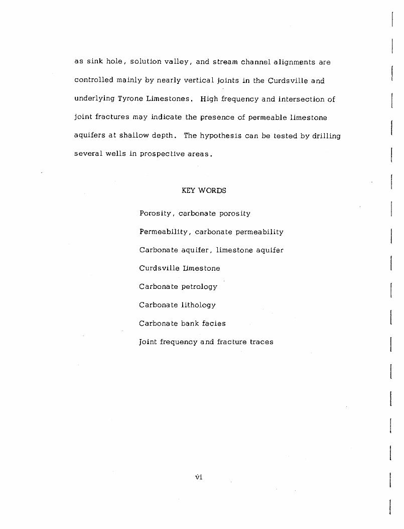
Frontispiece
BASAL CURDSVILLE LIMESTONE SPRING
Figure 1
Nonesuch Community Spring in basa 1 Curds ville Limestone, Sa !visa Quadrangle, Woodford County, Kentucky. Hammer handle at contact of Tyrone Limestone (below) and Curdsville Limes tone (above).
iii

[
[ ,~ [
r [
[:
[
r: [
[
[
L [
L L L L t
ABSTRACT
Factors controlling the porosity and permeabi.lity of the Curds
ville Limestone Member of the Lexington Limestone of Midd.le
Ordovician Age in the Blue Grass Region of Kentucky are geological.
Microstratigraphic analysis had led to the division of the lower
Lexington Limestone, consisting principally of the Curdsville Member
into three beds which may be subdivided into "zones" made up of
several lithologic types and sub-types. Lower, middle, and upper
bed characteristics are helpful in determining the regional depositional
history in the progressively transgressing Curds ville sea. Paleo
geography of Curdsville time has been determined by delineation of
two local facies: (1) a carbonate bank--shoal area facies, and
(2) a shelf--channel area facies.
Permeable carbonate bank--shoal facies are best developed on
the structurally high Jessamine Dome Shoal Area where the Curdsville
Limestone is found at shallow depth. Ground waters of meteoric
origin have created sink holes, solution valleys, and caverns
through solution enlargement of fractures comprising an extensive
intersecting joint system.
Detailed examination of the Bryantsville Quadrangle on the
Jessamine Dome Shoa 1 Area indicates that "fracture traces" such
v
as sink hole, solution valley, and stream channel alignments are
controlled mainly by nearly vertical joints in the Curdsville and
underlying Tyrone Limestones. High frequency and intersection of
joint fractures may indicate the presence of permeable limestone
aquifers at shallow depth, The hypothesis can be tested by drilling
severa 1 wells in prospective areas.
KEY WORDS
Porosity, carbonate porosity
Permeability, carbonate permeability
Carbonate aquifer, limestone aquifer
Curdsville limestone
Carbonate petrology
Carbonate lithology
Carbonate bank facies
Joint frequency and fracture traces
vi

L
r r~
l [
L l [
L L L L t
TABLE OF CONTENTS
FRONTISPIECE
ABSTRACT AND KEY WORDS
LIST OF TABLES
LIST OF ILLUSTRATIONS
INTRODUCTION
ACKNOWLEDGMENTS
OBJECTIVES
SCOPE ...
First Year's Work Second Year's Work .
GEOLOGY
REGIONAL STRATIGRAPHY
MICROSTRATIGRAIHY AND HISTORY OF SEDIMENTATION
11 Zones 11 • • o o • o o O O O O ,
Lithologic Types and Subtypes Beds . . . . . . . Lower Bed (0-10) . Middle Bed (10-20) Upper Bed (20-30)
REGIONAL STRUCTURE
Structural History
CURDSVILLE FACIES AND PALEOGEOGRAPHY
Carbonate Bank and Shoal Facies . Shelf and Channel Facies
vii
Page
. fii
v
- .i:X
. xi
1
2
5
7 8
8
9 15 15 26 30 31
33
35 36
TABLE OF CONTENTS (Continued)
Evidence for Local Facies Areas Ripple Marks and Cross Bedding Relationship of Facies to Structure
RELATIONSHIP OF GEOLOGY TO GROUND WATER
JOINT AND BEDDING PLANE FREQUENCY
Page
37 43 45
46
CHARACTERISTICS OF CURDSVILLE WATER MOVEMENT 48
CURDSVILLE AND TYRONE LIMESTONE WATER ANALYSES · SO
AQUIFER CLASSES AND DISTRIBUTION
Class I-Perched Springs. . . . 51 Class II-Gravel Source Springs S 1 Class III-Tubular Springs 54 Wells . . . . . . . • . • . . . 54
PROSIECTIVE CURDSVILIE AQUIFERS IN THE BRYANTSVILLE QUADRANGIE . . . . . . . . 56
SUMMARY 59
APPENDICES
Appendix A 1. Calcium-Magnesium Ratios in Spring Waters from the
Curdsville Limestone, By John Thrailkill . • . . . . . 62 2. Sampled Springs in the Curdsville and Tyrone Limestone 66
Appendix B Intercrystalline Porosity and Vertical Permeability in the Curds ville Limes tone--after Data from Oilfield Research, Inc. 68
Appendix C X-Ray Analysis of Curdsville Limestone, by George T. Hine 70
Appendix D 76 Insoluble Residues of Curdsville Limestone, By George T. Hine
Appendix E Station Locations of Curdsville Limestone Sections 78
REFERENCES CITED . . . . . 79
viii
I I

r i r
[
'
[
c [
[
L L L L L l
Table
l.
2.
3.
4.
5.
LIST OF TABLES
Geologic History of Curdsville Depositional Zones
Curds ville Limes tone Lithologic Types
Average Length of Joints and Bedding Planes
Calcium-Magnesium Geochemistry of Curdsville and Tyrone Limestone Waters in the Blue Grass Reg ion . . . . . . . . . . . . . . . . . . . . .
Comparison of Calcium-Magnesium in Curds-ville Limestone Springs (by area) ...... .
ix
Page
10
22
47
52
55

r [
r
[
L L c L
L L
L
L l
Figure
1.
2.
3.
4.
5.
6.
7.
8.
9.
10.
11.
12.
13.
14.
15 ,.
16.
17.
18.
19.
LIST OF ILLUSTRATIONS
Basal Curdsville Limestone Spring. Frontispiece ........... .
Index Map and Geologic Structure
Cross Sections of Curdsville Limestone Lithologic Types and Zones
Lithologic Type la
Lithologic Type Ib
Lithologic Type Ic
Lithologic Type IIa , IIb
Litholog ic Type III
Lithologic Type V
Curdsville Bed Lithology and Silica Content
Regional and Local Joint Patterns
Facies Map of the Curdsville Limestone
Color (Value) of Curds ville Limes tone Facies
Color (Hue) of Curdsville Limestone Facies ".
Average Silica Content of Curdsville Limestone Facies
Ripple Marks and Cross Bedding
Distribution of Ground Water
Joint Control of Fracture Traces and Channel Patterns (Bryantsville Quadrangle area) .. ,
Calibration Curve for Determination of Quartz Content
xi
Page
iii
6
12
16
17
18
19
20
21
27
34
39
40
41
42
44
53
57
74
r r-
r r: r f' r[
L L [
[
L [
L L L L L
INTRODUCTION
ACKNOWLEDGMENTS
"Factors Controlling Porosity and Permeability in the Curdsville
Member of the Lexington Limestone" (OWRR Project No. A-003-KY)
was sponsored by the University of Kentucky Water Resources
Institute and supported by funds provided by the United States Depart
ment of the Interior, Office of Water Resources Research, as authorized
under the Water Resources Research Act of 1964.
Research was begun in September 1965 and finished in June
1967, although some capital expenditures were made during fiscal
year 1964-65.
Cores obtained by the United States Geological Survey and the
Kentucky Geological Survey during the Kentucky Mapping Program were
m~de available to the author. Paul Richards, Earle Cressman,
Don Wolcott, and Douglas Black of the USGS Office in Lexington
and Robert Cushman and Herbert Hopkins of the USGS Office in
Louisville have been most cooperative in providing information and
advice.
Colleagues at the University of Kentucky, Irving S. Fisher
assisted in x-ray diffraction experiments and John V. Thrailkill
analyzed spring water samples, Robert Lauderdale, Director of the
Water Resources Institute of the University of Kentucky and his
secretary Mrs. Betty Bradshaw have aided during all stages of the
project beyond normally expected assistance.
OBJECTIVES
The principal objective of this project was to analyze a typical
carbonate ground water aquifer in the Blue Grass region in order to
isolate the principal geological factors controlling porosity and
permeability which affect movement and accumulation of ground water.
The Curds ville Limestone Member, the basal member of the
Lexington Limestone of Middle Ordovician age, was selected for
study because it is well exposed and easily located in the drainage
of the Kentucky River and tributaries; it is limited in thickness; it
contains some intergranular porosity and permeability; it is well
fractured with joints, faults, and bedding planes which promote the
development of solution features such as sink holes and caverns;
and it contains springs and wells locally.
Locating ground water resources in the carbonate rocks of the
Blue Grass region has been a problem for years. Most farmers in
the area have few, if any, water wells and depend on numerous
farm ponds, some local springs, or water from the Kentucky River.
Studies of fairly detailed nature have been made, resulting in such
- 2 -
r r-
r r r r r [
l [
c L L L L L L L t
publications as those of Hamilton (1950), Hall and Palmquist (1960),
Hendrickson and Krieger (1964). While of importance in indicating
the location, quality, quantity, and potability of water from known
wells these reports are limited for several reasons. The basic
geology was done on inadequate topographic base maps published
prior to the availability of new larger scale, topographic base maps
made from aerial photographs. Moreover, the lack of mapping detail,
the lumping of several units together, and the dependence on
reconnaissance geologic knowledge of earlier workers, have led to
generalized conclusions, which, though helpful, have not solved
many of the problems of obtaining water on individual farms.
This lack of basic, accurate, detailed, geological information
in Kentucky has led to a joint 10-year federal-state Geologic
Mapping Program which has already resulted in the geologic mapping
of 15 Blue Grass quadrangles. The principal investigator of this
project has done the geology on three of these and in the process
has been on every farm in an area covering about 200 square miles
and he has personally observed the importance of detailed mapping
in determining the occurrence of both surface and subsurface water.
The large mapping units of the past have been broken down recently
into smaller members which vary considerably in porosity, permea
bility, composition and in lateral and vertical extent (Black and
- 3 -

MacQuown, 1965; Black, Cressman, MacQuown, 1965), More
detailed field, microscopic, chemical, and x-ray work on each
member and contained beds should be of considerable value in deter
mining likely conditions for ground or surface water accumulation.
Microstratigraphic examination (detailed foot by foot examina
tion) of the Curdsville Limestone Member at 27 surface and subsurface
stations has resulted in a delineation of favorable areas for ground
water accumulation which are amenable to drilling and testing and
therefore the principal objective of the project has been accomplished.
Minor objectives· involving the development of techniques
applicable to the study of prospective acquifers has been achieved
within the limits imposed by the time available for research. Discus
sion of methods, results, and possible future approaches to chemical
analyses, porosity and permeability determinations, x-ray diffraction
work, and insoluble residue analysis, are discussed in attached
appendices (Appendices A to D inc.). Insoluble residue work and
quantitative carbonate petrology beyond the scope of this project
will be pursued and should result in publishable research.
Mr. George Hine plans to complete a M. S. thesis by December
1967 involving selection of prospective ground water drill sites
in the Curdsville Limestone through study of aerial photography
and detailed field work.
- 4 -

r r-
r ['
r r-r
r-
1
r [
L L L L I. i: L r
SCOPE
Representative field exposures in the Kentucky River and
tributary drainage systems and subsurface cores provided 26 complete
and several incomplete 30-foot sections of the Curdsville Limestone
Member at stations throughout the Blue Grass Region and north to the
Ohio River (Fig. 2). Descriptive logs were prepared for each station
and 510 rock samples were collected, an average of 17 samples per
station or about one sample every two feet of section. Most of these
samples were cut and polished for examination under the binocular
microscope. Acetate peels (200) were made and sealed in slide
mounts and projected on a screen to aid in sample description, Thin
sections (430) were prepared from chips and stained with Alizarin
red dye before examination under the petrographic microscope to
aid in separating calcite from dolomite and silica. Representative
point counts were made from selected thin sections. Percentages
were determined for such parameters as composition, texture (including
grain size, shape, roundness, sorting, cement, matrix), alteration,
fossil abundance and diversity, etc. Although the results are
beyond the scope of the present project, they were useful in litholog
ical descriptions and the results will be published later. However,
a complete petrographic microscope percentage analysis of the
silica (detrital quartz and chert) in all thin sections was made by
- 5 -
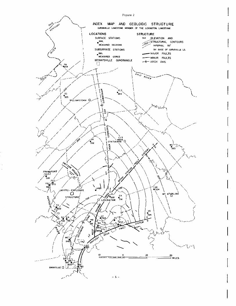
Figure 2
INDEX MAP AND GEOLOGIC STRUCTURE CLRDSVILLE LIMESTONE MEMBER OF THE LEXINGTON LIMESTONE
LOCATIONS SURFACE STATIONS
•MML
MEASURED SECTIONS
SUBSURFACE STATIONS
.aaL MEASURED CORES
BR'l'ANTSVILLE QUADRANGLE
- 6 -
STRUCTURE 562 ELEVATION AND
~STRUCTURAL CONTOURS 7 INTERVAL so' ON SASE OF CURDS VIL LE LS.
-- MAJOR FAULTS
- MINOR FAULTS
-i- ARCH AXIS

i i f' [
r-
1 [
I~ r: r: c [
[
[
L L L L l
the point count method to aid in facies analysis. This method proved
to be much faster than insoluble residue methods first used.
Field observations included measurement of approximately 275
joint measurements, 40 fracture frequency readings, 80 ripple mark
strikes and cross bedding dips. Twelve samples of water from
representative springs were collected and analyzed by Dr. Thrailkill
(Appendix A). Ten core samples of repr'esentative lithologies were
analyzed for porosity and vertical permeability (Appendix B).
Practical techniques were developed for future utilization of
x-ray diffraction for the analysis of clay size material (Appendix C).
Appendix D describes insoluble residue techniques employed for
about 100 insoluble samples from 4 stations. Appendix E is a list
of all station locations.
First Year's Work
A detailed progress report of the first ye'ar's work was prepared ,'
in August 1966 and submitted to OWRR by the University of Kentucky
Water Resources Institute (MacQuown, 1966). Much of the signifi-
cant data has been reproduced in this Completion Report. This early
work was limited to an area near the Kentucky River, Dix River, and
tributary streams in the Blue Grass Region of Kentucky in the outcrop
belt of the Curdsville Limestone. Samples collej';ted from this area
provided the basis for subdivision of lithologic types previously
- 7 -

employed in field mapping the area (Black and MacQuown, 1965).
The Curdsville was also divided into a number of "zones" from the
base to the top. Each of these included several lithologic types.
The "zones" reflect the geologic history of the deposits laid down
during Curdsville time. Changes in "zones" from station to station
indicate the presence of local facies variation which was further
delineated during the second year of the project.
Second Year's Work
During the second year of the project, the area of investigation
was expanded to include much of the Blue Grass Region plus some
of the surrounding region north to the Ohio River. Availability of new
core data from the USGS-KGS Kentucky Mapping Program provided a
broader base for analysis of the regional and local geology. Most
of the detailed microstratigraphic, insoluble residue, x-ray, and
petrographic work was done during the second year. An understanding
of the geologic factors which have controlled the porosity and
permeability of the Curdsville Limestone has led to positive sugges
tions for finding ground water as discussed in this report.
GEOLOGY
REGIONAL STRATIGRAPHY
The Middle Ordovician Iexington Limestone of the Blue Grass
iegion includes three members in the area of this project. The
- 8 -

r r I"'
['
r ['
F r· I: [
[
[
L L L L L L
t
basal Curdsville Limestone Member is the principal unit discussed in
this report and is generally thirty feet thick in the area of study,
although it varies in thickness from 20 to 35 feet. It is overlain
by, and transitional with, the shaly Lagana Member in the western
and south central pprtion and by the limy and shaly Grier Member in
the eastern and north central portion. Thus the upper boundary is
somewhat arbitrary. The lower boundary is distinct because of an
abrupt change in lithology. The coarser grained Curds ville Member
is underlain by the finer grained, semi-lithographic ''bitdseye"
Tyrone Limestone of the High Bridge Group of Middle Ordovician age.
Stratigraphic relations are discussed by Black and MacQuown (1965)
and Cressman, Black, and MacQuown (1965).
MICROSTRATIGRAPHY AND HISTORY OF SEDIMENTATION
The stratigraphic contribution of this report cons is ts of the
microstratigraphic, or detailed foot-by-foot, analysts of the Curds
ville Limestone Member and the delineation of local facies changes.
11 Zones 1'
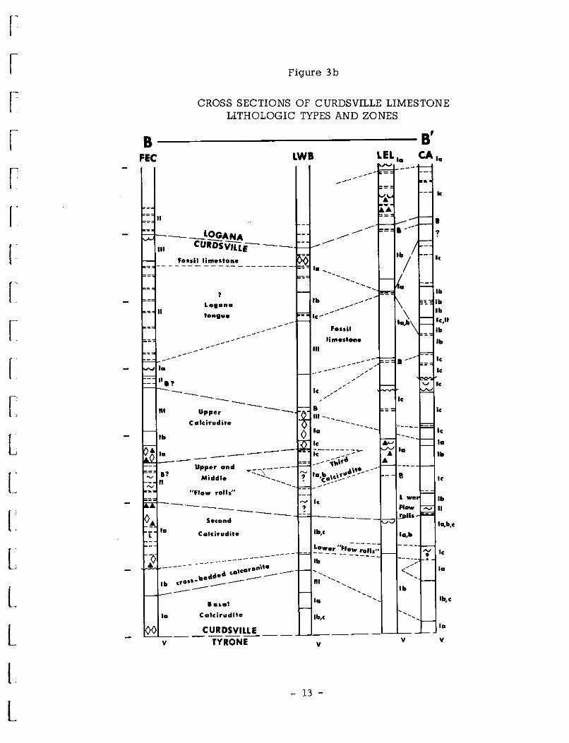
Informal lithologic units called "zones" which were delineated
during the first year of the project are useful in interpreting the
history of sedimentation in the region as summarized in Table 1
and illustrated on cross sections (Fig. 3).
- 9 -
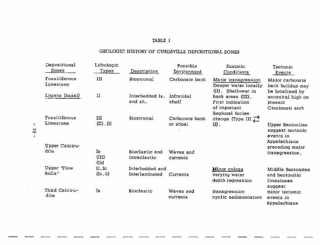
TABLE 1
GEOLOGIC HISTORY OF CURDSVILLE DEPOSITIONAL ZONES
Depositional Lithologic Possible Eustatic Tectonic Zones Trees Descrietion Environment Conditions Events
Fossiliferous III Biostromal Carbonate bank Major transgression Major carbonate Limestone Deeper water locally bank buildup may
(II). Shallower in be localized by Logana (basal) II Interbedded ls. Infra tidal bank areas (III) . ancestral high on
and sh. shelf First indication present of important Cincinnati arch Regional facies
Fossiliferous III Biostromal Carbonate bank change (Type III ;! Limestone (II) ' (I) or shoal II). Upper Bentonites
...., suggest tectonic 0
events in Appalachians
Upper Calciru- preceding major dite Ia Bioclastic and Waves and transgression.
(III) intraclastic currents (Ib)
Upper ''Flow II, Ic Interbedded and Minor crlces Middle Bentonites Rolls" (Ia , b) Inter laminated Currents varying water and bentonitic
depth regress ion limestones suggest
Third Calciru- Ia Bioclastic Waves and transgression minor tectonic dite currents cyclic sedimentation events in
Appalachians
~

r:- r- r-- r- r- r-- r-- r-- :;--, -i :---i r'1 --,----, --, ~ ~ -:-i -1 --i
TABLE 1 (Continued)
Depositional Lithologic Possible Eustatic Tectonic Zones Ty2es Descri2tion Environment Conditions Events
Middle "Flow le, II Inter laminated Currents regression Rolls" (lb) early, local
carbonate shoals
Second Calciru- Ia, III Bioclastic Waves and dite locally bio- currents
stromal Lower ''Flow le Interlamina ted Currents Initial trans2ression ...... Rolls" Deepening water ......
Cross-bedded lb Bioclas tic Tidal (intra-calcarenite Intra cla s tic tidal currents)
well sorted)
Basal calciru- Ia Intra cla s tic Surf zone (waves) Shallow Lower Bentonites dite Bioclastic poorly sorted water suggest tectonic
events in Appalachians preceding trans-gression
Tyrone (upper) v Micritic Supra tidal, very shallow lime mud lagoonal, water
Tidal flats.

Figure 3a
• CROSS SECTIONS OF CURDSVILLE LIMESTONE LITHOLOGIC TYPES AND ZONES
A ~ FWD FEC TD
35 SC KA LHC BD
Ill Ill
------=
II " - II II
II 30 = = --- LOGANA __
le = II / CURDSVllLE --= / Ill -
----Ill ---
II Ill = Fos,il limestone = /
25 < ll --=--= == = Ill II
II n1
= II Lo;ana \ Fossil limestone = tongue ~
"'' - I? le / - / ~~-----
NI --20 / le f I? / ~
~ / - I? / ~
--- - !I •• ... / Upper le ... - •• Calcirudite Ill le .,,/ - 'I?--•.
Ill .,,/ -.,,/ - II la 15 Upper
le II "Flow roll~ -- II - ----- ""---Third ""- ... '-.._ f lb
la Ca1cirudite __ __ ----= - II Middle
10 - "Flow rolls" -~
le = ----- ··----- le -... --...
------= --la Second lb
Calcirudite le
;i la "' 5 ---------------- 0 la cross-bedded
lb lb calcarenite le -- ... ------ ------ la ~ le () - I? Basal
la la Calcirudite () la 0 0 <) Ola
() ... () 0
() - I ____!? CURDSVILLE ------- ----v v v I I TYRONE I I v v v I 0 5 10 v
Ml L E s -5
12 -FEET -
r
r
[
[
f
f '.
L L L L L L L l
B FEC
Figure 3b
CROSS SECTIONS OF CURDSVILLE LIMESTONE LITHOLOGIC TYPES AND ZONES
------~~~~~~~~~~&' LWB LEL '• CA,.
k
II • ----__ LOGANA ---- ?
----III CURDsviur-- ----Fossil limestone ··; ,,
-- - - --- ------ --------
? lb
Logana - lb . II \ lb tongu•
lc,lt -- .... Fossil lb
~ --- limestone lb Ill ---- --- ,,
--- , = la --- , , le , - .. , ?
, , , ,
le , , --- , ,, le --"' Upper -- =
Calcirudite ---,. le lb ---- •• --- le ___ ,.,.. v ,. --- .. •• ----,~.,· ..
Upper and ~~.:'\ _____ .,,,. __ --Middle -- ? la,t!~~\_!-"'--- e le -----"Flow rolls" ·-le lb ------ ?
,,_ II
Second --- - _!Dlf& ..., la,11,c
r la Calcirudite lb,c la,llt
~~-:_·, ..... ~-~;,;,, - •• 1 ---- - -- ----- ? -- enit•
lb , </ la
d ,a c.alcO' - -- ' bed e -----
"' ' -- '
•• c.ross- -- ------ - lb - ----- lb,c lai.ol •• ' -Calcirudite -la lb,c -- '
CURDSVILLE •• - - TYRONE- - - -------
v v v v
- 13 -
Figure 3c
CROSS SECTIONS OF CURDSVILLE LIMESTONE LITHOLOGIC TYPES AND ZONES
c ~~~~~~~~~~~~~c' KA
v
II
LOGANA F=t-::Cc:UR DSVILLE
lb I-+-__ _
Ill
,: fossil
_ I? Limestone
Ill
1,
- I?
ND
= = II
Ill
CT
Ill
Ill
1,
Ill
lc,11
_ fa,b
k
, '
, ,
/
/ ,..-'
la
FL
= lc,11
=
Ill
lb
= le
- II?
1,
- la
¢
Ill
la
0 1, .. lb
• cuRDsv1LL~e~o~_ ~~1_'_ -~0~_1a_
I TYRONE • v " v v v
FCF
II?
= = = ti?
la - B!
la
Ill
.A. la
II
c
1,
la
Ill
• fo,b,c
I
v
- 14 -
SECTION LOCATION
B' . CA
LHC • Surface section
• Core holes
BD
EXPLANATION SYMBOLS
4 Chert () I ntrat:lasts
Diastem ,, ,.._, "Flow Roll
~ Coquina
¥ Porous Vugs.
L Limonite
P Pyrite C Calcite
• ZONE c!OUNDAII_I_!~ 8
SHALE
LIMESTONE
Fluorite
Bentoni te
LITHOLOGIC TYPES
I a,b,c 11 a, b Ill v
r r r r f' ['
r: r r [
[
L.
L L L L L L.
t
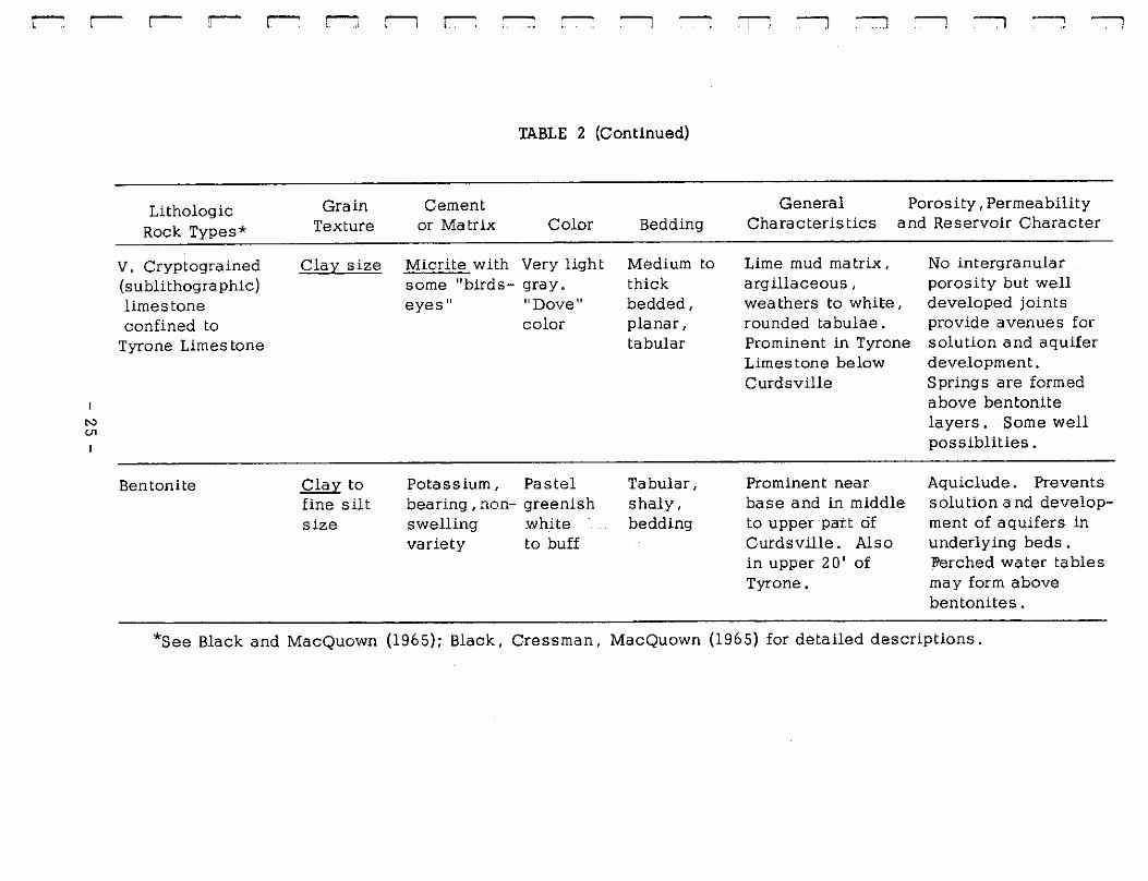
Lithologic Types and Sub-types
The "zones" consist of several lithologic types. These lithologic
types, first described by Black and MacQuown (1965), were divided
into sub-types during the first year of the project to aid in detailed
field and microscopic examination. The basis for subdivision is
indicated in a series of photographic reproductions (Figs. 4-9, inc.),
and summary characteristics are listed in Table 2.
Beds
The basal Lexington Limestone, composed primarily of the Curds
ville Member and lower portions of the overlying Logana or Grier
Members locally has been divided intb three ten-foot beds for analysis
of lithologic and reservoir characteristics. Measurements have been
made upward from the distinct contact of the Lexington with the under
lying Tyrone Limestone. This procedure is necessary because
porosity and permeability development as well as water movement
and accumulation are not restricted to formal stratigraphic units such
as formations and members. Key beds within formations such as
impermeable shales and bentonites several feet thick may determine
the base of an aquifer unit made up of portions of several members
or formations.
The basis for subdivision of the lower Lexington Limestone
(primarily the Curds ville Limes tone Member) into three ten-foot
- 15 -

Figure 4. LITHOLOGIC TYPE la
Basal Curdsville calcirudite (Type la) lies above Tyrone (Type V) at hammer head. Better joint development and different joint orientation in Tyrone.
300 mm
10 mm
1 mm
Surface section Keene Quad. (KA)
Acetate peel of polished surface
Denny Core Hole, Nicholasville Quad. (ND)
Photomicrographs
Keen A Section (KA)
- 16 -
1 mm

r r
r: L L L L L
L
L L l
Figure 5. LITHOLOGIC TYPE lb
Curdsville calcarenite with low angle cross-bedding (Type lb) above hammer handle. Basal calcirudite (Type la) below hammer. Joints better developed in Type lb.
300 mm
Surface section Keene Quad. (KA)
Acetate peel of polished surface
10 mm
Little Hickman Quad. , (LHC). Surface Section
Photomicrograph
1 mm
Keene A Section (KA)
- 17 -

Figure 6. LITHOLOGIC TYPE le
Curds ville Laminated calcisiltite (Type le) in 6" zone (length of hammer head) between thicker beds of Type la.
300 mm
10 mm
l mm
Surface section, Keene Quad. (KA)
Acetate peel of polished surface.
Nicholasville Quad. , Denny C-ore Hole (ND) USGS-KSG.
Photomicrograph
Lexington East Quad. (LEB), Core hole, Ferguson-Bosworth Co.
- 18 -
I r

r
r:
[
[ '.
L
[
L L I. l L
Figure 7. LITHOLOGIC TYPE 11 (a and b)
Lower Logana interbedded, tabular, micro-grained limestone (Type l la) and shale (Type l lb). Contact with underlying Type 111 at hammer handle.
300 mm
10 mm
1 mm
Surface section, Keene Quad. (KA)
Acetate peel of polished surface
Nicholasville Quad., Denny Core Hole (ND) USGS-KGS.
Photomicrograph
Bryantsville Quad. (BD). Surface section.
- 19 -
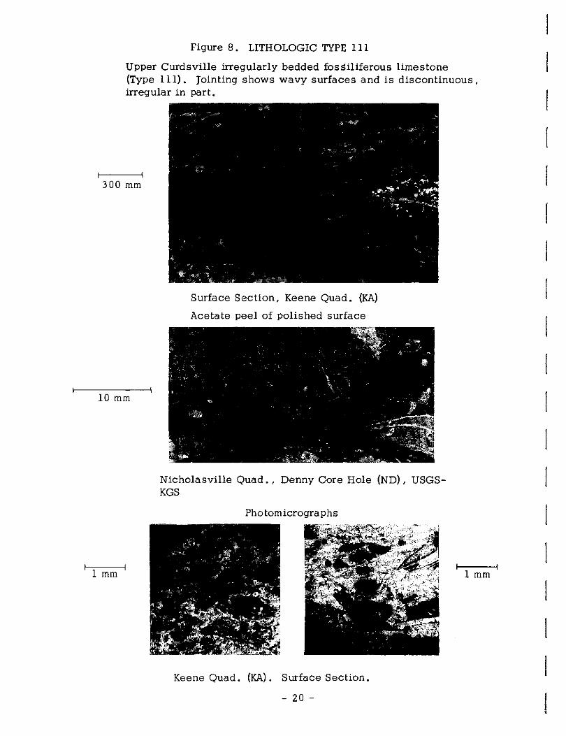
Figure 8. LITHOLOGIC TYPE 111
Upper Curdsville irregularly bedded fossiliferous limestone (Type 111). Jointing shows wavy surfaces and is discontinuous, irregular in part.
300 mm
10 mm
1 mm
Surface Section, Keene Quad. (KA)
Acetate peel of polished surface
Nicholasville Quad. , Denny Core Hole (ND), USGSKGS
Photomicrographs
Keene Quad. (KA). Surface Section.
- 20 -
1 mm
r
r
r -
I r: [
l L [
L L L L t
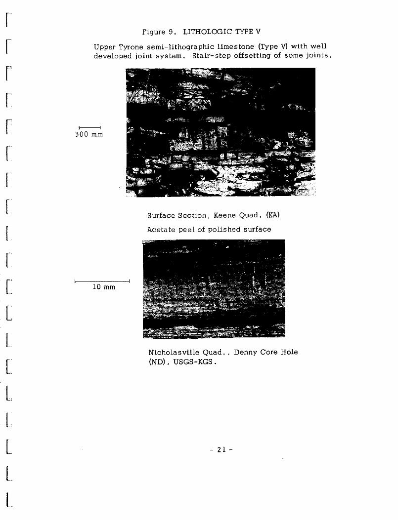
Figure 9. LITHOLOGIC TYPE V
Upper Tyrone semi-lithographic limestone (Type V) with well developed joint system, Stair-step offsetting of some joints.
300 mm
10 mm
Surface Section, Keene Quad. (KA)
Acetate peel of polished surface
Nicholasville Quad. , Denny Core Hole (ND), USGS-KGS.
- 21 -

N N
I
TABLE 2
CURDSVILLE LIMESTONE LITHOLOGIC TYPES
Lithologic Grain Cement General Porosity, Permeability Rock Types* Texture or Matrix Color Bedding Characteristics and Reservoir Character
I. Calcarenite, Silt to Sparry Light PJanar to Grains of whole Solution and spar calcirudite, and gravel size calcite gray- slightly or fossil frag- formation in vugs , calcisiltite and Value of wavy .Some ments (rounded along joints , bedding
pseudos par, 5 or more. cross- and sorted gener- planes. Intergranular micros par; Low chrorra bedding or ally). Intraclasts porosity locally. sparse yellow cross- common.Sub-angular Springs and wells micrite common lamination, quartz grains, locally.
feldspar.
Ia**. Calcirudite Gravel size Spar to common and micros par.
Light
.'IB!Y·
Blocky, Intraformational Possible aquifer. Oxidation of pyrite
finer Sparse grains micrite
thick-bedd!d.conglomera te common. Large fossils and fragments in some coquina beds . Vugs, pyrite weathering to limonite, chett and detrital quartz common. Medium washed and sorted.
to limonite. Chert nodules formed in surface sections. Fluorite and calcite in vugs and veins . Microcline and plagioclase feldspar a minor constitutent.
*see Black and MacQuown (1965); Black, Cressman, MacQuown (1965) for detailed descriptions.
**subdivisions of types as proposed in this report.
~

rT'. r- r- r- r- r-:: ll r- -; ' ,..---. - --, :-1 :--=i :::---, ----, ---, ----,
N <,J
Lithologic Rock Types*
Ib**. Calcarenite
Ic**. Calcisiltite
II. Tabular bedded, micrograined limestone and shale Fine calcisiltite.
TABLE 2 (Continued)
Grain Texture
Cement or Matrix
General Porosity, Permeability Color Bedding Characteristics and Reservoir Character
Sand size Spar to common and micros par.
Very Light Wavy to Light colored, well washed and sorted, Cross-laminated· to blocky. Chert, detrital quartz, and minor feldspar.
~- planar, finer Sparse grains
Silt size
Fine silt to clay size
micrite.
Micros par Sparse micrite.
Medium
~-
Microspar Dark gray and micrite. Value of Some pseudo- 5 or less. spar. Neutral
hue common.
Low angle crossbedding common. Medium Bedded.
Thin light Transitional gray lamina between Type I Inter-bedced and II. Commonly with thin associated with darker gray convolute "flow lamina.Low roll" beds. Fairly angle cross well washed and laminae. sorted. Planar to wavy beds.
Thin-beddrl ·.small fossils and to laminated planar surfaces.
fragments. Sjnall intraclasts, and pellets. Quartz grains and clay minerals. Some "flow tolls" . Weathers to buff color.
Possible aquifer, Thinner bedding and cross-bedding offer additional solution avenues. Better sorting than Type Ia.
Poor aquifer? Fine grains limit permeability. All Type I groups form typical Karst topography when exposed at surface.
Aquiclude. Little or no intergranular porosity or permeability. Perched water tables form on these beds. Farm ponds may hold surface water.
*see Black and MacQuown (1965); Black, Cressman, MacQuown (1965) for detailed descriptions.
** Subdivisions of types as proposed in this report.
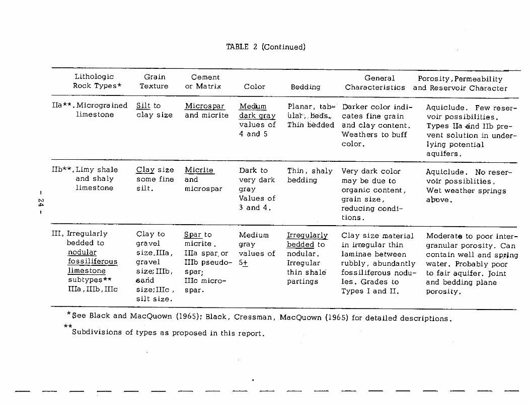
TABLE 2 (Continued)
Lithologic Grain Cement General Porosity, Permeability Rock Types* Texture or Matrix Color Bedding Characteristics and Reservoir Character
Ha**. Microgra ined Silt to Micros Ear Mecfum Planar, tab~· Darker color indi- Aquiclude. Few reser-limestone clay size and micrite dark gral:'. ular;. bed's., cates fine grain voir possibilities.
values of Thin bedded and clay content. Types !Ia -and I!b pre-4 and 5 Weathers to buff vent solution in under-
color. lying potential aquifers.
IIb**, Li.my shale Clal:'. size Micrite Dark to Thin, shaly Very dark color Aquiclude. No reser-and shaly some fine and very dark bedding may be due to voir possiblities, limestone silt. micros par gray organic content, Wet weather springs
N Values of grain size, a\:mve. "" 3 and 4. reducing condi-
tions.
III, Irregularly Glay to SEar to Medium Irreg:ularli Clay size material Moderate to poor inter-bedded to gravel micrite. gray bedded to in irregular thin granular porosity. Can .nodular size.IIIa, IIIa spar, or values of nodular. laminae between contain well and sp_~ing fossiliferous gravel IIIb pseudo- 5+ Irregular rubbly, abundantly water. Probably poor limestone size; IIIb, spar; thin shale fossiliferous nodu- to fair aquifer. Joint subtypes** saiid IIIc micro- partings les . Grades to and bedding plane IIIa , IIIb , IIIc size;IIIc , spar. Types I and II. porosity.
silt size.
* See Black and MacQuown (1965); Black, Cressman, MacQuown (1965) for detailed descriptions. **
Subdivisions of types as proposed in this report.
rr r- r- r-
N u,
Lithologic Rock Types*
V. Cryptograined (sublithographic) limestone confined to
Tyrone Limes tone
Bentonite
r- r-:;
Grain Texture
Clay size
Clay to fine silt size
Cl r- "' r- :--1 ~
TABLE 2 (Continued)
Cement or Matrix Color
Micrite with Very light some "birds- gray. eyes 11 11 Dove 11
color
Potassium, Pastel bearing, non- greenish swelling white variety to buff
Bedding
Medium to thick bedded, planar, tabular
Tabular, shaly, bedding
:--1 :--:] :---i :--1 ---, :---i
General Porosity, Permeability Characteristics and Reservoir Character
Lime mud matrix, arg illaceous, weathers to white, rounded tabulae. Prominent in Tyrone Limestone below Curds ville
Prominent near base and in middle to upper patt of Curds ville. Also in upper 20' of Tyrone.
No intergranular porosity but well developed joints provide avenues for solution and aquifer development. Springs are formed above bentonite layers. Some well possiblities.
Aquiclude. Prevents solution and development of aquifers in underlying beds. l'lerched water tables may form above bentonites.
*See Black and MacQuown (1965); Black, Cressman, MacQuown (1965) for detailed descriptions.

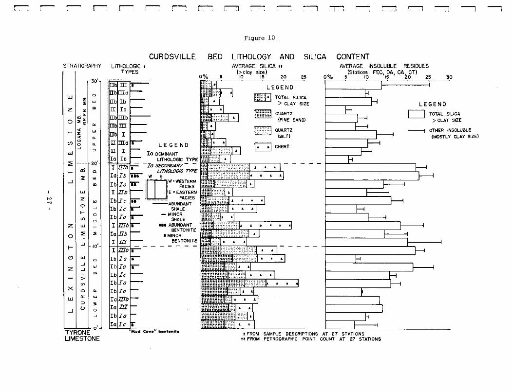
beds is graphically illustrated in Figure 10. This illustration is a
summary of data compiled from a foot-by-foot analysis of rock
samples from all stations. The composite log of lithologic types
shows the dominant (most common) and secondary lithologies,
the position of bentonites, and the relative number of shaly layers
in each bed. The silica graph is particularly significant in a
dominantly limestone section. Silica content (detrital quartz
and chert) was first determined at four representative stations by
both insoluble residue and petrographic analysis. Because results
were similar, the faster petrographic point count method was then
applied to a study of thin-sections at all stations. Only the silt
and larger silica grains can be determined by this method, however.
The graph of average insoluble residues from four stations compares
favorably with the graph of average silica for all stations thus indi
cating that the insolubles are mostly silica .
. Lower B¢d
The lower bed of the Curds ville Member is largely light colored,
fine to coar=- crystalline, biocla stic limes tone consisting of
calcirudites (Type Ia), cross-bedded, ripple-marked calcarenites
(Type Ib), and laminated calcisiltites (Type Ic) as shown in Figure
10. The lower bed is the only one containing more than 5% sub
rounded detrital quartz of fine sand size. In most sampled sections
- 26 -
l
r--r: r-: r-: rr-
STRATIGRAPHY
30'
WI ~1; ZI "' . "' "' -0 ::.i~
"' .. "' t- z
"' .. (f) "' 0 ..
--' w =>
::?: ---- 20'
al 0
...J I ::. "' "' w
N I lz "' ...J 0 --' .... 0 U)
0 zl w -
0 ::. " t- I --' ~ IO'
'91 ~IO z I __, "'
- "' > U)
Xlo "' w "' "' ::, 3' ...Ji O 0
--'
TYRONE o'
LIMESTONE
r-: r-: ~ r-: r:--:1 r-: r-: :--, ~ ---, :::1 ~ :--:1 -----i
Figure 10
CURDSVILLE BED LITHOLOGY AND AVERAGE SILICA tt
SILICA CONTENT LITHOLOGIC t
TYPES
II maro II I
5
LEGEND •
(> cloy size) JO 15 20 25
LEGEND
~ ~ liliiliiilil
LJ
TOTAL SlLICA > CLAY SIZE
QUARTZ (FINE SANO)
QUARTZ islLTI
D CHERT
lb Ia
t iif/j I
Ib Ia
Ia DOMINANT rh· .. ···1 I LITHOLOGIC TYPE h:.::.::::-.~i 6
-Ia si~=:~~y~ 11\~': ?r H '!) . . . 11
lb Ia iii I IIb Ib Ic ~ lb Ic I
lb Ia I
Ib Ia fi Ib Ic Ib Ia
Io Io nI lb Ia Io Ic ii
W E • • • ico···· ·rw=w~:1~:: ~ !E: EASTERN r;;;;;i~::::::;i. I , ................ ! FACIES h:1::.:_:_:.::.:;;::.J A A A A I
--ABUNDANT SHALE
- MINOR SHALE
111 ABUNDANT BENTONITE
I MINOR BENTONITE
liii.imuuv :::::::, A
l··:"''.T'J ,, •
• • •
- - - -•
•
• • •
0°/o
AVERAGE INSOLUBLE RESIDUES (Stations FEC, DA, CAc CT)
5 10 15 t:O 25 30
LEGEND
D TOTAL SILICA > CLAY SIZE
---; OTt-lER INSOLUBLE (MOSTLY CLAY SIZE)
''Mud Cave" bentonite t FROM SAMPLE DESCRIPTIONS AT 27 STATIONS tt FROM PETROGRAPHIC POINT COUNT AT 27 STATIONS
-----i
the basal five-foot unit of the lower bed consists mainly of very
light colored calcirudite and calcarenite characterized by angular
edgewise conglomerate (intrasparite) made up of limestone fragments,
including some derived from the underlying Tyrone Limestone (Type V),
and whole or broken fragments of Curdsville fossils. The basal unit
also is lower in total silica .than the upper unit, although the surface
sections exhibit prominent sea ttered chert nodules. Locally, thin
bentonite layers several inches thick occur in the lower five feet.
Thicker layers of the "mud cave" bentonite several feet thick occur
in the underlying upper Tyrone Limestone below the Curdsville-
Tyrone contact at several localities such as the type section of the
Curdsville Member at Curdsville Station (:,NC) and at High Bridge to
the north on the Kentucky River. The Clay's Ferry station (FCF)
also contains a contact bentonite. Other bentonites are commonly
found in the underlying Tyrone Limestone within an interval several
feet below the contact, and a thick bentonite layer (the "pencil
cave") occurs some fifteen feet below the base of the Curdsville.
Each of these layers may act as an aquiclude (particularly the thick
"pencil cave" bentonite) inhibiting the downward movement of water
and all are important in the development of a number of springs
loca}!y in the basal Curdsville and upper Tyrone Limestones which
together form an aquifer unit. The upper five feet of the lower bed
- 28 -

r
' r I
r: I
[
l l. [
L [
L [ .
t
is characterized by Type I limestones except for several thin layers
(several inches thick) of darker shaly limestone (Type IIb). The ratio
of silt size quartz to fine san'd size quartz increases in the upper' five
feet partly as a result of decreasing mechanical energy in a deepening
transgressive sea. The increased percentage of chert in the upper five
feet is related to the great "flood" of bentonite material deposited as
volcanic ash which is dominant in the lithology of the middle bed
above. Chert may occur both below and above bentonite layers as
indicated by Huff (1962).
Initial high to later medium mechanical energy conditions resulting
from wave and current action in a transgressing sea would account for
the light colored "winnowed" coarse bioclastic grains, the "edgewise"
conglomerate, the ripple marks, the. cross bedding ,and the progressive
decrease in de tr ital quartz grain size. Altered volcanic a sh deposits
formed bentonite, and the absence of bentonite locally is best
explained through submarine erosion by waves and currents. At
least some of the angular to sub-angular material described as
quartz silt may be of volcanic origin as shown by the increased
percentage of this fraction in the cherty layers. Euhedral and
subhedral microcline and plagioclase feldspar in many of the lime-
stone layers may have been derived from bentonite but work to
date is not conclusive.
- 29 -

Shallow water environment of deposition is indicated for the
Tyrone Limestone (Type V) which underlies the lower bed. The Tyrone
is characterized by laminated sediment and "birdseyes" suggestive
of stromatolites as found in the supratidal environments of southern
Florida and the Bahamas today. Extensive tidal flats were exposed
to subaerial drying during Tyrone time which resulted in mud-cracks
in the dessicated lime mud later consolidated to semilithographic
limestone (micrite and microsparite).
Middle Bed
The middle bed of the Curdsville Member contains gray to buff
microcrystalline to medium crystalline, sparsely fossiliferous,
finely laminated limestones consisting of medium dark calcisiltites
(Type !Ia) and darker shaly and silty calcilutites (Type IIb) in
addition to interbedded calcarenites (Types Ib, IIIb), calcirudites
(Type Ia), and some calcisiltites (Type Ic). A number of thin
bentonites and bentonitic limestones and associated chert above and/
or below the bentonites accounts for the high percentage of chert
and insoluble residue found in this bed (Fig. 10). The percentage
of quartz is somewhat less than in the lower bed (particularly the
fine sand size) and the silt size detrial quartz is more abundant
than the fine sand size quartz thus indicating continued transgres
sion of the sea with possible deeper water and perhaps some change
- 30 -
l I

f"
r ["
[
r 1 ·
r~ [ .
l [
[
L L L L L L L t
in the detrital source area. Some of the silt may be of volcanic
origin. Ball and Pillow structures (''(low rolls" or convolute bedding)
occur locally and are common in the silty layers, particularly where
they are interbedded with fine sand layers and lie above shaly
layers. The origin of these features has been variously ascribed
to pore pressure changes creating a submarine quicksand, earth
quakes, loading of soft clay layers with blocks of partly consoli
dated coarser grained material, or disruption by currents or s term
waves. The association of several lithologic types with bentonites
of volcanic ash origin indicate an unstable sea affected by volcanic
activity and possibly earthquakes, the influx of large amounts of
wind-born elastic ash deposits, occasional storm waves or currents,
and possible fluctuation of sea level. The increase of finer bio
clastic material suggests somewhat lower mechanical energy overall
as the transgressing Curdsville sea created a deeper water environ
ment. Minor regression of the sea may explain the presence of
coarser calcirudites and calcarenites near the top of the bed and
in the lower part of the overlying bed,resulting from higher wave or
current energy conditions in somewhat shallower water.
The Upper Bed
The upper ten-foot bed is characterized by eastern and western
facies (Fig. 10). The eastern facies is dominantly a medium gray,
- 31 -
medium to coarse grained, bioclastic limestone (Types III, I) quite
similar to and difficult to differentiate from the overlying Grier Member.
The western facies is dominantly a dark gray, fine grained bioclastic
limestone (Type II) similar to and difficult to differentiate from the
overlying Logana Member. Both facies contain interbedded Type I
layers characteristic of the Curdsville Member which are particularly
prominent near the base. These higher energy lithologies probably
indicate a slight recession of the sea, somewhat shallower water and
increased wave and current energy. However, the low percentage of
detrital quartz indicates a continusid dominant transgresi,ion of the
seas. The few bentonites found in the upper bed are usually
restricted to the lower and upper layers or are found above the top of
the Curdsville Member. Therefore the chert content (usually assoc
iated with bentonite) in the upper bed is low. The progressive
deposition of the western shaly facies over the eastern limy facies
culminates in the deposition of the shaly Logana Member over the
entire western part of the project area.
REGIONAL STRUCTURE
The principal regional structural features of the Blue Grass
region are the north-south trending Cincinnati Arch and the major
fault systems including the Kentucky River and the West Hickman
Creek -- Bryan Station Faults as shown on Figure 2.
- 32 -
I
f
[
L
l

[
r r r r r-
r
r [
L I L r l L L L l L
Local structural features of importance include the Jessamine
Dome, which is partially truncated by the major fault systems, the
Switzer Graben, the Versailles cryptoexplosive structure (Black, 1965),
and numerous minor faults delineated in the Kentucky Mapping Program.
The minor fault trends are generalized and the sense of movement is
not indicated. In addition to faulting, numerous joints add to the
fracture pattern. Several sets of largely vertical joints are dominant
in an extensive network or joint system as shown by rose diagrams
on Figure 11. The orientation of Joints differs to some extent in the
Tyrone and Curdsville Limestones indicating that the pattern is con
trolled in part by the difference i.n lithology of the two units. Orienta
tion of jointing within the three beds of the Curdsville Limestone
varies locally as shown on Figure 11 probably because of differences
in lithology of each bed and also due in part to some variation in
regional stresses within the various local areas. Local variation in
joint directions in the Blue Grass Region has been observed by
Stafford ( 196 3) . The important relations hip of join ts to solution,
water movement, and aquifer development is discussed later in
this report.
Structural History
The s true ture map (Fig. 2) indicates that the axis of the
Jessamine Dome may have had a slightly different orientation than
- 33 -
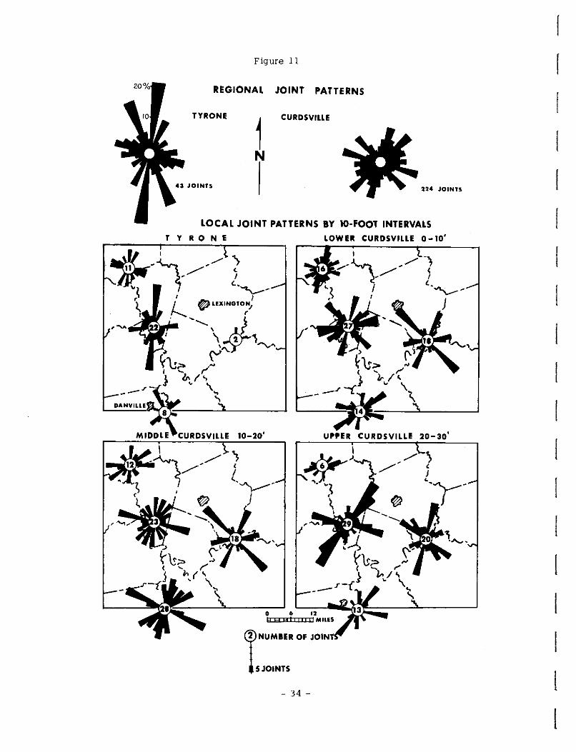
Figure 11
REGIONAL JOINT PATTERNS
TYRONE
1 CURDSVILLE
N
224 JOINTS
LOCAL JOINT PATTERNS BY 10-FOOT INTERVALS TYRONE LOWER CURDSVILLE 0-10'
i,r-~_/,/]. ~I I 1 '""'--' ,, I I ~ I e:, LEXINGTON/
I f-....... r
I, '-...._ \ r}l,l'"\,~ ~ \"':::;; Yu.,.. .,.-, ..._ r
>
__ .,~} b.l\~ DANVILLE
M IDD L
8
E C_U_R_D-SV_I_L~LE_I_0---20-.--'
~\S> "' } 'i,. ;(
--~~'-'"--~-----' UPPER CURDSVILLE 20-30'
'} / (
I ~J <-"'\.---"- ,_ .
;1, J ~
I
----"----.~.'-~ .•• - ... ~i'.!;;.;;;;;---~---__J H A A I i i ii Ii MllES
~NUMBER OF JOIN
ls JOINTS
- 34 -
r
I [
i i r· L f' i r: r-
r 1·
[
L [
L L I !. L t
the axis of the Cincinnati Arch proper and may have been formed at
a slightly different time. Both features are truncated by the major
faults which may be therefore partly younger than the fold features.
The minor faults appear to be influenced in part by the major faulting
and in part by the Jessamine Dome.
CURDSVILLE FACIES AND PALEOGEOGRAPHY
A transgressing sea resulted in a vertical change in lithologies
through time as evidenced by the previously described lower, middle,
and upper beds of the Curdsville Limestone. These changes were
largely regional in nature and affected the entire project area except
in late Curdsville time when distinct eastern and western regional
facies were deposited. However, local facies also were prominent
throughout Curdsville time in specific local areas. These local area
facies have been divided into two groups, (1) the carbonate bank ri:,r,
shoal area facies, and (2) the shelf or channel area facies. These
facies intertongue, but one or the other are dominant locally. Brief
area facies des_criptions will be followed by evidence for their
delineation (Fig. 12).
Carbonate Bank or Shoal Facies
The carbonate bank or shoal facies mainly consist of lighter
colored, coarser crystalline, coarser grained calcirudites (Types Ia,
IIIa) and calcarenites (Types Ib, IIIb) which were reworked,
- 35 -
winnowed, sorted, and rounded before final deposition by medium
to high energy waves and currents possibly in slightly shallower
water than the surrounding shelf-channel areas. The carbonate banks
are the large indefinite areas to the east that were slowly transgressed
by the Curds ville sea. The shoals are the smaller banks that have
been partly defined by better control in the central map area.
Shelf or Channel Facies
The shelf or channel facies ma inly consist of darker colored,
finer crystalline, finer grained calcisiltites (Types le, IIIc) , very
fine calcisiltites (Type Ila), and calcilutites (Type IIb) which were
deposited in medium to low energy areas with limited current activity,
possibly in slightly deeper water than the bank-shoal areas. The
shelf is the large indefinite area to the west where the transgressing
sea first deepened and where somewhat deeper water existed through
out Curdsville time resulting in the deposition of more fine shaly
limestone than in the bank-shoal areas. The western facies of the
upper bed consisting of the Curdsville and the overlying shaly
Lagana Member is particularly prominent in the shelf area. The
channel areas are the narrower areas in the bank-shoal complex that
also may represent slightly deeper water conditions where fine
sediments probably winnowed from the shoal areas were deposited.
- 36 -
I
r 1-
r r r r
r r [
L
r: L [
I L L L L
t
Evidence for Local Area Facies
The first evidence for existence and location of the coarse bank
shoal and the fine shelf-channel facies areas is shown on the facies
map of Figure 12 and is based on the ratio of the coarse to the fine
lithologies at each station as determined by field and polished
section descriptions. The basis for subdivisions into two lithologies
is explained on the map. An arbitrary coarse/fine ratio of 1. 5 was
chosen as the boundary between the indicated bank-shoal and the
adjacent shelf-channel areas. Support for this method of separating
facies areas was tested by several other approaches. The Geological
Society of America Rock Color Chart was used to determine color (value)
from wet polished sections at each station and the results are illus
trated on the map of Figure 13. Standard value numbers range from
white XlO) to black (1) but valures for the Curdsville Limestone range
from 8 to 3. The bank-shoal areas contain lighter colored facies and
are indicated by average station values higher than 5 whereas the
shelf-cbapnel areas contain darker colored facies and are indicated
by average values lower than 5. The rock color chart was also used
in the preparation of the map of Figure 14 which illustrates the
relationship between the two dominant hues (yellow and neutral)
and the two principal facies::., Stations with greater than 3% yellow
hues and less than 1% neutral hues are located in the bank-shoal
- 37 -

areas and, conversely, stations with less than 3% yellow and more
than 1 % neutral hues are located in the shelf-channel areas. Minor
hues, including yellow-red and greenish-blue are related to weathering
and are not applicable to facies differentiation. Finally, the map of
Figure 15 illustrates the relationship of silica to the two major facies.
The map is contoured on the basis of the percentage of silica greater
than clay size as determined by examination of thin sections for each
station. In the bank and shoal areas the percentage of silica is
greater than 10% (detrital quartz 5% and chert 5%) whereas in the
shelf-channel areas the percentage of silica is less than 10%. Both
the fine-sand and silt size detrital quartz is higher in the bank-shoal
areas as compared with the shelf-channel areas. The silica content
appears to be related to paleogeographic areas and is not primarily
a result of weathering. Chert nodules are more common at weathered
surface stations than at unweathered subsurface stations but this
may be due to secondary growth of nodules at the surface at the
expense of finely divided silica as a result of solution and later
redeposition locally without any significant change in total silica.
In summary all parameters investigated indicate the areal
extent of discrete bank-shoal and shelf-channel facies thus estab
lishing the paleogeography of Curdsville time, Other parameters
have not been completely investigated. However, preliminary
- 38 -

L ! : L
L L
L
t:
figure 12
FACIES MAP OF THE CURDSVILLE LIMESTONE RATIO OF COAIIS! TO FINE LITHOLOGlfS
,,--.,,_ ../ '
o+-'o.,- ~"' '--/. \)(, ' .... J<,,,.~'\ I , . ' \ I
EXPLANATION
<XWISE UTHOL061ES (LIGtf!VI COLORU.. OOARSER c:R'r'STAU.IN[
CALCIRUOIT( • TYPE Ia ,ma CALCAAENITE ~ TYPE lb,Illt,
' ' \ \ FINE LITHOL.OGIES (c,.RKER OOI...OREDI RNER CRYSTALLINE
\ I OlLCISIL TIT[ ; TYPE: Ic ,me
STATIONS ~SURf,\CE {SECTIONS)
•SUBSURFACE (CORESI 42.._RATIO COARSE/FINE
.,,{t- \ FINE CAtc1s1LTITE • TYPE Ila
/' \~ CALCILUTITE • TYPE Jib (f. \ RATIOS --~
1 > 1.5 • SANK ANO SHOAL AREAS
I J < 1.5 ' SHELF AND CHANNEL AREAS
(""'l. PB
I
COITOUR INTERVAL • lO
'""' ! _;-' \'-' ,,/ ,.j --· -\ , ' " -- I\ o,v/o---:--- ------...._ ,,.--... .....; /'--J ~-, li'tve,,,-- ....,_
--, .. ,, 1-;t- X, I i / ""\ M I \ I \ / ---, r-,f\f ' .'". . \
',-·"'' '1 fa' I CARBONATE ;" I\ I I I I I l -_, ~ i .. ",..,,,., 0 r:LS i ' L./ i J,,.J) .1
"'"'· 1 \ -...\-- ----+--r(., 1 1 • , 1 n \ "~- \ r·~J I I 1-1r 1 1 !1
\ s HELF \ \ ,¥,-., \ I I ?_,j CARBONATE /
) Q \ \.~/ 1\.. 1 1
1)r-- B~~\. .,,.-v '; 1,/ ,.'-+-, ,/,en
O I I /1 \ \ \ ,
( ,.1 • · I , CYNTHIANA " s( \ 8 9 ,o \,
,,~-~- _// I "I ( I 1-/\ "· \ '\ \ \ \°1..~'l-1 ""/ \ \ I \ I =· \ \ \ , -------- _;_ ~ \ I <,--4_!'-,,.,, '-- \, ~----=--. /·"' 'v-v I I . \. -i:rt,. A '\ ---.. ~ ' \ I CARBONAT~ \ - --'.--;<. \
FRAN~AT ~~\ \~AL:,\--\_ _;1·",fl / \) ) FwoD/ ,- \ , \..........___ __. <...
\ ~ ,/ -~%';, ,,.--- ( --- ,/ "'l._/ ? I /FEQ/ M ," ' / ---.
2 FE~.9 ~ ' ) _ // I '\.., -~. 'A.. ·" \ '"' "'--.. ~-~" I ·..._
--- 1.....1'-... I '·1----_LEL -.A...._ ~ V MT. sTtfL1Ne ,
~ s , 1 "'- ~' -,"1 <:," ; \ I I \ (. , -........._ / ,a LEXINGTON 1.fl j + "t" X """'-
\ (TO r:---./ ( ~... I I ' ~ 7 . --....._ ~ " /HS I \
::.,, / 2 ,, !:,- I J3 \ / ~ SJ;;• I 'Z,~CT ~~ I CARBONATE ' .r.. 30-.., -~-N~ ·~- ~ 1- I I .. __ _
SH ELF .rJ~· •-:;}' :"..-x ~yv · ~ BANK - I . . ~" •• " I: )"- c.-L, "-· ! \ ( ·-;;""~'!,~"\, : /Y) I I ~'\J---ir~\ I /we':;') ,_, "/ / I/ (.-..., '-/ \ .5- :P <:, < ''-. -? \ \-!J{/':'"i'.~./\ ... ~ ~ 11 I 1 ·~.,,. t,· \ _r\-f~ /; / ti ,o I o 10 20MILEs
- --- ----\_ 0
~ eA"l.., -+--"" 2f • .. _ EID I I BRYANTSVILLE QUAOFIANGLE
OANVILL[ 0 i .......... k~.;
- 39 -

Figure 13
COLOR (VALUE) OF CURDSVILLE LIMESTONE FACIES
AVERAGE YAlUES CONTOUR INTER'o'AI. ' 0.:Z
STATIONS
>5.0 BANK AND SHOAL FACIES
<S.O 51£LF ANO CHAHNEL
aSU~CE !SECTIONS)
" eSUBSURFACE !CORES}
5.J..._AVERAGE YALUE FROM WET POLISHED FIOCI< (GSA ROCK-COLOR CHART, 19481
- 40 -
"-"'

r
r
I
L [
L
L L L L L
L
Figure 14
COLOR (HUE) OF CURDSVILLE LIMESTONE F11CIES
DOMINANT 1-lJES (as "" of ytlbws t neutrlJB it, the oreo}
YELLOW
>a% BANK ANJ SHOAL AREAS
<3% >1% SHELF ANO
STATIONS 'tJ•~FAGE !SECTIONS)
• 9J8SURFACE (CORES!
~Ji~~~
CHANNEL AREAS
CONTOURS CCNTOUR INTERVAL
_ - - YELL.OW HUES 2.0
•. -········· NEUTRAL HUES o.,
~ 0 10 ~ .<3C=c=s=>eCEci=S=S=S=S=Sic=====,· MILES
- 41 -

Figure 15
/WfP.f,/Jf. SILICA CONTENT OF CLflOSVILLE Ll'.£STONE FIICES
..,.- CONTOIJAS ON o/o TOTAL SILICA __...--- CONTOUR INTERVAL • 5°/0
l
- 42 -
' ' r ' r f' [
[
[
I r: L [
L
L L L L L:
thin section analysis indicates that the greater number and diversity
of fossil forms, the coarser fossil fragments, the intraclasts, the
cross-bedding and coarse lamination, are characteristic: in the
bank-shoal areas, whereas sparse fauna in a dark micritic matrix
with microspar cement, thin lamination, and shaly bedding are more
characteristic of the shelf-channel areas.
Ripple Marks and Cross Bedding
Sixty-seven strike directions of cross bedding and ripple mark
axes and eighteen dip directions of cross bedding and current ripple
mark steep lee slopes were measured in the Curds ville Limestone.
Limited data available does not justify plotting individual rose
diagrµms at each field station or the preparation of vector diagrams.
Strike and dip rose diagrams are shown for the principal shoal areas
and for the channel or non-shoal areas. Composite diagrams summarize
the total strike and dip data (Fig. 16).
Only general observations can be made. The four asymmetrical
ripples observed were confined to the channel areas. Their lee side
dip slopes indicate currents moved toward the southeast. The four
teen cross beds observed were confined to the shoal area and the
dips show random distribution with a slight suggestion of a westward
directional trend. Strike directions, in general, are northwesterly
in the channel and nort!h-:northeasterly in the shoal area.
- 43 -
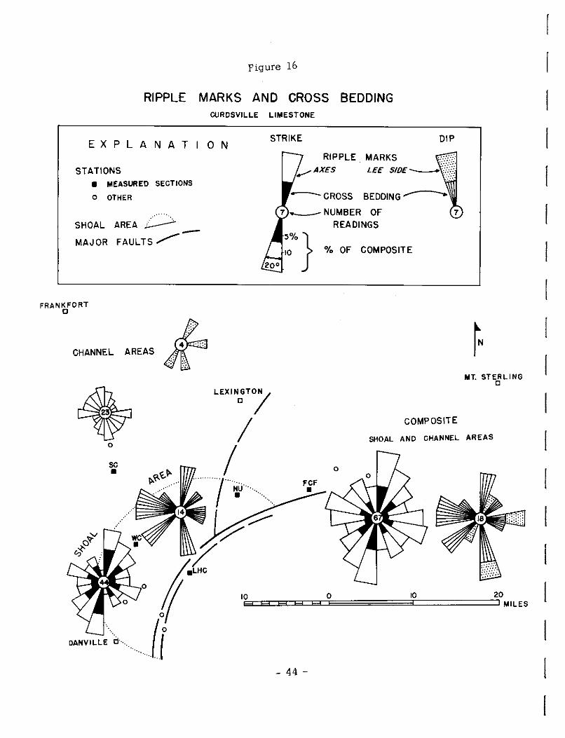
Figure 16
RIPPLE MARKS AND CROSS BEDDING CURDSVILLE LIMESTONE
EXPLANATION
STATIONS • MEASURED SECTIONS
O OTHER
AREA~
STRIKE
RIPPLE. MARKS !.--/AXES
--CROSS
7 --NUMBER OF READINGS
DIP
7
SHOAL
MAJOR FAULTS/" -~0%} % OF COMPOSITE
FRANKFORT 0
'"'"" "'" k LEXIN;T/
COMPOSITE
MT. STERLING 0
I I
·····1·········.
SHOAL AND CHANNEL AREAS 0
SC •
DANVILLE d"· ....
0
~u ··· ....
10 10 0 E3::::ECE3:::Er:::::Ec::E:=:=:=:=:=:=3::::=:=:=:=:=::::JM1LES
20
- 44 -

r· f'
r [
r ['
r r-
1
[
[
[
L [
L
L L L [
Relationship of Facies to Structure
The carbonate shoal south of Lexington shown on the facies map
(Fig, 12) is remarkably similar in shape and location to the Jessamine
Dome shown on the structure mpp {Fig. 2). Minor faults appear to
be prominent in the shoal flank areas, Although the control is limited,
other shoals may be present along the Cincinnati Arch. This relation
ship suggests that positive, or at least neutral areas resulting in
higher sea bottom topography and the consequent development of
carbonate shoals in medium · to high energy environment were present
in Curds ville time,
Therefore an ancestral Cincinnati Arch or at least an ancestral
Jessamine Dome may have been present. Moreover the eastern channel
area corresponps closely with the major fault system and may represent
a negative area that later developed into the Kentucky River and related
West Hickman Creek - Bryan:: Station fault systems. The channel
area between Lexington and Frankfort corresponds closely to the area
of the prominent Switzer Graben and the Versailles Crypllo-explosive
Structure mapped by Black (1965). Both channel areas could well
have been located in weak structurally negative areas resulting
in somewhat deeper sea bottoms locally which were filled with
lower energy deposits during Curds ville time. It is interesting to
speculate that the crypto··explosive structure is in fact a
- 45 -

crypto··volcanic structure possibly resulting from a subterranean
volcanic intrusion or explosion in a structurally weak zone as con
ceived by Bucher (1936) for the Jeptha Knob crypto··volcanic structure
some miles west of the project area. If so, this structure would not
then be an astrobleme resulting from a meteoric impact.
REIATIONSHIP OF GEOLOGY TO GROUND WATER
T01NT AND BEDDING PIANE FREQUENCY
Joints and bedding planes, the obvious avenues of solution and
water movement, vary in length, character, and number. Generally
they are better developed nearer the surface where weathering and
ground water movement have been more effective. They also vary
relative to lithology as shown in the following analysis.
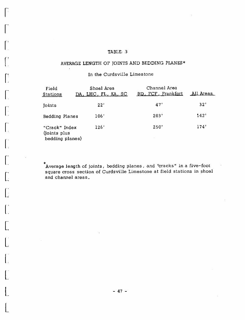
Joint and bedding plane frequency was determined for eight
surface localities located on the Jessamine Dome Shoal Area between
Lexington and Danville and in the adjacent channels (Fig. 12). At
each field station grids five feet square were laid out for each vert
ical five-foot interval of the Curdsvi11e Limestone. The length of
joints and bedding planes in the grids were measured. Data from
five field stations in the shoal area and three stations in the channel
areas were added and averages determined for each area:~s shown
on Table 3.
- 46 -
[
[
[
r· r
r-
r·
r: [
L
L L L L L t
TABLE, 3
AVERAGE LENGTH OF JOINTS AND BEDDING PLANES*
In the Curdsville Limestone
Shoal Area Field Stations DA, LHC, FL, KA, SC
Channel Area BD. FCF, Frankfort
Joints
Bedding Planes
"Crack" Index (Joints plus bedding planes)
22' 47'
106' 203'
126' 250'
All Areas
32'
l.42'
174'
* Average length of joints, bedding planes, and "cracks" in a five-foot square cross section of Curdsville Limestone at field stations in shoal and channel areas.
- 47 -

The table illustrates that in the shoal area of coarser grained
crystalline limestone the joints, bedding planes, and "cracks" {joints
plus bedding planes) are less numerous than in the finer grained shaly
limestones of the channel areas" Therefore, potential avenues of water
movement should be greater in the latter areas. However, impermeable
shaly layers and the more discontinuous nature of joints largely
confined to individual beds in these areas deters water movement
except along some bedding planes where minor perched springs
develop. Although fewer joints are found in the shoal areas, those
formed are more effective and more solution cavities (sink holes and
caverns) are formed. Consequently more favorable aquifer conditions
exist in the coarser grained limes tone of the shoal areas . Other
shoal and bank areas contain favorable lithology but are not exposed
at the surface and joints have not been enlarged by solution to the
same extent. Moreover these more deeply buried shoals would likely
contain salt and sulphur water and would therefore not be favorable
fresh water aquifers. However,gas was found in the core hole at station
SR in the flanks of the carbonate bank to the east. Some permeability
must be present and commercial oil and gas accumulation in buried
banks and shoals is possible.
CHARACTERISTICS OF CURDSVILLE WATER MOVEMENT
Water movement in the Curdsville Limestone is related to lithology
- 48 -
I
l [
l
l I
r
r· I f~ r r· r [
L L c L L L L L L L t
and is restricted largely to joint and bedding plane fractures in lime
stone beds which have been enlarged by solution. The openings formed
result in sink holes and solution valleys developed along joint sets
and caverns developed along bedding planes. Porosity and vertical
permeability in the limestone studied are very low (Appendix B) , and
for this reason little water moves through intergranular openings.
Where the Curdsville 11imestone occurs near the surface, solution can
be effective. Springs and some wells are present where water fills
solutional openings.
Downward movement of ground water is locally interrupted by
bentonites and shales which occur at vatious positions within the
Curds ville interval resulting in perched water tables and intermittent
springs. Where bentonites and shales occur at the surface, farm ponds
built on these lithologies may hold water. Bentonites act as effective
barriers to water movement, partly as a result of mixed layer clays,
which may swell or slough in the presence of water, thus filling
effective pore space and forming an impermeable layer. Shales
(mainly limy shales) may contain some bentonite, but impermeability
is ma inly related to the presep.ce of compacted fine silt and clay
which limits water movement thus preventing solution and the develop
ment of permeable channels. Therefore, in areas where the Curds
ville contains many small shale units the water movement is restricted
- 49 -

to the thicker, coarser limestone units between the shales. Where
shales and bentonites are absent, groundwater can move downward
and laterally for greater distances. The rock is more easily dissolved
and channels are enlarged.
Joint characteristics are directly related to rock type. Medium
to thick bedded carbonate units contain continuous, largely vertical,
regular joints. Thinner bedded carbonate units contain less continuous
joints commonly offset along bedding planes, but which may be
effective permeable fractures. Shales and bentonites, more than a
few inches thick, have few continuous joints.
Joint trends differ s tra tigraphically and geographically. Usually
joints are larger and more numerous near fault zones and as a result
many may give rise to high yield springs such as the Sulfur Well and
Keene Springs near the towns bearing these names.
CURDSVILLE AND TYRONE LIMESTONE WATER ANALYSES
No attempt was made to make a complete water analysis of the
water from the Curds ville and underlying Tyrone Limestone. Wells
over 80 to 100 feet deep usually contain salt or sulfur water (Hendrickson
and Krieger, 1964) and are therefore unsuited for most common uses.
Water from shallow wells and springs contains calcium and magnesium
ions, making the water hard but usable. Dr. John Thrailkill from the
Departmentof Geology at the University of Kentucky analyzed 12 spring
- 50 -
[
[
l
l
r r r r r r r f' [~
r [
L [
l..
L L L L L:
samples collected during the project for calcium and magnesium,
and this report is included in Appendix A. Table 4 is a comparison
of Qalit:ium- magnesium data from the work of several authors.
AQUIFER CLASSES AND DISTRIBUTION
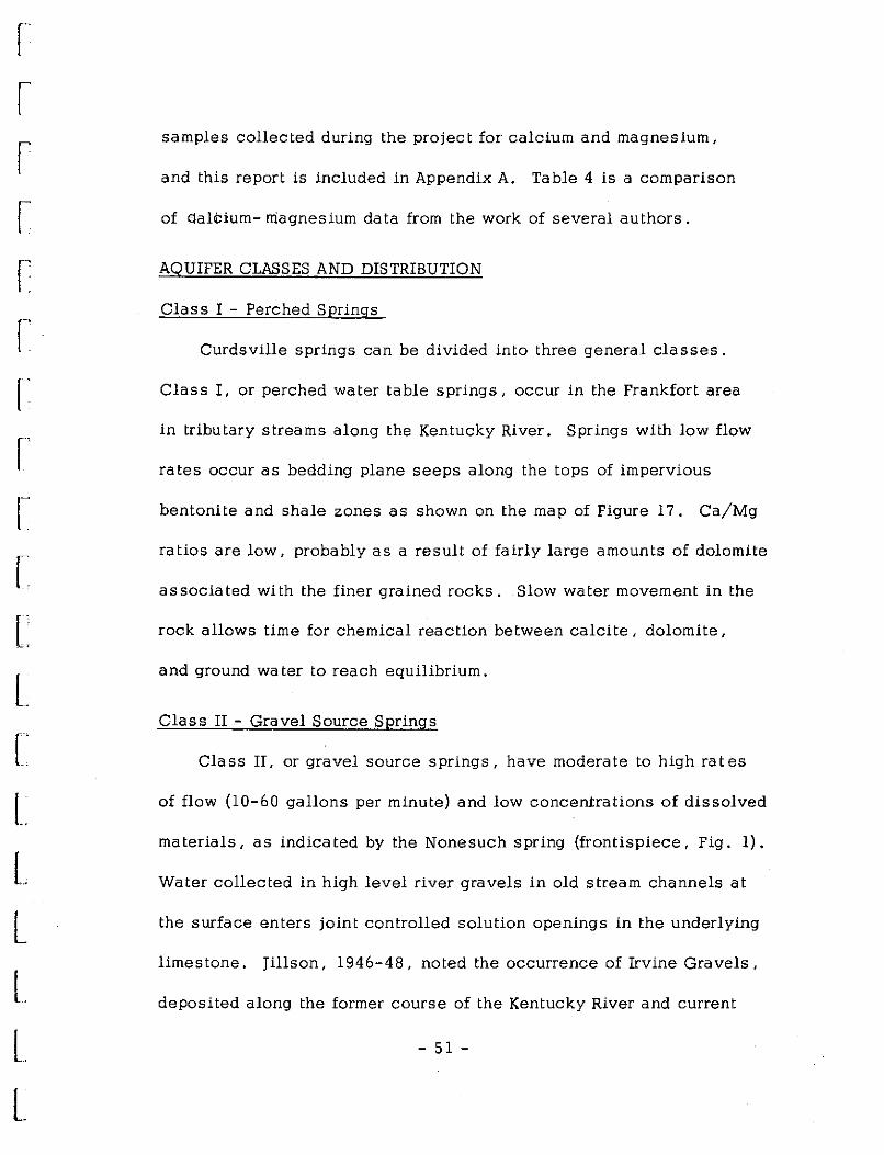
Class I - Perched Springs
Curds ville springs can be divided into three general classes.
Class I, or perched water table springs, occur in the Frankfort area
in tributary streams along the Kentucky River. Springs with low flow
rates occur as beading plane seeps along the tops of impervious
bentonite and shale zones as shown on the map of Figure 17. Ca/Mg
ratios are low, probably as a result of fairly large amounts of dolomite
associated with the finer grained rocks. Slow water movement in the
rock allows time for chemical reaction between calcite, dolomite,
and ground water to reach equilibrium.
Class II - Gravel Source Springs
Class II, or gravel source springs, have moderate to high rates
of flow (10-60 gallons per minute) and low concentrations of dissolved
materials, as indicated by the Nonesuch spring (frontispiece, Fig. 1).
Water collected in high level river gravels in old stream channels at
the surface enters joint controlled solution openings in the underlying
limestone. Jillson, 1946-48, noted the occurrence of Irvine Gravels,
deposited along the former course of the Kentucky River and current
- 51 -
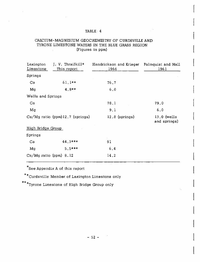
TABLE 4
CAICIUM-MAGNESIUM GEOCHEMISTRY OF CURDSVILLE AND TYRONE LIMESTONE WATERS IN THE BLUE GRASS REGION
(Figures in ppm)
Lexington Limestone
J. V. Thrailkill* This report
Hendrickson and Krieger 1964
Palmquist and Hall 1961
Springs
Ca
Mg
Wells and Springs
Ca
Mg
61. l**
4.8**
Ca/Mg ratio (ppm) 12. 7 (springs)
High Bridge Group
Springs
Ca
Mg
44.3***
5.5***
Ca/Mg ratio (ppm) 8. 12
*see Appendix A of this report
76.7
6.0
78.1
9. 1
12. 8 (springs)
91
6.4
14.2
79.0
6.0
13. 0 (wells and springs)
**curdsville Member of Lexington Limestone only
** *Tyrone Limestone of High Bridge Group only
- 52 -

r !' r r r ·
L ['
L [
L L L
L L
Figure 17
DISTRIBUTION OF GROUND WATER
GEOLOGY
CUROSVILLE LS.
foiclS&SURFACE
I.J..J.J..jJ 51.RFACE
TYRONE LS.
@] MAJOR FAUL TS x-
CUROSVILLE AND TYRONE LIMESTONES
SPRINGS - WELLS
SAMPLED SPRINGS
., Ole
Ii Qt
• Ole - Ot
OTHER (Ole - Qt)
A SPRINGS
e WELLS
Irvine, Channel • after
- 53 -
CUROSVILLE AQUIFERS
AREAS CLASSES
W.LJL I. PERCHED
JI. GRAVEL SOURCE
.... ···\ J.---""" m. TUBULAR
W. R. Ji Ilion, 1946 • 1941
20 MILES

detailed work of the Kentucky Mapping Program is revealing more
gravel deposits along former drainage channels (Earle Cressman,
Personal Communication). Low concentrations of dissolved material
probably is a result of short transportation in the limestone (Table 5).
Class III - Tubular Springs
Class III, or tubular springs, are common in the Jessamine Dome
Shoal Area north of Danville. Flow rates are variable from 1 to 40
gallons per minute, and Ca concentrations are high (Table 5). The
high Ca/Mg ratios indicates a lack of dolomite in the sediments
assuming the water has had time to reach equilibrium with the rock
through which it passes according to Thrailkill (Appendix A).
Bentonites, forming aquicludes, occur at various levels in the area.
The high percentage of limestone indicates possible high solubility
for the rock and accounts for the large solution openings.
Wells
Wells were not observed, sampled, or tested in the field . . ,,
Published information is not specific for wells in the Curdsville
Limestone Member alone. Most produce from several horizons
including the Tyrone Limes tone below.
The best prospective area for Curdsville wells is probably in
l the Jessamine Dome Shoal Area where favorable lithology and
fracture conditions exist, such as in the Bryantsville Quadrangle area.
- 54 -

r r r [
r r [~
North Danville Area
[ Frankfort Area
r: Nonesuch Spring
r c L L [
L L L L t
TABLE: 5
COMPARISON OF CALCIUM-MAGNESIUM IN CURDSVILLE LIMESTONE SPRINGS
{by area)
Average Ca in PPM Mg PPM ++ ++ Ca·. /Mg
64 4 .4 9.4
45 8. 2 3.4
13 3. 5 2.3
- 55 -

PROSFECTIVE CURDSVILIE LIMESTONE AQUIFERS IN THE BRYANTSVILLE QUADRANGLE AREA
The Bryantsville Quadrangle area, located on Figure 2, was
selected for detailed study as representative of the Jessamine Dome
Shoal Area. Springs and wells have been found in the Curdsville
Limes tone which occurs near the surface over much of the quadrangle.
Because intergranular porosity and permeability are cf:minor importance
in the Curdsville Limestone as observed in core analysis, subsurface
water movement must be largely confined to fractures (joints and
faults) or to bedding planes which have been enlarged by underground
solution. Surface water movement is partly controlled by fractures
which produce a somewhat rectangular drainage pattern in the present
stream channel of the Dix River and its tributaries as shown on the
map of Figure 18. Evidence of linear alignment of sink holes, solution
valleys, stream valleys, and old river courses are abundant on the
Bryantsville topographic quadrangle. Moreover, all these features
called "fracture traces" or lineaments are remarkably similar in
orientation to the measured joint fractures in outcrops of the Curds-
ville and Tyrone Limestones in the same area as shown on the map.
Therefore, although fault fractures may be important locally, joints
seem to be the dominant avenues of solution, and enlarged joints
are probably the principal aquifers. Springs observed in the field
issue from joints. The Joints are largely vertical, and wells drilled
- 56 -
l I
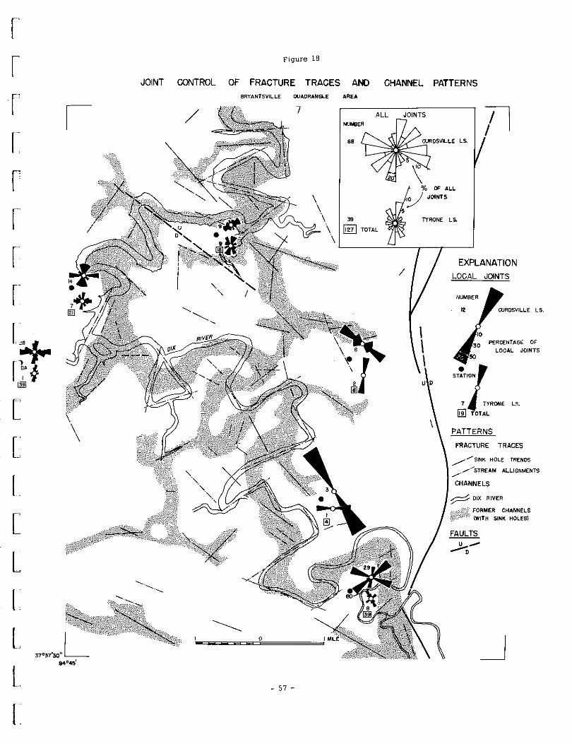
f'
I
r
r
c [
[
[
L I. L L
Figure 18
JOINT CONTROL OF FRACTURE TRACES AND CHANNEL PATTERNS 8RYANTSVILLE QUADRANGLE AREA
7 ALL
39
~ TOTAL
0
- 57 -
JOINTS
0/o OF ALL
~ JOINTS
TYRONE LS.
EXPLANATION
LOCAL JOINTS
PERCENTAGE OF
LOCAL JOINTS
ST~Tl1N
7 TYRONE LS.
fii} TOTAL
PATTERNS
FRACTURE TRACES
_/"/SINK HOLE TRENDS
_,.,... ............... STREAM ALLIGNMENTS
CHANNELS
FORMER CHANNELS
CWITH SINK HOLES)
FAULTS
>-0
_J

in areas of concentrated joints or where joint sets cross should
encounter more enlarged fractures and yield more water than wells
drilled in other areas. Old river courses marked by large numbers of
sink holes might be particularly favorable well sites. Lattman and
Parizek, 1964, applied this reasoning to a limestone area in
Pennsylvania and found that wells drilled near crossing "fracture
traces" encountered more cavities at depth and yielded more water
than wells drilled in interfracture areas.
Further work, including drilling, is needed to prove the validity
of the relationship between "fracture traces" and favorable well
locations in the Bryantsville area. Aerial photographs were examined
for a small portion of the Bryantsville quadrangle and indicate addi
tional evidence for fracture traces and solution phenomena. Obvious
joints were observed near the Dix River and other places. Shallow
depressions, and soil color variations suggest possible alignments.
Lattman and Parizek, op.cit,, using infrared aerial photographs made
with a blue filter were able to find soil moisture differences along
fracture traces. Field examination would yield additional information
in regard to fractures and fracture traces. A drilling program could
be set up as a separate Water Resources Institute Project with wells
proposed for favorable fracture tra<,;,e areas with provision for one or
more control wells in interfracture areas.
- 58 -
[
SUMMARY
The factors which control the porosity and permeability of the
Curds ville limestone are geological. Stratigraphy and structure
r determine water movement and aquifer development.
Microstratigraphic analysis of over 500 hand specimens and 400
thin-sections from 27 surface (outcrop) and subsurface (core) stations
in the Blue Grass Region and north to the Ohio River provides the
basis for subdivision of the lower Lexington Limestone, consisting
principally of the Curdsville Member, into three distinct ten-foot
L beds. Each bed can be subdivided into less distinct "zones" con-
sis ting of several Lithologic Types. These divisions aid in the
i: interpretation of the geologic history and paleogeography of Curds-
c ville time.
Both vertical (stratigraphic) and lateral (facies) changes occur
L in the Curdsville Member. The lower bed, which has the most
I : favorable aquifer attributes was deposited by high energy wave
and current action in a shallow sea. The middle and upper beds
[ were deposited in deeper water under lower energy conditions in
L a progressively transgressing sea. These latter beds contain more
L impervious shale and bentonite aquicludes than the lower bed.
However, locally, shaUow water was maintained over carbonate
L bank-shoal areas as compared with slightly deeper water over
L - 59 -
t

shelf-channel areas during most of Curdsville time" The high energy
bank-shoal facies were washed free of much of the fine impervious
material and thus developed into thicker potential aquifers than
the shelf-channel facies"
The Jessamine Dome Shoal Area is the most favorably located
shoal for ground water solution and accumulation in the Curds ville
Limestone because of subsequent uplift and erosion of this feature
along the Cincinnati Arch" Meteoric waters at shallow depths have
replaced unpotable salt and sulphur waters still found in the more
deeply buried bank or shoal areas" Dissolving ground waters have
enlarged fractures (mostly joints) in the limestone resulting in sink
holes, solution valleys, and caverns thus providing increased avenues
for ground water movement and accumulation as evidenced by the
existence of springs and wells in the area"
The Bryantsville Quadrangle north of Danville on the Jessamine
Dome Shoal Area was examined in detail for joint and fault fracture
frequency and alignment. Alighments of such features as sink hole
trends, present and pre-existing stream channels, and prominent
dry solution valleys were also determined" The obvious similarities
in trend of all these lineaments or "fracture trace" features with
the fracture pattern indicates that the subsurface solution and
surface water erosion are controlled by the fractures" Likewise
- 60 -
[
I
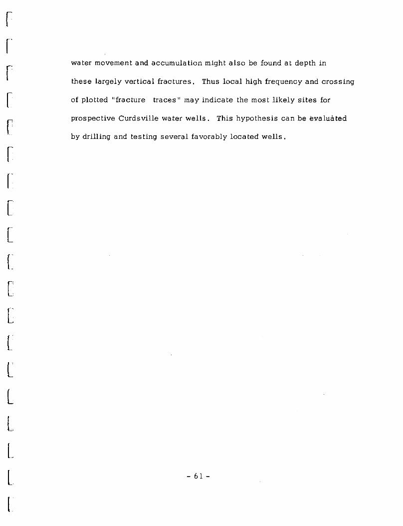
r l r r r r I[
[
L [
[
L L L L L L t
water movement and accumulation might also be found at depth in
these largely vertical fractures. Thus local high frequency and crossing
of plotted "fracture traces" may indicate the most likely sites for
prospective Curdsville water wells. This hypothesis can be evaluated
by drilling and testing several favorably located wells.
- 61 -
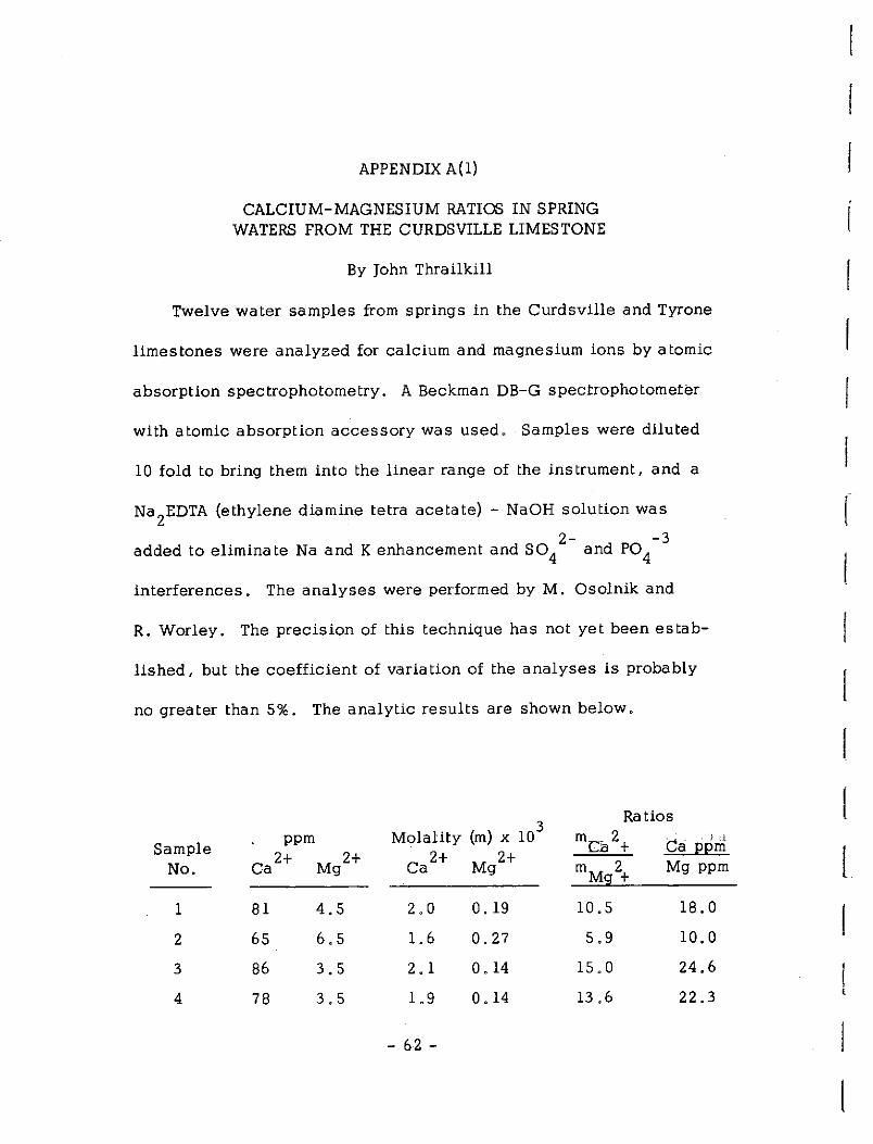
APPENDIX A(l)
CALCIUM-MAGNESIUM RATIOS IN SPRING WATERS FROM THE CURDSVILLE LIMESTONE
By John Thrailkill
Twelve water samples from springs in the Curdsville and Tyrone
limestones were analyzed for calcium and magnesium ions by atomic
absorption spectrophotometry. A Beckman DB-G spectrophotometer
with atomic absorption accessory was used. Samples were diluted
10 fold to bring them into the linear range of the instrument, and a
Na2
EDTA (ethylene diamine tetra acetate) - NaOH solution was
2- -3 added to eliminate Na and K enhancement and SO 4 and PO 4
interferences. The analyses were performed by M. Osolnik and
R. Worley. The precision of this technique has not yet been estab-
lished, but the coefficient of variation of the analyses is probably
no greater than 5%. The analytic results are shown below.
Molality (m) x 103
Ratios ppm me.a 2 + } '-1
Sample ca 2+ Mg2+ 2+ Mg2+
Ca ppm No. Ca mM 2 Mg ppm
g +
1 81 4.5 2.0 0.19 10.5 18.0
2 65 6.5 1. 6 0.27 5.9 10.0
3 86 3.5 2. 1 0. 14 15.0 24.6
4 78 3.5 1.9 0. 14 13 .6 22.3
- 62 -
l
l
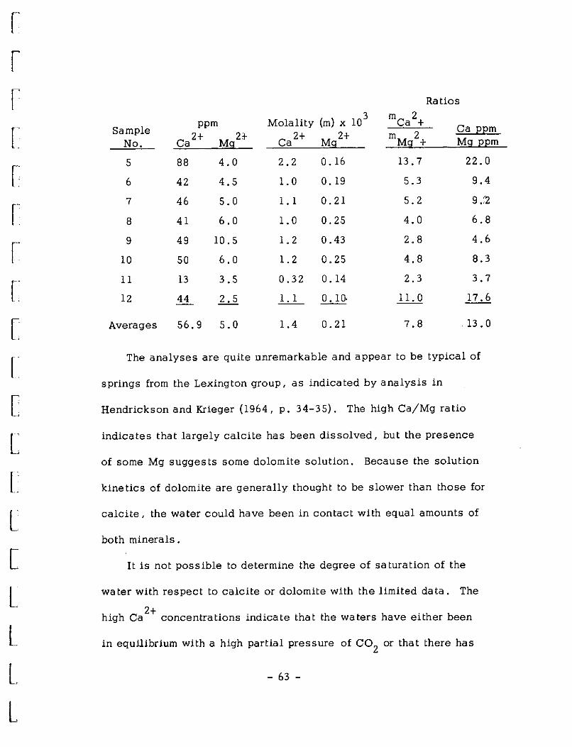
r r
r r: [
[
[
l L L [
L L
L l
Ratios
Sample ppm Molality (m) x 10
3 mca2+ Ca EEm
2+ 2} 2+ 2+ mM 2 No. Ca Mg Ca Mg g + Mg EEm
5 88 4.0 2.2 0. 16 13. 7 22.0
6 42 4.5 1. 0 0. 19 5.3 9.4
7 46 5.0 1. 1 0.21 5.2 9 .:2
8 41 6.0 1. 0 0.25 4.0 6,8
9 49 10. 5 1. 2 0.43 2.8 4,6
10 50 6,0 1. 2 0.25 4.8 8.3
11 13 3.5 0.32 0. 14 2.3 3.7
12 44 Ll _!_,_!.._ 0. 10, 11. 0 17.6
Averages 56.9 5.0 1.4 0.21 7.8 13. 0
The analyses are quite um.remarkable and appear to be typical of
springs from the Lexington group, as indicated by analysis in
Hendrickson and Krieger (1964, p. 34-35). The high Ca/Mg ratio
indicates that largely calcite has been dissolved, but the presence
of some Mg suggests some dolomite solution. Because the solution
kinetics of dolomite are generally thought to be slower than those for
calcite, the water could have been in contact with equal amounts of
both minerals.
It is not possible to determine the degree of saturation of the
water with respect to calcite or dolomite with the limited data, The
2+ high Ca concentrations indicate that the waters have either been
in equilibrium with a high partial pressure of co2
or that there has
- 63 -

been evaporation. In spring water, the former is a far more likely
explanation, inasmuch as both ground water and vadose seepage are
commonly in equilibrium with a P C02 higher than that of the normal
atmosphere. The 88 ppm Ca 2
+ in sample S suggests an equilibrium
-3 . P C02 of about 3 x 10 atm (10 times that of the normal atmosphere).
Although relatively little can be said about the probable history
and evolution of the spring waters, it is possible to compute,
assuming saturation, the equilibrium relationships with respect to
calcite and dolomite, the most abundant carbonates in the rocks
through which the water has passed. From the equation
2+ 2CaC0
3 + Mg
calcite )
2+ CaMg(C0
3) 2 + Ca
dolomite
it can be seen that the equilibrium constant K = aCa2+ / aMg2+
(assuming pure solid phases at unit activity). Although a complete
analysis of the spring waters is not available, they are undoubtedly
within the applicability range of the Deybe-Huckel equation for
individual ion activity coefficients and it is unlikely that any
complexing is important. Since, by the Deybe-H'uckel expression,
C 2+ YM 2+ y a ~ g then ac 2+ I aM 2+...., me 2+ I mM 2+ a g-a · g.
A value of K may be derived from the expression lnK = -t..G0
/RT
if the free energies of formation of the various species involved in
the reaction are known. Of these, all are known with fair accuracy
- 611 -
! [

r· r;
r
['.
L
L L L L t
except that for dolomite. Recent determinations have tended toward
values of AG0 f for dolomite of between -516 and -517 kcal. These
values yield values of K from O. 185 to O. Inasmuch as the ratios
ac 2+ /aM 2+ (me 2+ I m 2+ in. table) are considerably higher than a g a Mg ,
either value of K (the lowest is 2 ,3 for sample No. 11), the waters
at saturation are in equilibrium with calcite. Stated another way
(and assuming reversible equilibria), if waters with the mCa2+ /mMg2+
ratio of those sampled are saturated with respect to calcite, they
are undersaturated with respect to (and hence would dissolve) dolomite.
- 65 -

APPENDIX A(2)
SAMPLED SPRINGS IN THE CURDSVILLE AND TYRONE LIMESTONES
Sample Carter Date No_._ Count_y Quadrangle Farm Coordinates Collected Aquifer Remarks
1 Garrard Bryan ts ville Maywick 16-0-59 11/24/66 Curds ville 800' FWL, 3400' FSL
2 Mercer Wilmore 25-P-58 900' FWL 3500' FSL 11/14/66 Curds ville
3 Garrard Bryantsville - Rice 5-N-59 1500' FWL, 2200' FSL 11/24/66 Curds ville
as or Grier as 4 Garrard Bryantsville 11-0-".58
1500' PEL 3000' FSL 11/15/66 Curds ville Flows from
joint,110° 5 Garrard Bryan ts ville Maywick 20-0-58
1700' PEL 3000' FSL 11/24/66 Curds ville Flows from
Joint on top of mud cave
6 Jessamine Nicholasville 12-Q-59 2000' FNL 2000' PEL 9/14/66 Tyrone 10' Near
below Jessamine Curds ville Creek Contact
- -----,
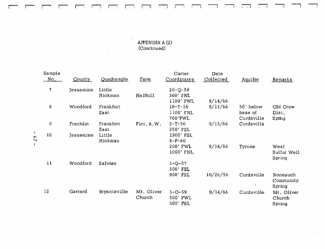
-L 1. r-- r-- r-: r-1 r-: r-:
Sample No, Qoupu,__ Quadrangle
7 Jessamine Little Hickman
8 Woodford Frankfort East
9 Frank Un Frankfort East
a- 10 Jessamine Little I~ Hickman
11 Woodford Sal visa
12 Garrard Bryantsville
r:-il --, il
Aff'ENDIX A (2) (Continued)
Carter Farm Coordinates
20-Q-59 Halfhill 300' FNL
1100' FWL 10-T-56 1100' FNL 700'FWL
Fint,A,W, 2-T-56 250' PEL 1900' FSL 4-P-60 200' FWL 1000' FNL
l-Q-57 300' PEL 800' FSL
Mt, Oliver 5-0-59 Church 500' FWL
500' FSL
--, --,
Date Collected
9/14/66 9/13/66
9/13/66
9/14/66
10/26/56
9/14/66
--, ---, .J
.Ag_uifer
50' below base of Curds ville Curds ville
Tyrone
Curds ville
Curds ville
--, --, --,
Remarks
Old Crow Dist, Spring
West Sulfur Well Spring
Nonesuch Community Spring Mt, Oliver Church Spring

AR'ENDIX B
INTERCRYSTALLINE POROSITY AND VERTICAL PERMEABILITY IN THE CURDSVILLE LIMESTONE
(After Data from Oilfield Research, Inc. , Evansville, Ind.)
Vertical Permea-
Area Lithologic Porosity Bulk Wet bility (Facies) Station Type Percent Density Md.
Shelf PB
242 la 2. 1 2.66 0. 14 240 lb 1.2 2.68 <0.10 236.8 le 0.6 2.68 226.1 I!b 0.9 2.64 210.5 !Ila 0.6 2.69 <O. 10 246 v 0.5 2.67
Carbonate HS Bank
388.S la 1. 5 2.68 386.2 lb 1. 5 2.68 390.4 le 0.6 2.66 355 Ila 3. 1 2.62 368 .4 Illa 0.9 2.70 356.6 I!Ib 4.7 2.64 <O. 10 367.4 Ille 2.2 2.71
SR
429.8 Ia 4.0 2.64 <O. 10
Porosities of less than 3% are of less than normal accuracy using commercial techniques. We chose the most applicable method, and the most accurate from our laboratories - weight loss method. The entire sample received was subjected to vacuum for 1 1/2 hours and the chamber then filled with water. The fluid was then pressured to 1500 psi and let stand for 1 1/2 hours. The rock was weighed, including the contained fluid, and dried at less than 100°C for three hours. Each sample was weighed again, the weight loss representing the vblume of pore space. Upon determining total volume by submersion the porosity was calculated by standard procedure.
- 68 -
I I
I L
I l

['
r
[
[
L r L [
L.
L L L L
-[
Based on our experience and a review of the porosity results, we felt it unnelJessary to test all the samples for permeability. First, many of the samples received are too small to drill a 3/4" standard plug. Although V2" (diameter) plugs could have been drilled, the results often leave something to be desired. However, we primarily based our decision on comparable rock lithologies which we have tested. The porosity is a good permeability indicator. Intercrystalline porosity, as observed in limestones, is normally quite low and the permeability negligible. Vugular porosity will normally be 8 to 12% and the permeability profile erratic. Dolomite porosity can be low (<8%), or high, (>20%), but with intercrystalline porosity the permeability will not be extremely high {>100 md.). The five permeability tests confirmed our preconceived ideas and, we hope, suffice for your purposes. In other words, we doubt any of the samples not tested will have measurable permeability at two atmospheres pressure differential.
Should you desire further testing, or have any questions regarding the above results contact us at your convenience. We have waived the minimum charge for these tests.
OILFIELD RESEARCH, INC. Evansville, Indiana
Ben Ross Oates

APPENDIX C
X-RAY ANALYSIS OF CURDSVILLE LIMESTONE INSOLUBIE RESIDUES
George T. Hine
Qualitative x-ray diffraction determinations were made on several
samples of insoluble material, from station FEC, which showed the
presence of quartz, montmorillonire-illite clays, feldspar, and some
carbonates. Quantitative values for the materials were not determined.
Subsequent petrographic examination, of station FEC thin sections, has
confirmed the presence of quartz, clay, and feldspar.
Quantitative x-ray diffraction determinations of quartz content
in the insoluble residues was attempted with limited success.
Dr. I. S. Fisher (Geology Department, University of Kentucky) has
prepared a calibration curve for the determination of quartz in insoluble
residues with calcite as an internal standard. This curve could not
be used with the FEC samples because of the occurrence of several
extraneous peaks in the vicinity of the standard calcite peak. Two
attempts were made to prepare a calibration curve, one using zircon
and the other using silicon as internal standards. The results
obtained in each case were variable, although promising with a
definite trend, indicating the need for refinement in method. Addi
tional work with the x-ray was not done because work with the
- 70 -
. [
L

' ' r r r r r r
[
[
[
L [
L
L L L L L
petrographic thin sections yielded sa tis tac tory information as to
quartz content in the Curdsville Limestone as well as distinguishing
the type of quartz (chert and detrital quartz).
PREIARATION OF STANDARD MATERIAL
Quartz: Clear fragments of quartz were ground in a crusher and then
powdered for five minutes in a Spex-mix No. 5000 mixer mill.
Clay filler: Mud Cave bentonite from Curdsville station was treated
overnight in a bath of concentrated (commercial grade 33%)
HCL. The residue was washed several times to remove the
acid. Tha remaining material was placed in water, mixed,
and the fi.ne material in suspension was decanted, allowed
to settle, and the clear water was siphoned off. The fine
clay was air direct, removed from the beaker, crushed in a
mortar and pestle, and placed in a closed bottle.
Zircon: Fine grained zircon sand of high purity was placed in the
Spex-mix for five minutes and powdered.
PREIARATION OF STANDARD SLIDES
Six 1.25 g. samples were prepared, each containing 0.25 g. of
zircon and 1. 00 g. of either pure quartz, clay, or a mixture of both
so that samples of 1.00 g., 0.80 g., 0.60 g., 0.40 g., 0.20 g.,
and O. 00 g. of quartz and an inverse amount of clay were made up.
Each of the six samples was plac~d in the Spex-mix for one minute
- 71 -
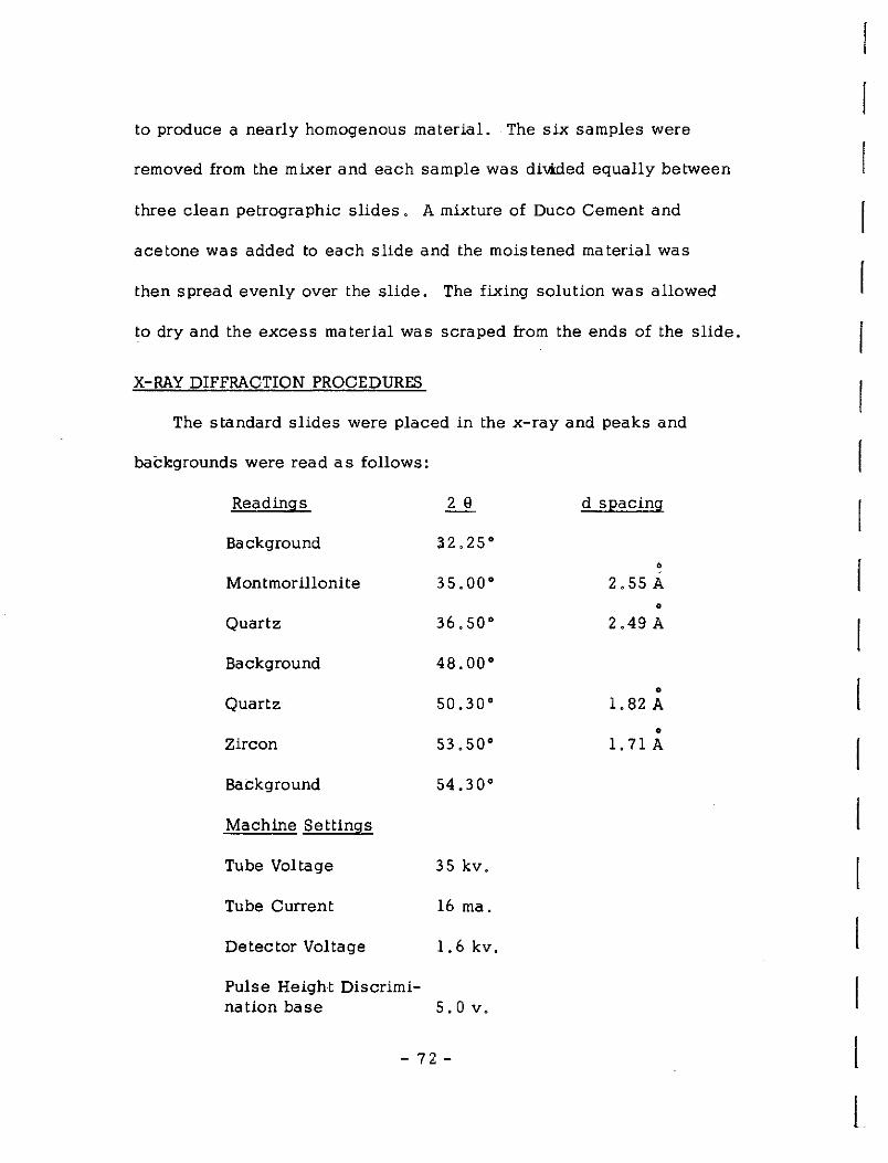
to produce a nearly homogenous material. The six samples were
removed from the mixer and each sample was divided equally between
three clean petrographic slides. A mixture of Duco Cement and
acetone was added to each slide and the moistened material was
then spread evenly over the slide. The fixing solution was allowed
to dry and the excess material was scraped from the ends of the slide.
X-RAY DIFFRACTION PROCEDURES
The standard slides were placed in the x-ray and peaks and
backgrounds were read as follows:
Readings 2 e d spacing
Background 32.25° •
Montmorillonite 35.oo· 2. 55 A •
Quartz 36.50° 2 .49 A
Background 48.oo•
• Quartz 50.30° 1.82 A
• Zircon 53.50° 1. 71 A
Background 54.30°
Machine Settings
Tube Voltage 3 5 kv.
Tube Current 16 ma.
Detector Voltage 1.6 kv.
Pulse Height Discrimi-nation base 5. 0 v.
- 7.2 -
I

i i r 1-
1-
[
!-
[
[
r[
L L l L L L L l:
Each peak and background was read three times for 100 seconds per
slide and the average of the peaks and backgrounds for the three
duplicate slides was calculated.
DETERMINATION OF RATIOS
The zircon/quartz ratios were calculated from the average values
using the formula:
~Z~i_rc~o_n_c~o_u~n~t~s_-_b~a~c~k-g~ro~u~n_d~c~o_u~n~t_s~ = zircon/ quartz ratio Quartz counts - background counts
These ratios were plotted on three cycle semi-logarithmic paper. The
ratio for zircon/quartz (Figure 19) yielded a smooth curve exqipt in the
area of O. 80 g. quartz. The cause of the variation was not determined
although additional samples were run. The other ratio (zircon/clay)
showed similar deviations in the O .80 g. quartz area perhaps indicating
a mixing or packing variation with slides of the composition 0. 80 g.
quartz and O. 20 g. clay and O. 25 g. zircon.
A new set of standard slides, identical to the zircon standard
slides except for the use of silicon as the internal standard, were
prepared. Silicon is often used to calibrate the goniometer on the
x-ray diffractometer since it has sharp definite peaks which can be
accurately located. Using the silicon peak as a reference, counts
were made as follows: SiHdon (28.443°); Background (27.843°);
Background (27.162°); Quartz (26.662°). The resulting curve showed
even more variation than the zircon standard curve.
- 7 3 -

0 ......
~ N E-< 0::
:3 0
z 0 0:: ...... N
Figure 19
CALIBRATION CURVE FOR DETERMINATION OF QUARTZ CONTENT
30.0
20.0
10.0
0
\ 0
1.0 0
0
0
0.1 ~-~-----~-~ o 20 40 so eo 100
% CF QUARTZ IN SAMPLE
- 74 -
r
I I

r r r [
r [
l [
[
[
[
[
L [
L L L L
L
ADDITIONAL WORK
Since the completion of the x-ray work, additional information
was obtained by Dr. Fisher as to recommended procedures for quantita
tive standardization of the x-ra y to an accuracy of± 1 % • The method
is as follows:
1. Crush all material to a size which will pass a 325 mesh screen.
2. Prepare the sl,ides by back filling a hoUow area in the slide
so that the powder is level with the upper surface of the
slide, so that it will be in the focal plane of the x-ray when
in the slide holder. The old method of gluing the material
to the slide introduces error as a result of differing thickness
of the standard which varies the focusing of the x-ray beam.
3 . The peak area should be determined using a step scanner.
Because for quantitative work it is important to determine
the area under the peak rather than the peak height. The
peak height is more sensitive to grain size than is the peak
area.
4. Readings of 50, 000 counts should be made on each peak
and the time required for the accumulation of this number
of counts should be recorded.
The method outlined should result in a calibration standard with an
accuracy of ± 1 % •
- 7·5 -

APPENDIX D
INSOLUBLE RESIDUES OF CURDSVILLE LIMESTONE
By George Hine
I. Four stations were selected for insoluble contenL (CA, DA, FEC, CT)
II. Modified standard insoluble techniques were used. (after Ireland, 1958, p. 75)
A. Two sampling techniques were used. 1. Gbres were sliced to give a continuous sample for
each 1 foot interval.
2. Surface sections were sampled for each 1 foot interval and proportional amounts of each rock type present were collected,
B. The samples were crushed to"-Omm and lOg of each was separated and placed in a 11 beakeL
C. Each sample was dissolved in 400cc of 20% HCl for at least 10 hrs. and until all reaction had stopped.
D .. Each sample was decanted and washed three times to remove all acid and salts, all insoluble materials,
Care was taken to preserve
E. The samples were air dried, weighed, and placed in small stoppered bottles for storage.
III. Several methods of examination were used on the residues.
A. The % insoluble for each one foot interval was plotted for each section, as were various running averages and total
r
[
! l
l averages. l
B. Each sample was studied under the microscope to determine the nature of the insoluble materiaL
- 76:-
l
r [
1-
[
[
r r L [
[
L L L L L
C, Color determinations were run on the samples. (GSA Rock Color Chart, 1948).
D, Grain size analysis was run on several samples and the composition of the size fraction noted.
E. Stain tests for bentonite clay were made.
F. Insoluble % were compared with y ray logs.
G, X-ray examination was tried on several samples.
H. Relation between rock type and insoluble content were noted.
- 77 -
Station
BA BB BC BD CA CT CYT DA FCF FEC FEO FL FLS FWD GG HS KA LEL LHC LWB MC ND NV PB SC SH SR TD
-"VJVK WL WC
APPENDIX E
STATION LOCATIONS OF CURDSVILLE IIMESTONE SECTIONS
Carter Coordinates Quadrangle
23-0-58 Bryant s ville 14-N-58 Bryan ts ville 15-N-58 Bryantsville 6-N-59 Bryantsville
10-S-62 Clintonville 17-R-6 l Cole town 10-W-62 Cynthiana 20-0-57 Danville 9-Q-62 Ford 8-T-56 Frankfort East
10-T-56 Fra nlliort East 23-R-62 Ford 22-AA-62 Falmouth 17-V-56 Frankfort West 21-AA-57 Glencoe, 13-R-65 Hedges 16-R-58 Keene 6-S-62 Lexington East
22-P-59 Little Hickman 19-T-60 Lexington West 13-W-67 Moorefield 4-Q-60 Nicholasville
10-Q-60 Nicholasville 20-CC-57 Pa tr<iot 19-R-57 Sal visa
8-V{-60 Sadieville 16-T-66 Sideview 24-S-57 Tyrone ll-Q-61 Valley View 17-Q-61 Valley View 7-P-58 Wilmore
- 78 -
r
I I
l
l l
r
' '
[
L [
L L L L L L
REFERENCES CITED
Black, D. F. B., 1965, Excursion to the Cryptoexplosive Structure near Versailles, Kentucky: Geol. Soc. of Kentucky, Field Trip Guidebook, Pub. by Kentucky Geological Survey, Lexington, Kentucky, 5 lp.
Black, D. F. B., Cressman, E. R., and MacQuown, W. C., Jr., 1965, The Lexington Limestone (Middle Ordovician) of Central Kentucky: U, S. Geol. Survey Bull. 1224-C, p. C l-C29,
Black, D. F. B., and MacQuown, W. C., Jr., 1965, Lithostratigraphy of the Ordovician Lexington and Clays Ferry Formation of the Central Bluegrass Area near Lexington, Kentucky: Geol. Soc. of Kentucky, Field Trip Guidebook, Pub. by Kentucky Geol. Survey, Lexington, Kentucky, 5 lp.
Bucher, W. H., 1936, Cryptovolcanic Structures in the United States: International Geol. Congress (16th), United States, Rets, , V, 2, p. 1055-1084.
Hamilton, D. K., 1950, Areas and Principles of Ground Water Occurrence in the Inr«. · Blue Grass Region, Kentucky: Kentucky Geol. Survey Bull. 5, 67p.
Hendrickson, G. E., and Krieger, R. A., 1964, Geochemistry of Natural Waters of the Blue Grass Region, Kentucky: U.S. Geol. Survey Water-Supply Paper 1700, 135p.
Huff, W. D., 1962, Mineralogy of Ordmzician K-Bentonites in Kentucky: National Conference on Clays and Clay Minerals (11th), Proceedings, p, 200-209.
Ireland, H. A., 1958, Insoluble Residues (in "Subsurface Geology in Petroleum Exploration," a Symposium, ed. by Haun, J. D., and Leroy, L. W.): Colorado School of Mines, Golden, Colorado, p. 75-95.
Jillson, W. R. , 1946-48, The Nonesuch (1946), the Warwick (194 7), The Pleasant Hill (1948), and the Hickman (1948) Abandoned Channels of the Kentucky River: Roberts Printing Company, Frankfort, Kentucky.
- 79 -

REFERENCES CITED (Continued)
Lattman, L. H., and Parizek, R. R., 1964, Relationship Between Fracture Traces and the Occurrence of Ground Water in Carbonate Rocks: Journal of Hydrology, r. 2, p. 73-91.
MacQuown, W. C. , Jr. , 1966, Factors Controlling Porosity and Permeability of the Curdsville Member of the Lexington Limes tone (Progress Report of Project No. A-003-KY for Office of Water Resources Research, U. S. Department of the Interior): Water Resources Institute, University of Kentucky, Lexington, Kentucky, 34 p .
Palmquist, W. N. , Jr. , and Hall, F. R., 1961, Reconnaissance of Ground Water Resources in the Blue Grass Region, Kentucky: U. S. Geological Survey Water-Supply Paper, 1533, 39p.
Stafford, T. F., Jr., 1963, Features of Jointing in the Inner Blue Grass of Kentucky: M .S. Thesis, Department of Geology, University of Kentucky, 72p.
- 80 -
I
Related Documents


