Extent and Depth to Top of Basalt and Interbed Hydrogeologic Units, Yakima River Basin Aquifer System, Washington Scientific Investigations Report 2008–5045 Prepared in cooperation with the Bureau of Reclamation, Washington State Department of Ecology, and the Yakama Nation U.S. Department of the Interior U.S. Geological Survey

Welcome message from author
This document is posted to help you gain knowledge. Please leave a comment to let me know what you think about it! Share it to your friends and learn new things together.
Transcript

Extent and Depth to Top of Basalt and Interbed Hydrogeologic Units, Yakima River Basin Aquifer System, Washington
Scientific Investigations Report 2008–5045
Prepared in cooperation with the Bureau of Reclamation, Washington State Department of Ecology, and the Yakama Nation
U.S. Department of the InteriorU.S. Geological Survey

Cover: Photograph of Clark Well No. 1, located on the north side of the Moxee Valley in North Yakima, Washington. The well is located in township 12 north, range 20 east, section 6. The well was drilled to a depth of 940 feet into an artesian zone of the Ellensburg Formation, and completed in 1897 at a cost of $2,000. The original flow from the well was estimated at about 600 gallons per minute, and was used to irrigate 250 acres in 1900 and supplied water to 8 small ranches with an additional 47 acres of irrigation. (Photograph was taken by E.E. James in 1897, and was printed in 1901 in the U.S. Geological Survey Water-Supply and Irrigation Paper 55.)
Extent and Depth to Top of Basalt and Interbed Hydrogeologic Units, Yakima River Basin Aquifer System, Washington
By M.A. Jones and J.J. Vaccaro
Prepared in cooperation with the Bureau of Reclamation, Washington State Department of Ecology, and Yakama Nation
Scientific Investigations Report 2008–5045
U.S. Department of the InteriorU.S. Geological Survey

U.S. Department of the InteriorDIRK KEMPTHORNE, Secretary
U.S. Geological SurveyMark D. Myers, Director
U.S. Geological Survey, Reston, Virginia: 2008
For product and ordering information: World Wide Web: http://www.usgs.gov/pubprod Telephone: 1-888-ASK-USGS
For more information on the USGS--the Federal source for science about the Earth, its natural and living resources, natural hazards, and the environment: World Wide Web: http://www.usgs.gov Telephone: 1-888-ASK-USGS
Any use of trade, product, or firm names is for descriptive purposes only and does not imply endorsement by the U.S. Government.
Although this report is in the public domain, permission must be secured from the individual copyright owners to reproduce any copyrighted materials contained within this report.
Suggested citation:Jones, M.A., and Vaccaro, J.J., 2008, Extent and depth to top of basalt and interbed hydrogeologic units, Yakima River Basin aquifer system, Washington: U.S. Geological Survey Scientific Investigations Report 2008–5045, 22 p., 5 pls.

iii
Contents
Abstract ...........................................................................................................................................................1Introduction.....................................................................................................................................................1
Purpose and Scope ..............................................................................................................................3Description of Study Area ............................................................................................................................3
Location and Setting ............................................................................................................................3Development of Water Resources .....................................................................................................5Overview of the Geology......................................................................................................................7
Methods of Investigation ..............................................................................................................................8Hydrogeologic Framework .........................................................................................................................10
Saddle Mountains Hydrogeologic Unit ...........................................................................................11Mabton Hydrogeologic Unit ..............................................................................................................11Wanapum Hydrogeologic Unit ..........................................................................................................14Vantage Hydrogeologic Unit .............................................................................................................14Grande Ronde Hydrogeologic Unit ..................................................................................................14
Summary and Conclusions .........................................................................................................................18Acknowledgments .......................................................................................................................................18Selected References ...................................................................................................................................18
iv
Figures Figure 1. Map showing the Yakima River Basin, Washington ……………………………… 2 Figure 2. Map showing land use and land cover, Yakima River Basin, Washington, 1999 … 4 Figure 3. Schematic diagram showing selected tributaries, diversion canals, return flows,
and streamflow-gaging stations, Yakima River Basin, Washington ……………… 6 Figure 4. Map showing simplified surficial geology, Yakima River Basin, Washington …… 7 Figure 5. Map showing structure delineating Yakima River Basin aquifer system,
Washington ……………………………………………………………………… 9 Figure 6. Correlation chart showing the regional relation between generalized stratigraphy
and hydrogeologic units for the Yakima River Basin, Washington ……………… 10 Figure 7. Map showing distribution of wells used to delineate the depth to top of Saddle
Mountains unit, Yakima River Basin aquifer system, Washington ………………… 12 Figure 8. Map showing distribution of wells used to delineate the depth to top of Mabton
unit, Yakima River Basin aquifer system, Washington …………………………… 13 Figure 9. Map showing distribution of wells used to delineate the depth to top of Wanapum
unit, Yakima River Basin aquifer system, Washington …………………………… 15 Figure 10. Map showing distribution of wells used to delineate the depth to top of Vantage
unit, Yakima River Basin aquifer system, Washington …………………………… 16 Figure 11. Map showing distribution of wells used to delineate the depth to top of Grande
Ronde unit, Yakima River Basin aquifer system, Washington …………………… 17
Plates [In pocket] Plate 1. Map showing extent and depth to top of Saddle Mountains hydrogeologic unit, in
Yakima River Basin aquifer system, Wahington Plate 2. Map showing extent and depth to top of Mabton hydrogeologic unit, in Yakima
River Basin aquifer system, Washington Plate 3. Map showing extent and depth to top of Wanapum hydrogeologic unit, in Yakima
River Basin aquifer system, Washinton Plate 4. Map showing extent and depth to top of Vantage hydrogeologic unit, in Yakima
River Basin aquifer system, Washington Plate 5. Map showing extent and depth to top of Grande Ronde hydrogeologic unit, in
Yakima River Basin aquifer system, Washinton

v
Conversion Factors, Datums, and Acronyms
Conversion Factors
Multiply By To obtain
Length
inch (in.) 2.54 centimeter (cm)inch (in.) 25.4 millimeter (mm)inch per year (in/yr) 2.54 centimeter per year (cm/yr)inch per year (in/yr) 25.4 millimeter per year (mm/yr)foot (ft) 0.3048 meter (m)mile (mi) 1.609 kilometer (km)
Area
acre 4,047 square meter (m2)square mile (mi2) 2.590 square kilometer (km2)
Volume
cubic foot (ft3) 0.02832 cubic meter (m3) acre-foot (acre-ft) 1,233 cubic meter (m3)acre-foot (acre-ft) 0.001233 cubic hectometer (hm3)
Flow rate
acre-foot per year (acre-ft/yr) 1,233 cubic meter per year (m3/yr)cubic foot per second (ft3/s) 0.02832 cubic meter per second (m3/s)
Datums
Vertical coordinate information is referenced to the North American Vertical Datum of 1988 (NAVD 88).
Horizontal coordinate information is referenced to the North American Datum of 1927 (NAD 27).
Altitude, as used in this report, refers to distance above the vertical datum.
Acronyms
CRBG Columbia River Basalt GroupDEM digital elevation modelDGER Washington Division of Geology and Earth ResourcesGIS Geographic Information SystemSOAC System Operations Advisory CommitteeTWSA current available storage in the reservoirs, estimates of unregulated flow, and other sources
that principally are return flowsUSGS U.S. Geological SurveyWaDOE Washington State Department of EcologyWRIA Washington State Water Resources Inventory AreaYN Yakama Nation3D Three dimensionalSMB Saddle Mountains BasaltWB Wanapum BasaltGRB Grande Ronde Basalt

vi
This page intentionally left blank.

AbstractThe hydrogeologic framework was delineated for the
ground-water flow system of the three basalt formations and two interbeds in the Yakima River Basin, Washington. The basalt units are nearly equivalent to the Saddle Mountains, Wanapum, and Grande Ronde. The two major interbed units between the basalt formations generally are referred to as the Mabton and Vantage.
The basalt formations are a productive source of ground-water for the Yakima River Basin. The Grande Ronde unit comprises the largest area in the Yakima River Basin aquifer system. This unit encompasses an area of about 5,390 mi2 and ranges in altitude from 6,900 ft, where it is exposed at land surface, to a depth of 2,800 ft below land surface. The Wanapum unit encompasses an area of 3,450 mi2 and ranges in altitude from 5,680 ft, where exposed at land surface, to a depth of 2,050 ft below land surface. The Saddle Mountains unit, the least extensive, encompasses an area of 2,290 mi2 and ranges from 4,290 ft, where exposed at the surface, to a depth of 1,840 ft below land surface.
IntroductionSurface water in the Yakima River Basin, in south-central
Washington (fig. 1) is under adjudication and the amount of surface water available for appropriation is unknown, but there are increasing demands for water for municipal, fisheries, agricultural, industrial, and recreational uses. These demands must be met by ground-water withdrawals and/or by changes in the way water resources are allocated and used. On-going activities in the basin for enhancement of fisheries and obtaining additional water for agriculture may be affected by ground-water withdrawals and by rules implemented under the Endangered Species Act for salmonids that have been either listed or were proposed for listing in the late 1990s. An integrated understanding of the ground-water flow system and its relation to the surface-water resources is needed in order to implement most water-resources management strategies in
the basin. In order to obtain this understanding, a study of the Yakima River Basin aquifer system began in June 2000. The study is a cooperative effort of the U.S. Geological Survey (USGS), Bureau of Reclamation (Reclamation), the Yakama Nation (YN), and the Washington State Department of Ecology (WaDOE).
The overall objectives of the study are to fully describe the ground-water flow system and its interaction with and relation to surface water, and to provide baseline information for a management tool—a numerical model. The conceptual model of the flow system and the results of the study will be used to guide and support actions taken by management agencies with respect to ground-water availability and to provide information to other stakeholders and interested parties. The numerical model will be developed as an integrated tool to assess short-term to long-term management activities, including the testing of potential management strategies.
The study includes three phases. The first phase includes (1) project planning and coordination, (2) compiling, documenting, and assessing available data, and (3) initial data collection. The second phase consists of data collection to support the following phase 2 work elements: (1) mapping of hydrogeologic units, (2) estimating ground-water pumpage, (3) developing estimates of ground-water recharge, (4) assessing ground water-surface water interchanges, and (5) constructing maps of ground-water levels. Together, these five elements provide the information needed to describe the ground-water flow system, the conceptual model, and provide the building blocks for the hydrogeologic framework. In the third phase, six structural basin models and one regional model of the ground-water flow system will be constructed in order to integrate the available information. The numerical models will be used to gain a further understanding of the flow system and its relation to surface water, and to test management strategies. The results from selected work elements will be described in a series of reports. This report defines the hydrogeologic framework of the three major basalt units, and the two major interbed units as described under the phase 2 work element, mapping of the hydrogeologic units.
Extent and Depth to Top of Basalt and Interbed Hydrogeologic Units, Yakima River Basin Aquifer System, Washington
By M.A. Jones and J.J. Vaccaro
2 Extent and Depth to Top of Basalt and Interbed Hydrogeologic Units, Yakima River Basin Aquifer System, Washington
82 22
22
97
97
97
12
12
82
82
240
24
410
240
90
90
90
24
410
12
97
12
241
82
82 12
KITTITAS COUNTYYAKIMA COUNTY
CO
UN
TY
BEN
TON
C
OU
NTY
CO
UN
TY
KLICKITATYAKIMA
EXPLANATIONBOUNDARY OF YAKIMA RIVER BASIN
Canal
Roza
Sunnyside
Canal
Main Canal
Extension
Kennewick
Main Canal
Marion Drain
North Branch Canal
Kittitas Main Canal
Bumping Lake N Fk
S Fk
S Fk
N Fk
S Fk N Fk
N Fk
Cle E
lum
Riv
er
Swau
k
Cre
ek
Carib
ou C
r
Col
eman
Cr
Nan
eum
Cr
Cook
e Cr
Crow Creek
Bumping R
iver
American River
Rattlesnake Cr
Little Rattlesnake C
r
Nile Creek
Manastash
Badger Creek
Lmuma Cr
Ahtanum Creek
Oak Creek
Tieton River
Wide Hollow Cr
Wenas Creek Selah Creek
North Fork
Dry Creek
Simcoe Creek
Agency Creek
Creek
Toppenish
Corral Cr
RIVER
Spring Cr
Logy
Creek
Satu
s
C
reek
Mule D
ry
Cre
ek
Cle Elum Lake
Rimrock Lake
Kachess Lake
Keechelus Lake
Lake Wallula
Priest Rapids Lake
Teanaway River
Reecer Cr
Wils
on C
reek
Park
Cr
Taneum Creek
Umtanum Creek
Little Naches River
Cr
Cowichee Creek
Cowichee
Creek
River
Naches
Snip
es C
r
Sulp
hu
r Cr W
asteway
Cherry Cr
S Fk
N Fk
YAKIMA
YAKIMA
RIVER
Cle Elum
Parker
Wapato
Ellensburg
Umtanum
Kittitas
Thrall
Toppenish
Moxee City Union
Gap
Yakima
Selah
Naches
Sunnyside Richland
Kiona
Kennewick Prosser
Grandview
Mabton
Satus
Zillah
Granger
Roza
Easton
Teanaway
Tieton Rimrock
SnoqualmiePass
Van Epps Pass
EsmeraldaPeaks
K I T T I T A S
V A L L E Y
M A N A S T A S H
KACHESS RIDGE
R I D G E
UNION GAP
CLEMAN MOUNTAIN
TEANAW
AY
NORTH RIDGE
U M T A N U M R I D G E
DeceptionPass
Y A K I M A V A L L E Y
AHTANUM RIDGE
COWICHE MTN
AMERICAN RIDGE
CLE ELUM RIDGE
RIDGE
TOPPENISH RIDGE
R A T T L E S N A K E H I L L S
Y A K I M A R I D G E
H O R S E H E A V E N H I L L S
CA
SC
AD
E
R
AN
GE
W
E N AT C H E E M O U N TA I N S
GilbertPeak
121°
47°
47°30'
46°
120°121°30' 120°30' 119°30'
46°30'
0 5 10 20 30 40 MILES
0 5 10 20 30 40 KILOMETERS
YakimaRiverBasin
WASHINGTON
Base modified from Fuhrer and others, 1994.
wa19_0162.fig01_drainage
COLUMBIA RI VER
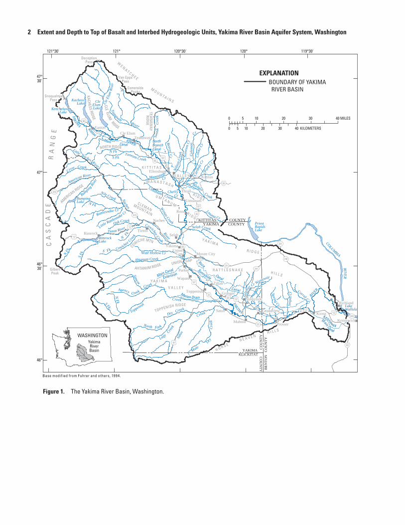
Figure 1. The Yakima River Basin, Washington.

Description of Study Area 3
Purpose and Scope
This report describes the depth to top of selected basalt and interbed hydrogeologic units that compose part of the Yakima River Basin aquifer system. This and other study information will be used to develop a conceptual model describing local and regional ground-water flow systems. Maps presented in this report provide the extents and the depth to the top of three basalt and two interbed hydrogeologic units within the study area. The three basalt units are nearly equivalent to the Grande Ronde, Wanapum, and Saddle Mountains Formations of the Columbia River Basalt Group (CRBG). The two major interbed units are between the Grande Ronde and Wanapum Formations and the Wanapum and Saddle Mountains Formations.
Description of Study AreaThe location and setting of the study area, the
development of water resources in the basin, and an overview of the geology are presented to provide a general background for understanding the study area.
Location and Setting
The Yakima River Basin aquifer system underlies about 6,200 mi2 in south-central Washington (fig. 1). The Yakima River Basin produces a mean annual unregulated streamflow (adjusted for regulation and without diversions or returns) of about 5,600 ft3/s (about 4.1 million acre-ft) and a regulated streamflow of about 3,600 ft3/s (about 2.6 million acre-ft). The basin includes three Washington State Water Resource Inventory Areas (WRIA—numbers 37, 38, and 39), part of the Yakama Nation lands, and three ecoregions (Cascades, Eastern Cascades, and Columbia Basin—Omernik, 1987; Cuffney and others, 1997). The basin includes parts of four counties (Klickitat, Kittitas, Yakima, and Benton). Almost all of Yakima County and more than 80 percent of Kittitas County lie within the basin, and about 50 percent of Benton County is in the basin. Less than 1 percent of the basin, principally in an unpopulated upland area, lies in Klickitat County.
The headwaters of the basin are on the upper, humid east slope of the Cascade Range, where the mean annual precipitation is more than 100 in. The basin terminates at the confluence of the Yakima and Columbia Rivers in the low-lying, arid part of the basin, which receives about 6 in. of precipitation per year. Altitudes in the basin range from 400 to nearly 8,000 ft. Eight major rivers and numerous smaller
streams are tributary to the Yakima River (fig. 1); the largest tributary is the Naches River. Most of the precipitation in the basin falls during the winter months as snow in the mountains. The mean annual precipitation over the entire basin is about 27 in. (about 12,000 ft3/s or 8.7 million acre-ft). The spatial pattern of mean annual precipitation resembles the pattern of the basin’s highly variable topography. The difference between the mean annual precipitation and mean annual unregulated streamflow is 6,400 ft3/s (about 4.6 million acre-ft) or about 53 percent of the precipitation is lost to evapotranspiration under natural conditions.
The basin is separated into several broad valleys by large east-west trending anticlinal ridges. The valley floors are flat and slope gently towards the Yakima River. Few perennial tributary streams traverse these valleys. Most of the population and economic activity occurs in these valleys.
Agriculture is the principal economic activity in the basin. The average annual surface-water demand met by Reclamation’s Yakima Project is about 2.5 million acre-ft; an additional 336,000 acre-ft of demand in the lower river basin is separate from the demand met by the project. Additional surface-water demand that is not met by Reclamation occurs in smaller tributaries and on the large rivers; this demand is based on State appropriated water. More than 95 percent of the surface-water demand is for irrigation of about 500,000 acres in the low-lying semiarid to arid parts of the basin (fig. 2). The demand is partially met by storage of nearly 1.1 million acre-ft of water in five Reclamation reservoirs. The major management point for Reclamation is the streamflow gaging station (12505000) at the Yakima River near Parker. Just upstream of this site, at Union Gap, is the location that is considered the dividing line between the upper (mean annual precipitation of 7 to 125 in.) and lower (mean annual precipitation of 6 to 45 in.) parts of the Yakima River Basin. About 45 percent of the water diverted for irrigation is eventually returned to the river system as surface-water inflows and ground-water discharge, but at varying time-lags (Bureau of Reclamation, 1999). During the low-flow period, these return flows, on average, account for about 75 percent of the streamflow below the Yakima River near Parker streamflow-gaging station. Much of the surface-water demand in the basin below Parker is met by these return flows and not by the release of water from the reservoirs. As a result of water use in the basin, the difference between mean annual unregulated and regulated streamflow in the basin is about 2,000 ft3/s, suggesting that some 1.4 million acre-ft of water, or about 17 percent of the precipitation in the basin, is consumptively used—principally by irrigated crops through evapotranspiration.

4 Extent and Depth to Top of Basalt and Interbed Hydrogeologic Units, Yakima River Basin Aquifer System, Washington
wa19_0162_fig02_landuse
Richland
Yakima
EXPLANATIONSIMPLIFIED LAND COVER
BOUNDARY OF AGRICULTURAL AREA
FOREST (33%)RANGE (36%)
CITIES AND TOWNS (2%)
AGRICULTURE (28%)Hops
Irrigated hay
Mixed row crops
Orchards
Orchards and grapes
Undifferentated agriculture
LAKES AND RESERVOIRS (1%)
121°
47°
47°30'
46°
120°121°30' 120°30' 119°30'
46°30'
Base modified from Fuhrer and others, 1994.
KITTITAS COUNTYYAKIMA COUNTY
CO
UN
TYB
ENTO
N
CO
UN
TY
CO
UN
TY
KLICKITATYAKIMA
0 5 10 20 30 40 MILES
0 5 10 20 30 40 KILOMETERS
YAKIMA RIVER
YAKIMA RIVER
YakimaRiverBasin
WASHINGTON
Figure 2. Land use and land cover, Yakima River Basin, Washington, 1999.
Description of Study Area 5
Development of Water Resources
Missionaries arrived in the basin in 1848 and established a mission in 1852 on Atanum (now Ahtanum) Creek. They were some of the first non-Indian settlers to use irrigation on a small scale. Miners and cattlemen immigrated to the basin in the 1850s and 1860s, which resulted in a new demand for water. With increased settlement in the mid-1860s, irrigation of the fertile valley bottoms began and the outlying areas were extensively used for stock raising. One of the first known non-Indian irrigation ditches was constructed in 1867 and diverted water from the Naches River (Parker and Storey, 1913; Flaherty, 1975). Private companies later delivered water through canal systems built between 1880 and 1904 for the irrigation of large areas. The development of irrigated agriculture was made more attractive by the construction of the Northern Pacific Railway that reached Yakima in December 1884, which provided a means to transport agricultural goods to markets; two years later, the completion of the railway to the Pacific coast provided new and easily accessible markets for agricultural products. The State of Washington was created in 1889, spurring further growth in the basin, especially because the cities of Ellensburg and Yakima were in contention for being the state capital. By 1902 there were about 120,000 acres under mostly surface-water irrigation in the basin (Parker and Storey, 1913; Bureau of Reclamation, 1999).
The Federal Reclamation Act was enacted in 1902 to enable the construction of Federal water projects in the western United States in order to expand the development of the West. In 1905, the Washington State Legislature passed the Reclamation Enabling Act and the Yakima Federal Reclamation Project was authorized to construct facilities to irrigate about 500,000 acres. As part of the 1905 authorization and extensions, all forms of further appropriation of unappropriated water in the basin were withdrawn (Parker and Storey, 1913). Six dams were constructed as part of the Yakima Project: Bumping Dam in 1910, Kachess Dam in 1912, Clear Creek Dam in 1914, Keechelus Dam in 1917, Tieton Dam (Rimrock Lake) in 1925, and Cle Elum Dam in 1933. The construction of the dams and other irrigation facilities resulted in an extremely complicated surface-water system (fig. 3). These Federal reservoirs provide water storage to meet irrigation requirements of the major irrigation districts at the time of year when the natural streamflow from unregulated streams can no longer meet demands; this time is referred to as the ‘storage control’ date. Several of the reservoirs also provide instream flows during the winter for the incubation of salmon eggs in the salmon redds (gravel spawning nests).
Legal challenges to water rights resulted in the 1945 Consent Decree (U.S. District Court, 1945) that established the framework of how Reclamation operates the Yakima Project to meet the water demands. The Decree determined two classes of rights—nonproratable and proratable. When the total water supply available (TWSA—defined as current available storage in the reservoirs, estimates of unregulated flow, and other sources that are principally return flows) is not sufficient to meet both classes of rights, the proratable (junior) rights are decreased according to the quantity of water available defined by the TWSA. This legally mandated method generally performs well in most years, but is dependent on the accuracy of the TWSA estimate. In some years, for example 1977, problems have arisen because of errors in the TWSA estimate (Kratz, 1978; Glantz, 1982). System management also accounts for defined instream flows at selected target points on the river, and for suggested changes in storage releases recommended by the Systems Operations Advisory Committee (SOAC)—the advisory board of fishery biologists representing the different stakeholders (Systems Operations Advisory Committee, 1999).
The drilling of numerous wells for irrigation was spurred by new (post 1945) well-drilling technologies, legal rulings, and the onset of a multi-year dry period in 1977 (Vaccaro, 1995, 2002). Population growth in the basin was, and still is, the driving force behind the increased drilling of shallow domestic wells and deeper public water supply wells. Currently, there are more than 20,000 wells in the basin. More than 70 percent of these wells are shallow, 10-250 ft deep, domestic wells. Based on the digital water-rights database provided by WaDOE (R. Dixon, Washington State Department of Ecology, written commun., 2001) and other information there are at least 2,874 active ground-water rights associated with the wells in the basin that can collectively withdraw an annual quantity of about 529,231 acre-ft during dry years. The irrigation rights are for the irrigation of about 129,570 acres. There are about 16,600 ground-water claims in the basin; these claims are for some 270,000 acre-ft of ground water (J. Kirk, Washington State Department of Ecology, written commun. 1998). ‘A water right claim is a statement of claim to water use that began before the state Water Codes were adopted, and is not covered by a water right permit or certificate. A water right claim does not establish a water right, but only provides documentation of one if it legally exists. Ultimately, the validity of claimed water rights would be determined through general water right adjudications’ (Washington State Department of Ecology, 1998). A ground-water claim means a user claims that they were using ground water continuously, for a particular use, prior to 1945 when the State legislature enacted the Ground Water Code.

6 Extent and Depth to Top of Basalt and Interbed Hydrogeologic Units, Yakima River Basin Aquifer System, Washington
Figure 3. Selected tributaries, diversion canals, return flows, and streamflow-gaging stations, Yakima River Basin, Washington.
CITY OF YAKIMA
RM 115.9
RM 113.3
RM 111.0
RM 107.4
RM 106.9
RM 106.7
RM 103.8
RM 89.2
RM 86.0
RM 83.2
RM 82.8 RM 82.8
RM 82.6
RM 80.4
RM 77.0
RM 69.6
RM 69.3
RM 65.1
RM 35.5
RM 47.1
RM 46.5
RM 41.8 RM 41.8
RM 35.8 RM 35.8
RM 34.9
RM 28.6
RM 18.0
Mouth of Yakima River RM 0.0
RM 18.0
RM 107.3 12500450
RM 116.3
RM 29.9 12510500
RM 55.0 12509050
RM 103.7 12505000
RM 61.0
COLUMBIA RIVER
Kiona Canal
Benton City STP
Columbia Canal
Richland Canal
Corral Canyon Creek
Chandler Canal
Prosser STP
Spring Creek
Snipes CreekChandler Canal
Kennewick Canal
Satus Drain 303
Mabton STP
Continued at top of next column
RM 203.5
RM 202.5
RM 183.1
RM 179.6
RM 176.1
RM 173.9
RM 169.9
RM 166.1 RM 166.1
RM 161.3
RM 160.3
RM 156.3
RM 154.5
RM 151.5
RM 147.0
RM 139.8
RM 127.9
RM 123.7
RM 123.6
RM 122.4
RM 117.0
RM 185.6
RM 202.0 12477000
RM 214.4 12474500
RM 182.9 12479500
RM 140.4 12484500
RM 16.8 12494000
RM 12.6
RM 9.7 RM 9.7
RM 8.5
RM 3.6
RM 17.5
RM 17.1
YAK
IMA
RIV
ER
Moxee Canal
Roza Power Plant Return Flow
Yakima STP
Wide Hollow Creek
Moxee Drain
Moxee City STP
North Fork Ahtanum Creek
Ahtanum Creek
South Fork Ahtanum Creek Wapato Canal
Sunnyside Canal
Zillah STP
Toppenish STP
East Toppenish Drain
Sub-Drain No. 35
Granger STP
Toppenish Creek Coulee Drain
Satus Creek
South Drain
DID No. 7
RM 60.2
RM 59.5
12506000
RM 23.1
RM 5.3 12500500
Sunnyside STP
Sulphur Creek
RM 0.8 12508850
YAK
IMA
RIV
ER
Kachess River Kachess Lake
Kittitas Main Canal
Cle Elum WTP
Cle Elum STP
Teanaway River
Kittitas Main Canal Return Flow
Swauk Creek
Taneum Creek
West Side Ditch
Town Canal
Cascade Canal
Ellensburg Power Canal Outfall
Manastash Creek
Ellensburg STP
Wilson Creek
Naneum Creek Che
rry
Cre
ek
RM 1.1
RM 20.0
RM 0.6 12476000
RM 0.9
(Dam)
RM 8.2
(Dam)
RM 214.5 (Dam)
Cle Elum Lake
Cle Elum River RM 7.9 12479000
RM 3.7 12480500
RM 5.5 12483800
Keechelus Lake
Union and Fruitvale Canals
NACHES RIVER
Cowiche Creek
Granger Drain
Wapato STP Harrah STP
Marion Drain
Simcoe Creek
Umtanum Creek
Roza Canal
Selah Creek
Selah-Moxee Canal
Wenas Creek
Selah STP
Lit
tle
Nac
hes
Riv
er
American River
Bumping River
Rattlesnake Creek
Naches-Selah Canal
Tieton CanalTieton River
Wapatox Canal
Naches STP
Wapatox Power Plant Return Flow
Yakima WTPCongdon Ditch
Naches-Cowiche Canal
Continued from bottom of previous column
Rimrock Lake
RM 21.3 (Dam)
RM 0.6 12499000
RM 0.5 12488500
RM 16.6 12488000
RM 19.4 12489500
RM 20.9 12491500
RM 14.2 12492500
RM 44.6
RM 27.8
RM 18.4
RM 13.9 12506500
RM 4.0 12501000
RM 2.7 RM 2.7
RM 3.5
DID
No.
3
NACHES RIVER
RM 44.2
YAK
IMA
RIV
ER
EXPLANATION
OUTFLOW FROM MAIN STEM
INFLOW TO MAIN STEM
USGS GAGING STATION AND NO.
RIVER MILE
SEWAGE-TREATMENT PLANT
WATER-TREATMENT PLANT
DRAINAGE IRRIGATION DISTRICT
WTP
DID
STP
RM 140.4
12484500
wa19-0062_Fig03_FlowChart

Description of Study Area 7
Overview of the Geology
The Columbia Plateau has been informally divided into three physiographic subprovinces (Meyers and Price, 1979). The western margin of the Columbia Plateau contains the Yakima Fold Belt subprovince and includes the Yakima River Basin. The Yakima Fold Belt is a highly folded and
faulted region and within the study area part, it is underlain by various consolidated rocks, ranging in age from Precambrian to Tertiary, and unconsolidated materials and volcanic rocks of Quaternary age (fig. 4). In the Yakima River Basin, the headwater areas in the Cascade Range include metamorphic, sedimentary, and intrusive and extrusive igneous rocks.
Figure 4. Simplified surficial geology, Yakima River Basin, Washington.
wa19_0I62_fig04_SIMPSURFGEO
Kiona
Naches
Yakima
Wapato
Prosser
Cle Elum
RichlandSunnyside
Union Gap
Ellensburg
Toppenish
121°
47°
47°30'
46°
120°121°30' 120°30' 119°30'
46°30'
0 5 10 20 30 40 MILES
0 5 10 20 30 40 KILOMETERS
EXPLANATIONSIMPLIFIED SURFICIAL GEOLOGY
Quaternary flood deposits
Quaternary deposits, loess
Quaternary and Pliocene volcanic rock
Columbia River Basalt Group rock
Miocene and older volcanic rock
Tertiary granitic and intermediate intrusive rock
Nonmarine sedimentary rock
Marine sedimentary rock
Pre-Tertiary metamorphic and intrusive rock
YakimaRiverBasin
WASHINGTON
Base modified from Fuhrer and others, 1994; surficial geology by Gannet t , M.G. in Fuhrer and others, 1994, plate 1.

8 Extent and Depth to Top of Basalt and Interbed Hydrogeologic Units, Yakima River Basin Aquifer System, Washington
The central, eastern, and southwestern parts of the basin are composed of basalt lava flows of the Columbia River Basalt Group (CRBG) with some intercalated sediments that are discontinuous and weakly consolidated. The lowlands are underlain by unconsolidated and weakly consolidated valley-fill composed of glacial, glacio-fluvial, lacustrine, and alluvium deposits that in places exceed 1,000 ft in thickness (Drost and others, 1990). Wind-blown deposits, called loess, occur locally along the lower valley.
Valley-fill deposits and basalt lava flows are important for ground-water occurrence in the study area. The basalt consists of a series of flows erupted during various stages of the Miocene Age, ranging from 17 to 6 million years ago. Basalt erupted from fissures located in the eastern part of the Columbia Plateau and individual flows range in thickness from a few feet to more than 100 ft. The total thickness in the central part of the plateau is estimated to be greater than 10,000 ft (Drost and others, 1990) with a maximum thickness of more than 8,000 ft in the study area. Unlike most of the Columbia Plateau, the CRBG in the Yakima Fold Belt is underlain by sedimentary rocks. The valley-fill deposits were eroded from the Cascade Range and from the east-west-trending anticlinal ridges that were formed from the buckling of the basalt sequence during mid- to late-Miocene time. Much of these deposits are part of the Ellensburg Formation. This formation underlies, intercalates, and overlies the basalts along the western edge, and comprises most of the thickness of the unconsolidated deposits (informally called the overburden; Drost and others, 1990) in the basinal areas. The basins are narrow to large open synclinal valleys intervening between the numerous anticlinal ridges.
The deposition of a thick, upper sequence of sand, gravel, and some fine-grained material is the result of erosion by glacial ice and transport by meltwater streams. Damming of large lakes by glacial ice during the Pleistocene epoch resulted in the deposition of silt and clay beds in parts of the uplands. When the lakes drained, the fine sediments were exposed and subsequently eroded by wind and deposited over the lower, eastern parts of the study area. Thus, the unconsolidated materials in the basinal areas that are abutting and interbedded with the basalts range from Miocene to Holocene in age.
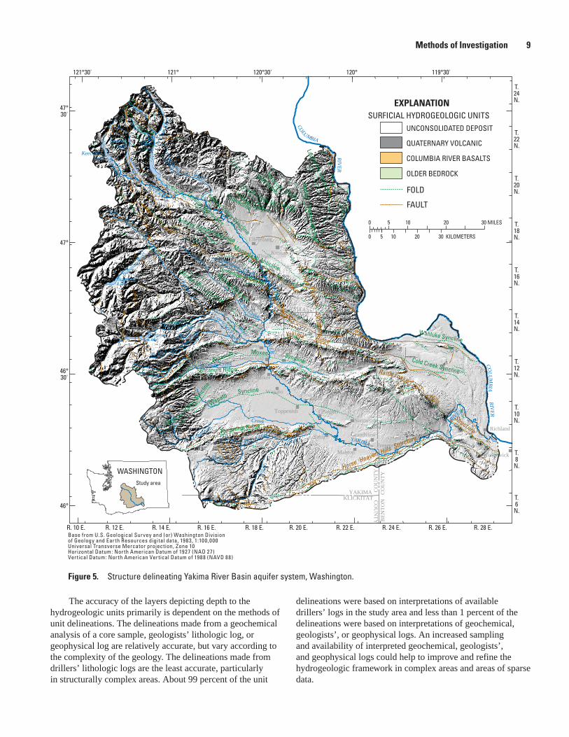
Methods of InvestigationFor this study, the area of interest was extended eastward
to include an additional 700 mi2 area beyond the Yakima River Basin to the Columbia River increasing the study area from 6,200 to 6,900 mi2 (fig. 5). This extension to the Yakima River Basin was included to accommodate the larger Yakima River Basin aquifer system study area being used for the development of numerical ground-water flow models.
The hydrogeologic framework for the basalt and interbed units was compiled using information from multiple data types and data sources. Data types include well-log information
from geochemical, geophysical, test hole, piezometer, and drillers’ well-log records; and interpretative information from unit contour and geologic maps compiled from multiple sources. Sources of information include well records and maps from published and unpublished data and investigations. Previously published data and investigations include: Siems and others (1973), Swanson and others (1979), Meyers and Price (1979 and 1981), Tanaka and others (1979), Biggane (1982, 1983), Drost and Whiteman (1986), Drost and others (1989, 1990, 1997), U.S. Department of Energy (1988), Lane (1988), Whiteman and others (1994), Owens (1995), Sinclair (1998), Jones and others (2006), and Vaccaro and Sumioka (2006). Unpublished data were supplied by John Kirk (Washington Department of Ecology, written commun., 2006), Steve Reidel (unpub. report, Battelle, 2006), WaDOE well records web site (http://apps.ecy.wa.gov/welllog/index.asp), and the U.S. Geological Survey unpublished well records (or non-inventoried well records). Well-record information includes data from inventoried wells (well location verified by field personnel visit) and non-inventoried wells (well location not verified, used reported information). The non-inventoried, well records were selected to help refine the hydrogeologic framework in strategic areas where available well records were sparse. Their reported locations generally are accurate within a radius of 0.25 mi of their actual location. Locations of the inventoried wells generally are accurate within a radius of several hundred feet of their actual location.
A simplified surficial-geology map (Jones and others, 2006), based on the original mapping of 12 quadrangle maps available from the Washington State Division of Geology and Earth Resources (DGER), was used in this study to assist in delineating the hydrogeologic framework and extents of the basalt and interbed units. For the study area, the combined CRBG from the simplified map was subdivided and regrouped into three basalt units: Grande Ronde, Wanapum, and Saddle Mountains. No attempt was made to reconcile matching of the surficial geologic units across originally mapped quadrangle boundaries.
Extents and depth to the top of the basalt and interbed units were constructed for each unit based on information from the (1) simplified surficial-geology map, (2) unit interpretations from previously constructed contour maps, and (3) unit interpretations from about 3,000 well records. A given unit was assumed to be continuous within the boundaries of its extent, except where an underlying unit was present at the surface or where the interpreted data indicated the unit was absent.
Information from well records and available unit contour maps were converted to digital data layers and entered into a Geographic Information System (GIS) to facilitate data comparison and analysis and to construct layers representing the extents and tops of units. These unit layers were constructed from the top down using all available data for each individual unit so the layers for each successive unit were constrained by all the overlying layers.
Methods of Investigation 9
Figure 5. Structure delineating Yakima River Basin aquifer system, Washington.
wa19_0162_Fig05_Structure
121°
47°
47°30'
46°
120°121°30' 120°30' 119°30'
46°30'
T.10N.
T.8
N.
T.6
N.
T.12N.
T.14N.
T.16N.
T.18N.
T.20N.
T.22N.
T.24N.
R. 28 E.R. 26 E.R. 24 E.R. 22 E.R. 20 E.R. 18 E.R. 16 E.R. 14 E.R. 12 E.R. 10 E.
KITTITAS COUNTYYAKIMA COUNTY
CO
UN
TYB
ENTO
N
CO
UN
TY
CO
UN
TY
KLICKITATYAKIMA
BumpingLake
S Fk
N Fk
Cle E
lum
Riv
er
Bumping R
iver
Ahtanum Creek
Tieton River
Wenas Creek
North Fork
Dry Creek
Creek
Toppenish RIVER
YAKIMA
Satu
s
C
reek
CleElumLake
RimrockLake
KachessLake
KeechelusLake
Teanaway River
Umtanum Creek
Little Naches River
Cowichee Creek
Cowichee
Creek
River
Naches
RIVER
YAKIMA
RIVER YAKIM
A
COLUMBIA RIVER
COLU
MBIA RIVER
So. Fork
No. For
k
Cle Elum
Parker
Wapato
Ellensburg
Umtanum
KittitasThrall
Toppenish
MoxeeCityUnion Gap
Yakima
Selah
Naches
SunnysideRichland
Kiona
Kennewick
Prosser
Grandview
Mabton
Satus
Zillah
Granger
Roza
EastonTeanaway
TietonRimrock
0 5 10 20 30 MILES
0 5 10 20 30 KILOMETERS
EXPLANATION
FAULT
FOLD
SURFICIAL HYDROGEOLOGIC UNITSUNCONSOLIDATED DEPOSIT
QUATERNARY VOLCANIC
COLUMBIA RIVER BASALTS
OLDER BEDROCK
WASHINGTONStudy area
Base from U.S. Geological Survey and (or) Washington Divisionof Geology and Earth Resources digital data, 1983, 1:100,000Universal Transverse Mercator projection, Zone 10Horizontal Datum: North American Datum of 1927 (NAD 27)Vertical Datum: North American Vertical Datum of 1988 (NAVD 88)
MoxeeAhtanum Syncline
Toppenish Ridge
Wahluke Syncline
Cold Creek Syncline
Kittitas Valley Syncline
Naneum
Ridge AnticlineManastash AnticlineUmtanum Anticline
Horse Heaven Hills Sturcture
Ainsley Canyon Anticline
Laurel Hill MonoclineTaneum Monocline
Cleman Mtn. Anticline
Ahtanum Ridge
Wapato Syncline
Wenas Syncline
Rattlesnake Hills Structure
Yakima Ridge
Hog Ra nch Structure
Medicine Valley S
yncli
ne
Wilson Creek Monocline
Reeser Canyon
Monocline
Naneum Creek
Monocline
The accuracy of the layers depicting depth to the hydrogeologic units primarily is dependent on the methods of unit delineations. The delineations made from a geochemical analysis of a core sample, geologists’ lithologic log, or geophysical log are relatively accurate, but vary according to the complexity of the geology. The delineations made from drillers’ lithologic logs are the least accurate, particularly in structurally complex areas. About 99 percent of the unit
delineations were based on interpretations of available drillers’ logs in the study area and less than 1 percent of the delineations were based on interpretations of geochemical, geologists’, or geophysical logs. An increased sampling and availability of interpreted geochemical, geologists’, and geophysical logs could help to improve and refine the hydrogeologic framework in complex areas and areas of sparse data.
10 Extent and Depth to Top of Basalt and Interbed Hydrogeologic Units, Yakima River Basin Aquifer System, Washington
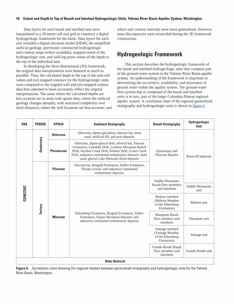
Figure 6. Correlation chart showing the regional relation between generalized stratigraphy and hydrogeologic units for the Yakima River Basin, Washington.
ERA PERIOD EPOCH Sediment Stratigraphy Basalt StratigraphyHydrogeologic
Unit
CEN
EZO
IC
Qua
tern
ary
Holocene Alluvium, alpine glaciation, alluvial fan, dune sand, artificial fill, and peat deposits
Quaternary and Pliocene Basalts Basin-fill deposits
Pleistocene
Alluvium, alpine glacial drift, alluvial fan, Palouse Formation, Lakedale Drift, Lookout Mountain Ranch Drift, Hayden Creek Drift, Kittitas Drift, Evans Creek Drift, unknown continental sedimentary deposits, dune
sand, glacial Lake Missoula flood deposits
Ter
tiary
PlioceneAlluvial fan, Ringold Formation, Dalles Formation,
Thorpe Gravel, and unknown continental sedimentary deposits
MioceneEllensburg Formation, Ringold Formation, Dalles
Formation, Snipes Mountain deposits, and unknown continental sedimentary deposits
Saddle Mountains Basalt flow members
and interbedsSaddle Mountains
unit
Mabton interbed (Mabton Member of the Ellensburg
Formation)
Mabton unit
Wanapum Basalt flow members and
interbedsWanapum unit
Vantage interbed (Vantage Member of the Ellensburg
Formation)
Vantage unit
Grande Ronde Basalt flow members and
interbedsGrande Ronde unit
Older Bedrock
Data layers for each basalt and interbed unit were interpolated to a 30-meter cell size grid to construct a digital hydrogeologic framework for the basin. Data layers for each unit included a digital elevation model (DEM), the simplified surficial geology, previously constructed hydrogeologic unit contour maps (where available), mapped extent of the hydrogeologic unit, and well-log point values of the depth to the top of the individual unit.
In developing the three-dimensional (3D) framework, the original data interpretations were honored as much as possible. Thus, the calculated depth to the top of the unit-cell values and (or) mapped contours for the hydrogeologic units were compared to the original well and (or) mapped contour data then adjusted to more accurately reflect the original interpretations. The areas where the calculated depths are less accurate are in areas with sparse data; where the surficial geology changes abruptly, with structural complexity over short distances; where the well locations are less accurate; and
where unit contour intervals were more generalized. However, most discrepancies were reconciled during the 3D framework construction.
Hydrogeologic FrameworkThis section describes the hydrogeologic framework of
the basalt and interbed hydrogeologic units that compose part of the ground-water system in the Yakima River Basin aquifer system. An understanding of the framework is important in determining the occurrence, availability, and movement of ground water within the aquifer system. The ground-water flow system that is composed of the basalt and interbed units is in turn, part of the larger Columbia Plateau regional aquifer system. A correlation chart of the regional generalized stratigraphy and hydrogeologic units is shown in figure 6.

Hydrogeologic Framework 11
The hydrogeologic units vary in extent and thickness, and each unit is discussed separately. The hydrogeologic units identified in this report do not necessarily correspond to geologic time-stratigraphic deposits. The ground-water flow system within the Yakima River Basin aquifer system is interconnected with the overlying basin-fill deposits and with the Columbia Plateau regional aquifer system.
Knowledge of the geologic structure that exists within the Yakima River Basin aquifer system (fig. 5) also assisted in mapping of the hydrogeologic units. The structural setting helps to explain the depositional sequences, thickness variations, and segmentation of the ground-water movement or anomalous water-level distributions within the area. For example, a predominantly fine-grained or non-porous unit could be vertically offset and juxtaposed with a coarse-grained or porous unit, thereby truncating the lateral ground-water movement along a fault and also offsetting the water-level distribution on either side of the fault. Although such ground-water flow issues are not addressed in this report, the structural history has provided information for mapping the hydrogeologic units that will assist in the development of numerical ground-water flow models.
Saddle Mountains Hydrogeologic Unit
The Saddle Mountains hydrogeologic unit is the youngest and least extensive of the basalt units. The unit is located in the southeast and south-central part of the Yakima River Basin aquifer system (pl. 1) and encompasses an area of about 2,290 mi2. Most of the unit area, about 1,800 mi2, lies beneath the basin fill deposits described in Jones and others (2006). Surficial outcrops of the Saddle Mountains Basalt (SMB) make up about 460 mi2 of the Saddle Mountains unit and about 30 mi2 of surficial outcrops of the older Wanapum Basalt (WB) and Grande Ronde Basalt (GRB) are within the mapped unit extent. The outcrops of the SMB are located in the southwest generally south of the Toppenish Ridge near Dry and Satus Creeks, and along the flanks of Horse Heaven Hills Structure, Rattlesnake Hills Structure, Ahtanum Ridge, Yakima Ridge, and the Umtanum Anticline (fig. 5, pl. 1).
The Saddle Mountains unit predominantly contains the basalt and interbed members associated with the SMB. The SMB is composed of at least 13 named flows and 5 interbed members (Meyers and Price, 1981). The SMB flows’ texture and composition differ greatly throughout its extent. The sedimentary interbeds contained within the SMB are common, relatively thick (often 50 ft or greater) and range in composition from clay to sand and gravel (Drost and Whiteman, 1986). The Saddle Mountains unit also may contain some of the younger basalts present in the unit extent due to the inability to delineate between the basalts based on
the available well record information and the minimal data available in some areas. This is true particularly in the area near Naches (pl. 1) where Quaternary basalt is mapped at the surface and in places that directly overlie the SMB, but due to a lack of data to effectively separate the basalts they were combined. The hydrogeologic framework could be improved as more detailed data become available at depth and for areas were data are sparse.
The top of the Saddle Mountains unit ranges from a maximum altitude of 4,290 ft where it is exposed at land surface to a depth of 1,840 ft below land surface. The mean and median depths to the top of the Saddle Mountains unit are about 200 ft and 120 ft below land surface, respectively. The highest altitudes of the Saddle Mountains unit are located along the southern boundary of the study area and along the western part of the Horse Heaven Hills Structure where the unit reaches altitudes above 4,000 ft. The unit is at its greatest depth below land surface in the area northwest of the city of Yakima where the depth to the top of the unit exceeds 1,800 ft. Thickness of the Saddle Mountains unit, based on wells that completely penetrated the unit ranged from about 0 to 1,110 ft, with a mean and median thickness of about 550 ft and 560 ft, respectively. The distribution of the well-record information used to delineate the depth to the top of the Saddle Mountains unit is shown in figure 7.
Mabton Hydrogeologic Unit
The Mabton hydrogeologic unit is the sedimentary interbed between the overlying SMB and the WB and is informally called the Mabton Member of the Ellensburg Formation (Drost and Whiteman, 1986). The Mabton unit is located in the southeast and south-central part of the Yakima River Basin (pl. 2) and encompasses an area of about 2,210 mi2. Most of the unit area, about 2,180 mi2, lies beneath the Saddle Mountains unit and about 30 mi2 of the older WB and GRB are within the mapped unit extent (pl. 2). No surficial outcrops of the Mabton unit are present within the study area and the extent is assumed to be within the extent of the Saddle Mountains unit. The Mabton unit might extend beyond the boundary of the Saddle Mountains unit, but it is difficult to delineate between the basin-fill deposits and the Mabton deposits at depth by only using available well-record information.
The Mabton unit generally consists of clay, shale, claystone, clay with basalt, clay with sand, and sandstone, but also may contain small amounts of sand and sand-and-gravel, based on the interval interpretations from available well records.

12 Extent and Depth to Top of Basalt and Interbed Hydrogeologic Units, Yakima River Basin Aquifer System, Washington
wa19_0I62_fig07_SM.TOP.WELLS
121°
47°
47°30'
46°
120°121°30' 120°30' 119°30'
46°30'
T.10N.
T.8
N.
T.6
N.
T.12N.
T.14N.
T.16N.
T.18N.
T.20N.
T.22N.
T.24N.
R. 28 E.R. 26 E.R. 24 E.R. 22 E.R. 20 E.R. 18 E.R. 16 E.R. 14 E.R. 12 E.R. 10 E.
KITTITAS COUNTYYAKIMA COUNTY
CO
UN
TYB
ENTO
N
CO
UN
TY
CO
UN
TY
KLICKITATYAKIMA
BumpingLake
S Fk
N Fk
Cle E
lum
Riv
er
Bumping R
iver
Ahtanum Creek
Tieton River
Wenas Creek
North Fork
Dry Creek
Creek
Toppenish RIVER
YAKIMA
Satu
s
C
reek
CleElumLake
RimrockLake
KachessLake
KeechelusLake
Teanaway River
Umtanum Creek
Little Naches River
Cowiche Creek
Cowichee
Creek
River
Naches
RIVER
YAKIMA
RIVER
YAKIMA
Cle Elum
Parker
Wapato
Ellensburg
Umtanum
KittitasThrall
Toppenish
Moxee CityUnion
Gap
Yakima
Selah
Naches
Sunnyside
Richland
Kiona
Kennewick
Prosser
Grandview
Mabton
Satus
Zillah
Granger
Roza
Easton
Teanaway
TietonRimrock
0 5 10 20 30 MILES
0 5 10 20 30 KILOMETERS
EXPLANATION
EXTENT OF SADDLE MOUNTAINS UNIT
WELLS USED TO DELINEATE DEPTH TO TOP OF SADDLE MOUNTAINS UNIT
WASHINGTONStudy area
Base from U.S. Geological Survey and (or) Washington Divisionof Geology and Earth Resources digital data, 1983, 1:100,000Universal Transverse Mercator projection, Zone 10Horizontal Datum: North American Datum of 1927 (NAD 27)Vertical Datum: North American Vertical Datum of 1988 (NAVD 88)
Figure 7. Distribution of wells used to delineate the depth to top of Saddle Mountains unit, Yakima River Basin aquifer system, Washington.
Hydrogeologic Framework 13
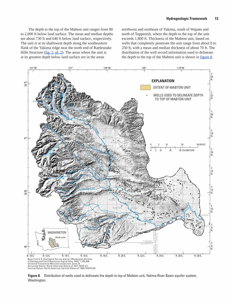
The depth to the top of the Mabton unit ranges from 80 to 2,000 ft below land surface. The mean and median depths are about 730 ft and 640 ft below land surface, respectively. The unit is at its shallowest depth along the southeastern flank of the Yakima ridge near the north end of Rattlesnake Hills Structure (fig. 5, pl. 2). The areas where the unit is at its greatest depth below land surface are in the areas
Figure 8. Distribution of wells used to delineate the depth to top of Mabton unit, Yakima River Basin aquifer system, Washington.
northwest and northeast of Yakima, south of Wapato and north of Toppenish, where the depth to the top of the unit exceeds 1,800 ft. Thickness of the Mabton unit, based on wells that completely penetrate the unit range from about 0 to 250 ft, with a mean and median thickness of about 70 ft. The distribution of the well record information used to delineate the depth to the top of the Mabton unit is shown in figure 8.
wa19_0I62_fig08_MAB.TOP.WELLS
121°
47°
47°30'
46°
120°121°30' 120°30' 119°30'
46°30'
T.10N.
T.8
N.
T.6
N.
T.12N.
T.14N.
T.16N.
T.18N.
T.20N.
T.22N.
T.24N.
R. 28 E.R. 26 E.R. 24 E.R. 22 E.R. 20 E.R. 18 E.R. 16 E.R. 14 E.R. 12 E.R. 10 E.
KITTITAS COUNTYYAKIMA COUNTY
CO
UN
TYB
ENTO
N
CO
UN
TY
CO
UN
TY
KLICKITATYAKIMA
BumpingLake
S Fk
N Fk
Cle E
lum
Riv
er
Bumping R
iver
Ahtanum Creek
Tieton River
Wenas Creek
North Fork
Dry Creek
Creek
Toppenish RIVER
YAKIMA
Satu
s
C
reek
CleElumLake
RimrockLake
KachessLake
KeechelusLake
Teanaway River
Umtanum Creek
Little Naches River
Cowiche Creek
Cowichee
Creek
River
Naches
RIVER
YAKIMA
RIVER
YAKIMA
Cle Elum
Parker
Wapato
Ellensburg
Umtanum
KittitasThrall
Toppenish
Moxee CityUnion
Gap
Yakima
Selah
Naches
SunnysideRichland
Kiona
Kennewick
Prosser
Grandview
Mabton
Satus
Zillah
Granger
Roza
Easton
Teanaway
TietonRimrock
0 5 10 20 30 MILES
0 5 10 20 30 KILOMETERS
EXPLANATION
EXTENT OF MABTON UNIT
WELLS USED TO DELINEATE DEPTH TO TOP OF MABTON UNIT
WASHINGTONStudy area
Base from U.S. Geological Survey and (or) Washington Divisionof Geology and Earth Resources digital data, 1983, 1:100,000Universal Transverse Mercator projection, Zone 10Horizontal Datum: North American Datum of 1927 (NAD 27)Vertical Datum: North American Vertical Datum of 1988 (NAVD 88)

14 Extent and Depth to Top of Basalt and Interbed Hydrogeologic Units, Yakima River Basin Aquifer System, Washington
Wanapum Hydrogeologic Unit
The Wanapum hydrogeologic unit is located in the northeast, central, south, and southeastern part of the Yakima River Basin aquifer basin (pl. 3) and encompasses an area of about 3,450 mi2. Most of the unit area (2,760 mi2) lies beneath the basin-fill deposits, Saddle Mountains unit, or Mabton unit. Surficial outcrops of the WB make up about 660 mi2 of the Wanapum unit and about 30 mi2 of the surficial outcrops within the mapped unit extent are older Grande Ronde Basalt. The outcrops of the WB are located predominantly in the northeast, north of and along the Yakima Ridge; and in the southwest, along and south of the Toppenish Ridge. Less continuous WB outcrops occur along the Ahtanum Ridge, Rattlesnake Hills Structure, and Horse Heaven Hills Structure (fig. 5, pl. 3).
The Wanapum unit contains predominantly the basalt and interbed members associated with the WB. The WB is composed of at least six named flows and two interbed members (Meyers and Price, 1981). The WB flows’ generally are medium-grained to moderately plagioclase-phyric, olivine bearing, and relatively high in iron and titanium oxides. The clay to sand-and-gravel sedimentary interbeds in the WB are less common than those in the SMB and generally are only a few feet thick (Drost and Whiteman, 1986). But the Wanapum unit also may contain some of the younger basalt, particularly in areas where the available well records occur along the margins of the unit extent and where the younger basalt abuts or overlies the WB.
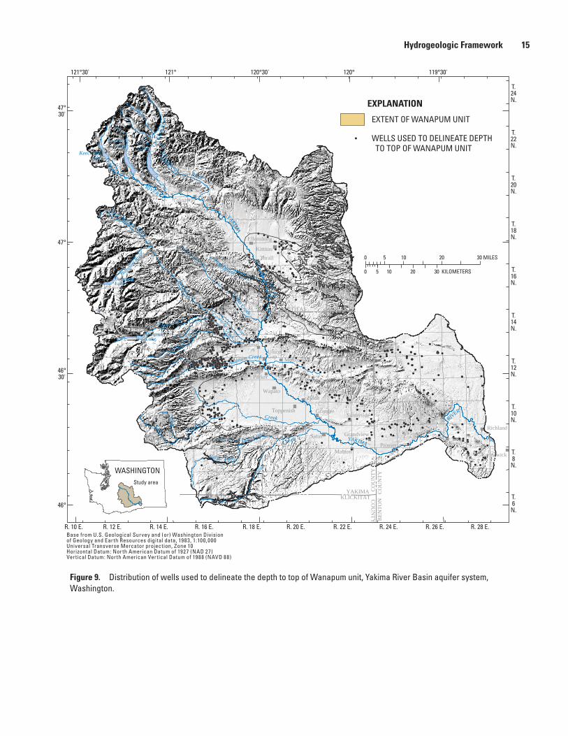
The top of the Wanapum unit ranges from a maximum altitude of 5,680 ft where it is exposed at land surface to a depth of 2,050 ft below land surface. The mean and median depths to the top of the Wanapum unit are about 420 ft and 260 ft below land surface, respectively. The highest altitudes of the Wanapum unit are located along the southern boundary near Satus Creek, where the unit reaches altitudes above 5,000 ft (fig. 5, pl. 3). The areas where the unit is at its greatest depth below land surface are east of Ellensburg and northwest of Yakima where the depth to the top of the unit exceeds 2,000 ft. Thickness of the Wanapum unit, based on wells that completely penetrated the unit, ranged from about 0 to 1,180 ft, with a mean and median thickness of about 600 ft and 490 ft, respectively. The distribution of the well-record information used to delineate the depth to the top of the Wanapum unit is shown in figure 9.
Vantage Hydrogeologic Unit
The Vantage hydrogeologic unit is the sedimentary interbed between the overlying WB and the GRB that informally is called the Vantage Member of the Ellensburg Formation (Drost and Whiteman, 1986). The Vantage unit
is located in the northeast, central, south, and southeastern part of the Yakima River Basin aquifer system (pl. 4) and encompasses an area of about 3,090 mi2. Most of the unit area (3,050 mi2) lies beneath the Wanapum unit and about 40 mi2 of the older GRB are within the mapped unit extent (pl. 4). No surficial outcrops of this unit within the study area are present and its extent is assumed to be within the extent of the Wanapum unit. The Vantage unit might extend beyond the boundary of the Wanapum unit, but it is difficult to delineate between the basin-fill deposits and the Vantage deposits at depth by only using well-record information.
The Vantage unit consists of clay, shale, sandstone, tuff with claystone, and clay with basalt, but also may contain small amounts of sand and sand-and-gravel. A few well-record interpretations also indicate that the Vantage unit is not present in the southeastern part of the Yakima River Basin aquifer system along the eastern boundary and near the Cold Creek Syncline and Rattlesnake Hills Structure (fig. 5, pl. 4).
The depth to the top of the Vantage unit ranges from 40 to 2,790 ft below land surface. The mean and median depths are about 1,150 ft and 820 ft below land surface, respectively. The unit is at its shallowest depth in the northeastern part of the Vantage unit extent along the eastern boundary, in the area where the WB outcrops at the surface (pls. 3 and 4). The areas where the unit is at its greatest depth are an area north of Toppenish and an area northeast of Rattlesnake Hills Structure, where the depth to the top of the unit exceeds 2,600 ft. Thickness of the Vantage unit, based on wells that completely penetrated the unit, ranged from about 0 to 135 ft, with a mean and median thickness of about 30 ft and 20 ft, respectively. The distribution of the well-record information used to delineate the depth to the top of the Vantage unit is shown in figure 10.
Grande Ronde Hydrogeologic Unit
The Grande Ronde hydrogeologic unit is the oldest and most extensive of the basalt units. It underlies most of the Yakima River Basin aquifer system (pl. 5), except for an area along the western boundary and the northwestern part of the basin where generally older bedrock units outcrop at the surface (fig. 4). The extent of the Grande Ronde unit encompasses about 5,390 mi2 with most of the unit, 3,790 mi2, present beneath the basin-fill deposits, Vantage unit, and Wanapum unit. Surficial outcrops of the GRB make up about 1,550 mi2 of the Grande Ronde unit and about 50 mi2 of the surficial outcrops within the mapped unit extent are older bedrock deposits. The outcrops of the GRB are located predominantly along the northeastern and western boundary of the unit extent. Less continuous GRB outcrops occur along Yakima Ridge, Rattlesnake Hills Structure, and in the south along Satus Creek (fig. 5, pl. 5).
Hydrogeologic Framework 15
Figure 9. Distribution of wells used to delineate the depth to top of Wanapum unit, Yakima River Basin aquifer system, Washington.
wa19_0I62_fig09_WANA.TOP.WELLS
121°
47°
47°30'
46°
120°121°30' 120°30' 119°30'
46°30'
T.10N.
T.8
N.
T.6
N.
T.12N.
T.14N.
T.16N.
T.18N.
T.20N.
T.22N.
T.24N.
R. 28 E.R. 26 E.R. 24 E.R. 22 E.R. 20 E.R. 18 E.R. 16 E.R. 14 E.R. 12 E.R. 10 E.
KITTITAS COUNTYYAKIMA COUNTY
CO
UN
TYB
ENTO
N
CO
UN
TY
CO
UN
TY
KLICKITATYAKIMA
BumpingLake
S Fk
N Fk
Cle E
lum
Riv
er
Bumping R
iver
Ahtanum Creek
Tieton River
Wenas Creek
North Fork
Dry Creek
Creek
Toppenish RIVER
YAKIMA
Satu
s
C
reek
CleElumLake
RimrockLake
KachessLake
KeechelusLake
Teanaway River
Umtanum Creek
Little Naches River
Cowiche Creek
Cowichee
Creek
River
Naches
RIVER
YAKIMA
RIVER
YAKIMA
0 5 10 20 30 MILES
0 5 10 20 30 KILOMETERS
EXPLANATION
EXTENT OF WANAPUM UNIT
WELLS USED TO DELINEATE DEPTH TO TOP OF WANAPUM UNIT
WASHINGTONStudy area
Cle Elum
Parker
Wapato
Ellensburg
Umtanum
KittitasThrall
Toppenish
Moxee CityUnionGap
Yakima
Selah
Naches
Sunnyside
Richland
Kiona
Kennewick
Prosser
Grandview
Mabton
Satus
Zillah
Granger
Roza
Easton
Teanaway
TietonRimrock
Base from U.S. Geological Survey and (or) Washington Divisionof Geology and Earth Resources digital data, 1983, 1:100,000Universal Transverse Mercator projection, Zone 10Horizontal Datum: North American Datum of 1927 (NAD 27)Vertical Datum: North American Vertical Datum of 1988 (NAVD 88)

16 Extent and Depth to Top of Basalt and Interbed Hydrogeologic Units, Yakima River Basin Aquifer System, Washington
wa19_0I62_fig10_VAN.TOP.WELLS
121°
47°
47°30'
46°
120°121°30' 120°30' 119°30'
46°30'
T.10N.
T.8
N.
T.6
N.
T.12N.
T.14N.
T.16N.
T.18N.
T.20N.
T.22N.
T.24N.
R. 28 E.R. 26 E.R. 24 E.R. 22 E.R. 20 E.R. 18 E.R. 16 E.R. 14 E.R. 12 E.R. 10 E.
KITTITAS COUNTYYAKIMA COUNTY
CO
UN
TYB
ENTO
N
CO
UN
TY
CO
UN
TY
KLICKITATYAKIMA
BumpingLake
S Fk
N Fk
Cle E
lum
Riv
er
Bumping R
iver
Ahtanum Creek
Tieton River
Wenas Creek
North Fork
Dry Creek
Creek
Toppenish RIVER
YAKIMA
Satu
s
C
reek
CleElumLake
RimrockLake
KachessLake
KeechelusLake
LakeWallula
Teanaway River
Umtanum Creek
Little Naches River
Cowiche Creek
Cowichee
Creek
River
Naches
RIVER
YAKIMA
RIVER
YAKIMA
Cle Elum
Parker
Wapato
Ellensburg
Umtanum
KittitasThrall
Toppenish
Moxee CityUnion
Gap
Yakima
Selah
Naches
SunnysideRichland
Kiona
Kennewick
Prosser
Grandview
Mabton
Satus
Zillah
Granger
Roza
Easton
Teanaway
TietonRimrock
0 5 10 20 30 MILES
0 5 10 20 30 KILOMETERS
EXPLANATION
EXTENT OF VANTAGE UNIT
WELLS USED TO DELINEATE DEPTH TO TOP OF VANTAGE UNIT
WASHINGTONYakima River
Basin
Base from U.S. Geological Survey and (or) Washington Divisionof Geology and Earth Resources digital data, 1983, 1:100,000Universal Transverse Mercator projection, Zone 10Horizontal Datum: North American Datum of 1927 (NAD 27)Vertical Datum: North American Vertical Datum of 1988 (NAVD 88)
Figure 10. Distribution of wells used to delineate the depth to top of Vantage unit, Yakima River Basin aquifer system, Washington.
The Grande Ronde unit predominantly contains the basalt and interbed members associated with the GRB. The GRB is composed of at least 30 flows and perhaps as many as several hundred individual flows (Meyers and Price, 1981; Drost and Whiteman, 1986). The GRB flows’ are aphyric with microphenocrysts of plagioclase and clinopyroxene. Olivine is
generally present only in the groundmass, and typically totals less than 0.5 percent of the flow volume (Drost and Whiteman, 1986). Sedimentary interbeds within the GRB generally are rare and where present are only a few feet thick (Meyers and Price, 1981; Drost and Whiteman, 1986). These sedimentary interbeds range in composition from clay to sand-and-gravel.
Hydrogeologic Framework 17
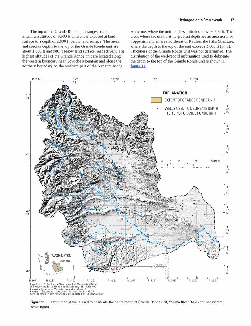
The top of the Grande Ronde unit ranges from a maximum altitude of 6,900 ft where it is exposed at land surface to a depth of 2,800 ft below land surface. The mean and median depths to the top of the Grande Ronde unit are about 1,300 ft and 980 ft below land surface, respectively. The highest altitudes of the Grande Ronde unit are located along the western boundary near Cowiche Mountain and along the northern boundary on the northern part of the Naneum Ridge
Figure 11. Distribution of wells used to delineate the depth to top of Grande Ronde unit, Yakima River Basin aquifer system, Washington.
Anticline, where the unit reaches altitudes above 6,500 ft. The areas where the unit is at its greatest depth are an area north of Toppenish and an area northeast of Rattlesnake Hills Structure, where the depth to the top of the unit exceeds 2,600 ft (pl. 5). Thickness of the Grande Ronde unit was not determined. The distribution of the well-record information used to delineate the depth to the top of the Grande Ronde unit is shown in figure 11.
wa19_0I62_fig11_GR.TOP.WELLS
121°
47°
47°30'
46°
120°121°30' 120°30' 119°30'
46°30'
T.10N.
T.8
N.
T.6
N.
T.12N.
T.14N.
T.16N.
T.18N.
T.20N.
T.22N.
T.24N.
R. 28 E.R. 26 E.R. 24 E.R. 22 E.R. 20 E.R. 18 E.R. 16 E.R. 14 E.R. 12 E.R. 10 E.
KITTITAS COUNTYYAKIMA COUNTY
CO
UN
TYB
ENTO
N
CO
UN
TY
CO
UN
TY
KLICKITATYAKIMA
BumpingLake
S Fk
N Fk
Cle E
lum
Riv
er
Bumping R
iver
Ahtanum Creek
Tieton River
Wenas Creek
North Fork
Dry Creek
Creek
Toppenish RIVER
YAKIMA
Satu
s
C
reek
CleElumLake
RimrockLake
KachessLake
KeechelusLake
Teanaway River
Umtanum Creek
Little Naches River Cowiche Creek
Cowichee
Creek
River
Naches
RIVER
YAKIMA
RIVER
YAKIMA
Cle Elum
Parker
Wapato
Ellensburg
Umtanum
KittitasThrall
Toppenish
Moxee CityUnion
Gap
Yakima
Selah
Naches
SunnysideRichland
Kiona
Kennewick
Prosser
Grandview
Mabton
Satus
Zillah
Granger
Roza
Easton
Teanaway
TietonRimrock
0 5 10 20 30 MILES
0 5 10 20 30 KILOMETERS
EXPLANATION
EXTENT OF GRANDE RONDE UNIT
WELLS USED TO DELINEATE DEPTH TO TOP OF GRANDE RONDE UNIT
WASHINGTONStudy area
Base from U.S. Geological Survey and (or) Washington Divisionof Geology and Earth Resources digital data, 1983, 1:100,000Universal Transverse Mercator projection, Zone 10Horizontal Datum: North American Datum of 1927 (NAD 27)Vertical Datum: North American Vertical Datum of 1988 (NAVD 88)
18 Extent and Depth to Top of Basalt and Interbed Hydrogeologic Units, Yakima River Basin Aquifer System, Washington
Summary and ConclusionsThe Yakima River Basin aquifer system in south-
central Washington encompasses an area of about 6,900 mi2 including the entire Yakima River Basin and lands to the east extending to the Columbia River. The five hydrogeologic units delineated, from top to bottom, are the Saddle Mountains, Mabton, Wanapum, Vantage, and Grande Ronde. Information for these units was compiled and combined from several data types and sources, which include a simplified geology map, hydrogeologic contour maps from previous studies, and interpretations of about 3,000 well records from previous studies and investigators. This information was used to delineate the extent of and the depth to the top of three basalt and two interbed hydrogeologic units within the study area.
All data and information were converted to digital data layers and entered into a GIS software program in order to construct a 3D digital framework of the unit extents and layers using a gridded 30-meter cell size. Data layers for each basalt and interbed unit include a DEM, simplified surficial-geology map, previously constructed hydrogeologic unit contour maps (where available), mapped extent of the hydrogeologic unit, and well-log point values of the depth to the top of the individual unit. The original data interpretations were honored as much as possible in developing the 3D framework. The calculated depth to the top of the unit-cell values and (or) mapped contours for the hydrogeologic units were compared to the original well and (or) mapped contour data then adjusted to reflect more accurately the original interpretations.
The hydrogeologic framework defines the physical, lithologic, and hydrologic characteristics of the basalt and interbed hydrogeologic units that compose part of the ground-water system in the Yakima River Basin. The hydrogeologic characteristics vary from unit to unit, and the extent and depth-to-top of each hydrogeologic unit is described.
The Saddle Mountains unit is the youngest and least extensive of the basalt units encompassing an area of about 2,290 mi2. The Saddle Mountains unit ranges in altitude from 4,290 ft where it is exposed at land surface to a depth of 1,840 ft below land surface with most of the unit lying beneath the basin-fill deposits. The hydrogeologic unit consists predominantly of basalt flows and interbed members of the Saddle Mountains Basalt whose flow texture and composition differ greatly throughout its extent.
The Mabton unit is the sedimentary interbed between the Saddle Mountains Basalt and Wanapum Basalt. It encompasses an area of about 2,210 mi2, and generally is present beneath the Saddle Mountains unit. The depth to the top of this unit ranges from 80 to 2,000 ft below land surface. The hydrogeologic unit generally consists of clay, shale, claystone, clay with basalt, clay with sand, and sandstone, but also may contain small amounts of sand and sand-and-gravel.
The Wanapum unit extends to the north and west beyond the Saddle Mountains unit and encompasses an area of about 3,450 mi2. The Wanapum unit ranges in altitude from 5,680 ft where it is exposed at land surface to a depth of 2,050 ft below land surface with most of the unit lying beneath the basin-fill deposits, Saddle Mountains unit or Mabton unit. The hydrogeologic unit consists predominantly of basalt flows and interbed members of the Wanapum Basalt. The basalt flows generally are medium-grained to moderately plagioclase-phyric, olivine bearing and relatively high in iron and titanium oxides.
The Vantage unit is the sedimentary interbed between the overlying Wanapum Basalt and Grande Ronde Basalt. It encompasses an area of about 3,090 mi2 with most of the unit present beneath the Wanapum unit. The depth to the top of this unit ranges from 40 to 2,790 ft below land surface. The hydrogeologic unit generally consists of clay, shale, sandstone, tuff with claystone, and clay with basalt, but also may contain small amounts of sand and sand-and-gravel.
The Grande Ronde unit is the oldest and most extensive of the basalt units encompassing an area of about 5,390 mi2. The Grande Ronde unit ranges in altitude from 6,900 ft where it is exposed at land surface to a depth of 2,800 ft below land surface with most of the unit lying beneath the basin-fill deposits. The hydrogeologic unit consists predominantly of basalt flows and interbed members of the Grande Ronde Basalt. The basalt flows are aphyric with microphenocrysts of plagioclase and clinopyroxene.
AcknowledgmentsThe cooperation of many well owners, tenants, and
well drillers who supplied information and allowed access to wells is gratefully acknowledged. The field assistance and information supplied by the Bureau of Reclamation, Washington State Department of Ecology, and Yakama Nation also are acknowledged. Appreciation is expressed to Steve Reidel, Staff Geologist, Pacific Northwest National Laboratory, for his assistance.
Selected References
Biggane, J.H., 1982, The low-temperature geothermal resource and stratigraphy of portions of Yakima County, Washington: Washington Department of Natural Resources Division of Geology and Earth Resources, Open-File Report 82-6, 128 p.
Selected References 19
Biggane, J.H., 1983, Geophysical logs from water wells in the Yakima area, Washington: Washington Department of Natural Resources Division of Geology and Earth Resources, Open-File Report 83-2, 50 p.
Bureau of Reclamation, 1999, Yakima River Basin Water Enhancement Project, Washington, Final Programmatic Environmental Impact Statement: U.S. Department of Interior, Bureau of Reclamation, Pacific Northwest Region, Upper Columbia Area Office, Yakima, Washington, 197 p.
Cuffney, T.F., Meador, M.R., Porter, S.D., and Gurtz, M.E., 1997, Distribution of fish, benthic invertebrate, and algal communities in relation to physical and chemical conditions, Yakima River Basin, Washington, 1990: U.S. Geological Survey Water-Resources Investigations Report 96-4280, 94 p.
Drost, B.W., Cox, S.E., and Schurr, K.M., 1997, Changes in ground-water levels and ground-water budgets, from predevelopment to 1986, in parts of the Pasco Basin, Washington: U.S. Geological Survey Water-Resources Investigations Report 96-4086, 172 p.
Drost, B.W., Schurr, K.M., and Lum, W.E., II, 1989, Selected ground-water information for the Pasco Basin and adjacent areas, Washington, 1986-1989: U.S. Geological Survey Open-File Report 89-228, 91 p.
Drost, B.W., and Whiteman, K.J., 1986, Surficial geology, structure, and thickness of selected geohydrologic units in the Columbia Plateau, Washington: U.S. Geological Survey Water-Resources Investigations Report 84-4326, 11 sheets.
Drost, B.W., Whiteman, K.J., and Gonthier, J.B., 1990, Geologic framework of the Columbia Plateau aquifer system, Washington, Oregon, and Idaho: U.S. Geological Survey Water-Resources Investigations Report 87-4238, 10 p., 10 sheets.
Flaherty, N.M., 1975, The Yakima Basin and its water: Washington State University, Water Research Center, Pullman, Wash., 29 p.
Frizzell, V.A., Jr., Tabor, R.W., Booth, D.B., Ort, K.M., and Waitt, R.B., Jr., 1984, Preliminary geologic map of the Snoqualmie Pass 1:100,000 quadrangle, Washington: U.S. Geological Survey Open-File Report 84-693, 33 p., 1 sheet.
Fuhrer, G.J., McKenzie, S.W., Rinella, J.F., Sanzolone, R.F., and Skach, K.A., 1993, Surface-water-quality assessment of the Yakima River Basin in Washington; analysis of major and minor elements in fine-grained streambed sediment 1987, with sections on Geology by Marshall Gannett: U.S. Geological Survey Open-File Report 93-30, 226 p., 3 sheets, scale 1:250,000.
Fuhrer, G.J., Morace, J.L., Johnson, H.M., Rinella, J.F., Ebbert, J.C., Embrey, S.S., Waite, I.R., Carpenter, K.D., Wise, D.R., and Hughes, C.A., 2004, Water quality in the Yakima River Basin, Washington, 1999-2000: U.S. Geological Survey Circular 1237, 44 p.
Glantz, M.H., 1982, Consequences and responsibilities in drought forecasting: The case of Yakima, 1977: Water Resources Research, v. 18, no. 1, p. 3–13.
Gulick, C.W., and Korosec, M.A., 1990, Geologic map of the Banks Lake 1:100,000 quadrangle, Washington: Washington Division of Geology and Earth Resources, Open-File Report 90-6, 20 p., 1 sheet
Jones, M.A., Vaccaro, J.J., and Watkins, A.M., 2006, Hydrogeologic framework of sedimentary deposits in six structural basins, Yakima River Basin, Washington: U.S. Geological Survey Scientific Investigations Report 2006-5116, 24 p.
Korosec, M.A., 1987, Geologic map of the Mount Adams quadrangle, Washington: Washington State Department of Natural Resources, Open-File Report 87-5, 41 p., 1 sheet, scale 1:100,000.
Kratz, M.R., 1978, Dilemmas, disruptions, but no disaster—Drought in the Yakima basin, Washington, 1977: State Climatologist for Arizona Climatological Publications, Scientific Paper no. 3, 16 p.
Lane, R.C., 1988, Selected ground-water information for the Columbia Plateau regional aquifer system, Washington and Oregon, 1982-1985; volume I: Geohydrology: U.S. Geological Survey Open-File Report 88-182, 236 p.
Meyers, C.W., and Price, S.M., 1979, Geologic studies of the Columbia Plateau, a status report: Rockwell International, Rockwell Hanford Operations RHO-BWI-ST-4, 520 p.
Meyers, C.W., and Price, S.M., 1981, Subsurface geology of the Cold Creek syncline, a status report: Rockwell International, Rockwell Hanford Operations RHO-BWI-ST-14, 396 p.
Omernik, J.M., 1987, Ecoregions of the conterminous United States: Annals of the Association of American Geographers, v. 77, no. 1, p. 118–125.
Owens, R.R., 1995, The hydrogeology of the Kittitas Valley, Washington: Central Washington University, Master of Science Thesis, 205 p.
Parker, G.L., and Storey, F.B., 1913, Water powers of the Cascade Range, part III, Yakima River Basin: U.S. Geological Survey Water-Supply Paper 369, 169 p., 18 pls.
20 Extent and Depth to Top of Basalt and Interbed Hydrogeologic Units, Yakima River Basin Aquifer System, Washington
Phillips, W.M., and Walsh, T.J., Geologic map of the northwest part of the Goldendale quadrangle, Washington: Washington Division of Geology and Earth Resources, Open-File Report 87-13, 9 p., 1 sheet, scale 1:100,000.
Reidel, S.P., and Fecht, K.R., 1994a, Geologic map of the Priest Rapids 1:100,000 quadrangle, Washington: Washington Division of Geology and Earth Resources, Open-File Report 94-13, 22 p.
Reidel, S.P., and Fecht, K.R., 1994b, Geologic map of the Richland 1:100,000 quadrangle, Washington: Washington Division of Geology and Earth Resources, Open-File Report 94-8, 21 p.
Russell, I.C., 1897, A reconnaissance of southeastern Washington: U.S. Geological Survey Water-Supply Paper 4, 96 p.
Schasse, H.W., 1987, Geologic map of the Mount Rainier quadrangle, Washington: Washington State Department of Natural Resources, Open-File Report 87-16, 43 p., 1 sheet, scale 1:100,000.
Schuster, J.E., 1994, Geologic maps of the east half of the Washington portion of the Goldendale 1:100,000 quadrangle and the Washington portion of the Hermiston 1:100,000 quadrangle: Washington State Department of Natural Resources, Open-File Report 94-9, 17 p., 1 sheet.
Schuster, J.E., 1994, Geologic map of the east half of the Toppenish 1:100,000 quadrangle, Washington: Washington State Department of Natural Resources, Open-File Report 94-10, 15 p., 1 sheet.
Schuster, J.E., 1994, Geologic map of the east half of the Yakima 1:100,000 quadrangle, Washington: Washington State Department of Natural Resources, Open-File Report 94-12, 19 p., 1 sheet.
Siems, B.A., Crosby, J.W., III, Anderson, J.V., Busch, J.H., and Weber, T.L., 1973, Geophysical investigations of Washington’s ground water resources; final report 1972/73: Washington State University, College of Engineering Research Division Report 73/15-58, 47 p.
Sinclair, Kelsey, 1998, Stratigraphic correlation of the N2 Grande Ronde Basalt across Kittitas Valley, Washington State: Central Washington University, Master of Science Thesis, 21 p.
Smith, G.O., 1901, Geology and water resources of a portion of Yakima County, Washington: U.S. Geological Survey Water-Supply and Irrigation Papers 55, 68 p.
Swanson, D.A., Anderson, J.L., Bentley, R.D., Byerly, G.R., Camp, V.E., Gardner, J.N., and Wright, T.L., 1979, Reconnaissance geologic map of the Columbia River Basalt Group in eastern Washington and northern Idaho: U.S. Geological Survey Open-File Report 79-1363, 26 p., 12 sheets, scale 1:250,000.
Swanson, D.A., Brown, J.C., Anderson, J.L., Bentley, R.D., Byerly, G.R., Gardner, J.N., and Wright, T.L., 1979, Preliminary structure contour maps on the top of the Grande Ronde and Wanapum Basalts, eastern Washington and northern Idaho: U.S. Geological Survey Open-File Report 79-1364, 3 sheets.
Systems Operations Advisory Committee, 1999, Report on biologically based flows for the Yakima River Basin: Report to the Secretary of the Interior, May 1999, Yakima: Washington, Executive Summary, 6 chaps., app. A.
Tabor, R.W., Frizzell, V.A., Jr., Booth, D.B., Waitt, R.B., Whetten, J.T., and Zartman, R.E., 1993, Geologic map of the Skykomish River 30- by 60-minute quadrangle, Washington: U.S. Geological Survey Miscellaneous Investigations Series Map I-1963, 42 p., 1 sheet, scale 1:100,000.
Tabor, R.W., Frizzell, V.A., Jr., Whetten, J.T., Waitt, R.B., Swanson, D.A., Byerly, G.R., Booth, D.B., Hetherington, M.J., and Zartman, R.E., 1987, Geologic map of the Chelan 30-minute by 60-minute quadrangle, Washington: U.S. Geological Survey Miscellaneous Investigations Series Map I-1661, 33 p., 1 sheet, scale 1:100,000.
Tabor, R.W., Waitt, R.B., Jr., Frizzell, V.A., Jr., Swanson, D.A., Byerly, G.R., and Bentley, R.D., 1982, Geologic map of the Wenatchee 1:100,000 quadrangle, central Washington: U.S. Geological Survey Miscellaneous Investigations Series Map I-1311, 26 p., 1 sheet.
Tanaka, H.H., Barrett, G.T., and Wildrick, L., 1979, Regional basalt hydrology of the Columbia Plateau in Washington: Richland, Wash., Rockwell Hanford Operations, RHO-BWI-C-60, 303 p.
U.S. Department of Energy, 1988, Site characterization plan, reference repository location, Hanford Site, Washington; volume 1: U.S. Department of Energy, DOE/RW-0164, unpaginated.
U.S. District Court, 1945, Consent decree in the District Court of the United States for the Eastern District of Washington, Southern Division: Spokane, Wash., Civil action no. 21.
Selected References 21
Vaccaro, J.J., 1995, Changes in the hydrometeorological regime in the Pacific Northwest: Proceedings of the Twelfth Annual Pacific Climate (PACLIM) Workshop, Asilomar, Calif., Technical Report 46 of the Interagency Ecological Program for the Sacramento-San Joaquin Estuary, p. 143.
Vaccaro, J.J., 2002, Interdecadal changes in the hydrometeorological regime of the Pacific Northwest and in the regional-to-hemispheric climate regimes, and their linkages: U.S. Geological Survey Water-Resources Investigations Report 02-4176, 94 p.
Vaccaro, J.J., 2007, A deep percolation model for estimating ground-water recharge: Documentation of modules for the modular modeling system of the U.S. Geological Survey: U.S. Geological Survey Scientific Investigations Report 2006-5318, 30 p.
Vaccaro, J.J., and Sumioka, S.S., 2006, Estimates of ground-water pumpage from the Yakima Basin aquifer system, Washington, 1960-2000: U.S. Geological Survey Sceintific Investigations Report 2006-5205, 56 p.
Walsh, T.J., 1986, Geologic map of the west half of the Toppenish quadrangle, Washington: Washington Division of Geology and Earth Resources, Open-File Report 86-3, 7 p., 1 sheet, scale 1:100,000.
Walsh, T.J., 1986, Geologic map of the west half of the Yakima quadrangle, Washington: Washington Division of Geology and Earth Resources, Open-File Report 86-4, 9 p., 1 sheet, scale 1:100,000.
Washington State Department of Ecology, 1998, Washington State Water Law, A Primer: WR-98-152, on-line on the World Wide Web, accessed October 2000, http://www.ecy.wa.gov/pubs/98152
Washington State Department of Ecology, 2006, Washington State well log viewer, available at http://apps.ecy.wa.gov/welllog/index.asp
Whiteman, K.J., Vaccaro, J.J., Gonthier, J.B., and Bauer, H.H., 1994, The hydrogeologic framework and geochemistry of the Columbia Plateau aquifer system, Washington, Oregon, and Idaho: U.S. Geological Survey Professional Paper 1413-B, 73 p.

22 Extent and Depth to Top of Basalt and Interbed Hydrogeologic Units, Yakima River Basin Aquifer System, Washington
This page intentionally left blank.
Manuscript approved for publication, March 21, 2008Prepared by the USGS Publishing Network, Bob Crist
Bill Gibbs Pat Revitzer Bobbie Jo Richey Sharon Wahlstrom
For more information concerning the research in this report, contact the Director, Washington Water Science Center U.S. Geological Survey, 934 Broadway — Suite 300 Tacoma, Washington 98402 http://wa.water.usgs.gov

Printed on recycled paper
Jones and others— Extent and D
epth to Top of Basalt and Interbed H
ydrogeologic Units, Yakim
a River Basin A
quifer System, W
ashington— SIR 2008–5045
Related Documents


![BASALT - hometyles.com · 190 191 rodapiÉ basalt rect. 8 x 59 cm. p 11 [59x59 cm] 23,6”x23,6” basalt basalt perla rect. 59 x 59 cm. basalt perla antideslizante rect. 59 x 59](https://static.cupdf.com/doc/110x72/6062510f5dcd07038d28a84f/basalt-190-191-rodapi-basalt-rect-8-x-59-cm-p-11-59x59-cm-236ax236a.jpg)