LETTERS Extensive dynamic thinning on the margins of the Greenland and Antarctic ice sheets Hamish D. Pritchard 1 , Robert J. Arthern 1 , David G. Vaughan 1 & Laura A. Edwards 2 Many glaciers along the margins of the Greenland and Antarctic ice sheets are accelerating and, for this reason, contribute increas- ingly to global sea-level rise 1–7 . Globally, ice losses contribute 1.8 mm yr 21 (ref. 8), but this could increase if the retreat of ice shelves and tidewater glaciers further enhances the loss of grounded ice 9 or initiates the large-scale collapse of vulnerable parts of the ice sheets 10 . Ice loss as a result of accelerated flow, known as dynamic thinning, is so poorly understood that its potential contribution to sea level over the twenty-first century remains unpredictable 11 . Thinning on the ice-sheet scale has been monitored by using repeat satellite altimetry observations to track small changes in surface elevation, but previous sensors could not resolve most fast-flowing coastal glaciers 12 . Here we report the use of high-resolution ICESat (Ice, Cloud and land Elevation Satellite) laser altimetry to map change along the entire grounded margins of the Greenland and Antarctic ice sheets. To isolate the dynamic signal, we compare rates of elevation change from both fast- flowing and slow-flowing ice with those expected from surface mass-balance fluctuations. We find that dynamic thinning of gla- ciers now reaches all latitudes in Greenland, has intensified on key Antarctic grounding lines, has endured for decades after ice-shelf collapse, penetrates far into the interior of each ice sheet and is spreading as ice shelves thin by ocean-driven melt. In Greenland, glaciers flowing faster than 100 m yr 21 thinned at an average rate of 0.84 m yr 21 , and in the Amundsen Sea embayment of Antarctica, thinning exceeded 9.0 m yr 21 for some glaciers. Our results show that the most profound changes in the ice sheets currently result from glacier dynamics at ocean margins. To quantify ice loss from ice sheets, three different methods have so far been used: calculation of flux imbalance from separate measure- ments of snow accumulation and ice flow velocity, detection of changing gravitational anomalies and measurement of changing ice- sheet surface elevation. Each approach has limitations: flux-imbalance estimates suffer from inaccuracies in snow accumulation rate 13 , and satellite gravity measurements have poor spatial resolution and are prone to problems in modelling crustal rebound 14 . Direct measure- ment of volume change by satellite radar altimeters is limited to lati- tudes between 81.5u S and 81.5u N and to surface slopes below ,1u. Resolution is limited to a footprint width of 2–3km, measurement density is low (being restricted to ground-track crossover points) and radar surface penetration is imperfectly known. Current radar systems perform poorly where change is most rapid, namely along the rela- tively steep and narrow glaciers fringing the ice sheets 12 . Furthermore, conversion from volume to mass change requires knowledge of the density of snow or ice added or lost. Additional information is needed to distinguish between these in low-resolution radar altimeter measurements 12 . An entirely different experiment, the Geoscience Laser Altimeter System, launched in 2002 on board NASA’s ICESat, was designed to overcome several of these issues. Here we report a method of com- paring data from near-repeat ICESat tracks. This produces a much greater measurement density than was previously available, revealing the pattern of change from local to continental scales, including the steep ice-sheet margins. Figure 1 shows two examples demonstrating that our technique provides coherent measurements of change, significant on length scales on the order of 100 m along the satellite ground track. This high resolution allows us, in many areas, to distinguish between changes in elevation that result from dynamical changes associated with fast- flowing ice and those that result from other causes (snowfall, melt and so on), by comparing the rate of change in adjacent slow- and fast- flowing areas in the same climatic setting (Fig. 1b, Supplementary Figs 5, 6, 7, 8, 9 and 10 and Supplementary Tables 2, 4 and 5). Comparison of Fig. 2 with those produced using the .10-yr records obtained by radar altimetry 12,15,16 shows that our technique successfully reproduces the large-scale patterns of ice-sheet change and, in both Antarctica and Greenland, shows features not previously seen. Prominent in Greenland is the strong thinning of the southeast and northwest ice-sheet margins (Supplementary Fig. 3); higher areas in the south thickened. These margins have a positive surface mass balance (SMB) and, hence, a high proportion of discharge through tidewater glaciers. Southeastern glaciers accelerated between 1996 and 2005, but those in the northwest showed little change in flow 2 . The widespread dynamic thinning we identify in the northwest therefore implies a sustained period of dynamic imbalance. For the ice sheet as a whole, areas of fast flow 1 (.100 m yr 21 (ref. 2)) thinned significantly more rapidly than slow-flowing areas (0.84 m yr 21 versus 0.12 m yr 21 ), a discrepancy that cannot be explained by variability in SMB (Supplementary Table 2). We find that of 111 glaciers surveyed, 81 thinned dynamically at rates greater than twice the thinning rate on nearby slow-flowing ice at the same altitude (Supplementary Tables 5 and 6). Dynamic thickening is scarce but notable on quiescent surge-type glaciers Storstrømmen 17 (Fig. 2, inset; S) and neighbouring L. Bistrup Bræ (Supplementary Fig. 3). For the first time, low-altitude changes are discernible across the slower-flowing, land-terminating ice sheet and on many small, fringing ice caps. North of 80u N, thinning of the slow-flowing margin peaked at 0.15 6 0.002 m yr 21 at an altitude of 900 m but was close to zero at 450 and 1,450 m (Supplementary Fig. 4), with changes most likely driven by SMB anomalies. In contrast, the south- western margin thickened at all altitudes, at up to 0.44 6 0.005 m yr 21 . Dynamic thinning has penetrated deep into the ice sheet: on Jakobshavn Isbræ, Helheim and Kangerdlugssuaq glaciers (Fig. 2, inset; respectively J, H and K), it is detectable from the snout to 120, 95 and 100 km inland, respectively, at altitudes of 1,600 m to 2,000 m above sea level. If these changes are driven by the reported recent glacier retreat and acceleration 18 , this would imply remarkable rates 1 British Antarctic Survey, Natural Environment Research Council, Madingley Road, Cambridge CB3 0ET, UK. 2 School of Geographical Sciences, University of Bristol, Bristol BS8 1SS, UK. doi:10.1038/nature08471 1 Macmillan Publishers Limited. All rights reserved ©2009

Welcome message from author
This document is posted to help you gain knowledge. Please leave a comment to let me know what you think about it! Share it to your friends and learn new things together.
Transcript

LETTERS
Extensive dynamic thinning on the margins of theGreenland and Antarctic ice sheetsHamish D. Pritchard1, Robert J. Arthern1, David G. Vaughan1 & Laura A. Edwards2
Many glaciers along the margins of the Greenland and Antarcticice sheets are accelerating and, for this reason, contribute increas-ingly to global sea-level rise1–7. Globally, ice losses contribute
1.8 mm yr21 (ref. 8), but this could increase if the retreat of iceshelves and tidewater glaciers further enhances the loss ofgrounded ice9 or initiates the large-scale collapse of vulnerableparts of the ice sheets10. Ice loss as a result of accelerated flow,known as dynamic thinning, is so poorly understood that itspotential contribution to sea level over the twenty-first centuryremains unpredictable11. Thinning on the ice-sheet scale has beenmonitored by using repeat satellite altimetry observations to tracksmall changes in surface elevation, but previous sensors could notresolve most fast-flowing coastal glaciers12. Here we report the useof high-resolution ICESat (Ice, Cloud and land Elevation Satellite)laser altimetry to map change along the entire grounded marginsof the Greenland and Antarctic ice sheets. To isolate the dynamicsignal, we compare rates of elevation change from both fast-flowing and slow-flowing ice with those expected from surfacemass-balance fluctuations. We find that dynamic thinning of gla-ciers now reaches all latitudes in Greenland, has intensified on keyAntarctic grounding lines, has endured for decades after ice-shelfcollapse, penetrates far into the interior of each ice sheet and isspreading as ice shelves thin by ocean-driven melt. In Greenland,glaciers flowing faster than 100 m yr21 thinned at an average rateof 0.84 m yr21, and in the Amundsen Sea embayment ofAntarctica, thinning exceeded 9.0 m yr21 for some glaciers. Ourresults show that the most profound changes in the ice sheetscurrently result from glacier dynamics at ocean margins.
To quantify ice loss from ice sheets, three different methods have sofar been used: calculation of flux imbalance from separate measure-ments of snow accumulation and ice flow velocity, detection ofchanging gravitational anomalies and measurement of changing ice-sheet surface elevation. Each approach has limitations: flux-imbalanceestimates suffer from inaccuracies in snow accumulation rate13, andsatellite gravity measurements have poor spatial resolution and areprone to problems in modelling crustal rebound14. Direct measure-ment of volume change by satellite radar altimeters is limited to lati-tudes between 81.5u S and 81.5uN and to surface slopes below ,1u.Resolution is limited to a footprint width of 2–3 km, measurementdensity is low (being restricted to ground-track crossover points) andradar surface penetration is imperfectly known. Current radar systemsperform poorly where change is most rapid, namely along the rela-tively steep and narrow glaciers fringing the ice sheets12. Furthermore,conversion from volume to mass change requires knowledge ofthe density of snow or ice added or lost. Additional information isneeded to distinguish between these in low-resolution radar altimetermeasurements12.
An entirely different experiment, the Geoscience Laser AltimeterSystem, launched in 2002 on board NASA’s ICESat, was designed to
overcome several of these issues. Here we report a method of com-paring data from near-repeat ICESat tracks. This produces a muchgreater measurement density than was previously available, revealingthe pattern of change from local to continental scales, including thesteep ice-sheet margins.
Figure 1 shows two examples demonstrating that our techniqueprovides coherent measurements of change, significant on lengthscales on the order of 100 m along the satellite ground track. This highresolution allows us, in many areas, to distinguish between changes inelevation that result from dynamical changes associated with fast-flowing ice and those that result from other causes (snowfall, meltand so on), by comparing the rate of change in adjacent slow- and fast-flowing areas in the same climatic setting (Fig. 1b, SupplementaryFigs 5, 6, 7, 8, 9 and 10 and Supplementary Tables 2, 4 and 5).
Comparison of Fig. 2 with those produced using the .10-yrrecords obtained by radar altimetry12,15,16 shows that our techniquesuccessfully reproduces the large-scale patterns of ice-sheet changeand, in both Antarctica and Greenland, shows features not previouslyseen.
Prominent in Greenland is the strong thinning of the southeastand northwest ice-sheet margins (Supplementary Fig. 3); higherareas in the south thickened. These margins have a positive surfacemass balance (SMB) and, hence, a high proportion of dischargethrough tidewater glaciers. Southeastern glaciers accelerated between1996 and 2005, but those in the northwest showed little change inflow2. The widespread dynamic thinning we identify in the northwesttherefore implies a sustained period of dynamic imbalance. For theice sheet as a whole, areas of fast flow1 (.100 m yr21 (ref. 2)) thinnedsignificantly more rapidly than slow-flowing areas (0.84 m yr21
versus 0.12 m yr21), a discrepancy that cannot be explained byvariability in SMB (Supplementary Table 2). We find that of 111glaciers surveyed, 81 thinned dynamically at rates greater than twicethe thinning rate on nearby slow-flowing ice at the same altitude(Supplementary Tables 5 and 6). Dynamic thickening is scarce butnotable on quiescent surge-type glaciers Storstrømmen17 (Fig. 2,inset; S) and neighbouring L. Bistrup Bræ (Supplementary Fig. 3).For the first time, low-altitude changes are discernible across theslower-flowing, land-terminating ice sheet and on many small,fringing ice caps. North of 80uN, thinning of the slow-flowingmargin peaked at 0.15 6 0.002 m yr21 at an altitude of 900 m butwas close to zero at 450 and 1,450 m (Supplementary Fig. 4), withchanges most likely driven by SMB anomalies. In contrast, the south-western margin thickened at all altitudes, at up to 0.44 6 0.005 m yr21.Dynamic thinning has penetrated deep into the ice sheet: onJakobshavn Isbræ, Helheim and Kangerdlugssuaq glaciers (Fig. 2,inset; respectively J, H and K), it is detectable from the snout to 120,95 and 100 km inland, respectively, at altitudes of 1,600 m to 2,000 mabove sea level. If these changes are driven by the reported recentglacier retreat and acceleration18, this would imply remarkable rates
1British Antarctic Survey, Natural Environment Research Council, Madingley Road, Cambridge CB3 0ET, UK. 2School of Geographical Sciences, University of Bristol, Bristol BS8 1SS, UK.
doi:10.1038/nature08471
1 Macmillan Publishers Limited. All rights reserved©2009

of propagation (Supplementary Fig. 5). Furthermore, deeply penetrat-ing dynamic thinning has spread to high northern latitudes, forexample on Tracy Glacier at 77.6uN (Supplementary Table 3 andSupplementary Fig. 6).
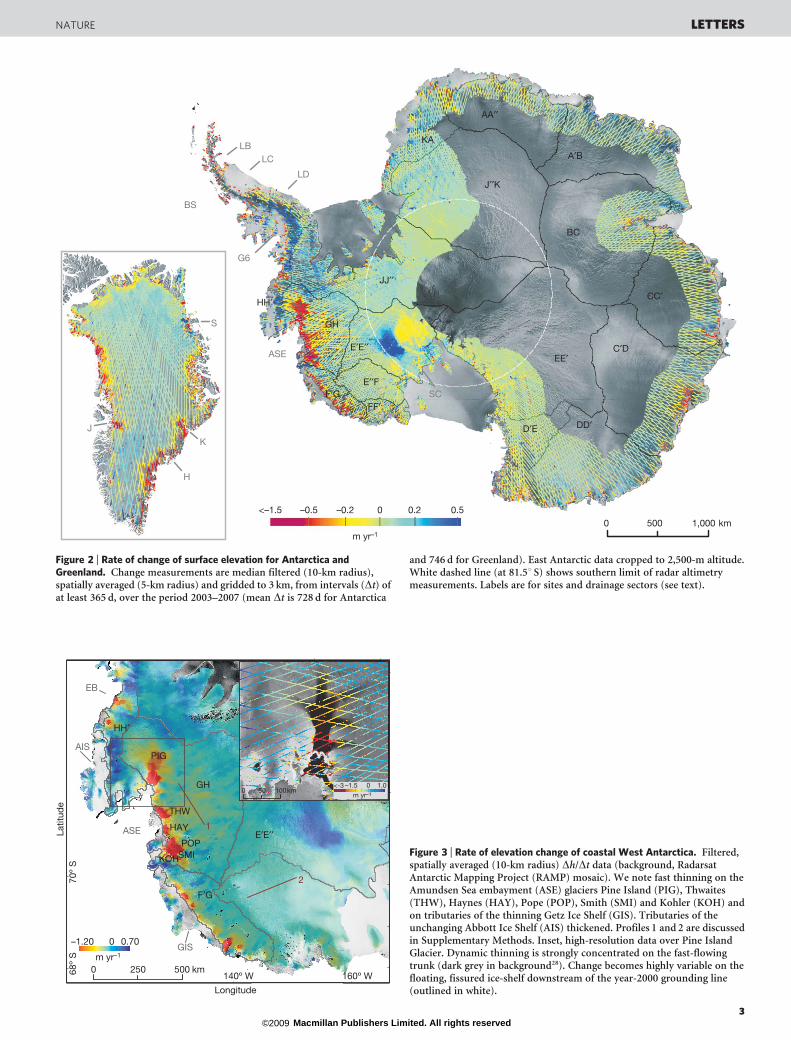
In Antarctica, we find significant dynamic thinning of fast-flowingice at rates greater than plausible through interannual accumulationvariability for drainage sectors19 F9G and GH (Fig. 2), with significantdynamic thickening of sector A9B (Supplementary Table 4). On theglacier scale, thinning is strongest in the Amundsen Sea embayment(ASE), where it is confirmed as being localized on the fast-flowingglaciers and their tributaries (Fig. 3 and Supplementary Fig. 7). Thearea close to the Pine Island Glacier grounding line thinned in theperiod 2003–2007 at up to 6 m yr21, neighbouring Smith Glacierthinned at a rate in excess of 9 m yr21 and Thwaites Glacier thinnedat a rate of around 4 m yr21. These rates are higher than thosereported for the 2002–2004 period20. Numerous small, independentglaciers feeding the same, rapidly thinning ice shelves, namely the
Crosson and Dotson ice shelves21, are also thinning dynamically,which is strong evidence of a common, ocean-driven cause(Supplementary Fig. 7). Surface lowering is apparent across almostthe whole area of the drainage basins of the Kohler, Smith, Pope andHaynes glaciers of the Amundsen Sea embayment, and up to thenorthern drainage divide of Pine Island Glacier. We calculate themean elevation rate for sector GH to be 20.139 6 0.07 m yr21
(whereas a rate of 20.092 6 0.007 m yr21 was reported for 1995–200322), giving a volume change of 257 6 29 km3 yr21.
Several new features in the pattern of Antarctic elevation changeare now visible. The ‘polar hole’ resulting from the orbital limit ofsatellites is reduced from the area south of 81.5u S for current radaraltimetry to that south of 86u S for ICESat; hence, we now see the fullAntarctic grounding line, including the Siple Coast (Fig. 2; SC). Thisallows us to confirm expectations of previous studies of the shutdownof the Kamb Ice Stream around 130 yr ago12,23–25. We see thickening ofthe ice stream reaching 0.65 6 0.07 m yr21 close to the transitionbetween its fast-flowing tributaries and stagnant trunk (Fig. 4). Thefast-flowing (.200 m yr21) sections of the neighbouring Whillans IceStream are thickening, but this is clearly bounded by the ice-streamshear margins, with the interstream ridges and slower-flowing upperdrainage basins conversely thinning at up to 0.25 6 0.07 m yr21.
Assuming that these volume changes are of ice with a density of917 kg m23, our observations allow an independent assessment of theflux imbalance. For drainage sector E9E99 as a whole (Fig. 4), the netchange was 136 6 16 Gt yr21 (139 km3 yr21), which is substantiallygreater than estimates based on the partial radar altimetry coverage12,16,but agrees with estimates from flux imbalance13,26.
On the Amundsen Sea coast of West Antarctica, our laser altimetrymethod resolves rapid dynamic thinning along the full length of thegrounded ice-sheet margin feeding the Getz Ice Shelf (Fig. 3; GIS) onfiner spatial scales than are possible using radar altimetry12. Thisreveals thinning at the grounding line at rates of up to several metresper year over areas of fast flow; this thinning attenuates inland butmore than outweighs gains on the interior of the drainage basin. Thenet volume change for sector F9G is 214 6 9 km3, in agreement withflux-imbalance calculations13,24 (assuming losses are of ice). Herealso, the more dynamic glaciers on offshore islands bounded by theGetz Ice Shelf are thinning rapidly on their lower reaches, suggestingthat the common cause is the ocean-driven thinning of this shelf at2–3 m yr21 (ref. 27).
Conversely, for the 400 km of coast feeding the Abbott Ice Shelf(AIS), whose thickness is unchanging27, the drainage basin thickenedstrongly down to the grounding line, presumably driven by recentanomalously high snowfall rates (Fig. 3). This is partly offset bydynamic thinning of adjacent Eltanin Bay (EB) glaciers, giving anet volume gain of 18 6 24 km3 yr21 (loss of 8 km3 yr21 plus gainof 16 km3 yr21) for sector HH9; hence, we do not find evidence for thelarge negative flux imbalance (249 Gt yr21) reported previously13.
In East Antarctica, we observe dynamic thinning on some outlets,particularly between 90u and 165u E (Supplementary Figs 8 and 9).Thinning of Totten Glacier, the highest-flux East Antarctic outlet, isthree times greater than previously reported28. The similar behaviourof its smaller, independent neighbours indicates a common, regionaland perhaps ocean-driven cause.
With ICESat, we can view elevation change over the full AntarcticPeninsula for the first time (Fig. 2), and find that slow-flowing ice capsand divides along the Bellingshausen Sea (BS) coast are thickening atup to 1 m yr21 (comparable to radar altimetry measurements of theneighbouring inland ice sheet for the preceding 13 yr (ref. 12)). Thissignal extends at high altitude to the peninsula’s northern tip, con-trasting strongly with profound dynamic thinning of collapsed-ice-shelf tributary glaciers flowing from the plateau to both the east andwest coasts (see, for example, Supplementary Fig. 10). These glaciersare thinning at some of the highest rates recorded either in Antarcticaor Greenland (up to tens of metres per year), and ongoing thinning isdetectable right up to the headwalls, or well into the inland ice sheet,
48º 20′ W 48º 0′ W
68º
50′ N
68º
55′ N
69º
0′ N
03–3 m yr–184 km
0.2
0
–0.2
–0.4
0 4 8 km–10 10m yr–1
70º
20′ S
70º
15′ S
62º 15′ W 62º W
⊗
⊗⊗ JN
GN
Latit
ude
Longitudea
b
DP
Figure 1 | High-resolution change measurements from along-trackinterpolation of ICESat data. a, The filling of a melt pond (blue; see colourscale) is resolved against a trend of dynamic thinning (yellow to red) onJakobshavn Isbræ, Greenland. Thinning increases strongly towards theglacier centre, to the northeast. White arrow, main ice flow direction; greencontours, mean SMB (metres water equivalent per year) (after ref. 2);background, synthetic-aperture-radar image. See also Supplementary Fig. 2.b, Rapid dynamic thinning (up to 13 m yr21) of Clifford Glacier, feeding thesouthern part of the Larsen Ice Shelf, Antarctic Peninsula. Background,Landsat Image Mosaic of Antarctica (grounding line in grey). Data areunfiltered. Inset, global-positioning-system ground-control points fromSupplementary Table 1 (JN, Jurassic Nunatak; GN, Gomez Nunatak; DP,Dyer Plateau).
LETTERS NATURE
2 Macmillan Publishers Limited. All rights reserved©2009
0 1,000500 km
J
K
H
S
ASE
BS
G6
LBLC
LD
SC
m yr–1
<–1.5 0.50 0.2–0.2–0.5
EE′
DD′
C′D
BC
A′B
CC′
AA′′
J′′K
FF′F′G
GH
E′′F
E′E′′
JJ′′
HH′
KA
D′E
Figure 2 | Rate of change of surface elevation for Antarctica andGreenland. Change measurements are median filtered (10-km radius),spatially averaged (5-km radius) and gridded to 3 km, from intervals (Dt) ofat least 365 d, over the period 2003–2007 (mean Dt is 728 d for Antarctica
and 746 d for Greenland). East Antarctic data cropped to 2,500-m altitude.White dashed line (at 81.5u S) shows southern limit of radar altimetrymeasurements. Labels are for sites and drainage sectors (see text).
0 500250 km
GIS
AIS
EB
E′E′′
GH
F′G
HH′
ASE 1
2
0 0.70–1.20
0 10050 km0 1.0<-3 –1.5
PIG
THW
HAY
POPSMIKOH
m yr–1
m yr–1
70º
S
140º W 160º W68º
S
Longitude
Latit
ude
Figure 3 | Rate of elevation change of coastal West Antarctica. Filtered,spatially averaged (10-km radius) Dh/Dt data (background, RadarsatAntarctic Mapping Project (RAMP) mosaic). We note fast thinning on theAmundsen Sea embayment (ASE) glaciers Pine Island (PIG), Thwaites(THW), Haynes (HAY), Pope (POP), Smith (SMI) and Kohler (KOH) andon tributaries of the thinning Getz Ice Shelf (GIS). Tributaries of theunchanging Abbott Ice Shelf (AIS) thickened. Profiles 1 and 2 are discussedin Supplementary Methods. Inset, high-resolution data over Pine IslandGlacier. Dynamic thinning is strongly concentrated on the fast-flowingtrunk (dark grey in background28). Change becomes highly variable on thefloating, fissured ice-shelf downstream of the year-2000 grounding line(outlined in white).
NATURE LETTERS
3 Macmillan Publishers Limited. All rights reserved©2009

even up to 30 yr after shelf collapse. Glacier tributaries feeding thesurviving but thinning parts of the Larsen Ice Shelf (Fig. 2; LC andLB)29, plus the George VI Ice Shelf (G6) and the little-studied,southern part of the Larsen Ice Shelf (Fig. 2; LD), also thinned at ratesof up to several metres per year. This behaviour, similar to that seen onGetz, Crosson and Dotson ice-shelf tributaries, demonstrates an un-expectedly marked dynamic response of glaciers flowing into intactbut thinning ice shelves.
To conclude, our simple technique for using ICESat along-trackdata to measure ice-sheet change is an effective tool for mappingcontinental and local-scale changes and can deliver two orders ofmagnitude more measurements than crossover analysis, increasingspatial coverage and resolution. The ICESat data constitute complete,consistent and directly comparable maps of elevation change for theentire grounded margins of the Antarctic and Greenland ice sheets,where rapid change is concentrated. They broadly agree with thosefrom radar altimetry but show changes farther south in Antarctica,closer to the ice-sheet margins, on coastal ice caps and ice rises, andon the mountainous Antarctic Peninsula and Greenland margins.The high spatial resolution allows us in many places to make thedistinction between dynamic thinning of faster-flowing ice and otherelevation-change signals. Our independent measurements act asarbiter in areas where existing methods fail to agree on the magnitudeof ice-sheet volume change: we find support for the results of flux-balance studies on the Siple Coast and Getz Ice Shelf areas of WestAntarctica.
The pattern of change now apparent across Antarctica andGreenland is complex, exhibiting the influence of changing precipi-tation, atmospheric temperature and oceanographic conditions, butthe most profound changes clearly result from glacier dynamiceffects. Much of the Greenland ice-sheet margin is thinning slowlyas SMB becomes more negative, but many coastal glaciers at alllatitudes show evidence specifically of rapid dynamic thinning as aresult of acceleration of flow. Where strong dynamic thinning hasbegun, it has spread rapidly, deep into the ice-sheet interior and up to
high altitudes. In Antarctica, dynamic thinning has accelerated at thegrounding lines of the major glaciers of the Amundsen Sea embay-ment, and in places has penetrated to within 100 km of the ice divides.Ice-shelf-collapse glaciers show particularly strong thinning that haspersisted for years to decades after collapse and in places has pene-trated to their headwalls. Although losses are partly offset by stronggains on the spine and western flank of the Antarctic Peninsula,numerous glaciers feeding intact Antarctic Peninsula, WestAntarctic and East Antarctic ice shelves are also thinning dynami-cally. We infer that grounded glaciers and ice streams are respondingsensitively not only to ice-shelf collapse but to shelf thinning owing toocean-driven melting. This is an apparently widespread pheno-menon that does not require climate warming sufficient to initiateice-shelf surface melt. Dynamic thinning of Greenland and Antarcticice-sheet ocean margins is more sensitive, pervasive, enduring andimportant than previously realized.
METHODS SUMMARY
ICESat samples surface elevation over 65-m footprints every 172 m along the
satellite orbit, and closely repeats ground tracks on the Greenland and Antarctic
ice sheets. However, technical issues limit the number of repeated tracks30,
and they are rarely repeated precisely—most are offset by up to a few hundred
metres. This has made height-change measurement difficult without knowledge
of the cross-track slope3. Attention has therefore focused on measuring change at
relatively sparse ground-track crossovers, discarding the bulk of along-track
data.
Our approach maximizes coverage by using the along-track data, allowing us
to resolve ice-sheet change in greater detail. We applied our method to the entire
grounded Greenland ice sheet and its fringing ice caps (6,700,000 measurements
of height change rate, Dh/Dt), and to the grounded Antarctic ice sheet below
2,500 m, including islands and ice caps (43,500,000 Dh/Dt measurements).
We used ICESat Release 28 GLA12 data31 from between February 2003 and
November 2007. We fitted planar surfaces to parallel tracks of point height and
date measurements that are close in space (, 300 m) and time (, 2 yr). We then
subtracted the height and date of later point measurements that overlap these
interpolated surfaces, giving us Dh/Dt (Supplementary Figs 1 and 2). We
repeated this process for all possible combinations of interpolated and overlap-
ping tracks that fit our criteria. This approach sacrifices temporal resolution to
gain spatial coverage. We estimate the uncertainty in our spatially averaged Dh/
Dt values to be 60.07 m yr21 at the 1s level.
Received 23 October 2008; accepted 28 August 2009.Published online 23 September 2009.
1. Joughin, I. et al. Continued evolution of Jakobshavn Isbrae following its rapidspeedup. J. Geophys. Res. 113, doi:10.1029/2008JF001023 (2008).
2. Rignot, E. & Kanagaratnam, P. Changes in the velocity structure of the Greenlandice sheet. Science 311, 986–990 (2006).
3. Scambos, T. A., Bohlander, J. A., Shuman, C. A. & Skvarca, P. Glacier accelerationand thinning after ice shelf collapse in the Larsen B embayment, Antarctica.Geophys. Res. Lett. 31, doi:10.1029/2004GL020670 (2004).
4. Krabill, W. et al. Greenland ice sheet: increased coastal thinning. Geophys. Res.Lett. 31, doi:10.1029/2004GL021533 (2004).
5. Pritchard, H. D. & Vaughan, D. G. Widespread acceleration of tidewater glacierson the Antarctic Peninsula. J. Geophys. Res. 112, doi:10.1029/2006JF000597(2007).
6. Sole, A., Payne, T., Bamber, J., Nienow, P. & Krabill, W. Testing hypotheses of thecause of peripheral thinning of the Greenland Ice Sheet: is land-terminating icethinning at anomalously high rates? Cryosphere 2, 205–218 (2008).
7. Scott, J. B. T. et al. Increased rate of acceleration on Pine Island Glacierstrongly coupled to changes in gravitational driving stress. Cryosphere 3, 125–131(2009).
8. Meier, M. F. et al. Glaciers dominate eustatic sea-level rise in the 21st century.Science 317, 1064–1067 10.1126/science.1143906 (2007).
9. Vieli, A., Funk, M. & Blatter, H. Flow dynamics of tidewater glaciers: a numericalmodelling approach. J. Glaciol. 47, 595–606 (2001).
10. Schoof, C. Ice sheet grounding line dynamics: steady states, stability andhysteresis. J. Geophys. Res. 112, doi:10.1029/2006JF000664 (2007).
11. Bindoff, N. L. et al. in Climate Change 2007: The Physical Science Basis (edsSolomon, S. et al.) 385–432 (Cambridge Univ. Press, 2007).
12. Wingham, D., Shepherd, A., Muir, A. & Marshall, G. J. Mass balance of theAntarctic ice sheet. Phil. Trans. R. Soc. A 364, 1627–1636 (2006).
13. Rignot, E. et al. Recent Antarctic ice mass loss from radar interferometry andregional climate modelling. Nature Geosci. 1, 106–110 (2008).
135° W79°
S80
° S
81°
S
150° W0 10050 km
Kamb
Whillans
0
m yr–1
Latit
ude
Longitude
0.45–0.35
Figure 4 | Rate of elevation change on the Siple Coast, Antarctica. Filtered,spatially averaged (10-km radius) Dh/Dt data (background, RAMPsynthetic-aperture-radar mosaic). The Kamb Ice Stream is thickening, as arethe fast-flowing sections of the Whillans Ice Stream. Much of the Whillanscatchment and many of the interstream ridges are thinning. Inset, location(red) and drainage sector E9E99 (grey).
LETTERS NATURE
4 Macmillan Publishers Limited. All rights reserved©2009

14. Velicogna, I. & Wahr, J. Acceleration of Greenland ice mass loss in spring 2004.Nature 443, 329–331 (2006).
15. Zwally, H. J. et al. Mass changes of the Greenland and Antarctic ice sheets andshelves and contributions to sea-level rise: 1992–2002. J. Glaciol. 51, 509–527(2005).
16. Davis, C. H., Yonghong, L., McConnell, J. R., Frey, M. M. & Hanna, E. Snowfall-driven growth in East Antarctic ice sheet mitigates recent sea-level rise. Science308, 1898–1901 (2005).
17. Reeh, N., Mohr, J. J., Madsen, S. N., Oerter, H. & Gundestrup, N. S. Three-dimensional surface velocities of Storstrømmen glacier, Greenland, derived fromradar interferometry and ice-sounding radar measurements. J. Glaciol. 49,210–219 (2003).
18. Howat, I. M., Joughin, I. R. & Scambos, T. A. Rapid changes in ice discharge fromGreenland outlet glaciers. Science 315, 1559–1561 (2007).
19. Liu, H. X., Jezek, K. C. & Li, B. Development of Antarctic DEM by integratingcartographic and remotely sensed data: a GIS-based approach. J. Geophys. Res.104, 23199–23213 (1999).
20. Thomas, R. et al. Accelerated sea-level rise from West Antarctica. Science 306,255–258 (2004).
21. Rignot, E. & Jacobs, S. S. Rapid bottom melting widespread near Antarctic icesheet grounding lines. Science 296, 2020–2023 (2002).
22. Helsen, M. M. et al. Elevation changes in Antarctica mainly determined byaccumulation variability. Science 320, 1626–1629 (2008).
23. Smith, B. E., Bentley, C. R. & Raymond, C. F. Recent elevation changes on the icestreams and ridges of the Ross Embayment from ICESat crossovers. Geophys. Res.Lett. 32, doi:10.1029/2005GL024365 (2005).
24. Rignot, E. & Thomas, R. H. Mass balance of polar ice sheets. Science 297,1502–1506 (2002).
25. Joughin, I. & Tulaczyk, S. Positive mass balance of the Ross Ice Streams, WestAntarctica. Science 295, 476–480 (2002).
26. Joughin, I., Tulaczyk, S., Bindschadler, R. & Price, S. F. Changes in west Antarcticice stream velocities: observation and analysis. J. Geophys. Res. 107, doi:10.1029/2001JB001029 (2002).
27. Shepherd, A., Wingham, D. & Rignot, E. Warm ocean is eroding West Antarcticice sheet. Geophys. Res. Lett. 31, doi:10.1029/2004GL021106 (2004).
28. Rignot, E. Changes in ice dynamics and mass balance of the Antarctic ice sheet.Phil. Trans. R. Soc. Lond. A 364, 1637–1655 (2006).
29. Shepherd, A., Wingham, D., Payne, T. & Skvarca, P. Larsen ice shelf hasprogressively thinned. Science 302, 856–859 (2003).
30. Abshire, J. B. et al. Geoscience Laser Altimeter System (GLAS) on the ICESatMission: on-orbit measurement performance. Geophys. Res. Lett. 32, doi:10.1029/2005GL024028 (2005).
31. Zwally, H. J. et al. GLAS/ICESat L2 Antarctic and Greenland Ice Sheet AltimetryData V028. Boulder, CO: National Snow and Ice Data CenterÆhttp://nsidc.org/data/gla12.htmlæ (2007).
Supplementary Information is linked to the online version of the paper atwww.nature.com/nature.
Acknowledgements We are extremely grateful to the ICESat science team and allthose at NASA involved in producing the ICESat data products distributed throughthe US National Snow and Ice Data Center. This work was funded by the UK NaturalEnvironment Research Council.
Author Contributions H.D.P. designed the research; H.D.P. and R.J.A. performedthe research; L.A.E. compiled velocity data; H.D.P., R.J.A. and D.G.V. analysed thedata; H.D.P. wrote the paper.
Author Information Reprints and permissions information is available atwww.nature.com/reprints. Correspondence and requests for materials should beaddressed to H.D.P. ([email protected]).
NATURE LETTERS
5 Macmillan Publishers Limited. All rights reserved©2009
Related Documents