Eos,Vol. 83, No. 21, 21 May 2002 resonance ionization MS, accelerator MS, inductively coupled plasma MS, and radiochemical neutron activation analysis. These techniques have been applied to show that elemental backgrounds in the collector materials are sufficiently low, and instrumental sensitivities are sufficiently high, to analyze most elements in the solar wind, even includ- ing some of the rare-Earth elements, from a 2-year solar-wind exposure. Large collector areas and a strong curation plan will ensure the availability of solar wind samples for many years to come. The Future of Genesis Mission The spacecraft was inserted into its LI halo orbit on 19 November 2001.The collector arrays were deployed and the solar wind concentrator was turned on during the first week of December. GIM and GEM have been operating since late August 2001. In addition to on-board moments and regime selection, raw plasma data are telemetered to the ground several times per week. Browse plots are made available on the Web at http://gene- sis.lanl.gov nearly as soon as they are down- linked, and processed data will soon be available.The Genesis LI halo orbit is -0.8 x 0.25 million km radius, somewhat larger than the -0.3 x 0.2 and -0.7 x 0.2 million km orbits of ACE and SOHO, respectively, presenting opportunities for time-resolved cluster obser- vations of solar wind flow properties.The Gen- esis spectrometers will be operated at LI until spring 2004, and then during the return phase, which takes the spacecraft through the L2 point on the tail side of the Earth prior to re- entry in September 2004. Genesis will be the first spacecraft to re-enter from beyond the orbit of the Moon, and the first spacecraft to return extraterrestrial samples in over 30 years. Acknowledgments We thank the thousands of people who have contributed to this mission in so many differ- ent ways.This manuscript was supported by NASA contract number 19,272. Authors Roger C Wiens, Donald S. Burnett, Marcia Neugebauer, Chester Sasaki, Donald Sevilla, Eileen Stansbery, Ben Clark, Nick Smith, Lloyd Oldham, Bruce Barraclough, Eric E. Dors, John Steinberg, Daniel B. Reisenfeld, Jane E. Nordholt, Amy Jurewicz, and Kimberly Cyr For additional information, contact Roger C. Wiens, Space & Atmospheric Sciences, Los Alamos National Laboratory, Los Alamos, N.M., USA; E-mail: [email protected]. References Bochsler, P, Abundances and charge states of parti- cles in the solar wind,/tea Geophys., 55,247-266, 2000. Clayton, R.N., Oxygen isotopes in meteorites, Ann. Rev. Earth Planet. Set, 31,115-149,1993. Collier, M. R., et al., Oxygen-16 to oxygen-18 abundance ratio in the solar wind observed by WIND/MASS, J Geophys. Res., 103,7-13, 1998. Harris, M. J., D. L Lambert, and A. Goldman, Carbon and oxygen isotope ratios in the solar photosphere, Mon. Not. RAstr. Soc, 224,237-255,1987. Kallenbach, R., et al., Isotopic composition of solar wind nitrogen: First in-situ determination with CELIAS/MTOF spectrometer on board SOHO, Astrophys.J, 507.L185-L188,1998. Thiemens, M. H., and J. E. Heidenreich, III,The mass- independent fractionation of oxygen: A novel isotope effect and its possible cosmochemical implications, Science, 219,1073-1075,1983. Wiens, R. C, D. S. Burnett, M. Neugebauer, and R. 0. Pepin, Solar-wind krypton and solid/gas fractiona- tion in the early solar nebula, Geophys. Res. Lett., 75,207-210,1991. Wiens, R. C, G. R. Huss, and D.S. Burnett,The solar oxygen-isotopic composition: Predictions and implications for solar nebula processes, Met. Planet. ScL, 34,99-107,1999. Wimmer-Schweingruber, R. F, P Bochsler, and G. Gloeckler,The isotopic composition of oxygen in the fast solar wind: ACE/SWIMS, Geophys. Res. Lett. 25,2763-2766,2001. Exploring Submarine Earthquake Geology in the Marmara Sea PAGES 229,235-236 The disastrous 1999 earthquakes in Turkey have spurred the international community to study the geometry and behavior of the North Anatolian Fault (NAF) beneath the Marmara Sea. While the area is considered mature for a large earthquake, the detailed fault geometry below the Marmara Sea is uncertain, and this prevents a realistic assess- ment of seismic hazards in the highly-populated region close to Istanbul. Two geological/geophysical surveys were recently conducted in the Marmara Sea: the first in November 2000 with the R/V Odin Finder, and the second in June 2001 with the R/V CNR-Urania. Both were sponsored and organized by the Institute of Marine Geology of the Italian National Research Council (CNR), in cooperation with the Turkish Council for Sci- entific and Technical Research (TUBITAK) and the Lamont-Doherty Earth Observatory of Columbia University Multi-beam bathymetry, multi-channel seismic reflection profiling, mag- netometry high-resolution CHIRP sub-bottom pro- filing, and bottom imaging were carried out with a remotely operated vehicle (ROV).Over 60 gravity and piston cores were collected. The main objectives were to identify and date fault ruptures on the sea floor, define the spatial-temporal distribution and the style of deformation and tectonic movements in this portion of a major continental strike-slip boundary and acquire elements useful for assessing seismic hazards. Both sedimentary and topographic features that define piercing lines were studied to estimate the slip along the fault and to reconstruct the post-glacial paleo-oceanographic history of the Marmara Sea—including the effects of glacio-eustatic paleoclimatic fluctuations on the exchange between the Marmara and the Black Sea on one side, and the Mediterranean on the other. The two studies are related because detailed stratigraphy and dated morphological features such as erosional channels, submarine canyons, and paleo-shorelines can provide key markers for paleoseismology The major finding of this research is that the geological study of earthquakes—paleoseis- mology—is feasible under water. Accurate sea- bottom topography and shallow sub-bottom profiles were obtained over key portions of the eastern Marmara Sea. Faults were success- fully located with an accuracy of 1-2 m. Sedi- ment cores collected over these faults allow us to correlate disturbances in the sediment column with submarine fault activity. These data and 14 C datings will allow estimates of Holocene slip rates and identification of indi- vidual earthquakes on fault segments of the North Anatolian plate boundary The North Anatolian Fault System The North Anatolian Fault system (NAF), one of the world's major continental transform systems, separates the Anatolian and the Eurasian plates for more than 1,600 km in northern Turkey The motion is primarily right-lateral, with a slip rate, estimated from Global Positioning System (GPS) geodetic measurements, at approximately 24 mm/y [McClusky et al., 2000] .The Marmara Sea is located near the transition between the right lateral strike-slip regime of the NAF to the east, and the extensional regime affecting most of the Aegean Sea to the west. The Marmara Sea includes three basins deeper than 1000 m that accommodate the splaying of the NAF system into several strands. The intense seismicity of the NAF system is documented by a remarkably good record of historical earthquakes in the region [Ambraseys and Finkel, 1995] . A sequence of eight M>7 earthquakes has progressively ruptured this boundary from east to west during the last century The most recent and western-most events in this sequence, the M 7.4 Kocaeli and M 7.1 Duzce main shocks of 1999, were particularly destructive.They ruptured about 160 km of this fault system, including a subma- rine portion in the Gulf of Izmit, eastern Mar- mara Sea [Barka, 1999; Reilinger et al., 2000; Wright et al., 2001 ]. However, little strain has been released since the mid-1700s by earth- quakes along 150 km of the transform through the Marmara Sea.The segment of the NAF connecting the Gulf of Saros and the western Marmara Sea (Ganos Fault, Figure 1) ruptured in 1912; this is the only large rupture in the

Welcome message from author
This document is posted to help you gain knowledge. Please leave a comment to let me know what you think about it! Share it to your friends and learn new things together.
Transcript
Eos,Vol. 83, No. 21, 21 May 2002
resonance ionization MS, accelerator MS, inductively coupled plasma MS, and radiochemical neutron activation analysis. These techniques have been applied to show that elemental backgrounds in the collector materials are sufficiently low, and instrumental sensitivities are sufficiently high, to analyze most elements in the solar wind, even includ-ing some of the rare-Earth elements, from a 2-year solar-wind exposure. Large collector areas and a strong curation plan will ensure the availability of solar wind samples for many years to come.
The Future of Genesis Mission
The spacecraft was inserted into its LI halo orbit on 19 November 2001.The collector arrays were deployed and the solar wind concentrator was turned on during the first week of December. GIM and GEM have been operating since late August 2001. In addition to on-board moments and regime selection, raw plasma data are telemetered to the ground several times per week. Browse plots are made available on the Web at http://gene-sis.lanl.gov nearly as soon as they are down-linked, and processed data will soon be available.The Genesis LI halo orbit is -0.8 x 0.25 million km radius, somewhat larger than the -0.3 x 0.2 and -0.7 x 0.2 million km orbits
of ACE and SOHO, respectively, presenting opportunities for time-resolved cluster obser-vations of solar wind flow properties.The Gen-esis spectrometers will be operated at LI until spring 2004, and then during the return phase, which takes the spacecraft through the L2 point on the tail side of the Earth prior to re-entry in September 2004. Genesis will be the first spacecraft to re-enter from beyond the orbit of the Moon, and the first spacecraft to return extraterrestrial samples in over 30 years.
Acknowledgments
We thank the thousands of people who have contributed to this mission in so many differ-ent ways.This manuscript was supported by NASA contract number 19,272.
Authors
Roger C Wiens, Donald S. Burnett, Marcia Neugebauer, Chester Sasaki, Donald Sevilla, Eileen Stansbery, Ben Clark, Nick Smith, Lloyd Oldham, Bruce Barraclough, Eric E. Dors, John Steinberg, Daniel B. Reisenfeld, Jane E. Nordholt, Amy Jurewicz, and Kimberly Cyr For additional information, contact Roger C. Wiens, Space & Atmospheric Sciences, Los Alamos National Laboratory, Los Alamos, N.M., USA; E-mail: [email protected].
References
Bochsler, P, Abundances and charge states of parti-cles in the solar wind,/tea Geophys., 55,247-266, 2000.
Clayton, R.N., Oxygen isotopes in meteorites,Ann. Rev. Earth Planet. Set, 31,115-149,1993.
Collier, M. R., et al., Oxygen-16 to oxygen-18 abundance ratio in the solar wind observed by WIND/MASS, J Geophys. Res., 103,7-13, 1998.
Harris, M. J., D. L Lambert, and A. Goldman, Carbon and oxygen isotope ratios in the solar photosphere, Mon. Not. RAstr. Soc, 224,237-255,1987.
Kallenbach, R., et al., Isotopic composition of solar wind nitrogen: First in-situ determination with CELIAS/MTOF spectrometer on board SOHO, Astrophys.J, 507.L185-L188,1998.
Thiemens, M. H., and J. E. Heidenreich, III,The mass-independent fractionation of oxygen: A novel isotope effect and its possible cosmochemical implications, Science, 219,1073-1075,1983.
Wiens, R. C , D. S. Burnett, M. Neugebauer, and R. 0. Pepin, Solar-wind krypton and solid/gas fractiona-tion in the early solar nebula, Geophys. Res. Lett., 75,207-210,1991.
Wiens, R. C , G. R. Huss, and D.S. Burnett,The solar oxygen-isotopic composition: Predictions and implications for solar nebula processes, Met. Planet. ScL, 34,99-107,1999.
Wimmer-Schweingruber, R. F, P Bochsler, and G. Gloeckler,The isotopic composition of oxygen in the fast solar wind: ACE/SWIMS, Geophys. Res. Lett. 25,2763-2766,2001.
Exploring Submarine Earthquake Geology in the Marmara Sea PAGES 229,235-236
The disastrous 1999 earthquakes in Turkey have spurred the international community to study the geometry and behavior of the North Anatolian Fault (NAF) beneath the Marmara Sea. While the area is considered mature for a large earthquake, the detailed fault geometry below the Marmara Sea is uncertain, and this prevents a realistic assess-ment of seismic hazards in the highly-populated region close to Istanbul.
Two geological/geophysical surveys were recently conducted in the Marmara Sea: the first in November 2000 with the R/V Odin Finder, and the second in June 2001 with the R/V CNR-Urania. Both were sponsored and organized by the Institute of Marine Geology of the Italian National Research Council (CNR), in cooperation with the Turkish Council for Sci-entific and Technical Research (TUBITAK) and the Lamont-Doherty Earth Observatory of Columbia University Multi-beam bathymetry, multi-channel seismic reflection profiling, mag-netometry high-resolution CHIRP sub-bottom pro-filing, and bottom imaging were carried out with a remotely operated vehicle (ROV).Over 60 gravity and piston cores were collected.
The main objectives were to identify and date fault ruptures on the sea floor, define the spatial-temporal distribution and the style of
deformation and tectonic movements in this portion of a major continental strike-slip boundary and acquire elements useful for assessing seismic hazards. Both sedimentary and topographic features that define piercing lines were studied to estimate the slip along the fault and to reconstruct the post-glacial paleo-oceanographic history of the Marmara Sea—including the effects of glacio-eustatic paleoclimatic fluctuations on the exchange between the Marmara and the Black Sea on one side, and the Mediterranean on the other. The two studies are related because detailed stratigraphy and dated morphological features such as erosional channels, submarine canyons, and paleo-shorelines can provide key markers for paleoseismology
The major finding of this research is that the geological study of earthquakes—paleoseis-mology—is feasible under water. Accurate sea-bottom topography and shallow sub-bottom profiles were obtained over key portions of the eastern Marmara Sea. Faults were success-fully located with an accuracy of 1-2 m. Sedi-ment cores collected over these faults allow us to correlate disturbances in the sediment column with submarine fault activity. These data and 14C datings will allow estimates of Holocene slip rates and identification of indi-vidual earthquakes on fault segments of the North Anatolian plate boundary
The North Anatolian Fault System
The North Anatolian Fault system (NAF), one of the world's major continental transform systems, separates the Anatolian and the Eurasian plates for more than 1,600 km in northern Turkey The motion is primarily right-lateral, with a slip rate, estimated from Global Positioning System (GPS) geodetic measurements, at approximately 24 mm/y [McClusky et al., 2000] .The Marmara Sea is located near the transition between the right lateral strike-slip regime of the NAF to the east, and the extensional regime affecting most of the Aegean Sea to the west. The Marmara Sea includes three basins deeper than 1000 m that accommodate the splaying of the NAF system into several strands.
The intense seismicity of the NAF system is documented by a remarkably good record of historical earthquakes in the region [Ambraseys and Finkel, 1995] .A sequence of eight M>7 earthquakes has progressively ruptured this boundary from east to west during the last century The most recent and western-most events in this sequence, the M 7.4 Kocaeli and M 7.1 Duzce main shocks of 1999, were particularly destructive.They ruptured about 160 km of this fault system, including a subma-rine portion in the Gulf of Izmit, eastern Mar-mara Sea [Barka, 1999; Reilinger et al., 2000; Wright et al., 2001 ] . However, little strain has been released since the mid-1700s by earth-quakes along 150 km of the transform through the Marmara Sea.The segment of the NAF connecting the Gulf of Saros and the western Marmara Sea (Ganos Fault, Figure 1) ruptured in 1912; this is the only large rupture in the
Eos, Vol. 83, No. 21, 21 May 2002
30* oo! aaf 30' ao* my
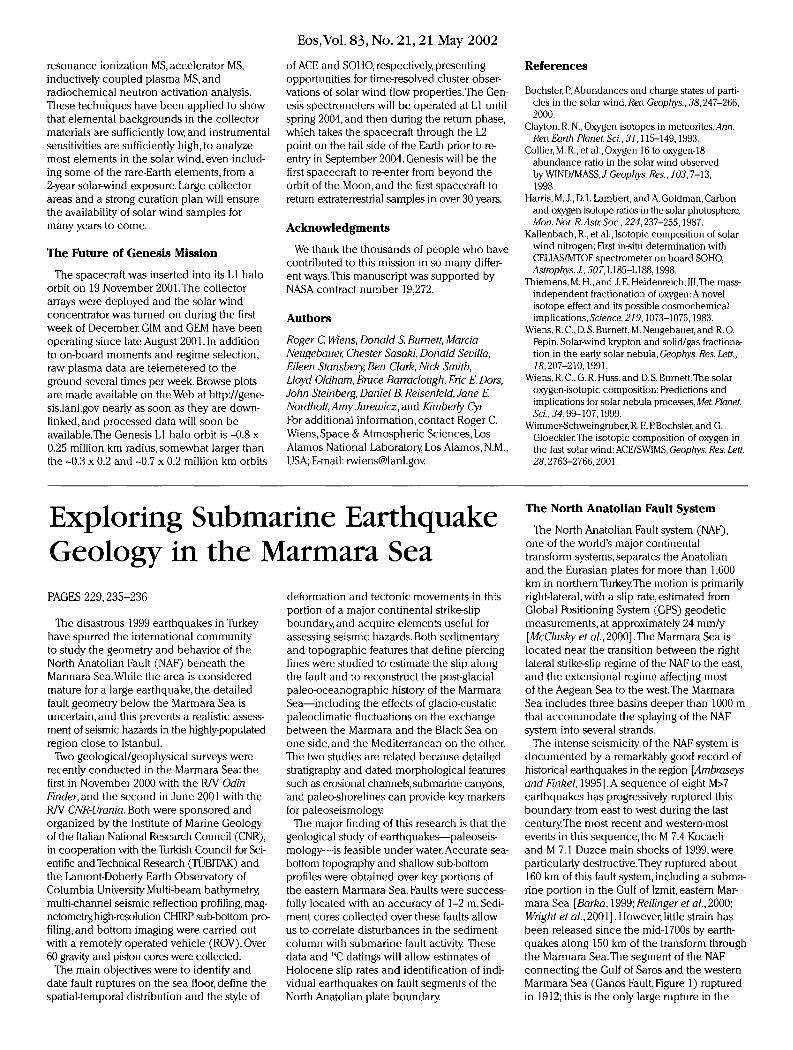
Fig. 1. This shaded relief map of the Marmara region combines (a) the Odin Finder and Urania 20-m resolution Digital Terrain Model, (b) data acquired by the Hydrographic Institute of the Turkish Navy (SHOD), and (c) the International Bathymetric Chart of the Mediterranean data (IBCM), with (d) onland European Research Satellite SAR interferometric Digital Elevation Model. The map clearly shows the North Anatolian Fault entering the Gulfoflzmit from western Turkey (red arrow). The epicenter of the M 7.4 17 August 1999 Kocaeli earthquake is represented by the largest red circle in the inset map. The tectonic model used in the inset map is taken from Okay et al. [2000]. Capital letters represent the key areas investigated during the two surveys (A: Gulf of Izmit; B: east oflmrali Island; C: Qinarcik Basin; D: the near-shore area southwest of Istanbul (Biiyuk Qekmece); E: Prince's Islands). Original color image appears at the back of this volume.
Marmara basin during the last century.There-fore, this submarine portion of the NAF system constitutes a seismic gap where the accumu-lated elastic strain is about as large as that released by slip in the 1999 sequence [Reilinger et al, 2000; Hubert-Ferrari et al, 2000]. Different earthquake scenarios can be described, in terms of how the strain gap in the Marmara Sea between the 1912 and 1999 ruptures will be filled, with different implications for the hazard facing the circum-Marmara region; a good understanding of the seismogenic behavior of the submarine strands of the NAF system is critical.
Research Equipment and Methods
Estimates of seismic hazards around the Marmara Sea require the identification of the active faults, the association of these faults with specific historic earthquakes, and dating their most recent ruptures at the same scale as typical paleoseismic studies on land. While paleoseismology has become a primary tool for seismic hazard evaluation on land, submarine paleoseismology has seldom been attempted, mainly because of the limited resolution of available marine geophysical techniques. Rapid developments in imaging and sampling techniques now make this approach possible.
High-resolution multi-beam and side-scan sonar maps and CHIRP sub-bottom profiles have been combined with carefully positioned core samples. Integrated navigation systems with Differential Global Positioning System (DGPS) and gyrocompass (GYRO) sensors
were used.To improve accuracy, some cores and the side-scan sonar tow fish, were positioned with Hydroacoustic Positioning and Ranging (HPR) transponders. The data were thereby referred to the ship's center of gravity.
This approach, called submarine earthquake geology is used to resolve the shallow geometry and kinematics of the fault system in the Marmara Sea, and to study the geological effects of individual earthquakes; that is, the effects of the fault motion along the rupture plan and secondary structures derived from the shaking, such as landslides near the fault.
Work was concentrated in the Gulf of Izmit, an east-west elongated feature located along the NAF system near its 1999 rupture, and at the offshore extension of the Ganos Fault in the Marmara Sea—the segment of the NAF that ruptured in 1912.We also surveyed the near-shore area southwest of Istanbul (Biiyuk Qekmece), the Qinarcik basin, the region close to the Prince's Islands, and an area east of Imrali Island (inset, Figure 1) to investigate other possible branches of the NAF system [e.g.,Okay et al.,2000].
Preliminary Results
The NAF enters the Gulf of Izmit from the east, where it ruptured during the 1999 earthquakes; it bisects the entire Gulf, passing through the Hersek promontory (Figure 1). Several strands of the NAF were traced as troughs or steps in sea-floor topography, and as growth structures in the shallow subsurface. In places, a single major fault
trace was found, and its position could be mapped with a resolution of less than a few meters; in other areas, several strands were found in a zone up to 1 km wide (Figures 2 and 3) . Along-strike topography identified local complexities depending on whether secondary tectonic deformation or sedimen-tary or erosional processes dominate.
The Eastern Gulf of Izmit and the 1999 Rupture
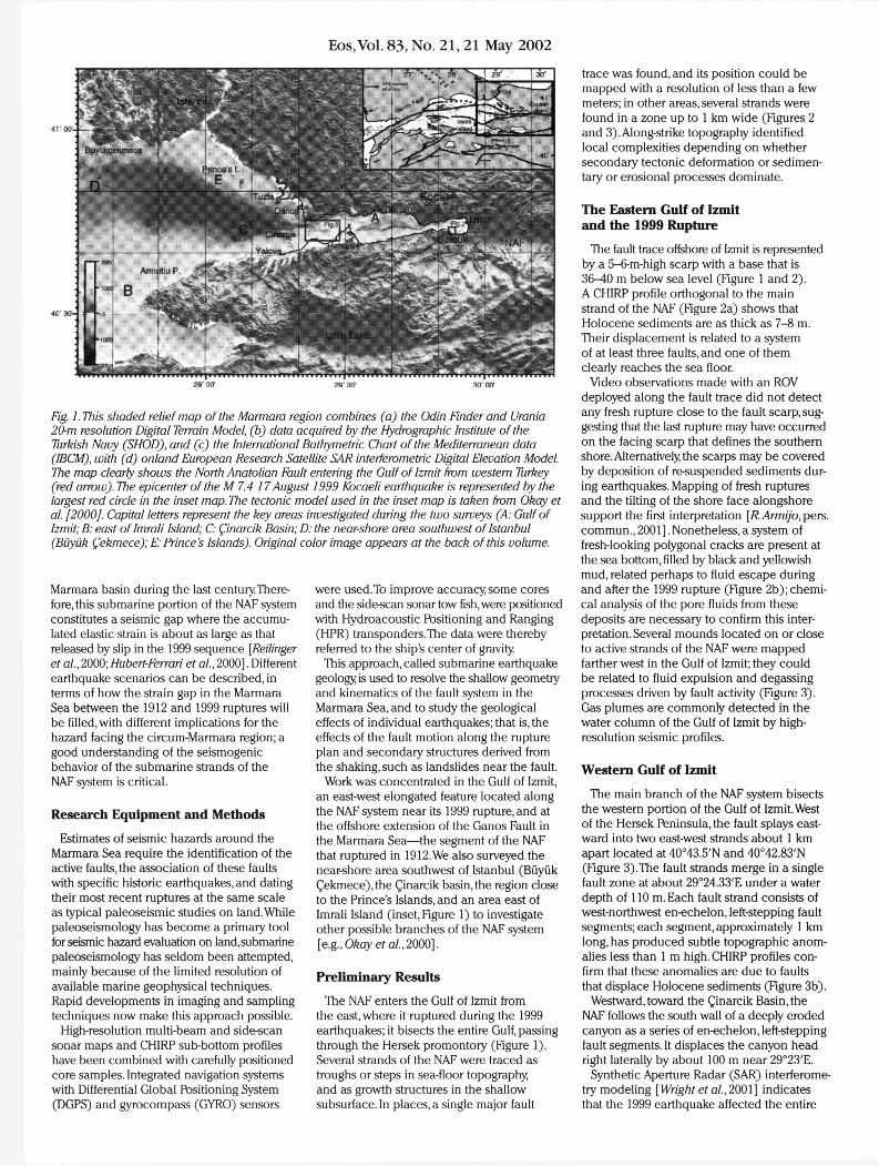
The fault trace offshore of Izmit is represented by a 5-6-m-high scarp with a base that is 36-40 m below sea level (Figure 1 and 2) . A CHIRP profile orthogonal to the main strand of the NAF (Figure 2a) shows that Holocene sediments are as thick as 7-8 m. Their displacement is related to a system of at least three faults, and one of them clearly reaches the sea floor.
Video observations made with an ROV deployed along the fault trace did not detect any fresh rupture close to the fault scarp, sug-gesting that the last rupture may have occurred on the facing scarp that defines the southern shore. Alternatively the scarps may be covered by deposition of re-suspended sediments dur-ing earthquakes. Mapping of fresh ruptures and the tilting of the shore face alongshore support the first interpretation [/?.j4/777/yb,pers. commun., 2001]. Nonetheless, a system of fresh-looking polygonal cracks are present at the sea bottom, filled by black and yellowish mud, related perhaps to fluid escape during and after the 1999 rupture (Figure 2b); chemi-cal analysis of the pore fluids from these deposits are necessary to confirm this inter-pretation. Several mounds located on or close to active strands of the NAF were mapped farther west in the Gulf of Izmit; they could be related to fluid expulsion and degassing processes driven by fault activity (Figure 3) . Gas plumes are commonly detected in the water column of the Gulf of Izmit by high-resolution seismic profiles.
Western Gulf of Izmit
The main branch of the NAF system bisects the western portion of the Gulf of Izmit. West of the Hersek Peninsula, the fault splays east-ward into two east-west strands about 1 km apart located at 40°43.5'N and 40°42.83'N (Figure 3).The fault strands merge in a single fault zone at about 29°24.33'E under a water depth of 110 m. Each fault strand consists of west-northwest en-echelon, left-stepping fault segments; each segment, approximately 1 km long, has produced subtle topographic anom-alies less than 1 m high. CHIRP profiles con-firm that these anomalies are due to faults that displace Holocene sediments (Figure 3b).
Westward, toward the Qinarcik Basin, the NAF follows the south wall of a deeply eroded canyon as a series of en-echelon, left-stepping fault segments. It displaces the canyon head right laterally by about 100 m near 29°23'E.
Synthetic Aperture Radar (SAR) interferome-try modeling [Wright et a/., 2001] indicates that the 1999 earthquake affected the entire
Eos, Vol. 83, No. 21, 21 May 2002
40 44' 00"
40 43' 30"
40 43' 00" ~
29 53' 00" 29 53" 30" 29 54' 00"
Fig. 2. This shaded-relief bathymetric map shows the eastern basin of the Gulf of Izmit near the towns of Izmit and Golcuk. (a) Sub-bottom profile across the North Anatolian Fault; Holocene sediments displacement is related to a system of at least three faults, and one of them clearly reaches the seafloor (F2). (b) This ROV image shows the system of recent cracks on the sea floor, filled by black and yellowish mineralizations presumably related to fluid escape enhanced by fault movement during and after the 1999 rupture.
Izmit Bay from the epicenter at the eastern end, to the western end close to the Qinarcik basin. However, our data suggest that the 1999 event did not rupture the sea floor of the Izmit Gulf west of the Hersek peninsula, where SAR data indicate 1.5 m of slip. Multibeam and CHIRP data and ROV images do not show fresh scarps or other indicators of recent seis-mic activity. Pinar et al. [2001] also suggest that the western termination of the 1999 rup-ture is located east of the Hersek promontory
We cannot exclude the possibility of a lack of mechanical coupling between the seismo-genic basement and the sediments above; this would inhibit brittle deformation on the sea floor. Another possibility is that the upper few meters of the sediments have very little cohe-sion and "flow" across the basement fault scarp, or that fresh fault scarps may be buried
by deposition of re-suspended sediments after each earthquake. Mud with very little cohesion sampled in that area supports this hypothesis.
We found a northwest-southeast-trending structure in front of the Hersek promontory (Figure 1) close to the northern coast that appears to continue on land close to Darica and Tuzla.This structure probably plays a secondary role in the plate motion, but it may affect the behavior of the major faults. It may be related to the fault system known as the Prince's Island segment, which is recognized by Pinar et al. [2001] as one of the potential sites for future earthquakes.
Displacement Rate Along the NAF
Topographic-sedimentary structures such as canyons, channels, and scarps have important
implications for earthquake geology. Contour-parallel scarps may represent paleo-shore faces and could thus represent horizontal paleo-ref-erence levels—that is, piercing lines—whose offset along the fault strands in the different regions of the Marmara basin may be used to estimate the NAF Holocene horizontal and vertical slip rates.
The present slip rate of the NAF has been estimated at 24 mm/yr from geodetic measurements [McClusky et al, 2000] .We will investigate the fault movement for the Holocene and how the displacement is distributed among the different strands of the NAF system in the Gulf of Izmit.Tight grids of multibeam and CHIRP profiles and core tran-sects were collected in three key areas where piercing points—submerged canyon, paleo-shorelines,and fluvial channel—were recognized.
Submarine Canyon
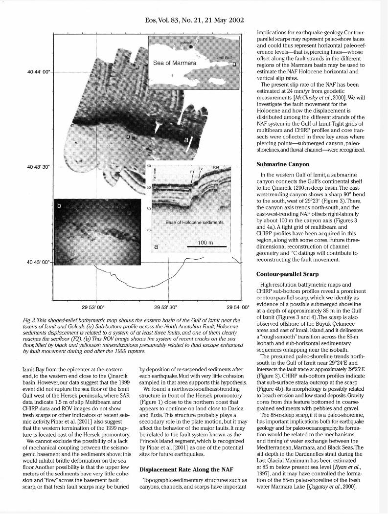
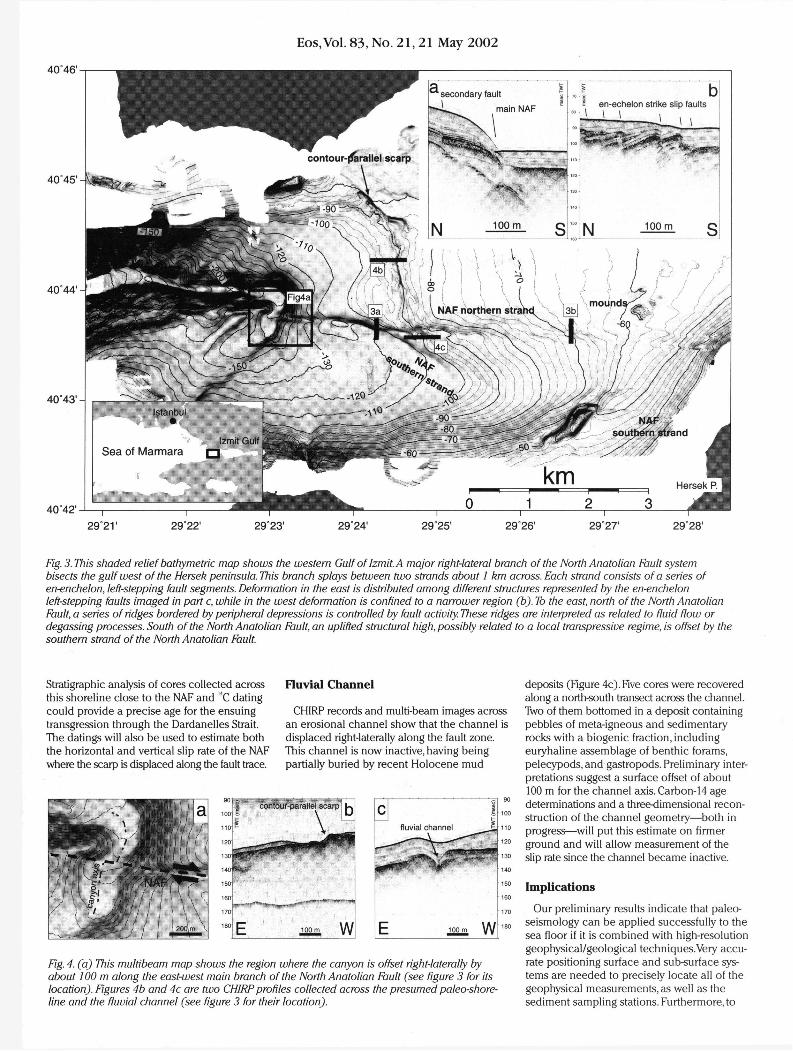
In the western Gulf of Izmit, a submarine canyon connects the Gulf's continental shelf to the Qinarcik 1200-m-deep basin.The east-west-trending canyon shows a sharp 90° bend to the south, west of 29°23' (Figure 3).There, the canyon axis trends north-south, and the east-west-trending NAF offsets right-laterally by about 100 m the canyon axis (Figures 3 and 4a). A tight grid of multibeam and CHIRP profiles have been acquired in this region, along with some cores. Future three-dimensional reconstruction of channel geometry and 14C datings will contribute to reconstructing the fault movement.
Contour-parallel Scarp
High-resolution bathymetric maps and CHIRP sub-bottom profiles reveal a prominent contour-parallel scarp, which we identify as evidence of a possible submerged shoreline at a depth of approximately 85 m in the Gulf of Izmit (Figures 3 and 4).The scarp is also observed offshore of the Biiyuk Qekmece areas and east of Imrali Island, and it delineates a "rough-smooth" transition across the 85-m isobath and sub-horizontal sedimentary sequences onlapping near the isobath.
The presumed paleo-shoreline trends north-south in the Gulf of Izmit near 29°24'E and intersects the fault trace at approximately 29°25'E (Figure 3). CHIRP sub-bottom profiles indicate that sub-surface strata outcrop at the scarp (Figure 4b). Its morphology is possibly related to beach erosion and low stand deposits. Gravity cores from this feature bottomed in coarse-grained sediments with pebbles and gravel.
The 85-m-deep scarp, if it is a paleo-shoreline, has important implications both for earthquake geology and for paleo-oceanography Its forma-tion would be related to the mechanisms and timing of water exchange between the Mediterranean, Marmara, and Black Seas.The sill depth in the Dardanelles strait during the Last Glacial Maximum has been estimated at 85 m below present sea level [Ryan et al, 1997],and it may have controlled the forma-tion of the 85-m paleo-shoreline of the fresh water Marmara Lake [Qagatay et al, 2000].
Eos, Vol. 83, No. 21, 21 May 2002
29°21' 29°22' 29°23' 29°24' 29°25' 29°26' 29°27' 29°28'
Fig. 3. This shaded relief bathymetric map shows the western Gulf of Izmit. A major right-lateral branch of the North Anatolian Fault system bisects the gulf west of the Hersek peninsula. This branch splays between two strands about I km across. Each strand consists of a series of en-enchelon, left-stepping fault segments. Deformation in the east is distributed among different structures represented by the en-enchelon left-stepping faults imaged in part c, while in the west deformation is confined to a narrower region (b). To the east, north of the North Anatolian Fault, a series of ridges bordered by peripheral depressions is controlled by fault activity. These ridges are interpreted as related to fluid flow or degassing processes. South of the North Anatolian Fault, an uplifted structural high, possibly related to a local transpressive regime, is offset by the southern strand of the North Anatolian Fault.
Stratigraphic analysis of cores collected across this shoreline close to the NAF and 14C dating could provide a precise age for the ensuing transgression through the Dardanelles Strait. The datings will also be used to estimate both the horizontal and vertical slip rate of the NAF where the scarp is displaced along the fault trace.
Fluvial Channel
CHIRP records and multi-beam images across an erosional channel show that the channel is displaced right-laterally along the fault zone. This channel is now inactive, having being partially buried by recent Holocene mud
deposits (Figure 4c). Five cores were recovered along a north-south transect across the channel. Two of them bottomed in a deposit containing pebbles of meta-igneous and sedimentary rocks with a biogenic fraction, including euryhaline assemblage of benthic forams, pelecypods, and gastropods. Preliminary inter-pretations suggest a surface offset of about 100 m for the channel axis. Carbon-14 age determinations and a three-dimensional recon-struction of the channel geometry—both in progress—will put this estimate on firmer ground and will allow measurement of the slip rate since the channel became inactive.
Implications
Our preliminary results indicate that paleo-seismology can be applied successfully to the sea floor if it is combined with high-resolution geophysical/geological techniques.Very accu-rate positioning surface and sub-surface sys-tems are needed to precisely locate all of the geophysical measurements, as well as the sediment sampling stations. Furthermore, to
Fig. 4. (a) This multibeam map shows the region where the canyon is offset right-laterally by about 100 m along the east-west main branch of the North Anatolian Fault (see figure 3 for its location). Figures 4b and 4c are two CHIRP profiles collected across the presumed paleo-shore-line and the fluvial channel (see figure 3 for their location).
Eos,Vol. 83, No. 21, 21 May 2002
obtain long-term reconstructions of the activity of the major faults, this approach has to be combined with regional and interdisciplinary studies such as basin-wide paleo-oceanogra-phy stratigraphy, and large-scale tectonics.
The ongoing analysis of this data set should help answer the following questions:
• Is the plate motion through the Marmara Sea partitioned between distinct structures accommodating the transcurrent and exten-sional components of motion?
• Do faults with complementary roles in these partitioned systems rupture in repeatable sequences?
• Is the Marmara Sea seismic gap going to be filled by a single large rupture or by a sequence of smaller ruptures?
• What is the paleo-oceanographic history of the Marmara Sea since the Last Glacial Maximum?
• What is the history of its communication with the Black Sea on one side and the Mediterranean on the other?
Acknowledgments
We thank FColognori for providing the ROV and Mr. Leoni and Mr. Dettore for support in installing multibeam sensors on board of R/V
Urania.This project is supported by a Progetto Strategico of the Italian National Research Coun-cil (CNR),Lamont-Doherty Earth Observatory of Columbia University the Turkish Council for Sci-entific and Technical Research, Collaborative Linkage Grant #976826 from the North Atlantic Treaty Organization, and Grant OCE-0096668 from the National Science Foundation.
Authors
A. Polonia, M.-H. Cormier, N. Qagatay, G. Bortoluzzi, E. Bonatti, L. Gasperini, L. Seeber, N. Gorur, L. Capotondi, C McHugh, WB. ERyan, O. Emre, N. Okay, M. Ligi, B. Tok,A. Blasi, M. Busetti, K. Eris, PFabretti, E. J. Fielding, C Imren, H. Kurt, A. Magagnoli, G Marozzi, N. Ozer, D. Penitenti, G Serpi, and K. Sarikavak For additional information, contact Alina Fblonia, Istituto Geologia Marina,Via Gobetti, 101, 40129 Bologna, Italy; E-mail: Alina.Polonia@ igm.bo.cnr.it
References
Ambraseys, N. N., and C. FFinkel,The Seismicity of Turkey and Adjacent Areas - A Historical Review, 1500-1800,240 pp., EREN, Istanbul, 1995.
Barka,A.,The 17 August 1999 Izmit earthquake, Science, 285,1858-1859,1999.
QagatayM.N.,et al.,Late Glacial-Holocene palae-oceanography of the Marmara Sea: Timing of connections with the Mediterranean and the Black Seas,Mar. Geol., 167,191-206,2000.
Hubert-Ferrari, A. , et al., Seismic hazard in the Marmara Sea region following the 17 August 1999 Izmit earthquake, Nature, 404, 269-273,2000.
McClusky, S., et al., Global Positioning system constraints on plate kinematics and dynamics in the eastern Mediterranean and Caucasus, J. Geophys. Res., 105,5695-5719,2000.
Okay A. I., et al., Active faults and evolving strike-slip basins in the Marmara Sea, northwest Turkey: A multichannel seismic reflection study Tectonophys., 527,189-218,2000.
Pinar,A.,Y Honkura, and K . Kuge,Seismic activity triggered by the 1999 Izmit earthquake and its implications for the assessment of future seismic risk, Geophys. J. Int., 146, F1-F7,2001.
Reilinger, R., et al., 1999 Izmit Turkey earthquake was no surprise, GSA Today, 10,1-6,2000.
Ryan,W B. F, et al., An abrupt drowning of the Black Sea she l f ,M^ Geol., 138,119-126,1997.
WrightJ. J., E. J. Fielding, and B. E. Parsonsjriggered slip: Observations of the 17 August 1999 Izmit (Turkey) earthquake using radar interferometry Geophys. Res. Lett., 28,1079-1082,2001.
The Habitability of Europa: A Cautionary Note
PAGE 231
Despite the lack of empirical evidence, the hypothesized existence of a liquid water ocean beneath the icy surface of Europa is supported by enough indirect data—photo-graphic, spectroscopic, magnetic, and gravito-metric—to make the proposal plausible [Gaidos and Nimmo, 2000; Greenberg, 2002; Kivelson et al, 2000; Prockter and Pappalardo, 2000] .A number of planetary scientists have suggested that were a Europan ocean to exist, it could be inhabited, if only by primitive microbial organisms [Chyba and Phillips, 2002; Gaidos and Nimmo, 2000; Greenberg, 2002; Kargel et al, 2000; McKollom, 1999]. We argue that speculation concerning poten-tial habitability, unlike the Europan ocean hypothesis, is data-deficient. Engaging as this speculation may seem, a greater measure of caution should be exercised when elaborating a supportive framework of arguments.
The Conditions of Habitability
Based upon their understanding of life processes on Earth, some scientists argue analogically that life on another planet or moon might exist if four conditions were met: the presence of a solvent such as liquid water to facilitate biochemical activity; the availability of elemental carbon, nitrogen, phosphorus, and sulfur, the building blocks of biochemistry; environmental stability over a period of time sufficient to engender and sustain fundamental biochemical processes; and sufficient free energy to maintain these processes [McKay, 2001].
A permanent, liquid water ocean beneath the icy Europan surface could, by definition, satisfy the first condition; also, it would contribute to potential habitability by moder-ating extremes of temperature. Magnetic field and surface reflectance data suggest that many of the key elements required by organ-isms may be present in the sub-surface ocean [Chyba and Phillips, 2002; Kargel et al., 2000; McCollom, 1999; McKay, 2000]. Hypotheses concerning the availability of free energy on Europa rely upon one of two potential metabolic paths: photosynthesis or chemosyn-thesis [Chyba and Phillips, 2002; Gaidos and Nimmo, 2000; Greenberg, 2002].
Photosynthesis requires, at a minimum, water near enough to the surface to be exposed to light yet deep enough to protect organisms from the severe Jovian radiation [Gaidos and Nimmo, 2000; Greenberg, 2002]. Chemosynthesis does not require light; but the extent to which the compounds needed to sustain chemosyn-thesis are available in the Europan ocean is a matter of high speculation [Kargel et al, 2000; McKollom, 1999; Chyba and Phillips, 2002]. On Earth, chemosynthesis is often associated with hydrothermal vents and hot springs. Were the frictional heating of tidal forces and the decay of radioactive elements in the rocky core of Europa sufficient to generate volcanism,then the metabolic needs for chemosynthetic life might be met through methanogenesis or sulfur reduction [Kargel at al, 2000; McKollom, 1999].
The subject of Europan habitability is capti-vating but problematic because it is removed from direct observation, evidence, or data by four orders of inference. First, the existence of a sub-surface water ocean itself, although
plausible, is derived by indirect means and from indirect data. Second, magnetic field data suggest that abundant electrolytes could be present in the water, and surface reflectance data hint that the dissolved solids may include some type of hydrated sulfate; yet substantiation of these hypotheses must await a sampling mission.Third, neither the surface nor near-surface water required by photosynthesis, nor the sub-surface energetic conditions required for chemosynthesis have been discerned. Fourth, speculation on Europan habitability is weakened by the failure to acknowledge the possibility that a Europan ocean, were it to exist, might be barren and abiotic. Even if Europa is habitable, this does not mean that conditions suited to the origin of life, or to nurturing primitive life that was delivered from a distance [pan-spermia], ever arose.
Life's Origin on Earth
Although conditions at hydrothermal vents and other terrestrial environments of extreme temperature, pH, and chemistry are possible analogues for the conditions that may have sustained primitive life on Earth, countless questions concerning the origin of life and antecedent pre-biotic conditions remain unresolved. For example, it has been argued that life originated either in very warm, thermophilic conditions (50°C > 100°C),or very cold, psychrophilic conditions ( » 0°C). Interestingly, both extremes of temperature are troublesome with regard to the formation of cytosine.The latter, along with adenine, uracil, and guanine, comprise the four nucle-obases of DNA.
At temperatures approaching 100°C, these nucleobases are unstable and have half-lives that are very short [Levy and Miller, 1998].
Eos, Vol. 83, No. 21, 21 May 2002
41 'Of f .
29* 00' mm so* oo*
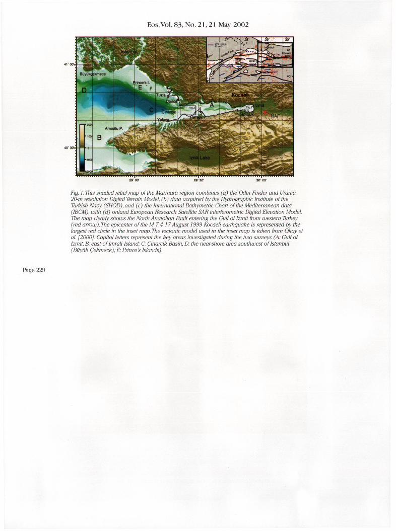
Fig. I. This shaded relief map of the Marmara region combines (a) the Odin Finder and Urania 20-m resolution Digital Terrain Model, (b) data acquired by the Hydrographic Institute of the Turkish Navy (SHOD), and (c) the International Bathymetric Chart of the Mediterranean data (IBCM), with (d) onland European Research Satellite SAR interferometric Digital Elevation Model. The map clearly shows the North Anatolian Fault entering the Gulf of Izmit from western Turkey (red arrow). The epicenter of the M 7.4 17 August 1999 Kocaeli earthquake is represented by the largest red circle in the inset map. The tectonic model used in the inset map is taken from Okay et al. [2000]. Capital letters represent the key areas investigated during the two surveys (A: Gulf of Izmit; B: east oflmrali Island; C: Qnarcik Basin; D: the near-shore area southwest of Istanbul (Biiyiik Qekmece); E: Prince s Islands).
Page 229
Related Documents