Top Banner
Geothermal Energy Resources Exploration using Gravity and magnetics By Mariita, N.O.
51

Exploration using Gravity and magnetics - Orkustofnun 2007... · •Surface exploration to determine existence of resource •Determine areal extent and potential power •Exploration

Apr 28, 2018

Download

Documents

doanduong
Welcome message from author
This document is posted to help you gain knowledge. Please leave a comment to let me know what you think about it! Share it to your friends and learn new things together.
Transcript
Page 1: Exploration using Gravity and magnetics - Orkustofnun 2007... · •Surface exploration to determine existence of resource •Determine areal extent and potential power •Exploration

Geothermal Energy Resources

Exploration

using

Gravity and magnetics

By

Mariita, N.O.

Page 2: Exploration using Gravity and magnetics - Orkustofnun 2007... · •Surface exploration to determine existence of resource •Determine areal extent and potential power •Exploration

What is Geothermal Energy?

Geothermal Energy = heat from the Earth

Transmitted by

fluids

via fractures and pores within the rock

Page 3: Exploration using Gravity and magnetics - Orkustofnun 2007... · •Surface exploration to determine existence of resource •Determine areal extent and potential power •Exploration

Lake

Brittle Brittle

Ductile Ductile

Heat Source

Reservoir Capping Rocks

Reservoir

Page 4: Exploration using Gravity and magnetics - Orkustofnun 2007... · •Surface exploration to determine existence of resource •Determine areal extent and potential power •Exploration

Information needed

• Volume, geometry, boundary conditions of

resource

• Permeability, density, heat capacity and

conductivity

Page 5: Exploration using Gravity and magnetics - Orkustofnun 2007... · •Surface exploration to determine existence of resource •Determine areal extent and potential power •Exploration

Sizing of Resource

• Surface exploration to determine existence

of resource

• Determine areal extent and potential power

• Exploration drilling to prove resource,

determine physical and geochemical

parameters

• Determine total heat available

Page 6: Exploration using Gravity and magnetics - Orkustofnun 2007... · •Surface exploration to determine existence of resource •Determine areal extent and potential power •Exploration

Geophysical investigations

• Geophysics = X-Raying the Earth

INVOLVES

• Sending signal into the earth

• Monitoring natural signals from the earth

Page 7: Exploration using Gravity and magnetics - Orkustofnun 2007... · •Surface exploration to determine existence of resource •Determine areal extent and potential power •Exploration

• Schlumberger Array

• Dipole

• Electromagnetics

• Head on Resistivity

• Transient Electromagnetics (TEM)

• Magnetotellurics (MT)

• Gravity

• Magnetic

• Seismic

Geophysical methods available

Page 8: Exploration using Gravity and magnetics - Orkustofnun 2007... · •Surface exploration to determine existence of resource •Determine areal extent and potential power •Exploration

Geophysics methods…

Note:

• All geophysical techniques are expensive,

although some more than others

• BUT still much, much cheaper than drilling

Page 9: Exploration using Gravity and magnetics - Orkustofnun 2007... · •Surface exploration to determine existence of resource •Determine areal extent and potential power •Exploration

Common Geophysical Methods used

in Geothermal Energy investigations

• Resistivity

• Seismic

• Gravity

• Magnetics

Page 10: Exploration using Gravity and magnetics - Orkustofnun 2007... · •Surface exploration to determine existence of resource •Determine areal extent and potential power •Exploration

GRAVITY

Page 11: Exploration using Gravity and magnetics - Orkustofnun 2007... · •Surface exploration to determine existence of resource •Determine areal extent and potential power •Exploration

Gravity as a force

Gravity is a potential field

i.e.,

a force that acts at a distance

Measures differences in the earth’s

gravitational field at specific locations

Page 12: Exploration using Gravity and magnetics - Orkustofnun 2007... · •Surface exploration to determine existence of resource •Determine areal extent and potential power •Exploration

Gravity field

The strength of the gravitational field

proportional to

> the mass (the density)

> the depth

of subsurface materials

Page 13: Exploration using Gravity and magnetics - Orkustofnun 2007... · •Surface exploration to determine existence of resource •Determine areal extent and potential power •Exploration

UNIFORM

EARTH

Gravity

Uniform layered earth

Page 14: Exploration using Gravity and magnetics - Orkustofnun 2007... · •Surface exploration to determine existence of resource •Determine areal extent and potential power •Exploration

Buried Body

Page 15: Exploration using Gravity and magnetics - Orkustofnun 2007... · •Surface exploration to determine existence of resource •Determine areal extent and potential power •Exploration

Buried Body….

Page 16: Exploration using Gravity and magnetics - Orkustofnun 2007... · •Surface exploration to determine existence of resource •Determine areal extent and potential power •Exploration

GRAVITY SURVEY

Results in

• Density indications in subsurface

HEAVIER Rocks

may imply

possibility of HEAT Source

Page 17: Exploration using Gravity and magnetics - Orkustofnun 2007... · •Surface exploration to determine existence of resource •Determine areal extent and potential power •Exploration

Heat Source

Page 18: Exploration using Gravity and magnetics - Orkustofnun 2007... · •Surface exploration to determine existence of resource •Determine areal extent and potential power •Exploration

INSTRUMENTATION

Common gravimeters

> Worden

> Scintrex and

> La Coste Romberg

Page 19: Exploration using Gravity and magnetics - Orkustofnun 2007... · •Surface exploration to determine existence of resource •Determine areal extent and potential power •Exploration

INSTRUMENTATION…..

Worden and La Coste Romberg

gravity meters

Page 20: Exploration using Gravity and magnetics - Orkustofnun 2007... · •Surface exploration to determine existence of resource •Determine areal extent and potential power •Exploration

Gravimeter

• Important for mapping

– Dense bodies

• Heat sources

• Dikes

– Buried faults zones

– Ground subsidence

• Mass withdrawal

Equipment cost upwards of US$ 150,000

Page 21: Exploration using Gravity and magnetics - Orkustofnun 2007... · •Surface exploration to determine existence of resource •Determine areal extent and potential power •Exploration

Data Acquisition

Gravity data acquisition

can be performed

by one person.

But

Two people are better

Readings at each site:

Gravity – Coordinates - Elevation

Page 22: Exploration using Gravity and magnetics - Orkustofnun 2007... · •Surface exploration to determine existence of resource •Determine areal extent and potential power •Exploration

Data Acquisition…..

Speed and amount of data

collected depends on:

Station separation

Operator experience

Terrain conditions

Page 23: Exploration using Gravity and magnetics - Orkustofnun 2007... · •Surface exploration to determine existence of resource •Determine areal extent and potential power •Exploration

Data Processing

The most tedious and time consuming!!!

REDUCTION

Must remove all known gravitational

effects not related to the subsurface

density changes

Page 24: Exploration using Gravity and magnetics - Orkustofnun 2007... · •Surface exploration to determine existence of resource •Determine areal extent and potential power •Exploration

Data Processing…..

Each reading has to be corrected

for

Elevation,

Tides,

Latitude and

if significant local topography exists, a

topographic correction

Page 25: Exploration using Gravity and magnetics - Orkustofnun 2007... · •Surface exploration to determine existence of resource •Determine areal extent and potential power •Exploration

Data Processing…..

Tides and Drift removal

Page 26: Exploration using Gravity and magnetics - Orkustofnun 2007... · •Surface exploration to determine existence of resource •Determine areal extent and potential power •Exploration

Data Processing…..

Correction for topography

Page 27: Exploration using Gravity and magnetics - Orkustofnun 2007... · •Surface exploration to determine existence of resource •Determine areal extent and potential power •Exploration

Data Processing…..Corrections to Gravimeter Reading

1.) Correct for drift in terms of dial units

2.) Calculate difference between stations and base ( Rdg)

3.) Convert difference to units of gravity ( g) by multiplying Rdg values by the

gravimeter scale constant

4.) Calculate gobs at the station by adding g to observed gravity at base

5.) Calculate the Free Air (CFA) correction (below reference surface h is

negative, above h is positive) and add to gobs of the station

6.) Calculate Bouguer slab (CBS) correction and subtract from gobs + CFA of the

station.

7.) Calculate terrain (CTC) correction if necessary and add to gobs + CFA - CBS

8.) Calculate gth for the station and subtract from gobs + CFA - CBS + CTC. This

is the complete Bouguer anomaly.

9.) The simple Bouguer anomaly is gobs + CFA - CBS - gth.

10.) The Free Air anomaly is gobs + CFA - gth.

Page 28: Exploration using Gravity and magnetics - Orkustofnun 2007... · •Surface exploration to determine existence of resource •Determine areal extent and potential power •Exploration

Data Analysis and interpretation…..

From the reduced data:

Plot contour maps

Locate interesting features

Construct profiles across

Model

Page 29: Exploration using Gravity and magnetics - Orkustofnun 2007... · •Surface exploration to determine existence of resource •Determine areal extent and potential power •Exploration

Data Analysis and interpretation…..

Contour maps

Page 30: Exploration using Gravity and magnetics - Orkustofnun 2007... · •Surface exploration to determine existence of resource •Determine areal extent and potential power •Exploration

Data Analysis and interpretation…..Profile Construction

Page 31: Exploration using Gravity and magnetics - Orkustofnun 2007... · •Surface exploration to determine existence of resource •Determine areal extent and potential power •Exploration

Data Analysis and interpretation…..

Modelling

Observed

Model

Page 32: Exploration using Gravity and magnetics - Orkustofnun 2007... · •Surface exploration to determine existence of resource •Determine areal extent and potential power •Exploration

Costs for a Gravity Survey

Typical costs for a gravity survey depends

on

> contract out the survey to a consulting company

the clients wants to perform the survey

themselves,

the amount of interpretation and data

processing

the number of stations

and the object of interest

Page 33: Exploration using Gravity and magnetics - Orkustofnun 2007... · •Surface exploration to determine existence of resource •Determine areal extent and potential power •Exploration

Costs for a Gravity Survey…..

Page 34: Exploration using Gravity and magnetics - Orkustofnun 2007... · •Surface exploration to determine existence of resource •Determine areal extent and potential power •Exploration

Data Analysis and interpretation…..

Page 35: Exploration using Gravity and magnetics - Orkustofnun 2007... · •Surface exploration to determine existence of resource •Determine areal extent and potential power •Exploration

Menengai Gravity

140000 150000 160000 170000 180000 190000

Eastings(m)

9970000

9980000

9990000

10000000

10010000

Nort

hin

gs(m

)

Kabarak

Mogotio

Kambi Moto

Olobanita

Kisanana

Rongai

-2000

-1900

-1850

-1800

-1750

-1700

-1650

-1550

-1500

-1450

-1400

g.u.

Menengai caldera

Molo

TectonovolcanicAxis

Sola

ifa

ult

zone

35.7 36.10 0E E

0.20S

(Equator)

Page 36: Exploration using Gravity and magnetics - Orkustofnun 2007... · •Surface exploration to determine existence of resource •Determine areal extent and potential power •Exploration

Gravity model across Menengai volcano

Page 37: Exploration using Gravity and magnetics - Orkustofnun 2007... · •Surface exploration to determine existence of resource •Determine areal extent and potential power •Exploration

MAGNETICS

Page 38: Exploration using Gravity and magnetics - Orkustofnun 2007... · •Surface exploration to determine existence of resource •Determine areal extent and potential power •Exploration

Magnetometer

• Important for mapping

– Demagnetized bodies

•Heat sources

•Dikes

– Buried faults zones

– Alteration zones

Page 39: Exploration using Gravity and magnetics - Orkustofnun 2007... · •Surface exploration to determine existence of resource •Determine areal extent and potential power •Exploration

Magnetic Susceptibility of

Representative Rock Types

Page 40: Exploration using Gravity and magnetics - Orkustofnun 2007... · •Surface exploration to determine existence of resource •Determine areal extent and potential power •Exploration

Magnetic signatures

Page 41: Exploration using Gravity and magnetics - Orkustofnun 2007... · •Surface exploration to determine existence of resource •Determine areal extent and potential power •Exploration

Instrumentation

Proton Precession magnetometers. (a) Geometrics

G-856 (b) Geometrics G-858

Page 42: Exploration using Gravity and magnetics - Orkustofnun 2007... · •Surface exploration to determine existence of resource •Determine areal extent and potential power •Exploration

Data Acquisition

> Ground

> Aero-magnetics

To obtain a representative reading

the sensor should be operated well above the ground

the operator is “magnetically clean.” No Zippers,

watches, eyeglass frames, boot Grommets, room keys,

and mechanical pencils, can all contain steel or iron

No cultural noise, e.g., power-lines, waterlines

Page 43: Exploration using Gravity and magnetics - Orkustofnun 2007... · •Surface exploration to determine existence of resource •Determine areal extent and potential power •Exploration

Data Processing

Correct for diurnal drift

Cultural noise

Done by use of two instruments

and

Filtering

Page 44: Exploration using Gravity and magnetics - Orkustofnun 2007... · •Surface exploration to determine existence of resource •Determine areal extent and potential power •Exploration

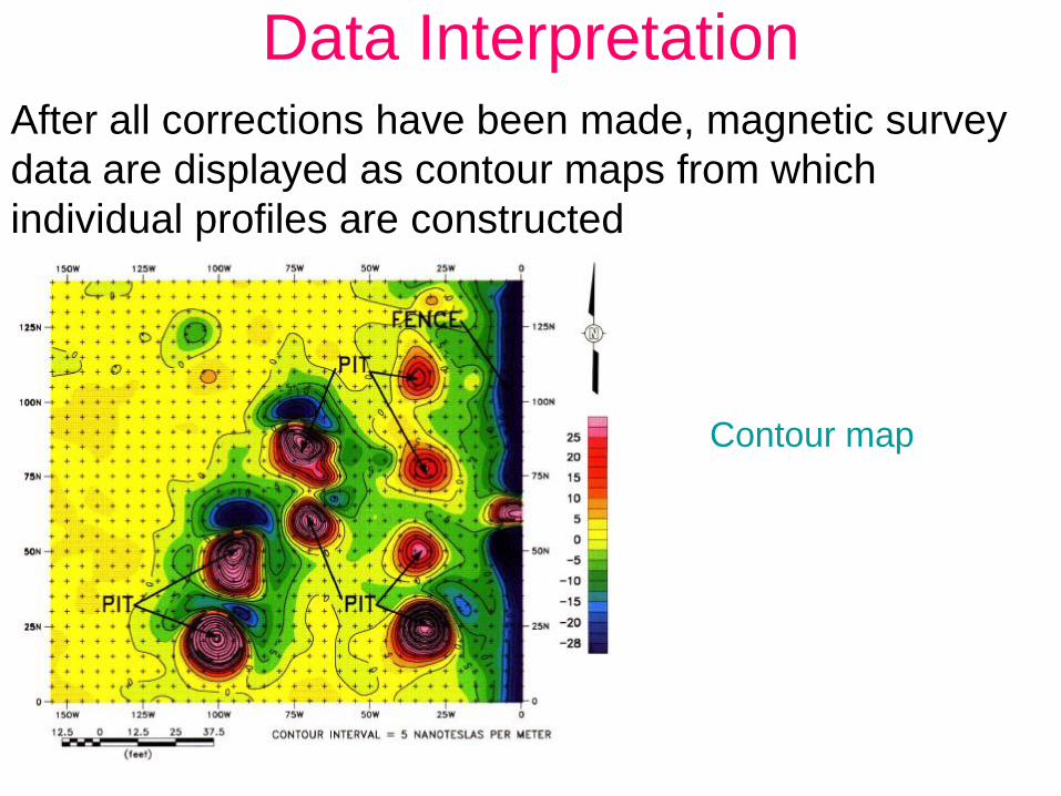
Data InterpretationAfter all corrections have been made, magnetic survey

data are displayed as contour maps from which

individual profiles are constructed

Contour map

Page 45: Exploration using Gravity and magnetics - Orkustofnun 2007... · •Surface exploration to determine existence of resource •Determine areal extent and potential power •Exploration

Data Interpretation…..

Profile across interesting feature

Page 46: Exploration using Gravity and magnetics - Orkustofnun 2007... · •Surface exploration to determine existence of resource •Determine areal extent and potential power •Exploration

Total magnetic intensity over Olkaria

185000 190000 195000 200000 205000

Eastings

9895000

9900000

9905000

9910000

No

rthin

gs

33350

33500

33650

33750

33875

34000

Olkaria East

Olkaria N-E

Olkaria West

nT

Olkaria Domes

Page 47: Exploration using Gravity and magnetics - Orkustofnun 2007... · •Surface exploration to determine existence of resource •Determine areal extent and potential power •Exploration

Advantages of Magnetic Surveys

It is expedient and cost effective

ideal for both reconnaissance and focused surveys

covers more ground in less time and

requires a minimum of field support

Page 48: Exploration using Gravity and magnetics - Orkustofnun 2007... · •Surface exploration to determine existence of resource •Determine areal extent and potential power •Exploration

Cost of Magnetic Surveys…..

DEPENDS on whether

Ground

or

Aero-magnetics

Page 49: Exploration using Gravity and magnetics - Orkustofnun 2007... · •Surface exploration to determine existence of resource •Determine areal extent and potential power •Exploration

Cost of Magnetic Surveys…..Economic factors governing ground survey

Mobilization and demobilization will require 1/2 day each

Area/nature to be covered, total number of stations

Number of field crew (minimum 3)

Total person-hours required for processing, interpretation and

report preparation

Cost of renting two instruments

Subsistence and travel expenses

Transport costs

Consulting fee

Overhead = 100% of total direct cost

Page 50: Exploration using Gravity and magnetics - Orkustofnun 2007... · •Surface exploration to determine existence of resource •Determine areal extent and potential power •Exploration

What then ???

And hopefully be happy, thereafter

Page 51: Exploration using Gravity and magnetics - Orkustofnun 2007... · •Surface exploration to determine existence of resource •Determine areal extent and potential power •Exploration

Thank you !