ASX Release 3 December 2015 1 Exploration Pipeline Bolstered by Exciting New Target Highlights: High calibre exploration target identified at Esso’s Waterloo Historic shallow drill intercepts up to 10.4% Pb adjacent to newly identified anomaly Anomaly is marked by a large zone of IP chargeability located under shallow cover Limited historic drilling of Esso’s Waterloo failed to test geophysical anomaly Red River Resources Limited (ASX:RVR) (“Red River” or the “Company”) is pleased to provide an update on ongoing historic data compilation and target generation at its Thalanga Zinc Project (“Project”) in Queensland. Exploration Pipeline Bolstered with Exceptional New Target Re-processing of historic geophysical data, compilation of historic surface geochemical and drilling data within the Liontown Waterloo Project Area has identified a significant untested Induced Polarisation (“IP”) chargeability anomaly adjacent to historic shallow high-grade drill intercepts. Esso’s Waterloo is located approximately 2km East of the Waterloo deposit (refer to Figure 1). Red River has defined a JORC resource of 707kt @ 1.9% Cu, 1.6% Pb, 11.0% Zn, 0.9 g/t Au & 50 g/t Ag (19.1% Zn Eq) at Waterloo (refer to ASX release of 24 April 2015 – ‘Waterloo Deposit – Updated Mineral Resource Estimate’) and Waterloo forms part of the exciting Thalanga Zinc Project Restart Study (refer to ASX release 12 November 2015). Historic drilling at Esso’s Waterloo by Esso Australia Ltd (“Esso”) between 1975 and 1979 produced a number of significant high-grade intercepts including WTP119: 6.0m at 1.33% Cu, 4.2% Pb, 0.5% Zn & 40g/t Ag (refer to Table 2 for further details). Esso’s drilling was focussed on testing beneath an outcropping gossan. Red River’s recent review has determined that the historic drilling failed to test a significant IP anomaly adjacent to and north of the gossan. The anomaly sits along strike from historic shallow high-grade intercepts of up to 10.4% Pb and is interpreted to be located at the boundary of a strongly altered felsic volcanic pile and overlying mixed volcano-sedimentary sequences. This is the same stratigraphic position which hosts the Thalanga deposits. Red River believes this IP anomaly has the potential to represent a significant VHMS deposit. As Figure 2 illustrates, Esso’s drilling focussed on testing below and along strike from the outcropping gossan and only one line of shallow RAB holes was drilled in the vicinity of the recently identified IP anomaly which displayed encouraging alteration and elevated zinc to 2600ppm. Only one drillhole (WTP122) tested the interpreted “Thalanga Position” and recorded anomalous Pb & Zn values up to 0.5%.

Welcome message from author
This document is posted to help you gain knowledge. Please leave a comment to let me know what you think about it! Share it to your friends and learn new things together.
Transcript

ASX Release 3 December 2015
1
Exploration Pipeline Bolstered by Exciting New Target
Highlights:
High calibre exploration target identified at Esso’s Waterloo
Historic shallow drill intercepts up to 10.4% Pb adjacent to newly identified anomaly
Anomaly is marked by a large zone of IP chargeability located under shallow cover
Limited historic drilling of Esso’s Waterloo failed to test geophysical anomaly
Red River Resources Limited (ASX:RVR) (“Red River” or the “Company”) is pleased to provide an update on ongoing historic data compilation and target generation at its Thalanga Zinc Project (“Project”) in Queensland.
Exploration Pipeline Bolstered with Exceptional New Target
Re-processing of historic geophysical data, compilation of historic surface geochemical and drilling data within the Liontown Waterloo Project Area has identified a significant untested Induced Polarisation (“IP”) chargeability anomaly adjacent to historic shallow high-grade drill intercepts.
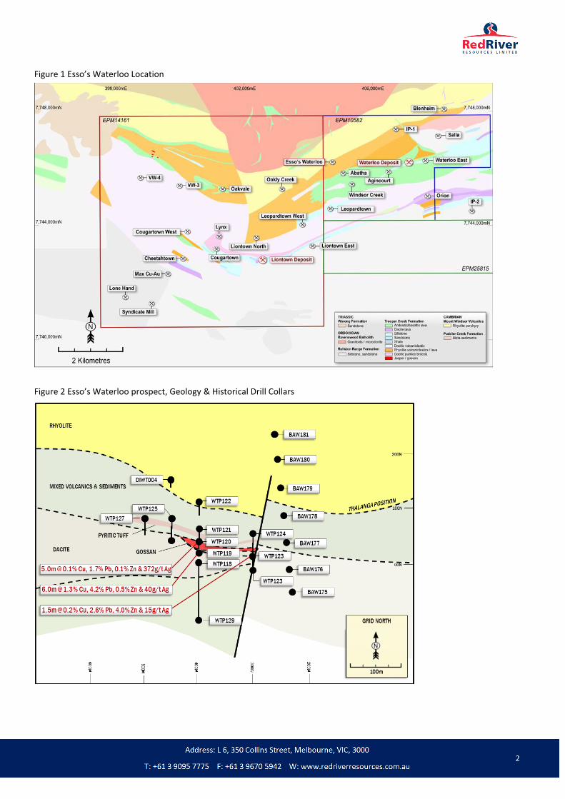
Esso’s Waterloo is located approximately 2km East of the Waterloo deposit (refer to Figure 1). Red River has defined a JORC resource of 707kt @ 1.9% Cu, 1.6% Pb, 11.0% Zn, 0.9 g/t Au & 50 g/t Ag (19.1% Zn Eq) at Waterloo (refer to ASX release of 24 April 2015 – ‘Waterloo Deposit – Updated Mineral Resource Estimate’) and Waterloo forms part of the exciting Thalanga Zinc Project Restart Study (refer to ASX release 12 November 2015).
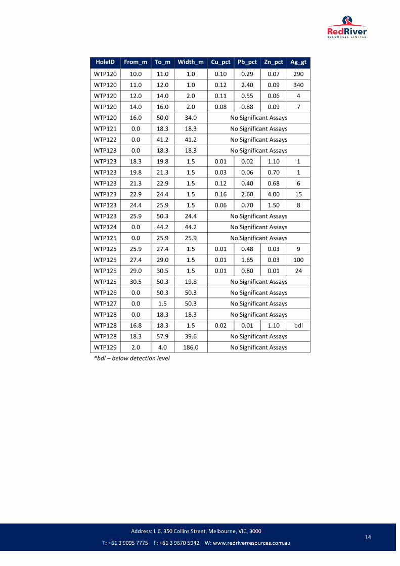
Historic drilling at Esso’s Waterloo by Esso Australia Ltd (“Esso”) between 1975 and 1979 produced a number of significant high-grade intercepts including WTP119: 6.0m at 1.33% Cu, 4.2% Pb, 0.5% Zn & 40g/t Ag (refer to Table 2 for further details). Esso’s drilling was focussed on testing beneath an outcropping gossan. Red River’s recent review has determined that the historic drilling failed to test a significant IP anomaly adjacent to and north of the gossan.
The anomaly sits along strike from historic shallow high-grade intercepts of up to 10.4% Pb and is interpreted to be located at the boundary of a strongly altered felsic volcanic pile and overlying mixed volcano-sedimentary sequences. This is the same stratigraphic position which hosts the Thalanga deposits. Red River believes this IP anomaly has the potential to represent a significant VHMS deposit.
As Figure 2 illustrates, Esso’s drilling focussed on testing below and along strike from the outcropping gossan and only one line of shallow RAB holes was drilled in the vicinity of the recently identified IP anomaly which displayed encouraging alteration and elevated zinc to 2600ppm. Only one drillhole (WTP122) tested the interpreted “Thalanga Position” and recorded anomalous Pb & Zn values up to 0.5%.
2
Figure 1 Esso’s Waterloo Location
Figure 2 Esso’s Waterloo prospect, Geology & Historical Drill Collars

3
Figure 3 Esso’s Waterloo IP Chargeability
Historical Drilling
Historical drilling at Esso’s Waterloo prospect consists of seven Rotary Air Blast (RAB) holes, 12 percussion holes and one diamond hole conducted over two campaigns in 1975/1976 & 1979 by Esso Australia Ltd. Historic drilling is summarised below and complete collar details are provided as Appendix 1 and assay details are provided as Appendix 2. Highlights of this drilling are included in the tables below.
Table 1 - Esso’s Waterloo Drill Program
Year Company No. Holes Drilling Type Total Metres Comments
1975 Esso 12 Percussion 730.8m Holes WTP118 -128 (originally PDH1-11) & WTP129 (originally WPD12)
1976 Esso 1 Diamond 11.1m DIWT004 (originally WDD13)
1979 Esso 6 Rotary Air Blast 26.0m BAW175-181
Table 2 - Esso’s Waterloo Drill Intercepts
Hole ID From (m) To (m) Int. (m)* Cu (%) Pb (%) Zn (%) Ag (g/t) Au (g/t)
WTP119 1.0 7.0 6.0 1.3 4.2 0.5 40 -
Including 1.0 0.7 10.4 0.6 27 -
WTP120 7.0 12.0 5.0 0.1 1.6 0.1 372 -
Including 1.0 0.1 1.7 0.1 560 -
WTP123 22.9 24.4 1.5 0.2 2.6 4.0 15 -
(*) Intercept based on down-hole thickness. True width unknown

4
The one line of shallow RAB holes drilled in the vicinity of the IP anomaly (BAW series) produced encouraging alteration
and elevated zinc levels up to 2600ppm, however these holes were much too shallow to test the IP anomaly which is
interpreted to be located at approximately 150m below the surface. Figure 4 illustrates the failure of all the historic
drilling to test the recently identified IP anomaly.
Figure 4 Esso’s Waterloo prospect - Oblique view looking NW. 3D Chargeability shells and historic drilling
On behalf of the Board
Mel Palancian Managing Director Red River Resources Limited
For further information please visit Red River’s website or contact us:
Mel Palancian Nathan Ryan Managing Director NWR Communications [email protected] [email protected] D: +61 3 9095 7775 M: +61 420 582 887

5
COMPETENT PERSON STATEMENT
Exploration Results
The information in this report that relates to Exploration Results is based on information compiled by Mr Tav Bates who is a member of the Australasian Institute of Mining and Metallurgy, and a full time employee of Terra Search Pty. Ltd., and who has sufficient experience relevant to the style of mineralisation and type of deposit under consideration and to the activities being undertaken to qualify as a Competent Person as defined in the 2012 Edition of the ‘Australasian Code for Reporting Exploration Results, Mineral Resources and Ore Reserves’ (JORC Code). Mr Bates consents to the inclusion in this report of the matters based on the information in the form and context in which it appears.

6
JORC CODE, 2012 EDITION – TABLE 1
Section 1 Sampling Techniques and Data
(Criteria in this section apply to all succeeding sections.)
Criteria JORC Code explanation Commentary
Sampling techniques
Nature and quality of sampling (eg cut channels, random chips, or specific specialised industry standard measurement tools appropriate to the minerals under investigation, such as down hole gamma sondes, or handheld XRF instruments, etc). These examples should not be taken as limiting the broad meaning of sampling.
Include reference to measures taken to ensure sample representivity and the appropriate calibration of any measurement tools or systems used.
Aspects of the determination of mineralisation that are Material to the Public Report.
In cases where ‘industry standard’ work has been done this would be relatively simple (eg ‘reverse circulation drilling was used to obtain 1 m samples from which 3 kg was pulverised to produce a 30 g charge for fire assay’). In other cases more explanation may be required, such as where there is coarse gold that has inherent sampling problems. Unusual commodities or mineralisation types (eg submarine nodules) may warrant disclosure of detailed information.
This report presents historical geophysical and drilling data collected by Esso Australia Limited during the period 1975 to 1979
Geophysical data consists of three 280m lines of dipole-dipole Induced Polarisation (IP) collected with 50m dipole spacing and a line spacing of 200m.
Drilling data consists of a combination of Rotary Air Blast (RAB), Percussion and Diamond Core drilling, totalling 768.9m, undertaken using Industry Standard procedures for the era.
Drilling techniques
Drill type (eg core, reverse circulation, open-hole hammer, rotary air blast, auger, Bangka, sonic, etc) and details (eg core diameter, triple or standard tube, depth of diamond tails, face-sampling bit or other type, whether core is oriented and if so, by what method, etc).
Drilling techniques consisted of a combination of;
Rotary Air Blast drilling (RAB), Percussion drilling and diamond core drilling. The hole diameter sizes are unknown.
Drill sample recovery
Method of recording and assessing core and chip sample recoveries and results assessed.
Measures taken to maximise sample recovery and ensure representative nature of the samples.
Whether a relationship exists between sample recovery and grade and whether sample bias may have occurred due to preferential loss/gain of fine/coarse material.
The method of recording sample recovery is unknown
Drill hole logging suggests good ground conditions were encountered and as such negligible sample loss is assumed
Logging Whether core and chip samples have been geologically and geotechnically logged to a level of detail to support appropriate Mineral Resource estimation, mining studies and metallurgical studies.
Whether logging is qualitative or quantitative in nature. Core (or costean, channel, etc) photography.
Holes were logged to a level of detail that would support mineral resource estimation.
Qualitative logging includes lithology, alteration and textures

7
Criteria JORC Code explanation Commentary
The total length and percentage of the relevant intersections logged.
Sub-sampling techniques and sample preparation
If core, whether cut or sawn and whether quarter, half or all core taken.
If non-core, whether riffled, tube sampled, rotary split, etc and whether sampled wet or dry.
For all sample types, the nature, quality and appropriateness of the sample preparation technique.
Quality control procedures adopted for all sub-sampling stages to maximise representivity of samples.
Measures taken to ensure that the sampling is representative of the in situ material collected, including for instance results for field duplicate/second-half sampling.
Whether sample sizes are appropriate to the grain size of the material being sampled.
RAB samples consisted of the first 1m of bedrock encountered, sample size and split ratio is unknown
Percussion samples consisted of 1m, 1.5m or 2m samples, sample size and split ratio is unknown.
The diamond drill core was not assayed
Quality control procedures are unknown
Sample sizes are assumed to have been appropriate for the grainsize
Quality of assay data and laboratory tests
The nature, quality and appropriateness of the assaying and laboratory procedures used and whether the technique is considered partial or total.
For geophysical tools, spectrometers, handheld XRF instruments, etc, the parameters used in determining the analysis including instrument make and model, reading times, calibrations factors applied and their derivation, etc.
Nature of quality control procedures adopted (eg standards, blanks, duplicates, external laboratory checks) and whether acceptable levels of accuracy (ie lack of bias) and precision have been established.
The assay laboratory utilised is unknown
Assay techniques are unknown
Quality control procedures are unknown
Dipole-dipole Induced Polarisation readings were collected by Geoquest Pty Ltd, Transmitter & receiver type is unknown.
Verification of sampling and assaying
The verification of significant intersections by either independent or alternative company personnel.
The use of twinned holes.
Documentation of primary data, data entry procedures, data verification, data storage (physical and electronic) protocols.
Discuss any adjustment to assay data.
No verification of significant intersections has been undertaken
Primary assay data has been transcribed from original company reports
Location of data points
Accuracy and quality of surveys used to locate drill holes (collar and down-hole surveys), trenches, mine workings and other locations used in Mineral Resource estimation.
Specification of the grid system used.
Quality and adequacy of topographic control.
A selection of drill collars have been surveyed with handheld GPS to validate original survey locations
Drilling was conducted on a local grid system
Hole Coordinates presented within Appendix 1 are MGA94 Zone 55
Topographic control is based on a detailed Digital Terrain Model developed from modern heli-borne geophysical surveys
Data spacing and distribution
Data spacing for reporting of Exploration Results.
Whether the data spacing and distribution is sufficient to establish the degree of
Drill hole spacing varies
This report does not present any Mineral Resource or Ore Reserve Estimation

8
Criteria JORC Code explanation Commentary
geological and grade continuity appropriate for the Mineral Resource and Ore Reserve estimation procedure(s) and classifications applied.
Whether sample compositing has been applied.
No sample compositing has been applied
Orientation of data in relation to geological structure
Whether the orientation of sampling achieves unbiased sampling of possible structures and the extent to which this is known, considering the deposit type.
If the relationship between the drilling orientation and the orientation of key mineralised structures is considered to have introduced a sampling bias, this should be assessed and reported if material.
Drill holes are orientated perpendicular to the perceived strike of the host lithologies
The orientation of the drilling is designed to not bias sampling
No downhole surveying was completed
Sample security
The measures taken to ensure sample security.
Sample security measures are unknown
Audits or reviews
The results of any audits or reviews of sampling techniques and data.
No audits or reviews of sampling techniques are available

9
Section 2 Reporting of Exploration Results
(Criteria listed in the preceding section also apply to this section.)
Criteria JORC Code explanation Commentary
Mineral tenement and land tenure status
Type, reference name/number, location and ownership including agreements or material issues with third parties such as joint ventures, partnerships, overriding royalties, native title interests, historical sites, wilderness or national park and environmental settings.
The security of the tenure held at the time of reporting along with any known impediments to obtaining a licence to operate in the area.
The drilling was conducted on historical EPM 1403M. This area is now covered by EPM 10582 & EPM 14161
EPM 10582 & EPM 14161 forms part of Red River’s 100% owned Thalanga Zinc Project
Red River has engaged Native Title Claimants, the Gudjalla People
Exploration done by other parties
Acknowledgment and appraisal of exploration by other parties.
Historic Exploration was carried out by Esso Australia Ltd. This included geochemical sampling, geophysics & drilling
Geology Deposit type, geological setting and style of mineralisation.
The exploration model is Volcanic Hosted Massive Sulphide (VHMS) base metal mineralisation
The regional geological setting is the Mt Windsor Volcanic Sub-province, consisting of Cambro-Ordovician marine volcanic and volcano-sedimentary sequences
Drill hole Information
A summary of all information material to the understanding of the exploration results including a tabulation of the following information for all Material drill holes, including, easting and northing, elevation or RL, dip and azimuth, down hole length, interception depth and hole length.
If the exclusion of this information is justified the Competent Person should clearly explain why this is the case.
See Appendix 1 – Drill Hole Details
See Appendix 2 – Drill Hole Assay Details
Data aggregation methods
In reporting Exploration Results, weighting averaging techniques, maximum and/or minimum grade truncations (eg cutting of high grades) and cut-off grades are usually Material and should be stated.
Where aggregate intercepts incorporate short lengths of high grade results and longer lengths of low grade results, the procedure used for such aggregation should be stated and some typical examples of such aggregations should be shown in detail.
The assumptions used for any reporting of metal equivalent values should be clearly stated.
Interval length weighted assay results are reported
Significant Intercepts are chosen on the context of the results. i.e significant drilling RAB are > 500ppm and significant percussion and or diamond intercepts are generally > 1% Zn or 1% Pb or 0.5% Cu
No metal equivalents are reported
Relationship between mineralisation widths and
These relationships are particularly important in the reporting of Exploration Results.
If the geometry of the mineralisation with respect to the drill hole angle is known, its
Due to the sparse drilling Red River are unable to determine true intercept width, as such only downhole intercepts are reported

10
Criteria JORC Code explanation Commentary
intercept lengths
nature should be reported.
If it is not known and only the down hole lengths are reported, there should be a clear statement to this effect (eg ‘down hole length, true width not known’).
Diagrams Appropriate maps and sections (with scales) and tabulations of intercepts should be included for any significant discovery being reported These should include, but not be limited to a plans and sections.
Refer to plans and sections within report
Balanced reporting
Where comprehensive reporting of all Exploration Results is not practicable, representative reporting of both low and high grades and/or widths should be practiced to avoid misleading reporting of Exploration Results.
All holes drilled are reported
Other substantive exploration data
Other exploration data, if meaningful and material, should be reported.
All meaningful and material data is reported
Further work The nature and scale of planned further work (eg tests for lateral extensions or depth extensions or large-scale step-out drilling).
Further drilling has been designed to test along strike for massive sulphide mineralisation

11
Appendix 1. Drill Hole Details
Hole ID Easting Northing mRL Dip Azimuth Final Depth
BAW175 404718 7746122 318 -90 0 3.0
BAW176 404681 7746155 319 -90 0 6.0
BAW177 404644 7746189 321 -90 0 4.0
BAW178 404606 7746222 323 -90 0 2.0
BAW179 404569 7746256 325 -90 0 6.0
BAW180 404532 7746290 326 -90 0 4.0
BAW181 404495 7746323 326 -90 0 1.0
DIWT004 404413 7746124 319 -60 145 11.1
WTP118 404552 7746048 318 -60 317 53.0
WTP119 404538 7746063 318 -60 317 50.0
WTP120 404524 7746078 319 -60 317 50.0
WTP121 404511 7746092 320 -60 137 42.0
WTP122 404476 7746129 321 -60 137 43.0
WTP123 404617 7746124 318 -60 317 50.3
WTP124 404589 7746155 319 -60 137 44.2
WTP125 404461 7746073 319 -60 137 50.3
WTP126 404488 7746043 318 -60 317 50.3
WTP127 404424 7746038 319 -60 137 50.3
WTP128 404635 7746106 320 -60 317 61.4
WTP129 404585 7746012 317 -60 317 186.0

12
Appendix 2. Assay Details
RAB Drilling
HoleID From_m To_m Width_m Cu_ppm Pb_ppm Zn_ppm Ag_gt
BAW175 2 3 1 10 10 85 bdl
BAW176 5 6 1 310 560 1800 2.0
BAW177 3 4 1 30 25 2600 bdl
BAW178 1 2 1 20 95 330 bdl
BAW179 5 6 1 Not assayed
BAW180 3 4 1 Not assayed
BAW181 0 1 1 Not assayed
*bdl – below detection level

13
Percussion & Diamond Core Drilling
HoleID From_m To_m Width_m Cu_pct Pb_pct Zn_pct Ag_gt
WTP118 0.0 53.0 53.0 No Significant Assays
WTP119 0.0 1.0 1.0 0.24 1.30 0.16 28
WTP119 1.0 2.0 1.0 0.38 1.65 0.31 50
WTP119 2.0 3.0 1.0 0.92 2.70 0.70 29
WTP119 3.0 4.0 1.0 0.66 10.40 0.58 27
WTP119 4.0 5.0 1.0 1.55 8.80 0.74 55
WTP119 5.0 6.0 1.0 1.95 0.77 0.46 28
WTP119 6.0 7.0 1.0 2.50 0.84 0.27 48
WTP119 7.0 8.0 1.0 0.58 1.30 0.14 22
WTP119 8.0 9.0 1.0 0.52 0.97 0.12 18
WTP119 9.0 10.0 1.0 0.58 1.30 0.13 19
WTP119 10.0 11.0 1.0 0.31 0.79 0.11 18
WTP119 11.0 12.0 1.0 0.28 0.77 0.09 8
WTP119 12.0 13.0 1.0 0.27 0.64 0.08 7
WTP119 13.0 14.0 1.0 0.20 0.51 0.06 48
WTP119 14.0 15.0 1.0 0.16 0.42 0.04 25
WTP119 15.0 16.0 1.0 0.22 0.59 0.05 12
WTP119 16.0 17.0 1.0 0.15 0.48 0.04 14
WTP119 17.0 18.0 1.0 0.12 0.44 0.04 17
WTP119 18.0 19.0 1.0 0.11 0.53 0.03 8
WTP119 19.0 20.0 1.0 0.17 0.75 0.04 75
WTP119 20.0 21.0 1.0 0.20 0.70 0.08 16
WTP119 21.0 22.0 1.0 0.20 0.76 0.09 6
WTP119 22.0 23.0 1.0 0.16 0.70 0.07 6
WTP119 23.0 24.0 1.0 0.06 0.22 0.05 30
WTP119 24.0 25.0 1.0 0.07 0.37 0.06 4
WTP119 25.0 26.0 1.0 0.11 0.48 0.07 32
WTP119 26.0 27.0 1.0 0.13 3.50 0.07 85
WTP119 27.0 50.0 23.0 No Significant Assays
WTP120 0.0 1.0 1.0 0.08 0.53 0.06 6
WTP120 1.0 2.0 1.0 0.19 2.60 0.16 44
WTP120 2.0 3.0 1.0 0.13 1.85 0.15 47
WTP120 3.0 4.0 1.0 0.12 1.35 0.09 41
WTP120 4.0 5.0 1.0 0.07 0.88 0.06 41
WTP120 5.0 6.0 1.0 0.08 1.00 0.06 40
WTP120 6.0 7.0 1.0 0.09 1.55 0.07 170
WTP120 7.0 8.0 1.0 0.10 1.65 0.07 560
WTP120 8.0 9.0 1.0 0.07 1.55 0.05 210
WTP120 9.0 10.0 1.0 0.08 2.00 0.07 460
14
HoleID From_m To_m Width_m Cu_pct Pb_pct Zn_pct Ag_gt
WTP120 10.0 11.0 1.0 0.10 0.29 0.07 290
WTP120 11.0 12.0 1.0 0.12 2.40 0.09 340
WTP120 12.0 14.0 2.0 0.11 0.55 0.06 4
WTP120 14.0 16.0 2.0 0.08 0.88 0.09 7
WTP120 16.0 50.0 34.0 No Significant Assays
WTP121 0.0 18.3 18.3 No Significant Assays
WTP122 0.0 41.2 41.2 No Significant Assays
WTP123 0.0 18.3 18.3 No Significant Assays
WTP123 18.3 19.8 1.5 0.01 0.02 1.10 1
WTP123 19.8 21.3 1.5 0.03 0.06 0.70 1
WTP123 21.3 22.9 1.5 0.12 0.40 0.68 6
WTP123 22.9 24.4 1.5 0.16 2.60 4.00 15
WTP123 24.4 25.9 1.5 0.06 0.70 1.50 8
WTP123 25.9 50.3 24.4 No Significant Assays
WTP124 0.0 44.2 44.2 No Significant Assays
WTP125 0.0 25.9 25.9 No Significant Assays
WTP125 25.9 27.4 1.5 0.01 0.48 0.03 9
WTP125 27.4 29.0 1.5 0.01 1.65 0.03 100
WTP125 29.0 30.5 1.5 0.01 0.80 0.01 24
WTP125 30.5 50.3 19.8 No Significant Assays
WTP126 0.0 50.3 50.3 No Significant Assays
WTP127 0.0 1.5 50.3 No Significant Assays
WTP128 0.0 18.3 18.3 No Significant Assays
WTP128 16.8 18.3 1.5 0.02 0.01 1.10 bdl
WTP128 18.3 57.9 39.6 No Significant Assays
WTP129 2.0 4.0 186.0 No Significant Assays
*bdl – below detection level
Related Documents