Proc SocAntiq Scot, 125 (1995), 697-718, fiche 4: A4-B7 Excavations at Sueno's Stone, Forres, Moray R P J McCullagh* ABSTRACT Archaeological investigations of the immediate environs of Sueno's Stone were occasioned by Historic Scotland's decision, after extensive consultation, to construct a protective glass pavilion around the stone. The archaeological fieldwork had to be integrated with the programme of site preparation and construction work, which resulted in a protracted and occasionally disjointed examination of the monument and its immediate environs. This work re-exposed the lowermost panel of carving on the eastern face of Sueno's Stone and the massive socketed block that forms the socle for the monument. Two adjacent oval settings of subsoil features were identified, one centred on the socle and the second positioned immediately to the south. Contexts within two post- holes in the first group provided radiocarbon dates from the late first millennium AD. These dates must be used with considerable caution because no direct, physical relationships between the dated features and the stone could be identified in excavation. There is, however, circumstantial evidence that gives weight to the claim that these dated features should be linked to the emplacement of the stone in its present location. The excavation results have cast doubt upon the long-standing tradition that the present location of the stone dates from the early 18th century and they offer no support to earlier interpretations of the function of the stone as a burial marker. The programme of excavation was financed by Historic Scotland and undertaken by the then Archaeological Operations and Conservation unit of Historic Scotland. Most of the post- excavation work has been undertaken under the auspices of AOC (Scotland) Ltd and funded by Historic Scotland. INTRODUCTION Excavation was initiated in August 1990, when the first stage of the preparatory building work began. Further work ensued as a watching brief in August 1991, when small-scale additions were made to the initial preparatory works. Fieldwork continued in September 1991 with the removal of the enclosing wrought-iron fence and foundations and the cutting of four deep perpendicular trenches to receive horizontal concrete foundation beams. The final season was undertaken in November 1991 after the glass pavilion had been erected and prior to the final landscaping of the site. The new pavilion was inaugurated by Sir Hector Munro on behalf of Historic Scotland on 13 October 1991. The full site plan (illus 4) was assembled from the disparate fragments of each season's work only at the stage of post-excavation analysis. ! AOC (Scotland) Ltd, The Schoolhouse, 4 Lochend Road, Leith, Edinburgh EH6 8BR

Welcome message from author
This document is posted to help you gain knowledge. Please leave a comment to let me know what you think about it! Share it to your friends and learn new things together.
Transcript

Proc SocAntiq Scot, 125 (1995), 697-718, fiche 4: A4-B7
Excavations at Sueno's Stone, Forres, MorayR P J McCullagh*
ABSTRACT
Archaeological investigations of the immediate environs of Sueno's Stone were occasioned byHistoric Scotland's decision, after extensive consultation, to construct a protective glass pavilionaround the stone. The archaeological fieldwork had to be integrated with the programme of sitepreparation and construction work, which resulted in a protracted and occasionally disjointedexamination of the monument and its immediate environs. This work re-exposed the lowermostpanel of carving on the eastern face of Sueno's Stone and the massive socketed block that formsthe socle for the monument. Two adjacent oval settings of subsoil features were identified, onecentred on the socle and the second positioned immediately to the south. Contexts within two post-holes in the first group provided radiocarbon dates from the late first millennium AD. These datesmust be used with considerable caution because no direct, physical relationships between thedated features and the stone could be identified in excavation. There is, however, circumstantialevidence that gives weight to the claim that these dated features should be linked to theemplacement of the stone in its present location. The excavation results have cast doubt upon thelong-standing tradition that the present location of the stone dates from the early 18th century andthey offer no support to earlier interpretations of the function of the stone as a burial marker.
The programme of excavation was financed by Historic Scotland and undertaken by the thenArchaeological Operations and Conservation unit of Historic Scotland. Most of the post-excavation work has been undertaken under the auspices of AOC (Scotland) Ltd and funded byHistoric Scotland.
INTRODUCTION
Excavation was initiated in August 1990, when the first stage of the preparatory building work began.Further work ensued as a watching brief in August 1991, when small-scale additions were made to theinitial preparatory works. Fieldwork continued in September 1991 with the removal of the enclosingwrought-iron fence and foundations and the cutting of four deep perpendicular trenches to receivehorizontal concrete foundation beams. The final season was undertaken in November 1991 after theglass pavilion had been erected and prior to the final landscaping of the site. The new pavilion wasinaugurated by Sir Hector Munro on behalf of Historic Scotland on 13 October 1991.
The full site plan (illus 4) was assembled from the disparate fragments of each season's workonly at the stage of post-excavation analysis.
! AOC (Scotland) Ltd, The Schoolhouse, 4 Lochend Road, Leith, Edinburgh EH6 8BR

698 j SOCIETY OF ANTIQUARIES OF SCOTLAND, 1995
Sueno's Stone
.Tarras
FORRES
1 0 5 kilometres
Iixus 1 Forres, Moray: location. (Based on the Ordnance Survey map © Crown Copyright)
LOCATION (ILLUS i & 2)
Sueno's Stone is located on a level terrace of fluvio-glacial gravels and sands on the north-easternperimeter of Forres (NGR NJ 046595). This terrace, delineated by the 15 m contour, overlooks theonce marshy floodplains of the rivers Mosset and Findhorn which flow northwards into FindhornBay. Appreciation of this location is now much impaired by the deep cleft of the A96 trunk routethat passes to the north of Forres and by the rampart screen that separates the diminished fieldcontaining Sueno's Stone from the recently built Sueno's Park, a modern housing estate. Prior tothe recent works, the stone was enclosed within a hexagonal wrought-iron fence. For at least the

McCULLAGH: EXCAVATIONS AT SUENO'S STONE, FORRES, MORAY | 699
500 0 1000 metres
ILLUS 2 Sueno's Stone, Forres: location . (Based on the Ordnance Survey map © Crown Copyright)
last 200 years the stone has been buttressed above ground-level by a stepped masonry collar. Thiscollar was last remodelled early this century and it is this arrangement that has been retainedwithin the new pavilion.
HISTORICAL BACKGROUND TO THE MONUMENT
Two popular traditions, concerning the date of erection and the function of the stone, have becomepart of any standard work on the monument. One tradition sees the stone as undoubtedly ancientbut the emplacement in its present position is dated to only the last 200-300 years. This tradition isprimarily supported by evidence to show that the stone was discovered during the course of late17th-century agricultural improvements (Douglas 1934, 396; Simpson & Stevenson 1982, 11). Insome way counter to this view is the second tradition which quotes the numerous discoveries ofskeletons and artefacts from the vicinity. Eight skeletons with cloth and jewellery were found ineither 1812 (Watson & Watson 1868, 269) or 1813 (Douglas 1934, 309). Further skeletons were

700 | SOCIETY OF ANTIQUARIES OF SCOTLAND, 1995
found in 1823 (NMR NJ 05 NW 9), followed by ancient weapons in 1823 or 1827 (NMR NJ NW7), a Roman coin in 1843 (NMR NJ 05 NW9) and stone coffins in 1864 (ONE 1870 12). Thesefinds were seen (eg by Watson & Watson 1868, 269) as complementary evidence to support earlierinterpretations of the stone as a battle memorial or statement of conquest (eg Cordiner 1788). Theactual locations for these finds are vague and as Douglas (1934, 312) places the 1823 and 1864finds over 100 m away, to the west of the stone, it seems likely that the second tradition lacks anyfirm basis of evidence.
The monument was omitted in descriptions of parish boundaries either in pre- or post-Reformation records (at least up to the time of the 1833 Reform Act) and this absence isinterpreted as evidence for a late transportation to the present site (Southwick 1981, 19).Southwick also cites the absence of the stone from both Aubrey's 17th-century and Lhwyd's 18th-century gazetteers of ancient monuments as evidence that the stone was not on its present site atthese times.
Medieval references to a pillar or obelisk in Forres (Douglas 1934, 312) are imprecise andseveral candidate monuments can be listed (eg the town cross and the Callifer Stone on the townboundary). There is, however, no account that records the movement or erection of the stone in therecent past. The Statistical Account of 1795 records that Lady Ann Campbell, who died in 1734aged 76., was responsible for the placing of the first set of steps (1795, 346). A second,contemporary account by Shaw (1775) claims that: '... the corn land round Sueno's Stone beingalways ploughed up, it was like to fall, but Lady Ann Campbell, late Countess of Moray, caused itto be set upright and supported by several steps of free stone'.
Although Shaw's text did not appear in print until close to the end of his life, the manuscriptwas written in the 1740s. The events he describes may have occurred somewhat earlier as analmost identical account places them in the early 1700s (Gordon 1726, 158). Shaw had lived in theregion and it is probable that his account refers to events he had witnessed during the Countess'slifetime. It seems unlikely that he could have commented on the Countess's repair works withoutmentioning the stone's erection if this had occurred, as is implied, in the decade or so that precededhis birth.
Lady Campbell's repair work may have been designed to counter problems caused by toomuch tillage and an unstable topsoil. If so, then the problem persisted. All the early illustrations ofthe setting of Sueno's Stone show it tilting to the west (eg Daniell 1819; and an unsignedwatercolour of 1826). Although some licence is evident it seems probable that the tilt was genuineand that the stone was inherently unstable. The repeated discoveries of artefacts in the area attestto considerable disturbance of the soil and continued ploughing as the most likely cause of thisinstability. Further repairs may be inferred by a later reference to work undertaken on behalf ofLady Margaret Stewart (Watson & Watson 1868, 270). Margaret Stewart was the daughter of the10th Earl of Moray, and, although no description of these works has been identified in the estatearchives (the Earl of Moray, pers comm), they were probably undertaken in the second half of the19th century.
Although not entirely refuting Southwick's claim, it is here suggested that the populartradition confuses the 18th- and 19th-century repair works, necessitated by subsidence caused byerosion of the soil around the base, with a fictional discovery of the stone. Just such a 'memory'has entered the local popular traditions, with the conflation of accounts of the excavations in 1926(see below), the erection of the police station and the movement of one or all of the 'WitchesStanes' to create the unfounded history of the stone being shifted and rotated in the inter-war years(pers comm, local informant).
A further cause for doubt concerning this alleged late emplacement of the stone derives from

McCULLAGH: EXCAVATIONS AT SUENO'S STONE, FORRES, MORAY 701
^•irss&sufcj?'.
ILLUS 3 Detail of Font's Mapp of Murray. The monoliths are shown immediately to the north of Forres. Note also thesketch of Kinloss (Killos). (Crown Copyright. Reproduced by permission of the Trustees of the National Libraryof Scotland}
the state of the stone itself. All the descriptive texts and illustrations of the stone record theuniform loss of sculptured detail on the upper portion of the stone (eg Gordon 1726, 158). This andthe absence of any plough scars on the stone (the radiating notches on the lowest panel of thecross-carved face are most probably axe or sickle sharpening marks) seem to be inconsistent withthe stone's supposed long, recumbent sojourn below ground level.
Only one document of any authority records the location of the stone prior to the 17thcentury (illus 3). On the manuscript of Timothy Font's Mapp of Murray (c 1590) two stones havebeen depicted lying north of Forres (Pont Adv.MS.70.2.9 Mapp of Murray manuscript 8). It mightbe suggested that these marks may merely reflect a confusion by the illustrator, mistaking a surveyaccount of either side of the stone for two separate monuments. This view is not consistent withthe general quality of this particular manuscript, in which the features have been carefully inserted

702 SOCIETY OF ANTIQUARIES OF SCOTLAND, 1995
and it would be surprising had the second stone been merely an error of the cartographer (J Stone,pers comm). When the map was engraved by Blaeu for printing, from a draft prepared by RobertGordon (c 1640), the two stones were again represented and again must have been deliberateinsertions. The same features reappear on Roy's map of Moray (1750) and on Ainslie's 1800edition of his government-commissioned series. On Ainslie's map, the location of Sueno's Stone isinscribed 'two curiously carved pillars'. Ainslie is regarded as the foremost cartographer of hisgeneration and both his and his predecessor Font's hitherto unnoticed references to themonument's missing twin must arouse considerable curiosity.
The basic veracity of Pont is not an issue and his manuscript must offer considerable weightto the hypothesis that Sueno's Stone existed in this approximate location prior to the 16th century.
PREVIOUS WORK
While still privately owned by the Earls of Moray, public concern for the monument's preservationwas frequently expressed. In 1811, the lack of protection from the 'wasting influence of the weather'was deplored and seen as cause enough to propose the erection of a 'small ornamental building' orthe application of a coat of paint (Leslie 1811, 524). In 1842, the Forres Gazette records the proposalto raise the pedestal around the base of the stone though it is unclear why this action was proposed.On 6 October 1857, the Forres Gazette advocated the erection of a wooden fence around the stone asa precaution against further damage. A 'high rustic paling' was recorded in 1868 (Watson & Watson1868, 271). This stockade allowed the estate to recover some income from the investment as Watsonand Watson record that a charge of sixpence was made for admission (ibid, 26). A photographpublished in 1870 records the state of this fence (Washington Wilson 1870). In November 1883, theForres Gazette reported the need for better protection and presentation and advocated the erection ofiron railings. A photograph, dated 1890, shows the fence in position (NMR DOE 72/1 MO 592). Inthe minutes of a council meeting in December 1910, it is reported that the Earl offered to pay for abronze plaque bearing an inscription written by Dr loseph Anderson.
In 1923 the stone was taken into Guardianship and, the following year, J S Richardson(Ministry of Works) advocated archaeological excavation to provide better foundations and to'exhibit the stone in its original proportion' (SRO SC23419/2A).
In 1926 the excavation was undertaken, possibly by a Mr Bain, on behalf of the Inspectorateof Ancient Monuments. Unfortunately the only records of this work to have survived are somephotographs in the National Monuments Record of Scotland, a local tradition which asserts thatthe stone was moved or rotated and evidence quoted by Douglas in his general description of thestone (1934, 307). This excavation established that the upright stone was not counter-balanced by adeeply buried footing, but set into a large base stone weighing about 10 tons (Douglas 1934, 307).In the following year, the local press castigated the
... official antiquarians, who specialise in ruins. They appear to have resented the fact that the stonewas still proudly standing ... and that there was every evidence on every hand of the community'sregard for the relic. The official came with the intention of 'restoring' a ruin, and as governmentservants they were quite sincere in their determination to turn something upside down, once theyrealised that Sweno's (sic) Stone was quite intact. Believing that what was below the ground mightprove to be more interesting than the inscriptions above, they employed tradesmen from Elgin to digdeep and well. The base was in part removed and the tablet thrown across the fence. That was about ayear ago. If those slipshod and careless antiquarians had designed a ruin they could not have goneabout their business more purposefully ... (Forres, Elgin and Nairn Gazette, 3 Aug 1927).

McCULLAGH: EXCAVATIONS AT SUENO'S STONE, FORRES, MORAY 703
This criticism seems to have stimulated a swift response and before the end of the year the damagehad been repaired (Woods 1992).
In seeking possible causes for the observed archaeological features the most appealingcorrelation would be with the devices used when the stone was first erected. It is probable that thework undertaken by the Countess of Moray, Lady Ann Campbell, could well have requiredscaffolding and heavy, fixed, lifting gear. The evidence for further repair work is ambiguous butsimilar constructions may have been necessary at regular intervals over the next 200 years. Ascaffold was built for Stuart in 1832 when he drew the field sketches for his illustrations (Stuart1856). A photograph of 1840 (Douglas 1934, 408) shows a scaffold erected around the CalliferStone (Forres) to provide a platform for local dignitaries. Whilst no record exists for a similarstructure at Sueno's Stone, such use of ancient monuments in civic festivities was not unusual. Afinal candidate for some of the features observed in excavations in 1990-1 may be the constructionof a scaffold in the 1920s, when an Elgin firm was employed to take a 1:1 scale plaster cast of thestone on behalf of the National Museum of Antiquities of Scotland.
In the course of a preliminary investigation of the monument, as part of the initialinformation-gathering stage of the design of the architectural brief, the state of preservation of thegeological structure of the stone was addressed. The resulting paper (Knight & Maxwell, nd) is theonly extant source of information on the depth of the socket in the base stone.
In 1978, the Inspectorate of Ancient Monuments commissioned a resistivity andmagnetometer survey of the area immediately around the monument. No archaeological featureswere recognized (Nebelsick & Munro 1978).
In 1989 an archaeological assessment programme was undertaken by Glasgow UniversityArchaeological Research Department (then APG) in the area to the west of the monument, inadvance of the construction of Sueno's Park (illus 2). This programme did not detect anysignificant archaeological sediments (Terry 1989), nor is there any record of finds being madeduring the ensuing construction of the estate (I A G Shepherd, pers comm). These results will beused in support of the general conclusions drawn from the current work. In 1990, a furthergeophysical survey was commissioned to re-examine the much larger area under consideration forlandscaping around the monument. Using much greater technical sophistication than the 1978survey, this survey detected resistivity anomalies (Gater & Gaffney 1990), but the subsequentexcavation did not identify the cause.
AIMS AND METHODSThe 1990-1 excavation was prompted by the decision to enclose Sueno's Stone within a protectiveglass pavilion. The design of this structure was chosen by means of an architectural competitionorganized by the Royal Incorporation of Architects in Scotland and funded by Historic Scotland.The purpose of the pavilion was to protect the monument from further environmental degradationwhich was perceived to have had a considerable effect on the stone since it came into State care in1923.
The excavation was intended to recover a record of the archaeological sediments which wereto be disturbed or destroyed by the erection of the pavilion and by its associated landscaping. Aprimary objective was to obtain evidence for the date of erection of the stone at this location. Itwas also recognized that other archaeological sediments might be present and could meritinvestigation regardless of their relationship to the monument.
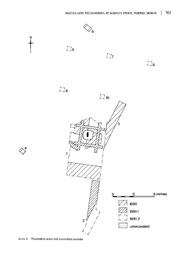
The location and shape of the main excavated trenches (Areas 1, 2 & 3) reflect the extent ofengineering work that penetrated the topsoil. The schedule of excavation was governed by the

704 j SOCIETY OF ANTIQUARIES OF SCOTLAND, 1995
progress of the construction work and the location and extent of the excavation trenches weresimilarly dictated by each stage of construction work. Within Area 1, excavation was severelyconstrained by considerations of safety (to the monument and to the staff) and open areaexcavation was not possible. Instead, excavation progressed through successive seasons in asequence of interlocking trenches. The depth of archaeological excavation in all trenches wasconstrained by the need not to exceed the maximum working depth of the construction engineers.As a result of these constraints, three small areas remain unexcavated and five subsoil featureswere incompletely excavated.
Area 1 (illus 5) includes the pavilion, its external pavement and the site of a stone screenwall. This wall supports a recessed bench and a display board.
Area 2 was located to examine the area affected by the construction of a gently graded accesspath.
Area 3 represents a similar area which was initially planned to be a pathway. In the finaloutcome no path was constructed.
Beyond the main area, seven soil test pits (Areas 4-10) were dug to examine the nature ofthe soil profile away from the monument and to give some indication of the frequency ofarchaeological deposits and features.
ARCHAEOLOGICAL RESULTS
In all the excavated areas (illus 4) a freely draining topsoil directly overlay the coarse gravels andsands of the terrace. In only one area (Area 5), where the topsoil had accumulated to a depth ofover 2 m, was there any indication of a developed soil profile. Within the topsoil, fragments ofmodern pottery and glass were found. In addition, earthworms were common in every area. Apartfrom the ground enclosed by the hexagonal wrought-iron fence, it was clear that the whole areaaround the monument had been turbated and probably landscaped. It was hoped that the raisedground surface within the fence might indicate less disturbance. Subsequent excavations confirmedthis interpretation, but even here no well-preserved stratigraphy was encountered above the surfaceof the subsoil.
Within the first season of excavation permission was granted to retrace a line of investigationlast undertaken in 1926 (see below) when the collar of steps had been removed from the uppersurface of the base stone, revealing the lowest panel of carvings on the eastern face. Unfortunately,in 1990, because of their concern for the safety of the monument, the site engineers were obligedto halt this work before the lowest of the carved panels could be exposed. The main thrust ofsubsequent work was directed towards the investigation of the large number of subsurface featuresin the vicinity of the monument.
FIELDWORK INTERPRETATIONS
A total of 43 archaeological features was recognized in the three seasons of fieldwork (illus 5). Inall cases, these were revealed as slightly more humic soils within the upper surface of the coarsegravels and sands of the substrate. These features can be categorized by form and by location intofive spatial groups; a more detailed description of each feature is available in the site archive.
Group 1 features include all those which were clearly the products of relatively recent activities.Group 2 represents a group of mostly deep post-holes located in a broadly spaced penannular
pattern around the monument.
McCULLAGH: EXCAVATIONS AT SUENO'S STONE, FORRES, MORAY 705
L.J9
0 5 metres
1990
1991.1
1991.2
unexcavated
ILLUS 4 Excavation areas and excavation seasons

706 SOCIETY OF ANTIQUARIES OF SCOTLAND, 1995
' ~]
F31'€>F29
F24,
F3(TF28'
F27
.F14
F26,
F25>
F12
1 0 2 metres
ILLUS 5 Excavated features Area 1: plan
•• — • — . -J

McCULLAGH: EXCAVATIONS AT SUENO'S STONE, FORRES, MORAY 707
Group 3 represents a similar pattern of features located to the south of the monument. In general,these appear markedly more weathered and truncated than Group 2 features.
Group 4 contains a small number of features that do not fit into the previous three categories.Group 5 contains the monument, its basal stone and the shallow cut containing the base.
With the exception of the occasional superimposition of Group 1 features over Group 2features, there were no significant stratigraphic links between features within and between groups.The justification for these groupings of features is thus based entirely on the interpretation of thehorizontal pattern (illus 4) and is, in the main, a matter of conjecture.
Within the area enclosed by the metal fence the land surface was less degraded than theexterior, with the stone foundations of the fence forming, in effect, a lynchet. On the interior, ashallow turf (c 0.01 m in depth) overlay an horizon of very loose sandy gravel which in turnoverlay hard and, in places, heavily iron-panned gravel. Externally, a deeper topsoil layimmediately upon the hardened gravel surface, indicating the greater depth to which mechanicaldisturbance had prevailed outwith the fence.
Group 1 features (2, 8, 10, 34, 35, 37, 39, 40)In all cases where stratigraphic relationships were observable, features within Group 1 were late.In the field, there was little evidence to support interpretation, with the exception of Feature 10,but in subsequent archival research it has proved possible to correlate almost all features withknown structures or activities dating to the last 150 years.
The oldest identified feature, Feature 10, contained the weathered stumps of a stockadeerected around the stone (illustrated in a photograph of c 1870, Washington Wilson nd, No 1131).The erection of this stockade was proposed in 1857 (Forres Gazette 1857) and a charge for accessof sixpence was later being levied in the 1860s (Watson & Watson 1868, 26).
In 1910, Forres Council proposed the erection of an information plaque inscribed with a shortdescription of the stone by Dr Joseph Anderson. This plaque was temporarily uprooted in 1926, butwas reinstated a year later. It is present in a photograph printed in 1934, in which the plaque is seento be mounted on a large stone slab. At some time after 1934, the stone and the plaque were removed.The stone slab was rediscovered during the excavations in 1990. The plaque was not in place and itspresent location is unknown. The slab lay over the outline of Feature 40 and it is probable that thisfeature was the socket for the slab. It is highly likely that Feature 2 was cut in the course of theexcavation of 1926, when the old 19th-century stone collar was replaced (Woods 1993, 9).
The final feature from this group - Feature 35, a broad scoop - could not be linked to aprecise event, but probably resulted from some earlier investigation of the base stone.
Group 2 features (3, 4, 5, 17, 18, 19, 20, 21, 33)The second feature group consists entirely of post-holes (Table 1). Dimensions of the post-pipeswere preserved in section in five examples (Table 2), but in most cases the upper fills weredisturbed and it is probable that the post had been removed (illus 6). In one instance, Feature 33, apost-pipe was seen in plan, but operational constraints precluded its full excavation and recording.The size of the posts, especially those on the western side, suggest the use of large to massivetimbers (0.4 m in Feature 5).
Although there is no stratigraphic evidence to warrant integrating these features into a singlestructural entity, their arrangement can be interpreted as, at least, a representation of a concentration of

708 SOCIETY OF ANTIQUARIES OF SCOTLAND, 199:5
F23 F28
F32
1 metre
........ later intrusion
. ._._ limit of excavationILLUS 6 Excavated features Area 1: sections
activity around the present site of the stone. Speculating from the field evidence, it is not unreasonableto interpret these features as the remains of a scaffold or a derrick used to raise the stone to thevertical.
Group 3 features (11, 12, 14, 15, 25, 26, 27, 28, 29, 30, 31)
This group, like Group 2, consists entirely of pits, but these are generally shallower and are lesswell defined, with more graded profiles than Group 2 features. Like Group 2 they are arranged in apenannular pattern, although, clearly, no upright stone remains to give such an hypothetical

McCULLAGH: EXCAVATIONS AT SUENO'S STONE, FORRES, MORAY 709
TABLE 1Post-hole dimensions in metres
Feature
345
1112141517181920212223242526272829303132333742
Diam
0.200.550.900.550.550.550.600.350.300.650.400.500.300.250.300.450.500.280.480.300.400.200.701.000.450.15
Depth
0.850.851.040.350.350.200.150.150.09
0.620.160.100.080.100.220.300.140.420.150.160.180.400.600.440.10
not excavated
limit of excavation
limit of excavation
TABLE 2Post-pipe dimensions in metres
Features with clear post-pipes
Context
345
20233233
post-pipe diam
0.260.240.400.120.150.340.20
depth of truncation
0.550.480.100.250.50
seen in plan onlyseen in plan only
structure credence. It is probable that they are the weathered vestiges of once deeper post-holes. Ifthis interpretation is correct and the pattern is not merely a product of the trench location, then it istempting to propose a similar function to that of Group 2.
Group 4 features (22, 23, 24, 32, 36, 38, 41, 42)
Within the excavated area there were several features, including two post-holes (Features 23 & 32),which did not accord with the perceived patterning of Groups 2 and 3. It is recognized that thisnonconformity may result from variations in the relative state of preservation and/or the extent ofthe excavated areas, and that of the Group 4 features cast some doubt upon the perceived cohesionof Groups 2 and 3. A single fragment of post-medieval pottery was recorded from Feature 36.

710 SOCIETY OF ANTIQUARIES OF SCOTLAND, 1995
Group 5 features (1, 7, 9)
With the removal of the upper two courses of the stone collar on the eastern side of the monument,the large, rectangular, base stone was revealed. Sueno's Stone itself is socketed into this block; thesocket is not placed symmetrically, being located slightly to the west of the centre.
Unfortunately, concerns for the safety of the excavation personnel and for the stone itselfprevented the further removal of the masonry. Consequently, it was only possible to examine thebase stone on its eastern side. This exercise was more limited than that of 1926 and it was notpossible to remove the thick layer of lime mortar that obscured much of the lowest figurative paneland the edges of the socket. For this reason much of the cross-sectional detail of the collar, socleand socket (illus 7) is conjectural.
The socle stone was set into a shallow pit (Feature 1), seen partially in both plan view andsection at various times in the course of the convoluted excavation process. A steep-sided profileon the north, south and west sides is suggested by this evidence. Access would have been from theeast where the side wall of the pit formed a gentle gradient. This corresponds to the layout of thepost-holes in Group 2 and particularly to the location, on the western side, of the more massiveposts within the putative derrick structure.
No dating evidence was retrieved from this limited excavation. Nor was the sequence oferection apparent: either the socle block was first levelled and then the upright shaft inserted, orthe two elements were preassembled and then raised. Neither operation would have been easilyaccomplished and considerable technical problems, such as the need to control the rotation of thebase stone in its pit at ground level, would have been encountered.
Examination of the photographs from the ill-recorded excavations of 1926 (illus 8) showshow the lowest panel of fighting or parading figures has been carved on to the slightly concave
1 metre
Itfj-i'-al mortarILLUS 7 Section through the socle and the supporting masonry. The broken line indicates a conjectured continuation of
the visible edges to stones and features. The section has been collated from several partial profiles recorded atvarious times in the three seasons of field-work.

McCULLAGH: EXCAVATIONS AT SUENO'S STONE, FORRES, MORAY I 711
ILLUS 8 Sueno's Stone excavated in 1926. (Crown Copyright: RCAHMS)
surface of the stone. The stone at this point has been cut with a distinct waist before expanding intothe bevelled upper surface of the tenon. Unfortunately, in 1990 it was not possible to examine thisarea in sufficient detail to allow any opinion on the possible sequence of carving, but from the1926 photograph it appears that the stone was already waisted before the figures were cut.
In the 1926 photograph, the profile of the uppermost stone from the collar can be seenrunning through the second panel at shoulder height picked out by a line of residual mortar. Thesurface of the stone beneath this mortar line is clearly less weathered than that above. Thisphotograph suggests that much of the surface damage, at least at this level on the stone, hasoccurred between the early 1700s and 1926. This may imply that the stone has suffered two formsof damage: abrasion from wind-born particles may have had greater effect close to the groundsurface, whilst higher up the stone there were more signs of influence from chemical agents.
Areas 4-10: test pits
The test pits (fiche Table 4) did not reveal any intact archaeological sediments and demonstrated,especially in the area beyond the confines of the fence, that tillage has extensively remodelled theland surface. The deep profile in Area 5 (1.6 m of topsoil) demonstrated the degree to which a

712 | SOCIETY OF ANTIQUARIES OF SCOTLAND, 1995
more ancient topography is now masked. No dating material was retrieved from these sample pitsand it has not been possible to assess the rate nor the date of the onset of this weathering. It is thusimpossible to estimate the state of the landscape into which Sueno's Stone was originally set,although it is likely that the local topography would have been more pronounced.
Fieldwork summaryFrom the field evidence alone it has been demonstrated that there was a concentration ofarchaeological features around the site of the monument, but it was not apparent whether thisconcentration reflects areas of differential erosion or repeated activity around the site of themonument. The penannular arrangement of excavated features (Group 2) around the monumenthas been interpreted, merely on the basis of proximity and pattern, as being linked to either theoriginal erection or carving, or to some subsequent phase of repair. The almost identicalpenannular arrangement of very degraded features to the south of the stone (Group 3) can beinterpreted, if similarity of form can be equated to like function, either as evidence of a secondsetting of the monument, or as evidence of a second monument, or as the basis for refuting theinterpretation of the relationship between Group 2 features and the stone. This latter argumentwould rest its case on the mere coincident location of various types or dates of archaeological site.
Post-excavation analysisNo post-excavation analysis or research was undertaken until after the final season of excavation,because the necessarily disjointed programme of fieldwork had militated against a clear siteinterpretation. This has led to some delays in the post-excavation programme, with the finalradiocarbon dating being completed only by October 1993.
The objective of the post-excavation work was to test the fieldwork hypotheses and toenhance the fieldwork results with dating evidence. The initial phase of post-excavation workconcentrated on the processing of samples. Sub-sampling and wet-sieving of bulk samples from allsediments produced materials for radiocarbon dating, soils analysis, geological appraisal,artefactual and macroplant analysis.
Dating
Two sources of chronology have been pursued. Samples of charcoal from secure contexts weresought to supply radiocarbon dates for the erection of the monument and for the various activitieslocated around it. The local historical archive v/as investigated to provide some resolution to thevarious local traditions concerning the history arid use of the monument. This historical record wasalso examined to resolve various gaps in the history of the monument since it was taken into Statecare in 1923.
Analysis of the distribution of charcoal suggested that it was present throughout the soilprofile, but was concentrated in the deeper deposits (see Charcoal Report in microfiche).Examination of the size range showed that, generally, charcoal occurred as small fragments withlarge angular fragments being the exception. The small-fraction material was mostly within theaverage size range for 'pea-grit' and was located probably as a result of worm action.
Of the five contexts containing large angular fragments of charcoal, only two were secureenough for radiocarbon dating (Table 3). These are both from post-holes within Group 2, thepenannular setting of posts around the monument. Context 30, from Feature 5, represents the latest

McCULLAGH: EXCAVATIONS AT SUENO'S STONE, FORRES, MORAY I 713
TABLE 3List of radiocarbon dates obtained from Sueno's Stone
Calibrated Date RangeLab. Code Context Date BP 1 sigma 2 sigma
GU-3440 0300 1000±50 AD 990-1035 AD 960-1160GU-3443 0046 1270±50 AD 673-786 AD 660-880
secure fill of the post-pipe. The sample contained the charcoal of a single species (Ulmus sp., elm)which could have been derived from the original post, although there was no supporting evidencefor such a conclusion. Feature 3, Context 46, was also the uppermost secure context within thepost-pipe. Neither context occupied an unequivocal position in the site stratigraphy and theinterpretation of the resultant dates cannot be precise. At best, both may be claimed to representterminus ante quern dates for the infilling of their respective post-sockets.
It is very unlikely statistically that these two dates represent the same event, and given therelatively small diameter of the charcoal roundwood dated from Context 46 (0.1m)- the earliersample - this disparity cannot easily be explained as an effect caused by the use, within the samestructure, of timber of widely disparate ages. Instead, the dates can only used be as prima facieevidence for at least two distinct events within the area. These dates must also cast doubt on thearchaeological integrity of the perceived grouping of features (Group 2) in that it suggests thatthese features result from more than one episode of activity.
Soil analysisSoil samples from 41 contexts were subjected to the standard suite of analyses (soil acidity (pH),loss on ignition (LOI), phosphate and calcium carbonate content). The tests were designed toestablish the character of the archaeological and natural sediments and to identify patterns ofresults which may reflect depositional processes. A corollary to this was also the identification ofthe effects of any post-depositional processes.
The results (see Routine Soil Analysis in microfiche) have demonstrated that there was apattern of significant values for both soil phosphate and acidity in features around the monument.These figures can be interpreted only crudely, but it is legitimate to interpret them as evidence fora concentration of activity focused on the monument. It must be stressed that this observation lacksany temporal dimension and clearly has no possible relationship to the original use of the stoneitself.
Geological appraisalAt the time of writing there was no precise information on the geological nature of the monumentstone or its base stone, despite some claims that the stone can be provenanced to a particularquarry in Moray (Douglas 1934, 306). Permission was sought from Historic Scotland toundertake a close geological inspection of the stone but, as this would have necessitated theexamination of freshly exposed faces of the stones, Historic Scotland was understandablyreluctant to agree. On the lowest exposed panel of figures (but in fact the second panel, as thelowest is obscured by the uppermost step of the pediment), there are two infilled drilled holes.There is no record of the purpose of these holes and no knowledge of the location of the coresextracted from them. These holes represent the only means of non-destructive invasive

714 SOCIETY OF ANTIQUARIES OF SCOTLAND, 1995
examination of the inner geological fabric of the monument, but Historic Scotland have againbeen understandably reluctant to allow this form of research. Until some non-destructivetechnique is devised, the provenance of the stone, set against the highly variable local sandstonegeology, cannot be established.
Artefacts
Hand sorting of the sieved bulk samples produced a range of possible artefacts, none of whichderived from sealed contexts as all are within the size limits for 'pea-grit' and may have beenmoved by worm action. Four certain artefacts were recovered in the course of excavation: twosherds and two flints. None of these derives from secure contexts and therefore no analysis wasundertaken. The fragment of putative Roman pottery from one of the test pits (Area 6) merely addsto the corpus of Roman artefacts from this area.
Coarse fraction sorting results
When the stone was put up (or re-erected) and if it had been carved (or recarved) in situ, it mightbe expected that stone fragments would have been produced. Some of this debris would beexpected to survive as part of the coarse fraction of contemporary deposits. In order to test thishypothesis, the coarse fraction material of the relevant soil samples was examined.
As part of the standard treatment of bulk samples, the non-floating coarse fraction isrecovered from wet-sieving and retained as a sub-sample or 'retent'. These relents were examinedfor all chips, flakes or carved fragments which could be reasonably conceived as 'mason's debris'.A total of 35 contexts provided samples for examination. These were selected as the most likelydeposits to have received masonry debris during the carving process. Five specimen samples wereselected from the latest contexts (ie topsoil) to offer a control on the identification. The separatedmaterial was then examined for pieces of sandstone that appeared to be flaked, cut or chipped. Thecriteria for identification as 'mason's debris' were that no naturally polished surface survived; thatany abrasion had to be consistent with directed, methodical percussion; and that geologicalanalysis of any putative debris unequivocally correlated the material with the geology of Sueno'sStone or of its plinth.
If debris was found and a physical link made between the deposits and the monument, it wasrecognized that the interpretation of that link would remain problematical. It is by no means clearthat the carving occurred at one time nor that the stone has been erected only once. Indeed the roll-moulding on the vertical edges of the stone appears to be damaged at several levels, possibly aconsequence of different phases of engineering works.
The inspection of the retent material produced no credible specimens and no link wasdemonstrated, by this means, between archaeological deposits and the stone.
Macroplant analysis
In addition to wood charcoal a small assemblage of carbonized macroplant material was recoveredfrom the sieving programme (see Macroplant report in microfiche). No significance can be placedon these finds as they are from within the zone of worm sorting and are within the size range forworm-transported materials.

McCULLAGH: EXCAVATIONS AT SUENO'S STONE, FORRES, MORAY 715
DISCUSSION
The archaeological investigation of Sueno's Stone sought to resolve the debate on the date of theerection and the carving of the monument in its present location and to recover evidence pertainingto its function. In addition, the project also sought to record all other forms of archaeologicalevidence that were likely to be lost as a result of the construction of the glass pavilion. The projecthas established, in conjunction with previous excavations and geophysical surveys, thatarchaeological features and sediments survive only close to the present location of the monument.Although there is both physical and historical evidence of ploughing in the area, and circumstantialevidence for the degrading of the subsoil surface (based on the shallow depths from features inGroup 3), there appears to be a genuine lack of archaeological features away from the monument.It would therefore appear that activity has been focused upon this location for a very considerableperiod of time.
Some of the excavated features can be directly correlated to historically knownactivities, but the majority of features cannot and are presumed, generally, to predate thereliable historical record. Amongst these putative early features, two distinct but similar pat-terns were recognized. The first pattern (Group 2 features) has been interpreted as an arrangementof large post-sockets. Because of the very substantial nature of some of the post-sockets fromGroup 2, and their layout around Sueno's Stone, it was speculated that these sockets are theremains of a large structure - perhaps a derrick - used in either the erection, carving, ritual orrepair of Sueno's Stone. This interpretation has obvious implications for the interpretation ofthe second group of post-hole-like features (Group 3) to the south of the stone. There was nodirect stratigraphic link between the excavated features and the monument and the radio-carbon dates imply that the apparently simple pattern of features in Group 2 in fact masks apossibly complex chronology of structural elements or other unknown events. The methodsemployed to recover datable charcoal infer that the resultant dates are a random andchronologically true sample of the sediment forming processes. The two dates thus imply thata later first millennium AD date can be inferred for the activities represented by the Group 2features. Unfortunately, it is quite impossible to extend this crude dating to cover the Group 3contexts.
Amongst the non-floating sub-samples from the wet-sieving programme, 'masons'debris' was sought to establish whether the stone was carved in situ or transported in afinished state. From the outset, it was recognized that this exercise had a low probability ofsuccess: absence of evidence need not be evidence of absence. Thus the eventual absence ofany recognizable carved fragments from sealed contexts did not disprove manufacture in situ.One explanation for the lack of any recognizable debris could be that the stone was carved bydrilling and fine chiselling, neither operation being likely to produce distinguishablefragments.
The depiction of two stones on Timothy Font's map (c 1590) is not absolute proof thatSueno's Stone existed at this time, nor at precisely its present location. But Pont must be regardedas a reliable recorder as his maps formed the basis for cartography in this area for the next twocenturies. It is certainly tempting to link his depiction of two stones with the two settings of post-holes. This speculation must be balanced against the absence of any mention of Sueno's Stonefrom either Aubrey's 16th-century or Lhwyd's 17th-century gazetteers (Southwick 1981, 19).Earlier references, listed by Douglas (1934), to a pillar or obelisk at Forres seem to date thismonument to at least the llth century, but none of these texts is without problems of interpretationwhich are outwith the scope of this paper. Although the cartographic evidence is not indisputable,

716 SOCIETY OF ANTIQUARIES OF SCOTLAND, 1995
Southwick's refutation of Sueno's Stone's place in the landscape earlier than the 17th century mustbe discounted.
The carvings on Sueno's Stone have hitherto inspired two related lines of enquiry. The firsthas examined iconography and style to gain an insight into the date of carving (eg Henderson1983) while the second approach has sought to interpret the symbolic (Jackson 1983; 1993) andhistorical meaning (Sellar 1993). The two lines coincide in a concern to identify the author orinstigator of the carvings, leading into general questions about its social and political context(Shepherd 1993, 85). Although there is general agreement that the monument must date tobetween the ninth and llth centuries, greater precision has not been achieved and is probably notpossible. Stevenson likened the 'monotonous' interlacing and dense panels of figures to Irishcrosses of the 10th century (1954, 128). The two side panels depict wiry vine scrolls inhabited bymen (as in the Book of Kells) which Henderson suggests may indicate a date somewhat earlierthan the 10th century, but she also suggests that a later date could still be possible if the stonerepresents a re-emergence of this style (Henderson 1983, 258). Jackson dates the 98 figuresdepicted variously in battle, parade and decapitation scenes, to the ninth century and suggests thatthe personage whose authority caused the stone to be erected, and who is depicted amongst themore static scenes, is identified as Kenneth MacAlpin (1984, 173). The stone is seen by Jackson(1993, 94) as an evocation of MacAlpin's military and legal authority over northern Pictland,married to a moral authority ordained by both traditions of Christianity (lona and Rome). Even ifthe precise details of the historical context are not obtainable, the iconography, with itscelebration of rule ordained by military might and clerical authority, offers a political contextwhich is matched by the wider archaeological context within Moray. Recent research offers alandscape that is well populated by late prehistoric and early historic sites which contain thetrappings of secular (eg Burghead) and religious (eg Kinnedar) centres of political power(Shepherd 1993).
The excavation in preparation for the glass pavilion demonstrated that the present locationcontains no evidence of burial. This, and the lack of detectable features in the wider vicinity, mustnow put to rest all claims for the stone as a sepulchral marker. The 1990-1 archaeological andengineering projects have also served as a reminder of the sheer size of Sueno's Stone and itsmassive base stone. Although the inability of present-day technology to move the stone withoutsignificant risk does not entirely rule out the possibility of a successful earlier transportation, thelatter seems improbable. It seems more reasonable to presume that the stone stands where it hasalways stood. Perhaps a more appropriate reaction to the monument is simply to recognize themastery of the carving and the stone erector's craftsmanship, both of which must reflect theauthority, whether political, military or ecclesiastical, of the personage who caused the monumentto be set up.
With the erection of the pavilion, researchers can no longer expect to find crucial informationunder the ground (although the unseen and untouchable deposits under the base stone should notbe forgotten). Instead, future analysis and research must rely on the nature and content of thecarvings for further information. It is noteworthy that all of the principal previous writers havetreated the carved faces in isolation from each other, and it might prove profitable to examine theiconography and craftsmanship of the monument as a whole. Given the disparity between the tworadiocarbon dates, it is reasonable to suggest that activities at this location took place over a periodof several hundred years in the later first millennium AD. If this insight is transferred to the stone italso seems worth considering whether the carvings bear similarities of design or execution orwhether the erection of the monument and the process of carving are elements in a longer sequenceof symbolic activity on this site.

McCULLAGH: EXCAVATIONS AT SUENO'S STONE, FORRES, MORAY | 717
CONCLUSIONAt the outset, it was recognized that this excavation would result in the final removal of what was,seemingly, the only hitherto untouched strand of evidence about the stone, its origins and its functions.It is argued that its present location is set amongst archaeological features which date either to theperiod AD 600 to AD 1000 or to the period of c 1850 to 1950. It is also proposed, but with considerablymore apprehension, that this location was in some way special and that the concentration of features isnot merely an effect of survival. With similar caution, the second, eroded, setting of features is seen asa duplicate of the arrangement of substantial post-holes set around the base of the monument andtaking inspiration from Font's map, it is speculated that two stones may once have existed.
None of these interpretations is irrefutable, but the erection of the glass pavilion marks theclosing of the archaeological avenues of enquiry. Further research must return to the nature andcontent of the stone itself.
It will remain a matter of considerable public debate (cf Woods 1992) whether the new glasspavilion has been the correct solution for the curatorial problems of the stone. It has been aprivilege to work at Sueno's Stone and to witness the construction of the pavilion. In the course ofthis project it was particularly obvious that the monument draws visitors from far afield and with avery diverse suite of interests. With the new pavilion in place, the stone is given a new and verydramatic setting and continues to attract visitors (even in winter). It is probable that the monumentwill continue to be seen in Forres as a very considerable asset, and by Historic Scotland as a veryimportant test-bed for its ideas on conserving and presenting field monuments.
ACKNOWLEDGEMENTSThe erection of the pavilion over Sueno's Stone presented considerable problems to the engineers andarchitects involved. It is therefore to their credit that they co-ordinated much of their work to what many oftheir peers might regard as the presumptuous demands of the archaeologists. That the exercise achieved anyof its aims is due, in large measure, to the good offices of Historic Scotland, in particular to the projectarchitect, Robin Kent, Inspectors of Ancient Monuments, Olwyn Owen and Fiona Stewart, and the staff ofthe Fort George depot, especially Bob McUwraith, Jim Rankine, George Newlands and Alan McKerron. Theexcavation work was supervised by the author but in fact much of the credit should go to the excavators:James Falconer, Paul Sharman, Janet Kermack, Mike and Hilary Graham and Graham Bruce. Turning anexcavation record into a written account has required the assistance and advice of many specialists and inaddition to those listed as contributing authors to this text, I must thank Dr Denys Pringle (Historic Scotland)for his help in the later stages of the project, Diana Webster and Margret Wilkes (National Library ofScotland) for advice on Font's map, also Dr Jeffrey Stone (Dept of Geography, University of Aberdeen), DrDavid Iredale and Mr John Barrett (Forres Record Office), lan Shepherd (Grampian Regional Council), DrAnna Ritchie, The Earl of Moray and finally Rachel Woods, who kindly allowed me to read her thesis. I amalso grateful to the Royal Commission for Ancient and Historical Monuments of Scotland for permission topublish the 1926 photograph and to the National Library of Scotland for permission to publish a detail ofTimothy Font's Mapp of Murray. Final thanks are due to colleagues within AOC (Scotland) Ltd, who havehelped in putting some shape and rigour into this report, especially Coralie Mills, Chris Lowe and ValericMcLellan, and Chris Unwin who produced the illustrations. The responsibility for the final version liesentirely with the author, who will some day answer for its imperfections.
REFERENCESAinslie, J 1789 Scotland drawn and engraved... Edinburgh.Alien, J R & Anderson, J 1903 The Early Christian Monuments of Scotland. Edinburgh.

718 SOCIETY OF ANTIQUARIES OF SCOTLAND, 199.5
Aubrey, J 1692 Monumenta Britannica. Oxford.Blaeu, J 1654 Atlas Novus. Amsterdam.Cordiner, C 1788 Remarkable Ruins and Romantic Prospects of North Britain. London.Cordiner, C 1795 The Antiquities and Scenery of the North of Scotland. London.Daniell, J 1819 Red Portfolio No 20. Society of Antiquaries of London.Douglas, R 1934 The Annals of the Royal Burgh ofForres. Elgin.Gater, J & Gaffney, C 1990 'Report on geophysical survey: Sueno's Stone, Forres, Moray'. February 1990.
Unpublished report to HS/AOC.Glentworth, R 1954 The Soils of the Country round Banff, Huntley and Turriff. Edinburgh.Gordon, A 1726 Itinerarium Septentrionale. London.Grant, J & Leslie, W 1798 A Survey of the Province of Moray. Aberdeen.Hamond, F W 1983 'Phosphate analysis of archaeological sediments', in Reeves-Smyth, T & Hamond, F W
(eds), Landscape Archaeology in Ireland, Oxford, 47-80 (= BAR Int Ser, 116).Henderson, I 1978 'Sculpture north of the Forth after the take-over by the Scots', in Lang, J T (ed), Anglo-
Saxon and Viking Age sculpture and its context: papers from the Collingwood Symposium on insularsculpture from 800 to 1066, Oxford, 47-73 (= BAR Brit Ser, 49).
Henderson, I 1983 'Pictish Vine-Scroll Ornament', in O'Connor, A & Clark, D V (eds) From the Stone Age tothe 'Forty-Five, Edinburgh, 243-68.
Hodgson, J M 1976 Soil Survey Field Handbook, Soil Survey Technical Monograph, no. 5.Jackson, A 1983 The Symbol Stones of Scotland. Kirkwall.Jackson, A 1993 'Further thoughts on Sueno's Stone', in Sellar, W D H (ed) Moray: Province and People,
Scot Soc Northern Studies, 97-116.Knight, J & Maxwell, I (nd) unpublished Internal Technical Report to Historic Scotland (then Historic
Buildings & Monuments Division (Scotland)).Leslie, Revd W 1813 View of the agriculture of the counties of Nairn and Moray. LondonLhwyd, E 1707 Archaeologia Britannica. Oxford.Nebelsick, L & Munro, M 1978 Geophysical Survey at Sueno's Stone, Forres, Moray. Internal report to
Inspectorate of Ancient Monuments (1978).Pont, N (nd) Mapp of Murray, Manuscript 8, National Library of Scotland Adv.Ms. 70.2.9.Schweingruber, F H 1978 Microscopic Wood Anatomy. Teufen.Sellar, W D H 1993 'Sueno's Stone and its Interpreters', in Sellar, W D H (ed) Moray: Province and People,
Scot Soc Northern Studies, 97-116.Shaw, L 1775 History of the Province of Moray. Edinburgh.Shepherd, I A G 1993 'The Picts in Moray', in Sellar, W D H (ed) Moray: Province and People, Scot Soc
Northern Studies, 75-90.Simpson, A & Stevenson, S 1982 Historic Forres: archaeological implications on development. (= Scottish
Burgh Survey, Glasgow University, Dept of Arch).Skene, W F 1876 Celtic Scotland: A History of Ancient Alban. Edinburgh.Smyth, A P 1984 Warlords and Holy Men. London.Southwick, L 1981 The so-called Sueno's Stone at Forres. Moray District Libraries Publication.Statistical Account of Scotland 1791-99 Banffshire, Moray and Nairnshire, vol XVI.Stevenson, R B K 1955 'Pictish Art', in Wainwright, F T (ed) The problem of the Picts, Edinburgh & London,
97-128.Stuart, J S 1856 Sculptured Stones of Scotland. Edinburgh.Terry, J 1989 Sueno 's Park, Forres, Moray: An Archaeological Assessment. Unpublished report to Headland Properties.Washington Wilson, G (nd) Photographs: Scottish Scenery. Aberdeen.Watson, J & Watson, W 1868 Moray shire Described. Aberdeen.Woods, R 1992 The protection of Sueno's Stone. Unpublished MA dissertation, Dept of Fine Art, University
of Edinburgh.
This paper is published with the aid of a grant from Historic Scotland
Related Documents


