EVOLUTION OF MAPBASIC : part 1 MapBasic Language from version 3.0 to version 6.5 for the Windows environment A compilation by Jacques Paris [email protected] 11/02/2002

Welcome message from author
This document is posted to help you gain knowledge. Please leave a comment to let me know what you think about it! Share it to your friends and learn new things together.
Transcript

EVOLUTION OF MAPBASIC :
part 1
MapBasic Language
from version 3.0 to version 6.5
for the Windows environment
A compilation by
Jacques Paris
11/02/2002


Presentation and warning This document is a compilation of all the changes (additions and modifications) that I was able to discover in the various versions of MapBasic since the original Windows v.3.0. It deals only with the basic elements of the language, note with its syntax and rules of use. The elements I considered are the functions, statements, clauses and procedures listed in the various MI/MB documents printed and electronic. Functions, clauses and procedures are identified by a single word. Changes to such elements will be mostly modifications to the number of parameters that are attached to the elements (e.g. the various syntaxes of the Symbol clause) or to the range of values compatible with the parameters (e.g. the width parameter in the Pen clause). Most of the statements are composed of more than one word. These identifiers that are of course required can also be accompanied by key words; some are themselves required and could be considered as part of the identifier, others are optional or exist as alternatives. Changes to statements will mainly deal with the addition of options reflected by new key words and with the ranges of the parameters associated with certain key words. Modifications in the clauses are not reflected in the description of the statements history to avoid cumbersome repetitions. I have composed this document on the basis of the MapBasic.hlp for every version from 3.0 to 6.0 (4.0, 4.1, 4.12, 4.5, 5.0, 5.5) and of the MapBasic.def version 6.0 for the numeric codes. I started from the 6.0 definitions, compared them with the original version
and traced the differences to the intermediate versions. I also used various documents pointing at changes that have occurred in different versions. To show the continuity with the earliest versions, I have also included the references to an add-on to version 3.0 called SQL DataLink, even if most of the related statements and functions will not work without the presence of the add-on. The quality of the information contained in this document is as good (dismissing the transcription and interpretation errors I have certainly made) as the information in these files is good. There are some cases where it is obvious that there are some discrepancies between Hlp and Def files, - where some options may have been available earlier than their appearance in the Help files leave one to think, - where changes in some part of the Help have not been reflected onto other parts. There are also instances where the explanatory texts have been modified since their original version. I have not taken these variations into account if they did not correspond to known changes. In short, if I am confident in the quality of my work, I would recommend to use it with a certain caution, mainly in the absence of any official endorsement by MapInfo. Any correction, precision, addition should be notified to the author who counts on such contributions to enhance the quality of the document.
Jacques Paris


Contents
Alphabetical list of MapBasic language elements 1 Clauses 6 Procedures 10 Functions, standard 11 Functions with attributes 14 Statements 37

1
MapBasic language elements
The element name is in bold if it was added since version 3.0. It is in italics, if it was modified since its creation. The details on the creation or the changes are given under the element name in the section for its type. Consult the section headings for details about the codification used in each section.
A function returns a value; some use special codes called to return MI attributes. A statement initiates an action. A clause is used repeatedly as part of a statement. A procedure is a reserved name for a subroutine that reacts to certain MI events.
Abs function, standard Acos function, standard Add Cartographic Frame statement Add Column statement Add Map statement AEExecute function, standard AEInitiate function, standard Alter Button statement Alter ButtonPad statement Alter Cartographic Frame statement Alter Control statement Alter MapinfoDialog statement Alter Menu statement Alter Menu Bar statement Alter Menu Item statement Alter Object statement Alter Table statement ApplicationDirectory$ function, standard Area function, standard AreaOverlap function, standard Asc function, standard Asin function, standard Ask function, standard Atn function, standard AutoLabel statement Beep statement Browse statement Brush clause, style Buffer function, standard ButtonPadInfo function with attributesCall statement CartesianArea function, standard CartesianBuffer function, standard
CartesianDistance function, standard CartesianObjectLen function, standard CartesianPerimeter function, standard Centroid function, standard CentroidX function, standard CentroidY function, standard CharSet clause ChooseProjection$ function, standard Chr$ function, standard Close All statement Close File statement Close Table statement Close Window statement ColumnInfo function with attributesCombine function, standard CommandInfo function with attributesCommit Table statement Continue statement Control [Brush Font Pen Symbol]Picker clause, control Control Button/OKButton/CancelButton clause, control Control CheckBox clause, control Control EditText clause, control Control GroupBox clause, control Control ListBox/MultiListBox clause, control Control PopUpMenu clause, control Control RadioGroup clause, control Control StaticText clause, control ConvertToPline function, standard ConvertToRegion function, standard ConvexHull function, standard CoordSys clause Cos function, standard Create Arc statement

2
Create ButtonPad statement Create ButtonPad as Default statement Create Cartographic Legend statement Create Collection satement Create Ellipse statement Create Frame statement Create Grid statement Create Index On statement Create Legend statement Create Line statement Create Map statement Create Map3D statement Create Menu statement Create Menu Bar statement Create MultiPoint statement Create Object statement Create Pline statement Create Point statement Create PrismMap statement Create Ranges statement Create Rect statement Create Redistricter statement Create Region statement Create Report from Table statement Create RoundRect statement Create Styles statement Create Table statement Create Text statement CreateCircle function, standard CreateLine function, standard CreatePoint function, standard CreateText function, standard CurDate function, standard CurrentBrush function, standard CurrentFont function, standard CurrentPen function, standard CurrentSymbol function, standard DateWidow function with attributesDay function, standard DDEExecute statement DDEInitiate function, standard DDEPoke statement DDERequest$ function, standard DDETerminate statement
DDETerminateAll statement Declare Function statement Declare Sub statement Define statement DeformatNumber$ function, standard Delete statement Dialog statement Dialog Preserve statement Dialog Remove statement Dim statement Distance function, standard Do Case…End Case statement Do…Loop statement Drop Index statement Drop Map statement Drop Table statement End MapInfo statement End Program statement EndHandler procedure EOF function, standard EOT function, standard Erase function, standard Err function, standard Error statement Error$ function, standard Exit Do statement Exit For statement Exit Function statement Exit Sub statement Exp function, standard Export statement ExtractNodes function, standard Fetch statement FileAttr function with attributesFileExists function, standard FileOpenDlg function, standard FileSaveAsDlg function, standard Find statement Find Using statement Fix function, standard Font clause, style For…Next statement ForegroundTaskSwitchHandler procedure Format$ function, standard
3
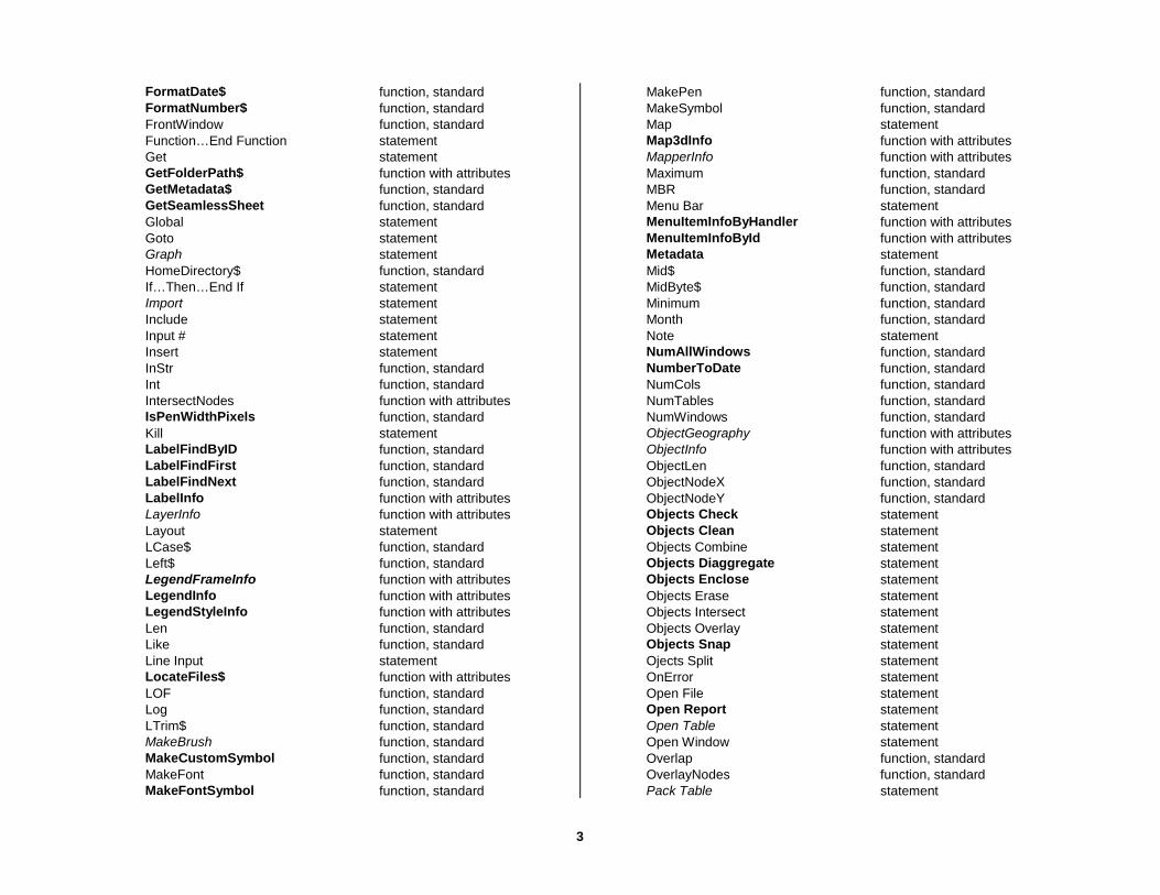
FormatDate$ function, standard FormatNumber$ function, standard FrontWindow function, standard Function…End Function statement Get statement GetFolderPath$ function with attributesGetMetadata$ function, standard GetSeamlessSheet function, standard Global statement Goto statement Graph statement HomeDirectory$ function, standard If…Then…End If statement Import statement Include statement Input # statement Insert statement InStr function, standard Int function, standard IntersectNodes function with attributesIsPenWidthPixels function, standard Kill statement LabelFindByID function, standard LabelFindFirst function, standard LabelFindNext function, standard LabelInfo function with attributesLayerInfo function with attributesLayout statement LCase$ function, standard Left$ function, standard LegendFrameInfo function with attributesLegendInfo function with attributesLegendStyleInfo function with attributesLen function, standard Like function, standard Line Input statement LocateFiles$ function with attributesLOF function, standard Log function, standard LTrim$ function, standard MakeBrush function, standard MakeCustomSymbol function, standard MakeFont function, standard MakeFontSymbol function, standard
MakePen function, standard MakeSymbol function, standard Map statement Map3dInfo function with attributesMapperInfo function with attributesMaximum function, standard MBR function, standard Menu Bar statement MenuItemInfoByHandler function with attributesMenuItemInfoById function with attributesMetadata statement Mid$ function, standard MidByte$ function, standard Minimum function, standard Month function, standard Note statement NumAllWindows function, standard NumberToDate function, standard NumCols function, standard NumTables function, standard NumWindows function, standard ObjectGeography function with attributesObjectInfo function with attributesObjectLen function, standard ObjectNodeX function, standard ObjectNodeY function, standard Objects Check statement Objects Clean statement Objects Combine statement Objects Diaggregate statement Objects Enclose statement Objects Erase statement Objects Intersect statement Objects Overlay statement Objects Snap statement Ojects Split statement OnError statement Open File statement Open Report statement Open Table statement Open Window statement Overlap function, standard OverlayNodes function, standard Pack Table statement

4
PathToDirectory$ function, standard PathToFileName$ function, standard PathToTableName$ function, standard Pen clause, style PenPattern function, standard PenWidthToPoints function, standard Perimeter function, standard PointsToPenWidth function, standard Print statement Print # statement PrintWin statement PrismMapInfo function with attributesProgramDirectory$ function, standard ProgressBar statement Proper$ function, standard ProportionOverlap function, standard Put statement Randomize statement ReadControlValue function, standard ReDim statement Register Table statement Relief Shade statement Reload Symbols statement RemoteMapGenHandler procedure RemoteMsgHandler procedure RemoteQueryHandler function, standard Remove Cartographic Frame statement Remove Map Layer statement Rename File statement Rename Table statement Reproject statement Resume statement RGB function, standard Right$ function, standard Rnd function, standard RollBack statement Round function, standard RTrim$ function, standard Run Application statement Run Command statement Run Menu Command statement Run program statement Save File statement Save Window statement
Save Workspace As statement SearchInfo function with attributesSearchPoint function, standard SearchRect function, standard Seek function, standard Seek statement SelChangedHandler procedure Select statement SelectionInfo function with attributesServer Begin Transaction statement Server Bind Column statement Server Close statement Server Commit statement Server Create Map statement Server Create Style statement Server Disconnect statement Server Fetch statement Server Link Table statement Server Refresh statement Server RollBack statement Server Set Map statement Server_ColumnInfo function with attributesServer_Connect function, standard Server_ConnectInfo function with attributesServer_DriverInfo function with attributesServer_EOT function, standard Server_Execute function, standard Server_GetODBCHConn function, standard Server_GetODBCHStmt function, standard Server_GetQEHConn function, standard Server_GetQEHStmt function, standard Server_NumCols function, standard Server_NumDrivers function, standard Set Application Window statement Set Area Units statement Set Browse statement Set Cartographic Legend statement Set Command Info statement Set CoordSys statement Set Date Window statement Set Digitizer statement Set Distance Units statement Set Drag Threshold statement Set Event Processing statement

5
Set File Timeout statement Set Format statement Set Graph statement Set Handler statement Set Layout statement Set Legend statement Set Map statement Set Map3D statement Set Next Document statement Set Paper Units statement Set PrismMap statement Set ProgressBars statement Set Redistricter statement Set Resolution statement Set Shade statement Set Style statement Set Table statement Set Target statement Set Window statement Sgn function, standard Shade statement Sin function, standard Space$ function, standard SphericalArea function, standard SphericalDistance function, standard SphericalObjectLen function, standard SphericalPerimeter function, standard Sqr function, standard Status Bar statement Stop statement Str$ function, standard String$ function, standard StringCompare function, standard StringCompareIntl function, standard StringToDate function, standard StyleAttr function with attributesSub…End Sub statement Symbol clause, style SystemInfo function with attributesTableInfo function with attributesTan function, standard TempFileName$ function, standard Terminate Application statement Time function, standard
Timer function, standard ToolHandler procedure TriggerControl function, standard TrueFileName$ function, standard Type statement UBound function, standard UCase$ function, standard UnDim statement UnitAbbr$ function, standard UnitName$ function, standard Unlink statement Update Set statement Update Window statement Val function, standard Weekday function, standard While…Wend statement WinChangedHandler procedure WinClosedHandler procedure WindowID function, standard WindowInfo function with attributesWinFocusChangedHandler procedure Write # statement Year function, standard
6
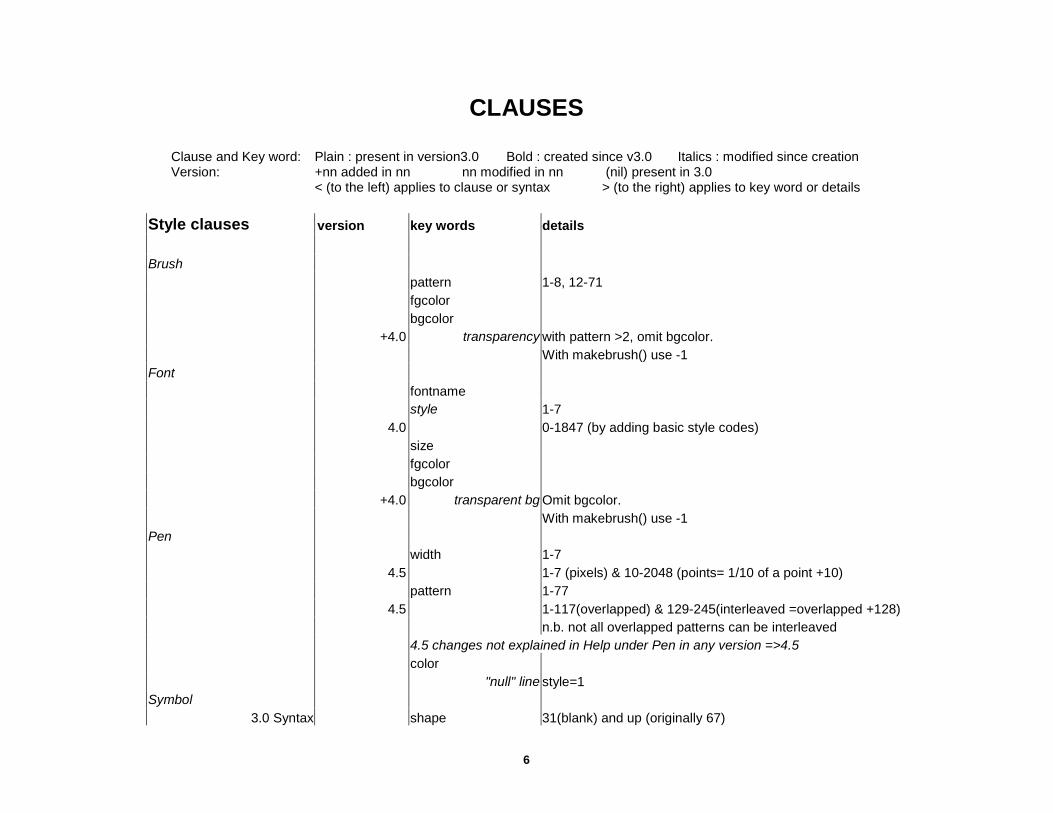
CLAUSES
Clause and Key word: Plain : present in version3.0 Bold : created since v3.0 Italics : modified since creation Version: +nn added in nn nn modified in nn (nil) present in 3.0
< (to the left) applies to clause or syntax > (to the right) applies to key word or details
Style clauses version key words details Brush pattern 1-8, 12-71 fgcolor bgcolor +4.0 transparency with pattern >2, omit bgcolor. With makebrush() use -1 Font fontname style 1-7 4.0 0-1847 (by adding basic style codes) size fgcolor bgcolor +4.0 transparent bg Omit bgcolor. With makebrush() use -1 Pen width 1-7 4.5 1-7 (pixels) & 10-2048 (points= 1/10 of a point +10) pattern 1-77 4.5 1-117(overlapped) & 129-245(interleaved =overlapped +128) n.b. not all overlapped patterns can be interleaved 4.5 changes not explained in Help under Pen in any version =>4.5 color "null" line style=1 Symbol
3.0 Syntax shape 31(blank) and up (originally 67)
7
color size 1-48
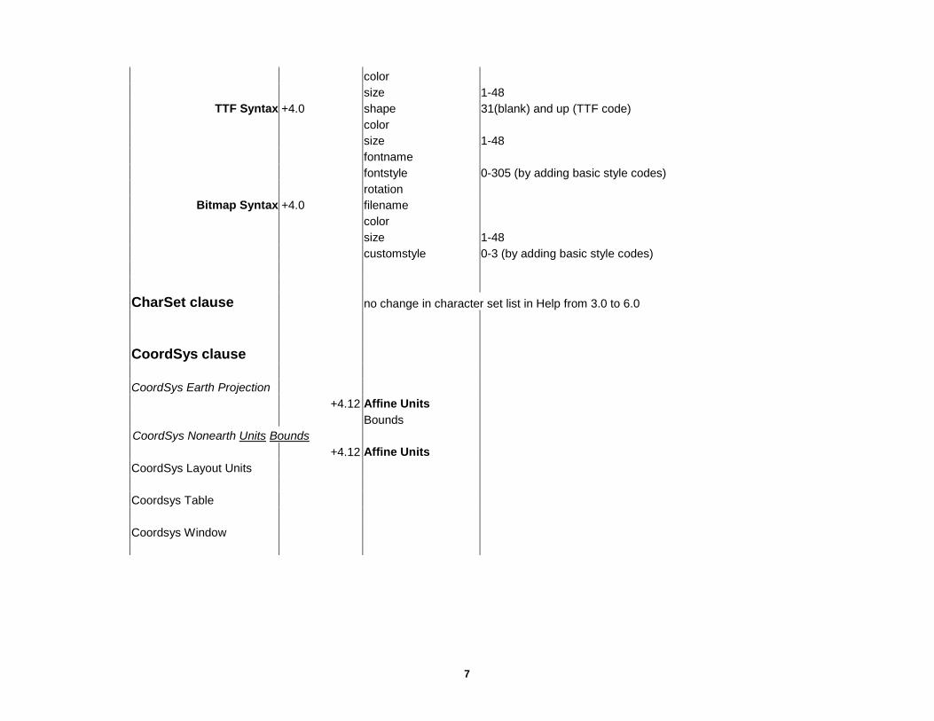
TTF Syntax +4.0 shape 31(blank) and up (TTF code) color size 1-48 fontname fontstyle 0-305 (by adding basic style codes) rotation
Bitmap Syntax +4.0 filename color size 1-48 customstyle 0-3 (by adding basic style codes) CharSet clause no change in character set list in Help from 3.0 to 6.0 CoordSys clause CoordSys Earth Projection +4.12 Affine Units Bounds CoordSys Nonearth Units Bounds +4.12 Affine Units CoordSys Layout Units Coordsys Table Coordsys Window

8
Control clauses
Control Button/OKButton/CancelButton position width height ID calling Title Disable Hide Control CheckBox position width ID calling Title value into Disable Hide Control EditText position width eight ID Title value into Disable Hide Password Control GroupBox position width
eight Title Hide Control ListBox/MultiListBox position width ID calling Title from variable value into Disable Hide Control [Brush Font Pen Symbol]Picker position width height ID calling value into Disable Hide Control PopUpMenu position width ID calling title from variable value into

9
Disable Control RadioGroup position ID calling title from variable value into Disable Hide Control StaticText position +4.0 width +4.0 height +4.1 ID Title Hide

10
PROCEDURES
version
EndHandler +3.0
ForegroundTaskSwitchHandler +4.0
RemoteMapGenHandler +4.1
RemoteMsgHandler +3.0 SelChangedHandler +3.0 ToolHandler +3.0 WinChangedHandler +3.0 WinClosedHandler +3.0 WinFocusChangedHandle +3.0

11
FUNCTIONS, standard Column 1 Function name Plain : present in version3.0 Bold : created since v3.0 Italics : modified since creation Column 2 Version +nn added in nn nn modified in nn (nil) present in 3.0 < (to the left) applies to function > (to the right) applies to detailsColumn 3 Details SQL-DL = exists in the SQL DataLink add=on to version 3.0
Abs Acos AEExecute AEInitiate ApplicationDirectory$ Area AreaOverlap Asc Asin Ask Atn Buffer CartesianArea +5.5 CartesianBuffer +5.5 CartesianDistance +5.5 CartesianObjectLen +5.5 CartesianPerimeter +5.5 Centroid CentroidX CentroidY ChooseProjection$ +4.5 Chr$ Combine ConvertToPline ConvertToRegion ConvexHull +6.0 Cos CreateCircle CreateLine
CreatePoint CreateText +4.1 CurDate 4.5 changed date format CurrentBrush CurrentFont CurrentPen CurrentSymbol Day DDEInitiate DDERequest$ DeformatNumber$ +4.0 Distance EOF EOT Erase Err Error$ Exp ExtractNodes FileExists FileOpenDlg FileSaveAsDlg Fix Format$ 4.0 supports non-US date format FormatDate$ +4.5 FormatNumber$ +4.0 FrontWindow GetMetadata$ +4.0 GetSeamlessSheet +4.0
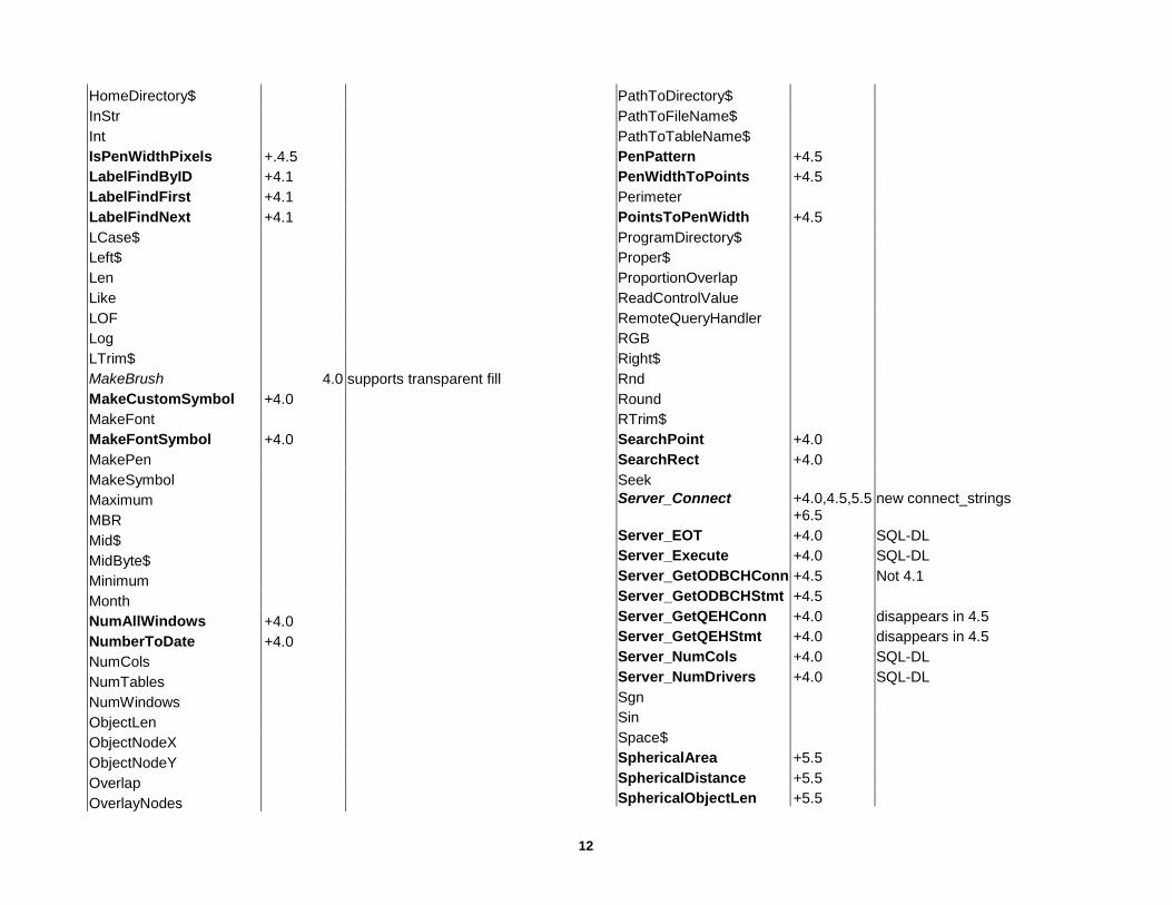
12
HomeDirectory$ InStr Int IsPenWidthPixels +.4.5 LabelFindByID +4.1 LabelFindFirst +4.1 LabelFindNext +4.1 LCase$ Left$ Len Like LOF Log LTrim$ MakeBrush 4.0 supports transparent fill MakeCustomSymbol +4.0 MakeFont MakeFontSymbol +4.0 MakePen MakeSymbol Maximum MBR Mid$ MidByte$ Minimum Month NumAllWindows +4.0 NumberToDate +4.0 NumCols NumTables NumWindows ObjectLen ObjectNodeX ObjectNodeY Overlap OverlayNodes
PathToDirectory$ PathToFileName$ PathToTableName$ PenPattern +4.5 PenWidthToPoints +4.5 Perimeter PointsToPenWidth +4.5 ProgramDirectory$ Proper$ ProportionOverlap ReadControlValue RemoteQueryHandler RGB Right$ Rnd Round RTrim$ SearchPoint +4.0 SearchRect +4.0 Seek Server_Connect +4.0,4.5,5.5
+6.5 new connect_strings
Server_EOT +4.0 SQL-DL Server_Execute +4.0 SQL-DL Server_GetODBCHConn +4.5 Not 4.1 Server_GetODBCHStmt +4.5 Server_GetQEHConn +4.0 disappears in 4.5 Server_GetQEHStmt +4.0 disappears in 4.5 Server_NumCols +4.0 SQL-DL Server_NumDrivers +4.0 SQL-DL Sgn Sin Space$ SphericalArea +5.5 SphericalDistance +5.5 SphericalObjectLen +5.5
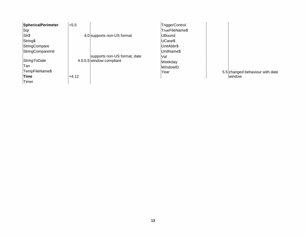
13
SphericalPerimeter +5.5 Sqr Str$ 4.0 supports non-US format String$ StringCompare StringCompareIntl
StringToDate 4.0,5.5 supports non-US format, date window compliant
Tan TempFileName$ Time +4.12 Timer
TriggerControl TrueFileName$ UBound UCase$ UnitAbbr$ UnitName$ Val Weekday WindowID Year 5.5 changed behaviour with date
window

14
FUNCTIONS WITH ATTRIBUTES
Attribute code Plain : present in original version Bold : created since original Italics : modified since creation Version +nn added in nn nn modified in nn (nil) present in original < (to the left) applies to attribute > (to the right) applies to code / return value Code numerical value (defined in mapbasic.def); to be used in MapBasicWindow or requesters < (to the left) applies to attribute > (to the right) applies to return value Return value
BUTTONPADINFO( ) original version= 4.0 attribute code version code ButtonPadInfo( ) Return Value BTNPAD_INFO_FLOATING 1 TRUE means the pad is floating, FALSE the pad is docked. BTNPAD_INFO_NBTNS 3 number of buttons on the pad. BTNPAD_INFO_WIDTH 2 The width of the pad, expressed as a number of buttons (not including separators). BTNPAD_INFO_WINID 6 window ID of the specified pad. BTNPAD_INFO_X 4 A number indicating the x-position of the upper-left corner of the pad. If pad is docked,
this is an Integer, zero or greater; if pad is floating, this is a Float value, in paper units such as inches.
BTNPAD_INFO_Y 5 A number indicating the y-position of the upper-left corner of the pad. COLUMNINFO( ) original version= 3.0 attribute code version code ColumnInfo( ) Return Value COL_INFO_NAME 1 String identifying the column name COL_INFO_NUM 2 SmallInt indicating the number of the column COL_INFO_TYPE 3 SmallInt indicating the column type (see table below) 1 COL_TYPE_CHAR Character 2 COL_TYPE_DECIMAL Fixed-point decimal 8 COL_TYPE_FLOAT Floating-point decimal 3 COL_TYPE_INTEGER Integer (4-byte) 4 COL_TYPE_SMALLINT Small Integer (2-byte)
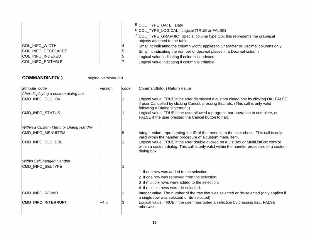
15
5 COL_TYPE_DATE Date 6 COL_TYPE_LOGICAL Logical (TRUE or FALSE) 7 COL_TYPE_GRAPHIC special column type Obj; this represents the graphical
objects attached to the table COL_INFO_WIDTH 4 SmallInt indicating the column width; applies to Character or Decimal columns only COL_INFO_DECPLACES 5 SmallInt indicating the number of decimal places in a Decimal column COL_INFO_INDEXED 5 Logical value indicating if column is indexed COL_INFO_EDITABLE 7 Logical value indicating if column is editable COMMANDINFO( ) original version= 3.0 attribute code version code CommandInfo( ) Return Value After displaying a custom dialog box, CMD_INFO_DLG_OK 1 Logical value: TRUE if the user dismissed a custom dialog box by clicking OK; FALSE
if user Cancelled by clicking Cancel, pressing Esc, etc. (This call is only valid following a Dialog statement.)
CMD_INFO_STATUS 1 Logical value: TRUE if the user allowed a progress-bar operation to complete, or FALSE if the user pressed the Cancel button to halt.
Within a Custom Menu or Dialog Handler CMD_INFO_MENUITEM 8 Integer value, representing the ID of the menu item the user chose. This call is only
valid within the handler procedure of a custom menu item. CMD_INFO_DLG_DBL 1 Logical value: TRUE if the user double-clicked on a ListBox or MultiListBox control
within a custom dialog. This call is only valid within the handler procedure of a custom dialog box.
Within SelChanged Handler CMD_INFO_SELTYPE 1 1 if one row was added to the selection; 2 if one row was removed from the selection; 3 if multiple rows were added to the selection; 4 if multiple rows were de-selected. CMD_INFO_ROWID 2 Integer value: The number of the row that was selected or de-selected (only applies if
a single row was selected or de-selected). CMD_INFO_INTERRUPT +4.0 3 Logical value: TRUE if the user interrupted a selection by pressing Esc, FALSE
otherwise.

16
From within RemoteMsgHandler, RemoteQueryHandler( ), or RemoteMapGenHandler: CMD_INFO_MSG 1000 String value, representing the execute string or the item name sent to MapInfo by a
client program. For details, see RemoteMsgHandler, RemoteQueryHandler( ), or RemoteMapGenHandler.
From within WinChangedHandler or WinClosedHandler: CMD_INFO_WIN 1 Integer value, representing the ID of the window that changed or the window that
closed. For details, see WinChangedHandler or WinClosedHandler. From within ForegroundTaskSwitchHandler: CMD_INFO_TASK_SWITCH +4.0 1 Integer value, indicating whether MapInfo just became the active application or just
stopped being the active application. The return value matches one of these codes: 1 SWITCHING_INTO_MAPINFO (if MapInfo received the focus) 0 SWITCHING_OUT_OF_MAPINFO (if MapInfo lost the focus). After a Find Operation CMD_INFO_FIND_RC +4.0 3 Integer value, indicating whether the Find statement found a match. CMD_INFO_FIND_ROWID +4.0 4 Integer value, indicating the Row ID number of the row that was found. CMD_INFO_X or CMD_INFO_Y +4.0 1 or 2 Floating-point number, indicating x- or y-coordinates of the location that was found. Within a Custom ToolButton’s Handler Procedure CMD_INFO_X 1 x coordinate of the spot where the user clicked: If the user clicked on a Map, the
return value represents a map coordinate (e.g. longitude), in the current coordinate system unit. If the user clicked on a Browser, the value represents the number of a column in the Browser (e.g. one for the leftmost column, or zero for the select-box column).If the user clicked in a Layout, the value represents the distance from the left edge of the Layout (e.g. zero represents the left edge), in MapBasic’s current paper units.
CMD_INFO_Y 2 y-coordinate of the spot where the user clicked: If the user clicked on a map, the value represents a map coordinate (e.g. Latitude). If the user clicked on a Browser, the value represents a row number; a value of one represents the top row, and a value of zero represents the row of column headers at the top of the window If the user clicked on a Layout, the value represents the distance from the top edge of the Layout.
CMD_INFO_X2 5 x-coordinate of the spot where the user released the mouse button. This only applies if the toolbutton was defined with a draw mode that allows dragging, e.g. DM_CUSTOM_LINE.
CMD_INFO_Y2 6 y-coordinate of the spot where the user released the mouse button. CMD_INFO_SHIFT 3 Logical value: TRUE if the user held down the Shift key while clicking.
17
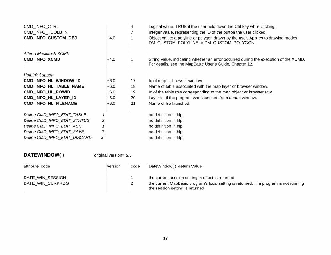
CMD_INFO_CTRL 4 Logical value: TRUE if the user held down the Ctrl key while clicking. CMD_INFO_TOOLBTN 7 Integer value, representing the ID of the button the user clicked. CMD_INFO_CUSTOM_OBJ +4.0 1 Object value: a polyline or polygon drawn by the user. Applies to drawing modes
DM_CUSTOM_POLYLINE or DM_CUSTOM_POLYGON. After a Macintosh XCMD CMD_INFO_XCMD +4.0 1 String value, indicating whether an error occurred during the execution of the XCMD.
For details, see the MapBasic User’s Guide, Chapter 12. HotLink Support CMD_INFO_HL_WINDOW_ID +6.0 17 Id of map or browser window. CMD_INFO_HL_TABLE_NAME +6.0 18 Name of table associated with the map layer or browser window. CMD_INFO_HL_ROWID +6.0 19 Id of the table row corresponding to the map object or browser row. CMD_INFO_HL_LAYER_ID +6.0 20 Layer id, if the program was launched from a map window. CMD_INFO_HL_FILENAME +6.0 21 Name of file launched. Define CMD_INFO_EDIT_TABLE 1 no definition in hlp Define CMD_INFO_EDIT_STATUS 2 no definition in hlp Define CMD_INFO_EDIT_ASK 1 no definition in hlp Define CMD_INFO_EDIT_SAVE 2 no definition in hlp Define CMD_INFO_EDIT_DISCARD 3 no definition in hlp DATEWINDOW( ) original version= 5.5 attribute code version code DateWindow( ) Return Value DATE_WIN_SESSION 1 the current session setting in effect is returned DATE_WIN_CURPROG 2 the current MapBasic program's local setting is returned, if a program is not running
the session setting is returned

18
FILEATTR( ) original version= 3.0 attribute code version code File Attr( ) Return Value FILE_ATTR_MODE 1 Small Integer, indicating the mode in which the file was opened. Return value will be
one of these: 0 MODE_INPUT 1 MODE_OUTPUT 2 MODE_APPEND 3 MODE_RANDOM 4 MODE_BINARY FILE_ATTR_FILESIZE +4.0 0 Integer, indicating the file size in bytes. FOLDERPATH$( ) original version= 6.5 attribute code version code File Attr( ) Return Value FOLDER_ID -1 FOLDER_MI_APPDATA -2 FOLDER_MI_LOCAL_APPDATA -3 FOLDER_MI_PREFERENCE 26 FOLDER_APPDATA 28 FOLDER_LOCAL_APPDATA 35 FOLDER_COMMON_APPDATA 46 FOLDER_COMMON_DOCS 5 FOLDER_MYDOCS 39 FOLDER_MYPICS INTERSECTNODES( ) original version= 3.0 attribute code version code IntersectNodes( ) Return Value INCL_CROSSINGS 1 returns points where segments cross INCL_COMMON 6 returns end-points of segments that overlap INCL_ALL 7 returns points where segments cross and points where segments overlap

19
LABELINFO( ) original version= 4.1 attribute code version code Labelinfo( ) Return Value LABEL_INFO_ANCHORX 3 Float value, indicating the x-coordinate of the label's anchor location. LABEL_INFO_ANCHORY 4 Float value, indicating the y-coordinate of the label's anchor location. LABEL_INFO_DRAWN 20 Logical value; TRUE if label is currently visible. LABEL_INFO_EDIT 8 Logical value; TRUE if label has been edited. LABEL_INFO_EDIT_ANCHOR 10 Logical value; TRUE if label has been moved. LABEL_INFO_EDIT_ANGLE 16 Logical value; TRUE if label's rotation angle has been modified. LABEL_INFO_EDIT_FONT 12 Logical value; TRUE if label's font has been modified. LABEL_INFO_EDIT_OFFSET 11 Logical value; TRUE if label's offset has been modified. LABEL_INFO_EDIT_PEN 13 Logical value; TRUE if callout line's Pen style has been modified. LABEL_INFO_EDIT_POSITION 17 Logical value; TRUE if label's position (relative to anchor) has been modified LABEL_INFO_EDIT_TEXT 14 Logical value; TRUE if label's text has been modified. LABEL_INFO_EDIT_TEXTARROW 15 Logical value; TRUE if label's text arrow setting has been modified. LABEL_INFO_EDIT_TEXTLINE 18 Logical value; TRUE if callout line has been moved. LABEL_INFO_EDIT_VISIBILITY 9 Logical value; TRUE if label Visibility has been set to OFF. LABEL_INFO_OBJECT 1 Text object is returned, which is an approximation of the label. This feature allows you
to convert a label into a text object, which you can save in a permanent table. LABEL_INFO_OFFSET 5 Integer value between 0 and 50, indicating the distance (in points) the label is offset
from its anchor location. LABEL_INFO_POSITION 2 Integer value between 0 and 8, indicating the label's position relative to its anchor
location. The return value will match one of these codes: (For example, if the label is Below and to the Right of the anchor, its position is 8; if the label is Centered horizontally and vertically over its anchor, its position is zero.)
0 LAYER_INFO_LBL_POS_CC 1 LAYER_INFO_LBL_POS_TL 2 LAYER_INFO_LBL_POS_TC 3 LAYER_INFO_LBL_POS_TR 4 LAYER_INFO_LBL_POS_CL 5 LAYER_INFO_LBL_POS_CR 6 LAYER_INFO_LBL_POS_BL 7 LAYER_INFO_LBL_POS_BC 8 LAYER_INFO_LBL_POS_BR LABEL_INFO_ROWID 6 Integer value, representing the ID number of the row that owns this label. LABEL_INFO_SELECT 19 Logical value; TRUE if label is selected.
20
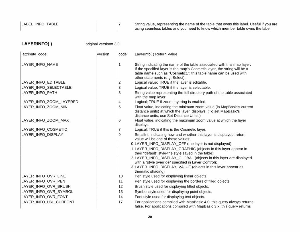
LABEL_INFO_TABLE 7 String value, representing the name of the table that owns this label. Useful if you are using seamless tables and you need to know which member table owns the label.
LAYERINFO( ) original version= 3.0 attribute code version code LayerInfo( ) Return Value LAYER_INFO_NAME 1 String indicating the name of the table associated with this map layer.
If the specified layer is the map's Cosmetic layer, the string will be a table name such as "Cosmetic1"; this table name can be used with other statements (e.g. Select).
LAYER_INFO_EDITABLE 2 Logical value; TRUE if the layer is editable. LAYER_INFO_SELECTABLE 3 Logical value; TRUE if the layer is selectable. LAYER_INFO_PATH 8 String value representing the full directory path of the table associated
with the map layer. LAYER_INFO_ZOOM_LAYERED 4 Logical; TRUE if zoom-layering is enabled. LAYER_INFO_ZOOM_MIN 5 Float value, indicating the minimum zoom value (in MapBasic's current
distance units) at which the layer displays. (To set MapBasic's distance units, use Set Distance Units.)
LAYER_INFO_ZOOM_MAX 6 Float value, indicating the maximum zoom value at which the layer displays.
LAYER_INFO_COSMETIC 7 Logical; TRUE if this is the Cosmetic layer. LAYER_INFO_DISPLAY 9 SmallInt, indicating how and whether this layer is displayed; return
value will be one of these values: 0 LAYER_INFO_DISPLAY_OFF (the layer is not displayed); 1 LAYER_INFO_DISPLAY_GRAPHIC (objects in this layer appear in
their "default" style-the style saved in the table); 2 LAYER_INFO_DISPLAY_GLOBAL (objects in this layer are displayed
with a "style override" specified in Layer Control); 3 LAYER_INFO_DISPLAY_VALUE (objects in this layer appear as
thematic shading) LAYER_INFO_OVR_LINE 10 Pen style used for displaying linear objects. LAYER_INFO_OVR_PEN 11 Pen style used for displaying the borders of filled objects. LAYER_INFO_OVR_BRUSH 12 Brush style used for displaying filled objects. LAYER_INFO_OVR_SYMBOL 13 Symbol style used for displaying point objects. LAYER_INFO_OVR_FONT 14 Font style used for displaying text objects. LAYER_INFO_LBL_CURFONT 17 For applications compiled with MapBasic 4.0, this query always returns
false. For applications compiled with MapBasic 3.x, this query returns
21
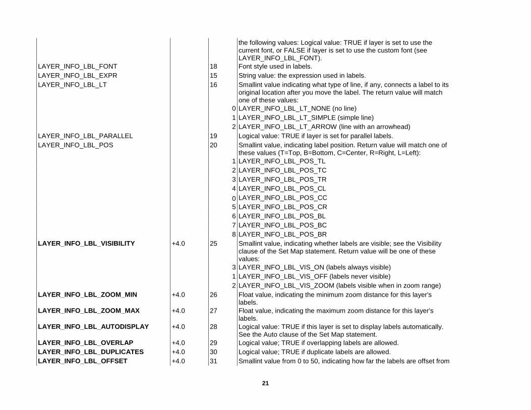
the following values: Logical value: TRUE if layer is set to use the current font, or FALSE if layer is set to use the custom font (see LAYER_INFO_LBL_FONT).
LAYER_INFO_LBL_FONT 18 Font style used in labels. LAYER_INFO_LBL_EXPR 15 String value: the expression used in labels. LAYER_INFO_LBL_LT 16 Smallint value indicating what type of line, if any, connects a label to its
original location after you move the label. The return value will match one of these values:
0 LAYER_INFO_LBL_LT_NONE (no line) 1 LAYER_INFO_LBL_LT_SIMPLE (simple line) 2 LAYER_INFO_LBL_LT_ARROW (line with an arrowhead) LAYER_INFO_LBL_PARALLEL 19 Logical value: TRUE if layer is set for parallel labels. LAYER_INFO_LBL_POS 20 Smallint value, indicating label position. Return value will match one of
these values (T=Top, B=Bottom, C=Center, R=Right, L=Left): 1 LAYER_INFO_LBL_POS_TL 2 LAYER_INFO_LBL_POS_TC 3 LAYER_INFO_LBL_POS_TR 4 LAYER_INFO_LBL_POS_CL 0 LAYER_INFO_LBL_POS_CC 5 LAYER_INFO_LBL_POS_CR 6 LAYER_INFO_LBL_POS_BL 7 LAYER_INFO_LBL_POS_BC 8 LAYER_INFO_LBL_POS_BR LAYER_INFO_LBL_VISIBILITY +4.0 25 Smallint value, indicating whether labels are visible; see the Visibility
clause of the Set Map statement. Return value will be one of these values:
3 LAYER_INFO_LBL_VIS_ON (labels always visible) 1 LAYER_INFO_LBL_VIS_OFF (labels never visible) 2 LAYER_INFO_LBL_VIS_ZOOM (labels visible when in zoom range) LAYER_INFO_LBL_ZOOM_MIN +4.0 26 Float value, indicating the minimum zoom distance for this layer's
labels. LAYER_INFO_LBL_ZOOM_MAX +4.0 27 Float value, indicating the maximum zoom distance for this layer's
labels. LAYER_INFO_LBL_AUTODISPLAY +4.0 28 Logical value: TRUE if this layer is set to display labels automatically.
See the Auto clause of the Set Map statement. LAYER_INFO_LBL_OVERLAP +4.0 29 Logical value; TRUE if overlapping labels are allowed. LAYER_INFO_LBL_DUPLICATES +4.0 30 Logical value; TRUE if duplicate labels are allowed. LAYER_INFO_LBL_OFFSET +4.0 31 Smallint value from 0 to 50, indicating how far the labels are offset from

22
object centroids. The offset value represents a distance, in points. LAYER_INFO_LBL_MAX +4.0 32 Integer value, indicating the maximum number of labels allowed for this
layer. If no maximum has been set, return value is 2,147,483,647. LAYER_INFO_LBL_PARTIALSEGS +4.1 33 Logical value; TRUE if the Label Partial Segments check box is
checked for this layer. LAYER_INFO_ARROWS 21 Logical value; TRUE if layer displays direction arrows on linear objects. LAYER_INFO_NODES 22 Logical value; TRUE if layer displays object nodes. LAYER_INFO_CENTROIDS 23 Logical value; TRUE if layer displays object centroids. LAYER_INFO_TYPE 24 SmallInt value, indicating this layer's file type: 0 LAYER_INFO_TYPE_NORMAL for a normal layer; 1 LAYER_INFO_TYPE_COSMETIC for the Cosmetic layer; 2 LAYER_INFO_TYPE_IMAGE for a raster image layer; 3 LAYER_INFO_TYPE_THEMATIC for a thematic layer. +5.5 4 LAYER_INFO_TYPE_GRID for a grid image layer LAYER_HOTLINK_EXPR +6.0 34 Returns the layer's HotLink filename expression. LAYER_HOTLINK_MODE +6.0 35 Returns the layer's HotLink mode, one of the following predefined
values: HOTLINK_MODE_LABEL HOTLINK_MODE_OBJ HOTLINK_MODE_BOTH LAYER_HOTLINK_RELATIVE +6.0 36 Returns True if the relative path options is on, False otherwise. LEGENDFRAMEINFO( ) original version= 5.0 attribute code version code LegendFrameInfo( ) Return Value FRAME_INFO_TYPE 1 Returns one of the following predefined constant indicating frame type: 1 FRAME_TYPE_STYLE 2 FRAME_TYPE_THEME FRAME_INFO_MAP_LAYER_ID 2 Returns the id of the layer to which the frame corresponds. FRAME_INFO_REFRESHABLE 3 Returns true if the frame was created without the Norefresh keyword. Always returns
true for theme frames. FRAME_INFO_POS_X 4 Returns the distance of the frames upper left corner from the left edge of the legend
canvas (in paper units). FRAME_INFO_POS_Y 5 Returns the distance of the frame’s upper left corner from the top edge of the legend
canvas (in paper units).

23
FRAME_INFO_WIDTH 6 Returns the width of the frame (in paper units). FRAME_INFO_HEIGHT 7 Returns the height of the frame (in paper units). FRAME_INFO_TITLE 8 Returns the title of a style frame or theme frame. FRAME_INFO_TITLE_FONT 9 Returns the font of a style frame title. Returns the default title font if the frame has no
title or if it is a theme frame. FRAME_INFO_SUBTITLE 10 Returns the subtitle of a style frame or theme frame. FRAME_INFO_SUBTITLE_FONT 11 Same as title font. FRAME_INFO_BORDER_PEN 12 Returns the pen used to draw the border. FRAME_INFO_NUM_STYLES 13 Returns the number of styles in a frame. Zero if theme frame. FRAME_INFO_VISIBLE 14 Returns true if the frame is visible (theme frames can be invisible). FRAME_INFO_COLUMN +5.5 15 Returns the legend attribute column name as a string if there is one. Returns an
empty string for a theme frame. FRAME_INFO_LABEL +5.5 16 Returns the label expression as a string if there is one. Returns an empty string for a
theme frame. LEGENDINFO( ) original version= 5.0 attribute code version code LegendInfo( ) Return Value 1 LEGEND_INFO_MAP_ID Return the id of the parent map window (can also get this value by issuing
WindowInfo() with the WIN_INFO_TABLE code). LEGEND_INFO_ORIENTATION 2 Returns predefined value to indicate the layout of the legend: 1 ORIENTATION_PORTRAIT 2 ORIENTATION_LANDSCAPE 3 ORIENTATION_CUSTOM LEGEND_INFO_NUM_FRAMES 3 Returns the number of frames in the legend. LEGENDSTYLEINFO( ) original version= 5.0 attribute code version code LegendStyleInfo( ) Return Value LEGEND_STYLE_INFO_TEXT 1 Returns the text of the style. LEGEND_STYLE_INFO_FONT 2 Returns the font of the style. LEGEND_STYLE_INFO_OBJ 3 Returns the object of the style.
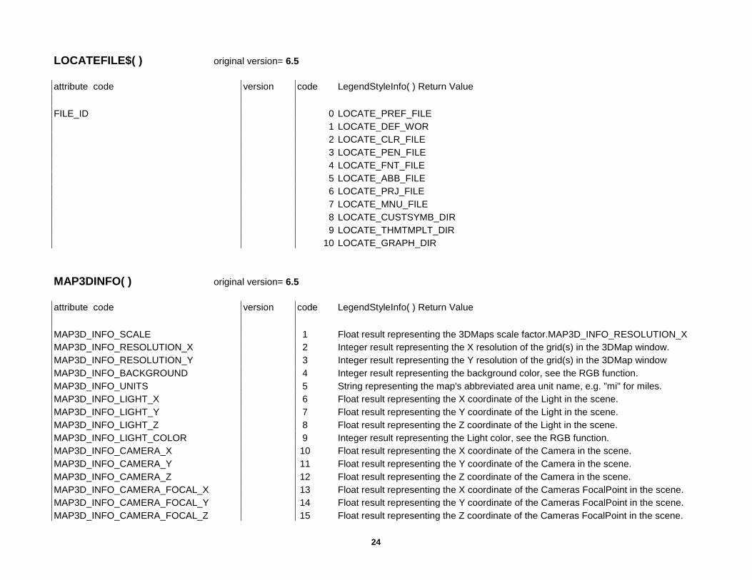
24
LOCATEFILE$( ) original version= 6.5 attribute code version code LegendStyleInfo( ) Return Value FILE_ID 0 LOCATE_PREF_FILE 1 LOCATE_DEF_WOR 2 LOCATE_CLR_FILE 3 LOCATE_PEN_FILE 4 LOCATE_FNT_FILE 5 LOCATE_ABB_FILE 6 LOCATE_PRJ_FILE 7 LOCATE_MNU_FILE 8 LOCATE_CUSTSYMB_DIR 9 LOCATE_THMTMPLT_DIR 10 LOCATE_GRAPH_DIR MAP3DINFO( ) original version= 6.5 attribute code version code LegendStyleInfo( ) Return Value MAP3D_INFO_SCALE 1 Float result representing the 3DMaps scale factor.MAP3D_INFO_RESOLUTION_X MAP3D_INFO_RESOLUTION_X 2 Integer result representing the X resolution of the grid(s) in the 3DMap window. MAP3D_INFO_RESOLUTION_Y 3 Integer result representing the Y resolution of the grid(s) in the 3DMap window MAP3D_INFO_BACKGROUND 4 Integer result representing the background color, see the RGB function. MAP3D_INFO_UNITS 5 String representing the map's abbreviated area unit name, e.g. "mi" for miles. MAP3D_INFO_LIGHT_X 6 Float result representing the X coordinate of the Light in the scene. MAP3D_INFO_LIGHT_Y 7 Float result representing the Y coordinate of the Light in the scene. MAP3D_INFO_LIGHT_Z 8 Float result representing the Z coordinate of the Light in the scene. MAP3D_INFO_LIGHT_COLOR 9 Integer result representing the Light color, see the RGB function. MAP3D_INFO_CAMERA_X 10 Float result representing the X coordinate of the Camera in the scene. MAP3D_INFO_CAMERA_Y 11 Float result representing the Y coordinate of the Camera in the scene. MAP3D_INFO_CAMERA_Z 12 Float result representing the Z coordinate of the Camera in the scene. MAP3D_INFO_CAMERA_FOCAL_X 13 Float result representing the X coordinate of the Cameras FocalPoint in the scene. MAP3D_INFO_CAMERA_FOCAL_Y 14 Float result representing the Y coordinate of the Cameras FocalPoint in the scene. MAP3D_INFO_CAMERA_FOCAL_Z 15 Float result representing the Z coordinate of the Cameras FocalPoint in the scene.

25
MAP3D_INFO_CAMERA_VU_1 16 Float result representing the first value of the ViewUp Unit Normal Vector. MAP3D_INFO_CAMERA_VU_2 17 Float result representing the second value of the ViewUp Unit Normal Vector. MAP3D_INFO_CAMERA_VU_3 18 Float result representing the third value of the ViewUp Unit Normal Vector. MAP3D_INFO_CAMERA_VPN_1 19 Float result representing the first value of the ViewPlane Unit Normal Vector. MAP3D_INFO_CAMERA_VPN_2 20 Float result representing the second value of the ViewPlane Unit Normal Vector. MAP3D_INFO_CAMERA_VPN_3 21 Float result representing the third value of the ViewPlane Unit Normal Vector. MAP3D_INFO_CAMERA_CLIP_NEAR 22 Float result representing the cameras near clipping plane. MAP3D_INFO_CAMERA_CLIP_FAR 23 Float result representing the cameras far clipping plane. MAPPERINFO( ) original version= 3.0 attribute setting version code MapperInfo( ) Return Value MAPPER_INFO_AREAUNITS 13 String representing the map’s abbreviated area unit name, e.g. “sq mi” for square
miles. MAPPER_INFO_CENTERX 3 The x-coordinate of the Map window’s center. MAPPER_INFO_CENTERY 4 The y-coordinate of the Map window’s center. MAPPER_INFO_COORDSYS_ CLAUSE +4.0 17 String result, indicating the window’s CoordSys clause. MAPPER_INFO_COORDSYS_CLAUSE_WITH_BOUNDS
+5.5 22 String result, indicating the window’s CoordSys clause including the bounds.
MAPPER_INFO_DISPLAY_DMS +5.5 21 Returns True or False to indicate whether the map displays coordinates in degrees, minutes, seconds or degrees decimal.
MAPPER_INFO_COORDSYS_ NAME +4.0 18 String result, representing the name of the map’s CoordSys as listed in MAPINFOW.PRJ (but without the optional “\p...” suffix that appears in MAPINFOW.PRJ). Returns empty string if CoordSys is not found in MAPINFOW.PRJ.
MAPPER_INFO_DISPLAY +4.0 15 Small integer, indicating what aspect of the map is displayed on the status bar. Corresponds to Set Map Display. Return value will be one of these:
0 MAPPER_INFO_DISPLAY_SCALE 1 MAPPER_INFO_DISPLAY_ZOOM 2 MAPPER_INFO_DISPLAY_POSITION MAPPER_INFO_DISTUNITS 12 String representing the map’s abbreviated distance unit name, e.g. “mi” for miles. MAPPER_INFO_EDIT_LAYER 10 A SmallInt indicating the number of the currently-editable layer. A value of zero
means that the Cosmetic layer is editable. A value of –1 means that no layer is editable.
MAPPER_INFO_LAYERS 9 Returns number of layers in the Map window as a SmallInt (excludes the cosmetic layer).
MAPPER_INFO_MAXX 7 The largest x-coordinate shown in the window.

26
MAPPER_INFO_MAXY 8 The largest y-coordinate shown in the window. MAPPER_INFO_MINX 5 The smallest x-coordinate shown in the window. MAPPER_INFO_MINY 6 The smallest y-coordinate shown in the window. MAPPER_INFO_NUM_THEMATIC +4.0 16 Small integer, indicating the number of thematic layers in this Map window. MAPPER_INFO_MOVE_ DUPLICATE_NODES
+5.5 19 Small integer, indicating whether duplicate nodes should be moved when reshaping objects in this Map window. If the value is 0, duplicate nodes are not moved. If the value is 1, any duplicate nodes within the same layer will be move. To return to using the default from the map preferences, “Move Nodes Default” can be specified.
MAPPER_INFO_SCALE 2 The Map window’s current scale, defined in terms of the number of map distance units (e.g. Miles) per paper unit (e.g. Inches) displayed in the window. This returns a value in MapBasic’s current distance units.
MAPPER_INFO_SCROLLBARS 14 Logical value indicating whether the Map window shows scrollbars. MAPPER_INFO_XYUNITS 11 String representing the map’s abbreviated coordinate unit name, e.g. “degree”. MAPPER_INFO_ZOOM 1 The Map window’s current zoom value (i.e. the East-West distance currently
displayed in the Map window), specified in MapBasic’s current distance units; see Set Distance Units.
MAPPER_INFO_DIST_ CALC_TYPE +5.5 20 Small integer, indicating type of calculation to use for distance, length, perimeter, and area calculations for a mapper. Corresponds to Set Map Distance Type. Return values include:
0 MAPPER_INFO_DIST_SPHERICAL 1 MAPPER_INFO_DIST_CARTESIAN MAPPER_INFO_CLIP_REGION +6.0 24 Returns a string to indicate if a clip region is enabled. Returns the string “on” if a clip
region is enabled in the Mapper window. Otherwise, it returns the string “off”. MAPPER_INFO_CLIP_TYPE +6.0 23 The type of clipping being implemented. Choices include: 0 MAPPER_INFO_CLIP_DISPLAY_ALL 1 MAPPER_INFO_CLIP_DISPLAY_POLYOBJ 2 MAPPER_INFO_CLIP_OVERLAY MENUITEMINFOBYHandler( ) original version= 4.0 MENUITEMINFOBYID( ) MenuitemInfoByHandler( ) attribute setting version code MenuitemInfoByID( ) Return Value MENUITEM_INFO_ACCELERATOR 5 String: The code sequence for the menu item's accelerator (e.g. "/W^Z" or
"/W#%119") or an empty string if the menu item has no accelerator. For details on menu accelerators, see the Create Menu statement.

27
MENUITEM_INFO_CHECKABLE 3 Logical: TRUE if this menu item is checkable (specified by the "!" prefix in the menu text)
MENUITEM_INFO_CHECKED 2 Logical: TRUE if the menu item is checkable and currently checked; also return TRUE if the menu item has alternate menu text (e.g. if the menu item toggles between Show... and Hide...), and the menu item is in its "show" state. Otherwise, return FALSE.
MENUITEM_INFO_ENABLED 1 Logical: TRUE if the menu item is enabled MENUITEM_INFO_HANDLER 8 Integer: The menu item's handler number. If the menu item's Calling clause specified
a numeric constant (e.g. Calling M_FILE_SAVE), this call returns the value of the constant. If the Calling clause specified "OLE", "DDE", or the name of a procedure, this call returns a unique Integer (an internal handler number) which can be used in subsequent calls to MenuitemInfoByHandler( ) or in the Run Menu Command statement.
MENUITEM_INFO_HELPMSG 7 String: the menu item's help message (as specified in the HelpMsg clause in Create Menu) or empty string if the menu item has no help message.
MENUITEM_INFO_ID 9 Integer: The menu ID number (specified in the optional ID clause in a Create Menu statement), or 0 if the menu item has no ID.
MENUITEM_INFO_SHOWHIDEABLE 4 Logical: TRUE if this menu item has alternate menu text (i.e. if the menu item toggles between Show... and Hide...). An item has alternate text if it was created with "!" at the beginning of the menu item text (in Create Menu or Alter Menu) and it has a caret (^) in the string.
MENUITEM_INFO_TEXT 6 String: the full text used (e.g. in a Create Menu statement) to create the menu item. OBJECTGEOGRAPHY( ) original version= 3.0 attribute setting version code ObjectGeography( ) Return Value (Float) 6.5 1-4 applies to collection or multipoint objects OBJ_GEO_MINX 1 minimum x coordinate of an object’s minimum bounding rectangle (MBR), unless
object is a line; if object is a line, returns same value as OBJ_GEO_LINEBEGX. OBJ_GEO_MINY 2 minimum y coordinate of object’s MBR. For lines, returns OBJ_GEO_LINEBEGY
value. OBJ_GEO_MAXX 3 maximum x coordinate of object’s MBR. Does not apply to Point objects. For lines,
returns OBJ_GEO_LINEENDX value. OBJ_GEO_MAXY 4 maximum y coordinate of the object’s MBR. Does not apply to Point objects. For lines,
returns OBJ_GEO_LINEENDY value. OBJ_GEO_ARCBEGANGLE 5 beginning angle of an Arc object. OBJ_GEO_ARCENDANGLE 6 ending angle of an Arc object. OBJ_GEO_LINEBEGX 1 x coordinate of the starting node of a Line object. OBJ_GEO_LINEBEGY 2 y coordinate of the starting node of a Line object.
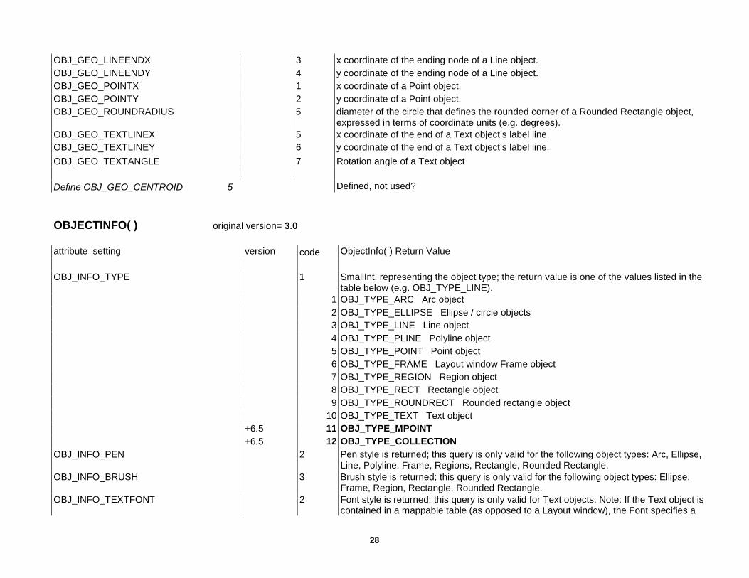
28
OBJ_GEO_LINEENDX 3 x coordinate of the ending node of a Line object. OBJ_GEO_LINEENDY 4 y coordinate of the ending node of a Line object. OBJ_GEO_POINTX 1 x coordinate of a Point object. OBJ_GEO_POINTY 2 y coordinate of a Point object. OBJ_GEO_ROUNDRADIUS 5 diameter of the circle that defines the rounded corner of a Rounded Rectangle object,
expressed in terms of coordinate units (e.g. degrees). OBJ_GEO_TEXTLINEX 5 x coordinate of the end of a Text object’s label line. OBJ_GEO_TEXTLINEY 6 y coordinate of the end of a Text object’s label line. OBJ_GEO_TEXTANGLE 7 Rotation angle of a Text object Define OBJ_GEO_CENTROID 5 Defined, not used? OBJECTINFO( ) original version= 3.0 attribute setting version code ObjectInfo( ) Return Value OBJ_INFO_TYPE 1 SmallInt, representing the object type; the return value is one of the values listed in the
table below (e.g. OBJ_TYPE_LINE). 1 OBJ_TYPE_ARC Arc object 2 OBJ_TYPE_ELLIPSE Ellipse / circle objects 3 OBJ_TYPE_LINE Line object 4 OBJ_TYPE_PLINE Polyline object 5 OBJ_TYPE_POINT Point object 6 OBJ_TYPE_FRAME Layout window Frame object 7 OBJ_TYPE_REGION Region object 8 OBJ_TYPE_RECT Rectangle object 9 OBJ_TYPE_ROUNDRECT Rounded rectangle object 10 OBJ_TYPE_TEXT Text object +6.5 11 OBJ_TYPE_MPOINT +6.5 12 OBJ_TYPE_COLLECTION OBJ_INFO_PEN 2 Pen style is returned; this query is only valid for the following object types: Arc, Ellipse,
Line, Polyline, Frame, Regions, Rectangle, Rounded Rectangle. OBJ_INFO_BRUSH 3 Brush style is returned; this query is only valid for the following object types: Ellipse,
Frame, Region, Rectangle, Rounded Rectangle. OBJ_INFO_TEXTFONT 2 Font style is returned; this query is only valid for Text objects. Note: If the Text object is
contained in a mappable table (as opposed to a Layout window), the Font specifies a

29
point size of zero, and the text height is controlled by the Map window’s zoom distance. OBJ_INFO_SYMBOL 2 Symbol style; this query is only valid for Point and MultiPoint objects. OBJ_INFO_NPNTS
4.56.5
20 Integer, indicating the total number of nodes in a polyline or region object. number of nodes went from 32K to over one million Applies to a MultiPoint objecr
OBJ_INFO_SMOOTH 4 Logical, indicating whether the specified Polyline object is smoothed. OBJ_INFO_FRAMEWIN 4 Integer, indicating the window id of the window attached to a Frame object. OBJ_INFO_FRAMETITLE 6 String, indicating a Frame object’s title. OBJ_INFO_NPOLYGONS 21 SmallInt, indicating the number of polygons (in the case of a region) or sections (in the
case of a polyline) which make up an object. OBJ_INFO_NPOLYGONS+N 21 + N Integer, indicating the number of nodes in the Nth polygon of a region or the Nth
section of a polyline. Note: With region objects, MapInfo counts the starting node twice (once as the start node and once as the end node). For example, ObjectInfo returns a value of 4 for a triangle-shaped region.
OBJ_INFO_TEXTSTRING 3 String, representing the body of a Text object; if the object has multiple lines of text, the string includes embedded line-feeds (Chr$(10) values).
OBJ_INFO_TEXTSPACING 4 Float value of 1, 1.5, or 2, representing a Text object’s line spacing. OBJ_INFO_TEXTJUSTIFY 5 SmallInt, representing justification of a Text object: 0 = left, 1 = center, 2 = right. OBJ_INFO_TEXTARROW 6 SmallInt, representing the line style associated with a Text object: 0 = no line, 1 =
simple line, 2 = arrow line. OBJ_INFO_FILLFRAME +4.0 7 Logical: TRUE if the object is a frame that contains a Map window, and the frame’s “Fill
Frame With Map” setting is checked. OBJ_INFO_REGION +6.5 8 Object value representing region part of a collection object. If collection object does not
have a region, it returns empty region. This query is valid only for collection objects OBJ_INFO_PLINE +6.5 9 Object value representing polyline part of a collection object. If collection object does
not have a polyline, it returns empty polyline object. This query is valid only for collection objects
OBJ_INFO_MPOINT +6.5 10 Object value representing Multipoint part of a collection object. If collection object does not have a Multipoint, it returns empty Multipoint object. This query is valid only for collection objects
OBJ_INFO_NONEMPTY +6.5 11 Logical, returns TRUE if a Multipoint or Collection object has nodes, FALSE - if object is empty

30
PRISMMAPINFO( ) original version= 6.5 attribute setting version code SearchInfo( ) returns: PRISMMAP_INFO_SCALE 1 Float result representing the PrismMaps scale factor. PRISMMAP_INFO_BACKGROUND 4 Integer result representing the background color, see the RGB function. PRISMMAP_INFO_LIGHT_X 6 Float result representing the X coordinate of the light in the scene. PRISMMAP_INFO_LIGHT_Y 7 Float result representing the Y coordinate of theLight in the scene. PRISMMAP_INFO_LIGHT_Z 8 Float result representing the Z coordinate of the Light in the scene. PRISMMAP_INFO_LIGHT_COLOR 9 Integer result representing the Light color, see the RGB function. PRISMMAP_INFO_CAMERA_X 10 Float result representing the X coordinate of the Camera in the scene. PRISMMAP_INFO_CAMERA_Y 11 Float result representing the Y coordinate of the Camera in the scene. PRISMMAP_INFO_CAMERA_Z 12 Float result representing the Z coordinate of the Camera in the scene. PRISMMAP_INFO_CAMERA_FOCAL_X 13 Float result representing the X coordinate of the Cameras FocalPoint in the scene. PRISMMAP_INFO_CAMERA_FOCAL_Y 14 Float result representing the Y coordinate of the Cameras FocalPoint in the scene. PRISMMAP_INFO_CAMERA_FOCAL_Z 15 Float result representing the Z coordinate of the Camera’s FocalPoint in the scene. PRISMMAP_INFO_CAMERA_VU_1 16 Float result representing the first value of theViewUp Unit Normal Vector. PRISMMAP_INFO_CAMERA_VU_2 17 Float result representing the second value of the ViewUp Unit Normal Vector. PRISMMAP_INFO_CAMERA_VU_3 18 Float result representing the third value of the ViewUp Unit Normal Vector. PRISMMAP_INFO_CAMERA_VPN_1 19 Float result representing the first value of the View Plane Unit Normal Vector. PRISMMAP_INFO_CAMERA_VPN_2 20 Float result representing the second value of theViewPlane Unit Normal Vector. PRISMMAP_INFO_CAMERA_VPN_3 21 Float result representing the third value of the ViewPlane Unit Normal Vector. PRISMMAP_INFO_CAMERA_CLIP_NEAR 22 Float result representing the cameras near clipping plane. PRISMMAP_INFO_CAMERA_CLIP_FAR 23 Float result representing the cameras far clipping plane.. PRISMMAP_INFO_INFOTIP_EXPR 24 Defined, not explained in Help file SEARCHINFO( ) original version= 4.0 attribute setting version code SearchInfo( ) returns: SEARCH_INFO_TABLE 1 String value: the name of the table containing this object. If an object is from a
Cosmetic layer, this string has the form “CosmeticN” (where N is a number, 1 or larger).
SEARCH_INFO_ROW 2 Integer value: this row’s RowId number. You can use this RowId number in a Fetch statement or in a Select statement’s Where clause.

31
SELECTIONINFO( ) original version= 3.0 attribute setting version code SelectionInfo( ) Return Value SEL_INFO_TABLENAME 1 String: The name of the table the selection was based on. Returns an empty string if
no data currently selected. SEL_INFO_SELNAME 2 String: The name of the temporary table (e.g. "Query1") representing the query.
Returns an empty string if no data currently selected. SEL_INFO_NROWS 3 Integer: The number of selected rows. Returns zero if no data currently selected. SERVER_COLUMNINFO( ) original version= 4.0 SQL-DataLink add-on for version 3.0 attribute setting version code Server_ColumnInfo() returns: SRV_COL_INFO_NAME 1 String result, the name identifying the column SRV_COL_INFO_TYPE 2 Integer result, a code indicating the column type: 0 SRV_COL_TYPE_NONE 1 SRV_COL_TYPE_CHAR 2 SRV_COL_TYPE_DECIMAL 3 SRV_COL_TYPE_INTEGER 4 SRV_COL_TYPE_SMALLINT 5 SRV_COL_TYPE_DATE 6 SRV_COL_TYPE_LOGICAL 8 SRV_COL_TYPE_FLOAT 16 SRV_COL_TYPE_FIXED_LEN_STRING 17 SRV_COL_TYPE_BIN_STRING SRV_COL_INFO_SCALE 5 Integer result, indicating the number of digits to the right of the decimal for a
SRV_COL_TYPE_DECIMAL column, or -1 for any other column type. SRV_COL_INFO_PRECISION 4 Integer result, indicating the total number of digits for a SRV_COL_TYPE_DECIMAL
column, or -1 for any other column type. SRV_COL_INFO_WIDTH 3 Integer result, indicating maximum number of characters in a column of type
SRV_COL_TYPE_CHAR or SRV_COL_TYPE_FIXED_LEN_CHAR SRV_COL_INFO_VALUE 6 Result type varies. Returns the actual data value from the column of the current row.
Long character column values greater than 32,766 will be truncated. Binary column values are returned as a double length string of hexadecimal characters.
SRV_COL_INFO_STATUS 7 Integer result, indicating the status of the column value: -1 SRV_NULL_DATA - Returned when the column has no data for that row.

32
-2 SRV_TRUNCATED_DATA - Returned when there is more data in the column than can be stored in the MapBasic variable.
Positive Integer Value - Number of bytes returned by the server. SRV_COL_INFO_ALIAS 8 Column alias returned if an alias was used for the column in the query. SERVER_CONNECTINFO( ) original version= 5.5 attribute setting version code Server_ConnectInfo() returns: SRV_CONNECT_INFO_DRIVER_NAME 1 String result, the name identifying the toolkit drivername associated with this
connection. SRV_CONNECT_INFO_DB_NAME 2 String result, returning the database name. SRV_CONNECT_INFO_SQL_USER_ID 3 String result, returning the name of the SQL user ID. SRV_CONNECT_INFO_DS_NAME 4 String result, returning the data source name. SRV_CONNECT_INFO_QUOTE_CHAR 5 String result, returning the quote character. SERVER_DRIVERINFO( ) original version= 4.0 SQL-DataLink add-on for version 3.0 attribute setting version code Server_DriverInfo() returns: SRV_DRV_INFO_NAME 1 String result, the name identifying the toolkit. “ODBC” indicates an ODBC data source.
“ORAINET” indicates an Oracle8i connection. SRV_DRV_INFO_NAME_LIST 2 String result, returns all the toolkit names, separated by semicolons, i.e.
“ODBC;ORAINET”. The DriverNo parameter is ignored SRV_DRV_DATA_SOURCE 3 String result, returning the name of the data sources supported by the toolkit.
Repeated calls will fetch each name. After the last name for a particular toolkit, the function will return an empty string. Calling the function again for that toolkit will cause it to start with the first name on the list again.
STYLEATTR( ) original version= 3.0 attribute setting version code StyleAttr( ) returns: BRUSH_PATTERN 1 Integer, indicating the Brush style’s pattern.
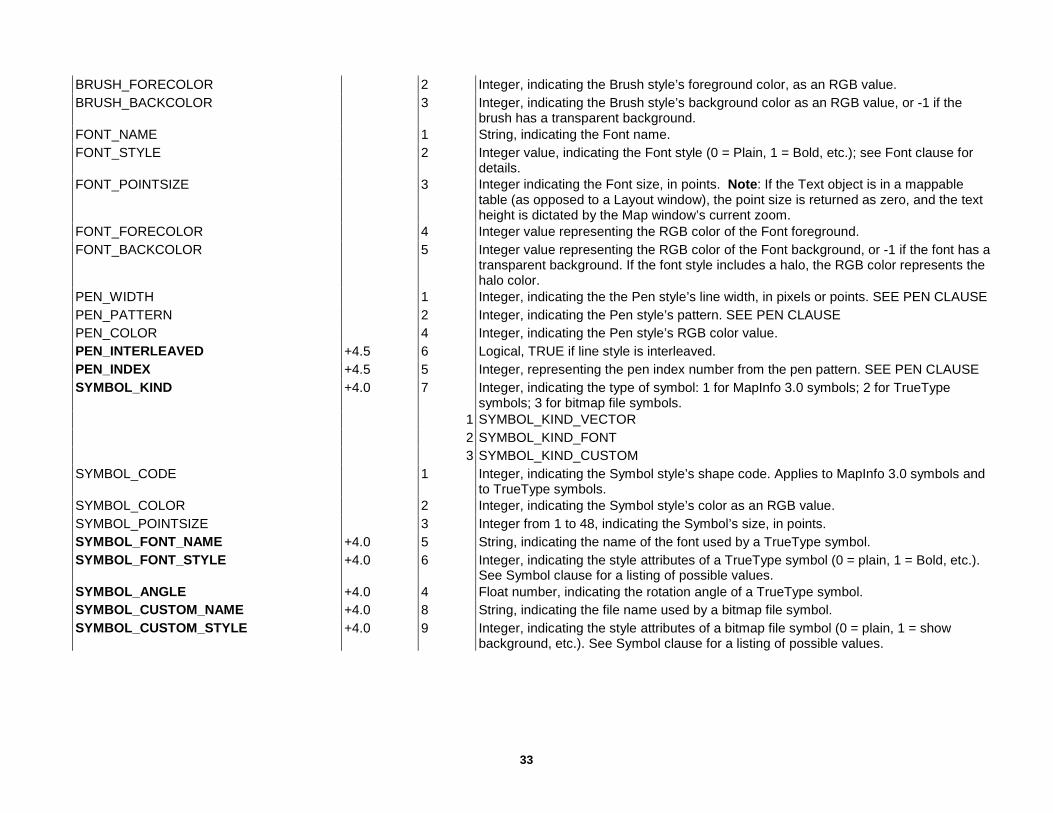
33
BRUSH_FORECOLOR 2 Integer, indicating the Brush style’s foreground color, as an RGB value. BRUSH_BACKCOLOR 3 Integer, indicating the Brush style’s background color as an RGB value, or -1 if the
brush has a transparent background. FONT_NAME 1 String, indicating the Font name. FONT_STYLE 2 Integer value, indicating the Font style (0 = Plain, 1 = Bold, etc.); see Font clause for
details. FONT_POINTSIZE 3 Integer indicating the Font size, in points. Note: If the Text object is in a mappable
table (as opposed to a Layout window), the point size is returned as zero, and the text height is dictated by the Map window’s current zoom.
FONT_FORECOLOR 4 Integer value representing the RGB color of the Font foreground. FONT_BACKCOLOR 5 Integer value representing the RGB color of the Font background, or -1 if the font has a
transparent background. If the font style includes a halo, the RGB color represents the halo color.
PEN_WIDTH 1 Integer, indicating the the Pen style’s line width, in pixels or points. SEE PEN CLAUSE PEN_PATTERN 2 Integer, indicating the Pen style’s pattern. SEE PEN CLAUSE PEN_COLOR 4 Integer, indicating the Pen style’s RGB color value. PEN_INTERLEAVED +4.5 6 Logical, TRUE if line style is interleaved. PEN_INDEX +4.5 5 Integer, representing the pen index number from the pen pattern. SEE PEN CLAUSE SYMBOL_KIND +4.0 7 Integer, indicating the type of symbol: 1 for MapInfo 3.0 symbols; 2 for TrueType
symbols; 3 for bitmap file symbols. 1 SYMBOL_KIND_VECTOR 2 SYMBOL_KIND_FONT 3 SYMBOL_KIND_CUSTOM SYMBOL_CODE 1 Integer, indicating the Symbol style’s shape code. Applies to MapInfo 3.0 symbols and
to TrueType symbols. SYMBOL_COLOR 2 Integer, indicating the Symbol style’s color as an RGB value. SYMBOL_POINTSIZE 3 Integer from 1 to 48, indicating the Symbol’s size, in points. SYMBOL_FONT_NAME +4.0 5 String, indicating the name of the font used by a TrueType symbol. SYMBOL_FONT_STYLE +4.0 6 Integer, indicating the style attributes of a TrueType symbol (0 = plain, 1 = Bold, etc.).
See Symbol clause for a listing of possible values. SYMBOL_ANGLE +4.0 4 Float number, indicating the rotation angle of a TrueType symbol. SYMBOL_CUSTOM_NAME +4.0 8 String, indicating the file name used by a bitmap file symbol. SYMBOL_CUSTOM_STYLE +4.0 9 Integer, indicating the style attributes of a bitmap file symbol (0 = plain, 1 = show
background, etc.). See Symbol clause for a listing of possible values.
34
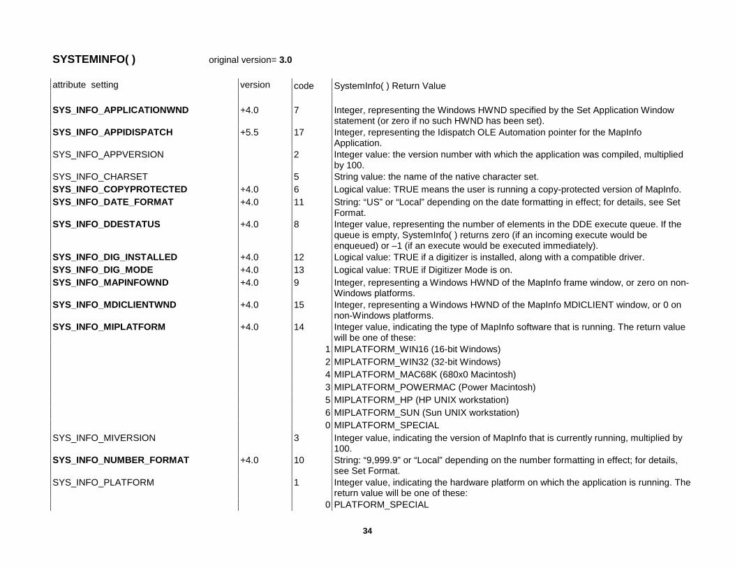
SYSTEMINFO( ) original version= 3.0 attribute setting version code SystemInfo( ) Return Value SYS_INFO_APPLICATIONWND +4.0 7 Integer, representing the Windows HWND specified by the Set Application Window
statement (or zero if no such HWND has been set). SYS_INFO_APPIDISPATCH +5.5 17 Integer, representing the Idispatch OLE Automation pointer for the MapInfo
Application. SYS_INFO_APPVERSION 2 Integer value: the version number with which the application was compiled, multiplied
by 100. SYS_INFO_CHARSET 5 String value: the name of the native character set. SYS_INFO_COPYPROTECTED +4.0 6 Logical value: TRUE means the user is running a copy-protected version of MapInfo. SYS_INFO_DATE_FORMAT +4.0 11 String: “US” or “Local” depending on the date formatting in effect; for details, see Set
Format. SYS_INFO_DDESTATUS +4.0 8 Integer value, representing the number of elements in the DDE execute queue. If the
queue is empty, SystemInfo( ) returns zero (if an incoming execute would be enqueued) or –1 (if an execute would be executed immediately).
SYS_INFO_DIG_INSTALLED +4.0 12 Logical value: TRUE if a digitizer is installed, along with a compatible driver. SYS_INFO_DIG_MODE +4.0 13 Logical value: TRUE if Digitizer Mode is on. SYS_INFO_MAPINFOWND +4.0 9 Integer, representing a Windows HWND of the MapInfo frame window, or zero on non-
Windows platforms. SYS_INFO_MDICLIENTWND +4.0 15 Integer, representing a Windows HWND of the MapInfo MDICLIENT window, or 0 on
non-Windows platforms. SYS_INFO_MIPLATFORM +4.0 14 Integer value, indicating the type of MapInfo software that is running. The return value
will be one of these: 1 MIPLATFORM_WIN16 (16-bit Windows) 2 MIPLATFORM_WIN32 (32-bit Windows) 4 MIPLATFORM_MAC68K (680x0 Macintosh) 3 MIPLATFORM_POWERMAC (Power Macintosh) 5 MIPLATFORM_HP (HP UNIX workstation) 6 MIPLATFORM_SUN (Sun UNIX workstation) 0 MIPLATFORM_SPECIAL SYS_INFO_MIVERSION 3 Integer value, indicating the version of MapInfo that is currently running, multiplied by
100. SYS_INFO_NUMBER_FORMAT +4.0 10 String: “9,999.9” or “Local” depending on the number formatting in effect; for details,
see Set Format. SYS_INFO_PLATFORM 1 Integer value, indicating the hardware platform on which the application is running. The
return value will be one of these: 0 PLATFORM_SPECIAL
35
1 PLATFORM_WIN 2 PLATFORM_MAC 3 PLATFORM_MOTIF 4 PLATFORM_X11 5 PLATFORM_XOL DWT in 3.0 dropped SYS_INFO_PRODUCTLEVEL +4.0 16 Integer value, indicating the product level of the version of MapInfo that is running (e.g.
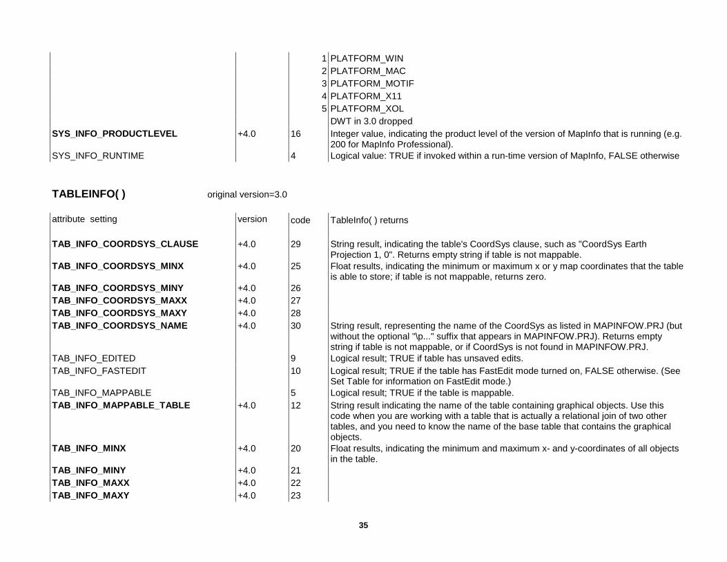
200 for MapInfo Professional). SYS_INFO_RUNTIME 4 Logical value: TRUE if invoked within a run-time version of MapInfo, FALSE otherwise TABLEINFO( ) original version=3.0 attribute setting version code TableInfo( ) returns TAB_INFO_COORDSYS_CLAUSE +4.0 29 String result, indicating the table's CoordSys clause, such as "CoordSys Earth
Projection 1, 0". Returns empty string if table is not mappable. TAB_INFO_COORDSYS_MINX +4.0 25 Float results, indicating the minimum or maximum x or y map coordinates that the table
is able to store; if table is not mappable, returns zero. TAB_INFO_COORDSYS_MINY +4.0 26 TAB_INFO_COORDSYS_MAXX +4.0 27 TAB_INFO_COORDSYS_MAXY +4.0 28 TAB_INFO_COORDSYS_NAME +4.0 30 String result, representing the name of the CoordSys as listed in MAPINFOW.PRJ (but
without the optional "\p..." suffix that appears in MAPINFOW.PRJ). Returns empty string if table is not mappable, or if CoordSys is not found in MAPINFOW.PRJ.
TAB_INFO_EDITED 9 Logical result; TRUE if table has unsaved edits. TAB_INFO_FASTEDIT 10 Logical result; TRUE if the table has FastEdit mode turned on, FALSE otherwise. (See
Set Table for information on FastEdit mode.) TAB_INFO_MAPPABLE 5 Logical result; TRUE if the table is mappable. TAB_INFO_MAPPABLE_TABLE +4.0 12 String result indicating the name of the table containing graphical objects. Use this
code when you are working with a table that is actually a relational join of two other tables, and you need to know the name of the base table that contains the graphical objects.
TAB_INFO_MINX +4.0 20 Float results, indicating the minimum and maximum x- and y-coordinates of all objects in the table.
TAB_INFO_MINY +4.0 21 TAB_INFO_MAXX +4.0 22 TAB_INFO_MAXY +4.0 23
36
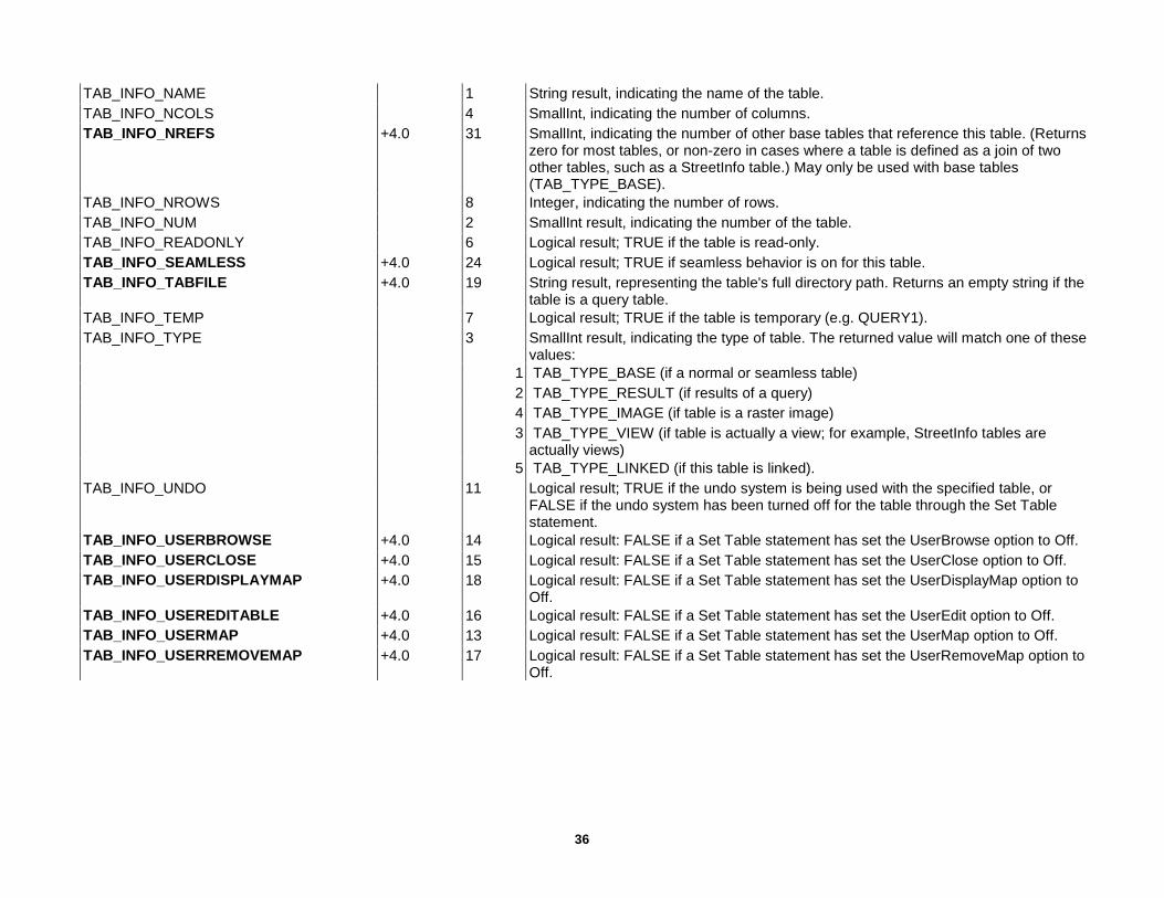
TAB_INFO_NAME 1 String result, indicating the name of the table. TAB_INFO_NCOLS 4 SmallInt, indicating the number of columns. TAB_INFO_NREFS +4.0 31 SmallInt, indicating the number of other base tables that reference this table. (Returns
zero for most tables, or non-zero in cases where a table is defined as a join of two other tables, such as a StreetInfo table.) May only be used with base tables (TAB_TYPE_BASE).
TAB_INFO_NROWS 8 Integer, indicating the number of rows. TAB_INFO_NUM 2 SmallInt result, indicating the number of the table. TAB_INFO_READONLY 6 Logical result; TRUE if the table is read-only. TAB_INFO_SEAMLESS +4.0 24 Logical result; TRUE if seamless behavior is on for this table. TAB_INFO_TABFILE +4.0 19 String result, representing the table's full directory path. Returns an empty string if the
table is a query table. TAB_INFO_TEMP 7 Logical result; TRUE if the table is temporary (e.g. QUERY1). TAB_INFO_TYPE 3 SmallInt result, indicating the type of table. The returned value will match one of these
values: 1 TAB_TYPE_BASE (if a normal or seamless table) 2 TAB_TYPE_RESULT (if results of a query) 4 TAB_TYPE_IMAGE (if table is a raster image) 3 TAB_TYPE_VIEW (if table is actually a view; for example, StreetInfo tables are
actually views) 5 TAB_TYPE_LINKED (if this table is linked). TAB_INFO_UNDO 11 Logical result; TRUE if the undo system is being used with the specified table, or
FALSE if the undo system has been turned off for the table through the Set Table statement.
TAB_INFO_USERBROWSE +4.0 14 Logical result: FALSE if a Set Table statement has set the UserBrowse option to Off. TAB_INFO_USERCLOSE +4.0 15 Logical result: FALSE if a Set Table statement has set the UserClose option to Off. TAB_INFO_USERDISPLAYMAP +4.0 18 Logical result: FALSE if a Set Table statement has set the UserDisplayMap option to
Off. TAB_INFO_USEREDITABLE +4.0 16 Logical result: FALSE if a Set Table statement has set the UserEdit option to Off. TAB_INFO_USERMAP +4.0 13 Logical result: FALSE if a Set Table statement has set the UserMap option to Off. TAB_INFO_USERREMOVEMAP +4.0 17 Logical result: FALSE if a Set Table statement has set the UserRemoveMap option to
Off.

37
WINDOWINFO( ) original version= 3.0 attribute setting version code WindowInfo( attribute ) returns: WIN_INFO_AUTOSCROLL +4.0 17 Logical value: TRUE if the autoscroll feature is on for this window, allowing the user to
scroll the window by dragging to the window's edge. To turn autoscroll on or off, see Set Window.
WIN_INFO_CLONEWINDOW +4.0 15 String value: a string of MapBasic statements that can be used in a Run Command statement to duplicate a window. See Run Command.
WIN_INFO_HEIGHT 5 Float value: window height (in paper units). WIN_INFO_LEGENDS_MAP +4.0 10 Integer value: when you query a Legend window created using the Create Legend
statement, this code returns the Integer window ID of the Map or Graph window that owns the legend. When you query the standard Legend window, returns 0.
WIN_INFO_NAME 1 String value: the name of the window. WIN_INFO_OPEN 11 Logical value: TRUE if the window is open (used with special windows such as the
Info window). WIN_INFO_SMARTPAN +4.12 18 Logical value: TRUE if SmartPan has been set on. WIN_INFO_STATE 9 SmallInt value: 0 WIN_STATE_NORMAL if at normal size 1 WIN_STATE_MINIMIZED if minimized, 2 WIN_STATE_MAXIMIZED if maximized WIN_INFO_SYSMENUCLOSE +4.0 16 Logical value: FALSE indicates that a Set Window statement has disabled the Close
command on the window's system menu. WIN_INFO_TABLE 10 String value: For Map windows, the name of the window's "CosmeticN" table. For
Layout windows, the name of the window's "LayoutN" table.For Browser or Graph windows, the name of the table displayed in the window.
WIN_INFO_TOPMOST 8 Logical value: TRUE if this is the active window. WIN_INFO_TYPE 3 SmallInt value: window type: 1 WIN_MAPPER Map window 2 WIN_BROWSER Browse window 3 WIN_LAYOUT Layout window 4 WIN_GRAPH Graph window 1001 WIN_HELP The Help window 1002 WIN_MAPBASIC The MapBasic window 1003 WIN_MESSAGE The Message window (used with the MapBasic Print statement) 1007 WIN_RULER The Ruler window (displays the distances measured by the Ruler tool) 1008 WIN_INFO The Info window (displays data when the user clicks with the Info tool) 1009 WIN_LEGEND The Legend window

38
1010 WIN_STATISTICS The Statistics window 1011 WIN_MAPINFO The MapInfo application window +4.0 19 WIN_BUTTONPAD A ButtonPad window ? 25 WIN_TOOLBAR (in Define, not in Help) ? 27 WIN_CART_LEGEND (in Define, not in Help) ? 28 WIN_3DMAP (in Define, not in Help) WIN_INFO_WIDTH 4 Float value: window width (in paper units). WIN_INFO_WINDOWID +4.0 13 Integer value, representing the window's ID; identical to the value returned by
WindowID( ). This is useful if you pass zero as the window_spec. WIN_INFO_WND +4.0 12 Integer value. On Windows, the value represents a Windows HWND for the window
you are querying. On the Macintosh, the value represents a WindowPtr. On other platforms, returns zero.
WIN_INFO_WORKSPACE +4.0 14 String value: the string of MapBasic statements that a Save Workspace operation would write to a workspace to record the settings for this map. Differs from WIN_INFO_CLONEWINDOW in that the results include Open Table statements, etc.
WIN_INFO_X, WIN_INFO_Y 6, 7 Float value: the window's distance from the left (top) edge of the MapInfo work area (in paper units).
WIN_INFO_PRINTER_NAME +5.5 21 Returns string value with printer identifier (e.g. DISCOVERY\\HP4_DEVEL) WIN_INFO_PRINTER_ORIENT +5.5 22 Returns 1 WIN_PRINTER_PORTRAIT 2 WIN_PRINTER_LANDSCAPE WIN_INFO_PRINTER_COPIES +5.5 23 Returns integer number of copies. WIN_INFO_SNAPMODE +5.5 19 Returns a logical value. TRUE if snap mode is on. FALSE if snap mode is off. The
value for WIN_INFO_SNAPMODE is 19. WIN_INFO_SNAPTHRESHOLD +5.5 20 Returns a SmallInt value representing the pixel tolerance. The value for
WIN_INFO_SNAPTHRESHOLD is 20. WIN_INFO_PRINTER_PAPERSIZE +6.0 24 Integer value:Refer to Papersize.def file for the meaning of the return value.. WIN_INFO_PRINTER_LEFT_MARGIN +6.0 25 Float value: left printer margin value in current units. WIN_INFO_PRINTER_RIGHT_MARGIN +6.0 26 Float value: right printer margin value in current units. WIN_INFO_PRINTER_TOP_MARGIN +6.0 27 Float value: top margin value in current units. WIN_INFO_PRINTER_BOTTOM_MARGIN.
+6.0 28 Float value: bottom printer margin value in current units
WIN_INFO_PRINTER_BORDER +6.0 29 String value: ON if a black border will be on the printer output, OFF otherwise. WIN_INFO_PRINTER_TRUECOLOR +6.0 30 String value: ON if use 24-bit true color to print raster and grid images. This is
possible when the image is 24 bit and the printer supports more than 256 colors, OFF otherwise.
WIN_INFO_PRINTER_DITHER +6.0 31 String value: return dithering method, which is used when it is necessary to convert a 24-bit image to 256 colors. Possible return values are HALFTONE and ERRORDIFFUSION. This option is used when printing raster and grid images.

39
Dithering will occur if WIN_INFO_PRINTER_TRUECOLOR is disabled or if the printer color depth is 256 colors or less.
WIN_INFO_PRINTER_METHOD +6.0 32 String value: possible return values are DEVICE and EMF. WIN_INFO_PRINTER_TRANSPRASTER +6.0 33 String value: possible return values are DEVICE and INTERNAL. WIN_INFO_PRINTER_TRANSPVECTOR +6.0 34 String value: possible return values are DEVICE and INTERNAL. WIN_INFO_EXPORT_BORDER +6.0 35 String value: possible return values are ON and OFF. WIN_INFO_EXPORT_TRUECOLOR +6.0 36 String value: possible return values are ON and OFF. WIN_INFO_EXPORT_DITHER +6.0 37 String value: possible return values are HALFTONE and ERRORDIFFUSION. WIN_INFO_EXPORT_TRANSPRASTER +6.0 38 String value: possible return values are DEVICE and INTERNAL. WIN_INFO_EXPORT_TRANSPVECTOR +6.0 39 String value: possible return values are DEVICE and INTERNAL.

40
STATEMENTS Column 1 Statement “name” plus required key words (underlined) or “internal” clause (repetitive parts) in italics right aligned Column 2 Version: +nn added in nn nn modified in nn (nil) present in 3.0 SQL-DL existed in the SQL-DatatLik add-on to version 3.0
< (to the left) applies to statement > (to the right) applies to key word or details Column 3 Key words Column 4 Secondary key words or details Statement name and Key word: Plain : present in version3.0 Bold : created since v3.0 Italics : modified since creation
Add Cartographic Frame +5.0 Window Custom Default Frame Title Default Frame
Subtitle
Default Frame Style Default Frame
Border Pen
Font Frame definition Frame From Layer
+5.5 Using +5.5 Column +5.5 Label Position Units Title SubTitle Border Pen Style NoRefresh Text Line Pen Region Pen Brush. Symbol Add Column From Set To Values Where Within, Contains, Intersects Dynamic
Add Map Layer Window Auto +4.0 Animate Alter Button ID Enable Disable Check Uncheck Alter ButtonPad ID Add Remove Title Width Position Units Show Hide Destroy +4.0 ToolbarPosition +4.0 Fixed +4.0 Float
button definition Separator, PushButton, ToggleButton, ToolButton
4.0 Calling +OLE, DDE ID Icon File Cursor 4.0 DrawMode +2 modes HelpMsg
41
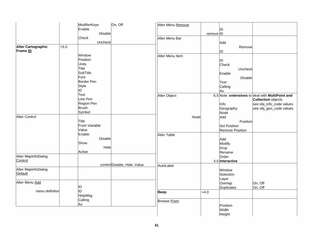
ModifierKeys On, Off Enable Disable Check Uncheck Alter Cartographic Frame ID
+5.0
Window Position Units Title SubTitle Font Border Pen Style ID Text Line Pen Region Pen Brush. Symbol Alter Control Title From Variable Value Enable Disable Show Hide Active Alter MapInfoDialog Control
control Disable, Hide, Value Alter MapInfoDialog Default
Alter Menu Add ID
menu defintion ID HelpMsg Calling As
Alter Menu Remove ID remove ID Alter Menu Bar Add Remove ID Alter Menu Item ID Check Uncheck Enable Disable Text Calling As Alter Object 6.5 Note: extensions to deal with MultiPoint and
Collection objects Info see obj_info_code values Geography see obj_geo_code values Node
Node Add Position Set Position Remove Position Alter Table Add Modify Drop Rename Order 4.0 Interactive AutoLabel Window Selection Layer Overlap On, Off Duplicates On, Off Beep +4.0 Browse From Position Width Height

42
Units Row Column Min Max Call Close All Interactive Close File # Close Table Interactive Close Window 4.0 Interactive Commit Table As 5.0 Type Native Type DBF +4.1 Type Access
Database
+5.0 Type Query +4.1 Table +4.1 Password Charset CoordSys Version +4.1 Interactive +4.1 Automatic Continue Create Arc Into Window Variable Pen Create ButtonPad As ID Title Width Position Units 4.0 ToolbarPosition
4.0 Fixed 4.0 Float Show Hide
button definition Separator, PushButton, ToggleButton, ToolButton
4.0 Calling +OLE, DDE ID Icon Cursor File 4.0 DrawMode +2 modes HelpMsg ModifierKeys On, Off Enable Disable Check Uncheck Create ButtonPads As Default
Create Cartographic Legend
+5.0
From Window Behind Position Width Height Units Window Title ScrollBars On, Off Portrait Landscape Custom Default Frame Title Defautl Frame
Subtitle
Default Frame Style Default Frame
Border Pen
frame definition Frame From Layer +5.5 Using +5.5 Column +5.5 Label
Position
43
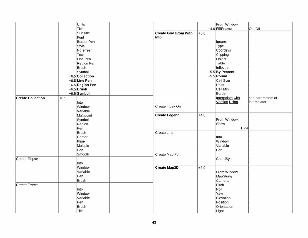
Units Title SubTitle Font Border Pen Style Norefresh Text Line Pen Region Pen Brush Symbol +6.5 Collection +6.5 Line Pen +6.5 Region Pen +6.5 Brush +6.5 Symbol Create Collection +6.5 Into Window Variable Multipoint Symbol Region Pen Brush Center Pline Multiple Pen Smooth Create Ellipse Into Window Variable Pen Brush Create Frame Into Window Variable Pen Brush Title
From Window +4.0 FillFrame On, Off Create Grid From With Into
+5.0
Ignore Type Coordsys Clipping Object Table Inflect at +5.5 By Percent +5.5 Round Cell Size Units Cell Min Border Interpolate with
Version Using see parameters of interpolator
Create Index On Create Legend +4.0 From Window Show Hide Create Line Into Window Variable Pen Create Map For CoordSys Create Map3D +6.0 From Window MapString Camera Pitch Roll Yaw Elevation Position Orientation Light
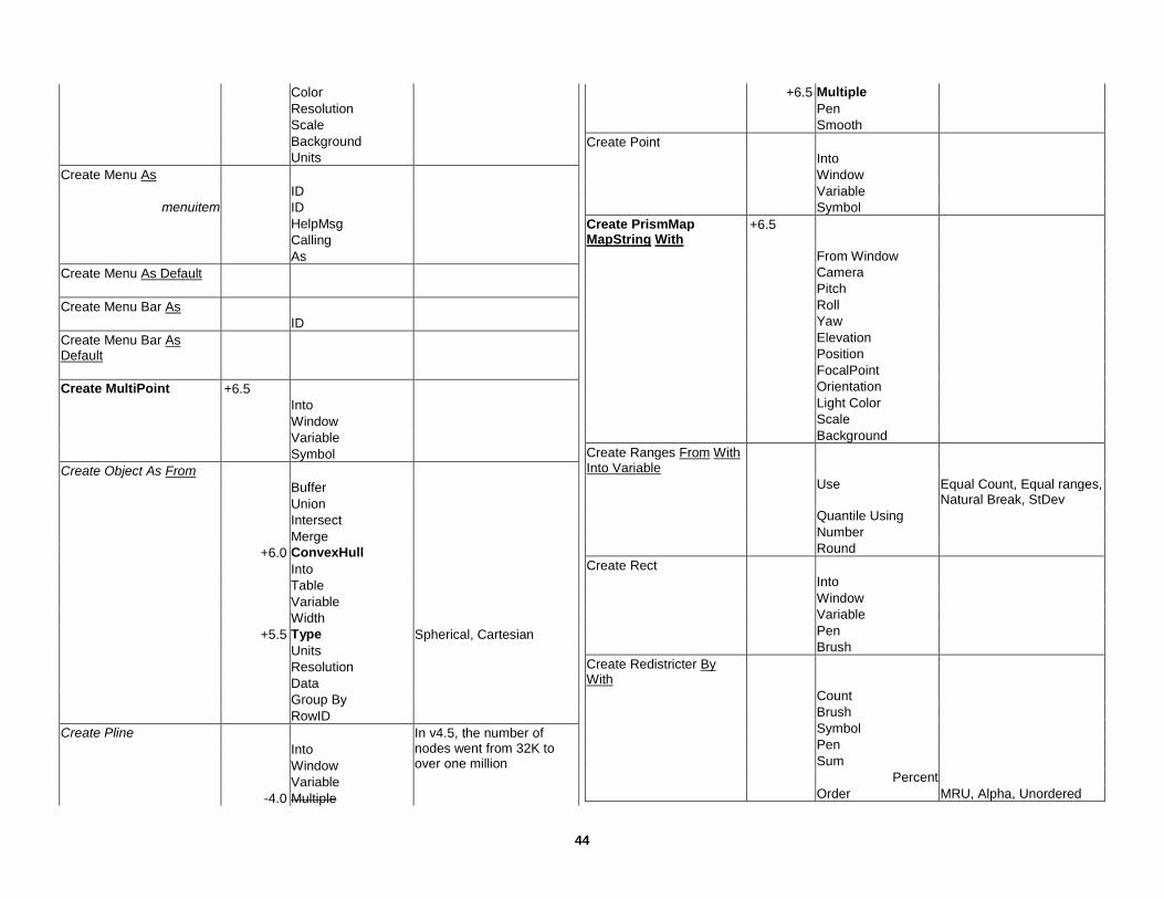
44
Color Resolution Scale Background Units Create Menu As ID
menuitem ID HelpMsg Calling As Create Menu As Default Create Menu Bar As ID Create Menu Bar As Default
Create MultiPoint +6.5 Into Window Variable Symbol Create Object As From Buffer Union Intersect Merge +6.0 ConvexHull Into Table Variable Width +5.5 Type Spherical, Cartesian Units Resolution Data Group By RowID Create Pline Into Window
In v4.5, the number of nodes went from 32K to over one million
Variable -4.0 Multiple
+6.5 Multiple Pen Smooth Create Point Into Window Variable Symbol Create PrismMap MapString With
+6.5
From Window Camera Pitch Roll Yaw Elevation Position FocalPoint Orientation Light Color Scale Background Create Ranges From With Into Variable
Use Equal Count, Equal ranges, Natural Break, StDev
Quantile Using Number Round Create Rect Into Window Variable Pen Brush Create Redistricter By With
Count Brush Symbol Pen Sum Percent Order MRU, Alpha, Unordered

45
Create Region Into Window
In v4.5, the number of nodes went from 32K to over one million
Variable Pen Brush Center Create Report From Table
+5.0
Into Interactive Create RoundRect Into Window Variable Pen Brush Create Styles From To Vary Into Variable
Pen Brush Symbol Color By RGB, HSV Background By RGB, HSV Size By Log, Sqrt, Constant Number Inflect At With Create Table File Type Native Type DBF CharSet 4.1 Type Access
Database
4.1 Table 4.1 Password Version Create Text Into Window Variable Font Label Line Simple, Arrow Spacing 1.0, 1.5, 2.0
Justify Left, Center, Right Angle DDEExecute DDEPoke DDETerminate DDETerminateAll Declare Function As ByVal As Declare Function Lib As Alias ByVal As Declare Sub ByVal As Declare Sub Lib Alias ByVal As Define Delete From Object Where Rowid=+6.5 Dialog Title Width Height Position Calling At least one control clause Control …
Dialog preserve Dialog Remove Dim As Do Case End Case Case Case Else

46
Do Loop Until While Drop Index Drop Map Drop Table End MapInfo +4.0 Interactive End Program Error Exit Do Exit For Exit Function Exit Sub Export Into Type MIF, DBF, ASCII CharSet Delimiter Titles +4.0 Overwrite Export Into Type DXF +4.0 Overwrite +4.0 Preserve +4.0 AttributeData +4.0 MultiPolygonRgns +4.0 As Blocks +4.0 Binary +4.0 ASCII +4.0 DecimalPlaces +4.0 Version 12, 13 +4.0 Transform Fetch From First, Last, Next,
Prev, Rec
Find Interactive Find Using Refine Using Options Abbrs On, Off ClosestAddr On, Off OtherBdy On, Off Symbol +6.0 Inset +6.0 Percent +6.0 Distance Units +6.0 Offset For Next To Step Function End Function As ByVal As Get # Global As GoTo Graph From Position Width Height Units Min Max +5.5 Using +5.5 Restore +5.5 Series in Columns If End If Then Else ElseIf Import Type MIF, MBI, MMI, IMG, PICT Into +4.0 Overwrite Import Type DXF Into

47
+4.0 Overwrite +4.0 Warnings On, Off +4.0 Preserve +4.0 AttributeData +4.0 Blocks As
MultipolygonRgns
+4.0 CoordSys +4.0 AutoFlip +4.0 Transform +4.0 Read +4.0 Integer As Decimal +4.0 Float As Decimal +4.0 Store +4.0 Handles +4.0 Elevation +4.0 VisibleOnly
layer definition +4.0 Layer +4.0 Into +4.0 Preserve +4.0 AttributeData +4.0 Blocks As
MultipolygonRgns
Include Input # Insert Into Values Select From Kill Layout Position Width Height Units Min Max Line Input # Map From Position Width
Height Units Min Max Menu Bar Hide Show Metadata Table +4.0 SetKey To DropKey Hierarchical SetTraverse Into ID Metadata Traverse +4.0 Next Into Key Into Value Destroy Note Objects Check From +6.0 Into Table +6.5 SelfInt Symbol Overlap Pen Brush +6.5 Gap +6.5 Units Objects Clean From +6.5 Overlap Gap Units Objects Combine Into Target Data Objects Disaggregate +6.5 IntoTable All Collection Data Objects Enclose +6.0 Into Table +6.5 Region

48
Objects Erase Into Target Data Objects Intersect Into Target
Data Objects Overlay Into Target
Objects Snap From +6.5 Tolerance Node Vector Units Thein Bend Distance Cull Area Objects Split Into Target Data OnError GoTo Open File As For Input, Output, Append,
Random, Binary Access Read, Write, Read Write # Len= ByteOrder Lowhigh, Highlow Charset Filetype Open Report +5.0 Open Table As Hide ReadOnly Interactive +4.1 Password +4.1 NoIndex +6.0 View Automatic +6.0 DenyWrite Open Window Pack Table
Graphic Data +4.0 Graphic Data +4.0 Interactive Print Print # PrintWin Window Interactive ProgressBar Calling Range Put # Randomize With ReDim Register Table Type Native, DBF, Ascii, WKS,
XLS +4.1 Access +5.0 ODBC +5.5 Grid, Raster CharSet Delimiter Titles Range Into +4.1 Table +4.1 Password +5.0 Cache On, Off +5.0 Connection +5.0 Handle +5.5 Toolkit +6.5 controlPoints +6.5 Coordsys +6.5 Interactive Relief Shade +5.5 Grid Horizontal Vertical Scale

49
Reload Symbols Reload Custom Symbols From
+4.0
Remove Cartographic Frame ID
+5.0
Window Remove Map Layer Window +4.1 Interactive Rename File As Rename Table As Reproject From +4.1 Resume 0 Next RollBack Table Run Application Run Command Run Menu Command +4.0 ID Run program Save File As Append Save Window As Type Type BMP, WMF, PICT, RAS,
GIF, TIFF, EPS 4.0 type BMP, WMF, PICT 4.1 type BMP, WMF, JPEG,PNG,
TIFF,PSD,PICT 6.5 type BMP, WMF,JPEG,PNG,
TIFF,TIFFCMYK,PSD,EMF +4.0 Width +4.0 Height +4.0 Units +4.1 Copyright
+4.1 Font Save Workspace As Seek # Select From Where Into Group By Order By +4.0 Noselect Server Begin Transaction
+4.0 SQL-DL
Server Bind Column +4.0 SQL-DL Server Close +4.0 SQL-DL Server Commit +4.0 SQL-DL Server Create Map For Type
+4.0
4.5+++ type -6.0 MICODE, HHCODE, XYINDEX
+4.5 SQS +5.0, -5.5 SDO +5.5 SPATIALWARE CoordSys Symbol +4.1,6.0 ObjectType Point, Line, Region,
+6.0 All +4.1 Symbol +4.1 Linestyle +4.1 Regionstyle +4.1 Pen +4.1 Brush +6.5 StyleType +6.5 Column Server Create Style +6.5 (Server Set Map Style ) Type Column Server Disconnect +4.0 SQL-DL
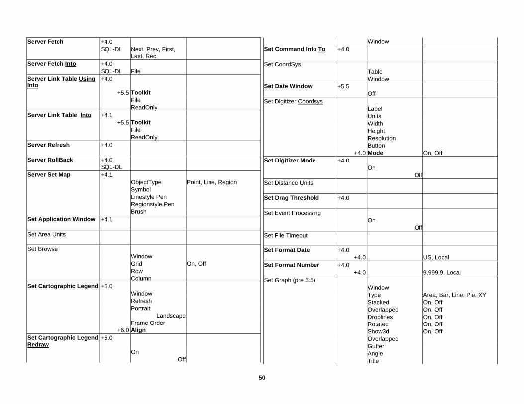
50
Server Fetch +4.0 SQL-DL Next, Prev, First,
Last, Rec
Server Fetch Into +4.0 SQL-DL File Server Link Table Using Into
+4.0
+5.5 Toolkit File ReadOnly Server Link Table Into +4.1 +5.5 Toolkit File ReadOnly Server Refresh +4.0 Server RollBack +4.0 SQL-DL Server Set Map +4.1 ObjectType Point, Line, Region Symbol Linestyle Pen Regionstyle Pen Brush Set Application Window +4.1 Set Area Units Set Browse Window Grid On, Off Row Column Set Cartographic Legend +5.0 Window Refresh Portrait Landscape Frame Order +6.0 Align Set Cartographic Legend Redraw
+5.0
On Off
Window Set Command Info To +4.0 Set CoordSys Table Window Set Date Window +5.5 Off Set Digitizer Coordsys Label Units Width Height Resolution Button +4.0 Mode On, Off Set Digitizer Mode +4.0 On Off Set Distance Units Set Drag Threshold +4.0 Set Event Processing On Off Set File Timeout Set Format Date +4.0 +4.0 US, Local Set Format Number +4.0 +4.0 9,999.9, Local Set Graph (pre 5.5) Window Type Area, Bar, Line, Pie, XY Stacked On, Off Overlapped On, Off Droplines On, Off Rotated On, Off Show3d On, Off Overlapped Gutter Angle Title

51
Font Series definition Series
Pen Brush Line Symbol Title Wedge
Axis definition Axis Label, Value Tick Major, Minor Cross, Inside, None,
Outside Grid Major, Minor On, Off Pen Labels None, At Axis Font Min Max Cross Auto Unit Major, Minor Pen Title Font
Legend Legend Title Font Subtitle Range Set Graph (5.5 on) +5.5 Window Title SubTitle TitleSeries TitleGroup TitleAxisY1 TitleAxisY2 Set Handler +4.0 On Off Set Layout Window Center
Extents To Fit Pagebreaks On, Off Frame Contents Active, On, Off Ruler On, Off Zoom To Fit Set Legend Window
layer definition Layer Prev Display On, Off Shades On, Off Symbols On, Off Lines On, Off Count On, Off Title +5.0 Auto Font Subtitle Ascending On, Off Ranges Display On, Off Set Map Window Center +4.0 Smart Redraw +4.0 Clipping Object, On Off +6.0 Using Display All, PolyObj +6.0 Using Overlay Zoom Units Entire Layer Preserve Scale, Zoom Display Scale, Position, Zoom Order Pan North, South, East, Wesr CoordSys Area Units Distance Units +5.5 Distance Type Spherical, Cartesian XY Units +5.5 Display Decimal On, Off +6.5 Display Grid Scale For Redraw On, Off
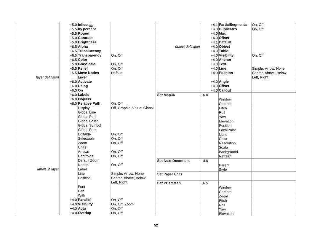
52
+5.0 Inflect at +5.5 by percent +5.5 Round +5.0 Contrast +5.0 Brightness +6.5 Alpha +6.5 Translucency +6.5 Transparency On, Off +6.5 Color +5.0 GrayScale On, Off +5.5 Relief On, Off +5.5 Move Nodes Default
layer definition Layer +6.0 Activate +6.0 Using +6.0 On +6.0 Labels +6.0 Objects +6.0 Relative Path On, Off
Display Off, Graphic, Value, Global Global Line Global Pen Global Brush Global Symbol Global Font Editable On, Off Selectable On, Off Zoom On, Off Units Arrows On, Off Centroids On, Off Default Zoom Nodes On, Off
labels in layer Label Line Simple, Arrow, None Position Center, Above,,Below Left, Right Font Pen With +4.0 Parallel On, Off +4.0 Visibility On, Off, Zoom +4.0 Auto On, Off +4.0 Overlap On, Off
+4.1 PartialSegments On, Off +4.0 Duplicates On, Off +4.0 Max +4.0 Offset +4.1 Default
object definition +4.0 Object +4.0 Table +4.0 Visibility On, Off +4.0 Anchor +4.0 Text +4.0 Line Simple, Arrow, None +4.0 Position Center, Above,,Below Left, Right +4.0 Angle +4.0 Offset +4.0 Callout Set Map3D +6.0 Window Camera Pitch Roll Yaw Elevation Position FocalPoint Light Color Resolution Scale Background Refresh Set Next Document +4.0 Parent Style Set Paper Units Set PrismMap +6.5 Window Camera Zoom Pitch Roll Yaw Elevation
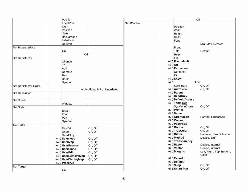
53
Position FocalPoint Light Position Color Background Label With Refresh Set ProgressBars On Off Set Redistricter Change To Add Remove Pen Brush Symbol Set Redistricter Order order Alpha, MRU, Unordered Set Resolution Set Shade Window Set Style Brush Font Pen Symbol Set Table FastEdit On, Off Undo On, Off ReadOnly +4.0 Seamless On, Off +4.0 UserMap On, Off +4.0 UserBrowse On, Off +4.0 UserClose On, Off +4.0 UserEdit On, Off +4.0 UserRemoveMap On, Off +4.0 UserDisplayMap On, Off +4.0 Preserve Set Target On
Off Set Window Position Width Height Units Font Min, Max, Restore Front Title Default Help File +4.0 File default +4.0 Off +4.0 Permanent Contents ID +4.0 Show +4.0 Hide ScrollBars On, Off +4.0 AutoScroll On, Off +4.0 Parent +4.0 ReadOnly +4.0 Default Access +4.0 Table Rec SysMenuClose On, Off +5.5 Printer +5.5 Name +5.5 Orientation Portrait, Landscape +5.5 Copies +6.0 Papersize +6.0 Border On, Off +6.0 TrueColor On, Off +6.0 Dither Halftone, ErrorDiffusion +6.0 Method Device, Emf +6.0 Transparency +6.0 Raster Device, Internal +6.0 Vector Device, Internal +6.0 Margins Left, Right, Top, Bottom,
Units +6.0 Export +6.0 Default +5.5 Snap On, Off +5.5 Smart Pan On, Off
54
+5.5 Threshold Default Shade With Ranges Window Ignore Apply Color, Size, All Use Color, Size, All From Variable Style Variable Default Pen Line Brush Symbol Shade With Values Window Ignore Default Pen Line Brush Symbol Shade With Density Window Color Shade With Graduated Window Symbol Inflect Symbol Vary Size by Log, Sqrt, Const Shade With Pie Window Selection Half Angle Counter Fixed Max Size Units At Value Vary Size by Log, Sqrt, Const Border Pen Position Left, Right, Center Above, Below, Center Style Brush
Shade With Bar Stacked Bar Window Selection Normalized Fixed Max Size Units At Value Vary Size by Log, Sqrt, Const Border Pen Frame Brush Width Position Left, Right, Center Above, Below, Center Style Brush Status Bar Show Hide Message +4.5 ViewDisplayPopUp On, Off +4.5 EditLayerPopUp On, Off Stop Sub End Sub ByVal As Terminate Application Type End Type As UnDim +4.0 Unlink +4.0 Update Set Where RowID = Update Window While Wend Write #

Related Documents