8/9/2014 Evernote shared notebook: geography https://www.evernote.com/pub/crazyphoton/geography#st=p&n=58a62826-44a4-4286-864a-b494cedfeda6 1/39 India Tuesday, April 24 2012, 3:37 PM A sustainable agricultural practice However, there are regions all over the world where abstraction of groundwater does not require a pump. Once the drilling of bore-hole to the specific aquifer (essentially artesian 2 ) is completed, the pressure within the aquifer forces the groundwater to rise above the ground surface naturally without using a pump. These types of wells are known as flowing artesian wells. Flowing wells are an uncommon manifestation of geological activities (Swamee et al: 2000). Expansion of water due to release of pressure and compression of aquifer formation material are responsible for the water flow from such wells (Jacob: 1940). In Uttarakhand, such type of wells - of width up to 25 km and having a general slope less than 1%, is restricted only to the Tarai zone. . The formation of the Tarai region is dependent on the evenly sorted finer material that was washed away by the streams from the hilly tracts. The northern limit of the Tarai belt is in contact with the Bhabar zone which is bound by the lower Shiwalik range of Himalayas in the north. The Bhabar zone can also be referred as piedmont alluvial terrain that comprises ill-sorted sediments ranging from big boulders to silt. Since this zone is very porous and permeable it forms the recharge area of the artesian aquifer system in the Tarai zone. Moreover, the region between Bhabar and Tarai belts forms the spring line (the landmass with marshy conditions). This spring line is of the source of various perennial streams in the region. Since the slope of Bhabar zone varies from 1- 2%, the elevation difference between the recharging area in Bhabar zone and water withdrawing position (i.e. well) in Tarai zone creates the artesian head in the aquifer which is directly responsible for the existence of flowing wells. Tarai soils are rich in clay and organic matter and that is why this belt is considered one of the highly productive agricultural areas in India. Availability of irrigation water from flowing wells without spending any energy on its withdrawal is one of the factors that could reduce agricultural costs.. The introduction of highly mechanised agricultural practices since the last two to three decades has encouraged the farmers to adopt the intensive cultivation in the region. Consequently, the demand for irrigation water has increased significantly. The trajectory of water resources development has thus been following a simple principle of “developing”, which in the case of groundwater means extracting more water to produce more grain (Kulkarni and Shah: 2013). Other than this, the rising domestic and industrial needs for water have further stressed the existing groundwater resources. Collectively, it has resulted in the development of more number of bore wells which has increased the density of flowing wells in the Tarai belt. As expected, the discharge rates of these wells have drastically decreased and are declining further with time. Overexploitation and environmental damage A preliminary study on the thermal characteristics of water sampled from the seven flowing wells located in a radius of more than 15 km has revealed that all the wells are installed in the same aquifer. Definitely, the installation of more wells in this stretch will directly affect the yield of other wells. It can be judged from the fact that in year 197 0, the water pressure of these flowing wells at the ground surface was over 2 kg/cm 2 (Michael: 2006) which now has dropped to ~ 0.2 kg/cm 2 . Moreover, the figures mentioned are for the monsoon season only which would be lesser than this value during the dry season. Presently, the flowing behaviour of wells in certain pockets of the region have become seasonal (see Figures 1) and few others are completely dried (Figure 2a) and are abandoned now. Other than the over exploitation of groundwater due to overall development and industrialisation in the Tarai zone, haphazard felling of trees for converting forest land into industrial/agricultural land, reduction of water pressure in the artesian aquifers due to increased leakage of water from confined to unconfined aquifers through the increased number of bore-holes for developing tube wells, and unattended flowing of these wells without any beneficial purpose (Figure 2b below) are the additional causes for their changed behaviour. The current scenario will further worsen with the reduction in recharging of these artesian aquifers in Bhabar zone due to changed rainfall pattern in Himalayan (Vashisht and Bam: 2013) and Shiwalik foothill regions. For proper recharging of the aquifers, rainfall intensity should be less than the water intake capacity of the land surface. According to a World Bank report , global mean warming is approaching 4°C. This will result in a 10% increase in annual mean monsoon intensity and a 15% increase in a year-to-year variability of Indian summer monsoon precipitation is projected compared to normal levels during the first half of the 20th century (World Bank: 2013). The report further emphasises that these changes imply an extreme wet monsoon. This is projected to occur every 10 years by the end of the century compared to the currently probability of it occurring only once in 100 years. These extremes of weather conditions are likely to affect flowing wells adversely. With the number of flowing wells dwindling, abstraction of water will be dependent on the diesel engine or electric motor operated pumps. This increase in the energy cost will be added to the production cost of the crops. To equalise the profit margin, it is likely that food prices will be increased which will affect the end consumer adversely. Nevertheless, the impact of the above mentioned factors can be drastically reduced by strengthening the farmers’ knowledge regarding the groundwater hydraulics with special attention on the groundwater movement from the recharging zone to flowing artesian wells in their fields. But, the immediate action that is required at this stage is to increase awareness so that the farmers in the region can install control valves on the flowing wells to avoid water loss. The farmers who are aware of the consequences of this water loss have already adopted these measures by using end plugs or end plates for the purpose. However, these measures are not so effective in completely controlling the water loss (see Figure 3 below). Lack of general maintenance of control valves, non-replacement of end-plug gaskets at appropriate intervals, and improper tightening of the nuts and bolts of the pipe are the main reasons of this major water loss. Additionally, there is a need to demarcate the major recharging zones in Bhabar belt and any kind of development other than the construction of water conservation/harvesting structures should be restricted on it. Environmental isotope techniques can be efficiently used for the purpose (Shivanna et al: 2008). Conserving groundwater resources at this stage is crucial in the Tarai and Bhabar belt before it’s too late. JANUARY 2014 - CURRENT AFFAIRS - CVIL SERVICES EXAM 2014 Q1 - WRITE A SHORT NOTE ON "SMILE WELLNESS PROGRA MME & ITS SIGNIFICA NCE? [ 50 WORDS] Q2 - ENUMERATE THE SALIENT FEATURES OF SUPPRESSION OF UNLAWFUL ACTS AGAINST SAFETY OF MARITIME NAVIGATION AND FIXED PLATFORMS ON CONTINENTAL SHELF ACT, 2002? HOW APPLICATION OF SUA ACT IN ITALIAN MARINES CASE MAY AFFECT INDIA-EU RELATIONS [ 200 words] Q3 - WHA T DO Y OU MEA N BY “DEXTER”? BRIEFLY MENTION THE SIGNIFICA NCE OF DEXTER? DISCU SS THE ROLE OF CERT-In? [200 WORDS] Q4 – WHA T IS “FED TA PERING”? ENUMERA TE THE REA SONS WHY US HA S STA RTED FED TA PERING? WHA T A RE THE IMPLICA TIONS OF FED TA PERING ON EMERGING MARKETS LIKE INDIA? [200 words] Q5 – DEFINE ‘A V A LA NCHES”? HOW IT OCCURS? DESCRIBE THE V A RIOUS PREV ENTIV E STEPS TA KEN BY GOV ERNMENT OF INDIA TO CONTROL AVALANCHES? [200 WORDS] Q6 – WHA T DO Y OU MEA N BY “PONZI SCHEME”? HOW PONZI SCHEME DIFFERS FROM PY RA MID SCHEME? DISCUSS THE ROLE OF SEBI IN CONTROLLING PONZI SCHEMES? [200 WORDS]

Evernote Shared Notebook_ Geography1
Dec 04, 2015
geography
Welcome message from author
This document is posted to help you gain knowledge. Please leave a comment to let me know what you think about it! Share it to your friends and learn new things together.
Transcript
8/9/2014 Evernote shared notebook: geography
https://www.evernote.com/pub/crazyphoton/geography#st=p&n=58a62826-44a4-4286-864a-b494cedfeda6 1/39
India
Tuesday, April 24 2012, 3:37 PM
A sustainable agricultural practice
However, there are regions all over the world where abstraction of groundwater does not require a pump. Once the drilling of bore-hole to the specific
aquifer (essentially artesian2) is completed, the pressure within the aquifer forces the groundwater to rise above the ground surface naturally without
using a pump. These ty pes of wells are known as flowing artesian wells. Flowing wells are an uncommon manifestation of geological activ ities (Swamee et al:
2000). Expansion of water due to release of pressure and compression of aquifer formation material are responsible for the water flow from such wells
(Jacob: 1940). In Uttarakhand, such ty pe of wells - of width up to 25 km and hav ing a general slope less than 1%, is restricted only to the Tarai zone. .
The formation of the Tarai region is dependent on the evenly sorted finer material that was washed away by the streams from the hilly tracts. The northern
limit of the Tarai belt is in contact with the Bhabar zone which is bound by the lowerShiwalik range of Himalay as in the north. The Bhabar zone can also be
referred as piedmont alluv ial terrain that comprises ill-sorted sediments ranging from big boulders to silt. Since this zone is very porous and permeable it
forms the recharge area of the artesian aquifer sy stem in the Tarai zone. Moreover, the region between Bhabar and Tarai belts forms the spring line (the
landmass with marshy conditions). This spring line is of the source of various perennial streams in the region. Since the slope of Bhabar zone varies from 1-
2%, the elevation difference between the recharging area in Bhabarzone and water withdrawing position (i.e. well) in Tarai zone creates the artesian head in
the aquifer which is directly responsible for the existence of flowing wells.
Tarai soils are rich in clay and organic matter and that is why this belt is considered one of the highly productive agricultural areas in India. Availability of
irrigation water from flowing wells without spending any energy on its withdrawal is one of the factors that could reduce agricultural costs.. The
introduction of highly mechanised agricultural practices since the last two to three decades has encouraged the farmers to adopt the intensive cultivation
in the region. Consequently , the demand for irrigation water has increased significantly . The trajectory of water resources development has thus been
following a simple principle of “developing”, which in the case of groundwater means extracting more water to produce more grain (Kulkarni and Shah:
2013). Other than this, the rising domestic and industrial needs for water have further stressed the existing groundwater resources. Collectively , it has
resulted in the development of more number of bore wells which has increased the density of flowing wells in the Tarai belt. As expected, the discharge
rates of these wells have drastically decreased and are declining further with time.
Overexploitation and environm ental dam age
A preliminary study on the thermal characteristics of water sampled from the seven flowing wells located in a radius of more than 15 km has revealed that
all the wells are installed in the same aquifer. Definitely , the installation of more wells in this stretch will directly affect the y ield of other wells. It can be
judged from the fact that in y ear 197 0, the water pressure of these flowing wells at the ground surface was over 2 kg/cm2 (Michael: 2006) which now has
dropped to ~ 0.2 kg/cm2. Moreover, the figures mentioned are for the monsoon season only which would be lesser than this value during the dry season.
Presently , the flowing behaviour of wells in certain pockets of the region have become seasonal (see Figures 1) and few others are completely dried (Figure
2a) and are abandoned now.
Other than the over exploitation of groundwater due to overall development and industrialisation in the Tarai zone, haphazard felling of trees for
converting forest land into industrial/agricultural land, reduction of water pressure in the artesian aquifers due to increased leakage of water from
confined to unconfined aquifers through the increased number of bore-holes for developing tube wells, and unattended flowing of these wells without any
beneficial purpose (Figure 2b below) are the additional causes for their changed behaviour. The current scenario will further worsen with the reduction in
recharging of these artesian aquifers in Bhabar zone due to changed rainfall pattern in Himalay an (Vashisht and Bam: 2013) and Shiwalik foothill regions.
For proper recharging of the aquifers, rainfall intensity should be less than the water intake capacity of the land surface.
According to a World Bank report, global mean warming is approaching 4°C. This will result in a 10% increase in annual mean monsoon intensity and a 15%
increase in a y ear-to-y ear variability of Indian summer monsoon precipitation is projected compared to normal levels during the first half of the 20th
century (World Bank: 2013). The report further emphasises that these changes imply an extreme wet monsoon. This is projected to occur every 10 y ears
by the end of the century compared to the currently probability of it occurring only once in 100 y ears. These extremes of weather conditions are likely to
affect flowing wells adversely . With the number of flowing wells dwindling, abstraction of water will be dependent on the diesel engine or electric motor
operated pumps. This increase in the energy cost will be added to the production cost of the crops. To equalise the profit margin, it is likely that food prices
will be increased which will affect the end consumer adversely .
Nevertheless, the impact of the above mentioned factors can be drastically reduced by strengthening the farmers’ knowledge regarding the groundwater
hy draulics with special attention on the groundwater movement from the recharging zone to flowing artesian wells in their fields. But, the immediate action
that is required at this stage is to increase awareness so that the farmers in the region can install control valves on the flowing wells to avoid water loss. The
farmers who are aware of the consequences of this water loss have already adopted these measures by using end plugs or end plates for the purpose.
However, these measures are not so effective in completely controlling the water loss (see Figure 3 below). Lack of general maintenance of control valves,
non-replacement of end-plug gaskets at appropriate intervals, and improper tightening of the nuts and bolts of the pipe are the main reasons of this major
water loss.
Additionally , there is a need to demarcate the major recharging zones in Bhabar belt and any kind of development other than the construction of water
conservation/harvesting structures should be restricted on it. Environmental isotope techniques can be efficiently used for the purpose (Shivanna et al:
2008). Conserv ing groundwater resources at this stage is crucial in the Tarai and Bhabar belt before it’s too late.
JANUARY 2014 - CURRENT AFFAIRS - CVIL SERVICES EXAM 2014
Q1 - WRITE A SHORT NOTE ON "SMILE WELLNESS PROGRAMME & ITS SIGNIFICANCE? [ 50 WORDS]
Q2 - ENUMERATE THE SALIENT FEATURES OF SUPPRESSION OF UNLAWFUL ACTS AGAINST SAFETY OF MARITIME NAVIGATION AND FIXED
PLATFORMS ON CONTINENTAL SHELF ACT, 2002? HOW APPLICATION OF SUA ACT IN ITALIAN MARINES CASE MAY AFFECT INDIA-EU RELATIONS [
200 words]
Q3 - WHAT DO Y OU MEAN BY “DEXTER”? BRIEFLY MENTION THE SIGNIFICANCE OF DEXTER? DISCUSS THE ROLE OF CERT-In? [200 WORDS]
Q4 – WHAT IS “FED TAPERING”? ENUMERATE THE REASONS WHY US HAS STARTED FED TAPERING? WHAT ARE THE IMPLICATIONS OF FED TAPERING
ON EMERGING MARKETS LIKE INDIA? [200 words]
Q5 – DEFINE ‘AVALANCHES”? HOW IT OCCURS? DESCRIBE THE VARIOUS PREVENTIVE STEPS TAKEN BY GOVERNMENT OF INDIA TO CONTROL
AVALANCHES? [200 WORDS]
Q6 – WHAT DO Y OU MEAN BY “PONZI SCHEME”? HOW PONZI SCHEME DIFFERS FROM PY RAMID SCHEME? DISCUSS THE ROLE OF SEBI IN
CONTROLLING PONZI SCHEMES? [200 WORDS]

8/9/2014 Evernote shared notebook: geography
https://www.evernote.com/pub/crazyphoton/geography#st=p&n=58a62826-44a4-4286-864a-b494cedfeda6 2/39
Q7 - WHAT DO Y OU MEAN BY “EAVESDROPPING”? “INDIA NEEDS EAVESDROPPING SY STEM LIKE CENTRAL MONITORING SY STEM” – COMMENT? [200
WORDS]
Q8 - TEESTA RIVER WATER SHARING ISSUE & ITS IMPACT ON INDIA -BANGLADESH RELATIONS [200 WORDS]
Q9 - WHAT DO Y OU MEAN BY “QUANTITATIVE EASING”? HOW IT INFLUENCES EMERGING ECONOMIES LIKE INDIA? CAN INDIA FOLLOW
QUANTITATIVE EASING POLICY LIKE USA – COMMENT? [ 200 WORDS]
Q10 -WHAT DO Y OU MEAN BY “SPECTRUM”? “SPECTRUM IS CONSIDERED AS A SOVEREIGN ASSET” – CRITICALLY ANALY ZE? [200 WORDS]
Q11 - WRITE A SHORT NOTE ON STRUCTURE, MANDATE & FUNCTIONS OF NCPCR? [100 WORDS]
Q 12 – WRITE A SHORT NOTE ON “NAWADCO”? [50 WORDS]
Q13 - SPECIAL ARTICLE "GEOPOLITICAL GAME AROUND A TEMPORARY LINE –“LINE OF CONTROL"
Q14 - INDIA IS OFTEN CALLED "INTANGIBLE CULTURAL HERITAGE" OF THE WORLD. CRITICALLY EVALUATE THE STATEMENT BY USING FOLK
DANCES OF INDIA AS AN EXAMPLE [ 300 WORDS]
Q15 – WHAT DO Y OU MEAN BY “ATMOSPHERIC BROWN CLOUD”? DESCRIBE THE REASONS AND ITS IMPACTS ON SOUTH ASIA? [200 words]
Q15 - WHAT IS ASACUSA EXPERIMENT? DISCUSS IN DETAIL THE SIGNIFICANCE OF IT? [100 WORDS]
Q 16 – WRITE A SHORT NOTE ON NATIONAL SPORTS DEVELOPMENT FUND [ 50 WORDS]
Q17 - WHAT DO Y OU MEAN BY “INNOVATION”? THE BOTTOM OF ECONOMIC PY RAMID [SME] NEEDS CAPITAL ASSISTANCE TO ENHANCE THEIR
INNOVATION SKILLS.IN THIS BACKGROUND, DISCUSS THE VARIOUS OBJECTIVES AND SIGNIFICANCE OF RECENTLY LAUNCHED INDIA INCLUSION
INNOVATION FUND [ 100 WORDS]
Q18– WHAT DO Y OU MEAN BY “RURAL –URBAN CLUSTERS”? THE RECHRISTINED PURA SCHEME WILL ENSURE THE DEVELOPMENT OF RURAL-URBAN
CLUSTERS-COMMENT? [200 WORDS]
Q19 - WRITE A SHORT NOTE "NATIONAL COMMUNAL HARMONY AWARDS & ITS SIGNIFICANCE"? [ 50 WORDS]
Q20 - WHAT DO Y OU MEAN BY THE TERM "ABENOMICS"? HOW ABENOMICS IS DIFFERENT FROM 'LIKONOMICS'? DISCUSS IN DETAIL THE
IMPLICATIONS OF ABENOMICS TO INDIA? [200 WORDS]
Aluminium industry changes in world
Higher energy pricesEnergy shocks of 1973 and 1979, and the surge of energy demand in China, India, Brazil andother fast growing emerging economies in the early years of the new millennium have pushedup prices not only of oil but also of all other forms of energy (Figure 6). Even if discoveries ofnew energy supply or financial crises have kept prices at bay, the general trend has definitelybeen upward, thus increasing the price of electricity generation. The latter jump in electricityprices has dramatically altered the international competitiveness and hence location ofindustries such as aluminium whose production process uses large amounts of electricity.Energy shocks and the soaring energy demand in many emerging economies did not push upthe price of electricity equally in all countries. Some nations are endowed with ample suppliesof hydropower or low cost coal preventing electricity costs from rising as sharply as in nationsmore dependent on imported oil-generated power.The interregional differences in electricity prices and hence in countries’ primary aluminiumproduction costs were exacerbated by the factors mentioned above, accelerating the shift ofprimary aluminium production centres that began in the 1970s from high cost locations such asJapan, United States and Western Europe to lower cost regions such as Australia, Canada,Middle East, Russia and China.In the last 10-15 years, the shift has accelerated, with the Middle East strengthening its positionas a leading aluminium production centre; within China, the move is from the high cost areas ofthe south and south-east to the west and north-west regions.However, differences in electricity prices do not fully explain the shift in primary aluminiumproduction centres. The impact of public policy — electricity rates below the long-run marginalopportunity cost of production, taxes, exchange rates, trade tariffs, or industry subsidies — alsoneeds to be taken into account. The clear object
US share has gone down from 32% to 4% in last 40 yrs, Japan from 9% to zero.
Drainage Patterns

8/9/2014 Evernote shared notebook: geography
https://www.evernote.com/pub/crazyphoton/geography#st=p&n=58a62826-44a4-4286-864a-b494cedfeda6 3/39
8/9/2014 Evernote shared notebook: geography
https://www.evernote.com/pub/crazyphoton/geography#st=p&n=58a62826-44a4-4286-864a-b494cedfeda6 4/39
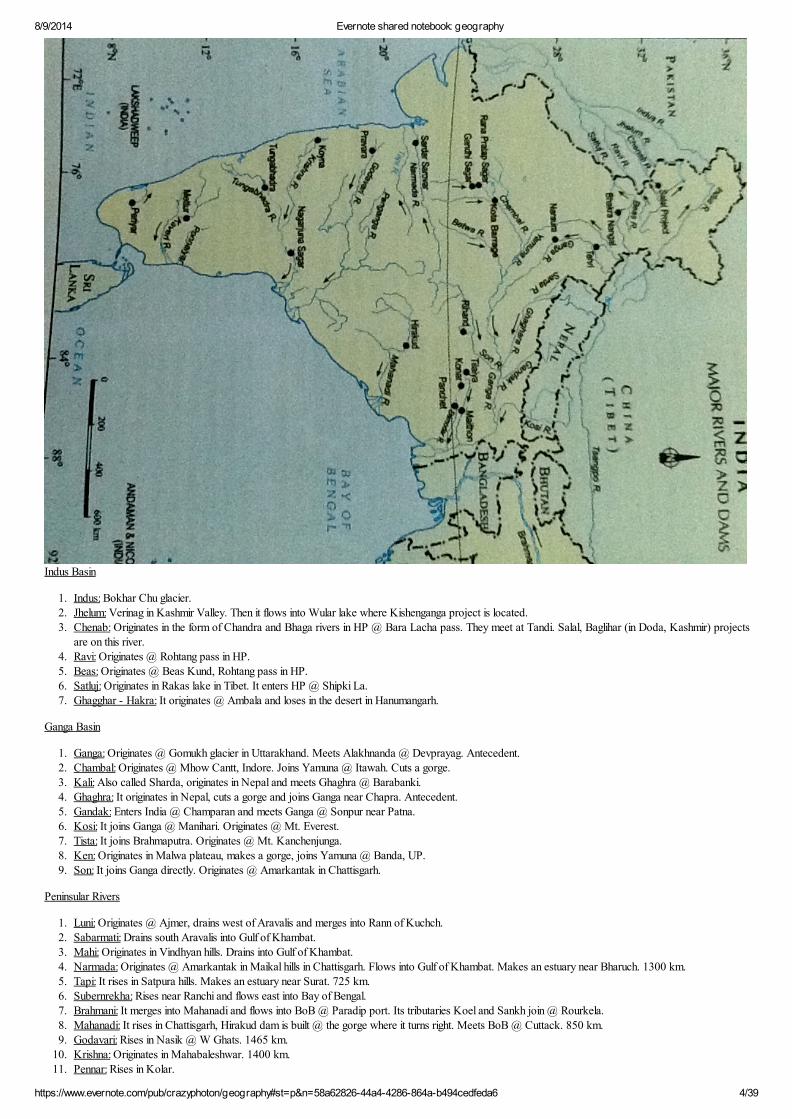
Indus Basin
1. Indus: Bokhar Chu glacier.2. Jhelum: Verinag in Kashmir Valley. Then it flows into Wular lake where Kishenganga project is located.3. Chenab: Originates in the form of Chandra and Bhaga rivers in HP @ Bara Lacha pass. They meet at Tandi. Salal, Baglihar (in Doda, Kashmir) projects
are on this river.4. Ravi: Originates @ Rohtang pass in HP.5. Beas: Originates @ Beas Kund, Rohtang pass in HP.6. Satluj: Originates in Rakas lake in Tibet. It enters HP @ Shipki La. 7. Ghagghar - Hakra: It originates @ Ambala and loses in the desert in Hanumangarh.
Ganga Basin
1. Ganga: Originates @ Gomukh glacier in Uttarakhand. Meets Alakhnanda @ Devprayag. Antecedent.2. Chambal: Originates @ Mhow Cantt, Indore. Joins Yamuna @ Itawah. Cuts a gorge.3. Kali: Also called Sharda, originates in Nepal and meets Ghaghra @ Barabanki. 4. Ghaghra: It originates in Nepal, cuts a gorge and joins Ganga near Chapra. Antecedent.5. Gandak: Enters India @ Champaran and meets Ganga @ Sonpur near Patna.6. Kosi: It joins Ganga @ Manihari. Originates @ Mt. Everest.7. Tista: It joins Brahmaputra. Originates @ Mt. Kanchenjunga.8. Ken: Originates in Malwa plateau, makes a gorge, joins Yamuna @ Banda, UP. 9. Son: It joins Ganga directly. Originates @ Amarkantak in Chattisgarh.
Peninsular Rivers
1. Luni: Originates @ Ajmer, drains west of Aravalis and merges into Rann of Kuchch. 2. Sabarmati: Drains south Aravalis into Gulf of Khambat.3. Mahi: Originates in Vindhyan hills. Drains into Gulf of Khambat.4. Narmada: Originates @ Amarkantak in Maikal hills in Chattisgarh. Flows into Gulf of Khambat. Makes an estuary near Bharuch. 1300 km.5. Tapi: It rises in Satpura hills. Makes an estuary near Surat. 725 km.6. Subernrekha: Rises near Ranchi and flows east into Bay of Bengal.7. Brahmani: It merges into Mahanadi and flows into BoB @ Paradip port. Its tributaries Koel and Sankh join @ Rourkela.8. Mahanadi: It rises in Chattisgarh, Hirakud dam is built @ the gorge where it turns right. Meets BoB @ Cuttack. 850 km.9. Godavari: Rises in Nasik @ W Ghats. 1465 km.
10. Krishna: Originates in Mahabaleshwar. 1400 km.11. Pennar: Rises in Kolar.
8/9/2014 Evernote shared notebook: geography
https://www.evernote.com/pub/crazyphoton/geography#st=p&n=58a62826-44a4-4286-864a-b494cedfeda6 5/39
12. Cauveri: It rises in S Mysore plateau and near Mysore Krishna Sagar dam has been built. 800 km.
Peninsular vs Himalayan Rivers
1. Peninsular rivers are old, have broad channels, slow moving, have hardly any vertical erosion and low carrying capacity. Himalayan rivers on the other hand are in late youth, deep vertical cutting, shallow channels in upper parts, swift as well as sluggish a d huge erosion capacity.
Climatic Regions
(C) Monsoons ki current understanding is that Jet streams play a key role in it . Old theories have all been discarded. Now, it is believed that the upper air circulations are as important as the
surface circulations:
The foolwing are the key players in Monsoon:
1. Northward shifting of the Westerly Jet (north of himalayas)
2. Tropical Easterly Jet Stream which is associated closely with the burst of monsoon. It is also a major reason why there are no cyclones during Monsoon because the presence of an Easterly jet
over the Indian landmass in the upper troposphere prevents vertical circulation of air...which is a pre-condition for formation of cyclones.
3. Northward shifting of the ITCZ.
4. S-E trade winds from S. hemisphere cross the equator and turn right due to coriolis force.
5. The location and shift of ITCZ governs the breaks and pulsating nature of monsoons.
6. ElNino/La Nina
A good source to understand Monsoon would be D D Khullar but I guess you need not go into too much detail for the sake of GS.
Regarding your other question...
Also, Tropical cyclones move from east to West.....they are secondary circulations and maintain the larger direction of the planetary winds (i.e Trade winds which blow from East to West).
So, any cyclones to form in Arabian sea is less likely to affect India.
Also, another reason that can be given is that the findlater jet of the coast of Somalia causes coastal upwelling and hence cooling of waters in the western Indian ocean...and cooler temperatures
would not support the formation of tropical cyclones. However, please note that it would happen only if the Findlater Jet is very strong.
Koeppen Scheme
1. It is based on monthly values of temperature and precipitation. A ==> Tropical; B ==> Dry; C ==> Temperate; D ==> Continental; E ==> Polar.2. These 5 types are divided into subtypes based on seasonal variations in rainfall and temperature. m (monsoon), w (wet and dry or savanna), s (semi-arid:
precipitation > 50% of threshold but < threshold), h (low latitude) denote subtypes.

8/9/2014 Evernote shared notebook: geography
https://www.evernote.com/pub/crazyphoton/geography#st=p&n=58a62826-44a4-4286-864a-b494cedfeda6 6/39
1. Amw ==> Tropical monsoon with short dry season. It prevails in western ghats south of Goa.2. As ==> Tropical monsoon types with dry summers. It prevails in eastern ghats in Coromandel coast.3. Aw ==> Tropical savanna type.4. Bshw ==> Semi-arid steppe climate. 5. Bwhw ==> Hot desert type.6. Cwg ==> Monsoon type with dry winters.7. Dfc ==> Cold humid winter type.8. E ==> Polar type.
Thornthwaite Scheme
1. It is based on concept of water balance i.e. rate of precipitation - rate of evaporation. An area is arid if there is water deficiency in all months. An area is

8/9/2014 Evernote shared notebook: geography
https://www.evernote.com/pub/crazyphoton/geography#st=p&n=58a62826-44a4-4286-864a-b494cedfeda6 7/39
humid if it has water surplus in all months.
A ==> PerhumidB ==> HumidC ==> Moist sub-humidC2 ==> Dry sub-humidD ==> Semi-aridE ==> Arid
Cyclones
1. They strike in 2 distinct seasons - (a) pre-monsoon months of April-May, and (b) post-monsoon months of October-November. The post-monsoon months have more intense cyclone activity.
2. Cyclones are more dominant in Bay of Bengal compared to Arabian sea. The reasons could be - (a) Trade winds blow from east to west.

8/9/2014 Evernote shared notebook: geography
https://www.evernote.com/pub/crazyphoton/geography#st=p&n=58a62826-44a4-4286-864a-b494cedfeda6 8/39
Conditions necessary for formation of cyclones
1. Large and continuous supply of warm moist air that can release enormous amount of latent heat.2. Large coriolis force which can prevent the filling of low pressure.3. Absence of strong vertical currents which can distribute the latent heat vertically.4. Unstable conditions in troposphere.
Geographical Regions
Himalayan Regions
1. Kashmir: The valley is surrounded by high mountain ranges and has a temperate climate and alpine vegetation.2. Karakoram, Ladakh, Baltistan: Here we have high plateaus, mountain ranges and inhabitable terrain.3. Himachal and Kumaon: It lies to the east of Sutlej gorge. They differ from Kashmir Himalayas in rainfall pattern and vegetation. Rainfall here is higher and
trees are tropical in valleys of Kullu, Kangra, Shimla.
8/9/2014 Evernote shared notebook: geography
https://www.evernote.com/pub/crazyphoton/geography#st=p&n=58a62826-44a4-4286-864a-b494cedfeda6 9/39
4. Eastern himalayas: They receive heavy rainfalls and vegetation is luxuriant.5. Purvanchal: They have low altitude (< 2000 m) and rainfall is also less. The forest cover is thick though it changes from tropical evergreen to monsoon
deciduous type.
Unique Himalayan relieve and structureStructure refers to geochemical composition and internal features of rocks and their geomorphic description. - Relief refers to slope and its nature, angular position, nature of peaks and valleys. => Structure:- - Indo-Tsangpo Suture Zone: Convergence boundary of plates. - Tethyean Himalaya-Sedimentary and fossil rocks. - Great Himalaya- Assymetrical fold, Archean granite-Gneiss-Schist Absence of
volcanic Eruption (Batholith structure.) - Lesser Himalaya-Metamorphic rocks (Slate, quartzite) - Shivaliks- almost unbroken range, lime and sand stone - Absence of volcanic eruption (Batholith structure in inner part.) - Large number of faults-MBF, MCT, HFF - Belt of nappe - Syntaxial Bend, Convex shape of Himalaya - Orthoclinal plan => Relicf:- - Series of high elevation peaks - V-Shaped valley and deep gorges - Synclinal valley and anticlinal peaks - Lack of intermontane plateaus and basins
- Glacial landscape - River terraces - Steeper southern slope than northern slope
Plain Regions
1. Punjab plains: It is a part of the Indus plain and has a dry climate. The various doabs are - (a) Bari doab - Beas and Ravi, (b) Bist doab - Beas and Sutlej, (c) Rachna doab - Ravi and Chenab, (d) Chaj doab - Chenab and Jhelum, (e) Sind Sagar doab - Chenab-Jhelum and Indus. Its arid character and dry thorny vegetation distinguishes it from the sub-humid Gangetic plain.
2. Indo-Gangetic divide: It lies mainly in Haryana between Sutlej and Yamuna and is the watershed between Indus and Ganga systems. Parts of it are intruded by Aravalis. It is a transition zone.
3. Gangetic plain: Sub-humid. Rainfall increases to east.4. Ganga delta: High temperatures and humid climate.5. Assam valley: Shorter summer, higher rainfall and humidity.
Peninsular Plateau Regions
1. Thar desert: It is an extension of the Vindhayan upland to the west of Aravalis lying underneath the sand.2. Aravalis: Southern part is higher and has more forest cover. It forms the NW flank of the plateau and is heavily eroded.3. Central Vindhayan uplands: It consists of Malwa plateau and Bundelkhand gnessis. It is highly dissected and soil cover is shallow. Vegetation varies from
tropical dry deciduous to tropical thorny shrubs. It contains the Vindhyas, Kaimur and Bhanver ranges. It offers many natural sites for storage of water. It is made of gneisses and quartzite.
4. Khandesh, Satpura, Maikal ranges: These are scarp plateaus lying to south of Narmada and have steep sides. Tapi trough lies to its south. Ajanta caves are here.
5. Chotanagpur plateau: It is dissected, high rainfall region. It has moist deciduous forests.6. Meghalaya plateau: It is dissected, high rainfall region. It has evergreen forests. Its general height is 1300 - 1800 meters.7. Kuchch & Kathiawar: They are lava formations. These are low but highly dissected ranges with salt marshes in the north. Climate is dry.8. Gujarat coast: Sabarmati, Mahi, Narmada and Tapi have deposited alluvium here. It is a transition zone from humid west coast to arid Gujarat and
Rajasthan.9. Konkan coast: It is narrow and dominated by outlying scarps of W Ghats.
10. Goa & Kanara coast: It is hot and humid and rainy season lengthens as we move south.11. Malabar coast: It is wider plain and has great diversity of vegetation. Rainfall however decreases towards the southern tip of the peninsula.12. W Ghats: There general altitude is 900 - 1100 meters and it continues up to Goa. Here the rugged lava topography gives way to smooth granites and
gnessis hills. Near Goa their appearance changes from highly dissected lava rocks to smooth granite and gneisses hills. Their height dips to 900 meter but rises against in Nilgiri hills.
13. Deccan lava plateau: It gives rise to the black soil. Its general slope is towards east and south-east.14. Karnataka plateau: Lava rocks of deccan plateau are replaced by granite and gnessis here. General elevation is 450 - 800 meters and it is divided into
Malnad and Maidan plateaus. Malnad is thickly forested.15. Wainganga and Mahanadi basin: These are low lying basins. Rainfall is lower in Wainganga basin than in Mahanadi basin. Sal forests are found in
Wainganga basin and teak forests in Mahanadi basin.16. Telangana: It is a low, highly dissected plateau. Isolated granite rocks form uplands and are called monadnocks. Otherwise its an open region. Mostly it
has grasslands and low rainfall.17. Southern hills complex: Nilgiris, Anamalais, Palani ranges are here. They have thick vegetation cover.18. Eastern ghats: They consist of 3 main groups - (a) Northern hills between Jamshedpur and Godavari, (b) Cudappah hills between Godavari and
Palkonda, and (c) Tamil Nadu hills lying between Cauveri and Palar.
Island Regions
1. Lakshadweep islands: They have tropical humid climate. They are coral islands. 2. A&N islands: They are volcanic islands.
Relief Features

8/9/2014 Evernote shared notebook: geography
https://www.evernote.com/pub/crazyphoton/geography#st=p&n=58a62826-44a4-4286-864a-b494cedfeda6 10/39
PlateauEvolution
1. It was lifted out of the sea in pre-cambrian times and never fell back. It can be compared to a horst.2. In the initial phases, Aravalis folded up into great mountain ranges and so did Nallamalai hills in south. This is the only incident of folding in peninsular
block. 3. Generally it has seen faulting and fracturing only. The recent evidences of uplift are in Palni and Nilgiri hills. Narmada and Tapi are fault valleys.4. When Himalayas began to rise, the NW part of plateau saw volcanic eruptions leading to the formation of Deccan lava plateau. Then the western part of
the plateau subsided below the ocean leading to the prominence of Western Ghats. The eastern coastline has remained largely unchanged. The gap between Rajmahal and Garo is due to downwarping which happened as a result of Himalayan folding.
Relief
1. Slope: The general elevation is 600 - 900 meters. The plateau first slopes towards the north and the east (as suggested by Chambal, Son and Damodar) and then west (Vindhyan, Kaimur, Satpura ranges). Towards the south of Satpura, the general slop is towards the east and the south-east.
2. Southern plateau: It is made of granite and gneiss. Nilgiris, Karnataka plateau and Telangana are examples.3. Deccan lava plateau: It contains horizontally arranged basaltic lava sheets.4. Narmada and tapi troughs: They lie between Vindhyas and Satpura.
HimalayasEvolution
1. It remained under sea level until the recent times. In Mesozoic times, the area was a geosyncline and was under Tethys sea. Then the sediments deposited under the sea began to be folded up ~ 65-70 mya. By 30-60 mya, Tethys' crust began to fracture and by 20-30 mya Himalayas began to emerge.
2. The erosion from the Himalayas began to fill the depression of Tethys. In the first phase, the uplift of central himalayan axis took place which comprised of old sediments and crystalline rocks. Second uplift took place in Miocene which saw the uplift of Potwar region of Pakistan. In the third uplift in pleistocene, Shivaliks emerged. Karakoram ranges emerged before Himalayas.
Relief
1. Longitudinal classification: From Indus gorge to Sutlej gorge they are called Punjab himalayas and run for 560 km. Between Sutlej gorge to Kali gorge they are known as Kumaon himalayas and run for 320 km. Between Kali gorge and Teesta gorge they area called Nepal himalayas (800 km) and between Teesta gorge and Dihang gorge they are called Assam himalayas (720 km). Punjab himalayas can be broken into Kashmir and Himachal himalayas.
2. In the west the himalayas attain height gradually through a successive chain of ranges (sub hills of J&K followed by Pir Panjal and Dhaloadhar followed by Kashmir and Zaskar ranges and finally Karakoram, Kailash and Ladakh ranges). But in east, himalayas attain height suddenly from the plains.
3. Axial classification: Great himalayas (height ~ 6000 m), lesser himalayas (width 80 km and height ~ 4500 m) and Siwaliks (width ~50 km and height ~1000 m). They have longitudinal valleys or plateaus separating them.
4. Syntaxian bends: They occur @ Indus and Dihang gorges. They were formed as Himalayas pressed against the plateau.5. Orthoclinal structure: They have steep, scarp like face on south and gentler slopes towards north. The north has greater amount of glaciers.6. Rock based classification: (a) North or the tibetan zone comprises of old sedimentary rocks lying to the north of great himalayas. (b) Central or the
himalayan zone comprises of lesser and parts of great himalayas and is composed of crystalline and metamorphic rocks. There is no horizontal displacement of rocks. (c) Nappe zone comprises of Kashmir, Himachal and Garwahl himalayas. They have thrust faults due to over folding. (d) Siwaliks which are composed of recent times sedimentary deposits.
PlainsEvolution
1. They were formed due to filling of Tethys by sediments. Perhaps in the mountain building process, the northern part of the plateau subsided. Rajmahal - Garo gap was a depression which was created in the same process of downwarping and subsequently got filled with sediments.
Relief
1. Plains are narrowest in Assam (100 km) and increase in width towards the west (160 km in Rajmahal and 280 km in Allahbad).2. Deltas: Ganga delta extends from Rajmahal to the edge (430 km x 480 km) while Indus delta extends only for 960 km x 160 km from Chenab hills.
Ganga's flow increases as it moves while Indus's decreases. Alluvium of Gangetic delta is finer than Indus delta. Gangetic delta is also deeper than Indus delta.
3. Bhabhar, terai, bhangar and khadar: Bhabhar lies along the foot of Siwaliks consistently and is studded with pebbles. Its porosity is so high that all the streams lose themselves underground before reemerging in terai. It is only 8-16 km wide. The terai is damp, has wetlands and excessive forest cover. The older alluvium in the plain is called bhangar while the newer one is called khadar. Bhangar forms alluvial terraces. Calcareous formations on bhangar are called kankar. Bhangar formations in deltaic tracts form low uplands called barinds.
4. Alluvial cones, intercones and cone foot plains: Alluvial fans or cones are formed when river descends on to plains. All himalayan rivers form cones except Ghagghar. Alluvial fans / cones have convex edges. If the edges are concave they are called intercones. When cones and intercones merge they form cone foot plains. Generally himalayan rivers form simple cones except Beas, Ravi, Teesta which form composite cones. The north Bihar plain is the intersection of 3 cones formed by Gandak, Kosi and Teesta.
5. Indus plains: To the west of the Indus lies bhangar. Its northern part is a clay pat desert while the south is a sandy desert. To the east of Indus is the delta. Old dry river beds are called dhoros. Along some of the dhoros occur alkaline lakes called dhands. Towards the east, the Indus delta gradually loses itself in the salt wastes of Rann of Kuchch.
6. Punjab plains: The rivers have bluffs along their sides which are called dhayas. These bluffs may be heavily gullied. The khadar belt is known as bet and is useful for agriculture. The northern part of plains (near Hoshiarpur) has witnessed heavy erosion at the hands of narrow streams called chos. These chos rearrange themselves after every flood.
7. Yamuna plains: Its tributaries (specially Chambal) cut a series of gullies and ravines in the plateau and these are called badlands.

8/9/2014 Evernote shared notebook: geography
https://www.evernote.com/pub/crazyphoton/geography#st=p&n=58a62826-44a4-4286-864a-b494cedfeda6 11/39
8. Ganga-Yamuna doab: The bhangar forms uplands which may rise up to 15 - 30 meters and are called khols. While Yamuna khols may rise up to 6-115 meters, Ganga khols may be 12 - 20 meters. Such uplands are called bhurs in Moradabad and Bijnor. They might be formed as a result of joining of 2 head and channel bars in a braided stream.
Soils

8/9/2014 Evernote shared notebook: geography
https://www.evernote.com/pub/crazyphoton/geography#st=p&n=58a62826-44a4-4286-864a-b494cedfeda6 12/39
1. Alluvial soils: In plains, they have been brought down by rivers, in coasts by the tides and in semi-arid areas by the desert winds. Bhangar has a higher clay content than khadar so the water retention capacity of khadar is not good. They are N-P deficient but K rich.
2. Black soils: They are of lava origin, clayey and impermeable. On the uplands they have comparatively lower fertility than the low lands. They are deficient in N-P and organic matter but rich in K, Fe, Mg, Al. They are good for cotton and sugarcane production. They are generally alkaline.
3. Red soils: Red color is due to Fe. Their pH varies from 6.6 to 8 and are poorer than alluvial. They are loamy or sandy and have low water retention capacity. They are deep and fertile in low lands and poor in up lands. They are poor in N-P-K and organic matter.
4. Laterite soils: The alteration of wet and dry season leads to leaching. The soils in higher areas are more acidic than in lower areas as leaching is more there.
5. Mountain soils: They are acidic, loamy and poor in organic matter.6. Desert soils: They are sandy, alkaline, P-K rich but N and organic matter deficient.
Natural Vegetation

8/9/2014 Evernote shared notebook: geography
https://www.evernote.com/pub/crazyphoton/geography#st=p&n=58a62826-44a4-4286-864a-b494cedfeda6 13/39
1. Tropical evergreen forests: They are mainly found in W Ghats and Meghalaya. Mahogany, jamun, bamboo are main species.2. Tropical moist deciduous forests: They are typical monsoon forests. They are found in regions of moderate rainfall (100 - 200 cm). Teak, sal,
sandalwood, sheesham are main species.3. Tropical dry deciduous forests: They are found in areas having 70 - 100 cm of rain. In the dry season the trees shed their leaves completely.4. Tropical thorn forests: They are found in areas with < 70 cm rainfall.
Rainfall and DroughtIMD Monsoon Classification Norms
1. Below Normal: 90 - 96%.2. Normal: 96 - 104%.3. Above Normal: 104 - 110%.

8/9/2014 Evernote shared notebook: geography
https://www.evernote.com/pub/crazyphoton/geography#st=p&n=58a62826-44a4-4286-864a-b494cedfeda6 14/39
8/9/2014 Evernote shared notebook: geography
https://www.evernote.com/pub/crazyphoton/geography#st=p&n=58a62826-44a4-4286-864a-b494cedfeda6 15/39

8/9/2014 Evernote shared notebook: geography
https://www.evernote.com/pub/crazyphoton/geography#st=p&n=58a62826-44a4-4286-864a-b494cedfeda6 16/39

8/9/2014 Evernote shared notebook: geography
https://www.evernote.com/pub/crazyphoton/geography#st=p&n=58a62826-44a4-4286-864a-b494cedfeda6 17/39

8/9/2014 Evernote shared notebook: geography
https://www.evernote.com/pub/crazyphoton/geography#st=p&n=58a62826-44a4-4286-864a-b494cedfeda6 18/39

8/9/2014 Evernote shared notebook: geography
https://www.evernote.com/pub/crazyphoton/geography#st=p&n=58a62826-44a4-4286-864a-b494cedfeda6 19/39

8/9/2014 Evernote shared notebook: geography
https://www.evernote.com/pub/crazyphoton/geography#st=p&n=58a62826-44a4-4286-864a-b494cedfeda6 20/39

8/9/2014 Evernote shared notebook: geography
https://www.evernote.com/pub/crazyphoton/geography#st=p&n=58a62826-44a4-4286-864a-b494cedfeda6 21/39
Economic GeographyMineral Belts

8/9/2014 Evernote shared notebook: geography
https://www.evernote.com/pub/crazyphoton/geography#st=p&n=58a62826-44a4-4286-864a-b494cedfeda6 22/39
Iron OreDistribution & Production
1. India produces 210 MT of iron ore. Domestic consumption is 110 MT. Karnataka (25%) > Odisha (22%) > Chattisgarh (20%) > Goa (18%) > Jharkhand (14%).
2. Total reserves 25 bio tonnes, 14 bio good quality.3. India is 5th largest iron ore exporter. Japan, China, S Korea major importers.
Types of Ores

8/9/2014 Evernote shared notebook: geography
https://www.evernote.com/pub/crazyphoton/geography#st=p&n=58a62826-44a4-4286-864a-b494cedfeda6 23/39
1. Hematite: 60-70% Fe. Its reddish in color. Jharkhand, Odisha, Chattisgarh, MP, AP, Goa, Maharastra, Karnataka.2. Magnetite: 60-65% Fe and black in color, igneous or metamorphic. Karnataka (Dharwar, Shimoga), AP (Bellary), TN (Salem, Tiruchillapalli).3. Limonite: 35-50% Fe, yellow in color and is hydrated. W Bengal (Raniganj), UP (Mirzapur), Uttarakhand (Garhwal), HP (Kangra).4. Siderite: 10-30% Fe, carbonate of Fe.
ManganeseDistribution and Production
1. India has 2nd largest reserves (380 MT) after Zimbabwe and 5th largest producer (2 MT) after Brazil, Gabon, SAF, Australia.2. Odisha (40%), Maharastra (23%), MP (20%), Karnataka (14%) are the main producers.
Uses
1. Steel making, bleaching powder, pesticides, paints, photography.

8/9/2014 Evernote shared notebook: geography
https://www.evernote.com/pub/crazyphoton/geography#st=p&n=58a62826-44a4-4286-864a-b494cedfeda6 24/39
CopperDistribution and Production
1. In terms of reserves, Rajasthan > MP > Jharkhand. In terms of production, MP > Rajasthan > Jharkhand.2. India imports Cu from Zimbabwe, Australia, Japan, USA, Mexico.
ChromiteDistribution and Production
1. It is found in Odisha (99%). It is used in steel industry.
LeadDistribution and Production
1. Rajasthan (Udaipur, Dungarpur) > AP. India imports 75% of its Pb from Australia, Canada and Myanmar.

8/9/2014 Evernote shared notebook: geography
https://www.evernote.com/pub/crazyphoton/geography#st=p&n=58a62826-44a4-4286-864a-b494cedfeda6 25/39
ZincDistribution and Production
1. Rajasthan produces 99%. India imports 80% of its Zn requirement from Australia, Canada, Zaire.
BauxiteDistribution and Production
1. Odisha (50%) > Gujarat (16%) > Jharkhand (12%) in production.
GoldDistribution and Production
1. Karnataka (Kolar and Hutti) > AP (Ramgiri).
MicaDistribution and Production
1. In reserves, Rajasthan (51%) > AP > Maharastra. In production, AP(Nellore belt) (71%) > Rajasthan (Jaipur - Udaipur belt) (16%) > Jharkhand (12%).2. India is largest producer and exporter in the world. Japan, USA, UK are the main clients.
Properties & Uses
1. It has insulating properties, can withstand high voltage and low power loss factor.
LimestoneType
1. Dolomite: Contains ≥ 10% Mg and used in iron and steel industry. Odisha is leading producer (30%) of dolomite followed by Chattisgarh (27%).
Distribution and Production
1. Rajasthan > MP > AP.
GypsumUses
1. It is hydrated calcium sulphate and is used in cement, fertilizers industry. It is used in plaster of paris and ceramics as well.
Distribution and Production
1. Rajasthan is the leading producer (99%).
CattleDistribution and Production
1. It has 2nd largest cattle heads (14%) in the world and largest (56%) buffalo heads.2. MP > UP > Bihar > W Bengal in cattle heads.3. In goats, Bihar > Rajasthan > W Bengal. Sheep are reared in Rajasthan > AP > TN > Karnataka. In poultry, AP > Bihar > W Bengal > TN.
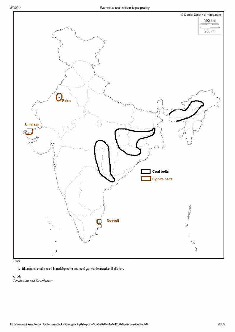
CoalDistribution and Production
1. In reserves, Jharkhand (29%) > Odisha (25%) > Chattisgarh (16%) > W Bengal (11%) > MP (8%) > AP (7%).
8/9/2014 Evernote shared notebook: geography
https://www.evernote.com/pub/crazyphoton/geography#st=p&n=58a62826-44a4-4286-864a-b494cedfeda6 26/39
Uses
1. Bituminous coal is used in making coke and coal gas via destructive distillation.
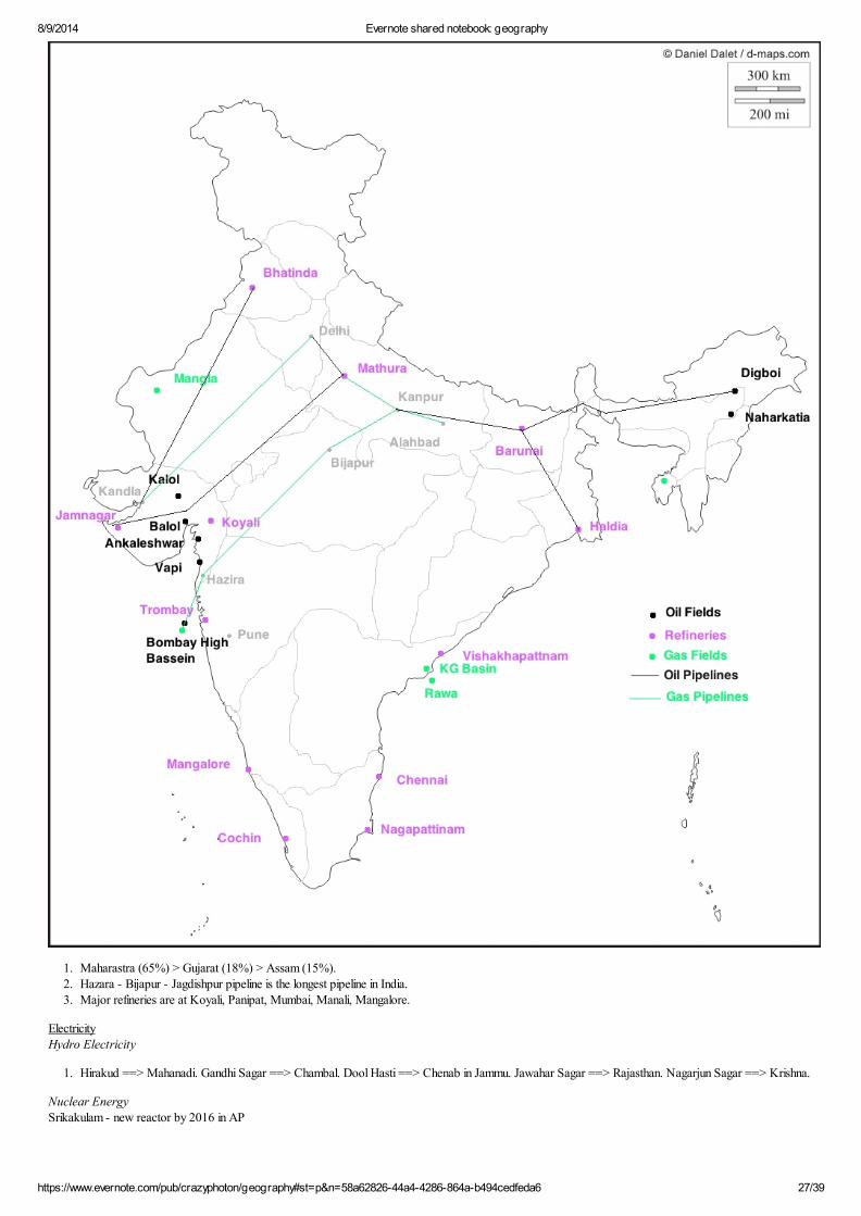
CrudeProduction and Distribution
8/9/2014 Evernote shared notebook: geography
https://www.evernote.com/pub/crazyphoton/geography#st=p&n=58a62826-44a4-4286-864a-b494cedfeda6 27/39
1. Maharastra (65%) > Gujarat (18%) > Assam (15%). 2. Hazara - Bijapur - Jagdishpur pipeline is the longest pipeline in India.3. Major refineries are at Koyali, Panipat, Mumbai, Manali, Mangalore.
ElectricityHydro Electricity
1. Hirakud ==> Mahanadi. Gandhi Sagar ==> Chambal. Dool Hasti ==> Chenab in Jammu. Jawahar Sagar ==> Rajasthan. Nagarjun Sagar ==> Krishna.
Nuclear EnergySrikakulam - new reactor by 2016 in AP
8/9/2014 Evernote shared notebook: geography
https://www.evernote.com/pub/crazyphoton/geography#st=p&n=58a62826-44a4-4286-864a-b494cedfeda6 28/39
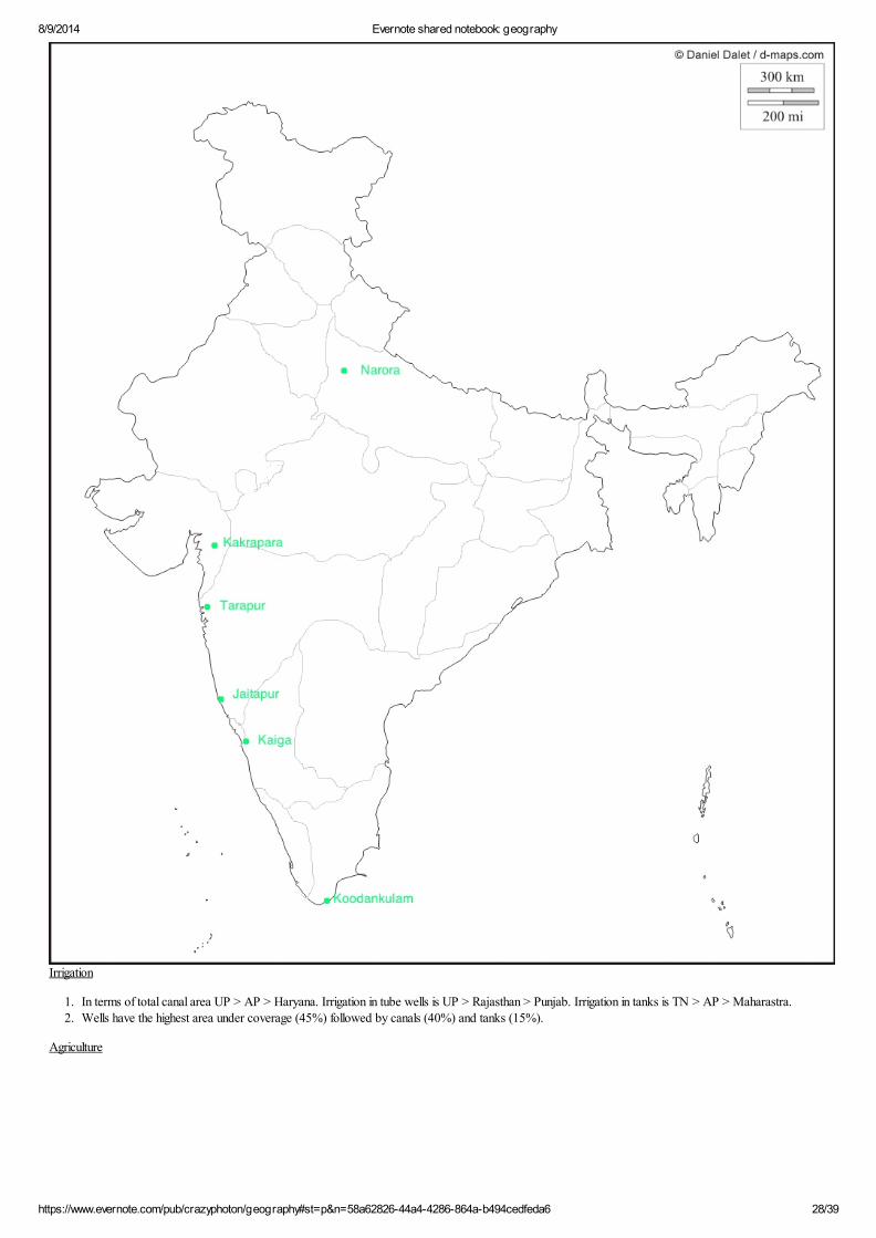
Irrigation
1. In terms of total canal area UP > AP > Haryana. Irrigation in tube wells is UP > Rajasthan > Punjab. Irrigation in tanks is TN > AP > Maharastra.2. Wells have the highest area under coverage (45%) followed by canals (40%) and tanks (15%).
Agriculture

8/9/2014 Evernote shared notebook: geography
https://www.evernote.com/pub/crazyphoton/geography#st=p&n=58a62826-44a4-4286-864a-b494cedfeda6 29/39
Agricultural Regions
1. Temperate himalaya region: The eastern himalayas are wet (rainfall > 250 cm) and have thick forest cover. Tea is cultivated on slopes and paddy in valleys. The western himalayas are dry and horticulture crops and dry fruit crops are main crops grown.
2. Northern dry region: Rainfall < 75 cm and includes UP, Rajasthan, west MP, Punjab, Haryana. Wheat is the main crop. Maize, cotton, sugarcane (only in irrigated area) and rice (only in irrigated area) are other crops.
3. Eastern wet region: Rainfall > 150 cm and includes W Bengal, Odisha, AP, TN, Chattisgarh, NE. Paddy.4. Western wet or malabar region: Rainfall > 200 cm and includes coast of Kerala and Karnataka. Rice, coconut, cashew nuts, spices, rubber are grown.5. Southern arid region: Rainfall < 100 cm. Coarse cereals like millet, bajra, ragi are grown.
Rice
1. It needs warm, humid climate and well distributed rainfall. Delta and valley soils with high clay content are most suitable.
Wheat

8/9/2014 Evernote shared notebook: geography
https://www.evernote.com/pub/crazyphoton/geography#st=p&n=58a62826-44a4-4286-864a-b494cedfeda6 30/39
1. It needs cool temperature and moderate rainfall. Well drained loamy soils are ideal.
Maize
1. It requires warm climate with moderate rainfall. Alluvial and red souls are good.2. UP, Bihar, Rajasthan, Punjab are main producers.
Bajra
1. It needs warm and dry climate. Sandy soils are good. 2. Rajasthan and Gujarat are main producers.
Jowar
1. It needs warm and dry climate but prolonged drought is harmful. Sandy soils are good.2. Maharastra, Karnataka and MP are main producers.
Cardamom
1. Kerala > Sikkhim ? Karnataka.
Coffee
1. Karnataka (67%) > Kerala > TN. 2. Production has increased from 290K tonnes in 2009-10 to 320K tonnes in 2011-12.
Cotton
1. It needs warm and semi-arid conditions with abundant sunshine. Black soils are ideal. 2. Gujarat, AP and MP are main producers.
Pulses
1. They are dry crops mainly grown in MP, UP, Rajasthan.
Tea
1. It needs heavy precipitation, good drainage and warm conditions. 2. Assam > W Bengal > TN.
Rubber
1. It needs warm and humid conditions. 2. It is grown in Kerala (90%) > TN.
Groundnut

8/9/2014 Evernote shared notebook: geography
https://www.evernote.com/pub/crazyphoton/geography#st=p&n=58a62826-44a4-4286-864a-b494cedfeda6 31/39
Tobacco
1. It needs warm and semi-arid conditions.2. AP > Karnataka.
Rapeseed
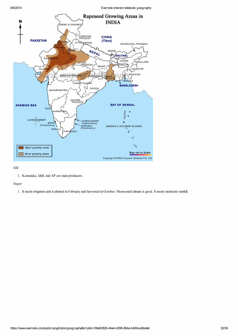
8/9/2014 Evernote shared notebook: geography
https://www.evernote.com/pub/crazyphoton/geography#st=p&n=58a62826-44a4-4286-864a-b494cedfeda6 32/39
Silk
1. Karnataka, J&K and AP are main producers.
Sugar
1. It needs irrigation and is planted in February and harvested in October. Monsoonal climate is good. It needs moderate rainfall.

8/9/2014 Evernote shared notebook: geography
https://www.evernote.com/pub/crazyphoton/geography#st=p&n=58a62826-44a4-4286-864a-b494cedfeda6 33/39
Fisheries
1. Indian coastline is 8100 km, EEZ: 2 mm sq. km (west coast: 0.85 mm, east coast: 0.55 mm, A&N islands: 0.6 mm), continental shelf: 0.5 mm sq. km. Fisheries contribute 5% of agri-GDP and 0.6% of total GDP.
2. W Bengal (1.5 MT) > AP (1 MT) > Gujarat and Kerala (0.7 MT each).3. In 2010, aquaculture production: 4 MT (3rd highest in the world), marine production: 4 MT. Per fisherman catch = 2 T per annum.

8/9/2014 Evernote shared notebook: geography
https://www.evernote.com/pub/crazyphoton/geography#st=p&n=58a62826-44a4-4286-864a-b494cedfeda6 34/39
PortsMumbai Port
1. It is a natural harbor. A new port @ Nava Sheva has been developed to take off its burden.
Paradip Port
1. It is an artificial, deep water port @ confluence of Mahanadi and BoB. It has a capacity of 20 MT to handle coal and a water draft of 19 m to accommodate capesize vehicles (ships originally too large to transit Suez canal ~ 150K - 400K deadweight tonnes). Deadweight tonnes is the max weight a ship can carry safely. It handles iron ore and coal.
Tuticorin port
1. It handles coal, fertilizers and iron ore.
Ennore Port
1. It is located near Chennai and is a corporate port (68% centre, 32% Chennai port trust stake). It has a capacity of 12 MT and draft of 13.5 m. It can handle 65K - 80K deadweight tonnes ships. It mainly handles coal.
Kolkata Port
1. Its a riverine port and has a deep water dock at Haldia.
Haldia Port
1. It has been developed to relive Kolkata. It also has an oil refinery and is a riverine port.
Kandla Port
1. It is a natural deep water tidal port. It handles petroleum, chemicals, iron and steel and textiles.
Vishakhpatnam Port
1. It is the largest port and has a capacity of 65 MT. It is the deepest land locked and protected port. It handles petroleum and iron ore.
New Mangalore Port

8/9/2014 Evernote shared notebook: geography
https://www.evernote.com/pub/crazyphoton/geography#st=p&n=58a62826-44a4-4286-864a-b494cedfeda6 35/39
1. It is a deep water port. It handles iron ore, petroleum products, fertilizers.
Marmagaon Port
1. Located in Goa, it handles iron ore. It is 5th largest port.
Kochi Port
1. It is a natural harbor and handles tea, coffee and spices.
Chennai Port
1. It handles automobiles, iron ore, coal, fertilizers and petroleum products. Its capacity is 60 MT and is 2nd largest port in India. Its maximum draft is 16.5 m. It is a natural port.
Iron & SteelDistribution & Production
1. India produced 35 MT of sponge iron and is world's largest producer. This is 30% of total steel capacity in India.
8/9/2014 Evernote shared notebook: geography
https://www.evernote.com/pub/crazyphoton/geography#st=p&n=58a62826-44a4-4286-864a-b494cedfeda6 36/39

8/9/2014 Evernote shared notebook: geography
https://www.evernote.com/pub/crazyphoton/geography#st=p&n=58a62826-44a4-4286-864a-b494cedfeda6 37/39
River Linkage Plan

8/9/2014 Evernote shared notebook: geography
https://www.evernote.com/pub/crazyphoton/geography#st=p&n=58a62826-44a4-4286-864a-b494cedfeda6 38/39
[edit]
Himalayan development
The northern component would consist of a series of dams built along the Ganga and Brahmaputra rivers in India, Nepal and Bhutan for the purposes of storage. Canals would be built to transfer surplus water from the eastern tributaries of the Ganga to the west. The Brahmaputra and its tributaries would be linked with the Ganga and the Ganga with the Mahanadi river. This part of the project would provide additional irrigation for about 220,000 square kilometres and generate about 30 gigawatts of electricity. In theory it would provide extra flood control in the Ganga and Brahmaputra river basins. It could also provide excess water for the controversial Farakka Barrage which could be used to flush out the silt at the port of Kolkata.
Peninsular development
The main part of the project would send water from the eastern part of India to the south and west. The southern development project would consist of four main parts.
First, the Mahanadi, Godavari. Krishna and Kaveri rivers would all be linked by canals. Extra water storage dams would be built along the course of these rivers. The
purpose of this would be to transfer surplus water from the Mahanadi and Godavari rivers to the south of India. Second, those rivers that flow west to the north
of Mumbai and the south of Tapiwould be linked. Due to the irregular fluctuations in water levels in the region, as much storage capacity would be built as possible. The
water would be used by the urban areas of Bombay and also to provide irrigation in the coastal areas of Maharashtra. Third the Ken and Chambal rivers would be linked
in order to provide better water facilities forMadhya Pradesh and Uttar Pradesh. Finally a number of west-flowing rivers along the Western Ghats simply discharge into
the Arabian Sea. As many of these as possible would be diverted for irrigation purposes. The Peninsular part of the project would provide additional irrigation to 130,000
square kilometres and generation an additional 4 gigawatts of power.
National Monsoon Mission
The main objectives of the National Monsoon Mission are:
(i) To build a working partnership between the academic and R&D organisations both national and international and the operational agencies to improve the
operational monsoon forecast skill over the country.
(ii) To set up a state of the art dynamic modelling framework for improving the prediction skill of:
a. Seasonal and extended range prediction system (16 days to one season)
b. Short to medium range prediction system (up to 15 days).
The Mission has a budget of Rs.400 crore for five years to support the research work related to the mission.
The National Monsoon Mission after its implementation will help to implement a dynamic prediction system for the prediction of monsoon in all time scales, short
range to seasonal time scale at appropriate spatial scales with improved prediction skill. The forecasts based on this prediction system will cater to the needs of
various sectors like agriculture, water resources management, power generation, disaster management, tourism and transport.
The programme will be undertaken through two sub-missions on two different time scales, (i) extended range to seasonal time scale to be coordinated by the Indian

8/9/2014 Evernote shared notebook: geography
https://www.evernote.com/pub/crazyphoton/geography#st=p&n=58a62826-44a4-4286-864a-b494cedfeda6 39/39
Institute of Tropical Meteorology (IITM) Pune/ESSO and (ii) short to medium range scale, to be coordinated by the National Centre for Medium Range Weather
Forecasting (NCMRWF)/ESSO. The Indian National Center for Ocean Information Services (INCOIS)/ESSO will provide the ocean observations for assimilation
and the India Meteorological Department/ESSO will implement the research outcome of the efforts in operational mode. The Mission will support focused research
by national and international research groups with definitive objectives and deliverables to improve the models in the short, medium, extended and seasonal range
scales at appropriate spatial scales. The Mission will also support observational programmes that will result in better understanding of the processes. The progress of
the National Monsoon Mission will be reviewed and monitored by two committees. The Scientific Review and Monitoring Committee (SRMC) will review the
research proposals from different research groups and monitor the progress of the research work. The Scientific Steering Committee (SSC), which is the apex body
will steer the programme, advise and direct midcourse corrections, if any.
Related Documents