European Commission LEGAL ASPECTS OF MARITIME SPATIAL PLANNING Framework Service Contract, No. FISH/2006/09 – LOT2 Final Report to DG Maritime Affairs & Fisheries APPENDICES by in association with October 2008

Welcome message from author
This document is posted to help you gain knowledge. Please leave a comment to let me know what you think about it! Share it to your friends and learn new things together.
Transcript
European Commission
LEGAL ASPECTS OF MARITIME SPATIAL PLANNING
Framework Service Contract, No. FISH/2006/09 – LOT2
Final Report to DG Maritime Affairs & Fisheries
APPENDICES
by
in association with
NILOS Netherlands Institute for the Law
of the Sea
October 2008

Project no: ZF0924 Issue ref: R1 Appendices Date of issue: 16 October 2008 Prepared by: Hendrik Acker and
Stephen Hodgson Checked/Approved by: Graeme Parkes

Appendix A - Terms of reference Appendix B - Bibliography Appendix C - Testing the draft indicators Appendix D - Country study - France Appendix E - Country study – Germany Appendix F - Country study – Greece Appendix G - Country study – Poland Appendix H - Country study – United Kingdom
Appendix A – Terms of Reference 1
Appendix A Terms of reference
TECHNICAL SPECIFICATIONS TO SPECIFIC TASKS TO BE UNDERTAKEN
IN THE FRAMEWORK OF LOT 2 OF FISH/2006/09 STUDIES IN THE FIELDS
OF THE COMMON FISHERIES POLICY AND MARITIME AFFAIRS
WORK PACKAGE 2 "LEGAL ASPECTS OF MARINE SPATIAL PLANNING"
version 15 November 2007
CONTEXT The recently published "Blue Paper" on an integrated EU maritime policy1 the Commission promises to: "develop a roadmap in 2008 to facilitate the development of maritime spatial planning by Member States" And in the accompanying action plan indicates
Building on existing EU initiatives with a strong maritime spatial planning dimension, including the ICZM Recommendation and the proposed Marine Strategic Directive, which introduces elements of maritime spatial planning, the Commission will
1. Propose a road map in 2008 to facilitate and encourage the further development of
maritime spatial planning in the Member States. 2. In 2008, it will examine the needs and different options, including for zoning, to making
compatible different maritime activities, including the maintenance and strengthening of biodiversity.
3. In 2009, the Commission will also set up of a system for the exchange of best practice among authorities in maritime spatial planning and integrated coastal zone management
SPECIFIC BACKGROUND TO THIS STUDY Spatial planning or place-based management can be considered an integrated management of the full suite of human activities occurring in spatially demarcated areas identified through a procedure that takes into account biophysical, socioeconomic, and jurisdictional considerations2. A number of countries have already introduced spatial planning and some are moving towards it. There have been a number of surveys of spatial planning practices in Member States. However there has not yet been a comprehensive legal study on the
Appendix A – Terms of Reference 2
constraints imposed by existing law. Neither has a complete picture of spatial planning practices in EU Member States been presented.
RELEVANCE OF STUDY TO WORK SPECIFIED IN FISH/2006/09 STUDIES IN THE FIELDS OF THE COMMON FISHERIES POLICY AND MARITIME AFFAIRS
The study is relevant to Lot 2 "Legal Studies" activity 1 "Analysis of the existing law and proposals for future law" "Analysis of the existing law and proposals for future law. Studies could be asked to examine existing law affecting maritime affairs, and notably law that is indicated by respondents to the questions in the Green Paper as particularly problematic or that contradicts with maritime policy goals as set out in the Green Paper or that will be developed in the context of a future maritime policy. This could also include aspects of implementation, control, enforcement, administrative or commercial practices, decisions by judicial and quasi-judicial bodies or dispute settlement."
EXPECTED OUTCOME The expected outcome of this study is a better understanding of the legal constraints on the introduction of spatial planning in Member States and a method of measuring its implementation. These will feed into a road map to facilitate and encourage the further development of maritime spatial planning in the Member States.
TASKS
Task 1 Legal constraints on marine spatial planning.
Background Although nation administrations are free to set up spatial planning in their own territory in a way that best suits them, there are a number of constraints and recommendations at an international, European or maritime basin level that are common.
Objective To identify and classify the current recommendations and constraints on marine spatial planning imposed by European legislation, regional agreements and international commitments. The approach should be to examine marine protected areas as well as a number of marine activities (aquaculture development, fisheries rules, navigation restrictions, gravel extraction, petroleum extraction, port expansion, wind-farm siting) and determine within coastal water, territorial waters, jurisdictional waters and high seas, the constraints and recommendations imposed by European legislation, regional agreements and international commitments. The areas to be covered are all seas within the exclusive economic zones of EU Member States as well as high seas in the Mediterranean.
Appendix A – Terms of Reference 3
Task 2 Progress of integrated marine spatial planning in Member States
Background A number of countries have indicated that they have implemented marine spatial planning or are considering doing so. OSPAR have issued a questionnaire to contracting parties which should indicate each country's current status. They expect to complete the exercise in early 2008. The projects PLANCOAST and BALTCOAST have also prepared reports on the issue. However it is difficult to determine from this complex and heterogeneous set of data how far the Member States are along the road to true integrated spatial planning
Objective 1. Propose a simple set of indicators that describe the status of marine spatial planning in
Member States, 2. Provide a set of instructions for preparing the indicators from readily available
information 3. Use the data from OSPAR, PLANCOAST and BALTCOAST to evaluate these indicators The Commission will provide the reports from OSPAR, PLANCOAST and BALTCOAST. The study should not require further questionnaires or surveys. Where information is not readily available from the above-mentioned studies or from the internet, the indicators should be left blank.
Task 3 Marine spatial planning in specific Member States
Objective The objective is to examine practices for planning and licensing for marine activities in Member States. The approach should be to examine the same activities and sea areas as in task 1 and determine 1. The responsibilities for spatial planning of local, regional and national authorities – both
in an advisory and in decision-making capacity. 2. Mechanisms for conflict resolution between sectors. 3. Obligations for consulting stakeholders The study should cover a sample of the coastal Member States of the EU that have made some progress in marine spatial planning. Belgium, Germany, Netherlands and UK are suggested.
Appendix A – Terms of Reference 4
Task 4 Relationship between marine spatial planning and governance in specific Member States
Objective Based on the results of task 3, to determine what the relationship is between the type of governance operating in a country and its ability to develop an effective marine spatial planning.
DELIVERABLES A report describing the work done and the conclusions An executive summary of approximately 15 pages that is self-standing and can be published separately.
SUGGESTED TIMETABLE
T0 Start of contract First months Kick-off meeting in Brussels including the Commission and those
involved with the study. T0+6 months Presentation of results and delivery of draft reports in Brussels to
Commission and any stakeholders to be invited by the Commission T0+8 months Delivery of final reports
Appendix B – Bibliography 1
Appendix B - Bibliography Boyle, A.E., “Some Reflections on the Relationship of Treaties and Soft Law”, in International and Comparative Law Quarterly, Vol. 48, No. 4 (Oct., 1999), pp. 901-913. Boyle, A.E ‘Further Development of the Law of the Sea’ 54 ICLQ (July 2005) pp 563-584 Churchill, R.R. and Lowe, A.V., The Law of the Sea Manchester 3rd edition, 1999. Czybulka (2001) “The Convention on the Protection of the Marine Environment of the North-East Atlantic” in : Hjalmar Thiel & J. Anthony Koslow (Eds.) Managing Risks to Biodiversity and the Environment on the High Sea, Including Tools Such as Marine Protected Areas Scientific Requirements and Legal Aspects, 2001, pp. 175 – 184. Ehler C., Douvere F., “Visions for a Sea Change. Report of the First International Workshop on Marine spatial planning”. Intergovernmental Oceanographic Commission and Man and the Biosphere Programme. IOC Manual and Guides No. 48, IOCAM Dossier No. 4. Paris, UNESCO, 2007. http://www.unesco-ioc-marinesp.be/uploads/documentenbank/322a25f624fcb940dc70d0b3b510de24.pdf European Communities 2008 Proposal for a Directive of the European Parliament and of the Council on the geological storage of carbon dioxide, COM(2008) 19 final. http://ec.europa.eu/energy/climate_actions/doc/2008_res_directive_en.pdf Gellermann M., Stoll, P-T., Schwarz, K. and Wolf, R., „Nutzungsbeschränkungen in geschützten Meeresflächen im Bereich der Ausschließlichen Wirtschaftszone und des Festlandsockels“, Federal Agency for Nature Conservation, BfN – Skripten 194, 2007. HELSINKI COMMISSION Maritime Group 2004, Note of the secretariat “Places of Refuge” (Helcom Maritime 3/2004) International Institute for Sustainable Development (IISD); Earth Negotiations Bulletin; Summary of the 9th Conference of the Parties to the Convention on Biological Diversity 19-30 May 2008 http://www.iisd.ca/download/pdf/enb09452e.pdf International Energy Agency (IEA) “Legal Aspects of storing CO2”, 2005. http://www.iea.org/textbase/nppdf/free/2005/co2_legal.pdf Morgera, E. ‘Competence or Confidence? The Appropriate Forum to Address Multi-Purpose High Seas Protected Areas’ 16 RECIEL p1 (2007) Owen, D., “Interaction between the EU Common Fisheries Policy and the Habitats and Birds Directives”, Insititute for European Environmental Policy, 2004. http://www.ieep.eu/publications/pdfs/2004/natura2000cfpfinalreport.pdf Røsæg, E. and Ringbom H. “Liability and Compensation with Regard to Places of Refuge” Scandiniavian Institute of Maritime Law, University of Oslo, 2004
Appendix B – Bibliography 2
Tyldesley, D., “Irish Sea Pilot Project: Coastal and Marine Spatial Planning Framework”, 2004. http://www.jncc.gov.uk/pdf/Tyldesley%20Marine%20spatial%20planning.pdf UNESCO, “Final Report of the Second meeting of Governmental Experts on the Draft Convention on the Protection of Underwater Cultural Heritage”, 2001. Köppel, J., Wende, W., Herberg, A., Wolf, R., Nebelsiek, R. & K. Runge, „Naturschutzfachliche und naturschutzrechtliche Anforderungen im Gefolge der Ausdehnung des Raumordnungsregimes auf die deutsche Ausschließliche Wirtschaftszone“, BfN Skripten 2006. Young, T. R., “The Legal Framework for MPAs and successes and failures in their incorporation into national legislation”, FAO Expert Workshop on Marine Protected Areas and Fisheries Management: Review of Issues and Considerations, 2006. Young O., Osherenko G., Ekstrom J., Crowder L., Ogden J., Wilson, Day J., Douvere F., Ehler, C., McLeod K., Halpern B., Peach R., “Solving the crisis in place-based management of marine ecosystems”, Issue of Environment. Volume 49, Number 4 Warner, R., “Marine Protected Areas Beyond National Jurisdiction - Existing Legal Principles and Future Legal Frameworks” in : Hjalmar Thiel & J. Anthony Koslow (Eds.) Managing Risks to Biodiversity and the Environment on the High Sea, Including Tools Such as Marine Protected Areas - Scientific Requirements and Legal Aspects, 2001. Wolf, R., „Rechtliche und naturschutzfachliche Aspekte beim Bau und Betrieb von Stromkabeln“, Federal Agency for Nature Conservation, BfN, 2004 http://www.bfn.de/fileadmin/MDB/documents/awz2.pdf

Appendix C – Testing the draft indicators
1
Appendix C - Testing the draft indicators Introduction The following section provides results from the exercise of testing the draft indicators presented in Section 3.1 of the main report. These indicators were developed to assess the status of MSP in different member states. However, since there are a wide range of formats that such planning can take, these indicators should not be used to benchmark countries but can be used to give a view on the type of MSP that exists in any particular country. The terms of reference for this study asked the indicators to be tested based on the Plancoast, Baltcoast and Ospar reports that have recently been published and provide information on coastal and maritime planning for these regions. This information was used to test the indicators for Italy and the Netherlands although in many cases there were gaps which did not allow for a complete review of the indicators, and in some cases these had to be left out of the diagram to avoid confusion. The case study information presented in Section 4 of the main report and Appendices E and H were then used to test the indicators for Germany and the UK. It is important to note that this exercise was undertaken to test the indicators and should not be used to assess these countries. If the commission were to go ahead and use these indicators, a process would need to be set up where comparable information was used to measure the indicators (e.g. member state questionnaires and case studies) and the results were verified by the countries in question.
Appendix C – Testing the draft indicators
2
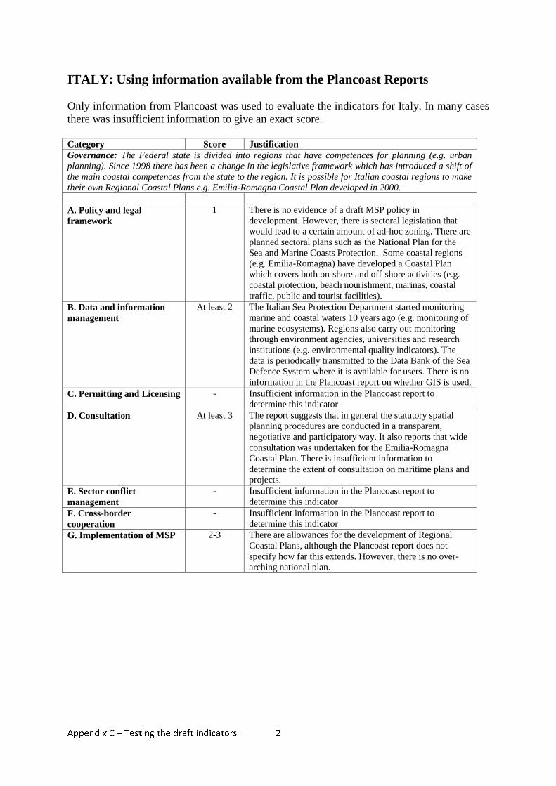
ITALY: Using information available from the Plancoast Reports Only information from Plancoast was used to evaluate the indicators for Italy. In many cases there was insufficient information to give an exact score. Category Score Justification Governance: The Federal state is divided into regions that have competences for planning (e.g. urban planning). Since 1998 there has been a change in the legislative framework which has introduced a shift of the main coastal competences from the state to the region. It is possible for Italian coastal regions to make their own Regional Coastal Plans e.g. Emilia-Romagna Coastal Plan developed in 2000. A. Policy and legal framework
1 There is no evidence of a draft MSP policy in development. However, there is sectoral legislation that would lead to a certain amount of ad-hoc zoning. There are planned sectoral plans such as the National Plan for the Sea and Marine Coasts Protection. Some coastal regions (e.g. Emilia-Romagna) have developed a Coastal Plan which covers both on-shore and off-shore activities (e.g. coastal protection, beach nourishment, marinas, coastal traffic, public and tourist facilities).
B. Data and information management
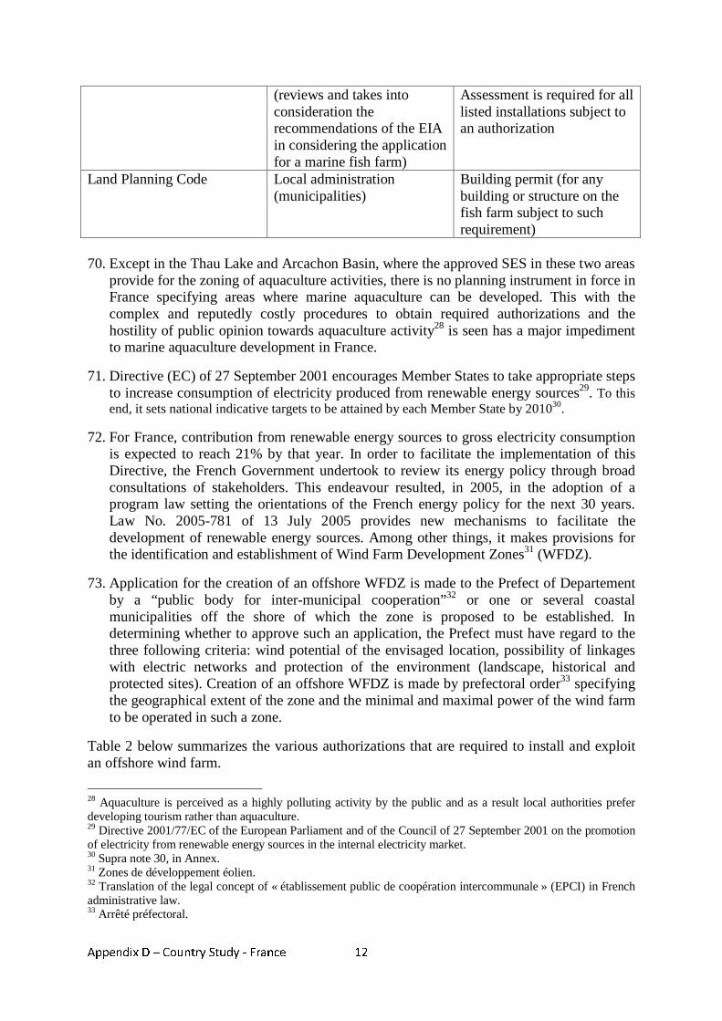
At least 2 The Italian Sea Protection Department started monitoring marine and coastal waters 10 years ago (e.g. monitoring of marine ecosystems). Regions also carry out monitoring through environment agencies, universities and research institutions (e.g. environmental quality indicators). The data is periodically transmitted to the Data Bank of the Sea Defence System where it is available for users. There is no information in the Plancoast report on whether GIS is used.
C. Permitting and Licensing - Insufficient information in the Plancoast report to determine this indicator
D. Consultation At least 3 The report suggests that in general the statutory spatial planning procedures are conducted in a transparent, negotiative and participatory way. It also reports that wide consultation was undertaken for the Emilia-Romagna Coastal Plan. There is insufficient information to determine the extent of consultation on maritime plans and projects.
E. Sector conflict management
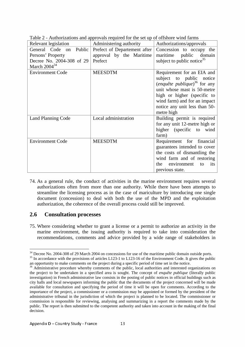
- Insufficient information in the Plancoast report to determine this indicator
F. Cross-border cooperation
- Insufficient information in the Plancoast report to determine this indicator
G. Implementation of MSP 2-3 There are allowances for the development of Regional Coastal Plans, although the Plancoast report does not specify how far this extends. However, there is no over-arching national plan.
Appendix C – Testing the draft indicators
3
NETHERLANDS: Using information available from the Ospar Report Only information from the Ospar report was used to evaluate the indicators for Netherland. In the case of the indicator ‘cross-boundary cooperation’ there was insufficient information to give a score. Category Score Justification Governance: The Dutch Government is responsible for Marine and Maritime Policies of the Dutch EEZ in the North Sea. Although regional and local authorities develop spatial plans on land, the Ministry of Transport, Public Works and Water Management provide spatial plans for the ‘North Sea’. A. Policy and legal framework
At least 3 (Could be 4
or 5)
There is an MSP policy in place which has an objective: ‘To enhance the economic importance of the North Sea and maintain and develop the international and ecological and landscape features by developing and harmonising suitable economic activities in the North Sea, taking into account the ecological and landscape features of the North Sea’. However, it is considered by the OSPAR report to be reactive rather than proactive. In 2008 there is a plan to develop a more proactive full spatial vision and strategic agenda for the Dutch part of the North Sea. There is no information in the report on related MSP legislation, so it cannot be determined if this would score a 4 or 5.
B. Data and information management
Assume 3 There is limited information in the OSPAR report on the extent of data collection and availability, but it is mentioned that GIS systems are used within the planning process.
C. Permitting & licensing At least 3 Permits and licenses are provided by different agencies (e.g. the Ministry of Economical Affairs provides permits for oil and gas extraction), but the majority of permits are provided by Rijkswaterstaat North Sea Agency which operates under the Ministry of Transport, Public Works and Water Management. There is no information in the Plancoast report on the transparency of the permitting process and inter-agency coordination, so this is assumed. It could score a 4 or 5, but insufficient information to determine.
D. Consultation 4 Consultation took place on the integrated maritime spatial plan in a formal way through an advisory committee of stakeholders on a national level and through informal means in the way of workshops and bi-lateral contacts. There is limited information in the OSPAR report whether active consultation takes place on most projects, but this is hinted at by the active participation that took place for the Natura 200 management plan for the Voordelta.
E. Sector conflict management
At least 4 Sectors and activities are regulated by the MSP system. It is mentioned that plan makers try to formulate an attractive perspective for all stakeholders, although in some cases this is not always possible and political choices need to be made. At several stages during the plan-making, issues are discussed with the Interdepartmental Directors Consultative Committee for the North Sea, and in this way potential conflicts are identified at an early stage and options for solving the conflicts can be identified. There is

Appendix C – Testing the draft indicators
4
no information given on how conflicts relating to projects are resolved.
F. Cross-border cooperation
- No information provided in the OSPAR report to be able to evaluate this criterion. The relevant question in the OSPAR questionnaire had not been completed but may be available in a final version of the OSPAR report.
G. Implementation of MSP 5 An Integrated Management Plan of the North Sea (i.e. Maritime Spatial Plan) has been developed for 10 years: 2005-2015. In 2008 a future vision and strategy will be produced. Some aspects of the spatial plan are expected to be changed to solve some potential spatial conflicts e.g. the realisation of wind farms.
** It is also necessary to note that this was based on the draft OSPAR report, and that the draft response on the questionnaire by Netherlands had not yet been validated.
Netherlands
0
1
2
3
4
5A. Policy & legal framework
B. Data and informationmanagement
C. Permitting and Licensing
D. Consultation
E. Sector conflict management
G. Implementation of a MSP
NB: This diagram does not include a score for cross-border cooperation as there was insufficient information in the Ospar report to score this indicator.
Appendix C – Testing the draft indicators
5
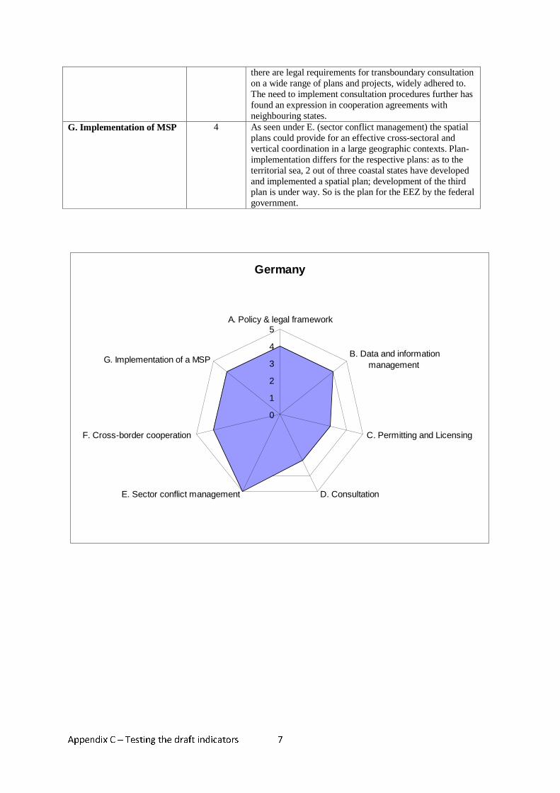
Germany: Using information from the German case study Category Score Justification Governance: German Governance structure in terms of MSP is highly complex and fragmented. In sum both the federal government as well as the federal states (Länder) have joint responsibility for most areas of maritime planning issues. They are clearly delineated legally, organisationally and from the point of view of content. On the one hand, they each have their own legal basis, but on the other hand they are closely inter-linked on the basis of complex regulations regarding information, participation, agreement and co-operation. As far as legislation is concerned the Federal level has competence in matters of defence, navigation, ports, waste exploitation of gas and oil, energy cables/pipelines, fishery and coastal protection. But only a framework competence in matters of spatial planning, nature protection and water management. This entails that in these areas, the Länder have a high degree of freedom in establishing their own legislative structure in line with the federal legal framework. Law enforcement and the performance of state functions in general is a matter for the Länder insofar as the Basic Law does not prescribe or permit otherwise. Exceptions are administration in matters of defence, navigation and partly ports. A. Policy and legal framework
4 Comprehensive legislation exists for MSP in the territorial sea (responsible are the federal Länder) and the EEZ (responsible is the federal government); this legislation has been implemented by the Länder Niedersachsen and Mecklenburg Western Pomerania; as for Schleswig-Holstein implementation is under way; so is the plan for the EEZ. Thus MSP legislation has partly been implemented but it is too early to say that this legislation has “stood” the passage of time”.
B. Data and information management
4 Comprehensive data as to maritime activities and uses in the territorial sea and the EEZ held by the Federal Ministry of Transport, Building and Housing (BMVBS) or the Federal Maritime and Hydrographic Agency (BSH) (forms the basis for preparation of maritime spatial plans); CONTIS is a marine database providing access to geodata covering current uses, potential uses, and marine protected areas in the North and Baltic Seas. NAUTHIS is a centralised database storing and updating the complete hydrographic geodata that are needed for the BSH's activities. In addition the Marine Environmental Data Base (MUDAB) is a joint project of BSH and of the Federal Environmental Agency (UBA) serving as the central German data base for maritime data collected within the framework of international and national conventions for the protection of the North Sea and Baltic Sea.
C. Permitting and licensing 3 Depending on the activity, the location (e.g. territorial sea or EEZ) the permitting procedures may differ considerably making it hard to come to a general characterisation; however the overall system is still far from a “streamlined” process as described under score “5”. In most cases several different licenses are required. Although literature discussion on the legal bases for issuing of some permits persists (e.g. for laying of electric cables within a wind farm in the EEZ) in practice a clear division of competences is implemented; as to the question if all relevant aspects/impacts of the licensing decision are dealt with in an integrated and comprehensive manner, an overall evaluation leads to the assessment that the extent of coordination with other policies and agencies is considerable. However it is limited to central legal and
Appendix C – Testing the draft indicators
6
factual uncertainties and there is a trend of other agencies involved to amend their planning according to the “requirements” of the permitting agency in order to reduce the need for coordination/negotiation (Schuchardt et al. 2004). Thus it seems that the system does not necessarily lead to an effective integration of all aspects relevant to the allocation of permits.
D. Consultation 3 Requirements for quite active consultation exist as regards most relevant plans and projects. Decisions are reasonably considering the input. However “quality” of consultation is differing: it is better in cases where due to political and/or financial implications a higher interest exists in reducing legal uncertainties through participation of stakeholders. E.g. involvement of environmental NGO is rather broad as most legal uncertainties are involved with compensation measures for ecological damage, and involvement of stakeholders is highly valued in order to identify those legal uncertainties and determine compensation measures. In sum consultation is limited to questions on implementation as opposed to involvement in the decision on the plan or project itself.
E. Sector conflict management
5 First of all the Federal Spatial Planning Act (ROG) defines “essential purposes” of spatial planning, giving guidance on decision making. Moreover it provides for definition of goals of spatial planning, which are legally binding as well as principles of spatial planning which are of a more general nature and have to be considered when weighing interests. Furthermore priority areas, reserved exclusively for specific uses or activities (Article 7(4) no.1 ROG), ‘reservation areas’ (Vorbehaltsgebiete) giving priority to specific uses without excluding other activities (Article 7(4) no.2 ROG) and ‘suitability or qualification areas’ (Eignungsgebiete) reserved for activities/uses which are excluded elsewhere in the planning area may be defined in maritime spatial plans covering all of the EEZ and the territorial sea). As regards impacts on the environment, environmental law requires adequate compensational measures aiming at restitution in kind. In sum, the legal framework for (maritime) spatial planning provides for instruments which when effectively used allow for a structured steering of spatial development.
F. Cross-border cooperation
4 Establishment of maritime spatial plans of the coastal Länder as well as of the spatial structure plan for the EEZ, transboundary consultation is required by law. Art.16 ROG requires the Länder to consult neighbouring states in case that plans or projects with spatial significance, have considerable effects on those states; as to the spatial structure plan for the EEZ Art.7(6) ROG requires transboundary consultation in the context of an SEA. Additional regulations implementing the general legal requirements regarding transboundary cooperation have been laid down in agreements with the Netherlands and Poland in 2005 and 2006. It appears that there is a widespread sense for the need to follow up the legal requirements; however efforts to facilitate active involvement vary from case to case. There is room for practical improvement as regards the provision of documents in language versions easily accessible for authorities and citizens of the countries involved. In sum
Appendix C – Testing the draft indicators
7
there are legal requirements for transboundary consultation on a wide range of plans and projects, widely adhered to. The need to implement consultation procedures further has found an expression in cooperation agreements with neighbouring states.
G. Implementation of MSP 4 As seen under E. (sector conflict management) the spatial plans could provide for an effective cross-sectoral and vertical coordination in a large geographic contexts. Plan-implementation differs for the respective plans: as to the territorial sea, 2 out of three coastal states have developed and implemented a spatial plan; development of the third plan is under way. So is the plan for the EEZ by the federal government.
Germany
0
1
2
3
4
5A. Policy & legal framework
B. Data and informationmanagement
C. Permitting and Licensing
D. ConsultationE. Sector conflict management
F. Cross-border cooperation
G. Implementation of a MSP
Appendix C – Testing the draft indicators
8
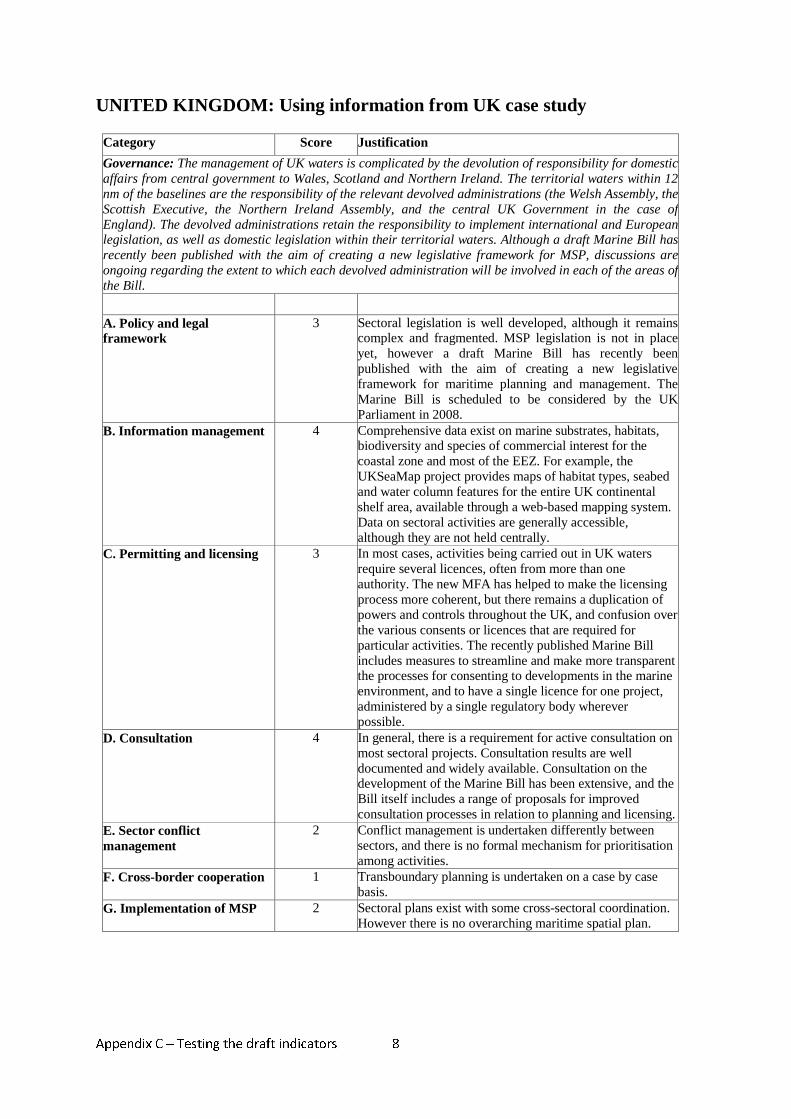
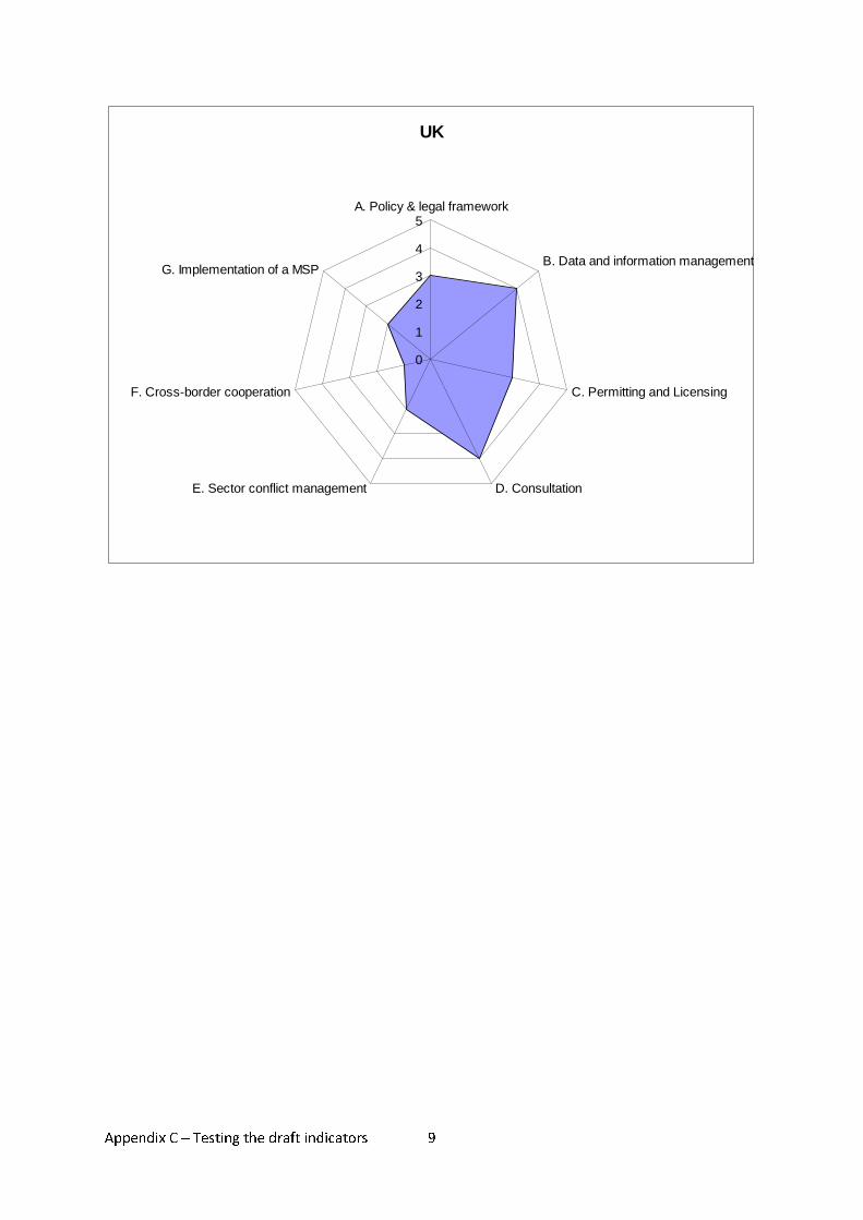
UNITED KINGDOM: Using information from UK case study
Category Score Justification
Governance: The management of UK waters is complicated by the devolution of responsibility for domestic affairs from central government to Wales, Scotland and Northern Ireland. The territorial waters within 12 nm of the baselines are the responsibility of the relevant devolved administrations (the Welsh Assembly, the Scottish Executive, the Northern Ireland Assembly, and the central UK Government in the case of England). The devolved administrations retain the responsibility to implement international and European legislation, as well as domestic legislation within their territorial waters. Although a draft Marine Bill has recently been published with the aim of creating a new legislative framework for MSP, discussions are ongoing regarding the extent to which each devolved administration will be involved in each of the areas of the Bill.
A. Policy and legal framework
3 Sectoral legislation is well developed, although it remains complex and fragmented. MSP legislation is not in place yet, however a draft Marine Bill has recently been published with the aim of creating a new legislative framework for maritime planning and management. The Marine Bill is scheduled to be considered by the UK Parliament in 2008.
B. Information management 4 Comprehensive data exist on marine substrates, habitats, biodiversity and species of commercial interest for the coastal zone and most of the EEZ. For example, the UKSeaMap project provides maps of habitat types, seabed and water column features for the entire UK continental shelf area, available through a web-based mapping system. Data on sectoral activities are generally accessible, although they are not held centrally.
C. Permitting and licensing 3 In most cases, activities being carried out in UK waters require several licences, often from more than one authority. The new MFA has helped to make the licensing process more coherent, but there remains a duplication of powers and controls throughout the UK, and confusion over the various consents or licences that are required for particular activities. The recently published Marine Bill includes measures to streamline and make more transparent the processes for consenting to developments in the marine environment, and to have a single licence for one project, administered by a single regulatory body wherever possible.
D. Consultation 4 In general, there is a requirement for active consultation on most sectoral projects. Consultation results are well documented and widely available. Consultation on the development of the Marine Bill has been extensive, and the Bill itself includes a range of proposals for improved consultation processes in relation to planning and licensing.
E. Sector conflict management
2 Conflict management is undertaken differently between sectors, and there is no formal mechanism for prioritisation among activities.
F. Cross-border cooperation 1 Transboundary planning is undertaken on a case by case basis.
G. Implementation of MSP 2 Sectoral plans exist with some cross-sectoral coordination. However there is no overarching maritime spatial plan.
Appendix C – Testing the draft indicators
9
UK
0
1
2
3
4
5A. Policy & legal framework
B. Data and information management
C. Permitting and Licensing
D. Consultation E. Sector conflict management
F. Cross-border cooperation
G. Implementation of a MSP
Appendix D – Country Study - France
1
Appendix D - Country study - France
MARITIME SPATIAL PLANNING IN FRANCE
1. Introduction
1. France enjoys one of the most extensive maritime zones in the world1. In continental
France, it has declared an economic exclusive zone (EEZ) off the coasts of the North Sea, the English Channel and the Atlantic Ocean.
2. For political and historical reasons, it has, hitherto, refrained from doing so in the Mediterranean Sea. However, in recent years, several coastal States in the Mediterranean Sea have taken initiatives aiming at progressively extending their jurisdiction for targeted purposes, for instance fisheries (e.g. Spain)2.
3. France followed suit and declared an Ecology Protection Zone (EPZ) in the
Mediterranean Sea claiming in this area jurisdiction over the protection and preservation of the marine environment, marine scientific research and the establishment and use of artificial islands, installations and structures in accordance with article 56.1b of the 1982 United Nations Convention on the Law of the Sea (LOSC).
4. Two legal instruments were enacted for the creation of the EPZ. One is Law No. 2003-
346 of 15 April 2003 relating to the creation of an Ecology Protection Zone off the coasts of the French Republic (Loi No. 2003-346 du 15 avril 2003 relative à la creation d’une zone de protection écologique au larges des côtes de la République). This Law is intended to introduce the concept of EPZ in the French law by modifying several laws, particularly Law No. 76-655 of 16 July 1976 relating to the EEZ.
5. The second instrument is Decree No. 2004-33 of 8 January 2004 creating an Ecology
Protection Zone off the coasts of the French Republic in the Mediterranean. This Decree provides the geographical boundary of the EPZ in the Mediterranean.
6. Fisheries is NOT part of the environment. In the EPZ, French authorities are competent
for the protection and preservation of the marine environment, marine scientific research and the setting up and use of artificial islands, installations and structures (art 4 of Law No. 76-655 of 16 July 1976 as modified by Law No. 2003-346 of 15 April 2003).
7. Based on Article 4 of Annex II to the LOSC and pursuant to the decision of the Meeting
of the State Parties to the LOSC3, France commissioned studies to file an application to
1 The combined total surface area of the French maritime zones is estimated to be approximately 11 035 000 km2, including maritime zones off French overseas territories. It is the second largest maritime zone after that of the United States of America. Maritime zones off the coasts of continental France represent about 2.6% of the total surface area. 2 In 1997, Spain established a Fisheries Protection Zone in the Mediterranean Sea (Royal Decree No. 1315/1997 of 1 August 1997). 3 Decision (SPLOS/72) of the Meeting of the States Parties to the LOSC provides that States have 10 years starting on 13 May 1999 for making submissions to the CLCS, including for a State for which the Convention entered into force before 13 may 1999.
Appendix D – Country Study - France
2
the Commission on the Limits of the Continental Shelf (CLCS)4 for the extension of its continental shelf beyond 200 nautical miles measured from the baselines of the territorial sea. On 19 May 2006, France, Ireland, Spain and the United Kingdom of Great Britain and Northern Ireland (UK), in accordance with Article 76.8 of the LOSC, submitted to the CLCS, through the Secretary-General, information on the limits of the continental shelf appurtenant to France, Ireland, Spain and the UK that lie beyond 200 nautical miles from the baselines from which the territorial seas of these four states are measured in the portion of the continental shelf in the area of the Celtic Sea and the Bay of Biscay. France shares maritime boundaries with Belgium, the UK, Spain, Monaco and Italy.
8. France is a maritime nation. However, France, unlike the UK and the Netherlands in Europe, has not had a steady maritime ambition. As a result, development of maritime activities has not always been a State priority and France has not devised a full-fledged maritime policy with clear objectives. Aware of the need to develop a comprehensive integrated maritime policy, the French Government, through the General Secretariat of the Sea under the Prime Minister’s Office, commissioned a study intended to review the strengths and weaknesses of the French maritime sector and to formulate recommendations to form the basis for an integrated maritime policy5.
9. As asserted in its response to the Green Paper on the European Union maritime policy,
France’s maritime future is firmly anchored in the European Union (EU) through the EU maritime policy. In the field of environment, France has adopted a national strategy on biodiversity containing a specific sea action plan. This action plan is in an attempt to integrate, in a coherent framework, actions undertaken by competent authorities at different levels of government. At this stage of development, it is more a strategic action plan than an operational plan.
10. In 2005, value added from maritime activities (maritime financial services, offshore
equipment for petrol and gas extraction, shipyards, pleasure crafts industry, tourism and marine research) was estimated to be about 19 billion euros and employment (direct and indirect) generated by such activities around 500 0006.
11. The management of waters under French jurisdiction has been and still is, to a large
extent, the responsibility of the central government. However, over the years, responsibility for coastal and near shore activities has been shared with local authorities and stakeholders.
12. Mechanisms for consultation have been established, notably, with the enactment of a
Coastal Zone Law in 1986. 13. At the central level of government, an Inter-Ministerial Committee of the Sea, chaired by
the Prime Minister, was established in 1978 to discuss the general maritime policy of the State and identify the main orientations of governmental action in maritime activities,
4 These studies are financed by the State in the framework of the EXTRAPLAC programme (2002 – 2009) coordinated by the General Secretariat of the Sea. EXTRAPLAC is the French acronym standing for Programme français d’extension du plateau continental. 5 See Poseidon Group report in Annex 5 of this document. 6 Supra note 5, at p. 6.
Appendix D – Country Study - France
3
including protection of the marine environment, use of sea-bed and subsoil and exploitation of marine living and non-living resources.
14. In 1995, a General Secretariat of the Sea, placed under the authority of the Prime
Minister, was created to coordinate the actions of the State at sea7. Chief functions of the General Secretariat of the Sea include: monitoring the implementation of laws and regulations relating to the sea and proposing their adjustment to new developments, preparation of the meetings of the Inter-Ministerial Committee of the Sea and assessing the adequacy of the maritime policy.
15. The representative of the Government at sea is the Maritime Prefect8. Three Maritime
Prefects have been appointed, one for the North Sea/English Channel region, one for the Atlantic Ocean region and one for the Mediterranean Sea region. The Maritime Prefect wears two ‘hats’ as he is both a civil and military authority. He is entrusted with general State power at sea and thus has authority in the fields of defence, public order, assets and people’s safety, protection of the marine environment and coordination of state action against illegal activities.
16. While several planning instruments have been introduced to facilitate and enhance spatial
planning in the coastal zone, they have been conceived primarily for terrestrial activities. To date, management of maritime zones off the French coastline is not integrated and is characterized by a sectoral approach with the involvement of scores of authorities. France, unlike many important maritime nations, has not developed an Ocean Law. In 2007, the IUCN French Committee, published a paper addressing the issue of integrated management of the sea and advocated the drafting of an Ocean Law setting out the principles and objectives of a maritime policy, establishing the institutional structure for the management of the maritime zones and providing the planning instruments and consultative mechanisms for achieving the set objectives9. Pursuant to the so-called “Grenelle de l’environnement” that took place in the autumn of 2007, the French Government undertook to introduce a Global Strategic Vision taking into account all human activities at sea and on the coastal zone and the preservation of the marine environment through the devising of new piece of legislation to be adopted by the end of 2008.
17. This document reviews briefly the legislation applicable to maritime spatial planning
(MSP) in France and identifies the authorities responsible for planning and licensing different activities in the maritime area. It examines existing procedures for obtaining licenses or other authorizations for maritime activities and mechanisms for consultation and resolving conflicts between different users and stakeholders. Lastly, it addresses the issue of transboundary initiatives.
2. Legislation applicable to MSP
7 The General Secretariat of the Sea was established by Decree No. 95-1232 of 22 November 1995. 8 The Maritime Prefect is an old institution that was created in the early 1800s under the First Consul. Nowadays, its powers and duties are laid out in Decree No. 2004-112 of 6 February 2004 relating to State action at sea. 9IUCN, French Committee, 2007. Etat des lieux et propositions pour une loi mer, Marine Biodiversity and French Law.
Appendix D – Country Study - France
4
18. The planning of maritime activities in France is regulated by a complex array of international, regional (including European Union) and national (regional and local levels) legislation. As mentioned above, much of the legislation is sectoral, applying to specific activities or users of the marine environment.
19. With the development of integrated approaches such as integrated coastal zone management (ICZM) and ecosystem management, there has, however, been a shift towards a more holistic approach to planning of maritime activities. In France, it started in 1983 with the introduction of a novel tool to plan activities on delimited areas of the coastal zone, known as the Sea Enhancement Schemes (schémas de mise en valeur de la mer)10.
20. The table in Annex 1 summarizes the legislation applicable to MSP in France at the international, regional and national levels. Traditionally, French law has been codified by themes such as property, environment, mining and land use planning and thus specific pieces of legislation and regulations are incorporated in relevant codes. Codes cover a wide range of issues and thus may apply to different activities. In an attempt to make the table in Annex 1 as comprehensive as possible, reference to both codes and specific legislation and regulations are shown.
21. It is worth noting that there is no code compiling legislation and regulations applicable to maritime activities. This, however, could be very useful as scores of legislation have first been conceived to regulate terrestrial activities and then extended to areas at sea where activities under consideration have implications on the marine environment or can also be undertaken at sea.
2.1 Global level 22. At the international level, France has ratified numerous treaties, conventions and
agreements that have implications on MSP such as the LOSC, the 1992 Convention on Biological Diversity (CBD) and the International Convention for the Prevention of Pollution from Ships (MARPOL). In the French legal system, treaty law is superior to national law provided that the ratified treaty or agreement has been published in the Official Journal and is applied by the other party(ies)11.
2.2 Regional level 23. France is a member of the OSPAR Commission for the Protection of the Marine
Environment of the North-East Atlantic which aims to apply an ecosystem approach to managing human activities impacting on the marine environment.
24. France is also a party to the Barcelona Convention for the Protection of the Marine Environment and the Coastal Region of Mediterranean of 1976 as amended in 1995 and its implementing protocols, including the 1995 Protocol concerning Mediterranean specially protected areas and biological diversity in the Mediterranean. The latter is of particular relevance to this study as it fosters regional cooperation in the protection of critical habitats and marine species (see section 7 below).
10 This new tool was introduced by Law No. 83-8of 7 January 1983. 11 See Article 55 of the Constitution of 1958 as modified.
Appendix D – Country Study - France
5
25. The Habitats Directive together with the Birds Directive forms the cornerstone of Europe’s nature conservation policy12. Natura 2000 is the centrepiece of EU nature and biodiversity policy. It is an EU wide network of nature protection areas established under the 1992 Habitats Directive. It is comprised of Special Areas of Conservation (SAC) designated by Member States under the Habitats Directive, and also incorporates Special Protection Areas (SPAs) which they designate under the 1979 Birds Directive. So far, France has mainly focused its effort in designating terrestrial sites. As a result, 1706 Natura sites have been identified with 206 sites comprising a marine area13.
26. However, the French Government has reiterated its commitment to meet the deadline set by the European Union requiring that each Member State finalizes the identification of marine sites and aquatic species to be part of Natura 2000 by mid-2008. To this effect, a notice of 20 November 2007 by the Minister responsible for the environment was sent to Prefects of Departements throughout the country urging them to engage the process for the designation of Natura 2000 marine sites and for indentifying species of EU interest in the marine environment.
27. The principles of Directive 85/337/EEC of 27 June 1985 on Environmental Impact Assessment (EIA) as modified by Directive 97/11/EC of 3 March 1997 have been transposed in French law as reflected in the Environment Code14.
2.3 National level 28. In France, there is no overarching legislation addressing the issue of integrated MSP but a
myriad of sectoral legislation and regulations dealing separately and partially with this issue.
29. The need to develop spatial planning mechanisms and processes has been recognized, particularly with respect to the planning of activities in the coastal zone. Increasing population pressure in coastal area has prompted the French Government to be more creative and devise new ways of planning, regulating activities and settling disputes in the coastal zone.
30. With the first phase of decentralization in 1983, the French Government introduced a new planning instrument in the French legislation, known as le schéma de mise en valeur de la mer or ‘Sea Enhancement Scheme’ (SES).
31. An SES may be established in respect of areas in the coastal zone with a view to setting out the fundamental orientations for management and protection of terrestrial and maritime areas forming part of a single coherent management unit.
32. It is limited to the zoning of activities in the area considered, particularly, identification of areas reserved for industrial development, mariculture and recreational activities and specifies measures for the protection of the marine environment. To date, four SES have been approved in continental France, one in the Mediterranean Sea in respect of the Thau
12 Council Directive 79/409/EEC of 2 April 1979 on the conservation of wild birds (Birds Directive) and Council Directive 92/43/EEC of 21 May 1992 on the conservation of natural habitats and wild fauna and flora (Habitats Directive) 13 As quoted by Mrs. Kosciusko-Morizet in her speech given at the First National Workshop on marine protected areas on 20 November 2007 (www.natura2000.fr/spip.php?article142) 14 In Chapter II of Title II of Legislative Part 1 on environmental assessment.
Appendix D – Country Study - France
6
Lake near Montpellier and three in the Atlantic Ocean in the Arcachon Basin close to Bordeaux, in the Gulf of Morbihan and in Tregor Goëlo in Brittany15.
33. Apparently one of the primary reasons why so few SES have been developed lies in the fact that the devising process rested too heavily on the State. To tackle this problem, the 2005 law on the development of rural territories modified the procedure for the establishment of SES (laid down in the 1986 Law on the management, protection and enhancement of the coastal zone) by introducing mechanisms providing for greater involvement of local authorities and stakeholders.
34. In 2005, the process for developing SES was modified by allowing their formulation in the framework of Schémas de cohérence territoriale or ‘Territorial Coherence Schemes’ (SCOT) and their approval by the Prefect of Department16. The new process provides for the participation of regional and local authorities and, where appropriate, of the management committees of national parks and marine parks. Since 2007, SES are subject to an environment impact assessment (EIA) in accordance with the Environment Code. Draft SES, together with the EIA, are submitted to a wide range of regional and local authorities and organizations and the public for comments17.
35. The principal legislation for the management of the coastal zone is Law No. 86-2 of 3 January 1986. It promotes the participation of civil society in the decision-making process and shared responsibilities in terms of planning insofar as it is consistent with the goals set out in the law.
36. It provides for land use planning and zoning of activities in the coastal zone to ensure coherence in the use of both the terrestrial and marine parts of the coastal zone. It also addresses the issues of mariculture, mining and mooring. Interestingly, the concept of coastal zone is defined in relation to its objectives.
37. It is a geographical entity in respect of which specific management, protection and enhancement measures are defined with a view to: (a) implementing research effort relating to the specificities of the coastal zone and its resources; (b) protecting biological and ecological balance, fighting erosion and preserving sites and landscapes; (c) preserving and developing economic activities requiring use of sea water such as fishing, mariculture, port activities, ship building and maritime transportation; and (d) maintaining and developing agricultural and forestry activities and tourism.
38. It is worth noting that lawmakers have not defined the geographical extent (outer limits) of the coastal zone at sea. In response to the Recommendation of the European Parliament and the Council concerning Integrated Coastal Zone Management (ICZM) of 30 May 2002 calling for a strategic approach to coastal zone planning and management in order to achieve sustainable development, France has undertaken to review the existing process described above to improve it by providing a more strategic and integrated framework.
15 See website of the Ministry responsible for ecology, energy, sustainable development and land use planning at www.mer.gouv/article.php3?id_article=7575, website of the Morbihan Prefecture at www. morbihan.pref.gouv.fr/prefecture/.../Schema_de_la_mise_en_valeur_de_la_Mer_du_Golfe_du_Morbihan, website of Tregor Goëlo at www.paystregorgoelo.com/docs/53-Diag_Amenagement.pdf 16 This was done through the enactment of Law No. 2005-157 of 23 February 2005 on the development of rural territories. The Prefect is the State Representative in each Département (French equivalent of county). Continental France is made up of 96 Départements. 17 Decree No. 2007-1586 of 8 November 2007.
Appendix D – Country Study - France
7
39. In an attempt to enhance coherence of urban and territorial policies, France enacted Law No. 2000-1208 of 13 December 2000 on solidarity and urban renewal. This law promotes a global approach to management and planning through the creation of territorial coherence schemes (TCS) designed to integrate all sectoral policies at the town level.
40. As shown in the table in Annex 1, several pieces of legislation make provision for the protection of wetlands and marine areas in France. An array of tools is available to ensure the protection of biodiversity, sensitive areas, wetlands, critical habitats and biotopes.
41. The first national legislation providing for the creation of protected areas was the Law of 1960 on national parks. To date 7 national parks have been established with one including a marine area (National Park of Port-Cros in the Mediterranean Sea)18.
42. In 2006, France enacted a new legislation on national parks, natural marine parks and natural regional parks modifying the 1960 Law on national parks. Most importantly, it introduces the concept of natural marine park and establishes a specialized agency, known as the Marine Protected Areas Agency, designed to coordinate the national network of marine protected areas and to further France’s involvement in the development and management of marine protected areas at the international level.19
43. While marine areas as an extension of terrestrial national parks could be protected through the establishment of national parks, it is the first time in French law that there is provision for the creation of marine parks in the water under French sovereignty (internal and territorial sea) with possible extension into adjacent waters under French jurisdiction (EEZ).
44. This new tool is based on an integrated and participatory approach to management through spatial planning of activities and involvement of local authorities and various user groups in the decision-making process with a view to ensuring protection and sustainable development of maritime resources and ecosystems. On 28 September 2007, the first natural marine park was created by decree in the Mer d’Iroise off the coast of Brittany20.
45. In 1975, the Coastal Zone Conservatory (Conservatoire du littoral) was created21. It is a public body mandated to ensure the protection of natural sites and landscapes in the coastal zone or on lake shores by acquiring sensitive or threatened areas through pre-emption or exceptionally expropriation (eminent domain). As of December 2007, the Conservatory was responsible for the protection of 113,000 hectares representing an estimated total of 1000 km of coastline22.
46. Law No. 2005-157 of 23 February 2005 on the development of rural territories has also established a Coastal Zone National Council. Membership and functions are set out in Decree No. 2005-1426 of 18 November 2005.
18 The establishment of another national park with a marine component in the Marseille area, to be known as the National Park of Calanques, will be examined in the course of 2008 and is expected to be created in 2009. 19 Article L. 334-1 of the Environment Code. This new article was introduced by article 18 of Law No. 2006-436 of 14 April 2006 on national parks, natural marine parks and natural regional parks. 20 Decree No. 2007-1406 of 28 September 2007 establishing a a natural marine park in Iroise. 21 Law of 10 July 1975 establishing the Coastal Zone Conservatory. 22 Information available on the Coastal Zone Conservatory website at: www.conservatoire-du-littoral.fr/front/process/Home.asp
Appendix D – Country Study - France
8
47. The Council is made up of 72 members, out of which half are elected officials and half are socio-professional representatives and experts. It is an advisory body to the Government, chaired by the Prime Minister. It is intended to be a forum for discussion. Its principal functions are: to make recommendations on any matters referred to it by the Government; and define the objectives and specify the actions to be taken for the management, protection and enhancement of the coastal zone.
48. There are currently several initiatives under way in various administrations to develop geographic information systems (GIS) to improve spatial planning capability. The Ministry responsible for environment23 has undertaken to identify zones for the protection and conservation of nature, including marine protected areas, and to make use of GIS for zoning purposes.
49. There is also a project for identifying zones for the development and exploitation of marine energy sources (wind farms, waves and currents) led by the Environment and Energy Control Agency (Agence de l’environnement et de la maîtrise de l’énergie).
50. Concurrently, a GIS on fisheries and aquaculture is being prepared by the Ministry of Agriculture and Fisheries (MAF). Last but not least, the Inter-Ministerial Committee of the Sea required the Navy Hydrographic and Oceanographic Service (SHOM), the French Research Institute for the Exploitation of the Sea (IFREMER) and the National Geographic Institute (IGN) to associate their efforts in order to design a global GIS on the coastal zone covering both terrestrial and maritime areas and compiling information on such areas in one single database. This project, known as Litto3D, was initiated in response to an EU recommendation requesting Member States to make a comprehensive inventory of their natural resources in the coastal zone. This endeavour should result in the production of three dimensional maps that should be of assistance for competent authorities in the planning of activities in the coastal zone.
51. Hitherto, instruments for spatial planning of activities have primarily focused on terrestrial activities.
52. Even the 1986 Coastal Zone Law, which is designed to manage and plan activities in the
coastal zone, both in coastal areas and in adjacent waters, has been used chiefly to regulate terrestrial activities. This has been compounded by the fact that terrestrial areas and the sea are governed by two separate legal regimes.
53. In recent years, however, on the impulsion of EU initiatives, France has taken steps to
review its maritime policy and reform its institutional and legal framework relating to maritime activities. With respect to MSP, there has been a genuine effort to improve the SES efficiency by decentralizing the decision-making process and by involving local authorities and user groups through broad participation.
54. Several SES are currently under discussion. Development of state-of-the-art GIS should
greatly enhance France’s capability in MSP. While these are steps in the right direction, the reflection is still fragmented. More should be done by opening a national debate so as to put together a comprehensive maritime policy with clearly established objectives, which may pave the way for the formulation of an Ocean law. Issues such as distribution of powers between different levels of government, particularly the role of local coastal
23 Currently known as the Ministry of Ecology, Energy, Sustainable Development and Territorial Management
Appendix D – Country Study - France
9
authorities in maritime areas adjacent to their jurisdiction (coastal municipalities, departments and regions have currently no authority in these areas outside non autonomous ports), decision-making processes in respect of maritime activities and balance between economic development and environment protection need to be addressed. The “Grenelle de l’environnement” has recognized the necessity to develop a global approach to coastal zone management. The draft Program Law implementing the Grenelle de l’environnement contains a Chapter 15 dedicated to integrated sea and coastal zone management. This Chapter provides for the devising of a Global Strategic Vision, based on integrated and consultative management of the sea and the coastal zone, taking into account all human activities, the preservation of the marine environment, enhancement and protection of the sea and its resources with a view to ensuring sustainable development.
2.4 Responsibilities and jurisdiction for planning and licensing in the maritime areas
55. The legal regime applicable in the maritime area is defined by the LOSC24. One should
distinguish between the internal waters and the territorial sea, on the one hand, and the EEZ and the continental shelf on the other. The former are an extension of the coastal State’s territory at sea where the coastal State exercises full sovereignty.
56. In the EEZ, the coastal State, in accordance with article 56 of the LOSC, exercises
sovereign rights for the purpose of exploring and exploiting, conserving and managing the natural resources in the water column and of the sea bed and subsoil and has jurisdiction over: (a) the establishment and use of artificial islands, installations and structures; (b) marine scientific research; and (c) the protection and preservation of the marine environment. The continental shelf comprises the sea bed and subsoil of the submarine areas that extends beyond a coastal State’s territorial sea. Over this area, the coastal State exercises sovereign rights for the purpose of exploring it and exploiting its natural resources (article 77 of the LOSC).
57. The sea bed and the subsoil from the high water mark to the outer limit of the territorial
sea belong to the natural maritime public domain (MPD)25, which is State property. Interestingly this definition does not include the water column.
58. The MPD is inalienable and imprescriptible. In other words, the MPD is not transferable
and not subject to prescription. As a result, the MPD can only be leased for a specified period of time.
59. Rules applying to the MPD are codified in the Code général de la propriété des
personnes publiques or ‘General Code on Public Persons’ Property’. No person is allowed to occupy or use the MPD without an authorization from the State. This authorization, which may take the form of a concession or an authorization of temporary occupation, simply confers to the holder of such an authorization the right to use a specified area of the MPD but not a right of exploitation or of exercising a particular maritime activity.
24 France ratified the LOSC on 16 April 1996. 25 Items that make up the natural MPD are enumerated in Article L2111-4 of the General Code on Public Persons’ Property

Appendix D – Country Study - France
10
60. Enjoyment of such a right requires the issuance of a separate authorization by the
competent authority in accordance with the relevant sectoral legislation. However, there are cases where only one single authorization is required. For instance, the holder of an authorization to conduct any aquaculture activity in the DPM, that is within the 12 nm limit, is exempted from obtaining a separate authorization to occupy the DPM26.
61. The legislation set out in Annex 1 is administered and enforced by a wide range of
administrations, government agencies and regional or local authorities. Most authorizations and approvals are sectoral, although the envisaged activity may also require a building permit, where construction of structures or buildings are involved, and may be subject to an EIA. The Ministry of Ecology, Energy, Sustainable Development and Territorial Management (MEESDTM) has responsibility for administering environmental protection (monitor the state of the environment, EIA, pollution prevention and environmental risk assessment), biodiversity (protected areas), water resources, energy, climate change, sustainable development and maritime transport (shipping and navigation with the Direction of Maritime Affairs). The Ministry of Agriculture and Fisheries is responsible for administering fisheries and aquaculture. The Ministry of Economy, Industry and Employment is competent to regulate all business activities and levy taxes.
62. There are many overlapping jurisdictions, with a duplication of powers between various
levels of government and agencies and no single authority with an overview of all activities being planned in the marine environment. A good example of this is the overlap of jurisdiction between agencies responsible for environmental protection and conservation through the establishment of protected areas. Attempts to optimize the use of SES for the planning of activities in the coastal zone by improving the drafting procedure and by enhancing focus on maritime activities may improve the situation in the medium term and help rationalize the distribution of authority between the various administrations and agencies.
63. In the field of fisheries, the EU Common Fisheries Policy and regulations takes
precedence over national fisheries regulation in all Member States. However, Member States are still competent to regulate coastal fisheries within their territorial waters.
64. Inshore and coastal fisheries are managed by the local and regional committees for
marine fisheries and aquaculture, made up of representatives of producers, traders and processors. These committees are consulted on any fisheries or aquaculture related matter, including regulations27.
65. Annex 2 summarizes the institutional arrangements for planning and licensing of
maritime activities in the waters under France jurisdiction, the capacity of responsible authorities to grant authorizations, implement planning and sectoral legislation, and the extent of their jurisdiction.
26 This provision was introduced by Article 29 of Law No. 86-2 of 3 January 1986 and codified under article L2124-29 of the General Code on Public Persons’ Property. 27 See Decree No. 92-335 of 30 March 1992 laying down rules for the organization and operation of the National Marine Fisheries and aquaculture Committee and Regional and Local Marine Fisheries and Aquaculture Committees.
Appendix D – Country Study - France
11
2.5 Licensing procedures 66. This section examines the existing procedures for obtaining authorizations (licenses,
permits) to undertake activities in the marine environment. It focuses on two sectoral activities, namely mariculture and wind energy.
67. France has one of the most stringent legislation in Europe with respect to marine
aquaculture. A concession is required to install and operate a marine fish farm on the MPD under Decree No. 83-228 of 22 March 1983 as modified.
68. As was mentioned in section 3 above, mariculture undertakings are not subject to a
separate authorization to occupy or use the MPD as this issue is addressed in the concession agreement. In addition, fish farms fall into the category of listed installations for environmental protection and are subject to the legal regime applicable to this type of installations spelled out in Law No. 76-663 of 19 July 1976. Since 1993, marine fish farms producing more than 5 tons of aquatic organisms per year are required to declare their activity and those producing more than 20 tons of aquatic organisms per year are subject to an EIA and an authorization.
69. Both the concession and the authorization are issued through an order by the Prefect of
Departement in the jurisdiction of which the fish farm is located. In this respect, it is important to note that in France most of marine fish farms are located close to the coastline with on shore facilities. The bulk of France’s mariculture production is shellfish (oysters and mussels).
Table 1 summarizes the different approvals and authorizations that are required to install and exploit a marine fish farm in France. Table 1 – Approvals and authorizations for installing and operating a marine fish farm Relevant legislation Administering authority Authorizations/approvals Decree No. 83-228 of 22 March 1983 regulating the licensing system for mariculture establishments as modified Decree of 9 January 1852 on marine fisheries as modified
Prefect of Departement Concession providing for the terms and conditions of occupation of the MPD and for the conditions of exploitation
Law No. 76-663 of 19 July 1976 on listed installations for the protection of the environment Environment Code
Prefect of Departement Declaration of activity for any fish farm producing more than 5 tons/year but less than 20 tons/year of aquatic organisms Authorization for any fish farm producing more than 20 tons/year of aquatic organisms
Environment Code Prefect of Departement Environmental Impact
Appendix D – Country Study - France
12
(reviews and takes into consideration the recommendations of the EIA in considering the application for a marine fish farm)
Assessment is required for all listed installations subject to an authorization
Land Planning Code Local administration (municipalities)
Building permit (for any building or structure on the fish farm subject to such requirement)
70. Except in the Thau Lake and Arcachon Basin, where the approved SES in these two areas
provide for the zoning of aquaculture activities, there is no planning instrument in force in France specifying areas where marine aquaculture can be developed. This with the complex and reputedly costly procedures to obtain required authorizations and the hostility of public opinion towards aquaculture activity28 is seen has a major impediment to marine aquaculture development in France.
71. Directive (EC) of 27 September 2001 encourages Member States to take appropriate steps to increase consumption of electricity produced from renewable energy sources29. To this end, it sets national indicative targets to be attained by each Member State by 201030.
72. For France, contribution from renewable energy sources to gross electricity consumption is expected to reach 21% by that year. In order to facilitate the implementation of this Directive, the French Government undertook to review its energy policy through broad consultations of stakeholders. This endeavour resulted, in 2005, in the adoption of a program law setting the orientations of the French energy policy for the next 30 years. Law No. 2005-781 of 13 July 2005 provides new mechanisms to facilitate the development of renewable energy sources. Among other things, it makes provisions for the identification and establishment of Wind Farm Development Zones31 (WFDZ).
73. Application for the creation of an offshore WFDZ is made to the Prefect of Departement by a “public body for inter-municipal cooperation”32 or one or several coastal municipalities off the shore of which the zone is proposed to be established. In determining whether to approve such an application, the Prefect must have regard to the three following criteria: wind potential of the envisaged location, possibility of linkages with electric networks and protection of the environment (landscape, historical and protected sites). Creation of an offshore WFDZ is made by prefectoral order33 specifying the geographical extent of the zone and the minimal and maximal power of the wind farm to be operated in such a zone.
Table 2 below summarizes the various authorizations that are required to install and exploit an offshore wind farm.
28 Aquaculture is perceived as a highly polluting activity by the public and as a result local authorities prefer developing tourism rather than aquaculture. 29 Directive 2001/77/EC of the European Parliament and of the Council of 27 September 2001 on the promotion of electricity from renewable energy sources in the internal electricity market. 30 Supra note 30, in Annex. 31 Zones de développement éolien. 32 Translation of the legal concept of « établissement public de coopération intercommunale » (EPCI) in French administrative law. 33 Arrêté préfectoral.
Appendix D – Country Study - France
13
Table 2 - Authorizations and approvals required for the set up of offshore wind farms Relevant legislation Administering authority Authorizations/approvals General Code on Public Persons’ Property Decree No. 2004-308 of 29 March 200434
Prefect of Departement after approval by the Maritime Prefect
Concession to occupy the maritime public domain subject to public notice35
Environment Code MEESDTM Requirement for an EIA and subject to public notice (enquête publique)36 for any unit whose mast is 50-metre high or higher (specific to wind farm) and for an impact notice any unit less than 50-metre high
Land Planning Code Local administration Building permit is required for any unit 12-metre high or higher (specific to wind farm)
Environment Code MEESDTM Requirement for financial guarantees intended to cover the costs of dismantling the wind farm and of restoring the environment to its previous state.
74. As a general rule, the conduct of activities in the marine environment requires several
authorizations often from more than one authority. While there have been attempts to streamline the licensing process as in the case of mariculture by introducing one single document (concession) to deal with both the use of the MPD and the exploitation authorization, the coherence of the overall process could still be improved.
2.6 Consultation processes 75. Where considering whether to grant a license or a permit to authorize an activity in the
marine environment, the issuing authority is required to take into consideration the recommendations, comments and advice provided by a wide range of stakeholders in
34 Decree No. 2004-308 of 29 March 2004 on concessions for use of the maritime public domain outside ports. 35 In accordance with the provisions of articles L123-1 to L123-16 of the Environment Code. It gives the public an opportunity to make comments on the project during a specific period of time set in the notice. 36 Administrative procedure whereby comments of the public, local authorities and interested organizations on the project to be undertaken in a specified area is sought. The concept of enquête publique (literally public investigation) in French administrative law consists in the posting of public notices in official buildings such as city halls and local newspapers informing the public that the documents of the project concerned will be made available for consultation and specifying the period of time it will be open for comments. According to the importance of the project, a commissioner or a commission may be appointed or formed by the president of the administrative tribunal in the jurisdiction of which the project is planned to be located. The commissioner or commission is responsible for reviewing, analysing and summarizing in a report the comments made by the public. The report is then submitted to the competent authority and taken into account in the making of the final decision.
Appendix D – Country Study - France
14
accordance with the existing consultation processes. In recent years, effort to make the decision-making process more transparent and participatory has resulted in additional requirements for consultation. With increasing population pressure in coastal areas, competition for space has become fierce and augmented the potential for conflict among various users. To reduce risks of conflict, broad consultation requirements have been built in licensing processes.
76. The absence of a global approach to the planning of maritime activities means that there is no well-established and effective system of public consultation for the development of these activities as is illustrated by the decision of the Government to develop offshore wind energy. Implantation of wind farms in the coastal area where competition for space is intense between users of the marine environment would have certainly been facilitated had an adequate system of public consultation been in place and had the State given indication on priority areas of development.37 Likewise, the prospect of further development of the marine aquaculture sector (outside oysters and mussels production), which has stagnated for many years, would have been enhanced had a proper forum of discussion with various stakeholders existed.
77. The two main mechanisms for consulting the public in areas where a project is envisaged are: the EIA procedure and public notice (enquête publique). In addition, there may be a consultation process specific to the industry concerned. This section examines the consulting process for the installation of a marine fish farm in the MPD (see Annex 3). As was mentioned in section 4 above, two authorizations are required for the installation and operation of a marine fish farm (authorization to operate and authorization for listed installations for environmental protection).
78. Review of applications for obtaining these authorizations is a two-pronged process. On the one hand, public opinion is expressed through the enquête publique procedure, whereby the public, local authorities and any interested organizations have the opportunity, during a specified period of time, to formulate comments on the project. On the other, an enquête administrative designed to seek advice from the scientific community (IFREMER)38, relevant governmental administrations and agencies, and the industry (Marine Aquaculture Commission) is conducted. The EIA report together with the recommendation of the Hygiene Department Council informs the decision process for the issuance of an authorization for the listed installations for environmental protection. No marine aquaculture farm can be established in the MPD unless both authorizations have been granted.
2.7 Conflict resolution
79. There are many conflicts between different users of the marine environment in France. With the development of the coastal area, there has been increasing conflicts between tourism and traditional users, fisheries and aquaculture in particular.
37 See, General Secretary of the Sea, Off-shore Wind Energy – Recommendations for a National Policy, Documentation française (December 2002). 38 In this respect, it should be noted that IFREMER is consulted only in the review process for an authorization to install and operate a marine fish farm. Although not mandatory, it is also sometimes consulted in the framework of the review process for an authorization of listed installation for environmental protection. Note that IFREMER has made an official request for being included in both consultation processes.
Appendix D – Country Study - France
15
80. Introduction of new activities in the near shore marine environment such as the setting up of offshore wind farms may conflict with navigation, fisheries and tourism39. The preservation of the coastal zone and the protection of marine ecosystems, through the creation of marine protected areas, may also conflict with traditional usages such as fisheries, marine aquaculture and navigation. Oil and gas is not an issue in France as no offshore oil or gas fields have been discovered in the sea bed or on the continental shelf.
81. The need to develop new global approaches and to improve existing mechanisms to reduce conflicts of usage in the coastal zone is recognized. Spatial planning is an important tool to minimize risks of conflict in the coastal zone.
82. Analysis of the impact of the Coastal Zone Law of 1986 has shown that more decentralization in the planning of maritime activities is required to improve its effectiveness. Involvement of local authorities, civil society and professional groups in the decision-making process is crucial. Indeed, it is well established that the broader the participation the higher the level of compliance with agreed measures. To this end, the procedure for formulating SES has been overhauled to ensure broader stakeholder participation and decentralize the level of decision. However it is too early to measure the impact of this novel approach to planning of activities in the marine environment.
83. It is the responsibility of the Government, through its representatives at the regional and local levels, to establish priorities amongst the activities to be developed in the marine environment through the devising of a comprehensive maritime policy with clear objectives. The development of new GIS tools, using new and more sophisticated technology, will assist the Government in the decision-making process and increase its capability in the planning of maritime activities. Pursuant to the EU recommendation of 200240, France has embraced the concept of integrated coastal zone management and is in the process of devising new tools and mechanisms to develop an integrated approach for the management of the coastal zone’s resources.
84. While, apart from initiating legal proceedings, there is no specific mechanism to settle conflicts between different activities, mechanisms of conflict resolution exist to tackle conflicts arising between different players within a same economic sector. For instance, local and regional Marine Fisheries and Marine Aquaculture Committees are instrumental in settling conflicts between recreational and professional fishers and between professional fishers using different gears.
85. In the Mediterranean Sea, the prud’homie de pêche, which dates from the 15th century and is based on customary law, is a unique institution. The prud’homies de pêche, which are made up of professional fishers elected by their peers, have authority within their jurisdiction to manage fisheries, regulate fishing activities and settle conflicts among fishers.
86. There are currently 33 prud’homies de pêche in the Mediterranean Sea, including 7 in Corsica, representing 1650 professional fishers (patrons de pêche41) and having jurisdiction over the French territorial waters in the Mediterranean Sea. Decisions are
39 For instance, the project to set up 156 offshore wind farms off the coastline of the Seine maritime Departement in the English Channel is faced with the hostility of traditional users. 40 Recommendation No. 2002/413/EC of the European Parliament and the Council concerning Integrated Coastal Zone management of 30 May 2002 41 Patrons de pêche designate fishing vessels’owners.
Appendix D – Country Study - France
16
made by consensus and are immediately applicable. They are placed under the authority of the Ministry of Agriculture and Fisheries, but enjoy a great deal of autonomy.
87. The French Government tried, by law, to extend this system to the other seas and oceans surrounding the French national territory, but without success as these institutions were not traditionally implanted in these areas.
2.8 Transboundary conservation or energy projects
88. France shares maritime boundaries with Belgium, Italy, Monaco, Spain and the UK. A host of cross-border cooperation projects have been initiated with France’s neighbouring countries to address issues of common interest such as vessel traffic management, maritime safety, fisheries control and surveillance, pollution response, search and rescue, accident and disaster response, conservation of marine biodiversity and protection of the marine environment. This section briefly examines two examples of cooperation, one in the Mediterranean Sea and the other in the English Channel.
89. In 1999, France, Italy and Monaco signed the Agreement on the creation of a
Mediterranean sanctuary for marine mammals. The Pelagos sanctuary extends throughout the area between France, Italy and Monaco over an area of approximately 87 500 km2. It comprises both waters under national sovereignty (internal waters 15% and territorial waters 32%) and areas of the high seas (53%). In November 2001, the Parties to the Barcelona Convention42 adopted the decision of inscribing the Pelagos sanctuary in the list of Specially Protected Areas of Mediterranean Importance (SPAMI) in accordance with the 1995 Protocol concerning Mediterranean specially protected areas and biological diversity in the Mediterranean43. Following the ratification of Monaco (2000), France (2001) and Italy (2002), the Sanctuary Agreement entered into force on 21 February 2002. The objective of the agreement is to ensure the protection of marine mammals within the sanctuary.
90. The level of maritime traffic in the English Channel is among the highest in the world. In
addition to cooperation in maritime traffic through the managing and monitoring of traffic separation schemes44, France and the UK created, in 1976, a working group, known as the Anglo-French Working Group (AFWG), to coordinate their actions to ensure maritime safety in the English Channel. Pursuant to the Amoco Cadiz accident in 1978, the AFWG worked out a contingency plan for maritime disasters, called the Manche plan. It is conceived as an operational plan designed to provide help and assistance at the request of the other country. A tug boat is co-financed and co-exploited in the framework of this plan. The group was extended to Belgium, the Channel Islands and Ireland.
2.9 Conclusions 42 Barcelona Convention for the Protection of the Marine Environment and the Coastal Region of Mediterranean of 1976 as amended in 1995. 43 The list is to include sites which “are of importance for conserving the components of biological diversity in the Mediterranean; contain ecosystem specific to the Mediterranean area or the habitats of endangered species; are of special interest at the scientific, aesthetic cultural or educational levels” (article 8(2)). SPAMIs may be created both within areas under national jurisdiction and on the high seas. 44 Four traffic separation schemes (TSS) are operated in the Bristish Channel, namely the Scilly Islands TSS, the Ouessant TSS, the Casquets TSS and the Pas de Calais TSS.
Appendix D – Country Study - France
17
91. Historically, France has been a highly centralized State focusing primarily on rural areas (agriculture, industry). Despite having jurisdiction on one of the largest maritime zones in the world, development of economic maritime activities has not been a priority of the French Government. This relative lack of interest is reflected in the legal framework, where the concept of MPD, which is an extension of the concept of the terrestrial public domain and the cornerstone of French law in the territorial waters, focuses exclusively on the sea bed and does not entail the water column.
92. Likewise, spatial planning tools that have been developed for the planning of activities in the coastal zone are primarily designed for on shore activities using maritime waters.
93. Recent assessment of the Coastal Zone Law of 1986 by various stakeholders has shown
that further decentralization in the decision-making process was necessary for improving the effectiveness of SES and other spatial planning tools. In particular, it was argued that local authorities should be given some level of authority for the planning and managing of activities off their coasts.
94. Aware of the need to devise a comprehensive maritime policy with clear objectives, the
French Government commissioned a study to review the current policy and formulate recommendations to form the basis of discussion for the drafting of a new and ambitious maritime policy (see Poseidon Group report). Determination and prioritization of clear objectives will be instrumental in developing integrated planning mechanisms. Pressure groups, such as IUCN, have advocated an overhaul of the legal framework at sea through the formulation of a global framework applicable to maritime waters under French sovereignty and jurisdiction in the form of an Ocean Law.
95. While requiring improvement, SES is viewed as a valuable tool for the planning of
activities in the marine environment. It is expected that SES remains the central instrument for the planning of maritime activities within the next few years and that more SES will be adopted. The concept and use of SES will have to be reassessed in the context of the development of a global ICZM approach.
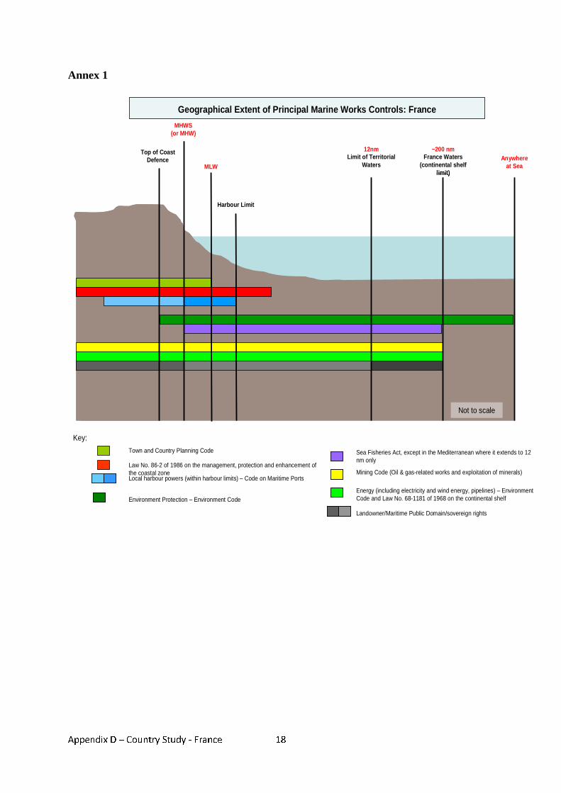
Appendix D – Country Study - France
18
Annex 1
Not to scale
Key:
Top of Coast Defence
Top of Coast Defence
MHWS(or MHW)
MHWS(or MHW)
Harbour LimitHarbour Limit
MLWMLW
12nmLimit of Territorial
Waters
12nmLimit of Territorial
Waters
~200 nmFrance Waters
(continental shelf limit)
~200 nmFrance Waters
(continental shelf limit)
Anywhereat Sea
Anywhereat Sea
Geographical Extent of Principal Marine Works Controls: France
Town and Country Planning Code
Law No. 86-2 of 1986 on the management, protection and enhancement of the coastal zoneLocal harbour powers (within harbour limits) – Code on Maritime Ports
Environment Protection – Environment Code
Sea Fisheries Act, except in the Mediterranean where it extends to 12 nm only
Mining Code (Oil & gas-related works and exploitation of minerals)
Energy (including electricity and wind energy, pipelines) – Environment Code and Law No. 68-1181 of 1968 on the continental shelf
Landowner/Maritime Public Domain/sovereign rights
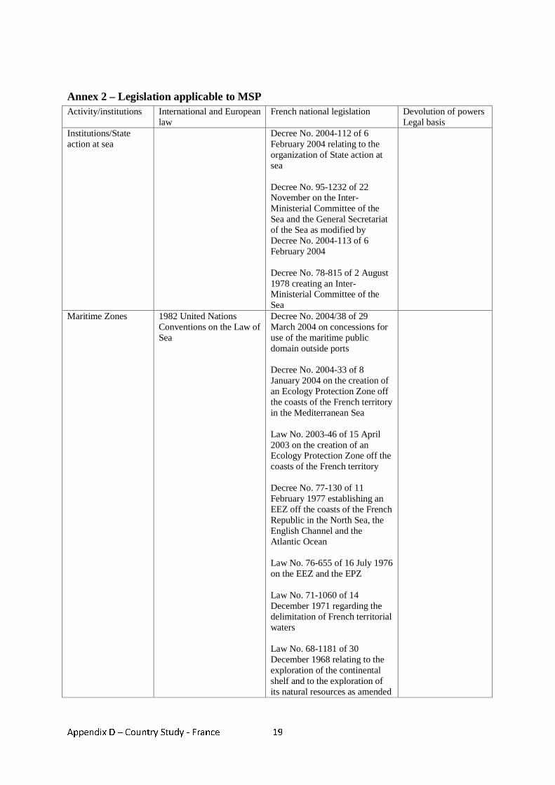
Appendix D – Country Study - France
19
Annex 2 – Legislation applicable to MSP Activity/institutions International and European
law French national legislation Devolution of powers
Legal basis Institutions/State action at sea
Decree No. 2004-112 of 6 February 2004 relating to the organization of State action at sea Decree No. 95-1232 of 22 November on the Inter-Ministerial Committee of the Sea and the General Secretariat of the Sea as modified by Decree No. 2004-113 of 6 February 2004 Decree No. 78-815 of 2 August 1978 creating an Inter-Ministerial Committee of the Sea
Maritime Zones 1982 United Nations Conventions on the Law of Sea
Decree No. 2004/38 of 29 March 2004 on concessions for use of the maritime public domain outside ports Decree No. 2004-33 of 8 January 2004 on the creation of an Ecology Protection Zone off the coasts of the French territory in the Mediterranean Sea Law No. 2003-46 of 15 April 2003 on the creation of an Ecology Protection Zone off the coasts of the French territory Decree No. 77-130 of 11 February 1977 establishing an EEZ off the coasts of the French Republic in the North Sea, the English Channel and the Atlantic Ocean Law No. 76-655 of 16 July 1976 on the EEZ and the EPZ Law No. 71-1060 of 14 December 1971 regarding the delimitation of French territorial waters Law No. 68-1181 of 30 December 1968 relating to the exploration of the continental shelf and to the exploration of its natural resources as amended
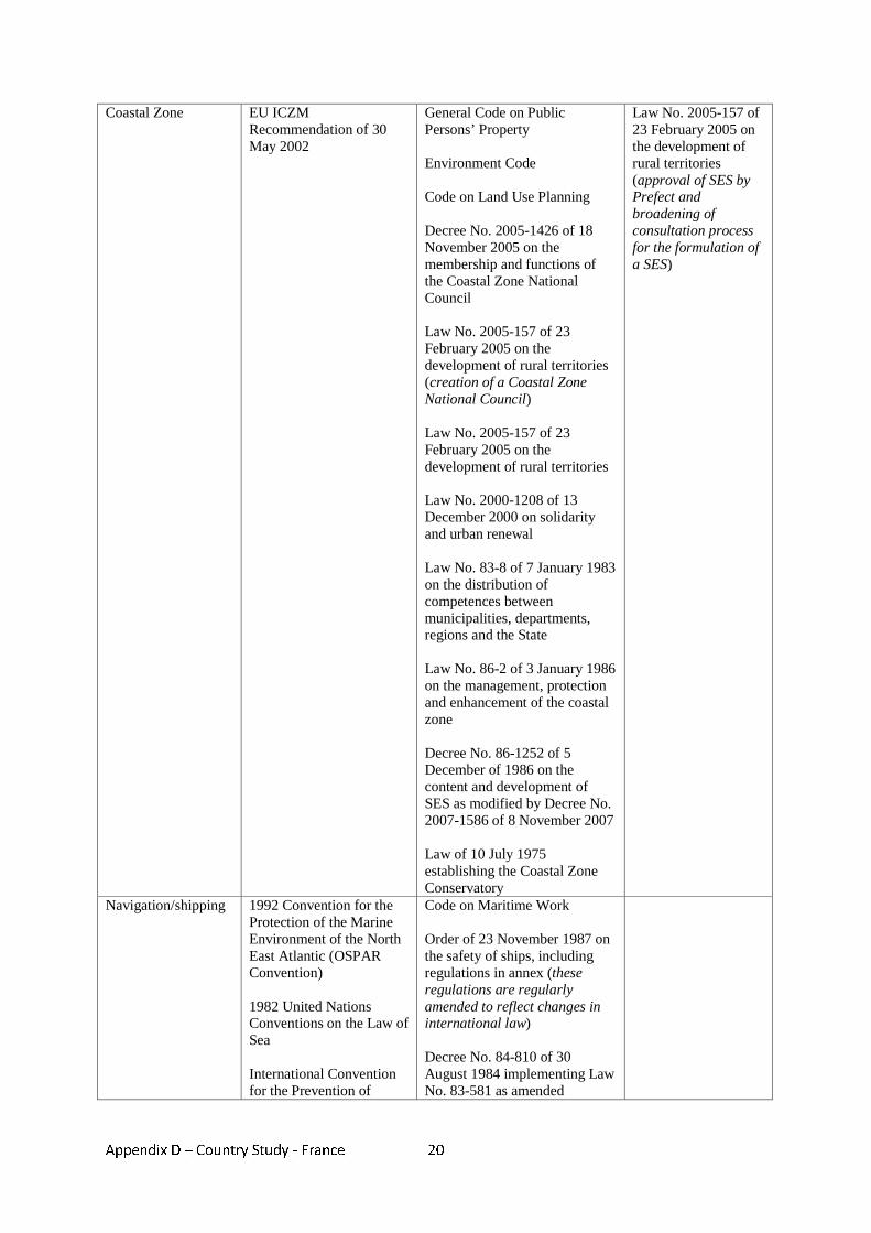
Appendix D – Country Study - France
20
Coastal Zone EU ICZM Recommendation of 30 May 2002
General Code on Public Persons’ Property Environment Code Code on Land Use Planning Decree No. 2005-1426 of 18 November 2005 on the membership and functions of the Coastal Zone National Council Law No. 2005-157 of 23 February 2005 on the development of rural territories (creation of a Coastal Zone National Council) Law No. 2005-157 of 23 February 2005 on the development of rural territories Law No. 2000-1208 of 13 December 2000 on solidarity and urban renewal Law No. 83-8 of 7 January 1983 on the distribution of competences between municipalities, departments, regions and the State Law No. 86-2 of 3 January 1986 on the management, protection and enhancement of the coastal zone Decree No. 86-1252 of 5 December of 1986 on the content and development of SES as modified by Decree No. 2007-1586 of 8 November 2007 Law of 10 July 1975 establishing the Coastal Zone Conservatory
Law No. 2005-157 of 23 February 2005 on the development of rural territories (approval of SES by Prefect and broadening of consultation process for the formulation of a SES)
Navigation/shipping 1992 Convention for the Protection of the Marine Environment of the North East Atlantic (OSPAR Convention) 1982 United Nations Conventions on the Law of Sea International Convention for the Prevention of
Code on Maritime Work Order of 23 November 1987 on the safety of ships, including regulations in annex (these regulations are regularly amended to reflect changes in international law) Decree No. 84-810 of 30 August 1984 implementing Law No. 83-581 as amended
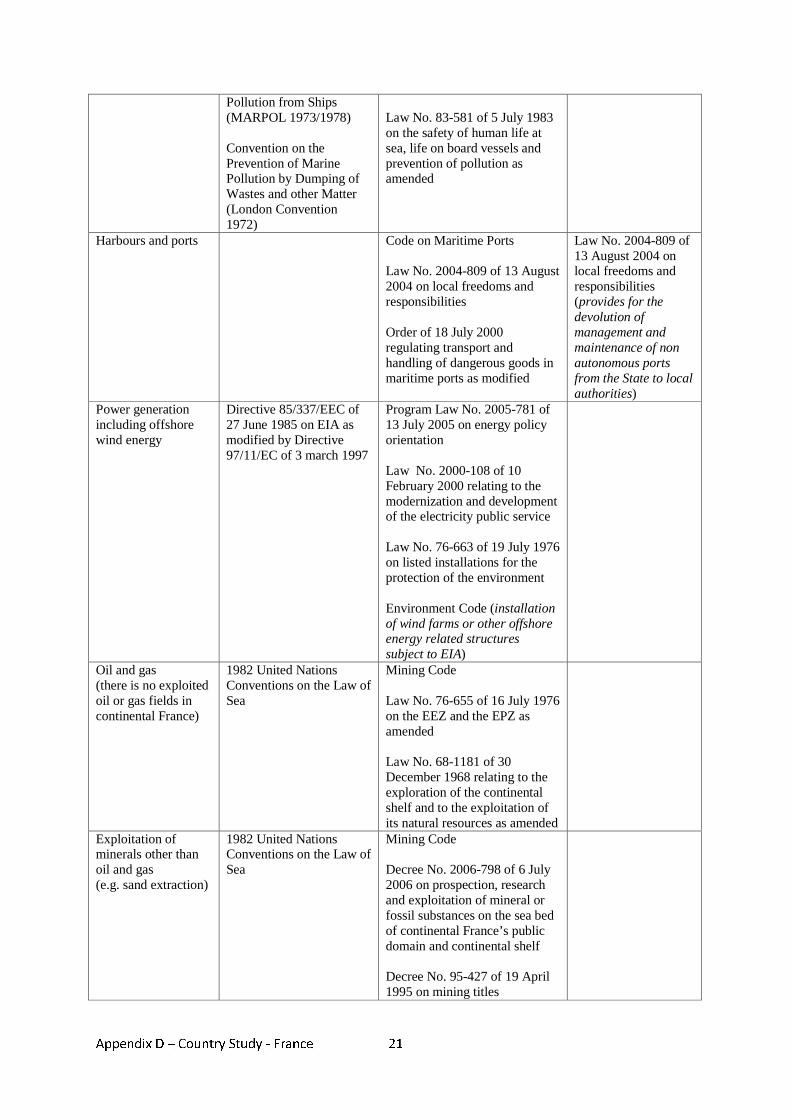
Appendix D – Country Study - France
21
Pollution from Ships (MARPOL 1973/1978) Convention on the Prevention of Marine Pollution by Dumping of Wastes and other Matter (London Convention 1972)
Law No. 83-581 of 5 July 1983 on the safety of human life at sea, life on board vessels and prevention of pollution as amended
Harbours and ports Code on Maritime Ports Law No. 2004-809 of 13 August 2004 on local freedoms and responsibilities Order of 18 July 2000 regulating transport and handling of dangerous goods in maritime ports as modified
Law No. 2004-809 of 13 August 2004 on local freedoms and responsibilities (provides for the devolution of management and maintenance of non autonomous ports from the State to local authorities)
Power generation including offshore wind energy
Directive 85/337/EEC of 27 June 1985 on EIA as modified by Directive 97/11/EC of 3 march 1997
Program Law No. 2005-781 of 13 July 2005 on energy policy orientation Law No. 2000-108 of 10 February 2000 relating to the modernization and development of the electricity public service Law No. 76-663 of 19 July 1976 on listed installations for the protection of the environment Environment Code (installation of wind farms or other offshore energy related structures subject to EIA)
Oil and gas (there is no exploited oil or gas fields in continental France)
1982 United Nations Conventions on the Law of Sea
Mining Code Law No. 76-655 of 16 July 1976 on the EEZ and the EPZ as amended Law No. 68-1181 of 30 December 1968 relating to the exploration of the continental shelf and to the exploitation of its natural resources as amended
Exploitation of minerals other than oil and gas (e.g. sand extraction)
1982 United Nations Conventions on the Law of Sea
Mining Code Decree No. 2006-798 of 6 July 2006 on prospection, research and exploitation of mineral or fossil substances on the sea bed of continental France’s public domain and continental shelf Decree No. 95-427 of 19 April 1995 on mining titles
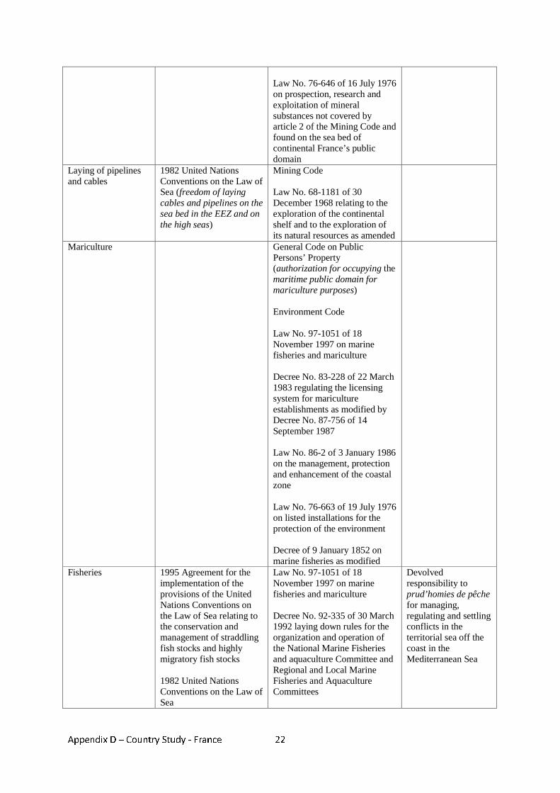
Appendix D – Country Study - France
22
Law No. 76-646 of 16 July 1976 on prospection, research and exploitation of mineral substances not covered by article 2 of the Mining Code and found on the sea bed of continental France’s public domain
Laying of pipelines and cables
1982 United Nations Conventions on the Law of Sea (freedom of laying cables and pipelines on the sea bed in the EEZ and on the high seas)
Mining Code Law No. 68-1181 of 30 December 1968 relating to the exploration of the continental shelf and to the exploration of its natural resources as amended
Mariculture General Code on Public Persons’ Property (authorization for occupying the maritime public domain for mariculture purposes) Environment Code Law No. 97-1051 of 18 November 1997 on marine fisheries and mariculture Decree No. 83-228 of 22 March 1983 regulating the licensing system for mariculture establishments as modified by Decree No. 87-756 of 14 September 1987 Law No. 86-2 of 3 January 1986 on the management, protection and enhancement of the coastal zone Law No. 76-663 of 19 July 1976 on listed installations for the protection of the environment Decree of 9 January 1852 on marine fisheries as modified
Fisheries 1995 Agreement for the implementation of the provisions of the United Nations Conventions on the Law of Sea relating to the conservation and management of straddling fish stocks and highly migratory fish stocks 1982 United Nations Conventions on the Law of Sea
Law No. 97-1051 of 18 November 1997 on marine fisheries and mariculture Decree No. 92-335 of 30 March 1992 laying down rules for the organization and operation of the National Marine Fisheries and aquaculture Committee and Regional and Local Marine Fisheries and Aquaculture Committees
Devolved responsibility to prud’homies de pêche for managing, regulating and settling conflicts in the territorial sea off the coast in the Mediterranean Sea
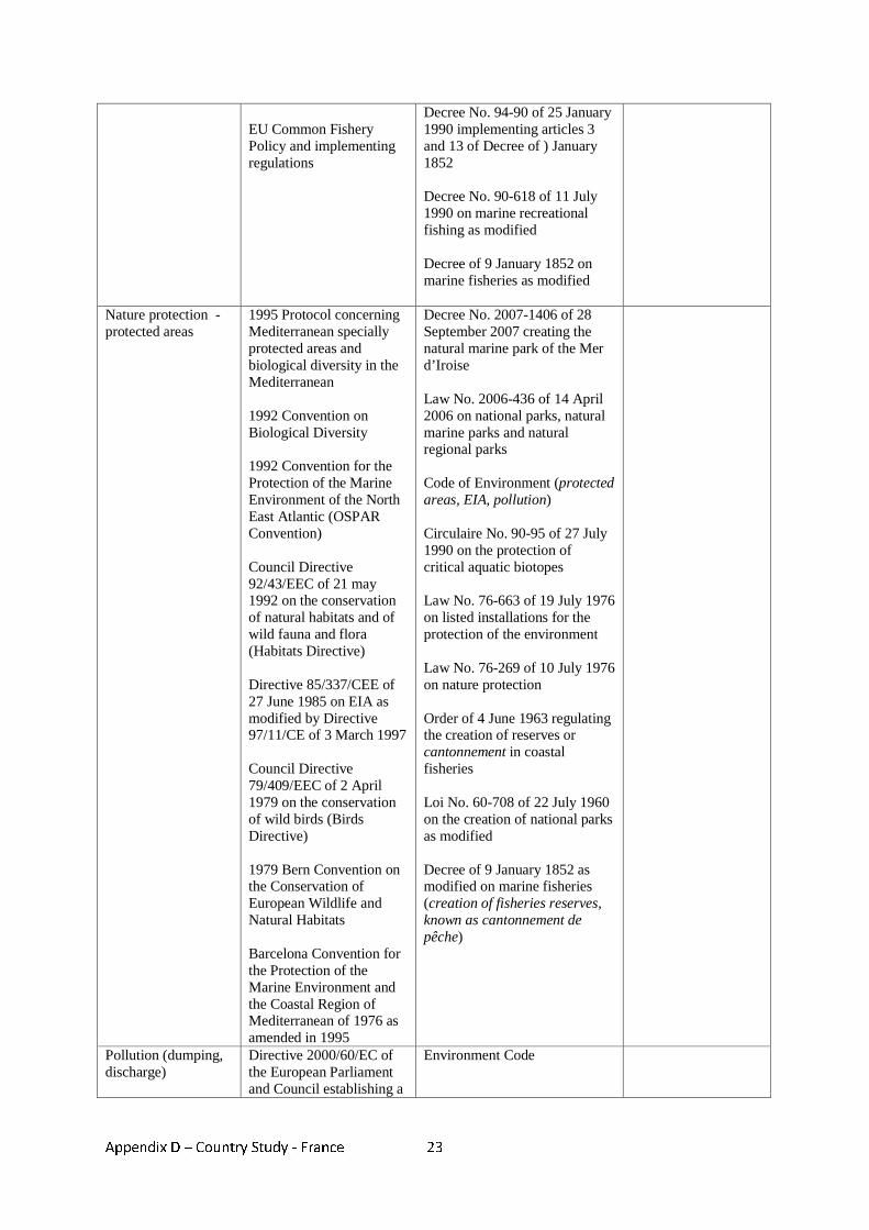
Appendix D – Country Study - France
23
EU Common Fishery Policy and implementing regulations
Decree No. 94-90 of 25 January 1990 implementing articles 3 and 13 of Decree of ) January 1852 Decree No. 90-618 of 11 July 1990 on marine recreational fishing as modified Decree of 9 January 1852 on marine fisheries as modified
Nature protection - protected areas
1995 Protocol concerning Mediterranean specially protected areas and biological diversity in the Mediterranean 1992 Convention on Biological Diversity 1992 Convention for the Protection of the Marine Environment of the North East Atlantic (OSPAR Convention) Council Directive 92/43/EEC of 21 may 1992 on the conservation of natural habitats and of wild fauna and flora (Habitats Directive) Directive 85/337/CEE of 27 June 1985 on EIA as modified by Directive 97/11/CE of 3 March 1997 Council Directive 79/409/EEC of 2 April 1979 on the conservation of wild birds (Birds Directive) 1979 Bern Convention on the Conservation of European Wildlife and Natural Habitats Barcelona Convention for the Protection of the Marine Environment and the Coastal Region of Mediterranean of 1976 as amended in 1995
Decree No. 2007-1406 of 28 September 2007 creating the natural marine park of the Mer d’Iroise Law No. 2006-436 of 14 April 2006 on national parks, natural marine parks and natural regional parks Code of Environment (protected areas, EIA, pollution) Circulaire No. 90-95 of 27 July 1990 on the protection of critical aquatic biotopes Law No. 76-663 of 19 July 1976 on listed installations for the protection of the environment Law No. 76-269 of 10 July 1976 on nature protection Order of 4 June 1963 regulating the creation of reserves or cantonnement in coastal fisheries Loi No. 60-708 of 22 July 1960 on the creation of national parks as modified Decree of 9 January 1852 as modified on marine fisheries (creation of fisheries reserves, known as cantonnement de pêche)
Pollution (dumping, discharge)
Directive 2000/60/EC of the European Parliament and Council establishing a
Environment Code

Appendix D – Country Study - France
24
framework for the Community action in the field of water policy of 23 October 2000 1992 Convention for the Protection of the Marine Environment of the North East Atlantic (OSPAR Convention) Directive 85/337/CEE of 27 June 1985 on EIA as modified by Directive 97/11/CE of 3 March 1997 1982 United Nations Conventions on the Law of Sea International Convention for the Prevention of Pollution from Ships (MARPOL 1973/1978) Convention on the Prevention of Marine Pollution by Dumping of Wastes and other Matter (London Convention 1972)
Law No. 2006-1772 of 30 December 2006 on water and aquatic environment
Wrecks and other historic features
Law No. 89-874 of 1 December 1989 on maritime cultural assets modifying Law of 27 September 1941 regulating archaeological exploration
Tourism and recreation
Tourism Code Environment Code Code on Land Use Planning Law No. 2006-437 of 14 April 2006 laying down various provisions on tourism Law No. 92-1341 of 23 December 1992 on distribution of powers in the field of tourism Decree No. 90-618 of 11 July 1990 on marine recreational fishing as modified Order of 23 November 1987 on the safety of ships, including regulations in annex (volume 4 deals with recreational vessels)
Places of refuge IMO Resolution A
Appendix D – Country Study - France
25
949(23) of December 2003 (It provides guidelines on places of refuge for vessels requiring assistance) Directive 2002/59/EC of 27 June 2002 establishing a Community vessel traffic monitoring and information system (article 20) (Plans for accommodating ships in distress to be prepared by February 2004)
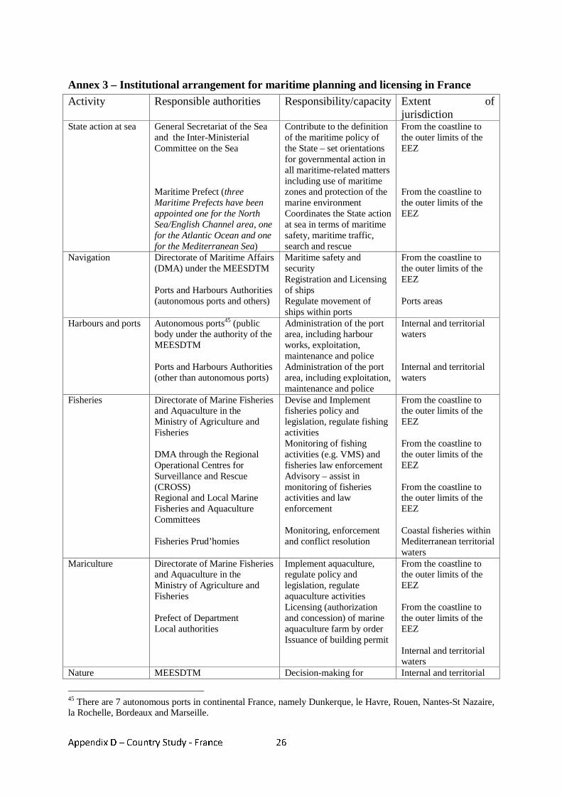
Appendix D – Country Study - France
26
Annex 3 – Institutional arrangement for maritime planning and licensing in France Activity Responsible authorities Responsibility/capacity Extent of
jurisdiction State action at sea General Secretariat of the Sea
and the Inter-Ministerial Committee on the Sea Maritime Prefect (three Maritime Prefects have been appointed one for the North Sea/English Channel area, one for the Atlantic Ocean and one for the Mediterranean Sea)
Contribute to the definition of the maritime policy of the State – set orientations for governmental action in all maritime-related matters including use of maritime zones and protection of the marine environment Coordinates the State action at sea in terms of maritime safety, maritime traffic, search and rescue
From the coastline to the outer limits of the EEZ From the coastline to the outer limits of the EEZ
Navigation Directorate of Maritime Affairs (DMA) under the MEESDTM Ports and Harbours Authorities (autonomous ports and others)
Maritime safety and security Registration and Licensing of ships Regulate movement of ships within ports
From the coastline to the outer limits of the EEZ Ports areas
Harbours and ports Autonomous ports45 (public body under the authority of the MEESDTM Ports and Harbours Authorities (other than autonomous ports)
Administration of the port area, including harbour works, exploitation, maintenance and police Administration of the port area, including exploitation, maintenance and police
Internal and territorial waters Internal and territorial waters
Fisheries Directorate of Marine Fisheries and Aquaculture in the Ministry of Agriculture and Fisheries DMA through the Regional Operational Centres for Surveillance and Rescue (CROSS) Regional and Local Marine Fisheries and Aquaculture Committees Fisheries Prud’homies
Devise and Implement fisheries policy and legislation, regulate fishing activities Monitoring of fishing activities (e.g. VMS) and fisheries law enforcement Advisory – assist in monitoring of fisheries activities and law enforcement Monitoring, enforcement and conflict resolution
From the coastline to the outer limits of the EEZ From the coastline to the outer limits of the EEZ From the coastline to the outer limits of the EEZ Coastal fisheries within Mediterranean territorial waters
Mariculture Directorate of Marine Fisheries and Aquaculture in the Ministry of Agriculture and Fisheries Prefect of Department Local authorities
Implement aquaculture, regulate policy and legislation, regulate aquaculture activities Licensing (authorization and concession) of marine aquaculture farm by order Issuance of building permit
From the coastline to the outer limits of the EEZ From the coastline to the outer limits of the EEZ Internal and territorial waters
Nature MEESDTM Decision-making for Internal and territorial
45 There are 7 autonomous ports in continental France, namely Dunkerque, le Havre, Rouen, Nantes-St Nazaire, la Rochelle, Bordeaux and Marseille.
Appendix D – Country Study - France
27
protection/protected areas
Marine Protected Areas Agency Coastal Zone Conservatory
designation of national parks and natural marine parks Purchase lands in the coastal zone for conservation purposes and protection of landscapes and particular sites
waters. Natural marine parks may extend in the EEZ.
Power generation, including wind energy
MEESDTM MEEDDAT (General Directorate of Energy and Climate) Prefect of Departement (after approval by the Maritime Prefect) Local authorities
Consent for offshore renewable energy project in consultation with local authorities concerned Define and implement French energy policy (oil, gas and electricity) Grant of concession to occupy the maritime public domain Building permit
From the coastline to the outer limits of the EEZ From the coastline to the outer limits of the EEZ Internal and territorial waters Internal and territorial waters
Wrecks and other historic features
Ministry of Culture and Communication
Licensing for exploration of wrecks or other historic features in sites of national interest
Internal and territorial waters
Tourism and recreation
Local authorities (region, département and municipalities) Ports and harbours authorities
Implementing regulations, planning (tourism scheme developed at the regional and département levels) and regulation of local recreational and tourism facilities and activities Regulating movement of ships and mooring within port areas
Local Within the limits of port areas
Places of refuge MEESDTM, DMA, port authorities
Providing facilities to accommodate ships in distress
Internal and territorial waters
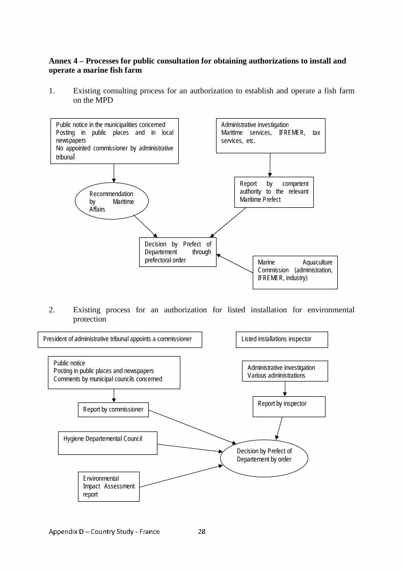
Appendix D – Country Study - France
28
Annex 4 – Processes for public consultation for obtaining authorizations to install and operate a marine fish farm 1. Existing consulting process for an authorization to establish and operate a fish farm
on the MPD
2. Existing process for an authorization for listed installation for environmental protection
Public notice in the municipalities concerned Posting in public places and in local newspapers No appointed commissioner by administrative tribunal
Administrative investigation Maritime services, IFREMER, tax services, etc.
Recommendation by Maritime Affairs
Decision by Prefect of Departement through prefectoral order
Report by competent authority to the relevant Maritime Prefect
Marine Aquaculture Commission (administration, IFREMER, industry)
President of administrative tribunal appoints a commissioner Listed installations inspector
Public notice Posting in public places and newspapers Comments by municipal councils concerned
Report by commissioner
Administrative investigation Various administrations
Report by inspector
Hygiene Departemental Council
Decision by Prefect of Departement by order
Environmental Impact Assessment report
Appendix D – Country Study - France
29
Annex 5 – References Burvingt, J.C. Tricolor experience in the framework of the contingency plan Manche plan, Maritime Prefecture of the English Channel and North Sea, www.vliz.be/imisdocs/publications.103734.pdf Dujardin, B., Les espaces maritimes français, Revue maritime No. 477, December 2006 IUCN, French Committee, Etat des lieux et propositions pour une loi mer, Marine Biodiversity and French Law, 2007 European Commission, Working Document on offshore activities of Coastal EU Member States and Cross-Border Cooperation, Integrated Maritime Policy for the EU, DG Fisheries and Maritime Affairs, Maritime Policy Task Force, November 2007 French Government, Réponse des Autorités françaises au Livre Vert sur la politique maritime de l’Union, www.sgae.gouv.fr/actualites/docfiles/Livre_vert_reponse_FR200407.pdf French Republic, Rapport du Gouvernement au Parlement portant bilan de la loi littoral et des mesures en faveur du littoral, September 2007 General Secretariat of the Sea, Une ambition maritime pour la France, Poseidon Group Report, December 2006, www.sgmer.gouv.fr/IMG/pdf/POSEIDON_-_Rapport_11-12-06-2.pdf General Secretariat of the Sea, Stratégie nationale pour la biodiversité – Plan d’action mer, November 2005 IFREMER, Pisciculture marine : éléments de prospective, Directorate of Programmes and Strategy, March 2006 Kosciusko-Morizet, N., Discours de Mme Kosciusko-Morizet, first national workshop on marine protected areas, 20 November 2007, www.natura2000.fr
Appendix E – Country Study - Germany
1
Appendix E - Country study - Germany
MARITIME SPATIAL PLANNING IN GERMANY
1. Introduction 1. The total length of Germany’s coast measures 2,389 km and includes the Länder
(Federal states of) Lower-Saxony, Schleswig-Holstein, Mecklenburg-Western Pomerania, as well as the city-states Hamburg and Bremen.
2. It is bordering the North and the Baltic Sea. The North Sea comprises 745.950 km² of
which 7.950 km² are made up by the Wadden Sea. The Baltic Sea covers an overall surface of 415.266 km². The characteristics and natural dynamics of the two seas however are fundamentally different.
3. In 1994 Germany declared an EEZ in both North and Baltic Sea. The area of the EEZ is
identical with its continental shelf area. The total area of the EEZ covers 28.606 km² in the North Sea and 4513 km² in the Baltic Sea. It is equivalent to one tenth of the overall surface of the territory of Germany. Germany shares maritime boundaries with the Netherlands, the UK, Denmark, Sweden and Poland.
4. It has been pointed out that maritime spatial planning (MSP) would necessarily have
become an issue as the technical and economic progress allows for an increasingly demand to use offshore areas especially for economic activities46.
5. Consequently there have been calls to introduce spatial planning to maritime areas since
the end of the 1990s. However the trigger for eventually starting this process is to be seen in the political and economic interest to develop offshore wind energy exploitation47.
6. The German Government had set the target of doubling the share of renewable energies
by the year 2010 as one element to reach its ambitious carbon dioxide reduction targets. The assumption was that an initial phase (by 2006) would allow for the generation of at least 500 MW and in the medium-term, by 2010, even 2000 to 3000 MW power were expected from using off-shore wind energy. In the long-term, i.e. up to 2025 or 2030 about 20,000 to 25,000 MW of installed power should be reached48.
7. For investors to consider investments of a scale needed to reach up to these ambitious
targets requires a stable planning framework which allows for predictable decisions as to the realisation of the projects. On the other hand, the decisions as to the location of the projects were not to be left to the investors alone, but the state was seen to be responsible for weighing and balancing all public and private interests.
46 Von Nicolai, H. (2004), Rechtliche Aspekte einer Raumordnung auf dem Meer, in Informationen zur Raumentwicklung, Heft 7/8.2004, p. 491. 47 as before 48 Federal Ministry for the Environment, Nature Conservation and Nuclear Safety (2002), Strategy of the German Government on the use of off-shore wind energy, January 2002, Berlin, p.7.
Appendix E – Country Study - Germany
2
8. The introduction of MSP was thus becoming more concrete at the end of 2001 when the ministers of the federal government as well as the Länder responsible for spatial planning asked the coastal Länder to extend their spatial structure plans to the territorial sea and the federal government to develop a “spatial development strategy” for the EEZ and consider legislative changes to the Raumordnungsgesetz (Federal Spatial Planning Act/ROG) to support such a strategy.
9. As to the general legal setting MSP in Germany has to settle with “Germany’s highly
complex federal structure” as “one of the most complex and multi-layered administrative landscapes”49. It is characterized by three governmental levels, the federation itself, the Länder, and the local communities. Each of them plays a decisive role in the German planning system. In a complex system responsibilities are legally determined and distributed among all three levels however closely inter-linked on the basis of complex regulations regarding information, participation, agreement and cooperation.
10. As to the territorial jurisdiction of the areas concerned by MSP, the territorial sea is
integral part of the Länder50. However the marine area below mean high water springs (MHWS) up to the 12nm limit is considered a federal waterway (Art. 1 (2) Federal Waterways Act/ WaStrG). Art. 89 of the German constitution (Grundgesetz) stipulates that as such federal waterways are private property of the Federal Republic of Germany and administered by the Wasserschifffahrtsverwaltung (Federal Administration of Waterways/WSV). Art. 89 reads:
(1) The Federation shall be the owner of the former Reich waterways. (2) The Federation shall administer the federal waterways through its own authorities. It shall exercise those state functions relating to […] maritime shipping, which are conferred on it by a law.
In addition to any licenses required under administrative law, any uses of a longer duration through fixed installations require a contract for remuneration with the WSV under private law51. In general the jurisdiction of local communities and thus also the districts ends at the MHWS52.
11. This case study reviews the legislation applicable to MSP in Germany, and the
authorities and jurisdictions responsible for planning and licensing of different activities in the maritime area. It examines current procedures for obtaining licenses for maritime activities, and mechanisms for consultation and resolving conflict between different users and stakeholders.
12. The case study also discusses how recent legislative changes in legislation such as the
Raumordnungsgesetz change the status of MSP in Germany. Finally the legal framework of transboundary planning as well as some examples of cross-border cooperation are reviewed in the context of their contribution to spatial planning in German waters.
49 Gee, K., Kannen, A.,Glaeser, B., Sterr, H. (2004). National ICZM Strategy in Germany: A spatial planning approach, Schernewski, G. & Löser, N. (eds.) Coastline Reports 2, p. 25. 50 The Federal Republic does not have a territory itself but is made up exclusively of the territory of the Länder. 51 Wolf, R., AWZ-Vorhaben: Rechtliche und Naturschutzfachliche Aspekte beim Bau und Betrieb von Stromkabel, im Auftrag des Bundesamtes für Naturschutz, p. 65. 52 Niedersächsisches Ministerium für den ländlichen Raum, Ernährung, Landwirtschaft und Verbraucherschutz, Raumordnungskonzept für das niedersächsische Küstenmeer –Stand 2005, p.6.
Appendix E – Country Study - Germany
3
2. Legislation applicable to MSP
13. For a better understanding of the legislation relevant to spatial planning in the territorial sea and the EEZ this section opens with a brief introduction into the general framework of German planning law ( 2.1.). Subsequently relevant legislation applicable to MSP is described within the categories of sectoral planning (2.2.) and comprehensive spatial planning (2.3.).
2.1 General legal framework of spatially significant planning in Germany 14. In Germany “spatial planning” is an area-related public sector task comprising two
different categories: comprehensive planning (Raumplanung) and sectoral planning (Fachplanung).
15. Comprehensive planning addresses the supra-local (spatial planning) and local levels
(urban land-use planning). The latter not being of interest in the context of MSP. Comprehensive spatial planning is cross-sectional at all planning levels.
16. All public planning authorities have to comply with or take into account the legally
defined requirements of spatial planning when deciding on more detailed plans or projects. The supra-sectoral and coordinating function is central to the German planning system. “Raumplanung” is therefore legally and organisationally distinct from spatially relevant sectoral planning53.
17. In general federal spatial planning was not meant to directly organise and develop
territory itself54. Consequently as spatial planning falls within the competence of the Länder, there is no spatial plan covering the entire surface of Germany developed by a federal agency. The Federal Spatial Planning Act (Raumordnungsgesetz/ROG), provides the framework and material basis for spatial development, either in form of principles and guidelines to be taken into account when weighing interests and making discretionary decisions or by specifying the instruments to be used in plan-making. Those instruments include especially the designation of different types of areas such as ‘priority areas’ (Vorranggebiete), reserved exclusively for specific uses or activities (Article 7(4) no.1 ROG), ‘reservation areas’ (Vorbehaltsgebiete) giving priority to specific uses without excluding other activities (Article 7(4) no.2 ROG) and ‘suitability or qualification areas’ (Eignungsgebiete) reserved for activities/uses which are excluded elsewhere in the planning area (Article 7(4) no.3 ROG). Art. 7 ROG states:
(2) Spatial structure plans should contain specifications concerning the spatial structure, especially with respect to: 1. the desired settlement structure …., 2. the desired open space structure …, 3. the desired infrastructure locations and routes. Stipulations in accordance with sentence 1, No. 2, may also establish the need to compensate for, make good or limit unavoidable damage to the ecological balance or the countryside in this area elsewhere.
53 Pahl-Weber, E., Henckel D., Klinge, W., Lau, P., Zwicker, D. (2007), The Structure of Government and Administration and Planning System in the Federal Republic of Germany, COMMIN - Baltic Sea Region (BSR) INTERREG III – project at: http://commin.org/upload/Germany/DE_Country_and_Planning_System_Engl.pdf. 54 As to the recent changes with regard to the EEZ see below.
Appendix E – Country Study - Germany
4
(3) Spatial structure plans should also contain those stipulations concerning spatially significant plans and measures …these mainly include: 1. spatially significant nature protection and countryside conservation requirements…; …. (4) The stipulations in accordance with paragraphs 2 and 3 may also refer to areas 1. scheduled for certain spatially significant functions or uses, thus excluding other regionally significant uses in this area provided that they are inconsistent with the priority functions, uses or objectives of regional planning (priority areas), 2. where special importance is attached to certain spatially significant functions or uses when balanced with competing regionally significant uses (reservation areas), 3. suitable for certain spatially significant measures which are… prohibited in another location in the planning area (suitability areas).
18. The key concept as defined in the ROG is that of a “sustainable spatial development”
harmonising social and economic requirements with the ecological functions of the area subject to the plan and permitting a permanent, balanced development. Art. 1 (2) ROG states:.
The overall concept … is that of sustainable spatial development which will bring the social and economic demands made on an area into line with its ecological functions and result in a stable order which will be well-balanced on a large scale. …
19. The ROG requires the Länder to establish an overall, superordinate plan for the territory of each Land (Art. 8 ROG)55. The goals and principles of spatial planning as laid down in these plans are to be observed and taken into consideration by subordinate tiers of planning (regional plans) and in sectoral planning. As a rule, such plans contain both text and drawings (maps).
20. Sectoral planning deals with specific uses and specific areas and sites and handles the
final authorisation of special projects. Some sectoral planning also provides for the designation of protected areas to safeguard public interests (gebietsbezogene Fachplanung)56.
21. A legal basis has been created for each type of sectoral planning laying down the tasks
and competences of each authority. The Planfeststellungsverfahren (Planning approval procedure) is a key tool in sectoral planning law. This is a special procedure in order to determine whether a particular project with spatial impacts is to proceed. It involves weighing and balancing both the interests of the developer and any public or private interests which might be affected by the project. Planning approval includes and replaces all of the other required decisions by public authorities; all requirements are dealt within this one procedure (concentration effect). Sectoral planning laws contain Raumordnungsklauseln (spatial planning clauses) requiring bringing the decisions in line with the requirements of federal and/or state planning requirements.
22. Moreover, at the level of the Länder an additional instrument to reflect on spatial
significance of certain plans and measures is the Raumordnungsverfahren (spatial 55 Different terminologies in each Land: Landesentwicklungsplan, Landesraumordungsprogramm, Landesentwicklungsprogramm, etc. 56 Of particular importance for MSP is the creation of nature protection areas (see below).
Appendix E – Country Study - Germany
5
planning procedure) aiming at a territorial impact assessment (TIA/Raumverträglichkeitsprüfung) (Art. 15 (1) ROG).
23. It aims at harmonising spatially significant plans and measures (large-scale infrastructure
projects) with the requirements of comprehensive spatial planning. The function of the TIA is to integrate all relevant issues, especially environmental aspects and evaluate alternatives regarding the chosen route or location. Art. 15 (1) ROG states:
(1) Spatially significant plans and measures shall be harmonized with each other as well as coordinated with the requirements of spatial policy under a special procedure (spatial planning procedure). The spatial planning procedure assesses 1. whether spatially significant plans or measures are in accordance with the requirements of regional policy, 2. in which way spatially significant plans and measures can be harmonized with each other or carried out under the provisions of spatial policy (territorial impact assessment). The spatial planning procedure shall assess the spatially significant impact of the plan or measure … taking supralocal criteria into consideration. The assessment in accordance with sentence 2 shall include evaluation of the locational or route alternatives introduced by the body that is responsible for the plan or measure.
2.2. Sectoral Planning 2.2.1. Territorial Sea
24. In general the legal regime applying to licensing of projects on land will also apply to projects in the territorial sea. Depending on the kind of project the licensing procedure is based either on specific sectoral legislation (e.g. the Bundesimmissionsschutzgesetz57) or on provisions of the general building codes (Bauordnungen) of the Länder – e.g. as for the construction of wind turbines.
25. The granting of the license depends inter alia on whether the project meets the
requirements of the planning law on construction works (Bauplanungsrecht). Compliance with requirements of other specific sectoral legislation (especially environmental protection laws) referring to the admissibility of a project is often subject to the licensing procedure and therefore covered by the license. E.g. projects subject to a license procedure under the Bundesimmissionsschutzgesetz (Law on emission’s control/BImSchG) as this license is vested with a "concentration effect". Art. 13 BImSchG reads:
The licence shall include other official decisions with a bearing on the installation, in particular licences under public law, approvals, grantings, permits and authorisations – with the exception of plan approvals, approvals of operation plans under mining law, official decisions based on nuclear law and permits and authorisations under water law pursuant to Arts. 7 and 8 of the Federal Water Act
26. If this is not the case and specific sectoral legislation contains additional requirements
those may require a separate licensing procedure. Finally additional specific
57 Federal Law on emission’s control/BImSchG
Appendix E – Country Study - Germany
6
requirements referring to the operation of the installation are laid down in the relevant specific sectoral legislation; they are normally not covered by the license58.
27. Numerous provisions of federal legislation are applicable, like the Federal Building
Code and the Federal Waterway Law as well as laws of the Länder like the building codes, Environmental Protection Laws, Water Laws, and Laws on Nature Protection Areas etc. In addition installations in coastal waters close to the coast usually need a license according to the Water Laws of the Länder. If the project is located in a waterway, another license according to the Bundeswasserstrassengesetz (Federal Waterway Act/WaStrG) is needed. Finally, as the entire coastal sea including the ocean floor is property of the Federal Republic of Germany the consent is required for any use/activities therein; this usually takes the form of a licensing agreement under private law to be concluded with the shipping and navigation administration59.
2.2.2. Exclusive Economic Zone
28. So far no comprehensive spatial planning for the German EEZ in force. The changes in legislation and the actual progress towards MSP in the German EEZ are presented infra (see section 7). But until finalisation of the first plan the legal framework for spatially organising the German EEZ is based almost exclusively on sectoral planning. The main instruments are as follows.
29. The legal basis for authorising the erection and operation of installations in the German
EEZ is the Seeaufgabengesetz (Federal Maritime Responsibilities Act/SeeAufG). This law had been amended subsequently to the accession of Germany to the UN Convention on the Law of the seas (LOSC) giving the Federal Government competency to regulate on the assessment, approval and control of installations within the EEZ.
30. Details and procedures haven been implemented by the Seeanlagenverordnung (Marine
Facilities Ordinance/SeeAnlV) issued by the Federal Ministry of Public Transport, Construction and Urban Development (BMVBS)60. Therefore projects will have to be granted a license provided that they: a) do not impair the safety and efficiency of navigation; b) have no detrimental effect on the marine environment (bound decision); and c) do not contradict the requirements of spatial planning or other prevailing public interests. Art. 3 SeeAnlV states:
Issuance of a licence shall be refused if the safety and smoothness of traffic is disrupted or the marine environment is endangered and these negative effects cannot be prevented or compensated for by imposition of a time limit, condition or additional requirement. Particular grounds for a refusal shall be deemed to exist in cases where
1. operation and effect of navigational installations and marks or 2. use of shipping lanes or airspace or navigation would be disrupted;
58 Klinski, S. (2005), Überblick über die Zulassung von Anlagen zur Nutzung Erneuerbarer Energien, im Auftrag des Bundesministeriums für Umwelt, Naturschutz und Reaktorsicherheit, p. 21. 59 Wolf, R., AWZ-Vorhaben: Rechtliche und Naturschutzfachliche Aspekte beim Bau und Betrieb von Stromkabel, im Auftrag des Bundesamtes für Naturschutz, p. 65. 60 Under German Law a “Verordnung”/Ordinance is a subordinate instrument with binding legal character enacted by the executive on the basis of a competency conferred on it by the legislator.
Appendix E – Country Study - Germany
7
3. pollution of the marine environment as defined in Article 1 (1) No. 4 of the United Nations Convention on the Law of the Sea of 10 December 1982 (BGBl. 1994 II p. 1798) is to be feared, or if
4. bird migration is endangered. The licence shall not be refused if no grounds for refusal within the meaning of the first sentence above exist.
Moreover the license granted under those provisions does not exempt from other licenses required under other legal provisions.
31. The laying and operation of transit pipelines and transit submarine cables (power cables
and communication cables) on the German continental shelf are subject to the regulations of the Federal Mining Act (Bundesberggesetz) Art. 133. This law regulates on aspects of organizing activities in the waters and the air above the German continental shelf (Art.133 (1) No.2) as well as of mining interests (Art.133 (1) No.1). The two different licenses are both subject to a bound decision, based on the same conditions. The license may only be denied if threats on life, health or private property or negative effects on overriding public interests cannot be prevented or otherwise be compensated for.
32. A first step to steer spatial development in the German EEZ was undertaken within the
framework of the Marine Facilities Ordinance in 2002. In reaction to the high interest of the federal government regarding the exploitation off offshore wind energy a new provision was inserted concerning the designation of “particularly suitable areas for wind farms” (Art. 3a SeeAnlV).
33. Despite favourable conditions set by the Federal Renewable Energies Act in 2000,
planning and setting up of offshore wind parks did not progress as quickly as expected. This was also considered to be the result of a reactive and highly sectoral planning system which did not provide a framework for managing competing interests in the EEZ.
34. Areas identified for designations as protected areas under Art. 38 BNatschG (see infra)
could generally not be designated as suitable areas for offshore wind farms. In the licensing procedure for a specific project the designation has the effect of an expert opinion with regard to the choice of locations for installations (Article 3 a (2) SeeAnlV). However an EIA within the licensing process of specific projects is still mandatory. The areas designated under these provisions are to be taken over as priority areas for wind farms in the spatial plan for the EEZ. The idea behind this concept was to give an investor a clear signal as to the admissibility of a project within such a designated area, to speed up the licensing process and to steer the spatial development of offshore wind energy exploitation.
35. Due to the lack of an exclusion of applications for licenses in other areas, the potential to
actively steer spatial development with regard to offshore wind energy exploitation is rather low61. Projects have been licensed within and outside those “particularly suitable” areas and this instrument has therefore been characterised as rather “passive spatial
61 Kruppa, I., (2007), Steuerung der Offshore-Windenergienutzung vor dem Hintergrund der Umweltziele Klima- und Meeresumweltschutz, Berlin, p. 94.
Appendix E – Country Study - Germany
8
steering instrument”62. The amendment coincided with the amendment of the Marine Facilities Ordinance introducing the “particularly suitable areas for wind farms”. The intention had been that the combination of those two instruments would provide a structured spatial development of wind farms in the EEZ and allow solving existing use conflicts by means of previous inter-ministerial consultation63.
36. Of particular importance for site-related protection of the (marine) environment is the
framework legislation of the Bundesnaturschutzgesetz (Federal Nature Conservation Act/BNatSchG). The framework Act requires expansion by Länder nature conservation legislation. The relevant provision (Art. 38) of the BNatschG was amended in 2002, establishing a statutory basis for federal declaration of protected areas in the EEZ (Art. 38 BNatschG).
37. The designation of protected areas has been among the sectoral instruments with high
potential for steering spatial development demonstrated by the fact that from the very beginning plans for the development of offshore wind parks have been limited in the territorial sea mainly for nature protection reasons due to very large parts designated as protected areas (e.g. the Wadden) and by now Germany has designated MPAs under the Natura 2000 scheme covering about 30% of its EEZ64.
38. From a legal point of view the possibility for the federal government to designate nature
protection areas itself (through the Bundesamt für Naturschutz (Federal Agency for Nature Conservation/BfN) was a novel development. It was criticised as under the German constitutional framework nature protection falls within the realm of the Länder giving only framework legislation competence to the federal level65.
39. In addition some difficulties remain as regards areas extending from the territorial sea to
the EEZ: coordination problems between the Länder and the federal level sometimes result in an area being only partly designated, e.g. the missing extension of the Borkum Riffgrund pSCI, a proposed NATURA 2000 site in the German EEZ, into territorial waters of Lower Saxony66.
40. The effect of the designation of a protected area as to the exclusion of other activities is
also not quite clear and subject to a case by case evaluation. In one case construction of a wind park has been authorised within a proposed Natura 2000 protected area67. In other cases applications for construction of wind parks within the EEZ of the German Baltic
62 Kruppa, I., (2007), Steuerung der Offshore-Windenergienutzung vor dem Hintergrund der Umweltziele Klima- und Meeresumweltschutz, Berlin, p. 97. 63 Kruppa, I., (2007), Steuerung der Offshore-Windenergienutzung vor dem Hintergrund der Umweltziele Klima- und Meeresumweltschutz, Berlin, p. 230. 64 See Federal Agency for Nature Conservation at http://www.bfn.de/0316_gebiete.html 65 Von Nicolai, H. (2004), Rechtliche Aspekte einer Raumordnung auf dem Meer, in Informationen zur Raumentwicklung, Heft 7/8.2004, p. 497. 66 WWF Germany (2004), Managing across boundaries - The Dogger Bank – a future international marine protected area, Frankfurt/M. 2004. 67 Bundesamt für Seeschifffahrt und Hydrographie (2002): Genehmigung Offshore Windenergiepark "Offshore-Bürger-Windpark Butendiek". Antragsteller: OSB Offshore-Bürger-Windpark Butendiek GmbH & Co.KG. Aktenzeichen 8086.01/Butendiek/Z1. Hamburg, December 2002.
Appendix E – Country Study - Germany
9
Sea have been rejected on grounds that negative implications for the marine environment were to be expected68.
2.2.3. Environmental Impact Assessment
41. Under German law the environmental impact assessment is not a particular procedure of its own but forms an integral part of licensing procedures (Art. 2 (1) Gesetz über die Umweltverträglichkeitsprüfung (Environmental Impact Assessment Act/UVPG). The licensing authority is thus the authority responsible for administering the Environmental Impact Assessment.
42. The scope of the UVPG is defined in an Annex I listing all projects requiring an EIA. An
Environmental Impact Assessment is only to be carried out as regards public and private projects listed in this Annex.
43. An EIA is especially required for all installations in the EEZ falling within the scope of
the Marine Facilities Ordinance in so far as these projects are considered projects in the meaning of Art. 3 of the UVPG (Art. 2a SeeAnlV) .
2.3. Comprehensive spatial planning/ Raumplanung 44. As the territorial sea forms part of the territory of the Federal Republic of Germany all
federal and state laws of Germany applying to the mainland are applicable in the territorial sea as well. However as far as comprehensive spatial planning is concerned it was not until 2001 that the Conference of Ministers responsible for spatial planning asked the coastal Länder to extend their spatial structure plans to the territorial sea in order to provide early conflict management between the demands of new technologies69.
45. Lower Saxony has extended the state spatial plan to the 12-nm-zone in the North Sea (in
effect since June 2006). So has Mecklenburg-Western Pomerania for the territorial sea in the Baltic Sea (in effect since May 2005). Work on the extension of the state spatial plan of Schleswig-Holstein (North Sea and Baltic Sea) is still ongoing. A draft has been presented in January 2008 and is subject to consultation until July/October. The plan is to be finalised by the end of 2009.
46. As explained above those plans may contain binding requirements to be observed when
deciding on specific projects. The plan of Lower Saxony focused on the provisions regulating the use of wind energy in the territorial sea. It states that an extensive installation of wind farms is usually not consistent with the development of the territorial sea of Lower Saxony, the designation of (two) suitable areas for wind farms is only limited in time and restricted to smaller testing sites. In an addition a corridor is defined for electricity grid connecting offshore wind farms in the EEZ with the mainland. Within the suitable areas for wind farms, designation of exact locations is subject to a spatial planning procedure. As one of the areas is located at the German-Dutch boundary the plan requires consultation with Dutch authorities concerning designation of exact sites
68 Kruppa, I., (2007), Steuerung der Offshore-Windenergienutzung vor dem Hintergrund der Umweltziele Klima- und Meeresumweltschutz, Berlin, p. 79. 69 Von Nicolai, H. (2004), Rechtliche Aspekte einer Raumordnung auf dem Meer, in Informationen zur Raumentwicklung, Heft 7/8.2004, p. 492
Appendix E – Country Study - Germany
10
for turbines. All these provisions have been defined as binding spatial planning “goals”70.
47. The plan for Mecklenburg-Western Pomerania defined suitable areas for wind farms,
reserve areas for cables, as well as tourism and recreation, priority and reserve areas for nature protection and priority areas for exploitation of natural resources (sand and gravel)71. Only the designation of priority areas for nature protection and exploitation of natural resources, as well as the suitable areas for wind farms are defined as binding spatial planning “goals”. As in Lower-Saxony designation of exact sites of wind farms within the suitable areas are subject to a spatial planning procedure72.
48. As environmental impact assessments are required by law for all spatial structure plans
the extension of the plans has been or is subject to an EIA.
3. Responsibilities and jurisdictions for planning and licensing in the maritime area
3.1. Licensing in the territorial sea and the EEZ 49. The legislation as set out in Annex 2 is administered by a range of sectoral agencies and
Länder or local authorities. A legal basis has been created for each of these types of sectoral planning (e.g. Federal Nature Conservation Act, the Federal Water Act), laying down the tasks and competencies of each authority.
50. In fields relevant to MSP the implementation of sectoral planning especially the
administration of the federal waterways is entrusted directly to a federal authority. The agencies of the federal waterways and shipping administration (Wasser- und Schifffahrtsverwaltung/WSV) are generally the competent authorities for planning approval, licensing, and hearings (Art. 45 (1) Wasserstraßengesetz, Federal Waterways Act/WaStrG). In addition and concerning the territorial sea, local and state authorities are responsible to the same extent as for projects to be realized on the mainland. Designation of the competent authority is up to the Länder and may thus differ accordingly. Different agencies will usually be responsible for questions of nature conservation, coastal protection, cultural heritage etc.
51. In cases where licenses have “concentration effect” (see supra section 2.2.1.) the
decision-making powers concerning any additional requirements contained in other legislation normally requiring a separate license, are dealt with by the authority in charge of the license procedure vested with concentration effect. The authorities otherwise competent need to give their consent.
70 Niedersächsisches Ministerium für den ländlichen Raum, Ernährung, Landwirtschaft und Verbraucherschutz (2006), Landes-Raumordnungsprogramm Niedersachsen Ergänzung 2006, p. 9-11. 71 Fahrenkrug, K./Rave, T. (2007). Best Practice in Marine Spatial Planning Description of four Case Studies in Europe and Overseas - Final Report, Institut für Planung Kommunikation und Prozessmanagement GmbH, Wedel/Hamburg, 2007, p. 31. 72 Innenministerium des Landes Schleswig-Holstein(2008), Entwurf Landesentwicklungsplan Schleswig-Holstein 2009, at: http://www.entera-online3.de/035_lep/index_tabs.php.
Appendix E – Country Study - Germany
11
52. As to mining activities in the German territorial sea and the German Exclusive Economic Zone (on the continental shelf) these are subject to licenses issued by the competent authorities of the Länder. Competent authorities are the Landesamt für Bergbau, Energie und Geologie of Lower Saxony (State Office for mining, energy and geology/LBEG) and the Bergamt Stralsund (Mining Authority Stralsund).
53. The Bundesamt für Schifffahrt und Hydrographie (Federal Maritime and Hydrographic
Agency/BSH) is the main licensing authority for the erection, operation of installations in the EEZ. According to Art.6 SeeAnlV the BSH before issuing a license shall obtain consent from the responsible local Wasser- und Schifffahrtsdirektion (Water and Shipping Directorate/WSD) as to concerns of the safety of shipping. As regards the installation of offshore wind farms the federal government had considered integrating all aspects (from the turbines to the connection to the electricity grid) into one licensing process. The Strategy of the German Government on the use of off-shore wind energy states:
“The procedure could be made more efficient and faster if the license for the construction of the offshore wind farms not only covered the construction itself and the cables but also any type of additional license for the construction and operation of the wind farms up to its connection to the mainland. This would also reduce the costs and offer the possibility to assess the total environmental impact of the project in a single process.”73
This would involve integration of different jurisdictions – Länder for the territorial sea and federal level for the EEZ. So far no progress has been made in establishing such a licensing procedure.
54. Concerning the designation of protected areas in the EEZ the 2002 amendment of the
BNatschG gave the Bundesamt für Naturschutz (Federal Agency for Nature Conservation/BfN) within the Bundesumweltministerium (Federal Ministry for the Environment Nuclear Safety and Nature Conservation/BMU) full responsibility for selecting, establishing and managing EEZ protected areas (Art. 38 (2) BNatschG).
3.2. Comprehensive MSP 55. Given the divided jurisdiction of the Länder for the territorial sea and the federal
government for the EEZ, there is no overall central planning authority for maritime areas under German jurisdiction. Responsibility for the establishment of a maritime spatial plan for the EEZ (see infra section 7) is given to the BSH. This has been subject to some criticism as the BSH is also the competent authority for the licensing of all major installations and laying of cables and pipelines in the EEZ. The BSH arguably would not be in the best position to take a neutral and objective position in weighing and balancing all the different aspects as required in a comprehensive planning74.
56. As regards the territorial sea the responsibility for MSP lies with the respective state
ministries responsible for spatial planning. 73 Federal Ministry for the Environment, Nature Conservation and Nuclear Safety, Strategy of the German Government on the use of off-shore wind energy, January 2002, p.25. 74 Von Nicolai, H. (2004), Rechtliche Aspekte einer Raumordnung auf dem Meer, in Informationen zur Raumentwicklung, Heft 7/8.2004, p. 497.

Appendix E – Country Study - Germany
12
4. Licensing procedures 57. This section examines the current procedures for obtaining licenses for the laying of
cables and pipelines and mariculture activities. As the latter is of little economic importance in German coastal waters, the procedure for the licensing of wind farms – at the heart of maritime spatial development discussion- is also described in more detail.
4.1. Laying of cables and pipelines 58. Legal requirements differ as to the laying of cables and pipelines within the territorial
sea and on the continental shelf/EEZ.
59. Within the territorial see the whole spectrum of legal requirements as on the mainland is to be adhered to. Different licenses according to national and Länder-legislation are to be obtained from several different authorities. A permit according to the Federal Waterways Act of the WSA in case a cable/pipeline is to interfere with a federal waterway (strom- und schifffahrtspolizeiliche Genehmigung), a permit under nature protection law from the Nature Protection Authority, an exemption from protection provisions in case of crossing of Nature Protected Area, a license for dike-crossing and in areas close to the coast a license under water law75. The introduction of a single license procedure at least for electricity cables connecting wind farms in the EEZ with the mainland is discussed76.
60. As regards the continental shelf solely the Bundesberggesetz (Federal Mining
Act/BBergG) is applicable.77 In first instance a license is required under the Federal Mining Act (BBergG, Art. 133) for the laying and operation of transit pipelines and transit submarine cables on the German continental shelf in the area of the North and Baltic Seas. This license is subject to approval by the BSH as concerns the aspect of regulating activities in the waters of the German continental shelf (Art. 133(1) no.1 BBergG). An EIA is mandatory and integral part of the licensing procedure. Secondly a license is required concerning mining aspects. This is to be issued by the competent mining authority (Art.133(1) no.2 BBergG). The BSH may only issue the license after a license has been obtained from the mining authority.
61. Applications for approval have to include documentation describing the type and scope
of the project and, in particular, possible negative effects on life, health, property or any public interests. Important public interests are, e.g., the operation and effectiveness of facilities for shipping and aids to navigation, use of shipping routes and airspace, navigation, nature conservation issues, fisheries, flora and fauna, the laying, operation, and maintenance of submarine cables and pipelines as well as scientific research, and the security of the Federal Republic of Germany. The BSH involves other relevant authorities such as the Regional Waterways and Shipping Directorates, the Federal Research Centre for Fisheries, the Federal Agency for Nature Conservation, and the
75 Innenministerium des Landes Schleswig-Holstein, Raumordnungsbericht Küste und Meer 2005, Landesplanung in Schleswig-Holstein Heft 32, Kiel 2006, p.20. 76 Klinski , S. et al. (2007). Entwicklung einer Umweltstrategie für die Windenergienutzung an Land und auf See; Umweltbundesamt, Berlin 2007, p.110. 77 Article 133 of the Bundesberggesetz explicitly refers to the continental shelf. The law pre-dates Germany’s declaration of its EEZ.
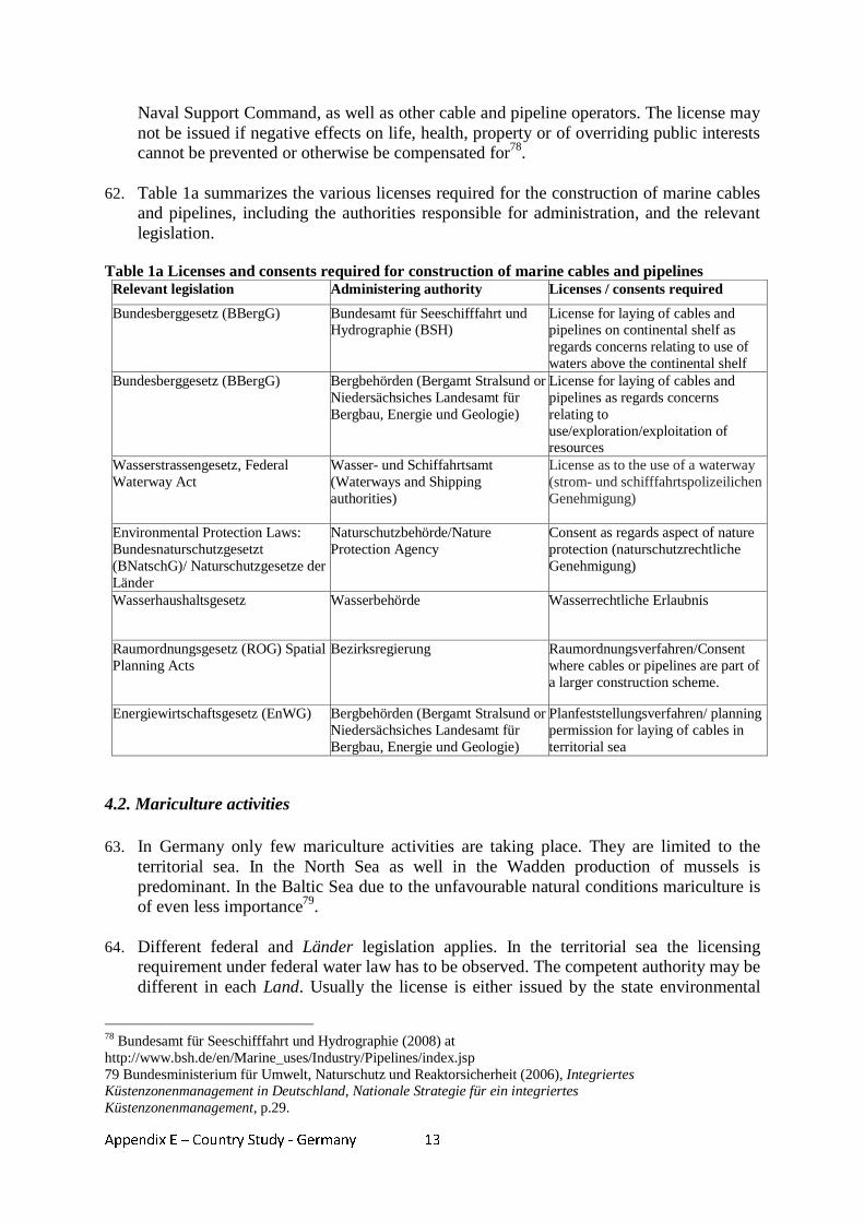
Appendix E – Country Study - Germany
13
Naval Support Command, as well as other cable and pipeline operators. The license may not be issued if negative effects on life, health, property or of overriding public interests cannot be prevented or otherwise be compensated for78.
62. Table 1a summarizes the various licenses required for the construction of marine cables
and pipelines, including the authorities responsible for administration, and the relevant legislation.
Table 1a Licenses and consents required for construction of marine cables and pipelines
Relevant legislation Administering authority Licenses / consents required
Bundesberggesetz (BBergG) Bundesamt für Seeschifffahrt und Hydrographie (BSH)
License for laying of cables and pipelines on continental shelf as regards concerns relating to use of waters above the continental shelf
Bundesberggesetz (BBergG) Bergbehörden (Bergamt Stralsund or Niedersächsiches Landesamt für Bergbau, Energie und Geologie)
License for laying of cables and pipelines as regards concerns relating to use/exploration/exploitation of resources
Wasserstrassengesetz, Federal Waterway Act
Wasser- und Schiffahrtsamt (Waterways and Shipping authorities)
License as to the use of a waterway (strom- und schifffahrtspolizeilichen Genehmigung)
Environmental Protection Laws: Bundesnaturschutzgesetzt (BNatschG)/ Naturschutzgesetze der Länder
Naturschutzbehörde/Nature Protection Agency
Consent as regards aspect of nature protection (naturschutzrechtliche Genehmigung)
Wasserhaushaltsgesetz Wasserbehörde Wasserrechtliche Erlaubnis
Raumordnungsgesetz (ROG) Spatial Planning Acts
Bezirksregierung Raumordnungsverfahren/Consent where cables or pipelines are part of a larger construction scheme.
Energiewirtschaftsgesetz (EnWG) Bergbehörden (Bergamt Stralsund or Niedersächsiches Landesamt für Bergbau, Energie und Geologie)
Planfeststellungsverfahren/ planning permission for laying of cables in territorial sea
4.2. Mariculture activities 63. In Germany only few mariculture activities are taking place. They are limited to the
territorial sea. In the North Sea as well in the Wadden production of mussels is predominant. In the Baltic Sea due to the unfavourable natural conditions mariculture is of even less importance79.
64. Different federal and Länder legislation applies. In the territorial sea the licensing
requirement under federal water law has to be observed. The competent authority may be different in each Land. Usually the license is either issued by the state environmental
78 Bundesamt für Seeschifffahrt und Hydrographie (2008) at http://www.bsh.de/en/Marine_uses/Industry/Pipelines/index.jsp 79 Bundesministerium für Umwelt, Naturschutz und Reaktorsicherheit (2006), Integriertes Küstenzonenmanagement in Deutschland, Nationale Strategie für ein integriertes Küstenzonenmanagement, p.29.
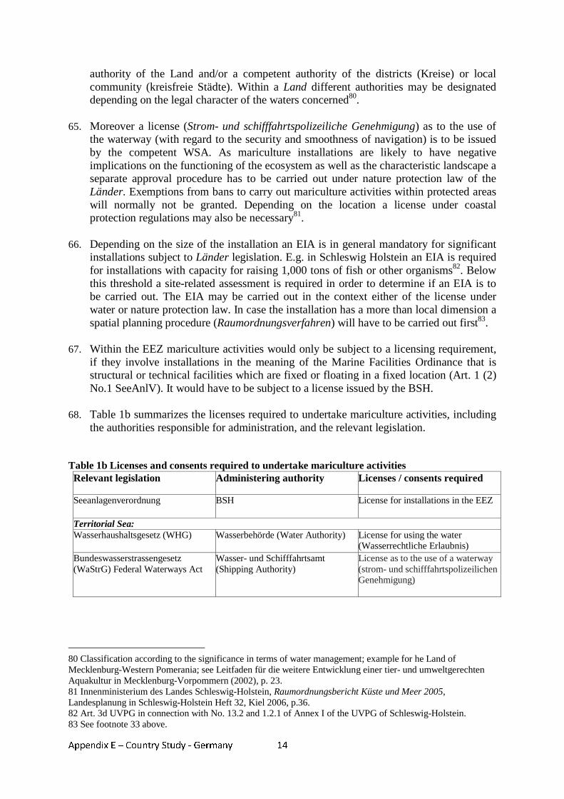
Appendix E – Country Study - Germany
14
authority of the Land and/or a competent authority of the districts (Kreise) or local community (kreisfreie Städte). Within a Land different authorities may be designated depending on the legal character of the waters concerned80.
65. Moreover a license (Strom- und schifffahrtspolizeiliche Genehmigung) as to the use of
the waterway (with regard to the security and smoothness of navigation) is to be issued by the competent WSA. As mariculture installations are likely to have negative implications on the functioning of the ecosystem as well as the characteristic landscape a separate approval procedure has to be carried out under nature protection law of the Länder. Exemptions from bans to carry out mariculture activities within protected areas will normally not be granted. Depending on the location a license under coastal protection regulations may also be necessary81.
66. Depending on the size of the installation an EIA is in general mandatory for significant
installations subject to Länder legislation. E.g. in Schleswig Holstein an EIA is required for installations with capacity for raising 1,000 tons of fish or other organisms82. Below this threshold a site-related assessment is required in order to determine if an EIA is to be carried out. The EIA may be carried out in the context either of the license under water or nature protection law. In case the installation has a more than local dimension a spatial planning procedure (Raumordnungsverfahren) will have to be carried out first83.
67. Within the EEZ mariculture activities would only be subject to a licensing requirement,
if they involve installations in the meaning of the Marine Facilities Ordinance that is structural or technical facilities which are fixed or floating in a fixed location (Art. 1 (2) No.1 SeeAnlV). It would have to be subject to a license issued by the BSH.
68. Table 1b summarizes the licenses required to undertake mariculture activities, including
the authorities responsible for administration, and the relevant legislation. Table 1b Licenses and consents required to undertake mariculture activities Relevant legislation Administering authority Licenses / consents required
Seeanlagenverordnung BSH License for installations in the EEZ
Territorial Sea: Wasserhaushaltsgesetz (WHG) Wasserbehörde (Water Authority) License for using the water
(Wasserrechtliche Erlaubnis) Bundeswasserstrassengesetz (WaStrG) Federal Waterways Act
Wasser- und Schifffahrtsamt (Shipping Authority)
License as to the use of a waterway (strom- und schifffahrtspolizeilichen Genehmigung)
80 Classification according to the significance in terms of water management; example for he Land of Mecklenburg-Western Pomerania; see Leitfaden für die weitere Entwicklung einer tier- und umweltgerechten Aquakultur in Mecklenburg-Vorpommern (2002), p. 23. 81 Innenministerium des Landes Schleswig-Holstein, Raumordnungsbericht Küste und Meer 2005, Landesplanung in Schleswig-Holstein Heft 32, Kiel 2006, p.36. 82 Art. 3d UVPG in connection with No. 13.2 and 1.2.1 of Annex I of the UVPG of Schleswig-Holstein. 83 See footnote 33 above.
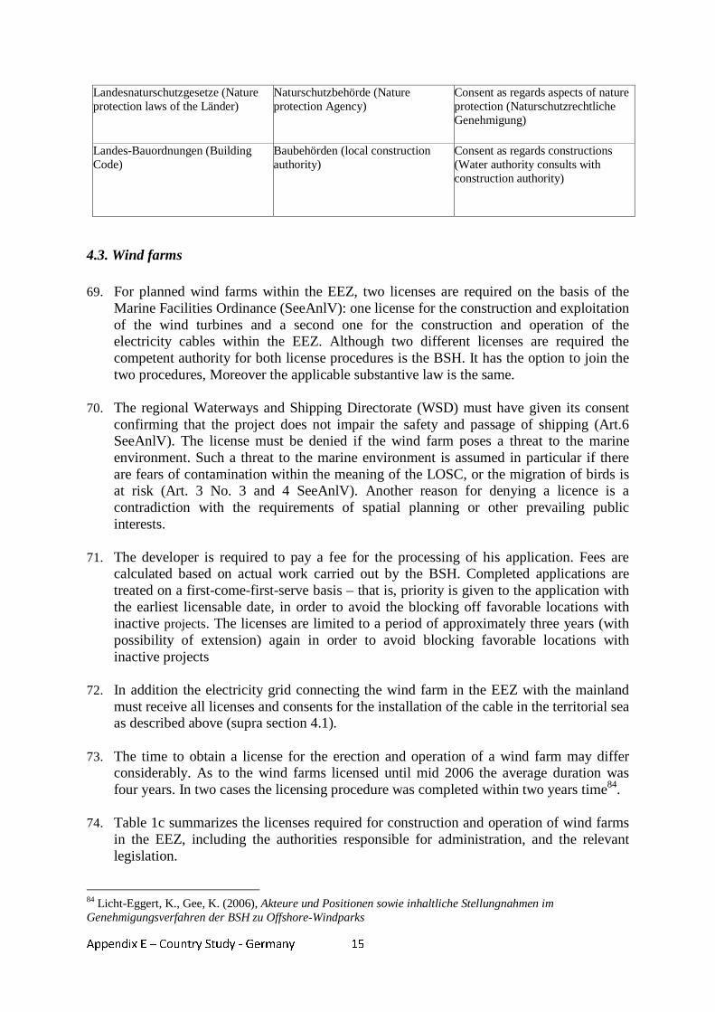
Appendix E – Country Study - Germany
15
Landesnaturschutzgesetze (Nature protection laws of the Länder)
Naturschutzbehörde (Nature protection Agency)
Consent as regards aspects of nature protection (Naturschutzrechtliche Genehmigung)
Landes-Bauordnungen (Building Code)
Baubehörden (local construction authority)
Consent as regards constructions (Water authority consults with construction authority)
4.3. Wind farms 69. For planned wind farms within the EEZ, two licenses are required on the basis of the
Marine Facilities Ordinance (SeeAnlV): one license for the construction and exploitation of the wind turbines and a second one for the construction and operation of the electricity cables within the EEZ. Although two different licenses are required the competent authority for both license procedures is the BSH. It has the option to join the two procedures, Moreover the applicable substantive law is the same.
70. The regional Waterways and Shipping Directorate (WSD) must have given its consent
confirming that the project does not impair the safety and passage of shipping (Art.6 SeeAnlV). The license must be denied if the wind farm poses a threat to the marine environment. Such a threat to the marine environment is assumed in particular if there are fears of contamination within the meaning of the LOSC, or the migration of birds is at risk (Art. 3 No. 3 and 4 SeeAnlV). Another reason for denying a licence is a contradiction with the requirements of spatial planning or other prevailing public interests.
71. The developer is required to pay a fee for the processing of his application. Fees are
calculated based on actual work carried out by the BSH. Completed applications are treated on a first-come-first-serve basis – that is, priority is given to the application with the earliest licensable date, in order to avoid the blocking off favorable locations with inactive projects. The licenses are limited to a period of approximately three years (with possibility of extension) again in order to avoid blocking favorable locations with inactive projects
72. In addition the electricity grid connecting the wind farm in the EEZ with the mainland
must receive all licenses and consents for the installation of the cable in the territorial sea as described above (supra section 4.1).
73. The time to obtain a license for the erection and operation of a wind farm may differ
considerably. As to the wind farms licensed until mid 2006 the average duration was four years. In two cases the licensing procedure was completed within two years time84.
74. Table 1c summarizes the licenses required for construction and operation of wind farms
in the EEZ, including the authorities responsible for administration, and the relevant legislation.
84 Licht-Eggert, K., Gee, K. (2006), Akteure und Positionen sowie inhaltliche Stellungnahmen im Genehmigungsverfahren der BSH zu Offshore-Windparks
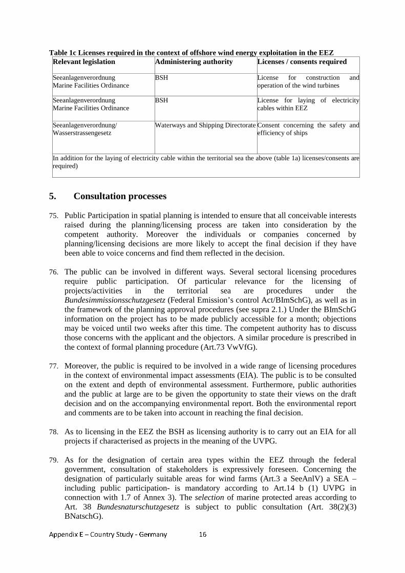
Appendix E – Country Study - Germany
16
Table 1c Licenses required in the context of offshore wind energy exploitation in the EEZ Relevant legislation Administering authority Licenses / consents required
Seeanlagenverordnung Marine Facilities Ordinance
BSH License for construction and operation of the wind turbines
Seeanlagenverordnung Marine Facilities Ordinance
BSH License for laying of electricity cables within EEZ
Seeanlagenverordnung/ Wasserstrassengesetz
Waterways and Shipping Directorate Consent concerning the safety and efficiency of ships
In addition for the laying of electricity cable within the territorial sea the above (table 1a) licenses/consents are required)
5. Consultation processes 75. Public Participation in spatial planning is intended to ensure that all conceivable interests
raised during the planning/licensing process are taken into consideration by the competent authority. Moreover the individuals or companies concerned by planning/licensing decisions are more likely to accept the final decision if they have been able to voice concerns and find them reflected in the decision.
76. The public can be involved in different ways. Several sectoral licensing procedures
require public participation. Of particular relevance for the licensing of projects/activities in the territorial sea are procedures under the Bundesimmissionsschutzgesetz (Federal Emission’s control Act/BImSchG), as well as in the framework of the planning approval procedures (see supra 2.1.) Under the BImSchG information on the project has to be made publicly accessible for a month; objections may be voiced until two weeks after this time. The competent authority has to discuss those concerns with the applicant and the objectors. A similar procedure is prescribed in the context of formal planning procedure (Art.73 VwVfG).
77. Moreover, the public is required to be involved in a wide range of licensing procedures
in the context of environmental impact assessments (EIA). The public is to be consulted on the extent and depth of environmental assessment. Furthermore, public authorities and the public at large are to be given the opportunity to state their views on the draft decision and on the accompanying environmental report. Both the environmental report and comments are to be taken into account in reaching the final decision.
78. As to licensing in the EEZ the BSH as licensing authority is to carry out an EIA for all
projects if characterised as projects in the meaning of the UVPG.
79. As for the designation of certain area types within the EEZ through the federal government, consultation of stakeholders is expressively foreseen. Concerning the designation of particularly suitable areas for wind farms (Art.3 a SeeAnlV) a SEA –including public participation- is mandatory according to Art.14 b (1) UVPG in connection with 1.7 of Annex 3). The selection of marine protected areas according to Art. 38 Bundesnaturschutzgesetz is subject to public consultation (Art. 38(2)(3) BNatschG).
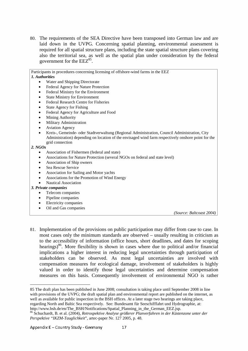
Appendix E – Country Study - Germany
17
80. The requirements of the SEA Directive have been transposed into German law and are
laid down in the UVPG. Concerning spatial planning, environmental assessment is required for all spatial structure plans, including the state spatial structure plans covering also the territorial sea, as well as the spatial plan under consideration by the federal government for the EEZ85.
Participants in procedures concerning licensing of offshore-wind farms in the EEZ 1. Authorities
• Water and Shipping Directorate • Federal Agency for Nature Protection • Federal Ministry for the Environment • State Ministry for Environment • Federal Research Centre for Fisheries • State Agency for Fishing • Federal Agency for Agriculture and Food • Mining Authority • Military Administration • Aviation Agency • Kreis-, Gemeinde- oder Stadtverwaltung (Regional Administration, Council Administration, City
Administration) depending on location of the envisaged wind farm respectively onshore point for the grid connection
2. NGOs • Association of Fishermen (federal and state) • Associations for Nature Protection (several NGOs on federal and state level) • Association of Ship owners • Sea Rescue Service • Association for Sailing and Motor yachts • Associations for the Promotion of Wind Energy • Nautical Association
3. Private companies • Telecom companies • Pipeline companies • Electricity companies • Oil and Gas companies
(Source: Baltcoast 2004) 81. Implementation of the provisions on public participation may differ from case to case. In
most cases only the minimum standards are observed – usually resulting in criticism as to the accessibility of information (office hours, short deadlines, and dates for scoping hearings)86. More flexibility is shown in cases where due to political and/or financial implications a higher interest in reducing legal uncertainties through participation of stakeholders can be observed. As most legal uncertainties are involved with compensation measures for ecological damage, involvement of stakeholders is highly valued in order to identify those legal uncertainties and determine compensation measures on this basis. Consequently involvement of environmental NGO is rather
85 The draft plan has been published in June 2008; consultation is taking place until September 2008 in line with provisions of the UVPG; the draft spatial plan and environmental report are published on the internet, as well as available for public inspection in the BSH offices. At a later stage two hearings are taking place, regarding North and Baltic Sea respectively. See: Bundesamt für Seeschifffahrt und Hydrographie, at: http://www.bsh.de/en/The_BSH/Notifications/Spatial_Planning_in_the_German_EEZ.jsp. 86 Schuchardt, B. et al. (2004), Retrospektive Analyse größerer Planverfahren in der Küstenzone unter der Perspektive “IKZM-Tauglichkeit”, artec-paper Nr. 127 2005, p. 48.
Appendix E – Country Study - Germany
18
broad, taking place timely with sufficient information being provided However involvement is limited to questions on implementation as opposed to involvement in the decision on the plan or project itself.87.
6. Conflict resolution 82. Until the extension of the traditional spatial planning instruments to the maritime area
conflict resolution took place on a case by case basis. Generally all requirements need to be taken into consideration by the competent authority; decisions are based on a comparative evaluation.
83. Instruments aiming for the early detection, evaluation and resolution of conflicts are
basically early stakeholder consultations, environmental impact assessments and the spatial planning procedure, as a special supporting instrument provided for by the Raumordnungsgesetz (Spatial Planning Act/ROG). The “Spatial planning procedure” assesses the compatibility of a particular plan or measure with regard to its location. It determines whether projects (or plans) are or may be brought into line with the requirements of spatial policy, as laid down in the spatial structure plan. So far it has only been applicable and practiced for projects in the territorial sea.
84. As presented more general approaches to organize spatial allocation of activities on a
larger scale taken so far include designation of marine protected areas and particularly suitable areas for wind farms in the EEZ. For both inter-ministerial consultations are prescribed to assure that diverging interest would be taken into account. The public as well as the bordering Länder had to be consulted (Art. 3a (1) SeeAnlV; Art. 38 (2) BNatschG).
85. With a view to environmental impacts these features are supplemented by the EIA as
concerns specific projects and SEA for spatial structure plans. The environmental report to be prepared in this context is to describe and evaluate the expected serious impacts on the environment and must be taken into account when balancing different interests. It thus serves to integrate reflections on the protection of the marine ecosystem into the planning/licensing procedures and contributes to detecting possible conflicts and finding a solution for minimizing or avoiding them. These instruments focus on the evaluation of site alternatives and possible compensational measures for negative impacts of projects if for several reasons they are not to be avoided.
86. Improvements expected by the introduction of spatial planning to the maritime areas
concern the speeding up of planning/implementation of projects, providing a higher degree of security of investment and above all minimization of conflicts, as comprehensive spatial planning is directed at a broad spatial allocation and finding suitable areas for specific activities /uses with a low conflict potential.
87. Conflicts between different activities can be resolved through the application of
government policy. By establishing priorities they are designed to give a basis for concrete decisions and legitimize the decision to be taken were conflicts may not be avoided. In addition principles for conflict avoidance may be defined.
87As before, p. 92.
Appendix E – Country Study - Germany
19
88. As regards the draft spatial structure plan for the EEZ (see infra section 7.) the following principles for minimization or avoidance of conflicts will be laid down: spatial separation of conflicting uses shall be realized as much as possible; and priority will be given to certain uses in accordance with the LOSC (e.g. shipping, and laying of cables and pipelines). Moreover spatial concentration of uses shall be achieved in order to protect the openness of the seascape88.
89. Besides the conflict resolution effects inherent to the German spatial planning system
described above, there are informal instruments meant to enhance co-operation within the planning process and to support conflict resolution: negotiation, moderation and mediation. However covering these approaches would exceed the context of this study.
7. Progress towards MSP in the German EEZ 90. This section focuses on the introduction of MSP to the German EEZ. Due to designation
of large parts of the territorial seas as Marine Protected Areas, as well as the early policy decision that the development of offshore wind energy would have to take place mainly in the EEZ the main focus of the German discussion on the development of MSP is on the EEZ. Progress on MSP in the Länder referring to the territorial sea has been presented above (supra section 2.3.).
91. At the same time as the Länder decided to extend their spatial structure plans to the
territorial sea, the Conference of Ministers for Spatial Planning89 had asked the Federal Government to develop guidelines for spatial development in the EEZ. However the Federal Government introduced an amendment to the Raumordnungsgesetzt (Federal Spatial Planning Act/ROG) extending its jurisdiction to the EEZ and giving the federal government competence to organize spatial planning in the EEZ. Despite criticism based on the argument that competence for spatial planning lies exclusively with the Länder Art. 18a ROG came into effect in 2004 and has never been challenged. The Federal Government now has competence to define “goals and principles [...] for spatial planning regarding economic and scientific use as well as the security of navigation and the protection of the marine environment” for the EEZ (Art. 18a (1) ROG).
92. Art.18a ROG had been drafted in order to take account of the framework set by the
LOSC. International navigation as well as the laying of transit-cables and pipelines are thus not subject to MSP in the German EEZ. No restrictions may be imposed on those activities by spatial planning measures.
Planning Procedure 93. The BSH a subordinate agency of the Federal Ministry of Transport, Construction and
Urban Affairs (BMVBS), is charged with preparing the maritime spatial plan for the EEZ. The plan will eventually take the form of an ordinance of the BMVBS. As such the plan and the principles that it contains will have legal effect.
88 Bundesamt für Seeschifffahrt und Hydrographie, Draft Ordinance on Spatial Planning in the German Exclusive Economic Zone of 13 June 2008 at: http://www.bsh.de/en/The_BSH/Notifications/Draft_spatial_plan.pdf 89 Assembling the ministers of all Länder and the Federal Government responsible for spatial planning.
Appendix E – Country Study - Germany
20
94. Early in 2005 authorities neighbouring states (Netherlands, United Kingdom, Denmark, Sweden and Poland) were asked as to current and planned uses of their EEZ and neighbouring areas. Bilateral coordination meetings were subsequently held with authorities responsible for navigation, the environmental protection, authorisation of off-shore wind farms and mining activities.
95. As the plan is subject to a mandatory SEA an environmental report describing and
evaluating the likely significant effects on the environment was prepared. The scope of the environmental assessment had been discussed with public authorities and organisations as well as the interested public and representatives of bordering states in spring 2005 at two scoping-hearings (separately for the North and the Baltic Sea). Drafts of the plan and the environmental assessment report have been finalized by the end of 2007 and submitted to an inter-ministerial consultation within the federal government. Public and transboundary consultation has been opened in June 2008 The results of the consultation process will have to be taken into consideration and the plan will be established on the basis of an appreciation of all relevant interests and concerns . Further consultation may be necessary if changes to the draft plan are envisaged. The goal is to enact the plan in the course of 200890.
Content of the Plan 96. Uses to be addressed either partially or completely within the plan are navigation,
resource exploitation, submarine cables and pipelines, marine scientific research, wind energy and the protection of the marine environment. The plan will determine goals of spatial planning, which are legally binding as well as principles of spatial planning which are of a more general nature and have to be considered when weighing interests. Furthermore priority areas, reserve areas and suitable areas will be determined for different economic uses and scientific activities.
97. Priority will be given to international navigation and the laying of cables and pipelines as
guaranteed by the LOSC. Therefore shipping routes define the basic structure of the spatial plan and are to be designated as priority or reserved areas. In order to contribute to the avoidance of conflicts, conflicting uses are to be spatially separated as much as possible. Taken the connecting grid of offshore wind farms as an example the plan strives to define gates for the crossing of the EEZ/12 nm-border and of traffic separation schemes in crucial areas (binding planning goals). In addition the definition of planning principles is envisaged such as the laying of cables parallel to existing infrastructure like pipelines or the grouping of such utility lines.
98. No areas will be designated for fishery, mariculture or military uses. In order to preserve
resources and protect the marine environment but also to reserve marine spaces for future uses large parts or the EEZ will be kept free91.
90 Runkel, P., Federal Ministry for Transport, Construction and Urban Affairs, Raumordnung auf dem Meer, Strategien und Instrumente in Deutschland. 91 Bundesamt für Seeschifffahrt und Hydrographie, Draft Ordinance on Spatial Planning in the German Exclusive Economic Zone of 13 June 2008 at: http://www.bsh.de/en/The_BSH/Notifications/Draft_spatial_plan.pdf
Appendix E – Country Study - Germany
21
8. Transboundary planning
8.1. Sectoral Planning 99. Transboundary aspects of sectoral planning are addressed within the framework of
mandatory consultation in the context of an EIA. As obligations of the Espoo Convention have been transposed into German law the licensing of projects thus requires involvement of the competent authorities as well as the public of neighboring countries, for projects requiring an EIA under German law (Art.8 and 9a UVPG).
100. As to the implementation there are numerous examples of involvement of neighboring
states. It appears that there is a widespread sense for the need to follow up the legal requirements; however efforts to facilitate active involvement vary from case to case. Barriers for the involvement of foreign authorities are naturally lower compared to that of the public; e.g. in the case of the licensing procedure of the wind farm at “Kriegers Flak I” in the Baltic Sea, Sweden and Denmark were involved in the framework of the Espoo Convention. Comments from the public of those countries were not channeled through their national competent environmental authorities but were to be directed directly to the German licensing agency. No comments were received92.
101. Current examples of transboundary cooperation on major projects include the Nord
Stream Gas Pipeline project. As regards the scoping phase a common appreciation was positive based on the facts that reports of the meetings of the Parties of Origin were sent out to all interested parties, there was ample time given for the consultation and that the Parties of Origin were acting in a coordinated manner93.
102. Additional regulations implementing the general legal requirements regarding
transboundary cooperation have been laid down in agreements with the Netherlands and Poland in 2005 and 200694.
103. Under the aspect of nature conservation a particularly intense cooperation exists within
the framework of the Trilateral Cooperation on the Protection of the Wadden Sea. Since 1978, the Netherlands, Germany and Denmark have worked together on the protection and conservation activities covering management, monitoring and research, as well as political matters. In 1982, a joint declaration was adopted committing the three countries to coordinate their activities and measures for the protection of the Wadden Sea.
104. The Guiding Principle of the trilateral Wadden Sea policy is to achieve, as far as
possible, a natural and sustainable ecosystem. For the implementation of this principle
92 Swedish Ministry of the Environment (2005), Cooperation on the EIA Convention in the Baltic Sea subregion- Report of a Seminar in Stockholm 20-21 October 2005, p.7; at: http://www.unece.org/env/eia/documents/BalticSeaWorkshop2005/Espooseminarreport.pdf. 93 Swedish Ministry of the Environment (2005), Cooperation on the EIA Convention in the Baltic Sea subregion - Report of a Seminar in Copenhagen 8 November 2006, p.3; at: http://www.unece.org/env/eia/documents/ActivityReports/Copenhseminarreportfinal.pdf. 94 Gemeinsame Erklärung über die Zusammenarbeit bei der Durchführung grenzüberschreitender Umweltverträglichkeitsprüfungen im deutsch-niederländischen Grenzbereich zwischen dem Ministerium für Wohnungswesen, Raumordnung und Umwelt des Königreichs der Niederlande und dem Bundesministerium für Umwelt, Naturschutz und Reaktorsicherheit der Bundesrepublik Deutschland; at: http://www.bmu.de/files/umweltvertraeglichkeitspruefung/downloads/application/pdf/uvp_sup_vereinbarung_d_nl.pdf, Deutschland - Polen: UVP - Vereinbarung vom 11. April 2006
Appendix E – Country Study - Germany
22
several management principles have been adopted at the sixth trilateral Governmental Conference on the Protection of the Wadden Sea in 199195 which are fundamental to any decisions concerning the protection and management of the Wadden Sea inter alia the principle that activities which are potentially damaging to the Wadden Sea should be avoided (principle of avoidance), even where there is no sufficient scientific evidence to prove a causal link between activities and their impact (precautionary principle), that activities which are harmful to the Wadden Sea environment should be translocated to areas where they will cause less environmental impact (principle of translocation), that harmful effect of activities which cannot be avoided, must be balanced by compensatory measures (principle of compensation). Moreover common objectives were agreed regulating all major common uses and activities in the Wadden Sea. Common standards were set regarding the protection and sustainable use of the Wadden Sea. In 1997 the Wadden Sea Plan (WSP) was adopted96. The WSP entails the common policies, measures, projects and actions of the countries for their joint efforts to fulfill the ecological targets. However the recent withdrawal of the Land of Hamburg from the joint Dutch-German application for the nomination of the Wadden Sea region as world natural heritage site, because of fears as to a possible negative impact on the development of the port of Hamburg97, is an example for the implications of the challenges of a federalist structure to a comprehensive planning. The application was maintained by the federal government jointly with the Länder of Niedersachsen and Schleswig-Holstein and the Netherlands.
8.2. Comprehensive Spatial Planning 105. Establishment of maritime spatial plans of the coastal Länder as well as of the spatial
structure plan for the EEZ, transboundary consultation is required by law. Art.16 ROG requires the Länder to consult neighboring states in case that plans or projects with spatial significance, have considerable effects on those states; as to the spatial structure plan for the EEZ Art.7(6) ROG requires transboundary consultation in the context of an SEA98.
9. Conclusions 106. As the spatial structure plan for the EEZ has not been established it is too early to fully
evaluate the effects of the introduction of MSP in the Germany. However the expectation is that the application of Spatial Planning legislation to maritime areas will lead to clear improvements due to the positive aspects of the German spatial planning system. In general it has a high potential to steer the spatial development in a comprehensive and balanced manner through definition of goals and principles as well as the combination of designations of priority areas and areas where specific activities/uses are prohibited. The multi-layered planning process comprises different instruments which reflect the superordinate decisions and allow for a comprehensive, cross-sectoral spatial development and management of spatially significant activities and uses. While safeguarding a considerable degree of vertical and horizontal integration of planning decisions, the system is viewed as being sufficiently flexible especially with regard to
95 Ministerial Declaration, 13 November 1991. 96 Published in 1998. 97 As especially concerns the dredging of waterways of the river Elbe to enable bigger ships to enter the port. 98 see also supra section 7.
Appendix E – Country Study - Germany
23
complex planning and licensing projects. Moreover it secures a rather broad involvement of governmental institutions as well as other relevant stakeholders. Regarding ecological effects of planning and licensing they are usually subject to a comprehensive and in most cases adequate assessment. Negative effects are in most cases adequately compensated for according to legal requirements99.
107. However the introduction of spatial planning in German maritime areas as currently
undertaken will not provide an answer to all questions raised in the context of a comprehensive and balanced spatial order of the German maritime areas. This is due to the general flaws of the planning system as well as to their particular adaptation of planning instruments with view to planning of the territorial sea and the EEZ.
108. Spatial planning provides for a common framework for the development and
management of a given area and precludes certain decisions. However the legal framework for spatial planning does not in any case assure that all parts and aspects belonging to the same project are comprehensively considered. Within the framework to be established for German offshore areas the fragmentation of licensing procedures persits due to different territorial and functional jurisdictions (with)in the EEZ, the territorial sea or the continental shelf.
109. This has been considered a problem before the introduction of spatial planning
instruments and will probably not totally be remedied by coordination of the respective plans. Some call for introduction of licensing procedure with concentration effect at least under procedural aspects. Some argue in favour of a further strengthening of the German spatial planning system by enhancing the binding character and a wider use of spatial planning procedures for large scale projects of high spatial significance100.
110. As regards comprehensive spatial planning different jurisdictions apply to planning in
the EEZ (federal government) and the territorial sea (the Länder). It remains to be seen if and to what extent the legal requirement for harmonisation of the plans will suffice to come to an integrated approach towards spatial development of the EEZ and the territorial sea.
111. While acknowledging that introduction of MSP without stopping progress on
development of activities considered a high priority such as the exploitation of wind energy meets a lot of constraints, generally the introduction of spatial planning comes rather late. Especially with view to the development of exploitation of offshore wind energy –the driver for introduction of MSP in Germany - it is questioned in how far MSP will have any regulating effect, as for many projects planning is advanced, pilot phases of several projects have already started and others are about to be licensed very shortly101.
112. However the Federal Government is taking further measures to assure effectiveness of
the overall system. Some critics claimed that it was unclear how goals and principles of
99 Schuchardt, B. et al. (2004), Retrospektive Analyse größerer Planverfahren in der Küstenzone unter der Perspektive “IKZM”-Tauglichkeit, artec-paper Nr. 127 2005, p. 67, 102. 100 Schuchardt, B. et al. (2004), Retrospektive Analyse größerer Planverfahren in der Küstenzone unter der Perspektive “IKZM”-Tauglichkeit, artec-paper Nr. 127 2005, p. 104/105. 101 Kruppa, I., (2007), Steuerung der Offshore-Windenergienutzung vor dem Hintergrund der Umweltziele Klima- und Meeresumweltschutz, Berlin, p. 98.
Appendix E – Country Study - Germany
24
the spatial structure plan for the EEZ will be reflected in the (bound) licensing decisions based on the Marine Facilities Ordinance (SeeAnlV), as it lacked a provision ordering the alignment with the requirements of the spatial structure plan (Raumordnungsklausel). This would mean that in the context of licensing on the basis of the Marine Facilities Ordinance the requirements of the spatial structure plan for the EEZ would be deprived of there binding character102. Meanwhile the legal basis has been created to insert the necessary Raumordnungsklausel into the SeeAnlV103. The Marine Facilities Ordinance has been amended accordingly.
113. In sum the German approach to MSP sets a basic framework for coherent development
and management of Germany’s offshore areas, even though some flaws will have to be evaluated when experiences with the structure plans both for the EEZ and the territorial sea have been made.
102 Wende, J., Köppel A., Wolf, R., Nebelsieck, R. Runge, K. (2006), Naturschutzfachliche und naturschutzrechtliche Anforderungen im Gefolge der Ausdehnung des Raumordnungsregimes auf die deutsche Ausschließliche Wirtschaftszone, Arbeitsmaterialien zur Landschaftsplanung, Band 41, Berlin 2007, p. 83. 103 See: Gesetz zur Änderung seeverkehrsrechtlicher, verkehrsrechtlicher und anderer Vorschriften mit Bezug zum Seerecht of 08 April 2008 concerning Art.1 10a SeeAufgG at http://www.bgblportal.de/BGBL/bgbl1f/bgbl108s0706.pdf.
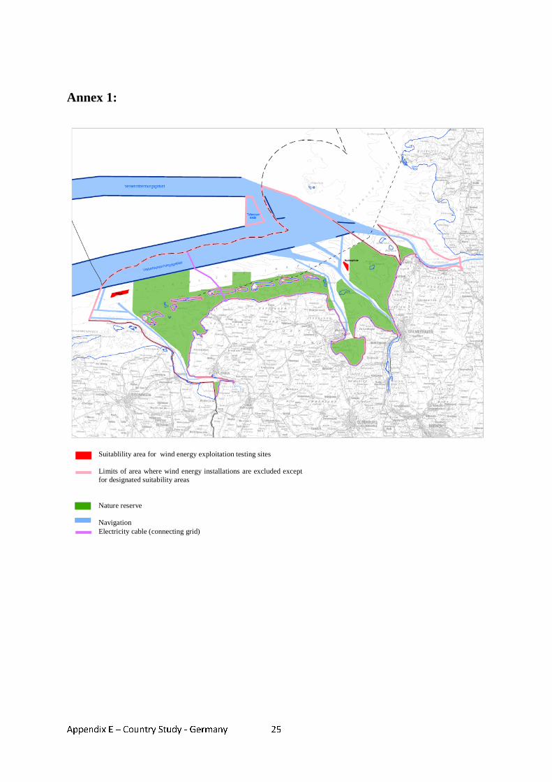
Appendix E – Country Study - Germany
25
Annex 1:
Suitablility area for wind energy exploitation testing sites Limits of area where wind energy installations are excluded except for designated suitability areas Nature reserve Navigation Electricity cable (connecting grid)

Appendix E – Country Study - Germany
26
Annex 2:
Key:
Top of Coast Defence
MHWS(or MHW)
12nmsLimit of Territorial Waters
~200 nmsEEZ/Continental
Shelf limitAnywhere
at Sea
Geographical Extent of Marine Spatial Planning and of Marine Works Controls: Germany
Building Codes of the Länder
Federal Mining Act
Federal Nature Conservation Act (Länder/Federal Government)
Energy Industry Act
Water Management Act
Spatial Planning Acts of the Länder
Federal Spatial Planning Act (Länder/Federal Government)
Federal Maritime Responsibilities Act/Marine Facilities Ordinance
Federal Waterways Act
1 nms
Federal Environmental Impact Assessment Act
Key:
Top of Coast Defence
Top of Coast Defence
Top of Coast Defence
MHWS(or MHW)
MHWS(or MHW)
12nmsLimit of Territorial Waters
12nmsLimit of Territorial Waters
~200 nmsEEZ/Continental
Shelf limit
~200 nmsEEZ/Continental
Shelf limitAnywhere
at SeaAnywhere
at Sea
Geographical Extent of Marine Spatial Planning and of Marine Works Controls: Germany
Building Codes of the Länder
Federal Mining Act
Federal Nature Conservation Act (Länder/Federal Government)
Energy Industry Act
Water Management Act
Spatial Planning Acts of the Länder
Federal Spatial Planning Act (Länder/Federal Government)
Federal Maritime Responsibilities Act/Marine Facilities Ordinance
Federal Waterways Act
1 nms1 nms
Federal Environmental Impact Assessment Act
Appendix E – Country Study - Germany
27
Annex 3: References BaltCoast (2004). Framework for the co-ordinated use of offshore areas - Conclusions and recommendations. Bundesamt für Seeschifffahrt und Hydrographie (2002): Genehmigung Offshore Windenergiepark "Offshore-Bürger-Windpark Butendiek". Antragsteller: OSB Offshore-Bürger-Windpark Butendiek GmbH & Co.KG. Aktenzeichen 8086.01/Butendiek/Z1. Hamburg, 18. Dezember 2002. Bundesamt für Seeschifffahrt und Hydrographie, Draft Ordinance on Spatial Planning in the German Exclusive Economic Zone, of 13 June 2008, at: http://www.bsh.de/en/The_BSH/Notifications/Draft_spatial_plan.pdf. Bundesministerium für Umwelt, Naturschutz und Reaktorsicherheit (2005), Gemeinsame Erklärung über die Zusammenarbeit bei der Durchführung grenzüberschreitender Umweltverträglichkeitsprüfungen im deutsch-niederländischen Grenzbereich zwischen dem Ministerium für Wohnungswesen, Raumordnung und Umwelt des Königreichs der Niederlande und dem Bundesministerium für Umwelt, Naturschutz und Reaktorsicherheit der Bundesrepublik Deutschland, at: http://www.bmu.de/files/umweltvertraeglichkeitspruefung/downloads/application/pdf/uvp_sup_vereinbarung_d_nl.pdf Bundesministerium für Umwelt, Naturschutz und Reaktorsicherheit (2006), Integriertes Küstenzonenmanagement in Deutschland, Nationale Strategie für ein integriertes Küstenzonenmanagement. Common Wadden Sea Secretariat (1991). Ministerial Declaration of the Sixth Trilateral Governmental Conference on the Protection of the Wadden Sea at Esbjerg, November 13, 1991. http://www.waddensea-secretariat.org/tgc/MD-Esbjerg.html#anchor1454000. Fahrenkrug, K./Rave, T. (2007). Best Practice in Marine Spatial Planning Description of four Case Studies in Europe and Overseas - Final Report, Institut für Planung Kommunikation und Prozessmanagement GmbH, Wedel/Hamburg, 2007. Federal Ministry for the Environment, Nature Conservation and Nuclear Safety (2002), Strategy of the German Government on the use of off-shore wind energy, January 2002, Berlin. Gee, K., Kannen, A.,Glaeser, B., Sterr, H. (2004). National ICZM Strategy in Germany: A spatial planning approach, Schernewski, G. & Löser, N. (eds.) Coastline Reports 2. Gesetz zur Änderung seeverkehrsrechtlicher, verkehrsrechtlicher und anderer Vorschriften mit Bezug zum Seerecht vom 8. April 2008 concerning Art.1 10a SeeAufgG, at http://www.bgblportal.de/BGBL/bgbl1f/bgbl108s0706.pdf. Innenministerium des Landes Schleswig-Holstein (2006), Raumordnungsbericht Küste und Meer 2005, Landesplanung in Schleswig-Holstein Heft 32, Kiel 2006.
Appendix E – Country Study - Germany
28
Innenministerium des Landes Schleswig-Holstein(2008), Entwurf Landesentwicklungsplan Schleswig-Holstein 2009, at: http://www.entera-online3.de/035_lep/index_tabs.php. Klinski, S. (2005), Überblick über die Zulassung von Anlagen zur Nutzung Erneuerbarer Energien, im Auftrag des Bundesministeriums für Umwelt, Naturschutz und Reaktorsicherheit. Klinski , S. et al. (2007). Entwicklung einer Umweltstrategie für die Windenergienutzung an Land und auf See; Umweltbundesamt, Berlin 2007. Kruppa, I., (2007) Steuerung der Offshore-Windenergienutzung vor dem Hintergrund der Umweltziele Klima- und Meeresumweltschutz, Berlin. Licht-Eggert, K., Gee, K. (2006) Akteure und Positionen sowie inhaltliche Stellungnahmen im Genehmigungsverfahren der BSH zu Offshore-Windparks. Ministerium für Arbeit, Bau und Landesentwicklung Mecklenburg-Vorpommern (2005), Landesraumentwicklungsprogramm Mecklenburg-Vorpommern, Schwerin, 2005, at: http://service.mvnet.de/_php/download.php?datei_id=1689. von Nicolai, H. (2004), Rechtliche Aspekte einer Raumordnung auf dem Meer, in: Informationen zur Raumentwicklung, Heft 7/8.2004. Niedersächsisches Ministerium für den ländlichen Raum, Ernährung, Landwirtschaft und Verbraucherschutz (2005), Raumordnungskonzept für das niedersächsische Küstenmeer –Stand 2005. Niedersächsisches Ministerium für den ländlichen Raum, Ernährung, Landwirtschaft und Verbraucherschutz (2006), Landes-Raumordnungsprogramm Niedersachsen Ergänzung 2006, at: http://cdl.niedersachsen.de/blob/images/C23434478_L20.pdf. Pahl-Weber, E., Henckel D., Klinge, W., Lau, P., Zwicker, D. (2007), The Structure of Government and Administration and Planning System in the Federal Republic of Germany, COMMIN - Baltic Sea Region (BSR) INTERREG III– project, at: http://commin.org/upload/Germany/DE_Country_and_Planning_System_Engl.pdf. Runkel, P. (2007), Federal Ministry for Transport, Construction and Urban Affairs, Raumordnung auf dem Meer, Strategien und Instrumente in Deutschland, Speech on the Occasion of the conference „Future Maritime Policy of the EU“ in Bremen, May 2007, at: http://www.bmvbs.de/Anlage/original_1011378/s5-runkel-td.pdf. Schuchardt, B. et al. (2004), Retrospektive Analyse größerer Planverfahren in der Küstenzone unter der Perspektive “IKZM“-Tauglichkeit, artec-paper Nr. 127, 2005. Swedish Ministry of the Environment (2005), Cooperation on the EIA Convention in the Baltic Sea subregion- Report of a Seminar in Stockholm 20-21 October 2005, at: http://www.unece.org/env/eia/documents/BalticSeaWorkshop2005/Espooseminarreport.pdf.
Appendix E – Country Study - Germany
29
Swedish Ministry of the Environment (2005), Cooperation on the EIA Convention in the Baltic Sea subregion - Report of a Seminar in Copenhagen 8 November 2006, at: http://www.unece.org/env/eia/documents/ActivityReports/Copenhseminarreportfinal.pdf. Wende, J., Köppel A., Wolf, R., Nebelsieck, R. Runge, K. (2006), Naturschutzfachliche und naturschutzrechtliche Anforderungen im Gefolge der Ausdehnung des Raumordnungsregimes auf die deutsche Ausschließliche Wirtschaftszone, Arbeitsmaterialien zur Landschaftsplanung, Band 41, Berlin 2007. Wolf, R. (2004), AWZ-Vorhaben: Rechtliche und Naturschutzfachliche Aspekte beim Bau und Betrieb von Stromkabel, im Auftrag des Bundesamtes für Naturschutz. WWF Germany (2004), Managing across boundaries - The Dogger Bank – a future international marine protected area, Frankfurt/M. 2004.
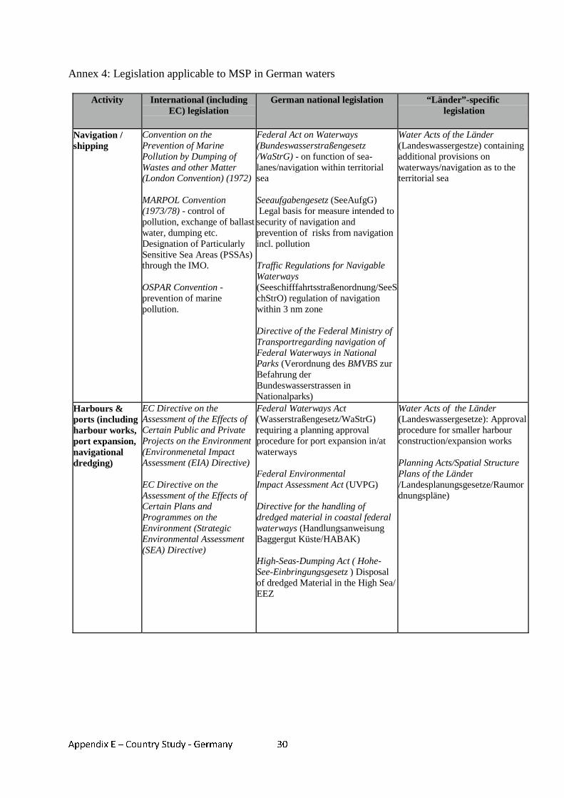
Appendix E – Country Study - Germany
30
Annex 4: Legislation applicable to MSP in German waters
Activity International (including EC) legislation
German national legislation “Länder”-specific legislation
Navigation / shipping
Convention on the Prevention of Marine Pollution by Dumping of Wastes and other Matter (London Convention) (1972) MARPOL Convention (1973/78) - control of pollution, exchange of ballast water, dumping etc. Designation of Particularly Sensitive Sea Areas (PSSAs) through the IMO. OSPAR Convention - prevention of marine pollution.
Federal Act on Waterways (Bundeswasserstraßengesetz /WaStrG) - on function of sea-lanes/navigation within territorial sea Seeaufgabengesetz (SeeAufgG) Legal basis for measure intended to security of navigation and prevention of risks from navigation incl. pollution Traffic Regulations for Navigable Waterways (Seeschifffahrtsstraßenordnung/SeeSchStrO) regulation of navigation within 3 nm zone Directive of the Federal Ministry of Transportregarding navigation of Federal Waterways in National Parks (Verordnung des BMVBS zur Befahrung der Bundeswasserstrassen in Nationalparks)
Water Acts of the Länder (Landeswassergestze) containing additional provisions on waterways/navigation as to the territorial sea
Harbours & ports (including harbour works, port expansion, navigational dredging)
EC Directive on the Assessment of the Effects of Certain Public and Private Projects on the Environment (Environmenetal Impact Assessment (EIA) Directive) EC Directive on the Assessment of the Effects of Certain Plans and Programmes on the Environment (Strategic Environmental Assessment (SEA) Directive)
Federal Waterways Act (Wasserstraßengesetz/WaStrG) requiring a planning approval procedure for port expansion in/at waterways Federal Environmental Impact Assessment Act (UVPG) Directive for the handling of dredged material in coastal federal waterways (Handlungsanweisung Baggergut Küste/HABAK) High-Seas-Dumping Act ( Hohe-See-Einbringungsgesetz ) Disposal of dredged Material in the High Sea/ EEZ
Water Acts of the Länder (Landeswassergesetze): Approval procedure for smaller harbour construction/expansion works Planning Acts/Spatial Structure Plans of the Länder /Landesplanungsgesetze/Raumordnungspläne)
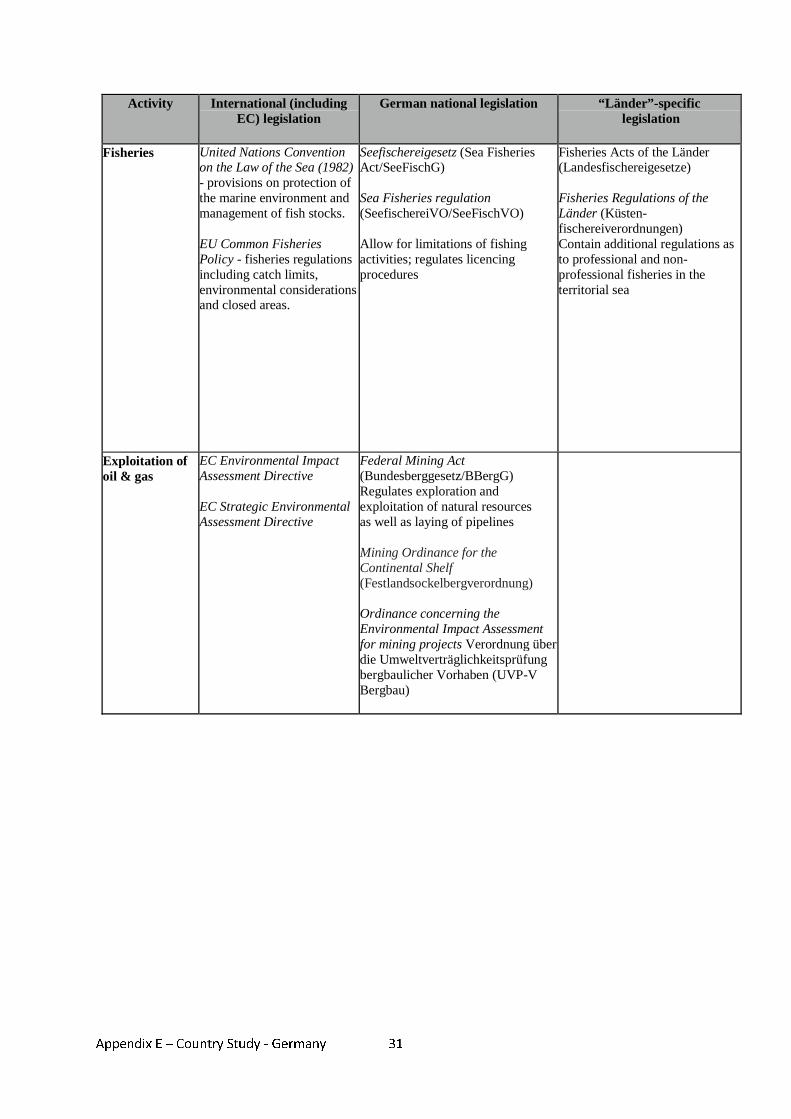
Appendix E – Country Study - Germany
31
Activity International (including EC) legislation
German national legislation “Länder”-specific legislation
Fisheries United Nations Convention on the Law of the Sea (1982) - provisions on protection of the marine environment and management of fish stocks. EU Common Fisheries Policy - fisheries regulations including catch limits, environmental considerations and closed areas.
Seefischereigesetz (Sea Fisheries Act/SeeFischG) Sea Fisheries regulation (SeefischereiVO/SeeFischVO) Allow for limitations of fishing activities; regulates licencing procedures
Fisheries Acts of the Länder (Landesfischereigesetze) Fisheries Regulations of the Länder (Küsten-fischereiverordnungen) Contain additional regulations as to professional and non-professional fisheries in the territorial sea
Exploitation of oil & gas
EC Environmental Impact Assessment Directive EC Strategic Environmental Assessment Directive
Federal Mining Act (Bundesberggesetz/BBergG) Regulates exploration and exploitation of natural resources as well as laying of pipelines Mining Ordinance for the Continental Shelf (Festlandsockelbergverordnung) Ordinance concerning the Environmental Impact Assessment for mining projects Verordnung über die Umweltverträglichkeitsprüfung bergbaulicher Vorhaben (UVP-V Bergbau)
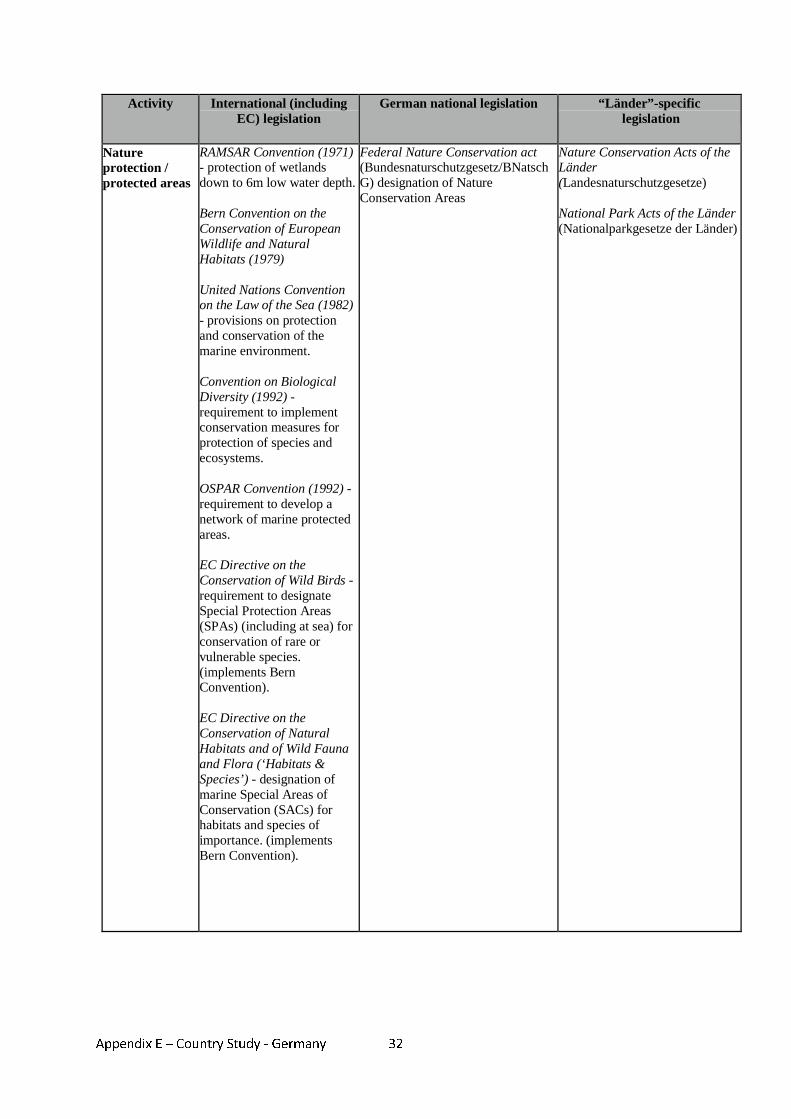
Appendix E – Country Study - Germany
32
Activity International (including EC) legislation
German national legislation “Länder”-specific legislation
Nature protection / protected areas
RAMSAR Convention (1971) - protection of wetlands down to 6m low water depth. Bern Convention on the Conservation of European Wildlife and Natural Habitats (1979) United Nations Convention on the Law of the Sea (1982) - provisions on protection and conservation of the marine environment. Convention on Biological Diversity (1992) - requirement to implement conservation measures for protection of species and ecosystems. OSPAR Convention (1992) - requirement to develop a network of marine protected areas. EC Directive on the Conservation of Wild Birds - requirement to designate Special Protection Areas (SPAs) (including at sea) for conservation of rare or vulnerable species. (implements Bern Convention). EC Directive on the Conservation of Natural Habitats and of Wild Fauna and Flora (‘Habitats & Species’) - designation of marine Special Areas of Conservation (SACs) for habitats and species of importance. (implements Bern Convention).
Federal Nature Conservation act (Bundesnaturschutzgesetz/BNatschG) designation of Nature Conservation Areas
Nature Conservation Acts of the Länder (Landesnaturschutzgesetze) National Park Acts of the Länder (Nationalparkgesetze der Länder)
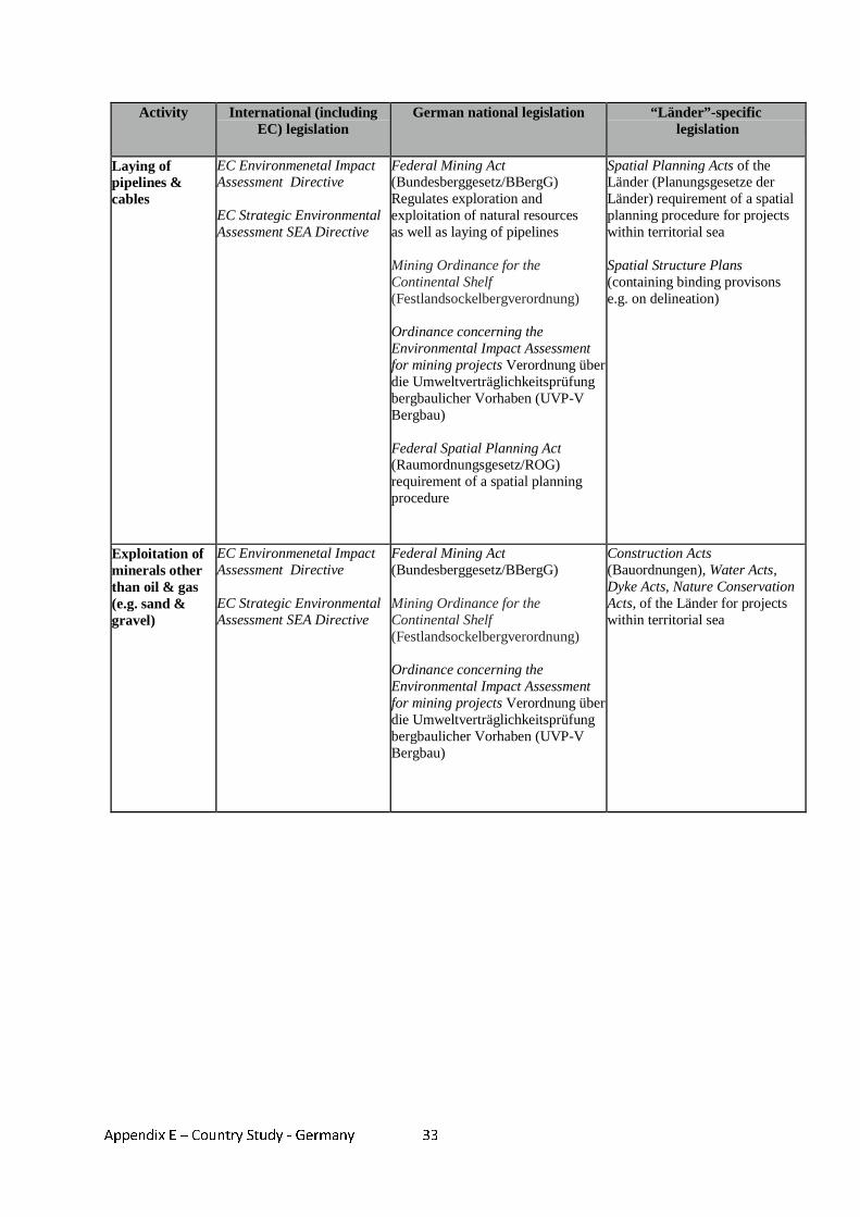
Appendix E – Country Study - Germany
33
Activity International (including EC) legislation
German national legislation “Länder”-specific legislation
Laying of pipelines & cables
EC Environmenetal Impact Assessment Directive EC Strategic Environmental Assessment SEA Directive
Federal Mining Act (Bundesberggesetz/BBergG) Regulates exploration and exploitation of natural resources as well as laying of pipelines Mining Ordinance for the Continental Shelf (Festlandsockelbergverordnung) Ordinance concerning the Environmental Impact Assessment for mining projects Verordnung über die Umweltverträglichkeitsprüfung bergbaulicher Vorhaben (UVP-V Bergbau) Federal Spatial Planning Act (Raumordnungsgesetz/ROG) requirement of a spatial planning procedure
Spatial Planning Acts of the Länder (Planungsgesetze der Länder) requirement of a spatial planning procedure for projects within territorial sea Spatial Structure Plans (containing binding provisons e.g. on delineation)
Exploitation of minerals other than oil & gas (e.g. sand & gravel)
EC Environmenetal Impact Assessment Directive EC Strategic Environmental Assessment SEA Directive
Federal Mining Act (Bundesberggesetz/BBergG) Mining Ordinance for the Continental Shelf (Festlandsockelbergverordnung) Ordinance concerning the Environmental Impact Assessment for mining projects Verordnung über die Umweltverträglichkeitsprüfung bergbaulicher Vorhaben (UVP-V Bergbau)
Construction Acts (Bauordnungen), Water Acts, Dyke Acts, Nature Conservation Acts, of the Länder for projects within territorial sea
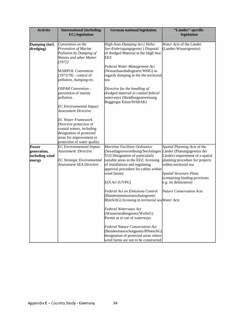
Appendix E – Country Study - Germany
34
Activity International (including EC) legislation
German national legislation “Länder”-specific legislation
Dumping (incl. dredging)
Convention on the Prevention of Marine Pollution by Dumping of Wastes and other Matter (1972) MARPOL Convention (1973/78) - control of pollution, dumping etc. OSPAR Convention - prevention of marine pollution. EC Environmental Impact Assessment Directive EC Water Framework Directive protection of coastal waters, including designation of protected areas for improvement or protection of water quality.
High-Seas-Dumping Act ( Hohe-See-Einbringungsgesetz ) Disposal of dredged Material in the High Sea/ EEZ Federal Water Management Act (Wasserhaushaltsgesetz/WHG) as regards dumping in the the territorial sea Directive for the handling of dredged material in coastal federal waterways (Handlungsanweisung Baggergut Küste/HABAK)
Water Acts of the Länder (Landes-Wassergesetze)
Power generation, including wind energy
EC Environmenetal Impact Assessment Directive EC Strategic Environmental Assessment SEA Directive
Maritime Facilities Ordinance (Seeanlagenverordnung/SeeAnlagenVO) Designation of particularly suitable areas in the EEZ; licensing of installations and regulating approval procedure for cables within wind farms) EIA Act (UVPG) Federal Act on Emissions Control (Bundesimmissionsschutzgesetz/ BImSchG) licensing in territorial sea Federal Waterways Act (Wasserstraßengesetz/WaStrG) Permit as to use of waterways Federal Nature Conservation Act (Bundesnaturschutgesetz/BNatschG) designation of protected areas where wind farms are not to be constructed
Spatial Planning Acts of the Länder (Planungsgesetze der Länder) requirement of a spatial planning procedure for projects within territorial sea Spatial Structure Plans (containing binding provisons e.g. on delineation) Nature Conservation Acts Water Acts
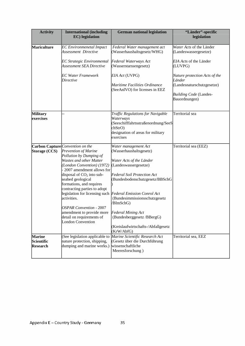
Appendix E – Country Study - Germany
35
Activity International (including EC) legislation
German national legislation “Länder”-specific legislation
Mariculture EC Environmenetal Impact Assessment Directive EC Strategic Environmental Assessment SEA Directive EC Water Framework Directive
Federal Water management act (Wasserhaushaltsgesetz/WHG) Federal Waterways Act (Wasserstarssengesetz) EIA Act (UVPG) Maritime Facilities Ordinance (SeeAnlVO) for licenses in EEZ
Water Acts of the Länder (Landeswassergesetze) EIA Acts of the Länder (LUVPG) Nature protection Acts of the Länder (Landesnaturschutzgesetze) Building Code (Landes-Bauordnungen)
Military exercises
-- Traffic Regulations for Navigable Waterways (Seeschifffahrtsstraßenordnung/SeeSchStrO) designation of areas for military exercises
Territorial sea
Carbon Capture Storage (CCS)
Convention on the Prevention of Marine Pollution by Dumping of Wastes and other Matter (London Convention) (1972) - 2007 amendment allows for disposal of CO2 into sub- seabed geological formations, and requires contracting parties to adopt legislation for licensing such activities. OSPAR Convention - 2007 amendment to provide more detail on requirements of London Convention
Water management Act (Wasserhaushaltsgesetz) Water Acts of the Länder (Landeswassergesetze) Federal Soil Protection Act (Bundesbodenschutzgesetz/BBSchG) Federal Emission Conrol Act (Bundesimmissionsschutzgesetz /BImSchG) Federal Mining Act (Bundesberggesetz /BBergG) (Kreislaufwirtschafts-/Abfallgesetz (KrW/AbfG)
Territorial sea (EEZ)
Marine Scientific Research
(See legislation applicable to nature protection, shipping, dumping and marine works.)
Marine Scientific Research Act (Gesetz über die Durchführung wissenschaftliche Meeresforschung )
Territorial sea, EEZ
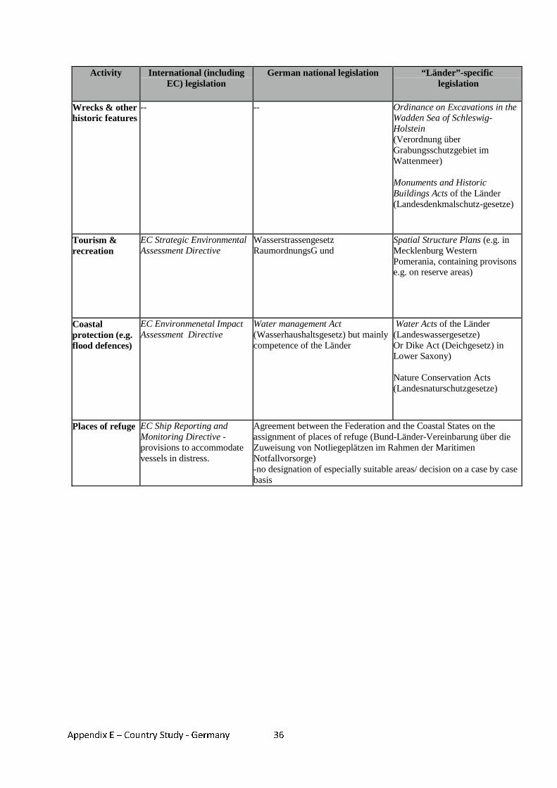
Appendix E – Country Study - Germany
36
Activity International (including EC) legislation
German national legislation “Länder”-specific legislation
Wrecks & other historic features
-- -- Ordinance on Excavations in the Wadden Sea of Schleswig-Holstein (Verordnung über Grabungsschutzgebiet im Wattenmeer) Monuments and Historic Buildings Acts of the Länder (Landesdenkmalschutz-gesetze)
Tourism & recreation
EC Strategic Environmental Assessment Directive
Wasserstrassengesetz RaumordnungsG und
Spatial Structure Plans (e.g. in Mecklenburg Western Pomerania, containing provisons e.g. on reserve areas)
Coastal protection (e.g. flood defences)
EC Environmenetal Impact Assessment Directive
Water management Act (Wasserhaushaltsgesetz) but mainly competence of the Länder
Water Acts of the Länder (Landeswassergesetze) Or Dike Act (Deichgesetz) in Lower Saxony) Nature Conservation Acts (Landesnaturschutzgesetze)
Places of refuge EC Ship Reporting and Monitoring Directive - provisions to accommodate vessels in distress.
Agreement between the Federation and the Coastal States on the assignment of places of refuge (Bund-Länder-Vereinbarung über die Zuweisung von Notliegeplätzen im Rahmen der Maritimen Notfallvorsorge) -no designation of especially suitable areas/ decision on a case by case basis
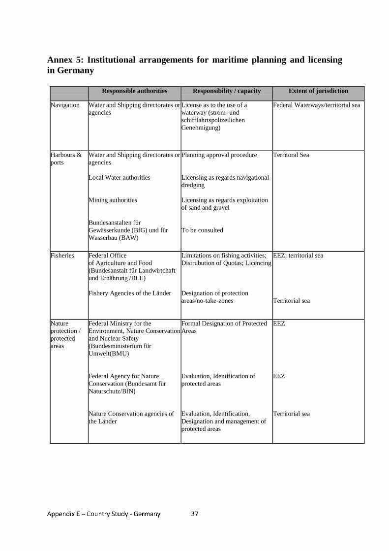
Appendix E – Country Study - Germany
37
Annex 5: Institutional arrangements for maritime planning and licensing in Germany Responsible authorities Responsibility / capacity Extent of jurisdiction
Navigation Water and Shipping directorates or agencies
License as to the use of a waterway (strom- und schifffahrtspolizeilichen Genehmigung)
Federal Waterways/territorial sea
Harbours & ports
Water and Shipping directorates or agencies Local Water authorities Mining authorities Bundesanstalten für Gewässerkunde (BfG) und für Wasserbau (BAW)
Planning approval procedure Licensing as regards navigational dredging Licensing as regards exploitation of sand and gravel To be consulted
Territoral Sea
Fisheries Federal Office of Agriculture and Food (Bundesanstalt für Landwirtchaft und Ernährung /BLE) Fishery Agencies of the Länder
Limitations on fishing activities; Distrubution of Quotas; Licencing Designation of protection areas/no-take-zones
EEZ; territorial sea Territorial sea
Nature protection / protected areas
Federal Ministry for the Environment, Nature Conservation and Nuclear Safety (Bundesministerium für Umwelt(BMU) Federal Agency for Nature Conservation (Bundesamt für Naturschutz/BfN) Nature Conservation agencies of the Länder
Formal Designation of Protected Areas Evaluation, Identification of protected areas Evaluation, Identification, Designation and management of protected areas
EEZ EEZ Territorial sea
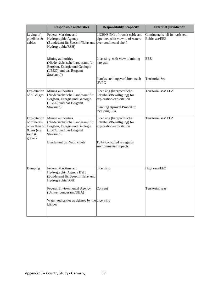
Appendix E – Country Study - Germany
38
Responsible authorities Responsibility / capacity Extent of jurisdiction
Laying of pipelines & cables
Federal Maritime and Hydrographic Agency (Bundesamt für Seeschifffahrt und Hydrographie/BSH) Mining authorities (Niedersächsische Landesamt für Bergbau, Energie und Geologie (LBEG) und das Bergamt Stralsund))
LICENSING of transit cable and pipelines with view to of waters over continental shelf Licensing with view to mining interests Planfeststellungsverfahren nach UVPG
Continental shelf in north sea, Baltic sea/EEZ EEZ Territorial Sea
Exploitation of oil & gas
Mining authorities (Niedersächsische Landesamt für Bergbau, Energie und Geologie (LBEG) und das Bergamt Stralsund)
Licensing (bergrechtliche Erlaubnis/Bewilligung) for exploration/exploitation Planning Aproval Procedure including EIA
Territorial sea/ EEZ
Exploitation of minerals other than oil & gas (e.g. sand & gravel)
Mining authorities (Niedersächsische Landesamt für Bergbau, Energie und Geologie (LBEG) und das Bergamt Stralsund) Bundesamt für Naturschutz
Licensing (bergrechtliche Erlaubnis/Bewilligung) for exploration/exploitation To be consulted as regards envrionmental impacts
Territorial sea/ EEZ
Dumping Federal Maritime and Hydrographic Agency BSH (Bundesamt für Seeschifffahrt und Hydrographie/BSH) Federal Environmental Agency (Umweltbundesamt/UBA) Water authorities as defined by the Länder
Licensing Consent Licensing
High seas/EEZ Territorial seas
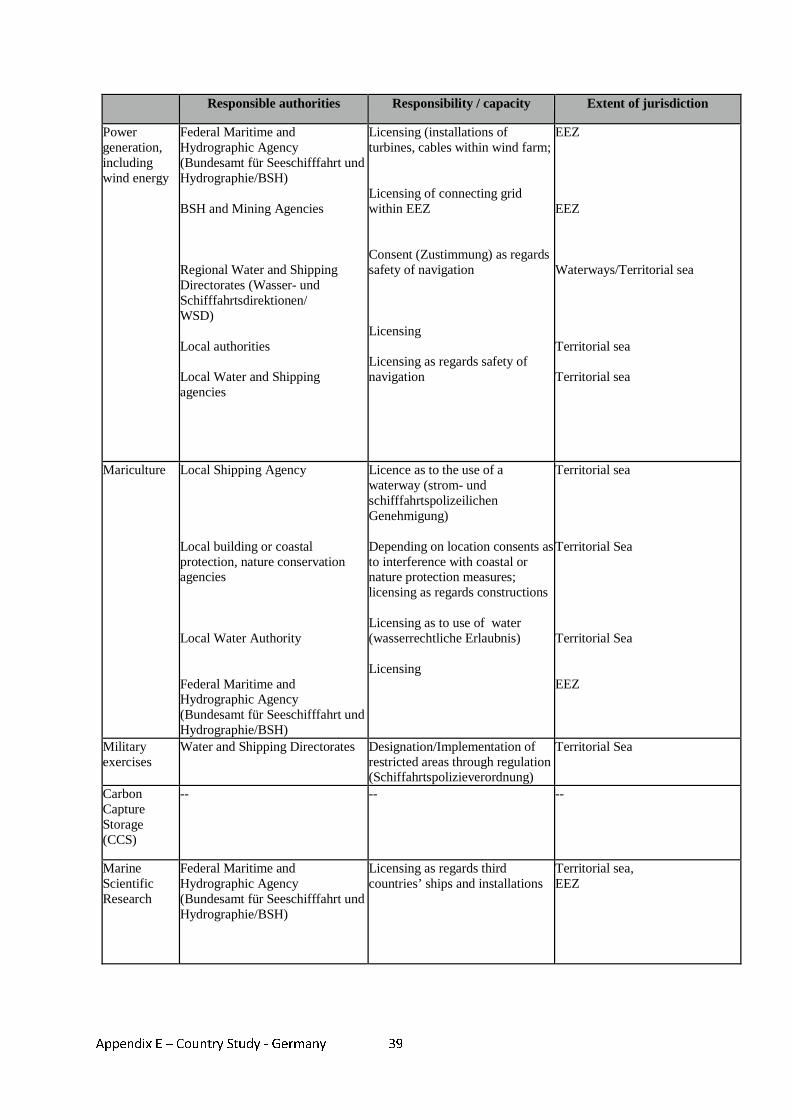
Appendix E – Country Study - Germany
39
Responsible authorities Responsibility / capacity Extent of jurisdiction
Power generation, including wind energy
Federal Maritime and Hydrographic Agency (Bundesamt für Seeschifffahrt und Hydrographie/BSH) BSH and Mining Agencies Regional Water and Shipping Directorates (Wasser- und Schifffahrtsdirektionen/ WSD) Local authorities Local Water and Shipping agencies
Licensing (installations of turbines, cables within wind farm; Licensing of connecting grid within EEZ Consent (Zustimmung) as regards safety of navigation Licensing Licensing as regards safety of navigation
EEZ EEZ Waterways/Territorial sea Territorial sea Territorial sea
Mariculture Local Shipping Agency Local building or coastal protection, nature conservation agencies Local Water Authority Federal Maritime and Hydrographic Agency (Bundesamt für Seeschifffahrt und Hydrographie/BSH)
Licence as to the use of a waterway (strom- und schifffahrtspolizeilichen Genehmigung) Depending on location consents as to interference with coastal or nature protection measures; licensing as regards constructions Licensing as to use of water (wasserrechtliche Erlaubnis) Licensing
Territorial sea Territorial Sea Territorial Sea EEZ
Military exercises
Water and Shipping Directorates Designation/Implementation of restricted areas through regulation (Schiffahrtspolizieverordnung)
Territorial Sea
Carbon Capture Storage (CCS)
-- -- --
Marine Scientific Research
Federal Maritime and Hydrographic Agency (Bundesamt für Seeschifffahrt und Hydrographie/BSH)
Licensing as regards third countries’ ships and installations
Territorial sea, EEZ
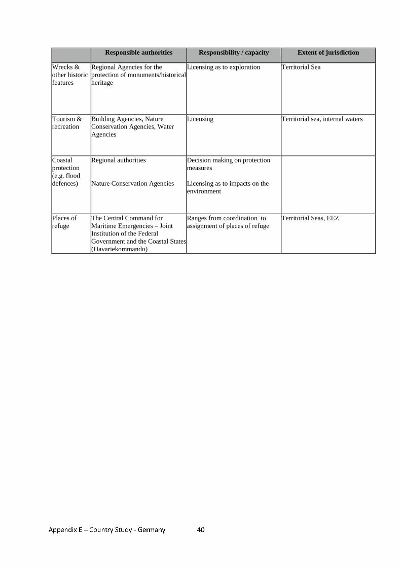
Appendix E – Country Study - Germany
40
Responsible authorities Responsibility / capacity Extent of jurisdiction
Wrecks & other historic features
Regional Agencies for the protection of monuments/historical heritage
Licensing as to exploration Territorial Sea
Tourism & recreation
Building Agencies, Nature Conservation Agencies, Water Agencies
Licensing Territorial sea, internal waters
Coastal protection (e.g. flood defences)
Regional authorities Nature Conservation Agencies
Decision making on protection measures Licensing as to impacts on the environment
Places of refuge
The Central Command for Maritime Emergencies – Joint Institution of the Federal Government and the Coastal States (Havariekommando)
Ranges from coordination to assignment of places of refuge
Territorial Seas, EEZ
Appendix F – Country Study – Greece 1
Appendix F - Country study – Greece
MARITIME SPATIAL PLANNING IN GREECE
1. Introduction
1. Greece has a coastline of approximately 15,000 km, the second longest in Europe after Norway, which represents more than 25% of the total Mediterranean coastline. The Aegean Sea lies to the east and south of mainland Greece, while the Ionian Sea lies to the west. Both parts of the Eastern Mediterranean basin feature a vast number of islands. The Territorial waters are limited to 6 nautical miles (NM).
2. The lack of an Exclusive Economic Zone (EEZ) in the Mediterranean Sea and the geography of the mainland and of the 3500 Greek islands and islets create a unique environment, resulting in very special conditions. These include large corridors of International waters allowing vessels from Third countries and of other Member States to operate as close as 6 N.M. from the Greek coasts and large maritime areas impeding the possibility of constant policing from the Hellenic Coast Guard for issues such as guarding of antiquities in archaeological protected zones, illegal fishing, smuggling, etc.
3. Out of the Greek population, 33 % lives in coastal cities or villages not more than 2 km
from the coast. Tourism and shipping are important pillars of the Greek economy. In 2005 the goods handled in all Greek ports amounted to 151 million tonnes and the number of passengers who transited through these ports amounted to 86 million104.
4. The following most significant maritime activities in Greece, as presented in the
publication EU Maritime Policy: Facts and Figures – Greece from DG Fisheries and Marine Affairs105, indicate the importance of the marine environment for Greek economy:
• Greece has the largest merchant fleet in the EU: 2,999 vessels controlled in 2005
which make up about half of the total EU deadweight tonnage (data comprises ships of 1,000 GRT and over). The Greek owned merchant fleet (under national and other flags) is one of the largest in the world. The vessels sailing the national flag made up one quarter of the total Greek-controlled fleet in 2005.
• The country is ranked 15th worldwide as a tourist destination. Tourism contributes more than 18 % to the annual Gross National Product (GNP), generating approximately 20 % of employment and contributing substantially to regional development.
• The fisheries sector in Greece employs 37,701 persons. The country’s fishing fleet is characterised by its large share of small scale coastal vessels (total number of vessels 18.269). In addition, the country has an important aquaculture sector, which in 2005 produced 106,208 tonnes at a value of € 345.5 million (4th place in the EU in terms of value).
5. As it can therefore be inferred, the geographical characteristics of the country on the one
hand and the dependence of the Greek economy on activities relating to the sea on the
104 European Commission. EU Maritime Policy: Facts and Figures – Greece. DG Fisheries and Marine Affairs.http://ec.europa.eu/maritimeaffairs/facts_figures_en.html 105 As above
Appendix F – Country Study – Greece 2
other hand, underline the necessity for a proper maritime spatial planning (MSP) framework. Currently, MSP is practiced by different authorities, depending on the activity, and through a broad range of sectoral legislative instruments.
6. This case study presents the legislation applicable to different aspects of MSP in Greece and the responsibilities, jurisdictions and decision making processes of the authorities involved in planning and licensing. It further examines current procedures for obtaining licences for specified maritime activities and describes the consultation procedures and the existing conflict resolution mechanisms if there are objections to proposed developments. Proposed policy and legislation is also discussed and how it will affect the existing regulatory system. Finally, transboundary initiatives are described concerning Greece in the frame of MSP.
2. Legislation applicable to MSP 7. As indicated by Lialios,106 Greece remains one of the few European countries without
concrete tools for implementing spatial planning. The first law on spatial planning was adopted in 1976107 but was never actually implemented. In 1999 another law was issued108 which established a number of spatial planning frameworks; the national, the regional and the special ones (according to sectoral category activities). Based on this legal instrument, 12 regional spatial plans were elaborated, which however, were not put into practice109. It is not until now that the National Spatial Plan and a number of other Special Plans have been elaborated and are either under consultation procedures or have already been submitted to the Parliament. These plans include provisions on maritime issues but only in a sectoral approach. Some examples are described in section “Progress toward MSP in Greece”.
8. It can therefore be inferred that particularly MSP, in the broader absence of spatial planning instruments, is not regulated by a relevant particular law but instead by a number of sectoral legislative mechanisms applying to specific activities or users of the marine environment.
9. Annex 2 summarises the legislation applicable to MSP in Greece, in terms of
international, EC and national instruments. The table shows the individual pieces of legislation that are relevant to specific maritime activities; some activities are legislated by several different instruments, and the same legislation may apply to a range of different activities.
10. At the international level, a number of conventions and protocols apply to MSP issues
such as the United Nations Convention on the Law of the Sea UNCLOS (1982) and the International Convention for the Prevention of Pollution from Ships, 1973, as modified by the Protocol of 1978 (MARPOL). Greece has ratified and implements the relevant international legislation through specific legislative pieces.
106 Λιάλιος, Γ. 2007. Επιτέλους το χωροταξικό σχέδιο για τα αιολικά πάρκα. Καθηµερινή 2 Φεβρουαρίου 2007. (Lialios, G. 2007. Finally the spatial plan for wind parks. Kathimerini 2 February 2007.) news.kathimerini.gr/4dcgi/_w_articles_economy_100047_02/02/2007_214381 107 Law 360/1976 on Spatial planning and environment 108 Law 2742/1999 on Spatial planning & sustainable development and other provisions 109 Λιάλιος, Γ. 2007. Επιτέλους το χωροταξικό σχέδιο για τα αιολικά πάρκα. Καθηµερινή 2 Φεβρουαρίου 2007. (Lialios, G. 2007. Finally the spatial plan for wind parks. Kathimerini 2 February 2007.)
Appendix F – Country Study – Greece 3
11. At the European level the main two EC Directives that affect most maritime activities are
the Environmental Impact Assessment (EIA) Directive (85/337/EC and Amending Directive 97/11/EC) and the Strategic Environmental Assessment (SEA) Directive (2001/42/EC). The EIA Directive requires for all projects with impacts to the environment to identify and assess these impacts before authorisation is granted for the project to be realised. This is also valid for activities and works that take place at the marine environment. The SEA Directive requires all plans and programs to be assessed during their elaboration with reference to their environmental impacts. In Greece, both Directives have been transposed, although there were enormous delays in the transposition of the SEA Directive. The transposed legislation of both Directives does not provide, however, in most cases any particular provisions for maritime areas; meaning there is no specific distinction to the related provisions whether the activity, plan or program is taking place on land or the marine environment.
12. Greece has been implementing MSP through a vast number of Laws, Presidential
Decrees, Ministerial Decisions and General Rules. For each maritime activity relating to spatial planning there are a number of items of legislation that regulate it and many different authorities that get involved. Even in the case that a specific legal instrument is applicable to a broad range of maritime activities, there is little requirement for planning to be undertaken in consideration of each activity in relation to others. The main considerations constantly undertaken for each maritime activity in order to get authorization is the impact on the environment, including protected sites, and the potential threat to antiquities or archeologically protected areas. The process that is currently practiced for ensuring the compatibility of the planned activity in relation to others is the examination of the maritime activity from the different sectoral authorities.
13. The law that covers a broad range of activities covering also maritime areas is Law
2971/2001 Coast, Seashore and other provisions. More specifically, the law describes in Articles 13, 14, 15 and 16 the procedures required and the authorities involved for the simple concession or the concession and licensing for the implementation of works at the coast, seashore, consecutive and adjacent sea and the sea bed, as well as for swallow waters.
14. Concession of coast, seashore, consecutive or adjacent sea areas and the seabed is
provided for works (or for simple use) that serve commercial, industrial, transportation, port or other purpose110. Concession of islands, reefs, cays and the shallow waters that are public property is permitted for activities relating to agriculture, livestock farming, tourism, fisheries, development of national economy, national security and defence and environmental research111. This legislation incorporates specific provisions for laying of cables and pipelines112, flood defences113, marine scientific research114, harbour/port works115, tourism and recreation116 and covers also other maritime activities in the
110 Law 2971/2001 Coast, Seashore and other provisions, Article 14, paragraph 1. 111 Law 2971/2001 Coast, Seashore and other provisions, Article 16, paragraph 1 112 Law 2971/2001 Coast, Seashore and other provisions, Article 14, paragraph 4 113 Law 2971/2001 Coast, Seashore and other provisions, Article 12 114 Law 2971/2001 Coast, Seashore and other provisions, Article 14, paragraph 3 and Article 16, paragraph 1 115 Law 2971/2001 Coast, Seashore and other provisions, Articles 18, 24, 25 116 Law 2971/2001 Coast, Seashore and other provisions, Article 14, paragraphs 3,5,6
Appendix F – Country Study – Greece 4
umbrella of the general wording used (e.g. “works that serve commercial, industrial, transportation, port or other purpose117”).
15. An example of the fragmented nature of MSP even for a specific activity can be observed
from the rules that govern harbour works and facilities. Due to the recent freedom of the provision of services in maritime domestic transportation, consent and licensing for port works and facilities are under Law 2971/2001 Coast, Seashore and other provisions when the managing authority of the port is a public entity, while when it is an incorporated company Law 2932/2001 on the freedom of the provision of services in marine domestic transportation, formation of the Ports’ and Port Policy General Secretariat, conversion of Port Funds to Incorporated companies is valid. Further there are specific provisions for works implemented in the main two ports in Piraeus and Thessalonica.
16. The different laws that rule the same activity present the complexity and overlap of
national MSP. The laying of pipelines and cables for example are mentioned in Law 2971/2001 Coast, Seashore and other provisions, in which a specific procedure for concession and permit process is described in Article 14. Additional legal instruments however, such as Law 2289/95 on the Quest, Research and Exploitation of hydrocarbons, and other provision (Article 6) and Law 3054/2002 on the organization of the oil market and other provisions incorporate provisions for oil facilities including pipelines.
17. There is a range of activities that are not being implemented in Greece in the marine
environment either because the legal base is there but there is no actual practice or there is no planning yet, or limited planning, because there is a lack of appropriate legal background hindering implementation. An example of the first case is the absence of underwater exploitation of minerals other than oil in Greece although Law 210/1973 Rules on Extraction and Law 142/1969 on the quest and exploitation of underwater and under the lakes mineral resources have provisions for exploitation of underwater minerals other than hydrocarbons.
18. The second case is valid for example for offshore power generation from renewable
energy sources. The legal instruments for these activities have only very recently been issued (Law 3468/2006 Production of Electricity from renewable energy sources and co-generation of heat and power) and there is still complementary secondary legislation expected to be prepared in order for actual planning of such activities to be able to take place. Additionally, due to lack of basic provisions from the Law for the spatial planning of aquaculture units (lack of spatial plans – lack of spatial planning of Areas of Organised Development of Productive Activities), serious problems arise for existing mariculture units and the spatial planning of new ones is obstructed118.
3. Responsibilities and jurisdictions for planning and licensing in the maritime area 19. Planning in Greece remains to a great extent within the competence of central
government. Though the main responsibility for spatial planning and protection of the environment lies with the Ministry for the Environment, Physical Planning and Public
117 Law 2971/2001 Coast, Seashore and other provisions, Article 14, paragraph 1. 118 Αναγνόπουλος, Ν. 2007. Χωροταξικός Σχεδιασµός Υδατοκαλλιεργειών. 13o Πανελλήνιο Συνέδριο Ιχθυολόγων. Μυτιλήνη, 27-30 Σεπτεµβρίου 2007. (Anagnopoulos, N. 2007. Spatial Planning for Aquaculture. 13th National Hellenic Convention of Ichthyologists. Mytilini 27-30 September 2007)
Appendix F – Country Study – Greece 5
Works, the following bodies are involved in MSP issues in the country, at different levels119:
• Central Government: Ministry of Development (covering also Industry, Energy and
Research), Ministry of Mercantile Marine, the Aegean and Island Policy, Ministry of Rural Development and Food, Ministry of the Aegean and Insular Policy, Ministry of Tourism, Ministry of Culture, Ministry of Economy and Finance.
• Regional level: the 12 (out of 13) Regional Authorities. • Local Authorities of 1st and 2nd tier: Municipalities (to a lesser degree because of
limited resources – 451 coastal (out of 1033 “Kapodistrian” Municipalities) and 41 coastal Prefectures (out of the 51 of the country).
20. On an indicative basis, one could mention the following competencies of the Ministries
involved in issues related directly or indirectly to the Marine Environment and the Coastal Zones120:
• The Ministry of the Environment, Physical Planning and Public Works (MEPPPW)
assumes responsibility for setting out the policy framework and priorities regarding the marine environment protection as well as for coastal zone management (including management of ecosystems and conservation of threatened species). MEPPPW bases its national policies to a great extent respectively on the EC Recommendation on Integrated Coastal Zone Management, the EC Directives 79/409 and 92/43 as well as on commitments undertaken within the Barcelona Convention and its related Protocols. With the exception of the Dumping and the Emergency Protocols (pollution due to ships) mentioned below, MEPPPW is the focal point for all activities covered by the Barcelona Convention system and the Mediterranean Action Plan, including for the Mediterranean Ecosystems and Species Protocol. MEPPPW has launched a programme of environmental studies for the most vulnerable NATURA and bird sites and has established already 27 Protected Areas with a Management Body, 13 of which are coastal and/or marine. There is close co-operation between MEPPPW and the Ministry of Mercantile Marine, the Aegean and Island Policy for the control of possible illegal activities and the implementation of protection measures concerning these coastal/marine protected areas regulated under Articles 18-21 of Law 1650/1986 on Environmental Protection which applies to marine areas as well from the areas defined under the legal instruments transposing the Birds and Habitats Directives121.
• In the field of the marine environment protection from pollution due to navigation, it
is the Marine Environment Protection Directorate of the Hellenic Ministry of Mercantile Marine, the Aegean and Island Policy that has been nominated as the Greek Operational Focal Point and, in this capacity, is entitled to act on behalf of Greece in relation to measures of mutual assistance and cooperation between Parties
119 Ministry for the Environment, Physical Planning and Public Works. 2006. Report of Greece on coastal zone management. http://www.minenv.gr/4/42/00/094%20GR%20Report%20CZM-full%20version-4-final.pdf 120 As above 121 JMD 414985/1985 transposing EC Directive on the Conservation of Wild Birds – designation and provisions for protected sites (including marine) and JMD 33318/3028/98 transposing EC Directive on the Conservation of Natural Habitats and of Wild Fauna and Flora – designation and provisions for protected sites (including marine)
Appendix F – Country Study – Greece 6
in the framework of the implementation of the 2002 Protocol concerning Cooperation in Preventing Pollution from Ships and, in case of emergency, in Combating Pollution of the Mediterranean Sea (Prevention and Emergency Protocol). Moreover, under the approved national organisational structure, the Hellenic Coast Guard that belongs to the Hellenic Ministry of Mercantile Marine, the Aegean and Island Policy, performs the necessary government functions aimed at an effective marine environment control by using a modern fleet of air operational means (aircrafts and helicopters), which survey the Greek territorial waters for, among others, tracking down and preventing illegal discharges from ships. The Hellenic Coast Guard (H.C.G.) has general duties for policing ships, either at sea or in ports (subject to the relevant provisions of UNCLOS), and enforcing the law not only in sea areas but also in land areas (coastal zones) of its competence.
• Government functions in respect to maritime transport in any sense have been
assigned to the Ministry of Mercantile Marine, the Aegean and Island Policy. This Ministry is also responsible for Safety of Navigation issues and for monitoring the maritime traffic in the Hellenic seas. A VTMIS system is in operation covering a large part of the Greek waters, whereas its extension to the remaining sea areas is in progress. There is also a Hellenic Search and Rescue Centre (JRCC) operating in Piraeus, with personnel from the Hellenic Coast Guard, the Air Force and the Hellenic Navy.
• Cross-border cooperation has been declared on issues relating to the protection of the
Marine Environment (Barcelona Convention and bilateral agreement with Italy) and search and rescue (bilateral agreement with Italy).
• The Ministry of Rural Development and Food is competent for the implementation of
the Common Agriculture and Fisheries Policies in Greece, while the Ministry of Mercantile Marine, the Aegean and Island Policy, through the Hellenic Coast Guard, conducts controls and inspections for preventing and combating, when necessary, any illegal fishing activity.
• The Ministry of Culture has competence for the protection of coastal and marine
archaeological sites and monuments. The Ministry has an important advisory role in the decision making process of most maritime activities (for public and private works and licensing of permits)
• The Ministry of National Economy and Finance is responsible for awarding permits for the use of beaches and seashores (e.g., during the swimming period or for broader investments)
• Customs activities (including implementation of the CITES provisions) are carried out
by the Ministry of National Economy and Finance (Customs Authorities).
• Matters relating to immigration, policing and border protection constitute a joined activity, which is carried out by the Ministry for Internal Affairs and the Ministry of Public Order.
21. Concerning the licensing procedure for the environmental permit, which is necessary for
a number of maritime activities, it is the Ministry for the Environment, Physical Planning
Appendix F – Country Study – Greece 7
and Public Works that has the main responsibility. More specifically, according to the category of impact of the project, the approval of environmental conditions and the licensing of the environmental permit for the project or activity is issued from the Minister of Environment, Physical Planning and Public Works and the co-responsible Ministers for category A (great impact), from the relevant Prefect for category B (medium impact) and form the relevant Mayor or President of the Community for category C (low impact). (WWF Report, 2005)122.
22. As an overview, maritime planning in Greece is regulated largely by centralised authorities and there is no single authority with an overview of all activities being planned in the marine environment. Instead there are many overlapping jurisdictions, with a duplication of powers.
23. Annex 3 summarises the institutional arrangements for planning and licensing of
maritime activities in Greek waters, the capacity of responsible authorities to grant licenses, provide advice, or implement planning bye-laws, and their jurisdiction.
4. Licensing procedures
24. This section examines the current procedures for obtaining licenses to undertake activities
in the marine environment, focusing on two examples:1) laying of cables and pipelines, and 2) installation of mariculture units
1) Laying of cables and pipelines
25. There are a number of legislative instruments that area concerned with the laying of pipelines. According to the Law on the Coast, Seashore and other Provisions, as described in Article 14, the Ministry of National Economy and Finance is mainly responsible for the concession of the coastal and seashore areas, the consecutive or adjacent sea area and the sea bottom for the execution of works including the laying pipelines and cables. However, a number of other ministries have jurisdiction, as their approval consent is necessary.
26. The typical process which leads to the concession of the area and the provision of a license in order to lay submarine cables and pipelines, according to this law is the following:
• An application is submitted by the interested party to the National Land Service,
accompanied by the necessary technical documents according to the relevant Joint Ministerial Decision.
• The National Land Service forwards the relevant technical documents to the
following recipients within one month in order to provide their opinions (within three months) according to their competences:
122 WWF Ελλάς. 2005. ∆εσµεύσεις χωρίς εφαρµογή: Η περιβαλλοντική νοµοθεσία στην Ελλάδα. Ετήσια Έκθεση Ιούλιος 2005. (WWF Hellas. 2005. Commitments without implementation: The environmental legislation in Greece. Annual Report July 2005.) http://politics.wwf.gr/index.php?option=com_content&task=view&id=450&Itemid=302
Appendix F – Country Study – Greece 8
o Ministry for the Environment, Physical Planning and Public Works / Department of Physical Planning and Department of Urban Planning or the Environmental or Physical Planning Department of the relevant Prefecture for the preliminary approval of spatial planning
o General Hellenic Navy Staff o Ministry of Mercantile Marine, the Aegean and Island Policy o Prefectural Committee of Physical Planning and Environment o Ministry of Culture o Greek National Tourism Organisation o Ministry of Rural Development and Food (for works in rivers, ports or
relevant to fishing shelters o Local Council of the relevant Local Self-Government Organisation o Ministry of Development (for concession of the area to industrial units, oil
facilities and industries of extractive, mine and industrial minerals)
• After the preliminary approval of spatial planning and the expression of views from the above authorities, the Environmental Impact Assessment Study is elaborated.
• The Final Study is approved, for which all environmental conditions are taken into
consideration, after the following authorities have provided their consent (within three months):
o General Hellenic Navy Staff for national security and navigational security issues
o Ministry of Mercantile Marine, the Aegean and Island Policy for issues of rational shipping development, coastal and seashore protection, control and security of navigation and transport
o The relevant authority of the Ministry of Culture for the protection of antiquities
• The approved Final Study together with the above views is delivered to the competent
Land Service for issuing of the concession permit and the necessary license.
27. According to Article 6 of Law 2289 of 1995 on the Quest, Research, exploitation of
hydrocarbons, and other provision, the license for installation of pipelines for transporting exploited hydrocarbons towards the installations for distillation, processing or storage or towards the installations for loading is under the jurisdiction of the Ministry of Development and for the route it will undertake with the approved consent of the Ministry of Defence, the Ministry for the Environment, Physical planning and Public Works and when submarine also from the Ministry of Mercantile Marine, the Aegean and Insular Policy. The operation license is provided by the Minister of Development.
2) Installation of mariculture units
28. Until today, the installation of mariculture units has taken place based on the applicable legislation for “area-specific” spatial planning after the elaborations of the “preliminary environmental assessment and evaluation” of the Environmental Impact Assessment Pre-study. This takes place due to lack of approved spatial or regulatory plans.
Appendix F – Country Study – Greece 9
29. The typical process which leads to the tenancy/leasing of a sea area, in order to establish an aquaculture farm and also to obtain the issue of an establishment and operation license is the following:
• Selection of the farmed species and the method of farming.
• Selection of the convenient site for the settlement of the farm.
• Submission of application, for the tenancy of the selected sea area accompanied with
the necessary documents (see the following figure) to the competent Fisheries Office of the Region where that sea area belongs to (necessary time for the issuing of the competent services’ s concurrent opinions, 3 months minimum).
• Submission of application supported by the necessary documents (see table 1) for the
issuing of the Preliminary Approval of Site Allocation, by the competent Office of the Region (Planning-Environment Office).
• After the issuing of the concurrent opinions of the competent services and the
Preliminary Approval of Site Allocation, the decision of the General Secretary of the Region for the tenancy of the sea area is being issued.
• Submission to the MEPPPW of an application accompanied by an Environmental
Impact Assessment for the sites which are inside Ramsar or Natura 2000 areas, or to the Region (Environment Office) for the rest of the sea sites, for the issuing of Decision for Approval of the Environmental Terms.
• After the Tenancy Decision and the Decision for the approval of the Environmental
Terms, is being issued the decision of the General Secretary of the Region, concerning the Establishment and Operation License of the farm.
• The investor is now ready to proceed with the settlement of the equipment and the set
up of the farm.
30. In the case that, the under formation farms, apply for accession of their plan in an
Operational Program (Communitary or National) to gain financial support, it is needed to submit the appropriate extra supporting documentation and studies.
31. The following table 1 shows the procedure:
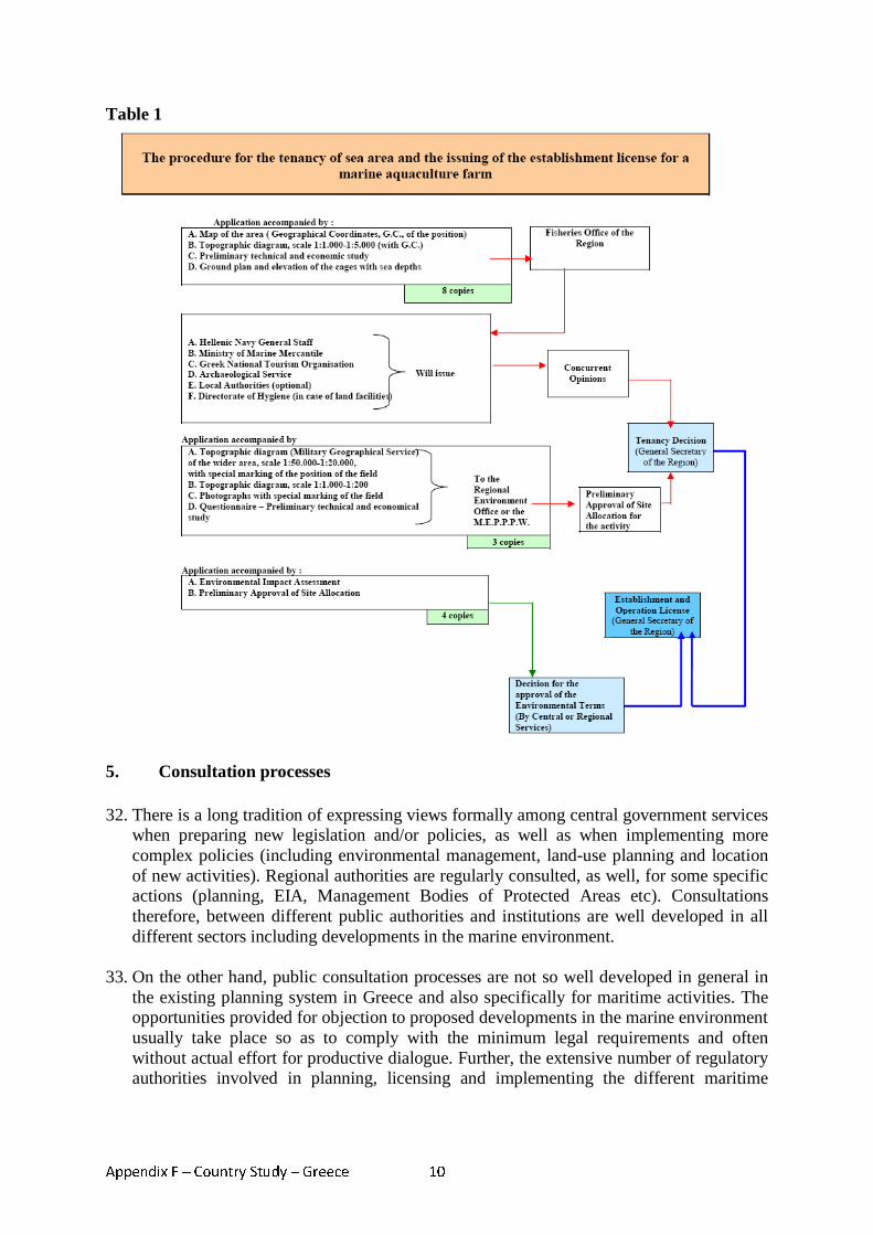
Appendix F – Country Study – Greece 10
Table 1
5. Consultation processes
32. There is a long tradition of expressing views formally among central government services when preparing new legislation and/or policies, as well as when implementing more complex policies (including environmental management, land-use planning and location of new activities). Regional authorities are regularly consulted, as well, for some specific actions (planning, EIA, Management Bodies of Protected Areas etc). Consultations therefore, between different public authorities and institutions are well developed in all different sectors including developments in the marine environment.
33. On the other hand, public consultation processes are not so well developed in general in the existing planning system in Greece and also specifically for maritime activities. The opportunities provided for objection to proposed developments in the marine environment usually take place so as to comply with the minimum legal requirements and often without actual effort for productive dialogue. Further, the extensive number of regulatory authorities involved in planning, licensing and implementing the different maritime
Appendix F – Country Study – Greece 11
activities make effective consultation more difficult. The main legal instruments for public consultations are the national regulations transposing the EIA and SEA Directives.
34. Several organisations of the civil society are active in consultation processes, representing
Universities, Professional Chambers or Trade Unions and Non-Governmental Organisations (NGOs – mostly dealing with the environmental and cultural heritage). They mainly participate in public hearings in the context of issuing environmental permits, in particular in ecologically vulnerable areas123.
35. Concerning consultation procedures for Environmental Impact Assessment requirements,
the Joint Ministerial Decision 37111/2021/2003 defines the ways in which the public will be informed and participate during the procedures for approval of environmental conditions of projects and activities. The main means and actual common practice of informing the public is the announcement in the newspaper. The public can actively participate by providing verified written positions and views within a specific timeframe.
36. As described in the Annual report of WWF Hellas in 2005, the main drawback in the
consultation procedure for EIA, that diminishes noticeably its actual value, is the circumvention of the regulatory procedure for environmental licensing through relevant extensive legislative activity of the Parliament. Particularly, for specific projects, the spatial planning and the license for construction are approved by law, abolishing this way the right of the citizens to participate and interfere in the procedure. In parallel, the right of the Council of the State to exercising legality control is deducted. These conditions were mainly practiced for the spatial planning needs of the Olympic Games but also for other big project for which intense opposing reactions were expected124.
37. Further the first stage of the Preliminary Environmental Assessment and Evaluation
requires only a simple consent from the relevant authority and therefore is an act that can not be legally disputed since it does not comprise of an executive action of the Administration. As such it deprives from the citizens the right of control, which can be exercised only during the procedure of the approval of environmental conditions125.
38. The Ministerial Decision 107017/2006 – on the assessment of environmental impact of
certain plans and programs on the environment, which transposes the SEA Directive 2001/42/ΕΚ, provides limited procedures for consultation. Particularly the authorities’ obligation of making public the relevant announcement of the strategic studies is constrained to the publication in at least two daily newspapers, while it is up to the planning authority to use any other additional means.
39. The Directive was transposed only recently in national legislation and therefore there
have been only limited applications until today. One of the first applications of Strategic Environmental Assessment (SEA) that was delivered for public consultation and incorporates, among others, activities to be implemented in the marine environment was the Special Framework of Spatial Planning for Renewable Energy Sources (SFSP-RES).
123 Ministry for the Environment, Physical Planning and Public Works. 2006. Report of Greece on coastal zone management. http://www.minenv.gr/4/42/00/094%20GR%20Report%20CZM-full%20version-4-final.pdf 124 WWF Ελλάς. 2005. ∆εσµεύσεις χωρίς εφαρµογή: Η περιβαλλοντική νοµοθεσία στην Ελλάδα. Ετήσια Έκθεση Ιούλιος 2005. (WWF Hellas. 2005. Commitments without implementation: The environmental legislation in Greece. Annual Report July 2005.) 125 As above
Appendix F – Country Study – Greece 12
The procedure relating to Strategic Environmental Assessment for the SFSP-RES, with reference to both the content and the public consultation procedure, were considered very satisfactory and provide a good precedent for further SEA applications126.
6. Conflict resolution
40. The main areas of conflict between different uses of the marine environment in Greece include the following: • Fishing activities which conflict with conservation objectives and protection of antiquities; • Protection of marine species and habitats, which may limit development in other sectors • Unauthorized works and installations (for harbours, industries, tourism, fishing,
aquaculture, etc.) which conflict with the protection of antiquities and protection of marine species and habitats
• Unsustainable tourist development activities which conflict with protection of marine species and habitats and protection of antiquities
41. There is no particular procedure or mechanism for conflict resolution concerning
maritime activities. The same procedure as for all other activities is valid. That is, when conflict arises from the side of the public (including institutions, NGOs, organizations, etc) toward a certain maritime activity / plan and the relevant responsible authority does not take into consideration the public’s views, expressed through the public consultation, the main means to solve the conflict is through the Council of the State. The Council of the State is one of the three independent courts of Greece to which the public can appeal.
42. An example of this is the submarine highway that is under construction in the area of Thessalonica. The group “citizens against the submarine highway” appealed at the Council of the State as in order to construct the highway, a number of listed buildings were to be demolished. After the appeal, the Minister of Environment, Physical Planning and Public Works decided to consult further scientific advice and finally selected an alternative route through which the buildings would not be demolished127.
43. Another means of conflict resolution for the public is the Greek Ombudsman which
investigates individual administrative actions or omissions or material actions taken by government departments or public services that infringe upon the personal rights or violate the legal interests of individuals or legal entities.
44. Before submitting a complaint to the Greek Ombudsman, the complainant should first
come into contact with the public service involved with his or her case. Only if the problem is not resolved by the service concerned should a complaint be submitted to the Ombudsman.
126 WWF Ελλάς. 2007. ∆εσµεύσεις χωρίς εφαρµογή: Η περιβαλλοντική νοµοθεσία στην Ελλάδα. Ετήσια Έκθεση Ιούλιος 2007. (WWF Hellas, 2007. Commitments without implementation: The environmental legislation in Greece. Annual Report July 2007.) http://politics.wwf.gr/index.php?option=com_content&task=view&id=450&Itemid=302 127 Κουτσαµπάρης, Φ. 2007. Φουρτούνες στην υποθαλάσσια. ΜΑΚΕ∆ΟΝΙΑ 2 Ιουνίου 2007. (Koutsamparis, F. 2007. Storms for the Underwater. MAKEDONIA 2 June 2007). http://www.makthes.gr/index.php?name=News&file=article&sid=2348
Appendix F – Country Study – Greece 13
45. If the conflict arises between the public authorities concerned in the implementation of the activity / plan, then this is usually resolved through the Ministerial Council, meaning actually a political decision. If there is still no resolution and the action / plan is of importance, it is then the Prime Minister that takes the decision.
46. The existing conflict resolution mechanisms described above that are practiced in Greece
involve the use of the legal system. Naturally, the best mechanism for resolving conflicts would be to involve all relevant stakeholders from the earliest possible stages of planning the maritime activities. In this way, all conflicts would be presented and discussed from an early stage resulting in the generation of productive solutions. However, in Greece this is not common practice especially, as discussed also at the consultation section, since public consultations are not an active instrument of the spatial planning process. An additional element for resolving conflicts is the prioritization of sectoral policies and activities. An example of this mechanism is observed in Article 10 of the Special Framework for Tourism (discussed in more detail in the next section) in which, although just as an overview, the resolution of conflicts is envisaged through the prioritization of the different land /sea use that affects tourism128.
7. Progress towards MSP in Greece
47. The current legislation for MSP is sectoral and fragmented based mainly on the different maritime activities. Unfortunately, in the short and medium term, there are no envisaged provisions for a holistic approach. However, through the National Spatial Plan and the Special Framework Plans that have been elaborated, a number of maritime activities are incorporated into a regulatory framework. For many of these activities there were ambiguous regulatory provisions until now, hindering therefore their implementation or resulting in unresolved conflicts.
48. The National Spatial Plan has been approved by the Governmental Committee and after a number of dialogues and consultation procedures it was recently submitted to the Parliament. Special Frameworks Plans that include provisions for maritime activities have already been presented to the public for consultation. These are the one for the Renewable Energy Sources, the one for Tourism and the one for Industry. Also a very important step towards MSP will be the Special Framework Plan for Coastal Areas which has been elaborated but not yet presented for public consultation.
49. The Special Framework Plan on Renewable Energy Sources129, for example, provides a
more concrete regulatory frame for marine wind parks in Article 10. Until today, spatial planning of wind parks has been taking place through the environmental licensing procedures, according to each different case. The Special Framework Plan on Renewable Energy Sources defines now the frame of regulations which will govern the spatial planning of RES units in the country, namely where they are permitted and under what conditions. Particularly at the marine environment for example, there are a number of
128 ΥΠΕΧΩ∆Ε. 2007. Ειδικό Χωροταξικό πλαίσιο για το τουρισµό. Σχέδιο κοινής υπουργικής απόφασης. (Ministry for the Environment, Physical Planning and Public Works. 2007. Special Framework Plan for Tourism. Draft Joint Ministerial Decision.) http://www.minenv.gr/4/42/g4200.html#a 129 ΥΠΕΧΩ∆Ε. 2008. Ειδικό πλαίσιο χωροταξικού σχεδιασµού και αειφόρου ανάπτυξης για τις ανανεώσιµες πηγές ενέργειας. Σχέδιο κοινής υπουργικής απόφασης. (Ministry for the Environment, Physical Planning and Public Works. 2007. Special Framework Plan for Renewable Energy Sources. Draft Joint Ministerial Decision.) http://www.minenv.gr/4/42/g4200.html#a
Appendix F – Country Study – Greece 14
preconditions for RES unit installation, such as the distance from land, developed beaches, cultural heritage areas, or the prohibition of installation in protected marine parks, verified navigation channels, etc.
50. The Special Framework Plan for Tourism130 defines the conditions for marine tourism
development, which mainly concerns rented boats for recreation, proposes the promotion of scuba diving tourism in areas of increased tourism activity and provides a frame for development of nature tourism in protected areas including the national marine parks of Zakynthos and N. Sporades.
51. A draft Law on the Coast, Seashore and other provisions, has been in preparation the past
years, which is meant to replace the existing one. The main provisions for works and facilities on the marine environment remain the same. There are some changes on the definitions of the new and old coast boundaries and some changes are also envisaged for the harbour zones.
52. As it can be inferred, although some further steps towards a better regulatory framework
for MSP activities is envisaged, a holistic approach is not foreseen for the near future.
8. Transboundary initiatives
53. As Greece is bordering the Aegean Sea, the Ionian Sea, and the Mediterranean Sea, and shares maritime boundaries with Italy, Albania and Turkey, the importance of transboundary initiatives is crucial for MSP issues. Examples of such initiatives are presented below and focus on the area of natural gas pipelines, national power grids and protection of the marine environment.
54. Concerning the international and EU legislation, the SEA Directive and the Espoo Convention contain provisions for transboundary projects and plans. The EU SEA Directive requires that where the implementation of a plan or programme prepared in one Member State is likely to have a significant effect on the environment of other Member States, provision has to be made for the Member States to enter into consultations, and for the relevant authorities and the public to be informed and able to express their opinion. The Espoo Convention on Environmental Assessment in the Transboundary Context (1991) requires contracting parties to undertake an EIA where there may be significant transboundary environmental effects.
55. Greece is currently being connected to Turkey by an onshore pipeline and to Italy via an
undersea pipeline and will be connected to the wider European natural gas network by 2010.
56. The Greece-Turkey pipeline, a joint venture between DEPA and BOTAS, the Greek and
Turkish state-owned natural gas utilities, is due to be completed by 2009. In 2005, DEPA signed an agreement with Italy’s Edison group to extend the Greece-Turkey pipeline to Italy across the Adriatic. Known as the Poseidon pipeline, the Interconnection Greece-Italy (IGI) gas pipeline will be approximately 800 kilometres long, 600 of which will be
130 ΥΠΕΧΩ∆Ε. 2007. Ειδικό Χωροταξικό πλαίσιο για το τουρισµό. Σχέδιο κοινής υπουργικής απόφασης. (Ministry for the Environment, Physical Planning and Public Works. 2007. Special Framework Plan for Tourism. Draft Joint Ministerial Decision.) http://www.minenv.gr/4/42/g4200.html#a

Appendix F – Country Study – Greece 15
built by DEPA in Greek territory and 200 in the maritime section between the Greek coast and Italy's Apulia region131.
57. After the necessary authorisations, the construction works of the Italy-Greece gas pipeline
will start within 2008 for completion expected in 2012. On the basis of agreements already signed, the project company will be established on an equal holding, between the Italian energy company Edison and DEPA for completing the submarine section between Greece and Italy. Also the European Union has expressed an opinion on the IGI Project, including it among one of the 5 priority development axes for the trans-European energy system and by contributing financially to the technical-financial studies it entails132.
58. Law 3441/2006 is the Agreement between the Hellenic Republic and the Italian Republic
for the development of the Interconnection Greece-Italy (IGI) Project, in which the general frame of co-operation for the underwater pipeline is provided. As specified further in the agreement, the project is within the scope of the European Energy Charter, it falls within the provisions of the Espoo Convention on the Environmental Impact Assessment in Transboundary Context and the parties are bound by the rules concerning the laying of gas pipelines on their Continental shelf and the protection of the environment from pollution provided for by the UNCLOS and by the Agreement of co-operation for the protection of the marine environment on the Ionian sea and its seacoast.
59. A further transboundary activity that relate to MSP is the 500-MW link completed in
2002 under the Ionian Sea to connect the national power grids of Greece and Italy133. An agreement of cooperation between Greece and Italy on the protection of the marine environment of the Ionian Sea and of its coastal zones which entered into force in 1983 and provides for the establishment of a joint commission, is an additional example of a transboundary initiative.
9. Conclusions
60. In summary, the existing legislative framework in Greece defining the practices and licensing procedures for MSP is sectoral, fragmented, incomplete and complex. Lack of basic provisions from the existing legal mechanisms for spatial planning often results in the impediment of the maritime activity or its inappropriate practice. The different laws that often rule the same activity demonstrate the complexity and overlap of national MSP.
61. There is no single body with an overview of spatial planning for all maritime activities; instead the responsible authorities are different depending on who has jurisdiction for the maritime activity. For each maritime activity there is usually no requirement for planning and authorisation is issued from the responsible regulatory body after a number of different central and sometimes also regional and/or local authorities are advised and provide their consent. This is the process that ensures that the activity will not intervene with other maritime activities.
131 Edison Homepage. The Greece-Italy gas pipeline. http://www.edison.it/edison/site/en/activities/gas/new-projects/ 132 As above 133 Ministry of Development. 2006. Energy Sector in Greece. Diplomatic Cabinet of the Minister. www.greekembassy.org/Embassy/files/ENERGY%20SECTOR%20IN%20GREECE24-01-20060.doc
Appendix F – Country Study – Greece 16
62. Obligations for consultations with stakeholders are present through certain regulatory instruments but the procedure usually takes place in such a way so as to fulfil the minimum legal requirements and often without actual effort for productive dialogue. Further, the extensive number of regulatory authorities involved in planning, licensing and implementing make effective consultation more difficult. A consultation procedure initiating from the earliest possible stage of planning would provide more successful planning and assist in the resolution of conflicts. The existing mechanisms for conflict resolution in case there are objections to proposed developments usually include the use of the legal system when the conflict arises from the public or other interested stakeholders. An additional element that would assist in resolving conflicts is the prioritization of sectoral policies and activities.
63. Proposed policy developments, such as the preparation of the National Spatial Plan and
some Sectoral Spatial Plans, are taking place leading to a more concrete framework for spatial planning in general. The new developments do not confront MSP as an integrated approach but still as a sectoral one. However, a number of maritime activities which were until today governed by ambiguous regulatory provisions, hindering therefore their implementation or resulting in unresolved conflicts, are now incorporated into a regulatory framework.
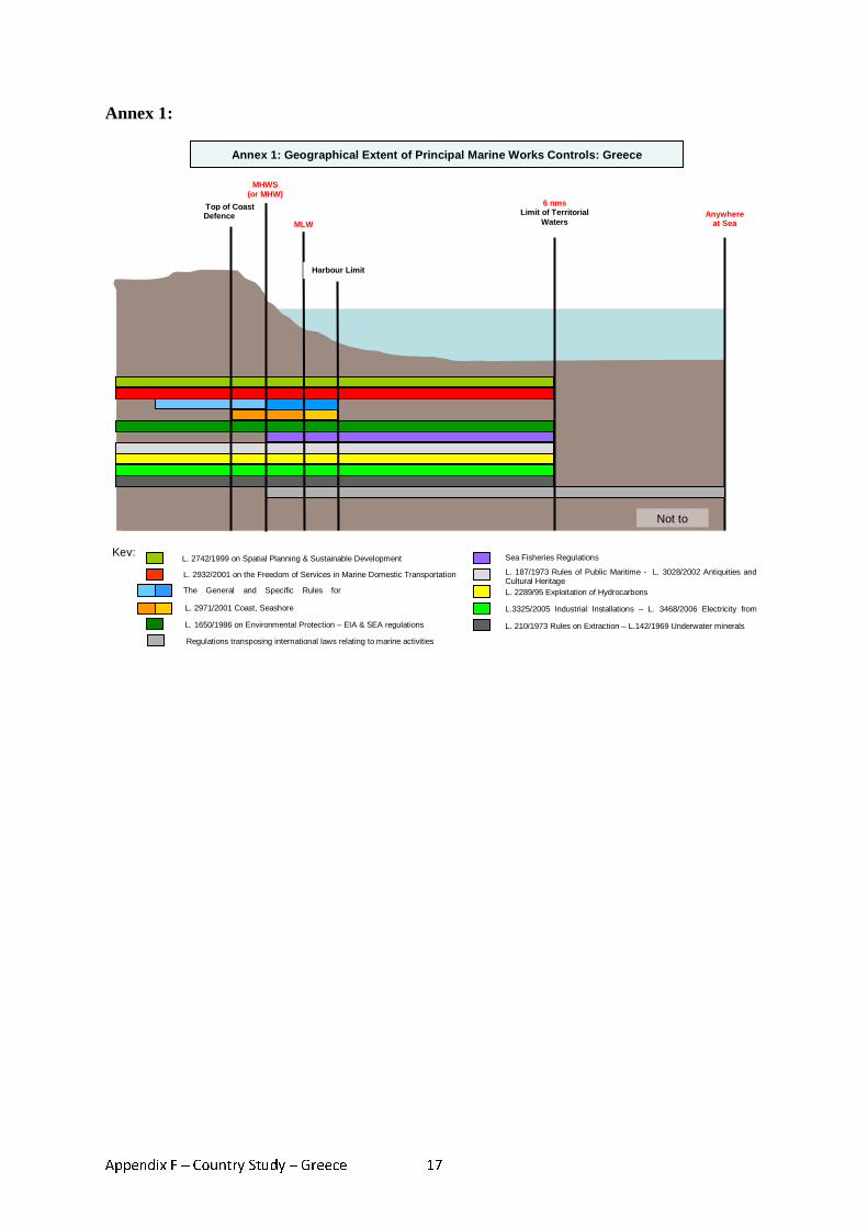
Appendix F – Country Study – Greece 17
Annex 1:
Not to
Key:
Anywhere at Sea
Annex 1: Geographical Extent of Principal Marine Works Controls: Greece
L. 2742/1999 on Spatial Planning & Sustainable Development
L. 2932/2001 on the Freedom of Services in Marine Domestic Transportation
The General and Specific Rules for Harbours
L. 2971/2001 Coast, Seashore
L. 1650/1986 on Environmental Protection – EIA & SEA regulations
Sea Fisheries Regulations
L. 187/1973 Rules of Public Maritime - L. 3028/2002 Antiquities and Cultural Heritage L. 2289/95 Exploitation of Hydrocarbons
L.3325/2005 Industrial Installations – L. 3468/2006 Electricity from
L. 210/1973 Rules on Extraction – L.142/1969 Underwater minerals
Regulations transposing international laws relating to marine activities
Top of Coast Defence
MHWS (or MHW)
MLW
Harbour Limit
6 nms Limit of Territorial
Waters
Appendix F – Country Study – Greece 18
Annex 2: References Edison Homepage. The Greece-Italy gas pipeline. http://www.edison.it/edison/site/en/activities/gas/new-projects/ European Commission. EU Maritime Policy: Facts and Figures – Greece. DG Fisheries and Marine Affairs.http://ec.europa.eu/maritimeaffairs/facts_figures_en.html Ministry of Development. 2006. Energy Sector in Greece. Diplomatic Cabinet of the Minister. www.greekembassy.org/Embassy/files/ENERGY%20SECTOR%20IN%20GREECE24-01-20060.doc Ministry for the Environment, Physical Planning and Public Works. 2006. Report of Greece on coastal zone management. http://www.minenv.gr/4/42/00/094%20GR%20Report%20CZM-full%20version-4-final.pdf WWF Ελλάς. 2005. ∆εσµεύσεις χωρίς εφαρµογή: Η περιβαλλοντική νοµοθεσία στην Ελλάδα. Ετήσια Έκθεση Μάιος 2005. (WWF Hellas. 2005. Commitments without implementation: The environmental legislation in Greece. Annual Report May 2005.) http://politics.wwf.gr/index.php?option=com_content&task=view&id=450&Itemid=302 WWF Ελλάς. 2006. ∆εσµεύσεις χωρίς εφαρµογή: Η περιβαλλοντική νοµοθεσία στην Ελλάδα. Ετήσια Έκθεση Ιούνιος 2006. (WWF Hellas. 2006. Commitments without implementation: The environmental legislation in Greece. Annual Report June 2006.) http://politics.wwf.gr/index.php?option=com_content&task=view&id=450&Itemid=302 WWF Ελλάς. 2007. ∆εσµεύσεις χωρίς εφαρµογή: Η περιβαλλοντική νοµοθεσία στην Ελλάδα. Ετήσια Έκθεση Ιούλιος 2007. (WWF Hellas, 2007. Commitments without implementation: The environmental legislation in Greece. Annual Report July 2007.) http://politics.wwf.gr/index.php?option=com_content&task=view&id=450&Itemid=302 Αναγνόπουλος, Ν. 2007. Χωροταξικός Σχεδιασµός Υδατοκαλλιεργειών. 13o Πανελλήνιο Συνέδριο Ιχθυολόγων. Μυτιλήνη, 27-30 Σεπτεµβρίου 2007. (Anagnopoulos, N. 2007. Spatial Planning for Aquaculture. 13th National Hellenic Convention of Ichthyologists. Mytilini 27-30 September 2007) ∆ελλαπόρτα, Κ. 2005 Υποβρύχια αρχαιολογική κληρονοµιά στην Ελλάδα: Νοµική προστασία και διαχείριση. Νόµος και Φύση. (Dellaporta, K. 2005. Underwater archeological heritage in Greece: Legal protection and management. Nomos + Physis) http://www.nomosphysis.org.gr/articles.php?lang=1&artid=2093&catpid=1 Κουτσαµπάρης, Φ. 2007. Φουρτούνες στην υποθαλάσσια. ΜΑΚΕ∆ΟΝΙΑ 2 Ιουνίου 2007. (Koutsamparis, F. 2007. Storms for the Underwater. MAKEDONIA 2 June 2007). http://www.makthes.gr/index.php?name=News&file=article&sid=2348 Λιάλιος, Γ. 2007. Επιτέλους το χωροταξικό σχέδιο για τα αιολικά πάρκα. Καθηµερινή 2 Φεβρουαρίου 2007. (Lialios, G. 2007. Finally the spatial plan for wind parks. Kathimerini 2 February 2007.) news.kathimerini.gr/4dcgi/_w_articles_economy_100047_02/02/2007_214381 ΥΠΕΧΩ∆Ε . 2008. Σχέδιο Νόµου, Γενικού πλαισίου χωροταξικού σχεδιασµού και αειφόρου ανάπτυξης. Σχέδιο κοινής υπουργικής απόφασης. (Ministry for the Environment, Physical Planning and Public Works. 2008. Draft Law, General Frame for Spatial planning and Sustainable Development. Draft Joint Ministerial Decision.) http://www.minenv.gr/4/42/g4200.html#a

Appendix F – Country Study – Greece 19
ΥΠΕΧΩ∆Ε. 2007. Ειδικό Χωροταξικό πλαίσιο για το τουρισµό. Σχέδιο κοινής υπουργικής απόφασης. (Ministry for the Environment, Physical Planning and Public Works. 2007. Special Framework Plan for Tourism. Draft Joint Ministerial Decision.) http://www.minenv.gr/4/42/g4200.html#a ΥΠΕΧΩ∆Ε. 2008, Ειδικό πλαίσιο χωροταξικού σχεδιασµού και αειφόρου ανάπτυξης για τη βιοµηχανία. Σχέδιο κοινής υπουργικής απόφασης. (Ministry for the Environment, Physical Planning and Public Works. 2007. Special Framework Plan for Industry. Draft Joint Ministerial Decision.) http://www.minenv.gr/4/42/g4200.html#a ΥΠΕΧΩ∆Ε. 2008. Ειδικό πλαίσιο χωροταξικού σχεδιασµού και αειφόρου ανάπτυξης για τις ανανεώσιµες πηγές ενέργειας. Σχέδιο κοινής υπουργικής απόφασης. (Ministry for the Environment, Physical Planning and Public Works. 2007. Special Framework Plan for Renewable Energy Sources. Draft Joint Ministerial Decision.) http://www.minenv.gr/4/42/g4200.html#a
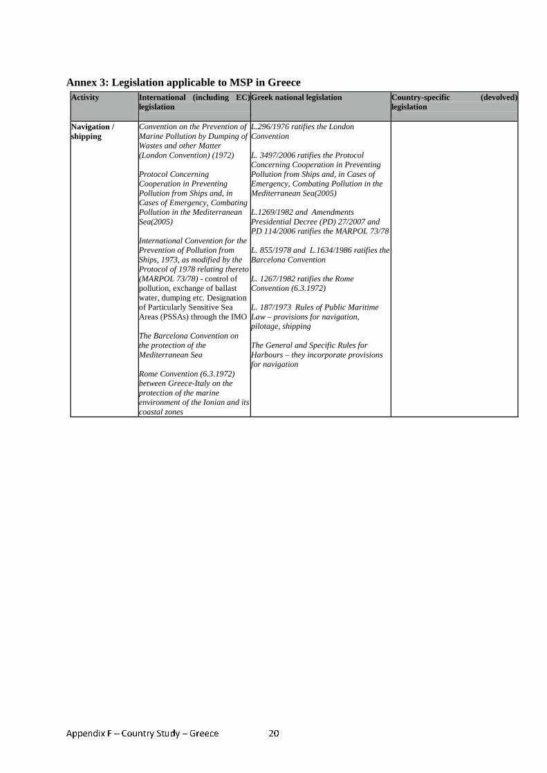
Appendix F – Country Study – Greece 20
Annex 3: Legislation applicable to MSP in Greece Activity International (including EC)
legislation
Greek national legislation Country-specific (devolved) legislation
Navigation / shipping
Convention on the Prevention of Marine Pollution by Dumping of Wastes and other Matter (London Convention) (1972) Protocol Concerning Cooperation in Preventing Pollution from Ships and, in Cases of Emergency, Combating Pollution in the Mediterranean Sea(2005) International Convention for the Prevention of Pollution from Ships, 1973, as modified by the Protocol of 1978 relating thereto (MARPOL 73/78) - control of pollution, exchange of ballast water, dumping etc. Designation of Particularly Sensitive Sea Areas (PSSAs) through the IMO The Barcelona Convention on the protection of the Mediterranean Sea Rome Convention (6.3.1972) between Greece-Italy on the protection of the marine environment of the Ionian and its coastal zones
L.296/1976 ratifies the London Convention L. 3497/2006 ratifies the Protocol Concerning Cooperation in Preventing Pollution from Ships and, in Cases of Emergency, Combating Pollution in the Mediterranean Sea(2005) L.1269/1982 and Amendments Presidential Decree (PD) 27/2007 and PD 114/2006 ratifies the MARPOL 73/78 L. 855/1978 and L.1634/1986 ratifies the Barcelona Convention L. 1267/1982 ratifies the Rome Convention (6.3.1972) L. 187/1973 Rules of Public Maritime Law – provisions for navigation, pilotage, shipping The General and Specific Rules for Harbours – they incorporate provisions for navigation
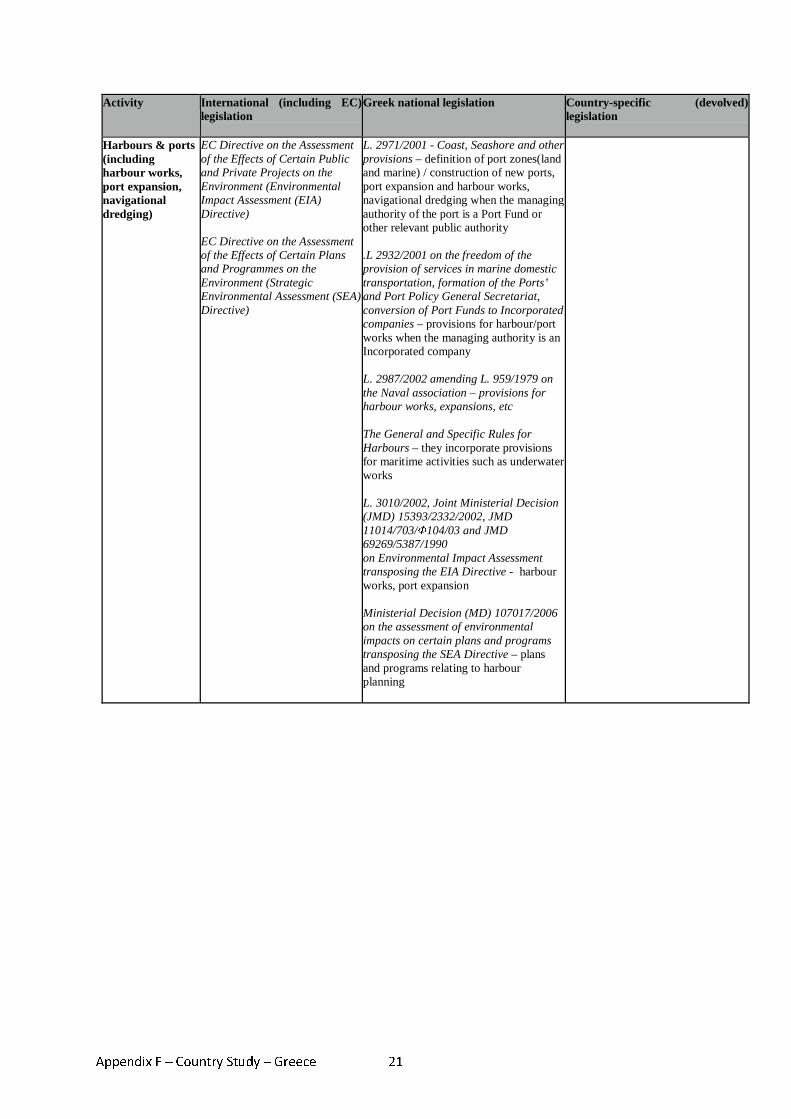
Appendix F – Country Study – Greece 21
Activity International (including EC) legislation
Greek national legislation Country-specific (devolved) legislation
Harbours & ports (including harbour works, port expansion, navigational dredging)
EC Directive on the Assessment of the Effects of Certain Public and Private Projects on the Environment (Environmental Impact Assessment (EIA) Directive) EC Directive on the Assessment of the Effects of Certain Plans and Programmes on the Environment (Strategic Environmental Assessment (SEA) Directive)
L. 2971/2001 - Coast, Seashore and other provisions – definition of port zones(land and marine) / construction of new ports, port expansion and harbour works, navigational dredging when the managing authority of the port is a Port Fund or other relevant public authority .L 2932/2001 on the freedom of the provision of services in marine domestic transportation, formation of the Ports’ and Port Policy General Secretariat, conversion of Port Funds to Incorporated companies – provisions for harbour/port works when the managing authority is an Incorporated company L. 2987/2002 amending L. 959/1979 on the Naval association – provisions for harbour works, expansions, etc The General and Specific Rules for Harbours – they incorporate provisions for maritime activities such as underwater works L. 3010/2002, Joint Ministerial Decision (JMD) 15393/2332/2002, JMD 11014/703/Φ104/03 and JMD 69269/5387/1990 on Environmental Impact Assessment transposing the EIA Directive - harbour works, port expansion Ministerial Decision (MD) 107017/2006 on the assessment of environmental impacts on certain plans and programs transposing the SEA Directive – plans and programs relating to harbour planning
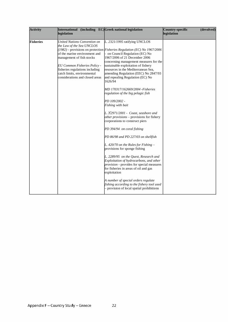
Appendix F – Country Study – Greece 22
Activity International (including EC) legislation
Greek national legislation Country-specific (devolved) legislation
Fisheries United Nations Convention on the Law of the Sea UNCLOS (1982) - provisions on protection of the marine environment and management of fish stocks EU Common Fisheries Policy - fisheries regulations including catch limits, environmental considerations and closed areas
L. 2321/1995 ratifying UNCLOS Fisheries Regulation (EC) No 1967/2006 - on Council Regulation (EC) No 1967/2006 of 21 December 2006 concerning management measures for the sustainable exploitation of fishery resources in the Mediterranean Sea, amending Regulation (EEC) No 2847/93 and repealing Regulation (EC) No 1626/94 MD 170317/162669/2004 -Fisheries regulation of the big pelagic fish PD 109/2002 - Fishing with bait L. Ν2971/2001 - Coast, seashore and other provisions – provisions for fishery corporations to construct piers PD 394/94 on coral fishing PD 86/98 and PD 227/03 on shellfish L. 420/70 on the Rules for Fishing – provisions for sponge fishing L. 2289/95 on the Quest, Research and Exploitation of hydrocarbons, and other provision - provides for special measures for fisheries in areas of oil and gas exploitation A number of special orders regulate fishing according to the fishery tool used – provision of local spatial prohibitions
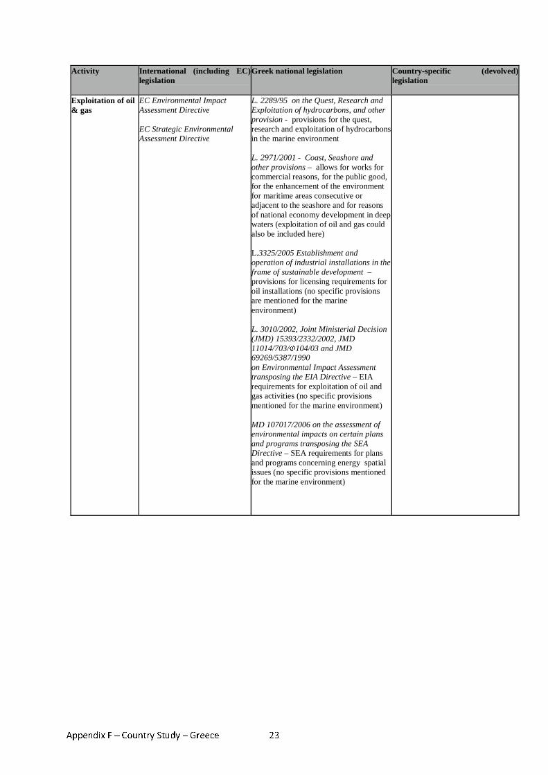
Appendix F – Country Study – Greece 23
Activity International (including EC) legislation
Greek national legislation Country-specific (devolved) legislation
Exploitation of oil & gas
EC Environmental Impact Assessment Directive EC Strategic Environmental Assessment Directive
L. 2289/95 on the Quest, Research and Exploitation of hydrocarbons, and other provision - provisions for the quest, research and exploitation of hydrocarbons in the marine environment L. 2971/2001 - Coast, Seashore and other provisions – allows for works for commercial reasons, for the public good, for the enhancement of the environment for maritime areas consecutive or adjacent to the seashore and for reasons of national economy development in deep waters (exploitation of oil and gas could also be included here) L.3325/2005 Establishment and operation of industrial installations in the frame of sustainable development – provisions for licensing requirements for oil installations (no specific provisions are mentioned for the marine environment) L. 3010/2002, Joint Ministerial Decision (JMD) 15393/2332/2002, JMD 11014/703/Φ104/03 and JMD 69269/5387/1990 on Environmental Impact Assessment transposing the EIA Directive – EIA requirements for exploitation of oil and gas activities (no specific provisions mentioned for the marine environment) MD 107017/2006 on the assessment of environmental impacts on certain plans and programs transposing the SEA Directive – SEA requirements for plans and programs concerning energy spatial issues (no specific provisions mentioned for the marine environment)
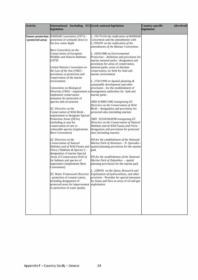
Appendix F – Country Study – Greece 24
Activity International (including EC) legislation
Greek national legislation Country-specific (devolved) legislation
Nature protection / protected areas
RAMSAR Convention (1971) - protection of wetlands down to 6m low water depth Bern Convention on the Conservation of European Wildlife and Natural Habitats (1979) United Nations Convention on the Law of the Sea (1982) - provisions on protection and conservation of the marine environment Convention on Biological Diversity (1992) - requirement to implement conservation measures for protection of species and ecosystems EC Directive on the Conservation of Wild Birds - requirement to designate Special Protection Areas (SPAs) (including at sea) for conservation of rare or vulnerable species (implements Bern Convention) EC Directive on the Conservation of Natural Habitats and of Wild Fauna and Flora (‘Habitats & Species’) - designation of marine Special Areas of Conservation (SACs) for habitats and species of importance (implements Bern Convention) EC Water Framework Directive - protection of coastal waters, including designation of protected areas for improvement or protection of water quality
L. 191/74 On the ratification of RAMSAR Convention and the amendments with L.1950/91 on the ratification of the amendments of the Ramsar Convention. L. 1650/1986 on Environmental Protection – definition and provisions for marine national parks / designation and provisions for areas of conservation, national parks, areas of absolute conservation, etc both for land and marine environment L. 2742/1999 on Spatial planning & sustainable development and other provisions - for the establishment of management authorities for land and marine parks JMD 414985/1985 transposing EC Directive on the Conservation of Wild Birds – designation and provisions for protected sites (including marine) JMD 33318/3028/98 transposing EC Directive on the Conservation of Natural Habitats and of Wild Fauna and Flora – designation and provisions for protected sites (including marine) PD for the establishment of the National Marine Park of Alonissos – N. Sporades - spatial planning provisions for the marine park PD for the establishment of the National Marine Park of Zakynthos – spatial planning provisions for the marine park L. 2289/95 on the Quest, Research and Exploitation of hydrocarbons, and other provision - Provides for special measures for fauna and flora in areas of oil and gas exploitation
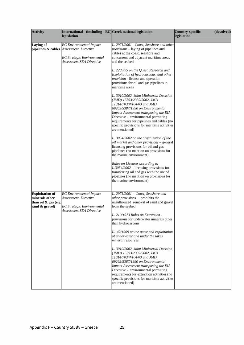
Appendix F – Country Study – Greece 25
Activity International (including EC) legislation
Greek national legislation Country-specific (devolved) legislation
Laying of pipelines & cables
EC Environmental Impact Assessment Directive EC Strategic Environmental Assessment SEA Directive
L. 2971/2001 - Coast, Seashore and other provisions – laying of pipelines and cables at the coast, seashore and concurrent and adjacent maritime areas and the seabed L. 2289/95 on the Quest, Research and Exploitation of hydrocarbons, and other provision - license and operation provisions for oil and gas pipelines in maritime areas L. 3010/2002, Joint Ministerial Decision (JMD) 15393/2332/2002, JMD 11014/703/Φ104/03 and JMD 69269/5387/1990 on Environmental Impact Assessment transposing the EIA Directive - environmental permitting requirements for pipelines and cables (no specific provisions for maritime activities are mentioned) L. 3054/2002 on the organization of the oil market and other provisions – general licensing provisions for oil and gas pipelines (no mention on provisions for the marine environment) Rules on Licenses according to L.3054/2002 – licensing provisions for transferring oil and gas with the use of pipelines (no mention on provisions for the marine environment)
Exploitation of minerals other than oil & gas (e.g. sand & gravel)
EC Environmental Impact Assessment Directive EC Strategic Environmental Assessment SEA Directive
L. 2971/2001 - Coast, Seashore and other provisions – prohibits the unauthorized removal of sand and gravel from the seabed L. 210/1973 Rules on Extraction - provisions for underwater minerals other than hydrocarbons L.142/1969 on the quest and exploitation of underwater and under the lakes mineral resources L. 3010/2002, Joint Ministerial Decision (JMD) 15393/2332/2002, JMD 11014/703/Φ104/03 and JMD 69269/5387/1990 on Environmental Impact Assessment transposing the EIA Directive - environmental permitting requirements for extraction activities (no specific provisions for maritime activities are mentioned)
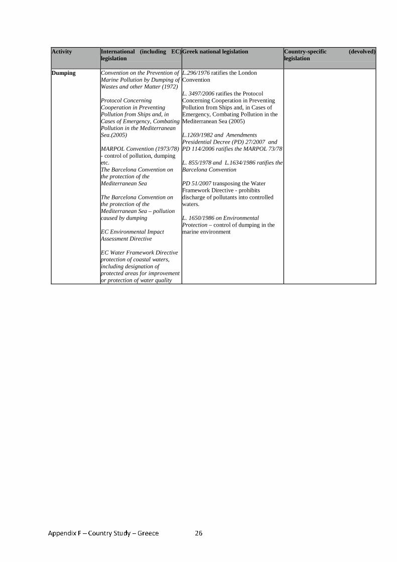
Appendix F – Country Study – Greece 26
Activity International (including EC) legislation
Greek national legislation Country-specific (devolved) legislation
Dumping Convention on the Prevention of Marine Pollution by Dumping of Wastes and other Matter (1972) Protocol Concerning Cooperation in Preventing Pollution from Ships and, in Cases of Emergency, Combating Pollution in the Mediterranean Sea.(2005) MARPOL Convention (1973/78) - control of pollution, dumping etc. The Barcelona Convention on the protection of the Mediterranean Sea The Barcelona Convention on the protection of the Mediterranean Sea – pollution caused by dumping EC Environmental Impact Assessment Directive EC Water Framework Directive protection of coastal waters, including designation of protected areas for improvement or protection of water quality
L.296/1976 ratifies the London Convention L. 3497/2006 ratifies the Protocol Concerning Cooperation in Preventing Pollution from Ships and, in Cases of Emergency, Combating Pollution in the Mediterranean Sea (2005) L.1269/1982 and Amendments Presidential Decree (PD) 27/2007 and PD 114/2006 ratifies the MARPOL 73/78 L. 855/1978 and L.1634/1986 ratifies the Barcelona Convention PD 51/2007 transposing the Water Framework Directive - prohibits discharge of pollutants into controlled waters. L. 1650/1986 on Environmental Protection – control of dumping in the marine environment
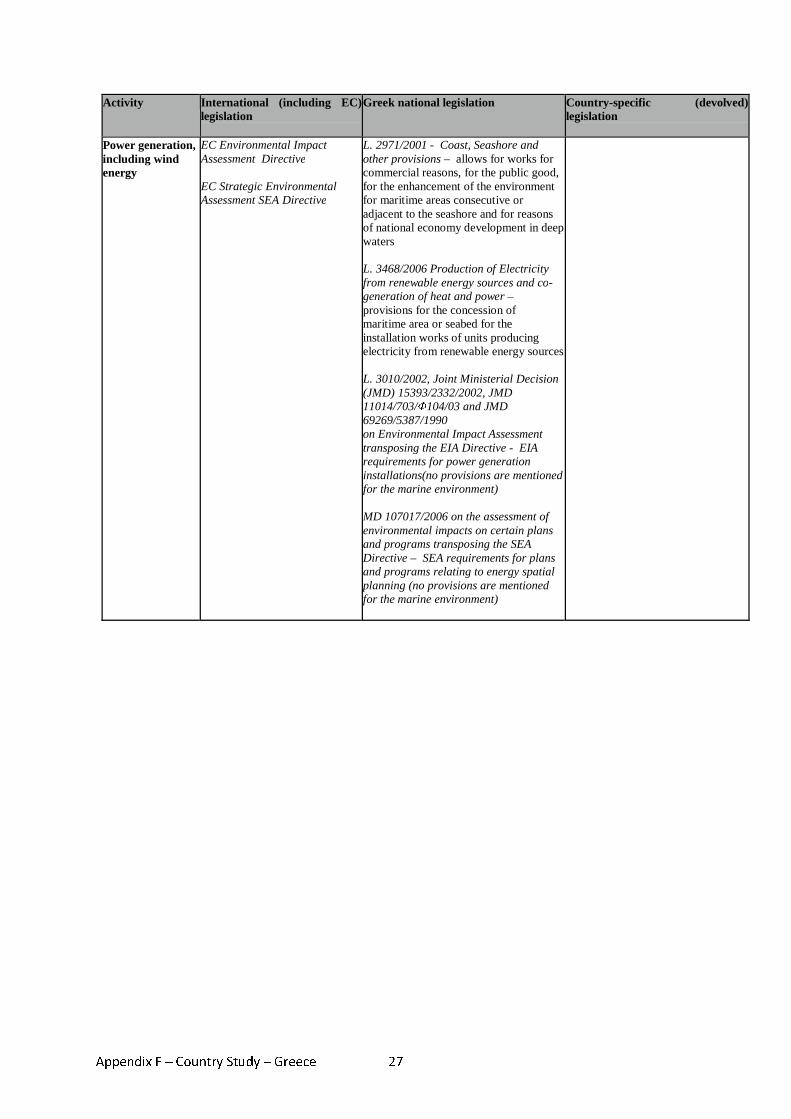
Appendix F – Country Study – Greece 27
Activity International (including EC) legislation
Greek national legislation Country-specific (devolved) legislation
Power generation, including wind energy
EC Environmental Impact Assessment Directive EC Strategic Environmental Assessment SEA Directive
L. 2971/2001 - Coast, Seashore and other provisions – allows for works for commercial reasons, for the public good, for the enhancement of the environment for maritime areas consecutive or adjacent to the seashore and for reasons of national economy development in deep waters L. 3468/2006 Production of Electricity from renewable energy sources and co-generation of heat and power – provisions for the concession of maritime area or seabed for the installation works of units producing electricity from renewable energy sources L. 3010/2002, Joint Ministerial Decision (JMD) 15393/2332/2002, JMD 11014/703/Φ104/03 and JMD 69269/5387/1990 on Environmental Impact Assessment transposing the EIA Directive - EIA requirements for power generation installations(no provisions are mentioned for the marine environment) MD 107017/2006 on the assessment of environmental impacts on certain plans and programs transposing the SEA Directive – SEA requirements for plans and programs relating to energy spatial planning (no provisions are mentioned for the marine environment)
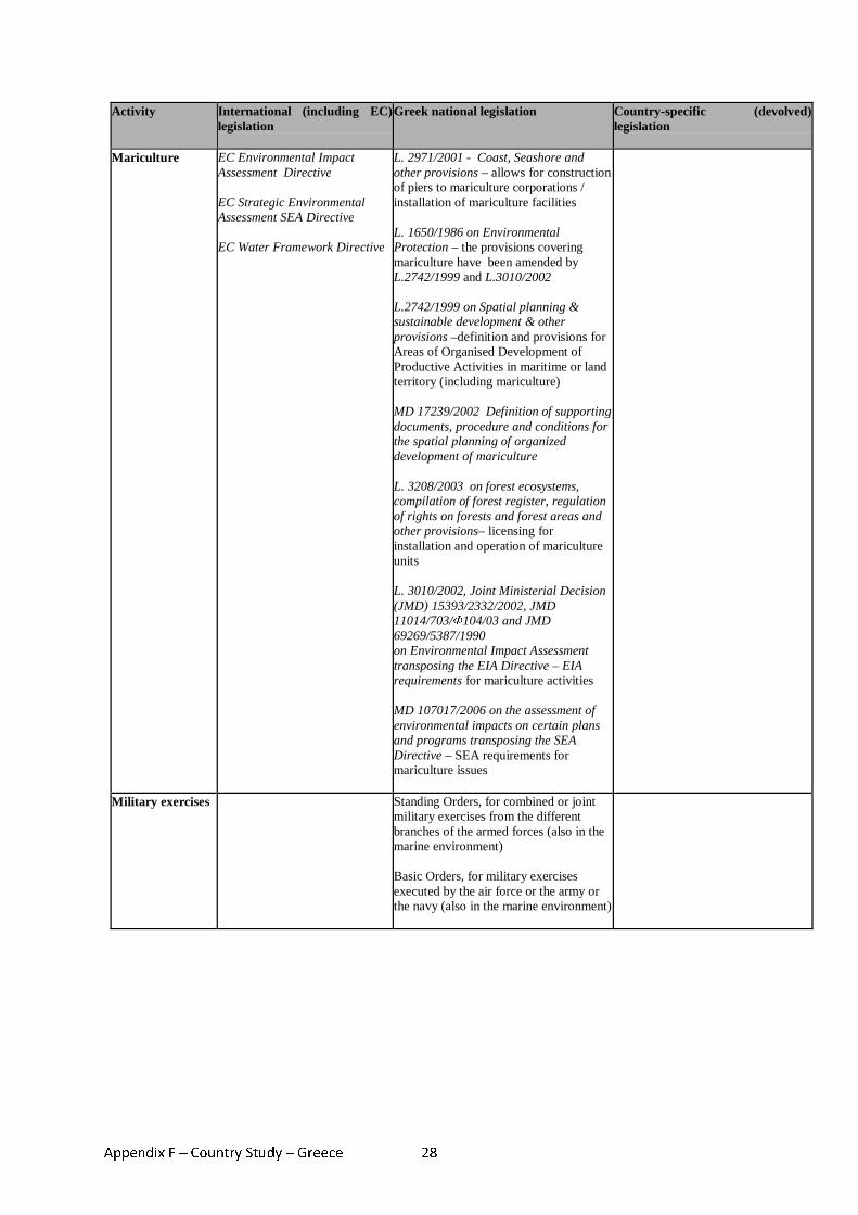
Appendix F – Country Study – Greece 28
Activity International (including EC) legislation
Greek national legislation Country-specific (devolved) legislation
Mariculture EC Environmental Impact Assessment Directive EC Strategic Environmental Assessment SEA Directive EC Water Framework Directive
L. 2971/2001 - Coast, Seashore and other provisions – allows for construction of piers to mariculture corporations / installation of mariculture facilities L. 1650/1986 on Environmental Protection – the provisions covering mariculture have been amended by L.2742/1999 and L.3010/2002 L.2742/1999 on Spatial planning & sustainable development & other provisions –definition and provisions for Areas of Organised Development of Productive Activities in maritime or land territory (including mariculture) MD 17239/2002 Definition of supporting documents, procedure and conditions for the spatial planning of organized development of mariculture L. 3208/2003 on forest ecosystems, compilation of forest register, regulation of rights on forests and forest areas and other provisions– licensing for installation and operation of mariculture units L. 3010/2002, Joint Ministerial Decision (JMD) 15393/2332/2002, JMD 11014/703/Φ104/03 and JMD 69269/5387/1990 on Environmental Impact Assessment transposing the EIA Directive – EIA requirements for mariculture activities MD 107017/2006 on the assessment of environmental impacts on certain plans and programs transposing the SEA Directive – SEA requirements for mariculture issues
Military exercises Standing Orders, for combined or joint military exercises from the different branches of the armed forces (also in the marine environment) Basic Orders, for military exercises executed by the air force or the army or the navy (also in the marine environment)
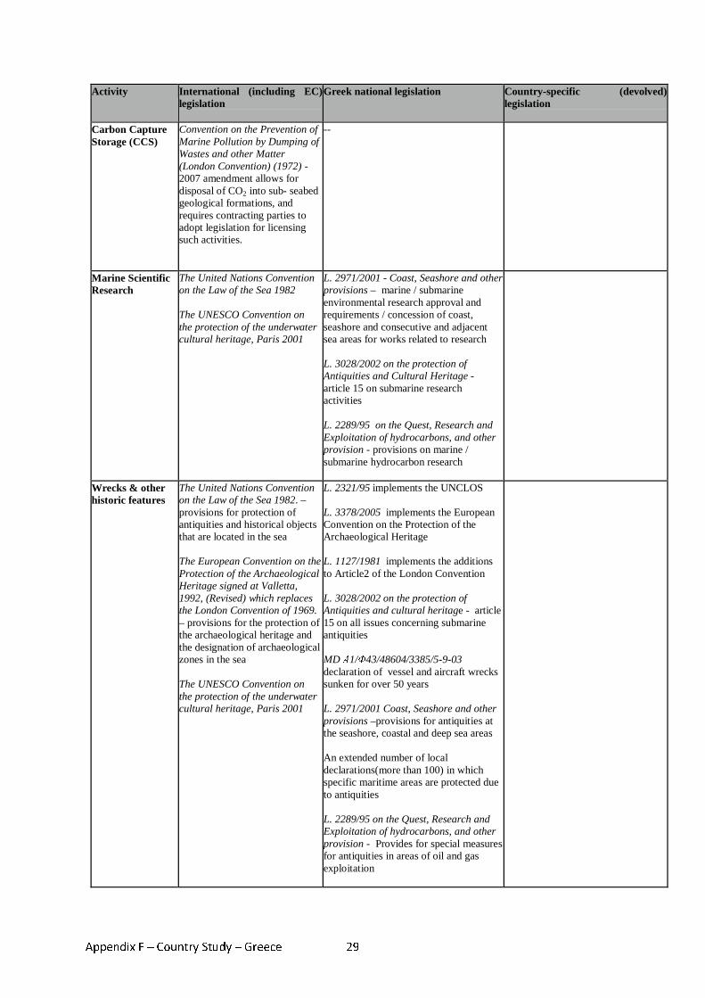
Appendix F – Country Study – Greece 29
Activity International (including EC) legislation
Greek national legislation Country-specific (devolved) legislation
Carbon Capture Storage (CCS)
Convention on the Prevention of Marine Pollution by Dumping of Wastes and other Matter (London Convention) (1972) - 2007 amendment allows for disposal of CO2 into sub- seabed geological formations, and requires contracting parties to adopt legislation for licensing such activities.
--
Marine Scientific Research
The United Nations Convention on the Law of the Sea 1982 The UNESCO Convention on the protection of the underwater cultural heritage, Paris 2001
L. 2971/2001 - Coast, Seashore and other provisions – marine / submarine environmental research approval and requirements / concession of coast, seashore and consecutive and adjacent sea areas for works related to research L. 3028/2002 on the protection of Antiquities and Cultural Heritage - article 15 on submarine research activities L. 2289/95 on the Quest, Research and Exploitation of hydrocarbons, and other provision - provisions on marine / submarine hydrocarbon research
Wrecks & other historic features
The United Nations Convention on the Law of the Sea 1982. – provisions for protection of antiquities and historical objects that are located in the sea The European Convention on the Protection of the Archaeological Heritage signed at Valletta, 1992, (Revised) which replaces the London Convention of 1969. – provisions for the protection of the archaeological heritage and the designation of archaeological zones in the sea The UNESCO Convention on the protection of the underwater cultural heritage, Paris 2001
L. 2321/95 implements the UNCLOS L. 3378/2005 implements the European Convention on the Protection of the Archaeological Heritage L. 1127/1981 implements the additions to Article2 of the London Convention L. 3028/2002 on the protection of Antiquities and cultural heritage - article 15 on all issues concerning submarine antiquities MD Α1/Φ43/48604/3385/5-9-03 declaration of vessel and aircraft wrecks sunken for over 50 years L. 2971/2001 Coast, Seashore and other provisions –provisions for antiquities at the seashore, coastal and deep sea areas An extended number of local declarations(more than 100) in which specific maritime areas are protected due to antiquities L. 2289/95 on the Quest, Research and Exploitation of hydrocarbons, and other provision - Provides for special measures for antiquities in areas of oil and gas exploitation
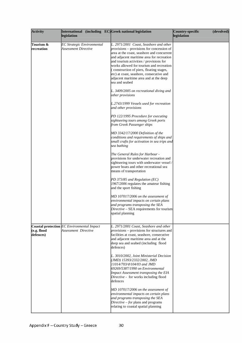
Appendix F – Country Study – Greece 30
Activity International (including EC) legislation
Greek national legislation Country-specific (devolved) legislation
Tourism & recreation
EC Strategic Environmental Assessment Directive
L. 2971/2001 Coast, Seashore and other provisions – provisions for concession of area at the coast, seashore and concurrent and adjacent maritime area for recreation and tourism activities / provisions for works allowed for tourism and recreation ( construction of piers, floating stages, etc) at coast, seashore, consecutive and adjacent maritime area and at the deep sea and seabed L. 3409/2005 on recreational diving and other provisions L.2743/1999 Vessels used for recreation and other provisions PD 122/1995 Procedure for executing sightseeing tours among Greek ports from Greek Passenger ships MD 3342/17/2000 Definition of the conditions and requirements of ships and small crafts for activation in sea trips and sea bathing The General Rules for Harbour - provisions for underwater recreation and sightseeing tours with underwater vessel / power boats and other recreational sea means of transportation PD 373/85 and Regulation (EC) 1967/2006 regulates the amateur fishing and the sport fishing MD 107017/2006 on the assessment of environmental impacts on certain plans and programs transposing the SEA Directive – SEA requirements for tourism spatial planning
Coastal protection (e.g. flood defences)
EC Environmental Impact Assessment Directive
L. 2971/2001 Coast, Seashore and other provisions – provisions for structures and facilities at coast, seashore, consecutive and adjacent maritime area and at the deep sea and seabed (including flood defences) L. 3010/2002, Joint Ministerial Decision (JMD) 15393/2332/2002, JMD 11014/703/Φ104/03 and JMD 69269/5387/1990 on Environmental Impact Assessment transposing the EIA Directive - for works including flood defences MD 107017/2006 on the assessment of environmental impacts on certain plans and programs transposing the SEA Directive – for plans and programs relating to coastal spatial planning
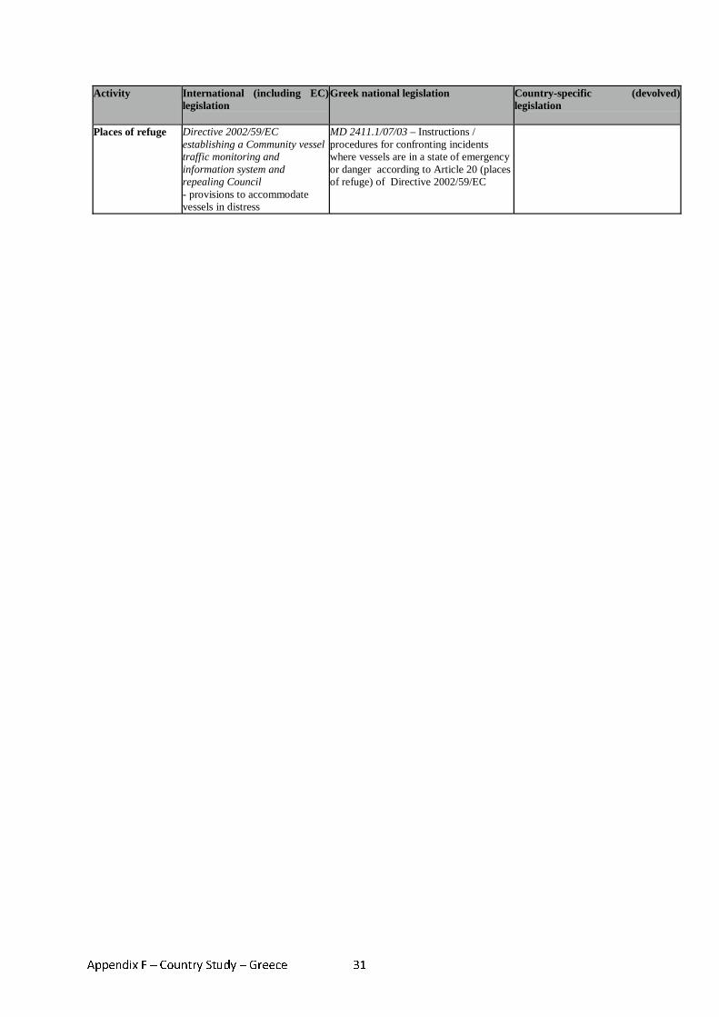
Appendix F – Country Study – Greece 31
Activity International (including EC) legislation
Greek national legislation Country-specific (devolved) legislation
Places of refuge Directive 2002/59/EC establishing a Community vessel traffic monitoring and information system and repealing Council - provisions to accommodate vessels in distress
MD 2411.1/07/03 – Instructions / procedures for confronting incidents where vessels are in a state of emergency or danger according to Article 20 (places of refuge) of Directive 2002/59/EC
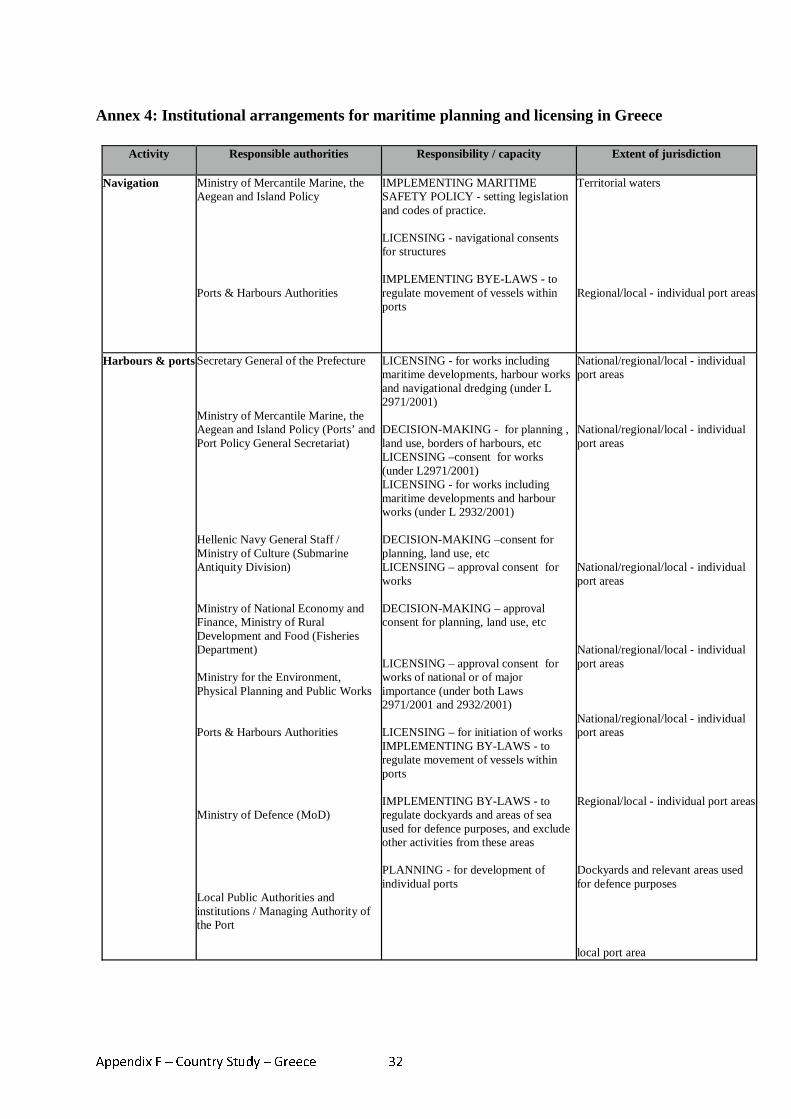
Appendix F – Country Study – Greece 32
Annex 4: Institutional arrangements for maritime planning and licensing in Greece
Activity Responsible authorities Responsibility / capacity Extent of jurisdiction
Navigation Ministry of Mercantile Marine, the Aegean and Island Policy Ports & Harbours Authorities
IMPLEMENTING MARITIME SAFETY POLICY - setting legislation and codes of practice. LICENSING - navigational consents for structures IMPLEMENTING BYE-LAWS - to regulate movement of vessels within ports
Territorial waters Regional/local - individual port areas
Harbours & ports Secretary General of the Prefecture Ministry of Mercantile Marine, the Aegean and Island Policy (Ports’ and Port Policy General Secretariat) Hellenic Navy General Staff / Ministry of Culture (Submarine Antiquity Division) Ministry of National Economy and Finance, Ministry of Rural Development and Food (Fisheries Department) Ministry for the Environment, Physical Planning and Public Works Ports & Harbours Authorities Ministry of Defence (MoD) Local Public Authorities and institutions / Managing Authority of the Port
LICENSING - for works including maritime developments, harbour works and navigational dredging (under L 2971/2001) DECISION-MAKING - for planning , land use, borders of harbours, etc LICENSING –consent for works (under L2971/2001) LICENSING - for works including maritime developments and harbour works (under L 2932/2001) DECISION-MAKING –consent for planning, land use, etc LICENSING – approval consent for works DECISION-MAKING – approval consent for planning, land use, etc LICENSING – approval consent for works of national or of major importance (under both Laws 2971/2001 and 2932/2001) LICENSING – for initiation of works IMPLEMENTING BY-LAWS - to regulate movement of vessels within ports IMPLEMENTING BY-LAWS - to regulate dockyards and areas of sea used for defence purposes, and exclude other activities from these areas PLANNING - for development of individual ports
National/regional/local - individual port areas National/regional/local - individual port areas National/regional/local - individual port areas National/regional/local - individual port areas National/regional/local - individual port areas Regional/local - individual port areas Dockyards and relevant areas used for defence purposes local port area
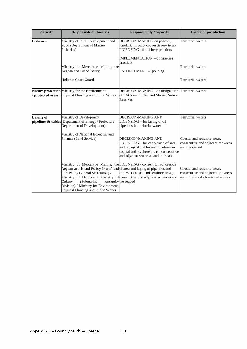
Appendix F – Country Study – Greece 33
Activity Responsible authorities Responsibility / capacity Extent of jurisdiction
Fisheries Ministry of Rural Development and Food (Department of Marine Fisheries) Ministry of Mercantile Marine, the Aegean and Island Policy Hellenic Coast Guard
DECISION-MAKING on policies, regulations, practices on fishery issues LICENSING - for fishery practices IMPLEMENTATION – of fisheries practices ENFORCEMENT – (policing)
Territorial waters Territorial waters Territorial waters
Nature protection / protected areas
Ministry for the Environment, Physical Planning and Public Works
DECISION-MAKING - on designation of SACs and SPAs, and Marine Nature Reserves
Territorial waters
Laying of pipelines & cables
Ministry of Development (Department of Energy / Prefecture Department of Development) Ministry of National Economy and Finance (Land Service) Ministry of Mercantile Marine, the Aegean and Island Policy (Ports’ and Port Policy General Secretariat) / Ministry of Defence / Ministry of Culture (Submarine Antiquity Division) / Ministry for Environment, Physical Planning and Public Works
DECISION-MAKING AND LICENSING – for laying of oil pipelines in territorial waters DECISION-MAKING AND LICENSING – for concession of area and laying of cables and pipelines in coastal and seashore areas, consecutive and adjacent sea areas and the seabed LICENSING - consent for concession of area and laying of pipelines and cables at coastal and seashore areas, consecutive and adjacent sea areas and the seabed
Territorial waters Coastal and seashore areas, consecutive and adjacent sea areas and the seabed Coastal and seashore areas, consecutive and adjacent sea areas and the seabed / territorial waters

Appendix G – Country Study – Poland 1
Appendix G - Country study - Poland
MARITIME SPATIAL PLANNING IN POLAND
1. Introduction 1. The Polish coastline is around 630 km in length, and is surrounded by the Baltic Sea.
Polish maritime areas are (see picture below):
• internal maritime waters (2004 km2) - which consist mainly in waters of gulfs and waters of harbours;
• territorial sea (8682 km2) - which is a belt of sea 12 nautical miles (22,22 km) wide; • EEZ (around 19.850 km2).
2. The internal maritime waters and the territorial sea are part of the territory of the Republic
of Poland (the Polish state border runs along the outer border of the territorial sea). 3. The belt of land adjacent to the sea is called “coastal belt”. It is composed of the
“technical belt” (adjacent directly to the sea is between 10 and 1000 m wide) and the “protective belt” (the outer part of the coastal belt, 100 - 2500 m wide). The existence of the coastal belt (similarly to the existence and division of internal maritime waters, territorial sea and the EEZ) is foreseen by the Marine Areas Act (see below). The borders (breadth) of the coastal belt (i.e. of the technical and protective belts) are to be determined by an order of the Director of the relevant Maritime Office. The executive regulation by the Council of Ministers (issued under the Marine Areas Act) provides for criteria for determining the breadth of coastal belt.
Polish maritime areas134 The red line indicates border of EEZ, the yellow line - border of the territorial sea, and the green line - border of internal marine waters.135
134 Map from the website of Polish Geological Institute: http://www.pgi.gov.pl/index.php?option=com_content&task=view&id=427&Itemid=2
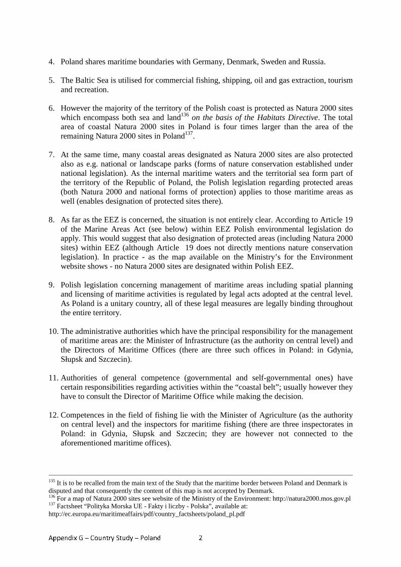
Appendix G – Country Study – Poland 2
4. Poland shares maritime boundaries with Germany, Denmark, Sweden and Russia.
5. The Baltic Sea is utilised for commercial fishing, shipping, oil and gas extraction, tourism
and recreation.
6. However the majority of the territory of the Polish coast is protected as Natura 2000 sites which encompass both sea and land136 on the basis of the Habitats Directive. The total area of coastal Natura 2000 sites in Poland is four times larger than the area of the remaining Natura 2000 sites in Poland137.
7. At the same time, many coastal areas designated as Natura 2000 sites are also protected
also as e.g. national or landscape parks (forms of nature conservation established under national legislation). As the internal maritime waters and the territorial sea form part of the territory of the Republic of Poland, the Polish legislation regarding protected areas (both Natura 2000 and national forms of protection) applies to those maritime areas as well (enables designation of protected sites there).
8. As far as the EEZ is concerned, the situation is not entirely clear. According to Article 19
of the Marine Areas Act (see below) within EEZ Polish environmental legislation do apply. This would suggest that also designation of protected areas (including Natura 2000 sites) within EEZ (although Article 19 does not directly mentions nature conservation legislation). In practice - as the map available on the Ministry’s for the Environment website shows - no Natura 2000 sites are designated within Polish EEZ.
9. Polish legislation concerning management of maritime areas including spatial planning
and licensing of maritime activities is regulated by legal acts adopted at the central level. As Poland is a unitary country, all of these legal measures are legally binding throughout the entire territory.
10. The administrative authorities which have the principal responsibility for the management
of maritime areas are: the Minister of Infrastructure (as the authority on central level) and the Directors of Maritime Offices (there are three such offices in Poland: in Gdynia, Słupsk and Szczecin).
11. Authorities of general competence (governmental and self-governmental ones) have
certain responsibilities regarding activities within the “coastal belt”; usually however they have to consult the Director of Maritime Office while making the decision.
12. Competences in the field of fishing lie with the Minister of Agriculture (as the authority
on central level) and the inspectors for maritime fishing (there are three inspectorates in Poland: in Gdynia, Słupsk and Szczecin; they are however not connected to the aforementioned maritime offices).
135 It is to be recalled from the main text of the Study that the maritime border between Poland and Denmark is disputed and that consequently the content of this map is not accepted by Denmark. 136 For a map of Natura 2000 sites see website of the Ministry of the Environment: http://natura2000.mos.gov.pl 137 Factsheet “Polityka Morska UE - Fakty i liczby - Polska”, available at: http://ec.europa.eu/maritimeaffairs/pdf/country_factsheets/poland_pl.pdf
Appendix G – Country Study – Poland 3
2. Legislation applicable to maritime spatial planning 13. Planning of maritime activities in Poland is regulated by a complex set of international,
EC and national legislation.
14. The main legal act regulating such activities is the Marine Areas of the Republic of Poland and Maritime Administration Act of 21 March 1991138, although certain specific issues (such as fishing, nature protection, environmental protection, activity of harbours) are regulated by other provisions either of general nature or regulating specific sectors of maritime activity (see below).
15. The Water Law Act of 18 July 2001139 is also relevant for internal maritime waters
(according Article 7.1 of Water Law Act, its provisions apply to inland waters and the internal maritime waters excluding waters of the Gdansk Gulf). Provisions of the Water Law Act on prevention and control of pollution caused by land sources, as well as its provisions on flood protection apply to the territorial sea and waters of the Gdansk Gulf (Article 7.2). The Water Law Act provides also for certain regulations concerning water quality standards (see below).
Legislation at international and Community level 16. At the international level, legislation is provided by instruments such as the 1992 Helsinki
Convention on the Protection of the Marine Environment of the Baltic Sea Area (HELCOM), the International Convention for the Prevention of Pollution of Ships (MARPOL), UN Convention on the Law of the Sea (UNCLOS), the Convention on EIA in the Transboundary Context (the Espoo Convention) or the Bern Convention on the Conservation of the European Wildlife and Natural Habitats. Such international legislation is enacted in Polish law, for example the provisions of HELCOM and MARPOL are enacted through Prevention of Sea Pollution by Ships Act of 16 March 1995140.
17. Directives provided by the European Community are also required to be transposed into legislation within EC Member States, thus providing a further level of legislation applicable to Poland.
18. The Directives which seem to be of particular relevance for carrying out maritime
activities in Poland are:
• The Environmental Impact Assessment (EIA) Directive (85/337/EC as amended by Directives 97/11/EC and 2003/35/EC) - the EIA Directive requires that the environmental consequences of projects are identified and assessed before authorisation is given. These EIA requirements have been transposed into Polish law by general provisions on EIA, provided by the Environmental Protection Law Act of 27 April 2001141 (EPLA); the EPLA provisions apply to all the projects subject to EIA; there are no specific EIA provisions for maritime projects.
138 Cons. text: Official Journal of Laws of 2003 No. 153 item 1502 as amended 139 Cons. text: Official Journal of Laws of 2005 No. 239 item 2019 as amended 140 Cons. text: Official Journal of Laws of 2006 No. 99 item 692 as amended 141 Cons. text: Official Journal of Laws of 2008 No. 25 item 1550
Appendix G – Country Study – Poland 4
• The Strategic Environmental Assessment (SEA) Directive (2001/42/EC) - the SEA Directive requires that environmental consequences of plans and programmes are identified and assessed during their preparation and before their adoption. Also the SEA requirements have been transposed into Polish law by general provisions of EPLA.
• The Habitats Directive (92/43/EEC) - the Habitats Directive provides for provisions on
designation and protection of Natura 2000 sites, including requirements for carrying out an assessment of impact of plans and programs on Natura 2000 site (so-called habitat assessment). The Directive’s requirements have been transposed into Polish law by general of the Nature Conservation Act of 16 April 2004142 and - as far as the habitat assessment is concerned - by provisions of EPLA.
19. Although the aforementioned Directives have been transposed by general provisions, in the case of plans or projects carried out within the maritime areas or the coastal belt, these provision grant relevant competences to or foresee participation of maritime administration (Directors of Maritime Offices).
National legislation Spatial planning and construction
20. Spatial planning on land (including the coastal belt) is regulated by the Spatial Planning
and Management Act of 27 March 2003143.
21. Under this Act the localization of any project is to be authorised either on the basis of a local land-use plan (which is adopted by the local community - i.e. by authorities of the basic self-governmental unit called gmina) or - in the absence of such a plan for the given area - on the basis of an individual localization decision (to be issued also by the gmina’s authorities).
22. The land-use plan specifies which types of projects may be undertaken within a given
zone (e.g. industrial projects or housing building) but rarely mentions a specific project (except for certain bigger projects such as e.g. motorway or airport). The localization decision (called in Polish legislation “decyzja o warunkach zabudowy i zagospodarowania terenu”, “land development decision”) is issued for a particular project indicating its type, size etc.). This decision is a kind of a indicative decision or “outline planning permission” and could be issued for more than one developer for the same land plot. A potential developer does not need to actually own the land plot in order to obtain such a decision.
23. Neither the plan nor the individual decision constitute an approval for undertaking the
project. The final consent to proceed with the project is the development consent (see below).
24. Adoption of a land-use plan is subject to SEA. The localization decision for projects requiring EIA does not by itself trigger to EIA, because before lodging an application for
142 Official Journal of Laws of 2004 No. 92 item 880 as amended 143 Official Journal of Laws of 2003 No. 80 item 717 as amended
Appendix G – Country Study – Poland 5
a development consent, a developer has to obtain so-called EIA decision within which the EIA procedure is carried out (see point 27-28 below).
25. The next decision authorising the project is a construction permit issued under the Building Law Act of 7 July 1994144. The construction permit approves a construction design submitted by a developer which means that the construction design becomes binding. The construction design is quite specific in that it describes building technique in each case such as the types of materials to be used, nature of beams and main structures etc.
26. For projects requiring EIA, along with an application for the development consent, the
developer has to provide also the EIA decision for the project (see further below). However, there is a new draft Act concerning e.g. EIA, which envisages that - where needed - it would be possible (or necessary) to carry out the EIA procedure for the second time on the stage of the construction permit145.
27. The authority competent for granting the construction permit is - as a rule - a starost (a
head of self-governmental administration in a poviat - district). A poviat is a self-governmental local unit - other than a gmina and encompassing bigger area (there are 2,478 gminas and 379 poviats in Poland); both units are however not hierarchically dependent. In case of bigger cities (which constitute a separate gmina) the municipal (city’s; gmina’s) authorities have also competences of gmina’s authorities, including granting of construction permits.
28. Spatial planning within the maritime areas is regulated by the Marine Areas of the
Republic of Poland and Maritime Administration Act (‘the Marine Areas Act’). Under the Marine Areas Act localization of projects (understood analogically as localization decision for land projects - see point 16 above) such as artificial islands, constructions, installations, cables and pipelines is to be authorised either on the basis of a spatial plan for maritime areas (which may by adopted by the Minister of Infrastructure) plus a consent (authorisation) by the Director of Maritime Office, or - in the absence of a spatial plan for maritime areas - on the basis of an individual decision issued by the Minister of Infrastructure.
29. According to Article 37b.1 of the Marine Areas Act, the draft spatial plan for maritime
areas is to be prepared by the director of the Maritime Office. The draft project is subject to SEA procedure (including public participation) - according to Article 37b.2 and Article 40.1 of EPLA. The spatial plan is then adopted by the Minister of Infrastructure. According to Article 37a.2 of the Marine Areas Act, the spatial plan provides for provisions on:
• allocation of maritime internal waters, the territorial sea and the EEZ areas; • bans and limits in using the above areas bearing in mind the nature conservation
requirements • localization of projects of public use
144 Cons. text: Official Journal of Laws of 2006 No. 156 item 1118 as amended 145 The European Commission has indicated that Polish legislation is in non-compliant with the requirements of the EIA Directive seen in the light of the ECJ verdict in the Barker case, because it allows the EIA procedure to be carried only once during the investment process.
Appendix G – Country Study – Poland 6
• directions of development of transport infrastructure • protected areas and conditions of environmental protection and cultural heritage
conservation. 30. According to Article 23 of the Marine Areas Act, the individual localization decision is
issued by the Minister of Infrastructure (or - where the spatial plan would exist - by the Director of Maritime Office) after consultations with the Ministers of: Economy, Agriculture, Culture, Environment, Internal Affairs and Defence. The decision indicates type, localization and technical parameter of the project, as well as requirements provided for by specific provisions, in particular those concerning navigation, environment, defence, fishing etc.
31. No spatial plan for maritime areas has, however, been adopted to date.
32. Similarly as in the case of projects carried out on land, construction projects to be carried
out within the maritime areas require a construction permit issued under the Building Law Act. Such permits are not, however, issued by district or local authorities but by a voivode (a head of governmental administration in the region). The voivode is responsible for granting decisions in an adjacent maritime area. There are two coastal voivodas in Poland: the Pomeranian Voivode (based in Gdansk) and the West-Pomeranian Voivide (based in Szczecin). However, as will be seen below, the issue of competences in this area remains a problem.
33. Projects such as pipelines and cables but also e.g. breakwaters or other installations
localized within the internal maritime waters (apart form the Gdansk Gulf) require also - apart from the construction permit granted under the Building Law Act - so-called water law permit for their construction, issued under the Water Law Act (as mentioned above, provisions of this Act apply to the internal maritime waters excluding the Gdansk Gulf). The authority competent for granting such a permit is:
• for projects requiring obligatory EIA procedure – the marshall of the voivodship
(the head of a self-governmental administration in a voivodship - administration at this level consists of two separate sets of institutions: governmental and non-governmental);
• for other projects - a starost. Sea pollution prevention and control
34. The issue of sea pollution is regulated by the Prevention of Sea Pollution by Ships Act of
1995 and by the Water Law Act (the main Act transposing the Water Framework Directive). The former Act forests out requirements for ships and their management. The authority competent in this field is the Director of the Maritime Office.
35. As mentioned above, the Water Law Act applies to maritime internal waters (apart from
the waters of the Gdansk Gulf); its provisions on protection from pollution caused by land sources (i.e. nor by ships etc.) and on flood protection apply to the waters of the Gdansk Gulf and the territorial sea.
36. Certain specific provisions of the Water Law Act concern the quality and protection of
“coastal waters” which are defined as the 1 nm wide belt of the territorial sea calculated

Appendix G – Country Study – Poland 7
from the “base line” which is - generally speaking - the coastal line or the border line between internal maritime waters and the territorial sea (on areas where internal maritime waters exist).
Nature conservation and environmental protection
37. As mentioned above, the nature conservation and environmental protection requirements
(including EIA, SEA, Natura 2000 protection but also emission control) for maritime areas and coastal belt are provided by general provisions - EPLA and the Nature Conservation Act.
38. EPLA regulates inter alia. the EIA procedure. An EIA decision issued under EPLA
concludes the EIA procedure as is required before a developer applies for a construction permit (the EIA decision is an obligatory attachment to the application). The EIA decision provides for certain binding recommendations for the construction design and is binding for the construction permit.
39. The Water Law Act provides for provisions concerning quality standards of shellfish
waters. Fishing and mariculture
40. The issue of fishing is regulated by the Fishing Act of 19 February 2004146. It refers to the
European Community’s Common Fisheries Policy. Under this Act fishing is allowed on the basis of a “fishing licence” and a “special fishing permit”; both issued by the Minister of Agriculture. The special fishing permit is valid for one year and indicates the fishing quotas granted to a given ship.
41. Maricultre (i.e. the culture in sea water of fish and shellfish) requires a consent granted by
the Minister of Agriculture under Article 29 of this Act. However, apart from this single provision no further regulations regarding mariculture were identified.
42. Furthermore the EIA regulation (issued under EPLA) providing for a list of projects
subject to EIA mentions only the fish farming in fish ponds (i.e. inland fish farming) and fails to refer to marine aquaculture. It seems to be a non-compliant with the EIA Directive which in Annex II.1 (f) mentions “fish farming” which seems to encompasses both inland and marine fish farming.
43. No major problems with application of the above listed provisions were reported (apart from problems with the fishing quotas granted to Poland by the European Commission - which are considered too small by Polish fishermen).
3. Responsibilities and jurisdictions for planning and licensing in the maritime area
146 Official Journal of Laws of 2004 No. 62 item 574 as amended
Appendix G – Country Study – Poland 8
44. The legislation relevant to Poland’s maritime area, which is set out in Annex 2, is administrated and enforced by special maritime authorities and by authorities of general competences:
• Spatial planning within coastal belt: land-use plans are adopted and localization
decisions are issued by local community (gmina) authorities in cooperation with relevant Director of Maritime Office (binding consent by the Director is required); construction permits are issued by a voivode.
• Spatial planning within maritime areas: spatial plans are adopted by the Minister of
Infrastructure and localization decisions are issued either by a Director of Maritime Office (in case a spatial plan is adopted) or by the Minister of Infrastructure (where there is no plan; in practice no spatial plan for maritime areas has been adopted yet); construction permits are issued by a voivode (head of governmental administration in a region).
• EIA procedures for projects within maritime areas: EIA procedure is carried out and
EIA decision is given by a voivode in cooperation with relevant Director of Maritime Office (binding consent by the Director is required).
• Natura 2000 sites management and nature conservation within maritime areas: Director
of Maritime Office.
• Environmental protection, first of all emission permits for installations: self-governmental authorities - depending on the type of installation those are: a starost (head of a district administration) or a marshall of a voivodeship (head of self-governmental administration in a region).
• Fishing: Minister of Agriculture and inspectors for fishing.
45. The problem which was reported by respondents interviewed while carrying out this
study was the unclear division of territorial competences in maritime areas between voivodes. As mentioned above, voivodes are competent to carry out EIA procedures and to issue EIA decisions for projects within maritime areas (i.e. on the sea).
46. The boundary between voivodships (regions) is clearly indicated on the land; on the other hand the boundary between jurisdictions of two maritime offices on the sea is also clearly defined by legislation (it is a given meridian) - and the boundary between two voivodships on the sea is unclear.
47. According to Article 10.1a of the Water Law Act, waters of the territorial sea and internal
maritime waters are owned by the State (ownership of the State Treasury). According to Article 14.1 of the Water Law Act, land covered by water (in this case - a seabed) belong to the owner of waters (in this case - the State).
4. Licensing procedures
48. This section examines the current procedures for obtaining licences to undertake activities in the marine environment, focusing construction of cables and pipelines.
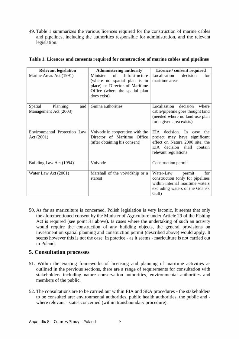
Appendix G – Country Study – Poland 9
49. Table 1 summarizes the various licences required for the construction of marine cables and pipelines, including the authorities responsible for administration, and the relevant legislation.
Table 1. Licences and consents required for construction of marine cables and pipelines
Relevant legislation Administering authority Licence / consent required Marine Areas Act (1991) Minister of Infrastructure
(where no spatial plan is in place) or Director of Maritime Office (where the spatial plan does exist)
Localisation decision for maritime areas
Spatial Planning and Management Act (2003)
Gmina authorities Localisation decision where cable/pipeline goes thought land (needed where no land-use plan for a given area exists)
Environmental Protection Law Act (2001)
Voivode in cooperation with the Director of Maritime Office (after obtaining his consent)
EIA decision. In case the project may have significant effect on Natura 2000 site, the EIA decision shall contain relevant regulations
Building Law Act (1994) Voivode
Construction permit
Water Law Act (2001) Marshall of the voividship or a starost
Water-Law permit for construction (only for pipelines within internal maritime waters excluding waters of the Gdansk Gulf)
50. As far as mariculture is concerned, Polish legislation is very laconic. It seems that only
the aforementioned consent by the Minister of Agriculture under Article 29 of the Fishing Act is required (see point 31 above). Is cases where the undertaking of such an activity would require the construction of any building objects, the general provisions on investment on spatial planning and construction permit (described above) would apply. It seems however this is not the case. In practice - as it seems - mariculture is not carried out in Poland.
5. Consultation processes
51. Within the existing frameworks of licensing and planning of maritime activities as outlined in the previous sections, there are a range of requirements for consultation with stakeholders including nature conservation authorities, environmental authorities and members of the public.
52. The consultations are to be carried out within EIA and SEA procedures - the stakeholders to be consulted are: environmental authorities, public health authorities, the public and - where relevant - states concerned (within transboundary procedure).
Appendix G – Country Study – Poland 10
53. In practice however SEA procedures are very often neglected (plans or programmes are
adopted without SEA).
54. Transboundary consultations initiated by Poland (i.e. where Poland is the country of origin) in practice do take place at all. The aforementioned problems are however common for all types of plans or projects and are not specific for maritime areas.
55. Thus, in practice only consultations concerning environmental issues (within EIA
procedures) do take place. Consultations concerning non-environmental conflicts between different users of the sea are neither required by law, not carried out in practice.
6. Transboundary initiatives
56. A number of transboundary initiatives are currently being undertaken. The following section was prepared on the basis of interviews with officials of various authorities acting within maritime areas.
6.1. Transboundary initiatives in Western Pomeranian Voivodship Maritime Office in Szczecin
57. Polish-German cooperation has been carried up until now as a result of mandatory
obligations arising out of international agreements/conventions (for example HELCOM working group meetings). To a lesser degree it has been connected with the need to jointly manage sea resources.
58. Nevertheless the situation seems to be slowly improving. The first step towards border cooperation has been participation of the Maritime Office in Szczecin (MO) in the international project entitled “Baltic Master” focused on the strengthening the knowledge and building the capacity of the Office representatives (more about the project you can find o the website http://irm.am.szczecin.pl/bm).
59. At the moment MO is preparing itself to another project aimed at mapping the problems and starting the border cooperation connected with the management of the sea resources. There is shown explicit tendency towards bigger interest in border cooperation, visible also in strengthening the structure of the maritime administration for the Western Pomeranian region – there has been created a new International Cooperation and EU Funds Unit in the MO.
60. In practice there is no joint spatial planning on the area of Odra zone or the littoral zone.
61. It's the new issue inspiring some fears, e.g. connected with the development of the fluvial-
marine port in Schwedt. There are comments saying that development of this German port poses danger to the further development of the Szczecin-Swinoujscie ports. Polish radical parties effectively stir up mistrust for the intentions of the German partners.
Appendix G – Country Study – Poland 11
Wolinski National Park (WNP) 62. Cooperation in respect of the nature protection is one of the action priorities of the
Euroregion Pomerania. It is the most developed area of cross-border cooperation.
63. Every year Wolinski National Park implementing projects connected with sharing experiences regarding the nature protection and broadly understood ecological education. Foreign partners of those projects are: German Uznam Nature Park (ger. Naturpark Usedom) and Danish Mon Park.
64. The cooperation is conducted on the basis of the partnership agreements. Problems connected with the joint projects result from administrative-structural differences, f.i. WNP as the state budget body cannot undertake any liabilities for the benefit of the Treasury.
Swinoujscie city/ Swinoujscie Water-supply and Sewage System Facility 65. On the strength of an agreement between the Polish Ministry of Environmental Protection
and the German Federal Ministry of Environment made in 1994, there has been started joint project on the building sewage treatment plant in Swinoujscie. T
66. he whole initiative assumed building of the plant and combined sewers to supply the plant with sewage from the border areas as well as waste water treatment. The plant was built in 1997 and put into operation in 1998. Construction of the combined sewers on the both sides of the border was based on the national legislations. Problems appearing so far have had only the commercial character. They concerned the way Polish side calculated the costs of waste water treatment. Signed in 2006 an annex to the agreement has regulated potential disputed issues connected with charges.
Regional Agenda 21 Szczecin Lagoon 67. 18th of June 2000 in Schwerin there was signed Joint Statement regarding transboundary
cooperation of Zachodniopomorskie Voivodship and the Land of Mecklenburg Vorpommern. The body responsible for the coordination of the nature protection activities is Joint Committee of the Environmental Protection (http://www.um.mv-regierung.de/agenda21/pages/stArticle htm).
68. The next step was signing the agreement (so called Szczecin Resolution) for the building
the Regional Agenda 21 Szczecin Lagoon. It was done by the member of the Board of the Zachodniopomorskie Voivodship and the Ministry of the Environmental Protection of the Land of Mecklenburg Vorpommern on 20th of April 2001r. in Szczecin (Appendix 3 and 4).
69. The main areas of actions of the Regional Agenda are:
a) Creating and development of the local Agendas 21 in the cities and municipalities, b) Ecological education and development of the ecological awareness among local
society, c) Stable development of so called „soft” tourism,
Appendix G – Country Study – Poland 12
d) Ecological agriculture, e) Marketing and regional products sale, f) Environment friendly technologies, g) Using the renewed sources of the energy, h) Preserving the cultural heritage, i) Integrated management of the coast zone, j) Scientific cooperation.
70. Polish municipalities interested in cooperation created an Association called ‘Regional
Agenda 21 Szczecin Lagoon’. They jointly undertake research and education projects, among others:
• analysis of the course of the cycle route around the Szczecin Lagoon, • research on Integrated Management on the area of Odra-mouth (http://www.ikzm-
oder.de/pl/projekt-ikzm-oder.html).147 Conflict over investments 71. To date there have been no cross-border conflicts regarding such investments as for
examplewind-power stations. The controversies that have arisen related to investments connected with the fluvial-marine port or municipal waste incinerator plant in Schwedt.
72. Taking into account the lack of the joint plans for the management of the Odra Estuary (Szczecin Lagoon) nature areas (even under the Natura 2000), future conflicts connected with the spatial planning and using of the cross-border area may be anticipated.
6.2. Transboundary initiatives in Pomeranian Voivodship 73. The Maritime Office in Gdynia takes part in the PlanCoast project (2006–2008) - which is
an INTERREG IIIB NP CADSES Project with the aim to develop the tools and capacities for an effective integrated planning in coastal zones and maritime areas in the Baltic, Adriatic and Black Sea regions.
74. PlanCoast will:
• Introduce the completely new spatial planning instrument Maritime Planning • Link Integrated Coastal Zone Management (ICZM) with the processes of statutory
spatial planning in selected number of pilot projects • Spread the use of modern geographical information systems (GIS) for an effective
transnational planning • Contribute to the implementation of European policies and national strategies on
coastal zones and maritime areas
147 Link to: Measuring the progress and outcomes of Integrated Coastal and Ocean Management: The German Oder Estuary case study http://ioc3.unesco.org/icam/images/stories//Case%20studies/Progress%20and%20outcomes%20ICAM%20Germany.pdf
Appendix G – Country Study – Poland 13
75. PlanCoast has 16 partners representing the Spatial Planning Departments or responsible regional authorities from Albania, Bosnia–Herzegovina, Bulgaria, Croatia, Germany, Italy, Montenegro, Poland, Romania, Slovenia and Ukraine148.
76. Poland cooperates within this project with Germany. The authorities involved on Polish
side are: Maritime Office in Gdynia and the Regional Spatial Planning of Pomorskie Voivodeship. The German authoroties involved are: the Ministry of Transport, Building and Regional Development Mecklenburg-Vorpommern and the Federal Ministry ofTransport, Building and Urban Development.
77. Within this project, in October 2007 the Maritime Office in Gdynia set about working on a draft spatial plan for a maritime area149. The plan is to encompass the western part of Gdańsk Bay - see map below.
148 See website: http://www.plancoast.eu/ 149 Website for Polish part of the project: http://www.plancoast.pl
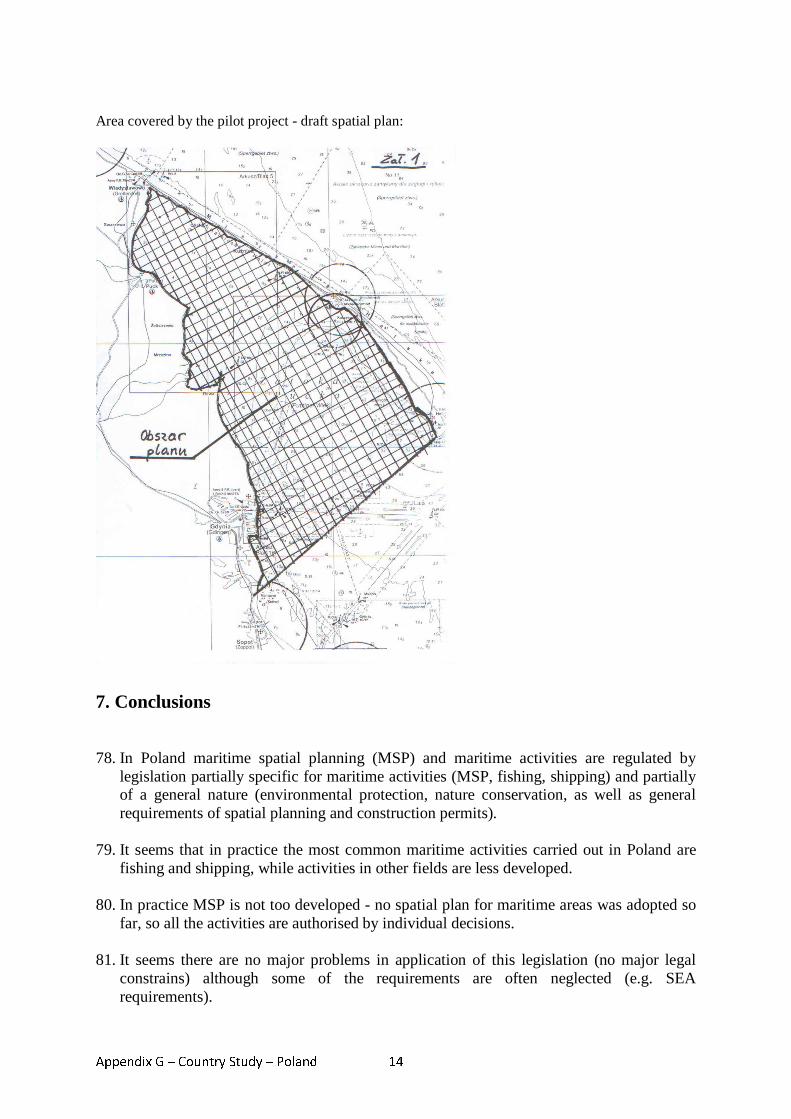
Appendix G – Country Study – Poland 14
Area covered by the pilot project - draft spatial plan:
7. Conclusions
78. In Poland maritime spatial planning (MSP) and maritime activities are regulated by
legislation partially specific for maritime activities (MSP, fishing, shipping) and partially of a general nature (environmental protection, nature conservation, as well as general requirements of spatial planning and construction permits).
79. It seems that in practice the most common maritime activities carried out in Poland are fishing and shipping, while activities in other fields are less developed.
80. In practice MSP is not too developed - no spatial plan for maritime areas was adopted so
far, so all the activities are authorised by individual decisions.
81. It seems there are no major problems in application of this legislation (no major legal constrains) although some of the requirements are often neglected (e.g. SEA requirements).
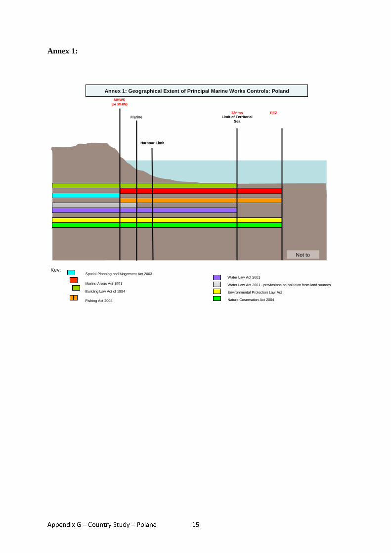
Appendix G – Country Study – Poland 15
Annex 1:
Not to
Key:
MHWS (or MHW)
Harbour Limit
Marine 12nms
Limit of Territorial Sea
EEZ
Annex 1: Geographical Extent of Principal Marine Works Controls: Poland
Spatial Planning and Magement Act 2003
Marine Areas Act 1991
Building Law Act of 1994
Fishing Act 2004
Water Law Act 2001
Water Law Act 2001 - proviosions on pollution from land sources
Environmental Protection Law Act
Nature Coservation Act 2004
Appendix G – Country Study – Poland 16
Annex 2: References Brodecki Zdzisław, Gąsiewski Mariusz, Lewandowski Piotr, Młyński Ryszard, Szczurek Wojciech - Prawo w portach morskich (red. Zdzisław Brodecki), Warszawa 1998, ss. 171 Brodecki Zdzisław - Wprowadzenie do dyskusji nad ustrojem organów administracji morskiej, [w:] Problemy ekonomiczne i prawne w polskiej gospodarce morskiej, Gdańsk 1993 Ciechanowicz Janina - Prawne problemy ochrony środowiska w pasie nadbrzeżnym,[w:] Gospodarka morska państwa, Gdańsk 1995, s. 150-166 Gruszecki Krzysztof - Prawo ochrony środowiska. Komentarz., Warszawa 2007, ss.1119 Jabłoński Eugeniusz - Ocena stanu realizacji w Polsce międzynarodowych konwencji o ochronie środowiska morskiego, Gdańsk 1992, IM, ss. 24 Jabłoński Eugeniusz - Funkcjonowanie systemu administracji morskiej i morskiego wymiaru sprawiedliwości, metody działania i zasady współdziałania z rządową administracją ogólną i administracją samorządową, Gdańsk 1996, IM, ss. 96 Jendrośka Jerzy (red.) - Ustawa - Prawo ochrony środowiska. Komentarz. Wrocław 2001, ss. 1044 Knypl Zenon - Ustawa o obszarach morskich i administracji morskiej. Komentarz, Sopot 1995, ss. 182 Koziński Mirosław H. - Morskie prawo publiczne, Gdynia 1997, ss. 258 Radecki Wojciech - Ustawa o ochronie przyrody. Komentarz, Warszawa 2008, ss. 460
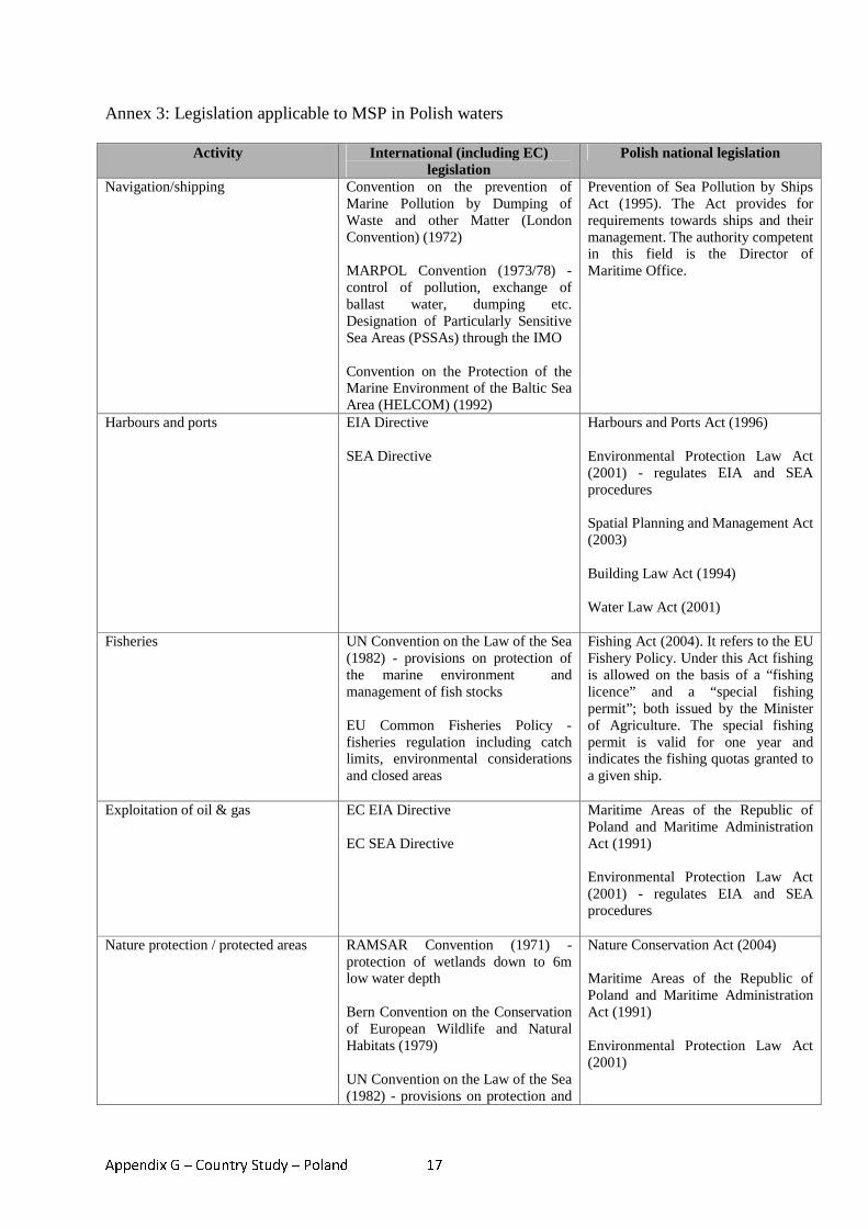
Appendix G – Country Study – Poland 17
Annex 3: Legislation applicable to MSP in Polish waters
Activity International (including EC) legislation
Polish national legislation
Navigation/shipping Convention on the prevention of Marine Pollution by Dumping of Waste and other Matter (London Convention) (1972) MARPOL Convention (1973/78) - control of pollution, exchange of ballast water, dumping etc. Designation of Particularly Sensitive Sea Areas (PSSAs) through the IMO Convention on the Protection of the Marine Environment of the Baltic Sea Area (HELCOM) (1992)
Prevention of Sea Pollution by Ships Act (1995). The Act provides for requirements towards ships and their management. The authority competent in this field is the Director of Maritime Office.
Harbours and ports EIA Directive SEA Directive
Harbours and Ports Act (1996) Environmental Protection Law Act (2001) - regulates EIA and SEA procedures Spatial Planning and Management Act (2003) Building Law Act (1994) Water Law Act (2001)
Fisheries UN Convention on the Law of the Sea (1982) - provisions on protection of the marine environment and management of fish stocks EU Common Fisheries Policy - fisheries regulation including catch limits, environmental considerations and closed areas
Fishing Act (2004). It refers to the EU Fishery Policy. Under this Act fishing is allowed on the basis of a “fishing licence” and a “special fishing permit”; both issued by the Minister of Agriculture. The special fishing permit is valid for one year and indicates the fishing quotas granted to a given ship.
Exploitation of oil & gas EC EIA Directive EC SEA Directive
Maritime Areas of the Republic of Poland and Maritime Administration Act (1991) Environmental Protection Law Act (2001) - regulates EIA and SEA procedures
Nature protection / protected areas RAMSAR Convention (1971) - protection of wetlands down to 6m low water depth Bern Convention on the Conservation of European Wildlife and Natural Habitats (1979) UN Convention on the Law of the Sea (1982) - provisions on protection and
Nature Conservation Act (2004) Maritime Areas of the Republic of Poland and Maritime Administration Act (1991) Environmental Protection Law Act (2001)
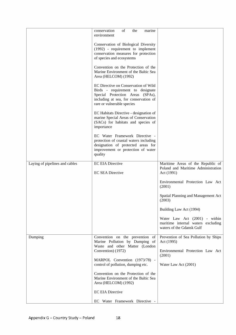
Appendix G – Country Study – Poland 18
conservation of the marine environment Conservation of Biological Diversity (1992) - requirement to implement conservation measures for protection of species and ecosystems Convention on the Protection of the Marine Environment of the Baltic Sea Area (HELCOM) (1992) EC Directive on Conservation of Wild Birds - requirement to designate Special Protection Areas (SPAs), including at sea, for conservation of rare or vulnerable species EC Habitats Directive - designation of marine Special Areas of Conservation (SACs) for habitats and species of importance EC Water Framework Directive - protection of coastal waters including designation of protected areas for improvement or protection of water quality
Laying of pipelines and cables EC EIA Directive EC SEA Directive
Maritime Areas of the Republic of Poland and Maritime Administration Act (1991) Environmental Protection Law Act (2001) Spatial Planning and Management Act (2003) Building Law Act (1994) Water Law Act (2001) - within maritime internal waters excluding waters of the Gdansk Gulf
Dumping Convention on the prevention of Marine Pollution by Dumping of Waste and other Matter (London Convention) (1972) MARPOL Convention (1973/78) - control of pollution, dumping etc. Convention on the Protection of the Marine Environment of the Baltic Sea Area (HELCOM) (1992) EC EIA Directive EC Water Framework Directive -
Prevention of Sea Pollution by Ships Act (1995) Environmental Protection Law Act (2001) Water Law Act (2001)
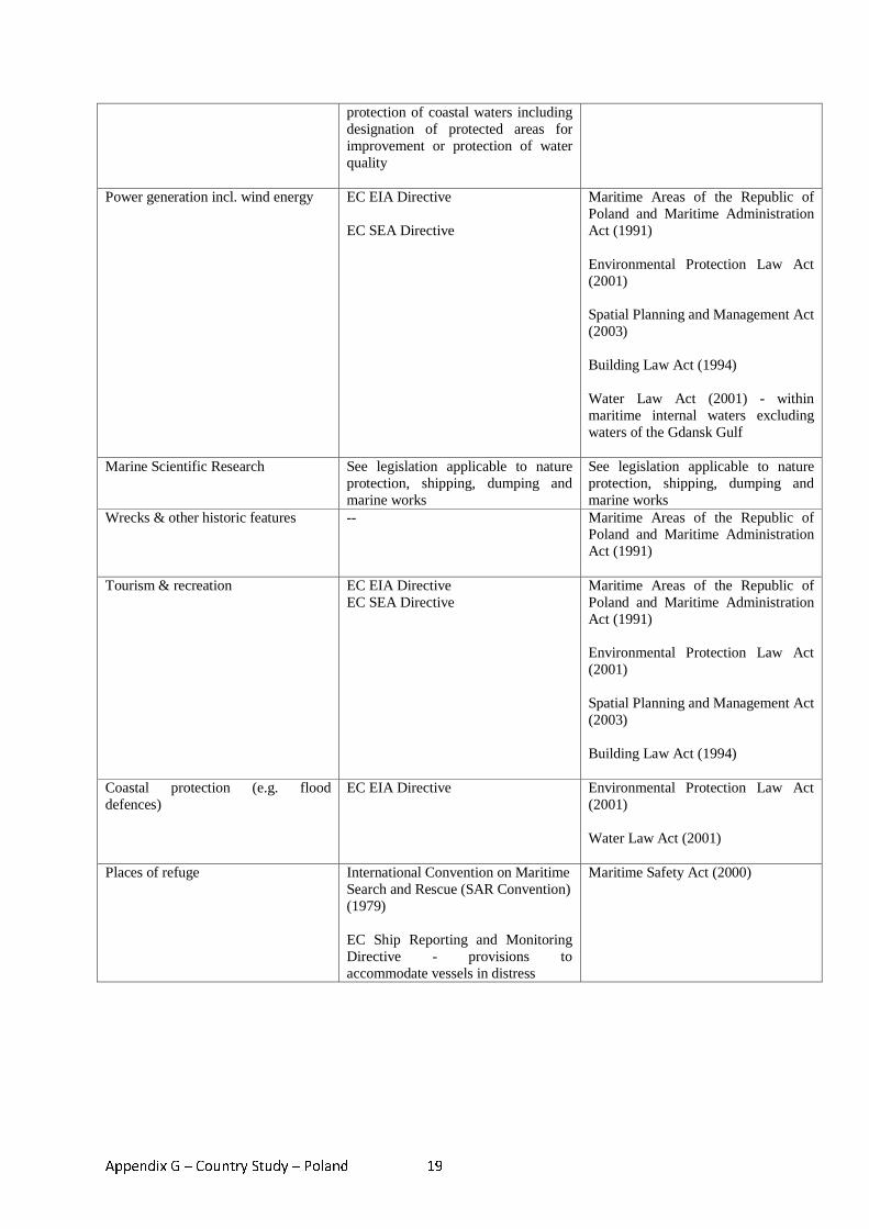
Appendix G – Country Study – Poland 19
protection of coastal waters including designation of protected areas for improvement or protection of water quality
Power generation incl. wind energy EC EIA Directive EC SEA Directive
Maritime Areas of the Republic of Poland and Maritime Administration Act (1991) Environmental Protection Law Act (2001) Spatial Planning and Management Act (2003) Building Law Act (1994) Water Law Act (2001) - within maritime internal waters excluding waters of the Gdansk Gulf
Marine Scientific Research See legislation applicable to nature protection, shipping, dumping and marine works
See legislation applicable to nature protection, shipping, dumping and marine works
Wrecks & other historic features -- Maritime Areas of the Republic of Poland and Maritime Administration Act (1991)
Tourism & recreation EC EIA Directive EC SEA Directive
Maritime Areas of the Republic of Poland and Maritime Administration Act (1991) Environmental Protection Law Act (2001) Spatial Planning and Management Act (2003) Building Law Act (1994)
Coastal protection (e.g. flood defences)
EC EIA Directive Environmental Protection Law Act (2001) Water Law Act (2001)
Places of refuge International Convention on Maritime Search and Rescue (SAR Convention) (1979) EC Ship Reporting and Monitoring Directive - provisions to accommodate vessels in distress
Maritime Safety Act (2000)
Appendix H – Country Study – United Kingdom 1
Appendix H - Country study – United Kingdom
MARITIME SPATIAL PLANNING IN THE UNITED KINGDOM
Introduction
1. The intensity of human activities in the waters around the UK is among the highest in Europe, according to a recently published global map of human impact on marine ecosystems.150 The English Channel is one of the world’s busiest shipping lanes, and the North Sea is heavily utilized for commercial fishing and oil and gas extraction. In 1999/2000 the contribution of marine-related activities to the UK economy was estimated at £39 billion (4.9 per cent of its GDP), from sectors including shipping, oil and gas production, marine aggregates, fisheries, tourism and recreation.151 There is a growing need to balance the sustainable development of often conflicting maritime activities while protecting the marine environment. However, UK legislation for maritime planning has been developed piecemeal over several hundred years and remains complex and fragmented, based on sectoral regulation of specific categories of activities.
2. The UK coastline is around 12,500 km in length, and is surrounded by the Atlantic
Ocean, the North Sea, the Irish Sea and the English Channel. Although it has not declared an EEZ, the UK claims jurisdiction over fisheries and renewable energy generation out to 200 nm, covering a total area of 870,000 km (British Fishery Limits (Fishery Limits Act 1976) and the Renewable Energy Zone (Energy Act 2004) extend 200 nm from the baseline). In the northwest, the UK continental shelf extends beyond 200 nm offshore into the Atlantic Ocean west of Rockall. The UK shares maritime boundaries with Belgium, Denmark (Faeroe Islands), France, Germany, Ireland, the Netherlands and Norway.
3. The management of UK waters is complicated by the devolution of responsibility for
domestic affairs from central government to Wales, Scotland and Northern Ireland.152 The territorial waters within 12 nm of the baselines are the responsibility of the relevant devolved administrations (the Welsh Assembly, the Scottish Executive, the Northern Ireland Assembly, and the central UK Government in the case of England). The Scottish Parliament and the Northern Ireland Assembly have primary legislative powers over areas including fisheries, environmental regulations and marine nature conservation within Scotland and Northern Ireland respectively. However, the legislative powers of the Welsh Assembly are more limited in scope.153
150 Halpern, B.S., Walbridge, S., Selkoe, K.A., Kappel, C.V., Micheli, F., D’Agrosa, C., Bruno, J.F., Casey, K.S., Ebert, C., Fox, H.E., Fujita, R., Heinemann, D., Lenihan, H.S., Madin, E.M.P., Perry, M.T., Selig, E.R., Spalding, M., Steneck, R. & Watson, R. 2008. A global map of human impact on marine ecosystems. Science. Vol 319 at page 948. 151 WWF-UK & The Wildlife Trusts. 2004. Marine spatial planning. Marine Update No.55. www.wwf.org.uk/filelibrary/pdf/mu55.pdf 152 Boyes, W., Warren, L. & Elliott, H. 2003a. Regulatory Responsibilities & Enforcement Mechanisms Relevant to Marine Nature Conservation in the United Kingdom. Institute of Estuarine and Coastal Studies, University of Hull, p.2 http://www.jncc.gov.uk/PDF/enforcement.pdf 153 Boyes et al., 2003a. Op. cit., p.2.
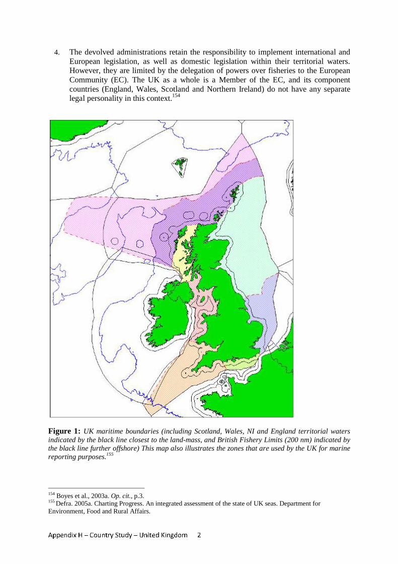
Appendix H – Country Study – United Kingdom 2
4. The devolved administrations retain the responsibility to implement international and European legislation, as well as domestic legislation within their territorial waters. However, they are limited by the delegation of powers over fisheries to the European Community (EC). The UK as a whole is a Member of the EC, and its component countries (England, Wales, Scotland and Northern Ireland) do not have any separate legal personality in this context.154
Figure 1: UK maritime boundaries (including Scotland, Wales, NI and England territorial waters indicated by the black line closest to the land-mass, and British Fishery Limits (200 nm) indicated by the black line further offshore) This map also illustrates the zones that are used by the UK for marine reporting purposes.155
154 Boyes et al., 2003a. Op. cit., p.3. 155 Defra. 2005a. Charting Progress. An integrated assessment of the state of UK seas. Department for Environment, Food and Rural Affairs.
Appendix H – Country Study – United Kingdom 3
5. In 2004, the UK Government Department for Environment, Food and Rural Affairs (Defra) published a review of marine nature conservation management in England and Wales, identifying maritime spatial planning (MSP) as a key area for improvement.156 Pilot studies undertaken in the Irish Sea to consider how marine nature conservation and spatial planning might be delivered concluded that there is a need for a statutory process of MSP in the UK, involving national planning guidelines, strategic plans at the regional sea scale, and more detailed local plans.157 These studies also recommended that a cross-departmental authority should be established to take overall responsibility for strategic planning in the marine environment.158
6. A draft Marine Bill was published in April 2008, with the aim of establishing an
improved framework for delivering sustainable development of the marine and coastal environment.159 This addresses both the use and protection of marine resources, and includes a strong emphasis on a more coherent framework for maritime planning and licensing. The establishment of new legislative frameworks, however, is likely to take several more years.
7. This case study reviews the legislation applicable to MSP in the UK, and the
authorities and jurisdictions responsible for planning and licensing of different activities in the maritime area. It examines current procedures for obtaining licences for maritime activities, and mechanisms for consultation and resolving conflict between different users and stakeholders. The case study also discusses how new legislative proposals such as the Marine Bill may change the status of MSP in the UK, and help to overcome current constraints. Finally, transboundary initiatives are reviewed in the context of their contribution to spatial planning in UK waters.
1. Legislation applicable to MSP 8. Planning of maritime activities in the UK is regulated by a complex array of
international, European Community, regional, national, devolved and local legislative controls. Much of this legislation is sectoral, applying to specific activities or users of the marine environment, although in recent years there has been a shift towards a more holistic, ecosystem approach to marine environmental protection and planning of activities.160
9. Reviews of the existing legal mechanisms relevant to marine nature conservation in
UK waters161,162 were undertaken by the Joint Nature Conservation Committee (JNCC)
156 Defra. 2004. Review of Marine Nature Conservation. Working Group Report to Government. Department for Environment, Food and Rural Affairs. 157 MSPP Consortium. 2006. Marine Spatial Planning Pilot - Final Report. Report to Defra by the Marine Spatial Planning Pilot (MSPP) Consortium, p.47. http://www.abpmer.net/mspp/docs/finals/MSPFinal_report.pdf 158 Vincent, M.A., Atkins, S.M., Lamb, C.M., Golding, N., Lieberknecht, L.M. & Webster, M. 2004. Marine nature conservation and sustainable development - the Irish Sea Pilot. Report to Defra by the Joint Nature Conservation Committee, Peterborough, p.145. 159 Defra. 2008a. Draft Marine Bill. Presented to Parliament by the Secretary of State for Environment, Food and Rural Affairs By Command of Her Majesty. April 2008. 160 Boyes, S., Warren, L. & Elliott, M. 2003b. Summary of Current Legislation Relevant to Nature Conservation in the Marine Environment in the United Kingdom. Institute of Estuarine and Coastal Studies, University of Hull, p.2. http://www.jncc.gov.uk/PDF/summary.pdf 161 Boyes et al. 2003a. Op. cit. 162 Boyes et al. 2003b. Op. cit.
Appendix H – Country Study – United Kingdom 4
as part of a pilot study163 (referred to as the “Irish Sea Pilot”) to test the potential for an ecosystem approach to managing the marine environment at a regional sea scale. These reviews are used as the basis for the information provided in this section, together with updated information on international, European and UK legislation from JNCC, the Department for Business, Enterprise and Regulatory Reform (BERR, formerly the Department for Trade and Industry) and Marine and Fisheries Agency (MFA, formerly the Marine Consents and Environment Unit) websites.164 Annex 1 summarizes the legislation applicable to MSP in the UK, in terms of international, EC, national (UK-wide), and country-specific (devolved) instruments. The table shows the individual items of legislation that are relevant to specific maritime activities; some activities are legislated for by several different instruments, and the same legislation may apply to a range of different activities.
10. At the international level, rules are contained in instruments such as the International
Convention for the Prevention of Pollution from Ships (MARPOL) and the Bern Convention on the Conservation of European Wildlife and Natural Habitats. Such international rules are enacted in UK law, for example the provisions of MARPOL are enacted through the Merchant Shipping and Maritime Security Act 1997.
11. Directives provided by the European Community are also required to be transposed
into legislation within EC Member States, thus providing a further level of legislation applicable to the UK. Two items of EC legislation have overarching relevance to MSP in the UK. The Environmental Impact Assessment (EIA) Directive (85/337/EC and Amending Directive 97/11/EC) requires that the environmental consequences of projects are identified and assessed before authorization is given. These EIA requirements have been specifically transposed in the UK to apply to maritime activities including mariculture,165 offshore oil and gas production,166 renewable power generation,167 extraction of minerals (e.g. sand and gravel),168 harbour works,169 and laying of cables and pipelines.170 For example, the Marine Works (Environmental Impact Assessment) Regulations 2007 apply the provisions of the EIA Directive to applications for approval of marine works such as cable laying and pipeline development. Offshore wind power generation works require an EIA under the provisions of the Electricity Works (Environmental Impact Assessment) (England and Wales) Regulations 2000.
12. The Strategic Environmental Assessment (SEA) Directive (2001/42/EC) further
requires that the environmental consequences of plans and programmes are identified and assessed during their preparation and before their adoption. These requirements have been transposed into UK legislation via the Environmental Assessment of Plans and Programmes Regulations 2004, (and similar regulations in Northern Ireland, Scotland, and Wales), to form part of the licensing procedures for offshore oil and gas
163 Vincent et al. 2004. Op. cit. 164 http://www.jncc.gov.uk/page-1359 (accessed 10/3/08) http://www.berr.gov.uk/energy/ (accessed 10/3/08) http://www.mfa.gov.uk/environment/index.htm (accessed 10/03/08) 165 Boyes et al. 2003b. Op. cit. p. 46. 166 Boyes et al. 2003b. Op. cit. p. 67. 167 Boyes et al. 2003b. Op. cit. p. 72. 168 Boyes et al. 2003b. Op. cit. p. 77. 169 Boyes et al. 2003b. Op. cit. p. 98. 170 Boyes et al. 2003b. Op. cit. p. 115.
Appendix H – Country Study – United Kingdom 5
production, laying of cables and pipelines, extraction of minerals, and renewable power generation.
13. The UK is also a member of the OSPAR Commission for the Protection of the Marine
Environment of the North-East Atlantic, which aims to apply an ecosystem approach to the management of human activities in this region. The requirements of the OSPAR Convention have particular relevance to the protection of threatened or declining species, management of human activities which may affect the marine environment, and the establishment of protected areas.171
14. In the absence of overarching UK legislation on MSP, maritime activities in the UK
are regulated by more than fifty Acts of Parliament relating to marine nature conservation, environmental protection and individual sectors of industry. Marine nature conservation, industries and development are managed by a range of different government departments and advisory bodies. In addition, devolved administrations have separate legislative and regulatory powers over activities in their territorial seas.
15. The Town and Country Planning Act 1990 provides a regulatory framework for land
use development and planning in the UK, whereby planning permission is granted if the application is consistent with land-use plans and policies in a particular area. The EC Environmental Impact Assessment and Strategic Environmental Assessment Directives were initially implemented in the UK in the context of this land planning system, which does not extend beyond waters internal to the baseline.172 However, the extension of these Directives to activities in the marine environment has focused on specific activities, rather than assessment in the context of broader planning,173 and there is no equivalent overall planning legislation seaward of the low water mark.
16. There is a strong sectoral basis for management of many maritime activities, and
sectoral inter-dependencies between the marine and terrestrial elements of some uses.174 For example, the Pipelines Act 1962 applies to the construction of pipelines on the foreshore down to the low water mark, whereas the Coast Protection Act 1949 (CPA) applies to the same activity below the level of mean high water spring tides, and the Petroleum Act 1998 applies to construction in the territorial sea and on the continental shelf. A seafloor pipeline crossing all three zones would need to be planned taking account of the requirements of separate pieces of legislation for each area, in addition to other licensing requirements (see Section 3 on licensing procedures for more details on this example). Similarly, different activities as part of the same project, for example the structures, research, pipelines and waste disposal associated with an oil rig may be subject to a range of separate legislation focusing on specific activities rather than the entire project or programme.
17. The CPA and the Food & Environmental Protection Act 1985 (FEPA) provide general
legislation on planning and licensing requirements for maritime activities in UK territorial waters including navigation, harbour works, laying of cables and pipelines, exploitation of minerals, disposal of wastes, offshore power generation, mariculture
171 Defra. 2008b. Draft Marine Bill. Policy Paper. April 2008, p.59. 172 Vincent et al. 2004. Op. cit. p.147. 173 Boyes et al. 2003. Op. cit. 174 MSPP Consortium. 2005. Marine Spatial Planning Literature Review. Report to Defra by the Marine Spatial Planning Pilot (MSPP) Consortium, p.9.
Appendix H – Country Study – United Kingdom 6
and coastal protection. Although these two Acts cover a broad range of activities, there is little requirement for planning to be undertaken in consideration of each activity in relation to others, and there remains a highly sectoral focus to planning legislation.
18. Legislation for the planning of marine protected areas and reserves in the UK is
particularly fragmented and complex.175 Table 1 demonstrates the large number of different items of legislation on this issue, and the different area types that can be designated under each instrument. The obligations imposed by the Birds and Habitats Directives were initially transposed into UK law through the Wildlife and Countryside Act 1981 and the Conservation (Natural Habitats, &c) Regulations 1994, applying only to terrestrial areas and territorial waters (within 12 nm).176 These require the designation of Specially Protected Areas (SPAs) for the conservation of rare and vulnerable bird species, and Special Areas of Conservation (SACs) for the conservation of habitats and species of importance. However, new legislation (Offshore Marine Conservation (Natural Habitats, & c.) Regulations 2007) extends the area over which SACs and SPAs need to be designated to the UK offshore maritime area (those waters, beyond 12 nm, within British fishery limits and the seabed within the UK continental shelf). These sites are required to be established as part of the European Natura 2000 network of protected sites to maintain or restore natural habitats and species within the EC. In addition, there is a complex range of existing national protected area types which can be established in different sectors under UK nature conservation legislation.177
19. There is a high degree of overlap between the aims and provisions of these different
protected area types. One of the few statutory Marine Nature Reserves (MNRs) currently designated in UK waters illustrates the complex array of authorities and instruments involved: a MNR was established around the island of Lundy in the Bristol Channel in 1986, under the provisions of the Wildlife and Countryside Act 1981. The island is also designated as a SAC under the Conservation (Natural Habitats, &c) Regulations 1994. In 2003, the Devon Sea Fisheries Committee (SFC) passed a bye-law under the Sea Fisheries Regulation Act 1966 to establish a ‘No-Take Zone’ prohibiting all fishing within a small area of high biodiversity in the east of the MNR. The area is administered by Natural England (the statutory advisor to Government on nature conservation), in conjunction with the Devon SFC.
20. The Irish Sea Pilot study concluded that the existing legislation for marine habitat
protection is not capable of delivering an ecologically coherent network of protected areas to achieve the objectives of the EC Birds and Habitats Directives, nor to meet the UK’s commitments to the requirements of OSPAR.178
21. There is also a lack of integration between legislation for the fishing industry and for
nature conservation. MNRs such as that established off Lundy Island can only be designated out to the outer limits of the territorial sea. The regulation of fishing beyond this is reserved to the EC, so there is no clear framework for offshore areas to be designated as protected sites with this type of restriction on fishing activities. There are already a number of closed areas in place under EC regulations to protect, for example,
175 Boyes et al. 2003b. Op. cit. p.4. 176 Boyes et al. 2003b. Op. cit. p.6. 177 Boyes et al. 2003b. Op. cit. p.9 178 Vincent et al. 2004. Op. cit., p.125.
Appendix H – Country Study – United Kingdom 7
juvenile fish and spawning adults.179 However, there is a lack of scope for combined fisheries management and environmental or nature conservation objectives to be achieved, particularly through the development of an ecologically coherent network of protected areas to support fisheries management.180
2. Responsibilities and jurisdictions for planning and licensing in the maritime area 22. The legislation set out in Annex 2 is administered and enforced by a range of
government departments, sectoral agencies and regional or local authorities. Most consents and licences are sectoral, although consents for works under the CPA and the FEPA sometimes have a broader, project-based application. Works and activities on the seabed also require the consent of the landowner, usually the Crown Estate (see Box 1 on ownership of the seabed). The Government View procedure requires that a favourable “Government View” is needed to support applications to the Crown Estate.181 Defra has responsibility for administering environmental protection, biodiversity conservation and protected areas, fisheries and mariculture. Its executive agency, the MFA, has improved the coherence of licensing and consent procedures for a range of activities, although these are only a sub-set of the full range of activities taking place in the marine environment.
23. Other government departments with responsibility for regulating sectoral activities
include BERR, which has responsibility for telecommunications and energy production, including renewables, the Environment Agency (fisheries, mariculture and disposal of materials at sea) and the Department for Transport (DfT) (shipping and navigation).
24. The EC Common Fisheries Policy takes precedence over fisheries regulation in all
European waters, however authority is devolved back to Member States within territorial waters. Inshore fisheries (out to 6 nm from the shore) are controlled by SFCs in England and Wales, to allow for better consideration of local conditions and requirements.182 Twelve SFCs are empowered to create local bye-laws for conservation and management of fisheries in their districts. Inshore fisheries in Scotland are managed centrally by the Scottish Executive.183
25. For protected areas and nature conservation, there is an overlap between several
different agencies with jurisdiction over different zones within UK waters. Local authorities may establish bye-laws for the designation of National Nature Reserves and Local Nature Reserves down to the low water mark. Individual country conservation agencies (Natural England, Scottish Natural Heritage, Countryside Council for Wales and the Environment and Heritage Service in Northern Ireland) have a remit for species and habitat protection (e.g. in MNRs) within the 12 nm territorial sea. JNCC acts on behalf of these agencies and their associated government departments to collate
179 Boyes et al. 2003b. Op. cit. p.42. 180 Vincent et al. 2004. Op. cit. p.131. 181 Boyes et al. 2003a. Op. cit. p.1. 182 Boyes et al. 2003b. Op. cit. pp. 41. 183 Vincent et al. 2004. Op. cit. p.131.
Appendix H – Country Study – United Kingdom 8
information, coordinate consultation, and propose sites for nature conservation in the UK, including for European Sites (SACs and SPAs) out to 200 nm.184
26. There are many overlapping jurisdictions, with a duplication of powers and no single
authority with an overview of all activities being planned in the marine environment. Maritime planning is regulated largely by sectoral authorities, often resulting in a lack of community ownership of planning controls and coordination.185 This is in contrast to the terrestrial planning system, where development is administered and assessed by local authorities.
27. Annex 2 summarizes the institutional arrangements for planning and licensing of
maritime activities in UK waters, the capacity of responsible authorities to grant licences, provide advice, or implement planning bye-laws, and their jurisdiction. Devolved authorities with separate jurisdiction over England and Wales, Scotland and Northern Ireland are included to highlight the range of authorities dealing with different activities across the UK. Figure 3 further illustrates the overlap of UK jurisdictions for maritime planning between different activities, and across coastal, territorial and offshore waters.
184 Boyes et al. 2003a. Op. cit. p.10. 185 Tyldesley, D. 2004. Making the case for marine spatial planning in Scotland. Report commissioned by RSPB Scotland and RTPI in Scotland, p.3
BOX 1 - Ownership of the seabed in the UK
For almost 1000 years, the seabed within UK territorial waters has been owned by the Sovereign, as part of the ‘Crown Estate’. The Crown Estate owns 55% of the foreshore (between mean high water and mean low water), and almost all of the seabed out to 12 nm. It also owns around half of the beds of estuaries and tidal rivers in the UK. The remainder of the foreshore and estuary beds are privately owned. Generally, the Crown Estate does not sell areas of the foreshore or seabed, but instead grants consents for works and activities such as offshore aggregate dredging, construction of cables and pipelines, and offshore renewable energy development. Areas are also leased to local authorities, ports and harbours. Around 21% of the foreshore is leased to conservation bodies and statutory bodies such as the National Trust, the Royal Society for the Protection of Birds and Natural England for conservation purposes, or to local authorities for protective ownership. The Crown Estate owns the rights to all minerals (excluding hydrocarbons) out to 12 nm. However, it does not own the water column, and does not govern public rights such as navigation and marine fisheries. Mineral rights on the continental shelf outside territorial waters are also vested in the Crown Estate Commissioners, under the Crown Estate Act 1961, however the power to grant licences for exploration and exploitation of petroleum on the continental shelf is exercised by the Secretary of State for Business, Enterprise and Regulatory Reform, under the Petrolem Act 1998. (information from: www.thecrownestate.co.uk/our_portfolio/marine.htm)
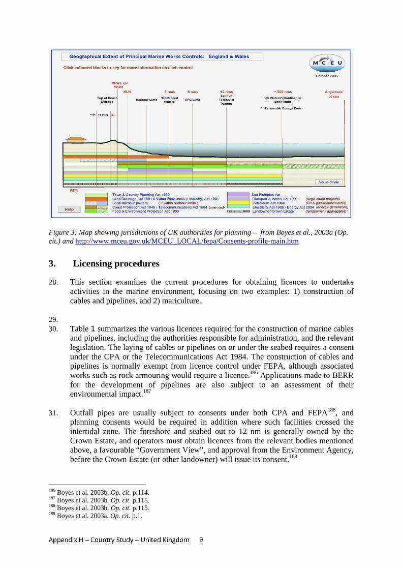
Appendix H – Country Study – United Kingdom 9
Figure 3: Map showing jurisdictions of UK authorities for planning – from Boyes et al., 2003a (Op. cit.) and http://www.mceu.gov.uk/MCEU_LOCAL/fepa/Consents-profile-main.htm
3. Licensing procedures 28. This section examines the current procedures for obtaining licences to undertake
activities in the marine environment, focusing on two examples: 1) construction of cables and pipelines, and 2) mariculture.
29. 30. Table 1 summarizes the various licences required for the construction of marine cables
and pipelines, including the authorities responsible for administration, and the relevant legislation. The laying of cables or pipelines on or under the seabed requires a consent under the CPA or the Telecommunications Act 1984. The construction of cables and pipelines is normally exempt from licence control under FEPA, although associated works such as rock armouring would require a licence.186 Applications made to BERR for the development of pipelines are also subject to an assessment of their environmental impact.187
31. Outfall pipes are usually subject to consents under both CPA and FEPA188, and
planning consents would be required in addition where such facilities crossed the intertidal zone. The foreshore and seabed out to 12 nm is generally owned by the Crown Estate, and operators must obtain licences from the relevant bodies mentioned above, a favourable “Government View”, and approval from the Environment Agency, before the Crown Estate (or other landowner) will issue its consent.189
186 Boyes et al. 2003b. Op. cit. p.114. 187 Boyes et al. 2003b. Op. cit. p.115. 188 Boyes et al. 2003b. Op. cit. p.115. 189 Boyes et al. 2003a. Op. cit. p.1.
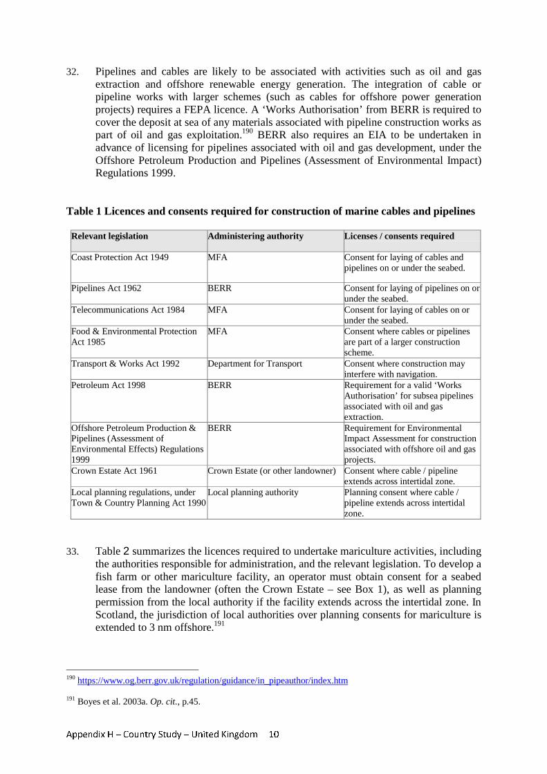
Appendix H – Country Study – United Kingdom 10
32. Pipelines and cables are likely to be associated with activities such as oil and gas extraction and offshore renewable energy generation. The integration of cable or pipeline works with larger schemes (such as cables for offshore power generation projects) requires a FEPA licence. A ‘Works Authorisation’ from BERR is required to cover the deposit at sea of any materials associated with pipeline construction works as part of oil and gas exploitation.190 BERR also requires an EIA to be undertaken in advance of licensing for pipelines associated with oil and gas development, under the Offshore Petroleum Production and Pipelines (Assessment of Environmental Impact) Regulations 1999.
Table 1 Licences and consents required for construction of marine cables and pipelines
Relevant legislation Administering authority Licenses / consents required
Coast Protection Act 1949
MFA Consent for laying of cables and pipelines on or under the seabed.
Pipelines Act 1962 BERR
Consent for laying of pipelines on or under the seabed.
Telecommunications Act 1984 MFA Consent for laying of cables on or under the seabed.
Food & Environmental Protection Act 1985
MFA Consent where cables or pipelines are part of a larger construction scheme.
Transport & Works Act 1992 Department for Transport Consent where construction may interfere with navigation.
Petroleum Act 1998 BERR
Requirement for a valid ‘Works Authorisation’ for subsea pipelines associated with oil and gas extraction.
Offshore Petroleum Production & Pipelines (Assessment of Environmental Effects) Regulations 1999
BERR
Requirement for Environmental Impact Assessment for construction associated with offshore oil and gas projects.
Crown Estate Act 1961
Crown Estate (or other landowner) Consent where cable / pipeline extends across intertidal zone.
Local planning regulations, under Town & Country Planning Act 1990
Local planning authority Planning consent where cable / pipeline extends across intertidal zone.
33. Table 2 summarizes the licences required to undertake mariculture activities, including
the authorities responsible for administration, and the relevant legislation. To develop a fish farm or other mariculture facility, an operator must obtain consent for a seabed lease from the landowner (often the Crown Estate – see Box 1), as well as planning permission from the local authority if the facility extends across the intertidal zone. In Scotland, the jurisdiction of local authorities over planning consents for mariculture is extended to 3 nm offshore.191
190 https://www.og.berr.gov.uk/regulation/guidance/in_pipeauthor/index.htm 191 Boyes et al. 2003a. Op. cit., p.45.
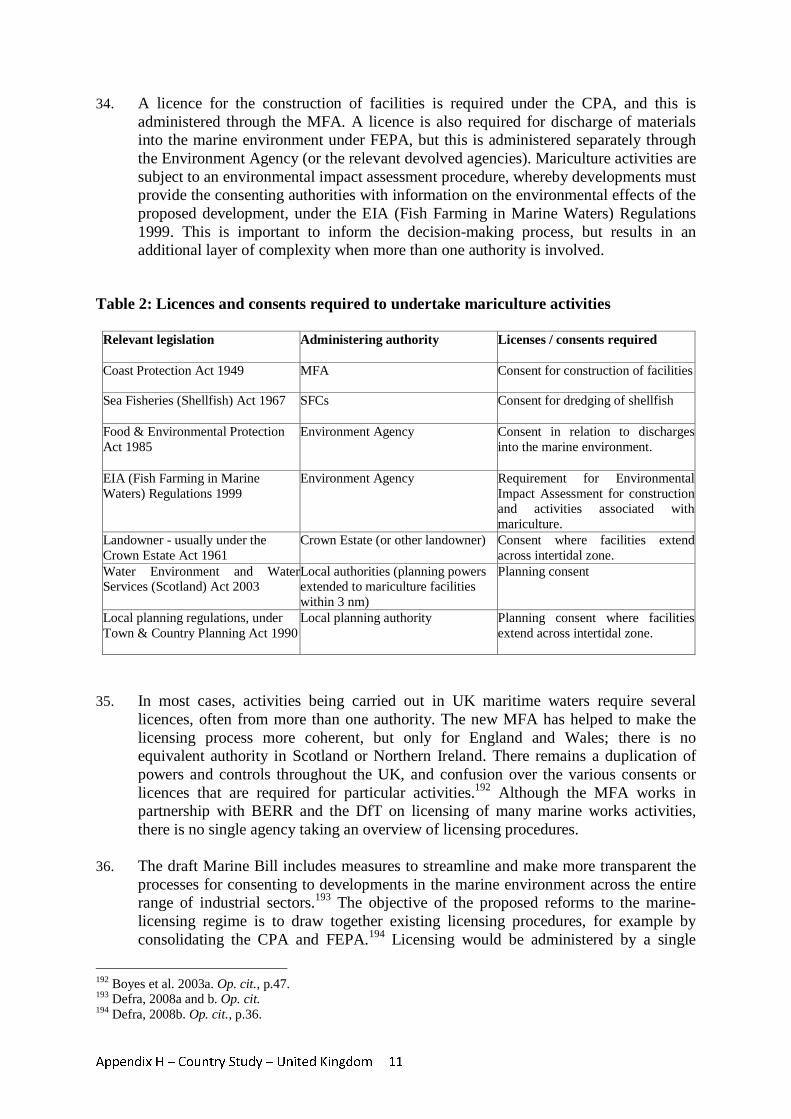
Appendix H – Country Study – United Kingdom 11
34. A licence for the construction of facilities is required under the CPA, and this is administered through the MFA. A licence is also required for discharge of materials into the marine environment under FEPA, but this is administered separately through the Environment Agency (or the relevant devolved agencies). Mariculture activities are subject to an environmental impact assessment procedure, whereby developments must provide the consenting authorities with information on the environmental effects of the proposed development, under the EIA (Fish Farming in Marine Waters) Regulations 1999. This is important to inform the decision-making process, but results in an additional layer of complexity when more than one authority is involved.
Table 2: Licences and consents required to undertake mariculture activities
Relevant legislation
Administering authority Licenses / consents required
Coast Protection Act 1949 MFA Consent for construction of facilities
Sea Fisheries (Shellfish) Act 1967 SFCs Consent for dredging of shellfish
Food & Environmental Protection Act 1985
Environment Agency Consent in relation to discharges into the marine environment.
EIA (Fish Farming in Marine Waters) Regulations 1999
Environment Agency Requirement for Environmental Impact Assessment for construction and activities associated with mariculture.
Landowner - usually under the Crown Estate Act 1961
Crown Estate (or other landowner) Consent where facilities extend across intertidal zone.
Water Environment and Water Services (Scotland) Act 2003
Local authorities (planning powers extended to mariculture facilities within 3 nm)
Planning consent
Local planning regulations, under Town & Country Planning Act 1990
Local planning authority Planning consent where facilities extend across intertidal zone.
35. In most cases, activities being carried out in UK maritime waters require several
licences, often from more than one authority. The new MFA has helped to make the licensing process more coherent, but only for England and Wales; there is no equivalent authority in Scotland or Northern Ireland. There remains a duplication of powers and controls throughout the UK, and confusion over the various consents or licences that are required for particular activities.192 Although the MFA works in partnership with BERR and the DfT on licensing of many marine works activities, there is no single agency taking an overview of licensing procedures.
36. The draft Marine Bill includes measures to streamline and make more transparent the
processes for consenting to developments in the marine environment across the entire range of industrial sectors.193 The objective of the proposed reforms to the marine-licensing regime is to draw together existing licensing procedures, for example by consolidating the CPA and FEPA.194 Licensing would be administered by a single
192 Boyes et al. 2003a. Op. cit., p.47. 193 Defra, 2008a and b. Op. cit. 194 Defra, 2008b. Op. cit., p.36.

Appendix H – Country Study – United Kingdom 12
regulatory body.195 The draft Bill therefore aims to rationalize a variety of sector-specific rules which have developed ad hoc over many years, and to resolve overlaps and inconsistencies between them.
4. Consultation processes 37. Within the existing frameworks for licensing and planning of maritime activities as
outlined in the previous sections, there are a range of requirements for consultation with stakeholders including other industry sectors and users of the marine environment, nature conservation agencies and members of the public. As pressure on maritime space increases, there is growing potential for conflict between different activities, industries and users, which must be resolved as part of the planning consultation process.
38. The planning system on land in the UK has a well-established system of public
consultation, with opportunities for objection to proposed developments, appraisal and conflict resolution mechanisms. However, the complex and fragmented nature of the existing licensing procedures and regulatory authorities means that mechanisms for consultation on proposed maritime activities are often weak.196 In addition, the resolution of any conflicts requires coordination among a range of authorities.
39. The European Strategic Environmental Assessment Directive (Directive 2001/42/EC)
was not incorporated into UK law until 2004. However, a Strategic Environmental Assessment (SEA) process was established by the DTI in 1999 (and continues to be operated by BERR) for offshore activities including oil and gas development and renewable energy projects.197 This is a good example of best practice for minimizing conflict through stakeholder consultation on maritime activities, and illustrates the potential for further consultation processes to influence spatial planning. Objections to proposed developments and activities may be raised during the SEA and Environmental Impact Assessment (EIA) processes, and are considered as part of the licensing procedure.
40. BERR is undertaking a series of SEAs of the implications of further licensing of oil
and gas exploration and production programmes on the UK Continental Shelf. The Continental Shelf has been divided into 8 areas, which have been subject to a rolling programme of SEA prior to the release of ‘blocks’ within each area for oil and gas licensing.198 In conducting the SEA process for oil and gas development, BERR is guided by the Oil and Gas SEA Steering Group, composed of departmental representatives, conservation and other agencies, NGOs, industry representatives and independent experts. The process has generated a large resource of valuable data on the marine environment, and has resulted in a more integrated approach to decision-making.199
195 Defra, 2008b. Op. cit., p.26 196 Tyldesley, D. 2004. p.3. 197 http://www.offshore-sea.org.uk/site/index.php 198 http://www.offshore-sea.org.uk/site/scripts/documents_info.php?categoryID=39&documentID=5 199 Vincent et al. 2004. Op. cit., p.128.
Appendix H – Country Study – United Kingdom 13
41. BERR is also undertaking a process for planning new sites for offshore wind farms, informed by SEA. The Phase 1 SEA was completed in 2003,200 and developers have been invited to bid for site leases in three offshore ‘strategic areas’ (the North West, Greater Wash, and Thames Estuary). Bids are assessed against the constraints set by the SEA, including possible impacts on fishing, navigation and other users of the maritime area. A required part of SEA is consultation with the public, environmental authorities and other bodies.201
42. The proposed development of a new offshore wind farm at Gwynt y Môr in North
Wales (within the North West strategic area) illustrates how stakeholder and public consultation has proceeded as part of the consent application process. An application for permission to develop a large wind farm was submitted to BERR in 2005, together with an Environmental Statement. Consultations have been undertaken with a variety of stakeholders including the general public, central and local government, environmental groups, fishermen and navigational authorities. Additional studies and surveys have since been commissioned by the developers in response to questions and requests for clarification raised by consultees. ‘Supplementary Environmental Information’ has now been submitted to BERR for consideration, together with a review of the original assessments in light of changes to the project information. For example, the size and position of the wind farm is constrained by visual interests, the northern limit of the turbine array has been changed because of feedback on navigational safety and the onshore power export cabling will be buried to eliminate the visual impact of pylons.202
5. Conflict resolution 43. The major areas of conflict between different uses of the marine environment in the
UK are: • Activities requiring large areas of maritime space such as wind farms and oil and
gas developments, which may conflict with shipping and other industrial uses; • Activities targeting marine resources such as fish or aggregates, which may
conflict with other extractive activities, and with conservation objectives; • Protection of marine species and habitats, which may limit development in other
sectors. 44. Approaches to minimize such conflicts require spatial planning, but consultation on the
draft Marine Bill stressed that this should not result in the displacement of activities into more environmentally sensitive areas, nor the restriction of sustainable development of industry in the maritime area.203
45. For example, freedom of navigation is traditionally recognized as a public ‘right’, with
innocent passage permitted through all UK territorial waters, and no requirement for ships to limit their navigation to specific routes (with the exception of harbour
200 BMT Cordah. 2003. Offshore Wind Generation: Phase 1 Proposals and Environmental Report, for consideration by the Department for Trade and Industry. www.og.dti.gov.uk/offshore-wind-sea/process/envreport.htm 201 BMT Cordah. 2003. Op. cit., p.4-1 202 http://www.npower-renewables.com/gwyntymor/progress.asp (accessed 10/03/08) 203 Defra. 2006. A Marine Bill. Consultation Document. Summary of Responses. Department for Environment, Food and Rural Affairs.
Appendix H – Country Study – United Kingdom 14
restrictions and the English Channel Traffic Separation Scheme). However, this freedom may be increasingly affected by the construction of large installations such as wind farms. The development of shipping corridors may help to minimize the potential for conflict. Similarly, wind farms may be planned to limit their extent to areas where economic feasibility is balanced with minimal implications for fisheries and nature conservation requirements.204
46. The Gwynt y Môr wind farm developers have undertaken a comprehensive
navigational risk assessment, including computer simulations and extensive consultation with local mariners. A new proposal for a traffic separation scheme adjacent to the wind farm is being taken forward by the Maritime and Coastguard Agency (MCA) to the UK and international authorities, designed with input from some of the key navigation organizations operating in Liverpool, to route ships into and out of the Port of Liverpool while avoiding any conflict with the wind farm.205
47. Conflict between activities can be resolved through the application of government
policy, which may include prioritization between different activities, and for example, nature conservation objectives. However consultation on the Marine Bill has highlighted the view of industry that there must be flexibility within MSP to ensure that there is not a presumption against development. For example, the British Wind Energy Association welcomed the development of maritime spatial plans to help avoid and resolve conflicts, but warned that conflict would never be fully erased from the marine environment because of its multiple use nature, and suggested that a prescriptive system would not be appropriate. It further recommended that stakeholders should have input at the early stages of developing a maritime spatial plan, to ensure that their needs are properly understood, and that conflicts are highlighted and resolved early in the process.206
6. Progress towards MSP in the UK 48. While current legislation and planning procedures in the UK are limited in their ability
to deliver effective MSP, the new mechanisms proposed under the draft Marine Bill207 aim to improve spatial planning and licensing, alongside nature conservation and fisheries management (see Box 2 for a summary of the main themes under proposal).
49. The Marine Bill is set to introduce a new legislative framework for the seas, based on
MSP, that balances conservation, energy and resource needs. This framework will enable a more rational organization of the use of maritime space, and the interactions between its uses, taking account of all sectors and ensuring an integrated approach at the land-sea interface. It aims to simplify the regulatory regimes for maritime activities, with a licensing system that is efficient and transparent, while delivering sustainable development. New mechanisms are proposed for the conservation of species and habitats, to improve existing protected area provisions which have proved to be ineffective. Mechanisms by which fisheries management and related
204 BMT Cordah. 2003. Op. cit., p.1-10. 205 http://www.npower-renewables.com/gwyntymor/progress.asp (accessed 10/03/08) 206 BWEA. 2006. The Marine Bill. Offshore Renewables Perspective. British Wind Energy Association. http://www.bwea.com/marine 207 Defra, 2008a. Op. cit.
Appendix H – Country Study – United Kingdom 15
environmental enforcement can be integrated are also under consideration, although fisheries management beyond 12 nm would remain under EC CFP regulation. Finally, the Marine Bill proposes the establishment of a new Marine Management Organisation (MMO) to regulate maritime planning, licensing and enforcement.208
50. The proposed MMO will be an independent Non-Departmental Public Body, and will
deliver maritime functions for the UK Government as a whole. Among other functions, the MMO will209:
• Prepare a series of maritime plans to articulate what the agreed Marine Policy
Statement means for different areas of the sea and coast. • Make decisions on applications, issue licences, and set conditions on maritime
development such as wind farms, tidal and wave power projects, jetties, moorings, aggregate extraction and dredging.
• Have responsibility for involving stakeholders and consulting on plan proposals. • Contribute to the selection of sites for designation as Marine Conservation Zones
(MCZs). • Appoint marine enforcement officers, with the streamlined enforcement powers
set out in the draft Bill to enforce sea fisheries, nature conservation and licensing legislation in the maritime area.
• Deliver Defra’s marine fisheries management functions, including managing UK fleet capacity, managing UK fisheries quotas, recording and providing data on fishing activity and catches.
• The MMO will need large amounts of data to discharge its functions and will require an effective system for managing data, information and knowledge across its functions and sharing it with other bodies and the public.
51. The devolved administrations of Scotland, Wales and Northern Ireland will consider
how they will link with the MMO as it develops, but will work jointly on a marine policy statement to ensure that maritime activities are managed effectively across administrative boundaries. Where these countries have responsibility for the management of their territorial waters, they will determine the need for new legislation.210 While this would allow for more specific consideration of the needs of different regions, there remain questions about whether all components of an integrated UK MSP system can be achieved across separate UK administrations.
52. In preparation for the likely introduction of new legislation for MSP through the
Marine Bill, several initiatives have been undertaken to test potential new management and planning approaches. A pilot project in the Irish Sea was undertaken for Defra to simulate the development of regional and local plans, concluding that MSP should be implemented as a binding system with a statutory purpose of achieving sustainable development of the marine environment.211 The project highlighted the importance of integrating strategic environmental assessment and public participation into the planning process.
208 Defra. 2008b. Op. cit. 209 Defra. 2008b. Op. cit. 210 Defra. 2008b. Op. cit., p.21. 211 MSPP Consortium. 2006. Op. cit., p.ii.
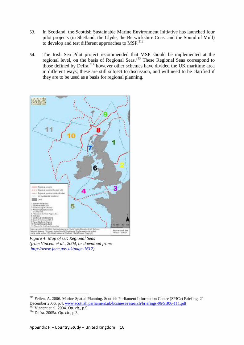
Appendix H – Country Study – United Kingdom 16
53. In Scotland, the Scottish Sustainable Marine Environment Initiative has launched four pilot projects (in Shetland, the Clyde, the Berwickshire Coast and the Sound of Mull) to develop and test different approaches to MSP.212
54. The Irish Sea Pilot project recommended that MSP should be implemented at the
regional level, on the basis of Regional Seas.213 These Regional Seas correspond to those defined by Defra,214 however other schemes have divided the UK maritime area in different ways; these are still subject to discussion, and will need to be clarified if they are to be used as a basis for regional planning.
Figure 4: Map of UK Regional Seas (from Vincent et al., 2004, or download from: http://www.jncc.gov.uk/page-1612).
212 Feilen, A. 2006. Marine Spatial Planning. Scottish Parliament Information Centre (SPICe) Briefing, 21 December 2006, p.4. www.scottish.parliament.uk/business/research/briefings-06/SB06-111.pdf 213 Vincent et al. 2004. Op. cit., p.5. 214 Defra. 2005a. Op. cit., p.3.
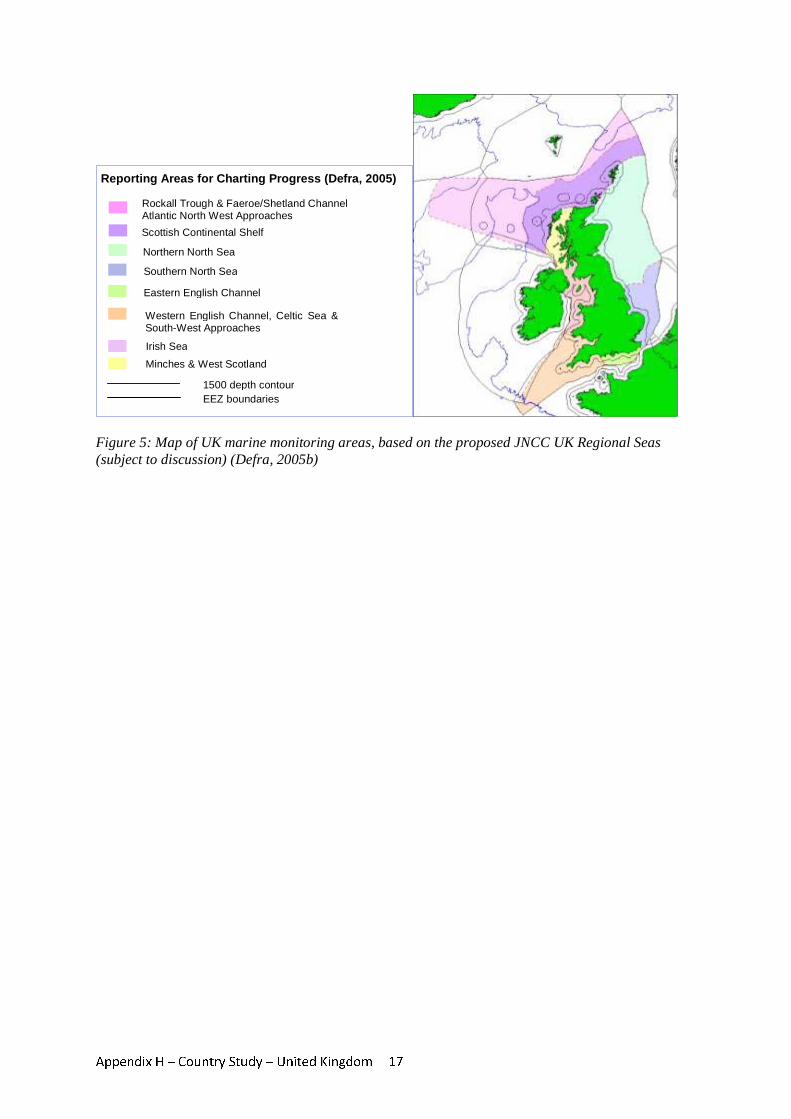
Appendix H – Country Study – United Kingdom 17
Figure 5: Map of UK marine monitoring areas, based on the proposed JNCC UK Regional Seas (subject to discussion) (Defra, 2005b)
Scottish Continental Shelf
Rockall Trough & Faeroe/Shetland Channel Atlantic North West Approaches
Southern North Sea Northern North Sea
Eastern English Channel
Western English Channel, Celtic Sea & South-West Approaches
Irish Sea
Minches & West Scotland
Reporting Areas for Charting Progress (Defra, 2005)
1500 depth contour EEZ boundaries

Appendix H – Country Study – United Kingdom 18
7 Transboundary initiatives 55. The UK shares maritime boundaries with Belgium, Denmark, France, Germany,
Ireland, the Netherlands and Norway. The high level of maritime activities in the North Sea, the Irish Sea and the English Channel make transboundary approaches to spatial planning in these areas particularly important. Transboundary initiatives may also become increasingly important within UK waters, across the devolved jurisdictions of England, Wales, Scotland and Northern Ireland. Three examples of transboundary
BOX 2 - The Marine Bill The draft Marine Bill has seven main themes: Marine Planning: The draft Bill contains measures to deliver a new marine planning system. Long term objectives for the marine area around the UK will be set out in a Marine Policy Statement. Marine plans will then be created to set more detailed and spatial policy at a more local level, based on information about specific areas and their uses of the sea. Marine Consents: The proposals in the draft Bill change the system for licensing activities in the seas from a slow and complex one to a simplified system where, as far as possible, a one-stop-shop is provided for each project. Marine Management Organisation: A new Marine Management Organisation (MMO) will be established an authority for marine planning. This will be the marine planning body on behalf of UK Government in the waters off England and in most of the offshore areas. It will be the UK Government’s regulator of most activities in the marine environment. It will make decisions according to the Marine Policy Statement and marine plans on most marine development, Marine Nature Conservation: The draft Bill provides for the designation of marine conservation zones, both for protection of individual habitats and species, and also for the creation of a network of sites representing marine ecosystems around the UK. Designation will take account of environmental, social and economic criteria. The draft Bill also provides for measures to prevent activities from damaging sites once designated. Coastal and Estuary Management: In response to a European Union recommendation, we are developing a strategy for integrated coastal zone management. Current arrangements for coordinating activities in busy estuaries and coastal areas are complex and inconsistent, split between authorities or even incomplete. Fisheries Management: The draft Bill introduces measures to strengthen the management of marine fisheries, including the replacement of Sea Fisheries Committees with newly created Inshore Fisheries and Conservation Authorities. Marine Enforcement: The draft Bill streamlines and modernises enforcement powers. It introduces a common set of powers so that officers enforcing fisheries, nature conservation and licensing legislation will have access to a core set of enforcement powers for the purposes of inspection and investigation. (Information from Defra, 2008b. Op. cit.)
Appendix H – Country Study – United Kingdom 19
initiatives in the context of shipping, seabed habitat mapping, and offshore wind energy development, are provided in this section.
56. The EU Strategic Environmental Assessment Directive requires that where the
implementation of a plan or programme prepared in one Member State is likely to have a significant effect on the environment of other Member States, provision has to be made for the Member States to enter into consultations, and for the relevant authorities and the public to be informed and able to express their opinion.215 In addition, the international Convention on Environmental Assessment in the Transboundary Context (1991) requires contracting parties to undertake an EIA where there may be significant transboundary environmental effects.
57. The English Channel Traffic Separation Scheme is a spatial solution to address the
dangers of navigation in the Dover Strait between England and France. The scheme is approved by the International Maritime Organisation, and establishes separate lanes for eastbound and westbound vessel traffic. The rules for navigation in the Traffic Separation Schemes are agreed internationally, and set out in UK legislation through the Merchant Shipping (Distress Signals and Prevention of Collisions)(Amendment) Regulations 1991. The IMO provides an international framework for this type of legislation, which is then enacted into the national legislation of relevant member states.
58. The UKSeaMap project was completed in 2006, and provides maps of seabed and
water column features for the entire UK continental shelf area.216 The UK Joint Nature Conservation Committee (JNCC) subsequently led an international marine habitat mapping programme for north-west Europe (Mapping European Seabed Habitats - MESH), involving partners in five countries within the framework of EU INTERREG IIIB. One of the major objectives of the MESH Project is to provide maritime landscape maps to inform MSP. Although having no direct impact on legislative or licensing procedures for transboundary spatial planning, this type of initiative is important in providing the background information necessary for future planning of activities across borders.
59. The European Concerted Action for Offshore Wind Energy Deployment (COD) was
undertaken by eight coastal EU Member States, with the aim of identifying and removing legal, administrative, policy, environmental and electrical infrastructure barriers to the development of offshore wind energy in the EU. 217 It aims to provide a harmonized European process for deployment, environmental impact analysis and licensing procedures for offshore wind farms. COD is steered by a Ministerial Committee, with members from the Energy Ministries of the UK, Ireland, Sweden, Denmark, Germany, Poland, Belgium and the Netherlands. EC Directive 2001/77/EC on the Promotion of Electricity Produced from Renewable Energy Sources requires Member States to evaluate the existing legislative and regulatory frameworks with regard to authorisation procedures for renewable energy sources, and to reduce the
215 Vincent et al. 2004. Op. cit., p.129. 216 Connor, D.W., Gilliland, P.M., Golding, N., Robinson, P., Todd, D. & Verling, E. 2006. UKSeaMap: the mapping of seabed and water column features of UK seas. Joint Nature Conservation Committee, Peterborough. 217 European Communities. 2005. Concerted Action for Offshore Wind Energy Development (COD). Final Report. European Commission, p.8 www.offshorewindenergy.org/cod/COD-Final_Rept.pdf
Appendix H – Country Study – United Kingdom 20
regulatory barriers to an increase in production from renewable sources. In doing so, COD observed that the licensing requirements for offshore wind energy development are similar in all countries involved (determined largely by EU law on environmental impact assessment(. However, there are differences in the type of information required for licensing, which may constrain coordinated spatial planning, and there is a need for harmonisation of regulatory frameworks.218
8 Conclusions 60. In summary, the existing legislative framework for MSP in the UK is fragmented,
complex, poorly integrated and understood, with variation between sectoral interests, and overlap between jurisdictions and with the land use planning system. Where planning systems currently exist, they are largely sectoral or focused on specific issues, and often local in scope. Regulating bodies are not obliged to prepare plans for activities in the marine environment, and there is therefore no simple way in which the different bodies can visualize the spatial overlap of different activities.219 The Irish Sea Pilot study concluded that all sectoral regulators should be required to carry out their functions in compliance with the government’s strategic goals for the marine environment.220 However, with a lack of integrated or strategic planning mechanisms, this objective cannot be effectively delivered for the UK maritime area as a whole.
61. Many of the existing legal constraints may be overcome through new legislation being
proposed in the draft Marine Bill. The draft Bill sets out guidance on the principles and processes for the development of spatial plans for marine policy. Further guidance on developing these spatial plans is likely to be developed and transferred to a Marine Management Organisation over the next two years, depending on the passage of the Bill through Parliament.
62. Key aspects of the proposed reforms will be to streamline licensing procedures and to
establish a single body with oversight for planning of all maritime activities. The process of strategic environmental assessment has already been established for some UK maritime activities, and has been successful in providing for stakeholder consultation and the minimization of conflicts between sectors. This process must continue to be an important part of new planning frameworks.
63. Devolution has resulted in an increasingly complex system of legal jurisdictions over
UK waters, and proposals for reform will have different implications for each devolved administration. Nevertheless, the removal of existing legal constraints on effective MSP would have significant benefits for industry, nature conservation and environmental protection throughout the UK.
218 European Communities. 2005. Concerted Action for Offshore Wind Energy Development (COD). Final Report. European Commission, p.17 www.offshorewindenergy.org/cod/COD-Final_Rept.pdf 219 Feilen, A. 2006. Op. cit., p.8. 220 Vincent et al. 2004. Op. cit., p.145.
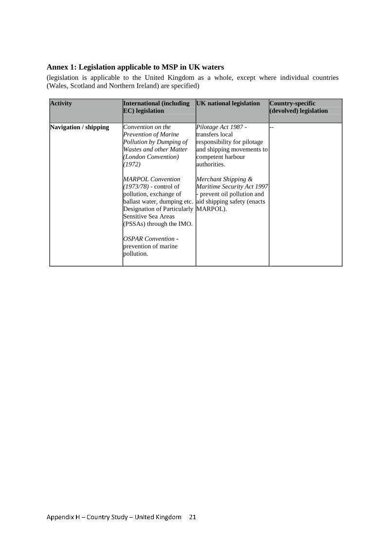
Appendix H – Country Study – United Kingdom 21
Annex 1: Legislation applicable to MSP in UK waters (legislation is applicable to the United Kingdom as a whole, except where individual countries (Wales, Scotland and Northern Ireland) are specified)
Activity International (including EC) legislation
UK national legislation Country-specific (devolved) legislation
Navigation / shipping Convention on the Prevention of Marine Pollution by Dumping of Wastes and other Matter (London Convention) (1972) MARPOL Convention (1973/78) - control of pollution, exchange of ballast water, dumping etc. Designation of Particularly Sensitive Sea Areas (PSSAs) through the IMO. OSPAR Convention - prevention of marine pollution.
Pilotage Act 1987 - transfers local responsibility for pilotage and shipping movements to competent harbour authorities. Merchant Shipping & Maritime Security Act 1997 - prevent oil pollution and aid shipping safety (enacts MARPOL).
--
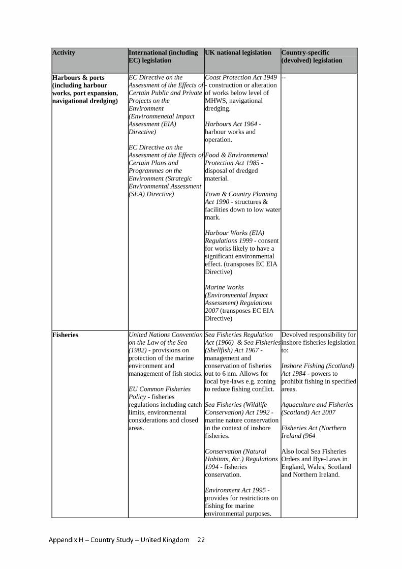
Appendix H – Country Study – United Kingdom 22
Activity International (including EC) legislation
UK national legislation Country-specific (devolved) legislation
Harbours & ports (including harbour works, port expansion, navigational dredging)
EC Directive on the Assessment of the Effects of Certain Public and Private Projects on the Environment (Environmenetal Impact Assessment (EIA) Directive) EC Directive on the Assessment of the Effects of Certain Plans and Programmes on the Environment (Strategic Environmental Assessment (SEA) Directive)
Coast Protection Act 1949 - construction or alteration of works below level of MHWS, navigational dredging. Harbours Act 1964 - harbour works and operation. Food & Environmental Protection Act 1985 - disposal of dredged material. Town & Country Planning Act 1990 - structures & facilities down to low water mark. Harbour Works (EIA) Regulations 1999 - consent for works likely to have a significant environmental effect. (transposes EC EIA Directive) Marine Works (Environmental Impact Assessment) Regulations 2007 (transposes EC EIA Directive)
--
Fisheries United Nations Convention on the Law of the Sea (1982) - provisions on protection of the marine environment and management of fish stocks. EU Common Fisheries Policy - fisheries regulations including catch limits, environmental considerations and closed areas.
Sea Fisheries Regulation Act (1966) & Sea Fisheries (Shellfish) Act 1967 - management and conservation of fisheries out to 6 nm. Allows for local bye-laws e.g. zoning to reduce fishing conflict. Sea Fisheries (Wildlife Conservation) Act 1992 - marine nature conservation in the context of inshore fisheries. Conservation (Natural Habitats, &c.) Regulations 1994 - fisheries conservation. Environment Act 1995 - provides for restrictions on fishing for marine environmental purposes.
Devolved responsibility for inshore fisheries legislation to: Inshore Fishing (Scotland) Act 1984 - powers to prohibit fishing in specified areas. Aquaculture and Fisheries (Scotland) Act 2007 Fisheries Act (Northern Ireland (964 Also local Sea Fisheries Orders and Bye-Laws in England, Wales, Scotland and Northern Ireland.
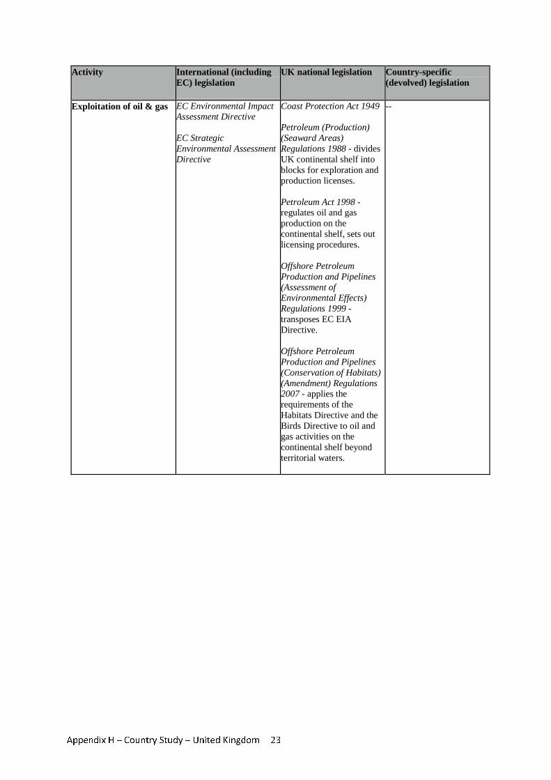
Appendix H – Country Study – United Kingdom 23
Activity International (including EC) legislation
UK national legislation Country-specific (devolved) legislation
Exploitation of oil & gas EC Environmental Impact Assessment Directive EC Strategic Environmental Assessment Directive
Coast Protection Act 1949 Petroleum (Production) (Seaward Areas) Regulations 1988 - divides UK continental shelf into blocks for exploration and production licenses. Petroleum Act 1998 - regulates oil and gas production on the continental shelf, sets out licensing procedures. Offshore Petroleum Production and Pipelines (Assessment of Environmental Effects) Regulations 1999 - transposes EC EIA Directive. Offshore Petroleum Production and Pipelines (Conservation of Habitats) (Amendment) Regulations 2007 - applies the requirements of the Habitats Directive and the Birds Directive to oil and gas activities on the continental shelf beyond territorial waters.
--
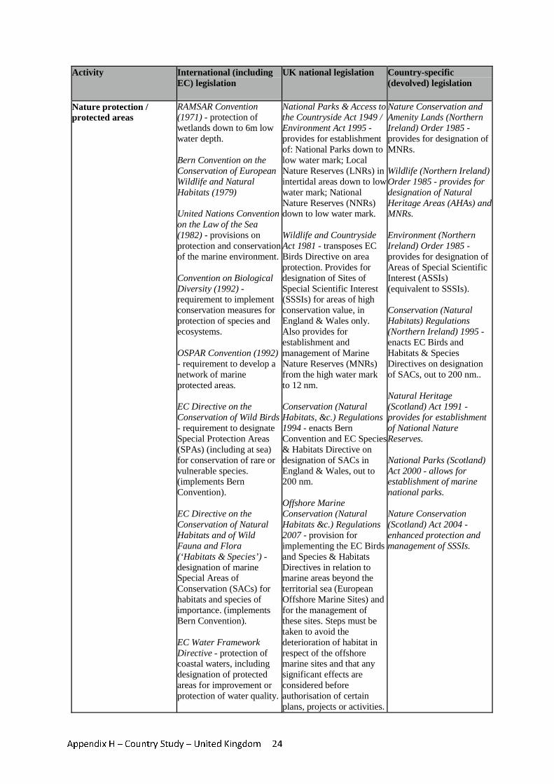
Appendix H – Country Study – United Kingdom 24
Activity International (including EC) legislation
UK national legislation Country-specific (devolved) legislation
Nature protection / protected areas
RAMSAR Convention (1971) - protection of wetlands down to 6m low water depth. Bern Convention on the Conservation of European Wildlife and Natural Habitats (1979) United Nations Convention on the Law of the Sea (1982) - provisions on protection and conservation of the marine environment. Convention on Biological Diversity (1992) - requirement to implement conservation measures for protection of species and ecosystems. OSPAR Convention (1992) - requirement to develop a network of marine protected areas. EC Directive on the Conservation of Wild Birds - requirement to designate Special Protection Areas (SPAs) (including at sea) for conservation of rare or vulnerable species. (implements Bern Convention). EC Directive on the Conservation of Natural Habitats and of Wild Fauna and Flora (‘Habitats & Species’) - designation of marine Special Areas of Conservation (SACs) for habitats and species of importance. (implements Bern Convention). EC Water Framework Directive - protection of coastal waters, including designation of protected areas for improvement or protection of water quality.
National Parks & Access to the Countryside Act 1949 / Environment Act 1995 - provides for establishment of: National Parks down to low water mark; Local Nature Reserves (LNRs) in intertidal areas down to low water mark; National Nature Reserves (NNRs) down to low water mark. Wildlife and Countryside Act 1981 - transposes EC Birds Directive on area protection. Provides for designation of Sites of Special Scientific Interest (SSSIs) for areas of high conservation value, in England & Wales only. Also provides for establishment and management of Marine Nature Reserves (MNRs) from the high water mark to 12 nm. Conservation (Natural Habitats, &c.) Regulations 1994 - enacts Bern Convention and EC Species & Habitats Directive on designation of SACs in England & Wales, out to 200 nm. Offshore Marine Conservation (Natural Habitats &c.) Regulations 2007 - provision for implementing the EC Birds and Species & Habitats Directives in relation to marine areas beyond the territorial sea (European Offshore Marine Sites) and for the management of these sites. Steps must be taken to avoid the deterioration of habitat in respect of the offshore marine sites and that any significant effects are considered before authorisation of certain plans, projects or activities.
Nature Conservation and Amenity Lands (Northern Ireland) Order 1985 - provides for designation of MNRs. Wildlife (Northern Ireland) Order 1985 - provides for designation of Natural Heritage Areas (AHAs) and MNRs. Environment (Northern Ireland) Order 1985 - provides for designation of Areas of Special Scientific Interest (ASSIs) (equivalent to SSSIs). Conservation (Natural Habitats) Regulations (Northern Ireland) 1995 - enacts EC Birds and Habitats & Species Directives on designation of SACs, out to 200 nm.. Natural Heritage (Scotland) Act 1991 - provides for establishment of National Nature Reserves. National Parks (Scotland) Act 2000 - allows for establishment of marine national parks. Nature Conservation (Scotland) Act 2004 - enhanced protection and management of SSSIs.

Appendix H – Country Study – United Kingdom 25
Activity International (including EC) legislation
UK national legislation Country-specific (devolved) legislation
Laying of pipelines & cables
EC Environmenetal Impact Assessment Directive EC Strategic Environmental Assessment SEA Directive
Coast Protection Act 1949 construction or alteration of works below level of MHWS. Crown Estate Act 1961 - the Crown owns around half of the intertidal area, and all of the seabed out to 12nm. Pipelines Act 1962 - requires authorisation for construction of pipelines down to the low water mark, and in partially enclosed areas such as bays and habours. Telecommunications Act 1984 - requires authorisation for construction of offshore cables below MHWS. Food and Environmental Protection Act 1985 - requires authorisation for construction of non- oil and gas pipelines at sea. Town & Country Planning Act 1990 - structures & facilities down to low water mark. Transport & Works Act 1992 Petroleum Act 1998 - requires authorisation for construction of pipelines in the territorial sea and continental shelf. Offshore Petroleum Production and Pipelines (Assessment of Environmental Effects) Regulations 1999 - transposes EC regulations on EIA for offshore oil and gas projects. Marine Works (Environmental Impact Assessment) Regulations 2007 (transposes EC EIA Directive)
--
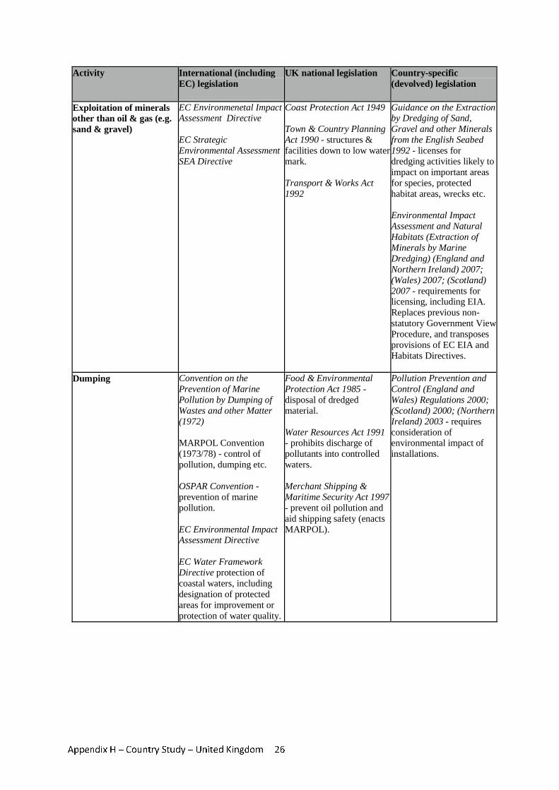
Appendix H – Country Study – United Kingdom 26
Activity International (including EC) legislation
UK national legislation Country-specific (devolved) legislation
Exploitation of minerals other than oil & gas (e.g. sand & gravel)
EC Environmenetal Impact Assessment Directive EC Strategic Environmental Assessment SEA Directive
Coast Protection Act 1949 Town & Country Planning Act 1990 - structures & facilities down to low water mark. Transport & Works Act 1992
Guidance on the Extraction by Dredging of Sand, Gravel and other Minerals from the English Seabed 1992 - licenses for dredging activities likely to impact on important areas for species, protected habitat areas, wrecks etc. Environmental Impact Assessment and Natural Habitats (Extraction of Minerals by Marine Dredging) (England and Northern Ireland) 2007; (Wales) 2007; (Scotland) 2007 - requirements for licensing, including EIA. Replaces previous non-statutory Government View Procedure, and transposes provisions of EC EIA and Habitats Directives.
Dumping Convention on the Prevention of Marine Pollution by Dumping of Wastes and other Matter (1972) MARPOL Convention (1973/78) - control of pollution, dumping etc. OSPAR Convention - prevention of marine pollution. EC Environmental Impact Assessment Directive EC Water Framework Directive protection of coastal waters, including designation of protected areas for improvement or protection of water quality.
Food & Environmental Protection Act 1985 - disposal of dredged material. Water Resources Act 1991 - prohibits discharge of pollutants into controlled waters. Merchant Shipping & Maritime Security Act 1997 - prevent oil pollution and aid shipping safety (enacts MARPOL).
Pollution Prevention and Control (England and Wales) Regulations 2000; (Scotland) 2000; (Northern Ireland) 2003 - requires consideration of environmental impact of installations.
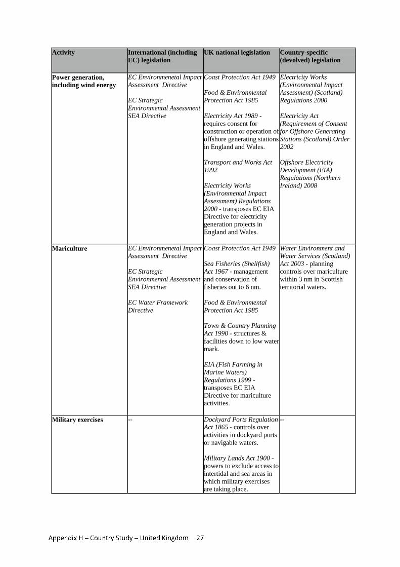
Appendix H – Country Study – United Kingdom 27
Activity International (including EC) legislation
UK national legislation Country-specific (devolved) legislation
Power generation, including wind energy
EC Environmenetal Impact Assessment Directive EC Strategic Environmental Assessment SEA Directive
Coast Protection Act 1949 Food & Environmental Protection Act 1985 Electricity Act 1989 - requires consent for construction or operation of offshore generating stations in England and Wales. Transport and Works Act 1992 Electricity Works (Environmental Impact Assessment) Regulations 2000 - transposes EC EIA Directive for electricity generation projects in England and Wales.
Electricity Works (Environmental Impact Assessment) (Scotland) Regulations 2000 Electricity Act (Requirement of Consent for Offshore Generating Stations (Scotland) Order 2002 Offshore Electricity Development (EIA) Regulations (Northern Ireland) 2008
Mariculture EC Environmenetal Impact Assessment Directive EC Strategic Environmental Assessment SEA Directive EC Water Framework Directive
Coast Protection Act 1949 Sea Fisheries (Shellfish) Act 1967 - management and conservation of fisheries out to 6 nm. Food & Environmental Protection Act 1985 Town & Country Planning Act 1990 - structures & facilities down to low water mark. EIA (Fish Farming in Marine Waters) Regulations 1999 - transposes EC EIA Directive for mariculture activities.
Water Environment and Water Services (Scotland) Act 2003 - planning controls over mariculture within 3 nm in Scottish territorial waters.
Military exercises -- Dockyard Ports Regulation Act 1865 - controls over activities in dockyard ports or navigable waters. Military Lands Act 1900 - powers to exclude access to intertidal and sea areas in which military exercises are taking place.
--
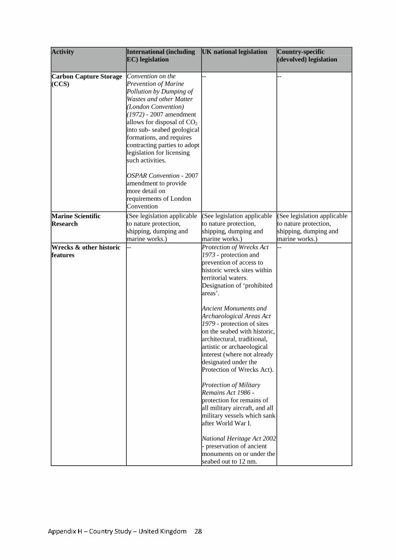
Appendix H – Country Study – United Kingdom 28
Activity International (including EC) legislation
UK national legislation Country-specific (devolved) legislation
Carbon Capture Storage (CCS)
Convention on the Prevention of Marine Pollution by Dumping of Wastes and other Matter (London Convention) (1972) - 2007 amendment allows for disposal of CO2 into sub- seabed geological formations, and requires contracting parties to adopt legislation for licensing such activities. OSPAR Convention - 2007 amendment to provide more detail on requirements of London Convention
-- --
Marine Scientific Research
(See legislation applicable to nature protection, shipping, dumping and marine works.)
(See legislation applicable to nature protection, shipping, dumping and marine works.)
(See legislation applicable to nature protection, shipping, dumping and marine works.)
Wrecks & other historic features
-- Protection of Wrecks Act 1973 - protection and prevention of access to historic wreck sites within territorial waters. Designation of ‘prohibited areas’. Ancient Monuments and Archaeological Areas Act 1979 - protection of sites on the seabed with historic, architectural, traditional, artistic or archaeological interest (where not already designated under the Protection of Wrecks Act). Protection of Military Remains Act 1986 - protection for remains of all military aircraft, and all military vessels which sank after World War I. National Heritage Act 2002 - preservation of ancient monuments on or under the seabed out to 12 nm.
--
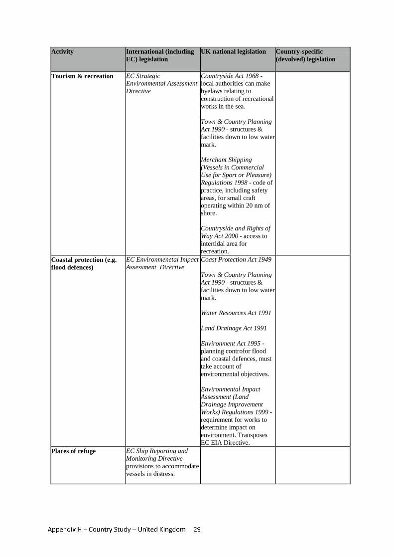
Appendix H – Country Study – United Kingdom 29
Activity International (including EC) legislation
UK national legislation Country-specific (devolved) legislation
Tourism & recreation EC Strategic Environmental Assessment Directive
Countryside Act 1968 - local authorities can make byelaws relating to construction of recreational works in the sea. Town & Country Planning Act 1990 - structures & facilities down to low water mark. Merchant Shipping (Vessels in Commercial Use for Sport or Pleasure) Regulations 1998 - code of practice, including safety areas, for small craft operating within 20 nm of shore. Countryside and Rights of Way Act 2000 - access to intertidal area for recreation.
Coastal protection (e.g. flood defences)
EC Environmenetal Impact Assessment Directive
Coast Protection Act 1949 Town & Country Planning Act 1990 - structures & facilities down to low water mark. Water Resources Act 1991 Land Drainage Act 1991 Environment Act 1995 - planning controfor flood and coastal defences, must take account of environmental objectives. Environmental Impact Assessment (Land Drainage Improvement Works) Regulations 1999 - requirement for works to determine impact on environment. Transposes EC EIA Directive.
Places of refuge EC Ship Reporting and Monitoring Directive - provisions to accommodate vessels in distress.
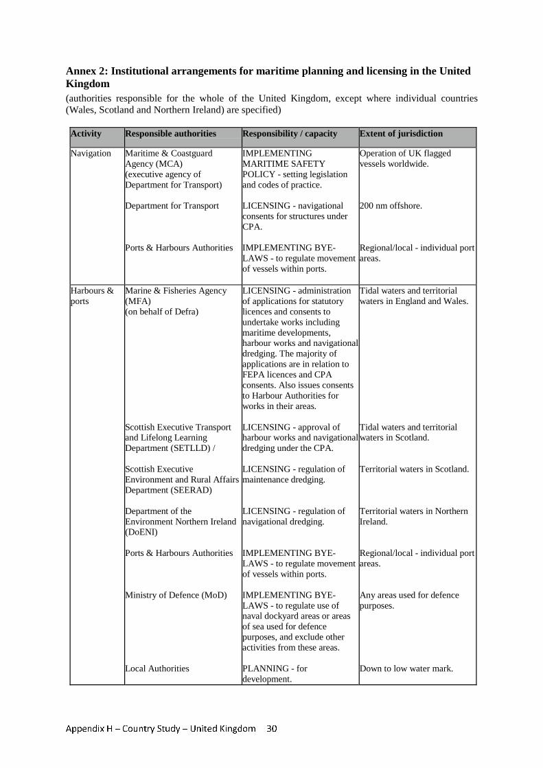
Appendix H – Country Study – United Kingdom 30
Annex 2: Institutional arrangements for maritime planning and licensing in the United Kingdom (authorities responsible for the whole of the United Kingdom, except where individual countries (Wales, Scotland and Northern Ireland) are specified)
Activity Responsible authorities Responsibility / capacity Extent of jurisdiction
Navigation Maritime & Coastguard Agency (MCA) (executive agency of Department for Transport) Department for Transport Ports & Harbours Authorities
IMPLEMENTING MARITIME SAFETY POLICY - setting legislation and codes of practice. LICENSING - navigational consents for structures under CPA. IMPLEMENTING BYE-LAWS - to regulate movement of vessels within ports.
Operation of UK flagged vessels worldwide. 200 nm offshore. Regional/local - individual port areas.
Harbours & ports
Marine & Fisheries Agency (MFA) (on behalf of Defra) Scottish Executive Transport and Lifelong Learning Department (SETLLD) / Scottish Executive Environment and Rural Affairs Department (SEERAD) Department of the Environment Northern Ireland (DoENI) Ports & Harbours Authorities Ministry of Defence (MoD) Local Authorities
LICENSING - administration of applications for statutory licences and consents to undertake works including maritime developments, harbour works and navigational dredging. The majority of applications are in relation to FEPA licences and CPA consents. Also issues consents to Harbour Authorities for works in their areas. LICENSING - approval of harbour works and navigational dredging under the CPA. LICENSING - regulation of maintenance dredging. LICENSING - regulation of navigational dredging. IMPLEMENTING BYE-LAWS - to regulate movement of vessels within ports. IMPLEMENTING BYE-LAWS - to regulate use of naval dockyard areas or areas of sea used for defence purposes, and exclude other activities from these areas. PLANNING - for development.
Tidal waters and territorial waters in England and Wales. Tidal waters and territorial waters in Scotland. Territorial waters in Scotland. Territorial waters in Northern Ireland. Regional/local - individual port areas. Any areas used for defence purposes. Down to low water mark.
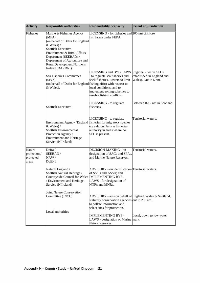
Appendix H – Country Study – United Kingdom 31
Activity Responsible authorities Responsibility / capacity Extent of jurisdiction
Fisheries Marine & Fisheries Agency (MFA) (on behalf of Defra for England & Wales) / Scottish Executive Environment & Rural Affairs Department (SEERAD) / Department of Agriculture and Rural Development Northern Ireland (DARDNI) Sea Fisheries Committees (SFCs) (on behalf of Defra for England & Wales). Scottish Executive Environment Agency (England & Wales) / Scottish Environmental Protection Agency / Environment and Heritage Service (N Ireland)
LICENSING - for fisheries and fish farms under FEPA. LICENSING and BYE-LAWS - to regulate sea fisheries and shell fisheries. Powers to limit fishing effort with respect to local conditions, and to implement zoning schemes to resolve fishing conflicts. LICENSING - to regulate fisheries. LICENSING - to regulate fisheries for migratory species e.g salmon. Acts as fisheries authority in areas where no SFC is present.
200 nm offshore Regional (twelve SFCs established in England and Wales). Out to 6 nm. Between 0-12 nm in Scotland. Territorial waters.
Nature protection / protected areas
Defra / SEERAD / NAW / DoENI Natural England / Scottish Natural Heritage / Countryside Council for Wales / Environment and Heritage Service (N Ireland) Joint Nature Conservation Committee (JNCC) Local authorities
DECISION-MAKING - on designation of SACs and SPAs, and Marine Nature Reserves. ADVISORY - on identification of SSSIs and ASSIs; and IMPLEMENTING BYE-LAWS - for designation of NNRs and MNRs. ADVISORY - acts on behalf of statutory conservation agencies to collate information and select sites for protection. IMPLEMENTING BYE-LAWS - designation of Marine Nature Reserves.
Territorial waters. Territorial waters. England, Wales & Scotland, out to 200 nm. Local, down to low water mark.
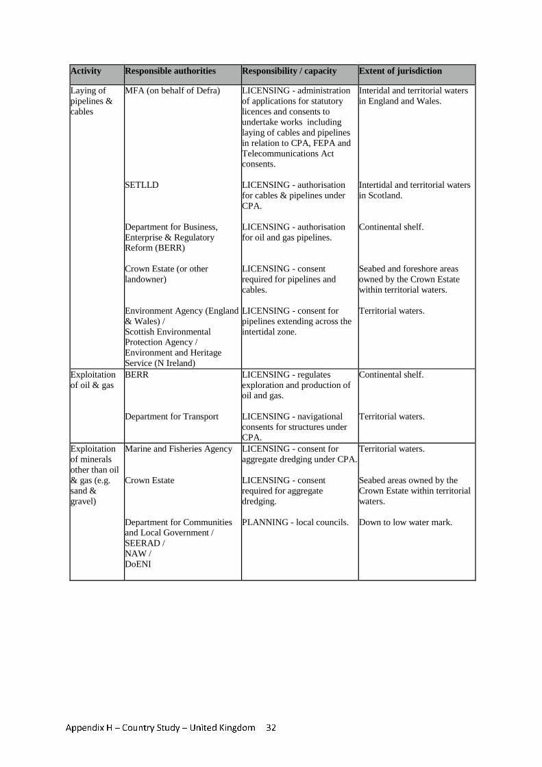
Appendix H – Country Study – United Kingdom 32
Activity Responsible authorities Responsibility / capacity Extent of jurisdiction
Laying of pipelines & cables
MFA (on behalf of Defra) SETLLD Department for Business, Enterprise & Regulatory Reform (BERR) Crown Estate (or other landowner) Environment Agency (England & Wales) / Scottish Environmental Protection Agency / Environment and Heritage Service (N Ireland)
LICENSING - administration of applications for statutory licences and consents to undertake works including laying of cables and pipelines in relation to CPA, FEPA and Telecommunications Act consents. LICENSING - authorisation for cables & pipelines under CPA. LICENSING - authorisation for oil and gas pipelines. LICENSING - consent required for pipelines and cables. LICENSING - consent for pipelines extending across the intertidal zone.
Interidal and territorial waters in England and Wales. Intertidal and territorial waters in Scotland. Continental shelf. Seabed and foreshore areas owned by the Crown Estate within territorial waters. Territorial waters.
Exploitation of oil & gas
BERR Department for Transport
LICENSING - regulates exploration and production of oil and gas. LICENSING - navigational consents for structures under CPA.
Continental shelf. Territorial waters.
Exploitation of minerals other than oil & gas (e.g. sand & gravel)
Marine and Fisheries Agency Crown Estate Department for Communities and Local Government / SEERAD / NAW / DoENI
LICENSING - consent for aggregate dredging under CPA. LICENSING - consent required for aggregate dredging. PLANNING - local councils.
Territorial waters. Seabed areas owned by the Crown Estate within territorial waters. Down to low water mark.
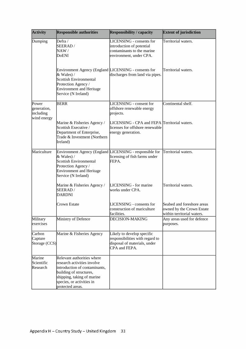
Appendix H – Country Study – United Kingdom 33
Activity Responsible authorities Responsibility / capacity Extent of jurisdiction
Dumping Defra / SEERAD / NAW / DoENI Environment Agency (England & Wales) / Scottish Environmental Protection Agency / Environment and Heritage Service (N Ireland)
LICENSING - consents for introduction of potential contaminants to the marine environment, under CPA. LICENSING - consents for discharges from land via pipes.
Territorial waters. Territorial waters.
Power generation, including wind energy
BERR Marine & Fisheries Agency / Scottish Executive / Department of Enterprise, Trade & Investment (Northern Ireland)
LICENSING - consent for offshore renewable energy projects. LICENSING - CPA and FEPA licenses for offshore renewable energy generation.
Continental shelf. Territorial waters.
Mariculture Environment Agency (England & Wales) / Scottish Environmental Protection Agency / Environment and Heritage Service (N Ireland) Marine & Fisheries Agency / SEERAD / DARDNI Crown Estate
LICENSING - responsible for licensing of fish farms under FEPA. LICENSING - for marine works under CPA. LlCENSING - consents for construction of mariculture facilities.
Territorial waters. Territorial waters. Seabed and foreshore areas owned by the Crown Estate within territorial waters.
Military exercises
Ministry of Defence
DECISION-MAKING
Any areas used for defence purposes.
Carbon Capture Storage (CCS)
Marine & Fisheries Agency
Likely to develop specific responsibilities with regard to disposal of materials, under CPA and FEPA.
Marine Scientific Research
Relevant authorities where research activities involve introduction of contaminants, building of structures, shipping, taking of marine species, or activities in protected areas.
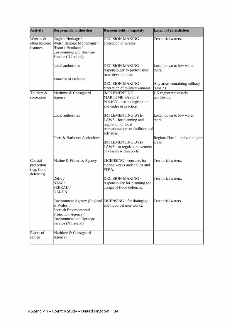
Appendix H – Country Study – United Kingdom 34
Activity Responsible authorities Responsibility / capacity Extent of jurisdiction
Wrecks & other historic features
English Heritage / Welsh Historic Monuments / Historic Scotland / Environment and Heritage Service (N Ireland) Local authorities Ministry of Defence
DECISION-MAKING - protection of wrecks. DECISION-MAKING - responsibility to protect sites from development. DECISION-MAKING - protection of military remains.
Territorial waters. Local, down to low water mark. Any areas containing military remains.
Tourism & recreation
Maritime & Coastguard Agency Local authorities Ports & Harbours Authorities
IMPLEMENTING MARITIME SAFETY POLICY - setting legislation and codes of practice. IMPLEMENTING BYE-LAWS - for planning and regulation of local recreation/tourism facilities and activities. IMPLEMENTING BYE-LAWS - to regulate movement of vessels within ports.
UK registered vessels worldwide. Local, down to low water mark. Regional/local - individual port areas.
Coastal protection (e.g. flood defences)
Marine & Fisheries Agency Defra / NAW / SEERAD / DARDNI Environment Agency (England & Wales) / Scottish Environmental Protection Agency / Environment and Heritage Service (N Ireland)
LICENSING - consents for marine works under CPA and FEPA. DECISION-MAKING - responsibility for planning and design of flood defences. LICENSING - for draingage and flood defence works.
Territorial waters. Territorial waters. Territorial waters.
Places of refuge
Maritime & Coastguard Agency?
Related Documents