" " ) ! ( ! ( ! ( ! ( ! ( ! ( ! ( ! ( ! ( ! ( ! ( ! ( ! ( ! ( ! ( ! ( ! ( DJIBOUTI ERITREA ILEMI TRIANGLE KENYA SOMALIA SOUTH SUDAN SUDAN UGANDA YEMEN AFAR AMHARA BENISHANGUL GUMUZ GAMBELLA OROMIA SNNP SOMALI TIGRAY Adama Ārba Minch Ambo Dessie Nekemte Sodo Shashamane Debre Birhan Dilla Axum Kembolcha Āddīgrat Buhoodle Assella Robe Robe Jimma Bahir Dar Jijiga Mek'elē Harar Dirē Dawa Gambela Asosa Semera Awassa Addis Ababa Roads : OSM Populated Places : OSM Admin Boundaries : ICRC ETHIOPIA - Base map SOURCES Document Name : ETH_BM_A3L Creation date : 15-Jan-16 Created by : MSF GIS Unit - [email protected] Print format : A3 Landscape 0 50 100 150 25 km 1:5,000,000 1 cm = 50 km PROPRIETES SCALE ± This map is for information purposes only and has no political significance. The boundaries and names shown and the designations used on this map do not imply official endorsement or acceptance by MSF. " " ) Capital Admin 1 capital ! ( City International boundary Administrative boundary 2005 peace accord bound. Coast line Trunk Admin 1 boundary Lake LEGEND

Welcome message from author
This document is posted to help you gain knowledge. Please leave a comment to let me know what you think about it! Share it to your friends and learn new things together.
Transcript

"")
!(
!(
!(
!(
!(
!(
!(
!(
!(
!(
!(
!(
!(
!(
!(
!(
!(
DJIBOUTI
ERITREA
ILEMITRIANGLE
KENYA
SOMALIA
SOUTHSUDAN
SUDAN
UGANDA
YEMEN
AFAR
AMHARA
BENISHANGULGUMUZ
GAMBELLA
OROMIA
SNNP
SOMALI
TIGRAY
Adama
ĀrbaMinch
Ambo
Dessie
Nekemte
Sodo
Shashamane
DebreBirhan
Dilla
Axum
Kembolcha
Āddīgrat
Buhoodle
AssellaRobe
Robe
Jimma
Bahir Dar
Jijiga
Mek'elē
Harar
Dirē Dawa
Gambela
Asosa
Semera
Awassa
Addis Ababa
Roads : OSMPopulated Places : OSMAdmin Boundaries : ICRC
ETHIOPIA - Base map
SOURCES
Document Name : ETH_BM_A3LCreation date : 15-Jan-16Created by : MSF GIS Unit - [email protected] format : A3 Landscape
0 50 100 15025 km
1:5,000,000 1 cm = 50 km
PROPRIETES
SCALE
±
This map is for information purposes only and has no political significance. The boundaries and names shown and the designations used on this map do not imply official endorsement or acceptance by MSF.
"") Capital
Admin 1 capital!( City
International boundary
Administrative boundary
2005 peace accord bound.
Coast line
Trunk
Admin 1 boundary
Lake
LEGEND

¾
¾
¾
¾
¾
¾
¾
¾
¾
¾
¾
¾
¾
¾
¾
¾
¾
¾
¾
¾¾¾¾
¾
¾
¾
¾
¾
¾
¾
¾
¾
¾
¾
¾
¾
¾
¾
¾
¾
¾
¾
¾
¾
¾
¾
¾
¾
¾
¾
¾
¾
¾
¾
¾
¾
¾
¾
¾
¾¾¾¾
¾
¾
¾
¾
¾
¾
¾
¾
¾
¾
¾
¾
¾
¾
¾
¾
¾
o
o
o
o
o
o
o
o
o
o
o
o
o
o
o
o
o
o
o
oooo
o
o
o
o
o
o
o
o
o
o
o
o
o
o
o
o
o
¾
¾
¾
¾
¾
¾
¾
¾ ¾
¾
¾
¾
¾
¾
¾
¾
¾
¾
¾
¾
¾¾
¾
¾
¾
¾
o
o
o
o
o
o
o
oo
o
o
o
o
DJIBOUTI
ERITREA
ILEMI
TRIANGLE
KENYA
SOMALIA
SOUTH
SUDAN
SUDAN
UGANDA
YEMEN
COMBOLCHAAIRPORT
BEICAAIRPORT
DEMBIDOLLOAIRPORT
GOREAIRPORT
MIZAN TEFERIAIRPORT
TIPPIAIRPORT
BACOAIRPORT
SHILAVOAIRPORT
KABRI DEHARAIRPORT
SHIRE INDASELASSIE AIRPORT
LIDETA ARMYAIRPORT
LALIBELLAAIRPORT
DEBRA MARCOSAIRPORT
DEBRE TABORAIRPORT
METEMAAIRPORT
MENDIAIRPORT
NEJJOAIRPORT
AWASSAAIRPORT
FINCHAAIRPORT
GHINNIRAIRPORT
ROBEAIRPORT
ADABAAIRPORT
DODOLAAIRPORT
MASSLOAIRPORT
SHEIK HUSSEINAIRPORT
NEKEMTEAIRPORT
SODDUAIRPORT
WACAAIRPORT
TUMEAIRPORT
GELADIAIRPORT
KELAFO EASTAIRPORT
HUMERAAIRPORT
SEMERAAIRPORT
MEKANE SELAMAIRPORT
NEGELEAIRPORT
MOYALEAIRPORT
MUI RIVERAIRPORT
KIBBISH WELLSAIRPORT
TUMAIRPORT
WARDERAIRPORT
ADDIS ABABABOLE INTERNATIONAL
AIRPORT
ABA TENNA DEJAZMACHYILMA INTERNATIONAL
AIRPORT
BAHIR DARAIRPORT
GONDERAIRPORT
ASOSAAIRPORT
GAMBELLAAIRPORT
JIMMAAIRPORT
ARBA MINCHAIRPORT GODE
AIRPORT
AXUMAIRPORT
MEKELEAIRPORT
HARAR MEDAAIRPORT
WILWALINTERNATIONAL
AIRPORT
Roads : OSMRailway : DCWAirports : OurairportsAdmin Boundaries : ICRC
ETHIOPIA - Transport infrastructures
SOURCES
Document Name : ETH_BM_transport_A3LCreation date : 15-Jan-16Created by : MSF GIS Unit - [email protected] format : A3 Landscape
0 50 100 15025 km
1:5,000,000 1 cm = 50 km
PROPRIETES
SCALE
±
This map is for information purposes only and has no political significance. The boundaries and names shown and the designations used on this map do not imply official endorsement or acceptance by MSF.
¾¾o Main airport
¾¾o Small airport
International boundary
Administrative boundary
2005 peace accord bound.
Coast line
Admin 1 boundary
Trunk
Primary road
Secondary road
Tertiary road
Other road / track
Railway
Lake
LEGEND
!G(
!G(
!G(!G(!G(!G(!G(!G(!G(!G(!G(!G(
!G(!G(!G(!G(!G(!G( !G(!G(!G(!G(!G(!G(!G(!G(!G(!G(!G(!G(!G(!G(!G(!G(
!G(
!G(
!G(
!G(
!G(
!G(
!G(
!G(
!G(
!G(
!G(
!G(
!G(
!G(
!G(
!G(
!G(
!G(
!G( !G(
!G( !G(
!G(
!G(
!G(
!G(
!G(
!G(
!G(
!G(
!G(
!G(
!G(
!G(!G(
!G(
!G(
!G(
!G( !G(
!G(
!G(
!G(
!G(!G(
!G(
!G(
!G(
!G(
!G(
!G(
!G(!G(
!G(
!G(
!G(
!G(
!G(
!G(
!G(
!G(
!G(
!G(
!G(
!G(
!G(
!G(!G(
!G( !G(
!G(
!G(
!G(
!G(
!G(
!G(
!G(
!G(
!G(
!G(
!G(
!G(
!G(
!G(!G(
!G(
!G(
!G(
!G(!G(
!G(
!G(
!G(
!G(
!G(
!G(
!G(!G(
!G(
!G(
!G(
!G(
!G(
!G(!G(!G(
!G(
!G(
!G(
!G(
!G(
!G(
!G(
!G(
!G(
!G(
!G(!G(
!G(
!G(
!G(
!G(
!G(
!G(
!G(
!G(
!G(
!G(
!G(
!G(
!G(
!G(
!G(!G(
!G(
!G(
!G(
!G(
!G(
!G(
!G(
!G(
!G(
!G(
!G(
!G(
!G(
!G(
!G(
!G(
!G(
!G(
!G(
!G(
!G(
!G( !G(
!G(
!G(
!G(
!G(
!G(
!G(
!G(
!G(
!G(
!G(
!G(
!G(
!G(
!G(
!G(!G(
!G(
!G(
!G(
!G(
!G(
!G(
!G(
!G(
!G(
!G(!G(
!G(
!G(
!G(
!G(
!G(
!G(
!G(!G(
!G(
!G(
!G(
!G(
!G(!G(
!G(
!G(!G(!G(!G(!G(
!G(
!G(
!G(
!G(
!G(!G(
!G(
!G(
!G(!G(
!G(!G(!G(!G(
!G(
!G(
!G(
!G( !G(
!G(
!G(
!G(
!G(
!G(
!G(
!G(
!G(
!G(
!G(
!G(
!G(
!G(
!G(
!G(
!G(
!G(
!G(
!G(
!G(!G(
!G(
!G(
!G(
!G(
!G(
!G(
!G(
!G(
!G(
!G(
!G(
!G(
!G(
!G(
!G(
!G(
!G(!G(
!G(
!G(
!G(!G(
!G(
!G(
!G(
!G(
!G(
!G(
!G(
!G(
!G(
!G(
!G(
!G(
!G(
!G(!G(
!G(
!G(
!G(
!G(
!G(
!G(
!G(
!G(
!G(!G(
!G(
!G(
!G(
!G(
!G(
!G(
!G(!G(
!G(
!G(
!G(
!G(
!G(
!G(
!G(
!G(
!G(
!G(
!G(
!G(
!G(
!G(
!G(
!G(
!G(!G(
!G(
!G(
!G(
!G(
!G(
!G(
!G(!G(
!G(
!G(
!G(
!G(
!G(
!G(
!G(
!G(
!G(!G(
!G(
!G(!G(
!G(
!G(
!G(
!G(
!G(
!G(
!G(
!G(
!G(
!G(!G(
!G(
!G(
!G(
!G(
!G(
!G(
!G(
!G(
!G(
!G(
!G(
!G(
!G(
!G(
!G(
!G(
!G(
!G(
!G(
!G(
!G(
!G(
!G(
!G(!G(
!G(
!G(
!G(
!G(
!G(
!G(
!G(
!G(!G(
!G(
!G(
!G(
!G(!G( !G(
!G(
!G( !G(
!G(
!G(!G(
!G(
!G(
!G(
!G(
!G(
!G(
!G(
!G(
!G(
!G(
!G(
!G(
!G(
!G(
!G(
!G(
!G(
!G(!G(
!G(
!G(
!G(
!G(
!G(
!G(
!G(
!G(
!G(
!G(
!G(
!G(
!G(
!G(
!G(
!G(
!G(
!G(
!G(
!G(
!G(
!G(
!G(
!G(!G(
!G(!G(
!G(
!G(
!G(
!G(
!G(
!G(
!G(
!G(
!G(
!G(
!G(
!G(
!G(
!G(
!G(
!G(
!G(!G(
!G(
!G(
!G(
!G(
!G(
!G(
!G(!G(
!G(
!G(
!G(
!G(
!G(
!G(!G(
!G(
!G(
!G(
!G(!G(
!G(
!G(
!G(
!G(
!G(
!G(
!G(
!G(
!G(
!G(
!G(
!G(
!G(
!G(
!G(
!G(
!G(
!G(
!G(
!G(
!G(
!G(
!G(
!G(
!G(
!G(
!G(
!G(
!G(
!G(
!G(
!G(
!G(
!G(
!G(
!G(
!G(!G(
!G(
!G(
!G(
!G(
!G(
!G(
!G(
!G(
!G(
!G(
!G(
!G(
!G(
!G(
!G(
!G(
!G(
!G(
!G(
!G(
!G(
!G(
!G(
!G(
!G(
!G(
!G(
!G(
!G(
!G(
!G(
!G(!G(
!G(
!G(
!G(
!G(
!G(!G(
!G(
!G(
!G(
!G(
!G(
!G(
!G(
!G(
!G(
!G(
!G(
!G(
!G(
!G(
!G(
!G(
!G(
!G(!G(
!G(
!G(
!G(
!G(
!G(
!G(
!G(!G(
!G(
!G(
!G(
!G(
!G(
!G(
!G(
!G(
!G(
!G(
!G(
!G(
!G(
!G(
!G(
!G(
!G(
!G(
!G(
!G(
!G(
!G(
!G(
!G(
!G(
!G(
!G(
!G(
!G(
!G(
!G(
!G(
!G(
!G(
!G(
!G(
!G(
!G(
!G(
!G(
!G(
!G(
!G(
!G(
!G(
!G(
!G(
!G(
!G(
!G(
!G(
!G(
!G(
!G(!G(
!G(
!G(
!G(
!G(
!G(
!G(
!G(!G(!G(!G(!G(!G(!G(!G(!G(!G(!G(!G(!G(!G(!G(!G(!G(!G(!G(!G(!G(!G(!G(!G(!G(!G(!G(!G(!G(!G(!G(!G(!G(!G(!G(!G(!G(!G(!G(!G(!G(!G(!G(!G(!G(!G(!G(!G(!G(!G(!G(!G(!G(!G(!G(!G(!G(!G(!G(
!G(!G(!G(!G(!G(!G(!G(!G(!G(!G(!G(!G(!G(!G(!G(!G(!G(!G(!G(!G(
!G(
!G(!G(!G(!G(!G(!G(!G(!G(!G(!G(!G(!G(!G(!G(!G(!G(!G(!G(!G(!G("H)"H)"H)"H)"H)"H)"H)"H)"H)"H)"H)"H)"H)"H)"H)"H)"H)"H)"H)"H)"H)"H)"H)"H)"H)"H)"H)"H)"H)
"H)
"H)
"H)
"H)"H)
"H)
"H)
"H)
"H)
"H)
"H)
"H)
"H)
"H)
"H)
"H)
"H)
"H)
"H)
"H)
"H)
"H)
"H)"H)"H)
"H)
"H)"H)"H)"H)"H)
"H)
"H)"H)
"H)
"H)
"H)
"H)
"H)
"H)
"H)
"H)
"H)
"H)
"H)
"H)
"H)"H)
"H)
"H)
"H)
"H)
"H)
"H)
"H)
"H)
"H)
"H)
"H)
"H)
"H)
"H)
"H)
"H)"H)
"H)"H)
"H)
"H)
"H)
"H)
"H)
"H)
"H)
"H)
"H)
"H)
"H)
"H)
"H)
"H)
"H)
"H)
"H)"H)
"H)
"H)
"H)
"H)"H)"H)
"H) "H)"H)
"H)
"H)
"")
DJIBOUTI
ERITREA
ILEMI
TRIANGLE
KENYA
SOMALIA
SOUTH
SUDAN
SUDAN
UGANDA
YEMEN
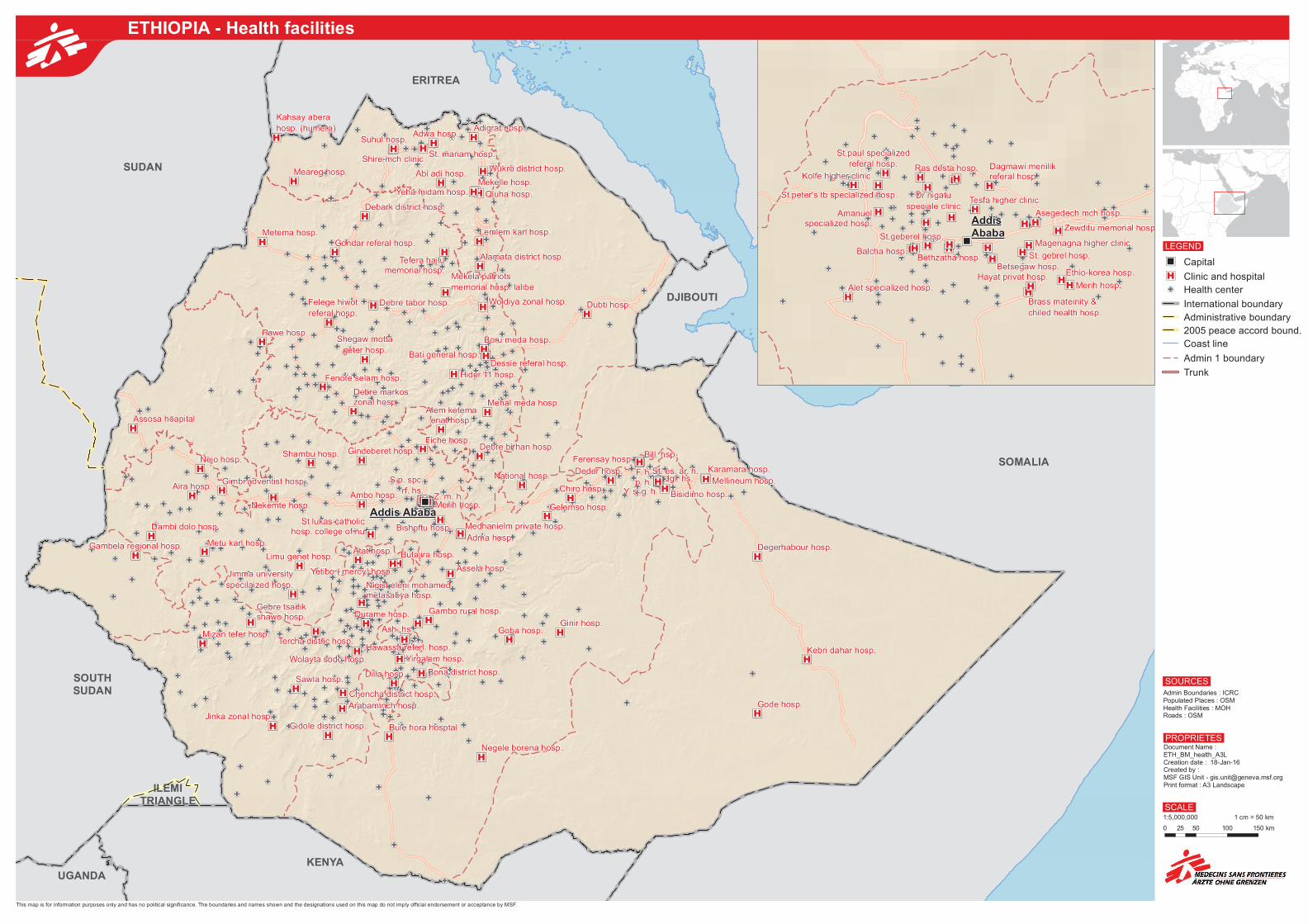
Merih hosp.
S.p. spc.
rf. hs.Z. m. h.
Dubti hosp.
National hosp.
Alem ketemaenat hosp.
Bati general hosp.
Boru meda hosp.
Debark district hosp.
Debre birhan hosp.
Debre markoszonal hosp.
Debre tabor hosp.
Dessie referal hosp.
Felege hiwot
referal hosp.
Fenote selam hosp.
Gondar referal hosp.
Hider 11 hosp.
Mehal meda hosp.
Mekela patriots
memorial hosp. lalibe
Metema hosp.
Shegaw motta
geter hosp.
Tefera hailumemorial hosp.
Woldiya zonal hosp.
Assosa hoapital
Pawe hosp.
Bill. hsp.Ferensay hosp.
Gambela regional hosp.
F. h.p. h. Jgl. hs.
St. es. ar. h.
Y. s. g. h.
Adma hosp.
Aira hosp.Ambo hosp.
Assela hosp.
Bishoftu hosp.
Bisidimo hosp.
Bule hora hosptal
Chiro hosp.
Dambi dolo hosp.
Deder hosp.
Fiche hosp.
Gambo rural hosp.
Gelemso hosp.
Gimbi adventist hosp.
Gindeberet hosp.
Ginir hosp.Goba hosp.
Jimma university
specilaized hosp.
Limu genet hosp.
Medhanielm private hosp.
Metu karl hosp.
Negele borena hosp.
Nejo hosp.
Nekemte hosp.
Shambu hosp.
St lukas catholichosp. college of nu
Arabaminch hosp.
Ash. hs.
Atat hosp.
Bona district hosp.
Butajira hosp.
Chencha district hosp.
Dilla hosp.
Durame hosp.Gebre tsadikshawo hosp.
Gidole district hosp.
Hawassa referl. hosp.
Jinka zonal hosp.
Mizan tefer hosp.
Nigist eleni mohamedmetasabya hosp.
Sawla hosp.
Tercha distric hosp.
Wolayta sodo hosp.
Yetibo ( mercy) hosp.
Yirgalem hosp.
Degerhabour hosp.
Gode hosp.
Karamara hosp.
Kebri dahar hosp.
Mellineum hosp.
Abi adi hosp.
Adigrat hosp.Adwa hosp.
Alamata district hosp.
Kahsay abera
hosp. (humera)
Lemlem karl hosp.
Meareg hosp.
Mekelle hosp.
Qiuha hosp.
Shire mch clinicSt. mariam hosp.
Suhul hosp.
Wukro district hosp.
Yeha midam hosp.
Addis Ababa
Admin Boundaries : ICRCPopulated Places : OSMHealth Facilities : MOHRoads : OSM
SOURCES
Document Name : ETH_BM_health_A3LCreation date : 18-Jan-16Created by : MSF GIS Unit - [email protected] format : A3 Landscape
0 50 100 15025 km
1:5,000,000 1 cm = 50 km
PROPRIETES
SCALE
±
This map is for information purposes only and has no political significance. The boundaries and names shown and the designations used on this map do not imply official endorsement or acceptance by MSF.
"") Capital
"H) Clinic and hospital
!G( Health center
International boundary
Administrative boundary
2005 peace accord bound.
Coast line
Admin 1 boundary
Trunk
LEGEND
!G( !G(
!G(
!G(
!G(
!G(
!G(
!G(
!G(
!G(
!G(
!G(
!G(!G(
!G(
!G(
!G(
!G(!G(
!G(
!G(
!G(
!G(
!G(
!G(
!G( !G(
!G(
!G(
!G(
!G(
!G(
!G(
!G(
!G(
!G(
!G(
!G(
!G(
!G(!G(
!G(!G(
!G( !G(!G(
!G(
!G(
!G(
!G(
!G(
!G(!G(!G(
!G(
!G(
!G(
!(
!G(
!G(!G(
!G(
!G(
!G(!G(
!G(
!G(!G(
!G(!G(
!G(
!G( !G(
!G(
!G(
!G(
!G(
!G(
!G(
!G(!G(
!G(
!G(
!G(
!G(
!G(
!G(!G(
!G(
!G(
!G(
!G(
!G(!G(
!G(
!G(
!G(
!G(
!G( !G(
!G(
!G(
!G(
!G(
!G( !G(
!G(
!G(
!G(
!G(
!G(
!G(
!G(
!G(
!G(
!G(
!G(
!G(
!G(
"H)
"H)
"H)"H)
"H) "H)"H)
"H)
"H)
"H)
"H)
"H)
"H)
"H)
"H)
"H)
"H)
"H)
"H)
"H)
"H)
"H)
"H)"H)
"H)
"H)
"H)
"H)
"H)"")
Alet specialized hosp.
Amanuelspecialized hosp.
Asegedech mch hosp.
Balcha hosp.Bethzatha hosp.
Betsegaw hosp.
Brass mateinity &
chiled health hosp.
Dagmawi menilikreferal hosp.
Dr nigatu
speciale clinic
Ethio-korea hosp.Hayat privat hosp.
Kolfe higher clinic
Magenagna higher clinic
Merih hosp.
Ras desta hosp.
St. gebrel hosp.
St.geberel hosp.
St.paul specialized
referal hosp.
St.peter's tb specialized hosp.Tesfa higher clinic
Zewditu memorial hosp.Addis
Ababa
ETHIOPIA - Health facilities

((
(
(
(
(
(
(
( (
(
DJIBOUTI
ERITREA
ILEMITRIANGLE
KENYA
SOMALIA
SOUTHSUDAN
SUDAN
UGANDA
YEMEN
Addis Ababa4567857
Gondar232782
Bahir Dar200452
Debre Zeit 157185
Jijiga
117321
Mek'elē202109
Shashamane111822
Harar142125
Dirē Dawa446025
Awassa156366
Jimma190607
Admin Boundaries : ICRCPopulation : CSA, populationdata.net
SOURCES
Document Name : ETH_BM_pop_A3LCreation date : 15-Jan-16Created by : MSF GIS Unit - [email protected] format : A3 Landscape
0 50 100 15025 km
1:5,000,000 1 cm = 50 km
PROPRIETES
SCALE
±
This map is for information purposes only and has no political significance. The boundaries and names shown and the designations used on this map do not imply official endorsement or acceptance by MSF.
International boundary
Administrative boundary
2005 peace accord bound.
Coast line
Lake
Population( 10,000
( 100,000
( 1,000,000
Pop. density (hab/km²)
0.1 - 100.0
100.1 - 250.0
250.1 - 500.0
500.01 - 1000.0
1000.1 - 40677.6
LEGEND
ETHIOPIA - Population distribution (2007) and main cities (2015)
# #
#
#
#
#
#
"")
DJIBOUTI
ERITREA
ILEMITRIANGLE
KENYA
SOMALIA
SOUTHSUDAN
SUDAN
UGANDA
YEMEN
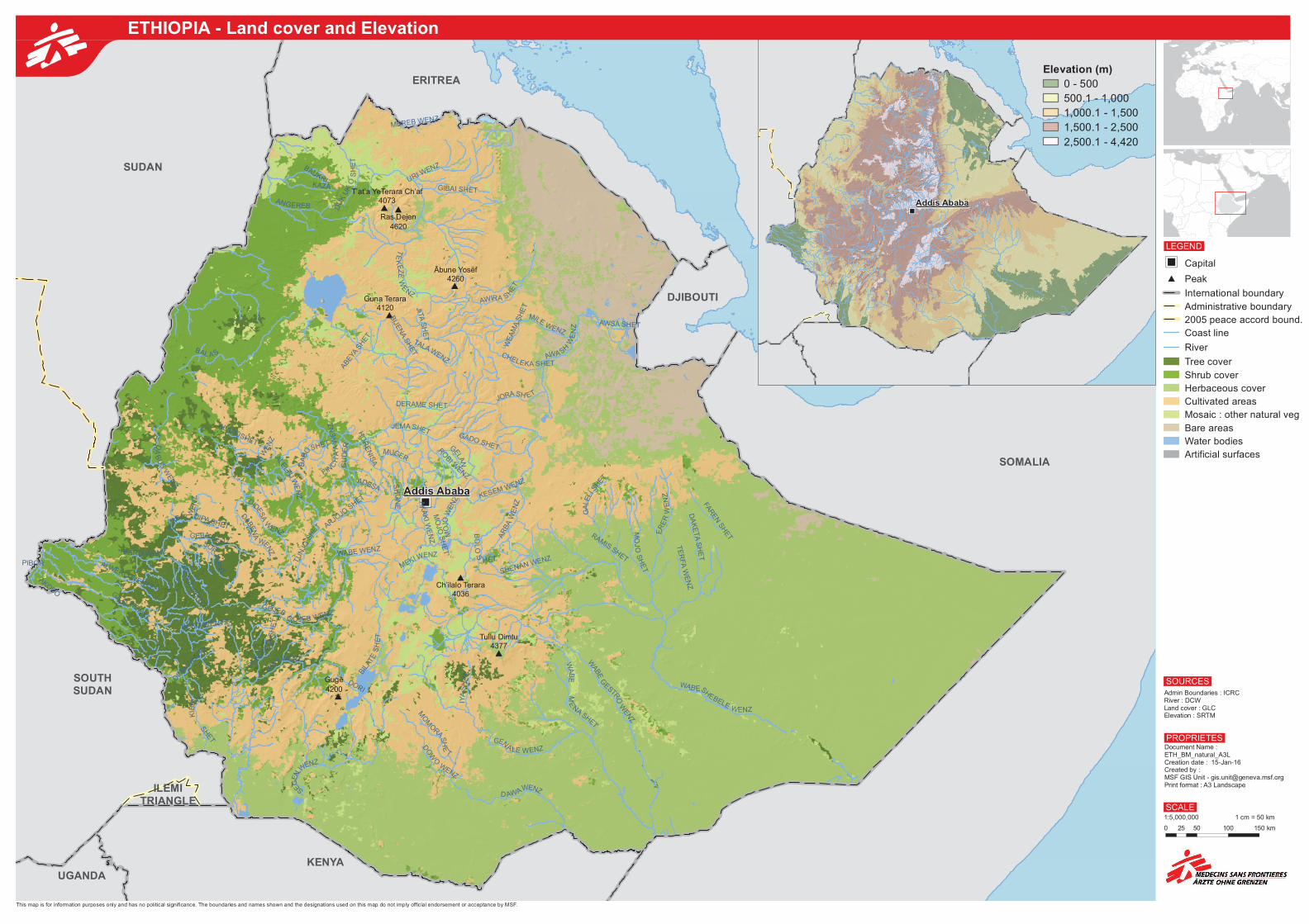
MEREB WENZ
BARO WENZ
WABESH
EBELE WENZ
BILA
TE
SH
ET
KESEM WENZFIN
CH
'A'A
WE
NZ JEMA SHET
JITAS
HE
T
BAL A S
SHET
PIBOR
WABE
G
ESTROW
EN
Z
AWA SH
WE
NZ
AKOBO
DA
BU
SW
EN
Z
BEKO WENTZ
TE
KEZE
WE
NZ
OMOWENZ
GEBAW
E NZ
MUGER
D AWAWENZ
DENDNIJ
AS
HE
T
URI WENZ
ANGEREB
ABEY
A SH
ET
DO
W
OW
ENZ
DU
KU
KO
SH
ET
SO
R WE
N
Z
GILO WEN
TZ
ALWERO WENTZ
WAJA
WE
NZ
AR
BA
WE
NZ
BIR
BIR WE
NZ
MO
JO S
HE
T'
GU
DE
R
GOJEB WENZ
MILEWENZ
DERAME SHET
KAZA
AK
AK
I WE
NZ
GEN
ALE WENZ
GIBAI SHET
MO
JOW
EN
Z FAR
EN
SH
ET
AWSA SHET
WE
AM
A S
HE
T
RAMIS SHET
CHELEKA SHET
ROBI W
ENZ
DORI
MEKI WENZ
SEGEN
WENZ
DIPA SHET
ME
NASHET
DABEN
A
WENZ
WABE WENZ
SHENAN WENZ
ARJOJO
SHET
SH
ON
E
WAB
E
ADESA
BAUKRI
GADO SHET
HO
RE
NIS
A
MO
JO
SH
ET
DIDESA
W
ENZ
ALADUSHET
MO
M
ORA S
HE
T
BO
LO
S
HET
DIMA
W
ENTZ
BA
BO
SHET
TE
RFA
WE
NZ
GOJEB
BIJE
NA S
HE
T
TU
NJO
SHET
GELAN
ALELTU
WE
NZ
TALA WENZ
KIB
IS
H
GE
NJI
WEN
TZ
JORASH ET
DA
KE
TA
SH
ET
GA
LELI
SHET
ER
ER
WE
NZ
AWIRA S HE
T
IYA
SH
ET
T’at’a YeTerara Ch’af4073
Ras Dejen4620
Guna Terara4120
Gugē4200
Ch’ilalo Terara4036
Ābune Yosēf4260
Tullu Dimtu4377
Addis Ababa
Admin Boundaries : ICRCRiver : DCWLand cover : GLCElevation : SRTM
SOURCES
Document Name : ETH_BM_natural_A3LCreation date : 15-Jan-16Created by : MSF GIS Unit - [email protected] format : A3 Landscape
0 50 100 15025 km
1:5,000,000 1 cm = 50 km
PROPRIETES
SCALE
±
This map is for information purposes only and has no political significance. The boundaries and names shown and the designations used on this map do not imply official endorsement or acceptance by MSF.
"") Capital
# Peak
International boundary
Administrative boundary
2005 peace accord bound.
Coast line
River
Tree cover
Shrub cover
Herbaceous cover
Cultivated areas
Mosaic : other natural veg
Bare areas
Water bodies
Artificial surfaces
LEGEND
"")
Addis Ababa
Elevation (m)
0 - 500
500.1 - 1,000
1,000.1 - 1,500
1,500.1 - 2,500
2,500.1 - 4,420
ETHIOPIA - Land cover and Elevation
Related Documents