Estimativa das temperaturas máximas mensais no município de Cruz das Almas, Bahia, a partir de dados SRTM Neilon Duarte da Silva 1 Aureo Silva de Oliveira 2 Tatyana Keyty de Souza Borges 3 1,3 Universidade Federal do Recôncavo da Bahia - UFRB Caixa Postal 44380-000 – Cruz das Almas – BA, Brasil [email protected] [email protected] 2 Professor Associado, Universidade Federal do Recôncavo da Bahia - UFRB Caixa Postal 44380-000 – Cruz das Almas – BA, Brasil [email protected] Abstract. The objective of this study was to estimate the maximum temperature (Tx) and to show the spatial distribution of this weather variable in Cruz das Almas, Bahia, by means of regression models generated from geographic coordinates and SRTM data. Multiple linear regression models based on maximum temperature measured in 30 meteorological weather stations of the Brazilian National Meteorological Institute were developed using the geographical coordinates, latitude, longitude and altitude as input. The coordinates were extracted from the topographic sheet 12S405 with the ArcGIS 9.3 software. The Kriging interpolation method was used in the making of temperature maps. Estimated values of Tx closely followed the measured one over the year. The period from October to May showed the lowest absolute errors. The larger error was 0.4 °C in the months of June and September. In general, the monthly models showed good values of the determination coefficient (R²) with the months of July and August showing the higher values of R² around 0.92 and 0.90, respectively. There is greater uniformity of maximum temperature across the region in the colder period of the year. In the warmer months, it was observed a greater spatial variation. As expected, in the higher elevations of the municipality, the lowest values of maximum temperature were found showing the influence of altitude on air temperature. The use of SRTM data with high spatial resolution showed very adequate in the extraction of geographical coordinates for estimating air temperature across the region. Palavras-chave: SIG, geoprocessamento, espacialização, geoestatística 1. Introdução A temperatura do ar se destaca entre os elementos meteorológicos por ter efeitos que são diretamente ligados a processos físicos e fisiológicos nos animais e nas plantas. É também um componente relevante para o zoneamento agrícola, e determina a forma como as espécies vegetais e culturas agrícolas se distribuem, além de ser também fundamental no entendimento de impactos ambientais (LYRA et al., 2009). A falta de dados ou falhas oriundas de mal funcionamento de sensores é um dos motivos da criação de modelos de estimativas de variáveis meteorológicas. Assim, por apresentar baixa variabilidade espacial, a temperatura do ar pode ser modelada em função das coordenadas geográficas (CAVALCANTI et al., 2006). Autores como FERREIRA et al., 1971; VALERIANO; ASTOLPHO et al., 2005; BARDIN et al., 2010) tem utilizado essa metodologia para a criação de modelos Trata-se de uma metodologia prática e que tem apresentado um nível de acurácia aceitável (MEDEIROS et al., 2005). O uso de dados SRTM (Shuttle Radar Topography Mission) permite aumentar o nível de precisão dessas estimativas a partir do Modelo Digital de Terreno (MDT) (PEZZOPANE et al., 2004) Anais XVII Simpósio Brasileiro de Sensoriamento Remoto - SBSR, João Pessoa-PB, Brasil, 25 a 29 de abril de 2015, INPE 7081

Welcome message from author
This document is posted to help you gain knowledge. Please leave a comment to let me know what you think about it! Share it to your friends and learn new things together.
Transcript

Estimativa das temperaturas máximas mensais no município de Cruz das Almas, Bahia,
a partir de dados SRTM
Neilon Duarte da Silva 1
Aureo Silva de Oliveira 2
Tatyana Keyty de Souza Borges3
1,3 Universidade Federal do Recôncavo da Bahia - UFRB
Caixa Postal 44380-000 – Cruz das Almas – BA, Brasil
2 Professor Associado, Universidade Federal do Recôncavo da Bahia - UFRB
Caixa Postal 44380-000 – Cruz das Almas – BA, Brasil
Abstract. The objective of this study was to estimate the maximum temperature (Tx) and to show the spatial
distribution of this weather variable in Cruz das Almas, Bahia, by means of regression models generated from
geographic coordinates and SRTM data. Multiple linear regression models based on maximum temperature
measured in 30 meteorological weather stations of the Brazilian National Meteorological Institute were
developed using the geographical coordinates, latitude, longitude and altitude as input. The coordinates were
extracted from the topographic sheet 12S405 with the ArcGIS 9.3 software. The Kriging interpolation method
was used in the making of temperature maps. Estimated values of Tx closely followed the measured one over the
year. The period from October to May showed the lowest absolute errors. The larger error was 0.4 °C in the
months of June and September. In general, the monthly models showed good values of the determination
coefficient (R²) with the months of July and August showing the higher values of R² around 0.92 and 0.90,
respectively. There is greater uniformity of maximum temperature across the region in the colder period of the
year. In the warmer months, it was observed a greater spatial variation. As expected, in the higher elevations of
the municipality, the lowest values of maximum temperature were found showing the influence of altitude on air
temperature. The use of SRTM data with high spatial resolution showed very adequate in the extraction of
geographical coordinates for estimating air temperature across the region. Palavras-chave: SIG, geoprocessamento, espacialização, geoestatística
1. Introdução
A temperatura do ar se destaca entre os elementos meteorológicos por ter efeitos que
são diretamente ligados a processos físicos e fisiológicos nos animais e nas plantas. É também
um componente relevante para o zoneamento agrícola, e determina a forma como as espécies
vegetais e culturas agrícolas se distribuem, além de ser também fundamental no entendimento
de impactos ambientais (LYRA et al., 2009).
A falta de dados ou falhas oriundas de mal funcionamento de sensores é um dos
motivos da criação de modelos de estimativas de variáveis meteorológicas. Assim, por
apresentar baixa variabilidade espacial, a temperatura do ar pode ser modelada em função das
coordenadas geográficas (CAVALCANTI et al., 2006). Autores como FERREIRA et al.,
1971; VALERIANO; ASTOLPHO et al., 2005; BARDIN et al., 2010) tem utilizado essa
metodologia para a criação de modelos
Trata-se de uma metodologia prática e que tem apresentado um nível de acurácia
aceitável (MEDEIROS et al., 2005). O uso de dados SRTM (Shuttle Radar Topography
Mission) permite aumentar o nível de precisão dessas estimativas a partir do Modelo Digital
de Terreno (MDT) (PEZZOPANE et al., 2004)
Anais XVII Simpósio Brasileiro de Sensoriamento Remoto - SBSR, João Pessoa-PB, Brasil, 25 a 29 de abril de 2015, INPE
7081

Considerando a importância agroecológica e climatológica da temperatura do ar bem
como a disponibilidade de dados MDT de boa qualidade, o presente estudo objetivou estimar
e especializar a temperatura do ar máxima em Cruz das Almas, Bahia, através de modelos
gerados com dados SRTM.
2. Material e Métodos
2.1 Dados meteorológicos
Para a confecção dos modelos mensais de temperatura máxima, foram utilizados
dados de 30 estações meteorológicas automáticas do Instituto Nacional de Meteorologia
(INMET) (Figura 1) contendo dados de 1970 a 2013.
12S405
40°0'0"W
40°0'0"W
45°0'0"W
45°0'0"W
10°0'0"S 10°0'0"S
15°0'0"S 15°0'0"S
0 390195Km ¥
Legenda
Estações Meteorológicas
Cruz das Almas
Carta SRTM (SD-24V-B)
BAHIA
Figura 1: Localização do município de Cruz das Almas e localização da folha topográfica
2.2 Estimativa das temperaturas
Através das médias mensais das temperaturas máximas, fez se o uso de regressão
linear múltipla para a confecção dos modelos para cada mês. O modelo apresenta as seguintes
variáveis fixas: altitude, longitude e latitude, bem como seus respectivos coeficientes
(Equação 1). Como forma de mensurar a confiabilidade e acurácia dos modelos fez-se o uso
do coeficiente de determinação da regressão (R²) como indicador estatístico.
3322110 ... XAXAXAAy (1)
em que,
y – Temperatura calculada (°C)
X1 – Altitude da localidade (m)
Anais XVII Simpósio Brasileiro de Sensoriamento Remoto - SBSR, João Pessoa-PB, Brasil, 25 a 29 de abril de 2015, INPE
7082
X2 – Latitude da localidade (graus)
X3 – Longitude da localidade (graus)
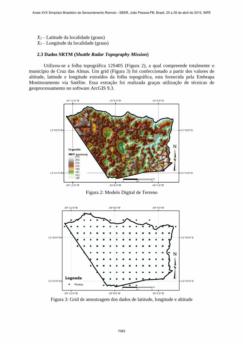
2.3 Dados SRTM (Shuttle Radar Topography Mission)
Utilizou-se a folha topográfica 12S405 (Figura 2), a qual compreende totalmente o
município de Cruz das Almas. Um grid (Figura 3) foi confeccionado a partir dos valores de
altitude, latitude e longitude extraídos da folha topográfica, esta fornecida pela Embrapa
Monitoramento via Satélite. Essa extração foi realizada graças utilização de técnicas de
geoprocessamento no software ArcGIS 9.3.
Figura 2: Modelo Digital de Terreno
39°4'0"W
39°4'0"W
39°8'0"W
39°8'0"W
39°12'0"W
39°12'0"W
12°40'0"S 12°40'0"S
12°44'0"S 12°44'0"SLegenda
Pontos
³0 52.5
Km
Figura 3: Grid de amostragem dos dados de latitude, longitude e altitude
Anais XVII Simpósio Brasileiro de Sensoriamento Remoto - SBSR, João Pessoa-PB, Brasil, 25 a 29 de abril de 2015, INPE
7083
2.4 Técnicas Geoestatísticas
Os mapas mensais de temperatura máxima foram gerados a partir de técnicas
geoestatísticas embutidas no software ArcGIS 9.3. A técnica de interpolação usada a partir
dos pontos do grid foi a Krigagem. Esse método é calculado pela (Equação 1).
vi
n
i
iv ZZ
1
' (1)
em que,
Zv – estimador de krigagem ordinária para o ponto v
λi – i-ésimo peso
Zvi – valor da i-ésima observação da variável regionalizada, coletada nos pontos xi
n – número de pesos
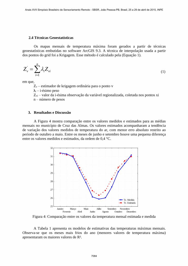
3. Resultados e Discussão
A Figura 4 mostra comparação entre os valores medidos e estimados para as médias
mensais no município de Cruz das Almas. Os valores estimados acompanharam a tendência
de variação dos valores medidos de temperatura do ar, com menor erro absoluto restrito ao
período de outubro a maio. Entre os meses de junho e setembro houve uma pequena diferença
entre os valores medidos e estimados, da ordem de 0,4 °C.
Janeiro
Fevereio
Março
Abril
Maio
Junho
Julho
Agosto
Setembro
Outubro
Novembro
Dezembro
25
26
27
28
29
30
31
32
Tx Medida
Tx Estimada
Figura 4: Comparação entre os valores da temperatura mensal estimada e medida
A Tabela 1 apresenta os modelos de estimativas das temperaturas máximas mensais.
Observa-se que os meses mais frios do ano (menores valores de temperatura máxima)
apresentaram os maiores valores de R².
Anais XVII Simpósio Brasileiro de Sensoriamento Remoto - SBSR, João Pessoa-PB, Brasil, 25 a 29 de abril de 2015, INPE
7084

Tabela 1: Equações de estimativa da médias das temperaturas máximas mensais
Mês Ao A1 A2 A3 R²
Janeiro 32,79369 -0,00571 -0,01083 0,00343 0,726**
Fevereiro 26,44028 -0,00584 -0,00887 0,00541 0,708**
Março 24,94878 -0,00552 -0,00743 0,00552 0,676**
Abril 13,87539 -0,00655 -0,00749 0,00977 0,794**
Maio -0,01944 -0,00740 -0,00707 0,01506 0,864**
Junho -8,12247 -0,00825 -0,00817 0,01840 0,882**
Julho -14,2272 -0,00848 -0,00867 0,02095 0,920**
Agosto -17,6494 -0,00785 -0,00901 0,02271 0,901**
Setembro -13,1690 -0,00723 -0,01010 0,02168 0,829**
Outubro 6,59662 -0,00627 -0,01355 0,01485 0,801**
Novembro 24,61882 -0,00542 -0,01366 0,00743 0,751**
Dezembro 30,18980 -0,00523 -0,01077 0,00429 0,655** Teste t e teste F, ** significativo ao nível de 1% de probabilidade
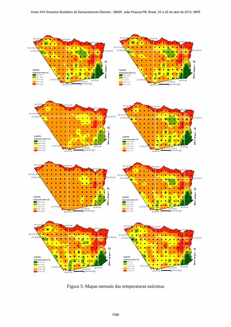
Os mapas de espacialização das médias mensais da temperatura máxima são
apresentados na Figura 5. Verifica-se que a parte norte do município apresenta as maiores
máximas, enquanto que o setor sudeste durante todos os meses representa as menores
máximas. Á medida que os meses mais frios se aproximam há uma maior uniformidade dos
valores de temperatura por todo o município. Nos meses mais quentes, observa-se maior
variação espacial.
39°12'0"W
39°8'0"W
39°8'0"W
39°4'0"W
39°4'0"W
12°40'0"S 12°40'0"S
12°44'0"S
39°12'0"W
12°44'0"S
³0 52.5
Km
Legenda
Temperatura Max (°C)
31.08 - 31.39
31.39 - 31.42
31.42 - 31.48
31.48 - 31.56
31.56 - 31.84
39°12'0"W
39°8'0"W
39°8'0"W
39°4'0"W
39°4'0"W
12°40'0"S 12°40'0"S
12°44'0"S
39°12'0"W
12°44'0"S
³0 52.5
Km
Legenda
Temperatura Max (°C)
30.89 - 31.2
31.2 - 31.23
31.23 - 31.27
31.27 - 31.33
31.33 - 31.66
39°12'0"W
39°8'0"W
39°8'0"W
39°4'0"W
39°4'0"W
12°40'0"S 12°40'0"S
12°44'0"S
39°12'0"W
12°44'0"S
³0 52.5
Km
Legenda
Temperatura Max (°C)
30.8 - 31.1
31.1 - 31.12
31.12 - 31.16
31.16 - 31.22
31.22 - 31.53
39°12'0"W
39°8'0"W
39°8'0"W
39°4'0"W
39°4'0"W
12°40'0"S 12°40'0"S
12°44'0"S
39°12'0"W
12°44'0"S
³0 52.5
Km
Legenda
Temperatura Max (°C)
29.32 - 29.68
29.68 - 29.71
29.71 - 29.75
29.75 - 29.82
29.82 - 30.16
Anais XVII Simpósio Brasileiro de Sensoriamento Remoto - SBSR, João Pessoa-PB, Brasil, 25 a 29 de abril de 2015, INPE
7085
39°12'0"W
39°8'0"W
39°8'0"W
39°4'0"W
39°4'0"W
12°40'0"S 12°40'0"S
12°44'0"S
39°12'0"W
12°44'0"S
³0 52.5
Km
Legenda
Temperatura Max (°C)
27.87 - 28.3
28.3 - 28.34
28.34 - 28.41
28.41 - 28.51
28.51 - 28.81
39°12'0"W
39°8'0"W
39°8'0"W
39°4'0"W
39°4'0"W
12°40'0"S 12°40'0"S
12°44'0"S
39°12'0"W
12°44'0"S
³0 52.5
Km
Legenda
Temperatura Max (°C)
26.47 - 26.95
26.95 - 27
27 - 27.08
27.08 - 27.19
27.19 - 27.51
39°12'0"W
39°8'0"W
39°8'0"W
39°4'0"W
39°4'0"W
12°40'0"S 12°40'0"S
12°44'0"S
39°12'0"W
12°44'0"S
³0 52.5
Km
Legenda
Temperatura Max (°C)
25.92 - 26.29
26.29 - 26.43
26.43 - 26.48
26.48 - 26.62
26.62 - 26.99
39°12'0"W
39°8'0"W
39°8'0"W
39°4'0"W
39°4'0"W
12°40'0"S 12°40'0"S
12°44'0"S
39°12'0"W
12°44'0"S
³0 52.5
Km
Legenda
Temperatura Max (°C)
26.51 - 26.99
26.99 - 27.04
27.04 - 27.12
27.12 - 27.22
27.22 - 27.5
39°12'0"W
39°8'0"W
39°8'0"W
39°4'0"W
39°4'0"W
12°40'0"S 12°40'0"S
12°44'0"S
39°12'0"W
12°44'0"S
³0 52.5
Km
Legenda
Temperatura Max (°C)
27.92 - 28.22
28.22 - 28.35
28.35 - 28.41
28.41 - 28.54
28.54 - 28.84
39°12'0"W
39°8'0"W
39°8'0"W
39°4'0"W
39°4'0"W
12°40'0"S 12°40'0"S
12°44'0"S
39°12'0"W
12°44'0"S
³0 52.5
Km
Legenda
Temperatura Max (°C)
29.37 - 29.55
29.55 - 29.65
29.65 - 29.72
29.72 - 29.76
29.76 - 29.78
39°12'0"W
39°8'0"W
39°8'0"W
39°4'0"W
39°4'0"W
12°40'0"S 12°40'0"S
12°44'0"S
39°12'0"W
12°44'0"S
³0 52.5
Km
Legenda
Temperatura Max (°C)
30.19 - 30.5
30.5 - 30.53
30.53 - 30.59
30.59 - 30.66
30.66 - 30.91
39°12'0"W
39°8'0"W
39°8'0"W
39°4'0"W
39°4'0"W
12°40'0"S 12°40'0"S
12°44'0"S
39°12'0"W
12°44'0"S
³0 52.5
Km
Legenda
Temperatura Max (°C)
30.72 - 31
31 - 31.03
31.03 - 31.09
31.09 - 31.16
31.16 - 31.42
Figura 5: Mapas mensais das temperaturas máximas
Anais XVII Simpósio Brasileiro de Sensoriamento Remoto - SBSR, João Pessoa-PB, Brasil, 25 a 29 de abril de 2015, INPE
7086

Os valores especializados variaram de 31,1 a 25,9 °C. As temperaturas do mês de
setembro se mostraram mais homogêneas. Por se tratar de uma região plana em geral não
houve grande variação mensal das temperaturas máximas, uma vez que o fator altitude é
determinante na variação da temperatura.
Nas regiões mais altas do município, porém, foram encontrados os menores valores de
temperatura máxima; o inverso também foi verificado. Isso prova que há uma influência da
altitude na temperatura.
4. Conclusões
Os modelos mensais de estimativa da temperatura máxima a partir de coordenadas
geográficas permitiram estimar com alta acurácia as médias mensais para o município de Cruz
das Almas.
A metodologia de utilização de dados SRTM para a extração e utilização das
coordenadas para a confecção de mapas de temperatura mostrou-se adequada em quantificar e
especializar a variável por todo o município.
5. Referências
ASTOLPHO, F. et al. Regionalização de riscos de ocorrência de temperaturas mínimas
absolutas anuais para o estado de São Paulo com base em modelos probabilísticos e
digitais de elevação. Bragantia, Campinas, v. 64, n. 1, p.139-148, 2005.
BARDIN, L.; PEDRO JÚNIOR, M. J.; MORAES, J. F. L. de. Estimativa das temperaturas
máximas e mínimas do ar para a região do Circuito das Frutas, SP, Revista Brasileira de
Engenharia Agrícola e Ambiental, Campina Grande, v. 14, n. 6, p. 618-624, 2010.
CAVALCANTI, E. P.; SILVA, V. de P. R.; de SOUZA, F. A. S. Programa
computacional para a estimativa da temperatura do ar para a região Nordeste do Brasil.
Revista Brasileira de Engenharia Agrícola e Ambiental, Campina Grande, v. 10, n. 1, p. 140-
147, 2006.
FERREIRA, M. et al. Estimativa das temperaturas médias mensais e anuais do estado do
Rio Grande do Sul. Revista Centro Ciências Rurais, Santa Maria, v. 1, n. 1, p. 21-52, 1971
MEDEIROS, S. S. et al. Estimativa e espacialização das temperaturas do ar mínimas,
médias e máximas na Região Nordeste do Brasil, Revista Brasileira de Engenharia
Agrícola e Ambiental, Campina Grande, v. 9, n. 2, p. 247-255, 2005.
LYRA, G. B.; OLIVEIRA JUNIOR, J. F.; SOUZA, J.L.; LYRA, G.B.; SANTOS, M.J.;
SANTOS, P.J. Variação espacial e temporal da temperatura mensal do ar no estado de
Alagoas. 2009. In: XVI Congresso Brasileiro de Agrometeorologia, 2009, Belo Horizonte.
Anais...Sociedade Brasileira de Agrometeorologia: Viçosa, 2009.
PEZZOPANE, J. R. M. et al. Espacialização da temperatura do ar no estado do Espírito
Santo. Revista Brasileira de Agrometeorologia, Santa Maria, v. 12, n. 1, p. 151-158, 2004.
Anais XVII Simpósio Brasileiro de Sensoriamento Remoto - SBSR, João Pessoa-PB, Brasil, 25 a 29 de abril de 2015, INPE
7087
Related Documents