Estimation of 12 Biomass Parameters Using Terrestrial Laser Scanner (7812) Irwan Gumilar, Hasanuddin Zaenal Abidin, Eko Prasetiyo, Ekus Kustiwa and Rizqi Abdulharis (Indonesia) FIG Working Week 2015 From the Wisdom of the Ages to the Challenges of the Modern World Sofia, Bulgaria, 17-21 May 2015 1/15 Estimation of 12 Biomass Parameters and Interaction between the Trees Using Terrestrial Laser Scanner Irwan GUMILAR, Hasanuddin Zaenal ABIDIN, Eko PRASETYO, Ekus KUSTIWA, Indonesia Keywords: Biomass, Crown, Forest, TLS, Tree SUMMARY Biomass has an important role to control the earth’s climate and the mitigation of the climate change. Indonesia is one of the countries with rich biomass resources, especially in forestry, plantation, and agricultural sectors. The technology to measure the 12 biomass parameters to calculate the biomass potential in the forestry sector continues to develop. One of the new methods that are being developed is by using Terrestrial Laser Scanner (TLS). In this research, the TLS is applied to measure the 12 biomass parameters, which consist of the parameters of the trunk, crown, and the parameters between trees. The methodology of this research consists of literature study, measurement planning, acquisition data, processing the TLS data, calculating the value of the desired parameters, and validating the TLS measurements by comparing them with the measurement results using measuring tapes. The objects of this research were 2 mahogany trees (Swietenia mahagoni). The result of this research is the measured 12 biomass parameters which are related to the competition between trees. The validation result shows that the difference between the measurement and the measurement using tapes is 1 mm – 7,73 cm. The TLS can be applied in forestry and analyze the complex 3 dimensional shape of the trees, especially the growth plasticity of the crown of the trees. The measurement using TLS has obstacles in areas with high wind intensity, which causes the shape of the object to be inconsistent.

Welcome message from author
This document is posted to help you gain knowledge. Please leave a comment to let me know what you think about it! Share it to your friends and learn new things together.
Transcript

Estimation of 12 Biomass Parameters Using Terrestrial Laser Scanner (7812)
Irwan Gumilar, Hasanuddin Zaenal Abidin, Eko Prasetiyo, Ekus Kustiwa and Rizqi Abdulharis (Indonesia)
FIG Working Week 2015
From the Wisdom of the Ages to the Challenges of the Modern World
Sofia, Bulgaria, 17-21 May 2015
1/15
Estimation of 12 Biomass Parameters and Interaction between the Trees
Using Terrestrial Laser Scanner
Irwan GUMILAR, Hasanuddin Zaenal ABIDIN, Eko PRASETYO, Ekus KUSTIWA,
Indonesia
Keywords: Biomass, Crown, Forest, TLS, Tree
SUMMARY
Biomass has an important role to control the earth’s climate and the mitigation of the climate
change. Indonesia is one of the countries with rich biomass resources, especially in forestry,
plantation, and agricultural sectors. The technology to measure the 12 biomass parameters to
calculate the biomass potential in the forestry sector continues to develop. One of the new
methods that are being developed is by using Terrestrial Laser Scanner (TLS). In this
research, the TLS is applied to measure the 12 biomass parameters, which consist of the
parameters of the trunk, crown, and the parameters between trees. The methodology of this
research consists of literature study, measurement planning, acquisition data, processing the
TLS data, calculating the value of the desired parameters, and validating the TLS
measurements by comparing them with the measurement results using measuring tapes. The
objects of this research were 2 mahogany trees (Swietenia mahagoni). The result of this
research is the measured 12 biomass parameters which are related to the competition between
trees. The validation result shows that the difference between the measurement and the
measurement using tapes is 1 mm – 7,73 cm. The TLS can be applied in forestry and analyze
the complex 3 dimensional shape of the trees, especially the growth plasticity of the crown of
the trees. The measurement using TLS has obstacles in areas with high wind intensity, which
causes the shape of the object to be inconsistent.

Estimation of 12 Biomass Parameters Using Terrestrial Laser Scanner (7812)
Irwan Gumilar, Hasanuddin Zaenal Abidin, Eko Prasetiyo, Ekus Kustiwa and Rizqi Abdulharis (Indonesia)
FIG Working Week 2015
From the Wisdom of the Ages to the Challenges of the Modern World
Sofia, Bulgaria, 17-21 May 2015
2/15
Estimation of 12 Biomass Parameters and Interaction between the Trees
Using Terrestrial Laser Scanner
Irwan GUMILAR, Hasanuddin Zaenal ABIDIN, Eko PRASETYO, Ekus KUSTIWA,
Indonesia
1. INTRODUCTION
Forest is an ecosystem which consists of landscape containing natural resources, dominated
by trees in the natural environment where each cannot be separated from the other (Act
Number 44 Year 1999). Forest can act as a regulator to control the climate change and its
mitigation through its ability to absorb the carbon particles from an area of the forest.
To maximize the function and potential of the forest, three dimensional information of
the biomass spread in a forest area is required. Biomass is an organic matter produced by
photosynthetic process, either as a product or a waste [Sutaryo, 2009]. The biomass
parameters that are formed in every tree in a forest represent the interaction process between a
tree and another.
There are several methods to calculate the biomass parameters, namely direct methods
and indirect methods. Direct methods use instruments that have direct contact to the material
of investigation and that are able to determine the desired parameters without using
mathematical derivations. Although nowadays there are already other techniques used for
validation, the direct method are still regarded the best choice. Some direct methods are:
allometrics, stratified clipping and the scaffolding approach, and litter traps method. In
contrast to the direct methods, indirect approaches are based on mathematical derivations or
assumptions which are used to calculate the desired parameter from another easily measured
parameters. Some indirect methods are: point quadrat method and inclined point quadrats,
MacArthur and Horn’-photographic method, hemispherical photography, LIDAR and optical
point quadrat methods, radiation measurement, TRAC and MVI, DEMON, spherical
densiometer [Seidel, 2011].
Presently, a new technology using non-contact methods is available, namely the three
dimensional terrestrial laser scanner, which can give spatial information from the trees with
very high resolution [Seidel, 2011]. This technique, commonly known as the Terrestrial Laser
Scanner (TLS), can give comprehensive information of the structure of the tree, and thus
allows the research regarding the canopy process and the interaction between trees. The aim
of this research is to apply the TLS to measure the 12 vegetation biomass parameters related
to the interaction between trees.

Estimation of 12 Biomass Parameters Using Terrestrial Laser Scanner (7812)
Irwan Gumilar, Hasanuddin Zaenal Abidin, Eko Prasetiyo, Ekus Kustiwa and Rizqi Abdulharis (Indonesia)
FIG Working Week 2015
From the Wisdom of the Ages to the Challenges of the Modern World
Sofia, Bulgaria, 17-21 May 2015
3/15
2. MATERIAL AND METHOD
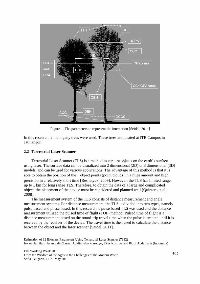
2.1 Biomass Parameters Related to the Interaction Between Trees
The planting distance between trees, size, and identity are the most often used parameters to
characterize the competition of the target tree with its neighbour, in the case of magnitude and
general direction of the pressure from the occurring competition [Seidel, 2011]. To determine
and predict the competition between neighbour trees, 12 parameters are used, listed as follows
[Seidel, 2011]:
1. Total tree height (TTH)
2. Diameter at breast height (DBH)
3. Crown base height (CBH)
4. Crown height (CH)
5. Coordinate of the center of the stem at ground level (CCG)
6. Height of maximum crown projection area (HCPA)
7. Maximum crown projection area (CPA)
8. Center of the crown at the height of maximum crown projection area (CCC)
9. Crown projection area at the height of maximum crown projection area of focal tree
(CPAcomp), only for neighbour trees and the center of the crown at the height of the
CPAcomp, (CCatCPAcomp), only for neighbour trees
10. Degree of tree asymmetry and its direction expressed as a vector (abbr.ASYM)
11. Horizontal distance between the CCC of the focal tree and the CCatCPAcomp of the
neighbour tree (HD)
12. Horizontal distance between the CCG of the focal tree and CCG of the neighbour tree
(DCCG).
The illustration of the parameters can be seen in Figure 1. The use of those parameters related
to the interaction also can be seen in Figure 1.
Estimation of 12 Biomass Parameters Using Terrestrial Laser Scanner (7812)
Irwan Gumilar, Hasanuddin Zaenal Abidin, Eko Prasetiyo, Ekus Kustiwa and Rizqi Abdulharis (Indonesia)
FIG Working Week 2015
From the Wisdom of the Ages to the Challenges of the Modern World
Sofia, Bulgaria, 17-21 May 2015
4/15
Figure 1. The parameters to represent the interaction [Seidel, 2011]
In this research, 2 mahogany trees were used. These trees are located at ITB Campus in
Jatinangor.
2.2 Terrestrial Laser Scanner
Terrestrial Laser Scanner (TLS) is a method to capture objects on the earth’s surface
using laser. The surface data can be visualized into 2 dimensional (2D) or 3 dimensional (3D)
models, and can be used for various applications. The advantage of this method is that it is
able to obtain the position of the object points (point clouds) in a huge amount and high
precision in a relatively short time [Reshetyuk, 2009]. However, the TLS has limited range,
up to 1 km for long range TLS. Therefore, to obtain the data of a large and complicated
object, the placement of the device must be considered and planned well [Quintero et al.
2008].
The measurement system of the TLS consists of distance measurement and angle
measurement systems. For distance measurement, the TLS is divided into two types, namely
pulse based and phase based. In this research, a pulse based TLS was used and the distance
measurement utilized the pulsed time of flight (TOF) method. Pulsed time of flight is a
distance measurement based on the round-trip travel time when the pulse is emitted until it is
received by the receiver of the device. The travel time is then used to calculate the distance
between the object and the laser scanner [Seidel, 2011].
Estimation of 12 Biomass Parameters Using Terrestrial Laser Scanner (7812)
Irwan Gumilar, Hasanuddin Zaenal Abidin, Eko Prasetiyo, Ekus Kustiwa and Rizqi Abdulharis (Indonesia)
FIG Working Week 2015
From the Wisdom of the Ages to the Challenges of the Modern World
Sofia, Bulgaria, 17-21 May 2015
5/15
According to [Reshetyuk, 2009], distance measurement using pulse based TLS follows
the equation 1:
(1)
where:
R : the distance between the TLS and the object;
c : the speed of light on air (≈ 3∙108 m/s);
t : the time travel of the laser when it is emitted and received
Angle Measurement System
Apart from distance measurement, the TLS also has an angle measurement system which can
be used to obtain the coordinates of the objects. This system consists of angular ecoders that
measures the horizontal direction and vertical angle of the TLS laser beam to the objects.
Coordinates Calculation
To obtain the coordinates of the objects using TLS, there are several parameters that have to
be measured for every object, namely:
Distance ( R );
Horizontal direction ( );
Vertical angle ( ).
The TLS also measures the intensity of the reflected laser beam from every point cloud. The
principle of the TLS measurement is illustrated in Figure 2.
2.3 Data Acquisition
Study literature regarding the theories of TLS application in forestry was done in preparation
step. These theories were then used to plan the measurement trials using TLS in forestry. In
this step, a training to use Leica Scan Station C10 device and processing the point clouds as
scanned by the device. Finding the appropriate location and trees were done afterwards.
2.4 Data Acquisition Planning
After finding the research location, the next step is data acquisition planning. The design
planning for the device and targets positions was done in this step. The primary consideration
of placement of the device and targets is that the scan must cover all trees. This planning is
also related to accommodation and licensing in the study area
.

Estimation of 12 Biomass Parameters Using Terrestrial Laser Scanner (7812)
Irwan Gumilar, Hasanuddin Zaenal Abidin, Eko Prasetiyo, Ekus Kustiwa and Rizqi Abdulharis (Indonesia)
FIG Working Week 2015
From the Wisdom of the Ages to the Challenges of the Modern World
Sofia, Bulgaria, 17-21 May 2015
6/15
2.5 TLS Data Acquisition
Data acquisition using TLS was done following the design which was made in the planning
step. The device was moved 7 times, while the positions of targets were unchanged. There
were four targets used in this step, namely: 2 HDS 6 inch and 2 HDS 3 inch. The weather was
fine and a little windy. The locations of the targets can be seen in Figure 2.3 and Figure 3.
Figure 3. TLS data acquisition strategy (a) and field data acquisition (b)
2.6 Data Acquisition Using Measuring Tapes
The purpose of acquiring data using measuring tapes is to validate the results from the TLS.
The tapes were used to measure the diameter at breast height (DBH) of both trees and the
distance between the trees.
Figure 2. The principle of TLS measurement (adapted from [3])
Remark
Trees
TLS

Estimation of 12 Biomass Parameters Using Terrestrial Laser Scanner (7812)
Irwan Gumilar, Hasanuddin Zaenal Abidin, Eko Prasetiyo, Ekus Kustiwa and Rizqi Abdulharis (Indonesia)
FIG Working Week 2015
From the Wisdom of the Ages to the Challenges of the Modern World
Sofia, Bulgaria, 17-21 May 2015
7/15
The relation between measurement data ( r , , ) and coordinates ( n , e ,u ) can be written in
equation 2.4 [Reshetyuk, 2009]:
(2)
where:
jr : distance from the time travel of the laser to the;
j : horizontal angle between the aim of the laser and the e-axis of the device;
j : vertical angle between the horizontal plane and the aim of the laser to the
object;
je : coordinate e of point clouds in the device coordinate system;
jn : coordinate n of point clouds in the device coordinate system;
ju : coordinate u of point clouds in the device coordinate system;.
The methodology of this research consists of several steps, namely: preparation and TLS data
acquisition, registration process, filterization, georeferencing process, 3D modelling, video
making, and analysis and discussion. These steps will be described in the following sections
to answer the conclusion of the research.

Estimation of 12 Biomass Parameters Using Terrestrial Laser Scanner (7812)
Irwan Gumilar, Hasanuddin Zaenal Abidin, Eko Prasetiyo, Ekus Kustiwa and Rizqi Abdulharis (Indonesia)
FIG Working Week 2015
From the Wisdom of the Ages to the Challenges of the Modern World
Sofia, Bulgaria, 17-21 May 2015
8/15
3. RESULT AND DISCUSSION
After the scanning process was finished, the next step is the process to create the model by
using point clouds from the scanning. Creating a model space to obtain the biomass
parameters include several steps, namely: registration, filtering, and modeling. The software
used in this process is Leica Cyclone 7.1.1.
Registration is a process to combine the scanning data. In this research, the registration
was done using target to target method. This method is the best registration method and faster
because the reference points are already determined. The scanning results has the maximum
error of 0.006 m and the mean of 0.002.
After the registration process, model space can be created. In this process, all point
clouds scanned from all the device locations are combined to create a three dimensional
model of the desired objects. Several undesired points are also modeled in the model space,
known as noise. The noise has to be removed in the filterization process. In this research, the
filterization was done using manual method. The model space before and after filtering can be
seen in Figure 4.
Figure 4. Model spase before (a) and after filterization (b)
The next step after modeling is calculating the biomass parameters, which was done in
Cyclone 7.1.1. The results of the calculation can be seen in Table 2.1.

Estimation of 12 Biomass Parameters Using Terrestrial Laser Scanner (7812)
Irwan Gumilar, Hasanuddin Zaenal Abidin, Eko Prasetiyo, Ekus Kustiwa and Rizqi Abdulharis (Indonesia)
FIG Working Week 2015
From the Wisdom of the Ages to the Challenges of the Modern World
Sofia, Bulgaria, 17-21 May 2015
9/15
Table 1. Biomass parameter from the TLS measurement
NO Parameter Measurement Figure
1 TTH
Tree 1 : 8,685 m
Tree 2 : 7,507 m
2 DBH (first tree)
Diameter : 0,249 m
Table 1. Biomass parameter from the TLS measurement (continued)
NO Parameter Measurement Figure
CPA
(first tree)
Leaf Area
19,325 m2

Estimation of 12 Biomass Parameters Using Terrestrial Laser Scanner (7812)
Irwan Gumilar, Hasanuddin Zaenal Abidin, Eko Prasetiyo, Ekus Kustiwa and Rizqi Abdulharis (Indonesia)
FIG Working Week 2015
From the Wisdom of the Ages to the Challenges of the Modern World
Sofia, Bulgaria, 17-21 May 2015
10/15
9 (First tree) 20,461 m2
10
CPA
(Second tree)
Leaf Area
(Second tree)
15,010 m2
12,488 m2

Estimation of 12 Biomass Parameters Using Terrestrial Laser Scanner (7812)
Irwan Gumilar, Hasanuddin Zaenal Abidin, Eko Prasetiyo, Ekus Kustiwa and Rizqi Abdulharis (Indonesia)
FIG Working Week 2015
From the Wisdom of the Ages to the Challenges of the Modern World
Sofia, Bulgaria, 17-21 May 2015
11/15
Table 1. Biomass parameter from the TLS measurement (continued)
NO Parameter Measurement Figure
12
CPAcomp
10.872 m2
14 CCatCPAcom
p
X: -6.435 m
Y : 1.650 m
Z : 5.137 m
15 abbr.ASYM
First tree :
Angle : 31˚47’14.11’’
Distance : 0,418 m
Second tree:
Angle :
227˚41’6.46”
Distance : 0,468
m
The plotting in the first tree 481 is CCC, and 482 is
CCG.

Estimation of 12 Biomass Parameters Using Terrestrial Laser Scanner (7812)
Irwan Gumilar, Hasanuddin Zaenal Abidin, Eko Prasetiyo, Ekus Kustiwa and Rizqi Abdulharis (Indonesia)
FIG Working Week 2015
From the Wisdom of the Ages to the Challenges of the Modern World
Sofia, Bulgaria, 17-21 May 2015
12/15
Table 1. Biomass parameter from the TLS measurement (continued)
NO Parameter Measurement Figure
16
HD 4,568 m
17 DCCG 4,243 m
As seen from the parameter values in Table 2.1, the CPA value and leaf area for the first one
are larger. This shows that the first tree have better growth. The value of the diameter at breast
height (DBH) also shows that the first tree has larger diameter. From the height of the trees,
the first tree is also taller than the second tree, which even shows that the first tree grows
better. However, from the abbr.ASYM parameter which shows the growth vector, it can be
seen that there is a competitive interaction between the trees. The value of abbr.ASYM shows
that both trees have growth vector in the opposite directions. This shows that naturally, both
trees avoid the occurring competition. Further research regarding the occurring interaction
needs to be done and hopefully can give a reference for procedures of planting/silvicultural in
order to obtain maximum results on the target plants.
Based on measurements using TLS, the known HD value (4,568 m) is larger than the DCCG
value (4,243 m), which means there has been a pressure between both trees for as far as
±0,325 m. This suggests a competition between both trees in order to obtain a space for them
to grow. Larger DBH and HCPA show that the first tree has a faster growing ability. As a
form of adaption to competition, the second tree tends to have a faster vertical growth than its
horizontal one (CBH-1 > CBH-2 and CH-1 < CH-2). This means than even though the second
tree has smaller DBH, the free branch height (as a commercial tree parameter) of the second
tree is higher than that of the first tree. Thus, it is very likely that the second tree’s height can
be higher in the future than the first tree, in order to win the competition to obtain the
sunlight.
.

Estimation of 12 Biomass Parameters Using Terrestrial Laser Scanner (7812)
Irwan Gumilar, Hasanuddin Zaenal Abidin, Eko Prasetiyo, Ekus Kustiwa and Rizqi Abdulharis (Indonesia)
FIG Working Week 2015
From the Wisdom of the Ages to the Challenges of the Modern World
Sofia, Bulgaria, 17-21 May 2015
13/15
The validity of these measurements indicates the accuracy of the measurement results as
obtained from the model in software Cyclone 7.1.1. The validation was done by comparing
the TLS results with the measurements from measuring tapes. Due to the limitation of the
measuring tapes, only DBH, CBH, and DCCG can be compared. The results can be seen in
Table 2.
Table 2. Comparison of measurements
Parameter TLS Tapes Difference
DCCG 424,3cm 431 cm -7,7cm
First tree
DBH 24,9 cm 25,6 cm 0,7 cm
CBH 164,3cm 169,3cm -5,0cm
Second tree
DBH 17,6 cm 17,6 cm -0,1cm
CBH 259,1cm 264,7cm -5,6cm

Estimation of 12 Biomass Parameters Using Terrestrial Laser Scanner (7812)
Irwan Gumilar, Hasanuddin Zaenal Abidin, Eko Prasetiyo, Ekus Kustiwa and Rizqi Abdulharis (Indonesia)
FIG Working Week 2015
From the Wisdom of the Ages to the Challenges of the Modern World
Sofia, Bulgaria, 17-21 May 2015
14/15
4. CLOSING REMARK
From this research, it can be concluded that the TLS can be applied in forestry to measure the
12 biomass parameters which are related to the interaction between trees. The measurement
results using the TLS at 2 tree samples in ITB Jatinangor can be seen in Table 6.1.
Table 6. 1 The results of the 12 parameters
No Parameter Results
Tree 1 Tree 2
1 TTH 8,685 m 7,507 m
2 DBH 0,249 m 0,176 m
3 CBH 1,643 m 2,591 m
4 CH 7,042 m 4,916 m
5 CCG
X: -6,867m X:
-6,629m
Y: -2,506m Y:
1,730 m
6 HCPA 5,631 m 4,615 m
7 CPA / Leaf Area 19,325 m2
/20,461 m2
15,010 m2
/12,488 m2
8 CCC X: -7,087m X:
-6,283m
Y:
-2,861m
Y:
2,045 m
Z:
5,137 m
Z :
4,538 m
No Parameter Results
Tree 1 Tree 2
9
CPAcomp 10,872 m2
CCatCPAcomp
X: -6,435m
Y: 1,650 m
Z: 5,137 m
10 Abbr.ASYM 31˚47’14.11’’ 227˚41’6.46”
0,418 m 0,468 m
11 HD 4,558 m
12 DCCG 4,243 m
TLS can create 3-dimensional model of the tree crown with unique coordinates for each point,
making the model unique for each tree with resolution that can reach up mm level. The
measurement results using the TLS can be used because the difference between the TLS
measurements and conventional method using measuring tapes is 1 mm – 7,7 cm.
Estimation of 12 Biomass Parameters Using Terrestrial Laser Scanner (7812)
Irwan Gumilar, Hasanuddin Zaenal Abidin, Eko Prasetiyo, Ekus Kustiwa and Rizqi Abdulharis (Indonesia)
FIG Working Week 2015
From the Wisdom of the Ages to the Challenges of the Modern World
Sofia, Bulgaria, 17-21 May 2015
15/15
REFERENCES
1. Quintero, M. S., Genechten, B. V., Bruyne, M. D., Ronald, P., Hankar, M, and Barnes,
S. 2008. Theory and practice on terrestrial laser scanning. The Learning Tools for
Advanced Three Dimensional Surveying in Risk Awareness Project
(3DRiskMapping).
2. Reshetyuk, Y. 200). Terrestrial laser scanning, error source, self-calibration, and
direct georeferencing. Saarbrucken, Germany: VDM Verlag Dr. Muller.
3. Seidel, D. 2011. Terrestrial laser scanner application in forest ecological research.
GottingenGermany: Gottingen Center for Biodiversity and Ecology
4. Sutaryo, D. 2009. Perhitungan biomassa. Wetlands International Indonesia
Programme, Bogor.
BIOGRAPHICAL NOTES
Dr. Irwan Gumilar was born in Bandung 29 March 1978. He got bachelor degree in 2001
from the Department of Geodetic Engineering Institute of Technology Bandung, and finished
his doctoral degree in 2013 from Department of Geodesy and Geomatics Engineering Institute
of Technology Bandung. Since 2010, he has been working as lecturer and researcher at the
Department of Geodesy and Geomatics Engineering Institute of Technology Bandung
CONTACTS
Dr. Irwan Gumilar
Geodesy Research Group, Institute of Technology Bandung
Jl. Ganesa 10 Bandung
Indonesia
Tel. +62-22-2534286
Fax + 62-22-2534286
Email: [email protected]
Web site: geodesy.gd.itb.ac.id
Related Documents