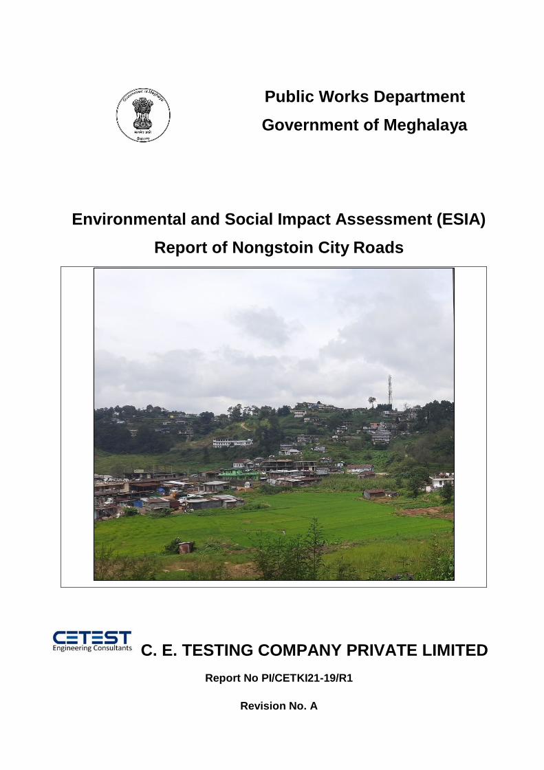
Public Works Department Government of Meghalaya Environmental and Social Impact Assessment (ESIA) Report of Nongstoin City Roads C. E. TESTING COMPANY PRIVATE LIMITED Report No PI/CETKI21-19/R1 Revision No. A

Welcome message from author
This document is posted to help you gain knowledge. Please leave a comment to let me know what you think about it! Share it to your friends and learn new things together.
Transcript
Public Works Department
Government of Meghalaya
Environmental and Social Impact Assessment (ESIA)
Report of Nongstoin City Roads
C. E. TESTING COMPANY PRIVATE LIMITED
Report No PI/CETKI21-19/R1
Revision No. A

Consultancy Services for conducting an Environmental and Social Impact Assessment
(ESIA) of Urban Roads (Town roads) and non-urban roads and Major/Minor bridges
and preparation of Environmental and Social Management instruments under MITP
(World Bank) initiative
Environmental and Social
Impact Assessment (ESIA) for
MITP of Nongstoin City Roads
Revision: R0 January,
2022 Page: 1
Consultancy Services for conducting an Environmental and Social Impact Assessment
(ESIA) of Urban Roads (Town roads) and non-urban roads and Major/Minor bridges
and preparation of Environmental and Social Management instruments under MITP
(World Bank) initiative
Environmental and Social
Impact Assessment (ESIA) for
MITP of Nongstoin City Roads
Revision: R0 January,
2022 Page: 2
Table of Contents
1 CHAPTER-I: INTRODUCTION AND PROJECT BACKGROUND ....................................... 11
1.1 Details of the project stretches are elaborated below: ........................................................ 11
1.1.1 Non-Urban Roads ...................................................................................................... 11
1.1.2 Urban Roads .............................................................................................................. 12
1.1.3 Nongstoin City Roads: ................................................................................................ 12
1.2 The Project Road.............................................................................................................. 12
1.3 Objective of the Project: ................................................................................................... 15
1.4 Scope of the Project: ........................................................................................................ 16
1.5 Structure of ESIA Report ................................................................................................. 17
2 CHAPTER-II: Project Description ........................................................................................... 18
2.1 Need for the Project ......................................................................................................... 18
2.2 Project Location ............................................................................................................... 18
2.3 Existing Features of the Project ........................................................................................ 18
2.4 Right of Way (RoW) ........................................................................................................ 19
2.5 Proposed Land Acquisition............................................................................................... 19
2.6 Proposed Cross Section Details ........................................................................................ 19
2.7 Current and Projected Daily Traffic .................................................................................. 28
2.8 Proposed Roadside Drainage ............................................................................................ 28
2.9 Proposed Pedestrian and Animal Crossing ........................................................................ 29
2.10 Wayside Amenities .......................................................................................................... 29
2.11 Pavement Condition ......................................................................................................... 30
2.12 Construction Material Requirement .................................................................................. 40
2.13 Minor Bridge ................................................................................................................... 40
2.14 Culvert ............................................................................................................................. 40
2.15 Estimated Project Cost ..................................................................................................... 50
2.16 Implementation Schedule: ................................................................................................ 51
2.17 Sub-project Benefits ......................................................................................................... 51
3 CHAPTER-III: NEED OF ENVIRONMENT & SOCIAL IMPACT ASSESSMENT ............... 52
3.1 Project Approach for Environmental Studies .................................................................... 52
3.2 Study Area ....................................................................................................................... 55
3.3 Study Area ....................................................................................................................... 55
3.4 Scope of the ESIA/ESMP Study ....................................................................................... 56
4 CHAPTER: IV- LEGAL FRAMEWORK ................................................................................ 58
4.1 Institutional Setting .......................................................................................................... 58
4.2 Acts & Regulation ............................................................................................................ 58
4.3 Clearance Requirement .................................................................................................... 61
Consultancy Services for conducting an Environmental and Social Impact Assessment
(ESIA) of Urban Roads (Town roads) and non-urban roads and Major/Minor bridges
and preparation of Environmental and Social Management instruments under MITP
(World Bank) initiative
Environmental and Social
Impact Assessment (ESIA) for
MITP of Nongstoin City Roads
Revision: R0 January,
2022 Page: 3
4.4 MORTH & IRC Specifications ......................................................................................... 62
4.5 Environmental Standards and Code of Practices ............................................................... 62
4.6 Other Applicable Policies (Social Security & Labor Welfare) ........................................... 62
4.6.1 World Bank safeguard/ Operational policies .............................................................. 63
4.6.2 Applicable Legal Framework for Social ....................................................................... 66
4.6.3 Objectives of the Policy ............................................................................................. 66
4.6.4 Policy Framework for this Project .............................................................................. 66
4.6.5 Social Categorization: ................................................................................................ 70
5 CHAPTER: V- DESCRIPTION OF ENVIRONMENT ............................................................ 71
5.1 Topography:..................................................................................................................... 71
5.2 Soil & Geology: ............................................................................................................... 72
1.1.1 Soil Quality Monitoring .............................................................................................. 74
5.3 Climate: ........................................................................................................................... 76
Meteorology: ............................................................................................................................ 76
5.4 Natural Hazards: .............................................................................................................. 80
5.5 Land Environment: .......................................................................................................... 86
5.6 Water Environment: ......................................................................................................... 87
5.7 Air Environment: ............................................................................................................. 87
5.8 Monitoring Parameters and Standards .............................................................................. 88
5.8.1 Ambient Air Quality Monitoring ................................................................................. 88
5.9 Noise Environment: ......................................................................................................... 93
5.9.1 Noise Quality Monitoring........................................................................................... 93
5.10 Biological Environment: .................................................................................................. 96
Rice Cultivation ....................................................................................................................... 118
Tea Estates ............................................................................................................................. 118
5.10.1 Educational Institutions / Hospitals.......................................................................... 118
5.11 Social Environment ........................................................................................................ 121
5.11.1 The State Profile of Meghalaya ................................................................................ 121
5.11.2 District Profile:......................................................................................................... 122
5.11.3 Demographic Profile ................................................................................................ 122
5.11.4 Schedule Castes and Schedule Tribes ....................................................................... 123
5.11.5 Literacy Rate............................................................................................................ 123
5.11.6 Employment Pattern ............................................................................................... 123
5.11.7 Economic Development ........................................................................................... 124
5.11.8 Road Network ......................................................................................................... 125

Consultancy Services for conducting an Environmental and Social Impact Assessment
(ESIA) of Urban Roads (Town roads) and non-urban roads and Major/Minor bridges
and preparation of Environmental and Social Management instruments under MITP
(World Bank) initiative
Environmental and Social
Impact Assessment (ESIA) for
MITP of Nongstoin City Roads
Revision: R0 January,
2022 Page: 4
5.11.9 Railway .................................................................................................................... 125
5.11.10 Aviation ................................................................................................................... 126
5.11.11 Agriculture and Cropping Pattern ............................................................................ 126
5.11.12 Animal Husbandry ................................................................................................... 126
5.11.13 Fishery..................................................................................................................... 127
5.11.14 Hospitals ................................................................................................................. 127
6 CHAPTER-VI: ANALYSIS OF POTENTIAL ENVIRONMENTAL & SOCIAL IMPACTS &
MITIGATION- MEASURES ........................................................................................................ 128
6.1 Environmental Impacts and Mitigation Measures ........................................................... 128
6.1.1 Impacts During Design/ Pre-constructional Phase .................................................... 128
6.1.2 Impacts during Construction Phase .......................................................................... 129
Name of the Component ......................................................................................................... 139
Road Name................................................................................................................................. 139
Distance from the road (m) ..................................................................................................... 139
Noise Level (dB) ........................................................................................................................ 139
Mitigation Measures: .............................................................................................................. 143
Provision for adequate numbers of septic tank to avoid contamination of ground water.
143
Requisite permission will be obtained for abstraction of groundwater. .................... 143
The contractor will make arrangements for water required for construction in such a way
that the water availability and supply to nearby communities remain unaffected. .................. 143
Water harvesting structures shall be proposed for groundwater augmentation in the
project area. ........................................................................................................................... 143
No change in groundwater regime is envisaged hence no mitigation is proposed. ... 143
6.2 Social Impact Assessment .............................................................................................. 152
6.2.1 Projects Impacts ...................................................................................................... 152
6.2.2 Positive Impact ........................................................................................................ 152
6.2.3 Impact on Land ........................................................................................................ 152
6.2.4 Impact on Structures ............................................................................................... 152
6.2.5 Impacts on Displaced Families ................................................................................. 153
6.2.6 Demography of Families .......................................................................................... 153
6.2.7 Family Pattern ......................................................................................................... 153
6.2.8 Religious Stratification ............................................................................................. 153
6.2.9 Social Stratification .................................................................................................. 153
6.2.10 Educational Status of PAPs ...................................................................................... 154

Consultancy Services for conducting an Environmental and Social Impact Assessment
(ESIA) of Urban Roads (Town roads) and non-urban roads and Major/Minor bridges
and preparation of Environmental and Social Management instruments under MITP
(World Bank) initiative
Environmental and Social
Impact Assessment (ESIA) for
MITP of Nongstoin City Roads
Revision: R0 January,
2022 Page: 5
6.2.11 Occupation of PAPs ................................................................................................. 155
6.2.12 Income and Expenditure Profile of DFs .................................................................... 155
6.2.13 Holding of Agricultural Land (Immovable Assets) ..................................................... 156
6.2.14 Possession of Vehicle (Movable Asset) ..................................................................... 156
6.2.15 Vulnerability ............................................................................................................ 157
6.2.16 Impact on Gender.................................................................................................... 157
6.2.17 Migration ................................................................................................................ 158
6.2.18 Impact on Tribal People ........................................................................................... 158
6.2.19 Impact on Access to Services Amenities ................................................................... 159
Transport facility ..................................................................................................... 159
Solid Waste Dumping Facilities ................................................................................ 159
Source of Drinking Water......................................................................................... 159
Distance of Medical Facilities ................................................................................... 159
Other Services ......................................................................................................... 159
6.3 Impacts on Road Safety and Human Health .................................................................... 160
6.4 Mitigation Measures:...................................................................................................... 160
7 CHAPTER-VII: ENVIRONMENTAL MONITORING PROGRAM ..................................... 161
7.1 Environmental Monitoring ............................................................................................. 161
7.2 Monitoring Plans for Environment Condition ................................................................. 161
7.3 Environmental Monitoring Budget: ................................................................................ 164
8 CHAPTER-VIII: Climate Change Impact & Risk .................................................................. 166
8.1 Climate Change Mitigation............................................................................................. 166
8.2 Possible Climate Events, Risks and Adaptation Measures in Road Transport Infrastructure170
9 CHAPTER-IX: STAKEHOLDER CONSULTATION AND SOCIAL ASSESSMENT.......... 172
9.1 Local, Public & Other Stakeholders Consultation ........................................................... 172
9.2 Social Impact Assessment (SIA) And R&R .................................................................... 173
9.3 Introduction ................................................................................................................... 173
9.4 Stakeholders Identification & Analysis ........................................................................... 173
9.5 Focus Group Discussion (FGD) ...................................................................................... 173
9.6 Need and Usefulness of Focus Group Discussion (FGD) ................................................ 174
9.7 Objectives ...................................................................................................................... 174
9.8 Level of Discussion ........................................................................................................ 174
9.9 Objectives of the Public Consultation ............................................................................. 174
9. Methodology for Consultations ...................................................................................... 175
Stakeholder Consultations .............................................................................................. 175
9.9.1 Project Stakeholders ................................................................................................ 175

Consultancy Services for conducting an Environmental and Social Impact Assessment
(ESIA) of Urban Roads (Town roads) and non-urban roads and Major/Minor bridges
and preparation of Environmental and Social Management instruments under MITP
(World Bank) initiative
Environmental and Social
Impact Assessment (ESIA) for
MITP of Nongstoin City Roads
Revision: R0 January,
2022 Page: 6
11. Consultation with Local People and Beneficiaries .......................................................... 177
9.1 Outcome of the Consultations......................................................................................... 181
9.2 Minutes of meeting with the DPR consultant .................................................................. 182
10 RESETTLEMENT ACTION PLAN ...................................................................................... 186
11 CHAPTER-XI: Tribal People’s Development Plan ................................................................ 187
12 CHAPTER-XII: Gender Action Plan...................................................................................... 188
12.1 Monitoring Gender Action Plan ...................................................................................... 188
12.1.1 Implementation Arrangements ................................................................................ 189
13 Chapter XIII: Implementation of ESMP and RAP .................................................................. 191
13.1.1 Project Management Unit (PMU)............................................................................. 192
Capacity Building Strategy ....................................................................................... 193
Institutional Capacity to Manage Social Development Aspects ................................. 193
Grievance Redressal Committee (GRC).......................................................................... 193
Grievance Redress Mechanism ................................................................................ 193
Grievance management through Electronic Mode ................................................... 194
Grievance Redressal Mechanism ............................................................................. 194
Disclosure of Project Information ............................................................................ 195
14 CHAPTER-XIV: MONITORING & EVALUATION ............................................................ 196
14.1 M&E of the ESMP application ....................................................................................... 196
14.2 M&E of E&S Management Plans ................................................................................... 196
14.3 Concurrent Monitoring ................................................................................................... 197
14.4 Periodic Evaluation ........................................................................................................ 197
14.5 Arrangements for Monitoring ......................................................................................... 197
15 CHAPTER-XV: ENVIRONMENT AND SOCIAL MANAGEMENT PLAN ........................ 199
15.1 Objectives of EMP ......................................................................................................... 199
15.2 Pre-Construction Stage ................................................................................................... 199
15.2.1 Pre-construction activities by PIU/Independent Consultant ..................................... 199
15.2.2 Pre-construction activities by Contractor ................................................................. 199
15.3 Construction Stage ......................................................................................................... 200
15.3.1 Construction activities by the Contractor ................................................................. 200
15.3.2 Construction activities by the PIU/ Authority Engineer / Independent Consultants .. 200
15.4 Operation Stage.............................................................................................................. 200
15.5 Reporting System ........................................................................................................... 224
15.6 Technical set up ............................................................................................................. 224
15.7 Nonconformity To Environmental Management Plan (EMP) .......................................... 224
15.8 Environmental Monitoring Budget: ................................................................................ 227

Consultancy Services for conducting an Environmental and Social Impact Assessment
(ESIA) of Urban Roads (Town roads) and non-urban roads and Major/Minor bridges
and preparation of Environmental and Social Management instruments under MITP
(World Bank) initiative
Environmental and Social
Impact Assessment (ESIA) for
MITP of Nongstoin City Roads
Revision: R0 January,
2022 Page: 7
16 CHAPTER-XV: CONCLUSION AND RECOMMENDATIONS .......................................... 231
Consultancy Services for conducting an Environmental and Social Impact Assessment
(ESIA) of Urban Roads (Town roads) and non-urban roads and Major/Minor bridges
and preparation of Environmental and Social Management instruments under MITP
(World Bank) initiative
Environmental and Social
Impact Assessment (ESIA) for
MITP of Nongstoin City Roads
Revision: R0 January,
2022 Page: 8
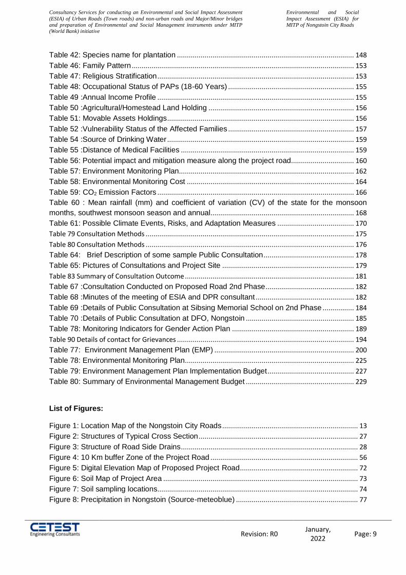
List of Tables:
Table 1: The project road stretches of Nongstoin City Roads ....................................................... 13
Table 2: Project Salient Features.................................................................................................. 17
Table 3: Summary of Pavement Condition ...................................................................................... 30
Table 4: Culverts along the Project streches .................................................................................. 41
Table 5 :Summary of Project Cost ................................................................................................... 50
Table 6: Area of Influence (AoI) ....................................................................................................... 55
Table 7: Applicable Acts & Regulations ........................................................................................... 58
Table 8: Applicable Acts & Regulations (Construction Phase) ...................................................... 61
Table 9: Applicable Policies .......................................................................................................... 62
Table 10: Applicable World Bank Operational policies................................................................... 63
Table 21 Applicable Legal Framework for the entire Project ................................................................. 67
Table 12: Techniques Used for Ambient Air Quality Monitoring .................................................... 89
Table 13: Air Quality Monitoring locations along the project road ................................................. 89
Table 14: Ambient Air Quality along the Project Road ................................................................... 90
Table 15: Ambient Noise Standards ................................................................................................ 93
Table 16: Noise Monitoring locations along the project road ......................................................... 94
Table 17: Day and Night Time Leq .................................................................................................. 95
Table 18: Protected area in Meghalaya ........................................................................................... 97
Table 19: Reserve forest list in Meghalaya State ........................................................................... 99
Table 20: Community Reserves ..................................................................................................... 100
Table 21: Availability of Ecologigical/Cultural Site within Project Area ....................................... 100
Table 22: West Khasi Hill- Forest Cover (Area in Sq. km) ........................................................... 101
Table 23: Community Reserves in West Khasi Hills .................................................................... 102
Table 24: IBA Sites .......................................................................................................................... 102
Table 25: Sacred Grove in West Khasi Hills District..................................................................... 104
Table 26: Agro-biodiversity in the Study Area ............................................................................... 105
Table 27: Plant Biodiversity in the Study Area .............................................................................. 106
Table 28: Invasive Alien Plants in the Study Area ........................................................................ 109
Table 29: Mammals in The Study Area ......................................................................................... 111
Table 30: Herpetofauna of the Study Area .................................................................................... 111
Table 31: Common Fishes of Study Area...................................................................................... 112
Table 32: Common Birds of the Study area .................................................................................. 113
Table 33: Phytoplankton of the Study Area ................................................................................... 116
Table 34: Zooplankton found in the Project area .................................................................... 117
Table 35: Sensitive receptors along the project road ................................................................... 118
Table 36:Demographic Profile of West Khasi Hills District .......................................................... 122
Table 37 Distribution of Rural and Urban Population ................................................................... 123
Table 38: Adverse impacts on air quality during construction stage ........................................... 132
Table 39: Impact on Air Environment and Mitigation Measures .................................................. 134
Table 40: Typical noise levels of principal construction equipment (Noise Level in dB (A) at 50
Feet ................................................................................................................................................... 135
Table 41: Anticipated Noise due to construction in the sensitive receptor ................................. 139
Consultancy Services for conducting an Environmental and Social Impact Assessment
(ESIA) of Urban Roads (Town roads) and non-urban roads and Major/Minor bridges
and preparation of Environmental and Social Management instruments under MITP
(World Bank) initiative
Environmental and Social
Impact Assessment (ESIA) for
MITP of Nongstoin City Roads
Revision: R0 January,
2022 Page: 9
Table 42: Species name for plantation .......................................................................................... 148
Table 46: Family Pattern ................................................................................................................. 153
Table 47: Religious Stratification .................................................................................................... 153
Table 48: Occupational Status of PAPs (18-60 Years) ................................................................ 155
Table 49 :Annual Income Profile .................................................................................................... 155
Table 50 :Agricultural/Homestead Land Holding .......................................................................... 156
Table 51: Movable Assets Holdings ............................................................................................... 156
Table 52 :Vulnerability Status of the Affected Families ................................................................ 157
Table 54 :Source of Drinking Water ............................................................................................... 159
Table 55 :Distance of Medical Facilities ........................................................................................ 159
Table 56: Potential impact and mitigation measure along the project road ................................ 160
Table 57: Environment Monitoring Plan......................................................................................... 162
Table 58: Environmental Monitoring Cost ..................................................................................... 164
Table 59: CO2 Emission Factors .................................................................................................... 166
Table 60 : Mean rainfall (mm) and coefficient of variation (CV) of the state for the monsoon
months, southwest monsoon season and annual ......................................................................... 168
Table 61: Possible Climate Events, Risks, and Adaptation Measures ....................................... 170
Table 79 Consultation Methods .......................................................................................................... 175
Table 80 Consultation Methods .......................................................................................................... 176
Table 64: Brief Description of some sample Public Consultation .............................................. 178
Table 65: Pictures of Consultations and Project Site ................................................................... 179
Table 83 Summary of Consultation Outcome ...................................................................................... 181
Table 67 :Consultation Conducted on Proposed Road 2nd Phase ............................................. 182
Table 68 :Minutes of the meeting of ESIA and DPR consultant .................................................. 182
Table 69 :Details of Public Consultation at Sibsing Memorial School on 2nd Phase ................ 184
Table 70 :Details of Public Consultation at DFO, Nongstoin ....................................................... 185
Table 78: Monitoring Indicators for Gender Action Plan .............................................................. 189
Table 90 Details of contact for Grievances .......................................................................................... 194
Table 77: Environment Management Plan (EMP) ....................................................................... 200
Table 78: Environmental Monitoring Plan...................................................................................... 225
Table 79: Environment Management Plan Implementation Budget ............................................ 227
Table 80: Summary of Environmental Management Budget ....................................................... 229
List of Figures:
Figure 1: Location Map of the Nongstoin City Roads ..................................................................... 13
Figure 2: Structures of Typical Cross Section ................................................................................. 27
Figure 3: Structure of Road Side Drains .......................................................................................... 28
Figure 4: 10 Km buffer Zone of the Project Road ........................................................................... 56
Figure 5: Digital Elevation Map of Proposed Project Road ............................................................ 72
Figure 6: Soil Map of Project Area ................................................................................................... 73
Figure 7: Soil sampling locations...................................................................................................... 74
Figure 8: Precipitation in Nongstoin (Source-meteoblue) .............................................................. 77

Consultancy Services for conducting an Environmental and Social Impact Assessment
(ESIA) of Urban Roads (Town roads) and non-urban roads and Major/Minor bridges
and preparation of Environmental and Social Management instruments under MITP
(World Bank) initiative
Environmental and Social
Impact Assessment (ESIA) for
MITP of Nongstoin City Roads
Revision: R0 January,
2022 Page: 10
Figure 9: Average Temperature in Nongstoin ................................................................................. 78
Figure 10: Average Wind Speed in Nongstoin ........................................................................... 79
Figure 11: Wind Rose Diagram For Nongstoin ............................................................................... 80
Figure 12: Average Humidity of previous 10 years ......................................................................... 80
Figure 13: Seismic zone map of India & Meghalaya ...................................................................... 81
Figure 14: Earthquake Zones Map of Meghalaya ........................................................................... 82
Figure 15: Multi Hazard Zone Map of Meghalaya showing the project road ................................ 83
Figure 16: Flood Prone Zones of Meghalaya .................................................................................. 84
Figure 17: Landslide Map of North-Eastern Himalayas.................................................................. 85
Figure 18: Map of Wind and Cyclone Zone in Meghalaya showing the project road .................. 86
Figure 19: Land Use Map of the Project Area ............................................................................ 87
Figure 20: Air Quality Monitoring locations along the project road ................................................ 90
Figure 21: Noise Monitoring locations along the project road........................................................ 95
Figure 22: Protected Areas of Meghalaya ....................................................................................... 98
Figure 23: distance between Balpakram National Park and project area ..................................... 98
Figure 24: the Elephant Corridors in Meghalay ............................................................................ 103
Figure 25: Vegetation along the Project Road .............................................................................. 109
Figure 26: Photographs of some sensitive receptors along the road stretch .............................. 121
Figure 27: Road Network of West Khasi Hills ............................................................................... 125
Figure 28 :Categories of Surveyed Families along the Project Road ......................................... 154
Figure 29: Educational Status of PAPs .......................................................................................... 154
Figure 30: Annual Expenditure Profile .......................................................................................... 156
Figure 33:Project Implementation Arrangement ........................................................................... 191
Consultancy Services for conducting an Environmental and Social Impact Assessment
(ESIA) of Urban Roads (Town roads) and non-urban roads and Major/Minor bridges
and preparation of Environmental and Social Management instruments under MITP
(World Bank) initiative
Environmental and Social
Impact Assessment (ESIA) for
MITP of Nongstoin City Roads
Revision: R0 January,
2022 Page: 11
1 CHAPTER-I: INTRODUCTION AND PROJECT BACKGROUND
Meghalaya is a hilly state in north eastern India. The state shares its international
boundaries with Bangladesh-South & West of Meghalaya are adjacent to Mymensingh,
Sylhet and Rangpur division of Bangladesh, respectively and northern part of this hilly state
is boarded by another north-eastern state, Assam. Economical growth of this state has been
hampered compared to other states of India, due to socio-geographical reasons, poor
communication, and low agricultural and industrial outputs. The Public Works Department
(PWD) of the Government of Meghalaya is the implementing the rehabilitation / up-gradation
of existing roads and construction of missing links/bypasses/Bridges in the major stretches
(Nongstoin-Maweit, Umsning-Jagi Road, Borsora road, Cherragoan road, Bagli and
Nongpoh-Umden-Sonapur in State of Meghalaya.
The Government of Meghalaya has stepped up investments in the development of transport
infrastructure using financial assistance (loan) from the World Bank (IBRD) under its
Meghalaya Integrated Transport Project (MITP) for the enhancement of the transport
Infrastructure in the State. The state Government has assigned the work of
improvement/rehabilitation of roads and construction of bridges (under the World Bank
funded MITP) to Public Works Department (PWD) of the Government of Meghalaya. This
department designs plans for rehabilitation / up gradation of existing roads and construction
of missing links / bypasses / Bridges in the stretches from Nongstoin-Maweit (35km),
Umsning- Jagi Road (40km), Borsora (6.50Km), Cherragoan (6.80 Km), Bagli (4.00 Km),
Nongpoh-Umden-Sonapur (25.0km), Shillong town roads (12.591km), Jowai Town roads
(34.843km), Nongstoin Town roads (20.925 km) and Williamnagar Town roads (23.451
km).
M/s Consulting Engineers Group Ltd. in JV with M/s C.E. Testing Company Pvt. Ltd. has
been chosen by Public Works Department (PWD) of the Government of Meghalaya to
perform Consultancy Services for Preparation of Detailed Project Report (DPR) for above
discussed stretch.
The PWD of Meghalaya issued Letter of award vide letter No. PW/CE/NH/WB/4/2021/58
dated 13.07.2021. The agreement for the project has been signed on 13.07.2021.
1.1 Details of the project stretches are elaborated below:
1.1.1 Non-Urban Roads
A. Nongstoin-Maweit corridor section is having a length of 35km in the West Khasi
Hills districts of Meghalaya state. The Project Road will connect the major towns and villages.
B. Umsning-Jagi Road corridor (SH-8) section is extended up to 40 km length in the districts Ri-Bhoi of Meghalaya state. The project road starts from the junction with National Highway - 6 /Asian Highway. The NH-6 is a Jorabat to Shillong stretches and it also part of the Asian Highway. It is mainly connected between the cities
Consultancy Services for conducting an Environmental and Social Impact Assessment
(ESIA) of Urban Roads (Town roads) and non-urban roads and Major/Minor bridges
and preparation of Environmental and Social Management instruments under MITP
(World Bank) initiative
Environmental and Social
Impact Assessment (ESIA) for
MITP of Nongstoin City Roads
Revision: R0 January,
2022 Page: 12
Guwahati to Shillong. The project scope ends at Km 40.00 of SH-8 near Sonidan town
C. Up-Gradation/improvement of road to Export point from the main road Borsora corridor sections is covering a length of 6.50 Km, Cherragoan corridor sections has
a length of 6.80 Km, and Bagli corridor sections has a Length of 4.00 Km. These roads are located under the Districts of South West Khasi Hills of Meghalaya state. (Border road)
D. Nongpoh-Umden-Sonapur Road corridor section has a length of 25 km in the
districts Ri-Bhoi of Meghalaya state. The project road starts from Nongpoh connecting with NH-6 /Asian Highway. The NH-6 is mainly connected between the Guwahati to Shillong location. The scope of project road ends at junctions of RDBR road near by Umden town. List of the project roads are given below:
1.1.2 Urban Roads
A. Shillong Town Roads:
All the project roads come under the East Khasi Hills district; Meghalaya passes
through the Shillong town. Eleven roads are parts of this project road having total
length of 12.59 Kms.
B. Jowai Town Roads:
All the project roads come under West Jaintia Hills district and part of Jowai town.
Total 54 roads are part of this project road having total length of 34.85 Kms.
C. Nongstoin Roads:
All the project roads come under West Khasi Hills district and part of Nongstoin town.
Total 24 roads are part of this project having total length of 20.75 Kms.
D. Williamnagar Town:
All the project roads come under East Garo Hills district and part of Williamnagar
town. 35 roads are part of this project having total length of 13.989 Kms.
The present Environment and Social Impact Assessment (ESIA) report has been
prepared for the Nongstoin City Roads under Non-urban Roads.
1.1.3 Nongstoin City Roads:
Nongstoin City Roads section has a total length of 20.925 km in the district of West
Khasi hills of Meghalaya state.
All the project road stretches lie in hilly terrain.
The carriageway width varies from 1m to 3.5m.
1.2 The Project Road
Nongstoin City Town Roads are 20.925 km total in length situated in the West Khasi Hills
district of Meghalaya state. The road project involves improvement of 24 road stretches. The
Project Roads for the Nongstoin City Roads are shown in the Figure 1.

Consultancy Services for conducting an Environmental and Social Impact Assessment
(ESIA) of Urban Roads (Town roads) and non-urban roads and Major/Minor bridges
and preparation of Environmental and Social Management instruments under MITP
(World Bank) initiative
Environmental and Social
Impact Assessment (ESIA) for
MITP of Nongstoin City Roads
Revision: R0 January,
2022 Page: 13
Figure 1: Location Map of the Nongstoin City Roads
The urban roads of Nongstoin town are around 20.925 kms total in length. The project road
stretches of Nongstoin City Roads are listed table below:
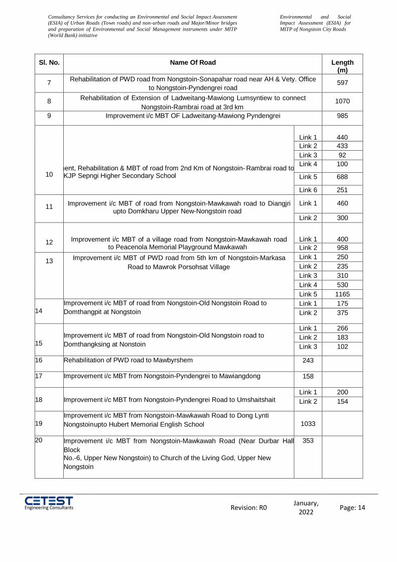
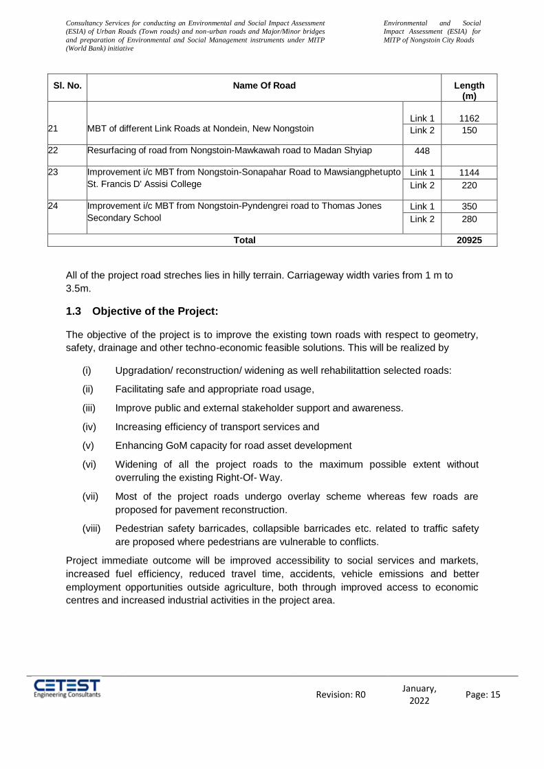
Table 1: The project road stretches of Nongstoin City Roads
Sl. No. Name Of Road Length (m)
1 Improvement i/c MBT of road from Lulong (Nongstoin-Mawkawah road) to Dong
Lynti Nongstoin connecting to Nongstoin-Mawthawpdah Road 1195
2 Improvement i/c MBT of approach road from Nongstoin-Mawkawah road to
Umsaitmluh 500
3 Improvement i/c MBT of road from Nongstoin-Mawkawah road to Petjyllan (Near
Anderson H/S School) to connect NH-44E 410
4 Improvement i/c MBT of approach road from NH-44E (Near Petrol Pump) to
Lulong,Mawkawah village 258
5
Improvement i/c MBT of road from TB Hospital road upto Nongstoin
Playground
Link 1 650
Lilnk 2 364
Link 3 170
6
Improvement i/c widening, MBT of road from Nongstoin College to permanent campus of Rev.S. Wollington Children Home of the KJP Synod Sepngi
1118
Consultancy Services for conducting an Environmental and Social Impact Assessment
(ESIA) of Urban Roads (Town roads) and non-urban roads and Major/Minor bridges
and preparation of Environmental and Social Management instruments under MITP
(World Bank) initiative
Environmental and Social
Impact Assessment (ESIA) for
MITP of Nongstoin City Roads
Revision: R0 January,
2022 Page: 14
Sl. No. Name Of Road Length (m)
7 Rehabilitation of PWD road from Nongstoin-Sonapahar road near AH & Vety. Office
to Nongstoin-Pyndengrei road 597
8 Rehabilitation of Extension of Ladweitang-Mawiong Lumsyntiew to connect
Nongstoin-Rambrai road at 3rd km 1070
9 Improvement i/c MBT OF Ladweitang-Mawiong Pyndengrei 985
10
Improvement, Rehabilitation & MBT of road from 2nd Km of Nongstoin- Rambrai road to KJP Sepngi Higher Secondary School
Link 1
440
Link 2 433
Link 3 92
Link 4 100
Link 5 688
Link 6 251
11
Improvement i/c MBT of road from Nongstoin-Mawkawah road to Diangjri upto Domkharu Upper New-Nongstoin road
Link 1 460
Link 2 300
12
Improvement i/c MBT of a village road from Nongstoin-Mawkawah road to Peacenola Memorial Playground Mawkawah
Link 1
400
Link 2 958
13 Improvement i/c MBT of PWD road from 5th km of Nongstoin-Markasa
Road to Mawrok Porsohsat Village
Link 1 250
Link 2 235
Link 3 310
Link 4 530
Link 5 1165
14
Improvement i/c MBT of road from Nongstoin-Old Nongstoin Road to
Domthangpit at Nongstoin
Link 1 175
Link 2 375
15
Improvement i/c MBT of road from Nongstoin-Old Nongstoin road to
Domthangksing at Nonstoin
Link 1 266
Link 2 183
Link 3 102
16 Rehabilitation of PWD road to Mawbyrshem 243
17 Improvement i/c MBT from Nongstoin-Pyndengrei to Mawiangdong 158
18
Improvement i/c MBT from Nongstoin-Pyndengrei Road to Umshaitshait
Link 1 200
Link 2 154
19
Improvement i/c MBT from Nongstoin-Mawkawah Road to Dong Lynti
Nongstoin upto Hubert Memorial English School
1033
20 Improvement i/c MBT from Nongstoin-Mawkawah Road (Near Durbar Hall
Block
No.-6, Upper New Nongstoin) to Church of the Living God, Upper New
Nongstoin
353
Consultancy Services for conducting an Environmental and Social Impact Assessment
(ESIA) of Urban Roads (Town roads) and non-urban roads and Major/Minor bridges
and preparation of Environmental and Social Management instruments under MITP
(World Bank) initiative
Environmental and Social
Impact Assessment (ESIA) for
MITP of Nongstoin City Roads
Revision: R0 January,
2022 Page: 15
Sl. No. Name Of Road Length (m)
21
MBT of different Link Roads at Nondein, New Nongstoin
Link 1
1162
Link 2 150
22 Resurfacing of road from Nongstoin-Mawkawah road to Madan Shyiap 448
23 Improvement i/c MBT from Nongstoin-Sonapahar Road to Mawsiangphet upto
St. Francis D' Assisi College
Link 1 1144
Link 2 220
24 Improvement i/c MBT from Nongstoin-Pyndengrei road to Thomas Jones
Secondary School
Link 1 350
Link 2 280
Total 20925
All of the project road streches lies in hilly terrain. Carriageway width varies from 1 m to
3.5m.
1.3 Objective of the Project:
The objective of the project is to improve the existing town roads with respect to geometry,
safety, drainage and other techno-economic feasible solutions. This will be realized by
(i) Upgradation/ reconstruction/ widening as well rehabilitattion selected roads:
(ii) Facilitating safe and appropriate road usage,
(iii) Improve public and external stakeholder support and awareness.
(iv) Increasing efficiency of transport services and
(v) Enhancing GoM capacity for road asset development
(vi) Widening of all the project roads to the maximum possible extent without
overruling the existing Right-Of- Way.
(vii) Most of the project roads undergo overlay scheme whereas few roads are
proposed for pavement reconstruction.
(viii) Pedestrian safety barricades, collapsible barricades etc. related to traffic safety
are proposed where pedestrians are vulnerable to conflicts.
Project immediate outcome will be improved accessibility to social services and markets,
increased fuel efficiency, reduced travel time, accidents, vehicle emissions and better
employment opportunities outside agriculture, both through improved access to economic
centres and increased industrial activities in the project area.

Consultancy Services for conducting an Environmental and Social Impact Assessment
(ESIA) of Urban Roads (Town roads) and non-urban roads and Major/Minor bridges
and preparation of Environmental and Social Management instruments under MITP
(World Bank) initiative
Environmental and Social
Impact Assessment (ESIA) for
MITP of Nongstoin City Roads
Revision: R0 January,
2022 Page: 16
1.4 Scope of the Project:
The proposed subprojects are part of Meghalaya Integrated Transport Program (MITP) for
which the Environmental and Social Safeguard Management Framework (ESMF) has been
prepared and disclosed at the websites of MIDFC and the World Bank. It is also noted that in
specific to the rural roads the ESMF guidelines delineated under PMGSY RRP II (P165402)
and subsequently revised for Additional Finance in 2018 to be followed.
Preparation of application and supplementary reports (survey and preparation) as
required for obtaining project's clearances like forest /environmental/wildlife
clearances, if applicable, and presentation before expert panel committees of
MoEF&CC, Govt. of India.
Undertake the given special and additional assessments as applicable.
Scientific and expert judgement for adding or skipping any element of assessment
was apply
Preparation of screening report for all the subprojects and Scope of Work (SoW) was
define for the detail assessment if required.
Screening report was include the Environment and Social Management Plans, Health
and Safety Plans including COVID 19 management plans, Stakeholder Engagement
Plan, Public Disclosure, Grievance Redressal Mechanism and Resettlement Action
Plan if required.
It was consider but not be limited to the following:
a) Conduct a comprehensive Environmental and Social Screening for all the
subprojects.
b) Establishing an environmental and social baseline for the project area.
c) Conduct detailed Environmental and Social Impact Assessment (ESIA) only for
those subprojects against which need for detailed assessment has been
recommended as an outcome of Screening Activity.
d) Integration of ESIA findings and ESMP budget in engineering feasibility studies.
e) Preparation of any Environmental and Social Management Plan (ESMP), Health
and Safety Plans including COVID 19 management plan, Resettlement Action
Plan (RAP), Tribal (Indigenous) Development Plan (TDP), Gender Action Plan;
Labor Management Procedure and Stakeholder Engagement Plan (SEP) etc.
f) Preparation of application and supplementary reports (survey and preparation)
required per local regulatory requirements for obtaining project’s clearances like
forest/environmental/wildlife clearances, if applicable, and presentation before
expert panel committees of MoEF&CC, Govt. of India.
g) Conduct consultations with identified stakeholders and project-affected parties
/community from early project planning and design stages of the assignment.
h) Develop monitoring programme to ensure that the proposed mitigation measures
are being implemented effectively.

Consultancy Services for conducting an Environmental and Social Impact Assessment
(ESIA) of Urban Roads (Town roads) and non-urban roads and Major/Minor bridges
and preparation of Environmental and Social Management instruments under MITP
(World Bank) initiative
Environmental and Social
Impact Assessment (ESIA) for
MITP of Nongstoin City Roads
Revision: R0 January,
2022 Page: 17
Table 2: Project Salient Features
S. No. Salient Features Details
1 Design Chainage -
2 Total Length (Km) 20.925
3 Proposed Carriageway width
The carriageway (BT) width varies from 1 to 3.5 m either
side of design center line.
4
Major Junctions (Nos.) 23
Minor Junction (Nos.) 50
Total Junction 73
6 Major Bridge Nil
7 Minor Bridge Nil
8 Total Culverts (Nos) 72
9 Bus Shelters (Nos.) .-
10 Slope Protection Retaining Walls, Breast Walls, Parapet Walls
11 Project Cost 15.43 Cr.
1.5 Structure of ESIA Report
As per the EIA notification of the MOEF on dated 14 September 2006 & subsequent
amendments, the generic structure for the EIA report shall consist of the following chapters:
The EIA report for the project road has been prepared complying country regulations and
The World Bank Guidelines for Environmental Assessment. The report has been structured
in the following Chapters:
Chapter -I: Introduction and Project Background
Chapter -II: Project Description
Chapter -III: Need of Environment & Social Impact Assessment
Chapter -IV: Legal Framework
Chapter -V: Description of Environment
Chapter -VI: Analysis of Potential Environmental and Social Impacts and Mitigation
Measures
Chapter -VII: Environmental Monitoring Plan
Chapter -VIII: Climate Change Impact and Risk
Chapter -IX: Additional Studies
Chapter -X: Resettlement Action Plan
Chapter -XI: Monitoring & Evaluation
Chapter -XII: Abbreviated Resettlement Action Plan
Chapter -XIII: Environment and Social Management Plan
Chapter -XIV: Conclusions and Recommendations

Consultancy Services for conducting an Environmental and Social Impact Assessment
(ESIA) of Urban Roads (Town roads) and non-urban roads and Major/Minor bridges
and preparation of Environmental and Social Management instruments under MITP
(World Bank) initiative
Environmental and Social
Impact Assessment (ESIA) for
MITP of Nongstoin City Roads
Revision: R0 January,
2022 Page: 18
2 CHAPTER-II: Project Description
The urban roads of Nongstoin town are around 20.925 km in length which situated in the
West Khasi Hills district of Meghalaya state. The project road starts from the ABDK Mission
Compound of RSN Road and it’s interconnected to 24 road junctions within Nongstoin Town.
2.1 Need for the Project
The project stretch has bitumen surface throughout. 99% of the road stretches are poor in
condition. The safety provision of road is also inadequate. Therefore, it is imperative to
upgrade this road section to standard configuration with adequate safety measures in order
to enhance traffic operational efficiency and to ensure safety to road users, so that the
objective of improving the connectivity of the roads to the others parts of the district and
state is realised.
Many settlements are located close to project road, which make road narrow and congested.
Poor road conditions and geometry of the project road result in slow economic growth and
poor infrastructure facilities in the area. Therefore, rehabilitation and upgrading project road
is needed with proper traffic engineering and enforcement of the rules and regulations of the
road, so that there should also be a marked reduction in road traffic accidents and smooth
flow of traffic is ensured.
2.2 Project Location
Nongstoin City Roads involves 24 road stretches, total length of 20.925. The Project
Highway corridor is situated in West Khasi Hills district of Meghalaya. The project is located
in the Universe Transverse Meter (UTM) zone 46. The height of the dissected Meghalaya
Plateau is 150 meters - 1961 meters above sea level. Location map of the project roads is
given in Figure 1.
2.3 Existing Features of the Project
The existing project features are given below.
Sl. no Project Component Details
1 Location of Project Nongstoin Town (20.925km). Project road is situated in West Khasi Hills in the state of Meghalaya.
2 Administrative locations West Khasi Hills
3 State Meghalaya
4 Length of the project section 20.925 km
5 Terrain All of the road stretches of Nongstoin passes through hilly terrain
7 Land use The project area covers mostly forest area and agricultural area and 30% area is covered by built-up area.
8 Forest area 40% area of the project road is under forest area 9 Bridge There is no major and minor Bridges along the project
road
10 Road Configuration Most of the roads are of single lane configuration with a
Consultancy Services for conducting an Environmental and Social Impact Assessment
(ESIA) of Urban Roads (Town roads) and non-urban roads and Major/Minor bridges
and preparation of Environmental and Social Management instruments under MITP
(World Bank) initiative
Environmental and Social
Impact Assessment (ESIA) for
MITP of Nongstoin City Roads
Revision: R0 January,
2022 Page: 19
few numbers of roads have intermediate/two lane configuration.
11 Pavement condition Existing road is not motorable, thus 99% of the roads are ‘poor’ in condition.
12 High embank road stretches Nil
2.4 Right of Way (RoW)
The carriageway width of the existing road varies from 1m to 3.5 meter. Width of earthen
shoulder varies from 0 to 1.5 meter. The Proposed Right of Way is within the existing Right
of way.
2.5 Proposed Land Acquisition
As the Proposed Right of Way is well within the existing Right of Way, so there is No New
Land is required.
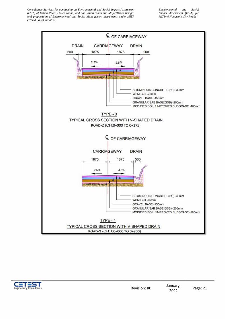
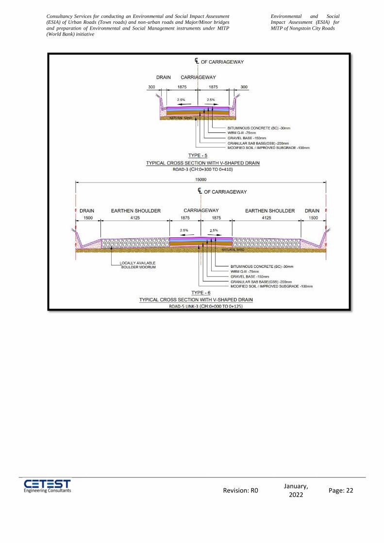
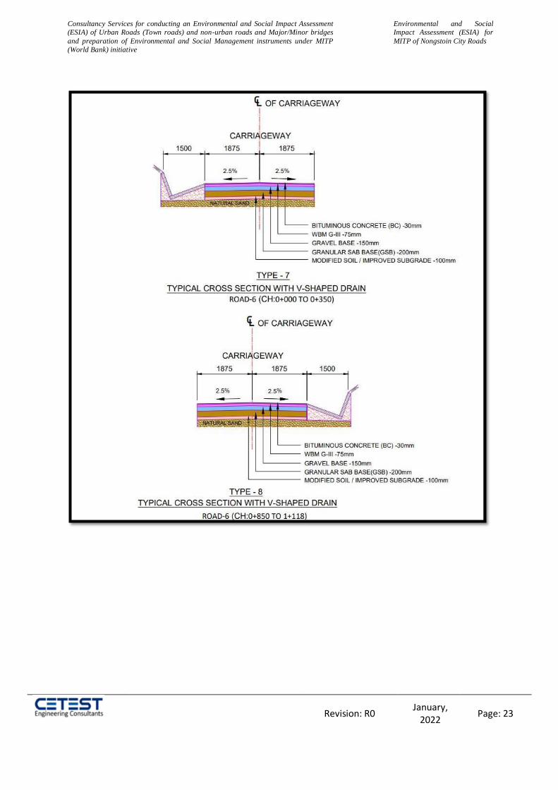
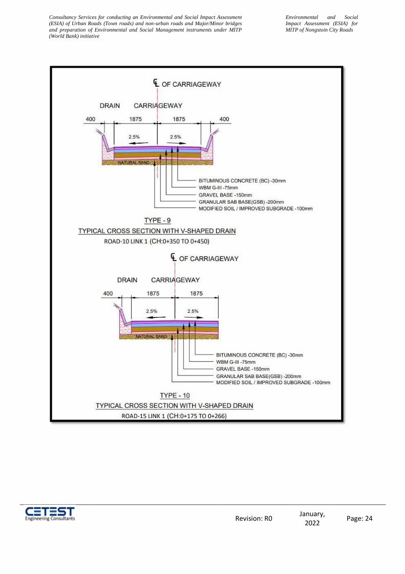
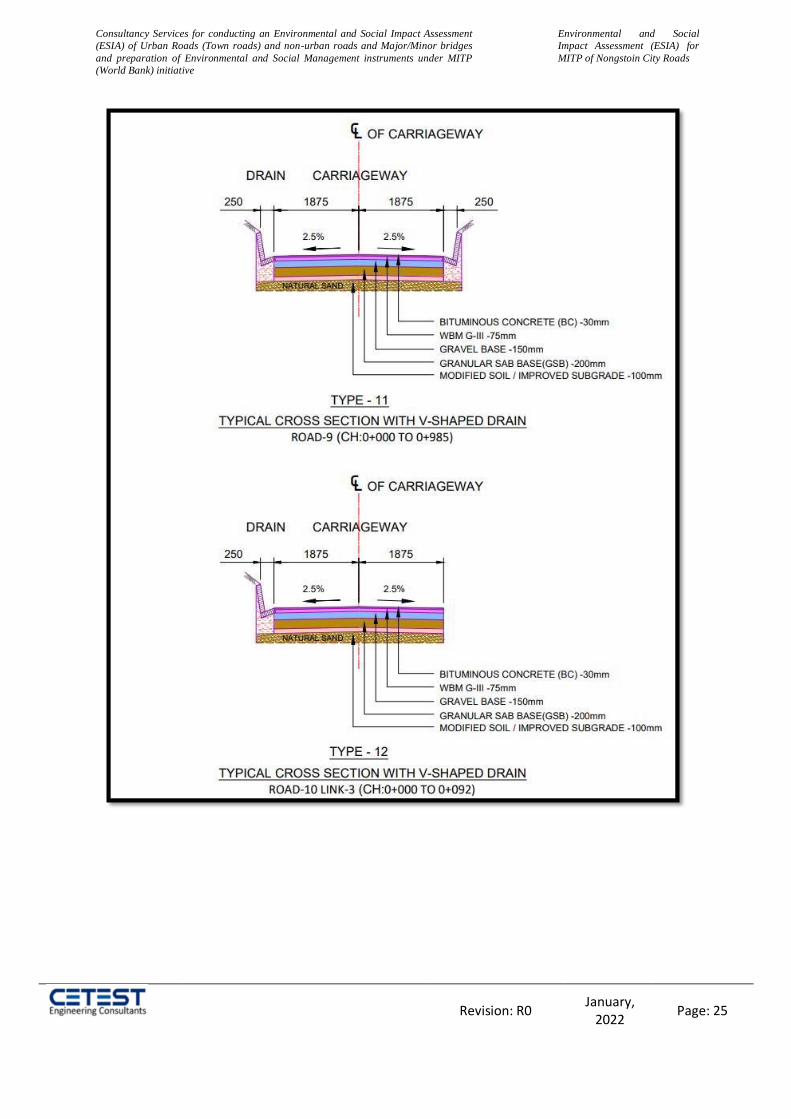
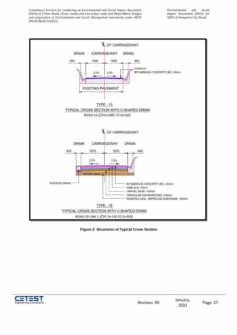
2.6 Proposed Cross Section Details
Carriageway Width: The carriageway configuration of two lanes with a paved and
hard shoulder is proposed for the project road having 1 to 3.5m carriageway width.
Shoulder: Earthen shoulders are proposed to be 1 to 1.5 m on both sides of the
Carriageway.
Typical Cross Section:
Typical cross sections (TCS) for various configurations proposed in built up area and
open country area in hilly terrain are shown below:

Consultancy Services for conducting an Environmental and Social Impact Assessment
(ESIA) of Urban Roads (Town roads) and non-urban roads and Major/Minor bridges
and preparation of Environmental and Social Management instruments under MITP
(World Bank) initiative
Environmental and Social
Impact Assessment (ESIA) for
MITP of Nongstoin City Roads
Revision: R0 January,
2022 Page: 20
Consultancy Services for conducting an Environmental and Social Impact Assessment
(ESIA) of Urban Roads (Town roads) and non-urban roads and Major/Minor bridges
and preparation of Environmental and Social Management instruments under MITP
(World Bank) initiative
Environmental and Social
Impact Assessment (ESIA) for
MITP of Nongstoin City Roads
Revision: R0 January,
2022 Page: 21
Consultancy Services for conducting an Environmental and Social Impact Assessment
(ESIA) of Urban Roads (Town roads) and non-urban roads and Major/Minor bridges
and preparation of Environmental and Social Management instruments under MITP
(World Bank) initiative
Environmental and Social
Impact Assessment (ESIA) for
MITP of Nongstoin City Roads
Revision: R0 January,
2022 Page: 22
Consultancy Services for conducting an Environmental and Social Impact Assessment
(ESIA) of Urban Roads (Town roads) and non-urban roads and Major/Minor bridges
and preparation of Environmental and Social Management instruments under MITP
(World Bank) initiative
Environmental and Social
Impact Assessment (ESIA) for
MITP of Nongstoin City Roads
Revision: R0 January,
2022 Page: 23
Consultancy Services for conducting an Environmental and Social Impact Assessment
(ESIA) of Urban Roads (Town roads) and non-urban roads and Major/Minor bridges
and preparation of Environmental and Social Management instruments under MITP
(World Bank) initiative
Environmental and Social
Impact Assessment (ESIA) for
MITP of Nongstoin City Roads
Revision: R0 January,
2022 Page: 24
Consultancy Services for conducting an Environmental and Social Impact Assessment
(ESIA) of Urban Roads (Town roads) and non-urban roads and Major/Minor bridges
and preparation of Environmental and Social Management instruments under MITP
(World Bank) initiative
Environmental and Social
Impact Assessment (ESIA) for
MITP of Nongstoin City Roads
Revision: R0 January,
2022 Page: 25

Consultancy Services for conducting an Environmental and Social Impact Assessment
(ESIA) of Urban Roads (Town roads) and non-urban roads and Major/Minor bridges
and preparation of Environmental and Social Management instruments under MITP
(World Bank) initiative
Environmental and Social
Impact Assessment (ESIA) for
MITP of Nongstoin City Roads
Revision: R0 January,
2022 Page: 26
Consultancy Services for conducting an Environmental and Social Impact Assessment
(ESIA) of Urban Roads (Town roads) and non-urban roads and Major/Minor bridges
and preparation of Environmental and Social Management instruments under MITP
(World Bank) initiative
Environmental and Social
Impact Assessment (ESIA) for
MITP of Nongstoin City Roads
Revision: R0 January,
2022 Page: 27
Figure 2: Structures of Typical Cross Section

Consultancy Services for conducting an Environmental and Social Impact Assessment
(ESIA) of Urban Roads (Town roads) and non-urban roads and Major/Minor bridges
and preparation of Environmental and Social Management instruments under MITP
(World Bank) initiative
Environmental and Social
Impact Assessment (ESIA) for
MITP of Nongstoin City Roads
Page 28 of 238
2.7 Current and Projected Daily Traffic
Meghalaya government had restricted traffic movement in the state due to unprecedented increase in Covid-19 cases. Due to these restrictions, traffic surveys were not carried out earlier during field surveys. Preliminary site reconnaissance indicates that substantial number of private cars commute along the project road stretches.
2.8 Proposed Roadside Drainage
To ensure effective drainage of water from road side drainage system has been provided throughout the project stretch. The details of the roadside drainage are shown in typical cross section and drawing volume. Roadside drains should generally be of uniform section throughout Irrespective of the location of road on the hill slope. Road on ridge alignment may not require the same section of drains due to lesser quantity of flow of water. For convenience of construction, it may be necessary to have uniform section of a drain but the frequency of culverts could be regulated to the catchment area that it has to cater to. Roadside drains are constructed to parabolic (Saucer shape), trapezoidal, triangular, V-Shape, kerb and channel or U-Shaped cross-sections. The parabolic section is hydraulically the best and most erosion resistant. The trapezoidal sections easier to construct and is more generally used. Kerb and channel drain gives extra width in case of emergencies for vehicles to use. U-Shaped drains are generally deep drains and are provided where higher discharge has to be catered and adequate road width is available. Drawings of Structures of different shapes of roadside drains are given below in Figure 3.
Figure 3: Structure of Road Side Drains
Consultancy Services for conducting an Environmental and Social Impact Assessment
(ESIA) of Urban Roads (Town roads) and non-urban roads and Major/Minor bridges
and preparation of Environmental and Social Management instruments under MITP
(World Bank) initiative
Environmental and Social
Impact Assessment (ESIA) for
MITP of Nongstoin City Roads
Page 29 of 238
2.9 Proposed Pedestrian and Animal Crossing
On the basis of interfering site visit data and traffic data, no pedestrian underpass is proposed.
There is no animal movement corridor along or across the project road. Therefore, no animal
underpass is needed.
2.10 Wayside Amenities
Bus Shelters
No data avalible form DPR consultancy.
Truck Lay Bye
No data avalible form DPR consultancy.
Footpath
No data avalible form DPR consultancy.

Consultancy Services for conducting an Environmental and Social Impact Assessment
(ESIA) of Urban Roads (Town roads) and non-urban roads and Major/Minor bridges
and preparation of Environmental and Social Management instruments under MITP
(World Bank) initiative
Environmental and Social
Impact Assessment (ESIA) for
MITP of Nongstoin City Roads
Page 30 of 238
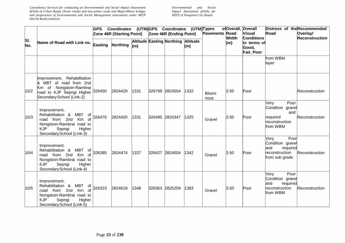
2.11 Pavement Condition
The project stretch has bitumen surface throughout. Most of the existing road stretches (99% of the road stretches) are ‘poor’ in condition.
The summary of the visual pavement condition (survey carried out in October, 2021) of the project roads are given below:
Table 3: Summary of Pavement Condition
Sl.
No.
Name of Road with Link no.
GPS Coordinates (UTM)
Zone 46R (Starting Point)
GPS Coordinates (UTM)
Zone 46R (Ending Point)
Types of Pavements
Overall, Road Width (m)
Overall Visual Conditions in terms of Good, Fair, Poor
Distress of the Road
Recommended Overlay/ Reconstruction
Easting Northing Altitude (m)
Easting Northing Altitude (m)
1
Improvement i/c MBT of road from Lulong (Nongstoin- Mawkawah road) to Dong Lynti Nongstoin connecting to Nongstoin-Mawthawpdah Road
327156
2823351
1408
326779
2822416
1357
Gravel Earthen Road
/
3.50
Poor
Veryn Poor Condition gravel and required reconstruction from WBM
Reconstruction
2
Improvement i/c MBT of approach road from Nongstoin-Mawkawah road to Umsaitmluh
325904
2823385
1318
326198
2823084
1343
Gravel Earthen Road
/
3.50
Poor
Very Poor Condition gravel and required reconstruction from WBM
Reconstruction
3
Improvement i/c MBT of road from Nongstoin-Mawkawah road to Petjyllan (Near Anderson H/S School) to connect NH-44E
326169
2823571
1362
326229
2823874
1323
Gravel Earthen Road
/
3.50
Poor
Gravel-Earthen very Poor Condition gravel-and required reconstruction from sub grade
Reconstruction

Consultancy Services for conducting an Environmental and Social Impact Assessment
(ESIA) of Urban Roads (Town roads) and non-urban roads and Major/Minor bridges
and preparation of Environmental and Social Management instruments under MITP
(World Bank) initiative
Environmental and Social
Impact Assessment (ESIA) for
MITP of Nongstoin City Roads
Page 31 of 238
Sl.
No.
Name of Road with Link no.
GPS Coordinates (UTM)
Zone 46R (Starting Point)
GPS Coordinates (UTM)
Zone 46R (Ending Point)
Types of Pavements
Overall, Road Width (m)
Overall Visual Conditions in terms of Good, Fair, Poor
Distress of the Road
Recommended Overlay/ Reconstruction
Easting Northing Altitude (m)
Easting Northing Altitude (m)
4
Improvement i/c MBT of approach road from NH-44E (Near Petrol Pump) to Lulong, Mawkawah village
327231
2822814
1420
327033
2822714
1392
Gravel Earthen Road
/ 3.50
Poor
Gravel-Earthen very Poor Condition gravel-and required reconstruction from sub grade
5/1
Improvement i/c MBT of road from TB Hospital road upto Nongstoin Playground (Link-1)
326493
2822318
1362
326029
2822374
1404
Gravel
3.50
Poor
Very Poor Condition gravel and required reconstruction from sub grade
Reconstruction
5/2
Improvement i/c MBT of road from TB Hospital road upto Nongstoin Playground (Link-2)
325887
2822099
1393
325545
2822042
1401
Gravel
3.50
Poor
Very Poor Condition gravel and required reconstruction from sub grade
Reconstruction
5/3
Improvement i/c MBT of road from TB Hospital road upto Nongstoin Playground (Link-3)
326195
2822417
1401
326082
2822530
1402
Gravel
3.50
Poor
Very Poor Condition gravel and required reconstruction from sub grade
Reconstruction
6
Improvement i/c widening, MBT of road from Nongstoin
College to permanent campus of Rev.S. Wollington Children Home of the KJP Synod Sepngi
324077
2822955
1383
324474
2821944
1356
Gravel / Earthen Road
3.50
Poor
Gravel-Earthen very Poor Condition gravel-and required reconstruction from sub grade
Reconstruction

Consultancy Services for conducting an Environmental and Social Impact Assessment
(ESIA) of Urban Roads (Town roads) and non-urban roads and Major/Minor bridges
and preparation of Environmental and Social Management instruments under MITP
(World Bank) initiative
Environmental and Social
Impact Assessment (ESIA) for
MITP of Nongstoin City Roads
Page 32 of 238
Sl.
No.
Name of Road with Link no.
GPS Coordinates (UTM)
Zone 46R (Starting Point)
GPS Coordinates (UTM)
Zone 46R (Ending Point)
Types of Pavements
Overall, Road Width (m)
Overall Visual Conditions in terms of Good, Fair, Poor
Distress of the Road
Recommended Overlay/ Reconstruction
Easting Northing Altitude (m)
Easting Northing Altitude (m)
7
Rehabilitation of PWD road from Nongstoin - Sonapahar road near AH & Vety. Office to Nongstoin - Pyndengrei road
325021
2824417
1322
325247
2824541
1345
Gravel
3.50
Poor
BT but very worst condition and reconstruction required from WBM layer
Reconstruction
8
Rehabilitation of Extension of Ladweitang - Mawiong Lumsyntiew to connect Nongstoin - Rambrai road at 3rd km
325932
2824809
1351
326220
2825220
1369
Gravel
3.50
Poor
Bt-gravel- earthen but very poor condition so require construction from top of the sub grad and some places GSB/WBM
Reconstruction
9
Improvement i/c MBT OF Ladweitang-Mawiong Pyndengrei
325461
2825169
1345
325632
2824570
1335
Bituminous
3.50
Poor Very Poor Condition gravel and required reconstruction from sub grade
Reconstruction
10/1
Improvement, Rehabilitation & MBT of road from 2nd Km of Nongstoin-Rambrai road to KJP Sepngi Higher Secondary
School (Link-1)
326310
2824484
1338
326392
2824154
1326
Bituminous
3.50
Poor
BT Road Very Poor Conditions due to Lots of potholes, cracking, rutting, raveling and undulating type surface so required reconstruction
Reconstruction
Consultancy Services for conducting an Environmental and Social Impact Assessment
(ESIA) of Urban Roads (Town roads) and non-urban roads and Major/Minor bridges
and preparation of Environmental and Social Management instruments under MITP
(World Bank) initiative
Environmental and Social
Impact Assessment (ESIA) for
MITP of Nongstoin City Roads
Page 33 of 238
Sl.
No.
Name of Road with Link no.
GPS Coordinates (UTM)
Zone 46R (Starting Point)
GPS Coordinates (UTM)
Zone 46R (Ending Point)
Types of Pavements
Overall, Road Width (m)
Overall Visual Conditions in terms of Good, Fair, Poor
Distress of the Road
Recommended Overlay/ Reconstruction
Easting Northing Altitude (m)
Easting Northing Altitude (m)
from WBM layer
10/2
Improvement, Rehabilitation & MBT of road from 2nd Km of Nongstoin-Rambrai road to KJP Sepngi Higher Secondary School (Link-2)
326450
2824429
1331
326799
2824554
1332
Bituminous
3.50
Poor
Reconstruction
10/3
Improvement, Rehabilitation & MBT of road from 2nd Km of Nongstoin-Rambrai road to KJP Sepngi Higher Secondary School (Link-3)
326476
2824420
1331
326495
2824347
1325
Gravel
3.50
Poor
Very Poor Condition gravel and required reconstruction from WBM
Reconstruction
10/4
Improvement, Rehabilitation & MBT of road from 2nd Km of Nongstoin-Rambrai road to KJP Sepngi Higher Secondary School (Link-4)
326385
2824474
1337
326427
2824504
1342
Gravel
3.50
Poor
Very Poor Condition gravel and required reconstruction from sub grade
Reconstruction
10/5
Improvement, Rehabilitation & MBT of road from 2nd Km of Nongstoin-Rambrai road to KJP Sepngi Higher Secondary School (Link-5)
326323
2824618
1348
326363
2825259
1383
Gravel
3.50
Poor
Very Poor Condition gravel and required reconstruction from WBM
Reconstruction
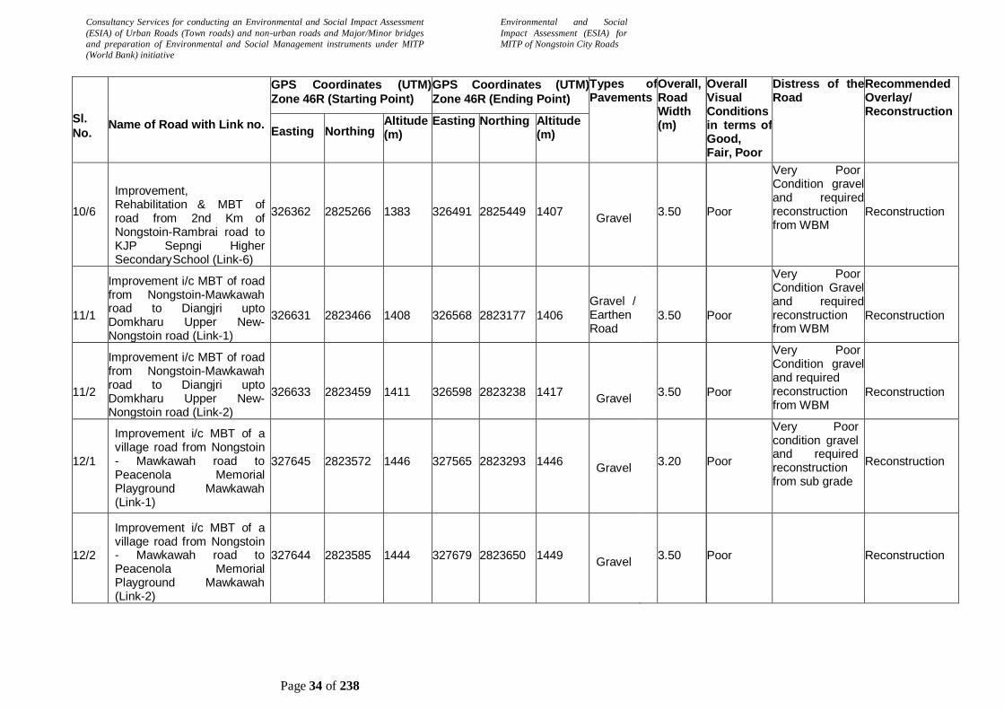
Consultancy Services for conducting an Environmental and Social Impact Assessment
(ESIA) of Urban Roads (Town roads) and non-urban roads and Major/Minor bridges
and preparation of Environmental and Social Management instruments under MITP
(World Bank) initiative
Environmental and Social
Impact Assessment (ESIA) for
MITP of Nongstoin City Roads
Page 34 of 238
Sl.
No.
Name of Road with Link no.
GPS Coordinates (UTM)
Zone 46R (Starting Point)
GPS Coordinates (UTM)
Zone 46R (Ending Point)
Types of Pavements
Overall, Road Width (m)
Overall Visual Conditions in terms of Good, Fair, Poor
Distress of the Road
Recommended Overlay/ Reconstruction
Easting Northing Altitude (m)
Easting Northing Altitude (m)
10/6
Improvement, Rehabilitation & MBT of road from 2nd Km of Nongstoin-Rambrai road to KJP Sepngi Higher Secondary School (Link-6)
326362
2825266
1383
326491
2825449
1407
Gravel
3.50
Poor
Very Poor Condition gravel and required reconstruction from WBM
Reconstruction
11/1
Improvement i/c MBT of road from Nongstoin-Mawkawah road to Diangjri upto Domkharu Upper New- Nongstoin road (Link-1)
326631
2823466
1408
326568
2823177
1406
Gravel / Earthen Road
3.50
Poor
Very Poor Condition Gravel and required reconstruction from WBM
Reconstruction
11/2
Improvement i/c MBT of road from Nongstoin-Mawkawah road to Diangjri upto Domkharu Upper New- Nongstoin road (Link-2)
326633
2823459
1411
326598
2823238
1417
Gravel
3.50
Poor
Very Poor Condition gravel and required reconstruction from WBM
Reconstruction
12/1
Improvement i/c MBT of a village road from Nongstoin - Mawkawah road to Peacenola Memorial Playground Mawkawah (Link-1)
327645
2823572
1446
327565
2823293
1446
Gravel
3.20
Poor
Very Poor condition gravel and required reconstruction from sub grade
Reconstruction
12/2
Improvement i/c MBT of a village road from Nongstoin - Mawkawah road to Peacenola Memorial Playground Mawkawah (Link-2)
327644
2823585
1444
327679
2823650
1449
Gravel
3.50
Poor
Reconstruction
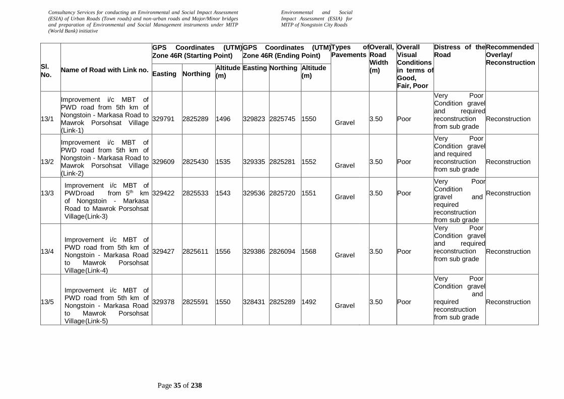
Consultancy Services for conducting an Environmental and Social Impact Assessment
(ESIA) of Urban Roads (Town roads) and non-urban roads and Major/Minor bridges
and preparation of Environmental and Social Management instruments under MITP
(World Bank) initiative
Environmental and Social
Impact Assessment (ESIA) for
MITP of Nongstoin City Roads
Page 35 of 238
Sl.
No.
Name of Road with Link no.
GPS Coordinates (UTM)
Zone 46R (Starting Point)
GPS Coordinates (UTM)
Zone 46R (Ending Point)
Types of Pavements
Overall, Road Width (m)
Overall Visual Conditions in terms of Good, Fair, Poor
Distress of the Road
Recommended Overlay/ Reconstruction
Easting Northing Altitude (m)
Easting Northing Altitude (m)
13/1
Improvement i/c MBT of PWD road from 5th km of Nongstoin - Markasa Road to Mawrok Porsohsat Village (Link-1)
329791
2825289
1496
329823
2825745
1550
Gravel
3.50
Poor
Very Poor Condition gravel and required reconstruction from sub grade
Reconstruction
13/2
Improvement i/c MBT of PWD road from 5th km of Nongstoin - Markasa Road to Mawrok Porsohsat Village (Link-2)
329609
2825430
1535
329335
2825281
1552
Gravel
3.50
Poor
Very Poor Condition gravel and required reconstruction from sub grade
Reconstruction
13/3
Improvement i/c MBT of PWD road from 5th km of Nongstoin - Markasa Road to Mawrok Porsohsat Village (Link-3)
329422
2825533
1543
329536
2825720
1551
Gravel
3.50
Poor
Very Poor Condition gravel and required reconstruction from sub grade
Reconstruction
13/4
Improvement i/c MBT of PWD road from 5th km of Nongstoin - Markasa Road to Mawrok Porsohsat Village (Link-4)
329427
2825611
1556
329386
2826094
1568
Gravel
3.50
Poor
Very Poor Condition gravel and required reconstruction from sub grade
Reconstruction
13/5
Improvement i/c MBT of PWD road from 5th km of Nongstoin - Markasa Road to Mawrok Porsohsat Village (Link-5)
329378
2825591
1550
328431
2825289
1492
Gravel
3.50
Poor
Very Poor Condition gravel and required reconstruction from sub grade
Reconstruction

Consultancy Services for conducting an Environmental and Social Impact Assessment
(ESIA) of Urban Roads (Town roads) and non-urban roads and Major/Minor bridges
and preparation of Environmental and Social Management instruments under MITP
(World Bank) initiative
Environmental and Social
Impact Assessment (ESIA) for
MITP of Nongstoin City Roads
Page 36 of 238
Sl.
No.
Name of Road with Link no.
GPS Coordinates (UTM)
Zone 46R (Starting Point)
GPS Coordinates (UTM)
Zone 46R (Ending Point)
Types of Pavements
Overall, Road Width (m)
Overall Visual Conditions in terms of Good, Fair, Poor
Distress of the Road
Recommended Overlay/ Reconstruction
Easting Northing Altitude (m)
Easting Northing Altitude (m)
14/1
Improvement i/c MBT of road from Nongstoin - Old Nongstoin Road to Domthangpit at Nongstoin
(Link-1)
326080
2822532
1408
326026
2822373
1403
Gravel
3.50
Poor
Very Poor Condition gravel and required reconstruction from sub grade (Not marked on kml)
Reconstruction
14/2
Improvement i/c MBT of road from Nongstoin - Old Nongstoin Road to Domthangpit at Nongstoin
(Link-2)
326035
2822318
1412
325688
2822274
1394
Gravel
3.50
Poor
Very Poor Condition gravel and required reconstruction from sub grade (Not marked on kml)
Reconstruction
15/1
Improvement i/c MBT of road from Nongstoin - Old Nongstoin road to Domthangksing at Nonstoin (Link-1)
325545
2822042
1401
325903
2822594
1408
Gravel
3.50
Poor
Very Poor Condition gravel and required reconstruction from sub grade
Reconstruction
15/2
Improvement i/c MBT of road from Nongstoin - Old Nongstoin road to Domthangksing at Nonstoin (Link-2)
325897
2822678
1402
325774
2822613
1409
Gravel
3.50
Poor
Very Poor Condition gravel and required reconstruction from sub grade
Reconstruction
15/3
Improvement i/c MBT of road from Nongstoin - Old Nongstoin road to Domthangksing at Nonstoin (Link-3)
325887
2822810
1397
325793
2822893
1411
Gravel
3.50
Poor
Very Poor Condition gravel and required reconstruction from sub grade
Reconstruction
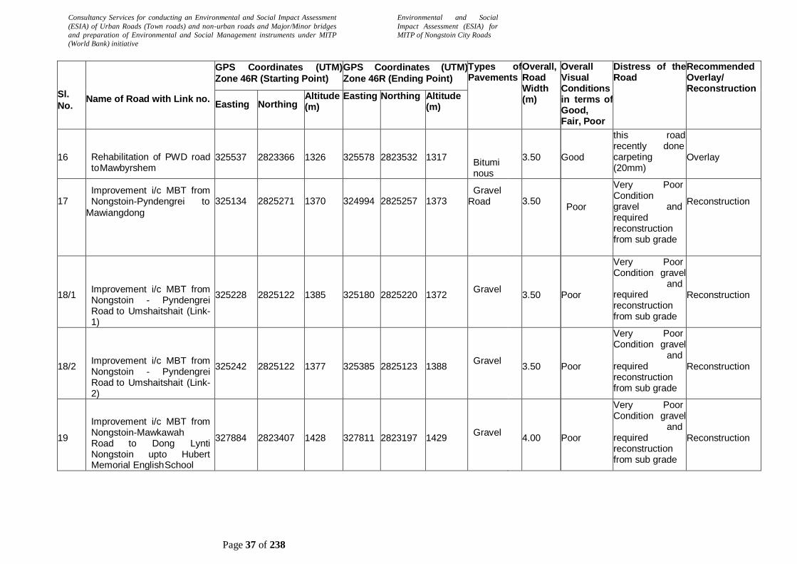
Consultancy Services for conducting an Environmental and Social Impact Assessment
(ESIA) of Urban Roads (Town roads) and non-urban roads and Major/Minor bridges
and preparation of Environmental and Social Management instruments under MITP
(World Bank) initiative
Environmental and Social
Impact Assessment (ESIA) for
MITP of Nongstoin City Roads
Page 37 of 238
Sl.
No.
Name of Road with Link no.
GPS Coordinates (UTM)
Zone 46R (Starting Point)
GPS Coordinates (UTM)
Zone 46R (Ending Point)
Types of Pavements
Overall, Road Width (m)
Overall Visual Conditions in terms of Good, Fair, Poor
Distress of the Road
Recommended Overlay/ Reconstruction
Easting Northing Altitude (m)
Easting Northing Altitude (m)
16
Rehabilitation of PWD road to Mawbyrshem
325537
2823366
1326
325578
2823532
1317
Bituminous
3.50
Good
this road recently done carpeting (20mm)
Overlay
17
Improvement i/c MBT from Nongstoin-Pyndengrei to
Mawiangdong
325134
2825271
1370
324994
2825257
1373
Gravel / Earthen Road
3.50
Poor
Very Poor Condition gravel and required reconstruction from sub grade
Reconstruction
18/1
Improvement i/c MBT from Nongstoin - Pyndengrei Road to Umshaitshait (Link-1)
325228
2825122
1385
325180
2825220
1372
Gravel / Earthen Road
3.50
Poor
Very Poor Condition gravel and required reconstruction from sub grade
Reconstruction
18/2
Improvement i/c MBT from Nongstoin - Pyndengrei Road to Umshaitshait (Link-2)
325242
2825122
1377
325385
2825123
1388
Gravel / Earthen Road
3.50
Poor
Very Poor Condition gravel and required reconstruction from sub grade
Reconstruction
19
Improvement i/c MBT from Nongstoin-Mawkawah Road to Dong Lynti Nongstoin upto Hubert Memorial English School
327884
2823407
1428
327811
2823197
1429
Gravel / Earthen Road
4.00
Poor
Very Poor Condition gravel and required reconstruction from sub grade
Reconstruction

Consultancy Services for conducting an Environmental and Social Impact Assessment
(ESIA) of Urban Roads (Town roads) and non-urban roads and Major/Minor bridges
and preparation of Environmental and Social Management instruments under MITP
(World Bank) initiative
Environmental and Social
Impact Assessment (ESIA) for
MITP of Nongstoin City Roads
Page 38 of 238
Sl.
No.
Name of Road with Link no.
GPS Coordinates (UTM)
Zone 46R (Starting Point)
GPS Coordinates (UTM)
Zone 46R (Ending Point)
Types of Pavements
Overall, Road Width (m)
Overall Visual Conditions in terms of Good, Fair, Poor
Distress of the Road
Recommended Overlay/ Reconstruction
Easting Northing Altitude (m)
Easting Northing Altitude (m)
20
Improvement i/c MBT from Nongstoin - Mawkawah Road (Near Durbar Hall Block No.-6, Upper New Nongstoin) to Church of the Living God,Upper New Nongstoin
326281
2823429
1380
326032
2823306
1352
Gravel / Earthen Road
3.50
Poor
Gravel-Earthen very Poor Condition gravel-and required reconstruction from sub grade
Reconstruction
21/1
MBT of different Link Roads at Nondein, New Nongstoin (Link-1)
324855
2824549
1324
325321
2823821
1320
Gravel / Earthen Road
3.50
Poor
Very Poor Condition gravel and required reconstruction from sub grade
Reconstruction
21/2
MBT of different Link Roads at Nondein, New Nongstoin (Link-2)
324740
2824284
1339
324900
2824292
1327
Gravel / Earthen Road
3.50
Poor
Very Poor Condition gravel and required reconstruction from sub grade (Under Construction)
Reconstruction
22
Resurfacing of road from Nongstoin - Mawkawah road to Madan Shyiap
326479
2823502
1415
326601
2823865
1356
Gravel / Earthen Road
3.50
Poor
Gravel-Earthen very Poor Condition gravel-and required reconstruction from sub grade
Reconstruction
23/1
Improvement i/c MBT from Nongstoin - Sonapahar Road to Mawsiangphet upto St. Francis D' Assisi College (Link-
1)
323691
2825444
1322
324264
2825444
1374
Gravel / Earthen Road
3.5
0
Poor
Very Poor Condition gravel and required reconstruction from sub grade
Reconstruction

Consultancy Services for conducting an Environmental and Social Impact Assessment
(ESIA) of Urban Roads (Town roads) and non-urban roads and Major/Minor bridges
and preparation of Environmental and Social Management instruments under MITP
(World Bank) initiative
Environmental and Social
Impact Assessment (ESIA) for
MITP of Nongstoin City Roads
Page 39 of 238
Sl.
No.
Name of Road with Link no.
GPS Coordinates (UTM)
Zone 46R (Starting Point)
GPS Coordinates (UTM)
Zone 46R (Ending Point)
Types of Pavements
Overall, Road Width (m)
Overall Visual Conditions in terms of Good, Fair, Poor
Distress of the Road
Recommended Overlay/ Reconstruction
Easting Northing Altitude (m)
Easting Northing Altitude (m)
23/2
Improvement i/c MBT from Nongstoin - Sonapahar Road to Mawsiangphet upto St. Francis D' Assisi College (Link-2)
323812
2825108
1347
323680
2825270
1345
Gravel / Earthen Road
3.50
Poor
Very Poor Condition gravel and required reconstruction from sub grade
Reconstruction
24/1
Improvement i/c MBT from Nongstoin - Pyndengrei road to Thomas Jones Secondary School (Link-1)
325123
2825151
1380
325407
2824991
1337
Gravel / Earthen Road
3.50
Poor
Very Poor Condition gravel and required reconstruction from sub grade
Reconstruction
24/2
Improvement i/c MBT from Nongstoin - Pyndengrei road to Thomas Jones Secondary School (Link-2)
325317
2825033
1367
325591
2825067
1356
Gravel / Earthen Road
3.50
Poor
Very Poor Condition gravel and required reconstruction from sub grade
Reconstruction

Consultancy Services for conducting an Environmental and Social Impact Assessment
(ESIA) of Urban Roads (Town roads) and non-urban roads and Major/Minor bridges
and preparation of Environmental and Social Management instruments under MITP
(World Bank) initiative
Environmental and Social
Impact Assessment (ESIA) for
MITP of Nongstoin City Roads
Page 40 of 238
2.12 Construction Material Requirement
Data is awaited from the concern department.
2.13 Minor Bridge
There is no Minor bridge along the project road.
2.14 Culvert
A total no. of 74 culverts are there along the project stretches. The details of culverts observed
along the project stretch are as follows:

Consultancy Services for conducting an Environmental and Social Impact Assessment
(ESIA) of Urban Roads (Town roads) and non-urban roads and Major/Minor bridges
and preparation of Environmental and Social Management instruments under MITP
(World Bank) initiative
Environmental and Social
Impact Assessment (ESIA) for
MITP of Nongstoin City Roads
Page 41 of 238
Table 4: Culverts along the Project streches
Sl. No. GPS Coordinate Type
of
Struc
ture
Span arrangement Condition Remark
Latitude Longitude No. of pipe/ Span
Diameter/ Span
Culvert
1.Lulong to Dong Lynti Nongstoin Connecting to Nongstoin - Mawthawpdah Road
a 25.511677 91.278857 Pipe Culvert
1 x 1.00 good Overall condition of the culvert is good.
b 25.513741 91.279868 Pipe Culvert
1 x 1.00 good Overall condition of the culvert is good.
c 25.515142 91.28046 Pipe Culvert
2 x 1.00 good Overall condition of the culvert is good.
2. Nongstoin - Mawkawah Road to Umisatmluh
a 25.517256 91.26791 slab Culvert
1 x 5.00 good Overall condition of the culvert is good.
b 25.516583 91.67974 slab Culvert
1 x 0.50 good Overall condition of the culvert is good.
c 25.516497 91.267865 slab Culvert
1 x 0.50 good Overall condition of the culvert is good.
d 25.515917 91.267995 slab Culvert
1 x 0.50 good Overall condition of the culvert is good.
e 25.515968 91.268017 slab Culvert
1 x 0.50 good Overall condition of the culvert is good.
f 25.515861 91.268057 slab Culvert
1 x 0.50 good Overall condition of the culvert is good.
g 25.515715 91.268203 slab Culvert
1 x 0.50 good Overall condition of the culvert is good.
h 25.515589 91.268604 slab Culvert
1 x 2.00 good Overall condition of the culvert is good.
i 25.514758 91.270609 slab Culvert
1 x 1.00 good Overall condition of the culvert is good.
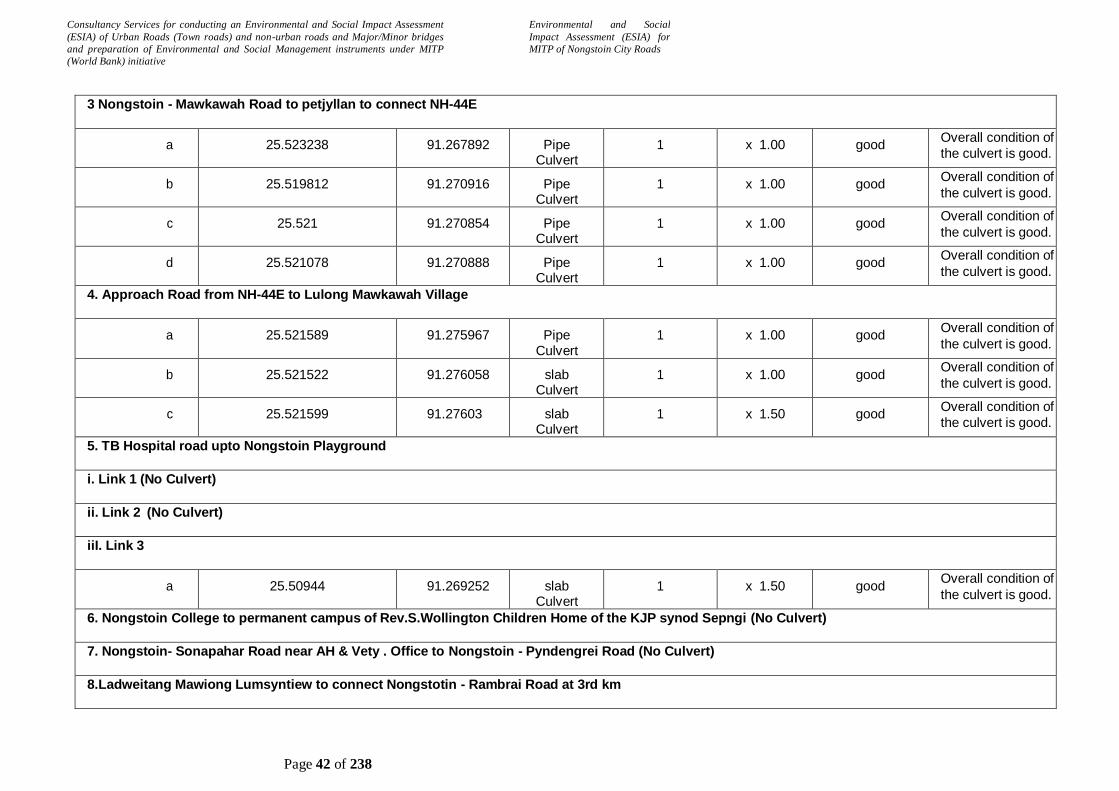
Consultancy Services for conducting an Environmental and Social Impact Assessment
(ESIA) of Urban Roads (Town roads) and non-urban roads and Major/Minor bridges
and preparation of Environmental and Social Management instruments under MITP
(World Bank) initiative
Environmental and Social
Impact Assessment (ESIA) for
MITP of Nongstoin City Roads
Page 42 of 238
3 Nongstoin - Mawkawah Road to petjyllan to connect NH-44E
a 25.523238 91.267892 Pipe Culvert
1 x 1.00 good Overall condition of
the culvert is good.
b 25.519812 91.270916 Pipe Culvert
1 x 1.00 good Overall condition of
the culvert is good.
c 25.521 91.270854 Pipe Culvert
1 x 1.00 good Overall condition of
the culvert is good.
d 25.521078 91.270888 Pipe Culvert
1 x 1.00 good Overall condition of
the culvert is good.
4. Approach Road from NH-44E to Lulong Mawkawah Village
a 25.521589 91.275967 Pipe Culvert
1 x 1.00 good Overall condition of
the culvert is good.
b 25.521522 91.276058 slab Culvert
1 x 1.00 good Overall condition of
the culvert is good.
c 25.521599 91.27603 slab Culvert
1 x 1.50 good Overall condition of
the culvert is good.
5. TB Hospital road upto Nongstoin Playground
i. Link 1 (No Culvert)
ii. Link 2 (No Culvert)
iiI. Link 3
a 25.50944 91.269252 slab Culvert
1 x 1.50 good Overall condition of
the culvert is good.
6. Nongstoin College to permanent campus of Rev.S.Wollington Children Home of the KJP synod Sepngi (No Culvert)
7. Nongstoin- Sonapahar Road near AH & Vety . Office to Nongstoin - Pyndengrei Road (No Culvert)
8.Ladweitang Mawiong Lumsyntiew to connect Nongstotin - Rambrai Road at 3rd km
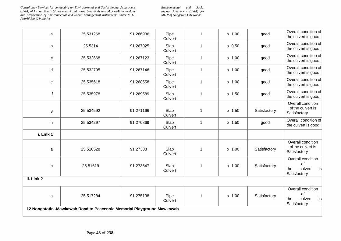
Consultancy Services for conducting an Environmental and Social Impact Assessment
(ESIA) of Urban Roads (Town roads) and non-urban roads and Major/Minor bridges
and preparation of Environmental and Social Management instruments under MITP
(World Bank) initiative
Environmental and Social
Impact Assessment (ESIA) for
MITP of Nongstoin City Roads
Page 43 of 238
a 25.531268 91.266936 Pipe Culvert
1 x 1.00 good Overall condition of
the culvert is good.
b 25.5314 91.267025 Slab Culvert
1 x 0.50 good Overall condition of
the culvert is good.
c 25.532668 91.267123 Pipe Culvert
1 x 1.00 good Overall condition of
the culvert is good.
d 25.532795 91.267146 Pipe Culvert
1 x 1.00 good Overall condition of
the culvert is good.
e 25.535618 91.268558 Pipe Culvert
1 x 1.00 good Overall condition of
the culvert is good.
f 25.535978 91.269589 Slab Culvert
1 x 1.50 good Overall condition of
the culvert is good.
g
25.534592
91.271166
Slab Culvert
1
x 1.50
Satisfactory
Overall condition of the culvert is
Satisfactory
h 25.534297 91.270869 Slab Culvert
1 x 1.50 good Overall condition of
the culvert is good.
i. Link 1
a
25.516528
91.27308
Slab Culvert
1
x 1.00
Satisfactory
Overall condition of the culvert is
Satisfactory
b
25.51619
91.273647
Slab Culvert
1
x 1.00
Satisfactory
Overall condition
of
the culvert is
Satisfactory
ii. Link 2
a
25.517284
91.275138
Pipe Culvert
1
x 1.00
Satisfactory
Overall condition
of
the culvert is
Satisfactory
12.Nongstotin -Mawkawah Road to Peacenola Memorial Playground Mawkawah

Consultancy Services for conducting an Environmental and Social Impact Assessment
(ESIA) of Urban Roads (Town roads) and non-urban roads and Major/Minor bridges
and preparation of Environmental and Social Management instruments under MITP
(World Bank) initiative
Environmental and Social
Impact Assessment (ESIA) for
MITP of Nongstoin City Roads
Page 44 of 238
i. Link 1
a 25.518696 91.283998 Pipe Culvert
1 x 1.00 Partially choked
Cleaning of the
culvert is required
ii. Link 2 (No Culvert)
13. Nongstoin Markasa Road to Mawrok Porsohat Village
i. Link 1
a 25.535124 91.305835 Pipe Culvert
1 x 1.00 Satisfactory Overall condition of
the culvert is
Satisfactory
b 25.537111 91.304772 Pipe Culvert
1 x 1.00 Choked Replacement
required.
c
25.536421
91.304177
slab Culvert
1
x 1.00
Satisfactory
Overall condition
of
the culvert is
Satisfactory
ii. Link 2 (No Culvert)
iii. Link 3 (No Culvert)
iv. Link 4 (No Culvert)
v. Link 5 (No Culvert)
14. Nongstoin -Old Nongstoin Road to Domthangpit at Nongstoin
i. Link 1 (No Culvert)
ii. Link 2
a 25.507653 91.268176 slab Culvert
1 x 1.00 good Overall condition of
the culvert is good.

Consultancy Services for conducting an Environmental and Social Impact Assessment
(ESIA) of Urban Roads (Town roads) and non-urban roads and Major/Minor bridges
and preparation of Environmental and Social Management instruments under MITP
(World Bank) initiative
Environmental and Social
Impact Assessment (ESIA) for
MITP of Nongstoin City Roads
Page 45 of 238
15. Nongstoin - Old Nongstoin Road to Domthangksing at Nongstoin
i. Link 1 (No Culvert)
ii. Link 2 (No Culvert)
iii. Link 3 (No Culvert)
16. PWD road to Mawbyrshem
a 25.518447 91.264878 Pipe Culvert
1 x 1.00 good Overall condition of
the culvert is good.
17. Nongstoin - Pyndengrei to Mawiangdong (No Culvert)
18. Nongstoin - Pyndengrei Road to Umshaitshait
i. Link 1 (No Culvert)
ii. Link 2 (No Culvert)
19.Nongstotin -Mawkawah Road to Dong Lynti Nogstoin upto Hubert Memorial English School (No Culvert)
20. Nongstoin - Mawkawah road to church of the Living god , Upper new Nongstoin
a 25.517659 91.270755 Slab Culvert
1 x 1.00 good Overall condition of
the culvert is good.
b 25.51784 91.270512 Slab Culvert
1 x 0.50 good Overall condition of
the culvert is good.
c 25.51784 91.270512 Slab Culvert
1 x 0.50 good Overall condition of
the culvert is good.
d 25.517056 91.270036 Slab Culvert
1 x 0.50 good Overall condition of
the culvert is good.
21. Different Link roads at Nondein, New Nongstoin

Consultancy Services for conducting an Environmental and Social Impact Assessment
(ESIA) of Urban Roads (Town roads) and non-urban roads and Major/Minor bridges
and preparation of Environmental and Social Management instruments under MITP
(World Bank) initiative
Environmental and Social
Impact Assessment (ESIA) for
MITP of Nongstoin City Roads
Page 46 of 238
i. Link 1
a 25.521397 91.261657 Pipe Culvert
1 x 1.00 good Overall condition of
the culvert is good.
b 25.521542 91.262208 Pipe Culvert
1 x 1.00 good Overall condition of
the culvert is good.
c 25.524853 91.25864 Pipe Culvert
1 x 1.00 good Overall condition of
the culvert is good.
d 25.524561 91.258005 Pipe Culvert
1 x 1.00 good Overall condition of
the culvert is good.
e 25.526493 91.257973 slab Culvert
1 x 2.00 good Overall condition of
the culvert is good.
f 25.526964 91.257422 Pipe Culvert
1 x 1.00 good Overall condition of
the culvert is good.
g 25.527376 91.257009 Pipe Culvert
1 x 1.00 good Overall condition of
the culvert is good.
ii. Link 2 (No Culvert)
22. Nongstoin - Mawkawah road to Madan Shyiap
a 25.519141 91.2709 Slab Culvert
1 x 2.00 good Overall condition of
the culvert is good.
b 25.518691 91.273173 Slab Culvert
1 x 1.20 good Overall condition of
the culvert is good.
c 25.519266 91.272633 Pipe Culvert
1 x 1.00 good Overall condition of
the culvert is good.
d 25.520517 91.273501 Pipe Culvert
1 x 1.00 good Overall condition of
the culvert is good.
23. Nongstoin Sonapahar Road to Mawsiangphet upto st, Francis D'Assisi College
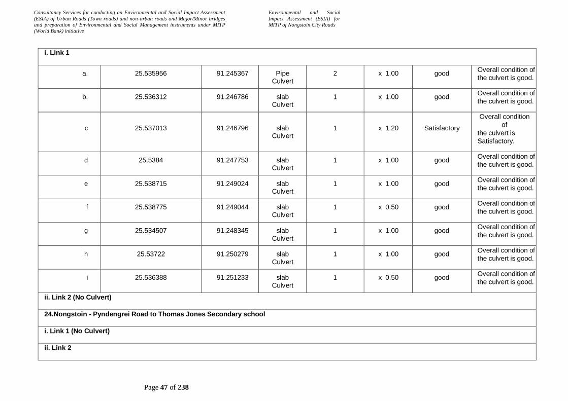
Consultancy Services for conducting an Environmental and Social Impact Assessment
(ESIA) of Urban Roads (Town roads) and non-urban roads and Major/Minor bridges
and preparation of Environmental and Social Management instruments under MITP
(World Bank) initiative
Environmental and Social
Impact Assessment (ESIA) for
MITP of Nongstoin City Roads
Page 47 of 238
i. Link 1
a. 25.535956 91.245367 Pipe Culvert
2 x 1.00 good Overall condition of
the culvert is good.
b. 25.536312 91.246786 slab Culvert
1 x 1.00 good Overall condition of
the culvert is good.
c
25.537013
91.246796
slab Culvert
1
x 1.20
Satisfactory
Overall condition
of
the culvert is
Satisfactory.
d 25.5384 91.247753 slab Culvert
1 x 1.00 good Overall condition of
the culvert is good.
e 25.538715 91.249024 slab Culvert
1 x 1.00 good Overall condition of
the culvert is good.
f 25.538775 91.249044 slab Culvert
1 x 0.50 good Overall condition of
the culvert is good.
g 25.534507 91.248345 slab Culvert
1 x 1.00 good Overall condition of
the culvert is good.
h 25.53722 91.250279 slab Culvert
1 x 1.00 good Overall condition of
the culvert is good.
i 25.536388 91.251233 slab Culvert
1 x 0.50 good Overall condition of
the culvert is good.
ii. Link 2 (No Culvert)
24.Nongstoin - Pyndengrei Road to Thomas Jones Secondary school
i. Link 1 (No Culvert)
ii. Link 2
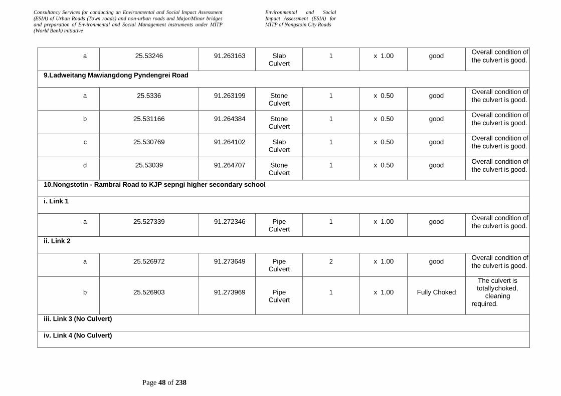
Consultancy Services for conducting an Environmental and Social Impact Assessment
(ESIA) of Urban Roads (Town roads) and non-urban roads and Major/Minor bridges
and preparation of Environmental and Social Management instruments under MITP
(World Bank) initiative
Environmental and Social
Impact Assessment (ESIA) for
MITP of Nongstoin City Roads
Page 48 of 238
a 25.53246 91.263163 Slab Culvert
1 x 1.00 good Overall condition of
the culvert is good.
9.Ladweitang Mawiangdong Pyndengrei Road
a 25.5336 91.263199 Stone Culvert
1 x 0.50 good Overall condition of
the culvert is good.
b 25.531166 91.264384 Stone Culvert
1 x 0.50 good Overall condition of
the culvert is good.
c 25.530769 91.264102 Slab Culvert
1 x 0.50 good Overall condition of
the culvert is good.
d 25.53039 91.264707 Stone Culvert
1 x 0.50 good Overall condition of
the culvert is good.
10.Nongstotin - Rambrai Road to KJP sepngi higher secondary school
i. Link 1
a 25.527339 91.272346 Pipe Culvert
1 x 1.00 good Overall condition of
the culvert is good.
ii. Link 2
a 25.526972 91.273649 Pipe Culvert
2 x 1.00 good Overall condition of
the culvert is good.
b
25.526903
91.273969
Pipe Culvert
1
x 1.00
Fully Choked
The culvert is totally choked,
cleaning required.
iii. Link 3 (No Culvert)
iv. Link 4 (No Culvert)
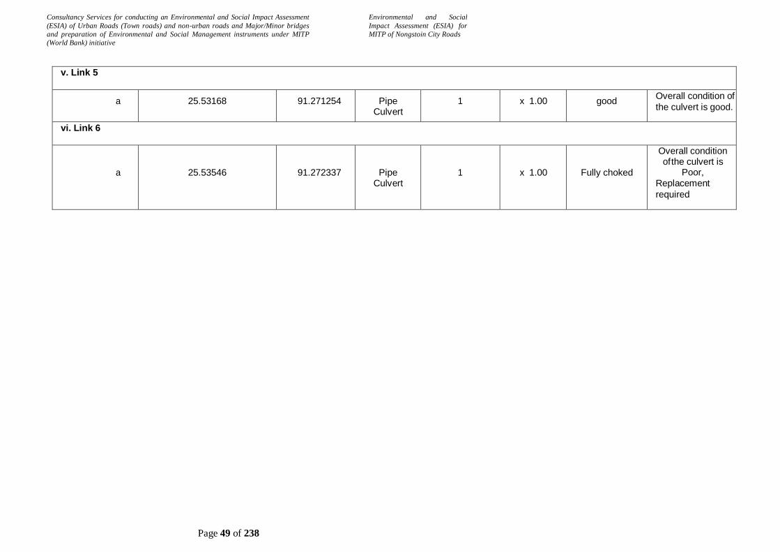
Consultancy Services for conducting an Environmental and Social Impact Assessment
(ESIA) of Urban Roads (Town roads) and non-urban roads and Major/Minor bridges
and preparation of Environmental and Social Management instruments under MITP
(World Bank) initiative
Environmental and Social
Impact Assessment (ESIA) for
MITP of Nongstoin City Roads
Page 49 of 238
v. Link 5
a 25.53168 91.271254 Pipe Culvert
1 x 1.00 good Overall condition of
the culvert is good.
vi. Link 6
a
25.53546
91.272337
Pipe Culvert
1
x 1.00
Fully choked
Overall condition of the culvert is
Poor, Replacement
required

Consultancy Services for conducting an Environmental and Social Impact Assessment
(ESIA) of Urban Roads (Town roads) and non-urban roads and Major/Minor bridges
and preparation of Environmental and Social Management instruments under MITP
(World Bank) initiative
Environmental and Social
Impact Assessment (ESIA) for
MITP of Nongstoin City Roads
Page 50 of 238
2.15 Estimated Project Cost
The amount of each item is evaluated on the basis of relevant unit rates analyzed from Standard Data Book of Ministry of Road Transport and Highways- MORT&H. Summary of Preliminary Cost Estimate for all the improvement works is presented table below
Table 5 :Summary of Project Cost
Abstract of Cost, Road Wise
S No.
Details of Road
Length of the
Road (m)
Cost (INR) Cost (Cr.)
1 Improvement i/c MBT of road from Lulong (Nongstoin- Mawkawah road) to Dong Lynti Nongstoin connecting to Nongstoin-Mawthawpdah Road
1195.000
9,110,779.95
0.91
2 Improvement i/c MBT of approach road from
Nongstoin- Mawkawah road to Umsaitmluh
500.000 3,823,758.52 0.38
3 Improvement i/c MBT of road from Nongstoin-Mawkawah road to Petjyllan (Near Anderson H/S School) to connect NH-44E
410.000
2,919,171.00
0.29
4 Improvement i/c MBT of approach road from NH-
44E (Near Petrol Pump) to Lulong,Mawkawah village
258.000 1,789,391.09 0.18
5 Improvement i/c MBT of road from TB Hospital road
upto Nongstoin Playground
1184.000
10,096,721.99 1.01
6 Improvement i/c widening, MBT of road from Nongstoin College to permanent campus of Rev.S. Wollington Children Home of the KJP Synod Sepngi
1118.000
9,787,679.59
0.98
7 Rehabilitation of PWD road from Nongstoin-
Sonapahar road near AH & Vety. Office to Nongstoin-Pyndengrei road
597.000 4,720,466.15 0.47
8 Rehabilitation of Extension of Ladweitang-
Mawiong Lumsyntiew to connect Nongstoin-Rambrai road at 3rd km
1070.000 8,658,247.94 0.87
9 Improvement i/c MBT of Ladweitang-Mawiong Pyndengrei
985.000
7,282,344.96 0.73
10 Improvement, Rehabilitation & MBT of road from 2nd Km of Nongstoin-Rambrai road to KJP Sepngi Higher Secondary School
2004.000
15,069,332.17
1.51
11 Improvement i/c MBT of road from Nongstoin-Mawkawah road to Diangjri upto Domkharu Upper New-Nongstoin road
760.000
5,375,473.98
0.54
12 Improvement i/c MBT of a village road from Nongstoin- Mawkawah road to Peacenola Memorial Playground Mawkawah
1358.000
9,282,937.06
0.93
13 Improvement i/c MBT of PWD road from 5th km
of Nongstoin-Markasa Road to Mawrok Porsohsat Village
2490.000
17,555,358.34 1.76
14 Improvement i/c MBT of road from Nongstoin-
Old Nongstoin Road to Domthangpit at Nongstoin
550.000
3,782,869.05 0.38
15 Improvement i/c MBT of road from Nongstoin-Old Nongstoin road to Domthangksing at Nonstoin
551.000
4,191,812.71 0.42
16 Rehabilitation of PWD road to Mawbyrshem 243.000
495,713.52 0.05
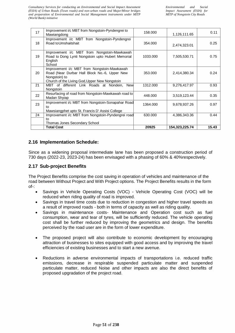
Consultancy Services for conducting an Environmental and Social Impact Assessment
(ESIA) of Urban Roads (Town roads) and non-urban roads and Major/Minor bridges
and preparation of Environmental and Social Management instruments under MITP
(World Bank) initiative
Environmental and Social
Impact Assessment (ESIA) for
MITP of Nongstoin City Roads
Page 51 of 238
17 Improvement i/c MBT from Nongstoin-Pyndengrei to Mawiangdong
158.000
1,126,111.65 0.11
18 Improvement i/c MBT from Nongstoin-Pyndengrei Road to Umshaitshait
354.000
2,474,323.01
0.25
19 Improvement i/c MBT from Nongstoin-Mawkawah Road to Dong Lynti Nongstoin upto Hubert Memorial English School
1033.000
7,505,530.71
0.75
20 Improvement i/c MBT from Nongstoin-Mawkawah Road (Near Durbar Hall Block No.-6, Upper New Nongstoin) to Church of the Living God,Upper New Nongstoin
353.000
2,414,380.34
0.24
21 MBT of different Link Roads at Nondein, New Nongstoin
1312.000 9,276,417.97 0.93
22 Resurfacing of road from Nongstoin-Mawkawah road to Madan Shyiap
448.000 3,519,123.44 0.35
23 Improvement i/c MBT from Nongstoin-Sonapahar Road
to Mawsiangphet upto St. Francis D' Assisi College
1364.000 9,678,937.26 0.97
24 Improvement i/c MBT from Nongstoin-Pyndengrei road to Thomas Jones Secondary School
630.000 4,386,343.36 0.44
Total Cost 20925 154,323,225.74 15.43
2.16 Implementation Schedule:
Since as a widening proposal intermediate lane has been proposed a construction period of 730 days (2022-23, 2023-24) has been envisaged with a phasing of 60% & 40%respectively.
2.17 Sub-project Benefits
The Project Benefits comprise the cost saving in operation of vehicles and maintenance of the road between Without Project and With Project options. The Project Benefits results in the form of-:
Savings in Vehicle Operating Costs (VOC) - Vehicle Operating Cost (VOC) will be reduced when riding quality of road is improved.
Savings in travel time costs due to reduction in congestion and higher travel speeds as a result of improved roads - both in terms of capacity as well as riding quality.
Savings in maintenance costs- Maintenance and Operation cost such as fuel consumption, wear and tear of tyres, will be sufficiently reduced. The vehicle operating cost shall be further reduced by improving the geometrics and design. The benefits perceived by the road user are in the form of lower expenditure.
The proposed project will also contribute to economic development by encouraging attraction of businesses to sites equipped with good access and by improving the travel efficiencies of existing businesses and to start a new avenue.
Reductions in adverse environmental impacts of transportations i.e. reduced traffic emissions, decrease in respirable suspended particulate matter and suspended particulate matter, reduced Noise and other impacts are also the direct benefits of proposed upgradation of the project road.

Consultancy Services for conducting an Environmental and Social Impact Assessment
(ESIA) of Urban Roads (Town roads) and non-urban roads and Major/Minor bridges
and preparation of Environmental and Social Management instruments under MITP
(World Bank) initiative
Environmental and Social
Impact Assessment (ESIA) for
MITP of Nongstoin City Roads
Page 52 of 238
3 CHAPTER-III: NEED OF ENVIRONMENT & SOCIAL IMPACT ASSESSMENT
The analysis of location of environmental features with respect to the project alignment and
extent of identified impacts due to project, reflect that most of the impacts are of low and
medium extent and mainly related to construction activities which are mostly temporary in
nature. Based on the environmental screening, environmental screening checklist is added in
Error! Reference source not found..The project is Classified as Category-B project in
accordance with World Bank’s Policy (OP 4.01 Environmental Assessment) and therefore it
warrants site specific Environmental Impact Assessment.
Similarly, in accordance with World Bank’s Operational Policy OP 4.12 (Involuntary
Resettlement), this project mandates the preparation of the Social Impact Assessment (SIA)
and Resettlement Action Plan (RAP). Accordingly, detailed assessments of the environmental
and social impacts have been carried out following a suitable methodology.
This ESIA shall cover, the environmental and social impacts due to the project, concerning
construction-related environmental impacts, infringements with natural habitats and places of
cultural heritage also in the context of ‘chance-find’, and impacts on local population/
community. The findings of ESIA will guide the effective development of the specific ESMP and
facilitate the implementation of safeguard measures appropriately.
3.1 Project Approach for Environmental Studies
The approach followed for conducting ESIA study of the Project. To identify the environmental
and social issues arising out of the current practices adopted for planning, design, and
construction of the project roads, include assessment of the environmental and social
conditions along the project roads were assessed during site visit. During these visits,
consultations through group discussions with local communities, road users and Village
Council/ village members were contacted to understand their perceptions and needs. The main
approaches for the study are:
Identification, appraisal and division between positive and negative impacts, direct and
indirect impacts, and instant and long-term impacts likely to result from project road
Identification of unavoidable or irreversible impacts;
Exploration towards the opportunities for environmental enhancement; and
Identification of feasible and cost-effective mitigation measures to minimize negative
impacts and enhance positive impacts by incorporating in the preliminary engineering
design.
Preparation of Environmental Management Plan for effective implementation of
environmental mitigation measures at different stages of the project.
A standard methodology was adopted for fulfilling the ESIA requirements; key features/tasks of
the methodology are detailed as follows:

Consultancy Services for conducting an Environmental and Social Impact Assessment
(ESIA) of Urban Roads (Town roads) and non-urban roads and Major/Minor bridges
and preparation of Environmental and Social Management instruments under MITP
(World Bank) initiative
Environmental and Social
Impact Assessment (ESIA) for
MITP of Nongstoin City Roads
Page 53 of 238
Task 1: Field Reconnaissance Survey and Review of Earlier Studies The field
reconnaissance survey has been carried out along the project roads to understand salient
environmental and social features that are likely to cause adverse impacts, sensitive
environmental and social issues via-a-vis proposed project interventions. The salient feature
includes. The topography of the land, road geometry. Environmental features like trees, any
forest area, water bodies like ponds, rivers, etc. A social and physical feature like settlement
pattern, its density, typology of buildings, especially the presence of religious buildings, land
use, etc.
Experience of EIA, EMP, SIA, RAP study, as well as the implementation of EMP, was also
taken into account from earlier TNRSP projects.
Task 2: Review and Assessment of Applicable Environmental and Social Regulations
Various rules/regulations and guidelines applicable to the project roads vis-à-vis center (GoI),
state (GoM) and World Bank statutory requirements were reviewed and referred to for
assessing current environmental and social impacts that are likely to emanate.
Task 3: Delineation of Study Area for Assessment
In road projects, while the influence area may vary via-a-vis size of the road, location of the
road, type of road, etc., hence, the study area was fixed based on the proposed interventions
including the road sections undergoing widening and strengthening, RoW availability, structural
works (culverts and bridges), presence of sensitive areas, etc. In addition to this, the project
influence area (10 km buffer from the center line on either sides) for impact assessment is also
considered in those areas that are directly or indirectly influenced by the project activities during
construction or operation of the proposed road work such as Hot Mix plants, sand quarries,
source of raw material and material transport, etc.
Task 4: Assessment of Baseline Environmental and Social Conditions This task comprises
a collection of baseline data for the project road locations primarily on physical, biological and
socio-economic conditions. The secondary source of information was utilised for giving a

Consultancy Services for conducting an Environmental and Social Impact Assessment
(ESIA) of Urban Roads (Town roads) and non-urban roads and Major/Minor bridges
and preparation of Environmental and Social Management instruments under MITP
(World Bank) initiative
Environmental and Social
Impact Assessment (ESIA) for
MITP of Nongstoin City Roads
Page 54 of 238
generic snapshot of socio environment features. In addition, existing environmental and social
quality/features along the project roads were assessed based on a walk through surveys, public
consultations, FGD’s and discussions with line department officials.
Task 5: Public Consultations/ Focus Group Discussions To cover a wide range of
stakeholders in the study area, corner meetings were conducted at selected places with women
groups, men and road users to understand the people’s perception about the project as well as
their issues and concerns. Overall project features, social safeguards, issues related to
women’s safety and security, environmental safeguards, and enhancement measures would be
implemented in the project was also discussed with the public.
Task 6: Prediction of Environmental and Social Impacts The task identifies the likely
impacts that would arise due to the construction of project roads, through changes in the
physical, biological or socio-economic environment. Based on the baseline environmental
profile of the project and analysis of the primary and secondary data collected, impacts of the
proposed project on various environmental components were identified. The impacts were also
analysed with respect to pre-construction, construction and operation phases and were
categorised in terms of magnitude and significance.
The assessment considered both positive and negative impacts at different stages of
implementation, i.e. pre-construction, construction and operation stages of the project roads.
Task 7: Preparation of Environment and Social Management Plan (ESMP) A
comprehensive Environmental and Social Management Plan (ESMP) was prepared which
included mitigation measures for all the negative impacts of sub-projects and enhancement
measures for positive impacts.
Task 8: Preparation of Resettlement Action Plan (RAP) Based on the impacts a suitable
RAP shall be prepared to specify the procedures it will follow and the actions it will take to
properly resettle/compensate affected people and communities. The objective of the RAP is to
assist the affected people in their efforts to improve their living standards or at least regain their
living standards to their pre displacement levels.
Task 9: Preparation of Environmental and Social Management Budget
Based on the impact assessment for the environmental and social components a suitable
budget has been estimated to compensate for the temporary and permanent impacts that are
likely during the project implementation. As part of the project implementation monitoring,
budgetary provision has been allotted for RAP implementation and environmental monitoring.
The budget also includes compensatory afforestation measures for the loss of avenue trees
due to road widening.
Task 10: Environmental Safeguard Clauses in the Bid Document
Suitable safeguard clauses have been prepared based on the ESIA, the prepared clauses shall
form part of the bid document either in the General condition or Specific conditions of the
contract agreement/ bid document. The prepared ESMP shall also be part of the bid document.

Consultancy Services for conducting an Environmental and Social Impact Assessment
(ESIA) of Urban Roads (Town roads) and non-urban roads and Major/Minor bridges
and preparation of Environmental and Social Management instruments under MITP
(World Bank) initiative
Environmental and Social
Impact Assessment (ESIA) for
MITP of Nongstoin City Roads
Page 55 of 238
3.2 Study Area
3.3 Study Area
Area of Influence (AoI)
The effects of the Project activities on a particular resource or receptor will have spatial
(distance) and temporal (time) dimensions. Some activities would impact a larger radius than
other identified impact sources. The spatial and temporal dimensions have therefore been
taken into account to define a Project’s Area of Influence and given below:
Table 6: Area of Influence (AoI)
Sl. No. Environmental and
Social Issues
Area of Influence
(AoI)
Justification
1 Air Quality 500 m Dust emissions, fugitive dust, etc. is typically
observed within 100-200m from the
construction /operation area. A minimum of
500m AoI on either side of road has been
taken to capture all sources of these
emissions including vehicular movement
across access roads.
2 Noise Pollution 500 m Noise can often be detected up to 400-500m
from any operation.
3 Water Environment 200 m Waterbody located in the vicinity of the project
area may get impacted due to activities at
project footprint and allied sites.
4 Land Environment Within proposed
RoW
Impacts on soil and land are often restricted to
the Project footprint area. An AoI with
proposed RoW was taken into account. The
indirect effects usually occur due to vehicular/
heavy machinery movements and activities at
allied sites
5 Socio-economic
Conditions
Within proposed
RoW
Within proposed RoW is considered as an AoI
for socioeconomic consultations to determine
perceived impacts due to the Project
6 Ecology 10 Km An AoI of 10 km on either side of the roads
are considered for the ecological study to
understand the ecological settings in and
around the project area
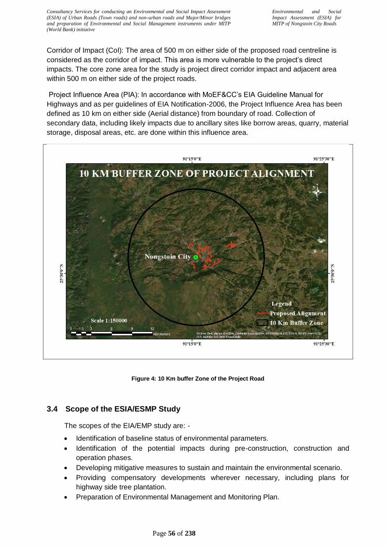
Consultancy Services for conducting an Environmental and Social Impact Assessment
(ESIA) of Urban Roads (Town roads) and non-urban roads and Major/Minor bridges
and preparation of Environmental and Social Management instruments under MITP
(World Bank) initiative
Environmental and Social
Impact Assessment (ESIA) for
MITP of Nongstoin City Roads
Page 56 of 238
Corridor of Impact (CoI): The area of 500 m on either side of the proposed road centreline is
considered as the corridor of impact. This area is more vulnerable to the project’s direct
impacts. The core zone area for the study is project direct corridor impact and adjacent area
within 500 m on either side of the project roads.
Project Influence Area (PIA): In accordance with MoEF&CC’s EIA Guideline Manual for
Highways and as per guidelines of EIA Notification-2006, the Project Influence Area has been
defined as 10 km on either side (Aerial distance) from boundary of road. Collection of
secondary data, including likely impacts due to ancillary sites like borrow areas, quarry, material
storage, disposal areas, etc. are done within this influence area.
Figure 4: 10 Km buffer Zone of the Project Road
3.4 Scope of the ESIA/ESMP Study
The scopes of the EIA/EMP study are: -
Identification of baseline status of environmental parameters.
Identification of the potential impacts during pre-construction, construction and
operation phases.
Developing mitigative measures to sustain and maintain the environmental scenario.
Providing compensatory developments wherever necessary, including plans for
highway side tree plantation.
Preparation of Environmental Management and Monitoring Plan.

Consultancy Services for conducting an Environmental and Social Impact Assessment
(ESIA) of Urban Roads (Town roads) and non-urban roads and Major/Minor bridges
and preparation of Environmental and Social Management instruments under MITP
(World Bank) initiative
Environmental and Social
Impact Assessment (ESIA) for
MITP of Nongstoin City Roads
Page 57 of 238
Screening, scoping and consultations with public, experts in various fields, non-
government organization (NGOs) etc.
Review of policies and legal framework.

Consultancy Services for conducting an Environmental and Social Impact Assessment
(ESIA) of Urban Roads (Town roads) and non-urban roads and Major/Minor bridges
and preparation of Environmental and Social Management instruments under MITP
(World Bank) initiative
Environmental and Social
Impact Assessment (ESIA) for
MITP of Nongstoin City Roads
Page | 58
4 CHAPTER: IV- LEGAL FRAMEWORK
The Ministry of Environment, Forest & Climate Change(MOEF&CC) made it mandatory for
introducing environment assessment into the planning process of road projects as well as
environmental impact appraisal as per Environmental Protection Act, 1986. The MoEF&CC
have assigned all central and State authorities to develop policies towards protection of
environment for any infrastructure development activities as per the act. The Ministry of
Environment, Forest & Climate Change (MoEF&CC) has overall authority for the administration
and implementation of government policies, laws and regulations. In the present project the
environment acts, policy guidelines of both State and Central Government will be applicable. As
these acts/regulations have varying procedures, requirements depending on type of project, a
detailed discussion is required in this report to study the extent of applicability, procedures and
requirements to be met by the implementing authorities. The following subsections summarized
the legislative framework in which the present project will be addressed with respect to the
environment including social issues.
4.1 Institutional Setting
The primary responsibility of administration and implementation of the Government of India’s
policy with respect to environmental management, conservation, ecologically sustainable
development, and pollution control rests with the Ministry of Environment, Forest & Climate
Change (MoEF & CC). The MoEF & CC has a number of agencies and institutions to implement
the environmental policies. Such as: Central Pollution Control Board (CPCB), MoEF & CC
Regional Offices, State Pollution Control Board (SPCB) & State Department of Environment &
Forests.
The Government of India through specific legislations regulates the environmental management
system in India. The Ministries / Statutory Bodies responsible for ensuring environmental
compliance by project proponents include:
The Ministry of Environment & Forests and Climate Change (MoEFCC)
Central Pollution Control Board (CPCB)
Meghalaya Pollution Control Boards (MPCB)
Ministry / Department of Environment in the States
4.2 Acts & Regulation
The Government of India has laid down various policy guidelines, regulations, acts and
legislations pertaining to sustenance of environment. The following table shows the relevant
environmental legislations and the implementing agencies.
Table 7: Applicable Acts & Regulations
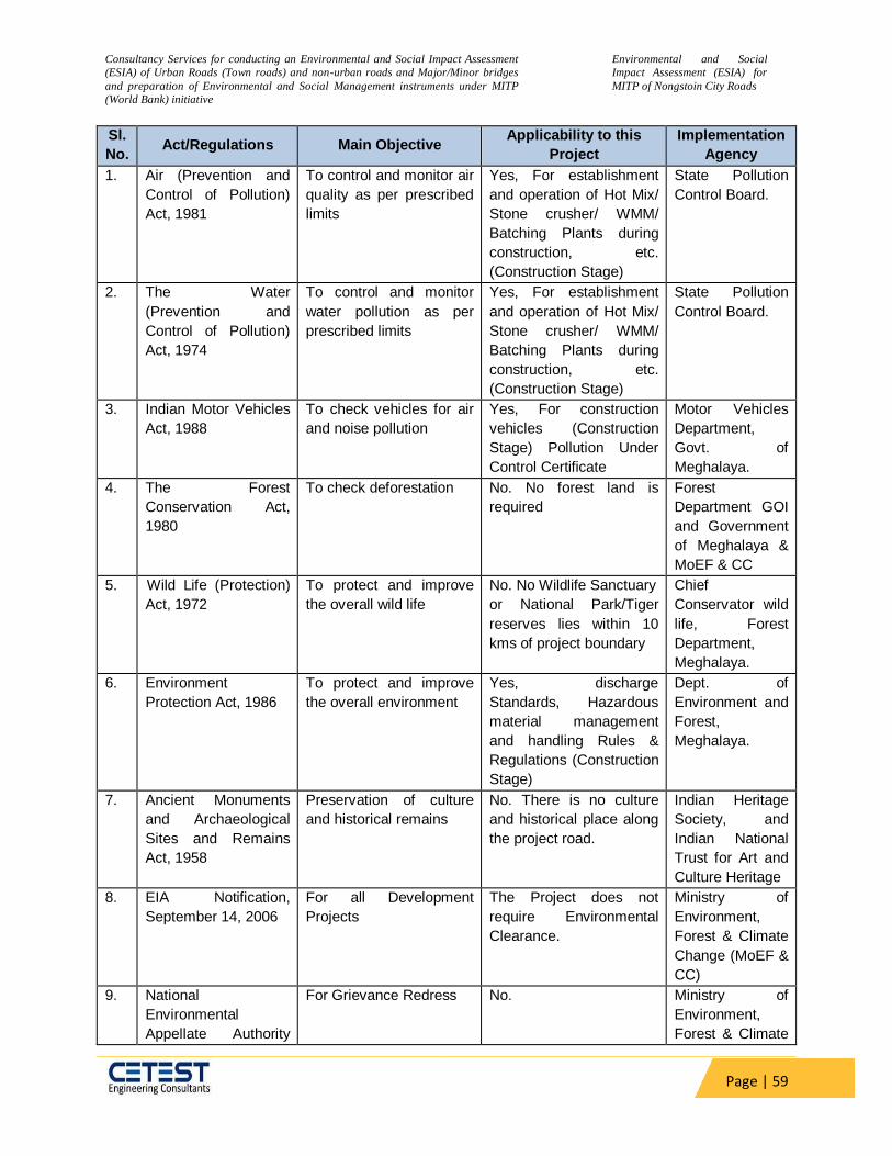
Consultancy Services for conducting an Environmental and Social Impact Assessment
(ESIA) of Urban Roads (Town roads) and non-urban roads and Major/Minor bridges
and preparation of Environmental and Social Management instruments under MITP
(World Bank) initiative
Environmental and Social
Impact Assessment (ESIA) for
MITP of Nongstoin City Roads
Page | 59
Sl.
No. Act/Regulations Main Objective
Applicability to this
Project
Implementation
Agency
1. Air (Prevention and
Control of Pollution)
Act, 1981
To control and monitor air
quality as per prescribed
limits
Yes, For establishment
and operation of Hot Mix/
Stone crusher/ WMM/
Batching Plants during
construction, etc.
(Construction Stage)
State Pollution
Control Board.
2. The Water
(Prevention and
Control of Pollution)
Act, 1974
To control and monitor
water pollution as per
prescribed limits
Yes, For establishment
and operation of Hot Mix/
Stone crusher/ WMM/
Batching Plants during
construction, etc.
(Construction Stage)
State Pollution
Control Board.
3. Indian Motor Vehicles
Act, 1988
To check vehicles for air
and noise pollution
Yes, For construction
vehicles (Construction
Stage) Pollution Under
Control Certificate
Motor Vehicles
Department,
Govt. of
Meghalaya.
4. The Forest
Conservation Act,
1980
To check deforestation No. No forest land is
required
Forest
Department GOI
and Government
of Meghalaya &
MoEF & CC
5. Wild Life (Protection)
Act, 1972
To protect and improve
the overall wild life
No. No Wildlife Sanctuary
or National Park/Tiger
reserves lies within 10
kms of project boundary
Chief
Conservator wild
life, Forest
Department,
Meghalaya.
6. Environment
Protection Act, 1986
To protect and improve
the overall environment
Yes, discharge
Standards, Hazardous
material management
and handling Rules &
Regulations (Construction
Stage)
Dept. of
Environment and
Forest,
Meghalaya.
7. Ancient Monuments
and Archaeological
Sites and Remains
Act, 1958
Preservation of culture
and historical remains
No. There is no culture
and historical place along
the project road.
Indian Heritage
Society, and
Indian National
Trust for Art and
Culture Heritage
8. EIA Notification,
September 14, 2006
For all Development
Projects
The Project does not
require Environmental
Clearance.
Ministry of
Environment,
Forest & Climate
Change (MoEF &
CC)
9. National
Environmental
Appellate Authority
For Grievance Redress No. Ministry of
Environment,
Forest & Climate

Consultancy Services for conducting an Environmental and Social Impact Assessment
(ESIA) of Urban Roads (Town roads) and non-urban roads and Major/Minor bridges
and preparation of Environmental and Social Management instruments under MITP
(World Bank) initiative
Environmental and Social
Impact Assessment (ESIA) for
MITP of Nongstoin City Roads
Page | 60
Sl.
No. Act/Regulations Main Objective
Applicability to this
Project
Implementation
Agency
Act, 1997 Change (MoEF &
CC)
10. Integrated Waste
Management
Waste management and
control.
Yes, it is applicable as
domestic solid waste is
generated from the
canteens, residences
located within the
Construction camp.
Ministry of
Environment,
Forest & Climate
Change (MoEF &
CC) and State
Pollution Control
Board
11 Fly Ash Notification,
2011 and 2016
Mandate use of fly ash in
road construction within a
radius of 300km
Yes. Because as per
the notification every
construction agency
engaged in
construction of roads
within a radius of 300
kilometers from a coal
or lignite based thermal
power plant would be
bound to use fly ash in
accordance with the
guidelines or
specifications issued by
the Indian Road
Congress. The NTPC
Thermal Power Project
in Dolaigaon, Assam
and Bongaigaon
Thermal Power Project
lie within 300km radius
of the project road.
MoEF & CC
12 Noise Pollution
(Regulation and
Control) Rules The
Noise Pollution
(Regulation and
Control) Amendment
Rules 2006
To regulate and control
noise producing and
generating sources with
the objective of
maintaining the ambient
air quality standards in
respect of noise
Yes State Pollution
Control Board
13 The Explosives Act (&
Rules) Explosives
Rules, 2008
An Act to regulate the
manufacture, possession,
use, sale, transport,
import and export of
Explosives (For
transporting and storing
Yes, if the storage
quantity of Diesel and
Bitumen exceeds the
allowable limit.
Petroleum &
Explosives
Safety
Organization
(PESO)

Consultancy Services for conducting an Environmental and Social Impact Assessment
(ESIA) of Urban Roads (Town roads) and non-urban roads and Major/Minor bridges
and preparation of Environmental and Social Management instruments under MITP
(World Bank) initiative
Environmental and Social
Impact Assessment (ESIA) for
MITP of Nongstoin City Roads
Page | 61
Sl.
No. Act/Regulations Main Objective
Applicability to this
Project
Implementation
Agency
diesel, bitumen etc.)
14 Ground Water
(Management &
Regulation) Act, 2019
For regulating ground
water abstraction and
maintaining ground water
table.
Yes, NOC for establishing
bore wells for abstraction
of ground water for use of
construction as well as
domestic use.
State Ground
Water Board
15 The Petroleum
Rules,2002
Delivery, dispatch or
storage of petroceum
products by authorized
persons/organization
Yes A person
recognized by
the Chief
Controller
4.3 Clearance Requirement
During the construction stage, some of the key statutory requirements that need to be obtained
by the Contractor as part of mobilization have been listed in the table given below:
Table 8: Applicable Acts & Regulations (Construction Phase)
S. No. Clearance Required for Statute under which clearance is required Statutory Authority
1 Hot mix plants, Crushers,
Batch Mix Plants & DG Sets.
Air (Prevention and Control of Pollution) Act,
1981 and Noise Pollution (Regulation and
Control) Rules, 2000
State Pollution
Control Board
2 Storage, handling and
transport of hazardous
materials.
Hazardous Waste (Management and
Handling) Rules, 1989 and Manufacturing,
Storage and Import of Hazardous Chemicals
Rules, 1989.
State Pollution
Control Board
3 Location/ layout of workers
camp, equipment and
storage yards
Environment Protection Act, 1986 and
Manufacturing, Storage and Import of
Hazardous Chemicals Rules, 1989
State Pollution
Control Board
4 Quarries (Aggregates, Sand
& Earth)
Environment Protection Act, 1986 MoEF&CC
5 Permission for withdrawal of
groundwater and for
construction purpose.
Environment Protection Act, 1986 CGWB
6 Disposal of bituminous
wastes
Hazardous Waste (Management and
Handling) Rules, 1989
As per state norm/
Local Civic Body
7 Pollution Under Control
Certificate
Central Motor and Vehicle Act 1988 Department of
Transport, State
Government.
8 Storage of fuel oil, lubricants, explosives, diesel etc. at construction camp.
Manufacture, storage and Import of Hazardous Chemical Rules 1989
State Pollution Control Board & PESO.

Consultancy Services for conducting an Environmental and Social Impact Assessment
(ESIA) of Urban Roads (Town roads) and non-urban roads and Major/Minor bridges
and preparation of Environmental and Social Management instruments under MITP
(World Bank) initiative
Environmental and Social
Impact Assessment (ESIA) for
MITP of Nongstoin City Roads
Page | 62
4.4 MORTH & IRC Specifications
All road works in India are to be in accordance with the Ministry of Road Transport and Highway
MoRTH specifications for Road and Bridge works and guidelines of Indian Roads Congress
(IRC). The MoRTH specifications have special provisions towards protection of environment
under Clause 501, Annexure A and the contractor is to satisfy the provisions. Apart from the
Annexure A to clause 501, there are provisions for control of erosion, drainage, dust
suppression, borrow area and haul road management under relevant sections.
4.5 Environmental Standards and Code of Practices
All the construction work will be carried out as per the Environment standards and guidelines of
MoEF&CC, CPCB & code of practices of IRC. Some of the codes used during the construction
phase are listed below.
Guidelines for use of Fly Ash in Road Embankments (IRC: SP: 58-2001)
Guidelines for Environmental Impact Assessment of Highway Projects (IRC: 104-1988)
Guidelines on Preparation and Implementation of Environment Management Plan (IRC SP
108-2015)
Guidelines on Landscaping and Tree Plantation (IRC: SP-21-2009)
Report containing recommendations of the IRC regional workshops on Highway Safety
(IRC: SP: 27-1984)
Recommended practice for Borrow pits for Road Embankments constructed by Manual
operation (IRC: 10-1961)
Road accident Forms (IRC: 53-1982)
Guidelines for Use of Construction and Demolition Waste in Road Sector (IRC 121-2017)
Proceedings of International Seminar on sustainable development in 8.10.2001
Road Transport Highway Safety Code (IRC: SP: 44-1996)
Guidelines on Safety in Road Construction Zones IRC: SP: 55:2001
Guidelines on Skill Development of Workmen in Road Sector (IRC 127-2018)
Guidelines of WB& ADB.
4.6 Other Applicable Policies (Social Security & Labor Welfare)
Environmental and labour welfare issues during the construction stage generally involve equity,
safety and public health issues. The different applicable policies are: Table 9: Applicable Policies
Applicable Codes Concerns Remarks
Consultancy Services for conducting an Environmental and Social Impact Assessment
(ESIA) of Urban Roads (Town roads) and non-urban roads and Major/Minor bridges
and preparation of Environmental and Social Management instruments under MITP
(World Bank) initiative
Environmental and Social
Impact Assessment (ESIA) for
MITP of Nongstoin City Roads
Page | 63
Applicable Codes Concerns Remarks
The Code on Social Security, 2020
It consolidated The Employees’ Compensation Act, 1923, The Employees’ State Insurance Act, 1948, The Employees’ Provident Funds and Miscellaneous Provisions Act, 1952, The Employment Exchanges
(Compulsory Notification of Vacancies) Act, 1959, The Maternity Benefit Act, 1961, The Payment of Gratuity Act, 1972, The Cine Workers Welfare Fund Act, 1981, The Building and Other Construction Workers Welfare
Cess Act, 1996, Unorganised Workers' Social Security Act 2008.
Ministry of labour and Employment
The Occupational Safety, Health And Working Conditions Code, 2020
It amalgamated The Factories Act, 1948, The Plantations Labour Act, 1951, The Mines Act, 1952, The Working Journalists and other Newspaper Employees (Conditions of Service and Miscellaneous Provisions) Act, 1955, The Working Journalists (Fixation of Rates of Wages) Act, 1958, The Motor Transport Workers Act, 1961, The Beedi and Cigar Workers (Conditions of Employment) Act, 1966, The Contract Labour (Regulation and Abolition) Act, 1970, The Sales Promotion Employees (Condition of Service) Act, 1976, The Inter-State Migrant workmen (Regulation of Employment and Conditions of Service) Act, 1979, The Cine Workers and Cinema Theatre Workers Act, 1981, The Dock Workers (Safety, Health and Welfare) Act, 1986 and The Building and Other Construction Workers (Regulation of Employment and Conditions of Service) Act, 1996.
Ministry of labour and Employment
The Code on Wages, 2019
It consolidated the provisions of four labour laws concerning wage and bonus payments and makes universal the provisions for minimum wages and timely payment of wages for all workers in India. The Code repeals and replaces the Payment of Wages Act, 1936, the Minimum Wages Act, 1948, the Payment of Bonus Act, 1965, and the Equal Remuneration Act, 1976.
Ministry of labour and Employment
4.6.1 World Bank safeguard/ Operational policies
The World Bank policies and directives on environmental and social safeguards have been
adhered to the project roads. The applicability of the relevant policies of the project roads that
are undergoing up-gradation (strengthening and widening) are summarized in the following
Table 10:
Table 10: Applicable World Bank Operational policies
OP 4.01 Environmental Assessment
The objective of this policy is to ensure that Bank financed projects are environmentally sound and sustainable. Help to ensure the environmental and social soundness and sustainability of investment projects. Support integration of environmental and social aspects of projects in the decision-making process. Yes, this operational policy is applicable in this project. The project is Classified as Category-B
Consultancy Services for conducting an Environmental and Social Impact Assessment
(ESIA) of Urban Roads (Town roads) and non-urban roads and Major/Minor bridges
and preparation of Environmental and Social Management instruments under MITP
(World Bank) initiative
Environmental and Social
Impact Assessment (ESIA) for
MITP of Nongstoin City Roads
Page | 64
project and EIA study is required.
OP 4.04 Natural Habitats
The policy recognizes that the conservation of natural habitats is essential for long-term sustainable development. Promote environmentally sustainable development by supporting the protection, conservation, maintenance, and rehabilitation of natural habitats and their functions. This policy may be triggered to improvement activity of road requiring forest/ wildlife lands, locating close to the natural habitats with the potential to cause significant adverse impact or degradation of natural habitats whether directly (through construction) or indirectly (through human activities induced by the project). The project does not pass through reserved forest or natural habitat of wild animals therefore this operational policy is not applicable in this project.
OP 4.36 Forestry Aims to harness the potential of forests to reduce poverty in a sustainable manner, integrate forests effectively for sustainable economic development and protect vital local and global environmental services and values of forests. The widening of project road section will require felling of 166 numbers of trees within the existing ROW, although these trees loss will be compensated with plantation along the project stretch to restore the green cover. Hence this operational policy is not applicable in this project.
OP 4.09 Pest Management
The objective of this policy is to promote the use of biological or environmental control methods and to reduce reliance on chemical pesticides. This policy is not applicable in this project.
OP 4.12 Involuntary
Resettlement
Avoid or minimize involuntary resettlement and, where this is not feasible,
assist displaced persons in improving or at least restoring their livelihoods
and standards of living in real terms relative to pre-displacement levels or to
levels prevailing before the beginning of project implementation, whichever is
higher. No family will be physically or economically displaced due to the
project, however there might be temporary impact of accessibility and/or
loss of livelihood during actual construction period thus there is applicability
of OP 4.12 of World Bank Guidelines.
OP 4.10 Indigenous
People
Design and implement projects in a way that fosters full respect for
indigenous peoples’ dignity, human rights, and cultural uniqueness so that
they receive culturally compatible social and economic benefits, and do not
suffer adverse effects during the development process. No families of ST
will be will be physically or economically displaced or culturally impacted due
to the project, moreever these families mostly reside in the urban areas and
are not attached to the land for their live and livelihood. Thus OP 4.10 is not
applicable.
Physical Cultural
Resources (PCR)
OP 4.11 Assist in preserving PCR and in avoiding their destruction or
damage. PCR includes resources of archaeological, paleontological,
historical, architectural, religious (including graveyards and burial sites),
aesthetic, or other cultural significance. No community or cultural structures
Consultancy Services for conducting an Environmental and Social Impact Assessment
(ESIA) of Urban Roads (Town roads) and non-urban roads and Major/Minor bridges
and preparation of Environmental and Social Management instruments under MITP
(World Bank) initiative
Environmental and Social
Impact Assessment (ESIA) for
MITP of Nongstoin City Roads
Page | 65
will be impacted due to the project.
The World Bank has classified the type of projects into following categories depending on the
extent of the impact on environment:
Category A: A proposed project is classified as Category A, if it is likely to have significant
adverse environmental impacts that are sensitive, diverse, or unprecedented. Such project
requires full EIA study.
Category B: A proposed project is classified as Category B if its potential adverse
environmental impacts on human populations or environmentally important areas— including
wetlands, forests, grasslands, and other natural habitats—are less adverse than those of
Category A projects. These impacts are site-specific; few if any of them are irreversible; and in
most cases mitigation measures can be designed more readily than for Category A projects.
Category C: A proposed project is classified as Category C if it is likely to have minimal or no
adverse environmental impacts. Beyond screening, no further EA action is required for a
Category C project.
Category FI: A proposed project is classified as Category FI if it involves investment of Bank
funds through a financial intermediary, in subprojects that may result in adverse environmental
impacts
As per World Bank has categorization the project comes under Category-B project, so for this
project covered under this scheme would require EIA study and preparation of EIA reports
including EMP.
Applicability of new ESF: The new ESF is applicable from 1 October, 2018. This ESF will be
applicable for all new projects signed after 1st October, 2018. For ongoing projects or scheme
the old safeguard policy will be continuing. Since MITP is an old project which is ongoing
scheme with financial assistance from the World Bank, the old Bank’s Operational Policies (OP)
and Bank’s Procedures (BP) will be applicable.
Resettlement Policy Framework (RPF): Resettlement Policy Framework (RPF) consisting of national/state policies and the World Bank’s operational policy on involuntary resettlement is being implemented in MITP. The frameworks provide an overview of screening of the road-projects for social impacts, the process for social impact assessment, preparation of land plan schedules, entitlements for different impact categories, institutional arrangements, information disclosure and consultations and the preparation and implementation of Resettlement Plan (RP). Land will be acquired following provisions of Meghalaya PWD Rules, Meghalaya RFCTLARR Rules, 2017 and RFCTLARR Act, 2013, if required. For the compensation for land, the competent authority will be guided by the provisions of Sec 26, Sec 27, Sec 28, Sec 29 and Sec 30 of RFCTLARR Act, 2013. The replacement value of houses, buildings and other immovable properties will be determined based on the latest PWD Standard Schedule of Rates (SSOR) as on date without depreciation. Compensation for trees will be based on their market value. Disputes relating to ownership rights, apportionment issues, amount of compensation awarded will be referred by the Special DRO to the jurisdictional LARR Authority, to be
Consultancy Services for conducting an Environmental and Social Impact Assessment
(ESIA) of Urban Roads (Town roads) and non-urban roads and Major/Minor bridges
and preparation of Environmental and Social Management instruments under MITP
(World Bank) initiative
Environmental and Social
Impact Assessment (ESIA) for
MITP of Nongstoin City Roads
Page | 66
constituted following Section 51(1) of the RFCTLARR Act, 2013 and Meghalaya RFCTLARR Rules, 2017. However the project does not envisaged any new Land Acquisition. .
4.6.2 Applicable Legal Framework for Social
The legal framework and principles adopted for addressing resettlement issues in the Project
have been guided by the proposed legislation and policies of the GOI, the state Government of
Meghalaya, PWRD Meghalaya in accordance to World Bank’s OP 4.12 for Involuntary
Resettlement and OP 4.10 for Indigenous People. Prior to the preparation of the Resettlement
Plan, a detailed analysis of the proposed national and state policies is to be undertaken and an
entitlement matrix has to be prepared for the entire program. The section below provides details
of the various national and state level legislations and their applicability. A summary of
applicable acts and policies is presented in the following paragraphs
4.6.3 Objectives of the Policy
The objectives of the Policy are as follows: -
To minimize displacement and to identify non-displacing or least-displacing alternatives;
To plan the resettlement and rehabilitation of Project Affected Families, (PAFs) including special needs of Tribal and vulnerable sections;
To provide better standard of living to Aps.
4.6.4 Policy Framework for this Project
Based on the above analysis of applicable legal and policy frameworks of the country and in consistent with World Bank’s policy requirements the broad resettlement principle for this project shall be the following: The livelihoods of all Affected Persons were improved or at least restored through (i) land-based resettlement strategies when affected livelihoods are land based where possible or cash compensation at replacement value for land when the loss of land does not undermine livelihoods, (ii) prompt replacement of assets with access to assets of equal or higher value, (iii) prompt compensation at full replacement cost for assets that cannot be restored, and (iv) additional revenues and services through benefit sharing schemes where possible. Affected Persons without titles to land or any recognizable legal rights to land are ensured that they are eligible for resettlement assistance and compensation for loss of non-land assets. A abbreviated resettlement plan was prepared elaborating on Affected Persons’ entitlements, the income and livelihood restoration strategy, institutional arrangements, monitoring and reporting framework, budget and time-bound implementation schedule. All compensation to be paid and other resettlement entitlements are to be provided before physical or economic displacement. The resettlement plan is to implemented under close supervision throughout project implementation. Resettlement outcomes, their impacts on the standards of living of Affected Persons are monitored, it was accessed whether the objectives of the resettlement plan have been achieved by taking into account the baseline conditions and the results of resettlement monitoring. Monitoring reports are disclosed to DPs. All Common Property Resources (CPR) lost due to the project are replaced or compensated by the project. Cash compensation for properties belonging to the community if opted by the community, were provided to enable construction of the same at new places through the

Consultancy Services for conducting an Environmental and Social Impact Assessment
(ESIA) of Urban Roads (Town roads) and non-urban roads and Major/Minor bridges
and preparation of Environmental and Social Management instruments under MITP
(World Bank) initiative
Environmental and Social
Impact Assessment (ESIA) for
MITP of Nongstoin City Roads
Page | 67
community/ local self-governing bodies / appropriate authority in accordance with the modalities determined by such bodies / authority to ensure correct use of the amount of compensation. Compensation for trees is based on their market value. Loss of timber trees were compensated at their replacement cost while the compensation for the loss of fruit bearing trees were calculated as annual produce value for at next 15 years depending on the nature of crops/trees.
Table 11 Applicable Legal Framework for the entire Project
Sl. Name of Act/
Rules Purpose
Applicable/N
ot
Applicable
Description Responsible
Agency
2. The
Scheduled
Tribes and
other
Traditional
Forest
Dwellers
(Recognition
of Forest
Rights) Act
Grants Legal
recognition to the rights
of traditional forest
dwelling communities.
Not
Applicable
This Act is Applicable as it
protects the rights of the
forest dwelling schedule
tribes & other traditional
forest dwelling
communities. As the
majority of the population
in the state is ST.
Tribal Affairs,
Department of
Tribal Welfare
of State
Government
3. The Minimum
Wage
Act,1948
Payment of minimum
rate of wages as fixed
and periodically revised
by the State
Government
Applicable Construction/ daily
wageworkers are involved
and was involved in the
project
District Labour
Commissioner.
4. Workmen
Compensatio
n Act, 1923
It provides for payment
of compensation by
Employers to their
Employees for injury by
accident i.e., personal
injury or occupational
disease.
Applicable The Insurance Policy
covers the compensation,
hospitalization and
transportation of workers
/employees
District Labour
Commissioner
5. Inter-state
Migrant
Workers Act,
1979
It protects workers
whose services are
requisitioned outside
their native states in
India. Contractor who
employs or who
employed five or more
Inter-State migrant
workmen need to
obtain registration
under this act
Applicable Construction workers
involved in the project
may or may not be from
the neighboring state.
Presently the construction
workers are from within
the state of Meghalaya.
District Labour
Commissioner/
Govt. Of
Meghalaya
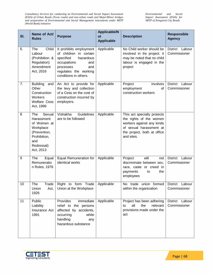
Consultancy Services for conducting an Environmental and Social Impact Assessment
(ESIA) of Urban Roads (Town roads) and non-urban roads and Major/Minor bridges
and preparation of Environmental and Social Management instruments under MITP
(World Bank) initiative
Environmental and Social
Impact Assessment (ESIA) for
MITP of Nongstoin City Roads
Page | 68
Sl. Name of Act/
Rules Purpose
Applicable/N
ot
Applicable
Description Responsible
Agency
6. The Child
Labour
(Prohibition &
Regulation)
Amendment
Act, 2016
It prohibits employment
of children in certain
specified hazardous
occupations and
processes and
regulates the working
conditions in others.
Applicable No Child worker should be
involved in the project. it
may be noted that no child
labour is engaged in the
project
District Labour
Commissioner
7. Building and
Other
Construction
Workers
Welfare Cess
Act, 1996
An Act to provide for
the levy and collection
of a Cess on the cost of
construction incurred by
employers.
Applicable Project involves
employment of
construction workers
District Labour
Commissioner
8 The Sexual
Harassment
of Women at
Workplace
(Prevention,
Prohibition,
and
Redressal)
Act, 2013
Vishakha Guidelines
are to be followed
Applicable This act specially protects
the rights of the women
workers against any kinds
of sexual harassment at
the project, both at office
and sites.
9 The Equal
Remuneratio
n Rules, 1976
Equal Remuneration for
identical works
Applicable Project will not
discriminate between sex,
race, caste or creed in
payments to the
employees
District Labour
Commissioner
10 The Trade
Union Act,
1926
Right to form Trade
Union at the Workplace
Applicable No trade union formed
within the organization
District Labour
Commissioner
11 Public
Liability
Insurance Act
1991
Provides immediate
relief to the persons
affected by accidents,
occurring while
handling any
hazardous substance
Applicable Project has been adhering
to all the relevant
provisions made under the
act
District Labour
Commissioner

Consultancy Services for conducting an Environmental and Social Impact Assessment
(ESIA) of Urban Roads (Town roads) and non-urban roads and Major/Minor bridges
and preparation of Environmental and Social Management instruments under MITP
(World Bank) initiative
Environmental and Social
Impact Assessment (ESIA) for
MITP of Nongstoin City Roads
Page | 69
Sl. Name of Act/
Rules Purpose
Applicable/N
ot
Applicable
Description Responsible
Agency
12 World Bank
OP/BP 4.12 –
Involuntary
Resettlement
Avoid or minimize
involuntary
resettlement and,
where this is not
feasible, assist
displaced persons in
improving or at least
restoring their
livelihoods and
standards of living in
real terms relative to
pre-displacement levels
or to levels prevailing
before the beginning of
project implementation,
whichever is higher
Applicable The project does not
envisage land acquisition
and the RoW is free from
any encroachments or
encumbrances as there is
a very low scale widening,
realignments, junction
improvements etc
however might adversely
affect non-titleholders
structures used for various
purposes, livelihood of
people (mainly earning
their livelihood by means
of petty shops and
providing various
services).
PIU/Implementin
g Agency
13 Indigenous
Peoples
OP/BP 4.10
In the context of India
Indigenous Peoples
may be referred to
"scheduled tribes". As
per the Census of
India, 2011 about 86%
of the Meghalaya state
belongs the Schedule
Tribe. The population is
distributed across 11
districts of Meghalaya.
Not
Applicable
The majority of the
population of the state is
tribal however, largely
impacted ST population
mostly live in the urban
areas and become the
mainstream population.
Thus the policy on
Indigenous People is tnot
riggered. as the presence
of tribal groups with close
attachment to land in the
project area is not
established. Further, this
policy is not triggered in
terms of “collective
attachment to
geographically distinct
habitats” and “institutions”.
PIU/Implementin
g Agency
14 Bank Policy –
Access to
Information
The policy governs the
public accessibility of
information in the
Bank’s possession.
Applicable Documents such as RPF,
all ESIA and ARAPs was
disclosed both by the
borrower and Bank and
uploaded in the website.
PIU/Implementin
g Agency

Consultancy Services for conducting an Environmental and Social Impact Assessment
(ESIA) of Urban Roads (Town roads) and non-urban roads and Major/Minor bridges
and preparation of Environmental and Social Management instruments under MITP
(World Bank) initiative
Environmental and Social
Impact Assessment (ESIA) for
MITP of Nongstoin City Roads
Page | 70
4.6.5 Social Categorization:
There are 8 identified sub-projects 4 are urban and 4 are rural. All activities under these sub-projects are limited to the available RoW, thus no land acquisition and resettlement and rehabilitation are envisioned for these activities. As there is impact on ST population due to the project thus, the World Bank OP 4.10 does trigger for these projects. Again, impacts on the livelihood of vendors, petty shopkeepers and likes cannot be fully avoided and thus need to be mitigated in accordance with the policies of the World Bank (OP 4.12). As per World Bank’s guidelines of Categorization for Involuntary Resettlement, this sub-project is categorized as Category S3 as there is no permanent impact the sub-projects. Thus, ESIA is prepared on the possible impacts identified and measured in SIA and mitigation measures as provisioned in the Entitlement Matrix of the Resettlement Framework and is as per the Guideline and Template of ESMF. The ESIA will be disclosed and will be implemented in the project and the compensation and R&R assistances will be released to the displaced families before the Civil Construction starts. All the activities in the urban or rural projects will impact the tribal population though it is limited to the existing land area already available. However, “collective attachment to geographically distinct habitats” and “institutions that are separate from those of the dominant society and culture is not present in the project impact area. As per World Bank’s guidelines of Categorization for Indigenous People Impact this sub-project is categorized as Category S3. As per the guidelines no specific action is required, still the mitigation methods are reflected in the related plans such as an Abbreviated Resettlement Plan, ESMP and Gender Action Plan.

Consultancy Services for conducting an Environmental and Social Impact Assessment
(ESIA) of Urban Roads (Town roads) and non-urban roads and Major/Minor bridges
and preparation of Environmental and Social Management instruments under MITP
(World Bank) initiative
Environmental and Social
Impact Assessment (ESIA) for
MITP of Nongstoin City Roads
Page | 71
5 CHAPTER: V- DESCRIPTION OF ENVIRONMENT
The present chapter describes the baseline environmental conditions of the project road. It
comprises both secondary information as well as primary information collected through baseline
studies, data collection and field surveys.
Details of the baseline environmental parameters are required for decision making for the
project design, implementation and operation from the environmental point of views. The data
has been collected from the primary surveys and secondary sources. It is essential to establish
the base line environmental status of the physical, natural and socio-cultural environmental
parameters along the project roads and within the project influence area of 10 Kms.
The baseline condition describes the state of the existing environment before the onset of the
proposed development work. The collection of baseline information on biophysical, social and
economic aspects of the project area is the most important reference for conducting
Environmental Screening and Preliminary Environmental and Social Impact Assessment study.
The description of existing environment includes the characteristic of area in which the activity
of the project road would occur and cover area affected by all impacts. The existing baseline
conditions have been analyzed based on secondary information/data collection with regard to
air quality, water quality, noise, soil, ecology & biodiversity and socio- economic aspects and
secondary data/information collection from published authentic sources and various government
agencies. Efforts have been made to collect the latest information both at regional as well as
local level especially along the project roads alignment. The existing baseline data and analysis
around the project road covering both districts are presented in the following sections.
5.1 Topography:
Meghalaya: Meghalaya state is also known as Meghalaya plateau. The highest point in the state
is the Shillong Peak with an altitude of 1961 meters. The state can, broadly, be divided into
three physiographic zones, namely:
Central Plateau Region comprising the Khasi Hills and has the highest elevations
between 900-2000m
Sub-montane region in continuation with the Central Plateau below 900m which
gradually merges with the plains in the West and North, namely the Jaintia Hills, and
Border region which stretches south-wards abruptly from the Central Plateau to the
plains in Bangladesh, mainly the Garo Hills region, and is nearly plain.
West Khasi Hills:
West Khasi Hills District of Meghalaya, was carved out of the erstwhile Khasi Hills District on the
28th October 1976. The District lies in the central part of the State of Meghalaya and is situated
between 10‘ and 25 degrees 51‘ N Latitude, and between 90 degrees 44‘ and 91 degrees 49‘E
longitude. The District is divided into four broad geographical units. The western parts bordering
Garo Hills, at an elevation between 600 to 900 meters from the mean sea level are traditionally

Consultancy Services for conducting an Environmental and Social Impact Assessment
(ESIA) of Urban Roads (Town roads) and non-urban roads and Major/Minor bridges
and preparation of Environmental and Social Management instruments under MITP
(World Bank) initiative
Environmental and Social
Impact Assessment (ESIA) for
MITP of Nongstoin City Roads
Page | 72
the homes of dense forest. The southern sector is rich in mineral resources. The central plateau
divides the district into the northern slope and the southern slope is between 1400 to 1700
meters above the MSL. The district headquarters is Nongstoin which covers an area of 76 sq.
km. Mairang, Mawshynrut and Mawkyrwat are the three civil Subdivisions of the district.
Most of the project road passes through hilly terrain. The existing road streches level varies
from 1254 meter above sea level to 1594 meter above sea level. Digital elevation map of project
road is attached in Figure 5.
Figure 5: Digital Elevation Map of Proposed Project Road
5.2 Soil & Geology:
The climate, vegetation, relief and parent material constituting the ecosystem influence significantly the paedogenesis resulting in the development of different kinds of soils. The State is covered by the warm per-humid agro-ecoregion. However, it can be divided into two distinct sub eco-region (Zone) with thermic and hyper thermic temperature regimes.
The area form a part of Meghalaya plateau comprising Archaean Basement Complex and younger sediments. The Archaean Basement CompOlex and the overlying Proterozoic metasediments of Shillong Group form NE-SW trending strike redges with prominent Valleys. Quartzite and conglomerate form high hills whereas phyllites, slate and quaternary valley fills form the low lying valleys. The Shillong Group of rocks were deposited in a shallow marine

Consultancy Services for conducting an Environmental and Social Impact Assessment
(ESIA) of Urban Roads (Town roads) and non-urban roads and Major/Minor bridges
and preparation of Environmental and Social Management instruments under MITP
(World Bank) initiative
Environmental and Social
Impact Assessment (ESIA) for
MITP of Nongstoin City Roads
Page | 73
environment. Gneisses and schistose rocks of the Archaean age are the oldest rock of the area forming the basement complex of Assam Meghalaya Gneissic Complex. The other rocks present in the area are quartz-biotite-sillimanite schist and migmatites. The regional strike of the foliation is more or less NE-SW with southerly dips. Veins of quartz and pegmatites mostly follow the foliation trend. The Shillong Group of rock includes conglomerate, quartzite, phyllites and quartz mica schist. The above group of rocks is intruded by grey/pink Alluvium comprising dark brown to brown oxidized sand, silt clay of Chapar and sorbhog formation is found towards northern part of the district. A NESW trending shear zone traverses through the eastern part of the district.1
The district shows different types of soil as the provenance differs widely. Red Gravelly and Red Loamy Soil are the common soil types. The soils are acidic in nature and comparatively rich in organic matter and nitrogen but poor in phosphorous.
Soil profile of the project location is drawn below:
Figure 6: Soil Map of Project Area
1 Final District Survey Report, Govt. Of Meghalaya
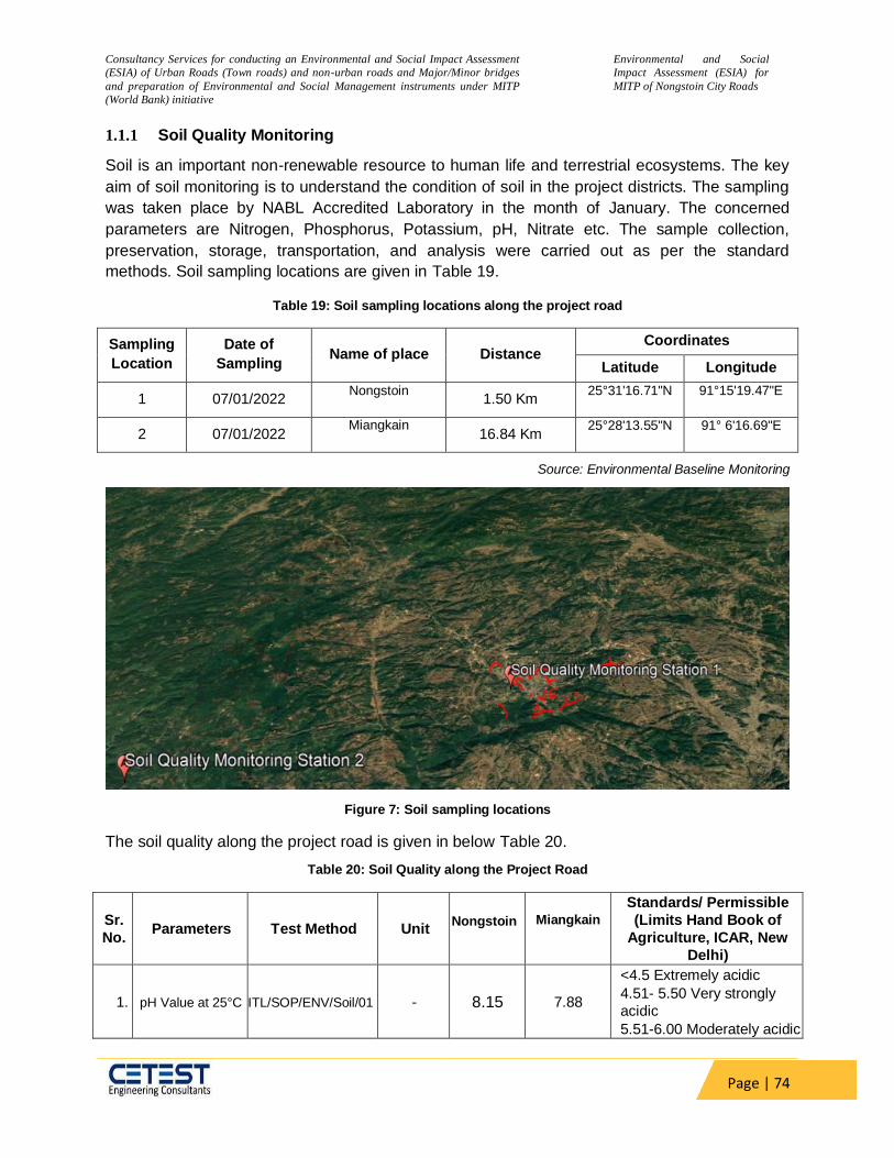
Consultancy Services for conducting an Environmental and Social Impact Assessment
(ESIA) of Urban Roads (Town roads) and non-urban roads and Major/Minor bridges
and preparation of Environmental and Social Management instruments under MITP
(World Bank) initiative
Environmental and Social
Impact Assessment (ESIA) for
MITP of Nongstoin City Roads
Page | 74
1.1.1 Soil Quality Monitoring
Soil is an important non-renewable resource to human life and terrestrial ecosystems. The key
aim of soil monitoring is to understand the condition of soil in the project districts. The sampling
was taken place by NABL Accredited Laboratory in the month of January. The concerned
parameters are Nitrogen, Phosphorus, Potassium, pH, Nitrate etc. The sample collection,
preservation, storage, transportation, and analysis were carried out as per the standard
methods. Soil sampling locations are given in Table 19.
Table 19: Soil sampling locations along the project road
Sampling
Location
Date of
Sampling Name of place Distance
Coordinates
Latitude Longitude
1 07/01/2022 Nongstoin
1.50 Km
25°31'16.71"N 91°15'19.47"E
2 07/01/2022 Miangkain
16.84 Km
25°28'13.55"N 91° 6'16.69"E
Source: Environmental Baseline Monitoring
Figure 7: Soil sampling locations
The soil quality along the project road is given in below Table 20.
Table 20: Soil Quality along the Project Road
Sr.
No. Parameters Test Method Unit
Nongstoin
Miangkain
Standards/ Permissible
(Limits Hand Book of
Agriculture, ICAR, New
Delhi)
1. pH Value at 25°C ITL/SOP/ENV/Soil/01 - 8.15 7.88
<4.5 Extremely acidic
4.51- 5.50 Very strongly
acidic
5.51-6.00 Moderately acidic
Consultancy Services for conducting an Environmental and Social Impact Assessment
(ESIA) of Urban Roads (Town roads) and non-urban roads and Major/Minor bridges
and preparation of Environmental and Social Management instruments under MITP
(World Bank) initiative
Environmental and Social
Impact Assessment (ESIA) for
MITP of Nongstoin City Roads
Page | 75
Sr.
No. Parameters Test Method Unit
Nongstoin
Miangkain
Standards/ Permissible
(Limits Hand Book of
Agriculture, ICAR, New
Delhi)
6.01-6.50 Slightly acidic
6.51-7.30 Neutral
7.31-7.80 Slightly alkaline
7.81-8.50 Moderately
alkaline
8.51-9.00 Strongly alkaline
>9.00 Very strongly alkaline
2.
Conductivity at
25°C ITL/SOP/ENV/Soil/02 µmhos/cm 677 714
Upto 1.00 Average
1.01-2.00 harmful to
germination
2.01-3.00 Harmful to crops
(sensitive to salts)
4. Soil Texture ITL/SOP/ENV/Soil/07 - Silty Clay
Soil Silty Clay
Soil
-
5. Sand ITL/SOP/ENV/Soil/06 % by mass 23.4 18.2 -
6. Clay ITL/SOP/ENV/Soil/06 % by mass 42.5 42.6 -
7. Silt ITL/SOP/ENV/Soil/06
% by mass 34.1 39.2 -
8. Nitrogen
ITL/SOP/ENV/Soil/09
mg/kg 25.1 22.8
Upto 50 Very less
51-100 Less
101-150 Good
151-300 Better
>300 Sufficient
9. Potassium (as K) ITL/SOP/ENV/Soil/11
mg/kg
73.1 68.4
Upto 15 Very less
16-30 Less
31-50 Medium,
51-65 On an avg. sufficient
66-80 Sufficient
>80 More than sufficient
10. Phosphorus ITL/SOP/ENV/Soil/10
mg/kg
4.21 3.99
0 -120 Very less
120-180 Less
181-240 Medium
241-300 Average
301-360 Better
>360 More than sufficient
11. Organic Matter ITL/SOP/ENV/Soil/17 % by mass 6.5 6.2
Upto 0.20: Very less
0.21-0.40: Less
0.41-0.50: Medium,
0.51-0.80: On an avg.
sufficient
0.81-1.00: Sufficient
>1.00 : More than sufficient

Consultancy Services for conducting an Environmental and Social Impact Assessment
(ESIA) of Urban Roads (Town roads) and non-urban roads and Major/Minor bridges
and preparation of Environmental and Social Management instruments under MITP
(World Bank) initiative
Environmental and Social
Impact Assessment (ESIA) for
MITP of Nongstoin City Roads
Page | 76
Sr.
No. Parameters Test Method Unit
Nongstoin
Miangkain
Standards/ Permissible
(Limits Hand Book of
Agriculture, ICAR, New
Delhi)
12.
Moisture
Retention
capacity
ITL/SOP/ENV/Soil/05 Inches/foot 1.22 1.17
-
14. Sulphates ITL/SOP/ENV/Soil/14 mg/kg 13.4 14.2 -
17. Bulk Density ITL/SOP/ENV/Soil/04 gm/cc 1.30 1.29 -
The important physical characteristics of soil are bulk density, porosity and texture. Ph of soil in
the proposed study area were found in the range of 7.88 to 8.15 the soil samples are, therefore,
moderately alkaline. Conductivity of soils sample is found in the range of 677 to 714 Mhos/cm.
Available phosphorous of soil samples along the proposed study area ranges from 3.99 to 4.21
mg/kg which is very less. Potassium content as K in soil samples along the proposed study
area is found in the range of 68.4 to 73.1 mg/kg. Total organic matter in soil samples along the
proposed study area is found in the range of 6.2– 6.5 %, therefore the soil is fertile in terms of
productivity.
5.3 Climate:
Meteorology:
The state of Meghalaya experiences four distinct seasons. As per the Kalita et.al. (2020), the
state of Meghalaya has four distrinct season viz.
Winter season- It includes the months of January and February.
Pre Monsoon season consists of March, April, and May.
Monsoon season is being from June to September
Post-Monsoon includes the rest of the months: October, November, and December
In some places in Meghalaya, annual average rainfall has crossed the 12 000 mm (470 in) and
maximum temperature is around 28 °C.
West Khasi Hills District:
The Climate of the district varies in latitudinal and longitudinal directions and is influenced mainly by physiography. There are four seasons in the district namely summer, monsoon or rainy, autumn and winter. The summer season extends from the end of March to mid-May, which is characterized by relatively high temperature, occasional thunderstorm with high wind velocities. The rainy season commences with the onset of southwest monsoon in April and lasts

Consultancy Services for conducting an Environmental and Social Impact Assessment
(ESIA) of Urban Roads (Town roads) and non-urban roads and Major/Minor bridges
and preparation of Environmental and Social Management instruments under MITP
(World Bank) initiative
Environmental and Social
Impact Assessment (ESIA) for
MITP of Nongstoin City Roads
Page | 77
up to October. This is followed by short autumn from mid-October to November. This season indicates the slow retreating of monsoon with clear and sunny sky. The winter season extends from December to the end of March. This is the coldest season of the year with sharp decline in the temperature. During winter, some high altitude areas of the state experiences very cold nights. Winter is basically dry with lower diurnal range of temperature.
In general, the district has a mildly tropical climate in the northern and southern foothills, whereas central upland portion experiences temperate climate and the places of medium altitude of the northern, southern and western parts of the district experience sub-tropical climate.2
Nongstoin:
In Nongstoin, the wet season is comfortable, muggy, and mostly cloudy and the dry season is cool and mostly clear.
Rainfall:
In terms of precipitation received, in Nongstoin August receives the most amount of
rainfall, with an average of 27.6 days with at least 706 mm of precipitation. Driest month
of Nongstoin district is January an average of 5.9 days with at least 23mm of
precipitation. The study area is surrounded by hills and is subjected to a wet weather.
The area experiences a lot of rainfall every year. In the month of August there will be
chances of water logging, flash floods, landslides in the area.
Figure 8: Precipitation in Nongstoin (Source-meteoblue)
Temperature:
The warm season lasts for 5.3 months, from May 20 to October 30, with an average
temperature above 70°F. The hottest month of the year in Nongstoin is August, with an
2 Ground Water Information Booklet West Khasi Hills District, Meghalaya

Consultancy Services for conducting an Environmental and Social Impact Assessment
(ESIA) of Urban Roads (Town roads) and non-urban roads and Major/Minor bridges
and preparation of Environmental and Social Management instruments under MITP
(World Bank) initiative
Environmental and Social
Impact Assessment (ESIA) for
MITP of Nongstoin City Roads
Page | 78
average of 23°C. The cool season lasts for 1.7 months, from December 17 to February
8, with an average temperature below 19°C. The coldest month of the year in Nongstoin
is January, with an average of 17°F.
Figure 9: Average Temperature in Nongstoin
Wind Speed/Direction:
The average hourly wind speed in Nongstoin experiences significant seasonal variation
over the course of the year. The windier part of the year lasts for 5.3 months, from March
25 to September 3, with average wind speeds of more than 6.4 miles per hour.
The windiest month of the year in Nongstoin is July, with an average hourly wind speed
of 8.4 miles per hour and so in this month there is a chance of soil erosion in this area.
Potholes can also be created due to continuous soil erosion and water may get logged
into the potholes during heavy rainfall which can ultimately led to the destruction of
roads. While the calmer time of year lasts for 6.7 months, from September 3 to March
25. The calmest month of the year in Nongstoin is December, with an average hourly
wind speed of 4.0 miles per hour. The calmer time of year is suitable for construction.
. Depending on the maximum flow direction of wind the setup of hot mix plant will be
decided because the construction of roads should not affect the air quality of residential
areas in the down wind direction.

Consultancy Services for conducting an Environmental and Social Impact Assessment
(ESIA) of Urban Roads (Town roads) and non-urban roads and Major/Minor bridges
and preparation of Environmental and Social Management instruments under MITP
(World Bank) initiative
Environmental and Social
Impact Assessment (ESIA) for
MITP of Nongstoin City Roads
Page | 79
Figure 10: Average Wind Speed in Nongstoin
Source: https://weatherspark.com/y/111986/Average-Weather-in-Nongstoin-India-Year-Round
The wind is most often from the west for 2.5 months, from January 7 to March 23, with a
peak percentage of 52% on March 2. The wind is most often from the south for 6.6
months, from March 23 to October 10, with a peak percentage of 87% on July 8. The
wind is most often from the east for 2.9 months, from October 10 to January 7, with a
peak percentage of 37% on January 1. Depending on the maximum flow direction of
wind the setup of hot mix plant will be decided because the construction of roads should
not affect the air quality of residential areas in the down wind direction.
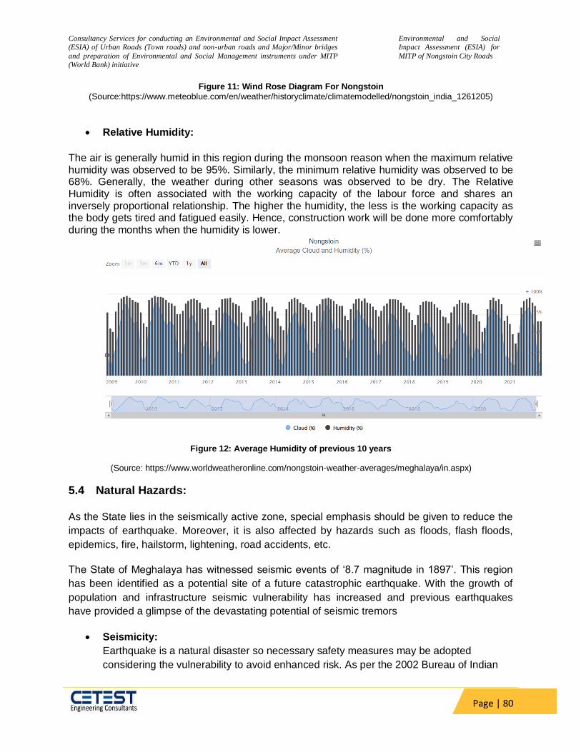
Consultancy Services for conducting an Environmental and Social Impact Assessment
(ESIA) of Urban Roads (Town roads) and non-urban roads and Major/Minor bridges
and preparation of Environmental and Social Management instruments under MITP
(World Bank) initiative
Environmental and Social
Impact Assessment (ESIA) for
MITP of Nongstoin City Roads
Page | 80
Figure 11: Wind Rose Diagram For Nongstoin (Source:https://www.meteoblue.com/en/weather/historyclimate/climatemodelled/nongstoin_india_1261205)
Relative Humidity:
The air is generally humid in this region during the monsoon reason when the maximum relative humidity was observed to be 95%. Similarly, the minimum relative humidity was observed to be 68%. Generally, the weather during other seasons was observed to be dry. The Relative Humidity is often associated with the working capacity of the labour force and shares an inversely proportional relationship. The higher the humidity, the less is the working capacity as the body gets tired and fatigued easily. Hence, construction work will be done more comfortably during the months when the humidity is lower.
Figure 12: Average Humidity of previous 10 years
(Source: https://www.worldweatheronline.com/nongstoin-weather-averages/meghalaya/in.aspx)
5.4 Natural Hazards:
As the State lies in the seismically active zone, special emphasis should be given to reduce the
impacts of earthquake. Moreover, it is also affected by hazards such as floods, flash floods,
epidemics, fire, hailstorm, lightening, road accidents, etc.
The State of Meghalaya has witnessed seismic events of ‘8.7 magnitude in 1897’. This region
has been identified as a potential site of a future catastrophic earthquake. With the growth of
population and infrastructure seismic vulnerability has increased and previous earthquakes
have provided a glimpse of the devastating potential of seismic tremors
Seismicity:
Earthquake is a natural disaster so necessary safety measures may be adopted
considering the vulnerability to avoid enhanced risk. As per the 2002 Bureau of Indian
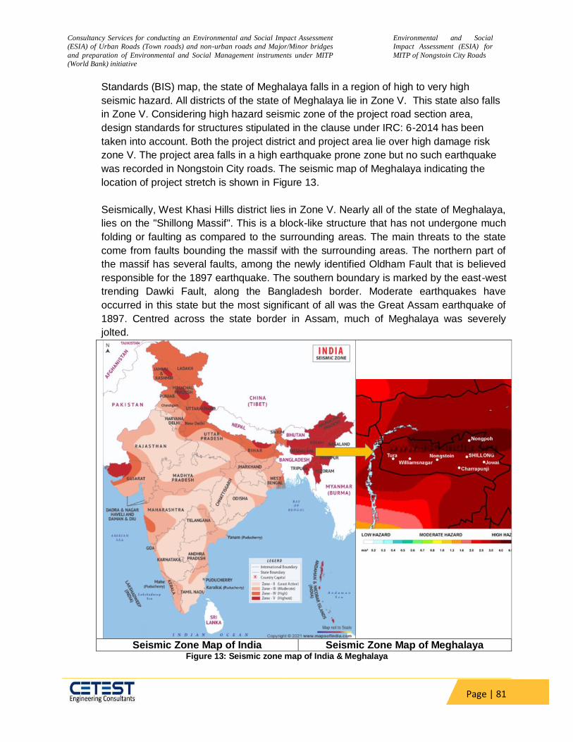
Consultancy Services for conducting an Environmental and Social Impact Assessment
(ESIA) of Urban Roads (Town roads) and non-urban roads and Major/Minor bridges
and preparation of Environmental and Social Management instruments under MITP
(World Bank) initiative
Environmental and Social
Impact Assessment (ESIA) for
MITP of Nongstoin City Roads
Page | 81
Standards (BIS) map, the state of Meghalaya falls in a region of high to very high
seismic hazard. All districts of the state of Meghalaya lie in Zone V. This state also falls
in Zone V. Considering high hazard seismic zone of the project road section area,
design standards for structures stipulated in the clause under IRC: 6-2014 has been
taken into account. Both the project district and project area lie over high damage risk
zone V. The project area falls in a high earthquake prone zone but no such earthquake
was recorded in Nongstoin City roads. The seismic map of Meghalaya indicating the
location of project stretch is shown in Figure 13.
Seismically, West Khasi Hills district lies in Zone V. Nearly all of the state of Meghalaya,
lies on the "Shillong Massif". This is a block-like structure that has not undergone much
folding or faulting as compared to the surrounding areas. The main threats to the state
come from faults bounding the massif with the surrounding areas. The northern part of
the massif has several faults, among the newly identified Oldham Fault that is believed
responsible for the 1897 earthquake. The southern boundary is marked by the east-west
trending Dawki Fault, along the Bangladesh border. Moderate earthquakes have
occurred in this state but the most significant of all was the Great Assam earthquake of
1897. Centred across the state border in Assam, much of Meghalaya was severely
jolted.
Seismic Zone Map of India Seismic Zone Map of Meghalaya
Figure 13: Seismic zone map of India & Meghalaya
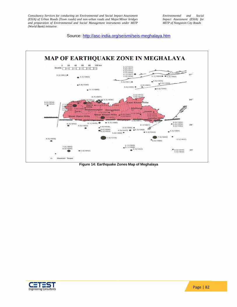
Consultancy Services for conducting an Environmental and Social Impact Assessment
(ESIA) of Urban Roads (Town roads) and non-urban roads and Major/Minor bridges
and preparation of Environmental and Social Management instruments under MITP
(World Bank) initiative
Environmental and Social
Impact Assessment (ESIA) for
MITP of Nongstoin City Roads
Page | 82
Source: http://asc-india.org/seismi/seis-meghalaya.htm
Figure 14: Earthquake Zones Map of Meghalaya

Consultancy Services for conducting an Environmental and Social Impact Assessment
(ESIA) of Urban Roads (Town roads) and non-urban roads and Major/Minor bridges
and preparation of Environmental and Social Management instruments under MITP
(World Bank) initiative
Environmental and Social
Impact Assessment (ESIA) for
MITP of Nongstoin City Roads
Page | 83
Figure 15: Multi Hazard Zone Map of Meghalaya showing the project road
Flood Hazard:
In Meghalaya, floods occur in river valleys, when flow exceeds the capacity of the river
channel, particularly at bends or meanders. The plain areas of Meghalaya adjoining
Assam are affected by flood due to the back flow of water from the River Brahmaputra
during the flood season between June and October. The tributaries like Krishnai, Jinari,
Jingjiram, Rongai, Dudhnoi, Ringgi, Gohai, Dilni etc cause flood in the plain areas of the
State.
The Flood Prone Areas of Meghalaya:
Western part of Meghalaya like Tikrikilla, Phulbari, Rajabala, Garobadha, Hallidaygunj,
Bhaitbari, Fersakandi, Magurmari, Silkata, Mahendraganj etc.
Plain areas near Bangladesh like Baghmara, Balat, Shella, Dawki etc.
Urban Flooding in localized areas of Shillong, Williamnagar, Tura etc.
Localised areas of West Khasi Hills, South West Khasi Hills, East Khasi Hills Jaintia
Hills and in Ri-Bhoi Districts.
Figure 15 shows that project area comes under flood prone zone. In this area flooding of
river during monsoon and flash floods in hill areas is commonly experienced.

Consultancy Services for conducting an Environmental and Social Impact Assessment
(ESIA) of Urban Roads (Town roads) and non-urban roads and Major/Minor bridges
and preparation of Environmental and Social Management instruments under MITP
(World Bank) initiative
Environmental and Social
Impact Assessment (ESIA) for
MITP of Nongstoin City Roads
Page | 84
Project district also fall under flood prone area. Flood prone area of Meghalaya is
showing in Figure 16
The project area is not known to face significant impacts from monsoon floods. However, it does witness flash floods in certain low-lying areas. The patterns of floods cannot be forecasted.
.
Figure 16: Flood Prone Zones of Meghalaya
Source: http://www.mati.gov.in/docs/Academic%20Module%20-
%202/PDF%20(3rd%20November%202021)/vulnerability%20profile%20of%20meghalaya%2018th%20October,2013
-SDMA.pdf
Landslide Hazard:
Meghalaya being a hilly terrain is prone to landslides. Every year a number of landslides have
been reported from various localities. These cause a lot of miseries to public, resulting in loss of
lives and properties, disruption of communication network, besides causing economic burden on
the society. Landslide is primarily attributed to high slope, immature geology, neo-tectonic
activity, heavy rainfall, unplanned and improper land use practice in the State. Landslides
generally occur during heavy rains that is during the months of June to October in Meghalaya.

Consultancy Services for conducting an Environmental and Social Impact Assessment
(ESIA) of Urban Roads (Town roads) and non-urban roads and Major/Minor bridges
and preparation of Environmental and Social Management instruments under MITP
(World Bank) initiative
Environmental and Social
Impact Assessment (ESIA) for
MITP of Nongstoin City Roads
Page | 85
Figure 17: Landslide Map of North-Eastern Himalayas
Source:
https://megrevenuedm.gov.in/reports/Meghalaya_State_Disaster_Management_Plan_Volume1.
Cyclone
Meghalaya is situated in the north eastern direction of Bangladesh which is highly prone to
cyclone. Yearly, approx. 60% percent of the state is affected by cyclone in Bangladesh. The
Districts close to Bangladesh like South West Garo Hills, South Garo Hills, South West Khasi
Hills, West Khasi Hills, fall in very high cyclonic zone due to close proximity to Bay of Bengal
(which is a cyclone basin). During April – May, various parts of Meghalaya observe cyclone. It
has detrimental impacts on society and environment.3
West Khasi Hill district and project area also comes under high cyclonic zone. The proposed
project area comes under very high damage risk zone B. The Cyclone Zone map of Meghalaya
indicating the location of project stretch is shown in Figure 18.
.
3 Meghalaya State Disaster Management Plan

Consultancy Services for conducting an Environmental and Social Impact Assessment
(ESIA) of Urban Roads (Town roads) and non-urban roads and Major/Minor bridges
and preparation of Environmental and Social Management instruments under MITP
(World Bank) initiative
Environmental and Social
Impact Assessment (ESIA) for
MITP of Nongstoin City Roads
Page | 86
Figure 18: Map of Wind and Cyclone Zone in Meghalaya showing the project road
5.5 Land Environment:
The project road passes mostly through hilly terrain and few stretches pass through rolling
Terrain. The adjoining land is generally hilly with vegetation. A combination of conversion of
land use to agriculture and plantations, deforestation and periods of intense rainfall render
several tracts of land abutting the road to be erosion prone. The project corridor has scattered
built up area named as Nongpyndeng, Mawlait, Nongthraw, Miangshiang, Nongsba,
Nongpathar, Maweit Etc.
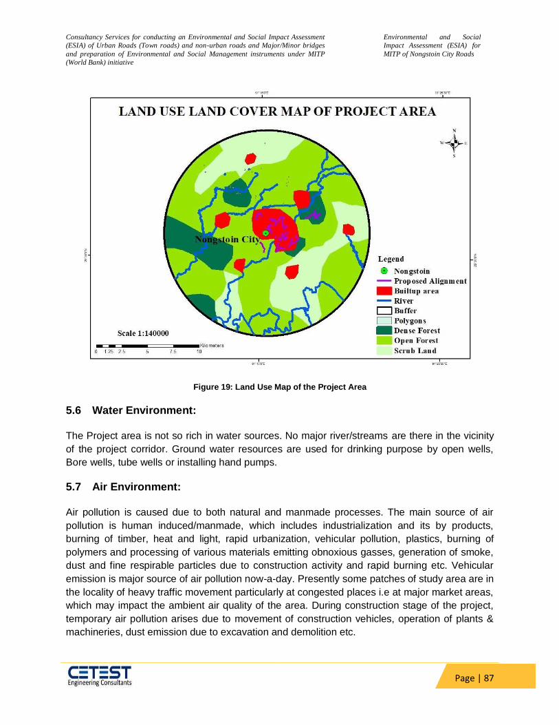
Consultancy Services for conducting an Environmental and Social Impact Assessment
(ESIA) of Urban Roads (Town roads) and non-urban roads and Major/Minor bridges
and preparation of Environmental and Social Management instruments under MITP
(World Bank) initiative
Environmental and Social
Impact Assessment (ESIA) for
MITP of Nongstoin City Roads
Page | 87
Figure 19: Land Use Map of the Project Area
5.6 Water Environment:
The Project area is not so rich in water sources. No major river/streams are there in the vicinity
of the project corridor. Ground water resources are used for drinking purpose by open wells,
Bore wells, tube wells or installing hand pumps.
5.7 Air Environment:
Air pollution is caused due to both natural and manmade processes. The main source of air
pollution is human induced/manmade, which includes industrialization and its by products,
burning of timber, heat and light, rapid urbanization, vehicular pollution, plastics, burning of
polymers and processing of various materials emitting obnoxious gasses, generation of smoke,
dust and fine respirable particles due to construction activity and rapid burning etc. Vehicular
emission is major source of air pollution now-a-day. Presently some patches of study area are in
the locality of heavy traffic movement particularly at congested places i.e at major market areas,
which may impact the ambient air quality of the area. During construction stage of the project,
temporary air pollution arises due to movement of construction vehicles, operation of plants &
machineries, dust emission due to excavation and demolition etc.
Consultancy Services for conducting an Environmental and Social Impact Assessment
(ESIA) of Urban Roads (Town roads) and non-urban roads and Major/Minor bridges
and preparation of Environmental and Social Management instruments under MITP
(World Bank) initiative
Environmental and Social
Impact Assessment (ESIA) for
MITP of Nongstoin City Roads
Page | 88
5.8 Monitoring Parameters and Standards
The Environmental monitoring of the parameters involved and the threshold limits specified are
discussed below: -
5.8.1 Ambient Air Quality Monitoring
The air quality parameters viz. Sulphur di-oxide (SO2), Oxides of Nitrogen (NOX), Carbon
Monoxide (CO) and Particulate Matter (PM 2.5 & PM 10) shall be regularly monitored at identified
locations from the start of the construction activity. The air quality parameters shall be
monitored in accordance with the National Ambient Air Quality Standards.
The ambient air quality with respect to the study area forms the baseline information. The prime
objective of the baseline air quality study was to assess the existing air quality of the area. This
will also be useful for assessing the conformity to standards of the ambient air quality during the
construction and operation phase.
This section describes the selection of sampling locations, methodology adopted for sampling,
analytical techniques and frequency of sampling. The ambient air quality monitoring data is
taken from an environmental assessment report of Rongram-Rongrenggre-Darugre Road.
5.8.1.1 Methodology Adopted for Air Quality Survey
Selection of Sampling Locations:
The baseline status of the ambient air quality has been assessed through a scientifically
designed ambient air quality monitoring network. Selection of Air quality monitoring
station was done as per MoEF guidelines for conducting EIA study. The design of
monitoring network in the air quality surveillance program has been based on the
following considerations:
Meteorological conditions on synoptic scale;
Topography of the study area;
Representatives of regional background air quality for obtaining baseline status;
Representatives of likely impact areas.
5.8.1.2 Frequency and Parameters for Sampling
High volume samplers were used to collect/measure the air pollutant concentration data
at 24 hours averaging periods for all stations. The baseline data of air environment was
monitored for parameters mentioned below:
Particulate Matter (PM2.5);
Particulate Matter (PM10);
Sulphur dioxide (SO2);
Oxides of Nitrogen (NOx);
Carbon Monoxide (CO)

Consultancy Services for conducting an Environmental and Social Impact Assessment
(ESIA) of Urban Roads (Town roads) and non-urban roads and Major/Minor bridges
and preparation of Environmental and Social Management instruments under MITP
(World Bank) initiative
Environmental and Social
Impact Assessment (ESIA) for
MITP of Nongstoin City Roads
Page | 89
The AAQ sampling is carried out as the present revised standards mentioned in the
latest Gazette notification of the Central Pollution Control Board (CPCB) (November,
2009).
The baseline status of the ambient air quality has been checked through ambient air
quality monitoring at selected points along the project area. The ambient air quality has
been monitored at 2 locations as shown in Table 13 along the project road for particulate
matter (PM2.5 and PM10), sulphur dioxide (SO2), oxides of nitrogen (NOX); and carbon
monoxides (CO) using standard analysis technique is shown in Table 12
Table 12: Techniques Used for Ambient Air Quality Monitoring
Sr. No. Parameter Technique Minimum Detectable
Limit (µg/m3)
1. Particulate Matter (PM2.5) Gravimetric Method 10.0
2. Particulate Matter (PM10) Gravimetric Method 25.0
3. Sulphur dioxide Modified West and Gaeke 5.0
4. Nitrogen Oxide Modified Jacob &
Hochheiser 5.0
5. Carbon Monoxide Non-Dispersive Infrared Spectroscopy (NDIR)
1
(in mg/m3)
To study the baseline ambient air quality scenario within the project corridor the ambient air quality, air sampling was carried out in the month of January 2022. To generate post-monsoon air quality of the project area, samples of ambient air was collected from two (2) locations for twice a week for two weeks.
Table 13: Air Quality Monitoring locations along the project road
SL. no Date of Sampling Name of
place
Distance
(m)
Coordinates
Latitude Longitude
1
i. 03/01/2022 to 04/01/2022
ii. 07/01/2022 to 08/01/2022
Nongstoin
1.50 Km
25°31'16.71"N 91°15'19.47"E
2 iii. 03/01/2022 to
04/01/2022 iv. 07/01/2022 to
08/01/2022
Miangkain
16.84 Km
25°28'13.55"N 91° 6'16.69"E
Source: environmental assessment report of Rongram-Rongrenggre-Darugre Road.

Consultancy Services for conducting an Environmental and Social Impact Assessment
(ESIA) of Urban Roads (Town roads) and non-urban roads and Major/Minor bridges
and preparation of Environmental and Social Management instruments under MITP
(World Bank) initiative
Environmental and Social
Impact Assessment (ESIA) for
MITP of Nongstoin City Roads
Page | 90
Figure 20: Air Quality Monitoring locations along the project road
Ambient air quality monitoring results for PM2.5, PM10, SO2, NOX, and CO concentrations are
given in Table 14 and summarized below. The monitored values are compared with National
Ambient Air Quality Standards prescribed by Central Pollution Control Board (CPCB) and WHO
Ambient Air Quality Guidelines (IFC EHS) for residential, rural, and other areas.
Table 14: Ambient Air Quality along the Project Road
S. N.
Particulate Matter (PM10)
Particulate Matter (PM2.5)
Sulphur Dioxide
Nitrogen Dioxide
Carbon Monoxide
Hydrocarbon (HC), µg/m³
Lead (Pb), µg/m³
National Ambient Air Quality Standard (CPCB) - Permissible limit
100 60 80 80 2 - 1
AAQM 1: Nongstoin
Week 1 1 72 41 7.4 11.2 BDL BDL BDL
Week 2 2 76 42 8.1 12.1 BDL BDL BDL AAQM 2: Miangkain
Week 1 5 67 38 6.4 10.4 BDL BDL BDL
Week 2 6 69 39 6.1 11.1 BDL BDL BDL
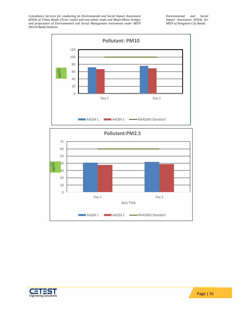
Consultancy Services for conducting an Environmental and Social Impact Assessment
(ESIA) of Urban Roads (Town roads) and non-urban roads and Major/Minor bridges
and preparation of Environmental and Social Management instruments under MITP
(World Bank) initiative
Environmental and Social
Impact Assessment (ESIA) for
MITP of Nongstoin City Roads
Page | 91
0
20
40
60
80
100
120
Day 1 Day 2
µg/
l3
Pollutant: PM10
AAQM 1 AAQM 2 NAAQMS Standard
0
10
20
30
40
50
60
70
Day 1 Day 2
µg/
l3
Axis Title
Pollutant:PM2.5
AAQM 1 AAQM 2 NAAQMS Standard

Consultancy Services for conducting an Environmental and Social Impact Assessment
(ESIA) of Urban Roads (Town roads) and non-urban roads and Major/Minor bridges
and preparation of Environmental and Social Management instruments under MITP
(World Bank) initiative
Environmental and Social
Impact Assessment (ESIA) for
MITP of Nongstoin City Roads
Page | 92
The Ambient air quality levels meet the National air quality standards for the rural, residential
area all along the project road. Concentrations of all the parameters at three locations are within
the National Ambient Air Quality Standard (CPCB) - Permissible limit.
PM2.5: The mean PM2.5 concentration at ambient air quality monitoring locations
varies from 38 µg/m3 to 42 µg/m3. The values are within the permissible limit at
all the stations.
PM10: The mean PM10 concentration at ambient air quality monitoring locations
varies from 67 to 76 µg/m3. The values are within the permissible limit at all the
stations as per the NAAQS.
0
10
20
30
40
50
60
70
80
90
Day 1 Day 2
µg/
l3
Pollutant: SOx
AAQM 1
AAQM 2
NAAQMSStandard
0
10
20
30
40
50
60
70
80
90
Day 1 Day 2
µg/
l3
Pollutant: NOx
AAQM 1
AAQM 2
NAAQMSStandard
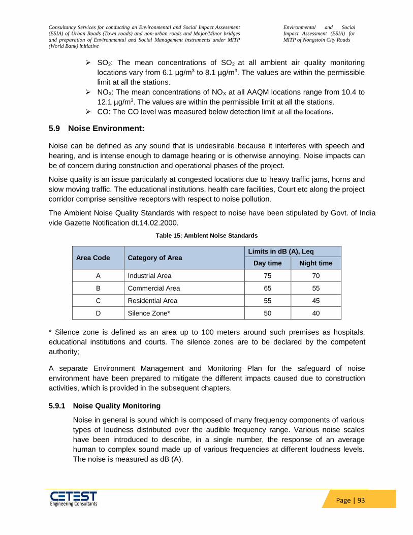
Consultancy Services for conducting an Environmental and Social Impact Assessment
(ESIA) of Urban Roads (Town roads) and non-urban roads and Major/Minor bridges
and preparation of Environmental and Social Management instruments under MITP
(World Bank) initiative
Environmental and Social
Impact Assessment (ESIA) for
MITP of Nongstoin City Roads
Page | 93
SO2: The mean concentrations of SO2 at all ambient air quality monitoring
locations vary from 6.1 µg/m3 to 8.1 µg/m3. The values are within the permissible
limit at all the stations.
NOX: The mean concentrations of NOX at all AAQM locations range from 10.4 to
12.1 µg/m3. The values are within the permissible limit at all the stations.
CO: The CO level was measured below detection limit at all the locations.
5.9 Noise Environment:
Noise can be defined as any sound that is undesirable because it interferes with speech and
hearing, and is intense enough to damage hearing or is otherwise annoying. Noise impacts can
be of concern during construction and operational phases of the project.
Noise quality is an issue particularly at congested locations due to heavy traffic jams, horns and
slow moving traffic. The educational institutions, health care facilities, Court etc along the project
corridor comprise sensitive receptors with respect to noise pollution.
The Ambient Noise Quality Standards with respect to noise have been stipulated by Govt. of India
vide Gazette Notification dt.14.02.2000.
Table 15: Ambient Noise Standards
Area Code Category of Area Limits in dB (A), Leq
Day time Night time
A Industrial Area 75 70
B Commercial Area 65 55
C Residential Area 55 45
D Silence Zone* 50 40
* Silence zone is defined as an area up to 100 meters around such premises as hospitals,
educational institutions and courts. The silence zones are to be declared by the competent
authority;
A separate Environment Management and Monitoring Plan for the safeguard of noise
environment have been prepared to mitigate the different impacts caused due to construction
activities, which is provided in the subsequent chapters.
5.9.1 Noise Quality Monitoring
Noise in general is sound which is composed of many frequency components of various
types of loudness distributed over the audible frequency range. Various noise scales
have been introduced to describe, in a single number, the response of an average
human to complex sound made up of various frequencies at different loudness levels.
The noise is measured as dB (A).
Consultancy Services for conducting an Environmental and Social Impact Assessment
(ESIA) of Urban Roads (Town roads) and non-urban roads and Major/Minor bridges
and preparation of Environmental and Social Management instruments under MITP
(World Bank) initiative
Environmental and Social
Impact Assessment (ESIA) for
MITP of Nongstoin City Roads
Page | 94
This is more suitable for audible range of 20 to 20,000 Hz. The scale has been designed
to weigh various components of noise according to the response of a human ear. The
impact of noise sources on surrounding community depends on:
Characteristics of noise sources (instantaneous, intermittent or continuous in
nature). It can be observed that steady noise is not as annoying as one which is
continuously varying in loudness;
The time of day at which noise occurs, for example high noise levels at night in
residential areas are not acceptable because of sleep disturbance; and
The location of the noise source, with respect to noise sensitive land-use, which
determines the loudness and period of exposure.
The main objective of noise monitoring in the study area is to establish the baseline
noise levels, and assess the impact of the total noise generated by the construction work
and movement of vehicles during operations phase.
Identification of Sampling Locations
The noise at different noise generating sources has been identified based on industrial,
commercial, and residential activities, traffic, and noise at sensitive areas. Sound
Pressure Level (SPL) measurements were undertaken at all locations, with an interval of
about 5 seconds over 10 minutes per hour for 24 hr. The day noise level has been
monitored from7 AM to 10 PM and night levels from 10 P.M. to 7 AM at 3 locations. The
Details of the monitoring locations are given in Table 16 . Day and night-time Leq have
been calculated from hourly Leq values and compared with the stipulated standards.
The monitored values are compared with CPCB Ambient Air Quality Standards in
respect of Noise and Guidelines for Community Noise, World Health Organization for
residential areas. The monitored levels meet the National as well as WHO standards for
the residential area all along the project road.
The main objective of noise monitoring in the study area is to establish the baseline
noise levels, which was used to assess the impact of total noise generated by the
proposed project activities. Noise level monitoring was carried out continuously for 24 –
hours with one-hour interval at each location using Sound level meter capable of
measuring the Sound Pressure Level (SPL) in Db (A). Hourly Leq values were computed
by the noise integrating sound level meter and statistical analysis was done for
measured noise levels in the study area.
Table 16: Noise Monitoring locations along the project road
Sampling
Location
Date of
Sampling
Name of
place
Distance (m)
Coordinates
Land Use
Latitude Longitude
1 03.01.2022-
07.01.2022
Nongstoin
1.50 Km 25°31'16.71"N 91°15'19.47"E Residential cum
residential
2 03.01.2022-
07.01.2022
Miangkain
16.84 Km 25°28'13.55"N 91° 6'16.69"E Residential

Consultancy Services for conducting an Environmental and Social Impact Assessment
(ESIA) of Urban Roads (Town roads) and non-urban roads and Major/Minor bridges
and preparation of Environmental and Social Management instruments under MITP
(World Bank) initiative
Environmental and Social
Impact Assessment (ESIA) for
MITP of Nongstoin City Roads
Page | 95
Source: environmental assessment report of Rongram Rongrenggre Darugre Road and CPCB Manual Monitoring
Data
Figure 21: Noise Monitoring locations along the project road
Table 17: Day and Night Time Leq
Noise location1: Nongstoin
Noise location 2
Miangkain
Date 03.01.2022 07.01.202 03.01.2022 07.01.2022
Maximum 52.3 52.1 52.1 51.2
Minimum 35.2 36.4 37.9 38.2
Leqday 48.6 47.7 48.2 47.7
Leqnight 36.4 36.5 39.4 38.3
Leq 48 47.4 48.6 47.9
STANDARD Day–65 Night-55 Day–55 Night - 45
It can be seen from Table 17 that at all the monitoring locations, the ambient noise levels are
well within the permissible limits for residential areas prescribed by CPCB and also by World
Bank EHS standards of 55 dB(A) and 45 dB(A) for day time and night time respectively. The
maximum recorded day time noise level is 48.6 dB(A) and night time noise level is 36.4 dB(A) at
Nongstoin and Miangkain. Average day time noise level along the subproject roads varies from
47.7 dB(A) to 48.6 dB(A) whereas average night time noise levels vary from 36.4 dB(A) to
39.4dB(A).

Consultancy Services for conducting an Environmental and Social Impact Assessment
(ESIA) of Urban Roads (Town roads) and non-urban roads and Major/Minor bridges
and preparation of Environmental and Social Management instruments under MITP
(World Bank) initiative
Environmental and Social
Impact Assessment (ESIA) for
MITP of Nongstoin City Roads
Page | 96
5.10 Biological Environment:
Ecological resources are among the most important resources impacted by the
road/infrastructure projects. The detailed baseline study of the ecological resources is essential
to estimate the magnitude of potential impacts and to avoid or mitigate any loss caused by the
proposed project. In this section baseline details of the flora and fauna are presented.
The three geographical sub-regions of Meghalaya, viz., Khasi, Garo and Jaintia hills are among
the wettest regions of the world, with clouds persisting in various areas nearly throughout the
year. Meghalaya falls under the Indo-Myanmar Bioddiversity Hotspot zone. Meghalaya, is one of
the biodiversity rich state of India in terms of diversity of both flora and fauna due to its unique
geographical position at the meeting point of Indo-Malayan and Eastern Himalayan bio-
geographical regions. Thus, it shares biodiversity elements including flora and fauna from both
the regions. Meghalaya also shares rich species diversity containing species from Indo-China
and rest of India. The diverse landscape of the state also supports a large array of forest types
and species. The flora of Meghalaya comprises about 3,128 species of flowering plants of which
a large number of species are endemic. Meghalaya harbours a rich diversity of orchids (Family:
Orchidaceae), of which nearly 110 genera and 439 taxa are reported from the state. However,
many authors believe that Meghalaya may have more species of orchids and many are still to
be discovered (Kakati 1986). Meghalaya is also considered as center of origin for a number of
crop plants like rice, and Citrus based on the large number of wild relatives found in the state.
True to its name, ‘Meghalaya’ is an abode of clouds and thus increased moisture conditions
prevails. The hills rise abruptly in south, while it is gradual in north. The altitudinal variation
range from 50 meters to 1950 meters with the Shillong plateau at the crest. The hills are
dissected and drained by numerous rivers and rivulets draining to north and south. The climate
is monsoonal with distinct warm-wet and cold-dry periods. The towns of Sohra (Cherrapunjee)
and Mawsynram, which are located on the Southern part of the State, receive very heavy rainfall
and amongst the wettest spots in the world.
The faunal diversity of Meghalaya constitutes a total of 5538 species recorded so far, of a total
89,451 species known from India. Nearly 35 % of Indian Mammals and 50 % of the birds are
represented in the state (Invertebrates are represented by 2114 genera and 4580 species, of
which 3624 species are insects. Among invertebrates, the porifera is the smallest group
represented by only one genus and one species. Meghalaya has 139 species of Mammals, 659
species of Birds, 107 species of Reptiles, 55 species of Amphibia and 152 species of Fishes. Of
these, 35 species of Mammals are endangered, vulnerable or insufficiently known. Similarly, 10
species of birds and 9 species of reptiles are either endangered or vulnerable. Along with the
species diversity, the State has a significant percentage of endemic elements.
West Khasi Hills District was carved out of the state of Meghalaya in the year 1976 on the 28
day of October which in fact is the largest of all the eleven districts in the state of Meghalaya and
since its existence, it has been bifurcated into two Civil Sub-divisions and a new district in South
West Khasi Hills. It spreads through the heart of the state running high with plateau ranges and
low with rich plain lands.

Consultancy Services for conducting an Environmental and Social Impact Assessment
(ESIA) of Urban Roads (Town roads) and non-urban roads and Major/Minor bridges
and preparation of Environmental and Social Management instruments under MITP
(World Bank) initiative
Environmental and Social
Impact Assessment (ESIA) for
MITP of Nongstoin City Roads
Page | 97
Protected Areas of Meghalaya:
The protected area network in Meghalaya occupies 1133.9 Sq. Km area which constitute about
5.06 % of the State’s Geographical Area. The Protected Area Network includes 2 national
Parks, 4 wildlife Sanctuaries and 1 Biosphere Reserve playing an important role in in-situ
conservation of Biodiversity.
As per the website of Meghalaya Forest Department, the project district does not have any
Protected area within its boundary. The nearest Protected area is Balpakram National Park,
which is about 22km away from the project site and fall outside of the both Direct and Indirect
impact zone.
Table 18: Protected area in Meghalaya
Sl No Protected Area Area (sq kms) District
1 Balpakram National Park 352.00 South Garo Hills
2 Nokrek National Park 47.48 East Garo Hills
3 Nongkhyllem Wildlife Sanctuary 29.00 Ri-Bhoi District
4 Siju Wildlife Sanctuary 5.18 South Garo Hills
5 Baghmara Pitcher Plant Sanctuary 0.02 South Garo Hills
6 Narpuh Wildlife Sanctuary 59.9 East Jainti
7 Nokrek Biosphere Reserve 820 East, West and South Garo Hills

Consultancy Services for conducting an Environmental and Social Impact Assessment
(ESIA) of Urban Roads (Town roads) and non-urban roads and Major/Minor bridges
and preparation of Environmental and Social Management instruments under MITP
(World Bank) initiative
Environmental and Social
Impact Assessment (ESIA) for
MITP of Nongstoin City Roads
Page | 98
Figure 22: Protected Areas of Meghalaya
Figure 23: distance between Balpakram National Park and project area
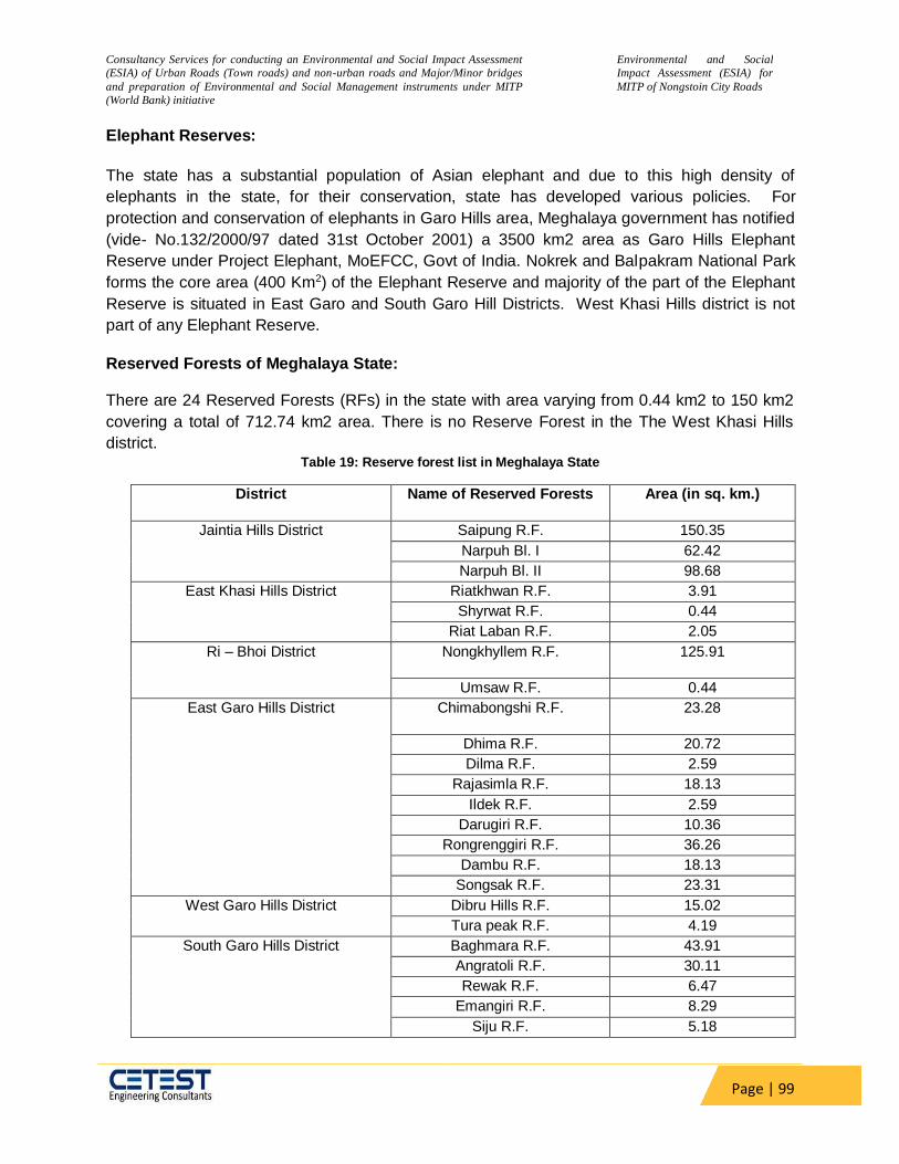
Consultancy Services for conducting an Environmental and Social Impact Assessment
(ESIA) of Urban Roads (Town roads) and non-urban roads and Major/Minor bridges
and preparation of Environmental and Social Management instruments under MITP
(World Bank) initiative
Environmental and Social
Impact Assessment (ESIA) for
MITP of Nongstoin City Roads
Page | 99
Elephant Reserves:
The state has a substantial population of Asian elephant and due to this high density of
elephants in the state, for their conservation, state has developed various policies. For
protection and conservation of elephants in Garo Hills area, Meghalaya government has notified
(vide- No.132/2000/97 dated 31st October 2001) a 3500 km2 area as Garo Hills Elephant
Reserve under Project Elephant, MoEFCC, Govt of India. Nokrek and Balpakram National Park
forms the core area (400 Km2) of the Elephant Reserve and majority of the part of the Elephant
Reserve is situated in East Garo and South Garo Hill Districts. West Khasi Hills district is not
part of any Elephant Reserve.
Reserved Forests of Meghalaya State:
There are 24 Reserved Forests (RFs) in the state with area varying from 0.44 km2 to 150 km2
covering a total of 712.74 km2 area. There is no Reserve Forest in the The West Khasi Hills
district. Table 19: Reserve forest list in Meghalaya State
District Name of Reserved Forests Area (in sq. km.)
Jaintia Hills District Saipung R.F. 150.35
Narpuh Bl. I 62.42
Narpuh Bl. II 98.68
East Khasi Hills District Riatkhwan R.F. 3.91
Shyrwat R.F. 0.44
Riat Laban R.F. 2.05
Ri – Bhoi District Nongkhyllem R.F. 125.91
Umsaw R.F. 0.44
East Garo Hills District Chimabongshi R.F. 23.28
Dhima R.F. 20.72
Dilma R.F. 2.59
Rajasimla R.F. 18.13
Ildek R.F. 2.59
Darugiri R.F. 10.36
Rongrenggiri R.F. 36.26
Dambu R.F. 18.13
Songsak R.F. 23.31
West Garo Hills District Dibru Hills R.F. 15.02
Tura peak R.F. 4.19
South Garo Hills District Baghmara R.F. 43.91
Angratoli R.F. 30.11
Rewak R.F. 6.47
Emangiri R.F. 8.29
Siju R.F. 5.18
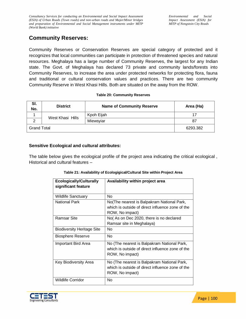
Consultancy Services for conducting an Environmental and Social Impact Assessment
(ESIA) of Urban Roads (Town roads) and non-urban roads and Major/Minor bridges
and preparation of Environmental and Social Management instruments under MITP
(World Bank) initiative
Environmental and Social
Impact Assessment (ESIA) for
MITP of Nongstoin City Roads
Page | 100
Community Reserves:
Community Reserves or Conservation Reserves are special category of protected and it
recognizes that local communities can participate in protection of threatened species and natural
resources. Meghalaya has a large number of Community Reserves, the largest for any Indian
state. The Govt. of Meghalaya has declared 73 private and community lands/forests into
Community Reserves, to increase the area under protected networks for protecting flora, fauna
and traditional or cultural conservation values and practices. There are two community
Community Reserve in West Khasi Hills. Both are situated on the away from the ROW.
Table 20: Community Reserves
Sl.
No. District Name of Community Reserve Area (Ha)
1 West Khasi Hills
Kpoh Eijah 17
2 Miewsyiar 87
Grand Total 6293.382
Sensitive Ecological and cultural attributes:
The table below gives the ecological profile of the project area indicating the critical ecological ,
Historical and cultural features –
Table 21: Availability of Ecologigical/Cultural Site within Project Area
Ecologically/Culturally
significant feature
Availability within project area
Wildlife Sanctuary No
National Park No(The nearest is Balpakram National Park,
which is outside of direct influence zone of the
ROW, No impact)
Ramsar Site No( As on Dec 2020, there is no declared
Ramsar site in Meghalaya)
Biodiversity Heritage Site No
Biosphere Reserve No
Important Bird Area No (The nearest is Balpakram National Park,
which is outside of direct influence zone of the
ROW, No impact)
Key Biodiversity Area No (The nearest is Balpakram National Park,
which is outside of direct influence zone of the
ROW, No impact)
Wildlife Corridor No

Consultancy Services for conducting an Environmental and Social Impact Assessment
(ESIA) of Urban Roads (Town roads) and non-urban roads and Major/Minor bridges
and preparation of Environmental and Social Management instruments under MITP
(World Bank) initiative
Environmental and Social
Impact Assessment (ESIA) for
MITP of Nongstoin City Roads
Page | 101
Ecologically/Culturally
significant feature
Availability within project area
Elephant Corridor No (The nearest is Bagmara – Balpakram ,
which is outside of direct influence zone of the
ROW, No impact)
Tiger Reserve No
Reserve Forest No
Elephant Reserve No
Community Forests No
Sacred Groove No
Archeological Sites No
Unprotected / Non
Classified Forest
Yes
Major River No
Fish Sanctuary No
Surface water bodies Yes. Small ponds mostly used for fishery.
Forest Status in Project District:
As per the latest State of Forest Report 2019 published by Forest Survey of India (FSI) , It is
evident from below mentioned table that the project area district has a high forest cover, i.e.,
76.32 % of the geographical area of the district, which mostly comprises of moderately dense or
open forest and majority of the forests are either private or owned by the community.
Table 22: West Khasi Hill- Forest Cover (Area in Sq. km)
Animal crossings & Migratory Routes
The project corridor is devoid of any reserved forest within the study area and there is no wildlife habitat around the project. So, there is no designated migratory route or animal crossing in the project area.
Community Reserves:
District Geographic Area As per 2017 Assessment % Forest cover Very Dense
Forest Mod Dense
Forest Open Forest
Total
West Khasi Hills 5247 91 2551 1366 4008 76.39
Source: Indian State of Forest Report, 2019
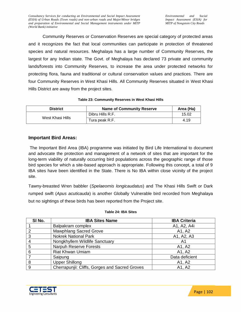
Consultancy Services for conducting an Environmental and Social Impact Assessment
(ESIA) of Urban Roads (Town roads) and non-urban roads and Major/Minor bridges
and preparation of Environmental and Social Management instruments under MITP
(World Bank) initiative
Environmental and Social
Impact Assessment (ESIA) for
MITP of Nongstoin City Roads
Page | 102
Community Reserves or Conservation Reserves are special category of protected areas
and it recognizes the fact that local communities can participate in protection of threatened
species and natural resources. Meghalaya has a large number of Community Reserves, the
largest for any Indian state. The Govt. of Meghalaya has declared 73 private and community
lands/forests into Community Reserves, to increase the area under protected networks for
protecting flora, fauna and traditional or cultural conservation values and practices. There are
four Community Reserves in West Khasi Hills. All Community Reserves situated in West Khasi
Hills District are away from the project sites.
Table 23: Community Reserves in West Khasi Hills
District Name of Community Reserve Area (Ha)
West Khasi Hills Dibru Hills R.F. 15.02
Tura peak R.F. 4.19
Important Bird Areas:
The Important Bird Area (IBA) programme was initiated by Bird Life International to document
and advocate the protection and management of a network of sites that are important for the
long-term viability of naturally occurring bird populations across the geographic range of those
bird species for which a site-based approach is appropriate. Following this concept, a total of 9
IBA sites have been identified in the State. There is No IBA within close vicinity of the project
site.
Tawny-breasted Wren babbler (Spelaeornis longicaudatus) and The Khasi Hills Swift or Dark
rumped swift (Apus acuticauda) is another Globally Vulnerable bird recorded from Meghalaya
but no sightings of these birds has been reported from the Project site.
Table 24: IBA Sites
Sl No. IBA Sites Name IBA Criteria
1 Balpakram complex A1, A2, A4i
2 Mawphlang Sacred Grove A1, A2
3 Nokrek National Park A1, A2, A3
4 Nongkhyllem Wildlife Sanctuary A1
5 Narpuh Reserve Forests A1, A2
6 Riat Khwan Umiam A1, A2
7 Saipung Data deficient
8 Upper Shillong A1, A2
9 Cherrapunjii: Cliffs, Gorges and Sacred Groves A1, A2
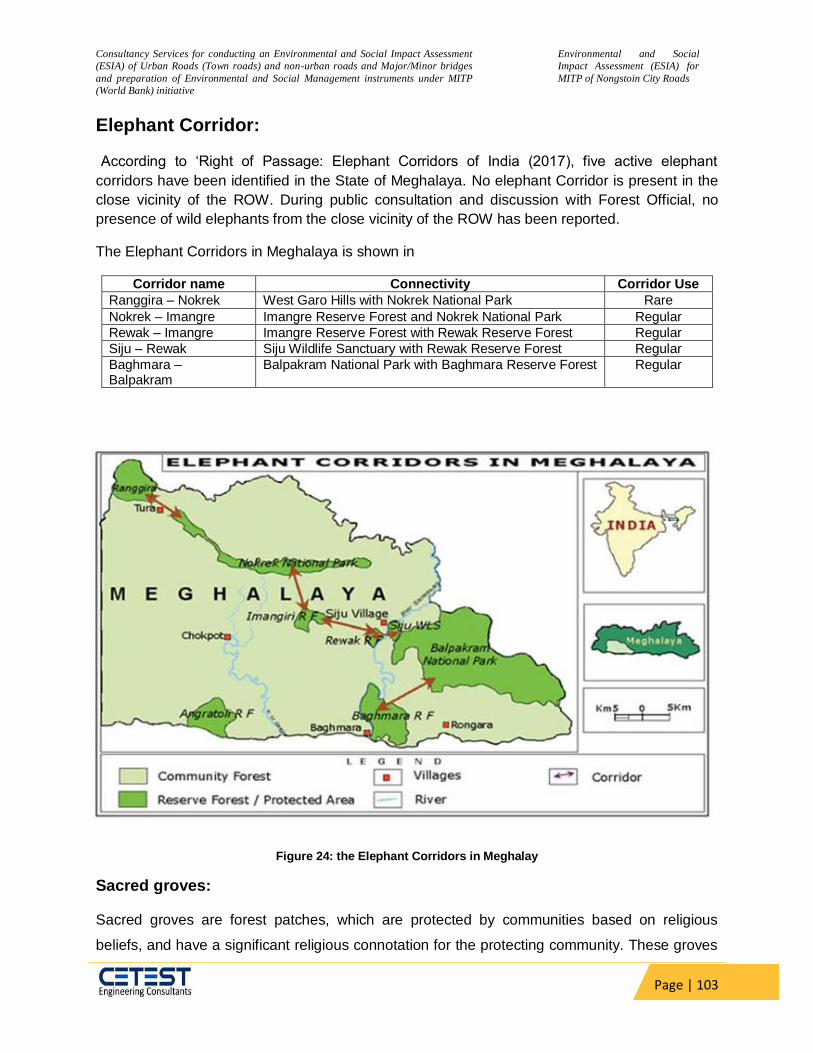
Consultancy Services for conducting an Environmental and Social Impact Assessment
(ESIA) of Urban Roads (Town roads) and non-urban roads and Major/Minor bridges
and preparation of Environmental and Social Management instruments under MITP
(World Bank) initiative
Environmental and Social
Impact Assessment (ESIA) for
MITP of Nongstoin City Roads
Page | 103
Elephant Corridor:
According to ‘Right of Passage: Elephant Corridors of India (2017), five active elephant
corridors have been identified in the State of Meghalaya. No elephant Corridor is present in the
close vicinity of the ROW. During public consultation and discussion with Forest Official, no
presence of wild elephants from the close vicinity of the ROW has been reported.
The Elephant Corridors in Meghalaya is shown in
Corridor name Connectivity Corridor Use
Ranggira – Nokrek West Garo Hills with Nokrek National Park Rare
Nokrek – Imangre Imangre Reserve Forest and Nokrek National Park Regular
Rewak – Imangre Imangre Reserve Forest with Rewak Reserve Forest Regular
Siju – Rewak Siju Wildlife Sanctuary with Rewak Reserve Forest Regular
Baghmara – Balpakram
Balpakram National Park with Baghmara Reserve Forest Regular
Figure 24: the Elephant Corridors in Meghalay
Sacred groves:
Sacred groves are forest patches, which are protected by communities based on religious
beliefs, and have a significant religious connotation for the protecting community. These groves

Consultancy Services for conducting an Environmental and Social Impact Assessment
(ESIA) of Urban Roads (Town roads) and non-urban roads and Major/Minor bridges
and preparation of Environmental and Social Management instruments under MITP
(World Bank) initiative
Environmental and Social
Impact Assessment (ESIA) for
MITP of Nongstoin City Roads
Page | 104
are considered as one of the most species-rich areas for plants, birds and mammals. Most of
the groves are in the catchment areas of major rivers. The information on floristic richness of the
sacred groves of Meghalaya revealed that at least 514 species representing 340 genera and
131 families are present in these sacred forests. Many endemic, rare, endangered and
threatened species of the state are found in the sacred groves. The sacred grove biodiversity
compares favourably with that of the core area of some of the biosphere reserves in this region,
which are being managed by the state forest department.
Even though Meghalaya has as many as 105 recorded sacred groves, the more famous ones
are the Mawphlang and Mawsmai sacred groves. No sacred grove is located within the Project
site i.e., Nongstoin City Roads.
Table 25: Sacred Grove in West Khasi Hills District
Sl.No. Sacred Grove Name Sacred Grove Location Area (Hectares)
District – West Khasi Hills
1 U Law Lyngdoh Nongkyngkin 190
2 U Lum Sanglia -DO- -DO-
3 U Law Blei -DO- -DO-
4 Law Lyngdoh Nonglang 200
5 Law Kyntang Mawlangwir Not Known
6 Law Kyntang Mawten -DO-
7 Law Lyngdoh Rangmaw -DO-
8 Law Kyntang Mawthawiaw -DO-
9 Nongsynrih sacred grove Nongsynrih -DO-
10 Law Adong Lyngdoh Mawlong (clan protected grove)
Mawlong 200
11 Kyllai Lyngngun Mariam 80
12 Lyngdoh Mawnai sacred grove Mawnai 80
13 Law Lyngdoh Nonglait Not Known
Biodiversity Profile of the Study area:
The whole of Garo Hills region forms a sort of undulating plateau with plenty of flat lands and
valleys with altitudes varying from 100-1400 m above sea level, highest point being Lum
Shyllong which is 1,968 metres. The district has a rich and unique flora and it is supposed to be
the original home of the Citrus. Based on altitude, the vegetation of Garo Hills can be broadly
classified into the flora of tropical and sub-tropical zones. During the survey, The team has also
given emphasis about presence of different species within the 10 km and 15 km Buffer area of
the project site through interview, field visit and literature review.

Consultancy Services for conducting an Environmental and Social Impact Assessment
(ESIA) of Urban Roads (Town roads) and non-urban roads and Major/Minor bridges
and preparation of Environmental and Social Management instruments under MITP
(World Bank) initiative
Environmental and Social
Impact Assessment (ESIA) for
MITP of Nongstoin City Roads
Page | 105
Vegetation:
Vegetation around 10 km and 15 km buffer of the study area mostly comprises of large/
medium/ small trees bushy shrubs and annuals perennial or biennials herbs. No scheduled
species as per Wildlife Protetion Act ,1972 had been described from the project site nor any
species listed under Endangered or Vulnerable as per IUCN status had been described from the
project site. It embraces evergreen, semi-evergreen and deciduous forests, bamboo thickets
and grasslands including riparian forests and swamps. These forests mainly consist of Shorea
robusta and in certain area Tectona grandis has also been introduced.
Table 26: Agro-biodiversity in the Study Area
Scientific Name Family Crop Type Local/ English Name
Allium cepa Amaryllidaceae Vegetable Piyaj
Allium sativum Amaryllidaceae Spice Lahsun
Amaranthus sp. Amaranthaceae Vegetable Lalsag
Anacardium occidentalis Anacardiaceae Plantation Crop Kaju
Ananas comosus Bromeliaceae Fruit Pineapple
Areca catechu Arecaceae Plantation Crop Tambul
Artocarpus hetrophyllus Moraceae Vegetable Kathal
Carica papaya Caricaceae Fruit Papita
Cier aeriatinum Fabaceae Pulse Chana
Citrus media Rutaceae Fruit Nimbu
Cocos nucifera Arecaceae Fruit Narikol
Colocasia antiquoram Aracea Vegetable Kachchu
Corchorus capsularis Malvaceae Fibre Jute
Coriandrum sativum Apiaceae Condiment & Spice Dhania
Cucumis sativa Cucurbitaceae Fruit Kheera
Cucurbita pepo Cucurbitaceae Vegetable Kaddu
Daucus carrota Apiaceae Vegetable Gajar
Hevia brasiliensis Euphorbiaceae Plantation Crop Ruber
Lens esculenta Fabaceae Pulse Masur
Luffa spp. Cucurbitaceae Vegetable Lauki
Lycopersicon esculentum Solanaceae Vegetable Tamatar
Momordica charantia Cucurbitaceae Vegetable Karela
Musa indica Musaceae Fruit Kela
Oryza sativa Poaceae Cereal Dhan
Phaseolus mungo Fabaceae Pulse Urd
Psidum guajava Myrtaceae Fruit Amrud
Raphanus sativa Brassicaceae Vegetable Muli

Consultancy Services for conducting an Environmental and Social Impact Assessment
(ESIA) of Urban Roads (Town roads) and non-urban roads and Major/Minor bridges
and preparation of Environmental and Social Management instruments under MITP
(World Bank) initiative
Environmental and Social
Impact Assessment (ESIA) for
MITP of Nongstoin City Roads
Page | 106
Sesamum indicum Pedaliaceae Oilseed Til
Solanum melongena Solanaceae Vegetable Began
Solanum tuberosum Solanaceae Vegetable Aalu
Spinach oleracea Amaranthaceae Vegetable Palak
Trigonella foenium graecum Fabaceae Vegetable Methi
Triticum aestivum Poaceae Cereal Gehu
Zea mays Poaceae Cereal Makka
Zingiber officinalis Zingiberaceae Rhizome Adrakh
Table 27: Plant Biodiversity in the Study Area
Scientific Name Family Habit Local Availability
IUCN * Status
(A) ANGIOSPERMS
Acacia pennata Mimosaceae Herb Common LC
Ageratum conyzoides Asteraceae Herb Very Common NA
Albizzia procera Mimosaceae Tree Rare NA
Anthocephalus chinensis Rubiaceae Tree Common NA
Artocarpus integrifolia Moraceae Small Tree Common NA
Arundinella nepalensis Poaceae Herb Common NA
Arundo donax Poaceae Herb Common LC
Asparagus racemosus Liliaceae Herb Rare NA
Bauhinia acuminata Caesalpiniaceae Small Tree Common LC
Bombax ceiba Bambacaceae Tree Very
Common
NA
Cardamine impatiens Brassicaceae Herb Common NA
Cassia fistula Caesalpiniaceae Small Tree Common NA
Cassia tora Caesalpiniaceae Shrub Common NA
Chrysopogon fulvus Poaceae Herb Common NA
Cissampelos pariera Manispermaceae Herb Rare NANIC
Commelina bengalensis Commelinaceae Herb Very
Common
NANIC
Cyperus rotundus Cyperaceae Herb Abundant NANIC
Dendrocalamus
hamiltonii
Poaceae Herb Common NA
Dioscorea bulbifera Dioscoreaceae Climber Common NA
Erythrina variegata Papilionaceae Small Tree Rare NA
E. hirta Euphorbiaceae Herb Common NA
Ficus hispida Moraceae Tree Common NA
Galium sp. Rubiaceae Herb Common NA
Gmelina arborea Verbenaceae Tree Common NA

Consultancy Services for conducting an Environmental and Social Impact Assessment
(ESIA) of Urban Roads (Town roads) and non-urban roads and Major/Minor bridges
and preparation of Environmental and Social Management instruments under MITP
(World Bank) initiative
Environmental and Social
Impact Assessment (ESIA) for
MITP of Nongstoin City Roads
Page | 107
Imperata cylindrica Poaceae Herb Common LC
Ipomoea aquatica Convolvulaceae Herb Common NA
I. cairica Convolvulaceae Creeper Very
common
NA
Justicia adhatoda Acanthaceae Shrub Common NA
Lagerstroemia sp Lytharaceae Tree Rare NA
Lathyrus aphaca Fabaceae Herb Common NA
Lemna minor Lemnaceae Herb Common LC
Lepidium virginicum Brassicaceae Herb Common NA
Litsea glutinosa Lauraceae Tree Rare NA
Mallotus philippensis Euphorbiaceae Small Tree Common NA
Mimosa pudica Mimosaceae Herb Rare NA
Phragmites karka Poaceae Herb Common LC
Phyllanthus emblica Euphorbiaceae Tree Common NA
Poa annua Poaceae Herb Common LC
Potamogeton pectinatus Potomogetonaceae Herb Common LC
Pycrius spp. Cyperaceae Herb Abundant NA
Ranunculus arvensis Ranunculaceae Herb Common NA
Saccharum spontaneum Poaceae Herb Abundant LC
Sapium baccatum Euphorbiaceae Tree Common NA
Scripus spp. Cyperaceae Herb Common NA
Shorea robusta Dipterocarpaceae tree Rare NA
Smilex zylanica Smilaceae Climber Rare LR
Solanum erianthum Solanaceae Herb Common NANIC
Sonchus spp. Asteraceae Herb Common NA
Stellaria media Caryophylaceae Herb Common NA
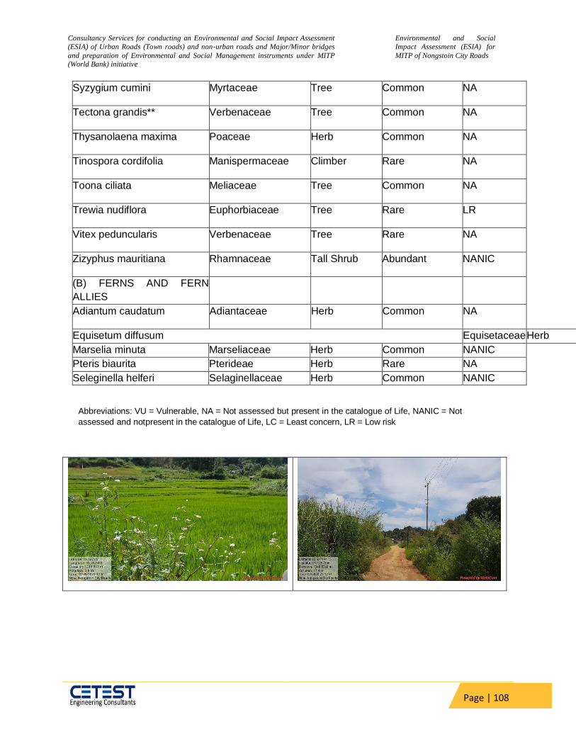
Consultancy Services for conducting an Environmental and Social Impact Assessment
(ESIA) of Urban Roads (Town roads) and non-urban roads and Major/Minor bridges
and preparation of Environmental and Social Management instruments under MITP
(World Bank) initiative
Environmental and Social
Impact Assessment (ESIA) for
MITP of Nongstoin City Roads
Page | 108
Syzygium cumini Myrtaceae Tree Common NA
Tectona grandis** Verbenaceae Tree Common NA
Thysanolaena maxima Poaceae Herb Common NA
Tinospora cordifolia Manispermaceae Climber Rare NA
Toona ciliata Meliaceae Tree Common NA
Trewia nudiflora Euphorbiaceae Tree Rare LR
Vitex peduncularis Verbenaceae Tree Rare NA
Zizyphus mauritiana Rhamnaceae Tall Shrub Abundant NANIC
(B) FERNS AND FERN
ALLIES
Adiantum caudatum Adiantaceae Herb Common NA
Equisetum diffusum Equisetaceae Herb
Marselia minuta Marseliaceae Herb Common NANIC
Pteris biaurita Pterideae Herb Rare NA
Seleginella helferi Selaginellaceae Herb Common NANIC
Abbreviations: VU = Vulnerable, NA = Not assessed but present in the catalogue of Life, NANIC = Not
assessed and not present in the catalogue of Life, LC = Least concern, LR = Low risk

Consultancy Services for conducting an Environmental and Social Impact Assessment
(ESIA) of Urban Roads (Town roads) and non-urban roads and Major/Minor bridges
and preparation of Environmental and Social Management instruments under MITP
(World Bank) initiative
Environmental and Social
Impact Assessment (ESIA) for
MITP of Nongstoin City Roads
Page | 109
Figure 25: Vegetation along the Project Road
Table 28: Invasive Alien Plants in the Study Area
Species Family Habit Nativity
Aerva javanica Amaranthaceae Herb Tropical America
Ageratum conyzoides Asteraceae Herb Brazil
Amaranthus spinosus Amaranthaceae Herb Tropical America
Anagallis arvensis Primulaceae Herb Europe
Argemone mexicana Papaveraceae Herb Tropical South
America
Calotropis procera Asclapiadaceae Shrub Tropical America
Cannabis sativa Cannabaceae Herb Tropical America
Chenopodium album Chenopodiaceae Herb Tropical America
Species Family Habit Nativity
Cleome viscosa Capparaceae Herb Tropical America
Cuscuta reflexa Cuscutaceae Climber Mediterranean region
Datura metal Solanaceae Shrub Tropical America
Eichhornia crassipes Pontederiaceae Herb Tropical America
Euphobia hirta Euphorbiaceae Herb Tropical America
E. thymifolia Euphorbiaceae Hurb Tropical America
Galinsoga paviflora Asteraceae Herb Tropical America
Lantana camara Verbenaceae Shrub Tropical America
Oxalis corniculata Oxalidaceae Herb Europe
Parthenium hysterophorus Asteraceae Herb Tropical America
Physalis minima Solanaceae Herb Tropical America
Portulaca oleracea Portulacaceae Herb Tropical South America
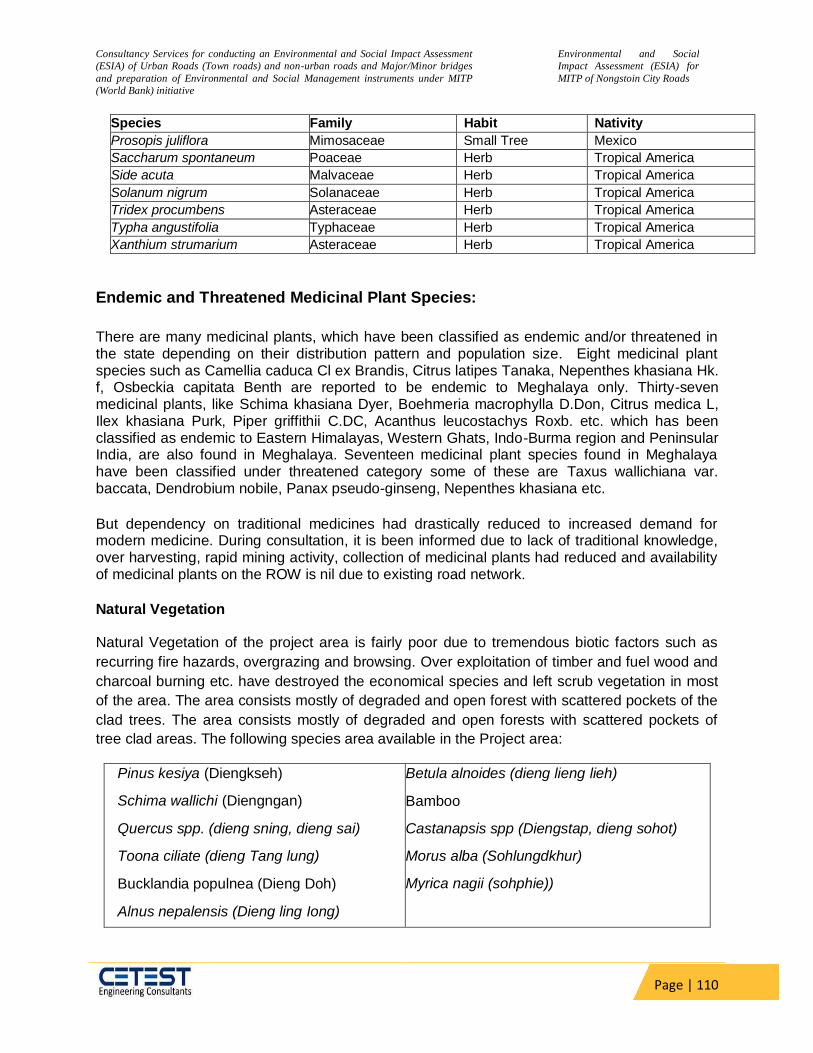
Consultancy Services for conducting an Environmental and Social Impact Assessment
(ESIA) of Urban Roads (Town roads) and non-urban roads and Major/Minor bridges
and preparation of Environmental and Social Management instruments under MITP
(World Bank) initiative
Environmental and Social
Impact Assessment (ESIA) for
MITP of Nongstoin City Roads
Page | 110
Species Family Habit Nativity
Prosopis juliflora Mimosaceae Small Tree Mexico
Saccharum spontaneum Poaceae Herb Tropical America
Side acuta Malvaceae Herb Tropical America
Solanum nigrum Solanaceae Herb Tropical America
Tridex procumbens Asteraceae Herb Tropical America
Typha angustifolia Typhaceae Herb Tropical America
Xanthium strumarium Asteraceae Herb Tropical America
Endemic and Threatened Medicinal Plant Species:
There are many medicinal plants, which have been classified as endemic and/or threatened in the state depending on their distribution pattern and population size. Eight medicinal plant species such as Camellia caduca Cl ex Brandis, Citrus latipes Tanaka, Nepenthes khasiana Hk. f, Osbeckia capitata Benth are reported to be endemic to Meghalaya only. Thirty-seven medicinal plants, like Schima khasiana Dyer, Boehmeria macrophylla D.Don, Citrus medica L, Ilex khasiana Purk, Piper griffithii C.DC, Acanthus leucostachys Roxb. etc. which has been classified as endemic to Eastern Himalayas, Western Ghats, Indo-Burma region and Peninsular India, are also found in Meghalaya. Seventeen medicinal plant species found in Meghalaya have been classified under threatened category some of these are Taxus wallichiana var. baccata, Dendrobium nobile, Panax pseudo-ginseng, Nepenthes khasiana etc.
But dependency on traditional medicines had drastically reduced to increased demand for modern medicine. During consultation, it is been informed due to lack of traditional knowledge, over harvesting, rapid mining activity, collection of medicinal plants had reduced and availability of medicinal plants on the ROW is nil due to existing road network.
Natural Vegetation
Natural Vegetation of the project area is fairly poor due to tremendous biotic factors such as
recurring fire hazards, overgrazing and browsing. Over exploitation of timber and fuel wood and
charcoal burning etc. have destroyed the economical species and left scrub vegetation in most
of the area. The area consists mostly of degraded and open forest with scattered pockets of the
clad trees. The area consists mostly of degraded and open forests with scattered pockets of
tree clad areas. The following species area available in the Project area:
Pinus kesiya (Diengkseh)
Schima wallichi (Diengngan)
Quercus spp. (dieng sning, dieng sai)
Toona ciliate (dieng Tang lung)
Bucklandia populnea (Dieng Doh)
Alnus nepalensis (Dieng ling Iong)
Betula alnoides (dieng lieng lieh)
Bamboo
Castanapsis spp (Diengstap, dieng sohot)
Morus alba (Sohlungdkhur)
Myrica nagii (sohphie))
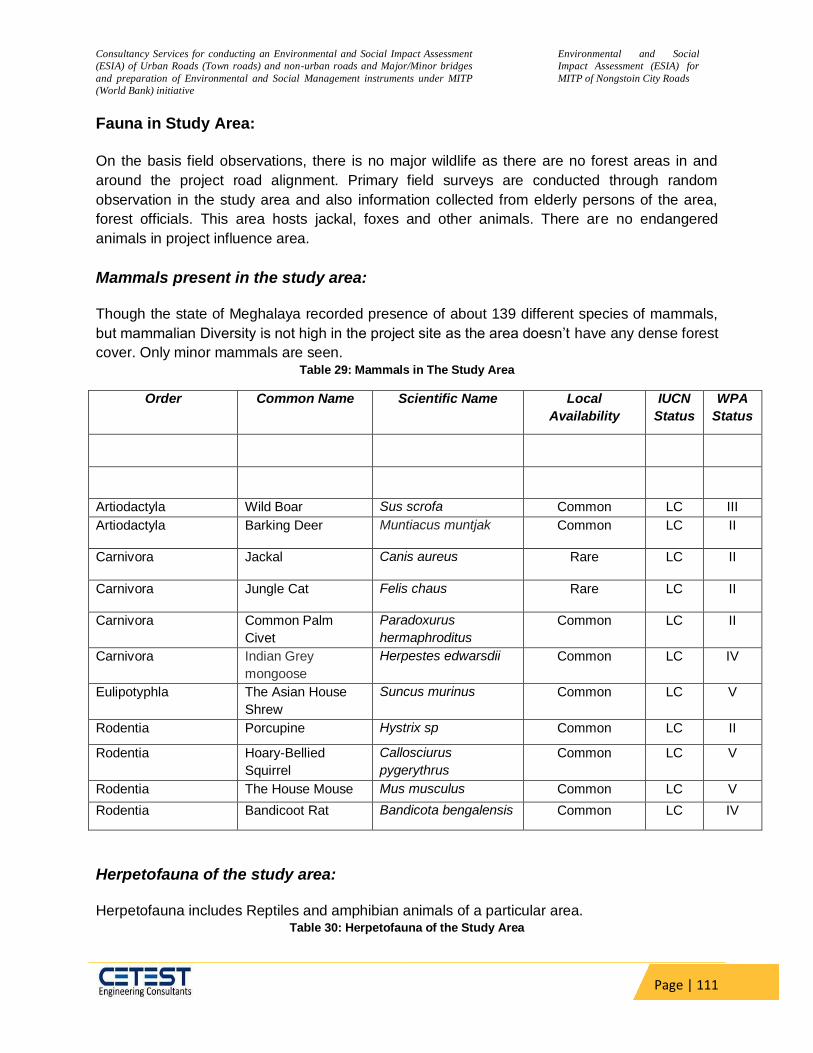
Consultancy Services for conducting an Environmental and Social Impact Assessment
(ESIA) of Urban Roads (Town roads) and non-urban roads and Major/Minor bridges
and preparation of Environmental and Social Management instruments under MITP
(World Bank) initiative
Environmental and Social
Impact Assessment (ESIA) for
MITP of Nongstoin City Roads
Page | 111
Fauna in Study Area:
On the basis field observations, there is no major wildlife as there are no forest areas in and
around the project road alignment. Primary field surveys are conducted through random
observation in the study area and also information collected from elderly persons of the area,
forest officials. This area hosts jackal, foxes and other animals. There are no endangered
animals in project influence area.
Mammals present in the study area: Though the state of Meghalaya recorded presence of about 139 different species of mammals,
but mammalian Diversity is not high in the project site as the area doesn’t have any dense forest
cover. Only minor mammals are seen. Table 29: Mammals in The Study Area
Order Common Name Scientific Name Local
Availability
IUCN
Status
WPA
Status
Artiodactyla Wild Boar Sus scrofa Common LC III
Artiodactyla Barking Deer Muntiacus muntjak Common LC II
Carnivora Jackal Canis aureus Rare LC II
Carnivora Jungle Cat Felis chaus Rare LC II
Carnivora Common Palm
Civet
Paradoxurus
hermaphroditus
Common LC II
Carnivora Indian Grey
mongoose
Herpestes edwarsdii Common LC IV
Eulipotyphla The Asian House
Shrew
Suncus murinus Common LC V
Rodentia Porcupine Hystrix sp Common LC II
Rodentia Hoary-Bellied
Squirrel
Callosciurus
pygerythrus
Common LC V
Rodentia The House Mouse Mus musculus Common LC V
Rodentia Bandicoot Rat Bandicota bengalensis Common LC IV
Herpetofauna of the study area: Herpetofauna includes Reptiles and amphibian animals of a particular area.
Table 30: Herpetofauna of the Study Area

Consultancy Services for conducting an Environmental and Social Impact Assessment
(ESIA) of Urban Roads (Town roads) and non-urban roads and Major/Minor bridges
and preparation of Environmental and Social Management instruments under MITP
(World Bank) initiative
Environmental and Social
Impact Assessment (ESIA) for
MITP of Nongstoin City Roads
Page | 112
Order Common Name Scientific Name Local
availability
IUCN
Status
WPA
Status
Agamidae Garden Lizard Calotes versicolor Common LC IV
Gekkonidae Indian House Gecko Hemidactylus sp Common LC IV
Scincidae Common Skink Eutropis carinata Common LC IV
Colubridae Common Wolf Snake Lycodon aulicus Common LC IV
Colubridae Indian Rat Snake Ptyas mucosa Common LC IV
Colubridae Checkered Keelback Fowlea piscator Common LC IV
Colubridae Indo-Chinese Rat snake Ptyas korros Common LC IV
Elapidae Northeastern hill krait Bungarus
bungaroides rare
LC IV
Viperidae Mountain Pit Viper Ovophis monticola Rare LC IV
Colubridae
Painted Bronzeback
Tree Snake
Dedrelaphis pictus
Common LC IV
Turtles and Tortoises
Amphibians
Bufonidae Common Asian Toad Duttaphrynus
melanostictus
Common LC ~
Rhacophoridae Terai Tree Frog Polypedates
teraiensis
Common LC ~
Rhacophoridae Common Tree Frog Polypedates
leucomystax
Common LC ~
Rhacophoridae Assam Tree Frog Polypedates
assamensis
Common LC ~
Dicroglossidae
Indian Bull Frog Hoplobatrachus
tigerinus
Common LC IV
Dicroglossidae
Indian Skipping Frog Euphylctis
cyanophlyctis
Common LC IV
LC= Least Concern, EN= Endangered,NT= Near Threatened, VU= Vulnerable
Common Fishes of study area: diversity of the West Khasi hills is good due to presence of numerous water bodies, smalls
Strems. As commercial fishery is important livelihood option in West Garo hills, many different
species of fishes are being farmed in the region. The project site do not have any major river
system and fish sanctuary within its limits. Table 31: Common Fishes of Study Area
Species IUCN Status Remarks

Consultancy Services for conducting an Environmental and Social Impact Assessment
(ESIA) of Urban Roads (Town roads) and non-urban roads and Major/Minor bridges
and preparation of Environmental and Social Management instruments under MITP
(World Bank) initiative
Environmental and Social
Impact Assessment (ESIA) for
MITP of Nongstoin City Roads
Page | 113
Species IUCN Status Remarks
Brachydanio rerio Least Concern
Heteropneustes fossilis Least Concern
Mastacembelus armatus Least Concern
Glyptothorax striatus Least Concern
Heteropneustes fossilis Least Concern
Mastacembelus armatus Least Concern
Garra nasuta Least Concern
Neolissocheilus hexagonolepis Near Threatened Very rare
Puntius. shalynius Least Concern
Brachydanio rerio Least Concern
Heteropneustes fossilis Least Concern
Mastacembelus armatus Least Concern
Glyptothorax striatus Least Concern
Heteropneustes fossilis Least Concern
Chana stewartii Least Concern
Tor putitora Endangered Very Rare
Cyprinus carpio Vulnerable Farm fish, locally
common
Heteropneustes fossilis Least Concern
Common Birds of study area: Avian Diversity is quite low due to large scale mining, jhum cultivation. The common birds of the
study area are listed below.
Table 32: Common Birds of the Study area
Order Common Name Scientific name IUCN
Status
WPA
Status
COLUMBIFORMES Rock Dove Columba livia LC IV
COLUMBIFORMES Oriental Turtle
Dove
Streptopelia
orientalis
LC IV
COLUMBIFORMES Yellow-Footed
Green-Pigeon
Treron
phoenicoptera
LC IV
COLUMBIFORMES Spotted Dove Streptopelia
chinensis
LC IV
COLUMBIFORMES Red Collared Dove Streptopelia
tranquebarica
LC IV
COLUMBIFORMES Emerald Dove Chalcophaps
indica
LC IV
CUCULIFORMES Indian Cuckoo Cuculus
micropterus
LC IV

Consultancy Services for conducting an Environmental and Social Impact Assessment
(ESIA) of Urban Roads (Town roads) and non-urban roads and Major/Minor bridges
and preparation of Environmental and Social Management instruments under MITP
(World Bank) initiative
Environmental and Social
Impact Assessment (ESIA) for
MITP of Nongstoin City Roads
Page | 114
Order Common Name Scientific name IUCN
Status
WPA
Status
CUCULIFORMES Asian Koel Eudynamys
scolopaceus
LC IV
GALLIFORMES Red Jungle Fowl Gallus gallus LC IV
PELECANIFORMES Indian Pond Heron Ardeola grayii LC IV
PELECANIFORMES Cattle Egret Bubulcus ibis LC IV
PELECANIFORMES Little Cormorant Microcarbo niger LC IV
CHARADRIIFORMES River Lapwing Vanellus
duvaucelii
LC IV
ACCIPITRIFORMES Crested Serpent-
Eagle
Spilornis cheela LC IV
STRIGIFORMES Barn Owl Tyto alba LC IV
STRIGIFORMES Jungle Owlet Glaucidium
radiatum
LC IV
BUCEROTIFORMES Oriental Pied-
Hornbill
Anthracoceros
albirostris
LC IV
BUCEROTIFORMES Common Hoopoe Upupa epops LC IV
CORACIIFORMES Common
Kingfisher
Alcedo atthis LC IV
CORACIIFORMES White-Throated
Kingfisher
Halcyon
smyrnensis
LC IV
CORACIIFORMES Green Bee-Eater Merops orientalis LC IV
CORACIIFORMES Indian Roller Coracias
benghalensis
LC IV
PICIFORMES Coppersmith
Barbet
Psilopogon
haemacephalus
LC IV
PICIFORMES Blue-Eared Barbet Psilopogon
duvaucelii
LC IV
PICIFORMES Lineated Barbet Psilopogon
lineatus
LC IV
PICIFORMES Blue-Throated
Barbet
Psilopogon
asiaticus
LC IV
PICIFORMES Common Flame-
Backed
Woodpecker
Dinopium
javanense
LC IV
PICIFORMES Black-Rumped
Flameback
Dinopium
benghalense
LC IV
PICIFORMES Greater Flameback Chrysocolaptes
guttacristatus
LC IV
PASSERIFORMES Scarlet Minivet Pericrocotus LC IV
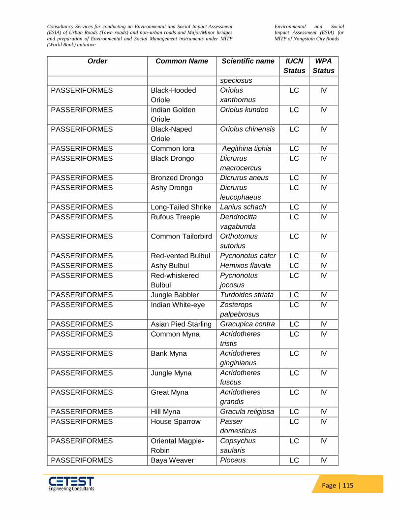
Consultancy Services for conducting an Environmental and Social Impact Assessment
(ESIA) of Urban Roads (Town roads) and non-urban roads and Major/Minor bridges
and preparation of Environmental and Social Management instruments under MITP
(World Bank) initiative
Environmental and Social
Impact Assessment (ESIA) for
MITP of Nongstoin City Roads
Page | 115
Order Common Name Scientific name IUCN
Status
WPA
Status
speciosus
PASSERIFORMES Black-Hooded
Oriole
Oriolus
xanthornus
LC IV
PASSERIFORMES Indian Golden
Oriole
Oriolus kundoo LC IV
PASSERIFORMES Black-Naped
Oriole
Oriolus chinensis LC IV
PASSERIFORMES Common Iora Aegithina tiphia LC IV
PASSERIFORMES Black Drongo Dicrurus
macrocercus
LC IV
PASSERIFORMES Bronzed Drongo Dicrurus aneus LC IV
PASSERIFORMES Ashy Drongo Dicrurus
leucophaeus
LC IV
PASSERIFORMES Long-Tailed Shrike Lanius schach LC IV
PASSERIFORMES Rufous Treepie Dendrocitta
vagabunda
LC IV
PASSERIFORMES Common Tailorbird Orthotomus
sutorius
LC IV
PASSERIFORMES Red-vented Bulbul Pycnonotus cafer LC IV
PASSERIFORMES Ashy Bulbul Hemixos flavala LC IV
PASSERIFORMES Red-whiskered
Bulbul
Pycnonotus
jocosus
LC IV
PASSERIFORMES Jungle Babbler Turdoides striata LC IV
PASSERIFORMES Indian White-eye Zosterops
palpebrosus
LC IV
PASSERIFORMES Asian Pied Starling Gracupica contra LC IV
PASSERIFORMES Common Myna Acridotheres
tristis
LC IV
PASSERIFORMES Bank Myna Acridotheres
ginginianus
LC IV
PASSERIFORMES Jungle Myna Acridotheres
fuscus
LC IV
PASSERIFORMES Great Myna Acridotheres
grandis
LC IV
PASSERIFORMES Hill Myna Gracula religiosa LC IV
PASSERIFORMES House Sparrow Passer
domesticus
LC IV
PASSERIFORMES Oriental Magpie-
Robin
Copsychus
saularis
LC IV
PASSERIFORMES Baya Weaver Ploceus LC IV
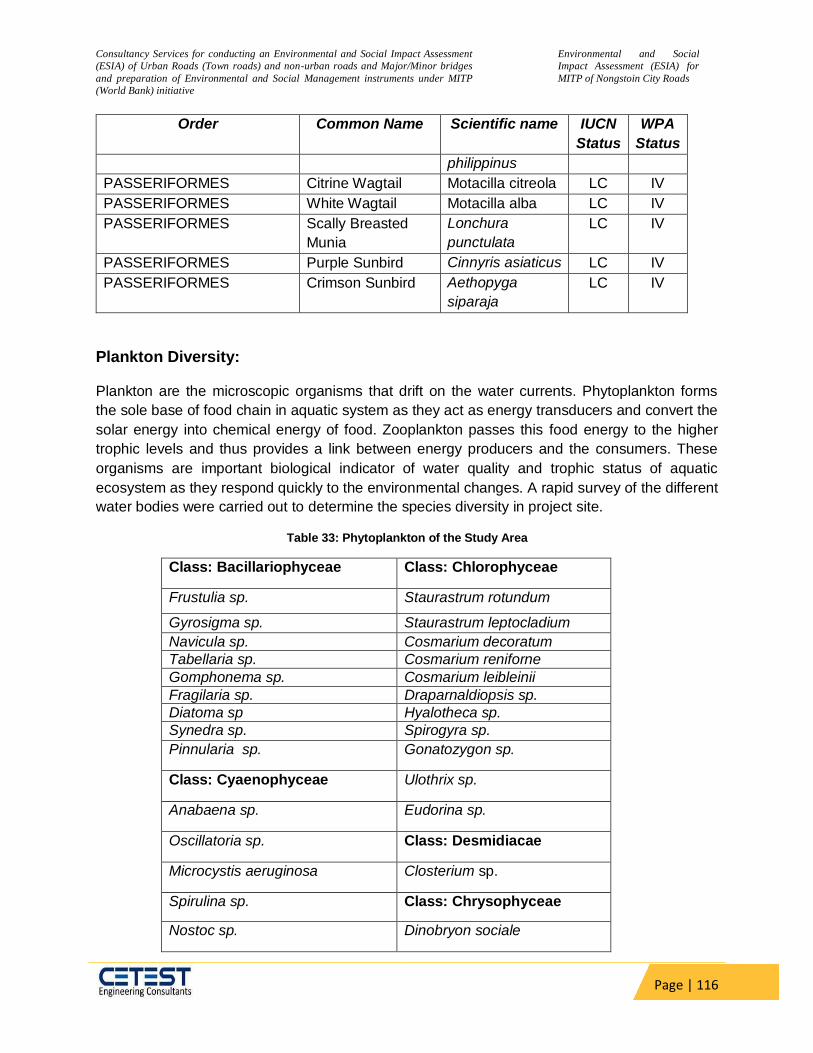
Consultancy Services for conducting an Environmental and Social Impact Assessment
(ESIA) of Urban Roads (Town roads) and non-urban roads and Major/Minor bridges
and preparation of Environmental and Social Management instruments under MITP
(World Bank) initiative
Environmental and Social
Impact Assessment (ESIA) for
MITP of Nongstoin City Roads
Page | 116
Order Common Name Scientific name IUCN
Status
WPA
Status
philippinus
PASSERIFORMES Citrine Wagtail Motacilla citreola LC IV
PASSERIFORMES White Wagtail Motacilla alba LC IV
PASSERIFORMES Scally Breasted
Munia
Lonchura
punctulata
LC IV
PASSERIFORMES Purple Sunbird Cinnyris asiaticus LC IV
PASSERIFORMES Crimson Sunbird Aethopyga
siparaja
LC IV
Plankton Diversity:
Plankton are the microscopic organisms that drift on the water currents. Phytoplankton forms
the sole base of food chain in aquatic system as they act as energy transducers and convert the
solar energy into chemical energy of food. Zooplankton passes this food energy to the higher
trophic levels and thus provides a link between energy producers and the consumers. These
organisms are important biological indicator of water quality and trophic status of aquatic
ecosystem as they respond quickly to the environmental changes. A rapid survey of the different
water bodies were carried out to determine the species diversity in project site.
Table 33: Phytoplankton of the Study Area
Class: Bacillariophyceae Class: Chlorophyceae
Frustulia sp. Staurastrum rotundum
Gyrosigma sp. Staurastrum leptocladium
Navicula sp. Cosmarium decoratum
Tabellaria sp. Cosmarium reniforne
Gomphonema sp. Cosmarium leibleinii
Fragilaria sp. Draparnaldiopsis sp.
Diatoma sp Hyalotheca sp.
Synedra sp. Spirogyra sp.
Pinnularia sp. Gonatozygon sp.
Class: Cyaenophyceae Ulothrix sp.
Anabaena sp. Eudorina sp.
Oscillatoria sp. Class: Desmidiacae
Microcystis aeruginosa Closterium sp.
Spirulina sp. Class: Chrysophyceae
Nostoc sp. Dinobryon sociale
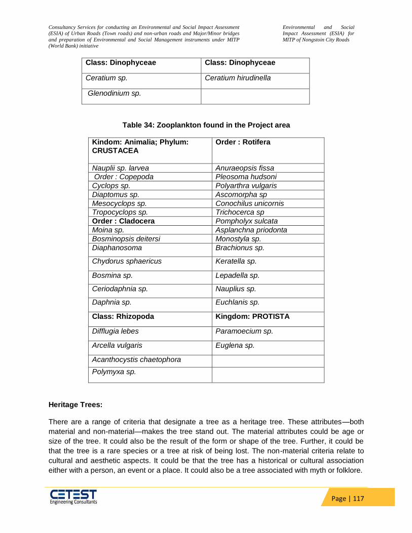
Consultancy Services for conducting an Environmental and Social Impact Assessment
(ESIA) of Urban Roads (Town roads) and non-urban roads and Major/Minor bridges
and preparation of Environmental and Social Management instruments under MITP
(World Bank) initiative
Environmental and Social
Impact Assessment (ESIA) for
MITP of Nongstoin City Roads
Page | 117
Class: Dinophyceae Class: Dinophyceae
Ceratium sp. Ceratium hirudinella
Glenodinium sp.
Table 34: Zooplankton found in the Project area
Kindom: Animalia; Phylum: CRUSTACEA
Order : Rotifera
Nauplii sp. larvea Anuraeopsis fissa
Order : Copepoda Pleosoma hudsoni
Cyclops sp. Polyarthra vulgaris
Diaptomus sp. Ascomorpha sp
Mesocyclops sp. Conochilus unicornis
Tropocyclops sp. Trichocerca sp
Order : Cladocera Pompholyx sulcata
Moina sp. Asplanchna priodonta
Bosminopsis deitersi Monostyla sp.
Diaphanosoma Brachionus sp.
Chydorus sphaericus Keratella sp.
Bosmina sp. Lepadella sp.
Ceriodaphnia sp. Nauplius sp.
Daphnia sp. Euchlanis sp.
Class: Rhizopoda Kingdom: PROTISTA
Difflugia lebes Paramoecium sp.
Arcella vulgaris Euglena sp.
Acanthocystis chaetophora
Polymyxa sp.
Heritage Trees:
There are a range of criteria that designate a tree as a heritage tree. These attributes—both
material and non-material—makes the tree stand out. The material attributes could be age or
size of the tree. It could also be the result of the form or shape of the tree. Further, it could be
that the tree is a rare species or a tree at risk of being lost. The non-material criteria relate to
cultural and aesthetic aspects. It could be that the tree has a historical or cultural association
either with a person, an event or a place. It could also be a tree associated with myth or folklore.

Consultancy Services for conducting an Environmental and Social Impact Assessment
(ESIA) of Urban Roads (Town roads) and non-urban roads and Major/Minor bridges
and preparation of Environmental and Social Management instruments under MITP
(World Bank) initiative
Environmental and Social
Impact Assessment (ESIA) for
MITP of Nongstoin City Roads
Page | 118
In order to identify Heritage trees in the study area a detailed field study was conducted. As per
the study conducted, No such Heritage trees of cultural significance have been identified along
the road.
Sericulture
No Sericulture activities were identified in the project region.
Rare or Endangered Species
The local forest department was consulted to know the presence of any endangered and
protected species of flora and fauna within the formation width. It is confirmed by the forest
department officials that there are no endangered species that are likely to be affected by the
current project.
Joint inspection is being carried out with field officials from the local forest department to
prepare the detailed inventory and marking of the trees to be cut. During the joint inspection, if
any endangered and or protected species of flora are found within the formation width of the
subproject road, necessary mitigation measures will be adapted to protect such species. Also
based on the joint inspection, a suitable compensatory afforestation plan will be prepared to
mitigate the loss of vegetative cover due to the subproject activities.
Rice Cultivation
No large-scale rice cultivation has been found during the field visit along the project site
Tea Estates
No tea Plantation is present along the Project Site.
5.10.1 Educational Institutions / Hospitals
The educational institutions and hospital/health centres constitute the sensitive environmental receptors. The list of such features along the ROW along the project roads is presented in Table 35. A total number of 6 educational institutions are located along the project stretches. No health care centre was found within the project core zone which is 500m either side of the road.
Table 35: Sensitive receptors along the project road
Sr.
No. Receptor
Road Name Approx
distance from
the edge of
the road (m)
Physically
Impacted or Not
1 Church Nongstoin-Sonapahar Road to
Mawsiangphet , Link 2 142.07
Not impacted at all
2 College Nongstoin-Sonapahar Road to
Mawsiangphet , Link 1 34.47
Not impacted at all
3 School Nongstoin-Sonapahar Road to
Mawsiangphet , Link 1 77.78
Not impacted at all
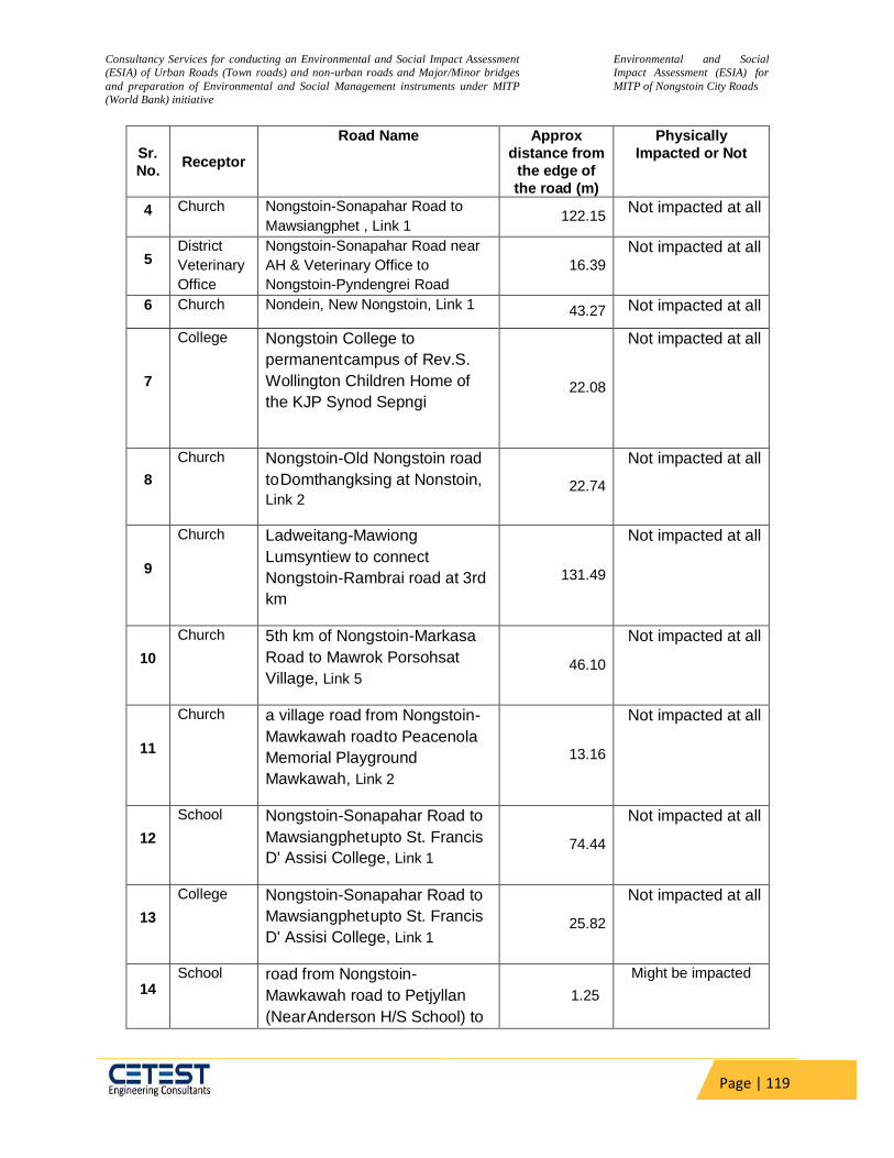
Consultancy Services for conducting an Environmental and Social Impact Assessment
(ESIA) of Urban Roads (Town roads) and non-urban roads and Major/Minor bridges
and preparation of Environmental and Social Management instruments under MITP
(World Bank) initiative
Environmental and Social
Impact Assessment (ESIA) for
MITP of Nongstoin City Roads
Page | 119
Sr.
No. Receptor
Road Name Approx
distance from
the edge of
the road (m)
Physically
Impacted or Not
4 Church Nongstoin-Sonapahar Road to
Mawsiangphet , Link 1 122.15
Not impacted at all
5 District
Veterinary
Office
Nongstoin-Sonapahar Road near
AH & Veterinary Office to
Nongstoin-Pyndengrei Road
16.39
Not impacted at all
6 Church Nondein, New Nongstoin, Link 1 43.27 Not impacted at all
7
College Nongstoin College to
permanent campus of Rev.S.
Wollington Children Home of
the KJP Synod Sepngi
22.08
Not impacted at all
8
Church Nongstoin-Old Nongstoin road
to Domthangksing at Nonstoin,
Link 2 22.74
Not impacted at all
9
Church Ladweitang-Mawiong
Lumsyntiew to connect
Nongstoin-Rambrai road at 3rd
km
131.49
Not impacted at all
10
Church 5th km of Nongstoin-Markasa
Road to Mawrok Porsohsat
Village, Link 5 46.10
Not impacted at all
11
Church a village road from Nongstoin-
Mawkawah road to Peacenola
Memorial Playground
Mawkawah, Link 2
13.16
Not impacted at all
12
School Nongstoin-Sonapahar Road to
Mawsiangphet upto St. Francis
D' Assisi College, Link 1 74.44
Not impacted at all
13
College Nongstoin-Sonapahar Road to
Mawsiangphet upto St. Francis
D' Assisi College, Link 1 25.82
Not impacted at all
14 School road from Nongstoin-
Mawkawah road to Petjyllan
(Near Anderson H/S School) to
1.25
Might be impacted
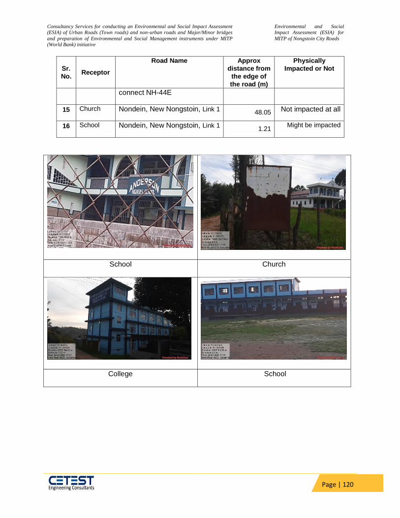
Consultancy Services for conducting an Environmental and Social Impact Assessment
(ESIA) of Urban Roads (Town roads) and non-urban roads and Major/Minor bridges
and preparation of Environmental and Social Management instruments under MITP
(World Bank) initiative
Environmental and Social
Impact Assessment (ESIA) for
MITP of Nongstoin City Roads
Page | 120
Sr.
No. Receptor
Road Name Approx
distance from
the edge of
the road (m)
Physically
Impacted or Not
connect NH-44E
15 Church Nondein, New Nongstoin, Link 1 48.05 Not impacted at all
16 School Nondein, New Nongstoin, Link 1 1.21
Might be impacted
School Church
College School

Consultancy Services for conducting an Environmental and Social Impact Assessment
(ESIA) of Urban Roads (Town roads) and non-urban roads and Major/Minor bridges
and preparation of Environmental and Social Management instruments under MITP
(World Bank) initiative
Environmental and Social
Impact Assessment (ESIA) for
MITP of Nongstoin City Roads
Page | 121
School
Figure 26: Photographs of some sensitive receptors along the road stretch
5.11 Social Environment
5.11.1 The State Profile of Meghalaya
The State of Meghalaya was carved out of Assam as an autonomous State in April 1970 and
was declared a full-fledged State in January 1972. Meghalaya, situated in the north eastern
region of India is a narrow stretch of land, running between Bangladesh on the South and West
and Assam on the North and East, Meghalaya lies between 24 58’ N to 26 07’N latitudes and
89 48’E to 92 51’ E longitudes. It covers an area of 22,429 sq. km. The State has most of its
land covered by hills interspersed with gorges and small valleys. Endowed with dense forests
and rivers cascading down undulating terrain, this region is one of the most scenic of the North
Eastern States.
Thus, out of the total forest area of 15,657 sq. km in the State only 1,027.20 sq. km is under the
control of State Forest Department, which constitutes only 4.58 % of the total geographical area
of the State and 6.56 % of the total forest area of the State. Rest of the area is either private or
clan /community owned and is under the indirect control and management of the Autonomous
District Councils.
The population of Meghalaya is predominantly tribal, the main tribes are the Khasis, the Jaintias
and the Garos besides other plain tribes such as Koch, Rabhas and Bodos etc The Khasis and
the Jaintias predominantly inhabiting the districts towards eastern part of Meghalaya, belong to

Consultancy Services for conducting an Environmental and Social Impact Assessment
(ESIA) of Urban Roads (Town roads) and non-urban roads and Major/Minor bridges
and preparation of Environmental and Social Management instruments under MITP
(World Bank) initiative
Environmental and Social
Impact Assessment (ESIA) for
MITP of Nongstoin City Roads
Page | 122
the Proto AustroloidMonkhmer race. The ESIA Study Proposal of Roads lies under West Khasi,
RiBhoi, South West Khasi, Jaintia, East Garo Hills respectively.
5.11.2 District Profile:
West Khasi Hills is an administrative district in the state of Meghalaya in India. The West Khasi
Hills district was carved out of the Khasi Hills district, which was divided into West and East
Khasi Hills districts on 28 October 1976. The district headquarters is located at Nongstoin. The
district occupies an area of 5247 km2. Khasi society has greatly been transformed by many
factors which have arisen in recent times. Adoption of the Western style of life, especially
among the literate and educated, has been quite rapid although the matrilineal laws of
inheritance and succession and the other cultural states are still retained.
West Khasi Hills District was carved out of the state of Meghalaya in the year 1976 on the 28
day of October which in fact is the largest of all the eleven districts in the state of Meghalaya
and since its existence, it has been bifurcated into two Civil Sub-divisions and a new district in
South West Khasi Hills. It spreads through the heart of the state running high with plateau
ranges and low with rich plain lands.
5.11.3 Demographic Profile
Out of total population of Meghalaya, 13.9% people live in urban regions. The district occupies: Table 36:Demographic Profile of West Khasi Hills District
Description Census 2011 Census 2001
Total Population 383461 296049
Male 193715 150419
Female 189746 145630
Population Growth 29.53% 33.05%
Area Sq.Km 5247 5247
Density /Km2 73 56
Proportion to Meghalaya Population 12.92% 12.77%
Sex Ratio (Per 1000) Males 980 968
Average Literacy 77.87 65.10
Male Literacy 78.53 66.49
Female Literacy 77.19 63.65
No. of Blocks 6 NA
No. of Villages 232 NA
Source: Census 2011

Consultancy Services for conducting an Environmental and Social Impact Assessment
(ESIA) of Urban Roads (Town roads) and non-urban roads and Major/Minor bridges
and preparation of Environmental and Social Management instruments under MITP
(World Bank) initiative
Environmental and Social
Impact Assessment (ESIA) for
MITP of Nongstoin City Roads
Page | 123
As per 2011 census, 88.76% population of West Khasi Hills district lives in rural areas of
villages. The total West Khasi Hills district population living in urban areas is 43105 of which
males and females are 21335 and 21770 respectively. In rural areas of West Khasi Hills district,
sex ratio is 974 females per 1000 males.
Table 37 Distribution of Rural and Urban Population
Description Urban Rural
Population (%) 11.24% 88.76%
Total Population 43105 340356
Male Population 21335 172380
Female Population 21770 167976
Sex Ratio 981 974
Source: Census 2011
5.11.4 Schedule Castes and Schedule Tribes
The social stratification of the project area shows of Schedule Tribe population with 97.8%
households. The second stratum of the social grouping in the area is of Schedule caste
population of 0%.
5.11.5 Literacy Rate
The literacy rate in the district of West Khasi Hills is 77.87%, whereas the literacy rate in the PIA
is around 67.37%. The respective male and female literacy rate is 78.53% and 77.19% in the
district of West Khasi Hills, whereas resembles 50.21% and 51.2% in the PIA.
5.11.6 Employment Pattern
Economic backwardness is the leading problem of the state as majority of the population is
below the poverty line. Although the state is rich in mineral resources, the industrial linkages are
virtually absent and government is the major source of employment in the organized sector.
Activities like animal husbandry, fishery, poultry and horticulture have not been targeted as a
major source of employment. Therefore, agriculture forms the only option for the people to seek
gainful employment. This too is influenced by impediments such as shifting agriculture, poor
productivity, land tenure system and traditional methods of cultivation. All these factors have
resulted in poor land and labour productivity.
As unemployment and poverty are correlated, it becomes necessary to understand the
occupational pattern of labour force and status of employment to analyse the development in
the state.
Consultancy Services for conducting an Environmental and Social Impact Assessment
(ESIA) of Urban Roads (Town roads) and non-urban roads and Major/Minor bridges
and preparation of Environmental and Social Management instruments under MITP
(World Bank) initiative
Environmental and Social
Impact Assessment (ESIA) for
MITP of Nongstoin City Roads
Page | 124
West Khasi Hills:
More than 80% of the total population in West Khasi Hills is agrarian as their main backbone of
livelihood is basically agriculture. Rice, Maize, potato and ginger are the main crops grown in
West Khasi Hills. Agriculture and allied activities provide income and employment for the people
in West Khasi Hills. Mono cropping in low land areas and mixed cropping in upland areas are
the features of agriculture in the district.
5.11.7 Economic Development
Meghalaya has predominantly an agrarian economy with a significant commercial forestry
industry. Meghalaya's gross state domestic product for 2012 was estimated at16,173 crore
(US$2.5billion) in current prices. The state is geologically rich in minerals. The state has about
1,170km of national highways. It is also a major logistical centre for trade with Bangladesh.
Meghalaya has an ideal location advantage for South East Asia Market. The neighbouring
countries of India viz Bhutan, Bangladesh, Myanmar has been involved with the state for
business and commerce. It has a huge potential to reach other South Asian countries as well.
Meghalaya is also geographically rich in minerals and has the potential for industrial setups
based on these mineral resources. Above all the Meghalaya Industrial Policy is framed for the
ease of doing business and increase trade and commerce. The added advantage being the
climate in Meghalaya is good for the development of electronics chips.
Different types of Industry that can be ideally formed in the state are Mineral based Industry,
Horticulture and Agro-Based Industry, Electronics and Information Technology, Export Oriented
Units, Tourism and besides these the recent development in the state has seen many upcoming
service sectors on customer service, real estate’s etc. The State Government also provides
various types of Central and State Incentives for the established Industrial Setups which
includes Transport Subsidy, Income Tax Exemption, Excise Exemption, Capital Investment
Subsidy, Special Incentives for Food Processing, Subsidy on Comprehensive Insurance, Power
Subsidy, Subsidy on Power Line (33 K.V. and above), Employment Subsidy, Refund of Central
Sales Tax. Meghalaya is coming up with 150 LPM (Litres Per Minute) Oxygen Plant at Nongpoh
Civil Hospital in RiBhoi district.
West Khasi Hills:
Although the district is endowed with many economically important minerals but the operations
are limited mostly to the mining of these minerals. The minerals found in the district are coal,
limestone, sillimanite and uranium, among these last two are major deposits in the district (coal
mining is carried out at minor scale at shallang and rambari, Coalfields are mainly found and
extracted in large scale from Nongri, Nonghyllam, Nongkulang areas). Mining of Uranium has
not so far been undertaken due to opposition from the people. As per census, 2011, there are
many small scale industries in the district.
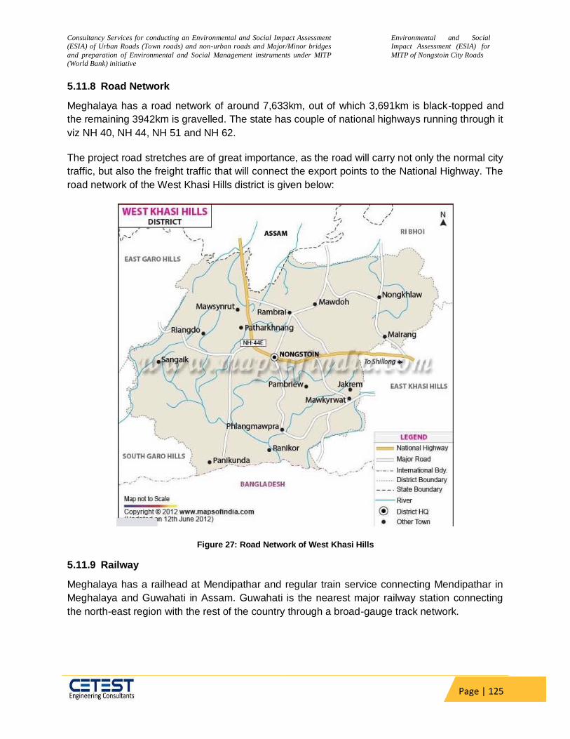
Consultancy Services for conducting an Environmental and Social Impact Assessment
(ESIA) of Urban Roads (Town roads) and non-urban roads and Major/Minor bridges
and preparation of Environmental and Social Management instruments under MITP
(World Bank) initiative
Environmental and Social
Impact Assessment (ESIA) for
MITP of Nongstoin City Roads
Page | 125
5.11.8 Road Network
Meghalaya has a road network of around 7,633km, out of which 3,691km is black-topped and
the remaining 3942km is gravelled. The state has couple of national highways running through it
viz NH 40, NH 44, NH 51 and NH 62.
The project road stretches are of great importance, as the road will carry not only the normal city
traffic, but also the freight traffic that will connect the export points to the National Highway. The
road network of the West Khasi Hills district is given below:
Figure 27: Road Network of West Khasi Hills
5.11.9 Railway
Meghalaya has a railhead at Mendipathar and regular train service connecting Mendipathar in
Meghalaya and Guwahati in Assam. Guwahati is the nearest major railway station connecting
the north-east region with the rest of the country through a broad-gauge track network.

Consultancy Services for conducting an Environmental and Social Impact Assessment
(ESIA) of Urban Roads (Town roads) and non-urban roads and Major/Minor bridges
and preparation of Environmental and Social Management instruments under MITP
(World Bank) initiative
Environmental and Social
Impact Assessment (ESIA) for
MITP of Nongstoin City Roads
Page | 126
5.11.10 Aviation
The state has an airport at Umroi which is at a distance of 30 kilometres from Shillong. There is
also a helicopter service connecting Shillong to Guwahati and Tura. Baljek Airport near Tura
became operational in 2008. Other nearby airports are in Assam, Borjhar, Guwahati airport,
about 124 kilometres (77 mi) from Shillong. Newly operational Rupsi Airport is also near to Tura.
5.11.11 Agriculture and Cropping Pattern
Agriculture is the main occupation of the people of the watershed areas. The principal
agricultural crops are paddy, ginger, yam, chillies, turmeric etc. However, few horticultural crops
like pineapple, arecanut, banana etc. are cultivated in the Watershed area.
Most of the forest species were extinct or not seen in the areas due to repeated jhumming.
However, some forest species like Shorea robusta, Artocarpus heterophyllus, Albizzia species,
Bahaunia variegetta etc. are seen in the Watershed Area.
West Khasi Hills:
More than 80% of the total population in West Khasi Hills is agrarian as their main backbone of
livelihood is basically agriculture. Rice, Maize, potato and ginger are the main crops grown in
West Khasi Hills. Agriculture is the main stay of the population in the district. As per census
2011, 52% of the population is engaged in agriculture and 22.8% of total workers population is
engaged as agriculture labourers. The area is endowed with diversified climatic condition
thereby offering good scope for cultivation of temperate and subtropical crops. Principal crops
grown in the district are rice, maize, millets, oilseeds and pulses. Horticulture products include
orange, pineapple and many local fruits. Vegetables like potato, cucumber, squash, beans etc.
are also grown.
5.11.12 Animal Husbandry
Animal husbandry and Agriculture are related with the overall socio – economic conditions of
rural tribal people of Meghalaya. Animal husbandry plays a significant role in overall farming
system of the state. The total livestock and poultry population of the state are 15.51 lakhs and
28.20 lakhs respectively out of which Ri Bhoi district possesses 1.12 lakhs and 3.52 lacks
respectively (Sample survey 2005- 06). The livestock availability in the district ranges from pig,
cattle, buffalo, poultry, goat, rabbit and sheep. Although the district possesses a good number of
livestock and poultry, the productivity of livestock and poultry is very poor due to stunted growth
and low production of local breeds of livestock and poultry, non-scientific approach of livestock
and poultry farming.
West Khasi Hills:
The Animal Husbandry and Veterinary Department was established in the District right from
1976-1977 with the main objective of combating diseases in livestock and to encourage and
assist the people of the district to take up farming in livestock on commercial scale so as to

Consultancy Services for conducting an Environmental and Social Impact Assessment
(ESIA) of Urban Roads (Town roads) and non-urban roads and Major/Minor bridges
and preparation of Environmental and Social Management instruments under MITP
(World Bank) initiative
Environmental and Social
Impact Assessment (ESIA) for
MITP of Nongstoin City Roads
Page | 127
substantiate their income generating capacity. The people mostly rear local breeds of livestock
characterized by low productivity in terms of meat, milk and meat.
5.11.13 Fishery
The PIA has unique topographical condition. Consequently, the PIA is blessed with vast and varied water resources in the forms of rivers, reservoirs, beels, lakes, swamp, pond, mini barrages and low-lying paddy. The district shared maximum 20% in total area of pond/mini barrages of the state followed by 10.2, 9.23 and 2.46% in case of reservoirs, rivers, and beels, lakes etc. respectively, but no contribution in state in terms of paddy cum fish culture in the district, although it is a proven technology scope and potential of ornamental fish (Puntius bartissp) is not so much satisfactory. The Government of Meghalaya has identified fisheries as a key sector and launched the
Meghalaya State Aquaculture Mission (MSAM) in 2012. Under this mission, a large water area
in the state has been brought for fish culture.
In West Khasi Hills District, the total water area assisted under MSAM is 99.5 ha which includes 970 nos. of individual ponds and 5 nos. of community ponds. There are 5 nos. of fish ponds under convergence of MSAM with other Departments covering an area of 3.5 ha which will be implemented shortly. The area covered under the 1000 ponds scheme of the Fisheries Department is 67.45 ha. There are 2 nos. of Govt. fish farm in the District. There are also 3 nos. of fish sanctuaries which aims at conserving the indigenous and endemic fish species. According to the Fisheries Department, fish production (2014-15) in the District is 386 MT.
5.11.14 Hospitals
The PIA has 1 hospital, 2 dispensaries, 8 primary health centres, 3 community health centres, 27 sub centres, 1 leprosy control unit, 1 set centre, 1 ayurvedic dispensary and 3 homeopathic dispensaries. Para medical personnel registered during the year for the service of the people of the district.

Consultancy Services for conducting an Environmental and Social Impact Assessment
(ESIA) of Urban Roads (Town roads) and non-urban roads and Major/Minor bridges
and preparation of Environmental and Social Management instruments under MITP
(World Bank) initiative
Environmental and Social
Impact Assessment (ESIA) for
MITP of Nongstoin City Roads
Page | 128
6 CHAPTER-VI: ANALYSIS OF POTENTIAL ENVIRONMENTAL &
SOCIAL IMPACTS & MITIGATION- MEASURES
During Planning and Design phase the road alignment, construction details, materials of
construction etc. ultimately decide the impacts during later phases are evaluated. Most of the
impacts are occurred during construction and operation phase. While some of the construction
phase impacts are temporary, others are permanent. Operation phase impacts are continuous
in nature. The important criteria for identification of impact are the identification of the impact
zone. For present screening studies, a direct Corridor of Impact (COI) within 500 m road
alignment has been considered.
Environmental parameters are broadly classified into three groups.
a) Physical Environment includes: Water Resources, Water Quality, Air Quality,
Noise and Land environment etc.
b) Biological Environment includes: Terrestrial and aquatic biodiversity and
Roadside Plantation etc.
c) Social Environment includes: Demography, Employment, Agriculture, Housing,
Culture etc.
6.1 Environmental Impacts and Mitigation Measures
The assessment of potential environmental impact consists of comparing the expected changes
in the environment with or without the project. The analysis predicts the nature and significance
of the expected impacts. The detail of potential impacts & mitigation measures are mentioned in
the below table.
6.1.1 Impacts During Design/ Pre-constructional Phase
The project envisages upgrading the existing single lane carriageway to intermediate lane for
augmenting the capacity of the project road and significantly extending its service life. However,
at few locations small parcel of land will be required to accommodate the proposed
improvement/widening. The impacts during Design and Preconstruction stage have been
discussed in the following sections:
6.1.1.1 Impacts on Physiography
The project section is already existing road and located on hill and plain terrain. The same
alignment will be followed for improvement from existing single lane with earthen shoulder to
standard single lane configuration with paved shoulder and geometric correction at few
locations. The existing ground profile will be followed with minor profile corrections at few
locations without significant alteration of existing vertical profile, except for improvement of
geometrics and road safety. The rehabilitation and widening will be generally restricted within
the existing ROW, except for few locations where small land parcel would be required beyond
existing RoW. The entire project lies over flat land. The project will not have any impact on the
Consultancy Services for conducting an Environmental and Social Impact Assessment
(ESIA) of Urban Roads (Town roads) and non-urban roads and Major/Minor bridges
and preparation of Environmental and Social Management instruments under MITP
(World Bank) initiative
Environmental and Social
Impact Assessment (ESIA) for
MITP of Nongstoin City Roads
Page | 129
topography/ Physiography within the project influence area and hence does not require any
mitigation measures.
6.1.1.2 Ambient Air Quality
Impact to air environment during pre-construction stage will be limited to activities such as
setting of construction camp, unloading of materials, exhaust from Diesel Generators, etc.
Mitigation Measure:
Consent to Establish for emission/continuation of emission under Section 21 of the Air (Prevention and Control of Pollution) Act, 1981 should be obtained for Diesel Generator Set (s) of > 15 KVA for Non-Industrial use from SPCB
LPG should be used in the labour camps for cooking purposes instead of wood.
6.1.1.3 Felling of Trees
The feasibility of Transplantation will be examined at a later stage. The project road is not
passing through any reserved or protected forest. If tree felling done compensatory afforestation
will be done.
6.1.1.4 Impacts on Fauna
There is no wildlife habitat located along the project area nor any migratory route/ animal
crossings in the project area. So any risk or impact on wild animals or incidence of habitat
fragmentation or disturbances to the wildlife migration route due to project is not anticipated in
any of the project sections.
6.1.1.5 Impacts on Ecologically Protected Area
The project road does not pass through any ecologically protected areas such as Wildlife Sanctuary, National Park, Tiger Reserve or any notified ecologically sensitive area not is located in any Eco-sensitive zone. Further no movement of wild animals has been reported near the project alignment. So, any impact on such feature due to the project is not envisaged.
6.1.2 Impacts during Construction Phase
Most of the adverse environmental impacts are related to construction works which are
inevitable but are manageable through certain environmental friendly practices. The negative
environmental effects can be taken care of at an early stage through proper engineering
designs and through the contract during construction practices.
No significant natural habitat conversion is envisaged to take place as a direct consequence of
this project. Since the road improvements would follow the existing alignment of the road and all
improvements will be undertaken within the formation width of the road, there will no direct
impacts on land use conversion.
The standard road construction works involve are site clearance, excavation, filling of earth
materials and sub grade materials, laying of bituminous mixtures, handling of hazardous
materials like bitumen, diesel, etc., dumping of unusable debris materials, transportation of
materials from production site to construction site, and other constructional activities and

Consultancy Services for conducting an Environmental and Social Impact Assessment
(ESIA) of Urban Roads (Town roads) and non-urban roads and Major/Minor bridges
and preparation of Environmental and Social Management instruments under MITP
(World Bank) initiative
Environmental and Social
Impact Assessment (ESIA) for
MITP of Nongstoin City Roads
Page | 130
associated works like mobilization of constructional equipments, setting up of different
construction plants, setting up of workforce camps, quarrying, material storage etc. These
activities have certain impacts of various magnitudes on different components of environment.
The anticipated impacts due to all these activities have been described below:
6.1.2.1 Compaction and Contamination of Soil
Contamination of soil during construction stage may happen primarily due to construction and
allied activities. The sites where construction vehicles are parked and serviced are likely to be
contaminated because of leakage or spillage of fuel and lubricants. Contamination of soil during
construction might be a major long-term residual negative impact. Unwarranted disposal of
construction spoil and debris will add to soil contamination. This contamination is likely to be
carried over to water bodies in case of dumping near water bodies.
Mitigation Measures:
Construction equipment/vehicles should be routinely maintained to prevent leakage of fuels/ lubricants;
Construction equipment/vehicles should be parked and maintained in designated areas on hard stand having perimeter drains to collect spilled liquids;
Fuels and other liquid chemicals should be stored in designated storage areas with drip trays to collect leaked materials, if any.
The Contractors shall ensure the use of a relatively new, well maintained hot mix plant (batch type) and maintenance of hot mix plants and batching plants should be regular and periodic to prevent any kind of oil leakage on soil surface.
6.1.2.2 Increased erosion and loss of top soil
Loss of topsoil: The topsoil on the land parcels, which is either used for short term (e.g., borrow areas, construction camps etc) or permanent use (expansion of the road alignment), would be lost unless the same is preserved. The alignment passes through areas which have sandy loam or sandy clayey loam. These soils are light textured and are thus prone to erosion by winds and during rain, gravity erosion. Further, the movement of vehicle over land next to existing road and to access the construction site would also cause compactions of soil and affect soil fertility. Waste from off-spec hot-mix as wells as from the regular operations of the machinery e.g. layers and bitumen sprayers during the surfacing of the roads. The concrete wastes from the batching plant and transit mixer wash water would also be generated. The labour camps that would be setup for construction would generate municipal solid waste and hazardous waste (waste oil from the maintenance and operation of machinery). These wastes have potential to contaminate the soil around the site if it is not properly stored, handled and disposed. If these excess excavated material, construction and demolition wastes are disposed on agricultural land it may result in loss of productivity of land. Mitigation Measures:
The existing vegetation on slopes outside the immediate area of construction must remain undisturbed during construction and/or upgrading.
Engineering and bioengineering techniques to be used to prevent barren slopes and to stop soil erosion and protect erosion prone areas from excessive grazing by animals;
Slope failures should be monitored and remedial actions initiated at the earliest possible time
Logging immediately above road should be restricted to reduce erosion/landslide potential;

Consultancy Services for conducting an Environmental and Social Impact Assessment
(ESIA) of Urban Roads (Town roads) and non-urban roads and Major/Minor bridges
and preparation of Environmental and Social Management instruments under MITP
(World Bank) initiative
Environmental and Social
Impact Assessment (ESIA) for
MITP of Nongstoin City Roads
Page | 131
Retaining structures like gabion wall, breast wall and retaining wall, slope protection measures are provided to ensure stability of hill slope during and after the construction of project road. Gabions are made up of Galvanized iron wire netting of 4 mm diameter having 10 cm square or hexagonal openings and filling the sausages with hammer dressed stones and wrapping the wire net at top.
Slope protection measures are to be provided along the project stretch in the form of
erosion blanket with shrub plantation, Hydro seeding, interlink chain mesh with grass
strips, shotcrete crib wall with vegetation and hedge brush layer
Where practicable, excavated areas should be backfilled at the end of the working day.
Guidance for establishment of construction camps, material storage or staging of plant
and machinery.
Sites /land types to be avoided:
– Lands close to habitations
– Irrigated agricultural lands
– Lands belonging to small farmers
– Lands under village forests
– Lands within 100m of community water bodies and water sources as rivers to avoid
contamination.
– Lands supporting dense vegetation and Forest with/without conservations status
– Low lying lands within 100m of watercourses
– Grazing lands and lands with or without tenure rights
– Lands where there is no willingness of the landowner to permit its use
– 2km from towns 500m from any villages
– Community land (Chruch, community forest) which is traditionally used as
conservation areas
Land Types Preferred:
– Waste lands.
– Waste Lands belonging to owners who look upon the temporary use as a source of
income.
– Community lands or government land not used for beneficial purposes.
– Private non-irrigated lands where the owner is willing.
– Lands with an existing access road.
6.1.2.3 Borrow Areas and Quarries
Need for opening borrows areas is anticipated. It may cause some adverse impacts if left un-rehabilitated. It may pose risk to people, particularly children and animals of accidentally falling into it as well as become potential breeding ground for mosquitoes and vector born disease. Illegal quarrying may lead to unstable soil condition; destroy the landscape of the terrain, air and noise pollution. Quarry material will be sourced from existing licensed quarries. The dredging and use of dredged material, if involved, may have its impact in terms of localized sedimentation level increase and dispersion of pollutants present in the dredged material in the river water. Mitigation Measures
Borrow areas if required, shall not be located near forest areas. The edges of borrow sites shall be no closer than 3 meters from any fence line or boundary. Adequate

Consultancy Services for conducting an Environmental and Social Impact Assessment
(ESIA) of Urban Roads (Town roads) and non-urban roads and Major/Minor bridges
and preparation of Environmental and Social Management instruments under MITP
(World Bank) initiative
Environmental and Social
Impact Assessment (ESIA) for
MITP of Nongstoin City Roads
Page | 132
clearance shall be provided for the construction of catch drains. Borrow sites shall have adequate drainage outlets unless the relevant landowner has agreed that the borrow area is to create a permanent tank or dam. Cut batter slopes shall not be steeper than 3 to 1 and shall be left by the Contractor in a tidy and safe condition to the satisfaction of the Engineer. Written clearance from the land owner/village head shall be obtained before leaving a site
Borrow pits shall be selected from barren land/wasteland to the extent possible. Borrow areas should not be located on cultivable lands except in the situations where land owners desires to level the land. The top soil shall be preserved and depth shall be restricted to the desired level.
Borrow areas should be excavated as per the intended end use by the owner. The Indian Road Congress (IRC):10-1961 guideline should be used for selection of borrow pits and amount that can be borrowed.
The dredged material from the nearby water body shall be tested for presence of heavy metals and other pollutants before its reuse.
The depths in borrow pits to be regulated so that the sides shall not be steeper than 25%, to the extent possible, borrow areas shall be sited away from populated areas. Borrow areas shall be leveled with salvaged material or other filling materials which do not pose contamination of soil.
6.1.2.4 Ambient Air Quality
Construction stage impacts will have adverse impacts on the workers as well as the settlements adjacent to the road, especially those in the down wind direction. Bituminous concrete which is used for pavement rehabilitation can affect the air quality by producing toxic gases. If the hot mix plant is installed nearby project road it will emit number of pollutants that can affect construction workers as well as habitation along the project stretches.
if the bituminous concrete cannot be sourced from outside, and install near project stretches, then there will be adverse impacts on air quality during construction stage. They are classified and presented in the table below. There are two types of pollution i.e. dust pollution and pollution from harmful gases.
Table 38: Adverse impacts on air quality during construction stage
Sl. No.
Impact Source
1 Generation of dust
Transportation and tipping of cut material - while the former will occur over the entire stretch between the cutting location and disposal site, the latter is more location specific and more intense;
Transportation of raw materials from quarries and borrow sites
Stone crushing, handling and storage of aggregates in asphalt plants
Site levelling, clearing of trees, laying of asphalt
Concrete batching plants;
Asphalt mix plants – due to the mixing of aggregates with bitumen;
Construction of structures and allied activities 2 Generation
of polluting gases including SO2, NOx and
Hot mix plants
Large construction equipment, trucks and asphalt producing and paving equipment
The movement of heavy machinery, oil tankers etc.
Toxic gases released through the heating process during bitumen production
Inadequate vehicle maintenance and the use of adulterated fuel in vehicles.

Consultancy Services for conducting an Environmental and Social Impact Assessment
(ESIA) of Urban Roads (Town roads) and non-urban roads and Major/Minor bridges
and preparation of Environmental and Social Management instruments under MITP
(World Bank) initiative
Environmental and Social
Impact Assessment (ESIA) for
MITP of Nongstoin City Roads
Page | 133
HC
The impacts are expected to be temporary (limited to construction period) and confined within construction areas.
Mitigation Measures:
Vehicles delivering loose and fine materials shall be covered
Limiting unnecessary idling of heavy machineries and other vehicles significantly reduce emission of polluting gases.
Loading and unloading of construction materials in covered area or provisions of water fogging around these locations.
Storage areas should be located downwind of the habitation area.
Periodic water sprinkling needs to be done wherever required.
Regular maintenance of machinery and equipment needs to be done. Vehicular pollution check shall be made mandatory and renewed as per requirement.
Hot mix plants and other plants should be located at least 1.5 km from the nearest habitation, school, hospital, archaeological site, forest, rivers, streams and lakes, 500 m from ponds, and national highway, 250 m from state highway, unless otherwise required by statutory requirements after securing a No-Objection Certificate (NOC) from the SPCB. Hot mix plant shall be fitted with stack of adequate height as may be prescribed by SPCB to ensure enough dispersion of exit gases.
Bitumen emulsion and bitumen heaters should be used to extent feasible.
CTE & CTO for HMP, BMP, crushers & DG sets needs to be obtained.
LPG should be used as fuel source in construction/labour camps instead of f irewood.
Mask and other PPE shall be provided to all the staffs/workers at construction site.
Diesel Generating (DG) sets shall be fitted with stack/chimney of adequate height as per regulations (Height of stack = height of the building + 0.2 KVA. Low sulphur diesel shall be used in DG sets as well as machineries.
Contractor should submit a site specific air pollution management plan.
Avenue plantation may improve the air quality during operation stage.
Regular air monitoring will be done to check the ambient air quality of the area.
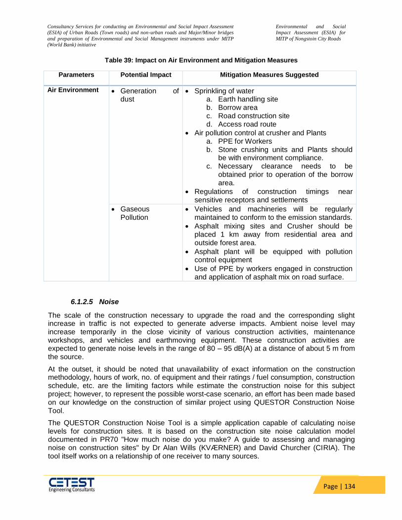
Consultancy Services for conducting an Environmental and Social Impact Assessment
(ESIA) of Urban Roads (Town roads) and non-urban roads and Major/Minor bridges
and preparation of Environmental and Social Management instruments under MITP
(World Bank) initiative
Environmental and Social
Impact Assessment (ESIA) for
MITP of Nongstoin City Roads
Page | 134
Table 39: Impact on Air Environment and Mitigation Measures
Parameters Potential Impact Mitigation Measures Suggested
Air Environment Generation of dust
Sprinkling of water a. Earth handling site b. Borrow area c. Road construction site d. Access road route
Air pollution control at crusher and Plants a. PPE for Workers b. Stone crushing units and Plants should
be with environment compliance. c. Necessary clearance needs to be
obtained prior to operation of the borrow area.
Regulations of construction timings near sensitive receptors and settlements
Gaseous Pollution
Vehicles and machineries will be regularly maintained to conform to the emission standards.
Asphalt mixing sites and Crusher should be placed 1 km away from residential area and outside forest area.
Asphalt plant will be equipped with pollution control equipment
Use of PPE by workers engaged in construction and application of asphalt mix on road surface.
6.1.2.5 Noise
The scale of the construction necessary to upgrade the road and the corresponding slight increase in traffic is not expected to generate adverse impacts. Ambient noise level may increase temporarily in the close vicinity of various construction activities, maintenance workshops, and vehicles and earthmoving equipment. These construction activities are expected to generate noise levels in the range of 80 – 95 dB(A) at a distance of about 5 m from the source.
At the outset, it should be noted that unavailability of exact information on the construction methodology, hours of work, no. of equipment and their ratings / fuel consumption, construction schedule, etc. are the limiting factors while estimate the construction noise for this subject project; however, to represent the possible worst-case scenario, an effort has been made based on our knowledge on the construction of similar project using QUESTOR Construction Noise Tool.
The QUESTOR Construction Noise Tool is a simple application capable of calculating noise levels for construction sites. It is based on the construction site noise calculation model documented in PR70 "How much noise do you make? A guide to assessing and managing noise on construction sites" by Dr Alan Wills (KVÆRNER) and David Churcher (CIRIA). The tool itself works on a relationship of one receiver to many sources.

Consultancy Services for conducting an Environmental and Social Impact Assessment
(ESIA) of Urban Roads (Town roads) and non-urban roads and Major/Minor bridges
and preparation of Environmental and Social Management instruments under MITP
(World Bank) initiative
Environmental and Social
Impact Assessment (ESIA) for
MITP of Nongstoin City Roads
Page | 135
‘QUESTOR Construction Noise Tool’ provides a library of sample plants and the activities they are performing from the BS 5228 standard: The British Standard on Noise. The total noise level calculated by the application is the noise level at the receiver.
As depicted in the above picture, it is considered that for particular construction zone, the source is located at a distance of 50m with 900angle of view. Accordingly, the sound pressure levels are predicted at the receptor location during different activities.
Inference
Based on the calculations, presented below it is anticipated that whenever the construction will happen in any zone other than industrial, the ambient noise level will exceed the statutory level at a distance of 50m away from the construction zone, if no barrier is put.
Table 40: Typical noise levels of principal construction equipment (Noise Level in dB (A) at 50 Feet
ID Type Noise
pressure
(dB), 1m from
the source
Distance
(m)
Barrier Reflection On
Time
(%)
Angle
of View
(0)
Traffic
Volume /
hour
Speed
(km/hr)
Total
(dB(A))
Site Clearing
1 Dozer 116 50 None None 20 90 10 10 46
2 Tracked
excavator
113 20 90 76
3 Tracked
loader
113 20 90 76
4 Wheeled
loader
108 20 90 71
Total noise from site at receiver 80
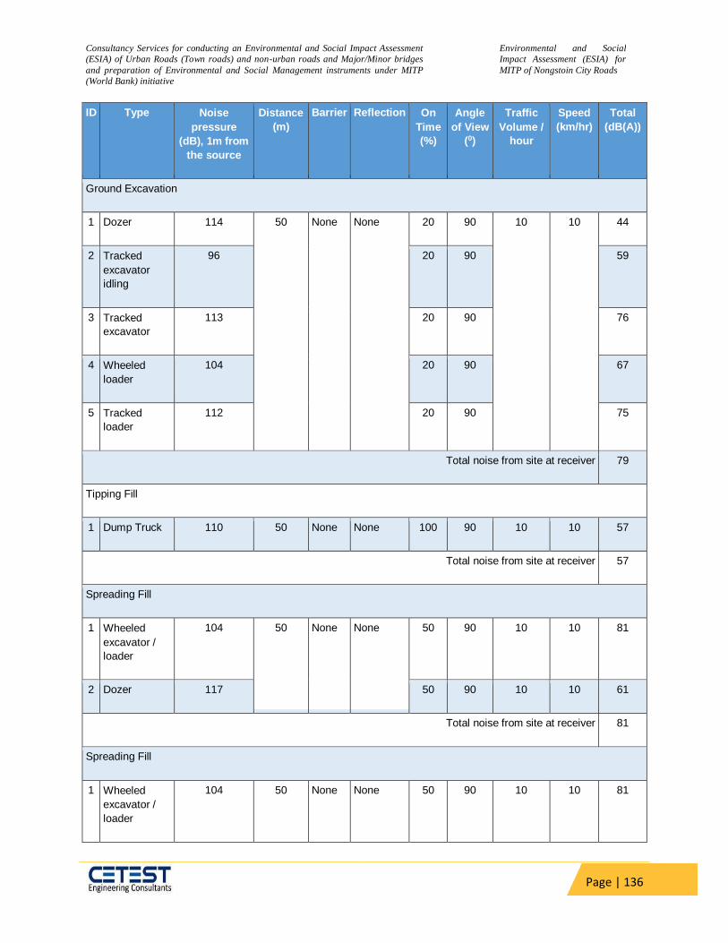
Consultancy Services for conducting an Environmental and Social Impact Assessment
(ESIA) of Urban Roads (Town roads) and non-urban roads and Major/Minor bridges
and preparation of Environmental and Social Management instruments under MITP
(World Bank) initiative
Environmental and Social
Impact Assessment (ESIA) for
MITP of Nongstoin City Roads
Page | 136
ID Type Noise
pressure
(dB), 1m from
the source
Distance
(m)
Barrier Reflection On
Time
(%)
Angle
of View
(0)
Traffic
Volume /
hour
Speed
(km/hr)
Total
(dB(A))
Ground Excavation
1 Dozer 114 50 None None 20 90 10 10 44
2 Tracked
excavator
idling
96 20 90 59
3 Tracked
excavator
113 20 90 76
4 Wheeled
loader
104 20 90 67
5 Tracked
loader
112 20 90 75
Total noise from site at receiver 79
Tipping Fill
1 Dump Truck 110 50 None None 100 90 10 10 57
Total noise from site at receiver 57
Spreading Fill
1 Wheeled
excavator /
loader
104 50 None None 50 90 10 10 81
2 Dozer 117 50 90 10 10 61
Total noise from site at receiver 81
Spreading Fill
1 Wheeled
excavator /
loader
104 50 None None 50 90 10 10 81
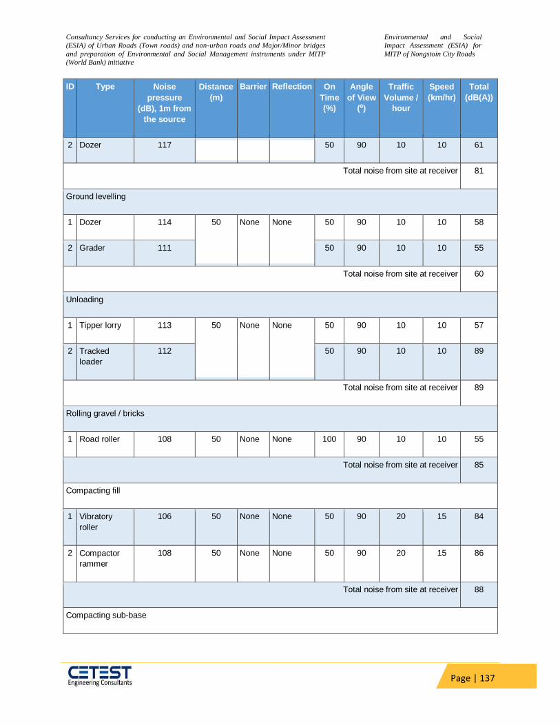
Consultancy Services for conducting an Environmental and Social Impact Assessment
(ESIA) of Urban Roads (Town roads) and non-urban roads and Major/Minor bridges
and preparation of Environmental and Social Management instruments under MITP
(World Bank) initiative
Environmental and Social
Impact Assessment (ESIA) for
MITP of Nongstoin City Roads
Page | 137
ID Type Noise
pressure
(dB), 1m from
the source
Distance
(m)
Barrier Reflection On
Time
(%)
Angle
of View
(0)
Traffic
Volume /
hour
Speed
(km/hr)
Total
(dB(A))
2 Dozer 117 50 90 10 10 61
Total noise from site at receiver 81
Ground levelling
1 Dozer 114 50 None None 50 90 10 10 58
2 Grader 111 50 90 10 10 55
Total noise from site at receiver 60
Unloading
1 Tipper lorry 113 50 None None 50 90 10 10 57
2 Tracked
loader
112 50 90 10 10 89
Total noise from site at receiver 89
Rolling gravel / bricks
1 Road roller 108 50 None None 100 90 10 10 55
Total noise from site at receiver 85
Compacting fill
1 Vibratory
roller
106 50 None None 50 90 20 15 84
2 Compactor
rammer
108 50 None None 50 90 20 15 86
Total noise from site at receiver 88
Compacting sub-base
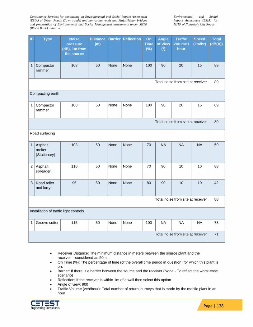
Consultancy Services for conducting an Environmental and Social Impact Assessment
(ESIA) of Urban Roads (Town roads) and non-urban roads and Major/Minor bridges
and preparation of Environmental and Social Management instruments under MITP
(World Bank) initiative
Environmental and Social
Impact Assessment (ESIA) for
MITP of Nongstoin City Roads
Page | 138
ID Type Noise
pressure
(dB), 1m from
the source
Distance
(m)
Barrier Reflection On
Time
(%)
Angle
of View
(0)
Traffic
Volume /
hour
Speed
(km/hr)
Total
(dB(A))
1 Compactor
rammer
108 50 None None 100 90 20 15 89
Total noise from site at receiver 89
Compacting earth
1 Compactor
rammer
108 50 None None 100 90 20 15 89
Total noise from site at receiver 89
Road surfacing
1 Asphalt
melter
(Stationary)
103 50 None None 70 NA NA NA 59
2 Asphalt
spreader
110 50 None None 70 90 10 10 88
3 Road roller
and lorry
96 50 None None 80 90 10 10 42
Total noise from site at receiver 88
Installation of traffic light controls
1 Groove cutter 115 50 None None 100 NA NA NA 73
Total noise from site at receiver 71
Receiver Distance: The minimum distance in meters between the source plant and the receiver – considered as 50m.
On Time (%): The percentage of time (of the overall time period in question) for which this plant is on.
Barrier: If there is a barrier between the source and the receiver (None - To reflect the worst-case scenario)
Reflection: If the receiver is within 1m of a wall then select this option
Angle of view: 900
Traffic Volume (veh/hour): Total number of return journeys that is made by the mobile plant in an hour

Consultancy Services for conducting an Environmental and Social Impact Assessment
(ESIA) of Urban Roads (Town roads) and non-urban roads and Major/Minor bridges
and preparation of Environmental and Social Management instruments under MITP
(World Bank) initiative
Environmental and Social
Impact Assessment (ESIA) for
MITP of Nongstoin City Roads
Page | 139
Speed: Average speed of the plant in kilometres per hour
Although this level of noise is higher than the permissible limit for ambient noise level for residential/commercial levels but will occur only intermittently and temporarily. This noise level will attenuate with an increase in distance from the noise source, decreasing by 10dB at a distance of about 55m and 20 dB at 180 meters. Impact due to noise during construction activities will be minimal near communities as construction camps are located at least 50 meters away from community areas.
Along the project road, noise-sensitive places have been located which includes schools, hospitals, and religious places. Noise impacts during project construction will be significant on these but temporary.
The principal source of noise during construction of highway would be from operation of equipment, machinery and vehicles. Earth moving machineries e.g. excavators, graders and vibratory rollers has potential to generate high noise levels. These machineries produce noise level of more than 70 dB (A). This can cause disturbance to the settlement, adjacent to the carriageway or at 500 m from the worksite. The vibration produced by rollers can be transmitted along the ground. This may cause damage to kutcha structure located along the alignment. The extent of damage would be dependent on the type of soil, the age and construction of the structure. The noise generated during the construction would cause inconvenience to the population adjoining the road especially within 500 m of the alignment after which it would be attenuated to acceptable levels Since, the settlement along the road alignment is sparse the severity of the noise in sensitive receptor are given below.
Further, using the Inverse Square Law of noise propagation, anticipated noise at the sensitive receptor due to construction was also calculated. This is given below.
Table 41: Anticipated Noise due to construction in the sensitive receptor
Name of the
Component
Description Road Name Distance
from the
road (m)
Noise
Level (dB)
CHC Church Nongstoin-Sonapahar Road to
Mawsiangphet , Link 2 142.07 61.92
CLG College Nongstoin-Sonapahar Road to
Mawsiangphet , Link 1 34.47 74.23
SCH School Nongstoin-Sonapahar Road to
Mawsiangphet , Link 1 77.78 67.16
CHC Church Nongstoin-Sonapahar Road to
Mawsiangphet , Link 1 122.15 63.24
DVO District Veterinary Office
Nongstoin-Sonapahar Road
near AH & Veterinary Office to
Nongstoin-Pyndengrei Road
16.39 80.68
CHC Church Nondein, New Nongstoin, Link
1 43.27 72.25

Consultancy Services for conducting an Environmental and Social Impact Assessment
(ESIA) of Urban Roads (Town roads) and non-urban roads and Major/Minor bridges
and preparation of Environmental and Social Management instruments under MITP
(World Bank) initiative
Environmental and Social
Impact Assessment (ESIA) for
MITP of Nongstoin City Roads
Page | 140
Name of the
Component
Description Road Name Distance
from the
road (m)
Noise
Level (dB)
CLG College Nongstoin College to
permanent campus of Rev.S.
Wollington Children Home of
the KJP Synod Sepngi
22.08 78.09
CHC Church Nongstoin-Old Nongstoin road to Domthangksing at
Nonstoin, Link 2
22.74 77.84
CHC Church Ladweitang-Mawiong Lumsyntiew to connect
Nongstoin-Rambrai road at 3rd km
131.49 62.60
CHC Church 5th km of Nongstoin-Markasa Road to Mawrok Porsohsat Village, Link 5
46.10 71.7
CHC Church a village road from Nongstoin-Mawkawah road
to Peacenola Memorial Playground Mawkawah, Link
2
13.16 82.5
SCH School Nongstoin-Sonapahar Road to Mawsiangphet upto St. Francis D' Assisi College,
Link 1
74.44 67.54
CLG College Nongstoin-Sonapahar Road to Mawsiangphet upto St. Francis D' Assisi College,
Link 1
25.82 76.74
SCH School road from Nongstoin-Mawkawah road to Petjyllan (Near Anderson H/S School)
to connect NH-44E
1.25
103.04
CHC Church Nondein, New Nongstoin, Link 1
48.05 71.34
SCH School Nondein, New Nongstoin, Link 1
1.21 103.32
From the above study we have observed that the range of noise level of all locations is exceeding the permissible limit. To avoid the impact, the mitigation measures are mentioned below.
Although all the construction related activities are not expected to occur simultaneously at a given location yet Increases in noise due to construction activities (land clearing, site preparation, material/ equipment’s /machinery movement, establishment of camps/site offices) are expected.
Consultancy Services for conducting an Environmental and Social Impact Assessment
(ESIA) of Urban Roads (Town roads) and non-urban roads and Major/Minor bridges
and preparation of Environmental and Social Management instruments under MITP
(World Bank) initiative
Environmental and Social
Impact Assessment (ESIA) for
MITP of Nongstoin City Roads
Page | 141
Control Measures adopted during Construction Phase for Noise Environment
Site Controls: Stationary equipment will be placed along un-inhabited stretches as per distance requirements computed above as far as practicable to minimize objectionable noise impacts. These locations should be away from known bird nesting areas.
Scheduling of Project Activities: Construction activities will be scheduled to
coincide with period when people would least likely to be affected. Construction activities will be strictly prohibited between 10 P.M. and 6 A.M. Near sensitive areas like schools’, construction activities should be prohibited at the schooling hours. Near residential areas. Noisy operation near known nesting areas should be avoided during winter, typical breeding period of migratory birds.
Protection devices (ear plugs or ear muffs) will be provided to the workers
operating in the vicinity of high noise generating machines.
Construction equipment and machinery should be fitted with silencers and maintained properly.
Noise measurements should be carried out along the road to ensure the
effectiveness of mitigation measures
All construction equipment used for an 8-hour shift shall conform to a standard of less than 90 dB(A). If required, machinery producing high noise as concrete mixers, generators etc., must be provided with noise shields;
At construction sites within 500m of human settlements, noisy construction
activities shall be stopped between 9.00PM and 6.00AM and near sensitive locations such as schools’ construction activities should not be done during the schooling hours.
Vehicles and construction machinery shall be monitored regularly with particular attention to silencers and mufflers to maintain noise levels to minimum;
Workers in the vicinity of high noise levels must wear ear plugs and should be engaged in diversified activities to prevent prolonged exposure to noise levels of more than 85 dB(A)per 8-hour shift.
6.1.2.6 Surface Water Quality and Siltation
Construction activities may increase turbidity level increasing the sediment load. Sometimes
contamination of surface water may take place due to accidental spills of construction materials,
oil, grease, fuel, and paint. Degradation of water quality is also possible due to accidental
discharges into watercourses from drainage of workers camps and from spillages from vehicle
parking and/or fuel and lubricant storage areas. During construction phase, care would be
exercised to control silt so that the water available in the ponds and wells especially those
located very near to the ROW may not be contaminated.
Extraction of sand from the river bed will increase turbidity and affect propagation of fishes and
other aquatic life mainly benthic organisms. The macro-benthic life which remains attached to
the river bed material may get dislodged and carried away downstream by turbulent flow. Mining
and dredging activities, poorly planned stockpiling and uncontrolled dumping of overburden, and

Consultancy Services for conducting an Environmental and Social Impact Assessment
(ESIA) of Urban Roads (Town roads) and non-urban roads and Major/Minor bridges
and preparation of Environmental and Social Management instruments under MITP
(World Bank) initiative
Environmental and Social
Impact Assessment (ESIA) for
MITP of Nongstoin City Roads
Page | 142
chemical/fuel spills from equipment's and machinery involved in dredging may cause
deterioration of water quality for downstream users, and poisoning of aquatic life. However, the
river bed sand quarries identified for the project have no density and diversity of benthic fauna.
Fishing is practiced in the water bodies intersecting the project road. There are several ponds
adjacent to the proposed project road. Moreover, any extraction of river bed material is
regulated by different authorities like State Environmental Impact Assessment Authority, State
Pollution Control Board and State Mining Department with an objective to conserve top soil,
avoid impact on aquatic biodiversity, hydrological regime etc. by haphazard and unscientific
mining of minor minerals. The project will utilize river bed materials from existing licensed
quarries with all stipulated conditions of above-mentioned authorities.
Mitigation Measure:
Construction works near waterways/water bodies will not be undertaken during the monsoon season
Retaining walls have been proposed to prevent erosion
Installation temporary silt traps or sedimentation basins along the drainage leading to the water bodies;
No construction camp within 500m of any water body
Locatig all parking, repair and fuel and hazardous material storage area away from any water body. Vehicle parking and maintenance areas will have waterproof floors from which drainage is collected and treated to legal standards.
Refuel vehicles only in dedicated areas with waterproof floors from which drainage flows to an oil/water separator before discharge
Collect all waste oil, store in sealed damage-proof containers and dispose it to recyclers.
All equipment operators, drivers, and warehouse personnel will be trained in immediate response for spill containment and eventual clean-up.
Temporary retention ponds, interception drains, and silt traps are installed to prevent silt laden water from entering adjacent water bodies/waterways;
Modification and rechanneling of The slope of embankments leading to water bodies should be modified and rechannelled to prevent entry of contaminants.
Comply with requirements of the clearance issued by the relevant state authority for mining in rivers
No construction related activities of bridges during breeding season of fish and other aquatic species.
6.1.2.7 Impacts on natural drainage and watershed management (flooding)
Along the rivers and streams crossed by the road, there is a need for bank protection measures
to avoid accelerated sedimentation that can affect drainage pattern as well as riverine habitats.
The alignment follows the existing topography except for the location of the cross-drainage
structure. There is no existing Major Bridge on the Project road section only 4 nos. of RCC
Bridge and 11 nos. wooden bridges exist, and No additional bridges are proposed to be
constructed. Out of the 196 nos. of existing culverts, 45 nos. are Pipe Culvert, 1 no. is RSJ with
Wooden Deck & 150 nos. are Slab culvert. All culverts present in the project road are either
hydraulically inadequate or structurally unsafe & hence are proposed for reconstruction.
Proposed Mitigation Measure
Consultancy Services for conducting an Environmental and Social Impact Assessment
(ESIA) of Urban Roads (Town roads) and non-urban roads and Major/Minor bridges
and preparation of Environmental and Social Management instruments under MITP
(World Bank) initiative
Environmental and Social
Impact Assessment (ESIA) for
MITP of Nongstoin City Roads
Page | 143
At all locations where the preliminary design has indicated a raise in the level of the embankment, the final design should review the feasibility of the same and if possible, reduce the embankment height.
At all location where the vertical profile has increased by 0.25 to 0.50 m or more protections of embankment is required.
A slope protection measure that has been successful in Meghalaya has been the use of Vertiver as a Bio engineering measure. The basis of this technique is plantation of Vetiver plants of approved variety specifically designed as per the soil and site conditions. For controlling the underwater erosion, a flexible mattress is proposed to be used. This mattress made of waste/recycled items like empty cement bags which will remain intact for long periods under water has been found effective in controlling underwater erosion elsewhere in Meghalaya. The stretches along the river bank will also have a reed bed which will absorb the flow energy before the water current hits the bank.
6.1.2.8 Ground Water Quality
Water for construction purpose will be sourced mainly through major streams along the project
road. Suitable arrangement for drinking in the campsite will be managed by contractor without
affecting availability to local community. The area is not classified as critical semi-critical or
overexploited by CGWB. However, uncontrolled drinking water abstraction can deteriorate the
situation. Contamination of groundwater is not envisaged since all construction camps will have
septic tanks or mobile toilets depending on the number of workers in each camp.
Mitigation Measures:
Provision for adequate numbers of septic tank to avoid contamination of ground water.
Requisite permission will be obtained for abstraction of groundwater.
The contractor will make arrangements for water required for construction in such a way that the water availability and supply to nearby communities remain unaffected.
Water harvesting structures shall be proposed for groundwater augmentation in the project area.
No change in groundwater regime is envisaged hence no mitigation is proposed.
6.1.2.9 Construction and Demolition Waste
Construction and Demolition waste shall be generated during the project construction phase. A
certain amount of waste will be generated. Those wastes shall be utilized by the Contractor
depending upon suitability. However, Contractor shall dispose unused C&D waste at designated
disposal site as per construction and demolition waste management rules 2016.
Mitigation measures:
Contractor will use the excavated road side material for construction of road. The rest unsuitable
material will be disposed suitably. The lead and lift has been considered in cost estimates. The
Contractor will not dispose the excavated unsuitable material generated from hill section to
other side (valley side) of the project road. Proper disposal plan will be prepared by the
Contractor to dispose the unsuitable material generated from hill cutting/ road excavation.

Consultancy Services for conducting an Environmental and Social Impact Assessment
(ESIA) of Urban Roads (Town roads) and non-urban roads and Major/Minor bridges
and preparation of Environmental and Social Management instruments under MITP
(World Bank) initiative
Environmental and Social
Impact Assessment (ESIA) for
MITP of Nongstoin City Roads
Page | 144
6.1.2.10 Natural Disaster
Flood and flash flood is common during the monsoon in the vicinity of the proposed project
road. During public consultation it was revealed by the local people that flash flood occurs in
several villages in the project area during the months of monsoon season. Hence All CD
structures have been proposed to design with anticipated risk of flood. Embankment height
along potential flood affected areas shall increase. Lined and unlined side drains have been
included in the design to avoid water-logging.
Relevant IS codes have been adopted in designing the structures to sustain the highest
magnitude of earthquake.
6.1.2.11 Disruption of Community Services
Local services, including water supply lines, irrigation line, drainage, ditches, streets are
commonly cut during road earthworks. These activities are required by the local people for crop
production, drinking water supply and access, and have the potential to damage road work too.
These services are often either inadequately reconnected or not reins ted at all.
Mitigation Measures
The Contractor will arrange their own source to cater for their water requirement for
construction and other activities and will not interfere with the local water supply system
All irrigation canals, water supply lines and stand pipes, drainage and streets will be
maintained during construction or if necessary, temporary services shall be arranged of
the owner/ user’s permission for temporary cessation will be gained.
All the Services will be progressively reinstalled as soon as road excavation has been
completed.
6.1.2.12 Diversion of Traffic
Since the road upgradation works will be on the existing road only, therefore there will be direct
interface with the road traffic. The Short term impacts associated with the project will be traffic
diversion and management during construction phase. Construction activities will cause
hindrance to the existing traffic flow. There is possibility of accident hazards during construction
phase of the widening project. There will be requirement for diversion of existing traffic at
various construction sites during construction phase. It needs to be mentioned that though there
are no direct impacts on the natural environment due to disruption/diversion of such services,
but diversion can also lead to adverse impacts if not planned properly. Rapid restoration of
diverted services can help in minimizing the severity of impacts arising out due to diversions of
existing services.
Mitigation Measures
Proper preventive measures will be taken during the construction activities at the
construction sites
Reduce speed through construction zones.

Consultancy Services for conducting an Environmental and Social Impact Assessment
(ESIA) of Urban Roads (Town roads) and non-urban roads and Major/Minor bridges
and preparation of Environmental and Social Management instruments under MITP
(World Bank) initiative
Environmental and Social
Impact Assessment (ESIA) for
MITP of Nongstoin City Roads
Page | 145
Construction of bridges/culverts will be carried out prior to construction of new
carriageway at the first stage.
Strengthening/raising of existing two lanes will be done only after the completion of the
first stage.
Proper warning signs will be displayed at construction sites.
6.1.2.13 Impacts on Occupational Health & Safety
The Construction workers are continuously exposed to dust and gaseous emission during
construction activities. The construction industry falls in hazardous category and there is always
risks of accidents to the labours. However this type of risks of Occupational hazards can be
managed with implementation of proper safety at site.
Mitigation Measures:
The Contractor will comply with the requirements of the Environmental, Health, and
Safety (EHS), Guidelines of the World Bank, April, 2007 and all national, state and local
core labor laws on working conditions and safety during construction.
The Contractor will Develop and implement site-specific Health and Safety (H&S) Plan
including SoP for preventing spread of COVID-19 epidemic which will include measures
such as: (a) excluding public from the site; (b) ensuring all workers are provided with and
use Personal Protective Equipment; (c) H&S training for all site personnel; (d)
documented procedures to be followed for all site activities; and (e) documentation of
work-related accidents
The Contractor will provide adequate good quality Personal Protective Equipment (PPE)
to all the workers working at construction zones and Plant sites and will ensure that
these PPEs are used by workers at all time during works.
Safe access to the work site and safe working conditions to be maintained throughout
the working period.
Adequate drainage, sanitation and waste disposal will be provided at workplaces.
Proper drainage will be maintained around sites to avoid water logging leading to various
diseases.
Adequate sanitation and waste disposal facilities will be provided at construction camps
by means of septic tanks, soakage pits etc.
A health care system will be maintained at construction camp for routine check-up of
workers and avoidance of spread of any communicable disease.
Readily available First Aid kit bearing all necessary first aid items will be proved at all the work
sites and should be regularly maintained.
The Contractor will organize awareness program on occupational health and safety
aspects as well as on HIV/AIDS and sexually transmitted diseases (STDs) and COVID-
19 on periodic basis through authorized agency.
Preventive measures require to be followed to avoid or minimize transmission of
communicable diseases that may be associated with the influx of temporary or
permanent project labour for workers on periodic basis.

Consultancy Services for conducting an Environmental and Social Impact Assessment
(ESIA) of Urban Roads (Town roads) and non-urban roads and Major/Minor bridges
and preparation of Environmental and Social Management instruments under MITP
(World Bank) initiative
Environmental and Social
Impact Assessment (ESIA) for
MITP of Nongstoin City Roads
Page | 146
6.1.2.14 Work Site Safety
Construction site safety is one of the most overlooked things during a construction project. In
most workplaces accidents are common due to lack of work site safety. Accidents have the
potential to be life-threatening and can be avoided through proper Work site Safety.
Mitigation Measures:
Safe access to the work site and safe working conditions to be maintained throughout
the working period
Scaffolding to be used properly.
Avoid enter a trench that is unprotected.
Avoid ladders with metallic components near electrical work and power lines
Head Protection, use helmet or body harnesses
Construction workers should wear work boots with slip-resistant and puncture-resistant
soles
Hazard communication: Make information accessible to employees at all times in a
language or formats
Check all electrical tools and equipment regularly for defect
The Contractor will comply with the requirements of the Environmental, Health, and
Safety (EHS), Guidelines of the World Bank, April, 2007 and the statutory norms on
safety during construction.
6.1.2.15 Anticipated Impact on Biological Environment:
Impact on Faunal and Terrestrial Ecology:
The entire project site is within the William Nagar Town there are no National Parks, Wildlife
Sanctuaries and other eco-sensitive areas nearby.
There is hardly the presence of any Endangered/ Schedule - I species in the project area, as
confirmed by site visits as well as consultation with community and Forest/Wildlife department.
Majority of the important species are reported from outside of the ROW.
The traffic – animal conflicts during the operation stage shall be resolved by implementing
speed calming mitigation measures such as road humps, rumble strips, speed limits, sign
boards etc.
It is essential to make provisions for the transportation of agricultural equipment and animal
crossing wherever necessary by providing service roads, speed breakers (road humps, rumble
strips, signboards, etc.). Although situation does not warrant for the provision of exclusive
underpasses, all possible efforts shall be made to avoid animal- traffic conflict arising out of
proposed improvement of project roads.
There is a scope of slight impact to local domestic animals, which graze in the area especially
after the road is constructed. Increased vehicle movement in the area might lead to accidents
involving animals. Apart from this, micro-ecosystems developed on the roadside, with the birds,

Consultancy Services for conducting an Environmental and Social Impact Assessment
(ESIA) of Urban Roads (Town roads) and non-urban roads and Major/Minor bridges
and preparation of Environmental and Social Management instruments under MITP
(World Bank) initiative
Environmental and Social
Impact Assessment (ESIA) for
MITP of Nongstoin City Roads
Page | 147
animals and insects using the plantation over the years, would be lost due to loss of their
habitat.
Mitigation
The Contractor shall take reasonable precaution to prevent his workmen or any other
persons from removing and damaging any flora (plant/vegetation) and fauna (animal)
including fishing in any water body and hunting of any animal.
Mandatory / Regulatory sign for entire section of project road for every 2 km at alternate
side is proposed.
The compensatory plantation shall act as the new habitat for the birds, animals and
insect species
If any animal is found near the construction site at any point of time, the contractor shall
immediately upon discovery thereof contact authorized wildlife rescuer or Forest Dept.
for rescue of snakes or other distressed wildlife.
Special care of ponds shall be taken since the wildlife and the public are dependent on
these water bodies.
Impact on Flora and Mitigation measures:
The project has significant, direct and long-term impact on roadside trees in the Pre-
construction stage. The cutting of trees shall have manifold impact. Most visible impact will be
the loss of shade. Also, there is a possibility of the local people being deprived of tree products,
such as wood, fruits, leaves etc. Removal of roadside tress will reduce comfort levels for slow
moving traffic and pedestrians.
Trees impacted due to the project shall only be cut after requisite permission from State
Forest Department is obtained.
Trees impacted by the project shall be compensated by planting of endemic tree species
which are highly tolerable to vehicular emissions and dust as per IRC: SP 21.
All necessary measures such as siting of construction establishments away from human
habitations; increase of stack height; regular maintenance of construction equipments
and vehicles; etc. shall be taken up to reduce the dust and gaseous emissions during
construction activities.
The compensatory plantation shall act as the new habitat for avifauna, lesser mammals,
herpetofauna & insects. List of species recommended for taking up compensatory
afforestation has been presented in the table below. Local authority and populace may
also be consulted for selection of species types.
All efforts shall be made for the survival of planted trees. A Memorandum of
Understanding should be signed with competent authority or agency to take up the
plantation.
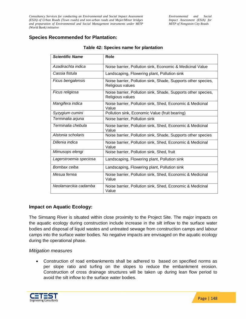
Consultancy Services for conducting an Environmental and Social Impact Assessment
(ESIA) of Urban Roads (Town roads) and non-urban roads and Major/Minor bridges
and preparation of Environmental and Social Management instruments under MITP
(World Bank) initiative
Environmental and Social
Impact Assessment (ESIA) for
MITP of Nongstoin City Roads
Page | 148
Species Recommended for Plantation:
Table 42: Species name for plantation
Scientific Name Role
Azadirachta indica Noise barrier, Pollution sink, Economic & Medicinal Value
Cassia fistula Landscaping, Flowering plant, Pollution sink
Ficus bengalensis Noise barrier, Pollution sink, Shade, Supports other species, Religious values
Ficus religiosa Noise barrier, Pollution sink, Shade, Supports other species, Religious values
Mangifera indica Noise barrier, Pollution sink, Shed, Economic & Medicinal Value
Syzygium cumini Pollution sink, Economic Value (fruit bearing)
Terminalia arjuna Noise barrier, Pollution sink
Terminalia chebula Noise barrier, Pollution sink, Shed, Economic & Medicinal Value
Alstonia scholaris Noise barrier, Pollution sink, Shade, Supports other species
Dillenia indica Noise barrier, Pollution sink, Shed, Economic & Medicinal Value
Mimusops elengi Noise barrier, Pollution sink, Shed, fruit
Lagerstroemia speciosa Landscaping, Flowering plant, Pollution sink
Bombax ceiba Landscaping, Flowering plant, Pollution sink
Mesua ferrea Noise barrier, Pollution sink, Shed, Economic & Medicinal Value
Neolamarckia cadamba Noise barrier, Pollution sink, Shed, Economic & Medicinal Value
Impact on Aquatic Ecology:
The Simsang River is situated within close proximity to the Project Site. The major impacts on
the aquatic ecology during construction include increase in the silt inflow to the surface water
bodies and disposal of liquid wastes and untreated sewage from construction camps and labour
camps into the surface water bodies. No negative impacts are envisaged on the aquatic ecology
during the operational phase.
Mitigation measures
Construction of road embankments shall be adhered to based on specified norms as
per slope ratio and turfing on the slopes to reduce the embankment erosion.
Construction of cross drainage structures will be taken up during lean flow period to
avoid the silt inflow to the surface water bodies.
Consultancy Services for conducting an Environmental and Social Impact Assessment
(ESIA) of Urban Roads (Town roads) and non-urban roads and Major/Minor bridges
and preparation of Environmental and Social Management instruments under MITP
(World Bank) initiative
Environmental and Social
Impact Assessment (ESIA) for
MITP of Nongstoin City Roads
Page | 149
If any aquatic animals, such as turtles, are found near the construction site at any point
of time, the contractor shall immediately upon discovery thereof contact authorized
wildlife rescuer or Forest Dept. for rescue of the said animals.
No fishing should be allowed by construction workers
Liquid wastes and sewage from the construction establishments will be treated to meet
the CPCB standards before disposing it into water bodies.
Accidental chemical spills shall be handled by emergency spill procedures such as
stopping the flow; removing ignition source; initiating emergency response; cleanup and
safe disposal.
Provision for silt traps has been made at regular intervals, especially at major cross
drainage structures to trap the silt before it reaches the water bodies along the
subproject road.
Management of Construction Debris/Waste
Construction debris/waste is generated due to demolition of existing structures, scarification of
existing pavement and excavation on some sections of the subproject road etc. Improper
disposal of scarified bitumen causes decrease in soil fertility and water pollution. Careless
disposal of debris can obstruct waterways causing siltation of reservoirs and reduce capacity.
Unleaded demolition wastes will cause traffic blockage and dust, thus causing inconvenience
and health risks.
Mitigation measures
During the site clearance and disposal of debris, the contractor shall take full care to
ensure that public or private properties are not affected; there are no dwellings below the
dumpsite and the traffic is not interrupted.
The Contractor shall at all times ensure that the entire existing canal and drains within
and adjacent to the site are kept safe and free from any debris.
Construction waste debris shall be utilised for backfilling embankments, filling pits,
construction of cross roads, approach roads and landscaping before being disposed into
disposal pits.
Debris disposal sites shall be sited away from sensitive locations like settlements, water
body, forest areas and any other sensitive locations.
The debris dumpsites have to be suitably rehabilitated by planting local species of
shrubs and other plants so that the landscape is coherent with the local environment.
Care should always be taken to maintain the hydrological flow in the area and that the
dumping sites do not contaminate the water sources such as rivers and ponds.
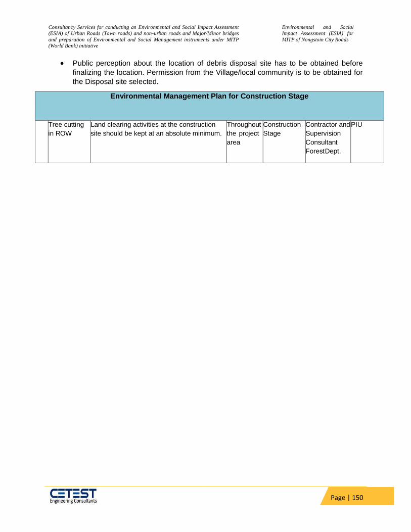
Consultancy Services for conducting an Environmental and Social Impact Assessment
(ESIA) of Urban Roads (Town roads) and non-urban roads and Major/Minor bridges
and preparation of Environmental and Social Management instruments under MITP
(World Bank) initiative
Environmental and Social
Impact Assessment (ESIA) for
MITP of Nongstoin City Roads
Page | 150
Public perception about the location of debris disposal site has to be obtained before
finalizing the location. Permission from the Village/local community is to be obtained for
the Disposal site selected.
Environmental Management Plan for Construction Stage
Tree cutting
in ROW
Land clearing activities at the construction
site should be kept at an absolute minimum.
Throughout
the project
area
Construction
Stage
Contractor and
Supervision
Consultant
Forest Dept.
PIU
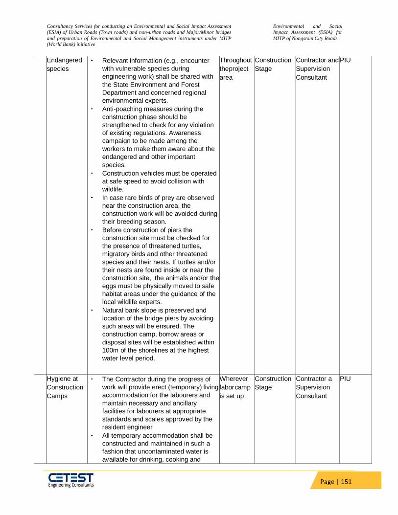
Consultancy Services for conducting an Environmental and Social Impact Assessment
(ESIA) of Urban Roads (Town roads) and non-urban roads and Major/Minor bridges
and preparation of Environmental and Social Management instruments under MITP
(World Bank) initiative
Environmental and Social
Impact Assessment (ESIA) for
MITP of Nongstoin City Roads
Page | 151
Endangered
species
• Relevant information (e.g., encounter
with vulnerable species during
engineering work) shall be shared with
the State Environment and Forest
Department and concerned regional
environmental experts.
• Anti-poaching measures during the
construction phase should be
strengthened to check for any violation
of existing regulations. Awareness
campaign to be made among the
workers to make them aware about the
endangered and other important
species.
• Construction vehicles must be operated
at safe speed to avoid collision with
wildlife.
• In case rare birds of prey are observed
near the construction area, the
construction work will be avoided during
their breeding season.
• Before construction of piers the
construction site must be checked for
the presence of threatened turtles,
migratory birds and other threatened
species and their nests. If turtles and/or
their nests are found inside or near the
construction site, the animals and/or the
eggs must be physically moved to safe
habitat areas under the guidance of the
local wildlife experts.
• Natural bank slope is preserved and
location of the bridge piers by avoiding
such areas will be ensured. The
construction camp, borrow areas or
disposal sites will be established within
100m of the shorelines at the highest
water level period.
Throughout
the project
area
Construction
Stage
Contractor and
Supervision
Consultant
PIU
Hygiene at
Construction
Camps
• The Contractor during the progress of
work will provide erect (temporary) living
accommodation for the labourers and
maintain necessary and ancillary
facilities for labourers at appropriate
standards and scales approved by the
resident engineer
• All temporary accommodation shall be
constructed and maintained in such a
fashion that uncontaminated water is
available for drinking, cooking and
Wherever
labor camp
is set up
Construction
Stage
Contractor a
Supervision
Consultant
PIU

Consultancy Services for conducting an Environmental and Social Impact Assessment
(ESIA) of Urban Roads (Town roads) and non-urban roads and Major/Minor bridges
and preparation of Environmental and Social Management instruments under MITP
(World Bank) initiative
Environmental and Social
Impact Assessment (ESIA) for
MITP of Nongstoin City Roads
Page | 152
washing. The sewage system for the
camp must be properly designed, built
and operated.
• Compliance with the relevant legislation
must be strictly adhered to. Garbage
bins shall be provided in the camp and
regularly emptied and the garbage
disposed of in lined landfill sites.
• Upon completion of the works, the entire
temporary structures shall be cleared
away, all rubbish burnt, excreta or other
disposal pits or trenches filled in and
effectively sealed off and the entiret site
left clean and tidy.
6.2 Social Impact Assessment
6.2.1 Projects Impacts
The urban infrastructures project is associated with some adverse impacts as well as some benefits. The major impacts of the project include temporary loss of livelihood during the actual construction period due to inaccessibility to the commercial enterprise all along the project corridor and in Parking Areas. Socio Economic survey was done September, 2021. Due to the pandemic situation the Census Survey Started from 10th November to 20th December, 2021 is nearly completed and will be updated in the final DPR. The SES was done in September 2021 and also consultation was done from September to December 2021 which are completed for the present design phase.
6.2.2 Positive Impact
This sub-project aims to reduce traffic congestion within the Nongstoin City roads. The storm water drain improves the existing system of rain water flow as most of the drain chokes due to silting. The new design will make easy cleaning/desilting of the storm water drain and thus prevent the overflow of water on the black top. The footpath over the drain and utility corridor will reduce accident.
People residing at the Nongstoin City Roads can easily travel within the area. It will give a major fillip to the quest for all weather good roads for the PIA.
Lower accident and provide quick accessibility to services like hospital, market, office etc.
6.2.3 Impact on Land
As discussed earlier also there is no scope of land acquisition in the project area because all of the proposed sub-projects are well within the available existing RoW. The proposed construction of Parking areas is within the available Government land.
6.2.4 Impact on Structures
Based on the updated DPR design there would be no impact on any structures belonging to private individuals both title and non-title holders or Community. Displaced Families
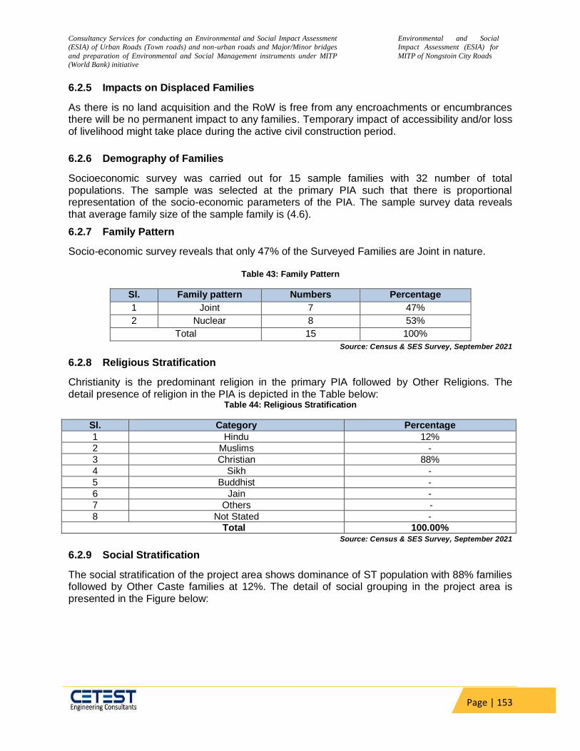
Consultancy Services for conducting an Environmental and Social Impact Assessment
(ESIA) of Urban Roads (Town roads) and non-urban roads and Major/Minor bridges
and preparation of Environmental and Social Management instruments under MITP
(World Bank) initiative
Environmental and Social
Impact Assessment (ESIA) for
MITP of Nongstoin City Roads
Page | 153
6.2.5 Impacts on Displaced Families
As there is no land acquisition and the RoW is free from any encroachments or encumbrances there will be no permanent impact to any families. Temporary impact of accessibility and/or loss of livelihood might take place during the active civil construction period.
6.2.6 Demography of Families
Socioeconomic survey was carried out for 15 sample families with 32 number of total populations. The sample was selected at the primary PIA such that there is proportional representation of the socio-economic parameters of the PIA. The sample survey data reveals that average family size of the sample family is (4.6).
6.2.7 Family Pattern
Socio-economic survey reveals that only 47% of the Surveyed Families are Joint in nature.
Table 43: Family Pattern
Sl. Family pattern Numbers Percentage
1 Joint 7 47%
2 Nuclear 8 53%
Total 15 100%
Source: Census & SES Survey, September 2021
6.2.8 Religious Stratification
Christianity is the predominant religion in the primary PIA followed by Other Religions. The detail presence of religion in the PIA is depicted in the Table below:
Table 44: Religious Stratification
Sl. Category Percentage
1 Hindu 12%
2 Muslims -
3 Christian 88%
4 Sikh -
5 Buddhist -
6 Jain -
7 Others -
8 Not Stated - Total 100.00%
Source: Census & SES Survey, September 2021
6.2.9 Social Stratification
The social stratification of the project area shows dominance of ST population with 88% families followed by Other Caste families at 12%. The detail of social grouping in the project area is presented in the Figure below:
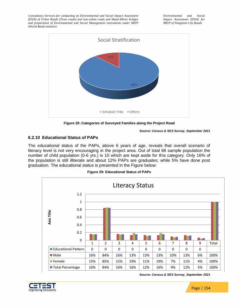
Consultancy Services for conducting an Environmental and Social Impact Assessment
(ESIA) of Urban Roads (Town roads) and non-urban roads and Major/Minor bridges
and preparation of Environmental and Social Management instruments under MITP
(World Bank) initiative
Environmental and Social
Impact Assessment (ESIA) for
MITP of Nongstoin City Roads
Page | 154
Figure 28 :Categories of Surveyed Families along the Project Road
Source: Census & SES Survey, September 2021
6.2.10 Educational Status of PAPs
The educational status of the PAPs, above 6 years of age, reveals that overall scenario of literacy level is not very encouraging in the project area. Out of total 68 sample population the number of child population (0-6 yrs.) is 10 which are kept aside for this category. Only 16% of the population is still illiterate and about 12% PAPs are graduates; while 5% have done post graduation. The educational status is presented in the Figure below:
Figure 29: Educational Status of PAPs
Source: Census & SES Survey, September 2021
88%
12%
Social Stratification
Schedule Tribe Others
1 2 3 4 5 6 7 8 9 Total
Educational Pattern 0 0 0 0 0 0 0 0 0
Male 16% 84% 16% 13% 13% 13% 10% 13% 6% 100%
Female 15% 85% 15% 19% 11% 19% 7% 11% 4% 100%
Total Percentage 16% 84% 16% 16% 12% 16% 9% 12% 5% 100%
0
0.2
0.4
0.6
0.8
1
1.2
Axi
s Ti
tle
Literacy Status
Consultancy Services for conducting an Environmental and Social Impact Assessment
(ESIA) of Urban Roads (Town roads) and non-urban roads and Major/Minor bridges
and preparation of Environmental and Social Management instruments under MITP
(World Bank) initiative
Environmental and Social
Impact Assessment (ESIA) for
MITP of Nongstoin City Roads
Page | 155
6.2.11 Occupation of PAPs
The occupational status of PAPs reveals that 88% Population are depending on business and this includes the business they are carrying out along the road, mainly shops and kiosks. 12% are engaged in government jobs & private Jobs. The details of occupations by the PAPs are presented in the Table below.
Table 45: Occupational Status of PAPs (18-60 Years)
Sl. Type of Occupation Percentage
1 Agriculture & Allied Activities -
2 Government & Private Services 12%
3 Trade & Business 88%
4 Self Employed -
5 Casual Labour -
6 Non-Remuneratively Engaged -
Total 100%
Source: Census & SES Survey, September 2021
The total number of persons is 68 and the number of persons within the active age group of 15
to 64 years is 29.
6.2.12 Income and Expenditure Profile of DFs
All the families surveyed have an average annual income more than Rs. 30000/. About 27%
Surveyed Families are having average annual income in the range of Rs. 30000-50000, while
53% of the families are earning between Rs. 50000-100000. It has been observed that about
20% Surveyed Families have annual income more than Rs. 1,00,000. The average income level
of DF in the project area is summarized in the Table below.
Table 46 :Annual Income Profile
Sl. Annual Income Categories in (Rs) % Age
1 More than 30000 but less than or equal to 50000 27%
2 More than 50000 but less than or equal to 100000 53%
3 More than 100000 20% Total 100.00%
Source: Census & SES Survey, September 2021
The expenditure pattern of the families surveyed revealed that about 55% of the average
expenditure incurred by the Surveyed Families is on the food items. The detail of the same is
presented in graphical format in Figure below

Consultancy Services for conducting an Environmental and Social Impact Assessment
(ESIA) of Urban Roads (Town roads) and non-urban roads and Major/Minor bridges
and preparation of Environmental and Social Management instruments under MITP
(World Bank) initiative
Environmental and Social
Impact Assessment (ESIA) for
MITP of Nongstoin City Roads
Page | 156
Figure 30: Annual Expenditure Profile
Source: Census & SES Survey, September 2021
6.2.13 Holding of Agricultural Land (Immovable Assets)
Only 13% of the population owes more than 0.25 acre of land. The detail of the land holding is depicted in the Table below.
Table 47 :Agricultural/Homestead Land Holding
Sl. Land owned (area in Acres) Numbers Percentage
1 Less than 0.25 13 87%
2 0.25-0.5 2 13%
3 More than 0.5 - -
4 No land - -
Total 15 100% Source: Census & SES Survey, September 2021
6.2.14 Possession of Vehicle (Movable Asset)
Majority of the population (47%) have only two wheelers followed by four wheelers (40%) and
13% population have 2-wheeler & 4-wheeler both as mode of Family transport. The details of
the movable assets holding is depicted in the Table below. Table 48: Movable Assets Holdings
Sl. Family assets Numbers Percentage
1 2-wheeler 7 47%
2 3-wheeler - -
55%
9%
11%
12%
8%5%
Expenditure Profile
Food Items Medical Education
Transport/Communication Tobacco & Beverages Other HH Expenditure

Consultancy Services for conducting an Environmental and Social Impact Assessment
(ESIA) of Urban Roads (Town roads) and non-urban roads and Major/Minor bridges
and preparation of Environmental and Social Management instruments under MITP
(World Bank) initiative
Environmental and Social
Impact Assessment (ESIA) for
MITP of Nongstoin City Roads
Page | 157
Sl. Family assets Numbers Percentage
3 4-wheeler 6 40%
4 2-wheeler & 4-wheeler 2 13%
5 More than one 2-wheeler & 4-wheeler - -
6 No Assets - -
Total 15 100% Source: Census & SES Survey, September 2021
6.2.15 Vulnerability
Vulnerable Families are defined as, who are either: (i) below poverty line (BPL); or (ii) women
headed household (WHH); or (iii) differently able households (DAH); or (iv)elderly (60 years and
above) living alone; or (v) scheduled tribes (ST); or (vi) scheduled caste (SC). It shall be noted
here that though there are multiple categories of vulnerability groups exist in the project road,
we have taken single impact of single vulnerable category for the authentication. For example,
the number of BPL/DA/Aged Person/WHH mentioned in the below table does not include those
who fall under SC and ST category to avoid the repetition of data and vice-versa. Vulnerability is
defined on Census Survey data.
The census survey finding reveals that there is 88% surveyed population along the roadside
who belong to the ST community and 12% belong to BPL category.
Table 49 :Vulnerability Status of the Affected Families
Sl. Category %Age to total
population
1 Schedule Tribe 88%
2 Schedule Caste -
3 Below Poverty Line (Excluding ST, SC) 12%
4 Women Headed Households -
5 Senior Citizen living alone - Total Vulnerable DFs 100.00%
Source: Census & SES Survey, September 2021
6.2.16 Impact on Gender
In Indian context, irrespective caste, creed, religion and social status, the overall status of
women in lower than male and therefore a male child is preferred over a female child. According
to 2001 Census in Meghalaya, the sex ratio was 972 females per 1000 male in 2001 but it has
increased in 2011 with 989 females per 1000 male which is an indication of social development.
However, the tribes of Meghalaya whose societies are organized on matrifocal principles have
obtained much greater gender equality than the societies (e.g. Hindu and Muslim) that are
organized on the patriarchal principles.
The gender composition of surveyed persons shows that the male accounts for 51% and female
accounts for 49%. The gender disparity is not so much visible in among surveyed persons i.e.
943 against state level statistic having 989 but as per census data of India, 2011. The sex ratio
of West Khasi Hills district is 980 females per 1000 males in 2011. The illiterate among the
female is slightly higher than of the male counterparts. There is One (1) of the Surveyed

Consultancy Services for conducting an Environmental and Social Impact Assessment
(ESIA) of Urban Roads (Town roads) and non-urban roads and Major/Minor bridges
and preparation of Environmental and Social Management instruments under MITP
(World Bank) initiative
Environmental and Social
Impact Assessment (ESIA) for
MITP of Nongstoin City Roads
Page | 158
Families are Women Headed Households. From the SES survey the total Population is 68, of
which 35 are males & 33 are females.
6.2.17 Migration
The Decadal growth rate of the West Khasi Hills district and town clearly indicates influx of
migrates from the nearby districts and villages. The SES reveals that about 2.34% of the
population or One Family has immigrated in the other urban town area in the last 25 years.
6.2.18 Impact on Tribal People
a. Impact on Land, Structure & Livelihood of ST
As there is no Land Acquisition and the RoW is free from all encumbrances there will be no impact of the land, structures and livelihood of the ST population.
b. Impact on Socio Economic Profile of ST
The proposed sub-project can be viewed as boosting economic growth and poverty reduction, which will bring substantial social and economic development in the region. The ST Surveyed Families have Income between Rs.50,000 to Rs. 1,00,000 annually.
c. Impact on Community
This sub-project has ensured that the designed and implementation will be in such away that it fosters full respect for ST identity, dignity, human rights, livelihood systems, and cultural uniqueness as they define them. There is no impact on the community structure or community land of cultural or religious sentiment of the ST Population in the Primary PIA. The proposed project will ensure that STs receive culturally appropriate social and economic benefits, do not suffer adverse impacts as a result of projects, and can participate actively in projects that affect them. There is no cultural heritage site of the ST which comes in the way of the road alignment. The ST population among the Surveyed Families in the PIA are living in the towns and in the due course of time became the part of the main stream population. Presently the impacted ST population does not follow any customs that are attached to their land or natural habitat which will be impacted. Thus, there will be no cultural or social impact on the ST population.
d. Impact on Gender
As already pointed out that the tribes of Meghalaya whose societies are organized on matrifocal principles have obtained much greater gender equality than the societies (e.g. Hindu and Muslim) that are organized on the patriarchal principles. Thus, the impact Gender is not different from the general population. It was identified that social and economic benefits for affected STs which are culturally appropriate and gender and inter-generationally inclusive and develop measures to avoid, minimize, and/or mitigate adverse impacts on STs mainly the Gender. Suggestion of noise barrier, reduction of dust, providing employment of the female members as unskilled labourers during construction were the results of the focus group discussions. Continuous meaningful focus group discussions with the ST women and affected STs communities and concerned STs organizations were carried out and will be carried on to solicit their participation (i) in designing, implementing, and monitoring measures to avoid adverse impacts or, when avoidance is not possible, to minimize, mitigate, or compensate for such effects; and (ii) in tailoring project benefits for affected ST communities in a culturally

Consultancy Services for conducting an Environmental and Social Impact Assessment
(ESIA) of Urban Roads (Town roads) and non-urban roads and Major/Minor bridges
and preparation of Environmental and Social Management instruments under MITP
(World Bank) initiative
Environmental and Social
Impact Assessment (ESIA) for
MITP of Nongstoin City Roads
Page | 159
appropriate manner. To enhance STs’ active participation, projects affecting them will provide appropriate and gender inclusive capacity development. Establish a culturally appropriate and gender inclusive grievance mechanism to receive and facilitate resolution of the ST concerns.
6.2.19 Impact on Access to Services Amenities
Transport facility
Transport facility is considered as the most basic of all civic amenities as this is the life line to
access any kind of social services. Most of the clusters in the PIA have adequate road transport
facility but it fails to cater its benefit due to bad condition of the road during winter and rainy
season. Nongstoin Town roads are of great importance, as the road will carry not only the
normal city traffic, but also the freight traffic that will connect the export points to the National
Highway.
Solid Waste Dumping Facilities
The PIA is congested with structures and roads and as it is situated on the hill slope, solid waste
dumping is a very sensitive issue in the area. As per the SES it is revealed that more than 95%
of the people dispose solid waste by the method of ‘door to door’ collection by local Authority in
the urban area.
Source of Drinking Water
Table 50 :Source of Drinking Water
Sl. Types of drinking Water Source Numbers Percentage
1 Tap Water by ULB 15 100%
2 Groundwater/surface water - -
Total 15 100% Source: Census & SES Survey, September 2021
Distance of Medical Facilities
Medical facilities like government hospital and urban health centres (UHC) are not easily available within 5km for 14% of the population.
Table 51 :Distance of Medical Facilities
Sl. Distance of Medical Facilities Numbers Percentage
1 Within 1km 4 27%
2 Within 2km 5 33%
3 Within 5km 6 40%
4 More than 5km - -
Total 15 100% Source: Census & SES Survey, September 2021
Other Services
The proposed project will enhance the standard of living and/or quality of life of the residents of
West Khasi Hills. During the construction there might some temporary restrictions in access
which have to be taken care in the Resettlement Plan.
There is no permanent impact regarding the limited access to services or amenities are
envisaged in the process of development of the proposed project.

Consultancy Services for conducting an Environmental and Social Impact Assessment
(ESIA) of Urban Roads (Town roads) and non-urban roads and Major/Minor bridges
and preparation of Environmental and Social Management instruments under MITP
(World Bank) initiative
Environmental and Social
Impact Assessment (ESIA) for
MITP of Nongstoin City Roads
Page | 160
6.3 Impacts on Road Safety and Human Health
The planning and designing of the project road is in accordance with the improved safety
measures and better health conditions.
The chances of accidents could be minimized by (1) strengthening the pavements, (2)
improving upon the curves in road geometrics, (3) improving upon road crossings and (4)
putting right signals and signboards.
6.4 Mitigation Measures:
The project is likely to bring some negative impacts on the environment and socio-economic
structure of the region. While deciding the alignment from environment point of view, some negative
potential impacts are unavoidable. In such cases, adoption of mitigation measures is the only
solution. Mitigation should be focused on achieving goals within clear timeframes. Use of SMART
approach is recommended to evaluate the likely effectiveness of alternative mitigation strategies or
measures. The SMART refers to measures that are Specific, Measurable, Achievable, Realistic and
Timely.
Table 52: Potential impact and mitigation measure along the project road
Potential Impacts Mitigation
Accidental spots can be
reduced by providing proper
signs and warnings,
improvement of junctions,
new under pass, fly-over etc.
Proper provision of service roads, junctions, fly-over, under passes to
be provided at appropriate places
Truck parking places
Medical facility to be provided (an ambulance fitted with all medical
equipments and a doctor)
Sexually transmission
diseases (STDs)
Detected diseased person to be carried to the nearest city hospital
Preventive measures should be taken to check the spreading of STDs
Influx of Labour force from
nearby states
The project is not huge and can be easily completed with the local
labour force. There might movement of labour from the neighboring
districts within the state.
Consultancy Services for conducting an Environmental and Social Impact Assessment
(ESIA) of Urban Roads (Town roads) and non-urban roads and Major/Minor bridges
and preparation of Environmental and Social Management instruments under MITP
(World Bank) initiative
Environmental and Social
Impact Assessment (ESIA) for
MITP of Nongstoin City Roads
Page | 161
7 CHAPTER-VII: ENVIRONMENTAL MONITORING PROGRAM
The purpose of the monitoring program is to ensure that the envisaged purpose of the project is
achieved and results in desired benefits to the target population. To ensure the effective
implementation of the Environmental Management Plan (EMP), it is essential that an effective
monitoring program should be designed and carried out. The environmental monitoring
program provides such information based on which management decision may be taken during
construction and operational phases. It provides basis for evaluating the efficiency of mitigation
and enhancement measures and suggest further actions that need to be taken to achieve the
desired effect.
Objective of Monitoring Program
The Objectives of environmental monitoring program are-
Evaluation of the efficiency of mitigation and enhancement measures;
Updating of the actions and impacts of baseline data;
Adoption of additional mitigation measures if the present measures are insufficient;
and
Generating the data, which may be incorporated in environmental management plan
in future projects.
7.1 Environmental Monitoring
Environmental monitoring describes the processes and activities that need to take place to
characterize and monitor the quality of the environment. Environmental monitoring is used in
the preparation of environmental impact assessments, as well as in many circumstances in
which human activities carry a risk of harmful effects on the natural environment. All monitoring
strategies and program have reasons and justifications which are often designed to establish
the current status of an environment or to establish trends in environmental parameters. In all
cases the results of monitoring will be reviewed, analyzed statistically and published. The
design of a monitoring program must therefore have regard to the final use of the data before
monitoring starts.
7.2 Monitoring Plans for Environment Condition
For each of the environmental components, the monitoring plan specifies the parameters to be
monitored; location of the monitoring sites; frequency and duration of monitoring. The
monitoring plan also specifies the applicable standards, implementation and supervising
responsibilities. The monitoring plan for the various environmental condition indicators of the
project in construction and operation stages is presented in Table 53.
Monitoring plan does not include the requirement of arising out of Regulation Provision such as
obtaining NOC/ consent for plant site operation.

Consultancy Services for conducting an Environmental and Social Impact Assessment
(ESIA) of Urban Roads (Town roads) and non-urban roads and Major/Minor bridges
and preparation of Environmental and Social Management instruments under MITP
(World Bank) initiative
Environmental and Social
Impact Assessment (ESIA) for
MITP of Nongstoin City Roads
Page | 162
Table 53: Environment Monitoring Plan E
nvir
on
men
tal
Co
mp
on
en
t
Pro
ject
Sta
ge
Monitoring Institutional
Responsibility
Para
mete
rs
Sp
ecia
l
Gu
idan
ce
Sta
nd
ard
s
Lo
cati
on
Fre
qu
en
cy
Imp
lem
en
tati
on
Su
perv
isio
n
Air
Co
nstr
ucti
on
Sta
ge
PM10,
PM 2.5,
SOx,
NOx,
CO
Respirable
Dust Sampler
to be located
50 m from the
plant in the
downwind
direction. Use
method
specified by
CPCB for
analysis
Air
(P&CP)
Act,1981
and its
amendme
nt
Hot mix
Plant /
Batching
Plant.
Stretch of
the road
where
construction
is in
progress at
the site.
(Total 02
locations)
Three
times in a
year for
two years
(Excludin
g Rainy
season)
Contracto
r through
NABL
approved
monitorin
g agency
Environmen
t Expert-
AE/IE/PIU
Op
era
tio
nal
Sta
ge
PM10,
PM 2.5,
SOx,
NOx,
CO
Respirable
Dust Sampler
to be located
50m from the
plant in the
downwind
direction. Use
method
specified by
CPCB for
analysis
Air
(P&CP)
Act,1981
and its
amendme
nt
As directed
by the PIU
(02 Project
locations)
Three
times in a
year for
two years
(Excludin
g Rainy
season)
P I U
through
NABL
approved
monitorin
g agency
P I U
W
ate
r Q
uali
ty
Co
nstr
ucti
on
Sta
ge
Paramet
ers as
per IS:
10500
and
standar
ds of
surface
water
Grab sample
collected from
source and
analyze as per
Standard
Methods for
Examination
of Water
quality
Water
quality
standards
by CPCB
01 drinking
water
sample-
Labour
Camp and
01 surface
water
samples in
project
stretch.
Three
times in a
year for
two years
(Excludin
g Rainy
season)
Contracto
r through
NABL
approved
monitorin
g agency
Environmen
t Expert-
AE/IE/PIU
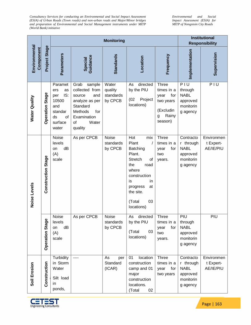
Consultancy Services for conducting an Environmental and Social Impact Assessment
(ESIA) of Urban Roads (Town roads) and non-urban roads and Major/Minor bridges
and preparation of Environmental and Social Management instruments under MITP
(World Bank) initiative
Environmental and Social
Impact Assessment (ESIA) for
MITP of Nongstoin City Roads
Page | 163
En
vir
on
men
tal
Co
mp
on
en
t
Pro
ject
Sta
ge
Monitoring Institutional
Responsibility
Para
mete
rs
Sp
ecia
l
Gu
idan
ce
Sta
nd
ard
s
Lo
cati
on
Fre
qu
en
cy
Imp
lem
en
tati
on
Su
perv
isio
n
Wate
r Q
uality
Op
era
tio
n S
tag
e
Paramet
ers as
per IS:
10500
and
standar
ds of
surface
water
Grab sample
collected from
source and
analyze as per
Standard
Methods for
Examination
of Water
quality
Water
quality
standards
by CPCB
As directed
by the PIU
(02 Project
locations)
Three
times in a
year for
two years
(Excludin
g Rainy
season)
P I U
through
NABL
approved
monitorin
g agency
P I U
No
ise L
evels
Co
nstr
ucti
on
Sta
ge
Noise
levels
on dB
(A)
scale
As per CPCB Noise
standards
by CPCB
Hot mix
Plant /
Batching
Plant.
Stretch of
the road
where
construction
is in
progress at
the site.
(Total 03
locations)
Three
times in a
year for
two
years.
Contracto
r through
NABL
approved
monitorin
g agency
Environmen
t Expert-
AE/IE/PIU
Op
era
tio
n S
tag
e Noise
levels
on dB
(A)
scale
As per CPCB Noise
standards
by CPCB
As directed
by the PIU
(Total 03
locations)
Three
times in a
year for
two
years.
PIU
through
NABL
approved
monitorin
g agency
PIU
So
il E
rosio
n
Co
nstr
ucti
on
Sta
ge
Turbidity
in Storm
Water
Silt load
in
ponds,
---- As per
Standard
(ICAR)
01 location
construction
camp and 01
major
construction
locations.
(Total 02
Three
times in a
year for
two years
Contracto
r through
NABL
approved
monitorin
g agency
Environmen
t Expert-
AE/IE/PIU
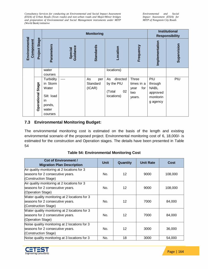
Consultancy Services for conducting an Environmental and Social Impact Assessment
(ESIA) of Urban Roads (Town roads) and non-urban roads and Major/Minor bridges
and preparation of Environmental and Social Management instruments under MITP
(World Bank) initiative
Environmental and Social
Impact Assessment (ESIA) for
MITP of Nongstoin City Roads
Page | 164
En
vir
on
men
tal
Co
mp
on
en
t
Pro
ject
Sta
ge
Monitoring Institutional
Responsibility
Para
mete
rs
Sp
ecia
l
Gu
idan
ce
Sta
nd
ard
s
Lo
cati
on
Fre
qu
en
cy
Imp
lem
en
tati
on
Su
perv
isio
n
water
courses
locations)
Op
era
tio
nal
Sta
ge
Turbidity
in Storm
Water
Silt load
in
ponds,
water
courses
---- As per
Standard
(ICAR)
As directed
by the PIU
(Total 02
locations)
Three
times in a
year for
two
years.
PIU
through
NABL
approved
monitorin
g agency
PIU
7.3 Environmental Monitoring Budget:
The environmental monitoring cost is estimated on the basis of the length and existing
environmental scenario of the proposed project. Environmental monitoring cost of 6, 18,000/- is
estimated for the construction and Operation stages. The details have been presented in Table
54
Table 54: Environmental Monitoring Cost
Cot of Environment /
Migration Plan Description Unit Quantity Unit Rate Cost
Air quality monitoring at 2 locations for 3
seasons for 2 consecutive years.
(Construction Stage)
No. 12 9000 108,000
Air quality monitoring at 2 locations for 3
seasons for 2 consecutive years.
(Operation Stage)
No. 12 9000 108,000
Water quality monitoring at 2 locations for 3
seasons for 2 consecutive years.
(Construction Stage)
No. 12 7000 84,000
Water quality monitoring at 2 locations for 3
seasons for 2 consecutive years.
(Operation Stage)
No. 12 7000 84,000
Noise quality monitoring at 2 locations for 3
seasons for 2 consecutive years.
(Construction Stage)
No. 12 3000 36,000
Noise quality monitoring at 3 locations for 3 No. 18 3000 54,000
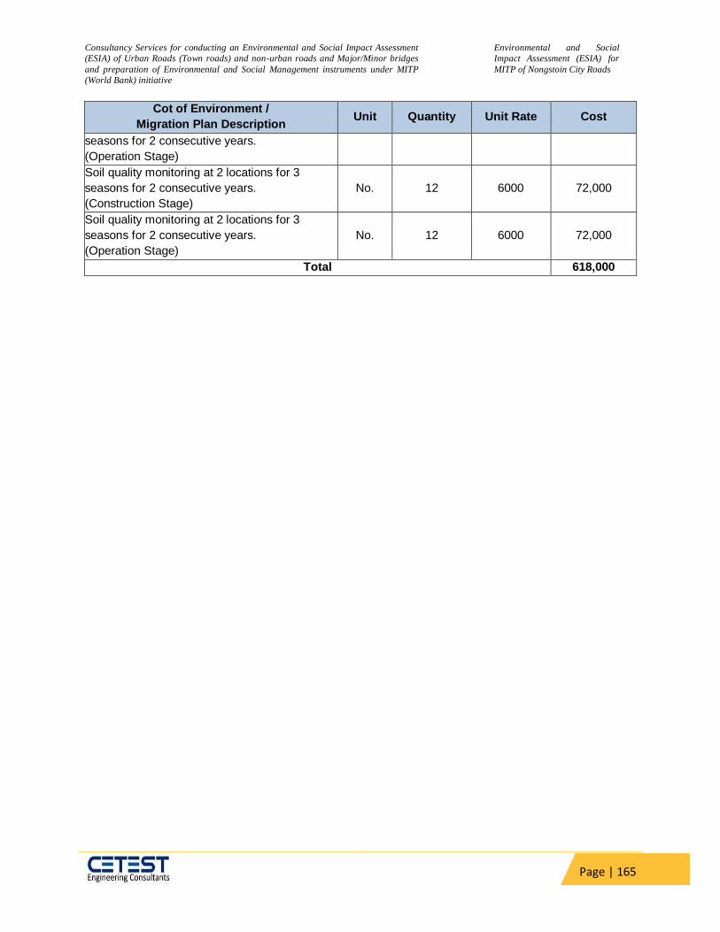
Consultancy Services for conducting an Environmental and Social Impact Assessment
(ESIA) of Urban Roads (Town roads) and non-urban roads and Major/Minor bridges
and preparation of Environmental and Social Management instruments under MITP
(World Bank) initiative
Environmental and Social
Impact Assessment (ESIA) for
MITP of Nongstoin City Roads
Page | 165
Cot of Environment /
Migration Plan Description Unit Quantity Unit Rate Cost
seasons for 2 consecutive years.
(Operation Stage)
Soil quality monitoring at 2 locations for 3
seasons for 2 consecutive years.
(Construction Stage)
No. 12 6000 72,000
Soil quality monitoring at 2 locations for 3
seasons for 2 consecutive years.
(Operation Stage)
No. 12 6000 72,000
Total 618,000
Consultancy Services for conducting an Environmental and Social Impact Assessment
(ESIA) of Urban Roads (Town roads) and non-urban roads and Major/Minor bridges
and preparation of Environmental and Social Management instruments under MITP
(World Bank) initiative
Environmental and Social
Impact Assessment (ESIA) for
MITP of Nongstoin City Roads
Page | 166
8 CHAPTER-VIII: Climate Change Impact & Risk
A rapid increase in the number of motor vehicles on road in Meghalaya has been observed
over the past decade. Due to the lack of adequate public transport systems where buses
comprise only 1% of the total population of vehicles on road, and due to the availability of easy
loans, most of the people are aspiring to buy their vehicles. As a result, two-wheelers are 57%
of the total vehicle mix in the State, and cars follow suit with a 21% share in 2013-14. The road
transport sector is a direct consumer of fossil fuel, emits GHG into the atmosphere. With an
increase in population and per capita rise in the number of personal vehicles, GHG emissions
are likely to rise. The use of the public transport system needs to control future emissions in the
future and to ease off the pressure of vehicles on the roads, hence. This would require policy
changes in the way lending is done by banks, enabling fuel mix with biofuels, and behavioural
changes of the population whereby they use more and more non- motorized transport at short
distances and public transport for long distances.
8.1 Climate Change Mitigation
The Transport Emissions Evaluation Model for Projects (TEEMP) developed by Clean Air Asia
was utilized to assess the CO2 gross emissions with and without the project improvements.
The main improvement from the project that was considered for the model are better surface
roughness with initially 6 m/km which may deteriorate over a period but not less than 2 m/km
and widening of roads from the single/intermediate lane to two lanes with paved shoulder (7
m). These were translated into impacts on traffic speed and hence fuel consumption. The
model also allows for the inclusion of impacts related to traffic congestion with and without
project through provisions for inserting data on the traffic numbers, lane width, number of
lanes, and volume/capacity saturation limit.
Information that was fed into the model for projecting the CO2 emissions were:
The road configuration will change from an intermediate lane to two lanes with a
carriageway width of varies from 2.4 to 7 m with 1.5 m hard shoulder on both
sides. The road will have an asphalt concrete surface.
The surface road roughness is mostly 6 m/km and will be improved to 2.0 m/km,
which may further reach up to 3.5 m/km during 5 years of road operations.
Resurfacing of the road would be required after 5 years.
The design life of the road is 20 years.
Other improvements include the repair or reconstruction and improvement of
culverts, longitudinal and cross drains, and removal of irregularities on the
existing vertical profile and road safety appurtenances.
Emission factors were mostly taken from the CPCB/MOEF (2007) Draft Report on Emission
Factor Development for Indian Vehicles, the Automotive Research Association of India, and C.
Reynolds et.al (2011) Climate and Health, Relevant Emissions from in-Use Indian for three-
wheelers rickshaw as presented in Table below. Emission factors were taken from the
CPCB/MOEF&CC (2007) Draft Report on Emission Factor Development for Indian Vehicles,
the Automotive Research Association of India, and C. Reynolds et.al (2011) Climate and Health
Relevant Emissions from in-Use Indian for three-wheelers rickshaw as shown in Table 55
Table 55: CO2 Emission Factors

Consultancy Services for conducting an Environmental and Social Impact Assessment
(ESIA) of Urban Roads (Town roads) and non-urban roads and Major/Minor bridges
and preparation of Environmental and Social Management instruments under MITP
(World Bank) initiative
Environmental and Social
Impact Assessment (ESIA) for
MITP of Nongstoin City Roads
Page | 167
VehicleType Petrol Diesel LPG/CNG
2-Wheel 1.37kg/l
3-Wheel 2.12kg/l 2.58kg/l 3kg/l
Cars/bus 2.24kg/l 2.58kg/l
1. All 2-wheel vehicles are run on petrol; average fuele conomy:50km/litres 2. All3-wheelvehicles are run on diesel; average fuele conomy:30km/litres 3. 50%of the cars/bus are run on petrol while the remaining are run by diesel;
average fuel economy:15km/litres
For 20.925 km of road construction would result in emission of approximately 2155.275
tCO2eq. (Source: Greenhouse Gas Emissions Mitigation in Road Construction and
Rehabilitation - A Toolkit for Developing). This value if based on estimation of materials
required to upgrade /construct of rural road which include cement, steel, gasoline,
diesel, and bitumen etc.
Estimated carbon emissions:
Construction Phase
The GHG emissions during a road construction project involve the following major sources:
Transport emissions owing to transportation of man and material
Material emissions owing to extraction/production of construction materials
Machines emissions owing to consumption of fuel by engines used in construction
A detailed study conducted for the World Bank titled “Greenhouse Gas Emissions Mitigation in
Road Construction and Rehabilitation- A Toolkit for Developing Countries” established the
typical GHG emission rate in terms of ton CO2eq per km of road construction. According to this
study, for Rural Road-DBST, GHG emissions due to material production is based on estimation
of materials required to upgrade /construct of rural road which include cement, steel, gasoline,
diesel, and bitumen etc. are the main contributor.
Type of Road
Transport emissions
Materiale missions
Machines emissions
Total (t C02 eq.)
Rural Road—DBST 26 62 14 103
Source: Green house Gas Emissions Mitigation in Road Construction and Rehabilitation-A Toolkit for
Developing Countries
Therefore, for 20.925 km of road construction would result in emission of approximately
2155.275 tonCO2eq.
Operation Phase
The design life of the project road is 20 years. Due very less traffic density and introduce of e-
vehicle major CO2 emission increase not anticipated.
Climate Change Impacts & Risks
In today’s world, climate change is considered the most serious global challenge. Changes in
the atmosphere have been detected that could drastically alter the climate system and the
balance of ecosystems. Atmospheric changes are linked to an increase in greenhouse gases
(GHGs), chiefly on account of anthropogenic releases attributed to fossil fuel consumption,
land-use changes, deforestation, etc. Research has established that carbon dioxide (CO2)
levels in the atmosphere have risen by 35% since the pre‐industrial era. Rising CO2
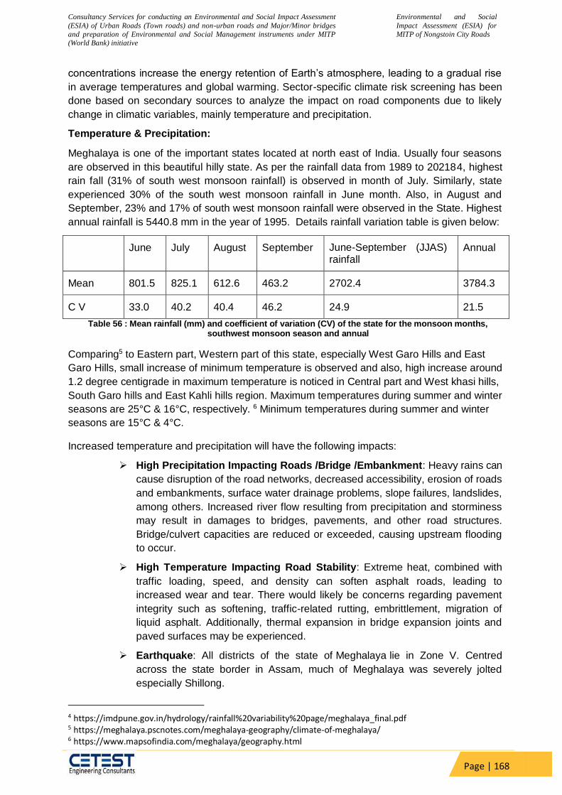
Consultancy Services for conducting an Environmental and Social Impact Assessment
(ESIA) of Urban Roads (Town roads) and non-urban roads and Major/Minor bridges
and preparation of Environmental and Social Management instruments under MITP
(World Bank) initiative
Environmental and Social
Impact Assessment (ESIA) for
MITP of Nongstoin City Roads
Page | 168
concentrations increase the energy retention of Earth’s atmosphere, leading to a gradual rise
in average temperatures and global warming. Sector-specific climate risk screening has been
done based on secondary sources to analyze the impact on road components due to likely
change in climatic variables, mainly temperature and precipitation.
Temperature & Precipitation:
Meghalaya is one of the important states located at north east of India. Usually four seasons
are observed in this beautiful hilly state. As per the rainfall data from 1989 to 202184, highest
rain fall (31% of south west monsoon rainfall) is observed in month of July. Similarly, state
experienced 30% of the south west monsoon rainfall in June month. Also, in August and
September, 23% and 17% of south west monsoon rainfall were observed in the State. Highest
annual rainfall is 5440.8 mm in the year of 1995. Details rainfall variation table is given below:
June July August September June-September (JJAS) rainfall
Annual
Mean 801.5 825.1 612.6 463.2 2702.4 3784.3
C V 33.0 40.2 40.4 46.2 24.9 21.5
Table 56 : Mean rainfall (mm) and coefficient of variation (CV) of the state for the monsoon months, southwest monsoon season and annual
Comparing5 to Eastern part, Western part of this state, especially West Garo Hills and East
Garo Hills, small increase of minimum temperature is observed and also, high increase around
1.2 degree centigrade in maximum temperature is noticed in Central part and West khasi hills,
South Garo hills and East Kahli hills region. Maximum temperatures during summer and winter
seasons are 25°C & 16°C, respectively. 6 Minimum temperatures during summer and winter
seasons are 15°C & 4°C.
Increased temperature and precipitation will have the following impacts:
High Precipitation Impacting Roads /Bridge /Embankment: Heavy rains can
cause disruption of the road networks, decreased accessibility, erosion of roads
and embankments, surface water drainage problems, slope failures, landslides,
among others. Increased river flow resulting from precipitation and storminess
may result in damages to bridges, pavements, and other road structures.
Bridge/culvert capacities are reduced or exceeded, causing upstream flooding
to occur.
High Temperature Impacting Road Stability: Extreme heat, combined with
traffic loading, speed, and density can soften asphalt roads, leading to
increased wear and tear. There would likely be concerns regarding pavement
integrity such as softening, traffic-related rutting, embrittlement, migration of
liquid asphalt. Additionally, thermal expansion in bridge expansion joints and
paved surfaces may be experienced.
Earthquake: All districts of the state of Meghalaya lie in Zone V. Centred
across the state border in Assam, much of Meghalaya was severely jolted
especially Shillong.
4 https://imdpune.gov.in/hydrology/rainfall%20variability%20page/meghalaya_final.pdf 5 https://meghalaya.pscnotes.com/meghalaya-geography/climate-of-meghalaya/ 6 https://www.mapsofindia.com/meghalaya/geography.html

Consultancy Services for conducting an Environmental and Social Impact Assessment
(ESIA) of Urban Roads (Town roads) and non-urban roads and Major/Minor bridges
and preparation of Environmental and Social Management instruments under MITP
(World Bank) initiative
Environmental and Social
Impact Assessment (ESIA) for
MITP of Nongstoin City Roads
Page | 169
Drought: The Average Annual Rainfall in Meghalaya is 2818 MM (source:
rainwaterharvesting.org), whereas, Sohra or Cherrapunjee and Mawsynram in
Meghalaya receive the highest rainfall in the world i.e. about 11000 mm
annually, but this huge rainfall is concentrated only in monsoon months. 11,
667 sq km of the State drains into the Brahmaputra basin and the rest 10,650
sq km into the Barak Basin (Source: Central Water Commission). In less than
12 hours all the rainfall runoff water reaches the plains of Bangladesh and
Assam taking along with-it top soil, boulders and logs besides creating flood-
havoc in Bangladesh. In contrast during non-monsoon months, most of the
rain-fed surface sources and spring sources get dried up, leading to water
scarcity, which is a major problem as the people living in these areas with
highly variable rainfall, experience droughts like situation and floods and often
have insecure livelihoods. In many dire cases people do not even have regular
access to water for drinking purposes.
Cyclone Meghalaya is situated in the north eastern direction of Bangladesh
which is highly prone to cyclone/ winds. Every year about 60% of the area is
affected by cyclone in Bangladesh. The Districts of West Jaintia Hills and East
Jaintia Hills may experience a wind speed of up to 55m/s. Occasional cyclones
do occur in western Meghalaya their severity being more during monsoon
season. The districts close to Bangladesh like South West Garo Hills, South
Garo Hills, South West Khasi Hills, West Khasi Hills, fall in very high cyclonic
zone due to close proximity to Bay of Bengal (which is a cyclone basin). In this
zone wind speed can reach up-to 50 m/s, which can cause large scale
damages. The Bay of Bengal accounts for seven percent of the annual tropical
cyclone activity worldwide; the recorded frequency of cyclones per year along
the Bay of Bengal is four and inevitably one of the four transforms into a severe
cyclone causing human and property losses
Flood:
The plain areas of Meghalaya adjoining Assam are affected by flood due to the
back flow of water from the River Brahmaputra during the flood season
between June and October. The tributaries like Krishnai, Jinari, Jingjiram,
Rongai, Dudhnoi, Ringgi, Gohai, Dilni etc cause flood in the plain areas of the
State.
Key engineering measures taken to address flood risks in the design are:
Increase in embankment height,
Construction of new side and lead away drains,
Construction of new culverts and widening of existing ones and iv)
widening of bridges.
Cross drainage structures, embankment, and Roadside drains would have
been considered anyway in the conventional design as the issue of flooding is
a threat to the sustainability of the road. However, these measures also
contribute to the adaptation of the roads for future increases in precipitation.
This risk screening and risk identification exercise have helped to ensure that
the project road with climate risks have adequate risk mitigation or adaptation
measures. Provisions have also been made in the bidding documents for the
Contractor to prepare contract package-specific EMP’s based on the final

Consultancy Services for conducting an Environmental and Social Impact Assessment
(ESIA) of Urban Roads (Town roads) and non-urban roads and Major/Minor bridges
and preparation of Environmental and Social Management instruments under MITP
(World Bank) initiative
Environmental and Social
Impact Assessment (ESIA) for
MITP of Nongstoin City Roads
Page | 170
detailed design to address a range of issues including climate-related risks and
vulnerabilities.
8.2 Possible Climate Events, Risks and Adaptation Measures in Road Transport
Infrastructure
The design objective included ensuring that current infrastructure assets are protected from the
long term and acute effects of climate change, and wherever necessary upgrading to new
infrastructure systems fit for changing climate conditions have been taken into serious
consideration. Those adaptive measures to counter possible risks and their likely effects on
project road infrastructure as incorporated in the DPRs are summarized in Table 57. It must be
noted that all these events either simultaneously or in isolation can generate severe disastrous
impacts on road infrastructure.
Table 57: Possible Climate Events, Risks, and Adaptation Measures
Sr. No.
Climate Change Events
Risks to the Road Infrastructure
Adaptation Measures incorporated in Detailed Design of
Project Roads
1 Extreme rainfall events
i. Overtopping and wash away ii. Increase of seepage and infiltration pass iii. Increase of hydrodynamic pressure of roads iv. Decreased cohesion of soil compaction v. Traffic hindrance and safety
a. Certain critical sections affected by overland flooding of the road raised(vertical alignment, embankment improvement) to be free from the onslaught of flooding events under intense precipitation. b. Road asset survey has considered certain critical road sections where the sub-grade strength and integrity were found to be compromised; the sub-grade strength specification meeting the recent-most IRC specifications has been adopted. c. The highest assessment of design discharge for sizing culverts and bridges from among the several discharge methods as outlined in recent IRC guidelines has been adopted. d. In terms of floodwater conveyance to prevent stagnation, closed concrete drains in settlement pockets have been provided. e. Improved cross-drainage capacities required for the quick conveyance of floodwater by replacing small diameter pipes with box culverts with higher discharge openings has been considered.
f. The bottom of the sub-grade has been kept 0.6m above HFL, to avoid over topping, water-logging of the road surface.
2 Changes in seasonal and annual average rainfall
i. Impact on soil moisture levels, affecting the structural integrity of roads, culverts, bridges standing water on the road base ii. Risk of floods from runoff, landslides, slope failures and damage to roads if changes occur in the precipitation pattern
3 Increased maximum temperature and a higher number of consecutive hot days (heat waves)
i. Concerns regarding pavement integrity, e.g., softening, traffic-related rutting, cracking, fracture, etc. ii. Thermal expansion in bridge expansion joints and paved surfaces Temperature break soil cohesion and increase dust volume which caused health and traffic accidents
a. An adequate binding layer thickness has been proposed to offset the wear, surface fatigue, and rutting under climate stresses. b. In terms of pavement integrity, the choice of viscosity grade VG30 has been maintained.
4 Extreme wind speed under
i. The threat to the stability of bridge decks ii. Damage to signs,
Business As Usual

Consultancy Services for conducting an Environmental and Social Impact Assessment
(ESIA) of Urban Roads (Town roads) and non-urban roads and Major/Minor bridges
and preparation of Environmental and Social Management instruments under MITP
(World Bank) initiative
Environmental and Social
Impact Assessment (ESIA) for
MITP of Nongstoin City Roads
Page | 171
Sr. No.
Climate Change Events
Risks to the Road Infrastructure
Adaptation Measures incorporated in Detailed Design of
Project Roads
cyclonic conditions
lighting fixtures and supports

Consultancy Services for conducting an Environmental and Social Impact Assessment
(ESIA) of Urban Roads (Town roads) and non-urban roads and Major/Minor bridges
and preparation of Environmental and Social Management instruments under MITP
(World Bank) initiative
Environmental and Social
Impact Assessment (ESIA) for
MITP of Nongstoin City Roads
Page | 172
9 CHAPTER-IX: STAKEHOLDER CONSULTATION AND SOCIAL
ASSESSMENT
Additional Studies has been carried out based on local consultation and discussion. The different additional studies carried out for the project comprising of R & R study, Safety study, SIA study etc. The study also covers all other aspects within this project location and makes a plan to reduce the issues based on consultation of local community, department and nodal officer’s recommendations.
9.1 Local, Public & Other Stakeholders Consultation
These consultations were held at major settlement areas along the project to inform people about the objectives of the project. Such consultations provided a means to get the opinion of the people and their issues of concern. The focused group discussion and interview survey methods were adopted as tools for community level consultations. In each of the consultation, participants were encouraged to give their observations, suggestions and share experiences on various environmental and road safety issues and suitable mitigation. Public involvement is one of the most important methods for the success of any project. It is useful for gathering environmental baseline data, understanding likely impacts, determining community and individual preferences, selecting the alternative and for designing sustainable mitigation and compensations plans. The guiding principles include
Dissemination of information: - The information regarding the proposed project should
be disseminated to the project affected people directly and indirectly.
Soliciting information: - The basic information regarding various environmental and
socio-economic issues is solicited.
Consultation: - The consultation involves engaging people in dialogue. There has to be a
continuous dialogue between the components of the project and the public.
The public consultations are held at all the stages, namely, inception, screening, feasibility, and EIA preparation. Outcome of Consultations
Following are the key issues emerged during public consultations during field Study:
The Local people were satisfied as there is no land acquisition for the proposed
project.
The shops and community structures near the end point are not impacted as the
road ends 25m before the market.
The proposed project should have adequate road safety measures including
service roads, traffic signal etc. to minimize increasing road accidents.
Adequate provision of drainage should be made for catering runoff from
surrounding areas as well.
Tree cutting should be minimized.
Traffic noise is particularly disturbing for schools, residential complex, hospitals
located near to project and appropriate mitigation measures are required.
Appropriate pollution control measures are required during construction phase.
Provision of noise barriers for sensitive noise receptors like school and colleges.
Provision of bus stops with kiosk facilities and landscaping.
Provision for adequate tree plantation should be made to compensate tree cutting.

Consultancy Services for conducting an Environmental and Social Impact Assessment
(ESIA) of Urban Roads (Town roads) and non-urban roads and Major/Minor bridges
and preparation of Environmental and Social Management instruments under MITP
(World Bank) initiative
Environmental and Social
Impact Assessment (ESIA) for
MITP of Nongstoin City Roads
Page | 173
9.2 Social Impact Assessment (SIA) And R&R
The Social Impact Assessment study of the project State Highway has been carried out as per terms of reference of PWD Meghalaya and guidelines given by the World Bank in accordance with the guidelines of the World Bank. Based on the identification, secondary baseline data were collected and then analyzed to predict the impacts and quantify them. A detailed Social Assessment has been carried out to identify nature and characteristics of losses to individuals and local communities because of the proposed project interventions. The report prepared which gives detailed impacts of the project. A census survey of Project-Affected Persons (PAPs) was carried out along with the land resource survey of the project area. To establish impacts on people and community and consultation with individuals, communities and other stakeholders were done. Based on the findings of this survey and consultation with project-affected persons and other stakeholders a social impact assessment report is prepared.
9.3 Introduction
Public consultations or community participation is an integral part and process of any project which involves resettlement or rehabilitation issues. It helps to incorporate valuable indigenous suggestions and perceptions of development. In the process, stakeholders get the opportunity to address issues, which are resolved after making appropriate changes in design and alternative finalization. The stakeholders become aware of the development schemes and at the same time influence and share the control over these initiatives, decisions and resources. Community consultations also help to avoid opposition to the project, which is otherwise likely to occur. During the course of the social impact assessment, consultation meetings were held to inform the communities and population about the positive as well as negative impacts of the road improvement scheme. Public Consultations were held along the subproject with the displaced households, local persons who will be benefitted from the project and other stakeholders of the sub project. Focus group discussions were held with the youth’s group, women’s group, farmers, shopkeepers, tenants, interest groups and organisation. Key Informant Interview took place with the village head men, village council members, head of households and important personalities. There was special consultation with the individual women, vulnerable affected persons and tribal persons. These meetings were used to get wider public input from both the primary and secondary stakeholders.
9.4 Stakeholders Identification & Analysis
The stakeholders are all the people getting affected by the project or are responsible for the project, whether directly or indirectly. Primary stakeholders included those affected negatively or positively by the project, like the PAPs, project beneficiaries and project implementing agencies. This includes the affected families of residential structures, Commercial structures, affected shopkeepers, tenants, artisans and local communities. Secondary stakeholders included other individuals and groups, with an interest in the project, viz., the State Highway, National Highway users, Government Stakeholders (BDO, CMOs, ANMs, Teachers etc.) and the line departments.
9.5 Focus Group Discussion (FGD)
A focus group discussion is held involving local people to discuss the project. It is a form of qualitative research where questions are asked about their perceptions attitudes, beliefs, opinion or ideas. In focus group discussion participants are free to talk with other group members; unlike other research methods it encourages discussions with other participants. Keeping the present Covid-19 situation in view, it was advised by the Block Development Officer to organize Public Consultation with less than 15 persons at any point of time. The group's composition and the group discussion should be carefully planned to create a non-intimidating environment, so that participants feel free to talk openly and give honest opinions on that particular project. Since participants are actively encouraged to not only express their
Consultancy Services for conducting an Environmental and Social Impact Assessment
(ESIA) of Urban Roads (Town roads) and non-urban roads and Major/Minor bridges
and preparation of Environmental and Social Management instruments under MITP
(World Bank) initiative
Environmental and Social
Impact Assessment (ESIA) for
MITP of Nongstoin City Roads
Page | 174
own opinions, but also respond to other members and questions posed by the leader, focus groups offer a depth, nuance, and variety to the discussion that would not be available through surveys. Additionally, as FGDs are structured and directed, but also expressive, they can yield a lot of information in a relatively short time. Therefore, FGDs are a good way to gather in-depth information about a community’s thoughts and opinions on that specific project.
9.6 Need and Usefulness of Focus Group Discussion (FGD)
FGDs involve organized discussion with a selected group of individuals to gain information about their views and experiences on the project. It is particularly suited for obtaining several perspectives about the same topic. Therefore, FGDs help in gaining insights into people’s shared understanding of everyday life and the ways in which individuals are influenced by others in a group situation. Moreover, the role of the moderator/convenor is very significant, as good levels of group leadership and interpersonal skill are required to moderate/convey a group successfully. During FGD, free and open discussion among the respondents results in generation of new ideas that can be very useful for decision-making on that specific project. A focus group is not static. The moderator/convenor can bring any changes, remaining within the Scope of Work, in order to better facilitate the discussion during the group discussion. This dynamism allows better results in terms of information derived by a focus group. Expressions other than those in verbal form such as gestures and stimulated activities can provide researcher with useful insights on that particular project.
9.7 Objectives
The community participation programmes in social impact assessment ensured that information is disseminated to all the PAPs and other stakeholders in appropriate ways. The information dissemination has taken place in vernacular, giving details about the main project features and the entitlement framework. The Census/Survey Team carried out preliminary consultations through Focus Group Discussions (FGDs) and meetings with the PAPs as well as the general public in the project area. The local Village Council leaders were informed through the PIU and the date and venue of the Public Consultation were fixed. Several informal FGDs were conducted primarily in settlements with problems of traffic congestion, dense informal/squatter settlement, close junctions and road intersections, and concentration of PAPs.
9.8 Level of Discussion
A detailed public consultation was organized with the potential project affected persons, people’s representatives, shopkeepers, businessmen, and others regarding the project benefits and vis-à-vis estimated loss. The main point of discussions were minor realignments to save certain structures, compensation and assistance, road safety etc. It has been observed that the benefits of the proposed project area acknowledged by the local people but they want the Executing Agency to take care of the implementation of the project to bring about promised benefits with proper safety measures. Due to the extreme Pandemic situation in the whole world, the PIA is not an exception. There is lockdown, social distancing and various conditions that are not conducive for Public Consultation. As per the guidelines only five persons could be called for Consultation at Village Council Office thus those are the Public Representatives and the Public Consultation is rather Key Informant Interview in Nature. Informal FGDs have been done at the villages, market place and other common places to gather and disseminate information about the proposed project.
9.9 Objectives of the Public Consultation
Stakeholder Engagement Plan (SEP) is an integral part of the project planning and design. The consultations are carried out to develop community /stakeholder’s ownership and support for

Consultancy Services for conducting an Environmental and Social Impact Assessment
(ESIA) of Urban Roads (Town roads) and non-urban roads and Major/Minor bridges
and preparation of Environmental and Social Management instruments under MITP
(World Bank) initiative
Environmental and Social
Impact Assessment (ESIA) for
MITP of Nongstoin City Roads
Page | 175
the project; integrate and address their concerns through suitable measures in the project design and implementation. The objectives of undertaking public consultations are listed below.
Dissemination of information to build awareness among them
To incorporate community concerns in the project designs for minimizing potential conflicts and
resultant delays in implementation
To document road safety related issues for developing possible mitigation measures
To appraise gender issues and accordingly incorporate views of women into the project design
To understand specific issues related to tribal people and those of vulnerable sections
To facilitate development of appropriate and acceptable entitlement options
To understand the priorities / concerns of the communities and the likely adverse and positive
socio-economic impacts
To create a sense of ownership of the project for its sustainability.
9. Methodology for Consultations
Both formal and informal modes of consultation were used in the public consultation process for the project. Consultation with the stakeholders, beneficiaries, and community leaders were carried out using standard structured questionnaires as well as unstructured questionnaires. In addition, focused ground discussions (FGDs) and personal discussions with officials, on-site discussion with project affected stakeholders, and reconnaissance visits have also been made to the project area. The attempts were made to encourage participation in the consultation process of the government officials from different departments that have relevance to the project. Same way, local people from different socio-economic backgrounds in the villages as well as urban areas along the road alignment and at detours, women, residents near the existing road, local commuters, and other concerned were also consulted.
Stakeholder Consultations
9.9.1 Project Stakeholders
Stakeholder analysis typically classifies stakeholders or all those who have an interest in the project, into three categories:
1. Primary stakeholders are those who are directly or indirectly affected by a project, such as
the project beneficiaries and the people who are likely to be adversely affected by a project.
2. Secondary stakeholders are those who are involved in the delivery of the project outputs,
such as the government, the implementing agency, the executing agency (e.g., contractors,
consultants), if any and NGOs, etc.
3. External stakeholders are those who are the ambit of the project activities, but who can
influence the outcome of the project, such as the media, politicians, religious leaders and
other opinion leaders.
Stakeholders and their level of interest may change as the project progresses, depending on the impacts associated with each stage of planning, construction and post-construction. Table 79 below provides a list of specific stakeholder’s involvement and their level of impact and interest during project lifecycle.
Table 58 Consultation Methods
Sl. Categories of
Stakeholders
Involvement of Stakeholders Pre-Construction
Planning Construction Post Construction Level of
Impact
Level of
Interest
1 Displaced Persons (TH &
NTH)
Frequent Occasional On required basis High Low
2 Local Communities Frequent Occasional On required basis High Low

Consultancy Services for conducting an Environmental and Social Impact Assessment
(ESIA) of Urban Roads (Town roads) and non-urban roads and Major/Minor bridges
and preparation of Environmental and Social Management instruments under MITP
(World Bank) initiative
Environmental and Social
Impact Assessment (ESIA) for
MITP of Nongstoin City Roads
Page | 176
Sl. Categories of
Stakeholders
Involvement of Stakeholders Pre-Construction
Planning Construction Post Construction Level of
Impact
Level of
Interest
3 Village Headmen & Gram
Village Council members
(local elected
representatives)
Frequent Occasional On required basis High Low
4 Women’s belonging to
various socio-economic
groups
Frequent Occasional On required basis High Low
5 Other vulnerable groups Frequent Occasional On required basis High Low
6 Local Elected Members Occasional On required
basis
On required basis Low High
7 Concerned Officials from
Government
Frequent Occasional On required basis Low High
8 NGOs and CBOs Occasional frequent As and when
required
Low High
The different methods/tools that will be employed for stakeholder engagement to consult with each of the identified key stakeholder groups under the primary and secondary categories will be either one of the tools listed below or a combination of some of these depending on the category of stakeholders and the requirement of the project. The methods that will be used for obtaining the feedback of the different stakeholders are:
1. Face to face discussions with individual stakeholders
2. Public meetings/open house community forums like Village Council, local health centres or the
schools
3. Formal closed-door meetings with the elected representatives or government functionaries
4. Public notices through print in the form of flyers, posters, banners and public announcements.
5. Formal correspondence through telephone or email
Engaging in an appropriate way and communicating adequately is fundamental for a good relationship. Engagement methods have been tailored according to the needs and influence of the two categories of stakeholders. A summary of the proposed level of engagement with stakeholders has been presented in table below.
Table 59 Consultation Methods
No. Stakeholders Dialogue
Level Issues for discussion
Frequency of
Engagement
Form of
Engagement
1 Landowner
households
Proactive
Information
Issues related to procurement of land
on lease and resultant impacts like
access, payment of lease rent,
temporary employment opportunities
etc.
Monthly
Open Dialogue
with the affected
households
2 Agricultural
laborers
Proactive
Information
Issues related to livelihood and
livelihood and training opportunities in
the project and through other
programs under CSR
Monthly
Open Dialogue
with the affected
persons
3 Women and Girls
Direct
Contact and
discussions
Issues related to GBV, safety,
sanitation, and hygiene. Vocational
training for women empowerment
Monthly
Open discussions
with women and
girls through the
ANM and school
authorities
4
Indigenous
people (ST
Community)
Contact
through the
Gram
Common interest with that of the local
community Quarterly Open Dialogue

Consultancy Services for conducting an Environmental and Social Impact Assessment
(ESIA) of Urban Roads (Town roads) and non-urban roads and Major/Minor bridges
and preparation of Environmental and Social Management instruments under MITP
(World Bank) initiative
Environmental and Social
Impact Assessment (ESIA) for
MITP of Nongstoin City Roads
Page | 177
Pradhan
5 Contractors and
Sub-contractors
Regular
Direct
Contact
Issues of common Interest in the day-
to-day functioning of the project. weekly
Regular Direct
Contact
6
Unskilled and
semi-skilled local
labour
Regular
contact
through the
labour
supplier
Issues related to employment
opportunities and payments monthly
Information
dissemination and
redressal of
payments related
complaints raised
by the laboures.
7 Surrounding
Community
Regular
Direct
Contact
Common Interest on social and
environmental issues Monthly
Community event
and open
dialogue
8 Gram Village
Council
Regular
Direct
Contact
Common Interest on employment,
livelihood trainings, CSR activities,
and social & environmental issues
Monthly
Information
dissemination and
suggestions and
feedback.
9 Tehsil/District
Officials
Occasional
Direct
Contact
Documentation of land deeds and
local permits As required Formal meetings
10
Central and
State Level
authorities
Occasional
Direct
Contact
Permits and clearances As required Formal meetings
11 Local Political
groups
Occasional
Direct
Contact
Common interest with that of the local
community and administrative issues As required
Information
dissemination
12 NGOs and CBOs
Occasional
Direct
Contact
Common interest with that of the local
community As required
Information
dissemination
Source: Socio-Economic Survey on 2021
11. Consultation with Local People and Beneficiaries
The informal consultation was generally started with explaining the project, followed by an explanation of potential impacts. Participant’s views were gathered with regard to all aspects of the environment which may have a direct or indirect impact on local people. Key Issues discussed are:
Awareness and extent of the project and development components;
Benefits of the project for the economic and social upliftment of community;
Labour availability in the project area or requirement of outside labour involvement;
Local disturbances due to project construction work;
The necessity of tree felling etc. at project sites;
Impact on water bodies, water-logging, and drainage problem if any;
Environment and health
Flora and fauna of the project area
Socio-economic standing of the local people.
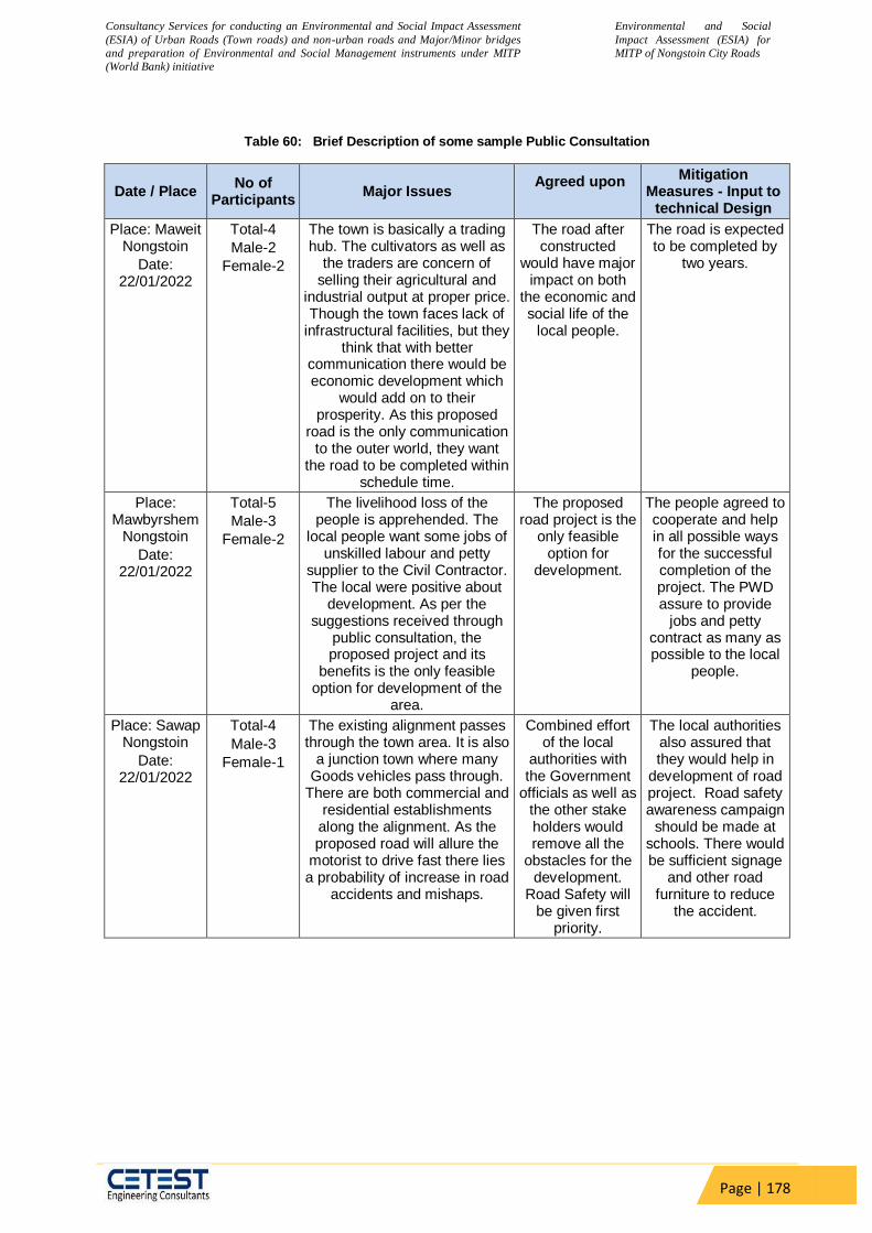
Consultancy Services for conducting an Environmental and Social Impact Assessment
(ESIA) of Urban Roads (Town roads) and non-urban roads and Major/Minor bridges
and preparation of Environmental and Social Management instruments under MITP
(World Bank) initiative
Environmental and Social
Impact Assessment (ESIA) for
MITP of Nongstoin City Roads
Page | 178
Table 60: Brief Description of some sample Public Consultation
Date / Place No of
Participants Major Issues
Agreed upon
Mitigation Measures - Input to
technical Design
Place: Maweit Nongstoin
Date: 22/01/2022
Total-4
Male-2
Female-2
The town is basically a trading hub. The cultivators as well as
the traders are concern of selling their agricultural and
industrial output at proper price. Though the town faces lack of
infrastructural facilities, but they think that with better
communication there would be economic development which
would add on to their prosperity. As this proposed
road is the only communication to the outer world, they want
the road to be completed within schedule time.
The road after constructed
would have major impact on both
the economic and social life of the
local people.
The road is expected to be completed by
two years.
Place: Mawbyrshem
Nongstoin
Date: 22/01/2022
Total-5
Male-3
Female-2
The livelihood loss of the people is apprehended. The
local people want some jobs of unskilled labour and petty
supplier to the Civil Contractor. The local were positive about
development. As per the suggestions received through
public consultation, the proposed project and its
benefits is the only feasible option for development of the
area.
The proposed road project is the
only feasible option for
development.
The people agreed to cooperate and help in all possible ways for the successful completion of the project. The PWD assure to provide
jobs and petty contract as many as possible to the local
people.
Place: Sawap Nongstoin
Date: 22/01/2022
Total-4
Male-3
Female-1
The existing alignment passes through the town area. It is also
a junction town where many Goods vehicles pass through.
There are both commercial and residential establishments
along the alignment. As the proposed road will allure the
motorist to drive fast there lies a probability of increase in road
accidents and mishaps.
Combined effort of the local
authorities with the Government
officials as well as the other stake holders would remove all the
obstacles for the development.
Road Safety will be given first
priority.
The local authorities also assured that they would help in
development of road project. Road safety awareness campaign
should be made at schools. There would be sufficient signage
and other road furniture to reduce
the accident.

Consultancy Services for conducting an Environmental and Social Impact Assessment
(ESIA) of Urban Roads (Town roads) and non-urban roads and Major/Minor bridges
and preparation of Environmental and Social Management instruments under MITP
(World Bank) initiative
Environmental and Social
Impact Assessment (ESIA) for
MITP of Nongstoin City Roads
Page | 179
Date / Place No of
Participants Major Issues
Agreed upon
Mitigation Measures - Input to
technical Design
Place: Pyndengrei
Road
Date: 22/01/2022
Total-6
Male-4
Female-2
A detailed public consultation was organized with the
potential project affected persons, people’s
representatives, shopkeepers, businessmen, and others
regarding the project benefits and vis-à-vis estimated loss. The most important topic of
discussion was the alignment which passes through the two-market complex, which will be
temporarily affected during upgradation of road. .
The local people had agreed in the
view of the proposed road
project which will bring some hope to the movement
of the heavy vehicles and
development of the area.
The PWD officials had agreed to take
special care for traffic movement and road
safety.
In addition to the above specific public consultations and FGDs the peoples were also consulted. In the villages the impact of social and economic are more. In all the villages the access to the market would increase and based on this the valuation of land and properties would also increase.
Table 61: Pictures of Consultations and Project Site
Special attention is needed on the road crossings/intersections and sharp turns to avoid traffic snarls and accidents. Proper traffic signals and signboards should be present at strategic points not only for the sake of motorists but also for the pedestrians. Dated: 22/01/2021. .
Improper/illegal parking not only causes hindrance to the smooth flow of traffic but also increases the probability of road accident. Therefore, the local people demanded for a separate parking bay especially in congested areas. Dated: 22/01/2021.

Consultancy Services for conducting an Environmental and Social Impact Assessment
(ESIA) of Urban Roads (Town roads) and non-urban roads and Major/Minor bridges
and preparation of Environmental and Social Management instruments under MITP
(World Bank) initiative
Environmental and Social
Impact Assessment (ESIA) for
MITP of Nongstoin City Roads
Page | 180
Existing condition of the present road which needs immediate upgradation/restoration not only to allow smooth flow of traffic but also to minimize the count of road accident. Moreover, the affected stretches of road turn into nightmare during monsoon. Dated: 22/01/2021. .
Public Consultation in progress.. Dated: 22/01/2021.
Mobile vendors have been identified on different places on the project road that need to be vacated to allow pedestrians using the footpath. Date: 22/01/2021.
Dumping area should be identified. Dated: 22/01/2021. .

Consultancy Services for conducting an Environmental and Social Impact Assessment
(ESIA) of Urban Roads (Town roads) and non-urban roads and Major/Minor bridges
and preparation of Environmental and Social Management instruments under MITP
(World Bank) initiative
Environmental and Social
Impact Assessment (ESIA) for
MITP of Nongstoin City Roads
Page | 181
9.1 Outcome of the Consultations
People were aware about the improvements proposed for the project road but were not aware about specific details of the PRoW, shift in centreline and the method of valuation for land and building, payment of compensation and other rehabilitation and resettlement measures. A detailed public consultation was organized with the potential project displaced persons, people’s representatives, shopkeepers, businessmen, and others regarding the project benefits and vis-à-vis estimated loss. The main point of discussions were minor realignments to save certain structures, compensation and assistance, road safety etc. It has been observed that the benefits of the proposed project area acknowledged by the local people but they want the Executing Agency, to take care of the implementation of the project to bring about promised benefits with proper safety measures. The information and recommendations gathered from the various stakeholder consultations has been incorporated into the design of the project to ensure that the investments align with local priorities and development plans, and that they will deliver equitable socio-economic benefits to the intended project beneficiaries. The salient points of the consultations are summarised in the following table below
Table 62 Summary of Consultation Outcome
Issues Discussed Outcome
Relocation Options Compensations/Assistance
Displaced Persons whose residential structures are getting affected
prefer not to get disturbed and if disturbance is not avoidable then they
shall be relocated very nearby. Shop owners and workers raised the
issue of loss of their livelihood during the resettlement period due to loss
of business.
During consultation they were convinced that there will be no permanent
impact but temporary impact during the active construction period. There
will be economic displacement of petty shop owners and vendors, all
non-title holders who will be compensated and/or provided assistance as
per the ESMF guidelines.
What are all the facilities provided through this project and to whom should we approach?
Facilities like bus shelters, rest rooms, pavements, drains etc would be
provided. Officers such as PWRD Engineers could be approached for
grievances.
Safety due to alignment People expressed their views on the risk if the road is widened at the
dense settlement area affecting structures on both sides. The proposed
project does not envisage any widening of the existing roads. Thus,
there will be no damage to any structures beyond the existing RoW.
About 42 families all non-title holders doing business with the existing
RoW will be impacted.
During consultation they were convinced that there will be no permanent
impact but temporary impact during the active construction period.
Could you inform us the time when our assets be removed?
Would be informed well in advance and compensation will be paid
before vacating assets, if required.
Relocation of school buildings Relocation of Bus shelter/CPR
The boundary wall of one school will be impacted which will be
compensated. There were differences in opinions among the villagers in
demolishing/ shifting the Bus shelter. It was agreed that bus shelter has
been proposed in the DPR.
Cross Drainage for alignment
People have shown their concern for the proposed drainage pattern for
the alignment of a portion of the project road. In this regard the lined
rectangular drains with proper outfall shall be planned as a part of the
project design of the main carriageway. Adequate cross drainage
structures are planned after study of hydrology of the Survey area.

Consultancy Services for conducting an Environmental and Social Impact Assessment
(ESIA) of Urban Roads (Town roads) and non-urban roads and Major/Minor bridges
and preparation of Environmental and Social Management instruments under MITP
(World Bank) initiative
Environmental and Social
Impact Assessment (ESIA) for
MITP of Nongstoin City Roads
Page | 182
Issues Discussed Outcome
Utilities and basic infrastructures
People showed their concern about what will happen with the utility lines
if the road is widened. Adequate care shall be taken for the shifting of
the utilities.
Employment during construction
People were of demand if the local people are given preference for
employment during the construction phase of the project. Such options
shall be explored to the extent possible and mostly the unskilled worked
can be hired from nearby locality.
Why structures at places along the road were not measured?
If and only the structure to be impacted, measurements are required.
Otherwise, there is no requirements of measurements of structures.
What about the loss of livelihood during active phase of construction?
The active phase of construction is planned in such a way that there will
be minimum (temporary) loss of access and/or livelihood. If there is any
inconvenience of access, loss or damage of structures of any immovable
assets the Civil Contractor will provide necessary access and
compensation of the same will be provided as per the ESMF in
discussion with the affected party.
Add about parking space
Table 63 :Consultation Conducted on Proposed Road 2nd Phase
Sl. Location Date Participants Male Female
1 Sibsing Memorial School 28.01.20222 2 2 0
9.2 Minutes of meeting with the DPR consultant
A meeting via video conference was held between ESIA Consultant and the DPR Consultant for discussion on Environmental and Social Impact Assesment on Nongstoin Town Roads.
Location: Office of CETEST Pvt. Ltd, Kolkata and CEG Tower, Jaipur vide Video Conference Mode
Date: 21.01.2022
Time: 4.00 pm
Attendees: Mr. Sukesh Gupta, Team Leader, CEG Ltd. My. Shyam Sundar Khandelway, Asso. Director, CEG Ltd.
Mr. Anirban Nayak, Road Safety Specialist, CE Testing Mr. Supriya Deb, Highway Expert, CE Testing
Mr. Swarnava Bandhopadhyay, Environmental Specialist, CE Testing Mr. Suman Sarkar, Social Specialist, CE Testing
The proposals mentioned in Draft Project Report for Nongstoin town Roads and their possible
Environmental and social effects were discussed along with probable remedies. Following
points were discussed in detail.
Table 64 :Minutes of the meeting of ESIA and DPR consultant
Sl. Topic Details of Discussion Decision
1 Land Acquisition
The ESIA consultants requested for the details of Land Acquisition being done on the project stretch. DPR Consultant informed that, no land is being acquired for this project stretch and the road is being designed to fit within available ROW as advised by the Client. All proposed structures are well
DPR Consultant has assured that there is no proposal for Land Acquisition.
Consultancy Services for conducting an Environmental and Social Impact Assessment
(ESIA) of Urban Roads (Town roads) and non-urban roads and Major/Minor bridges
and preparation of Environmental and Social Management instruments under MITP
(World Bank) initiative
Environmental and Social
Impact Assessment (ESIA) for
MITP of Nongstoin City Roads
Page | 183
Sl. Topic Details of Discussion Decision
within the existing RoW and thus no LA is required for this project.
2 Demand for all weather road
ESIA consultants wanted to know the condition of existing road and improvements planned in the design. DPR Consultant deliberated that the existing pavement condition along the road is poor. In some portions of the stretch, the existing pavement is damaged with cracks, raveling, rutting edge breaking and potholes and in some stretches it is observed that the existing bituminous layer is fully damaged and exposed. The overall pavement condition needs to be improvised.
DPR Consultants clarified that pavement is being designed in compliance with IRC codal provisions along with climate resilient technology.
3 Road safety ESIA Consultants asked about the convex mirror to be installed at turning points, sharp corners of the roads at a suitable height as they allow to see invisible but oncoming vehicles. Hence reducing the probability of road accidents. Proper signage and road furniture are to be integral part of the design.
The DPR consultants clarified that all the required safety measures including Rumble strips, Sign boards, Chevron boards, Road studs, Convex mirrors etc are being provided as per codal provisions so as to make the road safe to drive.
4 Road safety at Night
ESIA Consultants recommended for street lighting. Provision of street lighting is absolutely necessary as it not only act as a prevention of accidents but also an important source of public security intended to reduce crime. Studies have shown that darkness results in a large number of crashes and fatalities, especially those involving pedestrians; pedestrian fatalities are 3 to 6.75 times more likely in the dark than in daylight. Several decades ago, when automobile crashes were far more common, street lighting was found to reduce pedestrian crashes by approximately 50%. Road Furniture and Road Signage are to be introduced at all proper and suitable places.
DPR Consultants clarified that street lightings are proposed at built – up areas and other safety measures viz. Chevron sign boards, Road studs are proposed as safety measures at night.
5 Storm Water Drain
The Local People demanded storm water drain as much as possible throughout the alignment. At congested area it should also have cover and use as footpath.
DPR Consultants clarified that storm water drains are provided at all required locations. Trapezoidal drains are proposed at hill side locations. At built up areas cover drain cum footpath are already proposed considering the requirement of pedestrians.
6 Bus Shelter and/or Rain Shed
Bus Shelter and/or Rain Shed should be proposed at regular intervals.
Bus shelters are proposed in the DPR at all built up locations where people are expected to use public transport.
7 Other facilities
There should be speed breakers in front of school, church and market place
Boundary wall are proposed to completely segregate the school from traffic. Road humps/Rumble strips are proposed at cross roads of all junction. Hence safety
Consultancy Services for conducting an Environmental and Social Impact Assessment
(ESIA) of Urban Roads (Town roads) and non-urban roads and Major/Minor bridges
and preparation of Environmental and Social Management instruments under MITP
(World Bank) initiative
Environmental and Social
Impact Assessment (ESIA) for
MITP of Nongstoin City Roads
Page | 184
Sl. Topic Details of Discussion Decision
is given prime consideration in the proposal.
8 Utility Corridor
There should be utility corridor at underground near the congested place
Utility corridor will be provided as per actual requirement.
9 Public Transport
There are very few public transports in the total alignment. The frequency of public transport should increase.
The matter belongs to Govt. of Meghalaya and ESIA consultants can recommend to increase public transport for betterment of people.
10 Bridges Are there any new bridges proposed in the alignment for not to disturb the natural flow of water?
Two minor bridges have been proposed for reconstruction. All natural streams have been provided with cross drainage structures viz. minor bridges and culverts. All culverts which are in distressed condition will be replaced
11 Trees Are there any trees proposed in the alignment?
No trees will be cut
The project has immense acceptability among the local people. They perceive that in addition to providing all-weather connectivity, the subproject road will bring positive socioeconomic changes in the area. Local people mainly discussed the issues related to flooding, rehabilitation, resettlement, and road safety issues. The Details of Participants and Public Consultation photographs are attached in Annexure 2.
Table 65 :Details of Public Consultation at Sibsing Memorial School on 2nd Phase
Date Issues Discussed Response Participant
28.01.2022 During school hours, presence of
children are seen, thus must plan the work schedule avoiding the entry and exit timing of the students.
The road must be diverted from the place into the side as the school is planning to prepare the playground which is present in the side of the existing road which is again in the school’s property.
Maximum students are coming from the Maweit area which takes a lot of time for the children. Thus, this road development will absolutely benefit the students of the school.
Noise must be monitored during school hours so that disturbance in class can be avoided
It was assured that the construction work will be stopped during the school hours.
The Contractor will be persuaded to induct the local people as per their skills.
Total = 2
Male = 2
Female = 0

Consultancy Services for conducting an Environmental and Social Impact Assessment
(ESIA) of Urban Roads (Town roads) and non-urban roads and Major/Minor bridges
and preparation of Environmental and Social Management instruments under MITP
(World Bank) initiative
Environmental and Social
Impact Assessment (ESIA) for
MITP of Nongstoin City Roads
Page | 185
Table 66 :Details of Public Consultation at DFO, Nongstoin
Date Issues Discussed Response Participant
28.01.2022 A joint survey is required to
identify the way of the road during planning phase. During the implementation phase it is to be identified what trees are required to be felled under the forest sector area are to be surveyed and then finalized.
For involving the forest officers, Project award with alignment along with KML file must be submitted to the DFO office from PWD department for receiving the clearance.
No wildlife sanctuary is present in the area as the forests are mainly community forest and managed and maintained by local villagers.
No forest is involved in the Town roads modification, only in the Nongstoin- Maweit road there are some forests but all are of private in nature.
According to the meeting there are around 250 trees having DGH of around 15cm in where continuous 4 hectres are forest.
There are no recorded forest found in the Nongstoin-Maweit road according to the last census available.
As of wildlife availability, need to talk with Khasi hills Wildlife division, Social and Territorial section for more updates.
A framework has to be develop to address this issues.
Alignment of the project road along with KML file will be submitted to DFO Office.
Afforestation activity will be done along the project road as per the ratio of 1:10.
1
Consultancy Services for conducting an Environmental and Social Impact Assessment
(ESIA) of Urban Roads (Town roads) and non-urban roads and Major/Minor bridges
and preparation of Environmental and Social Management instruments under MITP
(World Bank) initiative
Environmental and Social
Impact Assessment (ESIA) for
MITP of Nongstoin City Roads
Page | 186
10 RESETTLEMENT ACTION PLAN
The Resettlement Policy Framework (RPF) provides a guide the preparation of the
Resettlement and Rehabilitation Action Plan (R&R Action Plan) depending upon the scale and
severity of impacts that may arise, temporary or permanent land acquisition or resettlement and
rehabilitation is inevitable. Thus, the objective of the RPF is to ensure that the Project Affected
Personsssit (PAPs) get compensation for their loss, are offered resettlement measures, and
are supported in improving or at least restoring their levels of living and income after the project
impact to pre-project levels. The RPF is intended to safeguard the interests of the population
impacted by the project, especially the poor and vulnerable. The RPF is based on applicable
Policies of GoI, State government (herein Govt. of Meghalaya) and the World Bank.
As there is no scope of land acquisition and the RoW is free from all encroachments and
encumbrances in the project area. As per the guidelines of World Bank there will be only ESIA
. No Resettlement Plan or Abbreviated Resettlement Plan is envisaged at this stage.
Consultancy Services for conducting an Environmental and Social Impact Assessment
(ESIA) of Urban Roads (Town roads) and non-urban roads and Major/Minor bridges
and preparation of Environmental and Social Management instruments under MITP
(World Bank) initiative
Environmental and Social
Impact Assessment (ESIA) for
MITP of Nongstoin City Roads
Page | 187
11 CHAPTER-XI: Tribal People’s Development Plan
The Tribal People in India are categorized as indigenous community who often become
vulnerable in development projects because of their cultural autonomy, economic status, and
enduring specific disadvantages in terms of social indicators of quality of life, thus usually as
subject of social exclusion. Because tribal communities live within varying and changing
historical, cultural, political and economic contexts, no precise and coherent term has been
found to define them. Under OP 4.10, the determination as to whether a group is to be defined
as indigenous peoples is made by reference to the presence (in varying degrees) of four
identifying characteristics:
Self-identification as members of a distinct indigenous cultural group and recognition of
this identity by others;
Collective attachment to geographically distinct habitats or ancestral territories in the
project area and to the natural resources in these habitats and territories
Customary cultural, economic, social, or political institutions that are separate from
those of the dominant society and culture; and
An indigenous language, often different from the official language of the country or
region.
There is no impact on the community structure or community land of cultural or religious
sentiment of the ST Population in the Primary PIA. The proposed project will ensure that STs
receive culturally appropriate social and economic benefits, do not suffer adverse impacts as a
result of projects, and can participate actively in projects that affect them. There is no cultural
heritage site of the ST which comes in the way of the road alignment. The ST population
among the Surveyed Families in the PIA are living in the towns and in the due course of time
became the part of the main stream population. Presently the impacted ST population does not
follow any customs that are attached to their land or natural habitat which will be impacted.
Thus, there will be no cultural or social impact on the ST population

Consultancy Services for conducting an Environmental and Social Impact Assessment
(ESIA) of Urban Roads (Town roads) and non-urban roads and Major/Minor bridges
and preparation of Environmental and Social Management instruments under MITP
(World Bank) initiative
Environmental and Social
Impact Assessment (ESIA) for
MITP of Nongstoin City Roads
Page | 188
12 CHAPTER-XII: Gender Action Plan
In terms of gender the specific anticipated outcomes for women in the project areas include: (a)
access to self-help women group to develop and preserve bioengineering solutions and post
construction road maintenance; and (b) employment within SMEs, production clusters, and
road-side commercial activities. The project is mainstreaming gender by increasing the
participation of women in the workforce and contracting out the preservation of bio-engineering
solutions to women self-help groups. The project will carry out the following Gender actions
MPWD with the local ULBs will ensure that the women PAPs and women SHGs will be
given preferential treatment in allotment of the shops and business space.
MPWD will engage women-led producer groups to build capacity on operations and
maintenance and incentivize private contractors to train and hire women-led groups
(CBOs/SHGs) for maintenance tasks supported across the horticulture belt;
The logistics system and strategy planned to stimulate horticulture growth and other
aesthetic infrastructure for landscaping at the roadside and ULBs will take into
consideration the specific needs of women and involve them for such actions;
Ensure that at least a 33% of women are recruited by the ULBs in their workforce;
Three major tools are used to identify and deal with gender issues in the project cycle: gender
analysis, project design, and policy dialogue. Gender analysis will be an integral part of the
initial social assessment at the screening stage itself. The issues identified can be scaled up
during the feasibility and detailed analysis can be carried out during the project preparation
stage. The project designs will be gender responsive based on gender analysis and will be
included in the SIA report. The findings and recommendations from the gender analysis during
project planning and feedback from beneficiaries during implementation will be discussed
thoroughly to determine the need for further action. Listed below are the key action points:
a Core Requirement for Mainstreaming Gender
1 All data should be disaggregated by gender, caste, ethnicity, location, and age
2 Issues of division of labour, access to resources and decision-making power (who is
doing what, who has access to what, who makes the ultimate decision) have to be
assessed for their gender differential impact on women and men of different social
identity groups.
3 Assessment of policies, programs, institutional arrangements, human resources issues,
and M&E system has to be done from a gender perspective of the project, project
authorities and community groups.
12.1 Monitoring Gender Action Plan
The indicators, frequency, and agency recommended for monitoring are presented in the table below.
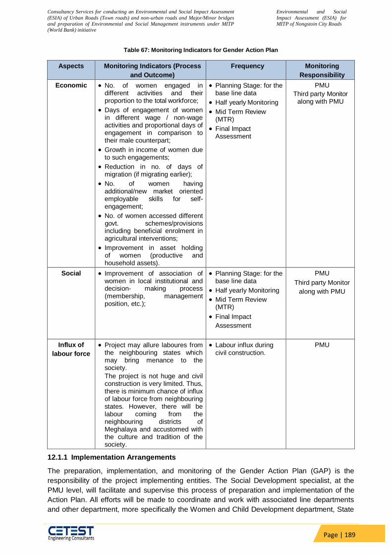
Consultancy Services for conducting an Environmental and Social Impact Assessment
(ESIA) of Urban Roads (Town roads) and non-urban roads and Major/Minor bridges
and preparation of Environmental and Social Management instruments under MITP
(World Bank) initiative
Environmental and Social
Impact Assessment (ESIA) for
MITP of Nongstoin City Roads
Page | 189
Table 67: Monitoring Indicators for Gender Action Plan
Aspects Monitoring Indicators (Process
and Outcome)
Frequency Monitoring
Responsibility
Economic No. of women engaged in different activities and their proportion to the total workforce;
Days of engagement of women in different wage / non-wage activities and proportional days of engagement in comparison to their male counterpart;
Growth in income of women due to such engagements;
Reduction in no. of days of migration (if migrating earlier);
No. of women having additional/new market oriented employable skills for self-engagement;
No. of women accessed different govt. schemes/provisions including beneficial enrolment in agricultural interventions;
Improvement in asset holding of women (productive and household assets).
Planning Stage: for the base line data
Half yearly Monitoring
Mid Term Review (MTR)
Final Impact Assessment
PMU
Third party Monitor along with PMU
Social Improvement of association of women in local institutional and decision- making process (membership, management position, etc.);
Planning Stage: for the base line data
Half yearly Monitoring
Mid Term Review (MTR)
Final Impact
Assessment
PMU
Third party Monitor
along with PMU
Influx of
labour force
Project may allure laboures from the neighbouring states which may bring menance to the society.
The project is not huge and civil construction is very limited. Thus, there is minimum chance of influx of labour force from neighbouring states. However, there will be labour coming from the neighbouring districts of Meghalaya and accustomed with the culture and tradition of the society.
Labour influx during civil construction.
PMU
12.1.1 Implementation Arrangements
The preparation, implementation, and monitoring of the Gender Action Plan (GAP) is the
responsibility of the project implementing entities. The Social Development specialist, at the
PMU level, will facilitate and supervise this process of preparation and implementation of the
Action Plan. All efforts will be made to coordinate and work with associated line departments
and other department, more specifically the Women and Child Development department, State
Consultancy Services for conducting an Environmental and Social Impact Assessment
(ESIA) of Urban Roads (Town roads) and non-urban roads and Major/Minor bridges
and preparation of Environmental and Social Management instruments under MITP
(World Bank) initiative
Environmental and Social
Impact Assessment (ESIA) for
MITP of Nongstoin City Roads
Page | 190
Livelihood Mission, Panchayati Raj, and Rural Development department to help dovetailing with
their development programs for the socio-economic development of women.
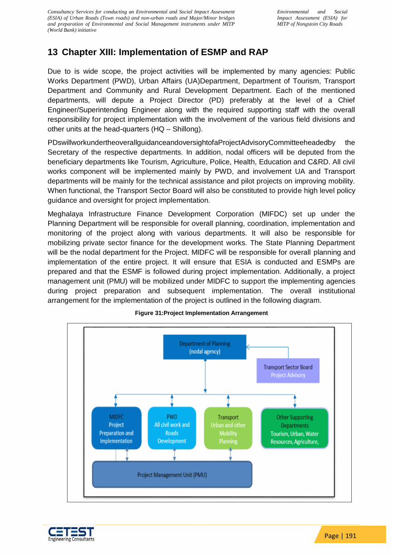
Consultancy Services for conducting an Environmental and Social Impact Assessment
(ESIA) of Urban Roads (Town roads) and non-urban roads and Major/Minor bridges
and preparation of Environmental and Social Management instruments under MITP
(World Bank) initiative
Environmental and Social
Impact Assessment (ESIA) for
MITP of Nongstoin City Roads
Page | 191
13 Chapter XIII: Implementation of ESMP and RAP
Due to is wide scope, the project activities will be implemented by many agencies: Public
Works Department (PWD), Urban Affairs (UA)Department, Department of Tourism, Transport
Department and Community and Rural Development Department. Each of the mentioned
departments, will depute a Project Director (PD) preferably at the level of a Chief
Engineer/Superintending Engineer along with the required supporting staff with the overall
responsibility for project implementation with the involvement of the various field divisions and
other units at the head-quarters (HQ – Shillong).
PDswillworkundertheoverallguidanceandoversightofaProjectAdvisoryCommitteeheadedby the
Secretary of the respective departments. In addition, nodal officers will be deputed from the
beneficiary departments like Tourism, Agriculture, Police, Health, Education and C&RD. All civil
works component will be implemented mainly by PWD, and involvement UA and Transport
departments will be mainly for the technical assistance and pilot projects on improving mobility.
When functional, the Transport Sector Board will also be constituted to provide high level policy
guidance and oversight for project implementation.
Meghalaya Infrastructure Finance Development Corporation (MIFDC) set up under the
Planning Department will be responsible for overall planning, coordination, implementation and
monitoring of the project along with various departments. It will also be responsible for
mobilizing private sector finance for the development works. The State Planning Department
will be the nodal department for the Project. MIDFC will be responsible for overall planning and
implementation of the entire project. It will ensure that ESIA is conducted and ESMPs are
prepared and that the ESMF is followed during project implementation. Additionally, a project
management unit (PMU) will be mobilized under MIDFC to support the implementing agencies
during project preparation and subsequent implementation. The overall institutional
arrangement for the implementation of the project is outlined in the following diagram.
Figure 31:Project Implementation Arrangement
Project Preparation and
Consultancy Services for conducting an Environmental and Social Impact Assessment
(ESIA) of Urban Roads (Town roads) and non-urban roads and Major/Minor bridges
and preparation of Environmental and Social Management instruments under MITP
(World Bank) initiative
Environmental and Social
Impact Assessment (ESIA) for
MITP of Nongstoin City Roads
Page | 192
13.1.1 Project Management Unit (PMU)
The Project Management Unit (PMU) will engage a consulting firm, as Project Management Consultant (PMC) for providing technical support to the project and facilitate implementation of project framed activities. The experts of the PMC will assist MIDFC in preparing and updating ESIA (including E&SMPs). The PMC will also assist MIDFC in preparing semi-annual safe guards monitoring reports. Specific roles of the PMC with regard to ESMF implementation would include the followings.
13.1.1.1 Preparatory Stage:
Initial field visit to project sites and assessment of environmental and social aspects of
project activities;
Discussion with different stakeholders, including implementing agencies on safeguard
measures and their expected role;
Preparing / finalizing assessment framework in line with the Environment and Social
indicators;
Finalizing TOR of the contractors incorporating safeguard measures to be taken;
Facilitate / organize training / workshops on safeguard measures for the stakeholders;
Designing study / assessment tools for periodic assessment, its piloting and finalization.
13.1.1.2 Implementation Stage:
Conductingperiodicsitevisitsandobservethemeasurestakenasperthesafeguardnorms;
On the spot guidance to contractor/s / implementing agencies on safeguards;
Preparation of site-specific reports and sharing with MIDFC;
Documentation of learning cases for sharing and dissemination;
Visual documentation of site-specific safeguard measures;
Tracking activity specific environmental and social monitoring indicators;
Organizing / facilitating refresher training courses for stakeholders;
Monthly and quarterly progress report preparation and submission to MIDFC.
13.1.1.3 Post-Implementation Stage:
Consolidation of periodic monitoring reports;
Support in conducting environment and social audit;
Consolidation of good practice documents and its submission to MIDFC;
Final sharing workshop on environment and social safeguard practices and its outcome.
13.1.1.4 The PMU shall have following experts for implementation of ESMF and
E&SMPs: Social cum Gender Expert
The Social cum Gender Expert at the PMU level will guide the overall process related to social
and gender aspects. The district/sub-district level implementing agencies will execute and
monitor the social / gender components in consultation with the said Expert. She / he will be
associated in the screening process of such activities that require acquisition of land and/or
involvement of women and/or need special focus on tribal involvement. She/he will monitor the
social processes followed in execution of the planned activities and realisation of the social /
gender inclusion parameters. She / he will be looking after social / gender aspects of the
project, including monitoring of social / gender indicators and coordinating with different
Consultancy Services for conducting an Environmental and Social Impact Assessment
(ESIA) of Urban Roads (Town roads) and non-urban roads and Major/Minor bridges
and preparation of Environmental and Social Management instruments under MITP
(World Bank) initiative
Environmental and Social
Impact Assessment (ESIA) for
MITP of Nongstoin City Roads
Page | 193
agencies / institutions. The expert will be guided by the Project Director from MIDFC and
reporting to the Project Director directly.
13.1.1.5 Environmental Expert
Theenvironmentexpertwilllookafterenvironmentalaspects.She/hewillguidetheprojectteam
onenvironmentalaspectsandsupportinbuildingenvironmentalparameterstobebuiltinthebids. She /
he will also guide the contracts and monitor their works from time to time. In case of
requirement, she/he will prepare a detail environment management plan for different activities
to be executed by the project. The expert will be guided by the MIDFC Project Director and
reporting to the Project Director directly.
Capacity Building Strategy
The concerned officials within the project implementation agencies will be oriented on different social and environment aspects by which they will be equipped well to manage the related issues effectively and efficiently.
Institutional Capacity to Manage Social Development Aspects
13.1.1.6 Autonomous District Councils
As mentioned earlier, ADCs were established under the Sixth Schedule of the Constitution of
India (Articles 244(2) and 275(1)) with a view to preserve and protect tribal institutions. It is a
system of local administration to give greater autonomy to tribal societies, to preserve and
safeguard tribal groups’ traditional practice and to act as a conduit between the formal state
government and the informal grassroots tribal institutions.
The Project lies within the Khasi Hills Autonomous District Councils. The ADC with the village councils or looks after the administration of the Council areas.
13.1.1.7 Grassroots Institutions
The third centre of authority is the grassroots tribal institutions and practices. In the Khasi and
Jaintia Hills, these are powers that rest at the village level’s elected members to govern the
village.
Grievance Redressal Committee (GRC)
Grievance Redress Mechanism
Effective grievance redressal mechanism gives an opportunity to the organization to implement a set of specific measures to ensure good governance accountability and transparency in managing and mitigation of environmental and social issue of a particular project. This consists of defining the process for recording/receiving complaints and their redressal in respect of environmental and social matters. An integrated system will be established with Grievance Redressal Cell (GRCs), with necessary officers, officials and systems at MIDFC. Grievances, if any, may be submitted through various mediums, including in person, in written form to a noted address, e-mail, or through direct calls to concerned official/s. The Social and Environmental Expert within PMU shall be responsible for coordination of grievance/complaints received. The grievance redress mechanism should be in place at the time of initiating the implementation of ARAP & RAP and civil construction activities in the project area. A platform for grievance redressal should be organized and its regular meetings may be conducted so as to allow people to put forth their grievances. It will help the appropriate authority to find solutions and amicably address the issues. The project, apart from web-based mechanism, will have three-tire

Consultancy Services for conducting an Environmental and Social Impact Assessment
(ESIA) of Urban Roads (Town roads) and non-urban roads and Major/Minor bridges
and preparation of Environmental and Social Management instruments under MITP
(World Bank) initiative
Environmental and Social
Impact Assessment (ESIA) for
MITP of Nongstoin City Roads
Page | 194
grievance redressal mechanism, i.e., (1) at the project site level, (2) State level (PMU level) and (3) Judiciary level. Web based grievance mechanism11: In case of grievances received through toll free number
or web-based system, a person should be made in-charge of screening and resolution of the same/communicating with the concerned divisions for resolution of the same. The person in-charge based on nature of complaint, should forward the same to the concerned official. A ticket or a unique number will be generated for all such complaints. The complainant should follow up based on that unique number. All calls and messages should be responded within 15 days. If response is not received within 15 days, the complaint should be escalated to the Project Director. Tier I: Under this project, the local VECs and community level organizations will serve as the first- tier mechanism to handle complaints and grievances. The local Headman will be the focal point who will receive, address, and keep record of the complaints and feedbacks. The grievance focal point will first review the grievances submitted. If grievances or disputes cannot be solved at the VEC’s level within 30 days of the submission of the grievances, the issue will be brought to PMU level for mediation. PMU is expected to inform aggrieved persons or parties to disputes of the resolution in 30 days. Tier II: If the aggrieved person is not satisfied with the verdict of site level grievance cell, he or she can escalate the grievance to state level grievance cell. The tier II cell will be under the Chairmanship of Secretary, Department of Planning. The other members will include Chief Engineer; Project Director and Social Expert of the Project. The second level of grievance cell will provide its view within 30 days of receiving the grievance. Tier III: The aggrieved person if not satisfied with the verdict given by State level grievance cell,
will have the right to approach the Judiciary. Project will help the aggrieved person in all respect if person wants to approach the judiciary. This would include the District Commissioner and Legal courts. If the issue cannot be addressed or is outside the purview of the GRC, then it may be taken by the Office of the District Commissioner or a Legal Court.
Grievance management through Electronic Mode
A simplified mobile based technology feedback system can be used at community level to capture and feed data into the Management Information System of the PMU. A toll-free Helpline number will also be established to make the mechanism widely accessible and gender friendly.
Grievance Redressal Mechanism
There Grievance Redressal Committee (GRC) at the PMU level is in process of formation. Consultation for the formation of GRC for this project at city/ward level is currently being undertaken. Before the start of civil contractor appointment, the GRC at project level will be formed with consultation with the PAPs and Beneficiaries so that the grievances are resolved at the project site only. There should be a Women Cell at the PMU. The contractor and the other stakeholder’s office will display the Vishaka Guidelines at their Notice board. The Women helpline Number should be displayed in the Bus Stand, Ticket Counter, all commercial vehicles and any other place as required.
Table 68 Details of contact for Grievances
Description Contact details
Company: PWD, Meghalaya
To: Chief Engineer-cum-Project Director
Address: HV9P+GFJ, Lachumiere, Shillong, Meghalaya 793001
E-mail: [email protected]
Website: http://megpwd.gov.in/contacts.html
Telephone: Tel: 0364-2224561
Fax: -
Consultancy Services for conducting an Environmental and Social Impact Assessment
(ESIA) of Urban Roads (Town roads) and non-urban roads and Major/Minor bridges
and preparation of Environmental and Social Management instruments under MITP
(World Bank) initiative
Environmental and Social
Impact Assessment (ESIA) for
MITP of Nongstoin City Roads
Page | 195
Disclosure of Project Information
In order to make the ARAP implementation process transparent, salient features of ARAP shall
be translated in Hindi and disclosed on the Project Authority’s website. The documents
available in the public domain will include ARAP (summary in Hindi) and the list of affected
persons eligible for compensation and R&R assistance. Copy of all documents will be kept in
PMU for ready reference. As per Access to Information Policy of the World Bank, all safeguard
documents will also be disclosed and available at the World Bank’s Portal.

Consultancy Services for conducting an Environmental and Social Impact Assessment
(ESIA) of Urban Roads (Town roads) and non-urban roads and Major/Minor bridges
and preparation of Environmental and Social Management instruments under MITP
(World Bank) initiative
Environmental and Social
Impact Assessment (ESIA) for
MITP of Nongstoin City Roads
Page | 196
14 CHAPTER-XIV: MONITORING & EVALUATION
The M&E framework of ESMF is designed to assess the progress and achievements against
the said management plans – both Environment and Social as well as other plans such as
R&R, TPP, and GAP. By providing a feedback loop, the M&E plans enable decision makers to
take up mid-course corrections if required. The M&E framework is designed to measure the
impacts that have taken place, ensure compliance with the legal obligations, evaluate the
performance of the mitigation measures applied, and suggest improvements in management
plans, if so required.
The M&E is to be undertaken at two levels:
Monitoring and Evaluation of the ESMF application: i.e. the application and
effectiveness of ESMF elements including screening, assessment, formulation and
implementation of the ESMPs, monitoring, capacity building and institutional
arrangements; and
Monitoring and Evaluation of E&S management plans at each project site: i.e. to
monitor the effectiveness of implementation of the identified mitigation measures, the
environmental quality parameters and social management plans relevant to each
project activity.
14.1 M&E of the ESMP application
The PMU’s Social cum Gender Expert and Environment Expert will undertake ongoing
monitoring of the ESMP implementation in order to identify issues, good practices and required
actions. Reports based on the monitoring will be prepared by the PMU at least every quarter
and submitted to the Project Director. The reports will be shared with the other implementing
agencies. The monitoring of the ESMP implementation will cover the following aspects:
Screening of project activities:
Has the categorization of the project activities been done accurately and or changed
(A to B)?
Has the Environmental and Social Screening Checklist been used in all applicable activities?
Has the scoping for further assessment been done comprehensively for all
applicable activities?
Monitoring of E&S aspects in project activities:
Are the contractors and implementing agencies undertaking periodic and regular
monitoring of the E&S implementation in the project activities?
Capacity building arrangements for management of E&S aspects:
What training programs on E&S aspects have been organized for the staff of
implement agencies?
What training programs on E&S aspects have been organized for the contractors?
14.2 M&E of E&S Management Plans
Monitoring and evaluation of the project is significant for achieving the project development objective (PDO) within the stipulated time period. The key environmental and social aspects, those that have been highlighted in each E&SMPs at site level are to be monitored periodically. The approved E&SMPs will give the direction and indicate the milestones achieved as per the
Consultancy Services for conducting an Environmental and Social Impact Assessment
(ESIA) of Urban Roads (Town roads) and non-urban roads and Major/Minor bridges
and preparation of Environmental and Social Management instruments under MITP
(World Bank) initiative
Environmental and Social
Impact Assessment (ESIA) for
MITP of Nongstoin City Roads
Page | 197
national / state benchmarks / norms. The following specific environmental and social parameters should be quantitatively and qualitatively measured and compared over a period of time to understand the impacts. The PMU through the respective district level offices of PWD will monitor all projects roads to ensure conformity to the requirements of the ESMF. The monitoring will cover all stages of planning and implementation. The monitoring will be carried out through the safeguard compliance reports that will form a part of Quarterly Progress Reports (QPR) for all sub projects and regular visits by the Social cum Gender and Environmental specialists of the PMU.
14.3 Concurrent Monitoring
The PMU’s Social cum Gender Expert and Environment Expert will undertake ongoing monitoring of the ESMF implementation in order to identify issues, good practices and required actions. Reports based on the monitoring will be prepared by the PMU at least every quarter and submitted to the Project Director. The reports will be shared with the other implementing agencies. The PMU will review these reports and identify technical, managerial, policy or regulatory issues with regards to the ESMF compliance. The identified technical issues will be duly incorporated. Policy and regulatory issues will be debated internally by PMU and the need for appropriate interventions will be determined. These interventions could include appropriate revision of ESMF in consultation with the Bank or suitable analytical studies to influence policy or programs of the state, if found necessary / warranted. The table below provides the milestones and process to be followed for monitoring at different stages of project:
14.4 Periodic Evaluation
An external evaluation of the safegurad implementation prepared for sub projects will also be undertaken twice during the implementation of the project – midterm and at the end of the implementation. During implementation, meetings will be organized by PMU inviting all PIUs for providing information on the progress of the project work. Mid-term Assessment Study – this would be undertaken mid-way through the project to
ascertain the progress achieved and any mid-course corrections which need to be introduced. It would include indicators to measure progress towards log frame goals and objectives. End-Term Assessment Study – this will be undertaken at the end of the project period
(around the time of project completion) and will assess the achievement of the project during
the tenure.
14.5 Arrangements for Monitoring
Monitoring is an integral part of successful implementation of the ARAP activities. Internal monitoring will be carried out by the Social Development Expert, PMU and/or the ULB under the supervision of Project Director/Chairman of ULB. Data collected for monitoring activities shall be suitably analysed for project management’s learning and experience. Key progress indicators (indicative) for monitoring ARAP implementation are as given below:
disbursement of compensation and assistance to PAPs, if any
establishment of grievance redressal mechanism (including processes and timeline for
redressal of grievances),
consultation meetings with PAPs and communities regarding resettlement and
rehabilitation issues,
MIDFC website will include a link where affected person(s) can register their complaints
online. A telephone number will also be on the website of MIDFC and the project sites,
so that the general public can register their complaint with the PMU office.
income restoration of affected persons,
training of the interested PAPs

Consultancy Services for conducting an Environmental and Social Impact Assessment
(ESIA) of Urban Roads (Town roads) and non-urban roads and Major/Minor bridges
and preparation of Environmental and Social Management instruments under MITP
(World Bank) initiative
Environmental and Social
Impact Assessment (ESIA) for
MITP of Nongstoin City Roads
Page | 198
grievance handling mechanism
Project monitoring will be the responsibility of the PMU who will submit Quarterly Progress Reports. The reports will compare the progress of the project to targets set up at the commencement of the project. The list of impact performance indicators will be used to monitor project objectives. The socio-economic survey conducted will provide the benchmarks for comparison

Consultancy Services for conducting an Environmental and Social Impact Assessment
(ESIA) of Urban Roads (Town roads) and non-urban roads and Major/Minor bridges
and preparation of Environmental and Social Management instruments under MITP
(World Bank) initiative
Environmental and Social
Impact Assessment (ESIA) for
MITP of Nongstoin City Roads
Page | 199
15 CHAPTER-XV: ENVIRONMENT AND SOCIAL MANAGEMENT PLAN
The environmental and social management measures shall be implemented during the various
stages of the project viz: Pre-construction Stage, Construction Stage and Operational Stage.
The environmental and social management plan for the project is described below.
15.1 Objectives of EMP
The Environmental Management Plan (EMP) consists of a set of mitigation, monitoring and
institutional measures to be taken during the design, construction and operational phases of the
project to eliminate adverse environmental impacts, to offset them, or to reduce them to
acceptable levels. The main aim of the Environmental Management Plan is to ensure that the
various adverse impacts are mitigated and the positive impacts are enhanced. A description of
the various management measures against each activity suggested for construction stage is
provided in this chapter.
15.2 Pre-Construction Stage
15.2.1 Pre-construction activities by PIU/Independent Consultant
Prior to the contractor mobilization, the PIU will ensure that a hindrance free corridor is handed over to enable the start of construction work. Clearance involves for the following activities:
Felling and removal of trees, which should be minimal with due permission.
Relocation of common property resources and community assets like temples, telephone poles, electric poles and hand pumps etc;
Modification (if any), of the contract documents by the Engineer of the Independent Engineer.
15.2.2 Pre-construction activities by Contractor
Pre-construction stage involves mobilisation of the contractor and the activities undertaken by the contractor pertaining to the planning of logistics and site preparation necessary for commencing construction activities. The activities include:
Joint field verification of EMP by the Environment Expert of the Independent Engineer/Authority Engineer and Contractor.
Identification and selection of material sources (quarry and borrow material, water, sand etc).
Procurement of construction equipment / machinery such as crushers, hot mix plants, batching plants and other construction equipment and machinery.
Selection, design and layout of construction areas, hot mix and batching plants, labour camps etc.
Apply for and obtain all the necessary clearances/ NOC’s/ consents from the agencies concerned.
Planning traffic diversions and detours including arrangements for temporary land acquisition (if required).

Consultancy Services for conducting an Environmental and Social Impact Assessment
(ESIA) of Urban Roads (Town roads) and non-urban roads and Major/Minor bridges
and preparation of Environmental and Social Management instruments under MITP
(World Bank) initiative
Environmental and Social
Impact Assessment (ESIA) for
MITP of Nongstoin City Roads
Page | 200
15.3 Construction Stage
15.3.1 Construction activities by the Contractor
Construction stage is the most crucial stage in terms of activities that require careful
management to avoid environmental impacts. There are several other environmental issues
that have been addressed as part of good engineering practices, the costs for which have been
accounted for in the Engineering Costs.
15.3.2 Construction activities by the PIU/ Authority Engineer / Independent Consultants
The PIU/Independent Engineer shall be involved in the smooth execution of the project and
assisting the contractor during this phase. Their work shall include but not limited to:
Monitoring and guiding the contractor on adopting good environmental and engineering practices;
Arrangement of plantation through the Forest Department;
Arranging training to the contractor and other stakeholders according to the needs arising; and
Implementation of Environment Management and Monitoring Plan.
Making changes in the design if need so arises.
15.4 Operation Stage
The operational stage involves the following activities by PIU:
Monitoring of environmental conditions through approved monitoring agency; and
Monitoring of operational performance of the various mitigation/enhancement
measures carried out. Table 69: Environment Management Plan (EMP)
Sl. No.
Environmental Issue
Management Measures Location
Responsibility
Planning and
Execution
Supervision/ Monitoring
PRE-CONSTRUCTION STAGE
P1 Alignment, The alignment as finalized by shifting / adjusting the centerline of the road, adopting of suitable cross-sections and adjustment of the median width to minimize land acquisition, loss of settlements and to avoid environmentally sensitive features compatible with project activities.
Throughout Corridor
PIU, Revenue Dept. NGOs
Collaborating Agencies
-
P2 Land Acquisition The same alignment will be followed for improvement from existing single lane with earthen shoulder to standard single lane configuration with paved shoulder and geometric correction at few locations. The widening will be generally restricted within the existing ROW, except few locations. The land acquisition for this project not required.
Throughout Corridor
PIU,
Revenue Dept.
NGOs
Collaborating Agencies
-
P3 Preservation of All efforts will be made to Throughout PIU
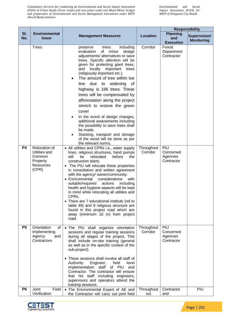
Consultancy Services for conducting an Environmental and Social Impact Assessment
(ESIA) of Urban Roads (Town roads) and non-urban roads and Major/Minor bridges
and preparation of Environmental and Social Management instruments under MITP
(World Bank) initiative
Environmental and Social
Impact Assessment (ESIA) for
MITP of Nongstoin City Roads
Page | 201
Sl. No.
Environmental Issue
Management Measures Location
Responsibility
Planning and
Execution
Supervision/ Monitoring
Trees preserve trees including evaluation of minor design adjustments/ alternatives to save trees. Specific attention will be given for protecting giant trees, and locally important trees (religiously important etc.).
The amount of tree within toe
line due to widening of
highway is 166 trees. These
trees will be compensated by
afforestation along the project
stretch to restore the green
cover
In the event of design changes, additional assessments including the possibility to save trees shall be made.
Stacking, transport and storage of the wood will be done as per the relevant norms.
Corridor Forest Department Contractor
P4 Relocation of Utilities and Common Property Resources (CPR)
All utilities and CPRs i.e., water supply lines, religious structures, hand pumps will be relocated before the construction starts.
The PIU will relocate these properties in consultation and written agreement with the agency/ owner/community.
Environmental considerations with suitable/required actions including health and hygiene aspects will be kept in mind while relocating all utilities and CPRs.
There are 7 educational institute (ref to table 49) and 8 religious structure are found in this project road which are away (minimum 10 m) from project road.
Throughout Corridor
PIU Concerned Agencies Contractor
P5 Orientation of Implementing Agency and Contractors
The PIU shall organize orientation sessions and regular training sessions during all stages of the project. This shall include on-site training (general as well as in the specific context of the sub-project).
These sessions shall involve all staff of Authority Engineer, field level implementation staff of PIU and Contractor. The contractor will ensure that his staff including engineers, supervisors and operators attend the training sessions.
Throughout Corridor
PIU Concerned Agencies Contractor
P6 Joint Field Verification
The Environmental Expert of AE and the Contractor will carry out joint field
Throughout out
Contractor and
PIU

Consultancy Services for conducting an Environmental and Social Impact Assessment
(ESIA) of Urban Roads (Town roads) and non-urban roads and Major/Minor bridges
and preparation of Environmental and Social Management instruments under MITP
(World Bank) initiative
Environmental and Social
Impact Assessment (ESIA) for
MITP of Nongstoin City Roads
Page | 202
Sl. No.
Environmental Issue
Management Measures Location
Responsibility
Planning and
Execution
Supervision/ Monitoring
verification to ascertain any additional possibility to saving trees, environmental and community resources.
The verification exercise should assess the need for additional protection measures or changes in design/ scale/ nature of protection measures including the efficacy of enhancement measures suggested in the EMP.
Proper documentation and justifications/reasons shall be maintained in all such cases where deviation from the original EMP is proposed.
Corridor Environmental Expert of AE
P7 Assessment of Impacts due to Changes/Revisions/Additions in the Project Work
The Environmental Expert of AE will assess impacts and revise/ modify the EMP and other required sections of the project documents in the event of changes/ revisions (including addition or deletion) in the project’s scope of work.
Throughout out
Corridor
Contractor Environmental Expert of AE
PIU
P8 Crushers, Hot-mix plants and Batching Plants Location
Hot mix plants and batching plants will be sited sufficiently away from settlements and agricultural operations or any commercial establishments. Such plants will be located at least 1 Km away from the nearest village/ settlement preferably in the downwind direction.
The Contractor shall submit a detailed layout plan for all such sites and approval of Environmental Expert of AE/PMC shall be necessary prior to their establishment.
Arrangements to control dust pollution through provision of windscreens, sprinklers, and dust encapsulation will have to be provided at all such sites.
Specifications of crushers, hot mix plants and batching plants will comply with the requirements of the relevant current emission control legislations and Consent/NOC for all such plants shall be submitted to the “PIU through Environmental Expert of AE/PMC.
The Contractor shall not initiate plant/s operation till the required legal clearances are obtained and submitted. The engineer will ensure that the regulatory and legal requirements are being complied with.
Throughout out
Corridor
Contractor Environmental Expert of AE and PIU
P9 Other Construction
All vehicles, equipment and machinery to be procured for construction will
Throughout out
Contractor Environmental Expert of
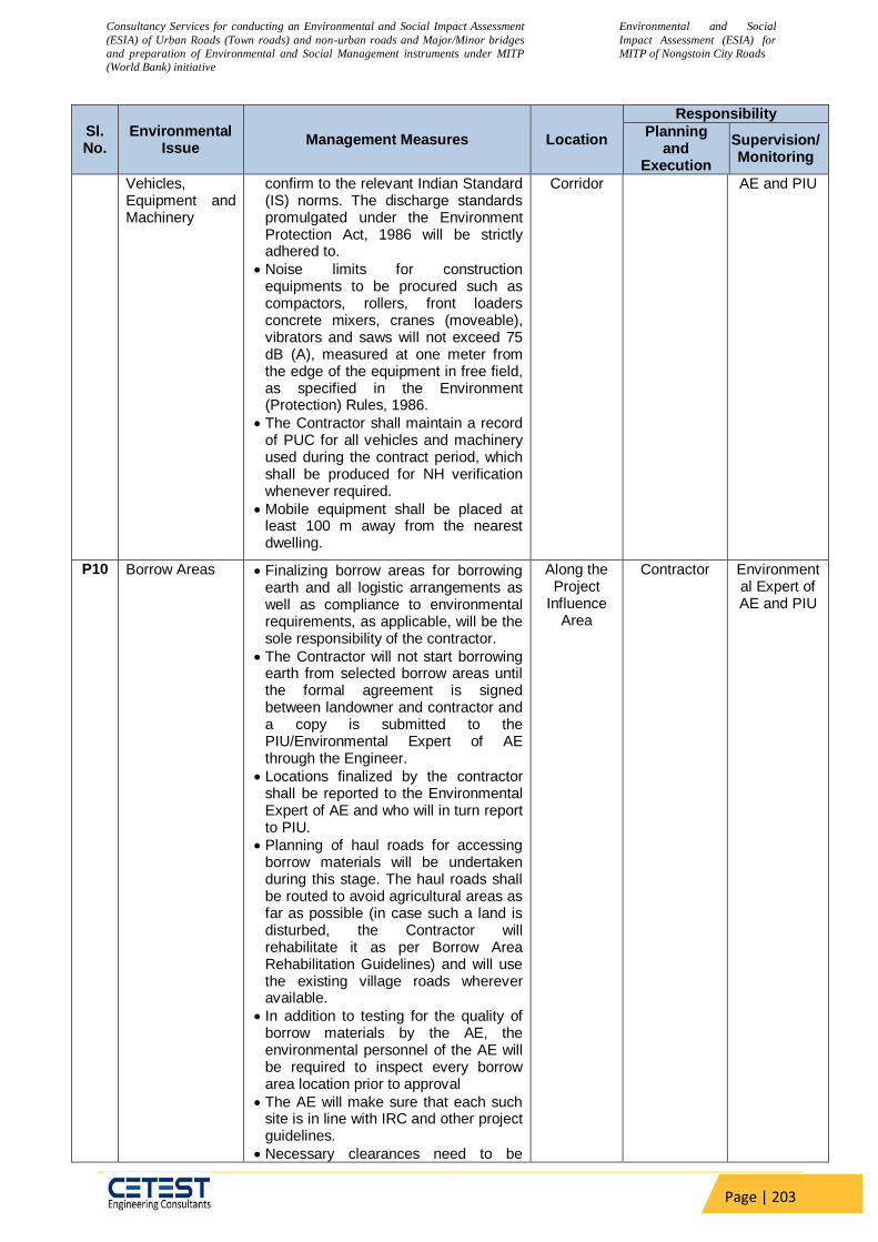
Consultancy Services for conducting an Environmental and Social Impact Assessment
(ESIA) of Urban Roads (Town roads) and non-urban roads and Major/Minor bridges
and preparation of Environmental and Social Management instruments under MITP
(World Bank) initiative
Environmental and Social
Impact Assessment (ESIA) for
MITP of Nongstoin City Roads
Page | 203
Sl. No.
Environmental Issue
Management Measures Location
Responsibility
Planning and
Execution
Supervision/ Monitoring
Vehicles, Equipment and Machinery
confirm to the relevant Indian Standard (IS) norms. The discharge standards promulgated under the Environment Protection Act, 1986 will be strictly adhered to.
Noise limits for construction equipments to be procured such as compactors, rollers, front loaders concrete mixers, cranes (moveable), vibrators and saws will not exceed 75 dB (A), measured at one meter from the edge of the equipment in free field, as specified in the Environment (Protection) Rules, 1986.
The Contractor shall maintain a record of PUC for all vehicles and machinery used during the contract period, which shall be produced for NH verification whenever required.
Mobile equipment shall be placed at least 100 m away from the nearest dwelling.
Corridor AE and PIU
P10 Borrow Areas Finalizing borrow areas for borrowing earth and all logistic arrangements as well as compliance to environmental requirements, as applicable, will be the sole responsibility of the contractor.
The Contractor will not start borrowing earth from selected borrow areas until the formal agreement is signed between landowner and contractor and a copy is submitted to the PIU/Environmental Expert of AE through the Engineer.
Locations finalized by the contractor shall be reported to the Environmental Expert of AE and who will in turn report to PIU.
Planning of haul roads for accessing borrow materials will be undertaken during this stage. The haul roads shall be routed to avoid agricultural areas as far as possible (in case such a land is disturbed, the Contractor will rehabilitate it as per Borrow Area Rehabilitation Guidelines) and will use the existing village roads wherever available.
In addition to testing for the quality of borrow materials by the AE, the environmental personnel of the AE will be required to inspect every borrow area location prior to approval
The AE will make sure that each such site is in line with IRC and other project guidelines.
Necessary clearances need to be
Along the Project
Influence Area
Contractor Environmental Expert of AE and PIU
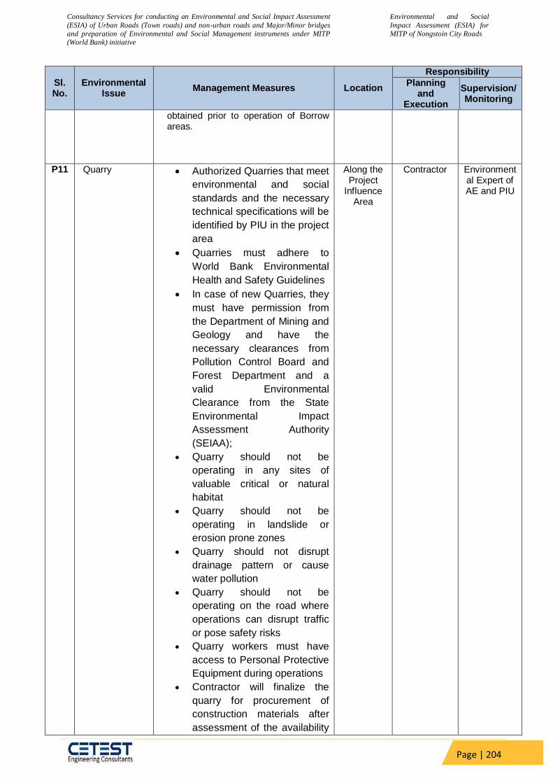
Consultancy Services for conducting an Environmental and Social Impact Assessment
(ESIA) of Urban Roads (Town roads) and non-urban roads and Major/Minor bridges
and preparation of Environmental and Social Management instruments under MITP
(World Bank) initiative
Environmental and Social
Impact Assessment (ESIA) for
MITP of Nongstoin City Roads
Page | 204
Sl. No.
Environmental Issue
Management Measures Location
Responsibility
Planning and
Execution
Supervision/ Monitoring
obtained prior to operation of Borrow areas.
P11 Quarry Authorized Quarries that meet
environmental and social
standards and the necessary
technical specifications will be
identified by PIU in the project
area
Quarries must adhere to
World Bank Environmental
Health and Safety Guidelines
In case of new Quarries, they
must have permission from
the Department of Mining and
Geology and have the
necessary clearances from
Pollution Control Board and
Forest Department and a
valid Environmental
Clearance from the State
Environmental Impact
Assessment Authority
(SEIAA);
Quarry should not be
operating in any sites of
valuable critical or natural
habitat
Quarry should not be
operating in landslide or
erosion prone zones
Quarry should not disrupt
drainage pattern or cause
water pollution
Quarry should not be
operating on the road where
operations can disrupt traffic
or pose safety risks
Quarry workers must have
access to Personal Protective
Equipment during operations
Contractor will finalize the
quarry for procurement of
construction materials after
assessment of the availability
Along the Project
Influence Area
Contractor Environmental Expert of AE and PIU
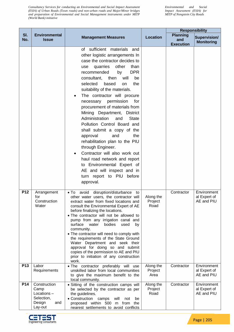
Consultancy Services for conducting an Environmental and Social Impact Assessment
(ESIA) of Urban Roads (Town roads) and non-urban roads and Major/Minor bridges
and preparation of Environmental and Social Management instruments under MITP
(World Bank) initiative
Environmental and Social
Impact Assessment (ESIA) for
MITP of Nongstoin City Roads
Page | 205
Sl. No.
Environmental Issue
Management Measures Location
Responsibility
Planning and
Execution
Supervision/ Monitoring
of sufficient materials and
other logistic arrangements In
case the contractor decides to
use quarries other than
recommended by DPR
consultant, then will be
selected based on the
suitability of the materials.
The contractor will procure
necessary permission for
procurement of materials from
Mining Department, District
Administration and State
Pollution Control Board and
shall submit a copy of the
approval and the
rehabilitation plan to the PIU
through Engineer.
Contractor will also work out
haul road network and report
to Environmental Expert of
AE and will inspect and in
turn report to PIU before
approval.
P12 Arrangement
for Construction Water
To avoid disruption/disturbance to other water users, the contractor will extract water from fixed locations and consult the Environmental Expert of AE before finalizing the locations.
The contractor will not be allowed to pump from any irrigation canal and surface water bodies used by community.
The contractor will need to comply with the requirements of the State Ground Water Department and seek their approval for doing so and submit copies of the permission to AE and PIU prior to initiation of any construction work.
Along the
Project Road
Contractor Environmental Expert of AE and PIU
P13 Labor Requirements
The contractor preferably will use unskilled labor from local communities to give the maximum benefit to the local community.
Along the Project Area
Contractor Environmental Expert of AE and PIU
P14 Construction Camp Locations – Selection, Design and Lay-out
Sitting of the construction camps will be selected by the contractor as per the guidelines.
Construction camps will not be proposed within 500 m from the nearest settlements to avoid conflicts
Along the Project Road
Contractor Environmental Expert of AE and PIU

Consultancy Services for conducting an Environmental and Social Impact Assessment
(ESIA) of Urban Roads (Town roads) and non-urban roads and Major/Minor bridges
and preparation of Environmental and Social Management instruments under MITP
(World Bank) initiative
Environmental and Social
Impact Assessment (ESIA) for
MITP of Nongstoin City Roads
Page | 206
Sl. No.
Environmental Issue
Management Measures Location
Responsibility
Planning and
Execution
Supervision/ Monitoring
and stress over the infrastructure facilities with the local community.
Location for stockyards for construction materials will be identified at least 1000 m from watercourses.
The waste disposal and sewage system for the camp will be designed, built and operated such that no odor is generated.
P15 Arrangements for Temporary Land Requirement
The contractor as per prevalent rules will carry out negotiations with the landowners for obtaining their consent for temporary use of lands for construction sites/hot mix plants/traffic detours/borrow areas etc.
The Contractor will submit a copy of agreement to the Environmental Expert of AE. The Environmental Expert will be required to ensure that the clearing up of the site prior to handing over to the owner (after construction or completion of the activity) is included in the contract.
Along the Project Road
Contractor Environmental Expert of AE and PIU
P16 Implementation -Information Meetings
The contractor will organize at least 2 implementation information meetings in the vicinity of Project Site (minimum one in each section) for general public to consult and inform people about his plans covering overall construction schedule, safety, use of local resources (such as earth, water), traffic safety and management plans of debris disposal, drainage protection during construction, pollution abetment and other plans, measures to minimize disruption, damage and in convenience to roadside users and people along the road.
The first Implementation information meeting be conducted within four weeks of mobilization. The people should be informed about the date, time and venue at least 7 days prior to meetings. Public shall be informed about the meeting through display of posters at prominent public places (Village Council offices, offices of Market committees, Notice board of religious places etc.) and distribution of pamphlets along roadside communities or in any manner deemed fit.
The contractor will maintain a channel of communication with the communities through his designated Environment and Safety Officer to address any concern or grievances.
Periodic meetings will also be
Along the Project Road
Contractor Environmental Expert of AE and PIU

Consultancy Services for conducting an Environmental and Social Impact Assessment
(ESIA) of Urban Roads (Town roads) and non-urban roads and Major/Minor bridges
and preparation of Environmental and Social Management instruments under MITP
(World Bank) initiative
Environmental and Social
Impact Assessment (ESIA) for
MITP of Nongstoin City Roads
Page | 207
Sl. No.
Environmental Issue
Management Measures Location
Responsibility
Planning and
Execution
Supervision/ Monitoring
conducted during the construction period to take feedback from communities or their representatives to ensure minimum disturbance. The mechanism and contents for disclosure shall be approved by PIU prior to the meetings.
P17 Disaster
Management
and
Emergency
Response Plan
The Contractor will develop and maintain emergency response system in order to address any accidents or other emergency situation or disaster at site such as fall of workers from height, collapse of pier, flood, earthquake, accident, etc.
For entire project stretch
including bridge
locations, camp site and plat
site
Contractor Environmental Expert of AE and
PIU
P18 Chance Finds Procedure
As unknown features/objects could be encountered during works, earthworks, a “chance finds procedure” shall be in place to stop works and require investigation by an archaeologist in case of such findings and involvement of relevant state entities
Along the Project Road
Contractor Environmental Expert of AE and
PIU
CONSTRUCTION STAGE C1 Clearing and
Grubbing Vegetation will be removed from the
construction zone before commencement of construction. All works will be carried out such that the damage or disruption to flora other than those identified for cutting is minimum.
Only ground cover/shrubs that impinge directly on the permanent works or necessary temporary works will be removed with prior approval from the Environmental Expert of AE.
The Contractor under any circumstances will not cut trees other than those identified for cutting and for which he has written instructions from the PIU. The PIU will issue these instructions only after receiving all stages of clearances from the Forest Department/ MoEF& CC.
Vegetation only with girth of over 30 cm will be considered as trees and shall be compensated, in the event of PIU’s instruction to undertake tree cutting.
The sub grade of the existing pavement shall be used as embankment fill material.
The existing base and sub-base material shall be recycled as sub-base of the haul road or access roads.
Along the work in
progress
Contractor Environmental Expert of AE and PIU

Consultancy Services for conducting an Environmental and Social Impact Assessment
(ESIA) of Urban Roads (Town roads) and non-urban roads and Major/Minor bridges
and preparation of Environmental and Social Management instruments under MITP
(World Bank) initiative
Environmental and Social
Impact Assessment (ESIA) for
MITP of Nongstoin City Roads
Page | 208
Sl. No.
Environmental Issue
Management Measures Location
Responsibility
Planning and
Execution
Supervision/ Monitoring
The existing bitumen surface may be utilized for the paving of cross roads, access roads and paving works in construction sites and campus, temporary traffic diversions, haulage routes etc.
C2 Disposal of debris from dismantling structures and road surface
The contractor shall identify disposal sites. The identified locations will be reported to the Environmental Expert of AE. These locations will be checked on site and accordingly approved by Environmental Expert of AE prior to any disposal of waste materials.
All arrangements for transportation during construction including provision, maintenance, dismantling and clearing debris, will be considered incidental to the work and will be planned and implemented by the contractor as approved and directed by the Environmental Expert of AE.
The pre-designed disposal locations will be a part of Comprehensive Solid Waste Management Plan to be prepared by Contractor in consultation and with approval of Environmental Expert of AE.
Debris generated from pile driving or other construction activities shall be disposed such that it does not flow into the surface water bodies or form mud puddles in the area.
Along the work in
progress
Contractor Environmental Expert of AE and PIU
C3 Other Construction Waste Disposal
The pre-identified disposal locations will be a part of Comprehensive Waste Disposal Management Plan to be prepared by the Contractor in consultation and with approval of Environmental Expert of AE. Location of disposal sites will be finalized prior to initiation of works on any particular section of the road.
The Environmental Expert of AE will approve these disposal sites after conducting a joint inspection on the site with the Contractor.
Contractor will ensure that any spoils of material unsuitable for embankment fill will not be disposed off near any water course, agricultural land, and natural habitat like grass lands or pastures. Such spoils from excavation can be used to reclaim borrow pits and low-lying areas located in barren lands along the project corridors (if so desired by the owner/community and approved by the Environmental Expert of AE).
Along the Road
Contractor Environmental Expert of AE and PIU
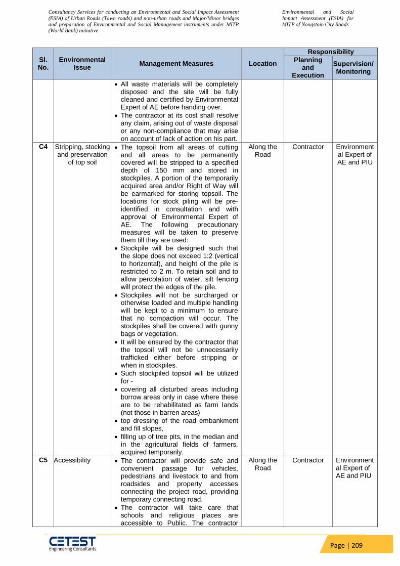
Consultancy Services for conducting an Environmental and Social Impact Assessment
(ESIA) of Urban Roads (Town roads) and non-urban roads and Major/Minor bridges
and preparation of Environmental and Social Management instruments under MITP
(World Bank) initiative
Environmental and Social
Impact Assessment (ESIA) for
MITP of Nongstoin City Roads
Page | 209
Sl. No.
Environmental Issue
Management Measures Location
Responsibility
Planning and
Execution
Supervision/ Monitoring
All waste materials will be completely disposed and the site will be fully cleaned and certified by Environmental Expert of AE before handing over.
The contractor at its cost shall resolve any claim, arising out of waste disposal or any non-compliance that may arise on account of lack of action on his part.
C4 Stripping, stocking and preservation
of top soil
The topsoil from all areas of cutting and all areas to be permanently covered will be stripped to a specified depth of 150 mm and stored in stockpiles. A portion of the temporarily acquired area and/or Right of Way will be earmarked for storing topsoil. The locations for stock piling will be pre-identified in consultation and with approval of Environmental Expert of AE. The following precautionary measures will be taken to preserve them till they are used:
Stockpile will be designed such that the slope does not exceed 1:2 (vertical to horizontal), and height of the pile is restricted to 2 m. To retain soil and to allow percolation of water, silt fencing will protect the edges of the pile.
Stockpiles will not be surcharged or otherwise loaded and multiple handling will be kept to a minimum to ensure that no compaction will occur. The stockpiles shall be covered with gunny bags or vegetation.
It will be ensured by the contractor that the topsoil will not be unnecessarily trafficked either before stripping or when in stockpiles.
Such stockpiled topsoil will be utilized for -
covering all disturbed areas including borrow areas only in case where these are to be rehabilitated as farm lands (not those in barren areas)
top dressing of the road embankment and fill slopes,
filling up of tree pits, in the median and in the agricultural fields of farmers, acquired temporarily.
Along the Road
Contractor Environmental Expert of AE and PIU
C5 Accessibility The contractor will provide safe and convenient passage for vehicles, pedestrians and livestock to and from roadsides and property accesses connecting the project road, providing temporary connecting road.
The contractor will take care that schools and religious places are accessible to Public. The contractor
Along the Road
Contractor Environmental Expert of AE and PIU
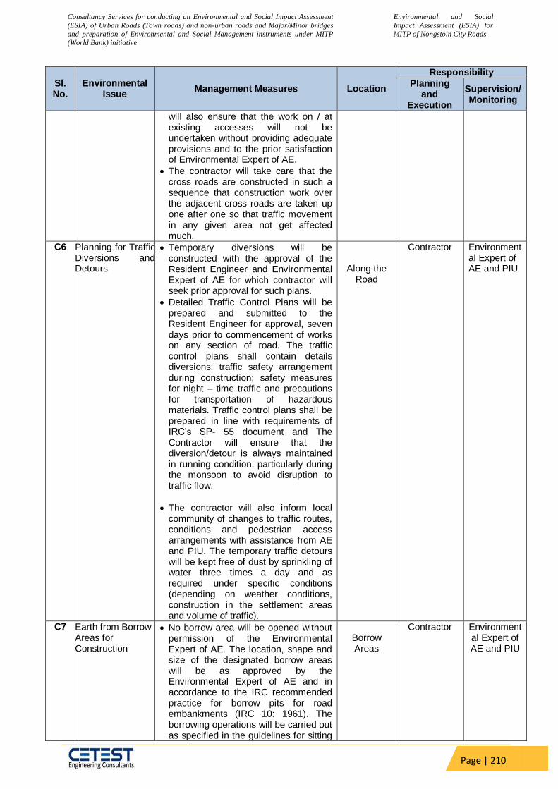
Consultancy Services for conducting an Environmental and Social Impact Assessment
(ESIA) of Urban Roads (Town roads) and non-urban roads and Major/Minor bridges
and preparation of Environmental and Social Management instruments under MITP
(World Bank) initiative
Environmental and Social
Impact Assessment (ESIA) for
MITP of Nongstoin City Roads
Page | 210
Sl. No.
Environmental Issue
Management Measures Location
Responsibility
Planning and
Execution
Supervision/ Monitoring
will also ensure that the work on / at existing accesses will not be undertaken without providing adequate provisions and to the prior satisfaction of Environmental Expert of AE.
The contractor will take care that the cross roads are constructed in such a sequence that construction work over the adjacent cross roads are taken up one after one so that traffic movement in any given area not get affected much.
C6 Planning for Traffic Diversions and Detours
Temporary diversions will be constructed with the approval of the Resident Engineer and Environmental Expert of AE for which contractor will seek prior approval for such plans.
Detailed Traffic Control Plans will be prepared and submitted to the Resident Engineer for approval, seven days prior to commencement of works on any section of road. The traffic control plans shall contain details diversions; traffic safety arrangement during construction; safety measures for night – time traffic and precautions for transportation of hazardous materials. Traffic control plans shall be prepared in line with requirements of IRC’s SP- 55 document and The Contractor will ensure that the diversion/detour is always maintained in running condition, particularly during the monsoon to avoid disruption to traffic flow.
The contractor will also inform local community of changes to traffic routes, conditions and pedestrian access arrangements with assistance from AE and PIU. The temporary traffic detours will be kept free of dust by sprinkling of water three times a day and as required under specific conditions (depending on weather conditions, construction in the settlement areas and volume of traffic).
Along the Road
Contractor Environmental Expert of AE and PIU
C7 Earth from Borrow Areas for Construction
No borrow area will be opened without permission of the Environmental Expert of AE. The location, shape and size of the designated borrow areas will be as approved by the Environmental Expert of AE and in accordance to the IRC recommended practice for borrow pits for road embankments (IRC 10: 1961). The borrowing operations will be carried out as specified in the guidelines for sitting
Borrow Areas
Contractor Environmental Expert of AE and PIU

Consultancy Services for conducting an Environmental and Social Impact Assessment
(ESIA) of Urban Roads (Town roads) and non-urban roads and Major/Minor bridges
and preparation of Environmental and Social Management instruments under MITP
(World Bank) initiative
Environmental and Social
Impact Assessment (ESIA) for
MITP of Nongstoin City Roads
Page | 211
Sl. No.
Environmental Issue
Management Measures Location
Responsibility
Planning and
Execution
Supervision/ Monitoring
and operation of borrow areas.
The unpaved surfaces used for the haulage of borrow materials, if passing through the settlement areas or habitations; will be maintained dust free by the contractor. Sprinkling of water will be carried out twice a day to control dust along such roads during their period of use.
During dry seasons (winter and summer) frequency of water sprinkling will be increased in the settlement areas and Environmental Expert of AE will decide the numbers of sprinkling depending on the local requirements.
Contractor will rehabilitate the borrow areas as soon as borrowing is over from a particular borrow area in accordance with the guidelines for Redevelopment of Borrow Areas or as suggested by Environmental Expert of AE.
The final rehabilitation plans will be approved by the Environmental Expert of AE.
C8 Quarry Operations The contractor shall obtain materials from quarries only after the consent of the Department of Mining / SPCB (both the states) / District Administration or will use existing approved sources of such materials. Copies of consent/ approval/ rehabilitation plan for opening a new quarry or use of an existing quarry source will be submitted to Environmental Expert of AE and the Resident Engineer.
The contractor will develop a Comprehensive Quarry Redevelopment plan, as per the Mining Rules of the state and submit a copy to PIU and AE prior to opening of the quarry site.
The quarry operations will be undertaken within the rules and regulations in force in the state.
Quarry Areas
Contractor Environmental Expert of AE and PIU
C9 Transporting Construction Materials and Haul Road Management
Contractor will maintain all roads (existing or built for the project), which are used for transporting construction materials, equipment and machineries as précised. All vehicles delivering fine materials to the site will be covered to avoid spillage of materials.
All existing highways and roads used by vehicles of the contractor or any of his sub-contractor or suppliers of materials and similarly roads, which
All Roads Used
Contractor Environmental Expert of AE and PIU
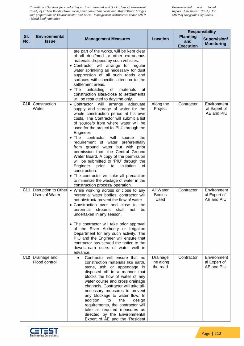
Consultancy Services for conducting an Environmental and Social Impact Assessment
(ESIA) of Urban Roads (Town roads) and non-urban roads and Major/Minor bridges
and preparation of Environmental and Social Management instruments under MITP
(World Bank) initiative
Environmental and Social
Impact Assessment (ESIA) for
MITP of Nongstoin City Roads
Page | 212
Sl. No.
Environmental Issue
Management Measures Location
Responsibility
Planning and
Execution
Supervision/ Monitoring
are part of the works, will be kept clear of all dust/mud or other extraneous materials dropped by such vehicles.
Contractor will arrange for regular water sprinkling as necessary for dust suppression of all such roads and surfaces with specific attention to the settlement areas.
The unloading of materials at construction sites/close to settlements will be restricted to daytime only.
C10 Construction Water
Contractor will arrange adequate supply and storage of water for the whole construction period at his own costs. The Contractor will submit a list of source/s from where water will be used for the project to ‘PIU’ through the Engineer.
The contractor will source the requirement of water preferentially from ground water but with prior permission from the Central Ground Water Board. A copy of the permission will be submitted to ‘PIU’ through the Engineer prior to initiation of construction.
The contractor will take all precaution to minimize the wastage of water in the construction process/ operation.
Along the Project
Contractor Environmental Expert of AE and PIU
C11 Disruption to Other Users of Water
While working across or close to any perennial water bodies, contractor will not obstruct/ prevent the flow of water.
Construction over and close to the perennial streams shall not be undertaken in any season.
The contractor will take prior approval of the River Authority or Irrigation Department for any such activity. The PIU and the Engineer will ensure that contractor has served the notice to the downstream users of water well in advance.
All Water Bodies Used
Contractor Environmental Expert of AE and PIU
C12 Drainage and Flood control
Contractor will ensure that no construction materials like earth, stone, ash or appendage is disposed off in a manner that blocks the flow of water of any water course and cross drainage channels. Contractor will take all-necessary measures to prevent any blockage to water flow. In addition to the design requirements, the contractor will take all required measures as directed by the Environmental Expert of AE and the ‘Resident
Drainage line along the road
Contractor Environmental Expert of AE and PIU
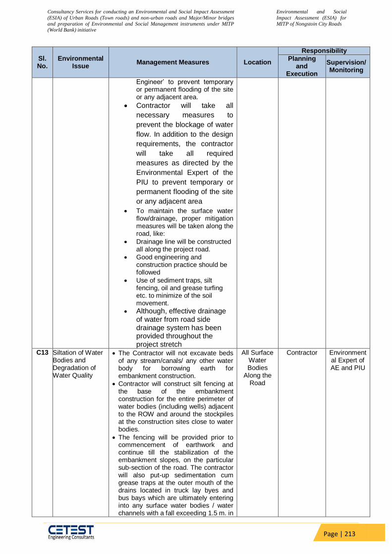
Consultancy Services for conducting an Environmental and Social Impact Assessment
(ESIA) of Urban Roads (Town roads) and non-urban roads and Major/Minor bridges
and preparation of Environmental and Social Management instruments under MITP
(World Bank) initiative
Environmental and Social
Impact Assessment (ESIA) for
MITP of Nongstoin City Roads
Page | 213
Sl. No.
Environmental Issue
Management Measures Location
Responsibility
Planning and
Execution
Supervision/ Monitoring
Engineer’ to prevent temporary or permanent flooding of the site or any adjacent area.
Contractor will take all
necessary measures to
prevent the blockage of water
flow. In addition to the design
requirements, the contractor
will take all required
measures as directed by the
Environmental Expert of the
PIU to prevent temporary or
permanent flooding of the site
or any adjacent area
To maintain the surface water flow/drainage, proper mitigation measures will be taken along the road, like:
Drainage line will be constructed all along the project road.
Good engineering and construction practice should be followed
Use of sediment traps, silt fencing, oil and grease turfing etc. to minimize of the soil movement.
Although, effective drainage of water from road side drainage system has been provided throughout the project stretch
C13 Siltation of Water Bodies and Degradation of Water Quality
The Contractor will not excavate beds of any stream/canals/ any other water body for borrowing earth for embankment construction.
Contractor will construct silt fencing at the base of the embankment construction for the entire perimeter of water bodies (including wells) adjacent to the ROW and around the stockpiles at the construction sites close to water bodies.
The fencing will be provided prior to commencement of earthwork and continue till the stabilization of the embankment slopes, on the particular sub-section of the road. The contractor will also put-up sedimentation cum grease traps at the outer mouth of the drains located in truck lay byes and bus bays which are ultimately entering into any surface water bodies / water channels with a fall exceeding 1.5 m. in
All Surface Water Bodies
Along the Road
Contractor Environmental Expert of AE and PIU
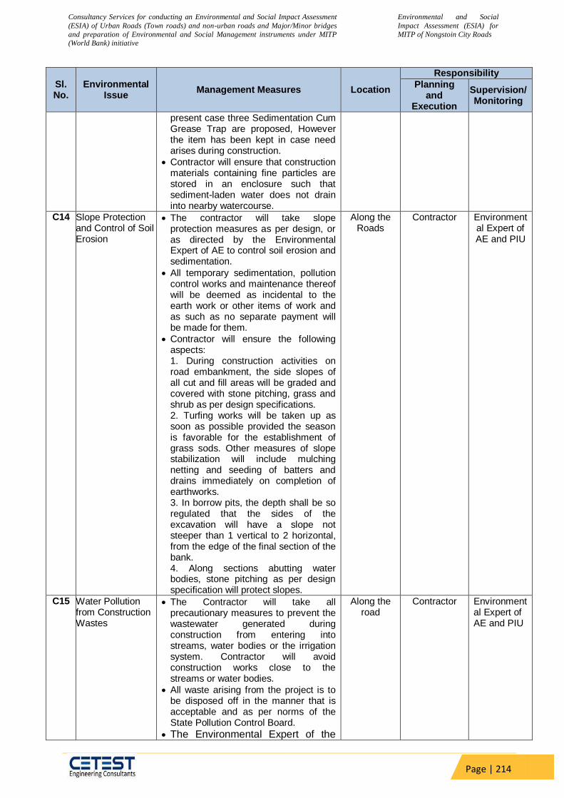
Consultancy Services for conducting an Environmental and Social Impact Assessment
(ESIA) of Urban Roads (Town roads) and non-urban roads and Major/Minor bridges
and preparation of Environmental and Social Management instruments under MITP
(World Bank) initiative
Environmental and Social
Impact Assessment (ESIA) for
MITP of Nongstoin City Roads
Page | 214
Sl. No.
Environmental Issue
Management Measures Location
Responsibility
Planning and
Execution
Supervision/ Monitoring
present case three Sedimentation Cum Grease Trap are proposed, However the item has been kept in case need arises during construction.
Contractor will ensure that construction materials containing fine particles are stored in an enclosure such that sediment-laden water does not drain into nearby watercourse.
C14 Slope Protection and Control of Soil Erosion
The contractor will take slope protection measures as per design, or as directed by the Environmental Expert of AE to control soil erosion and sedimentation.
All temporary sedimentation, pollution control works and maintenance thereof will be deemed as incidental to the earth work or other items of work and as such as no separate payment will be made for them.
Contractor will ensure the following aspects: 1. During construction activities on road embankment, the side slopes of all cut and fill areas will be graded and covered with stone pitching, grass and shrub as per design specifications. 2. Turfing works will be taken up as soon as possible provided the season is favorable for the establishment of grass sods. Other measures of slope stabilization will include mulching netting and seeding of batters and drains immediately on completion of earthworks. 3. In borrow pits, the depth shall be so regulated that the sides of the excavation will have a slope not steeper than 1 vertical to 2 horizontal, from the edge of the final section of the bank. 4. Along sections abutting water bodies, stone pitching as per design specification will protect slopes.
Along the Roads
Contractor Environmental Expert of AE and PIU
C15 Water Pollution from Construction Wastes
The Contractor will take all precautionary measures to prevent the wastewater generated during construction from entering into streams, water bodies or the irrigation system. Contractor will avoid construction works close to the streams or water bodies.
All waste arising from the project is to be disposed off in the manner that is acceptable and as per norms of the State Pollution Control Board.
The Environmental Expert of the
Along the road
Contractor Environmental Expert of AE and PIU

Consultancy Services for conducting an Environmental and Social Impact Assessment
(ESIA) of Urban Roads (Town roads) and non-urban roads and Major/Minor bridges
and preparation of Environmental and Social Management instruments under MITP
(World Bank) initiative
Environmental and Social
Impact Assessment (ESIA) for
MITP of Nongstoin City Roads
Page | 215
Sl. No.
Environmental Issue
Management Measures Location
Responsibility
Planning and
Execution
Supervision/ Monitoring
PIU will certify that all liquid wastes disposed off from the sites meet the discharge standards.
C16 Water Pollution from Fuel and Lubricants
The contractor will ensure that all construction vehicle parking location, fuel/lubricants storage sites, vehicle, machinery and equipment maintenance and refueling sites will be located at least 500 m from rivers and irrigation canal/ponds.
All location and layout plans of such sites will be submitted by the Contractor prior to their establishment and will be approved by the Environmental Expert of AE and PIU.
Contractor will ensure that all vehicle/machinery and equipment operation, maintenance and refueling will be carried out in such a fashion that spillage of fuels and lubricants does not contaminate the ground. Oil interceptors will be provided for vehicle parking, wash down and refueling areas as per the design provided.
Oil and grease traps will be provided at fuelling locations, to prevent contamination of water.
‘Oil interceptors’ shall be provided in wash down areas and re-fuelling areas
In all, fuel storage and refueling areas, if located on agricultural land or areas supporting vegetation, the top soil will be stripped, stockpiled and returned after cessation of such storage.
Contractor will arrange for collection, storing and disposal of oily wastes to the pre-identified disposal sites (list to be submitted to AE and PIU) and approved by the Environmental Expert of AE. All spills and collected petroleum products will be disposed off in accordance with MoEF&CC and state PCB guidelines.
Environmental Expert of AE and Resident Engineer’ will certify that all arrangements comply with the guidelines of PCB/ MoEF&CC or any other relevant laws.
Along the Roads
Contractor Environmental Expert of AE and PIU
C17 Dust Pollution The contractor will take every precaution to reduce the level of dust from crushers/hot mix plants, construction sites involving earthwork by sprinkling of water, encapsulation of dust source and by erection of screen/barriers.
All the plants will be sited at least 1 km
Along the Roads,
Construction Site/ Camps
Contractor Environmental Expert of AE and PIU

Consultancy Services for conducting an Environmental and Social Impact Assessment
(ESIA) of Urban Roads (Town roads) and non-urban roads and Major/Minor bridges
and preparation of Environmental and Social Management instruments under MITP
(World Bank) initiative
Environmental and Social
Impact Assessment (ESIA) for
MITP of Nongstoin City Roads
Page | 216
Sl. No.
Environmental Issue
Management Measures Location
Responsibility
Planning and
Execution
Supervision/ Monitoring
in the downwind direction from the nearest human settlement.
The contractor will provide necessary certificates to confirm that all crushers used in construction conform to relevant dust emission control legislation.
The suspended particulate matter value at a distance of 40m from a unit located in a cluster should be less than 500 g/m3. The pollution monitoring is to be conducted as per the monitoring plan.
Alternatively, only crushers licensed by the SPCB shall be used. Required certificates and consents shall be submitted by the Contractor in such a case to the Environmental Expert of AE through the ‘Engineer’.
Dust screening vegetation will be planted on the edge of the ROW for all existing roadside crushers. Hot mix plant will be fitted with dust extraction units.
C18 Emission from Construction Vehicles, Equipment and Machineries
Contractor will ensure that all vehicles, equipment and machinery used for construction are regularly maintained and confirm that pollution emission levels comply with the relevant requirements of SPCB.
The Contractor will submit PUC certificates for all vehicles/ equipment/machinery used for the project. Monitoring results will also be submitted to ‘PIU’ through the ‘Engineer’.
Along the Roads , all vehicles
used/ Camps
Contractor Environmental Expert of AE and PIU
C19 Noise Pollution: Noise from Vehicles, Plants and Equipments
The Contractor will confirm the following:
All plants and equipment used in construction shall strictly conform to the MoEF& CC/CPCB noise standards.
All vehicles and equipment used in construction will be fitted with exhaust silencers.
Servicing of all construction vehicles and machinery will be done regularly and during routine servicing operations, the effectiveness of exhaust silencers will be checked and if found defective will be replaced.
Limits for construction equipment used in the project such as compactors, rollers, front loaders, concrete mixers, cranes (moveable), vibrators and saws
Along the Roads , all vehicles
used/Camps
Contractor Environmental Expert of AE and PIU

Consultancy Services for conducting an Environmental and Social Impact Assessment
(ESIA) of Urban Roads (Town roads) and non-urban roads and Major/Minor bridges
and preparation of Environmental and Social Management instruments under MITP
(World Bank) initiative
Environmental and Social
Impact Assessment (ESIA) for
MITP of Nongstoin City Roads
Page | 217
Sl. No.
Environmental Issue
Management Measures Location
Responsibility
Planning and
Execution
Supervision/ Monitoring
shall not exceed 75 dB (A) (measured at one meter from the edge of equipment in the free field), as specified in the Environment (Protection) rules, 1986.
Maintenance of vehicles, equipment and machinery shall be regular to keep noise levels at the minimum.
At the construction sites within 150 m of the nearest habitation, noisy construction work such as crushing, concrete mixing, batching will be stopped during the night time between 10.00 pm to 6.00 am.
No construction activities will be permitted around educational institutes/health centers (silence zones) up to a distance of 100 m from the sensitive receptors i.e., school, health centers and hospitals between 10.00 pm to 6.00 am.
Monitoring shall be carried out at the construction sites as per the monitoring schedule and results will be submitted to Environmental Expert of AE through the ‘Engineer’.
No noisy construction activities will be permitted around educational institutes/health centers (silence zones) up to a distance of 100 m from the sensitive receptors i.e., school, health centers and hospitals between 9.00 am to 5.00 pm
C20 Personal Safety Measures for Labour
Contractor will provide:
Protective footwear and protective goggles to all workers employed on mixing asphalt materials, cement, lime mortars, concrete etc.
Welder's protective eye-shields to workers who are engaged in welding works
Protective goggles and clothing to workers engaged in stone breaking activities and workers will be seated at sufficiently safe intervals
Earplugs to workers exposed to loud noise, and workers working in crushing, compaction, or concrete
Along the Roads, all vehicles
used/Camps
Contractor Environmental Expert of AE and PIU
Consultancy Services for conducting an Environmental and Social Impact Assessment
(ESIA) of Urban Roads (Town roads) and non-urban roads and Major/Minor bridges
and preparation of Environmental and Social Management instruments under MITP
(World Bank) initiative
Environmental and Social
Impact Assessment (ESIA) for
MITP of Nongstoin City Roads
Page | 218
Sl. No.
Environmental Issue
Management Measures Location
Responsibility
Planning and
Execution
Supervision/ Monitoring
mixing operation.
Adequate safety measures for workers during handling of materials.
The contractor will comply with all regulations regarding safe scaffolding, ladders, working platforms, gangway, stairwells, excavations, trenches and safe means of entry and egress.
The contractor will comply with all the precautions as required for ensuring the safety of the workmen as per the International Labor Organization (ILO) Convention No. 62 as far as those are applicable to this contract.
The contractor will make sure that during the construction work all relevant provisions of the Factories Act, 1948 and the Building and other Construction Workers (regulation of Employment and Conditions of Services) Act, 1996 are adhered to.
The contractor will not employ any person below the age of 14 years for any work and no woman will be employed on the work of painting with products containing lead in any form.
The contractor will also ensure that no paint containing lead or lead products is used except in the form of paste or readymade paint.
Contractor will provide facemasks for use to the workers when paint is applied in the form of spray or a surface having lead paint dry is rubbed and scrapped.
The Contractor will mark ‘hard hat’ and ‘no smoking’ and other ‘high risk’ areas and enforce non-compliance of use of PPE with zero tolerance. These will be reflected in the Construction Safety Plan to be prepared by the Contractor during mobilization and will be approved by AE and PIU.
C21 Traffic and Safety The contractor will take all necessary measures for the safety of traffic during construction and provide, erect and maintain such barricades, including signs, markings, flags, lights and flagmen as proposed in the Traffic Control Plan/Drawings and as required by the Environmental Expert of AE and ‘Resident Engineer’ for the information and protection of traffic approaching or passing through the section of any existing cross roads.
The contractor will ensure that all signs, barricades, pavement markings
Along the Roads, all vehicles
used/Camps
Contractor Environmental Expert of AE and PIU
Consultancy Services for conducting an Environmental and Social Impact Assessment
(ESIA) of Urban Roads (Town roads) and non-urban roads and Major/Minor bridges
and preparation of Environmental and Social Management instruments under MITP
(World Bank) initiative
Environmental and Social
Impact Assessment (ESIA) for
MITP of Nongstoin City Roads
Page | 219
Sl. No.
Environmental Issue
Management Measures Location
Responsibility
Planning and
Execution
Supervision/ Monitoring
are provided as per the MOSRT&H specifications. Before taking up of construction on any section of the existing lanes of the highway, a Traffic Control Plan will be devised and implemented to the satisfaction of Environmental Expert of AE and ‘ Resident Engineer’
C22 Risk from Electrical Equipment(s)
The Contractor will take all required precautions to prevent danger from electrical equipment and ensure that:
No material will be so stacked or placed as to cause danger or inconvenience to any person or the public.
All necessary fencing and lights will be provided to protect the public in construction zones.
All machines to be used in the construction will conform to the relevant Indian Standards (IS) codes, will be free from patent defect, will be kept in good working order, will be regularly inspected and properly maintained as per IS provision and to the satisfaction of the ‘Resident Engineer’.
Along the Roads
Contractor Environmental Expert of AE and PIU
C23 Risk Force Measure
The contractor will take all reasonable precautions to prevent danger to the workers and public from fire, flood etc. resulting due to construction activities.
The contractor will make required arrangements so that in case of any mishap all necessary steps can be taken for prompt first aid treatment. Construction Safety Plan prepared by the Contractor will identify necessary actions in the event of an emergency.
Along the Roads,
construction Camps
Contractor Environmental Expert of AE and PIU
C24 First Aid The contractor will arrange for -
a readily available first aid unit including an adequate supply of sterilized dressing materials and appliances as per the Factories Rules in every work zone
availability of suitable transport at all times to take injured or sick person(s) to the nearest hospital
Equipment and trained nursing staff at construction camp.
Along the Roads,
construction Camps
Contractor Environmental Expert of AE and PIU
C25 Informatory Signs and Hoardings
The contractor will provide, erect and maintain informatory/safety signs, hoardings written in English and local language, wherever required as per IRC and MoRT&H specifications.
Along the Roads,
construction Camps
Contractor Environmental Expert of AE and PIU
C26 Road side Plantation Strategy
The contractor will do the plantation at median and/or turfing at embankment
Along the Roads
Contractor Environmental Expert of AE and PIU
Consultancy Services for conducting an Environmental and Social Impact Assessment
(ESIA) of Urban Roads (Town roads) and non-urban roads and Major/Minor bridges
and preparation of Environmental and Social Management instruments under MITP
(World Bank) initiative
Environmental and Social
Impact Assessment (ESIA) for
MITP of Nongstoin City Roads
Page | 220
Sl. No.
Environmental Issue
Management Measures Location
Responsibility
Planning and
Execution
Supervision/ Monitoring
slopes as per the tree plantation strategy prepared for the project.
Minimum 90 percent survival rate of the saplings will be acceptable otherwise the contractor will replace dead plants at his own cost. The contractor will maintain the plantation till they handover the project site to NHAI.
Environmental Expert of AE will inspect regularly the survival rate of the plants and compliance of tree plantation guidelines.
C27 Flora and Fauna The contractor will take reasonable precaution to prevent his workmen or any other persons from removing and damaging any flora (plant/vegetation) and fauna (animal) including fishing in any water body and hunting of any animal.
If any wild animal is found near the construction site at any point of time, the contractor will immediately upon discovery thereof acquaint the Environmental Expert of AE and carry out the AE instructions for dealing with the same.
Environmental Expert of AE will report to the nearby forest office (range office or divisional office) and will take appropriate steps/ measures, if required in consultation with the forest officials.
All efforts during the design stage should be made to minimize the tree felling requirement
Compensatory plantation should be started during construction phase parallel to the construction activities.
Along the Roads
Contractor Environmental Expert of AE and PIU
C28 Chance Found Archaeological Property
All fossils, coins, articles of value of antiquity, structures and other remains or things of geological or archaeological interest discovered on the site shall be the property of the Government and shall be dealt with as per provisions of the relevant legislation.
The contractor will take reasonable precautions to prevent his workmen or any other persons from removing and damaging any such article or thing. He will, immediately upon discovery thereof and before removal acquaint the Environmental Expert of AE of such discovery and carry out the AE instructions for dealing with the same, waiting which all work shall be
Along the Roads,
construction
sites/Camps
Contractor Environmental Expert of AE and PIU
Consultancy Services for conducting an Environmental and Social Impact Assessment
(ESIA) of Urban Roads (Town roads) and non-urban roads and Major/Minor bridges
and preparation of Environmental and Social Management instruments under MITP
(World Bank) initiative
Environmental and Social
Impact Assessment (ESIA) for
MITP of Nongstoin City Roads
Page | 221
Sl. No.
Environmental Issue
Management Measures Location
Responsibility
Planning and
Execution
Supervision/ Monitoring
stopped.
The AE will seek direction from the Archaeological Survey of India (ASI) before instructing the Contractor to recommence the work in the site.
C29 Labour Accommodation
Contractor will follow all relevant provisions of the Factories Act, 1948 and the building and the other Construction Workers (Regulation of Employment and Conditions of Service) Act, 1996 for construction and maintenance of labor camp.
The location, layout and basic facility provision of each labor camp will be submitted to AE and ‘PIU’ prior to their construction.
The construction will commence only upon the written approval of the Environmental Expert of AE.
The contractor will maintain necessary living accommodation and ancillary facilities in functional and hygienic manner and as approved by the AE.
The sewage system for such camps will be properly designed and built so that no water pollution takes place in adjacent canals
Along the Roads,
construction
Camps/site
Contractor Environmental Expert of AE and PIU
C30 Potable Water The Contractor will construct and maintain all labour accommodation in such a fashion that uncontaminated water is available for drinking, cooking and washing.
The Contractor will also provide potable water facilities within the precincts of every workplace in an accessible place, as per standards set by the building and other Construction Workers (Regulation of Employment and Conditions of Service) Act, 1996.
Testing of water will be done as per parameters prescribed in IS 10500:1991.
Along the Roads,
construction
Camps/construction
site
Contractor Environmental Expert of AE and PIU
C31 Sanitation and Sewage System
The contractor will ensure that -
the sewage system for the camp are designed, built and operated in such a fashion that no health hazards occurs and no pollution to the air, ground water or adjacent water courses take place
separate toilets/bathrooms, wherever required, screened from those from men (marked in vernacular) are to be provided for women
Adequate water supply is to be provided in all toilets and urinals
Along the Roads,
construction
Camps/Construction
Sites
Contractor Environmental Expert of AE and PIU
C32 Waste Disposal The contractor will provide garbage bins in the camps and ensure that
Along the Roads,
Contractor Environmental Expert of

Consultancy Services for conducting an Environmental and Social Impact Assessment
(ESIA) of Urban Roads (Town roads) and non-urban roads and Major/Minor bridges
and preparation of Environmental and Social Management instruments under MITP
(World Bank) initiative
Environmental and Social
Impact Assessment (ESIA) for
MITP of Nongstoin City Roads
Page | 222
Sl. No.
Environmental Issue
Management Measures Location
Responsibility
Planning and
Execution
Supervision/ Monitoring
these are regularly emptied and disposed off in a hygienic manner as per the Comprehensive Solid Waste Management Plan approved by the Environmental Expert of AE.
Unless otherwise arranged by local sanitary authority, arrangements for disposal of night soils (human excreta) suitably approved by the local medical health or municipal authorities or as directed by Environmental Expert of AE will have to be provided by the contractor.
construction Camps
AE and PIU
C33 Consultation The Environmental Expert of AE will contact the responsible people with the enhancement drawing of the site for which enhancement has been proposed and take their consent before the start of work.
Accesses to Different Schools along the road will be developed to the satisfaction of ‘PIU’.
Along the Roads
Contractor Environmental Expert of AE and PIU
C34 Clean-up Operations, Restoration and Rehabilitation
Contractor will prepare site restoration plans, which will be approved by the Environmental Expert of AE. The clean-up and restoration operations are to be implemented by the contractor prior to demobilization. The contractor will clear all temporary structures; dispose all garbage, night soils and POL waste as per Comprehensive Waste Management Plan and as approved by AE.
All disposal pits or trenches will be filled in and effectively sealed off. Residual topsoil, if any will be distributed in pre identified approved areas or in places suggested by the Environmental Expert of AE areas in a layer of thickness of 75 mm-l50 mm. All construction zones including river-beds, culverts, road-side areas, camps, hot mix plant sites, crushers, batching plant sites and any other area used/affected by the project will be left clean and tidy, at the contractor's expense, to the entire satisfaction to the Environmental Expert of AE and PIU will certify in this regard.
Along the Roads,
construction Camps
Contractor Environmental Expert of AE and PIU
OPERATION STAGE
Activities to be carried Out by PIU
O1 Monitoring Operation Performance
The PIU will monitor the operational performance of the various mitigation/ enhancement measures carried out as a part of the project.
Along the Road
PIU PIU

Consultancy Services for conducting an Environmental and Social Impact Assessment
(ESIA) of Urban Roads (Town roads) and non-urban roads and Major/Minor bridges
and preparation of Environmental and Social Management instruments under MITP
(World Bank) initiative
Environmental and Social
Impact Assessment (ESIA) for
MITP of Nongstoin City Roads
Page | 223
Sl. No.
Environmental Issue
Management Measures Location
Responsibility
Planning and
Execution
Supervision/ Monitoring
The indicators selected for monitoring include the survival rate of trees; utility of enhancement provision, status of rehabilitation of borrow areas and disposal sites,
O2 Maintenance of Drainage
PIU will ensure that all drains (side drains, median drain and all cross drainages) are periodically cleared especially before monsoon season to facilitate the quick passage of rainwater and avoid flooding.
PIU will ensure that all the sediment and oil and grease traps set up at the water bodies are cleared once in every three months.
Along the Road
PIU PIU
O3 Pollution Monitoring The periodic monitoring of the ambient air quality, noise level, water quality, soil pollution/contamination in the selected locations as suggested in pollution monitoring plan.
PIU will either appoint PCB or its approved pollution-monitoring agency for the purpose
Along the Road
PIU through Pollution
Monitoring Agency
PIU
O4 Air Pollution Ambient air concentrations of various pollutants shall be monitored as envisaged in the pollution-monitoring plan.
Bottlenecks should be avoided for smooth flow of traffic.
Plantation of pollutant adsorbing trees, such as Spider Plant, Bamboo Palm, etc.
Regular maintenance of the road will be done to ensure good surface condition
Along the Road
PIU through Pollution Monitoring Agency
PIU
O5 Noise Pollution Noise pollution will be monitored as per monitoring plan at sensitive locations. Noise control programs are to be enforced strictly.
According to monitoring results, use of sound barriers / trees will be considered where warranted
Signs for sensitive zones (health centers / educational institutions etc.) will be put up where horn should not be blown or traffic speed need to be regulated
Pressure Horn must be banned in the project road
Along the Road
PIU through Pollution Monitoring Agency
PIU
O6 Water Pollution Water Quality will be monitored as per monitoring plan
Along the Road
PIU through Pollution Monitoring Agency
PIU
O7 Soil Erosion and Monitoring of Borrow Areas
Visual monitoring and inspection of soil erosion at borrow areas, quarries (if closed and rehabilitated), embankment > 2m. and other places expected to be
Along the Road
PIU PIU
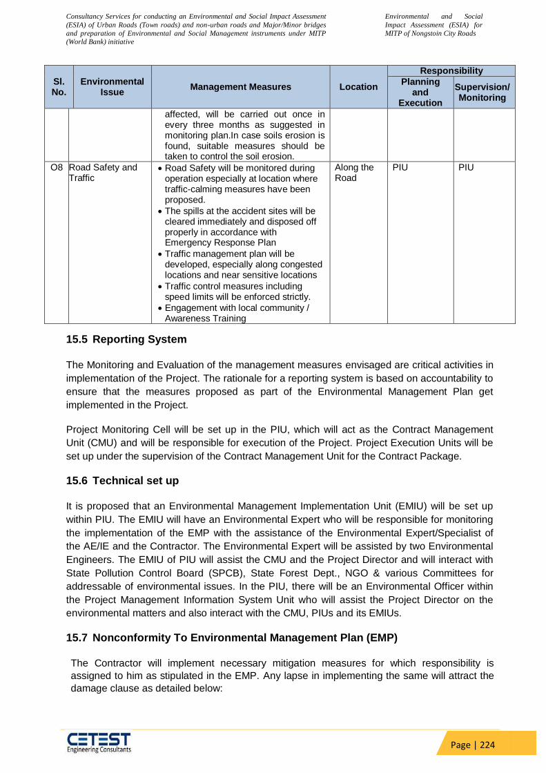
Consultancy Services for conducting an Environmental and Social Impact Assessment
(ESIA) of Urban Roads (Town roads) and non-urban roads and Major/Minor bridges
and preparation of Environmental and Social Management instruments under MITP
(World Bank) initiative
Environmental and Social
Impact Assessment (ESIA) for
MITP of Nongstoin City Roads
Page | 224
Sl. No.
Environmental Issue
Management Measures Location
Responsibility
Planning and
Execution
Supervision/ Monitoring
affected, will be carried out once in every three months as suggested in monitoring plan.In case soils erosion is found, suitable measures should be taken to control the soil erosion.
O8 Road Safety and Traffic
Road Safety will be monitored during operation especially at location where traffic-calming measures have been proposed.
The spills at the accident sites will be cleared immediately and disposed off properly in accordance with Emergency Response Plan
Traffic management plan will be developed, especially along congested locations and near sensitive locations
Traffic control measures including speed limits will be enforced strictly.
Engagement with local community / Awareness Training
Along the Road
PIU PIU
15.5 Reporting System
The Monitoring and Evaluation of the management measures envisaged are critical activities in
implementation of the Project. The rationale for a reporting system is based on accountability to
ensure that the measures proposed as part of the Environmental Management Plan get
implemented in the Project.
Project Monitoring Cell will be set up in the PIU, which will act as the Contract Management
Unit (CMU) and will be responsible for execution of the Project. Project Execution Units will be
set up under the supervision of the Contract Management Unit for the Contract Package.
15.6 Technical set up
It is proposed that an Environmental Management Implementation Unit (EMIU) will be set up
within PIU. The EMIU will have an Environmental Expert who will be responsible for monitoring
the implementation of the EMP with the assistance of the Environmental Expert/Specialist of
the AE/IE and the Contractor. The Environmental Expert will be assisted by two Environmental
Engineers. The EMIU of PIU will assist the CMU and the Project Director and will interact with
State Pollution Control Board (SPCB), State Forest Dept., NGO & various Committees for
addressable of environmental issues. In the PIU, there will be an Environmental Officer within
the Project Management Information System Unit who will assist the Project Director on the
environmental matters and also interact with the CMU, PIUs and its EMIUs.
15.7 Nonconformity To Environmental Management Plan (EMP)
The Contractor will implement necessary mitigation measures for which responsibility is
assigned to him as stipulated in the EMP. Any lapse in implementing the same will attract the
damage clause as detailed below:

Consultancy Services for conducting an Environmental and Social Impact Assessment
(ESIA) of Urban Roads (Town roads) and non-urban roads and Major/Minor bridges
and preparation of Environmental and Social Management instruments under MITP
(World Bank) initiative
Environmental and Social
Impact Assessment (ESIA) for
MITP of Nongstoin City Roads
Page | 225
Any complaints of public, within the scope of the Contractor, formally registered with the
PIU and communicated to the Contractor, which is not properly addressed within the time
period intimated by the PIU shall be treated as a major lapse.
Non-conformity to any of the mitigation measures like unsafe conditions, non-collection of
excavated material (during laying of drainage pipes) regularly and other unattended
Environment, Health & Safety (EHS) issues, as stipulated in the EMP Report (other than
stated above) shall be considered as a minor lapse.
On observing any lapses, PIU shall issue a notice to the Contractor, to rectify the same.
Any minor lapse for which notice was issued and not rectified, first and second reminders
shall be given after ten days from the original notice date and first reminder date
respectively. Any minor lapse, which is not rectified, shall be treated as a major lapse
from the date of issuing the second reminder.
If a major lapse is not rectified upon receiving the notice PIU shall invoke reduction, in
the subsequent interim payment certificate.
For major lapses, 10% of the interim payment certificate will be withheld, subject to a
maximum limit of about 0.5% of the contract value.
If the lapse is not rectified within one month after withholding the payment, the amount
withheld shall be forfeited immediately.
Table 70: Environmental Monitoring Plan
En
vir
on
men
tal
Co
mp
on
en
t
Pro
ject
Sta
ge
Monitoring Institutional
Responsibility
Para
mete
rs
Sp
ecia
l G
uid
an
ce
Sta
nd
ard
s
Lo
cati
on
Fre
qu
en
cy
Imp
lem
en
tati
on
Su
perv
isio
n
Air
Co
nstr
ucti
on
Sta
ge
PM10,
PM 2.5,
SOx,
NOx,
CO
Respirable
Dust Sampler
to be located
50 m from the
plant in the
downwind
direction. Use
method
specified by
CPCB for
analysis
Air
(P&CP)
Act,1981
and its
amendme
nt
Hot mix
Plant /
Batching
Plant.
Stretch of
the road
where
construction
is in
progress at
the site.
(Total 02
locations)
Three
times in a
year for
two years
(Excludin
g Rainy
season)
Contracto
r through
NABL
approved
monitorin
g agency
Environmen
t Expert-
AE/IE/PIU
Op
er
ati
on
al
Sta
ge PM10,
PM 2.5,
SOx,
Respirable
Dust Sampler
to be located
Air
(P&CP)
Act,1981
As directed
by the PIU
Three
times in a
year for
P I U
through
P I U

Consultancy Services for conducting an Environmental and Social Impact Assessment
(ESIA) of Urban Roads (Town roads) and non-urban roads and Major/Minor bridges
and preparation of Environmental and Social Management instruments under MITP
(World Bank) initiative
Environmental and Social
Impact Assessment (ESIA) for
MITP of Nongstoin City Roads
Page | 226
En
vir
on
men
tal
Co
mp
on
en
t
Pro
ject
Sta
ge
Monitoring Institutional
Responsibility
Para
mete
rs
Sp
ecia
l G
uid
an
ce
Sta
nd
ard
s
Lo
cati
on
Fre
qu
en
cy
Imp
lem
en
tati
on
Su
perv
isio
n
NOx,
CO
50m from the
plant in the
downwind
direction. Use
method
specified by
CPCB for
analysis
and its
amendme
nt
(02 Project
locations)
two years
(Excludin
g Rainy
season)
NABL
approved
monitorin
g agency
W
ate
r Q
uali
ty
Co
nstr
ucti
on
Sta
ge
Paramet
ers as
per IS:
10500
and
standar
ds of
surface
water
Grab sample
collected from
source and
analyze as per
Standard
Methods for
Examination
of Water
quality
Water
quality
standards
by CPCB
01 drinking
water
sample-
Labour
Camp and
02 surface
water
samples in
project
stretch.
Three
times in a
year for
two years
(Excludin
g Rainy
season)
Contracto
r through
NABL
approved
monitorin
g agency
Environmen
t Expert-
AE/IE/PIU
Wate
r Q
uality
Op
era
tio
n S
tag
e
Paramet
ers as
per IS:
10500
and
standar
ds of
surface
water
Grab sample
collected from
source and
analyze as per
Standard
Methods for
Examination
of Water
quality
Water
quality
standards
by CPCB
As directed
by the PIU
(02 Project
locations)
Three
times in a
year for
two years
(Excludin
g Rainy
season)
P I U
through
NABL
approved
monitorin
g agency
P I U
No
ise L
evels
Co
nstr
ucti
on
Sta
ge
Noise
levels
on dB
(A)
scale
As per CPCB Noise
standards
by CPCB
Hot mix
Plant /
Batching
Plant.
Stretch of
the road
where
construction
is in
progress at
the site.
(Total 02
locations)
Three
times in a
year for
two
years.
Contracto
r through
NABL
approved
monitorin
g agency
Environmen
t Expert-
AE/IE/PIU
Op
era tio n
St
ag e Noise
levels
As per CPCB Noise
standards
As directed Three
times in a
PIU
through
PIU

Consultancy Services for conducting an Environmental and Social Impact Assessment
(ESIA) of Urban Roads (Town roads) and non-urban roads and Major/Minor bridges
and preparation of Environmental and Social Management instruments under MITP
(World Bank) initiative
Environmental and Social
Impact Assessment (ESIA) for
MITP of Nongstoin City Roads
Page | 227
En
vir
on
men
tal
Co
mp
on
en
t
Pro
ject
Sta
ge
Monitoring Institutional
Responsibility
Para
mete
rs
Sp
ecia
l G
uid
an
ce
Sta
nd
ard
s
Lo
cati
on
Fre
qu
en
cy
Imp
lem
en
tati
on
Su
perv
isio
n
on dB
(A)
scale
by CPCB by the PIU
(Total 02
locations)
year for
two
years.
NABL
approved
monitorin
g agency
So
il E
rosio
n
Co
nstr
ucti
on
Sta
ge Turbidity
in Storm
Water
Silt load
in
ponds,
water
courses
---- As per
Standard
(ICAR)
01 location
construction
camp and 02
major
construction
locations.
(Total 02
locations)
Three
times in a
year for
two years
Contracto
r through
NABL
approved
monitorin
g agency
Environmen
t Expert-
AE/IE/PIU
Op
era
tio
nal
Sta
ge
Turbidity
in Storm
Water
Silt load
in
ponds,
water
courses
---- As per
Standard
(ICAR)
As directed
by the PIU
(Total 02
locations)
Three
times in a
year for
two
years.
PIU
through
NABL
approved
monitorin
g agency
PIU
15.8 Environmental Monitoring Budget:
The environmental monitoring cost is estimated on the basis of the length and existing
environmental scenario of the proposed project. Environmental monitoring cost of 6,18,000/- is
estimated for the construction and Operation stages. The details have been presented in Table
71
Table 71: Environment Management Plan Implementation Budget
Sl. no Environment
al
Components
Particulars Unit Rate In
(Rs.)
Approx.
Quantity
Total Cost In
(Rs.)
Mitigation / Enhancement Cost
2 Construction Stage
2.1 Air Dust Management with sprinkling
of water, covers for vehicles
20.925Km Cost included in Total Civil Cost
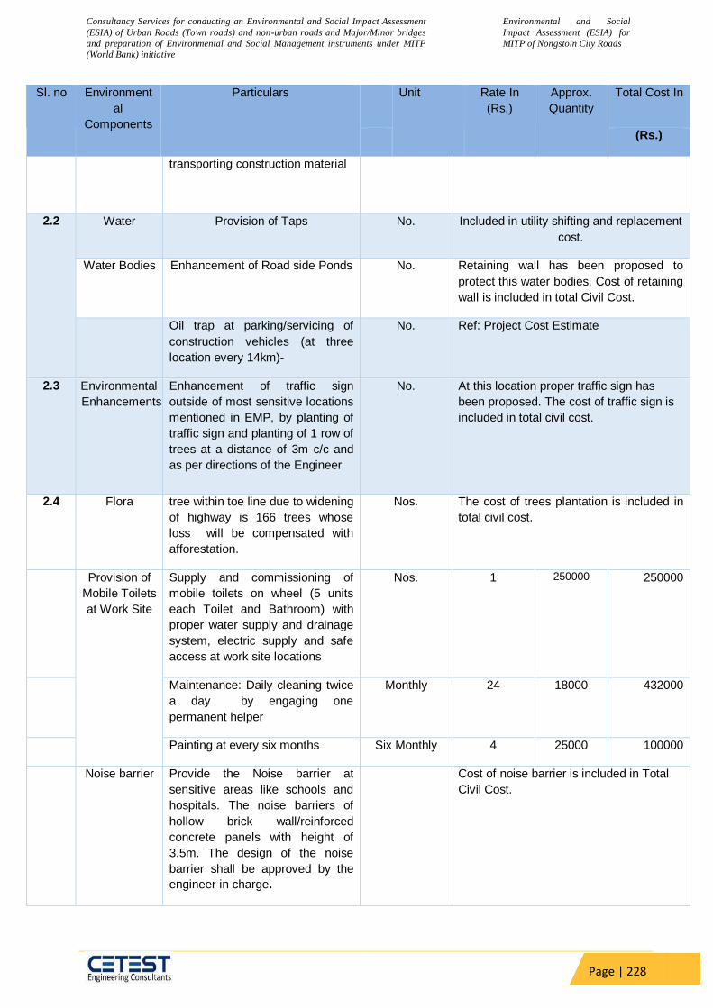
Consultancy Services for conducting an Environmental and Social Impact Assessment
(ESIA) of Urban Roads (Town roads) and non-urban roads and Major/Minor bridges
and preparation of Environmental and Social Management instruments under MITP
(World Bank) initiative
Environmental and Social
Impact Assessment (ESIA) for
MITP of Nongstoin City Roads
Page | 228
Sl. no Environment
al
Components
Particulars Unit Rate In
(Rs.)
Approx.
Quantity
Total Cost In
(Rs.)
transporting construction material
2.2 Water Provision of Taps No. Included in utility shifting and replacement
cost.
Water Bodies Enhancement of Road side Ponds No. Retaining wall has been proposed to
protect this water bodies. Cost of retaining
wall is included in total Civil Cost.
Oil trap at parking/servicing of
construction vehicles (at three
location every 14km)-
No. Ref: Project Cost Estimate
2.3 Environmental
Enhancements
Enhancement of traffic sign
outside of most sensitive locations
mentioned in EMP, by planting of
traffic sign and planting of 1 row of
trees at a distance of 3m c/c and
as per directions of the Engineer
No. At this location proper traffic sign has
been proposed. The cost of traffic sign is
included in total civil cost.
2.4 Flora tree within toe line due to widening
of highway is 166 trees whose
loss will be compensated with
afforestation.
Nos. The cost of trees plantation is included in
total civil cost.
Provision of
Mobile Toilets
at Work Site
Supply and commissioning of
mobile toilets on wheel (5 units
each Toilet and Bathroom) with
proper water supply and drainage
system, electric supply and safe
access at work site locations
Nos. 1 250000 250000
Maintenance: Daily cleaning twice
a day by engaging one
permanent helper
Monthly 24 18000 432000
Painting at every six months Six Monthly 4 25000 100000
Noise barrier Provide the Noise barrier at
sensitive areas like schools and
hospitals. The noise barriers of
hollow brick wall/reinforced
concrete panels with height of
3.5m. The design of the noise
barrier shall be approved by the
engineer in charge.
Cost of noise barrier is included in Total
Civil Cost.
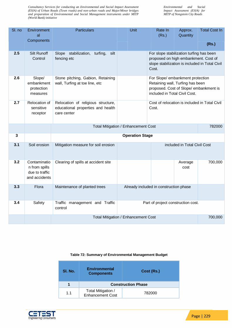
Consultancy Services for conducting an Environmental and Social Impact Assessment
(ESIA) of Urban Roads (Town roads) and non-urban roads and Major/Minor bridges
and preparation of Environmental and Social Management instruments under MITP
(World Bank) initiative
Environmental and Social
Impact Assessment (ESIA) for
MITP of Nongstoin City Roads
Page | 229
Sl. no Environment
al
Components
Particulars Unit Rate In
(Rs.)
Approx.
Quantity
Total Cost In
(Rs.)
2.5 Silt Runoff
Control
Slope stabilization, turfing, silt
fencing etc
For slope stabilization turfing has been
proposed on high embankment. Cost of
slope stabilization is included in Total Civil
Cost.
2.6 Slope/
embankment
protection
measures
Stone pitching, Gabion, Retaining
wall, Turfing at toe line, etc
For Slope/ embankment protection
Retaining wall, Turfing has been
proposed. Cost of Slope/ embankment is
included in Total Civil Cost.
2.7 Relocation of
sensitive
receptor
Relocation of religious structure,
educational properties and health
care center
Cost of relocation is included in Total Civil
Cost.
Total Mitigation / Enhancement Cost 782000
3 Operation Stage
3.1 Soil erosion Mitigation measure for soil erosion included in Total Civil Cost
3.2 Contaminatio
n from spills
due to traffic
and accidents
Clearing of spills at accident site
Average
cost
700,000
3.3 Flora Maintenance of planted trees Already included in construction phase
3.4 Safety Traffic management and Traffic
control
Part of project construction cost.
Total Mitigation / Enhancement Cost 700,000
Table 72: Summary of Environmental Management Budget
Sl. No. Environmental Components
Cost (Rs.)
1 Construction Phase
1.1 Total Mitigation /
Enhancement Cost 782000

Consultancy Services for conducting an Environmental and Social Impact Assessment
(ESIA) of Urban Roads (Town roads) and non-urban roads and Major/Minor bridges
and preparation of Environmental and Social Management instruments under MITP
(World Bank) initiative
Environmental and Social
Impact Assessment (ESIA) for
MITP of Nongstoin City Roads
Page | 230
1.2 Environmental
Monitoring Cost 309000
Total Cost in Construction phase 1091000
2 Operation Phase
2.1 Total Mitigation /
Enhancement Cost 700000
2.2 Environmental
Monitoring Cost 309000
Total Cost in Operation Phase 1009000
3 Miscellaneous Cost
3.1 Environmental Awareness and Training
1,20,000
3.2 Administrative
Charges including logistics
4,00,000
Total Cost in Miscellaneous
520000
TOTAL BUDGETED COST (1+2+3)
2620000
An environmental management budget at of INR 26,02,000 has been estimated for
implementation of the environmental management plan. This budget includes cost of
environmental monitoring and associated trainings.

Consultancy Services for conducting an Environmental and Social Impact Assessment
(ESIA) of Urban Roads (Town roads) and non-urban roads and Major/Minor bridges
and preparation of Environmental and Social Management instruments under MITP
(World Bank) initiative
Environmental and Social
Impact Assessment (ESIA) for
MITP of Nongstoin City Roads
Page | 231
16 CHAPTER-XV: CONCLUSION AND RECOMMENDATIONS
The environmental and the social impact assessment have been conducted as per the
approach/ methodology for conducting ESIA study for all the seven project corridors. All the
potential impacts were identified in relation to pre-construction, construction, and operation
phases. Social impact assessment study has done within the proposed corridor. The proposed
project interventions shall not attract Environmental Clearance (EC) from the SEIAA.
Focus Group Discussions (FGD’s) were conducted to assess the perception of the people
about the proposed project. The stakeholders selected included shop keepers, residents along
the road, owners/ workers of local commercial establishments etc. The outcome of the
consultations depicts the requirement for the road safety measures; road furniture’s (including
street lights, additional bus bays, signage’s, speed breaker etc,). The project is not huge and
can be easily completed with the local labour force. There might movement of labour from the
neighbouring districts within the state.
In view of the environmental Impact assessment, there will be temporary negative impacts,
arising mainly from construction dust and noise, hauling of construction material, waste and
equipment on the project corridors (traffic, dust, safety etc.,), mining of construction material,
occupation health and safety aspects, disturbance to the residents, businesses, safety risk to
workers, public and nearby buildings due to road excavation works, access impediment to
houses and business, disposal of large quantities of construction waste, etc. These are all
general impacts that are likely to arise during the road construction works in the settlement
areas, and there are well developed methods of mitigation that are suggested in the ESMP.
Mitigation will be assured by a program of environmental monitoring conducted during
construction and operation to ensure that all measures are implemented, and to determine
whether the environment is protected as intended. This will include observations on- and off-
site, document checks, and interviews with workers and beneficiaries, and any requirements for
remedial action will be reported by the contractor to the CSC/PIU.
The prepared ESMP will assist the Contractor, CSC, and the PIU in mitigating the
environmental and social impacts, and guide them in the environmentally sound execution of
the proposed project. A copy of the updated ESMP shall be kept on-site during the construction
period at all times. The ESMP shall be included in the bidding document along with appropriate
contractual clauses for safeguarding the environment during the project construction and
operation (maintenance period). As per the World Bank policy requirements, the prepared
safeguard documents shall be disclosed in the World Bank website.

Consultancy Services for conducting an Environmental and Social Impact Assessment
(ESIA) of Urban Roads (Town roads) and non-urban roads and Major/Minor bridges
and preparation of Environmental and Social Management instruments under MITP
(World Bank) initiative
Environmental and Social
Impact Assessment (ESIA) for
MITP of Nongstoin City Roads
Page | 232
Annexure 1: Environmental Screening Checklist
Name of the sub-project NONGSTOIN ROADS
Size of the project (approx. area in sq. mt/hac or length in mt/km, as relevant)
20.925 Km
Location of the proposed sub-project Meghalaya, India
Name of the of the district, block West Khasi Hills
Name of the settlement/ area, where the bridge is located This road goes through Nongstoin town which is a headquarter and key city of West Khasi Hills district in the state of Meghalaya in India.
Latitude and longitude Lat: 25.53015830 Long: 91.27633240
New construction/ repair/ rehabilitation/ expansion (if there is an existing bridge, please share picture of old bridge. Also, the approach roads.)
Rehabilitation of the project road
If expansion, then is there any need of new land NA
If yes, please share detail: - Total requirement - Private land - Govt. land
- Forest land
NA
What is the High Flood Level in the sub-project area?
S. No. Environmental & Social Features
Presence within 500 mts from activity sites (Yes/No) If yes, mention distance in km)
Type of Impact (+ or -)
Significance of Impact (High (H), Medium (M), Low (L))
Likelihood of Impact (Likely, Unlikely)
Description of Impact
Physical Environment
Springs No
Standing water bodies (ponds, lakes, etc.)
Yes _ Low (L) Likely Increase in turbidity

Consultancy Services for conducting an Environmental and Social Impact Assessment
(ESIA) of Urban Roads (Town roads) and non-urban roads and Major/Minor bridges
and preparation of Environmental and Social Management instruments under MITP
(World Bank) initiative
Environmental and Social
Impact Assessment (ESIA) for
MITP of Nongstoin City Roads
Page | 233
S. No. Environmental & Social Features
Presence within 500 mts from activity sites (Yes/No) If yes,
mention distance in km)
Type of Impact (+ or -)
Significance of Impact (High (H), Medium (M), Low (L))
Likelihood of Impact (Likely, Unlikely)
Description of Impact
Flowing water bodies (rivers, rivulets, streams, canals, etc.)
Yes _ Low (L) Likely Increase in turbidity
Ground water sources (open wells, bore wells, etc.)
Yes _ Low (L) Likely Extraction of Water
Meandering River No Erosion prone stretches7 Yes _ Medium (M) Likely In some location, soil
erosion may take place. Lack of drainage facilities and unsustainable agricultural practices are two key reasons behind soil erosion.
Areas with high slope (higher than 15 percent)
Yes _ Medium (M) Likely High slope will cause soil erosion problem.
Landforms (hills, valleys) Yes _ Medium (M) Likely Project road is mostly going through the hilly areas and for this, hill cutting may be required.
Coal Mine No Biological Environment
National Park / Wildlife Sanctuary Consider both end of the bridges and within 10km radius as per law
No National Park / Wildlife Sanctuary are locating along the project road
Reserved Forests Consider both end of the bridges and within 10km radius as per law
No reserved forest are locating along the project road
Community Forest/ Fisheries Local consultation No
7 https://slusi.dacnet.nic.in/srm/srmabstracts/SRM_138_West_Khasi_Hills.pdf

Consultancy Services for conducting an Environmental and Social Impact Assessment
(ESIA) of Urban Roads (Town roads) and non-urban roads and Major/Minor bridges
and preparation of Environmental and Social Management instruments under MITP
(World Bank) initiative
Environmental and Social
Impact Assessment (ESIA) for
MITP of Nongstoin City Roads
Page | 234
S. No. Environmental & Social Features
Presence within 500 mts from activity sites (Yes/No) If yes,
mention distance in km)
Type of Impact (+ or -)
Significance of Impact (High (H), Medium (M), Low (L))
Likelihood of Impact (Likely, Unlikely)
Description of Impact
Fish breeding Around the area – unique amphibian species (relevant dept.)
Large Trees / Woodland Visual checks – if found, please click photograph
_ Medium (M) Likely Tree cutting causes soil erosion
Sacred Groves No Presence of endangered species /
habitat areas Consider both end of the bridges and within 10km radius as per law
No
Migratory routes Please refer to ESMF and check if any intercepts with the project area
No
Ecologically sensitive areas Consider both end of the bridges and within 10km radius as per law
No
Human Environment
Settlements/Habitations Yes + Low Likely Connectivity Improvement Sensitive Receptors (schools,
hospitals, markets etc.) Yes _ Low Likely Increase of noise and air
pollution.
Drinking water sources Yes _ Low Likely
Underground utility lines like electricity lines, pipelines for gas, etc
Yes _ Low Likely Utility trench may come in the project road and may need to shift
Physical cultural resources – Protected monuments, historical/ heritage sites etc.
No
Physical cultural resources – Yes _ Low Likely Sensitive locations such as

Consultancy Services for conducting an Environmental and Social Impact Assessment
(ESIA) of Urban Roads (Town roads) and non-urban roads and Major/Minor bridges
and preparation of Environmental and Social Management instruments under MITP
(World Bank) initiative
Environmental and Social
Impact Assessment (ESIA) for
MITP of Nongstoin City Roads
Page | 235
S. No. Environmental & Social Features
Presence within 500 mts from activity sites (Yes/No) If yes,
mention distance in km)
Type of Impact (+ or -)
Significance of Impact (High (H), Medium (M), Low (L))
Likelihood of Impact (Likely, Unlikely)
Description of Impact
Religious structures, other sites significant to community
church, temple, mosque and hospitals, schools, collages present along the project road. Increase of noise and air pollution may impact on the physical cultural resources.
Agricultural land/ Other activities Yes _ Low unlikely Defence Installations / Airports No
Heavy polluting Industry No
Water or Waste water Treatment Plant
No
Social Safeguard Issues
Any loss / reduction of access to traditional dependent communities (to areas where they earn for their primary or substantial livelihood).
Adverse impacts to women, gender issues including economic and safety concerns
Community consultation
Presence of Indigenous / vulnerable communities
Community consultation
Land acquisition of private land leading to loss of shelter and livelihood
Whether land acquired / donated is more than 10% of the total holding
Land acquisition resulting to loss of

Consultancy Services for conducting an Environmental and Social Impact Assessment
(ESIA) of Urban Roads (Town roads) and non-urban roads and Major/Minor bridges
and preparation of Environmental and Social Management instruments under MITP
(World Bank) initiative
Environmental and Social
Impact Assessment (ESIA) for
MITP of Nongstoin City Roads
Page | 236
S. No. Environmental & Social Features
Presence within 500 mts from activity sites (Yes/No) If yes,
mention distance in km)
Type of Impact (+ or -)
Significance of Impact (High (H), Medium (M), Low (L))
Likelihood of Impact (Likely, Unlikely)
Description of Impact
income; livelihood; sources of livelihood; loss of access to common property resources and / or private residential and/or property resources.
Possible conflicts with and/or disruption to local community
Significant issues raised by the stakeholders during consultation
MoM of the community consultation
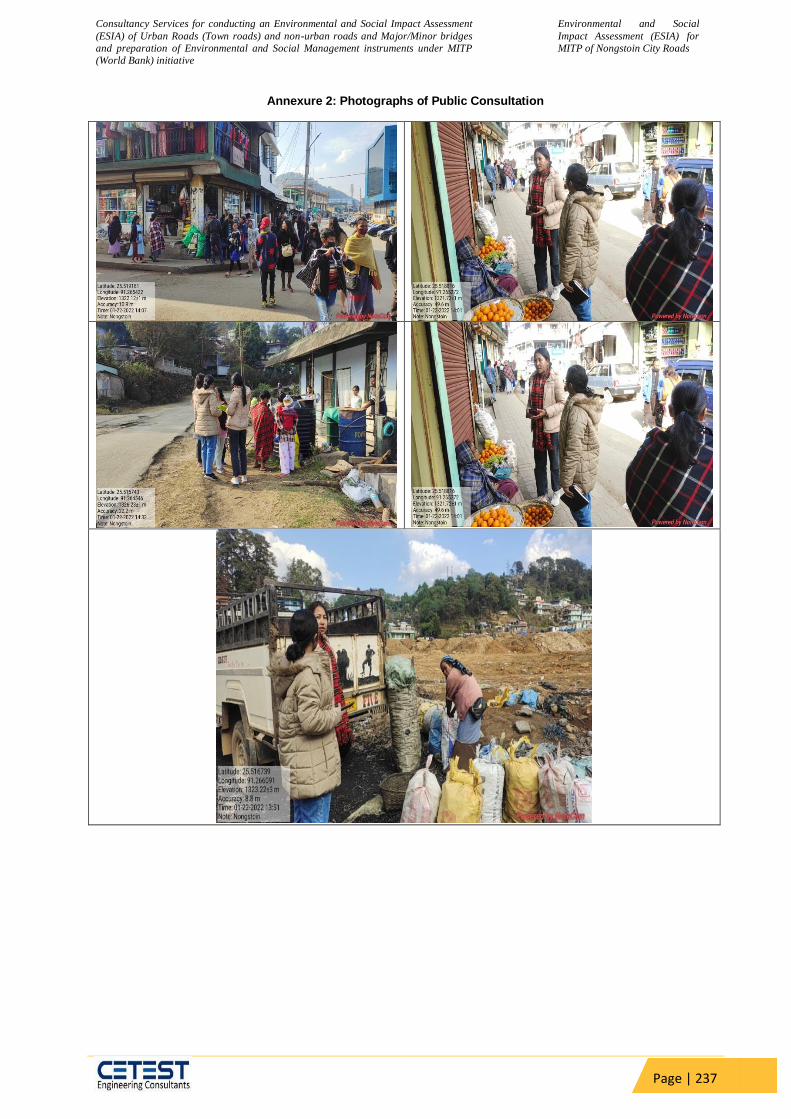
Consultancy Services for conducting an Environmental and Social Impact Assessment
(ESIA) of Urban Roads (Town roads) and non-urban roads and Major/Minor bridges
and preparation of Environmental and Social Management instruments under MITP
(World Bank) initiative
Environmental and Social
Impact Assessment (ESIA) for
MITP of Nongstoin City Roads
Page | 237
Annexure 2: Photographs of Public Consultation
Related Documents


