Office of Research and Development National Risk Management Research Laboratory/Air Pollution Prevention and Control Division Michelle Latham EPA/ORD’s Safe & Sustainable Water Resources Research Program EPA Tools and Resources Webinar: Green Infrastructure Modeling Toolkit December 14, 2016 Watch the Toolkit video: https://www.epa.gov/water-research/green-infrastructure-modeling-toolkit Watch as you wait

Welcome message from author
This document is posted to help you gain knowledge. Please leave a comment to let me know what you think about it! Share it to your friends and learn new things together.
Transcript

Office of Research and DevelopmentNational Risk Management Research Laboratory/Air Pollution Prevention and Control Division
Michelle LathamEPA/ORD’s Safe & Sustainable Water Resources Research Program
EPA Tools and Resources Webinar:Green Infrastructure Modeling Toolkit
December 14, 2016
Watch the Toolkit video: https://www.epa.gov/water-research/green-infrastructure-modeling-toolkit
Watch as you wait

2
Webinar Summary
Green Infrastructure: Green infrastructure, such as rain gardens, green roofs, porous
pavement, cisterns, and constructed wetlands, is becoming an increasingly attractive way to recharge aquifers and reduce the amount of stormwater runoff that flows into wastewater treatment plants or into waterbodies untreated. It provides many environmental, social, and economic benefits that promote urban livability, such as improved surface water quality, water conservation, and improved aesthetics and property values. Green infrastructure is also incorporated into municipal separate storm sewer system (MS4) and National Pollutant Discharge Elimination System (NPDES) stormwater permits for retention requirements for various states across the Nation.
Need for Water Runoff Control: Stormwater discharges continue to cause impairment of
our Nation’s waterbodies. Conventional stormwater infrastructure, or gray infrastructure, is largely designed to move stormwater away from urban areas through pipes and conduit. Runoff from these surfaces can overwhelm sewer systems and end up contaminating local waterways. When stormwater runs off impervious streets, parking lots, sidewalks, and rooftops, it carries pollutants, such as motor oil, lawn chemicals, sediments, and pet waste to streams, rivers, and lakes. Runoff flows can also cause erosion and flooding that can damage property, infrastructure, and wildlife habitat. In addition to runoff problems, impervious surfaces also prevent water from penetrating the soil and recharging groundwater supplies.
Green Infrastructure Modeling Toolkit: Researchers in EPA’s Office of Research and
Development (ORD) have been studying green infrastructure practices and developing models and tools to help communities manage their stormwater runoff and address nutrient impairment. This webinar will present a toolkit consisting of five EPA green infrastructure models and tools, along with communication material, that can be used as a teaching tool and as a quick reference resource for use by planners and developers when making green infrastructure implementation decisions, and can also be used for low impact development design competitions. The models and tools included in the toolkit are the National Stormwater Calculator (SWC), Green Infrastructure Wizard (GIWiz), Watershed Optimization Support Tool (WMOST), Storm Water Management Model (SWMM), and Visualizing Ecosystem Land Management Assessments (VELMA). Toolkit available on EPA’s website: epa.gov/water-research/green-infrastructure-modeling-toolkit
2

3
• Land development alters natural hydrologic cycle
• Combined sewer systems
• Wastewater systems discharge runoff and overwhelm treatment facilities
• Aging water infrastructure (gray)
Stormwater Management Issues:How did we get here?
3
Implications for communities:
– Release of untreated wastewater
– Increased runoff of stormwater
– Water quality degradation (e.g., pathogens, nutrients and resulting algal blooms, chemical contaminants)
– Stream erosion and degradation of aquatic ecosystems

4
Webinar SummaryStormwater Management Issues:How did we get here?

55
• Approximately 772 U.S. cities have water pollution concerns due to CSOs.
• Estimated 850 billion gallons of untreated wastewater is discharged into U.S. waterways annually due to CSOs.
• Estimated 3,500 to 5,500 gastrointestinal illnesses occur annually from CSO contaminated recreational waters.
A cause for concern…
Runoff Concerns: Combined Sewer Overflows (CSOs)
Total estimated water infrastructure needs for the United States include
— $48.0 billion for combined sewer overflow control, and
— $19.2 billion for stormwater management.(EPA Clean Water Needs Survey 2012)

6
Green Infrastructure as a
Solution to Runoff Issues
• Plants, soils, landscape design, and engineered techniques used to retain, absorb, and reduce polluted stormwater runoff.
• City or county scale: green infrastructure refers to the patchwork of natural areas that provides habitat, flood protection, cleaner air, and cleaner water.
• Neighborhood or site scale: green infrastructure refers to stormwater management systems that mimic nature by soaking up and storing water.
Green Infrastructure Practices
• Downspout Disconnection
• Rainwater Harvesting
• Rain Gardens
• Planter Boxes
• Bioswales
• Permeable Pavements
• Green Streets and Alleys
• Green Parking
• Green Roofs
• Urban Tree Canopy
• Land Conservation6

7
Green Infrastructure as a
Solution to Runoff Issues

8
• Water quality control
• Mitigation of flood and erosion risks
• Increase water supply (harvesting & aquifer recharge)
• Private and public cost savings
• Improve air quality by reducing temperatures and reducing emission pollutants
• Climate resiliency
• Provide habitat for wildlife
• Community aesthetic and health benefits
Benefits of Green Infrastructure

9
What is EPA doing to help?
Working with states and communities to identify green infrastructure implementation opportunities.
Developing modeling tools to integrate green infrastructure into stormwater management approaches.

10
Webinar SummaryEPA’s Green Infrastructure
Modeling Toolkit
epa.gov/water-research/green-infrastructure-modeling-toolkit
Additions coming soon:• Webinar recording• Case studies• Testimonials
Included in the Toolkit:• Five EPA models/tools• Manuals• Summary video • Fact sheets• Green infrastructure brochure

11
Webinar SummaryHow the Toolkit can help Regions,
States, and Communities
• Quick reference resource for use by planners and developers when making green infrastructure implementation decisions.
• Low impact development (LID) design competitions.
• Teaching and training tool.

12
• Database of EPA’s green infrastructure tools and resources.
• Interactive web application that connects communities with these tools and resources.
• Wizard that provides customized links and exploration, based you your objectives and specifications.
• Decision support tool for green infrastructure implementation.
• Simple means to generate a report about tools and resources of interest.
Green Infrastructure Wizard (GIWiz)
GIW
iz
Database content is expandingV1 Sept 2015: 270 Tools and ResourcesV2 Sept 2016: 395 Tools and Resources

13
Why GIWiz?G
IWiz Example search: EPA, green infrastructure, regulator, compliance
781,000Quick
Efficient
Accurate
It can be difficult for users to navigate the vast array of available EPA green infrastructure tools, information resources, and case studies.
GIWiz makes searching easy

14
National Stormwater Calculator (SWC)S
WC
Desktop application that estimates the annual amount of stormwater runoff from a specific location in the United States, including Puerto Rico.
– Addition of cost module in January 2017
– Mobile web compatible by Fall 2017
• Used to inform site developers on how well they can meet a stormwater retention target with and without the use of green infrastructure.
• Can be used by landscape architects, urban planners, and homeowners.
• Allows users to consider how runoff may vary based both on historical weather and potential future climate.

15
Potential Applications
• State or MS4 (Municipal Separate Storm Sewer System) Post Construction Stormwater Design Standards.
• Voluntary stormwater retrofits for private property owners.
• Voluntary programs: LEED (US Green Building Council) and Sustainable Sites Initiative stormwater credits, Rockefeller Foundation’s 100 Resilient Cities.
• Climate Resiliency Planning.
• Low impact design/green infrastructure design competitions: Campus RainWorks Challenge, DC Water Green Infrastructure Challenge, etc.
SW
C

16
Real-World Applications and Outreach
Demonstration Workshops
AAAS (American Association for the Advancement of Science):
http://www.eurekalert.org/pub_releases/2016-04/uota-ust042216.php
SW
C
Design Competitions

17
Climate Resiliency PlanningS
WC
http://toolkit.climate.gov/case-studies/improving-water-quality-dealing-first-inch-rain
18
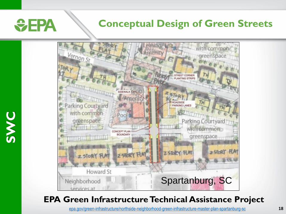
Conceptual Design of Green Streets
epa.gov/green-infrastructure/northside-neighborhood-green-infrastructure-master-plan-spartanburg-sc
EPA Green Infrastructure Technical Assistance Project
SW
C
Spartanburg, SC

19
US Green Building Council LEED Resource Tool
SW
C
usgbc.org/resources/epas-national-stormwater-calculator
Resource for LEED Project Credit 16 (Rainwater Management) certification by the U.S. Green Building Council for projects that are designed to reduce runoff volume and improve water quality of a site.

20
Green Infrastructure Grant Funding Application
http://www.neorsd.org/greenfunding.php
SW
C
Applicants must use the SWC for conducting their stormwater runoff analyses for their grant application submission.

21
Watershed Management Optimization
Support Tool (WMOST)
WM
OS
T
• Decision-support tool for integrated water management at the small watershed/community scale.
• Optimizes cost and evaluates management options in multiple programs, including stormwater, wastewater, drinking water, and land conservation.
• Target users are community decision-makers, such as municipal, regional, or watershed planners; utility managers; and community consultants.
• Used for planning level assessments.

22
Example ApplicationsW
MO
ST
• Ipswich River, MAWhat is the most cost-effective suite of management actions to meet target baseflows in the Ipswich River?
• Monponsett Ponds watershed, Halifax, MAWhat are the tradeoffs among flood control, recreational use, downstream aquatic life use, and sustainable water supply? What are the most cost-effective management practices to both reduce water quality impairments and manage for resilience in the face of climate change?
• Subwatersheds of Taunton River, MA (multiple communities)What is the value of natural and constructed green infrastructure in reducing flooding and water quality impairments under different development and climate change scenarios?
• Subwatersheds of Montgomery County, MDWhat are the most cost effective management practices and tradeoffs involved in meeting both local sediment TMDLs and N/P/SS targets for the Chesapeake Bay TMDL?
• Subwatersheds of Middle Kansas River, KSWhat are the most cost-effective management practices to both reduce water quality impairments and manage for resilience in the face of climate change?

23
“The process of applying this model (WMOST) to Halifax, MA was very useful from the beginning, allowing residents and stakeholders to participate in informing the scientists of the complicated issues and challenges facing the Monponsett Ponds. The model analyzed the data and needs of the area, resulting in a very useful report with options and ideas we can implement and use when seeking grant funds. We thank you!” —Cathy Drinan, Halifax Board of Health
Monponsett Pond Work Group
Application in Halifax, MA
• Coordinated with the town of Halifax, Monponsett Ponds (MP) Watershed Workgroup, and EPA Region 1.
• Developed a case study for the MP Watershed in conjunction with development of WMOST version 2.
• Halifax Board of Health has used the information provided by the case study in applying for grants to implement best management practices in the watershed.
WM
OS
T
23

24
Visualizing Ecosystems for Land
Management Assessment (VELMA) Model
VE
LM
A
• Identify green infrastructure best management practices for enhancing water quality and ecosystem service co-benefits.
• Users include communities, tribes, land managers, and EPA regions and scientists in Pacific Northwest, Central Plains, Midwest and East Coast.

25
Smoke Management PlanningCentral Plains Rangelands, KS
Estuarine Water Quality Tillamook Bay Estuary, OR
Salmon Recovery Planning Puget Sound, WA
Constructed Wetland Effectiveness
Agricultural Watershed, OH
Urban GI Effectiveness Seattle, Duluth, Mobile Bay
Forest Buffer EffectivenessChesapeake Bay Agriculture, MD
Broad ApplicabilityV
EL
MA

26
• Used widely throughout the world for large-scale planning, analysis, and design related to stormwater runoff, combined and sanitary sewers, and other drainage systems in urban areas.
• Many applications for drainage systems in non-urban areas.
• Developed to help support local, state, and national stormwater management objectives to reduce runoff through infiltration and retention.
Storm Water Management
Model (SWMM)
SW
MM
• Professional tool used by civil and environmental engineers.
• Used at the municipal level to design and manage stormwater and sanitary sewer infrastructure.
• Many large cities across the US and around the world rely on SWMM.

27
Broad Applicability
SW
MM
Design and sizing of drainage system components including detention facilities.
Control of combined and sanitary sewer overflows.
Modeling infiltration and inflow in sanitary sewer systems.
Generating non-point source pollutant loadings for waste load allocation studies.
Evaluating best management practices and LIDs for sustainability goals.
Flood plain mapping of natural channel systems.

28
Dr. Marilyn ten Brink
Dr. Naomi Detenbeck
Dr. Bob McKane
Dr. Michael Tryby
Jason Berner
Michelle Latham
Communications & Outreach
Contacts

29
DisclaimerThe views expressed in this presentation are those of the author and do not necessarily reflect the views of the U.S. Environmental Protection Agency. Any mention of trade
names or commercial products does not constitute Agency endorsement or recommendation for use.
29

30
Questions and Answers Session
30
Related Documents