Welcome message from author
This document is posted to help you gain knowledge. Please leave a comment to let me know what you think about it! Share it to your friends and learn new things together.
Transcript

Environmental Review Guide for Community Development Block Grant Programs Under Title I of the Housing and Community Development Act of 1974, as Amended.


Purpose of the Guide
This Guide is addressed to CDBG grant recipients who plan to carry out activities and projects funded or assisted by: • Entitlement Block Grants • HUD-administered nonentitlement Cities (Small Cities) • UDAG (Urban Development Action Grants) • Grants to Indian Tribes and Alaskan Natives (9 Territories • Special Projects • State administered programs for nonentitlement cities (Small Cities) • Categorical Program Settlement • Discretionary Grants (when environmental review is required) • 108 Loans and Loan Guarantees • State administered Small Cities Programs
The purpose of this Guide is to help entitlement cities urban counties, small cities and other Urban Development Action Grant (UDAG) recipients meet their environmental responsibilities. The Guide is intended to inform the grant recipient of its legal responsibilities in performing envir~n~ental reviews. of projects and other applicable actl~ll1es and to. aSSist staff in the identification and evaluatIOn of the likely impacts of proposed projects on the environment and the impacts of the environment on the proposed project.
This Guide has been prepared to serve as a reference resource to assist communities in preparing their environmental assessments and completing their environmental review with ease and efficiency.
The explanations, techniques and assessment tools presented here have been developed i'.' re~~onse to questions raised and problems noted In VISitS to 40 cities across the United States. Wherever possible the recommendations of this Guide are based upon good environmental review procedures now being .used by CDBG communities.
The CDBG environmental regulations of the Department of Housing and Urban Development (HUD) are contained in 24 CFR Part 58 "Environmental Review Procedures for Title I Community Development Block Grant Programs." The regulations require CDBG grant recipients to assume the responsibility for meeting those requirements unless they lack the legal capacity to do so. This Guide provides technical. assistance in meeting the requirements of the NatIOnal Environmental Policy Act (NEPA) as well as several related Federal laws and regulations and Executive Orders.
The five chapters in this Guide and the two appendices establish a commOn base for an understand-
ing of environmental review requirements and suggest an approach to the preparation of an environmental assessment (EA) in order to determine whether an Environmental Impact Statement (EIS) is required. If an EIS is required, additional detail and technical guidance not covered in this Guide wil~ be needed:
If the environmental review process IS to result In
better CDBG projects, it must be based upon the best available information, consider all relevant issues, and incorporate a rigorous and consistent evaluation procedure. At the same time, the environmental review process generally should not require time consun;ting and elaborate research reports. Consequently, this Guide will help communities to:
1. Simplify the review process and the presentation of findings;
2. Identify good available information and judge how much research effort is appropriate;
3. Establish a good data base to save time and effort on individual reviews;
4. Develop an approach for the environmental review of projects such as UDAG's, multi-year projects: citywide project activities, and development plans with unspecified project sites; and
5. Recommend project alternatives and/or mitigation actions that can help avoid or reduce environmental problems. .
The main objective is the preparation and documentation of an environmental review record which meets legal requirements and serves as a useful planning tool in CDBG program decisions. .
Communities with limited staff resources and With CDBG programs which raise few environmental issues may find that only a small portion of this Guide is applicable to their needs. Other communities with larger CDBG programs and greater staff resources may find that much more of the Guide relates to their program activities. This is not to suggest, however, that the size of the community or staff has any bearing on the simplicity Or complexity of environmental issues relevant to a particular project(s).
Finally, in preparing an environmental assessment one of the most valuable human resources is the Environmental Officer (EO) at the HUD Field Office. The Environmental Officer can help in identifying resources, in explaining requirements, and in sug- . gesting methods and techniques. Regular contact "(Ith the Environmental Officer is particularly valuable In
keeping informed about changes in regulatory requirements or Departmental policies and procedures.
Organization of the Guide
Chapter 1 Summary of the HUD Environmental Review Procedures for the Block Grant Programs A summary of environmental review requirements for grant recipients is provided, beginning with their organization in the National Environmental Policy Act (NEPA). This Chapter then summarizes HUD environmental review procedures and specifically explains and identifies exempt and categorically excluded projects and threshold requirements used in determining when to prepare an Environmental Impact Statement (BIS).
Chapter 2 Use of the Tools in This GUide A description of the environmental assessment process is provided as well as the decisions to be made, the scheduling of environmental studies and analyses activities and the contents of an Environmental Review Record (ERR), use of specific tools in early assessment and consideration of alternatives.
Cbapter 3 Organization and Management of Environmental Assessments Instructions are provided for adapting the assessment tools-checklists, techniques, procedures-to the particular characteristics and scope of CDBG projects. This chapter then discusses the scheduling of environmental assessments so they can be coordinated with project planning.
Chapter 4 Environmental Review Checklists Two checklists are presented and instructions provided for their use; One covers statutory considerations and compliance requirements for grant recipients' CDBG projects including those categorically excluded from the NEPA requirements. The other is an Environmental Assessment Checklist for all projects not exempt or categorically excluded from NEPA procedures.
Cbapter 5 Sources, Documentation, and Preparation of a Data Base File Useful data sources and agency or individual contacts are listed. The development, content and effective use of a base data file are demonstrated through reference to successful, timesaving efforts now being used by grant recipients.
Appendix A Assessment Techniques Complementing the Environmental Assessment Checklist, this Appendix discusses each impact category providing definitions, key assessment questions, applicable standards and criteria, data and reference sources, evaluation methods and suggested mitigation measures.
ii
Appendix B A Guide to the Statutes: Environmental Procedures and Requirements Other Than NEPA A reference, definition and general statement of procedures and analyses required is provided for each of the statutory or regulatory programs which nearly all CDBG projects must comply with or consider.
Findings From the Field Visits
This Guide was developed from an extensive analysis of current practices of CDBG communities including on-site visits and interviews with environmental officers, community development directors and citizens in 40 cities as well as with HUD Field Office staff. That analysis covered communities with good environmental review procedures and those having difficulties. Wherever possible, good examples from actual CDBG environmental reviews have been incorporated in this Guide.
The field survey showed that differences in communities affect the quality of environmental reviews. The expertise and availability of trained environmental staff to perform an environmental review varies. Some communities focus on concentrated neighborhood improvements and others only on city-wide efforts. Many communities have not always been aware of the other statutory and regulatory compliances which must be considered On any project, including those consisting solely of categorically excluded activities.
Frequently, too much time in the environmental process was spent preparing detailed write-ups on impact categories having no significant impact. Often, the environmental review and findings process was not taken seriously enough to be incorporated into project design and modification. In some cases, there was no organized program to train inexperienced staff responsible for the preparation of environmental reviews which would comply with basic requirements.
The best environmental reviews were done by communities with a clear local procedure, a consistent organization of materials and correspondence, and a process which made practical use of the environmental review to identify and avoid potential problems through project modifications. In some communities, a concerted effort has been made to organize a reliable and comprehensive data file. This saves considerable time in the review process and helps focus attention on environmental issues of relevance to the community and the specific project.
Glossary of Terms and Definitions
A number of environmental terms are used which deserve definition. Some of these definitions come from statutes or regulations. Others are developed for the purpose of consistent application and clarity in this Guide. Most are derived from the uniform terminology developed by the Council on Environmental Quality

(CEQ) and are found in its environmental regulations in Parts 1500 through 1508 of Title 40 in the Code of Federal Regulations; otherwise referred to as 40 CFR Parts 1500-1508.
Definitions From Statutes aud Regulatious: (Note: Many of the definitions are not direct quotes from CEQ or HUD regulations and have been slightly modified. For more precise definitions users of the Guide are encouraged to consult the relevant source.)
Enviroumeutal Impact Any alteration of existing environmental conditions, or creation of a new set of environmental conditions, adverse or beneficial, caused or iuduced in whole or in part, directly or indirectly, by a proposed project under Title I of the Housing and Community Development Act of 1974 as amended.
Cumulative Impacts Impacts on the environment resulting from the incremental impact of the action which added to the past, present, and reasonably forseeable future actions regardless of what agency (Federal or non-Federal) or person undertakes such other actions.
Euvironmental Assessment (EA) a. A concise public document (40 CFR 1508.9) for which a Federal agency is responsible that serves to:
1) briefly provide sufficient evidence and analysis for determining whether to prepare an Environmental Impact Statement or a finding of no significant impact.
2) aid au agency's compliance with NEPA when no Environmental Impact Statement is necessary.
3) facilitate preparation of a statement when one is necessary.
b. Shall include brief discussions of the need for the proposal, of alternatives as required by Section 102(2)(E) of NEPA, of the environmental impacts of the proposed action and alternatives, and a listing of agencies and persons consulted.
Environmental Impact Statement (ErS) A detailed written statement (Section 102(2)(C) of NEP A and 40 CFR Part 1502) describing, analyzing and assessing any alteration of environmental conditions or creation of a new set of environmental conditions, adverse or beneficial, caused or induced by the action or set of actions under consideration, and the alternatives to such action or group of actions. The statement should include qualitative measure of importance of the environmental impacts.
Environmental Review Process All analysis and findings necessary for compliance by the grant recipient with NEPA and all related laws and authorities cited in 24 CFR Part 58 with respect to a project funded under Title 1.
Project An activity or a group of integrally related activities, designed by the grant recipient to accomplish, in whole, or in part, a specific goal. Geographically or functionally related activities designed to accomplish a specific goal, irrespective of the funding sources of those activities, shall be grouped together for consideration as a single project. Because of the interrelationships of the activities comprising the project, the project as a whole shall be subject to a single en vironmental review in accordance with 24 CFR Part 58. Activity Those actions funded or authorized to be funded with Title I assistance and those related actions which are not funded (or not authorized to be funded) but which ne put forth by the applicant as part of its strategy for the treatment of a project' area (24 CFR 58.2(a)(2». In the context of environmental review, it is not the source of funds for an activity, but the nature of the activity and its relationship to other activities which is relevant.
Exempt Activities Title I activities for which there is no environmental requirement are "exempt" from both NEPA requirements and all other related statutory environmental requirements (24 CFR 58.34). Categorical Exclusion A category of activities or projects which do not individually or cumulatively have a significant effect on the human environment and which have been found to have no such effect in procedures adopted by a Federal agency (HUD) (40 CFR \508.4). In such cases, neither an environmental assessment nor an Environmental Impact Statement is required (24 CFR 58.35). (Categorically excluded projects must comply with non-NEPA statutes and regulations).
Mitigation Measures to reduce potential impacts which can include:
1. Avoiding the impact by not taking a certain action or parts of an action.
2. Minimizing impacts by limiting the degree or magnitude of the action and its implementation.
3. Rectifying the impact by repairing, rehabilitating, or restoring the affected environment. (Also changing design and construction techniques.)
iii

4. Reducing or eliminating the impact over time by preservation and maintenance operations during the life of the action.
S. Compensating for the impact by replacing or providing substitute resources or environments.
Finding of No Sigi!ilfieant Impaet (FONSI) A document by a Federal agency or a CDBO recipient briefly presenting the reasons why an action, not otherwise excluded (40 CFR 1508.4) or exempt will not have a significant effect on the human environment and for which an Environmental Impact Statement therefore will not be prepared. It shall include the environmental assessment (or a summary of it) and shall note any other environmental documents related to it. If the assessment is included, the finding need not repeat any of the discussion in the assessment but may incorporate it by reference.
Terms Used in. the EIS Process
Human Environment Interpreted comprehensively to include the natural and physical environment and the relationship of people with that environment (40 CFR 1508.14). This means that economic or social effects are not intended by themselves to require preparation of an Environmental Impact Statement. When an Environmental Impact Statement is prepared and economic or social and natural or physical environment effects are interrelated, then the Environmental Impact Statement will discuss all of these effects on the human environment.
Scoping An early and open processing for determining the scope of issues to be addressed and for identifying the significant issues related to a proposed project (40 CFR 1501.7). A scoping process is initiated after the decision to prepare an Environmental Impact Statement.
Tiering The coverage of general matters in broader Environmental Impact Statements (such as national program or policy statements) (40 CFR 1508.28). Subsequent narrower statements or environmental analyses (such as regional program statements or site-specific statements) would incorporate by reference the general discussions and concentrate solely on the issues specific to the statement subsequently prepared.
Other Terms Used in the Guide:
Environmental Assessment Checklist Developed for this Guide and provides a suitable starting point for any environmental review process. The
iv
checklist provides the means for early review of potential impacts in 36 categories and decisionmaking as to whether or not a detailed environmental analysis is needed in a select number of categories.
Statutory Checklist A checklist that covers environmental compliances required by other Federal laws and implementing regulations, Executive Orders and other HUD regulations (24 CFR 58.5). The Statutory Checklist should be completed for CDBO projects whether or not they are categoricallY excluded from NEPA procedures.
Environmental Analysis The technical process of identifying and evaluating the potential environmental effects of a specific CDBG project both within each impact category and as a whole. Completion of an Environmental Assessment Checklist helps identify environmental problems or issues which require additional analysis. A written discussion of this analysis becomes a part of the environmental assessment and is included in the Environmental Review Record.
Environmental Review Record . The documentation of the environmental review process including all assessments or Environmental Impact Statements, published notices, notifications and correspondence relating to a specific CDBG project or group of projects.
Abbreviations:
CDBG
CEQ CFR EA EO EIS ERR FONSI HUD
= Community Development Block Grant, including Urban Development Action Orants, Small Cities Grants
= Council on Environmental Quality = Code of Federal Regulations = Environmental Assessment = Environmental Officer = Environmental Impact Statement = Environmental Review Record = Finding of No Significant Impact = Department of Housing and Urban
Development NEPA NOIlElS NOI/RROF =
= National Environmental Policy Act Notice of Intent to Prepare an EIS Notice of Intent to Request Release of Funds
ROD ROF RROF SHPO SOA UDAO USC
= Record of Decision = Release of Funds = Request for Release of Funds = State Historic Preservation Officer
Statement of Activities = Urban Development Action Grant
United States Code
CONTENTS
Purpose of the Guide ................................................................... . Orgauizatiou of the Guide ................................................................ ii Findings From the Field Visits ............ " ........................ ".................... ii Terms and Definitions ................................................................... ii Terms Used in the EIS Process ........................................................... iv Other Terms Used in the Guide ........................................................... iv
Chapter 1 Summary of the HUD Environmental Review Procedures for the Block Grant Programs
Chapter 2 Use of the Tools in this Guide
Chapter 3 Organization and Management of Environmental Assessments
The CDBG Environmental Review Process ....
Summary of CEQ Regulations Under the National Environmental Policy Act of 1969 ...
Summary of NEPA Requirements Applicable to Environmental Assessments .............. .
Application of Tiering Concept to
2
Environmental Assessments .... . . . . . . . . . . . . . 2
HUD Environmental Review Procedures for the Community Development Block Grant Program . . . . . .. .. . . . . . . . . . . . . . . . .. . . .. . . . . 2
The Four Stages of Review ............... 3
Exempt Activities and Categorical Exclusions from NEP A Requirements . . . . . . . . . . . . . . . . . . 3
Categorically Excluded Projects and Activities. 4
Activities Which Require an BIS . . . . . . . . . . . . . 4
EIS Analysis Required. . . . . .. . . . . . . . . . . . . . . . 5
Interagency .Cooperation . . . . . . . . . . . . . . . . . . . . 5 Scoping ................................ 5
Tiering................................... 5
The Tools ................................ . 7
Some Basic Guidelines. . . . .. . . . . . . .. . . . . . . . . 7
The Environmental Assessment (EA) Process. . 7
Paths to Completing ail Environmental Review Record ............................ 8
Chart: Summary of Procedures and Requirements of Applicable Federal Laws and Regulations ........................... 9
Introduction .............................. .
Grouping Activities into Projects (for Environmental Review Purposes) ........... .
Precautions ........ , ..................... .
13
13
13
Concentrated Areas . . . . . . . . . . . . . . . . . . . . . . . . 13
Activities with Unspecified Sites. . . . . . . . . . . . . 14
Multi-Year Projects . . . . . . . . . . . . . . . . . . . . . . . . 15
Urban Development Action Grants (UDAGs) . . . . . . . . . . . . . . . . . . . . . . . . . . . . . . . . . 15
Scheduling of Environmental Analysis Activities ................................. 16
v

Cbapter 4 Environmental Review Checklists
Cbapter 5 Sources, Documentation, and Preparation of a Base Data File
Appendix A Assessment Techniques
vi
Early Assessment ............ . . . . . . . . . . . . . . 17
Consideration of Alternatives ............... 17
Determining When an BIS is Needed. . . . . . . . . 18
Determination of Significance. . . . . . . . . . . . . . . 18
Contents of an Environmental Review Record................................... 19
Timing Sequence for Public Comment Period.................................... 20
Statutory Checklist. ....................... . 21
Environmental Assessment Cbecklist ......... 21
Form: Statutory Checklist .................. 22
Form: Environmental Assessment Checklist. . . 27
Project Data ............................. .
Base Data Matrix ......................... .
35
36
Social and Land use Data. . . . . . . . . . . . . . . . . . . 37
Economic Data . . . . . . . . . . . . . . . . . . . . . . . . . . . . 37
Physical Data ............................. 37
The Limitation of Existing Secondary Data..................................... 38
Professional Expertise. . . . . . . . . . . . . . . . . . . . . . 38
Field Observation. . . . . . . . . . . . . . . . . . . . . . . . . . 38
Documentation . . . . . . . . . . . . . . . . . . . . . . . . . . . . 39
Map Preparation .......................... 39
Assembling Data. . . . . . . . . . . . . . . . . . . . . . . . . . . 39
Organization of Impact Category or Grouping ................................ . 41
Land Development. . . . . . . . . . . . . . . . . . . . . . . . . 43 • Conformance With Comprehensive Plans and Zoning. . . . . . . . . . . . . . . . . . . . . . . . . . 43 • Compatibility and Urban Impact .......... 46 • Slope ......... " . . .. .. . . .. . . .. . . . . .. . . . . 50 • Erosion. . . . . . . . . . . . . . . . . . . . . . . . . . . . . . . . . 54 • Soil Suitability. . . . . . . . . . . . . . . . . . . . . . . . . . . 57 • Hazards, Nuisances and Site Safety. . . . . . . . 61 • Hazards (Thermal/Explosive Hazards and Airport Clear Zones) . . . . . . . . . . . . . . . . . . . . . . . 64 • Energy Consumption. . . . . . . . . . . . . . . . . . . . . 65
Noise..................................... 67 • Noise Contribution and Effects of Ambient Noise on the Project. . . . . . . . . . . . . . . 67
Air Quality ............................... 73 • Contribution to Air Quality and Effects of Ambient Air Quality on the Project . . . . . . . 73

Appeudix B A Guide to the Statutes: Procedural Requirements Other Than NEPA
Environmental Design and Historic Valnes . . . . 79 • Visual Quality-Coherence, Diversity, Compatible Use, and Scale. . . . . . . . . . . . . . . . . . 79 • Historic, Cultural, and Archaeological Resources . . . . . . . . .. . . . . . . . . . . . . . . . . . . . . . . . 83
Socioeconomic. . . . . . . . . . . . . . . . . . . . . . . . . . . . . 87 • Demographic/Community Character Changes......................... .......... 87 • Displacement............................ 92 • Employment and Income Patterns ....... . . 94
Community Facilities aud Services . . . . . . . . . . . 98 • Educational Facilities ... : . . . . . . . . . . . . . . . . . 98 • Commercial Facilities. . . . . . . . . . . . . . . . . . . . . 101 • Health Care. . . . . . . . . . . . . . . . . . . . . . . . . . . . . 104 • Social Services. . . . . . . . . . . .. . . . . . . . . . . . . . . 106 • Solid Waste . . . . . . . . . . . . . . . . . . . . . . . . . . . . . 108 • Waste Water . . . . . . . . . . . . . . . . . . . . . . . . . . . . 109 • Storm Water . . . . . . . . . . . . . . . . . . . . . . . . . . . . 112 • Water Supply ........................... 114 • Public Safety-Police, Fire, and Emergency Medical ........................ 116 • Open Space, Recreation, and Cultural Facilities. . . . .. . . .. . . . . . .. . .. . . . . .. .. .. . . . . 119 • Transportation .......................... 122
Natural Features. . .. . . . . .. . . . . . . . .. .. .. . . .. 124 • Water Resources. . . . . . . . . . . . . . . . . . . . . . . . . 124 • Floodplain Management. . . . . . . . . . . . . . . . . . 127 • Wetlands Protection. . . .. . .. . . . . . . . . . . . . .. 131 • Coastal Zone Management. . . . . . . . . . . . . . . . 133 • Unique Natural Features. . . . . . . . . . . . . . . . . . 135 • Vegetation and Animal Life. . . . . . . . . . . . . . . 137 • Agricultural Lands . . . . . . . . . . . . . . . . . . . . . . . 140
FederallState Environmental Programs to be Considered and/or Complied With by a CDBG Recipient in an Environmental Review Record ........................... . 143
Noise Control. . . . . . . . . . . . . . . . . . . . . . . . . . . . . 143
Historic Properties . . . . . . . . . . . . . . . . . . . . . . . . . 144
Floodplain Management . . . . . . . . . . . . . . . . . . . . 144
Protection of Wetlands. . . . . . . . . . . . . . . . . . . . . 146
Coastal Zone Management . . . . . . . . . . . . . . . . . .. 146
Protection of Aquifers for Drinking Water Systems. . . . . . . . . . . . . . . . . . . . . . . . . . . . . . . . . . . 147
Endangered Species Protection .............. 147
Air Quality Management ................... 147
Water Quality Management . . . . . . . . . . . . . . . . . 148
Solid Waste Management . . . . . . . . . . . . . . . . . . . 148
Farmland Protection. . . . . . . . . . . . . . . . . . . . . . . 149
Man-made Hazards ...... . . . . . . . . . . . . . . . . . . 149
vii

Preface
This Guide was developed to assist all Community Development Block Grant (CDBG) recipients under Title I of the Housing and Community Development Act of 1974, as amended, to meet their enviromnental responsibilities. The Guide is also appropriate for use by recipients under Section 17 of the U.S. Housing Act of 1937 (Rental Rehabilitation Program and the Housing Development Grants Program) which was added by the Urban-Rural Recovery Act of 1983. Like Title I recipients, Section 17 recipients also assume the environmental responsibilities as required by CDBG environmental regulations at 24 CFR Part 58, "Environmental Review Procedures for Title I Community Development Block Grant Programs."
The Guide provides technical assistance in meeting the environmental requirements of 24 CFR Part 58, the National Environmental Policy Act (NEPA), the Council on Enviromnental Quality requirements under 40 CF,R Parts 1500-1508, and several other related Federal laws, regulations and Executive Orders. Its use by recipients is encouraged. For detailed and specific procedural requirements, recipients should always refer to 24 CFR Part 58 and to the regulations implementing related laws. We think this Guide will be particularly useful to those communities with limited resources because it helps to simplify and organize the enviromnental review process. And for those communities with resources and experience, it provides an easy useful reference resource.
The Guide was prepared by Abt Associates, Inc. under a contract with the Department of Housing and Urban Development. The information presented is based in part on materials and information provided to the contractor by the Department. The Department has attempted to verify the substance of the Guide and to update it to reflect recent changes in the Department's enviromnental regulations and block grant programs and to the requirements of other related enviromnental laws.
The Guide was developed by the Office of Environment and Energy, under the direction of Janice S. Golec, Acting Deputy Assistant Secretary for Program Development.
viii

Acknowledgements
This Guide was prepared by Abt Associates, Inc. of Cambridge, Massachusetts, and Skidmore, Owings & Merrill of Boston under U.S. Department of Housing and Urban Development contract number H·4389. While numerous individuals and agencies contributed to the development of this Guide we wish to acknowledge the following:
U.S. Department of Housing aud Urban Development Office of Community Planning and Development Environmental Planning Division
Antoinette Sebastian, Government Technical Representative Dr. Peggy Wireman James Miller, Director Charles Thomsen, Environmental Management Division
Abt Associates, Inc.
Peter H. Scholnick, Project Director Philip Tabas Michael Phillips John Reinhardt Cathy Cox Susanne Barclay
Skidmore, . Owings & Merrill
Karen B. Alschuler, Project Director Mary Helen Lorenz Robert M. Kaye Terri B. Eisenberg, Graphic Design
Advisory Panel
Dr. Robert Burchell, Rutgers University Dr. John Ehrenfeld, Chairman, New England River Basins Commission Professor Daniel R. Mandelker, Washington University School of Law Louis B. Muhly, former Mayor, Santa Cruz, California Professor Ron Shiffman, Pratt Institute, New York Professor Gary Winkel, City University of New York
Special thanks are extended to those within HUD and other Federal agencies who reviewed this document and provided substantive contributions. Particular acknowledgement is due to the more than fifty communities throughout the country who provided valued suggestions and comments throughout the course of this project.
ix

Summary of the HUD Environmental Review Procedures for the Block Grant Programs
An environmental analyst for a CDBO project should become thoroughly familiar with the environmental review procedures adopted by HUD for its CDBO programs (24 CFR Part 58). Part 58 is the primary reference that prescribes the procedures to be followed. It should be used for questions of a regulatory nature. The requirements of Part 58 are summarized in this Chapter. No guidebook can replace direct reference to the regulations. Hence, the principal contribution of this Ouide will be in the presentation of methods for successfully fulfilling those requirements in an organized, uncomplicated, complete, and consistent manner.
The chapter begins with background information on the National Environmental Policy Act of 1969 (NEPA) as amended, and the Council on Environmental Quality (CEQ) regulations that implement NEPA. The sections that follow outline the Part 58 procedures which apply NEPA and the CEQ regulations to the CDBO program. Also high lighted in this chapter is the identification of CDBO activities exempt and categoricaly excluded from NEPA requirements, as well as the threshold standards which indicate projects that are likely to have a significant impact on the human environment and, therefore, require the preparation of an Environmental Impact Statement.
Chapter 2 concludes this discussion of requirements by suggesting methods and tools for an organized and focused environmental review process that complies with the review requirements of CDBO projects.
The CDBG Environmental Review Process
The environmental review process for CDBO projects described in Part 58 are summarized as follows:
A. CDBO recipients are required to assume the responsibility and have or develop the technical capacity for conducting environmental reviews.
B. The CDBO environmental review process consists of two sets of requirements: 1. The first set is based on NEPA and the implementing regulations issued by CEQ (40 CFR Parts 1500 through 1508). All CDBO projects other than those exempt (24 CFR 58.34) or categorically excluded (24 CFR 58.35) must be approved according to this set of requirements. 2. The second set derives from other statutory and regulatory requirements of various Federal agencies such as the Environmental Protection Agency (EPA), the Advisory Council on Historic Preservation (ACHP), or HUD's own requirements such as those relating to noise. The environmental reviews of all projects other than those exempt (24 CFR 58.34) are subject to this second set of requirements.
C. There are three types of environmental reviews depending on the action being proposed: 1. Categorically Exclnded Projects-For these only the environmental requirements other than NEPA may
Chapter 1
apply. These projects consist solely of activities that are listed in 20 CFR 58.35. 2. Actions Requiring an Environmental AssessmentFor these an environmental assessment is carried out to determine whether the project will or will not have a significant impact on the human environment (24 CFR Part 58 Subpart F). 3. Actions Requiring an Environmental Impact Statement (EIS)-In these cases an Environmental Impact Statement is prepared in accordance with NEP A requirements, the CEQ regulations at 40 CFR Part 1502 and the EIS process described in 24 CFR 58.37.
D. An EIS is required either because (I) thresholds established in 24 CFR 58.37(a)(4), (5), and (6) and are exceeded, or (2) a finding is made after or during completion of an environmental assessment that the action may significantly affect the quality of the human environment.
E. If a grant recipient is required or decides to do an EIS, the procedure is spelled out in 24 CFR Part 58 Subparts H and I. It is a good idea to consult the HUD Environmental Officer designated for the locality if additional guidance is needed.
F. Whether the community completes an environmental assessment or an Environmental Impact Statement, all analyses should be documented and procedures for public notices, compliances and the determinations or decisions should be carefully followed. All actions· taken by the grant recipient are to be carefully documented for each project or group of projects in accordance with the procedures specified in the regulations, the environmental studies and analyses carried out, their findings and the decision or determination made. This documentation constitutes, in part, the Environmental Review Record (ERR).
Summary of CEQ Regulations Under the National Environmental Policy Act of 1969
The National Environmental Policy Act (NEPA) is the law which requires compliance of all Federal actions with national environmental policy. The Council on Environmental Quality (CEQ) was established as the oversight agency for compliance strategies under NEPA. Section 102(2)(C) of NEPA mandates all agencies of the Federal Oovernment to "include in every recommendation or report on proposals for legislation and other major Federal actions significantly affecting the quality of the human environment, a detailed statement by the responsible official." This is the basis for the CEQ regulations which require an Environmental Impact Statement (EIS) for major Federal actions including federally assisted projects significantly affecting the quality of the human environment. EIS requirements are not limited to CDBO projects, but extend to a wide range of major Federal actions.

In 1978 CEQ issued regulations which emphasized: • integration of NEPA requirements with other environmental obligations under related laws and authorities;. '. • consideration of cost benefit and techmcal feasIbility studies concurrently with environmental factors; • designation of major decision points of the major action so that Enviromnental Impact Statements and environmental assessments can be used in decisionmaking; • definition and evaluation of selected alternatives, including the proposed action (see 40 CFR. 1502.14); • standardization of techniques for makmg the EIS process and other review procedures more simple and less time consuming (e.g. tiering).
Summary of NEPA Requirements Applicable to Environmental Assessments
An enviromnental assessment must include brief discussions of the purpose and need for the proposal, of feasible alternatives as required by Section 102(2)(E) of NEPA, of the environmental impacts of the proposed action and alternatives, and a listing of agencies and persons consulted (40 CFR 1508.9(b».
An assessment must consider the cumulative impact of a project. Cumulative impact is defined as: "the impact on the environment which results from the incremental impact of the action when added to other past, present, and reasonably foreseeable future actions regardless of what agency (Federal or nonFederal) or person undertakes such other actions. Cumulative impacts can result from individually minor but collectively significant actions taking place over a period of time." (40 CFR 1508.7)
All the effects of an action must be considered and the significant ones identified so that they may be analyzed in depth. Effects (or impacts) are identified as to whether they are: "a. Direct effects, which are caused by the actiQn and occur at the same time and place.
b. Indirect effects, which are caused by the action and are later in time or farther removed in distance, but are still reasonably foreseeable. Indirect effects may include growth inducing effects and other effects related to induced changes in the pattern of land use, population density or growth rate, and relate.d effe~ts on air and water and other natural systems, mcludmg ecosystems.
Effects and impacts as used in these regulations are synonymous. Effects includes ecological (such as the effects on natural resources and on the components, structures and functioning of affected ecosystems),
' 'a1 aesthetic, historic, cultural, economic, SOCI ,or health whether direct, indirect, or cumulative. Effects may also include those resulting from actions which
2
may have both beneficial and detrimental effects, ~ven if on balance the agency believes that the effect wIll be beneficial." (40 CFR 1508.8)
Application of Tiering Concept to Environmental Assessments
CEQ encourages agencies to tier their environmental assessments and EIS's to eliminate repetitive discussions and to focus on the actual issues ready for decision at each level of environmental review. The rationale for this provision is the simplification of the assessment process by providing that environmental analysis completed at a broad program level not be duplicated for site-specific project reviews.
HUD Environmental Review Procedures for the Community Development Block Grant Program
Section 104(1) of Title I of the Housing and Community Development Act of 1974, as amended by Section 103(g) of the Housing and Community Develop- . ment Amendments of 1979 provides the statutory baSIS for the procedures established under which grant recipients for CDBO funds assume responsibility for environmental review and decisionmaking unless the recipient lacks legal capacity to do so (24 CFR 5~.1l). Orant recipients must certify, prior to any commItment of CDBO funds, that environmental review procedures under HUD regulations have been satisfied for each particular project unless suc~ project is eX~~\'t by 24 CFR 58.34 or consists of reImbursable actiVIties or specifically authorized by program regulation (24 CFR Parts 570 and 571) and excepted from the environmenial limitation on actions pending clearance (24 CPR 58.22).
Enviromnental responsibilities assumed by the grant recipient include the preparation of EISs and environmental assessments. For these environmental reviews, all individual activities which are related either geographically or functionally-or are logical parts of a composite of contemplated actions-mus.t be grouped. as II single project for environmental revIew. The envIronmental review of a mUlti-year project must encompass the entire multi-year scope of activities and must not be limited to those activities scheduled for any given year.
Often CDBO projects include actions assisted or funded under other HUD programs such as Section 8 housing projects or programs from other agencies. Therefore, it is important to consider the cumulative effects of these actions on the project. This may involve the recipient in the joint preparation of an enviromnental review with another agency as lead or cooperating agency.
The environmental responsibilities of a block grant recipient under other statutes and regulations consist of those directly imposed by Federal, state and local

authorities and the obligations assumed by the recipient under the CDBG program and designated in 24 CFR 58.5. In their environmental reviews, recipients will have to take into account and consider the national policies and environmental concerns of the Federal Government ranging from historic properties to solid waste disposal. These statutes and authorities are listed on Chart I and described in more detail in Appendix B - A Guide to the Statutes.
States whlch administer the Small Cities State program under Section 106(d) of Title I are responsible for the oversight of their nonentitlement grant recipients' compliance with the provisions of NEPA and related Federal laws (24 CFR 58.18(a) and (b».
The Four Stages of Review
There are four stages of environmental review:
Stage 1: Early Planning/Assessment Procedures Stage 2: Beginning the Environmental Assessment Stage 3: Completing the Environmental Assessment
and Reporting the Findings (when no EIS is required)
Siage 4: Preparing the Environmental Impact State-ment
Stage One At the first stage, the grant recipient should identify the environment which potentially will be affected by the project. The short- and long-term costs and benefits of performing either an areawide Environmental Impact Statement, broad scale environmental review, or other form of joint environmental analysis of several projects should be considered. Chapter 3 considers how to structure an environmental review for the CDBG program as a whole, mUltiyear project, projects with unspecified sites (such as a rehabilitation project where the particular properties to be rehabilitated have not been selected), Concentrated Development Areas, and Urban Development Action Grants (UDAG).
At this stage, the environmental analyst will also determine the likely environmental state of the project as to whether it is exempt or categorically excluded from NEPA requirements; or whether the nature and scope of the project is such that an EIS will be required or an environmental assessment is needed to test the probability or absence of significant environmental impacts.
If the recipient determines that the project meets the conditions for exemption, the- grant recipient just draws down the funds. If the project automatically requires an EIS or if the grant recipient has determined that ol)e is desirable, proceed to Stage 4. In all other cases proceed to Stage 2, including categorically excluded projects which do not qualify for exemption (24 CFR 58.34(a)(10».
Another determination at this stage concerns the applicability of the environmental requirements other than NEPA for block grant projects that are not determined to be exempt. This may require early consultation for confirmation that such requirements need to be carried out in the environmental assessment or during the EIS stage. In the case of categorically excluded projects, the determination may also be that non-NEPA authorities are not applicable so the project can be classified as exempt.
Stage Two An environmental assessment is performed at the second stage. The assessments for those projects which are categorically excluded from NEPA requirements should cover only the non-NEPA statutes and regulations. The recipient then has to issue a notice of intent to request the release of funds (NOI/RROF) and after 7 days submit the actual request on HUD Form 7015.15 (State use equivalent form) and a certification that it has complied with all the related laws and authorities (24 CFR 58.5) and taken into account their requirements and obligations.
For other projects, the requirements of both NEPA and other statutes and regulations must be considered. Once the environmental assessment has been done, a finding must be made as to whether the project does, or does not significantly affect the environment. If it does not, proceed to Stage 3 and complete the EA clearance process. If the finding indicates significant impacts, proceed to the Stage 4 EIS process.
Stage Three If there is a Finding of No Significant Impact (FONSl), the public must be given an opportunity to review and comment on this decision before funds for the project are released by HUD. The procedures for issuing the required public notices of the FONSI and the applicant's intent to request a release of funds (NOI/RROF) are contained in 24 CFR 58.44, 58.45 and 58.46.
Stage Four If there is a Finding of Significant Impact, an EIS must be prepared. Guidance on this process is found later in this chapter and in the Council on Environmental Quality regulations 40 CFR Parts 1500-1508 implementing NEPA.
Exempt Activities and Categorical Exclusions from NEPA Requirements
Exempt Activities
Exempt activities are those Title I activities for which there is no environmental review requirement. They are "exempt" from the environmental requirements of NEP A and related Federal authorities (laws, Executive Orders and regulations). For projects consisting solely of exempt activities, a grant recipient does not
3

have to submit the Request for Release of Funds nor the certification required for all other block grant projects. Furthermore, no additional HUO or State approval is required for the drawndown of Title I funds.
The following activities have been designated exempt in 24 CFR 58.34: • environmental studies or assessment; • planning and capacity building activities authorized by Section 106(a)(l2) of Title I and listed at 24 CFR 570.205 and 571.200; • the payment of principal and interest on outstanding urban renewal project loans as defined in 24 CFR 570.8oo(b) as long as the payment is not associated with a change in an urban renewal project, does not involve new COBO activities in the project area, nor propose to use urban renewal funds left over from projects closed out prior to completion; • the payment of principal and interest due on notes or other obligations guaranteed pursuant to Section 108 of Title I; • the payment of reasonable engineering and design costs associated with an activity eligible under 24 CFR Parts 570.201 through 570.204 and 24 CFR Part 571; • technical assistance awards authorized by Section 107(a)(8) of Title I and 24 CFR 570.402 and 24 CFR Part 571; • interim assistance eligible under 24 CFR Parts 570 and 571.203 for imminent threats to health and safety when the assistance does not result in permanent changes to the environment; • eligible public services which:
(1) support physical development and other Title I activities under Parts 570 and 571, or are
(2) a continuation of services after completion of physical development activities of a community development program pursuant to Parts 570 and 571 under conditions described at 24 CFR 58.34(a)(9).
• any of the categorically excluded activities listed in 24 CFR 58.35 provided that there are not circumstances which would require compliance with other Federal laws and authorities cited in 24 CFR 58.5. This determination, and the basis for it, must be documented in writing.
Categorically Excluded Projects and Activities
one activity that is neither an exemption nor categorically excluded, the project cannot be classified as being categorically excluded.
Although a categorically excluded project does not have to comply with NEPA review requirements, its activities will have to be reviewed so that they comply with the procedures and requirements for consultation, permits and approvals, review of other Federal statutes and regulations.
The following activities are categorically excluded from the NEPA requirements of 24 CFR Part 58: • acquisition, construction, reconstruction, rehabilitation, or installation of (a) public facilities and improvements; and (b) authorized economic development activities under the CDBO program (provided that continued uses remain without change in scale, size, capacity, location or character); • removal of architectural barriers; • public services not provided by the locality in previous program years, and ongoing services not previously assisted by the CDBO program and which the community proposes to increase level of delivery to COBO project areas when:
only the social or economic environment is affected and will result in no development of service facilities or physical improvements regardless of the source of funds and are part of the community development and housing projects funded in part or in whole under Title I and consisting solely of activities categorically excluded under 24 CFR 58.35 or exempt under 58.34.
• the "rehabilitation of buildings and improvements described in 24 CFR 570.202 and 571.202, except paragraph <e); and provided that:"
unit density or building occupancy is not increased more than 20 percent, the project does not involve changes in land use classification (e.g., from single-family residential to multi-family residential); and the estimated cost of rehabilitation is less than 75 percent of the total estimated cost of replacement after rehabilitation.
• any combination of the above activities exist.
Activities Which Require an EIS
An EIS may be required (24 CFR 58.37) if: • the project involves the construction, removal, demolition, conversion or substantial rehabilitation of
CDBO activities that are categorically excluded from 2,500 or more housing units, the NEPA environmental requirements are listed • the project would provide sites for 2,500 or more below. These activities should, however, be checked housing units or the equivalent, i.e., site for hospitals very carefully in order to verify that they meet all of and nursing homes of 2,500 or more beds or enough the conditions for exclusion. A COBO project may be additional water and sewer capacity to support the excluded if it consists solely of the activities designated equivalent 2,500 or more housing units in addition to at 24 CFR 58.35 as categorical exclusions and may also water for fire protection purposes; include exempt activities listed at 24 CFR 58.34. • when the environmental concerns of one or more However, if among the activities of the project there is Federal authorities cited at 24 CFR 58.5 will be affected
4

by the project, the cumulative impact of all such effects should be assessed to determine whether an EIS is required. However, where all of the affected authorities, provide alternative procedures for resolution, those procedures should be used in lieu of an EIS. • the EA determines that the project will have a significant impact on the human environment.
If an EIS is required, grant recipients may either prepare a draft and final EIS or adopt a final EIS that has been prep'ared by another agency under the provisions of the Council on Environmental Quality regulations (40 CFR 1506.3).
Once the decision to prepare an EIS is made, the grant recipient must publish a Notice of Intent to Prepare an EIS (NOIlEIS) (24 CFR 58.55). The EIS is then prepared in accordance with 40 CFR Part 1502 and Subpart I of 24 CFR Part 58.
EIS Analysis Required
Two major sections of the EIS must include five analytical elements mandated in Section 102(2)(C) of NEPA. (I) the enviromnental impact of the proposed development; (2) any adverse environmental effects which cannot be avoided should the proposal be implemented; (3) alternatives to the proposed action; (4) the relationship between local short-term uses of the enviromnent, and the maintenance and enhancement of long-term productivity; and (5) any irreversible and irretrievable commitments of resources which would be involved if the proposed action should be implemented.
Other requirements for EIS preparation are contained in the NEPA regulations at 40 CFR Part 1502. The cost, time and level of analysis required under EIS's are significantly greater than comparable levels for the development of environmental assessments.
Interagency Cooperation
CEQ regulations strongly encourages interagency cooperation prior to the drafting of an EIS, both to avoid duplicate effort and to insure that all relevant concerns are properly addressed.
Scoping
When an EIS is going to be prepared, CEQ regulations require an early and open process for determining the scope of the issues to be addressed and for identifying the significant issues related to a proposed action. This process is called "scoping" and is described at 40 CFR 1501.7.
The purpose of scoping is to identify those major issues which require more detailed studies; avoid lengthy studies or minor enviromnental problems and those which are not relevant, or have already been studied by the applicant or by Federal agencies. A meeting of interested parties, affected agencies or those with relevant expertise, can define the major issues, determine and assign specific areas of the EIS where agencies will be responsible for providing information and, in some cases, for participating in the preparation of an EIS (see 24 CFR 58.56).
Tiering
Section 1502.20 of the CEQ regulations encourages agencies to "tier" their Environmental Impact Statements to eliminate repetitive discussions and to focus on the actual issues suitable for decision at each level of environmental review (40 CFR 1508.28). The rationale for this provision is the simplification of the EIS process by providing that enviromnental analysis completed at a broad program level not be duplicated for site-specific project reviews. Hence, if a recipient has prepared a broadscale project EIS (or assessment) it will not be necessary to prepare a complete new one for each new activity proposed. Rather it would be necessary to focus only on the new environmental issues raised by that specific activity.
A grant recipient in preparing an EIS should consult with the HUD Field Office Environmental Officer and should review the pertinent sections of the CEQ regulations (40 CFR Parts 1502 and 1506) and the following sections of 24 CFR Part 58 very carefully: • Subpart I - the EIS process ' • Subpart H - the adoption and use of EIS prepared by another agency and use of a prior EIS prepared by the recipient.
5


Use of the Tools in This Guide
The approach presented in this Chapter is to further explain the basic requirements outlined in Chapter I and to make the environmental review process a useful· mechanism for the recipient in concerning its community development program strategies, CDBG priorities and options. Materials developed and procedures suggested recognize the capabilities and limitations of CDBG staffs and schedules by establishing a staged process which results in a focused and timesaving analysis. Grant recipients are cautioned not to rely only on the summarized requirements in Chapter I or those in Appendix B as their primary legal and technical reference for the relevant regulation of status. At the same time the approach calls for a more comprehensive identification of important issues and a recognition of statutory responsibilities often previously overlooked.
The approach was developed following an analysis of current practices. It should assist grant recipients in performing reviews in a mOre systematic and effective fashion, timed to have maximum impact on decisions. Grant recipients are not required by HUD to follow all of the procedures and scheduling recommendations suggested; however, most grant recipients will probably find these recommendations useful in satisfying their environmental program requirements.
Two checklists have been developed, (Chapter 4) the "Statutory Checklist" and the "Environmental Assessment Checklist," to ensure that all issues are considered and to provide a concise and convenient record of environmental review activities. Technical guidance for the assessment of effects in 36 impact categories necessary in completing the Environmental Assessment Checklist, is provided in Appendix A. Appendix A is also used in assessing selected impact categories when a brief and early review has signaled potential issues.
In addition, an approach for considering grouped, citywide activities or UDAG activities is presented in Chapter 3. The development of a data base is the subject of Chapter 5. Appendix B provides technical guidance requested by many cities on the statutes and negotiations other than NEPA with which nearly all CDBG projects must comply. In summary the environmental analysis tools presented include:
The Tools
• Methods for Assessment of Grouped Activities
• Statutory Checklist • Environmental Assessment
Checklist • Data Base Preparation • Assessment Techniques in
Chapter 3 Chapter 4
Chapter 4 Chapter 5
36 Impact Categories Appendix A • Guide to the Statutes Appendix B
This Chapter has been developed with a CDBG program focus, although the techniques and procedures
Chapter 1
suggested are generally applicable to UDAG recipients. UDAG participants are encouraged to contact their HUD Field Office for any environmental review requirements specific to that program.
Some Basic Guidelines
In the preparation of an environmental assessment the environmental analyst should bear in mind the following guidelines: • Consider environmental issues as early as possible. • Group related projects for environmental review so that cumulative impacts can be considered and repeti-tious paperwork avoided. . • Maintain good records of documentation. • Use the most relevant and recent sources of information-people, reports, and past environmental reviews. Verify the utility of prior work, but avoid duplicate efforts. • Make phone calls freely~there may be individuals spending full time collecting just the information needed, and time spent locating these people is well rewarded. • Schedule staff time to develop and enforce effective environmental safeguards and mitigation measures. Avoiding adverse effects; enhancing the quality of the environment is what the review process is all about. • Check carefully for compliance with the NEPA procedures contained in 24 CFR Part 58 and with the other statutes and regulations for all CDBG projects. Remember that the project should also conform with other Federal, State and local laws. Inattention to these requirements could cause delays and reflect poorly on the recipient's CDBG performance.
The Environmental Assessment (EA) Process
For a typical CDBG project not exempt or categorically excluded from the NEP A requirements, the Guide recommends a six-step process: 1. Describing the proposed project (and alternatives, if any) including a summary of the CDBG activities, a brief statement concerning the purpose and objectives of the project and a summary description of existing environmental -conditions. 2. Completing a Statutory Checklist including documentation for requirements for consultation or review with appropriate agencies; the procedures followed, actions taken and the permits or other forms of approval obtained. 3. Completing an Environmental Assessment Checklist including documentation and indication of where additional study may have to be done. 4. Performing detailed environmental analysis of the potentially significant issues identified in both checklists, followed by the recommendations for safeguards or mitigation measures.
7

5. Making and documenting a determination, based on the environmental review, whether or not the project will have a significant impact on the human environment. 6. Completing the public notice requirements and considering the comments from Government agencies and the public, concluding with the submittal to HUD (or the State) the environmental certification and the Request for Release of Funds.
The consolidation of correspondence, determinations, findings, notifications, as well as other documents referenced in the EA constitute the EA documentation which is made a part of the Environmental Review Record for the project.
The type of community and CDBG effort-entitlement or small cities, comprehensive or single purpose, and mUlti-year or single-year-may influence the timing, form and content of an environmental assessment. The type of project-public improvement, rehabilitation, Urban Development Action Grant (UDAG)-may dictate the scope and likely environmental problems that will have to be addressed in the EA.
In all cases the magnitude of the environmental im. pacts anticipated will determine the areas of the EA
that will require more detailed analyses. The reader may find it useful to take a quick look
at the two checklists in Chapter 4 before proceeding. The Statutory Checklist provides a format for docu
menting consideration and compliance with applicable statutes and regulations. Appropriate references are listed, and space is also provided for the addition of State or local laws and requirements applicable in a specific community. As previously mentioned, a statutory and regulatory review is required for all CDBG activities except those specificallly exempt as listed in the HUD regulations (see Chapter I of this Guide and 24 CFR 58.34).
The Environmental Assessment Checklist is provided by this Guide for projects which are neither exempt nor categorically excluded from NEPA requirements. This Checklist serves to identify and document potential adverse and beneficial impacts in any of the 36 listed categories. This Checklist may be used early in the EA process to determine the level of environmental review required by a project. If no adverse effect is anticipated, and no additional study is needed, this determination should be recorded on the EA Checklist and documented on attached notes including possible environmental safeguards. Space is also provided on the Checklist format for the source references used to obtain information and data for the preparation of tbe EA. These references should be kept in the office indicated by the locality in its public notices so that they may be consulted by interested citizens together with the project's ERR. It should be noted that 24 CFR Part 58 refers to. additional guidance on the use of
8
assessment formats contained in HUD-399-CPD, "Environmental Reviews at the Community Level".
If minor adverse effects are indicated they can be noted and documented on the checklist. Project modification, safeguards and suggested mitigation measures should be described in the sections provided on the back of the checklist format and in attachments when more space is needed. The Environmental Assessment would conclude with a Finding of No Significant Impact, signed and dated by the grantee's certifying officer.
In some cases use of the Checklists together with the information used for its preparation ·will be sufficient to complete the Environmental Assessment. In the majority of cases, however, the Environmental Assessment Checklist will identify areas in which adverse effects are anticipated and where more detailed analysis of impacts may be needed to determine and prescribe the mitigation measures to reduce (or eliminate) the adverse effects. In other cases, anticipated impacts Or the need for further study may involve a broad array of impact categories and require a more elaborate assessment effort. In either of these cases, use of the assessment techniques described in Appendix A for the particular impact categories can help to structure the analysis, and suggest easily available reference sources and suggested mitigation actions. The suggestions on grouped activities (Chapter 3) may help to assess several such related projects at one time and therefore reduce duplication of effort and paperwork. The preparation of a base data file (Chapter 5) can help to minimize the research time needed to determine whether or not to proceed with a detailed assessment for an impact category.
Paths to Completing an Environmental Review Record
Perhaps the best way to explain the use of these tools is to illustrate their role in environmental review of typical CDBG projects.
There are four basic sequences discussed.
One sequence follows the process for projects exempt from NEPA procedures. Another traces projects categorically excluded from NEPA procedures. The next follows the process for projects required to prepare an EIS and the final sequence determines alternative routes for all other CDBG projects. Decisions must be made, such as whether a project is exempt or categorically excluded, whether special actions must be taken to comply with statutory requirements and whether a detailed assessment is required to follow up on potential impacts listed on the Environmental Assessment Checklist.
The assessment tools provided in this Guide should be useful for all of the basic sequences outlined. For

Summary of Procedures aud Requirements of Applicable Federal Laws and Regulations
LegIslation
HIstoric Presenallon
National Historic Preset-vation Act, 16 U,S.C. 470(0. Section 106
floodplains
E.O. 11988, Floodplain Management
Wetlands
E.O, 11990, Protection of Wetlands
No'"
Noise Control Act 42 U,S.C. 4903
AU QuoIIty
Clean Air Act 42 U.S.C. 1400, et seq., Section 176 and Section 111
Watet Qnality
Clean Water Act, 33 U,S.C, 1251-1316, et seq" Section 404
Safe Drinking Water Act, 42 U.S,C. 300
SoUd Waste DIsposal
Resources Conservation and Recovery Act 42 U.S.C, 6901--69g1
Coastal Zone Management Act 16 U,S.C. 1451-1464
Coastal Barrier Resource Act 1982 16 U.S.C, 3501, et. seq.
Regulation
36 CFR Part 1294, 36 CFR Part 800
24 CFR Part 5S (when issued)
24 CFR Part 55 (when issued)
24 CFR Part 51 ,Subpart B
40 CFR Pan 50 and portions of CFR Parts 51. 52 and 61
HUD Notice 19-33 24 CFR Part 51 Subpart C and D
33 CFR Part 320-325, 33 CFR Part 230
IS CPR Part 930 44 FR 31142
AppUcablllty
All actions affecting prop-trues on or eligible for National Register of His-torie Places
Any action proposed for a floodplain
Any action proposed for construction in a wetland
All actions
All actions
Large stadonary pollution sourres
All actions
All actions
Any activity involving disposal or placement of dredged or fill material in navigable waters
Fed~rally assisted projects which may contaminate an aquifer designated by EPA as the sole source of drinking water for a community
Any activity which generates solid waste
Any proposed activity affecting areas covered by an approved coastal zone management plan
Any proposed construction or development action which may occur on an undeveloped coastal barrier listed in Section <I of the Act. (Section 6 cites exceptions,)
General Requirements
Protect sites, buildings, and objects with Na-tioruU, State, or local historic or cultural sig-nificance (I.e., historic properties that are lisle<! on or are eligible for listing on the National Register of Historic Places). Identify eftOCts of project on properties,
Avoid direct or indirect support of fJood-plain development wherever there is a prac-ticable alternative
Avoid direct or indirect support of new con" struction in wetlands wherever there is a practicable alternative
Compliance with speelal provisions for CDBO projects required
Federal actions must conform with the SIP
Compliance with stationary source air pollution standards for major sources emitting 100 tons per year of a single air pollutant
Screen to determine if site is in a location in violation of ambient air quality standardassess impacts on projea
Minimize the impact of environmental hazards on HUD·assisted activitieschemical and radioactive materials, activities of flammable or explosive nature, aircraft hazards
The 404 permit program is administered by Corps of Engineers. EPA has authority to veto permit.
Compliance with 208 plan
Prohibits financial assistance of projects which EPA determines may contaminate a designated sole source aquifer
Requires compliance with Section 209 guidelines
Ensure that projects are consistent with coastal rone program
Prohibits Federal Flood Insurance and other Federal assistance on actions which encourage development of coastal barrier resources,
Coordinatioo/CODsultatktn
Coordinate with SHPO, ACHP, DOl (Keeper of the Register)
Coordinate with EPA and State and local air poUution control agencies in making con-formity determination as appropriate
Coordinate with EPA and other Federal agencies, as appropriate
Applicant must have permit before decision on appropriate environmental document
Request from EPA a determination whether project may contaminate the aquifer
Coordinate with EPA
Coordinate with State Coastal Zone Man_ agement Agency. If federally funded action is inconsistent with approved plan, coordinate with DOC Office of Coastal Zone ManagemCllt
Coordination with U,S. Fish and Wildlife Service and State Coasta! Zone Management Agencies
9

Summary of Procedures and Requirements of Applicable Federal Laws and Regulations
l.eglslatioD
Endangmd Spedes
Endangered Species Act 16 U.S.C. lS31, Section 7
Fannbmds Protection
Farmland Proteetion Policy Act of 1981 7 U.S.C. 4201, ct. seq.
WUd and Scenic Rivers
Wild and Scenic Rivers Act 16 U.S.C. 1271-1257
10
Regulation
50 CFR Part 402
7 CFR Part 658
President's Environmental Message, 8-2-79, CBQ Memorandum, 8-10-80, interagency Consultation on Rivers in the Nationwide Inventory
AppUt:ablllty
Any action which might jeopardize continued as· sistance of endangered or threatened species or result in destruction or modification of critical habitat
Any federally assisted action which encourages the conversion of prime, unique, State/locally important farmlands
Rivers designated under the Act Propposed activity affecting rivers on the Nationwide Inventory of potential wild, scenic and t/Wrcational rivers
Geneflll Requlrements
Federal agencies shall insure that their actions conserve listed species and ensure, in consultation with FMS/NMFS, that their ae
-dons do not jeopardize listed species or modify critical habitat
Minimize the ex.tent to which Federal programs contribute to the unnecessary conversion of farmland to nonagricultural uses.
Preserve wJld and scenic rivers Assure that Federal actions do not foreclose designation under the Wild and Scenic Rivers Act
Coordjl1$Uon/Cousllltation
Coordinate with FMS concerning terrestrial and freshwater species, NMFS concerning marine species
Coordination with SCS(USDA) Slate Resource Conservation Office
Coordinate with HCRS and USDA Forest Service, as appropriate Coordinate with HCRS

purposes of illustration, the following scenarios describe some of the potential decision paths. 1. Projects Exempt from NEP A Procedures. If a specific CDBG project has been listed in the HUD regulations (24 CFR 58.34) as exempt from all environmental requirements of 24 CFR Part 58, the only necessary action is to make the determination that the activity or activities of the project meet the conditions for exempt status and insert a written statement on the finding memo to that effect in the project's ERR. 2. Projects Categorically Excluded from NEPA Procedures. Except for exempt projects, all CDBG projects, even those categorically excluded by HUD from NEPA procedures, are subject to the regulatory considerations and compliances outlined on the Statutory Checklist and described in more detail in Appendix B. The first decision is to determine whether or not the proposed activity is categorically excluded (see 24 CFR 58.35 and Chapter I of this Guide). If the activity is categorically excluded, refer to the Statutory Checklist. The Statutory Checklist should be used to identify the need for coordination, consultation, permits, reviews or approvals relating to the applicable statutes or regulations. In most cases, once required compliance actions are completed and sufficiently documented in the Environmental Review Record, the coordinating, permitting, and consulting have been completed. In some cases, the statutory checklist will identify serious problems which should be subject to further study, under procedures of the appropriate Goverument agencies with jurisdictional responsibilities. All actions taken pursuant to agency review or permitting procedures should be documented in the ERR, including copies of the approvals, permits and findings or recommendations affecting the project. 3. Projects Which Require EIS Preparatiou. Where activities or projects require the more detailed analysis of an EIS, the tools of this Guide cau be useful in defining the nature and scope of issues for study and for organizing the environmental review process to be followed. Both the Environmental Assessment and Statutory Checklists should and can be completed early in the process as a guide to the scoping process. Both
checklists would be useful in the scoping process to identify areas where consultation, coordination, permits or other environmental procedures for a project are required. The Environmental Assessment Checklist can be quite useful in indicating statutory or regulatory areas which will require attention. Detailed assessments would then be carried out for the impact areas determined to be potentially significant by the scoping process, together with the specific environmental analyses and actions identified in the Statutory Checklist. Some feedback and additional contact with other agencies should be anticipated including comments in response to public notices, hearings, if any, concerning Draft and Final ElS's. Sometimes, issues and controversies or objections may require further studies on the part of the recipient and the preparation of a supplemental Draft or Final and even supplemental Final ElS's. And finally, the EIS documents (draft and final) would be completed. This complete effort from start to finish would become part of the Environmental Review Record. 4. EA for All Other CDBG Projects. The fourth sequence indicates how CDBG activities which are not exempt, excluded or subject to an EIS might be handled. Depending on the potential significance of impacts identified and the results of statutory and regulatory reviews, environmental analysis of these activities may follow one of three potential routes to completion. All such projects would begin with completion of a Statutory Checklist and an Environmental Assessment Checklist. If no impact areas are identified which require further study or are potentially serious enough to require an ElS, full documentation attached to these two checklists may be sufficient to proceed directly to a Finding of No Significant Impact (FONSI). In other cases, the checklists will help to identify specific impact categories which require more detailed assessment and Appendix A of this Guide may be used to perform such an assessment. Once completed this more detailed assessment may result in a FONSI or in the requirement for an EIS. In each case, the completed checklists, consultation references, data sources, and assessment findings all become part of the Environmental Review Record.
11


Organization and Management of Environmental Assessments
Introduction
Neither effective planning nor environmental review can be accomplished unless activities are considered in relationship to other related activities planned for an area. The environmental regulations require that functionally and geographically related activities be grouped together into projects and that their environmental review consider the cumulative impact of the activities.
In addition to meeting regulatory requirements, combining CDBG activities with projects of other agencies or other activities proposed by the recipient has other benefits. Joint reviews may permit easier project modification or mitigation to reduce' or eliminate adverse environmental effects. Such a review saves time since a number of activities can be reviewed at once. It provides an opportunity to avoid the continuous repetition of the same environmental information and analysis and save time and money in terms of the publication of newspaper notices and solicitation of public comments required.
This section will consider the utilization of the checklists as an analytical and screening tool in the preparation of an environmental assessment and in project formulation and aggregation of activities.
Grouping Activities into Projects (for Environmental Review Purposes)
Projects consisting of grouped activities can include: 1. Concentrated action or development areas 1. Activities with unspecified sites 3. Multi-year projects 4. Urban Development Action Grants (UDAG)
Sometimes a project may fit more than one type grouping. For example, a project might have unspedfied sites and also be multi-year, such as a weatherization project. If the grouped activities fit more than one of these descriptions, it will help to review the more detailed guidance provided for each of those project types.
Prior to preparing an Environmental Assessment Checklist or Statutory Checklist on any proposed project, the environmental analyst should consider the following questions: 1. Are several activities proposed within a defined geographic area, or a target area? 2. Are a number of activities proposed for the purpose of completing one development or achieving one objective (e.g., water, sewer and street improvements to one site)? 3. Will a number of activities taken together have cumulative effects either in the short term (e.g. traffic illlpacts) or in the long term (e.g., requirements for services)? 4. Is one activity planned to continue over several years as part of a multi-year project?
Chapter 3
5. Do mitigation measures appear necessary to lessen effects of several activities under construction simultaneously?
For example, identification of construction impacts of several activities proposed for the same neighborhood could indicate the need to revise the construction schedule because of traffic and access. Thus an Environmental Assessment on groups of activities can yield the information needed to modify a project, to coordinate mitigation measures among several activities, to formulate alternatives to a project, or even to develop policies for mitigating cumulative effects in later years.
Precautions
When activities are grouped, it may be that some are exempt or categorically excluded from environmental assessment requirements while others are not. For example, concentrated development activities for a neighborhood or locality may include private housing rehabilitation at a level which is categorically excluded, and relocation, which is not. The assessment must consider all the activities within the area or group, excluded or not. Private activities must also be included if the recipient incorporates them in a comprehensive development strategy.
When filling out the Checklists and completing an assessment on selected impact categories for a group of activities', it may be important to convey which activity is causing which impact. In such cases, it is useful to add notes or to adapt the Checklist so that the causal relationship is clear.
Finally, as this type of assessment is being prepared, it may seem that additional work or time is required for the environmental review. It may also seem that there are more reasons to modify or mitigate the activities. While this may, in fact, be the case, the effort should prepare the way for smoother implementation of each activity over the next few years.
Concentrated Areas
For grant recipients considering a program of concentrated community development activities the strategy should include a combination of physical improvements, coordinated public and private development efforts, and a commitment of sufficient resources. All the activities within the targeted geographical area are grouped together as a project. The environmental review of such a project should take into account the relationship between component activities and the cumulative environment effects of activities (See Project Aggregation: 24 CFR 58.32).
One source to be consulted in preparing the assessment is the community's general development plan.
13

A general description of proposed CDBG activities and existing conditions can be summarized from this source. However sometimes general development plans, comprehensive plans, etc. are too general to be of a.ny value. The following are some guidelines for preparmg the environmental assessment for a project grouping activities that are geographically connected: • Clearly describe proposed CDBG activities within the area to avoid confusion over which activity within the geographic area is causing which impact. . • Use data which addresses both physical and social conditions. • Assess activities with unspecified sites as part of the total development project. For unsited activities, det~rmine which performance criteria and conditions which must be met later to help choose appropriate sites and to mitigate site specific problems. • Review the proposed activities for potentially conflicting objectives or counter productive effects. • Consider potentially negative effects of concurrent activities such as noise, traffic, or displacement. • Identify which activities are exempt or categorically excluded from NEPA requirement and which are not, but include all project activities in the Environmental Assessment and the ERR. • Recommend modification of the project schedule or the activities themselves to resolve conflicts or mitigate cumulative effects. • Specify mitigation measures that address impacts of individual activities.
Below are exa'mples of environmental reviews completed for concentrated development areas in different communities. Mitigation measures developed in each place represent useful applications of this process.
In Manchester, New Hampshire, the environmental asse:;sment for the Kaliwas-Union Area Improvement Project Assessment contains two sections on mitigation. The section on "Treatment of Environmental Impacts" offers a program of payments for the relocation of business and residences. The section on "Conditions and Safeguards" calls for historically significant properties to be reviewed for their rehabilitation potential. General guidelines for construction practices during public improvements also are described.
In Brunswick, Maine, the "Conditions and Safeguards" section of the Moodyville Neighborhood Renewal Area Assessment describes a citizen's committee formed to oversee relocation effort as a mitigation measures.
In Tucson, Arizona, the environmental review for the Barrio Historico (Historic Neighborhood) addresses mitigation measures under each impact category. For air quality and noise problems, it indicates that certam areas of the targeted development area should not have new construction or rehabIlitation unless strict
14
attenuation measures are taken. Guidelines also are given for controlling air pollution and noise during construction. The Tucson project ERR also contains detailed procedural guidelines for rehabilitation of any structures within the historic district, including review of all activities and bid specifications with a representative of either the State or local historical society.
Activities With Unspecified Sites
For some CDBG projects it is not possible to identify the exact physical location of the activity until it is underway. For example, the sites of a citywide rehabilitation loan program or a storefront improvement program will be determined by the reside~ts or business people who apply. Other types of projects with unspecified sites might be new housing infiIl, relocation, demolition and certain social servi~es. An environmental assessment on one of these projects would use city-wide or target neighborhood information as a data base. It would describe typical impacts regardless of the site. And it would include criteria or standards for judging impact and the need for mitigation measures at each site during the operation of the program. .. .
Although the specific sites are unknown, It IS POSSIble to start with the Checklists to review those impacts that might occur on a typical site or which would definitely vary by site. In completing the assessment, these typical impacts and any potentially unique impacts can be described in detail. Cumulative effects. should be addressed so that it is clear how the activity relates to other CDBG activities and any other future public or private actions. The following are some guidelines for assessing activities with unspecified sites: • There should be a geographic designation of the area in which the unspecified sites are located • The EA should address, on an area basis, the potential impact of activities that are not exempt or excluded by 24 CFR Part 58 from NEP A requirements: Also, the analyst should determine early all the requirements other than NEPA that apply to all o.r part of the geographic area and for what type ?f actl~It1es. • The EA should specify the site acceptabilIty cntena and standards (including mitigation) that will anticipate all special conditions that must be met by activities to be carried out under the project's ROF without further review and clearance. • The EA and its ROF suffice only for proposed activities or environmental conditions identified or anticipated in the assessment. Activities that do not comply with the EA's acceptability criteria for activities and sites should either be screened out or, where the scope of the project (or the environmental conditions) have changed, the EA should be amended in accordance with 24 CFR 58.47.

In such cases, the analyst can amend the EA and supplement it with a site~specific assessment including special compliance requirements of related laws and mitigation actions that would make them acceptable under the ROF for the project. This should be done prior to drawdown or use of any funds for these activities that become subject to the site specific assessments. • The process should be documented iIi the ERR.
St. Paul, Minnesota provides a good model for such analysis. Site selection criteria, required mitigation procedures, and requirements for future reviews in sensitive areas all have been used effectively. Each applicant or site is screened through site selection criteria as a first step (e.g., no homes within the floodplain . eligible) and then subject to migitation procedures whic/l were established for each site in the citywide rehabilitation program, one for noise problems and one for buildings with potential historic or architectural significance.
Multi- Year Projects
For grant recipients considering a CDBO funded project(s) that may occur over one or more years are subject to environmental review also (24 CFR 58.32(b)). This review will encompass the entire scope of the project and the component activities specified in the first application submitted to HUD with descriptions and schedules for the entire project. The environmental review (EA or EIS) will be valid for the entire project's duration as will the other documents (public notices, request for release of funds, certification). Amendments and supplements may be needed however where there is a major change in the scope of the project or a significant change in environmental conditions.
For example, a water and sewer project that may be staged for a two year period need only be subject to environmental review and clearance requirements for release of funds in year one unless substantial changes are made.
The following are some guidelines for preparing a useful multi-year environmental assessment: • Prepare an ERR which contains a clear description of the activities, coverage, and timetable, stating whether the environmental review is intended to encompass more than one year of activity. • Address the cumulative effects of all the proposed activities over the several years, and their relationship to other public or private improvements grouped into the project. • Establish a monitoring and enforcement program so as to ensure development of the project as planned and to verify the continuing validity of the environmental review and its information.
Urban Development Action Grants (UDAGs)
UDAOs are subject to HUD's CDBO environmental review procedures (24 CFR Part 58) and are discussed under grouped activities because UDAGs often involve several activities in a targeted area. Even if the UDAG funds are only used on a single acthity of a total development, all of the public and private activities that make up the UDAG are subject to environmental assessment and are to be treated as one project. This includes activities funded by other agencies, local. government or private groups.
The ciarificatfon and changes adopted by HUD in 24 CFR 570.454(c) include some expansion of the items to be addressed in the UDAO environmental review. They encourage more detailed evaluation of historic preservation, a development strategy for implementing mitigation measures, early scoping in those cases where an EIS will be required, and more detailed evaluation of several other topics. The regulations also recognize the short time schedule of the UDAO application process and encourage early investigation of potentially significant effects. In some cases a UDAG may be subject to the environmental reviews of State or other Federal agencies such as the Department of Transportation. It is important to involve relevant agencies early, particularly to determine the need for an EIS under regulations other than HUD's. Since UDAGs are often more complex than many other CDBO projects, a UDAO environmental assessment might expect to find more frequently a potentially significant effect and require the preparation of an EIS. Even though the EIS need not be prepared prior to the UDAO application, it is important to know early if one must be prepared.
Potential effects a UDAG project may have on historic and cultural properties is a significant matter which applicants mnst address early. The UDAO legislation affirms applicant responsibilities to determine the effects a project will have on properties that are included in or eligible for the National Register of Historic Places. Formal consultation with the State Historic Preservation Officer, the Department of the Interior and the Advisory Council on Historic Preservation may be required. Although such consultations do not have to be completed before an application is submitted to HUD, the local determination of affected properties, with suitable documentation, must be completed before applying to HUD. HUD cannot release project funds for an approved project until the applicant certifies that it has completed its process and afforded the SHPO and DOl opportunity to act. This certification is separate for the environmental certification required under Section 100(h) of Title J, HCDA of 1974. UDAO applicants are subjected to
15

the Advisory Council's expedited procedures of 36 CFR Part 801 which is used for UDAO only, in place of 36 CFR Part 800.
The following variations seem to occur most often in UDAO environmental reviews. First, a small project that involves revitalization of a limited geographical area may have no potential effects or only minor ones. These effects can be mitigated easily through project design and implementation. An example of such a project would be building rehabilitation as part of a neighborhood commercial UDAO. On such a project the Environmental Assessment Checklist could be completed and documented with little difficulty.
The second type of UDAO would include complex projects involving the undertaking of several major activities likely to have a major impact on the community. These projects also tend to generate local controversy because of the size and complexity. They are likely to have environmental effects in several areas. An example of such a project would be a mixed use development consisting of a new hotel, office space and retail business to be located between existing retail and an older residential area. This type of UDAO requires very thorough analysis in order to resolve issues and to determine the need for an ElS. If an EIS is required, a thorough assessment provides the groundwork for a scoping session and can be used to illustrate to HUD that environmental issues are being addressed. Preparation of a schedule for development and publication of the ElS will allow realistic project planning including mitigation of any adverse effects. Such a schedule also will serve to demonstrate to HUD that necessary environmental processing is underway and will not cause undue delay in project implementation.
The third type of UDAO project may have no significant effects resulting from the scale of the undertaking but may adversely affect or be affected by its location. Examples are: project in a floodplain; near a major noise or safety hazard such as an airport runway, storage area for hazardous materials or a railroad yard; or a project which is located so that it impacts a property on the National Register of Historic Places.
Such projects often require compliance with one or more of the specific environmental statutes covered in the Statutory Checklist. Appendix B describes procedures for complying with these specific environmental statutes. The actions and measure taken by applicants to meet these related environmental obligations must be taken into account in the analysis performed .and documented in the ERR.
A UOAO applicant must indicate the level of clearance finding required pursuant to 24 CFR 58.4 1. Therefore an assessment must normally be completed prior to the submittal of a UDAO application.
16
The following are some guidelines for preparing a UDAO environmental assessment. 1. Begin the Environmental Assessment Checklist and Statutory Checklist as soon as it is decided to apply for a UDAO. Begin technical analyses of potentially significant effects immediately. Assess the impacts of all UDAO related activities, not just those being funded with Federal dollars. 2. Recognize the need for outside experts on complex projects, particularly if an EIS is likely. 3. Contact other Federal agencies which may participate in UOAO related activities early to determine if their assessment procedures are compatible with the
. HUD requirements. This contact with other agencies also can confirm whether the CDBO agency is to be considered the "lead agency" in cases where an EIS will be required. It may be that for a very complex UDAO project another Federal agency is the more appropriate to conduct the EIS. 4. Address possible mitigation measures early, while preparing the Checklists. These measures may become part.of HUD's agreement with the community or its agreement with the developer. Such measures may need complex negotiations and should be addressed early so that they are ready for inclusion in the application. The new regulations also require that the environmental review document strategies for implementing mitigation measures. 5. Begin work on the EIS before the application is submitted or soon thereafter, in order to guarantee that the EIS will not hold up the final HUO approvals.
Scheduling of Environmental Analysis Activities
Another way of illustrating the use of the Checklists and detailed analysis approach is to describe their relationship to, and influence on, the overall COBO programming process. The objective is to have the Checklists completed as early as possible in the COBO programming process and then follow up later with more detailed analysis in selected categories when staff time is available. Early checklist completion can pinpoint problems and result in project modifications at an early stage where they will be least disruptive and least costly.
The Checklists (Chapter 4) may be used for a quick' review of potential COBO project alternatives as they are proposed by community groups, officials, staff or individuals. As such, the Checklists may be used along with a community's annual statement of community development objectives for selecting the activities for the coming program year. This approach helps identify potential environmental problems of the pro-posed activities and alternatives so that when a choice of priorities and activities is made, the community can be guided by the consideration of environmental effects, along with other program factors, such as

community needs, costs/benefits, and technical feasibility.
The environmental review of proposed activities during the development of an annual entitlement program should not overlook opportunities that can be exploited by the community while activities are being selected. One such opportunity is the functional or geographic grouping of proposed activities; another is the ability to coordinate and schedule the environmental review in conjunction with the planning and development of the project. Changes in proposed activities are often less costly and easier to accomplish at this stage.
Early Assessment
In some cases, as discussed briefly earlier in this Chapter it will be desirable to review the entire program initially. In any case, the process and tools developed for this Guide are designed to assist communities in considering environmental impacts as proj~ ects and alternatives are proposed and completing the detailed assessment later. Such early assessment has major advantages to the CDRG grant recipients and to their decision-makers: • Major environmental problems can be identified early enough in time for a solution to modify the project, to proceed even if an E1S may be required, to choose another project, or to identify a preferred alternative. • In many instances, early and less costly project modification along with construction controls, may minimize more costly mitigation measures and safeguards applied later and can avoid environmental problems altogether. • The focus and depth of any detailed assessment to be performed can be identified earlier to assist in staffing and scheduling the environmental review tasks. • The Checklists themselves can serve as documentation for consideration of alternatives and their environmental effects. • The cumulative impact of a number of CDRG efforts can be reviewed before the full development program is completed, thus reducing the number of environmental reviews otherwise required.
At a minimum, it will be to each community's advantage to fill out the Environmental Assessment Checklist as early as possible in their CDRG planning process.
Consideration of Alternatives
Alternatives should be considered at two stages in the CDRG project formulation process. In 'the first and most general stage, alternative CDRG projects may be considered in the first phase of program (or development) planning. This is the period in which project suggestions and proposals are made by citizen
groups, staff, agencies or individuals. The process of sorting through these options, presenting their advantages and disadvantages to decisionmakers and reviewing the variations for fitting them together into a coherent development program is essentially a review of alternatives.
The Guide recommends use of the Environmental Assessment Checklist for each project considered at this juncture: this serves two purposes. First, it provides an environmental perspective (raising social, economic and physical impact issues) to this early alternatives review. And secondly, it provides a consistent format for documentation of that analysis. Once the program (development plan or strategy) has been decided upon with specific projects selected, another level of alternatives review may OCCUf-a detailed environmental assessment for each of the individual impact categories identified as needing attention on the Environmental Assessment Checklist.
The NationaL Environmental Policy Act in Section 102(2)(E) states that each agency shall "study, develop and describe appropriate alternatives to recommend courses of action on any proposal which involves unresolved conflicts concerning alternative uses of available resources." A community should therefore consider the level of controversy or unresolved environmental issues surrounding a specific project and then determine the appropriate staff effort to be devoted to the analysis of alternatives.
In addition to the requirements for the consideration of alternatives under Section 102(2)(E) of NEPA in all actions, the Council on Environmental Quality regulations (40 CFR Part 1502) provide specific instructions on the presentation of alternatives as part of any Environmental Impact Statement prepared by an agency. In fact, CEQ describes the section on alternatives as being the heart of the E1S.
In addition to the proposed projects which are to be considered; the alternatives include the non-action alternative, other reasonable courses of action, and mitigation measures not in the proposed action. • Analysis of the "no-action" alternative requires a· description of what environmental effects would be caused if the applicant did not take the proposed action. In other words, what would be the effect of not buying the land for a housing development, not installing new lights or pavement or not having a citywide rehabilitation loan program. • The "preferred alternative" is the CDRG project or group of projects which has been chosen for inclusion in the finding.
Other alternatives which may be useful to discuss in the assessment report include: • Variations on the project which may have.been proposed in early program planning and development phases (possibly including some totally differ-ent uses of a site) and already documented in minutes
17

'of community meetings and/or Environmental Assessment Checklists that were prepared at that early phase . • Variations in the location, size, budget, or physical appearance of the proposed project which respond to' some community concern can reduce anticipated adverse impacts. Such slight variations of this type with no constituency and no potential change in en~ vironmental effects, generally do not extend or complicate the review effort.
The Environmental Assessment Checklist can be used as a guide for consideration and discussion of alternatives. As such, the "Analysis of Alternatives" becomes a separate, brief but major section of the Environmental Assessment document. This allows the applicant to determine the preferred alternative based on a comparison of impacts. What is essential to note in a brief review of this alternatives analysis are the differences among alternatives-different types of impacts anticipated, changes in the magnitude of impacts or differences in the overall significance of environmental effects.
Determining When an EIS is Needed
The decision to proceed with the preparation of an Environmental Impact Statement (EIS) may be made at several points in the environmental review process. The description here indicates how the efforts of Checklist preparation and detailed assessment can contribute to that decision process.
Chapter I discusses in detail project situations which require an EIS because they exceed numerical thresholds established in 24 CFR 58.25. Threshold standards have been set for residential projects, hospital, nursing homes, and sewer and water projects. The thresholds relate to the size of the project and the size of the community in which it is located. In these cases completion of an Environmental Assessment Checklist can help to prepare for anEIS scoping session. And the Statutory Checklist would still be a good organizing tool for assuring that compliance requirements are met.
In addition, a decision to proceed with an EIS may be made early in the assessment process after completion of the Environmental Assessment and Statutory Checklists. This would be a local decision based upon the likely magnitUde, number, location or type of impacts deafly demonstrated at that time., This decision would be documented and a full EIS would become a condition for the release of funds. The EIS then becomes part of the Environmental Review Record.
Finally, at the completion of an environmental assessment process, a finding must be made 'as to whether the anticipated impacts warrant preparation of a full EIS. This finding has to be documented in the Environmental Review Record (ERR). The environmental assessment effort can serve as the basis for the scoping process and the preparation of the EIS if one is needed.
18
Determination of Significance
A finding must be made as to whether the project or groups of projects does or does not represent an action which may "significantly affect the quality of the human environment." If it does represent such an aCM
tion, an EIS must be prepared. If it does not, a Finding of No Significant Impact (FONSI) must be made and the ERR serves to satisfy the Environmental documentation required.
. The basis for this finding of significance or no significance will not be a set of strict criteria. Some impacts cannot be easily quantified, some are much more important or 'controversial in one community than in another. And finally the decision must be based upon an overview of potential effects in all impact categories. In the end, therefore, it will depend upon the exercise of informed and reasoned judgment by local staff and officials as explained and documented in the ERR.
The following factors, however, must be considered in making such a local decision as to the importance of identified impacts.
Importance and Degree-While a proposed action may be small in itself, or affect a limited land area, the cumulative effect of many impacts-and possible interactions between them-may cause substantial benefit or harm to an area. Secondary or indirect impacts must also be considered. The cumulative importance of secondary impacts may often be greater in the long run than that of the direct impacts.
Magnitude of Change-The amount of change occurring within any given impact type. A large amount of change is likely to increase the severity of an impact on its receptors.
Exposure-Impact exposure includes: timing of occurrence (the number of times an impact occurs and its duration); geographic area exposed (whether the location of impact is either a confined area close to the source or a larger area beyond the source); number and uniqueness of receptors (number of people and organisms affected by the impact); and sensitivity of the receptors (the degree to which persons or organisms experience the impact).
Irreversibility-the probability that the impact will be permanent. Impacts that are short-lived or can be mitigated or reversed through human action may be judged less significant than irreversible impacts.
Policy Conflicts-Likelihood of the impacts of the project being in conflict with local, State or Federal policies and/or major public values-such as energy conservation or growth management plans.
Controversy-A high level of public interest or concern expressed over the environmental effects of a proposed action. Controversy often relates directly to number and/or ,awareness of individuals or groups potentially affected by the project, and to differences in judgment as to significance of environmental effects.

Controversy also may occur because state-of-the-art assessment techniques do not allow precise prediction of impacts but rather yield data requiring interpretation by experts who may disagree.
If a Finding of No Significant Impact (FONSI) results, there has still been ample and useful opportunity to identify areas of less significant impact and to take appropriate action to minimize those effects.
If the decision is made that an EIS will be prepared, guidance on preparation of that document may be found in a number of more technical sources as well as in Chapter I of this Guide. It may be useful to contact the Environmental Officer in the local HUD Office to get a reference to the most recent guidance materials.
Contents of an Environmental Review Record
Though the majority of this Guide addresses the process and techniques for preparing an environmental assessment, it is useful to keep in mind the form and documentation required to incorporate that assessment into an official Environmental Review Record (ERR) at the completion of the process. The ERR is the documentation of the process followed and the actions taken during the course of the environmental review. It contains the various documents which result from the process.
The following is a suggested table of contents for such an ERR file. If a determination is made to prepare an EIS, this too would become part of the ERR, and additional procedures such as public hearings would be documented. Whether the community is required to complete an Environmental Assessment or an Environmental Impact Statement, all efforts should be fully documented and procedures for notifications, compliances and the determinations or decisions should be carefully followed. If an EIS is required, 24 CFR Part 58 and 40 CFR Parts 1500-1508 must be reviewed to insure full compliance. The contents shown below apply to any environmental assessment where a Finding of No Significant Impact (FONSI) is made. Notes provided here describe each section of the ERR and refer to assistance provided in specific chapters of this Guide where applicable. 1. Project Description and Location
Typically this includes a brief project description from the application, and a map showing the location of the project is relevant. The description must be detailed enough to enable readers to locate the project easily.
2. Statement of Process and Status of ~nvironmental Analysis
This would include a brief description of administrative procedures (responsibilities, public participation 'and decision review mechanisms, urban environmental design capabilities and so forth) and en-
vironmental planning activities which have been used in the preparation of the ERR.
Where applicable this section would also include: • .Written decision on the use of prior environmental reviews (24 CFR 58.53) • Copy of any request for a waiver issued in relation to EIS time requirements (24 CFR 58.63) • Evidence of a determination of "lead agency" or "cooperating agency" roles (24 CFR 58.57 and 58.58) (Applicable only when an EIS is required.)
3. Description of the Site and Environmental Context A summary of existing environmental conditions is
provided to set the context for the analysis of potential environmental changes. This can be drawn from information in a good base data file and can be organized according to seven primary impact areas: land development, noise, air quality, environmental design and historic values, socioeconomic characteristics, community facilities and services, and natural features.
4. Statutory Checklist The Statutory Checklist provided in Chapter 4 of
this Guide should be completed and documented for every CDBG project whether or not it is categorically excluded from NEPA procedures. In cases where a full environmental assessment is prepared, the impact category analysis wilI provide useful information for completion of this form. Included here would be any documentation of coordination, consultation, permit procedures or reviews carried out in accordance with any of the relevant statutes.
S. Completed Environmental Assessment Checklist This refers to the Environmental Assessment
Checklist provided in Chapter 4 of this Guide which would be prepared and documented early in the CD BG programming process. This Guide recommends that the Checklist be used as an integral part of the ERR on which determinations are made as to more detailed impact analysis, mitigation and alternatives.
6. Alternative Analysis This would consist of a brief discussion and com
parison of alternatives considered as described earlier in this Chapter.
7. Analysis of Impacts and Mitigation Actions The Environmental Assessment Checklist will iden-
tify areas of impact needing further study. The results of this more detailed effort to identify environmental impacts in selected categories and recommended mitigation actions would be summarized here. Appen-dix A of this Guide provides technical assistance in' this area. (An overall review of effects should accompany the discussion by specific impact categories.) If environmental criteria have been developed to apply to future sites for a citywide development plan or program, they would be presented here (see Chapter 3 of this Guide).
19

8. Monitoring and Enforcement Procedures Documentation of monitoring and enforcement pro
cedures and related post review actions would be listed.
9. Copies of Other Environmental Analyses Copies of relevant information and data from en
vironmental analyses or reports conducted under State or local law would be included here along with any other appropriate documents such as an areawide or other Federal agency EIS.
10. Reference List of Applicable Base Data A good data base file (see Chapter 5 of this Guide)
should be catalogued and recorded so that a common basic reference list can be provided in each ERR. Specific items can then be referred to by number and not require a full description of dates, publishers, etc., in every case.
11. Other Relevant Correspondence and Notification This would include official notification letters pro
viding environmental data, community requests for information and copies of any pertinent environmental objection received.
12. Listing of Site Visits and Important Meetings A calendar of important events supporting the
assessment work.
13. Participants in the Assessments Major participants, titles and roles.
14. Findings and Signatures of Responsible Individnals
The certifying officer signs the ERR and makes the finding as to the significance of impacts.
20
In any case this section should include documentation that the review process has been performed. Specifically included should be: • Finding of No Significant Impact (FONSI) (or where applicable a Notice of Intent to prepare an EIS) indicating that the project is or is not an action which may significantly effect the quality of the hu-man environment. ' • Copy of published Notice of Finding of No Significant Impact (FONSI) or Notice of Intent to Prepare an EIS (NOIlEIS) • Copy of published Notice stating the intent to request funds and ERR has been prepared and may be examined • Copy of the Record of Decision as required by 24 CFR 58.65 (applicable only to EISs) • Copy of the "Request for Release of Funds" • Copy of Certification required by 24 CFR 58.71 including among ather items certification that the grant recipient has fully carried out its responsibilities (24 CFR 58.5) for environmental review decisionmaking. • Basis for determination of categorical exclusion.
Timing Sequence for Public Comment Period
Before taking actions prescribed by the published Notices, e.g., Notice of Intent to Request Release of Funds, the public must be given certain time period (24 CFR 58A5) for commenting on such notices. Specifically the time periods for comments include: (a) Notice of Finding of No Significant impact (FONS!) - 15 days (b) Notice of Intent to Request Release of Funds (NOI/RROF) - 7 days (c) Concurrent or combined notices - 15 days

Environmental Review Checklists
This Chapter present two checklists which can be used by CDBG recipients in the conduct of their environmental analysis. Use of the checklists will focus environmental assessment efforts and assures that all regulatory requirements have been met.
The first is a Statutory Checklist that covers statutes, regulations and Executive Orders, other than NEPA, to which every CDBG project must respond unless it is exempt. A listing of activities that a project can include to be exempt from the environmental requirements of NEPA and other related authorities, such as administrative actions, planning and environmental studies is found in Chapter I (see also 24 CFR 58.34).
If the project is categorically excluded from NEPA procedures, this is the only Checklist which applies. If the project is not excluded, then the Statutory Checklist can be completed in conjunction with the Environmental Assessment Checklist. The Environmental Assessment Checklist helps to organize an early consideration of numerous environmental issues. Together they become companion documents, with the Environmental Assessment Checklist recording anticipated impacts and the Statutory Checklist documenting compliance with laws and regulations.
Statutory Checklist
This Checklist covers Federal laws, regulations and Executive Orders (see 24 CFR 58.5). These are listed with citations following the Checklist. Appendix B briefly covers the policy base, standards, some legal issues, and provides a summary explanation of each statutory requirement. In some cases, compliance means that the CDBG recipients must follow detailed procedures required by the particular law, regulation or Executive Order.
Findings presented in the Statutory Checklist include: • Not Applicable to this Project-Check here, only when it is known that the project is not located in an area where the environmental condition or resource is nonexistent (e.g., project is not located in a delineated floodplain). • Consnltation Required-This requires that there has been coordination with appropriate individuals at Federal or federally authorized agencies and documented through attached notes and correspondence. • Review Procedures Required-(e.g., completion of the 106 procedure of the Advisory Council on Historic Preservation) • Permits Procedure Required-Attachments should indicate evidence of permits that have to be secured, or required procedures followed. • Determination of Consistency, Approvals and Permits Obtained-(e.g., consistency with State coastal zone management plan). In areas requiring consistency or where projects required Federal permits, licenses
Chapler 4
of other forms of approval, such requirements should be recorded here as having been met. Any condition, temporary permit or partial approval is recorded in the next column to a document recorded in the ERR. • Conditions or Mitigatiou Actions Required-These should be listed and attached including any correspondence from reviewing agencies and a designation of responsibility for implementation.
For each Checklist category there may be more than one applicable law or regulation. For example, in the case of water it will be necessary to indicate that the project is in compliance with the Safe Drinking Water Act and that the various water quality acts and regulations have been considered. Check all applicable laws or regulations.
In addition, there is space provided on the Checklist form to document compliance with the applicable law, regulation or Executive Order and to indicate source of information and reference that support the finding. Notes, correspondence, and documents (e.g., approval letters, permits) can also be attached to the Check-list.
It is recommended that State or local environmental laws or regulations be added to the Statutory Checklist as applicable to a particular CDBG community. Space has been provided to do so on this form. In addition, new Federal statutes and regulations should be added when issued ..
Grant recipients are reminded that they must certify that they have complied with the obligations and requirements of all other applicable laws and authorities (see list in Chapter I arid 24 CFR 58.5).
As previously stated, Appendix B contains a general explanation of each statutory requirement. However, rather than rely solely on Appendix B users of this Guide are strongly encouraged to check individual regulations directly.
Environmental Assessment Checklist
For all CDBG projects subject to NEPA procedures, the Environmental Assessment Checklist is a valuable step in that analysis. Completion of this Checklist constitutes a quick yet well documented review of environmental issues surrounding a specific project or group of projects and a decision as to how to proceed in further analysis.
Purpose The major purpose of the Checklist is to allow a more detailed analysis to focus on those categories of potentially significant impact. This can avoid a lot of wasted energy in data collection, analysis and report writing for categories which have no potential for significant impacts and require no mitigation efforts or ones for which the analyst has already done the work on previous projects. Assuming there is a file of solid
21

Environmental Assessment
Statutory Checklist
Project Name and Identification No. ______________________ _
Area of Statutory-Regulatory .{ 0-1, ~ Compliance $!IJ ;:-
<e-0
.~.1 .$ if ~ I $ .". 0 0
(Citations for applicable statutes $ # ~ ~ ?II ~S-b Provide compliance . ~ . and regulations are printed on >l' '"'
• ~qj j ;§/:;'~Ji ~;# documentation ;$ ·l & $i' lifo .!4" the back of this Checklist. Full .,it ~ <Ii ~ ~ ~ S' jf~ discussion of each is provided in ..§' ;§ ~ I Additional material ! :! if I. § . .&
Appendix B) ~ 'l!' ~lf ~~ O..f may be attached <:' 0
Historic Properties
Floodplain Management
Wetlands Protection
Noise
Manmade Hazards
Thermal/Explosive Hazards
Airport Clear Zones
Air Quality
Water Quality - Aquifers
Coastal Areas Coastal Zone Management
Coastal Barrier Resources
Endangered Species
Fan,nlands Protection
Wild and Scenic Rivers
"'Attach evidence that required actions have been taken.
22

Statutory Checklist
. Permits, Licences, Forms of Compliances Under Other Laws (Federal, State and Local Laws)
Project Name and Identification No. _____________________ _
,. I
OTHER AREAS OF STATUTORY AND $~ REGULATORY COMPLIANCE .<;; APPLICABLE TO PROJECT $
$ ·R ~
Water Quality
Solid Waste Disposal
Fish and Wildlife
State or Local Statutes (to be added by local community)
..f' ~ 'if
Provide compliance documentation
Additional Material may be attached
Note: See HUD-399-CPD. "Environmental Reviews at the Community Level". as revised for further details regarding the use of assessment formats.
Prepared By Title
Date
23

Listing of Applicable Statutes and Regulations by Area of Compliance
Historic Properties National Historic Preservation Act of 1966, Section 106 (16 U.S.C. 470f)
Preservation of Historic and Archaeological Data Act of 1974 (16 U.S.C. 469-469c)
Executive Order 11593, Protection and Enhancement of the Cultural Environment
Floodplain Flood Disaster Protection Act of 1973 (42 U.S.c. 4001 et. seq.) and Implementary Regulations
Title 24, Chapter X, Subchapter B, National Flood Insurance Program (44 CPR 59-79)
Executive Order 11988 and HUD Procedure for Floodplain Management (24 CPR Part 55) (When Issued)
Wetlands Executive Order 11990, Protection of Wetlands and Applicable State Legislation or Regulations. Also 24 CPR Part 55 (When Issued)
Noise HUD Regulations (24 CFR Part 51, Subpart B)
Air Quality· Clean Air Act of 1970 as Amended (42 U.S.C. 740l,76 42) EPA Regulation 40 CPR Part 50, and Partially 40 CPR Part 51, 52, 61.
Man-made Hazards HUD Regulation (24 CFR Part 51, Subpart C)
Please see Appendix B of this Guide for explanation of procedures to be followed.
HUD Notice 79-33) Indefinite Notice, September 10, 1979.
HUD Regulation 24 (CPR Part 5 I Subpart D)
Water Quality· Federal Water Pollution Control Act, as Amended (33 U.S.C. 1251-1376)
Safe Drinking Water Act of 1974 (42 U.S.C. 300f-300j-lO) as Amended
U.S. Environmental Protection Agency (EPA) Im-. plementing Regulations 40 CFR Parts 100-149
Solid Waste Disposal" Solid Waste Disposal Act as Amended by the Resource Conservation and Recovery Act of 1976 (42 U.S.C. 6901-6987)
U.S. Environmental Protection Agency (EPA) Implementing Regulations 40 CPR Parts 240-265
Coastal Areas Coastal Zone Management Act of 1972 as Amended (16 U.S.C. 1451-1464)
Coastal Barrier Resources Act of 1982 (16 U.S.C. 3501 et. seq.)
Endangered Species Endangered Species Act of 1973 as Amended (16 U.S.C. 1531-1543)
Farmlands Protection Farmlands Protection Policy Act of 1981 (U.S.C. 4201 et. seq.) Implementing Regulations 7 CFR Part 658
Wild and Scenic Rivers Wild and Scenic Rivers Act of 1968 as Amended (16 U.S.c. 1271 et. seq.)
"Environmental laws that have permit, license or other forms of compliance usually implemented through 'a State agency are also listed here.
24

environmental information about the community, the Checklist is intended to be filled out in a few hoursno more than a day even for projects with many potential effects. More time may be needed later for thorough analysis where the Checklist review indicates either potential impacts or where insufficient data is readily available. Judgments at this stage should be based upon available data with perhaps the addition of a few well placed phone calls or a site visit if the area is unfamiliar to the analyst.
Organization The Environmental Assessment Checklist covers seven major impact areas and 36 specific impact categories within those seven areas. The seven general areas represent categories with related and overlapping issues, shared data sources and similar requirements as to background for analysis. The presentation of a detailed list of 36 impact categories is provided to jog the memory of the reviewer, raise questions and assure that all potential impacts are considered. Note that some of impact categories are also included on the Statutory Checklist. A project may be in compliance with the provisions of a specialized law, regulation or Executive Order and still have an impact. For example, a site for a residential use may not be subjected to unacceptable noise levels and, therefore, be in compliance. If, however, the site will be used for an activity which will produce high levels of noise (short or long term), this may have an impact on the surrounding area and should be considered when completing the Environmental Assessment Checklist. If, however, it is determined that the subject has been covered adequately on the Statutory Checklist, this should be noted in the space provided for documentation, and no further analysis is required for that environmental factor.
How to Complete For each impact category the local environmental analyst is asked to check the appropriate box relating to potential impacts, needed study, and mitigation or modification. In many cases more than one box could or should be checked. In each case a source should be cited which may be a report, phone contact, previous ERR, field observation or general knowledge of the area. The assessment techniques presented in Appendix A provide key assessment questions and data sources which are ,a valuable reference in completing this Checklist. The determinations to be made for each impact category include: • No Impact Anticipated (Column l)-A checkmark here indicates no more analysis or mitigation effort is needed. Clear and specific documentation is essential, referencing the factual conditions or specific circumstances that support the finding. Mere conclusions are not sufficient. • Potentially Beneficial (Column 2)-Beneficial impacts should be indicated here. Notations supporting
that finding can be attached. A more detailed analysis is not necessary. • Potentially Adverse/Requires Documentation Only (Column 3)-ln some cases, this quick review may be all that is needed to evaluate impacts. They may be so small as to require no more study; they may be constructioneffects only for which standard mitigation procedures have been established; or they may have been analyzed for previous assessments in a fully comparable situation. Documentation here is particularly important and will require attached notes outlining sources explaining the factual basis of the impact finding and describing any mitigation efforts. • Potentially Adverse/Reqnires More Stndy (Column 4)-If this is checked, the impact category in question will be subject to further review (site visits, detailed review of data, consultation with experts, etc.) using techniques such as those described in Appendix A. The points to remember are that (I) only those categories with a check in this box need be subject to a detailed assessment and (2) this is not a decision about EIS preparation but a decision to investigate further. • Needs Mitigation (Column 5)-This column should be used in combination with the third and fourth columns indicating some type of potential adverse impact. In some cases specific measures to reduce adverse effects on a community cannot be discussed in full detail right away. Instead, such measures are subject to review and development and implementation responsibility as part of a more detailed analysis which follows. In other cases mitigation measures may be known, and recorded. Mitigation measures or safeguards should be listed for easy reference on page 6 of the Checklist. Appendix A, Assessment Techniques includes a list of possible mitigation measures within the presentation of each impact category. • Requires Project Modification (Column 6)-Early project review, affords a special opportunity to identify needed changes in the project itself before final applications are made or programs finalized. Often such changes can eliminate the need for further analysis by eliminating the source of the problem. It is also possible that changes (such as moving a project to a different site outside a high noise zone, or combining it with a new project to provide needed sewer or water lines) could be identified at this time.
In addition to these early decisions as to potential impact or mitigation needs, the Checklist calls for sources or contacts to be identified which have contributed to the decision in a specific impact category (Column 7). This may be done in the space provided, or more likely by reference to attached notes which indicate sources or contacts and describe considerations made. On pages 5 and 6 of the Checklist, the analyst is asked to look back over the individual decisions made and draw some conclusions for further action. This includes a listing of project modifications, impact
25

categories requiring more study and mitigation efforts needed.
Based on the conclusions of the environmental assessment, on the last page of the Checklist, the preparer will state his or her finding as to whether or not the request for release of funds for the project will constitute an action significantly affecting the quality of the human environment.
26
The Checklist is in a form suitable for reproduction and repeated use for CDBO assessments. When in doubt as to the meaning of a specific impact category, refer to the assessment questions presented for each impact category in Appendix A, Assessment Techniques.

Environmental Assessment Checklist page 1
Project Name and Identification No
Impact Categories Land Development
Conformance With Comprehensive Plans and Zoning
Compatibili.tyand Urban Impact
Slope
Erosion
Soil Suitability
Hazards and Nuisances, lncluding Site Safety
Energy Consumption
Noise Effects of Ambient Noise on Project and Contribution to Com~ munity Noise Levels
7
Source or Docum'entation (Note date of contact or page reference) Additional material may be attached.
27
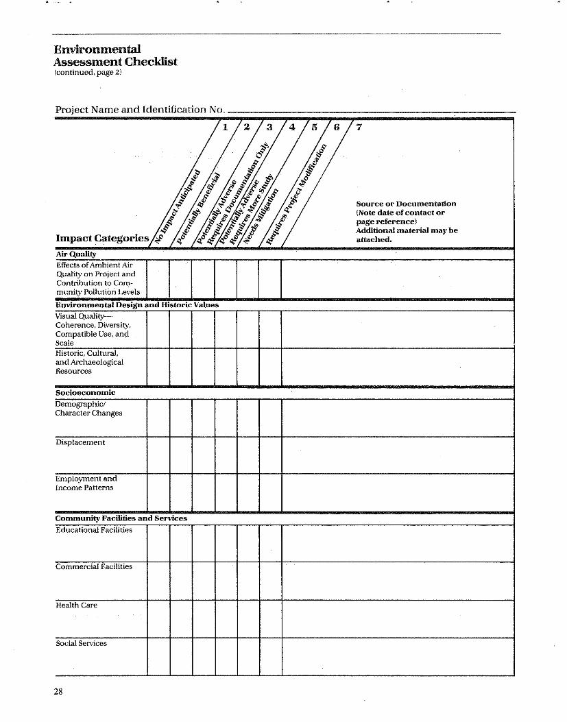
Environmental Assessment Checklist (continued, page 2)
PrOject Name and Identification No.
Impact Categories
Air Quality Effects of Ambient Air Quality on Project and Contribution to Community Pollution Levels
Environmental Design and Historic Values Visual QualityCoherence, Diversity, Compatible Use, and Scale Historic, Cultural, and Archaeological Resources
Socioeconomic Demographic/ Character Changes
Displacement
Employment and Income Patterns
Community Facilities and Services
Educational Facilities
Commercial Facilities
Health Care
Social Selvices
28
1 2 3 4 5 6 .,
Source or Documentation (Note date of contact or page reference) Additional material may be attached.

Environmental Assessment Checklist (continued, page 3)
p ro)ec tN amean dId ffi f en 1 ca IOn
~ ~
·S
N o.
1 Z 3
if 0
p
.~ #
-$ '$-# ¢.> ;:: q".:t
~r.c/ ;..~~ ;$' '" '" '" p § ':#~~;.,(}.);§
..,.1:' '"
4;t # cJ
'I .f
<; 'Ii ~¢ ..,. ,::f "".f ~ <; .1' 6 6 ~ 4 ."J b ."J ,,~ ~ c f ~ ~.~ ~.~ ~ :# of -$ .$~~§l ~ Impact Categories ;f 4'" 4"':! 4"':! :! 'I:
Community Facilities and Services (Continued) ,
Solid Waste
WasteWater
Storm Water
Water Supply
Public Safety Police
Fire
Emergency Medical
Open Open Space Space and Recreation
Recreation
Cultural Facilities
Transportation
7
Source or Documentation (Note date of contact or page reference) Additional material may be attached.

Environmental Assessment Checldist (continued, page 4)
p roJec tN amean d Id t'fi t' en I ca IOn N o.
1 '14,"/ I; # c ,,'"
~ # 'I .$'.~ g-$>o ~ # 4'~4'.$ ~
'N ~$~""C'" ;$' IlOl!1JO.§' o <i $' ~ ~ Q<
,.'t' 41 't' ~ 't'.:f. g {f fjlj,1jfJ$ it • • I.~~ /l)1;f)
;. 0 c;I c;l '11 ;I Impact Categories .; l lJ"lJ".! I' Natural Features Water Resources
Surface Water
Floodplains
Wetlands
Coastal Zone
Unique Natural Features and .
Agricultural Lands
Vegetation and Wildlife
30
I) 7
Source or Documentation (Note date of contact or page reference) Additional material may be attached.

Environmental Assessment Checklist (continued, page 5)
Summary of Findings and Conclusions:
Summary of Environmental Conditions:
Project Modifications and Alternatives Considered:
31

Environmental Assessment ChecJ4ist Icontinued, page 61
Additional Studies Periormed (Attach Study or Summary)
Mitigation Measures Needed:
32

Environmental Assessment Checklist (continued, page 7)
1. Is project in compliance with applicable laws and regulations? 0 Yes 0 No
2. Is an EIS required? 0 Yes 0 No
3. A Finding of No Significant Impact IFONSII can be made. Project will not significantly affect the quality of the human environment. 0 Yes 0 No
Prepltred by Title
Date
33


Sources, Documentation, and Preparation of a Base Data File
The key to preparing an accurate and responsive environmental assessment within a limited period of time is the ability to be able to draw on a sufficiently broad and current data file or data base. The term data file is viewed here in its widest context, including the following types of information: • Secondary Data Sources-includes data such as community maps (e.g., floodplain or topographic), Census data, and comprehensive plans. Special studies such as feasibility reports for a development project or highway design reports also can provide relevant information. o Professional Expertise-refers to the judgments and information provided by knowledgeable individuals such as the city engineer concerning a sewer or water system impact, or soils scientist and geologist concerning the impact on soils stability/suitability of a particular development site, or a school superintendent concerning the .availability of classroom space. • Field Survey-refers to detailed analysis of existing environmental conditions and site information such as topo surveys, permeability tests, hydrological characteristics, test borings, surveys of vegetation, animal life etc. and other site specific surveys of building conditions. • Field Observation-refers to the findings gleaned from a site visit. Field observations are either made by a professional expert or a generalist depending upon the category of impact and the special skills required. • "How to" Handbooks and Manuals-includes technical references which are intended to instruct the user in various techniques used to perform a particular. type of impact assessment.
Because of the size and variety of data sources which are typically required in preparing a data file, it is suggested that the information be organized and referenced in a matrix similar to the one which follows. Frequently, as the matrix demonstrates, the same data can be used for multiple categories of impact.
While the data items listed consist primarily of maps, reports and statistical information which are usually available in most city planning and development agencies, some of the items listed may not be available within the community and must be obtained from various state and Federal agencies.
It should be kept in mind that in performing a typical assessment it is normally necessary to assemble only a small amount of the data shown. Preparing the total data and organizing it in matrix form is suggested only as a tool which can be employed to greatly speed up and simplify each individual review.
Some data are quite stable, e.g. topographic maps, soil surveys, floodplains, master plans. Other data are changed or recorded annually, e.g., traffic, property tax assessments, labor force and income data. Assessment data are often obtained from a number of
. sources in a large metropolitan area, are often bulky
Chapter 5
in volume. Much of its value is lost If the information is not current. In these circumstances it may be better to have good contacts for obtaining current data when needed than it is to assemble a data bank which, more likely than not, will be out of date when you need it.
The same can be said of other data, if they can be readily obtained, from nearby municipal offices, the country court house, or other easily accessible government agency offices.
It should be stressed that some data should not only cover the documentation of existing conditions but also cover the projections of those conditions into the future. Along with the matrix, a description of each data element by general category is provided.
Project Data
1. Previous EA Documents-Previous Environmental Assessments and EIS' s prepared by the recipient or other Federal agencies in the community. The U.S. Environmental Protection Agency's monthly publication, the 102 Monitor (formerly published by the Council on Environmental Quality), contains a list of all EIS's filed, cross-referenced by Federal agency, and state and county I location. 2. U.S.G.S. & Other Base Maps-U.S. Geological Survey maps of the study area: topography; surficial/bedrock geology; water resources. Base maps of the area prepared by Federal, state, local or recognized private commercial mapping organizations. 3. Aerial Photographs-Aerial photographs of the project area at various scales, obtained from public agencies or commercial photographers. 4. Project Site Plaos-Location and boundary project site plans with maps and aerial photographs. 5. Project Alternative Plans-Project alternatives, including alternative site locations and alternative design features. 6. Urban Environmental Design,· Site lmprovement Plans, Architectural, Engineering Construction Plans-Proposed project construction features, such as proposed construction schedules, possible disruption of transportation activities, requirements for heavy equipment or blasting. 7. Project Utility Plans-Descriptions and plans of project showing such things as the use of local utilities (water, sewer, energy, etc.). 8. Project Employment Statistics-Listing of jobs related to project construction and future permanent employment by type and salary range including equal opportunity employment programs. 9. Project Use/Occupant Cbaracteristics Data-In multi-use facilities, listing of proposed project tenants (e.g. commercial, government agency, leased concessions) for residential type and size, number of units and number of bedrooms per unit .
35
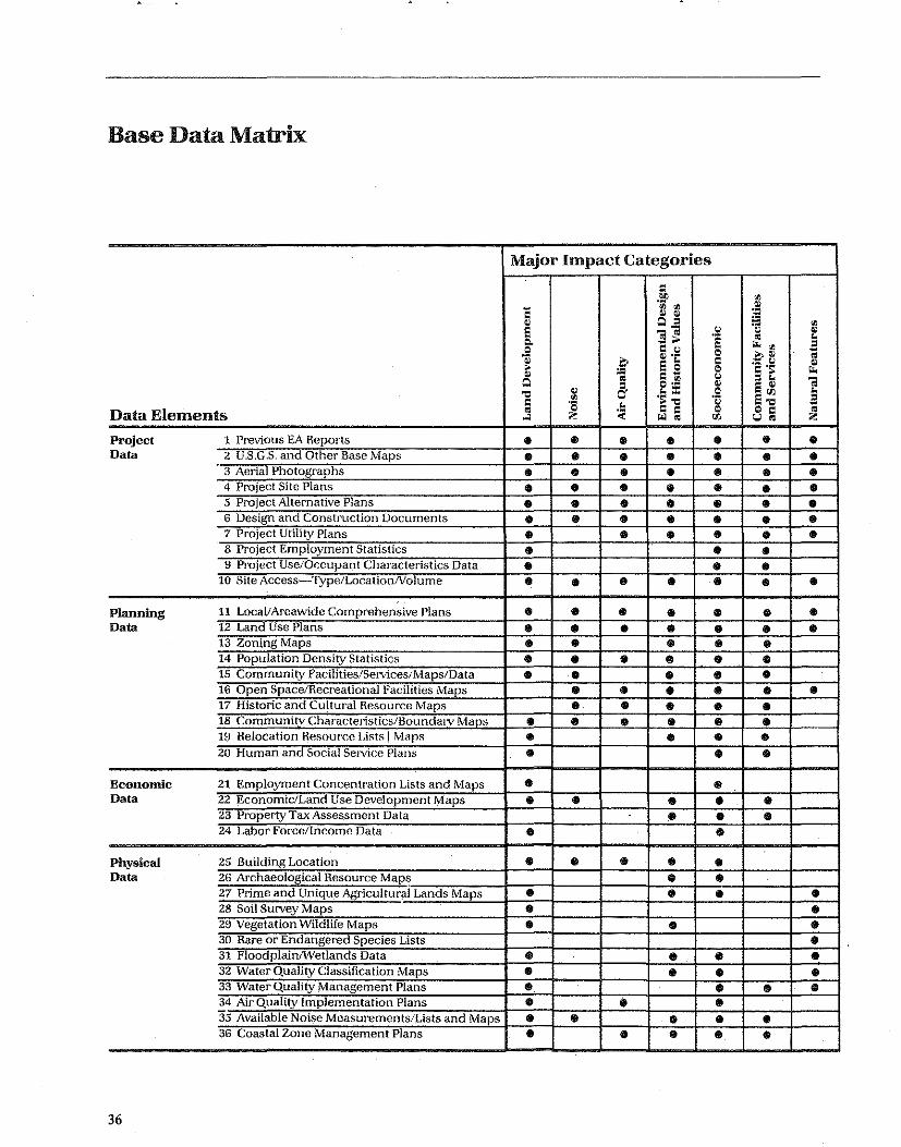
Base Data Matrix
Major Impact Categories
c .':1' <Il
C '" '" ,lJ ~ ~ ~ Q = ill '" e s~ .~ Q ~
~ ~ Q. e .. <Il E Q C Q
~ ~ .• Q ~~ ~
~ e S C ·s .~ <1: :; Q ~ C lil Q = ~ 'i Q g Q •• ~ e ~
'C ~ .~ :c .§ 5'" ~
<Il = C ·s ~ c'C Q'C ~
Data Elements ~ Q ~ ...l " '" § 00 u§ "
Project 1 Previous EA Reports • • • • • • • Data 2 U.S.G.S. and Other Base Maps • • • • • • •
3 Aerial Photographs • • • • • • • 4 Project Site Plans • • • • • • • 5 Project Alternative Plans • • • • • • • 6 Design and Construction Documents • • • • • • • 7 Project Utility Plans • • • • • • 8 Project Employment Statistics • • • 9 Project Use/Or.:cupant Characteristics Data • • •
10 Site Access Type/LocationNolume • • • • • • • Planning 11 LocallAreawide Comprehensive Plans • • • • • • • Data 12 Land Use Plans • • • • • • •
13 Zonjog Maps • • • • • 14 Population Density Statistics • • • • • • 15 Community Facilities/Services/Maps/Data • • • • • 16 Open Space/Recreational Facilities Maps • • • • • • 17 Historic and Cultural Resource Maps • • • • • 18 Community Characteristics/Boundmv Maps • • • • • • 19 Helocation Resource Lists! Mars • • • • 20 Human and Social Selvice Plans • • •
Economic 21 Employment Concentration Lists and Maps • • Data 22 Economic/Land Use Development Maps • • • • • 23 Property Tax Assessment Data • • • 24 Labor Force/Income Data • •
Physical 25 Building Location • • • • • Data 26 Archaeological Resource Maps • •
27 Prime and Unique Agricultur~I Lands Maps • • • • 28 Soil Survey Maps • • 29 Vegetation Wildlife Maps • • • 30 Rare or Endangered Species Lists • 31 FloodpiainlWetlands Data • • • • 32 Water Quality Classification Maps • • • • 33 Water Quality Management Plans • • • • 34 Air Quality Implementation Plans • .. • 35 Available Noise Measurements/Lists and Maps • • • • • 36 Coastal Zone Management Plans • • • • • .
36

10. Site Access-Type/Location/Volume-Maps, description and volume data for all access transportation modes including public transit liukages.
Planning Data
11. Local! Areawide Compreheusive Plans-Master plans for land acquisition, land development and capital improvement programs, from local, regional or state comprehensive planning agencies. Housing data maps are often included. 12. Land Use Plans-Land use plans and analyses, from local, regional or state planning agencies and describing both the goals and objectives of jurisdictions in the project area and the existing and proposed future distribution of land uses (residential, commercial, industrial, institutional, etc.). 13. Zoning Maps-Local zoning ordinances and maps prepared by local jurisdictions in the project area, obtained from municipal planning departments or municipal clerk's office. 14. Population Deusity Statistics-Population density maps of the project area, developed from Census data, obtained from municipal or regional planning agencies. 15. Commuuity Facilities/Services Maps/Data-Maps of major public facilities and services (schools, hospitals, police and fire protection, water supply, waste treatment, etc.) obtained from local agencies. 16. Open Space/Recreatioual Facilities Maps-Open space and recreation facility maps, depicting present and proposed publicly-owned areas (obtained in data elements 12 and 13). Data and maps from parks departments and voluntary organizations (see also data in elements 15 and 17). 17. Historic and Cultural Resource Maps-Historic and cultural resource lists and maps, including National Register sites as well as sites and resources identified by the State Historic Preservation Officer and local historic associations. This includes checking National Register lists and updates. 18. Community Characteristics/Boundary MapsSocioeconomic data (and maps) obtained from the Census and locally prepared planning reports which identify the characteristics and boundaries of communities found in the study area. 19. Relocation Resource Lists/Maps-Summary of relocation resources in the appropriate study area for potential residential or business relocatees, obtained from local planning agencies and relocation departments. 20. Human and Social Service Plans-These often inventory existing programs and resources and identify needs of particular groups in the community such as elderly, handicapped, youth and preschool. May be available at city or county human or social service agency or from a private community council of social service agencies.
Economic Data
21. Employment Concentration Lists & MapsEmployment location and concentration maps, developed by the regional planning agency or from state economic development agency data. 22. Economic/Land Use Development MapsEconomic/land use development trends (past and projected), developed and mapped for the project area from information obtained at local or regional planning and development agencies, state economic development agencies or utility companies. 23. Property Tax Assessment Data-Property tax assessment data for areas which might receive impacts from a project alternative, obtained from local tax assessor's office. 24. Labor ForcelIncome Data-Income characteris-tics of residents in the project area, obtained from CenSJlS data. Summary of regional labor force characteristics identifying major sectors of employment and skill concentrations in region as enumerated in Census data. Updated information may be available at the state employment service research department or at local or regional planning agencies.
Physical Data
25. Building Location-Building location maps of the project area, such as Sanborn maps available from the local engineering department, USGS maps, or developed from aerial photographs. 26. Archaeological Resource Maps-Archaeological resource lists and maps, including National Register sites as well as sites identified by or of potential interest to state and local archaeological offices or groups. 27. Soil Survey Maps-Soil survey maps, obtained from the Soil Conservation Service or county agent. 28. Prime and Unique Agricultural Lands-Maps obtained from the Soil Conservation Service U.S. Department of Agriculture. Also consult maps showing agricultural lands of state and local importance. 29. Vegetution/Wildlife Maps-Vegetation/wildlife maps identifying general characteristics of vegetation, and wildlife movement and concentration patterns, available from state fish and game agencies and local conservation groups. 30. Rare or Endangered Species Lists-Rare and endangered species lists, obtained from the U.s. Fish and Wildlife Service, state and local agencies; and maps denoting designated habitats or sensitive areas. 31.Floodplain/Wetlands Datu-Flood. hazard boundary maps, flood insurance rate maps, and related flood insurance studies identifying the location of riverine or coastal floodplains are obtained from the Federal Emergency Management Agency. Wetland identification and classification studies identifying location of coastal or inland wetlands are obtained from the U.S.
37

Fish and Wildlife Service, and from State and local conservation commissions. Other sources for such data are the Army Corps of Engineers, U.S. Geological Survey, and regional and local planning agencies. 32. Water Quality aassification Maps-Water quality classification maps, obtained from state departments of water pollution control. 33. Water Quality Management Plans-Areawide plans for pollution abatement and sewage treatment facilities necessary to meet the area's needs. 34. Air Quality implementation Plans of tbe StateAir quality implementation plans, obtained from state or regional air quality control agencies. 35. Available Noise Measurements/Lists & MapsData from previous assessments and other studies describing noise impact for airports, noise contours, highways, railroads and other major noise sources. If traffic data are available, noise levels may be determined by use of the HUD Noise Assessment Guidelines. 36. State and Subslate Coastal Zone Management Plans-contain inventories and designation of areas of particular concern which can assist in initial screening of potential project impacts.
The Limitation of Existing Secondary Data
It is important to note that currently available secondary data may vary widely in its accuracy, in its coverage, scale, age and overall utility. The improper use of existing secondary data can lead to faulty judgments in assessing impacts. The following list of characteristics and limitations of secondary data indicates some of these limitations: • Scale/Coverage-Frequently data, such as maps and Census Data, are presented in too gross a scale for effective use in a site specific assessment. A notable exception to this are the U.S. Geological Survey 7.5 minute topographic quadrangle maps (I "= 2000 ') and the U.S. Soil Conservation Service soil surveys which provide a wealth of data on a scale suitable to most projects. Generally, maps at a scale of 1" = more than I mile are not useful for site-specific applications other than in the most generalized way, except for projects which may be community-wide or areawide in scope. • Contents/Classification-Frequently, certain maps and other data sources may be limited in content. For example, a map showing vegetation may be limited to commercially harvestable timber species. Data is often prepared to serve the purposes of a special user group rather than for environmental impact assessment purposes. • Age-A frequent deficiency in secondary data is the age of the information contained in reports, maps, and Census reports. This is particularly true in growing communities where change is rapidly occurring. In many larger communities the research department of the planning agency frequently provides updated esti-
38
mates of Census data. In some states this is done by the state planning office or by a state university.
If the data resources of the particular community are deficient, assistance can be sought from the areawide planning agency and the HUD Field Office (the Environmental Officer).
A more detailed bibliography of sources of data and information specific to each of the impact categories can be found in Appendix A.
Professional Expertise
Some of the most important data required in an environmental assessment are not available in any secondary document and must be obtained from a knowledgeable individual. The table below is intended to serve as a guide to key agencies and personnel who can provide professional expertise. Most of these individuals can be contacted by looking in the local phone book or calling the information office of the appropriate government level shown. In the table the word "local" refers to county or municipal government,· while "regional" refers to sub-state regions.
If you are still uncertain how to locate these individuals, you can contact the Environmental Officer in your HUD Field Office or Regional Office. The HUD Regional Offices and many other Federal offices are located in ten major cities. If you can't find a resource closer to your community, try the nearest of the following ten cities:
HUD Region I II III IV V VI VII VIII IX X
Field Observation
Location Boston, MA New York, NY Philadelphia, PA Atlanta, GA Chicago,IL Ft. Worth, TX Kansas City, MO Denver, CO San Francisco, CA Seattle, WA
Field observation can serve as a useful information gathering tool when properly done. Based upon a site visit after an initial review of project plans and area maps, a project reviewer can perform an initial screening and may be able to eliminate some environmental categories from further consideration. Conversely, a field visit can surface environmental factors which may have been overlooked and may require more in-depth analysis.
No matter what level of environmental expertise a reviewer has, the site visit is an effective method of gaining a sense of how all of the site characteristics are integrated. In addition to gathering impressions of the physical characteristics of the site, it is very often
useful to interview persons who live and work near the site to gain greater understanding of issues and concerns. It should be remembered, however, that a casual field visit has major limitations in assessing many impact categories which are not always readily evident. For certain categories of impact (e.g., groundwater, soils suitability) the field visit should be made with a professional expert. The expert can then conduct relevant tests such as gathering soil samples or taking soil borings.
Documentation
One of the most critical elements in performing a responsive and professionally competent assessment is proper documentation. It is, for example, not sufficient to simply write "Field Observation" beside an impact category. Instead, it is recommended that the name of the field observer, title, agency and date be included. Similarly, with secondary texts, a complete bibliographic reference with page number is recommended. With phone calls made to professional experts, the name, title, and date should be listed. To avoid repetition the full list of sources can be included in chronological order at the end of the assessment form and Teferenced with a numerical code in the body of the document similar to footnoting at the end of a report. While preparing a listing of sources as part of the development of a data base is suggested, references found in the assessments should be as specific as possible.
Map Preparation
An important part of preparing the data file is the preparation of a series of maps which delineate the various impact elements in the community such as wetlands, floodplains, historic sites and districts. The early mapping of this information makes the task of assessing the impact of a proposed project simple and relatively speedy. In most communities the Planning Department is one of the single best sources of maps and other needed data.
A brief list of data which lends itself to plotting on maps includes: • Soils • Locations of Air Quality Monitoring Stations and Violations, Location of Major Sources • Slope and Topographic Features • Surface Waters • Locations of Rare and Endangered Plant and Animal Life • Floodplains and Wetlands • Shoreline Management Areas • Recreation and Open Space • High Noise Areas (highways, railroads, airports) • Census Data such as Income, Race and Unemployment Status
• Neighborhood Boundaries • Business Establishments • Highways and Public Transit • Human and Social Service Facilities • Historic Sites and Districts • Public and Private Utilities • Community Services such as schools, fire, police and medical • Location of hazardous waste sites • Farmlands/Agricultural, Lands of Local Importance • Unique Natural Resources
Specific information concerning the preparation of various maps is included in Appendix A: Assessment Techniques.
Assembling Data
The CDBO program director may want to assign a staff person to data base preparation, schedule a portion of the data to be collected every 6 months, hire outside experts to put the data base and maps together, or some combination of the above. It is time well spent and saves a great deal of research effort each time an environmental assessment is prepared.
While the goal of preparing an extensive community data file is a good one, many smaller communities may lack both the data resources and staff to prepare an extensive data base. These communities should prepare a data base which is tailored to the needs and resources of their community. They should, however, also become familiar with the location of data in or near their community.
Updating the data base file is as important as the initial effort and must be scheduled each year asappropriate to local staffing needs. Reports and plans in a few categories may require yearly updating while other data may require updating every 5-7 years.
While most of the base data needs can be satisfied by contacting governmental agencies, private sources are of equal importance and should not be overlooked. For example, in many large communities private nonprofit social and human service agencies can serve as important sources of data concerning the availability of local services and estimates of local needs. A particularly good source is the metropolitan council of social service agencies where such an agency exists. Private waste disposal companies can provide data on the storage and disposal of hazardous wastes (as can appropriate state environmental agencies). Other good private sector sources for data on employment and business activity include the Chamber of Commerce and major employers. Additionally, railroads often have data on hazardous materials (including waste) transportation routes or destinations.
Utility companies (electricity, water and sewer, gas) may have valuable information on current and future development trends based on hook-up applications and projected energy demand by population.
39


Assessment Techniques
This chapter has been organized according to the same impact categories listed on the Environmental Assessment Checklist (pp. 35-41) and serves to direct the environmental analyst toward relevant detailed issues and impact criteria. For each impact category, key impact issues and questions which should be considered have been listed. Also, technical assistance has been provided through the identification of appropriate techniques for assessment of direct and indirect impacts in each category. The analyst may use this chapter first as a reference for filling out the checklist and second for completing a detailed environmental assessment in the selected impact categories.
, Each impact category or grouping of categories within this chapter has been organized as follows:
Organization of Impact Category or Grouping
Overview This section defines the impact category and other relevant terms and concepts. It describes typically critical issues for CDBO and UDAO proje~ts, which may influence the assessment of that impact category.
Assessment Questions
This section provides a set of key assessment questions to guide the analyst in determining the likelihood of significant impacts. The assessment questions are first used by the analyst when filling out the checklist and then later when the analyst focuses on a specific impact category as part of the more detailed impact assessment process.
Analysis Techniques
In this section the specific analysis techniques are presented which can be used in determining the impacts in that. category . These techniques typically include the following: • Review of Project Plans
.• Review of Secondary Documents including Maps, Comprehensive Plans and other EIS's • Contacts with Local Experts • Special Studies • Field Observation
A brief discussion is included which is intended to guide the analyst in employing correctly each of the assessment techniques.
Policy Base (Including Standards and Legal Requirements)
This section outlines both official and commonly used standards and any statutory or regulatory requirements which relate to each of the categories of impact. Since many impact categories do not have adopted standards or legal requirements, this section is not included under each impact category.
Appendix A
Sources and References
Both secondary source material, special studies and guidance material such as text books and handbooks are included in this section. Possible contact persons also are listed.
Experts to Contact
The titles and typical agency locations of local experts are listed in this section. The listings are intended to be suggestive of typical experts found on the local level. The actual persons and agencies will vary from place to place. .
Mitigation Measures
Measures which can be used to mitigate possible adverse impacts are listed in each impact category. This Chapter will include the discussion of assessment techniques in the following categories:
Land Development • Conformance with Comprehensive Plans and Zoning • Compatibility and Urban Impact • Slope • Erosion • Soil Suitability • Hazards and Nuisances, Including Site Safety • Energy Consumption
Noise e Noise Contribution and Effects of Ambient Noise on the Project
Air Quality • Effects of Ambient Air Quality on Project and Contribution to Community Pollution Levels
Environmental Design and Historic Values • Visual Quality-Coherence, Diversity, Compatible Use and Scale • Historic, Cultural and Archaeological Resources
Socioeconomic • DemographiC/Community Character Changes • Displacement • Employment and Income Patterns
Assessment Questions
1. Is the proposal consistent with completed components of the local or regional comprehensive plan, whether adopted or in draft stage? Is there a relevant state plan and is the proposal consistent?
2. Is the proposed project consistent with other plans including those prepared by areawide planning agencies, special districts and boards and state agencies in various functional areas?
41
3. Is the proposed project consistent with adopted community or areawide policies and goals?
4. Does the proposed project comply with existing zoning and subdivision regulations? If not, does the proposal require a zoning variance?
Analysis Techniques /
To undertake this assessment, it is first necessary to determine if the proposed project is in conformance with existing zoning, subdivision control or other land use regulations of the community with respect to factors such as allowed use, height and scale of the building, adequacy of parking, access and landscaped areas.
Following a zoning review, the project should then be evaluated for consistency with plans. Some agencies may not have planning documents and may need to be contacted directly to determine if a proposed project is consistent with proposed actions of that agency.
This analysis is similar to the A-95 Review process. However, because it is performed by the CBDG agency in-house prior to the formal A-95 review procedure, it offers the community the opportunity to modify the project, as necessary, prior to the more formal A-95 review by the appropriate reviewing agencies. The State Clearinghouse and the Metropolitan Planning Organization (MPO) should be contacted for assistance in initially compiling the inventory of re1e-
42
Conformance With Comprehensive Plans and Zoning
vant plans and agencies. The goal of the review should be the following:
1. Identify areas of agreement and conflict between the proposed project and existing plans.
2. Identify policies and programs which could adversely affect the project or be adversely affected by the project.
These should be fully documented with either a source or a personal citation.
Policy Base (Including Standards and Legal Requirements)
The CEQ regulations require that agencies consider "the possible conflicts with ... regional, state and local land use plans, policies and controls for the area concerned.' ,
Sources and References
Tbe Model Land Development Code, prepared by the American Law Institute, provides a basic legal reference to zoning and land use regulation generally.
Another basic source is by Robert H. Twiss, "Linking the EIS to the Planning Process," Environmental Impact Assessment Gnidelines and Commentary (Thomas Dickert and Katherine Domeny (eds.), Berkeley: University of California, 1974).

Land Development
• Conformance With Comprehensive Plans and Zoning
• Compatibiity and Urban Impact
• Slope
• Erosion
• Soil Suitability
• Hazards, Nuisances and Site Safety
• Hazards (Thermal Explosive Hazards and Airport Clear Zones)
• Energy Consumption
Overview
It is important to ensure that a proposed project is consistent with a community's long range goals and policies as articulated in its comprehensive plans. A community's zoning ordinance is the principal legal tool available for the implementation of its master plan and for the definition of the community's land use policies. While not all communities have zoning, in those communities where zoning exists it regulates development patterns including the construction, alteration or use of buildings, structures or land.
A proposed project may not be in conformance with existing zoning but may be consistent with the communities general development plans and policies. Such projects may require either a change in the zoning or a special permit through an appeals process. The need for a change in the zoning should not, by itself, be interpreted as an adverse environmental effect.
Conformance With Comprehensive Plans and Zoning
Comprehensive plans are intended to encompass plans and goals relating to a wide variety of areas including transportation, housing improvement, recreation, social and human service, health, economic development and utilities. These plans are prepared by a variety of agencies and boards, including municipal and county government, special districts, area-wide planning agencies and state agencies. An assessment of the degree of conflict or consistency with local and regional plans must take into account the fact that the power to prepare and implement plans is highly decentralized, both on a geographic and an administrative or governmental basis. Some communities even require that local zoning be consistent with adopted plans. (See A. Delatons, Land use Controls in the U.S., MIT Press).
Experts to Contact
• Regional Planning Agency and A-95 Review Coordinator • Zoning Review Officer or Administrator • Planning Commission/Director • State Planning Office
Mitigation Measures
If the project is inconsistent with zoning and if neither a special permit nor a change in the zoning is contemplated, then the project must be modified to make it conform to zoning (e.g., reduce the density or height). Or its location could be changed to achieve z()ning conformance by relocating it to a less restrictive zone. If the project is inconsistent with comprehensive plans then some modification of the project or the plans may be required. The assessment process can help identify where· new or revised plans are needed.
43

44
I-I 2
Conformance With Comprehensive Plans and Zoning
Mill lUI o 400' (BASE MAP NIl,t4
BARRIO HISTORICO DISTRICT (City Register)
c:::::J PROPERTY CONTAINING HISTORIC STRUCTURES
... AREA OF REZONING REQUEST FROM R- 2 1 R·3, R-4 i 8-2 TO HR-2 I HR-3, HR-4; HB -2
Zoning in an Historic District This map shows the location of a proposed 'rezoning within an historic district and CDBG project area.
Source: Department of Housing and Community Development, City of Tucspo, Ariz~ma. Environmental Assessment Barrio Historico Neighborhood Strategy Area. October 1979,

Comprehensive Plans The location, timing and scale of CDBG activities can be reviewed for compatibility with plans such as this.
Conformance With Comprehensive Plans and Zoning
Source: The Metropolitan Planning CommissionKans'as City Region and the City Development Depar1;ment of Kansas City, Missouri. Kansas City International Airport and Vicinity Environmental Development Plan and Impact Study, 1970.
45

Overview
The man-made environment consists of differing types of land use: commercial, industrial, residential, recreation and open space. It also takes place in areas of differing land use density. Central city areas, particularly along the East Coast, for example, contain higher densities of development than rural areas, small towns or newer western communities. In terms of residential uses, density is measured by number of dwelling units or people per unit per land area, usually the acre. In most communities density is governed by the local zoning ordinance. Some communities have no zoning; Houston, Texas is one example.
Issues to consider under this category are: • Urban Impact-Certain types of federally assisted activities can have an adverse impact on the economic viability of a city's central business district. For example, situating a UDAG-assisted shopping center at the fringe of a city can serve to undermine the financial stability of downtown commercial establishments. Similarly, CDBG fnnded infrastructure improvements made at the edge of an urbanized area (e.g. sewer and water lines) may serve to induce development in undeveloped portions of a community thus creating sprawl with resulting environmental and social costs. In some situations the impacts of induced development may be highly desirable. CDBG funded infrastructure improvements made in the inner city may stimulate private investment and thereby help revitalize a lagging section of a community. • Land Use Compatibility-Certain types of land uses may be incompatible with one another. For example, it may be incompatible to locate a new housing development in a newly industrialized area.
Assessment Questions
1. What are the existing land uses adjacent to the proposed project. Do the abutters and neighbors think the proposed project will be incompatible with existing uses? 2. Will the project have an adverse effect on the economy of a core city area? Will it contribute to urban sprawl? Will it displace economic activity from a central business district? 3. Will the proposed project result in induced development which will alter existing land use or which will be incompatible with the existing scale and density of development? Are the changes which will result from any induced development regarded by the community as beneficial or negative? 4. Does the proposed project contribute to reducing the racial, ethnic and income segregation of the area's housing?
46
Compatibility and Urban Impact
Analysis Techniques
Analyze the existing project plans. If the proposal involves a new community facility such as a new sewer line, what is the service capacity of the new facility? How much new development will likely take place due to new facilities? Can this new growth be accommodated by the community in terms of the increased costs of delivering community services? Will this growth provide increased housing opportunities for low and moderate income or minority persons?·
Consult secondary data sources to establish existing land uses and trends in development. These include:
Land Use Maps and Zoning Maps which show general land use patterns in the community. Review how land use has changed in recent years prior to the current proposal.
. Aerial Photos. can be useful in showing areas with large vacant land tracts and areas where new development is taking place.
Pnblic Infrastructure Plans-These are useful in identifying likely locations where new growth will take place, locations where new highways and/or sewer and water lines are planned.
Buildiug Permit Records indicate where new development or rehab activity is taking place.
Property Ownersbip and Title Transfer data, where available, can reveal areas where real estate development interests 'are active.
Is this new induced growth consistent with community land use plans? Will the project serve to displace any existing uses? What are the trade-off issues to consider in this displacement?
Policy Base (Including Standards and Legal Requirements)
There is no Federal legislation specifically addressing urban impact issues. Local zoning laws, plans, and codes should be examined for their various requirements.
Sources and References
Schaenman, Philip. Using an Impact Measurement System to Evaluate Land Development. Washington, D.C.: The Urban Institute, 1976.
HUD Land Planning Bulletins.
Tbe Costs of Sprawl, Council on Environmental Quality, HUD and EPA, Washington, D.C. USGPO 1974 (Stock No. 041-011-00021-1).
Experts to Contact
• Planners at local and areawide planning agenCies • Zoning Officer • City Planning Department
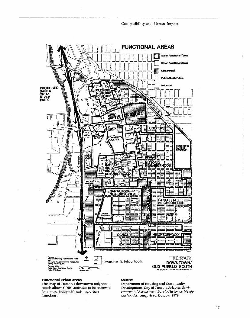
Compatibility and Urban Impact
':I ~I·~· FUNCTIONAL AREAS \Vi,'\\,-'-' Ul J! .JLJ LJLJ
LO O. 0 OU QQ. Of; DeE ,,"p.r. ... _-..
! DO DC DO Dr);; =-,-.. PROPOSED SANTA CRUZ RIVER PARK
;; O~ ~~~~~~. , LJ ..... bllcI.,...., ........
Funetional Urban Areas This map of Tucson's downtown neighbor~ hoods allows COBG activities to be reviewed for compatibility with existing urban functions.
Source:
ul\!©®©[fiJ DOWNTOWN/
OLD PUEBLO SOUTH AA~~a""P\aJ\ ... ...,S!\dI'
Department of Housing and CommunityDevelopment, City of Tucson, Arizona. Environmental Assessment Barrio Historico Neighborhood Strategy Area. October 1979.
47

48
[ " . , , ,
':~ .. i .
i ;. : L ,,)' t ...
p,' , f
(;EO(;RAPfIiC LIMITS TO COMMERCIAL GROWTII
Commercial Growth Limits
.,
By identifying the character and boundaries of the existing commercial area, the compatibility ofprop?sed activities can be assessed.
Compatibility and Urban Impact
, ..
,\ '
" ,1 )
~. _.>'
I L\i{\',\RD S(J,t"ARL
[= __ ::J EXISTING COMMERCIAL AREA
!i:':':':':':::<::::'::::;:~::::~ COMMERCIAL EXPANSION
111111111111111111 LIMIT OF COMMERCIAL DISTRICT
Source: Massachusetts Executive Office for Adminis.tratio.n and Finance. Environmental Impact Report on Mi}(,ed Use Development afParcel 1B/ Harvard Square/ Ma. August 1979.
Mitigation Measures
~he iocation of the project could be altered or protectIVe measures could be instituted to safeguard existing land uses, for example, the possible granting of tax
. abatements for certain types of land uses such as threatened agricultural use. '
Compatibility and Urban Impact
Community facilities and services could be expanded to service a development which is regarded as consistent wi~h local and federal growth policies, particularly urban Impact, despite its location at the fringe of a developed area .
49

Overview
Slope refers .(0 changes in the physical features of the land: its elevation, orientation and its topography. Such alteration is associated with construction on hillsides where changes in the visual character of the site may occur and where slope instability, erosion and/or drainage problems may result. In some localities, hillsides are likely to house native plant communities which could be lost as a result of topograpWc alteration.
Excessive grading will often alter the groundwater level, which may cause the slow death of trees and ground cover, and in turn destroy wildlife habitat.
Since erosion, slope stability and drainage characteristics depend not only on the steepness of the slope but also on the materials of which it is composed, soils suitability (discussed later in this Guide) needs to be considered in any analysis of slope conditions.
Assessment Questions
The following questions can be used to determine: (a) if the project will significantly affect or be affected by the slope conditlons; and (b) if the slope is unstable, potential problems wWch may require remedy. 1. Does the proposal call for development on a steep slope and, if so, does its design plan include measures to overcome potential erosion, slope stability and runoff problems? 2. Does the county, local or site-specific soil survey mention that slopes are unstable for any of the soils on the site? 3. Is there a history of slope failure in the project area environs? 4. Is there visual indication of previous slides or slumps in the project area, such as cracked walls or tilted trees or fences?
Analysis Techniques
It is recommended that communities with potential slope impacts relate their actions to a map of the area in order to establish if the project location is in an area of significant slope. An example of such a map is provided here.
Slope
Visual Indication of Unstable Slopes (Field Observation)
a. Indications of previous slides or slumps in the project area. b. Cracking of top of slope shows movement. c. Movement or tilting of fence, retaining walls, utility poles, or trees. d. Slowly developing and widening cracks in the ground or paved areas. e. Hummocky undulations on mid to lower slopes. f. Breakage of underground utility lines. g. New cracks in plaster, tile, brickwork, or foundations. h. Outside walls, walks, or stairs pulling away from the building. i. Leakage from swimming pools. j. Doors or windows that stick or jam may be caused by slope movement.
Policy Base (Including Standards and Legal Requirements)
There is no Federal legislation specifically addressing slope stability issues. HUD Minimum Property Standards establish requirements for the stability of slopes and embankments. Some states and localities including Colorado, San Mateo County. California and Cincinnati, Ohio have established slope construction regulations. These usually deal with a combination of factors: hillside management in relation to land use, lot size, drainage, foundation design and sewage disposal.
A restrictive soils zoning district proposed by the Metropolitan Council in the Twin Cities area in Minnesota would proWbit commercial and industrial development on slopes steeper than 120/0 and would require that developers of residential property on such slopes prove that construction techniques employed would overcome the site's limitations. Pittsburgh has slope zoning districts. The table below presents slope suitability standards for urban areas.
Slope Suitability for Urban Development
Limitations
Slight
Moderate
Severe
Suitability Rating
Optimum
Satisfactory
Marginal
Slopes Suitable for Development by Land Use Type
Residential
0-6%
6-12%
12-18%
Commercial
0-6%
6-12%
12-18%
Industrial Park
0-2%
2-6%
6-12%
Very Severe Unsatisfactory 18 + % 18 + % 12 + %
Adapted from: Kiefer, Ralph W. "Terrain Analysis for Metropolitan Fringe Area Planning," Journal of the Urban Planning Division, Proceedings of the American Society of Civil Engineers, December 1967.
Moechnig, Howard, Inventory and Evaluation of Soils for Urban Development (St. Paul HRA C.P. District 6 -North End), Ramsey Soil and Water Conservation District.
50
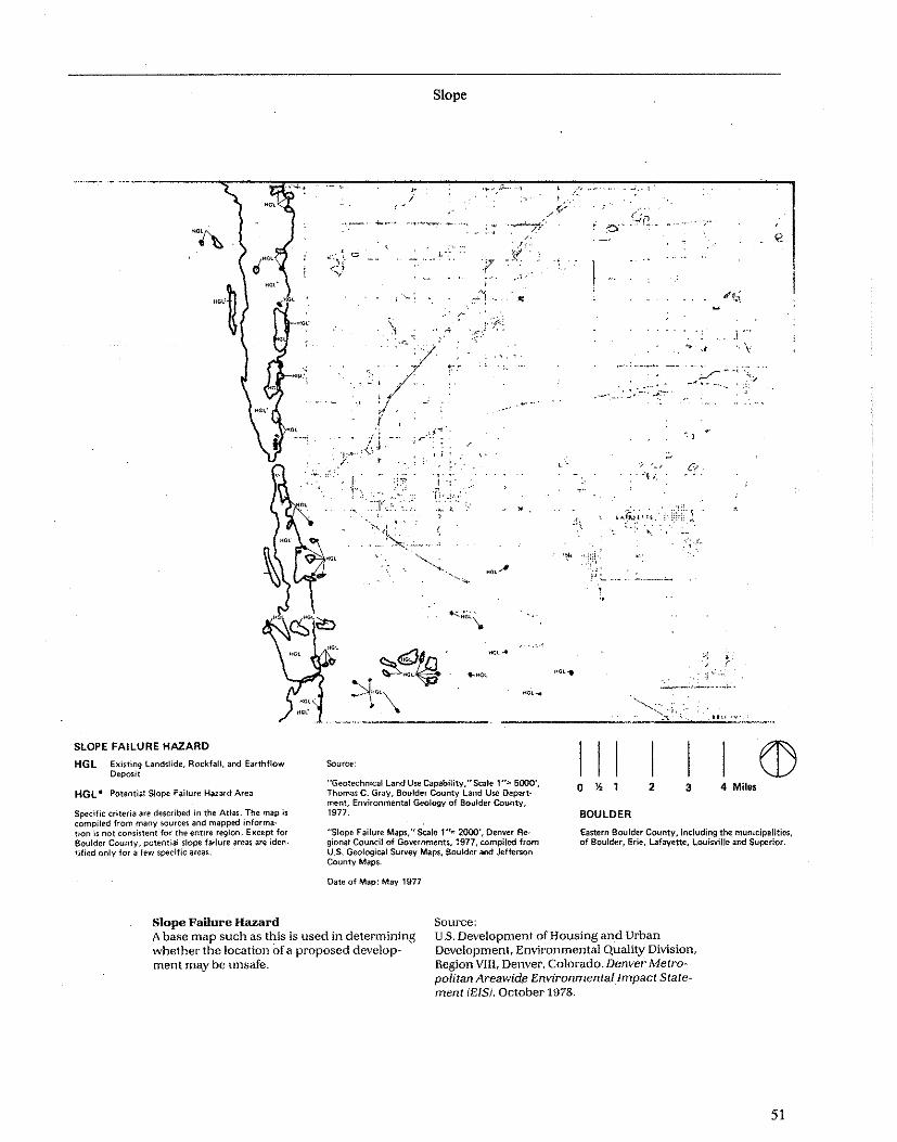
SLOPE FAILURE HAZARD
HGL Existing landslide, RockfaU, and Earthtlow Deposit
HGL. Potential Slope Failure Hazard Area
Source:
Slope
; :;". \: ,. ,
:-,-
.~ .. ~.
/'" ¥ J~
........
•
"Geotechnical land Use CapabHity,"Scale 1"" 5000', Thomas C. Gray, Boulder County Land Use Depart· ment, Environmental Geology of Boulder County, 1977.
,~.
\
...... -" ~~ .
-" '-, . , .,,~ ,
,,,,t~i';I. ' '.-, '-.
:, ,'-
:(
l';
I I I I I I o % 1 2 3 4 Miles
BOULDER Specific criteria are described in the Atlas. The map is compiled from many sources and mapped information is not consistent for the entire region. E)(cept for Boulder County, potential slope failure areas are iden· tified only for a few specific areas,
"Slope Failure Maps," Scale 1"'" 2000', Denver Re· gional Council of Governments, 1977, compiled from U.s, Geological Survey Maps, Boulder and Jefferson County Maps.
Eastern Boulder County, including the. municipalities, of Boulder, Erie, lafayette, loui~vil1e and Superior.
Date of Map: May 1977
Slope Failure Hazard A base map such as this is used in determining whether the location of a proposed development may be unsafe.
Source: U.S. Development of Housing and Urban Development, Environmental Quality Division, Region VIII, Denvel', Colorado. Denver Metro" politan Areawide EnvironmentalImpact Statement (EIS). October 1978.
51

Steep Slope~ within the Urban Area
Source:
~ -Saint Paul City Planning, St. Paul, Minnesota. Environmental Resource Data and Assessment Guide. JanuafY 1977.
52
Slope
.'
Slopes 10-15%
Slopes OVer 15%

Sources and References
1. U.S. Soil Conservation Service, County Soil Surveys (to be consulted for more in-depth tests). 2. U.S. Geological Survey, topographic maps, Federal, State, and local geologic mapping programs now commonly include an assessment of landslide hazards, and the resulting maps identify known slides as well as potentially unstable slopes, especially in urban areas. 3. USGS. Nature to be Commanded, Geological Survey Professional Paper 950. Washington, DC, 1978. 4. USGS. Facing Geologic and Hydrologic Hazards: Eartb Science Considerations, Geological Survey Professional Paper 1240-B. Washington, D.C., 1981.
Slope
Experts to Contact
• Civil Engineer • Geologist • Soils Scientist
Mitigation Measures Architectural and engineering design which addresses site problems adequately; to be determined by appropriate local agency (building inspector, city engineer, city building department, etc.)
Development on steep slopes should be avoided if at all possible. Such land is usually more suited to park or open space use. If developed, the densities should be very low and grading should be avoided wherever possible. . .
53

Overview
Erosion, transport and sedimentation are the processes by which the land surface is worn away (by the action of wind and water), moved to and deposited in another location. While commonly considered an agricultural problem, erosion.in the urban context, resulting from land clearance and construction can be equally serious. In urbanized areas, erosion. can cause structural damage in buildings by undermining foundation support. It can pollute surface waters with sediment and increase the possibility of flooding, by filling river or stream channels and urban storm drains.
Erosion results from the interaction of physical characteristics (topography, soil type, ground cover), wind and water action and human use at anyone site. Some soils are less stable than others and are consequently more susceptible to erosion. Loosely consolidated soils (e.g., sands) and those of small particle size (e.g., fine silts) are more susceptible to erosion. By contrast, soils with high moisture and clay content are more resistent to erosion. Wind erosion is most likely to occur in arid or semi-arid regions where the low moisture content reduces the cohesiveness of indigenous soils.
A key factor in erosion is the land cover. Undisturbed vegetated areas are less susceptible to erosion than surfaces which have been exposed. The greater the slope the more likely the occurrence of erosion, because steep slopes (often defined as 12"70 + ) increase the velocity of runoff.
Assessment Questions
1. Does the project involve development of an erosion sensitive area (near water, on a steep slope, on a sandy or silty soil)? If so, is erosion control included as part of the plan? 2. Does the proposed project create slopes by cut and fill? 3. Does site clearance require vegetation removal? How many acres will be cleared and for how long? 4. Is there evidence of erosion or sedimentation?
Analysis Techniques
Field Observations A variety of secondary sources, as listed below, provide guidance as to assessment techniques. In addition, field observation can help indicate a site's erosion potential. Evidence of past erosion can be observed if active rills or gullies, stream bank erosion, sediment fans or muddy water are found near the site. Silty or sandy soils and high slopes are also indications of erosion potential.
54
Erosion
Policy Base (Including Standards and Legal Requirements)
While no Federal legislation specifically addresses erosion concerns, they should be considered under the general provisions of NEPA. In many communities local building codes, subdivision regulations, and hillside zoning ordinances address the issue of erosion control techniques to be used during site preparation and actual construction.
In order to determine locations with serious erosion ptential, it is useful to consult both soild classification and topographic maps. If your community has not prepared such maps, the following sources should be helpful:
Sources and References
Topographic quadrangle maps, available from the U.S. Geological Survey are available for most areas and present slope gradients and hydrologic features (ponds, streams, etc.)
U.S. Soil Conservation Service Soil Survey Maps can be used to classify soil types on a project site. The "Unified Classifications" included on the map legend indicates soil erodibility.
To help in use of the maps listed above, the following documents provide instruction in the causes and control of erosion:
I. National Academy of Sciences, Slope Protection for Residential Development, Washington, D.C., NAS, 1969. 2. Tourbier, J. and Westmacott, R., Water Resources Protection Measures In Land Development - A Handbook. Newark, Delaware, University of Delaware, Water Resources Center, 1974. 3. USEP A. Processes, Procedures and Methods to Control PoJlntion Resulting from All Construction Activity. Washington, D.C., 1973 (EPA 430/9-73-(07) . 4. Urban Land Institute, Residential Erosion and Sediment Control, Washington, D.C., 1978. 5. USGS. Nature to be Commanded, Geological Survey Professional Paper 950. Washington, D.C., 1978.
Experts to Contact
The following specialists could be consulted: • City or County Engineer • Soil Conservationist-Soil Conservation Service County Office • Landscape Architect • Soils Engineer-State or local highway department

Upper cliff on which houses and roads are being undermined
Landslide debris in transit across bench
Well·strati~ fled Lawton Clay over which the loose land~ slide debris from the Esperance Sand falls
Cliff Erosion
Erosion
FiRure 1~11 The cliffs and bench on which landslides occur at Alki Point, Seattle, Failures on the upper cliff undermine roads and houses and move the fallen material across the bench on which the trees are growing, The light~colored structureless material below the trees and above the banded, well-stratified Lawton Clay is old landslide debris on its way to a second landslide over the lower cliff,
Source: Photographs of existing: conditions can be very useful in illustrating potential impacts.
U.S. Department of Agriculture. Soil Conservation Service. VVashington, OJ:.
55

Mitigation Measures
If it is determined that a location has a potential erosion problem. project plans should be reviewed to determine if the need for erosion control measures has been properly addressed.
Good site design and construction practice should include (I) a plan that fits the contours of the site and keeps grading to a minimum; (2) retaining vegetative cover until construction start-up. clearing ouly that area needed for construction at anyone time; and (3) providing temporary cover when extended exposure is unavoidable such as grass. sod. mulch. burlap or plastic. Despite these precautions. to some extent erosion may be inevitable. Sediment control measures-
Sediment basin {,,:~ SUt check dam ~ Preliminary Storm sewer outlet A Oevelopment Plan
Erosion
such as .the construction of sediment barriers. traps and basms-can help reduce potential damage and should be considered as part of a thorough impact mitigation effort. . Th~re are three basic approaches to reducing poten
tial wmd erosion: 1) maintain soil cohesiveness (by wetting disturbed areas and by avoiding unnecessary traffic on construction sites); 2) create or maintain vegetation or ground cover; and 3) reduce wind action (by scheduling construction to avoid high wind seasons by pl.anting or preserving treelines or hedgerows per- • pendlcular and upwind of the construction site. and by erecting artificial wind barriers. such as snow fences. if needed).
Land Use Acres Units
56
Diversion ........... Single family lot BO'x 140' 113.6 322 Drainage pattern -.~~- Single family fat 9O'x 160' 87.3 207
Buffer lone [SSJ Patio homes 26.9 161 Townhouses 19.8 156
[[[]]]]]J Garden apartments 13.0 '" Undisturbed area Schoof 12.0 Open space 117.4
Perennial stream .= 390.0 1043
Erosion~ and sediment-control plan fora housing development including single4amily homes, patio hornes, townhouses. garden apartments, a school, and open space. (Courtesy of Braxton Williams, Soif Conservation Service.)
Erosion and Sediment Control Plan Measures to minimize erosion impacts are indicated here.
Source: Edward A. Keller, Environmental Geology, Columbus, Ohio; Charles E. Merrill Publishing Co. 1976, page 454.

Overview
Soil suitability is the physical capacity of a soil to support a particular land use. To be suitable for a building, for example, a soil must be capable of adequately supporting its foundation without settling or cracking. The soil should be well drained so that basements remain dry, and so that septic systems can be installed in localities not served by sewers. Soil depth is an important factor and must be adequate for the excavation of basements; sewers and underground utility trenches. Surface soils need to be capable of supporting plantings. How well a soil is able to support development is a function of several factors including: its composition, texture, density, moisture content, depth, drainage and slope. Surface and bedrock geological conditions will also affect site suitability for development.
Development Issues There are soils with poor drainage and poor permeability qualities. There are. also soils with high shrinkswell potential, high frost action potential and with high side seepage potential. Each of these are characteristics which may cause problems for development if appropriate mitigation measures are not included in' project design. It is, of course, not just the type of soil which creates problems for development but the soil combined with other features of the site including the height of the water table, the slope stability and the potential of subsidence or settling of soils due to the extraction of mineral and geological deposits beneath the surface.
Nonetheless, it should be observed that most soils are suited for development, and many of the soil conditions which are adverse to development can be overcome by installation of drainage, replacement with structural fill or use of special foundations. While these measures add to project costs, in most urban areas the high cost of land makes these measures economically feasible. In rural localities these factors may justify the selection of an alternative development site.
Assessment Questions
1. Is there any visible evidence of soil problemsfoundation cracking or settling, basement flooding, etc.-in the neighborhood of the project site? 2. Have soil borings been made for the area? Do they indicate marginal or unsatisfactory soil conditions? 3. If the answer to either of the above questions is yes and the proposed project involves either new construction or very substantial rehabilitation activities, does the project design include appropriate mitigation measures to address the problem of poor soil conditions?
Soil Suitability
Analysis Techniques
Initial Screening An initial screening test should be performed to determine if the soils are compressible or unstable in foundation. Other sources which can be used are Soil Survey Maps prepared by the U.S. Soil Conservation Service, or soils maps prepared by the Army Corps of
. Engineers or state department of natural resources. If the potential exists for any of the problems
described below to be present at the project site, a site examination by a soils engineer or geologist will be needed.
Land Fill A field observation can be useful in helping to determine if the site. contains a former dump or land fill. Evidence of trash, random vegetative growth, odors and/or rodents can be indicative. If it is determined that a building is to be constructed on filled ground, a test boring to determine soil stability and the possible presence of hazardous s\lbstances is needed. Sometimes land fills contain toxic chemicals, (consult the section on "Hazards, Nuisances and Site Safety" which follows). If buildings are to be placed on a land fill or dump, appropriate engineering principles and techniques must be followed.
Bearing Capacity Foundation support capacity of a project site is defined by the bearing capacity of site soils and surficial geology. In general, well-drained coarsed textured soils provide the best structural support. Poorly drained clay and organic soils provide the least support. Two frequently used rating scales for soil engineering performance are the American Association of State Highway Officials scale and the Unified Soil Classification system (Corps of Engineers). Both ratings are generally provided in Soil Conservation Service County Soil Surveys. Local building codes may also establish standards for soil bearing capacity.
For mid-rise or high-rise structures, or in those areas where bedrock is close to the surface, the bearing capacity of the geological substrate will be important. Geotechnical engineering standard.s can be used to interpret the potential structural loadings for various categories of surface/bedrock geology configurations; however, site specific analyses will still be needed for major structures ..
Frost Susceptibility Liquefaction The city or county engineer or a geologist may need to be contacted to determine if frost susceptibility is a problem, based upon consideration of the frost line, foundation depth, soils type and water table. In general, poorly drained soils are more susceptible to frost action than well-drained soils. The engineer or geologist may also need to be consulted to determine if
57

58
SoUs and Geology This soils and geology map was used for analysis of a Neighborhood Strategy Area proposaL
Soil Suitability
Source:
~ DOWNTOWN/
OLD PUEBLO SOUTH Ivll'oo"lomic~M:lI"\anr"tiI'QS:t-.xIv
Department of Housing and Community Development, City'ofTucson, Arizona. Environmental Assessment Barrio Hl.storico Neighborhood Strategy Are~. October 1979.

" ,
SOIL GROUPS:
Soil Suitability
9 J"'
--
1 Soils formed on sandy glacial outwash and lake plains.
Citywide Soils Mapping
2 Loamy soils underlain by gray glacial till. 3 Loamy soils underlain by sand and gravel formed on
glacial outwash and iceblock lakes. 4 Loamy soils formed on small glacial lake basins. 5 Soils formed on steep slopes. 6 Loamy soils underlain by red glacial till. 7 Shallow soils formed on bedrock on Mississippi
River benches. 8 Soils underlain by red till, gray tillar sand and
gravel formed on irregular steep slopes. 9 Soils formed on flood plains.
Source: Ramse~ Soil and Water Conservation Distrlct Program, November 1975
Source: This cityvvide soils map is part of the 81. Paul base data file; specilic projects are indicated on it copy of this map and included in the Environmental Hcvicw Record.
Saint Paul City Planning, SI. Paul. Minnesota, En\'ironnltmtal Resource f);lta ,ll1d t\s:';(~SS"WI)( Gtn'ue . ./<lJ)llaT:'-' 1:177.
59

Hquefaction is a problem in the area. Sandy soils or ruled areas in which high water table conditions exist are subject to liquefaction in the event of grolind tremors or in the presence of large vibrating machinery. Under these circumstances, soils lose nearly all structural bearing capacity.
Shrink-SweU This factor describes the volume change for a soil when the moisture content is varied. Soils with a high clay content, subject to changes in moisture due to groundwater withdrawal, drainage, increase in paved areas, etc. are the least suitable for development.
If the site has soils with a high shrink-swell potential, su.ch as soils with high clay content, a soils engineer should be consulted to determine if settlement might occur due to changes in moisture content of the soil.
subsidence Ground sinking can lead to the collapse of existing structures, changes in drainage and vegetation and safety hazards. CO\lditions which may indicate subsidence include: extensive underground (shaft/tunnel) mining; presence of limestone (or other soluble) bedrock in areas of moderate to high precipitation; large withdrawals of groundwater from aquifers; and excessive wetting of low density soils subject to hydrocompaction. The city or county engineer or a geologist should be contacted to determine if subsidence is a potential problem in the area.
Water Table A high water table might produce damp or flooded basements or foundation damage. High water table conditions may also limit use of septic systems for onsite wastewater disposal. The soils survey should be checked to determine if the seasonal water table is higher than the lowest elevation of the structure. A soil boring test or soil percolation tests may be needed for more in-depth analysis.
Policy Base (Also Including Standards and Legal Requirements)
No Federal statute exists specifically concerned with physical site suitability, though NEPA implies that
60
Soil Suitability
must be considered. Legal requirements are found primarily in State and local building codes, zoning requirements and subdivision regulations.
Sources and References 1. Johnson, Sydney M. and Thomas C. Cavanagh, The Design of Foundations for Buildings, New York: McGraw-Hill, 1968 (a technical text). 2. Sowers, George B. and George F. Sowers, Introductory Soll Mechauics and Foundations, Third Edition, New York: MacMillian Co., 1970 (a general introductory text). 3. USGS. Nature to he Commanded, Geological Survey Professional Paper 950. Washington, DC, 1978. 4. USGS. Facing Geologic and Hydrologic Hazards: Earth Science Considerations, Geological Survey Professional Paper 1240-B, Washington, D.C., 1981.
Experts to Contact
• Architect/Engineer-local building department, HUD Field Office • Soil Conservationist-Soil Conservation Service country office • Highway Department Soils Engineer • Geologist-Soils Specialist
Mitigation Measures
Mitigation measures call for soils engineering and foundation engineering solutions. Solutions ·include the replacement of problem soil with more satisfactory fill, the treatment of problem soil to reduce or eliminate problems, as by injecting additives or improving drainage. Other solutions involve altering foundation design through measures such as embedding the foundation, using pilings or increasing the bearing areas of spread footings. Problems with subsidence or lack of suitable soils for onsite wastewater disposal may require considerations of alternative locations.

Overview
This' category is concerned with ensuring that a project is located and designed in a manner which reduces any potential risk to the public or project users from both natural and man-made risks to people or property damage. Accordingly, a number of possible hazards to health and safety have been identified below. Many of these hazards are already subject to municipal regulation. For example, standards for adequate light and air, building density, construction materials, structural integrity, maintenance and cleanliness are contained in local zoning, building and health codes. Their enforcement is often independent of environmental assessment procedure. The environmental assessment should particularly include those areas which are not covered by :ode requirements. Many can be corrected through proper siting, sound planning and good project design.
Potential Sources of Public Health and Safety Problems • Noise • Vibration • Odor • Lack of Light • Air Pollution • Toxic Chemical Dumps • Uranium Mill Tailings • Reclaimed Phosphate Land (Radioactive)
Site Hazards: Shadows, inadequate street lighting, uncontrolled access to lakes and streams, improperly screened drains or cachment areas, steep stairs or walks, overgrown brush, lack of access for emergency vehicles, hazardous waste dumps, uranium ntill tailings used as foundation or building material, radioactive reclaimed phosphate land, facilities handling chemicals and/or petrochemicals of an explosive or fire prone nature.
Traffic: circulation conflicts, road safety, exposure to radiation or toxic substances
Natural Hazards Climatic: wind, droughts, floods, lightning, hur
ricanes, tornadoes, hail and snowstorms deological: erosion, landslides, volcanoes, earth
quakes Biological: infestations, allergies, bacterial, viral and
fungal diseases
Assessment Questions
1. Does the project involve any of the potential hazards listed above? Any that are not listed including hazards created by project construction, operation and design as well as those existing on and near the site? 2. Are there project users or neighboring populations whose special health and safety needs are not anticipated in the project design? Have actions been taken to protect children from "attractive nuisances?" Have
Hazards, Nuisances and Site Safety
measures been taken to reduce the potential risk to the elderly from dust and temporary walkways and traffic around construction sites?
Analysis Techniques
Eartbquake or V olcauic Activity 1. Using the Seisntic Risk map of the United States given in HUD Minimum Property Standards, determines the risk zone of the project area. 2. If the project is in Zone 2, contact the State or Federal geological survey to determine if the site is within 0.5 miles of an active fault. If so, obtain the review and opinion of an engineer. Make sure the design requirements in HUD Minimum Property Standards are met. A seismologist can provide additional information as to the extent of risk.
Flasb Floods, Tornadoes, Hurricanes 1. To determine if the project is in risk zones for these hazards, consult the following sources: a. Flash flood information from the appropriate district office of the Army Corps of Engineers or the Federal Emergency Management Agency (FEMA). b. "Annual Climatological Data National Summary" which summarizes occurrences of tornadoes, hurricanes and floods, published by the Environmental Data Service, National Oceanic and Atmospheric Administration, U.S. Department of Commerce. It is available for local areas from the National Weather Center in Asheville, North Carolina. c. Wind speed map - HUD Minimum Property Standards.
If these hazards are present, consult a structural engineer to determine the type and extent of precautions or mitigative measures which are necessary.
Forest and Range Fires 1. Contact local fire departments to deterntine whether the project area is susceptible to forest and/or range fires. If so, consult with fire department and local weather service authorities to determine which factors create a potential for fire hazards.
Mudslides, Sands, and Hazardous Terrain Features 1. Through field observation, area soils maps, and consultation with local flood insurance personnel, local weather bureau and the Soil Conservation Service, determine whether: a. the site or adjacent area contains slopes with unconsolidated loose soils (i.e., a type of light wind borne soil). b. the area is subject to extensive rainfall that could cause mudslides. c. the site contains soil materials prone to exhibit liquifaction. such as quicksand.
61

Hazards, Nuisances and Site Safety
EXPLANATION
Fault trace location known o 500 Feet f-I '-T' ,"-' "r', "'-, 1
Fault trace location inferred o l5D-Meters
Natural Hazard Easement Building setbacks from active fault traces are required by town ordinances in Portol~ Valley, California.
Toxic and Radioactive Hazards 1. Using HUD Notice 79-33 and HUD Guidebook, "Safety Considerations in Siting .Housing Projects," Conduct field observations to identify potential hazards. 2. Contact local officials: a. State Fire Marshall b. Local Fire Department c. City or Areawide Planning Agency d. Public Utility Commission e. Department of Public Health f. City or County Engineer 3. United States Environmental Protection Agency Regional Office.
Policy Base (Including Standards and Legal Requirements)
HUD Notice 79-33, subject: "Policy guidance to address the problems posed by toxic chemicals and radioactive material."
HUD Minimum Property Standards along with local zoning, health and building codes apply to many of these categories.
62
Source: Edward A. Keller, Environmental GeoLogy. Charles E. Merrill Publishing Company, Columbus, Ohio. 1976, page 147. (From Mader et al., and U.S. Geological Survey Circular 690, 1972.1
Sources and References
1. Landslide Analysis and Control, Special Report 176. Transportation Research Board, NAS. Washington, D.C., 1978. . 2. Guidelines and Criteria for Identification and Land Use Controls of Geologic Hazards and Minerai Resources Areas, Colorado Geological Survey, Denver, Colorado, 1974 (p. 3-49). 3. U.S.G.S. Facing Geologic and Hydrologic Hazards: Earth Scieneil Considerations. Geological Survey Professional Paper 1240-B, Washington, D.C. 1981. 4. The Environmental Protection Agency (EPA) maintains a list of EPA's most hazardous (toxic) waste sites, the National Priorities List (NPL) (Office of the Superfund).
Mitigation Measures
There are a number of mitigation measures which can be instituted to avoid or guard against the various problems cited above. Most involve appropriate project planning and design.

,_'. i -" '" ) J-, );'''~'O'
......... 'I ."., .. I
/ I i : " I...." '--'-'-r--"-'
MAN-MADE HAZARDS
HMR, ExiJ\11'l\l R\Idl.t!oo Haw Ar ..
HMR- Pottnllil RedlnlOO Hltllrd A,.,
Spto;:ifl~ Ctiteril .,. cItK:,lbed In tIw AIlJ$, Mtn''''1dI H,urdJ .,.(\tfintd fOf 1M ptlf9OM$ of ml, AIseu· mrnl ." Umltld to ,aclitlion Inc! ",plotion IIn.rdJ. EHplOlion humllnlormltion il I_plitt and as lu\lh 111'lOt f/ro$tl'llMl on thllll\lP.
Man-made Hazards
"
"A!1I1 01 Cor\Qem-RockV Flltt," Colorado Department 01 Hlilth, Auaull 14, 1876,
"Plulonlum-239 COnIOllIl," ~.'"'' 2 Miln. USAEC· HASl.
FtHlblUty Analv,1t lor RHOUtoH R_try from Solid Wttte, Volu"," I tnd II, Th, Ralph "'. P.f1Olll CompanV, "'ITCh 1876.
Oll' 01 M ... , "'IV 1977
ManMmade radiation hazards in North Denver represent constraints to CDBG activity.
Hazards, Nuisances and Site Safety
",
NORTH DENVER
Northem PItt 01 till _<opeI!!un ..... , I,",'udl!>g the munk:iptllt!n col ArvMla, Broomfle1d, Commerce City, Ftdtrfi Hflglm, Nont.;lenn, Thornton, Wllttmlnrt.r II'Id the WHt,m l1li1 of Ad.m County •• 00 1M north_n P"1 of J.~rwn Countv.
III I I I CD o • 1 2 3 4 Mi*
'-<d "'con)iInC11oi'1wlthond "'_lnPOlltI>l' 'n.. Vol·' I0Il S'_~I'" H .... ''''ond Ulbon 0 ... '_1, "-,or ThtO' .... R""""" Co<ontll 01 Gowr_. 11111 Soutlo .Iocbon S ...... 0._. C<!Ic><_ 811210.
Source: U.S. Department of Housing and Urban DevelM opment, Environmental Quality Division, Region VIII, Denver, Colorado, Denver Metro* politan Areawide Environmental Impact State~ ment lEIS}. October 1978,
63

Overview
This section of the hazards discussion is concerned with two specific kinds of hazards which can result in significant risk to HUD-assisted or insured projects and their occupants. The first involves sites located near operations handling conventional fuels or chemicals of an explosive or flammable nature and the other involves sites located in Runway Clear Zones at civil airports and Clear Zones and Accident Potential Zones at military airfields. For both types of hazards, HUD has established standards for reducing the risk to persons and property.
Siting of HUD-Assisted Projects Near Hazardous Operations Handling Petroleum Products or Chemicals of an Explosive or Flammable Nature
Both people and property are at significant risk to exposure from explosion and thermal radiation (fire) when projecis are located too close to storage containers of hazardous gas and liquids or chemicals of a flammable or explosive nature.
Assessment Questions
I. Is the project site located near or in an area where conventional fuels (such as petroleum), hazardous gases (e.g., propane), or chemicals (e.g., benzene or hexane) of a flammable nature are stored? 2. Is there any evidence of industrial facility storage tanks, processing or transport tanks in the project site vicinity?
Analysis Techniques
If these hazards are present identify the contents of the container (or containers) and determine the distance between the container(s) and buildings and the container(s) and open space areas (play areas, parking lots, etc.) of the project site. Using the procedures contained in the regulation, calculate the acceptable separation distance (ASD) between the hazard and where the project building (and activities) should be located. -.
Siting of HUD-Assisted Projects in Runway Clear Zones at Civil Airports and Clear Zones and Accident Potential Zones at Military Airfields
Potential aircraft accident problems that are inevitable side effects of aircraft operations make some types of development incompatible or unsuitable for locations in the immediate vicinity of airports and airfields.
Assessment Questions
1. Is there a military airfield or commercial service airport near (in the vicinity 01) the proposed project site?
If yes, is the project site located in the Runway Clear Zone (civil airports only) or in the case of military airfields, is it located in the Clear Zone or Accident Potential Zone?
64
Hazards (Thermal/Explosive Hazards and Airport Clear Zones)
Analysis Techniques
The following information is necessary first to determine whether or not the project is located in an affected Runway Clear Zone or in a Clear Zone or Accident Potential Zone and second whether it is acceptable under the regulation.
1. the listing of the affected civil airports. 2. the dimensions of the zones 3. land use compatibility guidelines for Accident Potential Zones from the Department of Defense
The dimensions of the zones are available from the airport operators themselves.
Policy Base (Including Standards and Legal Requirements)
The standards for these hazards can be found in HUD regulations:
24 CFR Part 51, Subpart C, "Siting of HUD-Assisted Projects Near Hazardous Opertions Handling Petroleum Products or Chemicals of an Explosive or Flammable Nature."
24 CFR Part 51, Subpart 0, "Siting of HUD-Assisted Projects in Runway Clear Zones at Civil Airports and in Clear Zones and Accident Potential Zones at Military Airfields.
Handbook 1390.4: A Gnide to HUD Environmental Criteria and Standards Contained in 24 FCR Part 51. U.S. Development of Housing and Urban Development, August 1984.
Sources and References
Urban Development Siting witb Respect to Hazardous CommerciallIndustrial Facilities. U.S. Department of Housing and Urban Development, HUD-777-CPD, April 1984.
Compatible Land Uses at Federal Airfields. (Federal Management Circular 75-2) General Services Administration, 1975.
Experts to Contact
• Engineers • Airport Operators • HUD Regional or Field Office Environmental Officers • HUD Regional or Field Office Engineers
Mitigation Measures
For projects near hazardous operations handling chemicals, gases, or liquids of a flammable or explosive nature there are mitigation measures. The Circumstances under which they can be applied are clearly stated in the regulation. Because of the variables involved assistance should be obtained from an expert before preceding with mitigation measures.

Overview
Energy is a scarce resource due to increasing worldwide shortages and the resulting price increases. It has therefore become increasingly important to both design and to locate new facilities in a way which minimizes energy usage. Energy consumption should be viewed in a two-fold manner, first energy consumed -directly by the facility for heating, cooling, and for hot water systems, and secondly heating consumed indirectly or induced by the facility, consumed chiefly in the transportation of people and goods to and from the facility.
Maximizing opportunities for energy efficiency can be incorporated in nearly all phases of project planning location selection, site plan, building design and density. The location of new facilities in central areas with close proximity to mass transportation, shops, schools, and services can reduce energy consumed for transportation, the largest non-industrial use of energy in the U.S. The reuse of existing buildings can often both cost less and save more energy than new construction. Site planning should take into aC,count the role which trees can play in sheltering a structure from climatic extremes (wind, heat and cold). Southward facing sites receive maximum solar input, an important consideration in northern climates during the colder months. The final consideration is the incorporation of energy saving measures in bnildlng design, such as the usage of extra insulation, use of efficient heating, cooling and hot water systems, possibly solar, use of double-glazed windows which open and close, use of fluorescent rather than incandescent lights. Other measures include the reduction in the number of parking spaces provided to encourage carpooling and! or transit usage.
Assessment Questions
1. Does the location of the site have any special energy related advantages or disadvantages? Can these be maximized or overcome? 2. Have the architectural plans taken full advantage of potential energy saving measures, such as insulation, window design and placement, lighting, heating, cooling- and hot water systems? Are they in conformance with HUD Minimum Property Standards and other applicable energy saving codes? 3. Is the location of the project in close proximity to transit, shopping, services and employment locations?
Analysis Techniques
Further analysis beyond the initial screening questions listed above consists of both a document review and field observation, both of which might require consultation with an expert. First, to determine if a site is
Energy Consumption
adequately serviced with utilities (gas and electric), utility representatives should be consulted. Local street and transit maps can be used to determine if the site has good access, to schools, shopping, transit lines, etc. Field observation can help in evaluating site design, exposure of the building to the sun, use of trees to reduce energy consumption, etc.
Building plans for the project also should be reviewed for compliance with energy saving standards.
Policy Base (Including Standards and Legal Requirements)
Projects which are required to conform with HUD Minimum Property Standards are now also required to include certain energy conservation measures. Recent Presidential Executive Orders have been issued which regulate thermostat settings in public buildings. The National Energy Policy and Conservation Act of 1975 (PL 94-163) outlines national policy and provides assistance to the States in developing State plans. Many States and localities have revised building codes, subdivision requirements and zoning ordinances to require minimum energy efficiency standards.
Sources and References
Both HUD and the Department of Energy have prepared numerous manuals for including energy conservation in building design, as have many state energy offices.
National Recreation and Park Association. Energy Conservation Program Planning Materials. U.S. Department of Interior, Washington, D.C., 1978 (Vol. IV Facilitation Manual).
U.S. Department of Energy. Passive Solar Design Handbook (2 Vols.) January 1980.
Landscape Planning for Energy Conservation. Environmental Design Press. 1977.
Experts to Contact
It may be necessary to consult with an engineer and! or architect to determine if the design fully exploits potential energy saving measures. Direct contact with utility companies is suggested. Local public works staff can sometimes assist in determining adequacy of utilities.
Mitigation Measures
The mitigation measures refer to all of the project design measures discussed earlier-such as: (a) adequate insulation; (b) proper siting (north!south); (c) doubleglazing movable windows; (d) fluorescent versus incandescent lights; (e) efficient heating, cooling, and hot water systems; and (f) trees for shade and windbreak, etc.
65

AUTOMJTIVE FUEL SAVINGS DUE TO THE WELLINGTON DEVELOPMENT
ALTERNATIVE C
Garage
Retail
Office
Hotel
Housing
Total
Transit PersonTrips
3,380
1,536
350
50
1,443
6,759
ALTERNATIVE C-2
Garage
Retail
Office
Hotel
Housing
R&D
Total
Transit PersonTrips
3,380
~,536
350
50
715
360
6,391
ALTERNATIVE 0
Garage
Retail
Office
Hotel Housing
Total
Transit Person'l'tips
3,380
1,140
700
50
1,470
6,740
Energy Savings
Equivalent Auto Miles Total Gallons Saved Per
Auto Trips Day
2,600
1,181
269
39
1,196
5,285
13,000
9,925
2,262
323
10,048
35,558
Equivalent Auto Miles Saved Per
Auto Trips Day
2,600 13,000
1,181 9,925
269
39
550
277
4,916
2,262
323
4,620
2,326
32,456
of Fuel Saved Per Day Per Year
6SO
'96
113
17
503
1,779
162,500
148,874
28,263
5,895
183,358
S2B,e9\)
Total Gallons of Fuel Saved Per Day
6SO
496
113
17
231
117
1,624
Per Year
162,500
148,874
28.263
5,895
84,315
29,07S
458,922
Equivalent Auto Miles Total Gallons Saved Per of Fuel Saved
Auto Trips Day Pet Day Per Year
2,600
877
538
39
1,131
5.185
13,000
7,367
4,523
323
9,499
34,712
650
36. 226
17
415
1,736
162,500
110,505
56,538
5,895
173,334
508,772
Source;
Energy Consumption
ALTEIlNATIVE E
Garage
Retail
Office
Hotel
Housing
Total
Transit PersonTrips
3,380
1,680
5lB
50
1,470
Equivalent Auto Miles Total Gallons Saved Per of Fuel Saved
Auto Trips "Day Per Day Pet year
2,600
1,292
396
39
1,131
5,460
13,000
10,855
3,347
323
9,499
31,024
650
542
167
17
475
1,851
162,500
162,831
41 ,838
5,895
173,334
546,\i.i
ALTERNATIVE B-2
Garage
Office
Hotel
Housing
Total
Ttansit personTrips
3,380
5lB
50
2,940
6,888
Equivalent Auto Milea Total Gallons Saved Per of Fuel Saved
Auto Trips Day
2,600
3" 3.
2:,261
5,298
13,000
3,341
323
18,991
35,661
Per Day
650
167
17
.50
1,784
Per Year
162,500
41,838
5,895
346,661
556,900
PREFERRED ALTERNATIVE
Garage
Retail
Office
Hotel
Housing
Total
Transit Person~
Trips
3,380
1,540
280
100
1,906
7,206
Equivalent
Auto Trips
2,600
1,185
215
77
1,466
5,543
Auto Miles Saved Pe~ Day
13,000
9,950
1,809
646
12,320
n,735
Total Gallons of Fuel Saved Per Day
~50
••• '0 32
616
1,886
Per Year
162,500
149,258
22,615
5,895
22. ,856
565,124
Assumptions: 0 All fi9ures are projected to 1995. • Transit person-trips derived from Table 5-4, Well
ington Transportation Analysis: Technical Memot-andum ,
• Auto trips,. transit person ttips/l.3 persons per tcip.
• Average auto trip" 8.4 miles (National Study of Personal Travel. 1969).
• Garage adds 1300 new parkin9 spaces) SAves 2600-5 mile commuter auto tdps per day.
• Fuel consumed ~ auto miles/20 miles pet gallon. • 1 Year 250 days for gatag& and office
300 days for retail c 365 days fat hotel and housing
The alternatives presented 4emonstrate that automotive fuel savings can vary greatly depending upon the mixture of uses within a particular large-scale development.
Office of Community Development, Medford, Ma. Draft Environmental Impact Statement! Report: Wellington Station Area Development. November 1979.
66

Noise
• Noise Contribution and Effects of Ambient Noise on the Project
Overview
Noise is defined as any unwanted sound which disturbs· human activity. In the urban environment, noise is due primarily to vehicular traffic, air traffic, heavy machinery and heating, ventilation and air conditioning (HV AC) operations. Ambient noise levels in urban areas are increasing due to the growing volume of noise-generating activities. As with other kinds of environmental impacts, the long-term effects of noise on people are difficult to determine with scientific precision. A causal relationship has been established between noise and various effects, such as hearing loss and impairment, interference with speech communication, sleep disturbance, general anxiety, irritability and annoyance. Other less well established effects include fatigue, unsociability and inefficiency in performing complicated tasks.
Definition Although the point at which sound become undesirable, and hence noise, varies with the individual and the sound itself, levels of noise can be defined. A noise level depends on the volume or intensity of the sound, its frequency or pitch, and the time of day and duration of its occurrence. • Intensity-Noise is comprised of small, very rapid fluctuations in air pressure to which the ear is quite sensitive. These sound pressure levels are measured on a logarithmic scale in decibels (or dB), where 0 dB is approximately the threshold of hearing and 120 dB is approximately the threshold of pain. The logarithmic relationship between decibels means that it requires a tenfold increase in sound energy to produce an increase of 10 dB, and it requires a one hundredfold increase in sound energy to produce an increase of 20 dB. Such a 10 dB increase would be perceived by an average person as twice as loud as the original sound. An increase of 20 dB would be perceived as four times as loud as the original sound. A doubling of sound energy (as might occur when the number of noise sources is doubled) results in an increase of 3 dB. • Frequeucy-Frequency, the number of sound waves per second produced by an emitting source, gives a sound its pitch. The human ear is less sensitive to some frequencies than to others. Thus, not all sounds having the same decibel value are perceived to be equally loud. In general, high pitched sounds are jUdged to be "louder" (i.e., more annoying) than low pitched sounds even when both types of sounds are being emitted at the same sound pressure level. Nonetheless, low frequencies heard continuously can cause stress and impair a person's ability to sleep. • Duratiou-The third variable in describing noise is the time of day at which the noise occurs and its dura-
Noise Contribution and Effects of Ambient Noise on the Project
tion. For analo/tic purposes, night-time noise events (occurring between 10 pm and 7 am) are generally weighted as being ten times louder (lOdB higher sound pressure) than identical daytime noises. This reflects the findings of many studies that indicate a much higher human disturbance level (e.g., sleep disruption) associated with noise at night than at any other time. Concerning noise duration, noises which are heard frequently at shorter intervals are perhaps the more irritating whereas continuous sounds tend to blend into the background, and hence become less irritating. Cotinuous noises at high decibel levels are, however, more likely to cause physical harm.
Assessment Questions
Refer to the HUD Noise Assessment Guidelines to respond to the following assessment question: 1. Given the existing ambient noise and estimated future noise levels of the site, is the site appropriate for the proposed activities and facilities? Will the project be exposed to noise levels which exceed HUD's (or state or local) noise standards? If there is a potential noise problem, what kinds of mitigation measures are proposed for the project?
Analysis Techniques
The prime concern of a CDBG environmental impact assessment for noise should be the effect of existing and projected noise levels on the proposed activities and facilities. An assessment will be needed if housing and other noise sensitive uses are proposed and any of the following conditions are present: • existing or proposed commercial or military airport(s) within 15 miles of the site. • roadways within 1,000 fleet of the site with such characteristics (e.g., high traffic levels, high speed, heavy truck/bus usage, slope gradients, etc.) that would indicate high ambient vehicular noise levels. • At-grade or elevated transit lines. or railroads within 3,000 feet of the site. • Other significant noise sources (e.g., industrial! manufacturing facilities, power generating stations, etc.) in proximity to the site.
The measure used in analyzing the overall level of noise in an area is the day-night average sound level system which is denoted as Ldn or DNL. The day-night average sound level is derived by taking the average noise level of a 24-hour period and weighting it by the addition of 10 dB for noises occurring between 10:00 p.m. and 7:00 a.m.
U.S. Department of HUD Noise Assessment Gnidelines The Noise Assessment Gnidelines were designed to be used as a screening tool to indicate whether sites may be exposed to excessive nose levels. The Guidelines are
67

written specifically so that a person without training in acoustical engineering can estimate present and future noise levels at a proposed site to determine whether the decibel levels comply with the HUD standards.
The Noise Assessment Guidelines provide a series of work sheets for the estimation of individual DNL resulting from aircraft, highway, and railroad sources as well as an overall site noise level base on these three SO\lrces. If the major noise sources includes a nontransportation activity, measurements may be necessary to determine the noise levels.
. Once DNL is determined, it should be compared to the HUD Standards (see Standards and Legal Requirements below). Generally, if the site exposure is 65 Ldn and 75 Ldn' alternative locations or mitigation measures should be considered. If noise mitigation is impractical or impossible, the project will generally be considered unacceptable.
Airport authorities, state transportation agencies, the Environmental Protection Agency and other Federal, State and local agencies conduct noise surveys or require noise data to be prepared for their operations or projects. Wherever possible, use this data. Make sure that it is up to date and calculated in DNL. This data could possibly be used to map areas of the city of
HUJI) Noise Standards
Noise
high noise levels. Typical areas of high noise levels are heavily traveled streets and highways, airport approach routes and rail lines.
Policy Base (Including Standards and Legal Requirement)
Under HUD's noise policy (24 CFR Part 5ID) CDBG grant recipient must take into consideration the noise criteria and standards in the environmental review process and consider ameliorative actions when noise sensitive land development is proposed in high noise exposure areas. The grantee should pay particular attention to noise levels when HUD assistance is contemplated later for housing or other noise sensitive activities related to the CDBG actions (see 24 CFR 51.101(2». The grantee risks denial of HUD assistance for noise sensitive activities if noise standards are violated.
In order to determine whether sound levels at a given project site are acceptable, HUD has adopted the use of the day-night average sound level (DNL) formula, previously described, and has adopted the following noise standards.
(Applies to housing projects and other noise sensitive-however funded)
Nose Level AcceptabiUty
Above 75 Ldn: Unacceptable
Mitigation Required
An EIS and Assistant Secretarial approval is normally required. Attenuation measures will also be required.
Above 65 Ldn but not exceeding 75 Ldn:
Normally unacceptable An EIS is required for a HUDassisted project located in a large undeveloped area or where it is likely to encourage the establishment of incompatible land use in this noise zone. Attennation measures will be required.
Not exceeding 65 Ldn: Acceptable
Sources ,and References
Aircraft Noise Impact: Planning Guidelines for Local Age""es. U.S. Department of Housing and Urban Development, 1972.
The Audible Landscape - A Manual for Higbway Noise and Land Use, U.S. Department of Trans-
68
No.
portation, Federal Highway Administration, 1974. Provides a good overview of noise mitigation measures. •
"Environmental Criteria and Standards, Noise Abatement and Control, 24 CFR, Part 51, Subpart B," U.S. Department of Housing and Urban Development, July 12, 1979. This is the HUD noise regulation

EJ Noise Contours This railroad and automobile noise contour map was developed from the HUn noise guidelines and is used as a reference for all CDBG environmental reviews.
Noise
Source:
~[)::!] DOWNTOWNI
OLD PUEBLO SOUTH .~c.--.--.• _.,_ "-,-, , .. , .........
Department of Housing and Community D~velopment, Tucson, Arizona. Environmental Assessment Barrio Historica Neighborhood Strategy Area. Oc.tober 1979.
69

with quantitative noise standards and implementation procedures.
Noise Assessment Gnidelines. U.S. Department of Housing and Urban Development, 1983. These are guidelines for use in implementing the HUD noise regulation. They provide a desk top tool for persons without acoustical training to calculate the noise exposure at a site in relation to the HUD standards.
Noise Assessment Guidelines Technical Background. U.S. Department of Housing and Urban Development, 1980. This report discusses the need for noise abatenient, the various techiques for measuring and describing noise and human responses to it. It gives technical background information for the development of site noise assessment techniques.
Noise Barrier Design Handbook. U.S. Department of Transportation, Federal Highway Administration, 1976.
Gnidelines for Considering Noise in Land Use Planning and Control, Federal Interagency Committee on Urban Noise, June 1980. Consolidates federal guidance on noise considerations in local planning.
Experts to Contact
In most areas, there are a variety of experts who can provide useful .data on noise sources and noisesensitive receptors. State transportation agencies, airport authorities and aviation planning departments, railroads, transit authorities, bridge and turnpike authorities, and local highway departments can provide data on traffic movements (and in spme cases, noise emissions). Representatives of utilities and industries can be contacted, as appropriate, to provide any available data on facilities in close proximity to proposed CDSO project sites.
State or local health departments may be able to provide available data on ambient noise conditions or records, or local noise-related complaints. Service providers-especially hospitals and nursing homes, libraries,schools-may be able to assist in noise evaluation for proposed project sites near existing service facilities. Also Federal Aviation Administration, FAA, can be consulted concerning airport noise.
Mitigation Measures
Four types of measures can be taken to reduce noise or its effects: (listed in order of preference) 1. Reduce noise at its source 2. Locate noise-sensitive uses so that they will not be exposed to unacceptable noise levels 3. Modify the path along which noise emissions travel so as to reduce noise levels at the receptor site 4. Design or modify structures to minimize interior noise levels.
Noise source reduction is beyond the scope of what can realistically be accomplished as part of most
70
Noise
CDSO projects. Considerable long term intergovernmental efforts are needed to modify aircraft approach patterns, reschedule freight rail movements, or implement truck tire and exhaust noise reductions. Less ambitious, but potentially useful options are available to most CDSO grant recipients. Modifying roadway movement patterns, reducing traffic levels, and limiting vehicular access (according to vehicle type or time of day) can significantly reduce noise levels on residential streets. In addition, COSO project construction related noise should be minimized, especially in residential areas and near noise sensitive facilities such as schools, libraries and hospitals. Construction contracts can specify use of muffled equipment, temporary noise barriers, truck access routes which avoid noise-sensitive areas, and construction scheduling to avoid early morning and late evening hours.
Noise can be lessened by taking the common sense approach of grouping noise sensitive activities together aud locating them as far as possible from the noise source. Specifically, this requires siting practices which a) provide as much distance as possible between the noise source and the noise sensitive activity, b) interpose noise compatible activities such as parking lots, open space and commercial facilities between the noise source and the noise sensitive activities, c) use buildings containing nou-sensitive activities as noise barriers, and d) orient sensitive receptors away from the noise source. Within a particular building this means grouping the noise sensitive rooms together, away from the noise source and putting the noise compatible rooms, such as the kitchen, closer to the noise source.
Placing a barrier between the source and receptor is a technique that can be used to reduce exterior noise impacts to sensitive receptors. Noise reduction will usually be achievable at ground level and perhaps up to one or two stories in height. To be most effective, the barrier must be close to the source. The greater the height and length of the barrier, the more effective it is in reducing noise. Examples of barriers include earth berms and masonry walls. Dense vegetation plantings, while they do not attenuate noise emissions, provide perceived relief from noise impacts. Refer to the HUD Noise Assessment Gnidelines for calculation of noise barrier adjustment factors.
Sensitive receptor facilities can be designed or modified to reduce the effect of ambient noise on interior noise levels. Eliminating or reducing the size of windows is one possibility for lowering interior noise levels. Weatherstripping windows and doors, providing air conditioning and constructing ceilings and floors of dense materials will also help reduce interior noise levels. Interior noise reduction is necessary in heavily urbanized areas near transportation facilities or industriaUacilities where alternative sites are not available and where, due to land constraints, barriers

Noise
TYPICAL EQUIPMENT
QUIETED EQUIPMENT
LESIDENTIAL STANDARD
------- - -.iiiiiiiiiif -- - , QljjETED EQUIPMENT WITH- - ----
NOISE BARRIER
500 1 2 3 4 5 6 7 8 9 10 11 12 13 14 15 16 17 18 19 20 21 22 23 24
MONTHS AFTER START
Noise Mitigation This chart was used to illustrate the effects of proposed mitigation measures on construction noise levels. Ideally, the noise barrier should be located as close as possible to the source of noise. The residential standard shown is from City of Cambridge construction noise ordinance.
Source: Massachusetts Executive Office for Administration and Finance. Environmental Impact Report on Mixed Use Development of Parcel lB, Harvard Square, Ma. August 1979, page 171.
71

are infeasible. This is the least desirable approach to noise mitigation because most CDBO projects have outdoor activities associated with them-'such as recreation activities which would continue to be exposed to noise emissions.
72
Noise
If noise impact mitigation for a proposed facility at a particular site is not feasible, alternative sites should be considered.

Air Quality
• Contribution to Air Quality and Effects of Ambient Air Quality on the Project
Overview
Air quality refers to the preseuce or absence of pollutants in the atmosphere. It is the combined result of natural background and emissions from many individual pollution sources. The intensity of contamination varies with: 1. size of the source (emission) 2. distance from the source _ 3. height of emission above the ground 4. meteorological conditions, including wind direction and speed, air temperature and humidity, and sunlight S. height and location of human receptors in the project.
Air pollutants vary in their characteristics. Primary pollutants such as carbon monoxide (CO) are most dangerous in peak concentrations near their source. Others undergo chemical reactions to form harmful substances, known as secondary pollutants once in the atmosphere. An example of this is the creapon of photochemical oxidants, known commouly as "smog!' Because of the time required for mixing and reacting to take place, the effect of secondary pollutants Is more closely related to representative concentrations than to local peak concentrations. In addition, EPA has classified some industrial pollutants as "toxic". These are controlled primarily at the source.
Sources of air quality problems can be categorized at three scales of the urban environment: 1. Cumulative urban area effects resulting from both primary and secondary pollutants that can create large scale problems for a region. The areawide impact of the project is considered in this group. 2. A major source such as a power station or industry including the sources of "toxic" pollutants that may be subject to specific emission controls. 3. A local source, such as an industrial operation; highway, busy street, etc., inside or outside of the
. project directly impacting project livability.
Definition of Environmental Effeets The effect of air pollution on human health can vary from a source of irritation to the eyes and throat to a contributing factor in three often fatal diseases-heart disease, lung disease and cancer. Air pollution can also damage plant growth, soil materials, reduce visibility, and alter climatological conditions.
Some population groups-the sick, the elderly, pregnant women and children-are more seriously effected by air pollution than are others. These groups are sensitive receptors, suffering adverse effects at lower pollution levels than the general public. This fact should be incorporated in any consideration of the location and/or design of schools and parks, hospitals and housing.
Contribution to Air Quality and Effects of Ambient Air Quality on the Project
Air Quality Standards There are two general approaches to air pollution control: (I) setting standards for pollution levels in the ambient air; and (2) controllina emissions at the source. Ambient Air Quality Sludards estabish acceptable concentration levels for major classes of pollutants in the "ambient air" (defined as that portion of the atmosphere which is external to buildinas and accessible to the general public). Under the Federal Clean Air Act of 1970, states are required to achieve the primary air quality standards set by the Environmental Protection Agency (EPA) within speeified time limits. Primary standards are set to protect public health. The states must institute air pollution regulations which at . least satisfy minimum Federal standards, such as prohibiting development which will cause air quality to deteriorate below the standards, and mandatina clean-up measures where violations are registered. Some states, such as Minnesota and California, have adopted air pollution reguiatillll.s which are more stringent than Federal requirementS':
Emission Control ReaulatioDs: Direet Soult<t; Indlreet Souree Emission control regulations are designed to restrict pollution at the source. They are directed toward stationary and mobile sources. The stationary sources include plant sources such as those created by large scale heating and coolina systems, incinerators and power plants. Such facilities usually require installation and operation permits which demonstrate their ability to meet both Federal and applicable State or Local standards.
An indirect source is a facility which generates vehicular actIvity resulting in the emission of sil!nificant levels of pollutants. These include any large traffic generator such as a parking facility, retail complex, apartment building or a highway. In some states, indirect source permits may be required depending on the size and location of the proposed development .
. Administerine Agencies Most larger metropolitan areas (above 200,000 pop.) are categorized as "Non-Attainment" areas by EPA which means that ambient air quality falls short of Federal standards. Each such area is required to prepare and submit to. EPA for.approval,a Non-attainment StrateeY Plan and a Transportation Colltrol Plan. These plans are intended to specify the actions which will be taken to achieve compliance with national standards by a specified date. These plans are considered as subcomponents of the State Implementation Plan (SIP). By indicating how to attain and maintain ambient air quality standards the SIP's exist in all states and are administered either by a state or a regional air quality conttol agency.
73

74
.". I ,.. \ 111 •• '"
1'" io '-",,,
J Mapping Air QuaHty Data This data base map for air quality records the location of major parking 19ts, the airport, and the power plant, as well as providing traffic count$ for major thoroughfares.
Air Quality
""\ }'"
Source~ U.S. Department of Housing and Urban Development, Office of Policy Development and Research. Air Quality Considerations in Resi~ dential Planning. Volume 1 Guide for Rapid Assessment of Air Opality at Housing Sites.
Air Quality Mouitoring Stations In most metropolitan areas, the air quality control agency maintains mouitoring stations which measure pollution levels. This information is normally used. to measure air quality in a particular locality and to identify violations of air quality. These readings may assist in formulating approximate measures of air quality at a nearby location for distant industrial sources (Sulfur Dioxide, S02, Total Suspended Particulates, TSP, etc.), they are inadequate for estimation of traffic impacts, CO, etc. Use of a mobile lab can be expensive, may record only the existing situation, and requires extensive statistical analysis to provide useful' results.
Assessment Questions
Consideration of air quality impacts is often a difficult and highly technical undertaking, involving a host of different standards for different types of emissions and types of development. For purposes of Environmental Assessment, the task can begin with a set of simple questions. These questions will not necessarily lead to a conclusion about a project's acceptability. but rather will help to indicate if there is a potential problem and if expert advise should be sought. In many metropolitan areas this advice can be provided by the appropriate air quality control agency. I. Does the project require an installation permit, operating permit or indirect source permit under local pollution control agency rules? If so, have permit requirements been satisfied? 2. Is the project located in the vicinity of a monitoring station where air quality violations have been registered? If so, will the project exacerbate air quality problems in the area? 3. If the project or its potential users would be particularly sensitive to existing air pollution levels, or those expected 10 and 20 years hence, has the. project been designed to mitigate possible adverse effects? 4. Will the proposal establish a trend which, if continued, may lead to violation of air quality standards in the future? 5. Will the proposed project have parking facilities for 1,000 cars (include an SMSA) or 2,000 cars (out- . side an SMSA) or generate traffic of a corresponding magnitude?
Analysis Techniques
Typical CDBG Project Air Quality Issues Consideration of air quality involves both analyzing the impact of the proposed project on air quality in the community and the impact of the existing environment on the proposed project forecasting. It depends on project size, type and its location. (i.e., the suitability of the particular location for the type of project planned). Such consideration might, for example, argue against siting elderly housing adjacent to an express-
Air Quality
way. Such consideration might also involve stipulating that a new in-town commercial complex be designed with a limited supply of parking in order to encourage transit usage and thereby reduce potential vehicular generated air pollutants. It should be noted that if the proposed project will utilize CDBG funds and be a housing development of more than four units, the project should also be reviewed for conformance with HUD Noise Policy.
Nearly all new development will have some effect upon air quality, however minor. The dilemma faced by many cities is how best to consider proposed new development in locations which are nonattainment areas for specific air pollutants. Under the 1977 Amendments to the Clean Air Act, a new approach was instituted to permit development when it can be established that the "source will not cause or exacerbate a violation of a national standard or any applicable PSD (prevention of significant deterioration) increment" (42 U.S.C. Section 7401-7642). An approved estimation technique should be used to assess the impacts. The statute also established a "trade-off" condition under which emissions from a new development may be "traded" for a reduction in emissions elsewhere.
Policy Base (Including Standards and Legal Requirements)
Air quality is an impact category for which specific Federal and non-Federal governmental standards exist.
Clean Air Act, as amended, 1970 and 1977; Executive Order 11738; and Implementing Regulations, especially: l. National primary and secondary Ambient Air Quality Standards, EPA, 40 CFR 50, 1971 as amended. 2.' State Implementation Plans, EPA 40 CFR 51, 52. 3. HUD Environmental Regulations 24 CPR Part 58. 4. Ail other HUD regulations with Air Quality requirements, Section 701, Section 8, CDBG, etc. 5. Applicable state legislation and regulations.
Sources and References
Basic Mauuals 1. "HUD Interim Guide for Environmental Assessment," Interim Guide, 1975; Part IV-6, Climate and Air, Generation and Dispersion of Contaminants. Environmental Manual, HH-2080R. 2. "Air Quality Considerations in Residential Planning," SRI HUD 1980. Volume I, A Guide for Rapid Assessment of Air Quality at Housing Sites, HUDPDR-524-1, Vol. 2, Manual for Air Quality Considerations in Residential Location, Design and Construction, HUD-PDR-524-2. 3. "A Guide for Reducing Air Pollution through Urban Planning," Interim Guide, 1973; EPA/HUD. APDT-0937. Planning Manual.
75

Air Quality
ANNUAL GEOMETRIC MEAN SUSPENDED PARTICULATE CONCENTRATION _ JJ9/m3
. Air QualltyVariability An isopleth pattern map showing the annual geometric mean, of suspended particulates, such as this map for San Francisco-Oakland, can be used in residimtial site selection ..
76
Source: U.s. Department of Housing and Urban Development, Office of Policy Development and Research.Air Quality Considerations in Residential Planning, Volume Z Manual for Air Quality Considerations in Residential Locations, page 178.

Secondary Sources 1. State Implementation Plans (SIPs) required to meet the Federal Ambient Air Quality Standards. 2. Metropolitan-wide Air Quality Maintenance Area (AQMA) Plans.
Experts to Contact
• Local andlor Air Pollution Agency. • Traffic Department or Engineer., • Weather Service Station.
National Ambient Air Quality Standards
Pollutant< Time Period of Standard
Air Quality
• Air Pollution Consultant, Meteorologist or Engineer. • State Environmental Quality Agency. • Environmental Protection Agency Regional Office Staff.
Mitigation Measures In developing the design for a project there are recommended design practices that can be followed to reduce air quality impacts at the urban area, site and building scales.
Primary' Standard
Secondary> Standard
Suspended Annual Geometric Mean 75 g/m3 60 g/m3 150 g/m3 Particulate 24-hour Maximum' 260 g/m3
Matter
Sulfur Oxides Annual Arithmetic mean 0,03 ppm 3-hour Maximum' 24-hour Maximum' 0.14 ppm 0.50 ppm
0.50 ppm
Carbon Monoxide 8-hour Maximum' 9 ppm 9 ppm I-hour Maximum' 35 ppm 35 ppm
Ozone 3-hour Maximum' 0.12 ppm
Hydrocarbons 3-hour Maximum' 0.24 ppm
Nitrogen Oxides Annual Arithmetic Mean 0.05 ppm
0.12 ppm
0.24 ppm
0.05 ppm
Lead Calendar 1.5 g/m3
Footnotes: aprimary Standard: Protect Public Health
bSecondary Standard: Prevent all o~her adverse effects of air pollutants (for example, damage to materials, fibers. vegetation, etc.).
CUnits of con'centration are given in: ppm -= parts per million g/m3 = microgram per cubic meter
dNat to be exceeded more tnan one per year
CMay be exceeded no more than an average of once per year over a three year period.
Source: Code of Federal Regulations: "Protection of Environment, 40 CFR Part SO (Washington. D.C., July I, 1980).
Recommended Design Practices to Minimize Air Quality Problems
2. Assure easy flow of air around the buildings. 3. Arrangement of structues.
A .. Urban Design Criteria a. Avoid blocking valleys and other natural air flow ways with high rise structures.
1. Separate as far as possible human activity from automobile and other pollution sources. Avoid residential uses close to highway air rights, elevated highways, tunnel exits, lower floors along a busy street, etc.
B. Site Plan Design 1. Setbacl!s: Setback of structures or of heavily frequented areas oJ the site from major roadways can greatly reduce human exposure to pollution.
77

a. Avoid long linear blocks of structures, avoid closed courts, deep angles which trap and stagnate air masses. b. Vary setbacks, vary building size and heights, plant irregular landscaping to increase turbulence and dispersion. 2. Landscaping: Landscaping improves dispersion of pollutants, reduces the temperature of pollutants, and reduces infiltration of pollutants into the building. 3. Parking Lots: Avoid large masses of parking spaces in favor of smaller parking areas more broadly distribllted. 4. Grading: Avoid site grading that creates low pit areas since these spaces tend to trap pollutants.
C. IInildlng Design and Construction 1. A void balconies and cavities in the building shell and on the building side which is subject to heavy pollution impact.
78
Air Quality
2. Reduce infiltration of pollutants. a. Install yapor barrier material with an effective permeability rating of approximately 2 perms per 100 square inches in exterior wall (see ASTM Standard C-355), use weather sealed windows and doors. b. Reduce outside polluted air input into the ventilation and air conditioning systems, use oxidizing agents wash in air conditioning, program air intake schedules, avoid or vent indoor pollution sources, etc. 3. Use construction technology and building equipment necessary to reduce indoor air pollution levels. Unless indoor pollution sources are reduced, a "tight" building may have worse air quality than one which has high permeability.

Environmental Design and Historic Values
• Visual Quality-Coherence, Diversity, Compatible Use; and Scale
• Historic, Cultural, and Archaeological Resources
Overview
Visual quality can be defined as the impact of the project on the visual character of its surroundings and ultimately, on the residents, users and/or visitors of the project. Visual quality derives from the way elements of the natural and built environment relate to each other to create a sense of harmony. Ideally, the' overall effect of these elements is to give the viewer a sense of orientation and comprehension, and to enable the viewer to orient himself in the area. Visual impact should be examined in terms of the surrounding area of the project. Examine the project in view of how it fits in with its man-made and natural surroundings. Will the project add to the attractiveness of'the area or detract from it? Where changes are required, beneficial effects should be designed into the project (e.g., landscaping).
Elements that comprise the natural environment include the natural contours of the land, bodies of water, vistas of the sky; and trees and plants. These provide contrast to the built environment and create visual interest.
Any kind of physical construction related to the project will affect the natural. elements. Construction which is not adapted to the contours of the land is out of character with the site. Buildings that block views or cast shadows, cut and fill operations that ignore natural contours, the filling of wetlands, removal of trees and vegetation are other examples of site use insensitivity.
Elements of the built environment include the surrounding buildings and streets. The different styles and types of buildings and their materials, colors, shapes, sizes, facades, details and density all add to the character of the area. Their placement in relation to the street and to eac.h other can help provide a sense of harmony or create interesting skylines and views.
Streets and streetscapes are another major component of the built environment. Variables here are the size, width, paving and curb materials, lighting fixtures, signs and street furniture such as benches. The vitality of activity strongly affects the character of an area. Projects that are closed, windowless or undifferentiated at the sidewalk level may seriously mar the public perception of safety and livability of the sur-rounding area. .
A number of factors should be examined in determining the compatibility of a new building with the existing area. Buildings which open up views or block or degrade them or which become themselves focal points will affect the visual quality. Other factors include the size, design, materials, and siting of the
Visual Quality-Coherence, Diversity, Compatible Use, and Scale
building or buildings. However, buildings which do not copy their neighbors in materials or design are not necessarily incompatible .
Assessment Questions
l. Physical Alteration: Will there be demonstrable destruction or physical alteration of the natural or man-made environment? (For example, will there be clearance of trees or buildings, substantial regrading or alteration of the vegetative character or geomorphic form of the land? While alteration of the existing landscape is often negative, it can also provide opportunities to improve areas already disrupted by man-e.g., land may be regraded to prevent contaminated surface waters from flowing into a stream or pond, at the same time as creating a more varied landscape.). 2. Nonconformity with the Existing Environment: Will there be intrusion of elements out of character or scale with existing physical environment? Does the proposed building represent a significant change in size, scale, (Le., unrelated size or spacing of windows, floor levels, entrance patterns), placement or height in relation to neighboring structures in an inappropriate manner? Does it differ in materials, color or style from its neighbors in an inappropriate manner?
Are proposed signs and street furniture in character with the existing architectural styles, particularly in historic areas? Are levels of activity reduced or detrimentally increased? 3. Will the proposed structure block views or degrade them, change the skyline or create a new focal point? Is objectionable visual pollution introduced directly or indirectly due to loading docks, trash collectors, parking? Is this mitigated visually? 4. Disruption of the Ambient Environment: Will there be interference with or impairment of ambient (or existing background) conditions necessary for the enjoyment of the physical environment? (For example, increased ambient levels of air and noise pollution, vibration, dust, odor, heat and glare can seriously interfere with human health and the experience of natural conditions. These increases may aiso promote the deterioration of vegetation, wildlife habitats, and historic buildings,)
Analysis Techniques
Numerous techniques are available to better understand the visual effects of development. Some techniques are used by designers and planners to identify, measure, and evaluate visual effects; and other techniques are available for involving the community in the study of visual issues. Developers, officials, designers and residents can have very different perceptions of the same environment, and very different evaluations of aesthetic benefits and costs.
79

80
allJl"/luwm
Effects on Visual Quality Neighborhood maps and building elevation studies can be used in assessing compatibility of proposed storefront improvements with the existing scale and 9haracter of the area.
Source:
Visual Quality
reduce ~\z.e of 519'1<1.9& dnd orgdnlz.e. adJdcent 51y05 In d hon:z.ont<l.! bd;nd
Boston Redevelopment Authority. Dorchester Lower Mills:J!\n Urban Village in the 1980's. August 1979.

For analyzing visual issues, techniques are available from the fields of landscape architecture, urban design, and social impact assessment. The analysis of views, light and shadow, and visual compatibility is typical of landscape architecture site analysis of both urban and rural contexts. Urban designers apply other techniques, focusing on the influence of the scale and
PROJECT VISIBILITY
Alternative 2
Visual Quality
design of structures. Tools that can be used in these analyses include overlay maps, perspective drawings, scale models, still and motion fihn, and computer mapping. The field of social impact assessment offers tools for studying residents' perception of the existing visual environment and their evaluation of future development. These tools include surveys to coHect
Alternative 3
II1II Areas along the street from which Kennedy Square and structure above 80' will be visible
Areas along the street from which only perimeter facades of Kennedy Square will be visible
NEAR VIEWS High portions of development are hidden.
11II11II1I111111II1II11II1I1I111II11111II1II111II1II111II1_lIIIIlJIIIIIIIlIIIIlJIIIIIIImnU KENNEDY so. MEM. OR
FAR VIEWS High portions of development are seen.
1IIIIIIIIIIIIIIIIIIIIIIIIIIIIIIIIIIIIIIIIIIIIIIIIIIIIIIIIIImm .mITmlllllliffilll.ffiIII,,:!lmdi,11fI1f1111111111ll11111111111111111ll11111ll111111111111111111111111111111111111111111111111111111111111111111111111111111111111111111111111111111111111111111 KENNEDY so
Project Visibility Analysis of views of the proposed project can be a key element in the assessment of\'isual impacts.
Squrce: Massachusetts l::xecutive Office for Administration and Finance. Erwiromnentallrnpacl Report on /\,Ii,xed {!se Development (~fPal'(;el lB, Ifarvard ,square, f\,la. (\ugu:-;t J ~J'ilJ,
81

facts and to assess attitudes; focused group interviews and other community meetings; community demographic and social profiles; and quality of life indicators.
To achieve public acceptance of a project it is important to involve local citizens in identifying and evaluating visual effects. Community residents can help identify both physical and sociological effects and lend their judgment to the evaluation of these impacts. Since aesthetic judgments are based on past experience, education, and personal taste, it is important to offer residents repeated opportunities to understand the aesthetic issues and to allow them to express their judgments.
Most importantly, methods selected for displaying aesthetic iss .. es and collecting comments from citizens should be tbose proven effective in conveying aesthelic issues 10 laymen, and not techniques understood only by those in the field of development. Methods of collecting views should be designed to sort out the responses of various groups to aesthetic issues by such factors as potential. project used, age groups, or economic classes.
Sources and References
Urban Design as Public Policy. Jonathan Barnett. New York: Architectural Record Books. 1974.
82
Visual Quality
City Signs and Lights. Stephen Carr, MIT Press, Cambridge, Massachusetts. 1973.
Managing the Sense of a Region. Kevin Lynch. MIT Press, Cambridge, Massachusetts. 1976.
Guidelines for Incorporating Design, Art and Arcbitecture into Transportation Facilities. Lasos Heder. U.S. Government Printing Office, Washington, D.C. 1980. Report No. DOT OST p. 20-30.
Lessons from Local Experience, CDBGlUrban Environmental Design. U.S. Department of Housing & Urban Development. (HHA 5046) Superintendent of Documents, USGPO, Washington, D.C. 1983.
Experts to Contact
• City Architect, Urban Design staff. • Local American Institute of Architects, American Society of Landscape Architects or American Planning Association • Local Conservation and Historic Commissions
Mitigation Measures
To help resolve differences of opinion or visual impacts, a design review committee can be established to monitor development of detailed designs for the project. The committee reviews local sign and zoning codes to insure that the project complies with existing standards for height, bulk, and signage materials.

Overview
The 'identity of a community or neighborhood can be intimately tied to those structures or areas which have historic, cultural or architectural interest and significance. Such places help to define a community's past and provide a sense of place and character in its current image.
The National Register of Historic Places is a Federal listing of properties and places which are of special historic, cultural or archaeological value. The request for inclusion of a pr()perty on the National Register is usually made by the local community jointly with the State Historic Prevention Office (SHPO) and forwarded to the Keeper of the National Register of Historic Places which reviews the application and decides on eligibility. Inclusion on the Federal Register helps protect the property from alteration or adverse impact by a Federally funded activity. It may also make the property eligible for Federal matching funds for certain renovation activities. In addition to individual buildings and sites, entire districts can be placed on the National Register, such as Boston's Beacon Hill or the Georgetown area in Washington, D.C.
In addition to the National Register, some states have adopted their own inventories of historic places and many have established historic district enabling legislation, such as Massachusetts, which enables localities to establish historic districts as a type of overlay zoning. Further many counties, municipalities and metropolitan areas have their own inventories and districts.
The Department of Interior has issued specific criteria to help determine eligibility of properties for listing in the National Register. In summary, historic and cultural resources are those districts, sites, buildings, structures and objects haviug significant associations with historic, architectural, archaeological or cultural events, persons, groups, and social or artistic movements. In general, these resources include all districts, sites, buildings, structures, and objects which: • Are associated with events that have made a significant contribution to the broad patterns of our history. • Are associated with the lives of persons significant in our past. • Embody the distinctive characteristics of a type, period or method of construction; represent the work of a master; possess high artistic values; or represent a significant and distinguishable entity whose components may lack individual distinction. • Have yielded, or may be likely to yield, information important in prehistory or history.
Assessment Questions
1. Does the project area and environs contain any properties listed on the National Register of Historic
Historic, Cultural, and Archaeological Resources
Places? Does the locality have an inventory of historic places? 2. Is there a local historic commission that can provide historic information? What information on the project area does the State Historic Preservation Office (SHPO) have and has a survey of local historic properties been conducted? 3. Are there other properties within the boundaries or in the vicinity of the project that appear to be historic and thus require consultation with the SHPO as to eligibility for the National Register? 4. If so, can the applicant prepare documentation that reflects consultations with the SHPO as to what appears to be eligible for the National Register, whether effected or not by the project? 5. Has the Department of the Interior been requested to make a determination of eligibility on properties the community or SHPO deems eligible and affected by the project? 6. Has the Advisory Council on Historic Preservation been given an opportunity to comment on properties that are listed on or have been found eligible for the National Register and which would be affected by the project? 7. Does the Advisory Council response indicate that a Memorandum of Agreement is needed to avoid or reduce affects? 8 .. If so, has the Advisory Council's" 106 Process" been completed, or does the applicant contemplate completing the process after applying for HUD funds but prior to requesting the release of f)mds?
Analysis Techniques
In order to determine if the proposed project will, in fact, impact historic, cultural or archaeologically significant properties, it is first useful to consult secondary source material. As. part of the preparation of a data file, it is recommended that all of the properties having possible historic value be mapped or documented and discussed with the SHPO. Those that then appear to be eligible should be mapped as the example from Cambridge, MA. illustrates.
If such maps are not available, first examine the National Register along with state and local inventories of historical places to see if any are at, or close to the site of the proposed project.
If the community has not inventoried its resources, it should conduct a site inspection to review the project area against criteria of eligibility for the National Register, described above in the Overview. Where the scale of anticipated projects is extensive, the comfnunity may elect to undertake an inventory of community resources, the cost of which is "eligible activity." Depending on the history of the project area, a systematic survey may be a prudent expenditure, using the best expertise available or the local historic commission. Such work is not a program requirement.
83

HISTORIC BUILDINGS, SITES, AREAS
.. National Register Sites
.. possible National Register Sites under Study by Cambridge Historical Commission
- -- Area Reviewed by Cambridge Historical Commission for Parcel IB report
!%!i: Charles River 5;S; Basin National
Register District
Mapping: Historic Sites Numerous existing and proposed National Register sites had to be considered in assess~ ing the impact of a major new development in HaIvard Square.
Source: Massachusetts Executive Office of Administration and Finance, Environmental Report on Mixed Use Development ofParcellB, Harvard Square, Ma. August 1979, page 33.
84
Historic, Cultural, and Archaeological Resources

The community with the advice of the State Historic Preservation Officer 'must determine whether the projC ect area contains and will affect property on or eligible for the National Register. The Department ofthe Interior makes final determinations of eligibility (36 CFR 1204). When Register or Register-eligible property will be affected,consultation with the Advisory Council on Historic Preservation is required (36 CFR 800 for CDBG; 36 CFR 801 for UDAG).
An adverse effect is defined by the following cri, teria: a. destruction or alteration of all or part of the property; b. isolation from or alteration of its surrounding environment; c. introduction of visual, audible or atmospheric elements that are out of character with the property or alter its setting; d. neglect of a property resulting in its deterioration or destruction (vandalism); and e. transfer or sale of a Federally owned property without adequate restrictions regarding preservation maintenance or use.
Policy Base (Including Standards and Legal Requirements)
Historic preservation and the preservation of cultural and archaeological resources are protected under a number of legal authorities including the following:
National Historic Preservation Act of 1966 (P.L. 89-665) especially Sec. 106, an amended by P.L. 96-399. This is the basic legislation for historic preservation requirements.
Properties included or eligible for inclusion in the National Register are afforded protection under this Act.
HUD requires CDBG communities to take into account the effect of the undertaking on any district, site, building or object that is included or eligible for inclusion in the National Register. The Advisory Council on Historic Preservation must be afforded a reasonable opportunity to comment with regard to such undertaking.
Executive Order (EO) 11593, Protection and Enhancement of the Cultural Environment, 1971 as amended.
The Act as amended extends the protection of the National Historic Preservation Act to districts, sites and buildings that are eligible for listing in the National Register.
Advisory Council on Historic Preservation, Protection of Properties and National Register: Procedures for Compliauce (36 CFR Part 8(0)
. These are the procedural requirements implementing Section \06 and EO 11593 which must be followed. HUD UDAG program is subject to 36 CFR 801.
Historic, Cultural, and Archaeological Resources
Preservatiou of Historic, and Archaeological Data Act of 1974 (PL 93-291) ,
This Act deals with the preservation of scientific, historical, prehistorical and archaeological data as a' result of any Federally assisted construction project.
Whenever a Federal agency, including a CDBG grant recipient or State, in the case of the Small Cities Program, is notified by an appropriate historical or archaeological authority that its project may cause irreparable loss or destruction of significant scientific, prehistorical, historical or archaeological data, it shall notify the Department of the Interior and provide them with information concerning the project. Although some reasonable costs for data identification and recovery may come from project expense, other assistance for recovery or preservation may be provided by the U.S. Department of the Interior.
Sources and Rejerences
Advisory Council on Historic Preservation, Procedures for the Protection of Historic aud Cultural Properties, 36 CFR Part gOO. Also 36 CFR Part 801 applicable to HUD Urban Development Action Grants. Also various other guidelines, including:
Society for American Archaeology. Archaeology and Archaeological Resources, A Guide for Those Planning to Use, Affect or Alter tbe Land's Surface. Washington, D.C. Undated.
U.S. Department of the Interior. Preparation of Environmental Statements: Guidelines for Discussion of Cultural (Historic, Archaeological, Architectural) Resources. Washington, D.C. 1974.
U.S. Department of the Interior. Standards for Rehahilitation and Guidelines for Rehabilitating Historic Buildings. HCRS 1980 623-0771I3W.
Experts to Contact
• State Historic Preservation Officer (State Historical Commission) (required) • Local Historical or Archaeological Societies or Commissions • State, regional or local planning agencies known to have prepared historic plans or surveys o Keeper of the National Register, DOl, Washington, D.C. and Regional Offices, DOl's Heritage Conservation and Recreation Service.
Mitigation Measures
If it is determined that the project will result in an adverse effect on historic resources, it will be necessary to examine ways to modify the project by a variety of actions which might include: a. relocating the project away from historic or culural resources
85

b. modifying the project to avoid the adverse impact through actions such as the renovation of the historic property for use by the developer rather than the proposed demolition and construction of a new structure. c. establish design review criteria or procedures to be followed during project implementation d. relocating the Register eligible property.
86
Historic, Cultural, and Archaeological Resources
Local and state preservationists along with architects should be involved in the formulation of appropriate mitigation measures. The successful mitigation of a potentially adverse impact requires the preparation of a memorandum of agreement to be signed by the com, munity, the State Historic Preservation Officer and the Advisory Council on Historic Preservation.

Socioeconomic
• Demographic/Community Character Changes
• Displacement
• Employment and Income Patterns
Overview
Community is a term which commonly refers to people living within a defined geographic area such as a neighborhood or a small town. Communities can be highly diverse or highly homogeneous places, they can be strictly residential or can be characterized by mixed land uses. The CDBa program is primarily intended to benefit low and moderate income households and haS the objective of increasing housing opportunities, particularly outside areas of concentration, for all lower income households including minority households.
Central to the definition of community is both the presence of a residential population and a sense of common bond and collective identity which defines the community as distinct from other neighborhoods or communities. Community is often a difficult term to define because it carries a physical, social, and a psychological dimension. The physical dimensions are the quality and type of housing units, commercial, public and social services. The social dimensions include demographic characteristics such as the population size, density, age, ethnic and minority composition, household size and composition as well as income and employment characteristics. Much of this data is found in the U.S. Census and in the applicant's Housing Assistance Plan.
The final dimension of community is psychologically derived, referring to the residents' sense of community, their perceived relationship with their surroundings. It can be measured from resident attitudes, and the strength of organizational ties, both formal and informal. It should be observed, however, that change per se is not a negative or positive thing. In doing this assessment, it is important to be aware of the social networks and institutions which characterize a neighborhood. In many cities neighborhoods exist where residents have strong ties to the area, each other and local stores and institutions. Often these are ethnic areas where residents share a common cultural and religious heritage. It is important that CDBa activities not destroy the social networks and institutional ties in these areas.
Assessment Questions
1. What is/are the identifiable community(ies) within the sphere of likely impact of the proposed project? What are the factors which contribute to the character of the community(ies)? 2. Will the proposed project significantly alter the demographic characteristics of the community?
Demographic/Community Character Changes
3. Will the proposed project result in physical barriers or difficult access which will isolate a particular neighborhood or population group, making access to local services, facilities and institutions or other parts of the city more difficult? 4. Will the proposed project severely alter residential, commercial or industrial uses? S. Will the proposed project destroy or harm any community institution, such as a neighborhood church?
Analysis Techniques
Secondary Data It is first necessary to define the boundaries of the neighborhoods to be impacted by the proposed proj" ect. These may be congruent with existing or newly defined planning districts.
The Bureau of the Census has recently begun a program, the 1980 Neighborhood Statistics Program, which can provide data for recognized neighborhoods that is identical to that produced for census tracts. Each community must define its own concept of neighborhood and precise boundaries in order to participate in the program. Tbe Guidebook liste(J below provides assistance in participating. Census data should then be analyzed to establish the characteristics of the community. It is often helpful to map this information as part of the preparation of the data file.
Another potential source of updated demographic data is the local R.L. Polk directory which can be used to modify 1970 census data until 1980 data is available, although the modifications must be done carefully.
Another secondary measure which can be consulted is the results of neighborhood attitudinal surveys which are conducted in many cities to assist in the identification of needed public services.
Primary Data Field observation can be a useful method of assessing the character of a community. Measures to look for include: the quality and condition of the housing stock, any evidence of abandoned or vacant structures, both residential and commercial. Interviews with a cross section of area residents and business-persons can be helpful, as can the opinions expressed at community meetings in defining local problems.
In some cases, it may be considered desirable to conduct an attitudinal survey in an affected neighborhood to document commuruty needs and preferences.
Policy Base (Including Standards and Legal Requirements)
No Federal statutory requirement or standard exists for measuring this category of impact. While a number of data sources exist to assist in assessing impacts on community character, ultimately the determination of
87

South lEnd Neighborhoods
Neighborhood Boundaries The South End in B05to·n has twenty separate sub-neighborhoods; each was involved in an areawide environ.mental review process.
Source: ; Boston Redevelopment Authority. South End Environmental Assessment. Spring 1979.
88
Demographic/Community Character Changes
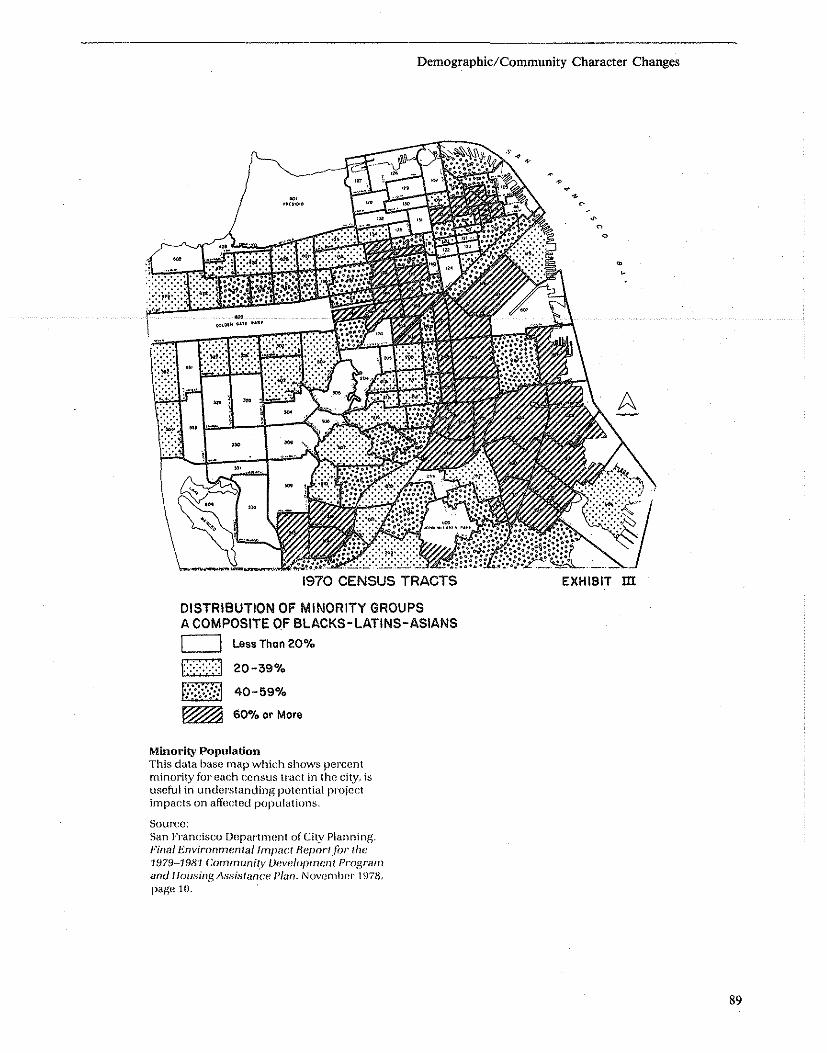
Demographic/Community Character Changes
1970 CENSUS TRACTS
DISTRIBUTION OF MINORITY GROUPS A COMPOSITE OF BLACKS-LATINS-ASIANS
c::::::J Less Thon 20%
\::;::;:;:;::1 20-39%
f~';;;i:'{::l 40-59%
~ 600/0 or More
Minority Population This data base map which shows percent minority for each census tract in the city, is useful in und{wstanding potential P)'()jcct impacts on affected populations.
Source: Sun Fnl.ncisco Department of City plu!)ning. Fin<ll .Environmcnlallmp;u:1 Heparlfor tile 1979-1981 Community Veve/oprmml Program and I/ousing !\s,,,isfance Pi<m. November 1978, page 10.
EXHIBIT m
89

90
362 10
351 ••
363 364 365 73 71 65
Demographic/Community Character Changes
363 Census Tract Number •• Rank Order
Socioeconomic Characteristics Above Average (top 1/3) Average (middle 1/3) Below Average (lower 1/3)
30701 54
Indicators of Socioeconomic Characteristics Percent of Residential Vacancies excluding
new construction Percent of Two-canvass Residential Vacancies Percent of Commercial Units Vacant
:30702 72
147 53
Percent of Occupied Housing Units with Change of Occupant Percent of One-person Households Percent of Female Heads of Household with Children Percent of Jobless Heads of Household Average index of Household Income
Source: R. L. Polk & Co., Profiles of Change, Map Series. Map HM9055, August 1975
Socioeconomic Characteristics by Census Tract Several demographic characteristics have been combined to fonn an indicator of socioeconomic characteristics, which is then mapped.
Source: ,Saint Paul City Planning, St. Paul, Minnesota. Environmemal Data Base and Assessment Guide. January 1977, page 126.

impact relies heavily on community comments and the professional judgment of the reviewer.
Sources and References Christensen, K. Social Impacts of Land Development: An Initial Approacb for Estimating Impacts on Neigbborboods Usages and Perceptions. Washington, D.C.: The Urban institute, 1975.
Fitzsimmons, S. et al. A Guide 10 tbe Preparation of tbe Social Well-Being Account; Social Assessment Manual. Prepared for the U.S. Department of the interior. Cambridge, Mass.: Abt Associates, inc., 1975.
McEvoy, J. and T. Dietz. Handbook for Environmental Planning: Tbe Social Consequences of Environmental Cbange. New York: John Wiley & Sons, 1977.
St. Paul City Planning Department. Environmental Resource Data and Assessment Guide. St. Paul, Minnesota, January 1977.
Neigbborbood Identification: A Guidebook for Participation in tbe U.S. Census Neigbborbood Statistics
Demographic/Community Character Changes
Program. Prepared for U.S. Department of Housing and Urban Development, Office of Policy Development and Research, Office of Neighborhoods, Voluntary Association and Consumer Protection. Prepared by institute for Urban Studies, University of Notre Dame, April 1980 (Purchase Order No. HUD 5239-79).
Experts to Contact
• Neighborhood planner at local planning department • Director of local neigllborhood organizations • Housing Code Compliance Office/local health or building department • Loclll Community Action Agencies • Local Advocacy Groups and/or Organizations
Mitigation Measures 1. Redesign or relocate project 2. Preserve or relocate community institutions 3. Establish community advisory group to monitor project implementation
91

Overview
Displacement refers to the dislocation of people, businesses, institutions or community facilities as a result of a project. There are several types of displacement: direct displacement and indirect displacement. Direct displacement is involuntary displacement of a person who occupies property that is acquired, rehabilitated or demolished for CDBG activity, or vacated to comply with CDBG-assisted, code enforcement or specifically identified ina CDBG/UDAG application as the site of a leveraged activity (i.e., completion is contingent upon approval of the CDBG/UDAG). Only displacement as a result acquisition by a public agency is covered by the Uniform Relocation Act.
Indirect'Displacement is involuntary displacement caused by an activity or event that is not CDBG- , assisted but which is supported by concentrated CDBG activities. For example, this would include displacement caused by rapidly increasing rents made possible by revitalization of an area in which CDBG funded rehabilitation or street improvements are taking place.
Assessment Questions
1. Will the project directly displace individuals or families? How many persons? Is the displacement covered by the Uniform Relocation Act and are funds available for payment? 2. Will the project destroy or relocate existing jobs, community facilities or any business establishments? Is the displacement covered by the Uniform Relocation Act and are funds available for payments? 3. Are relocation funds available for families or individuals who may be directly displaced? 4. Will identifiable groups be affected-older persons, females, single-parent families, racial/ethnic, or income groups, or minority group members? S. Are replacement facilities or housing units available within the community or in nearby neighborhoods? What will be the effect of relocation on these neighborhoods? 6. Will the project result in probable indirect displacement? If so, have measures been planned to alleviate the hardship on those affected whose displacement is not covered under the Act?
Analysis Techniques
The location of the project should first be plotted on a land ownership map in order to determine if any property will have to be purchased and whether there are residents, businesses, or institutional uses presently occupying the site. If it is determined that relocation is
92
Displacement
required, then an inventory of potential displacees should be prepared employing a city directory, city census or other listing of current building occupants. In larger cities, a relocation specialist is usually respon-sible for this activity. .
The Area Office Relocation Specialist can provide data on relocation requirements.
It is more difficult to assess and forecast any resulting indirect displacement. An analysis of trends in the local real estate market, vacancy rates, recent sales and rental prices along with income statistics of the area can help indicate an area which might likely experience indirect displacement.
Policy Base (Including Standards and Legal Requirements)
Under the Uniform Relocation Act individuals or businesses forced to, relocate due to real estate aquisition by a public agency for CDBG Activity are entitled to certain payments and other assistance. Specific information concerning these requirements can' be found in the following sources: .
Uniform Relocation Assistance and Real Property Acquisition, 44 FR 30 946; Effective Sept. 26, 1979, 24 CFR Part 42.
HUD Handbook 1376.1, "Relocation and Real Property Acquisition," September 1979, and any revisions.
Experts to Contact
• Relocation Specialist at local community development agency • Relocation Specialist at HUD Field Office
Mitigation Measures
As mentioned, those directly displaced by a public acquisition are entitled to the assistance stipulated in HUD Handbook 1376.1, "Relocation and Real Property Acquisition," September 1979, and any revisions. '
Persons displaced due to other forms of direct acquisition or the indirect impacts of a project are not covered by the Act. However, actions can be taken by public agencies to mitigate potential adverse effects including making housing assistance available through Section 8 and other programs, constructing new housing for the group to be displaced, targeting jobs programs to the neighborhood, establishing home purchase subsidy programs in the neighborhood for low and moderate income families, and tax abatement for elderly and/or low income persons.

Businesses Disglaced
Eastern Produce Goodyear Eardrum Hi-Fi Strawberries Records Edward's Food
Warehouse Tile City Service Station Child World Bickford's
pancakes
WXKS Sub Shop Restaurant
MSTA at grade parking
Drive-In
TOTAL
Assessed Estimated Acquisition Acreage Value * and Relocation Cost
1~.8 $646,300 $4,000,000
3.9 $ 98,300 $ 900,000
4.5 N/A N/A
20.75 $214,900 $2,000,000
44.95 $959,500 $6,900,000
Displacement
Displacement and Acquisition Costs Acreage, assessed value, potential acquisition costs and relocation costs for displaced busi~ nesses are important impact indicators.
Source:
* Assessed value at the time the businesses were surveyed in 1978.
Office of Community Development City of Medford, Ma, Draft Environmental Impact StatemenflReport Wellington Station Area Dev~lopment. November 1979, page 48.
ESTIMATES OF HOUSEHOLDS TO BE DISPLACED 1979-811
Elderly or Handicapped Family Large Family
Total (1-2 Persons) (4 or less Persons) (J tilt lIORl'L Pl!lIso~j
Total 1105 431 527 147
Female-Headed 231 93 90 48
Black 404 145 173 86
Hispanic 43 29 10 4
Asian or Pacific Islander 141 60 65 16
American Indian or Alaskan Native 8 3 4 1
1 David Cincotta, Housing Specialist, Office of Community Development,September 15, 1978, personal communication based upon material received from the San Francisco Redevelopment Agent. Dislocation estimates for each Revitalization Neighborhood are on file and available for review at the Department offices, 100 Larkin Street.
Displacement Estimates This table is taken from the city-wide CDBG program environmental review record for San Francisco. Other tables show dislocation by neighborhood and by project.
Source: San Francisco Department of City Planning. Final Environmental Impact Reportfor 1979-1981 Community Development Program and Housing Assistance Plan. November 1978, page 44.
93

Overview
Employment related impacts of a project can be grouped in three broad categories: tempel'llry jobs created in construction and allied fields as a result of constructing the project; permanellit jolJs created both directly and indirectly as a result of the project; and in the case of housing developments; the job ""!ltiremeats of BeW resideats.
Employment and income patterns can be measured in two ways-by identifying the occupations and income levels characteristic of an area's resident population or by identifying major employers within the area. Some of the measures commonly used include: (I) resident income; (2) resident occupational distribution; (3) unemployment levels; (4) job types of major employers.
There are several ways in which a project can impact on employment and income patterns. Most COBO and UOAO projects involve temporary construction jobs and permanent jobs required for the operation of a new facility. The purpose of the assessment is first to identify antiCipated changes in employment and income patterns and then to evaluate the results. How many of what type of job will be created? While increased job opportunities are generally considered beneficial, it is important to determine both who will likely be employed (e.g., city residents or suburbanites, low income low skilled persons or upper income higher skilled individuals) and what the skills and income profile of new employment is likely to be. Some new developments serve to displace existing employment. For example, a UOAO assisted new commercial development may serve to displacement employment in existing small businesses which service a neighborhood, and thus displace jobs and incomes from these businesses.
Assessment Questions
I. Will the project either significantly increase or decrease employment opportunities? Will it create conditions favorable or unfavorable to commercial, industrial, or institutional operation or development? 2. How many temporary and how many permanent jobs will be created by the project? 3. What is the profile of new jobs created by the project? What is the distribution across the skills and income scale? How do these relate to the skills and income profile of project area residents? 4. Will the new jobs likely go to area residents, to lower income, unemployed and ntinofity group members? Will construction jobs likely go to union or nonunion workers? 5. Where are the new employees likely to come from (i.e., inner city, suburb, outside SMSA)?
94
Employment and Income Patterns
Analysis Techniques
It is first necessary to identify the existing employment and income characteristics of the project area. Income data can be obtained from the Census with current estimates often prepared by city, state and areawide planning agencies.
As part of the preparation of the base data file it is suggested that employment and income data be mapped for the community. The City of St. Paul prepared three such maps, the first presented income status and trends by census tract. This map not only displayed low income areas but indicated which neighborhoods were finding their incomes increasing or decreasing significantly relative to the national average. Similarly an unemployment map both indicated the locations of chronic unemployment and presented recent trends of increase or decrease. The final base data map presented net change in number of businesses in each census tract. When viewed togetber these maps present a benchmark against which the impact of proposed changes created by the project can be measured.
It is next important to assess the likely employment generating effects of the project. Estimated construction and permanent employment may be known by project proponents. If not, estimates can be used which convert the size and value of the construction into numbers of workers and likely annual income. Based upon this, multipliers can then be used to calculate likely secondary employment effects. For example, 50"7. of the value of a project might he labor at an average cost of $16,000 per person year. Retail employment ntight average one employee per 1 ,000 square foot, etc. While national formulas can be employed it is preferable to use likely employment multipliers which are tailored to the general geographic area.
Once the likely employment and income generating impacts of a project are known, it is next necessary to forecast the likely beneficiaries. What percentage of the new jobs will likely go to a project area residents, to lower income, unemployed and minority group members?
Will the project cause area residents to leave existing jobs for new jobs which may only be temporary or will the new employment and income opportunities "pull" or attract others from outside the immediate jurisdiction and possibly increase the demands for related services?
Will the project result in displacement of existing jobs or businesses?
Sources and References
Lansing, J.B., Mueller, E., and Barth, M., Residential Location aod Urbaa Mobility, Ann Arbor, University of Michigan, Institute for Social Research, 1964; an analysis of the interrelationships between location of residential housing and urban employment.

, ,
l
301
319
+
332 -\ 348
362 +
333
349 +
36.l
35C+
351
364 +
375
30'2
322 +
3,i,4
352
365 +
376.02 +
323 -
353 +
366
,,+ ~3
367
+
+
-
Employment and Income Patterns
304 30e
305
Low Income Areas (1973 estimated average hQusehold income less than $10,700.)
Household income increased by at least 5% of the national average asa resu 1t of household movement between 1973 and 1974
House income decreased by at least 5% of the national average as a result of household movement between 1973 and 1974
307.01
I 37. ,
/
30702
-+
31802 ...
347
Source: R. L. Polk & Co., Profiles of Change, 1975.
Income Characteristics and Trends This base data map identifies low income areas and indicates income trends by census tract.
Source: Saint Paul City Planning, St, Paul, Minnesota. Environmental Resource Data and Assessment Guide. January 1977, page 122.
95

ARIAS Of SUBSTANtIAL UNEMPt.OYMENT 1"8 ANNUAL AVERAGI
UMfIIIf\OYMIHt CDlSUS "laHfAOI llIACU IAn .. """"""'"
!VMS"ft* 8092. SO'M. aQ90 ., III~
~IC[RO Slll,81M .. , 6143,814-1 ~6.\
_lNP;\U 8111, on~, u 811S, 8111 .- 8112. 611l. 811~ ... 811S,6111
IlEUIOSE 'AA'!C SIll •• ~~ 6113.6!17 ...
8118. 8!~1
wnlU~ 'AII~ 8!1~ ... $11»/1: PARK ,,~
'" """"""" 9l.t>£ ISUJIC "" CI<!u.oo IIUGIfIS 8200. ~?2. SlM. 5l!1.i, 112~7. 6302
CIlUnIlOO ". ,,- ~
u.sT CHIC\GO HtlCWllS $iiI
FI.O$_ .~ ..• !WIllY 826~. lIZ/). ." ...
SUI, &lIS. ." Holm C~t$l ." ... . ,- 8"~ ... Mlt:l.OTHJAli "" ., (lU ro:t($l 8l~6 ... PAAK F()Q£S! . ~ ... PHO£HII "n )u -, lilt), 8248 ., RIY!lIo.l1.t ,,~ ... _ .•
"" ) 1.$
$, CHICAGO HUt;l41$ •• . .. SQlIlItt)ltJJIg 821l, 3ZIS ... _ .•
~. ...
Areas of Substantial Unemployment CDBG activities can be reviewed in light of their effects on areas of concentrated unemployment.
Source: Cook County Department of Planning and Development for the Economic Development Advisory Committee of Cook County. June 1979.
96
Employment and Income Patterns
COOK COUNTY· 1918 ,,0 ,
:= U~'''~O'>OlA1l0 UIAI
::- ....:'u.\I ....... " .. 'c .... \,,~, :::.::::] (,10 o. C~lCAGO ~ ___ (OUN" IOIlNl>Ah

EPA and HUD. Population and Economic Ac· tivity in the United States and Standard Metropolitan Areas-Histoncal and Projected, 1950-2020. Springfield, Virginia, NTIS, 1972 (NTIS No. PB-216 6(7); provides description and projections of per capita in come in SMSA; based on employment predictions through the year 2020.
Experts to Contact
• Local Industrial Development Authority • Economist at state employment service • Planner/Administrator at local planning or employment agency • Chamber of Commerce
RETAIL OFFICE HOTEL
Employment and Income Patterns
Mitigation Measures
In several large cities, Boston and Dayton among them, UDAG assisted commercial developments required employers to hire a target percentage of CETA -·trained referrals. Boston has instituted a percentage residency requirement for the new Copley Place commercial development, of 20"1. minority and 50% city residents for both construction and permanent employment created by the project.
Often transportation is the critical link which is needed in assisting the unemployed to secure a job. In some situations, the development of public transportation, such as an express bus, from residential to job locations can serve to mitigate the problem of siting a new development pro· ject in a location which is removed from existing transportation lines.
R&D MBTA OTHER TOTAL EMPLOYMENT EMPLOYMENT EMPLOYMENT EMPLOYMENT EMPLOYMENT EMPLOYMENT EMPLOYMENT
Alternatives Leasable SF Jobs Gross SF Jobs Rooms
No-Build 128,000 250
Alternative E 600,000 2,000 370,000 3,145 125
Alternative 0 300 ,000 1,000 500 ,000 4,250 125
Alternative C 480,000 1,600 250,000 2,125 125
Alternative C-2 480,000 1,600 250,000 2,125 125
Alternative E-2 - 370,000 3,145 125
Preferred 550,000 1,833 200,000 1,700 250
Assumptions: 1.0 employees per 300 SF of gla. retail 1.25 employees per hotel room 1.0 employees per 100 SF net office 5.5 employees per 1,000 SF R&D
Employment Impacts As illustrated, alternative community development projects will generate different levels of employment in different sectors.
Source: Office of Community Development City of Medford, Ma. Draft Environmental Impact Statement/Report Wellington Station Area Development. November 1979.
'The CETA program has since been discontinued.
Jobs Gross SF Jobs Jobs Bldg. SF Jobs
110 13 ,000 15 375
156 110 5,411
156 110 5,516
156 110 3,991
156 180,000 990 110 4,'981
156 110 3,411
312 no 3,955
97

Community Facilities and Services
• Educational Facilities
• Commercial Facilities
• Health Care
• Social Services
• Solid Waste
• Waste Water
• Storm Water
• Water Supply
• Public Safety-Police, Fire, and Emergency Health
• Open Space, Recreation, and Cultural Facilities
• Transportation
Overview
There are two fundamental considerations regarding a CDBO activity's relationship to and/or impact on elementary. junior and senior high schools: • adequate capacity for children in the school(s) • safe access
In order to accurately establish the extent to which these two criteria should apply. an initial calculation must be made detailing the projected increase in student population to be created by the proposed development. This calculation can be accomplished by: • contacting the developer or sponsor for mix of unit types (Le .• I-bedroom, 2-bedroom dwellings); • contacting the school administrator or superintendent for an estimated average number of school-age children per unit type;
If neither source has the appropriate information. other sources are: • The Fiscal Impact Handb .... k. pgs. 276-299 (see references). This section deals with population projections. • A chart entitled "Pupil Oeneration Rates by Type of Dwelling" found in Center for Urban Policy Research. H .... sing Devel .. pment and M .. nicipal C .. sts, Rutgers University. 1973.
This chart provides "pupil multipliers" for "grade level" and "bedrooms" for different types of dwellings. This will give a pupil estimate when no other sources are available.
If the proposed project will overcrowd the schools consider such alternative options as: • building additions to existing schools; • locating classroom space in nearby buildings (Le., com!llunity centers or other commercial facilities, possibly owned by the developer);
98
Educational Facilities
• providing transportation to other schools. Safe access takes into account the possible need for
transportation to school and attention to potential traffic hazards. Specific issues include: • existence of all-weather walking paths and their or existing paths' proximity to bus stop(s) as well as to the school itself and crosswalks • crossing guards (especially for elementary school children) • clearly marked intersections near school or bus stop(s)
Assessment Questions 1. Will the additional school age children in the proposed development exceed the capacity of existing or planned school facilities? 2. Does the potentially affected school(s) have adequate and safe access facilities (Le .• walking paths. bus routes, crosswalks and guards) given any calculations done for projected population increase? Are these adequate both in terms of safety and access? 3. Will additional or alternative facilities have to be provided to ensure safety and suitable access? 4. What measures will be taken by the superintendent or school's governing body to resolve potential problems/conflicts?
Analysis Techniques If walking,routes are prohibitively unsafe or if such routes exceed 1/3 mile (elementary); 1/2 mile Guuior high); or I mile (senior high) in length (see table), then bus transportation should be instituted, provided the trip does not exceed 1/2 hour riding time for elementary children or 3/4 hour for junior/senior high school children. Early morning and late afternoon bus circuits should be arranged to accommodate those students wishing to arrive at school early or stay after normal school hours to participate in extracurricular activities.
Walking Bus Ride
Elementary 1/3 mile 112 hour Junior High 112 mile 3/4 hour Seni()r High 1 mile 3/4 hour
If school children will be required to walk or to ride the bus longer than the distances suggested above, or more than prevailing local standards. consult tbe superintendent about how to alleviate the problem.
If it is determined that there exist inadequate facilities to accommodate school children or that safety to school children will be jeopardized and corrective action is not proposed, then the project will have an adverse effect.

Community Facilities
~ Existing Parks & Playgrounds
I11III Schools, Public & Private
Educational Facilities
• Police, Fire, Library, Little City Hall
Existing Facilities Map This base data map shows schools, as well as parks and other public facilities within the area of concentrated program activities.
Source: Boston Redevelopment Authority. South End Environmental Assessment. Spring 1979.
99

1976 1977 1978 1979 1980 OSGOOD ELEMENTARY SCHOOL (GRADES K-VI)
Total Enrollment 473 423 377 340 31.
Percent Change -10.6% -10.9% -9.8% -7.6%
ROBERTS JUNIOR HIGH SCHOOL (GRADES IV-VIII)
Total Enrollment 859 818 772 582 543
Percent Change -4.8% -5.6% -24.6% -6.7%
MEDFORD HIGH SCHOOL (GRADES IX-XII)
Total Enrollment 3,218 3,116 3,033 2,911 2,640
"Percent Change -3.2% 2.7% -4.0% -9.3%
Source: Medford public School Department School Directory 1975-1980. (Figures shown are at October of each year.)
School Impacts Estimates of school age children for various housing alternatives are calculated here.
Source: Office of Community Development, Medford, Ma. Draft Environmental Impact Statement! Report: Wellington Station Area Development. November 1979, page 110.
UNITS
Studio 1 BR 2 BR "3 BR Total
Alternative E 50 315 225 50 700
Alternative D 50 375 225 50 700
Alternative C 45 450 220 25 740
Alternative C-2 20 225 95 0 340
AlternatiVe B-2 135 100 430 135 1,400
Preferred
POpuLATION
School Total Age
1,322 92
1,322 92
1,312 59
568 22
2,707 230
Alternative 370 282 206 858 2,035 311
Assumptionsl 1.071 persons (0.0 school age) per studio size d.u. 1.470 persons (0.015 school age) per 1 BR d.u. 2.270 persons (0.081 school age) per 2 BR d.u. 4.129 persons (1.311 school age) par 3 BR d.u.
Source: Burchell, Robert W., Listokin, David, et al., The Fiscal Impact Handbook, The Center for Urban Policy Research, 1978, Exhibits 13-1, 13-2.
Existing Enrollment Enrollment records at schools near the pro~ posed project are used to estimate the capac~ ity of existing services.
Source: Office of Community Development, Medford, Ma. Draft Environmental Impact Statement/ Report: Wellington Station Area Development. November 1979, page 109.
100
Educational Facilities
Sources and References
School maps are helpful for identifying distances and safety issues.
A school district plan is helpful for analyzing capacity issues and determining the impact of potentially increased enrollment.
The following source is useful in identifying the number of children produced by different types of units.
Burchell, Robert W. and David Listokin, The Fiscal Impact Handbook. New Brunswick, New Jersey: The Center for Urban Policy Research, 1978, pg. 276-288.
Experts to Contact
• School Superintendent • Developer or sponsor of proposed CDBO project • Traffic Department
Mitigation Measures
Identify alternative schools or buildings to temporarily house students if problems are anticipated due to overcrowding.
Expand and/or improve existing school access to alleviate safety problems. Work with school officials and city traffic engineer to identify options and costs.
Overview
There are two key considerations in assessing commercial facilities. The first is an evaluation of the adequacy of existing commercial facilities to service the development. Are these facilities located conveniently to the proposed development? Are the available retail goods within the income capacity of the proposed project users or residents? Are there serious gaps in range of available goods and services?
The second analysis involves the impact which a proposed development will likely have on surrounding commercial establishments. For example, a new UDAG sponsored commercial development might displace existing small scale retail establishments which become uncompetitive when compared to new enterprises. Similarly, a new office building\pr hotel may draw business away from existing hotels and office buildings.
There are generally three types of retail areas which ar~ recognized by type and function; any of these mIght be affected by the proposed project.
Neighborhood-consists of small businesses usually within 5-10 minutes travel time which include food drug, cleaning and convenience stores. The neighb~rhood shopping site is usually organized around a supermarket.
Community-or central business district contains multi-functional economic and service enterprises including banks, specialty stores with access provided either by auto or public transit. In larger metropolitan areas, a food store is often not included.
Regional-may be either the central business district of a metropolitan area or may be a regional shopping center, usually with two or more department stores and various specialty stores.
Assessment Questions
1. Is there adequate and convenient access to retail services? In the case of elderly, this means that shopping for such essential items as food and medicine is within three blocks and services such as banks and other convenience shopping are within walking distance. 2. Do local retail services meet the needs of project occupants/users? Are they affordable and is the range of services adequate? 3. Will existing retail and commercial services be adversely impacted by the proposed project? Will existing businesses be placed at a competitive disadvantage or be displaced?
A,nalysis Techniques
The first task in the analysis of commercial facilities is to determine the nature of the facility (housing, hotel etc.), its size, location and socioeconomic characteris-' tics of probable users or occupants. Next, using a
Commercial Facilities
m~p: evaluate the relationship between the project and eXlstmg commercial facilities. In the case of a housing development, for example, locate the nearest neighborhood, community and regional shopping areas from land use maps. Then determine their access to proposed occupants by probable mode (pedestrian transit or private automobile). Determine likely trans~ortation routes and travel time. Determine any transportation limitatio~s such as infrequent or irregular bus service.
Make Judgments concerning the quality of commercial services available, I.e., the range of goods and services and their relative price. Will these services meet the needs of project users and/or residents? Will access be adequate? If the project will cater to a population largely dependent on public transportation spe.cial consideration must be given to shopping areas' whIch can be reached either by transit or walking. If the project users/residents are elderly and/or handicapped, special consideration must be given to the a~ailability or .special transportation services and shoppm~ ~reas ~hlch are accessible to the handicapped. In addItion to mcome, demographic factors influence shoppi~g needs and preferences. Young working adults have dIfferent shopping patterns than families with small children or elderly persons.
In order to assess the impact of a new comercial ~evelopment (hotel, shopping complex, etc.) on existmg commercial enterprises it may first be necessary to identify existing potentially competitive establishments and to gather data concerning their sales markets and characteristics of patrons. Some new co~mercial ~nterpr~ses help to strengthen a commercial area by generatmg ~ew demand, which in turn benefits existing estabhshments. Other new establishments might serve to displace existing enterprises. For example, a new supermarket might draw business away from a "mom and pop" local food store. However, they usually serve a different clientele and there may be a need for both. The determination of likely impacts must be made on a case specific basis involving a careful analysis of both primary and secondary data. Consultation with real estate marketing experts and/or local commercial realtors may be helpful in gathering data and making judgments. . A determination of negative impact might result if it IS found that existing commercial facilities are inadequ~te to meet the needs of the project .users and/or reSIdents .. Most often, poor access is the problem; however, m some locations the existing commercial establishments are judged as having too limited a variety of goods available, or unusually high prices.
A determination of negative impact might also result f~om a finding that existing businesses might be dIsplaced by a new commercial development, such as a UDAG sponsored shopping mall or other commercial venture.
101

102
BLUE HILL AVENUE CORRIDOR
!:;::;:PROPOSEO UO.A.G. AREA __ ALTERNATlVE TRANSIT ••• COARIOORS • EXISTlNG COMMERCIAL .. CENTERS
Wellington
Mattapan
$av-Mor
Commercial Facilities and Neighborhoods This map iUustrates the location of a proposed UDAG in relation to commercial centers and transportation facilities.
Commercial Facilities
Source:
>-r"nKlin Hill
Franklin Field
-3-.:.'. ,1.~ . Scale: 7'"=32CO' , liIi' June. i9i8
City of Boston, Community Development Block Grant Program. Level afClearance Finding: Blue Hill Avenue Revitalization (UDAGJ, 1978, page 38.

8519
o e
MINOR MAJOR
GROCERY- 0 0 RETAIL -. • MIXED .. e
Location of Grocery and Retail Facilities A generalized map of commercial facilities by census tract is used as base data for environmental reviews.
Sources and References
Schaenman, Philip. Using an Impact Measurement System to Evaluate Land Development. Washington, D.C. Urban Land Institute, 1976.
U.S. Department of Commerce, Bureau of Census. Census of Retail Trade.
Broume, Larry S. lutemal Structure of the City. Toronto University Press, Toronto, Ontario, 1971.
Muller, T. Economic Impacts of Land Development, Washington, D.C., Urban Land Institute, 1976.
Experts to Contact
• Local Chamber of Commerce • Commercial Realtor • Commercial Development Speialist • Local Planning Agency
Mitigation Measures When a housing development is poorly situated in relation to shopping, mitigation might include arranging
Commercial Facilities
e
8044
o
Source: City of Elgin, Illinois. Environmental Review Board. 1981.
additional or new transportation services, either through the local transportation authority or through a social serVice agency, especially in the case of elderly or handicapped housing. In some cases it may be appropriate for the developer or sponsor to purchase a minibus to transport residents, if other semces are not available or are inadequate. The local plimning agency might be asked to encourage new retailing in the area, perhaps through a package of incentive Programs (Le., low interest commercial development loans from Economic Development Administration (EPA) or Small Business Administration (SBA». In Boston, a "foodmobile," a mobile food market, tours the city's elderly projects.
In the case of existing retail or other commercial facilities facing the adverse effects of new commercial enterprises, various business improvement loan programs might be employed to assist local businesses in making needed improvements to become more competitive, such as SBA or EDA funded loan programs.
103

Overview
Relevant issues to be considered regarding a proposed project's impact on health care services are: • adequate access to hospitals, emergency facilities, clinics and physician services • potential effect of the proposed development on existing helath care services' capacity and ability to accommodate an increase in use • are there adequate health services to accommodate the special needs of a potentially diverse population, i.e., families, elderly, handicapped.
Healtl! care services can be. defined as those regular and emergency dental and medical.care services provided for by private doctors, dentists, and other trained medical staff at a hospital, outpatient clinic, public, private or community health facility, home-care medical programs, or an emergency treatment facility (trauma unit, special cardiac pulmonary resuscitation (CPR) unit).
Assessment Questions
1. Are non-emergency health care services located within a reasonable proximity to the proposed project, i.e., less than a half-hour's drive or commute away? (In dense urban areas an even shorter time period may set the standard.) 2. In emergency health service available within approximately three to five minutes? Such service can often be provided by police and fire personnel as well as by ambulance staff. 3. Can ambulance trips to a hospital or other health care center be made within 10 to 15 minutes? 4. Is the number of d/,lctors, dentists, nurses and other trained medical staff in realistic proportion to any increase in residents/users? If not, can provision be made for additional skilled staff? 5. Will project residents/users require special medical services or skills such as geriatric clinics? 6. Will the local comprehensive health planning agency be contacted in the event that an increase in population from a proposed development causes a situation of increased or over capacity for area health care services? Consult the local area health systems agency to determine an estimate of number of hospital beds and other facilities needed. If over capacity is anticipated, the local comprehensive health planning agency should be approached for possible alternative plans.
Analysis Techniques
By examining relevant data regarding the demographic characteristics of the new residents/users (i.e., age, . sex), determine the specific types of medical services that will be required. Through discussion with the local comprehensive health planning agency determine if existing services will be adequate to meet the new . and increased demand.
104
Health Care
Determine the location of existing health care services and their distances to the proposed project site. Find out whether public transportation from the project site to the services is available and how long the commute is.
H it is determined that the facilities are not within a half-hour commute for the new residents/users or that the additional residents/users will overburden existing facilities, then the. proposed project will have an adverse effect.
Policy Base (Including Standards and Requirements)
There is no legislation that mandates the level of health care services. Comprehensive plans and analyses of the local area health systems agency may include desired levels of services.
Sources and References
EconomiclDemog .... pbic Assessmenl Manuai - Current Practices, Procedural Recommelllltions, and a Test Case. J .. A. Chalmers and E. J. Anderson. Mountain West Research, Inc. Tempe, Arizona, 1977, 300 pp.
How Effective Are Your Community Services? Procedures for Monitoring the Effectiveness of Municipal Services. Harry P. Hatry, Louis H. Blair, Donald·M. Fisk, John M. Greiner, John R. Hall, Jr., and Philip S. Schaenman. The Urban Institute and the International City Management Association, Washington, D.C., 1977, 320 pp.
Experts to Contact
Area Health Systems Agency-can provide the Areawide Health System Plan which is an inventory of institutional health services and projected demand within the area.
Local Public Healll! Department-can provide information on local demand for, and quality of health care.
Council on Aging-can provide information on size and location of the local elderly population.
Local Red Cross-can be valuable resource for medical needs of the area.
Mitigation Measures
Mitigation measures to be considered, depending on specific problems and local resources,include: • special shuttle and emergency transportation to medical services • incorporation of a small clinic or emergency medical service area into a housing development, keyed to the special needs of the resident popuJation • cooperation between the .CDBG agency and medical service providers in improving the quality and/or availability of health services in the area.

8519
0- fiRE STATIONS
e; CLINICS
() - HOSPITALS
o
Health Facilities and Fire Stations by Ceosus Tract
Source: City of Elgin, Illinois. 1981.
Hospitals An inventory of existing medical and health care facilities can be used to determine their adequacy in relation to CDBG activities.
Source: Regional Plan Association and Mid~Hudson Pattern for pfogress. New York, N.Y, The Mid" Hudson: A Development Guide. October 1973, page 28. .
Health eare
HOSPITALS. With 3.8 general care hospital beds per 1,000 people (com" pared to 4.2 In the New York Region), the Mld·Hudson Is only slightly undersupplied in quantity; however only 6 of its 25 gomeral care hospitals (dark dols) have over 100 beds, and none Is large enough to provide the full range of services required for superior medical care.
105

Overview
Social services can be defined as those services provided by governmental social service agencies or public or private groups, including but not limited to: programs for drug addiction, alcoholism, and mental disorders; halfway houses and drop-in centers, family counseling centers, day care centers; services for senior citizens and the handicapped; nutrition centers, meals on wheels; income maintenance and manpower programs, etc.
Social services by definition must cater to, and be easily accessible to, those who need them. Therefore, access and adequacy are important considerations. Factors to consider regarding a proposed project's impact on an area's social services include: • Availability and accessibility of day care, elderly centers and neighborhood centers to accommodate existing and future residents. • If appropriate social services centers are not located within a reasonable proximity to the proposed development, alternate space and services may need to be developed to accommodate new residents/users.
Assessment Questions
1. Are social services currently located in close proximity to the prospective users/residents? Are they within walking distance or convenient to public transportation and less than one-half hour's commute? 2. Is the number of trruned staff including social workers, counselors, psychologists, psychiatrists and related administrative and managerial personnel in realistic proportion to the anticipated increase in residents/users? If not, could provision readily be made for additional skilled staff? 3. Will the demand for the social services increase and overburden existing facilities, can provision be made to obtain alternative and/or additional space?
Analysis Techniques
By exiunining relevant data regarding the social service needs of the new residents/users (i.e., income level, age, number of children and teens per family) determine the specific types of services that will be required. Through discussions with the local Human and Social Service office, public welfare office, local youth services office, etc., determine if existing services will be adequate to meet the new and increased demand.
Determine the location of existing social services and their distances to the proposed development. Find out whether public transportation is available between the needed services and the project site and how long the commute is. .
r>etermine whether new residents or users will overburden existing services and facilities. What provisions could be made to expand them?
106
Social Services
Policy Base (Including Standards and Legal Requirements)
There is no legislation that mandates the level of social services. Local comprehensive plans may include desired levels of services. Local voluntary and public social service agencies and planning groups may have analysis of desired level of services.
Sources and References
Local Social Security Administration Offlcl>-can provide data concerning the size of the retired population and the income level of community.
Local PubHc Welfare Office-can provide data concerning the low-income populations in the community.
Local Social or Human Services Department (City or County)-can provide information on local demand for social/human services and their availability/adequacy.
Youtb Services Department-can provide data on the size and age of the local youth population.
Council on Aging-can provide information on the size, location and special social and human service needs of the elderly population.
Local Child Care or Daycare Center-may have information on the size and characteristics of the preschool population.
Local Healtb and Welfare Council or tbe United Fund-may have data on social and human service needs.
Economic/Demographic Assessmeut Manual - Current Practices, Procedural Recommendations, and a Test Case. J. A. Chalmers and E. J. Anderson. Mountain West Research, Inc. Tempe, Arizona, 1977, 300 pp.
How Effective Are Your Community Services? Procedures for Monitoring the Effectiveness of Municipal Services. Harry P Hairy, Louis H. Blair, Donald M. Fisk, John M, Greiner, John R. Hall, Jr., and Philip S. Schaenman. The Urban institute and the International City Management Association, Washington, D.C., 1977, 320 pp.
Municipal Costs and Revenues Resulting from Community Growtb. Walter Isard and Robert Coughlin. Federal Reserve Bank of Boston and the American institute of Planners. 1957, III pp.
Experts to Contact
• Planner-Local Planning Department • Administrator/Planner-Social Services Department • Administrator/Planner-Public Welfare Office • Administrator/Planner-Council on Aging • Administrator/Planner-Social Security Office • Administrator/Planner-Half-way House(s) in area • Administrator/Planner-Drop-in Center(s) in· area • Administrator.,-Child Care or Daycare Center • Administrator/Planner-Local Council of Voluntary Human Service Agencies.
Mitigation Measures
Mitigation measures to be considered include: • special transportation services-especially for elderly and children
Social Services
• potential CDBO cooperative funding for added social services • provisions of space for social se~vice offices a~ part of a CDBO facility-elderly drop-m center, nutntlon center, youth center and so forth.
107

•
Overview
SDlid waste dispDsal is regarded as an essential service in urban areas. Its availability fDr suppDrting a newly prDpDsed develDpment can be an essential determinant Df whether a project can be cDnstructed. SDlid waste materials are generally transpDrted by trucks to. a CDmmDn, usually remDte site fDr either recycling (rarely), incineratiDn (where allDwed), Dr burial/dispDsal in a sanitary landfill. In assessing this service twO. factDrs must be cDnsidered. First, the prDximity Df the service to. the site and secDnd, the capacity Df the serviCe to' accDmmDdate the project.
Assessment Questions
1. Will the existing Dr planned sDlid waste dispDsal system adequately service the propDsed develDpment? 2. As a result Df the prDject, will the design capacity Df these facilities be exceeded? 3. Will the prDpDsed prDject be adversely affected by proximity to' these facilities? 4. DDes the cDmmunity have an adequate number Df vehicles to' prDvide the prDject with cDllectiDn service? S. Will the residents/users Df prDpDsed prDject have to' pay annual/mDnthly CDsts fDr these services? Will these CDStS create severe financial hardsbips fDr prDject residents? (This can be a real cDnsideratiDn if IDW incDme Dr elderly are primary users.)
Analysis Techniques
An inventDry Df landfill IDcatiDns and capacities with estimated life expectancies can aid in determining adequate dispDsal capabilities.
Determination of Potential Adverse Effects Likely adverse effects can be determined if: a. Estimated sDlid waste generatiDn will significantly reduce life span Df landfill. b. Estimated sDlid waste generatiDn will significantly Dvertax existing cDllectiDn system. c. Projected future CDStS Df cDntinued service will far exceed the financial capacity Df users.
108
SDlid Waste
Policy Base (Including Standards and Legal Requirements)
ResDurce CDnservatiDn and RecDvery Act (42 U.S.C. S3251 et seq.).
The project ShDUld first be analyzed to' determine the lDcatiDn Df the site in relatiDn to' services and infrastructure including: the lDcatiDn and design Df SDlid waste storage facilities, if any, to' determine the ease Df remDval; the lDcatiDn Df sanitary land fill sites Dr SDlid waste recycling facilities in relatiDn to' the develDpment to' determine transpDrtatiDn needs.
SDlid Waste DispDsal Act (42 U. S. C. 690 \-6987 et seq. as Amended by the ResDurce CDnservatiDn and RecDvery Act Df 1976.
Sources and References
Minimum Property Standards, U.S. HUD Field Office. "EPA Guidelines fDr LDcal GDvernment Dn SDlid
Waste Management," Public Works Magazine, March 1972, p. 79-80.
Clark and TDftner, "Land Use Planning and SDlid Waste Management," Public Works Magazine, March 1972, p. 79-80.
Experts to Contact
• Engineer-LDcal SDlid Waste DispDsal Agency, Dr City Dr CDunty Engineering Department • Engineer/Planner-HUD Field Office Dr LDcal Planning Department • Engineer, Planner/Environmental SpecialistRegiDnal EPA Office
Mitigation Measures
If there is a prDblem with the capllcity Df an existing Dr planned system, alternatives to' explDre include expansiDn Df the existing landfill site adding Dne Dr mDre additiDnal sites, better cDmpactiDn methDds to' reduce the vDlume Df waste, incineratiDn, and recycling. If transpDrtatiDn to' the site is a problem due to' insufficient cDllectiDn vehicles, likely sDlutiDns include either cDntracting with a private cDllectiDn service Dr purchase by the cDmmunity Df new cDllectiDn trucks.
Overview
Waste water treatment and disposal is an essential service for all new development. The availability of adequate waste water disopsal service can be a determinant of whether or not a project is constructed. Waste water is usually collected in urban areas through a system of sanitary sewers which convey the waste to a treatment facility located "downstream" from the city. After treatment the effluent is either recycled (rarely) or is discharged into surface water or a permeable recharge area for an underground aquifer. In less developed areas, on-site septic systems or package treatment plants are used. Generally, 80 gallons of sewage is generated per capita per day. In aualyzing impacts to waste water treatment! disposal facilities, it is necessary to consider two factors: I) the proximity of the service to the site; and 2) the capacity of the service to accommodate the project.
Assessment Questions
1. Will existing or planned waste water systems ade-quately service the proposed development? . 2. As a result of the project, will the design capacity of these facilities be exceeded? 3. Will the proposed project be adversely affected by proximity to these facilities? 4. In less developed areas, are soils suitable for Onsite wastewater disposal such as septic systems? 5. Where on-site disposal is necessary, will the state or local health agency issue a permit?
Analysis Techniques
The project should first be analyzed to determine the location of the site in relation to municipal services and infrastructure, induding the location and design of waste water removal facilities, if any. If on-site disposal is planned, determine the potential for groundwater or surface water contamination. It is also necesssary to determine the type and density of development in order to estimate likely water use and the likely volume of waste to be generated.
Likely adverse effects can be determined if: a. Estimated sewage generation will exceed capacity of sewers or treatment facilities.
Waste Water
b. Project will utilize on-site liquid waste disposal system in an area not suited for its use. c. Waste water will be directed toward environmentally sensitive areas.
Policy Base (Including Standards and Legal Requirements)
Clean Water Act, as amended (33 U.S.C. S. 1251 et seq.).
Various states have laws which may be more stringent than Federal requirements.
Sources and References
Local infrastructure maps give the location and capacity of sewer and storm water drains. These are available from either the local planning or engineering departments.
The Soil Conservation Service Soils Maps indicate areas of impermeable soils and areas of highly permeable soils. The S.C.S. can also provide data on the depth of the water table which is useful in planning onsite waste water treatment facilities.
Areawide Wastewater Management Plans. Areawide 208 Agency.
Local Building and Healtb Codes, State and/or Local Building Department or Health Department.
Minimnm Property Standards, U.S. HUD Field Office.
Soils Survey Ratings for On-Site Waste Disposal, U.S. Soil Conservation Service.
Experts to Contact
• Engineer-Local Sanitary District! Agency, City or County Engineering Department, 208 Planning Agency • Engineer/Planner-Local Planning Department • Soils Scientist-U.S. Soil Conservation Service • Engineer-State Health and/or Environmental Quality Agency
Mitigation Measures
Potential problems can be mitigated through the construction of expanded capacity, such as sewer lines and treatment facilities. Contact the local 208 Agency for relevant plans and permit requirements.
109

iIIIIajor II! lements "fttle Montgomery Coonty S .... erage System
SOURCE: III-NCPi'C TEN YEAR WATER AND SEWERAGE PLAN
Sewerage System Map Using this map cnBG activities can be located in relation to existing service areas.
Source: The Montgomery County Planning Board of the Maryland-National Capital Park and Planning Commission, Silver Spring, Maryland. Growth Policy Report: Carrying Capacity and Adequate Public Facilities, October 1977.
110
Waste Water
TrunII 18_ ExItollAt Pro,""
(Gravity) Treatment I'tanls • 6
Pumping StatleM III Force Mains »»» Servlc. A •••
Categorle. 1-3 ..... "'.

1--:-- ..., ........
Major,Public Utilities A combination of base mapping and project area boundaries can assist in the determination of adequate facilities for new development.
Waste Water
MAJOR PUBLIC UTILITIES
u~1}!] DOWNTOWN/
OLD PUEBLO SOUTH
Major Publ ic Util Hies
Source: . Depal1ment of Housing and Community . Development, City of Tucson, Arizona. Environmental Assessment Barrio Historico Neighborhood Strategy Area. October 1979. Exhibit VII.
III

Overview
Storm water disposal is an essential service in most urban areas. Its availability to support a proposed new development can be an essential determinant of whether a project is to be constructed. Storm water is usually removed from an impermeable surface (e.g., pavement and buildings) by natural flow, storm sewers, or combined (storm and sanitary) sewers. It is discharged into a surface water body or onto permeable recharge area or temporary storage areas. In assessing impacts to storm water service facilities, two factors must be considered: I) the proximity of the system to the site; and 2) the capacity of the system to accommodate the project.
Assessment Questions
1. Will existing or planned storm water disposal and treatment systems adequately service the proposed development? 2. Will the project overload the design capacity of these facilities? 3. Will the proposed project be adversely affected by proximity to these facilities?
Analysis Techniques
The project should first be analyzed to determine the location of the site in relation to services and infrastructure including: the location and design of storm water facilities to determine both the ease of removal and the planned course of water runoff. It is also necessary to determine the type and density of development to determine the volume of storm water likely to be generated.
112
Storm Water
Determination of Potential Adverse Effects Likely adverse effects can be determined if: a. Estimated storm water generation will exceed capacity of storm sewers. b. Storm water will be directed toward environmentally sensitive areas.
Sources and References
Local infrastrncture maps give the location and capacity of storm water drains. These are available from
,either the local planning or engineering departments. Minimum Property Standards, U ,So HUD Field
Office.
Experts to Contact
• Engineer-City or County Engineering Department, Local or District Stormwater Treatment/Disposal Agency • Engineer/Planner-HUD Field Office or Local Planning Department
Mitigation Measures
Various measures can be taken to attenuate peak runoff including the use of controlled retention ponds on individual sites or along major drainage systems. Where storm sewers are not available, site grading patterns that increase flow distances over unpaved areas should be utilized. Detention/storage areas and the elimination of piped drains which discharge directly to surfaces will help minimize peak flow effects to existing storm drainage facilities. An expanded storm drainage system could be included in project plans if a potential deficiency is identified early in the project development process.

Storm Drainage Here a proposed CDBG project area is superimposed on a map of drainage facilities to assess the adequacy of the existing system to meet future development needs.
Storm Water
Source: Department of Housing and Community Development, City ofTucSOfl, Arizona. Environmental Assessment Barrio Historico Neighborhood Strategy Area. October 1979. Exhibit IV.
113

Overview
Adequate water supply refers to the delivery to a project site of sufficient quantities of potable water under adequate pressure at affordable cost. Approximately 100 gallons per day is the average urban domestic per capita water consumption rate.
Assessment Questions
1. Will either the municipal water utility or on-site water supply system be adequate to serve the proposed project? 2. Is the water supply quality safe from a chemical and bacteriological standpoint? 3. Will the project affect a sole source or other aquifer?
Analysis Techniques
Review the project plans to determine either the number andlor type of residential units proposed, or the type and size of proposed commercial, institutional or industrial uses. Estimate future water use by the project, and note any plans for conservation techniques. Then contact the local water authority or public works department to determine whether existing and future public water supply is adequate to meet the needs of the project. Check that the water supplies are of potable quality according to state and local public health standards.
If the existing public water supply system is inadequate to meet the needs of the project, discussions should be held with the water authority to learn if the system can be expanded by drilling new wells, making interconnections with other systems which have ample supplies or by other means. The willingness of the authority to do this and the economics are equally important.
114
Water Supply
Policy Base (Including Standards and Legal Requirements)
The quality and quantity of either surface or groundwater sources should meet HUD's Minimum Design Standards for Community Water Supply System. This would also be true if the alternative selected is purchase of water from a neighboring community. If a public system is not available to serve residential areas, then individual wells must meet HUD's Minimum Property Standards for One and Two Family Dwellings. Also applicable is the Safe Drinking Water Act (42 U.S.C. S. 300 el seq.) (This Act also protects sole source aquifers. Under the Safe Drinking Water Act Federal assistance cannot be approved for any project that could contaminate an aquifer that has been designated by EPA.
Sources and References
Dunne, Thomas and Luna Leopold, Water in Environmental Planning, W. H. Freeman, San Francisco, 1978.
Sargent, Frederic and Blaine Sargent, Rural Water Planning, F. O. Sargent (330 Spear St.,South Burlington, Vt. 05401), 1979.
Experts to Contact
• Municipal or private utility water supply planners and engineers • Local public health agency staff
Mitigation Measures
In the event that no additional water supply can be furnished from the public system, an investigation could be undertaken to discover whether \Veils drilled on site could furnish adequate supplies and at affordable costs.
If on site wells will not produce adequate water at reasonable cost the project must be abandoned or postponed until a supply is secured.
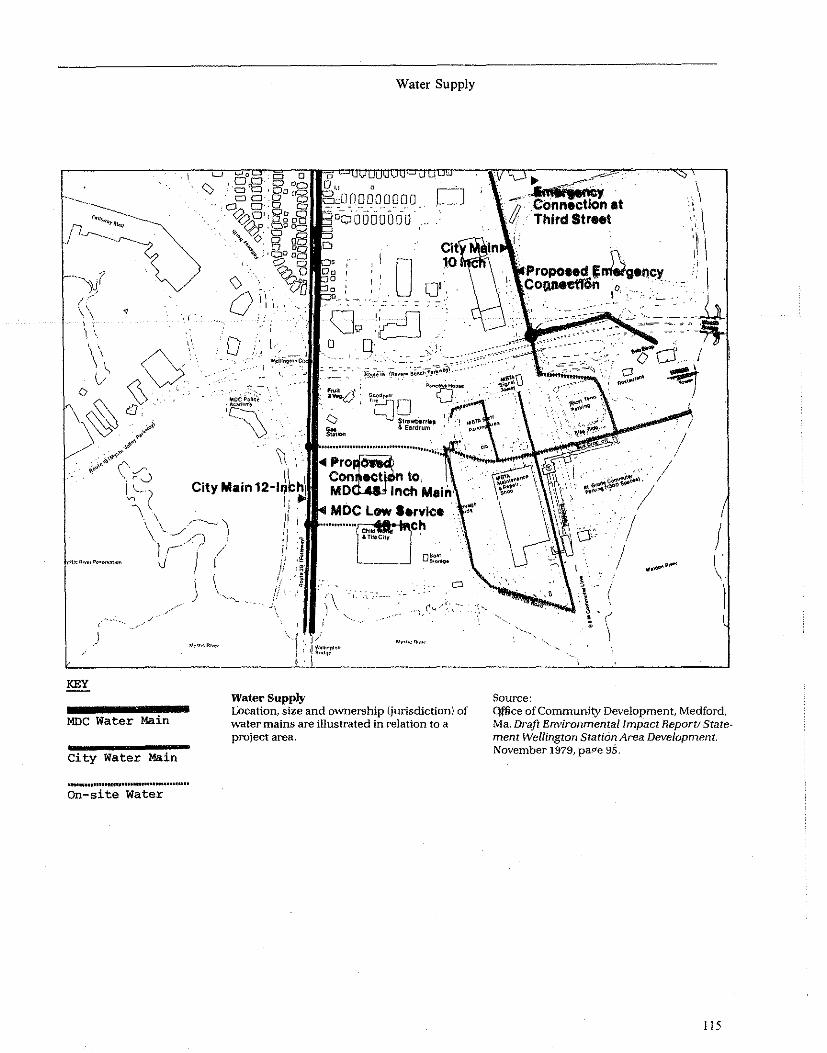
~?
I
I .~
KEY
MOC Water Main
City Water Main
On-site water
\)
A ll .1
D
\\ .....
City Main 12--lril:h
Water Supply
Water Supply
."·,l/1I000 000 0 C]
o cr ""
lEjo SIrawt>trt" & Ellrdrum proe
Con ecf n to. MD Inch
Location, size and ownership (jurisdiction) of water mains are illustrated in relation to a project area.
-;;1~=8t ThlrdStr .. t
.....
( (
\
Source:
! I' \
Q.ffice of Community Development, Medford, Ma. Draft Environmental Impact Report! Statement Wellington Station Area Development. November 1979, pap'e 95.
lIS

Overview
Fire, pqlice and ambulance services are concerns that should be considered in terms of the adequacy of existing services for the project site. Although many communities have sophisticated protective services, the consistency of adequate service is different from place to place. Within communities, one site may be better served than another.
Factors in the variability of protective services include the availability of funds for additional coverage and the degree to which building and growth are coordinated with provision of new municipal services. Key variables within each city are emergency equipment, emergency service personnel, response time and access. These factors influence the availability and adequacy of emergency services that may be required at a proposed project.
Assessment Questions
1. Does the project location provide adequate access to police, fire and ~mergency medical services? Does the project design provide easy access for emergency vehicles and individuals? Are there obstacles to access, such as one-way roads, narrow bridges, waterways, expressways, and railroads which would prohibit access in an emergency situation? Will the project create such obstacles? 2. Is the quality of the police and fire protection services available to the project adequate to meet project needs? 3. Does the area have a particularly high crime rate? Are there special plans for a security system which have been approved by the police department? Is the design and/or architectural configuration of the development such that it is easily patrolled by police from the street? 4. Will the project create a burden on existing facilities in terms of manpower and/or equipment? Can services either be expanded or be provided by the project, such as an in-house security force?
Analysis Techniques
Review the project plans in order to determine: a. location of the project in relation to each type of protective service; b. size of building and the number and type of users/residents, in order to estimate the demand for protective services; c. type of building materials as an indication of their resistance to fire and compliance with local codes; d. access routes for accessibility for emergency vehicles and compliance with local regulations; e. fire hydrant locations and availability of fire fighting equipment.
116
Public Safety-Police, Fire, and Emergency Medical
Next, secondary data should be consulted, including: • Fire-Service Maps: Obtained from the local fire department, these show the distance to the nearest fire station (and usually police station) which can be used to estimate response time. • Local Fire or'Police Department: If provided with the location and size of the project, the police and fire departments can determine whether they will be able to service the project adequately without increasing their staffs. They can also help to estimate response time to the site. o Emergency Medical Service Plans: These may be obtained from local hospitals or health, fire and police departments.
Field observation may be useful to determine the age and condition of surrounding buildings, location of fire hydrants, emergency call boxes, and nearby police and fire stations, and evidence of high crime rate in the area. Consult with police and fire departments for additional information on local conditions. Consult with the fire department to determine if water pressure is adequate as well as road service, e.g., width of roads, space to turn around, etc., for fire equipment. The issue of "access" is critical for emergency fire service.
A determination of an adverse impact may result if protective services are presently strained and there are no plans to increase services; if the distance to the closest fire station is more than 1.5 miles (high density) or 2 miles (low density); if the nearest hydrant is more than 600 feet away; if police response time is greater than 3 minutes; or if access by ambulances is difficult and/or if response time by someone trained in emergency medical techniques is more than 3 to 5 minutes. These response time standards are drawn from nationally recognized standards. You may want to establish standards better suited to your community. In some communities firemen and policemen are trained in such techniques as well as ambulance personnel.
Determine if the police and fire personnel are trained in basic paramedical skills and if they are available for such health emergencies as heart attacks.
Sources and References
The National Board of Fire Underwriters monitors the. fire insurance risks and fire fighting capabilities of most cities in the U.S. and rates sections of cities for the purpose of establishing insurance rates and premiums. If these are unsatisfactory the Board will advise what improvements are needed to gain a better rating.
U.S. Fire Administration's Home and Public Building Safety Division, National Fire Data Center, P.O. Box 19518, Washington, D.C. 20036. Telephone 202/634-7195. They have several publications: (1) A Basic Guide for Fire Prevention and Control Master

l1li CLOSEST FIRE t:::\ STATIONS AND \!J ROUTES TO PARCEL
lB.
A POLICE .t....:l. STATIONS
Fire and Police Services By mapping the fire stations surrounding a particular development it is possible to assess the response time in event of a fire.
Source: Massachusetts Executive Office of Administration and Finance. Environmental Impact Report on the Mi(Ced Use Development afParcellB, HaT1lard Square, Ma. August 1979/ pagf 116.
Public Safety
0
c;:;
Q . ........:" •
~, ~'\.(s
117

Planninll; (2) An Urban Guide for Fire Prevention and Control Masler Planniog.
There is no national agency which monitors crime and police efficiency on a nationwide basis. The International Association of Police Chiefs can offer guidance on how a particular police department can be studied and analyzed. Many police departments have established a Crime Prevention Unit internally. They are eager and able to review site, development, and architectural plans of proposed projects and will point out potential crime inducing situations and suggest how these can be avoided. .
Oscar Newman. Design Guidelines for Creating Defensible Space. National Institute of Law Enforcement and Criminal Justice. 1976.
Richard Gardiner. Design for Safe Neighborhoods. Law Enforcement Assistance Administration (LEAA), HUD, USGPO No. 027-000-00751-1. 1978.
Experts to Contact
• Chief of local fire department
118
Public Safety
• Local chapter or national Office of the National Fire Protection Association (NFP A) • Chief of local police department • Administrator of local emergency medical agency such as the ambulance corp in the Department of Health or the local Rescue Squad • Local medical society
Mitigation M.IIsures
Specific measures include: a) expanding local police, fire and emergency medical services in the community to adequately service the project; b) include safety features in the project such as fences, lighting, alarm systems and private guards to increase public safety; c) redesigning project site plan to improve police surveillance, neighborhood resident surveillance, and roadway design for emergency access; d) if it is a major development project, investigate how developers might contribute to additional service costs, or provide its own supplemental protective service by hiring a private security service; and e) add an alarm system if one has not been included in project plans .

Overview
The development or community services such as open space, recreation and cultural resources has become a necessary component of community development. These facilities can be operated by government, such as public parks and libraries, or they can be operated by private entities such as YMCAs and privately owned museums. They have much to do with the "quality of life" and "quality environment" concepts of a community and are essential to rilaintenance and continuity of a viable neighborhood.
Recreation and open space resources include active recreation, such as ball fields and passive recreation such as nature trails, and gardens.
Cultural resources include art galleries, libraries, dance facilities, museums, theatres and other facilities· for artistic and cultural purposes. These usually receive both public and private support.
Demand and supply for both specific recreation and cultural facilities is a function of factors which include the size of the community, density of development, income and demography. Wealthier communities have these services and facilities more often than poorer communities. Communities with a large percentage of children have greater needs for active recreational facilities than communities with a large number of elderly or handicapped persons who may prefer passive recreation. High density communities with little private open space have a greater need for access to public parks and recreation areas than small towns with ample open spaces or suburban areas where the homes have large yards.
Assessment Questions
1. Are open space, recreational and cultural facilities within reasonable proximity (Le., walking distance) to the project area? Is adequate public transporta-tion available from the project to these facilities? (Note: Small children and elderly persons need such facilities to be in very close proximity to their residences.) 2. Is there an adequate supply of these resources for the users or resident population of the development? 3. Will the CDBO project cause any overloading of existing facilities? 4. Are the special needs of certain population groups able to be satisfied, such as small children or the elderly and handicapped? For example, are there tot lots for very small children, playgrounds for elementary school children, drop-in centers for senior Citizens and ball fields for teenagers. 5. If the development is housing, has space for informal play for children of all ages been included on-site? Have areas for recreation for adults and the elderly been provided including places for passive recreation?
Open Space, Recreation, and Cultural Facilities
Analysis Techniques
Review plans to determine if such facilities have been included onsite. Locate the proposed site on a local land use map and determine the distance to the available open space, recreation and cultural facilities. Determine how many of these are within walking distance and are geared to project residents/users considering such factors as design and user fees. Determine if public transportation is available. Obtain data on the age and income of proposed project residents or users to determine needs.
Review plans for the project to determine whether the proposed project will have any adverse effect on these facilities, such as making user access more difficult or impeding views to these facilities. Consult with facility operators or administrators to determine if the project will cause any of these facilities to become overloaded.
If there are inadequate facilities within a reasonable distance of the proposed project, or the project will .overload existing facilities, explore appropriate mitigation measures.
Sources and References
Census data can help provide information on the size and location of population groups in the community who might need specialized recreation facilities.
The local cultural or arts commission can provide data on libraries and cultural resources including capacity, locations and usage level.
The Statewide Comprehensive Outdoor Recreation Plan (SCORP) identifies resources and often provides usage data.
The local parks and recreation department can provide data on the size, location and usage at various parks and open space areas. Utilize their standards or others listed below to determine whether facilities will be overlooked. • Urban Park and Recreation Recovery Program, Heritage Conservation and Recreation Service, Regional Offices • Land & Water Conservation Fund Heritage Conservation and Recreation Service, Regional Offices
If no local standards exist contact the National Recreation and Park Association, 1601 N. Kent St., Arlington, Va. 22209 for relevant examples of standards.
Experts to Contact
• Planner at local parks and recreation department • Administrator of Social Services Agency • Administrator of Local Cultural Commission • Local American Society of Landscape Architects • State Arts Office or Association • Administrators. of Private NonPrivate Agencies such as YMCAs, YWCAs, Museums, Private Libraries, etc. • State Liaison Officer
119
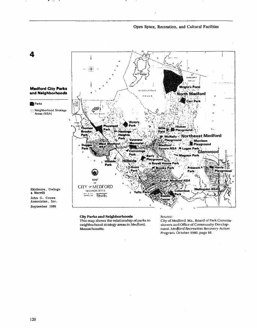
4
Medford City ....... end Nelghborhoocla
• Parks
Neighborhood Strategy Areas (NSA)
Skidmore, Owings • Merrill
John G. Crowe Associates, Inc. September 1980
120
,
Open Space, Recreation, and Cultural Facilities
'.L ~I·~
MAP or
CITY orMEDFORD :-'1,\.'):-'ACHl'5tTf.S
~::..;,:,~: ~
o
City Parks and Neighborhoods
,
This map shows the relationship of parks to neighborhood strategy areas in Medford, Massachusetts.
o
<-
Source: City of Medford, Ma., Board of Park Commis w
sioners and Office of Community Develop~ ment. Meclford Recreation Recovery Action Program. October 1980, page 16.

• State Historic Presentation Officer • H€ritage Conservation & Recreation Service • Department of Interior • National Park Service • Bureau of Land Management
Mitigatian Measures
Expand existing facilities. Develop more on-site facilities.
Open Space, Recreation, and Cultural Facilities
Review design to mitigate project impacts on open space and cultural resources in the vicinity.
Develop recreational resources for specific population groups, such as tot lots, playground, and passive park areas. Work with local school administrators to arrange after school use of school recreational facilities.
121

Overview
Definition Assessing transportation impacts involves analyzing four sub-elements of transportation. These are: 1. Access-To have access which is the primary function of a transportation system, the user must be able to reach a destination within reasonable limits of time, cost and convenience. 2. Balance-A balanced transportation system is one which provides reasonable options for travel by private automobile or public transit, or combinations of both as well as (car and bus) intermodal. 3. Safety-System design plays a strong role in safety, particularly elements such as traffic signals, turning lanes, and railroad grade crossings. 4. Level of Service-This term measures a number of operational factors including speed, travel delay, freedom to maneuver, safety and frequency Ihours of operation.
Assessment Questions
These assessment questions are organized by the four sub-elements described above:
Access 1. Will transportation facilities and services be adequate to meet the needs of the project's users? Is offstreet parking available and adequate? Is adequate public transportation available? 2. Are there special transportation issues (programs for the elderly and handicapped, bridge clearances for trucks, emergency vehicle access) which have not been adequately provided for? 3. Will the project serve to reduce the mobility of any group?
Balance 4. Will the project encourage additional private vehicle trips and increase energy consumption? 5. Will the users of the project be encouraged to use both auto and public transit?
Safety 6. Will the project create any safety hazards? For example, have curbs been designed with wheelchair ramps, have pedestrian activated signal lights or pedestrian overpasses been included in plans where needed? Is traffic light timing adequate for elderly pedestrians?
Level of Service 7. Will the project be provided with an adequate level of transportation service? Will it overload existing or proposed transportation services or conversely, create a situation whereby facilities are seriously underused?
Elderly and Handicapped 8. Have special parking spaces been designated for exclusive use by the handicapped?
122
Transportation
Analysis Techniques
Project plans should be reviewed to determine the location of the site with respect to transit services. Project data, such as the number of housing units or the square footage of office space, should be consulted to determine the type of transportation services that will be required. If the project will service an elderly population, their unique transportation needs will require special consideration.
Next, determine the location and adequacy of existing and planned services by reviewing: I. Transit Maps, Schedules and Time Tables, available from the local Transit Authority. 2. Transportation Improvement Plans, available from local transportation planning agency (usually the Metropolitan Planning Organization.) 3. Street Maps and Highway Improvement Plans, available from the state or local highway department or transportation planning agency. 4. Inventory of Puhlic and Private Parking Spaces within the project area.
Based upon the above data a determination of impact can be made: If a project is within one quarter mile of a bus route and if headways are fifteen minutes or less, transit access is adequate. The elderly and handicapped will most probably require special transportation services, such as Dial-a-Ride van service provided by a social service agency. New U.S. Department of Transportation Section 504 Regulations require handicapped accessibility for public transit systems. Poor public transit access should be noted. Similarly, projects which relocate a facility from a location of relatively good transit access, such as a central business district, to one of poor access must be regarded as having a negative impact. Other adverse effects include locating a project on a site which is poorly served by local streets and which will generate traffic and congestion on local streets. Safety and adequate parking supply should also be evaluated.
Policy Base (Including Standards and Legal Requirements)
The Federal Highway Administration and many state transportation agencies have specific capacity and level of service standards for primary and secondary roadways that must be met in order to qualify for Federal funds. If it appears that the project will increase local traffic, the standards should be consulted.
Sources and References
Booz-Allen and Hamilton, Inc. Transportation Facility Proximity Impact Assessment. Prepared for Calif. Department of Transportation. Philadelphia, Pa. 1976. NTIS #PB-264 160.
The Urban Planning Guide, William Clair (ed.), American Society of Civil Engineers, N.Y., N.Y. 1969.

Skidmore, Owings & Merrill, Airport Planning and Environmental Assessment Notebooks. Prepared for U.S. Department of Transportation, Washington, D.C., 1978. DOT P5600.5
Skidmore, Owings & Merrill, Environmental Assessment Notebook Series: Highways. Prepared for U.S. Department of Transportation, Washington, D.C., 1975. DOT P5600.4
Experts to Contact
• Planner at the Regional Transportation Planning Agency • Planner at Regional Transportation Authority • Planner at the State Highway Department • Local Transit Authority • Local Traffic Department • Local Parking Authority • Federal Highway Administration Division Office in each State • Urban Mass Transportation Administration Regional Office
Transportation
Mitigation Measures
l. Work with local transit authority to add and/or reroute buses to serve the new project. 2. Work with public transportation providers or social service agencies to add services for the handicapped. 3. Redesign project entry and exit to reduce or relocate traffic impacts on adjacent streets. 4. If traffic impacts are significant, consider changing the mix of project uses and thus alternating traffic generation patterns. 5. Adjust number of parking spaces, provide more parking to reduce parking on adjacent streets. 6. Reserve parking spaces which are close to the facility for the exclusive use of the handicapped. 7. Include wheelchair ramps in curb and sidewalk designs. 8. Include pedestrian activated traffic lights with timing intervals suitable for the elderly.
123

Natural Features
• Water Resources
• Floodplain Management
• Wetlands Protection
• Coastal Zone Areas
• Unique Natural Features
• Vegetation and Animal Life
• Agricultural Lands
Overview
Water resources can be divided into two subcategories: ground water and surface water.
Grouudwater refers to all of the water found below the ground's surfce. While most groundwater comes directly from rainwater, some results from seepage from the sides and bottoms of lakes and streams. The water usually passes down through a layer of partially saturated material to a zone of saturation in which all of the pore spaces between the soil or rock particles are filled with water. The water table is the upper level at which this saturation Occurs. The area in which the groundwater is stored is called an aquifer. Aquifers vary widely in size and depth, some cover hundreds of miles and are used extensively for drinking water and irrigation, such as the Ogallala Aquifer in the Great Plains.
The supply of groundwater depends upon a balance between the amount of water entering the ground and the amount being withdrawn. Urban land development reduces recharge to acquifers by precipitation. Excessive pumping can cause wells to run dry; increase the concentration of dissolved minerals; cause salt water intrusion if near the ocean, and cause land subsidence. The depth of the water table can vary tremendously from year to year and seasonally depending on the amount of rainfall. High water tables can result in basement flooding and surface puddles. Discharge from poorly designed, installed or maintained septic syst<;ms to drinking water wells can cause health hazards.
Some areas have experienced ground subsidence due to the pumping of ground water and the dewatering of the underground strata including aquifers. In Gulf Coast communities, such as New Orleans, excessive pumping has lowered the ground level and has made the area more prone to coastal flooding.
In many types of surficial geological formations, groundwater quantity and quality is related to the quality and presence of surface waters. Excessive well pumping can induce infiltration from streams and ponds, causing surface water levels to drop. If these surface waters are polluted, groundwater quality will
124
Water Resources
be degraded. Often, groundwater flows discharge to streams. Polluted groundwater can thus degrade the quality of otherwise unaffected surface waters.
Surface water plays an important role in nearly every community, as a source of drinking water, as a means of transportation, as a recreational resource, as a source of water for irrigation, and as a fishery.
Surface waters can range from very large rivers and lakes to small ponds and streams. Urban development can, however. have a serious negative impact on water quality. Surface waters, chiefly rivers and large lakes, frequently suffer from the effects of pollution generated by factories, urban sewerage systems, power plants and agricultural runoff. Degraded surface water quality can have short-term and long-term human health implications, can affect aquatic habitats and species and can have aesthetic and olfactory consequences.
While most water quality problems are due to effluents from sewerage treatment plants, sewer system overflows and industrial waste outfalls, new commercial and residential developments can have an adverse effect on surface water quality. The chief source of such pollution is from urban runoff, chiefly from impervious surfaces such as streets, parking lots and sidewalks from which oil and gasoline is carried by rain into surface water. Landscaped areas treated with insecticides and fertilizer can also introduce polluted runoff into surface water. Also, failing septic systems and other sources of polluted groundwater (landfills and waste disposal areas) can seep untreated sewage and other wastes to surface waters.
Assessment Questions
Groundwater 1. Is the site subject to rapid water withdrawal problems which change the depth Or character of the water table, affect water supply, and/or vegetation? 2. Will the project use groundwater for its water supply? 3. Are there a large number of wells, or wells that pump large quantities of water from the water table near the proposed project site? 4. Will a lowered water table require deep pumping for water? S. Are septic systems being used? 6. Is there a large variance in the water table elevation? A high seasonal water table can prevent proper functioning of septic tank drain fields. 7. Have septic disposal systems been properly designed, installed and maintained to prevent effluent from contaminating groundwater supplies? 8. Is there impact on a sole source aquifer?
Surface Water 9. Are there visual or other indications of water quality problems on or near the site?

10. Will the project involve discharge of sewage effluent into surface water bodies? If so, will it meet state, Federal and other applicable standards? 11. Will the project involve a substantial increase in impervious surface area, and, if so, have runoff control measures been included in the design? 12. Will the project affect surface water flows or water levels in ponds as a result of excessive groundwater well pumping?
Analysis Techniques
Ground Water In order to provide answers to many of the above questions and to determine possible negative impact, it is first necessary to review the project plans to determine such things as water supply source location and type (municipal or on-site system; groundwater or surface water source), septic or municipal sewerage for waste water, the depth of foundations and the amount of paved area proposed. While it is unlikely that a CDBG project would fail. to meet the requirements of the Safe Drinking Water Act (42 U.S.C. 5.)00 et. seq.), the regional office of the Environmental Protection Agency will be able to provide information on compliance procedures, as appropriate. Once this is established, the following can be useful in providing data on groundwater conditions in the area:
Secondary Sources USGS or State Geological Survey Hydrologic Maps/ Reports
USGS Topographic Maps
USDA Soil Conservation Service Soil Surveys
Field Ohservation Field observation can sometimes indicate potential groundwater problems including the presence of springs, seeps and perennial streams which are fed by groundwater. In addition, strips of distinctive vegetation, particularly deep rooted plants, may indicate the presence of subsurface water in semi"arid areas.
The impact evaluation consists of estimating the extent to which existing groundwater conditions are a hazard to the project, its users and others, and the extent to which the proposed project will alter groundwater resources at the site and in surrounding areas.
Surface Water It is useful to review the project plans to determine if paved areas might likely generate polluted runoff into surface water. A review of proposed landscaping, drainage and grading plans can indicate potential problems along with a review of any wastewater treatment and water source facilities if they are not a part of a ·municipal system.
Other secondary sources which could be useful are: U.S.G.S. Topographic Quadrangle Maps which pro
vide data on the location of surface water bodies.
Water Resources
208 Areawide Wastewater Management Plans, prepared by local agencies under this EPA program have information on local water quality conditions and plans for remedy.
Field observation can help indicate existing water quality problems on or near the site, such as the presence of odor, foam or debris on surface water. Also, water discoloration and the existence of heavy industry nearby can be indicative of problems.
Policy Base (Including Standards and Legal Requirements)
The Federal Water Pollution Control Act as amended (33 U.S.C. S 1251 et. seq;) in 1972 and 1977 defines water quality criteria, permit requirements, and compliance dates, and establishes a program of water quality planning and monitoring. Siate and local standards exist in most communities particularly with respect to on-site sewerage disposal (e.g., septic systems). (See the Waste Water impact category for a further discussion of water pollution abatement requirements and techniques.) Under the Safe Drinking Water Act of 1974 (42 U.S.C. 201, 300 et seq., arid 21 U.S.C. 349), sole source aquifers are protected. Under this Act, Federal assistance to projects cannot be approved for any projects which might contaminate an aquifer that has been designated by EPA as the sole source of drinking water for that area. Local public health agencies and sewerage treatment facility operators should be contacted for data on existing conditions and plans. Also applicable in some localities is the Scenic and Recreational Rivers Act.
Experts to Contact
It is suggested that experts be consulted to assist in determining degree of impact and possible mitigation. Possible experts include: • Planner and/or engineer-208 areawide planning agency • Hydrologist-USGS Geological Surveyor State Geological Survey • Soil scientist-U .S. Soil Conservation Service • Engineer-city and/or county engineering department
Sources and References
American Public Health Association, American Water Works Association, and Water Pollution Control Federation. Standard Methods for the Examination of Water and Wastewater, 13th ed., New York, APHA, 1971.
U.S. Federal Water Quality Administration (FWPCA) Water Quality Criteria: Report of the National Technical Advisory Committee to the Secretary of the Interior. Washington, DC., GPO, 1968.
125

Dunne, Thomas and Luna Leopold. Water in Environmental Planning. W. H. Freeman, San Francisco, California, 1978.
Keys, D. L. Land Development and tbe Natural Environment. The Urban Institute, Washington, D.C., 1976.
Mitigation Measures
Mitigation measures vary with the specific problem and site features. In aquifer recharge "reas, the amount of paved surfaces should be limited or porous surfaces should be used on roads and parking lots. However, porous road surfaces are practical only where traffic is light. In areas where pumping poses a problem, the amount of pumping should be limited to safe annual yields.
In locations with high water problems, underground spaces need to be designed to withstand pressure of
126
Water Resources
groundwater and to pump out seepage. Also, special design may be required of wastewater disposal systems to function properly in high water table con-ditions. .
Surface Water The objective of impact mitigation is twofold: to reduce the hazards to the project posed by polluted water and to reduce contamination of local surface waters by the project. In many cases the overloading of public wastewater treatment facilities can only be remedied by expanding those facilities. Old or poorly built sewers which permit seepage may need reconstruction. Proper construction of on-site facilities helps mitigate potential adverse effects. Runoff cont.rol measures, such as on-site storage or routing to settling basins prior to discharge into surface waters, can be included in site design.

Overview
Selection of sites outside the base (Le. lOO-year) floodplain is essential to projects for which Federal support may be requested, because Executive Order 11988 discourages Federal agencies from initiating or participating in new construction within areas having special flood hazards.
The evaluation should consider both flood hazards to potential CDBG projects, and possible increased flood hazards and environmental impacts resulting from Title I project construction. Federal policy defines high -flood risk areas (floodplains) as those subject to a one percent or greater statistical chance of flooding in any given year. Areas identified by the Federal Emergency Management Agency (FEMA) as having special flood hazards are set forth in a Flood Hazard Boundary Map or a Flood Insurance Rate Map and are shown as Flood Zone A and V (also referred to as the" lOO-year floodplain"). Such areas are expected to flood at least once everyone hundred years and are normally dry areas subject to partial or complete inundation due to overflow of inland ,and/or coastal waters, or accumulation of other surface waters. Typical floodplain areas include low land along rivers or the ocean, flat areas in which stormwater accumulates due to clay soils, and riverine areas subject to flash floods. Impacts of locating a CDBG construction project in a floodplain may range from property damage to loss of life when a flood occurs. Even if a potential CDBG project is not located in a floodplain, project construction may increase flood hazards elsewhere. For example, extensive paving may result in faster runoff and substantially increased water volumes being emptied into local river or lakes. Encroachment of development onto a floodplain or wetland often results from actions taken outside the floodplain or wetland. For example, construction of major roads and utilities adjacent to these areas will often encourage additional development within them. Construction of a housing development could well have the same effect.
Assessment Questions
The most important questions to ask when conducting the initial flood hazard screening are: • Will the project be located in the IOO-year floodplain? • Will the project change the IOO-year floodplain, or affect the floodway? (The floodway is the portion of the floodplain that must be reserved in order to discharge the IOO-year flood without cumulatively increasing the water surface elevation more than one foot at any point.) • Are there available alternatives to locating the proposed project or activity in the floodplain? • Is the proposed 'project in compliance with Executive Order 11988?
Floodplain Management
• Is the proposed project or activity subject to compliance with the Federally-approved State Coastal Zone Management Plans? • Is the proposed project or activity in compliance with conditions set forth by the U.S. Army Corps of Engineers concerning permits for dredge and fill activity?
Analysis Techniques
The basic analysis technique is set forth in "Floodplain Management Guidelines," of the U.S. Water Resources Council issued in accord with Section 2(a) of E.O. 11988. Among other considerations, the analysis must identify and evaluate practicable alternatives to locating in a floodplain including alternative sites outside the floodplain; alternative actions which serve essentially the same purpose as the proposed project or activity, but which have less potential to affect the floodplain adversely; and the alternative of taking "no action", e.g. not carrying out the project or activity.
For the approximately 16,000 communities participating in the National Flood Insurance Program, determination of whether or not the project would be located in the floodplain can be made by consulting the Flood Hazard Boundary and/or Flood Insurance Rate Map. Determining floodway or floodplain effects of large projects may require computer modeling, or el)gineering assistance.
If the N atiomil Flood Insurance Program Maps are not available, the determination as to whether the proposed project or activity is located in a floodplain may be made by cOl)sultil)g other sources, such as: • U.S. Army Corps of Engineers Floodplain Information Reports • USGS Flood-Prone Area Maps • USGS Topographic Quadrangle Map • State and local maps and records
An example of a local floodplain map is shown on the preceding page (Figure 7-2).
If the proposed project is to be located in, or might affect the floodplain, the impact evaluation must' be performed in accord with requirements of E.O. 11988.
Experts and other references are listed in the next section to assist in this task. The impact analysis should include consideration of flood control, water quality, groundwater recharge, and protection of natural and man-made resources, and any alternatives to the project including the "no action" one.
Policy Base (Including Standards and Legal Requirements)
Use of Federal funds, including CDBG funds, for activities in floodplains is governed by: • Executive Order 11988, Floodplain Management \42 FR 26951) • HUD General Statement of Policy (44 FR 47623)
127

Flood Plain Map Flood plain maps are used to determine whether proposed development sites are in danger of flooding.
Source: Saint Paul City Planning Department, Saint Paul, Minnesota. Environmental Resource Data andAssessment Guide, January 1977, page 80,
128
Floodplain Management
1111 - Flood Fringe
Floodway

• Flood Disaster Protection Act of 1973 (PL 93-234), as amended by the Housing Authorization Act of 1976 (PL 94-375) • National Flood Insurance Program (44 CFR Parts 59-75) • Floodplain Management Guidelines (43 PR 6030) • Community Development Block Grant Regulation (44 FR 30273)
Federal policy recognizes that floodplains have unique and significant public values and calls for protection of floodplains, and reduction of loss of life and property by not supporting projects located in floodplains, wherever there is a practicable alternative. Policy directives set forth in E.O. 11988 are: (a) avoid longand short-term adverse impacts associated with the occupancy and modification of floodplains; (b) avoid direct and indirect support of floodplain development; (c) reduce the risk of flood loss; (d) promote the use of nonstructural flood protection methods to reduce the risk of flood loss; (e) minimize the impact of floods on human health, safety and welfare; (f) restore and preserve the natural and beneficial values served by floodplains; and (g) involve the public throughout the floodplain management decisionmaking process. Subsidized flood insurance is available to property owners in communities participating in the National Flood Insurance Program.
(See the Wetlands Protection, Water Quality Management, Fish and Wildlife Regulation, and Coastal Zone Management Sections of Appendix B for discussions of related statutes and regulations.)
Sources and References
Water Resources Concil, Floodplain Management Handbook, Prepared by Flood Loss Reduction Associates, September, 1981, U.S. Government Printing Office; Stale and Local Acquisition of Floodplains and Wetlands; A Handbook on the Use of Acquisition in Floodplain Management," Prepared by Ralph M. Field Associates, Inc., September, 1981, U.S. Government Printing Office.
"General Statement of Policy: Implementation of Executive Orders 11988 and 11990," published by HUD in the August 14, 1979 Federal Register (44 FR 47623).
Free floodplain maps and studies on flood elevations for many localities may be obtained by calling the toll-free number 800-638-6620. They are provided by the Federal Emergency Management Agency whose contractor will service such requests. The maps are indexed by locality and panel. Localities with large floodplain areas may require several panels. The index will be sent on request.
Water Resources Council, Floodplain Management Guidelines, (43 FR 6030), 1978; and The Unified National Program for Floodplain Management, 1979.
Floodplain Management
National Flood Insurance Program, How to Read Flood Hazard Boundary Maps, 1977; and Community Assistance Series, 1979, Federal Insurance Administration, Federal Emergency Management Agency, Washington, D.C.
Department of the Interior, Office of Water Research and Technology, A Process for Commuuity Flood Plain Management, 1979, Washington, D.C. The manual is available through the National Technical Information Service, U.S. Department of Commerce, Springfield, Virginia 22161, Order No. PB 80-135296.
Tourbier, Joachim and Richard Westmacott, Water Resources Protection Measures in Land Development -A Handbook, Final Report, 1974. Prepared for U.S. Department of Interior, Office of Water Resources Research. Newark, Delaware: Water Resources Center, University of Delaware. (This work is especially useful as a guide for the development of mitigation measures and nonstructural flood protection methods.)
Amy, Gar, et al., Water Quality Mauagement Planning for Urban Runoff, 1974. Washington, D.C.: U.S. Environmental Protection Agency, (EPA Publication No. EPA 440/9-75-004).
Carstea, D., et al., Guidelines for the Analysis of Cumulative Environmental Effects of Small Projects in Navigable Waters. 1975. McLean, Virginia: Mitre Corporation, Mitre Technical Report NTR-6939.
Office of Water Planning and Standards, Methods to Control Fine-Grained Sediments Resulting from Construction Activity, 1976. Washington, D.C.: U.S. Environmental Protection Agency.
National Flood Insurance Program, Elevated Residential Structures: Reducing Flood Damage Through Building Design: A Guide Manual, February 1977; and Economic Feasibility of Floodproofing: Analysis of a Small Commercial Building, June 1979; and Design and Construction Manual for Residential Buildings in Coastal High Hazard Areas, January, 1981, Washington, D.C, Federal Insurance Administration, Federal Emergency Management Agency.
Urban Land Institute, American Society of Civil Engineers, and National Association of Home Builders, Residential Erosion and Sediment Control: Objectives, Principles and Design Considerations, 1978. Washington, D.C.: Urban Land Institute.
Experts to Contact
1. Regional Director, Federal Emergency Management Agency (FEMA), Flood Insurance and Hazard Mitigation Division (for information on floodplain maps and the National Flood Insurance Program). If the field office address is not known, contact the Washington, D.C. offices. 2. HUD Field Office, Environmental Clearance Officer.
129

3. The staff of the State Coordinating Agency for flood insurance; and the staff of the Servicing Agent issuing flood insurance policies. 4. U.S. Army Corps of Engineers District Office Director (for information on general floodplain management issues, mapping assistance and wetland protection). If field office address is not known, contact: Chief, Floodplain Management Ser~ices, U.S. Army, Independence Avenue, S.W., Washmgton, D.C. 20314. S. U.S. Soil Conservation Service - Field Office Staff. If the state or field office address is not known, contact: Chief, Floodplain Management and Special Projects Branch, River Basins Division, Soil Conservation Service, P.O. Box 2890, Washington, D.C. 20013. 6. U.S. Geological Survey - Field Office, Hydrologist (for information on natural resources values and flood hazard evaluation). 7. State and local government agency enginee:s and planners working with flood control and mappmg.
Mitigation Measurel
Where floodplains cannot be avoided, the project or activity must be designed or modified so as to minimize the potential adverse impacts affecting floodplains, restore and preserve the natural and beneficial values served by floodplains, and to use measures which mitigate or reduce the risk of flood loss. Mitigation must achieve protection of life, of property, and of the natural and beneficial values of the floodplain.
130
Floodplain Management
While specific mitigation measures depend on local circumstances, some major measures include:
Mitigation of Effect of Floodplain on Proposed CDBG Project • evaluate existing flood-free sites wherever available within a community; however for a community that is totally flood-prone, evaluate sites having the least risk on environmental impact • ensure that building foundations are above lOO-year flood elevation and! or can resist innundation. • consider grading or floodwalls to protect proposed project from flooding, and to ensure that subsequent effects elsewhere. will not be undesirable • provide for maintenance of at least one dry access and egress route • provide for protection of vital utilities (~~r exam~le; power lines) in order to ensure the operabIlIty of utIlities during the occurence of flooding
Mitigation of Effect of Project on Floodplain • hold increased storm runoff on site through use of storage basins, vegetation, porous paving materials, and grading • retard runoff through grading a!1d other methods of water diversion • design storm drainage to limit peak flow conditions • where appropriate, comply with floodplain zoning and watershed management regulations • restore and preserve the natural and beneficial values served by floodplains.

Overview
Selection of sites outside wetlands is essential for projects for which Federal support may be requested, because Executive Order 11990 discourages Federal agencies from initiating or participating in new construction within areas affecting wetlands. See also Coastal Zone Management requirements, if applicable. As defined in Executive Order 11990, the term "wetland" refers to those areas that are inundated by surface or groundwater with a frequency sufficient to support and un.der normal circumstances does or would support a prevalence of vegetative or aquatic life that requires saturated or seasonally saturated soil conditions for growth and reproduction. Wetlands generally include swamps, marshes, bogs, and similar areas such as sloughs, potholes, wet meadows, river overflows, mud flats, and natural ponds. Wetlands can assist man through groundwater filtering, storage, and recharge, flood control, nurturing wildlife including food sources such as water fowl and fish, water purification, oxygen production, recreational locations, and aesthetics. Urbanization has heavily impacted wetlands in the U.S. Scientists have estimated that from over a third to a half of the wetlands in the U.S. have been destroyed. In addition to filling, creation of pollution threatens additional wetlands.
Assessment Questions
1. Does the proposed CDBG project have the potential to affect or be affected by a wetland? 2. Is the project in compliance with Executive Order II 990? 3. Are there available alternatives to locating the project or activity in the wetland? 4. Is the proposed project or activity subject to compliance with Federally-approved State Coastal Zone Management Plans? 5. Is the proposed project or activity in compliance with conditions set forth by the U.S. Army Corps of Engineers concerning permits for dredge and fill activity?
AnalYsis Techniques
The Executive Order 11990 procedure requires that among other considerations, the analysis must identify and evaluate practicable alternatives to locating in a wetland (including alternative sites outside the wetland, alternative actions which serve essentially the same purpose as the proposed project or activity, but which have less potential to affect the wetland adversely, and the alternative of taking "no action", e.g. not carrying out the project or activity.
The Executive Order 11990 also requires that the following factors relevant to a proposed project's or activity's effects on the survival and quality of wetlands be analyzed: public health, safety, and welfare
Wetlands Protection
(including water supply, quality, recharge and discharge, pollution, flood and storm hazards, and sediment and erosion); maintenance of natural systems (including conservation and long term productivity of existing flora and fauna, species and habitat diversity and stability, hydrologic utility, fish, wildlife, timber, and food and fiber resources), and other uses of wetlands in the public interest (including recreational, scientific, and cultural uses).
The U.S. Fish and Wildlife Service, Department of the Interior, is developing a National Wetlands Inventory, including detailed maps showing wetlands. Where these maps have been completed, they should be the initial reference. Many states and localities have passed local wetland legislation, and will be able to provide maps and assistance.
Policy Base (Including Standards and Legal Requirements)
Wetland development is controlled by the following Federal legislation and regulations: • Executive Order 11990, Protection of Wetlands. • Federal Water Pollution Control Act, requiring anyone discharging dredge or fill material into a wetland to obtain a permit from the U.S. Army Corps of Engineers (42 FR 37136 (1977». • EPA has an extensive program of grants to assist state and local governments in developing plans for comprehensive protection of water resources, including wetlands, under Section 208 of the Federal Water Pollution Control Act. o EPA controls discharges of pollutants in all waters of the United States, including wetlands (40 FR 41296 (1975». • HUD General Statement of Policy (40 FR 26853) Calls for the same sequence of review steps outlined for CDBG projects in the Floodplain Management of this handbook. • Community Development Block Grant Programs (44 FR 30273)
Federal policy recognizes that wetlands have unique and significant public values and calls for the protection of wetlands. Policy directives set forth in Executive Order 11990 are: (a) avoid long- and shortterm adverse impacts associated with the destruction or modification of wetlands; (b) avoid direct or indirect support of new construction in wetlands; (c) minimize the destruction, loss or degradation of wetlands; (d) preserve and enhance the natural and beneficial values served by wetlands; and (e) involve the public throughout the wetlands protection decisionmaking process.
See the Water Quality Management, Coastal Zone Management,Fish and Wildlife Regulation and Floodplain Management Sections of the Appendix B for discussions of related statutes and regulations.
131

Sources and References
Department of Transportation, Federal Highway Administration, A Method For Wetland Functional Assessment (Volumes I & II), Final Report (Manual), March 1983, National Technical Information Services, Springfield, Virginia 22161; and
Environmental Law Institute, Our National Wetland Heritage: A Protection Guidebook, by Dr. Jon A. Kusler, 1346 Connecticut Avenue, N.W., Washington, D.C. 20036.
'The U.S. Fish and Wildlife Service, Department of the Interior, publication, Existing State and Local Wetland Surveys, 1976; and Classification of Wetlands and Deepwater Habitats of the United States, December, 1979. U.S. Government Printing Office, Washington, D.C. 20240 (Stock Number 024-010-00524-6).
Horwitz, Elinor Lander. Our Nation's Wetlands: An Interagency Task Force Report, Coordinated by the Council on Environmental Quality, 1978. U.S. Government Printing Office, Washington, D.C. 20402 (Stock Number 041.-011-00045-9).
"Proceedings of the American Shore and Beach Preservation Association," Library of Congress Catalogue No. 77-89048.
Galloway, G. E., Assessing Man's Impact on Wetlands, December, 1978. This publication was cosponsored by the University of North Carolina and the Office of Sea Grant, NOAA, U.S. Department of Commerce, under Grant No. 04-8-MOI-66.
U.S. Army Corps of Engineers, Institute for ·Water Resources, Wetlands Valnes: Concepts and Methods for Wetlands Evaluation, February,1979. Fort Belvoir, Virginia 22060.
U.S. Department of Transportation, Federal Highway Administration, Highways and Wetlands (Volumes 1,2, & 3), July, 1980. Washington, D.C.
Experts to Contact
For identification and classification of wetlands, consult the Regional Wetland Coordinator or the National Wetlands Project Leader, U.S. Fish and Wildlife Service (FWS) Department of the Interior, who is able to provide information on local material completed as part of the National Wetlands Inventory.
132
Wetlands Protection
In addition, FWS has fundamental responsibilities for protecting the natural values of floodplains, and should be contacted early to assist in developing mitigation measures. Consultation on mitigation is especially important if Federal permits will be needed in the future, since the FWS will review and provide recommendations on permit issuance under the Fish and Wildlife Coordination Act and related laws. Field Office Biologist should be consulted relating to mitigation and Federal permit matters.
EPA Section 208 Coordinator, Regional Office, Environmental Protection Agency.
State Coastal Zone Management Officer
State and/or Local Wetland Officer.
Mitigation Measures
Where use of the wetlands cannot be avoided the projector activity must be designed or modified so as to minimize the potential harm to wetlands which may result from such use, preserve and enhance the natural and beneficial values served by wetlands, and mitigate risk to public safety and health. The examples of mitigation measures outlined in the Coastal Zone Management section are also appropriate for wetlands. For construction activities, the type of impacts for which mitigation measures are needed are discussed in detail by Rezneat, M. Darnell, et al., in Impacts of Construction Activities in Wetlands of tbe Uuited States, 1976. (EPA-600/3-76-045, Washington, D.C.: U.S. EPA, Office of Research and Development.)
Department of Interior recently published, "Mitigation Policy of the Fish and Wildlife Service," (46 FR 7644) on January 23, 1981, (and as corrected in the FR February 4, 1981). This document establishes policy for Fish and Wildlife Service recommendations on mitigating the impact of land and water developments on fish, wildlife, their habitats, and use thereof. It will help localities to assure consistent and effective recommendations by outlining policy on the levels of mitigation to be achieved and the various methods for accomplishing mitigation. It will help anticipate Fish and Wildlife Service recommendations and plan early for mitigation measures, thus avoiding delays and assuring adequate consideration of fish and wildlife along with other project features and purposes.

Overview
The coastal zone includes the coastal salt waters and adjacent shorelands, including intertidal areas, barriers and other islands, estuaries, and land whose use would have a significant impact on coastal waters. The Great Lakes and their connecting waters, harbors, and estuary areas are also included. Many urban and built areas are included in the coastal zone; and in some cases - such as Hawaii and Florida - the entire land area of the island or state is in the coastal zone.
The Coastal Zone Management Acts of 1972, 1976 and 1980 require that all Federal grant activities which "directly affect" the zone be consistent with approved State Coastal Zone Management Plans. Coastal zone 'impact assessment is important so that CDBG activities do not cause, and are not affected by, problems associated with inappropriate coastal development. Such problems include development of areas subject to storm damage and associated destruction of property; costly disaster assistance efforts, and loss of life. Other problems include pollution of shellfish beds and fishing areas; beach and recreational access; activities which may affect water quality and local ecosystems; intrusions upon the zone; and any deviation from an approved State CZM Plan.
Assessment Questions
• Does the State have an approved Coastal Zone Management Plan? • If so, does the proposed project directly affect the coastal zone? If so, is it consistent with the approved State CZM Plan?
Analysis Techniques
The approved state coastal zone management plan must be consulted when assessing coastal zone impacts. Each plan includes an inventory and designation of areas of particular concern which can assist in initial screening of. potential impacts which may be caused by the CDBG project location. State coastal zone,management agency and other staff indicated in the following section may provide additional assistance, if necessary. Since most State Plans are not very detailed, grant recipients should consult the appropriate State coastal zone management agency for advice if they believe that a project or projects may in any way directly affect land or water of the coastal zone. Please note that a project does not necessarily have to be physically located in the land or waters of the coastal zone to affect the coastal zone.
Policy Base (Including Standards and Legal Requirements)
The Coastal Zone Management Act of 1972, (P.L. 92-583) as amended in 1976, (P.L. 94-370) and 1980
Coastal Zone Management
(P.L. 96-464) pursuant to Section 307 requires that Federal agency actions in States with approved Coastal Zone Management Plans, shall be consistent with the Plan. Program development and approval requirements are contained in 15 CFR Part 930.
The Coastal Barrier Resources Act of 1982, (P.L. 97-583) prohibits Federal Flood Insurance for any new construction or substantial improvements of a structure located on an undeveloped coastal barrier identified in Section 4 of the Act.
(See Act for exceptions) This Act prohibits Federal expenditures' and financial assistance which may encourage development of Coastal barriers.
Sources and References
Coastal Zone and Management Act of 1972 (P.L. 92-583) and the amendatories of 1976 and 1980. Program development and approval requirements are contained in 15 CFR Part 930, June 25, 1979.
Coastal Energy Impact Program Project Assessments and Environmental Impact Statements: Environmental Guidelines for Preparation (42 FR 44400). (The Energy Impact Program is not the same as the consistency requirement; however, these guidelines may be helpful.)
Marine Protection, Research and Sanctuaries Act of 1972 (P.L. 92-532)
Richard S. Weinstein, editor, Shorefront Access and Island Preservation Study, 1978; and Gilbert F. White and others, Natural Hazard Management in Coastal Areas, 1976, Office of Coastal Zone Management, National Oceanic and Atmospheric Administration, Department of Commerce, Washington, D.C. (OCZM has available bibliographic and other sources.)
Coastal environmental Management Guldeines for Conservation of Resources and Protection Against Storm Hazards, Federal Emergency Managemen.t Agency, Washington, D.C. 1980.
Experts to Contact
Y onr State Coastal Zone Management Agency. This is the best and most accurate sonrce of information.
Director, Office of State Programs, OCZM, National Oceanic and Atmospheric Administration, Department of Commerce, 3300 Whitehaven Street, S.W., Washington, D.C. 20235.
(Information on individual State Coastal Zone Management Plans can best be obtained from the State agency.)
Local office of the Army Corps of Engineers. HUD Field Office, Coastal Zone Management
Coordinator (usually either the Environmental Officer or EO 12372 Clearinghouse Coordinator).
U.S. Fish and Wildlife Services, Department of Interior.
133

Mitigation Measures
Except for compatible activities such as certain recreation projects, CDBG projects should not be located in sensitive coastal zone areas. CDBG projects located outside such areas may also gen-erate adverse impacts for which mitigation measures are important. Such impacts may include increased runoff, siltation and pollution. Examples of mitigation measures include: • Design and control of construction methods to minimize erosion and sedimentation. • Use of appropriate vegetation and porous paving materials to t:ninimize excess storm runoff.
Coastal Zone Management
• Design of the project io ensure no potentially toxic material (e.g., sewage, industrial waste or seepage) reaches sensitive coastal areas.
Other important impacts may include blockage of scenic views; improper use of area in conflict with land use requirements; drainage which impairs a wetland or estuarine situation and causes disturbances of marine ecosystems and/or spawning grounds; dumping, fill and dredging operations in the construction process, or as a continuing operation; blockage of or improper beach access; impairing the quality of dunes and beach areas; overuse of coastal zone areas, or improper use (usually with reference to recreational uses); other uses in violation of an approved plan; construction in a tsunami or floodtide area.
-+---------+---- t-: NEW YORK
General Sho~eJine Features Maps such as this one are useful in determining the impact of CnBG activities on special features of the coastal zone.
134
I ,
Source: Lee Koppelman, et a1., The Urban Sea: Long Island Sound. Praeger Publishers, New York, 1976, page 37.

Overview
Unique natural features are primarily geological features which are unique in the sense that their occurrence is infrequent or they are of special social/cultural, economic, educational, aesthetic or scientific value. Development on or near them may render them inaccessible to investigators or visitors or otherwise limit potential future use and appreciation of these resources.
Examples of unique natural features include: sand dunes, waterfalls, unique rock outcroppings, caves ,especially with limestone or gypsum deposits, canyons, petrified forests. Also included are unique stands of trees, such as Redwoods, or unique colonies of animals, such as Prairie Dog Town.
The key criterion in defining a unique natural feature is the rareness of the feature, a characteristic often recognized by local landmarks. Another characteristic is information content. Some unique natural features contain a great deal of information concerning natural history, such as geologic evolution.
Assessment Questions
1. Will the proposed project location, construction, or activities of project users adversely impact unique natural features on or near the site? 2. Will the project either destroy or isolate from public or scientific access the unique natural feature? 3. Will the unique feature pose safety hazards for a proposed development?
AMlysis Techniques
Review the project plans to determine its proximity to any unique natural features. Will the proposed project alter any views between public areas and the unique natural feature? Will it alter access? Will runoff from the project erode the unique feature?
Policy Base (Including Standards and Legal Requirements)
There is no Federal legislation which protects unique natural features per se other than features which might
Unique Natural Features
qualify for historic or archaeological preservation or endangered species protection. Some unique features are protected by state and local legislation from development pressures. Also many localities have elected to protect such lands through tax abatements and special zoning provisions.
Sources and References
Secondary sources which could be consulted include: U.S. Geological Snrvey Topographic Qnadrangle
Maps and Surface and Bedrock Geology Maps The "Quadrangle" maps indicate -topographic features land use and often identify unique features. The Geologic Maps provide information concerning contours and mineral outcroppings in the area.
Aerial Photos are also helpful in identifying existing land uses, and unique features of the terrain.
Geological Reports and Maps prepared by State Universities and state agencies.
Experts to Contact
State and Federal Park Service, Naturalists and/or Geologists
Local University Natural Scientists, Geologists
Sierra Club or Audubon Society Representatives
State Resource Conservationist, Soil Conservation Service(SCS) - USDA
District Conservationist, SCS
County Planner, County Planning Department
Mitigation Measures
Natural Features: 1. Set feature aside as part of natural area for long term preservation; adopt legal protections. 2. Provide visual or physical access to the feature. 3. If feature must be destroyed, allow scientific research (such as excavation of a fossil bed) before destruction is permitted.
135

3: PROTECT VALUABLE FARMLAND. Specialized farming districts In at least eight places") should be proteq!.~E.f~o.m urban encroachment and minimum development permitted there. ( '~~%\D,*'ttr: Indicate's existing valuable farmland.)
Valuable Farmland Based on such maps, development activities can be guided away from specialized and valu~ able fannland.
Source: Regional Plan Association and Mid-Hudson Pattern for Progress! New York, N.Y. The MidHudson: A Development Guide, October 1973, page 11.
136
Unique Natural Features
URBANIZED AREAS. Oesplte "spillover" growth from Westchester Into Putnam and from Rockland into Orange, the major population Increases in the Mid-Hudson are occurring In theJ-shaped area along the Hudson Rlver,generally from Poughkeepsie to Newburgh, the two largest cities. The municipalities shaded In grey are experiencing the greatest increases In population. The dots Indicate places of highest population denSity.

Overview
The abundance and survival of both plant ,md animal species is dependent upon the existence of a favorable environment and by their ability to adjust to conditions created by man. Urbanization has seriously altered natural ecosystems. In and near heavily urbanized areas, much of the native plant and animal species have been destroyed and have been replaced by species which are more successful in the urban environment, to the extent that it is often inappropriate to talk of native species in urban environments. Some species flourish in cities (pigeon, starling, English sparrow). Others (bluejay, robin, grey squirrel, skunk and racc'lon) have learned to adapt and exist with man. Still other species have shunned urban areas altogether.
The impact of man on the environment through urbanization often results in water, air and land pollution, while endangering many natural plant and animal species.
It is important to note that no organism lives alone but rather each lives as part of a population of its own species; a part of a community of several species; and as part of an ecosystem which includes the larger physical environment, including natural elements such as sunlight and water. These requirements or conditions for survival comprise the organism's habitat. Each ecosystem is in fact a complex chain of links, each dependent upon one another in a process known as a food web. Development which changes a sensitive ecosystem may adversely effect the diversity of species present, the productivity of the system or the rate of nutrient recycling.
Policy Base (Including Standards and Legal Requirements)
As a result of concern over the disappearance of many species the Congress passed the Endangered Species Preservation Act in 1966, the Endangered Spedes Conservation Act in 1969, and in 1973, the Endangered Spedes Act. This 1973 Act was again amended in 1978 and in 1979. The 1978 and 1979 amendments provide a mechanism for getting an exemption and require that an economic analysis must be made when a Critical Habitat is designated. Many states have also passed legislation protecting endangered spedes and have developed their own endangered spedes list. Some state legislation protects spedfic spedes but not their habitat unless it is in designated wildlife sanctuaries. The existence of an endangered species or a Critical Habitat does not preclude development. The key factor is the effect that the proposed development will have on the species. Development can occur if proper safeguards are taken to ensure that the action does not jeopardize the continued existence of the spe-des or destroy or adversely modify their Critical Habitat.
Vegetation and Animal Life
Vegetation Definitions
Vegetation can receive two types of damage due to the development of a CDBO project. The first of these is disruptiou which refers to the killing or removal of plant communities as a direct result of construction activity. The second category of damage is alteration of habitat which refers to changes in environmental conditions which, in turn, affect the existing vegetation such as contamination of the soil or air; grading or compaction in the root zone; dramatic changes in temperature or water level; and extension of impervious cover.
Succession refers to the natural replacement of one plant spedes by another as the plant community matures or changes. One succession problem common to urban areas is the creation of an environment which is favorable to weeds or other nuisance species, as in vacant lots and on polluted waterways.
Vegetation Assessment Questions
The first two questions deal with disruptiou; the last two deal with alteration of habitat. 1. Will the project damage or destroy existing remnant plant communities, especially rare or endangered species? 2. Will it damage or destroy trees without replacemant and landscaping? 3. Will the project create environmental conditions which might threaten the survival of existing vegetation, particularly changes in the native plant community habitats? 4. Will it create conditions favorable to nuisance species?
Vegetation Analysis Techniques
When considering ecosystems it is first helpful to review existing documentation to determine the ecological features of the area. It is suggested that, as part of preparing a data file, maps be prepared which delineate the locations of endangered or rare spedes, remnant native plant communities and existing open space. Other maps which could be reviewed are vegetation maps, U.S. Soil Conservation Survey's Soils Surveys which include data on woodland productivity, and aerial photography, particularly color infra-red photos which can present existing vegetation.
Field observation can be useful in determining the nature, viability and degree of vulnerability of plant spedes on the site. Natural sites, sites on slopes and sites with or adjacent to streams and other bodies of water tend to be more sensitive to development than sites which have been previously developed and have no surface water on or nearby.
A key factor in measuring the level of ecologic disturbance is the percentage of the site which will be developed or altered. No set formula fits all cases since
137

Vegetation and Animal Life
" ~
" ~ ,
LOCATION PRECISELY KNOWN • COLLECTION AFTER 1945 OR RECENT OBSERVATION
)
0 COLLECTION AFTER 1945 OR RECENT OBSERVATION
LOCATION NOT PRECISELY} t::. COLLECTION BEFORE 194, 5 KNOWN o POSSIBLY EXTIRPATED AT THIS SITE
1rNOT ENDANGERED
Endangered Specie. Maps such as these are useful in identifying potential impacts of development activities on endangered species (both animals and piants).
138
Source: Department of City Planning, Office of Community Development, San Francisco. Environ· mental Review Record Chinatown Neighbor. hood Strategy Area. Exhibit v.
t, --

the level of damage is a function of the sensitivity of the site and the amount of the site to be developed. For example, a condition of high ecological disturbance may result from a project of 30% site coverage on a highly sensitive site to 70"10 project coverage on a site of low sensitivity. This sort of evaluation requires the skills and experience of a vegetation and wildlife specialist.
Vegetation Experts to Contact
It is often best to consult an expert such as a biologist/ecologist from either a university or a state natural resources agency. In more rural areas representatives of the state forestry department or the USDA Soil Conservation Service may also provide useful expert judgment.
Vegetation Mitigation Measures
Most of the mitigation measures involve modification of the project plans rather than alteration of the ecosystem itself such as clustering development and limiting tree cutting to those areas to be occupied by buildings. Other measures include avoiding construction in wetland areas, terracing downhill slopes, and planting native vegetation in open space areas.
Animal Life Definition
An animal's habitat is the environment in which it normally lives and the one which meets its basic need for food, water, cover, breeding space and group territory. Urbanization has generally been at odds with the maintenance of natural habitats. Urban habitats are often found in negl~cted and unused areas such as along riverbanks and railroad alignments, in parks, institutional grounds and in vacant tracts of land. The protection of wildlife habitats can be at odds with urban development. However, certain actions can be taken to avoid undue disruption and to protect rare and endangered species.
Animal Life Assessment Questions
The assessment questions on animal life encompass the foIlowing five topics: disruption, habitat alteration or removal, endangered species, pest species and game species. I. Will the project create special hazards for animal life? What types of animals will be affected and how? 2. Will the project damage or destroy existing wildlife habitats? 3. Will the project threaten any animal species listed by either state or Federal agencies as rare or endangered?
Vegetation and Animal Life
4. Will the project damage game fish habitats Of
spawning grounds? 5. Will the project create conditions favorable to the proliferation of pest species? 6. Will excessive grading alter the groundwater level and thus cause the slow death of trees and ground cover which in turn destroys animal habitat?
Animal Life Analysis Techniques
Secondary Sources As with assessing impact on vegetation, it is first most useful to review lists of endangered species and to identify the location of the project in relationship to existing ecologicaIly sensitive areas, such as open space, wetlands and undeveloped areas which can be prepared as part of the data file. Other documents to be reviewed include biotic surveys and threatened species lists prepared by state agencies and the USDA Endangered Species Technical Bulletiu. Also relevant are the vegetation maps discussed previously.
Animal Life Expets to Contact
Technical studies can be supplemented with field observation of the site for signs of the likely presence of particular species. Consultation with biologists/ecologists with either state or Federal agencies may be helpful. The Fish & Wildlife Service of the Department of Interior can also be contacted for information.
A determination of adverse impact consists of a finding that a rare or endangered species or their habitat will be reduced in population or eliminated. Some CDBa projects may have a beneficial impact on species if park or conservation land is the proposed use.
Animal Life Mitigation Measures
Mitigation measures are threefold: 1. Alter project to avoid impact on critical habitat area. 2. Plant native vegetation to help feed and shelter protected species. 3. Establish a critical habitat area as a park or reserve.
Pests The correction of conditions harboring pest species is a requirement of health and housing codes in most cities. Mice, rats and insects are frequently a recurrent problem in cities. The problem is often most serious in aIleys, abandoned structures, and in poorly maintained construction areas. The problem is best corrected by requiring that contractors be responsible for pest control as a condition of the contract.
139

Overview
Agricultural Lands are those lands currently used to produce agricultural commodities or lands that have the potential for such production. Agricultural commodities include food, seed, fiber, forage, oilseed ornamental plant material and wood for all purposes. Development on or near them may destroy a valuable natural and economic asset. Infrastructure development in undeveloped agricultural areas may stimulate new commercial and residential development which would, in turn, threaten and destroy potential or future agricultural uses.
As urban expansion moves outward from cities into surrounding agricultural regions, highly productive lands are often converted to or adversely affected by urban development.
Farmlands are limited. Due to the importance of agriculture to the national economy and the importance to agricultural of maintaining the very best farmlands in production, many local and State governments are adopting policies and regulations to preserve farmlands or agricultural lands for this assessment factor refers to three specific categories: prime farmland, unique farmland, and farmland of statewide or local importance.
In some States agricultural lands are protected from . development by agricultural districting and by other overlay zoning provisions which may result in lower property tax assessments for maintenance of agricultural uses.
Assessment Questions
1. Will the proposed project be located on or directly adjacent to land that is categorized as prime, unique, or of State or local importance? 2. Will drainage from the project adversely affect farmland? 3. Will the project location, construction, or activities of project users adversely affect important and productive farmlands on or near the site by conversion? 4. Will the project create problems by introducing nuisance species of vegetation which may spread to adjacent farmland?
Analysis Techniques
Review the project plans to determine its proximity to agricultural lands and the impact that is likely to occur using the Site Assessment Criteria in the regulations (7 CFR Part 658) or HUD guidance on Agricultural lands. Some major concerns include whether or not the proposed project will be a catalyst for substantial future development which will encourage more farmland conversion.
Policy Base (Including Standards and Legal Requirements)
The Farmland Protection Policy Act of 1981 (U.S.C. 4201 et seq, Implementing Regulations 7 CFR Part
140
Agricultural Lands
658) (Subtitle I of the Agriculture and Food Act of 1981) requires Federal agencies to minimize the extent to which their programs contribute to the unnecessary and irreversible commitment of farmland to nonagricultural uses. If further requires that where practical, Federal programs will be administered in such a manner that they will be compatible with State, local and private programs and policies to protect farmland in the following categories: • "prime" farmland - the highest quality land for food and fiber production having the best chentical and physical characteristics for producing; • unique farmland - land capable of yielding high value crops such as citrus fruits, olives, etc., and; • farmlands designated as important by State and local governments, with the approval of the Secretary of Agriculture.
Some States and localities protect agricultural lands from development 'activity either through State legislation, local codes and zoning provision or taxing policies.
Sources and References
U.S. Department of Agriculture, Soil Conservation Service (SCS), Mapping of Important Farmlands . Maps are prepared on a county by county basis for much of the United States. Maps provide information on the three categories of Farmlands.
SCS, Land Evaluation and Site Assessment System for counties is available from SCS District Conservationist or County Planners.
Aerial Photos are also helpful in identifying existing land uses, and unique features of the terrain.
Geological Reports and Maps prepared by State Universities and State agencies.
Experts to Contact
State Resource Conservationist, Soil Conservation Service, USDA
District Conservationist, SCS, USDA
County Planner, County Planning Department
State Department of Agricultural and/or Natural Resources
HUD Regional or Field Office Environmental Clearance Officers
Mitigation Measures
I. Protect such lands through agricultural districting provisions, special zoning provision or tax abatements.

2. If project is adjacent to agricultural lands: • Minimize impervious surfaces and design the drainage system so that site runoff will be led to storm sewers or existing drainage ways
Agricultural Lands
• Limit human and pet access from project to adjacent agricultural lands with fencing, road patterns, and general site design • Avoid the use of species in landscaping that are invasive and likely to establish themselves in adjacent croplands
141

•

A Guide to the Statutes: Procedural Requirements Other Than NEPA
The following discussion takes each of the laws and reguljitions listed on the Statutory Checklist (Chapter 4) and provides a legal reference, definition, and general statement of procedures and analysis required. Grant recipients and users of the Guide should not rely exclusively on the discussions in Appendix B and are encouraged to cross reference the individual statutes for specific procedures. Every project, whether or not it .is categorically excluded from NEP A procedures, must comply with or consider these laws and regulations. The statutes and regulations discussed in this section have either been enacted or pending at the time of productions and publication of the Guide. However, there may have been amendments or substantive changes to these existing statutes and regulations or the enactment of entirely new ones. The grantees and States (as in the case of small cities) will be held accountable for compliance. The grant recipient should therefore check to see if any additional statutory requirements have been enacted since this Guide's publication. Also listed on the Statutory Checklist, the Regulations are:
FederallState Environmental Programs to Be Considered andlor Complied With by a CDBG Recipient in an Environmental Review Record
Regulatory Compliance Programs Historic Properties. The National Historic Preservation Act of 1966 (P.L. 89-665) (16 U.S.C. 470); Preservation of Historic and Archaeological Data Act of 1974 (P.L. 93-291) (16 U.S.C. 469) and regulations which may hereafter be issued: Executive Order 11593. Protection and Enhancement of the Cultural Environment, 1971 (36 CFR Part 800 or 801).
Floodplain. Flood Disaster Protection Act of 1973 (P.L. 93-234) and implementing regulations; National Flood Insurance Program (44 CFR Parts 59-79); Executive Order 11988.
Wetlands Protection. Executive Order 11990 and applicable State legislation.
Coastal Zone Management. Coastal Zone Management Act of 1972 (P.L. 92-583) (16 U.S.c. 1451, et seq.). Executive Order 11990 and applicable State legislation or regulations.
Coastal Barrier Resources. Coastal Barrier Resources Act of 1982 (P.L. 97-348).
Water Supply under Safe Drinking Water Act of 1974, as amended (P.L. 93-523, 95-190) 42 U.S.c. 6901-6987, and applicable U.S. Environmental Protection Agency Implementing Regulations.
Endangered Species. The Endangered Species Act of 1973 (16 U.S.C. 1531-1543) and applicable Department of the Interior and Department of Commerce implementing regulations.
Agricultural Lands. The Farmland Protection Policy Act of 1981 (Subtitle I of the Agriculture and Food Act of 1981). (P.L. 97-98). 7 U.S.C. 4201(c)(2) and the implenting regulations, 7 CFR Part 658.
Appendix B
Regulatory Considerations Air Quality. Clean Air Act as amended (P.L. 90-148), (42 U.S.C. 7401-7642) as amended, and applicable U.S. Environmental Protection Agency implementing regulations.
Water Quality. Federal Water Pollution Control Act (P.L. 92-500) as amended (33 U.S.C. 1251-1376), the Safe Drinking Water Act of 1974 (P.L. 93-523) as amended (42 U.S.C. 300f-300j-lO) and applicable U.S. Environmental Protection Agency implementing regulations.
Solid Waste Disposal. The Solid Waste Disposal Act as amended by the Resource Conservation and Recovery Act (P.L. 94-580) (42 U.S.C. 6901-6987) and applicable U.S. Environmental Protection Agency implementing regulations.
Noise. HUD regulations relative to environmental criteria and standards for "Noise Abatement and Control" (24 CFR Part 51, Subpart B).
Hazards. HUD Regulations (24 CFR Part 5C and D) and HUD Notice 79-33, Indefinite Notice, September 10, 1979.
These same topics are covered under the relevant categories in the discussion of assessment techniques (Appendix A). Compilation of a Checklist and assessment should therefore provide the needed data for response to these' statutory requirements. A more detailed discussion of these items follows.
Noise Control
The Quiet Communities Act of 1978 amended the Noise Control Act of 1972 to encourage noise control programs at the State and community level. In HUD regulations in 24 CFR Part 51, Subpart B (44 Federal Register 40860, July 12, 1979), specific noise control requirements were established for CDBG-funded projects. CDBG grant recipients must take into consideration the noise criteria and standards in the environmental review process and consider ameliorative actions when noise sensitive land development is proposed in noise exposed areas. Grant recipients must address deviations from the standards in their environmental reviews as required in 24 CFR Part 58.
The HUD standards are contained in 24 CFR Part 51 Subpart B. The Noise Assessment Guidelines describe how to determine whether the noise level standards are being met (see the noise oiscussions in Appendix A of this Guide).
In order to determine whether sound levels at a given location are acceptable, HUD has adopted the use of a day-night average sound level (DNL) descriptor. DNL is the 24 hour average sound level, in decibels, obtained after addition of 10 decibels to sound levels in the night from 10 PM to 7 AM. According to the HUD policy, an acceptable sound level is one in which the DNL does not exceed 65 decibels. DNL above 65, but riot in excess of 75, are normally
143

•
unacceptable. Five decibels attenuation above attenuation provided by standard construction is required for HUD-assisted projects in the Ldn 65 to Ldn 70 zone and 10 decibels additional attenuation is required in the Ldn 70 to Ldn 75 zone. For HUD to approve housing or other noise sensitive projects in the normally unacceptable or unacceptable noise zone, additional environmental assessment requirements as well as noise attenuation measures must be met. Areas in which noise levels exceed Ldn 75 are considered unacceptable,
'Environmental noise must be assessed for all CDBGfunded projects under 24 CFR Part 58, CDBG projects are not of themselves obliged to comply with HUD standards. However, where CDBG activities are planned in a noisy area, and the HUD assistance is contemplated later for housing and/or other noise sensitive activities, the CDBG grantee risks denial of the HUD assistance unless the HUD standards are met. Environmental studies, including noise assessments, are allowable costs under the CDBG program.
Historic Properties
Section 106 of the National Historic Preservation Act of 1966, as amended, mandates that Federal agencies with direct or indirect jurisdiction over a Federal, Federally assisted, or Federally licensed activity afford the National Advisory Council on Historic Preservation and the relevant State Historic Preservation Officer a reasonable opportunity for comment on the project's impact on historic properties. This review procedure relates to CDBG-funded activities affecting properties included on or eligible for inclusion on the National Register of Historic Places.
Regulations of the National Advisory Council on Historic Preservation at 36 CFR Part 800 define several terms important to the Council's regulatory impact for CDBG-funded activities: • "Area of the undertaking's potential environmental impact" refers to boundaries determined by the CDBG grant recipient's environmental review officer in consultation with the State Historic Preservation Officer; • "Criteria of Effect" refers to both direct and indirect effects of Federally assisted projects that impact historic places. Direct effects include any change, beneficial or adverse, in the quality of the historical, architectural, archaeological, or cultural characteristics that qualify the property to meet the criteria of the National Register. Indirect effects include changes.in the pattern of land use, population density or growth rate that may affect properties of historical, architectural, archaeological, or cultural significance. • "Criteria of Adverse Effect" include the: 1. destruction or alteration of all or part of a property; 2. isolation from or alteration of the property's surrounding environment;
144
3. introduction of visual, audible, or atmospheric elements that are out of character with the property or alter its setting; 4. neglect of a property resulting in its deterioration or destruction; 5. transfer or sale of a property without adequate conditions or restrictions regarding preservation, maintenance; or use.
CDBG grant recipients must coordinate NEPA compliance activities under HUD regulations with the separate responsibilities of the National Historic Pres,ervation Act and Executive Order 11593 to ensure that historic and cultural properties are given proper consideration in the preparation of environmental assessments and environmental impact statements. For a further description of the procedures for historic preservation, see the Historic Resources section in Appendix A.
Floodplain Management
Under Executive Order 11988, signed May 24, 1977, federal executive agencies are required to protect the values and benefits of floodplains and to reduce risks of flood losses by not conducting, supporting or allowing action located in floodplains unless it is the only practicable alternative. Section 9 of E.O. 11988 authorizes that responsibilities applicable to projects covered by Section 104(h) of the Housing and Community Development Act of 1974 may be assumed by the applicant if the applicant has also assumed with respect to such project, all of the responsibilities for the environmental review. The Executive Order directs federal executive agencies to take certain steps: (a) to avoid to the extent possible the long and short term adverse impacts associated with the occupancy and modification of floodplains and (b) to avoid direct or indirect support of floodplain development, wherever there is a practicable alternative.
If CDBG grant recipients determine that the proposed projects must be located in the floodplain, then certain measures must be undertaken to minimize potential harm to the floodplain. CDBG grant recipients must use available floodplain maps of the Federal Emergency Management Agency (formerly Federal Insurance Administration) in these determinations. In the development of floodplain management controls, criteria from' the National Flood Insurance Program, 44 CFR 59, et seq. and the U.S. Water Resources Council's Floodplain Management Guidelines (published February 10, 1978, 43 Federal Register 6030) must be considered.
Although there are separate requirements for wetlands, many wetlands are located in flood-prone areas. Prior to fund drawdowns, grant recipients must undertake a decision making process which includes the following actions (See discussion below.).
"

Determine if Proposal is in a Floodplain or Wetland (1) Determine whether the proposed action is located in a wetland and/or the lOO-year floodplain (or a larger floodplain for critical actions); (2) Provide at the earliest possible time notice and adequate information to give the public and interested parties an opportunity to comment on the proposed action (or activities) being conducted, supported, or allowed in a floodplain or wetland.
Each notice should include the following: statement of purpose of the proposed action and its description, a map of the general area clearly delineating the project locale and its relationship to its environs, a statement that it has been determined to be located in a floodplain or wetland, a statement of intent to avoid the floodplain or wetland where practicable, and to mitigate impacts where avoidance cannot be achieved, and identification of the responsible official for receipt of comments and for further information. At a minimum, all notices should be published in the newspaper serving the project area that has the widest circulation and should be distributed through the environmental review process to the appropriate federal agencies having responsibilities for floodplain management, wetlands protection, and environmental quality. (3) Identify and evaluate the practicable alternatives to locating in a floodplain or wetland (including alternative sites outside the floodplain or wetland; alternative actions which serve essentially the same purpose as the proposed action, but which have less potential to adversely affect the floodplain or wetland; and the "no action" option). The following factors should be analyzed in determining the practicability of alternatives: natural environment (topography, habitat, hazards, etc.); social concerns (aesthetics, historical and cultural values, land use patterns, etc.); economic aspects (costs of space, construction, services, and relocation); and legal constraints (deeds, leases, etc.). (4) Identify the full range of potential direct or indirect adverse impacts associated with the occupancy and modification of floodplains and wetlands and the potential direct and indirect support of floodplain and wetland development that could result from the proposed action. Flood hazard-related factors should be analyzed for all actions. These include, for example, the following: depth, velocity and rate of rise of flood water; duration of flooding, high hazard areas (riverine and coastal); available warning and evacuation time and routes; effects of special problems; e.g., levees and other protection works, erosion, subsidence, sink holes, ice jams, combinations of flood sources, debris load and pollutants, etc. Natural values-related factors should be analyzed for all actions. These include, for example, the following: water resource values (natural moderation of floods, water quality maintenance, and ground water recharge); living resource values (fish and
wildlife and biological productivity); cultural resource values (archaeological and historic sites, and open space for recreation and greenbelts); and agricultural, aquacultural and forestry resource values. Factors relevant to a proposed action's effects on the survival and quality of wetlands should be analyzed for all actions. These include, for example, the following: public health, safety, and welfare, including water supply, quality, recharge and discharge; pollution; flood and storm hazards; and sediment and erosion; maintenance of natural systems, including conservation and long term productivity of existing flora and fauna, species and habitat diversity and stability, hydrologic utility, fish, wildlife, timber, and food and fiber resources; and other uses of wetlands in the public interest, including recreational, scientific, and cultural uses. (5) Where avoidance of floodplains or wetlands cannot be achieved, design or modify its actions so as to minimize harm to or within the floodplain, minimize the destruction, loss or degradation of wetlands, restore and preserve natural and beneficial floodplain values, and preserve and enhance natural and beneficial wetland values.
CDBG grant recipients should minimize potential harm to lives and property from the IOO-year flood (500-year flood for critical actions), minimize potential adverse impacts the action may have on others, and minimize potential adverse impacts the action may have on floodplain and wetland values. Minimization of harm to property should be performed in accord with the standards and criteria set forth in 44 CFR 59 et seq. substituting the 500-year standard for critical actions and elevating structures on open works-walls, columns, piers, piles, etc.-rather than on fill in all cases within coastal high hazard areas, and elsewhere, where practicable. Minimization of harm to lives should include, but not be limited to, the provision for warning and evacuation procedures for all actions and should emphasize adequacy of warning time, access and egress routes. (6) Re-evaluate the proposed action to determine first if it is still practical in light of its exposure to flood hazards and its potential to disrupt floodplain and wetland values and, second, if alternatives rejected at (3) above are practicable, in light of the information gained in (4) and (5) above.
The proposed action shall not be located in a floodplain or wetland, if there is a practicable alternative.
In addition, where there are no practicable alternative sites and actions, and where the potential adverse effects of using the floodplain or wetland site cannot be minimized, no action shall be taken. (7) Prepare and circulate a finding and public explanation of any final decision that there is no practicable alternative to locating an action in, or affecting a floodplain or wetland. The same audience and means of distribution used in 2; above, should be used for
145

this finding. The finding should include the following: the reasons why the action is proposed to be located in a floodplain or wetland, a statement indicating whether the action . conforms to applicable State or local floodplain management standards, a list of the alternatives considered, and a map of the general area clearly delineating the project locale and its relationship to its environs. A brief comment period on the finding shall be provided wherever practicable prior to submission by the CDBG grant recipient of the certification form required by 24 CPR Part 58 which shall also be considered certification that the requirements of the Executive Orders 11988 and 11990 have been met by the Title I applicant. (8) Review the implementation and post implementation phase of the proposed action to ensure that the commitments for mitigation made under provisions of paragraph (5) above are fully implemented.
This responsibility should be fully integrated into the CDBG grant recipient's planning and environmental management to assure completion of the project in accord with the requirements of the Executive Orders to ensure that the Orders' goals are met.
It should be noted that pursuant to Section 202(a) of the Flood Disaster Protection Act (P.L. 93-234), all identified flood-prone communities must enter the National Flood Insurance Program by July I, 1975, or within one year after the hazard areas have been identified, whichever date is later, in order to continue to receive Federal financial assistance in identified special flood hazard areas, for acquisition or construction purposes (refer to Guidelines for Mandatory Purchase of Flood Insurance (43 FR February 17, 1978, 7140-7148).
Protection of Wetlands
HUD regulations for the application of Executive Order 11990 are presented in the previous discussion of HUD floodplain management procedures.
Executive Order 11990 requires all federal executive agencies to refrain from supporting construction in wetlands wherever there is a practicable alternative. Section 10 of Executive Order 11990 authorizes that responsibilities applicable to projects covered by Section 104(h) of the Housing and Community Development Act of 1974 may be assumed by the applicant if the applicant has also assumed all of the responsibilities for environmental review. The Executive Order directs agencies to take certain steps: (a) to avoid to the extent possible the long and short term impacts associated with the destruction or modification of wetlands, and (b) to avoid direct or indirect support of new construction in wetlands wherever there is a practicable alternative. If an agency determines that there is no practicable alternative to the use of wetlands for a project, the agency must act to reduce the adverse impacts. on the wetlands. The Order applies to Federal
146
agencies directing construction on wetlands, to Federally financed or assisted construction in wetlands, and to the use of wetlands on Federally-owned property.
Coastal Areas
Coastal Zone Management The Coastal Zone Management Act of 1972, as amended in 1976 and 1980 (CZMA) is administered by the Office of Ocean and Coastal Resource Management (OCRM) of the National Oceanic and Atmospheric Administration (NOAA), a part of the Department of Commerce. Under CZMA, matching grants have been authorized to 35 eligible States and trust territories for the development of coastal zone management plans. These CZM plans must include: (1) an identification of the boundaries of the coastal zone subject to the management program; (2) permissible land and water uses which have a direct and significant impact on coastal waters; (3) maintaining means State control over land and water uses; (4) designation of priority uses within specific geographic area throughout the coastal zone; (5) an organizational structure to carry out the management program. In addition, NOAA regulations require that an EIS must be submitted along with the State plan.
Under Section 307 of the CZMA, CDBG projects which can affect the coastal zone must be carried out in a manner consistent with approved State coastal zone management programs. Certification of consistency has been delegated by HUD to each CDBG grant recipient. If an opinion of potential inconsistency, or other problems, are noted by the appropriate State CZM agency or by an A-95 clearinghouse, HUD may conditional upon resolution of problems related to consistency between the applicant and the State CZM agency. HUD funds carmot be released for the project unfit resolution of the problem has been certified in writing to HU'D by the State agency. CDBG grant recipients anticipating possible problems should contact the State agency in advance. Consistency determination must be based on the following factors: • Determination of the effect of a proposed development's location within a State's coastal zone boundaries; • Identification and evaluation of practicable alternatives for the location of a proposed project, including alternative sites or alternative actions which could accomplish the purpose of the project but minimize any harm to the coastal zone; • Mitigation of the effect of locating a proposed project in a sensitive coastal area if there is no practicable alternative; • Identification of proposed projects of regional benefit (e.g., energy facilities, garbage disposal sites) that have direct and significant impact on coastal waters; .

• Identification of methods to assure that local land and ·water use regulations do not unreasonably restrict or exclude uses of regional benefits.
Coastal Barrier Resources The Coastal Barrier Resources Act of 1982 (Federal Register Vol. 47, No. 224, p. 52388-52392) is administered by the Department of Interior (001). The purpose of this act is to minimize the loss of human life, wasteful expenditure of Federal revenues, and damage to fish, wildlife, and other natural resources associated with the coastal barriers along the Atlantic and Oulf coasts by restricting future Federal expenditures and financial assistance which may encourage development of coastal barriers.
Under the Act, any new construction or substantial improvement of a structure located on an undeveloped coastal barrier identified in Section 4 of the Act, will be ineligible for Federal Flood Insurance after October I, 1983, as well as those which become part of the Coastal Barrier Resources System. The coastal Barrier Resources System is a mapping system identifying the barrier islands that are subject to the limitations of the Act. These maps will be on file and are available for public inspection and purchase in the Office of the Director of the U.S. Fish and Wildlife Service (001) and the State coastal zone management agencies.
Certain exceptions are provided for in Section 6 for Federal expenditures for developing energy resources, shipping channels and supporting structures, public facility networks, military and national security, Coast Ouard facilities and projects identified as being consistent with the purposes of the Act. Such expenditures are subject to prior review and consultation with the Fish and Wildlife Service or representatives of the Secretary of the Interior.
Protection of Aquifers for Drinking Water Systems
Section 1424(e) of the Safe Drinking Water Act of 1974; as amended in 1977 and 1979, requires that EPA designate areas in which no new underground injection wells may be operated without a permit for the operation of the wells. The criteria for area designation is that an area has one aquifer which is the sole or principal drinking water source for the area and which, if contaminated, would create a significant hazard to public health. CDBO grant recipient must review the proposed projects' impact on such designated aquifer sources.
A procedure has been established for the designation of sole source aquifer areas by EPA on its own initiative or upon petition. After Federal Register notice, no commitment of Federal assistance for any project determined by EPA to have adverse effect (contamination of the aquifer or aquifer recharge zones) is ' permitted.
Endangered Species Protection
Under procedures mandated in the E'ndangered Species Act of 1973 (P.O. 93-205) as amended in 1978 and 1979, CDBO grant recipient must determine whether CDBO-funded projects are likely to affect endangered or threatened species or Critical Habitats listed periodically under Section 4 of the Act. If such funding is made by the local certifying officer, the applicant must consult with the Department of Interior (001) in compliance with the procedure of Section 7 of the Act.
In compliance with Section 7(a) of the Act, Project applicants must consult with 001 or DOC to ensure that a proposed project is not likely to affect the continued existence of an endangered or threatened species nor result in (he destruction or adverse modification of critical habitats of plants and animal life. Designation of Critical Habitats must be based on cost benefit analYses by DOl and on a determination that failure to designate would result in the extinction of the species.
Under Section 7 of the Endangered Species Act, developers of CDBO-funded projects may be refused to permit to construct or rehabilitate structures that may affect listed species or their habitat if formal consultation with 001 or DOC has not taken place. All projects that require a direct Federal approval, and involve a Federal permit, grant, loan, or guarantee are covered by the Act. Expectations may be granted by a decision of the Endangered Species Committee constituting seven directors of Federal executive departments, agencies, and councils. In addition, exemption provisions from Section 7(a) requirements have been delineated in 001 regulations in 50 CFR 452.
Air Quality Management
Under the Clean Air Act of 1970, as amended in 1977, EPA has promulgated regulations with important implications for land use controls on CDBO-funded activity in urban areas. The State Implementation Plans are prepared by State environmental management agencies and reviewed by EPA. Under EPA regulations, National Ambient Air Quality Standards (NAAQS) have been established for both pollutants emitted from industrial sources (sulfur dioxide and total suspended particulates (TSP), and from mobile and other sources (carbon monoxide, ozone, nitrogen dioxide, hydrocarbons and lead). In particular, two phases of the state Implementation Plan (SIP) for air quality represent significant controls on urban development projects: (I) attainment and maintenance plans for metropolitan areas in non-attainment with National Ambient Air Quality Standards (NAAQS) and (2) transportation control plans restricting the use of motor vehicles and relevant parking facilities (on·street and off-street) in' certain portions of metropolitan area.
147

Under Section 171-178 of the Clean Air Act Amendments of 1977, EPA has developed guidelines for nonattainment areas_ In its State Implementation Plan, a State can make no provision for industrial growth in non-attainment areas unless it adopts control mechanisms which ensure that reasonable further progress is made toward attainment and maintenance of NAAQS.
Under EPA regulations published in January 16, 1979, the issuance of a permit is allowed for nonattainment areas assuming that the following conditions are met: • A net reduction in overall emissions is required before a new source receives a permit. That is, emission offsets must exceed the anticipated pollution from any new source. • The new source must be subject to the lowest achievable emission rate (LAER). • All sources owned by the owner of the proposed new source within the same State must either be in compliance or on an approved compliance schedule. • The applicable SIP is being carried out.
Under Section qo of the Act, if automobile emissions (e.g., carbon monoxide, nitrogen oxide, hydrocarbons) are the source of an areas non-attainment status, then that area must adopt transportation control plans as incorporated in the SIP for that region. These can include a combination of strategies that place restrictions on vehicle travel. Transportation controls include such devices as carpooling, improvements on mass transit, special bus lanes, banning cars in certain areas of the city, and altering traffic patterns. (Possible transportation controls are presented in Section 108(1) of the 1977 Clean Air Act Amendments.) CDBG projects that contribute or generate traffic (e.g., commercial development or parking garage) will be affected by these transportation controls.
Water Quality MalUlgement
The Federal Water Pollution Control Act of 1970, as amended by the Clean Water Act of 1977, has established several regulatory and areawide planning programs with regional implications on economic and community development. These include: the Section 402 National Pollutant Discharge Elimination Systems Program (NPDES); the Section 404 dredge and fill permit program; and the Section 201 construction grants program for municipal waste treatment facilities. CDBG grant recipients should be aware that the development of a commercial or industrial project supported by CDBG funds could be subject to the NPDESregulatory system upon the discharge of effluent onto navigable waters" is defined as: The waters of the United States, including the territorial seas." Prior to the granting of a 402 permit, the grant recipient must receive a certification from the State in which the discharge originates or will originate. Sec-
148
tion 401 of the Clean Water Act presents the procedural requirements for such State certification.
Under the 1977 Amendments, the Army Corps of Engineers has the authority under Section 404 to require permits for all dredging, fIlling, and disposal of dredged materials operations that occur in all of the nation's waters, which include navigable waters, as well as smaller water bodies and wetlands. The emphasis of this regulatory program is on minimizing environmentally damaging dredging and filling activities in wetlands, shellfish beds, wildlife fishery areas or recreational resources, natural habitats, and aquifers/aquifer recharge areas. CDBG-funded activities which support coastal development must be assessed with respect to any dredging and filling operations which are a component of these projects.
The Section 20 I wastewater treatment construction grants program represents an enormous Federal investment. CDBG should consult facility plans and EIS documents required for EPA and State agency approval of Section 201 grants. In a policy statement sent to regional EPA offices on June 6, 1975, the EPA Administrator directed staff to hold up construction grant awards on cases where the secondary effects could "reasonably" be expected to contravene environmental laws and regulations, unless the applicant revised the plan to mitigate the adverse environmental effects. Under Section 306 of the Amendments of 1977, EPA would be able to withhold funds to localities if it determined that added sewerage capacity and resultant development would cause the air quality to deteriorate from the level chosen in the State implementation plans (SIPs) to implement clean air standards.
Solid Waste Management
Under the Resource Conservation and Recovery Act (RCRA) of 1976, as amended, several regulatory programs with significant land development implications have been established. In particular, the Act establishes site selection criteria for hazardous waste disposal facilities. State or regional solid waste management plans often mandate the siting of sanitary landfills and the closing of open dumps.
EPA regulations of 40 CFR 250.43-1 prohibit hazardous waste disposal sites in a number of sensitive ecological areas: • an active fault area; • a "regulatory floodway" as adopted by communities participating in the National Flood Insurance Program as administered by the Federal Insurance and Hazard Mitigation Agency; • a "coastal high hazard area" as defined on a Flood Insurance Rate Map (FIRM) by the Federal Insurance and Hazard Mitigation Agency; • a 500-year flood plan; • sole source aquifers

• critical habitats of designated endangered and threatened' species as listed pursuant to the Endangered Species Act of 1973, as amended; • the recharge zone of a sole source aquifer designated pursuant to the Safe Drinking Water Act; • any closer than 60 meters from the property line of the disposed facility.
CDBG grant recipients should not allow CDBGfunded projects in ecologically sensitive areas which have been affected by hazardous waste disposal sites which do not satisfy EPA criteria.
Under recently promulgated EPA guidelines for State solid waste management plans required by the 1976 Act, State environmental management agencies are req~ired to develop procedures for the closing or upgradmg of open dumps and for the siting and mainte?an.ce of sanitary landfills. Included among the CrIterIa for the development of sanitary landfills are considerations for the site selection, design, leachate control, gas control, surface water runoff control operation, and monitoring. '
A review of the EIS's which are required for sanitary landfills will be necessary to document of the degree of environmental control measures required for sanitary landfills sites in CDBG-funded project areas.
Farmland Protection
Farmland Protection Policy Act (1981) (P.L. 97-98 -Dec. 22, 1981) (Subtitle I Sec. 1539-1554)
Farmland is a unique natural resource. In an effort to assure that the direct or indirect actions of the Federal Government do not cause United States farmland to be irreversibly converted to nonagricultural uses the Farmland Protection Policy Act of 1981 was legislated. The purpose of this Act is to minimize the extent to which Federal programs contribute to the unnecessary and irreversible conversion of fannland to nonagricultural uses and assure the administration .of Federal programs so that they are compatible with State and local efforts to preserve farmland. 1. prime farmland: land having the best combination of physical characteristics for crop production 2. unique farmland: land other than prime, with the capacity to produce specific high value food and fiber crops, e.g., citrus fruits, olives, etc. 3. farmland of State or local importance: (land not in categories I or 2)
The implementing regulations (7 CFR Part 658) ide?tify ~he 16 Site Assessme?t Criteria (7 CFR 658.5) which will be used to determme the impact of a proposed project on agricultural land. The Site Assessment Criteria is to be used in conjunction with the Land Evaluation Criteria (information provided by the Department of Agriculture District Conservationist) to assess whether or not the proposed project will convert farmland unnecessarily.
Man-made Hazards
In addition to the requirements of the environmental statutes listed in 24 CFR 58.5 the Department of ~ousing an~ Urban. Development has authority to Iss~e regulatIOns to Implement the national housing policy goal of, inter alia, " ... a decent home and suitable living environment for every American family .. " 42 U.S.C. 1441, and 42 U.s.C. 2525. The ~epartment takes the vie~ that, under this authority, It can promulgate regulatIOns, and establish safety standards relating to man-made hazards, which are applicable to all HUD-assisted projects.
Information on hazards not discussed here can be found u:uder their in,~ividual hazard (e.g. noise) or in AppendiX A, under Hazards, Nuisances and Site Safety.". Some hazards have no mandatory Federal regulation requiring compliance, others will. The haz~ds discussed here, have regulatory compliance reqUirements.
Thermal/Explosive Hazards
Un~er 24 C~R Part 51 Subpart C, '~Siting of HUDAssISted Projects Near Hazardous Operations Handling Petroleum Products or Chemicals of an Explosive or Flammable Nature," HUD established standards for the location of proposed HUD-assisted projects near hazardous operations handling petroleum products or chemicals of an explosive or flammable nature. The purpose of such standards is to minimize the posssible loss of life and property damage and loss from such hazards. The standards contained in Subpart C should be used as a basis for calculating acceptable separation distances (ASD) between the HUDassiste? project and a specific stationary, hazardous operatIOns which store, handle, or process hazardous sub~tances: These standards do not apply to gasoline stat.lOns With underground tanks nor does it apply to onslte fuel storage for use by the project such as an oil tank for a multifamily unit.
Generally, the regulation provides the standards for thermal radiation and blast overpressure. For thermal radiation, buildings will be located so that the allowable thermal radiation flux level at the building shall not exceed 10,000 BTU/sq. ft. per hour. For outdoor, unprotected facilities or areas of congregation the allowable thermal radiation flux lewl shall not exceed 4~0 BTU/sq. ft. per hour. The safety standard for maximum allowable blast overpressure at both buildings and outdoor, unprotected facilities and areas shall not exceed 0.5 psi. In situations where a hazardous substance constitutes a thermal radiation and blast overpressure hazard, calculate the ASD for both and use the larger of the ASDs to determine compliance with 24 CFR Part 51 Subpart C.
149
Related Documents