Environmental Report for R132 CONNECTIVITY PROJECT on THE R132, SWORDS, CO. DUBLIN prepared for on behalf of by CAAS Ltd 1 st Floor 26 -24 Ormond Quay Upper Dublin April 2021

Welcome message from author
This document is posted to help you gain knowledge. Please leave a comment to let me know what you think about it! Share it to your friends and learn new things together.
Transcript
Environmental Report
for
R132 CONNECTIVITY PROJECT
on
THE R132, SWORDS, CO. DUBLIN
prepared for on behalf of
by
CAAS Ltd
1st Floor
26 -24 Ormond Quay Upper
Dublin
April 2021
Environmental Report for proposed R132 Connectivity Project April 2021
by CAAS for Fingal County Council i
Document Control Author/Reviewer Date
Prepared by Andrew Reynolds, Clare O’Doherty, Paul Fingleton and other contributors listed in Table 1.1
various dates to 28 April 2021
Reviewed by
Paul Fingleton 28 April 2021
Status of this version Final
Environmental Report for proposed R132 Connectivity Project April 2021
by CAAS for Fingal County Council ii
Table of Contents 1 INTRODUCTION ..................................................................................... 1
1.1 INTRODUCTION AND TERMS OF REFERENCE ..................................................................................................... 1 1.2 COMPETENCY OF STUDY TEAM ..................................................................................................................... 1
2 PROPOSED DEVELOPMENT .................................................................... 4
2.1 INTRODUCTION .......................................................................................................................................... 4 2.2 DESCRIPTION OF THE PROPOSED DEVELOPMENT .............................................................................................. 4
3 POPULATION & HUMAN HEALTH ........................................................... 8
3.1 INTRODUCTION .......................................................................................................................................... 8 3.2 THE PROPOSED DEVELOPMENT ..................................................................................................................... 8 3.3 THE EXISITING ENVRONMENT ....................................................................................................................... 8 3.4 PREDICTED IMPACTS ................................................................................................................................. 10 3.5 MITIGATION MEASURES ............................................................................................................................ 11 3.6 RESIDUAL IMPACTS ................................................................................................................................... 11
4 BIODIVERSITY ..................................................................................... 12
4.1 INTRODUCTION ........................................................................................................................................ 12 4.2 LEGISLATIVE CONTEXT ............................................................................................................................... 12 4.3 APPROACH TO ECOLOGICAL EVALUATION AND IMPACT ASSESSMENT .................................................................. 13 4.4 METHODOLOGY ....................................................................................................................................... 14 4.5 PROPOSED DEVELOPMENT ......................................................................................................................... 15 4.6 RECEIVING ENVIRONMENT ......................................................................................................................... 16 4.7 POTENTIAL IMPACTS ................................................................................................................................. 31 4.8 MITIGATION MEASURES / MONITORING ...................................................................................................... 33 4.9 CUMULATIVE IMPACTS .............................................................................................................................. 34 4.10 RESIDUAL IMPACTS ................................................................................................................................... 37
5 AIR QUALITY ....................................................................................... 39
5.1 INTRODUCTION/METHODOLOGY ................................................................................................................. 39 5.2 THE PROPOSED DEVELOPMENT ................................................................................................................... 48 5.3 THE RECEIVING ENVIRONMENT ................................................................................................................... 48 5.4 MITIGATION & MONITORING MEASURES ..................................................................................................... 51 5.5 PREDICTED IMPACTS ................................................................................................................................. 53 5.6 RESIDUAL IMPACTS ................................................................................................................................... 60
6 NOISE & VIBRATION ........................................................................... 61
6.1 INTRODUCTION ........................................................................................................................................ 61 6.2 RECEIVING ENVIRONMENT ......................................................................................................................... 65 6.3 PREDICTED IMPACTS ................................................................................................................................. 68 6.4 MITIGATION MEASURES ............................................................................................................................ 74 6.5 RESIDUAL IMPACTS ................................................................................................................................... 76
7 LAND, SOILS, GEOLOGY ,HYDROGEOLOGY & HYDROGEOLOGY .......... 77
7.1 INTRODUCTION/METHODOLOGY ................................................................................................................. 77 7.2 THE PROPOSED DEVELOPMENT ................................................................................................................... 78 7.3 THE RECEIVING ENVIRONMENT ................................................................................................................... 81 7.4 PREDICTED IMPACTS ................................................................................................................................. 93 7.5 MITIGATION AND MONITORING MEASURES .................................................................................................. 95 7.6 RESIDUAL IMPACTS ................................................................................................................................... 95 7.7 CUMULATIVE IMPACTS .............................................................................................................................. 95
Environmental Report for proposed R132 Connectivity Project April 2021
by CAAS for Fingal County Council iii
8 LANDSCAPE & VISUAL ......................................................................... 96
8.1 INTRODUCTION/METHODOLOGY ................................................................................................................. 96 8.2 THE PROPOSED DEVELOPMENT ................................................................................................................... 97 8.3 THE RECEIVING ENVIRONMENT ................................................................................................................... 98 8.4 PREDICTED IMPACTS ............................................................................................................................... 107 8.5 MITIGATION .......................................................................................................................................... 113 8.6 RESIDUAL IMPACTS ................................................................................................................................. 114
9 CULTURAL HERTIAGE (ARCHAEOLOGY) ............................................ 115
9.1 INTRODUCTION/METHODOLOGY ............................................................................................................... 115 9.2 PROPOSED DEVELOPMENT ....................................................................................................................... 115 9.3 LEGISLATION & GUIDELINES ..................................................................................................................... 115 9.4 METHODOLOGY ..................................................................................................................................... 116 9.5 EXISTING ENVIRONMENT ......................................................................................................................... 118 9.6 HISTORICAL BACKGROUND ....................................................................................................................... 118 9.7 TOWNLANDS ......................................................................................................................................... 120 9.8 ARCHAEOLOGICAL HERITAGE .................................................................................................................... 123 9.9 IMPACTS AND MITIGATION ...................................................................................................................... 140
REFERENCES ............................................................................................ 143
List of Figures Figure 2.1 Location map .............................................................................................................. 5 Figure 2.2 Project extent ............................................................................................................. 6 Figure 2.3 Typical cross section of proposed project ....................................................................... 7 Figure 2.4 Typical plan of private entrance along the project .......................................................... 7 Figure 4.1 Map of current R132 drainage - Estuary and Seatown Roundabouts ............................... 18 Figure 4.2 Map of current R132 drainage – Malahide and Pinnockhill Roundabouts ......................... 19 Figure 4.3 Tree removal (red circles) for Malahide Rd. bus stop upgrade ....................................... 20 Figure 4.4 Tree removal (red circles) at Chapel Lane pedestrian crossing and links ......................... 21 Figure 4.5 Proposed project with 2km ZOI relative to protected areas & major rivers ...................... 23 Figure 4.6 European sites within 15 km buffer of the proposed project .......................................... 24 Figure 4.7 National Sites within 15km buffer of the proposed project ............................................. 25 Figure 4.8 Drainage networks surrounding Greenfields Steam ....................................................... 30 Figure 4.9 Swords Masterplan: notable zoning relative to proposed project site .............................. 36 Figure 5.1 Receptor locations ..................................................................................................... 44 Figure 5.2 Traffic data road locations .......................................................................................... 46 Figure 6.1 Survey locations ........................................................................................................ 66 Figure 6.2 Road network references ........................................................................................... 72 Figure 7.1 Site location and hydrological environmental ................................................................ 82 Figure 7.2 Local streams in context of Aerial 1995 and Aerial 2018 satellite imaging ....................... 82 Figure 7.3 Soil map ................................................................................................................... 83 Figure 7.4 Subsoil map .............................................................................................................. 84 Figure 7.5 Bedrock geology map ................................................................................................ 85 Figure 7.6 Bedrock aquifer classification map .............................................................................. 86 Figure 7.7 Bedrock aquifer classification map .............................................................................. 87 Figure 7.8 GSI well search map .................................................................................................. 88 Figure 7.9 EPA water quality stations near of the subject site ........................................................ 90 Figure 7.10 Fluvial flood extended map ....................................................................................... 92 Figure 8.1 Typical road junction landscape proposal ..................................................................... 98 Figure 8.2 Landscape character types 35 ...................................................................................... 99 Figure 8.3 Site location in relation to Historic Landscape Characterisation Areas ........................... 100 Figure 8.4 Typical visual enclosure of existing environment ........................................................ 101 Figure 8.5 Malahide Roundabout Overview ................................................................................ 103 Figure 8.6 Malahide Roundabout from South-west ..................................................................... 103
Environmental Report for proposed R132 Connectivity Project April 2021
by CAAS for Fingal County Council iv
Figure 8.7 Malahide Roundabout from East ............................................................................... 103 Figure 8.8 Malahide Roundabout from North ............................................................................. 103 Figure 8.9 Malahide Roundabout from West .............................................................................. 104 Figure 8.10 Seatown Road Roundabout overview ....................................................................... 104 Figure 8.11 Seatown Road Roundabout from South ................................................................... 104 Figure 8.12 Seatown Road Roundabout from East ...................................................................... 105 Figure 8.13 Seatown Road Roundabout from North .................................................................... 105 Figure 8.14 Seatown Road Roundabout from West .................................................................... 105 Figure 8.15 Estuary Road Roundabout overview ........................................................................ 106 Figure 8.16 Estuary Road Roundabout from South ..................................................................... 106 Figure 8.17 Estuary Road Roundabout from East ....................................................................... 106 Figure 8.18 Estuary Road Roundabout from North ..................................................................... 106 Figure 8.19 Estuary Road Roundabout from West ...................................................................... 107 Figure 8.20 Proposed view of carriageways ............................................................................... 107 Figure 8.21 Proposed view at Malahide junction ......................................................................... 108 Figure 8.22 Proposed view at Seatown Road junction ................................................................. 110 Figure 8.23 Proposed view at Estuary Road junction .................................................................. 111 Figure 8.24 Site of Chapel Lane toucan crossing as viewed from R132 ......................................... 112 Figure 8.25 Site of Chapel Lane toucan crossing as viewed from Chapel Lane .............................. 112 Figure 8.26 Proposed view of landscaping measures .................................................................. 114 Figure 9.1 Townlands through which the proposed project extends. ............................................ 122 Figure 9.2 Extract from RMP sheet 2925 showing R132 to west of DU011-036. ............................ 123 Figure 9.3 SMRs adjacent to the proposed works areas. ............................................................. 125 Figure 9.4 Location of sub areas 18 & 19 at testing area 7 (south) .............................................. 129 Figure 9.5 Detail of Subareas 18 & 19 within Testing Area 7 (south) ............................................ 130 Figure 9.6 Location of above testing site in relation to proposed project at R132 .......................... 132 Figure 9.7 Proposed project overlaid on 1st Edition 6 inch Historic map. ....................................... 138 Figure 9.8 Proposed project overlaid on 2nd Edition 25 inch Historic map. ..................................... 139
List of Tables
Table 1.1 Report Contents & Contributors ..................................................................................... 1 Table 4.1 Criteria used in Assessing the Importance of Ecological Features .................................... 14 Table 4.2 Bird species recorded on site during a bird point count and treeline walk survey .............. 28 Table 5.1 Air quality standards regulations .................................................................................. 39 Table 5.2 Traffic data used in local air quality modelling assessment ............................................. 45 Table 5.3 Trends in suburban & urban NO2 concentration (mg/m3) in Dublin 2015 to 2019.............. 49 Table 5.4 Trends in suburban & urban PM10 concentration (µg/m3) in Dublin 2015 to 2019 ............ 50 Table 5.5 Sensitivity of the area to dust soiling effects on people & property .................................. 50 Table 5.6 Sensitivity of the area to human health impacts ............................................................ 51 Table 5.7 Risk of dust impacts – earthworks ................................................................................ 54 Table 5.8 Risk of dust impacts – construction .............................................................................. 54 Table 5.9 Risk of dust impacts – trackout .................................................................................... 55 Table 5.10 Summary of dust impact risk used to define site-specific mitigation ............................... 55 Table 5.11 Summary predicted annual mean NO2 concentrations – without MetroLink(μg/m3). ........ 57 Table 5.12 Summary predicted annual mean NO2 concentrations – with MetroLink(μg/m3). ............. 57 Table 5.13 Climate impact assessment. ....................................................................................... 58 Table 5.14 Air quality impact on Designated Sites ........................................................................ 59 Table 6.1 Maximum permissible noise levels at the facade of dwellings during construction phase ... 62 Table 6.2 Example significance of effect relating to CNL ............................................................... 63 Table 6.3 Recommended construction vibration thresholds for buildings ........................................ 63 Table 6.4 Significance of change criteria – short-term .................................................................. 64 Table 6.5 Significance of change criteria – long-term ................................................................... 64 Table 6.6 Unattended noise survey results .................................................................................. 67 Table 6.7 Indicative road works construction noise calculations at varying distances ....................... 69
Environmental Report for proposed R132 Connectivity Project April 2021
by CAAS for Fingal County Council v
Table 6.8 Traffic data used in noise assessment .......................................................................... 71 Table 7.1 Attenuation provision .................................................................................................. 79 Table 7.2 Vulnerability mapping guidelines .................................................................................. 87 Table 7.3 GSI well card data for the site location and surrounding areas ........................................ 88 Table 7.4 EPA biological Q Ratings ............................................................................................. 90 Table 7.5 Q Ratings for Ward and Broadmeadows Rivers .............................................................. 91 Table 9.1 Townlands through which the proposed project extends. ............................................. 120 Table 9.2 SMR sites within or adjacent to the proposed project ................................................... 123
List of Appendices
Appendices to Section 4 Biodiversity
Appendix 4.1 Natura 2000 Sites, Natural Heritage Areas and proposed Natural Heritage Areas within 15km of site, arranged by distance from project site.
Appendix 4.2 National Biodiversity Data Centre hectad O14 (10km2), relevant for the proposed R132 Connectivity Project site
Appendix 4.3 Habitat characteristics and descriptions from the Field Surveys referred to in Figure 3.4 following the Fossitt coding system
Appendix 4.4 Landscape drawings of the intersections of the proposed R132 Connectivity Project
Appendices to Section 5 Air Quality
Appendix 5.1 Ambient Air Quality Standards
Appendix 5.2 Transport Infrastructure Ireland Significance Criteria
Appendix 5.3 Dust Management Plan
Appendices to Section 7 Land, Soils, Geology, Hydrogeology & Hydrology
Appendix 7.1 Impacts Rating & Assessment Criteria
Appendix 7.2 NRA Criteria for Impacts Rating & Assessment
Appendices to Section 9 Cultural Heritage (Archaeology)
Appendix 9.1 The Final County Development Plan 2017 – 2023 Archaeological/Cultural Heritage Objectives
Appendix 9.2 Photographic Record
Environmental Report for proposed R132 Connectivity Project April 2021
by CAAS for Fingal County Council 1
1 INTRODUCTION
1.1 INTRODUCTION AND TERMS OF REFERENCE
CAAS Ltd. has been commissioned by the National Transport Authority on behalf of Fingal County Council to prepare an Environmental Report for the proposed R132 Connectivity Project. The objective of the R132 Connectivity Project is, to improve the connectivity and safety of pedestrians and cyclists moving along and across the R132 and enhance facilities for all road users with particular benefits for sustainable modes of transportation (bus users, cyclists and pedestrians). The project location is shown in Figure 2.1 below. It extends from North of Pinnockhill roundabout to approximately 750 m North of Estuary Roundabout, an approx. total of 2.6 km. An Environmental Impact Assessment Screening Report, also prepared by CAAS Ltd and included as an appendix to the accompanying Planning Application Report concludes that, given the nature, scale and location of the proposed project, there is no requirement for an Environmental Impact Assessment Report to be prepared for the proposed project. In keeping with good practice, the project was screened before the project details were finalised. Changes to design details since the screening was carried out have not affected the validity of its findings. Notwithstanding and in keeping with good practice, it has been decided to provide this Environmental Report (ER) to assess any environmental impacts that may be caused by the proposed project and, where applicable, propose measures to avoid, reduce or remedy them. It aims to inform the Competent Authority (An Bord Pleanála), statutory consultees, other interested parties and the public in general about effects of the project on the environment. Other reports included in the planning application document set including a Natura Impact Statement, an Outline Construction Environmental Management Plan (Outline CEMP) and a Flood Risk Assessment are referred to in this report as relevant. Table 1.1, below, outlines the topics covered by this report and lists the contributors. Table 1.1 Report Contents & Contributors
Topic Contributor (Company)
Population & Human Health Conor Crowther (CAAS Ltd.)
Biodiversity Andrew Torsney & Karen Dylan Shevlin (CAAS Ltd.)
Air Quality Avril Challoner (AWN)
Noise & Vibration Alistair MacLaurin (AWN)
Land, Soils, Geology, Hydrogeology & Hydrology
Marcello Allende, Teri Hayes (AWN)
Landscape & Visual Conor Skehan & Andrew Reynolds (CAAS Ltd.)
Cultural Heritage Annette Quinn & Miriam Carroll (Tobar Archaeology)
1.2 COMPETENCY OF STUDY TEAM
Study Manager - Paul Fingleton has an MSc in Rural and Regional Resources Planning (with specialization in EIA), University of Aberdeen, 1990. Paul is a member of the International Association for Impact Assessment as well as the Institute of Environmental Management and Assessment. Paul has over twenty years’ experience working in the area of Environmental Assessment. Paul has been involved in a diverse range of projects including contributions to, and co-ordination of, a number of complex EIARs, NISs and IPPCL Applications for projects.
Environmental Report for proposed R132 Connectivity Project April 2021
by CAAS for Fingal County Council 2
Study Coordinator - Andrew Reynolds has a BSc in Environmental Planning and Management, Dublin Institute of Technology, 2015. Andrew has contributed to a number of complex EIARs, planning applications and environmental reports on behalf of multi-nationals and infrastructural providers for a diverse range of projects. Biodiversity – Andrew Torsney graduated from University College Dublin in 2011 with a B.Sc. degree in Zoology and obtained a Master’s degree in Biodiversity and Conservation from the University of Leeds in 2012. He has a range of ecological skills which include habitat mapping, ecological surveying, data interpretation and report writing. Andrew is a vegetative plant specialist, who has a wealth of experience classifying riparian habitats and identifying rare floral species. Andrew has a vast knowledge of riparian and freshwater ecosystems and undertakes freshwater surveys regularly. Andrew holds 4 national protected species licences and has a lot of experience obtaining surveying licences for sensitive species. Throughout Andrews’s career he has worked on all biodiversity aspects of EIAs and AAs for a wide variety of projects. Biodiversity – Karen Dylan Shevlin is an ecologist with over 7 years’ experience working in a variety of capacities in Ireland and as part of international research projects. Her experience ranges from academic research looking at trophic structures, multi-species interaction dynamics etc. to consultancy work undertaking and reviewing assessments for government agencies and private sector clients. Karen has undertaken stage 2 AAs and prepared NISs for a number of projects. As part of her work Karen has developed a strong set of field ecology skills, form complex habitat assessments to detailed invertebrate and mammal surveys. Karen has a wealth of experience gathering, interpreting and presenting complex data to ensure a clear understanding of the ecological integrity of sites is demonstratable. This work provides the backbone of the assessment process and is fundamental to successful project deliver. Karen has strong insights into ecological theory and the practical implication and impacts/effects to altering natural dynamics. These skills ensure that all of the baseline and detailed data gathered in the field is interpreted in a manner that is grounded in best scientific knowledge. This is a crucial element of ecological work that is often overlooked. Air Quality – Dr. Avril Challoner is a Senior Consultant in the Air Quality section of AWN Consulting. She holds a BEng (Hons) in Environmental Engineering from the National University of Ireland Galway, HDip in Statistics from Trinity College Dublin and has completed a PhD in Environmental Engineering (Air Quality) in Trinity College Dublin. She is a Chartered Scientist (CSci), Member of the Institute of Air Quality Management and specialises in the fields of air quality, EIA and air dispersion modelling. Noise & Vibration – Alistair Mac Laurin (Senior Acoustic Consultant) holds a B.Sc. and has completed the Institute of Acoustics Diploma. Alistair has some 6 years’ experience as an acoustic consultant and is a Member of the Institute of Acoustics. He has extensive knowledge in construction noise having worked as a noise specialist on major infrastructure projects such as Crossrail and Thames Tideway Tunnel. Additionally, he has undertaken various other environmental noise assessments for infrastructure developments and planning reports. Land, Soils, Geology, Hydrogeology & Hydrology – Terri Hayes (BSc MSc PGeol EurGeol) is a Director and Senior Hydrogeologist with AWN Consulting with over 25 years of experience in water resource management, environmental assessment and environmental licensing. Teri is a former President of The International Association of Hydrogeologists (IAH, Irish Group) and is a professional member of the Institute of Geologists of Ireland (IGI) and European Federation of Geologists (EurGeol). She has qualified as a competent person for contaminated land assessment as required by the IGI and EPA. Her project experience includes contributions to a wide range of complex Environmental Impact Statements, planning applications and environmental reports for Industry Infrastructure and residential developments. She has considerable experience in pharmaceutical developments having worked on BMS, Shire and Mallinckrodt’s recent developments. Land, Soils, Geology, Hydrogeology & Hydrology - Marcelo Allende is an Environmental Consultant at AWN with over 15 years of experience in Environmental Consulting and water resources. Marcelo holds a degree in Water Resource Civil Engineering from the University of Chile. He has worked on a wide of range of projects including multi-aspect environmental investigations, groundwater

Environmental Report for proposed R132 Connectivity Project April 2021
by CAAS for Fingal County Council 3
resource management, hydrological and hydrogeological conceptual and numerical modelling, Due Diligence reporting, surface and groundwater monitoring and field sampling programmes on a variety of brownfield and greenfield sites throughout Ireland as well as overseas in Chile, Argentina, Peru and Panama. Landscape & Visual Impact - Conor Skehan (Master of Landscape Architecture (BSC), (MLArch) University of Pennsylvania, 1983) is an Architect, Landscape Architect, Strategic Planner, Impact Analyst, academic and writer. Conor has been chartered by a number of professional Institutes including the International Association for Impact Assessment, the Irish Landscape Institute, the Royal Institute of the Architects of Ireland and the Irish Planning Institute. He co-founded and served as President of the Irish Landscape Institute from 1993 to 1994. He has directed and contributed to environmental assessments of projects of all scales and in all sectors. Cultural Heritage – Annette Quinn and Miriam Carroll both graduated from University College Cork in 1998 with a Masters degree in Methods and Techniques in Irish Archaeology. Both directors are licensed by the Department of Housing, Local Government and Heritage (DHLGH) to carry out excavations and are members of the Institute of Archaeologists of Ireland. Annette Quinn and Miriam Carroll have been working in the field of archaeology since 1994 and have undertaken numerous projects for both the private and public sectors including excavations, site assessments (EIAR) and surveys. Miriam Carroll and Annette Quinn are directors of Tobar Archaeological Services which has been in operation for 17 years. Tobar Archaeological Services have undertaken numerous EIARs for similar wind farm projects nationwide.
Environmental Report for proposed R132 Connectivity Project April 2021
by CAAS for Fingal County Council 4
2 PROPOSED DEVELOPMENT
2.1 INTRODUCTION
This section provides a description of the nature and scale of the proposed development. It also provides a context for the proposed development in terms of its wider catchment area and its local environment.
2.2 DESCRIPTION OF THE PROPOSED DEVELOPMENT
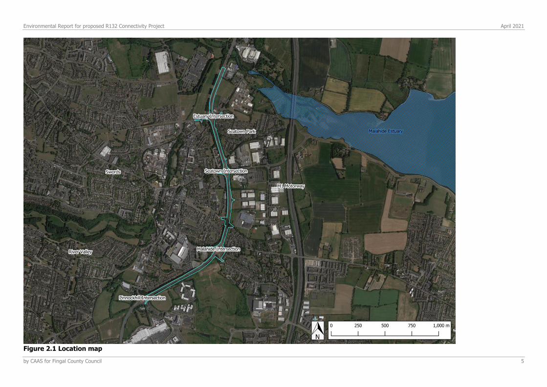
The proposed works are to be carried out along the existing R132 situated between Lissenhall Interchange and Pinnockhill junction, to the east of Swords Town Centre. The section of road the subject of the proposed development is approximately 2.6km long.
The works will involve the following:
a) Conversion of three existing intersections along the R132 (Estuary, Seatown and Malahide Road Roundabouts) to signalised intersections with ‘at-grade’ pedestrian and cyclist crossing points;
b) Installation of signalised toucan crossings at three separate points along the R132;
c) Pedestrian linkages to Chapel Lane and Ashley Avenue at the proposed Chapel Lane toucan crossing;
d) Installation of turning areas at two separate points along the R132;
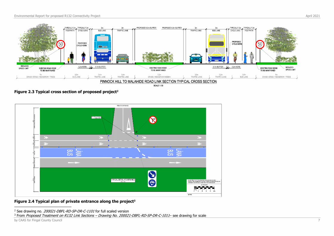
e) Carriageway alterations including the establishment of designated 3m wide bus lanes and 2m wide cycleways and 2m wide pedestrian walkways along each side of the carriageway;
f) Reconfiguration of the Drynam Road arm of the Malahide Road Roundabout to link directly to Malahide Road as a one-way road;
g) Construction of new bus stops on Malahide Road;
h) Installation of a sub-surface attenuation system; and
i) Landscaping and other ancillary works.
The carriageway alterations at (d) above will provide a more hospitable environment for pedestrians and cyclists within the overall proposed transport corridor upgrade. The changes will commence just north of the Pinnockhill Roundabout and extend to approximately 750m north of the Estuary Junction (Figure 2.1). The alterations will consist of the following:
• One 3.0m wide general traffic lane in both directions
• One 3.0m bus lane in both directions
• A footpath in both directions varying in width from 1.85-2.0m
• A 2m wide cycle lane in both directions
• Pedestrian paths and cycle lanes, segregated from the bus lanes via pencil bollards and a kerb;
• Existing median/road edges will generally be retained
The existing speed limits along the extents of the study area are 60km/h and 80km/h. A reduction in the speed limit to 50km/h is proposed, but will be facilitated through a separate process. The reduced speed limit, in conjunction with the infrastructural proposals, will increase safety along the corridor particularly for vulnerable road users. Construction is anticipated to be carried out in phases over a 2 year period.
Environmental Report for proposed R132 Connectivity Project April 2021
by CAAS for Fingal County Council 5
Figure 2.1 Location map

Environmental Report for proposed R132 Connectivity Project April 2021
by CAAS for Fingal County Council 6
Figure 2.2 Project extent1
1 See Site Location Plan – Drawing No. 200021-DBFL-RD-SP-DR-C-1100 for full scaled version
Environmental Report for proposed R132 Connectivity Project April 2021
by CAAS for Fingal County Council 7
Figure 2.3 Typical cross section of proposed project2
Figure 2.4 Typical plan of private entrance along the project3
2 See drawing no. 200021-DBFL-RD-SP-DR-C-1101 for full scaled version 3 From Proposed Treatment on R132 Link Sections – Drawing No. 200021-DBFL-RD-SP-DR-C-1011– see drawing for scale
Environmental Report for proposed R132 Connectivity Project April 2021
by CAAS for Fingal County Council 8
3 POPULATION & HUMAN HEALTH
3.1 INTRODUCTION
This section considers the impact of the proposed project in the context of population and settlement, land use, employment, other impacts of a social and economic nature and human health. In terms of population, the types of issues which developments such as this raise (both during construction and operation) include: impacts on amenities and services in the area; additional economic opportunities; increased traffic; and impacts on existing land uses. The assessment of impacts on human health draws on and refers to the other parts of the ER which address impacts on the vectors through which health could be directly or indirectly affected, including air quality, noise, water quality and traffic.
3.2 THE PROPOSED DEVELOPMENT
The proposed development involves the alteration of three roundabouts to signalised junctions at three intersections along the R132, along with additional alterations to the carriageway to include dedicated bus lanes and segregated cycle lanes and pedestrian walkways. The proposed development will provide at-grade pedestrian access and accompanying pedestrian linkages which will facilitate access to future developments along the R132, ensuring adequate permeability and links from Swords Town Centre and the existing and future developments in the vicinity of the R132. The proposed development will also include bus stops along Malahide Road, turning areas at two separate points along the R132, landscape and other ancillary works. The overall length of the proposed development is approximately 2.6km, and is expected to take approximately 2 years to construct. Further details are included in Section 2 of this document.
3.3 THE EXISITING ENVRONMENT
3.3.1 PLANNING AND DEVELOPMENT CONTEXT
The R132 is a regional road running in a north-south direction parallel to the M1 commencing at the border with Northern Ireland, and terminating at the interchange between the R132 and the N1/ Swords Road at Shantalla Road. The section of the R132 the subject of this application runs from between the Lissenhall Interchange and Estuary Roundabout, through Swords and terminates between Malahide Road and Pinnockhill Roundabouts. The R132, between Pinnockhill roundabout and the Estuary roundabout, is characterised by north/south dual carriageway dissected by roundabouts on an east/west axis. The carriageway is heavily car dominated with limited dedicated bus lane provision. Speed limits along this stretch of the carriageway currently range from 60-80 km/h. Overhead pedestrian walkways are dispersed along the carriageway, supported by pedestrian walkways mainly along the southbound (eastern) side of the carriageway. There is no existing cycle provision along the carriageway.
3.3.2 LAND USE STRUCTURE ADJACENT TO THE SITE
The R132 itself is designated as a road of primary regional importance and, as such, is not zoned for land use in the Development Plan. The land uses and zonings in the immediate vicinity of the R132 consist of the following mixture of land use zonings:
Environmental Report for proposed R132 Connectivity Project April 2021
by CAAS for Fingal County Council 9
• ME - Metro Economic Corridor (Facilitate opportunities for high density mixed use employment generating activity and commercial development, and support the provision of an appropriate quantum of residential development within the Metro Economic Corridor);
• RS – Residential (Provide for residential development and protect and improve residential amenity);
• HT – High Technology (Provide for office, research and development and high technology/high technology manufacturing type employment in a high quality built and landscaped environment);
• OS - Open Space (Preserve and provide for open space and recreational amenities);
• MC - Major Town Centre (Protect, provide for and/or improve major town centre facilities); and
• CI - Community Infrastructure (Provide for and protect civic, religious, community, education, health care and social infrastructure).
This is largely reflective of the diverse mix of land uses surrounding the R132, and demonstrates the distinctly urban nature of the R132, in that, it dissects the built environment of Swords. In summary, the surrounding area mainly consists of the built footprint of Swords, characterised by housing, commercial, retail, warehouse and educational uses. Large retail centres such as the Pavilions Shopping Centre and Airside Retail Park are located within the immediate vicinity of the R132.
3.3.3 SOCIO-ECONOMIC FACTORS
There are three roundabouts on the R132 within the project boundary of the proposed project, namely Estuary, Seatown and Malahide Road roundabouts. These junctions provide access from the R132 to areas to the east and west of this road, in addition to connections across the road. The first two of these roundabouts, Estuary and Seatown are priority controlled, whereas the Malahide Road Roundabout is signal controlled. The Malahide roundabout represents the most common crossing point of the R132 for traffic travelling directly between Malahide and Swords. This roundabout also acts as the central access point from the R132 to the Pavillions Shopping Centre and Swords Town Centre. As a result, the roundabout carries substantial volumes of traffic crossing the R132. The Swords Quality Bus Corridor along the R132, enjoys significant levels of bus priority along the R132 to the south of the Malahide Road roundabout. No dedicated quality bus corridors are currently provided north of the Malahide Road roundabout. Pedestrian bridges are currently located along this section of the R132 in four different locations linking residential areas and employment centres east of the R132 to the town centre west of the R132. The pedestrian bridges also function as a pedestrian linkage to the Pavillions Shopping Centre and to St Colmcille’s Boys & Girls National School. Pedestrian footpaths along the R132 are predominantly located on the southbound (eastern) side of the carriageway, with minimal footpath provision on the northbound (western) side of the carriageway linking to existing bus stops. It is anticipated that the proposed project will substantially increase connectivity between Swords Town Centre and residential and employment areas to the east of the R132. This is likely to result in a socio-economic impact for the Swords area.
3.3.4 POPULATION
3.3.4.1 Population change
Swords is identified in the Regional & Spatial Economic Strategy for the Eastern and Midlands Region as a key town within the Metropolitan Area of Dublin. In the recent past, the population of the immediate vicinity, namely Swords, has experienced substantial levels of growth. The Fingal County Development Plan expects the population of Swords to grow up to 100,000 by 2035. The electoral districts surrounding the subject proposal experienced varying degrees of population growth from the period of 2011-2016. Fingal County experienced a population growth of over 8% over
Environmental Report for proposed R132 Connectivity Project April 2021
by CAAS for Fingal County Council 10
the same period, while the national population growth for the same period was 3.8%. Given the urban nature of the surrounding areas, it is expected that further population growth will occur in these areas and that this will be supplemented by the subject proposal.
3.3.5 TOURISM, AMENITIES AND RECREATION
The R132 itself does not function as a tourism, amenity or recreation area. Rather, it seeks to create a safe environment, as a regional distributor road, for multiple transport modes through the Swords area. Notwithstanding this, the R132 does link to Dublin Airport which plays a strategic role, as the country’s primary international airport, in attracting visitors to Ireland. As such, the R132 plays an important role in making Swords accessible to international tourists coming from the airport. The importance of the R132, in this respect, is noted in the Dublin Airport Local Area Plan. Locally, the Malahide Estuary to the east of the subject proposal is recognised as a coastal walk, and the Fingal Development Plan aims to create ‘direct, attractive and overlooked pedestrian and cycle routes’ from the Seatown Masterplan Area lands to the Malahide Estuary. Swords Castle to the immediate west of the subject proposal, also functions as a local tourist attraction and is identified within the County Development Plan as a Cultural Quarter.
3.4 PREDICTED IMPACTS
3.4.1 INTRODUCTION
The proposed project consists of alteration to the existing R132 carriageway in the immediate vicinity of Swords Town Centre between Lissenhall and Pinnockhill intersections. The following sections will address how the proposed development could impact on population and human health during the construction and operational phases of the development.
3.4.2 POPULATION
Given the increasingly urban nature of the R132 and the population growth that is expected to occur in the immediate vicinity, it is considered that the subject proposal is likely to lead to increased rates of population growth in the area. This is further evidenced by the fact that multiple masterplans in the immediate vicinity of the R132 identify upgrades to the R132 as essential infrastructure required for the development of the area.
3.4.3 EMPLOYMENT
The subject proposal will provide an element of temporary employment as part of the construction phase, but it is not envisaged that the operational phase will directly result in the creation of employment. Moreover, the subject proposal is likely to indirectly increase employment by facilitating the development of masterplan areas in the vicinity of the R132 which will include commercial and retail development.
3.4.4 TOURISM, AMENITIES AND RECREATION
As previously mentioned, the subject proposal does not function as a tourism, amenity or recreation area. However, the subject proposal will facilitate improved access to local tourist attractions such as Malahide Estuary and Swords Castle. The subject proposal will also maintain a link between Swords and Dublin Airport, retaining international tourism potential for Swords. As such, it is anticipated that the subject proposal will have an indirect impact on tourism, amenities and recreation through increased accessibility.
Environmental Report for proposed R132 Connectivity Project April 2021
by CAAS for Fingal County Council 11
3.4.5 HUMAN HEALTH
In this ER, the potential for effects on human health are dealt with under the more specific topics of the environmental media through which it might be caused. These topics are principally air and noise. Traffic and transportation impacts are addressed in the separate Traffic and Transportation Assessment (TTA) report. In terms of air, section 5 concludes that air quality from traffic emissions during the operational stage is overall positive (although negative at some receptors), local, long-term and imperceptible. Section 6 of the ER outlines that noise during the construction phase of the project will cause moderate to major, temporary impacts. The area of impacts will move according to location of works at any time within the site area. Post construction impacts will generally be imperceptible. Negative but insignificant long term noise impacts will occur at two locations; Ashley Avenue and Foxwood (adjacent to the Malahide Roundabout and Drynam Road respectively) The subject proposal will support and encourage a modal shift towards more active forms of sustainable transport such as walking and cycling, and the general vicinity of the area will become more accessible as a result of the increased connectivity facilitated by this application. This will help to improve the quality of life and public health of local residents and road users who currently experience a car dominated environment in this area.
3.5 MITIGATION MEASURES
No specific mitigation measures are required to ameliorate the impacts on population and human health, above those detailed in separate sections relating to noise and air quality.
3.6 RESIDUAL IMPACTS
The proposed development will have a positive indirect long-term impact on the immediate vicinity, considering it is identified as an essential piece of infrastructure for the development of lands in the immediate vicinity.
Environmental Report for proposed R132 Connectivity Project April 2021
by CAAS for Fingal County Council 12
4 BIODIVERSITY
4.1 INTRODUCTION
This report assesses potential impacts that may arise from the proposed R132 Connectivity Project on biodiversity within the receiving environment, in preparation of this report, the author has had regard to the relevant standard guidelines and classifications, such as:
• Draft Guidelines on Information to be contained in Environmental Impact Statement Reports. (2017) Environmental Protection Agency.
• Guidelines for Ecological Impact Assessment in the UK and Ireland. Terrestrial, Freshwater, Coastal and Marine (2018). Chartered Institute of Ecology and Environmental Management (CIEEM), Ver. 1.1 Updated September 2019.
• Guidelines for Preliminary Ecological Appraisal. (2017) Chartered Institute of Ecological and Environmental Management (CIEEM), Second Edition.
• A Guide to Habitats in Ireland (2000), Fossitt JA. • Best Practice Guidance for Habitat Survey and Mapping. (2011) The Heritage Council.
It aims to discuss the existing ecological environment, the potential impacts of the project and avoidance and mitigation measures in relation to habitats, flora and fauna in the zone of influence (ZOI) of the proposed project. A separate stand-alone Natural Impact Statement is also included in the planning application documentation.
4.2 LEGISLATIVE CONTEXT
Specific focus is placed on protected species/habitat features as well as those of local or national importance. Ireland’s National Biodiversity Action Plan 2017–2021i, in accordance with the Convention on Biological Diversity, is a framework for the conservation and protection of Ireland’s biodiversity, with an overall objective to secure the conservation, including, where possible, the enhancement and sustainable use of biological diversity in Ireland and to contribute to collective efforts for conservation of biodiversity globally. The plan is implemented through legislation and statutory instruments concerned with nature conservation. The Planning and Development Acts, 2000 (revised September 2020) and the European Communities (Environmental Impact Assessment) (Amendment) Regulations, 1989 to 1999 are particularly important in that regard and include a number of provisions directly concerned with the protection of natural heritage and biodiversity. The Wildlife Acts, 1976–2012, are the principal mechanism for the legislative protection of wildlife in Ireland. They outline strict protection for species that have significant conservation value. In summary, the Wildlife Acts protect species from injury, disturbance and damage to breeding and resting sites. All species listed in the Wildlife Acts must, therefore, be a material consideration in the planning process. The Flora (Protection) Order, (2015) gives legal protection to certain species of wild flora, i.e. vascular plants, mosses, liverworts, lichens and stoneworts. Under the Order, it is an offence to uproot, damage, alter, or interfere with any species listed species listed within the Order, or to damage or alter their supporting habitats. The European Communities (Birds and Natural Habitats) Regulations, 2011–2015 transpose into Irish law Directive 2009/147/EC (the Birds Directive) and the Habitats Directive, which list habitats and species of Community, i.e., European Union (EU), importance for conservation and that require protection. This protection is afforded in part through the designation of areas that represent significant populations of listed species within Europe i.e., Natura 2000 sites. An area designated for bird species is classed as a Special Protection Area (SPA), and an area designated for other protected species and habitats is classed as a Special Area of Conservation (SAC). Birds listed in Annex I of the Birds Directive in SPAs and habitats and species listed in Annexes I and II, respectively, of the Habitats Directive in SACs in which they are designated features have full European protection. Species listed on Annex IV of the Habitats Directive are strictly protected wherever they occur, whether inside or outside European sites. Annex I habitats outside of SACs are still considered to be of national and international importance
Environmental Report for proposed R132 Connectivity Project April 2021
by CAAS for Fingal County Council 13
and, under Article 27(4)(b) of the European Communities (Birds and Natural Habitats) Regulations, 2011, public authorities have a duty to strive to avoid the pollution or deterioration of Annex I habitats and habitats integral to the functioning of SPAs. Sites of national importance for nature conservation are afforded protection under planning policy and the Wildlife Acts, 1976–2012. NHAs are sites that are designated under statute for the protection of flora, fauna, habitats and geological interest. Proposed NHAs (pNHAs) are published sites identified as of similar conservation interest but have not been statutorily proposed or designated. The International Union for the Conservation of Nature and Natural Resources (IUCN) provides a global approach for evaluating the conservation status of species to inform and catalyse action for biodiversity conservation through the Red List of Threatened Species.
4.3 APPROACH TO ECOLOGICAL EVALUATION AND IMPACT ASSESSMENT
Assessing impact significance is a combined function of the value of the affected feature (its ecological importance), the type of impact and the magnitude of the impact. It is necessary to identify the value of ecological features within the study area in order to evaluate the significance and magnitude of possible impacts. The following parameters are described when characterising impacts (adapted from CIEEM (2018), EPA (2017) and TII (2009, Rev. 2)): Direct and Indirect Impacts - An impact can be caused either as a direct or as an indirect consequence of a proposed project. Magnitude - Magnitude measures the size of an impact, which is described as high, medium, low, very low or negligible. Extent - The area over which the impact occurs – this should be predicted in a quantified manner. Duration - The time for which the effect is expected to last prior to recovery or replacement of the resource or feature.
• Temporary: Up to 1 Year; • Short Term: The effects would take 1-7 years to be mitigated; • Medium Term: The effects would take 7-15 years to be mitigated; • Long Term: The effects would take 15-60 years to be mitigated; • Permanent: The effects would take 60+ years to be mitigated.
Likelihood – The probability of the effect occurring taking into account all available information.
• Certain/Near Certain: >95% chance of occurring as predicted; • Probable: 50-95% chance as occurring as predicted; • Unlikely: 5-50% chance as occurring as predicted; • Extremely Unlikely: <5% chance as occurring as predicted.
The CIEEM Guidelines define an ecologically significant impact as an impact (negative or positive) on the integrity of a defined site or ecosystem and/or the conservation status of habitats or species within a given geographic area. The integrity of a site is the coherence of its ecological structure and function, across its whole area, which enables it to sustain the habitat, complex of habitats and/or the levels of populations of the species for which it was classified (CIEEM, 2018). The results of the ecological survey were evaluated to determine the significance of identified features located in the study area on an importance scale ranging from international-national-county-local. The local scale is approximately equivalent to one 10km square but can be operationally defined to reflect the character of the area of interest. Because most sites will fall within the local scale, this is sub-
Environmental Report for proposed R132 Connectivity Project April 2021
by CAAS for Fingal County Council 14
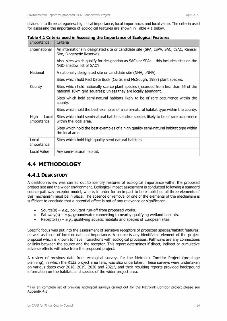
divided into three categories: high local importance, local importance, and local value. The criteria used for assessing the importance of ecological features are shown in Table 4.1 below.
Table 4.1 Criteria used in Assessing the Importance of Ecological Features
Importance Criteria
International An internationally designated site or candidate site (SPA, cSPA, SAC, cSAC, Ramsar Site, Biogenetic Reserve).
Also, sites which qualify for designation as SACs or SPAs – this includes sites on the NGO shadow list of SAC’s.
National A nationally designated site or candidate site (NHA, pNHA).
Sites which hold Red Data Book (Curtis and McGough, 1988) plant species.
County Sites which hold nationally scarce plant species (recorded from less than 65 of the national 10km grid squares); unless they are locally abundant.
Sites which hold semi-natural habitats likely to be of rare occurrence within the county.
Sites which hold the best examples of a semi-natural habitat type within the county.
High Local Importance
Sites which hold semi-natural habitats and/or species likely to be of rare occurrence within the local area.
Sites which hold the best examples of a high quality semi-natural habitat type within the local area.
Local Importance
Sites which hold high quality semi-natural habitats.
Local Value Any semi-natural habitat.
4.4 METHODOLOGY
4.4.1 DESK STUDY
A desktop review was carried out to identify features of ecological importance within the proposed project site and the wider environment. Ecological impact assessment is conducted following a standard source-pathway-receptor model, where, in order for an impact to be established all three elements of this mechanism must be in place. The absence or removal of one of the elements of the mechanism is sufficient to conclude that a potential effect is not of any relevance or significance.
• Source(s) – e.g., pollutant run-off from proposed works. • Pathway(s) – e.g., groundwater connecting to nearby qualifying wetland habitats. • Receptor(s) – e.g., qualifying aquatic habitats and species of European sites.
Specific focus was put into the assessment of sensitive receptors of protected species/habitat features; as well as those of local or national importance. A source is any identifiable element of the project proposal which is known to have interactions with ecological processes. Pathways are any connections or links between the source and the receptor. This report determines if direct, indirect or cumulative adverse effects will arise from the proposed project. A review of previous data from ecological surveys for the Metrolink Corridor Project (pre-stage planning), in which the R132 project area falls, was also undertaken. These surveys were undertaken on various dates over 2018, 2019, 2020 and 20214, and their resulting reports provided background information on the habitats and species of the wider project area.
4 For an complete list of previous ecological surveys carried out for the Metrolink Corridor project please see Appendix 4.3
Environmental Report for proposed R132 Connectivity Project April 2021
by CAAS for Fingal County Council 15
4.4.2 FIELD SURVEY
Data were collected during a walkover survey conducted on the 19th of January 2021. This data and resulting report are supported by the baseline biodiversity survey data collected for the Metrolink Corridor Project (pre-stage planning) that forms part of the Swords Masterplan Part A (2019)ii, which
were carried out over various dates over 2018, 2019, 2020 and 20215. A habitat survey of the site was conducted following standard guidelines set out in ‘Best Practice Guidance for Habitat Survey and Mapping’ developed by the Heritage Council of Irelandiii. Habitats were classified using habitat
descriptions and codes published by the Heritage Council in ‘A Guide to Habitat Types in Ireland’iv. Plant
species nomenclature follows Rose’s ‘The Wild Flower Key: How to identify wild flowers, trees and shrubs in Britain and Irelandv. A list of the dominant and notable plant species was taken for each
habitat type. Particular emphasis was given to the possible occurrence of rare or legally protected plant species (as listed in Flora Protection Order 1999) or Red-listed plant species (Curtis & McGough 1985, Wyse Jackson et al. 2016).
Observations were made for fauna species present or likely to occur on site, or indications thereof. Emphasis was placed on mammals and birds, and especially for species listed in the respective Red lists, namely Colhoun and Cummins (2013), and Marnell et al. (2009). For mammals, the survey was focused on signs of their presence/activity, such as tracks and trails, feeding marks and droppings, as well as any direct observations. Regarding bat species, the main focus was on evaluation of suitable habitats to support roosting bats; however, an ecological assessment of habitat suitability was undertaken throughout the site during the site visit. The assessment process undertaken for bats followed the BCT Guidelinesvi. Chapter 4 of these guidelines identify the approach to assess ‘preliminary
ecological appraisal for bats. This chapter sets out methods for identifying habitat suitability which do not constitute assumptions. Based on the information from the assessment the survey effort requirements are identified.
Bird species were recorded by sight and sound during the site visit, following the Birdwatch Ireland Country Breeding Bird survey methods. In addition, all linear hedgerows were walked and species were recorded. Particular attention was focused on areas within the site of high ecological value that interact or overlap with parts of the proposal to increase biodiversity of the site and provide civil recreation. During all surveys, particular attention was given to assessing the presence of rare or protected species. Each species identified was assessed in term of the EU Habitat Directive (92/43/EEC), Bird Directive (2009/147/EC), the Wildlife Act (1976), the Wildlife Amendment Act (2000) and the Red Data Lists for threatened and protected species, published on the NPWS website (www.npws.ie).
4.4.3 LIMITATIONS
The biodiversity assessment was carried out in winter, which is not the optimum time for botanical and breeding bird surveys. However, the site is currently a highly developed sub-urban site, consisting mostly of a dual carriage-way bypass road (current R132 road), verges, treelines planted along the route, and bordering housing developments, with patches of parkland. The site as a whole is heavily managed throughout. Thus, even though the site visit was carried out in a sub-optimal season, the site does not support habitats of significant ecological value that would harbour rare or threatened species. Nonetheless, as full assessment was carried out as a precautionary strategy, and evaluated alongside existing baseline data for the area. The addition of the data from previous surveys carried out for the overarching Metrolink Corridor Project (pre-planning stage), which include a complete baseline biodiversity assessment of the site proposed (and surrounding areas)5, allows sufficient deduction to be made for the ecological impact of this proposal on the site. Therefore, overall, it is considered that there are no significant limitations to the present assessment of the ecological importance of the site.
4.5 PROPOSED DEVELOPMENT
The objective of the R132 Connectivity Project is, to improve the connectivity and safety of pedestrians and cyclists moving along and across the R132 and enhance facilities for all road users with particular
5 For an complete list of previous ecological surveys carried out for the Metrolink Corridor project please see Appendix 4.3

Environmental Report for proposed R132 Connectivity Project April 2021
by CAAS for Fingal County Council 16
benefits for sustainable modes of transportation (bus users, cyclists and pedestrians). Details of the proposal are contained in Section 2 Project Description.
4.6 RECEIVING ENVIRONMENT
4.6.1 OVERVIEW
The R132 Connectivity Project proposal is an upgrade of existing infrastructure, which is very similar to the present usage and conditions of the site. The proposed project area lies almost completely within the bounds of the already present R132 Swords Bypass: the proposed works run from approximately 450m north of the Estuary Intersection, continuing south along the R132 and stopping just before the Pinnockhill Intersection (Figure 2.1). The vast majority of the site area, and its surrounding landscape, is highly modified and urbanised development area, that is bordered with semi-mature treelines, with minor pockets of mature trees and scrub. Any remaining undeveloped space, such as Fosterstown and Barryparks & Crowscastle, is either parkland habitat or intensively managed pasture, and is earmarked within the Swords Masterplan Part A (2019) (part of the Fingal Development Plan 2017-2023vii) for
either residential or economic development Figure 4.9).
4.6.2 ZONE OF INFLUENCE
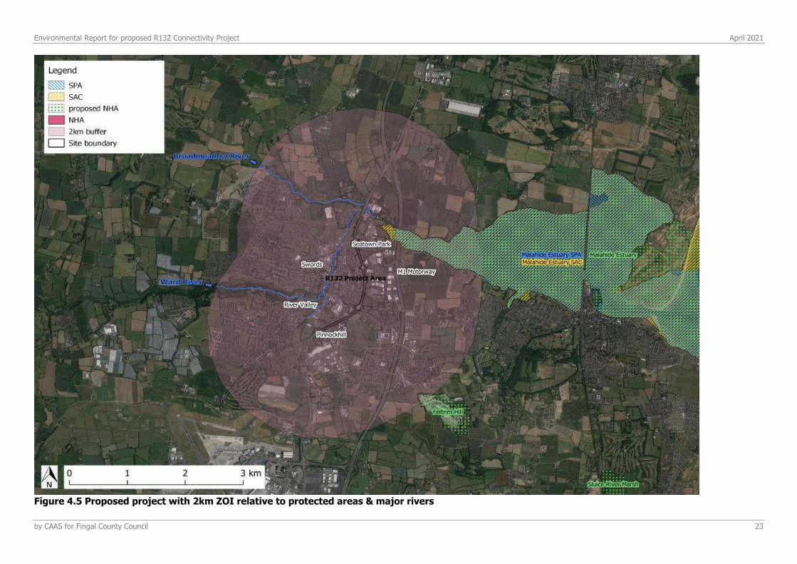
The construction phase works may have some effects beyond the boundary due to compound site use, increased dust, potential for sediment run off, noise pollution, and imposing of artificial lighting conditions. The operational phase works are not anticipated to have any impacts beyond the site boundary due to the proposed characteristics of the project which are very similar to the existing conditions and use of the site (i.e., as a highly modified urban-transport area), and will utilise current drainage networks. Following the source-pathway-receptor model identifying the potential likely sources a Zone of Influence (ZOI) was established; 2km radius around the proposed site (Figure 4.5). Given the nature of the proposed works, in keeping with the current use and disturbance levels, impacts are not foreseen to be significant beyond this distance. Two European sites and one National site occur within the 2km radius Zone of Influence (Figure 4.5); Malahide Estuary SAC, Malahide Estuary SPA and Malahide Estuary NHA. The proposed project is 230m from the SAC and NHA, and 600m from the SPA. There are no direct hydrological links between the proposed project area and the protected areas. However, as with all urban sites there is a network of drainage supporting the area – considering the proximity of the protected areas to the project area, there are indirect links between the project and the European and National sites. This is considered as source for potential effect within the defined Zone of Influence for this assessment during the construction phase of the project.
At 2km from the southern boundary of the proposed project is Feltrim Hill pNHA. As typical with proposed Natural Heritage Areas, there is no information on the National Parks and Wildlife database regarding the site. However according to EPA mapsviii, there are no hydrological links between the R132
project area and the Feltrim Hill pNHA. From satellite imagery, the site is a quarry, surrounded by mature woodland and scrub. Considering the distance and lack of connectivity with this site, it is thus considered here that there will be no impact of the proposed project on the ecological integrity of this site and it will not be assessed further.
4.6.3 HYDROLOGY
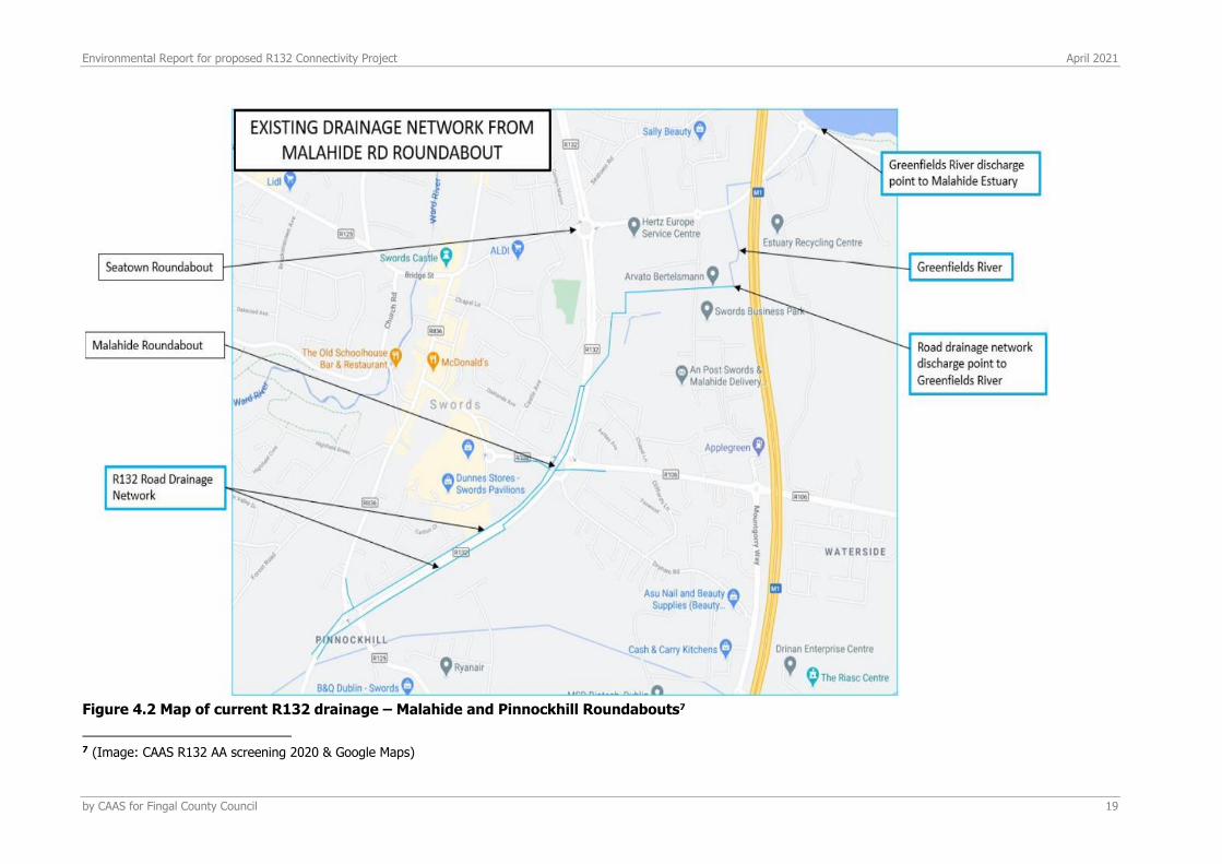
The proposed site lies within the 2km ZOI of the hydrologically sensitive Malahide Estuary. Two Water Framework Directive (WFD) sub-catchments encompass the proposed site: Broadmeadow (SC_010) and Mayne (SC_010), both of which drain into the Malahide Estuary. According to EPA maps of the WFD ground water bodies risk, neither of the ground water bodies of the aforementioned catchments are at riskix.The Broadmeadow and Ward Rivers meet just north of the proposed site and subsequently
drain into the Malahide Estuary. The WFD status of these rivers (2013-2018) are both “poor”. The R132 is indirectly linked to the Broadmeadow and Ward rivers, the Malahide Estuary and its European sites, via the network of underground urban drainage systems and proximity (Figure 4.1, Figure 4.2 Figure 4.5.

Environmental Report for proposed R132 Connectivity Project April 2021
by CAAS for Fingal County Council 17
4.6.3.1 Waterways and drainage
As mentioned, there are no freshwater streams or rivers running through the site. The closest river system is the Ward river which crosses underneath the R132 approximately 150m north of the northern most boundary of the project area. 50m north of this, the Broadmeadow river crosses underneath the R132 also. Both rivers then meet and flow almost immediately into the Malahide Estuary SAC, SPA and pNHA. As mentioned above, there are underground drainage networks which are ubiquitous within the suburban environment, that likely link indirectly to the Malahide Estuary SAC, SPA and pNHA. Considering the proximity of Ward and Broadmeadow European site tributaries rivers to the project area boundary and their interaction with the R132 route itself (i.e., passing underneath the road to the west), the proximity to the European sites themselves to the project area, and the likely indirect hydrological links to the European sites via underground suburban drainage systems, potential impacts as a result of the project via run off and siltation during construction and operational phases cannot thus be ruled out.

Environmental Report for proposed R132 Connectivity Project April 2021
by CAAS for Fingal County Council 18
Figure 4.1 Map of current R132 drainage - Estuary and Seatown Roundabouts6
6 (Image: CAAS R132 AA screening 2020 & Google Maps)
Broadmeadow River
Environmental Report for proposed R132 Connectivity Project April 2021
by CAAS for Fingal County Council 19
Figure 4.2 Map of current R132 drainage – Malahide and Pinnockhill Roundabouts7
7 (Image: CAAS R132 AA screening 2020 & Google Maps)
Environmental Report for proposed R132 Connectivity Project April 2021
by CAAS for Fingal County Council 20
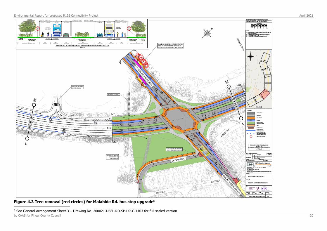
Figure 4.3 Tree removal (red circles) for Malahide Rd. bus stop upgrade8
8 See General Arrangement Sheet 3 – Drawing No. 200021-DBFL-RD-SP-DR-C-1103 for full scaled version
Environmental Report for proposed R132 Connectivity Project April 2021
by CAAS for Fingal County Council 21
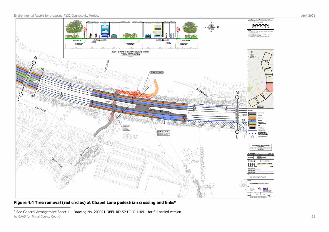
Figure 4.4 Tree removal (red circles) at Chapel Lane pedestrian crossing and links9
9 See General Arrangement Sheet 4 – Drawing No. 200021-DBFL-RD-SP-DR-C-1104 – for full scaled version
Environmental Report for proposed R132 Connectivity Project April 2021
by CAAS for Fingal County Council 22
4.6.4 DESIGNATED AREAS
In accordance with the European Commission Methodological Guidance (EC, 2001), a list of European Designated Sites that can be potentially affected by the works has been compiled. A dedicated Natura Impact Statement, reviewing all European sites within the zone of influence of the project, has been undertaken. A review of the conservation objectives and qualifying interests of these sites was undertaken in order to identify what habitats and/or species could be vulnerable to risk of impact from the proposed project. This was achieved by assessing whether any source receptor links identified for each European Site existed between the qualifying interests of the designated sites and the proposed project site, and presented in a NIS attached to this application.
When assessing ecological impacts, the CIEEM Guideline recommend a 15km zone of influence as an adequate buffer for effects. Due to the characteristics of the project, all other European sites and pNHA/NHA sites beyond threshold distances of 15km are considered to be of sufficient distance from the proposed site, that no significant effects could be caused either directly or indirectly or in combination with other plans or projects to their interest features. Any impacts caused by the R132 Connectivity Project have no valid impact pathway to transfer along to reach any of the receptor interest features. These sites are ‘screened out’ and not considered further.
In addition to examining European sites, NHAs and pNHA have been considered. Although NHAs and pNHAs do not form part of the Natura 2000 Network, they often can provide an important supporting role to the network, particularly when it comes to fauna species which often do not obey site boundaries. There are however, NHAs and pNHAs that are designated for features that are not important at an international level and thus may not interact with the Natura 2000 network. A stand-alone Natura Impact Statement, submitted separately to this assessment, expands on the potentially affected designated sites and their conservation objectives in more detail.
Appendix 4.1 provides a list of all of the designated sites considered within the assessment arranged by distance from the proposed R132 Connectivity Project which are assessed as part of this report. Figure 4.6 displays the designated European sites within a 15km radius buffer of the proposed project and Figure 4.7 displays the proposed and designated National sites within a 15km radius buffer of the proposed project. The proposed site has no hydrological pathways connecting it to the nearby Feltrim Hill pNHA. With the exception of the Malahide Estuary, which is addressed in detail in this ecological assessment, there are no other hydrological pathways connecting the proposed site to any other European sites within the 15km buffer zone considered in the accompanying Appropriate Assessment.
Environmental Report for proposed R132 Connectivity Project April 2021
by CAAS for Fingal County Council 23
Figure 4.5 Proposed project with 2km ZOI relative to protected areas & major rivers
Environmental Report for proposed R132 Connectivity Project April 2021
by CAAS for Fingal County Council 24
Figure 4.6 European sites within 15 km buffer of the proposed project
Environmental Report for proposed R132 Connectivity Project April 2021
by CAAS for Fingal County Council 25
Figure 4.7 National Sites within 15km buffer of the proposed project

Environmental Report for proposed R132 Connectivity Project April 2021
by CAAS for Fingal County Council 26
4.6.5 RECORDS OF PROTECTED, RARE OR OTHER NOTABLE FLORA AND FAUNA
SPECIES
The digital database of the National Biodiversity Data Centre (NBDC) was consulted to assess known records of rare, protected and invasive species that occur in the surrounding landscape. The collation of this information, as well as examination of aerial photographs allowed areas of potential ecological importance to be highlighted prior to field survey work. A search was undertaken of records of Red Data Book and Protected species held by the National Biological Data Centre Database. A list of the rare and/or protected species from the 10km x 10km grid square occupied by the study area (O14) are listed in Appendix 4.2 (NBDC data, accessed: 11th January 2021).
4.6.5.1 Invasive Flora species
Publicly available NBDC data was accessed to identify invasive species in the O14 hectad in which the proposed site is located, and is displayed in Appendix 4.2. Three of the invasive flora species and four of the invasive fauna species listed in Appendix 4.2 are subject to Third Schedule restrictions, under Regulation 49 of the European Communities (Birds and Natural Habitats) Regulations, 2011.
The current NBDC data for invasive species within the proposed R132 Connectivity Project area yielded several records going back to 2017 (full list species, grid numbers and location descriptions are available in Appendix 4.2). One Third Schedule species (i.e., subject to restrictions), Giant Hogweed (H. Mantegazzianum), was recorded within approx., 100m of the northern development area boundary of the project: 100km grid square (O188481), recorded in August 2018 in Ward-Broadmeadow rivers meeting point, next to Lissenhall Industrial Estate on the east side of the R132. Similarly, the baseline biodiversity surveys for the Metrolink Connectivity Project10 surveyed the area proposed for invasive species and found Giant Hogweed (Heracleum Mantegazzianum) near Ward River to the west of the R132 site.
4.6.6 FIELD SURVEY RESULTS
4.6.6.1 Habitats and Flora
No Annex I habitats were found within the project area during the site visit on 19th January 2021. The majority of the habitativ within the proposed site area consists of the R132 road network itself, which is buildings and artificial surface (BL3). Bordering this artificial surface on either side, are planted treelines (WL2) and hedgerows (WL1), highly modified monoculture parkland (WD5) and amenity grassland (GA2), ornamental planting (WS3). These road-edge habitats are bordered by either fencing, development cement walls, cement or wood fencing, or pointed stone walls (BL1). Additional small pockets of habitat of some ecological value consists of (to a very minor extent) patches of scrub (WS1) and mature trees (WD5). Habitat maps of the proposed site are supplied in Appendix 4.3, alongside a description of each of the habitats identified on site along with a species list.
The majority of these vegetative habitats present within the site boundary are of local value in terms of corridors for local wildlife and resource availability. These habitats are locally valuable for ecological connectivity across an urban landscape to other pockets of area of ecological value. Preservation of any mature trees on site, and corridor treelines and hedgerows where possible, will help preserve the ecological value of the remaining habitats within this highly modified landscape.
Floral species recorded on site during the Jan 2021 visits are consistent with what is expected of a highly developed road network, bordered by buffer tree planting and monoculture grassland. The majority of the grassland within the site area, and on remaining undeveloped patches and parkland amenity sites, consists of perennial ryegrass, bordered in some places by hawthorn hedgerow that is intensively maintained to 1-1.5m in height.
10 For an complete list of previous ecological surveys carried out for the Metrolink Corridor project please see Appendix 4.3
Environmental Report for proposed R132 Connectivity Project April 2021
by CAAS for Fingal County Council 27
No invasive species were recorded on site during the January site visit. The time of year of this site visit should be taken into account as not wholly representative of the presence or absence of certain species due to seasonality. However, Giant hogweed and Japanese knotweed were previously recorded in the wider area and are visible in the winter months; these species were not recorded on site during the 2021 site visit. The habitats surrounding the boundary of the proposed project are composed of a majority of two habitat types: buildings and artificial surface (BL3), consisting of residential estates and industrial developments; and amenity amenity grassland (GA2), consisting of public parkland, and private residential and industrial grassland spaces. There are only two areas bordering the project area that do not fit the above habitat types: two areas of improved agricultural grassland, namely; Fosterstown to the southeast of the proposed project and Barryparks & Crowscastle to the southwest of the proposed project (Figure 4.9). Both areas are identified in the Swords Masterplan Part A (2019) (part of the Fingal Development Plan 2017-2023ii) as key areas for future residential and employment development respectively.
4.6.6.2 Fauna
Mammals Non-volant mammals Evidence of potential use of the site by fox was present, in the way of commuting and foraging trails leading from the R132 roadside into patches of agricultural pasture and parkland, however other evidence of mammal presence or use of the site was found within the site during the January 2021 survey.
Bats Previous EIAR baseline surveys of bat species for the Metrolink project (in pre-planning stages) (which encompasses the proposed R132 Connectivity Project area)11, found the following species:
• Leisler’s bat (Nyctalus leisleri) recorded widely in the site area during walked transect surveys and static detector surveys – in particular utilising the vegetative boundaries north and south of the Broadmeadow and Ward Rivers, and along a treeline in Balheary Park. No roosts for this species were found in the area during the surveys.
• Common pipistrelle (Pipistrellus pipistrellus) recorded widely in the site area during walked transect surveys and static detector surveys – in particular utilising the vegetative boundaries north and south of the Broadmeadow and Ward Rivers, and in a field near Pinnockhill Intersection. No roosts for this species were found in the area during the surveys. Nathusius’ pipistrelle (Pipistrellus nathusii) recorded in the site area during static detector surveys along a treeline just south of the North Dublin Corporate Park. No roosts for this species were found in the area during the surveys.
• Soprano pipistrelle (Pipistrellus pygmaeus) recorded widely in the site area during walked transect surveys and static detector surveys – in particular utilising the vegetative boundaries north and south of the Broadmeadow and Ward Rivers. No roosts for this species were found in the area during the surveys.
• Unidentified Pipistrelle spp. recorded using static detectors at a treeline located directly west of the R132 in Balheary Park, a treeline east of the R132 south of Seatown Road, and a hedgerow east of the R132 near Pinnockhill.
• Daubenton’s bat (Myotis daubentoniid) and Whiskered bat (Myotis mystacinus) were recorded close to the Broadmeadowns river during walked transects and unidentified Myotis spp. were recorded just south of the Lissenhall Bridge/Broadmeadow river within the proposed project area. No roosts for these species were found in the area during the surveys.
The above species are present in the area and recorded often utilising natural/semi-natural corridors (i.e., from river banks to treelines close to the R132 route), thus illustrating the importance of these habitats as corridors for bats in the swords area and within the R132 proposed project area, even within a highly modified suburban landscape.
11 For an complete list of previous ecological surveys carried out for the Metrolink Corridor project please see Appendix 4.3
Environmental Report for proposed R132 Connectivity Project April 2021
by CAAS for Fingal County Council 28
It was deemed unnecessary to carry out a full bat survey for the current assessment for the following reasons:
• The low quality of habitats and low diversity of habitats contained within the project area; • The lack of any major ecological change to the proposed area; • the lack of suitable roosting sites or particularly high local value supporting habitat; • The sub-optimal time of year for conducting bat surveys • The comprehensive biodiversity surveys of the Metrolink Corridor Project12.
The previous baseline surveys also identified sites where mature trees had the potential to support bats roosts, and their preservation and protection is addressed therein the EIAR report. The current assessment identified four mature ash trees just outside of the proposed project area that have characteristics that could possibly support bat roosts (Appendix 4.3). These mature trees are outside of the defined area for the R132 project and will not be altered or disturbed as a result of the proposed project. It is determined in this assessment, that further bat acoustic surveys to assess these particular trees for the presence of roosts are not required for the following reasons:
- The implementation of mitigation measures for the protection and preservation of the mature trees found on site, as well as suitable best practice operational phase management of night lighting, will be recommended to ensure the retention of the current value and integrity of the site for local bat species.
- The proposal aims to preserve mature trees on site. - Previous comprehensive surveys which found zero bat roosts within the study area,
encompassing the R132 route.
The proposed project will be in keeping with current landscape use and pressures. There will be minimal trees removed as a consequence of the proposed works, and the operational phase will have little to no difference in terms of noise, pollution and lighting levels. These factors, combined with the preservation of mature trees currently on site, renders the project of negligible change in impact in the short to long term. There may be some disturbance to the commuting and foraging of bats during construction, but this will be short term and temporary, and will take the form of noise and air quality disturbance. Mitigations measures such as appropriate lighting hours and noise restrictions will be detailed in the accompanying Outline CEMP and will contribute to minimising the impact to bat species during construction phase. Operational phase effects are predicted to be very similar to current levels of the immediate and surrounding landscape long term.
Birds All of the trees and hedgerows present within the site area have potential to support for nesting breeding birds – starling and rooks were observed utilising some of the treelines during the 2021 site visit. This area also contains significant ivy, holly, and a developed litter layer in places where it has been cleared from the footpaths for the winter, which can increase insect abundance. There were some herbaceous plants, but to a minor extend only along the edges of verges - not as a maintained herbaceous layer. There are also significant rivers in the immediate area, the Ward river to the west of the site, and the Broadmeadows to the north, which provide an additional food source and support for a wider diversity of breeding bird species.
Bird species seen and heard were recorded throughout the site visit; the results of which are presented in Table 4.2. Table 4.2 Bird species recorded on site during a bird point count and treeline walk survey13
Species Scientific Name Heard Seen
Robin Erithacus rubecula Y Y
Blackbird Turdus merula Y Y
12 For an complete list of previous ecological surveys carried out for the Metrolink Corridor project please see Appendix 4.3 13 Conducted on the 19th of January 2021
Environmental Report for proposed R132 Connectivity Project April 2021
by CAAS for Fingal County Council 29
Wood Pidgeon Columba palumbus Y Y
Blue tit Cyanistes caeruleus Y N
Pied wag-tail Motacilla alba yarrellii Y Y
Magpie Pica pica N Y
Hooded crow Corvus cornix Y Y
Starling Sturnus vulgaris Y Y
Rook Corvus frugilegus Y Y
It is noted here that January is not the optimum time of year to survey breeding bird populations. A more comprehensive survey carried out for the Metrolink EIAR recorded 48 species of breeding bird species, as such the current survey is aimed at supporting the previous EIAR. Thus, this assessment is augmented with the baseline surveys for the Metrolink Corridor Project14. All species recorded are on the Green List of BirdWatch Ireland15 and were as expected for the habitat and time of year, and were
also recorded during the Metrolink baseline surveys.
The proposed project may have short term, low levels of disturbance to these species during construction phase (via noise and air quality disruption), but long-term impacts will be negligible as the proposed works are in keeping with the current landscape characters and disturbance levels for the area (Figure 2.2, & Figure 4.9).
Protected Fish, Amphibians & Reptiles There are no freshwater systems that run through the proposed site. There is one surface drainage location, but it is run off from local housing and industry developments and thus will not be suitable for any protected fish or amphibian species. There were no standing water locations noted within the site area that may support common frog during the January 2021 site visit. Thus, it is not foreseen as likely that there will be supporting habitat for protected fish or amphibian within the project area. In the surrounding area, current NBDC records shows the common frog (Rana temporaria) at various locations across the O14 10km hectad, and records within a 100m grid at the Ward river, west of the R132 project area, and upstream of its crossing point of the R132 route.
4.6.7 SUMMARY OF ECOLOGICAL EVALUATION & RECOMMENDATIONS
Overall, the site of the proposed R132 Connectivity Project is of low local importance in terms of ecological value. The highly developed context of the site and the surrounding urban/suburban landscape, combined with the project design to modify an already highly streetscaped environment, renders this project of little consequence for the ecological integrity of the immediate site and surrounding terrestrial environment. The proposed landscaping of the intersections within the project area (drawings supplied in Appendix 4.4), incorporate designs and species mixes that aim to increase the local biodiversity at each intersection, adding an increase to the overall ecological integrity at each intersection.
However, considering the proximity of a hydrologically sensitive estuary which harbours several habitat types that are highly sensitive to changes in siltation deposition and pollution, and the presence of underground urban drainage which will have indirect hydrological links to the estuary, possibly significant impact on the estuary, it’s associated European and National sites, and the protected species and habitats therein cannot be ruled out without sufficient mitigation measures put in place.
The proposed project aims to modify and improve the amenity value and infrastructure of the R132 route and increase access for cyclists and pedestrians, while retaining as much of the current ecological features within the site as possible (i.e., predominantly treelines and hedgerows). Drainage details provided for the project (Figure 4.1 & Figure 4.2) show existing drainage of the R132 route that is relevant for nearby watercourses. The R132 Connectivity Project Flood Risk Assessment sets out to
14 For a complete list of previous ecological surveys carried out for the Metrolink Corridor project please see Appendix 4.3 15 Colhoun K. & Cummins, S. 2013. Birds of Conservation Concern in Ireland 2014-19. Irish Birds 9:523-544
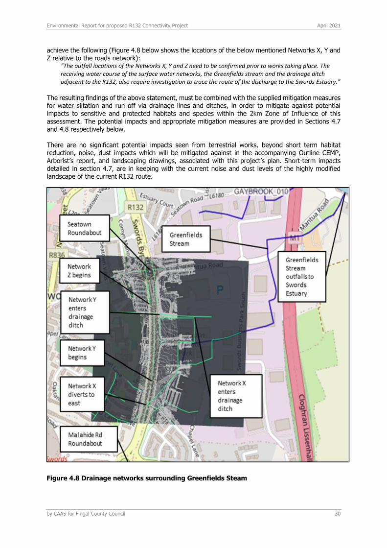
Environmental Report for proposed R132 Connectivity Project April 2021
by CAAS for Fingal County Council 30
achieve the following (Figure 4.8 below shows the locations of the below mentioned Networks X, Y and Z relative to the roads network):
“The outfall locations of the Networks X, Y and Z need to be confirmed prior to works taking place. The receiving water course of the surface water networks, the Greenfields stream and the drainage ditch adjacent to the R132, also require investigation to trace the route of the discharge to the Swords Estuary.”
The resulting findings of the above statement, must be combined with the supplied mitigation measures for water siltation and run off via drainage lines and ditches, in order to mitigate against potential impacts to sensitive and protected habitats and species within the 2km Zone of Influence of this assessment. The potential impacts and appropriate mitigation measures are provided in Sections 4.7 and 4.8 respectively below. There are no significant potential impacts seen from terrestrial works, beyond short term habitat reduction, noise, dust impacts which will be mitigated against in the accompanying Outline CEMP, Arborist’s report, and landscaping drawings, associated with this project’s plan. Short-term impacts detailed in section 4.7, are in keeping with the current noise and dust levels of the highly modified landscape of the current R132 route.
Figure 4.8 Drainage networks surrounding Greenfields Steam
Environmental Report for proposed R132 Connectivity Project April 2021
by CAAS for Fingal County Council 31
4.7 POTENTIAL IMPACTS
Based on the baseline ecological environment and the extent and characteristics of the proposed project the following potential impacts have been identified:
1. Augmentation of existing habitats, as well as the removal of trees; 2. Construction and earthworks; 3. Drainage and additional silt / pollutants release into the local urban drainage network 4. Lighting during construction and operation; 5. Noise and vibration; 6. Invasive species.
These 6 potential impacts are discussed below:
• Augmentation of existing habitats, as well as the removal of trees; The removal of vegetation on site has potential to negatively impact breeding bird populations. However, as part of the implementation of the project, an arborists report has been provided which details the age and species of trees lost, and supplies a recommendation of specimen trees of appropriate species to replace the local ecological value of those to be felled as a result of the proposed works. These trees are to be replanted in appropriate assigned areas, as detailed by the landscaping drawings accompanying this application. This will result in a no net loss of tree cover for the area as a result of the proposed works, and therefore there will be no long-term negative impact to the availability of suitable habitat for species which utilise these trees. A proposed site for a construction compound, just outside of the site boundary to the south west (on Fosterstown Lands adjacent to Pinnockhill roundabout16) which has not been confirmed at the time of this report being completed, contains agricultural grassland that has potential to be utilised as foraging grounds by protected species recorded to occur in the Malahide Estuary SPA (004025) – approximately 2.2km east of the proposed site. A desk-based study as part of the accompanying NIS did not identify this site as a known foraging ground for the SCI species of the Malahide Estuary SPA. This amounts to potential loss of potential foraging area, as it is currently unknown if this site is a foraging area for the SCI species of the Malahide Estuary SPA. Thus, following a precautionary approach, the accompanying NIS assessment identified that there is potential, based on the habitats available, that foraging of SCI species may occur at this site. If foraging occurs, the use of this space during the construction phase may introduce small scale, temporary disturbance effects through the loss of potential available forage. Given the context of the site; where there is available alternative foraging habitat elsewhere in the surrounding area, and the distance of 2.2km of the site from the Malahide Estuary SPA – it is not anticipated that this potential, short-term disturbance effect will have likely significant impact on the ecological integrity of the Malahide Estuary SPA. However, the subsequent management of the site post-use as a construction compound site for the R132 Connectivity Project after the works have completed, has potential for significant impacts via duration of disturbance to a possible foraging site of SCI species, if the site is not returned to its original state. Thus, appropriate mitigation measures for this instance are specified in s4.8 below.
• Construction and Earthworks; An element of the proposed R132 Connectivity Project that has potential to interact with existing habitats of local importance is the removal of treelines and grassland. This presents a need to reduce any unnecessary habitat augmentation outside of that which is detailed in the plan. Measures detailed in the accompanying Outline CEMP ensure that works are only carried out in necessary locations, that all earthworks are contained within the site itself and designated construction compounds (see below), and that best practice construction methods are following during construction; including silt fences, tree protection barriers and grassed swales. The location of the construction compound areas will be determined by the contractor and the proposed locations currently consist of the following three options:
16 See associated Outline CEMP for proposed compound site locations.

Environmental Report for proposed R132 Connectivity Project April 2021
by CAAS for Fingal County Council 32
a) Balheary Park to the south of the playing pitches; b) Fingal County Council Lands adjacent to the Pavilions Shopping Centre; c) Fosterstown Lands adjacent to Pinnockhill roundabout.
This potential site for a construction compound contains agricultural pasture that is approximately 2.2km from a European site (Malahide Estuary SPA). This European site is designated for SCI bird species that may utilise improved agricultural grassland habitat for foraging grounds (discussed above).
• Drainage and additional silt/pollutant release into the local urban drainage network; Drainage elements of this proposal have potential to impact sensitive hydrological habitats nearby, and protected sites of international importance. This is mostly during the construction phase, as the operational phase conditions and functions will be very similar to current levels. Possible additional silt and pollutant discharge and run off, via indirect pathways of the pre-existing urban drainage system of the Swords area, from compound sites and construction areas during the proposed works, could damage the ecological integrity of Annex I habitats within the Malahide Estuary, such as mudflats, sandflats and shifting dunes, and the species they support. To mitigate against these potential impacts, specific siltation and run off mitigation measures can enable works to be carried out with minimal impact via silt deposition and run off to these areas of national and international ecological importance. The impacts on Land, Soils, Geology, Hydrogeology and Hydrogeology have been assessed in Section 7 of this EIAR.
• Lighting during construction and operation; Strong lighting in the area of the proposed project during the construction phase could impact species that use the site for foraging and commuting if not carefully controlled via the Outline CEMP. Bats, other mammals, and birds would be sensitive to any significant changes in lighting during the construction phase within semi-natural habitat within the parkland and the marsh area to the north. The proposed project design includes construction and operational phase upgrades to current lighting infrastructure. However, construction phases changes to lighting are local and short-term, while the operational phase lighting changes are infrastructural upgrades and will not significantly change the intensity or abundance of light within the project area. Measures to mitigate against any potential impacts to bat species via light pollution (during the construction phase in particular) that have been recorded utilising treelines around the immediate R132 area are outlined thus in s4.8, below.
• Noise/vibration; The construction phase and movement of heavy vehicles to and from the site could cause localised disturbance of breeding birds that use treelines and hedgerows within the site area, and local noise and vibration during daylight working hours as the works are carried out. The location of the construction compound areas could contribute to short term local impacts on breeding bird habitat use. Identifying appropriate spoil storage and take areas as part of the accompanying Outline CEMP in relation to the key habitats identified in this report, will minimise potential impacts from disturbance effects. This would be expected to have a probable, significant short-term impact at a local level but there is likely to be an existing degree of habituation to regular traffic on the site so this impact may not be across the whole site. As there are no significant or long-term impacts identified there are no mitigation measures required, best practice construction methods relating to noise pollution controls will be sufficient to minimise potential impacts. The operational phase noise levels will be consistent with existing conditions of intermittent development works in the surrounding zoning lands. The impacts on Noise and Vibration have been assessed in Section 6 of this EIAR.
• Invasive species;
Although no invasive species were recorded on site during the January 2021 site visit, it should be noted it is not a suitable time of year for identification of some plant species. There are also
Environmental Report for proposed R132 Connectivity Project April 2021
by CAAS for Fingal County Council 33
no records on the NBDC Invasive Species database17 for any vegetative records in the proposed project area, or immediate surrounds. Invasive species have been recorded in the wider area of the Ward and Broadmeadow river system according to the NBDC database, and as part of the wider EIAR for the Metrolink project (Section 4.6.5.1 and Appendix 4.2). Thus, all relevant precautionary measures should be practiced, in line with best practice guidance for invasive species on construction projects, as stated in the accompanying project Outline CEMP.
An assessment of the project detail outlined in Section 4.5 indicates the potential impacts to biodiversity are predominantly associated with construction phase works, in particular drainage, and lighting during the operational phase to preserve the local value of habitats identified for commuting bat species and breeding birds. There will be removal of trees but only where necessary, i.e., to facilitate a bus stop on the Malahide Road (Figure 4.3) and a pedestrian footbridge Figure 4.4). A complete survey of all trees to be removed have been carried out by a qualified arborist and a report compiled detailing the species and maturity of trees to be removed, and recommended species and specimen tree to plant in replacement. These trees will be replanted in accordance with the landscaping drawings to facilitate local biodiversity and amenity value. Thus, the impact of tree removal will be short-term and there will be no net loss over all of trees for local habitat value. As part of the landscape plans biodiverse meadows and additional tree planting will be implemented also. Thus, the long-term impact of the proposed site is neutral to positive, for the ecological integrity and biodiversity of the site itself, and for supporting local wildlife populations.
4.7.1 POTENTIAL IMPACTS ON DESIGNATED SITES
The Natura Impact Statement sets out the likelihood and significance of any potential impacts on European designated sites. Potential has been identified for significant adverse effects to the ecological integrity of European sites within the proposed projects Zone of Influence. This is mainly via indirect hydrological pathways via underground drainage systems in and around the proposed project area (Figure 4.1 & Figure 4.2). The European sites potentially affected are:
- Malahide Estuary SAC - Malahide Estuary SPA
Potential effects during the construction phase are considered to require mitigation measures to protect mainly water quality and minimise noise pollution effects. The operational phase of the proposed project is not foreseen to have potential for significant adverse effects on the ecological integrity of the above European sites with the inclusion of appropriate mitigation measures, as outlined in the accompanying NIS report.
4.8 MITIGATION MEASURES / MONITORING
The proposed site has been identified to have an overall low local ecological importance due to consisting mostly of highly modified, built environment habitat within the site boundary. Significant treelines and hedgerows provide habitat of local importance for commuting bat species and local breeding bird communities. Overall, it is assessed that the implementation of the proposed project will have no net gain or loss in terms of the ecological resources present and current levels of biodiversity. However, mitigation measures are still required to ensure that potential impacts to the ecological integrity of nearby hydrologically sensitive European sites, are minimised. The following mitigation measures relative to the 6 potential impacts define above have been devised as part of the project proposal to mitigate against and/or avoid these impacts (further detail on all mitigation measures can be found in the Outline CEMP accompanying this application): The following mitigation measures relating to the protection of biodiversity will apply during the construction phase of the proposed project:
17 Accessed at: https://maps.biodiversityireland.ie/Dataset on 9th February 2021.
Environmental Report for proposed R132 Connectivity Project April 2021
by CAAS for Fingal County Council 34
• No vegetation will be removed during the breeding bird season (1st March to the 31st of August); where it is necessary to remove vegetation within this time period a project specific derogation licence will be sought from the NPWS.
• Any vegetation clearance or demolition of buildings required will only be undertaken subject to prior inspection and monitoring and directed by a suitably qualified ecologist;
• Although it is not anticipated that there will be any interface with invasive species, procedures will be put in place to prevent the spread of any Japanese Knotweed or Himalayan Knotweed within or outside the works area prior to any works commencing;
• Light during construction and operational phases to be installed with regard to best practice and sensitive lighting for commuting bats and in keeping with current lighting conditions on site for the operational phase.
• Possible construction compound on Fosterstown Lands adjacent to Pinnockhill roundabout18: If this site is utilised as a construction compound during works, it is to be restored in full to the original condition as an agricultural pasture post-works taking place. As a result of this precautionary mitigation measure, all potential effects associated with this compound site if it is utilised, will be small scale, and short-term regarding potential reduction in available habitat for foraging SCI species (listed in Appendix 4.2) of the Malahide Estuary SPA.
• Routine practice and procedures to prevent pollution of the environment will apply. These include: - During the construction stage, standard construction and site management practices will
be implemented by the contractor; - Silt fences and grassed swales/catchment ditches will be constructed around the perimeter
of work areas, compounds, storage yards and stockpile areas. - All material including oils, solvents and paints will be stored within temporary bunded areas
or dedicated bunded containers; - Refuelling will take place in a designated bunded area away from surface water gullies,
drains and water bodies, in the event of refuelling outside of this area, fuel will be transported in a mobile double skinned tank;
- All machinery and plant used will be regularly maintained and serviced and will comply with appropriate standards to ensure that leakage of diesel, oil and lubricants is prevented;
- Spill kits and hydrocarbon absorbent packs will be available and drip trays will be used during refuelling;
- Drainage wardens/silt socks will be placed around drainage gullies connected to the live network;
- Ongoing monitoring of the water receptors throughout the works; - Excavated material will be segregated into inert, non-hazardous and/or hazardous
fractions; - The excavation and handling of inert material will be carefully managed in such a way as
to prevent any potential negative impact on the receiving environment.
The absence of the application of the above mitigation measures would render the project having the potential to have significant adverse effects on habitats of local importance within the site area, and Annex I habitats of international importance within the Zone of Influence of the site area. It is thus recommended to implement these measures as part of the proposed project to avoid potential impacts to the ecological integrity of the site.
4.9 CUMULATIVE IMPACTS
An assessment of other plans or projects that might have the potential to have cumulative adverse effects on the ecological integrity of the proposed site and surrounding landscape, has been carried out in line with relevant guidance (CIEEM, 2018).
18 See associated Outline CEMP for proposed compound site locations.
Environmental Report for proposed R132 Connectivity Project April 2021
by CAAS for Fingal County Council 35
Each plan or project is considered within a radius of the site boundary of the proposed area as defined by the ecologist. The distance of this radius works from a standard 200m, but can be extended if the ecologist deems it necessary depending on whether certain characteristics are present, such as:
- Direct or indirect connectivity to areas of high local ecological value and/or European sites; - In close proximity to areas of high ecological value and/or European sites; - The proposal is of a substantial scale relative to the conditions and/or current works taking
place in the surrounding landscape.
These factors are considered particular to each proposal for each particular location and specification. Considering the overall neutral change that this project will have on the surrounding area in terms of function and characters of the surrounding environment, the radius of 200m for examining other plans and projects is deemed sufficient for this case. Plans of relevance to this proposal19: Plans of relevance in the context of this proposal include:
• Swords Masterplan Part A (2019), as part of the Fingal Development Plan 2017-2023; • Dublin Airport Local Area Plan (2020); and • Transport Strategy for the Greater Dublin Area (2016-2035).
Certain locations along the R132 route have been allocated zones within the Swords Masterplan (2019). Those of note within the 200m radius for consideration are MP 8.H and MP 8.I, which are zoned for industrial and residential development areas, respectively, and the planned Metrolink route (Figure 4.9). These are future sites for potential projects that have been assigned functionality within the Swords area, and thus are not in planning as of yet. All future developments within these zones will be subject to Appropriate Assessment and Ecological screening as necessary, as part of the Swords Masterplan policies, as lead by the Fingal Development Plan (2017-2023)x. Similarly, the planned Metrolink route
for the Swords (and greater Dublin) area is also indicated in Figure 4.9 and will be subject to individual AA, SEA and Ecological Assessment screening. Considering that the proposed development is in keeping with the current function and urban context or the immediate and surrounding landscape, and that the proposed project is in line with the objectives of the adopted Swords Masterplan, the Dublin Airport Local Area Plan, and wider Transport Strategy for the Greater Dublin Area, it is not foreseen that there will be any significant cumulative effects with the project, as a result of the above plans.
19 For a full list of plans associated with the proposed R132 Connectivity Project see associated planning report.
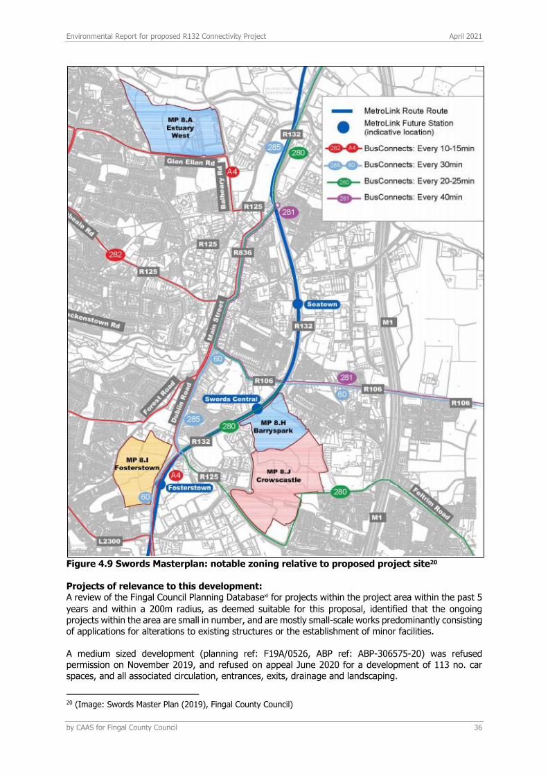
Environmental Report for proposed R132 Connectivity Project April 2021
by CAAS for Fingal County Council 36
Figure 4.9 Swords Masterplan: notable zoning relative to proposed project site20
Projects of relevance to this development: A review of the Fingal Council Planning Databasexi for projects within the project area within the past 5
years and within a 200m radius, as deemed suitable for this proposal, identified that the ongoing projects within the area are small in number, and are mostly small-scale works predominantly consisting of applications for alterations to existing structures or the establishment of minor facilities.
A medium sized development (planning ref: F19A/0526, ABP ref: ABP-306575-20) was refused permission on November 2019, and refused on appeal June 2020 for a development of 113 no. car spaces, and all associated circulation, entrances, exits, drainage and landscaping.
20 (Image: Swords Master Plan (2019), Fingal County Council)

Environmental Report for proposed R132 Connectivity Project April 2021
by CAAS for Fingal County Council 37
Another medium sized development (planning ref: F17A/0734, ABP ref: ABP-301082-18) was refused permission in February 2018, and refused on appeal August 2018 for a development to the south west of the proposed site consisting of demolition of existing structures, and construction of detached dwelling and 2 car spaces, and 5 no. two story, three-bedroom dwellings to the east (rear) of the site with additional pedestrian access. There are several areas identified as zoning objectives such as: Major Town Centre (MC); Metro Economic Corridor (ME); Residential Area (RA); General Employment (GE); Open Space (OS); High Technology with no applications attached to them as yet. The proposed works within the project area will be undertaken on highly modified urban/suburban lands of low ecological value locally, using standard, best practice construction methods. The largest sources for effects identified relate to run off through the existing drainage network and potential release of excess silt associated with construction phase, which could introduce temporary effects. Some trees will have to be removed to construct a bus stop on the Malahide Intersection and a pedestrian footbridge (Figure 4.3 & Figure 4.4). However, a complete arborist survey and resulting report accompanying this application has identified the maturity and species of trees to be felled as a result of these works. The report has provided recommended appropriate species and specimen trees to be replanted, in accordance with the landscaping drawings provided for this project. As the main local ecological values of the treelines along the R132 bypass is identified herein as an ecological corridor and habitat for breeding birds; the removal of the indicated trees will not significantly interrupt this connectivity, or significantly impact on breeding bird populations, as the vast majority of the tree line itself remains intact during the construction and operation phases of this project. Furthermore, the above-stated mitigations regarding replanting of appropriate trees identified by a qualified arborist will ensure that there is no net loss long term of available habitat for nest or foraging bird species.
These effects are identified individually, and together as localised and short term due to the nature of the proposed development, and are accompanied by best practice construction mitigation measures such as the use of silt fences and extraction locally and returning materials back to the local area, and attenuation tanks, and equivalent replanting of removed vegetation. The operational phase will be very similar to the current function and characters of the current site and in keeping with the noise, and light levels of the current immediate and wider environment. Thus, it is not foreseen that the proposed project will have any significant cumulative adverse effects on European sites with the aforementioned projects. On this basis, the relevant guidance (CIEEM, 2018) indicates that there is no need to consider cumulative effects for these smaller local dwelling developments. The Metrolink Scheme has potential for effects on European sites. The Scheme is not in planning stages yet, and will be required to have its own AA, EIA and Ecological screenings. As the current proposal is not likely to have any significant adverse effects on the integrity of the local or wider ecology via hydrological or terrestrial links, is in keeping with the current urban landscape and pressures, and will retain the current ecological features within the project area in the short and long-term, it is not currently considered in this assessment that there will be any significant cumulative effects with the Metrolink Scheme on European sites as a result of the proposed development.
4.10 RESIDUAL IMPACTS
Given the nature of the works proposed, there will be not net gain or net loss in terms of the ecological integrity of the proposed site due to the project in keeping with the current landscape characteristics and environmental features. Following the mitigation measures detailed above, the nature of the proposal that is consistent with existing conditions and usage of the site, the implementation of a tree balance sheet21 to mitigate habitat loss and leave not net loss long term of available habitat for local bird populations and the comprehensive methods statements for reducing risk of siltation increase in drainage plans of the accompanying Outline CEMP, the potential impacts to the flora and fauna of the existing environment within the proposed site are negligible. In addition, the landscaping proposal of
2121 See accompanying Arborist’s report to this application

Environmental Report for proposed R132 Connectivity Project April 2021
by CAAS for Fingal County Council 38
the intersections within the project area (Appendix 4.4) aim to increase the local biodiversity at each intersection with planting of native species of grasses and wildflowers, low intensity mowing and augmented tree planting where appropriate. The NIS identified potential significant effects due to the implementation of proposed projects; however, the mitigation measures incorporated into the design of the project ensure there are no likely significant effects remaining. The characteristics of the development detailed above indicate that any potential residual impacts will be localised and mainly kept to the construction phase due to the nature of the proposed works, the status and current usage of the highly modified urban site, and the operational phase which is very similar to current usage and activity levels for the area. Therefore, the overall status of the site as low local ecological importance is expected to remain the same /unaltered after the proposed works have been carried out, with negligible affects to local biodiversity.
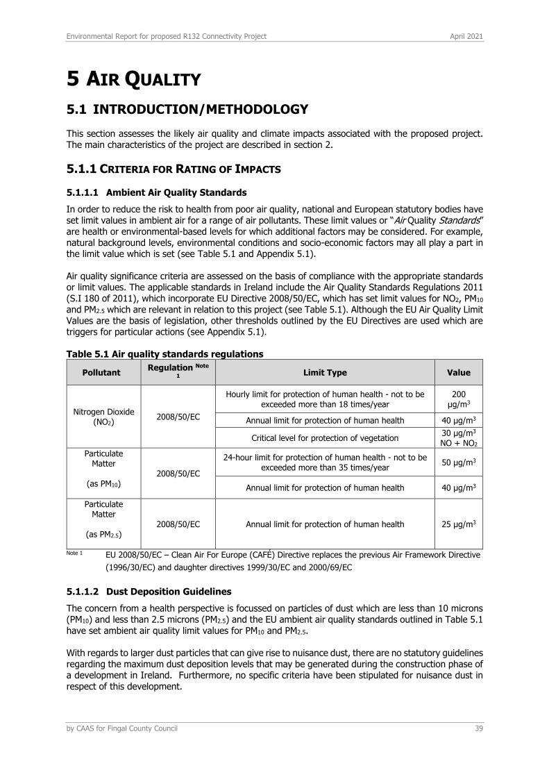
Environmental Report for proposed R132 Connectivity Project April 2021
by CAAS for Fingal County Council 39
5 AIR QUALITY
5.1 INTRODUCTION/METHODOLOGY
This section assesses the likely air quality and climate impacts associated with the proposed project. The main characteristics of the project are described in section 2.
5.1.1 CRITERIA FOR RATING OF IMPACTS
5.1.1.1 Ambient Air Quality Standards
In order to reduce the risk to health from poor air quality, national and European statutory bodies have set limit values in ambient air for a range of air pollutants. These limit values or “Air Quality Standards” are health or environmental-based levels for which additional factors may be considered. For example, natural background levels, environmental conditions and socio-economic factors may all play a part in the limit value which is set (see Table 5.1 and Appendix 5.1). Air quality significance criteria are assessed on the basis of compliance with the appropriate standards or limit values. The applicable standards in Ireland include the Air Quality Standards Regulations 2011 (S.I 180 of 2011), which incorporate EU Directive 2008/50/EC, which has set limit values for NO2, PM10 and PM2.5 which are relevant in relation to this project (see Table 5.1). Although the EU Air Quality Limit Values are the basis of legislation, other thresholds outlined by the EU Directives are used which are triggers for particular actions (see Appendix 5.1). Table 5.1 Air quality standards regulations
Pollutant Regulation Note
1 Limit Type Value
Nitrogen Dioxide (NO2)
2008/50/EC
Hourly limit for protection of human health - not to be exceeded more than 18 times/year
200 μg/m3
Annual limit for protection of human health 40 μg/m3
Critical level for protection of vegetation 30 μg/m3 NO + NO2
Particulate Matter
(as PM10)
2008/50/EC
24-hour limit for protection of human health - not to be exceeded more than 35 times/year
50 μg/m3
Annual limit for protection of human health 40 μg/m3
Particulate Matter
(as PM2.5)
2008/50/EC Annual limit for protection of human health 25 μg/m3
Note 1 EU 2008/50/EC – Clean Air For Europe (CAFÉ) Directive replaces the previous Air Framework Directive
(1996/30/EC) and daughter directives 1999/30/EC and 2000/69/EC
5.1.1.2 Dust Deposition Guidelines
The concern from a health perspective is focussed on particles of dust which are less than 10 microns (PM10) and less than 2.5 microns (PM2.5) and the EU ambient air quality standards outlined in Table 5.1 have set ambient air quality limit values for PM10 and PM2.5. With regards to larger dust particles that can give rise to nuisance dust, there are no statutory guidelines regarding the maximum dust deposition levels that may be generated during the construction phase of a development in Ireland. Furthermore, no specific criteria have been stipulated for nuisance dust in respect of this development.

Environmental Report for proposed R132 Connectivity Project April 2021
by CAAS for Fingal County Council 40
With regard to dust deposition, the German TA-Luft standard for dust deposition (non-hazardous dust) (German VDI, 2002) sets a maximum permissible emission level for dust deposition of 350 mg/(m2/day) averaged over a one year period at any receptors outside the site boundary. Recommendations from the Department of the Environment, Heritage & Local Government (DEHLG, 2004) apply the Bergerhoff limit of 350 mg/(m2/day) to the site boundary of quarries. This limit value can also be implemented with regard to dust impacts from construction of the proposed project.
5.1.1.3 Climate Agreements
Ireland is party to both the United Nations Framework Convention on Climate Change (UNFCCC) and the Kyoto Protocol. The Paris Agreement, which entered into force in 2016, is an important milestone in terms of international climate change agreements and includes an aim of limiting global temperature increases to no more than 2°C above pre-industrial levels with efforts to limit this rise to 1.5°C. The aim is to limit global GHG emissions to 40 gigatonnes as soon as possible whilst acknowledging that peaking of GHG emissions will take longer for developing countries. Contributions to GHG emissions will be based on Intended Nationally Determined Contributions (INDCs) which will form the foundation for climate action post 2020. Significant progress was also made in the Paris Agreement on elevating adaption onto the same level as action to cut and curb emissions. In order to meet the commitments under the Paris Agreement, the EU enacted Regulation (EU) 2018/842 on binding annual greenhouse gas emission reductions by Member States from 2021 to 2030 contributing to climate action to meet commitments under the Paris Agreement and amending Regulation (EU) No. 525/2013 (the Regulation). The Regulation aims to deliver, collectively by the EU in the most cost-effective manner possible, reductions in GHG emissions from the Emission Trading Scheme (ETS) and non-ETS sectors amounting to 43% and 30%, respectively, by 2030 compared to 2005. Ireland’s obligation under the Regulation is a 30% reduction in non-ETS greenhouse gas emissions by 2030 relative to its 2005 levels. In 2015, the Climate Action and Low Carbon Development Act 2015 (No. 46 of 2015) (Government of Ireland, 2015) was enacted (the Act). The purpose of the Act was to enable Ireland ‘to pursue, and achieve, the transition to a low carbon, climate resilient and environmentally sustainable economy by the end of the year 2050’ (3.(1) of No. 46 of 2015). This is referred to in the Act as the ‘national transition objective’. The Act made provision for a national mitigation plan, and a national adaptation framework. In addition, the Act provided for the establishment of the Climate Change Advisory Council with the function to advise and make recommendations on the preparation of the national mitigation and adaptation plans and compliance with existing climate obligations. The Climate Action Plan (CAP) (Government of Ireland, 2019), published in June 2019, outlines the current status across key sectors including Electricity, Transport, Built Environment, Industry and Agriculture and outlines the various broadscale measures required for each sector to achieve ambitious decarbonisation targets. The CAP also details the required governance arrangements for implementation including carbon-proofing of policies, establishment of carbon budgets, a strengthened Climate Change Advisory Council and greater accountability to the Oireachtas. The CAP has set a transport sector reduction target of 45 - 50% relative to 2030 pre-NDP (National Development Plan) projections. Following on from Ireland declaring a climate and biodiversity emergency in May 2019 and the European Parliament approving a resolution declaring a climate and environment emergency in Europe in November 2019, the Government approved the publication of the General Scheme for the Climate Action (Amendment) Bill 2019 in December 2019 (Government of Ireland, 2019). The General Scheme was prepared for the purposes of giving statutory effect to the core objectives stated within the CAP. In October 2020, the Climate Action and Low Carbon Development (Amendment) Bill 2020 (Government of Ireland, 2020) was published in draft format (draft 2020 Climate Act) which amends and enhances the 2015 Climate Act. Once approved, the purpose of the 2020 Climate Act is to provide for the approval of plans ‘for the purpose of pursuing the transition to a climate resilient and climate neutral economy by the end of the year 2050’. The 2020 Climate Act will also ‘provide for carbon budgets and a decarbonisation target range for certain sectors of the economy’. The 2020 Climate Act removes any
Environmental Report for proposed R132 Connectivity Project April 2021
by CAAS for Fingal County Council 41
reference to a national mitigation plan and instead refers to both the Climate Action Plan, as published in 2019, and a series of National Long Term Climate Action Strategies. In addition, the Environment Minister shall request each local authority to make a ‘local authority climate action plan’ lasting five years and to specify the mitigation measures and the adaptation measures to be adopted by the local authority. The Fingal County Council (FCC) Climate Action Plan (FCC and Codema 2019) outlines FCC’s goals to mitigate GHG emissions and plans to prepare for and adapt to climate change. Appendix II of the FCC Climate Action Plan states that transport accounted for 44.6% of FCC total GHG emissions in 2016. The FCC Plan states that FCC Climate Action Plan aims to reduce car dependency by encouraging modal shifts from car to more sustainable modes, including public transport and cycling. Similar to Dublin City Council (DCC), FCC states that it wishes to work with the relevant transportation bodies to introduce measures to achieve better integration of transportation and land use planning, modal shifts and promote interchange between modes. The FCC Climate Action Plan highlights the risks that climate change poses to the transportation network with risks mainly associated with extreme weather events and sea level rise. The FCC Climate Action Plan notes that sea level rise, extreme weather events (and in particular cold snaps, heat waves and dry spells) and coastal, fluvial and pluvial flooding have the greatest future risk when both the likelihood and consequence are accounted for. Increases in fluvial and pluvial flooding will cause road damage, which can lead to disruption of transport services.
5.1.2 CONSTRUCTION PHASE
5.1.2.1 Air Quality
The current assessment focuses on identifying the existing baseline levels of PM10 and PM2.5 in the region of the proposed project by an assessment of EPA monitoring data. Thereafter, the impact of the construction phase of the project on air quality was determined by a qualitative assessment of the nature and scale of dust generating construction activities associated with the proposed project. Construction phase traffic also has the potential to impact air quality. The UK DMRB guidance (UK Highways Agency, 2019a), states that road links meeting one or more of the following criteria can be defined as being ‘affected’ by a proposed project and should be included in the local air quality assessment.
• Annual Average Daily Traffic (AADT) changes by 1,000 or more. • Heavy Duty Vehicle (HDV) AADT changes by 200 or more. • A change in speed band. • A change in carriageway alignment by 5m or greater.
The construction stage traffic does not meet the above scoping criteria and therefore, has been scoped out from any further assessment as there is no potential for significant impacts to air quality.
5.1.2.2 Climate
The impact of the construction phase of the proposed project on climate has been assessed by quantifying the embodied carbon dioxide associated with all materials used in the construction of the project, the traffic and plant emissions during the construction phase and additionally emissions related to waste generated during the construction phase. Emission factors have been taken from the TII Carbon Tool (TII, 2020) which uses emission factors from recognized sources including the Civil Engineering Standard Method of Measurement (CESSM) Carbon and Price Book database (CESSM, 2013) as well as using emission factors outlined in the Inventory of Carbon & Energy (ICE) (University of Bath, 2019). The carbon emissions are calculated by multiplying the emission factor by the quantity of the material that will be used over the entire construction phase. The outputs are expressed in terms of kgCO2e (kilograms of carbon dioxide equivalent).
Environmental Report for proposed R132 Connectivity Project April 2021
by CAAS for Fingal County Council 42
Information on the material quantities, site activities, land clearance, waste product and construction traffic were obtained for this assessment. This information was input into the carbon calculator to determine an estimate of the GHG emissions associated with the project. Detailed information regarding the proposed construction materials was not available at the time of this assessment and will be specified at the detailed design stage. Best estimates have been used in this assessment to provide an estimate of the GHGs associated with construction materials.
5.1.3 OPERATIONAL PHASE
5.1.3.1 Air Quality
The air quality assessment has been carried out following procedures described in the publications by the EPA (2015; 2017) and using the methodology outlined in the guidance documents published by the UK Highways Agency (2019a) and UK Department of Environment Food and Rural Affairs (DEFRA) (2016; 2018). Transport Infrastructure Ireland (TII) reference the use of the UK Highways Agency and DEFRA guidance and methodology in their document Guidelines for the Treatment of Air Quality During the Planning and Construction of National Road Schemes (2011). This approach is considered best practice in the absence of Irish guidance. This guidance is specific to road schemes but can be applied to any development that causes a change in traffic. In 2019 the UK Highways Agency DMRB air quality guidance was revised with LA 105 Air Quality replacing a number of key pieces of guidance (HA 207/07, IAN 170/12, IAN 174/13, IAN 175/13, part of IAN 185/15). This revised document outlines a number of changes for air quality assessments in relation to road schemes but can be applied to any development that causes a change in traffic. Previously the DMRB air quality spreadsheet was used for the majority of assessments in Ireland with detailed modelling only required if this screening tool indicated compliance issues with the EU air quality standards. Guidance from Transport Infrastructure Ireland (TII, 2011) recommends the use of the UK Highways Agency DMRB spreadsheet tool for assessing the air quality impacts from road schemes. However, the DMRB spreadsheet tool was last revised in 2007 and accounts for modelled years up to 2025. Vehicle emission standards up to Euro V are included but since 2017, Euro 6d standards are applicable for the new fleet. In addition, the model does not account for electric or hybrid vehicle use. Therefore, this a somewhat outdated assessment tool. The LA 105 guidance document states that the DMRB spreadsheet tool may still be used for simple air quality assessments where there is unlikely to be a breach of the air quality standards. Due to its use of a “dirtier” fleet, vehicle emissions would be considered to be higher than more modern models and therefore any results will be conservative in nature and will provide a worst-case assessment. The 2019 UK Highways Agency DMRB air quality revised guidance LA 105 Air Quality states that modelling should be conducted for NO2 for the base, opening and design years for both the do minimum (do nothing) and do something scenarios. Modelling of PM10 is only required for the base year to demonstrate that the air quality limit values in relation to PM10 are not breached. Where the air quality modelling indicates exceedances of the PM10 air quality limits in the base year then PM10 should be included in the air quality model in the do minimum and do something scenarios. Modelling of PM2.5 is not required as there are currently no issues with compliance with regard to this pollutant. The modelling of PM10 can be used to show that the project does not impact on the PM2.5 limit value as if compliance with the PM10 limit is achieved then compliance with the PM2.5 limit will also be achieved. Historically modelling of carbon monoxide (CO) and benzene (Bz) was required however, this is no longer needed as concentrations of these pollutants have been monitored to be significantly below their air quality limit values in recent years, even in urban centres (EPA, 2020a). The key pollutant reviewed in this assessment is NO2. Concentrations of PM10 have been modelled for the base year to indicate that there are no potential compliance issues. Modelling of operational NO2 concentrations has been conducted for the do nothing and do something scenarios for the opening year (2023) and design year (2030). The UK Highways Agency guidance LA 150 (2019a) scoping criteria outlined in Section 9.2.2.1 was used to determine the road links required for inclusion in the modelling assessment. The TII guidance (2011) states that the assessment must progress to detailed modelling if:
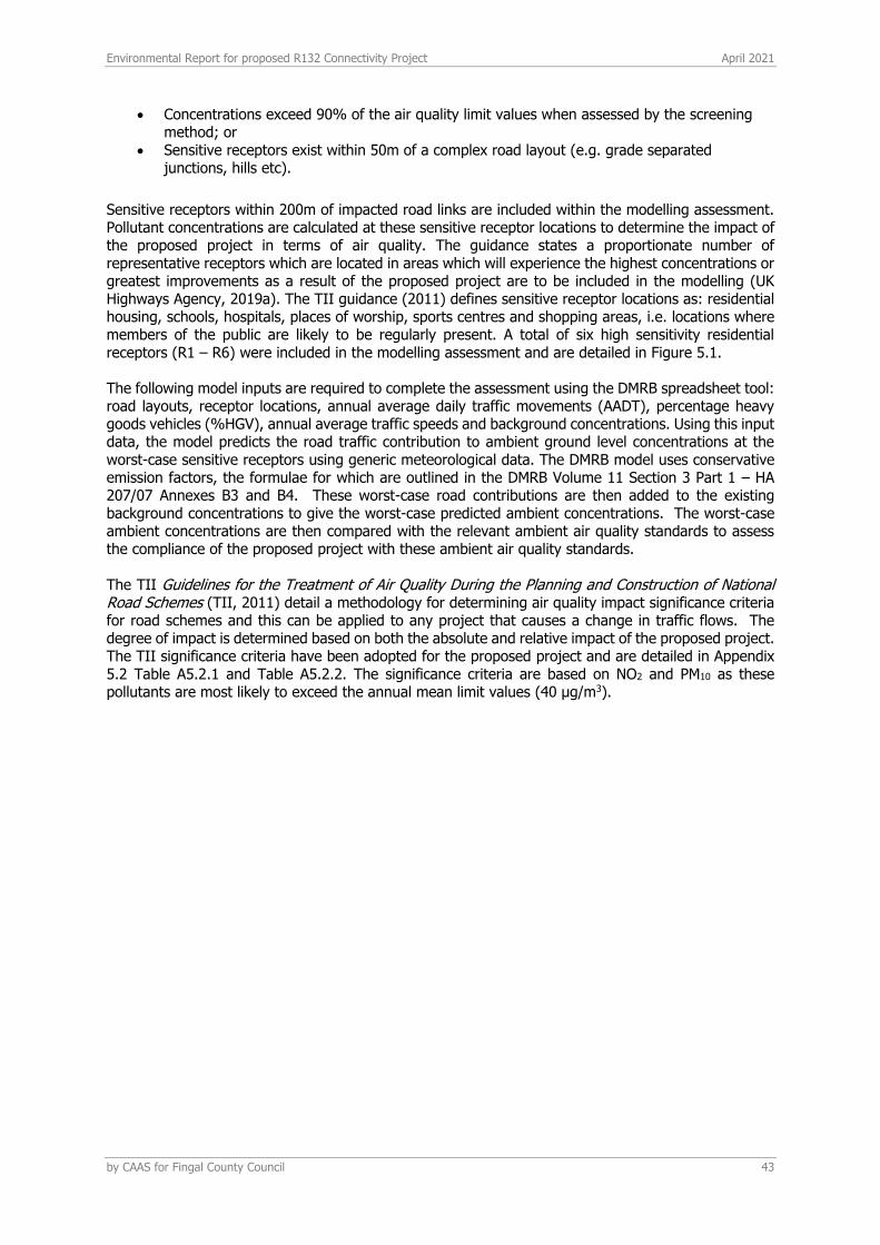
Environmental Report for proposed R132 Connectivity Project April 2021
by CAAS for Fingal County Council 43
• Concentrations exceed 90% of the air quality limit values when assessed by the screening method; or
• Sensitive receptors exist within 50m of a complex road layout (e.g. grade separated junctions, hills etc).
Sensitive receptors within 200m of impacted road links are included within the modelling assessment. Pollutant concentrations are calculated at these sensitive receptor locations to determine the impact of the proposed project in terms of air quality. The guidance states a proportionate number of representative receptors which are located in areas which will experience the highest concentrations or greatest improvements as a result of the proposed project are to be included in the modelling (UK Highways Agency, 2019a). The TII guidance (2011) defines sensitive receptor locations as: residential housing, schools, hospitals, places of worship, sports centres and shopping areas, i.e. locations where members of the public are likely to be regularly present. A total of six high sensitivity residential receptors (R1 – R6) were included in the modelling assessment and are detailed in Figure 5.1. The following model inputs are required to complete the assessment using the DMRB spreadsheet tool: road layouts, receptor locations, annual average daily traffic movements (AADT), percentage heavy goods vehicles (%HGV), annual average traffic speeds and background concentrations. Using this input data, the model predicts the road traffic contribution to ambient ground level concentrations at the worst-case sensitive receptors using generic meteorological data. The DMRB model uses conservative emission factors, the formulae for which are outlined in the DMRB Volume 11 Section 3 Part 1 – HA 207/07 Annexes B3 and B4. These worst-case road contributions are then added to the existing background concentrations to give the worst-case predicted ambient concentrations. The worst-case ambient concentrations are then compared with the relevant ambient air quality standards to assess the compliance of the proposed project with these ambient air quality standards. The TII Guidelines for the Treatment of Air Quality During the Planning and Construction of National Road Schemes (TII, 2011) detail a methodology for determining air quality impact significance criteria for road schemes and this can be applied to any project that causes a change in traffic flows. The degree of impact is determined based on both the absolute and relative impact of the proposed project. The TII significance criteria have been adopted for the proposed project and are detailed in Appendix 5.2 Table A5.2.1 and Table A5.2.2. The significance criteria are based on NO2 and PM10 as these pollutants are most likely to exceed the annual mean limit values (40 µg/m3).
Environmental Report for proposed R132 Connectivity Project April 2021
by CAAS for Fingal County Council 44
Figure 5.1 Receptor locations
5.1.3.2 Conversion of NOx to NO2
NOX (NO + NO2) is emitted by vehicles exhausts. The majority of emissions are in the form of NO, however, with greater diesel vehicles and some regenerative particle traps on HGVs the proportion of NOX emitted as NO2, rather than NO is increasing. With the correct conditions (presence of sunlight and O3) emissions in the form of NO, have the potential to be converted to NO2. Transport Infrastructure Ireland states the recommended method for the conversion of NOx to NO2 in “Guidelines for the Treatment of Air Quality During the Planning and Construction of National Road Schemes” (2011). The TII guidelines recommend the use of DEFRAs NOx to NO2 calculator (2020) which was originally published in 2009 and is currently on version 8.1. This calculator (which can be downloaded in the form of an excel spreadsheet) accounts for the predicted availability of O3 and proportion of NOx emitted as NO for each local authority across the UK. O3 is a regional pollutant and therefore concentrations do not vary in the same way as concentrations of NO2 or PM10. The calculator includes Local Authorities in Northern Ireland and the TII guidance recommends the use of ‘Armagh, Banbridge and Craigavon’ as the choice for local authority when using the calculator. The choice of Craigavon provides the most suitable relationship between NO2 and NOx for Ireland. The “All Other Urban UK Traffic” traffic mix option was used.
5.1.3.3 Update to NO2 projections using DMRB
In 2011 the UK DEFRA published research (Highways England, 2013) on the long term trends in NO2 and NOX for roadside monitoring sites in the UK. This study marked a decrease in NO2 concentrations between 1996 and 2002, after which the concentrations stabilised with little reduction between 2004 and 2010. The result of this is that there now exists a gap between projected NO2 concentrations which UK DEFRA previously published and monitored concentrations. The impact of this ‘gap’ is that the DMRB screening model can under-predict NO2 concentrations for predicted future years. Subsequently, the UK Highways Agency published an Interim advice note (IAN 170/12) in order to correct the DMRB

Environmental Report for proposed R132 Connectivity Project April 2021
by CAAS for Fingal County Council 45
results for future years. This methodology has been used in the current assessment to predict future concentrations of NO2 as a result of the proposed project.
5.1.3.4 Traffic data used in modelling assessment
Traffic flow information was obtained from DBFL Consulting Engineers on 12/02/2021 for the purposes of this assessment. Data for the Do Nothing (DN) and Do Something (DS) scenarios for the base year 2018, opening year 2023 and design year 2030 were provided, an additional scenario was also included for the scenario when the MetroLink proceeds. The traffic data is detailed in Table 5.2 Background concentrations have been included as per Section 5.3.2 of this section based on available EPA background monitoring data (EPA, 2020a). This traffic data has also been used in the operational stage climate impact assessment and ecological assessment. Table 5.2 Traffic data used in local air quality modelling assessment22
22 Percentages refer to volume of HGV traffic as a percentage of the AADT figure. Since this assessment of effects on air quality was carried out, the AADT figures for links L and M in the year 2030 were corrected and slightly adjusted to show no change between the Do-Nothing and Do-Something scenarios (see Traffic and Transportation report for final details). This correction has no significant effect on the findings of this assessment of effects on air quality.
Link Number
Road Name
Base Year Do-Nothing Do-Something Speed (kph) 2018 2023 2030 2023 2030
1 A 32040 (1%) 18210 (3%) 15342 (4%) 18210 (3%) 15342 (4%) 80
2 B 28824 (2%) 16021 (4%) 13816 (5%) 16021 (4%) 13816 (5%) 60
3 C 12607 (2%) 13212 (2%) 14174 (3%) 13212 (2%) 14174 (3%) 50
4 D 16287 (2%) 16323 (2%) 18400 (2%) 18953 (2%) 18400 (2%) 50
5 E 4138 (1%) 4490 (1%) 4963 (1%) 2782 (1%) 3076 (1%) 50
6 F 31911 (1%) 24577 (2%) 16845 (4%) 24577 (2%) 16845 (4%) 80
7 G 32967 (2%) 27438 (2%) 13118 (6%) 27438 (2%) 13118 (6%) 80
8 H 10794 (0%) 6324 (1%) 6462 (1%) 6324 (1%) 6462 (1%) 50
9 I 12008 (2%) 5528 (4%) 7184 (4%) 5528 (4%) 7184 (4%) 50
10 J 33003 (1%) 28622 (2%) 26922 (2%) 28622 (2%) 26922 (2%) 80
11 K 32574 (2%) 23759 (3%) 16381 (5%) 23759 (3%) 16381 (5%) 80
12 L 23236 (1%) 13650 (2%) 13650 (3%) 13650 (2%) 11333 (3%) 60
13 M 3862 (1%) 7009 (0%) 7009 (1%) 7009 (0%) 9948 (0%) 60
1 A 32040 (1%) N/A 15342 (4%) N/A 14174 (4%) 80
2 B 28824 (2%) N/A 13816 (5%) N/A 13071 (5%) 60
3 C 12607 (2%) N/A 14174 (3%) N/A 13241 (3%) 50
4 D 16287 (2%) N/A 18400 (2%) N/A 18465 (2%) 50
5 E 4138 (1%) N/A 4963 (1%) N/A 3076 (1%) 50
6 F 31911 (1%) N/A 16845 (4%) N/A 15917 (4%) 80
7 G 32967 (2%) N/A 13118 (6%) N/A 12237 (6%) 80
8 H 10794 (0%) N/A 6462 (1%) N/A 5910 (1%) 50
9 I 12008 (2%) N/A 7184 (4%) N/A 7114 (4%) 50
10 J 33003 (1%) N/A 26922 (2%) N/A 24428 (2%) 80
11 K 32574 (2%) N/A 16381 (5%) N/A 15888 (5%) 80
12 L 23236 (1%) N/A 13650 (3%) N/A 11797 (3%) 60
13 M 3862 (1%) N/A 7009 (1%) N/A 9854 (0%) 60

Environmental Report for proposed R132 Connectivity Project April 2021
by CAAS for Fingal County Council 46
Figure 5.2 Traffic data road locations
5.1.3.5 Air quality impact on Ecological sites
For routes that pass within 2 km of a designated area of conservation (either Irish or European designation) the TII requires consultation with an ecologist (2011). However, in practice the potential for impact to an ecological site is highest within 200m of the proposed project or development and when significant changes in AADT (>5%) occur. Only sites that are sensitive to nitrogen deposition should be included in the assessment. In addition, the UK Highways Agency (2019a) states that a detailed assessment does not need to be conducted for areas that have been designated for geological features or watercourses. Transport Infrastructure Ireland’s Guidelines for Assessment of Ecological Impacts of National Road Schemes (2009) and Appropriate Assessment of Plans and Projects in Ireland – Guidance for Planning Authorities (DEHLG, 2010) provide details regarding the legal protection of designated conservation areas. If both of the following assessment criteria are met, an assessment of the potential for impact due to nitrogen deposition should be conducted:
• A designated area of conservation is located within 200 m of the proposed development; and • A significant change in AADT flows (>5%) will occur.
Environmental Report for proposed R132 Connectivity Project April 2021
by CAAS for Fingal County Council 47
Designated sites which are within 2km of the boundary of the proposed project, are Feltrim Hill proposed Natural Heritage Area (pNHA) (Site Code: 001208), Malahide Estuary pNHA (Site Code: 000205), Malahide Estuary Special Protection Area (SPA) (Site Code: 004025) and Malahide Estuary Special Area of Conservation (SAC) (Site Code: 004025). A review of the operational traffic data indicates that only Road M (Spittal Hill) is within 200m of the designated sites and will experience a significant change in the AADT due to the proposed project and therefore it requires further assessment. Dispersion modelling and prediction was carried out at typical traffic speeds within a section of the pNHA, SAC and SPA. Ambient NOx concentrations were predicted along a transect of up to 200m within the designated sites in line with the UK Highways Agency (2019a) and TII (2011) guidance. The ecology assessment has been considered for the assessment year 2030 as no change in AADT is predicted during the opening year of 2023. In addition, the assessment was not conducted for the MetroLink scenario as the impact on the sensitive ecology was more significant in the no Metrolink scenario, therefore this can be considered worst-case. The road contribution to dry deposition along the transect was also calculated using the methodology outlined in Appendix 9 of the Guidelines for the Treatment of Air Quality During the Planning and Construction of National Road Schemes (2011).
5.1.3.6 Climate
As per the EU guidance document Guidance on Integrating Climate Change and Biodiversity into Environmental Impact Assessment (European Commission, 2013) the climate baseline is first established by reference to EPA data on annual GHG emissions (see Section 9.3.3). Thereafter the impact of the proposed development on climate is determined. Emissions from road traffic associated with the proposed project have the potential to emit carbon dioxide (CO2) which will impact climate. The UK Highways Agency has published an updated DMRB guidance document in relation to climate impact assessments LA 114 Climate (UK Highways Agency 2019b). The following scoping criteria are used to determine whether a detailed climate assessment is required for a proposed project during the operational stage. If any of the road links impacted by the proposed project meet or exceed the below criteria, then further assessment is required.
• A change of more than 10% in AADT. • A change of more than 10% to the number of heavy-duty vehicles. • A change in daily average speed of more than 20 km/hr.
There are a number of road links that will experience a change of 10% or more in the AADT. These road links have been included in the detailed climate assessment (see Table 5.2). The impact of the proposed project has been determined using the procedures given by Transport Infrastructure Ireland (2011) and the methodology provided in Annex D in the UK Design Manual for Roads and Bridges (UK Highways Agency, 2007). The assessment focused on determining the resulting change in emissions of carbon dioxide (CO2). The Annex provides a method for the prediction of the regional impact of emissions of these pollutants from road schemes and can be applied to any project that causes a change in traffic. The inputs to the air dispersion model consist of information on road link lengths, AADT movements and annual average traffic speeds (see Table 5.2).
Environmental Report for proposed R132 Connectivity Project April 2021
by CAAS for Fingal County Council 48
5.2 THE PROPOSED DEVELOPMENT
The proposed development is described in Section 2 Project Description.
5.2.1 CONSTRUCTION PHASE
It is expected that the works will be carried out in a number of phases (to be determined) over an expected 2-year construction period. Air quality and climate impacts have been considered for both the construction and operational phases of the proposed project. During the construction phase of the project there will be different sources of potential air quality impacts, primarily construction dust emissions. Construction plant, machinery and site vehicles are a source of GHG emissions which have the potential to impact climate. In addition, the embodied GHG emissions associated with the demolition wastes and construction materials for the project and their transport to and from site have the potential to impact climate. Mitigation measures with respect to the control of construction dust are built into Section 4.1.9 of the Outline Construction Environmental Management Plan (CEMP). These include;
• wheel wash at site exit points • spraying of exposed earthwork activities and site haul roads during dry weather • covering of stockpiles • the production of a documented system for managing site practices with regard to dust
control • site Hoarding • control of vehicle speeds, speed restrictions and vehicle access
5.2.2 OPERATIONAL PHASE
The primary sources of air and climatic emissions in the operational context are deemed long term and will involve the change in traffic flows in the local areas which are associated with the project.
5.3 THE RECEIVING ENVIRONMENT
5.3.1 METEOROLOGICAL DATA
A key factor in assessing temporal and spatial variations in air quality is the prevailing meteorological conditions. Depending on wind speed and direction, individual receptors may experience very significant variations in pollutant levels under the same source strength (i.e. traffic levels). Wind is of key importance in dispersing air pollutants and for ground level sources, such as traffic emissions, pollutant concentrations are generally inversely related to wind speed. Thus, concentrations of pollutants derived from traffic sources will generally be greatest under very calm conditions and low wind speeds when the movement of air is restricted. In relation to PM10, the situation is more complex due to the range of sources of this pollutant. Smaller particles (less than PM2.5) from traffic sources will be dispersed more rapidly at higher wind speeds. However, fugitive emissions of coarse particles (PM2.5 - PM10) will actually increase at higher wind speeds. Thus, measured levels of PM10 will be a non-linear function of wind speed.
The proposed project is roughly 2 km north of Dublin Airport at the closest point. The Dublin Airport meteorological station collects meteorological data in the correct format for the purposes of this assessment and has a data collection of greater than 90%. Long-term hourly observations at Dublin Airport meteorological station provide an indication of the prevailing wind conditions for the region. Results indicate that the prevailing wind direction is from south to westerly in direction over the period 2016 to 2020.
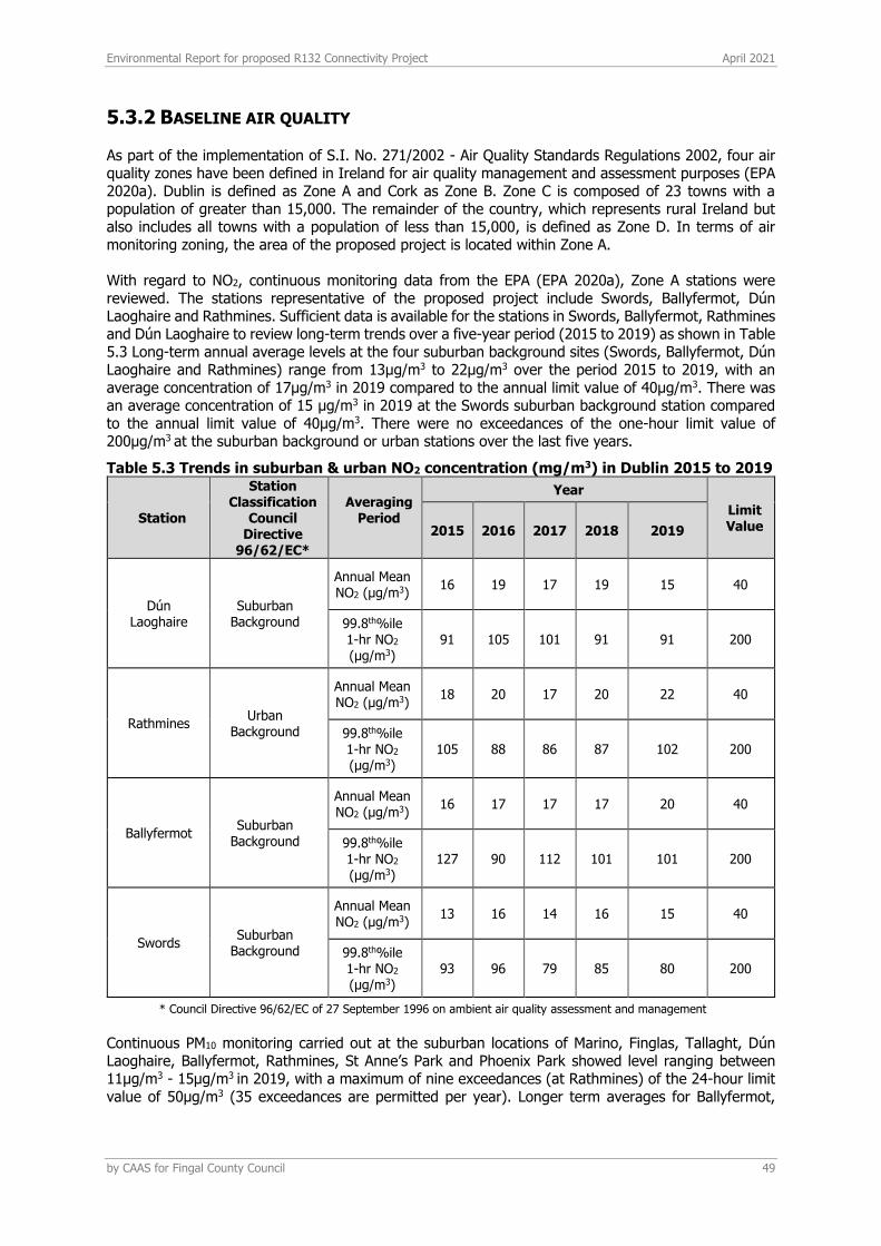
Environmental Report for proposed R132 Connectivity Project April 2021
by CAAS for Fingal County Council 49
5.3.2 BASELINE AIR QUALITY
As part of the implementation of S.I. No. 271/2002 - Air Quality Standards Regulations 2002, four air quality zones have been defined in Ireland for air quality management and assessment purposes (EPA 2020a). Dublin is defined as Zone A and Cork as Zone B. Zone C is composed of 23 towns with a population of greater than 15,000. The remainder of the country, which represents rural Ireland but also includes all towns with a population of less than 15,000, is defined as Zone D. In terms of air monitoring zoning, the area of the proposed project is located within Zone A.
With regard to NO2, continuous monitoring data from the EPA (EPA 2020a), Zone A stations were reviewed. The stations representative of the proposed project include Swords, Ballyfermot, Dún Laoghaire and Rathmines. Sufficient data is available for the stations in Swords, Ballyfermot, Rathmines and Dún Laoghaire to review long-term trends over a five-year period (2015 to 2019) as shown in Table 5.3 Long-term annual average levels at the four suburban background sites (Swords, Ballyfermot, Dún Laoghaire and Rathmines) range from 13µg/m3 to 22µg/m3 over the period 2015 to 2019, with an average concentration of 17µg/m3 in 2019 compared to the annual limit value of 40µg/m3. There was an average concentration of 15 µg/m3 in 2019 at the Swords suburban background station compared to the annual limit value of 40µg/m3. There were no exceedances of the one-hour limit value of 200µg/m3 at the suburban background or urban stations over the last five years.
Table 5.3 Trends in suburban & urban NO2 concentration (mg/m3) in Dublin 2015 to 2019
Station
Station Classification
Council Directive
96/62/EC*
Averaging Period
Year
Limit Value 2015 2016 2017 2018 2019
Dún Laoghaire
Suburban Background
Annual Mean NO2 (µg/m3)
16 19 17 19 15 40
99.8th%ile 1-hr NO2 (µg/m3)
91 105 101 91 91 200
Rathmines Urban
Background
Annual Mean NO2 (µg/m3)
18 20 17 20 22 40
99.8th%ile 1-hr NO2 (µg/m3)
105 88 86 87 102 200
Ballyfermot Suburban
Background
Annual Mean NO2 (µg/m3)
16 17 17 17 20 40
99.8th%ile 1-hr NO2 (µg/m3)
127 90 112 101 101 200
Swords Suburban
Background
Annual Mean NO2 (µg/m3)
13 16 14 16 15 40
99.8th%ile 1-hr NO2 (µg/m3)
93 96 79 85 80 200
* Council Directive 96/62/EC of 27 September 1996 on ambient air quality assessment and management
Continuous PM10 monitoring carried out at the suburban locations of Marino, Finglas, Tallaght, Dún Laoghaire, Ballyfermot, Rathmines, St Anne’s Park and Phoenix Park showed level ranging between 11µg/m3 - 15µg/m3 in 2019, with a maximum of nine exceedances (at Rathmines) of the 24-hour limit value of 50µg/m3 (35 exceedances are permitted per year). Longer term averages for Ballyfermot,
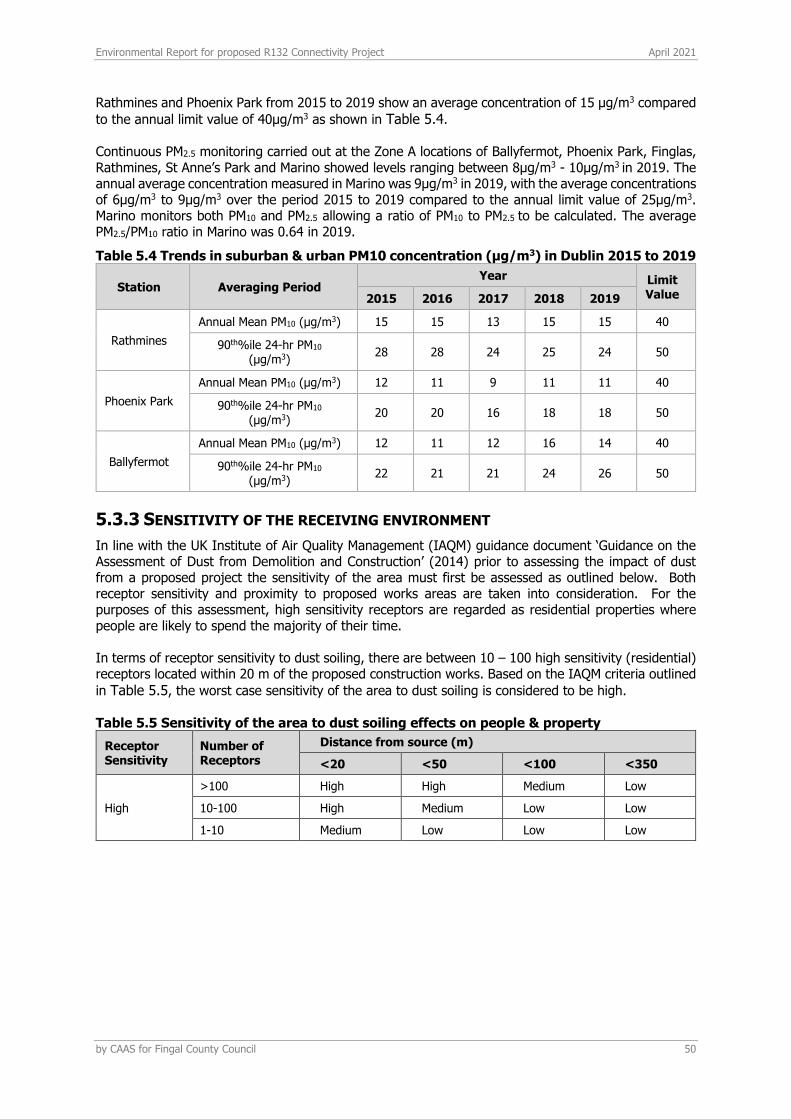
Environmental Report for proposed R132 Connectivity Project April 2021
by CAAS for Fingal County Council 50
Rathmines and Phoenix Park from 2015 to 2019 show an average concentration of 15 µg/m3 compared
to the annual limit value of 40µg/m3 as shown in Table 5.4.
Continuous PM2.5 monitoring carried out at the Zone A locations of Ballyfermot, Phoenix Park, Finglas, Rathmines, St Anne’s Park and Marino showed levels ranging between 8µg/m3 - 10µg/m3 in 2019. The annual average concentration measured in Marino was 9µg/m3 in 2019, with the average concentrations of 6µg/m3 to 9µg/m3 over the period 2015 to 2019 compared to the annual limit value of 25µg/m3. Marino monitors both PM10 and PM2.5 allowing a ratio of PM10 to PM2.5 to be calculated. The average PM2.5/PM10 ratio in Marino was 0.64 in 2019.
Table 5.4 Trends in suburban & urban PM10 concentration (µg/m3) in Dublin 2015 to 2019
Station Averaging Period Year Limit
Value 2015 2016 2017 2018 2019
Rathmines
Annual Mean PM10 (µg/m3) 15 15 13 15 15 40
90th%ile 24-hr PM10 (µg/m3)
28 28 24 25 24 50
Phoenix Park
Annual Mean PM10 (µg/m3) 12 11 9 11 11 40
90th%ile 24-hr PM10 (µg/m3)
20 20 16 18 18 50
Ballyfermot
Annual Mean PM10 (µg/m3) 12 11 12 16 14 40
90th%ile 24-hr PM10 (µg/m3)
22 21 21 24 26 50
5.3.3 SENSITIVITY OF THE RECEIVING ENVIRONMENT
In line with the UK Institute of Air Quality Management (IAQM) guidance document ‘Guidance on the Assessment of Dust from Demolition and Construction’ (2014) prior to assessing the impact of dust from a proposed project the sensitivity of the area must first be assessed as outlined below. Both receptor sensitivity and proximity to proposed works areas are taken into consideration. For the purposes of this assessment, high sensitivity receptors are regarded as residential properties where people are likely to spend the majority of their time. In terms of receptor sensitivity to dust soiling, there are between 10 – 100 high sensitivity (residential) receptors located within 20 m of the proposed construction works. Based on the IAQM criteria outlined
in Table 5.5, the worst case sensitivity of the area to dust soiling is considered to be high.
Table 5.5 Sensitivity of the area to dust soiling effects on people & property
Receptor Sensitivity
Number of Receptors
Distance from source (m)
<20 <50 <100 <350
High
>100 High High Medium Low
10-100 High Medium Low Low
1-10 Medium Low Low Low
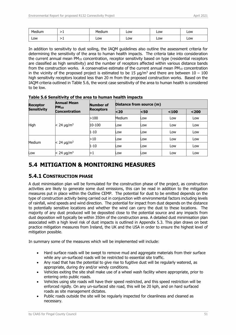
Environmental Report for proposed R132 Connectivity Project April 2021
by CAAS for Fingal County Council 51
Medium >1 Medium Low Low Low
Low >1 Low Low Low Low
In addition to sensitivity to dust soiling, the IAQM guidelines also outline the assessment criteria for determining the sensitivity of the area to human health impacts. The criteria take into consideration the current annual mean PM10 concentration, receptor sensitivity based on type (residential receptors are classified as high sensitivity) and the number of receptors affected within various distance bands from the construction works. A conservative estimate of the current annual mean PM10 concentration in the vicinity of the proposed project is estimated to be 15 µg/m3 and there are between 10 – 100 high sensitivity receptors located less than 20 m from the proposed construction works. Based on the
IAQM criteria outlined in Table 5.6, the worst case sensitivity of the area to human health is considered
to be low.
Table 5.6 Sensitivity of the area to human health impacts
Receptor Sensitivity
Annual Mean PM10
Concentration
Number of Receptors
Distance from source (m)
<20 <50 <100 <200
High < 24 µg/m3
>100 Medium Low Low Low
10-100 Low Low Low Low
1-10 Low Low Low Low
Medium < 24 µg/m3 >10 Low Low Low Low
1-10 Low Low Low Low
Low < 24 µg/m3 >1 Low Low Low Low
5.4 MITIGATION & MONITORING MEASURES
5.4.1 CONSTRUCTION PHASE
A dust minimisation plan will be formulated for the construction phase of the project, as construction activities are likely to generate some dust emissions, this can be read in addition to the mitigation measures put in place within the Outline CEMP. The potential for dust to be emitted depends on the type of construction activity being carried out in conjunction with environmental factors including levels of rainfall, wind speeds and wind direction. The potential for impact from dust depends on the distance to potentially sensitive locations and whether the wind can carry the dust to these locations. The majority of any dust produced will be deposited close to the potential source and any impacts from dust deposition will typically be within 350m of the construction area. A detailed dust minimisation plan associated with a high level risk of dust impacts is outlined in Appendix 5.3. This plan draws on best practice mitigation measures from Ireland, the UK and the USA in order to ensure the highest level of mitigation possible. In summary some of the measures which will be implemented will include:
• Hard surface roads will be swept to remove mud and aggregate materials from their surface while any un-surfaced roads will be restricted to essential site traffic.
• Any road that has the potential to give rise to fugitive dust will be regularly watered, as appropriate, during dry and/or windy conditions.
• Vehicles exiting the site shall make use of a wheel wash facility where appropriate, prior to entering onto public roads.
• Vehicles using site roads will have their speed restricted, and this speed restriction will be enforced rigidly. On any un-surfaced site road, this will be 20 kph, and on hard surfaced roads as site management dictates.
• Public roads outside the site will be regularly inspected for cleanliness and cleaned as necessary.
Environmental Report for proposed R132 Connectivity Project April 2021
by CAAS for Fingal County Council 52
• Material handling systems and site stockpiling of materials will be designed and laid out to minimise exposure to wind. Water misting or sprays will be used as required if particularly dusty activities are necessary during dry or windy periods.
• During movement of materials both on and off-site, trucks will be stringently covered with tarpaulin at all times. Before entrance onto public roads, trucks will be adequately inspected to ensure no potential for dust emissions.
• Hoarding or screens shall be erected around works areas to reduce visual impact. This will also have an added benefit of preventing larger particles of dust from travelling off-site and impacting receptors.
At all times, these procedures will be strictly monitored and assessed. In the event of dust nuisance occurring outside the site boundary, movements of materials likely to raise dust will be curtailed and satisfactory procedures implemented to rectify the problem before the resumption of construction operations.
5.4.2 OPERATIONAL PHASE
As impacts to air quality and climate are predicted to be imperceptible no mitigation is proposed.
5.4.3 CLIMATE BASELINE
Anthropogenic emissions of greenhouse gases in Ireland included in the EU 2020 strategy are outlined in the most recent review by the EPA which details provisional emissions up to 2019 (EPA, 2020b). The data published in 2020 states that Ireland will exceed its 2019 annual limit set under the EU’s Effort Sharing Decision (ESD), 406/2009/EC1 by an estimated 6.98 Mt. For 2019, total national greenhouse gas emissions are estimated to be 59.90 million tonnes carbon dioxide equivalent (Mt CO2eq) with 45.71 MtCO2eq of emissions associated with the ESD sectors for which compliance with the EU targets must be met. Agriculture is the largest contributor in 2019 at 35.3% of the total, with the transport sector accounting for 20.3% of emissions of CO2.
GHG emissions for 2019 are estimated to be 4.5% lower than those recorded in 2018. Emission reductions have been recorded in 6 of the last 10 years. However, compliance with the annual EU targets has not been met for four years in a row. Emissions from 2016 – 2019 exceeded the annual EU targets by 0.29 MtCO2eq, 2.94 MtCO2eq, 5.57 MtCO2eq and 6.98 MtCO2eq respectively. Agriculture is consistently the largest contributor to emissions with emissions from the transport and energy sectors being the second and third largest contributors respectively in recent years.
Environmental Report for proposed R132 Connectivity Project April 2021
by CAAS for Fingal County Council 53
The EPA 2019 GHG Emissions Projections Report for 2018 – 2040 (EPA 2019) notes that there is a long-term projected decrease in greenhouse gas emissions as a result of inclusion of new climate mitigation policies and measures that formed part of the National Development Plan (NDP) which was published in 2018. Implementation of these are classed as a “With Additional Measures scenario” for future scenarios. A change from generating electricity using coal and peat to wind power and diesel vehicle engines to electric vehicle engines are envisaged under this scenario. While emissions are projected to decrease in these areas, emissions from agriculture are projected to grow steadily due to an increase in animal numbers. However, over the period 2013 – 2020 Ireland is projected to cumulatively exceed its compliance obligations with the EU’s Effort Sharing Decision (Decision No. 406/2009/EC) 2020 targets by approximately 10 Mt CO2eq under the “With Existing Measures” scenario and 9 Mt CO2eq under the “With Additional Measures” scenario (EPA, 2019).
5.5 PREDICTED IMPACTS
5.5.1 CONSTRUCTION PHASE
5.5.1.1 Air quality
The greatest potential impact on air quality during the construction phase of the proposed project is from construction dust emissions and the potential for nuisance dust. While construction dust tends to be deposited within 200m of a construction site, the majority of the deposition occurs within the first 50m. The extent of any dust generation depends on the nature of the dust (soils, peat, sands, gravels, silts etc.) and the nature of the construction activity. In addition, the potential for dust dispersion and deposition depends on local meteorological factors such as rainfall, wind speed and wind direction. It is important to note that the potential impacts associated with the construction phase of the pproposed project are short-term in nature. When the dust minimisation measures detailed in the mitigation section (see Section 5.5) of this section are implemented, fugitive emissions of dust from the site will not be significant and will pose no nuisance at nearby receptors.
In order to determine the level of dust mitigation required during the proposed works, the potential dust emission magnitude for each dust generating activity needs to be taken into account, in conjunction with the previously established sensitivity of the area (see Section 9.3.3). The major dust generating activities are divided into four types within the IAQM guidance to reflect their different potential impacts. These are:
• Demolition; • Earthworks; • Construction; and • Trackout (movement of heavy vehicles).
Demolition There are no demolition activities associated with the proposed project. Therefore, there is no demolition impact predicted as a result of the works. Earthworks Earthworks primarily involve excavating material, loading and unloading of materials, tipping and stockpiling activities. Activities such as levelling the site and landscaping works are also considered under this category. The dust emission magnitude from earthworks can be classified as small, medium or large based on the definitions from the IAQM guidance as transcribed below:
• Large: Total site area > 10,000 m2, potentially dusty soil type (e.g. clay which will be prone to suspension when dry due to small particle size), >10 heavy earth moving vehicles active at any one time, formation of bunds > 8 m in height, total material moved >100,000 tonnes;
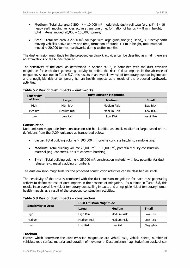
Environmental Report for proposed R132 Connectivity Project April 2021
by CAAS for Fingal County Council 54
• Medium: Total site area 2,500 m2 – 10,000 m2, moderately dusty soil type (e.g. silt), 5 - 10 heavy earth moving vehicles active at any one time, formation of bunds 4 – 8 m in height, total material moved 20,000 – 100,000 tonnes;
• Small: Total site area < 2,500 m2, soil type with large grain size (e.g. sand), < 5 heavy earth
moving vehicles active at any one time, formation of bunds < 4 m in height, total material moved < 20,000 tonnes, earthworks during wetter months.
The dust emission magnitude for the proposed earthwork activities can be classified as small, there are no excavations or tall bunds required.
The sensitivity of the area, as determined in Section 9.3.3, is combined with the dust emission magnitude for each dust generating activity to define the risk of dust impacts in the absence of
mitigation. As outlined in Table 5.7, this results in an overall low risk of temporary dust soiling impacts
and a negligible risk of temporary human health impacts as a result of the proposed earthworks activities.
Table 5.7 Risk of dust impacts – earthworks
Sensitivity of Area
Dust Emission Magnitude
Large Medium Small
High High Risk Medium Risk Low Risk
Medium Medium Risk Medium Risk Low Risk
Low Low Risk Low Risk Negligible
Construction Dust emission magnitude from construction can be classified as small, medium or large based on the definitions from the IAQM guidance as transcribed below:
• Large: Total building volume > 100,000 m3, on-site concrete batching, sandblasting;
• Medium: Total building volume 25,000 m3 – 100,000 m3, potentially dusty construction material (e.g. concrete), on-site concrete batching;
• Small: Total building volume < 25,000 m3, construction material with low potential for dust
release (e.g. metal cladding or timber). The dust emission magnitude for the proposed construction activities can be classified as small. The sensitivity of the area is combined with the dust emission magnitude for each dust generating
activity to define the risk of dust impacts in the absence of mitigation. As outlined in Table 5.8, this
results in an overall low risk of temporary dust soiling impacts and a negligible risk of temporary human health impacts as a result of the proposed construction activities.
Table 5.8 Risk of dust impacts – construction
Sensitivity of Area Dust Emission Magnitude
Large Medium Small
High High Risk Medium Risk Low Risk
Medium Medium Risk Medium Risk Low Risk
Low Low Risk Low Risk Negligible
Trackout Factors which determine the dust emission magnitude are vehicle size, vehicle speed, number of vehicles, road surface material and duration of movement. Dust emission magnitude from trackout can
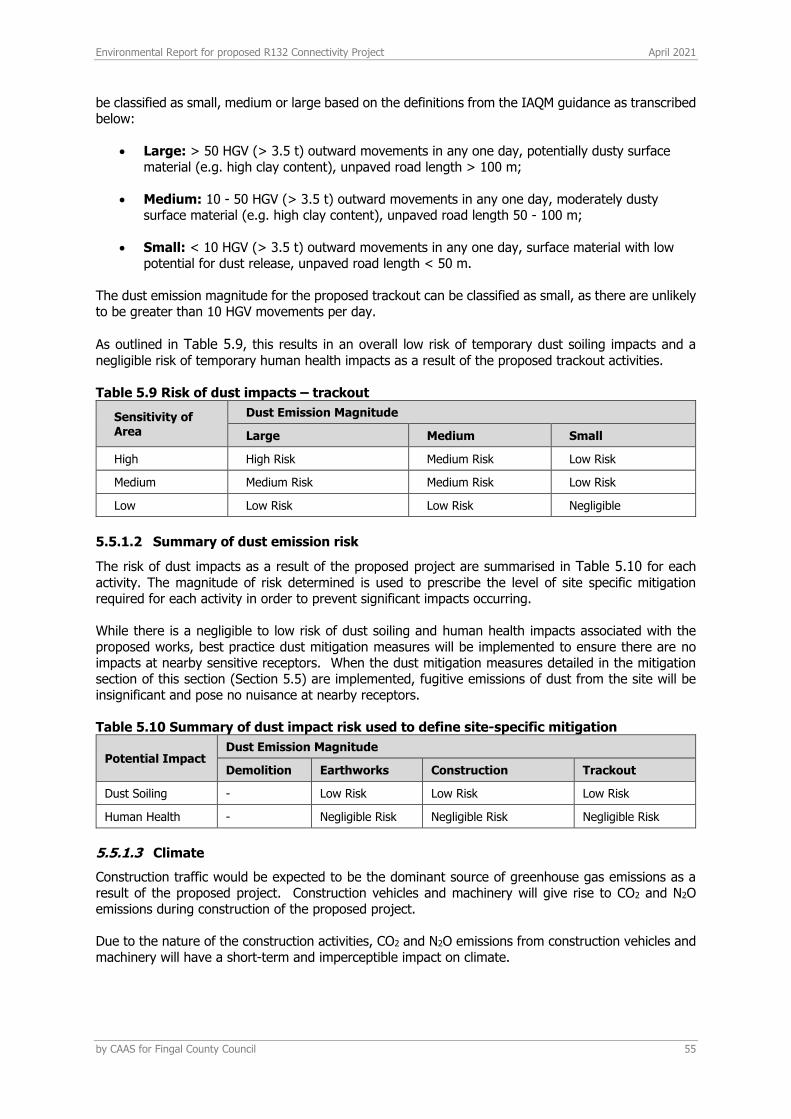
Environmental Report for proposed R132 Connectivity Project April 2021
by CAAS for Fingal County Council 55
be classified as small, medium or large based on the definitions from the IAQM guidance as transcribed below:
• Large: > 50 HGV (> 3.5 t) outward movements in any one day, potentially dusty surface material (e.g. high clay content), unpaved road length > 100 m;
• Medium: 10 - 50 HGV (> 3.5 t) outward movements in any one day, moderately dusty
surface material (e.g. high clay content), unpaved road length 50 - 100 m;
• Small: < 10 HGV (> 3.5 t) outward movements in any one day, surface material with low potential for dust release, unpaved road length < 50 m.
The dust emission magnitude for the proposed trackout can be classified as small, as there are unlikely to be greater than 10 HGV movements per day.
As outlined in Table 5.9, this results in an overall low risk of temporary dust soiling impacts and a
negligible risk of temporary human health impacts as a result of the proposed trackout activities.
Table 5.9 Risk of dust impacts – trackout
Sensitivity of Area
Dust Emission Magnitude
Large Medium Small
High High Risk Medium Risk Low Risk
Medium Medium Risk Medium Risk Low Risk
Low Low Risk Low Risk Negligible
5.5.1.2 Summary of dust emission risk
The risk of dust impacts as a result of the proposed project are summarised in Table 5.10 for each
activity. The magnitude of risk determined is used to prescribe the level of site specific mitigation required for each activity in order to prevent significant impacts occurring. While there is a negligible to low risk of dust soiling and human health impacts associated with the proposed works, best practice dust mitigation measures will be implemented to ensure there are no impacts at nearby sensitive receptors. When the dust mitigation measures detailed in the mitigation section of this section (Section 5.5) are implemented, fugitive emissions of dust from the site will be insignificant and pose no nuisance at nearby receptors.
Table 5.10 Summary of dust impact risk used to define site-specific mitigation
Potential Impact Dust Emission Magnitude
Demolition Earthworks Construction Trackout
Dust Soiling - Low Risk Low Risk Low Risk
Human Health - Negligible Risk Negligible Risk Negligible Risk
5.5.1.3 Climate
Construction traffic would be expected to be the dominant source of greenhouse gas emissions as a result of the proposed project. Construction vehicles and machinery will give rise to CO2 and N2O emissions during construction of the proposed project.
Due to the nature of the construction activities, CO2 and N2O emissions from construction vehicles and machinery will have a short-term and imperceptible impact on climate.
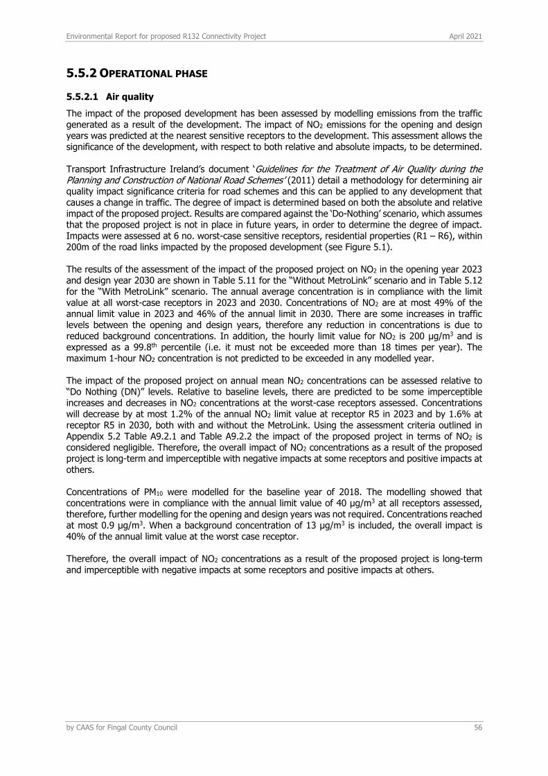
Environmental Report for proposed R132 Connectivity Project April 2021
by CAAS for Fingal County Council 56
5.5.2 OPERATIONAL PHASE
5.5.2.1 Air quality
The impact of the proposed development has been assessed by modelling emissions from the traffic generated as a result of the development. The impact of NO2 emissions for the opening and design years was predicted at the nearest sensitive receptors to the development. This assessment allows the significance of the development, with respect to both relative and absolute impacts, to be determined. Transport Infrastructure Ireland’s document ‘Guidelines for the Treatment of Air Quality during the Planning and Construction of National Road Schemes’ (2011) detail a methodology for determining air quality impact significance criteria for road schemes and this can be applied to any development that causes a change in traffic. The degree of impact is determined based on both the absolute and relative impact of the proposed project. Results are compared against the ‘Do-Nothing’ scenario, which assumes that the proposed project is not in place in future years, in order to determine the degree of impact. Impacts were assessed at 6 no. worst-case sensitive receptors, residential properties (R1 – R6), within 200m of the road links impacted by the proposed development (see Figure 5.1). The results of the assessment of the impact of the proposed project on NO2 in the opening year 2023 and design year 2030 are shown in Table 5.11 for the “Without MetroLink” scenario and in Table 5.12 for the “With MetroLink” scenario. The annual average concentration is in compliance with the limit value at all worst-case receptors in 2023 and 2030. Concentrations of NO2 are at most 49% of the annual limit value in 2023 and 46% of the annual limit in 2030. There are some increases in traffic levels between the opening and design years, therefore any reduction in concentrations is due to reduced background concentrations. In addition, the hourly limit value for NO2 is 200 μg/m3 and is expressed as a 99.8th percentile (i.e. it must not be exceeded more than 18 times per year). The maximum 1-hour NO2 concentration is not predicted to be exceeded in any modelled year. The impact of the proposed project on annual mean NO2 concentrations can be assessed relative to “Do Nothing (DN)” levels. Relative to baseline levels, there are predicted to be some imperceptible increases and decreases in NO2 concentrations at the worst-case receptors assessed. Concentrations will decrease by at most 1.2% of the annual NO2 limit value at receptor R5 in 2023 and by 1.6% at receptor R5 in 2030, both with and without the MetroLink. Using the assessment criteria outlined in Appendix 5.2 Table A9.2.1 and Table A9.2.2 the impact of the proposed project in terms of NO2 is considered negligible. Therefore, the overall impact of NO2 concentrations as a result of the proposed project is long-term and imperceptible with negative impacts at some receptors and positive impacts at others. Concentrations of PM10 were modelled for the baseline year of 2018. The modelling showed that concentrations were in compliance with the annual limit value of 40 μg/m3 at all receptors assessed, therefore, further modelling for the opening and design years was not required. Concentrations reached at most 0.9 μg/m3. When a background concentration of 13 μg/m3 is included, the overall impact is 40% of the annual limit value at the worst case receptor. Therefore, the overall impact of NO2 concentrations as a result of the proposed project is long-term and imperceptible with negative impacts at some receptors and positive impacts at others.
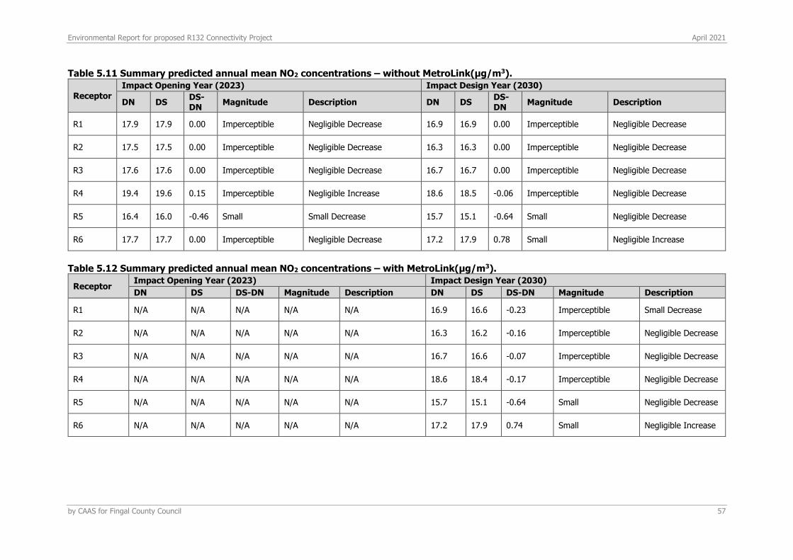
Environmental Report for proposed R132 Connectivity Project April 2021
by CAAS for Fingal County Council 57
Table 5.11 Summary predicted annual mean NO2 concentrations – without MetroLink(μg/m3).
Receptor
Impact Opening Year (2023) Impact Design Year (2030)
DN DS DS-DN
Magnitude Description DN DS DS-DN
Magnitude Description
R1 17.9 17.9 0.00 Imperceptible Negligible Decrease 16.9 16.9 0.00 Imperceptible Negligible Decrease
R2 17.5 17.5 0.00 Imperceptible Negligible Decrease 16.3 16.3 0.00 Imperceptible Negligible Decrease
R3 17.6 17.6 0.00 Imperceptible Negligible Decrease 16.7 16.7 0.00 Imperceptible Negligible Decrease
R4 19.4 19.6 0.15 Imperceptible Negligible Increase 18.6 18.5 -0.06 Imperceptible Negligible Decrease
R5 16.4 16.0 -0.46 Small Small Decrease 15.7 15.1 -0.64 Small Negligible Decrease
R6 17.7 17.7 0.00 Imperceptible Negligible Decrease 17.2 17.9 0.78 Small Negligible Increase
Table 5.12 Summary predicted annual mean NO2 concentrations – with MetroLink(μg/m3).
Receptor Impact Opening Year (2023) Impact Design Year (2030)
DN DS DS-DN Magnitude Description DN DS DS-DN Magnitude Description
R1 N/A N/A N/A N/A N/A 16.9 16.6 -0.23 Imperceptible Small Decrease
R2 N/A N/A N/A N/A N/A 16.3 16.2 -0.16 Imperceptible Negligible Decrease
R3 N/A N/A N/A N/A N/A 16.7 16.6 -0.07 Imperceptible Negligible Decrease
R4 N/A N/A N/A N/A N/A 18.6 18.4 -0.17 Imperceptible Negligible Decrease
R5 N/A N/A N/A N/A N/A 15.7 15.1 -0.64 Small Negligible Decrease
R6 N/A N/A N/A N/A N/A 17.2 17.9 0.74 Small Negligible Increase
Environmental Report for proposed R132 Connectivity Project April 2021
by CAAS for Fingal County Council 58
5.5.2.2 Climate
There is also the potential for increased traffic volumes to impact climate. The impact of the proposed project on emissions of CO2 impacting climate was assessed using the Design Manual for Roads and Bridges screening model (see Table 5.13). The results show that the impact of the proposed project in the opening year 2023 will be to increase CO2 emissions by 0.00006% of Ireland's EU 2030 Target. The impact in the design year of 2030 is to decrease CO2 emissions by 0.00018% of the EU 2030 Target. With the Metrolink in place in 2030 the impact is also beneficial with CO2 emissions decreasing by 0.00117% of the EU 2030 target. Thus, the impact of the proposed project on national greenhouse gas emissions will be positive and insignificant in terms of Ireland’s obligations under the EU 2030 Target. Therefore, the likely overall magnitude of the changes on climate in the operational stage of the proposed project is imperceptible, positive and long-term. Table 5.13 Climate impact assessment.
Year Scenario CO2
(tonnes/annum)
Without MetroLink
2023 Do Nothing 6328
Do Something 6350
2030 Do Nothing 5799
Do Something 5740
Increment in 2023 21.2 Tonnes
Increment in 2030 -59.5 Tonnes
Emission Ceiling (kilo Tonnes) 2023 32,860Note 1
Emission Ceiling (kilo Tonnes) 2030 32,860Note 1
Impact in 2023 (%) 0.00006 %
Impact in 2030 (%) -0.00018 %
Year Scenario CO2
(tonnes/annum)
With MetroLink
2030 Do Nothing 5799
Do Something 5415
Increment in 2030 -384.4 Tonnes
Emission Ceiling (kilo Tonnes) 2030 32,860Note 1
Impact in 2030 (%) -0.00117 %
Note 1 Target under Regulation (EU) 2018/842 of the European Parliament and of the Council of 30 May 2018 on binding annual greenhouse gas emission reductions by Member States from 2021 to 2030 contributing to climate action to meet commitments under the Paris Agreement and amending Regulation (EU) No 525/2013
5.5.2.3 Air quality impact on Designated Sites
The impact of NOX (i.e. NO and NO2) emissions resulting from the traffic associated with the proposed project at the Malahide Estuary pNHA (Site Code: 000205), Malahide Estuary Special Protection Area (SPA) (Site Code: 004025) and Malahide Estuary Special Area of Conservation (SAC) (Site Code: 004025) was assessed. Ambient NOX concentrations were predicted for the assessment year of 2030 along a transect of up to 200m and are given in Table 5.12 for the SAC, SPA and pNHA. The SAC, SPA and pNHA are located approximately 2m from the impacted road link (Spittal Hill, link M) and the 200m transect was begun at this distance (see Table 5.12). The road contribution to dry deposition along the transect is also given and was calculated using the methodology of TII (2011). The ecology assessment has been considered for the assessment year 2030 as no change in AADT is predicted during the opening year of 2023. In addition, the assessment was not conducted for the MetroLink scenario as the impact on the sensitive ecology was more significant in the no Metrolink scenario, therefore this can be considered worst-case.
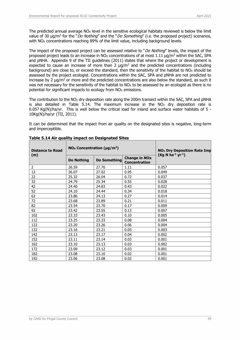
Environmental Report for proposed R132 Connectivity Project April 2021
by CAAS for Fingal County Council 59
The predicted annual average NOX level in the sensitive ecological habitats reviewed is below the limit value of 30 μg/m3 for the “Do Nothing” and the “Do Something” (i.e. the proposed project) scenarios, with NOX concentrations reaching 89% of the limit value, including background levels. The impact of the proposed project can be assessed relative to “Do Nothing” levels, the impact of the proposed project leads to an increase in NOX concentrations of at most 1.11 μg/m3 within the SAC, SPA and pNHA. Appendix 9 of the TII guidelines (2011) states that where the project or development is expected to cause an increase of more than 2 µg/m3 and the predicted concentrations (including background) are close to, or exceed the standard, then the sensitivity of the habitat to NOX should be assessed by the project ecologist. Concentrations within the SAC, SPA and pNHA are not predicted to increase by 2 µg/m3 or more and the predicted concentrations are also below the standard, as such it was not necessary for the sensitivity of the habitat to NOX to be assessed by an ecologist as there is no potential for significant impacts to ecology from NOX emissions. The contribution to the NO2 dry deposition rate along the 200m transect within the SAC, SPA and pNHA is also detailed in Table 5.14. The maximum increase in the NO2 dry deposition rate is 0.057 Kg(N)/ha/yr. This is well below the critical load for inland and surface water habitats of 5 - 10Kg(N)/ha/yr (TII, 2011). It can be determined that the impact from air quality on the designated sites is negative, long-term and imperceptible.
Table 5.14 Air quality impact on Designated Sites
Distance to Road (m)
NOX Concentration (µg/m3) NO2 Dry Deposition Rate Impact (Kg N ha-1 yr-1)
Do Nothing Do Something Change in NOx Concentration
2 26.59 27.70 1.11 0.057
12 26.07 27.02 0.95 0.049
22 25.32 26.04 0.72 0.037
32 24.79 25.34 0.55 0.028
42 24.40 24.83 0.43 0.022
52 24.10 24.44 0.34 0.018
62 23.86 24.13 0.27 0.014
72 23.68 23.89 0.21 0.011
82 23.54 23.70 0.17 0.009
92 23.42 23.55 0.13 0.007
102 23.33 23.43 0.10 0.005
112 23.25 23.33 0.08 0.004
122 23.20 23.26 0.06 0.004
132 23.16 23.21 0.05 0.003
142 23.13 23.17 0.04 0.002
152 23.11 23.14 0.03 0.001
162 23.10 23.13 0.03 0.002
172 23.09 23.12 0.03 0.001
182 23.08 23.10 0.02 0.001
192 23.06 23.08 0.02 0.001
Environmental Report for proposed R132 Connectivity Project April 2021
by CAAS for Fingal County Council 60
5.6 RESIDUAL IMPACTS
5.6.1 CONSTRUCTION PHASE
5.6.1.1 Air quality
In order to minimise dust emissions during construction, a series of mitigation measures have been prepared in the form of a dust minimisation plan which will be incorporated into the Outline CEMP for the site. Provided the dust minimisation measures outlined in the plan (see Appendix 5.3 and Section 9.5.1) are adhered to, the air quality impacts during the construction phase will be short-term, negative, localised and imperceptible.
5.6.1.2 Climate
Embodied carbon emissions associated with the construction materials and activities are predicted to be the primary impact to climate during the construction phase. Embodied CO2 emissions are predicted to have a short-term, negative and imperceptible impact to climate.
5.6.2 OPERATIONAL PHASE
5.6.2.1 Air quality
Traffic related air emissions of NO2 and PM10 associated with the proposed project have been calculated using the UK DMRB tool. The assessment (Section 9.4.2.2) determined that traffic emissions will have an imperceptible impact on air quality as a result. Traffic associated with all phases of the project has been included within the calculations. In addition, where such information was available, cumulative traffic data associated with other existing and permitted developments in the vicinity of the project were also included in the calculations. It can therefore be determined that the impact to air quality from traffic emissions during the operational stage is overall positive (although negative at some receptors), local, long-term and imperceptible.
5.6.2.2 Climate
Climate change has the potential to alter weather patterns and increase the frequency of rainfall in future years. As a result of this there is the potential for flooding related impacts on site in future years. A detailed flood risk assessment has been undertaken as part of this planning application by DBFL Consulting Engineers and adequate attenuation and drainage have been provided for to account for increased rainfall in future years. There is also the potential for increased traffic volumes to impact climate. The change in traffic associated with the proposed project has been assessed using the UK DMRB tool. It was found that traffic related CO2 emissions during the operational phase are long-term, positive and imperceptible.
Environmental Report for proposed R132 Connectivity Project April 2021
by CAAS for Fingal County Council 61
6 NOISE & VIBRATION
6.1 INTRODUCTION
This section assesses the likely noise and vibration impacts associated with the proposed R132 Connectivity Project in Swords, Co. Dublin. A full description of the project can be found in Section 2 Proposed Development.
6.1.1 CRITERIA FOR RATING OF IMPACTS
The significance of impacts has been assessed in accordance with the EPA Draft Guidelines on the information to be contained in Environmental Impact Assessment Reports (EPA 2017). The relevant definitions relating to quality, significance and the duration of impacts are defined as per the EPA Guidelines.
The key terms discussed in the following sections are summarised as follows:
LAeq,T is the A-weighted equivalent continuous steady sound level during the sample period and effectively represents an average value of the defined measurement period, T. LAeq,16hr refers to the ambient daytime period between 07:00 and 23:00hrs.
LASmax is the maximum root mean squared (RMS)A-weighted sound pressure level occurring within a specified time period. Measuring using the ‘Slow’ time weighting;
LA10,T is the A-weighted sound level that is exceeded for 10% of the sample period; this parameter
gives an indication of the upper limit of fluctuating noise such as that from road traffic. The T is the sample period the parameter is measured over.
LA10,18hr is the LA10 parameter between 06:00 and 00:00hrs as defined within the CRTN23.
LA90,T is the A-weighted sound level that is exceeded for 90% of the sample period; generally used
to quantify background noise. The T is the sample period the parameter is measured over.
LA90,16hr, refers to the background daytime noise level between 07:00 and 23:00hrs
LA90,8hr, refers to the background night-time noise level between 23:00 and 07:00hrs
The Lden parameter is also discussed within the report. For long-term survey locations, this parameter is derived from the LAeq data over each 24 hour period as is defined as follows:
Lden is the 24hour noise rating level determined by the averaging of the Lday with the Levening (plus a 5dB penalty) and the Lnight (plus a 10dB penalty). Lden is calculated using the following formula, as defined within the Environmental Noise Regulations24:
𝐿den = 10𝑙𝑜𝑔 (1
24) (12 ∗ (10
𝐿𝑑𝑎𝑦
10 ) + 4 ∗ (10𝐿𝑒𝑣𝑒𝑛𝑖𝑛𝑔+5
10 ) + 8 ∗ (10𝐿𝑛𝑖𝑔ℎ𝑡+10
10 ))
23 UK’s Department of Transport. 1988. Calculation of Road Traffic Noise (CRTN)
24 S.I. No. 140/2006 - Environmental Noise Regulations 2006
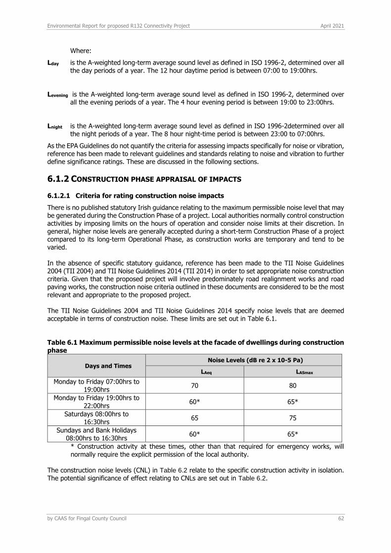
Environmental Report for proposed R132 Connectivity Project April 2021
by CAAS for Fingal County Council 62
Where:
Lday is the A-weighted long-term average sound level as defined in ISO 1996-2, determined over all the day periods of a year. The 12 hour daytime period is between 07:00 to 19:00hrs.
Levening is the A-weighted long-term average sound level as defined in ISO 1996-2, determined over all the evening periods of a year. The 4 hour evening period is between 19:00 to 23:00hrs.
Lnight is the A-weighted long-term average sound level as defined in ISO 1996-2determined over all the night periods of a year. The 8 hour night-time period is between 23:00 to 07:00hrs.
As the EPA Guidelines do not quantify the criteria for assessing impacts specifically for noise or vibration, reference has been made to relevant guidelines and standards relating to noise and vibration to further define significance ratings. These are discussed in the following sections.
6.1.2 CONSTRUCTION PHASE APPRAISAL OF IMPACTS
6.1.2.1 Criteria for rating construction noise impacts
There is no published statutory Irish guidance relating to the maximum permissible noise level that may be generated during the Construction Phase of a project. Local authorities normally control construction activities by imposing limits on the hours of operation and consider noise limits at their discretion. In general, higher noise levels are generally accepted during a short-term Construction Phase of a project compared to its long-term Operational Phase, as construction works are temporary and tend to be varied. In the absence of specific statutory guidance, reference has been made to the TII Noise Guidelines 2004 (TII 2004) and TII Noise Guidelines 2014 (TII 2014) in order to set appropriate noise construction criteria. Given that the proposed project will involve predominately road realignment works and road paving works, the construction noise criteria outlined in these documents are considered to be the most relevant and appropriate to the proposed project. The TII Noise Guidelines 2004 and TII Noise Guidelines 2014 specify noise levels that are deemed acceptable in terms of construction noise. These limits are set out in Table 6.1.
Table 6.1 Maximum permissible noise levels at the facade of dwellings during construction phase
Days and Times Noise Levels (dB re 2 x 10⁻⁵ Pa)
LAeq LASmax
Monday to Friday 07:00hrs to 19:00hrs
70 80
Monday to Friday 19:00hrs to 22:00hrs
60* 65*
Saturdays 08:00hrs to 16:30hrs
65 75
Sundays and Bank Holidays 08:00hrs to 16:30hrs
60* 65*
* Construction activity at these times, other than that required for emergency works, will normally require the explicit permission of the local authority.
The construction noise levels (CNL) in Table 6.2 relate to the specific construction activity in isolation. The potential significance of effect relating to CNLs are set out in Table 6.2.
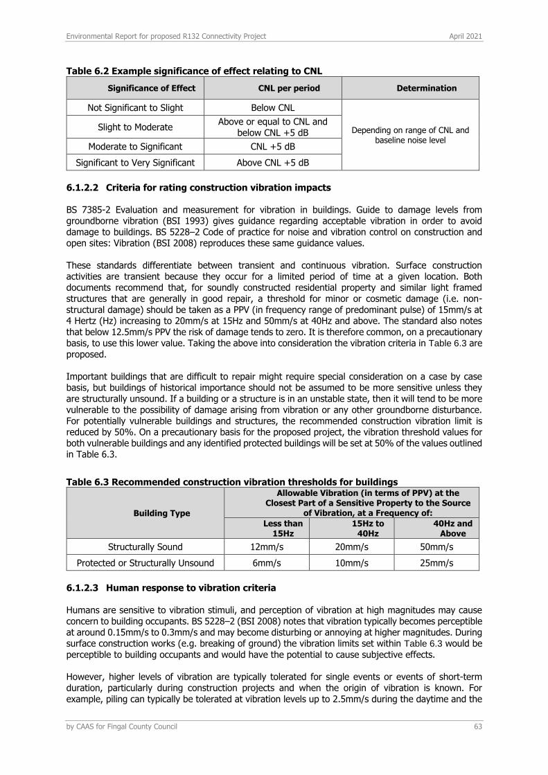
Environmental Report for proposed R132 Connectivity Project April 2021
by CAAS for Fingal County Council 63
Table 6.2 Example significance of effect relating to CNL
Significance of Effect CNL per period Determination
Not Significant to Slight Below CNL
Depending on range of CNL and baseline noise level
Slight to Moderate Above or equal to CNL and
below CNL +5 dB
Moderate to Significant CNL +5 dB
Significant to Very Significant Above CNL +5 dB
6.1.2.2 Criteria for rating construction vibration impacts
BS 7385-2 Evaluation and measurement for vibration in buildings. Guide to damage levels from groundborne vibration (BSI 1993) gives guidance regarding acceptable vibration in order to avoid damage to buildings. BS 5228–2 Code of practice for noise and vibration control on construction and open sites: Vibration (BSI 2008) reproduces these same guidance values.
These standards differentiate between transient and continuous vibration. Surface construction activities are transient because they occur for a limited period of time at a given location. Both documents recommend that, for soundly constructed residential property and similar light framed structures that are generally in good repair, a threshold for minor or cosmetic damage (i.e. non-structural damage) should be taken as a PPV (in frequency range of predominant pulse) of 15mm/s at 4 Hertz (Hz) increasing to 20mm/s at 15Hz and 50mm/s at 40Hz and above. The standard also notes that below 12.5mm/s PPV the risk of damage tends to zero. It is therefore common, on a precautionary basis, to use this lower value. Taking the above into consideration the vibration criteria in Table 6.3 are proposed.
Important buildings that are difficult to repair might require special consideration on a case by case basis, but buildings of historical importance should not be assumed to be more sensitive unless they are structurally unsound. If a building or a structure is in an unstable state, then it will tend to be more vulnerable to the possibility of damage arising from vibration or any other groundborne disturbance. For potentially vulnerable buildings and structures, the recommended construction vibration limit is reduced by 50%. On a precautionary basis for the proposed project, the vibration threshold values for both vulnerable buildings and any identified protected buildings will be set at 50% of the values outlined in Table 6.3.
Table 6.3 Recommended construction vibration thresholds for buildings
Building Type
Allowable Vibration (in terms of PPV) at the Closest Part of a Sensitive Property to the Source
of Vibration, at a Frequency of:
Less than 15Hz
15Hz to 40Hz
40Hz and Above
Structurally Sound 12mm/s 20mm/s 50mm/s
Protected or Structurally Unsound 6mm/s 10mm/s 25mm/s
6.1.2.3 Human response to vibration criteria
Humans are sensitive to vibration stimuli, and perception of vibration at high magnitudes may cause concern to building occupants. BS 5228–2 (BSI 2008) notes that vibration typically becomes perceptible at around 0.15mm/s to 0.3mm/s and may become disturbing or annoying at higher magnitudes. During surface construction works (e.g. breaking of ground) the vibration limits set within Table 6.3 would be perceptible to building occupants and would have the potential to cause subjective effects.
However, higher levels of vibration are typically tolerated for single events or events of short-term duration, particularly during construction projects and when the origin of vibration is known. For example, piling can typically be tolerated at vibration levels up to 2.5mm/s during the daytime and the
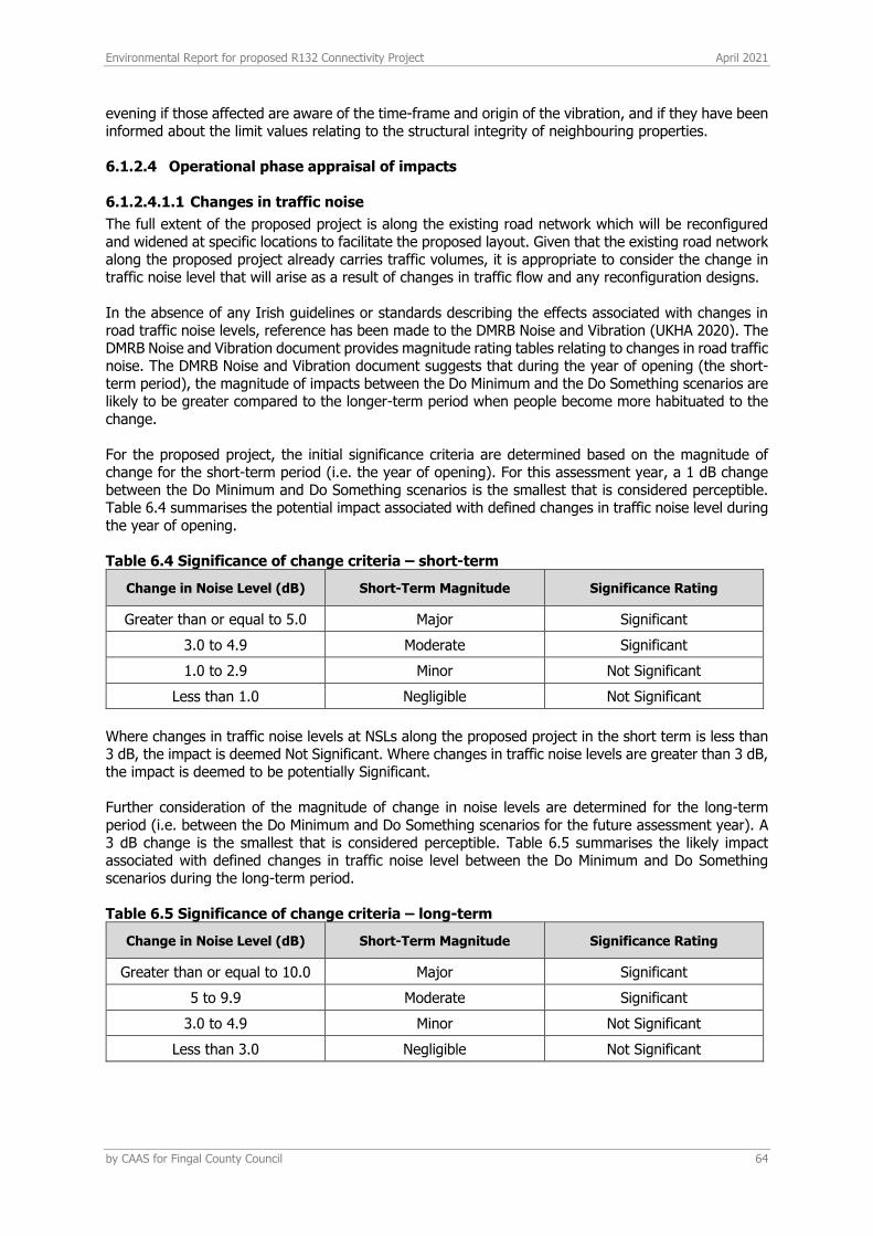
Environmental Report for proposed R132 Connectivity Project April 2021
by CAAS for Fingal County Council 64
evening if those affected are aware of the time-frame and origin of the vibration, and if they have been informed about the limit values relating to the structural integrity of neighbouring properties.
6.1.2.4 Operational phase appraisal of impacts
6.1.2.4.1.1 Changes in traffic noise
The full extent of the proposed project is along the existing road network which will be reconfigured and widened at specific locations to facilitate the proposed layout. Given that the existing road network along the proposed project already carries traffic volumes, it is appropriate to consider the change in traffic noise level that will arise as a result of changes in traffic flow and any reconfiguration designs. In the absence of any Irish guidelines or standards describing the effects associated with changes in road traffic noise levels, reference has been made to the DMRB Noise and Vibration (UKHA 2020). The DMRB Noise and Vibration document provides magnitude rating tables relating to changes in road traffic noise. The DMRB Noise and Vibration document suggests that during the year of opening (the short-term period), the magnitude of impacts between the Do Minimum and the Do Something scenarios are likely to be greater compared to the longer-term period when people become more habituated to the change. For the proposed project, the initial significance criteria are determined based on the magnitude of change for the short-term period (i.e. the year of opening). For this assessment year, a 1 dB change between the Do Minimum and Do Something scenarios is the smallest that is considered perceptible. Table 6.4 summarises the potential impact associated with defined changes in traffic noise level during the year of opening.
Table 6.4 Significance of change criteria – short-term
Change in Noise Level (dB) Short-Term Magnitude Significance Rating
Greater than or equal to 5.0 Major Significant
3.0 to 4.9 Moderate Significant
1.0 to 2.9 Minor Not Significant
Less than 1.0 Negligible Not Significant
Where changes in traffic noise levels at NSLs along the proposed project in the short term is less than 3 dB, the impact is deemed Not Significant. Where changes in traffic noise levels are greater than 3 dB, the impact is deemed to be potentially Significant. Further consideration of the magnitude of change in noise levels are determined for the long-term period (i.e. between the Do Minimum and Do Something scenarios for the future assessment year). A 3 dB change is the smallest that is considered perceptible. Table 6.5 summarises the likely impact associated with defined changes in traffic noise level between the Do Minimum and Do Something scenarios during the long-term period.
Table 6.5 Significance of change criteria – long-term
Change in Noise Level (dB) Short-Term Magnitude Significance Rating
Greater than or equal to 10.0 Major Significant
5 to 9.9 Moderate Significant
3.0 to 4.9 Minor Not Significant
Less than 3.0 Negligible Not Significant
Environmental Report for proposed R132 Connectivity Project April 2021
by CAAS for Fingal County Council 65
For the proposed project, the overall impacts and significance account for both the short-term and long-term impacts in addition to local circumstances and context described in Table 3.60 of the DMRB Noise and Vibration (UKHA 2020).
6.1.2.4.1.2 Operational vibration
Road traffic on well-maintained roads does not generate any significant perceptible vibration levels. Along heavily trafficked roads, vibration levels at the road edge are typically below the range of vibration levels associated with human perception. There is no aspect of the proposed project that is expected to give rise to any changes in the baseline scenario, hence this has not been assessed further.
6.2 RECEIVING ENVIRONMENT
Baseline noise surveys have been conducted at locations representative of the nearest noise sensitive areas which have the potential to be impacted by construction works and/or those likely to be impacted during the Operational Phase of the proposed project. The survey was conducted in general accordance with ISO 1996: 2017: Acoustics – Description, measurement and assessment of environmental noise. Specific details are set out below.
6.2.1 CHOICE OF MEASUREMENT LOCATIONS
Three measurement locations were selected as shown in Figure 6.1 and as described below: A: Unattended noise measurements located at the rear garden of residential building in Seatown
Park, Swords. B: Unattended noise measurements located at the rear garden of Kids Inc. Creche, Seatown Walk,
Swords. C: Unattended noise measurements located at the rear garden of residential building in Foxwood,
Swords.
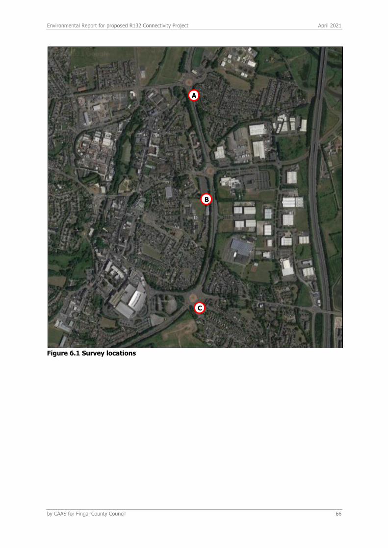
Environmental Report for proposed R132 Connectivity Project April 2021
by CAAS for Fingal County Council 66
Figure 6.1 Survey locations
A
B
C
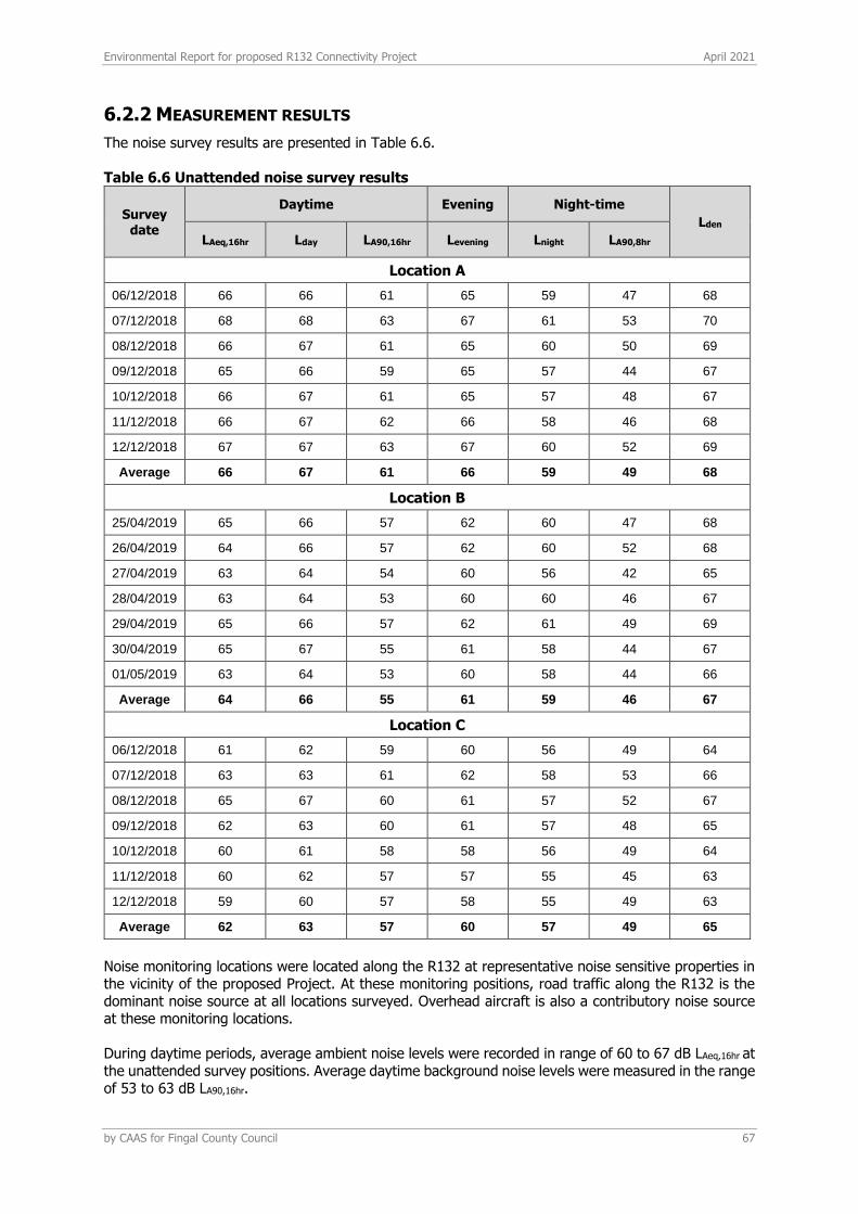
Environmental Report for proposed R132 Connectivity Project April 2021
by CAAS for Fingal County Council 67
6.2.2 MEASUREMENT RESULTS
The noise survey results are presented in Table 6.6. Table 6.6 Unattended noise survey results
Survey date
Daytime Evening Night-time
Lden
LAeq,16hr Lday LA90,16hr Levening Lnight LA90,8hr
Location A
06/12/2018 66 66 61 65 59 47 68
07/12/2018 68 68 63 67 61 53 70
08/12/2018 66 67 61 65 60 50 69
09/12/2018 65 66 59 65 57 44 67
10/12/2018 66 67 61 65 57 48 67
11/12/2018 66 67 62 66 58 46 68
12/12/2018 67 67 63 67 60 52 69
Average 66 67 61 66 59 49 68
Location B
25/04/2019 65 66 57 62 60 47 68
26/04/2019 64 66 57 62 60 52 68
27/04/2019 63 64 54 60 56 42 65
28/04/2019 63 64 53 60 60 46 67
29/04/2019 65 66 57 62 61 49 69
30/04/2019 65 67 55 61 58 44 67
01/05/2019 63 64 53 60 58 44 66
Average 64 66 55 61 59 46 67
Location C
06/12/2018 61 62 59 60 56 49 64
07/12/2018 63 63 61 62 58 53 66
08/12/2018 65 67 60 61 57 52 67
09/12/2018 62 63 60 61 57 48 65
10/12/2018 60 61 58 58 56 49 64
11/12/2018 60 62 57 57 55 45 63
12/12/2018 59 60 57 58 55 49 63
Average 62 63 57 60 57 49 65
Noise monitoring locations were located along the R132 at representative noise sensitive properties in the vicinity of the proposed Project. At these monitoring positions, road traffic along the R132 is the dominant noise source at all locations surveyed. Overhead aircraft is also a contributory noise source at these monitoring locations. During daytime periods, average ambient noise levels were recorded in range of 60 to 67 dB LAeq,16hr at the unattended survey positions. Average daytime background noise levels were measured in the range of 53 to 63 dB LA90,16hr.
Environmental Report for proposed R132 Connectivity Project April 2021
by CAAS for Fingal County Council 68
Night-time noise levels at the monitoring locations are dominated by road traffic noise. Average ambient night-time noise levels were measured in the range of 55 to 61 dB LAeq,8hr. Average background noise levels during this time period were measured in the range of 42 to 53 dB LA90,8hr.
6.3 PREDICTED IMPACTS
6.3.1 CONSTRUCTION PHASE
6.3.1.1 Noise
During the short-term construction phase of the proposed project, construction works will involve predominately general road works including road and junction reconfiguration and resurfacing works, and where required and road widening works. A variety of items of plant will be in use during these construction works all of which have the potential to generate high levels of noise and potential levels of perceptible vibration. These will include breakers, excavators, dump trucks, generators and other plant items. In general, road construction works by their nature are transient as the works progress along the length of the route of the proposed project. The TII Noise Guidelines 2004 (TII 2004) and TII Noise Guidelines 2014 (TII 2014) specifically note that there is limited information available on specific construction methods, numbers and types of plant before the appointment of a Contractor, which will normally happen after a project has been approved. The guidelines note that it is more appropriate to address the way in which potential construction impacts will be assessed and how they will be managed, including forms of mitigation and codes of practices that will be applied. The TII Noise Guidelines 2004 (TII 2004) and TII Noise Guidelines 2014 (TII 2014) note that in the absence of an Irish or international standard relevant to construction noise, reference can be made to BS 5228 – 1 (BSI 2009 +A1 2014) and BS 5228 – 2 (BSI 2009 +A1 2014). These standards include recommended methodologies for calculating CNL and includes a range of best practice mitigation and management measures for the control of noise and vibration from construction sites. In terms of calculation, BS 5228 – 1 Code of practice for noise and vibration control on construction and open sites: Noise (BSI 2009 +A1 2014) sets out sound power levels for a wide range of plant items normally encountered on construction sites, which in turn enables the prediction of indicative noise levels at distances from the works. This standard sets out sound power levels for plant items normally encountered on construction sites, which in turn enables the prediction of noise levels. However, it is not possible to conduct detailed accurate prediction calculations for the construction phase of a project due to the absence of detailed plant items, numbers and scheduling at this stage of the project. The following sections discusses typical noise levels associated with road construction activities and comments on potential noise impacts across the proposed project. Due to the nature of the activities undertaken on a construction site, there is potential for generation of high levels of noise. The impact at nearby NSLs will depend upon a number of variables, the most notable of which are: • the amount of noise generated by plant and equipment being used at any one time generally
expressed as a sound power level;
• the periods of operation of the plant at the development site, known as the “on-time”;
• the distance between the noise source and the NSLs;
• the attenuation due to ground absorption or barrier screening effects; and
• reflections of noise due to the presence of hard vertical faces such as walls.
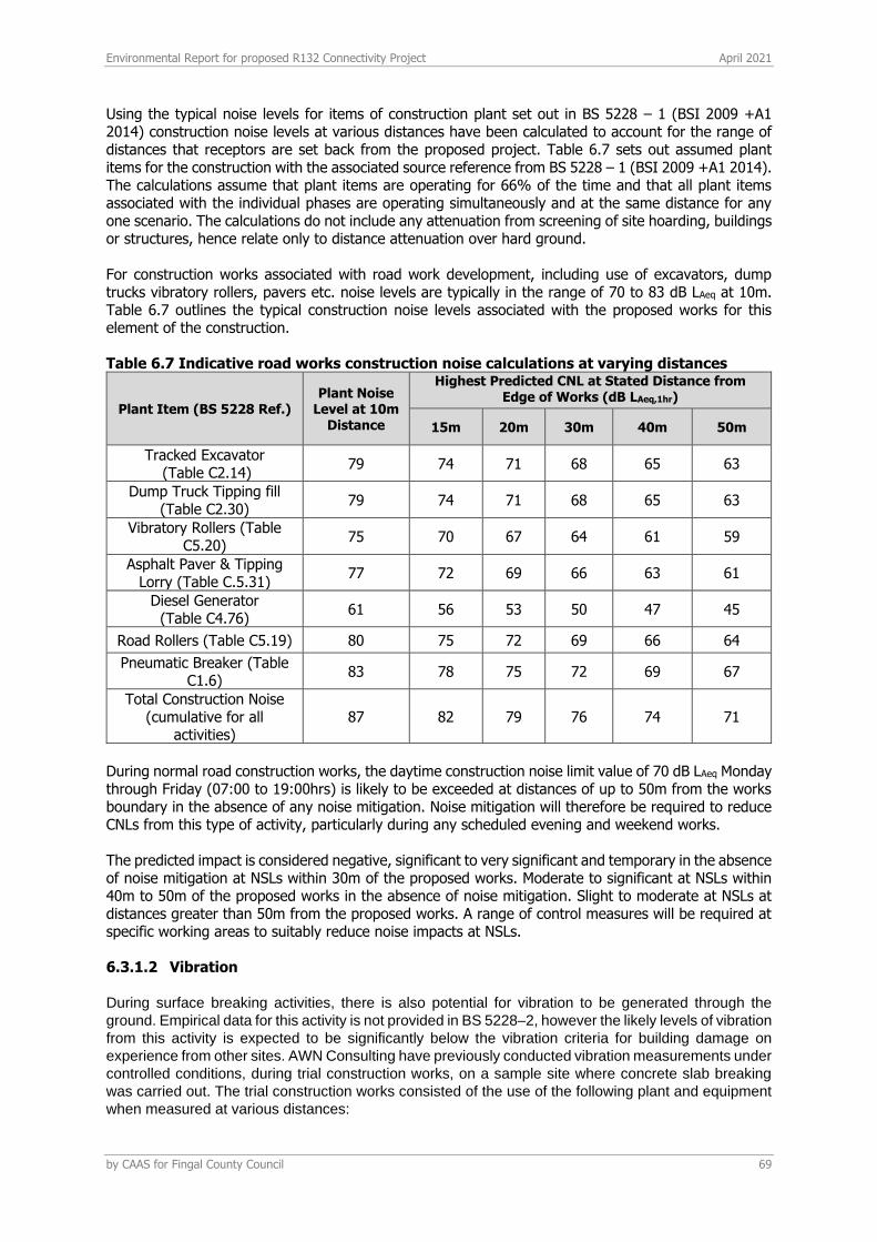
Environmental Report for proposed R132 Connectivity Project April 2021
by CAAS for Fingal County Council 69
Using the typical noise levels for items of construction plant set out in BS 5228 – 1 (BSI 2009 +A1 2014) construction noise levels at various distances have been calculated to account for the range of distances that receptors are set back from the proposed project. Table 6.7 sets out assumed plant items for the construction with the associated source reference from BS 5228 – 1 (BSI 2009 +A1 2014). The calculations assume that plant items are operating for 66% of the time and that all plant items associated with the individual phases are operating simultaneously and at the same distance for any one scenario. The calculations do not include any attenuation from screening of site hoarding, buildings or structures, hence relate only to distance attenuation over hard ground. For construction works associated with road work development, including use of excavators, dump trucks vibratory rollers, pavers etc. noise levels are typically in the range of 70 to 83 dB LAeq at 10m. Table 6.7 outlines the typical construction noise levels associated with the proposed works for this element of the construction. Table 6.7 Indicative road works construction noise calculations at varying distances
Plant Item (BS 5228 Ref.) Plant Noise
Level at 10m Distance
Highest Predicted CNL at Stated Distance from Edge of Works (dB LAeq,1hr)
15m 20m 30m 40m 50m
Tracked Excavator (Table C2.14)
79 74 71 68 65 63
Dump Truck Tipping fill (Table C2.30)
79 74 71 68 65 63
Vibratory Rollers (Table C5.20)
75 70 67 64 61 59
Asphalt Paver & Tipping Lorry (Table C.5.31)
77 72 69 66 63 61
Diesel Generator (Table C4.76)
61 56 53 50 47 45
Road Rollers (Table C5.19) 80 75 72 69 66 64
Pneumatic Breaker (Table C1.6)
83 78 75 72 69 67
Total Construction Noise (cumulative for all
activities) 87 82 79 76 74 71
During normal road construction works, the daytime construction noise limit value of 70 dB LAeq Monday through Friday (07:00 to 19:00hrs) is likely to be exceeded at distances of up to 50m from the works boundary in the absence of any noise mitigation. Noise mitigation will therefore be required to reduce CNLs from this type of activity, particularly during any scheduled evening and weekend works. The predicted impact is considered negative, significant to very significant and temporary in the absence of noise mitigation at NSLs within 30m of the proposed works. Moderate to significant at NSLs within 40m to 50m of the proposed works in the absence of noise mitigation. Slight to moderate at NSLs at distances greater than 50m from the proposed works. A range of control measures will be required at specific working areas to suitably reduce noise impacts at NSLs.
6.3.1.2 Vibration
During surface breaking activities, there is also potential for vibration to be generated through the
ground. Empirical data for this activity is not provided in BS 5228–2, however the likely levels of vibration
from this activity is expected to be significantly below the vibration criteria for building damage on
experience from other sites. AWN Consulting have previously conducted vibration measurements under
controlled conditions, during trial construction works, on a sample site where concrete slab breaking
was carried out. The trial construction works consisted of the use of the following plant and equipment
when measured at various distances:
Environmental Report for proposed R132 Connectivity Project April 2021
by CAAS for Fingal County Council 70
• 3 tonne hydraulic breaker on small CAT tracked excavator; and
• 6 tonne hydraulic breaker on large Liebherr tracked excavator.
Vibration measurements were conducted during various staged activities and at various distances.
Peak vibration levels during staged activities using the 3 tonne breaker ranged from 0.48 to 0.25 PPV
(mm/s) at distances of 10m to 50m respectively from the breaking activities. Using a 6 tonne breaker,
measured vibration levels ranged between 1.49 to 0.24 PPV (mm/s) at distances of 10m to 50m
respectively.
Whilst these measurements relate to a solid concrete slab, the range of values recorded provides some
context in relation typical ranges of vibration generated by construction breaking activity.
Referring to the vibration magnitudes above, vibration impacts due to ongoing construction works will
be not significant and short term.
Notwithstanding the above, any construction activities undertaken on the site will be required to operate
below the recommended vibration criteria set out in Table 6.3.
6.3.2 OPERATIONAL PHASE
In terms of operational noise, three factors of the proposed projecthave been identified as having the potential to alter noise levels at local receptors, the factors are identified as follows:
• A change in the volume of vehicular traffic between ‘Do Nothing’ and ‘Do Something’ scenarios. • A change in the distance from vehicular traffic source to receptor location between ‘Do Nothing’
and ‘Do Something’ scenarios. • The addition of a new road alignment, or the removal of existing roads.
These three factors are discussed in turn within the following sections.
6.3.2.1 Change in noise levels as a result of a change in vehicular traffic volumes
Traffic flow information was obtained from DBFL Consulting Engineers for the purposes of this assessment. Traffic data for the Do Nothing (DN) and Do Something (DS) scenarios for the base year 2018, opening year 2023 and design year 2030 were provided, an additional scenario was also included for the scenario when the MetroLink proceeds. The traffic data is detailed in Table 6.8. With the exception of Link 13, the data indicates that traffic volumes are expected to remain the same or lower when comparing the ‘Do Nothing’ and ‘Do Something’ scenarios, hence the calculation results in Table 6.8 indicate that noise levels will remain unchanged or will be reduced as a result of the proposed project. For Link 13 (Road name?) an increase of 1.5 dB is calculated, a review of the criteria in Table 6.4 indicates this can be considered a minor impact and is not significant. For all other roads the change in noise levels will be negligible.
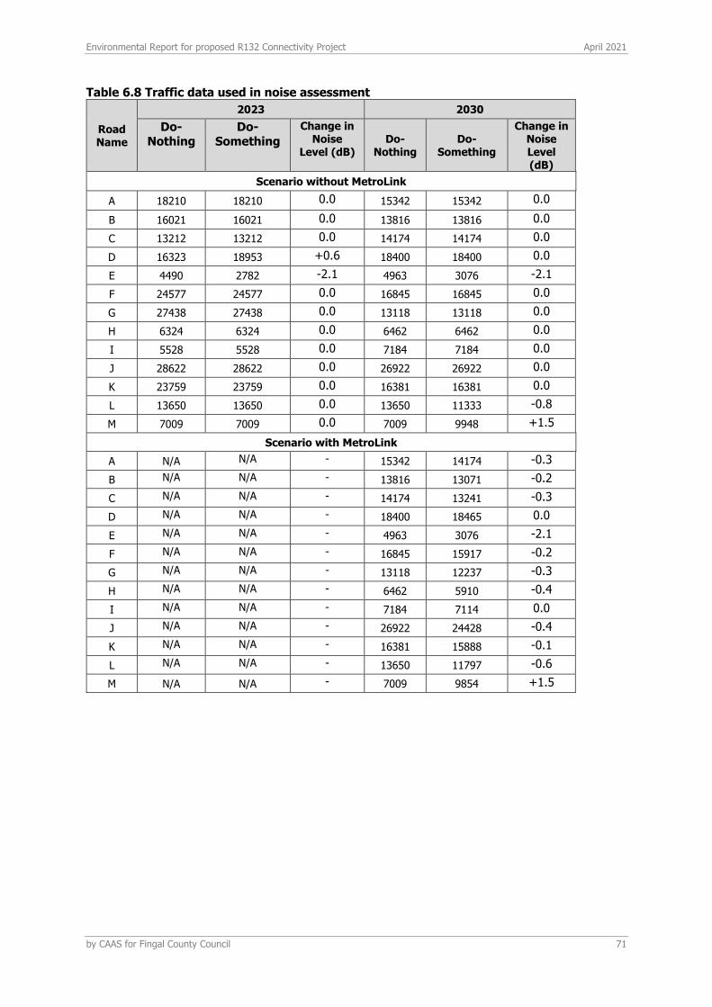
Environmental Report for proposed R132 Connectivity Project April 2021
by CAAS for Fingal County Council 71
Table 6.8 Traffic data used in noise assessment
Road Name
2023 2030
Do-Nothing
Do-Something
Change in Noise
Level (dB) Do-
Nothing Do-
Something
Change in Noise Level (dB)
Scenario without MetroLink
A 18210 18210 0.0 15342 15342 0.0
B 16021 16021 0.0 13816 13816 0.0
C 13212 13212 0.0 14174 14174 0.0
D 16323 18953 +0.6 18400 18400 0.0
E 4490 2782 -2.1 4963 3076 -2.1
F 24577 24577 0.0 16845 16845 0.0
G 27438 27438 0.0 13118 13118 0.0
H 6324 6324 0.0 6462 6462 0.0
I 5528 5528 0.0 7184 7184 0.0
J 28622 28622 0.0 26922 26922 0.0
K 23759 23759 0.0 16381 16381 0.0
L 13650 13650 0.0 13650 11333 -0.8
M 7009 7009 0.0 7009 9948 +1.5
Scenario with MetroLink
A N/A N/A - 15342 14174 -0.3
B N/A N/A - 13816 13071 -0.2
C N/A N/A - 14174 13241 -0.3
D N/A N/A - 18400 18465 0.0
E N/A N/A - 4963 3076 -2.1
F N/A N/A - 16845 15917 -0.2
G N/A N/A - 13118 12237 -0.3
H N/A N/A - 6462 5910 -0.4
I N/A N/A - 7184 7114 0.0
J N/A N/A - 26922 24428 -0.4
K N/A N/A - 16381 15888 -0.1
L N/A N/A - 13650 11797 -0.6
M N/A N/A - 7009 9854 +1.5
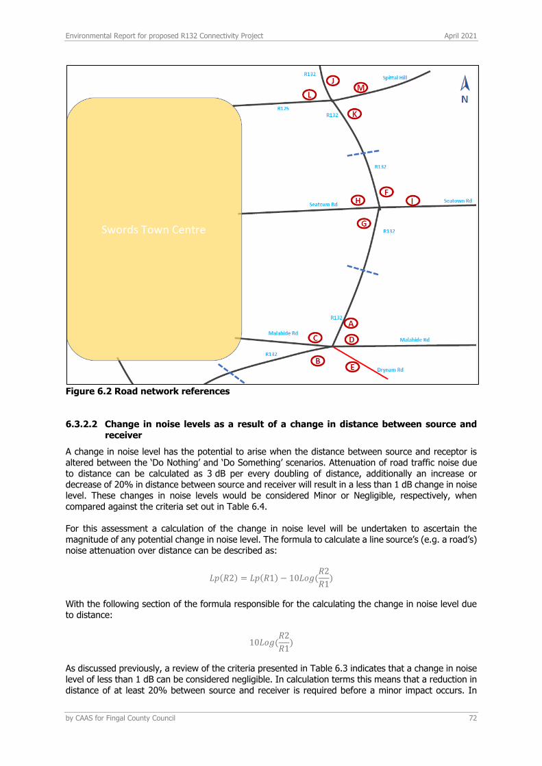
Environmental Report for proposed R132 Connectivity Project April 2021
by CAAS for Fingal County Council 72
Figure 6.2 Road network references
6.3.2.2 Change in noise levels as a result of a change in distance between source and receiver
A change in noise level has the potential to arise when the distance between source and receptor is altered between the ‘Do Nothing’ and ‘Do Something’ scenarios. Attenuation of road traffic noise due to distance can be calculated as 3 dB per every doubling of distance, additionally an increase or decrease of 20% in distance between source and receiver will result in a less than 1 dB change in noise level. These changes in noise levels would be considered Minor or Negligible, respectively, when compared against the criteria set out in Table 6.4. For this assessment a calculation of the change in noise level will be undertaken to ascertain the magnitude of any potential change in noise level. The formula to calculate a line source’s (e.g. a road’s) noise attenuation over distance can be described as:
𝐿𝑝(𝑅2) = 𝐿𝑝(𝑅1) − 10𝐿𝑜𝑔(𝑅2
𝑅1)
With the following section of the formula responsible for the calculating the change in noise level due to distance:
10𝐿𝑜𝑔(𝑅2
𝑅1)
As discussed previously, a review of the criteria presented in Table 6.3 indicates that a change in noise level of less than 1 dB can be considered negligible. In calculation terms this means that a reduction in distance of at least 20% between source and receiver is required before a minor impact occurs. In

Environmental Report for proposed R132 Connectivity Project April 2021
by CAAS for Fingal County Council 73
terms of the proposed project there is one location with a distance reduction greater than 20% between source and receiver, this is at Malahide Road where the lanes will be adjusted to bring them closer to the residential properties on Ashley Avenue, a change of approximately 20m distance to 15m distance. The resultant change in noise level is calculated to be an increase of 1.2 dB which correlates to a minor, short-term magnitude of change and a negligible long-term magnitude of change at the dwellings on Ashley Avenue. Referring to Table 6.8 the change in road traffic noise due to traffic volumes along this section of road is 0 dB, the combined effect is an increase of 1.2 dB. In subjective terms a change of this magnitude would be considered only just detectable. Impacts due to distance changes at all other receptors are calculated as negligible. The impacts at end of terrace properties on Ashley Avenue that overlook Malahide Road can be categorised as negative and not significant in the short-term; and neutral and not significant in the long-term. It’s noted that the slip road from the R132 to Malahide road is being removed, this will move some traffic along the western façade of properties on Ashley Avenue to a distance approximately 15m further west on to the main carriageway.
6.3.2.3 Change in noise levels as a result of proposed new roads
The proposed project includes an alteration to the Drynam Road layout where the road will be brought around the rear of the dwellings on Foxwood. For the purposes of this noise assessment this new layout can be interpreted as a new road and, hence, a noise calculation has undertaken to account for the new vehicular traffic passing the rear of the dwellings. The noise level associated with an event of short duration, such as a passing vehicle movement, may be expressed in terms of its Sound Exposure Level (LAX). The Sound Exposure Level can be used to calculate the contribution of an event or series of events to the overall noise level in a given period. The appropriate formula is given below: LAeq,T = LAX + 10log10(N) – 10log10(T) where: LAeq,T is the equivalent continuous sound level over the time period T (in seconds); LAX is the “A-weighted” Sound Exposure Level of the event considered(dB); N is the number of events over the course of time period T; The assumed mean value of Sound Exposure Level for cars and HGV’s is in the order of 68 dB LAX and 81 dB LAX respectively at a distance of 20 metres. These values have been used to calculate the noise levels as a result of the traffic on Drynam Road. The noise level results are expressed in terms Lden. A diurnal pattern taken from the TII Noise and Vibration guidelines which has been applied to the AADTs in order to produce Lden results for comparison with baseline values. The calculation results indicate values of 57 dB Lden for 2023 and 58 dB Lden for 2030. Summing these values with the measured baseline noise level provides a worst case scenario depicting the change in noise levels for the various years. The baseline noise level at this location was 65 dB Lden, measured at Location C in Table 6.6. For both 2023 and 2030 the cumulative noise level is < 66 dB Lden, an increase of less than 1 dB Lden above the baseline noise environment. Hence, it is expected that the impact of the Drynam Road relocation will be negligible for local dwellings on Foxwood.
Environmental Report for proposed R132 Connectivity Project April 2021
by CAAS for Fingal County Council 74
6.4 MITIGATION MEASURES
6.4.1 CONSTRUCTION PHASE
6.4.1.1 Noise
The Contractor undertaking the construction of the works will be obliged to take specific noise abatement measures and comply with the recommendations of BS 5228–1 (BSI 2008) and European Communities Noise Emissions by Equipment for Use Outdoors (Amendment) Regulations 2006. These measures are detailed in the Outline CEMP, and include:
• No plant used on site will be permitted to cause an ongoing public nuisance due to noise;
• The best means practicable, including proper maintenance of plant, will be employed to minimise the noise produced by on site operations;
• All vehicles and mechanical plant will be fitted with effective exhaust silencers and maintained in good working order for the duration of the contract;
• Compressors will be attenuated models fitted with properly lined and sealed acoustic covers which will be kept closed whenever the machines are in use and all ancillary pneumatic tools shall be fitted with suitable silencers;
• Machinery that is used intermittently will be shut down or throttled back to a minimum during periods when not in use;
• Any plant, such as generators or pumps that is required to operate before 07:00hrs or after 19:00hrs will be surrounded by an acoustic enclosure or portable screen; and
• During the course of the construction programme, the contractor will be required to manage the works to comply with the limits detailed in Table 6.1 using methods outlined in BS 5228–1 (BSI 2008).
BS 5228–1 (BSI 2008) includes guidance on several aspects of construction site practices, which include, but are not limited to:
• Selection of quiet plant;
• Control of noise sources;
• Screening;
• Hours of work;
• Liaison with the public; and
• Monitoring.
Further comment is offered on these items in the following paragraphs. Noise control measures that will be considered include the selection of quiet plant, enclosures and screens around noise sources, limiting the hours of work and noise monitoring.
6.4.1.2 Selection of quiet plant
The potential for any item of plant to generate noise will be assessed prior to the item being brought onto the site. The least noisy item of plant will be selected wherever possible. Should a particular item of plant already on the site be found to generate high noise levels, the first action will be to identify whether or not said item can be replaced with a quieter alternative. For static plant such as compressors and generators used at work areas such as construction compounds etc., the units will be supplied with manufacturers’ proprietary acoustic enclosures where possible.

Environmental Report for proposed R132 Connectivity Project April 2021
by CAAS for Fingal County Council 75
The contractor will evaluate the choice of excavation, breaking or other working method taking into account various ground conditions and site constraints. Where possible, where alternative lower noise generating equipment are available that will provide equivalent that would economically achieve, in the given ground conditions, equivalent structural / excavation / breaking results, these will be selected to minimise potential disturbance.
6.4.1.3 General comments on noise control at source
If replacing a noisy item of plant is not a viable or practical option, consideration will be given to noise control “at source”. This refers to the modification of an item of plant, or the application of improved sound reduction methods in consultation with the supplier or the best practice use of equipment and materials handling to reduce noise. The following outline guidance relates to practical noise control at source techniques which relate to specific site considerations:
• For mobile plant items such as dump trucks, excavators and loaders, the installation of an acoustic exhaust and/or maintaining enclosure panels closed during operation can reduce noise levels by up to 10 dB. Mobile plant will be switched off when not in use and not left idling;
• For percussive tools such as pneumatic concrete breakers and tools a number of noise control measures include fitting muffler or sound reducing equipment to the breaker ‘tool’ and ensuring any leaks in the air lines are sealed. Erection of localised screens around breaker or drill bit when in operation in close proximity to NSLs boundaries are other suitable forms of noise reduction;
• Where compressors, generators and pumps are located in areas in close proximity to NSLs and have potential to exceed noise criterion, these will be surrounded by acoustic lagging or enclosed within acoustic enclosures providing air ventilation;
• Resonance effects in panel work or cover plates can be reduced through stiffening or application of damping compounds; rattling and grinding noises can be controlled by fixing resilient materials in between the surfaces in contact;
• Demountable enclosures can also be used to screen operatives using hand tools and may be moved around site as necessary; and
• All items of plant will be subject to regular maintenance. Such maintenance can prevent unnecessary increases in plant noise and can serve to prolong the effectiveness of noise control measures.
6.4.2 OPERATIONAL PHASE
As impacts during the operational phase are predicted to be imperceptible or slight, no mitigation is proposed.
Environmental Report for proposed R132 Connectivity Project April 2021
by CAAS for Fingal County Council 76
6.5 RESIDUAL IMPACTS
6.5.1 CONSTRUCTION PHASE
Given the linear nature of the works, noise emissions related to construction works will be of temporary impact at any one area. The application of the proposed noise limits and restricted hours of operation, along with implementation of appropriate noise control measures, will ensure that noise impact is kept to within acceptable standards. During the construction phase of the proposed project, noise levels at properties closest to working areas will be temporarily increased. The most appropriate noise mitigation measures for each work area will be determined taking account of the various control measures included within Section 6.6.1. The various mitigation measures will be selected in order to control construction noise levels to within the limit values included in Table 6.1. Once the various mitigation measures are put in place and the limit values complied with, noise impacts associated with the construction phase will be of moderate to major, temporary impact. Highest noise impacts will occur during periods of surface breaking. The assessment has indicated that the use of standard construction activities can operate comfortably within the recommended vibration limits for standard residential and other light-framed buildings.
6.5.2 OPERATIONAL PHASE
Given that traffic volumes are not predicted to increase as a result for the project, and that for the majority of locations the road will not be moved closer to any receptors, the assessment has indicated that the vast majority of receptors along the proposed project will experience an imperceptible, long-term impact. The impacts at end of terrace properties on Ashley Avenue that face on to Malahide Road can be categorised as negative and not significant in the short-term; and neutral and not significant in the long-term. Dwellings at Foxwood are predicted to experience a not significant, negative long-term impact at their rear facade due to the re-routing of Drynam Road which will be located to the rear of the dwellings.
Environmental Report for proposed R132 Connectivity Project April 2021
by CAAS for Fingal County Council 77
7 LAND, SOILS, GEOLOGY ,HYDROGEOLOGY &
HYDROGEOLOGY
7.1 INTRODUCTION/METHODOLOGY
This section of the Environmental Report assesses and evaluates the potential impacts of the development on the land, soil, geological and hydrogeological as well as the hydrological aspects of the site and surrounding area during the construction and operational phases. In assessing likely potential and predicted effects, account is taken of both the importance of the attributes and the predicted scale and duration of the likely effects. Due to the inter-relationship between land, soils, geology and hydrogeology and surface water, this section covers aspects related to both components.
7.1.1 METHODOLOGY
This section evaluates the effects, if any, which the development has had or will have on Land, Soils, Geology and Hydrogeology as well as on Hydrology. The document entitled ‘Guidelines on Procedures for Assessment and Treatment of Geology, Hydrology and Hydrogeology for National Road Schemes’ by the National Roads Authority (NRA/TII, 2009) is referenced where the methodology for assessment of impact is appropriate. The rating of potential environmental effects on the land, soil, geological and hydrogeological as well as on the hydrological environment is based on the matrix presented in Table 1 in Appendix 7.1 which takes account of the quality, significance, duration and type of effect characteristic identified. The duration of each effect is considered to be either momentary, brief, temporary, short-term, medium term, long-term, or permanent. Momentary effects are considered to be those that last from seconds to minutes. Brief effects are those that last less than a day. Temporary effects are considered to be those which are construction related and last less than one year. Short term effects are seen as effects lasting one to seven years; medium-term effects lasting seven to fifteen years; long-term effects lasting fifteen to sixty years; and permanent effects lasting over sixty years. The NRA/TII criteria for rating the magnitude and significance of impacts on the geological related attributes and the importance of geological, hydrogeological and hydrological attributes at the site during the EIA stage are also relevant in assessing the impact and are presented in Tables 1-7 in Appendix 7.2. The principal attributes (and effects) to be assessed include the following:
• Geological heritage sites in the vicinity of the perimeter of the subject site; • Landfills, industrial sites in the vicinity of the site and the potential risk of encountering
contaminated ground; • The quality, drainage characteristics and range of agricultural uses of soil around the site; • Quarries or mines in the vicinity, the potential implications (if any) for existing activities and
extractable reserves;
• The extent of topsoil and subsoil cover and the potential use of this material on site as well or requirement to remove it off-site as waste for disposal or recovery;
• High-yielding water supply springs/ wells in the vicinity of the site to within a 2km radius and the potential for increased risk presented by the proposed development;
• Classification (regionally important, locally important etc.) and extent of aquifers underlying the site perimeter area and increased risks presented to them by the proposed development associated with aspects such as for example removal of subsoil cover, removal of aquifer (in whole or part), drawdown in water levels, alteration in established flow regimes, change in groundwater quality;
• Natural hydrogeological/karst features in the area and potential for increased risk presented by the activities at the site;
Environmental Report for proposed R132 Connectivity Project April 2021
by CAAS for Fingal County Council 78
• Groundwater-fed ecosystems and the increased risk presented by operations both spatially and temporally;
• River and stream water quality in the vicinity of the site (where available); • Surface watercourses near the site and potential impact on surface water quality arising from
proposed development related works including any discharge of surface water run-off; • Localised flooding (potential increase or reduction) and floodplains including benefitting lands
and drainage districts (if any); and • Surface water features within the area of the site.
Desk-based geological information on the substrata (both Quaternary deposits and bedrock geology) underlying the extent of the site was obtained through accessing databases and other archives where available. Data was sourced from the following:
• Geological Survey of Ireland (GSI) - on-line mapping, Geo-hazard Database, Geological Heritage Sites & Sites of Special Scientific Interest, Bedrock Memoirs and 1: 100,000 mapping;
• Teagasc soil and subsoil database; • Ordnance Survey Ireland - aerial photographs and historical mapping; • Environmental Protection Agency (EPA) – website mapping and database information including
envision water quality monitoring data for watercourses in the area • National Parks and Wildlife Services (NPWS) – Protected Site Register; • River Basin Management Plan for Ireland 2018-2021. • The Planning System and Flood Risk Management, Guidelines for Planning Authorities
(Department of the Environment, Heritage and Local Government (DoEHLG) and the Office of Public Works (OPW));
• Office of Public Works (OPW) flood mapping data (www.floodmaps.ie) • South Dublin City Council (2005), Greater Dublin Strategic Drainage Study: Technical
Documents of Regional Drainage Policies. Dublin: Dublin City Council; and • ‘Control of Water Pollution from Construction Sites, Guidance for Consultants and Contractors’
(CIRIA 532, 2001);
Site specific data was derived from the following sources:
• Infrastructure Design Report R132 Connectivity Project. DBFL Consulting Engineers. January 2021;
• Outline Construction Environmental Management Plan R132 Connectivity Project. DBFL Consulting Engineers. January 2021;
• Flood Risk Assessment R132 Connectivity Project. DBFL Consulting Engineers. January 2021; • Various design site plans and drawings; and • Consultation with site engineers.
It should be noted that no ground investigation has been carried out at the project junctions. Therefore, information on the receiving environment was obtained basically from the desk-based source aforementioned.
7.2 THE PROPOSED DEVELOPMENT
The objective of the R132 Connectivity Project is, to improve the connectivity and safety of pedestrians and cyclists moving along and across the R132 and enhance facilities for all road users with particular benefits for sustainable modes of transportation (bus users, cyclists and pedestrians). A full development description is included in Section 2. The upgraded junctions will include lanes for motor vehicles, cyclists and pedestrians and will be lit throughout. Construction will include new surface water drainage and modifications to existing underground services such as telecommunications ducting, watermains and upgrading of existing public lighting to accommodate the proposed junction layouts. A number of surface water attenuation storage tanks/ponds will be constructed to receive rain run-off. Most works proposed are within the existing
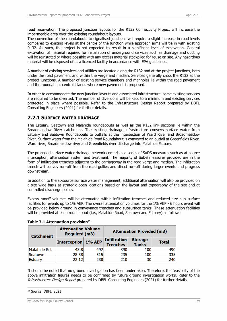
Environmental Report for proposed R132 Connectivity Project April 2021
by CAAS for Fingal County Council 79
road reservation. The proposed junction layouts for the R132 Connectivity Project will increase the impermeable area over the existing roundabout layouts. The conversion of the roundabouts to signalised junctions will require a slight increase in road levels compared to existing levels at the centre of the junction while approach arms will tie in with existing R132. As such, the project is not expected to result in a significant level of excavation. General excavation of material required for installation of underground services such as drainage and ducting will be reinstated or where possible with any excess material stockpiled for reuse on site. Any hazardous material will be disposed of at a licenced facility in accordance with EPA guidelines. A number of existing services and utilities are located along the R132 and at the project junctions, both under the road pavement and within the verge and median. Services generally cross the R132 at the project junctions. A number of existing service chambers and manholes lie within the road pavement and the roundabout central islands where new pavement is proposed. In order to accommodate the new junction layouts and associated infrastructure, some existing services are required to be diverted. The number of diversions will be kept to a minimum and existing services protected in place where possible. Refer to the Infrastructure Design Report prepared by DBFL Consulting Engineers (2021) for further details.
7.2.1 SURFACE WATER DRAINAGE
The Estuary, Seatown and Malahide roundabouts as well as the R132 link sections lie within the Broadmeadow River catchment. The existing drainage infrastructure conveys surface water from Estuary and Seatown Roundabouts to outfalls at the intersection of Ward River and Broadmeadow River. Surface water from the Malahide Road Roundabout is conveyed to an outfall at Greenfields River. Ward river, Broadmeadow river and Greenfields river discharge into Malahide Estuary. The proposed surface water drainage network comprises a series of SuDS measures such as at-source interception, attenuation system and treatment. The majority of SuDS measures provided are in the form of infiltration trenches adjacent to the carriageway in the road verge and median. The infiltration trench will convey run-off from the road gullies and direct run-off during larger events and progress downstream. In addition to the at-source surface water management, additional attenuation will also be provided on a site wide basis at strategic open locations based on the layout and topography of the site and at controlled discharge points. Excess runoff volumes will be attenuated within infiltration trenches and reduced size sub surface facilities for events up to 1% AEP. The overall attenuation volumes for the 1% AEP - 6 hours event will be provided below ground in conveyance trenches and subsurface tanks. These attenuation facilities will be provided at each roundabout (i.e., Malahide Road, Seatown and Estuary) as follows: Table 7.1 Attenuation provision25
It should be noted that no ground investigation has been undertaken. Therefore, the feasibility of the above infiltration figures needs to be confirmed by future ground investigation works. Refer to the Infrastructure Design Report prepared by DBFL Consulting Engineers (2021) for further details.
25 Source: DBFL, 2021
Environmental Report for proposed R132 Connectivity Project April 2021
by CAAS for Fingal County Council 80
7.2.2 WATER SUPPLY AND FOUL WATER
There is no requirement for a freshwater supply and a wastewater network service for this development.
7.2.3 DESIGN CONTROL MEASURES
The following environmental controls considered into the design/Outline CEMP (i.e. design stage mitigation measures) relating to the protection of the hydrological and hydrogeological environment will apply during the construction phase of the proposed development:
• The construction works will be carried out with the least feasible disturbance of soils, thereby minimising the amount of excavated soil. The inert excavated soil will be reused within the project wherever possible;
• Where applicable, design measures will be put forward to minimise the excavation of soil that cannot be reused due to their mechanical properties or contamination;
• All waste produced as part of the proposed development will be dealt with in accordance with
the relevant waste and environmental management legislation; • The contractor will be required to submit a Construction Waste Management Plan (CWMP) to
the local authority for approval which will address all types of material to be disposed of;
• Where soil stripping and excavation occurs, the resulting excavated soil fractions will be segregated into material that can be disposed of in the appropriate manner in accordance with Waste Management legislation;
• Excess topsoil, inert soil, and all hazardous soil waste will be separately removed off site to an
appropriately licenced facility by a licensed contractor; • Non-hazardous waste exceeding inert Waste Acceptance Criteria (WAC) will be sent to a
licensed non-hazardous landfill for disposal/recovery; • Construction personnel will be required to wear appropriate Personnel Protection Equipment
(PPE) and carry out other protective measures outlined in the Outline CEMP when handling hazardous waste;
• All associated hazardous waste residuals will be stored within temporary bunded storage areas
prior to removal by an appropriate EPA approved waste management contractor for off-site treatment/recycling/disposal.
• Any other building waste will be disposed of within on-site skips for removal by a licensed waste contractor;
• For the importation of topsoil and imported good-quality granular soils materials, the material
will be sourced from nearby sites where possible, in order to reduce transport distances; • To minimise any impact on the underlying subsurface strata from material spillages, fuels, oils,
solvents and paints used during construction will be stored within specially constructed bunded areas or within bunded containers;
• Refuelling of construction vehicles and the addition of hydraulic oils or lubricants to vehicles,
will take place away from surface water gullies or drains; • Spill kits and hydrocarbon absorbent packs will be stored in the site compound and relevant
personnel will be fully trained in the use of this equipment;
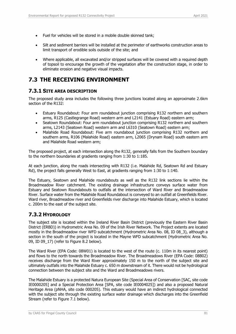
Environmental Report for proposed R132 Connectivity Project April 2021
by CAAS for Fingal County Council 81
• Fuel for vehicles will be stored in a mobile double skinned tank; • Silt and sediment barriers will be installed at the perimeter of earthworks construction areas to
limit transport of erodible soils outside of the site; and
• Where applicable, all excavated and/or stripped surfaces will be covered with a required depth of topsoil to encourage the growth of the vegetation after the construction stage, in order to eliminate erosion and negative visual impacts.
7.3 THE RECEIVING ENVIRONMENT
7.3.1 SITE AREA DESCRIPTION
The proposed study area includes the following three junctions located along an approximate 2.6km section of the R132:
• Estuary Roundabout: Four arm roundabout junction comprising R132 northern and southern arms, R125 (Castlegrange Road) western arm and L2141 (Estuary Road) eastern arm;
• Seatown Roundabout: Four arm roundabout junction comprising R132 northern and southern arms, L2143 (Seatown Road) western arm and L6310 (Seatown Road) eastern arm;
• Malahide Road Roundabout: Five arm roundabout junction comprising R132 northern and southern arms, R106 (Malahide Road) eastern arm, L2065 (Drynam Road) south eastern arm and Malahide Road western arm;
The proposed project, at each intersection along the R132, generally falls from the Southern boundary to the northern boundaries at gradients ranging from 1:30 to 1:185. At each junction, along the roads intersecting with R132 (i.e. Malahide Rd, Seatown Rd and Estuary Rd), the project falls generally West to East, at gradients ranging from 1:30 to 1:140. The Estuary, Seatown and Malahide roundabouts as well as the R132 link sections lie within the Broadmeadow River catchment. The existing drainage infrastructure conveys surface water from Estuary and Seatown Roundabouts to outfalls at the intersection of Ward River and Broadmeadow River. Surface water from the Malahide Road Roundabout is conveyed to an outfall at Greenfields River. Ward river, Broadmeadow river and Greenfields river discharge into Malahide Estuary, which is located c. 200m to the east of the subject site.
7.3.2 HYDROLOGY
The subject site is located within the Ireland River Basin District (previously the Eastern River Basin District (ERBD)) in Hydrometric Area No. 09 of the Irish River Network. The Project extents are located mostly in the Broadmeadow river WFD subcatchment (Hydrometric Area No. 08, ID 08_3), although a section in the south of the project is located in the Mayne WFD subcatchment (Hydrometric Area No. 09, ID 09_17) (refer to Figure 8.2 below). The Ward River (EPA Code: 08W01) is located to the west of the route (c. 110m in its nearest point) and flows to the north towards the Broadmeadow River. The Broadmeadows River (EPA Code: 08B02) receives discharge from the Ward River approximately 150 m to the north of the subject site and ultimately outfalls into the Malahide Estuary c. 650 m downstream of it. There would not be hydrological connection between the subject site and the Ward and Broadmeadows rivers. The Malahide Estuary is a protected Natura European Site (Special Area of Conservation [SAC, site code IE0000205] and a Special Protection Area [SPA, site code IE0004025]) and also a proposed Natural Heritage Area (pNHA, site code 000205). This estuary would have an indirect hydrological connected with the subject site through the existing surface water drainage which discharges into the Greenfield Stream (refer to Figure 7.1 below).
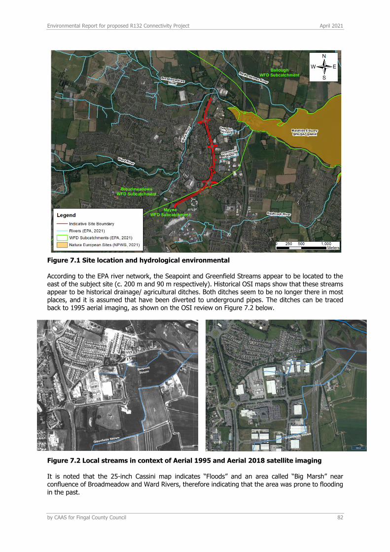
Environmental Report for proposed R132 Connectivity Project April 2021
by CAAS for Fingal County Council 82
Figure 7.1 Site location and hydrological environmental According to the EPA river network, the Seapoint and Greenfield Streams appear to be located to the east of the subject site (c. 200 m and 90 m respectively). Historical OSI maps show that these streams appear to be historical drainage/ agricultural ditches. Both ditches seem to be no longer there in most places, and it is assumed that have been diverted to underground pipes. The ditches can be traced back to 1995 aerial imaging, as shown on the OSI review on Figure 7.2 below.
Figure 7.2 Local streams in context of Aerial 1995 and Aerial 2018 satellite imaging It is noted that the 25-inch Cassini map indicates “Floods” and an area called “Big Marsh” near confluence of Broadmeadow and Ward Rivers, therefore indicating that the area was prone to flooding in the past.
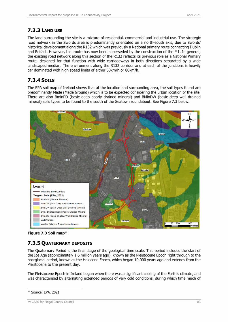
Environmental Report for proposed R132 Connectivity Project April 2021
by CAAS for Fingal County Council 83
7.3.3 LAND USE
The land surrounding the site is a mixture of residential, commercial and industrial use. The strategic road network in the Swords area is predominantly orientated on a north-south axis, due to Swords’ historical development along the R132 which was previously a National primary route connecting Dublin and Belfast. However, this route has now been superseded by the construction of the M1. In general, the existing road network along this section of the R132 reflects its previous role as a National Primary route, designed for that function with wide carriageways in both directions separated by a wide landscaped median. The environment along the R132 corridor and at each of the junctions is heavily car dominated with high speed limits of either 60km/h or 80km/h.
7.3.4 SOILS
The EPA soil map of Ireland shows that at the location and surrounding area, the soil types found are predominantly Made (Made Ground) which is to be expected considering the urban location of the site. There are also BminPD (basic deep poorly drained mineral) and BMinDW (basic deep well drained mineral) soils types to be found to the south of the Seatown roundabout. See Figure 7.3 below.
Figure 7.3 Soil map26
7.3.5 QUATERNARY DEPOSITS
The Quaternary Period is the final stage of the geological time scale. This period includes the start of the Ice Age (approximately 1.6 million years ago), known as the Pleistocene Epoch right through to the postglacial period, known as the Holocene Epoch, which began 10,000 years ago and extends from the Pleistocene to the present day. The Pleistocene Epoch in Ireland began when there was a significant cooling of the Earth’s climate, and was characterised by alternating extended periods of very cold conditions, during which time much of
26 Source: EPA, 2021
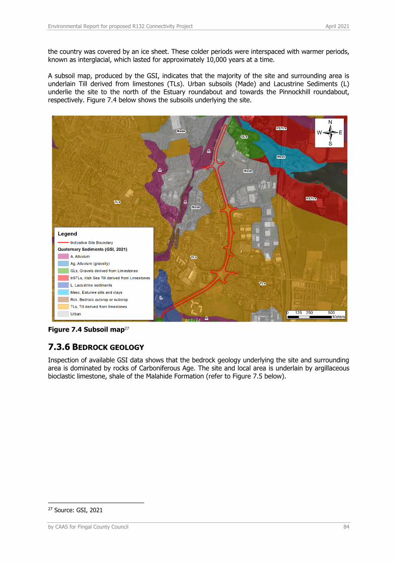
Environmental Report for proposed R132 Connectivity Project April 2021
by CAAS for Fingal County Council 84
the country was covered by an ice sheet. These colder periods were interspaced with warmer periods, known as interglacial, which lasted for approximately 10,000 years at a time. A subsoil map, produced by the GSI, indicates that the majority of the site and surrounding area is underlain Till derived from limestones (TLs). Urban subsoils (Made) and Lacustrine Sediments (L) underlie the site to the north of the Estuary roundabout and towards the Pinnockhill roundabout, respectively. Figure 7.4 below shows the subsoils underlying the site.
Figure 7.4 Subsoil map27
7.3.6 BEDROCK GEOLOGY
Inspection of available GSI data shows that the bedrock geology underlying the site and surrounding area is dominated by rocks of Carboniferous Age. The site and local area is underlain by argillaceous bioclastic limestone, shale of the Malahide Formation (refer to Figure 7.5 below).
27 Source: GSI, 2021
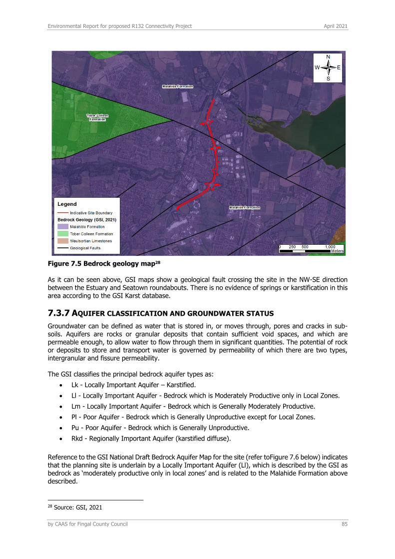
Environmental Report for proposed R132 Connectivity Project April 2021
by CAAS for Fingal County Council 85
Figure 7.5 Bedrock geology map28 As it can be seen above, GSI maps show a geological fault crossing the site in the NW-SE direction between the Estuary and Seatown roundabouts. There is no evidence of springs or karstification in this area according to the GSI Karst database.
7.3.7 AQUIFER CLASSIFICATION AND GROUNDWATER STATUS
Groundwater can be defined as water that is stored in, or moves through, pores and cracks in sub-soils. Aquifers are rocks or granular deposits that contain sufficient void spaces, and which are permeable enough, to allow water to flow through them in significant quantities. The potential of rock or deposits to store and transport water is governed by permeability of which there are two types, intergranular and fissure permeability. The GSI classifies the principal bedrock aquifer types as:
• Lk - Locally Important Aquifer – Karstified.
• Ll - Locally Important Aquifer - Bedrock which is Moderately Productive only in Local Zones.
• Lm - Locally Important Aquifer - Bedrock which is Generally Moderately Productive.
• Pl - Poor Aquifer - Bedrock which is Generally Unproductive except for Local Zones.
• Pu - Poor Aquifer - Bedrock which is Generally Unproductive.
• Rkd - Regionally Important Aquifer (karstified diffuse).
Reference to the GSI National Draft Bedrock Aquifer Map for the site (refer toFigure 7.6 below) indicates that the planning site is underlain by a Locally Important Aquifer (Ll), which is described by the GSI as bedrock as ‘moderately productive only in local zones’ and is related to the Malahide Formation above described.
28 Source: GSI, 2021

Environmental Report for proposed R132 Connectivity Project April 2021
by CAAS for Fingal County Council 86
Figure 7.6 Bedrock aquifer classification map29 The Water Framework Directive (WFD) Directive 2000/60/EC, was adopted in 2000 as a single piece of legislation covering rivers, lakes, groundwater and transitional (estuarine) and coastal waters. In addition to protecting said waters, its objectives include the attainment of ‘Good Status’ in water bodies that are of lesser status at present and retaining ‘Good Status’ or better where such status exists at present. The WFD requires ‘Good Water Status’ for all European waters to be achieved through a system of river basin management planning and extensive monitoring. ‘Good status’ means both ‘good ecological status’ and ‘good chemical status’. The proposed development crosses the ‘Swords’ (EU Code IE_EA_G_011) and ‘Dublin’ (EU Code IE_EA_G_008) WFD groundwater bodies (GWB). The most recent WFD groundwater status (2013-2018) is ‘Good’ for both GWBs. The WFD environmental risk score of the Swords groundwater body is ‘Not at risk’ of not achieving Good status, whilst the Dublin GWB risk is under review. It can also be seen another groundwater body associated with an Industrial Facility in Swords (P0014-03), west to the River Ward, nevertheless this is not crossed by the proposed route, which is projected easting the River Ward.
7.3.8 AQUIFER VULNERABILITY
Aquifer vulnerability is a term used to represent the intrinsic geological and hydrological characteristics that determine the ease with which groundwater may be contaminated generally by human activities. Due to the nature of the flow of groundwater through bedrock in Ireland, which is almost completely through fissures, the main feature that protects groundwater from contamination, and therefore the most important feature in protection of groundwater, is the subsoil (which can consist solely or of mixtures of peat, sand, gravel, glacial till, clays or silts).
29 Source: GSI, 2021
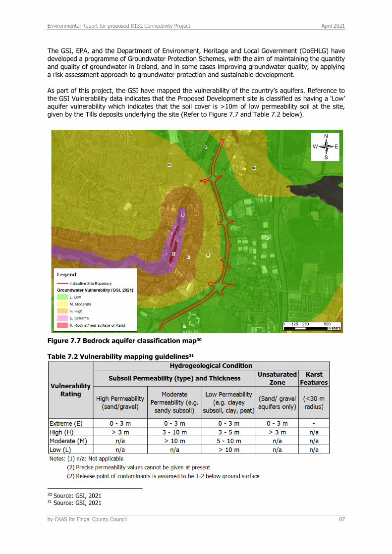
Environmental Report for proposed R132 Connectivity Project April 2021
by CAAS for Fingal County Council 87
The GSI, EPA, and the Department of Environment, Heritage and Local Government (DoEHLG) have developed a programme of Groundwater Protection Schemes, with the aim of maintaining the quantity and quality of groundwater in Ireland, and in some cases improving groundwater quality, by applying a risk assessment approach to groundwater protection and sustainable development. As part of this project, the GSI have mapped the vulnerability of the country’s aquifers. Reference to the GSI Vulnerability data indicates that the Proposed Development site is classified as having a ‘Low’ aquifer vulnerability which indicates that the soil cover is >10m of low permeability soil at the site, given by the Tills deposits underlying the site (Refer to Figure 7.7 and Table 7.2 below).
Figure 7.7 Bedrock aquifer classification map30 Table 7.2 Vulnerability mapping guidelines31
30 Source: GSI, 2021 31 Source: GSI, 2021

Environmental Report for proposed R132 Connectivity Project April 2021
by CAAS for Fingal County Council 88
7.3.9 GROUNDWATER WELLS
The GSI Well Card Index is a record of wells drilled in Ireland. This Index shows a number of wells in the vicinity of the site. While much useful information can be obtained from this Index, it is important to note that it is by no means exhaustive, as it requires individual drillers to submit details of wells in each area. The well card data presented in Table 7.3 shows the occurrence of recorded wells within a 1km radius of the site area, information regarding the depth to bedrock, and hence the depth of overburden is noted for each well where available. See Figure 7.8 GSI well search map below for locations. From the GSI well card data presented in Table 7.3, it can be seen that abstractions of up to 385 m3/day are obtained from the bedrock gravel aquifer at well 2923NEW019, which is located approx. 400m to the west from the site (Malahide Road roundabout), in Swords. In the surrounding area of the site, yield class would be ‘Good’ as it can be seen in the boreholes located in Swords and Seatown East townland c. 950 m to the east of the site.
Figure 7.8 GSI well search map32 Table 7.3 GSI well card data for the site location and surrounding areas
32 Source: GSI, 2021
Environmental Report for proposed R132 Connectivity Project April 2021
by CAAS for Fingal County Council 89
The site is not located near any public groundwater supplies or group schemes. There are no groundwater drinking water protection areas within 10km of the site.
7.3.10 GEOLOGICAL HERITAGE
The Geological Survey of Ireland (GSI) Public Viewer www.gsi.ie/mapping was reviewed to identify sites of geological heritage for the site and surrounding area. There are no recorded sites on the development site with the nearest heritage site is located approximately 1.8 km to the southeast (Feltrim Quarry). A full audit has not yet been completed for Dublin; however, there is no evidence of any site which could be considered suitable for protection under this programme or recorded in the South Dublin County Development Plan 2016-2022.
7.3.11 ECONOMIC GEOLOGY
The Extractive Industry Register (www.epa.ie) and the GSI mineral database was consulted to determine whether there were any mineral sites close to the proposed development. There are no active quarries located in the immediate vicinity with the nearest quarry located approximately 1.8 km to the southeast which is classified as the Feltrim Quarry.
7.3.12 GEO-HAZARDS
There are no expected geohazards at this location. In general, Ireland suffers few landslides. Landslides are more common in unconsolidated material than in bedrock, and where the sea constantly erodes the material at the base of a cliff landslides and falls lead to recession of the cliffs. Landslides have also occurred in Ireland in recent years in upland peat areas due to disturbance of peat associated with construction activities. The GSI landslide database was consulted and the nearest landslide to the proposed development was 15km to the west, referred to as the Clonee event which occurred on 2nd March 2014. There have been no recorded landslide events at the site. Due to the local topography and the underlying strata there is a negligible risk of a landslide event occurring at the site. In Ireland, seismic activity is recorded by the Irish National Seismic Network. The Geophysics Section of the School of Cosmic Physics at the Dublin Institute for Advanced Studies (DIAS) has been recording seismic events in Ireland since 1978. The station configuration has varied over the years. However, currently there are five permanent broadband seismic recording stations in Ireland and operated by DIAS. The seismic data from the stations comes into DIAS in real-time and are studied for local and regional events. Records since 1980 show that the nearest seismic activity to the proposed location was in the Irish sea (1.0 – 2.0 Ml magnitude) and ~55 km to the south in the Wicklow Mountains. There is a very low risk of seismic activity to the proposed development site.
7.3.13 AREAS OF CONSERVATION
The lands in which the proposed development is located have no formal designations. However, as mentioned above, the Malahide Estuary SAC/SPA/pNHA is located c. 200m to the east of the subject site. There would be an indirect hydrological connection between the subject site and the estuary through the existing surface water drainage network.
7.3.14 SURFACE WATER QUALITY
The Water Framework Directive (WFD) Directive 2000/60/EC was adopted in 2000 as a single piece of legislation covering rivers, lakes, groundwater and transitional (estuarine) and coastal waters. In addition to protecting said waters, its objectives include the attainment of ‘Good Status’ in water bodies that are of lesser status at present and retaining ‘Good Status’ or better where such status exists at present. The WFD requires ‘Good Water Status’ for all European waters to be achieved through a system of river basin management planning and extensive monitoring. ‘Good status’ means both ‘good ecological status’ and ‘good chemical status’.
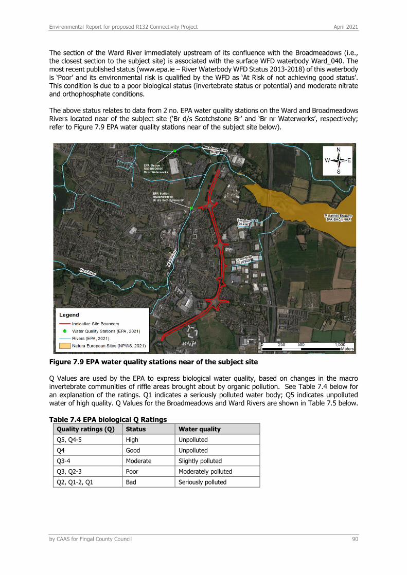
Environmental Report for proposed R132 Connectivity Project April 2021
by CAAS for Fingal County Council 90
The section of the Ward River immediately upstream of its confluence with the Broadmeadows (i.e., the closest section to the subject site) is associated with the surface WFD waterbody Ward_040. The most recent published status (www.epa.ie – River Waterbody WFD Status 2013-2018) of this waterbody is ‘Poor’ and its environmental risk is qualified by the WFD as ‘At Risk of not achieving good status’. This condition is due to a poor biological status (invertebrate status or potential) and moderate nitrate and orthophosphate conditions. The above status relates to data from 2 no. EPA water quality stations on the Ward and Broadmeadows Rivers located near of the subject site (‘Br d/s Scotchstone Br’ and ‘Br nr Waterworks’, respectively; refer to Figure 7.9 EPA water quality stations near of the subject site below).
Figure 7.9 EPA water quality stations near of the subject site Q Values are used by the EPA to express biological water quality, based on changes in the macro invertebrate communities of riffle areas brought about by organic pollution. See Table 7.4 below for an explanation of the ratings. Q1 indicates a seriously polluted water body; Q5 indicates unpolluted water of high quality. Q Values for the Broadmeadows and Ward Rivers are shown in Table 7.5 below. Table 7.4 EPA biological Q Ratings
Quality ratings (Q) Status Water quality
Q5, Q4-5 High Unpolluted
Q4 Good Unpolluted
Q3-4 Moderate Slightly polluted
Q3, Q2-3 Poor Moderately polluted
Q2, Q1-2, Q1 Bad Seriously polluted
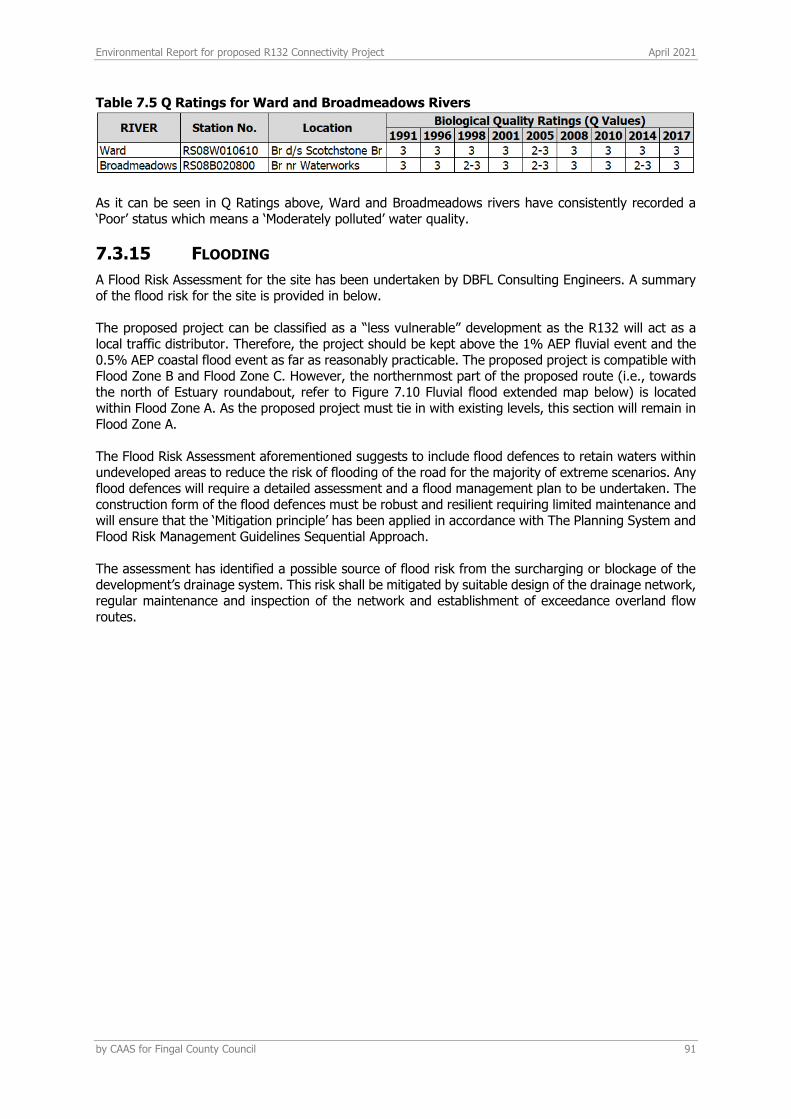
Environmental Report for proposed R132 Connectivity Project April 2021
by CAAS for Fingal County Council 91
Table 7.5 Q Ratings for Ward and Broadmeadows Rivers
As it can be seen in Q Ratings above, Ward and Broadmeadows rivers have consistently recorded a ‘Poor’ status which means a ‘Moderately polluted’ water quality.
7.3.15 FLOODING
A Flood Risk Assessment for the site has been undertaken by DBFL Consulting Engineers. A summary of the flood risk for the site is provided in below. The proposed project can be classified as a “less vulnerable” development as the R132 will act as a local traffic distributor. Therefore, the project should be kept above the 1% AEP fluvial event and the 0.5% AEP coastal flood event as far as reasonably practicable. The proposed project is compatible with Flood Zone B and Flood Zone C. However, the northernmost part of the proposed route (i.e., towards the north of Estuary roundabout, refer to Figure 7.10 Fluvial flood extended map below) is located within Flood Zone A. As the proposed project must tie in with existing levels, this section will remain in Flood Zone A. The Flood Risk Assessment aforementioned suggests to include flood defences to retain waters within undeveloped areas to reduce the risk of flooding of the road for the majority of extreme scenarios. Any flood defences will require a detailed assessment and a flood management plan to be undertaken. The construction form of the flood defences must be robust and resilient requiring limited maintenance and will ensure that the ‘Mitigation principle’ has been applied in accordance with The Planning System and Flood Risk Management Guidelines Sequential Approach. The assessment has identified a possible source of flood risk from the surcharging or blockage of the development’s drainage system. This risk shall be mitigated by suitable design of the drainage network, regular maintenance and inspection of the network and establishment of exceedance overland flow routes.

Environmental Report for proposed R132 Connectivity Project April 2021
by CAAS for Fingal County Council 92
Figure 7.10 Fluvial flood extended map33
7.3.16 RATING OF SITE IMPORTANCE OF THE GEOLOGICAL, HYDROGEOLOGICAL AND HYDROLOGICAL FEATURES
Based on the TII methodology (2009) (See Appendix 7.2) the importance of the geological features at this site is rated as ‘Low Importance’ (attribute has a low quality, significance or value on a local scale). However, the importance of the hydrogeological features is rated as ‘Extremely High’ based on the potential hydraulic connection and the close distance between the local aquifer and the Malahide Estuary SAC/SPA/pNHA EU Natura site which is located c. 200m to the east of the route R132.
33 Source: DBFL, 2021
Environmental Report for proposed R132 Connectivity Project April 2021
by CAAS for Fingal County Council 93
The aquifer is a Locally Important Aquifer but is not widely used for public water supply or generally for potable use. In addition, based on the TII methodology (2009) (See Appendix 7.2) the importance of the hydrological features at this site is rated as ‘Extremely High’ based on the potential hydraulic connection and the close distance between the subject site and the Malahide Estuary SAC/SPA/pNHA EU Natura site which is located c. 200m to the east of the route R132.
7.4 PREDICTED IMPACTS
An analysis of the potential impacts of the Proposed Development on the land, soils, geology and hydrogeological as well as hydrological environment during the construction and operation is outlined below. The following assessment of impacts has taken into account the environmental controls (i.e. design stage mitigation measures, see section 7.2.3) already incorporated into the design. It should be noted that the local hydrological environment is connected to the Malahide Estuary Natura Site, located c. 200 m to the east of the projected route via the existing surface water drainage system which discharges into the Greenfield River. However, as explained below, during the operational phase this connection will be minimised since the proposed surface water drainage which will discharge into the immediate subsoil though a series of infiltration trenches.
7.4.1 CONSTRUCTION PHASE
Potential impacts considered during construction are as follows.
7.4.1.1 Excavation and infilling
Excavation and infilling within the proposed site will be required as part of the preliminary site enabling works as well the levelling of the site to render it suitable for development. Excavated material will be reused on site for infilling and landscaping works where possible. Since the construction works will be carried out with the least feasible disturbance of soils and based on site conditions (refer to Section 7.3), no rock breaking or dewatering will be necessary. As mentioned in the Proposed Development section, if contaminated soil/water is encountered, it will be required to be removed by a licensed waste contractor. Further soil sampling will be undertaken during pre-development works. The contractor will be required to submit a Construction Waste Management Plan (CWMP) to the local authority for approval which will address all types of material to be disposed of.
7.4.1.2 Accidental spills and leaks
During construction of the development, there is a risk of accidental pollution incidences from the following sources if not adequately mitigated:
• Spillage or leakage of oils and fuels stored on site.
• Spillage or leakage of oils and fuels from construction machinery or site vehicles.
• The use of concrete and cement during pad foundation construction.
The environmental control measures incorporated into the design comprise special bunded areas for storage of construction materials as fuels, oils, solvents and paints; refuelling area away from surface water gullies or drains; a mobile double skinned tank for storage of fuel for vehicles; and the installation of silt and sediment barriers at the perimeter of earthworks construction areas to limit transport of erodible soils outside of the site.
Environmental Report for proposed R132 Connectivity Project April 2021
by CAAS for Fingal County Council 94
7.4.1.3 Increased sediments loading in run-off
Surface water runoff during the construction phase may contain increased silt levels or become polluted from construction activities. Runoff containing large amounts of silt can cause damage to surface water systems and receiving watercourses. Silt water can arise from dewatering excavations, exposed ground, stockpiles and access roads. There is a potential direct pathway from the works area to the surface water drainage onsite and therefore an indirect connection with the Malahide Estuary drainage system. The environmental control measures in Section 7.2.3 will be employed to remove the risk to affect the estuary regime.
7.4.1.4 Contamination of local water courses
During construction of the development, there is a risk of accidental pollution incidences from the following sources if not adequately mitigated:
• Spillage or leakage of oils and fuels stored on site.
• Spillage or leakage of oils and fuels from construction machinery or site vehicles.
• Spillage of oil or fuel from refuelling machinery on site; and
• The use of concrete and cement during pad foundation construction.
The environmental control measures incorporated into the design comprise special bunded areas for storage of construction materials as fuels, oils, solvents and paints; refuelling area away from surface water gullies or drains; a mobile double skinned tank for storage of fuel for vehicles; and the installation of silt and sediment barriers at the perimeter of earthworks construction areas to limit dilution and run-off composed of erodible soils outside of the site. Based on the points stated above in relation to the construction phase the potential impact on the on the soils, geology and hydrogeology as well as on surface water and hydrology during construction (EPA 2017) is considered to have a short term – imperceptible impact with a neutral impact on quality. i.e. An impact capable of measurement but without noticeable consequences.
7.4.2 OPERATIONAL PHASE
There will be no direct discharges of contaminated water to groundwater, soil or hydrological environment during the operational phase. However, the projected surface water drainage system comprises a series of infiltration trenches along the route and at the projected roundabouts as mentioned in section 7.2 above. As such, there would be a potential impact if any accidental oil or petrol leakage from the road enter the soil and groundwater environment without adequate mitigation. Infiltration trenches are expected to provide adequate interception and treatment should an accidental event occurs. In addition, it is expected that any effect on soils will be localised due to the anticipated thickness of low-permeability protective overburden (>10 m). Therefore, no impacts on the status of the aquifer -and on the Malahide Estuary SAC/SPA subsequently- are expected. The increase of impermeable area over the existing roundabouts will have a minor effect on local recharge to ground. During operational phase there is no requirement for bulk fuels or chemical storage. Based on the points stated above in relation to the construction phase the potential impact on the soils, geology and hydrogeology during operation (EPA 2017) is considered to have a long term – imperceptible impact with a neutral impact on quality. i.e. An impact capable of measurement but without noticeable consequences.
Environmental Report for proposed R132 Connectivity Project April 2021
by CAAS for Fingal County Council 95
7.5 MITIGATION AND MONITORING MEASURES
With regard to the construction phase, it is expected that the control measures defined in the design/Outline CEMP (design stage mitigation measures) will be sufficient to contain any potential impacts due to excavation of contaminated soil or eventual leakage or spills on the site and protect the local geological and hydrogeological environment as well as local water courses and the hydrological environment. In relation to the operational phase, projected at-source surface water management SuDS will be provided with adequate petrol interceptor in order to avoid any potential leakage to the infiltration trench. Therefore, no further mitigation and monitoring measures are suggested other than the control measures aforementioned. However, it is recommended that a ground investigation be carried out in order to confirm whether subsoils have sufficient capacity to drain the anticipated volume of surface water discharge.
7.6 RESIDUAL IMPACTS
There are no expected significant impacts on the land, geological, hydrogeological or hydrological environment associated with the proposed operational development of the site with mitigation in place. As such the impact is considered to have a long term, imperceptible significance with a neutral impact on quality i.e. an impact capable of measurement but without noticeable consequences.
7.7 CUMULATIVE IMPACTS
The cumulative impact of the proposed development with any/all relevant other planned or permitted developments are discussed below.
7.7.1 CONSTRUCTION PHASE
Contractors for the proposed project will be contractually required to operate in compliance with the Outline CEMP which includes the mitigation measures outlined in this Environmental Report. Other developments will also have to incorporate measures to protect soil and water quality in compliance with legislative standards for receiving water quality (European Communities Environmental Objectives (Groundwater) Regulations (S.I. 9 of 2010 and S.I. 266 of 2016). As a result, there will be minimal cumulative potential for change in soil quality or the natural groundwater and hydrological regime. The cumulative impact is considered to be neutral and imperceptible.
7.7.2 OPERATIONAL PHASE
There are no other large projects proposed within this area of the aquifer so no cumulative impact on recharge to the aquifer or hydrological regime is expected. All developments are required to manage groundwater discharges in accordance with S.I. 9 of 2010 and S.I. 266 of 2016 amendments. As such there will be no cumulative impact to groundwater quality and therefore there will be no cumulative impact on the Groundwater Body or Surface Waterbody Status. The operation of the proposed development is concluded to have a long-term, imperceptible significance with a neutral impact on soil and water quality.

Environmental Report for proposed R132 Connectivity Project April 2021
by CAAS for Fingal County Council 96
8 LANDSCAPE & VISUAL
8.1 INTRODUCTION/METHODOLOGY
This landscape and visual impact assessment has been prepared to identify and assess the effects on the appearance and character on the local environs arising from the proposed project.
8.1.1 ASSESSMENT METHODOLOGY
The assessment follows the layout and content suggested by the EPA Guidelines on Information to be Contained in EIARs and also has regard to the IEMA/LI Guidelines on Landscape and Visual Impact Assessment (see below). Description of the receiving environment (environs and site) having regard to:
• Context
• Character
• Significance (including designations)
• Sensitivity
Description of the proposed development including: • Siting
• Design
• Site Works
Description of the likely significant impact including: • Potential Impacts
• Residual Impacts
Description of Mitigation Measures including:
• Avoidance
8.1.2 OTHER FORMS OF ASSESSMENT CONSIDERED
Other forms of assessment are available and were considered before being deemed inappropriate for the circumstances of this proposed development. Scale models have little predictive capacity for establishing landscape and visual effects due to the generalised nature of the representation and the inability to accurately model local effects of micro-topography, walls and vegetation which are critical determinants of visual impacts in rural settings. ‘ZVI’ Analysis – an assessment of the ‘Zone of Visual Influence’ of a modification is a computer-based simulation of the theoretical extent of an area of topography that will be illuminated from a simulated point of light at the highest point of a structure. It is most effective when used to assess the theoretical maximum extent of visibility of tall single objects in large-scale open landscapes. It takes no account of the effects of vegetation. It was not deemed appropriate to use in this instance on account of the significance of the effects of mature vegetation and the screening role of tall walls and hedgerows which cannot be modelled. The County Development Plan was consulted to identify Landscape Character Areas and significant landscape features as well as designated Landscapes. Related provisions of the Plan – such as the proximity of Protected Structures to the site, were also considered.
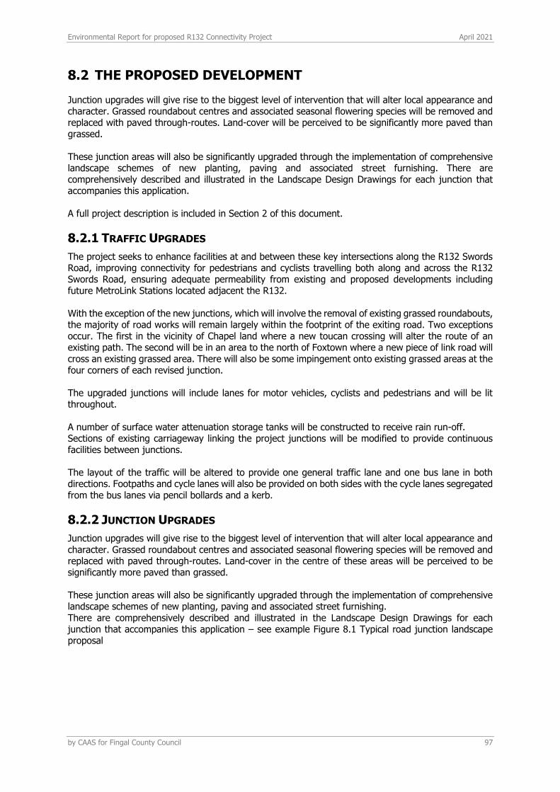
Environmental Report for proposed R132 Connectivity Project April 2021
by CAAS for Fingal County Council 97
8.2 THE PROPOSED DEVELOPMENT
Junction upgrades will give rise to the biggest level of intervention that will alter local appearance and character. Grassed roundabout centres and associated seasonal flowering species will be removed and replaced with paved through-routes. Land-cover will be perceived to be significantly more paved than grassed. These junction areas will also be significantly upgraded through the implementation of comprehensive landscape schemes of new planting, paving and associated street furnishing. There are comprehensively described and illustrated in the Landscape Design Drawings for each junction that accompanies this application. A full project description is included in Section 2 of this document.
8.2.1 TRAFFIC UPGRADES
The project seeks to enhance facilities at and between these key intersections along the R132 Swords Road, improving connectivity for pedestrians and cyclists travelling both along and across the R132 Swords Road, ensuring adequate permeability from existing and proposed developments including future MetroLink Stations located adjacent the R132. With the exception of the new junctions, which will involve the removal of existing grassed roundabouts, the majority of road works will remain largely within the footprint of the exiting road. Two exceptions occur. The first in the vicinity of Chapel land where a new toucan crossing will alter the route of an existing path. The second will be in an area to the north of Foxtown where a new piece of link road will cross an existing grassed area. There will also be some impingement onto existing grassed areas at the four corners of each revised junction. The upgraded junctions will include lanes for motor vehicles, cyclists and pedestrians and will be lit throughout. A number of surface water attenuation storage tanks will be constructed to receive rain run-off. Sections of existing carriageway linking the project junctions will be modified to provide continuous facilities between junctions. The layout of the traffic will be altered to provide one general traffic lane and one bus lane in both directions. Footpaths and cycle lanes will also be provided on both sides with the cycle lanes segregated from the bus lanes via pencil bollards and a kerb.
8.2.2 JUNCTION UPGRADES
Junction upgrades will give rise to the biggest level of intervention that will alter local appearance and character. Grassed roundabout centres and associated seasonal flowering species will be removed and replaced with paved through-routes. Land-cover in the centre of these areas will be perceived to be significantly more paved than grassed. These junction areas will also be significantly upgraded through the implementation of comprehensive landscape schemes of new planting, paving and associated street furnishing. There are comprehensively described and illustrated in the Landscape Design Drawings for each junction that accompanies this application – see example Figure 8.1 Typical road junction landscape proposal
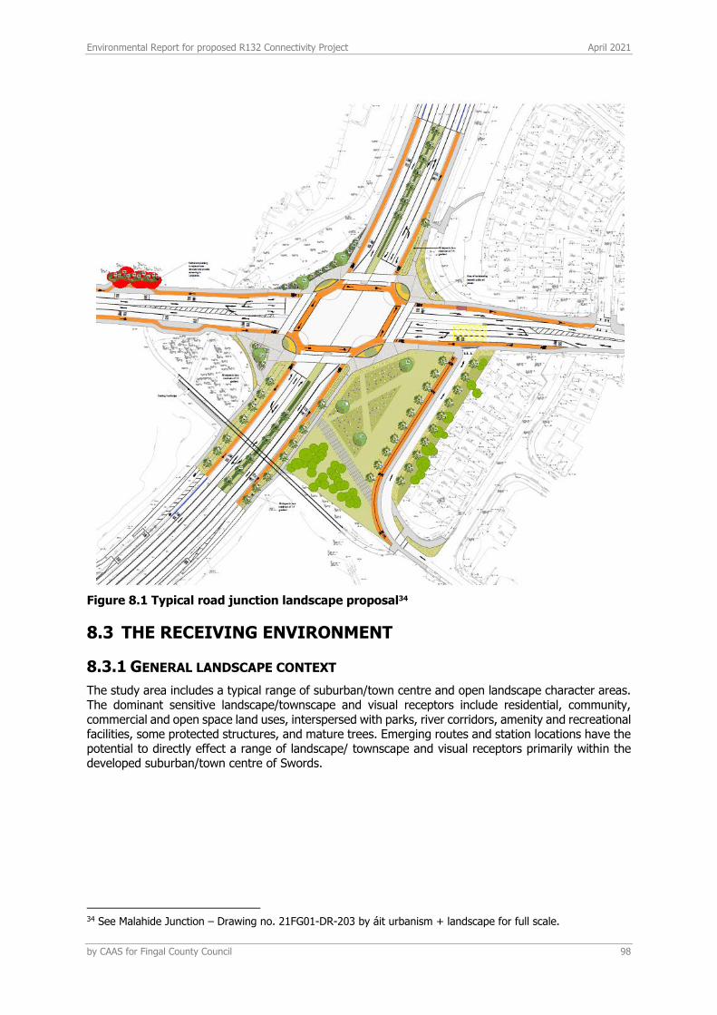
Environmental Report for proposed R132 Connectivity Project April 2021
by CAAS for Fingal County Council 98
Figure 8.1 Typical road junction landscape proposal34
8.3 THE RECEIVING ENVIRONMENT
8.3.1 GENERAL LANDSCAPE CONTEXT
The study area includes a typical range of suburban/town centre and open landscape character areas. The dominant sensitive landscape/townscape and visual receptors include residential, community, commercial and open space land uses, interspersed with parks, river corridors, amenity and recreational facilities, some protected structures, and mature trees. Emerging routes and station locations have the potential to directly effect a range of landscape/ townscape and visual receptors primarily within the developed suburban/town centre of Swords.
34 See Malahide Junction – Drawing no. 21FG01-DR-203 by áit urbanism + landscape for full scale.
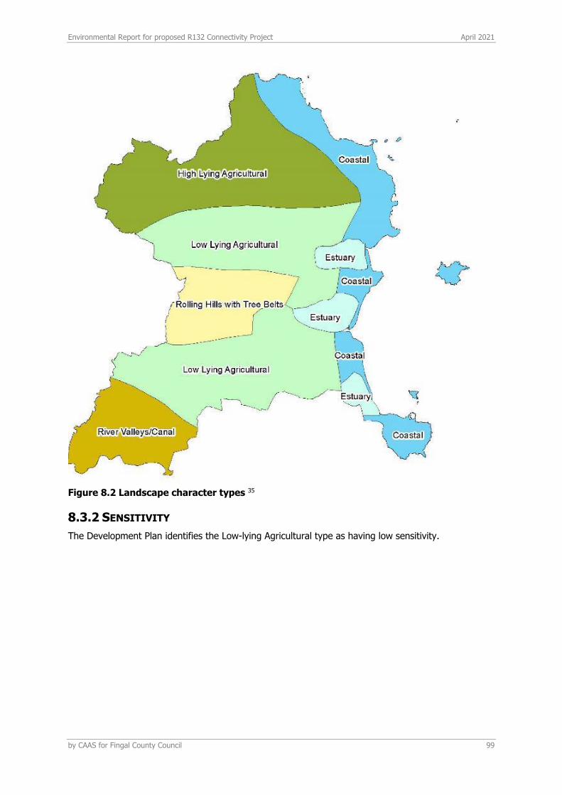
Environmental Report for proposed R132 Connectivity Project April 2021
by CAAS for Fingal County Council 99
Figure 8.2 Landscape character types 35
8.3.2 SENSITIVITY
The Development Plan identifies the Low-lying Agricultural type as having low sensitivity.
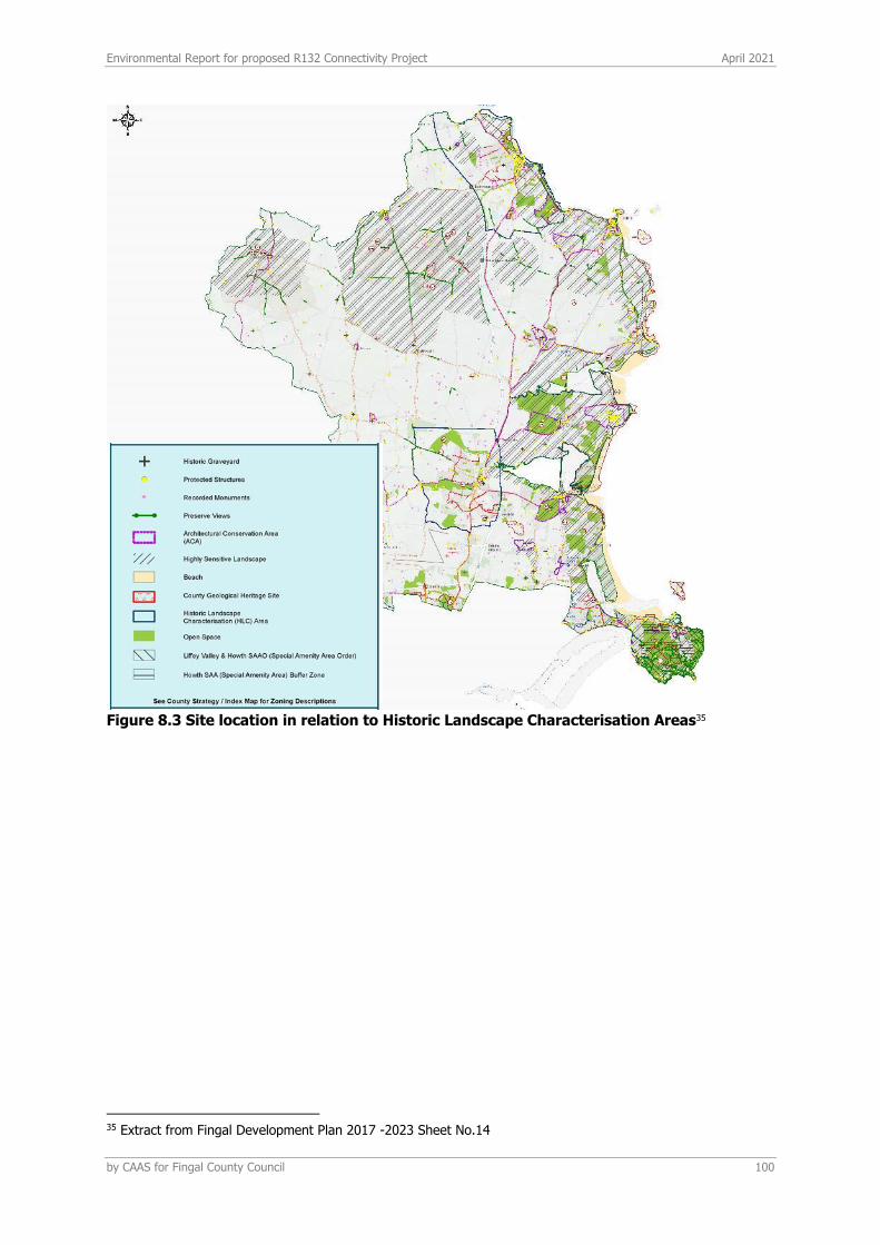
Environmental Report for proposed R132 Connectivity Project April 2021
by CAAS for Fingal County Council 100
Figure 8.3 Site location in relation to Historic Landscape Characterisation Areas35
35 Extract from Fingal Development Plan 2017 -2023 Sheet No.14
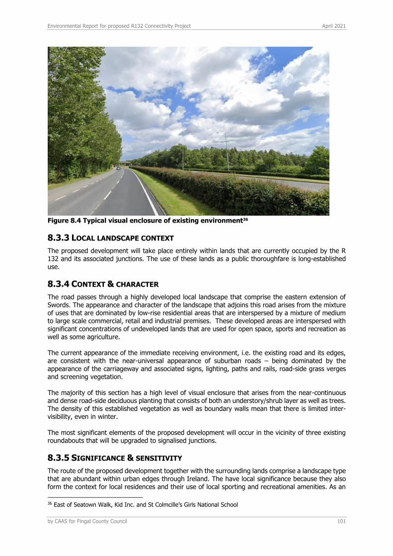
Environmental Report for proposed R132 Connectivity Project April 2021
by CAAS for Fingal County Council 101
Figure 8.4 Typical visual enclosure of existing environment36
8.3.3 LOCAL LANDSCAPE CONTEXT
The proposed development will take place entirely within lands that are currently occupied by the R 132 and its associated junctions. The use of these lands as a public thoroughfare is long-established use.
8.3.4 CONTEXT & CHARACTER
The road passes through a highly developed local landscape that comprise the eastern extension of Swords. The appearance and character of the landscape that adjoins this road arises from the mixture of uses that are dominated by low-rise residential areas that are interspersed by a mixture of medium to large scale commercial, retail and industrial premises. These developed areas are interspersed with significant concentrations of undeveloped lands that are used for open space, sports and recreation as well as some agriculture. The current appearance of the immediate receiving environment, i.e. the existing road and its edges, are consistent with the near-universal appearance of suburban roads – being dominated by the appearance of the carriageway and associated signs, lighting, paths and rails, road-side grass verges and screening vegetation. The majority of this section has a high level of visual enclosure that arises from the near-continuous and dense road-side deciduous planting that consists of both an understory/shrub layer as well as trees. The density of this established vegetation as well as boundary walls mean that there is limited inter-visibility, even in winter. The most significant elements of the proposed development will occur in the vicinity of three existing roundabouts that will be upgraded to signalised junctions.
8.3.5 SIGNIFICANCE & SENSITIVITY
The route of the proposed development together with the surrounding lands comprise a landscape type that are abundant within urban edges through Ireland. The have local significance because they also form the context for local residences and their use of local sporting and recreational amenities. As an
36 East of Seatown Walk, Kid Inc. and St Colmcille’s Girls National School

Environmental Report for proposed R132 Connectivity Project April 2021
by CAAS for Fingal County Council 102
ancient settlement, Swords is regarded as a tourism destination, while also laying a role as a regional shopping destination. The junctions play an additional role as the entrances to Swords – which is the centre of one of Ireland’s largest and fastest growing settlements – it is Ireland’s 7th largest settlement. It is also noted as being a regularly high-scoring entrant to the national Tidy Towns competition – in which the appearance of entrance roads is an important consideration. Having regard to these considerations, this section of road and these three junctions, in particular, play an important role in establishing and sustaining an elevated civic character. The functional nature of these areas means that they have relatively low levels of visual sensitivity and many of the details can be changed without a significant loss of character. The enclosing role of the mature trees and shrubs are the main sensitivity – for both the road and junctions. Any significant loss of mature vegetation has a high potential to increase intervisibility between the road and adjoining sensitive sites – such as residential areas, parks and schools.
8.3.6 THE JUNCTIONS
The majority of new works that have the potential to alter the appearance of the receiving environment are those that involve the upgrading of three intersections along the R132 from roundabout to signalised junctions. The locations are described in Figure 2.2 Project extent. The existing appearance and character are described below.
1. R132 / Malahide Road Roundabout This roundabout has a high degree of visual enclosure that is provided by mature vegetation. There is limited intervisibility between the area and the upper levels of some nearby housing
2. R132 / Seatown Road Roundabout This roundabout has an elevated degree of visual enclosure that is provided by mature vegetation along three side. These is less enclosure to the south-west along the boundary of a large walled carpark. There are distant views toward the junction from houses on Seatown Villas and Terrace to the west.
3. R132 / Estuary Roundabout This roundabout has low visual enclosure viewed from the north. There is more enclosure to the south due to the presence of mature trees. There are distant views toward the junction
from the upper floors of houses on Newcourt Mews to the west.
The general appearance of each junction is illustrated in the following section.
8.3.7 THE R132 CORRIDOR
The route itself is enclosed by mature trees and shrubs that substantially reduce intervisibility between the road and adjoining sensitive sites – such as residential areas, parks and schools.
8.3.7.1 Malahide Roundabout existing appearance
This roundabout has a high degree of visual enclosure that is provided by mature vegetation. There is limited intervisibility between the area and the upper levels of some nearby housing.
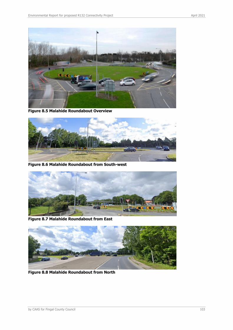
Environmental Report for proposed R132 Connectivity Project April 2021
by CAAS for Fingal County Council 103
Figure 8.5 Malahide Roundabout Overview
Figure 8.6 Malahide Roundabout from South-west
Figure 8.7 Malahide Roundabout from East
Figure 8.8 Malahide Roundabout from North
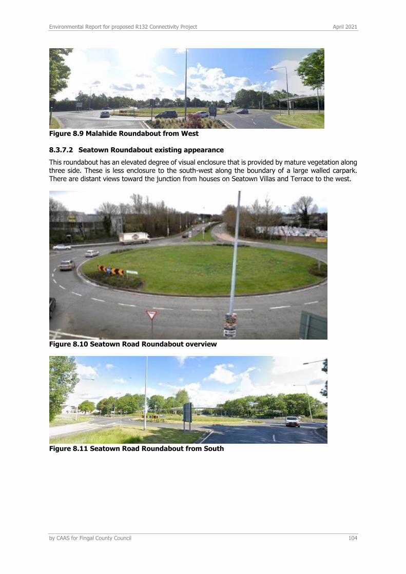
Environmental Report for proposed R132 Connectivity Project April 2021
by CAAS for Fingal County Council 104
Figure 8.9 Malahide Roundabout from West
8.3.7.2 Seatown Roundabout existing appearance
This roundabout has an elevated degree of visual enclosure that is provided by mature vegetation along three side. These is less enclosure to the south-west along the boundary of a large walled carpark. There are distant views toward the junction from houses on Seatown Villas and Terrace to the west.
Figure 8.10 Seatown Road Roundabout overview
Figure 8.11 Seatown Road Roundabout from South

Environmental Report for proposed R132 Connectivity Project April 2021
by CAAS for Fingal County Council 105
Figure 8.12 Seatown Road Roundabout from East
Figure 8.13 Seatown Road Roundabout from North
Figure 8.14 Seatown Road Roundabout from West
8.3.8 ESTUARY ROAD ROUNDABOUT EXISTING APPEARANCE
This roundabout has low visual enclosure on the north and west. These is more enclosure to the south from mature trees. There are distant views toward the junction from the upper floors of houses on Newcourt Mews to the west.
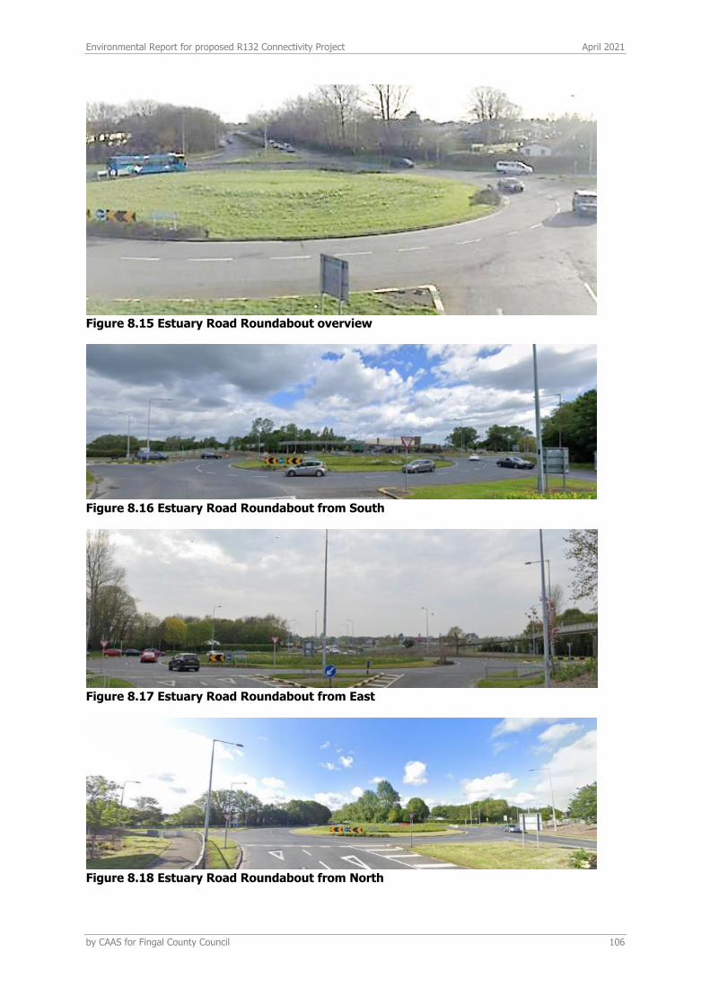
Environmental Report for proposed R132 Connectivity Project April 2021
by CAAS for Fingal County Council 106
Figure 8.15 Estuary Road Roundabout overview
Figure 8.16 Estuary Road Roundabout from South
Figure 8.17 Estuary Road Roundabout from East
Figure 8.18 Estuary Road Roundabout from North
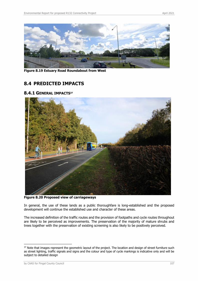
Environmental Report for proposed R132 Connectivity Project April 2021
by CAAS for Fingal County Council 107
Figure 8.19 Estuary Road Roundabout from West
8.4 PREDICTED IMPACTS
8.4.1 GENERAL IMPACTS37
Figure 8.20 Proposed view of carriageways In general, the use of these lands as a public thoroughfare is long-established and the proposed development will continue the established use and character of these areas. The increased definition of the traffic routes and the provision of footpaths and cycle routes throughout are likely to be perceived as improvements. The preservation of the majority of mature shrubs and trees together with the preservation of existing screening is also likely to be positively perceived.
37 Note that images represent the geometric layout of the project. The location and design of street furniture such as street lighting, traffic signals and signs and the colour and type of cycle markings is indicative only and will be subject to detailed design
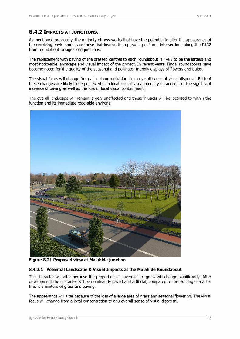
Environmental Report for proposed R132 Connectivity Project April 2021
by CAAS for Fingal County Council 108
8.4.2 IMPACTS AT JUNCTIONS.
As mentioned previously, the majority of new works that have the potential to alter the appearance of the receiving environment are those that involve the upgrading of three intersections along the R132 from roundabout to signalised junctions. The replacement with paving of the grassed centres to each roundabout is likely to be the largest and most noticeable landscape and visual impact of the project. In recent years, Fingal roundabouts have become noted for the quality of the seasonal and pollinator friendly displays of flowers and bulbs. The visual focus will change from a local concentration to an overall sense of visual dispersal. Both of these changes are likely to be perceived as a local loss of visual amenity on account of the significant increase of paving as well as the loss of local visual containment. The overall landscape will remain largely unaffected and these impacts will be localised to within the junction and its immediate road-side environs.
Figure 8.21 Proposed view at Malahide junction
8.4.2.1 Potential Landscape & Visual Impacts at the Malahide Roundabout
The character will alter because the proportion of pavement to grass will change significantly. After development the character will be dominantly paved and artificial, compared to the existing character that is a mixture of grass and paving. The appearance will alter because of the loss of a large area of grass and seasonal flowering. The visual focus will change from a local concentration to anu overall sense of visual dispersal.

Environmental Report for proposed R132 Connectivity Project April 2021
by CAAS for Fingal County Council 109
Both of these changes are likely to be perceived as a local loss of visual amenity. The overall landscape will remain largely unaffected and these impacts will be localised to within the junction and its immediate road-side environs. The revised junction off Drynam Road will introduce a small paved surface into an area that is currently grassed. This effect will be offset by the removal of a much larger area of exiting paved surfaces. The further additions to existing dense vegetation that screens views from the rear of houses on Foxwood will avoid adverse visual effects.
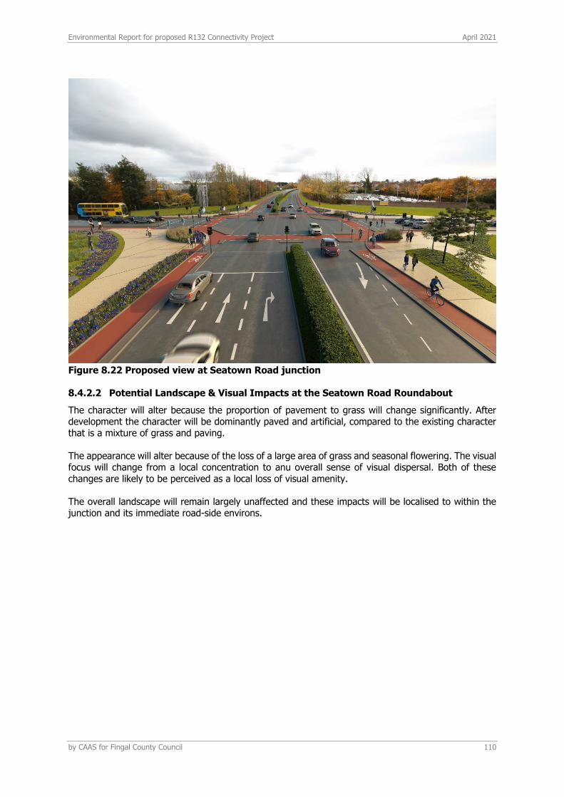
Environmental Report for proposed R132 Connectivity Project April 2021
by CAAS for Fingal County Council 110
Figure 8.22 Proposed view at Seatown Road junction
8.4.2.2 Potential Landscape & Visual Impacts at the Seatown Road Roundabout
The character will alter because the proportion of pavement to grass will change significantly. After development the character will be dominantly paved and artificial, compared to the existing character that is a mixture of grass and paving. The appearance will alter because of the loss of a large area of grass and seasonal flowering. The visual focus will change from a local concentration to anu overall sense of visual dispersal. Both of these changes are likely to be perceived as a local loss of visual amenity. The overall landscape will remain largely unaffected and these impacts will be localised to within the junction and its immediate road-side environs.
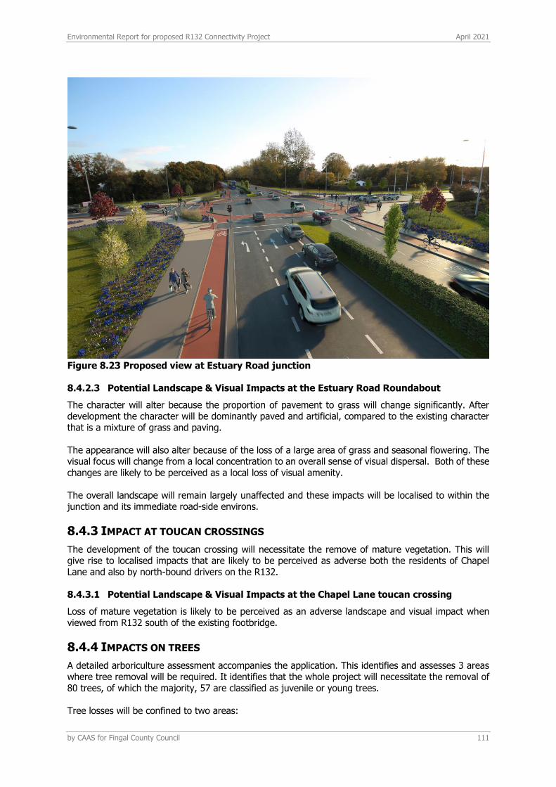
Environmental Report for proposed R132 Connectivity Project April 2021
by CAAS for Fingal County Council 111
Figure 8.23 Proposed view at Estuary Road junction
8.4.2.3 Potential Landscape & Visual Impacts at the Estuary Road Roundabout
The character will alter because the proportion of pavement to grass will change significantly. After development the character will be dominantly paved and artificial, compared to the existing character that is a mixture of grass and paving. The appearance will also alter because of the loss of a large area of grass and seasonal flowering. The visual focus will change from a local concentration to an overall sense of visual dispersal. Both of these changes are likely to be perceived as a local loss of visual amenity. The overall landscape will remain largely unaffected and these impacts will be localised to within the junction and its immediate road-side environs.
8.4.3 IMPACT AT TOUCAN CROSSINGS
The development of the toucan crossing will necessitate the remove of mature vegetation. This will give rise to localised impacts that are likely to be perceived as adverse both the residents of Chapel Lane and also by north-bound drivers on the R132.
8.4.3.1 Potential Landscape & Visual Impacts at the Chapel Lane toucan crossing
Loss of mature vegetation is likely to be perceived as an adverse landscape and visual impact when viewed from R132 south of the existing footbridge.
8.4.4 IMPACTS ON TREES
A detailed arboriculture assessment accompanies the application. This identifies and assesses 3 areas where tree removal will be required. It identifies that the whole project will necessitate the removal of 80 trees, of which the majority, 57 are classified as juvenile or young trees. Tree losses will be confined to two areas:
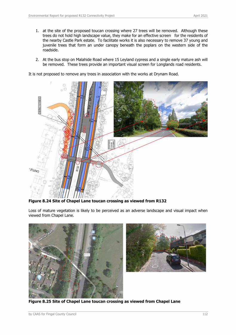
Environmental Report for proposed R132 Connectivity Project April 2021
by CAAS for Fingal County Council 112
1. at the site of the proposed toucan crossing where 27 trees will be removed. Although these trees do not hold high landscape value, they make for an effective screen for the residents of the nearby Castle Park estate. To facilitate works it is also necessary to remove 37 young and juvenile trees that form an under canopy beneath the poplars on the western side of the roadside.
2. At the bus stop on Malahide Road where 15 Leyland cypress and a single early mature ash will be removed. These trees provide an important visual screen for Longlands road residents.
It is not proposed to remove any trees in association with the works at Drynam Road.
Figure 8.24 Site of Chapel Lane toucan crossing as viewed from R132 Loss of mature vegetation is likely to be perceived as an adverse landscape and visual impact when viewed from Chapel Lane.
Figure 8.25 Site of Chapel Lane toucan crossing as viewed from Chapel Lane
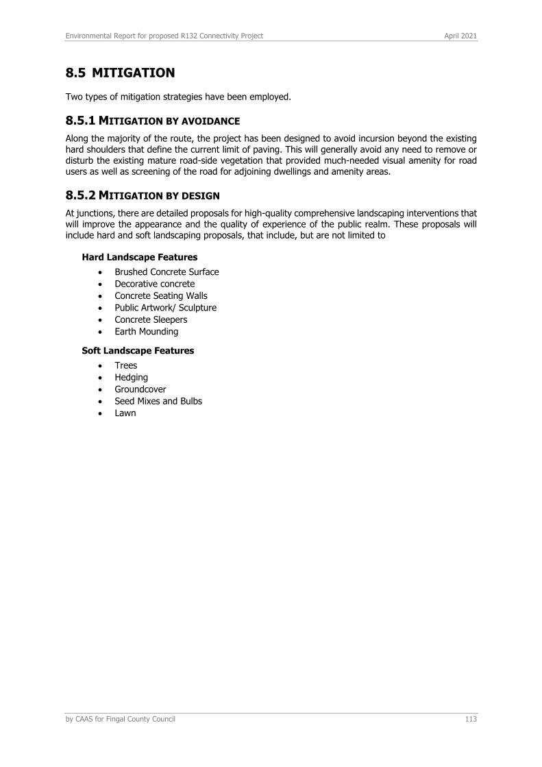
Environmental Report for proposed R132 Connectivity Project April 2021
by CAAS for Fingal County Council 113
8.5 MITIGATION
Two types of mitigation strategies have been employed.
8.5.1 MITIGATION BY AVOIDANCE
Along the majority of the route, the project has been designed to avoid incursion beyond the existing hard shoulders that define the current limit of paving. This will generally avoid any need to remove or disturb the existing mature road-side vegetation that provided much-needed visual amenity for road users as well as screening of the road for adjoining dwellings and amenity areas.
8.5.2 MITIGATION BY DESIGN
At junctions, there are detailed proposals for high-quality comprehensive landscaping interventions that will improve the appearance and the quality of experience of the public realm. These proposals will include hard and soft landscaping proposals, that include, but are not limited to
Hard Landscape Features
• Brushed Concrete Surface
• Decorative concrete
• Concrete Seating Walls
• Public Artwork/ Sculpture
• Concrete Sleepers
• Earth Mounding
Soft Landscape Features
• Trees
• Hedging
• Groundcover
• Seed Mixes and Bulbs
• Lawn
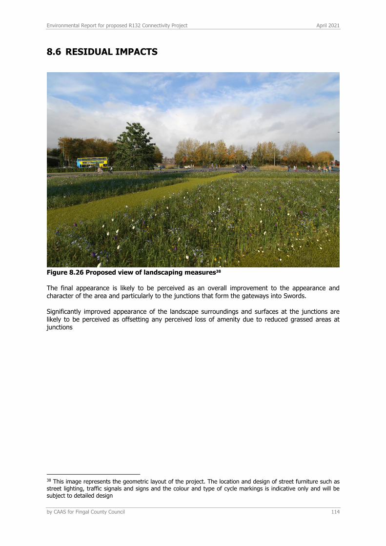
Environmental Report for proposed R132 Connectivity Project April 2021
by CAAS for Fingal County Council 114
8.6 RESIDUAL IMPACTS
Figure 8.26 Proposed view of landscaping measures38 The final appearance is likely to be perceived as an overall improvement to the appearance and character of the area and particularly to the junctions that form the gateways into Swords. Significantly improved appearance of the landscape surroundings and surfaces at the junctions are likely to be perceived as offsetting any perceived loss of amenity due to reduced grassed areas at junctions
38 This image represents the geometric layout of the project. The location and design of street furniture such as street lighting, traffic signals and signs and the colour and type of cycle markings is indicative only and will be subject to detailed design
Environmental Report for proposed R132 Connectivity Project April 2021
by CAAS for Fingal County Council 115
9 CULTURAL HERTIAGE (ARCHAEOLOGY)
9.1 INTRODUCTION/METHODOLOGY
This section presents the results of an impact assessment of the archaeological and cultural heritage landscape surrounding the proposed project. The assessment is based on both a desktop review of the available archaeological data within and adjacent to the study area and a site inspection. This section amalgamates desk-based research, GIS mapping and the results of field assessment to identify areas of archaeological potential which are likely to be impacted by the proposed project. An assessment of impacts is presented and mitigatory measures are recommended where appropriate. The visual impact of the proposed project on newly discovered monuments/sites of significance as well as known recorded monuments and items of cultural/architectural heritage is also considered.
9.2 PROPOSED DEVELOPMENT
A full development description is included in Section 2 of this document. The main phases of this project include:
• Site clearance and preparation • A construction phase using standard building materials • Construction will include new surface water drainage and modifications to existing
underground services such as telecommunications ducting, watermains and upgrading of existing public lighting to accommodate the proposed junction layouts.
• A landscaping phase following completion of the principal road related works. • An operation phase whereby the roads will be used by vehicular, pedestrian and cycle traffic.
9.3 LEGISLATION & GUIDELINES
9.3.1 CURRENT LEGISLATION
Archaeological monuments are safeguarded through national and international policy, which is designed to secure the protection of the cultural heritage resource. This is undertaken in accordance with the provisions of the European Convention on the Protection of the Archaeological Heritage (Valletta Convention). This was ratified by Ireland in 1997. Both the National Monuments Acts 1930 to 2004 and relevant provisions of the Cultural Institutions Act 1997 are the primary means of ensuring protection of archaeological monuments, the latter of which includes all man-made structures of whatever form or date. There are a number of provisions under the National Monuments Acts which ensure protection of the archaeological resource. These include the Register of Historic Monuments (1997 Act) which means that any interference to a monument is illegal under that Act. All registered monuments are included on the Record of Monuments and Places (RMP). The Record of Monuments and Places (RMP) was established under Section 12 (1) of the National Monuments (Amendment) Act 1994 and consists of a list of known archaeological monuments and accompanying maps. The Record of Monuments and Places affords some protection to the monuments entered therein. Section 12 (3) of the 1994 Amendment Act states that any person proposing to carry out work at or in relation to a recorded monument must give notice in writing to the Minister (Environment, Heritage and Local Government) and shall not commence the work for a period of two months after having given the notice. All proposed works, therefore, within or around any archaeological monument are subject to statutory protection and legislation (National Monuments Acts 1930-2004).

Environmental Report for proposed R132 Connectivity Project April 2021
by CAAS for Fingal County Council 116
Under the Heritage Act (1995) architectural heritage is defined to include ‘all structures, buildings, traditional and designed, and groups of buildings including street-scapes and urban vistas, which are of historical, archaeological, artistic, engineering, scientific, social or technical interest, together with their setting, attendant grounds, fixtures, fittings and contents…’. A heritage building is also defined to include ‘any building, or part thereof, which is of significance because of its intrinsic architectural or artistic quality or its setting or because of its association with the commercial, cultural, economic, industrial, military, political, social or religious history of the place where it is situated or of the country or generally‘.
9.3.2 FINGAL COUNTY DEVELOPMENT PLAN 2017-2023
The National Monuments Acts 1930-2004 provide for the protection of archaeological sites, monuments, artefacts and shipwrecks that are listed in the Record of Monuments and Places (RMP).The Fingal County Development Plan 2017 -2023 contains a number of objectives relating to the protection of the Archaeological resource. A list of the relevant objectives can be found in Appendix 9.1 of this report.
9.4 METHODOLOGY
The assessment of the archaeology, architecture and cultural heritage of the proposed project area included GIS mapping and desk-based research followed by field inspection. A desk-based study of the proposed project site was initially undertaken in order to assess the archaeological, architectural and cultural heritage potential of the area and to identify constraints or features of archaeological/cultural heritage significance within or near to the proposed project site.
9.4.1 GEOGRAPHICAL INFORMATION SYSTEMS
GIS is a computer database which captures, stores, analyses, manages and presents data that is linked to location. GIS is geographic information systems which includes mapping software and its application with remote sensing, land surveying, aerial photography, mathematics, photogrammetry, geography and tools that can be implemented with GIS software. A geographic information system (GIS) was used to manage the datasets relevant to the archaeological and architectural heritage assessment and for the creation of all the maps in this section of the report. This involved the overlaying of the relevant archaeological and architectural datasets on georeferenced aerial photographs and road maps (ESRI), where available. The integration of this spatial information allows for the accurate measurement of distances of a proposed project from archaeological and cultural heritage sites and the extraction of information on ‘monument types’ from the datasets. Areas of archaeological or architectural sensitivity may then be highlighted in order to mitigate the potential negative effects of a development or project on archaeological, architectural and cultural heritage.
9.4.2 DESKTOP ASSESSMENT
A primary cartographic source and base-line data for the assessment was the consultation of the Sites and Monuments Record (SMR) and Record of Monuments and Places (RMP) for County Dublin. All known recorded archaeological monuments are indicated on 6 inch Ordnance Survey (OS) maps and are listed in aforementioned records. The 1st (1840s) and 2nd (1900s) edition OS maps for the area were also consulted. The following sources were consulted for this assessment report:
• The Record of Monuments and Places (RMP) • The Sites and Monuments Record (SMR) • The Topographical Files of the National Museum of Ireland • First edition Ordnance Survey maps (OSI) • Second edition Ordnance Survey maps (OSI) • Third edition Ordnance Survey Map (Record of Monuments and Places) • Aerial photographs (copyright of Ordnance Survey Ireland (OSI) • Excavations Database
Environmental Report for proposed R132 Connectivity Project April 2021
by CAAS for Fingal County Council 117
• Heritage Maps containing locational details for excavations and TII excavations
9.4.2.1 Record of Monuments and Places
A primary cartographic source and base-line data for the assessment was the consultation of the Sites and Monuments Record (SMR) and Record of Monuments and Places (RMP) for County Dublin. All known recorded archaeological monuments are indicated on 6 inch Ordnance Survey (OS) maps and are listed in these records. The SMR/RMP is not a complete record of all monuments as newly discovered sites may not appear in the list or accompanying maps. In conjunction with the consultation of the SMR and RMP the electronic database of recorded monuments and SMRs which may be accessed at https://www.archaeology.ie/archaeological-survey-ireland/historic-environment-viewer-application was consulted.
9.4.2.2 Cartographic sources and aerial photography
The 1st (1840s) and 2nd (1900s) edition OS maps for the area were consulted, where available, as was OSI aerial photography.
9.4.2.3 Topographical files - National Museum of Ireland
Details relating to finds of archaeological material and monuments in numerous townlands in the country are contained in the topographical files held in the National Museum of Ireland. In order to establish if any new or previously unrecorded finds had been recovered from the study area these files were consulted for every townland within and adjacent to the same. The database on Heritage Maps was consulted.
9.4.2.4 Archaeological inventory aeries
Further information on archaeological sites may be obtained in the published County Archaeological Inventory series prepared by the Department of Culture, Heritage and the Gaeltacht. The archaeological inventories present summarised information on sites listed in the SMR/RMP and include detail such as the size and location of particular monuments as well as any associated folklore or local information pertaining to each site. The inventories, however, do not account for all sites or items of cultural heritage interest which are as yet undiscovered.
9.4.2.5 Excavations database
The Excavations Database is an annual account of all excavations carried out under license. The database is available on line at www.excavations.ie and includes excavations from 1985 to 2020. This database was consulted as part of the desktop research for this assessment to establish if any archaeological excavations had been carried out within or near to the proposed project area.
9.4.2.6 National Inventory of Architectural Heritage (NIAH)
This source lists some of the architecturally significant buildings and items of cultural heritage and is compiled on a county by county basis by the Department of Culture, Heritage and the Gaeltacht. The NIAH database was consulted for all townlands within and adjacent to the study area. The NIAH survey for Clare has been published and was downloaded on to the base mapping for the proposed (www.buildingsofireland.ie). The National Inventory of Architectural Heritage (NIAH) is a state initiative under the administration of the Department of Culture, Heritage and the Gaeltacht and established on a statutory basis under the provisions of the Architectural Heritage (National Inventory) and Historic Monuments (Miscellaneous Provisions) Act 1999. The purpose of the NIAH is to identify, record, and evaluate the post-1700 architectural heritage of Ireland, uniformly and consistently as an aid in the protection and conservation of the built heritage. NIAH surveys provide the basis for the recommendations of the Minister for the Environment, Heritage and Local Government to the planning authorities for the inclusion of particular structures in their Record of Protected Structures (RPS). The published surveys are a source of information on the selected structures for relevant planning authorities. They are also a research and educational

Environmental Report for proposed R132 Connectivity Project April 2021
by CAAS for Fingal County Council 118
resource. It is hoped that the work of the NIAH will increase public awareness and appreciation of Ireland's architectural heritage.
9.4.3 FIELD INSPECTION
The proposed works areas were inspected on the 2nd February 2021. The inspection consisted of a walk-over examination of the sites and a full photographic and descriptive record of the site was made.
9.5 EXISTING ENVIRONMENT
9.6 HISTORICAL BACKGROUND
The proposed project area is located c. 370m to the east of the historic town of Swords. Swords town (RMP Ref: DU011-034) is at the heart of an area that was of particular importance in the medieval period. It is said to have owed its origins to the establishment of the early medieval foundation founded by St Colmcille who died in AD 597, though there seems to have already been an established population base in the Swords area prior to this. The name ‘Swords’ derives from the Irish Sord Colmcille or ‘St Colmcille’s well’, taken from the Irish word sord meaning ‘pure’. The name is also given to a pagan spring or well (Joyce, 1995, 566). The well site was one of the principal sources of water supply in the town and is recorded in the Record of Monument and Places (RMP) (DU011-034/013). The association of the early foundation of Swords with St Colmcille, who appointed St Fínán Lobhar (the Leper), could suggest a 6th-century date for the site’s foundation (Gwynn and Hadcock 1988, 44). However, there are no contemporary documentary sources to confirm this. It has been suggested that Colmcille was the founder of Swords and that it was transferred to a Columban paruchia at a later date (ibid., 44). The Early Christian monastery was established on a ridge of high ground adjacent to the Ward River, known in medieval documentation as Reynen (Bradley, 1998). The foundation was first mentioned in the Annals in AD 965 when Ailill Mac Maenach, Bishop of Swords and Lusk, died (ibid., 44). It was burned in AD 994 by Maelseachlainn and at several times thereafter. The Round Tower is the only upstanding element of the original monastic establishment (and can be seen from the castle); the medieval church tower belongs to a structure erected in the later Middle Ages. Three churches have been recorded at Swords, dedicated to Saints Fintan, Brigid and Catherine. It has been supposed that these churches were all located within the present Church of Ireland site (D’Alton, 1838, 264). One of the most notable events in the history of Swords was the funeral of King Brian Boru and his son Morrough, after the Battle of Clontarf in 1014. Howard Clarke (2004, 153) records that ‘Brian Bórama’s body was handed over to the Armagh clerics at Swords, then a church on the border of Fine Gall’. The first contemporary documentary references to Swords appear in the late 10th/early 11th century when it became a target of attack by the Vikings of Dublin. This area became known as Fingal, or ‘the land of the foreigners’, a name that is still in use today. The Annals of the Four Masters (AFM) and Annals of Ulster (AU) record that in 1012 and 1016, Swords was burned by the ‘Danes’ or Vikings. The Vikings held Swords in the 11th century. In 1035, Sitric, King of Dublin, burned and wasted Ardbraccan in the Kingdom of Meath, and Conor O’Melaghlin, King of Meath, had burned Swords in retaliation. The close ties Swords would have held with the Vikings of Dublin made it a prime target for raids by the O’Melaghlin Kings of Meath, who repeatedly attacked Swords in 1069, 1130, 1135, 1138, 1150, and 1166. In 1135, Swords was virtually de-populated by Conor O’Melaghlin, who was eventually killed by the Vikings at Lusk. There is a reference to ‘sixteen foreign burgess’ in the extent of the manor in 1326; the burgagii forinseci is a term used to describe Ostmen/Viking settlements. According to Bradley (1998), there may have been a Scandinavian settlement in addition to the monastery in the period prior to the arrival of the AngloNormans. The close ties Swords would have held with the Vikings of Dublin made it a prime target for raids. The development of the town Before the Anglo-Norman invasion, the monastery and its possessions had been transferred to the Archbishop of Dublin. Swords subsequently became one of the principal archiepiscopal manors. After the Anglo-Norman invasion of 1169, the property of the monastery of Swords formed part of the lands of the See of Dublin, confirmed to Archbishop Laurence O’Toole in 1179 (McNeill, 1950). The extensive lands attached to the archbishopric were organised through a network of nine manorial
Environmental Report for proposed R132 Connectivity Project April 2021
by CAAS for Fingal County Council 119
centres: St Sepulchre (the principal manor), Tallaght, Rathcoole, Clondalkin, Shankill, Ballymore Eustace, Castlekevin, Swords and possibly Finglas (Wood, 1930).
9.6.1 ECCLESIASTICAL REMAINS
The boundary of Swords Glebe together with the curving alignment of the Brackenstown Road, Church Road and Rathbeale indicate the original extent of the early monastic foundation associated with St. Colmcille. On the south side the steep slope down to the Ward river immediately south of the Brackenstown Road forms a natural boundary. Cartographic evidence suggests that the western enclosure was most likely aligned along a former laneway visible on the Ordnance Survey six inch maps, now St Columba's Rise housing estate. Only the residential W tower of the medieval parish church survives. It lies on a height northwest of the C of I church (dated 1818) within the churchyard. A gable scar is present on the south wall. An early medieval cross slab (DU011-034007-) is built into the base of the south wall. The tower rises to four storeys with a belfry stage. The upper floors are offset and the style of the masonry changes at belfry stage. Built of coursed limestone masonry with dressed quoins. The tower is entered through a pointed arched doorway with late dressing in the south wall. The ground floor is square in plan with a corner turret in the SW which contains a stone newel staircase (int. dims 4m E-W, 4.40 N-S, wall Wth 1.40m). There is a barrel vault over the ground floor. Interior is lit by a single ope with chamfered exterior in the N corner of the E wall. The stairway is lit with single slit opes. Upper floors are entered through pointed arched, double centred doorways with late dressing. First floor is lit by a round-headed window under a flat segmental arch in the N wall. There is a flat lintelled fireplace in the S wall of the second floor with two wall presses to the W of it. The corbels which held the third floor are present. The belfry stage is entered through a flat-arched doorway with punch dressing. There are large pointed segmental-arched openings with louvres in the N, S, and E sides.
9.6.2 SWORDS HISTORIC TOWN
Archbishop Comyn established a borough in Swords in the late 12th century and confirmed the burgesses of Swords in their burgages with an established annual rent of 1s. per burgage (Mc Neill 1950, 32; Bradley and King, 1988, 306-310). An extent of the manor in 1326 noted that there were the 122 burgesses. The settlement was granted a new charter by Elizabeth 1 In 1578 which established it as a parliamentary borough and this was confirmed in 1603 on the accession of James 1. According to D'Alton (1838, 141) the town was considered one of the walled towns of Dublin in 1578. The long linear boundary delimiting the properties on the E side of Main Street is an obvious line for these defences but the S boundary is unclear. The stream would have provided a defence on the W and the parish church (DU011-034004-) may have been protected by remnants of its ecclesiastical enclosure (DU011-034002-). The medieval town was linear in form and was laid out along the present Main Street, which is called High Street in in medieval documentation (Mc Neill 1950, 285) focused onto the gates of the Archbishop's castle. There is a reference in a 14th century deed to a lane called Le Camerothe. It ran in an E-W direction and could possibly be the modern Well Road or Seatown Road. A weekly market was confirmed to the archbishops in 1395 and this was located in Main street which expands noticeably towards its N end to accommodate it. There are many references to burgages and individual properties in Archbishop Alen's register but none can be identified with present day properties (Mc Neill 1950, 284). The remains of a number of late medieval houses seems to have survived into the 19th century but none is in evidence now. D'Alton (1838, 136) states that the 'Anchor Inn' still attracts the eye of the traveller by its ancient aspect' and he adds that several houses exhibited the ancient escutcheons of inns, and he listed the Harp, the Anchor, the Black Bull, and the Royal Oak (D'Alton 1838, 137-8).
Environmental Report for proposed R132 Connectivity Project April 2021
by CAAS for Fingal County Council 120
9.6.3 SWORDS CASTLE
Situated on rising ground at the NE end of Swords Village. Built c. 1200 as the manorial residence of the Archbishop of Dublin (Anon 1914, 260-261). The curtain wall forms an irregular polygon in plan enclosing an area of one and one third acres. The entrance is in the S through a barrel-vaulted archway, which provides access to a range of buildings in the E and W. To the E is the chapel with a residential tower that rises to three storeys with a vaulted ground floor. There is a double-light, trefoil-headed window with transom in the S wall of the 2nd floor of the tower. The chapel is entered from the E wall of the tower and through round-headed doorways in the N wall of the chapel. Fourteenth century tiles were found during excavations of the chapel in the 1970's (Fanning 1975, 47-82). In the SE angle of the curtain wall are traces of a two-storey building with four plain windows and a fireplace in the E wall. This is thought to have been an oratory. A medieval tile pavement came to light in this building during excavations (Fanning 1975, 61ff). Along the E section of curtain wall is a three storey tower immediately S of a building referred to as the 'Great hall' (Anon 1914, 260-261). It has a vaulted ground floor and a stairwell in the NE angle. The first floor is lit by a large window with red sandstone moulding and tracery. There is a domestic range W of the entrance to the castle. The curtain wall is battlemented with parapet walks defended by towers in the E, N and SW sections. The impressive N tower is three storeys high with a stairwell in the SW angle. Sandstone has been used in the windows. The SW tower projects beyond the line of the curtain wall. At the SW angle is a turret on a stepped squinch arch and corbels. The buildings to the W of the entrance are made up of three compartments, all barrel-vaulted at ground floor level. The first floor of one of them carries over the gateway. This has a pointed arched window on the S side formed with Dundry stone and red sandstone. Archaeological monitoring along the southern boundary of the castle in 1993 revealed a large rock cut ditch c. 2.2m out from the base of the wall. This is thought to be the line of the outer castle moat (Swan 1994, 33). Further test-excavation along the same boundary to the east revealed a minimum depth of 2m of medieval deposits (Licence no. 02E1279). Internally the removal of overburden immediately north of the Knights and Squire’s chamber (Licence no.01E002) and monitoring of service insertions (1996-97) in front of Constable’s tower revealed the presence of archaeological activity such as wall footings, surfaces and drains, which are preserved under geotextile. In 2009 monitoring (Consent E004376) of service insertions took place outside the gateway arch uncovering two parallel walls traversing the exterior of the castle. Excavations in 2014 within the gatehouse in advance of proposed stabilisation uncovered burials that appear to predate the construction of the gatehouse. As part of the preparation of the Conservation Plan, geophysical survey (Licence no. 11R038) was undertaken within the castle walls identifying possible building foundations. Swords Castle has undergone a series of restoration initiatives based on designs by David Newman Johnson since the mid-1990s. The chapel has recently reopened. Swords castle Conservation Plan was published in 2014. http://www.fingal.ie/media/Swords%20Castle%20Conservation%20Plan_final.pdf
9.7 TOWNLANDS
The proposed project traverses a number of townlands which are detailed below in Table 9.1 and Figure 9.1 Townlands through which the proposed project extends.. Table 9.1 Townlands through which the proposed project extends.
TOWNLAND GAEILGE LOGAINM ID
MEANNG
Miltonsfields Páirceanna Bhaile an Mhuilinn
17047 Mill Fields
Crowscastle Caisleán na bPréachán
17039 Crows Castle
Balheary Demesne
Diméin Bhaile Anraí 17059 Moladh Baile Háraí 'Harry was the regular pronunciation of Henry in the Middle Ages but is

Environmental Report for proposed R132 Connectivity Project April 2021
by CAAS for Fingal County Council 121
rarely found in the documents where the name is usually in the Latin form Henricus' Reaney 155 '[Henry] One of the most popular Norman names. The English form was Herry or Harry' Reaney 161 Nóta: John Herre CJR 313 (1300)
Cremona Cremona 17067 Unknown
Swords Demesne
Diméin Shoird 17054 Swerdes, the churches of St. Columba and St. Fintan (Calendar of Archbishop Alen's Register (ed. McNeill, 1950)
Fosterstown North
Baile an Fhoraistéaraigh Thuaidh
17073 Foresterestowne, Simon
Newtown An Baile Nua 17083 Homestead – Folklore – ‘My address is
Newtown, The Ward. There are names on
some of the fields around my house such as
"The Crock" and "The Devil's Acre" in The
Ward. There was supposed to be a crock of
gold found in the former but I do not know
what the latter means’. The Schools’ Collection,
Volume 0789, Page 217
Commons East An Coimín Thoir 17038 little hollow, glen
Barrysparks Páirc an Bharraigh 17037 Barrys Parks
Seatown West Baile na Mara Thiar 17053 Seatown
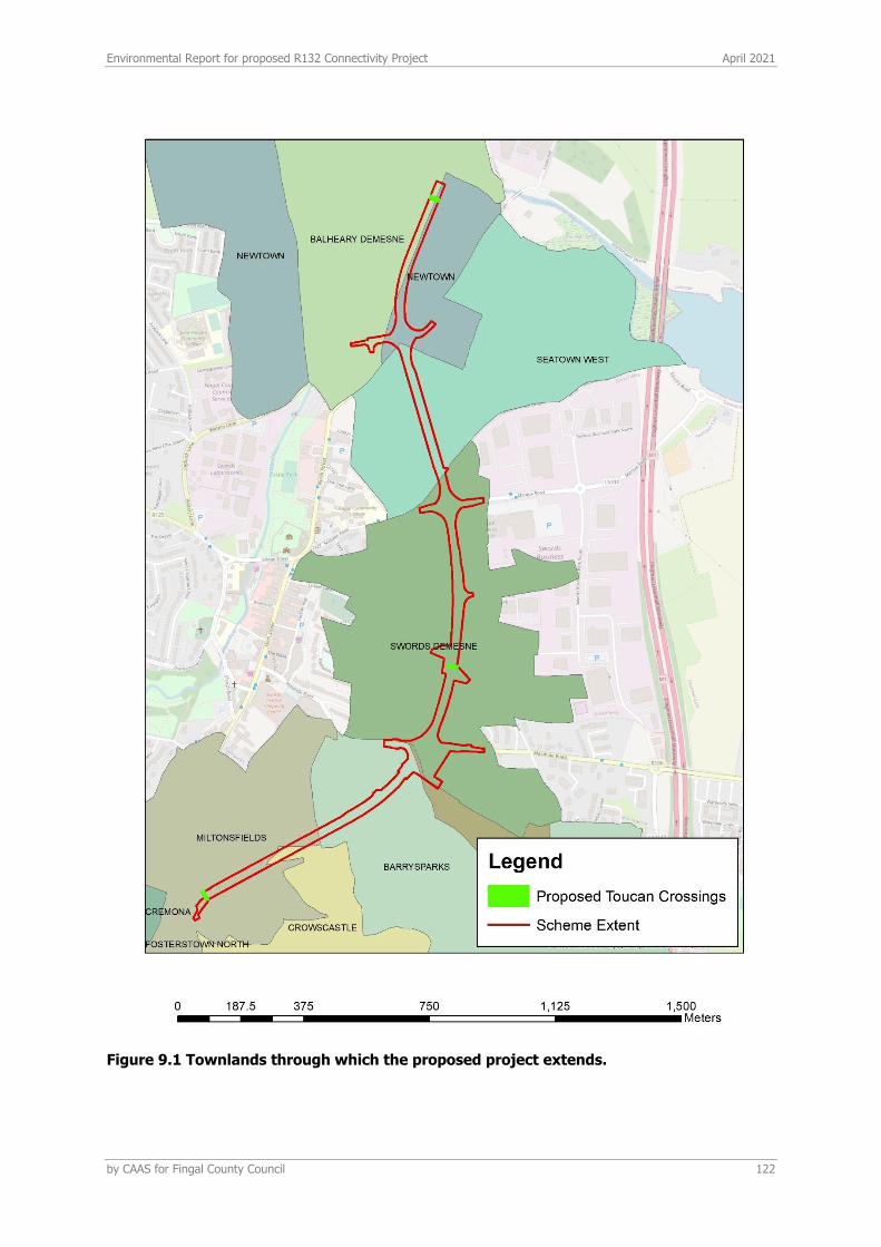
Environmental Report for proposed R132 Connectivity Project April 2021
by CAAS for Fingal County Council 122
Figure 9.1 Townlands through which the proposed project extends.
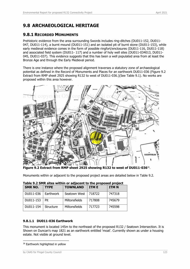
Environmental Report for proposed R132 Connectivity Project April 2021
by CAAS for Fingal County Council 123
9.8 ARCHAEOLOGICAL HERITAGE
9.8.1 RECORDED MONUMENTS
Prehistoric evidence from the area surrounding Swords includes ring-ditches (DU011-152, DU011- 047, DU011-114), a burnt mound (DU011-151) and an isolated pit of burnt stone (DU011-153), while early medieval evidence comes in the form of possible ringfort/enclosures (DU011-116, DU011-118) and associated field system (DU011- 117) and a number of holy well sites (DU011-034013, DU011-045, DU011-037). This evidence suggests that this has been a well populated area from at least the Bronze Age and through the Early Medieval period. There is one instance where the proposed alignment traverses a statutory zone of archaeological potential as defined in the Record of Monuments and Places for an earthwork DU011-036 (Figure 9.2 Extract from RMP sheet 2925 showing R132 to west of DU011-036.)(See Table 9.1). No works are proposed within this area however.
Figure 9.2 Extract from RMP sheet 2925 showing R132 to west of DU011-03639. Monuments within or adjacent to the proposed project areas are detailed below in Table 9.2. Table 9.2 SMR sites within or adjacent to the proposed project
SMR NO. TYPE TOWNLAND ITM E ITM N
DU011-036 Earthwork Seatown West 718722 747318
DU011-153 Pit Miltonsfields 717808 745679
DU011-154 Structure Miltonsfields 717723 745598
9.8.1.1 DU011-036 Earthwork
This monument is located 145m to the northeast of the proposed R132 / Seatown Intersection. It is Shown on Duncan's map 1821 as an earthwork entitled 'moat'. Currently shown as under a housing estate. Not visible at ground level.
39 Earthwork highlighted in yellow

Environmental Report for proposed R132 Connectivity Project April 2021
by CAAS for Fingal County Council 124
9.8.1.2 DU011-153 Pit
This monument was discovered during archaeological testing associated with the Metronorth advance archaeological testing phase in 2008/9 and is situated 285m south of the Pinnockhill roundabout. This monument was subject to geophysical survey (Licence no. 08R117) and test excavation (Licence no. 09E 0465) as part of the proposed Metro North development. A sub-circular pit (1.2m diam.) contained a charcoal rich fill with heat shattered stone, provisionally interpreted as Bronze Age in date (Fagan 2009, 20). This is also detailed below in Section 9.8.2.
9.8.1.3 DU011-154 Structure
This monument is located to the south of the latter monument and again the features were uncovered during testing associated with the Metro North scheme in 2009 (Excavation Licence Number: 09E465, Fagan and O. Frazer, at Swords Demesne and Miltonsfield townlands). This monument was subject to geophysical survey (Licence no. 08R117) and test excavation (licence no. 09E 0465) as part of the proposed Metro North development. It consists of a metalled surface (7.25m x 5.9m) associated with three U-shaped channels, postholes and pits. Although no diagnostic material was recovered the remains were interpreted on the basis of the morphology as a medieval structure (Fagan 2009, 23). This is further discussed in Section 9.8.2.1 where the detail of the test excavations in the vicinity are described. Furthermore, impacts and mitigation are addressed below in Section 9.9.
9.8.1.4 DU011-101 Burial Ground
This burial site is located 240m to the west of the R132 alignment. In 2003 pre-development investigation uncovered a cemetery which was in use from 550 AD to 1150 AD. Located on a low hillock overlooking Swords. The burial rite varied from crouched, flexed or extended inhumations. The range of grave types comprised simple unlined, stone-lined and lintel graves and body position changed throughout the use of the site. A total of 281 inhumed burials were revealed. The cemetery was unenclosed. No evidence for a stone or timber church or other building was discovered. Artefacts associated with the burials include aiglets or lace chapes used to protect the end of lace cords to tie a shirt or vest. A single female inhumation had a ring on her finger. The earliest dated burial between 549-610AD was a high status male 40-50 years old and buried within a lintel grave. Adults dominated the population (61%) juveniles represented about a third (29%) and only a small proportion of the population were infants (10%). Analysis of the human remains revealed evidence for disease, childbirth mortality and weapon-related injuries (O'Donovan, E. & Geber, J. 2009, 64-74). This demonstrates the sub-surface archaeological potential of Swords and its surrounds.
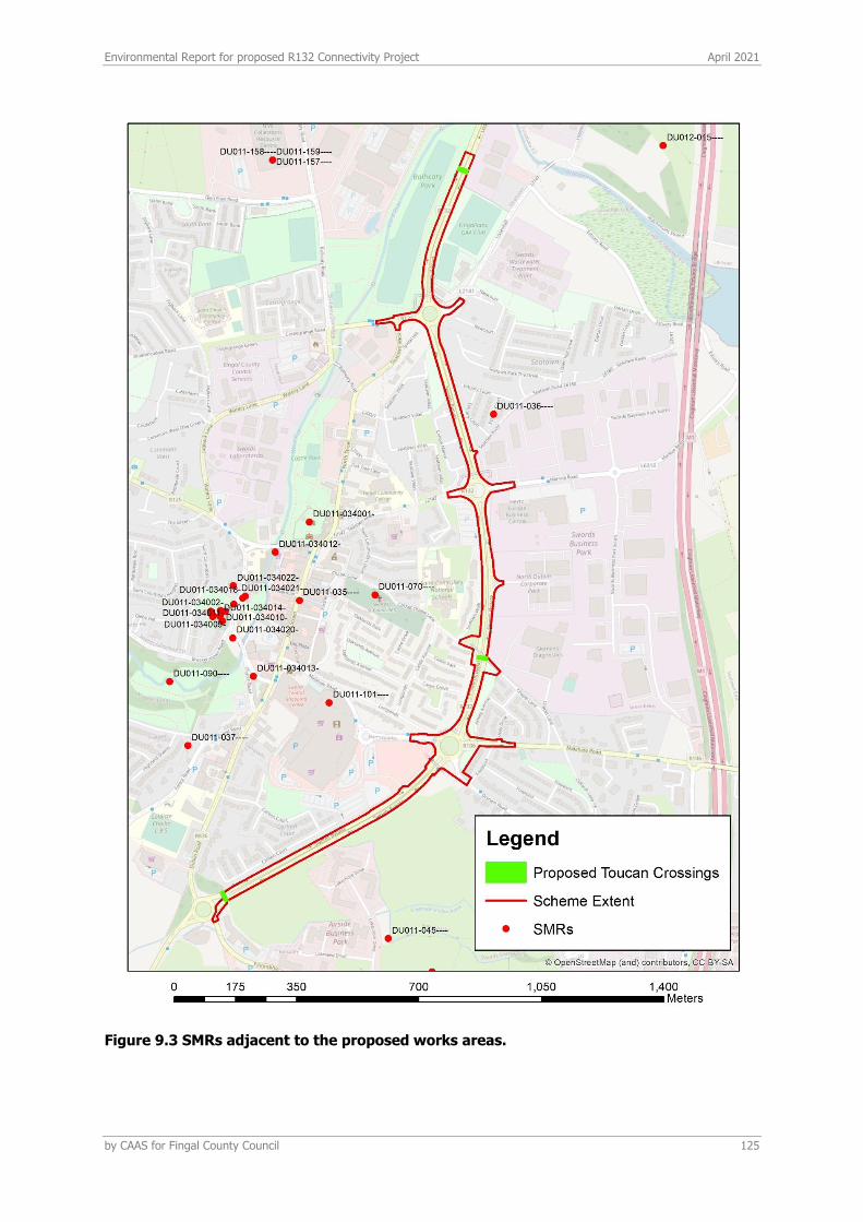
Environmental Report for proposed R132 Connectivity Project April 2021
by CAAS for Fingal County Council 125
Figure 9.3 SMRs adjacent to the proposed works areas.
Environmental Report for proposed R132 Connectivity Project April 2021
by CAAS for Fingal County Council 126
9.8.2 PREVIOUS EXCAVATIONS
9.8.2.1 Transport Infrastructure Ireland (TII) archaeological excavations
A programme of archaeological geophysical survey and advance archaeological testing was undertaken as part of the proposed Metro North Scheme in 2009. One testing programme resulted in the uncovering of archaeological features at Miltonsfield and Swords Demesne ‘Assessment Report on the Results of Metro North Advance Archaeological Test Trenching, Testing Area 7, Swords Demesne and Miltonsfield townlands, Co. Dublin, RPA ref: (MN101/MN102) Seatown Stop and Fosterstown Park & Ride (Fagan and Frazer 2009)’ (Microsoft Word - RPMN08 Testing Report TA7 1st Draft PL 110210 (tii.ie). This report revealed the presence of several archaeological features in the vicinity of the proposed crossing point at Fosterstown (near to the proposed Fosterstown Metro Station) (Testing Area 7) as detailed below. The findings were added to the Sites and Monuments Record as DU011-153--- and DU011-154--- and are situated to the south of Pinnockhill roundabout, outside the proposed development area.
Extract from testing report ‘Miltonsfield 1 (Sub-area 18 Test Trench 4) In Sub-area 18, Test Trench 4 two features were identified. The north/south orientated linear feature, located 4 m from the northwestern extent of the test trench, was interpreted as a field furrow. It was shallow with a depth of 0.18 m and contained fragments of broken red ceramic pipe. It appeared likely that it was of post-medieval or modern date and so its presence was noted but not recorded in any great archaeological detail. Of greater interest was the sub-circular shaped pit (101) (Figure 3; Plate 1). This feature was located approximately 0.71 m from the south-southeast extent of Test Trench 4 (GPS Lat: 53026 m, 52.315 m. Long: 6013 m, 35.175 m. Alt: 31 m.). It measured 1.20 m north/south by 1.05 m east/west and was 0.22 m in depth (Plate. 1). The feature was quarter sectioned by hand and from this the following details were ascertained. The pit was cut into the natural subsoil and had a bowl shaped profile. It had gradual breaks of slope to top, concave sides and a slightly concave base. It contained two fills. The basal fill (103) consisted of dark grey silt clay that contained inclusions of charcoal and heat-affected stones. The upper fill (102) was of grey silt clay. It is difficult to interpret this feature as it appeared to occur in isolation. The presence of heat-affected stone would be typical of a prehistoric burnt mound, making a provisional Bronze Age date possible (c.2200-500BC). Though no other features were identified in the immediate vicinity this feature was very well defined and could be indicative of further sub-surface archaeological remains. No burnt human bone was uncovered from either of the pit fills. It is therefore unlikely that this feature represented a cremation burial pit designed as a repository for burnt human remains. It is also difficult to discern if it may have been used as a refuse pit as no animal bone, fish bone or plant remains emerged from the excavated fills. While the evidence that could be gleaned from the test trenching is not sufficient for a definite interpretation for this feature (101), it would appear to be of archaeological significance. 7.4 Miltonsfield 2 (Sub-area 19 Test Trench 4 and Offset B) A metalled surface (024), which possibly represents the remains of a sub-rectangular building, was identified in Test Trench 4 and Offset B of Sub-area 19 approximately 34 m from the south-southwestern end of the test trench (Figures 4-7; Plates 3-7). Linear features that appear to represent a field system associated with the putative building remains were also identified in Test Trenches 2-4 ((004)-(006), (008)-(011), (014)-(018), and (022)).
No dating evidence was recovered from either the metalled surface or the associated linear ditches and stone drains. In a location so proximal to the important medieval and post-medieval centres of Swords and Dublin City itself, the lack of medieval or post-medieval ceramic is unusual (see Frazer forthcoming). The lack of pottery may therefore suggest that the archaeology dates from a predominantly aceramic era (i.e. prior to c.AD1200) or that the building is not domestic in nature and is thus less likely

Environmental Report for proposed R132 Connectivity Project April 2021
by CAAS for Fingal County Council 127
to have domestic pottery remains nearby. The apparent sub-rectangular shape in plan of the metalled surface - as opposed to a circular or oval shape - may suggest a construction date post c.AD800. Due to the lack of associated finds, it is suggested that the remains may provisionally date from the early medieval/late medieval eras (c.AD500–1600), but with an increased chance of dating from c.AD800–1200 as the likelihood of even stray pottery finds increases significantly after c.AD1600. As the route of the present R127 Dublin to Drogheda road is of some antiquity, there is a suspicion that the archaeology identified may be the rear portion of a narrow west-northwest/east-southeast oriented croft-and-toft-type landholding that extended off the predecessor to the R127. If such is the case, the former street frontage of such a property may have been lost beneath later road widening. This may mean that the putative building identified in Test Trench 4 and Offset B lay at the rear of a croft/garden enclosure; probably representing an outbuilding of some description (perhaps helping to explain the lack of ceramic finds there). The activity identified at Miltonsfield 2 was contained within an area of approximately 20 m north-northeast/south-southwest by 15 m. Linear features that may be a surviving remnant field system related to the building remains extended across Test Trenches 2-4 and included hand-dug linear ditches (016), (011), (004), (017), (010) and (005), hand-dug stone drains (015), (008), (018) and (006) and wide shallow ditches that are the possible remains of hedge boundaries (009), (014) and (022). On the recommendations of the RPA Project Archaeologists, a 20 m-wide buffer zone has been established around the archaeology, yielding a triangular 100 m by 50 m site that effectively includes all of Sub-area 19. It should be noted, however, that the density of archaeology within this site is likely to be very low outside of the central 20 m by 15 m area of the building remains.
The main activity at Miltonsfield 2 consisted of a metalled surface (024), measuring 7.25 m north-northeast by 5.9 m west-northwest(Figures 4-6; Plates 3-6). The compact surface consisted of round, sub-round and irregular small to medium-sized stones pressed down into the natural subsoil; although the density of the metalling varied throughout. Three u-shaped channels with gradual breaks of slope seemed to have been built into surface (024). The central of these channels, (028), was oriented north northwest/south-southeast and measured 0.75+ m long by 0.20 m wide by 0.08 m deep. It was lined along its western side and southern end by a row of slightly larger medium-sized stones. The westernmost drain (027) was oriented in a north/south direction and was 4.2+ m long. At its southern end it measured 0.30 m wide by 0.10 m deep. At its northern end it was slightly larger, with maximum dimensions of 0.40 m wide by 0.20 m deep. The larger measurements at the northern end of this feature are possibly the result of it intersecting with the central drain (028). The eastern drain (042) was oriented northeast/southwest and measured 0.70+ m long by 0.25 m wide. It was filled by large sub-round stones. At the southwestern corner of metalled surface (024) a small oval pit/possible posthole (019) was identified (Figures 4, 5 and 7; Plates 5 and7). This measured 0.67 m in length, 0.64 m in width and 0.28 m in depth. It was filled with a compact light grey silt clay (044). This contained large packing stones around its upper perimeter, occasional charcoal flecks concentrated at its base and frequent animal bone throughout. A second pit/possible posthole (026), measuring 0.60 m by 0.15+ m by 0.15 m deep, was identified along the western edge of the metalling. It contained a mid grey silt clay fill (045) with occasional charcoal flecks and tiny irregularly shaped stones. Both of these features possessed sharp breaks of slope on top, near vertical sides, gradual basal breaks of slope and concave bases. A large pit (021) was identified at the northwestern extent of the metalled surface (024) (Figures 4-6; Plates 3, 5 and 6). It was oval in plan, measuring 4.6+ m north northeast/ south-southwest by 1.0+ m, with a sharp break of slope on top and a gentle sloping, slightly stepped eastern side; the pit was not bottomed, but achieved a depth of 0.80+ m. Four fills were contained within this feature. The basal fill consisted of moderately compacted yellowish grey silty clay with inclusions of small sub angular
Environmental Report for proposed R132 Connectivity Project April 2021
by CAAS for Fingal County Council 128
stones (032). This was situated beneath moderately compacted mottled greyish orange silty clay (031), which contained inclusions of stone. The third fill consisted of moderately compacted mid-greyish yellow silty clay with inclusions of small to medium sub-rounded stones (030). This was overlain by the upper fill, moderately compacted mid-greyish yellow silty clay (029), containing inclusions of small to medium sub-rounded stones. Another sub-rectangular pit (025) was identified some4.5 m to the north-northeast of the metalled surface (024), approximately 50.0 m from the south-southwest end of Test Trench 4. It measured 1.25 m east/west by 1.14 m by 0.24 m deep and had a sharp break of slope on top, steeply sloping sides, a
gradual basal break of slope and a flat base. Overlying metalled surface (024) was a light yellow grey silt clay spread (020). This deposit may represent both erosion following the disuse of the metalled surface and the collapse of mass material walls (clay/mud) around it. The spread also overlay fill (045) of feature (026), however, its stratigraphic relationship with the other posthole (019) and with the large pit (021) to the northwest is unclear. Numerous linear features were also identified throughout Test Trench 4, with some extending into Test Trenches 2 and 3. None of these features contained postmedieval or modern finds and some of them were clearly hand-dug rather than excavated by machine. As they could not be related with any conviction to an extant field system, they may be a surviving field system contemporary to the aforementioned metalled surface (024)’.
The mitigation measures proposed in the testing report are detailed as follows:
‘the archaeology identified in Sub-areas 18 and 19 were grouped into two sites, Miltonsfield 1 and 2. For both sites, it is likely that heritage authorities will recommend a programme of ‘preservation by record’ of the archaeological remains. This will be required in order to preserve the cultural heritage of the ‘non-renewable archaeological resource’ concerned and to ameliorate the impact of the proposed scheme. The proposed areas for archaeological excavation, as illustrated on Figure 3, include the extent of archaeology stratigraphy as identified by the advance archaeological testing in addition to a recommended 20m buffer zone. This buffer zone was established in accordance with relevant heritage and planning legislation, the RPA Code of Practice (2007) and the recommendations of the RPA Project Archaeologist’.
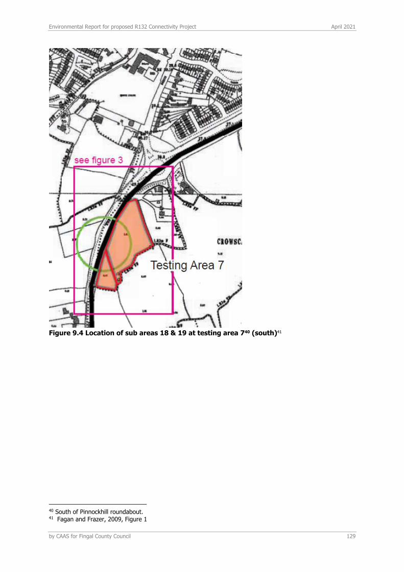
Environmental Report for proposed R132 Connectivity Project April 2021
by CAAS for Fingal County Council 129
Figure 9.4 Location of sub areas 18 & 19 at testing area 740 (south)41
40 South of Pinnockhill roundabout. 41 Fagan and Frazer, 2009, Figure 1
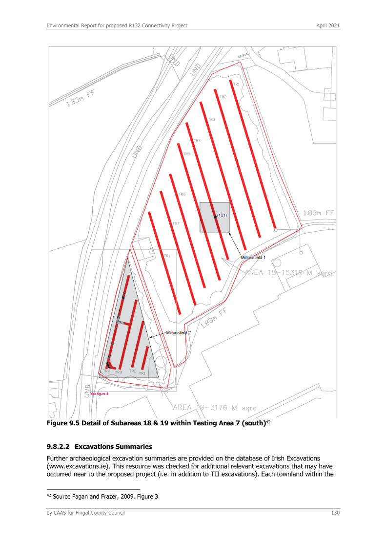
Environmental Report for proposed R132 Connectivity Project April 2021
by CAAS for Fingal County Council 130
Figure 9.5 Detail of Subareas 18 & 19 within Testing Area 7 (south)42
9.8.2.2 Excavations Summaries
Further archaeological excavation summaries are provided on the database of Irish Excavations (www.excavations.ie). This resource was checked for additional relevant excavations that may have occurred near to the proposed project (i.e. in addition to TII excavations). Each townland within the
42 Source Fagan and Frazer, 2009, Figure 3
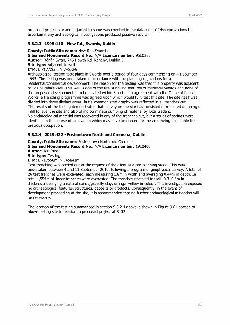
Environmental Report for proposed R132 Connectivity Project April 2021
by CAAS for Fingal County Council 131
proposed project site and adjacent to same was checked in the database of Irish excavations to ascertain if any archaeological investigations produced positive results.
9.8.2.3 1995:110 - New Rd., Swords, Dublin
County: Dublin Site name: New Rd., Swords Sites and Monuments Record No.: N/A Licence number: 95E0280 Author: Rónán Swan, 746 Howth Rd, Raheny, Dublin 5. Site type: Adjacent to well ITM: E 717726m, N 745724m Archaeological testing took place in Swords over a period of four days commencing on 4 December 1995. The testing was undertaken in accordance with the planning regulations for a residential/commercial development. The reason for the testing was that this property was adjacent to St Columba’s Well. This well is one of the few surviving features of medieval Swords and none of the proposed development is to be located within 5m of it. In agreement with the Office of Public Works, a trenching programme was agreed upon which would fully test this site. The site itself was divided into three distinct areas, but a common stratigraphy was reflected in all trenches cut. The results of the testing demonstrated that activity on the site has consisted of repeated dumping of infill to level the site and also of indiscriminate dumping of material by local traders. No archaeological material was recovered in any of the trenches cut, but a series of springs were identified in the course of excavation which may have accounted for the area being unsuitable for previous occupation.
9.8.2.4 2019:432 - Fosterstown North and Cremona, Dublin
County: Dublin Site name: Fosterstown North and Cremona Sites and Monuments Record No.: N/A Licence number: 19E0400 Author: Ian Russell Site type: Testing ITM: E 717558m, N 745841m Test trenching was carried out at the request of the client at a pre-planning stage. This was undertaken between 4 and 11 September 2019, following a program of geophysical survey. A total of 26 test trenches were excavated, each measuring 1.8m in width and averaging 0.44m in depth. In total 1,554m of linear trenches were excavated. The trenches revealed topsoil (0.3–0.6m in thickness) overlying a natural sandy/gravelly clay, orange–yellow in colour. This investigation exposed no archaeological features, structures, deposits or artefacts. Consequently, in the event of development proceeding at the site, it is recommended that no further archaeological mitigation will be necessary. The location of the testing summarised in section 9.8.2.4 above is shown in Figure 9.6 Location of above testing site in relation to proposed project at R132.
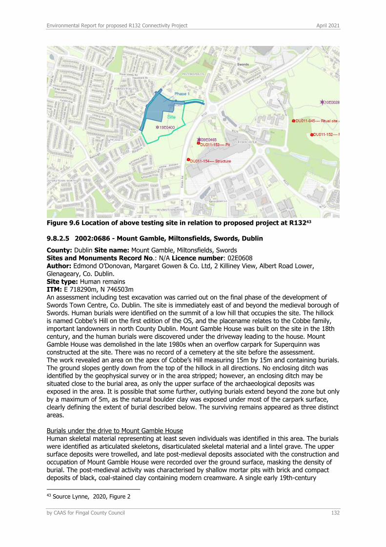
Environmental Report for proposed R132 Connectivity Project April 2021
by CAAS for Fingal County Council 132
Figure 9.6 Location of above testing site in relation to proposed project at R13243
9.8.2.5 2002:0686 - Mount Gamble, Miltonsfields, Swords, Dublin
County: Dublin Site name: Mount Gamble, Miltonsfields, Swords Sites and Monuments Record No.: N/A Licence number: 02E0608 Author: Edmond O’Donovan, Margaret Gowen & Co. Ltd, 2 Killiney View, Albert Road Lower, Glenageary, Co. Dublin. Site type: Human remains ITM: E 718290m, N 746503m An assessment including test excavation was carried out on the final phase of the development of Swords Town Centre, Co. Dublin. The site is immediately east of and beyond the medieval borough of Swords. Human burials were identified on the summit of a low hill that occupies the site. The hillock is named Cobbe’s Hill on the first edition of the OS, and the placename relates to the Cobbe family, important landowners in north County Dublin. Mount Gamble House was built on the site in the 18th century, and the human burials were discovered under the driveway leading to the house. Mount Gamble House was demolished in the late 1980s when an overflow carpark for Superquinn was constructed at the site. There was no record of a cemetery at the site before the assessment. The work revealed an area on the apex of Cobbe’s Hill measuring 15m by 15m and containing burials. The ground slopes gently down from the top of the hillock in all directions. No enclosing ditch was identified by the geophysical survey or in the area stripped; however, an enclosing ditch may be situated close to the burial area, as only the upper surface of the archaeological deposits was exposed in the area. It is possible that some further, outlying burials extend beyond the zone but only by a maximum of 5m, as the natural boulder clay was exposed under most of the carpark surface, clearly defining the extent of burial described below. The surviving remains appeared as three distinct areas. Burials under the drive to Mount Gamble House Human skeletal material representing at least seven individuals was identified in this area. The burials were identified as articulated skeletons, disarticulated skeletal material and a lintel grave. The upper surface deposits were trowelled, and late post-medieval deposits associated with the construction and occupation of Mount Gamble House were recorded over the ground surface, masking the density of burial. The post-medieval activity was characterised by shallow mortar pits with brick and compact deposits of black, coal-stained clay containing modern creamware. A single early 19th-century
43 Source Lynne, 2020, Figure 2
Environmental Report for proposed R132 Connectivity Project April 2021
by CAAS for Fingal County Council 133
halfpenny (dated 1823) was also recovered from the Mount Gamble deposits. Compact, stony, gritty, silty clay (topsoil) was present between the Mount Gamble deposits where the burials were situated. Subtle faint grave fills were noted at this level as sticky brown clay surrounding the human bone; these may represent upper grave-cuts through the compacted topsoil (brown, stony, silty clay). The burials were identified on the surface of the surviving ground level and consisted of both poorly preserved inhumations oriented with the head to the west and dense deposits of disarticulated bone that appeared to be the remains of inhumations, disturbed by the construction of both Mount Gamble and the carpark. Further burials are situated in this area, both beneath the recorded remains and under the post-medieval deposits. Earlier trench Examination of a previously excavated trench through the site revealed further inhumations, with bones exposed along 7.5m of the section. The burials were oriented at oblique angles and appeared to be aligned east–west. The base of the trench was irregular, and at least eleven intercutting graves were identified. A tile fragment recovered from the base of the topsoil suggests that post-medieval disturbance associated with Mount Gamble has truncated cut graves on the site. Burials to the south-east of the trench Seven individuals represented by skulls and long bones were identified to the south-east of the test-trench; these included two juveniles. One of the adult burials had stones adjacent to the skull (evidence of possible ‘ear-muff’ stones). The burials appeared to be much less disturbed in this location, as the topsoil survived to a greater extent. The ground sloped to the south-east here, and the topsoil overlying the burials was a loose, light brown, silty clay containing some stones, animal bone and disarticulated fragments of human bone. A small quantity of cockle and oyster shell was also identified in the topsoil. The burials were again oriented with the head to the west. Further burials remain unidentified under the loose, brown, silty clay in this location. Cultural context of the cemetery The purpose of the assessment was to attempt to establish the extent and context of the burials. Initially it was thought that the burials may be medieval and that the hill was the site of a gallows. Little artefactual dating evidence for the burials was recovered from the excavations, which suggests a pre-Norman date for the site, as no medieval pottery was recovered. No historical or cartographic references associated with a burial-ground were found during the compilation of the report, which suggests that the tradition of burial associated with Cobbe’s Hill had been forgotten by at least the post-medieval period (AD 1550). The identification of the lintel grave and the discovery of a single skull with a stone resting against it suggest that some of the burials date from c. AD 600–1100. No associated structures such as a ditch (enclosure) or church were identified at the site. This is not surprising, given the level of redevelopment carried out on the site with the construction and occupation of Mount Gamble and the carpark. The historical sources suggest that there were at least three churches at Swords. Previous scholars have suggested that these were all situated at the known early church site at Swords adjacent to the round tower. However, the site at Mount Gamble suggests that there may have been an outlying ecclesiastical site around the summit of Cobbe’s Hill, as early burial sites are unlikely to be unassociated.
9.8.2.6 2010:241 - Barrysparks and Crowcastle, Dublin
County: Dublin Site Name: Barrysparks and Crowcastle Sites and Monuments Record No.: DU011–045 Licence number: 10E0028 Author: Rob O’Hara, Archer Heritage Planning, 8 BEaT Centre, Stephenstown, Balbriggan, Co. Dublin. Site type: Ring-ditch ITM: E 718585m, N 746001m Two phases of testing were carried out at the site of a planned road network through the Barrysparks LAP area and at sites of archaeological potential identified in previous assessments. A total of 34 test-trenches were excavated across the site with a combined length of approximately 2,497m. One archaeological site was recorded during the testing programme, a ring-ditch (or barrow), formed by a circular ditch approximately 13m in diameter. A second drain feature in the same location may be associated. No other features were recorded in the areas tested and no artifacts were recovered either from topsoil or sampled deposits.
Environmental Report for proposed R132 Connectivity Project April 2021
by CAAS for Fingal County Council 134
9.8.2.7 2017:675 - Seatown West, Dublin
County: Dublin Site name: Seatown West Sites and Monuments Record No.: n/a Licence number: 16E0298 Author: Tim Coughlan, IAC Ltd Site type: No archaeology found ITM: E 719003m, N 747706m Monitoring was carried out of groundworks associated with the construction of the Swords Waste Water Treatment Plant Outfall Upgrade at Seatown West, Swords. The scheme is located in a marshy, marginal land to the south of Broadmeadow River estuary and c. 1km north-east of the centre of Swords Town. There are three recorded monuments located within 500m of the scheme. The closest of these is an enclosure (DU012-015), located c. 289m north of the scheme. A tide mill (DU012-047), is recorded c. 374m east-south-east of the scheme. An earthwork (DU011-036) located c. 402m south-west of the scheme. Monitoring took place in August and October of 2017. Nothing of archaeological significance was identified. Unit G1 Network Enterprise Park, Kilcoole, Co. Wicklow.
9.8.2.8 2008:366 - Broadmeadow River at Lissenhall Bridge and Ward River at Balheary Bridge, Balheary Demesne, Dublin
County: Dublin Site name: Broadmeadow River at Lissenhall Bridge and Ward River at Balheary Bridge, Balheary Demesne Sites and Monuments Record No.: N/A Licence number: 08D093; 08R312 (Broadmeadow River) and 08D092; 08R311 (Ward River) Author: Rex Bangerter and Edward Pollard, The Archaeological Diving Company Ltd, Brehon House, Castlecomer, Co. Kilkenny. Site type: Riverbed assessment ITM: E 718685m, N 748268m A non-disturbance assessment was undertaken on behalf of the Railway Procurement Agency across two waterways, the Broadmeadow River and the Ward River, in an area that is to undergo development as part of the proposed Metro North Project. The Ward River flows north-eastward through Balheary Demense before turning eastward and flowing east-north-east through the assessment area to conjoin with the Broadmeadow River at NGR 31885 248152. Balheary Bridge, a two-arched bridge structure, crosses the Ward River at NGR 318744 248140 (centre-point). Balheary Bridge is a protected structure and is noted in the National Inventory of Architectural Heritage (RPS340, NIAH no. 1335018). The Broadmeadow River is located 91m north of the Ward River and flows south-eastward through Balheary Demense to its confluence with the Ward River within Lissenhall Great townland Lissenhall Bridge, a five-arched bridge structure, crosses the Broadmeadow River at 318760 248245 (centre-point). Lissenhall Bridge (DU018–011–4081) is a protected structure (RPS 341, NIAH no. 1335019). A bridge is first recorded in this location on the Down Survey map of 1656 and the central section of Lissenhall Bridge may retain structural evidence to suggest a late 15th-century construction. Both river assessment areas are located adjacent to the N1 link-road, c. 700m north of Swords, Co. Dublin. The on-site assessment comprised a systematic visual inspection and magnetometer survey of the riverbed and attendant bank structures at both river locations. A 100m section of the Ward River was surveyed, between NGR 318649 248114 and 318757 248141, and a 70m section of Broadmeadow River was surveyed, between NGR 318724 248237 and 318786 248236. The assessment included a detailed survey of the bridges, the riverbed, and attendant bank structures at both river survey locations. Balheary Bridge and Lissenhall Bridge were recorded in plan, cross-section and elevation. The survey data was gathered and position-fixed using a differential GPS unit and a total station EDM. In addition, a c. 90m (north–south) by c. 90m area of parkland that forms the flood-plain between the two rivers was field-walked. Three features of archaeological significance were documented as part of the assessment: Lissenhall Bridge (Feature 1), its adjacent single-arched culvert (Feature 2) and Balheary Bridge (Feature 3). In addition, several riverine features of historic interest were documented, including: a weir location and
Environmental Report for proposed R132 Connectivity Project April 2021
by CAAS for Fingal County Council 135
associated walling (Feature 4), five sections of river revetment wall (Feature 5), and a single-arched bridge structure located 91m west of Balheary Bridge (Feature 6). The results of the assessment work indicate that Lissenhall Bridge the adjacent culvert and Balheary Bridge form part of the same continuous structure that was built across the Broadmeadow and Ward river channels. John Rocque’s map of County Dublin (1760) clearly depicts a single structure as described and visual inspection confirmed the presence of an earlier build phase (Phase 1) at Lissenhall Bridge, the single-arched culvert and Balheary Bridge. This initial build phase forms the middle section of each structure comprising Features 1–3. These mid-sections are aligned with each other on a north–south axis and display a similar construction methodology throughout. Later build phases abut the eastern (downstream) and western (upstream) side of each structure. It has previously been noted that the middle section of present-day Lissenhall Bridge is thought to date to the pre-1600s, a date that can be extrapolated to encompass the mid-sections of the adjacent culvert and Balheary Bridge. A second build phase (Phase 2), dating to the 18th century, was also identified, forming the bridge extensions at Features 1–2 and the downstream extension at Feature 3. A third build phase (Phase 3) is present at Balheary Bridge, the upstream bridge extension being constructed in the 19th century (c. 1850) in response to the collapse or partial collapse of the upstream (Phase 2) bridge extension that preceded it. It is following this 19th-century addition that the three bridge phases that form Feature 3 are collectively named ‘Balheary Bridge’. This, in name, partitioned the extended structure that formed Lissenhall Bridge, with Balheary Bridge and Lissenhall Bridge now being clearly marked as separate structures on the OS second-edition mapping of 1906.
9.8.2.9 2013:540 - Balheary Demesne, Dublin
County: Dublin Site name: Balheary Demesne Sites and Monuments Record No.: DU011-081 Licence number: 13E0370 Author: Billy Quinn Site type: Vicinity of bridge, no archaeological significance ITM: E 718685m, N 748269m Latitude, Longitude (decimal degrees): 53.471071, -6.212283 Testing was carried out at Balheary Demesne, Swords, Co. Dublin in advance of the proposed Swords Watermain Rehabilitation Project. The scheme proposes to upgrade the existing water infrastructure measuring 5250m in length, including approximately 4650m of pipework which will be placed along the existing pipeline. Testing involved the excavation of four trenches with offsets, on both sides of the Broad Meadow River, with a cumulative length of 130m. South of the river the land has been improved and landscaped. To the north are arable fields. Typically the stratigraphy exposed was a dark brown humic sod (0.2m) overlying a compact brown silty clay with moderate inclusions of small to medium sub-angular stones (0.25m). Below this was a brown grey, natural subsoil of alternating bands of clay with gravels. No finds or features of archaeological potential were noted. Corporate House, Ballybrit Business Park, Galway, Co. Galway
9.8.2.10 2020:054 - MetroLink Area 1 – Estuary Park & Ride, Lissenhall Little/Balheary Demesne, Swords, Dublin
County: Dublin Site name: MetroLink Area 1 – Estuary Park & Ride, Lissenhall Little/Balheary Demesne, Swords Sites and Monuments Record No.: DU011-131---- enclosure, DU011-081— Lissenhall Bridge Licence number: 19E0757 Author: Donald Murphy Site type: Enclosure ITM: E 718709m, N 748688m A programme of Advance Targeted Archaeological Test Excavations was carried out at MetroLink Licence Area 1: Estuary Park & Ride, Lissenhall Little/Balheary Demesne, Swords, Co. Dublin in January 2020. The site is located in the townlands of Lissenhall Little and Balheary Demesne, west of the R132 road and south of the proposed Swords Western Ring Road. The work was carried out on behalf of Transport Infrastructure Ireland as part of the MetroLink programme of archaeological investigations, the results of which informed the preparation of an Environmental Impact Assessment Report for the preferred route.
Environmental Report for proposed R132 Connectivity Project April 2021
by CAAS for Fingal County Council 136
There are two Recorded Monuments and Places within or immediately adjacent to the designated area, (DU011-131—- enclosure and DU011-081—- bridge). DU011-131—- is an enclosure in the townland of Lissenhall Little that was identified by the National Monuments Service through analysis of aerial photography, while DU011-081—- is Lissenhall Bridge National Monument, which crosses over the Broadmeadow River. It also forms part of the boundary between the townlands of Balheary Demesne and Lissenhall Great. This bridge is also a Protected Structure (RPS 341) and is listed in the National Inventory of Architectural Heritage (Reg. No. 11335019). Prior to this archaeological assessment a geophysical and ground penetrating radar (GPR) survey were undertaken as a component of advance MetroLink Works (Licence 08R0117, Thébaudeau & Harrison 2009; Licence 18R0196, Gimson & Garner 2019). The Advance Targeted Archaeological Test Excavations strategy was designed to assess the archaeological nature of high potential anomalies detected during these earlier surveys. The site was tested between 8 and 13 January 2020. It was subdivided into three separate areas, Area 1A in the north-eastern corner, Area 1B along the western side (assessing DU011-131—-) and Area 1C in the southern part, 50m west of Lissenhall Bridge National Monument. Thirty-one test trenches were excavated in total with a combined length of 847m. Twenty-two of these were excavated throughout Area 1A (totalling 442m) and nine in Area 1C (totalling 405m). No testing took place in Area 1B as the lands were under crop and not available. In Area 1A the advance test excavations confirmed the presence of an enclosure or ring ditch that defined the summit of a small ridge in the southern extent of the testing area. This enclosure was previously identified in the geophysical survey (Gimson & Garner 2019) and was oval in shape measuring 46m north-east/south-west by 36m externally and defined by a single ditch that was located on the break of slope of the low ridge on which the site was located. An additional ditch extended north-westwards from the northern part of the enclosure and may represent an annexe or attached field on the northern slope of the hill. The enclosure was heavily disturbed by a large watermain aligned south-west to north-east that cut through the eastern half of the site. No evidence was recovered during the test excavations for an entrance but there may be a suggestion of one along the west side on the geophysical survey where the ditch appears as a much fainter anomaly. The ditch ranged in width from 0.77m to 1.6m and in depth from 0.38m to 0.65m with only two fills evident. A number of smaller features were also identified in the immediate vicinity of the enclosure including a small charcoal spread, a possible pit and a small narrow linear feature, but for the most part features were noticeably absent from the interior. No finds were recovered but a number of the ditch fills were sampled and produced datable material in the form of charcoal and animal bone. A number of other geophysical anomalies not associated with the enclosure were identified throughout the remainder of Area 1A and the test trenches confirmed these not to be of archaeological origin. In Area 1C the test trenches were designed to target several geophysical anomalies and also the proximity to two recently identified sites (through aerial photography) just outside the site boundary to the west, which consist of a possible tree ring and possible enclosure. Two ditches were identified within the footprint of the proposed development and produced pottery of 19th/20th-century date. Both are aligned with a demesne landscape boundary element indicated on the first edition 6 inch OS map and later 25 inch OS map and define a tree belt around the demesne. No archaeological features were exposed. A number of environmental samples from the various ditch fills produced charcoal and animal bone and it is recommended that two of these be radiocarbon dated in order to more fully understand the nature and date of the features exposed.
9.8.2.11 Cartographic sources
The Ordnance Survey came to Ireland in 1824 in order to carry out a precise admeasurement of the country’s 60,000 or so townlands as a preliminary to the larger task of reforming Ireland’s local taxation system. The townland boundaries were demarcated by a Boundary Commission, and the Ordnance Survey had the task of measuring them. In addition to boundaries the maps are truly
Environmental Report for proposed R132 Connectivity Project April 2021
by CAAS for Fingal County Council 137
topographical in content. Drawn at the large scale of six inches-to-one-mile (1:10,560) it was important to mark all buildings, roads, streams, placenames, etc, that were required for valuation purposes. Ultimately the maps were used as a basis for the rateable valuation of land and buildings in what became known as Griffith’s Valuation. Working from north to south, the survey began in Antrim and Derry in 1829 and was completed in Kerry in 1842. It was published as thirty-two county maps between 1832 and 1846, the number of sheets per county varied from 153 for County Cork to 28 for Dublin, each of the 1,994 sheets in the series depicting an area 21,000 by 32,000 feet on the ground. Each county was projected on a different central meridian and so the maps of adjacent counties do not fit neatly together at the edges. Map content stops at the county lines.
9.8.2.11.1.1 The First Edition
The early Ordnance Survey maps are an unrivalled source for the period immediately before the Great Irish Famine (1847-50) when the population was at the highest level ever recorded. No additional archaeological features in the vicinity of the proposed development were noted on the maps however.
9.8.2.11.1.2 The Second Edition
When the original survey began it did not include field boundaries and they did not appear on the maps. This policy was reversed in 1838 after a number of northern counties had been published. Therefore when the country was completed in 1846 the counties of Antrim, Armagh, Derry, Donegal, Down, Fermanagh, Monaghan, and Tyrone were resurveyed to add field boundaries. Subsequently this general revision was extended to other counties because of change in the post- Famine landscape. Survey work was curtailed in 1887 when the government agreed to survey the country at the larger scale of 1:2,500. The 2nd edition 25 inch OS map was consulted to ascertain the presence or otherwise of additional features of potential archaeological value. No such features were noted along the proposed project area.
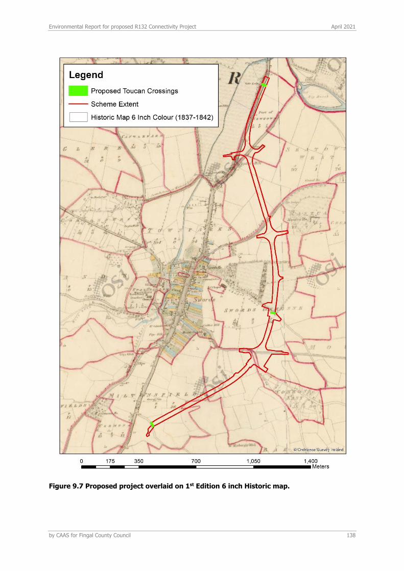
Environmental Report for proposed R132 Connectivity Project April 2021
by CAAS for Fingal County Council 138
Figure 9.7 Proposed project overlaid on 1st Edition 6 inch Historic map.

Environmental Report for proposed R132 Connectivity Project April 2021
by CAAS for Fingal County Council 139
Figure 9.8 Proposed project overlaid on 2nd Edition 25 inch Historic map.
Environmental Report for proposed R132 Connectivity Project April 2021
by CAAS for Fingal County Council 140
9.9 IMPACTS AND MITIGATION
9.9.1 CONSTRUCTION PHASE POTENTIAL IMPACTS (INDIRECT)
Indirect effects, in terms of archaeology and cultural heritage are considered to be those effects which happen away from ‘the site’. This includes impacts on visual setting of any cultural heritage asset in the wider landscape. Since these effects are only possible once the proposed project is operational, they are considered operational effects and are therefore discussed in Section 9.9.5 below. No indirect effects were identified which would occur at the construction stage of the proposed project.
9.9.2 CONSTRUCTION PHASE POTENTIAL IMPACTS (DIRECT)
Direct Impact refers to a ‘physical impact’ on a monument or site. The construction phase of the project consists largely of the following:
• Site clearance and preparation • A construction phase using standard building materials • Construction will include new surface water drainage and modifications to existing
underground services such as telecommunications ducting, watermains and upgrading of existing public lighting to accommodate the proposed junction layouts.
• A landscaping phase following completion of the principal road related works.
Accommodation works to provide new access arrangements for private properties affected by the proposed junction layouts. Most works proposed are within the existing road reservation. The principle exception to this are the accommodation works proposed to construct a bus stop on at the Malahide Road Intersection.
9.9.2.1 Recorded Archaeological Resource
No known documented Recorded Monuments will be affected by the proposed project in its current design and therefore no mitigation measures are necessary in this regard.
9.9.2.2 Potential Subsurface Archaeological Features
Potential Impact Swords and its vicinity are of high archaeological potential in terms of sub-surface archaeological features. The majority of monuments within the vicinity, as acknowledged by the County Development Plan are sub-surface (see section 9.3.2 above). In this regard, any proposed groundworks along the alignment could potentially impact on as yet unknown sub-surface features. Groundworks for the project include the following: Earthworks The project involves the removal of the existing roundabouts at the project junctions and replacement of same with signalised junctions with the majority of works being undertaken within the footprint of the existing R132 cross section. The conversion of the roundabouts to signalised junctions will require a slight increase in road levels compared to existing levels at the centre of the junction while approach arms will tie in with existing R132. The project is not expected to result in a significant level of excavation. General excavation of material required for installation of underground services such as drainage and ducting will be reinstated where possible with any excess material stockpiled for reuse on site (O Connor, 2021, 17). New Services The proposed junction layouts for the project are signal controlled. As the existing roundabouts at Seatown and Estuary are not currently signal controlled, new traffic signals and associated infrastructure is proposed at these junctions. There are existing traffic signals at Malahide Road Roundabout, however the existing duct locations are unknown. As part of this design, new ducts are proposed to be installed at Malahide Road Junction. Along the R132, the new traffic signal ducts are
Environmental Report for proposed R132 Connectivity Project April 2021
by CAAS for Fingal County Council 141
proposed to run on the western side of the carriageway, within the verge, to avoid any clashes with the future Metrolink construction ((O Connor, 2021, 33). Service Diversions In Order to accommodate the new junction layouts and associated infrastructure, some existing services are required to be diverted. The number of diversions will be kept to a minimum and existing services protected in place where possible. To accommodate access for future maintenance activities by asset owners, new chambers and manholes will be located within the new footpaths, cycle lanes and grassed areas. Chambers and manholes within the junction pavement area will be avoided where possible to reduce traffic disruption during maintenance activities. If an existing manhole cannot be relocated from the centre of the junction, additional manholes shall be provided in more appropriate areas nearby to provide alternative access. 6.3.3 Future construction of the new Metrolink rail service adjacent to the R132 has informed the alignment of new service ducts and locations of chambers and manholes. Diversions of some services have not been proposed with the understanding that they will be relocated as part of the future Metrolink works. A key aim of the utility design has been to avoid multiple asset diversions and the requirement for re-work where possible. Detail of the latter is provided in the DBFL engineering report ((O Connor, 2021 page 34 -36).
9.9.3 MITIGATION
• Archaeological monitoring of all groundworks including drainage, utility service trenches and any other groundworks deemed appropriate by the appointed archaeologist.
• The work should be carried out under licence from the National Monuments Service and any finds, features or deposits detected during the project will be reported to the NMS to discuss how best to proceed with the findings.
• Preservation by record or preservation in situ may apply depending on the location and nature of the archaeology.
• A report on the findings will be compiled on completion of the work and submitted to the relevant authorities including the National Monuments Service and Fingal County Council.
9.9.4 OPERATIONAL PHASE IMPACTS (DIRECT)
In terms of archaeology, since groundworks would be complete, it is considered that no direct effects would occur at the operational stage of the project.
9.9.5 OPERATIONAL PHASE POTENTIAL IMPACTS (INDIRECT)
Indirect impacts are where a feature or site of archaeological heritage merit or their setting is located in close proximity to a proposed project. Indirect impacts here are mainly concerned with impacts on setting. Impacts on settings of sites may arise when a development is proposed immediately adjacent to a recorded monument or cluster of monuments or any cultural heritage asset. While the proposed project may not physically impact on a site, it may alter the setting of a monument or group of monuments. Potential impact to the visual amenity of a site or area and the significance of same is dependent on a number of factors regarding the sensitivity of the location or ‘receptor’ and the scale or magnitude of the proposed project. The proposed project consists of the enhancement of facilities at key intersections and crossing points along the R132 Swords Road, improving connectivity for pedestrians and cyclists travelling across the R132 Swords Road from existing and proposed project lands to town centres. This will be achieved by replacing the existing roundabouts with signalised junctions and incorporating controlled toucan crossings, while also providing pedestrian/cycle access to (at-grade) proposed MetroLink stations along the R132, ensuring adequate permeability and links from the stations to existing and future developments. This project is not considered to have the potential to negatively impact on the nearest surrounding archaeological sites/monuments, the majority of which are sub-surface. The introduction of signalised

Environmental Report for proposed R132 Connectivity Project April 2021
by CAAS for Fingal County Council 142
junctions is such that the nature of the suburban setting has the capacity to absorb such a development without negatively affecting the archaeological heritage landscape.
Environmental Report for proposed R132 Connectivity Project April 2021
by CAAS for Fingal County Council 143
REFERENCES BRE (2003) Controlling Particles, Vapours & Noise Pollution From Construction Sites DEHLG (2004) Quarries and Ancillary Activities, Guidelines for Planning Authorities DEHLG (2007) Update and Revision of the National Programme for Ireland under Article 6 of Directive 2001/81/EC for the Progressive Reduction of National Emissions of Transboundary Pollutants by 2010 Department of Communications, Climate Action and Environment (DCCAE) (2017) National Mitigation Plan Department of Communications, Climate Action and Environment (DCCAE) (2018) National Adaptation Framework Department of the Environment, Heritage and Local Government (2010) Appropriate Assessment of Plans and Projects in Ireland – Guidance for Planning Authorities Environmental Protection Agency (2019b) GHG Emissions Projections Report - Ireland’s Greenhouse Gas Emissions Projections 2018 - 2040 Environmental Protection Agency (2015) Advice Notes for Preparing Environmental Impact Statements – Draft Environmental Protection Agency (2017) Guidelines on the Information to be Contained in Environmental Impact Assessment Reports - Draft Environmental Protection Agency (2020a) Air Quality Monitoring Report 2019 (& previous annual reports) Environmental Protection Agency (2020b) Ireland’s Provisional Greenhouse Gas Emissions 1990 – 2019 Environmental Protection Agency (2021) EPA website Available at: http://www.epa.ie/whatwedo/monitoring/air/ European Commission (2013) Guidance on Integrating Climate Change and Biodiversity into Environmental Impact Assessment European Council (2014) Conclusions on 2030 Climate and Energy Policy Framework, SN 79/14 FCC and Codema (2019) Fingal County Council Climate Change Action Plan 2019 – 2024 German VDI (2002) Technical Guidelines on Air Quality Control – TA Luft Government of Ireland (2015) Climate Action and Low Carbon Development Act Government of Ireland (2019) Climate Action Plan 2019 Government of Ireland (2020) Draft General Scheme of the Climate Action (Amendment) Bill 2019 Institute of Air Quality Management (IAQM) (2016) Guidance on the Assessment of Dust from Demolition and Construction Version 1.1 Met Éireann (2021) Met Eireann website: https://www.met.ie/ The Scottish Office (1996) Planning Advice Note PAN50 Annex B: Controlling The Environmental Effects Of Surface Mineral Workings Annex B: The Control of Dust at Surface Mineral Workings Transport Infrastructure Ireland (2009) Guidelines for Assessment of Ecological Impacts of National Roads Schemes (Rev. 2, Transport Infrastructure Ireland, 2009) Transport Infrastructure Ireland (2011) Guidelines for the Treatment of Air Quality During the Planning and Construction of National Road Schemes UK DEFRA (2016) Part IV of the Environment Act 1995: Local Air Quality Management, LAQM. PG(16) UK DEFRA (2018) Part IV of the Environment Act 1995: Local Air Quality Management, LAQM.TG(16) UK DEFRA (2020) NOx to NO2 Conversion Spreadsheet (Version 8.1) UK Department of the Environment, Transport and Roads (1998) Preparation of Environmental Statements for Planning Projects That Require Environmental Assessment - A Good Practice Guide, Appendix 8 - Air & Climate UK Highways Agency (2007) Design Manual for Roads and Bridges, Volume 11, Section 3, Part 1 - HA207/07 (Document & Calculation Spreadsheet) UK Highways Agency (2019a) UK Design Manual for Roads and Bridges (DMRB), Volume 11, Environmental Assessment, Section 3 Environmental Assessment Techniques, Part 1 LA 105 Air quality UK Highways Agency (2019b) UK Design Manual for Roads and Bridges (DMRB) Volume 11 Environmental Assessment, Section 3 Environmental Assessment Techniques, Part 14 LA 114 Climate UK Office of Deputy Prime Minister (2002) Controlling the Environmental Effects of Recycled and Secondary Aggregates Production Good Practice Guidance

Environmental Report for proposed R132 Connectivity Project April 2021
by CAAS for Fingal County Council 144
UN Framework Convention on Climate Change (1997) Kyoto Protocol To The United Nations Framework Convention On Climate Change UN Framework Convention on Climate Change (2012) Doha Amendment To The Kyoto Protocol USEPA (1997) Fugitive Dust Technical Information Document for the Best Available Control Measures World Health Organisation (2006) Air Quality Guidelines - Global Update 2005 (and previous Air Quality Guideline Reports 1999 & 2000) Fagan, B. (2009) Assessment Report on the results of Metro North advance archaeological test trenching, testing area 7, Swords Demesne and Miltonsfield townlands, Co. Dublin (Licence no. 09E466). Unpublished report. National Monuments Service, Department of Arts, Heritage and the Gaeltacht. Lyne, Magda (2020) Archaeological Impact Assessment of a Proposed SHD Development at Fosterstown North, Swords, Co. Dublin (ArchaeologicalImpactAssessment.pdf (fosterstownshd.ie)) Swords Castle Conservation Plan, 2014, Fingal County Council
Environmental Report for proposed R132 Connectivity Project April 2021
by CAAS for Fingal County Council 145
END NOTES
NPWS:https://www.npws.ie/sites/default/files/publications/pdf/National%20Biodiversity%20Action%20Plan%20English.pdf ii Swords Masterplan Part A (2019) Fingal County Council. Accessed at: https://www.fingal.ie/sites/default/files/2019-09/swords_masterplans_june_2019_part_a.pdf iii Smith, George F., et al. "Best practice guidance for habitat survey and mapping." The Heritage Council: Ireland (2011) iv Fossitt, J.A., 2000. A guide to habitats in Ireland. Heritage Council/ Chomhairle Oidhreacht v Rose, F., O'Reilly, C., Smith, D.P. and Collings, M., 2006. The wild flower key: how to identify wild flowers, trees and shrubs in Britain and Ireland. Frederick Warne. vi Collins, J. (ed.) 2016. Bat Surveys for Professional Ecologists: Good Practice Guidelines (3rd edn). The Bat Conservation Trust, London. vii Swords Masterplans Part A: Masterplans for Barrysparks & Crowcastle; Fostertown; & Estuary West (May 2019), Fingal Development Plan 2017-2023. Fingal County Council. viii Accessed 18th January 2021: https://gis.epa.ie/EPAMaps/ ix EPA Ground Waterbodies Risk maps https://gis.epa.ie/EPAMaps/ (accessed 19th January 2021) x Fingal Development Plan (2017-2023). Accessed at: https://maps.fingalcoco.ie/planning-and-buildings/development-plans-and-consultations/fingaldevelopmentplan2017-2023/ xi Accessed 28th January 2021 at: https://www.fingal.ie/view-or-search-planning-applications
Related Documents