May 7, 2021 Via email: Chelsea Fedrau Impact Assessment Agency of Canada 1145-9700 Jasper Avenue , Edmonton, AB T5J 4C3 Dear Chelsea Fedrau, Re: Review of Draft Tailored Impact Statement Guidelines (d/TISG) and Draft Permitting Plan during public comment – Suncor Base Mine Extension Project (BMX) Environment and Climate Change Canada (ECCC) is providing comments on the draft Tailored Impact Statement Guidelines (d/TISG) and the draft Permitting Plan for the Suncor Base Mine Extension Project as requested by the Impact Assessment Agency of Canada’s (IAAC or “Agency”) February 26, 2021 email. Comments have been provided on the February 26 version of the d/TISG posted to the Registry for public comment. ECCC has reviewed the Draft Permitting Plan and have no comments at this time. Our advice is based on ECCC’s mandate in the context of the Species at Risk Act (SARA), the Migratory Birds Convention Act 1994 (MBCA), pollution prevention provisions of the Fisheries Act, and the Canadian Environmental Protection Act 1999 (CEPA). ECCC File: 4194-10-3/6327 CIAR Reference: 80521 Environmental Protection Operations Directorate Prairie & Northern Region 9250 49 Street , Edmonton, AB T6B 1K5 <email address removed>

Welcome message from author
This document is posted to help you gain knowledge. Please leave a comment to let me know what you think about it! Share it to your friends and learn new things together.
Transcript
May 7, 2021 Via email: Chelsea Fedrau Impact Assessment Agency of Canada 1145-9700 Jasper Avenue , Edmonton, AB T5J 4C3 Dear Chelsea Fedrau, Re: Review of Draft Tailored Impact Statement Guidelines (d/TISG) and Draft Permitting Plan during public comment – Suncor Base Mine Extension Project (BMX) Environment and Climate Change Canada (ECCC) is providing comments on the draft Tailored Impact Statement Guidelines (d/TISG) and the draft Permitting Plan for the Suncor Base Mine Extension Project as requested by the Impact Assessment Agency of Canada’s (IAAC or “Agency”) February 26, 2021 email. Comments have been provided on the February 26 version of the d/TISG posted to the Registry for public comment. ECCC has reviewed the Draft Permitting Plan and have no comments at this time. Our advice is based on ECCC’s mandate in the context of the Species at Risk Act (SARA), the Migratory Birds Convention Act 1994 (MBCA), pollution prevention provisions of the Fisheries Act, and the Canadian Environmental Protection Act 1999 (CEPA).
ECCC File: 4194-10-3/6327
CIAR Reference: 80521
Environmental Protection Operations Directorate Prairie & Northern Region 9250 49 Street , Edmonton, AB T6B 1K5
<email address removed>
Please contact Gillian Brown at if you need more information. Sincerely,
Margaret Fairbairn A/ Regional Director Environmental Protection Operations Directorate cc: Jody Small, Head, EA South, EPOD, ECCC Gillian Brown, Senior EA Officer, EPOD, ECCC Attachments: SuncorBMX-DraftTISGpostedFeb262021-ECCCCommentsFinal
<contact information removed>
<Original signed by>
Suncor Base Mine Extension Project
DRAFT TAILORED IMPACT STATEMENT GUIDELINES PURSUANT TO THE
IMPACT ASSESSMENT ACT
February 26, 2021
DRAFT FOR PUBLIC COMMENT
Commented [GB1]: This document reflects ECCC’s comments on the February 26, 2021 draft TISG that was posted for public comment.
IMPACT ASSESSMENT AG ENCY OF CANADA
TAILORED IMPACT STAT EMENT GUIDELINES - SUNCOR BASE MINE EXTE NSION PROJECT i
Contents 1. Introduction ............................................................................................................................... 1
1.1. Factors to be considered in the Impact Assessment ...................................................................... 2
2. Proponent information ............................................................................................................... 3
2.1. The proponent ............................................................................................................................... 3
2.2. Qualifications of individuals preparing the Impact Statement .......................................................... 4
3. Project description .................................................................................................................... 4
3.1. Project overview ............................................................................................................................ 4
3.2. Project location ............................................................................................................................. 4
3.3. Regulatory framework ................................................................................................................... 5
3.4. Project components and activities ................................................................................................. 6
3.5. Workforce requirements ................................................................................................................ 7
4. Project purpose, need and alternatives considered ................................................................. 8
4.1. Purpose of the project ................................................................................................................... 8
4.2. Need for the project ....................................................................................................................... 8
4.3. Alternatives to the project .............................................................................................................. 9
4.4. Alternative means of carrying out the project ................................................................................. 9
5. Description of public participation and views ........................................................................ 11
5.1. Summary of public engagement activities .................................................................................... 11
5.2. Analysis and response to questions, comments and issues raised ............................................... 12
6. Description of engagement with Indigenous groups .............................................................. 12
6.1. Indigenous knowledge considerations ......................................................................................... 13
6.2. Record of engagement ................................................................................................................ 14
6.3. Analysis and response to questions, comments, and issues raised .............................................. 15
7. Assessment methodology ....................................................................................................... 17
7.1. Baseline methodology ................................................................................................................. 17
7.2. Selection of valued components .................................................................................................. 18
7.3. Spatial and temporal boundaries ................................................................................................. 20
7.4. Effects assessment methodology ................................................................................................ 22
7.5. Mitigation and enhancement measures ....................................................................................... 23
8. Biophysical environment ..................................................................................................... 2524
8.1. Meteorological environment ..................................................................................................... 2524
8.2. Geology, geochemistry and geological hazards ........................................................................... 25
8.3. Topography, soil and sediment ................................................................................................ 2625
8.4. Atmospheric, acoustic, and visual environment ........................................................................ 2726
8.5. Groundwater and surface water ............................................................................................... 3433
8.6. Vegetation and riparian, wetland and terrestrial environments ................................................. 4240
8.7. Fish and fish habitat ................................................................................................................ 4745
8.8. Birds, migratory birds and their habitat ..................................................................................... 5150
8.9. Wildlife and its habitat ............................................................................................................. 5554
8.10. Climate change ....................................................................................................................... 6259
9. Human health conditions .................................................................................................... 6762
9.1. Baseline conditions ................................................................................................................. 6762
9.2. Effects to human health ........................................................................................................... 6864
9.3. Mitigation and enhancement measures ................................................................................... 7166
10. Social conditions ................................................................................................................. 7167
10.1. Services and infrastructure ...................................................................................................... 7268
10.2. Land and resource use ............................................................................................................ 7369
10.3. Navigation ............................................................................................................................... 7470
10.4. Community well-being ............................................................................................................. 7571
10.5. Mitigation and enhancement measures ................................................................................... 7672
11. Economic conditions ........................................................................................................... 7773
11.1. Baseline conditions ................................................................................................................. 7773
11.2. Effects to economic conditions ................................................................................................ 7874
11.3. Mitigation and enhancement measures ................................................................................... 8177
12. Indigenous peoples .............................................................................................................. 8278
12.1. Indigenous physical and cultural heritage and structures, sites or things of significance ........... 8379
12.2. Current use of lands and resources for traditional purposes ..................................................... 8581
12.3. Health, social and economic conditions of Indigenous peoples ................................................ 8682
12.4. Rights of Indigenous peoples .................................................................................................. 8884
12.5. Mitigation and enhancement measures ................................................................................... 9086
13. Other effects ........................................................................................................................ 9187
13.1. Potential accidents or malfunctions .......................................................................................... 9187
13.2. Effects of the environment on the project ................................................................................. 9389
14. Residual effects ................................................................................................................... 9490
15. Cumulative effects assessment .......................................................................................... 9591
16. Follow-up programs ............................................................................................................. 9894
16.1. Follow-up program framework ............................................................................................... 10096
16.2. Follow-up program monitoring ............................................................................................... 10197
17. Canada’s ability to meet its environmental obligations and its climate change
commitments ............................................................................................................................ 10298
18. Description of the project’s contributions to sustainability............................................. 10399
19. Assessment summary ..................................................................................................... 104100
20. Appendix 1 – Reference documents ................................................................................ 105101
21. Appendix 2 – Additional guidance ................................................................................... 114110
21.1. List of project activities ........................................................................................................ 114110
21.2. Sources of baseline information ........................................................................................... 116112
21.3. Ecosystem approach ........................................................................................................... 118114
21.4. Application of GBA+ ............................................................................................................ 119115
21.5. Geospatial data requirements .............................................................................................. 120116
21.6. Reference documents requirements .................................................................................... 120116
21.7. Establishing spatial boundaries ........................................................................................... 120116
21.8. Human health baseline ........................................................................................................ 122118
21.9. Mitigation hierarchy ............................................................................................................. 123119
21.10. Compensation and offset plans ........................................................................................... 124120
21.11. Summary Tables ................................................................................................................. 126122
21.12. Additional guidance for biophysical components .................................................................. 127123
Annex I – Draft Terms of Reference for the provincial environmental assessment ............. 138134
IMPACT ASSESSMENT AG ENCY OF CANADA
TAILORED IMPACT STAT EMENT GUIDELINES - SUNCOR BASE MINE EXTE NSION PROJECT iv
List of Abbreviations and Acronyms
Abbreviation/Acronym Definition
AAQO Alberta Ambient Air Quality Objectives and Standards
the Act Impact Assessment Act
Agency Impact Assessment Agency of Canada
BCRs Bird Conservation Regions
CAAQS Canadian Ambient Air Quality Standards
CCME Canadian Council of Ministers of the Environment
COSEWIC Committee on the Status of Endangered Wildlife in Canada
Declaration United Nations Declaration on the Rights of Indigenous Peoples
ECCC Environment and Climate Change Canada
GBA+ Gender Based Analysis Plus
GHG Greenhouse gas
GIS Geographic Information Systems
HIA Health Impact Assessment
IVOC Intermediate volatile organic compounds
LSA Local Study Area
Minister Minister of Environment and Climate Change
Internet Site Impact Assessment Agency of Canada’s website
NAAQO National Ambient Air Quality Objectives
NOC National Occupational Classification
OCAP Ownership, Control, Access and Possession
OSBTT 2019 Oil Sands Bird Technical Team
PACs Polycyclic aromatic compounds
PAD Peace-Athabasca Delta
Project Suncor Base Mine Extension Project
Registry Canadian Impact Assessment Registry
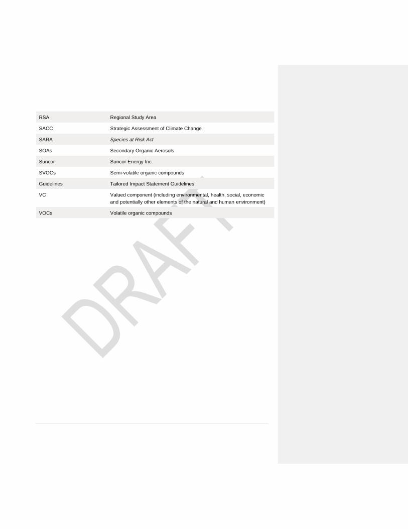
RSA Regional Study Area
SACC Strategic Assessment of Climate Change
SARA Species at Risk Act
SOAs Secondary Organic Aerosols
Suncor Suncor Energy Inc.
SVOCs Semi-volatile organic compounds
Guidelines Tailored Impact Statement Guidelines
VC Valued component (including environmental, health, social, economic
and potentially other elements of the natural and human environment)
VOCs Volatile organic compounds
TAILORED IMPACT STAT EMENT GUIDELINES - SUNCOR BASE MINE EXT ENSION PROJECT - CO-
EDIT ING OF DRAFT T ISG COMMENTS CLEAN SUNCOR BASE MINE EXT ENSION PROJECT 1
1. Introduction The federal Impact Assessment process serves as a planning tool that considers a broad range of potential
environmental, health, social and economic effects of designated projects identified by regulation or
designated by the Minister of Environment and Climate Change (the Minister). Decisions are based on
whether the potential adverse effects in areas of federal jurisdiction are in the public interest. The public
interest determination is guided by the factors set out in the Impact Assessment Act (the Act) in section 63:
the extent to which the project contributes to sustainability;
the extent to which the adverse effects within federal jurisdiction and the adverse direct or incidental
effects that are indicated in the impact assessment report in respect of the project are significant;
the implementation of the mitigation measures that the Minister or the Governor in Council, as the case
may be, considers appropriate;
the impact that the project may have on any Indigenous peoples and any adverse impact that the
designated project may have on the rights of the Indigenous peoples1 of Canada recognized and
affirmed by section 35 of the Constitution Act, 1982; and
the extent to which the effects of the project may hinder or contribute to the Government of Canada’s
ability to meet its environmental obligations and its commitments in respect of climate change.
A key element for the federal impact assessment process is the introduction of Tailored Impact Statement
Guidelines (Guidelines)2, which will provide the proponent with direction and requirements for the
preparation of an Impact Statement. The draft Guidelines have been specifically tailored for the Suncor
Base Mine Extension Project (the project), by the Impact Assessment Agency of Canada (the Agency).
The tailoring is based on the nature, complexity and context of the project, and is informed and guided by
consultation and engagement that occurs with the public, Indigenous groups, jurisdictions, federal
authorities and other interested parties during the Planning phase of the impact assessment process.
In order to support the Government of Canada’s objective of “one project, one assessment”, the Guidelines
have also been tailored to identify where the federal and provincial assessment processes have shared
information needs. While the information requirements may be shared, the impact assessment will respect
the jurisdiction of each governing body. The draft version of Suncor Energy Inc.’s (Suncor) proposed
Terms of Reference is included as Annex I – Draft Terms of ReferenceAnnex I – Draft Terms of Reference
in the Guidelines.
1 These guidelines use the term “Indigenous peoples” to represent the “aboriginal peoples of Canada” which includes
Indian, Inuit and Métis peoples as defined in subsection 35(2) of the Constitution Act, 1982, and “rights of Indigenous
peoples” is used to reflect the full scope of Aborig inal and Treaty rights recognized and affirmed by section 35 of the
Constitution Act, 1982.
2 As set out in paragraph 18(1)(b) of the Impact Assessment Act.
Formatted: Font: Italic
TAILORED IMPACT STAT EMENT GUIDELINES - SUNCOR BASE MINE EXTE NSION PROJECT 2
The Guidelines will be finalized following a comment period on this draft version of the Guidelines, which
will run from February 26 to April 7, 2021.
The proponent may present the information in the Impact Statement in the manner it deems most
appropriate. While the Guidelines do not prescribe a preferred structure for the Impact Statement, it is
recommended to follow a structure similar to the Guidelines to facilitate the review of the Impact Statement
and participation in the process.
Irrespective of the preferred structure for the Impact Statement, it is essential that the Impact Statement
address all requirements outlined in the Guidelines. If the proponent does not submit the information
required in the Guidelines, it should include an explanation justifying the exclusion. To facilitate the review
of the Impact Statement, the proponent must provide a table of concordance that indicates where each
requirement of the Guidelines is addressed.
The proponent must provide the information in a machine-readable, accessible format, to support the
Government of Canada’s commitment to open science and data and facilitate the sharing of information
with the public through the Registry and the Government of Canada’s open science and data platform. The
proponent should contact the Agency to obtain additional direction regarding the format and distribution of
the Impact Statement.
1.1. Factors to be considered in the Impact Assessment
The Guidelines correspond to factors listed in subsection 22(1) of the Act and prescribe that the impact
assessment of a designated project must take into account:
(a) the changes to the environment or to health, social or economic conditions and the positive and
negative consequences of these changes that are likely to be caused by the carrying out of the
designated project, including:
(i) the effects of malfunctions or accidents that may occur in connection with the designated
project;
(ii) any cumulative effects that are likely to result from the designated project in combination with
other physical activities that have been or will be carried out; and
(iii) the result of any interaction between those effects.
(b) mitigation measures that are technically and economically feasible and that would mitigate any
adverse effects of the designated project;
(c) the impact that the designated project may have on any Indigenous group and any adverse
impact that the designated project may have on the rights of the Indigenous peoples of Canada
recognized and affirmed by section 35 of the Constitution Act, 1982;
(d) the purpose of and need for the designated project;
(e) alternative means of carrying out the designated project that are technically and economically
feasible, including through the use of best available technologies, and the effects of those means;
TAILORED IMPACT STAT EMENT GUIDELINES - SUNCOR BASE MINE EXTE NSION PROJECT 3
(f) any alternatives to the designated project that are technically and economically feasible and are
directly related to the designated project;
(g) Indigenous knowledge provided with respect to the designated project;
(h) the extent to which the designated project contributes to sustainability;
(i) the extent to which the effects of the designated project hinder or contribute to the Government of
Canada’s ability to meet its environmental obligations and its commitments in respect of climate
change;
(j) any change to the designated project that may be caused by the environment;
(k) the requirements of the follow-up program in respect of the designated project;
(l) considerations related to Indigenous cultures with respect to the designated project;
(m) community knowledge provided with respect to the designated project;
(n) comments received from the public;
(o) comments from a jurisdiction that are received in the course of consultations conducted under
section 21 of the Act;
(p) any relevant assessment referred to in sections 92, 93 or 95 of the Act;
(q) any assessment of the effects of the designated project that is conducted by or on behalf of an
Indigenous governing body and that is provided with respect to the designated project;
(r) any study or plan that is conducted or prepared by a jurisdiction – or an Indigenous governing
body not referred to in paragraph (f) or (g) of the definition jurisdiction in section 2 of the Act – that
is in respect of a region related to the designated project and that has been provided with respect
to the project; and
(s) the intersection of sex and gender with other identity factors.
The impact assessment of the project has been referred to an independent review panel by the Minister. In
accordance with paragraph 22(1)(t) of the Act, any other matter relevant to the impact assessment that the
Agency would require to be taken into account would be detailed in the Terms of Reference for the review
panel.
The scope of the factors in paragraphs 22(1)(a) to (f), (h) to (l), and (s) that are to be taken into account,
including the extent of their relevance to the impact assessment, is determined by the Agency and is
outlined in the Guidelines.
2. Proponent information
2.1. The proponent
The Impact Statement must:
provide contact information for proponent representatives for the project (e.g. name, address, phone,
fax, email);
TAILORED IMPACT STAT EMENT GUIDELINES - SUNCOR BASE MINE EXTE NSION PROJECT 4
identify the proponent(s) and, where applicable, the name of the legal entity(ies) that would develop,
manage and operate the project;
describe corporate structure, including roles and responsibilities of key personnel;
specify the mechanism used to ensure that corporate policies will be implemented and respected for
the project; and
identify key personnel, contractors, and/or sub-contractors responsible for preparing the Impact
Statement.
2.2. Qualifications of individuals preparing the Impact Statement
The proponent must:
provide information on the individuals who prepared the sections within the Impact Statement; and
demonstrate that qualified individuals have prepared the information or studies provided. Where
possible, the proponent should use experts who are members of a professional body or recognized
association.
A qualified individual would include someone who, through education, experience or knowledge relevant to
a particular matter, may be relied upon by the proponent to provide advice within a given area of expertise.
Knowledge relevant to a particular matter may include Indigenous and community knowledge.
3. Project description
3.1. Project overview
The Impact Statement must:
describe the project, key project components and activities, scheduling details, the timing of each
phase of the project and other key features.
As the extension project is part of a larger sequence of projects, the Impact Statement must outline the
larger context and integration with, or leverage of, existing components. The Impact Statement must make
clear where existing project components and activities are being used or transferred from the existing Base
Mine operations (e.g. existing activities and components described in Table 3 of the proponent’s Detailed
Project Description that are operating under existing approvals), and would be captured within the current
baseline, versus where components and activities are new or additional. While it is important to understand
the scale and scope of the proposed project components and activities, this clarity is required to ensure
that approved and operating components are not inadvertently subject to re-assessment.
TAILORED IMPACT STAT EMENT GUIDELINES - SUNCOR BASE MINE EXTE NSION PROJECT 5
3.2. Project location
The Impact Statement must describe the geographical setting and socio-ecological context in which the
project is to take place. The description should focus on aspects of the project and its setting that are
important in order to understand the potential environmental, health, social and economic effects and
impacts of the project.
The following information must be included and, where appropriate, located on map(s):
geographic coordinates (i.e. longitude/latitude using international standard representation in degrees,
minutes, seconds) for the centre of the main project site;
project footprint, including the extent of the tenure;
the surface areas, location and spacing of the project components;
services and infrastructure and current land and aquatic uses in the area including:
o roads;
o municipalities and administrative regions;
o resource development projects already underway in the study area (e.g. mines and forestry
operations); and
o local businesses and industries such as fisheries and outfitters, and any other relevant uses;
distance of the project components to any federal lands and the location of any federal lands within the
regional study area, including lands in a reserve within the meaning of subsection 2(1) of the Indian
Act;
all permanent and temporary waterbodies and watersheds potentially affected by the project;
environmentally sensitive areas potentially affected by the project, such as national, provincial, and
regional parks, UNESCO World Heritage Sites, other protected areas, ecological reserves;
ecological classification of the landscape according to provincial and federal systems (e.g. ecosites,
ecoregions, ecodistricts and ecozones)3; and
lands subject to conservation agreements.
Maps are to be provided to the Agency as electronic geospatial data file(s) compliant with requirements set
out in section 21.5 Geospatial data requirementsGeospatial data requirements.
3.3. Regulatory framework
The Impact Statement must identify:
3 see: Introduction to the Ecological Land Classification (ELC). 2017. available at
https://www.statcan.gc.ca/eng/subjects/standard/environment/elc/2017-1 and Canadian Council on Ecological Areas.
Ecozones Introduction. available at http://www.ccea.org/ecozones-introduction/
Formatted: Font: Italic
TAILORED IMPACT STAT EMENT GUIDELINES - SUNCOR BASE MINE EXTE NSION PROJECT 6
any federal power, duty or function that may be exercised that would permit the carrying out (in whole
or in part) of the project or associated activities;
legislation and other regulatory approvals that are applicable to the project at the federal, provincial,
regional and municipal levels, including those denoted in the Permitting Plan;
a list of federal, provincial or territorial greenhouse gases (GHG) legislation, policies, or regulations that
will apply to the project;
government policies, resource management plans, planning or study initiatives relevant to the project
and impact assessment and their implications, including relevant regional studies and strategic
assessments;
any treaty, self-government, land claims or other agreements between federal or provincial
governments and Indigenous groups that are pertinent to the project and the impact assessment;
existing Indigenous governance systems and Indigenous laws relevant to the project or the impact
assessment, as identified by Indigenous groups;
any relevant land use plans, land zoning, or community plans;
information on land lease agreement or land tenure, when applicable; and
municipal, regional, provincial and/or national objectives, standards, regulations or guidelines, by-laws,
or ordinances that have been used by the proponent to assist in the evaluation of any predicted
environmental, health, social or economic effects or impacts.
3.4. Project components and activities
The Impact Statement must:
describe project components, associated and ancillary works, and other characteristics to assist in
understanding the potential environmental, climate, health, social and economic effects, and impacts
on Indigenous peoples and their rights, as identified by the Indigenous groups. Include descriptions of
the components and activities identified in sections 2.1, 2.5 and 2.6 of Suncor’s proposed Terms of
Reference (Annex I);
describe project activities to be carried out during each project phase (site preparation, construction,
operation, closure or abandonment and reclamation). Project activities that should be considered in
this description are outlined in section 21.1 List of project activitiesList of project activities;
include a summary of any change made to the project as originally proposed in the Detailed Project
Description, including the reasons for these changes;
provide sufficient detail to support analysis regarding the project’s impacts in the context of potential
interaction between valued components (VCs);
include the location, magnitude and scale of each project activity, and a schedule including, as
applicable, the activity's expected start date, duration, time of year, time of day (e.g. night operations),
and frequency, for all project stages;
highlight activities that involve periods of increased disturbance to environmental, health, social and
economic conditions or impacts on Indigenous peoples; and
Commented [GB2]: ECCC1 (See also ECCC62) Rationale: Considering Canada’s Paris commitment, and GC’s 2050 net-zero goal, climate effects must be considered separately for any IA/EA designated project, therefore this is added as its own item, distinct from “environment”.
Formatted: Font: Italic
TAILORED IMPACT STAT EMENT GUIDELINES - SUNCOR BASE MINE EXTE NSION PROJECT 7
include maps of key project components, boundaries of the proposed site with geographic coordinates,
major existing infrastructure, proponent lands, and leased properties or lands, adjacent resource lease
boundaries, adjacent land uses and any important environmental features.
Maps are to be provided to the Agency as electronic geospatial data file(s) compliant with requirements set
out in section 21.5 Geospatial data requirementsGeospatial data requirements.
Several requirements included in section 2 of Annex I are relevant to subsequent sections of these
Guidelines. The Impact Statement may include the information and cross-reference as is most logical,
including the Terms of Reference (Annex I) requirements for:
benefits of the project and adaptive management (section 2.1 [H] and [I]);
criteria to identify constraints and how the Project has been designed to accommodate those
constraints, such as Indigenous traditional land and water use, known traplines, cumulative
environmental and social impacts in the region (section 2.2);
involvement in regional and cooperative efforts and opportunities for sharing infrastructure and
coordinating reclamation plans (section 2.3);
process and infrastructure alternatives (section 2.4);
air emissions management (section 2.7);
water management information (section 2.8), including for water supply, surface water, and wastewater
management;
waste management information (section 2.9);
conservation and reclamation (section 2.10); and
environmental management systems (section 2.11).
3.5. Workforce requirements
The Impact Statement must describe the anticipated labour requirements, employee programs and
policies, and workforce development opportunities for the project, including:
opportunities for employment, outlining the anticipated number of full-time and part-time positions to be
created, and how this can change during the project;
continued employment opportunities for employees of the existing Base Plant and mine post-closure;
anticipated workforce region of origin (i.e. local, regional, out-of-province or international employees);
the skill and education levels required for the positions;
investment in training opportunities;
expected workforce requirements based on the National Occupational Classification system and
timelines for employment opportunities;
working conditions and anticipated work scheduling for construction and operation (e.g. hours of work,
rotational schedules, workers’ modes of travel to work sites, fly-in/fly-out);
anticipated hiring policies, including hiring programs;
Formatted: Font: Italic
TAILORED IMPACT STAT EMENT GUIDELINES - SUNCOR BASE MINE EXTE NSION PROJECT 8
workplace policies and programs for Indigenous employment, workforce diversity and employment of
women and other underrepresented groups;
employee assistance programs and benefits programs; and
workplace policies and programs, including codes of conduct, workplace safety programs and cultural
training programs.
Workforce requirements must take Gender Based Analysis Plus (GBA+)4 into consideration (see also
section 21.4 Application of GBA+Application of GBA+). The information must be presented in sufficient
detail to analyse how vulnerable or underrepresented groups will be taken into account, including
Indigenous groups and other relevant community subgroups (e.g., women, youth, seniors).
4. Project purpose, need and alternatives considered The proponent must identify the purpose of and need for the project, the alternative means of carrying out
the project, and the alternatives to the project in its Impact Statement. The proponent should consult
Agency guidance documents, particularly the documents Guidance: "Need for", "Purpose of", "Alternatives
to" and "Alternative Means" and Policy Context: "Need for", "Purpose of", "Alternatives" and "Alternative
Means".
4.1. Purpose of the project
The Impact Statement must outline what is to be achieved by carrying out the project. The Impact
Statement should broadly classify the project (e.g. bitumen extraction/processing) and indicate the target
market (e.g. international, domestic, local, etc.), where applicable. The purpose of statement should
include any objectives the proponent has in carrying out the project.
The proponent is encouraged to consider the perspectives of participants (i.e. public, Indigenous groups,
governments) in establishing objectives that relate to the intended effect of the project on society.
4 Gender Based Analysis Plus (GBA+) provides a framework to describe the full scope of potential adverse and
positive effects under the Act. GBA+ is an analytical framework that guides practitioners, proponents and participants
to ask important questions about how designated projects may affect diverse or potentially vulnerable population
groups. These Guidelines refer to "various subgroups" in the context of GBA+, either in reference t o groups within
the general population or within communities. The Agency's guidance document Gender-Based Analysis Plus in
Impact Assessment provides guiding principles to allow proponents to use this analytical framework in their Impact
Statement.
Formatted: Font: Italic
TAILORED IMPACT STAT EMENT GUIDELINES - SUNCOR BASE MINE EXTE NSION PROJECT 9
4.2. Need for the project
The Impact Statement must describe the underlying opportunity or issue that the project intends to seize or
solve and should be described from the perspective of the proponent. In many cases, the need for the
project can be described in terms of the demand for a resource. The proponent should provide supporting
information that demonstrates the need for the project.
The proponent should report the comments or views of Indigenous peoples, the public and other
participants on the proponent’s need statement.
The Impact Statement must provide the following information:
an assessment of the need for, and viability of, the project in relation to the demand for bitumen and
bitumen products, including an evaluation of the national and global demand for these products during
the operating years of the project;
an evaluation of the need for the project that must:
o consider the current climate context;
o account for the potential for local and international markets to significantly reduce their demand for
bitumen and bitumen products in the coming years; and
o take into account the possibility of a decline of renewable energy prices.
4.3. Alternatives to the project
Under section 22(f) of the Act, the Agency or a review panel must consider any alternatives to the project
that are economically and technically feasible and are directly related to the designated project. The
proponent’s Detailed Project Description identifies that alternatives to the Project “include development of a
different Suncor-owned oil sands lease, and import of bitumen from existing bitumen production operators
(p.21)” to support the purpose of the Project to “sustain the supply of bitumen to the existing upgraders at
Suncor’s Base Plant when the mineable bitumen resource at Base Plant is depleted” with bitumen froth
production “required in 2030 to support safe and stable upgrader operations (p.12)”.
4.4. Alternative means of carrying out the project
The Impact Statement must identify and consider the potential environmental, health, social and economic
effects and the impacts on the rights of Indigenous peoples of alternative means of carrying out the project
that are technically and economically feasible.
For the selection of the alternative means of carrying out the project, the Impact Statement must describe:
the criteria to determine technical and economic feasibility of possible alternative means;
the best available technologies considered and applied in determining alternative means;
those alternative means that are technically and economically feasible, presented in sufficient and
appropriate detail; and
TAILORED IMPACT STAT EMENT GUIDELINES - SUNCOR BASE MINE EXTE NSION PROJECT 10
the particularities of each alternative mean and their potential adverse and positive environmental,
health, social and economic effects, and their impacts on the rights and interests of Indigenous
peoples, as identified by Indigenous peoples.
The Impact Statement must then describe:
the preferred alternative means of carrying out the project based on the consideration of
environmental, health, social and economic effects, the impacts on the rights and interests of
Indigenous peoples, technical and economic feasibility, and the use of best available technologies; and
the methodology and criteria that were used to compare the alternative means, to determine the
preferred means of carrying out the project, and to justify the exclusions of other solutions, based on
the trade-offs associated with the preferred and other alternative means.
The application of GBA+ to the analysis of alternative means of carrying out the project is necessary to
inform how effects may vary for various subgroups (e.g. by gender, age, ethnicity, socio-economic status,
health status, etc.). The proponent must also indicate how the views and information provided by
Indigenous peoples, the public and other participants were considered in establishing and applying the
criteria for comparing the project’s alternative means.
In its alternative means analysis, the proponent must address the following project elements and
components:
project site location;
access to the project site;
location of key project components, including a list of facilities and infrastructures for which locations
may only be determined later (see also section 2.2 of Annex I);
route for any linear or other infrastructure development or modification, including means for
transportation of bitumen to existing processing facilities (see also section 2.4 of Annex I)
facility design;
processing facilities location and design;
excavation methods;
construction alternatives;
mining operations (e.g. open pit, underground, bitumen extraction) (see section 2.4 of Annex I);
suspension, abandonment, decommissioning and reclamation options;
thermal energy and electric power sources for the project site, and other stationary sources to provide
heat or steam to the project (see section 2.2 of Annex I);
waste disposal and management, including tailings management (see sections 2.4 and 2.9; of Annex
I);
management of excavated materials, including potentially acid-generating or leachable materials;
crossing, diversion and dewatering of watercourses and waterbodies, including wetlands;
management of water supply and wastewater, including location of the final effluent discharge points
and water treatment technologies and techniques to control effluent quality;
TAILORED IMPACT STAT EMENT GUIDELINES - SUNCOR BASE MINE EXTE NSION PROJECT 11
control technologies to minimize air emission and ensure air quality management (see section 2.7 of
Annex I);
any component or activity that has an effect on critical habitat or residences of a species listed under
the Species at Risk Act; and
the timing options for various components and phases of the project.
The information provided to satisfy the requirements of section 2.4 of Annex I may be referenced as
relevant to meet the requirements above, as applicable to the assessment of alternative means for process
and infrastructure, including for tailings management.
If applicable, the assessment of alternatives should include, but not be limited to, the following information
sources:
any regional or strategic assessment;
any study or plan that is conducted or prepared by a jurisdiction or an Indigenous governing body
related to the area affected by the project and provided with respect to project;
any relevant assessment of the effects of the project that is conducted by or on behalf of an Indigenous
governing body and that is provided with respect to the project;
Indigenous knowledge, community knowledge, comments received by the public, and comments
received from jurisdictions; and
other studies or assessments realized by other proponents.
Should potential impacts to critical habitat or residences be predicted, potential risks to critical habitat or
residences must be considered for each alternative, including a description of how avoidance of effects
was considered and how it may be achieved through alternate means of carrying out the project or
alternatives to the project.
5. Description of public participation and views
5.1. Summary of public engagement activities
The Impact Statement must describe the proponent’s ongoing and proposed public engagement activities
regarding the project.
The Impact Statement must provide a description of efforts made to distribute project information and
provide a description of information and materials that were distributed during the consultation process.
The Impact Statement must indicate, for example, the methods used; where the consultation was held; the
persons, organizations and diverse groups consulted; the views expressed; and the extent to which this
information was incorporated in the design of the project and the Impact Statement.
Commented [GB3]: ECCC2 Comment affects several places in the document where species at risk (SAR) and/or critical habitat are mentioned –each location where the word should be added is identified. Rationale: Investigating how a project will interact with species at risk requires direct information about species habitat use in the Project area.The proponent should identify not only critical habitat but also residences (for migratory birds) in order for ECCC to advise/verify the proponent’s characterization of environmental effects and the appropriateness of mitigation measures.
TAILORED IMPACT STAT EMENT GUIDELINES - SUNCOR BASE MINE EXTE NSION PROJECT 12
Engagement activities must be inclusive and ensure that interested members of the public have an
opportunity to share their views. They must also consider the language needs of the people being
engaged.
The proponent should consult Agency guidance documents on this topic, particularly: Interim Framework:
Public Participation Under the Impact Assessment Act, and Interim Guidance: Public Participation under
the Impact Assessment Act.
5.2. Analysis and response to questions, comments and issues raised
The Impact Statement must:
provide a summary of key issues related to the project and that were identified through engagement
with the public, as well as the potential environmental, health, social and economic effects, including
disproportionate effects for diverse subgroups within the population;
describe any questions and comments raised by the public and how they influenced the design,
construction or operation of the project;
identify the alternative means, mitigation measures, or the monitoring and follow-up programs
identified to address uncertainties raised by the public;
identify public concerns that have not been addressed, if any, and provide the reasons why they have
not been; and
describe plans to maintain the public engagement, if the project were to be approved and proceed, to
ensure that the public will have an appropriate forum for expressing their views on the ongoing
development, operation, and reclamation of the Project, and be involved in follow-up and monitoring
programs (see also section 1 of Annex I).
6. Description of engagement with Indigenous groups The proponent must engage with Indigenous groups, in order to identify and understand the potential
impacts of the project on Indigenous peoples, and to incorporate Indigenous knowledge into the impact
assessment. Engagement with Indigenous groups is required to inform the impact assessment and identify
measures to avoid or minimize potential impacts on Indigenous peoples from the project. This engagement
may also identify potential positive outcomes, including measures that could improve the underlying
baseline conditions that support the exercise of rights. Ideally, the project will be designed not only in such
a way as to minimize its negative effects, but also to maximize its positive impact on the quality of life of
Indigenous peoples.
Engagement with Indigenous groups must involve ongoing information sharing and collaboration between
the proponent and Indigenous groups to contribute to validation of conclusions and assessment findings.
TAILORED IMPACT STAT EMENT GUIDELINES - SUNCOR BASE MINE EXTE NSION PROJECT 13
The results of any engagement with each Indigenous group must be presented in the Impact Statement,
and, as best as possible, convey the perspective of the Indigenous peoples.
To the extent possible, information should be presented separately for each Indigenous group involved in
the assessment, and describe contextual information about the members within an Indigenous group (e.g.
women, men, elders and youth). The Impact Statement may also consider presenting information at
different scales but must include a justification, such as in the case where groups have expressed a
preference in that regard for certain VCs (e.g. use of a regional scale vs. community-specific)
The engagement efforts should be consistent with the Government of Canada’s commitment to implement
the United Nations Declaration on the Rights of Indigenous Peoples (the Declaration) as a comprehensive
international human rights instrument and Canada’s roadmap for reconciliation. The Declaration
emphasizes the importance of recognizing and upholding the rights of Indigenous peoples and ensuring
that there is effective and meaningful participation of Indigenous groups in decisions that affect them, their
communities, and territories. The Declaration also emphasizes the need to work together in partnership
and respect, as articulated through the principle of free, prior and informed consent. This principle reflects
working together in good faith on decisions that impact Indigenous peoples, with the intention to achieve
consensus.
The record of engagement and inclusion of Indigenous knowledge in the Impact Statement should
demonstrate that the proponent sought to build consensus and obtain the agreement of Indigenous groups
regarding information presented in the Impact Statement.
The proponent must strive to collaborate or partner with potentially affected Indigenous groups in
completing its Impact Statement. The Agency notes that not all Indigenous groups may be willing to
collaborate with the proponent, therefore the proponent must demonstrate they have made best efforts at
collaboration, and provide the Agency with an explanation regarding circumstances where collaboration
was not possible. The proponent should continue sharing information and analyses with the Indigenous
groups, to use publicly available sources of information to support the assessment, and to document their
efforts in that respect.
The proponent must consult the Agency's guidance documents on Indigenous participation and
engagement listed under heading Indigenous participation and engagement in section 20 Appendix 1 –
Reference documentsAppendix 1 – Reference documents.
6.1. Indigenous knowledge considerations
Indigenous knowledge is holistic and in impact assessment, it can provide insights related to knowledge of
the biophysical environment, as well as social, cultural, economic, and health aspects, Indigenous
governance and resource use. It is important that Indigenous knowledge, where available to the proponent,
be included for all of these aspects in the impact assessment, not only to look at potential impacts of the
project on Indigenous groups. It is also important to capture the context in which Indigenous groups
provide their Indigenous knowledge and to convey it in a culturally appropriate manner.
Indigenous knowledge that is not already publicly available should not be included without written consent
from the Indigenous group, regardless of the source of the Indigenous knowledge. The guidance document
Formatted: Font: Italic
TAILORED IMPACT STAT EMENT GUIDELINES - SUNCOR BASE MINE EXTE NSION PROJECT 14
Protecting Confidential Indigenous Knowledge under the Impact Assessment Act, to which the proponent
must refer, describes the approaches to be favoured. Appropriate, culturally-based Indigenous
methodology for integrating Indigenous knowledge and community input into the impact assessment is
necessary to appropriately and ethically assess potential effects and significance of those effects from an
Indigenous perspective.
The proponent must also refer to the Agency’s guidance document Indigenous Knowledge under the
Impact Assessment Act: Procedures for Working with Indigenous Communities..
6.2. Record of engagement
The Impact Statement must provide a record of engagement that describes all efforts, successful and
unsuccessful, taken to seek the views of each potentially affected Indigenous group with respect to the
project. This record of engagement is to include all engagement activities undertaken prior to the
submission of the Impact Statement.
At a minimum, the proponent must engage with the Indigenous groups identified5 by the Crown in the
Indigenous Engagement and Participation Plan issued along with the Notice of Commencement for the
project. The purpose of this engagement is to gain an understanding of the issues and concerns of
potentially affected Indigenous groups, and to inform an assessment of the potential adverse impacts of
the project on Indigenous peoples and their rights.
The record of engagement must include:
the proponent’s Indigenous engagement policy, as well as established policies and stated principles
related to the collection of traditional knowledge and traditional land use information;
the list of Indigenous groups engaged by the proponent, including those that the proponent was
unsuccessful in engaging;
the engagement activities undertaken with each Indigenous group, including the date, means and
results of engagement;
a description of the outcomes of conversations with each Indigenous group about how they wish to be
consulted by the proponent;
the results of any engagement and the perspectives of the Indigenous peoples involved;
the list of the consultation protocols adopted by Indigenous groups, if applicable. A copy of the
consultation protocols must be included when available in writing;
any agreements pertaining to engagement that are finalized or in progress, with anticipated timelines
to complete;
5 The list of Indigenous groups identified during the planning phase may change as knowledge of the e ffects and
potential impacts of the project is gained, or if the project or its components are modified during the impact
assessment. The Agency reserves the right to modify the list in the Indigenous Engagement and Participation Plan
based on additional information gathered during the impact assessment.
TAILORED IMPACT STAT EMENT GUIDELINES - SUNCOR BASE MINE EXTE NSION PROJECT 15
an explanation for cases where engagement efforts have proven unsuccessful;
a description of how project information is frequently and transparently shared with Indigenous
peoples;
a description of the preferred methods for sharing information, including alternative solutions
implemented for people and locations where technological resources are limited or language barriers
exist (e.g. translation of documents, provision of summaries in Indigenous languages);
a description of how Indigenous expertise will be sought to assist with the carrying out of the project,
should it be approved;
future planned engagement activities, and if none are planned, rationale for not undertaking future
engagement activities;
a description of efforts to engage diverse segments of each Indigenous group in culturally appropriate
ways, including groups identified by gender, age or other community relevant factors (e.g. hunters,
trappers, and other harvesters) to support the collection of information needed to complete the GBA+;
a description of how engagement activities by the proponent were intended to ensure Indigenous
groups were provided an opportunity to evaluate the project’s potential positive and negative effects on
their members, communities, and activities, and impacts to rights, as identified by the Indigenous
group(s). This could include activities aimed at providing appropriate capacity funding to support the
creation and operation of community-driven communication mechanisms that facilitate the flow of
information and the advancement of project efforts in each affected Indigenous community; and
sufficient information to demonstrate that the capacity needs of Indigenous groups were taken into
account, and that timelines were adequately communicated for the review of information in the Impact
Statement, including, where applicable, specific procedures for drafting sections of the Impact
Statement.
It is expected that the engagement activities for the preparation of the Impact Statement should be carried
out with integrity and transparency, without conflicts of interest, in good faith, and conducted in a manner
that is attentive to the concerns of Indigenous groups and committed to producing mutually beneficial
outcomes.
6.3. Analysis and response to questions, comments, and issues raised
The Impact Statement must provide an analysis of any potential effects and impacts to Indigenous peoples
and of all input received from Indigenous groups with respect to the project. This analysis is to include all
input received by Indigenous groups prior to, and since commencing, the impact assessment process. This
analysis should serve to inform the identification of potential effects and impacts on any applicable VCs,
impacts on Indigenous peoples and their rights, and proposed measures to mitigate or accommodate for
adverse impacts, enhance or optimize positive effects.
The analysis may be summarized in the relevant section on effects to a VC. The location and level of detail
of the information in the Impact Statement will depend on its importance to the selected VCs.
TAILORED IMPACT STAT EMENT GUIDELINES - SUNCOR BASE MINE EXTE NSION PROJECT 16
It is recommended that the proponent organize and analyze information relevant to Indigenous groups in
separate sections for each one potentially affected by the project, either by nation, community, or other
grouping based on the preference expressed by those people. In all cases, ethical guidelines and culturally
appropriate protocols governing research, data collection and confidentiality must be followed.
The Impact Statement must:
describe the potential effects and impacts to environmental, health, social, cultural and economic
conditions of each Indigenous group, informed by the Indigenous group(s) involved in the assessment
and must include both adverse and positive effects;
describe the rights or interests of each Indigenous group, including those that the groups themselves
have identified, that may be impacted by the project;
provide an analysis of the extent of the potential effects on each Indigenous group, and the views of
Indigenous groups regarding the extent of impact on the exercise of rights;
describe the potential effects and impacts to lands in a reserve within the meaning of subsection 2(1)
of the Indian Act. Note that section 2 of the Act defines federal lands as including “reserves,
surrendered lands and any other lands that are set apart for the use and benefit of a band and that are
subject to the Indian Act, and all waters on and airspace above those reserves or lands”;
describe the type of information received from Indigenous groups (observations, questions, issues,
comments, knowledge, expertise or other);
append any specific studies provided by Indigenous groups, if permission has been obtained from the
Indigenous group concerned to publish them;
describe how the information gathered during the Planning phase of the impact assessment was
considered and incorporated into the analysis, including the documents uploaded to the Registry by
Indigenous groups during that phase of the impact assessment;
identify the sources of information used in the analyses of potential impacts to rights;
detail the main issues, questions and comments raised during the engagement activities by each
Indigenous group and the proponent’s responses, including how matters have been addressed in the
Impact Statement or will be addressed in the future;
incorporate of the perspectives of Indigenous youth, women, and elders where provided;
indicate where and how the information received was integrated into or contributed to decisions
regarding the project or its impact assessment , including in:
o scoping of assessment factors, such as spatial and temporal study boundaries;
o selection of VCs;
o development and collection of baseline information;
o project design and activities planning;
o the construction, operation, closure and reclamation plans;
o the evaluation of alternative means of carrying out the project;
o characterization of the potential environmental, health, social, cultural and economic effects of the
project for each Indigenous group and potential mitigation or accommodation measures; and
o Indigenous participation in follow-up and monitoring activities should the project proceed;
TAILORED IMPACT STAT EMENT GUIDELINES - SUNCOR BASE MINE EXTE NSION PROJECT 17
describe how Indigenous expertise and knowledge would be considered in carrying out the project,
should the project be approved; and
provide, where potential impacts on the rights of Indigenous peoples are identified, a description of
how each impact would be avoided, mitigated, managed, or otherwise accommodated, for each
Indigenous group separately.
7. Assessment methodology The proponent should review the applicable guidance documents listed in section 20 Appendix 1 –
Reference documentsAppendix 1 – Reference documents and conform to requirements outlined in section
21 Appendix 2 – Additional guidanceAppendix 2 – Additional guidance. Summary tables are recommended
to convey key information (see section 21.11 Summary TablesSummary Tables).
7.1. Baseline methodology
The Impact Statement must provide a description of the environmental, health, social and economic setting
directly and incidentally related to the project. This should include the existing environmental, health, social
and economic components, interrelations and interactions as well as the variability in these components,
processes and interactions over time scales and spatial boundaries appropriate to the project. This should
also account for variability in the environmental, health, social and economic components due to potential
future climate change. Meaningful dialogue with communities and Indigenous groups provides input that
may describe how these components and processes are interrelated, and can allow the establishment of a
common understanding of the Indigenous knowledge perspective on the project’s potential effects and
impacts.
The Impact Statement must:
include baseline data collected in a way that makes analyses, extrapolations and reliable predictions
possible. The collated data should make it possible to carry out analyses to estimate pre-project
baseline conditions, predict impacts from the project only and application case scenarios, assess and
compare post-project conditions, including temporal and spatial factors all at the scale of the project
and the local and regional assessment areas;
provide detailed descriptions of data sources and data collection methods including sampling, survey
and research protocols, modeling methods (including other input data used for model simulations),
error estimates, and any assumptions or biases;
provide a description of the information sources used to determine baseline conditions, including a
justification of their adequacy. The justification should explain any limitations or uncertainty pertaining
to the source, such as for project-specific studies, field surveys, and the use of existing data and
information;
where applicable, describe modelling methods and include assumptions, , calculations of margins of
error and other relevant statistical information. Models that are developed should be validated using
field data from the appropriate local and regional study areas;
Formatted: Font: Italic
Formatted: Font: Italic
Formatted: Font: Italic
Commented [GB4]: ECCC3 Rationale: Providing clarity around expectations of describing variability in environmental, health, social and economic components.
Commented [GB5]: Moved text: Clarification moved to here from three bullets below.
Commented [GB6]: ECCC4 Rationale: Both spatial and temporal factors should be considered in order to adequately establish a baseline.
Commented [GB7]: ECCC5 Rationale: Modelling methods might result in a description of the model alone, but not in the inputs. Model inputs will allow ECCC to further understand the potential cumulative effects from percursors to acid deposition.
TAILORED IMPACT STAT EMENT GUIDELINES - SUNCOR BASE MINE EXTE NSION PROJECT 18
where applicable, show how the baseline data are representative of the site conditions if surrogate
data from reference sites are used rather than specific measurements at the project site;
indicate if baseline data gaps exist and additional steps taken to address gaps in information. For
instance, while there may be a rise in census participation from Indigenous communities, the
information may not be publicly available;
describe where and how Indigenous knowledge and input were considered in determining baseline
conditions; and
apply GBA+ as described in section 21.4 Application of GBA+Application of GBA+ and related
guidance documents in section 20 Appendix 1 – Reference documentsAppendix 1 – Reference
documents.
Relevant sources of baseline information are listed in section 21.2 Sources of baseline informationSources
of baseline information. The proponent should also consult requirements and guidance provided in
sections 21.3 Ecosystem approachEcosystem approach, 21.5 Geospatial data requirementsGeospatial
data requirements, and 21.6 Reference documents requirementsReference documents requirements.
7.2. Selection of valued components
The Impact Statement must describe VCs, processes, and interactions that are identified to be of concern
or likely to be affected by the project. The Impact Statement must indicate to whom these concerns are
important (e.g. the public, federal authorities, Indigenous groups) and the reasons why, such as
environmental, cultural, spiritual, historical, health, social, economic, recreational, and aesthetic
considerations. The value of a component not only relates to its role in the ecosystem, but also to the value
people place on it.
The Impact Statement must provide the rationale for selecting specific VCs and for excluding others. The
priority in selecting VCs to be included and assessed should be project-specific and focused on
appropriateness, not influenced by the quantity of information available or the use of the VCs in other
assessments.
In selecting a VC to be included, the following factors should be considered:
VC presence in the study area;
the extent to which the effects of the designated project and related activities have the potential to
interact with the VC;
the extent to which the VC may be under stress from other past, existing or future undertakings in
combination with other human activities and natural processes;
the extent to which the VC is linked to Indigenous interests or rights of Indigenous peoples and
whether an Indigenous group has requested the VC;
the extent to which the VC is linked to a federal, provincial, territorial or municipal government
priorities;
information from any ongoing or completed regional assessment processes;
Formatted: Font: Italic
Formatted: Font: Italic
Formatted: Font: Italic
Formatted: Font: Italic
Formatted: Font: Italic
Formatted: Font: Italic
TAILORED IMPACT STAT EMENT GUIDELINES - SUNCOR BASE MINE EXTE NSION PROJECT 19
the possibility that an adverse or positive effect on the VC would be of particular concern to Indigenous
groups, the public, or federal, provincial, territorial, municipal or Indigenous governments; and
whether the potential effects of the project on the VC can be measured and/or monitored or would be
better ascertained through the analysis of a proxy VC.
The VCs must be described in sufficient detail to allow the reviewer to understand their importance and to
assess the potential adverse and positive environmental, health, social and economic effects and impacts
arising from the designated project activities.
As part of the Planning Phase of the impact assessment, potential VCs have been identified from:
the proponent’s Detailed Project Description. Tables E-1 and E-2 identify a series of potential VCs to
be considered for inclusion in the Guidelines, as well as the rationale for selection, assessment
endpoints, and measurement indicators;
comments from Indigenous groups. As of the date of issuance of these draft Guidelines comments
from Indigenous groups indicate that the following components should be treated as VCs:
o species of Indigenous importance: moose, beaver, lynx, marten, ducks and fishers;
o specific vegetation types (e.g. various wetland types, old growth forest, traditional plant habitat);
o current and future land and resource use;
o sites important for current use of and resources for traditional purposes (hunting, trapping, fishing,
and gathering);
o landscapes of interest; and
o sacred and archaeological sites; and
engagement with participants in the impact assessment, such as the public and federal authorities,
during the preparation of the Summary of Issues and the draft version of these Guidelines.
The following VCs must be considered in the Impact Statement:
fish and fish habitat;
vegetation (including forested and non-forested wetlands, old growth forest, traditional plant habitat,
key habitats associated with species at risk);
species at risk and their habitat - each species at risk that the project interacts with must be considered
separately within the broader VC;
migratory birds and birds of Indigenous importance (including ducks and geese);
wildlife and wildlife habitat (including moose, beaver, lynx, marten, fisher, aquatic mammals such as
river otter and beaver, black bear, caribou);
wildlife health;
human health (including separate consideration of Indigenous health);
cultural and heritage resources;
Indigenous land and resource use (including navigation for traditional purposes);
other land and resource use (including compliance with land use planning objectives, recreational and
commercial activities);
TAILORED IMPACT STAT EMENT GUIDELINES - SUNCOR BASE MINE EXTE NSION PROJECT 20
economic opportunities; and
community well-being (including both Indigenous and non-Indigenous communities).
The following components may either be considered as VCs or as important intermediate components to
support the evaluation and understanding of impacts to other VCs.
air quality and climate;
noise and light;
hydrogeology, including groundwater quality;
hydrology;
surface water quality; and
terrain and soils.
The list of VCs to include in the Impact Statement will be finalized in the final version of the Guidelines, at
the end of the Planning Phase, and will be informed through engagement with the public, Indigenous
groups, jurisdictions, federal authorities, and other participants.
7.3. Spatial and temporal boundaries
The spatial and temporal boundaries determined and established for the impact assessment will vary
depending on the VC and should be considered separately for each VC. The proponent must engage with
Indigenous groups when defining spatial and temporal boundaries for VCs that are identified by, or relate
directly to, Indigenous groups.
The Impact Statement must explain how the proponent considered the information received by Indigenous
peoples in its definition of spatial and temporal boundaries, particularly for VCs related to effects on
Indigenous peoples.
7.3.1. Temporal Boundaries
The proponent has identified four typical development scenarios in the Detailed Project Description,
Appendix E, as follows:
(a) Pre-development Scenario, scenario that existed prior to the establishment of any industrial
development in the Athabasca Oil Sands Region;
(b) Baseline Case, which includes existing conditions, existing and approved projects or activities;
(c) Application Case, which includes the Baseline Case with the Project added; and
(d) Planned Development Case, which described the environmental conditions that would exist as a result
of the interaction of the Project, other existing projects and other planned projects that can be
reasonably expected to occur.
The proponent also proposes to identify additional scenarios for all or individual components, such as a
Project-only case for the Air Quality assessment.
Commented [GB8]: ECCC6 Rationale: Add “air quality and climate” directly to the list of VCs because of its potential impact on health and the proximity of the project to some communities.
TAILORED IMPACT STAT EMENT GUIDELINES - SUNCOR BASE MINE EXTE NSION PROJECT 21
In defining the assessment scenarios, the Impact Statement must:
define temporal boundaries for baseline conditions by taking into account past conditions. Past
conditions will help establish a historical context and reveal temporal patterns or trends for VCs within
the adequate spatial boundaries. Information on past conditions will also inform whether present-day
conditions are representative, and how the project may affect them. This should be considered in the
proposed pre-development scenario and baseline case and how they relate to other scenarios.
o During the planning phase of this assessment, the importance of a pre-development baseline to
support the context of generationally transmitted Indigenous Knowledge and land use expectations,
information, and decision-making was stated by Indigenous groups for assessment of VCs as
appropriate, particularly for those related to impacts to Indigenous peoples.
o For biophysical VCs, temporal boundaries used to establish the baseline conditions must be defined
to allow for the detection of all species using the study areas throughout the year and from one year
to another, to reflect and take into account temporal use patterns and variability;
define temporal boundaries according to the planned schedule for all phases of the project in order to
understand potential effects according to key timelines and milestones for project components and
activities. If potential effects are predicted after project closure and reclamation, this should be taken
into consideration in defining specific boundaries. This should be considered in the proposed
application case and how it relates to the other scenarios; and
clearly identify and describe effects from the project for all VCs, such that effects discussed in a
project-only case or an application case due to the project can easily be understood, and not only
expressed relative to the baseline case.
See the document Assessing Cumulative Environmental Effects under the Canadian Environmental
Assessment Act, 2012 for more information on establishing temporal boundaries.
7.3.2. Spatial Boundaries
The Impact Statement must:
describe the spatial boundaries, including local and regional study areas, for each VC included in
assessing the potential adverse and positive environmental, health, social and economic effects of the
project and provide a rationale for each boundary;
define spatial boundaries by taking into account:
o the appropriate scale and spatial extent of potential effects and impacts (direct and indirect) of the
project;
o the physical location of potential receptors, including, where applicable, the movement patterns of
potential receptors;
o the relationships between VCs (e.g. interaction between wildlife and vegetation);
o community knowledge and Indigenous traditional knowledge;
o current or traditional land and resource use by Indigenous peoples;
o rights of Indigenous peoples, including cultural and spiritual practices;
o physical, ecological, technical, social, health, economic and cultural considerations; and
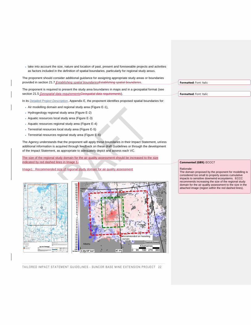
TAILORED IMPACT STAT EMENT GUIDELINES - SUNCOR BASE MINE EXTE NSION PROJECT 22
take into account the size, nature and location of past, present and foreseeable projects and activities
as factors included in the definition of spatial boundaries, particularly for regional study areas.
The proponent should consider additional guidance for assigning appropriate study areas or boundaries
provided in section 21.7 Establishing spatial boundariesEstablishing spatial boundaries.
The proponent is required to present the study area boundaries in maps and in a geospatial format (see
section 21.5 Geospatial data requirementsGeospatial data requirements).
In its Detailed Project Description, Appendix E, the proponent identifies proposed spatial boundaries for:
Air modelling domain and regional study area (Figure E-1).
Hydrogeology regional study area (Figure E-2)
Aquatic resources local study area (Figure E-3)
Aquatic resources regional study area (Figure E-4)
Terrestrial resources local study area (Figure E-5)
Terrestrial resources regional study area (Figure E-6)
The Agency understands that the proponent will apply these boundaries in their Impact Statement, unless
additional information is acquired through feedback on these draft Guidelines or through the development
of the Impact Statement, as appropriate to adequately depict and assess each VC.
The size of the regional study domain for the air quality assessment should be increased to the size
indicated by red dashed lines in Image 1.
Image1 : Recommended size of regional study domain for air quality assessment
Formatted: Font: Italic
Formatted: Font: Italic
Commented [GB9]: ECCC7 Rationale: The domain proposed by the proponent for modelling is considered too small to properly assess cumulative impacts to sensitive downwind ecosystems. ECCC recommends increasing the size of the regional study domain for the air quality assessment to the size in the attached image (region within the red dashed lines).
TAILORED IMPACT STAT EMENT GUIDELINES - SUNCOR BASE MINE EXTE NSION PROJECT 23
7.4. Effects assessment methodology
The environmental, health, social or economic effects should be described in terms of the context,
magnitude, geographic extent, context, timing, duration and frequency, and whether effects are reversible
or irreversible.
The description of the effect can use either qualitative or quantitative criteria, taking into account any
important contextual factors. In the case of quantitative predictions derived from models, the Impact
Statement must detail the model assumptions, the sources of data used for base case, project-only and
application-case scenarios, parameters, the quality of the data and the degree of certainty of the
predictions obtained. For other effects, it may be more appropriate to use other criteria, such as the nature
of the effects, directionality, causation and probability. The effects assessment should also set out the
probability or likelihood of that effect occurring and describe the degree of scientific uncertainty related to
the data, information, and methods used. The degree of confidence must be discussed in the analyses.
The Impact Statement must:
describe in detail the project’s potential direct and indirect adverse and positive effects in relation to
each phase of the project (construction, operation, closure and reclamation) including how baseline
data was used to inform this analysis;
provide a rationale for the absence of details if they cannot be provided (e.g. for future events such as
upon closure and reclamation), as well as a more general description of the expected activities and
effects;
employ analytical methods to compare predicted effects and actual effects that are statistically and
scientifically defensible;
include clearly stated assumptions for all predictions and clearly describe how each assumption has
been tested;
consider and describe the interactions between the environmental, health, social and economic effects
as well as the interaction and interconnectedness of selected VCs while taking into account community
values and a systems approach;
take into account the tolerance thresholds regarding the potential negative effects that Indigenous
peoples have identified;
describe where and how Indigenous knowledge and input were considered; and
include GBA+ as described in section 21.4 Application of GBA+Application of GBA+ and guidance
documents (see section 20 Appendix 1 – Reference documentsAppendix 1 – Reference documents).
7.5. Mitigation and enhancement measures
Every impact assessment conducted under the Act must identify measures that are technically and
economically feasible that would mitigate the project’s adverse environmental, health, social and economic
Commented [GB10]: ECCC8 Rationale: The description of the emissions data used should include both base case and the scenarios used to estimate project impact.
Formatted: Font: Italic
Formatted: Font: Italic
TAILORED IMPACT STAT EMENT GUIDELINES - SUNCOR BASE MINE EXTE NSION PROJECT 24
effects. Conversely, the proponent can identify enhancement measures to increase positive effects for
example, local and regional training efforts, investment in infrastructure and services, projects to
rehabilitate degraded environments, etc.. Mitigation and enhancement measures that will be proposed are
discussed during the review of the Impact Statement and may be modified as a result of the review.
Mitigation and enhancement measures may be considered for inclusion as conditions in the decision
statement.
A description of how the Agency describes the hierarchy of mitigation measures is captured in section 21.9
Mitigation hierarchyMitigation hierarchy.
The Impact Statement must:
describe the standard mitigation practices, policies and commitments that constitute proven technically
and economically feasible mitigation measures and that are to be applied as part of standard practice
within the project design;
specify the interventions, the work, the ecological footprint reduction techniques, the existing best
technology, the best environmental practices, the corrective actions and any addition anticipated in the
various stages of the project with a view to eliminating or mitigating the adverse effects of the project;
describe any new or innovative mitigation measures being proposed, including technological
innovations, and provide detailed information on the nature of these measures, their implementation
and anticipated effectiveness, management and related requirements of the follow-up program;
provide an assessment of the anticipated effectiveness of the technically and economically feasible
mitigation measures and describe all relevant uncertainties. The assessment must:
o provide the reasons for determining if the mitigation measure will reduce the extent to which the
adverse effects are significant;
o to the extent possible, provide relevant technical and scientific data and information from analogous
projects; and
o if there is little experience or some question as to the effectiveness of any measures, describe the
potential risks and effects should those measures not be effective or malfunction;
write mitigation measures as specific commitments that clearly describe how the proponent intends to
implement them and their desired outcomes. Measures are to be specific, achievable, measurable and
verifiable, and described in a manner that avoids ambiguity in intent, interpretation and implementation;
identify other technically and economically feasible mitigation measures that were considered but are
not proposed for implementation, and explain why they were rejected. Justify any trade-offs between
cost savings and effectiveness of the various forms of mitigation measures;
describe the approach that would be taken if a mitigation measure is no longer feasible while the
project is carried out, or does not perform as expected;
describe any environmental protection plan being prepared for the project and, if applicable, the
environmental management system through which plans will be delivered. The plan(s) must provide an
overall perspective on how potentially adverse effects would be minimized and managed over time;
discuss the mechanisms the proponent would use to require its contractors and sub-contractors to
comply with these commitments and policies and with auditing and enforcement programs;
Formatted: Font: Italic
TAILORED IMPACT STAT EMENT GUIDELINES - SUNCOR BASE MINE EXTE NSION PROJECT 25
describe how, throughout the project’s duration, the lessons learned through follow-up programs will be
used to continually improve mitigation measures (see also section 2.11B of Annex I);
include a mitigation and decommissioning plan for temporary components of the project;
identify the party responsible for the implementation of mitigation measures and the system of
accountability; and
explain how mitigation and enhancement measures were developed with communities and Indigenous
peoples, as well as federal, provincial and municipal authorities.
Effects from the project that remain after other mitigation measures are applied may need to be offset by
implementing compensatory measures. Where compensatory measures are proposed as measures to
mitigate remaining effects on species at risk and their critical habitats or residences, fish and fish habitat, or
wetland functions, the Impact Statement must include offsetting or compensation plans for consideration
during the impact assessment process. Guidance on the preparation of compensation plans is outlined in
section 21 Appendix 2 – Additional guidanceAppendix 2 – Additional guidance and within section 8
Biophysical environmentBiophysical environment.
8. Biophysical environment Although the requirements set out in these Guidelines are separated by biophysical, health, social or
economic conditions and elements, the Impact Statement must consider and describe the interactions
between the environmental, health, social and economic effects as well as the interaction and
interconnectedness of selected VCs while taking into account community values.
8.1. Meteorological environment
8.1.1. Baseline conditions
The Impact Statement must:
describe the local and regional climate, in sufficient detail to highlight weather variations and
characteristics of the region affected by project activities and components;
provide mean, maximum and minimum temperatures;
provide typical wind speed and direction;
identify the potential for extreme weather events such as, wind, precipitation and temperature
extremes;
provide a summary of, and reference to, data sources and unique weather station identifiers for hourly
meteorological data (wind speed and direction, air temperature, dew point temperature or humidity, air
pressure and precipitation data) gathered from a minimum of one year of study to support dispersion
and regional air quality modelling in order to capture the normal variability of meteorological conditions;
and
Formatted: Font: Italic
Formatted: Font: Italic
Commented [GB11]: ECCC9 Rationale: The data are required to support both dispersion and air quality modelling activities. One year is required for the regional air quality modelling in order to determine cumulative impacts such as acidifying deposition. The TISG should be explicit for the duration for both types of modelling.
TAILORED IMPACT STAT EMENT GUIDELINES - SUNCOR BASE MINE EXTE NSION PROJECT 26
consider the influence of climate change in the description of the local and regional climate and in the
risks of extreme weather events.
8.2. Geology, geochemistry and geological hazards
8.2.1. Baseline conditions
The Impact Statement must:
describe the geology of surficial deposits and bedrock at an appropriate scale. Include a table of
geologic and lithologic descriptions, including alteration styles, geological maps and cross-sections of
appropriate scale. Geospatial data files must also be included;
describe the geomorphology, topography and geotechnical characteristics of areas proposed for
construction of major project components;
provide a characterization of the geochemical composition of the materials to be excavated;
identify and provide maps of any areas with potential for acid-generating rock and provide geochemical
characterization of potential for metal leaching and acid rock drainage, for major and trace elements,
including oxidation of primary sulphides and secondary soluble sulphate minerals, as applicable;
identify any geological hazards that exist in the areas planned for project facilities and infrastructure,
including:
o a history of seismic activity in the area, including induced earthquakes, and any secondary effects,
such as the risk of landslides and liquefaction;
o a discussion pertaining to the potential presence of active faults; and
o a history of landslides, slope erosion and the potential for instability or landslides, and subsidence
during and following project activities;
describe baseline concentrations of contaminants of concern (these may include selenium, sulphate,
cadmium, nitrate and calcite, heavy metals) within the local, regional and downstream receiving
environments; and
describe the presence and location of landforms associated with important wildlife habitat features (see
21.12 Additional guidance for biophysical componentsAdditional guidance for biophysical components
for a list of habitat features).
8.3. Topography, soil and sediment
8.3.1. Baseline conditions
The Impact Statement must:
Formatted: Font: Italic
TAILORED IMPACT STAT EMENT GUIDELINES - SUNCOR BASE MINE EXTE NSION PROJECT 27
describe the landforms, terrain, soils and sediments within the local and regional study areas, including
sediment stratigraphy. Provide surficial geology maps and cross-sections of appropriate scale;
provide a description and location of any erosion-sensitive soils (see also section 3.9 of Annex I) and
areas of ground instability;
provide maps depicting soil depth by horizon and soil order within the project area to support soil
salvage and reclamation efforts;
describe the suitability and availability of reclamation material (soils, suitable overburden) (see also
section 3.9 of Annex I), taking into account the acid generating and metal leaching potential of
overburden to be used, if applicable;
identify soils within the local and regional study areas susceptible to potential acidification (by soil type)
(see also section 3.9 of Annex I);
describe the historical land use and the potential for contamination of soils and sediments; and
describe any known or suspected soil contamination within the study area that could be re-suspended,
released or otherwise disturbed as a result of the project.
8.4. Atmospheric, acoustic, and visual environment
8.4.1. Atmospheric environment
The proponent should consult the additional guidance for requirements pertaining to the atmospheric
environment provided in section 21.12 Additional guidance for biophysical componentsAdditional guidance
for biophysical components.
8.4.1.1. Baseline conditions
The Impact Statement must:
provide an assessment of the ambient air quality in the project, including modelling, for local and
regional study areas; identify existing emissions and contaminant sources using the most recent
meteorological and emissions data available (i.e. 2015-2019);
provide the results of a baseline survey of ambient air quality, in particular near key receptors by
identifying and quantifying emission sources for the following contaminants:
o total suspended particulates,
o fine particulates smaller than 2.5 microns (PM2.5),
o respirable particulates of less than 10 microns (PM10),
o carbon monoxide (CO),
o sulphur dioxide (SO2),
o nitrogen oxides (NOx),
o volatile organic compounds (VOCs),
Formatted: Font: Italic
Commented [GB12]: ECCC10 Rationale: In Section 21.12, the TISG states: “for requirements pertaining to the use of atmospheric dispersion modelling, the proponent should: •conduct modelling for a 5-year period, to account for variability in meteorology and baseline conditions;” The proponent should also have baseline pollutant data that matches this timeframe of five years. Data should be the five most recent years that data are available to ensure most applicable results.
TAILORED IMPACT STAT EMENT GUIDELINES - SUNCOR BASE MINE EXTE NSION PROJECT 28
o hydrogen sulphide (H2S) and other reduced sulphur compounds,
o polycyclic aromatic compounds (PACs), including polycyclic aromatic hydrocarbons (PAHs),
alkylated PAHs, PAH transformation products, including nitro and oxy-PAHs, and
dibenzothiophenes (DBTs)
o ammonia,
o metals related to bitumen resource extraction activities, including aluminum, antimony, arsenic,
barium, beryllium, cadmium, chromium, cobalt, copper, lead, manganese, mercury, molybdenum,
nickel, selenium, silver, strontium, thallium, tin, vanadium, zinc,
o and any other toxic air pollutants (mobile, stationary and fugitive sources);
include information on the baseline dust levels6 in areas that could potentially be affected by project
activities, including via transportation of workers to residences in Fort McMurray;
compare ambient air quality results with applicable regional, provincial and federal standards. For air
pollutants with standards, the proponent must use the averaging period and the statistical format
associated with each numerical value.
o Standards include the Canadian Ambient Air Quality Standards (CAAQS), National Ambient Air
Quality Objectives (NAAQO), the Alberta Ambient Air Quality Objectives and Standards (AAQO),
and Fort McKay’s Air Quality Objectives7. The proponent must refer to the new CAAQS established
by the Canadian Council of Ministers of the Environment (CCME) for PM2.5, O3, SO2 and NO2 to
take effect in 2020 and 2025;
identify and address issues pertaining to the quality of the monitoring data, including seasonal
variability in the baseline survey, and determine ambient contaminant concentrations using complete,
exhaustive, and representative monitoring data, collected over an appropriate duration (multi-year) and
geographic scope. Data validation, quality control methods, and any assumptions made must also be
described;
provide dispersion and regional air quality modelling of a base case for existing pollutant sources and
to determine the spatial distribution of pollutants in all study areas;
describe past and existing flaring activities, including number of hours of flaring per year associated
with Base Mine operations; and
provide a baseline assessment of odours at key receptor points, including in Fort MacKay and Fort
McMurray.
8.4.1.2. Changes to the atmospheric environment
The Impact Statement must:
6 The potential for the project to generate dust at a noticeable level in Fort McMurray and surrounding areas was noted
as a frequent concern in early public comments.
7 see the Public Registry for the Project, reference number 80521, file reference #77
Commented [GB13]: ECCC11 Rationale: For clarity for the proponent, this should be explicit – both types of modelling have been requested.
TAILORED IMPACT STAT EMENT GUIDELINES - SUNCOR BASE MINE EXTE NSION PROJECT 29
provide a detailed description of all emission sources of air pollutants from the project listed under
8.4.1.1 Baseline conditionsBaseline conditions, including all point sources, area sources, and mobile
and road sources and identify if these emissions differ from the existing Base Mine operations;
provide a detailed methodology and assumptions used to estimate emissions of air pollutants at all
phases;
provide details of the occurrence of flaring and associated assumptions. Describe the gas composition
under both normal and upset flaring conditions;
estimate the deposition of dust and other contaminants on sensitive receptors (including Fort
McMurray and Fort MacKay communities) and transportation of dust into communities via project or
worker vehicles;
provide a description of the odours potentially associated with the project including extent and
frequency;
predict the fate of emissions resulting from all project sources for all emissions listed under 8.4.1.1
Baseline conditionsBaseline conditions, by using atmospheric dispersion and regional air quality
modelling;
predict ground-level pollutant concentrations, and plot predicted concentrations using appropriately
scaled contour maps;
provide rationale for the choice of air quality model, including the type and magnitude of emissions, the
complexity of sources, terrain and meteorology;
provide SMOKE-ready emissions input files used for regional air-quality base case and scenario
simulations;
provide emission rates for all project and regional sources within the study areas, including emission
factors and all related assumptions and related parameters that would enable calculations to be
reproduced. Include details on methodology, uncertainty assessment and references, and provide
sample calculations;
provide detailed information on emission estimation methodologies for all project phases, including
details on the configuration of the atmospheric dispersion and regional air quality models used (e.g.
meteorology, land use, modelling domain, receptor grid density, land users, default options and
chemical and physical transformation parameters, where applicable);
assess the uncertainty in the modeled air pollutant concentrations using relevant range of model
meteorological and emissions inputs (i.e. 2015-2019). All sources of uncertainty should be taken into
account, including:
o model uncertainty, including a consideration for how uncertainty in modelled predictions may vary
spatially and temporally;
o uncertainty in baseline concentration estimates;
o uncertainty in the estimates of meteorological inputs; and
Formatted: Font: Italic
Formatted: Font: Italic
Commented [GB14]: ECCC12 Rationale: For clarity for the proponent, this should be explicit – both types of modelling have been requested.
Commented [GB15]: ECCC13 Rationale: Emission model inputs are needed in order to conduct an adequate cumulative effects assessment and for baseline studies.
Commented [GB16]: ECCC14 Rationale: For clarity for the proponent this should be explicit – both types of modelling have been requested.
Commented [GB17]: ECCC15 Meteorological data should be most recent available. The proponent specifies a 2002-2006 data set (see Detailed Project Description reference below) but newer data is available. Detailed Project Description, Section E-2 pdf pg 76: “The air dispersion modelling for the air quality assessment will be conducted using the CALPUFF dispersion model (Version 7) with a 5-year (2002-2006) meteorological data set.”
TAILORED IMPACT STAT EMENT GUIDELINES - SUNCOR BASE MINE EXTE NSION PROJECT 30
o uncertainty in estimates of source emissions (from sources attributable to the project, and
externally). Uncertainty in source estimates should take into account any published studies which
have shown apparent discrepancies between reported and observed emissions8;
provide maps of isopleths illustrating the predicted emissions for the modelling scenarios, using an
appropriate scale to visualize the extent of dispersion and sensitive receptors;
determine, through comparison between base case, project-only and application-case scenarios,
whether the formation of secondary pollutants resulting from the project has the potential to raise
concentrations above baseline levels – if so, identify and characterize these pollutants;
compare the predicted air quality results with applicable regional, provincial and federal standards for
ambient air quality and community-based air quality and odour guidelines.
o The assessment against CAAQS should be based on the principles of “keeping clean areas clean”
and “continuous” improvement and in the context of air sheds and air zones with the Air Quality
Management System;
conduct a source contribution analysis to assess the relative contributions of project and non-project
emission sources on pollutant concentrations at key receptors. The source contribution analysis should
be conducted for all pollutants that exceed 10% of the relevant guidance or standard value. Emission
sources should be grouped into appropriate categories, such as mine fleet, mine face, haul roads,
material handling, tailings storage areas, etc.; and
describe any positive changes.
Secondary organic compounds
The Impact Statement must quantify secondary organic compounds as a result of the project, by using the
following approach:
quantify the emissions of gas-phase precursor compounds of secondary organic aerosols (SOA) for
each relevant source;
identify the individual chemical compounds considered as SOA precursor emissions (VOCs, IVOCs
and SVOCs). In addition, group total organic gas-phase emissions on the basis of volatility for each
source, to use in the estimation of SOAs; and
estimate the concentration of SOAs (as PM2.5) with a regional air quality model an appropriate model
using the quantified SOA precursor emissions for the base case, project-only, and application-case
scenarios. SOA precursor emissions from other oil sands projects in the region may be approximated
by scaling measured emissions from these facilities to production levels. The model should provide an
accurate estimation of SOA formation that will be included with primary PM2.5 emissions to arrive at a
total PM2.5 burden.
8 Example: Li et al., 2017. Reference Li, S.-M., et al. Differences between measured and reported volatile organic
compound emissions from oil sands facilities in Alberta, Canada. (2017) Proceedings of the National Academy of
Sciences of the United States of America, 114 (19), pp. E3756-E3765
Commented [GB18]: ECCC16 Rationale: The methodology by which change is being assessed is not clear here. It should be made explicit.
Commented [GB19]: ECCC17 Rationale: This needs to be explicit. Dispersion models cannot be used to accurately estimate SOA.
Field Code Changed
TAILORED IMPACT STAT EMENT GUIDELINES - SUNCOR BASE MINE EXTE NSION PROJECT 31
Acid deposition
The Impact Statement must assess the potential for the project’s emissions of acidifying pollutants to
contribute to acid deposition at the regional scale, by using the following approach:
conduct regional air-quality model simulations using base case, project-only and application-case
scenarios to predict acidifying deposition using emissions of NOx and SO2 from processing facilities
that are part of the Project;
using modeled acidifying deposition rates, assess the potential for the project to contribute to
ecosystem damage by estimating exceedances of critical loads (an effective measure of ecosystem
sensitivity) in the region. Critical loads must be estimated using methods consistent with the
internationally recognized UN-ECE Convention on Long-Range Transboundary Air Pollution (CLRTAP,
2017)9. Further examples of critical load calculation datasets and procedures and the use of the
CLRTAP protocols may be found in Makar et al. (2018);
include summaries of the emissions associated with base case, project-only and application-case
scenarios for sulphur, nitrogen, and base cation emissions; and
compare potential effects with critical thresholds, considering current and historical loadings, buffering
capacity, and critical loads.
The proponent should refer to Health Canada’s Guidance for Guidance for Evaluating Human Health
Impacts in Environmental Assessment: Air Quality to ensure that it provides the information and analysis
considered necessary to assess the project’s impacts on human health in relation to changes to air quality.
It is requested that the proponent complete the checklists provided in this guide (Appendix A in the air
quality guide) to assist participants in verifying that the main elements of a air quality impact assessment
have been completed and in identifying the location of this information in the Impact Statement. These
checklists will facilitate the review of the Impact Statement and will be particularly useful if analyses on
these aspects are found in several sections of the Impact Statement.
It is recommended that the proponent engage with experts at Environment and Climate Change Canada
(ECCC) to inform the choice of program to conduct regional air quality modeling of acidifying deposition
rates.
8.4.1.3. Mitigation and enhancement measures
The Impact Statement must:
provide a description of all the methods and practices to be deployed to reduce and control emissions,
including options to reduce flaring (e.g. control equipment, heat or gas recovery system). If the best
available technologies are not selected in the project design, the proponent must provide a rationale to
justify the technologies selected;
9 CLRTAP 2017. Manual on methodologies and criteria for modelling and mapping critical loads and levels and air
pollution effects, risks and trends.
Commented [GB20]: ECCC18 Rationale: This needs to be explicit – the regional air-quality model should be used for the acid deposition calculations. Dispersion models cannot be used to accurately estimate SOA.
Commented [GB21]: ECCC19 Rationale: Additional information is available in the Makar paper.
Commented [GB22]: ECCC20 Rationale: ECCC requires this information in order to be able to assess the relative impact of project emissions to those of the region.
Commented [GB23]: ECCC21 Rationale: Added precision of what ECCC could provide.
TAILORED IMPACT STAT EMENT GUIDELINES - SUNCOR BASE MINE EXTE NSION PROJECT 32
document and justify how the contaminant emission reduction efficiencies were applied in the
calculation of emission rates, including details of all assumptions associated with these mitigation
measures and their feasibility;
provide a description of existing and planned measures to reduce odours and dust, including a
description of improvements to existing infrastructure as applicable (the impacts of dust reduction
measures should also be described in the context of their impact on base cation emissions used in
base case, project-only and application-case scenarios used for regional air-quality modelling); and
provide a description of participation in national or regional air emission tracking and reporting
programs (e.g. National Pollutant Release Inventory) or provide rationale why participation is not
required;
develop and implement strategies compliant with regional and national commitments, such as the
CCME’s commitment regarding pollution prevention; and
consult and consider best management practices presented in the document Best Practices for the
Reduction of Air Emissions from Construction and Demolition Activities.
8.4.2. Acoustic environment
8.4.2.1. Baseline conditions
The Impact Statement must:
provide current ambient noise levels at key receptor points (e.g. nearby communities, residences,
Indigenous land users, locations of traditional land use, wildlife), including the results of a baseline
ambient noise survey and permissible noise levels for each receptor. The information on typical noise
sources (natural and anthropogenic), their geographic extent and temporal variations must be
included. At the time of collecting baseline data for the study on ambient noise where there are human
receptors, it is recommended that the following aspects be considered:
o natural sounds,
o soundscapes (see standard ISO 12913-1:2014. Acoustics — Soundscape — Part 1: Definition and
conceptual framework),
o expectations regarding quiet conditions in specific places or at specific times,
o usual sleeping hours (the default assumption is 10:00 p.m. to 7:00 a.m.), and
o degree of baseline annoyance attributable to existing noise sources (e.g. vehicle traffic, aircraft,
other industrial noise);
justify the selection of and provide information on all noise-sensitive receptors in the study area,
including any foreseeable future receptors, and distances of receptors from the project; and
describe engagement with Indigenous communities to identify receptor locations.
8.4.2.2. Changes to the acoustic environment
The Impact Statement must:
describe changes in ambient vibration and sound levels resulting from the project;
Commented [GB24]: ECCC22 Rationale: Methodologies to control fugitive dust for the purposes of reducing human health risk may reduce the base cations available for acidifying deposition neutralization. The emissions data for fugitive dust (the main source of base cations) used in modelling need to be consistent with any human-health related emissions controls planned to reduce dust emissions.
TAILORED IMPACT STAT EMENT GUIDELINES - SUNCOR BASE MINE EXTE NSION PROJECT 33
quantify sound levels at appropriate distances from any project facilities and/or activities and describe
for each sound source the timing, frequency, and duration of sound events and their characteristics,
including the frequency spectrum;
describe the locations and characteristics of the most sensitive receptors (e.g. species at risk and
traditional land use sites);
identify and justify the approach to characterize sound effects resulting from the project that may be
adverse. Take into account:
o the distribution of the reference nighttime sound events relative to the individual sound events
expected at night at the location of each receptor; and
o expectations of peace and quiet for receptors (e.g. in a quiet rural area or during land use by
Indigenous peoples) and noise policies (e.g. processes for resolving and dealing with public
complaints);
describe consultation with regulators, stakeholders, community groups, landowners and Indigenous
groups about potential effects to the acoustic environment;
where there is public concern associated with an increase in sound levels during construction, provide
a vibration and sound impact assessment including an overview of concerns and an assessment of the
change in percent highly annoyed (see Health Canada guidance on Noise); and
describe any positive changes.
8.4.2.3. Mitigation and enhancement measures
The Impact Statement must:
identify current and proposed noise mitigation measures and their effectiveness, including design,
construction and operational factors referenced in AER’s Directive 38: Noise Control (see also section
3.1 of Annex I);
explain how a complaint-response protocol may be implemented and reported on to document any
complaints and associated mitigation measures undertaken to resolve the complaints, including the
nature of the noise produced (e.g. tonal, impulsive, highly impulsive, and the timing of the noise event);
and
explain how a community engagement plan may be implemented and reported on to proactively inform
community members and Indigenous groups who may be affected by project-related noise, such as
anticipated changes in noise levels (e.g. blasting).
The proponent should refer to Health Canada’s Guidance for Evaluating Human Health Impacts in
Environmental Assessment: Noise to ensure that it provides the information and analysis considered
necessary to assess the project’s impacts on human health in relation to changes to the sound
environment. It is requested that the proponent complete the checklists provided in these guide (Appendix
B in the above-referenced Health Canada Guidance on noise) to assist participants in verifying that the
main elements of a noise impact assessment have been completed and in identifying the location of this
information in the Impact Statement. These checklists will facilitate the review of the Impact Statement and
will be particularly useful if analyses on these aspects are found in several sections of the Impact
Statement.
TAILORED IMPACT STAT EMENT GUIDELINES - SUNCOR BASE MINE EXTE NSION PROJECT 34
8.4.3. Visual environment
8.4.3.1. Baseline conditions
The Impact Statement must:
describe existing ambient night-time light levels at the project site and at any other areas where project
activities could have an effect on light levels;
describe night-time illumination levels during different weather conditions and seasons; and
describe landscapes of interest, visual screens and other components of the visual environment, and
locate them on a map.
8.4.3.2. Changes to the visual environment
The Impact Statement must:
describe any changes in night-time light levels as a result of the project;
o quantify light levels at appropriate distances from any project facilities, including the timing (e.g.
night hours), frequency, duration, distribution and character of light emissions;
o describe the locations and characteristics of the most sensitive receptors, including species at risk,
nearby communities, and areas favoured by Indigenous groups for the practice of traditional
activities;
o describe consultations and, where appropriate, provide a record of engagement with regulators,
stakeholders, community groups, landowners and Indigenous groups regarding potential effects on
the visual environment;
describe any changes to the visual environment that would consist of aesthetic disruptions to the
cultural landscape (e.g. from deforestation, changes to topography, additional presence of humans).
This assessment should focus on land users and people traveling along the Athabasca river; and
describe any positive changes.
8.4.3.3. Mitigation and enhancement measures
The Impact Statement must describe existing and proposed mitigation measures for anticipated changes to
the visual environment.
8.5. Groundwater and surface water
8.5.1. Baseline conditions
The Impact Statement must:
provide complete hydrometeorological information (temperature, precipitation, evapotranspiration)
based on data from nearby weather stations or from a weather station on site;
TAILORED IMPACT STAT EMENT GUIDELINES - SUNCOR BASE MINE EXTE NSION PROJECT 35
describe and illustrate on one or more topographic maps, at appropriate scales, the drainage basins in
relation to key project components. On the map(s), identify all waterbodies and watercourses, including
intermittent streams, wetlands, watershed and sub-watershed boundaries, and indicate the intended
locations of crossings of water bodies or watercourses, if applicable, and any watercourse diversions;
indicate the type of watercourse impacted (e.g. lotic or lentic system, lake, river, pond, temporary or
permanent stream); the size of the water bodies and watercourses, the width at the ordinary high water
mark (OHWM) based on the following classes: large stream (over 20m in width), medium stream
(between 5 and 20m in width), small permanent and intermittent streams less than 5m in width);
provide flow hydrographs for nearby streams and rivers showing the full range of seasonal and inter-
annual variations, as well as seasonal baseflow, including for the Athabasca River below Fort
McMurray (i.e. station number 07DA001) and immediately upstream of the Peace-Athabasca Delta
(PAD) (i.e. station number 07DD001), and for nearby streams similar to Poplar Creek and Beaver
Creek,. Seasonal variability must cover the entire low flow season of late summer to early spring,
particularly during river freeze-up and periods important for Indigenous navigation within the PAD (e.g.
early spring and late summer/fall 10). The hydrographs may be based on data from nearby gauging
stations or from gauging stations on site. Information pertaining to the PAD must also be included;
provide stage hydrographs for nearby lakes showing the full range of seasonal and inter-annual water
level variations;
for each waterbody and watercourse affected by the project, provide the timing of freeze-thaw cycles,
ice cover, and ice conditions;
provide for each water body affected by the project, the total surface area, bathymetry, maximum and
mean depths, and sediments composition (e.g. particle size analysis, sediment quality, total organic
carbon);
provide a delineation and characterization of groundwater–surface water interactions, including an
identification of groundwater-dependent ecosystems, wetlands, discharge and recharge areas.;
develop a quantitative surface water balance for the local or regional watershed(s) containing the
project;
identify springs and potable surface water resources within the local project area and describe their
current use, potential for future use, and whether their consumption has Indigenous cultural
importance;
describe the surface water quality baseline characterization program, including sampling site selection
and locations, monitoring duration and frequency, sampling methodology, and analytical protocol,
including quality assurance and quality control measures for each waterbody and watercourse
potentially affected by the project. Baseline samples should also be collected in the project area, the
10 Suggested Reference: Transport Canada (2019) Athabasca River Navigational Study, prepared by Dillon Consulting
for Transport Canada. Retrieved from: https://tc.canada.ca/en/marine/navigation-study-lower-athabasca-river
TAILORED IMPACT STAT EMENT GUIDELINES - SUNCOR BASE MINE EXTE NSION PROJECT 36
local study area, the regional study area and from reference locations that are unlikely to be impacted
by the project;
provide physical limnology baseline data, e.g. lake vertical profile data, information on stratification and
turnover, and ice cover;
provide baseline data for physiochemical parameters11 and relevant chemical constituents12 for surface
water and groundwater quality. Water sample collection and analysis should use appropriately
sensitive detection limits. Include additional data, as appropriate, to illustrate the seasonal and inter-
annual variability in baseline water quality with sufficient years of baseline data to fully characterize
natural variability, including possible changes due to groundwater–surface water interactions;
describe baseline concentrations of elements or contaminants of concern in relation to applicable
water quality guidelines;
identify domestic, communal, or municipal water wells within the local and regional study areas,
including available information on their depth, distance from the project, stratigraphy, screened
hydrostratigraphic unit and piezometric level, and specific capacity. Describe their current use,
potential for future use, and whether their consumption has any Indigenous cultural importance;
identify groundwater-producing strata (course-grained sediments and permeable bedrock) that may be
affected by the project. Where current domestic, communal, or municipal water wells access these
strata, their distance from the project must also be marked and added to the map;
provide monitoring well hydrographs showing the range of seasonal and inter-annual water level
variations for groundwater monitoring wells within the regional study area, and identify their location,
groundwater quality information, and monitoring frequency;
describe the groundwater quality baseline characterization program including sampling site selection
and location, monitoring duration and frequency, sampling methodology, and analytical protocol
including quality assurance and quality control measures. Include baseline samples for upgradient
reference locations that are unlikely to be impacted by the project;
describe the hydrostratigraphic units (aquifers, aquitards, aquicludes) of the affected hydrogeological
environment, illustrated using geological cross-sections, and provide a piezometric map showing
heads and the direction of groundwater flow;
describe the structural geology of the affected hydrogeological environment, including any major faults,
fracture density and orientation, and bedding orientation with respect to groundwater flow directions;
11 Relevant physicochemical parameters may include: temperature, pH, electrical conductivity, dissolved oxygen,
turbidity, total suspended solids, total hardness, and total dissolved solids.
12 Relevant chemical constituents may include: major and minor ions, total and dissolved trace metals, radionuclides,
total mercury, methylmercury, naphthenic acids, PACs (including PAHs, alkylated-PAHs, PAH transformation
products, including nitro and oxy-PAHs and dibenzothiophenes), nutrients, organic and inorganic compounds, and
other compounds of potential concern. For groundwater, this also includes radionuclides (uranium -238, radium,
polonium, and thorium).
Commented [GB25]: ECCC23 Rationale: Without this information ECCC will not have sufficient baseline from which to assess the potential for effects. ECCC recommends that additional information on the expected locations for water quality baseline data collection be added to the requirements. The effects assessment section (TISG page 39) clearly outlines specific locations where changes to water quality are to be assessed, extending out as far as the regional study area. Providing similar specificity related to baseline data collection allows for consistency, as well as to ensure that data collected is sufficient to support the requirements of the effects assessment. The specified baseline data locations are necessary for sound monitoring study design, and for demonstrating the proponent will have the ability to detect change and implement adaptive management.
Commented [GB26]: ECCC24 Note of confirmation: The highlighted parameters were added specifically for this Project as they are oil-sands specific contaminants. Regarding “Relevant chemical constituents may include” in footnote 12:
Since we are asking for specific project-related parameters, it is the expectation that these parameters will be included in baseline data characterization and assessment of effects. Language should use “should” instead of “may”. Without data on these specific parameters, ECCC may not have all the information required to adequately review the potential for impacts and therefore recommends stronger language by the inclusion of “should” instead of “may”. Using “may” language insinuates collection and assessment of this data is optional.
TAILORED IMPACT STAT EMENT GUIDELINES - SUNCOR BASE MINE EXTE NSION PROJECT 37
describe the groundwater flow boundaries of the hydrogeological environment, including groundwater
divides and boundaries with surface water;
provide the hydraulic properties of the hydrostratigraphic units, including data on hydraulic conductivity,
specific storage, transmissivity, storativity, saturated thickness, porosity, and specific yield, as
applicable;
provide hydrogeological maps and cross-sections of the study area showing water table elevations,
potentiometric contours, interpreted groundwater flow directions, groundwater divides and areas of
recharge and discharge;
where community drinking water supply wells are present within RSA, provide the groundwater capture
zones, and the identify the potential for the groundwater to be under the direct influence of surface
water;
present a conceptual model of the hydrogeological environment, including a discussion of geomorphic,
hydrostratigraphic, hydrologic, climatic, and anthropogenic controls on groundwater flow;
develop a 3-dimensional numerical groundwater flow model for the project area based on the
conceptual model of the hydrogeological environment;
state limitations and assumptions in the modelling approach;
calibrate the numerical model to baseline hydrogeological conditions using groundwater level and
stream flow monitoring data, provide metrics and graphs describing the quality of the calibration that
was achieved, and discuss howspatial variability is considered in model calibration;
analyse the sensitivity of key model outputs to hydraulic properties and climatic parameters such as
recharge; and
using the calibrated numerical model, provide a baseline groundwater budget including distributed
surface recharge, groundwater discharge to wetlands, lakes streams and rivers, infiltration from
surface water features to the groundwater flow system, and any anthropogenic withdrawals.
The proponent shall refer to the Health Canada guide Guidance for Evaluating Human Health Impacts in
Environmental Assessment: Water Quality to ensure that all necessary information and analyses are
provided to assess the project’s impacts on human health in relation to changes in water quality. The
proponent should complete the checklist in this guide (Appendix A) to assist participants in verifying that
the main components of a water quality impact assessment have been completed and to identify the
location of this information in the Impact Statement. The checklist will make it easier to review the Impact
Statement, and it will be particularly helpful if analyses on this aspect are found in multiple sections of the
Impact Statement.
8.5.2. Changes to groundwater and surface water
The Impact Statement must:
identify locations of interaction of the project with surface water and groundwater, including aquifers;
describe changes to water quantity and quality of domestic, communal, or municipal wells;
describe the contaminants associated with the project and characterize how they could affect surface
and groundwater quality, including information on the source(s) of any contaminants, and their
transport and fate in the hydraulic environment;
TAILORED IMPACT STAT EMENT GUIDELINES - SUNCOR BASE MINE EXTE NSION PROJECT 38
identify potential contaminant flow paths, including groundwater seepage pathways and its relationship
to potential receptors;
describe potential effects to surface water as a result of acidifying emissions from the project and acid
deposition, making use of regional air-quality model deposition estimates generated per the acid
deposition portion of section 8.4.1.2;
describe the downgradient flow of groundwater affected by the project, including the quantity and the
contaminant mitigation capacity within the hydrogeological units in the project area, to identify the
potential for off-site groundwater and surface water contamination;
indicate the groundwater and surface water withdrawal requirements during all phases and specify:
o the quantity and quality of water withdrawn from the environment (flow rates and annual volumes);
o any treatment carried out on these waters (e.g. addition of a tracer); and
o the conditions under which this water is released into the receiving environment;
provide a project-specific water use assessment identifying and describing the quantity of water
resources potentially affected by the project, including water withdrawn from local waterbodies used as
a supply source, the flow or volume of water available in the waterbodies, and how and where waste
waters could be spilled or discharged and any potential changes to seasonal flows or fluxes from
project activities;
quantify the extent of hydrological changes that will result from disturbances to groundwater and
surface water movement, taking into account climate change and cumulative effects, including
changes to the quantity of surface flow, water levels and channel regime in watercourses and water
levels in affected waterbodies, during minimum, average and peak flows, including seasonal variability
of the LSA and of the RSA (including the PAD, Ruth Lake, Richardson Lake, the Athabasca
Watershed, Slave River, and Old Fort River).
o Seasonal variability must cover the entire low flow season of late summer to early spring,
particularly during river freeze-up and periods important for Indigenous navigation within the PAD
(e.g. early spring and late summer/fall). Changes to water levels and flows in the PAD should be
referenced to important thresholds such as those required for safe navigation through the PAD by
Indigenous peoples (suggested reference Athabasca River Navigational Study from Transport
Canada, 201913);
provide an operational and management plan related to the water intake, including the timing and
volumes of water withdrawal and resulting impacts to water levels and navigation;
describe any changes in habitat structure (e.g. streambed, aquatic vegetation, benthic communities);
describe changes to surface and groundwater quality as a result of changes toriparian, wetland, and
terrestrial environments, including vegetation removal of vegetation, as well as (see also section 3.6.2
of Annex I);
13 Transport Canada (2019) Athabasca River Navigational Study, prepared by Dillon Consulting for Transport Canada.
Retrieved from: https://tc.canada.ca/en/marine/navigation-study-lower-athabasca-river
Commented [GB27]: ECCC25 Rationale: The regional air quality modelling will provide deposition totals that will be used for critical load exceedance calculations. These should be used within the water section for the same purpose: the modelled fields generated should be used for the impacts to surface water due to acid deposition portion of the assessment .
TAILORED IMPACT STAT EMENT GUIDELINES - SUNCOR BASE MINE EXTE NSION PROJECT 39
discuss changes to watersheds, including alignment and condition of all streams, waterbodies, and
wetlands, both ephemeral and permanent, including those created, removed or altered by the project
(e.g. Beaver Creek and Poplar Creek Reservoirs);
present a 3-dimensional numerical groundwater flow model of the hydrogeological system that
incorporates all major project features such as open pits, overburden disposal areas, tailings
management facilities, dewatering wells, and water diversion ditches. The model should be based on
the calibrated model used to represent baseline conditions, and use telescopically refined groundwater
flow models in the vicinity of open pits and tailings management facilities. Using the numerical
groundwater flow model:
o estimate key project fluxes, including open pit inflow rates, dewatering rates, pit closure flooding
rates, and seepage rates from project facilities during operations and the post-closure period; and
o estimate seasonal changes to surface water and groundwater regimes during operations and the
post-closure period, including effects of depressurization of the basal aquifer and dewatering of
surficial deposits, effects on baseflow in rivers and streams, effects on wetlands, effects on potable
supplies, and effects on natural flow divides;
provide drawings and/or figures showing groundwater piezometric contours and/or particle tracking
results to illustrate projected seepage patterns for applicable project components;
describe potential downstream effects to water quality including in Wood Buffalo National Park, Ruth
Lake, Richardson Lake, the Athabasca Watershed, Slave River, PAD and Old Fort River;
present any applicable site water management plan, including water diversion and mine flooding
strategy in the post-closure period ; comprehensive site water management plans, including water
diversion and mine flooding strategyies for all project phases (construction, operations, closure);
present estimates of surface water runoff rates for major project components, including waste rock
piles, ore stockpiles, and tailings management facilities;
present an integrated site water balance model incorporating surface and groundwater fluxes to or
from all major project components, for the construction, operation, closure and post-closure periods;
present an integrated chemical mass balance model incorporating surface and groundwater chemical
loads to or from all major project components, for all project phases; this should include:
o a clear description and rationale for all input parameters and assumptions, and
o base case estimate (i.e. most likely scenario), worst case scenario, best case scenario, plus
applicable sensitivity scenarios;
describe any applicable water quality treatment measures and provide evidence supporting the
effectiveness of these measures;
describe the quantity and quality of all effluent streams released from the site to the receiving
environment, including seepage from tailings management facilities, overflow from pits or mine
workings, and surface runoff from mine components;
describe potential changes to surface water quality due to any project-derived erosion and
sedimentation;
describe potential changes to surface water quality due to aerial deposition of fugitive dust and
particulate matter containing contaminants such as metals (including total mercury and methylmercury)
and PACs;
Commented [GB28]: ECCC26 Rationale: Without this information, ECCC will be unable to assess the overall water management strategy and identify potential pathways of impacts to water quality. The text as worded in the TISG is quite limiting, specifically referencing only diversions and potential post-closure flooding, which does not capture the extent of water management over the total mine life. Water management for oil sands mines is an integral part of their operations due to the inability to discharge effluent and therefore needs to be adequately described and presented for all project phases.
Commented [GB29]: ECCC27 Rationale: Without this information ECCC will not have site water balance information for construction and closure and will be unable to assess potential impacts in these phases. The site water balance model should include all project phases since water management and the overall water balance may differ between the different phases of the project. The draft TISG wording does not include the construction phase or the closure phase. It is important to have an understanding of the water balance and associated management during these additional phases to provide an understanding of the potential for impacts to water quality. The transitional phases of construction and closure involve different risks and requirements for water management, and should be examined in the context of the water balance and related modeling inputs.
TAILORED IMPACT STAT EMENT GUIDELINES - SUNCOR BASE MINE EXTE NSION PROJECT 40
describe changes to geomorphology and suspended solid concentrations in surface waters due to
changes in surface flows;
describe how the alteration of the Beaver River and Poplar Creek watersheds may affect water and
sediment quality in the receiving environment;
describe changes to groundwater quality due to effluents from the project, including changes to
physicochemical parameters and chemical constituents (see footnotes 11 et 12);
assess the potential for the project to result in contamination and transport of radionuclides in
groundwater, and characterize the concentration of radionuclides per element in ore and the
equilibrium concentration with daughter materials;
describe any changes to groundwater quality that could affect surface water quality, particularly of the
Athabasca River and its tributaries;
describe potential effects to groundwater or surface water quality or quantity resulting from the removal
or diversion of watercourses;
describe tailings management strategies, including:
o the composition and volume of specific waste streams;
o measures to minimize fine fluid tailings production;
o disposal sites, including their location on the post-closure landscape;
o feasibility and effectiveness of different reclamation strategies (i.e. various wetland landscapes and
dry landscapes);
o measures and strategies for recycling, preventing pollution and minimizing waste through-out the
life-cycle of the project, including information on the technologies that will be employed; and
o identify the limits of proposed tailings treatment technologies at closure;
provide an assessment for off-site migration pathways for impacted groundwater, and an analysis of
contaminant attenuation capacities within the hydrogeological units of the project study area;
describe predicted changes to surface water quality due to all discharges from the project including
impacts to surface water from groundwater-surface water interactions. This should include changes to
physicochemical parameters and chemical constituents (see footnotes 11 et 12);
compare any changes to surface or groundwater quality to applicable guidelines, objectives or
standards. Where guidelines are exceeded, the risk of adverse effects occurring to receptors in the
receiving environment should be evaluated on a site specific basis, and adaptive management
practices identified, where appropriate;
describe potential changes to surface water quality associated with the inclusion of end pit lakes in the
project, including predicted water quality within the pit lake through closure and post-closure. This
should include:
o a comprehensive water balance;
o modelling of predicted closure water quality throughout the development of pit lakes until stability is
achieved, including modelling of potential releases of contaminants into the water column, sediment
resuspension, and potential stratification;
o potential for mercury methylation;
TAILORED IMPACT STAT EMENT GUIDELINES - SUNCOR BASE MINE EXTE NSION PROJECT 41
o closure water quality objectives; and
o comparison of expected water quality to relevant surface water quality guidelines for the protection
of aquatic life;
present an analysis of current or planned process water management, including a description of
possibilities for discharge (should regulations come into force) with the best available knowledge.
Include a discussion on potential effects to the Athabasca River and the PAD; and
provide proposed monitoring points to assess potential changes to surface water quality, including:
o all point and diffuse sources of discharges,
o the immediate receiving environment for any point or diffuse sources of discharges from the project,
o at the outer boundary of the mixing zone,
o where the water quality from the immediate receiving environment begins to meet Water Quality
Guidelines, or background levels for that contaminant;
o at the project boundary,
o at the LSA boundary, and
o at the RSA boundary.
The proponent should refer to Health Canada’s Guidance for Evaluating Human Health Impacts in
Environmental Assessment: Drinking and Recreational Water Quality to ensure that it provides the
information and analysis considered necessary to assess the project’s effects on human health in relation
to changes to water quality. It is requested that the proponent complete the checklist provided in this guide
(Appendix A) to assist participants in verifying that the main elements of a water quality impact assessment
have been completed and in identifying the location of this information in the Impact Statement. This
checklist will facilitate the review of the Impact Statement and will be particularly useful if analyses on this
aspect are found in several sections of the Impact Statement.
8.5.3. Mitigation and enhancement measures
The Impact Statement must:
describe the mitigation measures for the possible effects on the quantity and quality of surface water
and groundwater, including water supply wells, and provide a rationale that explains the effectiveness
of proposed measures;
provide any water management plan applicable to waterbodies and watercourses likely to be affected
by any phase of the project;
describe how connectivity of surface water and groundwater within the project site with the regional
landscape will be considered and maintained on the closure landscape;
describe and justify water takings for project works (e.g. hydrostatic tests), particularly for works or
water takings in sensitive environments including water-bearing strata associated with drinking water
supply, and the measures that will be taken to mitigate the adverse effects, including the supply and
discharge of water, and potential exchanges between watersheds. If the final details of the hydrostatic
tests have not been confirmed yet, the proponent nonetheless must specify the expected
TAILORED IMPACT STAT EMENT GUIDELINES - SUNCOR BASE MINE EXTE NSION PROJECT 42
requirements, the options available and the criteria it intends to apply to assure protection of water
resources;
describe any groundwater and surface water monitoring programs, including the selection and location
of sampling points, the parameters that will be measured, the duration and frequency of monitoring, the
sampling protocol and analysis protocol and the quality assurance and quality control measures.
Where applicable, the parameters measured should include a comparison of the measured parameters
with the criteria in the Canadian Council of Minister’s of the Environment Canadian Environmental
Quality Guidelines. Include the description of the measures that will be implemented if the criteria are
exceeded;
describe any specific monitoring program planned during construction, including assessment of effects
before and after construction activities in order to optimize or adapt mitigation measures at the time of
their application; and
describe methods for the prevention, management and control of acid rock drainage and metal
leaching during construction, operation, abandonment and decommissioning phases.
8.6. Vegetation and riparian, wetland and terrestrial environments
The proponent should consult the additional guidance for requirements pertaining to wetlands provided in
section 21.12 Additional guidance for biophysical componentsAdditional guidance for biophysical
components.
8.6.1. Baseline conditions
8.6.1.1. Vegetation and communities of importance
The Impact Statement must:
provide a description of the biodiversity, relative abundance and distribution of vegetation species and
communities of ecological, economic or human importance within the local study area of the project
(see also section 3.6.1 of Annex I), including:
o rare plant communities and communities of limited distribution;
o old growth forests;
o species listed as at risk, may be at risk, and sensitive in the General Status of Alberta Wild Species;
o species listed in Schedule 1 of the Species at Risk Act;
o species assessed by COSEWIC as extirpated, endangered, threatened or of special concern. It is
recommended to refer to the most recent COSEWIC annual report for the list of assessed species
posted on its website; and
o species of importance to Indigenous peoples, including traditional, medicinal, and cultural purposes;
identify the biodiversity metrics, and biotic and abiotic indicators that are used to characterize the
baseline vegetation biodiversity and discuss the rationale for their selection;
Formatted: Font: Italic
TAILORED IMPACT STAT EMENT GUIDELINES - SUNCOR BASE MINE EXTE NSION PROJECT 43
provide maps, at an appropriate scale, of the vegetation species and communities of importance within
the local study area. Where data is available, extend mapping to describe vegetation species and
communities of importance within the regional study area;
discuss the potential of each ecosite phase within the study areas to support the species and
communities listed above and their importance for local and regional habitat, sustained forest growth,
rare plant habitat and the hydrologic regime (section also section 3.6.1 of Annex I);
provide pre-project characterization of the shoreline, banks, current and future flood risk areas, and
wetland catchment boundaries;
describe the natural disturbance regimes in the local and regional study areas, including context on
how past projects and activities have affected those regimes (e.g. fire, floods, droughts, diseases,
insects and other pests, etc.);
describe and quantify the extent of any weed species, other invasive species, and introduced species
of concern within the project study areas;
describe the current levels of anthropogenic and natural disturbance affecting vegetation and other
ecological communities, including a description and quantification of the current extent of habitat
fragmentation, the extent of human access and use; and past and current fire suppression (see also
section 3.6.1 of Annex I);
identify ecosystems that are sensitive or vulnerable to disturbance, such as acidification resulting from
the deposition of atmospheric contaminants or the generation of acid rock drainage (see also section
3.6.2 of Annex I);
describe the amount, merchantability and location of any merchantable timber to be removed during
project construction within the local study area, including timber productivity ratings (see also section
3.6.1 of Annex I); and
describe the current use of site vegetation for construction materials, medicinal purposes, and as a
source of country foods (traditional foods) and indicate whether its consumption has any Indigenous
cultural importance. These include:
o fruits and vegetables harvested from the wild (e.g., berries, seeds, leaves, roots, mushrooms and
lichen), and
o plant tissue (e.g., roots, bark, leaves, and seeds) ingested for medicinal or other uses (e.g., teas).
8.6.1.2. Wetlands
The Impact Statement must:
quantify, describe, and map wetlands (fens, marshes, peat lands, bogs, etc.) potentially affected by the
project in the context of:
o wetland class, ecological community type and conservation status (including the use of the Alberta
Wetland Classification System, as also required in section 3.6.1 of Annex I);
Commented [GB30]: ECCC28 Rationale: Related to species at risk, migratory birds, and wetlands The Impact Statement should be required to identify and map vegetation species and communities of importance within not only project and local assessment areas but also within regional assessment areas to support the review of proponent conclusions regarding habitat effects. Past reviews of projects in the Alberta Athabasca oil sands have described continuing regional availability/retention of habitat features and functions when characterizing the magnitude of local project effects. Mapping and identifying habitats and features regionally will document the proponent’s understanding of habitat conditions to be preserved outside of the direct project landscape, as well as the cumulative effects assessment. This is particularly important to document in a region subject to multiple land uses and human disturbance, with complex tenures and land uses. Understanding where important habitat ecotypes supporting migratory birds and species listed under SARA can be found within the larger regional study area is important for planning discussions regarding cumulative effects, potential mitigation measures including habitat offsetting.
TAILORED IMPACT STAT EMENT GUIDELINES - SUNCOR BASE MINE EXTE NSION PROJECT 44
o biodiversity14;
o abundance15 at local, regional and provincial scales;
o distribution; and
o current level of disturbance;
provide a wetland functions assessment in accordance with the guiding principles of Wetland
Ecological Functions Assessment: An Overview of Approaches or any subsequently approved
guidelines by which to determine the most appropriate functions assessment methodology to use (see
section 21.12 for additional guidance on the assessment of WetlandsWetlands); and
determine whether the wetlands identified are within a geographic area of Canada where wetland loss
or degradation has reached critical levels, or whether they are considered ecologically, socially or
economically important to a region.
8.6.2. Changes to vegetation and riparian, wetland, and
terrestrial environments
The Impact Statement must describe all the interactions between the project and vegetation and the
riparian, wetland and terrestrial environments, including:
a description and rationale for the key indicators used to assess project effects and the sensitivity of
vegetation communities, wetlands, and riparian and terrestrial environments to disturbance;
provide an overall description of temporary and permanent changes related to landscape disturbance
including habitat fragmentation, alteration of riparian areas, including buffers and setbacks, and project
effects on areas of ground instability (see also section 3.6.2 of Annex I);
quantify the area of vegetation communities and riparian, wetland, and terrestrial environments, that
may be cleared or otherwise disturbed during all project phases and from both temporary and
permanent project components, including a description of the type of disturbance, (see also section
3.6.2 of Annex I);
describe, in a regional context, effects associated with changes to or loss of any ecosite phase (see
also section 3.6.2 of Annex I);
describe the potential effects of the project on rare plant species and plant species at risk (see also
section 3.6.2 of Annex I);
14 Biodiversity is defined as “the variability among living organisms from all sources including, inter alia, terrestrial,
marine and other aquatic ecosystems and the ecological complexes of which they are part; this includes diversity
within species, between species and of ecosystems” (Convention on Biological Diversity). Additional resources on
biodiversity are available at https://biodivcanada.chm-cbd.net/what-biodiversity.
15 Abundance is defined as “The number of individuals per species and the evenness of distribution of individuals
among species in a community.”
Formatted: Font: Italic
TAILORED IMPACT STAT EMENT GUIDELINES - SUNCOR BASE MINE EXTE NSION PROJECT 45
describe any hydrological or water flow changes, either permanent or temporary, that may alter
moisture regimes or drainage conditions, and describe the effects on vegetation and wetland areas,
including impacts on fish and fish habitat where applicable;
describe any changes to or loss of wetland function as a result of the project, including consideration of
the ecological (e.g. hydrological, water quality, biogeochemical cycling, habitat, and climate functions)
and socio-economic functions of wetlands. Describe and justify the methodology used to identify
impacts;
describe methods for clearing and maintaining the project right-of-way and other project components
and the potential effects on the quality of drinking water sources, species, biodiversity and species of
(cultural, traditional, or other) importance to Indigenous peoples;
assess the quantity, marketability and location of any commercial timber to be removed during
construction;
identify any other forest or vegetation resources that may be harvested by Indigenous peoples prior to
and during the construction;
describe the potential changes on soils and sediments of trenching, drilling, underground infrastructure
burial and compaction; stream and water body crossings; and dewatering, diversions, and water
withdrawals (e.g. hydrostatic testing). This includes changes in topography, erosion, altered bank
slopes and re-suspension of sediment;
describe any changes in soil quality, compaction, erosion, and soil loss that could result in a loss of soil
productivity;
describe any contaminants of concern potentially associated with the project that may affect
vegetation, soil, sediment or water;
describe the risk of soil and sediment contamination taking into account historical land use, as well as
the potential for loss of soil fertility. Describe any known or suspected soil contamination in the study
area which may be re-suspended, discharged or otherwise disturbed as a result of the project;
describe effects onto the biodiversity of riparian, wetland and terrestrial environments, including effects
from fragmentation, and changes to regional biodiversity;
describe potential effects from project emissions that may result in contamination and acidification of
nearby land and waterbodies, including consideration of the sensitivity of vegetation communities,
wetlands, and riparian and terrestrial environments to disturbance (see also section 3.6.2 of Annex I);
and
describe any positive changes (e.g. from offsets that result in re-vegetation, new wetlands, etc.).
8.6.3. Mitigation and enhancement measures
The Impact Statement must describe the mitigation measures for the potential effects of the project on
riparian, wetland and terrestrial environments, including:
describe any reclamation and revegetation procedures to be implemented as part of the project or as
additional mitigation measures, including:
o techniques that will be used to ensure geotechnical stability of the closure landscape;
o revegetation techniques and the locations where they would be implemented;
TAILORED IMPACT STAT EMENT GUIDELINES - SUNCOR BASE MINE EXTE NSION PROJECT 46
o the selection of plant species to be maintained and planted to promote return to a natural
ecosystem, including consideration for Indigenous use, during operation and upon reclamation, and
integration of the reclaimed landscape with the regional landscape;
o seed mixes to be used, application rates and location of application. Native and Indigenous species
adapted to the local conditions should be used when the purpose of revegetation is to naturalize or
regenerate the area;
o fertilizers to be used, application rates and locations, and criteria for determining these
specifications;
o the planting and seeding plans that include a description of species to be replanted, the locations
for replanting and criteria for determining these specifications;
o the expected timelines, from an ecological perspective, for establishment and recovery of
vegetation communities and the expected differences in community composition and structure, (see
also section 3.6.2 of Annex I);
o how reclaimed areas and vegetation communities on the project site will integrate with local and
regional vegetation communities and landscape features, (see also section 3.6.2 of Annex I);
o any uncertainty with respect to the anticipated effectiveness of reclamation; and
o reclamation standards to be used to evaluate ecological equivalency of post-operation reclaimed
landscapes;
describe any positive changes (e.g. from offsets that result in re-vegetation, new wetlands etc.);
describe and justify the ways of avoiding or reducing the temporary or permanent adverse effects on
wetlands and riparian habitats;
concerning wetlands:
o explain how avoidance of wetlands was considered, namely by considering other locations for
project components and activities;
o explain how the effects will be reduced and controlled when applying special mitigation or by
modifying the activities and components that have the potential to affect wetlands during all of the
phases of the project, including how the available procedures, practices and technologies that are
standardized, proven, or experimental and wetland-specific were considered;
o explain how mitigation measures consider the natural succession and the variability of the
environment over time; and
o describe proposed compensation measures, if applicable (see section 21.10 Compensation and
offset plansCompensation and offset plans for relevant guidance);
describe and justify the construction methods used to cross wetlands and other sensitive terrestrial
habitats, and the criteria for determination of techniques proposed for each crossing, including the
locations where trenchless crossing methods will be employed;
describe and justify the proposed measures to mitigate bank erosion, including measures to eliminate
the potential for erosion, such as bank stabilization using vegetation;
describe the vegetation standards and controls to be implemented during all project phases (see also
section 3.6.2 of Annex I). Describe any integrated vegetation management programs, including:
Formatted: Font: Italic
TAILORED IMPACT STAT EMENT GUIDELINES - SUNCOR BASE MINE EXTE NSION PROJECT 47
o the criteria and circumstances of application of chemical, biological or mechanical control methods,
as well as relevant regulations and potential adverse effects associated with control methods; and
o the methods to be used to identify invasive species or other undesirable introduced species, avoid
their propagation and control them during all phases of the project, including the necessity of
preconstruction surveys to identify any high density areas;
describe and justify the soil treatment methods to eliminate or reduce the adverse effects on the soils
and materials in the root area, including recovery techniques (e.g. soil stripping including the proposed
width, stump removal and other soil treatment techniques), soil separation maintenance measures,
control measures for wind and water erosion, work shutdown procedures in case of wet conditions,
and soil settlement prevention measures;
describe and justify how to locate pre-existing soil or sediment contamination, the mitigation and
monitoring measures that will be undertaken in this regard, and the applicable regulatory restoration
measures; and
describe and justify the biosafety measures that will be employed to identify biological risks and
eliminate their propagation, such as diseases in the soil or the roots.
8.7. Fish and fish habitat
8.7.1. Baseline conditions
The Impact Statement must:
provide a list of all waterbodies and watercourses (permanent and intermittent) that may be directly or
indirectly affected by the project. Group water bodies and watercourses by sub-watershed using the
following criteria:
o the type of watercourse (e.g. lotic or lentic system, lake, river, pond, temporary or permanent
stream);
o the size of the water bodies and watercourses, the width at the ordinary high water mark (OHWM)
based on the following classes: large stream (over 20 m in width), medium stream (between 5 and
20 m in width), small permanent and intermittent streams less than 5 m in width);
o the sensitivity of fish habitat; and
o for crossings, the anticipated or selected method of crossing (trenched or trenchless);
characterize the aquatic environment potentially affected by the project, including the extent of habitat
disturbance (e.g. fragmentation). Present the information in the form of tables where appropriate,
accompanied by maps and photos
o For watercourses, it is recommended that characterization be performed on the basis of
homogeneous section. The parameters to be measured include length of the section, width at the
ordinary high water mark, depth, streamflow types and characteristics (velocity, turbidity, peak and
low flows, etc.), substrate type (shoreline and bottom), aquatic (grass flat) and riparian vegetation,
natural barriers (significant vertical drop, waterfalls, subsurface flow over large distances, beaver
dams, etc.), and other barriers (existing stream crossing structures, etc.) that impede or obstruct
TAILORED IMPACT STAT EMENT GUIDELINES - SUNCOR BASE MINE EXTE NSION PROJECT 48
free passage of fish. The obstacles must be documented (size, condition, etc.) and their passability
by fish must be assessed.
o For waterbodies, the parameters to be measured include bathymetry, maximum and average
depths, seasonal water level fluctuations, substrate type (sediment), aquatic (submerged, floating
and emergent) and riparian vegetation, and water quality (temperature and dissolved oxygen
profile, turbidity, transparency, pH);
provide a description of potentially affected fish species and populations (as defined in subsection 2(1)
of the Fisheries Act) and other aquatic species (e.g. aquatic and benthic invertebrates) based on field
surveys (standardized experimental fisheries) and available data (e.g. government and historical
database, fisheries data, information from consultation and engagement activities, traditional
knowledge of Indigenous peoples affected by the project, etc.). The data sources must be identified,
including information on the surveys carried out (description of gear and catch methods, location of
sampling stations, catch methods, date of catches, date of surveys, species surveyed, size and life
cycle stage, catch per unit effort, etc.). It is recommended that the information be presented in the form
of tables;
provide a characterization of potentially affected fish and other aquatic species, on the basis of
relevant parameters including but not limited to: life history, food web interactions, population
dynamics, movements and migratory patterns, seasonal and annual trends in abundance, sensitive
habitats and periods in relation to the study areas, and predator-prey interactions, which are critical to
identifying potential effects to population persistence and ecological processes;
Provide baseline measurements of contaminants in the complete fish food web (including water,
invertebrates, prey fish) and carbon and nitrogen stable isotope measurements in fish and the
complete fish food web.
provide the location and area of potential and confirmed fish habitat in or near the project area and
describe how they are used by fish in terms of habitat function (species abundance and composition,
spawning, nursery, growth, foraging, migration, cover habitat, thermal and winter refuge, etc.) and
habitat suitability for species present. It is recommended that the information be presented on one or
more maps at appropriate scales, and in the form of tables;
characterize the baseline biodiversity for fish and include the rationale for the selection of biodiversity
metrics and biotic and abiotic indicators, such as relative abundance of fish species in each habitat
type, species richness and evenness from each habitat type, and biodiversity potential of each habitat
type;
provide a list of aquatic species at risk (provincial and federal) likely to be present and provide the
location and a description of suitable or potential habitat for these species (residence and critical
habitat) at or near the project area. Include:
o species listed as at risk, may be at risk and sensitive in the General Status of Alberta Wild Species;
o species identified by the Alberta Wildlife Act as endangered, threatened, or species of special
concern;
o species listed in Schedule 1 of the federal Species at Risk Act; and
o listed as at risk by COSEWIC; and
Commented [GB31]: ECCC29 Rationale: Without this information, ECCC will be unable to asses how contaminants are predicted to behave in the aquatic ecosystem, and what potential impacts may be expected. The current text does not include baseline characterization of contaminant levels within fish tissues and within the food web. Given the industrialized area of the oil sands, this baseline information (contaminant concentrations in the food web) is an important metric in order to provide a baseline from which to characterize any potential changes due to the project or contributions to cumulative effects on contaminant loads in fish tissues and within the food web. Distinct information on tissue and food web contaminants are separate from water quality as certain contaminants behave differently within fish tissue than they do in water. Measurements of contaminants and carbon and nitrogen isotopes in fish and the food web are required to establish baseline conditions.
TAILORED IMPACT STAT EMENT GUIDELINES - SUNCOR BASE MINE EXTE NSION PROJECT 49
describe the use of fish and/or aquatic species as country foods16 or for other traditional purposes,
including a description of the particular species of importance, and whether its consumption has
cultural importance for Indigenous peoples, including medicinal uses. All sites used in the study area or
historically important sites for the collection of country foods must be identified and mapped, such as
important fishing sites.
It is worthwhile noting that certain intermittent streams or wetlands (marshes, bogs, ponds, etc.) may
constitute fish habitat or contribute indirectly to fish habitat. The absence of fish or water at the time of the
survey does not irrefutably indicate an absence of fish and/or fish habitat (e.g. migratory corridor).
Similarly, beaver dams and accumulations of woody debris are not considered impassable barriers to fish.
8.7.2. Effects to fish and fish habitat
The Impact Statement must describe the potential effects on fish and fish habitat as defined in subsection
2(1) of the Fisheries Act (see also section 3.5 of Annex I). Consider any effects whether they are adverse
or positive, direct or indirect, and temporary or permanent, for all phase of the project, and for all
developmental stage of fish.
For each waterbody and watercourse potentially affected by the project, the following must be documented
and considered in the determination of effects:
the geomorphological changes and their effects to hydrodynamic conditions and fish habitats (e.g.
modification of substrates, dynamic imbalance, silting of spawning beds);
the modifications of hydrological and hydrometric conditions on fish habitat and on the fish species’ life
cycle activities (e.g. reproduction, rearing, feeding and growth, movement and migration, winter
refuge);
potential effects to riparian areas that could affect aquatic biological resources and productivity taking
into account any anticipated modifications to fish habitat (e.g. structure, cover) (see also section 3.5.1
of Annex I);
potential fish mortality associated with noise caused by project activities in or near the aquatic
environment, or by entrapment or entrainment at fish intakes during water pumping or withdrawal
activities (e.g. hydrostatic testing) (see also section 3.5.2 of Annex I);
potential changes in light and noise levels that could result in increased stress, and chronic or acute
effects to fish health (see also section 3.5.1 of Annex I);
the potential for introduction of deleterious substances (e.g. sediments, project-related contaminants)
and aquatic invasive species into the aquatic environment frequented by fish;
16 Country foods, or traditional foods, are defined as all foods sourced outside of commercial food systems. They
include any food that is trapped, fished, hunted, harvested, or grown for subsistence or medicinal purposes, outside
of the commercial food chain, including aquatic and terrestrial wildlife that is fished, trapped, hunted or harvested for
domestic consumption; fruits and vegetables harvested from the wild; plant tissue ingested for medicinal or other
uses; agricultural products grown in gardens and/or home orchards, and aquatic and terrestrial wildlife produced
exclusively for domestic consumption.
TAILORED IMPACT STAT EMENT GUIDELINES - SUNCOR BASE MINE EXTE NSION PROJECT 50
changes to water quality and quantity (e.g. flow, temperature, acidification and eutrophication), both at
the discharge point and in the receiving environment (including impacts due to atmospheric acidifying
deposition). Consideration should also be given to changes to surface water conditions resulting from
changes to groundwater quality and quantity;
effects that may be caused by erosion and sedimentation in waterbodies (see also section 3.5.1 of
Annex I);
changes in access to fishing grounds and resulting effects on fish populations and aquatic resources
(see also section 3.5.2 of Annex I);
potential direct and indirect effects from habitat fragmentation (see also section 3.5.2 of Annex I);
potential alteration of fish habitat and changes in fish use of habitat, including in the ability to access
the habitat;
contaminant levels in harvested species and their prey, with a focus on traditional foods harvested by
Indigenous peoples; and
any other changes resulting from the project that may affect fish and fish habitat.
The Impact Statement must:
take into account and include an examination of the correlation between construction periods and
sensitive periods for fish (e.g. reproduction), and any potential effects due to overlapping periods;
evaluate, where applicable, anticipated habitat losses (temporary or permanent) in terms of area,
sensitivity of habitat lost (e.g. resilience of affected species and their dependence on habitat, habitat
scarcity, habitat resilience, contribution to fisheries productivity, species at risk, etc.) and significance
(e.g. magnitude, intensity and persistence). Habitat losses must be clearly located and described. It is
recommended that the information be collected in the form of a map at appropriate scales, as well as
in the form of a table;
characterize how potential chronic and acute effects to fish populations relates to population density
and resilience;
describe potential effects to fish from contaminants, including in fish downstream of the project. Include
a comparison of predicted water quality for all project phases at all key locations in the receiving
environment to applicable water quality guidelines, site-specific objectives or benchmarks, and relevant
toxicity test results (either site-specific or published), or other applicable methods. Provide
predictions/modelling of the direct effects from contaminants on fish as well as bioaccumulation of
contaminants in fish downstream of the project (e.g. using baseline measurements of contaminants in
the complete fish food web (including water, invertebrates, and prey fish) and carbon and nitrogen
stable isotope measurements in fish and the complete fish food web.) Describe potential effects from
contamination on fish behaviour, distribution, abundance, and migration patterns;
describe how the project’s effects on aquatic biodiversity may contribute to changes in regional
biodiversity and effects on local and regional ecosystems (see also section 3.8.2 of Annex I);
provide an assessment of potential effects to fish populations in the Athabasca River, PAD and the
Slave River;
take into account the tolerance thresholds for potential adverse effects that the Indigenous peoples
have identified;
Commented [GB32]: ECCC30 Rationale: The regional air quality modelling will provide deposition totals that will be used for critical load exceedance calculations. These should be used in the “Effects to fish and fish habitat” section: the modelled fields generated should be used for the impacts to fish populations due to acid deposition portion of the assessment .
Commented [GB33]: ECCC31 Rationale: Without this information, ECCC will not be able to assess the potential for bioaccumulation of contaminants in fish tissues, and the potential impacts on the food web. Some of the contaminants associated with oil sands mines accumulate in fish and may affect their survival, growth, or reproduction. In addition, the assessment of contaminant concentrations within fish tissues and the food web are only referenced in relation to traditional foods and do not account for impacts to the fish itself. Measurements of contaminants in water quality alone does not fully quantify the potential effects experienced by fish as certain contaminants may be processed differently in fish. Measurements of concentrations of chemicals in fish tissues are needed to evaluate any potential harm to the fish. Bioaccumulation of contaminants in fish also has potential cross-cutting implications for human health and wildlife.
TAILORED IMPACT STAT EMENT GUIDELINES - SUNCOR BASE MINE EXTE NSION PROJECT 51
provide a quantification of any positive effects to fish and fish habitat, if applicable, such as area of
habitat creation and number of fish in re-stocking activities; and
describe any need for a Fisheries Act authorization or a permit under the Species at Risk Act, describe
any review of Fisheries and Oceans Canada guidance documents.
8.7.3. Mitigation and enhancement measures
The Impact Statement must describe the proposed mitigation measures for fish, fish habitat and aquatic
resources applicable for each phase of the project (design, construction, and operations) (see also section
3.5.2 of Annex I), including:
measures applicable to all water crossings, including how crossings would be maintained following
construction of the project;
measures proposed to restore aquatic environments, including the criteria used to assess successful
restoration;
measures to mitigate effects from harmful, destructive or disruptive activities during sensitive periods
and in sensitive locations (e.g. spawning and migration areas) for fish in water or places frequented by
fish;
measures to mitigate sensory disturbance and functional fish habitat loss that may result from project
components and activities;
measures to avoid fish mortality as a result of the use of explosives in or near the aquatic environment,
or by fish entrainment during pumping and water withdrawal operations (e.g. during construction of
temporary structures and hydrostatic tests);
measures to prevent the deposit of harmful substances to fish in the water or in zones frequented by
fish;
measures to prevent the introduction and intrusion of invasive aquatic species during work in or near
the aquatic environment; and
all standard measures, policies and commitments regarding mitigation that constitute technical and
economically feasible proven mitigation measures and that will be applied in common practice,
regardless of the location, as well as any new or innovative mitigation measure proposed.
The Impact Statement must also:
describe measures and plans to offset or compensate for any loss in productivity of fish populations
and fish habitat as a result of the project (see section 21.10 Compensation and offset
plansCompensation and offset plans); and
describe how environmental protection plans will address any applicable federal and provincial policies
with respect to fish habitat (see also section 3.5.2 of Annex I).
Formatted: Font: Italic
TAILORED IMPACT STAT EMENT GUIDELINES - SUNCOR BASE MINE EXTE NSION PROJECT 52
8.8. Birds, migratory birds and their habitat
The proponent should consult the additional guidance for requirements pertaining to birds provided in
section 21.12 Additional guidance for biophysical componentsAdditional guidance for biophysical
components.
8.8.1. Baseline conditions
The Impact Statement must:
identify any applicable Bird Conservation Regions (BCRs) and BCR strategies17 applicable to the local
and regional study areas;
describe the biodiversity of bird species and their types of associated habitats that are found or are
likely to be found in the study areas, noting all avian species at risk and species of Indigenous
importance or use;
identify the biodiversity measures (i.e. biotic and abiotic indicators) used to characterize the baseline
avifauna biodiversity conditions and discuss the rationale for their selection;
provide estimates of the abundance and distribution, and information on the life history of migratory
and non-migratory birds (e.g. waterfowl, raptors, shorebirds, forest birds, fen/bog/marsh birds, and
other land birds) in the study areas;
provide maps showing areas of highest concentrations of species and identify areas of concentration
of migratory birds, including sites used for migration, staging, breeding, feeding and resting. Maps
must comply with requirements set out in section 21.5 Geospatial data requirementsGeospatial data
requirements;
describe food webs and trophic linkages to summarize biotic interactions. Ensure described food webs
or interactions are relevant to the study areas since these can vary geographically and by ecosystem;
provide a characterization of habitat features found in the project area that are associated with the
presence of those bird species that are likely to be affected, based on the best available existing
information (e.g. land cover types, vegetation, aquatic elements, fragmentation). This information can
refer to the habitat description required in section 8.6 Vegetation and riparian, wetland and terrestrial
environmentsVegetation and riparian, wetland and terrestrial environments;
provide an estimate estimates of year-round bird use of the area (e.g. winter, spring migration,
breeding season, fall migration), based on data from existing sources and surveys to provide current
field data if required to generate reliable estimates. In each portion of the year, survey effort must
account for differences in species movements including: winter usage of highly habitat reliant species
and highly mobile species that will accurately characterize the use of a site;
identify all federal species at risk and , critical habitat and residences in the study areas; sites that are
likely to be sensitive locations and habitat for birds; and environmentally significant areas. These
include National Parks, Areas of Natural or Scientific Interest, Migratory Bird Sanctuaries, Important
17 See : Bird Conservation Regions and strategies
Formatted: Font: Italic
Formatted: Font: Italic
Formatted: Font: Italic
Commented [GB34]: ECCC32 Rationale: Related to Migratory Birds Numbers and species of birds using a project area will vary throughout the year, so the Impact Statement needs to include descriptions of changes in seasonal use. This information is not one single estimate, so the information requirements of the Impact Statement should identify the need for estimates (plural) in this item.
TAILORED IMPACT STAT EMENT GUIDELINES - SUNCOR BASE MINE EXTE NSION PROJECT 53
Bird Areas or other priority areas or sanctuaries for birds, National Wildlife Areas, World Biosphere
Reserves and provincially or territorially designated areas, such as Wildlife areas. This information can
supplement the requirements in section 3.2 Project locationProject location; and
describe the use (magnitude, timing) of migratory and non-migratory birds as a source of country foods
(traditional foods) and where use has Indigenous cultural importance.
Relevant information sources are provided in section 21.2 Sources of baseline informationSources of
baseline information. The proponent should consult the Framework for the Scientific Assessment of
Potential Project Impacts on Birds for examples of project types and recommended techniques for
assessing effects on migratory birds.
8.8.1.1. Whooping Crane
In relation to Whooping Crane, in addition to the information required above, the Impact Statement must:
quantify Whooping Crane use of the study areas with surveys focused on landings and stopover use of
habitat during migration to complement existing data on relative use of different habitats and features
in the project area and support the evaluation of project and project component siting decisions or
impact predictions;
provide the best available information from the relevant jurisdiction concerning baseline range
population size and trend, and consider Indigenous knowledge and community knowledge; and
document and demonstrate how the information was developed, including how the proponent
consulted:
o experts of the relevant jurisdiction on appropriate survey methodologies;
o the Whooping Crane sighting reporting protocols included in the 2019 Oil Sands Bird Technical
Team (OSBTT) mine operators monitoring program in order to design surveys; and
o relevant published studies, such as any describing including the U use of different habitat types by
Whooping Crane during stopovers relative to overall habitat availability in the northeastern Alberta
Oil Sands Region and mineable oil sands area (see Bidwell & Conkin 201918).
8.8.2. Effects to birds, migratory birds, and their habitat
The Impact Statement must:
describe the interaction between the project and birds, migratory birds, and their habitat;
describe predicted direct, incidental and cumulative effects to migratory and non-migratory birds and
their habitat, including species at risk, and their eggs and nests, including population level effects, that
could be caused by all project activities, including but not limited to:
18 Bidwell, M. and Conkin, J. 2019. Monitoring of Whooping Cranes during Migration through the Oil Sands Region
Mid-Year Status Report on Habitat Use during Landings and Overnight Stopovers 2018-19. Terrestrial Unit, Wildlife
and Habitat Assessment Section, Prairie Region, Canadian Wildlife Service, Environment and Climate Change
Canada. Technical report. 26p.
Formatted: Font: Italic
Formatted: Font: Italic
Commented [GB35]: ECCC33 Bidwell & Conkin reference is not available. Rationale: Related to species at risk and migratory birds (Whooping Crane) The reference document is not yet publically available and will not be provided to the proponent. Publication including this information is anticipated in 2021/22 and is expected to be available once published. Removal of the reference is required.
TAILORED IMPACT STAT EMENT GUIDELINES - SUNCOR BASE MINE EXTE NSION PROJECT 54
o site preparation/vegetation removal, particularly of habitats important for nesting, foraging, staging,
overwintering, and movement corridors between habitat;
o deposit of harmful substances in waters that are frequented by migratory birds;
o construction and operation of tailings disposal facilities (i.e. tailings ponds), wastewater ponds, or
other ponds containing process liquids or substances harmful to birds;
o construction and operation of aerial structures, including transmission and distribution lines;
o changes to the aquatic flow regime and sediment load;
o changes to the atmospheric, acoustic, and visual environment (noise, vibration, lighting, air
emissions and dust);
o flaring of gas;
o site reclamation; and
o any project activities that may occur during critical periods and/or restricted activity periods for
migratory and non-migratory bird species, including species at risk;
analyze the predicted effects of the project to identified migratory and non-migratory birds, plus each
species at risk and priority BCR species;
describe short term and long term changes to habitats and food sources of migratory and non-
migratory birds (in terms of types, quality, quantity, availability, distribution and function), including
habitat loss, fragmentation and structural change;
o consider important habitats, including: forests, riparian zones, wetlands and other similar geological
formations, and open waters; and
o if there is displacement of breeding birds, the reference data should provide evidence that there is a
significant number of equivalent habitats in which the birds can move and that the vegetation
removed is not unique to the project area;
describe any changes to bird-habitat relationships, including avoidance of habitats due to sensory
disturbance and any change in diversity, abundance, and density of the avian community that utilise
the various habitat types or ecosystems. Particular attention must be paid to the change in detection
before and after the project is carried out;
describe the change in mortality risk, including as a result of collision of migratory and non-migratory
birds with flaring gas, any project infrastructure and vehicles, and as a result of indirect effects such as
an increase in the ease of movement of predators in the predictions of mortality effects;
describe potential incidental effects caused by increased disturbance (e.g. sound, artificial light,
presence of workers), such as relative abundance movements, considering the critical periods for
birds, including breeding, migration and overwintering. If a temporary relocation hypothesis is made
during the operational phases of the project, support the hypothesis with scientific evidence or through
study and monitoring within the project area as the project proceeds;
describe the potential direct effects of contaminants and bioaccumulation of contaminants on resident
and migratory birds, and bird species at risk, including those that may be consumed by Indigenous
peoples; and
TAILORED IMPACT STAT EMENT GUIDELINES - SUNCOR BASE MINE EXTE NSION PROJECT 55
should the project be expected to result in or contribute to downstream effects to water quality in the
Athabasca River system, including the PAD, describe potential effects to migratory and non-migratory
birds and their eggs, including bird species at risk, that may be present in or utilize that area.
In describing activities that may result in direct, incidental and cumulative positive and/or adverse effects to
migratory birds and non-migratory birds, the proponent must describe the amount, duration, frequency, and
timing of disturbances. The proponent should refer to the Government of Canada’s guidance on this topic,
including Avoiding harm to migratory birds.
8.8.2.1. Whooping Crane
In relation to Whooping Crane, in addition to the information required aboveConcerning the description of
the effects on Whooping Crane, the Impact Statement must describe effects in consideration of Whooping
Crane use data collected in accordance with the protocols of the mine operators monitoring program
initiated in 2019 by ECCC with partners of the OSBTT, to report whooping crane sightings on mine leases,
including:
crane proximity to mine infrastructure (e.g. transmission lines or process-affected water);
number and type of bird deterrents active in the area;
levels of human activity;
habitat attributes and proportions of habitat types at landing sites; and
local weather conditions at the time of occurrences.
8.8.3. Mitigation and enhancement measures
The Impact Statement must:
describe measures that will be implemented to mitigate any direct, incidental and cumulative adverse
effects identified above to migratory birds and non-migratory birds, including species at risk, their eggs
and nests, or through effects to their habitats.
o Include a description of measures applied during sensitive periods and in sensitive locations, such
as avoiding lights at night during key migration peaks and avoiding excessive loud noises, vibration
or blasting during breeding season;
describe the deterrent systems that will be used to mitigate impacts on migratory and non-migratory
birds due to for instance, attraction to tailings ponds, wastewater ponds, or other areas with open water
on the project site, (see also section 3.7.2 of Annex I);
describe the anticipated effectiveness of the measures proposed to mitigate effects birds, including
deterrents;
describe measures to mitigate sensory disturbance and the functional habitat loss it may cause;
describe technologies and approaches to minimize the impacts of tailing ponds on migratory birds that
maybe come into contact with process affected waters;
describe measures for preventing the deposit of substances harmful to migratory birds in areas
frequented by migratory birds;
Commented [GB36]: ECCC34 Rationale: Related to species at risk and migratory birds (Whooping Crane) Information requirements for Whooping Crane, a migratory bird and species at risk, are not only limited to those presented in 8.8.2.1., but are in addition to the requirements applicable to all valued components (section 7.1), and all migratory birds (sections 8.8.1 and 8.8.2.) The identified edit provides one way to improve this clarity.
TAILORED IMPACT STAT EMENT GUIDELINES - SUNCOR BASE MINE EXTE NSION PROJECT 56
demonstrate how the proponent considered the timing of vegetation removal and construction to be
outside the main breeding season or other critical periods for birds; and
provide a waterfowl protection plan which addresses how bird use of the project area will be monitored
consistently across the project area and during project activities, including a description of how
monitoring thresholds and how exceedances of these thresholds will be managed.
In this regard, and for nesting periods, the proponent is encouraged to refer to the Guidelines to reduce risk
to migratory birds and to ECCC’s website on General nesting periods for migratory birds. It should be
noted that these dates cover the main nesting periods of migratory birds, which reduces the risk of taking
their nests or eggs. This recommendation does not authorize the disruption, destruction or taking of a
migratory bird, its nest or its eggs outside these periods.
8.9. Wildlife and its habitat
The proponent should consult the additional guidance for requirements pertaining to wildlife provided in
section 21.12 Additional guidance for biophysical componentsAdditional guidance for biophysical
components.
8.9.1. Baseline conditions
The Impact Statement must:
describe and map the wildlife resources (amphibians, reptiles, terrestrial and aquatic mammals) within
the study area that are likely to be directly or indirectly affected by the project, including:
o species listed in Schedule 1 of the federal SARA. A preliminary list of species at risk likely to use
the Project area is provided in section 21.12 Additional guidance for biophysical
componentsAdditional guidance for biophysical components. Each of these species must be
discussed separately;
o species listed as at risk, may be at risk and sensitive in the General Status of Alberta Wild Species
or under any other applicable provincial legislation;
o species assessed by COSEWIC as extirpated, endangered, threatened or of special concern. It is
recommended to refer to the most recent COSEWIC annual report for the list of assessed wildlife
species posted on its website;
o species of importance to Indigenous peoples, notably pertaining to the practice of rights,
considering traditional knowledge; and
o species of other ecological, economic or human importance;
for these species, describe and map as appropriate (see also section 3.7.1 of Annex I):
o species composition, abundance (including relative abundance in each habitat type), population
status, distribution (including across survey sites), general life history
o the location and quantity of habitat, including residences, seasonal movements and ranges,
movement and migration corridors, habitat features, requirements, key habitat areas, and species
use and potential use of habitats;
Formatted: Font: Italic
Formatted: Font: Italic
TAILORED IMPACT STAT EMENT GUIDELINES - SUNCOR BASE MINE EXTE NSION PROJECT 57
o their regional importance, including ecological, economic, and human importance (e.g. traditional
use, wetlands, old growth, etc.);
o sensitive periods (e.g. seasonal, diurnal and nocturnal) and sensitive locations, including critical
timing windows (e.g. denning, rutting, spawning, calving, breeding, roosting), setback distances
from sensitive areas, or other restrictions related to wildlife species and species at risk;
o a map showing the highest concentrations or areas of use by species; and
o locations of identified or proposed critical habitat and/or recovery habitat, residences and ranges for
species at risk, with information and locations differentiated between federal and non-federal lands;
identify the metrics and biotic and abiotic indicators that are used to characterize the baseline
conditions (e.g. population size, recruitment rates, etc.) and discuss the rationale for their selection;
describe the use of all wildlife species as a source of country foods (traditional foods) and whether its
consumption and use has Indigenous cultural importance, including for medicinal purposes;
describe the use and harvesting of fur-bearing species and whether its harvesting has Indigenous
cultural or economic importance;
take into account the species identified as being of importance or sensitive from an ecological,
economic or human point of view, which may include, among others, insects and arthropods (e.g. the
reference conditions of certain insect larvae in aquatic environments can serve as relevant indicators
for the subsequent development of a biodiversity monitoring program);
describe and quantify wildlife habitat, including function; location; suitability; structure; diversity; relative
use; natural inter-annual and seasonal variability; and abundance (see also sections 3.7.1 and 3.8.1 of
Annex I);
list, and depict on a map, wildlife management areas and established or proposed sanctuaries; and
provide the information required in section 3.8.1 of the provincial terms of reference (Annex I) for
terrestrial and aquatic biodiversity to inform characterization of the existing ecosystem, impacts, and
assessment of the proposed reclaimed landscape. Identify biodiversity metrics used to characterize the
baseline biodiversity for terrestrial wildlife and discuss the rationale for their selection.
The proponent should consult the Species at Risk Public Registry to obtain information on the list of
species at risk and their protection status, as well as available recovery documents. Information on species
and habitat attributes, threats, population and distribution objectives, critical habitat, and residences must
be considered and incorporated in the Impact Statement..The Impact Statement must specify the
references and dates consulted. The proponent is responsible for ensuring that the most up-to-date
documents have been used and that the status of the species is current.
8.9.1.1. Caribou
The Impact Statement must provide the best information available from the Government of Alberta
regarding population size and trends for herds within the RSA. The proponent should consult Alberta
provincial experts on appropriate survey methods for caribou and provide justification for the methodology
used.
The Impact Statement must:
Commented [GB37]: ECCC35 Rationale: Related to Species at Risk Information in recovery documents includes species distribution information, specific biophysical attributes of habitat supporting these species, threats and limitations, as well as critical habitat and residence descriptions. ECCC expects that a complete Impact Statement must include, consider and incorporate this information on species at risk. The TISG should not only require that the proponent ‘consults’ the SARA Registry to gain current information about the species status under SARA, but that the proponent consider and incorporate species-specific and publicly available information present in species recovery documents.
TAILORED IMPACT STAT EMENT GUIDELINES - SUNCOR BASE MINE EXTE NSION PROJECT 58
describe the use of the study areas by boreal caribou (e.g. distribution, movement, timing) over time
using survey data to supplement existing data if it is not sufficient;
take into account sensitive periods associated with caribou life stages such as calving, overwintering,
movements, and specific sensitive time periods established by Alberta for caribou that are used to
identify, delineate and take into account habitat features;
describe the type and spatial extent of biophysical attributes present in the study areas and defined in
Appendix H of the Modified Recovery Strategy for Woodland Caribou (Rangifer tarandus caribou),
Boreal Population, in Canada 2019; and
present total habitat disturbance for boreal caribou at the range scale, and also in a manner that clearly
indicates critical habitat disturbance within federal lands.
8.9.1.2. Bats
In relation to Little Brown Myotis and Northern Myotis (bats), in addition to the information required
above, the Impact Statement must:
include the best information available from the Government of Alberta . The proponent should
consult Alberta provincial experts on appropriate survey methods for bats and provide justification for
the methodology used;
describe the use of the study areas by bat species over time using site-specific surveys to provide
an overview of the species (present/undetected) to supplement existing data if it is not sufficient;
describe the type and spatial extent of biophysical attributes present in the study area and
defined in the Recovery Strategy for the Little Brown Myotis (Myotis lucifugus), the Northern
Myotis (Myotis septentrionalis), and the Tri-colored Bat (Perimyotis subflavus) in Canada;
Identify potential regional migration corridors and identify site-specific travel corridors and movement
patterns;
quantify bat baseline activity (e.g. using acoustic detection to calculate a bat activity index) to assess
the relative use of different habitats or features in the project area in order to evaluate and justify
decisions regarding project location and anticipated impacts. In addition, locate and confirm the use of
high-value features such as nurseries and resting sites (such as hollow trees and buildings), feeding
areas and hibernacula;
locate and assess potential hibernation sites for bat use, taking into account the inter-annual and
seasonal variability of use;
include the following types of surveys:
o acoustic surveys, ensure study design is statistically valid; and
o continuous acoustic monitoring throughout the night (at least from sunset to sunrise: 30 minutes
before sunset to 30 minutes after sunrise is recommended), active season (spring
dispersal/migration, summer breeding/fall migration and swarming [fall staging]), as well as
appropriate surveys of hibernation sites;
clearly describe the methods used for acoustic identification, including validation procedures, species
classification criteria and software used, if applicable (including versions and parameters);
Commented [GB38]: ECCC36 – Pulls text from the appendix of the Feb. 26, 2021 version, and makes some edits to it (edits shown in bold). Both bats and caribou are important SAR for this project. Rationale: Related to Species at Risk The current (Feb. 26, 2021) Suncor draft TISG structure did not include a specific section on Species at Risk as was included for current Ontario and Quebec impact assessment projects. Instead, it presents overall baseline requirements for all valued components and distributes species at risk baseline information requirements across three related biophysical components and within a section containing technical recommendations (Section 21.12 Additional guidance for biophysical components). In this division, some of ECCC’s identified information requirements are reduced from ‘things the Impact Statement must include’ to ‘things proponents should generally consider and may include as appropriate’. Where this is most challenging is in information requirements for species at risk. Section 21.12 appears to present some ECCC information requirements as optional technical consideration for the Impact Statement, where ECCC advises that the information is required. For example, the Suncor Draft TISG includes Caribou specific baseline information requirements using “the Impact Statement must” language. Baseline information requirements for bat species at risk (Little Brown Myotis and Northern Myotis), other provincially managed wildlife SAR, was not included in this same section. The baseline methodology for bats including standard methodology required for other impact assessment projects in Ontario and Quebec is instead found as recommended technical considerations (using “the proponent should” and “it is recommended that” language). Species at risk documented in the project area include bat species at risk. Baseline information is necessary to assess project effects therefore baseline survey methodology must be presented to the proponent as a requirement in the TISG. Providing consistent impact assessment baseline methodology to project proponents supports their planning for baseline studies necessary to avoid and mitigate effects to species at risk like Caribou and Little Brown Myotis. In the absence of adequate baseline information, ECCC may be unable to provide expert advice to the Panel or Minister regarding the identification and assessment of Project effects to SARA listed species, or the sufficiency of proposed measures to avoid or lessen Project effects, and monitoring requirements or potential conditions. ...
TAILORED IMPACT STAT EMENT GUIDELINES - SUNCOR BASE MINE EXTE NSION PROJECT 59
clearly describe how a bat “passage” is defined, consistent with the definition used for any control
group, and justify the choice of modality;
include, in data or reports, information on the acoustic detection methods used, including: detector
make and model; microphone model used; location of detectors; height of microphones; orientation of
microphones; special housing that may affect microphone; sensitivity (e.g. wind screen, cones,
weatherproofing); mounting method (e.g. meteorological tower, pole); device-specific settings (e.g.
gain/sensitivity, etc.); recording mode (i.e. full spectrum or zero crossing); and a summary of any
equipment failure issues and a description of procedures used to ensure equipment was functional
during deployment (including ensuring microphone sensitivity remains within an acceptable range);
and
take into account that when results are compared from year to year, the survey schedule, the
equipment and the installation protocols must remain consistent from year to year;
8.9.2. Effects to wildlife and its habitat
The Impact Statement must:
describe the potential direct and incidental, positive or negative effects of the project during all phases
to wildlife and species at risk and their habitat, residences and critical habitat (including its extent,
availability and presence of biophysical attributes), including:
o population level effects, including relative abundance, distribution, and mortality rates (see also
section 3.7.2 of Annex I) that could be caused by project effects, particularly in the vicinity of
wetland, lake and riparian habitats and on migratory corridors;
o effects to migration, movement, habitat usage patterns, wildlife behaviour, including potential
displacement of wildlife species and species at risk;
o the potential destruction of residences of species of risk;
o the surface area, biophysical attributes, and location of habitat, including residences and critical
habitat that may be affected;
o effects associated with habitat and vegetation removal such as loss and fragmentation of forest
cover and other habitat types, including effects to habitat quantity, diversity, spatial and temporal
habitat availability, and habitat effectiveness (i.e. types, quality, and distribution) considering edge
effects, particularly mixedwood and old-growth forest habitat, riparian areas, wetland (fen, bog,
swamp, and marsh) areas, and sensitive habitat locations (see also section 3.7.2 of Annex I);
o effects to species should project activities occur during critical timing windows or during other
sensitive periods;
o effects that may result from:
introduction and intrusion of invasive species;
altered predator-prey relationships, such as increased wildlife predation;
increased access by hunters to the project area due to new roads and access corridors,
including poaching; and
noise, artificial light, and vibrations;
TAILORED IMPACT STAT EMENT GUIDELINES - SUNCOR BASE MINE EXTE NSION PROJECT 60
provide an evaluation of the effects of the project, including any new road access, pipeline, powerline,
water supply line or other rights of way, on wildlife and species at risk mortality risk and movement
patterns;
describe the potential for an increase in the spread and prevalence of disease as a result of project
activities, including for species at risk;
describe the potential direct effects to wildlife and species at risk, including acute and chronic effects to
wildlife health, of changes to air and water quality and/or contaminants, including effluents,
atmospheric emissions and dust deposition, and bioaccumulation of contaminants in wildlife (see also
section 3.7.2 of Annex I);
describe potential adverse and positive effects of the project on species noted as important to
Indigenous groups and local communities, such as effects resulting from changes to important habitat
areas, including moose, beaver, lynx, marten, river otter and fishers, and their habitat that are not
currently listed under the Species at Risk Act or provincial statutes. This must include a discussion of
the availability of species for traditional use, considering potential habitat loss, habitat avoidance,
increased wildlife mortality (e.g. due to vehicle collisions, increased non-Indigenous hunting pressure),
and other project-related effects (see also section 3.7.2 of Annex I);
take into account the tolerance thresholds for potential adverse effects that Indigenous peoples have
identified;
describe and assess the resilience and recovery capabilities of wildlife populations and habitats to
disturbance, including the anticipated potential for the project area to be returned to its existing state
with respect to wildlife populations and their habitat following operations (see also section 3.7.2 of
Annex I);
identify provincial, territorial or federal permits or authorizations that may be required in relation to
species at risk and describe discussions with the appropriate authority regarding these permits or
authorizations;
describe effects to wildlife biodiversity, considering biodiversity metrics and the biotic and abiotic
indicators selected, including changes to regional biodiversity and local and regional ecosystems (see
also section 3.8.2 of Annex I); and
describe changes to important habitat for species important for the current use of lands and resources
for traditional purposes by Indigenous peoples.
Resources from the Alberta provincial government should be considered as a source of information on
appropriate methodologies for predicting effects on wildlife and vegetation (see section 21.2 Sources of
baseline informationSources of baseline information).
8.9.2.1. Caribou
With respect to the description of effects on caribou, the Impact Statement must:
provide an assessment of potential adverse effects on boreal caribou habitat;
describe any sensory disturbance that could affect caribou within the federal range boundaries and
assess if this could lead to abandonment or reduced use of habitat within the range;
Commented [GB39]: ECCC37 Rationale: Otters are an important species to Indigenous groups, and several communities collect and send otters to ECCC’s wildlife team for analysis.
Formatted: Font: Italic
TAILORED IMPACT STAT EMENT GUIDELINES - SUNCOR BASE MINE EXTE NSION PROJECT 61
determine whether the project is expected to result in a reduction of connectivity within or between the
ranges and provide a rationale for the conclusion;
evaluate habitat and connectivity at the local, regional and range scales using quantitative methods
(e.g. habitat quality analysis, etc.);
evaluate, where telemetry data are available, movements of collared individuals using quantitative
methods (e.g. step analysis) to determine existing movement corridors and how these may be affected
by project development;
determine whether the project is expected to result in an increase of predator and/or prey access to
undisturbed areas and provide a rationale for the conclusion; and
evaluate the effects on individual and population status at the range scale by providing:
o the best available information regarding population size and trend;
o an assessment of the potential adverse effects of the project on population status (size and trend)
at the federal range scale; and
o an assessment of the potential adverse effects on boreal caribou (e.g. sensory disturbance,
mortality, pollution), including legal harvesting by Indigenous peoples.
8.9.2.2. Bats
Concerning the description of the effects on bats, the Impact Statement must also:
identify potential resting areas, maternity roosts, hibernacula, foraging habitat and movement corridors
in the local area, as well as the project’s potential impacts on these habitats or on their particular
functions for bats; and
describe and consider all effects on overwintering habitat (hibernacula, such as caves, abandoned
mines and wells); summering habitat (roosting and foraging habitats, including maternity roosts),
swarming habitat (used in late summer and early fall for mating and socializing), and movement
corridors in an assessment of effects on local and regional populations;
8.9.3. Mitigation and enhancement measures
The Impact Statement must describe the measures for mitigating potential effects on wildlife and species at
risk and their habitat, including:
describe all feasible measures to avoid or lessen potential adverse effects to wildlife and species at
risk and their habitat, including residences and critical habitat. Include a description of the measures in
terms of the effectiveness of each measure in avoiding negative effects;
justify how the project and mitigation measures are consistent with any applicable recovery strategies,
action plans, or management plans for species at risk based on scientific data;
provide the best technically and economically feasible approaches for mitigating effects on habitat,
aligned with the hierarchy of mitigation measures, and justify moving from one mitigation option to
another;
include measures to address sensory disturbance and the resulting functional loss of wildlife habitat;
Commented [GB40]: ECCC38 Moved bullets and made some edits (in bold) to bullets of text that had been in the appendix of the Feb. 26, 2021 TISG version. Rationale: See the rationale for ECCC36
TAILORED IMPACT STAT EMENT GUIDELINES - SUNCOR BASE MINE EXTE NSION PROJECT 62
take into account species of interest to Indigenous peoples in the identification of mitigation measures
for potential effects on species and ecological communities;
describe the deterrent systems that will be used to mitigate impacts to wildlife and species at risk due
to, for instance, attraction to the project site and/or components and activities associated with the
project (see also section 3.7.2 of Annex I);
describe and explain when and how temporary construction areas will be restored or maintained
following construction, and explain the mitigation measures considered including possible revegetation,
obstruction of the sightline, restoration of wildlife and species at risk corridors and habitat connectivity,
reduction of fragmentation and reduction of long-term cumulative effects;
describe and explain the measures to control the use of the project area and new access roads to
access areas that were previously difficult to reach, including by wildlife and species at risk predators,
hunters, off-roading recreationalists, and other users;
describe measures to prevent the release of harmful substances into waters or areas frequented or
occupied by wildlife or species at risk;
provide details of any compensation or offsetting plans proposed following guidance in section 21.10
Compensation and offset plansCompensation and offset plans and available guidance documents, if
effects cannot be otherwise avoided or mitigated; and
describe how baseline biodiversity metrics are considered in the reclamation plan.
8.9.3.1. Caribou
With respect to caribou:
demonstrate that measures to avoid and minimize effects will be applied for boreal woodland caribou
and its critical habitat, including potential use of the project area that supports population connectivity
between ranges;
describe all reasonable alternative means of carrying out the project that would avoid the adverse
effects of the project on boreal woodland caribou;
describe how these alternative means have been considered, and provide a rationale to confirm that
the best solution has been adopted to mitigate adverse effects on boreal woodland caribou; and
describe all feasible measures that will be taken to minimize the adverse effects of the project on
boreal woodland caribou and its critical habitat, such as:
o minimize the footprint of the development and consider locations where the habitat is already
disturbed;
o restore the habitat to provide availability of undisturbed habitat over time;
o minimize noise, light, smell and vibrations;
o develop a management plan;
o use techniques to prevent increased predator access or density; and
report on how the project and mitigation measures are consistent with the recovery strategy, action
plan or management plan for the boreal woodland caribou.
Formatted: Font: Italic
TAILORED IMPACT STAT EMENT GUIDELINES - SUNCOR BASE MINE EXTE NSION PROJECT 63
8.9.3.2. Bats
With respect to Northern Myotis and Little Brown Myotis:
demonstrate that measures to avoid and minimize effects will be applied for SARA-listed bats,
residences and their critical habitats;
describe all reasonable alternative means of carrying out the project that would avoid the adverse
effects of the project on SARA-listed bats;
describe how these alternative means have been considered, and provide a rationale to confirm that
the best solution has been adopted to mitigate adverse effects on SARA-listed bats;
describe all feasible measures that will be taken to minimize the adverse effects of the project on
SARA-listed bats, and their critical habitat, and
report on how the project and mitigation measures are consistent with the Recovery Strategy for the
Little Brown Myotis (Myotis lucifugus), the Northern Myotis (Myotis septentrionalis), and the Tri-colored
Bat (Perimyotis subflavus) in Canada;
8.10. Climate change
8.10.1. Baseline
Refer to the requirements provided under Baseline conditions in sections 8.1 Meteorological
environmentMeteorological environment and 8.4 Atmospheric, acoustic, and visual environment
Atmospheric, acoustic, and visual environment .
8.10.2. Effects to climate change
The following requirements are based on the Strategic Assessment of Climate Change (SACC19)
document developed by ECCC. The SACC provides guidance on climate change information requirements
throughout the impact assessment process. More details will be provided in the Technical Guide Related to
the Strategic Assessment of Climate Change: Guidance on quantification of net GHG emissions and
impacts on carbon sinks, mitigation measures, and net-zero plan (hereafter ‘the technical guide’) when
published in its draft form in spring 2021.
The Impact Statement must:
19 October 2020 version available at:
https://www.canada.ca/en/services/environment/conservation/assessments/strategic -assessments/climate-
change.html
Commented [GB41]: ECCC39 Rationale: The bullets echo what is asked for for caribou. (The bullets that relate to caribou are in 8.9.3.1). See also ECCC36 for rationale.
Commented [GB42]: Note to the Agency: The reference for the Recovery Strategy has been added to Section 20-Reference documents-Species at Risk.
Formatted: Font: Italic
Formatted: Font: Italic
Commented [GB43]: ECCC40 Rationale: Propose including this in the TISG as the technical guide will be published in spring 2021 with further guidance to proponents. This addition was suggested by IAAC HQ. This exact language has been proposed for the Cedar LNG TISG, so this would ensure consistency between the two projects.
TAILORED IMPACT STAT EMENT GUIDELINES - SUNCOR BASE MINE EXTE NSION PROJECT 64
Provide annual estimates of net GHG emissions for each phase of the project based on the project’s
maximum capacity (nominally 225 thousand barrels per day). provide annual estimates of net GHG
emissions for each phase of the project based on the project’s maximum throughput or capacity (new
project) or additional throughput or capacity (replacement or expansion project) Refer to Section 3.1.1
of the SACC).
o Include a description of each of the project’s main GHG emission sources and their estimated
annual GHG emissions over the lifetime of the project;
provide each term of Equation 120 per year for each phase of the project (refer to Section 3.1.1 of the
SACC);
provide methodology, data, emission factors and assumptions used to quantify each element of the net
GHG emissions (refer to Section 3.1.1 of the SACC);
provide emission intensity (Equation 221) for each year of the operation phase of the project (refer to
Section 3.1.2 of the SACC);
provide the quantity and a description of the ”units produced” (in barrels of bitumen) used in Equation 2
for each year of the operation phase of the project (refer to Section 3.1.2 of the SACC);
provide a discussion on the development of emissions estimates and uncertainty assessment (refer to
Section 3.3 of the SACC);
Describe large sources of GHG emissions that may be the consequence of accidents or malfunctions.
provide a qualitative and quantitative description of the project’s positive or negative impact on carbon
sinks(refer to Section 5.1.2 of the SACC). This information must include:
o a description of project activities in relation to significant landscape features such as topography,
hydrology and regionally dominant ecosystems;
o land areas directly impacted by the project, by ecosystem type (forests, cropland, grassland,
wetlands, built-up land) over the course of the project lifetime; this includes the areas of restored or
reclaimed ecosystem(s);
o initial carbon stocks in living biomass, dead biomass and soils (by ecosystem type) on land directly
impacted by the project over the course of the project lifetime;
o fate of carbon stocks on directly impacted land, by ecosystem type: immediate emissions, delayed
emissions (timeframe), and storage (e.g. in wood products); and
o anticipated land cover on the impacted land areas after the project is in place.
The proponent can refer to the upcoming draft technical guide for information on quantifying impacts on
carbon sinks.
20 Equation 1: Net GHG emissions = Direct GHG emissions + Acquired energy GHG emissions - CO2 captured and
stored - Avoided domestic GHG emissions - Offset credits
21 Equation 2: Emission intensity = Net GHG emissions / Units produced
Commented [GB44]: ECCC41 Rationale: Amended to make clear that the SACC applies to the project.
Commented [GB45]: ECCC42 Rationale: Updated to align with the final SACC, published October, 2020.
Commented [GB46]: ECCC43 Rationale: Better clarity.
Commented [GB47]: ECCC44 Rationale: Updated to align with the SACC and Cedar LNG TISG.
Commented [GB48]: ECCC45 Rationale: Updated to align with Cedar LNG TISG.
TAILORED IMPACT STAT EMENT GUIDELINES - SUNCOR BASE MINE EXTE NSION PROJECT 65
With regard to federal emissions reduction efforts and on global GHG emissions, the Impact Statement
must provide:
an explanation of how the project may impact Canada’s efforts to reduce GHG emissions, if applicable, including how the project could result in GHG emission reductions in Canada (e.g. by replacing higher
emitting activities) (s.5.1.3 of the SACC);
a discussion on how the project could impact global GHG emissions, if applicable (s.5.1.3 of the
SACC). This could include, for example:
o if there is a risk of carbon leakage if the project is not built in Canada, the Impact Statement could
include an explanation of the likelihood and possible magnitude of carbon leakage if the project is
not approved
o if the project may displace emissions internationally, the Impact Statement could describe how the
project is likely to result in global emission reductions. For example, a project that enables the
displacement of high-emitting energy abroad with lower emitting energy produced in Canada could
be considered as having a positive impact; and
should the potential exist for the project to result in increased forest fires in the region, a description of
the impacts of increased forest fires on climate change.
Additional information is available at www.strategicassessmentclimatechange.ca.
8.10.3. Mitigation and enhancement measures
The Impact Statement must include a credible plan that describes the mitigation measures (, in accordance
with Section 5.1.4 of the SACC) ,describe the mitigation measures that will be taken to minimize GHG
emissions throughout all phases of the project and achieve net-zero emissions by 2050 (Section 5.3 of the
SACC). Additional guidance can also be found in the upcoming technical guide. The plan must
demonstrate how the net GHG emission equation (refer to Equation 1 in the SACC) will equal 0 kt CO2
eq/year by 2050 and thereafter for the remainder of the lifetime of the project.. Emphasis should be placed
on minimizing net GHG emissions as early as possible. The credible plan Impact Statement must include
at a minimum the following information:
the conclusions of the include a Best Available Technologies and Best Environmental Practices
(BAT/BEP) Determination process to identify and select the technically and economically feasible
technologies, techniques, or practices, including emerging technologies, to minimize GHG emissions
throughout all phases of the project. This must include at a minimum:The conclusion of this BAT/BEP
Determination will include:
o the list of selected technologies and practices and rationale that would support the conclusions of
the BAT/BEP determination process; will be used to mitigate the project’s GHG emissions. These
could include, for example, the use of low-emitting technologies, low-carbon or renewable fuel,
electrification or carbon capture and storage;
o the practices that will be taken to mitigate the project’s GHG emissions, such as anti-idling practices
for mobile equipment, leak detection and repair systems, continuous monitoring systems, or fleet
optimization; and
Commented [GB49]: ECCC46 Rationale: Updated to align with SACC and Cedar LNG TISG.
Commented [GB50]: ECCC47 Rationale: Updated to align with SACC and Cedar LNG TISG.
Commented [GB51]: ECCC48 Rationale: Propose to remove, as the SACC and technical guide are now already referred to above.
Commented [GB52]: ECCC49 Rationale: The changes presented in this section are proposed to be consistent with the Cedar LNG TISG. These changes are mostly to improve clarity.
TAILORED IMPACT STAT EMENT GUIDELINES - SUNCOR BASE MINE EXTE NSION PROJECT 66
the additional technologies and practices that could be considered during periods of project
maintenance and facility upgrades to further reduce the project’s GHG emissions through the
lifetime of the project, as well as the planning process, timing and circumstances for that
consideration;
o the potential reduction in GHG emissions associated with each selected technologies/practices over
the project’s lifetime;
o the emerging technologies with their respective technology readiness level (TRL) that could be
considered for future implementation to further reduce GHG emissions, as well as the planning
process, timing and circumstances for that consideration. This could include a discussion on
technical challenges, risks, infrastructure requirements and any other relevant considerations, and
how the proponent could overcome them;
o include a description of measures taken to mitigate the project’s impact on carbon sinks, including
measures to restore disturbed carbon sinks; and
o subject to the public availability of information, include a comparison of the project’s projected GHG
emission intensity to the emission intensity of similar high-performing, energy-efficient project types
in Canada and internationally. If applicable, the comparison should explain why the emission
intensity of the project is different.
Any additional mitigation measures and offset credits that will be taken to mitigate remaining GHG
emissions and achieve net-zero by 2050. This can include an explanation of the impact of the actions
the company will take to achieve net-zero emissions on Canada’s net-zero goal, and related avoided
emissions assigned to the project. This explanation can refer to the proponent’s corporate net-zero
emission plan, if applicable;
The implementation schedule of the mitigation measures identified, describing when the
technologies/practices and other mitigation measures will be implemented and considering equipment
replacement. It does not need to describe every technology or practice the project will implement over
time to achieve net-zero emissions. Proponents can describe the process they will follow in order to
make the decisions and investment needed to achieve net-zero emission by 2050;
The emissions reductions at specified intervals determined by the proponent, up to 2050. Explain how
net GHG emissions reductions are maximized in the earlier years of the project’s lifespan. ECCC
recommends intervals to be every five (5) years or as appropriate for the project;
Any other relevant information such as supportive actions that the proponent would need in order to be
able to achieve net-zero emissions.
The Impact Statement must in accordance with Section 5.3 of the SACC, provide the following:
a net-zero credible plan that describes how the project will achieve net-zero emissions by
demonstrating how the net GHG emission equation (refer to Equation 1 in the SACC) will equal 0 kt
CO2 eq/year by 2050 and thereafter for the remainder of the lifetime of the project. This plan will
complement and be informed by the BAT/BEP Determination process and any additional mitigation
measures identified by the proponent. This net-zero plan should include, at a minimum, the following
information:
Commented [GB53]: ECCC50 This is a shortened version of the bullets directly below. It is recommended that the shortened version be used in place of the struck-through version below.
TAILORED IMPACT STAT EMENT GUIDELINES - SUNCOR BASE MINE EXTE NSION PROJECT 67
o a quantitative description of net GHG emissions reductions and the emission intensities of the
project at specified intervals determined by the proponent, up to 2050. ECCC recommends intervals
to be every five (5) years or as appropriate for the project. The proponent should explain how net
GHG emissions reductions are maximized in the earlier years of the project’s lifespan;
o the GHG emissions and emission intensities expected for each year over the lifetime of the project’s
operation phase (in accordance with Section 5.1.1 of the SACC);
o a list of potential GHG mitigation measures (BAT/BEP, emerging technologies), and the level of
technology maturity (i.e. when the technology could be implemented) for all phases of the project;
o the potential percentage reduction in GHG emissions associated with each mitigation measure over
the project’s lifetime. Further discussion of each mitigation measure, including associated costs,
technical challenges, risks, infrastructure requirements and any other relevant considerations, and
how the proponent could overcome them;
o an explanation of the impact of the actions the company will take to achieve net-zero emissions on
Canada’s net-zero goal. This explanation can refer to the proponent’s corporate net-zero emission
plan, if applicable;
o a description of any additional mitigation measures (such as direct air capture technology and
afforestation) that will be taken to mitigate remaining GHG emissions, if applicable;
o a description of any offset credits that have been or will be obtained to mitigate remaining GHG
emissions, if applicable. Proponents may also provide information on their intent to acquire or
generate international offset credits. Offset credits must comply with the criteria in Section 3.1.1,
and will be considered as the last option in terms of GHG mitigation measures;
o the implementation schedule of mitigation measures identified, including equipment replacement;
and
o any other relevant information such as supportive actions by the Government of Canada or
Government of Alberta that the proponent would need in order to be able to achieve net-zero
emissions. This could include, for example, identifying the need for the construction of a grid intertie
to enable access to clean electricity.
ECCC is developing additional guidance related the SACC.
9. Human health conditions
9.1. Baseline conditions
Baseline information is required on existing human health conditions to prepare the community health
profiles. This information must include the current state of physical, mental and social well-being and
incorporate a determinants of health approach to move beyond biophysical health considerations.
Additional guidance is provided in section 21 Appendix 2 – Additional guidanceAppendix 2 – Additional
guidance under the Human health baselineHuman health baseline heading. The proponent must justify any
omission or deviation from the recommended baseline characterization approaches and methods,
including the Health Canada guidelines.
Commented [GB54]: ECCC 51 Remove, as it is now addressed in 8.10.2 above, assuming that those edits are kept.
Formatted: Font: Italic
Formatted: Font: Italic
TAILORED IMPACT STAT EMENT GUIDELINES - SUNCOR BASE MINE EXTE NSION PROJECT 68
The Impact Statement must:
provide information that is sufficiently detailed to describe the pathways by which the project's
influence on the determinants of health may affect health outcomes. This will help understand how
these determinants have been taken into account and why certain indicators or information are
presented when analyzing expected effects;
provide a comparison of data at the provincial, regional or national level, if possible, to better interpret
baseline health and social conditions; and
identify the social area of influence of the project.
To understand the context and to develop the baseline health profiles of local and Indigenous communities,
the proponent must:
develop community health profiles that reflect the overall health of each community, including birth
rates, death rates, sexually transmitted infections, injuries, chronic disease rates, mental health status
and other community-relevant health information. Profiles must:
o describe baseline health conditions and existing health inequalities using disaggregated data
include information on health VCs corresponding to health behaviours and human biology; and
o use, where known, secondary information sources (e.g. Public Health Agency of Canada, Statistics
Canada, provincial health authorities);
describe any context-specific definitions of physical, mental and social health and well-being that are
specific to the context of communities, including community and spiritual well-being, including from the
perspective of the relevant Indigenous cultures and local communities;
describe relevant community and Indigenous history or context, including historical impacts on health
and intergenerational trauma;
describe the determinants of health selected specifically for Indigenous communities, including for
subgroups within them (e.g. Indigenous women);
document and describe the relevant protection factors that contribute to community well-being and
resilience (e.g. sense of belonging, cultural continuity, language, family supports);
provide the approximate location on a map and distance of likely human receptors, including
foreseeable future receptors, which could be affected by changes in air, water, country food quality,
and noise and light levels. Include communities’ gathering, hunting, trapping and fishing areas,
including for Indigenous peoples; permanent residences, temporary residences (e.g. Indigenous
cottages and camps identified in collaboration with Indigenous peoples) and sensitive receptors (e.g.
schools, hospitals, community centres, retirement complexes, health care centres) near the project;
describe drinking water sources, both surface or groundwater (permanent, seasonal, periodic or
temporary), including approximate catchment areas at wellheads and their distance from project
activities (see also the section on groundwater and surface water);
provide baseline concentrations of contaminants in ambient air, drinking water and tissues of traditional
foods consumed by Indigenous peoples and local communities. For game, the proponent should work
with local Indigenous peoples to collect tissue samples where appropriate;
TAILORED IMPACT STAT EMENT GUIDELINES - SUNCOR BASE MINE EXTE NSION PROJECT 69
describe the consumption of traditional foods as a health-related behaviour, including what species are
used, quantities, frequency, harvesting locations and how the data were collected (e.g. site-specific
consumption surveys; community-led assessments on impacts to treaty and harvesting rights);
describe the level of food security and food sovereignty within local and Indigenous communities.
Refer to the Public Health Agency of Canada’s website on food security for more information;
ensure that the data are representative of site conditions; if surrogate data from reference sites are
used rather than Project site-specific measurements, demonstrate how the data are representative of
site conditions; and
identify and describe the baseline information for social determinants of health that may be relevant to
the Project, including social and economic conditions as outlines in sections 10 and 11 respectively.
9.2. Effects to human health
The proponent must assess the adverse and positive effects of the project on human health.
Interconnections between human health determinants (e.g. between behavioural factors such as healthy
eating and biological factors such as chronic stress or exposure to contaminants) and other VCs must be
described, as well as the interactions between effects, especially when the proponent foresees a potential
indirect effect.
Applying a determinants of health approach in the assessment of human health effects is recommended to
support the identification of linkages and effect pathways between VCs as well as of disproportionate
effects across subgroups.
A dedicated Health Impact Assessment, supported by a Human Health Risk Assessment, should show an
understanding of the Project’s health and social impacts on Indigenous peoples and will play a role in
understanding the Project’s impacts on rights and culture.
The Impact Statement must:
present data separately for each Indigenous group, and should be broken down by community;
describe any potential project-related effects on the community health profile (e.g. changes in existing
community activities) and the availability of health-related resources; and
indicate the potential health effects, short-term or long-term, resulting from changes on biophysical and
social determinants of health during the construction phase, and determine whether those effects
would change again during the operation phase, at closure and during reclamation.
9.2.1. Biophysical determinants of health
With regard to the biophysical determinants of health, the Impact Statement must:
provide an assessment of adverse and positive effects on human health taking into consideration, but
not limited to, potential changes in:
o air quality;
o noise exposure and effects of vibration;
TAILORED IMPACT STAT EMENT GUIDELINES - SUNCOR BASE MINE EXTE NSION PROJECT 70
o access to health services (i.e. increased demands on community services due to an influx of
workers);
o light levels;
o current and future availability and access to (including contamination/quality) of country foods
(traditional foods); and
o current and future availability and access to (including contamination/quality) of water for drinking,
recreational and cultural uses, applying the strictest guideline values for the Guidelines for
Canadian Drinking Water Quality (GCDWQ);
describe how the contaminants (e.g. arsenic, cadmium, lead, mercury) related to the project and that
can potentially end up in the water, air or soil can be absorbed in country foods (i.e. foods that are
trapped, fished, hunted, harvested or grown for subsistence, cultural or medicinal purposes);
identify all the potential routes of exposure to contaminants, taking into account, among other things,
potential infiltration of carbon monoxide into inhabited areas during blasting activities;
provide a detailed justification for every contaminant of potential concern (COPC22) or exposure route
that would be excluded and/or eliminated from the assessment of the human health risks;
apply a Human Health Impact Assessment Approach, including consideration of Indigenous
determinants of health;
conduct a Human Health Risk Assessment (HHRA23) using best practices (see Health Canada, 2019.
Guidance for Assessing Human Health Impacts in Environmental Assessments: Human Health Risk
Assessment). Include consideration of synergistic and additive effects of various COPCs, and all
exposure pathways for COPC to adequately characterize potential biophysical risks to human health. A
multimedia HHRA may need to be considered and conducted for any COPC with an identified risk and
multiple pathways;
describe and quantify, if possible, specific thresholds used for the health effects assessment and
indicate if different thresholds have been considered for vulnerable populations, including thresholds
based on sex and age. Provide a justification if any applicable threshold was not used;
document and take into account tolerance thresholds for potential adverse effects on health identified
by Indigenous peoples;
22 COPC: Any chemical substance for which the concentration in an environmental medium is likely to be high due to
the project’s activities may first be considered as a COPC. However, if it is established that the sum of the modelled
concentrations and the background concentrations is below the guidelines, standards or criteria - based on health
protection - for the affected area, the statement of the problem stage of the risk assessment may conclude that it is
unnecessary to treat this chemical substance as a COPC in a quantitative risk assessment.
23 HHRA: assessment of the effects on the health of persons exposed to biophysical stressors, particularly increased
concentrations of chemical substances present in the environment and linked to various phases of a project
(construction, operation, decommissioning and post-abandonment, as the case may be)
TAILORED IMPACT STAT EMENT GUIDELINES - SUNCOR BASE MINE EXTE NSION PROJECT 71
in situations where project-related air, water, noise or light emissions meet local, provincial, territorial or
federal guidelines, and yet public concerns were raised regarding human health effects, provide a
description of the public concerns and how they were or are to be addressed;
provide an assessment of the carcinogenicity of diesel exhaust gases when diesel engines are a
source of air pollutant emissions for the project. In characterizing the carcinogenic risk of project-
related diesel exhaust gases, the proponent has two options:
o carry out a quantitative risk assessment using the associated unit risk value published by the
Environmental Protection Agency of California that, despite not being expressly recognized in
Canada, can provide an overview of the potential impacts that a particular project may have on the
risks associated with diesel emissions; or
o provide a qualitative risk assessment of the carcinogenic risk of diesel exhaust gases related to the
project, which includes three different elements to ensure transparency:
identification of the main sources of diesel emissions for the project and acknowledgement of the
relative importance of diesel emissions as a source of air pollution for the project;
acknowledgement that diesel emissions have been labelled a human carcinogen by international
authorities such as Health Canada, WHO’s International Agency for Research on Cancer, the
U.S. Environmental Protection Agency and the California Environmental Protection Agency; and
why a quantitative assessment of the carcinogenic risk of diesel emissions for the project is not
being done;
describe changes in terms of availability, use, consumption and quality of country foods (traditional
foods), and the potential effects related to these changes on physical and mental health of
communities, including for Indigenous peoples;
identify possibilities of avoidance of certain country food sources or drinking or recreational water
sources by the Indigenous peoples due to the perception of contamination;
describe any project-related changes that could result in a positive health effect (e.g. remediation
projects); and
assess any resultant effects of air quality changes or deposition of air contaminants on land or
waterbodies to human health.
9.2.2. Social determinants of health
With respect to the determinants of health other than biophysical ones, the Impact Statement must:
consider the negative and positive health effects (i.e. general well-being) arising from the effects on
social and economic VCs, and their respective indicators, reflecting the input of the affected
communities; and
identify and describe the impacts to social determinants of health that may be relevant to the project .
Consider any effects to social conditions, including services and infrastructure, land and resource use,
navigation, and community well-being.
TAILORED IMPACT STAT EMENT GUIDELINES - SUNCOR BASE MINE EXTE NSION PROJECT 72
9.3. Mitigation and enhancement measures
The Impact Statement must describe the proposed mitigation and enhancement measures for any potential
effects on human health, including:
describe the mitigation and enhancement measures proposed separately for non-Indigenous and
Indigenous peoples and for each Indigenous community;
if the level of emissions from a particular project or effluent discharge is below or at the applicable
limits, identify if additional mitigation measures will still be considered. However, if the change may be
substantial (even within established limits) as a result of local or regional circumstances or the extent
of the change, the proponent must provide additional mitigation measures to minimize pollution and
risks to human health;
when potential effects on human health exist due to exposure to a non-threshold contaminant (e.g.
certain air pollutants such as fine particulate matter and nitrogen dioxide, as well as arsenic and lead in
drinking water), describe mitigation measures aimed at reducing residual effects to as low a level as
reasonably possible;
describe any project-related change that could lead to positive health effects (e.g. resulting from
improved economic opportunities or increased access to services);
describe how the GBA+ results on disproportionate effects have been used to inform mitigation and
enhancement measures;
propose differentiated mitigation measures, if applicable, so that adverse effects do not fall
disproportionately on Indigenous peoples and vulnerable subgroups, and they are not disadvantaged
in sharing any positive effect resulting from the project. These mitigation measures should be
developed in collaboration with the potentially affected communities and subgroups; and
identify mitigation and enhancement measures presented in other sections that are also applicable to
health and well-being effects.
The proponent is encouraged to refer to the National Collaborating Centre for Healthy Public Policy's
publication entitled Tools and approaches for assessing and supporting public health action on the social
determinants of health and health equity.
10. Social conditions Baseline information is required on existing social conditions and must include social well-being and social
activities for individual communities and Indigenous peoples. The scope and content of the social baseline
conditions should be tailored to the specific project context, take into account community and Indigenous
input, and should include indicators and information that are useful and meaningful for the effects analysis.
In preparing a baseline for the social context, the proponent must identify the social area of influence of the
project and prepare a community profile.
The information provided must:
TAILORED IMPACT STAT EMENT GUIDELINES - SUNCOR BASE MINE EXTE NSION PROJECT 73
describe the demographic information for the region, including descriptive statistics (age, ethnicity, sex
and gender, language); and
provide a comparison of data at the provincial, regional or national level, if possible, to better interpret
baseline health and social conditions.
Within the context of the predicted changes to the biophysical environment, health and economic
conditions resulting from the project, the proponent must assess the adverse and positive effects of the
project on social conditions. Interconnections between social VCs and other VCs and interactions between
effects must be described. The degree of confidence must be discussed in the analyses.
In consideration of effects, the impact statement must document and take into account tolerance
thresholds for potential adverse effects identified by Indigenous peoples.
10.1. Services and infrastructure
10.1.1. Baseline conditions
The Impact Statement must describe the existing local and regional services in the study area, including:
capacity (currently available or planned) of institutions to deliver public services and infrastructure;
water supplies and water lots, as well as water sources and intakes for agricultural operations,
industries, residents and municipalities;
accommodation and lodging (e.g. affordability, availability, suitability, home ownership), including
camping facilities;
educational services, facilities and daycare;
elder care and services;
existing health services and programs, including health providers’ capacity;
emergency services;
social services; and
all other potentially affected services.
10.1.2. Effects to services and infrastructure
The Impact Statement must:
describe the predicted effects to the local and regional infrastructure facilities and services, including
access to these infrastructure and services, in the study area, including adverse and positive effects to:
o accommodation/lodging (e.g. affordability, availability, appropriateness, home value and home
ownership), including camping facilities;
o access to green space, recreation and parks;
o road infrastructure and traffic safety;
TAILORED IMPACT STAT EMENT GUIDELINES - SUNCOR BASE MINE EXTE NSION PROJECT 74
o emergency, health and social services, including the increased use of health services and related
social services in the relevant communities;
o educational services, facilities and day care; and
o utilities; and
describe any need for government and/or proponent expenditures for new or expanded services,
facilities or infrastructure, arising out of project-related effects.
10.2. Land and resource use
10.2.1. Baseline conditions
The information provided must describe baseline conditions for land and resource use, including:
describe the general patterns of human occupancy and resource use based on the spatial and
temporal boundaries selected (include maps where available), including seasonal cabins;
describe sites or areas that are used by local populations and Indigenous peoples either for permanent
residences or on a seasonal/temporary basis and the number of people who use each site or area
identified (include a map(s), where possible), including any potentially impacted transportation routes;
identify and take into account relevant local, regional, or provincial land use or resource development
plans;
provide general information about local populations and diverse subgroups (e.g. women, gender-
diverse people, youth, elders, people with disabilities) and their roles and responsibilities in the
communities; and
identify parks and recreational use areas, including fishing.
10.2.2. Effects to land and resource use
The Impact Statement must:
describe the potential interactions of the project with local and regional land use and resource activities
(see also section 3.6.2 of Annex I), including adverse and positive effects to:
o residential land use;
o water supplies and water lots, as well as water sources and intakes for agricultural operations,
industries, residents and municipalities; and
o other land uses;
describe predicted effects to recreation (e.g. hunting, fishing, hiking, wildlife viewing, aesthetic
enjoyment) by the community and Indigenous groups (see also section 3.6.2 of Annex I), including
effects to:
o access to, and quality and quantity of resources, including terrestrial, riparian, and wetland areas;
and

TAILORED IMPACT STAT EMENT GUIDELINES - SUNCOR BASE MINE EXTE NSION PROJECT 75
o overall experience when undertaking recreational activities, including effects of noise, viewscapes
and artificial light;
describe the land use losses associated with the security buffer zones applicable to the project;
describe how potential avoidance of land near project components by Indigenous peoples due to
perceived changes in environmental quality and tranquillity was considered in assessing potential
effects to Indigenous peoples (including on diet and health);
describe how changes to or loss of wetlands and other waterbodies may affect land use, including use
by Indigenous peoples, (see also section 3.6.2 of Annex I); and
identify predicted effects of the project on the quality and quantity of surface water and implications for
recreational uses.
10.3. Navigation
10.3.1. Baseline conditions
The Impact Statement must describe baseline conditions for navigation, including:
identify and describe existing navigable waterways and all their uses;
provide a list of potentially affected waterway users, including Indigenous groups, and existing
concerns regarding waterway use and access;
provide information on existing water intake infrastructure to be used including, but not limited to,
location, construction date, project methodology, Navigation Protection Program/Transport Canada file
number; and
include information pertaining to the PAD (see also sections 8.5.1 and 8.5.2 as they relate to
navigation).
10.3.2. Effects to navigation
The Impact Statement must:
describe ancillary project components that will be constructed in, on, under, over, through or across
navigable waterways to support the project;
describe how potentially affected waterway users have been consulted, including Indigenous groups,
regarding navigational use and the issues that were raised and how they were addressed;
describe project effects to navigation and navigation safety, including potential effects from changes to
water levels and flows in the PAD;
reference any potential effects on the Athabasca River in the context of the Transport Canada (2019)
navigational study; and
consider available Indigenous navigational indices or thresholds for affected waterways.
TAILORED IMPACT STAT EMENT GUIDELINES - SUNCOR BASE MINE EXTE NSION PROJECT 76
10.4. Community well-being
10.4.1. Baseline conditions
To understand the community context, the Impact Statement must describe:
influences on community well-being; (e.g. disposable income, cost of living, lifestyle; language; rates of
alcohol and substance abuse, and of illegal activities and violence; rates of sexually transmitted
infections and ethnicity- and gender-based violence; etc.), including indicators proposed by Indigenous
groups;
access, ownership and use of resources (e.g. land tenure, food, water, social infrastructure);
food security, access to country foods (traditional foods) and baseline perceived quality;
community cohesion, including factors such as community or neighbourhood engagement, support,
and social networks and other social activities;
the psychosocial environment and its influence on community well-being;
factors supporting mental health and community well-being (including perceived stress, feelings of
isolation, of remoteness, of concern for future generations, and other factors that have been identified
in the wake of youth suicide in rural and remote communities);
the socio-cultural environment, identifying Indigenous peoples and predominant cultural communities;
demographic characteristics and major socio-cultural concerns of the population;
safety of Indigenous and non-Indigenous women and girls, identified LGBTQ and two-spirited people;
relevant historical community background; and
community leadership and governance structure.
10.4.2. Effects on community well-being
The Impact Statement must:
assess potential adverse and positive effects, at the community level, of changes to social conditions
including, such as those considered for the analysis in the section “Social determinants of health”;
describe the effects of in-and out-migration and the influx of transient workers or temporary work
camps, including changes in social and cultural make-up of affected communities, changes in
populations, and the potential for increased risks to local communities (e.g. greater spread of sexually
transmitted infections, racism, and ethnicity- and gender-based violence) and vulnerable groups who
may be disproportionately affected by these risks;
describe, at the community level, the expected interactions between the project's construction,
operation and maintenance workforce and local communities, businesses and residents;
identify whether social divisions might be intensified as a result of a project;
evaluate potential social effects associated with increased disposable income, including potential cost-
of-living effects, adverse and positive lifestyle changes, distribution of benefits among affected people;
TAILORED IMPACT STAT EMENT GUIDELINES - SUNCOR BASE MINE EXTE NSION PROJECT 77
describe impacts to mental health and community well-being (including perceived stress, feelings of
isolation, of remoteness, of concern for future generations, and other factors that have been identified
in the wake of youth suicide in rural and remote communities);
Describe any changes to safety of Indigenous and non-Indigenous women and girls, identified LGBTQ
and two-spirited people;
Describe effects on food security, access to country foods (traditional foods) and baseline perceived
quality;
describe any anticipated effects to language;
describe any emotional or stress factor that may result from the project including disturbance of normal
daily activities (e.g. changes to viewscapes, noise, traffic) and concerns regarding public safety;
consider the potential for stresses on community, family and household cohesion, alcohol and
substance abuse, or illegal or other potentially disruptive activities; and
describe potential effects related to greater propagation of sexually transmitted infections and gender-
based violence (e.g. harassment or human trafficking);
identify and consider the barriers that impede taking advantage of the positive effects on social
conditions and how they are accentuated across diverse subgroups;
Identify and changes to, or interaction with, community leadership and governance structure; and
document the consultation undertaken with local, regional and Indigenous communities, as
appropriate.
The proponent must apply GBA+ within the information related to community well-being and document
how potential effects are different across diverse subgroups, including among Indigenous peoples and
other relevant subgroups (e.g. women, youth, elders). Ethical guidelines and relevant cultural protocols
governing research, data collection and confidentiality must be adhered to. This is particularly important in
the case of information gathered and studies conducted with vulnerable subgroups (e.g. analysis of
gender-based violence).
10.5. Mitigation and enhancement measures
The Impact Statement must describe the mitigation and enhancement measures that will be implemented
for all potential effects on social conditions, including:
explore and discuss opportunities by which benefits to local communities can be enhanced, such as
improving infrastructure;
describe the goals of local or regional land use plans or local or regional development plans where
applicable mitigation or enhancement measures are proposed and the extent to which the project is
aligned with such plans to avoid or enhance social effects;
describe mitigation measures considered for heritage and structures, sites, and things of significance,
as well as contingency plans and communications plans in the event of such discoveries during
construction;
propose differentiated mitigation measures, if applicable, so that adverse effects do not fall
disproportionately on Indigenous peoples and vulnerable subgroups, and they are not disadvantaged
TAILORED IMPACT STAT EMENT GUIDELINES - SUNCOR BASE MINE EXTE NSION PROJECT 78
in sharing any positive effect resulting from the project. These mitigation measures should be
developed in collaboration with the potentially affected communities and subgroups;
describe how tolerance thresholds for potential adverse effects identified by Indigenous peoples were
considered;
describe how the GBA+ results on disproportionate effects have been used to inform mitigation and
enhancement measures, including measures to prevent sexual harassment and gender-based
violence;
identify measures that will be implemented to prevent sexual harassment and violence in the
workplace, such as programs to support the safety and security of people and codes of conduct; and
a description of any plans for cultural sensitivity or awareness training for non-Indigenous employees
to promote a safe work environment that supports the well-being of Indigenous employees.
11. Economic conditions
11.1. Baseline conditions
The economic baseline must document the local and regional economic conditions and trends based on
the spatial and temporal boundaries selected.
The Impact Statement must:
describe the main economic activities in the study area;
provide an overview of current labour market statistics, including jobs likely to be in demand over the
life of the project;
describe the workforce, including the availability of skilled and unskilled workers, education level,
existing working conditions, wages and average salary range, full-time and part-time employment and
training, and gender gaps such as for skilled trades in wages in qualifications. If the labour force is
anticipated to draw beyond the regional labour force, describe this information as well;
provide an overview of the availability of businesses that may provide supplies and services required
for the project;
describe the demographic features of the local and regional population as well as any prevalent
economic concerns and economic aspirations of residents, families and workers in the study area and
for each Indigenous community;
describe changes in socio-economic conditions and trends for the population as a result of oil sands
development, including Indigenous community-level changes (e.g. subsistence lifestyle to a wage-
based economy, population growth);
provide an overview of the existing employment rates and economic well-being in the study area and
impacted communities, including average income and wage inequality;
describe the current use of land and water bodies in the study area, outfitters, agriculture, forestry and
institutions. Consider baseline(s) described under social conditions, as relates to economic conditions;
TAILORED IMPACT STAT EMENT GUIDELINES - SUNCOR BASE MINE EXTE NSION PROJECT 79
describe any Indigenous and non-Indigenous commercial fisheries and their fishing areas, including
species fished (along with catch rates and fishing days), number of licences, value of fisheries and
breakdown between domestic vs. international fisheries, where applicable.
identify industrial and commercial sectors;
identify monitored or administered forest areas (including forests under agreement and areas
designated for timber sales); and
identify registered or recognized hunting, trapping or guiding areas.
11.2. Effects to economic conditions
Within the context of the predicted changes to the biophysical environment, and health and social
conditions, the proponent must assess the adverse and positive effects of the project on the economic VCs
and the distribution of any adverse or positive effects. The assessment of economic effects should take
into consideration the temporal scale for construction, operation and beyond, to assess the potential for,
and avoidance of, boom-and-bust cycles potentially associated with the project.
11.2.1. Training
The Impact Statement must:
describe, if applicable, the training requirements related to the project needs and the potential
economic effects that these requirements could cause, including opportunities; and
describe local and regional workforce development and training plans including those specific for
Indigenous people.
11.2.2. Employment
The Impact Statement must:
describe the potential changes in employment including:
o an estimate of the number of workers affected at each phase of the project. A clear distinction must
be made between creation of new jobs and transfer or extension of jobs due to the project;
o a description of the employment likely to be in demand due to the project and the project
requirements in terms of skilled and unskilled labour;
o an estimate of the availability of local workers to occupy these jobs, including by women, men and
diverse groups of people;
o an analysis of the potential for labour shortages in certain sectors within communities affected by
the project; and
o if applicable, a description of the plans and the justification for hiring of temporary workers to make
up for the shortage of labour and skills;
a description of the situations where the project may directly or indirectly create economic difficulties or
the displacement of workers;
TAILORED IMPACT STAT EMENT GUIDELINES - SUNCOR BASE MINE EXTE NSION PROJECT 80
provide an estimate of direct, indirect or induced income or wages, and the allocation of this income or
wages, resulting from the project’s expenditures during construction, operation and decommissioning;
describe the potential positive effects in terms of long term careers and quality employment (e.g.
fulltime versus precarious part time, temporary or permanent, skilled or unskilled) for the life of the
project;
analyze the potential for increasing employment for women and other subgroups and local workers
more generally;
provide an estimate of the anticipated levels of economic participation of Indigenous peoples in the
project in relation to the project’s total requirements (e.g. number of workers);
describe, if applicable, the co-development processes with Indigenous peoples to ensure common
development and management of programs for Indigenous employment;
describe the project’s diversity and inclusion workforce plans, policies and practices including gender -
neutral signage and appropriate safety equipment and apparel;
a description of the impacts to employment;
estimates of government revenues, including royalties and federal and provincial tax payments; and
a description of the assumptions and methodologies used to derive estimates of economic benefits,
including oil price forecasts.
11.2.3. Contracting and procurement
The Impact Statement must:
describe the products and services that would be required for the project, including those that the
proponent anticipates including procurement contracts;
provide construction procurement and contract values;
describe how the proponent anticipates it will attribute construction contracts and procurement of
products and services;
evaluate the ability of local businesses to compete for project-related contracting or to establish a
partnership with the proponent;
describe plans to encourage procurement and contracting opportunities for Indigenous peoples and
communities, including underrepresented groups;
summarize business commitments made, if the proponent has prepared an economic benefits plan or
has entered into specific cooperation agreements with communities or Indigenous peoples;
provide an estimate of the anticipated levels of local and regional economic participation in the project
in comparison to the total project requirements (e.g. total dollar value of contracts), as well as for
Indigenous peoples; and
describe situations when the project may directly or indirectly create economic hardships or the
displacement of businesses.
TAILORED IMPACT STAT EMENT GUIDELINES - SUNCOR BASE MINE EXTE NSION PROJECT 81
11.2.4. Economics
The Impact Statement must:
include an estimate and description of direct, indirect and induced economic effects of the project in
the short and long term;
provide the estimated total project cost and indicate the percentage of expenditures expected to occur
in the region, Alberta, Canada outside of Alberta, and outside of Canada;
describe any new technology, process or other intellectual property that will be developed as part of
this project, and their potential economic benefits;
document the sources and methodologies used for developing multipliers and estimates and, where a
generic multiplier may not accurately reflect the specific situation of the project, provide evidence of
specific economic activity that would result if the project is allowed to proceed;
describe the potential effects of changes to economic conditions in affected communities, including
Indigenous communities, for example, to:
o forestry and logging operations, including the recovery of wood cut during the construction phase;
o the loss of hunting, fishing, trapping, and gathering opportunities; and
o commercial outfitters, recreation and tourism;
consider the indirect effects on the economy resulting from changes in land use (e.g. potentially
increased use of recreational vehicles, and restrictions related to the presence of the project);
describe the potential effects on economies based on trade, namely for Indigenous peoples;
describe the potential effects of the project on the availability and quality of land and the short-term and
long-term disturbance of the related sectors of activity;
describe the potential effects of the project on the quality and quantity of groundwater or surface water
used for commercial purposes, including water lots (see social conditions baseline);
provide a quantitative evaluation of effects on local, regional, provincial, territorial, federal government
or Indigenous peoples revenues from tax levies, royalties, revenue sharing and other means for each
phase of the project;
discuss how the project would affect the gross domestic product at the federal and provincial levels;
evaluate the net economic benefits to the Canadian economy as a whole, which requires a detailed
forecast of annual cash flows for the life of the project, including a sensitivity analysis showing the
impact of changes in the discount rate, prices, capital and operating costs, or other significant
parameters;
estimate the potential effects of the project on the traditional economy, including the loss of
subsistence and the potential loss of related jobs; and
provide an analysis of potential changes to property values and to the cost of living as a result of the
project.
TAILORED IMPACT STAT EMENT GUIDELINES - SUNCOR BASE MINE EXTE NSION PROJECT 82
11.3. Mitigation and enhancement measures
The Impact Statement must describe the mitigation and enhancement measures that will be implemented
for all potential effects on economic conditions, including:
identify opportunities for enhancing positive effects, such as creation of local employment and
Indigenous employment, including:
o describe education, training and hiring practices that encourage employment of local people;
o describe actions taken to increase access to education and training opportunities for different
groups (e.g. provision of transportation, flexible hours);
o provide a summary of commitments made with respect to employment, training and trade, including
any economic benefit plans or specific cooperation agreements with Indigenous communities and
peoples;
o describe the training, education, and scholarship programs that the proponent plans to support in
order to improve employment opportunities, including participation in and contribution to local
training networks. Specify the types of employment targeted by these programs, as well as the
targeted clientele, such as local residents, Indigenous peoples, and various relevant subgroups
(e.g. Indigenous women);
o describe cultural competency training plans for non-Indigenous employees to ensure a respectful
working relationship with Indigenous employees, businesses and contractors; and
o describe all cultural awareness training plans for non-Indigenous employees to promote a safe work
environment that fosters the well-being of Indigenous employees and contractors;
describe plans, programs and policies to encourage contracting and procurement opportunities for
local and regional businesses and Indigenous peoples;
o describe supplier network development initiatives, including the identification of potential local
suppliers, and plans to provide them with information on technical, commercial and other
requirements, and to debrief unsuccessful bidders; and
o describe technology transfer and research and development programs that will facilitate the use of
local suppliers of goods and services and local employees, and that will develop new capabilities
related to project requirements;
o elaborate on the potential of the project to benefit community members in relevant subgroups;
where appropriate, provide details regarding financial liability and compensation in place as required
by regulation or the proponent’s commitments in relation to decommissioning or abandonment;
describe and justify the need for compensation plans to mitigate potential effects on social and
economic VCs related to Indigenous peoples;
propose differentiated mitigation measures, if applicable, so that adverse effects do not fall
disproportionately on Indigenous peoples and vulnerable subgroups, and they are not disadvantaged
in sharing any positive effect resulting from the project. These mitigation measures should be
developed in collaboration with the potentially affected communities and subgroups;
TAILORED IMPACT STAT EMENT GUIDELINES - SUNCOR BASE MINE EXTE NSION PROJECT 83
describe plans to encourage the recruitment, development, retention and advancement of women and
local workers more generally (i.e. establish employment targets for specific subgroups, such as setting
targets for the number of women in management positions and on boards of directors); and
describe how the GBA+ results on disproportionate effects have been used to inform mitigation and
enhancement measures.
12. Indigenous peoples The Impact Statement must provide information on how the project may affect Indigenous peoples, as
informed by the Indigenous group(s) involved in the assessment. The proponent should apply Agency
guidance on engaging with Indigenous groups and appropriate methodologies for assessing potential
effects and impacts on Indigenous peoples and their rights.
The assessment of potential effects must include both adverse and positive effects to the current use of
lands and resources for traditional purposes, to physical and cultural heritage, to structures, sites or things
of historical, archaeological, paleontological or architectural significance, and to environmental, health,
social and economic conditions of Indigenous peoples affected by the project.
The proponent must:
engage with Indigenous groups in developing baseline conditions, identification and understanding of
the potential impacts of the project on Indigenous peoples, and to work collaboratively to identify
preferred means to mitigate impacts;
incorporate Indigenous knowledge into the impact assessment and view this knowledge as
complementary and influential alongside western science;
provide a reasonable opportunity for Indigenous groups to review the information prior to submission of
the Impact Statement, including in cases where information was obtained from public sources;
take into account the capacity of Indigenous peoples to collect information on all aspects identified in
relation to the current use of lands and resources for traditional purposes;
support the participation of Indigenous peoples in the completion of the Impact Statement, which could
include funding studies conducted by potentially affected Indigenous peoples who demonstrate interest
in this regard; and
indicate where input from Indigenous groups has been incorporated. To the extent possible,
information should be specific to the individual Indigenous group(s) involved in the assessment, and
describe contextual information about the members within an Indigenous group (e.g. women, men,
elders and youth).
The baseline conditions should be validated by Indigenous peoples. Where not publicly available, the
proponent should obtain the approval of Indigenous groups to integrate current use baseline information
into the Impact Statement or explain, as applicable, why the information was not validated or approved.
The proponent is also encouraged to work with Indigenous groups who demonstrate an interest in drafting
sections of the Impact Statement that concern them, including sections describing Indigenous knowledge,
on the subject of current use of lands and resources for traditional purposes, on potential impacts to the
TAILORED IMPACT STAT EMENT GUIDELINES - SUNCOR BASE MINE EXTE NSION PROJECT 84
rights of Indigenous peoples, and for the identification of mitigation or enhancement measures. Where
applicable, sections of the Impact Statement prepared by Indigenous peoples must be clearly identified.
12.1. Indigenous physical and cultural heritage and structures, sites or things of significance
12.1.1. Baseline conditions
The Impact Statement must include a description of the baseline conditions associated with physical and
cultural heritage and structures, sites or things of significance for Indigenous peoples. This description
should give consideration to understanding the historical (pre-development) baseline conditions associated
with ability to transmit culture, including through language, ceremonies, harvesting, teaching of sacred
laws, traditional laws, stewardship laws, and traditional knowledge.
The requirements in Suncor’s proposed Terms of Reference that relate to historic resources captured
under the provincial Historical Resources Act are detailed in section 4 of Annex I and may be referenced to
inform baseline conditions.
The Impact Statement must:
provide the location of physical and cultural heritage features on maps, if it has been shared by an
Indigenous group with the proponent and if the Indigenous group has authorized its release;
describe how input from potentially impacted Indigenous groups was sought and considered in the
identification of these locations and features, including opportunities provided to participate in or lead
historic resources studies (including field studies);
describe best practices that will be employed for field studies, such as the use of 6 mm mesh size for
screening;
describe the outcomes of engagement and consultation activities with Indigenous groups with
concerns about heritage resources in the project area and indicate the participation of the members of
these communities in the related studies, if applicable; and
include components of the environment identified by Indigenous groups as having heritage value, to
reflect that natural and cultural heritage is a multidimensional concept which is not limited to particular
sites or objects .
Information on heritage and structures, sites, and things of significance for Indigenous groups can include:
burial sites;
spiritual sites, including rivers and watercourses;
oral histories;
cultural landscapes
teaching areas used to transfer knowledge between generations;
cultural values and experiences of being on the land;
Indigenous governance systems and Indigenous laws associated with the landscape;
TAILORED IMPACT STAT EMENT GUIDELINES - SUNCOR BASE MINE EXTE NSION PROJECT 85
sacred, ceremonial or culturally important places and landscapes, plants, animals, objects, beings or
things;
the toponymy, language and other components that make up a culture;
sites with archaeological potential and/or known artifact sites; and
sites occupied historically.
The proponent should consult the Technical Guidance for Assessing Physical and Cultural Heritage or any
Structure, Site or Thing on the Agency’s Website.
12.1.2. Effects to Indigenous physical and cultural heritage
The Impact Statement must:
assess potential effects to physical and cultural heritage and to structures, sites or things of historical,
archaeological, paleontological or architectural significance for Indigenous groups, including:
o the potential for loss or destruction of physical and cultural heritage;
o changes to access to the site(s) of physical and cultural heritage;
o changes to the cultural value, spirituality or importance attached to the physical and cultural
heritage;
o changes to sacred, ceremonial or culturally important places, objects or things, including languages,
stories and traditions; and
o changes to visual aesthetics over the life of the project and after reclamation, abandonment or
decommissioning of the project;
take into account potential effects on physical and cultural heritage when assessing the effects on
social and economic conditions;
describe how Indigenous groups will be notified of findings of historical resources;
present contingency plans and field interventions that will be applied should heritage resources be
discovered during construction and operation; and
in the event that project activities disturb the soil (surface or underground) on provincial Crown lands,
conduct an archaeological potential study for the Crown territory affected. Based on the
recommendations of this study, field work (visual inspection without snow cover, archaeological
inventory, or other) could be necessary. Depending on the findings, this expertise could lead to
mitigation measures related to the findings obtained, which can take the form, for example, of intensive
digs at a given site or a proposal for modification of the anticipated route.
TAILORED IMPACT STAT EMENT GUIDELINES - SUNCOR BASE MINE EXTE NSION PROJECT 86
12.2. Current use of lands and resources for traditional purposes
12.2.1. Baseline conditions
The Impact Statement must include information on the current use of lands and resources for traditional
purposes. The proponent must refer to the Technical Guidance for Assessing the Current Use of Lands
and Resources for Traditional Purposes under CEAA, 2012, on the Agency’s website.
The information requirements of section 5 of Annex I, Traditional Ecological Knowledge and Land Use
(Annex I), may be referenced as appropriate to address the information requirements below.
The Impact Statement must identify and describe:
Indigenous governance systems and Indigenous laws associated with the current land and resource
use for traditional purposes;
traditional activities presently or historically practiced (e.g. hunting, fishing, trapping, gathering of plants
or medicines);
location of traditional use areas such as hunting, trapping, and fishing camps, cabins and gathering or
teaching areas;
resources important for traditional and cultural purposes such as fish, wildlife, birds, plants or other
natural resources and describe places where these resources are harvested. Identify those being
species at risk and describe their traditional and cultural significance;
country foods (traditional foods);
quality and quantity of resources (e.g. preferred species and perception of quality);
rotational harvesting practices and how they vary in time, such as berry and tea harvesting, bait
harvesting and fishing, big game hunting and trapping of fur-bearing animals;
access and travel routes for conducting traditional practices (e.g. physical access to harvest specific
species, culturally important harvesting locations, timing, seasonality, distance from community);
all uses of banks, waterways and water bodies navigable by Indigenous groups, such as for travel and
recreation (e.g. canoe route and portage trails);
waterways and water bodies used as drinking water sources;
the current use of lands and water bodies in the study area, including for food, social and ceremonial
purposes, including as defined by Aboriginal and Treaty rights,
the frequency, duration or timing of traditional practices;
efforts by Indigenous groups to restore traditional practices, where applicable;
important features for the experience of the practice (e.g. connection to the landscape without artificial
noise and sensory disturbances, privacy, safety, air quality, visual landscape, perceived or real
contamination, etc.);
other current uses recognized by Indigenous groups; and
TAILORED IMPACT STAT EMENT GUIDELINES - SUNCOR BASE MINE EXTE NSION PROJECT 87
the use of the project area by non-Indigenous harvesters.
12.2.2. Effects to current use of lands and resources for
traditional purposes
The Impact statement must:
assess the potential effects on current use of lands and resources for traditional purposes, including to:
o current and future availability, distribution, and quality of country foods (traditional foods),
o quality, quantity, and distribution of resources available for harvesting, other than for subsistence
(e.g. species of cultural importance, traditional and medicinal plants);
o experiences of being on the land (e.g. the changes in air quality, noise exposure, effects of
vibrations from blasting or other activities, increase in artificial light at permanent and temporary
sites, fragmentation of traditional territory, visual aesthetics);
o the use of travel routes, navigable waterways and water bodies;
o sites of interest to communities including for non-commercial fishing, hunting, trapping and
gathering sites, as well as on cultural and ceremonial activities and practices that could be taking
place on those sites; and
o access to culturally important harvesting areas, resources of importance and traditional territory;
describe potential effects on the transmission of traditional knowledge linked to activities potentially
affected by the project;
take into account expectations pertaining to the preservation of landscapes, including nighttime
landscapes and, if applicable, regulatory requirements in place concerning light pollution;
describe the methods used to collect information on traditional use of lands and resources by
Indigenous groups; and
describe how Indigenous groups who participated in the gathering of traditional use information took
part in the impact assessment and in the development of proposed mitigation measures, including
undertaking their own assessment of effects. Include all Indigenous comments on potential effect to
current use of lands and resources for traditional purposes.
12.3. Health, social and economic conditions of Indigenous peoples
12.3.1. Baseline conditions
The Impact Statement must meet the requirements set out in sections above with regard to the baseline for
health, social and economic conditions, which must take into account Indigenous peoples and GBA+
specific to Indigenous peoples.
The baseline conditions established for Indigenous groups must take into account Indigenous governance
regimes and Indigenous laws associated with health and socio-economic conditions. The baseline

TAILORED IMPACT STAT EMENT GUIDELINES - SUNCOR BASE MINE EXTE NSION PROJECT 88
conditions should provide community-specific social and economic conditions on a disaggregated basis
(without identifying individuals).
12.3.2. Effects on Indigenous health, social and economic
conditions
The Impact Statement must meet the requirements set out in sections above with regard to the effects on
health, social and economic conditions, which must take into account Indigenous peoples and GBA+
specific to Indigenous peoples. Some of the above-described requirements are reiterated here.
The assessment of these effects on Indigenous peoples must describe and take into account interactions
with the effects on physical and cultural heritage, on structures, sites or things of significance, and on the
current use of lands and resources for traditional purposes. For example, an effect on a traditional food
may have consequences for the practice of traditional activities, and could lead to an effect on the cost of
living, food security, and mental health at the community level or on vulnerable subgroups.
The Impact Statement must:
describe the health, social and economic effects that the project may have on Indigenous peoples;
consideration of how economic boom and bust cycles in remote communities impact social and cultural
wellbeing;
include a Health Impact Assessment including Indigenous determinants of health and Human Health
Risk Assessment (see also section 9 Human health conditionsHuman health conditions);
describe potential long-term health effects to Indigenous peoples due to project activities;
describe and quantify potential effects to mental and social well-being of Indigenous peoples (e.g.
stress, depression, anxiety, sense of safety);
describe and quantify specific thresholds and document if different thresholds were considered for
vulnerable Indigenous peoples, including by sex and age; provide rationale and justification if specific
thresholds are not used;
identify predicted effects of the project on the quality and quantity of ground or surface water used by
Indigenous peoples;
describe effects to the availability, use and consumption of country foods (traditional foods) and
potential health impacts of any changes to availability, use and consumption patterns;
provide a rationale if a determination is made that an assessment of the potential for contamination of
country foods (or other exposure pathways, such as inhalation) is not required or if some contaminants
are excluded from the assessment;
describe how community and Indigenous knowledge was used in assessing potential effects to
Indigenous health, social and economic conditions;
apply GBA+ across all health, social and economic effects and document how potential effects or
changes to health, social or economic conditions could be different for diverse subgroups, including
community relevant subgroups (e.g. women, youth, elders); and
describe effects on reserve lands and peoples on reserve (e.g. visual, light, dust, noise, air quality,
odours, water sources and accidents/malfunctions).
Formatted: Font: Italic
TAILORED IMPACT STAT EMENT GUIDELINES - SUNCOR BASE MINE EXTE NSION PROJECT 89
12.4. Rights of Indigenous peoples
12.4.1. Baseline conditions
The Impact Statement must:
identify and describe the Treaty and Aboriginal rights of Indigenous peoples potentially affected by the
project, including historic, regional, and community context. The description should include maps,
when available, to illustrate the location of treaties, traditional territories and Metis harvesting zones;
document the nature and extent of the exercise of these rights by the Indigenous groups who are
potentially impacted by the project, as identified by the Indigenous group(s). Indigenous groups may
also provide their perspective through consultations with the Agency or directly to the review panel.
Indigenous groups should be involved in the choice for the scoping and assessment of the nature and
extent of the exercise of rights of Indigenous peoples; and
consider how the information requirements related to physical and cultural heritage, current use,
Indigenous health, social, and economic conditions are applicable to the nature and extent of the
exercise of rights.
Further information related to rights may include:
landscape conditions that support the Indigenous group’s exercise of rights (e.g. large, intact and
diverse landscapes; areas of solitude; connection to landscape);
the Indigenous governance systems and Indigenous laws associated with the exercise of rights;
information about members within an Indigenous group, and their role in the exercise of rights (e.g.
women, men, elders, youth, people with disabilities);
how the Indigenous group’s cultural traditions, laws and governance systems inform the manner in
which they exercise the rights (the who, what, when, how, where and why);
where they exist, identification of thresholds identified by the community that, if exceeded, may impair
the ability to meaningfully exercise of rights;
maps and relevant data sets (e.g. overlaying the project footprint, places of cultural and spiritual
significance, traditional territories, fish catch numbers); and
pre-existing impacts and cumulative effects that are already interfering with the ability to exercise rights
or to transmit Indigenous cultures and cultural practices (e.g. language, ceremonies, Indigenous
knowledge), particularly in the oil sands region.
12.4.2. Impacts on rights of Indigenous peoples
The Impact Statement must describe the level of engagement with Indigenous groups regarding potential
impacts of the project on the exercise of rights, and where possible, the project’s potential interference with
the exercise of rights. It is preferable that Indigenous groups have all the information about the project and
its potential effects on hand to be able to assess the potential impacts of the project on their rights. The
proponent is therefore encouraged to share studies with Indigenous groups prior to assessing the impact
on their rights. In the absence of this information, the proponent must document the approach taken to
TAILORED IMPACT STAT EMENT GUIDELINES - SUNCOR BASE MINE EXTE NSION PROJECT 90
support Indigenous groups in order to identify the potential impacts of the project on their rights and
interests, including the hypotheses put forward on the potential effects.
Where an Indigenous group has not provided this information to the proponent, or both parties agree that it
is better to provide information related to the impact on the exercise of rights directly to the Agency or the
review panel, the proponent must provide a rationale for the approach taken. The proponent should
discuss with Indigenous groups their views on how best to reflect the assessment of impacts on rights in
the Impact Statement. Impacts on rights may be assessed using a methodology identified by Indigenous
groups, including community-led assessments24. This may include supporting Indigenous-led studies that
are to be provided publicly and to the Government of Canada.
The proponent must work together with Indigenous groups to find mutually agreeable solutions to concerns
raised about the project, especially for those concerns raised by Indigenous peoples about impacts on the
exercise of their rights.
The Impact Statement must:
document the project’s potential impacts on the exercise or practice of the rights of Indigenous peoples
or the rights arising from treaties in the project area, as expressed by potentially impacted Indigenous
peoples; and
describe the impact on the rights of Indigenous peoples, taking into account the concept of the link
between resources, access and experience.
The proponent must consult the following Agency guidance documents on this topic: Policy Context:
Assessment of Potential Impacts on the Rights of Indigenous Peoples and the Guidance: Assessment of
Potential Impacts on the Rights of Indigenous Peoples.
The proponent and Indigenous groups may consider the following:
how the project may contribute cumulatively to any existing impacts on the exercise of rights, as
identified by the Indigenous group(s);
effects of the project on the quality and quantity of resources available for the exercise of rights;
how the project may affect the ability of Indigenous groups to travel freely in their territory;
effects of the project on access to areas important for the exercise of rights;
effects of the project on the experience associated with the exercise of rights including the ability of
Indigenous groups to exercise their rights in a peaceful manner;
effects the project on Indigenous traditions, laws and governance;
how the project will affect the planning, management or stewardship of traditional lands and resources
by Indigenous peoples;
24 See for example the Methodology for Assessing Potential Impacts on the exercise of Aboriginal and Treaty Rights of
the Proposed Frontier Oil Sands Mine Project (CEAA and MCFN, 2018). CEAR #394 on the Registry for the Frontier
Oil Sands Mine Project
TAILORED IMPACT STAT EMENT GUIDELINES - SUNCOR BASE MINE EXTE NSION PROJECT 91
how the project will affect the ability of Indigenous groups to derive future economic benefits from the
land or water or to maintain an ongoing relationship with the land or water;
the way that the project is aligned with the values, political direction and/or objectives of Indigenous
groups in the fight against climate change;
the manner in which the project and its impacts weaken or strengthen the authority of Indigenous
groups on their territory;
how the project affects all other components of significance identified by Indigenous groups; and
the severity of the impacts on the exercise of rights, as identified by the Indigenous groups.
12.5. Mitigation and enhancement measures
The Impact Statement must:
describe the proposed mitigation and enhancement measures for all potential effects on Indigenous
groups, as well as on potential impacts to the rights of Indigenous peoples, and identify if these are
measures for which the proponent or other parties would be responsible;
identify the mitigation and enhancement measures proposed for potential effects as described in the
previous sections that will also apply to effects on Indigenous groups and impacts on their rights, and
elaborate on how these measures may vary for each Indigenous group and community;
describe if and how proposed mitigation measures will be integrated into the project design, if
applicable;
include perspectives of the potentially impacted Indigenous groups on the effectiveness of particular
mitigation measures on such impacts;
describe cooperation with Indigenous peoples to identify preferred mitigation measures for potential
adverse impacts on Indigenous groups or their rights, as well as to optimize the project’s benefits for
their communities;
demonstrate how the timing of Indigenous activities on the land was considered when establishing the
schedule for project activities;
provide intervention and communications plans, as applicable, pertaining to heritage resources and
structures, sites, and things of historical, archaeological, paleontological, or architectural significance to
Indigenous groups, if there is a possibility of discovery during construction or development activities.
This plan must include, at a minimum, the person to be contacted, intervention measures and the
conditions that would lead to a shutdown and resumption of work;
describe the mitigation measures that will be implemented by the proponent for the potential impacts of
the project on the exercise of rights, including how the measures directly address the possible impacts
of the project on the exercise of rights and the scope of the measures;
describe the measures that would enhance or support the exercise or practice of rights in the project
area;
describe how the proponent has addressed the suggestions and recommendations made by potentially
affected Indigenous groups;
TAILORED IMPACT STAT EMENT GUIDELINES - SUNCOR BASE MINE EXTE NSION PROJECT 92
propose differentiated mitigation measures, if applicable, so that adverse effects do not fall
disproportionately on Indigenous groups and vulnerable subgroups, and they are not disadvantaged in
sharing any positive effect resulting from the project. These mitigation measures should be developed
in collaboration with the potentially affected communities and subgroups; and
describe how the GBA+ results on disproportionate effects have been used to inform mitigation and
enhancement measures.
Where no mitigation measures are proposed or mitigation is not possible, the Impact Statement must
describe the potential adverse impacts on the rights of Indigenous peoples, as identified by the Indigenous
groups.
13. Other effects
13.1. Potential accidents or malfunctions
The failure of certain works caused by malfunctions, human error or malicious act, or natural events (e.g.
flooding, earthquake, landslide, forest fire) could cause major effects. If certain events are expected to
occur (e.g. minor spills, road accidents), they should be included as expected effects in the previous
sections.
13.1.1. Risk Assessment
The Impact Statement must:
identify hazards for each project phase that could lead to events of accidents and malfunctions and
provide an explanation of how these events were identified (e.g. information sources, recognised risk
assessment methodology, professional expertise, similar project, participants’ input, etc.);
take into account the lifespan of different project components;
conduct an analysis of the risk of each hazard/adverse event (including likelihood and consequences)
including:
o risk of explosion linked to the project;
o risk of accidental leaks or failure of pipelines, tailings management facilities and/or tailings disposal
areas;
o risk of an accidental fuel spill, whether minor or major; and
o loss of containment of dangerous goods at permanent or temporary facilities during construction
and operation, or during maintenance activities;
describe the plausible worst-case scenarios, including;
o the magnitude and extent of effects, including a description of the quantity, mechanism, rate, form
and characteristics of contaminants, greenhouse gases and other materials likely to be released or
discharged into the environment;
TAILORED IMPACT STAT EMENT GUIDELINES - SUNCOR BASE MINE EXTE NSION PROJECT 93
o consideration of the influence of local and regional particularities of the terrain, in particular in terms
of topography (e.g. difficult access for interventions) and weather conditions such as snow and ice
cover;
o modelling for any contaminants spilled into water;
o potential environmental, health, social and economic effects, including effects on Indigenous
peoples. With respect to human health specifically, consideration should be given to potential
pathways of effect associated with surface water, air, country foods, and other relevant media,
including short-term and long-term risks to human health;
o relative locations of sensitive receptors (e.g. humans, fish and/or wildlife and their habitat,
waterways, private drinking water wells);
o consideration of timing related to sensitive receptors (e.g. hunting season, tourist season, migration
or nesting period; and
o any critical infrastructure, such as local drinking water treatment plants or facilities that can treat
water sources affected by the project, as well as the ability and capacity of the drinking water
treatment plants or facilities to treat water sources affected by accidental releases from the project
during all project phases;
justify spatial and temporal boundaries for the assessment of effects associated with accidents and
malfunctions. The spatial boundaries established for the effects resulting from possible accidents and
malfunctions will generally be larger than the boundaries for effects of the project alone; and
describe incidents that have occurred at the existing Base Mine site, lessons learned and how they
have been integrated into preventing future accidents or malfunctions for the proposed project.
13.1.2. Avoidance and Mitigation Measures
The Impact Statement must:
describe the mitigation measures and safeguards that would be in place to avoid and prevent
accidents and malfunctions, including project design choices and operational considerations;
describe the proposed security measures to reduce the potential for vandalism or other malicious acts
that could lead to accidents or malfunctions;
describe the mitigation measures applicable for the potential adverse environmental, health, social and
economic effects in the event of an accident or malfunction, such as emergency response and repair
procedures that would be put in place;
describe long-term monitoring and recovery measures that would be implemented to manage effects to
the environment and health, social and environment conditions from accidents and malfunctions,
including those to remediate affected lands and waters;
provide details of financial liability and compensation in place pursuant to regulations or the
proponent's commitment; and
describe mutual aid arrangements in the event that the incident exceeds proponent resources and how
to access these resources.
TAILORED IMPACT STAT EMENT GUIDELINES - SUNCOR BASE MINE EXTE NSION PROJECT 94
13.1.3. Emergency Management
An emergency response plan is required in section 6.2 of Annex I. In addition to, or as a part of this plan,
the Impact Statement must:
identify emergency planning and emergency response zones (section 7.5.1);
present preliminary emergency measures to respond to such events, including identifying associated
response systems and capabilities;
take into account evacuation areas in the planning of emergency measures as well as the
particularities linked to these areas (e.g. number of residents varying with the seasons, possible high
number of individuals unfamiliar with the region, limited communication means in remote areas and
with temporary residents);
describe emergency response training and exercise programs, including a description of the
participation and training agreements with Indigenous communities that could be impacted by
accidents or malfunctions;
document spill response strategies for each type of spill scenario, including strategic locations of spill
response equipment relative to likely accident and malfunction sites and/or likely pathways to sensitive
environmental receptors;
describe emergency communication plans that would provide emergency instructions to surrounding
communities, including Indigenous peoples, and how these will be informed by the public and
Indigenous groups. The proponent should consider including:
o immediate urgent actions, such as notifying the public of security and safety concerns, instructions
for on-site shelter or shelter-in-place, procedures and evacuation routes; and
o longer-term actions, such as a general website and telephone helplines, updates on the status of
incidents, injured animal reports, etc.;
describe liaison and continuous education plans linked to emergency preparedness for surrounding
communities that may be affected by the consequences of a significant incident, including for
Indigenous communities; and
explain how the proponent has made and will continue to make an outreach effort to ensure public and
Indigenous groups’ understanding of the risks associated with this type of project (e.g. include a non-
technical report).
13.2. Effects of the environment on the project
The Impact Statement must consider and describe how environmental conditions, including natural
hazards such as severe and/or extreme weather conditions and external events (e.g. earthquakes,
flooding, drought, ice jams, landslides, erosion, subsidence, fire), could adversely affect the project and
how this in turn could result in effects to the environment, health, social and economic conditions. These
events are to be considered in different probability patterns (e.g. 5-year flood vs. 100-year flood) with
considerations of how these may change under a range of potential future climate change scenarios. The
focus should be on credible external events that have a reasonable probability of occurrence and for which
the resulting environmental effects could be significant without careful management.
Commented [GB55]: ECCC52 Rationale: Mention of probability patterns is moved from further down (see ECCC53). The probability of certain extreme events could vary
compared to the probability calculated according to the observation period due to climate changes.
TAILORED IMPACT STAT EMENT GUIDELINES - SUNCOR BASE MINE EXTE NSION PROJECT 95
The Impact Statement must:
provide details of planning, design and construction strategies intended to minimize the potential
adverse effects of the environment on the project. This includes details related to any planning for
upgrades or Best Available Technology (Economically Achievable) improvements to existing
infrastructure or equipment;
provide information in accordance with section 5.1.5 of the Strategic Assessment on Climate Change
(October 2020) on how the project is resilient to, and at risk from, the current and future impacts of a
changing climate. This information will include descriptions of:
o the scope and timescale of the climate change resilience assessment and of the methods used to
identify, evaluate and manage the climate risks that could affect the project itself and thereby the
surrounding environment; and
o the project’s vulnerabilities to climate change both in mean conditions and extremes over the full
project lifetime from project construction to decommissioning. This could include the impacts of
extreme weather events on project infrastructure, impacts to water quality and availability, etc.; and
describe measures to mitigate adverse environmental, health, social and economic effects resulting
from effects of the environment on the project and enhance positive effects.
The resilience assessment should consider projections for multiple possible future emission scenarios and
different probability patterns (e.g. 5-year flood vs. 100-year flood), and should discuss the assumptions and
data sources used and the confidence or uncertainty in the results. Where in-house models or forecasts
are developed to support a specific assessment, the modeling methodology, assumptions, statistical
certainty and data sources should be provided.
14. Residual effects After considering the consequences of technically and economically feasible mitigation measures, the
Impact Statement must describe any residual environmental, health, social or economic effects.
The Impact Statement must:
characterize the residual effects, even if deemed small or negligible, using criteria and language most
appropriate for the effect. If an Indigenous group identifies that there are residual effects to rights or
interests, those effects should be carried through for residual effects analysis;
consider using the following criteria for residual effects, as appropriate:
o magnitude;
o geographic extent;
o timing;
o duration;
o frequency;
o reversibility; and
o the ecological, health, social and economic context within which potential effects may occur.
Context should be described and applied as part of the key criteria above, for example:
Commented [GB56]: ECCC53 Rationale: Clarity of wording, and placement of comments. (See also ECCC52 above).
TAILORED IMPACT STAT EMENT GUIDELINES - SUNCOR BASE MINE EXTE NSION PROJECT 96
the sensitivity and importance of affected aquatic and terrestrial species, including species at risk
and species of importance for Indigenous peoples;
the sensitivity and importance of affected habitats and their functions for wildlife;
the potential for disproportionate residual effects for diverse subgroups as per the GBA+; and
the existence of standards, guidelines and other sources of information to assess effects;
describe the extent to which the adverse effects within federal jurisdiction and the adverse direct or
incidental effects are significant;
justify the choice of criteria used to determine the extent to which these effects are significant. The
information provided must be clear and sufficient to allow the Agency, the review panel, regulatory
bodies, Indigenous peoples and other participants to review the effects analysis;
identify and explain relevant sources of information that were used to characterize the extent to which
those effects were significant, including views of the public, Indigenous groups, jurisdictions, federal
authorities and other participants; and
where applicable, specify the likelihood of, or potential for, residual effects occurring, and describe the
level of scientific uncertainty associated with the data and methods used in this analysis.
The Agency prepared a technical guidance document for Determining whether a designated project is
likely to cause significant adverse effects under the Canadian Environmental Assessment Act, 2012. The
best practices described in this document also apply to the assessment of cumulative effects under the
Act.
Other sources of best practices may complement the technical guidance from the Agency and be used by
the proponent as reference. For example, regarding species at risk and their habitat, the report
NatureServe Conservation Status Assessments: Factors for Evaluating Species and Ecosystem Risk is a
reference to evaluate criteria against applicable thresholds.
15. Cumulative effects assessment The proponent must assess the project’s cumulative effects using the approach described in the Agency’s
guidance documents related to cumulative effects. The proponent should consult the Agency’s technical
guidance on Assessing Cumulative Environmental Effects under the Canadian Environmental Assessment
Act, 2012 to complete its analysis. The best practices described in this document also apply to the
assessment of cumulative effects under the Act.
Cumulative effects are defined as changes to the environment, health, social and economic conditions,
after consideration of mitigation measures (residual effects), combined with the effects of past, existing and
reasonably foreseeable projects and physical activities. Cumulative effects may result if:
the implementation of the project may cause direct residual adverse effects to the VC, taking into
account the application of technically and economically feasible mitigation measures; and
the same VC may be affected by other past, present and future physical activities.
A cumulative effect on an environmental, health, social or economic component may be important even if
the project’s effects to this component by themselves are minor. Activities from the project itself that
TAILORED IMPACT STAT EMENT GUIDELINES - SUNCOR BASE MINE EXTE NSION PROJECT 97
generate multiple emissions and discharges (e.g. simultaneous operations) may also need to be
considered in the cumulative effects analysis to understand synergistic, compensatory, masking or additive
effects.
The Impact Statement must:
identify the VCs that will be subject to the cumulative effects assessment;
o VCs for which the proponent anticipates residual effects from the project must be considered in the
cumulative effects assessment;
o the proponent can refine its analysis by taking into account selected VCs that are most likely to be
affected by the project in combination with other past, existing or future projects and physical
activities, as well as those identified as being of particular concern in the context of cumulative
effects by the public and by Indigenous groups (see list below); and
o finalization of the selection of appropriate VCs and boundaries for cumulative effects assessment
should be informed by consultations with the public, Indigenous groups, other jurisdictions, federal
authorities and other participants;
include a rationale if VCs are excluded from the cumulative effects assessment;
identify and justify the spatial and temporal boundaries of the cumulative effects assessment for each
selected VC. Take into account that:
o the boundaries of cumulative effects assessments may differ for each selected VC and should not
be limited by administrative boundaries;
o spatial and temporal boundaries for cumulative effects will generally be larger than boundaries for
the effects of the project alone, and may extend beyond the jurisdictional boundaries of Canada;
o temporal boundaries must be based on appropriate baseline conditions and should account for all
potential effects over the life cycle of the project, including closure and reclamation (see
requirements in section 7.3.1 Temporal BoundariesTemporal Boundaries; and
o spatial and temporal boundaries for VCs related to effects and impacts on Indigenous peoples must
be defined in collaboration with the Indigenous peoples concerned;
identify sources of potential cumulative effects. Specify which other projects or activities that have
been or will be carried out that could have resulted or could result in effects on the selected VCs within
the defined boundaries and whether those effects could interact with the residual effects of the project.
Clearly explain and justify the rationale for selecting other past, existing or future projects or activities
to include in the cumulative effects assessment. Projects to be considered include but are not limited
to:
o past, existing and future oil sands mine projects;
o past, existing and future infrastructure projects; and
o past, existing and future projects and physical activities contributing to the fragmentation of the
territory;
take into account the results of any relevant regional studies;
assess the cumulative effects for each VC, taking into account the following;
Formatted: Font: Italic
TAILORED IMPACT STAT EMENT GUIDELINES - SUNCOR BASE MINE EXTE NSION PROJECT 98
o the analysis must include the effects of past and future projects and physical activities in
combination with the residual effects of the project, including how the effects may interact (additive,
synergistic, compensatory, and masking effects);
o the analysis of the effects of future projects and physical activities may include a comparison of
possible future scenarios with and without the project, but must reflect the full range of cumulative
effects and not just the project’s contribution;
o the effects of past and existing projects and physical activities can be used to put the current state
of the VC into context, but must be included in the cumulative effects analysis;
o cumulative effects for the same VC may need to be assessed using a hierarchy, e.g. effects on
local populations of certain species and on the larger populations; and
o cumulative effects to Indigenous peoples, and the resources they rely upon, both locally and
regionally;
describe technically and economically feasible mitigation measures proposed for cumulative effects on
the environment, health, social and economic conditions, as well as the potential impacts on the rights
and interests of Indigenous peoples, including:
o describe and assess the effectiveness of the measures applied to mitigate cumulative effects;
o in cases where the mitigation measures for these effects are beyond the proponent's control,
identify all parties with the power to act on these measures. In such cases, the Impact Statement
shall summarize the commitments of the other parties in relation to implementing the necessary
measures and any related communication plan;
assess the regional implications of applying project-specific mitigation and enhancement measures,
taking into account any reasonably foreseeable development in the area;
describe, where appropriate, the extent to which the adverse cumulative effects are significant, taking
into account applicable tolerance levels, including those identified by Indigenous groups and other
participants; and
develop a follow-up program to verify the accuracy of the assessment and the effectiveness of
mitigation measures for applicable cumulative effects.
The cumulative effects assessment must include consideration of cumulative effects to the rights of
Indigenous peoples and their cultures. Both the content and means of presenting this information is to be
developed in consultation with each Indigenous group potentially impacted by the project. Proponents are
encouraged to collaborate with Indigenous groups in the cumulative effects assessment. The Impact
Statement must demonstrate how Indigenous groups were involved in the cumulative effects assessment
and in the design of appropriate mitigation measures and follow-up programs. If Indigenous groups do not
wish to participate in the cumulative effects assessment with the proponent, the proponent must share a
preliminary draft of the cumulative effects assessment on the Indigenous groups’ rights and culture with
them in order to receive feedback prior to submitting the Impact Statement to the Agency.
The proponent must consider the following cumulative effects raised during the Planning phase in the
cumulative effects assessment, or justify their exclusion, where appropriate:
TAILORED IMPACT STAT EMENT GUIDELINES - SUNCOR BASE MINE EXTE NSION PROJECT 99
cumulative effects related to fragmentation, including habitat disturbance and loss, barriers to
movement, and direct and indirect mortality of wildlife species (e.g. moose, caribou, furbearers
important to Indigenous peoples, fish at the watershed level);
effects at other project sites due to habitat loss or disturbance in the project area (e.g. changes in the
level of risk for birds and other wildlife species interacting with tailings ponds outside the project area);
effects to water quantity and quality in Wood Buffalo National Park and the PAD;
effects at the watershed scale on water quality;
effects on navigation from the project in conjunction with surrounding works in the regional study area;
effects on migratory birds and their habitats;
interactions with effects from mining projects and activities, notably for groundwater and noise;
effects from changes in atmospheric conditions, including but not limited to local and transboundary
effects to wildlife habitat due to acid deposition;
effects from GHG emissions, including effects of climate change on biodiversity and ecosystems;
erosion and sedimentation of waterways;
effects on species of interest, species of special concern and species at risk;
direct and indirect effects related to changes in migratory routes for wildlife species;
effects of increased access to the area of the project on the current use of lands and resources in the
territory by Indigenous peoples;
effects on the practice of current traditional activities and areas of interest (e.g. medicinal plants, wild
berries, and other non-timber forest products);
effects on the social conditions and culture of Indigenous peoples including cumulative impacts to
inequality between Indigenous and non-Indigenous populations;
effects on community well-being;
effects on the sustainable development of the area of the project;
effects on the boreal forest and relevant protection measures to support continued and future use by
Indigenous groups; and
impacts on the rights of Indigenous peoples, as well as the loss of opportunities to exercise these
rights.
16. Follow-up programs A follow-up program verifies the accuracy of the effects assessment and evaluates the effectiveness of
mitigation measures. The information obtained through the follow-up program may be used to determine
whether additional actions are needed to address unanticipated outcomes.
Commented [GB57]: ECCC 54 Rationale: There are also local effects; transboundary implies the effects need only be reported on the other side of the provincial border, for example.
TAILORED IMPACT STAT EMENT GUIDELINES - SUNCOR BASE MINE EXTE NSION PROJECT 100
Follow-up programs are an opportunity to continue to consult affected Indigenous peoples and, if
undertaken collaboratively, can support solution-oriented approaches to adaptive management25 through
early identification of problems in follow-up programs and appropriate solutions that take Indigenous
knowledge into account. Follow-up programs also provide the opportunity to evaluate future environmental
performance against predictions made in the Impact Statement and how this will factor into adaptive
management plans.
The factors to be considered in developing a follow-up program include:
VCs for which residual adverse effects are expected or uncertain;
methods to assess the accuracy of the predictions;
an assessment of the effectiveness of mitigation measures;
the level of uncertainty regarding the effectiveness of proposed mitigation measures;
the efficiency of new or unproven techniques and technologies;
the nature of concerns raised by participants, including Indigenous peoples, about the project;
suggestions from Indigenous peoples and local communities on the design of and participation in
follow-up and monitoring programs;
the integration of Indigenous and community knowledge, if available;
disproportionate effects highlighted by the GBA+;
the nature of cumulative effects;
the nature, extent and complexity of the program;
any technically and economically feasible measures to manage the effects if the mitigation measures
applied do not work as intended;
whether scientific knowledge pertaining to effects is limited, or emerging;
the parties that will be involved in implementing the follow-up program and reviewing its results;
existing programs, procedures, and plans that provide relevant standardised or established follow-up
and monitoring methods, such as from municipal, provincial, federal, or other appropriate centres of
expertise;
the duration of follow-up program activities, which may vary depending on the VCs assessed;
any existing follow-up programs relevant to the project, and lessons that can be learned from their
results;
the commitments made by the proponent when the project was reviewed;
any compensation programs proposed to offset residual effects;
how the results of the follow-up program will be communicated to interested parties; and
triggers for adaptive management of any unacceptable or unexpected outcomes.
25 Although adaptive management is considered a best practice in environmental management, it is not, in and of itself,
considered a mitigation measure.
Commented [GB58]: ECCC55 – question for the Agency. Rationale: Follow-up programs should be included in the Impact Statement by the proponent for migratory birds, species at risk and wetlands. If the wording “VCs for which residual adverse effects are expected or uncertain” does not already encompass follow-up programs for migratory birds, species at risk, and wetlands then ECCC requests that they be added.
TAILORED IMPACT STAT EMENT GUIDELINES - SUNCOR BASE MINE EXTE NSION PROJECT 101
16.1. Follow-up program framework
The duration of the follow-up program must be as long as necessary to verify the accuracy of
environmental, health, social and economic effects predicted during the impact assessment and to
evaluate the effectiveness of the mitigation measures.
The Impact Statement must present a follow-up program that includes:
how the need for corrective action will be detected and the anticipated effectiveness of that detection;
the range of potential corrective actions that could be applied and the general circumstances under
which each such action would be applied, and the expected success of each such action based on
previous experience;
how Indigenous groups will be involved in decision-making processes and activities related to the
project throughout the lifecycle of the project;
the objectives of the follow-up program and the VCs targeted by the program;
the list of elements requiring follow-up;
the main characteristics of each of the recommended follow-up elements, including, but not limited to:
o the objectives to be achieved (general and specific);
o a list of the parameters to be measured, including the recommended methodology for each
parameter; and
o the proposed timelines, including the time period(s) involved (e.g. spring flood period, fish migration
period), frequency and overall time frame;
how potentially impacted Indigenous peoples have been, and will continue to be, consulted regarding
follow-up programs that may affect them, including on the development of the plans and participation in
follow-up measures, such as monitoring and data gathering throughout the project life;
the response mechanism used in the event of unanticipated environmental effects or impacts on rights
and cultures of Indigenous peoples;
the mechanism for disseminating the results of the follow-ups (deliverables) to relevant stakeholders
and per section 1 of Annex I plans to maintain the public and Indigenous community engagement to
ensure that the public and Indigenous communities will have an appropriate forum for expressing their
views on the ongoing development, operation and reclamation of the Project;
the accessibility and sharing of data for the general public.
As also required in section 2.11B of Annex I, describe adaptive management plans that minimize the
impact of the Project. Describe the flexibility built into the project to accommodate future modifications
required as a result of:
any change in environmental standards, limits and guidelines (Including approach to future potential
effluent release plans should regulations come into force); and
findings from project-specific regional monitoring programs.
To accompany the description of the follow-up program, it is recommended that a table be presented
showing the main characteristics for each of the recommended follow-up programs (objectives,
TAILORED IMPACT STAT EMENT GUIDELINES - SUNCOR BASE MINE EXTE NSION PROJECT 102
parameters, timelines). It is recommended that an overall schedule be presented in the form of a table
compiling all of the stages of achievement for each of the follow-ups, including all deliverables (e.g.
baseline status pre-construction, post construction follow-up, follow-up protocol, work and follow-up
reports, etc.).
16.2. Follow-up program monitoring
Monitoring is an essential component of effective follow-up programs. Monitoring can determine the
potential for environmental, health, social or economic degradation at any stage of project development.
Monitoring can also assist in developing clearly defined action plans and emergency response procedures
to address the protection of the environment, health, socio-economic conditions and human safety.
The Impact Statement must provide an overview of the preliminary environmental, health, social and
economic monitoring program, which includes:
information on the participation of Indigenous groups in existing monitoring activities with respect to
project planning, or for projects adjacent to the proposed project (where available);
the identification of monitoring activities that pose risks to the environment, health, social and
economic conditions or VCs, and the measures and means to protect these conditions;
the identification of regulatory instruments that include a monitoring requirement for VCs;
the definition of positions responsible for monitoring and compliance, including for inspections, and
confirmation that they are independent of the contractor;
inspection procedures, as well as the accountability and reporting structure for inspectors. Describe the
minimum qualifications and experience required for these roles, including training requirements for
individuals who will be undertaking inspection and monitoring responsibilities;
a description of the follow-up methodology and documentation of environmental, health, social and
economic issues (including Indigenous health, social and economic issues), taking into account
guidelines and methodologies used to establish reference conditions;
a description of the methodology and mechanism for monitoring the effectiveness of mitigation and
restoration measures including how Indigenous peoples will be notified and incorporated into
programing;
a description of the characteristics of monitoring, where foreseeable (e.g. location of interventions,
planned protocols, list of measured parameters, analytical methods employed, schedule, human and
financial resources required);
description of the proponent’s intervention mechanisms in the event of the observation of non-
compliance with the legal and environmental requirements or with the obligations imposed on
contractors by the provisions of their contracts, including a descriptions of the quantitative thresholds
that will trigger the need for corrective action;
procedures for the production of monitoring reports (number, content, frequency, date, format,
duration, geographical scope) to be transmitted to the authorities and Indigenous peoples involved;
plans, including funding options, to engage Indigenous peoples and local communities in monitoring,
where appropriate; and
TAILORED IMPACT STAT EMENT GUIDELINES - SUNCOR BASE MINE EXTE NSION PROJECT 103
quality assurance and quality control measures to be applied to monitoring and reclamation programs.
As also required in section 2.11C of Annex I, describe the Suncor’s current and proposed monitoring
programs with respect to:
air emissions, including fugitive emissions;
wastewater treatment and release; and
hazardous and non-hazardous waste treatment and storage.
Regarding the monitoring of air pollutants that do not have established thresholds for health effects, the
Impact Statement must include a description of how monitoring results will be used to trigger the
proponent's response mechanisms (e.g. CAAQS for common air pollutants such as fine particles and
nitrogen dioxide, and to follow the recommendation of Health Canada that concentrations of arsenic and
lead in drinking water be as low as is reasonably possible).
17. Canada’s ability to meet its environmental obligations and its climate change commitments The Government of Canada, through the Act, recognizes that impact assessment contributes to Canada’s
understanding and ability to meet, first, its environmental obligations, and second, its commitments in
respect of climate change.
In accordance with paragraph 22(1)(i) of the Act, the Impact Statement should describe the effects of the
project in the context of environmental obligations and commitments in respect of climate change, with a
focus on Government of Canada obligations and commitments relevant to decision-making.
Federal environmental obligations relevant to this project include the following:
the Convention on Biological Diversity and Canada's supporting national framework (e.g. the Canadian
Biodiversity Strategy, Canada’s Biodiversity Outcomes Framework and the current biodiversity goals
and objectives in Canada); and legislation that supports the implementation of Canada's biodiversity
commitments, including SARA and the Canada Wildlife Act (1985), as well as supporting policies and
guidance documents26;
recovery strategies and action plans developed under SARA for all species at risk potentially affected
by the project;
the Convention on Wetlands of International Importance especially as Waterfowl Habitat (Ramsar), as
implemented in part under the Federal Policy on Wetland Conservation and supporting guidance
documents such as the North American Waterfowl Management Plan; and
26 The proponent is encouraged to consult the publications and resources available on the biodivcanada website
TAILORED IMPACT STAT EMENT GUIDELINES - SUNCOR BASE MINE EXTE NSION PROJECT 104
the Convention for the Protection of Migratory Birds in the United States and Canada, as implemented
in part under the Migratory Birds Convention Act (1994), and supporting guidance documents on
conservation objectives derived from bird conservation regions and strategies.
The Government of Canada through a collaborative effort with the Government of Alberta, the Government
of British Columbia, the Government of the Northwest Territories, and Indigenous partners have developed
an Action Plan to ensure the ongoing protection and maintenance of the Wood Buffalo National Park World
Heritage Site. The proponent should ensure the project will not hinder achievement of the Wood Buffalo
National Park World Heritage Site Action Plan goals and any associated monitoring or management
actions implemented by the Federal-Provincial-Territorial-Indigenous Action Plan Committee.
The Impact Statement must:
describe the extent to which the effects of the project could contribute to or hinder Canada's ability to
meet its obligations;
describe where the project may enable Canada to meet its obligations, and the proponent's plans and
commitments to ensure that positive contributions are respected; and
describe where the project may adversely affect Canada's ability to meet its obligations, and the
mitigation measures and follow-up programs related to those effects.
The Impact Statement must also indicate how community and Indigenous knowledge has been
incorporated into the assessment with respect to the potential positive or negative effects of the project on
Canada's ability to meet its obligations.
The proponent should refer to the Agency’s guidance documents on this topic, including the document
Policy Context: Considering Environmental Obligations and Commitments in Respect of Climate Change
under the Impact Assessment Act, as well as section 8.10 Climate changeClimate change of the
Guidelines in reference to climate change commitments.
18. Description of the project’s contributions to sustainability The Impact Statement must characterize a project’s contribution to sustainability, as defined in section 2 of
the Act. The Impact Statement should describe the context of a particular project, including the issues of
importance to participants, the diversity of views expressed and the selection of VCs.
The Impact Statement must also describe the project's contribution to sustainability as defined by
Indigenous groups.
Once the analysis on potential effects of a project is conducted, the sustainability principles should be
applied:
consider the interconnectedness and interdependence of human-ecological systems;
consider the well-being of present and future generations;
maximize overall positive benefits and minimize adverse effects of the designated project; and
Formatted: Body Text Char, Font: Italic
TAILORED IMPACT STAT EMENT GUIDELINES - SUNCOR BASE MINE EXTE NSION PROJECT 105
apply the precautionary principle by considering uncertainty and risk of irreversible harm.
The Impact Statement must describe how sustainability principles were applied and identify conclusions
drawn from this analysis. This summary should be qualitative in nature, but may draw on quantitative data
as necessary.
In addition, the Impact Statement must:
indicate how the planning and design of the project, in all phases, considers the sustainability
principles;
describe the process in selecting the preferred alternative means and alternatives to the project and
how the sustainability principles were considered;
indicate how monitoring, management and reporting systems consider the sustainability principles and
attempt to ensure continuous progress towards sustainability;
describe the ecological, health, social and economic benefits of the project to local communities within
the study area, potentially affected Indigenous groups, regional, provincial, territorial and/or federal
governments; and
describe engagement with potentially affected Indigenous groups and describe measures and
commitments to ensuring the sustainability of Indigenous livelihood, traditional use, culture and well-
being.
The proponent should refer to Agency guidance on this topic: the Guidance: Considering the Extent to
which a Project Contributes to Sustainability and the Framework: Implementation of the Sustainability
Guidance.
19. Assessment summary The proponent must prepare a stand-alone plain language summary of the Impact Statement in both of
Canada’s official languages (French and English). The summary must contain sufficient details for the
reader to understand the project, any potential environmental, health, social and economic effects,
potential adverse impacts on Indigenous peoples, proposed mitigation measures, residual effects and any
required follow-up programs.
The Assessment Summary provides an opportunity for the proponent to demonstrate correspondence
between issues raised during the planning phase and issues addressed in the assessment. The summary
should be presented by VC, which allows the proponent to demonstrate the completeness of the
assessment and provide the results of the analysis. The summary must include key maps or figures
illustrating the project location and key project components.
The Impact Statement should also include a series of tables as outlined in 21.11 Summary
TablesSummary Tables.
Formatted: Font: Italic
TAILORED IMPACT STAT EMENT GUIDELINES - SUNCOR BASE MINE EXTE NSION PROJECT 106
20. Appendix 1 – Reference documents Atmospheric, acoustic and visual environment
ISO 12913-1:2014 Acoustics—Soundscape—Part 1: Definition and conceptual framework. International
Organization for Standardization. (2014). Available at
https://www.iso.org/cms/render/live/en/sites/isoorg/contents/data/standard/05/21/52161.html
Best Practices for the Reduction of Air Emissions From Construction and Demolition Activities. Cheminfo
Services Inc. (2005). Available at http://www.bv.transports.gouv.qc.ca/mono/1173259.pdf
CLRTAP 2017. Manual on methodologies and criteria for modelling and mapping critical loads and levels
and air pollution effects, risks and trends
Environmental Code of Practice for the Measurement and Control of Fugitive VOC Emissions from
Equipment Leaks. Canadian Council of Ministers of the Environment (CCME). (1993). Available at
https://www.ccme.ca/files/Resources/air/emissions/pn_1106_e.pdf
Makar, P. A., Akingunola, A., Aherne, J., Cole, A. S., Aklilu, Y.-A., Zhang, J., Wong, I., Hayden, K., Li, S.-
M., Kirk, J., Scott, K., Moran, M. D., Robichaud, A., Cathcart, H., Baratzedah, P., Pabla, B., Cheung, P.,
Zheng, Q., and Jeffries, D. S. (2018): Estimates of exceedances of critical loads for acidifying deposition in
Alberta and Saskatchewan, Atmos. Chem. Phys., 18, 9897–9927, https://doi.org/10.5194/acp-18-9897-
2018, 2018.
Birds, migratory birds and their habitat
Audubon Christmas Bird Count. Audubon. Available at
http://netapp.audubon.org/CBCObservation/Historical/ResultsByCount.aspx
Avoiding harm to migratory birds. Environment and Climate Change Canada. Available at
https://www.canada.ca/en/environment-climate-change/services/avoiding-harm-migratory-birds.html
Barker, R. J., Schofield, M. R., Link, W. A., Sauer, J. R. 2018. On the reliability of N-mixture models for
count data. Biometrics, 74(1), 369–377. Available at https://doi.org/10.1111/biom.12734
Bird Conservation Regions and strategies. Environment and Climate Change Canada. Available at
https://www.canada.ca/en/environment-climate-change/services/migratory-bird-conservation/regions-
strategies.html
Bird Survey Inventories in Canada. Available at http://www.ec.gc.ca/reom-
mbs/default.asp?lang=En&n=B944A67D-1. Compiled by Environment and Climate Change Canada
Bird surveys. Environment and Climate Change Canada. Available at
https://www.canada.ca/en/environment-climate-change/services/bird-surveys.html
Commented [GB59]: Agency, this is from Footnote 9. Does it also need to appear here?
Commented [GB60]: ECCC56 Rationale: Suggest adding the reference for Makar et al, (2018) to this section.
Commented [GB61]: ECCC57 Three references have been added as suggested information resources for the proponent. Rationale: Related to Species at Risk and Migratory Birds The reference documents listed in the TISG are largely standard to previous TISGs, but Suncor BMX lacks some provincially specific data and guidance references. Some Alberta specific information is available through the North American BBS website, with a query for Alberta region, and this site is already included in the listed references. ECCC suggests that the Agency consider these three additional references that are publicly available. ECCC hosted data and peer-reviewed documents that provide helpful advice regarding Project-specific regional considerations.
TAILORED IMPACT STAT EMENT GUIDELINES - SUNCOR BASE MINE EXTE NSION PROJECT 107
Boreal Avian Modelling Project. Available at
http://borealbirds.ca
Canada-US convention protecting migratory birds. Environment and Climate Change Canada. 1999.
Available at https://www.canada.ca/en/environment-climate-change/corporate/international-
affairs/partnerships-countries-regions/north-america/canada-united-states-protecting-migratory-birds.html
Canadian Migration Monitoring Network (CMMN). Birds Canada. 2019. Available at
https://www.birdscanada.org/bird-science/canadian-migration-monitoring-network-cmmn/
Cause-Effect Monitoring Migratory Landbirds at Regional Scales, Oil Sands Region. Environment and
Climate Change Canada. Available at
http://donnees.ec.gc.ca/data/species/scientificknowledge/cause-effect-monitoring-oil-sands-region/cause-
effect-monitoring-migratory-landbirds-at-regional-scales-oil-sands-region/?lang=en
eBird Canada. Available at https://ebird.org/canada/home
General nesting periods of migratory birds. Environment and Climate Change Canada. Available at
https://www.canada.ca/en/environment-climate-change/services/avoiding-harm-migratory-birds/general-
nesting-periods.html
Hanson, A., Goudie, I., Lang, A., Gjerdrum, C., Cotter, R., Donaldson, G. 2009. A Framework for the
Scientific Assessment of Potential Project Impacts on Birds. Technical report series No. 508.
Environnement Canada – Canadian Wildlife Service. Available at
http://publications.gc.ca/collections/collection_2010/ec/CW69-5-508-eng.pdf
iNaturalist. Available at https://www.inaturalist.org/
Milko, R. 1998. Migratory birds environmental assessment guideline. Environment Canada – Canadian
Wildlife Service. Biodiversity Protection Branch. Available at
http://publications.gc.ca/site/fra/9.647049/publication.html
North American Breeding Bird Survey Website - Results. Available at https://wildlife-
species.canada.ca/breeding-bird-survey-results/P001/A001/?lang=e
NatureCounts. Birds Canada, Avian Knowledge Network. Available at
https://www.birdscanada.org/birdmon/default/searchquery.jsp
Nesting Calendar Query Tool. Birds Canada. Available at https://www.birdscanada.org/apps/rnest/index.jsp
North American Waterfowl Management Plan. NAWMP Canada. 2013. Available at
http://nawmp.wetlandnetwork.ca/what-is-nawmp/
Species at Risk Migratory Landbirds, Oil Sands Region. Environment and Climate Change Canada.
Available at
http://donnees.ec.gc.ca/data/species/assess/species-at-risk-rare-and-difficult-species-monitoring-oil-sands-
region/species-at-risk-migratory-landbirds-oil-sands-region/?lang=en
Commented [GB62]: See ECCC57 – first added reference
Commented [GB63]: See ECCC 57– second added reference
Commented [GB64]: See ECCC57 – third added reference
TAILORED IMPACT STAT EMENT GUIDELINES - SUNCOR BASE MINE EXTE NSION PROJECT 108
Yip, D. A., L. Leston, E. M. Bayne, P. Sólymos, and A. Grover. 2017. Experimentally derived detection
distances from audio recordings and human observers enable integrated analysis of point count data.
Avian Conservation and Ecology 12(1):11. Available at https://www.ace-eco.org/vol12/iss1/art11/
Gender-based Analysis Plus
Demystifying GBA+ Job Aid. Women and Gender Equality Canada. Available at https://cfc-swc.gc.ca/gba-
acs/course-cours-2017/assets/modules/Demystifying_GBA_job_aid_EN.pdf
GBA+ By the Numbers: Gender Diversity in Canada’s Natural Resource Industries and Science,
Technology, Engineering and Math (STEM), Submitted Brief. Natural Resources Canada. Available at
https://www.ourcommons.ca/Content/Committee/421/FEWO/Brief/BR8745320/br-external/NRC-e.pdf
GBA+ in Impact Assessment Fact Sheet. Impact Assessment Agency of Canada. 2019. Available at
https://www.canada.ca/en/impact-assessment-agency/services/policy-guidance/gender-based-analysis-
plus-impact-assessment-fact-sheet.html
Gender Diversity and Inclusion: A Guide for Explorers. Prospectors and Developers Association of
Canada. 2020. Available at https://www.pdac.ca/priorities/responsible-exploration/gender/gender-diversity-
and-inclusion-guidance-document
Gender, diversity and inclusion statistics. Statistics Canada. Available at
https://www.statcan.gc.ca/eng/topics-start/gender_diversity_and_inclusion
Interim Guidance: Gender-based Analysis Plus in Impact Assessment. Impact Assessment Agency of
Canada. 2019. Available at https://www.canada.ca/en/impact-assessment-agency/services/policy-
guidance/practitioners-guide-impact-assessment-act/gender-based-analysis.html
Intersectionality Job Aid. Status of Women Canada. 2018. Available at https://cfc-swc.gc.ca/gba-
acs/course-cours/assets/modules/Intersectionality_tool_job_aid_EN.pdf
Ludgate, N. 2016. Gender Analysis Matrix. INGENAES & MEAS. Available at
https://ingenaes.illinois.edu/wp-content/uploads/ING-Info-Sheet-2016_09-4-Gender-Analysis-Matrix-
Ludgate.pdf
Ludgate, N. 2016. Moser Gender Analysis Framework. INGENAES & MEAS. Available at
https://ingenaes.illinois.edu/wp-content/uploads/ING-Info-Sheet-2016_09-3-Moser-Triple-Role-Framework-
Ludgate.pdf
Peletz, N. and Hanna, K. 2019. Gender Analysis and Impact Assessment: Canadian and International
Experiences. Canadian International Resources and Development Institute (CIRDI), Vancouver. Available
at https://cirdi.ca/wp-content/uploads/2019/07/WEB_Gender_Analysis_Impact_Assessment.pdf
Walker, H., Reed, M.G., Thiessen B. 2019. Gender and Diversity Analysis in Impact Assessment.
University of Saskatchewan. Available at: https://research-
groups.usask.ca/reed/documents/CEAA%20Report.FINAL.%20Walker%20Reed%20Thiessen.%20Gender
%20Diversity%20in%20IA.Feb%208%202019.pdf
TAILORED IMPACT STAT EMENT GUIDELINES - SUNCOR BASE MINE EXTE NSION PROJECT 109
Greenhouse gases and climate change
Policy Context: Considering Environmental Obligations and Commitments in Respect of Climate Change
under the Impact Assessment Act. Impact Assessment Agency of Canada. 2020. Available at
https://www.canada.ca/en/impact-assessment-agency/services/policy-guidance/practitioners-guide-impact-
assessment-act/considering-environmental-obligations.html
Strategic Assessment of Climate Change. Environment and Climate Change Canada. 2020. Available at
https://www.strategicassessmentclimatechange.ca
Human health
Bhatia, R., Farhang, L., Heller, J., Lee, M., Orenstein, M., Richardson, M., Wernham, A. Minimum
Elements and Practice Standards for Health Impact Assessment, Version 3. September, 2014. Available at
https://pdfs.semanticscholar.org/040d/8ff2749f8ef2ec8b8233b7bffae9f7a38a12.pdf
Canadian Best Practices Portal – Food Security. Public Health Agency of Canada. Available at
https://cbpp-pcpe.phac-aspc.gc.ca/public-health-topics/food-security/
Canadian Drinking Water Guidelines. Health Canada. Available at https://www.canada.ca/en/health-
canada/services/environmental-workplace-health/water-quality/drinking-water/canadian-drinking-water-
guidelines.html
Community and health system characteristics – Community. Health Indicators E-Publication. Canadian
Institute for Health Information. Available at https://www.cihi.ca/en/health-indicators-e-publication
Current Priorities—CAAQS. Canadian Council of Ministers of the Environment (CCME). Available at
https://www.ccme.ca/en/current_priorities/air/caaqs.html
Eating Well with Canada’s Food Guide—First Nations, Inuit and Métis. Health Canada. 2007. Available at
https://www.canada.ca/en/health-canada/services/food-nutrition/reports-publications/eating-well-canada-
food-guide-first-nations-inuit-metis.html
Guidance Documents – Contaminated sites – Environmental and workplace health – Parts I to VII. Health
Canada. Available at https://www.canada.ca/en/health-canada/services/environmental-workplace-
health/contaminated-sites/guidance-documents.html
Guidance for Evaluating Human Health Impacts in Environmental Assessment: Air Quality. Health Canada.
2016. Available at http://publications.gc.ca/collections/collection_2017/sc-hc/H129-54-2-2017-eng.pdf
Guidance for Evaluating Human Health Impacts in Environmental Assessments: Country Foods. Health
Canada. 2017. Available at https://www.canada.ca/en/health-canada/services/publications/healthy-
living/guidance-evaluating-human-health-impacts-country-foods.html
Guidance for Evaluating Human Health Impacts in Environmental Assessment: Drinking and Recreational
Water Quality. Health Canada. 2016. Available at https://aeic-
iaac.gc.ca/050/documents/p80054/119377E.pdf
Guidance for Evaluating Human Health Impacts in Environmental Assessment: Human Health Risk
Assessment. Health Canada. 2019. Available at https://www.canada.ca/en/health-

TAILORED IMPACT STAT EMENT GUIDELINES - SUNCOR BASE MINE EXTE NSION PROJECT 110
canada/services/publications/healthy-living/guidance-evaluating-human-health-impacts-risk-
assessment.html
Guidance for Evaluating Human Health Impacts in Environmental Assessment: Noise. Health Canada.
2017. Available at http://epe.lac-bac.gc.ca/100/201/301/weekly_acquisitions_list-ef/2017/17-
25/publications.gc.ca/collections/collection_2017/sc-hc/H129-54-3-2017-eng.pdf
Guidance for Evaluating Human Health Impacts in Environmental Assessments: Radiological Impacts.
Health Canada. 2017. Available at https://www.canada.ca/en/health-canada/services/publications/healthy-
living/guidance-evaluating-human-health-impacts-radiological.html.
Health impact assessment – A guide for the oil and gas industry. IPIECA & International Association of Oil
& Gas Producers. 2016. Available at https://www.ipieca.org/resources/good-practice/health-impact-
assessment-a-guide-for-the-oil-and-gas-industry/
Health Impact Assessments. National Collaborating Centre for Environmental Health. Available at
https://www.ncceh.ca/environmental-health-in-canada/health-agency-projects/health-impact-assessments
Health Inequalities Data Tool – Public Health Infobase. Public Health Agency of Canada. Available at
https://health-infobase.canada.ca/health-inequalities/indicat
Key Health Inequalities in Canada – A National Portrait. Public Health Agency of Canada, & Pan-Canadian
Public Health Network. 2018. Available at https://www.canada.ca/content/dam/phac-
aspc/documents/services/publications/science-research/key-health-inequalities-canada-national-portrait-
executive-summary/key_health_inequalities_full_report-eng.pdf
Rotenberg, C. 2016. Social determinants of health for the off-reserve First Nations population, 15 years of
age and older, 2012. Statistics Canada. Available at https://www150.statcan.gc.ca/n1/pub/89-653-x/89-
653-x2016010-eng.htm
Social determinants of health and health inequalities. Public Health Agency of Canada. Available at
https://www.canada.ca/en/public-health/services/health-promotion/population-health/what-determines-
health.html
Tools and approaches for assessing and supporting public health action on the social determinants of
health and health equity. National Collaborating Centre for Determinants of Health, & National
Collaborating Centre for Healthy Public Policy. 2012. Available at http://nccdh.ca/resources/entry/tools-
and-approaches
Indigenous participation and engagement
Indigenous Knowledge under the Impact Assessment Act: Procedures for Working with Indigenous
Communities. Impact Assessment Agency of Canada. 2020. Available at
https://www.canada.ca/en/impact-assessment-agency/services/policy-guidance/practitioners-guide-impact-
assessment-act/indigenous-knowledge-under-the-impact-assessment-act.html
Interim Guidance: Assessment of Potential Impacts on the Rights of Indigenous Peoples. Impact
Assessment Agency of Canada. 2020. Available at https://www.canada.ca/en/impact-assessment-
TAILORED IMPACT STAT EMENT GUIDELINES - SUNCOR BASE MINE EXTE NSION PROJECT 111
agency/services/policy-guidance/practitioners-guide-impact-assessment-act/interim-guidance-assessment-
potential-impacts-rights-indigenous-peoples.html
Interim Guidance: Collaboration with Indigenous Peoples in Impact Assessments. Impact Assessment
Agency of Canada. 2020. Available at https://www.canada.ca/en/impact-assessment-
agency/services/policy-guidance/practitioners-guide-impact-assessment-act/collaboration-indigenous-
peoples-ia.html
Interim Guidance: Indigenous Participation in Impact Assessment. Impact Assessment Agency of Canada.
2019. Available at https://www.canada.ca/en/impact-assessment-agency/services/policy-
guidance/practitioners-guide-impact-assessment-act/interim-guidance-indigenous-participation-ia.html
Policy Context: Indigenous Participation in Impact Assessment. Impact Assessment Agency of Canada.
2020. Available at https://www.canada.ca/en/impact-assessment-agency/services/policy-
guidance/practitioners-guide-impact-assessment-act/policy-indigenous-participation-ia.html
Policy Context: Assessment of Potential Impacts on the Rights of Indigenous Peoples . Impact Assessment
Agency of Canada. 2020. Available at https://www.canada.ca/en/impact-assessment-
agency/services/policy-guidance/practitioners-guide-impact-assessment-act/assessment-potential-impacts-
rights-indigenous-peoples.html
Protecting Confidential Indigenous Knowledge under the Impact Assessment Act – Supplementary
Guidance to Indigenous Knowledge in Impact Assessment: Procedures for Working with Indigenous
Communities. Impact Assessment Agency of Canada. 2020. Available at
https://www.canada.ca/en/impact-assessment-agency/services/policy-guidance/practitioners-guide-impact-
assessment-act/protecting-confidential-indigenous-knowledge-under-the-impact-assessment-act.html
Technical Guidance for assessing the Current Use of Lands and Resources for Traditional Purposes under
the Canadian Environmental Assessment Act, 2012. Canadian Environmental Assessment Agency. 2015.
Available at https://www.canada.ca/content/dam/iaac-acei/documents/policy-guidance/assessing-current-
use-lands-resources-traditional-purposes/current_use_final_draft-eng.pdf
Public participation
Interim Framework: Public Participation under the Impact Assessment Act. Impact Assessment Agency of
Canada. 2019. Available at https://www.canada.ca/en/impact-assessment-agency/services/policy-
guidance/practitioners-guide-impact-assessment-act/framework-public-participation.html
Interim Guidance: Public Participation for Impact Assessment under the Impact Assessment Act. Impact
Assessment Agency of Canada. 2019. Available at https://www.canada.ca/en/impact-assessment-
agency/services/policy-guidance/practitioners-guide-impact-assessment-act/interim-guidance-public-
particaption-impact.html
Purpose and need
Guidance: “Need for”, “Purpose of”, “Alternatives to” and “Alternative means”. Impact Assessment Agency
of Canada. 2020. Available at https://www.canada.ca/en/impact-assessment-agency/services/policy-
TAILORED IMPACT STAT EMENT GUIDELINES - SUNCOR BASE MINE EXTE NSION PROJECT 112
guidance/practitioners-guide-impact-assessment-act/guidance-need-for-purpose-of-alternatives-to-and-
alternative-means.html.
Policy Context: “Need for”, “Purpose of”, “Alternatives to” and “Alternative means”. Impact Assessment
Agency of Canada. 2020. Available at https://www.canada.ca/en/impact-assessment-
agency/services/policy-guidance/practitioners-guide-impact-assessment-act/need-for-purpose-of-
alternatives-to-and-alternative-means.html
Sustainability and environmental obligations
Canada’s national biodiversity clearing-house. Federal, provincial and territorial working group on
biodiversity. Available at https://biodivcanada.chm-cbd.net/
Interim Framework: Implementation of the Sustainability Guidance. Impact Assessment Agency of Canada.
2019. Available at https://www.canada.ca/en/impact-assessment-agency/services/policy-
guidance/practitioners-guide-impact-assessment-act/interim-guidance.html
Interim Guidance: Considering the Extent to which a Project Contributes to Sustainability under the Impact
Assessment Act. Impact Assessment Agency of Canada. 2019. Available at
https://www.canada.ca/en/impact-assessment-agency/services/policy-guidance/practitioners-guide-impact-
assessment-act/interim-guidance-considering.html
Social and economic conditions
Technical Guidance for Assessing Physical and Cultural Heritage or any Structure, Site or Thing. Impact
Assessment Agency of Canada. 2015. Available at https://www.canada.ca/en/impact-assessment-
agency/services/policy-guidance/technical-guidance-assessing-physical-cultural-heritage-or-structure-site-
or-thing.html
Species at risk
Alberta Sustainable Resource Development and Alberta Conservation Association. 2010. Status of the
Woodland Caribou (Rangifer tarandus caribou) in Alberta: Update 2010. Alberta Sustainable Resource
Development. Wildlife Status Report No. 30 (Update 2010). Edmonton, AB. 88 pp. Available at
https://open.alberta.ca/publications/1499-4682
Alberta Woodland Caribou Recovery Team. 2005. Alberta Woodland Caribou Recovery Plan 2004/05-
2013/14. Alberta Sustainable Resource Development, Fish and Wildlife Division, Alberta Species at Risk
Recovery Plan No. 4. Edmonton, AB. 48pp. Available at https://open.alberta.ca/dataset/1f7203ef-711a-
4909-95cc-f689dc7f3468/resource/0feb7a3f-60c5-481b-9db7-c227450e78da/download/SAR-
WoodlandCaribouRecoveryPlan-Jul2005.pdf
Amended Recovery Strategy for the Woodland Caribou (Rangifer tarandus caribou), Boreal population, in
Canada 201920. Environment and Climate Change Canada. 201920. Available at
https://www.canada.ca/en/environment-climate-change/services/species-risk-public-registry/recovery-
strategies/woodland-caribou-boreal-2020.htmlhttps://www.canada.ca/en/environment-climate-
change/services/species-risk-public-registry/recovery-strategies/woodland-caribou-boreal-2019.html
COSEWIC - Status reports. Available at http://cosewic.ca/index.php/en-ca/status-reports
Commented [GB65]: ECCC58 Rationale: Update to the reference.
TAILORED IMPACT STAT EMENT GUIDELINES - SUNCOR BASE MINE EXTE NSION PROJECT 113
Draft Provincial Woodland Caribou Range Plan. Government of Alberta. Available at
https://www.alberta.ca/draft-provincial-woodland-caribou-range-plan.aspx
Master, L. L., Faber-Langendoen, D., Bittman, R., Hammerson, G. A., Heidel, B., Ramsay, L., Snow, K.,
Teuche, A., Tomaino, A. 2012. NatureServe Conservation Status Assessments: Factors for Evaluating
Species and Ecosystem Risk. Available at
https://www.natureserve.org/sites/default/files/publications/files/natureserveconservationstatusfactors_apr1
2_1.pdf
Operational Framework for Use of Conservation Allowances. Environment and Climate Change Canada.
2012. Available at https://www.canada.ca/en/environment-climate-change/services/sustainable-
development/publications/operational-framework-use-conservation-allowances.html
Recovery Strategy for the Little Brown Myotis (Myotis lucifugus), the Northern Myotis (Myotis
septentrionalis), and the Tri-colored Bat (Perimyotis subflavus) in Canada. 2018. Available at
https://www.canada.ca/en/environment-climate-change/services/species-risk-public-registry/recovery-
strategies/little-brown-myotis-2018.html
Scientific assessment to inform the identification of critical habitat for woodland caribou (Rangifer tarandus
caribou), boreal population, in Canada. Environment Canada, Canadian Wildlife Service. 2011. Available at
https://central.bac-lac.gc.ca/.item?id=CW66-296-2011-eng&op=pdf&app=Library
Species at Risk Act Permitting Policy. Government of Canada. 2016. Available at https://species-
registry.canada.ca/index-en.html#/consultations/2983
Species at risk public registry. Environment and Climate Change Canada. Available at
https://www.canada.ca/en/environment-climate-change/services/species-risk-public-registry.html
Water quality
Canadian Water Quality Guidelines for the Protection of Aquatic Life. Canadian Council of Ministers of the
Environment. Available at http://ceqg-rcqe.ccme.ca/download/en/221
William A. Price. 2009. Prediction Manual for Drainage Chemistry from Sulphidic Geologic Materials –
MEND Report 1.20.1. Natural Resources Canada. Available at
https://www.fs.usda.gov/Internet/FSE_DOCUMENTS/stelprdb5336546.pdf
Soil, ground water and sediment standards for use under Part XV.1 of the Environmental Protection Act .
Ontario Ministry of the Environment, Conservation and Parks. Available at https://www.ontario.ca/page/soil-
ground-water-and-sediment-standards-use-under-part-xv1-environmental-protection-act
Wetlands
Convention on Wetlands of International Importance Especially as Waterfowl Habitat (Ramsar).
Environment and Climate Change Canada. 1983. Available at https://www.canada.ca/en/environment-
climate-change/corporate/international-affairs/partnerships-organizations/important-wetlands-ramsar-
convention.html
Commented [GB66]: ECCC59 See 8.9.3.2 which is a new subsection that ECCC suggests is added to the TISG.
TAILORED IMPACT STAT EMENT GUIDELINES - SUNCOR BASE MINE EXTE NSION PROJECT 114
Federal Policy on Wetland Conservation. Canadian Wildlife Service. Environment Canada. 1991. Available
at http://publications.gc.ca/collections/Collection/CW66-116-1991E.pdf
Hanson, A., L. Swanson, D. Ewing, G. Grabas, S. Meyer, L. Ross, M. Watmough, and J. Kirkby. 2008.
Wetland Ecological Functions Assessment: An Overview of Approaches. Canadian Wildlife Service
Technical Report Series No. 497. Atlantic Region. 59 pp. Available at
http://publications.gc.ca/site/eng/9.802589/publication.html
The Canadian Wetland Classification System. National Wetlands Working Group. 1997. Available at
http://www.gret-perg.ulaval.ca/fileadmin/fichiers/fichiersGRET/pdf/Doc_generale/Wetlands.pdf
WetlandNetwork. Available at http://www.wetlandnetwork.ca/index.php?g_int_AppLanguageId=1&
Other references
Analyzing Health, Social and Economic Effects under the Impact Assessment Act. Impact Assessment
Agency of Canada. 2020. Available at https://www.canada.ca/en/impact-assessment-
agency/services/policy-guidance/practitioners-guide-impact-assessment-act/analyzing-health-social-
economic-effects-impact-assessment-act.html
Determining Whether a Designated Project is Likely to Cause Significant Adverse Environmental Effects
under CEAA 2012. Canadian Environmental Assessment Agency. 2015. Available at
https://www.canada.ca/en/impact-assessment-agency/services/policy-guidance/determining-whether-
designated-project-is-likely-cause-significant-adverse-environmental-effects-under-ceaa-2012.html
Interim Technical guidance for assessing cumulative environmental effects under the Canadian
Environmental Assessment Act, 2012. Canadian Environmental Assessment Agency. 2018. Available at
https://www.canada.ca/en/impact-assessment-agency/services/policy-guidance/assessing-cumulative-
environmental-effects-ceaa2012.html
Operational Guidance: Framework for determining whether a Monitoring Committee is warranted for a
Designated Project under the Canadian Environmental Assessment Act 2012 and under the Impact
Assessment Act. Impact Assessment Agency of Canada. 2020. Available at
https://www.canada.ca/en/impact-assessment-agency/services/policy-guidance/practitioners-guide-impact-
assessment-act/framework-determining-monitoring-committee.html
Standard on Geospatial Data. Treasury Board of Canada Secretariat. 2009. Available at https://www.tbs-
sct.gc.ca/pol/doc-eng.aspx?id=16553
Note: Key Agency guidance documents are provided from the Practitioner’s Guide to Federal Impact
Assessments under the Impact Assessment Act
TAILORED IMPACT STAT EMENT GUIDELINES - SUNCOR BASE MINE EXT ENSION PROJECT - CO-
EDIT ING OF DRAFT T ISG COMMENTS CLEAN SUNCOR BASE MINE EXT ENSION PROJECT 115
21. Appendix 2 – Additional guidance
21.1. List of project activities
The list of project activities, as required in section 3.4 Project components and activitiesProject
components and activities, should focus on activities with the greatest potential to have environmental,
health, social and economic effects, or impacts on Indigenous peoples and their rights, as determined by
Indigenous groups. Sufficient information must be included to adequately predict adverse and positive
effects, the interaction between those effects and any disproportionate effects for diverse subgroups within
communities.
Project activities should include the following elements :
Preparation and clearing
construction staging, including surveying of work areas;
excavation and salvage of topsoil, soil and, where present, bedrock, including potentially acid-
generating and metal-leaching materials;
clearing, grubbing, and grading of site, including tree and vegetation removal and timber salvage;
clearing of transmission corridor for powerlines; and
seismic and vertical seismic profiling.
Use of Explosives
blasting; and
manufacture, storage, transportation and management of explosives.
Construction
new construction or changes to existing infrastructure including pipelines, powerlines, and access and
haul roads;
installation of site fencing;
construction of temporary and permanent facilities, including administrative buildings, maintenance
facilities, and other ancillary facilities;
construction of Ore Preparation Plant and Primary Extraction Plant;
construction of temporary and permanent areas for stockpiling and storing materials, including topsoil;
and
construction of facilities for managing and disposing of tailings materials.
Transportation
Formatted: Font: Italic
TAILORED IMPACT STAT EMENT GUIDELINES - SUNCOR BASE MINE EXTE NSION PROJECT 116
operation of light duty, heavy-duty and mobile off-road equipment (type, quantity);
transportation and management of borrow material (source and quantity);
transportation of construction materials, equipment and related infrastructure
transportation of employees;
acquisition and deployment on site of various mobile equipment; and
use and maintenance of access and haul roads.
Activities related to water management or effects
construction of water management infrastructure to divert, control, collect and discharge surface
drainage and groundwater seepage to the receiving environment (e.g. collector ditches, groundwater
interception wells, sedimentation ponds, sumps, and pump and pipeline systems);
work related to waterbody or watercourse crossings, temporary or permanent (bridge or culvert);
water management activities, including information on their location, methods, and timing, such as:
o water diversions, dewatering or deposition activities;
o site drainage and runoff management;
o sediment and erosion control;
o water recycling and effluent treatment, including information on quantity, treatment requirements,
and release point(s);
o wastewater treatment;water use requirements (e.g. drinking water, water intakes and mining
processes, water tanks); and
any other activity, including temporary structures, that may affect the terrestrial, riparian and aquatic
environment, including those carried out in intermittent streams and flood prone areas.
Emergency Services
general maintenance and emergency services.
Hazardous Materials and Waste Management
storage, handling, recycling and disposal of fuel, hazardous materials and residual materials, including
information on relevant types, methods, quantity;
waste management, other than for mine waste (disposal, recycling);
removal of contamination from facilities and equipment, and management of residual contamination;
and
transfer of fuel, hazardous materials and waste to off-site locations upon closure.
Operation
excavation and disposal of overburden materials;
bitumen extraction, transportation, and processing;
drilling, including infill drilling;
extraction, transportation, and use of aggregate resources;
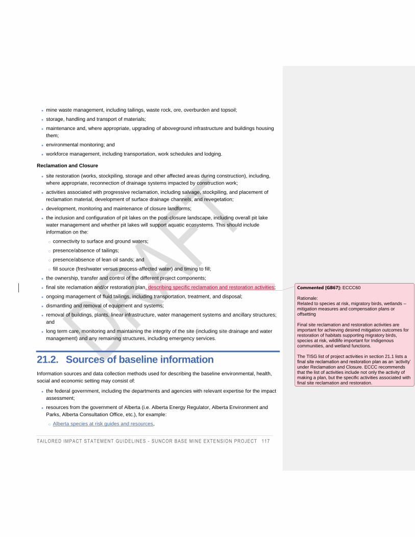
TAILORED IMPACT STAT EMENT GUIDELINES - SUNCOR BASE MINE EXTE NSION PROJECT 117
mine waste management, including tailings, waste rock, ore, overburden and topsoil;
storage, handling and transport of materials;
maintenance and, where appropriate, upgrading of aboveground infrastructure and buildings housing
them;
environmental monitoring; and
workforce management, including transportation, work schedules and lodging.
Reclamation and Closure
site restoration (works, stockpiling, storage and other affected areas during construction), including,
where appropriate, reconnection of drainage systems impacted by construction work;
activities associated with progressive reclamation, including salvage, stockpiling, and placement of
reclamation material, development of surface drainage channels, and revegetation;
development, monitoring and maintenance of closure landforms;
the inclusion and configuration of pit lakes on the post-closure landscape, including overall pit lake
water management and whether pit lakes will support aquatic ecosystems. This should include
information on the:
o connectivity to surface and ground waters;
o presence/absence of tailings;
o presence/absence of lean oil sands; and
o fill source (freshwater versus process-affected water) and timing to fill;
the ownership, transfer and control of the different project components;
final site reclamation and/or restoration plan, describing specific reclamation and restoration activities;
ongoing management of fluid tailings, including transportation, treatment, and disposal;
dismantling and removal of equipment and systems;
removal of buildings, plants, linear infrastructure, water management systems and ancillary structures;
and
long term care, monitoring and maintaining the integrity of the site (including site drainage and water
management) and any remaining structures, including emergency services.
21.2. Sources of baseline information
Information sources and data collection methods used for describing the baseline environmental, health,
social and economic setting may consist of:
the federal government, including the departments and agencies with relevant expertise for the impact
assessment;
resources from the government of Alberta (i.e. Alberta Energy Regulator, Alberta Environment and
Parks, Alberta Consultation Office, etc.), for example:
o Alberta species at risk guides and resources,
Commented [GB67]: ECCC60 Rationale: Related to species at risk, migratory birds, wetlands – mitigation measures and compensation plans or offsetting
Final site reclamation and restoration activities are important for achieving desired mitigation outcomes for restoration of habitats supporting migratory birds, species at risk, wildlife important for Indigenous communities, and wetland functions. The TISG list of project activities in section 21.1 lists a final site reclamation and restoration plan as an ‘activity’ under Reclamation and Closure. ECCC recommends that the list of activities include not only the activity of making a plan, but the specific activities associated with final site reclamation and restoration.
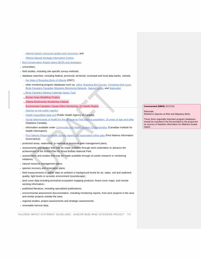
TAILORED IMPACT STAT EMENT GUIDELINES - SUNCOR BASE MINE EXTE NSION PROJECT 118
o Alberta historic resources guides and resources, and
o Alberta Natural Heritage Information Centre;
Bird Conservation Region plans (BCR) and strategies;
universities;
field studies, including site-specific survey methods;
database searches, including federal, provincial, territorial, municipal and local data banks, namely:
o the Atlas of Breeding Birds of Alberta (2007);
o other monitoring program databases such as, eBird, Breeding Bird Survey, Christmas bird count,
Birds Canada’s Canadian Migration Monitoring Network, NatureCounts, and iNaturalist;
o Birds Canada’s Nesting Calendar Query Tool;
o Boreal Avian Modelling Project;
o Alberta Biodiversity Monitoring Institute;
o Environment Canada’s Cause-Effect Monitoring, Oil Sands Region
o Species at risk public registry;
o Health inequalities data tool (Public Health Agency of Canada);
o Social determinants of health for the off-reserve First Nations population, 15 years of age and older
(Statistics Canada);
o information available under Community and Health System Characteristics (Canadian Institute for
Health Information);
o First Nations Regional Health Survey reports and associated online data (First Nations Information
Governance);
protected areas, watershed, or national or provincial park management plans;
assessments and studies that may be made available through work undertaken to advance the
achievement of the Action Plan for Wood Buffalo National Park;
assessments and studies that may be made available through oil sands research or monitoring
initiatives;
natural resource management plans;
species recovery and restoration plans;
field measurements to gather data on ambient or background levels for air, water, soil and sediment
quality, light levels or acoustic environment (soundscape);
land cover data including terrestrial ecosystem mapping products, forest cover maps, and remote
sensing information.;
published literature, including specialized publications;
environmental assessment documentation, including monitoring reports, from prior projects in the area
and similar projects outside the area;
regional studies, project assessments and strategic assessments;
renewable harvest data;
Commented [GB68]: ECCC61 Rationale: Related to Species at Risk and Migratory Birds. These three regionally important program databases should be included in the list provided to the proponent as sources of baseline information for Alberta’s boreal region.
TAILORED IMPACT STAT EMENT GUIDELINES - SUNCOR BASE MINE EXTE NSION PROJECT 119
Indigenous knowledge, including oral histories;
expert, community, public and Indigenous engagement and consultation activities, including
workshops, meetings, open houses, and surveys;
participant comments submitted during the Planning phase (posted on the Registry) that may be used
to identify specific areas and existing conditions of concern to be considered in the Impact Statement;
qualitative information gathered from interviews, focus groups or observation;
census data;
human health risk assessments (HHRA);
human health impact assessments (HHIA);
studies on community well-being and other social and economic studies;
community and regional economic profiles; and
statistical surveys, as applicable.
The Impact Statement must provide detailed descriptions of specific data sources, data collection,
sampling, survey and research protocols and methods followed to determine for each baseline
environmental, health, social and economic condition that is described, to corroborate the validity and
accuracy of the baseline information collected.
The proponent should consult with federal, provincial or local government authorities to determine whether
additional data sources and survey methods may be appropriate.
21.3. Ecosystem approach
In describing the biophysical environment, the Impact Statement must take an ecosystem approach that
considers how the project may affect the structure and functioning of biotic and abiotic components with
the ecosystem using scientific, community and Indigenous knowledge regarding ecosystem health and
integrity, as applicable. The Impact Statement must provide a description of the indicators and measures
used to determine ecosystem health and integrity, as reflected in the Guidelines. The presence of
endangered ecosystems, and rare, limited and/or significant habitat (e.g., federal27, provincial, or
Indigenous protected areas, wildlife sensitivity maps28, RAMSAR sites29, and identified or proposed critical
habitat in recovery strategies or action plans) potentially affected by the project should be included the
description of the biophysical baseline conditions.
27 Canadian Protected and Conserved Areas Database, available at https://www.canada.ca/en/environment-climate-
change/services/national-wildlife-areas/protected-conserved-areas-database.html
28 Wildlife sensitivity maps available at https://www.alberta.ca/wildlife-sensitivity-maps.aspx
29 Canada – Ramsar site, available at https://www.ramsar.org/wetland/canada
TAILORED IMPACT STAT EMENT GUIDELINES - SUNCOR BASE MINE EXTE NSION PROJECT 120
The baseline conditions must consider the resilience of relevant species populations, communities and
associated habitats to the effects of the project. Ecological processes should be evaluated for potential
susceptibility to adverse effects from the project. Considerations include: configurations and connectivity of
habitat patches; continuation of key natural disturbance regimes; structural complexity; hydrogeological
patterns; nutrient cycling; interactions of biotic components with each other and with abiotic components;
population dynamics and genetic diversity, and Indigenous knowledge relevant for the conservation and
sustainable use of relevant species populations, communities and associated habitats.
21.4. Application of GBA+
methodologies as described in the following two sections to understand potential effects to diverse
subgroups within the community including women, youth, elders.
To support GBA+, the information provided in the Impact Statement must:
must be sufficiently disaggregated to support the analysis of disproportionate effects as per the GBA+.
As much as possible, the data must be sub-divided by sex, age and ethnicity and presented distinctly
for each Indigenous group and all subgroups forming their communities.
be sufficient to provide a comprehensive understanding of the current state of health, social and
economic conditions, including trends relevant to GBA+;
describe how community and Indigenous knowledge from affected populations, including input from
diverse subgroups, was used in establishing baseline conditions and informing effects assessments for
these subgroups;
consider that subgroups have different access to resources, opportunities and services;
consider how the potential effects could particularly affect different subgroups, and how they may
respond differently; and
take into account the circumstances in which diverse subgroups could, due to their special situation,
suffer more severe adverse effects of the project than others, or not benefit from future economic
benefits.
In the preparation of the Impact Statement, the proponent must adhere to relevant ethical guidelines and
cultural protocols governing research, data collection and confidentiality. This is particularly important in the
case of information gathered and studies conducted with vulnerable subgroups. Namely, the proponent
must respect the obligation of protecting personal information and adopt the established standards for the
management of Indigenous data (e.g. the First Nations principles of Ownership, Control, Access and
Possession (OCAP), or standards adopted by an Indigenous people).
The application of GBA+ should not be limited to simple descriptions of differences but should include an
explanation of the underlying causes of these inequalities. Quantitative information, including gender
sensitive data, should also be complemented by qualitative insights from studies or consultations, and
other sources. Characterizing effects should be based largely on the level of concern expressed through
engaging with the affected Indigenous groups and community members. The proponent is encouraged to
refer to the Agency's guidance document Gender-Based Analysis Plus in Impact Assessment.
TAILORED IMPACT STAT EMENT GUIDELINES - SUNCOR BASE MINE EXTE NSION PROJECT 121
21.5. Geospatial data requirements
Where information is required in a map format, the proponent must also provide the Agency with the
corresponding electronic geospatial data file(s). The Agency will make the geospatial data files available to
the public under the terms of the Open Government License – Canada.
Metadata included in geospatial files must be compliant with the ISO 19115 standard and, at a minimum,
provide:
title;
abstract or summary of what is contained in the data file;
source of the data;
date of creation for the data;
the point of contact and originator; and
must confirm there are no restrictions or limitations on sharing the data.
The proponent should review the Agency’s Guidance on submitting geospatial data for more information.
21.6. Reference documents requirements
The impact assessment must be based on information that is publicly accessible. Therefore, the proponent
must provide a summary for the documents that served as key references in the Impact Statement that are
not otherwise publicly accessible, or consider appending them to the Impact Statement. The Impact
Statement must include a bibliography of all documents and sources of information consulted.
21.7. Establishing spatial boundaries
To establish baseline conditions, the study area boundaries need to encompass the spatial boundaries of
the project including any associated project components or related activities, and the anticipated
boundaries of the project effects. Since spatial boundaries can vary for each VC, the study area can also
vary. Considerations in assigning appropriate study areas or boundaries would include:
areas potentially impacted by changes to water quality and quantity or changes in flow in the
watershed and hydrologically connected waters, including any interprovincial or territorial borders that
that require a transboundary assessment;
areas potentially impacted by airborne emissions or odours, including any interprovincial or territorial
borders that that require a transboundary assessment;
TAILORED IMPACT STAT EMENT GUIDELINES - SUNCOR BASE MINE EXTE NSION PROJECT 122
air zone(s) that are affected – based on consideration of CAAQS, AQMS/Airshed management
system30;
o air zone CAAQS achievement status, as well as the associated management levels as outlined in
the Guidance Document on Air Zone Management (following removal of transboundary flows and
exceptional events per the Guidance Document on Transboundary Flows and Exceptional Events;
existing local major emissions;
areas within the range of vision, light and sound;
the locations and characteristics of the key and most sensitive receptors31;
terrestrial and aquatic species habitat areas likely to be affected directly or indirectly, usage timing and
species migratory patterns;
emergency planning and emergency response zones;
the geographic extent of local and regional services;
any affected communities;
areas of importance to people, such as recreational areas;
all potentially affected Indigenous peoples;
areas of known current use of Indigenous land, cultural, spiritual and resource use; and
existing affected infrastructure.
Generally, it is recommended that the proponent establish three spatial boundaries of study areas to
assess the impacts on each VC:
the Project Area: defined as the project footprint, including all temporary and permanent areas
associated with the project;
the Local Study Area (LSA): defined for each VC; and
the Regional Study Area (RSA): defined for each VC.
The terminology chosen to refer to the Project area, LSA and RSA can vary depending on the context of
the project, for example during the project development phase (development area), the assessment
methods (modelling area), the effects assessment phase (local or regional effects assessment areas), but
it is common to have at least three areas that correspond to the project, the local and the regional scales.
For the RSA, which is usually the area used for the assessment of cumulative effects, it will be important to
30 See http://airquality-qualitedelair.ccme.ca/en/
31 Key receptors include sensitive receptors and other current and reasonably foreseeable receptors that may be
affected by project activities. The most sensitive receptors may include, but not be limited to, residences, health and
social services institutions (hospitals, long-term care facilities, seniors’ residences, etc.), educational institutions
(schools, daycare centres, early childhood centres, etc.), tourism establishments (tourism information of fices,
museums, ski areas, summer camps, outdoor recreation areas, camp sites, etc.), recreational areas (recreational
land, urban parks, parks and conservation areas, etc.), and important areas of wildlife use.
TAILORED IMPACT STAT EMENT GUIDELINES - SUNCOR BASE MINE EXTE NSION PROJECT 123
correctly identify which project and past, present and reasonably foreseeable physical activities are
included or excluded. The proponent must provide a rationale for each boundary.
The spatial boundaries for the Project area, LSA and RSA for the biophysical VCs should be defined using
an ecosystem-centered approach (i.e. the components of the natural areas such as wetlands, birds,
species at risk, etc.) and consider habitat functions. For VCs that are defined on the basis of habitat, the
proponent should conduct a land cover analysis to determine appropriate ecological boundaries and buffer
distances around the project area.
The spatial boundaries for the biophysical VCs should allow the following objectives to be met:
the diversity of land cover types included in the LSA and RSA is representative of the land cover types
found within the LSA and RSA;
the spatial pattern of land cover types is even or well distributed within the RSA boundary. Spatial
boundaries of the RSA should be changed if one or more land cover types are concentrated in a sub-
area and are uncommon in other parts of the region; and
the land cover patterns within the RSA boundary being drawn show a low to moderate rate of change
with increasing distance from the project area.
See the document Assessing Cumulative Environmental Effects under the Canadian Environmental
Assessment Act, 2012 for more information on establishing spatial boundaries.
21.8. Human health baseline
Baseline information is required on existing human health conditions to prepare the community health
profiles. This information must include the current state of physical, mental and social well-being and
incorporate a determinants of health approach to move beyond biophysical health considerations. In line
with the World Health Organization's (WHO)32 expanded definition of health in the context of the social
determinants of health, a determinants of health approach recognizes that health is more than the absence
of disease but rather a state of general well-being, which is influenced by a variety of factors (i.e.
determinants). The structural and inequality factors of the socio-economic context would influence the
conditions in which people are born, develop, live, work and age. Acting as intermediary factors, these
same conditions would in turn influence individual factors (called behavioural and biological factors), which
directly affect physical and mental health. This approach recognizes the interdependence of environmental,
health, social and economic VCs. The selection of determinants can guided by the following references:
the Social determinants of health and health inequalities recognized by the Public Health Agency of
Canada;
resources from the National Collaborating Centre for Determinants of Health, such as the fact sheet
What are the social determinants of health?;
resources from the National Collaborating Centre for Healthy Public Policy;
32 PHAC, 2018. Key Health Inequalities in Canada, Introduction Chapter.
TAILORED IMPACT STAT EMENT GUIDELINES - SUNCOR BASE MINE EXTE NSION PROJECT 124
resources from the National Collaborating Centre for Indigenous Health, such as the report Health
inequalities and the social determinants of Aboriginal peoples' health;
resources from the National Collaborating Centre for Environmental Health on Health Impact
Assessments; and
the Positive Mental Health Surveillance Indicator Framework.
The following references contain best practices for health impact assessment methods, which the
proponent is encouraged to consult:
Minimum Elements and Practice Standards for Health Impact Assessment, Version 3 (Bathia et al,
2014);
resources from the National Collaborating Centre for Healthy Public Policy;
the Health Equity Impact Assessment (HEIA) Tool by the Ministry of Health of Ontario; and
Health impact assessment. A guide for the oil and gas industry by the International Association of Oil
and Gas Producers.
21.9. Mitigation hierarchy
Mitigation measures are technically and economically feasible measures to eliminate, reduce, control or
offset the adverse effects of a designated project, and include restitution for any damage caused by those
effects through replacement, restoration or compensation. The "hierarchy of mitigation measures" means
the descending sequence of the following three options:
Eliminate: refers to the elimination of effects, such as by changing the location or design of the project.
It can also be referred to as "avoidance" of effects.
Reduce and control: aims to reduce effects to the extent possible, for example, by modifying the most
adversely impactful project activities or components or by taking measures specific to the potential
effects. There may still be residual effects where measures are not sufficient to eliminate the effects, or
where their absolute effectiveness is uncertain. Effects may also be "minimized" when it is not possible
to "avoid" them.
Offset: aimed at offsetting residual effects following consideration of elimination and reduction
measures, through measures referred to as “compensation” or “restitution”. For example, where an
effect on fish habitat persists, it may be possible to offset through the creation of new habitat
(replacement) or to propose measures to restore degraded habitat conditions. These include measures
referred to as replacement, restoration or (financial) compensation.
As a first step, the proponent is encouraged to use an approach based on the avoidance and reduction of
the adverse effects at the source, namely consider modifying the design or changing the location of certain
project components.
TAILORED IMPACT STAT EMENT GUIDELINES - SUNCOR BASE MINE EXTE NSION PROJECT 125
21.10. Compensation and offset plans
In general, these plans should address the following elements, or refer to locations in the Impact Statement
where this information is presented:
describe the baseline conditions of the species at risk, critical habitat, and wetland functions potentially
impacted by the project;
explain and justify the hierarchy of mitigation measures considered;
identify and describe residual effects that are the subject of the compensatory measures;
identify a compensation ratio with rationale, including how any policies or guidance provided by federal
and provincial authorities and Indigenous peoples have been considered;
where feasible, identify the location and timing of implementation of compensation projects;
identify and describe the success criteria;
identify and describe in detail non-habitat related compensation measures (e.g. predator control);
describe how the proposed measures align with published provincial and federal recovery
management or action plans and strategies for species at risk, or for fish and fish habitat;
describe how the proposed measures align with published provincial and federal recovery
management or action plans and strategies for wetlands;
identify, if possible, the parties responsible for implementation of the compensatory measures,
including monitoring and review;
identify indicator species for setting compensation objectives. The choice of indicator species should
be based on baseline data. Species at risk should not be used as indicator species, since
compensation efforts must be specifically directed to these species;
describe the selection process for proposed compensation sites and associated baseline conditions;
provide a description of the monitoring schedule and activities to be completed to verify the success of
compensation activities; and
if offsets are required to address residual effects, refer to the Operational Framework for Use of
Conservation Allowances.
The proponent must explain how Indigenous groups were involved in the development of the
compensation plans. The proponent must demonstrate how the information received from Indigenous
groups has been taken into account, including the choice of compensation ratios, if applicable. The
proponent must also elaborate on how Indigenous groups will be involved in the implementation of the
compensation measures and the evaluation of the success of these measures.
For compensation plans targeting species at risk, the proponent can refer to Template 2 in the Species at
Risk Act Permitting Policy.
With respect to wetlands, compensation plans should:
clearly indicate the location and total area of each type of wetland, as well as their respective locations,
for which the residual effects should be mitigated by compensation measures;
TAILORED IMPACT STAT EMENT GUIDELINES - SUNCOR BASE MINE EXTE NSION PROJECT 126
favour the restoration of drained or altered natural wetlands of the same type and function as those
affected by the project. Wetland restoration is preferable to wetland enhancement, both of which are
preferable to the development of existing wetlands or the creation of new wetlands;
demonstrate that wetland functions can be replaced by the proposed compensation activities;
indicate where it is not possible to compensate for the loss of functions in cases where wetlands are
unique, perform habitat functions that ensure the survival of a large proportion of migratory birds, or
provide habitat for species at risk; and take this information into consideration when developing
compensation measures;
use a minimum ratio of 2:1 for the area of wetlands to be restored or created, versus the original area
of wetlands affected. A higher compensation ratio is recommended for wetland types where
compensation is more difficult or where there is uncertainty about the success of the compensation
measures. The choice of ratio for wetland compensation needs to be justified;
prioritize compensating for locally affected wetland functions. If this is not possible, the preference is to
compensate within the same watershed, and then within the same ecosystem as the one where
functions are affected;
minimize the delay between the time the adverse effects occur and the time habitat and functions are
restored; and
explain how vegetation removals, as well as soil and peat excavation activities will be managed for
reclamation of disturbed wetlands (e.g. methods, conditions and timing of stockpiling).
With regard to offsetting plans for fish and fish habitat, each offsetting plan should include:
baseline information, including a description of the environment (biological, hydrological, physical,
chemical, etc.), an estimation of the quality of the environment in question and a description of the
issue to address. Ideally, the description of the environment should be accompanied by georeferenced
and dated photographs;
a description of the proposed measures (nature, extent, method, timetable, etc.);
exact locations for the proposed offsetting measures (latitude and longitude, lot number, municipality,
regional municipality county, etc.) and property rights;
the fish species affected by the proposed measures, including the resulting fish habitat functions
(feeding, reproduction, rearing, shelter, growth, migration);
an assessment of the benefits to fish and fish habitat resulting from the offsetting measures in terms of
the significance, magnitude and adequacy of the gains to be achieved with respect to the current
situation; and
a follow-up program to measure the success of offsetting objectives, including the details of its
implementation. Offsetting objectives as well as the methods and criteria used to evaluate success
(parameters, frequency, duration, etc.) must be clearly identified and described. Deliverables must be
identified (e.g. baseline information, follow-up protocol, plans and specifications, work report, follow-up
report, etc.), along with contingency measures in case success criteria are not met. The offsetting
objectives and the timelines of the follow-up program (including deliverables) should be compiled in
one or more tables.
TAILORED IMPACT STAT EMENT GUIDELINES - SUNCOR BASE MINE EXTE NSION PROJECT 127
21.11. Summary Tables
The Impact Statement must include a series of tables summarizing the following information:
potential environmental, climate, health, social and economic effects and the potential impacts on
Indigenous peoples;
potential mitigation and enhancement measures in relation to potential effects and impacts;
a characterization of the residual effects of the project according to the selected criteria;
cumulative effects and proposed mitigation measures to address them;
any other commitments made by the proponent or recommendations made by the proponent to other
parties; and
effects falling within an area of federal jurisdiction as well as direct or incidental effects33 and the extent
to which they are significant. According to the Act, effects that fall under federal jurisdiction are as
follows:
o change to the following components of the environment that are within the legislative authority of
Parliament:
fish and fish habitat, as defined in subsection 2(1) of the Fisheries Act;
aquatic species, as defined in subsection 2(1) of the Species at Risk Act; and
migratory birds, as defined in subsection 2(1) of the Migratory Birds Convention Act, 1994;
o a change to the environment that would occur:
on federal lands,
in a province other than the one where the physical activity or the designated project is being
carried out, or
outside Canada;
o with respect to the Indigenous peoples of Canada, an impact — occurring in Canada and resulting
from any change to the environment — on:
physical and cultural heritage,
the current use of lands and resources for traditional purposes, or
any structure, site or thing that is of historical, archaeological, paleontological or architectural
significance; and
o any change occurring in Canada to the health, social or economic conditions of the Indigenous
peoples of Canada.
33 According to the Act, direct or incidental effects are defined as “effects that are directly linked or necessarily
incidental to a federal authority’s exercise of a power or performance of a duty or function that would permit the
carrying out, in whole or in part, of a physical activity or designated project, or to a federal authority’s provision of
financial assistance to a person for the purpose of enabling that activity or project to be carried out, in whole or in
part.
Commented [GB69]: ECCC62 (See also ECCC1) Rationale: Considering Canada’s Paris commitment, and GC’s 2050 net-zero goal, climate effects must be considered separately for any IA/EA designated project.
TAILORED IMPACT STAT EMENT GUIDELINES - SUNCOR BASE MINE EXTE NSION PROJECT 128
21.12. Additional guidance for biophysical components
Atmospheric environment
The following guidance should be consulted in conjunction with section 8.4.1 Atmospheric
environmentAtmospheric environment:
project sources of air pollutant emissions include the following types of sources:
o point sources: include but are not limited to power generation equipment (i.e. gensets), fire pump
stacks, turbines, compressor engines, incinerators, exhaust vents and stacks from processing
facilities, ventilation vents, boilers and other heating equipment, flares, idling transport vehicles,
fugitive emissions from storage tanks and leaks from gas pipes and other equipment. Where
applicable, emissions from start-up and shut-down should be taken into account;
o area sources: include material handling and transport, wind erosion of material piles, fugitive
emissions from exposed mine faces, fugitive emissions from process areas and tailings
management areas; and
o mobile and road sources: include tailpipe emissions and fugitive dust emissions. Fugitive dust
emission factors (e.g. road dust) and assumed mitigation (control efficiency) should be described
and should be justifiable based on what is practicable. Tailpipe emission factors should be
estimated using established methods. Include all off-road and on-road fleet vehicles used in the
project;
when providing detailed methodology and assumptions used to estimate emissions, all relevant
emissions factors should be provided and referenced. For all applicable emission sources, include the
assumed Tier of emission standard for each emission factor applied.
o For the mine fleet: include the vehicle descriptions for all mine fleet and assumptions with activity
data.
o For the mine face (fugitive emissions): provide the location of the mine face areas and the surface
of each area.
o For flaring: provide details of the occurrence of flaring and associated assumptions. Describe the
gas composition under both normal and upset flaring conditions;
for requirements pertaining to the use of atmospheric dispersion modelling, the proponent should:
o conduct modelling for a 5-year period (i.e. 2015-2019), to account for variability in meteorology and
baseline conditions;
o conduct modelling for all relevant temporal scenarios (see section 7.3.1 Temporal
BoundariesTemporal Boundaries), including: the base case (i.e. all existing emission sources plus
projects already approved and under construction), a project-alone scenario (recommended in order
to represent emissions from the project only), the application case, and the planned development
case; and
o ensure appropriate domain boundaries. At a minimum, the modelling domain should enclose
concentrations that are 10% of relevant air quality criteria;
Formatted: Font: Italic
Formatted: Font: Italic
Commented [GB70]: ECCC63 Rationale: The most recent data should be used to conduct the modelling in order to achieve the best results.
TAILORED IMPACT STAT EMENT GUIDELINES - SUNCOR BASE MINE EXTE NSION PROJECT 129
photochemical modelling may be necessary to model long range transport, as well as transformation
processes that are beyond the capabilities of standard models, particularly for SOA and acid
deposition;
the assessment of the project’s emissions of acidifying pollutants, and potential to adversely affect
ecosystems in the region, should include Northern Alberta, Northern Saskatchewan, the southern
NWT, and NE British Columbia (boundary corners approximately at: 53N and 122W, 53N and 100W,
62N and 100W, and 62N and 122W);
for requirements pertaining to the use of modelling for acidifying deposition, the proponent should
consider the following technical requirements:
o model simulations should be for a minimum of 1 year using the most recent meteorological and
emissions year available in the 2015-2019 timeframe, and should be conducted at minimum for the
base case and the application case;
o the regional air quality model’s horizontal resolution should comprise a horizontal grid cell size
equal to or less than 12 kilometres within the region modelled;
o the model chosen should be capable of a rigorous representation of gas and particle chemistry and
physics and long range transport, to provide an estimate of acidifying deposition, and must include
the explicit treatment of the following key processes:
chemical mechanism similar in complexity to the following mechanisms: Carbon-Bond4,
Carbon-Bond5, SAPRC07, SAPRC11, RACM2, ADOMII,
gas dry deposition,
size-resolved particle dry deposition,
cloud (aqueous) chemistry, particle uptake into and formation from clouds and rain drops,
wet deposition from clouds to the surface,
size-resolved particle microphysics (particle nucleation, condensation, coagulation as a function
of particle size),
inorganic particle heterogeneous chemistry, and
SOA formation; and
o key chemical species the model must include are: size resolved chemically speciated particles
(particle sulphate, nitrate, ammonium, base cations, water soluble iron and manganese, primary
organics, secondary organics, sea-salt, black carbon, crustal material), gases (including, but not
limited to NO, NO2, SO2, H2O2, speciated volatile organic compounds, ozone, NH3, HNO3, PAN,
HONO, HNO4, one or more organic nitrates, N2O5), and ions within precipitation (SO42-, HSO3
-,
NH4+, base cations). The model must include the dry (gases, particles) and wet (ions in solution)
deposition fluxes of these species.
Wetlands
The following guidance should be consulted in conjunction with section 8.6 Vegetation and riparian,
wetland and terrestrial environmentsVegetation and riparian, wetland and terrestrial environments.
With regards to the wetlands functions assessment, the proponent should:
Commented [GB71]: ECCC64 Rationale: A minimum of one year is needed for a CE assessment to be valid. The most recent year is needed to ensure the regional emissions are the most relevant. The most recent emissions data will include the most recent control technologies.
Formatted: Font: Italic
TAILORED IMPACT STAT EMENT GUIDELINES - SUNCOR BASE MINE EXTE NSION PROJECT 130
complete the assessment for a representative selection of wetlands that the Project would directly
impact and for a representative selection of wetland(s) that are hydrologically connected. In conducting
this assessment, the Proponent should ensure that wetlands are considered in the context of:
o the larger watersheds of which they are a part;
o adjacent land use with a focus on hydrological and other functions;
o landscape and/or watershed considering topography, soil types and hydrological linkages; and
o the global significance of peatlands across the RSA;
collect data from representative wetlands in a manner that enables reliable extrapolations in space (i.e.
at minimum to the project area, LSA and RSA) and in time (i.e. across years), including:
o design surveys so that they represent the spatial and temporal targets of modeling and
extrapolations, and to produce scientifically defensible predictions of effects and estimates of
mitigation effectiveness. Survey designs should be sensitive enough to detect and quantify the
effets at the appropriate spatial and temporal scales, any departures from predictions, and the
effectiveness of mitigations. Justify the selection of modeling techniques based on current and
recent scientific literature;
o plan survey protocol for representative wetlands to include modeling and simulations to estimate
sampling requirements, and analysis to evaluate resulting design options. Sample size must be
planned to support evaluation of the project study area within the context of the LSA and RSA.
Appropriate design of surveys will need to consider multiple survey locations in order to represent
the wetland heterogeneity of the RSA, and to yield multiple survey locations per wetland type,
without requiring aggregation of habitat classes post-hoc;
provide this assessment in a quantitative form and include the collection of site-specific baseline
information on wetland functions, including:
o surveys to assess for the presence, abundance, density, and distribution of migratory birds and
federally listed species at risk, provincially listed species at risk, and species assessed by
COSEWIC as at-risk in relation to potentially affected wetlands and associated riparian areas.
Surveys should meet appropriate standards, be species or bird group specific as appropriate, and
be conducted during the appropriate times of the year as specified in the following section for Birds
and their habitatBirds and their habitat. Surveys for species at risk should assess species
individually where possible (typically an indicator approach is not appropriate for species at risk).
Surveys should not be limited to species or groups of species that are wetland-obligate, but rather
should include any species known to use wetland habitats as part of its lifecycle. Data should be
sufficiently robust to identify which wetland classes are important to which species (and for how
many);
o the location and a description of the biological characteristics of each potentially affected wetland
and the ecological services and functions (hydrology, biochemical cycling, habitat, climate) they
provide. The functions assessment should be as specific as possible to the biological characteristics
of the wetland and to the ecological services and functions it provides; and
o a supporting rationale and detailed description of the methods used in completing the wetland
functions assessment, including sampling design;
submit complete data sets from any survey sites, including GIS files, compliant with the requirements
outlined in section 21.5 Geospatial data requirementsGeospatial data requirements; and
Formatted: Font: (Default) +Body (Arial), Italic
Formatted: Font: Italic
TAILORED IMPACT STAT EMENT GUIDELINES - SUNCOR BASE MINE EXTE NSION PROJECT 131
contact the relevant provincial and local government authorities to determine if other wetland
conservation policies, regulations or wetland compensation guidelines apply. See also resources
available from The Wetland Network.
Birds and their habitat
The following guidance should be consulted in conjunction with section 8.8 Birds, migratory birds and their
habitatBirds, migratory birds and their habitat:
the proponent should consider and assess the following groups of migratory and non-migratory birds
separately: waterfowl, water birds (other than waterfowl), songbirds, shorebirds, each bird species at
risk and their habitat;
in order to establish adequate baseline conditions for birds, the proponent should take into account the
following technical recommendations:
o collect bird data to adequately represent the following temporal sources of variation: among years,
within and among seasons (e.g., spring migration, breeding, fall migration, overwintering), and
within the 24-hour daily cycle.
o collect and include explanatory data (i.e. covariates) necessary for modeling in such a way as to
adequately represent the following sources of variation: land cover composition, soil type,
geomorphology, hydrological processes, and variation in climatic conditions inter- and intra-
annually.
o collect data in a manner that enables reliable extrapolations in space (i.e. at minimum to the project
area, LSA and RSA) and in time (i.e., across years).
o design surveys so that they represent the spatial and temporal targets of modeling and
extrapolations, and to produce scientifically defensible predictions of impacts and estimates of the
effectiveness of mitigation measures. Survey designs should be sensitive enough to detect and
quantify: the impacts at the spatial and temporal scales identified above (i.e. project area, LSA,
RSA), any departures from predictions, and the effectiveness of mitigation measures. Justify the
selection of modeling techniques based on current and recent scientific literature.
o survey protocol planning should include modeling and simulations to estimate sampling
requirements and analysis to evaluate resulting survey options. It is recommended to:
collect field data over at least two years. The goal of collecting data over multiple years is to
improve the understanding of natural variability in populations. Two years of sampling is
suggested as a minimum. As the number of sampling years increases so does the
understanding of natural variability;
plan sample size to support evaluation of the project study area within the context of the local
study area and regional study area. Appropriate design of surveys will need to consider multiple
survey locations in order to represent the habitat heterogeneity of the RSA, and to yield multiple
survey locations per land cover or habitat class, without requiring aggregation of habitat classes
post-hoc;
design sampling effort per unit area - field survey effort to be most intensive within the project
study area. The level of effort per unit area may be similar or somewhat less within the
remainder of the LSA, but should be scaled to the likelihood that project effects will effect birds
Formatted: Font: Italic
TAILORED IMPACT STAT EMENT GUIDELINES - SUNCOR BASE MINE EXTE NSION PROJECT 132
within that zone. Efforts outside the project study area should be carefully designed to ensure
that estimates comparing within and across the project area, LSA, and RSA are unbiased and as
precise as possible; and
use simulation modelling to assess bias and precision between project area, LSA, and RSA to
ensure the estimates are useful for comparison;
when selecting metrics to characterize avifauna biodiversity, it is recommended that:
o biodiversity metrics should include the following: distribution in space, frequency of occurrence,
occurrence and abundance trends in time, abundance and density, as well as the types of
associated habitats and the strength of the associations; and
o species communities should not be grouped together by diversity indicator and should not be limited
to the indicator species. The identification of species, distribution, abundance and, when possible,
estimates of species’ breeding status should be the main quantification objectives;
when estimating for the abundance and distribution of migratory and non-migratory birds, the
proponent should:
o base estimates on existing information, or additional surveys, as appropriate, to provide current
data sufficient for reliable estimates. At minimum, the combined information from existing data and
field surveys needs to be detailed enough to describe the distribution and abundance of all bird
species in relation to the study areas;
o generate measures of abundance and distribution using spatially balanced, randomly selected
sample locations. Sampling should include edges and transitions between habitat types and should
not be focused exclusively within homogeneous patches of a given habitat type.
Use simulation modelling prior to sampling to ensure coverage is broad enough to estimate and
account for detection error as well as provide unbiased estimates of abundance and
distributions.
Sampling within temporal boundaries should be spatially and temporally balanced so that all
spatial areas receive comparable temporal coverage;
o provide estimates of confidence or error for all estimates of abundance and distribution. Define
estimates by providing, for example, mean across years, mean across sites, and modeled
prediction. If appropriate, define confidence or other intervals such as 95% confidence intervals or
other credible intervals. The use of hypothesis testing p-values is generally not appropriate in this
context and their use should be justified;
o whenever estimating densities for species, consider observer-induced detection error for
comparisons among counts to be valid (e.g. between, before and after surveys, or between affected
and unaffected sites). When accounting for detection error the method used should account for
variable detection between land cover types, observers, weather, time of year, species, as well as
random variation between visits. Simulation methods can help determine if a specific method is
appropriate for a given survey design and analysis. Care should be taken to avoid affecting the
reliability of abundance estimates34;
34 see Barker et al. 2018 Biometrics: https://onlinelibrary.wiley.com/doi/full/10.1111/biom.12734
TAILORED IMPACT STAT EMENT GUIDELINES - SUNCOR BASE MINE EXTE NSION PROJECT 133
o use a spatially dispersed stratified random sampling approach to maximize efficiency. Sample sites
should be selected with a randomization procedure that accounts for the project design footprint. To
select specific sampling sites, care should be taken to ensure sites are spatially distributed across
the area of interest and coverage is obtained across habitat types. Site locations should be
randomly selected using an approach that avoids implicit bias in site selection;
o provide a justification on the approach chosen and include all criteria used to choose plot locations.
If necessary to constrain or adjust site selection based on access limitations, simulation modelling
should provide evidence that this sampling strategy has not resulted in the introduction of bias; and
o survey vegetation features of concern in a manner that is not disproportionate to other types. Avoid
bias in estimates of abundance and impair extrapolation and statistical inference;
the following must be considered when identifying areas of concentration of migratory birds:
o migratory bird concentrations can vary within a year and between years. It is therefore important to
survey across the project study area, LSA and RSA both temporally and spatially; and
o migratory bird counts are dependent on length of stay as well as presence. Attempt to estimate
abundances across a migratory period should incorporate an estimate of inter and intra-annual
trends and estimates of lengths of stay. Irruptive species may act in ways similar to migrants in
terms of abundance. They may be absent from an area until conditions change (such as a mast
event), during which time the habitat becomes vital to these species;
to quantify trophic linkages in the project area and the LSA, the proponent should consider using
Structural Equation Models;
in the baseline description for bird habitats, the proponent should include at a minimum,
characterization of biophysical conditions with regard to ecoregion and BCR, and include local aerial
and on-site photos. Habitat surveys need to be detailed enough within the LSA and RSA to provide
context for local and regional habitat availability and quality.
o For example, wixed wood and old-growth forest land cover and other upland vegetation types may
be particularly important for many forest associated birds, supporting birds during migration,
breeding and through the winter. Peatlands and wetlands including fens and bogs are ecologically
important elements of the landscape. River riparian corridors with adjacent mixed wood forest are
another relatively uncommon feature.
o Should there be anticipated displacement of nesting birds, baseline data should provide evidence
that there is enough equivalent habitat for birds to be displaced to and that the habitat being
removed is not unique to the project area or region. This information may serve to inform
reclamation planning; and
the proponent should curate survey data and analyses in such a way that it may be made available to
participants for review upon request. It is recommended that the proponent be prepared to:
TAILORED IMPACT STAT EMENT GUIDELINES - SUNCOR BASE MINE EXTE NSION PROJECT 134
o provide raw survey data and analysis results for 1) all birds, 2) each VC, and 3) BCR priority
species showing the species ranked according to: frequency of occurrence35, abundance,
abundance in each habitat type;
o data sets from all survey sites should be in the form of complete and quality assured relational
databases, with precisely georeferenced site information, precise observation/visit information and
with observations and measurements in un-summarized form;
o provide documentation and digital files for all results of analyses that allow for a clear understanding
of the methods and a replication of the results (raw scripts or workflows are preferred in place of
descriptive documentation); and
the analysis of predicted effects on birds should:
o include separate analyses for each activity, component and project phase;
o distinguish between migratory and non-migratory birds;
o consider sources of error for all analyses to ensure that the final effects predictions indicate the best
estimate of precision;
o explore, wherever possible, non-linear, indirect and synergistic responses to the project; and
o justify any assumptions regarding relocation or temporary displacement during construction and
operation of the project by using scientific references.
Wildlife
The following guidance should be consulted in conjunction with section 8.9 Wildlife and its habitat Wildlife
and its habitat. For wildlife surveys, the proponent should:
collect data to represent the sources of time variation between years, during and between seasons
(e.g. spring migration, breeding, fall migration, wintering), and in the daily 24-hour cycle;
rare species require more survey effort to detect than common species, and this needs to be
accounted for in survey design by increasing the number and duration of surveys; and
the proponent should curate survey data and analyses in such a way that it may be made available to
participants for review upon request. It is recommended that the proponent be prepared to:
o submit complete data sets from all survey sites. These should be in the form of complete and
quality assured relational databases, with precisely georeferenced site information, precise
observation/visit information and with observations and measurements in un-summarized form; and
o provide documentation and digital files for all results of analyses that allow for a clear understanding
of the methods and a replication of the results (raw scripts or workflows are preferred in place of
descriptive documentation).
35 Frequency of occurrence: % frequency for Species A = (# sampling locations in which Species A detected / total #
sampling locations) * 100
Formatted: Font: Italic
TAILORED IMPACT STAT EMENT GUIDELINES - SUNCOR BASE MINE EXTE NSION PROJECT 135
Species at Risk
The following guidance should be consulted in conjunction with sections 8.8 Birds, migratory birds and their
habitatBirds, migratory birds and their habitat and 8.9 Wildlife and its habitat Wildlife and its habitat .
The preliminary list of species at risk that may use the project study area and local study area is as
follows:
o Plants
None identified based on available project information to February, 2021.
o Insects:
Gypsy Cuckoo Bumble Bee (Bombus bohemicus)
Nine-spotted Lady Beetle*36 (Coccinella novemnotata)
Transverse Lady Beetle37 (Coccinella transversoguttata)
o Amphibians
Western Toad (Anaxyrus boreas);
o Birds
Bank Swallow (Riparia riparia);
Barn Swallow (Hirundo rustica);
Canada Warbler (Cardellina canadensis);
Common Nighthawk (Chordeiles minor);
Evening Grosbeak (Coccothraustes vespertinus);
Horned Grebe (Podiceps auritus);
Olive-sided Flycatcher (Contopus cooperi);
Peregrine Falcon (Falco peregrinus);
Rusty Blackbird (Euphagus carolinus);
Short-eared Owl (Asio flammeus);
Western Grebe (Aechmophorus occidentalis);
Whooping Crane (Grus americana);
Yellow Rail (Coturnicops noveboracensis);
o Mammals
Little Brown Myotis (Myotis lucifugus);
Northern Myotis (Myotis septentrionalis);
Caribou (Rangifer tarandus; including West Side Athabasca range);
36 Nine-spotted Lady Beetle was designated Endangered by COSEWIC and is not on SARA Schedule 1 but is under consideration for status change. 37 Transverse Lady Beetle was designated Special Concern and is not on SARA Schedule 1 but is under consideration for status change.
Formatted: Font: Italic
Formatted: Font: Italic
Commented [GB72]: ECCC65 Rationale: Related to species at risk IAAC requested a table be created that provides the preliminary list of Species at Risk that may be found in the project and local study area following the format used in Gazoduc (i.e. to include invertebrates). ECCC has added the three invertebrates to the existing table structure in the TISG, and provided the structure (Plants, Insects, Amphibians, Birds, Mammals). If that structure is not desired, it can be removed.
Commented [GB73]: Western Toad is not new to the table and has not been edited. It was moved up in the table when the table headings were added.
TAILORED IMPACT STAT EMENT GUIDELINES - SUNCOR BASE MINE EXTE NSION PROJECT 136
Grizzly Bear (Ursus arctos); and
Wolverine (Gulo gulo);
the proponent should consult the Species at Risk Public Registry to obtain information on the list of
species at risk and their protection status, as well as available recovery documents. Information on
species and habitat attributes, threats, population and distribution objectives, critical habitat, and
residences must be considered and incorporated in the Impact Statement..The proponent is
responsible for ensuring that the most up-to-date documents have been used and that the status of the
species is up to date.
for surveys of species at risk, the proponent should:
o take into account that the detection of species at risk will require more survey effort, since they are
generally less abundant, which needs to be considered in the survey design by increasing the
number and duration of surveys;
o collect data in order to represent sources of time variation between years, during and between
seasons (e.g. spring dispersal and migration, breeding, fall migration, wintering), and in the daily 24-
hour cycle;
o collect field data to account for natural variability in populations. To achieve this, a minimum of two
years of inventory is normally required. However, if existing data are available for the study area, it
can be used to complement the data collected in the field (minimum one year). The available data
must be sufficiently robust to assess the variability of populations between years and a
demonstration must be presented for that purpose;
o plan the sample size to ensure sufficient assessment of the project area in the context of the LSAs
and RSAs. Survey design will need to consider multiple number of survey locations in order to
represent the habitat heterogeneity of the regional study area, and to plan the number of survey
locations per land cover or habitat class so that aggregation of habitat classes post-hoc is not
required. In terms of sampling effort per unit area, focus primarily on field surveys within the project
area. The level of effort per unit area may be similar or slightly lower in the remainder of the LSAs,
but should be proportional to the likelihood that project effects will affect species at risk in that area.
Actions undertaken outside the project area must be carefully designed to ensure that comparative
estimates between the project area, LSAs and RSAs are unbiased and sufficiently accurate;
o preferably use stratified random sampling of habitat. Sample sites must be selected using a random
procedure such as a GIS grid overlay;
o plan to include several sampling stations and several visits to each station to support all required
assessment analyses;
o inventories and analyses should be conducted by qualified experts; and
o consult recovery plans for which a survey schedule would have been created to identify information
gaps for these species, including for the designation of critical habitat;
the proponent should consult provincial government experts on appropriate survey methods for bats,
document baseline conditions in the project area and LSA, and provide a rationale for the methodology
used. It is recommended to:
o conduct site-specific surveys to provide an overview of the species (present/undetected);
Commented [GB74]: ECCC66 Rationale: Related to Species at Risk Information in recovery documents includes species distribution information, specific biophysical attributes of habitat supporting these species, threats and limitations, as well as critical habitat and residence descriptions. ECCC expects that a complete Impact Statement must include, consider and incorporate this information on species at risk. The TISG should not only require that the proponent ‘consults’ the SARA Registry to gain current information about the species status under SARA, but that the proponent consider and incorporate species-specific and publicly available information present in species recovery documents.
TAILORED IMPACT STAT EMENT GUIDELINES - SUNCOR BASE MINE EXTE NSION PROJECT 137
o quantify bat baseline activity (e.g. using acoustic detection to calculate a bat activity index) to
assess the relative use of different habitats or features in the project area in order to evaluate and
justify decisions regarding project location and anticipated impacts. In addition, locate and confirm
the use of high-value features such as nurseries and resting sites (such as hollow trees and
buildings), feeding areas and hibernacula;
o identify potential regional migration corridors and identify site-specific travel corridors and
movement patterns;
o include the following types of surveys:
acoustic surveys, ensure study design is statistically valid; and
continuous acoustic monitoring throughout the night (at least from sunset to sunrise: 30 minutes
before sunset to 30 minutes after sunrise is recommended), active season (spring
dispersal/migration, summer breeding/fall migration and swarming [fall staging]), as well as
appropriate surveys of hibernation sites;
o locate and assess potential hibernation sites for bat use, taking into account the inter-annual and
seasonal variability of use;
o include, in data or reports, information on the acoustic detection methods used, including: detector
make and model; microphone model used; location of detectors; height of microphones; orientation
of microphones; special housing that may affect microphone; sensitivity (e.g. wind screen, cones,
weatherproofing); mounting method (e.g. meteorological tower, pole); device-specific settings (e.g.
gain/sensitivity, etc.); recording mode (i.e. full spectrum or zero crossing); and a summary of any
equipment failure issues and a description of procedures used to ensure equipment was functional
during deployment (including ensuring microphone sensitivity remains within an acceptable range);
o clearly describe how a bat “passage” is defined, consistent with the definition used for any control
group, and justify the choice of modality;
o clearly describe the methods used for acoustic identification, including validation procedures,
species classification criteria and software used, if applicable (including versions and parameters);
and
o take into account that when results are compared from year to year, the survey schedule, the
equipment and the installation protocols must remain consistent from year to year;
concerning the description of the effects on bats, the proponent should:
o consider all effects on overwintering habitat (hibernacula, such as caves, abandoned mines and
wells); summering habitat (roosting and foraging habitats, including maternity roosts), swarming
habitat (used in late summer and early fall for mating and socializing), and movement corridors
when assessing effects on local and regional populations; and
o identify potential resting areas, maternity roosts, hibernacula, foraging habitat and movement
corridors in the local area, as well as the project’s potential impacts on these habitats or on their
particular functions for bats; and
for the analysis of effects on species at risk, it is recommended to provide a separate analysis for each
species at risk, including separate analyses for each activity, component and phase of the project. To
fully understand the effects or benefits of one alternative over another, all parameters relevant to
species at risk should be considered.
TAILORED IMPACT STAT EMENT GUIDELINES - SUNCOR BASE MINE EXTE NSION PROJECT 138
Habitat features
In the baseline and effects descriptions concerning habitats for wildlife, including bird and species at risk,
the proponent should identify and consider the following habitats features and important landscape
characteristics:
waterbodies, wetlands, marshes, wet meadows, shrubby swamps, fens and watercourses,
riparian habitat, stream or river banks or other eroded habitats,
artificial water sources,
forests, trees patches, solitary trees, decaying trees, snags,
forest edges and rows of trees,
ridges, caves, mines,
talus,
karst topography,
buildings, bridges and other anthropogenic features, including linear features (e.g. roads, electrical
transmission lines),
sources of artificial lighting attracting insects,
critical habitat and residences of species at risk, and
any other habitat feature known to be important.
Commented [GB75]: ECCC67 Rationale: These specific wetland types have been noted in other oil sands reviews as important for regional wildlife. In the region of the project, key habitat features that have been described in recent EA reviews have also included specific wetland types such as marshes, wet meadows, shrubby swamps, fens.
TAILORED IMPACT STAT EMENT GUIDELINES - SUNCOR BASE MINE EXT ENSION PROJECT - CO-
EDIT ING OF DRAFT T ISG COMMENTS CLEAN SUNCOR BASE MINE EXT ENSION PROJECT 139
Annex I – Draft Terms of Reference for the provincial environmental assessment [English only]
Also available at: https://www.suncor.com/en-ca/about-us/oil-sands/mining/base-mine-extension
Related Documents