Environmental Impact Statement Detailed (Stage 2) State Significant Development Application - SSD-9978934 Cockle Bay Park - 241-249 Wheat Road, Sydney Submitted to Department of Planning, Industry and Environment On behalf of DPT Operator Pty Ltd and DPPT Operator Pty Ltd 15 October 2021 | 2200220

Welcome message from author
This document is posted to help you gain knowledge. Please leave a comment to let me know what you think about it! Share it to your friends and learn new things together.
Transcript

Environmental Impact Statement
Detailed (Stage 2) State Significant Development
Application - SSD-9978934
Cockle Bay Park - 241-249 Wheat Road, Sydney
Submitted to Department of Planning, Industry
and Environment
On behalf of DPT Operator Pty Ltd and DPPT
Operator Pty Ltd
15 October 2021 | 2200220
CONTACT
Michael Oliver Associate Director [email protected] (02) 9956 6962
Reproduction of this document or any part thereof is not permitted without prior written permission of Ethos Urban Pty Ltd.
This document has been prepared by: This document has been reviewed by:
Ella Coleman & Anna Nowland 15 October 2021 Michael Oliver 15 October 2021
Reproduction of this document or any part thereof is not permitted without written permission of Ethos Urban Pty Ltd. Ethos Urban operates under a Quality Management System. This report has been prepared and reviewed in accordance with that system. If the report is not signed, it is a preliminary draft.
VERSION NO. DATE OF ISSUE REVISION BY APPROVED BY
Version 2 – site reference 4 November 2021 AN MO
Ethos Urban Pty Ltd
ABN 13 615 087 931. www.ethosurban.com
173 Sussex Street, Sydney NSW 2000 t 61 2 9956 6952
Contents
Ethos Urban
Statement of Validity 9
Executive Summary 10
1.0 Introduction 14 1.1 Overview of Proposed Development 14 1.2 Background to the Development 15 1.3 Objectives of the Development 18 1.4 Analysis of Alternatives 19 1.5 Secretary’s Requirements 20
2.0 Site Analysis 25 2.1 Site Location and Context 25 2.2 Site Description 26 2.3 Surrounding Development 31
3.0 Description of the Development 34 3.1 Development Principles 35 3.2 Numerical Overview 36 3.3 Site preparation works 36 3.4 Built Form 38 3.5 Landscaping and Public Domain 46 3.6 Signage 54 3.7 Access, parking and servicing 57 3.8 Events 60 3.9 Environmentally Sustainable Development 61 3.10 Infrastructure and Services 62 3.11 Waste Management 63 3.12 Staging and construction management 63
4.0 Consultation 66
5.0 Legislation, policies, and requirements 69 5.1 Secretary’s Environmental Assessment
Requirements 69 5.2 Environmental Planning and Assessment Act 1979
& Regulation 2000 69 5.3 Relevant EPIs, Policies and Guidelines 71 5.4 Consistency with the Concept Approval 76
6.0 Environmental Assessment 79 6.1 Design Excellence 79 6.2 Built form and urban design 80 6.3 Public Domain and Landscaping 88 6.4 Overshadowing 93 6.5 Visual and View Impacts 95 6.6 Transportation and accessibility 98 6.7 Wind 103 6.8 Reflectivity 104 6.9 Noise and Vibration 105 6.10 Environmentally Sustainable Development 107
Contents
Ethos Urban
6.11 Contamination 107 6.12 Heritage 108 6.13 Flooding and Stormwater 111 6.14 Safety, Security and Management 113 6.15 Structural 114 6.16 Western Distributor Impact 115 6.17 Biodiversity 115 6.18 Waste Management 115 6.19 Social Impact 116 6.20 Utilities and Services 118 6.21 Airspace 118 6.22 Building Code of Australia and Disability
Discrimination Act 119 6.23 Fire engineering 119 6.24 Construction Management 119 6.25 Ecologically sustainable development principles 120 6.26 Site Suitability 121 6.27 Public interest 121 6.28 Public benefit and contributions 122
7.0 Environmental Risk Assessment 123
8.0 Mitigation Measures 128
9.0 Conclusion 131
Figures
Figure 1 Photomontage of proposed development 10 Figure 2 New park spanning over the Western Distributor 11 Figure 3 Cockle Bay Park 15 Figure 4 Project history and key milestones 16 Figure 5 Axonometric view of approved building envelope
from the north-west 17 Figure 6 Axonometric view of approved building envelope
from the south-west 17 Figure 7 Aerial image of the site 25 Figure 8 Skyview image of the site, illustrating the significant
disconnect created by the existing Western
Distributor 27 Figure 9 Existing Cockle Bay foreshore and podium 28 Figure 10 Wheat Road to the east of the site, with the Western
Distributor located on the right-hand side 28 Figure 11 Druitt Street Bridge 28 Figure 12 Cockle Bay viewed from Pyrmont Bridge, with
Darling Park located behind 28 Figure 13 Existing condition of Crescent Garden 29 Figure 14 Bicycle route context surrounding the site, with the
site’s approximate location marked in red. 30 Figure 15 The Sydney Aquarium precinct to the north of
Pyrmont Bridge 32
Contents
Ethos Urban
Figure 16 Cockle Bay promenade with Pyrmont Bridge to the
north 32 Figure 17 Cockle Bay promenade with the Ribbon to the south 32 Figure 18 The Ribbon and SICEEP Precinct to the south 32 Figure 19 Wheat Road (left) and Western Distributor (right) 33 Figure 20 Druitt Street and Sussex Street located to the east
of the site 33 Figure 21 International Convention Centre and Sofitel located
to the west 33 Figure 22 Existing Harbourside development to the west 33 Figure 23 Photomontage of the proposed Cockle Bay Park 35 Figure 24 Approved (red) demolition areas and proposed new
demolition areas (green) 37 Figure 25 Tree removal 38 Figure 26 Site arrangement 39 Figure 27 Dining terraces, including internal circulation, at the
ground floor 40 Figure 28 Retail Street 40 Figure 29 Pyrmont Walk 40 Figure 30 Podium form and circulation nodes 41 Figure 31 Layout of the wellness centre 42 Figure 32 Access across the wellness centre 42 Figure 33 Photomontage of the tower 43 Figure 34 Breakdown of the tower by level 43 Figure 35 Location of proposed tower terraces contributing to
the articulation of the building 44 Figure 36 Podium materials and finishes palette 44 Figure 37 Podium façade design intent 45 Figure 38 Treatment of the eastern podium façade 45 Figure 39 Tower façade materiality 46 Figure 40 Public domain and open space 47 Figure 41 Photomontage of the Northern Park, looking west 47 Figure 42 Photomontage of the Northern Park, looking east
back towards Market Street 47 Figure 43 Photomontage of Crescent Garden looking west 48 Figure 44 Photomontage of the amphitheatre stairs
connecting Crescent Garden to the Northern Park 48 Figure 45 Proposed Park Plaza 48 Figure 46 Connecting path looking southwest towards
Southern Park 49 Figure 47 Southern Park facing southwest 49 Figure 48 Connection to the existing Druitt Street Bridge 49 Figure 49 Civic Link forming the pedestrian thoroughfare on
the landbridge connecting Market Street and the
Pyrmont Bridge 50 Figure 50 Connection between the Pyrmont Bridge and Civic
Link 50 Figure 51 Connection between the Pyrmont Bridge and
Podium 51 Figure 52 Sussex Plaza at the corner of Sussex and Market
Streets 51
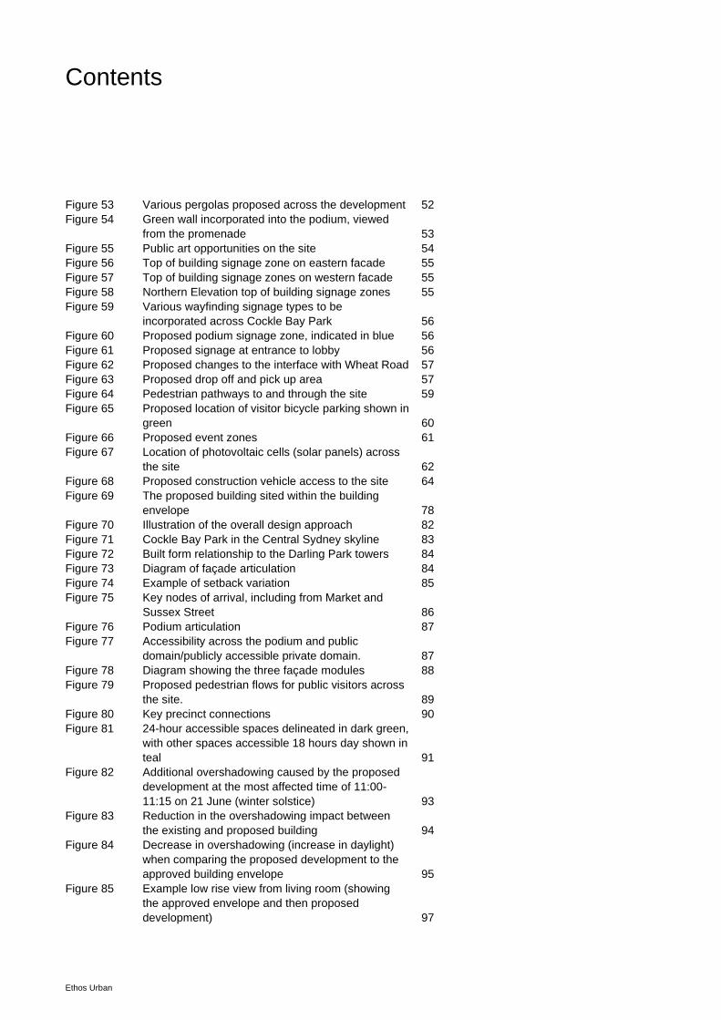
Contents
Ethos Urban
Figure 53 Various pergolas proposed across the development 52 Figure 54 Green wall incorporated into the podium, viewed
from the promenade 53 Figure 55 Public art opportunities on the site 54 Figure 56 Top of building signage zone on eastern facade 55 Figure 57 Top of building signage zones on western facade 55 Figure 58 Northern Elevation top of building signage zones 55 Figure 59 Various wayfinding signage types to be
incorporated across Cockle Bay Park 56 Figure 60 Proposed podium signage zone, indicated in blue 56 Figure 61 Proposed signage at entrance to lobby 56 Figure 62 Proposed changes to the interface with Wheat Road 57 Figure 63 Proposed drop off and pick up area 57 Figure 64 Pedestrian pathways to and through the site 59 Figure 65 Proposed location of visitor bicycle parking shown in
green 60 Figure 66 Proposed event zones 61 Figure 67 Location of photovoltaic cells (solar panels) across
the site 62 Figure 68 Proposed construction vehicle access to the site 64 Figure 69 The proposed building sited within the building
envelope 78 Figure 70 Illustration of the overall design approach 82 Figure 71 Cockle Bay Park in the Central Sydney skyline 83 Figure 72 Built form relationship to the Darling Park towers 84 Figure 73 Diagram of façade articulation 84 Figure 74 Example of setback variation 85 Figure 75 Key nodes of arrival, including from Market and
Sussex Street 86 Figure 76 Podium articulation 87 Figure 77 Accessibility across the podium and public
domain/publicly accessible private domain. 87 Figure 78 Diagram showing the three façade modules 88 Figure 79 Proposed pedestrian flows for public visitors across
the site. 89 Figure 80 Key precinct connections 90 Figure 81 24-hour accessible spaces delineated in dark green,
with other spaces accessible 18 hours day shown in
teal 91 Figure 82 Additional overshadowing caused by the proposed
development at the most affected time of 11:00-
11:15 on 21 June (winter solstice) 93 Figure 83 Reduction in the overshadowing impact between
the existing and proposed building 94 Figure 84 Decrease in overshadowing (increase in daylight)
when comparing the proposed development to the
approved building envelope 95 Figure 85 Example low rise view from living room (showing
the approved envelope and then proposed
development) 97
Contents
Ethos Urban
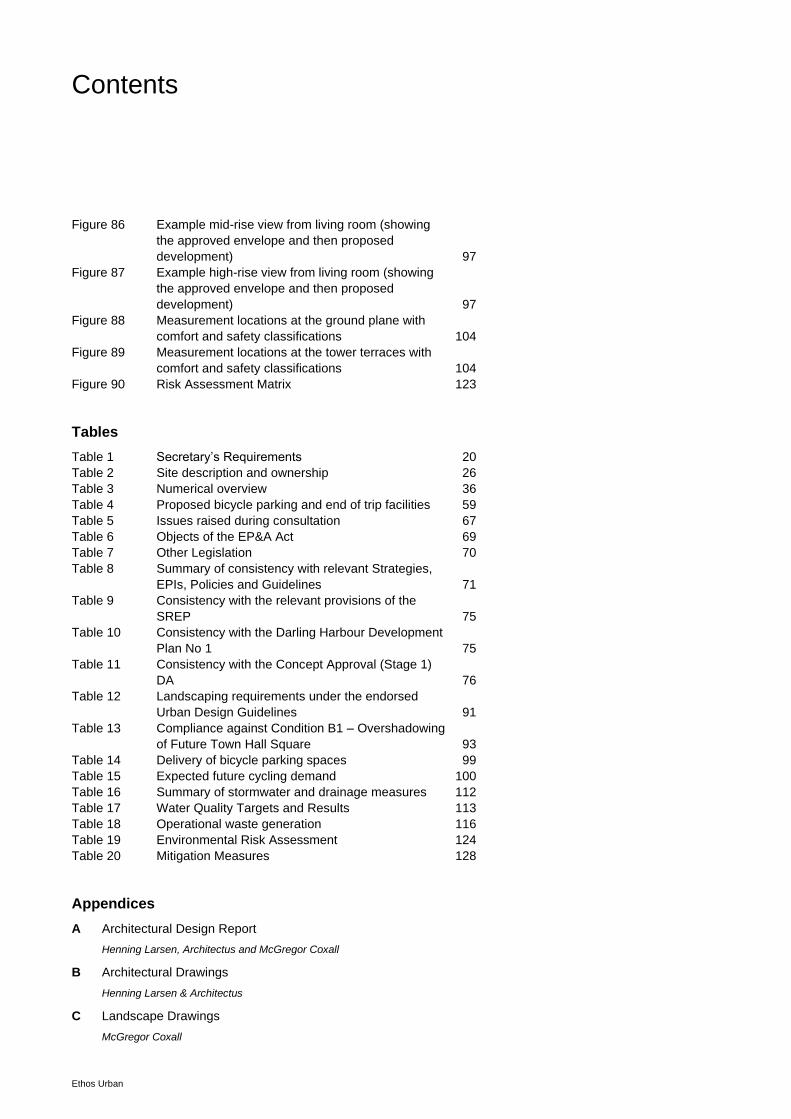
Figure 86 Example mid-rise view from living room (showing
the approved envelope and then proposed
development) 97 Figure 87 Example high-rise view from living room (showing
the approved envelope and then proposed
development) 97 Figure 88 Measurement locations at the ground plane with
comfort and safety classifications 104 Figure 89 Measurement locations at the tower terraces with
comfort and safety classifications 104 Figure 90 Risk Assessment Matrix 123
Tables
Table 1 Secretary’s Requirements 20 Table 2 Site description and ownership 26 Table 3 Numerical overview 36 Table 4 Proposed bicycle parking and end of trip facilities 59 Table 5 Issues raised during consultation 67 Table 6 Objects of the EP&A Act 69 Table 7 Other Legislation 70 Table 8 Summary of consistency with relevant Strategies,
EPIs, Policies and Guidelines 71 Table 9 Consistency with the relevant provisions of the
SREP 75 Table 10 Consistency with the Darling Harbour Development
Plan No 1 75 Table 11 Consistency with the Concept Approval (Stage 1)
DA 76 Table 12 Landscaping requirements under the endorsed
Urban Design Guidelines 91 Table 13 Compliance against Condition B1 – Overshadowing
of Future Town Hall Square 93 Table 14 Delivery of bicycle parking spaces 99 Table 15 Expected future cycling demand 100 Table 16 Summary of stormwater and drainage measures 112 Table 17 Water Quality Targets and Results 113 Table 18 Operational waste generation 116 Table 19 Environmental Risk Assessment 124 Table 20 Mitigation Measures 128
Appendices
A Architectural Design Report
Henning Larsen, Architectus and McGregor Coxall
B Architectural Drawings
Henning Larsen & Architectus
C Landscape Drawings
McGregor Coxall
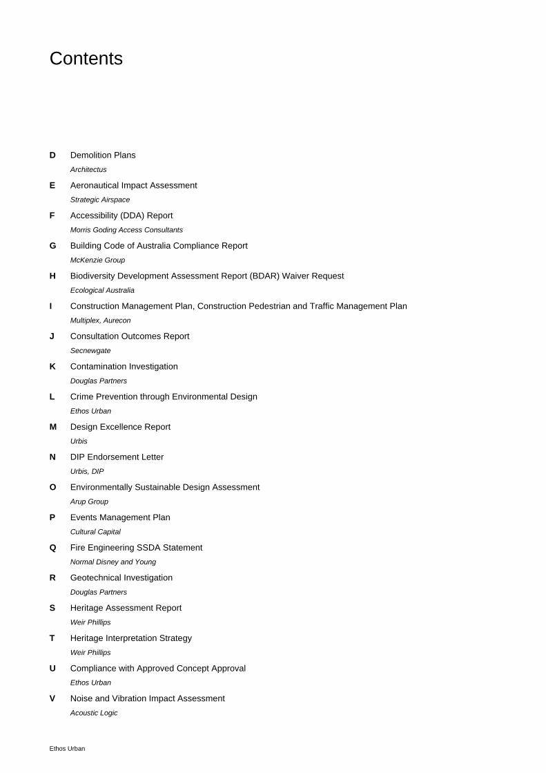
Contents
Ethos Urban
D Demolition Plans
Architectus
E Aeronautical Impact Assessment
Strategic Airspace
F Accessibility (DDA) Report
Morris Goding Access Consultants
G Building Code of Australia Compliance Report
McKenzie Group
H Biodiversity Development Assessment Report (BDAR) Waiver Request
Ecological Australia
I Construction Management Plan, Construction Pedestrian and Traffic Management Plan
Multiplex, Aurecon
J Consultation Outcomes Report
Secnewgate
K Contamination Investigation
Douglas Partners
L Crime Prevention through Environmental Design
Ethos Urban
M Design Excellence Report
Urbis
N DIP Endorsement Letter
Urbis, DIP
O Environmentally Sustainable Design Assessment
Arup Group
P Events Management Plan
Cultural Capital
Q Fire Engineering SSDA Statement
Normal Disney and Young
R Geotechnical Investigation
Douglas Partners
S Heritage Assessment Report
Weir Phillips
T Heritage Interpretation Strategy
Weir Phillips
U Compliance with Approved Concept Approval
Ethos Urban
V Noise and Vibration Impact Assessment
Acoustic Logic
Contents
Ethos Urban
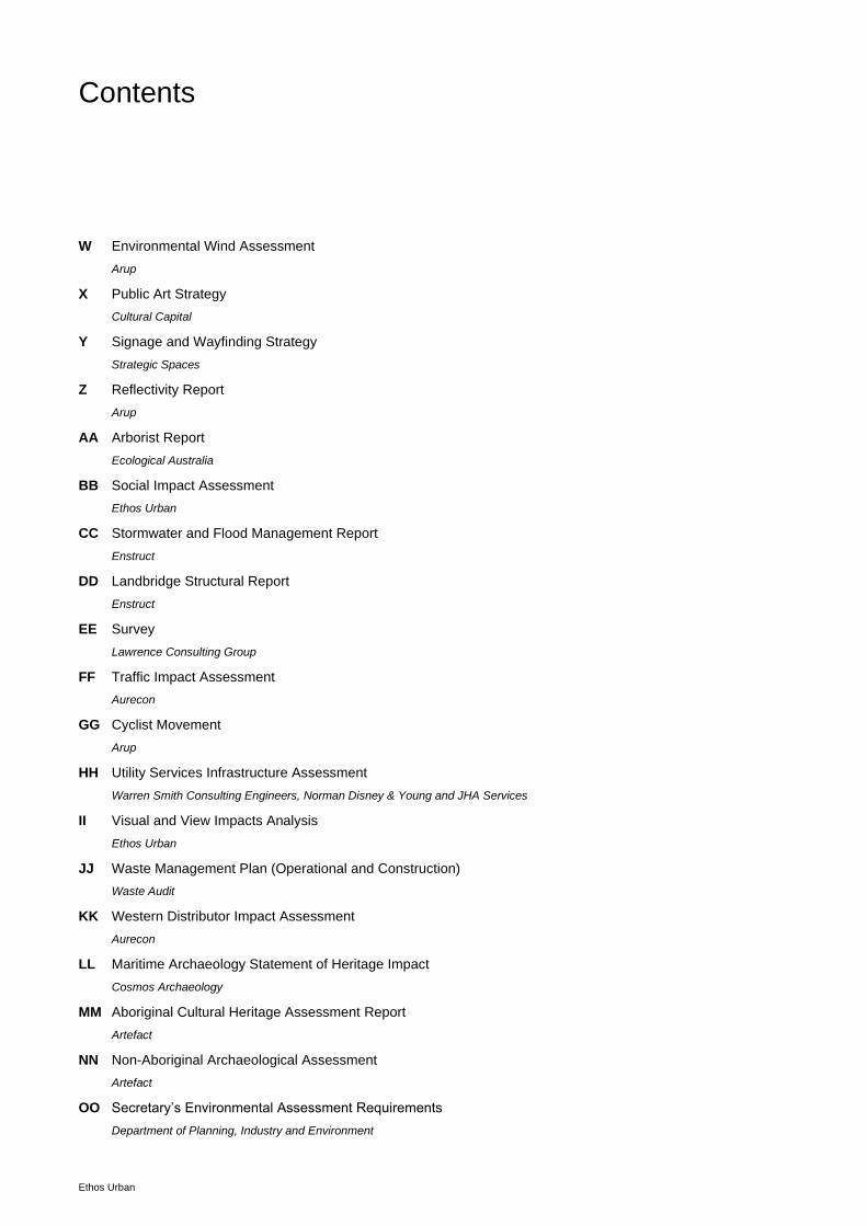
W Environmental Wind Assessment
Arup
X Public Art Strategy
Cultural Capital
Y Signage and Wayfinding Strategy
Strategic Spaces
Z Reflectivity Report
Arup
AA Arborist Report
Ecological Australia
BB Social Impact Assessment
Ethos Urban
CC Stormwater and Flood Management Report
Enstruct
DD Landbridge Structural Report
Enstruct
EE Survey
Lawrence Consulting Group
FF Traffic Impact Assessment
Aurecon
GG Cyclist Movement
Arup
HH Utility Services Infrastructure Assessment
Warren Smith Consulting Engineers, Norman Disney & Young and JHA Services
II Visual and View Impacts Analysis
Ethos Urban
JJ Waste Management Plan (Operational and Construction)
Waste Audit
KK Western Distributor Impact Assessment
Aurecon
LL Maritime Archaeology Statement of Heritage Impact
Cosmos Archaeology
MM Aboriginal Cultural Heritage Assessment Report
Artefact
NN Non-Aboriginal Archaeological Assessment
Artefact
OO Secretary’s Environmental Assessment Requirements
Department of Planning, Industry and Environment
Contents
Ethos Urban
PP State Environmental Planning Policy No 64 – Advertising and Signage Assessment
Ethos Urban
Submitted under separate cover:
QS Statement
Digital and Physical model
NOTE: all images contained in this document are for illustrative purposes only. Reference should be made to the appended
documentation where appropriate.
Cockle Bay Park - 241-249 Wheat Road, Sydney | Environmental Impact Statement | 15 October 2021
Ethos Urban | 2200220 9
Statement of Validity
Development Application Details
Applicant name DPT & DPPT Operator Pty Ltd
Applicant address Level 51, MLC Centre, 19 Martin Place, Sydney 2000
Land to be developed Primary address: 241-249 Wheat Road, Sydney
Proposed development Stage 2 detailed proposal for the redevelopment of Cockle Bay Park, as described in Section 3.0 of this Environmental Impact Statement, pursuant to the approved Stage 1 Concept Approval (SSD-7684), as
modified.
Prepared by
Name Michael Oliver
Qualifications BPlan (Hons 1) MEL MPIA
Address 173 Sussex Street, Sydney
In respect of State Significant Development - Development Application
Certification
I certify that I have prepared the content of this EIS and to the best of my knowledge:
• it is in accordance with Schedule 2 of the Environmental Planning and Assessment Regulation 2000;
• all available information that is relevant to the environmental assessment of the development to which the statement relates; and
• the information contained in the statement is neither false nor misleading.
Signature
Name Michael Oliver
Date 15 October 2021
Cockle Bay Park - 241-249 Wheat Road, Sydney | Environmental Impact Statement | 15 October 2021
Ethos Urban | 2200220 10
Executive Summary
This Environmental Impact Statement (EIS) has been prepared on behalf of DPT & DPPT Operator Pty Ltd in
support of a Stage 2 State Significant Development (SSD) Development Application (DA) made to the Department
of Planning, Industry and Environment (the Department) for the construction of a 43 storey commercial tower at
241-249 Wheat Road, Sydney, known as Cockle Bay Park.
The key features of the proposed development include:
Site preparation works that were not captured as part of the approved Stage 1 works but are required to
appropriately interface Cockle Bay Park with its context and enable the proposed redevelopment.
The construction and use of a landbridge across the Western Distributor freeway between Darling Harbour and
Darling Park, including:
− A northern park with over 5,500m2 of publicly accessible open space.
− A southern park with over 1,000m2 of publicly accessible open space.
− Associated landscaping and access to the park from both Darling Park and Darling Harbour.
− Interface works for the Pyrmont Bridge, Druitt Street Bridge, and to Sussex Street and Market Street,
including the construction of a new bridge connection over Sussex Street to the proposed landbridge.
The construction and use of a new 43 level commercial building, containing:
− 4 publicly accessible podium levels, containing 14,000m2 of retail gross floor area
− 35 levels of commercial office space, containing 75,000m2 of commercial GFA
− 4 levels of mechanical plant
Associated bicycle parking, loading facilities, end of trip facilities, building and business identification signage
and utilities and services infrastructure.
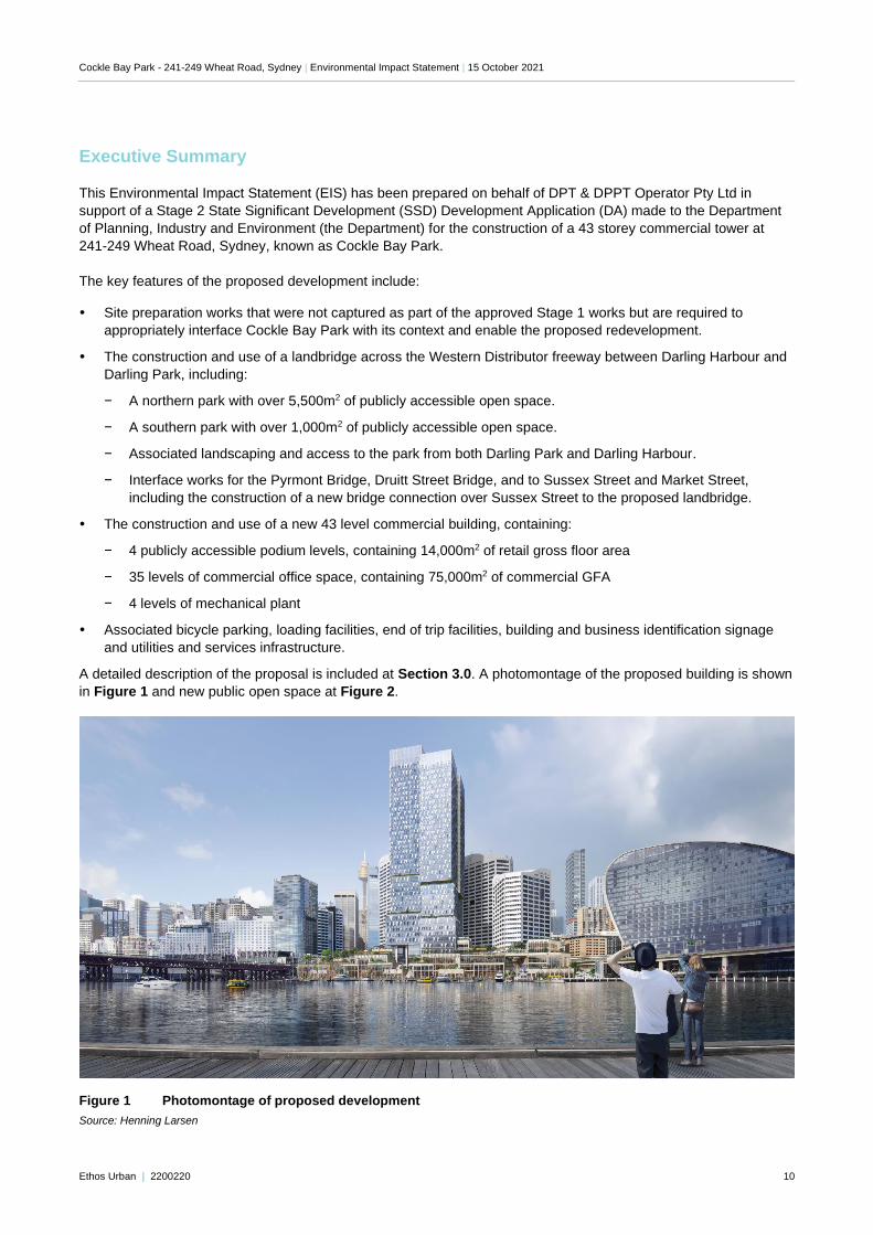
A detailed description of the proposal is included at Section 3.0. A photomontage of the proposed building is shown
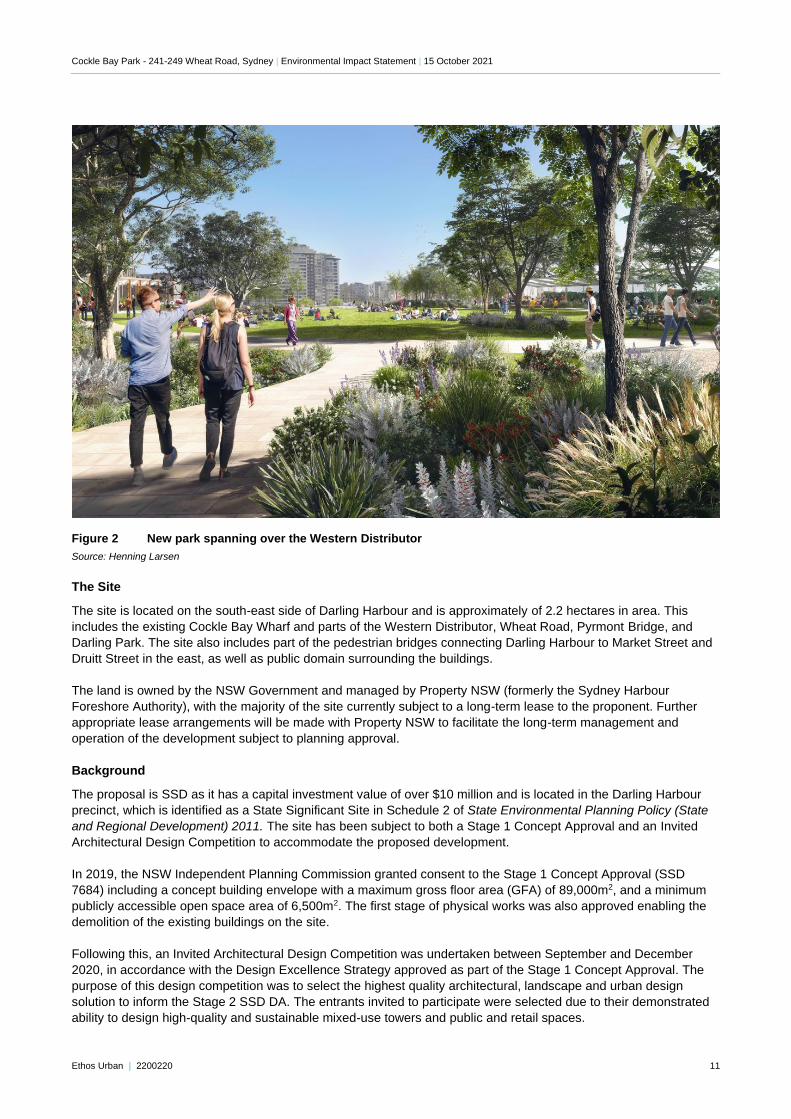
in Figure 1 and new public open space at Figure 2.
Figure 1 Photomontage of proposed development
Source: Henning Larsen
Cockle Bay Park - 241-249 Wheat Road, Sydney | Environmental Impact Statement | 15 October 2021
Ethos Urban | 2200220 11
Figure 2 New park spanning over the Western Distributor
Source: Henning Larsen
The Site
The site is located on the south-east side of Darling Harbour and is approximately of 2.2 hectares in area. This
includes the existing Cockle Bay Wharf and parts of the Western Distributor, Wheat Road, Pyrmont Bridge, and
Darling Park. The site also includes part of the pedestrian bridges connecting Darling Harbour to Market Street and
Druitt Street in the east, as well as public domain surrounding the buildings.
The land is owned by the NSW Government and managed by Property NSW (formerly the Sydney Harbour
Foreshore Authority), with the majority of the site currently subject to a long-term lease to the proponent. Further
appropriate lease arrangements will be made with Property NSW to facilitate the long-term management and
operation of the development subject to planning approval.
Background
The proposal is SSD as it has a capital investment value of over $10 million and is located in the Darling Harbour
precinct, which is identified as a State Significant Site in Schedule 2 of State Environmental Planning Policy (State
and Regional Development) 2011. The site has been subject to both a Stage 1 Concept Approval and an Invited
Architectural Design Competition to accommodate the proposed development.
In 2019, the NSW Independent Planning Commission granted consent to the Stage 1 Concept Approval (SSD
7684) including a concept building envelope with a maximum gross floor area (GFA) of 89,000m2, and a minimum
publicly accessible open space area of 6,500m2. The first stage of physical works was also approved enabling the
demolition of the existing buildings on the site.
Following this, an Invited Architectural Design Competition was undertaken between September and December
2020, in accordance with the Design Excellence Strategy approved as part of the Stage 1 Concept Approval. The
purpose of this design competition was to select the highest quality architectural, landscape and urban design
solution to inform the Stage 2 SSD DA. The entrants invited to participate were selected due to their demonstrated
ability to design high-quality and sustainable mixed-use towers and public and retail spaces.
Cockle Bay Park - 241-249 Wheat Road, Sydney | Environmental Impact Statement | 15 October 2021
Ethos Urban | 2200220 12
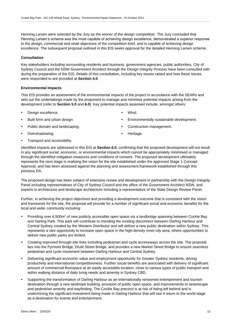
Henning Larsen were selected by the Jury as the winner of the design competition. The Jury concluded that
Henning Larsen’s scheme was the most capable of achieving design excellence, demonstrated a superior response
to the design, commercial and retail objectives of the competition brief, and is capable of achieving design
excellence. The subsequent proposal outlined in this EIS seeks approval for the detailed Henning Larsen scheme.
Consultation
Key stakeholders including surrounding residents and business, government agencies, public authorities, City of
Sydney Council and the NSW Government Architect through the Design Integrity Process have been consulted with
during the preparation of the EIS. Details of this consultation, including key issues raised and how these issues
were responded to are provided at Section 4.0.
Environmental Impacts
This EIS provides an assessment of the environmental impacts of the project in accordance with the SEARs and
sets out the undertakings made by the proponent to manage and minimise potential impacts arising from the
development (refer to Section 5.0 and 6.0). Key potential impacts assessed include, amongst others:
Design excellence.
Built form and urban design.
Public domain and landscaping.
Overshadowing.
Transport and accessibility.
Wind.
Environmentally sustainable development.
Construction management.
Heritage.
Identified impacts are addressed in this EIS at Section 6.0, confirming that the proposed development will not result
in any significant social, economic, or environmental impacts which cannot be appropriately minimised or managed
through the identified mitigation measures and conditions of consent. The proposed development ultimately
represents the next stage in realising the vision for the site established under the approved Stage 1 Concept
Approval, and has been assessed against the planning and assessment framework established through this
previous DA.
The proposed design has been subject of extensive review and development in partnership with the Design Integrity
Panel including representatives of City of Sydney Council and the office of the Government Architect NSW, and
experts in architecture and landscape architecture including a representative of the State Design Review Panel.
Further, in achieving the project objectives and providing a development outcome that is consistent with the vision
and framework for the site, the proposal will provide for a number of significant social and economic benefits for the
local and wider community including:
Providing over 6,500m2 of new publicly accessible open space via a landbridge spanning between Cockle Bay
and Darling Park. This park will contribute to mending the existing disconnect between Darling Harbour and
Central Sydney created by the Western Distributor and will deliver a new public destination within Sydney. This
represents a rare opportunity to increase open space in the high-density inner-city area, where opportunities to
deliver new public parks are limited.
Creating improved through-site links including pedestrian and cycle accessways across the site. The proposal
ties into the Pyrmont Bridge, Druitt Street Bridge, and provides a new Market Street Bridge to ensure seamless
pedestrian and cycle movement between Darling Harbour and Central Sydney.
Delivering significant economic value and employment opportunity for Greater Sydney residents, driving
productivity and international competitiveness. Further social benefits are associated with delivery of significant
amount of commercial floorspace at an easily accessible location, close to various types of public transport and
within walking distance of daily living needs and amenity in Sydney CBD.
Supporting the transformation of Darling Harbour as an internationally renowned entertainment and tourism
destination through a new landmark building, provision of public open space, and improvements to streetscape
and pedestrian amenity and wayfinding. The Cockle Bay precinct is at risk of being left behind and is
undermining the significant investment being made in Darling Harbour that will see it return to the world stage
as a destination for events and entertainment.
Cockle Bay Park - 241-249 Wheat Road, Sydney | Environmental Impact Statement | 15 October 2021
Ethos Urban | 2200220 13
Ultimately the proposed development will deliver substantial public benefits, an improved urban experience, and
achieve excellence in landscape and architectural design, noting that a place-making opportunity of this magnitude
is extremely unique.
Conclusion
The assessment undertaken as part of this Stage 2 SSD DA includes a number of suggested mitigation measures
and design recommendations. These have been collated to inform the ongoing management of the site through
detailed design, construction, and operation.
This Environmental Impact Statement fulfills the requirements of the EP&A Act and addresses the SEARs and the
Stage 1 Concept Approval conditions. This EIS demonstrates that the impacts of the proposal are acceptable and
are able to be managed. In light of the above, and the significant benefits of the proposed development, the
proposed development warrants approval.
Cockle Bay Park - 241-249 Wheat Road, Sydney | Environmental Impact Statement | 15 October 2021
Ethos Urban | 2200220 14
1.0 Introduction
This Environmental Impact Statement (EIS) is submitted to the Department of Planning, Industry and Environment
(DPIE) pursuant to Part 4 of the Environmental Planning and Assessment Act 1979 (EP&A Act) in support of State
Significant Development (SSD) application (SSD 9978934) for the development of a mixed-use office and retail
building at Cockle Bay Wharf.
This SSD DA is a staged application within the meaning of Section 4.22 of the EP&A Act. It is the second SSD DA
made in respect of the site, following the approval of the SSD DA for the Concept Approval and Stage 1 Early
Works (SSD-7684) by the NSW Independent Planning Commission (IPC) on 13 May 2019.
The project, Cockle Bay Park (also previously called Cockle Bay Wharf), is located within Darling Harbour which is
identified as a State Significant Development Site in Schedule 2 of State Environmental Planning Policy (State and
Regional Development) 2011. Development with a capital investment value of more than $10 million on such a site
is SSD for the purposes of the EP&A Act.
The report has been prepared by Ethos Urban on behalf of DPT Operator and DPPT Operator, and is based on the
Architectural Plans provided by Henning Larsen, Architectus and McGregor Coxall (see Appendix B to Appendix
D) and other supporting technical information appended to the report (see Table of Contents).
This EIS has been prepared in accordance with the requirements of Part 4 of the EP&A Act, Schedule 2 of the
Environmental Planning and Assessment Regulation 2000 (EP&A Regulation), and the SEARs for the preparation
of the EIS, which are included at Appendix A. This EIS should be read in conjunction with the supporting
information and plans appended to and accompanying this report.
1.1 Overview of Proposed Development
This application seeks approval for the following development:
Site preparation works not captured as part of the approved Stage 1 works but required to appropriately
interface Cockle Bay Park with its context and enable the proposed redevelopment, including:
− Tree removal across the site.
− Minor additional areas of excavation across the site.
− Demolition of existing built form elements not previously approved under SSD-7684, comprising:
○ Crescent Garden
○ Market Street Bridge
○ Cycle/pedestrian connection from Pyrmont Bridge
○ Minor internal building elements within the Darling Park precinct basement.
Construction and use of a landbridge across the Western Distributor freeway between Darling Harbour and
Darling Park, including:
− A northern park with over 5,500m2 of publicly accessible open space.
− A southern park with over 1,000m2 of publicly accessible open space.
− Associated landscaping and access to the park from both Darling Park and Darling Harbour.
− Interface works for the Pyrmont Bridge, Druitt Street Bridge, and to Sussex Street and Market Street,
including the construction of a new bridge connection over Sussex Street to the proposed landbridge.
Construction and use of a new 43 level commercial building, containing:
− 4 publicly accessible podium levels, containing 14,000m2 of retail GFA
− 35 levels of commercial office space, containing 75,000m2 of commercial GFA
− 4 levels of mechanical plant
− A loading dock area with nine (9) loading bay spots, and back-of-house areas.
Cockle Bay Park - 241-249 Wheat Road, Sydney | Environmental Impact Statement | 15 October 2021
Ethos Urban | 2200220 15
502 bicycle parking spaces for commercial, retail and visitor use and associated end of trip facilities within the
Darling Park basement, and 53 bicycle parking spaces within the public domain.
Building and business identification signage zones on the building, and wayfinding signage within the public
domain.
Utilities and services infrastructure to tie into the requirements of the proposed building.
Re-alignment, reconfiguration, and partial closure of Wheat Road.
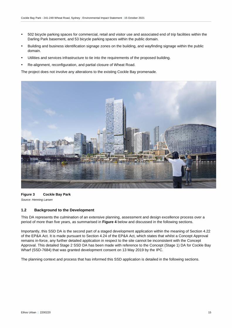
The project does not involve any alterations to the existing Cockle Bay promenade.
Figure 3 Cockle Bay Park
Source: Henning Larsen
1.2 Background to the Development
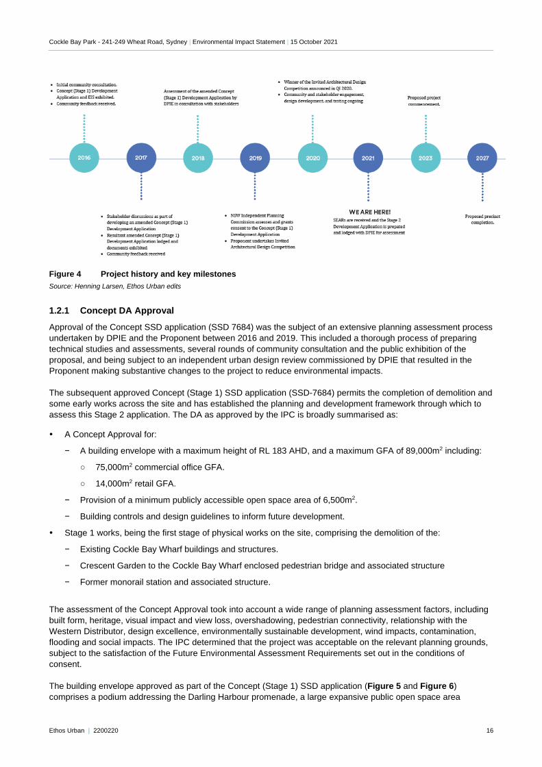
This DA represents the culmination of an extensive planning, assessment and design excellence process over a
period of more than five years, as summarised in Figure 4 below and discussed in the following sections.
Importantly, this SSD DA is the second part of a staged development application within the meaning of Section 4.22
of the EP&A Act. It is made pursuant to Section 4.24 of the EP&A Act, which states that whilst a Concept Approval
remains in-force, any further detailed application in respect to the site cannot be inconsistent with the Concept
Approval. This detailed Stage 2 SSD DA has been made with reference to the Concept (Stage 1) DA for Cockle Bay
Wharf (SSD-7684) that was granted development consent on 13 May 2019 by the IPC.
The planning context and process that has informed this SSD application is detailed in the following sections.
Cockle Bay Park - 241-249 Wheat Road, Sydney | Environmental Impact Statement | 15 October 2021
Ethos Urban | 2200220 16
Figure 4 Project history and key milestones
Source: Henning Larsen, Ethos Urban edits
1.2.1 Concept DA Approval
Approval of the Concept SSD application (SSD 7684) was the subject of an extensive planning assessment process
undertaken by DPIE and the Proponent between 2016 and 2019. This included a thorough process of preparing
technical studies and assessments, several rounds of community consultation and the public exhibition of the
proposal, and being subject to an independent urban design review commissioned by DPIE that resulted in the
Proponent making substantive changes to the project to reduce environmental impacts.
The subsequent approved Concept (Stage 1) SSD application (SSD-7684) permits the completion of demolition and
some early works across the site and has established the planning and development framework through which to
assess this Stage 2 application. The DA as approved by the IPC is broadly summarised as:
A Concept Approval for:
− A building envelope with a maximum height of RL 183 AHD, and a maximum GFA of 89,000m2 including:
○ 75,000m2 commercial office GFA.
○ 14,000m2 retail GFA.
− Provision of a minimum publicly accessible open space area of 6,500m2.
− Building controls and design guidelines to inform future development.
Stage 1 works, being the first stage of physical works on the site, comprising the demolition of the:
− Existing Cockle Bay Wharf buildings and structures.
− Crescent Garden to the Cockle Bay Wharf enclosed pedestrian bridge and associated structure
− Former monorail station and associated structure.
The assessment of the Concept Approval took into account a wide range of planning assessment factors, including
built form, heritage, visual impact and view loss, overshadowing, pedestrian connectivity, relationship with the
Western Distributor, design excellence, environmentally sustainable development, wind impacts, contamination,
flooding and social impacts. The IPC determined that the project was acceptable on the relevant planning grounds,
subject to the satisfaction of the Future Environmental Assessment Requirements set out in the conditions of
consent.
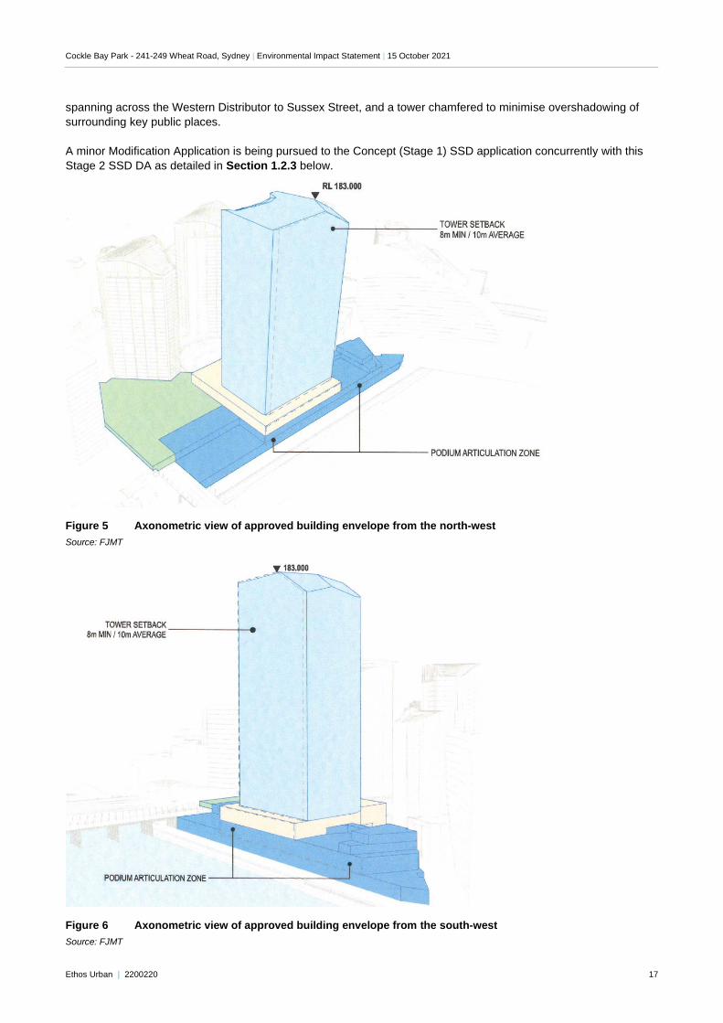
The building envelope approved as part of the Concept (Stage 1) SSD application (Figure 5 and Figure 6)
comprises a podium addressing the Darling Harbour promenade, a large expansive public open space area
Cockle Bay Park - 241-249 Wheat Road, Sydney | Environmental Impact Statement | 15 October 2021
Ethos Urban | 2200220 17
spanning across the Western Distributor to Sussex Street, and a tower chamfered to minimise overshadowing of
surrounding key public places.
A minor Modification Application is being pursued to the Concept (Stage 1) SSD application concurrently with this
Stage 2 SSD DA as detailed in Section 1.2.3 below.
Figure 5 Axonometric view of approved building envelope from the north-west
Source: FJMT
Figure 6 Axonometric view of approved building envelope from the south-west
Source: FJMT
Cockle Bay Park - 241-249 Wheat Road, Sydney | Environmental Impact Statement | 15 October 2021
Ethos Urban | 2200220 18
1.2.2 Invited Architectural Design Competition
In accordance with the Design Excellence Strategy approved under the Concept DA, an Invited Architectural Design
Competition was undertaken between September and December 2019. The purpose of this design competition was
to select the highest quality architectural, landscape and urban design solution to inform the Stage 2 SSD DA.
The entrants invited to participate were selected due to their demonstrated ability to design high-quality and
sustainable mixed-use towers and public and retail spaces. The six architectural practices and their partnerships
who participated were:
FJMT
Grimshaw
Henning Larsen
UN Studio and Cox Architecture
Wilkinson Eyre
Woods Bagot
Henning Larsen were selected by the Jury as the winner of the design competition. The Jury concluded that
Henning Larsen’s scheme was the most capable of achieving design excellence, demonstrated a superior response
to the design, commercial and retail objectives of the competition brief, and is capable of achieving design
excellence. The Jury concluded that the qualities of the Henning Larsen scheme, most notably the public open
space areas, new public domain connections, transitions between the podium and harbour edge, and the
commercial office tower, were superior to the other schemes. The Jury recommended, consistent with Condition
A16 of the Concept Approval, that a Design Integrity Panel be established to review and evaluate the development
of the scheme addressing the target design issues as well as to ensure that the design integrity of key conceptual
elements retained as they development.
The Design Integrity Panel (DIP) was established to review and evaluate the Stage 2 design as it developed,
including three (3) of the Jury members, and comprising representatives of City of Sydney Council, the office of the
Government Architect NSW, and experts in architecture and landscape architecture including a representative of
the State Design Review Panel. In the preparation of this DA, the project team met with the DIP on eight (8)
occasions ensuring the achievement of the highest standard of architectural, urban and landscape design. This
process is documented in Appendix M and Appendix N.
1.2.3 Modification Application
An application under Section 4.55 of the EP&A Act to modify the Concept (Stage 1) SSD application has been
lodged concurrently with this Stage 2 SSD DA. This Modification Application seeks to align the approved building
envelope and site areas with the detailed design of the built form and public domain areas proposed under this
subsequent Stage 2 SSD DA. The proposed modifications are minor and a direct result of the design development
that occurred as part of the Design Competition stage of the project, and the preparation of further detailed technical
assessments as part of this DA.
As the proposed modifications relate principally to the Stage 2 SSD DA, it is intended that the Modification
Application will be assessed and determined concurrently or prior to determining the Stage 2 SSD DA.
1.3 Objectives of the Development
The objectives of this Development Application are to:
Deliver a significant new mixed-use retail and office building on the edge of Darling Harbour and the Sydney
CBD, encompassing significant new public open space, generally in accordance with the approved Concept
Approval SSD-7684.
Deliver a project that demonstrates design excellence in accordance with the architectural and public domain
vision outlined by Henning Larsen and McGregor Coxall in their design-competition winning scheme.
Cockle Bay Park - 241-249 Wheat Road, Sydney | Environmental Impact Statement | 15 October 2021
Ethos Urban | 2200220 19
Deliver a significant quantum of retail and premium office floor space to support increased employment and
economic activity within the Sydney CBD.
Enhance pedestrian connectivity between the Sydney CBD, Darling Harbour and the Pyrmont Bridge through
the construction of a landbridge over the Western Distributor and Wheat Road, construction of a new pedestrian
bridge over Market Street, and enhancement of the interface with the Druitt Street pedestrian bridge to provide
accessible paths of travel.
Deliver significant new open space within the site that supports public access and use by workers and visitors to
the site, including enhancements and interface works to connect the Crescent Garden to the new precinct.
Provide suitable interfaces between the proposed development and existing heritage items, including the
Pyrmont Bridge, whilst supporting the enhancement of key pedestrian connections.
Support the development of a precinct that attains high levels of environmental performance and efficiency.
1.4 Analysis of Alternatives
Strategic need for the proposal
This SSD DA represents the next phase of the ongoing redevelopment of Cockle Bay Wharf (now known as Cockle
Bay Park) pursuant to the approved Stage 1 Concept Approval (SSD 7684). It is necessitated by virtue of Condition
A3 of the conditions of consent, which states that:
A3. In accordance with section 4.22 of the EP&A Act, all physical works and subsequent stages of the
development are to be subject of future development applications.
Hence, this SSD DA has been prepared to progress the next stage of the redevelopment of Cockle Bay Park
consistent with the vision and framework established under the Stage 1 Concept Approval.
DPIE and the IPC’s assessment of the Stage 1 Concept Approval concluded that the project’s facilitation of an
increase of density in this location has strategic merit as it would provide a significant increase to employment
generating floorspace, has excellent access to public transport, and is conveniently located within the CBD. The
project was found to be consistent with the objectives of the strategic planning documents applying to this land
including the Eastern City District Plan and Sustainable Sydney 2030. This included objectives for the delivery of
new publicly accessible open space, supporting significant job growth to contribute to a globally competitive city,
improving pedestrian connectivity between the CBD and Darling Harbour, promoting the creation of the ‘30-minute
city’, improving the enjoyment of Darling Harbour, and increasing the urban tree cover.
This subsequent Stage 2 SSD DA remains consistent with this assessment, and will enable the strategic objectives
of the project to be resolved, including:
The existing Cockle Bay Wharf building is not well integrated with the city, as the Western Distributor freeway
currently acts as a barrier separating this area from the CBD.
Critical pedestrian links from the CBD to Darling Harbour can be improved.
Despite being publicly accessible, the existing Darling Park Crescent Garden is not well utilised.
The existing Cockle Bay Wharf building is becoming outdated and is not in keeping with the future of the Darling
Harbour area as a vibrant and modern entertainment, tourist and mixed-use destination.
The Cockle Bay precinct is at risk of being left behind and is undermining the significant investment being made
in Darling Harbour that will see it return to the world stage as a destination for events and entertainment.
The project will deliver the following key improvements:
Providing significant public benefit through the repair of severed access between Darling Harbour and the CBD,
via the introduction of a new pedestrian link to Darling Harbour, and through the provision of expanded publicly
accessible areas in the Darling Harbour precinct.
Contributing to the revitalisation of the precinct as a lively and world-class destination through delivering the
mixture of commercial and retail uses that complement the current and future uses of Darling Harbour.
Cockle Bay Park - 241-249 Wheat Road, Sydney | Environmental Impact Statement | 15 October 2021
Ethos Urban | 2200220 20
Providing high quality retail and entertainment spaces catering for local and tourist markets will, contributing to
the entertainment and retailing experience of Darling Harbour.
Achieving a more activated ground level public domain spaces and providing greater opportunities for event
spaces in the public domain, contributing to the entertainment and tourism values of Darling Harbour.
Enhancing the user experience of Pyrmont Bridge through removing the disused monorail infrastructure, make-
good works and enhanced accessibility and connection to the CBD.
Improving surveillance opportunities with the delivery of the future buildings and overall improvements to the
site, in turn increasing the perception of the area as a high quality and safe environment.
Alternative Options
Through the preparation and assessment of the Stage 1 Concept Approval, an analysis of feasible alternatives to
the proposed built form were considered. The NSW IPC determined that the building envelope resulted in an
appropriate built form on the site and would be capable of delivering a detailed design that mitigated potential
environmental impacts and delivered a high quality architectural and urban design outcome.
Following the approval of the Stage 1 Concept Approval in May 2019, an Invited Architectural Design Competition
was undertaken with five highly qualified and reputable architectural teams. Throughout this process, several
alternative building forms and detailed designs were considered. As outlined in Section 6.1 of this EIS, the jury
determined that the Henning Larsen and partners scheme was most capable of achieving design excellence and
recommended that this scheme be further developed for submission of a Stage 2 detailed DA.
Therefore, during the preparation of the Stage 1 Concept Approval and the Invited Architectural Design Competition
Process, the applicant has considered feasible alternatives to the proposed development, however the proposal
represents the most sound and balanced proposal achieving the aims of the development, demonstrating design
excellence and functional requirements of the developer and likely operators.
The proponent has invested considerable resources on the Stage 1 Concept Approval, Invited Architectural Design
Competition and the preparation of the Stage 2 SSD DA. Under a ‘do nothing’ scenario, this time and resources
would be effectively wasted, and the significant opportunity created by the project would go unrealised. Retention of
the existing development under the ‘do nothing’ scenario fails to take advantage of the significant opportunities
presented by the potential redevelopment, including the opportunity to address the current lack of access and
connection of Darling Harbour and Cockle Bay with Central Sydney to the north and provide an intensity of land
uses commensurate with the vision Darling Harbour as a world class mixed-use, entertainment and tourist precinct.
1.5 Secretary’s Requirements
In accordance with section 4.39 of the EP&A Act, the Secretary of the Department of Planning and Environment
issued the requirements for the preparation of the EIS on 12 November 2020. A copy of the Secretary’s
Environmental Assessment Requirements (SEARs) is included at Appendix A.
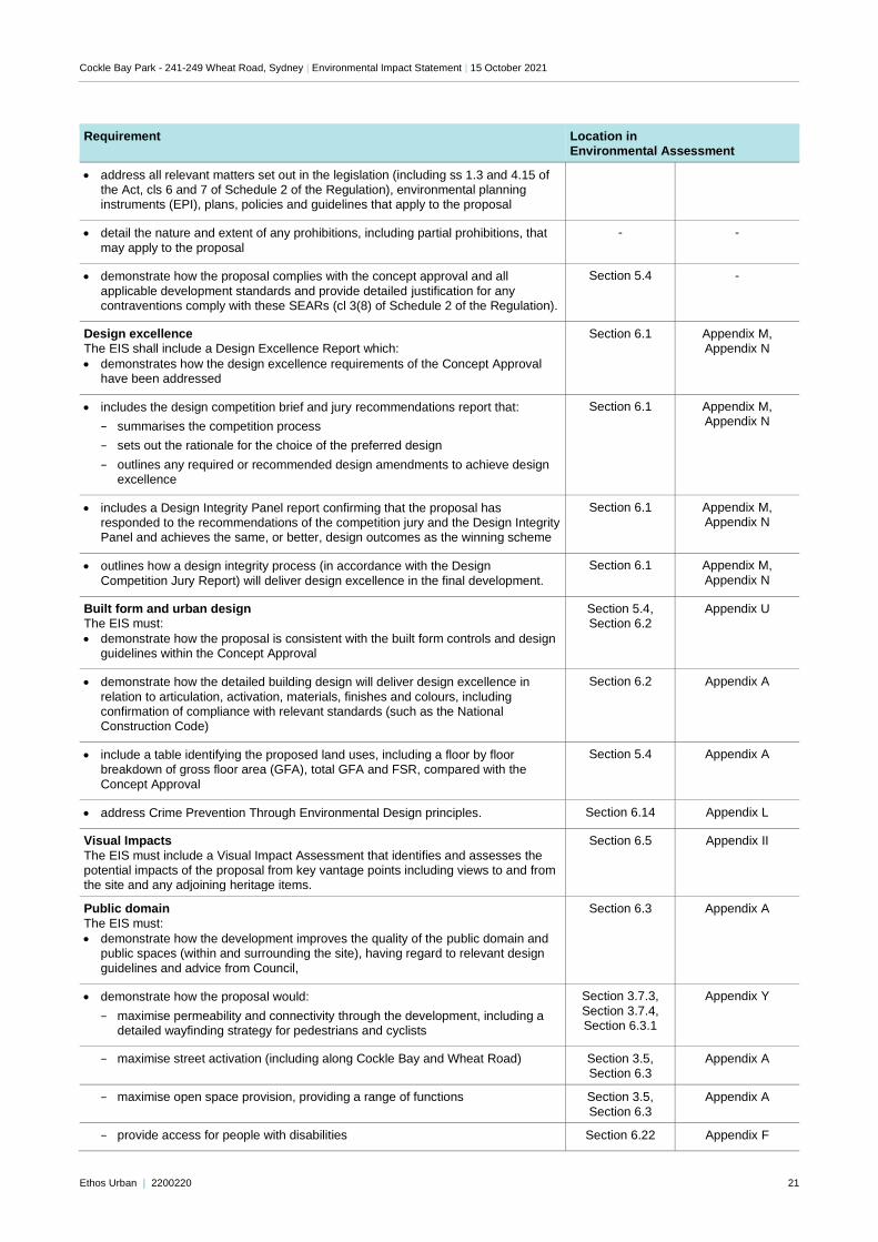
Table 1 provides a detailed summary of the individual matters listed in the SEARs and identifies where each of
these requirements has been addressed in this report and the accompanying technical studies.
Table 1 Secretary’s Requirements
Requirement Location in Environmental Assessment
General
The Environmental Impact Statement (EIS) must address the Environmental Planning
and Assessment Act 1979 and meet the minimum form and content requirements in clauses 6 and 7 of Schedule 2 the Environmental Planning and Assessment
Regulation 2000.
Environmental Impact Statement
Key Issues Report / EIS Technical Study
Statutory and strategic context The EIS must:
Section 5.0
-
Cockle Bay Park - 241-249 Wheat Road, Sydney | Environmental Impact Statement | 15 October 2021
Ethos Urban | 2200220 21
Requirement Location in Environmental Assessment
• address all relevant matters set out in the legislation (including ss 1.3 and 4.15 of the Act, cls 6 and 7 of Schedule 2 of the Regulation), environmental planning instruments (EPI), plans, policies and guidelines that apply to the proposal
• detail the nature and extent of any prohibitions, including partial prohibitions, that
may apply to the proposal
- -
• demonstrate how the proposal complies with the concept approval and all
applicable development standards and provide detailed justification for any contraventions comply with these SEARs (cl 3(8) of Schedule 2 of the Regulation).
Section 5.4 -
Design excellence The EIS shall include a Design Excellence Report which:
• demonstrates how the design excellence requirements of the Concept Approval have been addressed
Section 6.1 Appendix M, Appendix N
• includes the design competition brief and jury recommendations report that:
− summarises the competition process
− sets out the rationale for the choice of the preferred design
− outlines any required or recommended design amendments to achieve design excellence
Section 6.1 Appendix M, Appendix N
• includes a Design Integrity Panel report confirming that the proposal has responded to the recommendations of the competition jury and the Design Integrity Panel and achieves the same, or better, design outcomes as the winning scheme
Section 6.1 Appendix M, Appendix N
• outlines how a design integrity process (in accordance with the Design
Competition Jury Report) will deliver design excellence in the final development.
Section 6.1 Appendix M,
Appendix N
Built form and urban design The EIS must:
• demonstrate how the proposal is consistent with the built form controls and design guidelines within the Concept Approval
Section 5.4, Section 6.2
Appendix U
• demonstrate how the detailed building design will deliver design excellence in
relation to articulation, activation, materials, finishes and colours, including confirmation of compliance with relevant standards (such as the National Construction Code)
Section 6.2 Appendix A
• include a table identifying the proposed land uses, including a floor by floor breakdown of gross floor area (GFA), total GFA and FSR, compared with the
Concept Approval
Section 5.4 Appendix A
• address Crime Prevention Through Environmental Design principles. Section 6.14 Appendix L
Visual Impacts
The EIS must include a Visual Impact Assessment that identifies and assesses the potential impacts of the proposal from key vantage points including views to and from the site and any adjoining heritage items.
Section 6.5 Appendix II
Public domain
The EIS must:
• demonstrate how the development improves the quality of the public domain and public spaces (within and surrounding the site), having regard to relevant design
guidelines and advice from Council,
Section 6.3 Appendix A
• demonstrate how the proposal would:
− maximise permeability and connectivity through the development, including a detailed wayfinding strategy for pedestrians and cyclists
Section 3.7.3,
Section 3.7.4, Section 6.3.1
Appendix Y
− maximise street activation (including along Cockle Bay and Wheat Road) Section 3.5, Section 6.3
Appendix A
− maximise open space provision, providing a range of functions Section 3.5,
Section 6.3
Appendix A
− provide access for people with disabilities Section 6.22 Appendix F
Cockle Bay Park - 241-249 Wheat Road, Sydney | Environmental Impact Statement | 15 October 2021
Ethos Urban | 2200220 22
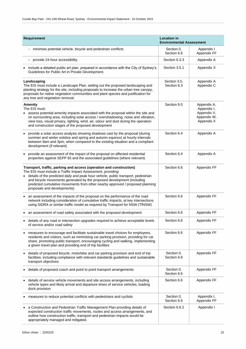
Requirement Location in Environmental Assessment
− minimise potential vehicle, bicycle and pedestrian conflicts Section 0, Section 6.6
Appendix I Appendix FF
− provide 24-hour accessibility. Section 6.3.3 Appendix A
• include a detailed public art plan, prepared in accordance with the City of Sydney’s Guidelines for Public Art in Private Development.
Section 3.5.1 Appendix X
Landscaping The EIS must include a Landscape Plan, setting out the proposed landscaping and
planting strategy for the site, including proposals to increase the urban tree canopy, proposals for native vegetation communities and plant species and justification for any tree and vegetation removal.
Section 3.5, Section 6.3
Appendix A Appendix C
Amenity
The EIS must:
• assess potential amenity impacts associated with the proposal within the site and on surrounding area, including solar access / overshadowing, noise and vibration, view loss, visual privacy, lighting, wind, air, odour and dust during the operation
and construction stages of the proposed development
Section 6.0 Appendix A,
Appendix I, Appendix V, Appendix W,
Appendix II
• provide a solar access analysis showing shadows cast by the proposal (during summer and winter solstice and spring and autumn equinox) at hourly intervals between 9am and 3pm, when compared to the existing situation and a compliant
development (if relevant)
Section 6.4 Appendix A
• provide an assessment of the impact of the proposal on affected residential properties against SEPP 65 and the associated guidelines (where relevant)
Section 6.4 Appendix A
Transport, traffic, parking and access (operation and construction) The EIS must include a Traffic Impact Assessment, providing:
• details of the predicted daily and peak hour vehicle, public transport, pedestrian and bicycle movements generated by the proposed development (including
predicted cumulative movements from other nearby approved / proposed planning proposals and developments)
Section 6.6 Appendix FF
• an assessment of the impacts of the proposal on the performance of the road network including consideration of cumulative traffic impacts, at key intersections
using SIDRA or similar traffic model as required by Transport for NSW (TfNSW)
Section 6.6 Appendix FF
• an assessment of road safety associated with the proposed development Section 6.6 Appendix FF
• details of any road or intersection upgrades required to achieve acceptable levels
of service and/or road safety
Section 6.6 Appendix FF
• measures to encourage and facilitate sustainable travel choices for employees,
residents and visitors, such as minimising car parking provision, providing for car share, promoting public transport, encouraging cycling and walking, implementing a green travel plan and providing end of trip facilities
Section 6.6 Appendix FF
• details of proposed bicycle, motorbike and car parking provision and end of trip facilities, including compliance with relevant standards guidelines and sustainable
transport objectives
Section 0,
Section 6.6
Appendix FF
• details of proposed coach and point to point transport arrangements Section 0, Section 6.6
Appendix FF
• details of service vehicle movements and site access arrangements, including vehicle types and likely arrival and departure times of service vehicles, loading
dock provision
Section 6.6 Appendix FF
• measures to reduce potential conflicts with pedestrians and cyclists Section 0,
Section 6.6
Appendix I,
Appendix FF
• a Construction and Pedestrian Traffic Management Plan providing details of expected construction traffic movements, routes and access arrangements, and outline how construction traffic, transport and pedestrian impacts would be
appropriately managed and mitigated.
Section 6.6.2 Appendix I
Cockle Bay Park - 241-249 Wheat Road, Sydney | Environmental Impact Statement | 15 October 2021
Ethos Urban | 2200220 23
Requirement Location in Environmental Assessment
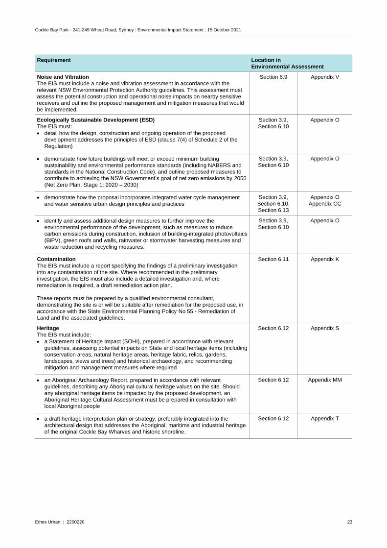
Noise and Vibration The EIS must include a noise and vibration assessment in accordance with the
relevant NSW Environmental Protection Authority guidelines. This assessment must assess the potential construction and operational noise impacts on nearby sensitive receivers and outline the proposed management and mitigation measures that would
be implemented.
Section 6.9 Appendix V
Ecologically Sustainable Development (ESD)
The EIS must:
• detail how the design, construction and ongoing operation of the proposed development addresses the principles of ESD (clause 7(4) of Schedule 2 of the
Regulation)
Section 3.9,
Section 6.10
Appendix O
• demonstrate how future buildings will meet or exceed minimum building sustainability and environmental performance standards (including NABERS and standards in the National Construction Code), and outline proposed measures to contribute to achieving the NSW Government’s goal of net zero emissions by 2050
(Net Zero Plan, Stage 1: 2020 – 2030)
Section 3.9, Section 6.10
Appendix O
• demonstrate how the proposal incorporates integrated water cycle management and water sensitive urban design principles and practices
Section 3.9, Section 6.10, Section 6.13
Appendix O Appendix CC
• identify and assess additional design measures to further improve the
environmental performance of the development, such as measures to reduce carbon emissions during construction, inclusion of building-integrated photovoltaics (BiPV), green roofs and walls, rainwater or stormwater harvesting measures and
waste reduction and recycling measures.
Section 3.9,
Section 6.10
Appendix O
Contamination
The EIS must include a report specifying the findings of a preliminary investigation into any contamination of the site. Where recommended in the preliminary investigation, the EIS must also include a detailed investigation and, where
remediation is required, a draft remediation action plan. These reports must be prepared by a qualified environmental consultant,
demonstrating the site is or will be suitable after remediation for the proposed use, in accordance with the State Environmental Planning Policy No 55 - Remediation of Land and the associated guidelines.
Section 6.11 Appendix K
Heritage
The EIS must include:
• a Statement of Heritage Impact (SOHI), prepared in accordance with relevant guidelines, assessing potential impacts on State and local heritage items (including
conservation areas, natural heritage areas, heritage fabric, relics, gardens, landscapes, views and trees) and historical archaeology, and recommending mitigation and management measures where required
Section 6.12 Appendix S
• an Aboriginal Archaeology Report, prepared in accordance with relevant guidelines, describing any Aboriginal cultural heritage values on the site. Should
any aboriginal heritage items be impacted by the proposed development, an Aboriginal Heritage Cultural Assessment must be prepared in consultation with local Aboriginal people
Section 6.12 Appendix MM
• a draft heritage interpretation plan or strategy, preferably integrated into the
architectural design that addresses the Aboriginal, maritime and industrial heritage of the original Cockle Bay Wharves and historic shoreline.
Section 6.12 Appendix T
Cockle Bay Park - 241-249 Wheat Road, Sydney | Environmental Impact Statement | 15 October 2021
Ethos Urban | 2200220 24
Requirement Location in Environmental Assessment
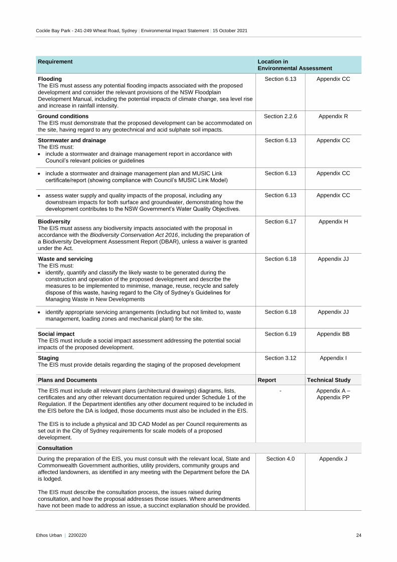
Flooding The EIS must assess any potential flooding impacts associated with the proposed
development and consider the relevant provisions of the NSW Floodplain Development Manual, including the potential impacts of climate change, sea level rise and increase in rainfall intensity.
Section 6.13 Appendix CC
Ground conditions The EIS must demonstrate that the proposed development can be accommodated on
the site, having regard to any geotechnical and acid sulphate soil impacts.
Section 2.2.6 Appendix R
Stormwater and drainage The EIS must:
• include a stormwater and drainage management report in accordance with
Council’s relevant policies or guidelines
Section 6.13 Appendix CC
• include a stormwater and drainage management plan and MUSIC Link
certificate/report (showing compliance with Council’s MUSIC Link Model)
Section 6.13 Appendix CC
• assess water supply and quality impacts of the proposal, including any
downstream impacts for both surface and groundwater, demonstrating how the development contributes to the NSW Government’s Water Quality Objectives.
Section 6.13 Appendix CC
Biodiversity The EIS must assess any biodiversity impacts associated with the proposal in
accordance with the Biodiversity Conservation Act 2016, including the preparation of a Biodiversity Development Assessment Report (DBAR), unless a waiver is granted under the Act.
Section 6.17 Appendix H
Waste and servicing
The EIS must:
• identify, quantify and classify the likely waste to be generated during the construction and operation of the proposed development and describe the measures to be implemented to minimise, manage, reuse, recycle and safely
dispose of this waste, having regard to the City of Sydney’s Guidelines for Managing Waste in New Developments
Section 6.18 Appendix JJ
• identify appropriate servicing arrangements (including but not limited to, waste management, loading zones and mechanical plant) for the site.
Section 6.18 Appendix JJ
Social impact The EIS must include a social impact assessment addressing the potential social
impacts of the proposed development.
Section 6.19 Appendix BB
Staging The EIS must provide details regarding the staging of the proposed development
Section 3.12 Appendix I
Plans and Documents Report Technical Study
The EIS must include all relevant plans (architectural drawings) diagrams, lists, certificates and any other relevant documentation required under Schedule 1 of the Regulation. If the Department identifies any other document required to be included in
the EIS before the DA is lodged, those documents must also be included in the EIS. The EIS is to include a physical and 3D CAD Model as per Council requirements as
set out in the City of Sydney requirements for scale models of a proposed development.
- Appendix A – Appendix PP
Consultation
During the preparation of the EIS, you must consult with the relevant local, State and Commonwealth Government authorities, utility providers, community groups and affected landowners, as identified in any meeting with the Department before the DA
is lodged. The EIS must describe the consultation process, the issues raised during
consultation, and how the proposal addresses those issues. Where amendments have not been made to address an issue, a succinct explanation should be provided.
Section 4.0 Appendix J
Cockle Bay Park - 241-249 Wheat Road, Sydney | Environmental Impact Statement | 15 October 2021
Ethos Urban | 2200220 25
2.0 Site Analysis
2.1 Site Location and Context
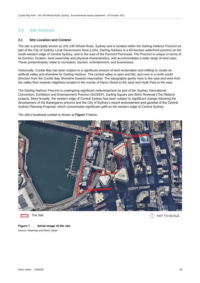
The site is principally known as 241-249 Wheat Road, Sydney and is located within the Darling Harbour Precinct as
part of the City of Sydney Local Government Area (LGA). Darling Harbour is a 60-hectare waterfront precinct on the
south-western edge of Central Sydney, and to the east of the Pyrmont Peninsula. The Precinct is unique in terms of
its function, location, land ownership and physical characteristics, and accommodates a wide range of land uses.
These predominately relate to recreation, tourism, entertainment, and businesses,
Historically, Cockle Bay has been subject to a significant amount of land reclamation and infilling to create an
artificial valley and shoreline for Darling Harbour. The central valley is open and flat, and runs in a north-south
direction from the Cockle Bay Shoreline towards Haymarket. The topography gently rises to the east and west from
the valley floor towards ridgelines located in the vicinity of Harris Street to the west and Hyde Park to the east.
The Darling Harbour Precinct is undergoing significant redevelopment as part of the Sydney International
Convention, Exhibition and Entertainment Precinct (SICEEP), Darling Square and IMAX Renewal (The Ribbon)
projects. More broadly, the western edge of Central Sydney has been subject to significant change following the
development of the Barangaroo precinct and the City of Sydney’s recent endorsement and gazettal of the Central
Sydney Planning Proposal, which concentrates significant uplift on the western edge of Central Sydney.
The site’s locational context is shown at Figure 7 below.
Figure 7 Aerial image of the site
Source: Nearmap and Ethos Urban
The Site
Cockle Bay Park - 241-249 Wheat Road, Sydney | Environmental Impact Statement | 15 October 2021
Ethos Urban | 2200220 26
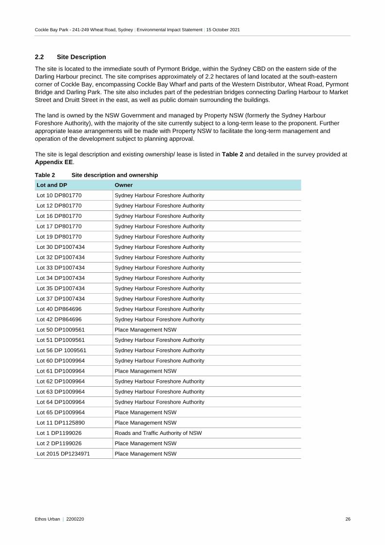
2.2 Site Description
The site is located to the immediate south of Pyrmont Bridge, within the Sydney CBD on the eastern side of the
Darling Harbour precinct. The site comprises approximately of 2.2 hectares of land located at the south-eastern
corner of Cockle Bay, encompassing Cockle Bay Wharf and parts of the Western Distributor, Wheat Road, Pyrmont
Bridge and Darling Park. The site also includes part of the pedestrian bridges connecting Darling Harbour to Market
Street and Druitt Street in the east, as well as public domain surrounding the buildings.
The land is owned by the NSW Government and managed by Property NSW (formerly the Sydney Harbour
Foreshore Authority), with the majority of the site currently subject to a long-term lease to the proponent. Further
appropriate lease arrangements will be made with Property NSW to facilitate the long-term management and
operation of the development subject to planning approval.
The site is legal description and existing ownership/ lease is listed in Table 2 and detailed in the survey provided at
Appendix EE.
Table 2 Site description and ownership
Lot and DP Owner
Lot 10 DP801770 Sydney Harbour Foreshore Authority
Lot 12 DP801770 Sydney Harbour Foreshore Authority
Lot 16 DP801770 Sydney Harbour Foreshore Authority
Lot 17 DP801770 Sydney Harbour Foreshore Authority
Lot 19 DP801770 Sydney Harbour Foreshore Authority
Lot 30 DP1007434 Sydney Harbour Foreshore Authority
Lot 32 DP1007434 Sydney Harbour Foreshore Authority
Lot 33 DP1007434 Sydney Harbour Foreshore Authority
Lot 34 DP1007434 Sydney Harbour Foreshore Authority
Lot 35 DP1007434 Sydney Harbour Foreshore Authority
Lot 37 DP1007434 Sydney Harbour Foreshore Authority
Lot 40 DP864696 Sydney Harbour Foreshore Authority
Lot 42 DP864696 Sydney Harbour Foreshore Authority
Lot 50 DP1009561 Place Management NSW
Lot 51 DP1009561 Sydney Harbour Foreshore Authority
Lot 56 DP 1009561 Sydney Harbour Foreshore Authority
Lot 60 DP1009964 Sydney Harbour Foreshore Authority
Lot 61 DP1009964 Place Management NSW
Lot 62 DP1009964 Sydney Harbour Foreshore Authority
Lot 63 DP1009964 Sydney Harbour Foreshore Authority
Lot 64 DP1009964 Sydney Harbour Foreshore Authority
Lot 65 DP1009964 Place Management NSW
Lot 11 DP1125890 Place Management NSW
Lot 1 DP1199026 Roads and Traffic Authority of NSW
Lot 2 DP1199026 Place Management NSW
Lot 2015 DP1234971 Place Management NSW
Cockle Bay Park - 241-249 Wheat Road, Sydney | Environmental Impact Statement | 15 October 2021
Ethos Urban | 2200220 27
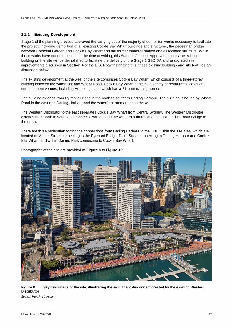
2.2.1 Existing Development
Stage 1 of the planning process approved the carrying out of the majority of demolition works necessary to facilitate
the project, including demolition of all existing Cockle Bay Wharf buildings and structures, the pedestrian bridge
between Crescent Garden and Cockle Bay Wharf and the former monorail station and associated structure. While
these works have not commenced at the time of writing, this Stage 1 Concept Approval ensures the existing
building on the site will be demolished to facilitate the delivery of the Stage 2 SSD DA and associated site
improvements discussed in Section 4 of the EIS. Notwithstanding this, these existing buildings and site features are
discussed below.
The existing development at the west of the site comprises Cockle Bay Wharf, which consists of a three-storey
building between the waterfront and Wheat Road. Cockle Bay Wharf contains a variety of restaurants, cafes and
entertainment venues, including Home nightclub which has a 24-hour trading license.
The building extends from Pyrmont Bridge in the north to southern Darling Harbour. The building is bound by Wheat
Road in the east and Darling Harbour and the waterfront promenade in the west.
The Western Distributor to the east separates Cockle Bay Wharf from Central Sydney. The Western Distributor
extends from north to south and connects Pyrmont and the western suburbs and the CBD and Harbour Bridge to
the north.
There are three pedestrian footbridge connections from Darling Harbour to the CBD within the site area, which are
located at Market Street connecting to the Pyrmont Bridge, Druitt Street connecting to Darling Harbour and Cockle
Bay Wharf, and within Darling Park connecting to Cockle Bay Wharf.
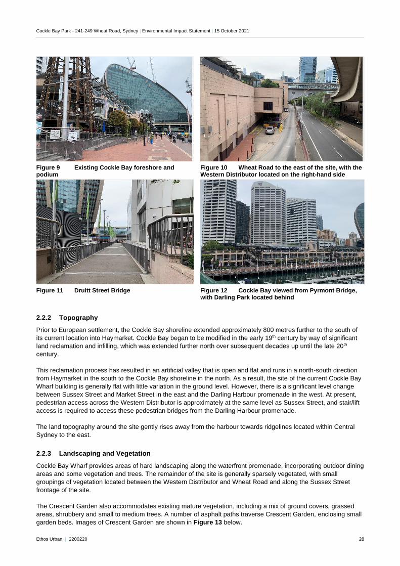
Photographs of the site are provided at Figure 8 to Figure 12.
Figure 8 Skyview image of the site, illustrating the significant disconnect created by the existing Western Distributor
Source: Henning Larsen
Cockle Bay Park - 241-249 Wheat Road, Sydney | Environmental Impact Statement | 15 October 2021
Ethos Urban | 2200220 28
Figure 9 Existing Cockle Bay foreshore and podium
Figure 10 Wheat Road to the east of the site, with the Western Distributor located on the right-hand side
Figure 11 Druitt Street Bridge Figure 12 Cockle Bay viewed from Pyrmont Bridge,
with Darling Park located behind
2.2.2 Topography
Prior to European settlement, the Cockle Bay shoreline extended approximately 800 metres further to the south of
its current location into Haymarket. Cockle Bay began to be modified in the early 19th century by way of significant
land reclamation and infilling, which was extended further north over subsequent decades up until the late 20th
century.
This reclamation process has resulted in an artificial valley that is open and flat and runs in a north-south direction
from Haymarket in the south to the Cockle Bay shoreline in the north. As a result, the site of the current Cockle Bay
Wharf building is generally flat with little variation in the ground level. However, there is a significant level change
between Sussex Street and Market Street in the east and the Darling Harbour promenade in the west. At present,
pedestrian access across the Western Distributor is approximately at the same level as Sussex Street, and stair/lift
access is required to access these pedestrian bridges from the Darling Harbour promenade.
The land topography around the site gently rises away from the harbour towards ridgelines located within Central
Sydney to the east.
2.2.3 Landscaping and Vegetation
Cockle Bay Wharf provides areas of hard landscaping along the waterfront promenade, incorporating outdoor dining
areas and some vegetation and trees. The remainder of the site is generally sparsely vegetated, with small
groupings of vegetation located between the Western Distributor and Wheat Road and along the Sussex Street
frontage of the site.
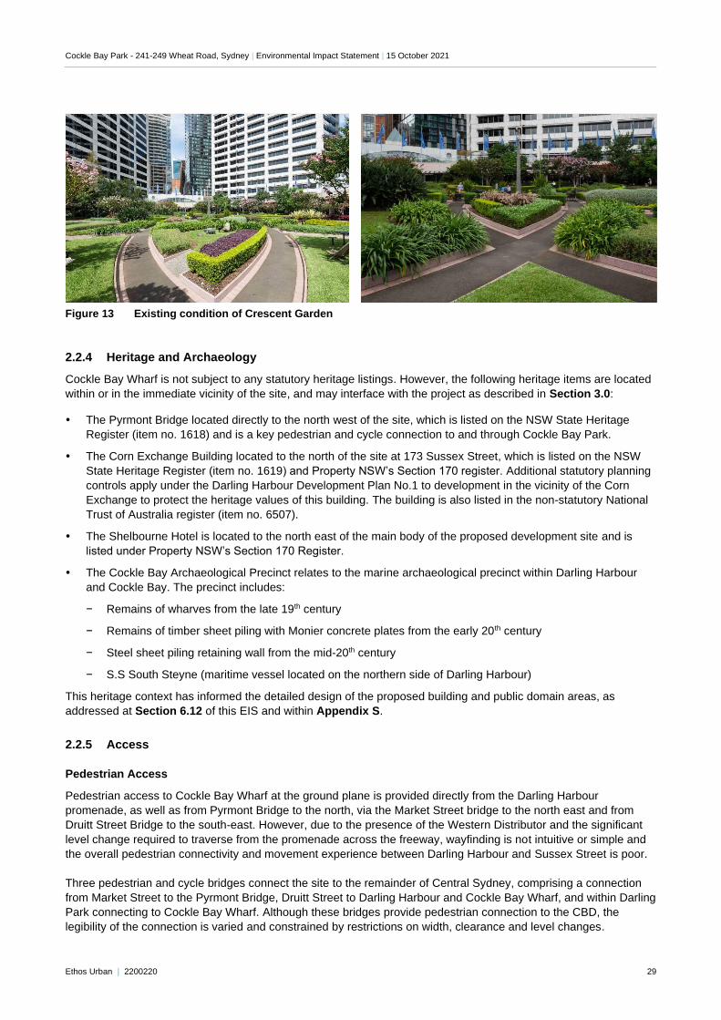
The Crescent Garden also accommodates existing mature vegetation, including a mix of ground covers, grassed
areas, shrubbery and small to medium trees. A number of asphalt paths traverse Crescent Garden, enclosing small
garden beds. Images of Crescent Garden are shown in Figure 13 below.
Cockle Bay Park - 241-249 Wheat Road, Sydney | Environmental Impact Statement | 15 October 2021
Ethos Urban | 2200220 29
"Double click to insert picture"
Figure 13 Existing condition of Crescent Garden
2.2.4 Heritage and Archaeology
Cockle Bay Wharf is not subject to any statutory heritage listings. However, the following heritage items are located
within or in the immediate vicinity of the site, and may interface with the project as described in Section 3.0:
The Pyrmont Bridge located directly to the north west of the site, which is listed on the NSW State Heritage
Register (item no. 1618) and is a key pedestrian and cycle connection to and through Cockle Bay Park.
The Corn Exchange Building located to the north of the site at 173 Sussex Street, which is listed on the NSW
State Heritage Register (item no. 1619) and Property NSW’s Section 170 register. Additional statutory planning
controls apply under the Darling Harbour Development Plan No.1 to development in the vicinity of the Corn
Exchange to protect the heritage values of this building. The building is also listed in the non-statutory National
Trust of Australia register (item no. 6507).
The Shelbourne Hotel is located to the north east of the main body of the proposed development site and is
listed under Property NSW’s Section 170 Register.
The Cockle Bay Archaeological Precinct relates to the marine archaeological precinct within Darling Harbour
and Cockle Bay. The precinct includes:
− Remains of wharves from the late 19th century
− Remains of timber sheet piling with Monier concrete plates from the early 20th century
− Steel sheet piling retaining wall from the mid-20th century
− S.S South Steyne (maritime vessel located on the northern side of Darling Harbour)
This heritage context has informed the detailed design of the proposed building and public domain areas, as
addressed at Section 6.12 of this EIS and within Appendix S.
2.2.5 Access
Pedestrian Access
Pedestrian access to Cockle Bay Wharf at the ground plane is provided directly from the Darling Harbour
promenade, as well as from Pyrmont Bridge to the north, via the Market Street bridge to the north east and from
Druitt Street Bridge to the south-east. However, due to the presence of the Western Distributor and the significant
level change required to traverse from the promenade across the freeway, wayfinding is not intuitive or simple and
the overall pedestrian connectivity and movement experience between Darling Harbour and Sussex Street is poor.
Three pedestrian and cycle bridges connect the site to the remainder of Central Sydney, comprising a connection
from Market Street to the Pyrmont Bridge, Druitt Street to Darling Harbour and Cockle Bay Wharf, and within Darling
Park connecting to Cockle Bay Wharf. Although these bridges provide pedestrian connection to the CBD, the
legibility of the connection is varied and constrained by restrictions on width, clearance and level changes.
Cockle Bay Park - 241-249 Wheat Road, Sydney | Environmental Impact Statement | 15 October 2021
Ethos Urban | 2200220 30
The promenade at the western frontage of the site provides uninterrupted pedestrian access between Barangaroo
and Pyrmont, connecting all Darling Harbour precinct attractions including Tumbalong Park, SICEEP and Darling
Square to the south.
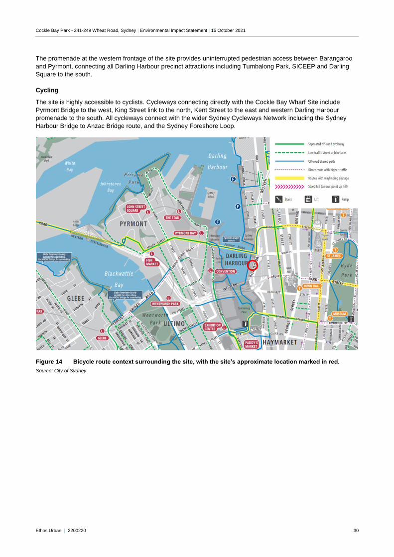
Cycling
The site is highly accessible to cyclists. Cycleways connecting directly with the Cockle Bay Wharf Site include
Pyrmont Bridge to the west, King Street link to the north, Kent Street to the east and western Darling Harbour
promenade to the south. All cycleways connect with the wider Sydney Cycleways Network including the Sydney
Harbour Bridge to Anzac Bridge route, and the Sydney Foreshore Loop.
Figure 14 Bicycle route context surrounding the site, with the site’s approximate location marked in red.
Source: City of Sydney
Cockle Bay Park - 241-249 Wheat Road, Sydney | Environmental Impact Statement | 15 October 2021
Ethos Urban | 2200220 31
Public transport
Being located on the western edge of the Sydney CBD, the site benefits from a range of existing and planned
transport options.
Rail – The site has good rail connectivity, being located approximately 350m to the northwest of Town Hall
Station, 650m to the south-west of Wynyard Station, and 1.1km to the north-west of Central Station. Town Hall
Station is a key station in the Sydney Trains network with excellent connectivity to the wider network.
Metro – The Sydney Metro City and Southwest and West lines will also pass through the CBD with stations in
close proximity of the site at Pitt Street (900m to the east) and Hunter Street (1.2km to the north east) within the
CBD and at the new Pyrmont Station (550m to the west). These approved and proposed stations provide high-
speed connections to Sydney’s north west, under Sydney Harbour, to Sydney’s south-west to Bankstown, to
Westmead through Parramatta and Sydney Olympic Park, and to Greater Western Sydney and the new
Western Sydney International Airport.
Light Rail – Light Rail runs from Central Station to Dulwich Hill via Darling Harbour, The Star Casino,
Wentworth Park, Glebe and Rozelle. The closest Light Rail stop from the site is at the Convention Centre,
approximately 450m south west of the site. A Light Rail route connecting Circular Quay with Sydney‟s south
east has been recently completed, and travels along George Street, situated approximately 400m east of
Cockle Bay Wharf.
Ferry – the site is situated approximately 500m south-east of the Pyrmont Bay Ferry Wharf, 400m south of the
King Street Ferry Wharf and approximately 700 metres from Barangaroo Ferry Wharf. Ferries from these
locations connect the site with key locations, including Circular Quay, Milsons Point, and Parramatta. Ferries
also connect the site with a variety of tourist and visitor attractions located around Sydney Harbour.
Bus – the are multiple bus services in the vicinity of the site. The closest bus stop is located at Druitt Street,
near Sussex Street, approximately 5 minutes walk from the site. The stop provides connections to destinations
across Sydney including Parramatta, Ryde, Coogee, Macquarie Park and the CBD. A major bus terminal is
located at Railway Square 1.1km to the south.
Vehicular Access
The key roads that provide access to the site include:
Wheat Road – a local road (included within the site title) connecting Cockle Bay with the King Street Wharf area
with Haymarket operating in one direction (north).
Harbour Street – classified as a State Road and aligned in a north south direction that provides connection to
Wheat Road from Haymarket and southern Central Sydney.
The connected Darling Park precinct has a direct street frontage to Sussex Street, with servicing/loading via Slip
Street.
2.2.6 Soil and Geotechnical Conditions
The majority of the site is located on reclaimed land and as such the bedrock beneath the site falls away sharply to
the west, reflecting the original shoreline. The eastern end of the site that fronts Market Street is located within land
that is outside of the original shoreline of Cockle Bay.
The Sydney 1:100 000 scale geology map indicates quaternary alluvium of Holocene age infilling the Cockle Bay
channel underlain by Hawkesbury Sandstone bedrock. The alluvium is described as silty to peaty sand, silt and clay
with ferruginous and humic cementation in places and common shell layers.
These river sediments and back swamp deposits would be expected to have been deposited predominantly in a
north south direction, consistent with the shape of the bay. The underlying sandstone bedrock is described as
medium to very coarse-grained quartz sandstone, with very minor shale and laminate lenses.
2.3 Surrounding Development
The site's location on the eastern perimeter of Darling Harbour is characterised as a busy and important tourist and
commercial area. In its immediate context, Cockle Bay Park is surrounded by commercial, tourist and residential
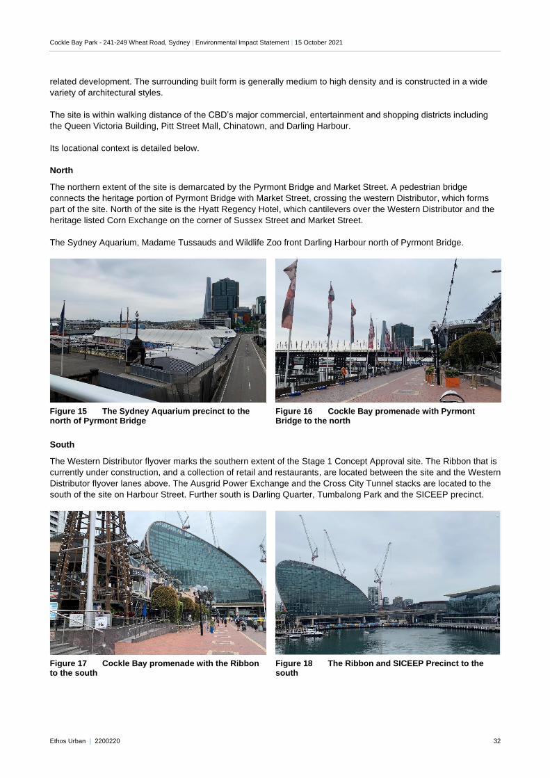
Cockle Bay Park - 241-249 Wheat Road, Sydney | Environmental Impact Statement | 15 October 2021
Ethos Urban | 2200220 32
related development. The surrounding built form is generally medium to high density and is constructed in a wide
variety of architectural styles.
The site is within walking distance of the CBD’s major commercial, entertainment and shopping districts including
the Queen Victoria Building, Pitt Street Mall, Chinatown, and Darling Harbour.
Its locational context is detailed below.
North
The northern extent of the site is demarcated by the Pyrmont Bridge and Market Street. A pedestrian bridge
connects the heritage portion of Pyrmont Bridge with Market Street, crossing the western Distributor, which forms
part of the site. North of the site is the Hyatt Regency Hotel, which cantilevers over the Western Distributor and the
heritage listed Corn Exchange on the corner of Sussex Street and Market Street.
The Sydney Aquarium, Madame Tussauds and Wildlife Zoo front Darling Harbour north of Pyrmont Bridge.
Figure 15 The Sydney Aquarium precinct to the north of Pyrmont Bridge
Figure 16 Cockle Bay promenade with Pyrmont Bridge to the north
South
The Western Distributor flyover marks the southern extent of the Stage 1 Concept Approval site. The Ribbon that is
currently under construction, and a collection of retail and restaurants, are located between the site and the Western
Distributor flyover lanes above. The Ausgrid Power Exchange and the Cross City Tunnel stacks are located to the
south of the site on Harbour Street. Further south is Darling Quarter, Tumbalong Park and the SICEEP precinct.
Figure 17 Cockle Bay promenade with the Ribbon to the south
Figure 18 The Ribbon and SICEEP Precinct to the south
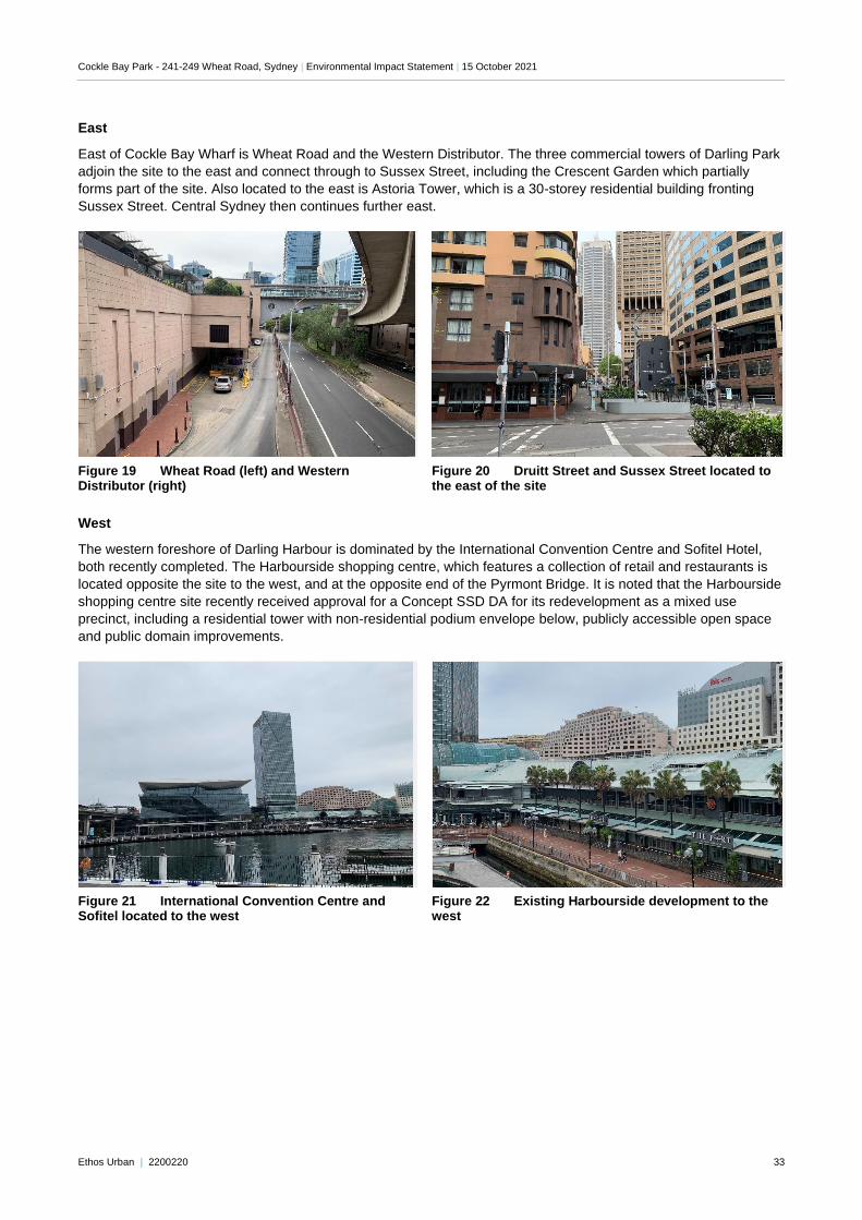
Cockle Bay Park - 241-249 Wheat Road, Sydney | Environmental Impact Statement | 15 October 2021
Ethos Urban | 2200220 33
East
East of Cockle Bay Wharf is Wheat Road and the Western Distributor. The three commercial towers of Darling Park
adjoin the site to the east and connect through to Sussex Street, including the Crescent Garden which partially
forms part of the site. Also located to the east is Astoria Tower, which is a 30-storey residential building fronting
Sussex Street. Central Sydney then continues further east.
Figure 19 Wheat Road (left) and Western Distributor (right)
Figure 20 Druitt Street and Sussex Street located to the east of the site
West
The western foreshore of Darling Harbour is dominated by the International Convention Centre and Sofitel Hotel,
both recently completed. The Harbourside shopping centre, which features a collection of retail and restaurants is
located opposite the site to the west, and at the opposite end of the Pyrmont Bridge. It is noted that the Harbourside
shopping centre site recently received approval for a Concept SSD DA for its redevelopment as a mixed use
precinct, including a residential tower with non-residential podium envelope below, publicly accessible open space
and public domain improvements.
Figure 21 International Convention Centre and Sofitel located to the west
Figure 22 Existing Harbourside development to the west
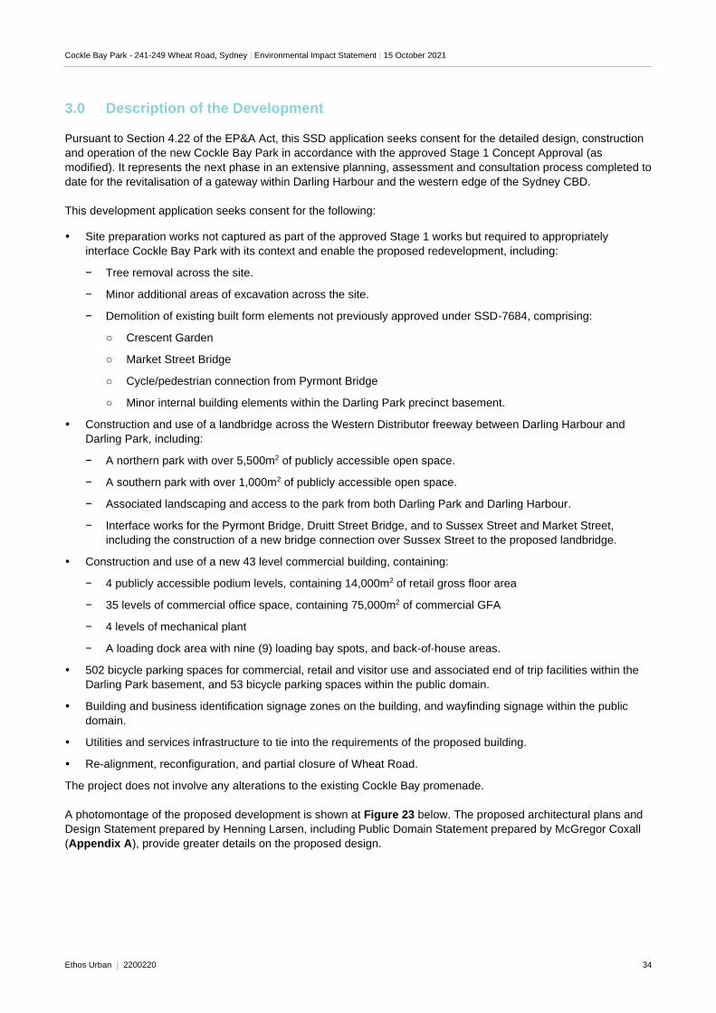
Cockle Bay Park - 241-249 Wheat Road, Sydney | Environmental Impact Statement | 15 October 2021
Ethos Urban | 2200220 34
3.0 Description of the Development
Pursuant to Section 4.22 of the EP&A Act, this SSD application seeks consent for the detailed design, construction
and operation of the new Cockle Bay Park in accordance with the approved Stage 1 Concept Approval (as
modified). It represents the next phase in an extensive planning, assessment and consultation process completed to
date for the revitalisation of a gateway within Darling Harbour and the western edge of the Sydney CBD.
This development application seeks consent for the following:
Site preparation works not captured as part of the approved Stage 1 works but required to appropriately
interface Cockle Bay Park with its context and enable the proposed redevelopment, including:
− Tree removal across the site.
− Minor additional areas of excavation across the site.
− Demolition of existing built form elements not previously approved under SSD-7684, comprising:
○ Crescent Garden
○ Market Street Bridge
○ Cycle/pedestrian connection from Pyrmont Bridge
○ Minor internal building elements within the Darling Park precinct basement.
Construction and use of a landbridge across the Western Distributor freeway between Darling Harbour and
Darling Park, including:
− A northern park with over 5,500m2 of publicly accessible open space.
− A southern park with over 1,000m2 of publicly accessible open space.
− Associated landscaping and access to the park from both Darling Park and Darling Harbour.
− Interface works for the Pyrmont Bridge, Druitt Street Bridge, and to Sussex Street and Market Street,
including the construction of a new bridge connection over Sussex Street to the proposed landbridge.
Construction and use of a new 43 level commercial building, containing:
− 4 publicly accessible podium levels, containing 14,000m2 of retail gross floor area
− 35 levels of commercial office space, containing 75,000m2 of commercial GFA
− 4 levels of mechanical plant
− A loading dock area with nine (9) loading bay spots, and back-of-house areas.
502 bicycle parking spaces for commercial, retail and visitor use and associated end of trip facilities within the
Darling Park basement, and 53 bicycle parking spaces within the public domain.
Building and business identification signage zones on the building, and wayfinding signage within the public
domain.
Utilities and services infrastructure to tie into the requirements of the proposed building.
Re-alignment, reconfiguration, and partial closure of Wheat Road.
The project does not involve any alterations to the existing Cockle Bay promenade.
A photomontage of the proposed development is shown at Figure 23 below. The proposed architectural plans and
Design Statement prepared by Henning Larsen, including Public Domain Statement prepared by McGregor Coxall
(Appendix A), provide greater details on the proposed design.
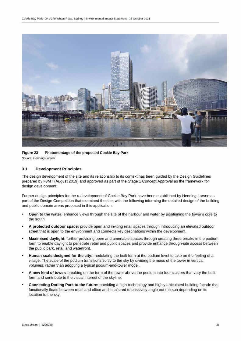
Cockle Bay Park - 241-249 Wheat Road, Sydney | Environmental Impact Statement | 15 October 2021
Ethos Urban | 2200220 35
Figure 23 Photomontage of the proposed Cockle Bay Park
Source: Henning Larsen
3.1 Development Principles
The design development of the site and its relationship to its context has been guided by the Design Guidelines
prepared by FJMT (August 2019) and approved as part of the Stage 1 Concept Approval as the framework for
design development.
Further design principles for the redevelopment of Cockle Bay Park have been established by Henning Larsen as
part of the Design Competition that examined the site, with the following informing the detailed design of the building
and public domain areas proposed in this application:
Open to the water: enhance views through the site of the harbour and water by positioning the tower’s core to
the south.
A protected outdoor space: provide open and inviting retail spaces through introducing an elevated outdoor
street that is open to the environment and connects key destinations within the development.
Maximised daylight: further providing open and amenable spaces through creating three breaks in the podium
form to enable daylight to penetrate retail and public spaces and provide enhance through-site access between
the public park, retail and waterfront.
Human scale designed for the city: modulating the built form at the podium level to take on the feeling of a
village. The scale of the podium transitions softly to the sky by dividing the mass of the tower in vertical
volumes, rather than adopting a typical podium-and-tower model.
A new kind of tower: breaking up the form of the tower above the podium into four clusters that vary the built
form and contribute to the visual interest of the skyline.
Connecting Darling Park to the future: providing a high-technology and highly articulated building façade that
functionally floats between retail and office and is tailored to passively angle out the sun depending on its
location to the sky.
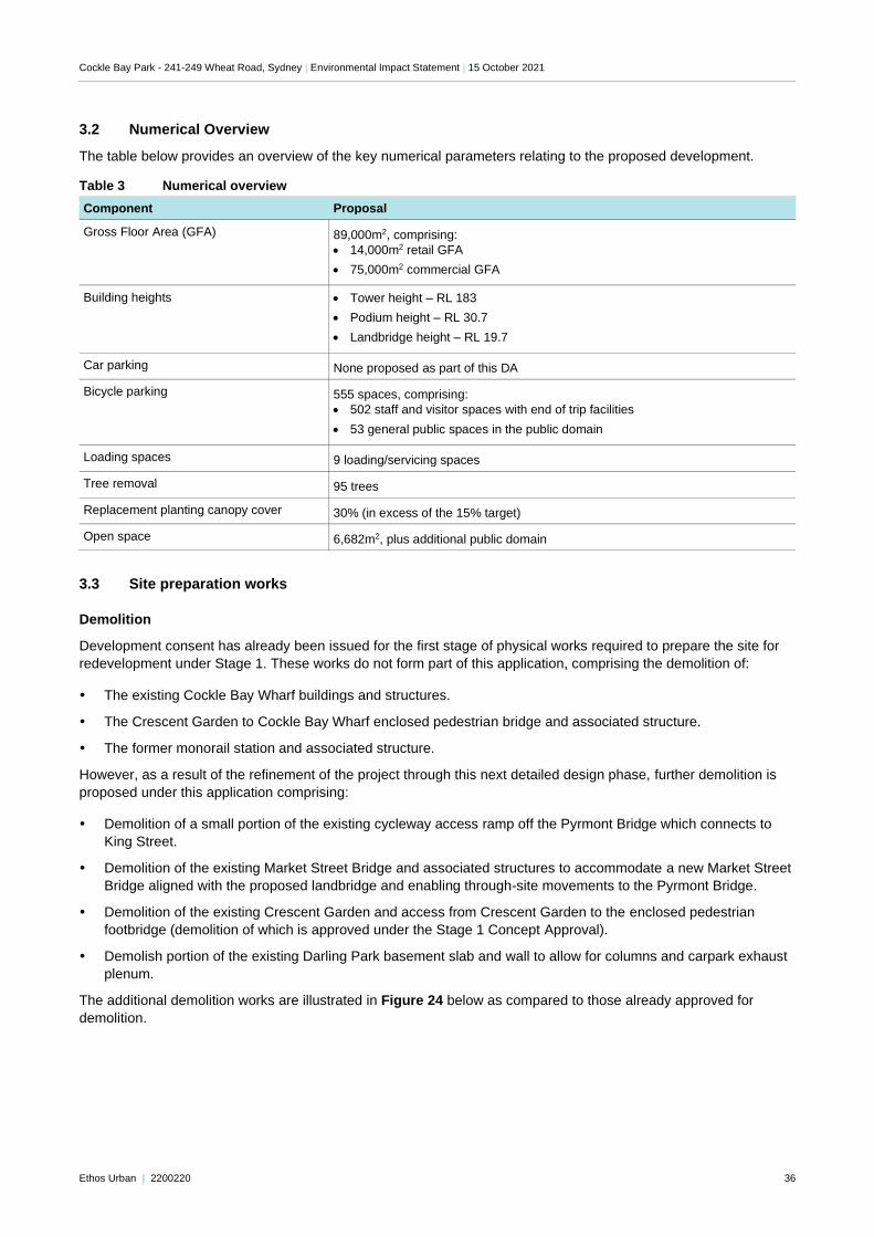
Cockle Bay Park - 241-249 Wheat Road, Sydney | Environmental Impact Statement | 15 October 2021
Ethos Urban | 2200220 36
3.2 Numerical Overview
The table below provides an overview of the key numerical parameters relating to the proposed development.
Table 3 Numerical overview
Component Proposal
Gross Floor Area (GFA) 89,000m2, comprising:
• 14,000m2 retail GFA
• 75,000m2 commercial GFA
Building heights • Tower height – RL 183
• Podium height – RL 30.7
• Landbridge height – RL 19.7
Car parking None proposed as part of this DA
Bicycle parking 555 spaces, comprising:
• 502 staff and visitor spaces with end of trip facilities
• 53 general public spaces in the public domain
Loading spaces 9 loading/servicing spaces
Tree removal 95 trees
Replacement planting canopy cover 30% (in excess of the 15% target)
Open space 6,682m2, plus additional public domain
3.3 Site preparation works
Demolition
Development consent has already been issued for the first stage of physical works required to prepare the site for
redevelopment under Stage 1. These works do not form part of this application, comprising the demolition of:
The existing Cockle Bay Wharf buildings and structures.
The Crescent Garden to Cockle Bay Wharf enclosed pedestrian bridge and associated structure.
The former monorail station and associated structure.
However, as a result of the refinement of the project through this next detailed design phase, further demolition is
proposed under this application comprising:
Demolition of a small portion of the existing cycleway access ramp off the Pyrmont Bridge which connects to
King Street.
Demolition of the existing Market Street Bridge and associated structures to accommodate a new Market Street
Bridge aligned with the proposed landbridge and enabling through-site movements to the Pyrmont Bridge.
Demolition of the existing Crescent Garden and access from Crescent Garden to the enclosed pedestrian
footbridge (demolition of which is approved under the Stage 1 Concept Approval).
Demolish portion of the existing Darling Park basement slab and wall to allow for columns and carpark exhaust
plenum.
The additional demolition works are illustrated in Figure 24 below as compared to those already approved for
demolition.
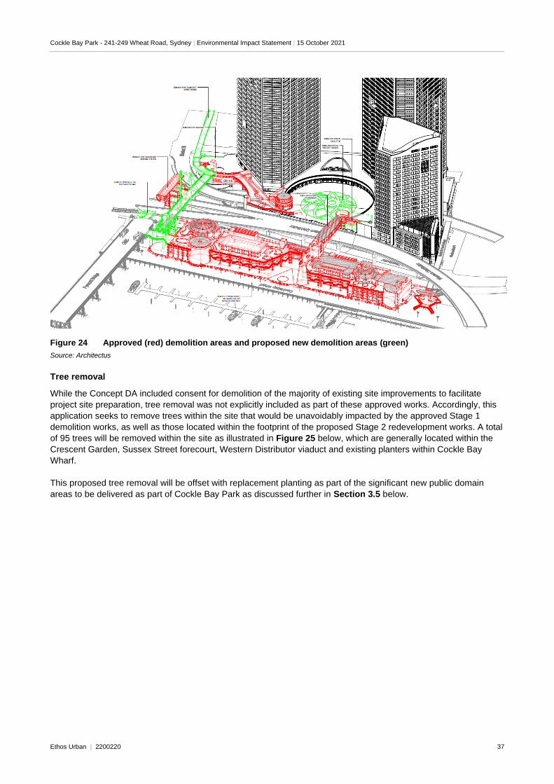
Cockle Bay Park - 241-249 Wheat Road, Sydney | Environmental Impact Statement | 15 October 2021
Ethos Urban | 2200220 37
Figure 24 Approved (red) demolition areas and proposed new demolition areas (green)
Source: Architectus
Tree removal
While the Concept DA included consent for demolition of the majority of existing site improvements to facilitate
project site preparation, tree removal was not explicitly included as part of these approved works. Accordingly, this
application seeks to remove trees within the site that would be unavoidably impacted by the approved Stage 1
demolition works, as well as those located within the footprint of the proposed Stage 2 redevelopment works. A total
of 95 trees will be removed within the site as illustrated in Figure 25 below, which are generally located within the
Crescent Garden, Sussex Street forecourt, Western Distributor viaduct and existing planters within Cockle Bay
Wharf.
This proposed tree removal will be offset with replacement planting as part of the significant new public domain
areas to be delivered as part of Cockle Bay Park as discussed further in Section 3.5 below.
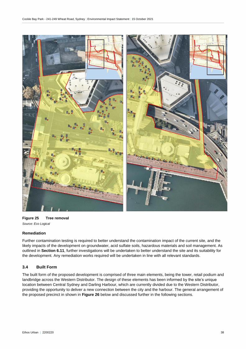
Cockle Bay Park - 241-249 Wheat Road, Sydney | Environmental Impact Statement | 15 October 2021
Ethos Urban | 2200220 38
Figure 25 Tree removal
Source: Eco Logical
Remediation
Further contamination testing is required to better understand the contamination impact of the current site, and the
likely impacts of the development on groundwater, acid sulfate soils, hazardous materials and soil management. As
outlined in Section 6.11, further investigations will be undertaken to better understand the site and its suitability for
the development. Any remediation works required will be undertaken in line with all relevant standards.
3.4 Built Form
The built form of the proposed development is comprised of three main elements, being the tower, retail podium and
landbridge across the Western Distributor. The design of these elements has been informed by the site’s unique
location between Central Sydney and Darling Harbour, which are currently divided due to the Western Distributor,
providing the opportunity to deliver a new connection between the city and the harbour. The general arrangement of
the proposed precinct in shown in Figure 26 below and discussed further in the following sections.
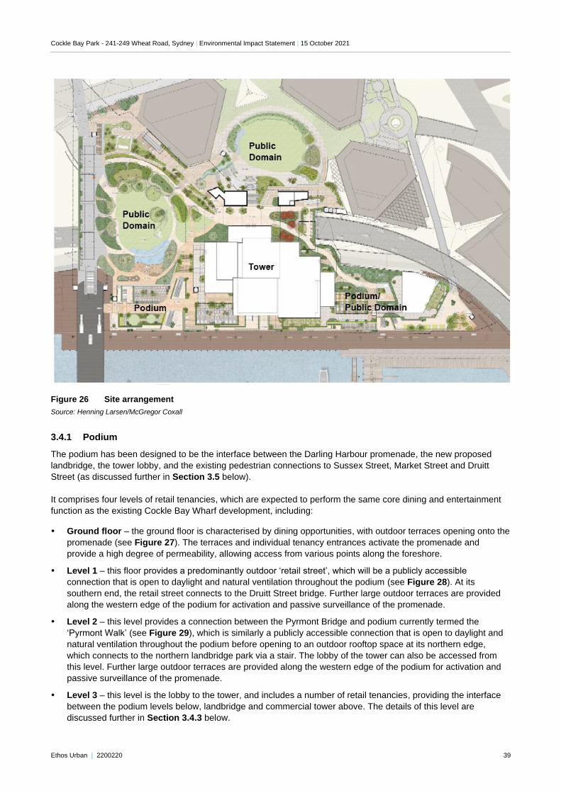
Cockle Bay Park - 241-249 Wheat Road, Sydney | Environmental Impact Statement | 15 October 2021
Ethos Urban | 2200220 39
Figure 26 Site arrangement
Source: Henning Larsen/McGregor Coxall
3.4.1 Podium
The podium has been designed to be the interface between the Darling Harbour promenade, the new proposed
landbridge, the tower lobby, and the existing pedestrian connections to Sussex Street, Market Street and Druitt
Street (as discussed further in Section 3.5 below).
It comprises four levels of retail tenancies, which are expected to perform the same core dining and entertainment
function as the existing Cockle Bay Wharf development, including:
Ground floor – the ground floor is characterised by dining opportunities, with outdoor terraces opening onto the
promenade (see Figure 27). The terraces and individual tenancy entrances activate the promenade and
provide a high degree of permeability, allowing access from various points along the foreshore.
Level 1 – this floor provides a predominantly outdoor ‘retail street’, which will be a publicly accessible
connection that is open to daylight and natural ventilation throughout the podium (see Figure 28). At its
southern end, the retail street connects to the Druitt Street bridge. Further large outdoor terraces are provided
along the western edge of the podium for activation and passive surveillance of the promenade.
Level 2 – this level provides a connection between the Pyrmont Bridge and podium currently termed the
‘Pyrmont Walk’ (see Figure 29), which is similarly a publicly accessible connection that is open to daylight and
natural ventilation throughout the podium before opening to an outdoor rooftop space at its northern edge,
which connects to the northern landbridge park via a stair. The lobby of the tower can also be accessed from
this level. Further large outdoor terraces are provided along the western edge of the podium for activation and
passive surveillance of the promenade.
Level 3 – this level is the lobby to the tower, and includes a number of retail tenancies, providing the interface
between the podium levels below, landbridge and commercial tower above. The details of this level are
discussed further in Section 3.4.3 below.
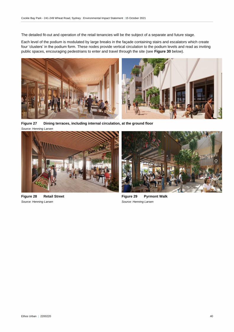
Cockle Bay Park - 241-249 Wheat Road, Sydney | Environmental Impact Statement | 15 October 2021
Ethos Urban | 2200220 40
The detailed fit-out and operation of the retail tenancies will be the subject of a separate and future stage.
Each level of the podium is modulated by large breaks in the façade containing stairs and escalators which create
four ‘clusters’ in the podium form. These nodes provide vertical circulation to the podium levels and read as inviting
public spaces, encouraging pedestrians to enter and travel through the site (see Figure 30 below).
Figure 27 Dining terraces, including internal circulation, at the ground floor
Source: Henning Larsen
Figure 28 Retail Street
Source: Henning Larsen
Figure 29 Pyrmont Walk
Source: Henning Larsen
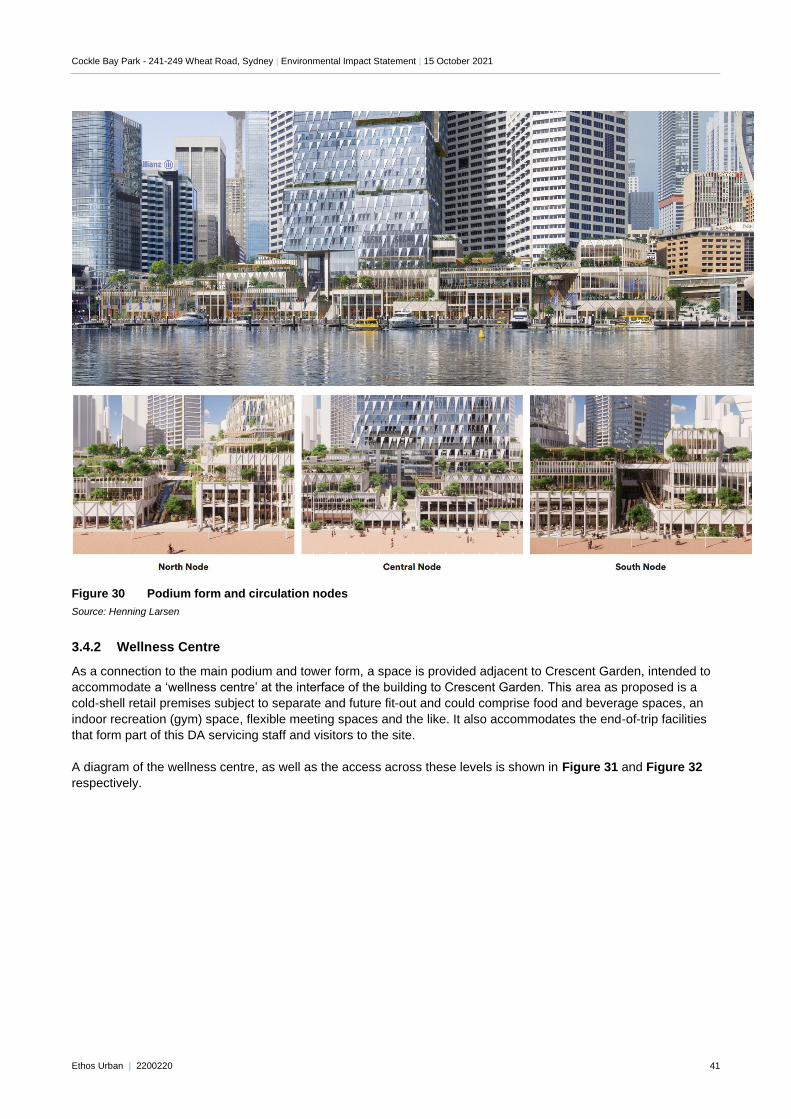
Cockle Bay Park - 241-249 Wheat Road, Sydney | Environmental Impact Statement | 15 October 2021
Ethos Urban | 2200220 41
Figure 30 Podium form and circulation nodes
Source: Henning Larsen
3.4.2 Wellness Centre
As a connection to the main podium and tower form, a space is provided adjacent to Crescent Garden, intended to
accommodate a ‘wellness centre’ at the interface of the building to Crescent Garden. This area as proposed is a
cold-shell retail premises subject to separate and future fit-out and could comprise food and beverage spaces, an
indoor recreation (gym) space, flexible meeting spaces and the like. It also accommodates the end-of-trip facilities
that form part of this DA servicing staff and visitors to the site.
A diagram of the wellness centre, as well as the access across these levels is shown in Figure 31 and Figure 32
respectively.
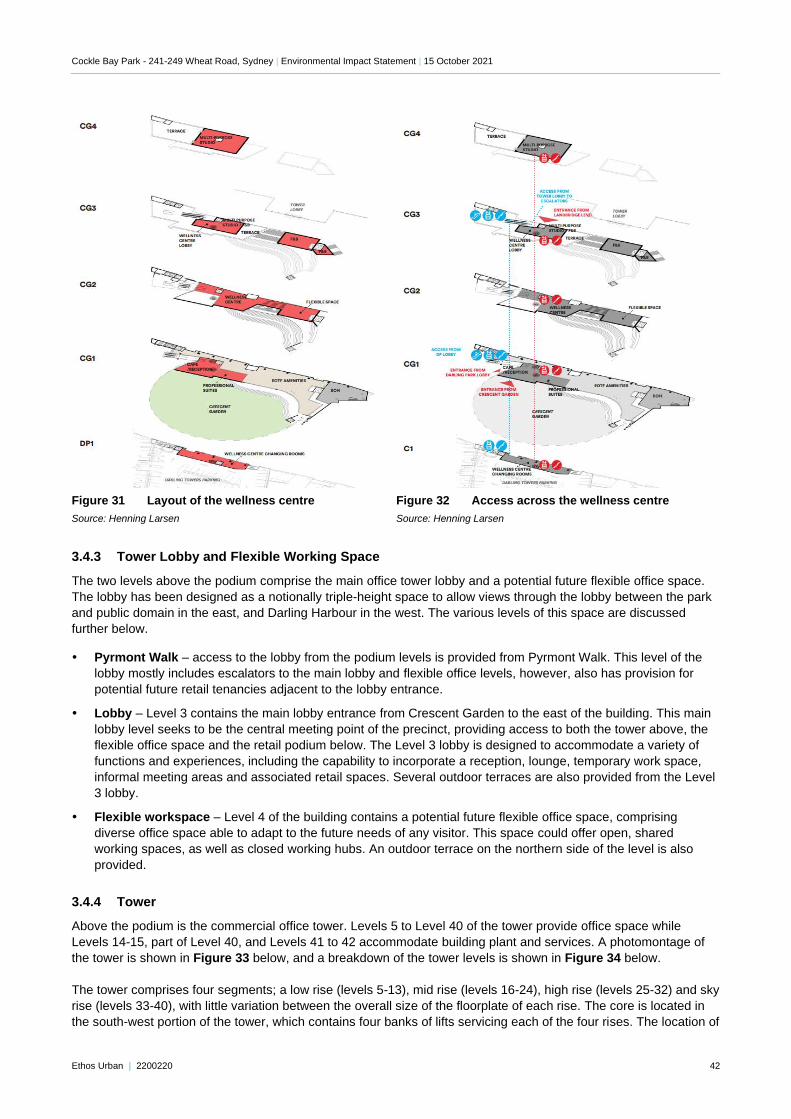
Cockle Bay Park - 241-249 Wheat Road, Sydney | Environmental Impact Statement | 15 October 2021
Ethos Urban | 2200220 42
Figure 31 Layout of the wellness centre
Source: Henning Larsen
Figure 32 Access across the wellness centre
Source: Henning Larsen
3.4.3 Tower Lobby and Flexible Working Space
The two levels above the podium comprise the main office tower lobby and a potential future flexible office space.
The lobby has been designed as a notionally triple-height space to allow views through the lobby between the park
and public domain in the east, and Darling Harbour in the west. The various levels of this space are discussed
further below.
Pyrmont Walk – access to the lobby from the podium levels is provided from Pyrmont Walk. This level of the
lobby mostly includes escalators to the main lobby and flexible office levels, however, also has provision for
potential future retail tenancies adjacent to the lobby entrance.
Lobby – Level 3 contains the main lobby entrance from Crescent Garden to the east of the building. This main
lobby level seeks to be the central meeting point of the precinct, providing access to both the tower above, the
flexible office space and the retail podium below. The Level 3 lobby is designed to accommodate a variety of
functions and experiences, including the capability to incorporate a reception, lounge, temporary work space,
informal meeting areas and associated retail spaces. Several outdoor terraces are also provided from the Level
3 lobby.
Flexible workspace – Level 4 of the building contains a potential future flexible office space, comprising
diverse office space able to adapt to the future needs of any visitor. This space could offer open, shared
working spaces, as well as closed working hubs. An outdoor terrace on the northern side of the level is also
provided.
3.4.4 Tower
Above the podium is the commercial office tower. Levels 5 to Level 40 of the tower provide office space while
Levels 14-15, part of Level 40, and Levels 41 to 42 accommodate building plant and services. A photomontage of
the tower is shown in Figure 33 below, and a breakdown of the tower levels is shown in Figure 34 below.
The tower comprises four segments; a low rise (levels 5-13), mid rise (levels 16-24), high rise (levels 25-32) and sky
rise (levels 33-40), with little variation between the overall size of the floorplate of each rise. The core is located in
the south-west portion of the tower, which contains four banks of lifts servicing each of the four rises. The location of
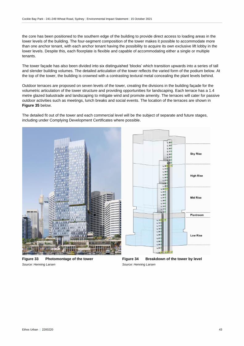
Cockle Bay Park - 241-249 Wheat Road, Sydney | Environmental Impact Statement | 15 October 2021
Ethos Urban | 2200220 43
the core has been positioned to the southern edge of the building to provide direct access to loading areas in the
lower levels of the building. The four-segment composition of the tower makes it possible to accommodate more
than one anchor tenant, with each anchor tenant having the possibility to acquire its own exclusive lift lobby in the
lower levels. Despite this, each floorplate is flexible and capable of accommodating either a single or multiple
tenants.
The tower façade has also been divided into six distinguished ‘blocks’ which transition upwards into a series of tall
and slender building volumes. The detailed articulation of the tower reflects the varied form of the podium below. At
the top of the tower, the building is crowned with a contrasting textural metal concealing the plant levels behind.
Outdoor terraces are proposed on seven levels of the tower, creating the divisions in the building façade for the
volumetric articulation of the tower structure and providing opportunities for landscaping. Each terrace has a 1.4
metre glazed balustrade and landscaping to mitigate wind and promote amenity. The terraces will cater for passive
outdoor activities such as meetings, lunch breaks and social events. The location of the terraces are shown in
Figure 35 below.
The detailed fit out of the tower and each commercial level will be the subject of separate and future stages,
including under Complying Development Certificates where possible.
Figure 33 Photomontage of the tower
Source: Henning Larsen
Figure 34 Breakdown of the tower by level
Source: Henning Larsen
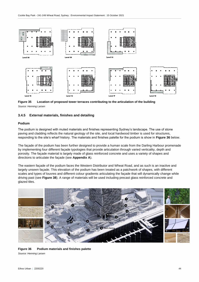
Cockle Bay Park - 241-249 Wheat Road, Sydney | Environmental Impact Statement | 15 October 2021
Ethos Urban | 2200220 44
Figure 35 Location of proposed tower terraces contributing to the articulation of the building
Source: Henning Larsen
3.4.5 External materials, finishes and detailing
Podium
The podium is designed with muted materials and finishes representing Sydney’s landscape. The use of stone
paving and cladding reflects the natural geology of the site, and local hardwood timber is used for structures,
responding to the site’s wharf history. The materials and finishes palette for the podium is show in Figure 36 below.
The façade of the podium has been further designed to provide a human scale from the Darling Harbour promenade
by implementing four different façade typologies that provide articulation through varied verticality, depth and
porosity. The façade material is largely made of glass reinforced concrete and uses a variety of shapes and
directions to articulate the façade (see Appendix A).
The eastern façade of the podium faces the Western Distributor and Wheat Road, and as such is an inactive and
largely unseen façade. This elevation of the podium has been treated as a patchwork of shapes, with different
scales and types of louvres and different colour gradients articulating the façade that will dynamically change while
driving past (see Figure 38). A range of materials will be used including precast glass reinforced concrete and
glazed tiles.
Figure 36 Podium materials and finishes palette
Source: Henning Larsen
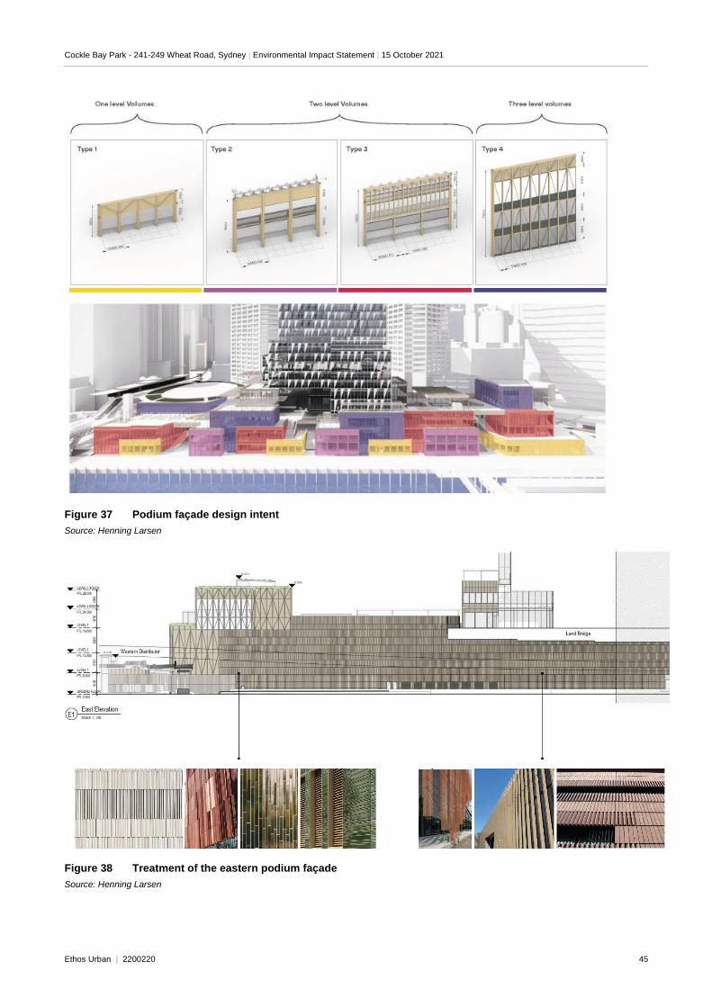
Cockle Bay Park - 241-249 Wheat Road, Sydney | Environmental Impact Statement | 15 October 2021
Ethos Urban | 2200220 45
Figure 37 Podium façade design intent
Source: Henning Larsen
Figure 38 Treatment of the eastern podium façade
Source: Henning Larsen
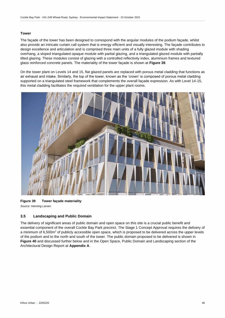
Cockle Bay Park - 241-249 Wheat Road, Sydney | Environmental Impact Statement | 15 October 2021
Ethos Urban | 2200220 46
Tower
The façade of the tower has been designed to correspond with the angular modules of the podium façade, whilst
also provide an intricate curtain call system that is energy efficient and visually interesting. The façade contributes to
design excellence and articulation and is comprised three main units of a fully glazed module with shading
overhang, a sloped triangulated opaque module with partial glazing, and a triangulated glazed module with partially
tilted glazing. These modules consist of glazing with a controlled reflectivity index, aluminium frames and textured
glass reinforced concrete panels. The materiality of the tower façade is shown at Figure 39.
On the tower plant on Levels 14 and 15, flat glazed panels are replaced with porous metal cladding that functions as
air exhaust and intake. Similarly, the top of the tower, known as the ‘crown’ is composed of porous metal cladding
supported on a triangulated steel framework that complements the overall façade expression. As with Level 14-15,
this metal cladding facilitates the required ventilation for the upper plant rooms.
Figure 39 Tower façade materiality
Source: Henning Larsen
3.5 Landscaping and Public Domain
The delivery of significant areas of public domain and open space on this site is a crucial public benefit and
essential component of the overall Cockle Bay Park precinct. The Stage 1 Concept Approval requires the delivery of
a minimum of 6,500m2 of publicly accessible open space, which is proposed to be delivered across the upper levels
of the podium and to the north and south of the tower. The public domain proposed to be delivered is shown in
Figure 40 and discussed further below and in the Open Space, Public Domain and Landscaping section of the
Architectural Design Report at Appendix A.
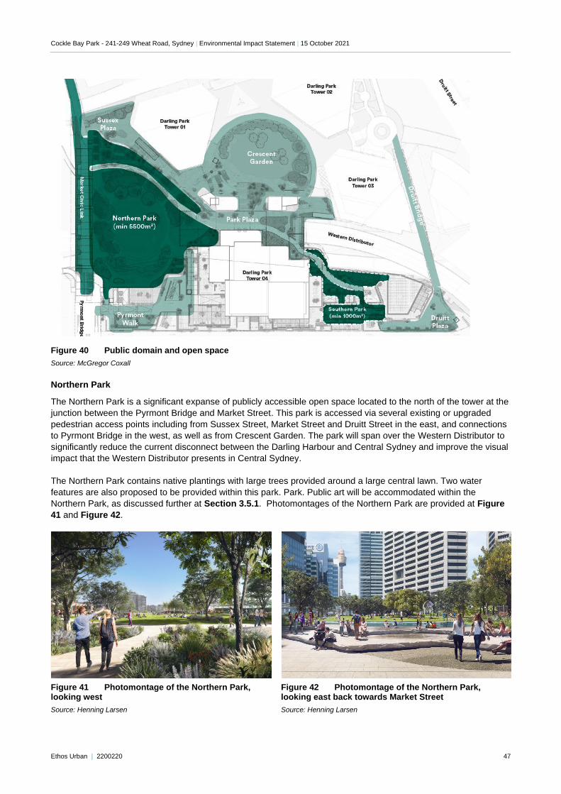
Cockle Bay Park - 241-249 Wheat Road, Sydney | Environmental Impact Statement | 15 October 2021
Ethos Urban | 2200220 47
Figure 40 Public domain and open space
Source: McGregor Coxall
Northern Park
The Northern Park is a significant expanse of publicly accessible open space located to the north of the tower at the
junction between the Pyrmont Bridge and Market Street. This park is accessed via several existing or upgraded
pedestrian access points including from Sussex Street, Market Street and Druitt Street in the east, and connections
to Pyrmont Bridge in the west, as well as from Crescent Garden. The park will span over the Western Distributor to
significantly reduce the current disconnect between the Darling Harbour and Central Sydney and improve the visual
impact that the Western Distributor presents in Central Sydney.
The Northern Park contains native plantings with large trees provided around a large central lawn. Two water
features are also proposed to be provided within this park. Park. Public art will be accommodated within the
Northern Park, as discussed further at Section 3.5.1. Photomontages of the Northern Park are provided at Figure
41 and Figure 42.
Figure 41 Photomontage of the Northern Park, looking west
Source: Henning Larsen
Figure 42 Photomontage of the Northern Park, looking east back towards Market Street
Source: Henning Larsen
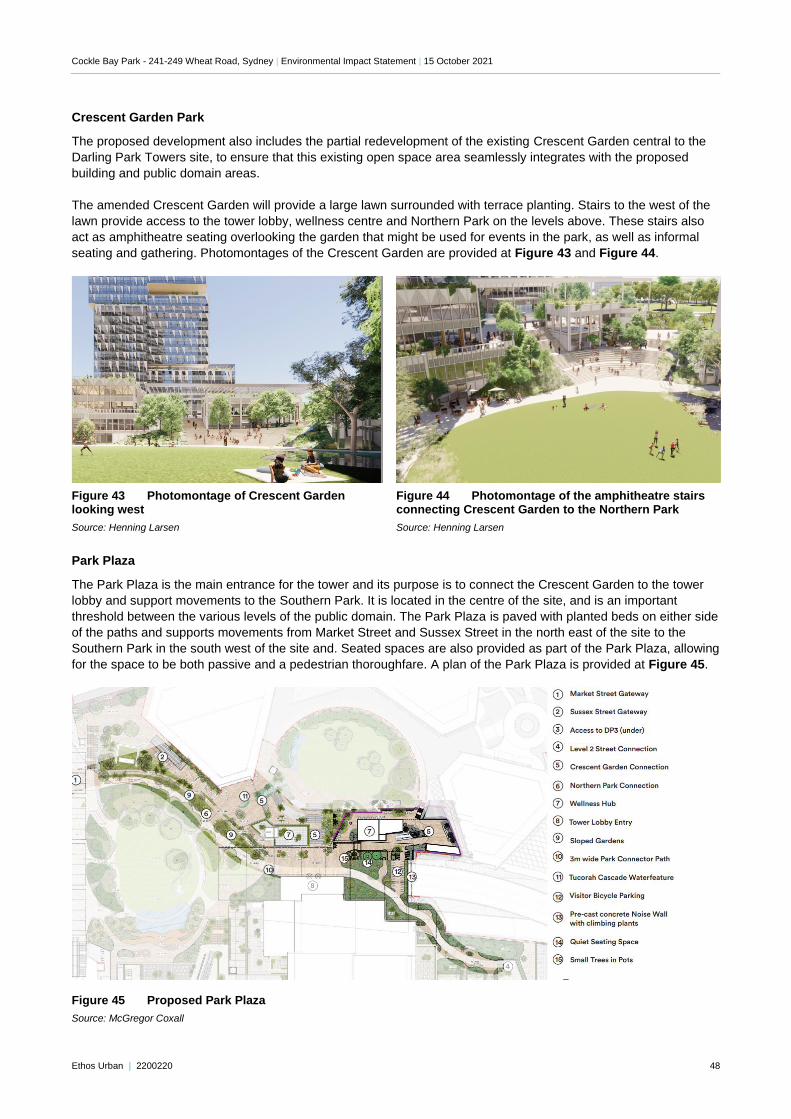
Cockle Bay Park - 241-249 Wheat Road, Sydney | Environmental Impact Statement | 15 October 2021
Ethos Urban | 2200220 48
Crescent Garden Park
The proposed development also includes the partial redevelopment of the existing Crescent Garden central to the
Darling Park Towers site, to ensure that this existing open space area seamlessly integrates with the proposed
building and public domain areas.
The amended Crescent Garden will provide a large lawn surrounded with terrace planting. Stairs to the west of the
lawn provide access to the tower lobby, wellness centre and Northern Park on the levels above. These stairs also
act as amphitheatre seating overlooking the garden that might be used for events in the park, as well as informal
seating and gathering. Photomontages of the Crescent Garden are provided at Figure 43 and Figure 44.
"Double click to insert picture"
Figure 43 Photomontage of Crescent Garden looking west
Source: Henning Larsen
Figure 44 Photomontage of the amphitheatre stairs connecting Crescent Garden to the Northern Park
Source: Henning Larsen
Park Plaza
The Park Plaza is the main entrance for the tower and its purpose is to connect the Crescent Garden to the tower
lobby and support movements to the Southern Park. It is located in the centre of the site, and is an important
threshold between the various levels of the public domain. The Park Plaza is paved with planted beds on either side
of the paths and supports movements from Market Street and Sussex Street in the north east of the site to the
Southern Park in the south west of the site and. Seated spaces are also provided as part of the Park Plaza, allowing
for the space to be both passive and a pedestrian thoroughfare. A plan of the Park Plaza is provided at Figure 45.
Figure 45 Proposed Park Plaza
Source: McGregor Coxall
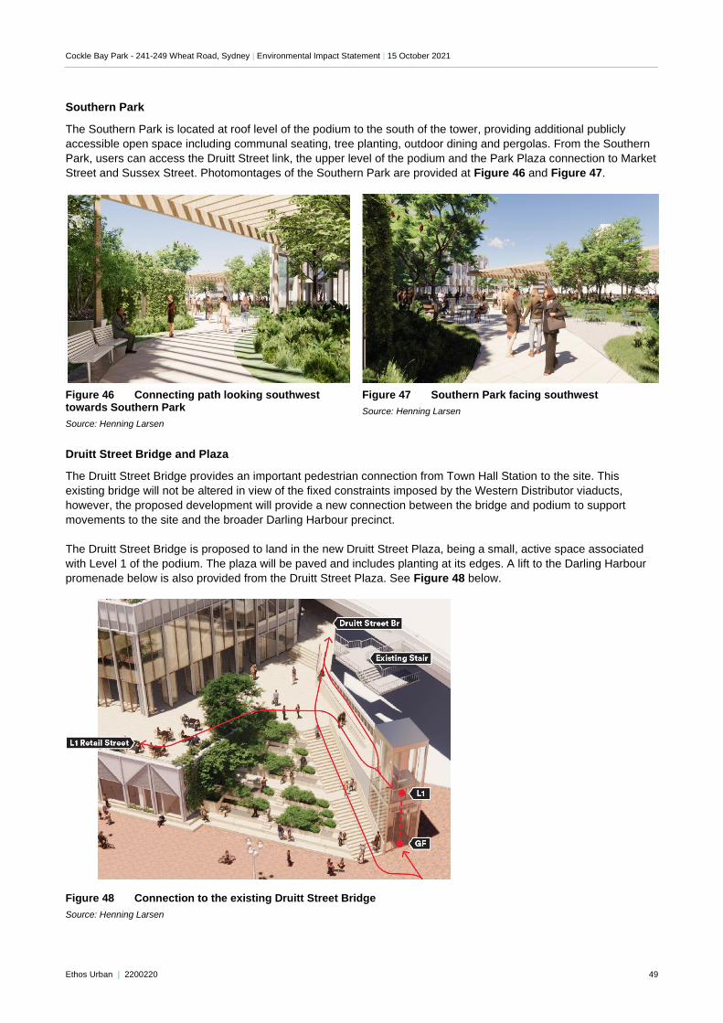
Cockle Bay Park - 241-249 Wheat Road, Sydney | Environmental Impact Statement | 15 October 2021
Ethos Urban | 2200220 49
Southern Park
The Southern Park is located at roof level of the podium to the south of the tower, providing additional publicly
accessible open space including communal seating, tree planting, outdoor dining and pergolas. From the Southern
Park, users can access the Druitt Street link, the upper level of the podium and the Park Plaza connection to Market
Street and Sussex Street. Photomontages of the Southern Park are provided at Figure 46 and Figure 47.
Figure 46 Connecting path looking southwest towards Southern Park
Source: Henning Larsen
Figure 47 Southern Park facing southwest
Source: Henning Larsen
Druitt Street Bridge and Plaza
The Druitt Street Bridge provides an important pedestrian connection from Town Hall Station to the site. This
existing bridge will not be altered in view of the fixed constraints imposed by the Western Distributor viaducts,
however, the proposed development will provide a new connection between the bridge and podium to support
movements to the site and the broader Darling Harbour precinct.
The Druitt Street Bridge is proposed to land in the new Druitt Street Plaza, being a small, active space associated
with Level 1 of the podium. The plaza will be paved and includes planting at its edges. A lift to the Darling Harbour
promenade below is also provided from the Druitt Street Plaza. See Figure 48 below.
Figure 48 Connection to the existing Druitt Street Bridge
Source: Henning Larsen
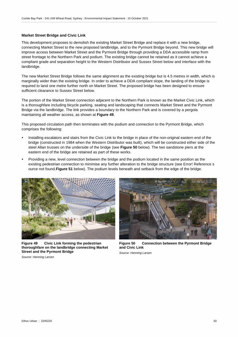
Cockle Bay Park - 241-249 Wheat Road, Sydney | Environmental Impact Statement | 15 October 2021
Ethos Urban | 2200220 50
Market Street Bridge and Civic Link
This development proposes to demolish the existing Market Street Bridge and replace it with a new bridge,
connecting Market Street to the new proposed landbridge, and to the Pyrmont Bridge beyond. This new bridge will
improve access between Market Street and the Pyrmont Bridge through providing a DDA accessible ramp from
street frontage to the Northern Park and podium. The existing bridge cannot be retained as it cannot achieve a
compliant grade and separation height to the Western Distributor and Sussex Street below and interface with the
landbridge.
The new Market Street Bridge follows the same alignment as the existing bridge but is 4.5 metres in width, which is
marginally wider than the existing bridge. In order to achieve a DDA compliant slope, the landing of the bridge is
required to land one metre further north on Market Street. The proposed bridge has been designed to ensure
sufficient clearance to Sussex Street below.
The portion of the Market Street connection adjacent to the Northern Park is known as the Market Civic Link, which
is a thoroughfare including bicycle parking, seating and landscaping that connects Market Street and the Pyrmont
Bridge via the landbridge. The link provides a boundary to the Northern Park and is covered by a pergola
maintaining all weather access, as shown at Figure 49.
This proposed circulation path then terminates with the podium and connection to the Pyrmont Bridge, which
comprises the following:
Installing escalators and stairs from the Civic Link to the bridge in place of the non-original eastern end of the
bridge (constructed in 1984 when the Western Distributor was built), which will be constructed either side of the
steel Allan trusses on the underside of the bridge (see Figure 50 below). The two sandstone piers at the
eastern end of the bridge are retained as part of these works.
Providing a new, level connection between the bridge and the podium located in the same position as the
existing pedestrian connection to minimise any further alteration to the bridge structure (see Error! Reference s
ource not found.Figure 51 below). The podium levels beneath and setback from the edge of the bridge.
Figure 49 Civic Link forming the pedestrian thoroughfare on the landbridge connecting Market Street and the Pyrmont Bridge
Source: Henning Larsen
Figure 50 Connection between the Pyrmont Bridge and Civic Link
Source: Henning Larsen
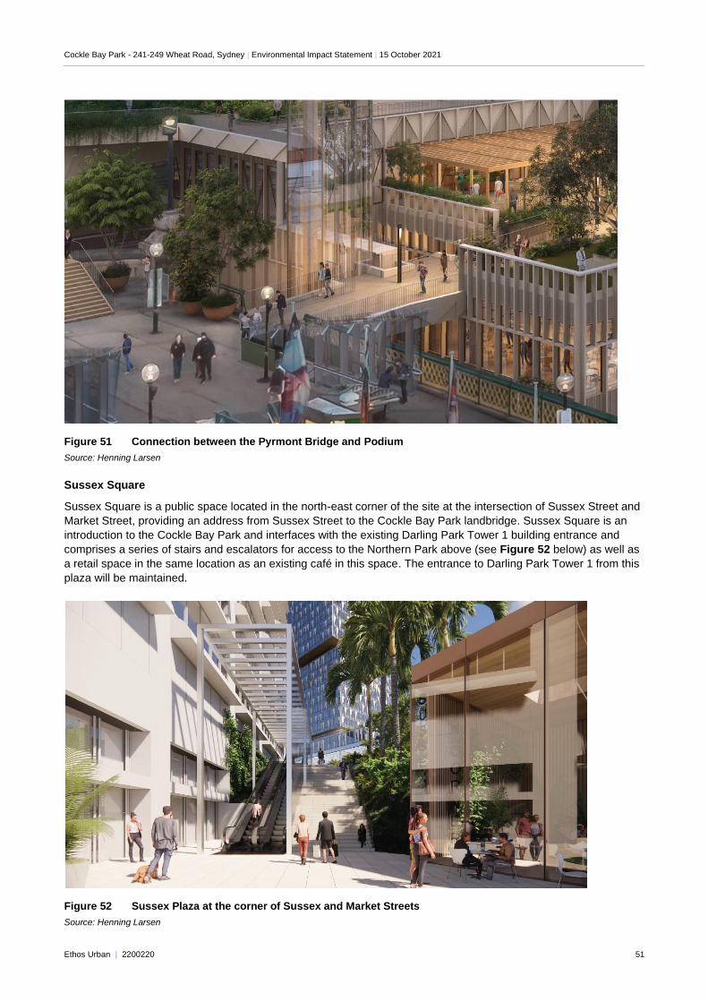
Cockle Bay Park - 241-249 Wheat Road, Sydney | Environmental Impact Statement | 15 October 2021
Ethos Urban | 2200220 51
Figure 51 Connection between the Pyrmont Bridge and Podium
Source: Henning Larsen
Sussex Square
Sussex Square is a public space located in the north-east corner of the site at the intersection of Sussex Street and
Market Street, providing an address from Sussex Street to the Cockle Bay Park landbridge. Sussex Square is an
introduction to the Cockle Bay Park and interfaces with the existing Darling Park Tower 1 building entrance and
comprises a series of stairs and escalators for access to the Northern Park above (see Figure 52 below) as well as
a retail space in the same location as an existing café in this space. The entrance to Darling Park Tower 1 from this
plaza will be maintained.
Figure 52 Sussex Plaza at the corner of Sussex and Market Streets
Source: Henning Larsen
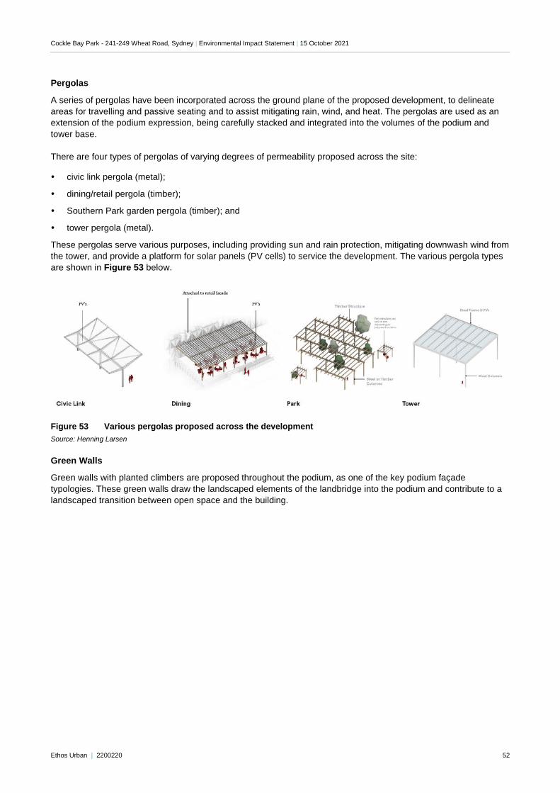
Cockle Bay Park - 241-249 Wheat Road, Sydney | Environmental Impact Statement | 15 October 2021
Ethos Urban | 2200220 52
Pergolas
A series of pergolas have been incorporated across the ground plane of the proposed development, to delineate
areas for travelling and passive seating and to assist mitigating rain, wind, and heat. The pergolas are used as an
extension of the podium expression, being carefully stacked and integrated into the volumes of the podium and
tower base.
There are four types of pergolas of varying degrees of permeability proposed across the site:
civic link pergola (metal);
dining/retail pergola (timber);
Southern Park garden pergola (timber); and
tower pergola (metal).
These pergolas serve various purposes, including providing sun and rain protection, mitigating downwash wind from
the tower, and provide a platform for solar panels (PV cells) to service the development. The various pergola types
are shown in Figure 53 below.
Figure 53 Various pergolas proposed across the development
Source: Henning Larsen
Green Walls
Green walls with planted climbers are proposed throughout the podium, as one of the key podium façade
typologies. These green walls draw the landscaped elements of the landbridge into the podium and contribute to a
landscaped transition between open space and the building.
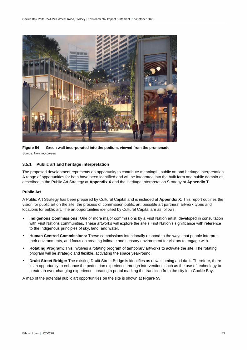
Cockle Bay Park - 241-249 Wheat Road, Sydney | Environmental Impact Statement | 15 October 2021
Ethos Urban | 2200220 53
Figure 54 Green wall incorporated into the podium, viewed from the promenade
Source: Henning Larsen
3.5.1 Public art and heritage interpretation
The proposed development represents an opportunity to contribute meaningful public art and heritage interpretation.
A range of opportunities for both have been identified and will be integrated into the built form and public domain as
described in the Public Art Strategy at Appendix X and the Heritage Interpretation Strategy at Appendix T.
Public Art
A Public Art Strategy has been prepared by Cultural Capital and is included at Appendix X. This report outlines the
vision for public art on the site, the process of commission public art, possible art partners, artwork types and
locations for public art. The art opportunities identified by Cultural Capital are as follows:
Indigenous Commissions: One or more major commissions by a First Nation artist, developed in consultation
with First Nations communities. These artworks will explore the site’s First Nation’s significance with reference
to the Indigenous principles of sky, land, and water.
Human Centred Commissions: These commissions intentionally respond to the ways that people interpret
their environments, and focus on creating intimate and sensory environment for visitors to engage with.
Rotating Program: This involves a rotating program of temporary artworks to activate the site. The rotating
program will be strategic and flexible, activating the space year-round.
Druitt Street Bridge: The existing Druitt Street Bridge is identifies as unwelcoming and dark. Therefore, there
is an opportunity to enhance the pedestrian experience through interventions such as the use of technology to
create an ever-changing experience, creating a portal marking the transition from the city into Cockle Bay.
A map of the potential public art opportunities on the site is shown at Figure 55.
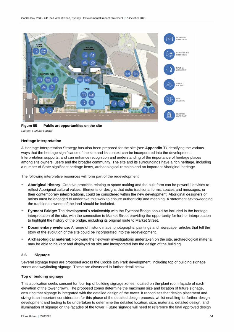
Cockle Bay Park - 241-249 Wheat Road, Sydney | Environmental Impact Statement | 15 October 2021
Ethos Urban | 2200220 54
Figure 55 Public art opportunities on the site
Source: Cultural Capital
Heritage Interpretation
A Heritage Interpretation Strategy has also been prepared for the site (see Appendix T) identifying the various
ways that the heritage significance of the site and its context can be incorporated into the development.
Interpretation supports, and can enhance recognition and understanding of the importance of heritage places
among site owners, users and the broader community. The site and its surroundings have a rich heritage, including
a number of State significant heritage items, archaeological remains and an important Aboriginal heritage.
The following interpretive resources will form part of the redevelopment:
Aboriginal History: Creative practices relating to space making and the built form can be powerful devises to
reflect Aboriginal cultural values. Elements or designs that echo traditional forms, spaces and messages, or
their contemporary interpretations, could be considered within the new development. Aboriginal designers or
artists must be engaged to undertake this work to ensure authenticity and meaning. A statement acknowledging
the traditional owners of the land should be included.
Pyrmont Bridge: The development’s relationship with the Pyrmont Bridge should be included in the heritage
interpretation of the site, with the connection to Market Street providing the opportunity for further interpretation
to highlight the history of the bridge, including its original route to Market Street.
Documentary evidence: A range of historic maps, photographs, paintings and newspaper articles that tell the
story of the evolution of the site could be incorporated into the redevelopment.
Archaeological material: Following the fieldwork investigations undertaken on the site, archaeological material
may be able to be kept and displayed on site and incorporated into the design of the building.
3.6 Signage
Several signage types are proposed across the Cockle Bay Park development, including top of building signage
zones and wayfinding signage. These are discussed in further detail below.
Top of building signage
This application seeks consent for four top of building signage zones, located on the plant room façade of each
elevation of the tower crown. The proposed zones determine the maximum size and location of future signage,
ensuring that signage is integrated with the detailed design of the tower. It recognises that design placement and
sizing is an important consideration for this phase of the detailed design process, whilst enabling for further design
development and testing to be undertaken to determine the detailed location, size, materials, detailed design, and
illumination of signage on the façades of the tower. Future signage will need to reference the final approved design
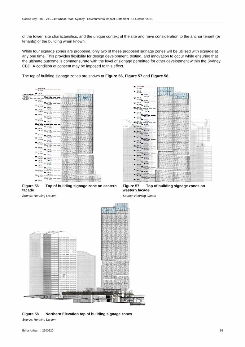
Cockle Bay Park - 241-249 Wheat Road, Sydney | Environmental Impact Statement | 15 October 2021
Ethos Urban | 2200220 55
of the tower, site characteristics, and the unique context of the site and have consideration to the anchor tenant (or
tenants) of the building when known.
While four signage zones are proposed, only two of these proposed signage zones will be utilised with signage at
any one time. This provides flexibility for design development, testing, and innovation to occur while ensuring that
the ultimate outcome is commensurate with the level of signage permitted for other development within the Sydney
CBD. A condition of consent may be imposed to this effect.
The top of building signage zones are shown at Figure 56, Figure 57 and Figure 58.
"Double click to insert picture"
Figure 56 Top of building signage zone on eastern facade
Source: Henning Larsen
Figure 57 Top of building signage zones on western facade
Source: Henning Larsen
Figure 58 Northern Elevation top of building signage zones
Source: Henning Larsen
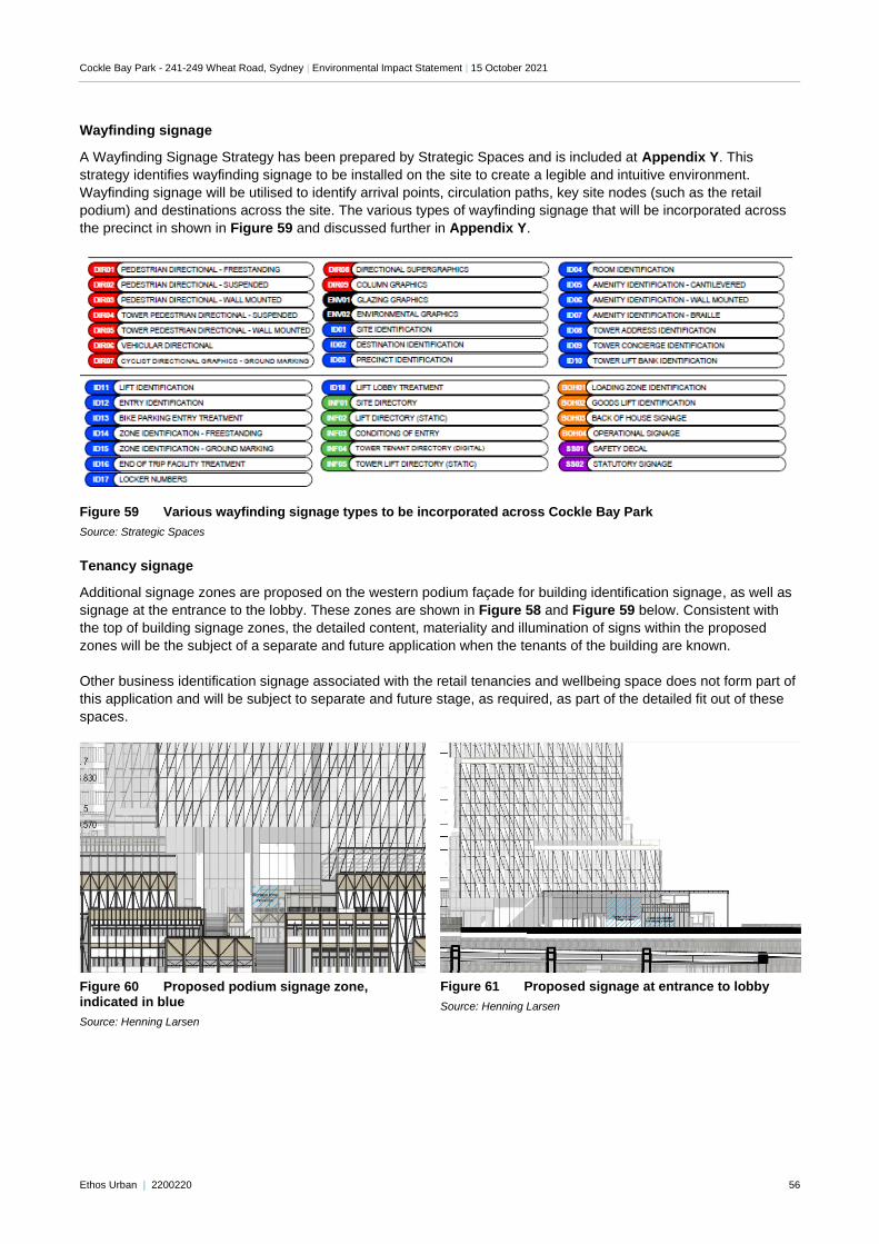
Cockle Bay Park - 241-249 Wheat Road, Sydney | Environmental Impact Statement | 15 October 2021
Ethos Urban | 2200220 56
Wayfinding signage
A Wayfinding Signage Strategy has been prepared by Strategic Spaces and is included at Appendix Y. This
strategy identifies wayfinding signage to be installed on the site to create a legible and intuitive environment.
Wayfinding signage will be utilised to identify arrival points, circulation paths, key site nodes (such as the retail
podium) and destinations across the site. The various types of wayfinding signage that will be incorporated across
the precinct in shown in Figure 59 and discussed further in Appendix Y.
Figure 59 Various wayfinding signage types to be incorporated across Cockle Bay Park
Source: Strategic Spaces
Tenancy signage
Additional signage zones are proposed on the western podium façade for building identification signage, as well as
signage at the entrance to the lobby. These zones are shown in Figure 58 and Figure 59 below. Consistent with
the top of building signage zones, the detailed content, materiality and illumination of signs within the proposed
zones will be the subject of a separate and future application when the tenants of the building are known.
Other business identification signage associated with the retail tenancies and wellbeing space does not form part of
this application and will be subject to separate and future stage, as required, as part of the detailed fit out of these
spaces.
Figure 60 Proposed podium signage zone, indicated in blue
Source: Henning Larsen
Figure 61 Proposed signage at entrance to lobby
Source: Henning Larsen
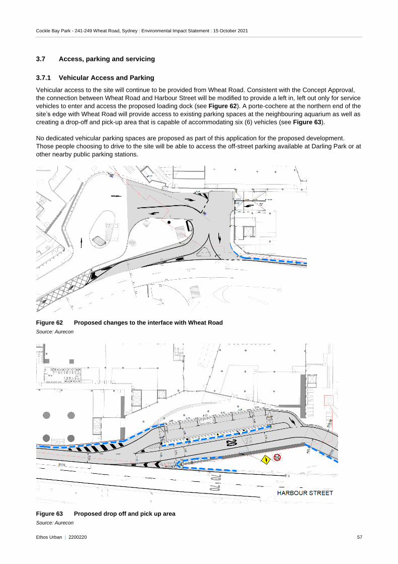
Cockle Bay Park - 241-249 Wheat Road, Sydney | Environmental Impact Statement | 15 October 2021
Ethos Urban | 2200220 57
3.7 Access, parking and servicing
3.7.1 Vehicular Access and Parking
Vehicular access to the site will continue to be provided from Wheat Road. Consistent with the Concept Approval,
the connection between Wheat Road and Harbour Street will be modified to provide a left in, left out only for service
vehicles to enter and access the proposed loading dock (see Figure 62). A porte-cochere at the northern end of the
site’s edge with Wheat Road will provide access to existing parking spaces at the neighbouring aquarium as well as
creating a drop-off and pick-up area that is capable of accommodating six (6) vehicles (see Figure 63).
No dedicated vehicular parking spaces are proposed as part of this application for the proposed development.
Those people choosing to drive to the site will be able to access the off-street parking available at Darling Park or at
other nearby public parking stations.
Figure 62 Proposed changes to the interface with Wheat Road
Source: Aurecon
Figure 63 Proposed drop off and pick up area
Source: Aurecon
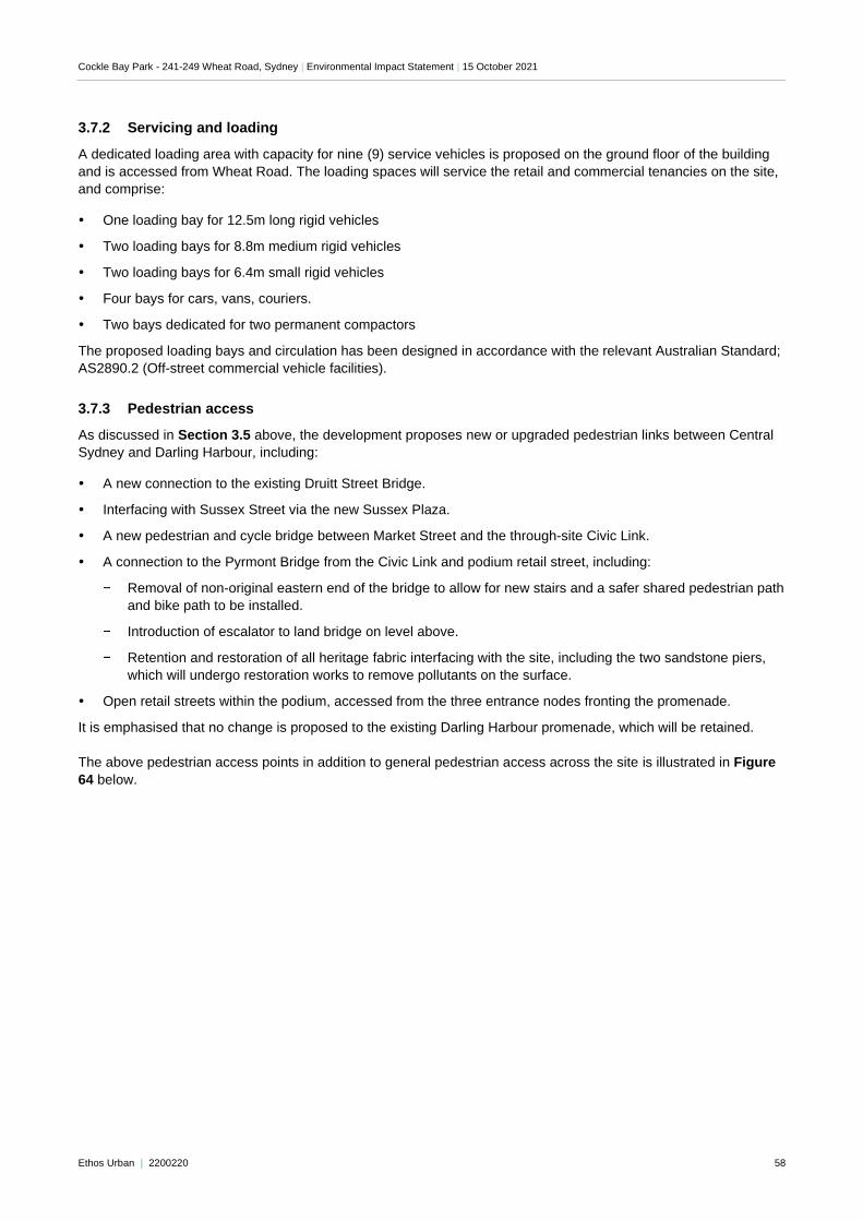
Cockle Bay Park - 241-249 Wheat Road, Sydney | Environmental Impact Statement | 15 October 2021
Ethos Urban | 2200220 58
3.7.2 Servicing and loading
A dedicated loading area with capacity for nine (9) service vehicles is proposed on the ground floor of the building
and is accessed from Wheat Road. The loading spaces will service the retail and commercial tenancies on the site,
and comprise:
One loading bay for 12.5m long rigid vehicles
Two loading bays for 8.8m medium rigid vehicles
Two loading bays for 6.4m small rigid vehicles
Four bays for cars, vans, couriers.
Two bays dedicated for two permanent compactors
The proposed loading bays and circulation has been designed in accordance with the relevant Australian Standard;
AS2890.2 (Off-street commercial vehicle facilities).
3.7.3 Pedestrian access
As discussed in Section 3.5 above, the development proposes new or upgraded pedestrian links between Central
Sydney and Darling Harbour, including:
A new connection to the existing Druitt Street Bridge.
Interfacing with Sussex Street via the new Sussex Plaza.
A new pedestrian and cycle bridge between Market Street and the through-site Civic Link.
A connection to the Pyrmont Bridge from the Civic Link and podium retail street, including:
− Removal of non-original eastern end of the bridge to allow for new stairs and a safer shared pedestrian path
and bike path to be installed.
− Introduction of escalator to land bridge on level above.
− Retention and restoration of all heritage fabric interfacing with the site, including the two sandstone piers,
which will undergo restoration works to remove pollutants on the surface.
Open retail streets within the podium, accessed from the three entrance nodes fronting the promenade.
It is emphasised that no change is proposed to the existing Darling Harbour promenade, which will be retained.
The above pedestrian access points in addition to general pedestrian access across the site is illustrated in Figure
64 below.
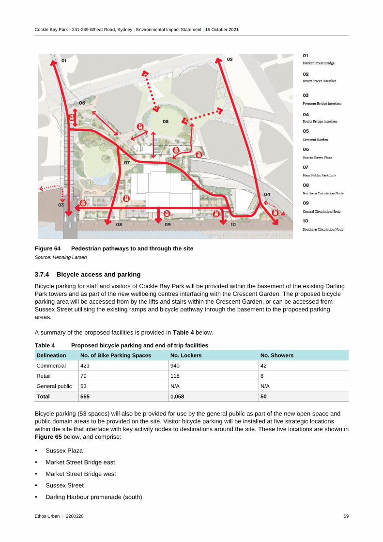
Cockle Bay Park - 241-249 Wheat Road, Sydney | Environmental Impact Statement | 15 October 2021
Ethos Urban | 2200220 59
Figure 64 Pedestrian pathways to and through the site
Source: Henning Larsen
3.7.4 Bicycle access and parking
Bicycle parking for staff and visitors of Cockle Bay Park will be provided within the basement of the existing Darling
Park towers and as part of the new wellbeing centres interfacing with the Crescent Garden. The proposed bicycle
parking area will be accessed from by the lifts and stairs within the Crescent Garden, or can be accessed from
Sussex Street utilising the existing ramps and bicycle pathway through the basement to the proposed parking
areas.
A summary of the proposed facilities is provided in Table 4 below.
Table 4 Proposed bicycle parking and end of trip facilities
Delineation No. of Bike Parking Spaces No. Lockers No. Showers
Commercial 423 940 42
Retail 79 118 8
General public 53 N/A N/A
Total 555 1,058 50
Bicycle parking (53 spaces) will also be provided for use by the general public as part of the new open space and
public domain areas to be provided on the site. Visitor bicycle parking will be installed at five strategic locations
within the site that interface with key activity nodes to destinations around the site. These five locations are shown in
Figure 65 below, and comprise:
Sussex Plaza
Market Street Bridge east
Market Street Bridge west
Sussex Street
Darling Harbour promenade (south)
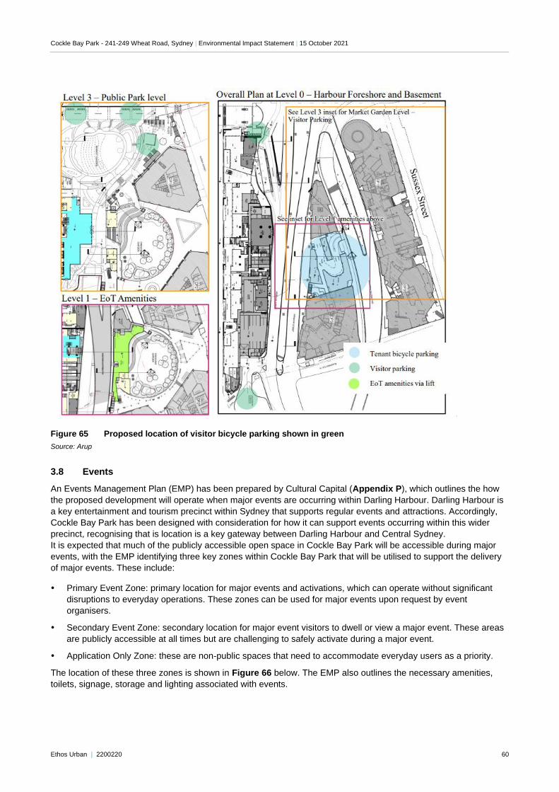
Cockle Bay Park - 241-249 Wheat Road, Sydney | Environmental Impact Statement | 15 October 2021
Ethos Urban | 2200220 60
Figure 65 Proposed location of visitor bicycle parking shown in green
Source: Arup
3.8 Events
An Events Management Plan (EMP) has been prepared by Cultural Capital (Appendix P), which outlines the how
the proposed development will operate when major events are occurring within Darling Harbour. Darling Harbour is
a key entertainment and tourism precinct within Sydney that supports regular events and attractions. Accordingly,
Cockle Bay Park has been designed with consideration for how it can support events occurring within this wider
precinct, recognising that is location is a key gateway between Darling Harbour and Central Sydney.
It is expected that much of the publicly accessible open space in Cockle Bay Park will be accessible during major
events, with the EMP identifying three key zones within Cockle Bay Park that will be utilised to support the delivery
of major events. These include:
Primary Event Zone: primary location for major events and activations, which can operate without significant
disruptions to everyday operations. These zones can be used for major events upon request by event
organisers.
Secondary Event Zone: secondary location for major event visitors to dwell or view a major event. These areas
are publicly accessible at all times but are challenging to safely activate during a major event.
Application Only Zone: these are non-public spaces that need to accommodate everyday users as a priority.
The location of these three zones is shown in Figure 66 below. The EMP also outlines the necessary amenities,
toilets, signage, storage and lighting associated with events.
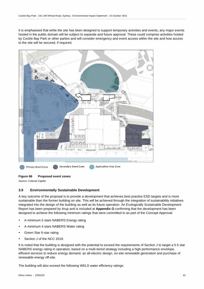
Cockle Bay Park - 241-249 Wheat Road, Sydney | Environmental Impact Statement | 15 October 2021
Ethos Urban | 2200220 61
It is emphasised that while the site has been designed to support temporary activities and events, any major events
hosted in the public domain will be subject to separate and future approval. These could comprise activities hosted
by Cockle Bay Park or other parties and will consider emergency and event access within the site and how access
to the site will be secured, if required.
Figure 66 Proposed event zones
Source: Cultural Capital
3.9 Environmentally Sustainable Development
A key outcome of the proposal is to provide a development that achieves best practice ESD targets and is more
sustainable than the former building on site. This will be achieved through the integration of sustainability initiatives
integrated into the design of the building as well as its future operation. An Ecologically Sustainable Development
Report has been prepared by Arup and is included at Appendix O confirming that the development has been
designed to achieve the following minimum ratings that were committed to as part of the Concept Approval:
A minimum 5 stars NABERS Energy rating
A minimum 4 stars NABERS Water rating
Green Star 6-star rating
Section J of the NCC 2019.
It is noted that the building is designed with the potential to exceed the requirements of Section J to target a 5.5 star
NABERS energy rating in operation, based on a multi-tiered strategy including a high performance envelope,
efficient services to reduce energy demand, an all-electric design, on-site renewable generation and purchase of
renewable energy off-site.
The building will also exceed the following WELS water efficiency ratings:
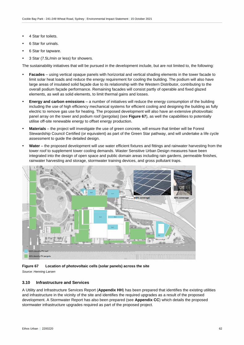
Cockle Bay Park - 241-249 Wheat Road, Sydney | Environmental Impact Statement | 15 October 2021
Ethos Urban | 2200220 62
4 Star for toilets.
6 Star for urinals.
6 Star for tapware.
3 Star (7.5L/min or less) for showers.
The sustainability initiatives that will be pursued in the development include, but are not limited to, the following:
Facades – using vertical opaque panels with horizontal and vertical shading elements in the tower facade to
limit solar heat loads and reduce the energy requirement for cooling the building. The podium will also have
large areas of insulated solid façade due to its relationship with the Western Distributor, contributing to the
overall podium façade performance. Remaining facades will consist partly of operable and fixed glazed
elements, as well as solid elements, to limit thermal gains and losses.
Energy and carbon emissions – a number of initiatives will reduce the energy consumption of the building
including the use of high efficiency mechanical systems for efficient cooling and designing the building as fully
electric to remove gas use for heating. The proposed development will also have an extensive photovoltaic
panel array on the tower and podium roof (pergolas) (see Figure 67), as well the capabilities to potentially
utilise off-site renewable energy to offset energy production.
Materials – the project will investigate the use of green concrete, will ensure that timber will be Forest
Stewardship Council Certified (or equivalent) as part of the Green Star pathway, and will undertake a life cycle
assessment to guide the detailed design.
Water – the proposed development will use water efficient fixtures and fittings and rainwater harvesting from the
tower roof to supplement tower cooling demands. Waster Sensitive Urban Design measures have been
integrated into the design of open space and public domain areas including rain gardens, permeable finishes,
rainwater harvesting and storage, stormwater training devices, and gross pollutant traps.
Figure 67 Location of photovoltaic cells (solar panels) across the site
Source: Henning Larsen
3.10 Infrastructure and Services
A Utility and Infrastructure Services Report (Appendix HH) has been prepared that identifies the existing utilities
and infrastructure in the vicinity of the site and identifies the required upgrades as a result of the proposed
development. A Stormwater Report has also been prepared (see Appendix CC) which details the proposed
stormwater infrastructure upgrades required as part of the proposed project.
Cockle Bay Park - 241-249 Wheat Road, Sydney | Environmental Impact Statement | 15 October 2021
Ethos Urban | 2200220 63
3.11 Waste Management
A central waste and recycling storage facility is located on the ground floor of the building including dedicated areas
for the storage of general waste and recycling, a bin wash area, and space for bulky goods storage. The waste
storage areas will be locked and accessible by authorised staff only. Standard mitigation and maintenance practices
will be employed to minimise odours, deter vermin, and maintain this space as a user-friendly and safe area. This is
discussed at Section 6.18 and in the Waste Management Plan at Appendix JJ.
3.12 Staging and construction management
A Preliminary Construction Management Plan has been prepared by Multiplex (Appendix I), which outlines the
overarching principles and practices for the management of construction activities to inform the preparation of a
detailed Construction Environmental Management Plan which would be required to be prepared by the appointed
contractor prior to the commencement of works and adhered to for the duration of construction. The plan provides
an overview of on-site management during the construction phase of the project and considers the management of
site operations, soil, water and groundwater, construction waste, traffic, noise and vibration, air quality, hazardous
materials and community consultation.
Hours of work
General demolition and construction works will be undertaken within the hours permitted under the Stage 1 Concept
Approval. For works over the Western Distributor and Harbour Street without overhead protection, road closures
will need to be approved and coordinated under the Works Authorisation Deed (WAD) entered into with Transport
for NSW (RMS).
Working hours are generally foreseen as follows:
Between 7am and 7pm Monday to Friday
Between 7am and 6pm Saturday
No working Sundays or public holidays
The exception to the above is for night works on roads and after hour works expected between 9pm and 5am
Sunday to Friday nights at a minimum.
Because of the site’s location and interface with the Western Distributor, the construction of the underpass
foundations and structure will need to take place out of hours and coordinated with road closures with appropriate
detours to minimise impacts to movements through the site.
Construction staging
The proposed redevelopment is expected to be undertaken in a number of phases, to accommodate the various
elements of the development, including the early works approved under Stage 1 Concept Approval. The project
phases are as follows:
Phase 0 – Demolition of Market Street Bridge, a per SSD 7684.
Phase 1 – Survey and Site Establishment
Phase 2 – Demolition of remaining structures
Phase 3 – Landbridge works (including all works on or above the Western Distributor
Phase 4 – Construction of retail podium
Phase 5 – Construction of tower
As the project is in the preliminary planning stage, the timeframes associated with each phase are not confirmed
and will be detailed further as part of the detailed Construction Environmental Management Plan. Further, some of
these phases will run in parallel where they are able to do so.
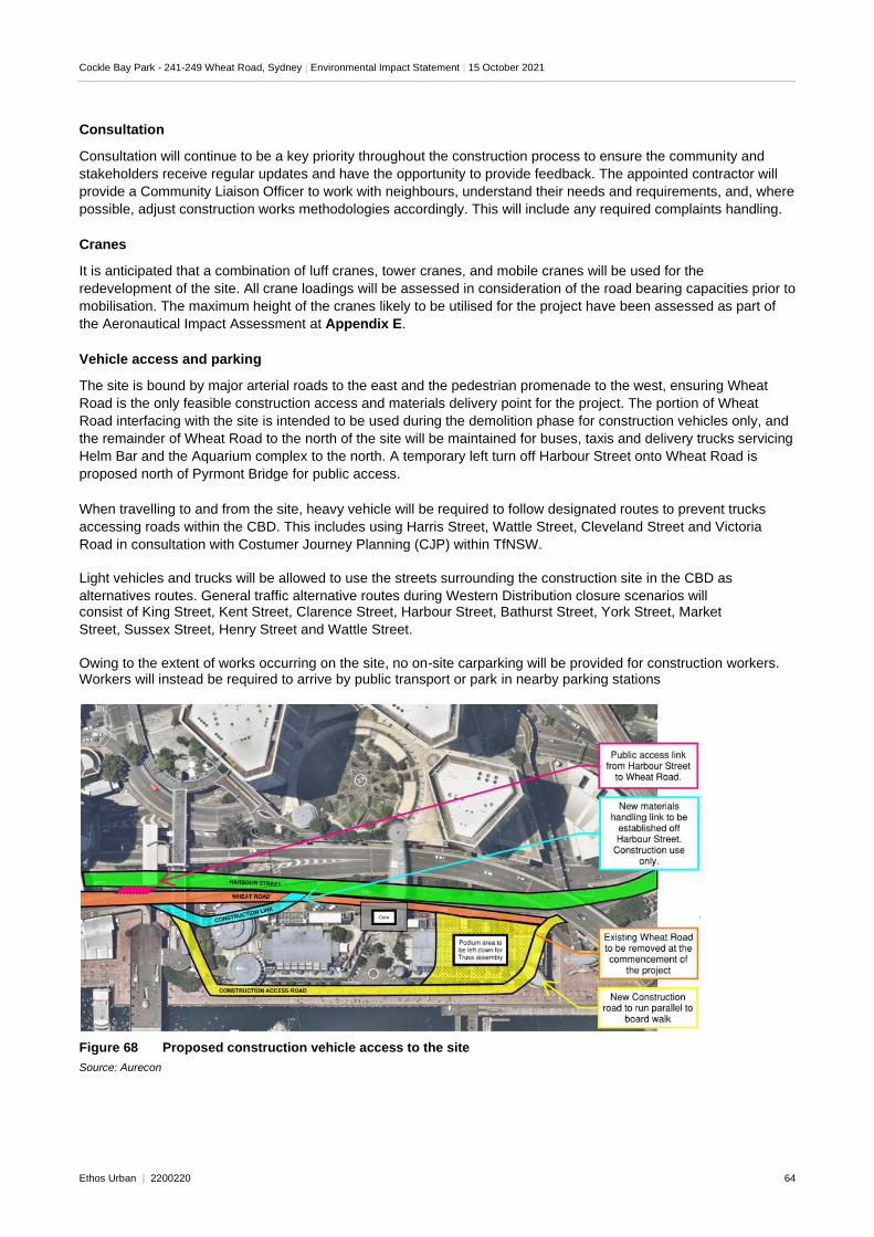
Cockle Bay Park - 241-249 Wheat Road, Sydney | Environmental Impact Statement | 15 October 2021
Ethos Urban | 2200220 64
Consultation
Consultation will continue to be a key priority throughout the construction process to ensure the community and
stakeholders receive regular updates and have the opportunity to provide feedback. The appointed contractor will
provide a Community Liaison Officer to work with neighbours, understand their needs and requirements, and, where
possible, adjust construction works methodologies accordingly. This will include any required complaints handling.
Cranes
It is anticipated that a combination of luff cranes, tower cranes, and mobile cranes will be used for the
redevelopment of the site. All crane loadings will be assessed in consideration of the road bearing capacities prior to
mobilisation. The maximum height of the cranes likely to be utilised for the project have been assessed as part of
the Aeronautical Impact Assessment at Appendix E.
Vehicle access and parking
The site is bound by major arterial roads to the east and the pedestrian promenade to the west, ensuring Wheat
Road is the only feasible construction access and materials delivery point for the project. The portion of Wheat
Road interfacing with the site is intended to be used during the demolition phase for construction vehicles only, and
the remainder of Wheat Road to the north of the site will be maintained for buses, taxis and delivery trucks servicing
Helm Bar and the Aquarium complex to the north. A temporary left turn off Harbour Street onto Wheat Road is
proposed north of Pyrmont Bridge for public access.
When travelling to and from the site, heavy vehicle will be required to follow designated routes to prevent trucks
accessing roads within the CBD. This includes using Harris Street, Wattle Street, Cleveland Street and Victoria
Road in consultation with Costumer Journey Planning (CJP) within TfNSW.
Light vehicles and trucks will be allowed to use the streets surrounding the construction site in the CBD as
alternatives routes. General traffic alternative routes during Western Distribution closure scenarios will consist of King Street, Kent Street, Clarence Street, Harbour Street, Bathurst Street, York Street, Market
Street, Sussex Street, Henry Street and Wattle Street.
Owing to the extent of works occurring on the site, no on-site carparking will be provided for construction workers. Workers will instead be required to arrive by public transport or park in nearby parking stations
Figure 68 Proposed construction vehicle access to the site
Source: Aurecon
Cockle Bay Park - 241-249 Wheat Road, Sydney | Environmental Impact Statement | 15 October 2021
Ethos Urban | 2200220 65
Pedestrian and bicycle access
Fencing or hoarding will be constructed around the perimeter of works to control access to the construction site and
to protect pedestrians and cyclists. The proposed fencing/hoarding will seek to ensure existing pathways, including
along the promenade, are maintained where possible during the construction process. However, to enable the
interface between the proposed development and existing frontages, it may be necessary to reduce the width of
existing footpaths and the promenade to allow for appropriate construction hoarding during the construction
process.
As discussed in Section 3.5 above, the proposed development necessitates the demolition and reconstruction of
the Market Street Bridge. Accordingly, a temporary pedestrian bridge will be installed from Sussex Street over the
Western Distributor to maintain access through the site to the Pyrmont Bridge. Where possible there may be
opportunity to re-use the existing footings for the monorail station and the existing pedestrian bridge.
Currently there is also an existing bicycle path located along the western side of the Western Distributor, which
connects to the centre point of the eastern end of the Pyrmont Bridge. An alternative access connection will be
provided to enable continued cycle movements from the Pyrmont Bridge and to King Street while the interface
between the proposed Civic Link and Pyrmont Bridge as described in Section 3.5 is completed. This temporary
path will be designed in conjunction with the heritage and traffic consultants during detailed design.
Uninterrupted access between Darling Harbour and the CBD will be maintained via the Druitt Street Bridge, with the
preliminary Construction Management Plan nominating two options for how this might be achieved:
partial relocation of the current walkway allowing for the southern portion of the existing walkway and stairs to
be demolished, leaving access to the existing lift and the northern stair to be available at all times. The southern
side will then be reconstructed with a new walkaway, lift and stairs allowing the remaining parts of the northern
side to be demolished.
installation of a new lift and stair in either a temporary or a permanent location, which can be incorporated in the
new design, allowing these to be constructed early, which will enable full demolition of the existing structures.
Cockle Bay Park - 241-249 Wheat Road, Sydney | Environmental Impact Statement | 15 October 2021
Ethos Urban | 2200220 66
4.0 Consultation
The Cockle Bay Park project has been the subject of an extensive consultation and stakeholder engagement
process since 2016, throughout the Concept Approval, detailed design and EIS preparation phases. In accordance
with the SEARs issued for this project, further consultation was undertaken with relevant agencies and public
authorities, the community, and Council as part of the preparation of this EIS and associated technical reports. The
consultation process completed to date is detailed in the Consultation Outcomes Report prepared by Newgate and
provided at Appendix J. It identifies the proactive and strategic approach to communications and stakeholder
engagement undertaken for this project. In delivering this approach, the transparent and comprehensive
engagement was timely, genuine and constructive, broad reaching, and engaging.
Following the Stage 1 Concept Approval and prior to the development of the Stage 2 detailed design, various
stakeholder and community engagement sessions were completed to inform the detailed design of this application.
These activities included a combination of online and face-to-face workshops, with several streams of engagement
running concurrently including:
A Citizens’ Panel held in 2019 to guide the design principles for the public domain elements of the site – this
comprised 26 community participants from a mix of genders, ages, life stages, cultural backgrounds and
employment status, and included participants who had lived in Australia for less than two years to provide the
perspective of an international visitor to Darling Harbour. The Panel also included 10 community stakeholders
including local businesses. This panel was reconvened in August 2021 to provide panel members detail on the
updated design. All participants from the 2019 Panel were invited back.
A disabilities group workshop held in 2019 to guide the design principles for people with a disability moving
through the site – this comprised participants from Vision Australia, Spinal Cord Injuries Australia, Synapse,
NSW Council for Intellectual Disability and the First People’s Disability Network. This group was reconvened in
August 2021 to provide the group detail on the updated design. Participants from the 2019 disabilities panel
were invited back for another discussion. Participants were from Guide Dogs NSW/ACT, Better Hearing
Australia, Spinal Cord Injury Association, and a former participant who had initially represented the interests of
Synapse. A separate, one-on-one meeting was held with the group member from Vision Australia who is
visually and hearing impaired.
Key community groups identified as part of the Stage 1 Concept Approval were briefed as part of the
preparation of the Stage 2 SSD DA – this included body corporate members from the Astoria Towers and
Millennium Towers and the Pyrmont Action Group.
Discussions with Aboriginal community – in addition to the consultation activities completed as part of the
Aboriginal Cultural Heritage Assessment Report (see Appendix MM), a representative of the Traditional
Custodian with the Metropolitan Local Aboriginal Land Council (MLALC) presented to the Citizens’ Panel in
2019.
Discussions with stakeholder groups and government agencies – noting that several consultants have
undertaken additional consultation with relevant parties during the preparation of their reports, as detailed in the
assessments appended to this EIS. This includes consultation with the NSW EPA, Transport for NSW (RMS),
City of Sydney Council, Sydney Water, Sydney Airport, Ausgrid, Telstra, Heritage NSW, Place Management
NSW, and Fire and Rescue NSW.
A range of tools were also developed to assist the discussions on the proposal, including:
A community newsletter delivered in August 2021 to 1,925 mailboxes in the surrounding area to the site, namely
Sussex Street, Market Street, Wheat Road, Day Street, Darling Drive, and Murray Street.
A project website, including contact details, which has been live since 2018 and provides the latest information
on the project and an opportunity for feedback.
The outcomes of authority and agency consultation is detailed in the relevant consultants’ reports appended to this
EIS. The outcomes of community and stakeholder consultation, including the issues raised, and how these have
been addressed is outlined in Table 5 below.
Cockle Bay Park - 241-249 Wheat Road, Sydney | Environmental Impact Statement | 15 October 2021
Ethos Urban | 2200220 67
Table 5 Issues raised during consultation
Issue Response
Building context with the cityscape
Concern that the buildings in the proposal are insensitive to the harbour and immediate surrounds including Pyrmont Bridge
The scale and form of the project has been the subject of extensive
design testing and development through the approval of the Stage 1 Concept Approval and the Design Competition that has informed this subsequent Stage 2 SSD DA. The project is considered to be high-
quality addition to the city context, creating an elegant, contemporary, urban tower form. It complements and enhances this strategically important location, including sensitively integrating with the existing
connections to and from the site including the Pyrmont Bridge, Druitt Street Bridge, and Market Street Bridge. The built form, its relationship to the harbour, and heritage context is discussed further
in Section 6.12
Glare and heat Concerns that the building façade may create glare or potentially a heat effect for nearby buildings.
A Reflectivity Assessment has been prepared by Arup (Appendix Z) demonstrating that the external treatments, materials and finishes of the project will not cause excessive glare, as discussed further in
Section 6.8
Building proximity to the foreshore Concern that the building would encroach on the pedestrian experience of the Darling Harbour
promenade
The proposed building has been carefully designed to activate, but not to encroach on the waterfront promenade. The project will maintain the existing pedestrian thoroughfare along the harbour and interface with this promenade through outdoor dining terraces, retail tenancies, and circulation nodes for pedestrian access through the site. The tower above the podium complies with the building setbacks nominated in the Stage 1 Concept Approval, ensuring it is suitably recessed from Darling Harbour and does not dominant the promenade. Built form and visual impacts are discussed further in
Sections 6.2 and 6.5.
Community activation of public spaces
Request to reactivate this area of Darling Harbour to make it appealing for a range of user groups, and safe (particularly at night)
An assessment of the project against the principles of Crime
Prevention Through Environmental Design is provided at Appendix L. This assessment confirms that the project provides a high level of natural surveillance, both to the development itself and to the
surrounds, and that the development as a whole has the opportunity to improve the safety and security. This is discussed further in Section 6.14.
Entertainment spaces/facilities for people of all ages
Community entertainment or recreational facilities to offer something for people of all ages; children, teenagers, families, and adults
The public domain has been designed to incorporate a wide variety of
spaces to suit different uses and user groups. As outlined in the public domain section of Appendix A, each public domain space incorporates several of the following potential uses or features:
• Walkability
• Cycle access
• Sit/dwell points
• Viewpoint
• Dine
• Meet/gather
• Gateway/entrance
• Canopy trees
• Water feature
• Terrace seating
• Wellness
• Performance
• Public art
Passive versus active community spaces The ‘pockets of spaces’ concept to include community
spaces that offer a balance between quiet, green spaces and a place to socialise, exercise, or enjoy an experience
As discussed above, the precinct delivers a wide range of different spaces to cater to various uses for a wide range of users and needs.
A variety of planting, access routes, activities and features across the public domain allows for the ‘pockets of spaces’ to deliver a wide range of activities and uses.
Pedestrian connectivity (including people with a
disability) Further design details to incorporate best in practice accessibility for people with a disability
The access arrangements for people with mobility impairments has
been considered in the architectural and landscape solutions for the site, which are required to address significant level changes between Darling Harbour, across the Western Distributor and Sussex Street.
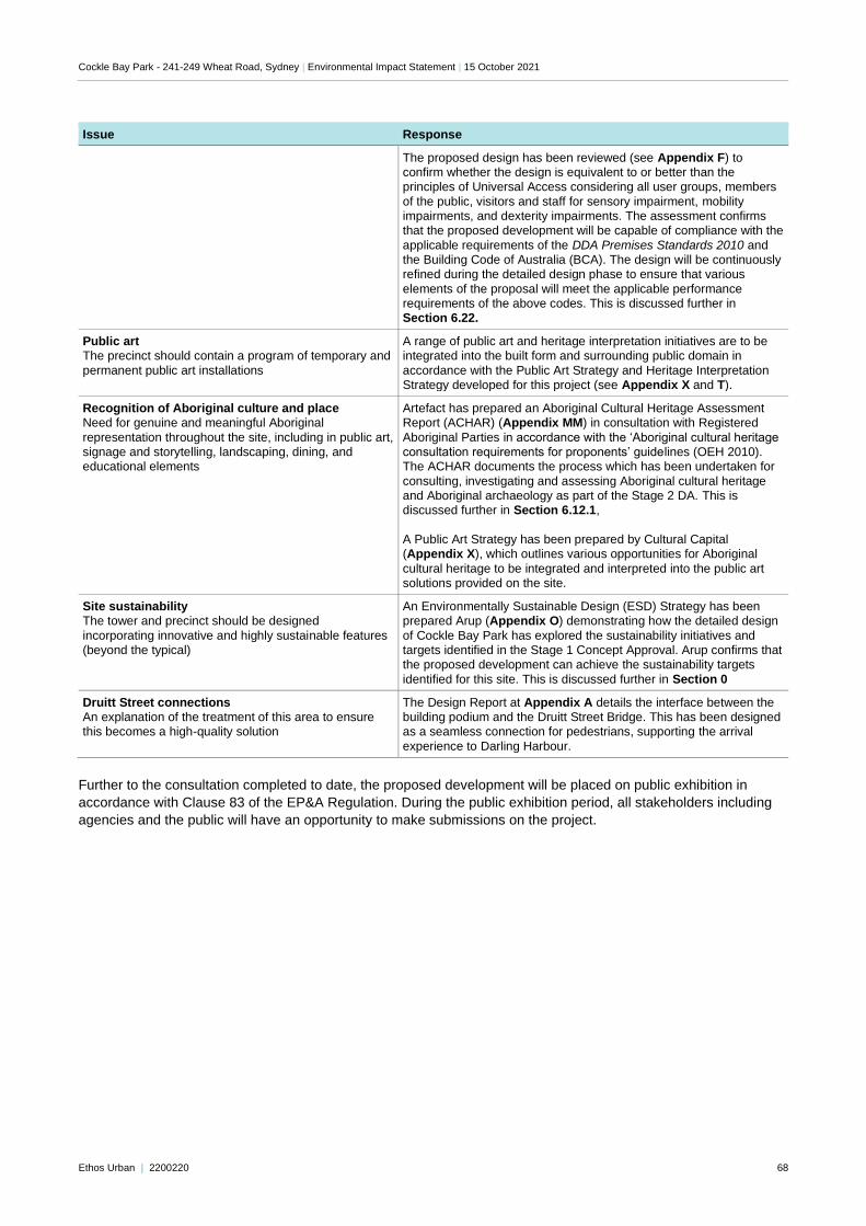
Cockle Bay Park - 241-249 Wheat Road, Sydney | Environmental Impact Statement | 15 October 2021
Ethos Urban | 2200220 68
Issue Response
The proposed design has been reviewed (see Appendix F) to confirm whether the design is equivalent to or better than the principles of Universal Access considering all user groups, members
of the public, visitors and staff for sensory impairment, mobility impairments, and dexterity impairments. The assessment confirms that the proposed development will be capable of compliance with the
applicable requirements of the DDA Premises Standards 2010 and the Building Code of Australia (BCA). The design will be continuously refined during the detailed design phase to ensure that various
elements of the proposal will meet the applicable performance requirements of the above codes. This is discussed further in Section 6.22.
Public art The precinct should contain a program of temporary and
permanent public art installations
A range of public art and heritage interpretation initiatives are to be integrated into the built form and surrounding public domain in
accordance with the Public Art Strategy and Heritage Interpretation Strategy developed for this project (see Appendix X and T).
Recognition of Aboriginal culture and place Need for genuine and meaningful Aboriginal
representation throughout the site, including in public art, signage and storytelling, landscaping, dining, and educational elements
Artefact has prepared an Aboriginal Cultural Heritage Assessment Report (ACHAR) (Appendix MM) in consultation with Registered
Aboriginal Parties in accordance with the ‘Aboriginal cultural heritage consultation requirements for proponents’ guidelines (OEH 2010). The ACHAR documents the process which has been undertaken for
consulting, investigating and assessing Aboriginal cultural heritage and Aboriginal archaeology as part of the Stage 2 DA. This is discussed further in Section 6.12.1,
A Public Art Strategy has been prepared by Cultural Capital (Appendix X), which outlines various opportunities for Aboriginal
cultural heritage to be integrated and interpreted into the public art solutions provided on the site.
Site sustainability The tower and precinct should be designed
incorporating innovative and highly sustainable features (beyond the typical)
An Environmentally Sustainable Design (ESD) Strategy has been prepared Arup (Appendix O) demonstrating how the detailed design
of Cockle Bay Park has explored the sustainability initiatives and targets identified in the Stage 1 Concept Approval. Arup confirms that the proposed development can achieve the sustainability targets
identified for this site. This is discussed further in Section 0
Druitt Street connections An explanation of the treatment of this area to ensure this becomes a high-quality solution
The Design Report at Appendix A details the interface between the building podium and the Druitt Street Bridge. This has been designed as a seamless connection for pedestrians, supporting the arrival
experience to Darling Harbour.
Further to the consultation completed to date, the proposed development will be placed on public exhibition in
accordance with Clause 83 of the EP&A Regulation. During the public exhibition period, all stakeholders including
agencies and the public will have an opportunity to make submissions on the project.
Cockle Bay Park - 241-249 Wheat Road, Sydney | Environmental Impact Statement | 15 October 2021
Ethos Urban | 2200220 69
5.0 Legislation, policies, and requirements
This chapter of the EIS contains our assessment or summary of the compliance of the proposed development with
relevant statutory instruments, strategic plans and policies, and other assessment and design requirements. The
environmental effects of the proposed development are discussed in detail in the proceeding Section 6.0 of the EIS
and relevant mitigation measures included at Section 8.0 of this EIS.
5.1 Secretary’s Environmental Assessment Requirements
Table 1 in Section 1.5 provides a summary of the individual matters listed in the SEARs and identifies where each
of these requirements has been addressed in this EIS and the accompanying technical studies.
5.2 Environmental Planning and Assessment Act 1979 & Regulation 2000
The EP&A Act establishes a specific assessment system to consider projects classed as State Significant
Development (SSD). SSD is development deemed to be of State significance and includes projects of a certain
value that are being completed on sites regarded as important to the NSW Government, such as the Cockle Bay
Park development within Darling Harbour. As noted, the proposed development that is the subject of this DA is
categorised as SSD.
Division 4.4 of the EP&A Act relates to concept development applications. A staged development application is one
that sets out Concept Approvals for the development of a site, and for which detailed proposals for the site are to be
the subject of subsequent development applications. The application may also concurrently set out detailed
proposals for the first stage of development. A Concept DA is commonly referred to as a 'Stage 1 Development
Application' or a 'Concept Approval'. These terms may be used interchangeably throughout the consultant reports,
but should be interpreted to mean 'staged DA' (for the purposes of section 4.24 of the EP&A Act) in each instance.
Section 4.24 of the EP&A Act provides that while any consent granted on the determination of a staged DA for a site
remains in force, the determination of any further development application in respect of that site cannot be
inconsistent with that consent. An assessment of the Stage 2 development against the requirements of the Concept
Approval set out in the terms of SSD 7684 has been undertaken to demonstrate that the proposed development is
not inconsistent with the Concept Approval, as proposed to be modified (refer to Appendix A).
This EIS has examined and considered all possible matters affecting or that are likely to affect the environment by
reason of the proposed development. Table 6 provides an assessment of the proposed development against the
objects of the EP&A Act.
The proposed development is consistent with Division 4.1 of the EP&A Act, particularly for the following reasons:
the development has been declared to have state significance;
the development is not prohibited by an environmental planning instrument; and
the development has been evaluated and assessed against the relevant heads of consideration under Section
4.15(1).
Table 6 Objects of the EP&A Act
Object Comment
(a) to promote the social and economic welfare of the community and a better environment by the proper management,
development and conservation of the State’s natural and other resources,
The proposal has the potential to provide a range of social and economic benefits and has been carefully designed and tested and will be monitored through the delivery and operational period, to ensure that it does not result in any adverse
environmental impacts. This is detailed further in Section 6.0 and the Mitigation Measures in Section 8.0.
(b) to facilitate ecologically sustainable development by integrating relevant
economic, environmental and social considerations in decision-making about environmental planning and assessment,
The principles of Ecologically Sustainable Development, as set out in Schedule 2 of the EP&A Regulation, as well as other relevant economic, environmental and social
considerations have been addressed in this EIS and the accompanying information. The ‘Justification of the Proposal’ outlined at Section 0 of this EIS demonstrates how ESD factors have been considered in the detailed design, delivery and
operation of the proposed development.
Cockle Bay Park - 241-249 Wheat Road, Sydney | Environmental Impact Statement | 15 October 2021
Ethos Urban | 2200220 70
Object Comment
(c) to promote the orderly and economic use and development of land,
The proposal will realise the approved vision in the Stage 1 Concept Approval and provides for the orderly and economic development of the site in accordance with established planning parameters, facilitating the delivery of a new, high quality
commercial development.
(d) to promote the delivery and
maintenance of affordable housing,
Not applicable.
(e) to protect the environment, including the conservation of threatened and other species of native animals and plants,
ecological communities and their habitats,
The proposed development takes place in a modified and disturbed environment and does not impact on biodiversity values. The site is not considered to have habitat suitable for any threatened flora and fauna, as was confirmed in the
Biodiversity Development Assessment Report Waiver request submitted with the SSD DA (Appendix H). This assessment considered the values of the site and confirmed that a Biodiversity Development Assessment Report was not required. A
formal waiver was then issued for the project.
(f) to promote the sustainable management of built and cultural heritage (including Aboriginal cultural heritage),
Cockle Bay Wharf is not identified as a heritage item in an environmental planning instrument or under the Heritage Act 1977, and is in the process of being demolished. An assessment of the heritage context of the site, an interpretation
strategy, and a detailed assessment of the archaeological potential of the site is provided at Appendix S, Appendix T, Appendix LL, Appendix MM and Appendix NN. These detailed assessments and strategies promote the sustainable
management of heritage in the redevelopment of the site. Refer to Section 6.12 for further detail.
(g) to promote good design and amenity of the built environment,
The proposed development is the result of a Design Competition undertaken in accordance with the project’s Design Excellence Strategy and the Government
Architect’s Design Excellence Competition Guidelines. The proposed development maintains the design intent of the winning scheme and incorporates the recommendations of the jury (refer to Section 6.1).
(h) to promote the proper construction and maintenance of buildings, including
the protection of the health and safety of their occupants,
The proposed development aims to provide world-class retail and commercial spaces. In accordance with this objective, the proposed development will achieve
the highest standards in construction and maintenance.
(i) to promote the sharing of the responsibility for environmental planning
and assessment between the different levels of government in the State,
Consultation has been undertaken with various levels of government and government agencies during the preparation of this SSD DA as outlined in Section
4.0. All agencies will be afforded the opportunity for further input into the development process during the public exhibition process.
(j) to provide increased opportunity for community participation in environmental
planning and assessment.
Community consultation and participation and to date has informed, and will continue to assist, the development and operation of the proposed development.
This is detailed in Section 4.0 of the EIS. Further consultation will be carried out during exhibition of the application, through the design development process, prior to the commencement of construction, and throughout the construction period.
In addition to the above, the EIS has addressed the criteria within Clause 6 and Clause 7 of Schedule 2 of the
EP&A Regulation. Similarly, the EIS has addressed the principles of ecologically sustainable development through
the precautionary principle (and other considerations), which assesses the threats of any serious or irreversible
environmental damage (see Section 0).
As required by Clause 7(1)(d)(v) of Schedule 2 of the EP&A Regulation, the following additional approvals set out in
Table 7 are either not required by virtue of the fact that the project is SSD, or because they are not required in order
to permit the proposed development to occur.
Table 7 Other Legislation
Act Approval Applicable/Required
Approvals that do not apply to State Significant Development
Coastal Protection Act 1979 N/A
Fisheries Management Act 1994 N/A
Heritage Act 1977 N/A
National Parks and Wildlife Act 1974 N/A
Native Vegetation Act 2003 N/A
Cockle Bay Park - 241-249 Wheat Road, Sydney | Environmental Impact Statement | 15 October 2021
Ethos Urban | 2200220 71
Act Approval Applicable/Required
Rural Fires Act 1997 N/A
Water Management Act 2000 N/A
Legislation that must be applied consistently
Fisheries Management Act 1994 No
Mine Subsidence Compensation Act 1961 No
Mining Act 1992 No
Petroleum (Onshore) Act 1991 No
Protection of the Environment Operations Act 1997 No
Roads Act 1993 Yes
Pipelines Act 1967 No
5.3 Relevant EPIs, Policies and Guidelines
The relevant strategies, environmental planning instruments, policies and guidelines as set out in the SEARs are
addressed in Table 8.
Table 8 Summary of consistency with relevant Strategies, EPIs, Policies and Guidelines
Instrument/Strategy Comments
Strategic Plans
Greater Sydney Region Plan – A Metropolis of Three Cities
The Greater Sydney Region Plan is the overarching strategy for growing and shaping the Greater Sydney Area. The proposal is consistent with the policy directions and objectives under the Region Plan, as based on the following:
• A City Supported by Infrastructure: the proposed development will deliver jobs and public open space in proximity to major transport infrastructure, including the future CBD Metro stations. The proposal does not deliver any vehicular parking, which will
encourage visitors to utilise the public transport infrastructure available.
• A City for People: the proposed development has been designed in consideration of intergenerational equity and promotes sustainability, universal design and accessibility, and community integration. The delivery of extensive publicly accessible open space
provides a great space for visitors to the site.
• A City of Great Places: The proposed development will provide new commercial office space in the financial, cultural and services heart of NSW, as well as a significant
amount of new publicly accessible open space. This will ensure future visitors are in immediate proximity to a variety of services and social infrastructure, open space and transport. The proposed building also exhibits design excellence and delivers an
activated mixed use precinct and a large amount of high quality public space.
• A Well-Connected City: The proposed development will provide a mix of retail and commercial uses in proximity to major transport infrastructure, including the new Pitt
Street Metro Station. In this regard, the development will help align land use planning and infrastructure planning, improving access to jobs in the heart of the CBD. This will take advantage of the substantial investment in public transport infrastructure and
support the achievement of the ’30 minute city’.
• Jobs and Skills for the City: Delivery of additional commercial and retail floorspace will directly contribute to the long-term strength and productivity of the economy in NSW by influencing the ability to attract businesses. In this way, it will also support broader
economic growth in the region, as a direct benefit of increase commercial activity. The proposal will also directly benefit job creation in the local hospitality and retail industries.
• A City in its Landscape: The development incorporates high quality landscaping
across the ground plane and podium, as well as in the various open spaces and public domain, as detailed in the Architectural Design Report at Appendix A. As recognised by the BDAR Waiver granted by DPIE, the proposed development does not affect any
protected biodiversity or remnant or significant vegetation.
• An Efficient City: The development has been designed to achieve the following minimum ratings:
− A minimum 5 stars NABERS Energy rating
− A minimum 4 stars NABERS Water rating
Cockle Bay Park - 241-249 Wheat Road, Sydney | Environmental Impact Statement | 15 October 2021
Ethos Urban | 2200220 72
Instrument/Strategy Comments
− Green Star 6-star rating
− Section J of the NCC 2019.
The sustainability initiatives identified in the ESD Report (Appendix O) will address the
baseload energy consumption of the proposed development, support the use of sustainable transport options, improve the efficient use and reuse of water and minimise waste.
• A Resilient City: The proposal minimises exposure to natural hazards by ensuring it responds to overall climate adaption and resilience as outlined in the Stormwater Report (Appendix CC) and ESD Report (Appendix O). The environmental initiatives implemented through the development contribute to enhanced environmental outcomes
and seek to mitigate impacts related to climate change.
Eastern City District Plan The Eastern City District Plan underpins the Greater Sydney Region Plan and sets the 20-year vision for the District through ‘Planning Priorities’ that are linked to the Regional Plan. The proposal is consistent with a number of these priorities, as follows:
• Infrastructure and Collaboration: The ’30-minute city’ model is a long-term aspiration for Sydney whereby jobs, services and strategic/metropolitan centres are accessible within 30 minutes by public transport. This development is uniquely placed to contribute
to the ’30 minute city’ model, by providing a mix of retail and commercial uses in proximity to major transport infrastructure, including the new Pitt Street Metro Station. In this regard, the development will help align land use planning and infrastructure
planning, improving access to jobs in the heart of the CBD.
• Productivity: The delivery of additional retail and commercial floorspace will directly contribute to the long-term strength and productivity of the NSW economy by attracting a variety of businesses and contributing to the commercial viability within the region.
• Sustainability: The measures identified in the ESD Report (Appendix O) will reduce baseload energy consumption, support the use of sustainable transport options, improve the efficient use and reuse of water, and minimise waste. This will be achieved
through the integration of sustainability initiatives that ensure superior environmental performance and achieve sustainability targets.
NSW State Priorities The priorities primarily relate to education, social policy, and governance and as such are not strongly related to or give effect to the proposed development. However, the project will
have a positive impact on jobs in NSW by promoting the retail and commercial economy and stimulating the construction industry in Sydney.
NSW Future Transport Strategy 2056
The proposal is consistent with the desire to encourage active and sustainable options and provide more seamless pedestrian experiences.
Sydney’s Walking Future The proposal’s proximity to surrounding facilities, such as services and infrastructure encourages walking over private transportation.
Sydney’s Cycling Future The site benefits from access to extensive local and regional bicycle networks. Further, the
site will deliver 555 bicycle parking spaces and associated end of trip facilities to facilitate the use of cycling as a form of transport to and from the site.
Sydney Development Control Plan 2012
The Sydney DCP 2012 does not apply to this development for several reasons:
• Part 2, clause 11 of State Environmental Planning Policy (State and Regional Development) 2011 makes clear that development control plans do not apply to
development that is State-significant.
• The site is located largely outside the boundary identified within the Sydney DCP.
• The project is subject to approved site-specific Design Guidelines that provide detailed
built form and controls for the Cockle Bay Park project.
Sydney City Centre Access Strategy
The proposal’s central location and delivery of no additional parking spaces will encourage visitors to take public transport, reducing pressure on local roads.
Sustainable Sydney 2030 The development has been designed to achieve the following minimum ratings:
• A minimum 5 stars NABERS Energy rating
• A minimum 4 stars NABERS Water rating
• Green Star 6-star rating
• Section J of the NCC 2019.
The proposed building is targeting to achieve a 5.5 NABER Energy rating
The sustainability initiatives identified in the ESD Report (Appendix O) will address the baseload energy consumption of the proposed development, support the use of
Cockle Bay Park - 241-249 Wheat Road, Sydney | Environmental Impact Statement | 15 October 2021
Ethos Urban | 2200220 73
Instrument/Strategy Comments
sustainable transport options, improve the efficient use and reuse of water and minimise waste.
Sydney Local Strategic Planning Statement
The Local Strategic Planning Statement (LSPS) represents Council’s 20-year vision and strategy for the LGA’s future direction on infrastructure, liveability, productivity and sustainability. The LSPS implements the planning priorities and actions identified in the
Greater Sydney Regional Plan and Eastern City District Plan at the local level. It is also informed by Council’s platform policy, Sustainable Sydney 2030, and the draft Central Sydney Planning Strategy (discussed further below).
The proposed Cockle Bay Park development is consistent with the LSPS’s goals of productivity, liveability and sustainability. The development delivers 89,000m2 of
commercial and retail floorspace, contributing to the economic competitiveness of Central Sydney through the creation of jobs. The building will provide a substantial amount public open space, and will contribute to the sustainability goals outlined in the LSPS.
Central Sydney Planning Strategy The Central Sydney Planning Strategy (CSPS) is a strategic document, accompanied by
amendments to the Sydney Local Environmental Plan 2012 and Sydney Development Control Plan 2012. The CSPS outlines the crucial role that Central Sydney plays as the economic centre of NSW, and provides an amended planning framework to support the
CBD as a commercial centre. It is noted that Cockle Bay site is located outside the boundary of the CSPS and
consequent statutory changes. Nevertheless, the proposal meets the aims of the CSPS by providing increased commercial floorspace in a strategic location, improving connection between Darling Harbour and Central Sydney. The proposal will support the delivery of
high quality open space and built form and capitalises on the increased transport infrastructure in Central Sydney.
Legible Sydney The proposed application will ensure clear wayfinding for pedestrians and increase permeability and additional through site links from Market Street, Sussex Street and Druitt
Street to Darling Harbour will further improve the amenity of the site.
State Legislation
Biodiversity Conservation Act 2016 In accordance with this Act, an assessment of any State Significant proposal’s biodiversity impacts must be undertaken as part of the provision of any SSD DA, including the
provision of a Biodiversity Development Assessment Report (BDAR) in instances where it is required. A waiver has been granted confirming that a BDAR is not required for this project on the grounds of the development being unlikely to impact biodiversity values in
accordance with Clause 1.5 of the Biodiversity Conservation Act 2016 and Clause 1.4 of the Biodiversity Conservation Regulation 2017.
Roads Act 1983 The proposed works to Wheat Road, as well as works within and above the Western Distributor corridor require referral to the Roads and Maritime Services (RMS) given
consent is required under Section 138 of the Roads Act 1993. The proposed roadworks are detailed in the Transport Impact Assessment at Appendix FF.
SEPP 55 – Remediation of Land Clause 7 of SEPP 55 specifies that a consent authority must not consent to the carrying out of any development on land unless it has considered whether land is contaminated and
if the land is contaminated, it is satisfied that the land is/can be suitable for the proposed development.
An assessment has been completed by Douglas Partners and provided at Appendix K which concludes that the development comprises ground uses that would effectively remain unchanged from that which currently exists, as the proposal does not seek to
excavate the site and would continue to cover the site by a building slab and concrete. Accordingly, on this basis, Douglas Partners consider the site can be made suitable for the proposed open space and commercial development subject to the implementation of
recommendations.
SEPP 64 – Advertising and Signage
Top of building signage and tenant podium signage has been incorporated into the building facade, and wayfinding signage will be provided in the public domain as discussed in Section 3.0. An assessment against the provisions of SEPP 64 is provided at Appendix
PP.
SEPP (Infrastructure) The proposed development requires consultation with NSW Roads and Maritime Services
(RMS) under the provisions of Schedule 3 of the SEPP as the proposed development provides over 10,000m2 of commercial floorspace. It is noted that extensive consultation has been completed to date with TfNSW (including RMS) in the preparation of the
Cockle Bay Park - 241-249 Wheat Road, Sydney | Environmental Impact Statement | 15 October 2021
Ethos Urban | 2200220 74
Instrument/Strategy Comments
consultants’ reports and specifically the Traffic Impact Assessment (Appendix FF) and the Western Distributor Impact Assessment (Appendix KK).
SEPP (State and Regional Development)
Pursuant to the State Environmental Planning Policy (State and Regional Development) 2011 a project within the Darling Harbour Development Area will be SSD if it has a capital investment value (CIV) of $10 million or more. The proposed development has a CIV of
over $10 million, and is therefore identified as SSD and considered to be development of State and/or Regional Significance. This EIS has accordingly been prepared in support of the DA.
Sydney Regional Environmental
Plan (Sydney Harbour Catchment)
2005
The Sydney Harbour REP applies to the site. The site is not zoned under the Harbour
REP, however, is located within the City Foreshores Area Strategic Foreshore Site and is also within the Foreshores and Waterways area. Compliance is further discussed in Section 5.3.1 below. No Land-Water Interface Works are proposed, and therefore referral
to the Foreshore Committee in accordance with Schedule 2 of the Sydney Harbour REP is not required.
DRAFT SEPP (Environment) 2017 The Draft SEPP Environment was released for public exhibition in October 2017 and aims to repeal and replace a number of SEPPs and SREPs that currently apply in NSW. Accordingly, this draft SEPP will also encompass the provisions of the Sydney Harbour Catchment REP. This SREP is discussed further below in the context of the proposal in Section 5.3.1 below.
Darling Harbour Development Plan No.1.
The proposal is consistent with the provisions of the Darling Harbour Development Plan No. 1 (DHDP). Compliance with the DHDP is discussed in further detail in Section 5.3.2 below.
Sydney Local Environment Plan
2012
The Sydney LEP does not apply to the site.
Frameworks and Guidelines
Development Near Rail Corridors and Busy Roads - Interim Guideline
Whilst the proposed building is located adjacent to the Western Distributor, as the site is proposed for commercial uses, these interim guidelines do not apply.
Guide to Traffic Generating Developments
As per the State Environmental Planning Policy (Infrastructure) 2005, the development is identified as traffic generating development. This has been discussed further at Section
6.6 and in the Traffic Impact Assessment at Appendix FF.
Guidelines for Waste Management in New Developments 2018
A Waste Management Plan and is provided at Appendix JJ. These reports outline the waste minimisation practices that will be put into place in both the construction and operational processes on site. This is discussed further at Section 6.18.
Interim Construction Noise
Guideline
The proposal has been assessed with consideration of the Interim Construction Noise
Guideline at Section 6.9 and Appendix V.
Crime Prevention Through Environmental Design (CPTED) Principles
CPTED principles are addressed in Section 6.14 of this report and discussed further at Appendix L.
Heritage Council Guidelines Assessing the Significance of
Archaeological Sites and Relics
The Heritage Council Guidelines are addressed in Appendix S, Appendix T, Appendix LL, Appendix MM and Appendix NN and Section 6.12 of this report.
5.3.1 Sydney Regional Environmental Plan (Sydney Harbour Catchment) 2005
The site is identified within the following areas under the Sydney Regional Environmental Plan (Sydney Harbour
Catchment) 2005 (SREP):
Sydney Harbour Catchment Area.
Foreshores and Waterways Area Boundary.
City Strategic Foreshores Area.
Part 3, Division 2 within the SREP refers to matters which are to be taken into consideration by consent authorities
before granting consent for development.
Table 9 below illustrates the proposal’s consistency with the relevant provisions and matters for consideration set
out in clauses 20 and 27 of the SREP.
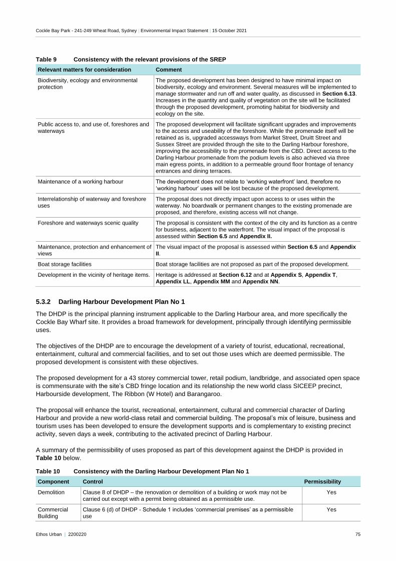
Cockle Bay Park - 241-249 Wheat Road, Sydney | Environmental Impact Statement | 15 October 2021
Ethos Urban | 2200220 75
Table 9 Consistency with the relevant provisions of the SREP
Relevant matters for consideration Comment
Biodiversity, ecology and environmental
protection
The proposed development has been designed to have minimal impact on
biodiversity, ecology and environment. Several measures will be implemented to manage stormwater and run off and water quality, as discussed in Section 6.13. Increases in the quantity and quality of vegetation on the site will be facilitated
through the proposed development, promoting habitat for biodiversity and ecology on the site.
Public access to, and use of, foreshores and waterways
The proposed development will facilitate significant upgrades and improvements to the access and useability of the foreshore. While the promenade itself will be
retained as is, upgraded accessways from Market Street, Druitt Street and Sussex Street are provided through the site to the Darling Harbour foreshore, improving the accessibility to the promenade from the CBD. Direct access to the
Darling Harbour promenade from the podium levels is also achieved via three main egress points, in addition to a permeable ground floor frontage of tenancy entrances and dining terraces.
Maintenance of a working harbour The development does not relate to ‘working waterfront’ land, therefore no
‘working harbour’ uses will be lost because of the proposed development.
Interrelationship of waterway and foreshore uses
The proposal does not directly impact upon access to or uses within the waterway. No boardwalk or permanent changes to the existing promenade are proposed, and therefore, existing access will not change.
Foreshore and waterways scenic quality The proposal is consistent with the context of the city and its function as a centre for business, adjacent to the waterfront. The visual impact of the proposal is
assessed within Section 6.5 and Appendix II.
Maintenance, protection and enhancement of views
The visual impact of the proposal is assessed within Section 6.5 and Appendix II.
Boat storage facilities Boat storage facilities are not proposed as part of the proposed development.
Development in the vicinity of heritage items. Heritage is addressed at Section 6.12 and at Appendix S, Appendix T, Appendix LL, Appendix MM and Appendix NN.
5.3.2 Darling Harbour Development Plan No 1
The DHDP is the principal planning instrument applicable to the Darling Harbour area, and more specifically the
Cockle Bay Wharf site. It provides a broad framework for development, principally through identifying permissible
uses.
The objectives of the DHDP are to encourage the development of a variety of tourist, educational, recreational,
entertainment, cultural and commercial facilities, and to set out those uses which are deemed permissible. The
proposed development is consistent with these objectives.
The proposed development for a 43 storey commercial tower, retail podium, landbridge, and associated open space
is commensurate with the site’s CBD fringe location and its relationship the new world class SICEEP precinct,
Harbourside development, The Ribbon (W Hotel) and Barangaroo.
The proposal will enhance the tourist, recreational, entertainment, cultural and commercial character of Darling
Harbour and provide a new world-class retail and commercial building. The proposal’s mix of leisure, business and
tourism uses has been developed to ensure the development supports and is complementary to existing precinct
activity, seven days a week, contributing to the activated precinct of Darling Harbour.
A summary of the permissibility of uses proposed as part of this development against the DHDP is provided in
Table 10 below.
Table 10 Consistency with the Darling Harbour Development Plan No 1
Component Control Permissibility
Demolition Clause 8 of DHDP – the renovation or demolition of a building or work may not be carried out except with a permit being obtained as a permissible use.
Yes
Commercial Building
Clause 6 (d) of DHDP - Schedule 1 includes ‘commercial premises’ as a permissible use
Yes
Cockle Bay Park - 241-249 Wheat Road, Sydney | Environmental Impact Statement | 15 October 2021
Ethos Urban | 2200220 76
Component Control Permissibility
Public domain improvements
Clause 6 (a) of DHDP includes development for the purposes of recreational facilities as a permissible use
Clause 6 (c) of DHDP includes development for the purposes of beautifying the landscape as a permissible use.
Clause 6 (d) of DHDP – Schedule 1 includes ‘parks and gardens’ as a permissible use. Clause 6 (e) of DHDP includes development for any purpose incidental or subsidiary to
permitted development as a permissible use.
Yes
Retail premises Clause 6 (d) of DHDP – Schedule 1 includes, ‘commercial premises (other than
premises used for pawn broking or other forms of moneylending)’, ‘professional consulting rooms’, ‘recreation facilities’, ‘refreshment rooms’, ‘shops’, and ‘theatre restaurants’ as permissible uses
Yes
Signage e.g.
wayfinding, building identification,
event signage
Clause 6 (a) of DHDP includes development for the purposes of tourist, educational,
recreational, entertainment, cultural facilities or commercial facilities as a permissible use.
Clause 6 (c) of DHDP includes development for the purposes of beautifying the landscape as a permissible use.
Clause 6 (e) of DHDP includes development for any purpose incidental or subsidiary to permitted development as a permissible use
Yes
Extension/ Augmentation of
infrastructure
Clause 6 (d) of DHDP – Schedule 1 includes ‘public utility undertakings’ and ‘utility installation’ as a permissible use.
Clause 6 (e) of DHDP includes development for any purpose incidental or subsidiary to permitted development as a permissible use.
Yes
Development in
vicinity of the Corn Exchange
Clause 11(2) of DHDP requires a permit for the carrying out of development on land
within the vicinity of the Corn Exchange, that may have an effect on the heritage value of the Corn Exchange. This has been addressed in Section 6.12 and Appendix S.
5.4 Consistency with the Concept Approval
As described in Section 5.2, under Section 4.24 of the EP&A Act any detailed application in respect to the site
cannot be inconsistent with a Concept Approval/Stage 1 DA. A detailed summary of how the proposal has achieved
the conditions of consent and mitigation measures as modified under SSD 7684 is provided at Appendix U.
An assessment against the key features of the Stage 1 Concept Approval has been provided below. Detailed
discussions concerning the mitigation measures and strategies proposed under the Concept Approval are
addressed in the following sections, as relevant. In summary, the detailed proposal for Cockle Bay Park is not
inconsistent with the Stage 1 Concept Approval as modified.
Table 11 Consistency with the Concept Approval (Stage 1) DA
Component Discussion Not
inconsistent
Capacity A level by level schedule of the Gross Floor Area delivered by this proposed development at Appendix A confirms that Cockle Bay Park complies with the maximum permitted GFA approved as part of the Concept Approval including the mix of retail and commercial uses to be delivered on the site. The project is expected to generate significant economic and employment opportunities through the proposed commercial and retail floor space being delivered, commensurate with the strategic location of the site within Darling Harbour and at the western edge of the CBD.
✓
Tower height The proposed tower complies with the maximum building height assessed and approved as part of the Concept Approval. The tower will make a positive built form contribution to the skyline, is compatible with the character of Darling Harbour, is in the most appropriate location in terms of its visual, heritage and amenity impacts. A minor building maintenance unit may extend above RL 183m in order to project over the tower crown and enable façade maintenance works. This is a standard requirement for towers and would only occur when the BMU is in operation, ensuring it
✓
Cockle Bay Park - 241-249 Wheat Road, Sydney | Environmental Impact Statement | 15 October 2021
Ethos Urban | 2200220 77
Component Discussion Not inconsistent
does not represent a permanent fixture of the building roofline. When not in operation, the BMU is hidden behind the tower crown and below RL 183m.
Building width, volume,
and floor plate
The proposed building complies with the maximum and average floor plate sizes and
the volumetric building envelope utilisation rate established in the Concept Approval. The width of the tower base and tower also complies with the modified Concept Approval. The built form and massing of the proposed podium, tower base and tower
is a direct outcome of the design competition winning scheme which provides a transition between the these built form elements rather than adopting a defined podium and tower form. The proposed gradual transition of the tower volume from the base
and podium ensures that a human scale is delivered while also creating a slender elegant tower that contributes to the Sydney skyline.
✓
Environmental performance
Sustainability targets and measures were identified in the Concept Approval to guide the environmental performance of the new development. The project will achieve the
identified targets through implementing energy efficiency, energy conservation and Water Sensitive Urban Design measures. The future operation of the site is also informed by a Green Travel Plan (see Appendix FF).
✓
Design excellence In accordance with the adopted Design Excellence Strategy, the project has been the subject of a Design Excellence Competition in accordance with the Government
Architect’s Design Excellence Competition Guidelines. It has since been reviewed by the Design Integrity Panel, who has provided endorsement that the project has achieved the highest standard of architectural, urban and landscape design.
✓
Design Guidelines The proposed building and public domain have been designed having regard to the
site-specific Design Guidelines that were developed to guide this next detailed design phase of the project. An assessment of the proposal against these design guidelines has been provided as part of the Design Report at Appendix A, and discussed where
relevant in the following sections.
✓
Access The proposed development realises the access arrangements proposed in the Concept Approval. Namely, pedestrians and cyclists will be able to access and walk through the site via the landbridge over the Western Distributor that seamlessly
integrates with the existing connections from Market Street, Druitt Street and the Pyrmont Bridge, which significantly improves site permeability and the east-west pedestrian connectivity between Darling Harbour and the CBD. The proposed vehicle and loading access arrangements remain the same as the Concept Approval, proposing a new left-in, left-out connections between Harbour Street and Wheat Road. This connection has been coordinated with the IMAX redevelopment.
✓
Parking, loading and servicing
Consistent with the Concept Approval, no vehicle parking is provided as part of this stage of the project. Bicycle parking and end of trip facilities are being provided on site for staff and patrons and within the public domain for the public, and the operation of the site will continue to utilise the significant available public transport network.
✓
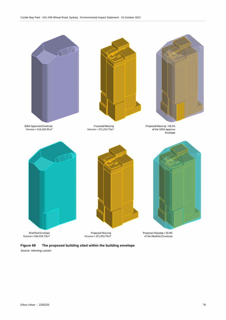
Cockle Bay Park - 241-249 Wheat Road, Sydney | Environmental Impact Statement | 15 October 2021
Ethos Urban | 2200220 78
Figure 69 The proposed building sited within the building envelope
Source: Henning Larsen
Cockle Bay Park - 241-249 Wheat Road, Sydney | Environmental Impact Statement | 15 October 2021
Ethos Urban | 2200220 79
6.0 Environmental Assessment
This chapter of the EIS contains our assessment of the environmental effects of the proposed development as
described in the preceding chapters of this report.
Under Section 4.15 (1) of the EP&A Act, in determining a development application the consent authority has to take
into account a range of matters relevant to the development, including the provisions of environmental planning
instruments; impacts of the built and natural environment, the social and economic impacts of the development; the
suitability of the site; and whether the public interest would be served by the development. The assessment includes
only those key matters under Section 4.15(1) that are relevant to the proposal.
6.1 Design Excellence
The proposed development is the winning entry of a competitive design process undertaken in accordance with the
Government Architect’s Design Excellence Guidelines (see Section 1.2.2). As noted in the Design Excellence
Report prepared by Urbis and provided at Appendix M, the winning scheme was deemed capable of achieving
design excellence pending the resolution of design items. These items have been resolved in design development
and discussed further below.
6.1.1 Competition and design process
The entrants invited to participate were selected due to their demonstrated ability to design high-quality and
sustainable mixed-use towers and public and retail spaces. The six architectural practices and their partnerships
who participated were:
FJMT
Grimshaw
Henning Larsen
UN Studio and Cox Architecture
Wilkinson Eyre
Woods Bagot
Following the receipt of all competition schemes from the above architects, the Jury unanimously identified one
competition scheme that demonstrated the greatest potential for achieving design excellence. Out of the six
competitors, the Jury unanimously awarded the Henning Larsen scheme as the competition winner as it
demonstrated the highest potential for achieving design excellence, with the resolution of some outstanding issues,
as discussed below.
6.1.2 Design integrity
In accordance with Condition A16 of Stage 1 Concept Approval, a Design Integrity Panel (DIP) was established to
review and evaluate the scheme and ensure any outstanding design excellence queries were addressed. The DIP
was established in September 2020, and a total of eight DIP sessions occurred between the commencement of the
process and lodgement. The following key issues were discussed during the DIP sessions with the architects
Henning Larsen and relevant technical experts:
Connectivity
Wayfinding
Site levels
Public open space
Soil volumes and landscaping of the site
Retail strategy
Darling Harbour frontage
Materiality
Environmental management
Tower façade
Microclimate
Environmentally sustainable development
At the conclusion of DIP Session 8, the design team had successfully resolved the majority of development areas
that were identified by the Jury as requiring further design development. The DIP has identified items which require
Cockle Bay Park - 241-249 Wheat Road, Sydney | Environmental Impact Statement | 15 October 2021
Ethos Urban | 2200220 80
continued design refinement through the assessment process or, where relevant, in satisfaction of development
consent conditions. There are as follows:
Darling Harbour frontage – southern retail podium
Market Street / Civic Link connection
Podium Materiality
Greening of the site
6.1.3 Achievement of Design Excellence
In awarding Henning Larsen the winner of the design competition, in partnership with Architects and McGregor
Coxall, a number of development areas were to be addressed in order to achieve design excellence. These
developments were the key focus of the DIP process, as discussed above. The Design Excellence Report provides
a summary of the areas identified as requiring further development by the Jury, and the status of these areas
following design development with the DIP.
Areas requiring further resolution prior to the determination of the development application will be addressed
throughout the assessment of the Stage 2 Development Application, with the DIP remaining engaged throughout to
ensure design excellence is achieved.
Recommendation
It is considered that the design achieves design excellence following the extensive competition and DIP process.
The DIP will remain involved with the project during assessment to ensure that outstanding matters are resolved
prior to determination.
6.2 Built form and urban design
Cockle Bay Park has been developed with consideration of the constraints and opportunities of the site and
surrounds and an understanding of the functional requirements of a mixed-use building that spans over an existing
road corridor and interfaces with prominent circulation pathways between Darling Harbour and the CBD. It has been
the subject of an international competitive design process and has been developed with consideration of the design
excellence criteria nominated in the endorsed Design Excellence Strategy and Design Competition Brief.
The key built form parameters for the project have been established by the Stage 1 Concept Approval, which have
informed the built form and detailed architectural design of the podium and tower, and its relationship to the
surrounding public domain. Specifically, the Design Guidelines approved as part of the Stage 1 DA have provided
the framework for the detailed design of the proposed development to ensure the achievement of design
excellence. The Design Guidelines were a key document forming part of the Design Competition Brief and
competition evaluation process which resulted in the selection of the Henning Larsen design. As detailed in the
Design Statement (Appendix A), the proposed development is also consistent with the building envelope as
modified as per Section 5.4, noting that the Stage 1 Concept Approval is subject to a concurrent modification
application to align the Concept Approval with the detailed design through minor envelope variations.
The detailed design of the built form reduces the overall mass of the tower form through the articulation of the
detailed design. The reduction in the overall mass following the detailed design of the building will reduce the visual
dominance and increase solar access to surrounding residential buildings and areas of public open space.
Overall, the proposed development delivers a built form that is a sensitive and intelligent response to the features of
the site and surrounding area that will deliver a high-quality architectural and landscape outcome for the site. This is
detailed further in the following sections and in the Design Report provided at Appendix A.
Cockle Bay Park - 241-249 Wheat Road, Sydney | Environmental Impact Statement | 15 October 2021
Ethos Urban | 2200220 81
6.2.1 Design approach
The proposed development is fundamentally influenced by the need to accommodate a range of interconnected
spaces that respond to the site’s relationship to Darling Harbour and Central Sydney, requiring the development to
step over the Western Distributor while seamlessly tying into the existing pedestrian connections and the Darling
Park precinct.
Accordingly, the proposed building massing, scale and site layout has been informed by the following key design
moves (as illustrated at Figure 70 below):
1. A landbridge is provided across the Western Distributor which has been carefully designed to provide vertical
separation to the road network beneath; to enable efficient through-movements taking into consideration the
significant level change between the street frontages and waterfront; and to tie into the existing Darling Park
towers and public domain areas. The resultant landbridge provides significant new open space, seamless
pedestrian and cycle connections, and an activated platform for the Cockle Bay Park building commensurate
with the site’s significance as a gateway between Darling Harbour and Central Sydney. These proposed site
improvements are substantial, noting that a place-making opportunity of this magnitude is extremely unique.
2. The building podium transitions from the landbridge to the waterfront promenade level, providing an activated
edge to Darling Harbour. The podium has been horizontally divided into four clusters by circulation nodes
(escalators and stairs into the podium) and further vertically divided into smaller volumes through variable
setbacks and façade typologies. This creates the appearance of a ‘village scale’ at the Darling Harbour frontage
of the site; ensures that the built form is strongly articulated and visually interesting; and provides opportunities
for a range of dining, circulation, and gathering spaces which are visible from the promenade to contribute to a
sense of activity within the broader Darling Harbour entertainment and tourism precinct.
3. The massing of the tower base, and the use of pergolas, has been carefully designed to create a gradual
transition from the podium below to the tower above. Rather than adopting a distinct podium and tower form, the
proposed development provides a seamless transition from the ‘village scale’ podium to the ‘city scale’ tower
above.
4. The tower form has been divided vertically and horizontally through variable setbacks and a series of outdoor
terraces which segment the façade into a series of stacked blocks. This successfully transforms the building
envelope into an articulated, slender tower form. The lower volumes of the tower façade have also been
carefully aligned with the stepped roof heights of the Darling Park towers which reduce in height to the
waterfront, creating a consistent scale and visual relationship between Cockle Bay Park and the existing Darling
Park buildings that make up this city block.
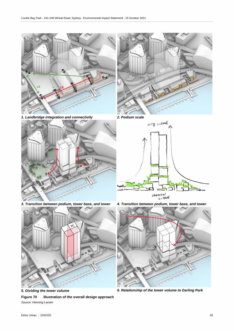
Cockle Bay Park - 241-249 Wheat Road, Sydney | Environmental Impact Statement | 15 October 2021
Ethos Urban | 2200220 82
1. Landbridge integration and connectivity
2. Podium scale
3. Transition between podium, tower base, and tower
4. Transition between podium, tower base, and tower
5. Dividing the tower volume
6. Relationship of the tower volume to Darling Park
Figure 70 Illustration of the overall design approach
Source: Henning Larsen
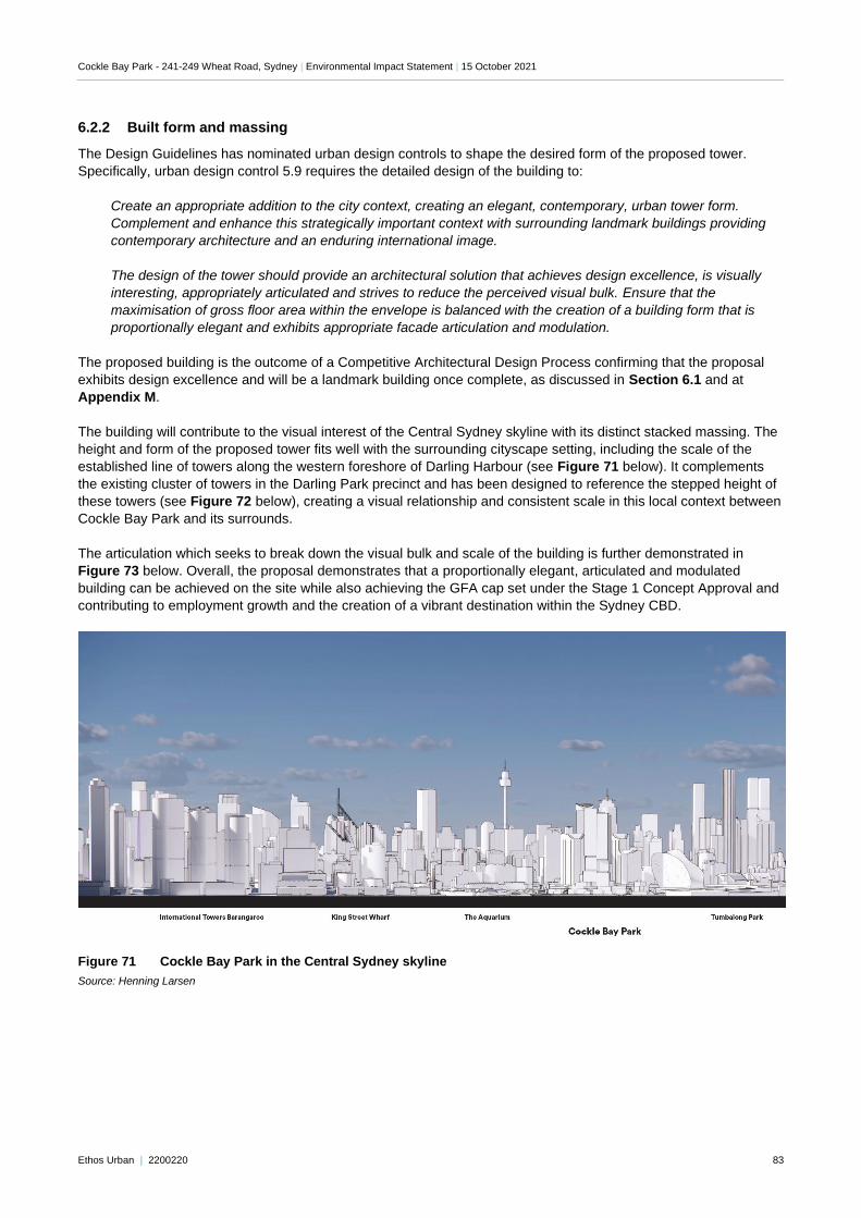
Cockle Bay Park - 241-249 Wheat Road, Sydney | Environmental Impact Statement | 15 October 2021
Ethos Urban | 2200220 83
6.2.2 Built form and massing
The Design Guidelines has nominated urban design controls to shape the desired form of the proposed tower.
Specifically, urban design control 5.9 requires the detailed design of the building to:
Create an appropriate addition to the city context, creating an elegant, contemporary, urban tower form.
Complement and enhance this strategically important context with surrounding landmark buildings providing
contemporary architecture and an enduring international image.
The design of the tower should provide an architectural solution that achieves design excellence, is visually
interesting, appropriately articulated and strives to reduce the perceived visual bulk. Ensure that the
maximisation of gross floor area within the envelope is balanced with the creation of a building form that is
proportionally elegant and exhibits appropriate facade articulation and modulation.
The proposed building is the outcome of a Competitive Architectural Design Process confirming that the proposal
exhibits design excellence and will be a landmark building once complete, as discussed in Section 6.1 and at
Appendix M.
The building will contribute to the visual interest of the Central Sydney skyline with its distinct stacked massing. The
height and form of the proposed tower fits well with the surrounding cityscape setting, including the scale of the
established line of towers along the western foreshore of Darling Harbour (see Figure 71 below). It complements
the existing cluster of towers in the Darling Park precinct and has been designed to reference the stepped height of
these towers (see Figure 72 below), creating a visual relationship and consistent scale in this local context between
Cockle Bay Park and its surrounds.
The articulation which seeks to break down the visual bulk and scale of the building is further demonstrated in
Figure 73 below. Overall, the proposal demonstrates that a proportionally elegant, articulated and modulated
building can be achieved on the site while also achieving the GFA cap set under the Stage 1 Concept Approval and
contributing to employment growth and the creation of a vibrant destination within the Sydney CBD.
Figure 71 Cockle Bay Park in the Central Sydney skyline
Source: Henning Larsen
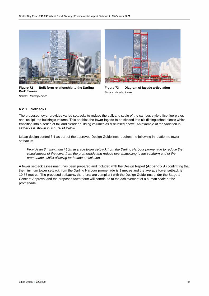
Cockle Bay Park - 241-249 Wheat Road, Sydney | Environmental Impact Statement | 15 October 2021
Ethos Urban | 2200220 84
Figure 72 Built form relationship to the Darling Park towers
Source: Henning Larsen
Figure 73 Diagram of façade articulation
Source: Henning Larsen
6.2.3 Setbacks
The proposed tower provides varied setbacks to reduce the bulk and scale of the campus style office floorplates
and ‘sculpt’ the building’s volume. This enables the tower façade to be divided into six distinguished blocks which
transition into a series of tall and slender building volumes as discussed above. An example of the variation in
setbacks is shown in Figure 74 below.
Urban design control 5.1 as part of the approved Design Guidelines requires the following in relation to tower
setbacks:
Provide an 8m minimum / 10m average tower setback from the Darling Harbour promenade to reduce the
visual impact of the tower from the promenade and reduce overshadowing to the southern end of the
promenade, whilst allowing for facade articulation.
A tower setback assessment has been prepared and included with the Design Report (Appendix A) confirming that
the minimum tower setback from the Darling Harbour promenade is 8 metres and the average tower setback is
10.83 metres. The proposed setbacks, therefore, are compliant with the Design Guidelines under the Stage 1
Concept Approval and the proposed tower form will contribute to the achievement of a human scale at the
promenade.
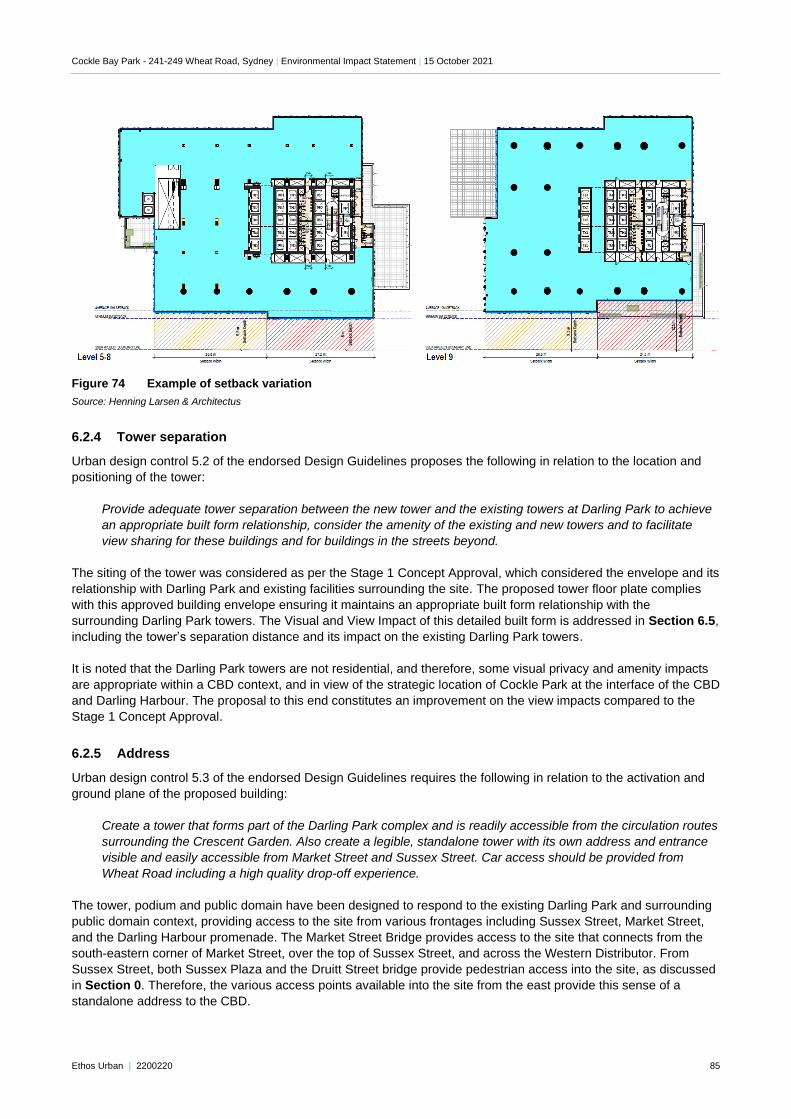
Cockle Bay Park - 241-249 Wheat Road, Sydney | Environmental Impact Statement | 15 October 2021
Ethos Urban | 2200220 85
Figure 74 Example of setback variation
Source: Henning Larsen & Architectus
6.2.4 Tower separation
Urban design control 5.2 of the endorsed Design Guidelines proposes the following in relation to the location and
positioning of the tower:
Provide adequate tower separation between the new tower and the existing towers at Darling Park to achieve
an appropriate built form relationship, consider the amenity of the existing and new towers and to facilitate
view sharing for these buildings and for buildings in the streets beyond.
The siting of the tower was considered as per the Stage 1 Concept Approval, which considered the envelope and its
relationship with Darling Park and existing facilities surrounding the site. The proposed tower floor plate complies
with this approved building envelope ensuring it maintains an appropriate built form relationship with the
surrounding Darling Park towers. The Visual and View Impact of this detailed built form is addressed in Section 6.5,
including the tower’s separation distance and its impact on the existing Darling Park towers.
It is noted that the Darling Park towers are not residential, and therefore, some visual privacy and amenity impacts
are appropriate within a CBD context, and in view of the strategic location of Cockle Park at the interface of the CBD
and Darling Harbour. The proposal to this end constitutes an improvement on the view impacts compared to the
Stage 1 Concept Approval.
6.2.5 Address
Urban design control 5.3 of the endorsed Design Guidelines requires the following in relation to the activation and
ground plane of the proposed building:
Create a tower that forms part of the Darling Park complex and is readily accessible from the circulation routes
surrounding the Crescent Garden. Also create a legible, standalone tower with its own address and entrance
visible and easily accessible from Market Street and Sussex Street. Car access should be provided from
Wheat Road including a high quality drop-off experience.
The tower, podium and public domain have been designed to respond to the existing Darling Park and surrounding
public domain context, providing access to the site from various frontages including Sussex Street, Market Street,
and the Darling Harbour promenade. The Market Street Bridge provides access to the site that connects from the
south-eastern corner of Market Street, over the top of Sussex Street, and across the Western Distributor. From
Sussex Street, both Sussex Plaza and the Druitt Street bridge provide pedestrian access into the site, as discussed
in Section 0. Therefore, the various access points available into the site from the east provide this sense of a
standalone address to the CBD.
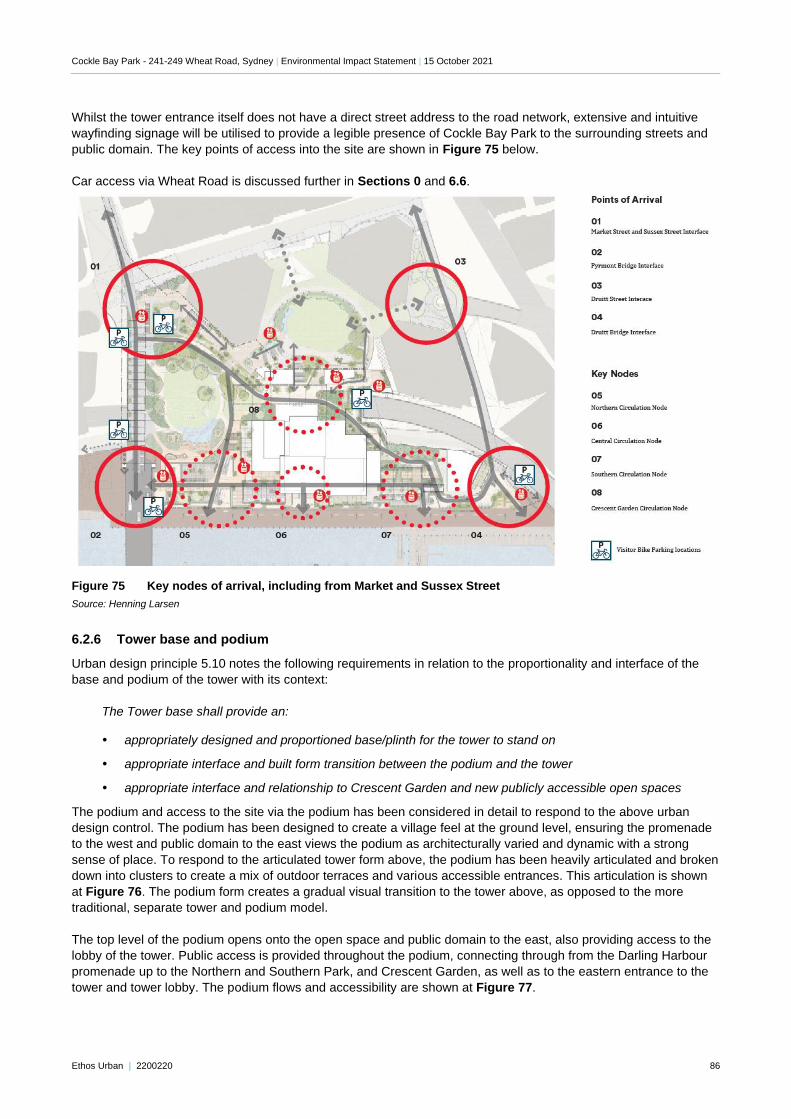
Cockle Bay Park - 241-249 Wheat Road, Sydney | Environmental Impact Statement | 15 October 2021
Ethos Urban | 2200220 86
Whilst the tower entrance itself does not have a direct street address to the road network, extensive and intuitive
wayfinding signage will be utilised to provide a legible presence of Cockle Bay Park to the surrounding streets and
public domain. The key points of access into the site are shown in Figure 75 below.
Car access via Wheat Road is discussed further in Sections 0 and 6.6.
Figure 75 Key nodes of arrival, including from Market and Sussex Street
Source: Henning Larsen
6.2.6 Tower base and podium
Urban design principle 5.10 notes the following requirements in relation to the proportionality and interface of the
base and podium of the tower with its context:
The Tower base shall provide an:
appropriately designed and proportioned base/plinth for the tower to stand on
appropriate interface and built form transition between the podium and the tower
appropriate interface and relationship to Crescent Garden and new publicly accessible open spaces
The podium and access to the site via the podium has been considered in detail to respond to the above urban
design control. The podium has been designed to create a village feel at the ground level, ensuring the promenade
to the west and public domain to the east views the podium as architecturally varied and dynamic with a strong
sense of place. To respond to the articulated tower form above, the podium has been heavily articulated and broken
down into clusters to create a mix of outdoor terraces and various accessible entrances. This articulation is shown
at Figure 76. The podium form creates a gradual visual transition to the tower above, as opposed to the more
traditional, separate tower and podium model.
The top level of the podium opens onto the open space and public domain to the east, also providing access to the
lobby of the tower. Public access is provided throughout the podium, connecting through from the Darling Harbour
promenade up to the Northern and Southern Park, and Crescent Garden, as well as to the eastern entrance to the
tower and tower lobby. The podium flows and accessibility are shown at Figure 77.
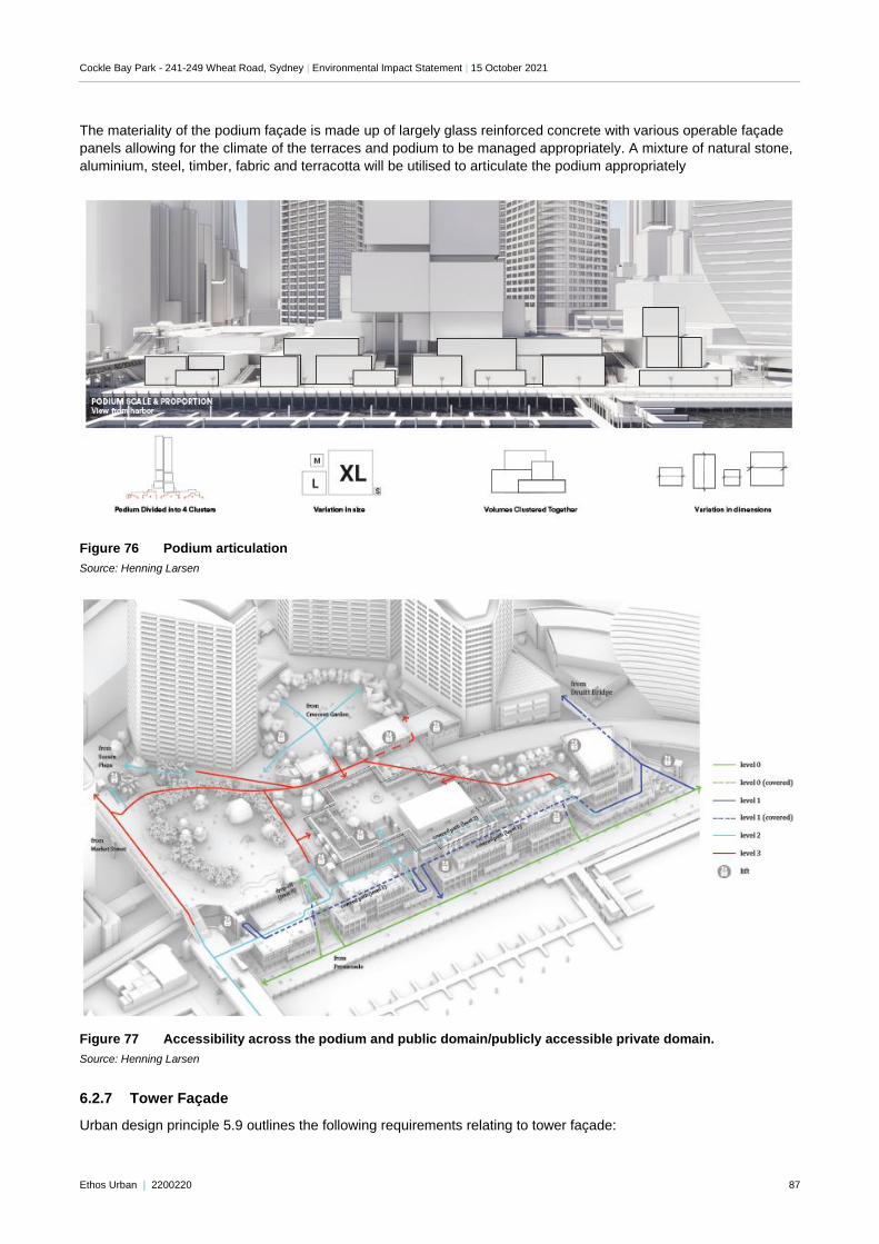
Cockle Bay Park - 241-249 Wheat Road, Sydney | Environmental Impact Statement | 15 October 2021
Ethos Urban | 2200220 87
The materiality of the podium façade is made up of largely glass reinforced concrete with various operable façade
panels allowing for the climate of the terraces and podium to be managed appropriately. A mixture of natural stone,
aluminium, steel, timber, fabric and terracotta will be utilised to articulate the podium appropriately
Figure 76 Podium articulation
Source: Henning Larsen
Figure 77 Accessibility across the podium and public domain/publicly accessible private domain.
Source: Henning Larsen
6.2.7 Tower Façade
Urban design principle 5.9 outlines the following requirements relating to tower façade:
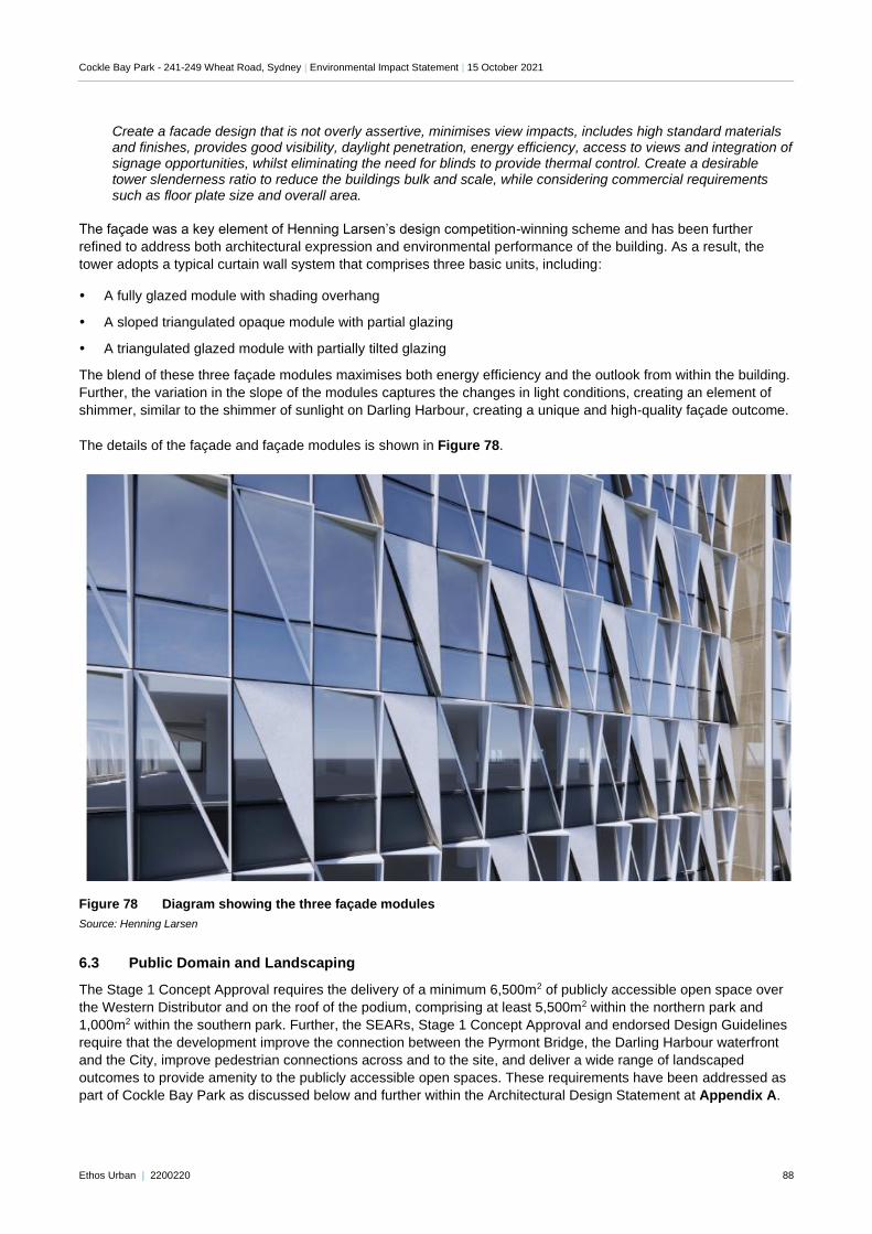
Cockle Bay Park - 241-249 Wheat Road, Sydney | Environmental Impact Statement | 15 October 2021
Ethos Urban | 2200220 88
Create a facade design that is not overly assertive, minimises view impacts, includes high standard materials and finishes, provides good visibility, daylight penetration, energy efficiency, access to views and integration of signage opportunities, whilst eliminating the need for blinds to provide thermal control. Create a desirable tower slenderness ratio to reduce the buildings bulk and scale, while considering commercial requirements such as floor plate size and overall area.
The façade was a key element of Henning Larsen’s design competition-winning scheme and has been further
refined to address both architectural expression and environmental performance of the building. As a result, the
tower adopts a typical curtain wall system that comprises three basic units, including:
A fully glazed module with shading overhang
A sloped triangulated opaque module with partial glazing
A triangulated glazed module with partially tilted glazing
The blend of these three façade modules maximises both energy efficiency and the outlook from within the building.
Further, the variation in the slope of the modules captures the changes in light conditions, creating an element of
shimmer, similar to the shimmer of sunlight on Darling Harbour, creating a unique and high-quality façade outcome.
The details of the façade and façade modules is shown in Figure 78.
Figure 78 Diagram showing the three façade modules
Source: Henning Larsen
6.3 Public Domain and Landscaping
The Stage 1 Concept Approval requires the delivery of a minimum 6,500m2 of publicly accessible open space over
the Western Distributor and on the roof of the podium, comprising at least 5,500m2 within the northern park and
1,000m2 within the southern park. Further, the SEARs, Stage 1 Concept Approval and endorsed Design Guidelines
require that the development improve the connection between the Pyrmont Bridge, the Darling Harbour waterfront
and the City, improve pedestrian connections across and to the site, and deliver a wide range of landscaped
outcomes to provide amenity to the publicly accessible open spaces. These requirements have been addressed as
part of Cockle Bay Park as discussed below and further within the Architectural Design Statement at Appendix A.
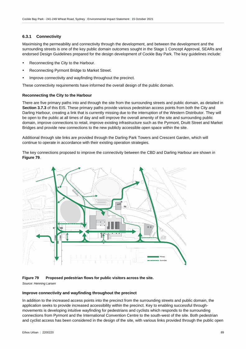
Cockle Bay Park - 241-249 Wheat Road, Sydney | Environmental Impact Statement | 15 October 2021
Ethos Urban | 2200220 89
6.3.1 Connectivity
Maximising the permeability and connectivity through the development, and between the development and the
surrounding streets is one of the key public domain outcomes sought in the Stage 1 Concept Approval, SEARs and
endorsed Design Guidelines prepared for the design development of Cockle Bay Park. The key guidelines include:
Reconnecting the City to the Harbour.
Reconnecting Pyrmont Bridge to Market Street.
Improve connectivity and wayfinding throughout the precinct.
These connectivity requirements have informed the overall design of the public domain.
Reconnecting the City to the Harbour
There are five primary paths into and through the site from the surrounding streets and public domain, as detailed in
Section 3.7.3 of this EIS. These primary paths provide various pedestrian access points from both the City and
Darling Harbour, creating a link that is currently missing due to the interruption of the Western Distributor. They will
be open to the public at all times of day and will improve the overall amenity of the site and surrounding public
domain, improve connections to retail, improve existing infrastructure such as the Pyrmont, Druitt Street and Market
Bridges and provide new connections to the new publicly accessible open space within the site.
Additional through site links are provided through the Darling Park Towers and Crescent Garden, which will
continue to operate in accordance with their existing operation strategies.
The key connections proposed to improve the connectivity between the CBD and Darling Harbour are shown in
Figure 79.
Figure 79 Proposed pedestrian flows for public visitors across the site.
Source: Henning Larsen
Improve connectivity and wayfinding throughout the precinct
In addition to the increased access points into the precinct from the surrounding streets and public domain, the
application seeks to provide increased accessibility within the precinct. Key to enabling successful through-
movements is developing intuitive wayfinding for pedestrians and cyclists which responds to the surrounding
connections from Pyrmont and the International Convention Centre to the south-west of the site. Both pedestrian
and cyclist access has been considered in the design of the site, with various links provided through the public open
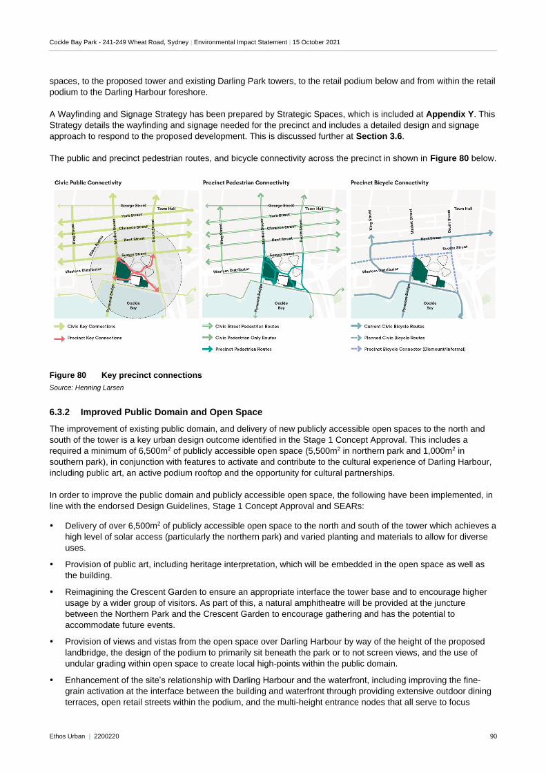
Cockle Bay Park - 241-249 Wheat Road, Sydney | Environmental Impact Statement | 15 October 2021
Ethos Urban | 2200220 90
spaces, to the proposed tower and existing Darling Park towers, to the retail podium below and from within the retail
podium to the Darling Harbour foreshore.
A Wayfinding and Signage Strategy has been prepared by Strategic Spaces, which is included at Appendix Y. This
Strategy details the wayfinding and signage needed for the precinct and includes a detailed design and signage
approach to respond to the proposed development. This is discussed further at Section 3.6.
The public and precinct pedestrian routes, and bicycle connectivity across the precinct in shown in Figure 80 below.
Figure 80 Key precinct connections
Source: Henning Larsen
6.3.2 Improved Public Domain and Open Space
The improvement of existing public domain, and delivery of new publicly accessible open spaces to the north and
south of the tower is a key urban design outcome identified in the Stage 1 Concept Approval. This includes a
required a minimum of 6,500m2 of publicly accessible open space (5,500m2 in northern park and 1,000m2 in
southern park), in conjunction with features to activate and contribute to the cultural experience of Darling Harbour,
including public art, an active podium rooftop and the opportunity for cultural partnerships.
In order to improve the public domain and publicly accessible open space, the following have been implemented, in
line with the endorsed Design Guidelines, Stage 1 Concept Approval and SEARs:
Delivery of over 6,500m2 of publicly accessible open space to the north and south of the tower which achieves a
high level of solar access (particularly the northern park) and varied planting and materials to allow for diverse
uses.
Provision of public art, including heritage interpretation, which will be embedded in the open space as well as
the building.
Reimagining the Crescent Garden to ensure an appropriate interface the tower base and to encourage higher
usage by a wider group of visitors. As part of this, a natural amphitheatre will be provided at the juncture
between the Northern Park and the Crescent Garden to encourage gathering and has the potential to
accommodate future events.
Provision of views and vistas from the open space over Darling Harbour by way of the height of the proposed
landbridge, the design of the podium to primarily sit beneath the park or to not screen views, and the use of
undular grading within open space to create local high-points within the public domain.
Enhancement of the site’s relationship with Darling Harbour and the waterfront, including improving the fine-
grain activation at the interface between the building and waterfront through providing extensive outdoor dining
terraces, open retail streets within the podium, and the multi-height entrance nodes that all serve to focus
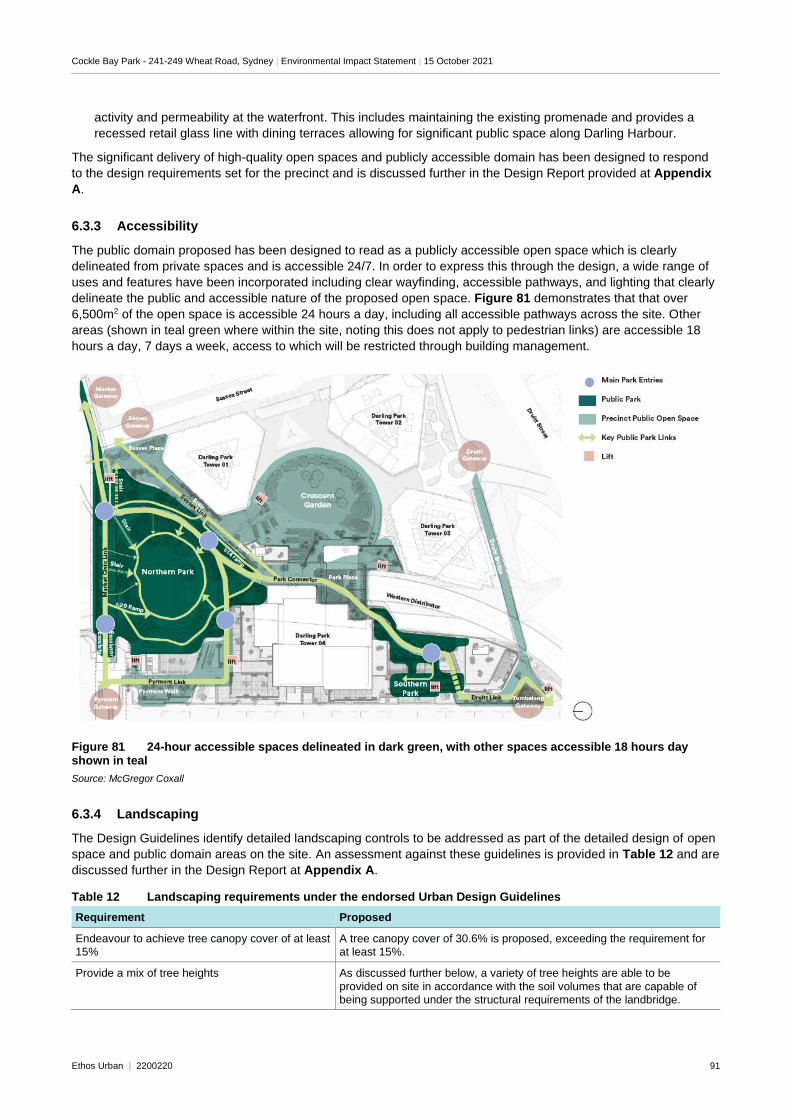
Cockle Bay Park - 241-249 Wheat Road, Sydney | Environmental Impact Statement | 15 October 2021
Ethos Urban | 2200220 91
activity and permeability at the waterfront. This includes maintaining the existing promenade and provides a
recessed retail glass line with dining terraces allowing for significant public space along Darling Harbour.
The significant delivery of high-quality open spaces and publicly accessible domain has been designed to respond
to the design requirements set for the precinct and is discussed further in the Design Report provided at Appendix
A.
6.3.3 Accessibility
The public domain proposed has been designed to read as a publicly accessible open space which is clearly
delineated from private spaces and is accessible 24/7. In order to express this through the design, a wide range of
uses and features have been incorporated including clear wayfinding, accessible pathways, and lighting that clearly
delineate the public and accessible nature of the proposed open space. Figure 81 demonstrates that that over
6,500m2 of the open space is accessible 24 hours a day, including all accessible pathways across the site. Other
areas (shown in teal green where within the site, noting this does not apply to pedestrian links) are accessible 18
hours a day, 7 days a week, access to which will be restricted through building management.
Figure 81 24-hour accessible spaces delineated in dark green, with other spaces accessible 18 hours day shown in teal
Source: McGregor Coxall
6.3.4 Landscaping
The Design Guidelines identify detailed landscaping controls to be addressed as part of the detailed design of open
space and public domain areas on the site. An assessment against these guidelines is provided in Table 12 and are
discussed further in the Design Report at Appendix A.
Table 12 Landscaping requirements under the endorsed Urban Design Guidelines
Requirement Proposed
Endeavour to achieve tree canopy cover of at least 15%
A tree canopy cover of 30.6% is proposed, exceeding the requirement for at least 15%.
Provide a mix of tree heights As discussed further below, a variety of tree heights are able to be
provided on site in accordance with the soil volumes that are capable of being supported under the structural requirements of the landbridge.
Cockle Bay Park - 241-249 Wheat Road, Sydney | Environmental Impact Statement | 15 October 2021
Ethos Urban | 2200220 92
Requirement Proposed
Preference local indigenous species, in accordance with the City of Sydney's Landscape Code
The planting palette of the landscaped areas has been informed by the naturally occurring and Indigenous plants that would have occurred on the site. Further, planting has been undertaken in line with the Gadigal Six
Seasons, which ensures the plants flowering on the site respond to those that would have been naturally flowering at different times of the year on the site.
The use of exotic species has been limited where possible.
Provide soil volumes for different tree sizes including:
• 39m3 for large trees (canopy diameter up to
16m at maturity)
• 38m3 for medium trees (canopy diameter up to 8m at maturity)
• 36m3 for small trees (canopy diameter up to 4m at maturity)
In order to support a healthy and resilient landscaped public park on the landbridge and podium structure, adequate soil volumes as per the City of Sydney Landscape Code have been provided. The following soil depths
provide f or a mix of tree heights consistent with the intent of this guideline:
• 1200mm soil depth for medium trees (up to 9 metres in height), which accounts for 16% of the total park areas.
• 300-1200mm soil for small trees and shrubs
• 300mm soil depth for lawn and ground cover.
All efforts have been made to accommodate as much soil volume as possible to ensure the resilience and wellbeing of the trees, however, due
to the height constraints over the Western Distributor below, the landbridge structure loading is limited and cannot accommodate further soil weight loading.
Accordingly, while strict compliance with this guideline cannot be achieved, adherence to Council’s Code ensures that a variety of tree heights are able
to be provided on site.
Incorporate permeable surfaces where possible A large portion of the ground surfaces will comprise of natural stone in varying forms, including crushed natural stone which is permeable and flagstone and natural slabs which are semi permeable.
Avoid raised planters in the public domain / open
spaces due to their impact in dividing the space, additional technical requirements for irrigation, and limitation on tree
Raised planters are avoided across the public domain. There are elements
of low 150mm kerb edges on select planting areas, but these have not been mounded to a full depth.
6.3.5 Tree Removal
Eco Logical has prepared an Arboricultural Impact Assessment (Appendix AA) identifying the trees within the site,
determining those affected by the proposed works, and evaluating the need to retain or remove trees as part of the
proposed development. As discussed in Section 3.3, the proposed development requires the removal of 95 trees
within the site that will be unavoidably impacted by either the approved Stage 1 works or the proposed Stage 2
redevelopment works that are pursuant to the Concept Approval. All trees proposed to be removed are identified as
being highly impacted by the development, with more than 20% of each tree’s Tree Protection Zone (TPZ) affected.
None of the trees that are proposed to be removed are identified as being of high landscape significance noting that
the majority of trees are exotic species, and have been placed as landscape trees (rather than remanent
vegetation), with a number having been topiarised (located within a planter box).
While this does represent a short-term loss of vegetation on the site, the proposed removal of trees will be mitigated
through significant supplementary planting in the new open space areas that are being delivered as part of the
project and through landscaping that is being integrated into the design of the podium and tower. As discussed
above, the project will achieve and exceed the tree canopy target nominated for this site.
Recommendation
Both the approved Stage 1 demolition works and this next stage of the redevelopment process will require existing
mature trees to be removed. These trees have been assessed by Eco Logical and none are identified as being of
high landscape significance or biological significance. The project will address the proposed interim tree removal
with notable replacement planting to be delivered as part of Cockle Bay Park.
Accordingly, no further study or refinement is required and no specific mitigation measure has been nominated in
this instance.
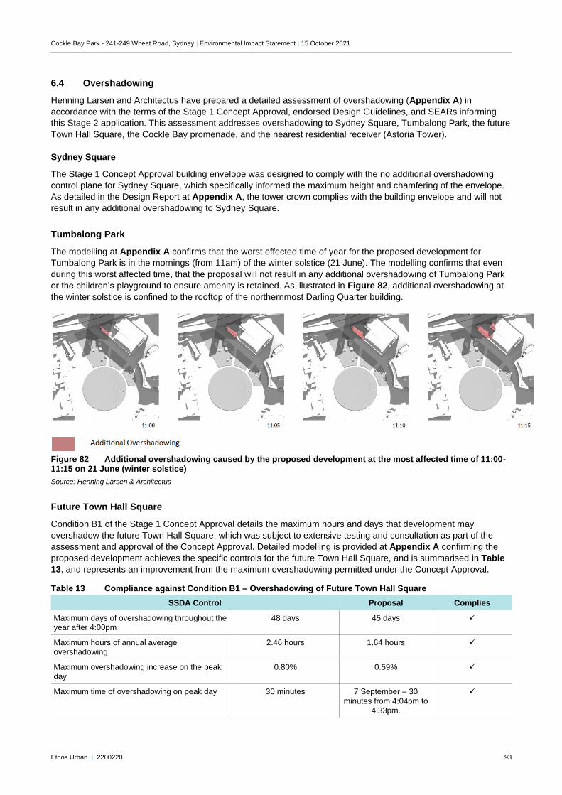
Cockle Bay Park - 241-249 Wheat Road, Sydney | Environmental Impact Statement | 15 October 2021
Ethos Urban | 2200220 93
6.4 Overshadowing
Henning Larsen and Architectus have prepared a detailed assessment of overshadowing (Appendix A) in
accordance with the terms of the Stage 1 Concept Approval, endorsed Design Guidelines, and SEARs informing
this Stage 2 application. This assessment addresses overshadowing to Sydney Square, Tumbalong Park, the future
Town Hall Square, the Cockle Bay promenade, and the nearest residential receiver (Astoria Tower).
Sydney Square
The Stage 1 Concept Approval building envelope was designed to comply with the no additional overshadowing
control plane for Sydney Square, which specifically informed the maximum height and chamfering of the envelope.
As detailed in the Design Report at Appendix A, the tower crown complies with the building envelope and will not
result in any additional overshadowing to Sydney Square.
Tumbalong Park
The modelling at Appendix A confirms that the worst effected time of year for the proposed development for
Tumbalong Park is in the mornings (from 11am) of the winter solstice (21 June). The modelling confirms that even
during this worst affected time, that the proposal will not result in any additional overshadowing of Tumbalong Park
or the children’s playground to ensure amenity is retained. As illustrated in Figure 82, additional overshadowing at
the winter solstice is confined to the rooftop of the northernmost Darling Quarter building.
Figure 82 Additional overshadowing caused by the proposed development at the most affected time of 11:00-11:15 on 21 June (winter solstice)
Source: Henning Larsen & Architectus
Future Town Hall Square
Condition B1 of the Stage 1 Concept Approval details the maximum hours and days that development may
overshadow the future Town Hall Square, which was subject to extensive testing and consultation as part of the
assessment and approval of the Concept Approval. Detailed modelling is provided at Appendix A confirming the
proposed development achieves the specific controls for the future Town Hall Square, and is summarised in Table
13, and represents an improvement from the maximum overshadowing permitted under the Concept Approval.
Table 13 Compliance against Condition B1 – Overshadowing of Future Town Hall Square
SSDA Control Proposal Complies
Maximum days of overshadowing throughout the year after 4:00pm
48 days 45 days ✓
Maximum hours of annual average overshadowing
2.46 hours 1.64 hours ✓
Maximum overshadowing increase on the peak day
0.80% 0.59% ✓
Maximum time of overshadowing on peak day 30 minutes 7 September – 30
minutes from 4:04pm to 4:33pm.
✓
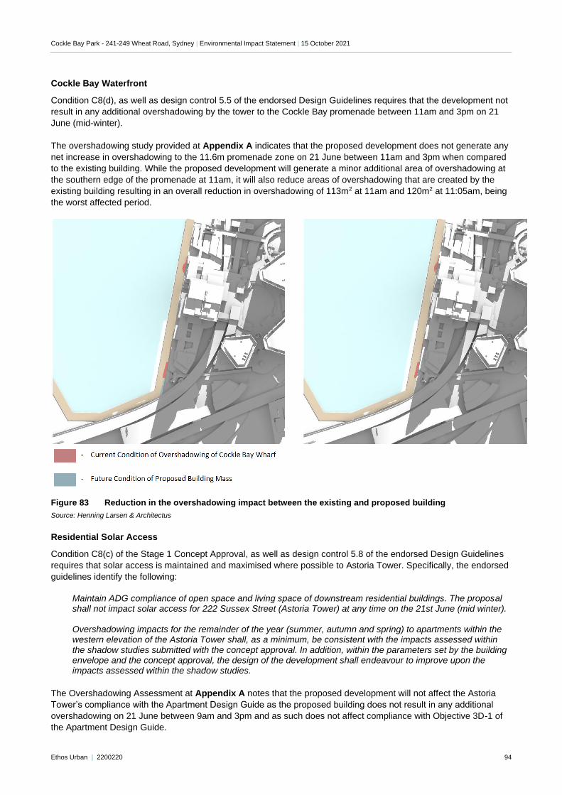
Cockle Bay Park - 241-249 Wheat Road, Sydney | Environmental Impact Statement | 15 October 2021
Ethos Urban | 2200220 94
Cockle Bay Waterfront
Condition C8(d), as well as design control 5.5 of the endorsed Design Guidelines requires that the development not
result in any additional overshadowing by the tower to the Cockle Bay promenade between 11am and 3pm on 21
June (mid-winter).
The overshadowing study provided at Appendix A indicates that the proposed development does not generate any
net increase in overshadowing to the 11.6m promenade zone on 21 June between 11am and 3pm when compared
to the existing building. While the proposed development will generate a minor additional area of overshadowing at
the southern edge of the promenade at 11am, it will also reduce areas of overshadowing that are created by the
existing building resulting in an overall reduction in overshadowing of 113m2 at 11am and 120m2 at 11:05am, being
the worst affected period.
Figure 83 Reduction in the overshadowing impact between the existing and proposed building
Source: Henning Larsen & Architectus
Residential Solar Access
Condition C8(c) of the Stage 1 Concept Approval, as well as design control 5.8 of the endorsed Design Guidelines
requires that solar access is maintained and maximised where possible to Astoria Tower. Specifically, the endorsed
guidelines identify the following:
Maintain ADG compliance of open space and living space of downstream residential buildings. The proposal shall not impact solar access for 222 Sussex Street (Astoria Tower) at any time on the 21st June (mid winter). Overshadowing impacts for the remainder of the year (summer, autumn and spring) to apartments within the western elevation of the Astoria Tower shall, as a minimum, be consistent with the impacts assessed within the shadow studies submitted with the concept approval. In addition, within the parameters set by the building envelope and the concept approval, the design of the development shall endeavour to improve upon the impacts assessed within the shadow studies.
The Overshadowing Assessment at Appendix A notes that the proposed development will not affect the Astoria
Tower’s compliance with the Apartment Design Guide as the proposed building does not result in any additional
overshadowing on 21 June between 9am and 3pm and as such does not affect compliance with Objective 3D-1 of
the Apartment Design Guide.
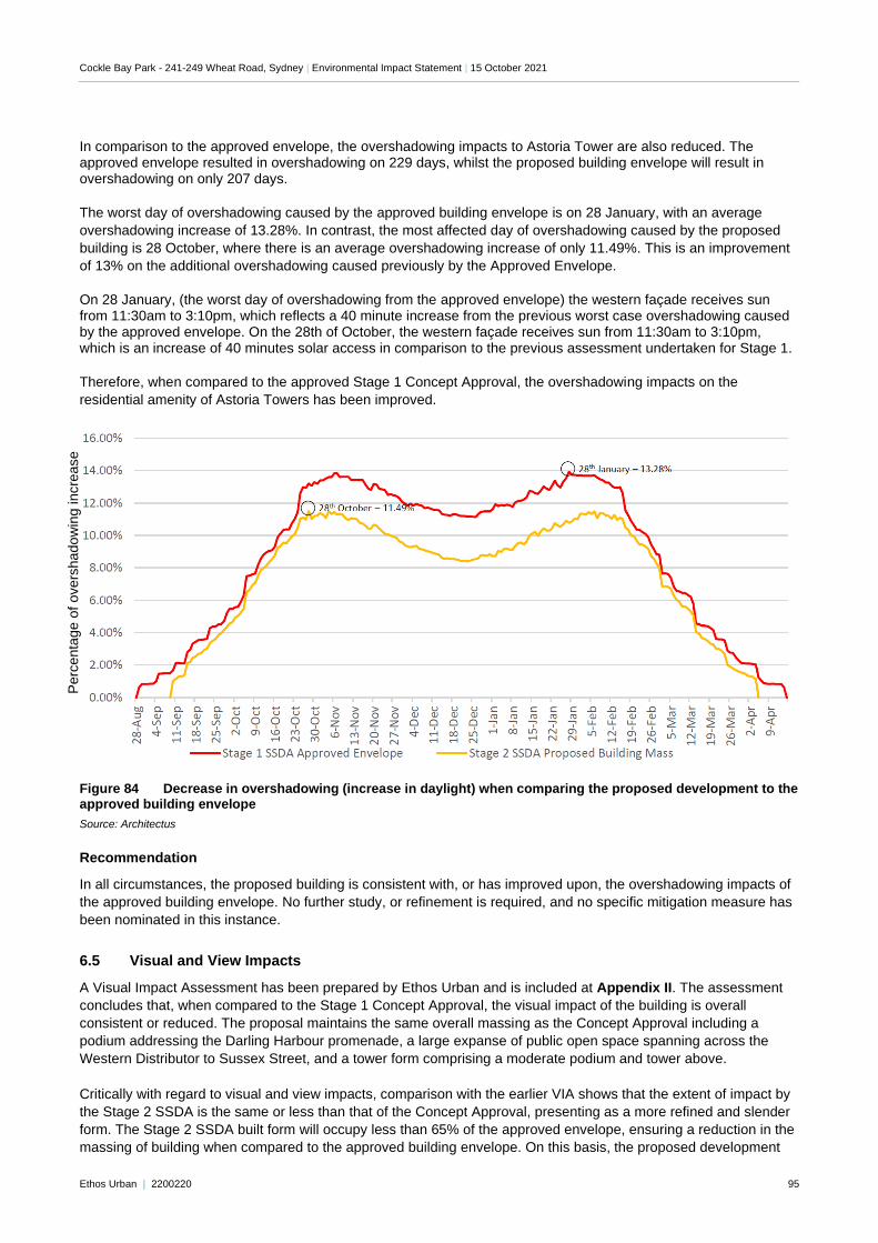
Cockle Bay Park - 241-249 Wheat Road, Sydney | Environmental Impact Statement | 15 October 2021
Ethos Urban | 2200220 95
In comparison to the approved envelope, the overshadowing impacts to Astoria Tower are also reduced. The approved envelope resulted in overshadowing on 229 days, whilst the proposed building envelope will result in overshadowing on only 207 days.
The worst day of overshadowing caused by the approved building envelope is on 28 January, with an average
overshadowing increase of 13.28%. In contrast, the most affected day of overshadowing caused by the proposed
building is 28 October, where there is an average overshadowing increase of only 11.49%. This is an improvement
of 13% on the additional overshadowing caused previously by the Approved Envelope.
On 28 January, (the worst day of overshadowing from the approved envelope) the western façade receives sun from 11:30am to 3:10pm, which reflects a 40 minute increase from the previous worst case overshadowing caused by the approved envelope. On the 28th of October, the western façade receives sun from 11:30am to 3:10pm, which is an increase of 40 minutes solar access in comparison to the previous assessment undertaken for Stage 1.
Therefore, when compared to the approved Stage 1 Concept Approval, the overshadowing impacts on the
residential amenity of Astoria Towers has been improved.
Figure 84 Decrease in overshadowing (increase in daylight) when comparing the proposed development to the approved building envelope
Source: Architectus
Recommendation
In all circumstances, the proposed building is consistent with, or has improved upon, the overshadowing impacts of
the approved building envelope. No further study, or refinement is required, and no specific mitigation measure has
been nominated in this instance.
6.5 Visual and View Impacts
A Visual Impact Assessment has been prepared by Ethos Urban and is included at Appendix II. The assessment
concludes that, when compared to the Stage 1 Concept Approval, the visual impact of the building is overall
consistent or reduced. The proposal maintains the same overall massing as the Concept Approval including a
podium addressing the Darling Harbour promenade, a large expanse of public open space spanning across the
Western Distributor to Sussex Street, and a tower form comprising a moderate podium and tower above.
Critically with regard to visual and view impacts, comparison with the earlier VIA shows that the extent of impact by
the Stage 2 SSDA is the same or less than that of the Concept Approval, presenting as a more refined and slender
form. The Stage 2 SSDA built form will occupy less than 65% of the approved envelope, ensuring a reduction in the
massing of building when compared to the approved building envelope. On this basis, the proposed development
Perc
enta
ge o
f overs
hado
win
g incre
ase
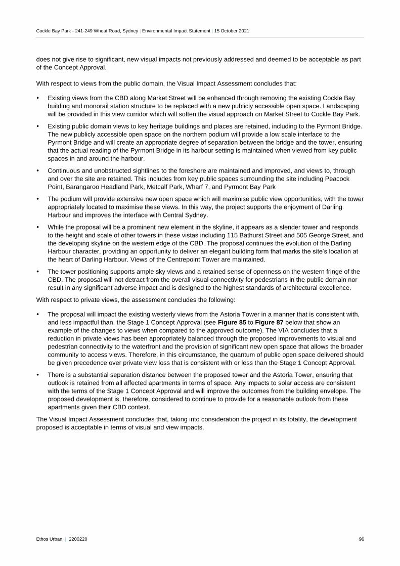
Cockle Bay Park - 241-249 Wheat Road, Sydney | Environmental Impact Statement | 15 October 2021
Ethos Urban | 2200220 96
does not give rise to significant, new visual impacts not previously addressed and deemed to be acceptable as part
of the Concept Approval.
With respect to views from the public domain, the Visual Impact Assessment concludes that:
Existing views from the CBD along Market Street will be enhanced through removing the existing Cockle Bay
building and monorail station structure to be replaced with a new publicly accessible open space. Landscaping
will be provided in this view corridor which will soften the visual approach on Market Street to Cockle Bay Park.
Existing public domain views to key heritage buildings and places are retained, including to the Pyrmont Bridge.
The new publicly accessible open space on the northern podium will provide a low scale interface to the
Pyrmont Bridge and will create an appropriate degree of separation between the bridge and the tower, ensuring
that the actual reading of the Pyrmont Bridge in its harbour setting is maintained when viewed from key public
spaces in and around the harbour.
Continuous and unobstructed sightlines to the foreshore are maintained and improved, and views to, through
and over the site are retained. This includes from key public spaces surrounding the site including Peacock
Point, Barangaroo Headland Park, Metcalf Park, Wharf 7, and Pyrmont Bay Park
The podium will provide extensive new open space which will maximise public view opportunities, with the tower
appropriately located to maximise these views. In this way, the project supports the enjoyment of Darling
Harbour and improves the interface with Central Sydney.
While the proposal will be a prominent new element in the skyline, it appears as a slender tower and responds
to the height and scale of other towers in these vistas including 115 Bathurst Street and 505 George Street, and
the developing skyline on the western edge of the CBD. The proposal continues the evolution of the Darling
Harbour character, providing an opportunity to deliver an elegant building form that marks the site’s location at
the heart of Darling Harbour. Views of the Centrepoint Tower are maintained.
The tower positioning supports ample sky views and a retained sense of openness on the western fringe of the
CBD. The proposal will not detract from the overall visual connectivity for pedestrians in the public domain nor
result in any significant adverse impact and is designed to the highest standards of architectural excellence.
With respect to private views, the assessment concludes the following:
The proposal will impact the existing westerly views from the Astoria Tower in a manner that is consistent with,
and less impactful than, the Stage 1 Concept Approval (see Figure 85 to Figure 87 below that show an
example of the changes to views when compared to the approved outcome). The VIA concludes that a
reduction in private views has been appropriately balanced through the proposed improvements to visual and
pedestrian connectivity to the waterfront and the provision of significant new open space that allows the broader
community to access views. Therefore, in this circumstance, the quantum of public open space delivered should
be given precedence over private view loss that is consistent with or less than the Stage 1 Concept Approval.
There is a substantial separation distance between the proposed tower and the Astoria Tower, ensuring that
outlook is retained from all affected apartments in terms of space. Any impacts to solar access are consistent
with the terms of the Stage 1 Concept Approval and will improve the outcomes from the building envelope. The
proposed development is, therefore, considered to continue to provide for a reasonable outlook from these
apartments given their CBD context.
The Visual Impact Assessment concludes that, taking into consideration the project in its totality, the development
proposed is acceptable in terms of visual and view impacts.
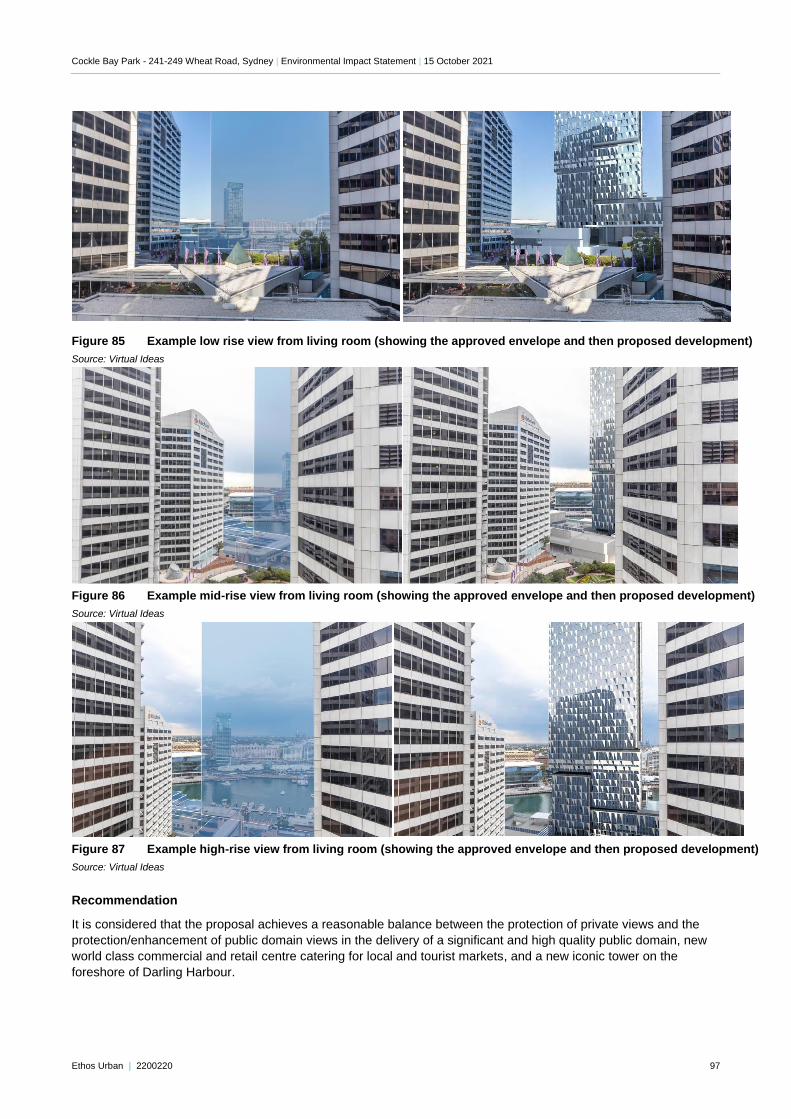
Cockle Bay Park - 241-249 Wheat Road, Sydney | Environmental Impact Statement | 15 October 2021
Ethos Urban | 2200220 97
Figure 85 Example low rise view from living room (showing the approved envelope and then proposed development)
Source: Virtual Ideas
Figure 86 Example mid-rise view from living room (showing the approved envelope and then proposed development)
Source: Virtual Ideas
Figure 87 Example high-rise view from living room (showing the approved envelope and then proposed development)
Source: Virtual Ideas
Recommendation
It is considered that the proposal achieves a reasonable balance between the protection of private views and the
protection/enhancement of public domain views in the delivery of a significant and high quality public domain, new
world class commercial and retail centre catering for local and tourist markets, and a new iconic tower on the
foreshore of Darling Harbour.
Cockle Bay Park - 241-249 Wheat Road, Sydney | Environmental Impact Statement | 15 October 2021
Ethos Urban | 2200220 98
Taking into consideration the project in its totality, the development proposed is acceptable in terms of visual and
view impacts. As this VIA has found that the visual impact of the proposal is acceptable when considered against
the planning framework and the public benefit being delivered, no mitigation measures are recommended or
considered necessary to reduce visual impacts.
6.6 Transportation and accessibility
Aurecon has prepared a Traffic Impact Assessment (Appendix FF) providing a strategy for access to Cockle Bay
Park during the operation phase, and a preliminary Construction Pedestrian Traffic Management Plan (Appendix I)
detailing access during the construction phase.
6.6.1 Operation
Parking
Vehicles
No long term stay car and vehicular parking will be provided as part of Cockle Bay Park at this stage, in compliance
with the Concept Approval consent that establishes a maximum parking rate for the project. Those that choose to
drive to the site will be able to utilise on-street parking or the number of public parking stations located within a
400m radius of the proposed development, including the commercial parking station in the basement of the
adjoining Darling Park towers. This is considered to adequately cater for the proposed development, which benefits
from excellent access to public transport as the primary transport mode used to travel to and from Central Sydney,
and supports the broader transport strategy for the Sydney CBD of reducing private vehicle dependence.
Bicycles
Bicycle parking and end of trip facilities (lockers, showers) will be provided for use by staff and visitors, as well as in
the public domain for use by the public. A Cyclist Movement Strategy has been prepared by Arup and is included at
Appendix GG. This application seeks to deliver bicycle parking and end of trip facilities at a demand driven rate to
better reflect the likely required amount of bicycle facilities on the site. Benchmarking has been undertaken with
surrounding commercial buildings in the CBD, in order to inform the delivery to understand the required number of
bicycle parking spaces, lockers and showers based on the uses of the building and surrounding infrastructure. This
benchmarking shows the following, in comparison to the Sydney DCP:
The average provision of bike spaces is 0.49% of GFA.
Assuming a population density of 1:10m2 of NLA and an NLA to GFA ratio of 88% (as per this development),
the average bike parking provision is equivalent to a bike mode share of 5.5%, compared to the DCP mode
share of 7.6%.
The existing bike mode share for Sydney CBD has been found to be around 2.5%.
Growth in bike mode share has been fairly constant at an additional 0.05% per decade.
Reflecting the intent of the cities’ strategy to accelerate the growth of bike mode share a growth rate of 4% has
been assumed for the design of this development, bringing the total mode share to 6.5% bikes.
Applying this mode share to the Cockle Bay Park GFA of 75,000m2 and 6,600 population results in a target
demand of 423 commercial tenant bike space (0.58% spaces per sqm GFA).
The benchmarking also notes that many buildings, including the existing Darling Park towers, have an underused
bicycle rack facility but a larger demand for lockers, and as a result retrofits are regularly happening to reduce the
number of bike parking spaces and increase the user amenity and locker numbers to accommodate for other forms
of active transport (walking and running) and exercise. Further, walk/run mode share has been found to be
approximately 4%, meaning these users require access to showers and lockers rather than bicycle parking spaces.
In addition to this, the visitor bicycle parking rates are proposed to be delivered in line with the Green Star
requirement and similar urban renewal projects in Sydney. Compliance with the Sydney DCP 2012 would require
the provision of 235 bicycle parking spaces within the public domain, which could not be physically accommodated
within the proposed open space without significantly impacting the usability of this new park. Further, it is noted that the broader precinct contains numerous spaces that precinct visitors can utilise at a range of locations including Barangaroo, Darling Quarter, King Street Wharf, Pyrmont, and more.
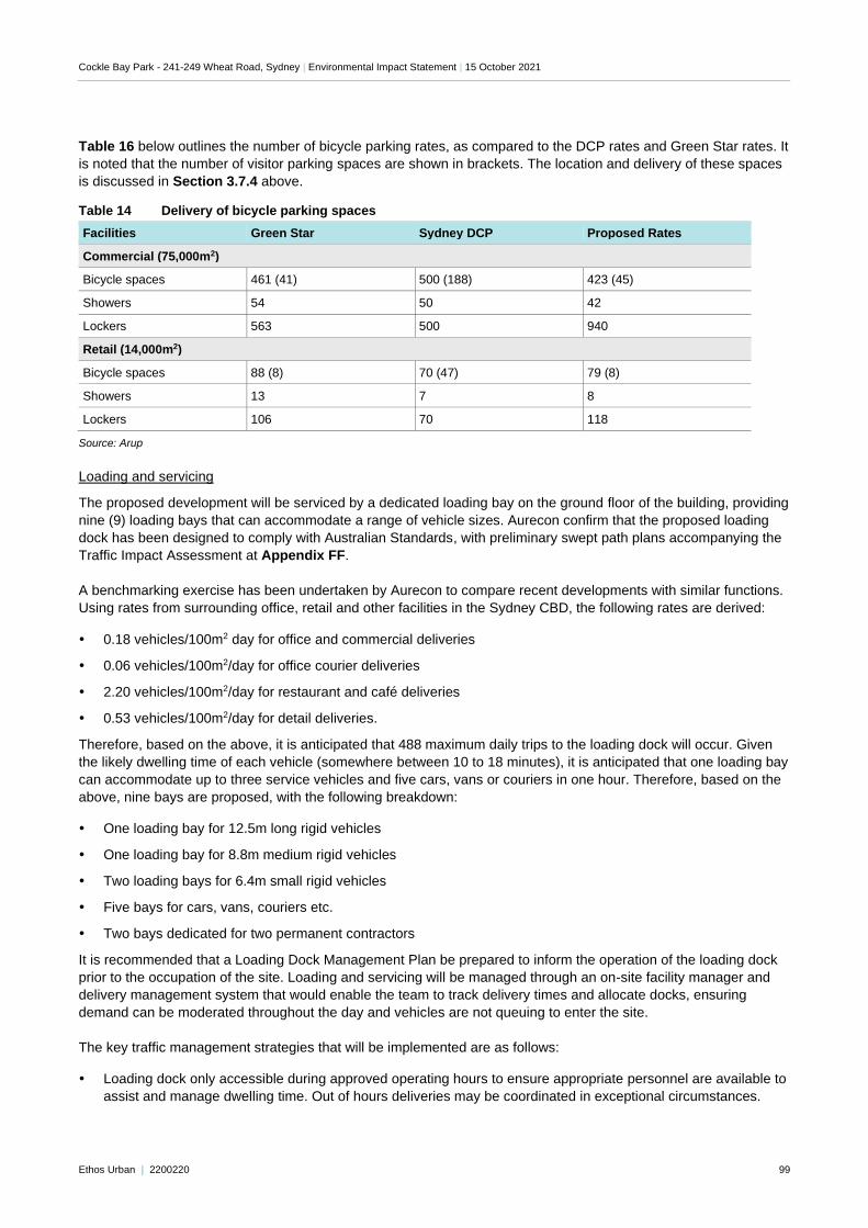
Cockle Bay Park - 241-249 Wheat Road, Sydney | Environmental Impact Statement | 15 October 2021
Ethos Urban | 2200220 99
Table 16 below outlines the number of bicycle parking rates, as compared to the DCP rates and Green Star rates. It
is noted that the number of visitor parking spaces are shown in brackets. The location and delivery of these spaces
is discussed in Section 3.7.4 above.
Table 14 Delivery of bicycle parking spaces
Facilities Green Star Sydney DCP Proposed Rates
Commercial (75,000m2)
Bicycle spaces 461 (41) 500 (188) 423 (45)
Showers 54 50 42
Lockers 563 500 940
Retail (14,000m2)
Bicycle spaces 88 (8) 70 (47) 79 (8)
Showers 13 7 8
Lockers 106 70 118
Source: Arup
Loading and servicing
The proposed development will be serviced by a dedicated loading bay on the ground floor of the building, providing
nine (9) loading bays that can accommodate a range of vehicle sizes. Aurecon confirm that the proposed loading
dock has been designed to comply with Australian Standards, with preliminary swept path plans accompanying the
Traffic Impact Assessment at Appendix FF.
A benchmarking exercise has been undertaken by Aurecon to compare recent developments with similar functions.
Using rates from surrounding office, retail and other facilities in the Sydney CBD, the following rates are derived:
0.18 vehicles/100m2 day for office and commercial deliveries
0.06 vehicles/100m2/day for office courier deliveries
2.20 vehicles/100m2/day for restaurant and café deliveries
0.53 vehicles/100m2/day for detail deliveries.
Therefore, based on the above, it is anticipated that 488 maximum daily trips to the loading dock will occur. Given
the likely dwelling time of each vehicle (somewhere between 10 to 18 minutes), it is anticipated that one loading bay
can accommodate up to three service vehicles and five cars, vans or couriers in one hour. Therefore, based on the
above, nine bays are proposed, with the following breakdown:
One loading bay for 12.5m long rigid vehicles
One loading bay for 8.8m medium rigid vehicles
Two loading bays for 6.4m small rigid vehicles
Five bays for cars, vans, couriers etc.
Two bays dedicated for two permanent contractors
It is recommended that a Loading Dock Management Plan be prepared to inform the operation of the loading dock
prior to the occupation of the site. Loading and servicing will be managed through an on-site facility manager and
delivery management system that would enable the team to track delivery times and allocate docks, ensuring
demand can be moderated throughout the day and vehicles are not queuing to enter the site.
The key traffic management strategies that will be implemented are as follows:
Loading dock only accessible during approved operating hours to ensure appropriate personnel are available to
assist and manage dwelling time. Out of hours deliveries may be coordinated in exceptional circumstances.
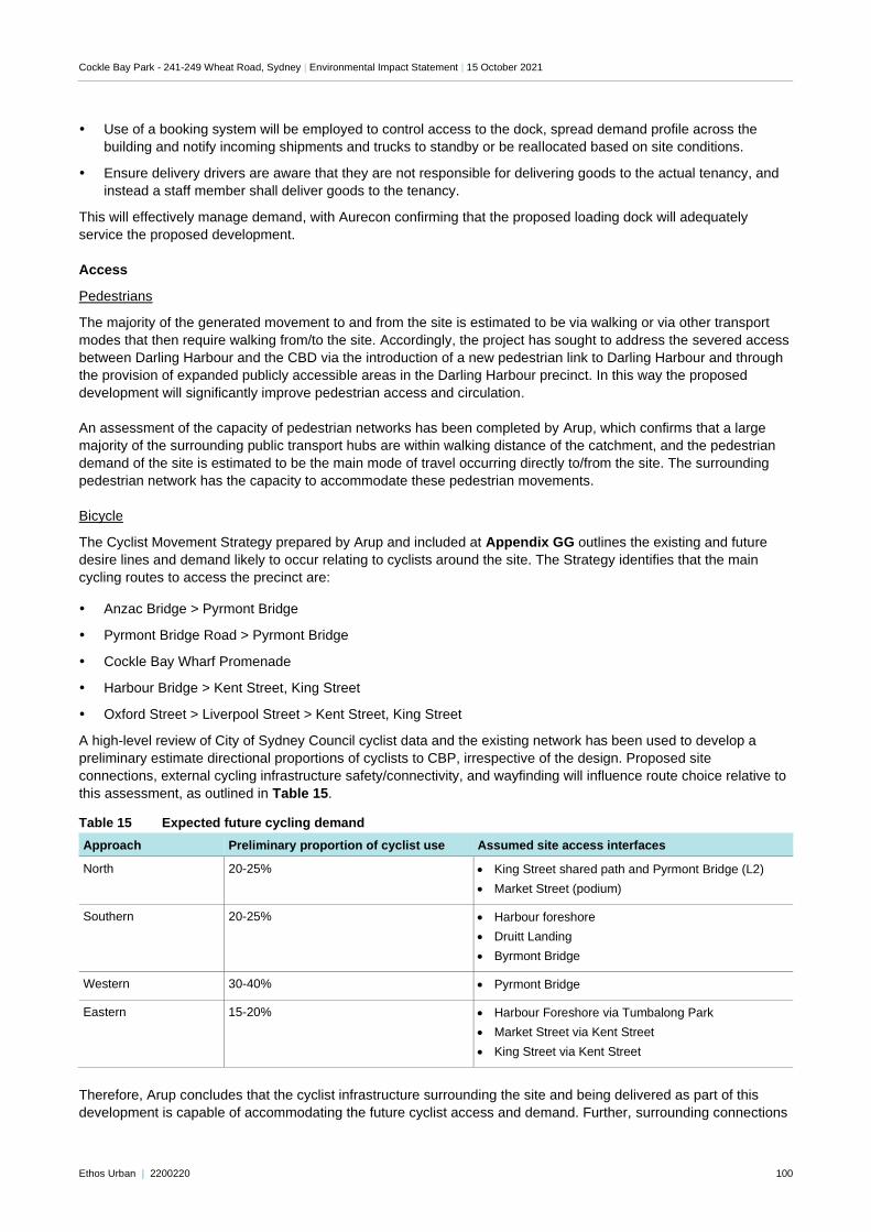
Cockle Bay Park - 241-249 Wheat Road, Sydney | Environmental Impact Statement | 15 October 2021
Ethos Urban | 2200220 100
Use of a booking system will be employed to control access to the dock, spread demand profile across the
building and notify incoming shipments and trucks to standby or be reallocated based on site conditions.
Ensure delivery drivers are aware that they are not responsible for delivering goods to the actual tenancy, and
instead a staff member shall deliver goods to the tenancy.
This will effectively manage demand, with Aurecon confirming that the proposed loading dock will adequately
service the proposed development.
Access
Pedestrians
The majority of the generated movement to and from the site is estimated to be via walking or via other transport
modes that then require walking from/to the site. Accordingly, the project has sought to address the severed access
between Darling Harbour and the CBD via the introduction of a new pedestrian link to Darling Harbour and through
the provision of expanded publicly accessible areas in the Darling Harbour precinct. In this way the proposed
development will significantly improve pedestrian access and circulation.
An assessment of the capacity of pedestrian networks has been completed by Arup, which confirms that a large
majority of the surrounding public transport hubs are within walking distance of the catchment, and the pedestrian
demand of the site is estimated to be the main mode of travel occurring directly to/from the site. The surrounding
pedestrian network has the capacity to accommodate these pedestrian movements.
Bicycle
The Cyclist Movement Strategy prepared by Arup and included at Appendix GG outlines the existing and future
desire lines and demand likely to occur relating to cyclists around the site. The Strategy identifies that the main
cycling routes to access the precinct are:
Anzac Bridge > Pyrmont Bridge
Pyrmont Bridge Road > Pyrmont Bridge
Cockle Bay Wharf Promenade
Harbour Bridge > Kent Street, King Street
Oxford Street > Liverpool Street > Kent Street, King Street
A high-level review of City of Sydney Council cyclist data and the existing network has been used to develop a
preliminary estimate directional proportions of cyclists to CBP, irrespective of the design. Proposed site
connections, external cycling infrastructure safety/connectivity, and wayfinding will influence route choice relative to
this assessment, as outlined in Table 15.
Table 15 Expected future cycling demand
Approach Preliminary proportion of cyclist use Assumed site access interfaces
North 20-25% • King Street shared path and Pyrmont Bridge (L2)
• Market Street (podium)
Southern 20-25% • Harbour foreshore
• Druitt Landing
• Byrmont Bridge
Western 30-40% • Pyrmont Bridge
Eastern 15-20% • Harbour Foreshore via Tumbalong Park
• Market Street via Kent Street
• King Street via Kent Street
Therefore, Arup concludes that the cyclist infrastructure surrounding the site and being delivered as part of this
development is capable of accommodating the future cyclist access and demand. Further, surrounding connections
Cockle Bay Park - 241-249 Wheat Road, Sydney | Environmental Impact Statement | 15 October 2021
Ethos Urban | 2200220 101
identified from Pyrmont Bridge and along the Western Distributor between King Street and Liverpool Street are not
precluded from operation or future upgrades as a result of this application.
Point to point
The proposed porte-cochere as part of the development will provide six (6) spaces for pick-up and drop-off, which would be utilised by taxis and well as ride-share services. Kerbside parking is also currently permitted along the western side Wheat Road, generally for coaches, taxis and universal access parking.
Aurecon confirm that that during the busiest 15 minute period in the AM peak approximately 17-20 vehicles will
utilise the porte cochère when adopting the existing mode share context for this area of the Sydney CBD. It is
confirmed that this demand can be accommodated within the porte-cochere if limited dwell times are enforced.
Accordingly, it is recommended that signage be installed as part of the detailed design and operation of the building
communicating that vehicles must not exceed 5 minutes of parking time.
Vehicles
As discussed in Section 3.7.1 above, the connection between Wheat Road and Harbour Street at the southern end
of the site will be modified to provide a left in, left out only for service vehicles to enter and access the loading dock
and will also facilitate egress from the adjacent Ribbon development located south of the site. This proposed road
upgrades will be subject to further design and works in consultation with RMS or the relevant road authority.
It should be noted that vehicular access to the site will not interact with public pedestrian and cycling connections
which occur over Wheat Road via the proposed public domain areas or bridged connections, ensuring there is no
conflict between these transport modes.
Traffic generation
Aurecon confirm that because vehicle access to the site is predicated on a left-in and left-out movement design,
there is no opposing movement to cause vehicles to be delayed or queued significantly and as such SIDRA
modelling has not been deemed necessary. Aurecon has provided an assessment of the queuing capacity of the
proposed development, which confirms that six vehicles are able to be accommodate in the loading dock and seven
at the porte cochere, if there are issues with vehicles exiting onto Wheat Road. This will be adequate in storing the
expended amount of vehicles queuing at any one time.
Sustainability
The proposed development represents an excellent opportunity to promote the use of sustainable and active
transport when travelling to and from the site. In view of this, Aurecon has prepared a preliminary Green Travel Plan
which has identified a number of strategies and measures that may be implemented to reduce dependency on
private vehicles and promote other modes of transport. These initiatives will naturally evolve with time and be
refined before the project commences operating. It is targeted that there will be an increase in public transport
usage and there will be no reduction in walking or cycling.
These initiatives demonstrate the project’s commitment to creating a more sustainable and resilient precinct that
minimises the impact on the local and wider environment. The success of any adopted initiatives will be the subject
of regular review, to assess travel demand and make refinements, as an ongoing commitment to sustainability.
Recommendation
The Traffic Impact Assessment prepared by Aurecon and the Cyclist Movement Assessment prepared by Arup
confirm that the proposed development can be accommodated on the site and integrated into its context, and has
been designed to facilitate safe, simple, enjoyable, and seamless travel to and from the site by staff, visitors, the
general public and loading and delivers.
Cockle Bay Park - 241-249 Wheat Road, Sydney | Environmental Impact Statement | 15 October 2021
Ethos Urban | 2200220 102
All access arrangements for the site, including pedestrian and cycle connections and loading and servicing have
been found to be adequate and appropriate. A range of transport measures can also be implemented by the
Powerhouse to encourage the use of sustainable and access transport when travelling to and from the site for staff,
residents, and visitors. These initiatives will be confirmed prior to the commencement of operations and will be
monitored and developed over time to meet the target mode share.
Detailed loading and servicing practices will also be the subject of a Loading Dock Management Plan to be
prepared prior to the commencement of operations on the site.
These recommendations are detailed in the Mitigation Measures in Section 8.0.
6.6.2 Construction
Aurecon has prepared a preliminary Construction Pedestrian and Traffic Management Plan (CPTMP) (Appendix I)
to assess the proposed access and operation of construction vehicles and their potential impact on the surrounding
area. A detailed CPTMP will be developed with the appointment contractor and confirm the detailed construction
methodology and specific measures for safely managing construction traffic in the surrounding area.
Pedestrian and cycle access
As discussed in Section 3.12, while the redevelopment of this gateway site requires the demolition and
replacement of existing pedestrian and cycle connections between Darling Harbour and the CBD, pedestrian
access will continue to be facilitated through the site via temporary alternative bridges and connections, as well as
around the site with all primary street frontages and the promenade to be protected via fences or hoarding and
retained. Construction hoarding will separate pedestrians and cyclists from works occurring on the site and ensure
the safety of those using the pathways adjacent to the construction site. Where temporary interruptions to street
frontages are necessary, diversions will be put in place to ensure continued movement including appropriate traffic
controllers, the installation of temporary wayfinding signage and temporary lighting. All temporary measures aim to
minimise disruption and to ensure that safety of pedestrians and cyclists is maintained while construction is on-
going.
In order to limit the impact of construction on pedestrian and cyclist traffic, a number of recommendations will be
implemented, including:
Providing directional signage and line marking to direct and guide drivers and pedestrians past work sites and to
suitable alternative routes (if required) on the surrounding road network.
Managing and coordinating construction vehicle access to and from the work sites where these accesses may
cross pedestrian paths.
− The type of traffic management to be employed will be dependent and adjusted accordingly, with regard to
the volume of pedestrians, passing traffic and volume of construction vehicle activities for the site.
− The types of management could include manual supervision, physical barriers, temporary traffic signals
(where approved by TfNSW or Council) or modification to existing traffic signals (where approved by
TfNSW). This may also require NSW Police presence.
Notifying proposed construction changes and their duration using newspapers (local or majors), radio, project
website, social media and direct community engagement, as required.
Undertaking on-going or direct coordination with the Transport Management Centre to mitigate congestion and
provide rapid response should incidents or undue congestion occur.
Ensuring that access to existing properties and businesses is maintained during the period of the works and
direct communication with business and property owners when construction activities are likely to impact on the
access.
Public transport
The nearest public transport asset, being bus stops, are sufficiently separated from the construction site so as not to
be impacted by the proposed works. Accordingly, Aurecon confirm that the proposed development will not impact
the operation of existing public transport connections.
Cockle Bay Park - 241-249 Wheat Road, Sydney | Environmental Impact Statement | 15 October 2021
Ethos Urban | 2200220 103
Parking
No parking for workers is to be provided on site, and as such workers will be informed to travel to the site via public
transport or to use one of the surrounding existing parking stations.
Traffic generation
Aurecon note that during the busiest construction phase, an estimated 20-25 truck movements will access the site
per day. This is considered minimal in the context of the existing traffic movements in the Sydney CBD and as such
no adverse construction impacts are likely to occur.
Cumulative construction impacts
The methodology for the redevelopment of the site has considered and will be further developed with regard to key
concurrent construction projects in the surrounding area. The Ribbon building adjacent to Cockle Bay is currently
under construction but is estimated to be operational in 2022, prior to the commencement of construction works
associated with this Stage 2 SSD DA. There are no other known significant projects occurring in close proximity of
the site that have progressed to the detailed DA phase. The cumulative impacts are, therefore, expected to be
minor and may be managed as part of the preparation of the detailed Construction Environmental Management
Plan and associated sub-plans prior to the commencement of works on the site.
Recommendation
Based on our current understanding of the site and construction vehicles required, no adverse cumulative construction impacts are likely to occur. Monitoring and recording of construction traffic impact will occur throughout the project where required and will be consulted with TfNSW and Council.
A live record of construction traffic issues and risks will be kept during the construction phase. This monitoring will enable the team to mitigate issues and risks during the construction program.
6.7 Wind
A Wind Impact Assessment has been prepared by Arup and is included at Appendix W. This report provides the
findings of wind tunnel testing conducted on the proposed development and the subsequent impacts of this testing
on the future use of the site and surrounding public domain. No vegetation was considered as part of the proposed
wind tunnel testing.
This wind tunnel testing concludes that all publicly accessible ground plane locations will meet the pedestrian safety
criterion with the exception of three (3) locations within the Northern Park where the criterion has been marginally
exceeded (see Figure 88 below). Owing to the exposed nature of these locations within the new proposed open
space area, they are affected by downwash and wind flowing around the Darling Park towers. Arup conclude that
the magnitude of the exceedances is small and that this open space area is less likely to be used during strong wind
events than the primary circulation areas and areas at the base of the tower and podium which pass the safety
criterion. Further, it is noted that the safety criterion is predicated on an annual worst-case-scenario and as such the
modelled wind event will be infrequent and will not adversely impact the enjoyment of the new proposed open
space. Arup conclude that these exceedances would be acceptable.
From a comfort perspective, Arup conclude that the majority of locations around the site are suitable for pedestrian
sitting or standing type activities, with some exposed locations only suitable for walking, and one location suitable
for outdoor dining. All locations meet the target classification – except for one location on the Level 0 terrace, which
slightly exceeds the limit. However, the podium has been modelled in the worst-case scenario with a fully open
western façade, which has been designed to be partially closed when weather conditions are uncomfortable for
patrons.
In relation to the outdoor terraces accessed from the tower, there are small exceedances of the safety criterion at
Levels 8 and 10 of the building (see Figure 89). Arup note that these exceedances are common for high-rise
buildings, especially in exposed waterfront locations. Therefore, access to the terraces during strong wind events
when exceedances occur is unlikely and should be further managed by the tenant. The use of external furniture
elevated terraces should be managed by the future tenants.
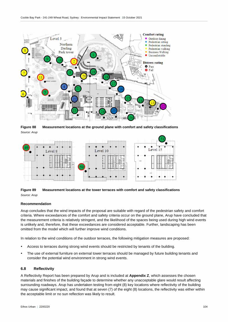
Cockle Bay Park - 241-249 Wheat Road, Sydney | Environmental Impact Statement | 15 October 2021
Ethos Urban | 2200220 104
Figure 88 Measurement locations at the ground plane with comfort and safety classifications
Source: Arup
Figure 89 Measurement locations at the tower terraces with comfort and safety classifications
Source: Arup
Recommendation
Arup concludes that the wind impacts of the proposal are suitable with regard of the pedestrian safety and comfort
criteria. Where exceedances of the comfort and safety criteria occur on the ground plane, Arup have concluded that
the measurement criteria is relatively stringent, and the likelihood of the spaces being used during high wind events
is unlikely and, therefore, that these exceedances are considered acceptable. Further, landscaping has been
omitted from the model which will further improve wind conditions.
In relation to the wind conditions of the outdoor terraces, the following mitigation measures are proposed:
Access to terraces during strong wind events should be restricted by tenants of the building.
The use of external furniture on external tower terraces should be managed by future building tenants and
consider the potential wind environment in strong wind events.
6.8 Reflectivity
A Reflectivity Report has been prepared by Arup and is included at Appendix Z, which assesses the chosen
materials and finishes of the building façade to determine whether any unacceptable glare would result affecting
surrounding roadways. Arup has undertaken testing from eight (8) key locations where reflectivity of the building
may cause significant impact, and found that at seven (7) of the eight (8) locations, the reflectivity was either within
the acceptable limit or no sun reflection was likely to result.
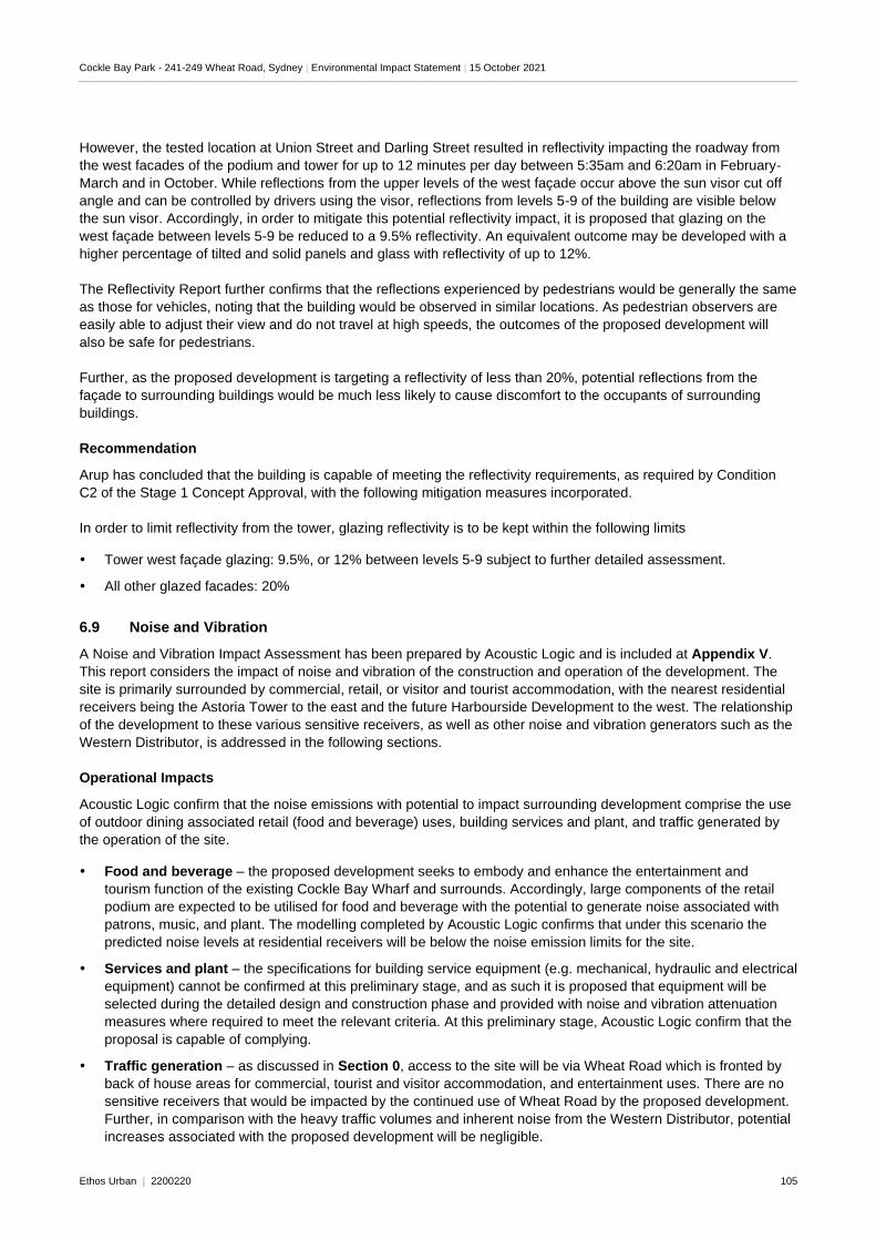
Cockle Bay Park - 241-249 Wheat Road, Sydney | Environmental Impact Statement | 15 October 2021
Ethos Urban | 2200220 105
However, the tested location at Union Street and Darling Street resulted in reflectivity impacting the roadway from
the west facades of the podium and tower for up to 12 minutes per day between 5:35am and 6:20am in February-
March and in October. While reflections from the upper levels of the west façade occur above the sun visor cut off
angle and can be controlled by drivers using the visor, reflections from levels 5-9 of the building are visible below
the sun visor. Accordingly, in order to mitigate this potential reflectivity impact, it is proposed that glazing on the
west façade between levels 5-9 be reduced to a 9.5% reflectivity. An equivalent outcome may be developed with a
higher percentage of tilted and solid panels and glass with reflectivity of up to 12%.
The Reflectivity Report further confirms that the reflections experienced by pedestrians would be generally the same
as those for vehicles, noting that the building would be observed in similar locations. As pedestrian observers are
easily able to adjust their view and do not travel at high speeds, the outcomes of the proposed development will
also be safe for pedestrians.
Further, as the proposed development is targeting a reflectivity of less than 20%, potential reflections from the
façade to surrounding buildings would be much less likely to cause discomfort to the occupants of surrounding
buildings.
Recommendation
Arup has concluded that the building is capable of meeting the reflectivity requirements, as required by Condition
C2 of the Stage 1 Concept Approval, with the following mitigation measures incorporated.
In order to limit reflectivity from the tower, glazing reflectivity is to be kept within the following limits
Tower west façade glazing: 9.5%, or 12% between levels 5-9 subject to further detailed assessment.
All other glazed facades: 20%
6.9 Noise and Vibration
A Noise and Vibration Impact Assessment has been prepared by Acoustic Logic and is included at Appendix V.
This report considers the impact of noise and vibration of the construction and operation of the development. The
site is primarily surrounded by commercial, retail, or visitor and tourist accommodation, with the nearest residential
receivers being the Astoria Tower to the east and the future Harbourside Development to the west. The relationship
of the development to these various sensitive receivers, as well as other noise and vibration generators such as the
Western Distributor, is addressed in the following sections.
Operational Impacts
Acoustic Logic confirm that the noise emissions with potential to impact surrounding development comprise the use
of outdoor dining associated retail (food and beverage) uses, building services and plant, and traffic generated by
the operation of the site.
Food and beverage – the proposed development seeks to embody and enhance the entertainment and
tourism function of the existing Cockle Bay Wharf and surrounds. Accordingly, large components of the retail
podium are expected to be utilised for food and beverage with the potential to generate noise associated with
patrons, music, and plant. The modelling completed by Acoustic Logic confirms that under this scenario the
predicted noise levels at residential receivers will be below the noise emission limits for the site.
Services and plant – the specifications for building service equipment (e.g. mechanical, hydraulic and electrical
equipment) cannot be confirmed at this preliminary stage, and as such it is proposed that equipment will be
selected during the detailed design and construction phase and provided with noise and vibration attenuation
measures where required to meet the relevant criteria. At this preliminary stage, Acoustic Logic confirm that the
proposal is capable of complying.
Traffic generation – as discussed in Section 0, access to the site will be via Wheat Road which is fronted by
back of house areas for commercial, tourist and visitor accommodation, and entertainment uses. There are no
sensitive receivers that would be impacted by the continued use of Wheat Road by the proposed development.
Further, in comparison with the heavy traffic volumes and inherent noise from the Western Distributor, potential
increases associated with the proposed development will be negligible.
Cockle Bay Park - 241-249 Wheat Road, Sydney | Environmental Impact Statement | 15 October 2021
Ethos Urban | 2200220 106
Accordingly, it is concluded that the noise impact from the above uses can be managed, considering the existing
CBD context and the current uses on the site. Further, as the bulk of the development faces west, it is anticipated
that much of the noise resulting from the operation of the development will be experienced on the harbour
immediately to the west and dissipate by the time it reaches sensitive receivers further to the west.
Further to noise emissions, Acoustic Logic have assessed the potential for operational noise and vibration to impact
on the operation of Cockle Bay Park. In this respect, it is concluded that the proposal does not trigger further
consideration under the Infrastructure SEPP requirements and, on this basis, both traffic and rail noise/vibration
intrusion need not be considered any further.
Further, it is noted that whilst there are rail corridors reserved below both Sussex Street and Kent Street, there is no
current proposal to utilise the allocated corridors to construct rail infrastructure. The extent of the proposed
development which is contained above the Sussex Street corridor is limited to the new Market Street Bridge (in the
same general location as the existing bridge) and tying into the landbridge over the Western Distributor to the
existing Darling Park development. With regard to acoustics (noise and tactile vibration), this would not be
considered as a sensitive space which may require any form of ameliorative measures (notwithstanding it would be
excluded from the requirements of the Infrastructure SEPP in any case). In the event the tunnels allocated for the
Sydney Metro Chatswood to Sydenham line running along the eastern edge of the site were to be used, they would
be subject to planning approval similar to the Metro lines currently under construction. It would be at this time that
any sensitive land uses near to the tunnels would be identified, and any mitigation measures required to control
noise and/or vibration from the proposed would be identified.
Construction Impact
Potential impacts associated with construction noise and vibration emanating from the site have been assessed,
including noise likely to result from the operation of the following construction machinery:
Pneumatic Jammer
35 Tonne Excavator
Bored Piling Rig
Concrete Pump
Trucks
Electric Tower Crane
Typically, the most significant sources of noise or vibration generated during a construction project will be
demolition, excavation, structural works and piling. Predicted noise levels modelled by Acoustic Logic indicate that
noise generated by demolition/construction works will be expected to meet the requirements of the Interim
Construction Noise Guideline and City of Sydney Council’s guidelines, with the exception of hammering during the
7- 8am period in relation to the Astoria Towers, Hyatt Regency, and some commercial buildings depending on the
location of the works occurring on the site. Accordingly, it is recommended that hammering activities should be
scheduled so that they do not occur during this period.
Further, Acoustic Logic conclude that given the distance and Type 1 vibration limits (from DIN-4150), vibration
impacts to surrounding developments are not expected to require specific mitigation. Where a complaint is received,
attended measurements of vibration may be undertaken to determine the cause and any further investigation or
monitoring which should be undertaken.
Recommendation
Acoustic Logic have concluded that the construction noise impacts likely to result from the development are
generally compliant with the relevant standards. Where minor exceedances occur, these impacts can be
appropriately managed through the incorporation of noise attenuation measures. Given the CBD context of the site,
it is anticipated that these noise impacts will generally in line with the surrounding noise and other construction
noise.
The following mitigation measures are therefore proposed to ensure noise and vibration impacts are managed:
Cockle Bay Park - 241-249 Wheat Road, Sydney | Environmental Impact Statement | 15 October 2021
Ethos Urban | 2200220 107
Prior to the commencement of any works onsite, a Noise and Vibration Management Plan will be developed by
the contractor in consultation with the stakeholders to develop strategies for the mitigation of noise and vibration
generated by the works.
The contractor will engage an independent acoustic and vibration consultant to install and monitor noise and
vibration logging equipment at suitable locations. These monitors will be calibrated and programmed to an
agreed level with an alarm being triggered in the event of vibration or noise exceeding the acceptable range.
6.10 Environmentally Sustainable Development
An ESD report has been prepared by Arup and is included at Appendix O, which demonstrates that in accordance
with the requirements of the Stage 1 Concept Approval, the proposed development seeks to achieve the following
targets:
A minimum 5 stars NABERS Energy rating
A minimum 4 stars NABERS Water rating
Green Star 6-star rating
Section J of the NCC 2019.
Achieving the sustainability targets will occur through implementation of the sustainability measures identified in the
ESD Report and discussed in Section 3.8 above.
The proposed measures will address the baseload energy consumption of the proposed development, support the
use of sustainable transport options, improve the efficient use and reuse of water and minimise waste. This will
ensure the proposed development provides a superior environmental performance, comparative to the existing
buildings.
Recommendation
The ESD Report has been developed to align with the SEARs and Stage 1 Concept Approval requirements. By
incorporating the measures outlined in the ESD Report, the development will achieve the targeted NABERs rating,
Green Star rating, and NCC requirements. It is recommended that the ESD strategy continue to be developed
throughout the design development process including ongoing consultation with Green Building Council of Australia
to ensure achievement of the nominated targets in the detailed design, construction, and operation of the
development.
6.11 Contamination
An Interim Contamination Investigation has been prepared by Douglas Partners and is included at Appendix K. An
assessment of the historical data found that the site has been used for various industrial purposes and a working
dock from as early as the 1880s to 1980s, when the area was subsequently developed as part of the Darling
Harbour Entertainment Precinct.
Given the site’s history, there are various potential sources of contamination, including unknown fill material, former
shipyard operations, former automobile and timberyard operations. Given the presence of building demolition
materials in the fill, such as concrete and bricks, it is considered that the risk of asbestos being present is high, and
consideration for the risk of asbestos should be adopted during soil management. The majority of heavily metals
and other soil contaminants were generally below the adopted site acceptance criteria (SAC). Therefore, a
remediation action plan is not considered necessary for the development. However, a soil management plan is
recommended to be implemented to address any unexpected contamination findings.
In relation to groundwater, heavy metals were found to exceed the SAC for copper, lead, nickel, zinc and total iron
in a number of locations. However, based on the area and its history, the concentration of metals in groundwater
are considered likely to be attributed to the background concentrations that would be associated with uncontrolled
fill within the harbour foreshore area and urban runoff. Further, the elevated iron levels are considered likely to be
naturally occurring. Therefore, remediation of heavy metals in the groundwater is not considered required, but will
need to be taken into consideration for dewatering and discharge purposes.
Cockle Bay Park - 241-249 Wheat Road, Sydney | Environmental Impact Statement | 15 October 2021
Ethos Urban | 2200220 108
Acid sulfate soils are expected to be present in both the fill material and the alluvial soils and, therefore, require
management and the preparation of an acid sulfate soils management plan.
It is noted however that the proposed development includes ground uses that would effectively remain unchanged
from that which currently exists, as the proposal does not seek to excavate the site and would continue to cover the
site by a building slab and concrete. Accordingly, on this basis, Douglas Partners consider the site can be made
suitable for the proposed open space and commercial development subject to the implementation of a number of
recommendations. These are discussed further below.
Recommendation
Douglas Partners confirm that the site can be made suitable for its intended use through the implementation of the
nominated recommendations. This includes undertaking a destructive hazardous building material (hazmat)
assessment should prior to demolition of any structures proposed in this DA, undertaking further detailed
investigations following demolition of the overlying structures which made areas inaccessible during the current
preliminary investigation, further waste classification assessment during development to confirm preliminary in situ
classifications, and further acid sulfate soil investigations within the proposed excavation zones following demolition
of the overlying structures or of the excavated materials to assess the lateral and vertical extent and nature of acid
sulfate soils. A dewatering management plan should also be prepared based on a supplementary round of
groundwater testing to confirm the presence (or otherwise) of total recoverable hydrocarbons in locations (and
potential impact on dewatering management) and potential tidal influence variability in groundwater condition.
Additional mitigation measures are also proposed during the construction process including undertaking an
asbestos clearance following the demolition of structures by a licenced asbestos assessor, preparing a soil
management plan including an unexpected finds protocol and preparing an acid sulfate soil management plan
including a methodology to manage acid sulfate soils present at the site.
6.12 Heritage
6.12.1 Aboriginal Heritage
An Aboriginal Cultural Heritage Assessment (ACHAR) has been prepared by Artefact and is included at Appendix
MM. The ACHAR will be developed in consultation with the indigenous community in accordance with the
‘Aboriginal cultural heritage consultation requirements for proponents’ guidelines (OEH 2010). The ACHAR
documents the process that is being undertaken for consulting with local Aboriginal stakeholders, investigating and
assessing Aboriginal cultural heritage associated with the site and surrounds. The ACHAR outlines that the
proposed development is assessed as having the following potential impacts on indigenous history:
Archaeology
The ACHAR finds that the study area is in a location once abundant with resources utilised by Aboriginal
communities, and that the archaeological record may reflect this utilisation. However, the effects of repeat
construction and demolition, particularly that in the late 20th century, would have significantly disturbed soils in the
majority of the study area.
Therefore, the archaeological potential is modelled as:
Low to moderate archaeological potential on reclaimed and submerged land.
Moderate archaeological potential on disturbed land.
Moderate to high archaeological potential on the original landform beneath paving and roadways.
Cultural heritage
Consultation is ongoing with Aboriginal stakeholders and interested parties through Registered Aboriginal Parties
(RAPs). As part of the consultation process, the present ACHAR will be reviewed by the above nominated parties
and finalised following their input.
Cockle Bay Park - 241-249 Wheat Road, Sydney | Environmental Impact Statement | 15 October 2021
Ethos Urban | 2200220 109
Recommendations
In order to manage the Aboriginal archaeological potential of the site, a number of mitigation measures are
recommended, as outlined below.
Excavation in areas reclaimed and submerged land (low to moderate archaeological potential) should be
subject to a program of archaeological monitoring and sample testing of soils that have been extracted through
processes such as piling or bulk excavation. If preserved natural soils or Aboriginal objects are detected,
archaeological test excavation and salvage must be considered.
Areas of disturbed land within the study area are of moderate archaeological potential. They should be subject
to archaeological monitoring and mechanical archaeological test excavation to establish the likely presence of
potential undisturbed soil deposits. If such deposits or Aboriginal objects are identified these soils must be
subject to archaeological test excavation / salvage.
Areas of disturbed land within the study area that have been subject to mechanical test excavation and /
monitoring and where the ED determines that there is no likelihood of Aboriginal archaeological potential may
be managed without further inspection or monitoring under the Unexpected Finds Policy
Further to the this, it is acknowledged that consultation is ongoing with Aboriginal stakeholders and interested
parties at the site. Preliminary responses have been positive/supportive as delineated in the ACHAR, however,
more detailed understanding is required to determine the exact social and cultural value of the site to Aboriginal
people, and whether any social/cultural mitigation measures are required. This can only be identified through
detailed consultation with Aboriginal people. The proponents are committed to continue working with the RAPs to
ensure positive outcomes for Aboriginal people continue to be provided in connection with the site. This has also
informed the mitigation measures in Section 8.0 of the EIS.
6.12.2 Non-Aboriginal Archaeological Heritage
A Non-Aboriginal Archaeological Assessment has been prepared by Artefact and is included at Appendix NN. This
report has undertaken testing to ascertain the likelihood of non-Aboriginal archaeological heritage being located on
site. The assessment finds that the study area incorporates locations of high archaeological potential and locations
of moderate archaeological potential. Archaeological remains in the study area are likely to contain early seawalls,
wharves, piers, jetties and remains of the earliest phases of industrialisation in Australia. These potential remains
may include items associated with individuals of significance in the development of NSW and could include items
ranging from local to state heritage significance. As a result of the rapidly changing nature of development in the
study area, including widespread land reclamation there is the potential for deep and complex heritage to be
present.
Recommendations
In order to manage the non-Aboriginal archaeological potential of the site, a number of mitigation measures are
recommended, as outlined below.
Impacts to significant potential or identified heritage fabric and archaeological remains should be kept to a
minimum where possible. Options for avoiding impacts to significant heritage fabric and archaeological remains
should continue to be investigated during the detailed design and construction phases of the proposal.
An Archaeological Research Design report would be prepared prior to the commencement of the construction
phase to outline the required non-Aboriginal archaeological management within the construction boundaries.
All relevant construction staff, contractors and subcontractors must be made aware of their statutory obligations
for heritage under the NSW Heritage Act 1977and best practice as outlined in The Burra Charter (Australia
ICOMOS 2013) to ensure no archaeological remains or heritage fabric are impacted during the proposed works
without appropriate mitigation measures in place. This will be implemented through a heritage induction carried
out prior to works commencing and continued throughout the works program
If potential archaeological investigations at the proposal identify significant archaeological remains, the nature
and historical significance of these remains must be reflected in a permanent site heritage interpretation
strategy.
Cockle Bay Park - 241-249 Wheat Road, Sydney | Environmental Impact Statement | 15 October 2021
Ethos Urban | 2200220 110
6.12.3 Non-Aboriginal Built Heritage
A Heritage Assessment Report has been prepared by Weir Phillips and is included at Appendix S. This report
identifies and assesses the potential heritage impacts associated with the proposed development on surrounding
heritage items, their context and setting and significant views, and heritage fabric where directly interfacing with the
Pyrmont Bridge.
The assessment largely considers the visual impact of the development on surrounding heritage items, noting that
the majority of the podium and tower structures are located on land that is not heritage listed. It concludes that
surrounding heritage items are largely unaffected, allowing the ongoing appreciation of the heritage significance and
interpretations of places and individual items. The proposed development will alter the setting of several items but
will not affect their visual integrity and heritage. Visual impacts from the proposed development on the heritage
items in the immediate vicinity north and east of the site will be ameliorated to some extent by existing tall buildings
forming the CBD backdrop to the site. The visual impacts of the proposed development on identified heritage items
in the vicinity of the proposed development are confirmed to be generally considered acceptable.
The physical interface between the proposed development and the eastern end of the Pyrmont Bridge has also
been assessed, with Weir Phillips concluding that the proposed modification to the eastern end of the Pyrmont
Bridge will have a positive impact on the significance of this structure. The new land bridge over the Western
Distributor connecting the western side of the CBD to Darling Harbour will re-establish the historic corridor of the
bridge and its connection to Market Street. The proposal has been designed in a way to minimise the physical
impact on the bridge, by only introducing new fabric or penetrations to allow for smooth transition of pedestrians.
The re-establishment of the severed connection between Market Street and the Bridge will have a profoundly
positive impact on the significance of the bridge as it will restore its original approach path and allow the bridge to
re-establish its role as a direct link between the City and Pyrmont.
Recommendation
The assessment confirms that the proposed redevelopment will not give rise to any significant or adverse heritage
impacts. It is expected that the detailed design and construction methodology for the interface of the proposed
podium and Civic Link will be provided to NSW Heritage for review prior to the commencement of these works. As
no significant impacts are identified, no mitigation measures are identified by Weir Phillips
6.12.4 Maritime Heritage
A Maritime Archaeology Statement of Heritage Impact has been prepared by Cosmos Archaeology and is included
at Appendix LL. As the eastern side of Cockle Bay has been used for maritime purposes since the beginning of the
19th century, the area is likely to contain heritage within the waterways relating to these historic uses. Further,
various instances of seawall construction and land reclamation has occurred over the last 200 years, which has
further contributed to the likelihood of marine heritage.
As a result, a diving pre-disturbance survey was undertaken to inform the assessment. This survey found the
following:
Remains of a seawall constructed in 1997 along the entire of the study area.
Steel sheet piling in the northern half of the study area, which was identified as containing no heritage
significance.
Potential historic sites within the study area include wharves and related material, seawalls, shipwrecks, discard
from vessels and discard in and under reclamation fill.
Remains of wharves and related material (c.1830 to 1970), which were assessed to be of State significance as
they represent the earliest private maritime infrastructure development in Sydney Harbour and a finite
archaeological resource.
The timber sheet piling with Monier concrete plates and potential remains of other seawalls, which were
assessed to be of State significance as the archaeological remains may yield information on the adaption of
seawalls and/or the location, material and form of seawalls which are not be available in the historic record.
Cockle Bay Park - 241-249 Wheat Road, Sydney | Environmental Impact Statement | 15 October 2021
Ethos Urban | 2200220 111
Recommendation
Based on the above findings of the Marine Archaeology Statement provided at Appendix LL, the following
recommendations are provided:
An archaeological investigation in the form of an excavation and/or sampling be undertaken within the areas to
be bulk excavation is proposed for the tower core and deluge tank.
A Maritime Archaeological Management Plan be prepared that would include the following:
− Maritime Archaeological Research Design and Excavation Methodology
− Unexpected finds, stop work triggers and notification protocols
− Heritage induction for contractors
− Recording methods and procedures
− Artefact collection and retention policies
6.12.5 Heritage Interpretation
A Heritage Interpretation Strategy has been prepared by Weir Phillips and is included at Appendix T. This
document has been prepared to consider the heritage and historic context of the site, and incorporate an
interpretation of this history into the development.
In particular, there is the opportunity to create meaningful products that not only continue to celebrate the
significance of the Cockle Bay and its relationship to the surrounding areas, but also the significant role of this as an
entertainment, retail commercial, tourist and public space destination within the heart of Sydney. Some physical
interpretation options include:
Signage
Place naming
Archaeology
Landscape design
Public art
Projections
It is recommended that a detailed Heritage Interpretation Plan be prepared and implemented at the site to identify
and interpret the key heritage conservation values of the heritage items to be demolished, as well as other aspects
of the history of the site.
Recommendation
The Heritage Interpretation Strategy (Appendix T) forms the basis of future implemented interpretation on the site.
The following mitigation measures are proposed to ensure that the Heritage Interpretation Strategy is appropriately
applied:
As the design of the site is ongoing, it is therefore critical that discussion regarding the incorporation of
interpretation into both the architectural and landscape design is initiated prior to further detailed development of
the design. This will mean that the interpretation is wholly incorporated into the design of the site.
A meeting is to be held with the design team, public art specialists, First Nations Consultants, and the heritage
team to begin the ongoing process of ensuring heritage interpretation is incorporated into the development.
6.13 Flooding and Stormwater
A Stormwater and Flood Management Report has been prepared by Enstruct and is provided at Appendix CC.
Significant consultation and coordination with relevant authorities, including Sydney Water, the City of Sydney and
Transport for NSW has been undertaken to ensure support for the development is provided by the relevant
authorities.
Cockle Bay Park - 241-249 Wheat Road, Sydney | Environmental Impact Statement | 15 October 2021
Ethos Urban | 2200220 112
6.13.1 Flooding
Flood modelling has been completed for the project in accordance with Council’s Darling Harbour Flood Study
(2014) and TUFLOW Flood Model for the Darling Harbour Catchment. The proposed flood model has been updated
to include the building extents of the proposed development, site levels and proposed upgrades to the stormwater
pit and pipe capacity.
In accordance with requirement 14 of the SEARs, flood planning levels for the development have been prepared in
accordance with the NSW Floodplain Development Manual. Specifically, Enstruct have confirmed that the proposed
development meets the required flood planning levels as follows:
Ground floor businesses and retail floors are above the 1% AEP flood levels.
The access to the basement and loading dock are above the PMF, to ensure no flood water is able to enter the
basement.
Minor works, including relocation of jersey kerbs, road grading, introduction of new culvert, and the landbridge’s
ability to capture rainfall have been included to minimise any flood impacts.
On this basis, drawing from the existing and proposed development scenarios, Enstruct confirm that the
development:
Is located within a low flood hazard precinct.
Does not significantly alter existing flood behaviour.
Does not result in significant increases in the potential flood affectation of existing development or properties.
Incorporates appropriate measures to manage risk to life from flood.
Achieves the required Flood Planning Levels.
Enstruct have also examined the effect of climate change in terms of rainfall intensity and rising sea levels. They
confirm that there will be an increase in flood level (less than 10mm), based on the CSIRO’s climate future tools.
Any future sea level rise can be mitigated through the current levels proposed in the building.
Recommendation
Enstruct conclude that a freeboard of 0.3m above the surrounding surface, being RL3.35AHD at the vehicle drop off
and RL 3.11AHD at the loading dock, be incorporated into the design of the site to address any flooding risk in line
with the 5% AEP. These minimum levels have been incorporated into the design of the development.
6.13.2 Stormwater and drainage
Enstruct’s Stormwater and Flood Report (Appendix CC) assesses the proposed stormwater and drainage
arrangements proposed to accommodate Cockle Bay Park. These identified stormwater management measures
have been developed in consultation with Sydney Water and are detailed in Table 16 detailed below.
Table 16 Summary of stormwater and drainage measures
Item Management Measure / Response
Stormwater Design Water from the tower, courtyard, terraces at ground level, and surface water will be collected and
conveyed via a downpipe system and floor pits to the stormwater drainage system. The stormwater drainage network will be gravity fed, which utilises the natural level change from the proposed development to the point of discharge.
The drainage system will be designed to the 5% AEP event as required by the City of Sydney’s guidelines.
Stormwater Detention As the site is able to discharge directly into Darling Harbour, no onsite stormwater detention system is required. Whilst no OSD is required, the development will not increase in peak flows compared to the
existing condition due to the ability of the landbridge to act as an interim stormwater store.
Stormwater Quality Treatments
The stormwater strategy also includes measures to ensure stormwater quality. These measures include:
• Provision of filter cartridges.
• Provision of rainwater tanks
Cockle Bay Park - 241-249 Wheat Road, Sydney | Environmental Impact Statement | 15 October 2021
Ethos Urban | 2200220 113
Item Management Measure / Response
• Provision of pit inserts
With regard to water quality, the proposed stormwater treatment devices have been modelled in MUSIC to demonstrate they achieve the stormwater treatment targets established in the SEARs requirements. The results of this are outlined in Table 17 below.
Table 17 Water Quality Targets and Results
Pollutant Green Star Reduction
Targets
City of Sydney Reduction
Targets
Proposed Reduction
Total Suspended Solids 90% 85% 92.2%
Gross Pollutants 95% 90% 82.2%
Total Nitrogen 60% 45% 60%
Total Phosphorus 70% 65% 100%
Source: Enstruct
Recommendation
The design of the building has been coordinated with the stormwater requirements provided by Enstruct and is
therefore capable of meeting the relevant stormwater and flooding guidelines which will be further confirmed at the
detailed design phase of the project. It is considered that the proposed development does not result in any
significant or adverse impacts, and as such no further study or refinement is required. No specific mitigation
measures are nominated in the assessment by Enstruct.
6.14 Safety, Security and Management
A Crime Prevention Through Environmental Design (CPTED) Report has been prepared by Ethos Urban and is
included at Appendix L. The review identifies the potential security concerns in and around the site and provides
recommendations to guide crime prevention, safety and security arrangements as part of detailed design of the
development.
This strategy includes a detailed assessment which includes:
A review of the Safer by Design Manual by the NSW Police Force
Collection and analysis of local and NSW State crime statistic from the Bureau of Crime Statistics and Research
(BOSCAR)
A crime risk assessment, in accordance with the current NSW policy and practice, of the following regulation
and assessment principles:
5. Surveillance
6. Lighting and Technical Supervision
7. Territorial Reinforcement
8. Environmental Maintenance
9. Activity and Space Management
10. Access Control
11. Design, Definition and Designation.
Recommendations were provided in the CPTED review, as outlined below.
Recommendation
Key findings of the CPTED Report undertaken have been detailed below and should be incorporated in the delivery
of the development:
Cockle Bay Park - 241-249 Wheat Road, Sydney | Environmental Impact Statement | 15 October 2021
Ethos Urban | 2200220 114
The final detailed construction drawings are to have considered the recommendations in the CPTED Report
prepared by Ethos Urban as applicable.
A CCTV network for the site is to be designed in consultation with a suitably qualified security consultant.
A lighting strategy should be developed by or in consultation with a suitably qualified and experienced lighting
expert. It is recommended that when designing the lighting strategy for the publicly accessible areas of the
ground levels and the basements, a CPTED professional is consulted.
Prepare a Plan of Management (PoM) to ensure that there are standard policies and procedures in place to
ensure the ongoing maintenance of the building. It is also recommended that the relevant staff members and
management personnel of the building responsible for such activities are aware of the procedures contained in
the PoM. This includes evacuation procedures and procedures in case of emergency.
Install a security door or secure electronic access (card / key controlled entries / lifts etc.) to all private
entrances of the building to prevent unauthorised individuals from entering restricted areas not intended for
public use (such as within the back of house areas, or areas where there is more private sensitivity, as well as
the loading dock).
Consider installation of an appropriate bollard/barrier system as well as within the Wheat Road drop off zone to
prevent vehicles driving into the site. A security consultant with a Class 2A licence under the Security Industry
Act 1997 is recommended to be engaged to provide specific advice on the type, placement and installation of
this bollard/barrier system to ensure vehicles moving at high velocity cannot enter the site in locations not
intended for vehicles, if need be.
Security, management personnel and employees of the building are advised to parole / occupy the publicly
accessible areas visibly and regularly to minimise opportunities for anti-social behaviour.
6.15 Structural
A Structural Report has been prepared by Enstruct and is included at Appendix DD. This report considers the
structural capacity of the proposed building, particularly in relation to the landbridge structure that will span across
the Western Distributor. This assessment considers the following in relation to structural design and engineering:
Structural design criteria
Structural surface
Beam requirements
Columns and transfers
Lateral support
Foundations
Relevant clearances
Stormwater diversion
Horizontal Clearances
Structural requirement of the pedestrian bridge from Market Street.
The report concludes that the landbridge is capable of complying with relevant structural requirements, as well as
the various pedestrian bridges across the site. The proposed development will be independent of the Western
Distributor.
Recommendation
The design of the building has been coordinated with the structural requirements provided by Enstruct and is
therefore capable of meeting the relevant structural needs and guidelines, subject to detailed design. No further
mitigation measures have been proposed by Enstruct.
Cockle Bay Park - 241-249 Wheat Road, Sydney | Environmental Impact Statement | 15 October 2021
Ethos Urban | 2200220 115
6.16 Western Distributor Impact
In accordance with Condition C23 of the Stage 1 Concept Approval, a detailed Western Distributor Impact
Assessment (WDIA) has been prepared by Aurecon and is included at Appendix KK. The WDIA outlines the
relationship between the proposal and the Western Distributor, and how the development will maintain the safety
and useability of the Western Distributor. The WDIA addresses:
Fire safety
The provision of adequate lighting
The reflectivity of the façade and its impact on the Western Distributor
Air quality over / in the Western Distributor
Prevention of falling objects
The ability of the Western Distributor to continue to allow for the transportation of dangerous goods.
Maintenance of the road reserve width
Design, location and impact of structural supports
Access for maintenance and repair
Impact on the structural integrity and durability of the Western Distributor
Methodology for construction over the Western Distributor
Major works authorisation deeds
Emergency response protocol
The WDIA also demonstrates compliance with RMS Technical Direction – Excavation Adjacent to Roads and
Maritime Infrastructure.
Recommendation
The proposed development will be undertaken in accordance with the WDIA provided at Appendix KK. No further
study or refinement is requirement, and no specific mitigation measure has been nominated in this instance.
6.17 Biodiversity
A request to waive the requirement to prepare a Biodiversity Development Assessment Report (BDAR) has been
prepared by Eco Logical and submitted separately to DPIE prior to the lodgement of this application (see Appendix
H). The waiver request provided an assessment of the biodiversity significance and context of the site and
determined that the proposed works did not warrant undertaking a further detailed assessment.
Recommendation
In view of the above, it was determined that the proposed development is unlikely to have a significant impact on
threatened species or their habitats, and as such no mitigation measures are identified as being necessary.
6.18 Waste Management
An Operational and Construction Waste Management Plan has been prepared by Waste Audit and is included at
Appendix JJ. This report outlines the ambitions and management systems for the construction and operation of the
proposed development and aims to support best practice waste management and environmentally sustainable
development. It provides guidance on waste minimisation, management and effective waste separation, recycling
and re-use measures.
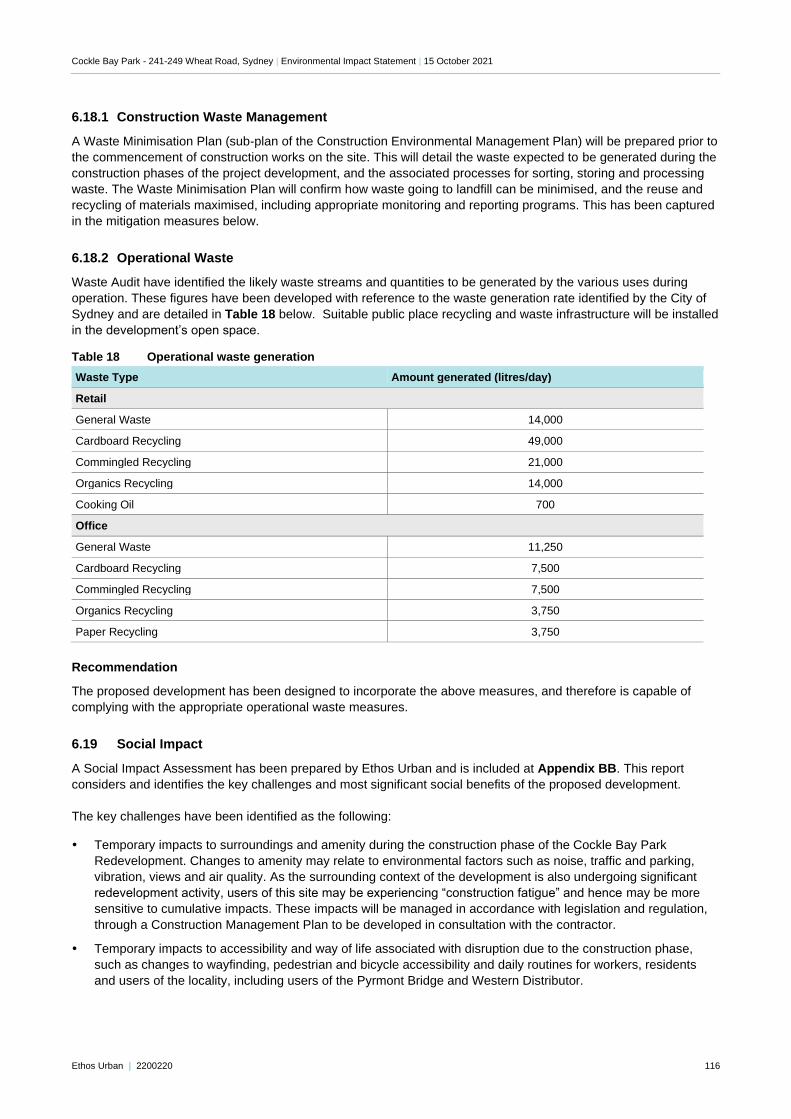
Cockle Bay Park - 241-249 Wheat Road, Sydney | Environmental Impact Statement | 15 October 2021
Ethos Urban | 2200220 116
6.18.1 Construction Waste Management
A Waste Minimisation Plan (sub-plan of the Construction Environmental Management Plan) will be prepared prior to
the commencement of construction works on the site. This will detail the waste expected to be generated during the
construction phases of the project development, and the associated processes for sorting, storing and processing
waste. The Waste Minimisation Plan will confirm how waste going to landfill can be minimised, and the reuse and
recycling of materials maximised, including appropriate monitoring and reporting programs. This has been captured
in the mitigation measures below.
6.18.2 Operational Waste
Waste Audit have identified the likely waste streams and quantities to be generated by the various uses during
operation. These figures have been developed with reference to the waste generation rate identified by the City of
Sydney and are detailed in Table 18 below. Suitable public place recycling and waste infrastructure will be installed
in the development’s open space.
Table 18 Operational waste generation
Waste Type Amount generated (litres/day)
Retail
General Waste 14,000
Cardboard Recycling 49,000
Commingled Recycling 21,000
Organics Recycling 14,000
Cooking Oil 700
Office
General Waste 11,250
Cardboard Recycling 7,500
Commingled Recycling 7,500
Organics Recycling 3,750
Paper Recycling 3,750
Recommendation
The proposed development has been designed to incorporate the above measures, and therefore is capable of
complying with the appropriate operational waste measures.
6.19 Social Impact
A Social Impact Assessment has been prepared by Ethos Urban and is included at Appendix BB. This report
considers and identifies the key challenges and most significant social benefits of the proposed development.
The key challenges have been identified as the following:
Temporary impacts to surroundings and amenity during the construction phase of the Cockle Bay Park
Redevelopment. Changes to amenity may relate to environmental factors such as noise, traffic and parking,
vibration, views and air quality. As the surrounding context of the development is also undergoing significant
redevelopment activity, users of this site may be experiencing “construction fatigue” and hence may be more
sensitive to cumulative impacts. These impacts will be managed in accordance with legislation and regulation,
through a Construction Management Plan to be developed in consultation with the contractor.
Temporary impacts to accessibility and way of life associated with disruption due to the construction phase,
such as changes to wayfinding, pedestrian and bicycle accessibility and daily routines for workers, residents
and users of the locality, including users of the Pyrmont Bridge and Western Distributor.
Cockle Bay Park - 241-249 Wheat Road, Sydney | Environmental Impact Statement | 15 October 2021
Ethos Urban | 2200220 117
As the site is located in a high-density CBD environment, the area is likely to be accessed by a large number of
sensitive receivers who could be more sensitive to changes to environmental factors, accessibility and routines.
This could include children, elderly, people with limited mobility, people experiencing illness, disability or
distress, and others. Appropriate wayfinding and safe and legible diversions will be essential throughout the
construction process.
Due to the scale and magnitude of the development it will have a significant permanent impact upon
surroundings. Whilst delivering an architectural landmark, the magnitude of the proposed tower would lead to
subsequent passing shade and loss of sunlight for some surrounding buildings and open spaces, once
operational. The scale of the development may also contribute to overcrowding and congestion in the area, if
not mitigated by appropriate traffic, wayfinding, and sustainable travel measures. Those impacts associated with
the scale of the proposed buildings have also been raised by the community as the key issues related to the
proposal (as discussed in Section 4.0).
However, the above challenges are largely temporary or can be appropriately mitigated through the various
environmental mitigation measures proposed throughout this EIS. Further, the most significant social benefits of the
proposal are as follows:
Supporting the transformation of Darling Harbour and Central Sydney delivering significant economic value and
employment opportunity for Greater Sydney residents, driving productivity and international competitiveness.
Further social benefits are associated with delivery of significant amount of commercial floorspace at an easily
accessible location, close to various types of public transport and within walking distance of daily living needs
and amenity in Sydney CBD.
Supporting the transformation of Darling Harbour as an internationally renowned commercial and cultural
destination, by delivering an architectural landmark building, including a human scale retail village. The proposal
has the potential to enhance the cultural significance and characteristics of the locality through its design,
provision of public open space, and improvements to streetscape and pedestrian amenity and wayfinding.
The proposal would also contribute to the growing diversification and activation of the Sydney CBD and Darling
Harbour at night.
Improved access to open space. The proposed development would deliver at least 6,500m2 of publicly
accessible open space, co-located with retail and office uses, in a prominent location, and well accessible by
public and active transport. This is a rare opportunity to increase green space provision in the high-density
inner-city area, where opportunities to deliver notable amounts of green open space are generally limited. The
planned park at this location is both visually prominent, and well-activated through linkages to retail uses and
local street network, to maximise the utilisation of the park. High quality activated open space at this site has the
potential to support worker, resident and visitor wellbeing, increased opportunities for physical activity, and new
opportunities for social interaction and build social cohesion within the largely anonymous CBD environment.
Potential positive impacts to community connection associated with increased opportunities for social interaction
between workers, residents and visitors to the area due to provision of new public and commercial spaces for
people to meet and gather, including:
− At least 6,500m2 of publicly accessible open space, as discussed above.
− Retail services on the site, which may facilitate casual encounters and encourage workers and visitors to
the site to interact.
− Potential benefits to community cohesion associated with increased pedestrian activation on the site,
including through site links, catalysing new opportunities for community interaction and connection.
Recommendation
In order to reduce the impact of the key challenges identified in the Social Impact Assessment, the following
mitigation measures will be incorporated:
A Construction Environmental Management Plan is to be prepared, which will consider and outline strategies for
managing continuous public access, materials handling and management of pedestrian safety. This will include
the installation of wayfinding signage, and lighting to ensure clear pedestrian understanding and preservation of
safety and amenity. The management plan will also consider the existing bike infrastructure located within the
vicinity of the site and will be managed as to not impact or impede with current major cycling routes.
Cockle Bay Park - 241-249 Wheat Road, Sydney | Environmental Impact Statement | 15 October 2021
Ethos Urban | 2200220 118
6.20 Utilities and Services
A Utility Services Infrastructure Assessment has been prepared by JHA Services, Norman Disney and Young and
Warren Smith and Partners and is included at Appendix HH. A summary of the assessment and proposed
mitigation measures are provided below.
6.20.1 Communications Infrastructure
Communications Services Infrastructure has been investigated by Norman Disney and Young (NDY) and relates to
the telecommunications infrastructure currently servicing the site and needed to service the future development.
NDY have contacted Telstra, NBN Co. and Optus as the telecommunications carriers on the site to notify them of
the development.
In order to service the development, a new primary and secondary pit and conduit system is proposed to bring
communication services into the development. Confirmation from the relevant telecommunications carriers will be
required.
6.20.2 Electrical Utility Services
The Electrical Utility Services relating to the site have been investigated by JHA Services, to investigate the existing
infrastructure servicing the site and the additional infrastructure necessary to service the future development. In
order to service the development, it is proposed to relocate the existing high voltage and auxiliary Ausgrid assets
into Harbour Street to retain network connection arrangements and to free the site of electrical infrastructure to
enable construction. This relocation also includes upgrades and additions to this network, such as the provision of
new feeder cables, new pit and conduit networks etc.
A formal application to Ausgrid has been lodged and design details provided to them, with further consultation to be
undertaken as the design develops.
6.20.3 Hydraulic Services
An assessment of the existing and required hydraulic services on the site has been investigated by Warren Smith
and Partners. There are two Sydney Water sewer mains, one Sydney Water watermain and one existing Jemena
natural gas connection to the site.
In order to accommodate the proposed development the following works are proposed:
One existing sewer main is to be extended, with a new access chamber to be installed over the existing sewer.
The second sewer main is to be retained in situ.
The water main is to be extended along the eastern boundary to the middle of the site.
A new natural gas connection is to be provided to the existing natural gas main to provide gas to the
redevelopment. Once the natural gas capacity is known, an application will be made to Jemena.
Recommendation
These assessment of infrastructure and services identify the existing utilities surrounding and within the site and
consider the necessary enabling works that would be required to facilitate the preparation of the site, including
preliminary design solutions for connecting new infrastructure to surrounding utilities and services. Any matters
raised by providers will be addressed and incorporated into the detailed design of the site for construction. No
specific mitigation measures have been nominated in this instance.
6.21 Airspace
An Aeronautical Impact Assessment has been prepared by Strategic Airspace (Appendix E) addressing the
maximum height of the building and construction cranes proposed as part of this development. The Assessment
confirms that these proposed elements will exceed the Sydney Airport Obstacle Limitation Surface consistent with
the Stage 1 Concept Approval, but that they are approvable under the APAR and are substantially lower than the
Cockle Bay Park - 241-249 Wheat Road, Sydney | Environmental Impact Statement | 15 October 2021
Ethos Urban | 2200220 119
PANS-OPS surface height. An airspace height application for approval of the development as a Controlled Activity
under the Airports (Protection of Airspace) Regulations 1996 has been pursued.
Recommendation
Given the vertical clearances from airspace protection surfaces for the building are achieved, and the cranes
proposed will also be well below critical surfaces, Strategic Airspace are satisfied that the proposed building
development will not adversely affect the safety, efficiency or regularity of current or future air transport operations
at Sydney Airport. All relevant approvals have been sought in accordance with the recommendations in this
assessment.
6.22 Building Code of Australia and Disability Discrimination Act
An BCA Report has been prepared by McKenzie Group (Appendix G) and a Disability Discrimination Act Report
has been prepared Morris Goding Access Consulting (Appendix F). These reports have reviewed the
documentation against the statutory requirements, and have confirmed that the design complies or is capable of
compliance during detailed design with the Disability Discrimination Act 1992 (DDA), DDA Premises Standards
2010 (including DDA Access Code), Building Code of Australia (BCA), the relevant Australian Standards. The
proposed development will significantly improve the quality and number of accessible paths of travel between
Darling Harbour and the CBD compared to the existing Cockle Bay Wharf development. The design of the
development will be continuously refined during the detailed design phase to ensure that various elements of the
proposal meet the applicable performance requirements.
Recommendation
No mitigation measures have been nominated by McKenzie Group or Morris Goding Access Consulting and it is
noted that the compliance with DDA and the Building Code of Australia is a standard requirement as part of the
issuance of a Construction Certificate. No specific mitigation measures are necessary in this instance.
6.23 Fire engineering
A Fire Engineering Report has been prepared by Norman Disney and Young (NDY) and is included at Appendix Q.
NDY conclude that the retail podium and tower is capable of complying with the relevant fire performance
requirements of the BCA. This will be achieved through the meeting of prescriptive deemed-to-satisfy provisions,
through fire engineering performance solutions or a combination of both. The design of the development will be
continuously refined during the detailed design phase to ensure that various elements of the proposal meet the
applicable performance requirements.
Recommendation
No mitigation measures have been nominated by NDY and it is noted that the compliance with all relevant fire
standards is a standard requirement as part of the issuance of a Construction Certificate. No specific mitigation
measures are necessary in this instance.
6.24 Construction Management
A Construction Management Plan (CMP) has been prepared by Multiplex and is included at Appendix I, which
outlines the overarching principles and practices for the management of construction activities. The plan provides
an overview of on-site management during the construction phase of the project and considers management of site
operations, soil, water and groundwater, construction waste, traffic, noise and vibration, air quality, hazardous
materials and community consultation and disputes. The CMP will be used to inform the preparation of a detailed
Construction Environmental Management Plan by the appointed contractor, prior to the commencement of works
and adhered to for the duration of construction.
Further details are included at Section 3.12.
Cockle Bay Park - 241-249 Wheat Road, Sydney | Environmental Impact Statement | 15 October 2021
Ethos Urban | 2200220 120
6.25 Ecologically sustainable development principles
The EP&A Regulation lists four principles of ecologically sustainable development to be considered in assessing a
project. They are:
The precautionary principle
Intergenerational equity
Conservation of biological diversity and ecological integrity
Improved valuation and pricing of environmental resources
An anslysis of these principles follows.
Precautionary Principle
The precautionary principle is utilised when uncertainty exists about potential environmental impacts. It provides
that if there are threats of serious or irreversible environmental damage, lack of full scientific certainty should not be
used as a reason for postponing measures to prevent environmental degradation. The precautionary principle
requires careful evaluation of potential environmental impacts in order to avoid, wherever practicable, serious or
irreversible damage to the environment.
This EIS has not identified any serious threat of irreversible damage to the environment and therefore the
precautionary principle has not been given further consideration in this instance. Notwithstanding, indirect
avoidance of damage to the environment can be achieved through implementing the mitigation measures identified
in this EIS, which will inform the construction and operation of Cockle Bay Park, including the open space. Proactive
measures to prevent environmental degradation have been included within the design, construction and operational
phases of the proposed development.
Intergenerational Equity
Inter-generational equity is concerned with ensuring that the health, diversity and productivity of the environment are
maintained or enhanced for the benefit of future generations. The proposal has been designed to benefit both the
existing and future generations by:
Delivering over 6,500m2 of well designed, high-quality and publicly accessible open space that will have
significant views over Darling Harbour from the publicly accessible domain.
Providing substantially improved access between Central Sydney and Darling Harbour, by providing a
landbridge over the Western Distributor and numerous publicly accessible links through the site from the CBD to
Darling Harbour. These links at present are either missing or deficient.
Appropriately considering the heritage surrounding the site, as well as the historic context of the site, both
Aboriginal and non-Aboriginal.
Implements safeguards and management measures to protect environmental values, and achieve best practice
sustainability targets to ensure Cockle Bay Park is able to operate efficiently into the future.
Facilitate job creations, with the delivery of 89,000m2 of commercial and retail gross floor area.
The proposal has integrated short and long-term social, financial and environmental considerations so that any
foreseeable impacts are not left to be addressed by future generations. Issues with potential long term implications
such as waste disposal would be avoided and/or minimised through construction planning and the application of
safeguards and management measures described in this EIS and the appended technical reports.
Conservation of biological diversity and ecological integrity
The principle of biological diversity upholds that the conservation of biological diversity and ecological integrity
should be a fundamental consideration. As demonstrated in Section 6.0 and throughout this EIS, the proposed
development will not result in any significant effect on biological and ecological integrity of the study area, subject to
the implementation of the Mitigation Measures set out in Section 8.0 below.
Cockle Bay Park - 241-249 Wheat Road, Sydney | Environmental Impact Statement | 15 October 2021
Ethos Urban | 2200220 121
Improved valuation, pricing and incentive mechanisms
The principles of improved valuation and pricing of environmental resources requires consideration of all
environmental resources which may be affected by a proposal, including air, water, land and living things. Mitigation
measures for avoiding, reusing, recycling and managing waste during construction and operation would be
implemented to ensure resources are used responsibly in the first instance.
Additional measures will be implemented to ensure no environmental resources in the locality are adversely
impacted during the construction or operational phases. Refer to the Mitigation Measures set out in Section 8.0
below.
6.26 Site Suitability
Having regard to the characteristics of the site and its location in the Sydney CBD, the proposed development is
considered suitable in that:
It will deliver high quality commercial and retail floor space in the heart of Darling Harbour, a key tourism centre
for Sydney, contributing to Sydney’s global tourist status.
It has been designed in a manner that minimises impacts on surrounding development and public spaces.
It will contribute to the revitalisation of Darling Harbour through the delivery of considerable benefits, including
significant, high-quality public domain for workers and visitors.
It will result in only minor environmental impacts that can be appropriately managed and mitigated.
In regard to the characteristics of the site and its location in Darling Harbour and Sydney CBD, it is also considered
to be highly suitable for the proposed development in that:
The proposed works are permissible under the Darling Harbour Development Plan 1985.
It is located within Darling Harbour, which is currently undergoing significant revitalisation, considering the
recent development of the Ribbon, Sydney International Convention, Exhibition and Entertainment Precinct, the
Sofitel and future Harbourside redevelopment.
It is close to existing and future public transport services, including the recently completed CBD and South East
Light Rail along George Street and the Sydney Metro City and Southwest, being approximately 550 metres to
the east of the future Pyrmont Station, 900 metres west of the Pitt Street Station and approximately 1.2
kilometres south-west of the Hunter Street Station.
The site has excellent access to a wide range of services and facilities that will support, and benefit from, the
future users of and visitors to, the development.
6.27 Public interest
The proposed development is in the public interest for the following reasons:
The project will deliver over 6,500m2 of publicly accessible open space, which has been designed to provide a
range of active and passive uses for workers and visitors of the site.
It will substantially improve the public domain, with a human-scale podium designed to activate and enhance
the Darling Harbour foreshore.
The development will generate a significant amount of high-quality employment floorspace, contributing to the
global competitiveness of the Sydney CBD.
It will deliver a world-class retail destination that will contribute to Darling Harbour’s significance as a global
tourism destination.
The proposed development also remains consistent with, and successfully achieves, the reasons given for granting
consent to the Stage 1 Concept Approval that has set the vision for this subsequent detailed SSD DA. Namely, that
the project is:
permitted with development consent under the Darling Harbour Development Plan No.1 and is consistent with
the principles of Sydney Regional Environmental Plan (Sydney Harbour Catchment) 2005;
Cockle Bay Park - 241-249 Wheat Road, Sydney | Environmental Impact Statement | 15 October 2021
Ethos Urban | 2200220 122
is consistent with the applicable Region and District Plans;
will have a reasonable and acceptable impacts on view loss and overshadowing on the Astoria Tower;
will ensure no additional overshadowing of the proposed Town Hall Square within the time of peak utilisation
and complies with Council’s existing overshadowing controls;
will have marginal wind impacts on the area, which can be mitigated;
will create social and economic benefits;
will create a public benefit by providing additional open space and improving connectivity between Darling
Harbour and the CBD;
will not have any adverse heritage impacts; and
is consistent with the objects of the EP&A Act.
The proposed development is, therefore, considered to be in the public interest and will play an important role in the
continuing revitalisation of Darling Harbour.
6.28 Public benefit and contributions
Central Sydney is subject to the Central Sydney Contributions Plan 2013, however, Cockle Bay Park is located
outside of the area to which this contributions plan applies. Therefore, the plan does not apply to this development.
The delivery of public benefits, however, is intrinsically linked to Cockle Bay Park. The proposed development will
benefit the area from a place-making perspective, providing significant new publicly accessible open space and
improved pedestrian and cycle connections between the CBD and Darling Harbour. In this way, Cockle Bay Park is
an anchor on the western edge of the CBD and will be a new significant destination essential to the future success
of the Darling Harbour entertainment and tourism precinct. These proposed site improvements are substantial,
noting that a place-making opportunity of this magnitude is extremely unique. It represents a rare opportunity to
increase open space in the high-density inner-city area, where opportunities to deliver new public parks are
generally limited.
The project has demonstrated that it will have a positive public and economic impact on Sydney and NSW, with the
site expected to general significant economic and employment opportunities during and post construction, will
provide significant new retail and commercial floor space in the western part of the CBD aligning with the State
Government’s strategic policies.
Consistent with the findings of the Stage 1 Concept Approval, the proposed public benefits are proportional to the
scale of development and proposed development yield on the site. In addition, the proportion of public benefits are
similar to those secured by other large redevelopments within the area such as Barangaroo and the ICC facilities /
Darling Square, including:
Providing up to 12,000m2 publicly accessible open space
Providing a deck over the Western Distributor and improvements to pedestrian connectivity between the CBD
and Darling Harbour through the site
Providing public art and heritage interpretation within the development / public domain
Creating a revitalised commercial and tourist precinct consistent with the strategic vision for Darling Harbour,
with an increased potential for local spending and job creation.
Consistent with the Stage 1 Concept Approval, no planning agreement will be pursued as part of this project, noting
that the realisation of the aforementioned significant public benefits will be delivered alongside the proposed
building. The proposal ultimately results in the extension to the long-term lease of the site from the NSW
Government, which would include a value for money assessment in favour of the Government as per the terms of
the lease agreement.
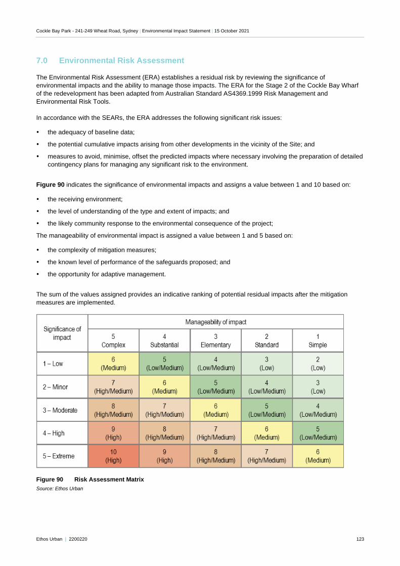
Cockle Bay Park - 241-249 Wheat Road, Sydney | Environmental Impact Statement | 15 October 2021
Ethos Urban | 2200220 123
7.0 Environmental Risk Assessment
The Environmental Risk Assessment (ERA) establishes a residual risk by reviewing the significance of
environmental impacts and the ability to manage those impacts. The ERA for the Stage 2 of the Cockle Bay Wharf
of the redevelopment has been adapted from Australian Standard AS4369.1999 Risk Management and
Environmental Risk Tools.
In accordance with the SEARs, the ERA addresses the following significant risk issues:
the adequacy of baseline data;
the potential cumulative impacts arising from other developments in the vicinity of the Site; and
measures to avoid, minimise, offset the predicted impacts where necessary involving the preparation of detailed
contingency plans for managing any significant risk to the environment.
Figure 90 indicates the significance of environmental impacts and assigns a value between 1 and 10 based on:
the receiving environment;
the level of understanding of the type and extent of impacts; and
the likely community response to the environmental consequence of the project;
The manageability of environmental impact is assigned a value between 1 and 5 based on:
the complexity of mitigation measures;
the known level of performance of the safeguards proposed; and
the opportunity for adaptive management.
The sum of the values assigned provides an indicative ranking of potential residual impacts after the mitigation
measures are implemented.
Figure 90 Risk Assessment Matrix
Source: Ethos Urban
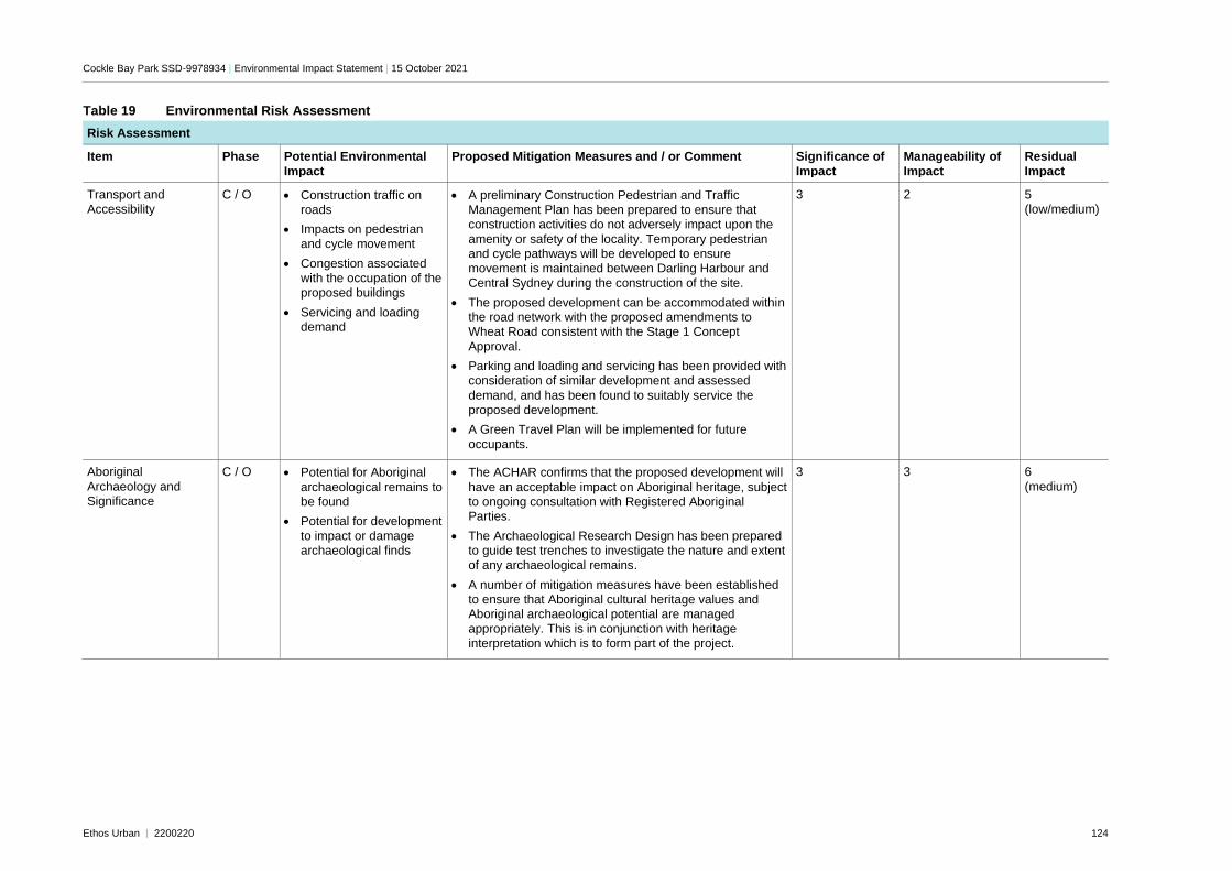
Cockle Bay Park SSD-9978934 | Environmental Impact Statement | 15 October 2021
Ethos Urban | 2200220 124
Table 19 Environmental Risk Assessment
Risk Assessment
Item Phase Potential Environmental
Impact
Proposed Mitigation Measures and / or Comment Significance of
Impact
Manageability of
Impact
Residual
Impact
Transport and Accessibility
C / O • Construction traffic on roads
• Impacts on pedestrian and cycle movement
• Congestion associated with the occupation of the proposed buildings
• Servicing and loading demand
• A preliminary Construction Pedestrian and Traffic Management Plan has been prepared to ensure that construction activities do not adversely impact upon the
amenity or safety of the locality. Temporary pedestrian and cycle pathways will be developed to ensure movement is maintained between Darling Harbour and
Central Sydney during the construction of the site.
• The proposed development can be accommodated within the road network with the proposed amendments to Wheat Road consistent with the Stage 1 Concept
Approval.
• Parking and loading and servicing has been provided with consideration of similar development and assessed
demand, and has been found to suitably service the proposed development.
• A Green Travel Plan will be implemented for future
occupants.
3 2 5 (low/medium)
Aboriginal
Archaeology and Significance
C / O • Potential for Aboriginal
archaeological remains to be found
• Potential for development
to impact or damage archaeological finds
• The ACHAR confirms that the proposed development will
have an acceptable impact on Aboriginal heritage, subject to ongoing consultation with Registered Aboriginal Parties.
• The Archaeological Research Design has been prepared to guide test trenches to investigate the nature and extent of any archaeological remains.
• A number of mitigation measures have been established to ensure that Aboriginal cultural heritage values and Aboriginal archaeological potential are managed appropriately. This is in conjunction with heritage
interpretation which is to form part of the project.
3 3 6
(medium)
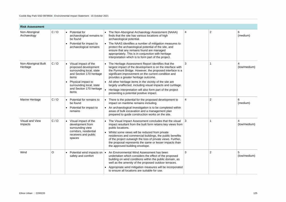
Cockle Bay Park SSD-9978934 | Environmental Impact Statement | 15 October 2021
Ethos Urban | 2200220 125
Risk Assessment
Non-Aboriginal
Archaeology
C / O • Potential for
archaeological remains to be found
• Potential for impact to
archaeological remains
• The Non-Aboriginal Archaeology Assessment (NAAA)
finds that the site has various locations of high archaeological potential.
• The NAAS identifies a number of mitigation measures to
protect the archaeological potential of the site, and ensure that any remains found are managed appropriately. This is in conjunction with heritage
interpretation which is to form part of the project.
4 2 6
(medium)
Non-Aboriginal Built Heritage
C / O • Visual impact of the proposed development surrounding local, state and Section 170 heritage
items
• Physical impact to surrounding local, state
and Section 170 heritage items
• The Heritage Assessment Report identifies that the largest impact of the development is on the interface with the Pyrmont Bridge. However, the proposed interface is a significant improvement on the current condition and
provides a greater heritage outcome.
• All other heritage items in the vicinity of the site are largely unaffected, including visual impacts and curtilage.
• Heritage interpretation will also form part of the project presenting a potential positive impact.
3 1 4 (low/medium)
Marine Heritage C / O • Potential for remains to be found
• Potential for impact to
remains
• There is the potential for the proposed development to impact on maritime remains including.
• An archaeological investigation is to be completed within
areas of bulk excavation and a management plan prepared to guide construction works on the site.
4 2 6 (medium)
Visual and View Impacts
C / O • Visual impact of the development from surrounding view
corridors, residential receivers and public spaces
• The Visual Impact Assessment concludes that the visual impact resultant from the built form retains key views from public locations.
• Whilst some views will be reduced from private residences and commercial buildings, the public benefits of the project outweigh the loss of private views. Further,
the proposal represents the same or lesser impacts than the approved building envelope.
3 1 4 (low/medium)
Wind O • Potential wind impacts on safety and comfort
• An Environmental Wind Assessment has been undertaken which considers the effect of the proposed building on wind conditions within the public domain, as
well as the amenity of the proposed outdoor terraces.
• Appropriate wind mitigation measures will be incorporated to ensure all locations are suitable for use.
3 2 5 (low/medium)
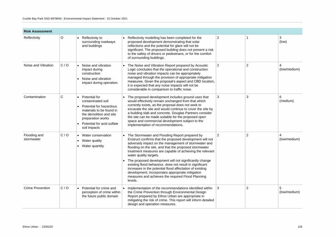
Cockle Bay Park SSD-9978934 | Environmental Impact Statement | 15 October 2021
Ethos Urban | 2200220 126
Risk Assessment
Reflectivity O • Reflectivity to
surrounding roadways and buildings
• Reflectivity modelling has been completed for the
proposed development demonstrating that solar reflections and the potential for glare will not be significant. The proposed building does not present a risk
to the safety of drivers or pedestrians, or for the comfort of surrounding buildings.
2 1 3
(low)
Noise and Vibration C / O • Noise and vibration impact during
construction
• Noise and vibration impact during operation.
• The Noise and Vibration Report prepared by Acoustic Logic concludes that the operational and construction
noise and vibration impacts can be appropriately managed through the provision of appropriate mitigation measures. Given the proposal’s aspect and CBD location,
it is expected that any noise impacts will not be considerable in comparison to traffic noise.
2 2 4 (low/medium)
Contamination C • Potential for contaminated soil
• Potential for hazardous
materials to be found in the demolition and site preparation works
• Potential for acid sulfate soil impacts
• The proposed development includes ground uses that would effectively remain unchanged from that which currently exists, as the proposal does not seek to
excavate the site and would continue to cover the site by a building slab and concrete. Douglas Partners consider the site can be made suitable for the proposed open
space and commercial development subject to the implementation of recommendations.
3 3 6 (medium)
Flooding and stormwater
C / O • Water conservation
• Water quality
• Water quantity
• The Stormwater and Flooding Report prepared by Enstruct confirms that the proposed development will not adversely impact on the management of stormwater and
flooding on the site, and that the proposed stormwater treatment measures are capable of achieving the relevant water quality targets.
• The proposed development will not significantly change existing flood behaviour, does not result in significant increases in the potential flood affectation of existing development, incorporates appropriate mitigation
measures and achieves the required Flood Planning levels.
2 2 4 (low/medium)
Crime Prevention C / O • Potential for crime and perception of crime within
the future public domain
• Implementation of the recommendations identified within the Crime Prevention through Environmental Design
Report prepared by Ethos Urban are appropriate in mitigating the risk of crime. This report will inform detailed design and operation measures.
3 2 5 (low/medium)
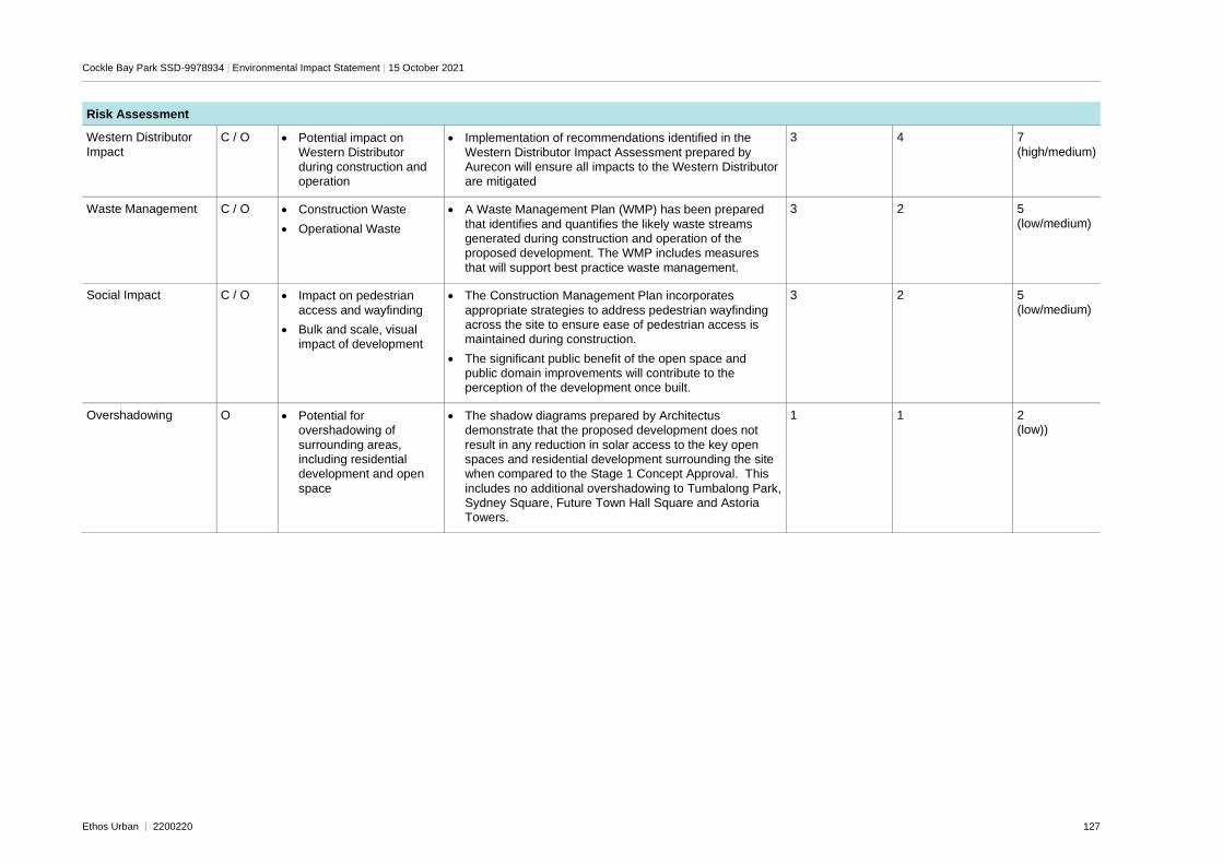
Cockle Bay Park SSD-9978934 | Environmental Impact Statement | 15 October 2021
Ethos Urban | 2200220 127
Risk Assessment
Western Distributor
Impact
C / O • Potential impact on
Western Distributor during construction and operation
• Implementation of recommendations identified in the
Western Distributor Impact Assessment prepared by Aurecon will ensure all impacts to the Western Distributor are mitigated
3 4 7
(high/medium)
Waste Management C / O • Construction Waste
• Operational Waste
• A Waste Management Plan (WMP) has been prepared
that identifies and quantifies the likely waste streams generated during construction and operation of the proposed development. The WMP includes measures
that will support best practice waste management.
3 2 5
(low/medium)
Social Impact C / O • Impact on pedestrian
access and wayfinding
• Bulk and scale, visual impact of development
• The Construction Management Plan incorporates
appropriate strategies to address pedestrian wayfinding across the site to ensure ease of pedestrian access is maintained during construction.
• The significant public benefit of the open space and public domain improvements will contribute to the perception of the development once built.
3 2 5
(low/medium)
Overshadowing O • Potential for overshadowing of
surrounding areas, including residential development and open
space
• The shadow diagrams prepared by Architectus demonstrate that the proposed development does not
result in any reduction in solar access to the key open spaces and residential development surrounding the site when compared to the Stage 1 Concept Approval. This
includes no additional overshadowing to Tumbalong Park, Sydney Square, Future Town Hall Square and Astoria Towers.
1
1 2 (low))
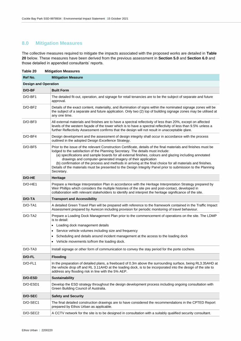
Cockle Bay Park SSD-9978934 | Environmental Impact Statement | 15 October 2021
Ethos Urban | 2200220
8.0 Mitigation Measures
The collective measures required to mitigate the impacts associated with the proposed works are detailed in Table
20 below. These measures have been derived from the previous assessment in Section 5.0 and Section 6.0 and
those detailed in appended consultants’ reports.
Table 20 Mitigation Measures
Ref No. Mitigation Measure
Design and Operation
D/O-BF Built Form
D/O-BF1 The detailed fit-out, operation, and signage for retail tenancies are to be the subject of separate and future
approval.
D/O-BF2 Details of the exact content, materiality, and illumination of signs within the nominated signage zones will be the subject of a separate and future application. Only two (2) top of building signage zones may be utilised at any one time.
D/O-BF3 All external materials and finishes are to have a spectral reflectivity of less than 20%, except on affected
levels of the western façade of the tower which is to have a spectral reflectivity of less than 9.5% unless a further Reflectivity Assessment confirms that the design will not result in unacceptable glare.
D/O-BF4 Design development and the assessment of design integrity shall occur in accordance with the process outlined in the adopted Design Excellence Strategy.
D/O-BF5 Prior to the issue of the relevant Construction Certificate, details of the final materials and finishes must be lodged to the satisfaction of the Planning Secretary. The details must include:
(a) specifications and sample boards for all external finishes, colours and glazing including annotated drawings and computer-generated imagery of their application
(b) confirmation of the process and methods in arriving at the final choice for all materials and finishes.
Details of the materials must be presented to the Design Integrity Panel prior to submission to the Planning Secretary.
D/O-HE Heritage
D/O-HE1 Prepare a Heritage Interpretation Plan in accordance with the Heritage Interpretation Strategy prepared by Weir Phillips which considers the multiple histories of the site pre and post-contact, developed in
collaboration with relevant stakeholders to identify and interpret the heritage significance of the site.
D/O-TA Transport and Accessibility
D/O-TA1 A detailed Green Travel Plan will be prepared with reference to the framework contained in the Traffic Impact
Assessment prepared by Aurecon including provision for periodic monitoring of travel behaviour.
D/O-TA2 Prepare a Loading Dock Management Plan prior to the commencement of operations on the site. The LDMP is to detail:
• Loading dock management details
• Service vehicle volumes including size and frequency
• Scheduling and details around incident management at the access to the loading dock
• Vehicle movements to/from the loading dock.
D/O-TA3 Install signage or other form of communication to convey the stay period for the porte cochere.
D/O-FL Flooding
D/O-FL1 In the preparation of detailed plans, a freeboard of 0.3m above the surrounding surface, being RL3.35AHD at the vehicle drop off and RL 3.11AHD at the loading dock, is to be incorporated into the design of the site to address any flooding risk in line with the 5% AEP.
D/O-ESD Sustainability
D/O-ESD1 Develop the ESD strategy throughout the design development process including ongoing consultation with Green Building Council of Australia.
D/O-SEC Safety and Security
D/O-SEC1 The final detailed construction drawings are to have considered the recommendations in the CPTED Report
prepared by Ethos Urban as applicable.
D/O-SEC2 A CCTV network for the site is to be designed in consultation with a suitably qualified security consultant.
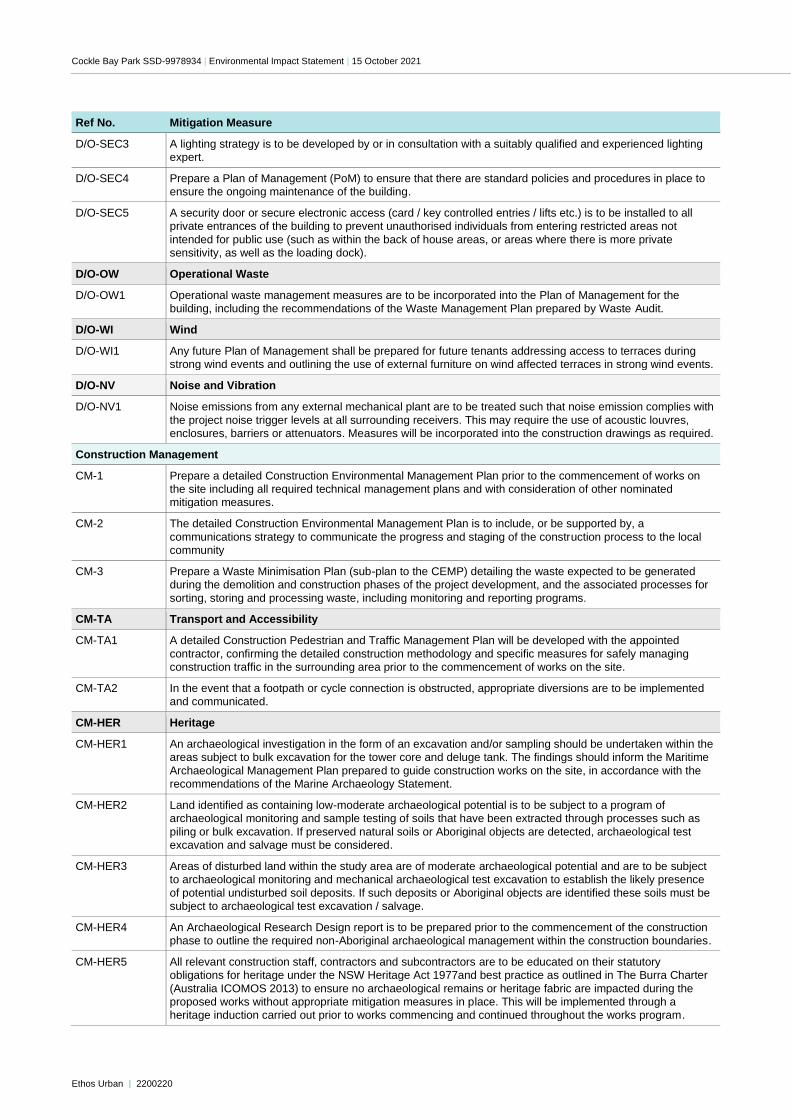
Cockle Bay Park SSD-9978934 | Environmental Impact Statement | 15 October 2021
Ethos Urban | 2200220
Ref No. Mitigation Measure
D/O-SEC3 A lighting strategy is to be developed by or in consultation with a suitably qualified and experienced lighting expert.
D/O-SEC4 Prepare a Plan of Management (PoM) to ensure that there are standard policies and procedures in place to ensure the ongoing maintenance of the building.
D/O-SEC5 A security door or secure electronic access (card / key controlled entries / lifts etc.) is to be installed to all private entrances of the building to prevent unauthorised individuals from entering restricted areas not
intended for public use (such as within the back of house areas, or areas where there is more private sensitivity, as well as the loading dock).
D/O-OW Operational Waste
D/O-OW1 Operational waste management measures are to be incorporated into the Plan of Management for the building, including the recommendations of the Waste Management Plan prepared by Waste Audit.
D/O-WI Wind
D/O-WI1 Any future Plan of Management shall be prepared for future tenants addressing access to terraces during strong wind events and outlining the use of external furniture on wind affected terraces in strong wind events.
D/O-NV Noise and Vibration
D/O-NV1 Noise emissions from any external mechanical plant are to be treated such that noise emission complies with
the project noise trigger levels at all surrounding receivers. This may require the use of acoustic louvres, enclosures, barriers or attenuators. Measures will be incorporated into the construction drawings as required.
Construction Management
CM-1 Prepare a detailed Construction Environmental Management Plan prior to the commencement of works on the site including all required technical management plans and with consideration of other nominated mitigation measures.
CM-2 The detailed Construction Environmental Management Plan is to include, or be supported by, a
communications strategy to communicate the progress and staging of the construction process to the local community
CM-3 Prepare a Waste Minimisation Plan (sub-plan to the CEMP) detailing the waste expected to be generated during the demolition and construction phases of the project development, and the associated processes for
sorting, storing and processing waste, including monitoring and reporting programs.
CM-TA Transport and Accessibility
CM-TA1 A detailed Construction Pedestrian and Traffic Management Plan will be developed with the appointed
contractor, confirming the detailed construction methodology and specific measures for safely managing construction traffic in the surrounding area prior to the commencement of works on the site.
CM-TA2 In the event that a footpath or cycle connection is obstructed, appropriate diversions are to be implemented and communicated.
CM-HER Heritage
CM-HER1 An archaeological investigation in the form of an excavation and/or sampling should be undertaken within the areas subject to bulk excavation for the tower core and deluge tank. The findings should inform the Maritime
Archaeological Management Plan prepared to guide construction works on the site, in accordance with the recommendations of the Marine Archaeology Statement.
CM-HER2 Land identified as containing low-moderate archaeological potential is to be subject to a program of archaeological monitoring and sample testing of soils that have been extracted through processes such as
piling or bulk excavation. If preserved natural soils or Aboriginal objects are detected, archaeological test excavation and salvage must be considered.
CM-HER3 Areas of disturbed land within the study area are of moderate archaeological potential and are to be subject to archaeological monitoring and mechanical archaeological test excavation to establish the likely presence
of potential undisturbed soil deposits. If such deposits or Aboriginal objects are identified these soils must be subject to archaeological test excavation / salvage.
CM-HER4 An Archaeological Research Design report is to be prepared prior to the commencement of the construction phase to outline the required non-Aboriginal archaeological management within the construction boundaries.
CM-HER5 All relevant construction staff, contractors and subcontractors are to be educated on their statutory obligations for heritage under the NSW Heritage Act 1977and best practice as outlined in The Burra Charter
(Australia ICOMOS 2013) to ensure no archaeological remains or heritage fabric are impacted during the proposed works without appropriate mitigation measures in place. This will be implemented through a heritage induction carried out prior to works commencing and continued throughout the works program.
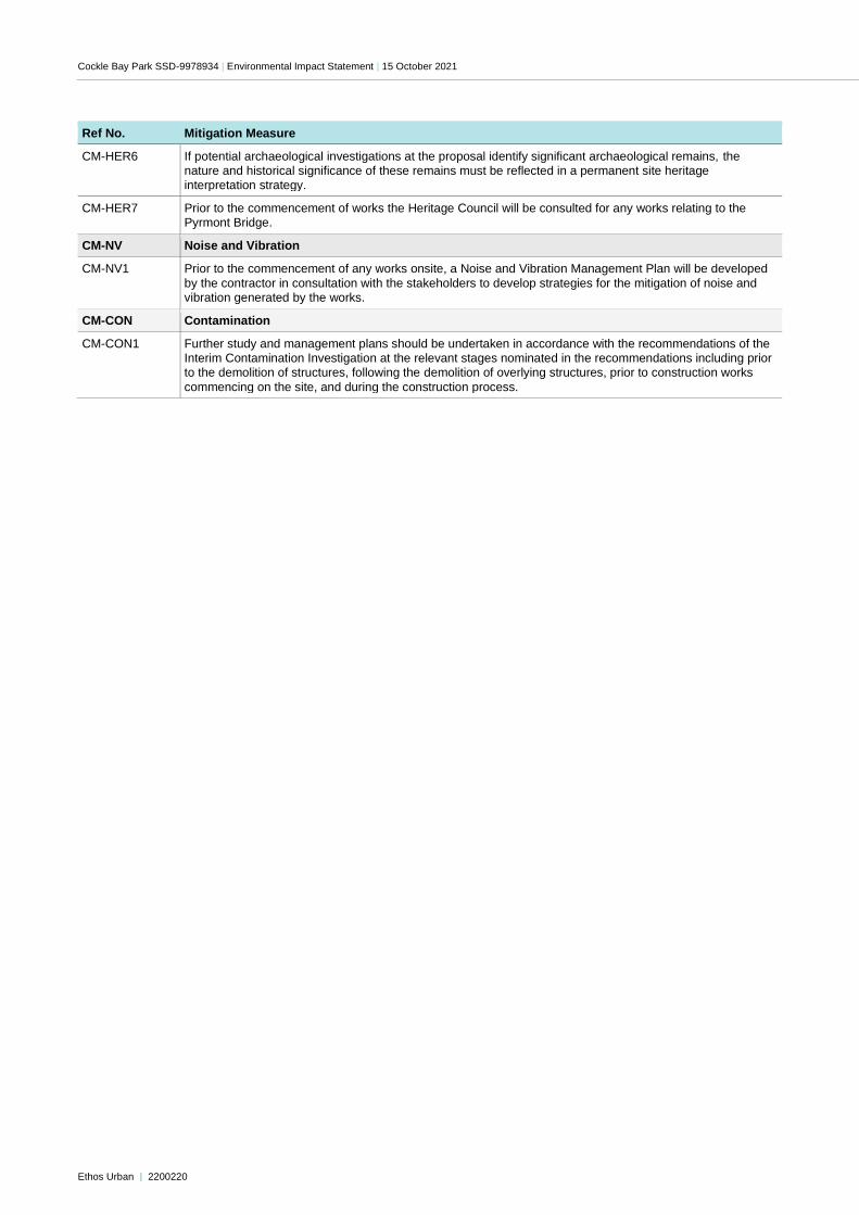
Cockle Bay Park SSD-9978934 | Environmental Impact Statement | 15 October 2021
Ethos Urban | 2200220
Ref No. Mitigation Measure
CM-HER6 If potential archaeological investigations at the proposal identify significant archaeological remains, the nature and historical significance of these remains must be reflected in a permanent site heritage interpretation strategy.
CM-HER7 Prior to the commencement of works the Heritage Council will be consulted for any works relating to the Pyrmont Bridge.
CM-NV Noise and Vibration
CM-NV1 Prior to the commencement of any works onsite, a Noise and Vibration Management Plan will be developed
by the contractor in consultation with the stakeholders to develop strategies for the mitigation of noise and vibration generated by the works.
CM-CON Contamination
CM-CON1 Further study and management plans should be undertaken in accordance with the recommendations of the Interim Contamination Investigation at the relevant stages nominated in the recommendations including prior to the demolition of structures, following the demolition of overlying structures, prior to construction works
commencing on the site, and during the construction process.
Cockle Bay Park SSD-9978934 | Environmental Impact Statement | 15 October 2021
Ethos Urban | 2200220
9.0 Conclusion
The Environmental Impact Statement (EIS) has been prepared to consider the environmental, social and economic
impacts of the proposed development of a mixed-use building at Cockle Bay Park. The EIS has addressed the
issues outlined in the SEARs (Appendix A) and accords with Schedule 2 of the EP&A Regulation with regards to
consideration of the relevant environmental planning instruments, built form, and social and environmental impacts
resulting from the proposed development. Appropriate mitigation measures have been identified to manage the
impacts of the development through the construction and operational phases of the project.
This SSD DA represents the next phase of the ongoing redevelopment of Cockle Bay Park pursuant to the
approved Stage 1 Concept Approval. Hence, this SSD DA has been prepared to progress the next stage of the
redevelopment of Cockle Bay Wharf consistent with the vision and framework established under the Stage 1
Concept Approval.
The project is identified as having strategic merit, by delivering an increase of density in a central CBD location, with
excellent access to public transport and other services provided within the CBD. The project is consistent with the
objectives of the strategic planning documents applying to this land including the Eastern City District Plan and
Sustainable Sydney 2030. This included objectives for the creation of new publicly accessible open space,
delivering significant job growth to contribute to a globally competitive city, improving pedestrian connectivity
between the CBD and Darling Harbour, promoting the creation of the ‘30-minute city’, improving the enjoyment of
Darling Harbour, and increasing the urban tree cover.
Having regard to biophysical, economic and social considerations, including the principles of ecologically
sustainable development, the carrying out of the project is justified for the following reasons:
The proposal will support the economic development and activation of Central Sydney through the provision of
commercial and retail uses on a well-located site. The proposed land uses will be facilitated through the
development of a building comprising a podium and tower, and provision of activated frontages to the Darling
Harbour waterfront, Darling Park, Market Street, Druitt Street and Sussex Street.
The provision of significant public domain upgrades, including the construction of a landbridge spanning
between Cockle Bay and Darling Park, will provide over 6,500m2 of public open space. This open space also
includes the provision of significant through site links and pedestrian and cycle accessways across the site, with
the provision of improved entries from Sussex Street, Druitt Street, Market Street and Darling Harbour.
The proposed development exhibits design excellence and is a sensitive response to the site’s history and
context in terms of building form and materiality. The scheme was selected by a highly esteemed jury and sets
the basis for a high-quality design outcome. The built form has been refined through numerous Design Integrity
Panel meetings that have sought to resolve as all environmental and design issues. This has resulted in a
contextually rich and striking design that will be recognisable in the city skyline.
The development will achieve industry best ESD standards in the form of a minimum 5 stars NABERS Energy
rating, a minimum 4 stars NABERS Water rating, a Green Star 6-star rating and a Section J of the NCC 2019, in
order to deliver a building that optimises amenity, efficiency and resilience.
The proposed development is consistent with the aims and objectives of the strategic and statutory plans that
apply to the site, including the relevant State Environmental Planning Policies and state and local strategic
planning frameworks.
The development is suitable for the development as it will deliver high quality commercial and retail floor space
in the heart of Darling Harbour, a key tourism centre for Sydney, contributing to Sydney’s global tourist status. It
will contribute to the revitalisation of Darling Harbour through the delivery of considerable benefits, including
significant, high-quality public domain for workers and visitors.
The proposed development does not result in any adverse environmental impacts with respect to
overshadowing, heritage, built form, streetscape impacts, traffic generation, sustainability, access, safety, wind,
noise or reflectivity.
Given the planning merits described above, and the significant benefits associated with the proposed development,
it is recommended that the application be approved.
Related Documents


