Passerine at Abaco Resort Community Development Final EIA Part 1 1 ENVIRONMENTAL IMPACT ASSESSMENT FOR PASSERINE AT ABACO RESORT COMMUNITY DEVELOPMENT Prepared for Bahamas Environment, Science and Technology Commission, Government of The Bahamas, Nassau

Welcome message from author
This document is posted to help you gain knowledge. Please leave a comment to let me know what you think about it! Share it to your friends and learn new things together.
Transcript
Passerine at Abaco Resort Community Development Final EIA
Part 1 1
ENVIRONMENTAL IMPACT ASSESSMENT FOR
PASSERINE AT ABACO RESORT COMMUNITY
DEVELOPMENT
Prepared for
Bahamas Environment, Science and Technology Commission, Government of The Bahamas,
Nassau
Passerine at Abaco Resort Community Development Final EIA
Part 1 2
ENVIRONMENTAL IMPACT ASSESSMENT FOR PASSERINE AT ABACO TABLE OF CONTENTS Acronyms used in this document 5 EXECUTIVE SUMMARY 6 PART 1: SMALL RESORT IMPACT ASSESSMENT, BASELINE DESCRIPTION AND MITIGATION PROGRAM
CHAPTER 1 INTRODUCTION AND OBJECTIVES o Overview of Passerine at Abaco Private Residential Club Plan o Project components and organization of Environmental Impact Assessment o Design Philosophy o Location of Property
10
CHAPTER 2 PROJECT DESCRIPTION AND ALTERNATIVES o Analysis of the Abacos and other large land parcels o Alternative sites considered for Private Residential Club o Marina and entrance channel location alternative sites o Housing and lot location site alternatives
21
CHAPTER 3 AREA AND BOUNDARIES o Legal Description of the property
25
CHAPTER 4 BASELINE DESCRIPTION o Physical Aspects/ Climate/ Hydrology/ Flooding/ Air Quality/ Noise Pollution o Biological and Ecological Aspects o Socioeconomic Aspects o Cultural Aspects
29
o Provision of Services - Power and Utility Requirements - BATELCO services, communications services - WATER and SEWAGE franchise - SOLID WASTE DISPOSAL and TRASNFER STATIONS
CHAPTER 5 ENVIRONMENTAL IMPACTS 69 o Overview of Project Environs in Northern Abacos and regional impacts o Methods of impact assessment o Impacts to Physical and Biological Environment o Impact Assessment Matrices: Site preparation and infrastructure,
Marina, Golf Course and Private Homes
CHAPTER 6 PROPOSED MITIGATION MEASURES 105 o Overview of Mitigation Objectives o Proposed Mitigation Plan o Sea Turtle Protection Plan CHAPTER 7 EVALUATION OF RESIDUAL IMPACTS 119 CHAPTER 8 PUBLIC CONSULTATION 120 CHAPTER 9 ENVIRONMENTAL MANGAGEMENT PLAN 124 o Environmental Management Plan components and Overview o Incident Management and Reporting CHAPTER 10 CONCLUSIONS 129
Passerine at Abaco Resort Community Development Final EIA
Part 1 3
PART 2: SUPPLEMENTAL INFORMATION ON THE MARINA, DOCKS AND SEAFLOOR ALTERATIONS
CHAPTER 1 Project Background 1 o Project Description o Marine and Port Project Proponents o Marine Site Selection Process o Size and Scope of Project o Project relationship to other projects
CHAPTER 2 Special Environmental Considerations 12 o Tides Flooding and Island Hydrology o Natural Communities and Species of Concern o Ecotomes or Wetlands Transition areas
CHAPTER 3 Description of the Proposed Facilities: Infrastructure and Management Operations
18
o Description of Proposed Project Facilities and Infrastructure o Marina Management and Operations
CHAPTER 4 Environmental Impacts and Community Consultation 38 o Impact Matrix o Positive Effects o Negative Effects o Community Consultation
CHAPTER 5 Proposed Environmental Management Plan for the Marina o Marina Monitoring Program o Sustainability of the Marina Environment and the Blue Flag Marina Program
PART 3: SUPPLEMENTAL INFORMATION ON THE RESIDENTIAL HOUSING DEVELOPMENT
Chapter 1: Upland and Coppice Communities Conservation Plan Chapter 2: Home Design and Construction Guidelines Chapter 3: Flood and Storm Hazard Management Chapter 4: Resident Environmental Outreach and Education Program Chapter 5: Monitoring Program APPENDICES A. Fold out Maps and Figures B. References and New Articles C. Personnel involved, Work permits D. Species Lists and Vegetation Community Classification E. News articles and background information on Guana Cay previous development
Passerine at Abaco Resort Community Development Final EIA
Part 1 4
ACRONYMS USED IN THIS DOCUMENT BEST Bahamas Environment, Science and Technology Commission, part of the
Ministry of Environmental Health ea Each ft Feet , 1 foot = 0.3 meters GoB Government of The Bahamas gpd Gallons per day, measure of water consumption rates ha Hectare, one acre = 0.4 hectares km Kilometers, 1.6 kilometers = 1 statute miles Kw Kilowatts, units of electrical energy used to measure load and consumption m Meters M Million NGO Non-government organization NPS Non-point source, referring to pollutants PPS Passerine Partners ppt Parts per thousand, a measure of the salt load in water. Pure water for human
consumption is 0 ppt, seawater is about 36 ppt. Qty Quantity SF Square feet RCD Resort Community Development Sq. Ft Square feet Sq. m Square meters; 10.56 square feet = 1 square meter
Passerine at Abaco Resort Community Development Final EIA
Part 1 5
EXECUTIVE SUMMARY OVERVIEW Passerine Partners (Developer) plans to develop an intimate resort and residential community with a golf and marina club (Passerine at Abaco Project) on Great Guana Cay. Great Guana Cay is part of the northern offshore cays of the Abacos. Passerine Partners will utilize the full resources of its partnership to ensure that the Project will be a source of pride for its members and residents, for the Government of The Bahamas and for the residents of Guana Cay. The Developers will strive to deliver the highest quality development, including
i. Environmental sensitivity in both practice and outreach educational programs ii. Bahamian-influenced architectural styles
iii. Materials and infra-structure appropriate for the small island setting, iv. Services provided to the resort members and community, and v. Socio-economic integration of the Project with both the local and regional
communities. The design philosophy is to use the best available technologies to construct a residential resort community with the highest environmental standards and management practices. The Developers believe that good environmental stewardship will add value to the community, as well as protect property from storm damage and erosion. The Project is compatible with the pattern of development of second homes and vacation homes throughout the cays and mainland of Abaco. The development creates a variety of jobs both on-site and in Marsh Harbour. Upon completion, the Project will feature:
• Approximately 400-450 residential units; these units will be a mixture of ocean-front home sites, golf villas and marina village homes,
• A championship-caliber 18-hole golf course, • A 240-slip marina, • Up to 75 villa-style rooms available for rental, and • A high-amenitized equity club with 400 members.
The Project will feature modern infrastructure and utility systems uniquely designed for a fragile island ecological system. The developers will allocate land for both conservation of natural areas as well as for island-wide logistical support for solid waste processing and transfer, community meeting facilities, and public beach access.
The Project will have unprecedented infrastructure and support facilities. A centralized sewage treatment plant will avoid the long-term pollution problems on on-site disposal (cess pits), and recycle water for golf course irrigation. The housing development guidelines will maintain the natural beauty of the island by minimizing lawn size, and utilizing native plant corridors to promote wildlife habitat as well as plant diversity. A state-of-the-art solid waste transfer station and management system will reduce the volume of wastes to be transferred to land fills, and seek to compost and recycle as much material as possible.
Passerine at Abaco Resort Community Development Final EIA
Part 1 6
SIGNIFICANT ENVIRONMENTAL IMPACTS MITIGATED The impacts to the environment will largely be mitigated by attention to detail in the construction process, and long-term planning to maintain. The project site includes the Disney Treasure Island cruise ship resort, large tract of recently developed, then abandoned buildings and infrastructure. The Treasure Island complex includes buried dumpsites, abandoned fuel tanks, transformers and hazardous materials that require removal and mitigation. This previous development introduced invasive alien plant and insect species that now threaten the natural flora and fauna of the island. Immediate landscape management and coastal stewardship actions are needed to prevent further degradation of the project site. The 7-point proposed mitigation plan includes:
• Cleanup of contaminants at the Treasure Island complex • Restoration of natural dune systems and native vegetation in coastal buffer zone
of Treasure Island complex • Removal and management of invasive alien plants along the coastal zone of the
entire project site (especially Australian pine and Hawai’ian inkberry). • Restore and manage wetlands adjacent to the marina area, • Management of wildlife habitat areas, including turtle nesting beaches, white
crown pigeon foraging areas, and neo-tropical migratory bird habitats, • Dissemination on the project status and documentation of impacts through a
project web site, and • Support the creative on an independent foundation for the management of
preserved areas, environmental outreach and education, as well as on-going monitoring of the site.
The proposed mitigation program is both innovative and ambitious. The environmental management plan addresses the future challenges of maintaining the ecological integrity of small island developments. PROBABLE ADVERSE IMPACTS Short-term and long-term environmental impacts will occur with such a large-scale land conversions. The developers and the environmental management team have identified areas of concern:
1.) Loss of local biological diversity and wildlife habitat 2.) Degradation of habitats for some wildlife specie 3.) Loss of wetlands 4.) Probability of chronic eutrophication (“nutrification”) stress to near shore marine
communities 5.) Some chance of small scale fuel spillage and seeps
These impacts are measurable, and can be managed within the scope of the mitigation and environmental management plans. ENVIRONMENTAL MANAGEMENT PLAN The Project is a unique development project in the transparency of its site management and environmental reporting. The project will be an experiment in sustainability for small island developments. Clearly, local residents or Bahamians in general would not appreciate being
Passerine at Abaco Resort Community Development Final EIA
Part 1 7
the site of “experimental” approaches to development of their natural resources, but the aim of the experiment is to provide a truthful documentation of the real ecological costs. The Great Guana Cay site is already severely impacted by previous development at the “Treasure Island Site”. The appendices include a section of news articles from 1988 and 1989 on the controversies that surrounded the original construction of the cruise ship resort site and approach channel. The ecological health of the property will continue to decline without legal action against the present owner for mitigation costs. There are significant environmental issues associated with
• Unknown material dumped in two landfills • Invasive alien plants displacing native vegetation • Invasive alien insects (Lobate Lac Scale Insect) impacting the health of native trees,
especially after hurricane disturbances. • Erosion of beaches from the removal of dunes and natural vegetation along Bakers
Bay • Erosion of beaches from Australian pine (invasive alien plants) • Accumulation of trashes and unregulated dumping
There is no stewardship of the natural resources or management of the property of this time. Many people, both local residents and visiting yachtsmen, reportedly use the property, yet no person or organization takes responsibility for management or stewardship of the resources. As land becomes increasingly scarce in Abacos (and all of The Bahamas), there needs to be an overall land use plan that sets aside natural areas for tourism, recreation, and conservation of the natural heritage of the country. This environmental management plan outlines four components that set a model for private land stewardship in the country, particularly for private resort communities with technologies and protocols appropriate for use in national parks and publicly held lands (Crown land). The major components of the environmental management plan are:
1.) Clearly-articulated and measurable environmental goals, 2.) Educational outreach programs and training material for
a. Contractors, construction crews and all on-site workers b. Local communities c. Regional Non-government environmental organizations (e.g. Friends of the
Environment) d. Local businesses and business leaders
3.) Clear management and project communications and reporting with a. Published “Chain of Command” for site management b. Documentation and accountability to EIA policies c. Incident reporting and management plan d. Clear reporting responsibilities
4.) Independent reporting and verification, with monitoring data available in a “score card” format.

Passerine at Abaco Resort Community Development Final EIA
Part 1 8
Passerine at Abaco Resort Community Development Final EIA
Part 1 9
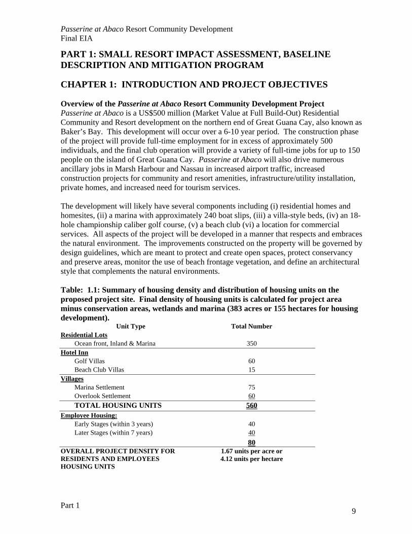
PART 1: SMALL RESORT IMPACT ASSESSMENT, BASELINE DESCRIPTION AND MITIGATION PROGRAM CHAPTER 1: INTRODUCTION AND PROJECT OBJECTIVES Overview of the Passerine at Abaco Resort Community Development Project Passerine at Abaco is a US$500 million (Market Value at Full Build-Out) Residential Community and Resort development on the northern end of Great Guana Cay, also known as Baker’s Bay. This development will occur over a 6-10 year period. The construction phase of the project will provide full-time employment for in excess of approximately 500 individuals, and the final club operation will provide a variety of full-time jobs for up to 150 people on the island of Great Guana Cay. Passerine at Abaco will also drive numerous ancillary jobs in Marsh Harbour and Nassau in increased airport traffic, increased construction projects for community and resort amenities, infrastructure/utility installation, private homes, and increased need for tourism services. The development will likely have several components including (i) residential homes and homesites, (ii) a marina with approximately 240 boat slips, (iii) a villa-style beds, (iv) an 18-hole championship caliber golf course, (v) a beach club (vi) a location for commercial services. All aspects of the project will be developed in a manner that respects and embraces the natural environment. The improvements constructed on the property will be governed by design guidelines, which are meant to protect and create open spaces, protect conservancy and preserve areas, monitor the use of beach frontage vegetation, and define an architectural style that complements the natural environments. Table: 1.1: Summary of housing density and distribution of housing units on the proposed project site. Final density of housing units is calculated for project area minus conservation areas, wetlands and marina (383 acres or 155 hectares for housing development).
Unit Type Total Number Residential Lots
Ocean front, Inland & Marina 350 Hotel Inn
Golf Villas 60 Beach Club Villas 15
Villages Marina Settlement 75 Overlook Settlement 60 TOTAL HOUSING UNITS 560
Employee Housing: Early Stages (within 3 years) 40 Later Stages (within 7 years) 40 80
OVERALL PROJECT DENSITY FOR RESIDENTS AND EMPLOYEES HOUSING UNITS
1.67 units per acre or 4.12 units per hectare
Passerine at Abaco Resort Community Development Final EIA
Part 1 10
The homesites at Passerine at Abaco will be marketed to the U.S. and European buyers. Residents of Passerine at Abaco will be invited to join the Passerine at Abaco Club. The 18-hole championship golf course and beach club described above will be built to amenitize the members of the Passerine at Abaco Club. The guests of the villa-style hotel will likely have access to the golf course which will be determined by the hotel’s rules and regulations. Another focal point of the development will be the eastern boundary of the property, upon which it is intended that a commercial center will be constructed. This commercial center, meant to benefit all local residents of Guana Cay, will likely contain amenities and services such as (i) public parks, (ii) a general store and post office, (iii) medical offices, and (iv) fire / police services. Project Components and Organization of Environmental Impact Assessment The Passerine at Abaco Resort Community Development has four major components in the proposed land cover alteration and change. The environmental impacts will be assessed in a THREE -part document* structured according to guidelines presented by the BEST Commission:
1.) PART 1 includes the RESORT EIA and will contain the major development components, background information on the site, impact assessment, mitigation plan, and environmental management plan,
2.) PART 2 addresses SUPPLEMENTAL INFORMATION ON THE MARINA CONSTRUCTION and other seafloor alterations, and
3.) PART 3 addresses SUPPLEMENTAL INFORMATION ON THE HOUSING DEVELOPMENT with specific guidelines and constraints for the development of house lots sold within the development.
*All three documents will have shared appendices of supporting material.
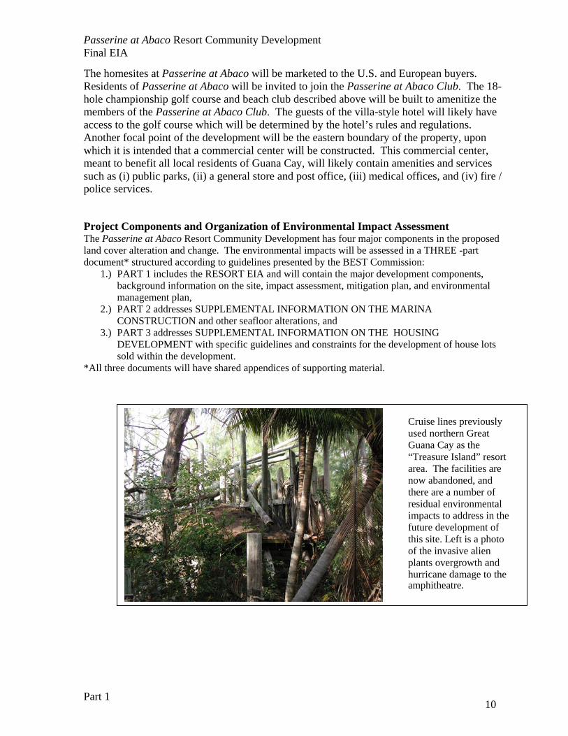
Cruise lines previously used northern Great Guana Cay as the “Treasure Island” resort area. The facilities are now abandoned, and there are a number of residual environmental impacts to address in the future development of this site. Left is a photo of the invasive alien plants overgrowth and hurricane damage to the amphitheatre.

Passerine at Abaco Resort Community Development Final EIA
Part 1 11
Table 1.2 List of the major components and descriptions for the Passerine at Abaco Resort Community Development proposed for northern Great Guana Cay. COMPONENT DESCRIPTION MARINA AND WATERFRONT/ SEAFLOOR ALTERATIONS
A private MARINA will be constructed for use of the residents and villa guests. This will not be open for public services. Approximately 200 boats slips will be constructed with some marine-front lots. Offshore, MEGA YACHT moorings will be provided for very large ships owned by residents, and a LOGISTICS DOCK will need to be constructed to accommodate the construction and on-going maintenance of the development. The existing DISNEY DOCK will need some repairs and clean-up to be used in the short-term for marketing the development.
RESIDENTIAL COMMUNITY
Approximately 400 RESIDENTIAL UNITS (in a mix a home sites and detached built-units) will be available on the project site for sale. Lots will include specific construction guidelines for
• beach front lots with protected dunes • rocky-shore lots with protected areas • marine-front lots • interior or golf-course lots
Guidelines will outline construction regulations, landscape philosophy and guidelines, water restrictions, and solid waste disposal protocols.
VILLA-STYLE HOTEL
The development will include a villa-style condo-hotel with up to 75 hotel beds. These rooms will be amenitized with hotel services such as in-room dining, housekeeping, and laundry service. In addition, the hotel will have a beach location for its guests, likely on the Atlantic side. Also, hotel guests will likely have access to the 18-hole golf course, usage will be established by the hotel’s policy and regulations.
CLUB AMENITES
Residents and homeowners at Passerine at Abaco will be invited to apply for membership in the Passerine at Abaco Club. Among the amenities serving the club will be (i) signature, 18-hole championship golf course maintained to the highest level of conditioning, and (iii) a luxurious beach club which will have dining, fitness and spa services.
Passerine at Abaco Resort Community Development Final EIA
Part 1 12
INFRASTRUCTURE/ UTILITY SYSTEM
Passerine at Abaco will develop systems to provide water, solid waste disposal, freight loading and unloading, as well as, 80 employee housing units to service the entire development. The development will have the franchise for production of freshwater and a centralized wastewater disposal plant, as well as, responsibility for solid waste disposal.
CONSERVATION AND MITIGATION AREAS
The remaining natural communities on the island proper will be managed by an independent Foundation in cooperation with the development management. The Foundation will provide on-going monitoring of the COASTAL SET-BACK ZONES, the WETLANDS AND MANGROVE CREEKS and the PROTECTED UPLAND HAMMOCK areas. The Foundation will be responsible for the management of two facilities: the Native plant nursery and recovery area, and the Environmental Education and Recreational Outreach center.
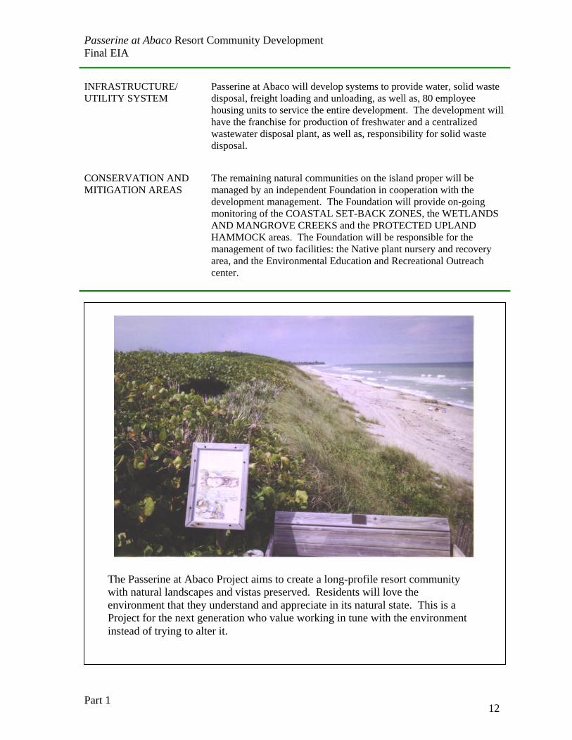
The Passerine at Abaco Project aims to create a long-profile resort community with natural landscapes and vistas preserved. Residents will love the environment that they understand and appreciate in its natural state. This is a Project for the next generation who value working in tune with the environment instead of trying to alter it.
Passerine at Abaco Resort Community Development Final EIA
Part 1 13
FIGURE 1.1: MASTER PLAN FOR DEVELOPMENT (11x17’ foldout) FIGURE 1.2: IMAGES OF DESIGN CONCEPTS FOR PASSERINE AT ABACO DEVELOPMENT (11x17’ foldout)
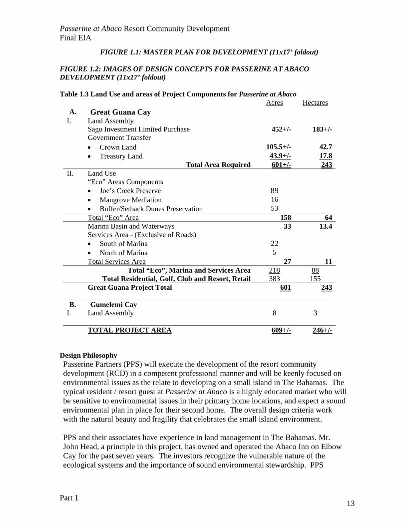
Table 1.3 Land Use and areas of Project Components for Passerine at Abaco
Acres Hectares A. Great Guana Cay
I. Land Assembly Sago Investment Limited Purchase 452+/- 183+/- Government Transfer • Crown Land 105.5+/- 42.7 • Treasury Land 43.9+/- 17.8 Total Area Required 601+/- 243II. Land Use “Eco” Areas Components • Joe’s Creek Preserve 89 • Mangrove Mediation 16 • Buffer/Setback Dunes Preservation 53 Total “Eco” Area 158 64 Marina Basin and Waterways 33 13.4 Services Area - (Exclusive of Roads) • South of Marina 22 • North of Marina 5 Total Services Area 27 11 Total “Eco”, Marina and Services Area 218 88 Total Residential, Golf, Club and Resort, Retail 383 155 Great Guana Project Total 601 243 B. Gumelemi Cay
I. Land Assembly 8 3 TOTAL PROJECT AREA 609+/- 246+/-
Design Philosophy Passerine Partners (PPS) will execute the development of the resort community development (RCD) in a competent professional manner and will be keenly focused on environmental issues as the relate to developing on a small island in The Bahamas. The typical resident / resort guest at Passerine at Abaco is a highly educated market who will be sensitive to environmental issues in their primary home locations, and expect a sound environmental plan in place for their second home. The overall design criteria work with the natural beauty and fragility that celebrates the small island environment. PPS and their associates have experience in land management in The Bahamas. Mr. John Head, a principle in this project, has owned and operated the Abaco Inn on Elbow Cay for the past seven years. The investors recognize the vulnerable nature of the ecological systems and the importance of sound environmental stewardship. PPS
Passerine at Abaco Resort Community Development Final EIA
Part 1 14
recognizes that there is much more to learn about compatible development on islands, particularly development practices that will be compatible with the island’s natural resistance to change with large hurricanes and storm events. PPS is forming the independent Great Guana Cay Foundation, an educational and research group that will document the ecological impacts of development on small islands, make recommendations for compatible development, and carry out environmental outreach activities to build a stronger community support for island stewardship. The Foundation will charged with the management of a 90± acre area within the Passerine at Abaco Resort Community Development Site; this area will be deeded to and/or controlled by deed restrictions by the Foundation. Deed restrictions will keep the coastal setbacks and buffer zones in perpetuity as part of the conservation planning. The PPS development philosophy consists of three components:
• PPS is committed to a residential development on the Great Guana Cay tract with the highest level of environmental protection for the long-term stability and function of the natural systems of the island, most especially the coastal zone.
• PPS is committed to a process of documentation and learning to improve industry-wide knowledge of compatible development practices for small islands. Part of this documentation and educational outreach is directed at the future residents of the development to enhance their enjoyment of the island environment as well as local residents and businesses.
• PPS is committed to exploring options and innovations to minimize the acute impacts of the construction phase of the development, and assist the GoB in an active monitoring program of construction progress and consequences.
The Bahamas is a small island nation, with the 2000 census establishing the population at 303,600. Over 70% of the population resides on the island on New Providence, also the location of the capital city, Nassau. The overwhelming majority of human resources and facilities for EIS assessment and management of environmental regulatory structure reside in Nassau, with some limited capacity associated in Freeport. PPS recognizes the challenge of regulation in a small island nation, and makes a commitment to assist in the monitoring and regulatory process with the relevant agencies by preparing timely progress reports with visual aids; funding external review processes; and facilitating on-site inspection by the appropriate civil servants.
PPS understands the main threats to small island environments from development stem from
• Chronic eutrophication or nutrification of the island, leading to a loss of biological diversity and wildlife habitat degradation on the land and in the sea;
• Loss of critical habitats for wildlife on and around the island in the land cover conversion; and
• Increased sediment run-off and erosion due to large-scale vegetation loss in the construction phase of the development.
These threats can be minimized through both appropriate site design and construction practices.
Passerine at Abaco Resort Community Development Final EIA
Part 1 15
PPS recognizes that the environmental impacts of development can be both acute and chronic. Construction and staging practices are engineered to minimize acute impacts, using established construction site practices from the U.S. Virgin Islands and the Florida Keys. The development design aims to minimize chronic environmental degradation to the island environment with special consideration to creating a coastal buffer zone, and minimizing ground water contamination and management of solid wastes and pollutants. Location of property The Passerine at Abaco Resort Community Development (referred to as “Site”) is planned on a 610-acres in the northern Abacos approximately 10 statute miles north of Marsh Harbour, located at the northern end of Great Guana Cay (N26° 40’; W77°10’). Site elevations range from 2 to 60 feet (0.6 to 18 meters) above mean sea level with the majority of the Site having elevations in the 10 to 20 foot (3 to 7 meters) range. The Site is approximately 2.25 miles (3.65 kilometers) in length along its southeast to northwest axis and varies in width from approximately 0.125 to 0.75 miles (0.20 to 1.21 kilometers) in a southwest to northeast direction. The Site begins at its southeastern boundary east of Little Joe’s Point and extents northwest to the terminus of Great Guana Cay. There are four small islands to the north of Great Guana Cay. The largest adjacent island, Gumelemi Cay, is approximately 8 acres in size (3.2 hectares) with topography to 16 feet (5 meters). This cay is well vegetated while the other smaller cays are only sparsely- vegetated rocky outcroppings. Gumelemi Cay has some invasive Casuarina trees along the coastal zone, but much of the island is native plants. These islands are included in the project site. To the southwest, there is an island created by the dredge spoils from the cruise ship channel. This island is not part of the project site. The look of the island will be unlike any other development in The Bahamas. The design will protect and preserve the natural vistas and “view scapes” of the island. The shoreline will retain its natural “uninhabitat” vista with the coastal protection zone and absence of private docks. Houses will not be obvious, and shaded paths and boardwalks along the coastal zone will protect wildlife habitat as well as maintain coastal stability. The “open space” in the development will help residents appreciate the natural vegetations communities now present on the islands. The diverse coastal coppice and wetlands will be incorporated into the development and golf course design to preserve the unique landforms of the property. This landscaping will rely heavily on native plants and seed stock, with an aggressive program to protect and re-locate the slow-growing native trees. The developers seek to achieve a uniquely Bahamian project. Tables 1.2 provides the details of land use in the project plan.
Passerine at Abaco Resort Community Development Final EIA
Part 1 16
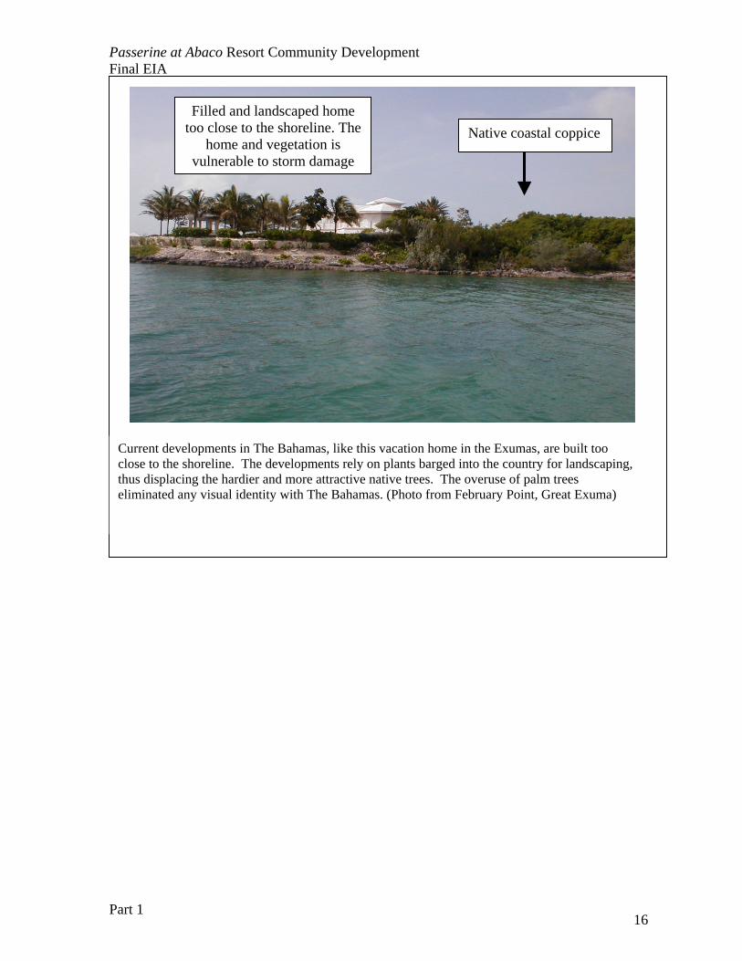
Current developments in The Bahamas, like this vacation home in the Exumas, are built too close to the shoreline. The developments rely on plants barged into the country for landscaping, thus displacing the hardier and more attractive native trees. The overuse of palm trees eliminated any visual identity with The Bahamas. (Photo from February Point, Great Exuma)
Native coastal coppiceFilled and landscaped home
too close to the shoreline. The home and vegetation is
vulnerable to storm damage
Passerine at Abaco Resort Community Development Final EIA
Part 1 17
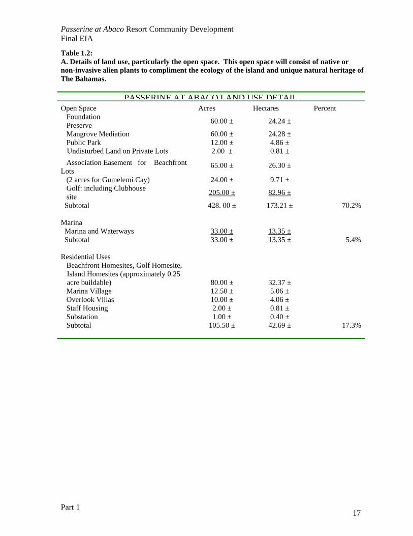
Table 1.2: A. Details of land use, particularly the open space. This open space will consist of native or non-invasive alien plants to compliment the ecology of the island and unique natural heritage of The Bahamas.
PASSERINE AT ABACO LAND USE DETAILOpen Space Acres Hectares Percent Foundation Preserve 60.00 ± 24.24 ± Mangrove Mediation 60.00 ± 24.28 ± Public Park 12.00 ± 4.86 ±
Undisturbed Land on Private Lots 2.00 ± 0.81 ± Association Easement for Beachfront Lots
65.00 ± 26.30 ±
(2 acres for Gumelemi Cay) 24.00 ± 9.71 ± Golf: including Clubhouse site 205.00 ± 82.96 ±
Subtotal 428. 00 ± 173.21 ± 70.2% Marina Marina and Waterways 33.00 ± 13.35 ± Subtotal 33.00 ± 13.35 ± 5.4% Residential Uses Beachfront Homesites, Golf Homesite,
Island Homesites (approximately 0.25 acre buildable) 80.00 ± 32.37 ±
Marina Village 12.50 ± 5.06 ± Overlook Villas 10.00 ± 4.06 ± Staff Housing 2.00 ± 0.81 ± Substation 1.00 ± 0.40 ± Subtotal 105.50 ± 42.69 ± 17.3%
Passerine at Abaco Resort Community Development Final EIA
Part 1 18
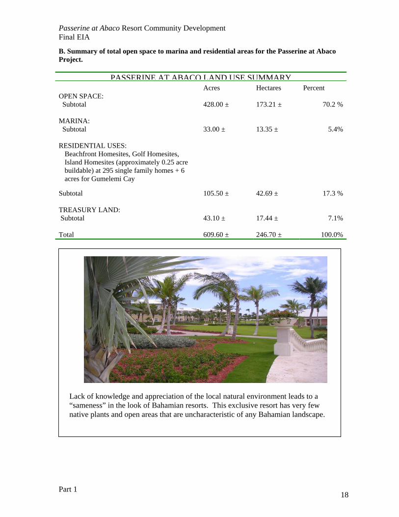
B. Summary of total open space to marina and residential areas for the Passerine at Abaco Project.
PASSERINE AT ABACO LAND USE SUMMARY Acres Hectares Percent OPEN SPACE: Subtotal 428.00 ± 173.21 ± 70.2 % MARINA: Subtotal 33.00 ± 13.35 ± 5.4% RESIDENTIAL USES:
Beachfront Homesites, Golf Homesites, Island Homesites (approximately 0.25 acre buildable) at 295 single family homes + 6 acres for Gumelemi Cay
Subtotal 105.50 ± 42.69 ± 17.3 % TREASURY LAND: Subtotal 43.10 ± 17.44 ± 7.1% Total 609.60 ± 246.70 ± 100.0%
Lack of knowledge and appreciation of the local natural environment leads to a “sameness” in the look of Bahamian resorts. This exclusive resort has very few native plants and open areas that are uncharacteristic of any Bahamian landscape.
Passerine at Abaco Resort Community Development Final EIA
Part 1 19
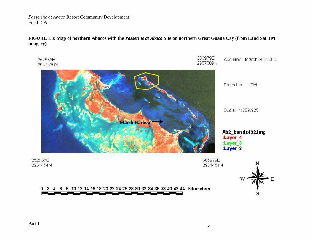
FIGURE 1.3: Map of northern Abacos with the Passerine at Abaco Site on northern Great Guana Cay (from Land Sat TM imagery).
Marsh Harbour
Passerine at Abaco Resort Community Development Final EIA
Part 1 12
CHAPTER 2 PROJECT DESCRIPTION AND ALTERNATIVES A brief review of alternative sites for the marina is presented, details on the design and impacts of these components are presented in Part 2 of this document. Most importantly, the criteria used in site design are presented with the rejected alternative. There were no alternative locations considered for the overall Passerine at Abaco RCD concept. Analysis of Abacos and other large land parcels The Abacos represent an ideal location for the siting of a Resort Community Development. There are a sizable number of second homes, yachting marinas, and tourism infrastructure to make the area comfortable for visitors, yet with a remote island setting. The geography of the Abacos presents an attractive area for development of vacation homes with scenic offshore cays, yet close to the third largest city in the Bahamas, Marsh Harbour. The RCD development vision requires an island setting with deepwater access for a marina, attractive beaches, and enough elevation to provide attractive vistas for homes and club facilities. The proposed Great Guana Cay site was previously used for the Treasure Island cruise ship attraction. Alternative Sites Considered for a Resort Community Development Other islands in Abaco that were both large enough and that could possible provide the physical environment needed for the development (e.g. Green Turtle Cay) do not have available parcels for sale. There were no other sites considered for this development, and the concept of a RCD was built around the availability of this particular land parcel. Marina and Entrance Channel Location Site Alternatives The marina and its entrance channel are critical components to the proposed development, and difficult to site. The following criteria were considered in the selection of sites for the marina:
• Adequate space for the channels and slips to accommodate the club residents’ / guests boats (about 240 slips),
• Adequate space for the associated infrastructure around the marina, • Safe harbour conditions during prevailing winds and storm events, • Minimal impact on terrestrial or wetland biological diversity or critical wildlife habitat, • Stable shoreline morphology for marine entrance, • Natural topography for vistas and scenic views of the marina area, • “Natural” feel of marina integrated into mangrove wetlands of property, • Stable coastal morphology and predictable sand movement that minimized maintenance
of the entrance channel depth, • Economical feasibility in depth and hardness of dredged substrate, and • Usability of fill substrate for other project components.
Passerine at Abaco Resort Community Development Final EIA
Part 1 13
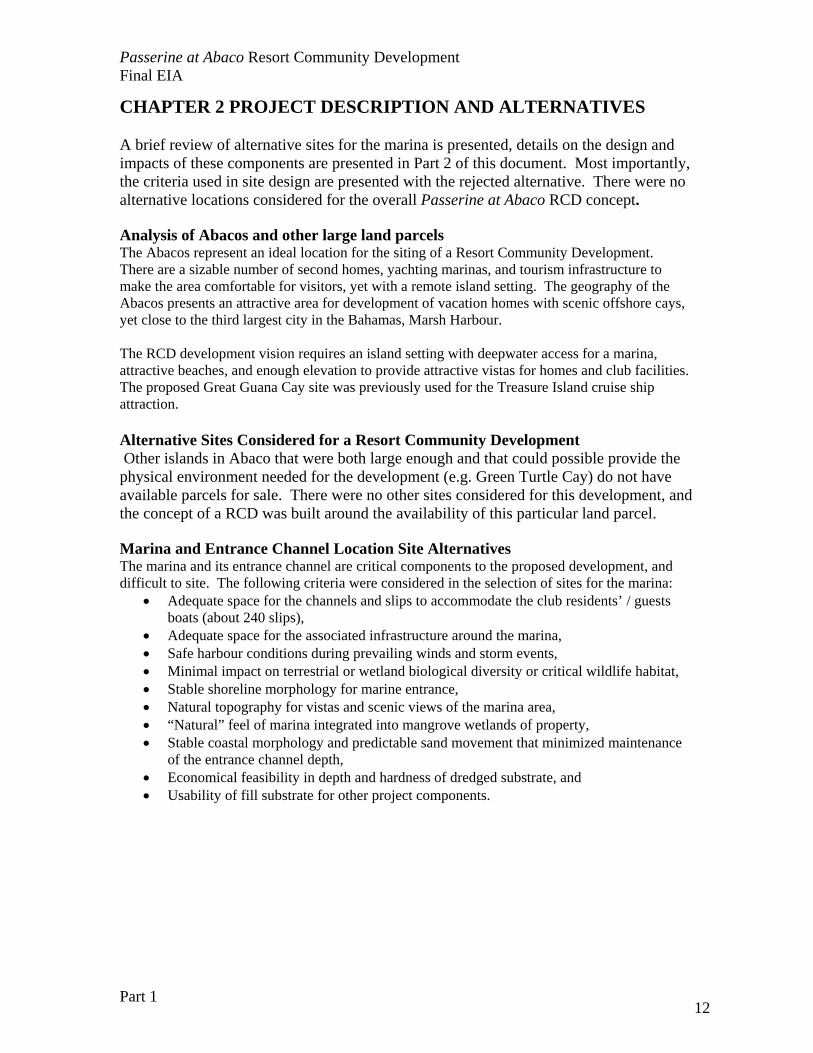
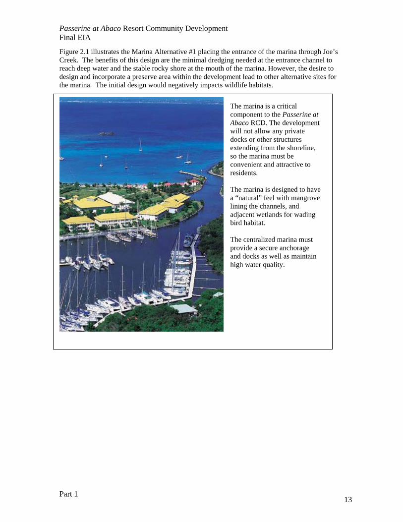
Figure 2.1 illustrates the Marina Alternative #1 placing the entrance of the marina through Joe’s Creek. The benefits of this design are the minimal dredging needed at the entrance channel to reach deep water and the stable rocky shore at the mouth of the marina. However, the desire to design and incorporate a preserve area within the development lead to other alternative sites for the marina. The initial design would negatively impacts wildlife habitats.
The marina is a critical component to the Passerine at Abaco RCD. The development will not allow any private docks or other structures extending from the shoreline, so the marina must be convenient and attractive to residents. The marina is designed to have a “natural” feel with mangrove lining the channels, and adjacent wetlands for wading bird habitat. The centralized marina must provide a secure anchorage and docks as well as maintain high water quality.
Passerine at Abaco Resort Community Development Final EIA
Part 1 14
Figure 2.1: Alternative #1 in marina location for Passerine at Abaco Private Residential Development.
Passerine at Abaco Resort Community Development Final EIA
Part 1 15
Housing and Lot Location Site Alternatives PPS will create the residential site plan to create dramatic ocean views while maintaining view corridors along the oceanfront to allow all residents / guests of the RCD to enjoy the ocean. The residential market in the wider Caribbean places a premium on coastal lots. The placement of lots is a function of the type of coastal environment present and available upland for development. Housing lots were configured to give the maximum number of coastal lots. The Resort Community Development market in the wider Caribbean places a premium on coastal lots. The placement of the lots is a function of the type of coastal environment present and available upland area for development. The criteria for the design and configuration of the housing lots are:
• Lots should be designed to have sufficient room for appropriate coastal set backs and safe placement of residents to protect property from flooding or hurricane damage
• Lots should highlight the natural beauty of the island, particularly outstanding trees and clusters of plant species of special interest.
• Lots should be designed for privacy from adjacent lots • Lots should be designed for ease of access and prudent road placement.
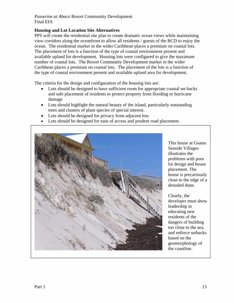
This house at Guana Seaside Villages illustrates the problems with poor lot design and house placement. The house is precariously close to the edge of a denuded dune. Clearly, the developer must show leadership in educating new residents of the dangers of building too close to the sea, and enforce setbacks based on the geomorphology of the coastline.
Passerine at Abaco Resort Community Development Final EIA
Part 1 16
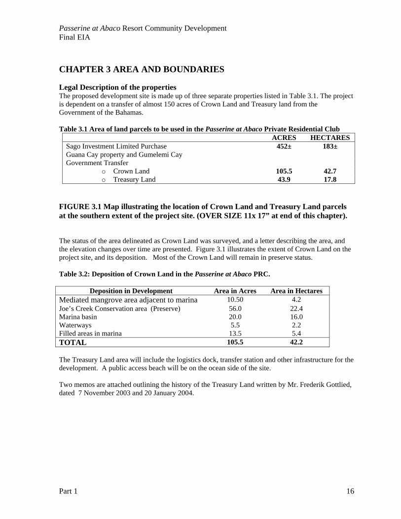
CHAPTER 3 AREA AND BOUNDARIES Legal Description of the properties The proposed development site is made up of three separate properties listed in Table 3.1. The project is dependent on a transfer of almost 150 acres of Crown Land and Treasury land from the Government of the Bahamas.
Table 3.1 Area of land parcels to be used in the Passerine at Abaco Private Residential Club
ACRES HECTARES Sago Investment Limited Purchase Guana Cay property and Gumelemi Cay
452± 183±
Government Transfer o Crown Land 105.5 42.7 o Treasury Land 43.9 17.8
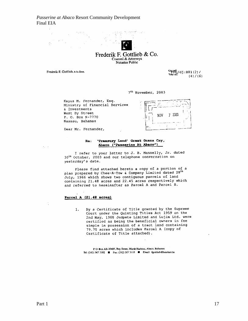
FIGURE 3.1 Map illustrating the location of Crown Land and Treasury Land parcels at the southern extent of the project site. (OVER SIZE 11x 17” at end of this chapter). The status of the area delineated as Crown Land was surveyed, and a letter describing the area, and the elevation changes over time are presented. Figure 3.1 illustrates the extent of Crown Land on the project site, and its deposition. Most of the Crown Land will remain in preserve status. Table 3.2: Deposition of Crown Land in the Passerine at Abaco PRC.
Deposition in Development Area in Acres Area in Hectares
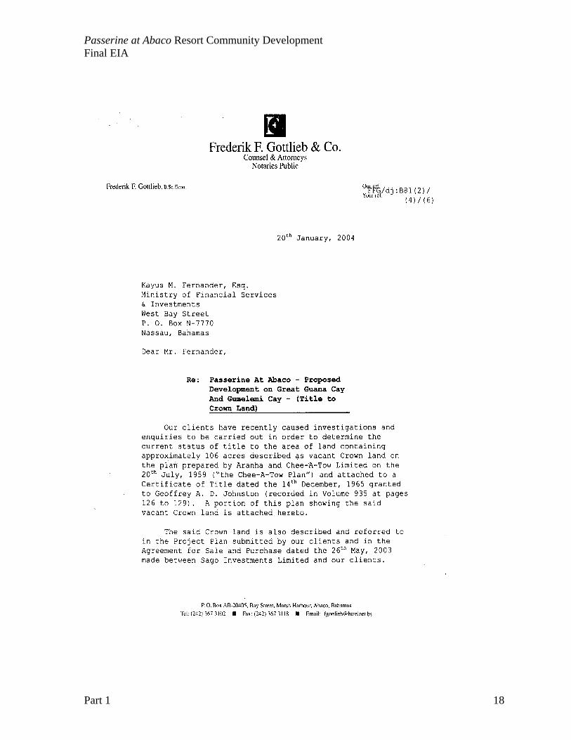
Mediated mangrove area adjacent to marina 10.50 4.2 Joe’s Creek Conservation area (Preserve) 56.0 22.4 Marina basin 20.0 16.0 Waterways 5.5 2.2 Filled areas in marina 13.5 5.4 TOTAL 105.5 42.2 The Treasury Land area will include the logistics dock, transfer station and other infrastructure for the development. A public access beach will be on the ocean side of the site. Two memos are attached outlining the history of the Treasury Land written by Mr. Frederik Gottlied, dated 7 November 2003 and 20 January 2004.
Passerine at Abaco Resort Community Development Final EIA
Part 1 17
Passerine at Abaco Resort Community Development Final EIA
Part 1 18
Passerine at Abaco Resort Community Development Final EIA
Part 1 19
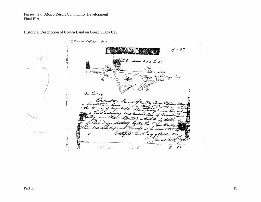
Historical Description of Crown Land on Great Guana Cay.
Passerine at Abaco Resort Community Development Final EIA
Part 1 20
Passerine at Abaco Resort Community Development Final EIA
Part 1 21
CHAPTER 4 BASELINE DESCRIPTION Physical Aspects/ Climate/ Hydrology/ Flooding/ Air Pollution Northern Abaco Islands The Abacos are part of the Little Bahama Bank, but include a separate set of islands at the extreme eastern margin of this Bank (Figure 4.1). Two large islands: Great Abaco and Little Abaco form the backbone of the island group, creating a low-energy mangrove environment along the western shores and a semi-enclosed Sea of Abaco to the east. The Sea of Abaco is fringed by small cays stretching along the platform margin, offering some protection to the waters of the sea itself. It is these small cays that are increasing the target for development because of their exclusivity and spectacular vistas. These smaller islands that can use the infrastructure of larger islands (airports, cargo ports, commercial centers) are particularly vulnerable to environmental destruction. Geology and Topography The Abacos are a large and complex island group which includes a considerable number of cays along its eastern shore, a feature that makes it quite different from its Atlantic counterparts on the Great Bahama Bank. Abaco occupies most of the eastern half of the Little Bahama Bank and extends for some 115 miles (185 kilometers) in an arc. The outer cays also extend for about the same distance but start and end some 35 miles (56 kilometers) further north, and generally follow a straight NW-SE line as far south as Elbow Cay. Abaco is in fact the second largest Bahamian island, over three times the size of Eleuthera for comparison. For the most part the island is at least five miles (eight kilometers) wide, but is broken up into smaller units at intervals by isthmuses such as Crossing Rocks in the south. Just north of Coopers Town there is in fact a complete separation into Great Abaco and Little Abaco Islands. The relief is dominated by a complex ridge running along the eastern side of the island and reaching heights of 80-100 feet (25 to 32 meters), with a maximum of 120 feet (37 meters). Little Abaco Island lacks this ridge and is much flatter. Inland is largely flat rockland 5-15 feet (1.5 to 5 meters) above sea level, occasionally relieved by old beach ridges reaching 30-40 feet (9 to 12 meters). The western shore is extensive wetland with mangroves eventually grading into wide tidal flats and an area of numerous small cays known as the Marls. The topography of the offshore cays, especially Great Guana Cay is similar, if smaller in scale. The exposed eastern coast of the cay is protected to some extent by an offshore reef tract, but coasts are high energy, receiving full force of winter storms and hurricanes from the north Atlantic. The cay is a series of dune ridges and swales with some consolidated rocky shores and cliffs. Great Guana Cay is part of the remnants of basically a twin dune-ridge reaching 40 to 60 feet (12 to 18 meters) on most islands. None of the offshore islands are more than half a mile wide (0.8 kilometers), but some can be quite long, notably Great Guana Cay which extends for some six miles (9.6 kilometers) (Figure 4.2). Great Guana Cay is typical of small offshore cays in the Abacos in poor soil development, and predominantly sandy substrates. Environmental impacts from the proposed development will be largely a function of habitat loss and destruction in land cover conversion. The property represents the largest intact tract of broad-evergreen coppice remaining in northern Abaco, but is already degraded from previous uses and invasive alien species of plants and insects. FIGURE 4.2: Topographic map of Great Guana Cay, showing elevation contours in 2-foot (0.6 meter) intervals. (Appendix A, 11 x 17 foldout map)

Passerine at Abaco Resort Community Development Final EIA
Part 1 22
FIGURE 4.3 Features of small islands like Great Guana Cay that make these sites particularly sensitive to land cover change and development
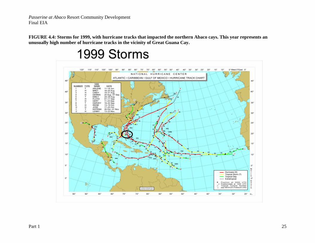
Climate The northerly location of Abaco and its large size combine to give it one of the heaviest rainfalls in the Bahamas, along with a fairly pronounced winter season. Rainfall averages about 60 inches (1.54 meters) a year, and winter temperatures are cool, but do not reach the minimums of Grand Bahama and North Andros which are that much closer to the landmass of North America. The Atlantic Ocean exposure does ensure that the NE Trade Winds are predominant throughout the year, but this same location has also made the island vulnerable to hurricanes heading northwards along the edge of the archipelago. Hurricane Floyd in 1999 did considerable damage to the outlying cays. Storm tracks like Hurricane Floyd represent a significant threat to property development on the smaller islands.
Below is an aerial view from the North of Great Guana Cay. The island is densely vegetated with broad-leaf evergreen forests and shrub thickets, but along Baker’s
Bay, the former cruise ship resort can be identified by the dense Casuarina invasion through this area (pink line). Previous uses of the island include a sisal
farm, land crab harvesting, and a cruise ship resort.
Disney “Treasure Island” Impacted
Passerine at Abaco Resort Community Development Final EIA
Part 1 23
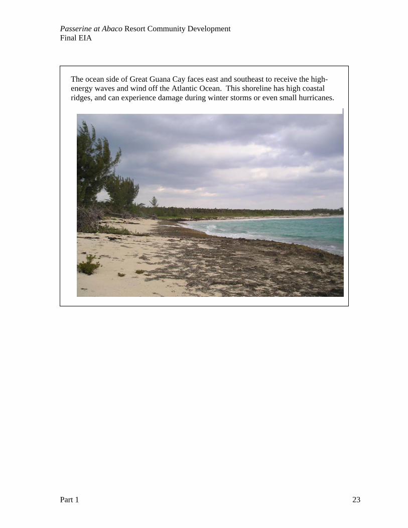
The ocean side of Great Guana Cay faces east and southeast to receive the high-energy waves and wind off the Atlantic Ocean. This shoreline has high coastal ridges, and can experience damage during winter storms or even small hurricanes.
Passerine at Abaco Resort Community Development Final EIA
Part 1 24
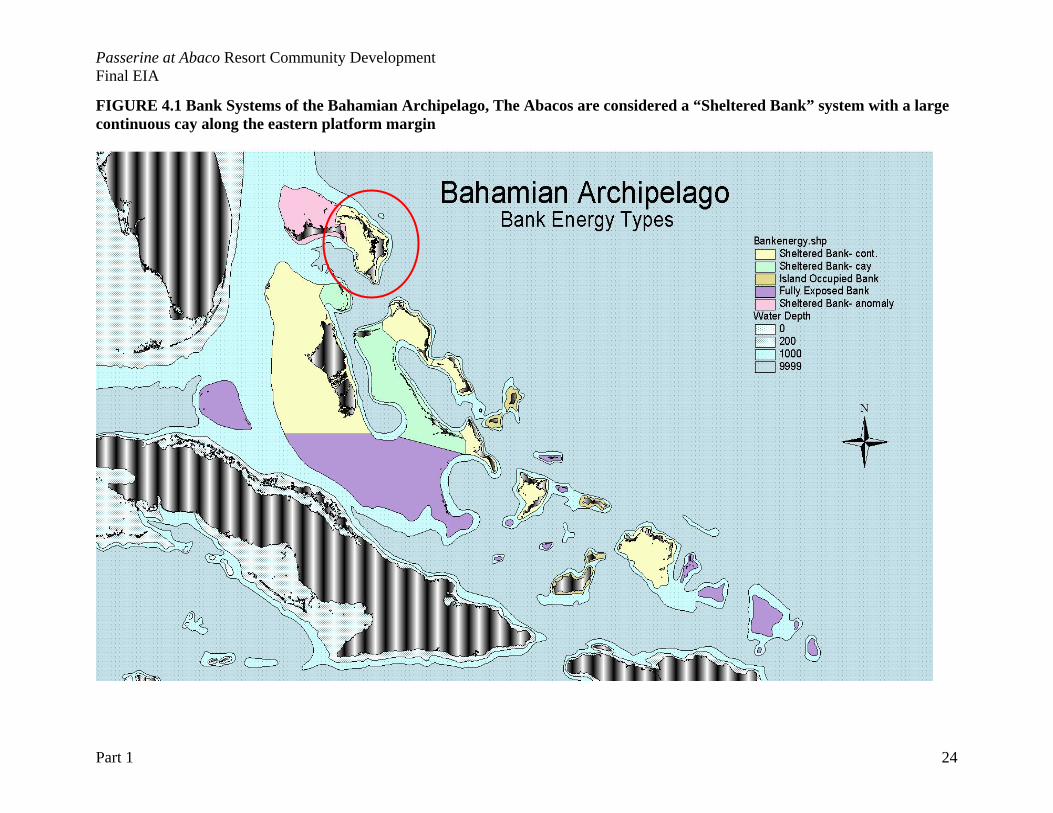
FIGURE 4.1 Bank Systems of the Bahamian Archipelago, The Abacos are considered a “Sheltered Bank” system with a large continuous cay along the eastern platform margin
Passerine at Abaco Resort Community Development Final EIA
Part 1 25
FIGURE 4.4: Storms for 1999, with hurricane tracks that impacted the northern Abaco cays. This year represents an unusually high number of hurricane tracks in the vicinity of Great Guana Cay.
Passerine at Abaco Resort Community Development Final EIA
Part 1 26
The level of rainfall has supported extensive growth of the Caribbean Pine, which covers the island except where it has been clear-felled. Pine rock lands cover most of the area south and west of marsh Harbour, some 20,000 acres (8,000 hectares). “Coppice” or broadleaf evergreen forests dominate the offshore islands and cays and shrub lands. Rain can be highly variable from year to year, thus vegetation on these offshore cays is drought resistant. The most important considerations for small island development are:
1.) Inter-annual variability in rainfall, and the impact of acute rainfall events: small islands throughout The Bahamas have been historically limited for development based on the availability of water. Although the vegetation on the island can depend and draw from ground water supplies, the natural vegetation is also highly drought-resistant. Rainfall patterns throughout the Bahamas are highly variable, with the entire month’s rainfall occurring in a single day. Year to year variability in rainfall is high, thus landscaping practices have to accommodate the natural climate extremes of the Bahamas.
2.) Storm Events: extreme and even average storms can cause severe property damage,
and the abandonment of island developments. A sound property protection and hurricane preparation plan is essential for the long-term viability of small island development. Storm preparation must include the protection of a coastal buffer zone and shoreline stabilization through natural landforms.
Table 4.1 Hurricane occurrences for all of The Bahamas and the northern Bahamas, 1886 to 2003 (from N. Sealey, 2004). LOCATION MAY JUNE JULY AUG SEPT OCT NOV TOTAL All Bahamas 1 2* 4 18 27 18 6 76 Northern Bahamas
0 2* 4 15 18 14 6 59
Probability of a storm in any given year – Northern Bahamas
0 1.7% 3.4% 12.8% 15.3% 12% 5.1% 50.4%
* the two June storms recorded in The Bahamas are not universally agreed to have been of hurricane strength. In any given year, there is a 50% chance of a hurricane hitting the northern Bahamas. Even if a storm does not directly impact Great Guana Cay, travel for residents, delivery of supplies and even rainfall patterns can be affected. Site design and construction must address storm energy and rainfall stresses to minimize property and shoreline damage from tropical storms to typical Category 2 and 3 hurricanes. Hydrology/ Flooding The threats from flooding on small islands come from two sources: 1) flooding from large storm surge events breaching dunes and coastal ridges, and 2) rapid accumulation of rainfall
Passerine at Abaco Resort Community Development Final EIA
Part 1 27
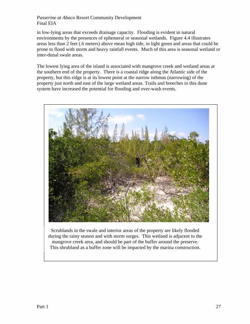
in low-lying areas that exceeds drainage capacity. Flooding is evident in natural environments by the presences of ephemeral or seasonal wetlands. Figure 4.4 illustrates areas less than 2 feet (.6 meters) above mean high tide, in light green and areas that could be prone to flood with storm and heavy rainfall events. Much of this area is seasonal wetland or inter-dunal swale areas. The lowest lying area of the island is associated with mangrove creek and wetland areas at the southern end of the property. There is a coastal ridge along the Atlantic side of the property, but this ridge is at its lowest point at the narrow isthmus (narrowing) of the property just north and east of the large wetland areas. Trails and breeches in this dune system have increased the potential for flooding and over-wash events.
Scrublands in the swale and interior areas of the property are likely flooded during the rainy season and with storm surges. This wetland is adjacent to the
mangrove creek area, and should be part of the buffer around the preserve. This shrubland as a buffer zone will be impacted by the marina construction.
Passerine at Abaco Resort Community Development Final EIA
Part 1 28
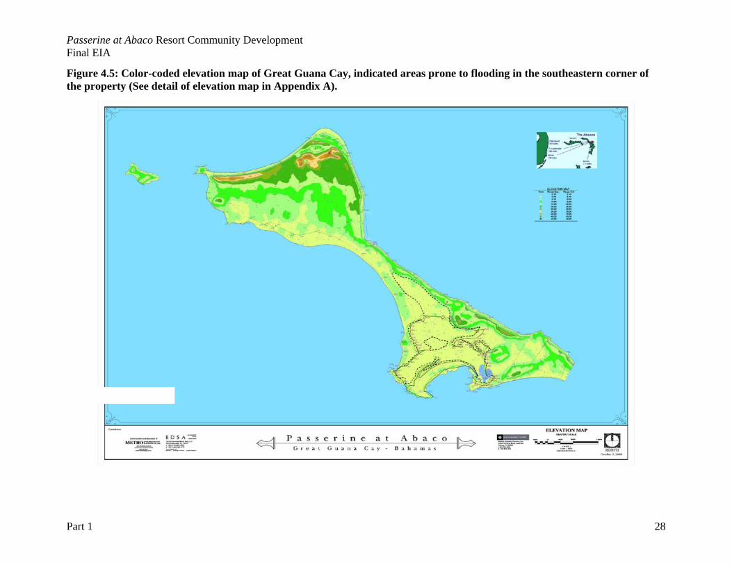
Figure 4.5: Color-coded elevation map of Great Guana Cay, indicated areas prone to flooding in the southeastern corner of the property (See detail of elevation map in Appendix A).
Passerine at Abaco Resort Community Development Final EIA
Part 1 29
Air Quality/ Noise Pollution Air Quality and emissions are addressed as part of the Environmental Health Services Act of 1987, which states that: “An act to promote the conservation and maintenance of the environment in the interest of health, for proper sanitation in matters of food and drinks and general for the provision and control of services, activities and other matters connected therewith or incidental thereto.” The Health Department must provide a certificate of approval for discharges, upon satisfaction that the measures used to control or prevent emissions or discharge of any contaminant or pollutant into any part of the environment are adequate. Air and Noise pollution monitoring should be initiated with the construction phase of this project, there are no evident air or noise pollution issues at this time, as the property is not occupied or used. Air and noise pollution issues will be temporary during the construction phase of this project. Biological and Ecological Aspects The coastal zone dominates small island ecology. The coastal environment is the area where the land meets the sea. The coastal zone includes areas of dunes, beaches, rocks, low cliffs, wetlands, bays and coves, and often refers to both the marine and terrestrial habitats that occur near the shoreline. Because of the effects of currents, waves, tidal changes, storms, and hurricanes, the coastal zone is a dynamic environment. The coastal zone includes many diverse and interconnected ecosystems and communities so that any impact on one ecosystem or community can directly affect all others that are connected to it through the life histories of species that travel between them (B.E.S.T., 2002). The coastal zone provides critical habitats and resources for many species, such as seabirds, sea turtles, and marine mammals. Additionally, coastal zones also provide people with benefits, which include hurricane buffer zones, tourist attractions, educational opportunities, and living resources (B.E.S.T., 2002). For the impact assessment, management and mitigation discussions, the coastline of the Great Guana Cay Site is divided into 5 types of coastal environments. Each type needs a defined boundary and management plan to function as part of the larger ecological landscape, and to provide protection to the constructed property of the development. This classification system attempts to combine the present marine classification system (see Allee et al.,2001) and terrestrial classification system (see Areces-Mallea et al., 1999) into a system appropriate for classifying coastal zones. The intersection of these two classification systems allows for better descriptions of coastal zones by addressing both the physical environment and the vegetation types present. Because the water level of a coastal zone area is constantly changing so that an intertidal area can be an aquatic environment at one moment and a terrestrial environment at the next, these areas deserve a specialized classification system, and are thus characterized by the following system of modifiers:
• Type of sediment Soft, unconsolidated sand or mud, found on beaches and mangrove
communities; and
Passerine at Abaco Resort Community Development Final EIA
Part 1 30
Consolidated carbonate sediments, found on rocky shores. Unconsolidated sediment is comprised mainly of sand, but also contains silt, mud, and stones; specific sources for these materials are the skeletal remains of many sea creatures and calcareous algae (B.E.S.T., 2002). In addition grains of calcium carbonate are precipitated in heated seawater, depositing fine, sandy, rounded oolite grains onto beaches. Coarser sand is the result of the erosion of coral reefs during storm events (B.E.S.T., 2002).
• Wave energy High Energy shorelines; Medium Energy shoreline, and Low Energy shorelines
Generally, higher wave energy corresponds with a wider beach, since the magnitude of the waves determines how far sand can be transported up the coast (Sealey, 1985). Each type of shoreline has associated subtidal, intertidal and terrestrial components. The terrestrial component determines what type(s) of plants grow adjacent to the shore to form and stabilize the coastal zone (B.E.S.T., 2002). The different combinations of sediment type and wave energy create a variety of environments that react differently to erosional and depositional processes, with some of the environments better suited for human habitation and development (B.E.S.T., 2002). Types of coastal environments on Great Guana Cay High relief beaches and beach strand communities are shrub or herb-dominated, sandy shores with varying widths and heights of dune systems. These high relief beach strands slope to Uniola paniculata herb-shrub lands, then to broadleaf forest or shrub thickets (Sealey et al., 1999). An element common to beaches is the sand dune. Salt-tolerant plants including railroad vine inhabit the coastal dunes that build up behind a beach, sea purslane, stunted sea grape, and the exotic casuarinas (Sealey, 1990). The dune vegetation plays an important role in fixing the soft sand sediments and preventing the spread of sandy sediments inland (Sealey, 1990). The dunes themselves store fresh water and provide a natural sea wall against storms (Sealey, 1990). Beaches can be described as HIGH or LOW energy, the wave energy correlates to dune height and relief. Beach rock is exposed beneath, shoreward, and seaward of modern beach sands, and exists in tabular, laminated beds that dip gently seaward (Shapiro et al., 1995). Laminations are defined by slight variations in grain size between fine and medium sand (Shapiro et al., 1995). Low energy beaches occur along more protected coasts (Sea of Abaco shorelines), and can transition to coastal wetlands, and mangrove communities. Low relief beaches occur on Great Guana Cay in two forms:
(i) beach to lowland subtropical evergreen forest/woodland/shrub land transition, and (ii) beach to palm dominated lowland subtropical evergreen shrub and transition (Sealey et al., 1999).
As with high-energy beaches and low-energy beach strands, dunes and beach rock also occur.
Passerine at Abaco Resort Community Development Final EIA
Part 1 31
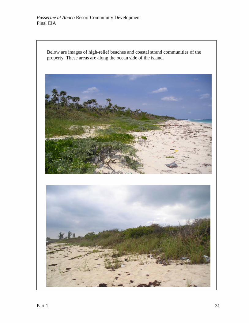
Below are images of high-relief beaches and coastal strand communities of the property. These areas are along the ocean side of the island.
Passerine at Abaco Resort Community Development Final EIA
Part 1 32
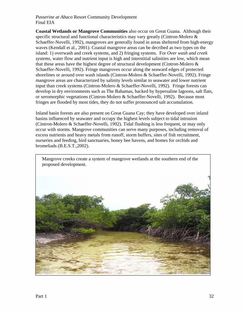
Coastal Wetlands or Mangrove Communities also occur on Great Guana. Although their specific structural and functional characteristics may vary greatly (Cintron-Molero & Schaeffer-Novelli, 1992), mangroves are generally found in areas sheltered from high-energy waves (Kendall et al., 2001). Coastal mangrove areas can be decribed as two types on the island: 1) overwash and creek systems, and 2) fringing systems. For Over wash and creek systems, water flow and nutrient input is high and interstitial salinities are low, which mean that these areas have the highest degree of structural development (Cintron-Molero & Schaeffer-Novelli, 1992). Fringe mangroves occur along the seaward edges of protected shorelines or around over wash islands (Cintron-Molero & Schaeffer-Novelli, 1992). Fringe mangrove areas are characterized by salinity levels similar to seawater and lower nutrient input than creek systems (Cintron-Molero & Schaeffer-Novelli, 1992). Fringe forests can develop in dry environments such as The Bahamas, backed by hypersaline lagoons, salt flats, or xeromorphic vegetations (Cintron-Molero & Schaeffer-Novelli, 1992). Because most fringes are flooded by most tides, they do not suffer pronounced salt accumulation. Inland basin forests are also present on Great Guana Cay; they have developed over inland basins influenced by seawater and occupy the highest levels subject to tidal intrusion (Cintron-Molero & Schaeffer-Novelli, 1992). Tidal flushing is less frequent, or may only occur with storms. Mangrove communities can serve many purposes, including removal of excess nutrients and heavy metals from runoff, storm buffers, sites of fish recruitment, nurseries and feeding, bird sanctuaries, honey bee havens, and homes for orchids and bromeliads (B.E.S.T.,2002).
Mangrove creeks create a system of mangrove wetlands at the southern end of the proposed development.
Passerine at Abaco Resort Community Development Final EIA
Part 1 33
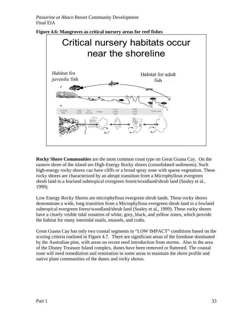
Figure 4.6: Mangroves as critical nursery areas for reef fishes
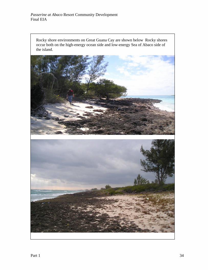
Rocky Shore Communities are the most common coast type on Great Guana Cay. On the eastern shore of the island are High-Energy Rocky shores (consolidated sediments). Such high-energy rocky shores can have cliffs or a broad spray zone with sparse vegetation. These rocky shores are characterized by an abrupt transition from a Microphyllous evergreen shrub land to a lowland subtropical evergreen forest/woodland/shrub land (Sealey et al., 1999). Low Energy Rocky Shores are microphyllous evergreen shrub lands. These rocky shores demonstrate a wide, long transition from a Microphyllous evergreen shrub land to a lowland subtropical evergreen forest/woodland/shrub land (Sealey et al., 1999). These rocky shores have a clearly visible tidal zonation of white, grey, black, and yellow zones, which provide the habitat for many intertidal snails, mussels, and crabs. Great Guana Cay has only two coastal segments in “LOW IMPACT” conditions based on the scoring criteria outlined in Figure 4.7. There are significant areas of the foredune dominated by the Australian pine, with areas on recent seed introduction from storms. Also in the area of the Disney Treasure Island complex, dunes have been removed or flattened. The coastal zone will need remediation and restoration in some areas to maintain the shore profile and native plant communities of the dunes and rocky shores.
Passerine at Abaco Resort Community Development Final EIA
Part 1 34
Rocky shore environments on Great Guana Cay are shown below Rocky shores occur both on the high-energy ocean side and low-energy Sea of Abaco side of the island.
Passerine at Abaco Resort Community Development Final EIA
Part 1 35
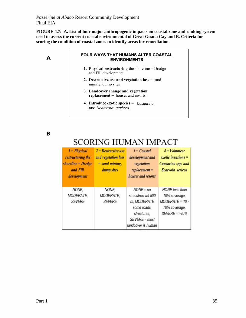
FIGURE 4.7: A. List of four major anthropogenic impacts on coastal zone and ranking system used to assess the current coastal environmental of Great Guana Cay and B. Criteria for scoring the condition of coastal zones to identify areas for remediation.
A
B
Casuarina
Passerine at Abaco Resort Community Development Final EIA
Part 1 36
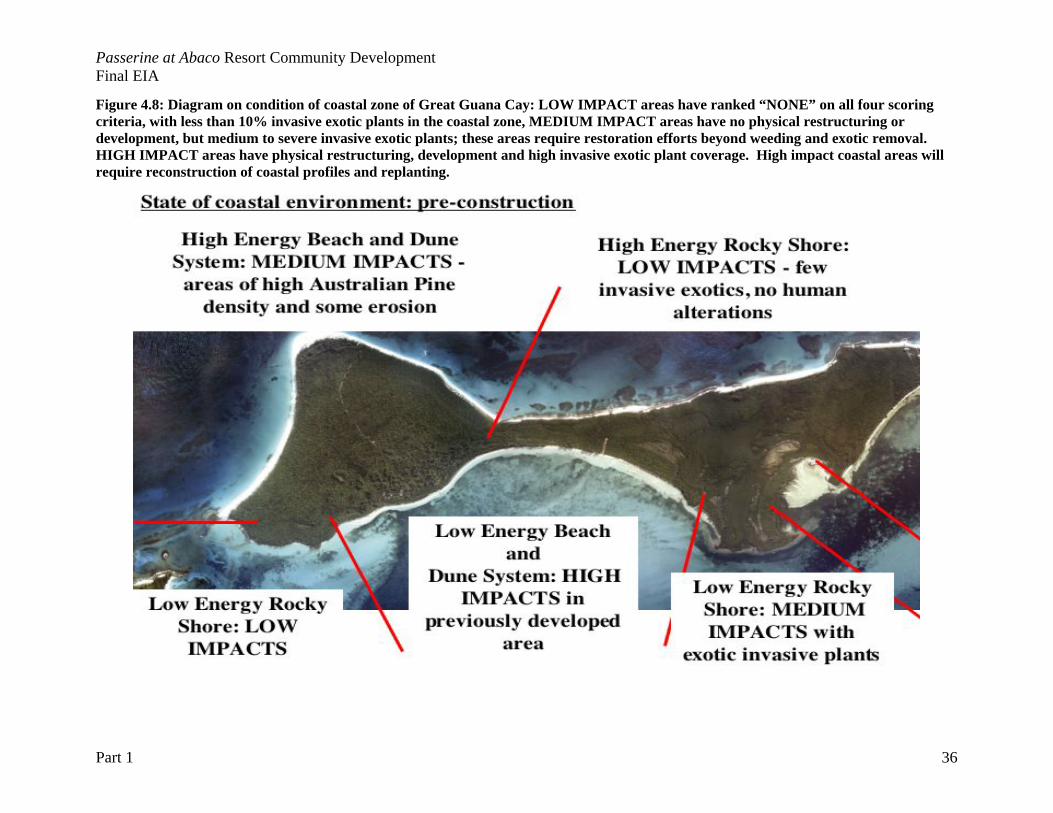
Figure 4.8: Diagram on condition of coastal zone of Great Guana Cay: LOW IMPACT areas have ranked “NONE” on all four scoring criteria, with less than 10% invasive exotic plants in the coastal zone, MEDIUM IMPACT areas have no physical restructuring or development, but medium to severe invasive exotic plants; these areas require restoration efforts beyond weeding and exotic removal. HIGH IMPACT areas have physical restructuring, development and high invasive exotic plant coverage. High impact coastal areas will require reconstruction of coastal profiles and replanting.
Passerine at Abaco Resort Community Development Final EIA
Part 1 37
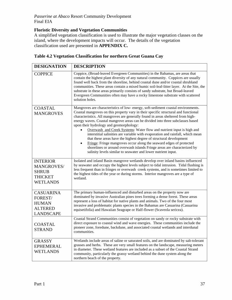
Floristic Diversity and Vegetation Communities A simplified vegetation classification is used to illustrate the major vegetation classes on the island, where the development impacts will occur. The details of the vegetation classification used are presented in APPENDIX C. Table 4.2 Vegetation Classification for northern Great Guana Cay DESIGNATION DESCRIPTION
COPPICE Coppice, (Broad-leaved Evergreen Communities) in the Bahamas, are areas that contain the highest plant diversity of any natural community. Coppices are usually found well back from the shoreline, behind coastal dune and/or coastal shrubland communities. These areas contain a mixed humic soil-leaf-litter layer. At the Site, the substrate in these areas primarily consists of sandy substrate, but Broad-leaved Evergreen Communities often may have a rocky limestone substrate with scattered solution holes.
COASTAL MANGROVES
Mangroves are characteristics of low- energy, soft-sediment coastal environments. Coastal mangroves on this property vary in their specific structural and functional characteristics. All mangroves are generally found in areas sheltered from high-energy waves. Coastal mangrove areas can be divided into three subclasses based upon their hydrology and geomorphology:
• Overwash and Creek Systems: Water flow and nutrient input is high and interstitial salinities are variable with evaporation and rainfall, which mean that these areas have the highest degree of structural development
• Fringe: Fringe mangroves occur along the seaward edges of protected shorelines or around overwash islands Fringe areas are characterized by salinity levels similar to seawater and lower nutrient input.
INTERIOR MANGROVES/ SHRUB THICKET WETLANDS
Isolated and inland Basin mangrove wetlands develop over inland basins influenced by seawater and occupy the highest levels subject to tidal intrusion. Tidal flushing is less frequent than in fringes or overwash creek systems, and is sometimes limited to the highest tides of the year or during storms. Interior mangroves are a type of wetland.
CASUARINA FOREST/ HUMAN ALTERED LANDSCAPE
The primary human-influenced and disturbed areas on the property now are dominated by invasive Australian pines trees forming a dense forest. These areas represent a loss of habitat for native plants and animals. Two of the four most invasive and problematic plants species in the Bahamas are Casuarina (Casuarina equisetifolia) and Hawaiian Seagrape or Half-flower (Scaveola sericea).
COASTAL STRAND
Coastal Strand Communities consist of vegetation on sandy or rocky substrate with direct exposure to coastal wind and wave energies. These communities include the pioneer zone, foredune, backdune, and associated coastal wetlands and interdunal communities.
GRASSY EPHEMERAL WETLANDS
Wetlands include areas of saline or saturated soils, and are dominated by salt-tolerant grasses and herbs. These are very small features on the landscape, measuring meters in diameter. These wetland features are included as a subset of the Coastal Strand community, particularly the grassy wetland behind the dune system along the northern beach of the property.
Passerine at Abaco Resort Community Development Final EIA
Part 1 38
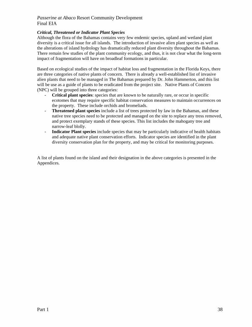
Critical, Threatened or Indicator Plant Species Although the flora of the Bahamas contains very few endemic species, upland and wetland plant diversity is a critical issue for all islands. The introduction of invasive alien plant species as well as the alterations of island hydrology has dramatically reduced plant diversity throughout the Bahamas. There remain few studies of the plant community ecology, and thus, it is not clear what the long-term impact of fragmentation will have on broadleaf formations in particular. Based on ecological studies of the impact of habitat loss and fragmentation in the Florida Keys, there are three categories of native plants of concern. There is already a well-established list of invasive alien plants that need to be managed in The Bahamas prepared by Dr. John Hammerton, and this list will be use as a guide of plants to be eradicated from the project site. Native Plants of Concern (NPC) will be grouped into three categories:
- Critical plant species: species that are known to be naturally rare, or occur in specific ecotomes that may require specific habitat conservation measures to maintain occurrences on the property. These include orchids and bromeliads.
- Threatened plant species include a list of trees protected by law in the Bahamas, and these native tree species need to be protected and managed on the site to replace any tress removed, and protect exemplary stands of these species. This list includes the mahogany tree and narrow-leaf blolly.
- Indicator Plant species include species that may be particularly indicative of health habitats and adequate native plant conservation efforts. Indicator species are identified in the plant diversity conservation plan for the property, and may be critical for monitoring purposes.
A list of plants found on the island and their designation in the above categories is presented in the Appendices.
Passerine at Abaco Resort Community Development Final EIA
Part 1 39
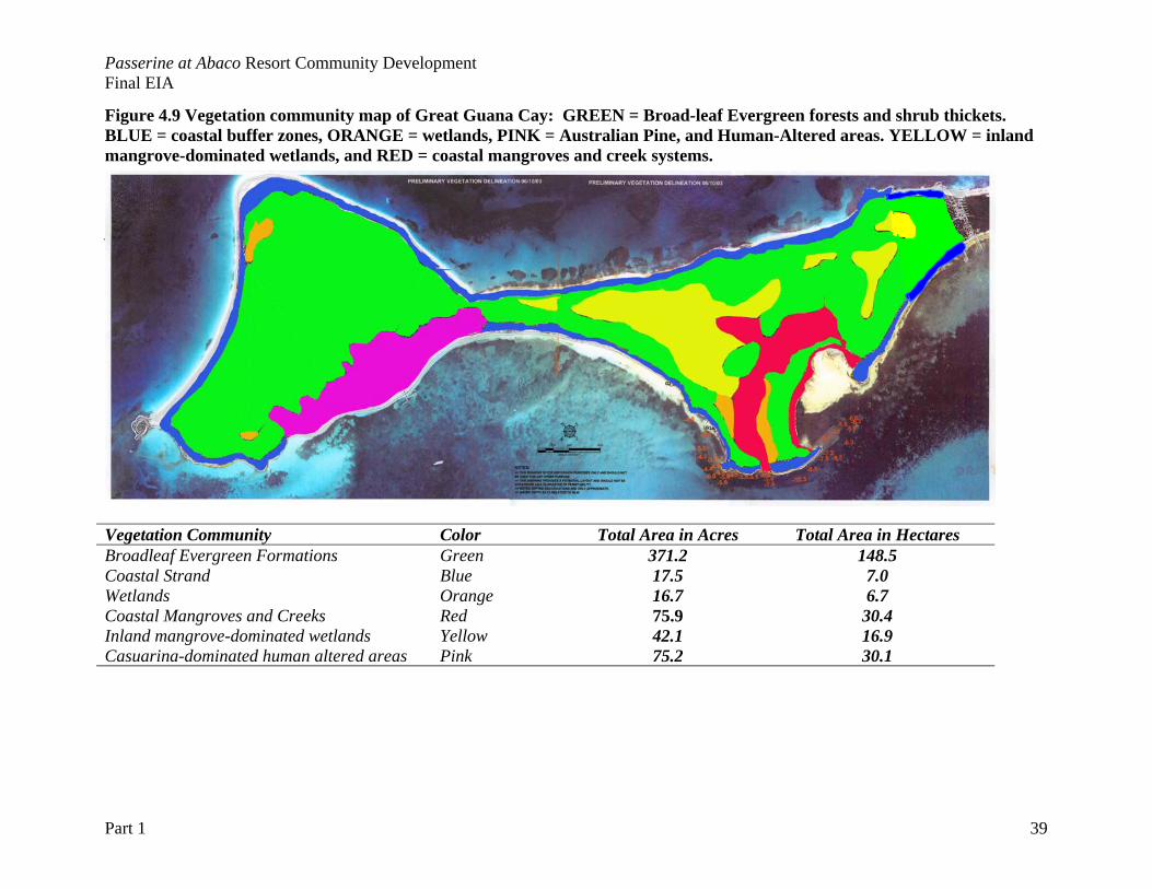
Figure 4.9 Vegetation community map of Great Guana Cay: GREEN = Broad-leaf Evergreen forests and shrub thickets. BLUE = coastal buffer zones, ORANGE = wetlands, PINK = Australian Pine, and Human-Altered areas. YELLOW = inland mangrove-dominated wetlands, and RED = coastal mangroves and creek systems. Approximate Areas of each Vegetation type
Vegetation Community Color Total Area in Acres Total Area in Hectares Broadleaf Evergreen Formations Green 371.2 148.5 Coastal Strand Blue 17.5 7.0 Wetlands Orange 16.7 6.7 Coastal Mangroves and Creeks Red 75.9 30.4 Inland mangrove-dominated wetlands Yellow 42.1 16.9 Casuarina-dominated human altered areas Pink 75.2 30.1

Passerine at Abaco Resort Community Development Final EIA
Part 1 41
Faunal Diversity and Habitat Utilization In the consideration of the all the wildlife species associated with both marine and terrestrial habitats, it is critical to consider the status of species in the larger region of the northern Abacos. This project site should not be considered in isolation, and is part of an already fragmented landscape for birds, land and sea invertebrates, and reptiles. It is critical to evaluate the impact of any loss of habitat in a regional perspective. Common Terrestrial Wildlife and Fauna Critical terrestrial wildlife falls into three taxa groups:
• Land crabs and invertebrates • Birds (resident as well as neotropical migrants) • Lizards, iguanas and snakes
Species lists of observed wildlife are included in the Appendix. All wildlife are threatened by habitat loss and degradation with development. With the history of development on the Site and a settlement on the island, it is likely that there are feral animals (e.g. rats, cats) and toxins (e.g. pesticides) that may have already impacted wildlife populations. There is evidence of rats invading the southern boundary of the property as evidenced by chewing of orchid bulbs.
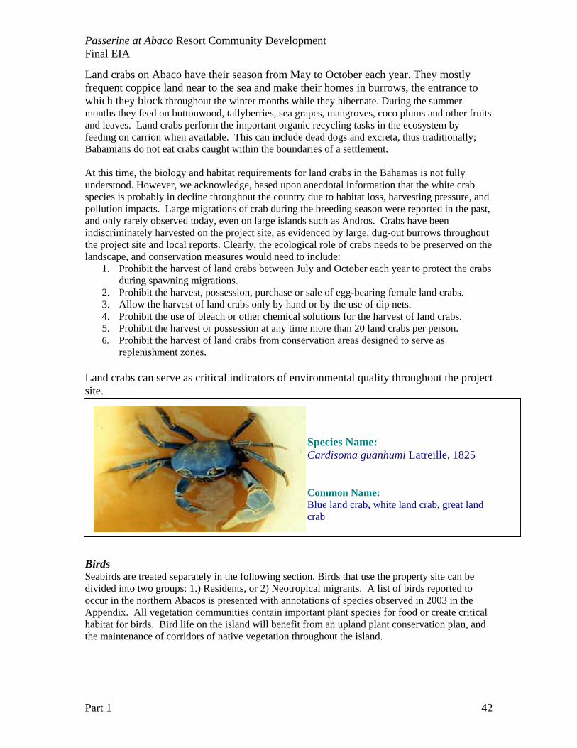
Land Crabs and Terrestrial Invertebrates – Land crabs play an important ecological role in The Bahamas. These are very young islands, and in the absence of any native small mammals (apart from bats), the land crabs are critical foragers on the coppice floor, recycling plant and animal matter. Land crabs require high quality habitat, especially clean ground water. “Land crabs” as an ecological group includes the “soldier crab” or land hermit crab, Coenobita clypeatus. The small land hermit crab is very abundant and an important detritivore on the island. Hermit crabs live near water only returning to sea to lay their eggs.
Since land crabs spend much of their time in burrows, any contaminants (especially anti-mosquito pesticides) can have devastating impacts on land crab populations. There is a conspicuous absence of land crabs in the vicinity of the former “Treasure Island” development, but throughout the island there have been three species of land crabs observed. There are two types of land crabs in the Family Gecarcinidate found on Abaco:
- black (Gecarcinus lateralis) and - white (Cardisoma guanhumi) .
Both land crab species occur on Great Guana Cay at the project site. The Black land crab is being particularly numerous in the broadleaf evergreen coppice areas, with thousands of individuals per hectare. Cardisoma guanhumi, the white land crab, is a large burrowing crab whose distribution on land is generally limited to within 5 km of the ocean. Large individuals may grow to over 11 cm and weigh over 500 grams. This is the species harvested to eat at the start of the rainy season. The male of the species is usually larger and has a narrow 'apron' on its underbelly. The smaller female has a much wider apron, slightly broader-based than an equilateral triangle.
Passerine at Abaco Resort Community Development Final EIA
Part 1 42
Land crabs on Abaco have their season from May to October each year. They mostly frequent coppice land near to the sea and make their homes in burrows, the entrance to which they block throughout the winter months while they hibernate. During the summer months they feed on buttonwood, tallyberries, sea grapes, mangroves, coco plums and other fruits and leaves. Land crabs perform the important organic recycling tasks in the ecosystem by feeding on carrion when available. This can include dead dogs and excreta, thus traditionally; Bahamians do not eat crabs caught within the boundaries of a settlement. At this time, the biology and habitat requirements for land crabs in the Bahamas is not fully understood. However, we acknowledge, based upon anecdotal information that the white crab species is probably in decline throughout the country due to habitat loss, harvesting pressure, and pollution impacts. Large migrations of crab during the breeding season were reported in the past, and only rarely observed today, even on large islands such as Andros. Crabs have been indiscriminately harvested on the project site, as evidenced by large, dug-out burrows throughout the project site and local reports. Clearly, the ecological role of crabs needs to be preserved on the landscape, and conservation measures would need to include:
1. Prohibit the harvest of land crabs between July and October each year to protect the crabs during spawning migrations.
2. Prohibit the harvest, possession, purchase or sale of egg-bearing female land crabs. 3. Allow the harvest of land crabs only by hand or by the use of dip nets. 4. Prohibit the use of bleach or other chemical solutions for the harvest of land crabs. 5. Prohibit the harvest or possession at any time more than 20 land crabs per person. 6. Prohibit the harvest of land crabs from conservation areas designed to serve as
replenishment zones. Land crabs can serve as critical indicators of environmental quality throughout the project site.
Species Name: Cardisoma guanhumi Latreille, 1825
Common Name: Blue land crab, white land crab, great land crab
Birds Seabirds are treated separately in the following section. Birds that use the property site can be divided into two groups: 1.) Residents, or 2) Neotropical migrants. A list of birds reported to occur in the northern Abacos is presented with annotations of species observed in 2003 in the Appendix. All vegetation communities contain important plant species for food or create critical habitat for birds. Bird life on the island will benefit from an upland plant conservation plan, and the maintenance of corridors of native vegetation throughout the island.

Passerine at Abaco Resort Community Development Final EIA
Part 1 43
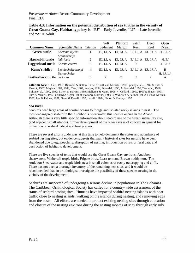
Reptiles Reptiles (snakes and lizards) and Amphibians (Frogs) within the Bahamas are largely endemic species or subspecies. All native reptiles and amphibians are at risk from loss of habitat or competition/predation threats from introduced species. Lizards seen as common on the property include Anolis sagrei, the Bahamian brown anole and the Curly Tailed Lizard (Leiocephalus carinatus ). One snake was sited, thought to be the Bahamas Boa (Epicrates striatus). This snake is quite harmless, but extremely threatened during development. Many laborers will kill a snake on sight based on its Biblical representation of even. The snake is not appreciated for its useful role in eating rats and mice! Common Marine Fauna Adjacent Marine Communities and Fisheries Resources There is a mosaic of soft-bottom and hard-bottom marine benthic communities adjacent to the Site. Soft-bottom communities dominate the western side of the project site, including Baker’s Bay. Dense to sparse seagrass beds (dominated by Thalassia testidium) provide critical habitat for finfish and invertebrates, as well as foraging areas for juvenile sea turtles. The windward side of the Site has important hard-bottom habitats that include windward hardbar, patch reefs, fringing reefs, and deep reef resources. All reef habitats are critical habitats for fisheries target species such as groupers and lobsters. Lists of species of stony corals and fishes recorded for the project environs are included in the appendix. Sea Turtle Foraging and Nesting Sites Information collected on Sea Turtle species that occur in The Bahamas indicates that the high energy beaches of the island are or were in the past nesting areas for three species of turtles: Green, Loggerhead and Hawksbill turtles. Nesting adults and hatchlings may potentially use these beaches throughout the year. In addition, the marine environments adjacent to the island provide abundant habitat for all 5 species (Table 4.3). Researchers believe that the Sea of Abaco sea grass beds are important foraging habitats for juvenile loggerhead and green turtles. These turtles need to be protected from degradation of water quality, boat traffic, and loss of seagrass habitat. It is likely that the 1988 dredging of the cruise ship channel and turning basin did significant damage to juvenile turtle habitat in the northern Sea of Abaco. Every effort should be made to protect remaining turtle habitat and near shore water quality.
Passerine at Abaco Resort Community Development Final EIA
Part 1 44
Table 4.3: Information on the potential distribution of sea turtles in the vicinity of Great Guana Cay. Habitat type key is “EJ” = Early Juvenile, “LJ” = Late Juvenile, and “A” = Adult.
Common Name Scientific Name CitationSoft
Sediment Platform Margin
Patch Reef
Deep Reef
Open Ocean
Green turtle Chelonia mydas 1 EJ, LJ, A EJ, LJ, A EJ, LJ, A EJ, LJ, A H, EJ, A
Hawksbill turtle Eretmochelys imbricata 2 EJ, LJ, A EJ, LJ, A EJ, LJ, A EJ, LJ, A H, EJ
Loggerhead turtle Caretta caretta 3 EJ, LJ, A EJ, LJ, A ? ? H, EJ, A
Kemp's ridley Lepidochelys kempi 4 EJ, LJ, A EJ, LJ, A EJ, LJ, A EJ, LJ, A H
Leatherback turtle Dermochelys coriacea 5 ? ? ? ?
H, EJ, LJ, A
Citation Key: 1: Carr, 1987; Bjorndal & Bolton, 1995; Keinath and Musick, 1991; Epperly et al., 1994, 2: Lutz & Musick, 1997; Meylan, 1984, 1988; Carr, 1987; Walker, 1994; Bjorndal, 1990; 3: Bjorndal, 1990;Carr et al., 1966; Bolton et al., 1990, 1992; Eckert & martins, 1989; Mellgren & Mann, 1996; 4: Collard, 1990a, 1990b; Shaver, 1991; Lutz & Musick, 1997; Collard & Ogren, 1990; Bolton& Martins, 1990; 5: Wyneken & Salmon, 1992; Lutz & Musick, 1997; Lee & Palmer, 1981; Grant & Ferrell, 1993; Lazell, 1980a; Shoop & Kenney, 1992 Sea Birds Seabirds need large areas of coastal oceans to forage and isolated rocky islands to nest. The most endangered seabird in the Audubon’s Shearwater, this species occurs in the Abaco. Although there is very little specific information about seabird use of the Great Guana Cay site, (and adjacent small islands), further development of the outer cays is of concern in general for protection of seabird habitat and forage areas. There are several efforts underway at this time to help document the status and abundance of seabird nesting sites, but evidence suggests that many historical sites for nesting have been abandoned due to egg poaching, disruption of nesting, introduction of rats or feral cats, and destruction of habitat to development. There are five species of terns that would use the Great Guana Cay environs: Audubon shearwaters, White-tail tropic birds, Frigate birds, Least tern and Brown noddy tern. The Audubon Shearwater and tropic birds nest in small colonies of rocky outcropping and cliffs. There has not been a thorough inventory of the remaining nest sites, and it would be recommended that an ornithologist investigate the possibility of these species nesting in the vicinity of the development. Seabirds are suspected of undergoing a serious decline in populations in The Bahamas. The Caribbean Ornithological Society has called for a country-wide assessment of the status of seabird nesting sites. Humans have impacted seabird nesting islands with boat traffic close to nesting islands, walking on the islands during nesting, and removing eggs from the nests. All efforts are needed to protect existing nesting sites through education and closure of the nesting environs during the nesting months of May through early July.
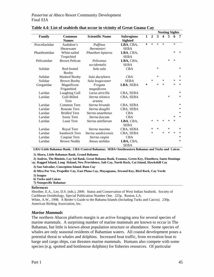
Passerine at Abaco Resort Community Development Final EIA
Part 1 45
Table 4.4: List of seabirds that occur in vicinity of Great Guana Cay Nesting Sights
Family Common Names
Scientific Name Subregions Sighted
1 2 3 4 5 6 7
Procellariidae Audubon’s Shearwater
Puffinus lherminieri
LBA, CBA, SEBA
* * * * *
Phaethontidae White-tailed Tropicbird
Phaethon lepturus LBA, CBA, SEBA
* *
Pelicanidae Brown Pelican Pelicanus occidentalis
LBA, CBA, SEBA
* *
Sulidae Red-footed Booby
Sula sula CBA * *
Sulidae Masked Booby Sula dactylatra CBA * * Sulidae Brown Booby Sula leugocaster SEBA * * * *
Gregatidae Magnificent Frigatebird
Fregata magnificens
LBA, SEBA * * * * *
Laridae Laughing Gull Larus atricilla CBA, SEBA * Laridae Gull-Billed
Tern Sterna nilotica
aranea CBA, SEBA * *
Laridae Common Tern Sterna hirundo CBA, SEBA * Laridae Roseate Tern Sterna dougllii CBA, SEBA * Laridae Bridled Tern Sterna anaethetus CBA * Laridae Sooty Tern Sterna fuscata CBA * * Laridae Least Tern Sterna antillarum LBA, CBA,
SEBA * * * * *
Laridae Royal Tern Sterna maxima CBA, SEBA * * * * Laridae Sandwich Tern Sterna sandvicensis CBA, SEBA * * * * * Laridae Caspian Tern Sterna caspia CBA * Laridae Brown Noddy Anous stolidus LBA, CBA,
SEBA *
LBA=Little Bahamas Bank; CBA=Central Bahamas; SEBA=Southeastern Bahamas and Turks and Caicos
1) Abaco, Little Bahamas Bank, Grand Bahama 2) Andros, The Biminis, Cay Sal Bank, Great Bahama Bank, Exumas, Green Key, Eleuthera, Santo Domingo
Cay, Ragged Island, Long IIsland, New Providence, Salt Cay, North Rock, Cat Island, Hawksbill Cay 3) San Salvador, Conception Island, Rum Cay 4) Mira Por Vos, Propeller Cay, East Plana Cay, Mayaguana, Atwood Key, Bird Rock, Cay Verde 5) Inagua 6) Turks and Caicos 7) Nonspecific Bahamas
References Shreiber, E.A., Lee, D.S. (eds.), 2000. Status and Conservation of West Indian Seabirds. Society of Caribbean Ornithology, Special Publication Number One. 225p. Ruston, LA. White, A.W., 1998. A Birder’s Guide to the Bahama Islands (Including Turks and Caicos). 230p. American Birding Association, Inc. Marine Mammals The northern Abacos platform margin is an active foraging area for several species of marine mammals. A surprising number of marine mammals are known to occur in The Bahamas, but little is known about population structure or abundance. Some species of whales are only seasonal residents of Bahamian waters. All coastal development poses a potential threat to whales and dolphins. Increased boat traffic, from recreation boat to barge and cargo ships, can threaten marine mammals. Humans also compete with some species (e.g. spotted and bottlenose dolphins) for fisheries resources. Of particular
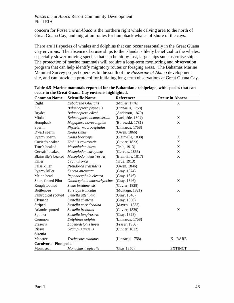
Passerine at Abaco Resort Community Development Final EIA
Part 1 46
concern for Passerine at Abaco is the northern right whale calving area to the north of Great Guana Cay, and migration routes for humpback whales offshore of the cays. There are 11 species of whales and dolphins that can occur seasonally in the Great Guana Cay environs. The absence of cruise ships to the islands is likely beneficial to the whales, especially slower-moving species that can be hit by fast, large ships such as cruise ships. The protection of marine mammals will require a long-term monitoring and observation program that can help identify migratory routes or foraging areas. The Bahamas Marine Mammal Survey project operates to the south of the Passerine at Abaco development site, and can provide a protocol for initiating long-term observations at Great Guana Cay. Table 4.5 Marine mammals reported for the Bahamian archipelago, with species that can occur in the Great Guana Cay environs highlighted. Common Name Scientific Name Reference: Occur in Abacos Right Eubalaena Glacialis (Müller, 1776) X Fin Balaenoptera physalus (Linnaeus, 1758) Brydes Balaenoptera edeni (Anderson, 1879) Minke Balaenoptera acutorostrata (Lacépède, 1804) X Humpback Megaptera novaeangliae (Borowski, 1781) X Sperm Physeter macrocephalus (Linnaeus, 1758) Dwarf sperm Kogia simus (Owen, 1866) Pygmy sperm Kogia breviceps (Blainville, 1838) X Cuvier’s beaked Ziphius cavirostris (Cuvier, 1823) X True’s beaked Mesoplodon mirus (True, 1913) X Gervais’ beaked Mesoplodon europaeus (Gervais, 1855) X Blainville’s beaked Mesoplodon densirostris (Blainville, 1817) X Killer Orcinus orca (True, 1913) False killer Pseudorca crassidens (Owen, 1846) Pygmy killer Feresa attenuata (Gray, 1874) Melon head Peponocephala electra (Gray, 1846) Short-finned Pilot Globicephala macrorhynchus (Gray, 1846) X Rough toothed Steno bredanensis (Cuvier, 1828) Bottlenose Tursiops truncatus (Montagu, 1821) X Pantropical spotted Stenella attenuata (Gray, 1846) Clymene Stenella clymene (Gray, 1850) Striped Stenella coeruleoalba (Mayen, 1833) Atlantic spotted Stenella frontalis (Cuvier, 1829) X Spinner Stenella longirostris (Gray, 1828) Common Delphinus delphis (Linnaeus, 1758) Fraser’s Lagenodelphis hosei (Fraser, 1956) Rissos Grampus griseus (Cuvier, 1812) Sirenia Manatee Trichechus manatus (Linnaeus 1758) X - RARE Carnivora - Pinnipedia Monk seal Monachus tropicalis (Gray 1850) EXTINCT
Passerine at Abaco Resort Community Development Final EIA
Part 1 47
Biological Diversity of the Island and species of special importance Generally, biodiversity within small island nations such as the Bahamas is considered low in relation to larger continental nations with greater habitat variation or tropical zones containing ecosystems such as tropical rainforest, although islands may support a greater degree of endemism. Within the Bahamas, biodiversity of flora and fauna is highest within broad-leaved evergreen communities and coral reefs. The Bahamian Archipelago, which includes the Turks and Caicos, is listed as having 1,370 species of vascular plants of which 125 are endemic (9.0%) (Correll and Correll 1982). Preliminary vegetation surveys at the site revealed 78 species within Broad-leaved Evergreen Communities, 42 species with Coastal Strand Communities, 17 species within Coastal Ironshore Communities and 16 within Wetland Communities. Within islands of The Bahamas, the Great Guana Cay site represents a large expanse of relatively old-growth Brad-leaf Evergreen communities (coppice). The island may be important as an important seed source of some species, and high densities (thus higher genetic diversity) of other species. The rate at which islands are being developed in the northern Bahamas makes all land conversions from natural vegetation communities significant. The goal will be to establish permanent vegetation plots throughout the project site to monitor for long-term decreases in plant diversity on the island, and try to maintain large patches of intact coppice within the land-planning of the development. This island is in rapid degradation now with the invasion of alien plant species, and without management or stewardship, the existing biological diversity is in jeopardy. National legislation that relates to the protection of the environment is acknowledged and incorporated into site planning. The Conservation and Protection of the Physical Landscape of the Bahamas Act, No 12. of 1997 provides a list of species of trees, which are protected in the Bahamas (Table 4.4). On site, these trees will be
a. protected whenever possible, especially large trees and a surrounding buffer area preserved in the landscape,
b. transplanted or removed to the nursery area for relocation, or c. replaced in the final landscape with two or more trees of the same species.
Prior to construction, a plant nursery area will be established to both cultivate non-invasive garden plants and native plants. In addition, a list of critical coastal plants was developed for conservation and planning purposes (APPENDIX). In addition to adopting any Bahamian guidelines specific to Biodiversity and species conservation, PPS will also seek to comply with the requirements of the following U.S. regulations:
United States Fish and Wildlife Service - Endangered Species Act, which
states that it is prohibited to take or capture any, listed endangered species. Activities should avoid harm or injury to any listed species, including nesting sea turtles, and
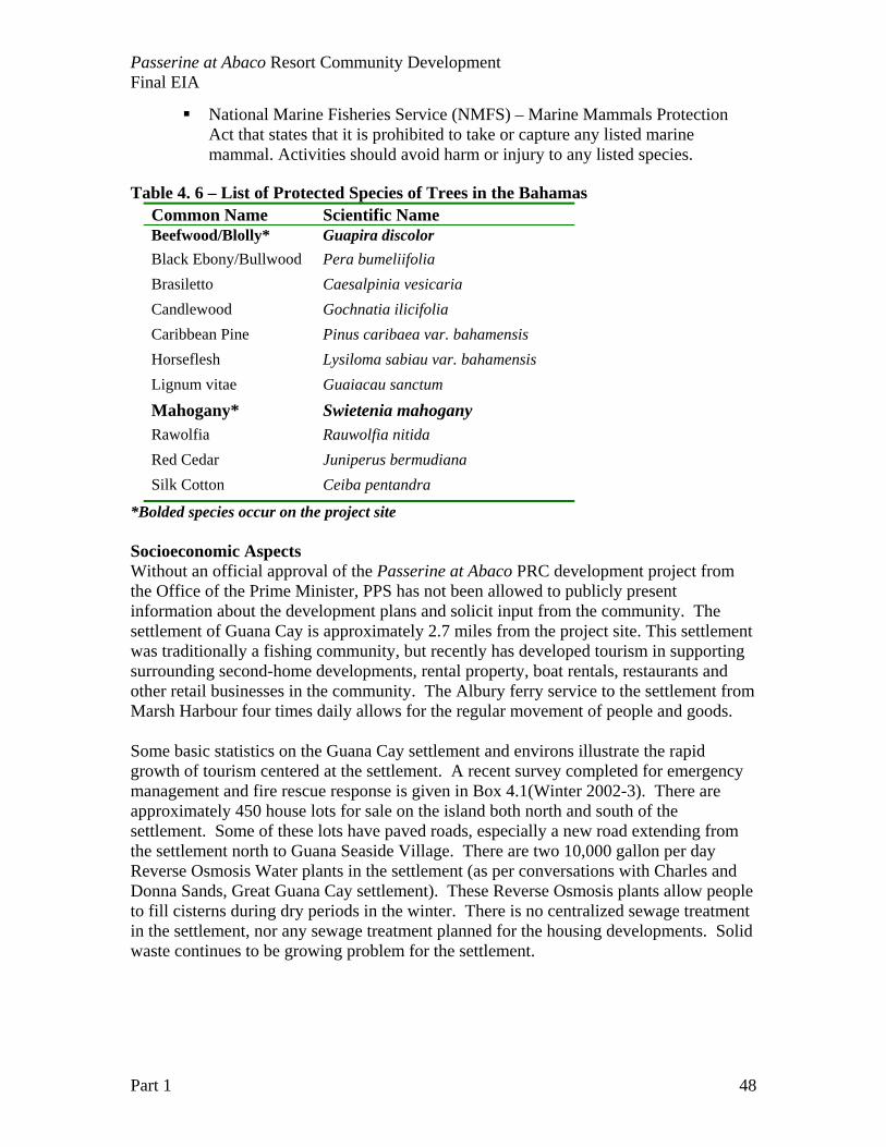
Passerine at Abaco Resort Community Development Final EIA
Part 1 48
National Marine Fisheries Service (NMFS) – Marine Mammals Protection Act that states that it is prohibited to take or capture any listed marine mammal. Activities should avoid harm or injury to any listed species.
Table 4. 6 – List of Protected Species of Trees in the Bahamas
Common Name Scientific Name Beefwood/Blolly* Guapira discolor Black Ebony/Bullwood Pera bumeliifolia Brasiletto Caesalpinia vesicaria Candlewood Gochnatia ilicifolia Caribbean Pine Pinus caribaea var. bahamensis Horseflesh Lysiloma sabiau var. bahamensis Lignum vitae Guaiacau sanctum
Mahogany* Swietenia mahogany Rawolfia Rauwolfia nitida Red Cedar Juniperus bermudiana Silk Cotton Ceiba pentandra
*Bolded species occur on the project site Socioeconomic Aspects Without an official approval of the Passerine at Abaco PRC development project from the Office of the Prime Minister, PPS has not been allowed to publicly present information about the development plans and solicit input from the community. The settlement of Guana Cay is approximately 2.7 miles from the project site. This settlement was traditionally a fishing community, but recently has developed tourism in supporting surrounding second-home developments, rental property, boat rentals, restaurants and other retail businesses in the community. The Albury ferry service to the settlement from Marsh Harbour four times daily allows for the regular movement of people and goods. Some basic statistics on the Guana Cay settlement and environs illustrate the rapid growth of tourism centered at the settlement. A recent survey completed for emergency management and fire rescue response is given in Box 4.1(Winter 2002-3). There are approximately 450 house lots for sale on the island both north and south of the settlement. Some of these lots have paved roads, especially a new road extending from the settlement north to Guana Seaside Village. There are two 10,000 gallon per day Reverse Osmosis Water plants in the settlement (as per conversations with Charles and Donna Sands, Great Guana Cay settlement). These Reverse Osmosis plants allow people to fill cisterns during dry periods in the winter. There is no centralized sewage treatment in the settlement, nor any sewage treatment planned for the housing developments. Solid waste continues to be growing problem for the settlement.
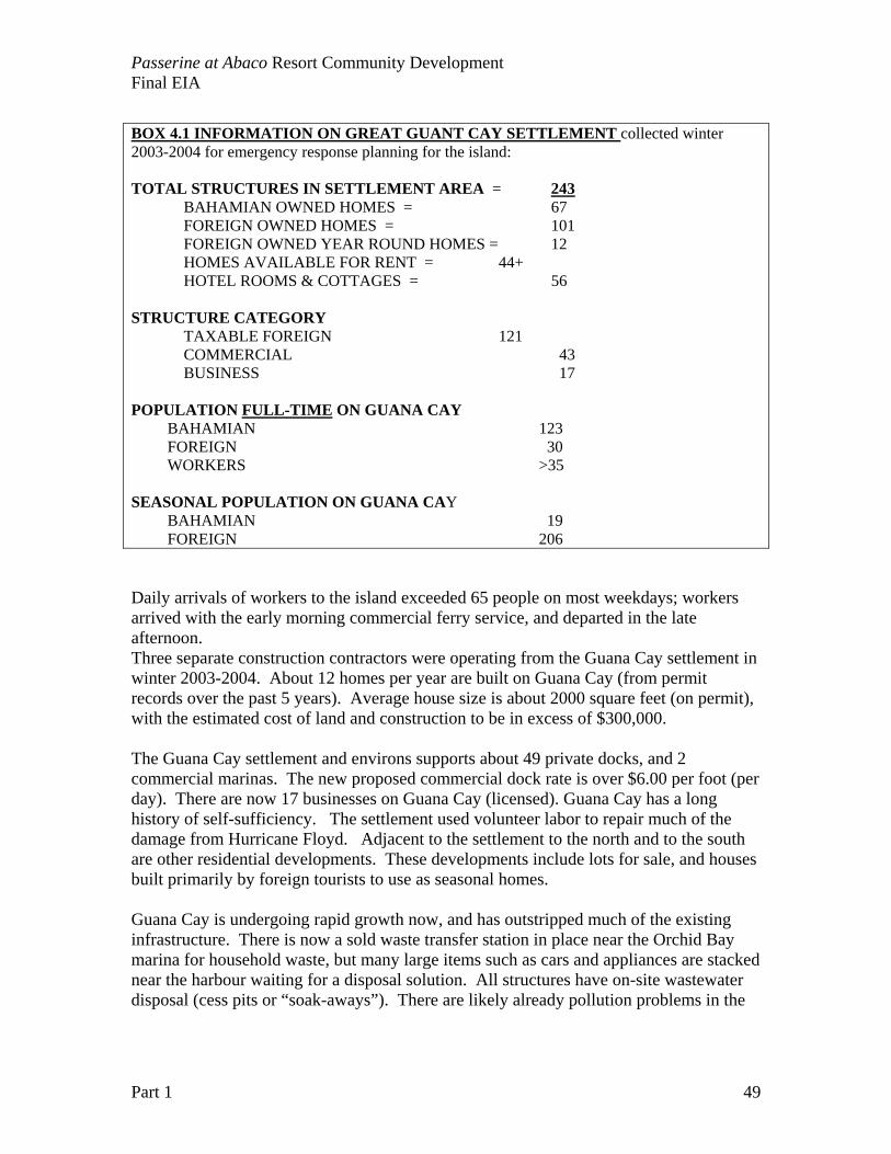
Passerine at Abaco Resort Community Development Final EIA
Part 1 49
BOX 4.1 INFORMATION ON GREAT GUANT CAY SETTLEMENT collected winter 2003-2004 for emergency response planning for the island: TOTAL STRUCTURES IN SETTLEMENT AREA = 243
BAHAMIAN OWNED HOMES = 67 FOREIGN OWNED HOMES = 101 FOREIGN OWNED YEAR ROUND HOMES = 12 HOMES AVAILABLE FOR RENT = 44+ HOTEL ROOMS & COTTAGES = 56
STRUCTURE CATEGORY TAXABLE FOREIGN 121 COMMERCIAL 43 BUSINESS 17 POPULATION FULL-TIME ON GUANA CAY BAHAMIAN 123 FOREIGN 30 WORKERS >35 SEASONAL POPULATION ON GUANA CAY BAHAMIAN 19 FOREIGN 206 Daily arrivals of workers to the island exceeded 65 people on most weekdays; workers arrived with the early morning commercial ferry service, and departed in the late afternoon. Three separate construction contractors were operating from the Guana Cay settlement in winter 2003-2004. About 12 homes per year are built on Guana Cay (from permit records over the past 5 years). Average house size is about 2000 square feet (on permit), with the estimated cost of land and construction to be in excess of $300,000. The Guana Cay settlement and environs supports about 49 private docks, and 2 commercial marinas. The new proposed commercial dock rate is over $6.00 per foot (per day). There are now 17 businesses on Guana Cay (licensed). Guana Cay has a long history of self-sufficiency. The settlement used volunteer labor to repair much of the damage from Hurricane Floyd. Adjacent to the settlement to the north and to the south are other residential developments. These developments include lots for sale, and houses built primarily by foreign tourists to use as seasonal homes. Guana Cay is undergoing rapid growth now, and has outstripped much of the existing infrastructure. There is now a sold waste transfer station in place near the Orchid Bay marina for household waste, but many large items such as cars and appliances are stacked near the harbour waiting for a disposal solution. All structures have on-site wastewater disposal (cess pits or “soak-aways”). There are likely already pollution problems in the
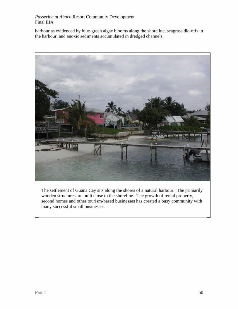
Passerine at Abaco Resort Community Development Final EIA
Part 1 50
harbour as evidenced by blue-green algae blooms along the shoreline, seagrass die-offs in the harbour, and anoxic sediments accumulated in dredged channels.
The settlement of Guana Cay sits along the shores of a natural harbour. The primarily wooden structures are built close to the shoreline. The growth of rental property, second homes and other tourism-based businesses has created a busy community with many successful small businesses.
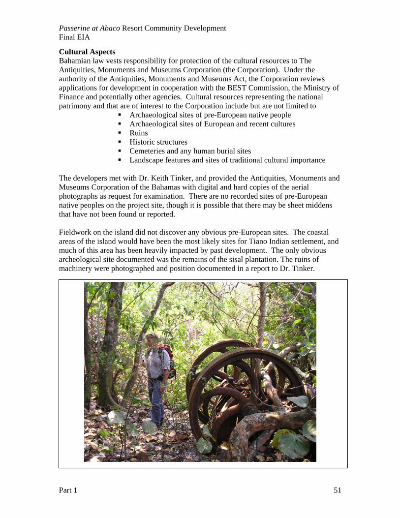
Passerine at Abaco Resort Community Development Final EIA
Part 1 51
Cultural Aspects Bahamian law vests responsibility for protection of the cultural resources to The Antiquities, Monuments and Museums Corporation (the Corporation). Under the authority of the Antiquities, Monuments and Museums Act, the Corporation reviews applications for development in cooperation with the BEST Commission, the Ministry of Finance and potentially other agencies. Cultural resources representing the national patrimony and that are of interest to the Corporation include but are not limited to
Archaeological sites of pre-European native people Archaeological sites of European and recent cultures Ruins Historic structures Cemeteries and any human burial sites Landscape features and sites of traditional cultural importance
The developers met with Dr. Keith Tinker, and provided the Antiquities, Monuments and Museums Corporation of the Bahamas with digital and hard copies of the aerial photographs as request for examination. There are no recorded sites of pre-European native peoples on the project site, though it is possible that there may be sheet middens that have not been found or reported. Fieldwork on the island did not discover any obvious pre-European sites. The coastal areas of the island would have been the most likely sites for Tiano Indian settlement, and much of this area has been heavily impacted by past development. The only obvious archeological site documented was the remains of the sisal plantation. The ruins of machinery were photographed and position documented in a report to Dr. Tinker.
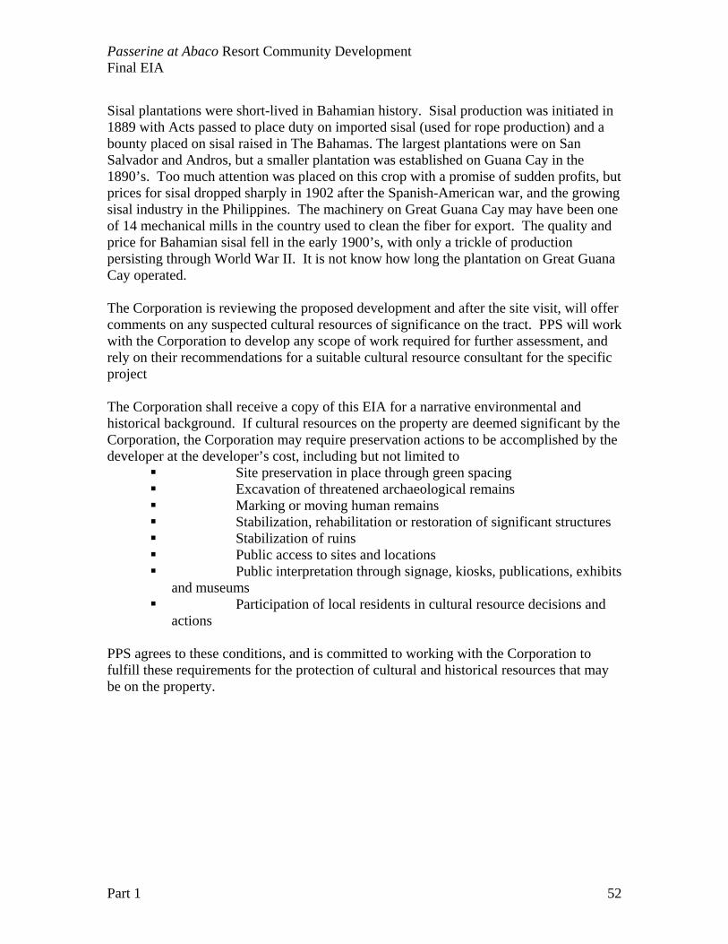
Passerine at Abaco Resort Community Development Final EIA
Part 1 52
Sisal plantations were short-lived in Bahamian history. Sisal production was initiated in 1889 with Acts passed to place duty on imported sisal (used for rope production) and a bounty placed on sisal raised in The Bahamas. The largest plantations were on San Salvador and Andros, but a smaller plantation was established on Guana Cay in the 1890’s. Too much attention was placed on this crop with a promise of sudden profits, but prices for sisal dropped sharply in 1902 after the Spanish-American war, and the growing sisal industry in the Philippines. The machinery on Great Guana Cay may have been one of 14 mechanical mills in the country used to clean the fiber for export. The quality and price for Bahamian sisal fell in the early 1900’s, with only a trickle of production persisting through World War II. It is not know how long the plantation on Great Guana Cay operated. The Corporation is reviewing the proposed development and after the site visit, will offer comments on any suspected cultural resources of significance on the tract. PPS will work with the Corporation to develop any scope of work required for further assessment, and rely on their recommendations for a suitable cultural resource consultant for the specific project The Corporation shall receive a copy of this EIA for a narrative environmental and historical background. If cultural resources on the property are deemed significant by the Corporation, the Corporation may require preservation actions to be accomplished by the developer at the developer’s cost, including but not limited to
Site preservation in place through green spacing Excavation of threatened archaeological remains Marking or moving human remains Stabilization, rehabilitation or restoration of significant structures Stabilization of ruins Public access to sites and locations Public interpretation through signage, kiosks, publications, exhibits
and museums Participation of local residents in cultural resource decisions and
actions PPS agrees to these conditions, and is committed to working with the Corporation to fulfill these requirements for the protection of cultural and historical resources that may be on the property.
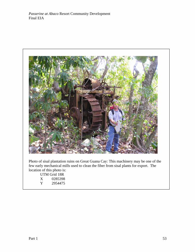
Passerine at Abaco Resort Community Development Final EIA
Part 1 53
Photo of sisal plantation ruins on Great Guana Cay: This machinery may be one of the few early mechanical mills used to clean the fiber from sisal plants for export. The location of this photo is:
UTM Grid 18R X 0285398 Y 2954475
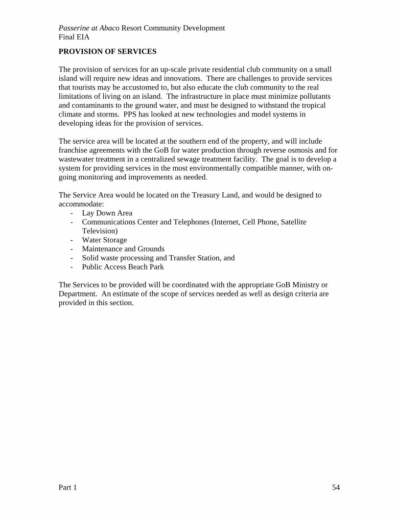
Passerine at Abaco Resort Community Development Final EIA
Part 1 54
PROVISION OF SERVICES The provision of services for an up-scale private residential club community on a small island will require new ideas and innovations. There are challenges to provide services that tourists may be accustomed to, but also educate the club community to the real limitations of living on an island. The infrastructure in place must minimize pollutants and contaminants to the ground water, and must be designed to withstand the tropical climate and storms. PPS has looked at new technologies and model systems in developing ideas for the provision of services. The service area will be located at the southern end of the property, and will include franchise agreements with the GoB for water production through reverse osmosis and for wastewater treatment in a centralized sewage treatment facility. The goal is to develop a system for providing services in the most environmentally compatible manner, with on-going monitoring and improvements as needed. The Service Area would be located on the Treasury Land, and would be designed to accommodate:
- Lay Down Area - Communications Center and Telephones (Internet, Cell Phone, Satellite
Television) - Water Storage - Maintenance and Grounds - Solid waste processing and Transfer Station, and - Public Access Beach Park
The Services to be provided will be coordinated with the appropriate GoB Ministry or Department. An estimate of the scope of services needed as well as design criteria are provided in this section.
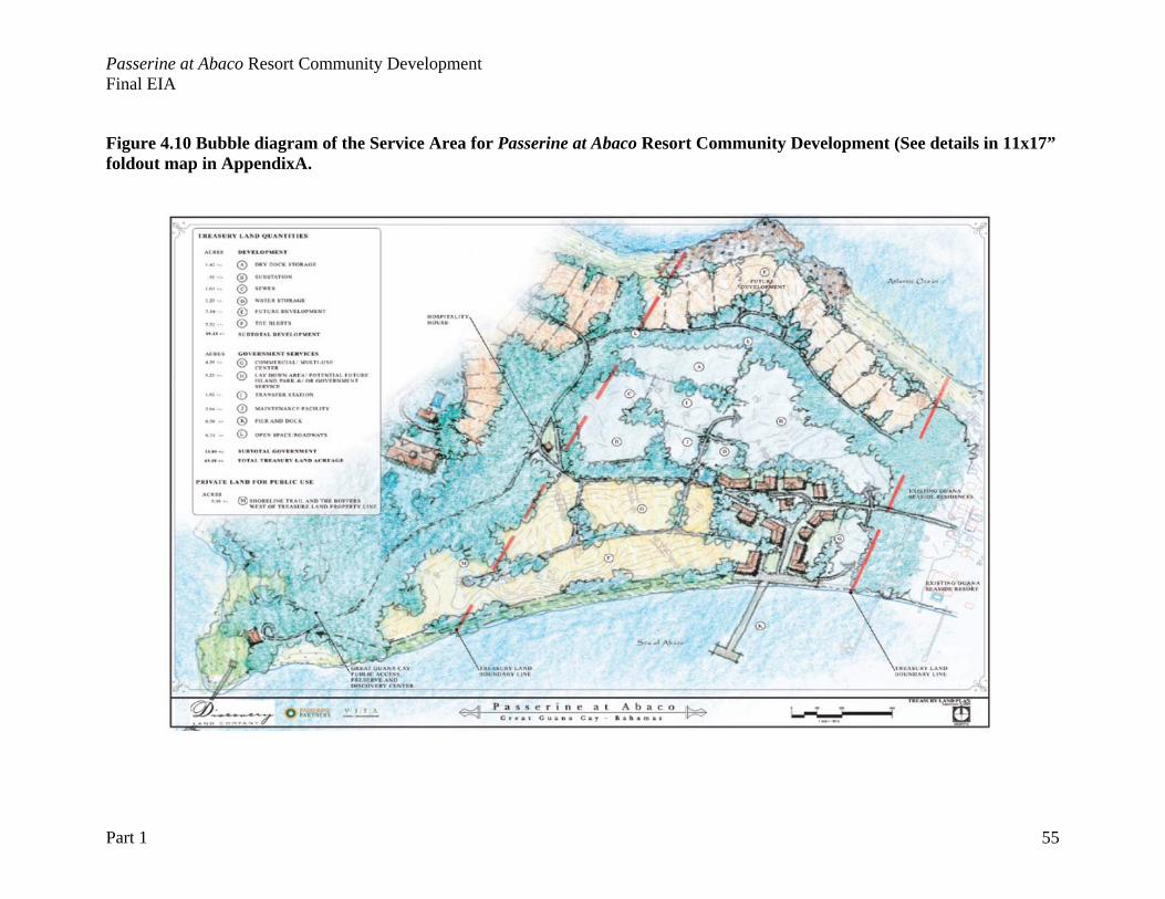
Passerine at Abaco Resort Community Development Final EIA
Part 1 55
Figure 4.10 Bubble diagram of the Service Area for Passerine at Abaco Resort Community Development (See details in 11x17” foldout map in AppendixA.
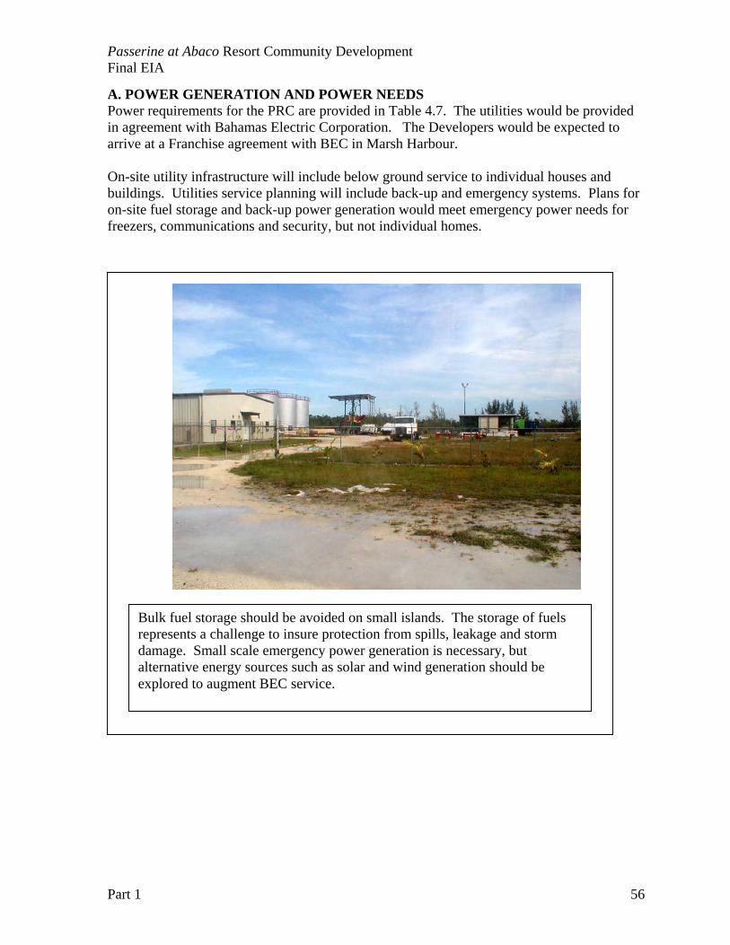
Passerine at Abaco Resort Community Development Final EIA
Part 1 56
A. POWER GENERATION AND POWER NEEDS Power requirements for the PRC are provided in Table 4.7. The utilities would be provided in agreement with Bahamas Electric Corporation. The Developers would be expected to arrive at a Franchise agreement with BEC in Marsh Harbour. On-site utility infrastructure will include below ground service to individual houses and buildings. Utilities service planning will include back-up and emergency systems. Plans for on-site fuel storage and back-up power generation would meet emergency power needs for freezers, communications and security, but not individual homes.
Bulk fuel storage should be avoided on small islands. The storage of fuels represents a challenge to insure protection from spills, leakage and storm damage. Small scale emergency power generation is necessary, but alternative energy sources such as solar and wind generation should be explored to augment BEC service.
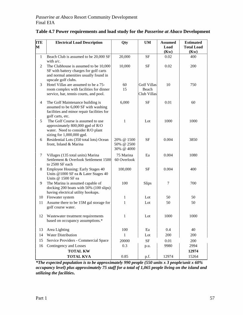
Passerine at Abaco Resort Community Development Final EIA
Part 1 57
Table 4.7 Power requirements and load study for the Passerine at Abaco Development ITEM
Electrical Load Description Qty UM Assumed Load (Kw)
Estimated Total Load
(Kw) 1 Beach Club is assumed to be 20,000 SF
with a/c. 20,000 SF 0.02 400
2 The Clubhouse is assumed to be 10,000 SF with battery charges for golf carts and normal amenities usually found in upscale golf clubs.
10,000 SF 0.02 200
3 Hotel Villas are assumed to be a 75-room complex with facilities for dinner service, bar, tennis courts, and pool.
60 15
Golf Villas Beach
Club Villas
10 750
4 The Golf Maintenance building is assumed to be 6,000 SF with washing facilities and minor repair facilities for golf carts, etc.
6,000 SF 0.01 60
5 The Golf Course is assumed to use approximately 800,000 gpd of R/O water. Need to consider R/O plant sizing for 1,000,000 gpd.
1 Lot 1000 1000
6 Residential Lots (350 total lots) Ocean front, Inland & Marina
20% @ 1500 50% @ 2500 30% @ 4000
SF 0.004 3850
7 Villages (135 total units) Marina Settlement & Overlook Settlement 1500 to 2500 SF each
75 Marina 60 Overlook
Ea 0.004 1080
8 Employee Housing: Early Stages 40 Units @1000 SF ea & Later Stages 40 Units @ 1500 SF ea
100,000 SF 0.004 400
9 The Marina is assumed capable of docking 200 boats with 50% (100 slips) having electrical utility hookups.
100 Slips 7 700
10 Firewater system 1 Lot 50 50 11 Assume there to be 15M gal storage for
golf course water. 1 Lot 50 50
12 Wastewater treatment requirements based on occupancy assumptions.*
1 Lot 1000 1000
13 Area Lighting 100 Ea 0.4 40 14 Water Distribution 1 Lot 200 200 15 Service Providers - Commercial Space 20000 SF 0.01 200 16 Contingency and Losses 0.3 p.u. 9980 2994 TOTAL KW 12974 TOTAL KVA 0.85 p.f. 12974 15264
*The expected population is to be approximately 990 people (550 units x 3 people/unit x 60% occupancy level) plus approximately 75 staff for a total of 1,065 people living on the island and utilizing the facilities.
Passerine at Abaco Resort Community Development Final EIA
Part 1 58
B. COMMUNICATION SERVICES Communications Services will be provided in cooperative agreements with BaTelCo as required by Bahamian Law. Components of communications services include:
- High speed wireless Internet Service - Satellite Television - Local and International Phone Services - Local dedicated radio frequencies for the marina, security services and management
staff. Out Island Internet, based in Marsh Harbour, has already provided Internet services for Great Guana Cay. BaTelCo already has microwave towers in place in northern Abacos (including the settlement of Guana Cay). Much of the communications services can be provided with existing infrastructure already developed in the area for existing developments. C. WATER AND WATER MANAGEMENT Water management and resident education programs are vital to bringing the reality of water limitations to everyone’s attention. Water is both limited in quantity and expensive to acquire and store on small islands. Water also poses one of the most insidious environmental threats to the near shore marine environments and enclosed waterways of the marina. A water-management strategy is established with the sources and uses of water at the initial planning for the development. There are only three potential sources of water on the island: groundwater, collected rainwater and manufactured water from reverse osmosis. Changes to the island hydrology, pollution or contamination of groundwater sources, or introduction of pathogens, nutrients or excessive organic matter can all pose serious and irreversible environmental impacts. An overall water management plan is critical to coordination of all phases of resort development. Near shore water quality and marina water quality are critical components of the site-monitoring plan. PPS is able to draw from the information base developed in U.S. Florida Keys to establish safety guidelines to protect both the environment and public health. The following legislation pertains to water quality: Section 5 - Water Preservation Bye-laws. A restriction is placed on chemical or
noxious materials that can contaminate the groundwater; and Section 8 - Marina and Island Waterways, which states that no oil, garbage, liquid,
sewage or other waste may be discharged into inland waterways.
Water quality is fundamental to both species and natural community distribution in the coastal zone environments, and the impact of water quality degradation is complex. Small islands such as Great Guana Cay place all the upland areas in close proximity to the ocean and mangrove wetlands. Changes in water quality parameters will occur with human alterations of coastal hydrology and runoff patterns. Because water quality parameters such as temperature, salinity and turbidity vary naturally with tidal, diurnal and seasonal cycles, changes in natural variability are difficult to document without a history of baseline water
Passerine at Abaco Resort Community Development Final EIA
Part 1 59
quality information. Documenting changes in coastal water quality would require some knowledge and monitoring of pre-development conditions. Sewage and wastewater discharge are notorious for long-term changes in tropical marine environments. Human activities on land inevitably increase nutrient inputs to coastal waters from deforestation, wastewater, fertilizer, and other sources (Bell, 1992). The Bahamas is not unlike the Florida Keys, USA (Hoffmeister, 1974), where the process of near shore eutrophication has been studied intensively. Major pathways of input of nutrients to Florida Keys waters include on-site sewage disposal systems (Lapointe and Clark 1992), and submarine groundwater discharge (Lapointe and Matzie 1992). One big difference between the Florida Keys and the Central Bahamas is circulation. The Bahamian islands are not adjacent to a continental peninsula (south Florida), and have not been targeted for any significant fill between islands for causeway construction (See Lott et al, 1996 for historical overview of island fill in the Florida Keys). Thus, in general, the surface circulation around islands should be higher for the Bahamian archipelago. In fact, water quality studies in Montagu Bay and Nassau Harbour, adjacent to New Providence, do not show elevated nutrient concentrations compared to waters adjacent to undeveloped islands (Sullivan Sealey 1999, Sullivan Sealey 2004). Despite alteration to 100% of the shoreline along Eastern Road, with loss of reef and seagrass habitats, the patterns of water quality variability with tides and seasons are not statistically different from lightly developed islands in a national park in the Exuma Cays. The ability to detect and document changes in inorganic nutrients in tropical near shore waters is limited to point sampling on tidal, diurnal or seasonal cycles and only extreme values for parameters such as Total Nitrogen appear higher. Most coastal development studies have documented the ecological changes to coral reefs rather than establishing pollution sources, quantities and pathways for non-point, land-based pollution (see Paul et al 1995, McCook et al 2001). The water-quality monitoring program in the Florida Keys National Marine Sanctuary involves a massive sampling effort of over 1400 stations throughout the Florida Keys (Jones and Boyer 2002). This program is only beginning to characterize water quality parameters for Florida Bay, the near shore Keys waters, and the Keys reef tract, with the only obvious water quality degradation near, and in, dredged residential and commercial canals systems. We concede the fact that water quality degradation will occur with coastal development and land-cover change. The water management plan is outlined to quantify the additional water added to the island system, and estimate the approximate nutrient loading. Mitigation efforts are based on the assumption that near shore eutrophication will occur, and will need to be addressed particularly on the low-energy shoreline of the Project Site. THIS DEVELOPMENT IS UNIQUE IN PROVIDED CENTRALIZED WASTEWATER TREATMENT AT THE ONSET OF DEVELOPMENT. There will be no on-site wastewater disposal. Detailed water quality monitoring is essential for remediation of problems associated with coastal development, but not necessary for the identification or prediction of ecological impacts. The most significant water quality impacts of coastal development that can be documented are likely to be manifested after severe storms and hurricanes. Anthropogenic
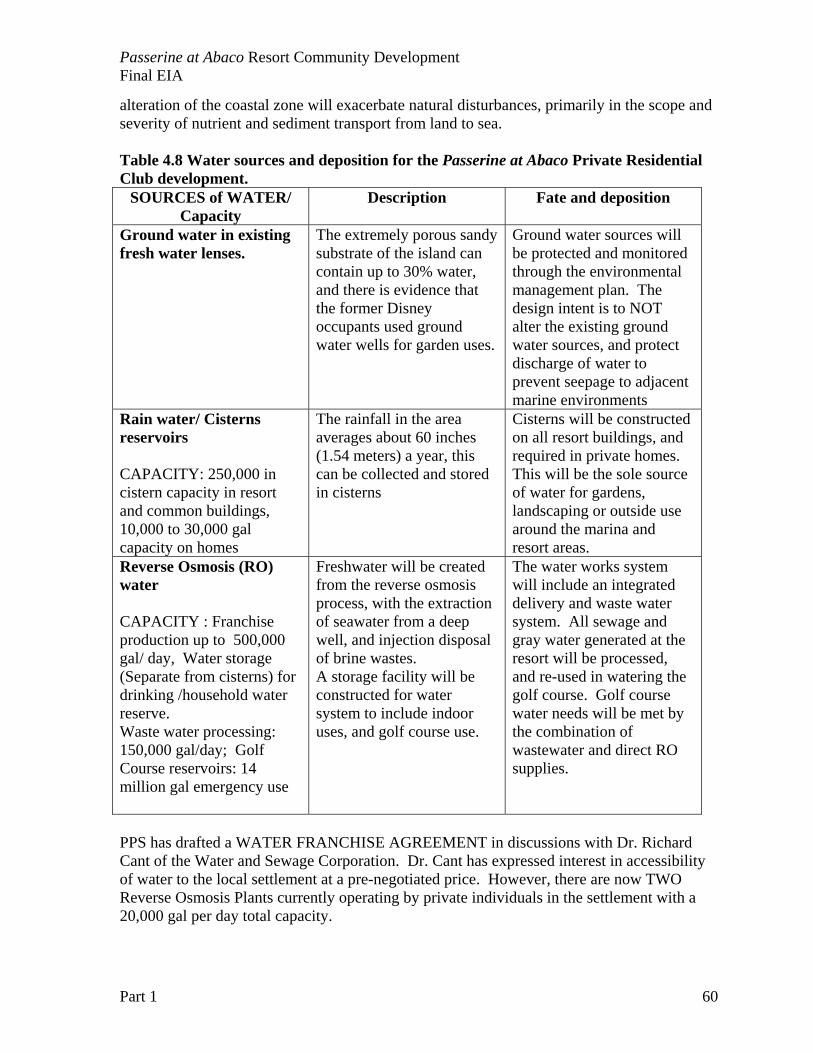
Passerine at Abaco Resort Community Development Final EIA
Part 1 60
alteration of the coastal zone will exacerbate natural disturbances, primarily in the scope and severity of nutrient and sediment transport from land to sea. Table 4.8 Water sources and deposition for the Passerine at Abaco Private Residential Club development.
SOURCES of WATER/ Capacity
Description Fate and deposition
Ground water in existing fresh water lenses.
The extremely porous sandy substrate of the island can contain up to 30% water, and there is evidence that the former Disney occupants used ground water wells for garden uses.
Ground water sources will be protected and monitored through the environmental management plan. The design intent is to NOT alter the existing ground water sources, and protect discharge of water to prevent seepage to adjacent marine environments
Rain water/ Cisterns reservoirs CAPACITY: 250,000 in cistern capacity in resort and common buildings, 10,000 to 30,000 gal capacity on homes
The rainfall in the area averages about 60 inches (1.54 meters) a year, this can be collected and stored in cisterns
Cisterns will be constructed on all resort buildings, and required in private homes. This will be the sole source of water for gardens, landscaping or outside use around the marina and resort areas.
Reverse Osmosis (RO) water CAPACITY : Franchise production up to 500,000 gal/ day, Water storage (Separate from cisterns) for drinking /household water reserve. Waste water processing: 150,000 gal/day; Golf Course reservoirs: 14 million gal emergency use
Freshwater will be created from the reverse osmosis process, with the extraction of seawater from a deep well, and injection disposal of brine wastes. A storage facility will be constructed for water system to include indoor uses, and golf course use.
The water works system will include an integrated delivery and waste water system. All sewage and gray water generated at the resort will be processed, and re-used in watering the golf course. Golf course water needs will be met by the combination of wastewater and direct RO supplies.
PPS has drafted a WATER FRANCHISE AGREEMENT in discussions with Dr. Richard Cant of the Water and Sewage Corporation. Dr. Cant has expressed interest in accessibility of water to the local settlement at a pre-negotiated price. However, there are now TWO Reverse Osmosis Plants currently operating by private individuals in the settlement with a 20,000 gal per day total capacity.
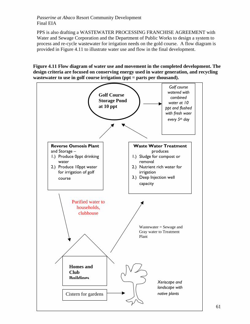
Passerine at Abaco Resort Community Development Final EIA
Part 1 61
PPS is also drafting a WASTEWATER PROCESSING FRANCHISE AGREEMENT with Water and Sewage Corporation and the Department of Public Works to design a system to process and re-cycle wastewater for irrigation needs on the gold course. A flow diagram is provided in Figure 4.11 to illustrate water use and flow in the final development.
Figure 4.11 Flow diagram of water use and movement in the completed development. The design criteria are focused on conserving energy used in water generation, and recycling wastewater to use in golf course irrigation (ppt = parts per thousand).
Reverse Osmosis Plant and Storage – 1.) Produce 0ppt drinking
water 2.) Produce 10ppt water
for irrigation of golf course
Golf Course Storage Pond at 10 ppt
Waste Water Treatment produces
1.) Sludge for compost or removal
2.) Nutrient rich water for irrigation
3.) Deep Injection well capacity
Cistern for gardens
Purified water to households, clubhouse
Wastewater = Sewage and Gray water to Treatment Plant
Xeriscape and landscape with native plants
Golf course watered with
combined water at 10
ppt and flushed with fresh waer every 5th day
Homes and Club Buildings
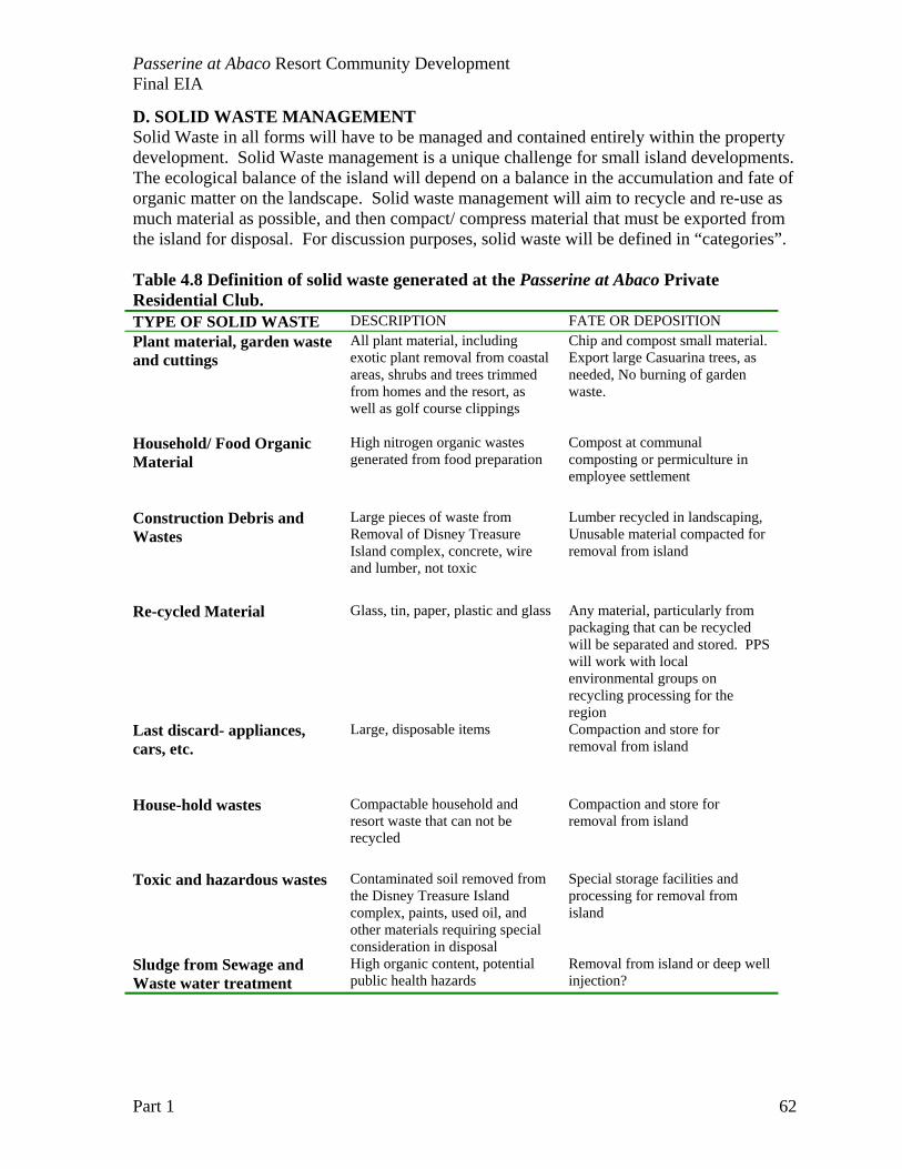
Passerine at Abaco Resort Community Development Final EIA
Part 1 62
D. SOLID WASTE MANAGEMENT Solid Waste in all forms will have to be managed and contained entirely within the property development. Solid Waste management is a unique challenge for small island developments. The ecological balance of the island will depend on a balance in the accumulation and fate of organic matter on the landscape. Solid waste management will aim to recycle and re-use as much material as possible, and then compact/ compress material that must be exported from the island for disposal. For discussion purposes, solid waste will be defined in “categories”. Table 4.8 Definition of solid waste generated at the Passerine at Abaco Private Residential Club. TYPE OF SOLID WASTE DESCRIPTION FATE OR DEPOSITION Plant material, garden waste and cuttings
All plant material, including exotic plant removal from coastal areas, shrubs and trees trimmed from homes and the resort, as well as golf course clippings
Chip and compost small material. Export large Casuarina trees, as needed, No burning of garden waste.
Household/ Food Organic Material
High nitrogen organic wastes generated from food preparation
Compost at communal composting or permiculture in employee settlement
Construction Debris and Wastes
Large pieces of waste from Removal of Disney Treasure Island complex, concrete, wire and lumber, not toxic
Lumber recycled in landscaping, Unusable material compacted for removal from island
Re-cycled Material
Glass, tin, paper, plastic and glass Any material, particularly from packaging that can be recycled will be separated and stored. PPS will work with local environmental groups on recycling processing for the region
Last discard- appliances, cars, etc.
Large, disposable items Compaction and store for removal from island
House-hold wastes
Compactable household and resort waste that can not be recycled
Compaction and store for removal from island
Toxic and hazardous wastes
Contaminated soil removed from the Disney Treasure Island complex, paints, used oil, and other materials requiring special consideration in disposal
Special storage facilities and processing for removal from island
Sludge from Sewage and Waste water treatment
High organic content, potential public health hazards
Removal from island or deep well injection?
Passerine at Abaco Resort Community Development Final EIA
Part 1 63
Solid Waste will be processed at a transfer station. The transfer station will sort and process waste for composting, recycling or disposal. Composting Guidelines Tropical environments present a special challenge for sanitary composting, but the recycling and reuse of organic material generated from landscaping, gardens, golf courses as well as restaurants is critical in reducing the need for fertilizers on small islands. Composting can reduce plant diseases and insect pests, can prevent erosion, can reduce costs of fertilizer and pesticides, and can reduce solid waste disposal costs. A composting program requires skilled attention and management, but is a critical component of compatible island development. Recycling Guidelines Although recycling is not widespread in The Bahamas, there is the interest and need to initiate a recycling program. PPS can provide leadership and expertise in recycling material from the small island communities. There are likely particularly good opportunities with aluminum and scrap metal (cars, construction debris and appliances) with a worldwide shortage of recycled steel. Even in small quantities, a transfer and recycling center in Marsh Harbour could be economically beneficial over time, and alleviate some pressure of landfill use. Education and outreach programs need to emphasize:
- The importance of sorting solid wastes, and recognizing material that can be recycled - Convenient collection facilities for residents - Commercial, retail and restaurant recycling programs
Transfer Station Design Guidelines In sensitive environments within the United States, the designs of solid waste transfer stations have provided good examples for sanitary, environmentally friendly and efficient handling of solid wastes. Below are some general guidelines and illustrations that capture the intent of the solid waste management programs for Passerine at Abaco RCD.
There is a need for site-specific guidelines and regulations that will insure that the RCD is in compliance with national regulations within The Bahamas, but also insures that the operator of a transfer station will comply with the standards set by operational goals and guidelines. The location and design of the transfer station should be in areas where the potential for degradation of the quality of air, land, and water is minimal. These stations need to be near roads and dock facilities capable of withstanding anticipated load limits. No transfer station should be located in an area such that solid waste would at any time be handled within the 100-year flood plain or within any wetland. The plans and specifications for a proposed transfer station shall be prepared and certified by a Professional Engineer with experience in transfer station design. Any solid waste disposal site in The Bahamas poses a critical threat to ground water quality, and leachates should be contained or avoided by minimizing the contact of solid wastes with

Passerine at Abaco Resort Community Development Final EIA
Part 1 64
the ground or exposure to heavy rains. The transfer stations should be designed to include at least the following:
- A leachate collection or management system, - A means for weighing or measuring all solid waste handled at the facility, - Tipping and loading areas contained within structures capable of preventing the
development of nuisance conditions (e.g., odors, litter, dust, rodents, insects) if these areas will be within 300 feet of a structure designed for human occupancy, and
- An evaluation for the need for exhaust systems in enclosed areas and shall install such systems if necessary for the protection of human health.
Also desirable is a security fence that will prevent access to the site by unauthorized persons. Hazardous wastes and corrosive materials need to be contained in corrosion-resistant holding tank. These materials need to be prevented from contaminating soils, surface waters or groundwater at the transfer site. Transfer stations should be operated in a manner that will preclude degradation of land, air, surface water, or ground water. Transfer stations should be maintained and operated to conform to the Environmental Management Plan. Especially important within the Service area is the monitoring of potential vector organisms. With the introduction of exotic mosquito species to The Bahamas, a vector control plan is especially critical throughout the property, but especially within the transfer station where standing water can be hidden in waste storage areas.
Employees at the site shall work under all appropriate health and safety guidelines established by the Occupational Safety and Health Administration. First aid equipment shall be available at the site. Record keeping and on-going education programs are critical to the continued success of the transfer station operation. The GoB should be provided with a closure plan should the transfer station ever cease operations.
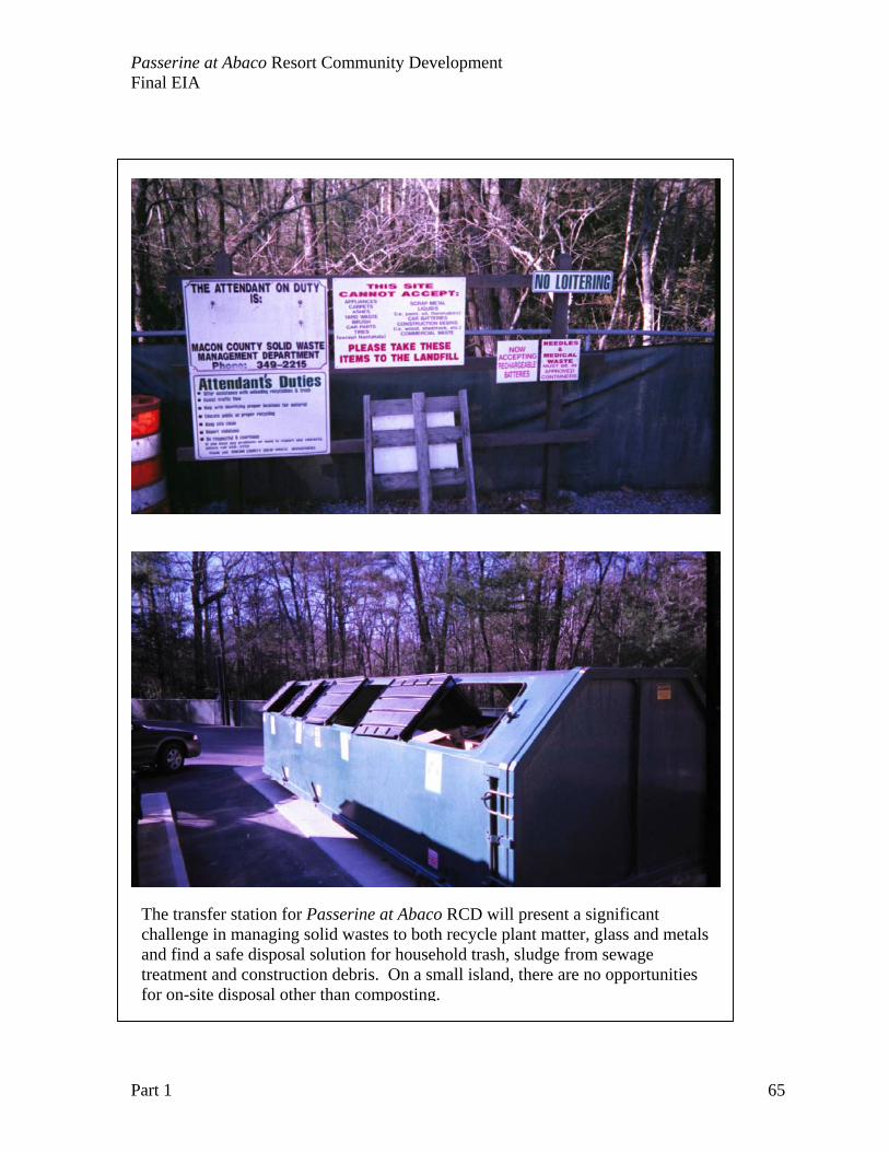
Passerine at Abaco Resort Community Development Final EIA
Part 1 65
The transfer station for Passerine at Abaco RCD will present a significant challenge in managing solid wastes to both recycle plant matter, glass and metals and find a safe disposal solution for household trash, sludge from sewage treatment and construction debris. On a small island, there are no opportunities for on-site disposal other than composting.
Passerine at Abaco Resort Community Development Final EIA
Part 1 66
CHAPTER 5: ENVIRONMENTAL IMPACTS Overview of Project Environs in Northern Abacos and regional impacts The Great Guana Cay project site is part of a larger landscape and environs. The environmental impacts of the Passerine at Abaco Resort Community Development reverberate through the greater areas of the North Abaco islands. The development itself will stimulate growth in Marsh Harbour, greater infrastructure for service delivery, and a broad spectrum of subtle and long-term environmental changes in the region. It is important to consider the wider geography of the northern Abacos from March Harbour to Carter’s Cay. This is a rapidly growing and changing landscape, and this development contributes to the trends with site-specific as well as regional impacts:
• Increase in urbanization, particularly water needs and solid waste disposal needs.
• Increase importation of materials, consumable goods and durable goods, and • Increase jobs and labor needs, with associated housing and infrastructure
needs. The “PROJECT ENVIRONS” will be defined as northern Abacos from Marsh Harbour to the terminus of Little Abaco, with the associated offshore cays from Elbow Cay to Carter’s Cay. The environmental impact assessment needs to examine the long-term impacts of the loss of island wetland and island habitats in the larger landscape. Islands have proven to be very desirable sites for development, but costly to acquire and manage in any protected area status. The larger landscape picture is critical to address the following questions: • What is the role of this particular island property in the ecology of the island chain from
Carter’s Cay to Elbow Cay? • What are the unique environmental considerations of northern Great Guana Cay
compared to both other cays, and the Abaco island landscape? • What are the likely consequences of the loss of natural areas associated with the Project
Site? Tropical islands present a particular challenge in balancing coastal development needs and environmental protection for both cultural and ecological reasons. Development poses an especially difficult challenge in the oligotrophic, carbonate environments of the Bahamian archipelago. In the Bahamas, small islands are acutely impacted by development activities, particularly the reclamation of coastal wetlands and pollution discharge to coastal waters. Source activities on land have produced ecological changes in the coastal environment. The most significant changes include:
• Changes in coastal species abundance and diversity (including local extirpation), • Changes in near shore natural community structure, • Changes in coastal water quality and • Changes associated with exotic species invasion.
Fragmentation and chronic eutrophication of tropical near shore marine environments likely impact fisheries production and life cycles of reef fishes and invertebrates. The smaller islands often pose the greatest challenge to development, as there are cumulative impacts of the landscape-scale of the archipelago beyond the island itself. Review of development history and resultant environmental issues in the Florida Keys continue to provide some
Passerine at Abaco Resort Community Development Final EIA
Part 1 67
cautionary guidelines for evaluating sustainability of development in The Bahamas. Chapter 9 provides an outlined monitoring plan for this impacts. Methods of impact assessment Resort and residential development on small islands requires an objective standardized process of risk and impact assessment. There are standard RISK/IMPACT ASSESSMENT TOOLS and accepted mitigation options for the most important ecological impacts:
• Loss or degradation of habitat for terrestrial and marine species, • Introduction of fresh water and nutrients to island hydrology, and • Introduction of land-based sources of pollutants and contaminants.
This tool is a series of questions and appraisals in a standardized format to rank and prioritize all potential hazards and risks. The key components to impact assessment include:
1. The presentation of a clear assessment process or methodology, with a clear set of priorities for ranking potential impacts. For resort development, the construction of marinas and golf courses with the land cover change has known and documented impacts in the construction and post-construction phases.
2. Management of expectations in the EIA process: Following the previous guideline, most controversies on risk assessment are differences in expectations. If impacts are clearly articulated, expectations will be consistent with the range of scenarios that are likely to occur with construction.
3. Informed participation of all stakeholders: A process by which stakeholders are education, informed, and participate in mitigation options is essential to the positive resolution to disputes.
Assessment Criteria are used to rank a source activity for its environmental impact. Each phase and component of the development is described and then evaluated for impacts, with mitigation options outlined. In general, the overall significance levels could be defined as follows: Significant: a high impact corresponds to an effect upon a substantive area of any
environmental or socioeconomic condition, with sufficient intensity and duration to generate significant change(s), and predominantly irreversible by natural means. The site condition or attribute would be limited or affected for a long term. Significant impacts also imply POTENTIAL HUMAN HEALTH IMPACTS as well. Moderate: a moderate impact is an effect upon a portion of any environmental or
socioeconomic condition area. The effect occurs for a limited period, naturally reversible in the medium-term, and the site condition affected is temporarily altered. Negligible: a negligible impact corresponds to an effect that is barely perceptible, of
short duration, generates naturally reversible changes in the short-term, and does not diminish or alter the site condition.
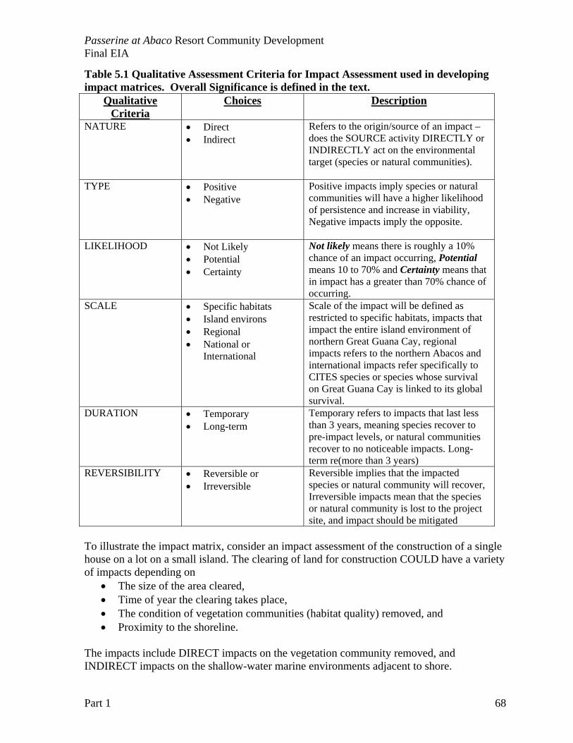
Passerine at Abaco Resort Community Development Final EIA
Part 1 68
Table 5.1 Qualitative Assessment Criteria for Impact Assessment used in developing impact matrices. Overall Significance is defined in the text.
Qualitative Criteria
Choices Description
NATURE • Direct • Indirect
Refers to the origin/source of an impact – does the SOURCE activity DIRECTLY or INDIRECTLY act on the environmental target (species or natural communities).
TYPE • Positive • Negative
Positive impacts imply species or natural communities will have a higher likelihood of persistence and increase in viability, Negative impacts imply the opposite.
LIKELIHOOD • Not Likely • Potential • Certainty
Not likely means there is roughly a 10% chance of an impact occurring, Potential means 10 to 70% and Certainty means that in impact has a greater than 70% chance of occurring.
SCALE • Specific habitats • Island environs • Regional • National or
International
Scale of the impact will be defined as restricted to specific habitats, impacts that impact the entire island environment of northern Great Guana Cay, regional impacts refers to the northern Abacos and international impacts refer specifically to CITES species or species whose survival on Great Guana Cay is linked to its global survival.
DURATION • Temporary • Long-term
Temporary refers to impacts that last less than 3 years, meaning species recover to pre-impact levels, or natural communities recover to no noticeable impacts. Long-term re(more than 3 years)
REVERSIBILITY • Reversible or • Irreversible
Reversible implies that the impacted species or natural community will recover, Irreversible impacts mean that the species or natural community is lost to the project site, and impact should be mitigated
To illustrate the impact matrix, consider an impact assessment of the construction of a single house on a lot on a small island. The clearing of land for construction COULD have a variety of impacts depending on
• The size of the area cleared, • Time of year the clearing takes place, • The condition of vegetation communities (habitat quality) removed, and • Proximity to the shoreline.
The impacts include DIRECT impacts on the vegetation community removed, and INDIRECT impacts on the shallow-water marine environments adjacent to shore.
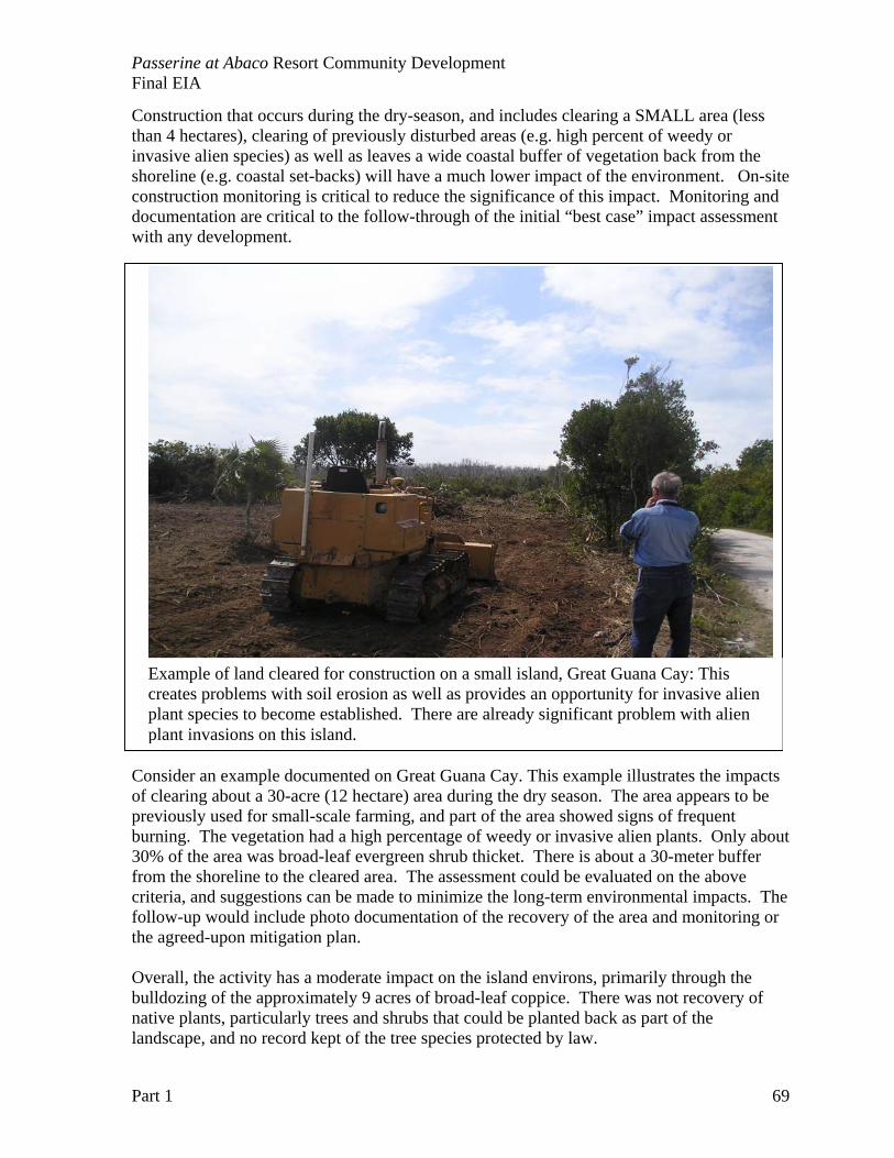
Passerine at Abaco Resort Community Development Final EIA
Part 1 69
Construction that occurs during the dry-season, and includes clearing a SMALL area (less than 4 hectares), clearing of previously disturbed areas (e.g. high percent of weedy or invasive alien species) as well as leaves a wide coastal buffer of vegetation back from the shoreline (e.g. coastal set-backs) will have a much lower impact of the environment. On-site construction monitoring is critical to reduce the significance of this impact. Monitoring and documentation are critical to the follow-through of the initial “best case” impact assessment with any development.
Consider an example documented on Great Guana Cay. This example illustrates the impacts of clearing about a 30-acre (12 hectare) area during the dry season. The area appears to be previously used for small-scale farming, and part of the area showed signs of frequent burning. The vegetation had a high percentage of weedy or invasive alien plants. Only about 30% of the area was broad-leaf evergreen shrub thicket. There is about a 30-meter buffer from the shoreline to the cleared area. The assessment could be evaluated on the above criteria, and suggestions can be made to minimize the long-term environmental impacts. The follow-up would include photo documentation of the recovery of the area and monitoring or the agreed-upon mitigation plan. Overall, the activity has a moderate impact on the island environs, primarily through the bulldozing of the approximately 9 acres of broad-leaf coppice. There was not recovery of native plants, particularly trees and shrubs that could be planted back as part of the landscape, and no record kept of the tree species protected by law.
Example of land cleared for construction on a small island, Great Guana Cay: This creates problems with soil erosion as well as provides an opportunity for invasive alien plant species to become established. There are already significant problem with alien plant invasions on this island.
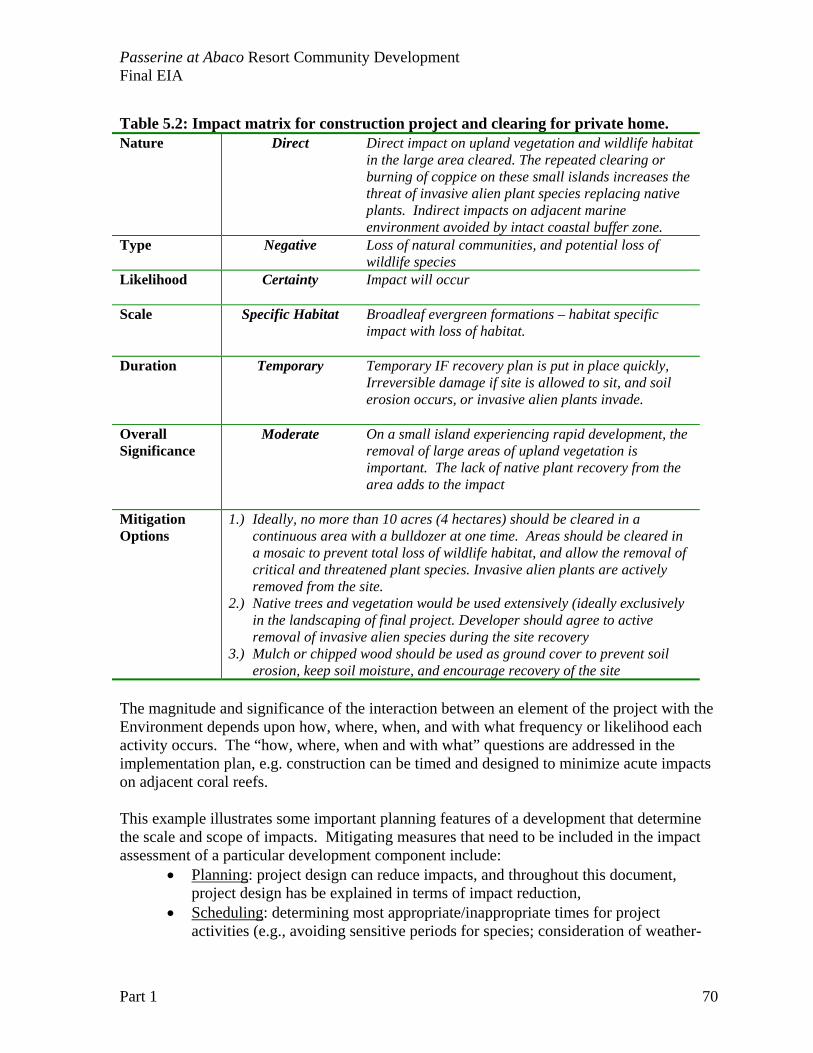
Passerine at Abaco Resort Community Development Final EIA
Part 1 70
Table 5.2: Impact matrix for construction project and clearing for private home. Nature Direct Direct impact on upland vegetation and wildlife habitat
in the large area cleared. The repeated clearing or burning of coppice on these small islands increases the threat of invasive alien plant species replacing native plants. Indirect impacts on adjacent marine environment avoided by intact coastal buffer zone.
Type Negative Loss of natural communities, and potential loss of wildlife species
Likelihood Certainty Impact will occur
Scale Specific Habitat Broadleaf evergreen formations – habitat specific impact with loss of habitat.
Duration Temporary Temporary IF recovery plan is put in place quickly, Irreversible damage if site is allowed to sit, and soil erosion occurs, or invasive alien plants invade.
Overall Significance
Moderate On a small island experiencing rapid development, the removal of large areas of upland vegetation is important. The lack of native plant recovery from the area adds to the impact
Mitigation Options
1.) Ideally, no more than 10 acres (4 hectares) should be cleared in a continuous area with a bulldozer at one time. Areas should be cleared in a mosaic to prevent total loss of wildlife habitat, and allow the removal of critical and threatened plant species. Invasive alien plants are actively removed from the site.
2.) Native trees and vegetation would be used extensively (ideally exclusively in the landscaping of final project. Developer should agree to active removal of invasive alien species during the site recovery
3.) Mulch or chipped wood should be used as ground cover to prevent soil erosion, keep soil moisture, and encourage recovery of the site
The magnitude and significance of the interaction between an element of the project with the Environment depends upon how, where, when, and with what frequency or likelihood each activity occurs. The “how, where, when and with what” questions are addressed in the implementation plan, e.g. construction can be timed and designed to minimize acute impacts on adjacent coral reefs. This example illustrates some important planning features of a development that determine the scale and scope of impacts. Mitigating measures that need to be included in the impact assessment of a particular development component include:
• Planning: project design can reduce impacts, and throughout this document, project design has be explained in terms of impact reduction,
• Scheduling: determining most appropriate/inappropriate times for project activities (e.g., avoiding sensitive periods for species; consideration of weather-
Passerine at Abaco Resort Community Development Final EIA
Part 1 71
related seasons/events, etc.). Scheduling considerations are also mentioned in the impact assessment
• Operational: considering the manner in which project activities are carried out (e.g., minimal land clearing; hand-clearing vs. bulldozing, etc.).
• Technological: using control devices to prevent or restrict the release of deleterious substances (e.g., use of filters and scrubbers, etc.).
In the example presented on clearing property for a housing development, each of these mitigating measures would have a significant input to minimizing impacts. Although each of these mitigating measures have a financial aspect (e.g. planning always cost more initially than not planning), the long-term financial benefits are absolute. Restoration costs are always higher on small islands than minimizing impacts initially.
Planning: Planning of the housing lots to allow for “corridors” of natural vegetation will promote native plant diversity of the site as well as rapid recovery of the area after construction. Housing guidelines must include maximum construction “foot print” on the property, as well as maximum clearance areas. Scheduling: Ideally construction could take place during the dry season to minimize erosion. However, neotropiocal migratory birds are using broadleaf trees and shrubs primarily in the winter (dry) months. Scheduling activities is likely very site specific, with the greatest consideration given to the impacts of heavy rainfall or storm events on the construction site. It is important to minimize grading during the wet season, to avoid problems with erosion with a near shore increase in turbidity. Operational: Operational goals and guidelines are critical to the final outcome of a construction project. The details are critical, and follow-through of guidelines and planning requires a knowledgeable, on-the-ground environmental staff. In this example, Operational details would include the selective removal of invasive alien plants, with the identification and protection of native species. Technological: Key technologies could have been used in this example. New advances in synthetic ground covers, mulching vegetation removed, or sediment curtains could all contribute to reducing impacts. THE MOST CRITICAL TECHNOLOGY TO BE USED ON THIS PROJECT IS ON-SITE “WEB-CAM”, USED TO MONITOR VARIOUS PHASES OF CONSTRUCTION. Real time web-camera will help prevent problems from occurring as well as help guide restoration of “errors”.
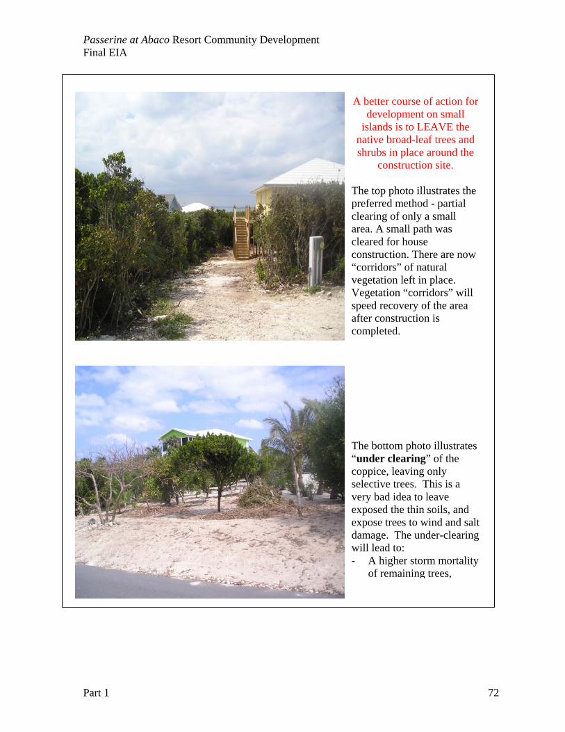
Passerine at Abaco Resort Community Development Final EIA
Part 1 72
A better course of action for development on small
islands is to LEAVE the native broad-leaf trees and shrubs in place around the
construction site.
The top photo illustrates the preferred method - partial clearing of only a small area. A small path was cleared for house construction. There are now “corridors” of natural vegetation left in place. Vegetation “corridors” will speed recovery of the area after construction is completed. The bottom photo illustrates “under clearing” of the coppice, leaving only selective trees. This is a very bad idea to leave exposed the thin soils, and expose trees to wind and salt damage. The under-clearing will lead to: - A higher storm mortality
of remaining trees,
Passerine at Abaco Resort Community Development Final EIA
Part 1 73
Impacts to the Physical and Biological Environments Below is a list of pre-construction/construction activities and project operation activities to be considered as part of the impact analysis Pre-construction/construction stages:
1. SITE PREPARATION AND CONSTRUCTION OF INFRASTRUCTURE: demolition of remaining Disney structures, remediation at Disney area, construction of roads and receiving areas, waste generation and disposal, and construction of common buildings
2. CONSTRUCTION OF MARINA AND LOGISTICS DOCK AREA: Marina dredging, depositions of dredge spoils, entrance channel construction and logistics pier construction.
3. CONSTRUCTION OF GOLF COURSE: design criteria for the course, grass and landscape plant selection, clearing and re-contouring areas, and irrigation systems.
4. CONSTRUCTION OF PRIVATE HOMES: design of lots, services provided at the lot line, and construction of individual homes.
Project operation stage: 5. INDIVIDUAL HOUSE AND PROPERTY MANAGEMENT: management of
coastal setbacks, hurricane restoration plan and monitoring for invasive species 6. MARINA MAINTENANCE AND MONITORING: Maintenance of marina
perimeter, managing spills and hazardous wastes, and preventing eutrophication 7. GOLF COURSE MAINTENANCE AND MANAGEMENT: watering and irrigation,
pest control, use of fungicides and landscape maintenance.
Impact Assessment Guidelines Below is a set of guidelines that must be followed for consistently completing the impact assessment exercise.
Each component should identify specific activities and components/alternatives applicable to be evaluated. The “how, where, when and with what” issues need to be identified. For natural resources (e.g. species or natural communities) with specific threshold
criteria, use in order of availability: (1) known viability assessments for the Bahamian archipelago, 2) Florida standards; (3) EPA standards (if FL not available); (3) World Bank standards (if FL and EPA not available). The analysis of impacts must take into consideration mitigation measures
proposed in Chapter 6. Include the summary matrix on the overall impact of each component at the end
of the impact discussion (as per example table in previous section). Cumulative impacts are those impacts that may not individually constitute a significant impact but when combined with impacts from past, present, and reasonably foreseeable future activities, result in a larger and more significant impact. The cumulative impacts analysis should address at a minimum: Magnitude, Duration and Scale.
Passerine at Abaco Resort Community Development Final EIA
Part 1 74
Impact Assessment Matrices: Site preparation and infrastructure, Marina, Golf Course and Private Homes Pre-construction/construction stage: 1. SITE PREPARATION AND CONSTRUCTION OF INFRASTRUCTURE: Activities in this component include demolition of remaining Disney structures, remediation at Disney area, construction of roads and receiving areas, waste generation and disposal, and construction of common buildings. About 65 acres of invasive alien plant species will be removed from the Disney Treasure Island area and about 40 acres of roads, lay-down areas and infrastructure in the Service Area will be impacted by construction. The restored areas will eventually be private homes with native plant corridors and coastal setback zones. Contaminated soil and arsenic-treated lumber will be removed from the site in the clean up of the Treasure Island area. Considerable care will be given to protecting the coastal zone vegetation. Bakers Bay has previously been developed and abandoned, and there are considerable impacts to clean up on the site that PPS will undertake. A complete outline of mitigation strategies can be found in Chapter 6. The site clean up includes:
The removal of debris and dead vegetation left from the passage of Hurricane Floyd (1999), The removal of storage tanks, transformers, and potential petrochemical spill sites,
contaminated soil The restoration of the old dock and removal of pen system that poise navigation
hazards The removal or restoration of damaged water storage facilities that now poise a health
hazard with vector breeding, The removal of Australian pine trees in the coastal zone, particularly large stands of
these trees that serve as a seed source, and The restoration of the dune system and native coastal plants in the coastal set back
zones. Re-vegetation of coastal areas will use native plant species (See Appendix Table 2) found on the island. The import of any sand, fill or soil material will be evaluated for the potential introduction of invasive species to the island. A list of appropriate plants for landscaping and gardens will be developed in the interest of both water conservation, and preventing known invasive exotic plants introduced to the island. The removal of such a large area of Australian pine is both expensive and ecologically sensitive. Many native plants do not grow in the leaf litter of Australian pine, thus the area needs to be completely cleared, re-contoured then replanted in small sections. The smaller Australian pines (less than 20 cm diameter) can be chipped and used as mulch. The mulch can be used on roadbeds and construction areas to prevent soil compaction and damage to root systems of native trees. A restoration plan for the Disney Treasure Island area will be a multi-year process. Trees that need to be cleared in other development areas can be re-located to the Treasure Island restoration area to create a natural zonation of native plants in the coastal strand.
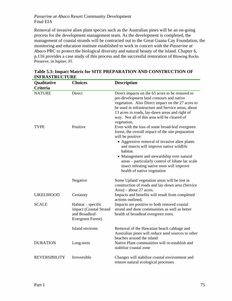
Passerine at Abaco Resort Community Development Final EIA
Part 1 75
Removal of invasive alien plant species such as the Australian pines will be an on-going process for the development management team. As the development is completed, the management of coastal strands will be contracted out to the Great Guana Cay Foundation, the monitoring and education institute established to work in concert with the Passerine at Abaco PRC to protect the biological diversity and natural beauty of the island. Chapter 6, p.116 provides a case study of this process and the successful restoration of Blowing Rocks Preserve, in Jupiter, Fl. Table 5.3: Impact Matrix for SITE PREPARATION AND CONSTRUCTION OF INFRASTRUCTURE Qualitative Criteria
Choices Description
NATURE Direct
Direct impacts on the 65 acres to be restored to pre-development land contours and native vegetation. Also Direct impact on the 27 acres to be used in infrastructure and Service areas, about 13 acres in roads, lay-dawn areas and right of way. Not all of this area will be cleared of vegetation.
TYPE Positive Even with the loss of some broad-leaf evergreen forest, the overall impact of the site preparation will be positive:
• Aggressive removal of invasive alien plants and insects will improve native wildlife habitat.
• Management and stewardship over natural areas – particularly control of lobate lac scale insect infesting native trees will improve health of native vegetation
Negative Some Upland vegetation areas will be lost in
construction of roads and lay-down area (Service Area) – about 27 acres.
LIKELIHOOD Certainty Impacts and benefits will result from completed actions outlined,
SCALE Habitat – specific impact (Coastal Strand and Broadleaf- Evergreen Forest)
Impacts are positive to both restored coastal strand and dune communities as well as better health of broadleaf evergreen trees.
Island environs
Removal of the Hawaiian beach cabbage and Australian pines will reduce seed sources to other beaches around the island
DURATION Long-term
Native Plant communities will re-establish and stabilize coastal zone
REVERSIBILITY Irreversible
Changes will stabilize coastal environment and restore natural ecological processes
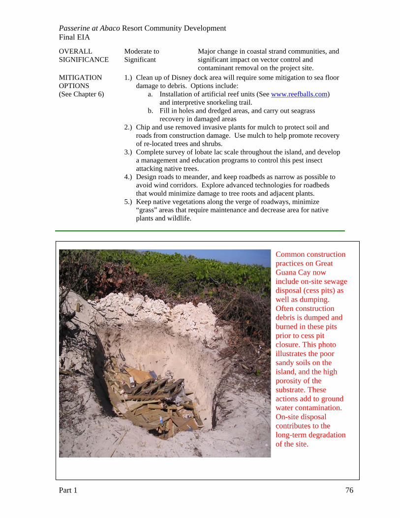
Passerine at Abaco Resort Community Development Final EIA
Part 1 76
OVERALL SIGNIFICANCE
Moderate to Significant
Major change in coastal strand communities, and significant impact on vector control and contaminant removal on the project site.
MITIGATION OPTIONS (See Chapter 6)
1.) Clean up of Disney dock area will require some mitigation to sea floor damage to debris. Options include:
a. Installation of artificial reef units (See www.reefballs.com) and interpretive snorkeling trail.
b. Fill in holes and dredged areas, and carry out seagrass recovery in damaged areas
2.) Chip and use removed invasive plants for mulch to protect soil and roads from construction damage. Use mulch to help promote recovery of re-located trees and shrubs.
3.) Complete survey of lobate lac scale throughout the island, and develop a management and education programs to control this pest insect attacking native trees.
4.) Design roads to meander, and keep roadbeds as narrow as possible to avoid wind corridors. Explore advanced technologies for roadbeds that would minimize damage to tree roots and adjacent plants.
5.) Keep native vegetations along the verge of roadways, minimize “grass” areas that require maintenance and decrease area for native plants and wildlife.
Common construction practices on Great Guana Cay now include on-site sewage disposal (cess pits) as well as dumping. Often construction debris is dumped and burned in these pits prior to cess pit closure. This photo illustrates the poor sandy soils on the island, and the high porosity of the substrate. These actions add to ground water contamination. On-site disposal contributes to the long-term degradation of the site.
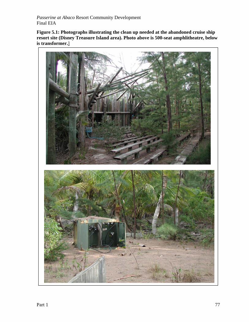
Passerine at Abaco Resort Community Development Final EIA
Part 1 77
Figure 5.1: Photographs illustrating the clean up needed at the abandoned cruise ship resort site (Disney Treasure Island area). Photo above is 500-seat amphlitheatre, below is transformer.]
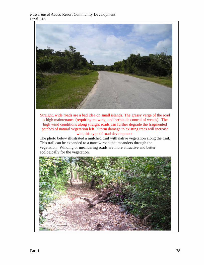
Passerine at Abaco Resort Community Development Final EIA
Part 1 78
Straight, wide roads are a bad idea on small islands. The grassy verge of the road is high maintenance (requiring mowing, and herbicide control of weeds). The high wind conditions along straight roads can further degrade the fragmented
patches of natural vegetation left. Storm damage to existing trees will increase with this type of road development.
The photo below illustrated a mulched trail with native vegetation along the trail. This trail can be expanded to a narrow road that meanders through the vegetation. Winding or meandering roads are more attractive and better ecologically for the vegetation.
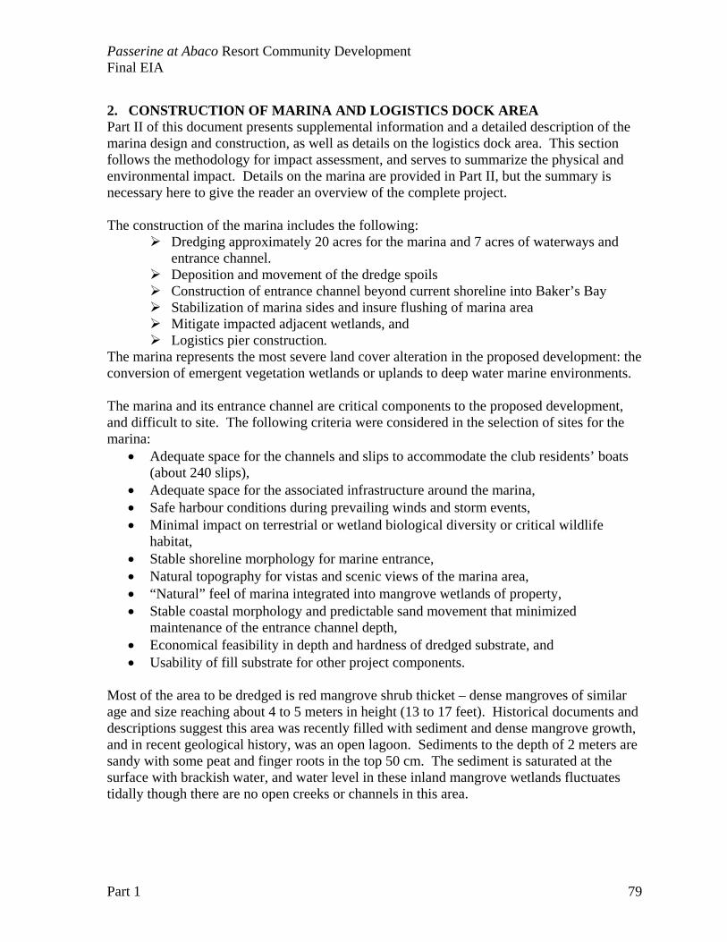
Passerine at Abaco Resort Community Development Final EIA
Part 1 79
2. CONSTRUCTION OF MARINA AND LOGISTICS DOCK AREA Part II of this document presents supplemental information and a detailed description of the marina design and construction, as well as details on the logistics dock area. This section follows the methodology for impact assessment, and serves to summarize the physical and environmental impact. Details on the marina are provided in Part II, but the summary is necessary here to give the reader an overview of the complete project. The construction of the marina includes the following:
Dredging approximately 20 acres for the marina and 7 acres of waterways and entrance channel. Deposition and movement of the dredge spoils Construction of entrance channel beyond current shoreline into Baker’s Bay Stabilization of marina sides and insure flushing of marina area Mitigate impacted adjacent wetlands, and Logistics pier construction.
The marina represents the most severe land cover alteration in the proposed development: the conversion of emergent vegetation wetlands or uplands to deep water marine environments.
The marina and its entrance channel are critical components to the proposed development, and difficult to site. The following criteria were considered in the selection of sites for the marina:
• Adequate space for the channels and slips to accommodate the club residents’ boats (about 240 slips),
• Adequate space for the associated infrastructure around the marina, • Safe harbour conditions during prevailing winds and storm events, • Minimal impact on terrestrial or wetland biological diversity or critical wildlife
habitat, • Stable shoreline morphology for marine entrance, • Natural topography for vistas and scenic views of the marina area, • “Natural” feel of marina integrated into mangrove wetlands of property, • Stable coastal morphology and predictable sand movement that minimized
maintenance of the entrance channel depth, • Economical feasibility in depth and hardness of dredged substrate, and • Usability of fill substrate for other project components.
Most of the area to be dredged is red mangrove shrub thicket – dense mangroves of similar age and size reaching about 4 to 5 meters in height (13 to 17 feet). Historical documents and descriptions suggest this area was recently filled with sediment and dense mangrove growth, and in recent geological history, was an open lagoon. Sediments to the depth of 2 meters are sandy with some peat and finger roots in the top 50 cm. The sediment is saturated at the surface with brackish water, and water level in these inland mangrove wetlands fluctuates tidally though there are no open creeks or channels in this area.
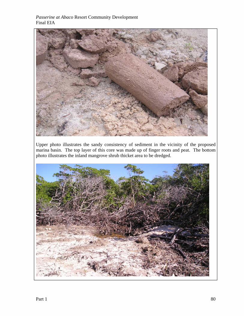
Passerine at Abaco Resort Community Development Final EIA
Part 1 80
Upper photo illustrates the sandy consistency of sediment in the vicinity of the proposed marina basin. The top layer of this core was made up of finger roots and peat. The bottom photo illustrates the inland mangrove shrub thicket area to be dredged.
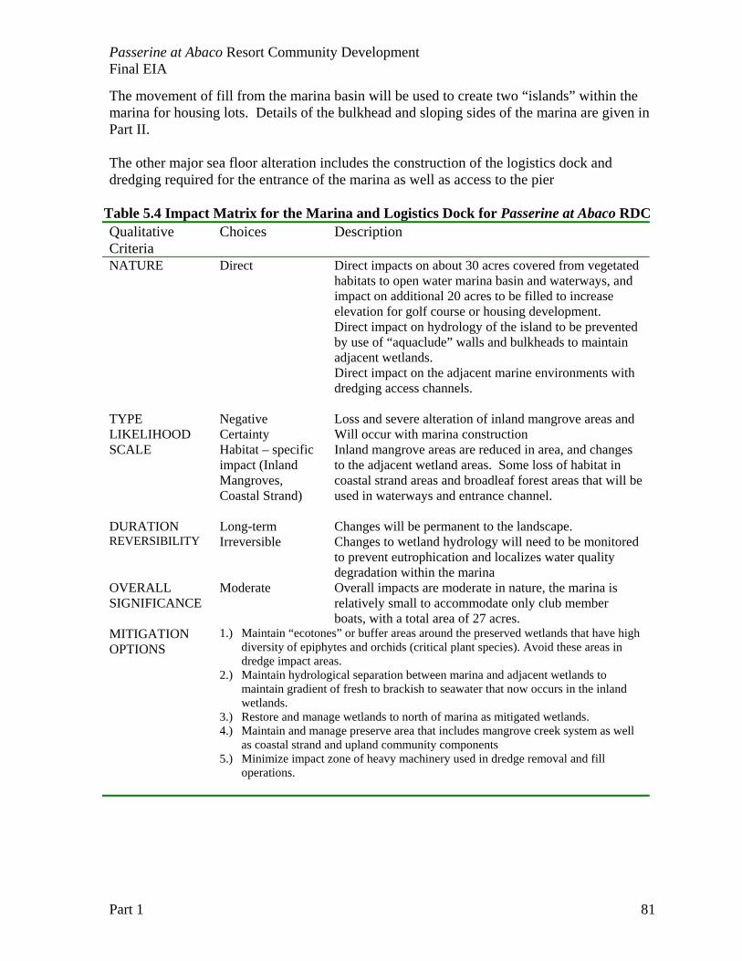
Passerine at Abaco Resort Community Development Final EIA
Part 1 81
The movement of fill from the marina basin will be used to create two “islands” within the marina for housing lots. Details of the bulkhead and sloping sides of the marina are given in Part II. The other major sea floor alteration includes the construction of the logistics dock and dredging required for the entrance of the marina as well as access to the pier
Table 5.4 Impact Matrix for the Marina and Logistics Dock for Passerine at Abaco RDC Qualitative Criteria
Choices Description
NATURE Direct
Direct impacts on about 30 acres covered from vegetated habitats to open water marina basin and waterways, and impact on additional 20 acres to be filled to increase elevation for golf course or housing development. Direct impact on hydrology of the island to be prevented by use of “aquaclude” walls and bulkheads to maintain adjacent wetlands. Direct impact on the adjacent marine environments with dredging access channels.
TYPE Negative Loss and severe alteration of inland mangrove areas and LIKELIHOOD Certainty Will occur with marina construction SCALE Habitat – specific
impact (Inland Mangroves, Coastal Strand)
Inland mangrove areas are reduced in area, and changes to the adjacent wetland areas. Some loss of habitat in coastal strand areas and broadleaf forest areas that will be used in waterways and entrance channel.
DURATION Long-term Changes will be permanent to the landscape. REVERSIBILITY Irreversible
Changes to wetland hydrology will need to be monitored to prevent eutrophication and localizes water quality degradation within the marina
OVERALL SIGNIFICANCE
Moderate
Overall impacts are moderate in nature, the marina is relatively small to accommodate only club member boats, with a total area of 27 acres.
MITIGATION OPTIONS
1.) Maintain “ecotones” or buffer areas around the preserved wetlands that have high diversity of epiphytes and orchids (critical plant species). Avoid these areas in dredge impact areas.
2.) Maintain hydrological separation between marina and adjacent wetlands to maintain gradient of fresh to brackish to seawater that now occurs in the inland wetlands.
3.) Restore and manage wetlands to north of marina as mitigated wetlands. 4.) Maintain and manage preserve area that includes mangrove creek system as well
as coastal strand and upland community components 5.) Minimize impact zone of heavy machinery used in dredge removal and fill
operations.
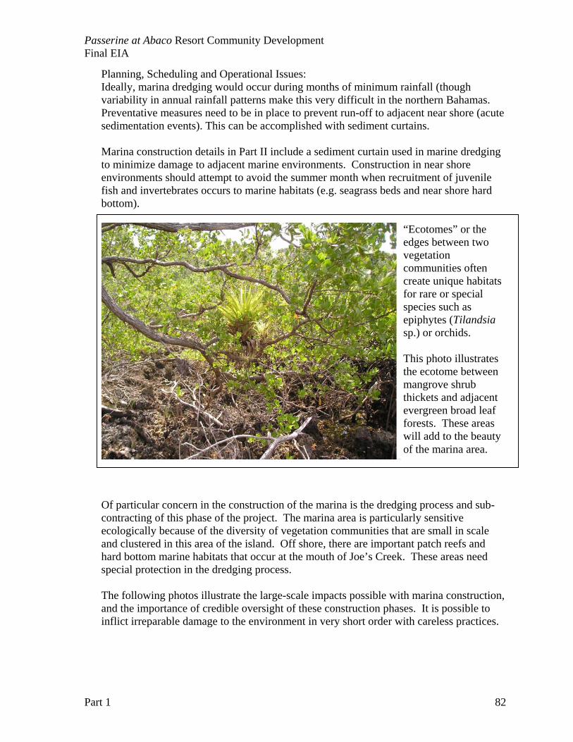
Passerine at Abaco Resort Community Development Final EIA
Part 1 82
Planning, Scheduling and Operational Issues: Ideally, marina dredging would occur during months of minimum rainfall (though variability in annual rainfall patterns make this very difficult in the northern Bahamas. Preventative measures need to be in place to prevent run-off to adjacent near shore (acute sedimentation events). This can be accomplished with sediment curtains. Marina construction details in Part II include a sediment curtain used in marine dredging to minimize damage to adjacent marine environments. Construction in near shore environments should attempt to avoid the summer month when recruitment of juvenile fish and invertebrates occurs to marine habitats (e.g. seagrass beds and near shore hard bottom).
Of particular concern in the construction of the marina is the dredging process and sub-contracting of this phase of the project. The marina area is particularly sensitive ecologically because of the diversity of vegetation communities that are small in scale and clustered in this area of the island. Off shore, there are important patch reefs and hard bottom marine habitats that occur at the mouth of Joe’s Creek. These areas need special protection in the dredging process. The following photos illustrate the large-scale impacts possible with marina construction, and the importance of credible oversight of these construction phases. It is possible to inflict irreparable damage to the environment in very short order with careless practices.
“Ecotomes” or the edges between two vegetation communities often create unique habitats for rare or special species such as epiphytes (Tilandsia sp.) or orchids. This photo illustrates the ecotome between mangrove shrub thickets and adjacent evergreen broad leaf forests. These areas will add to the beauty of the marina area.
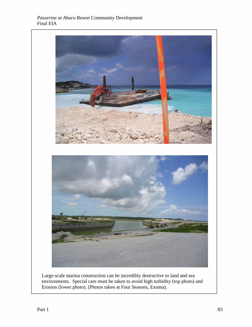
Passerine at Abaco Resort Community Development Final EIA
Part 1 83
Large-scale marina construction can be incredibly destructive to land and sea environments. Special care must be taken to avoid high turbidity (top photo) and Erosion (lower photo). (Photos taken at Four Seasons, Exuma).
Passerine at Abaco Resort Community Development Final EIA
Part 1 84
3. CONSTRUCTION OF THE GOLF COURSE The 18-hole championship golf course is a keystone amenity for the Club Membership Program. It will be designed, constructed and maintained with the best teams of professionals available. Interviews with top designers will be finalized within the next 90 days. The protection of the existing environmental setting and the conservation of water in the courses maintenance will be paramount in the design. The operations plan calls for clearing only limited sections before shaping and grassing begins to minimize soil loss and allow for some native plant recovery. Water conservation is the key to successful operation of a golf course on a small dry tropical island. Irrigation systems will be utilized that operate with a mixture of grey, brackish and R/O water. The sprinkler system will be designed to minimize run-off of applied water. Drainage systems for rainwater will be incorporated to maximize the ability for recycling water. The location of golf courses near the coastline causes concern about nonpoint source (NPS) pollution effects on the water quality of surrounding marine and wetland environments. Of particular interest is the impact of herbicides, fungicides and fertilizers on groundwater quality. Golf courses are intensive production systems, and the frequent mowing and application of fertilizers or pesticides requires careful management to avoid damage to the surrounding environment. Nitrogen, phosphorus and many pesticides are potential pollutants of groundwater, and monitoring of their movement from turf grass areas to receiving waters is needed. Passerine at Abaco RCD strives to demonstrate golf course best management practices to reduce the threat of NPS pollution to marine and wetland resources. A series of ground water wells will be established in the first year of the project to determine and evaluate specific golf course management practices that protect water quality. A second survey covers fertilizer handling, application and storage, clipping handling and use of other practices such as vegetative filter strips. Undisturbed natural areas of native plant species (e.g.,coppice or broadleaf evergreen forest patches) are incorporated into golf courses as roughs and in other design areas. Once management practices have been implemented at the site, soil and water samples will be collected to analyze for nitrogen, phosphorous, and selected pesticides. Important criteria in the design, construction and management of golf courses are outlined: Design and Construction 1. Potential sites should be selected which allow the golf course to be routed in such a way
as to minimize the need to alter or remove existing native landscapes, trees, and vegetation, and which provide opportunities for restoration/enhancement of valuable habitat.
2. Natural rock outcroppings that are archaeologically or geologically significant, and sensitive or critical habitat or environmental features should be preserved through careful golf course design.
3. Representatives of each of vegetation habitat types should be protected throughout the course area, this includes grassy wetlands and broadleaf evergreen forest communities.
3. The site plan should identify areas for restoration, replanting, and enhancement of disturbed habitat to re-establish wildlife migration corridors and linkages between
Passerine at Abaco Resort Community Development Final EIA
Part 1 85
fragmented habitat areas. This includes areas dominated by Australian pines and coconut trees that will require some restoration.
4. Areas between fairways should be utilized to retain and restore existing native vegetation, where possible.
5. Native habitats and communities of special value to threatened/endangered species shall be preserved to the greatest extent possible
6. The site plan should protect drainage systems that support retained vegetation. 7. Structures and buildings should be located such that impacts to habitats and significant
natural areas are avoided. 8. A plan for removal of invasive, exotic plants should be provided, introduction of new
plant alien plant species to the island should be avoided. 9. Development of ponds that mimic natural conditions in terms of both aesthetics and
habitat, to the extent feasible, is encouraged. Water Quality Management 1. Throughout the proposed golf course area, ground water quality is of critical concern due
to the sandy soil and near-surface groundwater. A qualified pest control advisor certified in groundwater protection should prepare a plan for the course which minimizes or avoids potential adverse impacts to surface water or ground water. This plan may include techniques such as: a) the use of underdrain systems or some other approved means for capturing and directing leachate away from ground water, and b) directing flow from underground drains to peat-sand filters in areas of permeable soils to ensure adequate filtration.
2. Paved areas should be limited in order to minimize impermeable surfaces and, thereby, reduce surface runoff. When possible, cart paths should be mulched and not paved.
3. Impervious liners for detention/retention ponds and water hazards to protect ground and surface water quality. Areas of critical concern on the golf course can use water-retaining buffers underground (“aquacludes”).
4. Buffer strips, oil/grease separators or other recommended techniques for parking area drainage systems.
5. Grease traps and other recommended technologies for facilities such as golf cart maintenance or wash areas to prevent untreated runoff from entering the natural groundwater environment.
6. The overall drainage system should be designed to insure that there is no increase in the velocity or amount of off-site flows during major storm events.
Members of the USGA’s Turfgrass and Environmental Research Program have consulted on golf course design compatible with a small island environment. The developers will be using one of the varieties of the seashore Paspalum salt-tolerant grasses for our project.
Special attention will be paid to erosion control, and stormwater management for areas impacted by the golf course construction. The erosion control and treatment measures discussed herein consist of descriptions and guidelines for various management practices used for pollution abatement and erosion and sediment control. Such practices are intended to improve runoff quality by reducing the generated and accumulation of potential stormwater runoff and contaminants; controlling the volume and discharge rate of the runoff;

Passerine at Abaco Resort Community Development Final EIA
Part 1 86
reducing the magnitude of the pollutants in the discharge water and to prevent and/or correct problems related to the transport of eroded material or soil by runoff particularly from construction and other land disturbing activities. Construction activities, by their nature, create many sources of potential pollutants, especially to near shore marine waters. Accelerated erosion and sedimentation caused by land disturbing activities is one of the major pollution problems caused by construction. Control measures and practices to limit sediment pollution are specified later. There are, however many other potential pollutants associated with construction activities such as gasoline, grease, paints, cements, and solvents, to name only a few. Even non-toxic materials such as paper and cardboard can be classified as potential pollutants when they are washed into the sea. The best way to prevent non-point source (NPS) pollution on construction sites is to use “good housekeeping” practices, which usually entails simply maintaining the site in a neat and orderly condition. Specific practices should be employed to retain runoff and to deal with toxic substances and materials. An overall plan for the control of non-point source pollution is advisable so that specific control measures can be spelled out and implemented in an effective manner. OVERVIEW OF OPTIONS TO BE USED FOR EROSION CONTROL
• Grassed Waterways and Swales: This practice involves using grassed surfaces to reduce runoff velocities, enhance infiltration and remove runoff contaminants, thus improving runoff quality and reducing the potential for downstream channel degradation and sediment pollution.
• Temporary Gravel Construction Entrance: A gravel pad, located at the points of vehicular ingress and egress on a construction site, to reduce the mud transported onto public roads and other paved areas.
• Mulch Bale Barriers: A temporary sediment barrier composed of native mulch placed across or at the toe of a slope to intercept and detain sediment and decrease flow velocities from drainage areas of limited size. NO VEGETATION MATERIAL WILL BE IMPORTED TO THE SITE to reduce the risk of alien invasive plant introduction.
• Silt Fences: A temporary sediment barrier constructed of posts, filter fabric and, in some cases, a wire support fence, placed across or at the toe of a slope or in a minor drainage way to intercept and detain sediment and decrease flown velocities from drainage areas of limited size.
• Temporary Sediment Trap: A small ponding area, formed by constructing an excavated shallow area or earthen embankment with a gravel outlet across a drainage swale, to detain sediment-laden runoff from small disturbed areas for enough time to allow most of the sediment to settle out.
• Riprap: A permanent, erosion-resistant ground cover of large, loose, angular stone usually underlain by erosion matt of filter fabric installed wherever soil conditions,
Passerine at Abaco Resort Community Development Final EIA
Part 1 87
water turbulence and velocity, expected vegetative cover, etc., are such that soil may erode under storm water flow conditions.
• Temporary Seeding: Establishment of temporary vegetative cover on disturbed areas by seeding with appropriate rapidly growing plants on sites that will not be brought to final grade for a period of 30 days.
• Permanent Planting: Establishment of perennial vegetative cover by planting seed or native plants from the on-site nursery area on the rough graded areas that will not be brought to final grade for a year or more or where permanent, long-lived vegetative cover is needed on fine graded areas.
• Sodding: Stabilizing fine graded areas by establishing permanent grass stands with sod. This provides immediate protection against erosion, and is especially effective in grassed swales and waterways or in areas where an immediate aesthetic effect is desirable.
IMPLEMENTATION AND EROSION MANAGEMENT
A. Erosion and sediment control measures are to be placed prior to, or as the first step in, construction. Sediment control practices will be applied as a perimeter defense against any transportation of silt and/or water turbidity off the site. The contractor shall provide a plan and written notice to the owner and engineer 10 days prior to commencing work. The contractor shall accept and will be responsible for maintaining existing erosion control facilities.
B. Silt screens and turbidity barriers must remain in place and in good condition at all locations shown in the plans and as required until the contract is completed and soils are stabilized and vegetation has been established.
C. The erosion control measures set forth in the plans are intended as minimum standards. Any erosion control requires beyond that specified shall be considered as included within the contract.
D. Materials from work shall be contained, and not allowed to collect on any off-site perimeter areas or in waterways. These include both natural and man-made open ditches, streams, storm drains, lakes and ponds.
E. Weekly, or after raining, inspections shall be made by the contractor to determine the effectiveness of these efforts. Any necessary remedies or repairs shall be performed without delay and at no cost to the owner.
F. All mud, dirt or other materials tracked or spilled onto existing roads and facilities from the site, due to construction, shall be promptly removed by the contractor/builder. Deviation from this will cause Owner notification, and all work will stop until corrected.
G. Permanent soil erosion control measures for all slopes, channels, ditched or any disturbed land areas shall be completed immediately after final grading. When it is not possible to permanently protect a disturbed area immediately after grading operations, temporary erosion control measures shall be installed. All temporary erosion control measures shall be maintained until permanent measures are in place and established. Temporary erosion control may consist of but not be limited to grass, sod, mulch, sand bags, piping, slope drains, settlement basins, artificial coverings, berms, hay bales, straw and dust control.
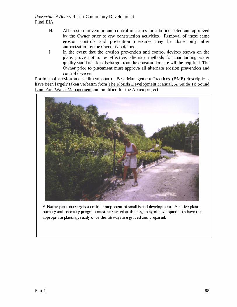
Passerine at Abaco Resort Community Development Final EIA
Part 1 88
H. All erosion prevention and control measures must be inspected and approved by the Owner prior to any construction activities. Removal of these same erosion controls and prevention measures may be done only after authorization by the Owner is obtained.
I. In the event that the erosion prevention and control devices shown on the plans prove not to be effective, alternate methods for maintaining water quality standards for discharge from the construction site will be required. The Owner prior to placement must approve all alternate erosion prevention and control devices.
Portions of erosion and sediment control Best Management Practices (BMP) descriptions have been largely taken verbatim from The Florida Development Manual, A Guide To Sound Land And Water Management and modified for the Abaco project
A Native plant nursery is a critical component of small island development. A native plant nursery and recovery program must be started at the beginning of development to have the appropriate plantings ready once the fairways are graded and prepared.
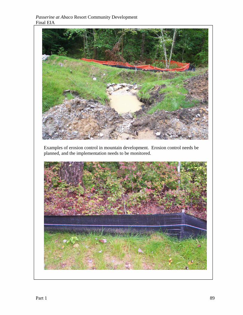
Passerine at Abaco Resort Community Development Final EIA
Part 1 89
Examples of erosion control in mountain development. Erosion control needs be planned, and the implementation needs to be monitored.
Passerine at Abaco Resort Community Development Final EIA
Part 1 90
Table 5.7 Impact matrix of the golf course construction for Passerine at Abaco RCD. Qualitative Criteria
Choices Description
NATURE Direct
Land cover alteration from shrub thicket and forests to open grassy areas will directly impact the overall plant diversity on the island
TYPE Negative Large area of continuous Broadleaf Evergreen Forest will be fragmented and converted to turf-grass fairways and greens. Of the original 372 acres, about 40% will remain in small patches and corridors. Patches of vegetation do not offer the same ecological value as a contiguous forest, and thus wildlife habitats and plant diversity may be lost.
Positive Upland vegetation communities will be fragmented, but a management program for the lobate lac scale will help control the current infestation on native trees,
LIKELIHOOD Certainty Impacts will occur with land conversion to golf course.
SCALE Habitat–specific impact
Impacts are the further fragmentation of the contiguous coppice (broadleaf evergreen forest) areas. This fragmentation may lead to a long-term loss of plant diversity if not monitored. There are very specific threats to the groundwater quality throughout the project site.
DURATION Long-term
Impacts will be more acute with construction, with some recovery of trees and vegetation with time. A KEY CONCERN is the use of Paspalum grasses that can grow with brackish water. This increased salinity of irrigation water, or contamination of ground waters may lead to the demise of native vegetation.
REVERSIBILITY Irreversible
It is unlikely that a forest will ever recover from the golf course conversion, even if site is abandoned.
OVERALL SIGNIFICANCE
Moderate
This is a moderate impact overall on the project site. The current infestations of fire ants and lobate lac scale do pose a threat to native plants and wildlife, thus the management development does offer better long-term stewardship of island biological diversity, with removal of invasive pest species.
MITIGATION OPTIONS
1.) Chip and use removed invasive plants for mulch to protect soil and cart paths, follow “best practices” in utilization of native vegetation that is compatible with Paspalum turf grass species.
2.) Complete groundwater well monitoring system, and environmental
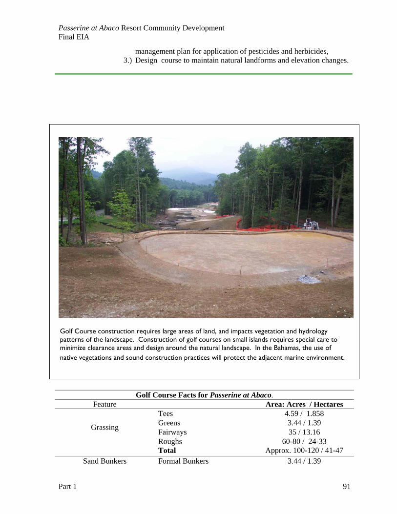
Passerine at Abaco Resort Community Development Final EIA
Part 1 91
management plan for application of pesticides and herbicides, 3.) Design course to maintain natural landforms and elevation changes.
Golf Course Facts for Passerine at Abaco. Feature Area: Acres / Hectares
Tees 4.59 / 1.858 Greens 3.44 / 1.39 Fairways 35 / 13.16 Grassing
Roughs 60-80 / 24-33 Total Approx. 100-120 / 41-47
Sand Bunkers Formal Bunkers 3.44 / 1.39
Golf Course construction requires large areas of land, and impacts vegetation and hydrology patterns of the landscape. Construction of golf courses on small islands requires special care to minimize clearance areas and design around the natural landscape. In the Bahamas, the use of native vegetations and sound construction practices will protect the adjacent marine environment.
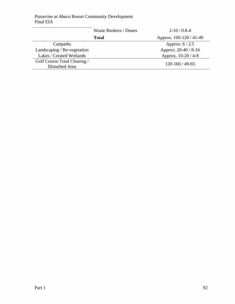
Passerine at Abaco Resort Community Development Final EIA
Part 1 92
Waste Bunkers / Dunes 2-10 / 0.8-4 Total Approx. 100-120 / 41-49
Cartpaths Approx. 6 / 2.5 Landscaping / Re-vegetation Approx. 20-40 / 8-16
Lakes / Created Wetlands Approx. 10-20 / 4-8 Golf Course Total Clearing /
Disturbed Area 120-160 / 49-65
Passerine at Abaco Resort Community Development Final EIA
Part 1 93
4. GOLF COURSE MAINTENANCE AND MANAGEMENT The Passerine at Abaco PRC will require monitoring programs (outlined in Chapter 9) to insure on-going protection of ground water quality around the golf course. A contingency plan should be provided for use in the event that monitoring shows a developing problem. Environmental standards for the maintenance of water quality and management of pest control chemicals would include the following: Guidelines for Water Quality Protection and Chemical Use
1. To minimize the need for chemical application, turf areas should be of sufficient size to accommodate the use, but should allow for native vegetation to remain between fairways.
2. Drainage design and buffers should be utilized to minimize any adverse impacts of runoff.
3. Storage and use of pesticides, herbicides, and fertilizers will be limited to and in conformance with US EPA and State of Florida standards. Chemical use is minimized through spot treatment and applicators are licensed and trained in all safety-related aspects of chemical use.
4. Integrated Pest Management systems should be employed to insure judicious use of pesticides, which will be applied by State-certified applicators.
5. Advanced technology/monitoring equipment should be used to insure minimal application of pesticides, herbicides, and fertilizers.
6. Use of the slow-release, less soluble, and least mobile chemical fertilizers, pesticides, and herbicides available is encouraged. These products should be used at the smallest rates of active ingredient to accomplish the desired result.
7. Drought, pest, and disease resistant grass species should be selected. 8. Natural buffer areas are maintained by minimizing the use of fertilizers,
pesticides, and herbicides. Guidelines for management of Water Demand
1. Lined artificial storage ponds should not be located in prime groundwater recharge areas.
2. Turfgrass species and landscaping around buildings should be selected which are native as well as drought-resistant or –tolerant, these plants would be best suited to island developments.
3. State-of-the-art irrigation systems with site meteorological monitoring capability should be used to minimize water use.
4. If on-site wells are to be used as the irrigation water source, analysis will be required to determine the safe yield in order to prevent aquifer depletion.
Many golf courses are utilizing a non-potable water supply, with possible use of reclaimed wastewater to irrigate turf areas. This can be combined with the appropriate low-flow fixtures to be used throughout the development, including the clubhouse, to practice water conservation measures critical to island living.
Passerine at Abaco Resort Community Development Final EIA
Part 1 94
5. CONSTRUCTION OF PRIVATE HOMES Coastal protection guidelines will be clearly established for the construction contractors as well as for individual lot owners. The purpose of the Guidelines is to prevent any long-term damage to the coastal buffer zone and conservation areas on the island, as well as to maintain as much intact upland vegetation as possible within the project design. a low impact on the island form both a visual and environmental standpoint. These coastal protection guidelines will include a detailed and clearly marked survey of areas not to be disturbed in the initial construction phase (marine and club infrastructure) as well as permanent coastal setback zones. The coastal type determines coastal setback distances. Coastal types were described in Chapter 4. The setbacks are illustrated in Figure 5.3 through 5.6 and are as follows: High Energy Beach and Dunes
10 meters back from Dune Crest or high point of dune system. For restored dune areas, dune crest is based on restored shore profile.
High Energy Rocky Shores 5 meters back from cliff crest, well above white zone of the upper tidal platform
Low Energy Beaches 15 meters back from permanent vegetation line, avoiding palm-dominated scrublands that are prone to flooding.
Low Energy Rock Shores 15 meters back from permanent vegetation line. Mangrove Coastlines No construction or setbacks, mangrove coastlines are within
proposed preserve area Excellent guidelines for prudent coastal development are outlined in the United Nations Environmental Programme (UNEP) Planning for coastal change report by Dr. Gillian Chambers. Dr. Chamber has prepared guidelines fro sontruction setbacks in the eastern Caribbean Islands that allow property to receive maximum protection from the dynamic processes of coastlines. A “coastal development setback” is defined as a prescribed distance to a coastal feature, such as a line of permanent vegetation, within which all types of development are prohibited. Access to beaches across setback zones should be on raised wooden structures to preserve vegetation zones and avoid erosion from trails and tracks. The basic formula for setback distances looks at three factors: 1) historical changes in coastline position, 2) change in the coastline likely to result from a category 4 hurricane, and 3) predicted coastline retreat that may result from sea level rise. Stability of coastal structures such as houses and resorts are based on at least a 40 to 50 year life of the building. The setback distance is from the line of permanent vegetation (not the pioneer zone of beaches). Setbacks are then dependent on coastal types, illustrated in Figure 5.1.
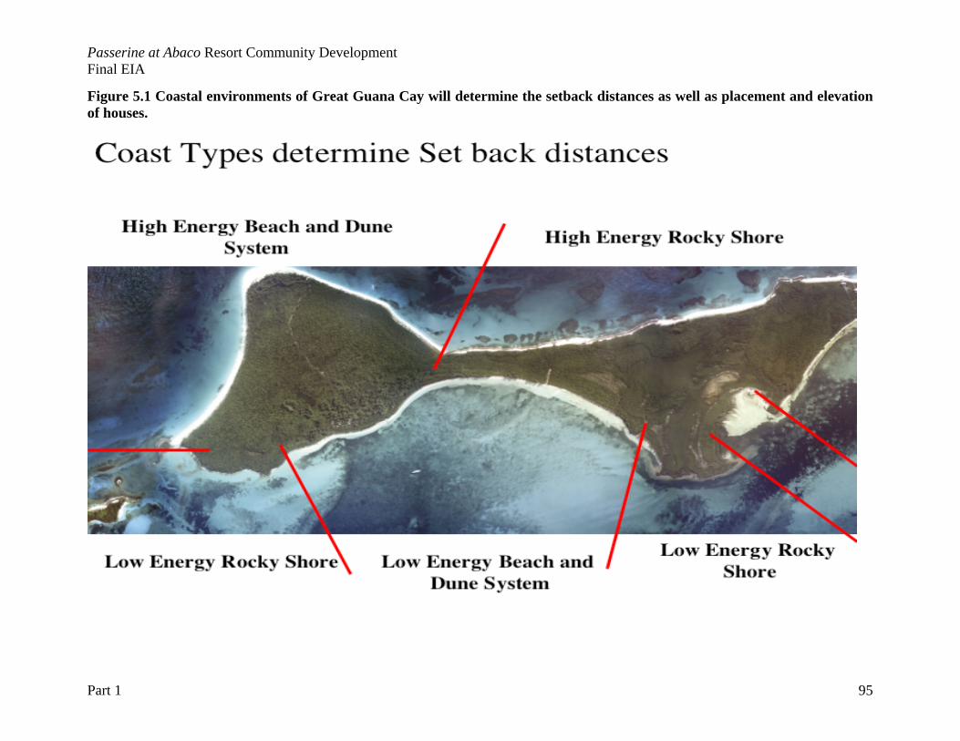
Passerine at Abaco Resort Community Development Final EIA
Part 1 95
Figure 5.1 Coastal environments of Great Guana Cay will determine the setback distances as well as placement and elevation of houses.
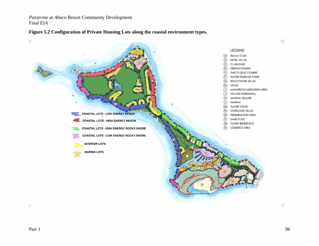
Passerine at Abaco Resort Community Development Final EIA
Part 1 96
Figure 5.2 Configuration of Private Housing Lots along the coastal environment types.
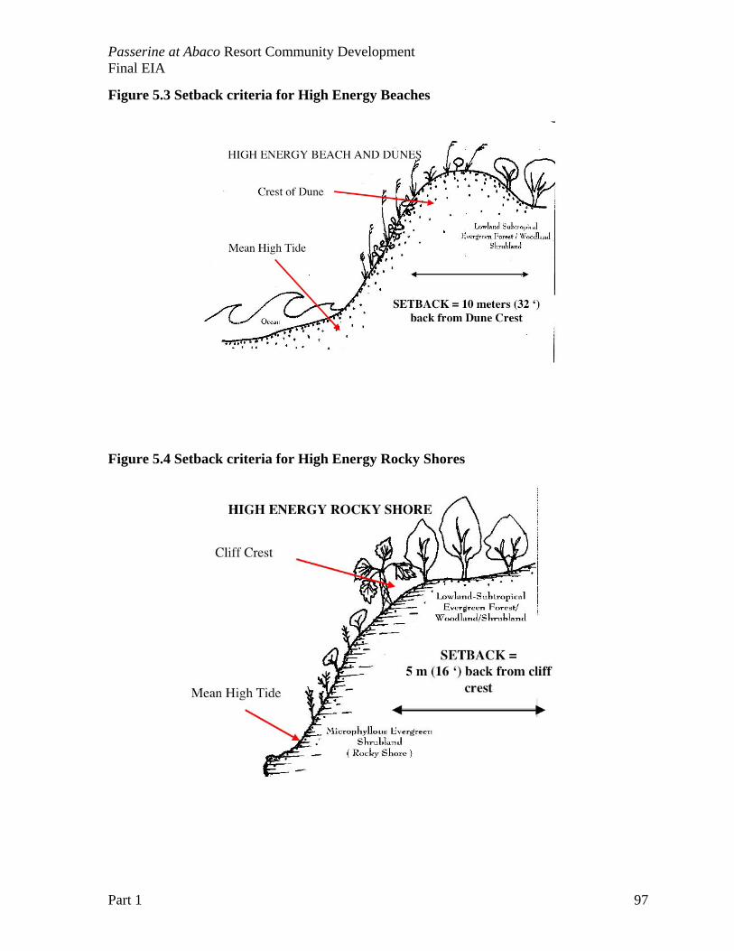
Passerine at Abaco Resort Community Development Final EIA
Part 1 97
Figure 5.3 Setback criteria for High Energy Beaches
Figure 5.4 Setback criteria for High Energy Rocky Shores
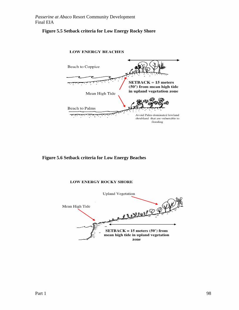
Passerine at Abaco Resort Community Development Final EIA
Part 1 98
Figure 5.5 Setback criteria for Low Energy Rocky Shore
Figure 5.6 Setback criteria for Low Energy Beaches
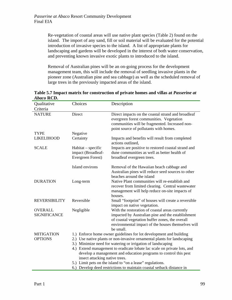
Passerine at Abaco Resort Community Development Final EIA
Part 1 99
Re-vegetation of coastal areas will use native plant species (Table 2) found on the island. The import of any sand, fill or soil material will be evaluated for the potential introduction of invasive species to the island. A list of appropriate plants for landscaping and gardens will be developed in the interest of both water conservation, and preventing known invasive exotic plants to introduced to the island. Removal of Australian pines will be an on-going process for the development management team, this will include the removal of seedling invasive plants in the pioneer zone (Australian pine and sea cabbage) as well as the scheduled removal of large trees in the previously impacted areas of the island.
Table 5.7 Impact matrix for construction of private homes and villas at Passerine at Abaco RCD. Qualitative Criteria
Choices Description
NATURE Direct
Direct impacts on the coastal strand and broadleaf evergreen forest communities. Vegetation communities will be fragmented. Increased non-point source of pollutants with homes.
TYPE Negative LIKELIHOOD Certainty Impacts and benefits will result from completed
actions outlined, SCALE Habitat – specific
impact (Broadleaf- Evergreen Forest)
Impacts are positive to restored coastal strand and dune communities as well as better health of broadleaf evergreen trees.
Island environs
Removal of the Hawaiian beach cabbage and Australian pines will reduce seed sources to other beaches around the island
DURATION Long-term
Native Plant communities will re-establish and recover from limited clearing. Central wastewater management will help reduce on-site impacts of houses.
REVERSIBILITY Reversible
Small “footprint” of houses will create a reversible impact on native vegetation.
OVERALL SIGNIFICANCE
Negligible
With the restoration of coastal areas currently impacted by Australian pine and the establishment of coastal vegetation buffer zones, the overall environmental impact of the houses themselves will be small.
MITIGATION OPTIONS
1.) Enforce home owner guidelines for lot development and building 2.) Use native plants or non-invasive ornamental plants for landscaping 3.) Minimize need for watering or irrigation of landscaping 4.) Extend management to eradicate lobate lac scale on private lots, and
develop a management and education programs to control this pest insect attacking native trees.
5.) Limit pets on the island to “on a lease” regulations. 6.) Develop deed restrictions to maintain coastal setback distance in
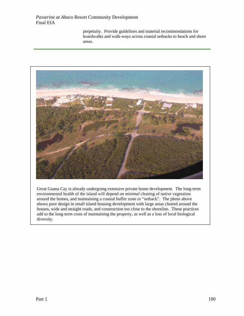
Passerine at Abaco Resort Community Development Final EIA
Part 1 100
perpetuity. Provide guidelines and material recommendations for boardwalks and walk-ways across coastal setbacks to beach and shore areas.
Great Guana Cay is already undergoing extensive private home development. The long-term environmental health of the island will depend on minimal clearing of native vegetation around the homes, and maintaining a coastal buffer zone or “setback”. The photo above shows poor design in small island housing development with large areas cleared around the houses, wide and straight roads, and construction too close to the shoreline. These practices add to the long-term costs of maintaining the property, as well as a loss of local biological diversity.
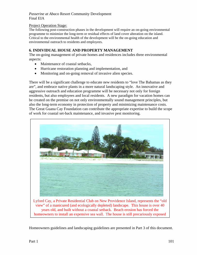
Passerine at Abaco Resort Community Development Final EIA
Part 1 101
Project Operation Stage: The following post-construction phases in the development will require an on-going environmental programme to minimize the long-term or residual effects of land cover alteration on the island. Critical to the environmental health of the development will be the on-going education and environmental outreach to residents and employees. 6. INDIVIDUAL HOUSE AND PROPERTY MANAGEMENT The on-going management of private homes and residences includes three environmental aspects:
• Maintenance of coastal setbacks, • Hurricane restoration planning and implementation, and • Monitoring and on-going removal of invasive alien species.
There will be a significant challenge to educate new residents to “love The Bahamas as they are”, and embrace native plants in a more natural landscaping style. An innovative and aggressive outreach and education programme will be necessary not only for foreign residents, but also employees and local residents. A new paradigm for vacation homes can be created on the premise on not only environmentally sound management principles, but also the long-term economy in protection of property and minimizing maintenance costs. The Great Guana Cay Foundation can contribute the appropriate expertise to build the scope of work for coastal set-back maintenance, and invasive pest monitoring.
Homeowners guidelines and landscaping guidelines are presented in Part 3 of this document.
Lyford Cay, a Private Residential Club on New Providence Island, represents the “old view” of a manicured (and ecologically depleted) landscape. This house is over 40
years old, and built without a coastal setback. Beach erosion has forced the homeowners to install an expensive sea wall. The house is still precariously exposed

Passerine at Abaco Resort Community Development Final EIA
Part 1 102
Passerine at Abaco Resort Community Development Final EIA
Part 1 103
CHAPTER 6: PROPOSED MITIGATION MEASURES There are seven proposed components of the mitigation plan. The goal of each component is proposed and explained, but the operation details are not presented. Criteria and conditions for accomplishing these mitigation goals will guide the development of operational plans. Overview of Mitigation Objectives Below is a set of guidelines used in the preparation of a mitigation plan for consistently addressing impacts previously identified and assessed.
Propose cost-effective and feasible measures to control, respond to, reduce, and/or mitigate adverse environmental impacts. There will not necessarily have a single measure for every adverse impact, but there are often several options that would minimize adverse impacts. Mitigation measures can include different types, such as:
• Planning: project design can reduce impacts, and throughout this document, project design has be explained in terms of impact reduction,
• Scheduling: determining most appropriate/inappropriate times for project activities (e.g., avoiding sensitive periods for species; consideration of weather-related seasons/events, etc.). Scheduling considerations are also mentioned in the impact assessment
• Operational: considering the manner in which project activities are carried out (e.g., minimal land clearing; hand-clearing vs. bulldozing, etc.).
• Technological: using control devices to prevent or restrict the release of deleterious substances (e.g., use of filters and scrubbers, etc.).
• Restoration: proposing procedures to reclaim disturbed sites and return areas to their original condition (e.g., slope stabilization and recontouring techniques, etc.).
• Management: including measures applied to the full spectrum of project/environment interactions; and/or can fulfill as a preventative role through restrictions, control, and maintenance activities.
• Compensation (for unavoidable/unmitigatable impacts): enhancement procedures (e.g., creation of wildlife habitat) or other monetary expenditures (e.g., wetland mitigation banks).
The Environmental Management Plan (Chapter 9) will outline the monitoring programs, environmental staff, and specifically management of upset/accident conditions, such as:
• Natural disasters (hurricanes and tropical storms) • Equipment failure (especially loss of power for water generation • Human errors (spills, unauthorized clearing, etc)
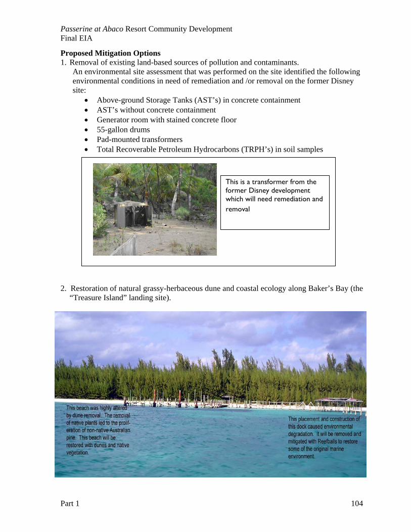
Passerine at Abaco Resort Community Development Final EIA
Part 1 104
Proposed Mitigation Options 1. Removal of existing land-based sources of pollution and contaminants.
An environmental site assessment that was performed on the site identified the following environmental conditions in need of remediation and /or removal on the former Disney site:
• Above-ground Storage Tanks (AST’s) in concrete containment • AST’s without concrete containment • Generator room with stained concrete floor • 55-gallon drums • Pad-mounted transformers • Total Recoverable Petroleum Hydrocarbons (TRPH’s) in soil samples
2. Restoration of natural grassy-herbaceous dune and coastal ecology along Baker’s Bay (the “Treasure Island” landing site).
This is a transformer from the former Disney development which will need remediation and removal
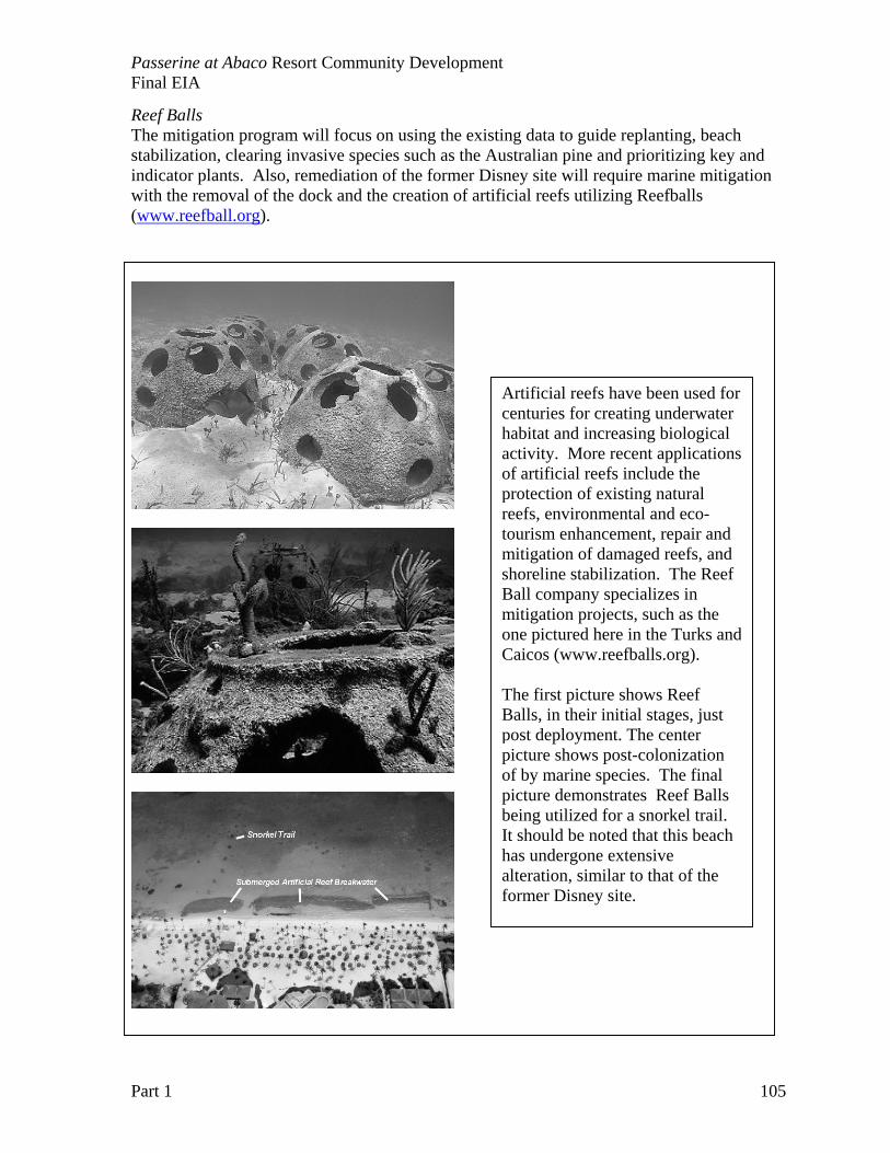
Passerine at Abaco Resort Community Development Final EIA
Part 1 105
Reef Balls The mitigation program will focus on using the existing data to guide replanting, beach stabilization, clearing invasive species such as the Australian pine and prioritizing key and indicator plants. Also, remediation of the former Disney site will require marine mitigation with the removal of the dock and the creation of artificial reefs utilizing Reefballs (www.reefball.org).
Artificial reefs have been used for centuries for creating underwater habitat and increasing biological activity. More recent applications of artificial reefs include the protection of existing natural reefs, environmental and eco-tourism enhancement, repair and mitigation of damaged reefs, and shoreline stabilization. The Reef Ball company specializes in mitigation projects, such as the one pictured here in the Turks andCaicos (www.reefballs.org). The first picture shows Reef Balls, in their initial stages, just post deployment. The center picture shows post-colonization of by marine species. The final picture demonstrates Reef Balls being utilized for a snorkel trail. It should be noted that this beach has undergone extensive alteration, similar to that of the former Disney site.
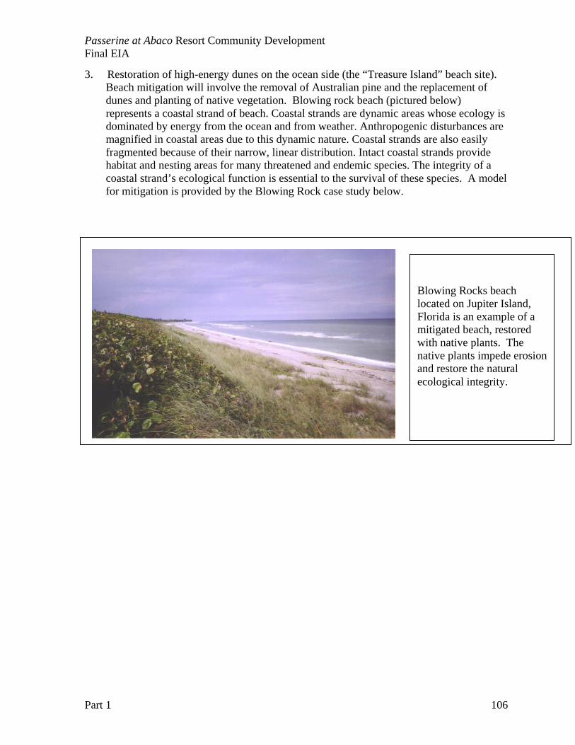
Passerine at Abaco Resort Community Development Final EIA
Part 1 106
3. Restoration of high-energy dunes on the ocean side (the “Treasure Island” beach site). Beach mitigation will involve the removal of Australian pine and the replacement of dunes and planting of native vegetation. Blowing rock beach (pictured below) represents a coastal strand of beach. Coastal strands are dynamic areas whose ecology is dominated by energy from the ocean and from weather. Anthropogenic disturbances are magnified in coastal areas due to this dynamic nature. Coastal strands are also easily fragmented because of their narrow, linear distribution. Intact coastal strands provide habitat and nesting areas for many threatened and endemic species. The integrity of a coastal strand’s ecological function is essential to the survival of these species. A model for mitigation is provided by the Blowing Rock case study below.
Blowing Rocks beach located on Jupiter Island, Florida is an example of a mitigated beach, restored with native plants. The native plants impede erosionand restore the natural ecological integrity.
Passerine at Abaco Resort Community Development Final EIA
Part 1 107
Blowing Rocks Preserve: A Model Approach to Beach Strand Restoration In dealing with coastal degradation and/or erosion in the Bahamas, lessons can be learned from
similar issues experienced along the coastline of South Florida. The geology and topography of Florida is very similar to that of the Bahamas, as land in both places is made up of exposed, low-lying carbonate deposits. Degradation of coastlines in South Florida has taken place in much the same way as it is currently occurring in the Bahamas. Coastal development and invasions by Casuarina trees have been (and in many cases still are) prevalent issues along much of the Florida coastline. To prevent further degradation and erosion of compromised shorelines, some measure of restoration is essential. Successful restoration is achieved when function is returned to the natural shoreline ecosystem. One success story in beach strand/shoreline restoration can be found at The Nature Conservancy’s Blowing Rocks Preserve, on Jupiter Island, Florida.
When The Nature Conservancy (TNC) acquired the 73 acres on Jupiter Island in 1969, the majority of the area was covered with non-native plants, especially Casuarina trees. Plans to begin a large-scale restoration of the area began with looking at historical aerial images to determine what vegetation types occurred and where they occurred within current Preserve boundaries. The images were also used to examine changes in vegetation over time, and to assess causes of change. With this information, staff at TNC created a map of the preserve showing coverage of the different types of vegetation that could be achieved through restoration. This map, which reflected historical vegetation coverage as well as permanent changes to the landscape that had occurred since, became a basis for restoration goals.
Concurrently, stewards of the preserve began a rigorous program to remove invasive plants. The help of the community was enlisted in this program. Volunteers were sought by passing out flyers advertising the need for weekend help in removing invasive species. The initial volunteer response was tremendous, however, too much time was allotted to overseeing volunteers that Preserve staff opted to target individual volunteers rather than to continue supervising large groups. Current individual volunteers in the non-native plant removal program have a higher level of safety training, allowing the use of more advanced and effective removal equipment, including herbicides.
A large effort was put forth to determine what to do with the bulky remains of cut Casuarina trees. Several different approaches to this problem were tried. Letting the felled trees decay naturally was not an option as the wood is dense and decays only very slowly. The wood of Casuarina burns very hot, and on-the-spot incineration proved to sterilize the soil and remove the seed bank of native vegetation, causing a temporary barren area. The felled trees were also processed and used as mulch in areas that were being re-planted. Finally, re-sprouting from cut stumps was the cause of large amounts of re-growth. It was determined that herbicide treatment, grinding the stump down to the roots, or removing the stump entirely was necessary to stop re-sprouting.
It was found that upon removal of Casuarina and other plants that caused unnatural shading or blocking of salt spray in beach strand areas, native vegetation returned without further effort. However, to create diversity within the vegetation, and to move toward restoration goals, TNC staff started a native plant nursery on the premises. Again using volunteers, native plant seeds were collected from the surrounding area. Seeds were prepared for germination (which sometimes included seed scarification) and planted in containers in a mixture of potting soil and sand or soil from local areas. Volunteers propagate and raise all plants in this nursery according to a set restoration schedule. For example, if it is known that a number of Sea Grape (Coccoloba uvifera) trees are to be out planted in a certain area, the growing process is started far in advance to ensure that trees are mature enough to survive on their own when out planted.
Restoration biologists working at the Preserve stressed the need to complete removal and restoration in phases so that habitat of some sort will always be available for wildlife. The restriction of foot and/or auto traffic to designated pathways is also necessary, as this type of disturbance destroys vegetation. Restoration of functioning strand/dune ecosystems at Blowing Rocks Preserve has been highly successful. Not only has this helped to preserve the shoreline, it has also become an attraction for tourists and local residents. (Case Study from: An Ecoregional Plan for the Bahamian Archipelago. Sealey et al, 2002).
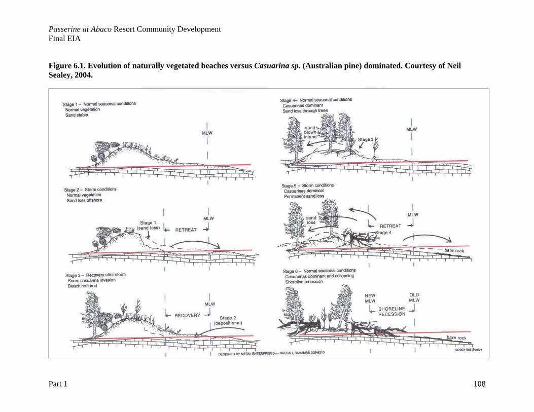
Passerine at Abaco Resort Community Development Final EIA
Part 1 108
Figure 6.1. Evolution of naturally vegetated beaches versus Casuarina sp. (Australian pine) dominated. Courtesy of Neil Sealey, 2004.
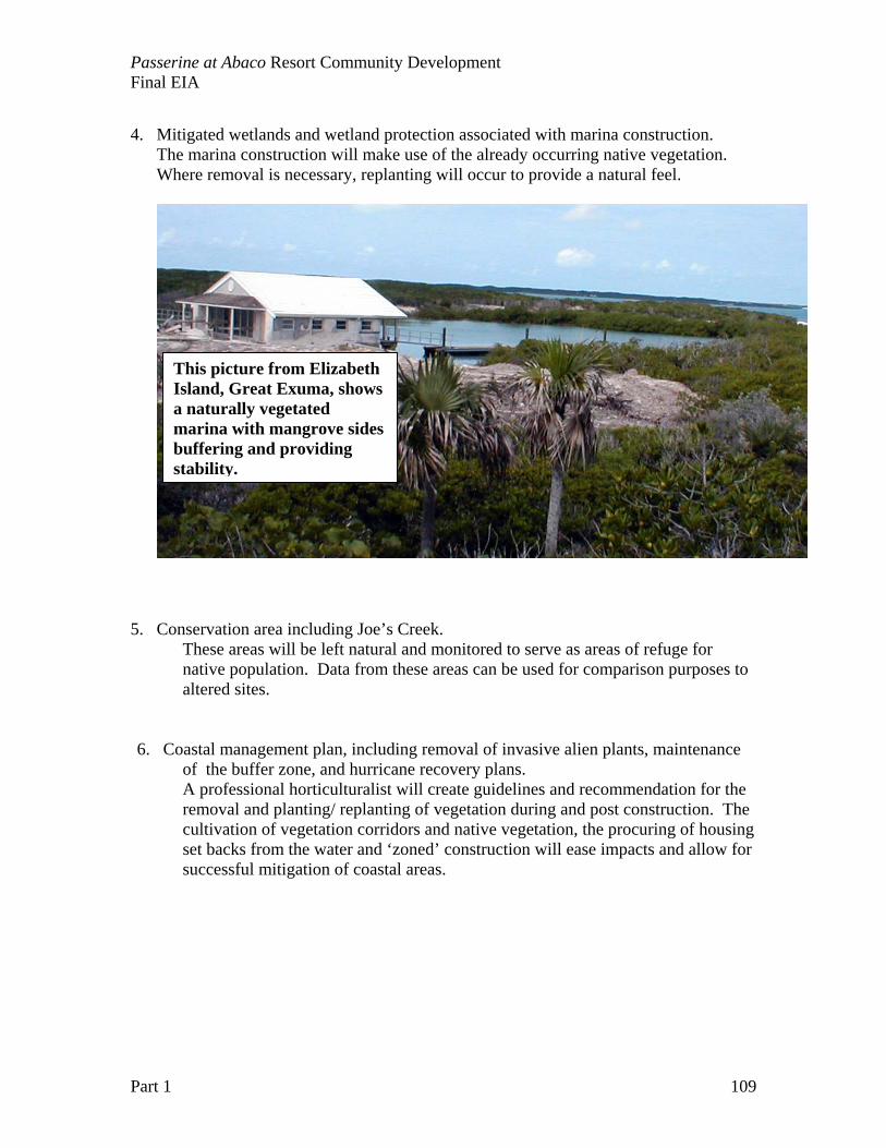
Passerine at Abaco Resort Community Development Final EIA
Part 1 109
4. Mitigated wetlands and wetland protection associated with marina construction.
The marina construction will make use of the already occurring native vegetation. Where removal is necessary, replanting will occur to provide a natural feel.
5. Conservation area including Joe’s Creek. These areas will be left natural and monitored to serve as areas of refuge for native population. Data from these areas can be used for comparison purposes to altered sites.
6. Coastal management plan, including removal of invasive alien plants, maintenance of the buffer zone, and hurricane recovery plans. A professional horticulturalist will create guidelines and recommendation for the removal and planting/ replanting of vegetation during and post construction. The cultivation of vegetation corridors and native vegetation, the procuring of housing set backs from the water and ‘zoned’ construction will ease impacts and allow for successful mitigation of coastal areas.
This picture from Elizabeth Island, Great Exuma, shows a naturally vegetated marina with mangrove sides buffering and providing stability.
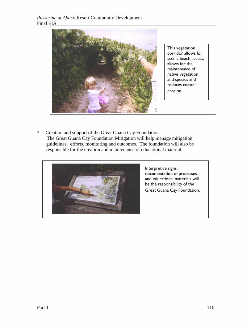
Passerine at Abaco Resort Community Development Final EIA
Part 1 110
7. Creation and support of the Great Guana Cay Foundation The Great Guana Cay Foundation Mitigation will help manage mitigation
guidelines, efforts, monitoring and outcomes. The foundation will also be responsible for the creation and maintenance of educational material.
This vegetation corridor allows for scenic beach access, allows for the maintenance of native vegetation and species and reduces coastal erosion.
Interpretive signs, documentation of processes and educational materials will be the responsibility of the Great Guana Cay Foundation.
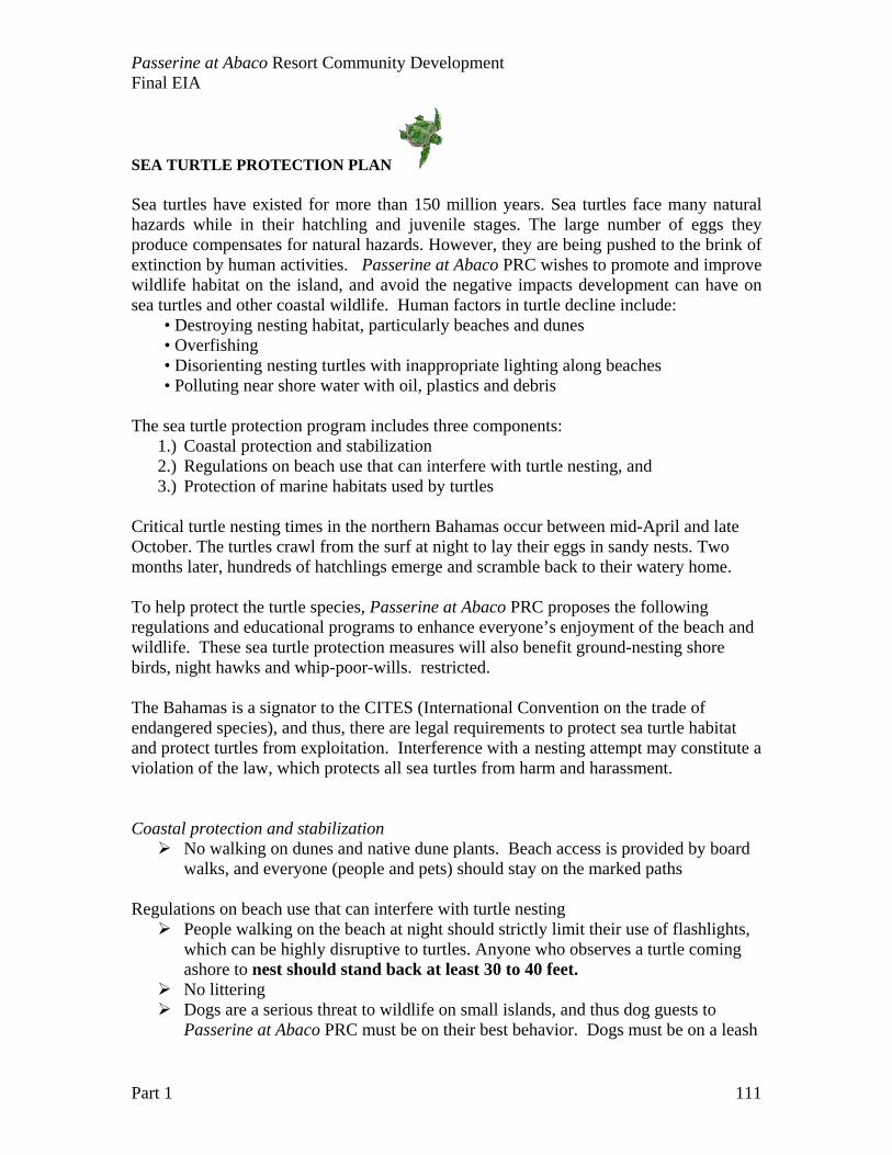
Passerine at Abaco Resort Community Development Final EIA
Part 1 111
SEA TURTLE PROTECTION PLAN Sea turtles have existed for more than 150 million years. Sea turtles face many natural hazards while in their hatchling and juvenile stages. The large number of eggs they produce compensates for natural hazards. However, they are being pushed to the brink of extinction by human activities. Passerine at Abaco PRC wishes to promote and improve wildlife habitat on the island, and avoid the negative impacts development can have on sea turtles and other coastal wildlife. Human factors in turtle decline include: • Destroying nesting habitat, particularly beaches and dunes • Overfishing • Disorienting nesting turtles with inappropriate lighting along beaches • Polluting near shore water with oil, plastics and debris The sea turtle protection program includes three components:
1.) Coastal protection and stabilization 2.) Regulations on beach use that can interfere with turtle nesting, and 3.) Protection of marine habitats used by turtles
Critical turtle nesting times in the northern Bahamas occur between mid-April and late October. The turtles crawl from the surf at night to lay their eggs in sandy nests. Two months later, hundreds of hatchlings emerge and scramble back to their watery home. To help protect the turtle species, Passerine at Abaco PRC proposes the following regulations and educational programs to enhance everyone’s enjoyment of the beach and wildlife. These sea turtle protection measures will also benefit ground-nesting shore birds, night hawks and whip-poor-wills. restricted. The Bahamas is a signator to the CITES (International Convention on the trade of endangered species), and thus, there are legal requirements to protect sea turtle habitat and protect turtles from exploitation. Interference with a nesting attempt may constitute a violation of the law, which protects all sea turtles from harm and harassment. Coastal protection and stabilization
No walking on dunes and native dune plants. Beach access is provided by board walks, and everyone (people and pets) should stay on the marked paths
Regulations on beach use that can interfere with turtle nesting
People walking on the beach at night should strictly limit their use of flashlights, which can be highly disruptive to turtles. Anyone who observes a turtle coming ashore to nest should stand back at least 30 to 40 feet. No littering Dogs are a serious threat to wildlife on small islands, and thus dog guests to
Passerine at Abaco PRC must be on their best behavior. Dogs must be on a leash
Passerine at Abaco Resort Community Development Final EIA
Part 1 112
at all times from March 16 to October 31 except on beaches along Baker’s Bay. From November 1 to March 15, dogs can be unleashed for the entirety of the beach so long as the animal is under voice control. Please leash your pets after dark and don't let them go into the dunes. Overnight storage of beach equipment (e.g. chairs, umbrellas, etc.) is prohibited
along the windward beaches No fires or fireworks on the windward beaches No overnight sleeping or public nudity (very disturbing to turtles) Do not position yourself in front of a nesting female. This action may cause her to
abort her nesting attempt. Watch for and avoid hatchlings emerging from a nest. They are small and easily
stepped on in the dark. Avoid using flashlights or flash cameras. Lights disrupt or disorient nesting
turtles and emerging hatchlings.
Beach Lighting is perhaps one of the most critical issues for coastal development. There are ways to avoid the disorientation of turtles, and make the beach attractive to people and turtles. The goal is to keep lights out on the beach, including flash cameras and flashlights.
General Information about Sea Turtles and Lights For millions of years female sea turtles have been coming ashore to lay their eggs on beaches. In the past the hatchling turtles were guided to the ocean by an instinct to travel away from the dark silhouettes of the dune vegetation and toward the brightest horizon which was the light from the sky reflecting off the ocean. In present times however, many coastal areas are highly populated. There are many artificial lights near the beach that can deter females from nesting and disorient hatchling sea turtles. The hatchlings travel inland, toward the artificial lights, where they often die from dehydration, are preyed upon by fire ants and ghost crabs, or sometimes crawl onto the road where they are run over by cars.
There are ways that beach front property owners can modify their lights to prevent them from being seen from the beach. The following is a list of suggestions (these solutions may need to be used in conjunction with one another in order to prevent sea turtle disorientation).
Turn off unnecessary lights. Don’t use decorative lighting (such as runner lights or uplighting of vegetation) in areas that are visible from the beach and permanently remove, disable, or turn off fixtures that cannot be modified in any other way. For lights that can be repositioned, face them away from the beach so that the
light source is no longer visible. Shield the light source. Materials such as aluminum flashing can be used as a
shield to direct light and keep it off the beach. When shielding lights, it is important to make sure they are shielded from all areas on the beach
Passerine at Abaco Resort Community Development Final EIA
Part 1 113
(including from either side and on top), and not just from the beach directly in front of the light.
Light sockets with an exposed light source (such as plain bulbs) should be replaced with fixtures that are specially made to recess and/or the light source should be shielded. Replace fixtures that scatter light in all directions (such as globe lights or
carriage lights) with directional fixtures that point down and away from the beach. Replace lights on poles with low profile, low-level lamps so that the light
source and reflected light are not visible from the beach. Replace incandescent, fluorescent, and high intensity lighting with the lowest
wattage low-pressure sodium vapor lighting or replace white incandescent bulbs with "bug" lights of 50 watts or less. Plant or improve vegetation buffers (such as sea grapes and other native beach
vegetation) between the light source and the beach to screen light from the beach. Use shielded motion detector lights for lighting, and set them on the shortest
time setting. To reduce spillover from indoor lighting move light fixtures away from
windows, apply window tint to your windows that meets the 45% inside to outside transmittance standards for tinted glass (you’ll save on air conditioning costs too!), or use window treatments (blinds, curtains) to shield interior lights from the beach. Agencies such as the Florida Wildlife Commission advocate the use of ‘turtle
friendly’ lights. Some lights that are considered turtle friendly are bug lights and Low Pressure Sodium (LPS) lights.
Protection of marine habitats used by turtles
Encourage regulations requiring that lights not shine on nesting beaches. Use structural shields or vegetation hedges. Low pressure sodium vapour lights emit wavelengths less attractive to sea turtles and their use should be encouraged. Don't drive vehicles or ride horses on potential nesting beaches. These
activities crush incubating eggs, and tire ruts trap hatchlings as they crawl to the sea. Don't leave lounge chairs, sailboats, and other obstructions on nesting beaches
at night. Don't litter sandy beaches. Discarded cans and bottles are unsightly and can
cause injury to nesting turtles.
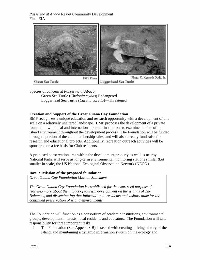
Passerine at Abaco Resort Community Development Final EIA
Part 1 114
Species of concern at Passerine at Abaco:
Green Sea Turtle (Chelonia mydas) Endangered Loggerhead Sea Turtle (Caretta caretta)—Threatened
Creation and Support of the Great Guana Cay Foundation BMP recognizes a unique education and research opportunity with a development of this scale on a relatively unaltered landscape. BMP proposes the development of a private foundation with local and international partner institutions to examine the fate of the island environment throughout the development process. The Foundation will be funded through a portion of the club membership sales, and will also directly fund raise for research and educational projects. Additionally, recreation outreach activities will be sponsored on a fee basis for Club residents. A proposed conservation area within the development property as well as nearby National Parks will serve as long-term environmental monitoring stations similar (but smaller in scale) the US National Ecological Observation Network (NEON). Box 1: Mission of the proposed foundation Great Guana Cay Foundation Mission Statement The Great Guana Cay Foundation is established for the expressed purpose of learning more about the impact of tourism development on the islands of The Bahamas, and disseminating that information to residents and visitors alike for the continued preservation of island environments.
The Foundation will function as a consortium of academic institutions, environmental groups, development interests, local residents and educators. The Foundation will take responsibility for three important tasks
i. The Foundation (See Appendix B) is tasked with creating a living history of the island, and maintaining a dynamic information system on the ecology and
Passerine at Abaco Resort Community Development Final EIA
Part 1 115
physical environment of Great Guana Cay before, during and after development of the Passerine residential development and resort.
ii. The Foundation is tasked with the maintenance and management of the conservation areas within the Passerine Cay development including mangroves, beaches and coastal buffer zones.
iii. The Foundation is tasked with promoting and facilitating interactions between scientists involved with long-term environmental research and monitoring in the environs with outreach and education programs for island residents and Bahamians.

Passerine at Abaco Resort Community Development Final EIA
Part 1 116

Passerine at Abaco Resort Community Development Final EIA
Part 1 117
CHAPTER 7: EVALUATION OF RESIDUAL IMPACTS The involvement of ecologists and a research team is critical to understanding the long-term impacts to the island environment. The Passerine at Abaco presents a great opportunity to local and international naturalists to study first hand the impact of various practices, and see the long-term implications of development. The on-going monitoring of the site will provide a “scorecard” evaluation of the site twice a year. This scorecard will allow Government and non-government organizations see the performance of the Developers against the stated environment goals. The promotion of Passerine at Abaco as a case study site for small island development will encourage independently funded research on the island, and in adjacent marine environments.

Passerine at Abaco Resort Community Development Final EIA
Part 1 118
Passerine at Abaco Resort Community Development Final EIA
Part 1 119
CHAPTER 8 – PUBLIC CONSULTATION At the time of EIA preparation, BMP have not had the opportunity to begin a public consultation process. Public discussion of the project has been discouraged prior to final project approval through the Office of the Prime Minister. BMP is committed to a thorough public consultation process outlined in this chapter. Any process of outreach and public consultation revolves around three fundamental questions:
1.) Who are the stakeholders? 2.) What is the message that needs to be delivered? And 3.) How can feedback be managed and a dialog established?
The process of public consultation follows a logical sequence of steps starting with information interviews with a wide spectrum of residents and visitors to gather views and perceptions on development, and on the Passerine at Abaco PRC in particular. A list of stakeholder groups and contacts is developed. With the list of stakeholders in hand, information can be developed along important themes: basic information, future consequences and changes, and opportunities for dialogue. Lastly, there needs to be a mechanism in place to allow feedback, hear legitimate concerns, and share information on permits or sections of the EIA. The proposed development is private, and thus there are limited demands that can be made by certain stakeholders (e.g. yachting tourists that have “for years” come ashore to visit the island). Establishing the Stakeholders There are many stakeholders with real and perceived impacts from further development in northern Abaco. Stakeholders can range from tourists that return every year to the same local resort to use the area for recreation to Bahamians that have spent all their lives in local settlements. People perceive the impact to themselves as economic, aesthetic or a combination of both. A partial list of stakeholders would include:
• Local Bahamian residents of the Guana Cay settlement • Bahamian residents of the northern Abacos • Home owners on Great Guana Cay • Boaters and yachting tourists • Marsh Harbour Chamber of Commerce and local businessmen • Local Non-government environmental organizations (Friends of the Environment) • National Non-government environmental organizations (Bahamas National Trust)
Determining the Message The proposed development will change the landscape of the northern Abacos, and change the quality of life for many residents. There are several important implications of this development as part of a trend towards populating the offshore cays with second homes and private residential clubs (e.g. Matt Lowe Cay, Scotland Cay, and Orchid Bay). The process of public consultation should include three themes:
• Passerine at Abaco PRC design and impact assessment: the first theme should be primarily providing information to the stakeholders.
• Implications for the future of small island communities: The proposed development can help communities see that the density of people on these small islands is impacting the quality of the environment. The fact that Passerine at Abaco PRC will plan and put into place advanced waste water treatment BEFORE homes are built should send a message to the local settlement and other developments that the days of cess pits are numbered.
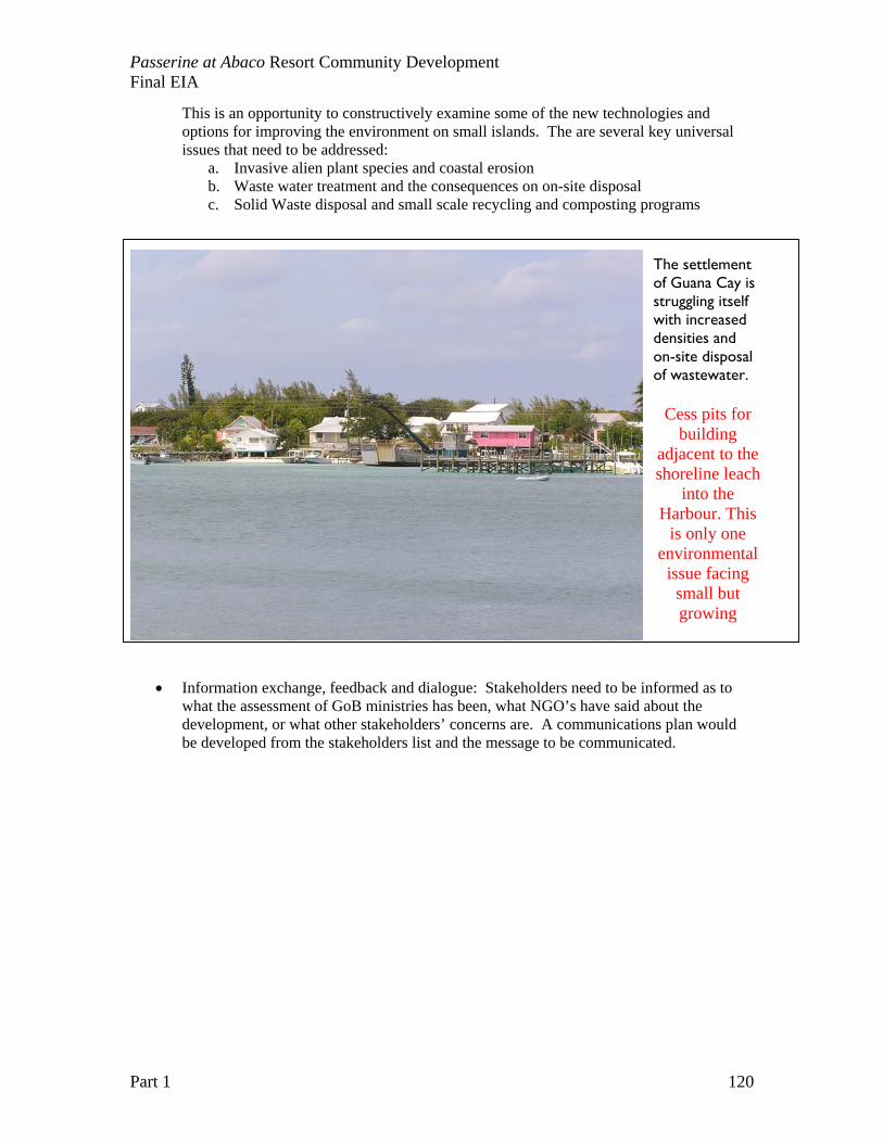
Passerine at Abaco Resort Community Development Final EIA
Part 1 120
This is an opportunity to constructively examine some of the new technologies and options for improving the environment on small islands. The are several key universal issues that need to be addressed:
a. Invasive alien plant species and coastal erosion b. Waste water treatment and the consequences on on-site disposal c. Solid Waste disposal and small scale recycling and composting programs
• Information exchange, feedback and dialogue: Stakeholders need to be informed as to what the assessment of GoB ministries has been, what NGO’s have said about the development, or what other stakeholders’ concerns are. A communications plan would be developed from the stakeholders list and the message to be communicated.
The settlement of Guana Cay is struggling itself with increased densities and on-site disposal of wastewater.
Cess pits for building
adjacent to the shoreline leach
into the Harbour. This
is only one environmental
issue facing small but growing
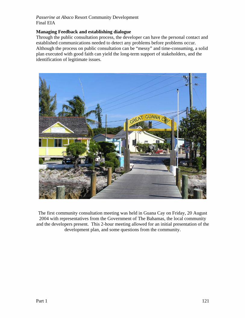
Passerine at Abaco Resort Community Development Final EIA
Part 1 121
Managing Feedback and establishing dialogue Through the public consultation process, the developer can have the personal contact and established communications needed to detect any problems before problems occur. Although the process on public consultation can be “messy” and time-consuming, a solid plan executed with good faith can yield the long-term support of stakeholders, and the identification of legitimate issues.
The first community consultation meeting was held in Guana Cay on Friday, 20 August 2004 with representatives from the Government of The Bahamas, the local community
and the developers present. This 2-hour meeting allowed for an initial presentation of the development plan, and some questions from the community.

Passerine at Abaco Resort Community Development Final EIA
Part 1 122
Passerine at Abaco Resort Community Development Final EIA
Part 1 123
CHAPTER 9: ENVIRONMENTAL MANAGEMENT PLAN The involvement of ecologists and a research team is critical to understanding the long-term impacts to the island environment. The Passerine at Abaco presents a great opportunity to local and international naturalists to study first hand the impact of various practices, and see the long-term implications of development. The promotion of Passerine at Abaco as a case study site for small island development will encourage independently funded research on the island, and in adjacent marine environments. Plan Components and Overview The Passerine at Abaco is a unique development project in the transparency of its site management and environmental reporting. The project will be an experiment in sustainability for small island developments. Clearly, local residents or Bahamians in general would not appreciate being the site of “experimental” approaches to development of their natural resources, but the aim of the experiment is to provide a truthful documentation of the real ecological costs. The Great Guana Cay site is already severely impacted by previous development at the “Treasure Island Site”. The appendices include a section of news articles from 1988 and 1989 on the controversies that surrounded the original construction of the cruise ship resort site and approach channel. Without legal action against the present owner for mitigation costs, the ecological health of the property will continue to decline. There are significant environmental issues associated with
• Unknown material dumped in two landfills • Invasive alien plants displacing native vegetation • Invasive alien insects (Lobate Lac Scale Insect) impacting the health of native
trees, especially after hurricane disturbances. • Erosion of beaches from the removal of dunes and natural vegetation along
Bakers Bay • Erosion of beaches from Australian pine (invasive alien plants) • Accumulation of trashes and unregulated dumping
There is no stewardship of the natural resources or management of the property of this time. Many people, both local residents and visiting yachtsmen, reportedly use the property, yet no person or organization takes responsibility for management or stewardship of the resources. As land becomes increasingly scarce in the Abacos (and all of The Bahamas), there needs to be an overall land use plan that sets aside natural areas for tourism, recreation, and conservation of the natural heritage of the country. This Environmental Management Plan (EMP) outlines four components that set a model for private land stewardship in the country, particularly for private resort communities with technologies and protocols appropriate for use in national parks and publicly-held lands (Crown land).
Passerine at Abaco Resort Community Development Final EIA
Part 1 124
Four facets of the EMP designed to disseminate information, define procedures and accountability and coordinate all necessary personnel and stakeholders include:
5.) Clearly articulated and measurable environmental goals 6.) Educational outreach programs and training material for
a. Contractors, construction crews and all on-site workers b. Local communities c. Regional Non-government environmental organizations (e.g. Friends of
the Environment) d. Local businesses and business leaders
7.) Clear management and project communications and reporting with a. Published “Chain of Command” for site management b. Documentation and accountability to EIA policies c. Incident reporting and management plan d. Clear reporting responsibilities
8.) Independent reporting and verification, with monitoring data available in a “score card” format.
It is often very difficult to document the real ecological costs of development until many years after the developers have completed the job and left. The long-term environmental impacts pose a significant financial burden to residents of the resort community. For example, resort development in the Florida Keys commonly underestimated the flushing rates of residential finger canal systems. Twenty to thirty years after the construction, residents are faced with very expensive mitigation options to improve near shore and canal water quality, with millions of dollars slated for advanced wastewater treatment plants, backfilling canals, and re-landscaping canal margins. The developers have shown an unusual willingness to work with researchers and scientists to better understand the environment of Guana Cay. It is common for development and resort companies to say, “we adhere to the highest environmental standards”, but what those standards are, and how appropriate standard industry practices are for small carbonate islands is yet to be documented. There is an opportunity with the Passerine at Abaco project to complete an initial ecological assessment of the property prior to development, and set measurable environmental goals. The goals can help both the development team and scientists understand the economic “break points” in small island development. Are golf courses always the “high impact” component of the resort? How can the known impacts be reduced? The EMP will address the critical need to have measurable environmental goals assessed in an objective and independent manner to report on the long-term implications of small island development. The complete EMP will consist of ecological and environmental monitoring programs, mitigation plans, an outreach and education program, and reporting and research. All monitoring programs will consist of three sections: a) pre-construction, b) during construction, and c) post construction. Impact matrices and ‘score cards’ will be used to gauge and measure adherence to monitoring goals and objectives. The mitigation plan,

Passerine at Abaco Resort Community Development Final EIA
Part 1 125
outreach and education program, and reporting and research programs will be ongoing and adaptive to the stages of development. A website and a ftp site will be maintained to post information and coordinate persons involved in various aspects of the project. The Great Guana Cay Foundation will carry out the reporting and verification. This foundation will coordinate the on-going research and monitoring of the site with academic partners (University of Miami and College of The Bahamas). Information collected will be available for publication and dissemination in the spirit of improving development practices with known ecological impacts and economic costs for “best practices”. Data and results will be reported in the “score card” format to allow for ease of understanding and adaptive management of the project. The components of the EMP will work together to achieve and maintain the following proposed environmental goals for Passerine at Abaco:
1.) To maintain representation of all the natural vegetation communities on the island 2.) To maintain water quality parameters in coastal groundwater and near shore
marine waters at pre-construction levels. 3.) To enhance wildlife habitat quality in the coastal zone, wetlands and preserve
areas, with measurable increases in targeted conservation species. 4.) To maintain coastal stability with the measurable maintenance of beaches, and
natural recovery of beaches from storm disturbances.
Figure 9.1. Environmental Management Plan and Components
The components of the EMP include:
A. Ecological and Marina Monitoring Programs REA
Prior to the construction of Passerine a Rapid Ecological Assessment (REA) was performed to specifically assess the biological communities (upland, coastal and near shore) and to gather baseline data in the areas targeted for development. The following habitats were assessed:
Environmental Management
Plan
Outreach and Education
Monitoring Programs
Reporting and Dissemination
Ecological
Website
Environmental
Construction: Housing, Marina and Golf Course
Great Guana Cay Foundation
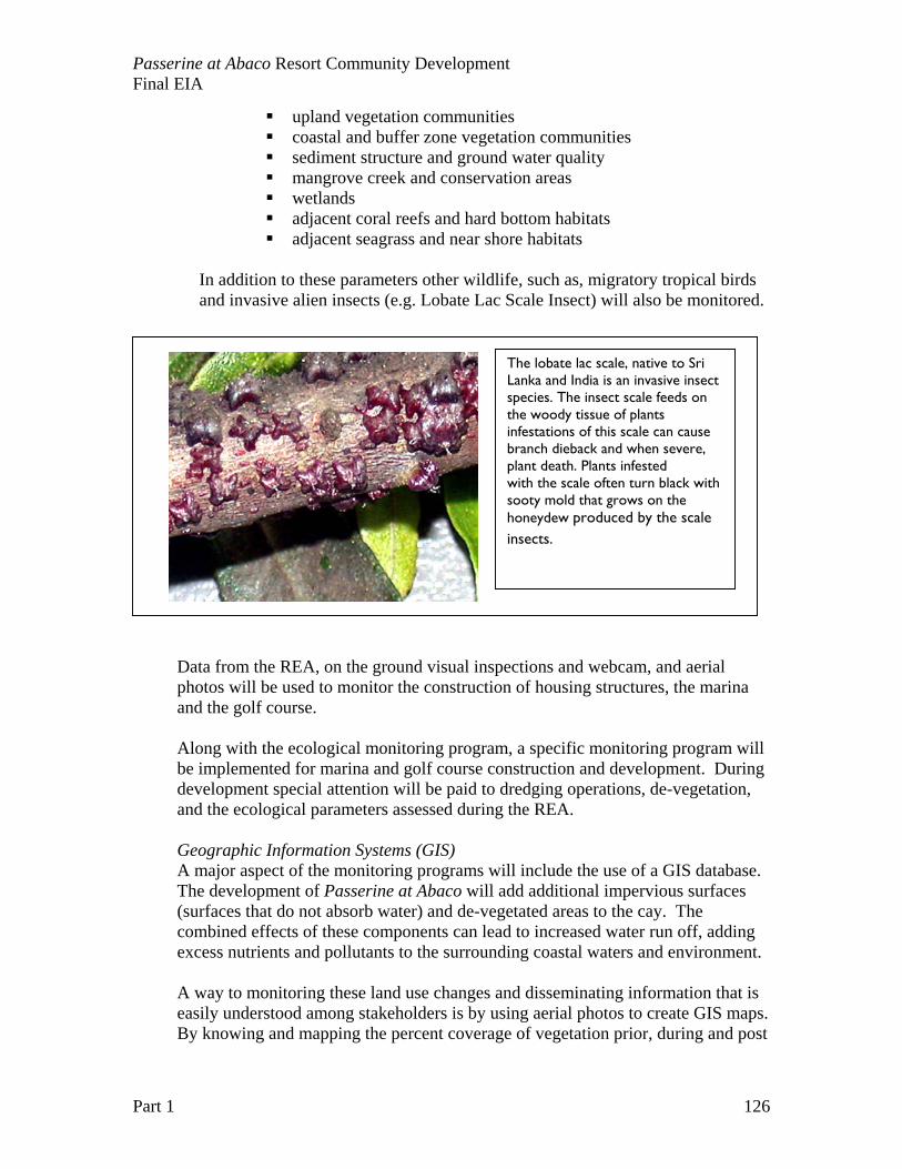
Passerine at Abaco Resort Community Development Final EIA
Part 1 126
upland vegetation communities coastal and buffer zone vegetation communities sediment structure and ground water quality mangrove creek and conservation areas wetlands adjacent coral reefs and hard bottom habitats adjacent seagrass and near shore habitats
In addition to these parameters other wildlife, such as, migratory tropical birds and invasive alien insects (e.g. Lobate Lac Scale Insect) will also be monitored.
Data from the REA, on the ground visual inspections and webcam, and aerial photos will be used to monitor the construction of housing structures, the marina and the golf course. Along with the ecological monitoring program, a specific monitoring program will be implemented for marina and golf course construction and development. During development special attention will be paid to dredging operations, de-vegetation, and the ecological parameters assessed during the REA. Geographic Information Systems (GIS) A major aspect of the monitoring programs will include the use of a GIS database. The development of Passerine at Abaco will add additional impervious surfaces (surfaces that do not absorb water) and de-vegetated areas to the cay. The combined effects of these components can lead to increased water run off, adding excess nutrients and pollutants to the surrounding coastal waters and environment. A way to monitoring these land use changes and disseminating information that is easily understood among stakeholders is by using aerial photos to create GIS maps. By knowing and mapping the percent coverage of vegetation prior, during and post
The lobate lac scale, native to Sri Lanka and India is an invasive insect species. The insect scale feeds on the woody tissue of plants infestations of this scale can cause branch dieback and when severe, plant death. Plants infested with the scale often turn black with sooty mold that grows on the honeydew produced by the scale insects.
Passerine at Abaco Resort Community Development Final EIA
Part 1 127
construction, analysis of impacts will be implemented. Already existing, pre-construction maps of the vegetated areas will be used as a baseline to monitor these alterations, highlights areas of concern during construction and post construction. The monitoring program will utilize software and guidelines that were developed directly for the purpose of impervious / de-vegetated surface analysis by the National Oceanic and Atmospheric Administration (NOAA) Coastal Service Center and the University of Connecticut’s Nonpoint Education of Municipal Officials (NEMO).
B. Environmental Monitoring Program The environmental monitoring program will focus on: 1. Waste Disposal 2. Sewage Treatment and Management 3. Water Quality Monitoring (Ground water and Coastal)
C. Mitigation Program The proposed mitigation plan and components are outlined in Chapter 6. A variety of tools and resources will be used to implement, document and monitor mitigation efforts. Best management practices following native vegetation guidelines, utilizing artificial reefs (Reef balls), and GIS mapping will all be integrated.
D. Outreach and Education Outreach and education will be used to improve coordination between agencies, stakeholders, scientists, etc. A database and website will be developed to coordinate and disseminate data and pertinent information. The majority of these activities will be carried out by the Great Guana Cay Foundation.
E. Reporting and Research
The development and protocols of Passerine are aimed at setting high environmental standards. Thus ongoing research documenting and reporting community / stakeholder relations, construction phases and ecological effects will be an integral part of the EMP.
Incident Management and Reporting With the Great Guana Cay Foundation, the Environmental management team will work to develop strategies and scope of work for implementing:
• Educational outreach programs and training programs • Clear management and project communications and reporting • Independent reporting and verification
The course of development, the results of the monitoring programs and any incidental occurrences will be documented on a regular basis. Information gained and processed will be reported directly to all necessary government agencies and stakeholders. A defined liaison will be identified with this responsibility.

Passerine at Abaco Resort Community Development Final EIA
Part 1 128
Passerine at Abaco Resort Community Development Final EIA
Part 1 129
CHAPTER 10: CONCLUSIONS Passerine at Abaco is a unique development project for the Bahamas with a partnership between ecologists and developers. The project offers a rare opportunity to document “best practices” in small island development, and record an accurate account of biological diversity loss with large-scale land conversion on a small island. The overall goal of the development collaboration is to maintain and celebrate the unique features of the island environment, and create a uniquely Bahamian setting for a resort community. The planned land conversion is substantial for the small island settling, but the investment in sewage and solid waste infrastructure at the onset of development could provide a model to improve environmental protection for other small island settlements and communities.
Related Documents