*OFFICIAL USE ONLY GOVERNMENT OF THE PEOPLE’S REPUBLIC OF BANGLADESH ROADS AND HIGHWAYS DEPARTMENT MINISTRY OF ROAD TRANSPORT AND BRIDGES Western Economic Corridor & Regional Enhancement Program (WeCARE Program) Hatikumrul-Bonpara-Ishwardi-Kushtia-Jhenaidah Road Environmental Impact Assessment (EIA) September 2020

Welcome message from author
This document is posted to help you gain knowledge. Please leave a comment to let me know what you think about it! Share it to your friends and learn new things together.
Transcript
*OFFICIAL USE ONLY
GOVERNMENT OF THE PEOPLE’S REPUBLIC OF BANGLADESH ROADS AND HIGHWAYS DEPARTMENT
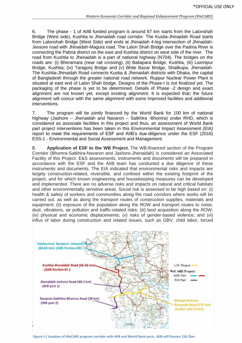
MINISTRY OF ROAD TRANSPORT AND BRIDGES
Western Economic Corridor & Regional Enhancement Program
(WeCARE Program)
Hatikumrul-Bonpara-Ishwardi-Kushtia-Jhenaidah Road
Environmental Impact Assessment (EIA)
September 2020
Western Economic Corridor and Regional Enhancement Program (WeCARE)
EIA - Bangladesh: Hatikumrul – Bonpara – Jhenaida Road Page | i
*OFFICIAL USE ONLY
Table of Contents ABBREVIATIONS.................................................................................................................................... x
EXECUTIVE SUMMARY......................................................................................................................... xi
I. INTRODUCTION ............................................................................................................................ 1
A. Background ............................................................................................................................... 1
B. Project scope ............................................................................................................................ 1
C. Categorization .......................................................................................................................... 3
D. Scope of this report and limitation .......................................................................................... 3
E. Extent of the EIA Study ............................................................................................................. 4
F. Objectives of this EIA ................................................................................................................ 5
G. Approach & Methodology ........................................................................................................ 5
1. Approach .............................................................................................................................. 5
2. Methodology ........................................................................................................................ 5
H. Contents of the Report ........................................................................................................... 12
II. ENVIRONMENTAL POLICY, LEGAL AND ADMINISTRATIVE FRAMEWORK .................................. 14
A. Regulatory Requirements for the Project .............................................................................. 14
B. National Legal and Institutional Framework .......................................................................... 14
1. National Environmental Policy, 1992 ................................................................................. 14
2. National Environmental Management Action Plan (NEMAP), 1995 .................................. 14
3. Environmental Conservation Act (ECA), 1995 .................................................................... 15
4. Environment Conservation Rules, 1997 (Amended in 2002) ............................................. 16
5. Environmental Courts Act, 2000 ........................................................................................ 17
6. The EIA Guidelines for Industry (1997) .............................................................................. 17
7. National Land Transport Policy, 2004 ................................................................................ 18
8. Environmental Guideline of RHD, 2004.............................................................................. 18
9. RHD’s Road Master Plan, 2009 ........................................................................................... 19
10. The Forest Act (1927) and the Forest (Amendment) Act (2000).................................... 19
11. National Forest Policy (amendment), 1994.................................................................... 19
12. The Private Forests Ordinance, 1959 ............................................................................. 19
13. Bangladesh Wildlife (Conservation & Security) Act, 2012 ............................................. 20
14. National Water Policy, 1999 ........................................................................................... 20
15. National Fisheries Policy, 1998 ....................................................................................... 21
16. Protection and Conservation of Fish Act 1950 (Amended 1982) ................................... 21
17. National Agriculture Policy, 1999 ................................................................................... 22
Western Economic Corridor and Regional Enhancement Program (WeCARE)
EIA - Bangladesh: Hatikumrul – Bonpara – Jhenaida Road Page | ii
*OFFICIAL USE ONLY
18. National Land Use Policy, 2001 ...................................................................................... 22
19. The Embankment and Drainage Act, 1952 ..................................................................... 22
20. Bangladesh Climate Change Strategy and Action Plan (BCCSAP) 2009 .......................... 22
C. International Conventions, Treaties and Protocols (ICTPs) .................................................... 23
D. Asian Infrastructure Investment Bank (AIIB) Environment and Social Framework and
Standards ........................................................................................................................................ 25
E. Legislation Relating to Occupational Health and Safety ........................................................ 26
F. Legislation Relating to Stakeholder Engagement and Information Disclosure ...................... 27
G. Environmental Categorization by GoB ................................................................................... 27
H. Environmental Categorization by AIIB ................................................................................... 28
I. GoB Environmental Clearance................................................................................................ 28
J. Environmental Studies Needed .............................................................................................. 30
K. Institutional arrangements ..................................................................................................... 31
1. RHD ..................................................................................................................................... 31
2. AIIB ..................................................................................................................................... 31
L. AIIB policies ............................................................................................................................ 32
M. Harmonization of policies of AIIB and GoB ........................................................................ 35
III. DESCRIPTION OF THE PROJECT .............................................................................................. 38
A. General ................................................................................................................................... 38
B. Need for the Project ............................................................................................................... 38
C. Location and Size of the Road ................................................................................................ 38
D. Design Features ...................................................................................................................... 43
E. Subproject Components ......................................................................................................... 44
1. Alignment and Right of Way (ROW) ................................................................................... 44
2. Designs for the Alignment .................................................................................................. 44
3. Pavement Design ................................................................................................................ 47
4. Intersections ....................................................................................................................... 47
5. Bridges and Culverts ........................................................................................................... 47
F. Materials Used and Sources for Construction ........................................................................ 49
1. Earthworks ......................................................................................................................... 49
2. Concrete Aggregate ............................................................................................................ 49
3. Cement and Steel Reinforcement ...................................................................................... 50
4. Bitumen .............................................................................................................................. 50
5. Recycled Pavement Materials ............................................................................................ 50
Western Economic Corridor and Regional Enhancement Program (WeCARE)
EIA - Bangladesh: Hatikumrul – Bonpara – Jhenaida Road Page | iii
*OFFICIAL USE ONLY
G. Existing Traffic and Forecast ................................................................................................... 50
H. Social and Resettlement Considerations ................................................................................ 50
IV. DESCRIPTION OF THE BASELINE ENVIRONMENT ................................................................... 53
A. General ................................................................................................................................... 53
B. Physical Environment ............................................................................................................. 53
1. Climate................................................................................................................................ 53
2. Topography ........................................................................................................................ 56
3. Physiographic Features ...................................................................................................... 57
4. Geology and Soil ................................................................................................................. 58
5. Water Resources and Hydrology ........................................................................................ 58
6. Seismicity ............................................................................................................................ 62
7. Natural Hazards .................................................................................................................. 64
8. Ambient Air Quality ............................................................................................................ 67
9. Noise and Vibration ............................................................................................................ 67
C. Biological Environment........................................................................................................... 68
1. Bio-ecological Zones ........................................................................................................... 68
2. Biodiversity ......................................................................................................................... 71
3. Environmentally Sensitive Areas ........................................................................................ 77
D. Environmental Quality Test .................................................................................................... 80
1. Air Quality ........................................................................................................................... 82
2. Noise Level ......................................................................................................................... 84
3. Vibration Level .................................................................................................................... 85
4. Groundwater Quality .......................................................................................................... 87
5. Surface Water Quality ........................................................................................................ 88
6. Riverbed Sediment Quality ................................................................................................. 90
7. Benthos Sample Test .......................................................................................................... 91
8. Plankton Sample Test ......................................................................................................... 92
E. Socio-economic Environment ................................................................................................ 93
1. General ............................................................................................................................... 93
2. Administrative Structures................................................................................................... 93
3. Demography ....................................................................................................................... 93
4. Settlement and Housing Pattern ........................................................................................ 94
5. Land Use Patterns............................................................................................................... 94
6. Water Supply and Sanitation .............................................................................................. 94
Western Economic Corridor and Regional Enhancement Program (WeCARE)
EIA - Bangladesh: Hatikumrul – Bonpara – Jhenaida Road Page | iv
*OFFICIAL USE ONLY
7. Agricultural Environment ................................................................................................... 95
8. Cultural and Common Property Resources ........................................................................ 95
F. COVID-19 situation in the project influence area .................................................................. 96
V. ANALYSIS OF ALTERNATIVE ........................................................................................................ 97
A. Background ............................................................................................................................. 97
B. Alternatives to the Project ..................................................................................................... 97
1. The Without-Project Alternative ........................................................................................ 97
C. The Alternatives Alignments .................................................................................................. 97
1. Minor Route Alternatives ................................................................................................... 97
D. Conclusions ............................................................................................................................. 98
VI. ANTICIPATED ENVIRONMENTAL IMPACTS AND MITIGATION MEASURES ............................ 99
A. General ................................................................................................................................... 99
B. Project Corridor ...................................................................................................................... 99
1. Project Right of Way (RoW) ................................................................................................ 99
2. Corridor of Impact (CoI) ..................................................................................................... 99
C. Anticipated Adverse Impacts and Mitigation Measures ...................................................... 100
1. Design/Pre-construction Stage ......................................................................................... 100
2. Construction Stage ........................................................................................................... 105
3. Specific Impacts due to Bridge Construction ................................................................... 125
4. Operation Stage ................................................................................................................ 128
VII. ANTICIPATED SOCIAL IMPACTS AND MITIGATION MEASURES ............................................ 131
A. Introduction .......................................................................................................................... 131
B. Social Impact assessment procedure ................................................................................... 131
C. Anticipated Potential Impacts and Mitigation measures ..................................................... 132
1. Impacts on Land acquisition and resettlements .............................................................. 133
2. Impacts on Labor .............................................................................................................. 136
3. Labor Influx ....................................................................................................................... 137
4. Impacts on Gender and GBV ............................................................................................ 137
5. Occupational Health and Safety ....................................................................................... 138
VIII. ASSOCIATED FACILITIES ........................................................................................................ 140
A. Associated Facilities .............................................................................................................. 140
B. Assessment of location and existing condition of the WB phase 1 road corridor ............... 140
C. Key E&S impacts and risks of WB phase 1 road corridor ..................................................... 141
D. Key mitigation measures proposed by WB .......................................................................... 142
Western Economic Corridor and Regional Enhancement Program (WeCARE)
EIA - Bangladesh: Hatikumrul – Bonpara – Jhenaida Road Page | v
*OFFICIAL USE ONLY
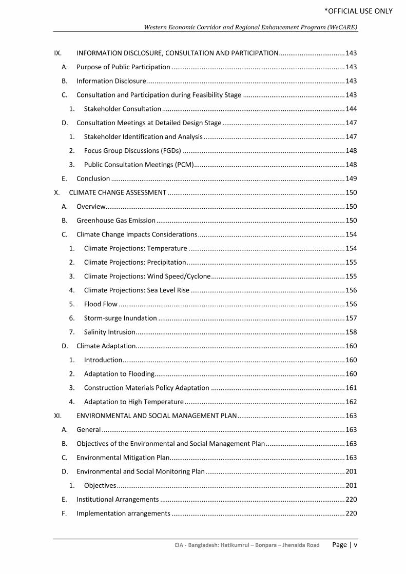
IX. INFORMATION DISCLOSURE, CONSULTATION AND PARTICIPATION ................................... 143
A. Purpose of Public Participation ............................................................................................ 143
B. Information Disclosure ......................................................................................................... 143
C. Consultation and Participation during Feasibility Stage ...................................................... 143
1. Stakeholder Consultation ................................................................................................. 144
D. Consultation Meetings at Detailed Design Stage ................................................................. 147
1. Stakeholder Identification and Analysis ........................................................................... 147
2. Focus Group Discussions (FGDs) ...................................................................................... 148
3. Public Consultation Meetings (PCM) ................................................................................ 148
E. Conclusion ............................................................................................................................ 149
X. CLIMATE CHANGE ASSESSMENT .............................................................................................. 150
A. Overview............................................................................................................................... 150
B. Greenhouse Gas Emission .................................................................................................... 150
C. Climate Change Impacts Considerations .............................................................................. 154
1. Climate Projections: Temperature ................................................................................... 154
2. Climate Projections: Precipitation .................................................................................... 155
3. Climate Projections: Wind Speed/Cyclone ....................................................................... 155
4. Climate Projections: Sea Level Rise .................................................................................. 156
5. Flood Flow ........................................................................................................................ 156
6. Storm-surge Inundation ................................................................................................... 157
7. Salinity Intrusion ............................................................................................................... 158
D. Climate Adaptation............................................................................................................... 160
1. Introduction ...................................................................................................................... 160
2. Adaptation to Flooding ..................................................................................................... 160
3. Construction Materials Policy Adaptation ....................................................................... 161
4. Adaptation to High Temperature ..................................................................................... 162
XI. ENVIRONMENTAL AND SOCIAL MANAGEMENT PLAN ......................................................... 163
A. General ................................................................................................................................. 163
B. Objectives of the Environmental and Social Management Plan .......................................... 163
C. Environmental Mitigation Plan............................................................................................. 163
D. Environmental and Social Monitoring Plan .......................................................................... 201
1. Objectives ......................................................................................................................... 201
E. Institutional Arrangements .................................................................................................. 220
F. Implementation arrangements ............................................................................................ 220
Western Economic Corridor and Regional Enhancement Program (WeCARE)
EIA - Bangladesh: Hatikumrul – Bonpara – Jhenaida Road Page | vi
*OFFICIAL USE ONLY
G. Institutional Responsibilities ................................................................................................ 221
1. Ministry of Road Transport and Bridges (MoRTB) ........................................................... 221
2. Inter-ministerial Steering Committee .............................................................................. 222
3. Roads and Highways Department .................................................................................... 222
4. The Social and Environmental Circle ................................................................................ 222
5. Project Implementation Unit............................................................................................ 222
6. Construction Supervision Consultant (CSC)...................................................................... 223
7. Contractor ........................................................................................................................ 223
H. Environmental Monitoring Cost Estimation ......................................................................... 224
XII. GRIEVANCE REDRESS MECHANISM ...................................................................................... 226
A. Requirements of the AIIB ..................................................................................................... 226
B. Objectives ............................................................................................................................. 226
C. Grievance Redress Mechanism ............................................................................................ 227
D. Details of Mechanism ........................................................................................................... 227
1. Formation and Operation of the GRC .............................................................................. 227
2. Steps to a Solution ............................................................................................................ 228
3. Publicizing the Grievance Redress Steps and the Committee.......................................... 229
4. Construction Workers Grievance ..................................................................................... 230
E. Composition of GRC ............................................................................................................. 230
1. GRC at local level .............................................................................................................. 230
2. District level GRC .............................................................................................................. 231
XIII. CONCLUSIONS AND RECOMMENDATIONS .......................................................................... 233
REFERENCES ..................................................................................................................................... 234
APPENDICES...................................................................................................................................... 235
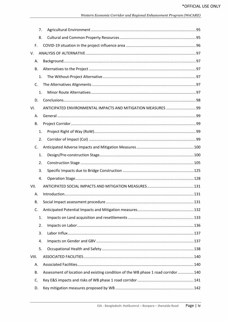
List of Tables Table I-2: Explanation and Assignment of Scores to ‘Magnitude of Impact’ ..................................... 11
Table I-3: Explanation and assignment of scores to ‘likelihood’ ........................................................ 11
Table I-4: Two-Dimensional Risk Assessment matrix ......................................................................... 11
Table II-1: International Conventions, Treaties and Protocols Signed by Bangladesh ....................... 23
Table II-2: Relevant Occupational Health and Safety Laws and Rules ............................................... 26
Table II-3: Actions Required for Different Stages of the Project ........................................................ 28
Table II-4 Applicability of AIIB policies and relevance to this project ................................................ 33
Table II-5 Harmonized policy framework used in this EIA .................................................................. 35
Table III-1: Main Design Features of the Project ................................................................................ 43
Table III-2: List of Major Bridges (> 100 m length) in Hatikumrul-Bonpara-Jhenaidah Road ............ 47
Table III-3: List of Minor Bridges on the Hatikumrul-Bonpara-Jhenaidah Road ................................ 49
Western Economic Corridor and Regional Enhancement Program (WeCARE)
EIA - Bangladesh: Hatikumrul – Bonpara – Jhenaida Road Page | vii
*OFFICIAL USE ONLY
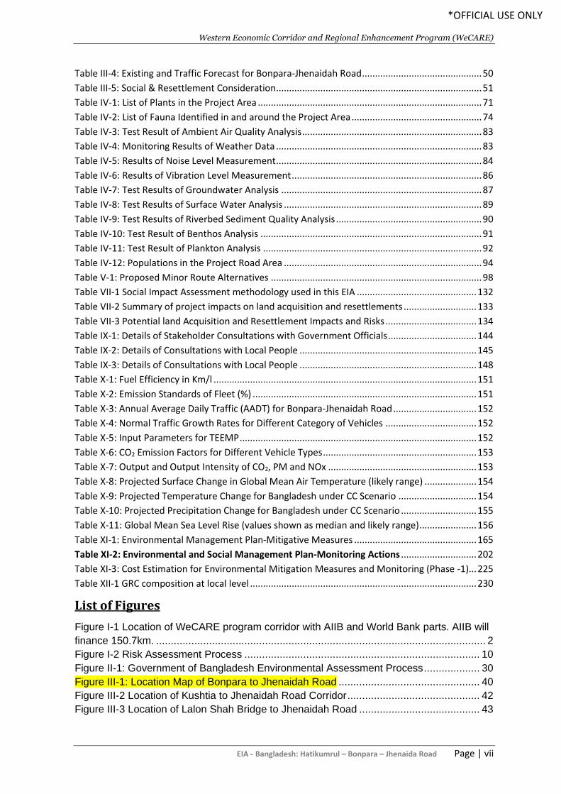
Table III-4: Existing and Traffic Forecast for Bonpara-Jhenaidah Road .............................................. 50
Table III-5: Social & Resettlement Consideration ............................................................................... 51
Table IV-1: List of Plants in the Project Area ...................................................................................... 71
Table IV-2: List of Fauna Identified in and around the Project Area .................................................. 74
Table IV-3: Test Result of Ambient Air Quality Analysis ..................................................................... 83
Table IV-4: Monitoring Results of Weather Data ............................................................................... 83
Table IV-5: Results of Noise Level Measurement ............................................................................... 84
Table IV-6: Results of Vibration Level Measurement ......................................................................... 86
Table IV-7: Test Results of Groundwater Analysis ............................................................................. 87
Table IV-8: Test Results of Surface Water Analysis ............................................................................ 89
Table IV-9: Test Results of Riverbed Sediment Quality Analysis ........................................................ 90
Table IV-10: Test Result of Benthos Analysis ..................................................................................... 91
Table IV-11: Test Result of Plankton Analysis .................................................................................... 92
Table IV-12: Populations in the Project Road Area ............................................................................ 94
Table V-1: Proposed Minor Route Alternatives ................................................................................. 98
Table VII-1 Social Impact Assessment methodology used in this EIA .............................................. 132
Table VII-2 Summary of project impacts on land acquisition and resettlements ............................ 133
Table VII-3 Potential land Acquisition and Resettlement Impacts and Risks ................................... 134
Table IX-1: Details of Stakeholder Consultations with Government Officials .................................. 144
Table IX-2: Details of Consultations with Local People .................................................................... 145
Table IX-3: Details of Consultations with Local People .................................................................... 148
Table X-1: Fuel Efficiency in Km/l ..................................................................................................... 151
Table X-2: Emission Standards of Fleet (%) ...................................................................................... 151
Table X-3: Annual Average Daily Traffic (AADT) for Bonpara-Jhenaidah Road ................................ 152
Table X-4: Normal Traffic Growth Rates for Different Category of Vehicles ................................... 152
Table X-5: Input Parameters for TEEMP ........................................................................................... 152
Table X-6: CO2 Emission Factors for Different Vehicle Types ........................................................... 153
Table X-7: Output and Output Intensity of CO2, PM and NOx ......................................................... 153
Table X-8: Projected Surface Change in Global Mean Air Temperature (likely range) .................... 154
Table X-9: Projected Temperature Change for Bangladesh under CC Scenario .............................. 154
Table X-10: Projected Precipitation Change for Bangladesh under CC Scenario ............................. 155
Table X-11: Global Mean Sea Level Rise (values shown as median and likely range) ...................... 156
Table XI-1: Environmental Management Plan-Mitigative Measures ............................................... 165
Table XI-2: Environmental and Social Management Plan-Monitoring Actions ............................. 202
Table XI-3: Cost Estimation for Environmental Mitigation Measures and Monitoring (Phase -1)... 225
Table XII-1 GRC composition at local level ....................................................................................... 230
List of Figures
Figure I-1 Location of WeCARE program corridor with AIIB and World Bank parts. AIIB will
finance 150.7km. ................................................................................................................ 2
Figure I-2 Risk Assessment Process ................................................................................ 10
Figure II-1: Government of Bangladesh Environmental Assessment Process ................... 30
Figure III-1: Location Map of Bonpara to Jhenaidah Road ................................................ 40
Figure III-2 Location of Kushtia to Jhenaidah Road Corridor ............................................. 42
Figure III-3 Location of Lalon Shah Bridge to Jhenaidah Road ......................................... 43
Western Economic Corridor and Regional Enhancement Program (WeCARE)
EIA - Bangladesh: Hatikumrul – Bonpara – Jhenaida Road Page | viii
*OFFICIAL USE ONLY
Figure III-4: Typical Cross Section .................................................................................... 46
Figure III-5: Layout Plan of Bus Bay at Urban Area........................................................... 46
Figure III-6: Cross Section of the Proposed Bridge ........................................................... 48
Figure IV-1: Temperature and Rainfall in Ishwardi ............................................................ 54
Figure IV-2: Number of Sunny, Rainfall and Cloud Coverage Days in Ishwardi ................ 55
Figure IV-3: Wind rose Diagram in Ishwardi ...................................................................... 56
Figure IV-4: General Topography of the Project Road Area .............................................. 57
Figure IV-5: Surface Water Bodies along the Project Road ............................................... 59
Figure IV-6: Hydrological Network of the Project Area ...................................................... 61
Figure IV-7: Seismic Zone and Activity of the Project Road .............................................. 63
Figure IV-8: Cyclone Risk Zone of the Project Road ......................................................... 65
Figure IV-9: Flood Zone of the Project Road ..................................................................... 66
Figure IV-10: Sources of Air Pollutants in the Project Area ............................................... 67
Figure IV-11: Bio-ecological Zone of the Project Road Alignment ..................................... 70
Figure IV-12: Roadside Vegetation along the Project Corridor .......................................... 73
Figure IV-13: Litchi and Banana Garden in the Project Area ............................................. 73
Figure IV-14: Roadside Aquatic Flora ............................................................................... 74
Figure IV-15: Fishing Practice in the Project Area ............................................................. 76
Figure IV-16 Location of Chalan Beel and Current road allignment ................................... 77
Figure IV-17: Environmental Protected Areas in the Project Location ............................... 79
Figure IV-18: Locations of Samples Collection in the Project Area .................................... 81
Figure IV-19: Ambient Air Quality Sampling in the Project Area ........................................ 82
Figure IV-20: Noise Level Measurement in the Project Area ............................................. 84
Figure IV-21: Vibration Level Measurement in the Project Area ........................................ 85
Figure IV-22: Sampling of Groundwater in the Project Area .............................................. 87
Figure IV-23: Sampling of Surface Water in the Project Area ............................................ 88
Figure IV-24: Sampling of Riverbed Sediment in the Project Area .................................... 90
Figure IV-25: Benthos Sampling in the Project Influenced Area ........................................ 91
Figure IV-26: Plankton Sampling in the Project Influenced Area ....................................... 92
Figure IV-27: Agricultural Practices in the Project Area ..................................................... 95
Figure VIII-1: Consultations with Government Officials ................................................... 145
Figure VIII-2: Consultations with Local People ................................................................ 147
Figure IX-1: Storm Surge Inundation Area (2050 in a changing Climate) ........................ 158
Figure IX-2: Salinity Intrusion for different Sea Level Rise during Dry Season (DEFRA
2007) .............................................................................................................................. 159
Figure X-1: Proposed Institutional Framework for ESMP Implementation ....................... 221
Figure XI-1: Grievance Redress Mechanism of the Project ............................................. 229
List of Appendices
Appendix 1: DoE Approved Terms of Reference (ToR) .................................................. 235
Appendix 2: Rapid Environmental Assessment (REA) Checklist ..................................... 237
Appendix 3: Test Result of Air Quality Measurement ...................................................... 242
Appendix 4: Test Result of Noise Level Measurement .................................................... 244
Appendix 5: Test Result of Vibration Level Measurement ............................................... 246
Appendix 6: Test Result of Groundwater Quality ............................................................ 247
Appendix 7: Test Result of Surface Water Quality .......................................................... 252
Appendix 8: Test Result of Riverbed Sediment Quality ................................................... 259
Western Economic Corridor and Regional Enhancement Program (WeCARE)
EIA - Bangladesh: Hatikumrul – Bonpara – Jhenaida Road Page | ix
*OFFICIAL USE ONLY
Appendix 9: Test Result of Benthos Analysis .................................................................. 263
Appendix 10: Test Result of Plankton Analysis ............................................................... 264
Appendix 11: Important Environmental & Social Features along the Road ..................... 265
Appendix 12: Consultations Details and List of Participants for FGD .............................. 288
Appendix 13: Waste Management Plan .......................................................................... 296
Appendix 14: Tree Plantation Plan .................................................................................. 299
Western Economic Corridor and Regional Enhancement Program (WeCARE)
EIA - Bangladesh: Hatikumrul – Bonpara – Jhenaida Road Page | x
*OFFICIAL USE ONLY
ABBREVIATIONS
AADT Annual Average Daily Traffic
AASHTO American Association of State Highway and Transportation Officials
AIIB Asian Infrastructure Investment Bank
AEZ Agro-ecological Zone
BBS Bangladesh Bureau of Statistics
BECA Bangladesh Environmental Conservation Act
BRTA Bangladesh Road Transport Authority
BECR Bangladesh Environmental Conservation Rules
BWDB Bangladesh Water Development Board
DoE Department of Environment
EA Environmental Assessment
EC Executive Committee
ECC Environmental Clearance Certificate
EIA Environmental Impact Assessment
ESMP Environmental and Social Management Plan
FD Forest Department
GOB Government of Bangladesh
IEE Initial Environmental Examination
IECs Important Environment Components
MOEF Ministry of Environment and Forest
NGO Non-Governmental Organization
PAPs Project Affected Persons
PPEs Personal Protection Equipment
RHD Roads and Highways Department
RoW Right of Way
Western Economic Corridor and Regional Enhancement Program (WeCARE)
EIA - Bangladesh: Hatikumrul – Bonpara – Jhenaida Road Page | xi
*OFFICIAL USE ONLY
EXECUTIVE SUMMARY
INTRODUCTION
Road transport being the predominant mode of transport in Bangladesh accounting for
about 80% of total traffic moved road quality does not correspond to the Asian Highway
standards. Most of Bangladesh’s road network needs to be upgraded for handling modern
diversified vehicles. The Road Master Plan 2009 targeted to expand the major roads and
highways of Bangladesh to four lanes.
In order to improve key transport corridor and road networks, the AIIB has been providing
technical and financial support to the GoB to establish sub-regional transport connectivity
with neighboring countries including India, Nepal, Myanmar, and China and beyond.
The proposed WeCARE-RHD program is located in the Western Region of Bangladesh
along the 260-km road including following parts: i. Jhenaidah – Bonpara – Hatikumrul (160
km); ii. Jashore – Jhenaidah (48 km); and iii. Navaron – Satkhira -Bhomra (approx. 52 km),
where AIIB will finance for 160 km (actually 150.7km planned) of national Highways
(Jhenaidah – Bonpara – Hatikumrul) under RHD. This program is planned to be
implemented in two phases over ten years. The anticipated time for Phase -1 is five years
while the duration of phase - 2 is expected to be another five years. Each phase will
include investments in primary, secondary, and tertiary road infrastructure, complementary
logistics infrastructure and services, and technical assistance for institutional capacity
building and transport sector modernization.
The WB-financed section of the Program Corridor (Bhomra-Satkhira-Navaron and Jashore-
Jhenaidah) is considered an Associated Facility of this Project. E&S assessments,
instruments and documents will be prepared in accordance with the ESF and the AIIB team
has conducted a due diligence of these instruments and documents. The EIA indicated that
environmental risks and impacts are largely construction-related, reversible, and confined
within the existing footprint of the project, and for which known engineering and
housekeeping measures can be developed and implemented.
Purpose and Scope of EIA
This EIA is prepared for the AIIB financed part of the WeCARE-RHD program which is the
Jennaidah – Bonpara – Hatikumrul Road (150.7 km). The objective of this EIA is to assess
the environmental and social risks and impacts of the upgradation of Jennaidah – Bonpara
– Hatikumrul Road from 2-lane to 4-lane road and to develop measures based on
mitigation hierarchy to manage environmental and social risks and impacts. The project is
to be implemented in two phases: (i) Phase – 1: Kushtia – Jhenaidah Road (66.66km); (ii)
Phase – 2: Hatikumrul – Bonpara – Ishwardi Road (84.04km).
Objectives
The objective of this study is to identify the social and environmental issues or parameters
that may be affected by the implementation of the project, as well as an assessment of the
current status of these issues and parameters related to the construction of the proposed
Project. It has also included a consideration of means to avoid or mitigate significant
environmentally negative impacts of the project.
Western Economic Corridor and Regional Enhancement Program (WeCARE)
EIA - Bangladesh: Hatikumrul – Bonpara – Jhenaida Road Page | xii
*OFFICIAL USE ONLY
Moreover, an EIA is an obligatory requirement that application to the Department of
Environment (DoE) for the Environmental Clearance Certificate (ECC) from the DoE for
initiating project implementation.
This EIA has been prepared in accordance with the requirements of the Government of
Bangladesh defined in the Bangladesh Environment Conservation Act (BECA) and the
Asian Infrastructure Investment Bank (AIIB) as defined in Chapter 2. An approved Terms of
Reference (ToR) has been issued by the DoE and it was used as a guideline for preparing
this document. Additional guidance and updates to the EIA has been requested by the AIIB
in accordance with its policies. The Format of the EIA follow the AIIB recommendations as
outlined in the AIIB Environment and Social Framework (ESF); 2016.
Methodology
As limited secondary information on the environmental quality and the ecology of the study
area are available, the Consultant used a number of methods and techniques to assess the
environmental issues of the proposed expressway. These included desktop review of the
background information, GIS mapping, reconnaissance survey, consultation with
stakeholders and community members, and professional judgment. Geographical
Information Systems (GIS) was used as a specialized analysis and presentation tool.
Before commencing field investigations, spatial analysis of satellite imagery was used to
identify present administrative areas and other boundaries/constraints to be considered for
both the environmental and social assessments. A review was conducted of the physical,
biological and legal literature relevant to the Project. The review of secondary sources and
informal initial field investigations were undertaken in order to prepare a preliminary
assessment of the physical and social environment, biodiversity, and conservation
significance of the identified study area. This preliminary literature review also assisted in
identifying data gaps, which would require collection of additional primary information
through physical field survey. Primary data of physical, biological and sociocultural
environment was collected to comprehensively evaluate the existing Project area baseline
conditions. The environmental quality assessment in the project influence area has been
carried out. The sampling focused on air quality, noise, surface water quality, groundwater
quality, soil quality, riverbed sediment quality and Benthos and Plankton sampling. The
resulting data provided information on existing conditions against which predictions of
changes and field measurements during the construction period will be compared in order
to assess change and its significance. An extensive stakeholder consultation has been
done as part of this Environmental Impact Assessment process. During field survey several
community consultations were conducted in the following forms, which were Small Group
Discussion (SGD), Key Informant Interview (KII) and Focus Group Discussion.
ENVIRONMENTAL POLICY, LEGAL AND ADMINISTRATIVE FRAMEWORK
The project is classified as ‘Red Category’ according to the ECR, 1997 of Government of
Bangladesh and as ‘Category A’ according to the AIIB ESF, 2016.
As per the government of Bangladesh guidelines the project requires to submit the
Environmental Impact Assessment (EIA) for getting Environmental Clearance Certificate
(ECC) during project feasibility and detailed design stage respectively. The AIIB
Environment and Social Framework (ESF) requires a number of additional considerations,
including: (i) project risks and respective mitigation measures and project assurances; (ii)
project level Grievance Redress Mechanism including documentation in the ESMP; (iii)
Western Economic Corridor and Regional Enhancement Program (WeCARE)
EIA - Bangladesh: Hatikumrul – Bonpara – Jhenaida Road Page | xiii
*OFFICIAL USE ONLY
definition of the project area of influence; (iv) physical cultural resources damage
prevention analysis; (v) climate change mitigation and adaptation; (vi) occupational and
community health and safety requirements; (vii) biodiversity conservation and natural
resources management requirements; (viii) ensuring adequate consultation and
participation; and (ix) ensuring that ESMP includes implementation schedule and
(measurable) performance indicators.
DESCRIPTION OF THE PROJECT
The Bonpara–Jhenaidah Road is a vital link in the national highway network. The
upgrading of this road is consistent with the Road Master Plan 2008 of Bangladesh. The
existing road is mostly two-lane roads with shoulders. There is no separate provision for
slow moving vehicular traffic (SMVT) or non-motorized traffic (NMT). There are capacities
constraints caused by congested junctions, heavy traffic moving around the land port, road
side parking, markets and built up areas.
The Project Road starts from Bonpara intersection with Dhaka-Bonpara-Rajshahi national
highway (N507) and ends at Jhenaidah 4-leg intersection of Jhenaidah-Jessore road with
Jhenaidah-Chuadanga road. The road crosses “Lalon Shah Bridge” over Padma River at
Pakshy. The Lalon Shah Bridge over the Padma River is connecting the Pabna district on
the east and Kushtia district on west side of the river. The candidate road runs from
Bonpara in the north to south direction at Jhenaidah. The road from Bonpara to Dasuria,
Ishawrdi is a national highway (N6). From Ishawrdi to Pakshey it is national highway
(N705) and from Pakshey to Jhenaidah is also national highway (N704). The project
related intervention involves 101.7 km highway improvement from 2-lane to 4-lane, and a
total of 110 hydraulic structures, of which 01 are major (>100m) bridge, and 109 are small
to medium bridges and culverts.
ANALYSIS OF ALTERNATIVES
No project scenario: From a purely physical and environmental point of view, the ‘do-
nothing’ approach is preferable to any project implementation since it would avoid creation
of any of the adverse impacts associated with a new road. The without project alternative is
not acceptable since this will strongly reduce the potential for socio-economic development
of the country. Despite having great potential, the industrial and commercial growth is
retarded mainly due to absence of safe and reliable transportation facility. Further, as a
common port facility of neighboring countries the Benapole Land Port does not yet have
the required transportation infrastructure to give it the momentum to reach that status. A
new highway to the rest of Bangladesh and to the region will help realise this objective.
Therefore, the ‘no-build’ alternative is unacceptable, and the potential socio-economic
benefits of implementation of such Project far outweigh the adverse impacts, all of which
can be controlled and minimised to an acceptable level.
Minor adjustment: The present alignment between Bonpara and Jhenaidah will require
numerous short distance (<1000m) straightening realignments to ensure the designed
alignment is in accordance with the RHD standards (Table V.1). The selection of these
minor realignments will need to ensure the minimum disturbance to the local environment
(and to ensure minimum disturbance to the built environment, land acquisition and
resettlement). This is particularly critical where the road passes through the settlement
areas and disturbance to the local environment should occur.
Western Economic Corridor and Regional Enhancement Program (WeCARE)
EIA - Bangladesh: Hatikumrul – Bonpara – Jhenaida Road Page | xiv
*OFFICIAL USE ONLY
ANTICIPATED ENVIRONMENTAL IMPACTS AND MITIGATION MEASURES
Pre-construction Phase
The topography in the Project area will be changed to some extent because of construction
of the proposed Project related structures such as embankments, bridge/culverts, flyovers,
etc. Visual changes to the topography would be permanent in nature.
The aesthetic elements (such as plantation) should be incorporated in the design to
overcome the impacts. In order to construct the embankment for the proposed project,
commercial infrastructure, the cultural and community property resources (e.g. mosque,
eidgah, grave yard, shrine, school, college, hospital/clinic and so on) located within the
ROW will be partially/fully affected. Proper compensation must be provided at first as per
the national legal frameworks and AIIB’s ESF.
Within the ROW of the project alignment, there are water supply pipelines, optical fiber, gas
distribution lines, and electricity distribution lines with transformers, telephone line and
mobile network tower. Relocation of the utilities will temporarily cause inconvenience to the
users.
Relocation of the electric transformers and transmission lines has to be performed taking
sufficient safety measures. Proper health and safety measures for the workers have to be
taken during shifting of these lines to avoid any incidents. During filling of road
embankment, road side electric, telephone, gas and water supply pipelines will be kept
undisturbed by training and awareness of the workers.
Clearance of vegetation on the ROW along the alignment will cause permanent and/or
temporary dislocation of some wildlife because of disturbance on their habitat. While
clearing vegetation it must be ensured that no wildlife like snakes, mongoose, fox, squirrel
and other wildlife species do not injure and/or die. Harming and/or killing of any types of
wildlife by the workers of the project must be prohibited. In case of appearance of any
endangered/threatened wildlife species respective regulatory authority must be informed as
early as possible.
Removal of mature trees will cause ecological loss to the environment, takes initiative to
replant trees as per the guidance of Forest Department (FD) of Bangladesh (e.g. minimum
two tree seedlings to be planted for each tree felled after completion of the construction
activities of the project).
Construction Phase
The construction of bridges and culverts has the possibility to cause drainage congestion if
diversions and dredged materials are not properly managed. Stockpiling of fill materials if
not properly managed will cause erosion and subsequent deposition in the adjacent water
courses and crop fields.
Establish local drainage line with appropriate silt collector and silt screen for rainwater or
wastewater connecting to the existing established drainage lines already there. Dredging
will be required to source borrow material for filling up of the project sites. Riverbed
sediment will be contaminated if construction wastes are disposed in the river or adjacent
water bodies. In addition, there is also a risk of contamination of bottom sediments by
accidental spilling of construction material.
Western Economic Corridor and Regional Enhancement Program (WeCARE)
EIA - Bangladesh: Hatikumrul – Bonpara – Jhenaida Road Page | xv
*OFFICIAL USE ONLY
Disposal of any construction waste into the river or nearby water bodies should be
restricting. Erosion will be taken place at the slope of the proposed road embankment if
slope protection measures are not taken immediately. Erosion can be happened at the
bridge and culvert construction sites. The Contractor is required to reuse the excavated soil
as much as possible unless the soil is considered not suitable for filling. The construction of
the embankment may cause soil contamination around the areas of road cuttings,
embankments, construction camps, workshop, and equipment washing yards, asphalt
plants, batching plants, fuel and chemical storage.
The water spray operation should be carried out in dry and windy day, at least twice a day
(morning and afternoon). Debris, construction wastes, vegetation or other materials shall
be not burned on the site. Conveyor belts shall be fitted with wind-boards, and conveyor
transfer points and hopper discharge areas shall be enclosed to minimize dust emission.
All conveyors carrying materials that have the potential to create dust shall be totally
enclosed and fitted with belt cleaners.
Noise pollution during construction phase will be caused by the equipment and process
such as operations of construction machines and equipment: trucks, bulldozer, excavator,
air compressor, Concrete mixing station, Pile drivers, Earth leveling and Generator
operation etc. The Contractor shall at its own expense take all appropriate measures to
ensure that work carried out (including works by sub-contractors), whether on or off the
site, will not cause any unnecessary or excessive noise.
If the construction materials such as asphalt, fuel, oil and chemicals are not well preserved,
they may be washed away into rivers causing water pollution. The Contractor shall comply
with the national legislation and other regulations currently applied in Bangladesh as they
relate to water pollution control. Construction of bridges may cause impact to groundwater
level and quality.
Setting up and implementation code of conducts to workers, including no catching or
hunting fish and wildlife, and no consumption of wildlife products. Environmental training
with information on the importance of biological diversity and its relationships with
sustainable development will be arranged for project workers. For any
construction/engineering work over the water bodies, proper measures need to be taken to
keep the existing water flow as usual as possible. Moreover, to protect the fisheries habitat,
erosion and siltation have to be kept in control at bridge and culvert sites. The construction
of bridges may lead to the loss of aquatic animal habitat due to increased turbidity,
decreased dissolved oxygen in the water, and reduction of food sources including
temporary decline of plankton and benthos organisms.
Do not dump wastes, be it hazardous or non-hazardous into the nearby water bodies or in
the river. Fertile land where two or more crops grow at present or the land which has such
potentiality, that land could be avoided. Non-agriculture khas land should be considered on
a priority if non-agriculture khas land becomes available.
Top soils of adjacent land could be preserved as these are most fertile and suitable for
crop production. Construction workers are more likely to face occupational health hazards
such as minor or major injuries due to lack of general safety requirements and precautions
applicable while working at construction sites, and handling with machines and equipment,
use of equipment and driving vehicles and so on.
Operation Phase
Western Economic Corridor and Regional Enhancement Program (WeCARE)
EIA - Bangladesh: Hatikumrul – Bonpara – Jhenaida Road Page | xvi
*OFFICIAL USE ONLY
The settlements in the immediate vicinity of the proposed road will be directly affected
which would be minor negative impact. Structures attached with the road, such as flyovers,
bridges, auxiliary facilities etc. would cause slight negative effect on landscape. This can
be mitigated by tree plantation along the proposed Corridor. The construction of new
structures such as flyovers, bridges and culverts as well as road side plantation will
improve the aesthetics view of the project area. The traffic volume will be increased after
the construction of Bonpara-Jhenaidah road.
The wildlife species while crossing the road may collide with the vehicles which will cause
injury/or death of the species. In operation phase, ambient air quality of the areas along the
road would be deteriorated by the dust and toxic gas generated from vehicles running on
the road. It can conclude that no structural measure is needed to mitigate impacts of air
pollution in operation phase.
The accidents may also be due to tiredness. By enforcing speed limits and imposing
penalties on the traffic violators will ensure the road safety. In some locations, it is difficult
to avoid split of villages or hindrance to residents in going to working places. Local
residents’ daily activities, production activities, etc. would be significantly affected. During
the detail design study, efforts will be paid to avoid split of communities by modification of
road alignment.
Besides, a number of cross structures (underpass and overpass) for local residents and
local vehicles will be designed. The locations of underpasses/overpasses will be carefully
determined based on existing and future condition of local areas, and result of consultation
with local communities. The proposed Project will promote better business opportunities
such as new petrol pumps and hotels. For the operation and maintenance work of the road
and bridge/culverts job opportunities will be created.
INFORMATION DISCLOSURE, CONSULTATION AND PARTICIPATION
As a standard practice, the Project safeguard documents including EIA released for
disclosure are accompanied by making available the registers of comments and
suggestions from the public that are subsequently documented by the PIU/RSEC in a
formal manner. PIU will continue applying the similar approach to disclosure for any
additional safeguard appraisal materials that will be prepared as part of the project
development.
The PD will continue applying the similar approach to disclosure for any additional E&S
appraisal materials that will be prepared as part of the project development. The EIA in
Bangla, and English will be made available for public review in accordance with the AIIB.
The EIA will be released in the public domain simultaneously with the other E&S
documents and will be available for stakeholder review during the same period of time.
Electronic copies of the safeguard documents will be placed on the project website
(http://www.rhd.gov.bd). This will allow stakeholders with access to Internet to view
information about the planned development and to initiate their involvement in the public
consultation process. The website will be equipped with an on-line feedback feature that
will enable readers to leave their comments in relation to the disclosed materials.
CLIMATE CHANGE ASSESSMENT
Western Economic Corridor and Regional Enhancement Program (WeCARE)
EIA - Bangladesh: Hatikumrul – Bonpara – Jhenaida Road Page | xvii
*OFFICIAL USE ONLY
Climate risk and vulnerability adaptation (CRVA) is a crucial component where under AIIB’s
requirements and for the purposes of subsequent project approval, the study needs to
demonstrate that climate considerations have been integrated into the detailed designs of
the road project.
As an adaptation measure the design height of bridges in the project area has considered
from existing levels in line with the envisaged increase in flood level under a changed
future climate as per the outcome of hydrological analysis. The bridges in the proposed
roads are designed for 1 in 50-year return period. The climate change adaptation concept
for bridges in the project area takes the bridge design to protect against a 1 in 50-year
flood (i.e. 2% chance of occurrence of a 50-year flood magnitude in any given year).
In line with the climate change literature summarized in this report acknowledges that
inflows from the three major rivers Ganges, Brahmaputra and Meghna into Bangladesh are
on average projected to increase over the monsoon period (driven primarily by increased
basin precipitation). As a result of these increased discharges, the drainage structures
throughout the roads have to drain much more water under climate change scenario.
ENVIRONMENTAL AND SOCIAL MANAGEMENT PLAN (ESMP)
An ESMP has been designed to mitigate the Project’s environmental and social risks and
impacts. The ESMP will be followed at the preconstruction, construction and operation
stages. While preparing the ESMP, medium and significant impacts are taken into
consideration to recommend possible mitigation measures. A mitigation measure will be
considered as successful when it complies with the Environmental Quality Standards
(EQS), policies, legal requirements set by AIIB SESF, 2016 and DoE environmental
guidelines & other relevant GoB legal requirements. In absence of DoE’s own EQS, other
relevant international or other recognized organization’s quality standard will be applied.
Environmental monitoring is an essential tool for environmental management as it provides
the basic information for rational management decisions. The purpose of the monitoring
program is to ensure that the envisaged purposes of the project are achieved and result in
desired benefits to the target population. To ensure the effective implementation of the
mitigation measures, it is essential that an effective monitoring program be designed and
carried out. Compliance monitoring will be conducted in accordance with the environmental
mitigation measures and monitoring plan provided with this report. Since the project is in
feasibility stage thus the consultant yet not prepared the environmental monitoring plan as
well as the environmental monitoring budget. These will be prepared during the detailed
design stage when all the baseline environmental quality will be measured.
The executing agency for the project is the Roads and Highways Division (RHD). A project
implementation unit (PIU) will be established which will be headed by a full-time project
manager. PIU will each have an environmental unit who will receive support from the
construction supervision consultant (CSC), and will be assisted by a non-government
organization to implement the resettlement plan. Safeguard specialists for environment and
resettlement will be a part of the CSC to monitor the ESMP implementation and ensure
compliance with both AIIB and Government of Bangladesh requirements.
GRIEVANCE REDRESS MECHANISM
Western Economic Corridor and Regional Enhancement Program (WeCARE)
EIA - Bangladesh: Hatikumrul – Bonpara – Jhenaida Road Page | xviii
*OFFICIAL USE ONLY
Project-affected-people for the AIIB funded construction activities in the WeCARE project
and any other stakeholder may submit comments or complaints at any time by using the
project’s Grievance Redress Mechanism (GRM).
The GRM will be accessible to all Internal, external, regional and international
stakeholders, including affected people, community members, civil society, media,
vulnerable people and other interested parties. External stakeholders can use the GRM to
submit complaints, feedback, queries, suggestions, or even compliments related to the
overall management and implementation of the WeCARE-AIIB project. The GRM is
intended to address issues and complaints in an efficient, timely, and cost-effective
manner. A separate GRM is also proposed for the labors following the guidelines of
Bangladesh Labor Act 2006 and Labor Rules 2015.
During COVID-19, if grievances are raised, there will be various options to submit
grievances through mediums such as websites, emails, phones and other appropriate
communication methods, which will be recorded and dealt with accordingly. Social-
distancing restrictions/high transmission risks related to COVID-19 and significant
resettlement.
Multichannel cloud GRM system will be established taking the best examples and practices
to diminish the need for Project-affected people to physically interact with Project staff. A
training program will be arranged with different stakeholders on how to raise grievances
during this pandemic.
CONCLUSIONS AND RECOMMENDATIONS
The project will have a number of environmental and social impacts during the construction
and operation periods. Assuming effective implementation of the mitigation measures and
monitoring requirements as outlined in the Environmental and Social Management Plan,
the Project is not expected to have significant adverse environmental impacts. It should
also be pointed out that the environmental and social benefits are likely to important; an all-
weather transport route will link major population and industrial centers in the west of
Bangladesh. The potential for congestion will be reduced which will reduce vehicle
emissions due to increased and more regular speeds and air quality adjacent to the road
will improve.
The proposed road will enhance the trade activities of the country and provide smooth and
safe travelling corridor. The project will have overall positive impacts and some negative
impacts. Most of these negative impacts are mainly construction related and can be
mitigated by the successful implementation of the ESMP. There will be some residual
impact for significant negative impacts, which will be compensated by environmental
enhancement measures recommended in the ESMP. No long-term and significant adverse
environmental impacts are however envisaged for the operation stage of the project.
Hence, the project is environmentally and socially feasible provided that the mitigation
measures are properly implemented during the Project execution.

Western Economic Corridor and Regional Enhancement Program (WeCARE)
EIA - Bangladesh: Hatikumrul – Bonpara – Jhenaida Road Page | xix
*OFFICIAL USE ONLY
Western Economic Corridor and Regional Enhancement Program (WeCARE)
EIA - Bangladesh: Hatikumrul – Bonpara – Jhenaida Road Page | 1
*OFFICIAL USE ONLY
I. INTRODUCTION
A. Background
1. Bangladesh’s trade with South Asia and Southeast Asia has been on the rise since the early 2000s, and about 40% of total trade currently takes place with these regions. The operation of the South Asian Free Trade Area (SAFTA) since 2006 and duty-free market access for most products in the Indian markets since 2011 have created potential opportunities for higher trade with South Asia, particularly with India. The development of cross-border connectivity between these neighboring countries will open up opportunities to further enhance trade. Bangladesh has the potential to become a Sub-Regional transport and trans-shipment centre, linking the heavily populated South Asian region to the burgeoning markets and countries to the north and south-east of Asia. It borders mostly with India and a small section with Myanmar, and is geographically close to Bhutan and Nepal, as well as Kunming - the key transportation hub in the south-west of the People’s Republic of China (PRC).
2. Road transport being the predominant mode of transport in Bangladesh accounting for about 80% of total traffic moved, road quality does not correspond to the Asian Highway standards. The existing highway links are primarily two-lane roads, and rail links are primarily single track (although initiatives for upgrading the railway from Dhaka to Chittagong are underway at the moment). Most of Bangladesh’s road network needs to be upgraded for handling modern diversified vehicles. However, Bangladesh has already taken many steps to strengthen its regional and international transport connectivity; specially aiming to facilitate trade between Bangladesh and the north-eastern states of India, the Indian state of West Bengal, Bhutan, Nepal and Myanmar. The Road Master Plan 2009 targeted to expand the major roads and highways of Bangladesh to four lanes.
3. In order to improve key transport corridor and road networks that would address the current transport bottlenecks for trade and help boost national, regional and international trade for Bangladesh, the AIIB has been providing technical and financial support to the GoB to establish sub-regional transport connectivity with neighboring countries including India, Nepal and Myanmar, China and beyond.
4. In continuation of the ongoing Sub-regional Transport Project Preparatory Facility, the GoB recently received a loan from the Asian Infrastructure Investment Bank (AIIB) for additional financing for the already in motion Sub-regional Transport Project Preparatory Facility.
B. Project scope
5. The proposed project is to be implemented under the Western Economic Corridor Regional Enhancement Program - RHD (WeCARE-RHD), financed by the AIIB and the World Bank (WB). The proposed WeCARE-RHD program is located in the Western Region of Bangladesh along the 260-km road including following parts: i. Jhenaidah – Bonpara – Hatikumrul (160 km); ii. Jashore – Jhenaidah (48 km); and iii. Navaron – Satkhira -Bhomra (approx. 52 km), where AIIB will finance for 160 km (actually 150.7km planned) of national Highways (Jhenaidah – Bonpara – Hatikumrul) under RHD. This program is planned to be implemented in two phases over ten years. The anticipated time for Phase -1 is five years while the duration of phase - 2 is expected to be another five years. Each phase will include investments in primary, secondary, and tertiary road infrastructure, complementary logistics infrastructure and services, and technical assistance for institutional capacity building and transport sector modernization.
Western Economic Corridor and Regional Enhancement Program (WeCARE)
EIA - Bangladesh: Hatikumrul – Bonpara – Jhenaida Road Page | 2
*OFFICIAL USE ONLY
6. The phase - 1 of AIIB funded program is around 67 km starts from the Lalonshah Bridge (West side), Kushtia to Jhenaidah road corridor. The Kustia-Jhinaidah Road starts from Lalonshah Bridge (West Side) and ends at Jhinaidah 4-leg intersection of Jhinaidah-Jessore road with Jhinaidah-Magura road. The Lalon Shah Bridge over the Padma River is connecting the Pabna district on the east and Kushtia district on west side of the river. The road from Kushtia to Jhenaidah is a part of national highway (N704). The bridges on the roads are: (i) Bheramara (near rail crossing), (ii) Baliapara Bridge, Kushtia, (iii) Laxmipur Bridge, Kushtia; (iv) Taragonj Bridge and (v) Bhite Bazar Bridge, Shailkupa, Jhenaidah. The Kushtia-Jhinaidah Road connects Kustia & Jhenaidah districts with Dhaka, the capital of Bangladesh through the greater national road network. Ruppur Nuclear Power Plant is situated at east end of Lalon Shah bridge. Designs of the Phase-I is not finalized yet. The packaging of the phase is yet to be determined. Details of Phase -2 design and exact alignment are not known yet, except existing alignment. It is expected that; the future alignment will concur with the same alignment with some improved facilities and additional interventions.
7. The program will be jointly financed by the World Bank for 100 km of national highway (Jashore – Jhenaidah and Navaron – Satkhira -Bhomra) under RHD, which is considered as associate facilities in this project and thus, an assessment of World Bank part project interventions has been taken in this Environmental Impact Assessment (EIA) report to meet the requirements of ESF and AIIB’s due-diligence under the ESF (2016) ESS-1 - Environmental and Social Assessment and Management.
8. Application of ESF to the WB Project. The WB-financed section of the Program Corridor (Bhomra-Satkhira-Navaron and Jashore-Jhenaidah) is considered an Associated Facility of this Project. E&S assessments, instruments and documents will be prepared in accordance with the ESF and the AIIB team has conducted a due diligence of these instruments and documents. The EIA indicated that environmental risks and impacts are largely construction-related, reversible, and confined within the existing footprint of the project, and for which known engineering and housekeeping measures can be developed and implemented. There are no adverse risks and impacts on natural and critical habitats and other environmentally sensitive areas. Social risk is assessed to be high based on: (i) health & safety of workers and communities along the road corridors where works will be carried out, as well as along the transport routes of construction supplies, materials and equipment; (ii) exposure of the population along the ROW and transport routes to noise, dust, vibrations, air pollution and traffic-related risks; (iii) land acquisition along the ROW; (iv) physical and economic displacements; (v) risks of gender-based violence; and (vi) influx of labor during construction and related issues, such as GBV, child labor, forced
Figure I-1 Location of WeCARE program corridor with AIIB and World Bank parts. AIIB will finance 150.7km.
Western Economic Corridor and Regional Enhancement Program (WeCARE)
EIA - Bangladesh: Hatikumrul – Bonpara – Jhenaida Road Page | 3
*OFFICIAL USE ONLY
labor, and health & safety. During implementation, the Government will supervise, and monitor E&S risks and impacts of the entire Program Corridor in accordance with the ESF and will ensure that all supervision records and project sites are accessible to both the AIIB and the World Bank. Joint supervision missions may also be conducted. The World Bank Environmental and Social Commitment Plan (ESCP) includes both the Government's commitment to apply the WB ESF to the AIIB-financed works, and to facilitate and support supervision by the World Bank and AIIB. There will be a single Grievance Redressal Mechanism (GRM) covering the Program Corridor.
9. Identification of the Project: The Government of Bangladesh has applied for a loan from the Asian Infrastructure Investment Bank (AIIB) for the Additional Financing to Sub-regional Transport Project Preparatory Facility to prepare the feasibility study and detailed engineering design for upgrading about 590 km of national highways, regional highways and zilla road to the standard as would be recommended according to feasibility study and approved by the government (4 lane, 6 lane etc. keeping a minimum provision of 4 lane) with Slow Moving Vehicular Traffic (SMVT) lane both sides. The Roads and Highways Department (RHD) under the Government of Bangladesh (GOB) Ministry of Communications (MOC) is the project implementing agency.
C. Categorization
10. The project is classified as Category A in accordance with AIIB guidelines stipulated in the ESF 2016 (amended 2019) and in the ‘Red’ category as per Environmental Conservation Rules (ECR) 1997 adopted by the Government of Bangladesh. Initially a screening environmental assessment has been done using similar REA format used by ADB. This Environmental Impact Assessment (EIA) has been prepared in accordance with AIIB requirements for a Category A project and provides an Environmental and Social Management Plan (ESMP) to ensure potential impacts are mitigated and monitored.
11. In general, impacts were determined not to be significant or irreversible, and precautionary measures have been taken (and incorporated into guidance, management plans and implementation frameworks) to avoid or reduce them.
D. Scope of this report and limitation
12. This EIA is prepared for the AIIB financed part of the WeCARE-RHD program which is the Jennaidah – Bonpara – Hatikumrul Road (150.7 km). The objective of this EIA is to assess the environmental and social risks and impacts of the upgradation of Jennaidah – Bonpara – Hatikumrul Road from 2-lane to 4-lane road and to develop measures based on mitigation hierarchy to manage environmental and social risks and impacts. The project is to be implemented in two phases: (i) Phase – 1: Kushtia – Jhenaidah Road (66.66km); (ii) Phase – 2: Hatikumrul – Bonpara – Ishwardi Road (84.04km).
13. The detailed design and Right of Way (RoW) of the proposed four lane road is not finalized yet, the EIA prepared by RHD is indicative in nature. WeCARE sets out the principles and objectives governing preparation and implementation of this environmental and social risks and impacts, mitigation measures in accordance with the ESS1 requirements. The aim is to ensure that adverse social and environmental impacts caused by the project interventions are kept within the margin that can be mitigated with. Once the road alignments and intermentioned are finalized, this EIA needs to be updated according to the interventions. During Phase - 2 interventions, this EIA needs to be further revised and updated as per planned activities.
14. According to the AIIB Environmental and Social Framework (ESF) 2016 and Environmental Conservation Act (ECA) 1995 adopted by the Bangladesh Government, an Environmental Impact Assessment (EIA) of the project is required as an integral part of the
Western Economic Corridor and Regional Enhancement Program (WeCARE)
EIA - Bangladesh: Hatikumrul – Bonpara – Jhenaida Road Page | 4
*OFFICIAL USE ONLY
environmental impact assessment study. The objective of this study is to identify the environmental issues or parameters that may be affected by the implementation of the project, as well as an assessment of the current status of these issues and parameters related to the construction of the proposed Project. It has also included a consideration of means to avoid or mitigate significant environmentally negative impacts of the project.
15. Moreover, an EIA is an obligatory requirement that application to the Department of Environment (DoE) for the Environmental Clearance Certificate (ECC) from the DoE for initiating project implementation.
16. The Environmental Impact Assessment (EIA) has been prepared based on the approved Terms of Reference (ToR) (Appendix 1) by the DoE. This EIA has been prepared in accordance with the requirements of the Government of Bangladesh defined in the Bangladesh Environment Conservation Act (BECA) and the Asian Infrastructure Investment Bank (AIIB) as defined in Chapter 2 below. The Format of the EIA following the AIIB recommendations as outlined in the AIIB Environmental and Social Framework (ESF) and its relevant Environmental and Social Standards (ESSs) 2016 and the approved ToR by DoE.
17. Limitations: As described in the earlier paragraphs (para 5 - 13, the design of the proposed Phase-I financed by AIIB has not been yet, neither the packages under the proposed phase. Therefore, development of design specific EIA is not practical. Therefore, this EIA study deals with the expertise opinion on the feasibility of the subproject and its possible implementation arrangements from the perspective of environment and experience gained from previous road projects being implemented in Bangladesh.
18. This EIA is indicative in nature given the information lacks as illustrated in earlier paragraphs and thus intend to be used as environmental advice to the detail design consultants. Once the detail design is done, this EIA needs to be updated with site specific information, environmental plan and mitigation measures.
E. Extent of the EIA Study
19. The EIA for the Hatikumrul-Bonpara-Ishwardi-Kushtia-Jhenaidah Road has been prepared in accordance with DoE, GoB and AIIB guidelines based on primary and secondary data, site visits, completion of a Rapid Environmental Assessment (REA) Checklist (Appendix 3) consultation with selected local people and close coordination with the Consultant team. ADB REA checklist was performed for initial environmental screening. The results of the ADB REA has been adopted and used as an input to this EIA. The influence of impact has been defined as 100m on each side from the centerline of the project road alignment during the feasibility study. However, the study area has been extended up to 1 km area on each side of the project alignment according to the guideline of DoE, GoB. Geographical Information System (GIS) techniques have also been used based on recent satellite imageries of the project area for above purposes. Assessment is carried out on the following environment components: terrestrial and aquatic ecology, soil, water, air, noise, and socio-economic aspects. The impacts on ecologically sensitive areas (e.g. wildlife sanctuaries, biosphere reserve, and protected places) within 1 km of the project alignment have also been assessed. 20. The primary data on physical, ecological, and human conditions collected by the project teams during site visits have been incorporated in the EIA. A rapid survey and quality assessment on the roadside environment were conducted by the environmental team. Published data relevant to the project area have also been used in preparing the document.
Western Economic Corridor and Regional Enhancement Program (WeCARE)
EIA - Bangladesh: Hatikumrul – Bonpara – Jhenaida Road Page | 5
*OFFICIAL USE ONLY
F. Objectives of this EIA
21. This EIA report has been prepared keeping in view the requirement of DoE and AIIB. The objectives of this EIA are as following:
• A review of the environmental legislative, regulatory and policy guidelines and considerations relating to the implementation of the project;
• A general description of the project and existing physical, biological and socio-economic conditions;
• Analysis of different alternatives to the project in terms of environmental and social perspectives;
• Identification and assessment of the potential impacts on the natural and human environment in the project area, from the construction of the project;
• Consultation with the locals/stakeholder involving concerned people in order to identify and act on any undocumented or perceived environmental issues;
• Identification of mitigation measures including monitoring framework in the form of an Environmental and Social Management Plan (ESMP).
• Identification of mitigation measures in the form of an Environmental and Social Management Plan (ESMP) Approach and Methodology; and
• Recommendations and conclusions in order to operate the project works in an environmentally safe and sound manner.
G. Approach & Methodology
1. Approach
22. The study has been conducted in accordance with Environment Conservation Rules, 1997, Government of Bangladesh (GOB) EIA Guidelines, 1997, and AIIB Environmental and Social Framework (ESF) and its relevant Environmental and Social Standards (ESSs);2016. The study is based on both primary and secondary data and information. The primary data includes data collected from field observations and secondary data includes review of the Bangladesh statistical and relevant information from Government Departments. For social baseline, discussions were held with stakeholders including government officials, community representatives and a wide range of road users and roadside dwellers. The main purpose of this approach was to obtain a fair impression on the people’s perceptions of the project and its environmental impacts.
2. Methodology
23. In order to establish the baseline biophysical conditions within the study area, relevant secondary and primary data was collected and reviewed, a comprehensive field visit was undertaken, and a number of consultations with local people were carried out. For better assessment the data collection programme was planned as per the segmented contract packages. The data generated allowed to better understand the complex interplay between the various biotic and abiotic factors within the study area and to establish the baseline conditions. Once this baseline was established it was used as a reference point to identify potential changes to the environment that may occur as a result of the proposed Project activities, as well as to allow development of measures to prevent, mitigate or manage these potential impacts.
a) Environmental Data Collection and Analysis
24. This section describes the methods and techniques used to investigate and describe the potential environmental risks of the Project. In order to establish the baseline biophysical conditions within the Project area, relevant secondary and primary data was
Western Economic Corridor and Regional Enhancement Program (WeCARE)
EIA - Bangladesh: Hatikumrul – Bonpara – Jhenaida Road Page | 6
*OFFICIAL USE ONLY
identified and reviewed, a comprehensive field visit program established, and a number of specialist studies were carried out. This included the gathering of primary and secondary data from various sources including from discussions with groups, discussion with individuals, Government sources, RHD and from locally active NGOs. 25. The assessment of potential environmental impacts requires detailed information on all aspects of the habitats, biodiversity and physical aspects of the Project area. It also requires development of an understanding of how the existing environmental processes work together to form a complex ecosystem. This information can be used to identify potential changes to the environment that may occur because of the Project, and to propose measures to prevent mitigate or manage potential environmental impacts. 26. The potential for environmental impacts was considered for activities during all stages of the proposed Project. This includes site establishment, drilling operations and site decommissioning and demobilization stages. As the environments within the Project area have not been widely studied in the past, knowledge gaps identified within the consultation phase have been filled through detailed investigations and field visits as part of this more comprehensive EIA report.
Secondary Data Collection
27. A review was conducted of the biophysical, ecological and legal literature relevant to the Project. The review of secondary sources and informal initial field investigations were undertaken in order to prepare a preliminary assessment of the physical and social environment, biodiversity, and conservation significance of the identified study area. This preliminary literature reviews also assisted in identifying data gaps which would require collection of additional primary information through physical field survey. The following activities were included in this phase of the Project:
• Data and information were collected from various government relating to site aspects climate (weather), groundwater quality and soils; secondary ecological data sources were collected and assessed;
• An appraisal was made of all legislation having direct and indirect relevance to environmental management within the Study Area including aspects such as biodiversity conservation, water quality, waste management, natural resource management and spill response;
• Previous environmental site studies, where available, were reviewed as well as relevant scientific journal articles; and
• Thereafter, an information gap analysis was undertaken to identify the areas where further primary data collection would be required to complete the EIA.
28. Thereafter, an information gap analysis was undertaken to identify the areas where further primary data collection would be required to complete the EIA. Further detail regarding the titles of the relevant literature, policies, acts and other regulations and guidelines reviewed and applied during the course of this process can be found in legal section of this report.
Baseline Data Collection and Analysis
29. Primary data collection was initiated to fill gaps in knowledge resulting from the secondary data review. Further, it aimed to provide a site-specific data set of relevant physical and biological environmental aspects relevant to the Project. The primary data collection program was undertaken in April 2019. During the field visit, stakeholders were consulted, and several important additional secondary sources of environmental information, data and literature were collected.
Western Economic Corridor and Regional Enhancement Program (WeCARE)
EIA - Bangladesh: Hatikumrul – Bonpara – Jhenaida Road Page | 7
*OFFICIAL USE ONLY
Physical Environment Field Survey
30. To comprehensively evaluate the existing Project area baseline conditions, a field visit and data collection program incorporating a number of biophysical investigations was developed and implemented. A desktop assessment was then prepared to enable the collection of refined and verifiable information. The field survey program was conducted throughout the Project area by a specialist environmental team. 31. This survey aimed to identify important environmental components and environmental issues within the study area. It included investigation and observation of the local landforms, market location, habitat types, drainage patterns, species abundance and distribution, soil types, water quality (surface water and groundwater), air quality, noise, vibration and hydro morphology. 32. The study area and surrounds were surveyed on foot and by boat. Important environmental features were identified and logged. Hand-held geographic positioning systems (GPS) were used to identify specific features for mapping and further analysis in the Project office. Features that were recorded or ground-truthed with GPS included:
✓ Habitation and settlement areas; ✓ Cultural Physical Properties (CPR); ✓ Plantations; ✓ Habitat areas; ✓ Sensitive environments; and ✓ Transportation routes;
33. Direct observation and key informant interview techniques were employed within the field survey. Direct observations were subject to accessibility and were guided by satellite image maps and local information. Observations were made along rivers, roads, embankments, and local footways across the agricultural fields and village groves. An environmental observation checklist was completed for each of the areas.
Ecological Field Survey
34. Initially, secondary data sources were reviewed in order to compile a potential presence/absence list of significant fauna and flora species. Thereafter two members among the field survey team were deployed to undertake the required sampling and assessment. Sampling and survey were conducted for both aquatic and terrestrial ecosystems; validation checks were confirmed against the earlier-compiled species lists in order to establish a comprehensive baseline. 35. The following activities were undertaken during the terrestrial and aquatic field surveys:
Direct Observation
36. Direct observation on the occurrence and abundance of flora and fauna was made while travelling along road edges, across the agricultural fields, the forest areas and within village groves. As well as direct sightings, identification of animal presence was also based on identification of tracks, footprints, feeding signs and animal/bird calls. Appropriate field guides and data preforms were used for this activity so that information was accurately recorded.
Interviews with Local Residents
37. Many of the mammalian and reptilian species are cryptic and unlikely to be encountered using standard field sampling methods. As such, experience suggests that
Western Economic Corridor and Regional Enhancement Program (WeCARE)
EIA - Bangladesh: Hatikumrul – Bonpara – Jhenaida Road Page | 8
*OFFICIAL USE ONLY
interviews with local people are a very useful method for collecting information on local biodiversity. This data is anecdotal and as such should not form the core of any assessment; however, it does nonetheless provide useful supplementary information. During the field survey period, extensive interviews with local people were conducted to collect information on animal and plant presence, including occurrences, behavior, breeding, distribution and seasonal appearance.
Socioeconomic Field Survey
38. The EIA study mostly used the socio-economic data collected by the Social and Resettlement Team for social assessment. However, during the environmental survey some consultations were conducted with the local people on environmental issues but social conditions were also discussed.
Consultations
39. For this report, Focus Group Discussions (FGD) were conducted along the project corridor. A team of experienced professional and support staff has conducted surveys and consultation meetings after being briefed about the project. The respondents were selected by random sampling method from each of the locations. Respondents’ contact information was collected for further verification, if and when required.
b) Impact Assessment Methods
40. The EIA process identifies the potential environmental impacts that may result from the implementation of the Project. Both positive and negative potential impacts for the Project were identified through the application of standardized international best practice methods of environmental impact assessment. Some of the methods of environmental impact assessment utilized include:
• Ad-hoc methods;
• Application of expert judgment;
• Risk based approach including residual risk assessment;
• Systematic and sequential approaches; and
• Spatial analysis methods (including GIS). 41. Further to these methods, potential impacts were assessed by drawing from the experiences and opinions of local people, important stakeholders such as government agencies and through the review of environmental literature and data collected relevant to the Project area. 42. The principal method for assessing the potential impacts of the Project on the biophysical and social environments utilized for this EIA was risk assessment. Details on the risk assessment process and how it was utilized to identify impacts, the likelihood and consequence of the actions and implement appropriate mitigation measures to reduce any potential impacts to an acceptable level is detailed within the following sections.
Geographical Information Systems (GIS)
43. Geographical Information Systems (GIS) was used as a specialized analysis and presentation tool. Before commencing field investigations, spatial analysis of satellite imagery and present administrative areas and other boundaries/constraints was considered for the environmental assessments. For example, the sanctuaries, forest areas, spawning grounds, infrastructures, and the contract packages were identified. It also supports more detailed on-ground survey, particularly spatial features that may be directly or indirectly influenced by Project activities.
Western Economic Corridor and Regional Enhancement Program (WeCARE)
EIA - Bangladesh: Hatikumrul – Bonpara – Jhenaida Road Page | 9
*OFFICIAL USE ONLY
44. Detailed on-ground validation of spatial information – particularly land use – was undertaken using a hand-held, non-differential GPS. The spatial data acquisition team took detailed transect walks through the Project area in order to identify various land use types and confirm the findings of the satellite imagery analysis. This extensive ground-truthing exercise both validated the land use mapping and identified additional sensitive areas to include within the environmental fieldwork for sampling.
Risk Assessment Matrix of Proposed Project
45. Relevant environmental issues were taken from the EIA and further investigated within the EIA utilizing a risk-based assessment methodology. Risk assessment is a process that supports the analysis of potential negative impacts that may result from implementation of a Project. It provides a means of categorizing how potential impacts are to occur, and of categorizing what the potential consequences might be if impacts were to occur. Risk assessment is the primary method of impact assessment that is applied in this EIA 46. Risk assessment was utilized in this EIA as the primary tool to support environmental and socio-economic impact assessments. It provides a means of categorizing the frequency and magnitude of potential impacts and provides a basis for the application of different degrees of mitigation and management measures. 47. By successfully categorizing the likelihood and consequence of potential impacts, direction can be given to those potential impacts that should be subjected to the most rigorous attention. Such impacts are designated as potentially significant impacts. Alternatively, potential impacts that are shown to be infrequent and a low magnitude of consequence can be treated as less significant. Figure I.1 presents a schematic of the risk assessment process adopted for the developed of this EIA.
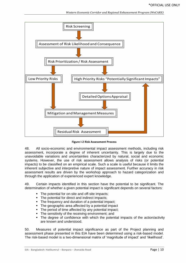
Western Economic Corridor and Regional Enhancement Program (WeCARE)
EIA - Bangladesh: Hatikumrul – Bonpara – Jhenaida Road Page | 10
*OFFICIAL USE ONLY
48. All socio-economic and environmental impact assessment methods, including risk assessment, incorporate a degree of inherent uncertainty. This is largely due to the unavoidable variations and uncertainties characterized by natural, social and economic systems. However, the use of risk assessment allows analysis of risks (or potential impacts) to be classified on an empirical scale. Such a scale is useful because it limits the inherent subjective and interpretive nature of impact assessment. Further accuracy in risk assessment results are driven by the workshop approach to hazard categorization and through the application of experienced expert knowledge. 49. Certain impacts identified in this section have the potential to be significant. The determination of whether a given potential impact is significant depends on several factors:
▪ The potential for on-site and off-site impacts; ▪ The potential for direct and indirect impacts; ▪ The frequency and duration of a potential impact; ▪ The geographic area affected by a potential impact ▪ The period of time affected by any potential impact; ▪ The sensitivity of the receiving environment; and ▪ The degree of confidence with which the potential impacts of the action/activity
are known and understood.
50. Measures of potential impact significance as part of the Project planning and assessment phase presented in this EIA have been determined using a risk-based model. The risk-based model is a two-dimensional matrix of ‘magnitude of impact’ and ‘likelihood’.
Risk Screening
Risk Prioritization / Risk Assessment
Assessment of Risk Likelihood and Consequence
Low Priority Risks High Priority Risks “Potentially Significant Impacts”
Detailed Options Appraisal
Mitigation and Management Measures
Residual Risk Assessment
Figure I-2 Risk Assessment Process
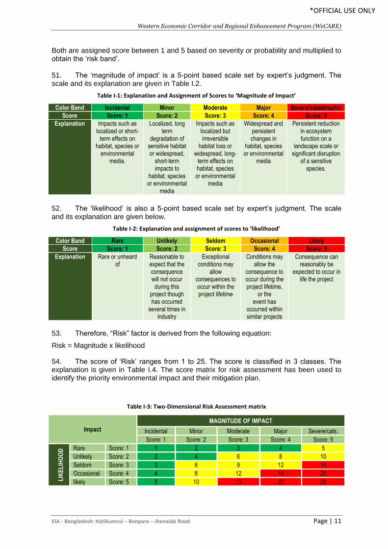
Western Economic Corridor and Regional Enhancement Program (WeCARE)
EIA - Bangladesh: Hatikumrul – Bonpara – Jhenaida Road Page | 11
*OFFICIAL USE ONLY
Both are assigned score between 1 and 5 based on severity or probability and multiplied to obtain the ‘risk band’. 51. The ‘magnitude of impact’ is a 5-point based scale set by expert’s judgment. The scale and its explanation are given in Table I.2.
Table I-1: Explanation and Assignment of Scores to ‘Magnitude of Impact’
Color Band Incidental Minor Moderate Major Severe/catastrophic
Score Score: 1 Score: 2 Score: 3 Score: 4 Score: 5
Explanation Impacts such as localized or short-
term effects on habitat, species or
environmental media.
Localized, long term
degradation of sensitive habitat or widespread,
short-term impacts to
habitat, species or environmental
media
Impacts such as localized but irreversible
habitat loss or widespread, long-
term effects on habitat, species or environmental
media
Widespread and persistent changes in
habitat, species or environmental
media
Persistent reduction in ecosystem function on a
landscape scale or significant disruption
of a sensitive species.
52. The ‘likelihood’ is also a 5-point based scale set by expert’s judgment. The scale and its explanation are given below.
Table I-2: Explanation and assignment of scores to ‘likelihood’
Color Band Rare Unlikely Seldom Occasional Likely
Score Score: 1 Score: 2 Score: 3 Score: 4 Score: 5
Explanation Rare or unheard of
Reasonable to expect that the consequence will not occur
during this project though has occurred
several times in industry
Exceptional conditions may
allow consequences to occur within the project lifetime
Conditions may allow the
consequence to occur during the project lifetime,
or the event has
occurred within similar projects
Consequence can reasonably be
expected to occur in life the project
53. Therefore, “Risk” factor is derived from the following equation:
Risk = Magnitude x likelihood
54. The score of ‘Risk’ ranges from 1 to 25. The score is classified in 3 classes. The explanation is given in Table I.4. The score matrix for risk assessment has been used to identify the priority environmental impact and their mitigation plan.
Table I-3: Two-Dimensional Risk Assessment matrix
Impact
MAGNITUDE OF IMPACT
Incidental Minor Moderate Major Severe/cats.
Score: 1 Score: 2 Score: 3 Score: 4 Score: 5
LIK
EL
IHO
OD
Rare Score: 1 1 2 3 4 5
Unlikely Score: 2 2 4 6 8 10
Seldom Score: 3 3 6 9 12 15
Occasional Score: 4 4 8 12 16 20
likely Score: 5 5 10 15 20 25
Western Economic Corridor and Regional Enhancement Program (WeCARE)
EIA - Bangladesh: Hatikumrul – Bonpara – Jhenaida Road Page | 12
*OFFICIAL USE ONLY
Methods for Mitigation and Management
55. Mitigation measures are the means by which potential negative impacts associated with the Project may be avoided or reduced to appropriate levels through modifications to the design, construction methods or context of the Project. In real terms, ‘reducing negative impacts to an appropriate level’ means that the potential impacts are reduced to a point where they no longer pose a significant threat to the current or future status of the surrounding natural environment, biodiversity value, and social or economic environment of the region. 56. Suggested mitigation measures for this Project are provided in Chapter VI. The mitigation measures have been translated into actions to maintain the environmental integrity of the Project and provide workable solutions. 57. An Environmental and Social Management Plan (ESMP) has been developed for each of the major issues identified and assessed within this EIA in Chapter IX. The ESMP incorporates environmental mitigation measures identified in Chapter VI and forms a practical guide to the ongoing management of all aspects of the Project, including biophysical monitoring and performance criteria auditing for the life of the Project. 58. Each ESMP Sub-Plan is consistent with the standards and guidelines of Bangladesh and with international best practice principles. The ESMP Sub-Plans document the following elements for each environmental aspect.
H. Contents of the Report
59. This report includes the following main elements;
Chapter I: Introduction and background
This chapter consists of the background of the project along with the objectives, scope and the methodology of preparing the EIA report. This chapter also includes the organization of the total EIA report. Chapter II: Legislative framework
In this chapter the national and international laws and policies are described which are relevant to the environmental aspects of the project. The relevant guidelines of the funding agency AIIB are also described in this chapter. Finally, the requirements for making EIA for this project according to DoE and AIIB are described. Chapter III: Project background
This chapter includes the background and objectives of the proposed project. The location of the project, proposed project interventions and project cost are described here. In total, this chapter gives a detailed idea about the project. Chapter IV: Description of the environmental and social baseline
This section provides the definition and baseline conditions or attributes of the study area and its existing physical, biological and socio-economic environment. This section presents both environmental and socio-economic aspect and draws upon both secondary and primary data collection. Maps tables, figures and plates are used to present relevant data about the study area to provide a comprehensive picture of the existing environment prior to Project implementation. Chapter V: Analysis of alternatives
Western Economic Corridor and Regional Enhancement Program (WeCARE)
EIA - Bangladesh: Hatikumrul – Bonpara – Jhenaida Road Page | 13
*OFFICIAL USE ONLY
In this chapter the alternative options of the proposed project are analyzed. It starts from no project alternative and ends at analyzing all the possible alternatives. This chapter concludes with declaring the proposed project as the best solution after analyzing all the other alternatives. Chapter VI: Anticipated environmental and social impacts of the proposed project
This section identifies the potential positive and negative environmental, physical and socio-economic impacts of the Project. Each key aspect is analysed and discussed in relation to the Project. For key aspects, the potential impacts are broken down into the different delivery stages of the Project. A risk prioritization matrix is presented which forms the guideline adopted for the undertaking of a risk assessment to identify the significance of potential impacts by way of likelihood and consequence. From this risk assessment, the identified potentially significant impacts are drawn out and presented as those that require most attention in the development of specific management and mitigation measures. Chapter VII: Public consultation
This section presents the outcomes of the stakeholder engagement and consultation undertaken as part of the EIA. Different types of engagement and consultation were undertaken with different stakeholder groups including local and divisional government administrations, the local community, business and social leaders, NGO’s and individuals. These were largely undertaken by one-on-one meetings, small group interviews, and focus group discussions. Chapter VIII: Climate change assessment
This chapter illustrated with a detailed literature review on the climate change and its impact of the project road along with adaptation measures. Chapter IX: Environmental and Social management plan
This chapter includes the environmental and social management plan which includes the impacts of the proposed project on environment and society is described. All the anticipated impacts in pre-construction stage, construction stage and operational stage are described here. Chapter X: Grievance redresses mechanism
This chapter includes the mechanism to redress the grievances from the local people during the implementation of the project. Chapter XI: Conclusion and recommendation
This chapter includes the conclusion and some recommendations are suggested here about the proposed project.
Western Economic Corridor and Regional Enhancement Program (WeCARE)
EIA - Bangladesh: Hatikumrul – Bonpara – Jhenaida Road Page | 14
*OFFICIAL USE ONLY
II. ENVIRONMENTAL POLICY, LEGAL AND ADMINISTRATIVE
FRAMEWORK
A. Regulatory Requirements for the Project
60. Regulatory requirements toward protection and conservation of environment and various environmental resources and also toward protection of social environment from adverse impact of projects and activities associated with them have been enunciated by the GoB as well as the AIIB relevant requirements are summarized below.
B. National Legal and Institutional Framework
1. National Environmental Policy, 1992
61. Bangladesh has adopted a National Environmental Policy (NEP) in 1992 aimed at sustainable development. The NEP sets out the basic framework for environmental action together with a set of broad sectoral guidelines for action. Major elements of the policy are as follows:
a) maintaining the ecological balance for ensuring sustainable development; b) protection of the country against natural disasters; c) identifying and controlling activities which are polluting and destroying the
environment; d) ensuring environment-friendly development in all sectors; e) promoting sustainable and sound management of natural resources; and f) active collaboration with international initiatives related to the environment.
62. Relevance to the project - With regard to the transport sector, the environmental policy aims at prevention of pollution and degradation of resources caused by roads and inland waterways transport.
2. National Environmental Management Action Plan (NEMAP), 1995
63. The National Environmental Management Action Plan (NEMAP) builds on the NEP and was developed to address specific issues and management requirements during the period 1995-2005. The plan includes a framework within which the recommendations of a National Conservation Strategy (NCS) are to be implemented. The NEMAP was developed with the following objectives:
a) to identify key environmental issues affecting Bangladesh; b) to identify actions to halt or reduce the rate of environmental degradation; c) to improve management of the natural environment; d) to conserve and protect habitats and bio-diversity; e) to promote sustainable development; and f) to improve the quality of life.
64. Relevance to the project - The plan proposes development and application of guidelines to avoid environmental pollution due to transport and communication system. It particularly puts emphasis on different environmental pollution, hamper of natural drainage pattern and agricultural land acquisition due to development of transport system.
Western Economic Corridor and Regional Enhancement Program (WeCARE)
EIA - Bangladesh: Hatikumrul – Bonpara – Jhenaida Road Page | 15
*OFFICIAL USE ONLY
3. Environmental Conservation Act (ECA), 1995
65. The ECA is currently the main legislation relating to environment protection in Bangladesh. This Act is promulgated for environment conservation, environmental standards development and environment pollution control and abatement. 66. The main objectives of ECA are:
▪ Conservation and improvement of the environment; and
▪ Control and mitigation of pollution of the environment.
67. The main focuses of the Act can be summarized as:
- Declaration of ecologically critical areas and restriction on the operations and processes, which can or cannot be carried out/ initiated in the ecologically critical areas (ECA);
- Regulations in respect of vehicles emitting smoke harmful for the environment;
- Environmental clearance;
- Regulation of industries and other development activities’ discharge permits;
- Promulgation of standards for quality of air, water, noise and soil for different areas for different purposes;
- Promulgation of a standard limit for discharging and emitting waste; and
- Formulation and declaration of environmental guidelines.
68. Before any new project can go ahead, as stipulated under the ECA, the project promoter must obtain Environmental Clearance from the Director General (DG), DOE. An appeal procedure does exist for those promoters who fail to obtain clearance. Failure to comply with any part of this Act may result in punishment to a maximum of 5 years imprisonment or a maximum fine of Tk.100, 000 or both. The DOE executes the Act under the leadership of the DG. 69. The Project will be undertaken in line with the aims and objectives of the Act by conserving the environment and controlling and mitigating potential impacts throughout the drilling program.
• Environmental Conservation Act (Amendment 2000)
70. The Bangladesh Environment Conservation Act Amendment 2000 focuses on ascertaining responsibility for compensation in cases of damage to ecosystems, increased provision of punitive measures both for fines and imprisonment and the authority to take cognizance of offences.
• Environmental Conservation Act (Amendment 2002) 71. The 2002 Amendment of the ECA elaborates on the following parts of the Act:
- Restrictions on polluting automobiles;
- Restrictions on the sale, production of environmentally harmful items like polythene bags;
- Assistance from law enforcement agencies for environmental actions;
- Break up of punitive measures; and
Western Economic Corridor and Regional Enhancement Program (WeCARE)
EIA - Bangladesh: Hatikumrul – Bonpara – Jhenaida Road Page | 16
*OFFICIAL USE ONLY
- Authority to try environmental cases.
• Environmental Conservation Act (Amendment 2010) 72. This amendment of the act introduces new rules and restriction on:
- No individual or institution (Gov. or Semi Govt., / Non-Govt. / Self Governing) can cut any Hill and Hillock. In case of national interest; it can be done after getting clearance from respective the department
- Owner of the ship breaking yard will be bound to ensure proper management of their hazardous wastes to prevent environmental pollution and Health Risk
- No remarked water body cannot be filled up/changed; in case of national interest; it can be done after getting clearance from the respective department; and
- Emitter of any activities/incident will be bound to control emission of environmental pollutants that exceeds the existing emission standards.
73. Relevance to the project - According to this law no industrial unit or project shall be established or undertaken without obtaining, in the manner prescribed by rules, an Environmental Clearance Certificate from the Director General.
4. Environment Conservation Rules, 1997 (Amended in 2002)
74. These are a set of rules, promulgated under the ECA, 1995 and its amendments. The Environment Conservation Rules provide categorization of industries and projects and identify types of environmental assessment required against respective categories of industries or projects. The Rules set:
▪ The National Environmental Quality Standards (NEQS) for ambient air, various types of water, industrial effluent, emission, noise, vehicular exhaust etc.;
▪ The requirement for and procedures to obtain environmental clearance; and ▪ The requirement for IEE and EIA according to categories of industrial and other
development interventions. 75. The Environment Conservation Rules, 1997 were issued by the GOB in exercise of the power conferred under the Environment Conservation Act (Section 20), 1995. Under these Rules, the following aspects, among others, are covered:
▪ Declaration of ecologically critical areas; ▪ Classification of industries and projects into four categories; ▪ Procedures for issuing the Environmental Clearance Certificate (ECC); and ▪ Determination of environmental standards.
76. Rule 3 defines the factors to be considered in declaring an 'ecologically critical area’ as per Section 5 of the ECA (1995). It empowers the Government to declare the area as the Ecologically Critical Areas (ECA), if it is satisfied that the ecosystem of the area has reached or is threatened to reach a critical state or condition due to environmental degradation. The Government is also empowered to specify which of operations or processes may be carried out or may not be initiated in the ecologically critical area. Under this mandate, the Ministry of Environment and Forest (MOEF) has declared Sundarban, Cox's Bazar-Tekhnaf Sea Shore, Saint Martin Island, Sonadia Island, Hakaluki Haor, Tanguar Haor, Marzat Baor and Gulshan-Baridhara Lake as ecologically critical areas and prohibited certain activities in those areas.
Western Economic Corridor and Regional Enhancement Program (WeCARE)
EIA - Bangladesh: Hatikumrul – Bonpara – Jhenaida Road Page | 17
*OFFICIAL USE ONLY
77. Rule 7 of the 1997 ECR provides a classification of industrial units and projects into four categories, depending on environmental impact and location. These categories are:
▪ Green; ▪ Orange A; ▪ Orange B; and ▪ Red.
78. The categorization of a project determines the procedure for issuance of an Environmental Clearance Certificate (ECC). All proposed industrial units and projects that are considered to be low polluting are categorized under "Green" and shall be granted Environmental Clearance. These are Orange B for work that requires Initial Environmental Examination (IEE) and Red for work that requires full environmental and social assessment. 79. A detailed description of those four categories of industries has been given in Schedule-1 of ECR'97. Apart from general requirement, for every Red category proposed industrial unit or project, the application must be accompanied with feasibility report on Initial Environmental Examination, Environmental Impact Assessment based on approved TOR by DOE, Environmental Management Plan (EMP) etc. 80. Depending upon location, size and severity of pollution loads, projects/activities have been classified in ECR, 1997 into four categories: Green, Orange A, Orange B and Red respectively, to nil, minor, medium and severe impacts on important environmental components (IECs). Corresponding categories of road projects are based on: Red Category
• Item 67: include construction / reconstruction / expansion of roads (regional, national and international). So, EIA study and ECC are required from the DOE.
81. Relevance to the project - In accordance with the Environment Conservation Rules (ECR) of 1997, the Project is classified as a Red Category, requiring a complete Environmental Impact Assessment (EIA) for RHD to obtain clearance for construction.
5. Environmental Courts Act, 2000
82. The Environment Court Act, 2000 has been enacted in order to establish environmental courts in each administrative division of Bangladesh. This Act sets out policy for effective pursuance and completion of legal proceedings related to environmental crimes. Under this Act the Director General of the DOE has the power to impose heavy penalties to industrial polluters who are dumping untreated wastewater into the environment or not operating their legally mandated ETPs. 83. Relevance to the project - According to this act, government can take legal actions if any environmental problem occurs due to project interventions.
6. The EIA Guidelines for Industry (1997)
84. The EIA Guidelines is a handbook defining procedures for preparing EIAs and for reviewing them, prepared for the benefit of the development partners, EIA consultants, reviewers, and academicians. 85. Relevance to the project - The Guidelines provide a step-by-step methodology for the completion of EIAs.
Western Economic Corridor and Regional Enhancement Program (WeCARE)
EIA - Bangladesh: Hatikumrul – Bonpara – Jhenaida Road Page | 18
*OFFICIAL USE ONLY
7. National Land Transport Policy, 2004
86. The Land Transport Policy has been formulated in light of the Government pledge to establish a transport system that is safe, cheap, modern, technologically dependable, and environmentally friendly. The objectives of this policy are:
▪ To introduce long-term network planning. ▪ To maintain the road network at a level, this protects the value of the investment. ▪ To secure a sustainable means of funding road maintenance. ▪ To improve the management of traffic. ▪ Management of road-side activities. ▪ To develop an integrated planning approach in road construction. ▪ To involve the private sector more in infrastructure, services and maintenance. ▪ To well protect the environment from road construction program
87. Relevance to the project - According to the policy, all new roads and major improvements, tolled or otherwise, are subjected to an Environmental Impact Assessment (EIA).
8. Environmental Guideline of RHD, 2004
88. RHD will seek to minimize the impact of its activities on the environment, including those activities of its consultants, contractors and agents. The Department’s specific environmental goals and objectives are:
▪ Minimize air pollution, including dust, from all RHD activities and planned projects. ▪ Reduce noise emanating from vehicles and plant operated by RHD and minimize the
potential effects of noise from new roads and traffic. ▪ Avoid water sedimentation and minimize the pollution of surface water from road run-
off, maintenance and construction activities, site camps and depots. ▪ Avoid impeding the free flow of surface waters and make all bridges and culverts ‘fish
friendly’ by allowing the free movement and migration of all aquatic species. ▪ Encourage the involvement of local people, especially women and disadvantaged
groups, in the construction and maintenance of all road projects. Ensure that work conditions for those employed directly or indirectly by RHD are in accordance with national labour regulations and international obligations.
▪ Avoid disrupting businesses and agricultural, fishing and social activities, including minimizing delays to traffic during road maintenance and construction.
▪ Minimize the need to resettle people in any road building or widening activities by avoiding existing housing areas and homesteads, industries and businesses.
▪ Protect areas and places of cultural heritage. ▪ Avoid the waste of material and energy, and recycle materials, including road
scrapings materials, wood, metal, oil, paper and other products. ▪ Minimize land acquisition when planning and constructing new roads, especially land
in productive use for agriculture, fishing, or forestry. ▪ Reduce dangers from accidents for all road users, especially pedestrians, through
the design of safe roads, bridges and ferry Ghats. ▪ Dispose of all waste materials in a safe and hygienic manner. ▪ Ensure that adequate drinking water is available for all employees and contractor’s
staff. ▪ Ensure that sewage and waste disposal facilities are provided for employees and
contractor’s staff and that they are sited an adequate distance away from sources of human and animal water supplies.
▪ Control pests in all temporary and permanent sites, including those of contractors.
Western Economic Corridor and Regional Enhancement Program (WeCARE)
EIA - Bangladesh: Hatikumrul – Bonpara – Jhenaida Road Page | 19
*OFFICIAL USE ONLY
▪ Ensure that RHD workers and their contractors are educated regarding health care, including issues such as sexually transmitted diseases.
89. Relevance to the project - According to the guideline, any impacts due to road construction activities needed to be minimized and proper compensation should be paid to the affected people.
9. RHD’s Road Master Plan, 2009
90. The objectives of RHD’s road master plan are:
▪ Protecting the value of RHD’s road and bridge assets ▪ Improving the connectivity of the road network ▪ Enhancing and developing the strategic road network to meet economic and traffic
growth targets ▪ Improving the zilla road network to enhance connectivity to the country’s growth
targets ▪ Improving road safety to reduce road accidents ▪ Provide environmental and social protection ▪ Outline the institution improvements required for RHD
91. Relevance to the project - According to the plan, the physical and social environment must be protected from adverse effects of road construction.
10. The Forest Act (1927) and the Forest (Amendment) Act (2000)
92. The Forest Act (1927) was enacted to control trespass, illegal resources extraction from forests and to provide a framework for the forestry revenue collection system. It is the main legislative context for forestry protection and management in Bangladesh. The Act allows for the notification of forest reserves in which the government, through the Forest Department, regulates the felling, extraction and transport of forestry produce in Bangladesh. The Act grants the government several basic powers, largely for conservation and protection of government forests, and limited powers for private forests. 93. Relevance to the project - The Act is relevant to the project as construction of the project road will require cutting 1053681 trees.
11. National Forest Policy (amendment), 1994
94. The National Forest Policy of 1994 is the amended and revised version of the National Forest Policy of 1977. The policy is designed to conserve the existing forest areas, bring about 20 % of the country's land area under the Forestation Programme, and increase reserve forests by 10 percent per year to 2015 through coordinated efforts of GoB-NGOs and through active participation of the people. 95. Relevance to the project - The Act is relevant to the project as construction of the project road will require cutting 105368 trees.
12. The Private Forests Ordinance, 1959
96. An Ordinance to provide for the conservation of private forests and for the afforestation in certain cases of waste lands in Bangladesh.
1As per the Social & Resettlement Survey.
Western Economic Corridor and Regional Enhancement Program (WeCARE)
EIA - Bangladesh: Hatikumrul – Bonpara – Jhenaida Road Page | 20
*OFFICIAL USE ONLY
97. Relevance to the project - According to the section 61 of this ordinance any land is required for any of the purposes of this Ordinance; such land shall be deemed to be needed for a public purpose.
13. Bangladesh Wildlife (Conservation & Security) Act, 2012
98. This Order aims to protect and conserve wildlife in Bangladesh. Wildlife preservation, conservation and management fall within the jurisdiction of the Forestry Department. The previous Wildlife (Preservation) Order, 1973 & Wildlife (Preservation) (Amendment) Act, 1974 have been revamped to Wildlife (Conservation & Security) Act of 2012. 99. The Act has adopted new types of protected areas for conservation and protection of wildlife resources, created avenue for community conserved areas and also community-based management of protected areas. This Act protects 1,307 species of plants and animals under four schedules that mandates imprisonment and fines for wildlife poaching, capturing, trapping, and trading. Bangladesh Wildlife (Preservation) Order (1973) and Act (1974) regulates the hunting, killing, capture, trade and export of wildlife and wildlife products. It designates a list of protected species and game animals. Protection of wildlife is provided with lists of species within four schedules of the Order:
• First Schedule - The Schedule -1 (823) represents Protected Animal (Amphibians-14, reptiles-96, birds-578, mammals-110, fishes-25) of Bangladesh which are open to shooting and may be hunted on a special hunting permit (though since 1988 no hunting permits have been issued by the Government).
• Second Schedule – Schedule-2 (424) also represents Protected Animal (Amphibians-18, reptiles-58, birds-44, mammals-3, fishes-27, phylum cnidaria – class anthozoa (coral)-32, molluscs – shells and snails-137, arthropods – crustacea (crabs and lobster)-22, insect (butterflies and moths)-59, Insect – beetles-24 those species that are not to be hunted, killed or captured and CITES Specification;
• Third Schedule – Schedule -3 (6) represents Vermin-6 Protected animals; and
• Fourth Schedule - Schedule -4 (54) represents Protected Plants-41 and Orchid-13. 100. Relevance to the project - This Act is relevant to the project as intervention may affect wildlife habitation, obstruct movement.
14. National Water Policy, 1999
101. The policy aims to provide guidance to the major players in water sector for ensuring optimal development and management of water. The policy emphasizes efficient and equitable management of water resources, proper harnessing and development of surface and ground water, availability of water to all concerned and institutional capacity building for water resource management. It also addresses issues like river basin management, water rights and allocation, public and private investment, water supply and sanitation and water need for agriculture, industry, fisheries, wildlife, navigation, recreation, environment, preservation of wetlands, etc. The policy has several clauses related to the project for ensuring environmental protection. 102. Relevance to the project - Clause 4.6b of this policy states that natural depressions and water bodies in major urban areas must be preserved in order to recharge of underground aquifers and rainwater management. Moreover, measures must be taken to minimize disruption to the natural aquatic environment in streams and water channels (Clause 4.9b). In addition, this policy requires each water resources development project or rehabilitation program to give full consideration to environmental protection, restoration and enhancement measures consistent with National Environmental Management Action Plan
Western Economic Corridor and Regional Enhancement Program (WeCARE)
EIA - Bangladesh: Hatikumrul – Bonpara – Jhenaida Road Page | 21
*OFFICIAL USE ONLY
(NEMAP) and the National Water Management Plan (NWMP) and adhere to a formal environment impact assessment (EIA) process, if required by the Government (Clause 4.12a and clause 4.12b).
15. National Fisheries Policy, 1998
103. The policy recognizes that fish production has declined due to environmental imbalances, adverse environmental impact and improper implementation of fish culture and management programs. The policy suggests, among others, that biodiversity will be maintained in natural water bodies and in marine environment and control measures will be taken against activities that have a negative impact on fisheries, resources and vice-versa. National Fisheries Policy focuses on aquaculture and marine fisheries development and includes the following mandates:
• Maintaining biodiversity in natural water bodies and in marine environment,
• Ensuring that chemicals harmful to the environment will not be used in fish shrimp farms;
• Using environment friendly fish shrimp culture technology;
• Expanding fisheries areas and integrating rice, fish and shrimp cultivation;
• Undertaking control measures against activities that have a negative impact on fisheries resources and vice-versa; and
• Formulating laws will to ban the disposal of any untreated industrial effluents into the water bodies.
104. Relevance to the project - The project required to take proper action to prevent any hindrance of biodiversity in natural water bodies and in aquatic environment.
16. Protection and Conservation of Fish Act 1950 (Amended 1982)
105. The Protection and Conservation of Fish Act of 1950, as amended by the Protection and Conservation of Fish (Amendment) Ordinance of 1982 and the Protection and Conservation of Fish (Amendment) Act of 1995, provides provisions for the protection and conservation of fish in inland waters of Bangladesh. This is relatively unspecific and simply provides a means by which the Government may introduce rules to protect those inland waters not in private ownership. 106. This is framework legislation with rule making powers. Among others, some of these rules may prohibit the destruction of, or any attempt to destroy, fish by the poisoning of water or the depletion of fisheries by pollution, by industrial effluent or otherwise. 107. Relevance to the project - Through this framework legislation, the government makes rules to prohibit the destruction of, or any attempt to destroy, fish by the poisoning of water or the depletion of fisheries by pollution, by industrial effluent or otherwise. Protection and Conservation of Fish Rules (1985). 108. The Fish Rules (1985) specifies in section-6 of the Rules states that “No person shall destroy or make any attempt to destroy any fish by poisoning of water or the depletion of fisheries by pollution, by trade (industrial) effluents or otherwise in inland waters”. It is considered that the proposed project construction works are in line with the objectives of the above-mentioned Act and Rules. 109. The project required to take proper action to prevent any hindrance of biodiversity in natural water bodies and in marine environment.
Western Economic Corridor and Regional Enhancement Program (WeCARE)
EIA - Bangladesh: Hatikumrul – Bonpara – Jhenaida Road Page | 22
*OFFICIAL USE ONLY
17. National Agriculture Policy, 1999
110. This policy aims to make the nation self-sufficient in food through increasing production of all crops including cereals and ensure a dependable and secure food system for all. One of the objectives of this Act is to preserve and develop land productivity. The policy particularly stresses on research and development of improved varieties and technologies for cultivation in water-logged and salinity affected areas. The policy also recognizes that adequate measures should be taken to reduce water-logging and salinity and provide irrigation facilities for crop production. 111. Relevance to the project - According to the policy alignment of the proposed project must be selected carefully so that acquisition of fertile agricultural land is minimal. Moreover, adequate measures should be taken to reduce water-logging and hamper of irrigation system due to construction of the project road.
18. National Land Use Policy, 2001
112. The National Land Use Policy was adopted by Bangladesh government in 2001, setting out guidelines for improved land-use and zoning regulations. The main objectives of this policy are to ensure criteria-based uses of land and to provide guidelines for usage of land for the purpose of agriculture, housing, afforestation, commercial and industrial establishments, rail and highway and for tea and rubber gardens. Overall, this policy promotes a sustainable and planned utilization of land. 113. The main contents of this policy are:
• Stopping the high conversion rate of agricultural land to nonagricultural purposes;
• Utilizing agro-ecological zones to determine maximum land use efficiency;
• Adopting measures to discourage the conversion of agricultural land for urban or development purposes;
• Improving the environmental sustainability of land-use practices. 114. Relevance to the project - The proposed project must adhere to this policy so that environmental sustainability of land-use practices is assured.
19. The Embankment and Drainage Act, 1952
115. This Act consolidates the laws relating to Embankments and drainage. It provides provision for the construction, maintenance, management, removal and control of embankments and water courses for the better drainage of lands and for their protection from floods, erosion or other damage by water. 116. Relevance to the project - Disposal of dredged spoil may create drainage obstruction. So, adherence to relevant section of the Act must be addressed in the environmental assessment.
20. Bangladesh Climate Change Strategy and Action Plan (BCCSAP) 2009
117. The GoB prepared the Bangladesh Climate Change Strategy and Action Plan (BCCSAP) in 2008 and revised in 2009. This is a comprehensive strategy to address climate change challenges in Bangladesh. Bangladesh Climate Change Strategy and Action Plan built on and expanded the NAPA. It is built around the following six themes:
• Food security, social protection and health to ensure that the poorest and most vulnerable in society, including women and children, are protected from climate
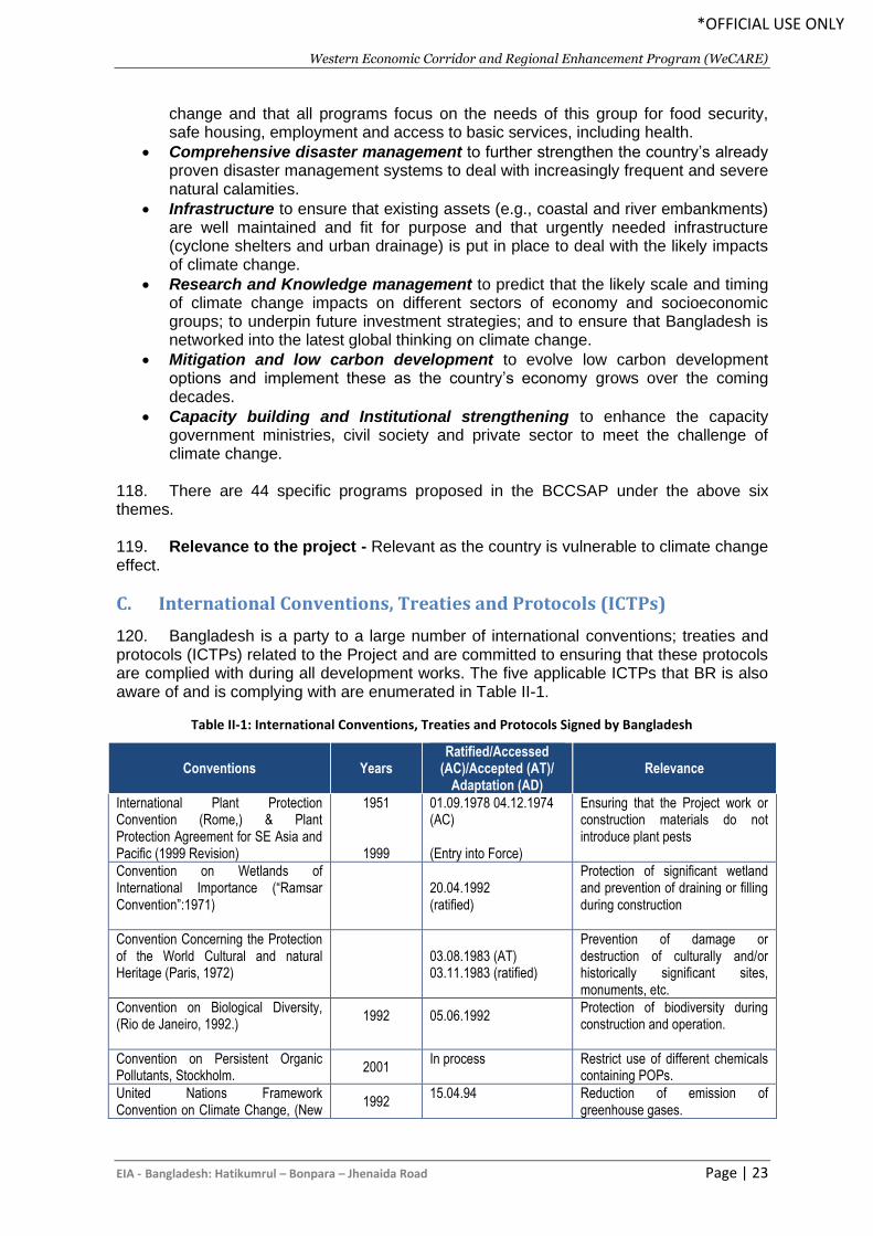
Western Economic Corridor and Regional Enhancement Program (WeCARE)
EIA - Bangladesh: Hatikumrul – Bonpara – Jhenaida Road Page | 23
*OFFICIAL USE ONLY
change and that all programs focus on the needs of this group for food security, safe housing, employment and access to basic services, including health.
• Comprehensive disaster management to further strengthen the country’s already proven disaster management systems to deal with increasingly frequent and severe natural calamities.
• Infrastructure to ensure that existing assets (e.g., coastal and river embankments) are well maintained and fit for purpose and that urgently needed infrastructure (cyclone shelters and urban drainage) is put in place to deal with the likely impacts of climate change.
• Research and Knowledge management to predict that the likely scale and timing of climate change impacts on different sectors of economy and socioeconomic groups; to underpin future investment strategies; and to ensure that Bangladesh is networked into the latest global thinking on climate change.
• Mitigation and low carbon development to evolve low carbon development options and implement these as the country’s economy grows over the coming decades.
• Capacity building and Institutional strengthening to enhance the capacity government ministries, civil society and private sector to meet the challenge of climate change.
118. There are 44 specific programs proposed in the BCCSAP under the above six themes. 119. Relevance to the project - Relevant as the country is vulnerable to climate change effect.
C. International Conventions, Treaties and Protocols (ICTPs)
120. Bangladesh is a party to a large number of international conventions; treaties and protocols (ICTPs) related to the Project and are committed to ensuring that these protocols are complied with during all development works. The five applicable ICTPs that BR is also aware of and is complying with are enumerated in Table II-1.
Table II-1: International Conventions, Treaties and Protocols Signed by Bangladesh
Conventions Years Ratified/Accessed
(AC)/Accepted (AT)/ Adaptation (AD)
Relevance
International Plant Protection Convention (Rome,) & Plant Protection Agreement for SE Asia and Pacific (1999 Revision)
1951
1999
01.09.1978 04.12.1974 (AC) (Entry into Force)
Ensuring that the Project work or construction materials do not introduce plant pests
Convention on Wetlands of International Importance (“Ramsar Convention”:1971)
20.04.1992 (ratified)
Protection of significant wetland and prevention of draining or filling during construction
Convention Concerning the Protection of the World Cultural and natural Heritage (Paris, 1972)
03.08.1983 (AT) 03.11.1983 (ratified)
Prevention of damage or destruction of culturally and/or historically significant sites, monuments, etc.
Convention on Biological Diversity, (Rio de Janeiro, 1992.)
1992
05.06.1992
Protection of biodiversity during construction and operation.
Convention on Persistent Organic Pollutants, Stockholm.
2001 In process
Restrict use of different chemicals containing POPs.
United Nations Framework Convention on Climate Change, (New
1992 15.04.94
Reduction of emission of greenhouse gases.
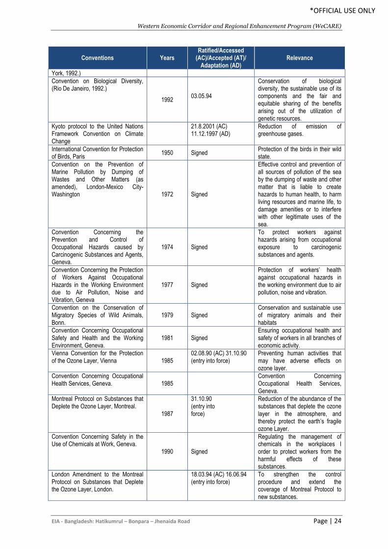
Western Economic Corridor and Regional Enhancement Program (WeCARE)
EIA - Bangladesh: Hatikumrul – Bonpara – Jhenaida Road Page | 24
*OFFICIAL USE ONLY
Conventions Years Ratified/Accessed
(AC)/Accepted (AT)/ Adaptation (AD)
Relevance
York, 1992.)
Convention on Biological Diversity, (Rio De Janeiro, 1992.)
1992 03.05.94
Conservation of biological diversity, the sustainable use of its components and the fair and equitable sharing of the benefits arising out of the utilization of genetic resources.
Kyoto protocol to the United Nations Framework Convention on Climate Change
21.8.2001 (AC) 11.12.1997 (AD)
Reduction of emission of greenhouse gases.
International Convention for Protection of Birds, Paris
1950 Signed Protection of the birds in their wild state.
Convention on the Prevention of Marine Pollution by Dumping of Wastes and Other Matters (as amended), London-Mexico City-Washington 1972 Signed
Effective control and prevention of all sources of pollution of the sea by the dumping of waste and other matter that is liable to create hazards to human health, to harm living resources and marine life, to damage amenities or to interfere with other legitimate uses of the sea.
Convention Concerning the Prevention and Control of Occupational Hazards caused by Carcinogenic Substances and Agents, Geneva.
1974 Signed
To protect workers against hazards arising from occupational exposure to carcinogenic substances and agents.
Convention Concerning the Protection of Workers Against Occupational Hazards in the Working Environment due to Air Pollution, Noise and Vibration, Geneva
1977 Signed
Protection of workers’ health against occupational hazards in the working environment due to air pollution, noise and vibration.
Convention on the Conservation of Migratory Species of Wild Animals, Bonn.
1979 Signed Conservation and sustainable use of migratory animals and their habitats
Convention Concerning Occupational Safety and Health and the Working Environment, Geneva.
1981 Signed Ensuring occupational health and safety of workers in all branches of economic activity.
Vienna Convention for the Protection of the Ozone Layer, Vienna 1985
02.08.90 (AC) 31.10.90 (entry into force)
Preventing human activities that may have adverse effects on ozone layer.
Convention Concerning Occupational Health Services, Geneva. 1985
Convention Concerning Occupational Health Services, Geneva.
Montreal Protocol on Substances that Deplete the Ozone Layer, Montreal.
1987
31.10.90 (entry into force)
Reduction of the abundance of the substances that deplete the ozone layer in the atmosphere, and thereby protect the earth’s fragile ozone Layer.
Convention Concerning Safety in the Use of Chemicals at Work, Geneva.
1990 Signed
Regulating the management of chemicals in the workplaces I order to protect workers from the harmful effects of these substances.
London Amendment to the Montreal Protocol on Substances that Deplete the Ozone Layer, London.
18.03.94 (AC) 16.06.94 (entry into force)
To strengthen the control procedure and extend the coverage of Montreal Protocol to new substances.
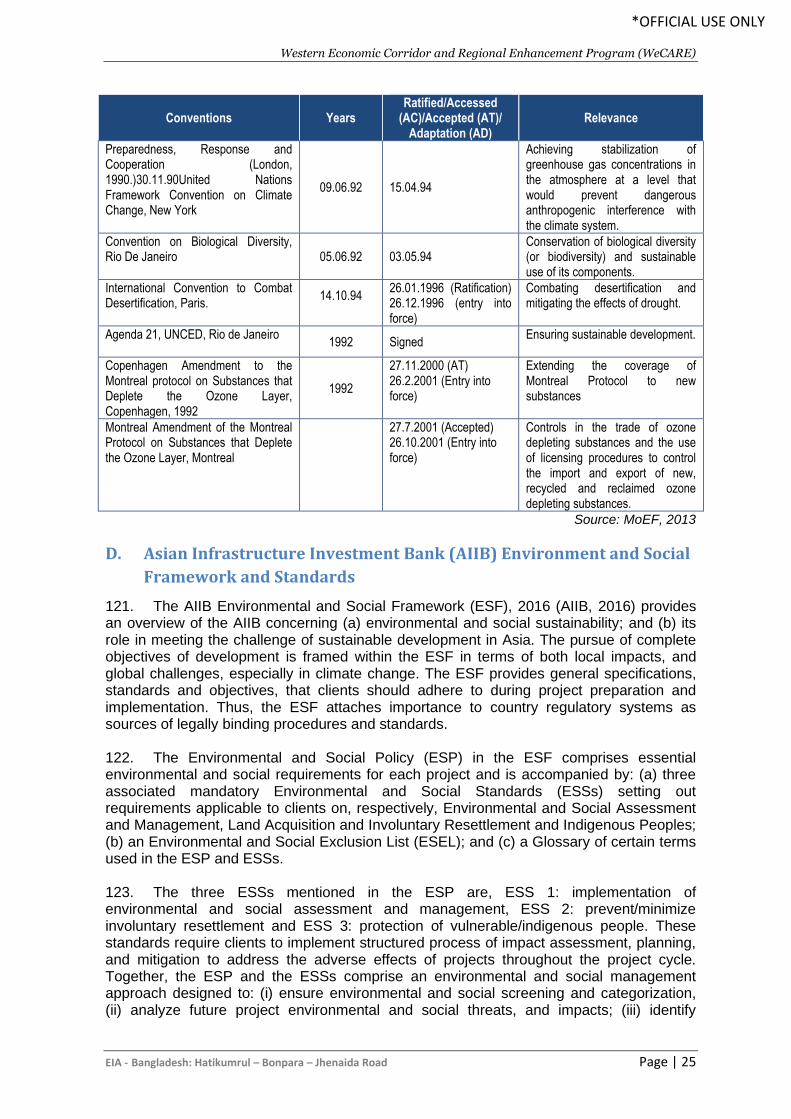
Western Economic Corridor and Regional Enhancement Program (WeCARE)
EIA - Bangladesh: Hatikumrul – Bonpara – Jhenaida Road Page | 25
*OFFICIAL USE ONLY
Conventions Years Ratified/Accessed
(AC)/Accepted (AT)/ Adaptation (AD)
Relevance
Preparedness, Response and Cooperation (London, 1990.)30.11.90United Nations Framework Convention on Climate Change, New York
09.06.92 15.04.94
Achieving stabilization of greenhouse gas concentrations in the atmosphere at a level that would prevent dangerous anthropogenic interference with the climate system.
Convention on Biological Diversity, Rio De Janeiro
05.06.92 03.05.94 Conservation of biological diversity (or biodiversity) and sustainable use of its components.
International Convention to Combat Desertification, Paris.
14.10.94
26.01.1996 (Ratification) 26.12.1996 (entry into force)
Combating desertification and mitigating the effects of drought.
Agenda 21, UNCED, Rio de Janeiro
1992 Signed Ensuring sustainable development.
Copenhagen Amendment to the Montreal protocol on Substances that Deplete the Ozone Layer, Copenhagen, 1992
1992
27.11.2000 (AT) 26.2.2001 (Entry into force)
Extending the coverage of Montreal Protocol to new substances
Montreal Amendment of the Montreal Protocol on Substances that Deplete the Ozone Layer, Montreal
27.7.2001 (Accepted) 26.10.2001 (Entry into force)
Controls in the trade of ozone depleting substances and the use of licensing procedures to control the import and export of new, recycled and reclaimed ozone depleting substances.
Source: MoEF, 2013
D. Asian Infrastructure Investment Bank (AIIB) Environment and Social
Framework and Standards
121. The AIIB Environmental and Social Framework (ESF), 2016 (AIIB, 2016) provides an overview of the AIIB concerning (a) environmental and social sustainability; and (b) its role in meeting the challenge of sustainable development in Asia. The pursue of complete objectives of development is framed within the ESF in terms of both local impacts, and global challenges, especially in climate change. The ESF provides general specifications, standards and objectives, that clients should adhere to during project preparation and implementation. Thus, the ESF attaches importance to country regulatory systems as sources of legally binding procedures and standards. 122. The Environmental and Social Policy (ESP) in the ESF comprises essential environmental and social requirements for each project and is accompanied by: (a) three associated mandatory Environmental and Social Standards (ESSs) setting out requirements applicable to clients on, respectively, Environmental and Social Assessment and Management, Land Acquisition and Involuntary Resettlement and Indigenous Peoples; (b) an Environmental and Social Exclusion List (ESEL); and (c) a Glossary of certain terms used in the ESP and ESSs. 123. The three ESSs mentioned in the ESP are, ESS 1: implementation of environmental and social assessment and management, ESS 2: prevent/minimize involuntary resettlement and ESS 3: protection of vulnerable/indigenous people. These standards require clients to implement structured process of impact assessment, planning, and mitigation to address the adverse effects of projects throughout the project cycle. Together, the ESP and the ESSs comprise an environmental and social management approach designed to: (i) ensure environmental and social screening and categorization, (ii) analyze future project environmental and social threats, and impacts; (iii) identify
Western Economic Corridor and Regional Enhancement Program (WeCARE)
EIA - Bangladesh: Hatikumrul – Bonpara – Jhenaida Road Page | 26
*OFFICIAL USE ONLY
measures to prevent, reduce, mitigate, cover or make up for project environmental and social impacts; (iv) provide a process to consult the public on environmental and social risks and impacts of projects and to disclose information.
124. The AIIB classifies all its projects into four categories.
• The project is categorized as Category A if it is likely to have significant adverse
environmental and social impacts that are irreversible, cumulative, diverse or
unprecedented and requires the client to conduct an Environmental Impact
Assessment (EIA) with Environmental and Social Management Plan (ESMP).
• A project is categorized as Category B when: it has a limited potentially adverse
environmental and social impacts; the impacts are not unprecedented; few if any of
them are irreversible or cumulative; they are site-specific; and can be successfully
managed using good practice in an operational setting and requires clients to
conduct an initial review of the environmental and social implications of the Project.
• A Project is categorized C when it is likely to have minimal or no adverse
environmental and social impacts and the client is required to prepare a review of
the environmental and social aspects of the Project.
• A Project is categorized FI if the financing structure involves the provision of funds
to a financial intermediary (FI) for the Project, whereby the Bank delegates to the FI
the decision-making on the use of the Bank funds, including the selection,
appraisal, approval and monitoring of Bank-financed subprojects. The Bank
requires the FI to develop and apply an appropriate ESMS that is proportional to the
environmental and social risks associated with the Bank-supported portfolio, is
consistent with this ESP, excludes from Bank support activities covered in the
ESEL and incorporates applicable provisions of the ESSs.
125. AIIB requires the client to establish, in accordance with the ESP and applicable ESSs, a suitable grievance mechanism to receive and facilitate resolution of the concerns or complaints of people who believe they have been adversely affected by the Project’s environmental or social impacts, and to inform Project-affected people of its availability. People who believe they have been or are likely to be adversely affected by a failure of the Bank to implement the ESP may also submit complaints to the Bank’s oversight mechanism in accordance with the policies and procedures to be established by the Bank for such mechanism. ESF 2016 (amended in 2019) has also provisions for identify measures to avoid, minimize, or mitigate potentially adverse impacts on and risks to physical, biological, socioeconomic and cultural resources, safety of both workers and affected community and natural resources during the design, construction, operation, and decommissioning of the project.
E. Legislation Relating to Occupational Health and Safety
126. During construction, the project will conform to the labor laws and occupational and health related rules as outlined in Table II-2.
Table II-2: Relevant Occupational Health and Safety Laws and Rules
Title Overview
Bangladesh Labor Act, 2006 Provides for safety of work force during construction period. The act provides guidance of employer’s extent of responsibility and the workman’s right to compensation in case of injury caused by accident while working.
Western Economic Corridor and Regional Enhancement Program (WeCARE)
EIA - Bangladesh: Hatikumrul – Bonpara – Jhenaida Road Page | 27
*OFFICIAL USE ONLY
Title Overview
Labor Relations under Labor Laws, 1996
General concerns during the project implementation state that the project manager must recognize labor unions.
Public Health (Emergency Provisions) Ordinance, 1994
Calls for special provisions with regard to public health. In case of emergency, it is necessary to make special provisions for preventing the spread of disease, safeguarding the public health, and providing adequate medical service, and other services essential to the health of respective communities and workers during construction-related work.
The Employees State Insurance Act, 1948
Health, injury and sickness benefit should be paid.
The Employer's Liability Act, 1938
Covers accidents, risks, and damages with respect to employment injuries
Maternity Benefit Act, 1950 Framed rules for female employees, who are entitled to various benefits for maternity
Bangladesh Factory Act, 1979
Workplaces provisions: these Act and Labor Laws require medical facilities, first aid, accident and emergency arrangements, and childcare services to be provided to the workers at workplace.
F. Legislation Relating to Stakeholder Engagement and Information
Disclosure
127. The DoE guidelines for IEE/EIA preparation encourages the implementing agency to conduct public consultations of orange-B and red category projects. The current environmental and social framework in Bangladesh does not recognize public consultation as a means for environmental decision making. Implementing agencies present the outcome of their assessment in the IEE/EIA reports which they submit to the DoE for clearance. However, opportunities for the public to review the final/completed IEE/EIA report are under the discretion of the Director-General of the DoE. The DoE does not officially disclose EIA report findings publicly on their website. However, when carrying out donor projects public consultation of reports are a standard practice and DoE is cognizant of this. 128. Relevance to the project - Stakeholder engagement is an important instrument of public policy and these regulations/laws aim to make the development project inclusive by giving voice to the communities. The anticipated civil work makes it necessary to implement stakeholder engagement. The current EIA system in the country does not have the scope for public consultation and disclosure. Therefore, guidance from AIIB ESF will underpin the stakeholder engagement and information disclosure requirements of the project
G. Environmental Categorization by GoB
129. The MoEF enacted the Bangladesh Environmental Conservation Act (BECA 1995) and the Bangladesh Environmental Conservation Rules (BECR, 1997) in accordance with the guidelines of the National Environmental Policy (NEP 1992), as follow- up of the Rio Conference (1992). A National Land Transport Policy (NLTP 2004) was enacted accordingly to reduce the number of deaths and injuries caused every year due to road accidents. The BECR (1997) categorized the various industries/projects in the country as Green, Orange, and Red, depending on their environmental impacts. 130. The road sector projects including bridge construction have been categorized as Red categories, as shown below:
• Red Item 67: Construction/reconstruction/extension of the regional, national, and international roads;
• Red Item 68: Construction/reconstruction/extension of bridges longer than 100 meters;
Western Economic Corridor and Regional Enhancement Program (WeCARE)
EIA - Bangladesh: Hatikumrul – Bonpara – Jhenaida Road Page | 28
*OFFICIAL USE ONLY
131. A project that falls into the Red category requires the preparation of an Environmental Impact Assessment (EIA). It is therefore concluded that an IEE should be prepared along with the Terms of Reference (TOR) for EIA preparation during feasibility study and an EIA during the detailed engineering design stage is required for this project.
H. Environmental Categorization by AIIB
132. The AIIB Environmental and Social Framework determines the project category by the type of the project’s component presenting the highest environmental or social risk, including direct, indirect, cumulative and induced impacts, as relevant, in the project area. The Environmental and Social Standards mentioned in the ESP covers environmental and social assessment and management, involuntary resettlement and vulnerable/indigenous people. These standards require clients to implement structured process of impact assessment, planning, and mitigation to address the adverse effects of projects throughout the project cycle. Together, the ESP and the ESSs comprise an environmental and social management which require that: (i) environmental and social screening and categorization is ensured early, (ii) future project environmental and social threats and impacts are analyzed; (iii) measures are identified to prevent, reduce, mitigate, cover or make up for project environmental and social impacts; (iv) a process to consult the public on environmental and social risks and impacts of projects and to disclose information is provided. The ESF apply to all AIIB-financed projects, including private sector operations, and to all project components. 133. Due to the nature and scale of this project and applying the ESF of AIIB the project has been classified as category A project. Category A refers to proposed projects if it is likely to have a number of potentially significant adverse environmental and/or social impacts. In this case the potential social impacts due to resettlement of project affected persons warrant a high risk categorization. For this category, the Bank determines the appropriate environmental and social assessment documentation the Client is required to prepare on a case-by-case basis. A full EIA is required for this project.
I. GoB Environmental Clearance
134. Steps to be followed for obtaining the Environmental Clearance Certificate for this road are shown in Figure II-1. For any Orange B or Red Category project, an IEE must be submitted to DoE in order to obtain clearance to proceed to construction, or to undertake the full EIA if Orange B is upgraded to Red by DoE. Once the IEE of Orange B is approved by DoE, the environmental requirements have been met. All Red Category projects require a DoE-approved IEE before proceeding to EIA preparation. Once the EIA has been approved, the clearance certificate is issued.
Table II-3: Actions Required for Different Stages of the Project
Stage of Project Required Actions
Feasibility Study Initial Environmental Examination (IEE), Obtaining Site Clearance, and preparation and finalizing of terms of references (TOR)
Detailed Engineering Design Completion of Environmental Impact Assessment and obtaining Environmental Clearance Certificate (ECC).
Preparation of Development Project Proposal (DPP)
Inclusion of recommendations from EIA in the DPP
Approval and construction of project Implementation of Environmental Management Plan (EMP) of construction stage
Operational Stage Implementing Monitoring Plan set by Environmental Management Plan (EMP) of operational stage
Western Economic Corridor and Regional Enhancement Program (WeCARE)
EIA - Bangladesh: Hatikumrul – Bonpara – Jhenaida Road Page | 29
*OFFICIAL USE ONLY
135. The No Objection Certificate (NOC) – this is a mandatory requirement to obtain environmental clearance from the Department of Environment (DoE). Usually DoE indicates the name of the agencies from whom NOC would be required. DoE requires that proponent obtain NOCs from affected agencies or local/regional administrations, which essentially sign off on the project. It is only after these NOCs are provided that DoE gives the Environmental Clearance Certificate, or green light to proceed to construction. 136. A NOC letter basically contains description of the project including location, justification to obtain NOC from that agency, and proposed measures under the project. In this Project, RHD will submit the NOC letter to the agencies mentioned above. This is a labor and time intensive process and can take more than a month and is largely contingent on regular and persistent follow up. Therefore, the ECC steps are: 137. RHD submits NOC letter or submits the standard NOC form of DoE, if applicable. The steps are:
• RHD sends letters to head of the agency;
• The requesting agency then evaluate the NOC request that sometime require field investigation for verification;
• RHD will pursue this and generally requires constant follow up to get a result; and
• Once the NOC’s are received-signed, they are forwarded by RHD to DOE.
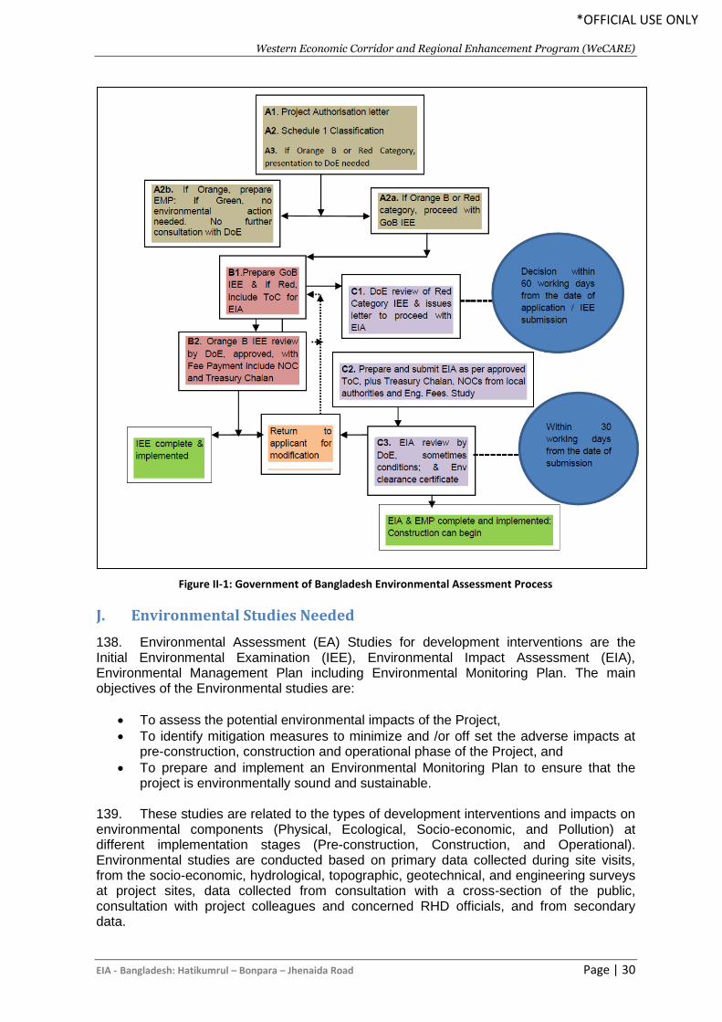
Western Economic Corridor and Regional Enhancement Program (WeCARE)
EIA - Bangladesh: Hatikumrul – Bonpara – Jhenaida Road Page | 30
*OFFICIAL USE ONLY
Figure II-1: Government of Bangladesh Environmental Assessment Process
J. Environmental Studies Needed
138. Environmental Assessment (EA) Studies for development interventions are the Initial Environmental Examination (IEE), Environmental Impact Assessment (EIA), Environmental Management Plan including Environmental Monitoring Plan. The main objectives of the Environmental studies are:
• To assess the potential environmental impacts of the Project,
• To identify mitigation measures to minimize and /or off set the adverse impacts at pre-construction, construction and operational phase of the Project, and
• To prepare and implement an Environmental Monitoring Plan to ensure that the project is environmentally sound and sustainable.
139. These studies are related to the types of development interventions and impacts on environmental components (Physical, Ecological, Socio-economic, and Pollution) at different implementation stages (Pre-construction, Construction, and Operational). Environmental studies are conducted based on primary data collected during site visits, from the socio-economic, hydrological, topographic, geotechnical, and engineering surveys at project sites, data collected from consultation with a cross-section of the public, consultation with project colleagues and concerned RHD officials, and from secondary data.
Western Economic Corridor and Regional Enhancement Program (WeCARE)
EIA - Bangladesh: Hatikumrul – Bonpara – Jhenaida Road Page | 31
*OFFICIAL USE ONLY
140. Implementation of the above interventions will have significant impacts on various environmental components; hence, they will require comprehensive environmental studies in accordance with the DOE and AIIB guidelines. The project roads involve the improvement and widening of the existing 2-lane road into four-lane highways, hence their impacts on environmental conditions may be significant, but will be less compared to new road construction. In addition, the impacts on agriculture, livelihoods, ecological components, infrastructure, and pollution, may be significant.
141. The preparation of IEE and EIA during the feasibility and detailed design phases is obligatory under environmental legislations and rules of Bangladesh, as well as for compliance the environmental guidelines of donor agency, AIIB. An environmental clearance certificate (ECC) from DoE is required for initiating project implementation activities. The EIA study needed is based on the degree of project impacts for decision making and planning, acts as legal document for the implementing agency and as a management tools to stakeholders and guidelines for the Contractor during project implementation phases.
K. Institutional arrangements
1. RHD
142. The Roads and Highways Department (RHD) is the Executing Agency (EA) for the RHD and will be responsible for ensuring that all the components of the ESF are complied with. The RHD has the responsibility to ensure that the investment follows the legal requirements for environmental assessment. The RHD has an Environmental and Social Circle (ESC) headed by the Superintending Engineer who is supported by the Executive Engineer, Subdivision Engineer, Assistant Engineer and Sub-assistant Engineer.
143. The Assistant Project Directors (ADPs) serve as the environmental focal persons under each PIU. One of Assistant Engineers serves as the environmental focal person at the site level and support the respective APD on environment safeguard matters. Further the Project Implementation Consultant (PIC) responsible for supervising the civil works contractor will provide support to the respective PIU for day to day monitoring and reporting on environment safeguards.
2. AIIB
144. As a funding agency AIIB is responsible for monitoring implementation of environment safeguards, providing technical guidance to the EA as necessary. Specific responsibilities entail the following:
• Review EIA reports, including ESMP, provide feedback, and disclose the reports on
the AIIB website as required by the AIIB Policy;
• Provide assistance to RHD, if required, in carrying out its responsibilities and for
building capacity for safeguard compliance;
• Monitor overall compliance of the RHD tranches and components to respective EIA
and ESMP through review missions;
• Review all environmental and social monitoring reports submitted by RHD, provide
feedback and disclose the reports on the AIIB website as required by the AIIB
Policy.
Western Economic Corridor and Regional Enhancement Program (WeCARE)
EIA - Bangladesh: Hatikumrul – Bonpara – Jhenaida Road Page | 32
*OFFICIAL USE ONLY
• Provide guidance to the RHD and the PIU on issues related to inclusion of new
component components, changes in component design, occurrence of
unanticipated environmental and social impacts during component implementation,
emergency situations and others as necessary.
L. AIIB policies
145. AIIB has a policy in the form of "Environmental and Social Standards (ESS)" for the purpose of addressing issues relating to environmental and social sustainability as AIIB considers it as a fundamental aspect of achieving outcomes consistent with its mandate to support infrastructure development and enhance interconnectivity in Asia. The objective of this overarching policy is to facilitate achievement of these development outcomes, through a system that integrates sound environmental and social management into Projects. AIIB has three associated environmental and social standards (ESSs), which set out more detailed mandatory environmental and social requirements relating to the following:
• ESS 1: Environmental and Social Assessment and Management (ESS 1);
• ESS 2: Involuntary Resettlement (ESS 2);
• ESS 3: Indigenous Peoples (ESS 3)
146. ESS1 applies to ensure the environmental and social soundness and sustainability of Projects and to support the integration of environmental and social considerations into the Project decision-making process and implementation and If any project is likely to have adverse environmental risks and impacts or social risks and impacts (or both). The scope of the environmental and social assessment and management measures are proportional to the risks and impacts of the Project. ESS 1 provides for both quality environmental and social assessment and management of risks and impacts through effective mitigation and monitoring measures during the course of Project implementation.
147. AIIB follows internationally applicable principles in case of any involuntary resettlement. AIIB carefully screens each and every project to determine whether or not it instigates any involuntary resettlement due to the project interventions. This includes both physical and economic displacement, as defined in the Environmental and Social Standards (ESS) 2: ‘Involuntary Resettlement’ under AIIB’s Environmental and Social Framework (Approved Feb, 2016; Amended Feb, 2019).
148. ESS 2 clearly acknowledges that there are cases where no alternatives can be found to avoid involuntary resettlement. In such cases, AIIB requires the Client to ensure that resettlement activities are conceived and carried out as sustainable development programs. The Client is required to provide sufficient resources to ensure that the people who are made to face involuntary resettlement share the benefits of the project.
149. In case of any involuntary resettlement, the RHD is required to prepare a Resettlement Policy Framework (RPF) and/or Resettlement Plan (RP) that it is proportionate to the extent and degree of impacts of project. The degree of impacts is determined by (a) the overall scope of displacement – both from economical and physical standpoint, and (b) the extent of vulnerability of the PAPs. A wider analysis of social risks associated with the project and their impacts is complemented by the RP for a comprehensive Social Impact Assessment (SIA) of the project. The RPF as well as the RP for a project set put the principles to be followed to ensure that impacts associated with involuntary resettlement, including but, not limited to – any land acquisition from, the land use rights changes of, any displacement of, and the need for livelihood restoration of the PDPs are mitigated so as to ensure Project Affected Peoples (PAPs) are no worse off and where possible their lives are improved as a result of the resettlement.
Western Economic Corridor and Regional Enhancement Program (WeCARE)
EIA - Bangladesh: Hatikumrul – Bonpara – Jhenaida Road Page | 33
*OFFICIAL USE ONLY
150. As specified in the Environmental and Social Framework (2019), AIIB recognizes that a considerable part of the population in the countries in which the Bank operates live without land title or recognized land rights. AIIB recognizes people without land title or legal rights to land are eligible for compensation. The AIIB requires the Client to ensure that these people receive resettlement assistance and compensation for loss of non-land assets; the procedure to ensure such would have to be in accordance with the cut-off dates will be established in the RP for the proposed project. Additionally, the Bank requires the Client to include these people in the resettlement consultation process.
151. ESS 3 applies if Indigenous Peoples are present in, or have a collective attachment to, the proposed area of the Project, and are likely to be affected by the Project. The term Indigenous Peoples is used in a generic sense to refer to a distinct, vulnerable, social and cultural group possessing the following characteristics in varying degrees: (a) self-identification as members of a distinct indigenous cultural group and recognition of this identity by others; (b) collective attachment to geographically distinct habitats or ancestral territories in the Project area and to the natural resources in these habitats and territories; (c) customary cultural, economic, social or political institutions that are separate from those of the dominant society and culture; and (d) a distinct language, often different from the official language of the country or region. In considering these characteristics, national legislation, customary law and any international conventions to which the country is a party may be taken into account. A group that has lost collective attachment to geographically distinct habitats or ancestral territories in the Project area because of forced severance remains eligible for coverage, as an Indigenous People, under ESS 3.
152. All AIIB funded Investment Project Financing are required to follow the Environmental and Social Framework (ESF) consisting three (3) Environmental and Social Standards (ESS). These ESSs set out their requirement for the borrowers relating to the identification and assessment of environmental and social risks and impacts associated with any project. The ESSs supports the borrowers in achieving good international practice relating to environmental and social sustainability, assist them in fulfilling their national and international environmental and social obligations, enhance transparency and accountability and ensure sustainable development outcome through ongoing stakeholder engagement.
Table II-4 Applicability of AIIB policies and relevance to this project
AIIB ESS
Policy,
Standards
Objectives Requirements
Relevance to the sub-
project/project and
Actions to be taken
ESS-1
Environmental
and Social
Risks
Assessment
and
Management
To conduct an environmental and social
assessment relating to these risks and
impacts, and design appropriate
measures to avoid, minimize, mitigate,
offset or compensate for them, all as
required under ESS 1. Adopt
differentiated measures so that adverse
impacts do not fall disproportionately on
the disadvantaged or vulnerable, and
they are not disadvantaged in sharing
development benefits and opportunities
The types of E&S risk and impacts that
should be considered in the environmental
and social assessment. The use and
strengthening of the Borrower’s
environmental and social framework for the
assessment, development and
implementation of AIIB financed projects
where appropriate.
Relevant GoB Laws/Regulation
(a) BECA 1995 and ECR 197 and
amendments
(b) ARIPA 2017
(c) Bangladesh Labor Act 2006; Bangladesh
Labor Rules 2015
(I)Project components
will be thoroughly
screened to ensure that
they are covered by and
meet the requirements of
ESS and Government
laws and regulation.
(II) E&S risks and
Impacts have been
identified based on
surveys and
consultations with
primary stakeholders
including communities
and implementing
agency
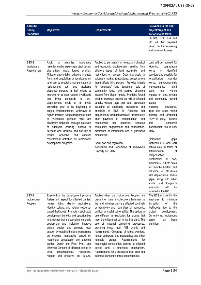
Western Economic Corridor and Regional Enhancement Program (WeCARE)
EIA - Bangladesh: Hatikumrul – Bonpara – Jhenaida Road Page | 34
*OFFICIAL USE ONLY
AIIB ESS
Policy,
Standards
Objectives Requirements
Relevance to the sub-
project/project and
Actions to be taken
(II) SIA, RPF, EIA and
RP will be prepared
based on the screening
and survey outcomes
ESS-2
Involuntary
Resettlement
Avoid or minimize involuntary
resettlement by exploring project design
alternatives. Avoid forced eviction.
Mitigate unavoidable adverse impacts
from land acquisition or restrictions on
land use by providing compensation at
replacement cost and assisting
displaced persons in their efforts to
improve, or at least restore, livelihoods
and living standards to pre-
displacement levels or to levels
prevailing prior to the beginning of
project implementation, whichever is
higher. Improve living conditions of poor
or vulnerable persons who are
physically displaced, through provision
of adequate housing, access to
services and facilities, and security of
tenure. Conceive and execute
resettlement activities as sustainable
development programs.
Applies to permanent or temporary physical
and economic displacement resulting from
different types of land acquisition and
restrictions on access. Does not apply to
voluntary market transactions, except where
these affects third parties. Provides criteria
for “voluntary” land donations, sale of
community land, and parties obtaining
income from illegal rentals. Prohibits forced
eviction (removal against the will of affected
people, without legal and other protection
including all applicable procedures and
principles in ESS 2). Requires that
acquisition of land and assets is initiated only
after payment of compensation and
resettlement has occurred. Requires
community engagement and consultation,
disclosure of information and a grievance
mechanism.
GoB Laws and regulation
Acquisition and Requisition of Immovable
Property Act, 2017
Land will be required for
widening, upgradation
works in identified
corridors and possibly for
rehabilitation corridor
works, curve/geometric
improvements, blind
spots, etc. Hence
impacts on land, private
and community owned
assets
including structures,
trees and crops within
existing and proposed
ROW is likely. Physical
and economic
displacement too is very
likely.
I)Important gaps
(between ESS and GoB
policy) exist in terms of
determination of
compensation,
identification of non-
titleholders, cut-off dates
for non-title holders and
valuation of structures
with depreciation. These
gaps, along with other
short- and long-term
measures will be
included in the RP.
ESS-3
Indigenous-
Peoples
Ensure that the development process
fosters full respect for affected parties’
human rights, dignity, aspirations,
identity, culture, and natural resource-
based livelihoods. Promote sustainable
development benefits and opportunities
in a manner that is accessible, culturally
appropriate and inclusive. Improve
project design and promote local
support by establishing and maintaining
an ongoing relationship based on
meaningful consultation with affected
parties. Obtain the Free, Prior, and
Informed Consent of affected parties in
three circumstances. Recognize,
respect and preserve the culture,
Applies when the Indigenous Peoples are
present or have a collective attachment to
the land, whether they are affected positively
or negatively and regardless of economic,
political or social vulnerability. The option to
use different terminologies for groups that
meet the criteria set out in the Standard. The
use of national screening processes,
providing these meet AIIB criteria and
requirements. Coverage of forest dwellers,
hunter gatherers, and pastoralists and other
nomadic groups. Requirements for
meaningful consultation tailored to affected
parties and a grievance mechanism.
Requirements for a process of free, prior and
informed consent in three circumstances.
This ESS will identify the
measures to minimize
disruption of the
livelihoods due to the
project development.
Currently no Indigenous
person has been
identified.
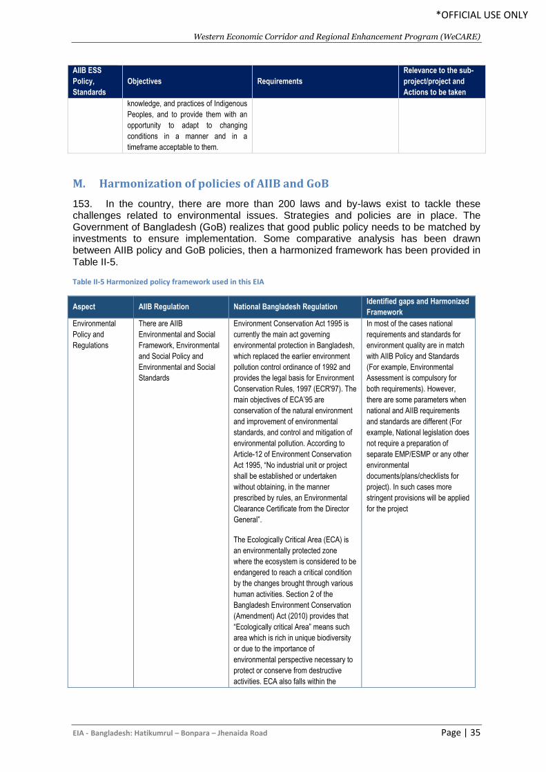
Western Economic Corridor and Regional Enhancement Program (WeCARE)
EIA - Bangladesh: Hatikumrul – Bonpara – Jhenaida Road Page | 35
*OFFICIAL USE ONLY
AIIB ESS
Policy,
Standards
Objectives Requirements
Relevance to the sub-
project/project and
Actions to be taken
knowledge, and practices of Indigenous
Peoples, and to provide them with an
opportunity to adapt to changing
conditions in a manner and in a
timeframe acceptable to them.
M. Harmonization of policies of AIIB and GoB
153. In the country, there are more than 200 laws and by-laws exist to tackle these challenges related to environmental issues. Strategies and policies are in place. The Government of Bangladesh (GoB) realizes that good public policy needs to be matched by investments to ensure implementation. Some comparative analysis has been drawn between AIIB policy and GoB policies, then a harmonized framework has been provided in Table II-5.
Table II-5 Harmonized policy framework used in this EIA
Aspect AIIB Regulation National Bangladesh Regulation Identified gaps and Harmonized
Framework
Environmental
Policy and
Regulations
There are AIIB
Environmental and Social
Framework, Environmental
and Social Policy and
Environmental and Social
Standards
Environment Conservation Act 1995 is
currently the main act governing
environmental protection in Bangladesh,
which replaced the earlier environment
pollution control ordinance of 1992 and
provides the legal basis for Environment
Conservation Rules, 1997 (ECR'97). The
main objectives of ECA’95 are
conservation of the natural environment
and improvement of environmental
standards, and control and mitigation of
environmental pollution. According to
Article-12 of Environment Conservation
Act 1995, “No industrial unit or project
shall be established or undertaken
without obtaining, in the manner
prescribed by rules, an Environmental
Clearance Certificate from the Director
General”.
The Ecologically Critical Area (ECA) is
an environmentally protected zone
where the ecosystem is considered to be
endangered to reach a critical condition
by the changes brought through various
human activities. Section 2 of the
Bangladesh Environment Conservation
(Amendment) Act (2010) provides that
“Ecologically critical Area” means such
area which is rich in unique biodiversity
or due to the importance of
environmental perspective necessary to
protect or conserve from destructive
activities. ECA also falls within the
In most of the cases national
requirements and standards for
environment quality are in match
with AIIB Policy and Standards
(For example, Environmental
Assessment is compulsory for
both requirements). However,
there are some parameters when
national and AIIB requirements
and standards are different (For
example, National legislation does
not require a preparation of
separate EMP/ESMP or any other
environmental
documents/plans/checklists for
project). In such cases more
stringent provisions will be applied
for the project
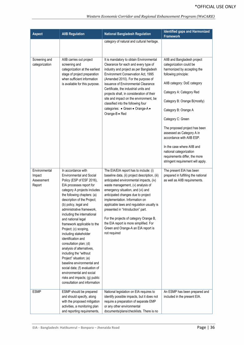
Western Economic Corridor and Regional Enhancement Program (WeCARE)
EIA - Bangladesh: Hatikumrul – Bonpara – Jhenaida Road Page | 36
*OFFICIAL USE ONLY
Aspect AIIB Regulation National Bangladesh Regulation Identified gaps and Harmonized
Framework
category of natural and cultural heritage.
Screening and
categorization
AIIB carries out project
screening and
categorization at the earliest
stage of project preparation
when sufficient information
is available for this purpose.
It is mandatory to obtain Environmental
Clearance for each and every type of
industry and project as per Bangladesh
Environment Conservation Act, 1995
(Amended 2010). For the purpose of
issuance of Environmental Clearance
Certificate, the industrial units and
projects shall, in consideration of their
site and impact on the environment, be
classified into the following four
categories: • Green • Orange-A •
Orange-B • Red
AIIB and Bangladesh project
categorization could be
harmonized by accepting the
following principle:
AIIB category: DoE category
Category A: Category Red
Category B: Orange B(mostly)
Category B: Orange A
Category C: Green
The proposed project has been
assessed as Category A in
accordance with AIIB ESP.
In the case where AIIB and
national categorization
requirements differ, the more
stringent requirement will apply.
Environmental
Impact
Assessment
Report
In accordance with
Environmental and Social
Policy (ESP of ESF 2016),
EIA processes report for
category A projects includes
the following chapters: (a)
description of the Project;
(b) policy, legal and
administrative framework,
including the international
and national legal
framework applicable to the
Project; (c) scoping,
including stakeholder
identification and
consultation plan; (d)
analysis of alternatives,
including the “without
Project” situation; (e)
baseline environmental and
social data; (f) evaluation of
environmental and social
risks and impacts; (g) public
consultation and information
The EIA/EIA report has to include: (i)
baseline data, (ii) project description, (iii)
anticipated environmental impacts, (iv)
waste management, (v) analysis of
emergency situation, and (vi) and
anticipated changes due to project
implementation. Information on
applicable laws and regulation usually is
presented in “Introduction” part.
For the projects of category Orange B,
the EIA report is more simplified. For
Green and Orange-A an EIA report is
not required
The present EIA has been
prepared in fulfilling the national
as well as AIIB requirements.
ESMP ESMP should be prepared
and should specify, along
with the proposed mitigation
activities, a monitoring plan
and reporting requirements,
National legislation on EIA requires to
identify possible impacts, but it does not
require a preparation of separate EMP
or any other environmental
documents/plans/checklists. There is no
An ESMP has been prepared and
included in the present EIA.
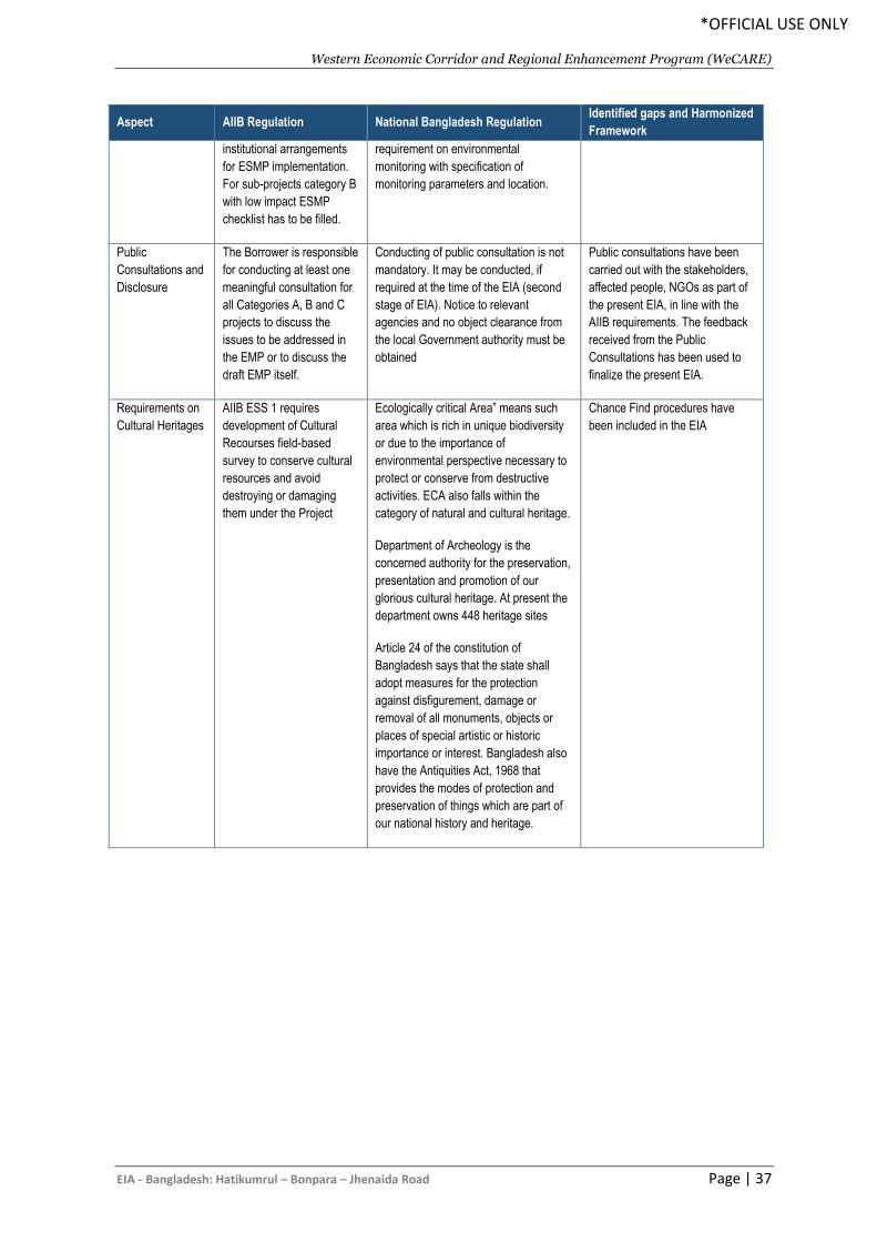
Western Economic Corridor and Regional Enhancement Program (WeCARE)
EIA - Bangladesh: Hatikumrul – Bonpara – Jhenaida Road Page | 37
*OFFICIAL USE ONLY
Aspect AIIB Regulation National Bangladesh Regulation Identified gaps and Harmonized
Framework
institutional arrangements
for ESMP implementation.
For sub-projects category B
with low impact ESMP
checklist has to be filled.
requirement on environmental
monitoring with specification of
monitoring parameters and location.
Public
Consultations and
Disclosure
The Borrower is responsible
for conducting at least one
meaningful consultation for
all Categories A, B and C
projects to discuss the
issues to be addressed in
the EMP or to discuss the
draft EMP itself.
Conducting of public consultation is not
mandatory. It may be conducted, if
required at the time of the EIA (second
stage of EIA). Notice to relevant
agencies and no object clearance from
the local Government authority must be
obtained
Public consultations have been
carried out with the stakeholders,
affected people, NGOs as part of
the present EIA, in line with the
AIIB requirements. The feedback
received from the Public
Consultations has been used to
finalize the present EIA.
Requirements on
Cultural Heritages
AIIB ESS 1 requires
development of Cultural
Recourses field-based
survey to conserve cultural
resources and avoid
destroying or damaging
them under the Project
Ecologically critical Area” means such
area which is rich in unique biodiversity
or due to the importance of
environmental perspective necessary to
protect or conserve from destructive
activities. ECA also falls within the
category of natural and cultural heritage.
Department of Archeology is the
concerned authority for the preservation,
presentation and promotion of our
glorious cultural heritage. At present the
department owns 448 heritage sites
Article 24 of the constitution of
Bangladesh says that the state shall
adopt measures for the protection
against disfigurement, damage or
removal of all monuments, objects or
places of special artistic or historic
importance or interest. Bangladesh also
have the Antiquities Act, 1968 that
provides the modes of protection and
preservation of things which are part of
our national history and heritage.
Chance Find procedures have
been included in the EIA
Western Economic Corridor and Regional Enhancement Program (WeCARE)
EIA - Bangladesh: Hatikumrul – Bonpara – Jhenaida Road Page | 38
*OFFICIAL USE ONLY
III. DESCRIPTION OF THE PROJECT
A. General
154. Bangladesh, due to its location, can serve as vital link between neighboring countries Nepal, Bhutan, Myanmar, and India. The Transport Working Group (TWG) of the South Asia Sub-regional Economic Cooperation (SASEC) has also identified four of the six corridors passing through Bangladesh. With the opening of Bangabandhu Bridge and the proposed development of Padma Bridge, the Bonpara–Jhenaidah transport corridor and other transport corridors can serve to facilitate trade between Bangladesh and the north-eastern states of India, the Indian state of West Bengal, and neighboring country Bhutan and Nepal. This central location of Bangladesh generates immense potential to benefit from better trade facilitation efforts. However, this potential has not been fully realized because of deficiencies in key infrastructure and the trade-related constraints.
155. The Hatkumrul – Bonpara – Jhenaidah Road is a vital link in the national highway network. The upgrading of this road is consistent with the Road Master Plan 2009 of Bangladesh. The existing road is mixed with four- and two-lane roads with shoulders. There is no separate provision for slow moving vehicular traffic (SMVT) or non-motorized traffic (NMT). There are capacities constraints caused by congested junctions, roadside parking, markets and built up areas.
156.
157. The completion of the proposed upgrading will substantially improve transport efficiency on the road linking the Bangabandhu Bridge to Dhaka and the Southwest Road Corridor (to Benapole and Mongla Sea Port).
B. Need for the Project
158. The Hatikumrul-Bonpara-Ishwardi-Pakshy-Kushtia-Jhenaidah Road connects Kushtia & Jhenaidah districts with Dhaka, the capital of Bangladesh through the greater national road network through Lalon Shah and Jamuna Bridges and Tangail district. Ruppur Nuclear Power Plant is situated by the side of this road at east end of Lalon Shah Bridge. The growing road traffic in this region will not be fulfilled by the existing highway. Road safety on the existing road is inadequate because it is overcrowded with different types of vehicles, including rickshaws, bicycles, motorcycles, cars, buses, and trucks. When vehicles break down this reduces the highway to a single lane leading to traffic delays and congestion. This improvement will provide enough additional capacity in this important corridor to accommodate future traffic growth and will also meet the demand for a safer and more reliable road connection. A limited controlled access road will prevent many of the issues noted in the RHD Road Master Plan, including the movement of slowing moving vehicles and hawkers into the traffic lanes. An uninterrupted access controlled 2 lane dual carriageway (four lane) will provide an unhindered flow of traffic, with no traffic signals, intersections or property access. They are free of any crossings with other roads, railways, or pedestrian paths, which are instead carried by overpasses and underpasses. Moreover, the access control road will opposite direction of travel by a central traffic barrier. Therefore, elimination of the sources of potential conflicts with other directions of travelers dramatically improves safety.
C. Location and Size of the Road
159. The Hatikumrul-Bonpara-Ishwardi-Kushtia-Jhenaidah Road, starts from Hatikumrul, runs towards the Bonpara intersection with Dhaka-Bonpara-Rajshahi national highway (N507) and ends at Jhenaidah 4-leg intersection of Jhenaidah-Jessore road with
Western Economic Corridor and Regional Enhancement Program (WeCARE)
EIA - Bangladesh: Hatikumrul – Bonpara – Jhenaida Road Page | 39
*OFFICIAL USE ONLY
Jhenaidah-Chuadanga road. The road crosses “Lalon Shah Bridge” over Padma River at Pakshy. The Lalon Shah Bridge over the Padma River is connecting the Pabna district on the east and Kushtia district on west side of the river. The candidate road runs from Bonpara in the north to south direction at Jhenaidah. The road from Bonpara to Dasuria, Ishwardi is a national highway (N6). From Ishwardi to Pakshy it is national highway (N705) and from Pakshy to Jhenaidah is also national highway (N704). The location map of the project roads is presented in Figure III-1. 160. Other mentionable bridge sites are: (i) Bheramara (near rail crossing), (ii) Baliapara Bridge, Kushtia, (iii) Laxmipur Bridge, Kushtia; (iv) Taraganj Bridge and (v) Bhite Bazar Bridge, Shailkupa, Jhenaidah. There is a permanent weigh station on the road at the Pakshy Lalon Shah Bridge, Ishwardi Pabna. 161. The road crosses the railway track at three places: Gopalpur rail crossing (17 km from Bonpara), Bheramara Power Station rail line and one on Kushtia bypass. The Roads and Highways Department, Kushtia started construction of about 6km long Kushtia bypass starts from Borkanda (before Kushtia) and ends at Battail Mor to avoid Kushtia town. The proposed new road alignment will also follow this bypass. 162. Other important places accessible through this road are the district towns of Natore, Pabna, Kushtia, Magura, then Faridpur and Jhenaidah and this is direct of Kushtia with Dhaka. Other important places connected to this road network are: Ruppur Nuclear Power Plant, Ishwardi; Bheramara Combined Cycle Power Plant Development Project, Islamic University Kushtia; Mongla seaport and Hili Land port, Hakimpur, Dinajpur.
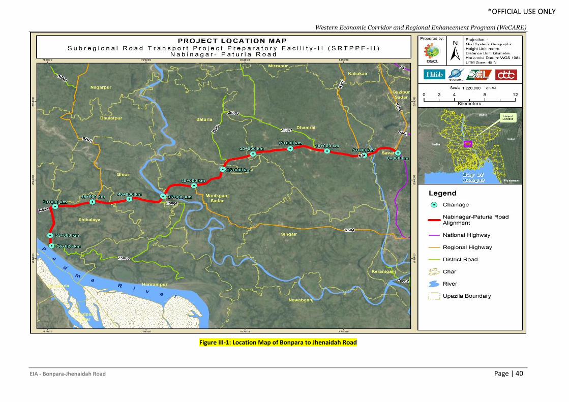
Western Economic Corridor and Regional Enhancement Program (WeCARE)
EIA - Bonpara-Jhenaidah Road Page | 40
*OFFICIAL USE ONLY
Figure III-1: Location Map of Bonpara to Jhenaidah Road
Western Economic Corridor and Regional Enhancement Program (WeCARE)
EIA - Bonpara-Jhenaidah Road Page | 41
*OFFICIAL USE ONLY
163. Phase I components: The phase 1 of the AIIB-WeCARE program consists of 5 components as below:
• Component 1: Procurement of Construction and Improvement of road corridor
from Lalonshah Bridge (West Side) to Alampur (31 km).
• Component 2: Procurement of Construction and Improvement of road corridor
from Alampur to Mirzapur (19 km)
• Component 3: Procurement of Construction and Improvement of road corridor
from Mirzapur to Jhenaidah (17 km)
• Component 4: Procurement of construction supervision and project
implementation consultancy services for construction and improvement of road
corridor from Lalonshah Bridge (West Side)-Jhenaidah (67 km)
• Component 5: Procurement of PIU supported PMC consultant (Individual)
164. The phase 1 of AIIB funded program will be around 67 km starts from the Lalonshah Bridge (West side), Kushtia to Jhenaidah road corridor. The Kustia-Jhinaidah Road, starts from Lalonshah Bridge (West Side) and ends at Jhinaidah 4-leg intersection of Jhinaidah-Jessore road with Jhinaidah-Magura road. The Lalon Shah Bridge over the Padma River is connecting the Pabna district on the east and Kushtia district on west side of the river. The road from Kushtia to Jhenaidah is a part of national highway (N704). The bridges on the roads are: (i) Bheramara (near rail crossing), (ii) Baliapara Bridge, Kushtia, (iii) Laxmipur Bridge, Kushtia; (iv) Taragonj Bridge and (v) Bhite Bazar Bridge, Shailkupa, Jhenaidah. The Kushtia-Jhinaidah Road connects Kustia & Jhenaidah districts with Dhaka, the capital of Bangladesh through the greater national road network. Ruppur Nuclear Power Plant is situated at east end of Lalon Shah Bridge. Details are shown with Figure III-2 below.
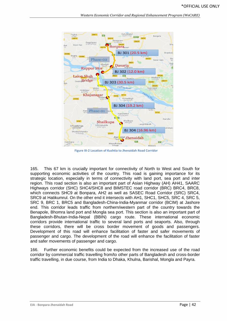
Western Economic Corridor and Regional Enhancement Program (WeCARE)
EIA - Bonpara-Jhenaidah Road Page | 42
*OFFICIAL USE ONLY
165. This 67 km is crucially important for connectivity of North to West and South for supporting economic activities of the country. This road is gaining importance for its strategic location, especially in terms of connectivity with land port, sea port and inter region. This road section is also an important part of Asian Highway (AH) AH41, SAARC Highways corridor (SHC) SHC4/SHC8 and BIMSTEC road corridor (BRC) BRC4, BRC8, which connects SHC9 at Bonpara, AH2 as well as SASEC Road Corridor (SRC) SRC4, SRC9 at Hatikumrul. On the other end it intersects with AH1, SHC1, SHC5, SRC 4, SRC 5, SRC 9, BRC 1, BRC5 and Bangladesh-China-India-Myanmar corridor (BCIM) at Jashore end. This corridor leads traffic from northern/western part of the country towards the Benapole, Bhomra land port and Mongla sea port. This section is also an important part of Bangladesh-Bhutan-India-Nepal (BBIN) cargo route. These international economic corridors provide international traffic to several land ports and seaports. Also, through these corridors, there will be cross border movement of goods and passengers. Development of this road will enhance facilitation of faster and safer movements of passenger and cargo. The development of the road will enhance the facilitation of faster and safer movements of passenger and cargo.
166. Further economic benefits could be expected from the increased use of the road corridor by commercial traffic travelling from/to other parts of Bangladesh and cross-border traffic travelling, in due course, from India to Dhaka, Khulna, Barishal, Mongla and Payra.
Figure III-2 Location of Kushtia to Jhenaidah Road Corridor
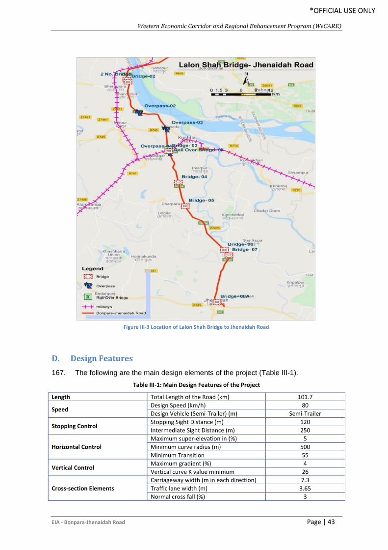
Western Economic Corridor and Regional Enhancement Program (WeCARE)
EIA - Bonpara-Jhenaidah Road Page | 43
*OFFICIAL USE ONLY
D. Design Features
167. The following are the main design elements of the project (Table III-1).
Table III-1: Main Design Features of the Project
Length Total Length of the Road (km) 101.7
Speed Design Speed (km/h) 80
Design Vehicle (Semi-Trailer) (m) Semi-Trailer
Stopping Control Stopping Sight Distance (m) 120
Intermediate Sight Distance (m) 250
Horizontal Control
Maximum super-elevation in (%) 5
Minimum curve radius (m) 500
Minimum Transition 55
Vertical Control Maximum gradient (%) 4
Vertical curve K value minimum 26
Cross-section Elements
Carriageway width (m in each direction) 7.3
Traffic lane width (m) 3.65
Normal cross fall (%) 3
Figure III-3 Location of Lalon Shah Bridge to Jhenaidah Road
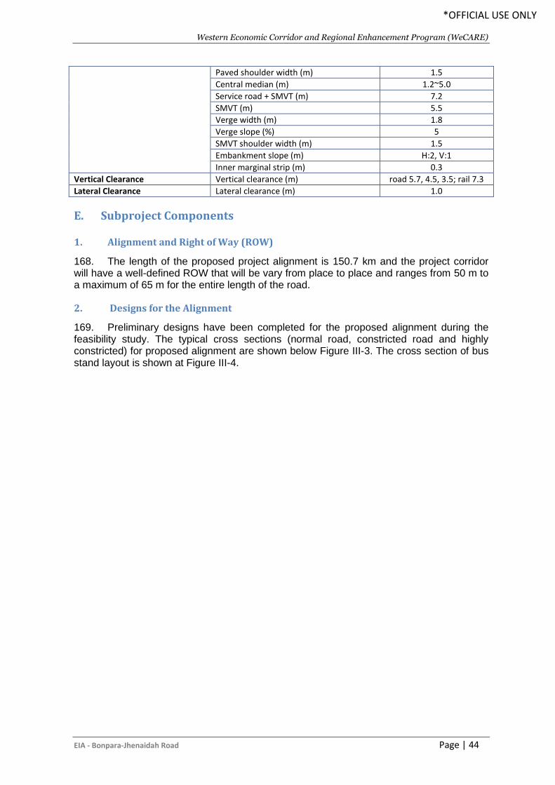
Western Economic Corridor and Regional Enhancement Program (WeCARE)
EIA - Bonpara-Jhenaidah Road Page | 44
*OFFICIAL USE ONLY
Paved shoulder width (m) 1.5
Central median (m) 1.2~5.0
Service road + SMVT (m) 7.2
SMVT (m) 5.5
Verge width (m) 1.8
Verge slope (%) 5
SMVT shoulder width (m) 1.5
Embankment slope (m) H:2, V:1
Inner marginal strip (m) 0.3
Vertical Clearance Vertical clearance (m) road 5.7, 4.5, 3.5; rail 7.3
Lateral Clearance Lateral clearance (m) 1.0
E. Subproject Components
1. Alignment and Right of Way (ROW)
168. The length of the proposed project alignment is 150.7 km and the project corridor will have a well-defined ROW that will be vary from place to place and ranges from 50 m to a maximum of 65 m for the entire length of the road.
2. Designs for the Alignment
169. Preliminary designs have been completed for the proposed alignment during the feasibility study. The typical cross sections (normal road, constricted road and highly constricted) for proposed alignment are shown below Figure III-3. The cross section of bus stand layout is shown at Figure III-4.
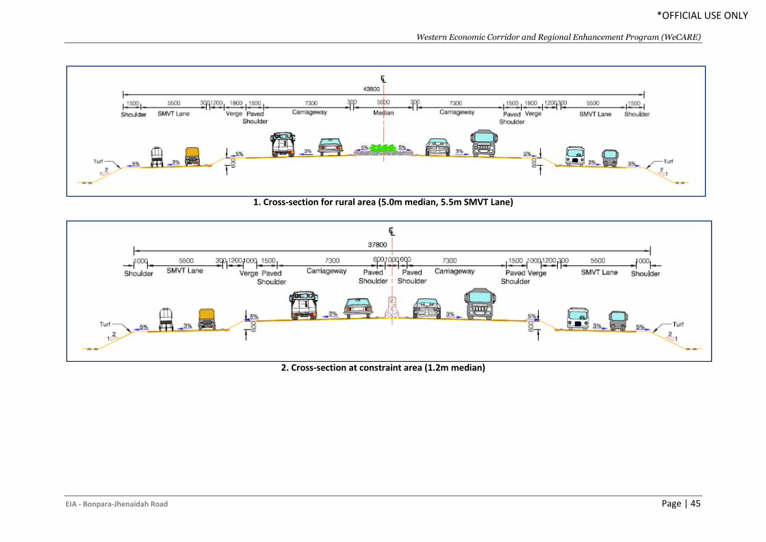
Western Economic Corridor and Regional Enhancement Program (WeCARE)
EIA - Bonpara-Jhenaidah Road Page | 45
*OFFICIAL USE ONLY
1. Cross-section for rural area (5.0m median, 5.5m SMVT Lane)
2. Cross-section at constraint area (1.2m median)
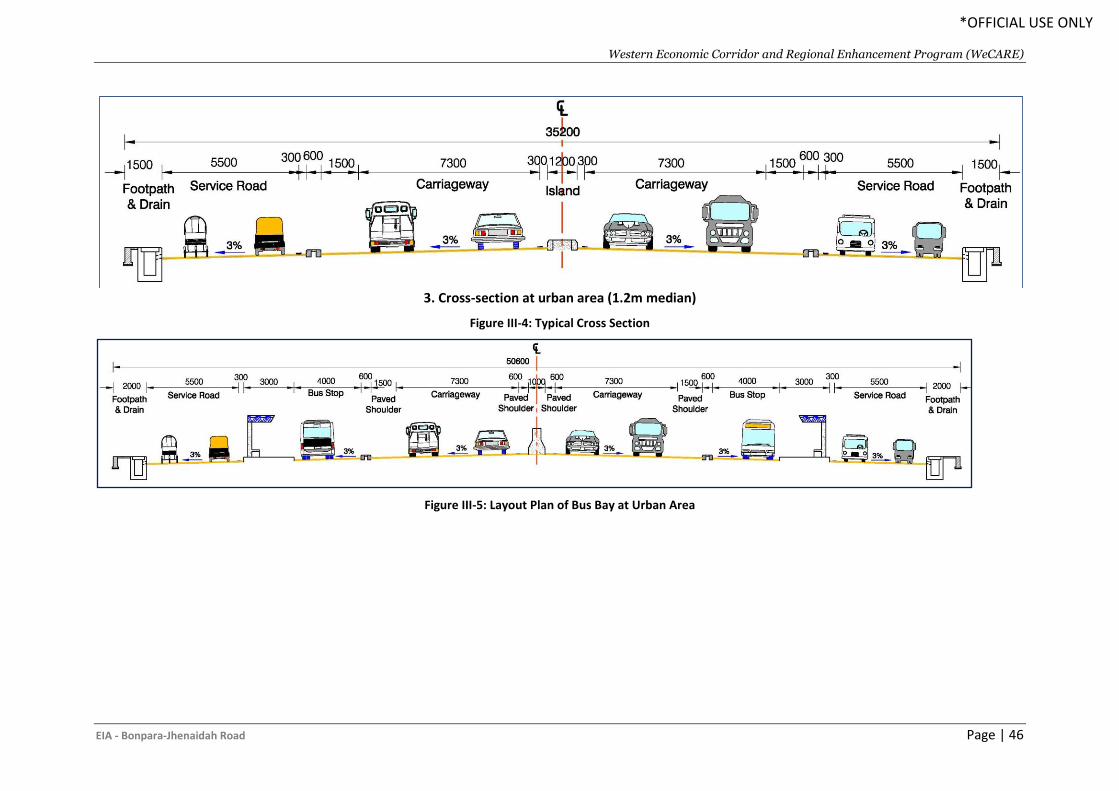
Western Economic Corridor and Regional Enhancement Program (WeCARE)
EIA - Bonpara-Jhenaidah Road Page | 46
*OFFICIAL USE ONLY
3. Cross-section at urban area (1.2m median)
Figure III-4: Typical Cross Section
Figure III-5: Layout Plan of Bus Bay at Urban Area
Western Economic Corridor and Regional Enhancement Program (WeCARE)
EIA - Bonpara-Jhenaidah Road Page | 47
*OFFICIAL USE ONLY
3. Pavement Design
170. The pavement works comprise construction of sub-grade, sub-base, base course, and surface course (binder course & wearing course). All roads have been designed following road safety requirements as per RHD published guidelines and standards.
4. Intersections
171. There are 08 intersections along the Bonpara-Jhenaidah Highway of the alignment. The intersections are designed with overpass and provide separate lanes for SMVT at grade section with a seamless and safe movement along the highway.
5. Bridges and Culverts
172. The project road has several numbers of bridges and culverts along its length. There is only one major bridge (>100m) located on the Noboganga River named as Borda Bridge at Jhenaidah (Table III-2). The bridge is being designed as concrete box girder bridges. More details on the bridge can be found in later sections of this report.
Table III-2: List of Major Bridges (> 100 m length) in Hatikumrul-Bonpara-Jhenaidah Road
Bridge Name Chainage Span Nos. Length (m)
Borda Bridge 87+481 5 100.59
173. In addition to above major bridge, there are many other lesser bridges and culverts on the project roads. The total number of culverts and minor bridges along the project road is 109. These structures mostly cross-undefined channels and carry only seasonal flow in the major cases. Some of these bridges are located over depressions and low-lying ditches. Culverts are located in depressions and at low lying agricultural land and are used merely as balancing structures and equalizing water levels either side of the road embankment. A typical cross section of the proposed bridge is given in Figure III.4. The list of all the minor structures with length is given in Table III-3.
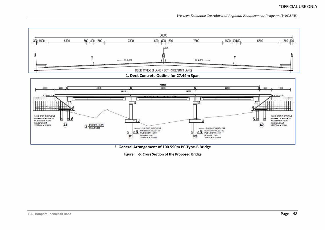
Western Economic Corridor and Regional Enhancement Program (WeCARE)
EIA - Bonpara-Jhenaidah Road Page | 48
*OFFICIAL USE ONLY
1. Deck Concrete Outline for 27.44m Span
2. General Arrangement of 100.590m PC Type-B Bridge
Figure III-6: Cross Section of the Proposed Bridge
Western Economic Corridor and Regional Enhancement Program (WeCARE)
EIA - Bonpara-Jhenaidah Road Page | 49
*OFFICIAL USE ONLY
Table III-3: List of Minor Bridges on the Hatikumrul-Bonpara-Jhenaidah Road
Sl. No.
Structure Name
Design Chainage
Existing Type Existing
Length/Width Proposed
Length/Width Latitude Longitude
1 Dhanaidah Bridge
9+105 PC BR 84 85.4 24.231111 89.119444
2 . 38+479 PC BR 65.56 - 24.038611 89.013056
3 . 60+095 PC BR & UP COMBO
48.48 39.63 23.88347 89.0897
4 Balipara Bridge
68+207 RC BR 26.85 30.48 23.815 89.106667
5 Bittipara Bridge
74+118 RC BR 33.8 33.53 23.763056 89.119444
6 . 88+961 RC BR 24.45 27.44 23.655556 89.198611
7 Noboganga Bridge
101+466 RC BR 78.54 82.32 23.549556 89.16864
F. Materials Used and Sources for Construction
174. The main groups of materials to be considered as part of this study include:
i. Road construction materials ii. Structure construction materials
175. Within this grouping of materials, the types of materials to be considered include:
1. Earthworks
176. The GOB has adopted a policy to encourage construction of roadway embankments with river sand rather than clayey agricultural soil. Accordingly, the embankments for new carriageways on this project have been designed based on the use of river sand with a CBR value estimated as 10% or greater. River sand is a good fill material with higher CBR value. It is quite abundant in the various riverbeds in the project area. Sand is easily compactable to a high degree of compaction but will require protection against erosion by cladding with a layer of cohesive soil.
177. The improvement of the road will require both filling of low land and cutting through the highland in order to achieve a workable grade. The earth filling to create proper embankment heights will range from 1–3 m. The proposed embankment will be constructed with suitable fill material, likely obtained by suction dredging from the nearby rivers crossed by the alignment. Preparation of the road embankment will require the placement of more than 12.42 million m3 of embankment material (subgrade, sub-base, base course, and surface course).
2. Concrete Aggregate
178. Bangladesh is occupying most part of the Bengal Delta having very thick sedimentary cover. Main source of construction aggregates is sedimentary rock but government developed an underground mine (Maddhapara Granite Mine, Dinajpur) for high quality aggregates from igneous rock. Unfortunately, the country fulfills their most demand from imported rock both igneous and sedimentary rock. Stone aggregates from Sylhet quarries are commonly used for the manufacture of normal and high strength concrete. Panchagarh is also a local source of stone aggregate which is located within the project road alignment. Additionally, aggregate of high strength concrete is likely to be
Western Economic Corridor and Regional Enhancement Program (WeCARE)
EIA - Bonpara-Jhenaidah Road Page | 50
*OFFICIAL USE ONLY
imported from India and Bhutan also. A significant amount of concrete aggregate will be required for the construction of 101.7 Km Bonpara to Jhenaidah Road.
3. Cement and Steel Reinforcement
179. Bangladesh produces different classes of EN and ASTM standard cement and high strength deformed bar of 40, 60 and 75 grades. These materials are readily available in the project area. A significant amount of cement and steel reinforcement will be required for the construction of the proposed road.
4. Bitumen
180. Bitumen used for the construction work is usually imported from other countries. Commonly used bitumen in the road construction industry in Bangladesh is 60-70 and 80-100 penetration grade bitumen. For Bangladesh temperatures 60-70 grade is better suited but the supply of this grade is limited.
5. Recycled Pavement Materials
181. The preliminary design envisages recycling pavement materials by milling the existing asphalt concrete and re-using the product. It is estimated that total 486135 m3 existing pavement materials could be used after recycling for the proposed carriageways. This recycled asphalt concrete mixed with unbound base and sub-base materials shall be used in the sub-base or lower base of the new carriageways.
G. Existing Traffic and Forecast
182. The type of traffic considered for traffic assessment and forecast includes (i) normal traffic which is using the existing corridor, and (ii) generated traffic likely to arise from reduced transport costs. The existing weighted average Annual Average Daily Traffic (AADT) as per the traffic studies carried out for 2018 including two and three-wheelers and forecast traffic are given at Table III-4.
Table III-4: Existing and Traffic Forecast for Bonpara-Jhenaidah Road
Traffic Assessment Year Traffic in AADT (Maximum of any section of the road)
2017 26333
2023 44163
2028 63355
2033 87811
2038 116232
2043 147058
Source: (SRTPPF-II, Traffic Survey 2017)
H. Social and Resettlement Considerations
183. The social safeguard work to be addressed under Project was triggered due to (i) the impacts of land acquisition for construction of the 150.7 Km length of the road from Bonpara to Jhenaidah, and (iii) relocation of houses, shops, and businesses from the proposed RoW. 184. The scope of social safeguard works for Project preparation thus include (i) consultation with affected communities and stakeholders; (ii) social surveys and census of all affected households and structures (residential, commercial, community structures), (iii) property valuation survey (land, structures, trees) for replacement value; (iv) preparation and disclosure of the Resettlement Plan, including the Project entitlement policy and matrix; and (v) income and livelihood restoration of the affected households as well as
Western Economic Corridor and Regional Enhancement Program (WeCARE)
EIA - Bonpara-Jhenaidah Road Page | 51
*OFFICIAL USE ONLY
vulnerable groups. Despite the limited and linear acquisition, there are 2084 households/units within the Project alignment. The social study and resettlement study have been carried out only for the first phase (Kushtia – Jhenaidah, 67km). the study for Phase – 2 will be carried out later. 185. The potential risk and impacts are analyzed based on the census and SES carried out by RHD in 2019 for same proposed AIIB financed Kushtia to Jhenaidah 67 km road. However, the study was conducted based on the feasibility design which RHD is currently updating and the width of the RoW may be increased. Transforming the 2-lane road to 4-lane road will cause many positive and negative impacts. Aside from the positive impacts of the project, land acquisition and consequential displacement of people from their residence, places of work or from means of livelihood might give rise to various physical, economic, social and environmental problems. Displacement may also affect production systems, de-link income sources and productive assets, reduce access to employment opportunities in a new socio-economic environment, etc.; resulting in long-term hardship, impoverishment and environmental damages unless the resettlement and rehabilitation plan is carefully drawn with appropriate mitigating measures and properly implemented with. A huge number of migrant labors will be engaged during the road construction which may cause labor influx.
186. According to the 2019 feasibility study Approximately 477 acres of private land may require acquiring. Project may affect 1660 entities comprising of 5,906 population. Project will affect 51 CPRs, GoB and non-GoB organization. Project will also affect around 80 thousand of government and private owned trees. Overall project interventions may cause both negative and positive livelihood impacts.
• Among the affected entities, 65% are non-titled
• Different types of lands will be affected and among them agricultural land will be
most affected which is expected more than 65%.
• 15 types of different structures may be affected. Among them 55% are non-
shiftable and 45% are shiftable.
• Among the affected structures, 90% are residential and commercial
• 20 types of secondary structures are identified within the proposed RoW which
may be affected.
• Around 80 thousand trees may require to cut-off and among them 85% are on
government land
187. The following table shows (Table III-5) summary land acquisition and resettlement impacts which will be updated based on the detailed design. It is expected that 30% of the presented impacts in the table will be increased as RHD is expecting to increase the road width than the feasibility study.
Table III-5: Social & Resettlement Consideration
SL Impacts/Types of losses Jhenaidah Kushtia Total
A Alignment Length and Required Land Acquisition
1 Total length of alignment /km 67.00
2 Total land required for the project in acre 218.51 258.51 477.02
B Number of Affected entities without CPR 1,660
1 Affected Residential HHs only 307 149 456
2 Affected Residential & Business HHs only 35 22 57
3 Affected roadside shops and business HHs only (small scale) 744 395 1,139
5 Number of HHs losing secondary structures only 6 1 7
6 Land and Trees affected HHs only 1 0 1
Western Economic Corridor and Regional Enhancement Program (WeCARE)
EIA - Bonpara-Jhenaidah Road Page | 52
*OFFICIAL USE ONLY
SL Impacts/Types of losses Jhenaidah Kushtia Total
C Number of affected units other than B 51
1 Affected CPRs 25 19 44
2 Affected Gob. Organization 0 2 2
3 Affected NGO and others office 2 1 3
4 Affected other entities (Large Business) 2 0 2
D Additional data by categories (already embedded in B and C)
1 Number of total affected entities (B+C) 1,122 589 1,711
2 Number of total affected Households 1,093 567 1,660
2.1 Number of male headed HHs affected 1,031 552 1,573
2.2 Number of females headed HHs affected 62 25 87
3 Affected Population 3,834 2,072 5,906
3.1 Male 2,144 1,152 3,296
3.2 Female 1,690 920 2,610
3 Average HH size 3.51 3.66 3.56
F Number of affected Trees (Ex Banana/Bamboo)
1 Total Number of trees (Ex Banana/Bamboo) on Private Land 4,266 834 5,100
2 Total Number of trees (Ex Banana/Bamboo) on Government
Land 24,440 48,249 72,689
3 Total no. of Banana and Bamboo 4,229 210 4,439
G Total Number of wage laborer affected 76 23 99
1 Number of Employee 69 20 89
2 Unskilled Wage laborers 7 3 10
H Total Number of Business Owner 696 389 1,085
1 Own Business 541 292
2 Rental Business 155 97
H Total Number of Tenants 158 94 252
1 Number of affected residential tenants 3 0 3
2 Number of affected commercial tenants 155 94 249
Source: Kustia –Jhenaidah Road -67 km, Resettlement Policy Framework (RPF), RHD
Western Economic Corridor and Regional Enhancement Program (WeCARE)
EIA - Bonpara-Jhenaidah Road Page | 53
*OFFICIAL USE ONLY
IV. DESCRIPTION OF THE BASELINE ENVIRONMENT
A. General
188. The baseline condition of environmental quality in the locality of project site serves as the basis for identification, prediction and evaluation of impacts. The baseline environmental quality is assessed through field studies within the impact zone for various components of the environment, viz. air, noise, water, land and socio-economic, etc. 189. Data was collected mostly from secondary sources for the macro-environmental setting like climate (temperature, rainfall, humidity, and wind speed), physiography, geology etc. Firsthand information collection was limited during the feasibility study to record the micro environmental features within and adjacent to the project corridor. Collection of primary information includes extrapolating environmental features on proposed road design, tree inventories, location and measurement of socio-cultural features adjoining proposed road. Consultation was another source of information and to explain local environmental conditions, impacts, and suggestions, etc. 190. The following section describes the baseline environment in three broad categories:
• Physical Environment- factors such geology, climate and hydrology;
• Biological Environment- factors related to life such as flora, fauna and ecosystem; and
• Socio-economic Environment- anthropological factors like demography, income, land use and infrastructure.
B. Physical Environment
1. Climate
191. Although less than half of Bangladesh lies within the tropics, the presence of the Himalayan mountain range has created a tropical macroclimate across most of the east Bengal land mass. Bangladesh can be divided into seven climatic zones (Rashid 1991). According to the classification, the project area is located in northern part of the northern region and north-western climatic zones.
i. North-western: Except that the extremes are less and the rainfall is lower, this zone is similar to northern part of the northern region. The lower rainfall makes this area both atmospherically and pedologically drier.
ii. South-western: It comprises greater Rajshahi district and parts of adjacent districts. This is the driest area in Bangladesh with rainfall generally below 1,500 mm and summer humidity less than 50%. In summer, it is the hottest and driest of all climatic zones. Mean summer maximum temperature is over 35°C.
192. The climatic condition of the whole project area may be considered same as reported in Ishwardi meteorological stations, since these stations are closed to the project areas. The climate data are derived from the meteoblue. The meteoblue climate diagrams are based on 30 years of hourly weather model simulations. The weather models with historical data from 1985 onwards and generated a continuous 30-year global history with hourly weather data.
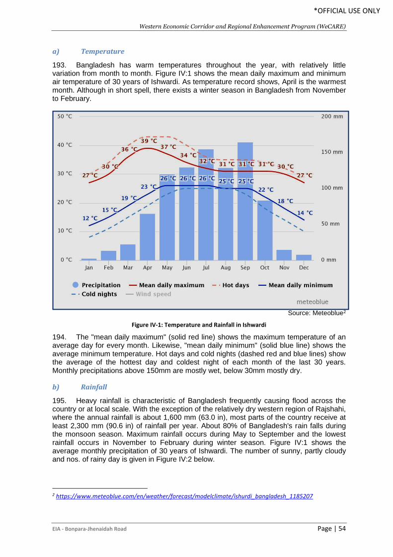
Western Economic Corridor and Regional Enhancement Program (WeCARE)
EIA - Bonpara-Jhenaidah Road Page | 54
*OFFICIAL USE ONLY
a) Temperature
193. Bangladesh has warm temperatures throughout the year, with relatively little variation from month to month. Figure IV:1 shows the mean daily maximum and minimum air temperature of 30 years of Ishwardi. As temperature record shows, April is the warmest month. Although in short spell, there exists a winter season in Bangladesh from November to February.
Source: Meteoblue2
Figure IV-1: Temperature and Rainfall in Ishwardi
194. The "mean daily maximum" (solid red line) shows the maximum temperature of an average day for every month. Likewise, "mean daily minimum" (solid blue line) shows the average minimum temperature. Hot days and cold nights (dashed red and blue lines) show the average of the hottest day and coldest night of each month of the last 30 years. Monthly precipitations above 150mm are mostly wet, below 30mm mostly dry.
b) Rainfall
195. Heavy rainfall is characteristic of Bangladesh frequently causing flood across the country or at local scale. With the exception of the relatively dry western region of Rajshahi, where the annual rainfall is about 1,600 mm (63.0 in), most parts of the country receive at least 2,300 mm (90.6 in) of rainfall per year. About 80% of Bangladesh's rain falls during the monsoon season. Maximum rainfall occurs during May to September and the lowest rainfall occurs in November to February during winter season. Figure IV:1 shows the average monthly precipitation of 30 years of Ishwardi. The number of sunny, partly cloudy and nos. of rainy day is given in Figure IV:2 below.
2 https://www.meteoblue.com/en/weather/forecast/modelclimate/ishurdi_bangladesh_1185207
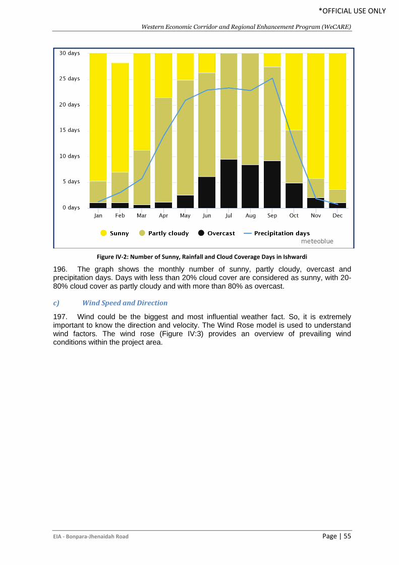
Western Economic Corridor and Regional Enhancement Program (WeCARE)
EIA - Bonpara-Jhenaidah Road Page | 55
*OFFICIAL USE ONLY
Figure IV-2: Number of Sunny, Rainfall and Cloud Coverage Days in Ishwardi
196. The graph shows the monthly number of sunny, partly cloudy, overcast and precipitation days. Days with less than 20% cloud cover are considered as sunny, with 20-80% cloud cover as partly cloudy and with more than 80% as overcast.
c) Wind Speed and Direction
197. Wind could be the biggest and most influential weather fact. So, it is extremely important to know the direction and velocity. The Wind Rose model is used to understand wind factors. The wind rose (Figure IV:3) provides an overview of prevailing wind conditions within the project area.
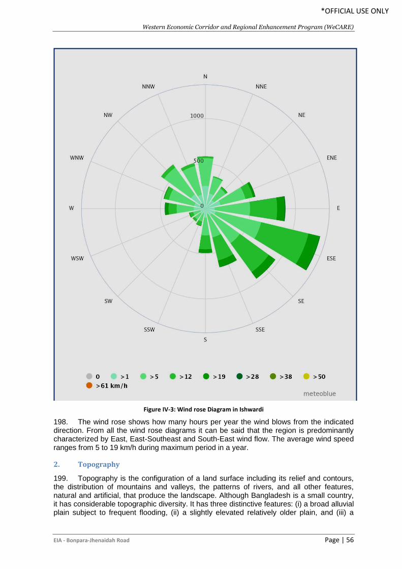
Western Economic Corridor and Regional Enhancement Program (WeCARE)
EIA - Bonpara-Jhenaidah Road Page | 56
*OFFICIAL USE ONLY
Figure IV-3: Wind rose Diagram in Ishwardi
198. The wind rose shows how many hours per year the wind blows from the indicated direction. From all the wind rose diagrams it can be said that the region is predominantly characterized by East, East-Southeast and South-East wind flow. The average wind speed ranges from 5 to 19 km/h during maximum period in a year.
2. Topography
199. Topography is the configuration of a land surface including its relief and contours, the distribution of mountains and valleys, the patterns of rivers, and all other features, natural and artificial, that produce the landscape. Although Bangladesh is a small country, it has considerable topographic diversity. It has three distinctive features: (i) a broad alluvial plain subject to frequent flooding, (ii) a slightly elevated relatively older plain, and (iii) a
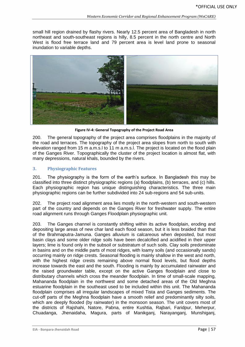
Western Economic Corridor and Regional Enhancement Program (WeCARE)
EIA - Bonpara-Jhenaidah Road Page | 57
*OFFICIAL USE ONLY
small hill region drained by flashy rivers. Nearly 12.5 percent area of Bangladesh in north northeast and south-southeast regions is hilly, 8.5 percent in the north centre and North West is flood free terrace land and 79 percent area is level land prone to seasonal inundation to variable depths.
Figure IV-4: General Topography of the Project Road Area
200. The general topography of the project area comprises floodplains in the majority of the road and terraces. The topography of the project area slopes from north to south with elevation ranged from 15 m a.m.s.l to 11 m a.m.s.l. The project is located on the flood plain of the Ganges River. Topographically the cluster of the project location is almost flat, with many depressions, natural khals, bounded by the rivers.
3. Physiographic Features
201. The physiography is the form of the earth’s surface. In Bangladesh this may be classified into three distinct physiographic regions (a) floodplains, (b) terraces, and (c) hills. Each physiographic region has unique distinguishing characteristics. The three main physiographic regions can be further subdivided into 24 sub-regions and 54 sub-units. 202. The project road alignment area lies mostly in the north-western and south-western part of the country and depends on the Ganges River for freshwater supply. The entire road alignment runs through Ganges Floodplain physiographic unit. 203. The Ganges channel is constantly shifting within its active floodplain, eroding and depositing large areas of new char land each flood season, but it is less braided than that of the Brahmaputra-Jamuna. Ganges alluvium is calcareous when deposited, but most basin clays and some older ridge soils have been decalcified and acidified in their upper layers; lime is found only in the subsoil or substratum of such soils. Clay soils predominate in basins and on the middle parts of most ridges, with loamy soils (and occasionally sands) occurring mainly on ridge crests. Seasonal flooding is mainly shallow in the west and north, with the highest ridge crests remaining above normal flood levels, but flood depths increase towards the east and the south. Flooding is mainly by accumulated rainwater and the raised groundwater table, except on the active Ganges floodplain and close to distributary channels which cross the meander floodplain. In time of small-scale mapping, Mahananda floodplain in the northwest and some detached areas of the Old Meghna estuarine floodplain in the southeast used to be included within this unit. The Mahananda floodplain comprises all irregular landscapes of mixed Tista and Ganges sediments. The cut-off parts of the Meghna floodplain have a smooth relief and predominantly silty soils, which are deeply flooded (by rainwater) in the monsoon season. The unit covers most of the districts of Rajshahi, Natore, Pabna, entire Kushtia, Rajbari, Faridpur, Meherpur, Chuadanga, Jhenaidaha, Magura, parts of Manikganj, Narayanganj, Munshiganj,
Western Economic Corridor and Regional Enhancement Program (WeCARE)
EIA - Bonpara-Jhenaidah Road Page | 58
*OFFICIAL USE ONLY
Shariatpur, Madaripur, Barisal, Gopalganj, Narail, Khulna, Bagerhat, Satkhira, and most of Jessore. This physiographic unit is almost triangular in shape and bounded by the Ganges tidal floodplain on the south. On its southern end it traps the Gopalganj-Khulna Beels (Banglapedia, 2015).
4. Geology and Soil
204. Bangladesh is situated to the east of the Indian sub-continental plate. Nearly 85% of Bangladesh is underlain by deltaic and alluvial deposits of the Ganges, Brahmaputra, and Meghna river systems. Geologically Bangladesh sediments belong to the Recent (floodplains), Plio-Plaistocene (terraces) and Mio-Pliocene (hills) periods (Wadia 1957 and Morgan and McIntire 1959). And about 10% of the land consists of Pleistocene (Project area) sediments with an average elevation of more than 15m above sea level. 205. The general soil types of the project road area predominantly include the Calcareous Alluvium, and Calcareous Dark Grey Floodplain soils and Calcareous Brown Floodplain soils. 206. Calcareous Alluvium Soils are stratified or raw alluvium throughout or below the cultivated layer. They are calcareous throughout or part of it and lack in having diagnostic subsoil horizon. This alluvium on the active Ganges floodplain mainly comprises brownish grey to pale brown sandy and silty deposits, which are moderately calcareous. Calcareous Dark Grey Floodplain soils occur extensively on the Ganges floodplain and locally on the soils that comprise cambic B-horizon and lime in part or throughout the solum and with a dark grey topsoil and/or upper subsoil. There are continuous dark grey gleans as well in the Ganges tidal floodplain. They are Calcaric Gleysols. Calcareous Brown Floodplain soils have cambic B-horizon that is predominantly oxidised, containing lime in the profiles. They comprise pale brown to olive brown, friable, loamy and clay soils occurring on the upper parts of ridges on the Ganges river floodplain and on the river bank of the Ganges tidal floodplain. Most of these soils belong to Calcaric Gleysols (Banglapedia, 2015).
5. Water Resources and Hydrology
207. Bangladesh and the western portion of the Indian State of Bengal are located within the ‘Bengal Basin’. According to Rahman et al (2003), this basin includes the world’s largest river delta, which is 140,000 square kilometers (the Ganges-Padma, Jumna-Brahmaputra-Tista and Meghna rivers and numerous tributary complexes) and the world’s largest submarine fan complex (the Bengal Fan). These river systems carry a combined annual sediment load of 1.5 to 2.4 billion metric tons. 208. The headwaters of both the Ganges-Padma and Brahmaputra-Jumuna-Tista river systems are situated in the Himalayas ranges. Water in the Meghna River, originates from the Shillong Plateau. It drains one of the heaviest rainfall areas of the world. As a result of these extensive catchments, flooding is an annual occurrence in Bangladesh and occurs mainly during the rainy season between May to October when the rainfall in the catchments is at its maximum intensity. 209. Bangladesh has an average annual surface flow of approximately 1,073 million-acre feet (MAF), of which about 870 MAF (93%) are received from India as inflow and the remaining 203 MAF (7%) as rainfall. This water is enough to cover the entire country to a depth of 9.14m. About 132 MAF (65% of rainfall and 12% of total) is lost to evaporation each year (114.30 cm), the remainder flows out to the Bay of Bengal. 210. Bangladesh is located over a subsiding basin of tectonic origin with a great thickness of sedimentary strata. This forms an unconsolidated alluvial deposit of recent
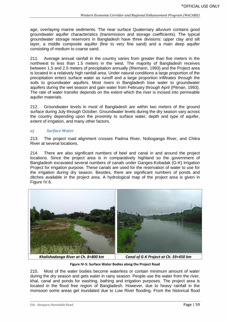
Western Economic Corridor and Regional Enhancement Program (WeCARE)
EIA - Bonpara-Jhenaidah Road Page | 59
*OFFICIAL USE ONLY
age, overlaying marine sediments. The near surface Quaternary alluvium contains good groundwater aquifer characteristics (transmission and storage coefficients). The typical groundwater storage reservoirs in Bangladesh have three divisions: upper clay and silt layer, a middle composite aquifer (fine to very fine sand) and a main deep aquifer consisting of medium to coarse sand. 211. Average annual rainfall in the country varies from greater than five meters in the northwest to less than 1.5 meters in the west. The majority of Bangladesh receives between 1.5 and 2.5 meters of precipitation annually (Riemann, 1993) and the Project area is located in a relatively high rainfall area. Under natural conditions a large proportion of the precipitation enters surface water as runoff and a large proportion infiltrates through the soils to groundwater aquifers. Most rivers in Bangladesh lose water to groundwater aquifers during the wet season and gain water from February through April (Pitman, 1993). The rate of water transfer depends on the extent which the river is incised into permeable aquifer materials. 212. Groundwater levels in most of Bangladesh are within two meters of the ground surface during July through October. Groundwater levels during the dry season vary across the country depending upon the proximity to surface water, depth and type of aquifer, extent of irrigation, and many other factors.
a) Surface Water
213. The project road alignment crosses Padma River, Noboganga River, and Chitra River at several locations. 214. There are also significant numbers of beel and canal in and around the project locations. Since the project area is in comparatively highland so the government of Bangladesh excavated several numbers of canals under Ganges-Kobadak (G-K) Irrigation Project for irrigation purpose. These canals are used for the reservation of water to use for the irrigation during dry season. Besides, there are significant numbers of ponds and ditches available in the project area. A hydrological map of the project area is given in Figure IV.6.
Khalishadanga River at Ch. 8+800 km Canal of G-K Project at Ch. 59+450 km
Figure IV-5: Surface Water Bodies along the Project Road
215. Most of the water bodies become waterless or contain minimum amount of water during the dry season and gets water in rainy season. People use the water from the river, khal, canal and ponds for washing, bathing and irrigation purposes. The project area is located in the flood free region of Bangladesh. However, due to heavy rainfall in the monsoon some areas get inundated due to Low River flooding. From the historical flood
Western Economic Corridor and Regional Enhancement Program (WeCARE)
EIA - Bonpara-Jhenaidah Road Page | 60
*OFFICIAL USE ONLY
records, it is seen that this area was flood free during the major flood occurred in 1955, 1974, and 1988. However, in the year of 1998 and 2004 some areas along the project road were inundated during the major floods in Bangladesh. In the dry season local canals and channels provide water for irrigation for boro cultivation and for growing winter crops. 216. The wetland areas in Bangladesh and at project site have shrunk due to land use conflicts, watershed degradation in catchments within and beyond Bangladesh border and water diversion up stream. Pollution of open water bodies due to use of pesticides in agricultural land, solid wastes and fish culture affected aquatic bio-diversity and wetland environment. 217. The key issues related to surface water quality at the project area is the use of surface water for domestic, agricultural and industrial uses instead of exhausting the groundwater and disposal of domestic and municipal wastes in the water bodies.
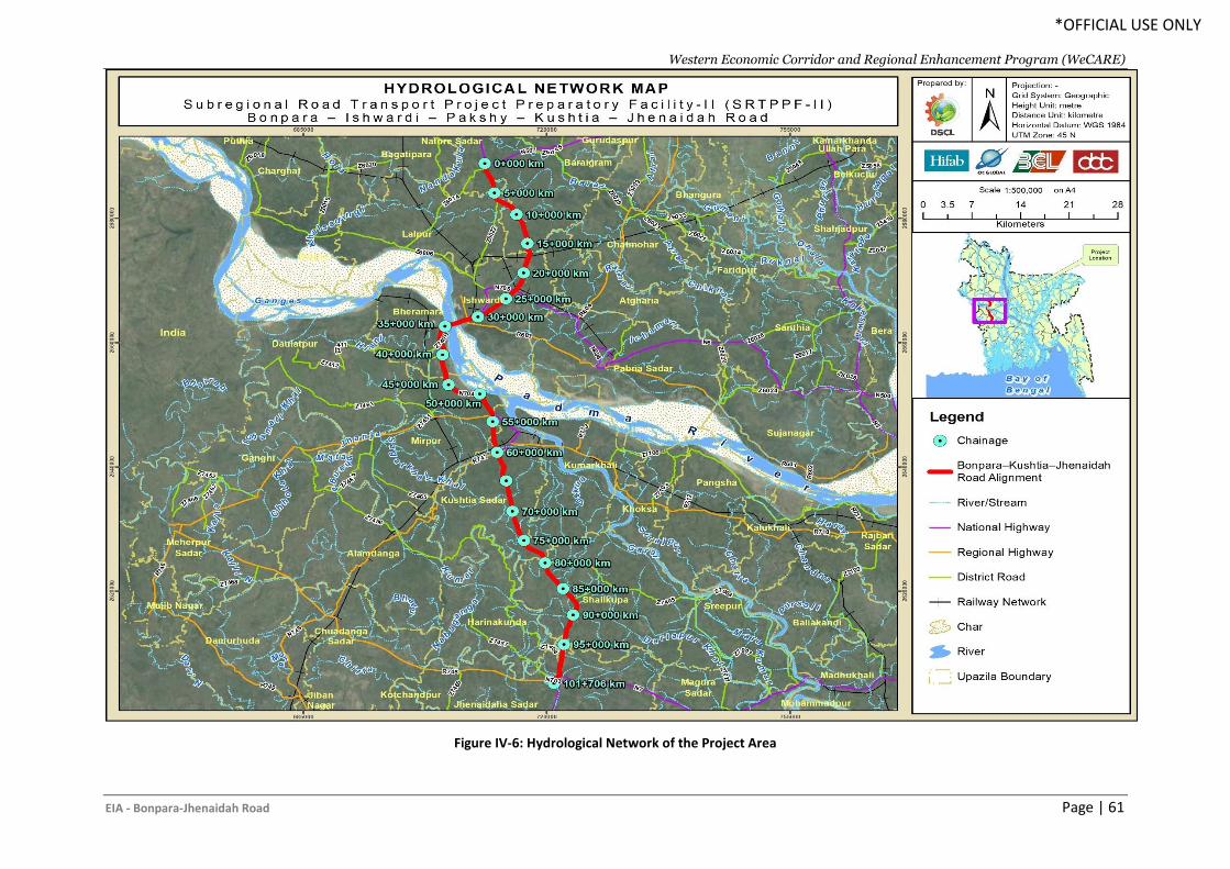
Western Economic Corridor and Regional Enhancement Program (WeCARE)
EIA - Bonpara-Jhenaidah Road Page | 61
*OFFICIAL USE ONLY
Figure IV-6: Hydrological Network of the Project Area
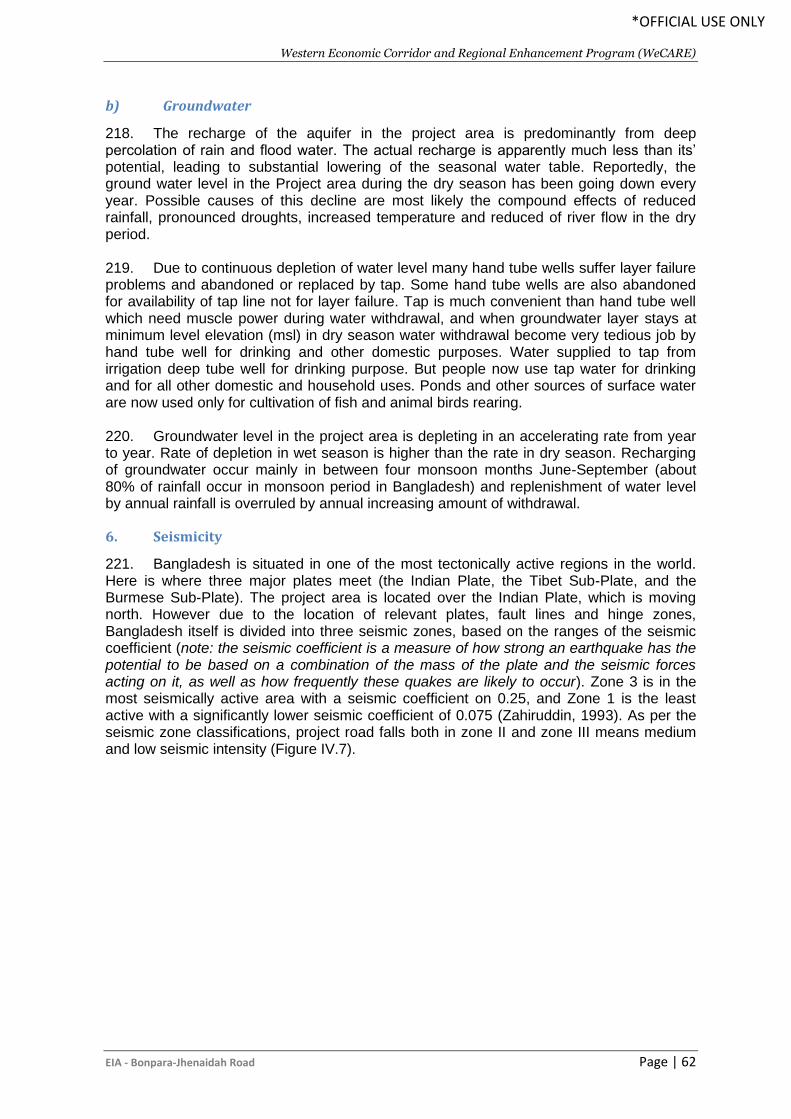
Western Economic Corridor and Regional Enhancement Program (WeCARE)
EIA - Bonpara-Jhenaidah Road Page | 62
*OFFICIAL USE ONLY
b) Groundwater
218. The recharge of the aquifer in the project area is predominantly from deep percolation of rain and flood water. The actual recharge is apparently much less than its’ potential, leading to substantial lowering of the seasonal water table. Reportedly, the ground water level in the Project area during the dry season has been going down every year. Possible causes of this decline are most likely the compound effects of reduced rainfall, pronounced droughts, increased temperature and reduced of river flow in the dry period. 219. Due to continuous depletion of water level many hand tube wells suffer layer failure problems and abandoned or replaced by tap. Some hand tube wells are also abandoned for availability of tap line not for layer failure. Tap is much convenient than hand tube well which need muscle power during water withdrawal, and when groundwater layer stays at minimum level elevation (msl) in dry season water withdrawal become very tedious job by hand tube well for drinking and other domestic purposes. Water supplied to tap from irrigation deep tube well for drinking purpose. But people now use tap water for drinking and for all other domestic and household uses. Ponds and other sources of surface water are now used only for cultivation of fish and animal birds rearing. 220. Groundwater level in the project area is depleting in an accelerating rate from year to year. Rate of depletion in wet season is higher than the rate in dry season. Recharging of groundwater occur mainly in between four monsoon months June-September (about 80% of rainfall occur in monsoon period in Bangladesh) and replenishment of water level by annual rainfall is overruled by annual increasing amount of withdrawal.
6. Seismicity
221. Bangladesh is situated in one of the most tectonically active regions in the world. Here is where three major plates meet (the Indian Plate, the Tibet Sub-Plate, and the Burmese Sub-Plate). The project area is located over the Indian Plate, which is moving north. However due to the location of relevant plates, fault lines and hinge zones, Bangladesh itself is divided into three seismic zones, based on the ranges of the seismic coefficient (note: the seismic coefficient is a measure of how strong an earthquake has the potential to be based on a combination of the mass of the plate and the seismic forces acting on it, as well as how frequently these quakes are likely to occur). Zone 3 is in the most seismically active area with a seismic coefficient on 0.25, and Zone 1 is the least active with a significantly lower seismic coefficient of 0.075 (Zahiruddin, 1993). As per the seismic zone classifications, project road falls both in zone II and zone III means medium and low seismic intensity (Figure IV.7).
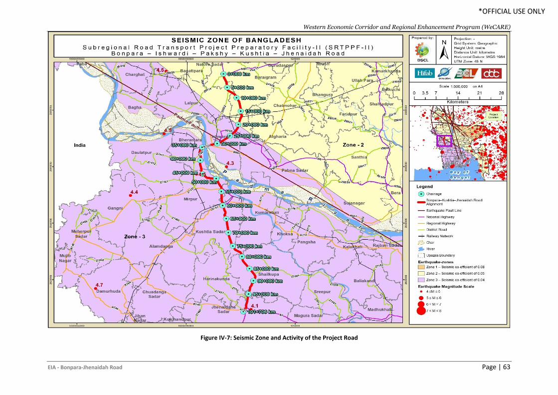
Western Economic Corridor and Regional Enhancement Program (WeCARE)
EIA - Bonpara-Jhenaidah Road Page | 63
*OFFICIAL USE ONLY
Figure IV-7: Seismic Zone and Activity of the Project Road
Western Economic Corridor and Regional Enhancement Program (WeCARE)
EIA - Bonpara-Jhenaidah Road Page | 64
*OFFICIAL USE ONLY
7. Natural Hazards
222. In Bangladesh, due to its unique geographic location, suffers from devastating tropical cyclones frequently. The funnel-shaped northern portion of the Bay of Bengal causes tidal when cyclones make landfall due to which thousands of people living in the coastal areas are affected. Some of the most devastating natural disasters in recorded history with high casualties were tropical cyclones that hit the region now forming Bangladesh (Wikipedia, 2015). The project area does not fall under the risk zone of cyclone. However, due to its geographic location, severe to moderate drought occurs regularly at Natore and Pabna districts in the project area. Additionally, the project road area also experienced a devastating flood in the year of 2004 and as per the statement of many of the local people it was the first time in their lifetime. The project area does not fall under the risk zone of cyclone (Figure IV.8).
223. However, due to its geographic location, flood occurs regularly in the project area (Figure IV.9). However, the topography of the surrounding area is being been considerably changed due to rapid land filling by land developers and it has been envisaged that the floodplain of the Nabaganga River and Padma River would progressively be encroached by rapid filling. Considering the present land filling trend and future urbanization, the water levels of both rivers will rise. With the rising of the water level of the surrounding rivers and unpredictable local heavy rainfall in a short duration due to climate change, the crest level of the road needs to be determined. The drainage of the surrounding areas is mostly dependent on the water levels of the peripheral rivers.
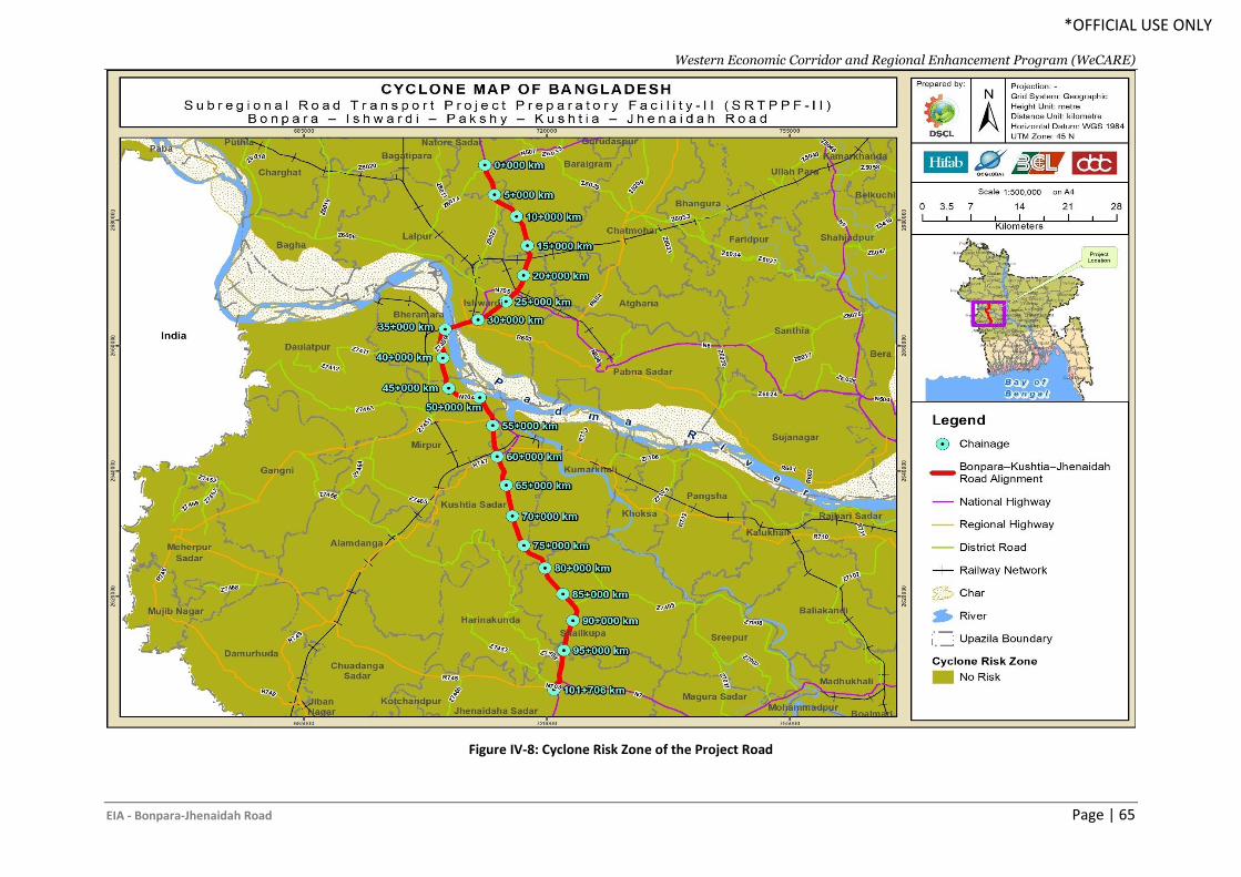
Western Economic Corridor and Regional Enhancement Program (WeCARE)
EIA - Bonpara-Jhenaidah Road Page | 65
*OFFICIAL USE ONLY
Figure IV-8: Cyclone Risk Zone of the Project Road
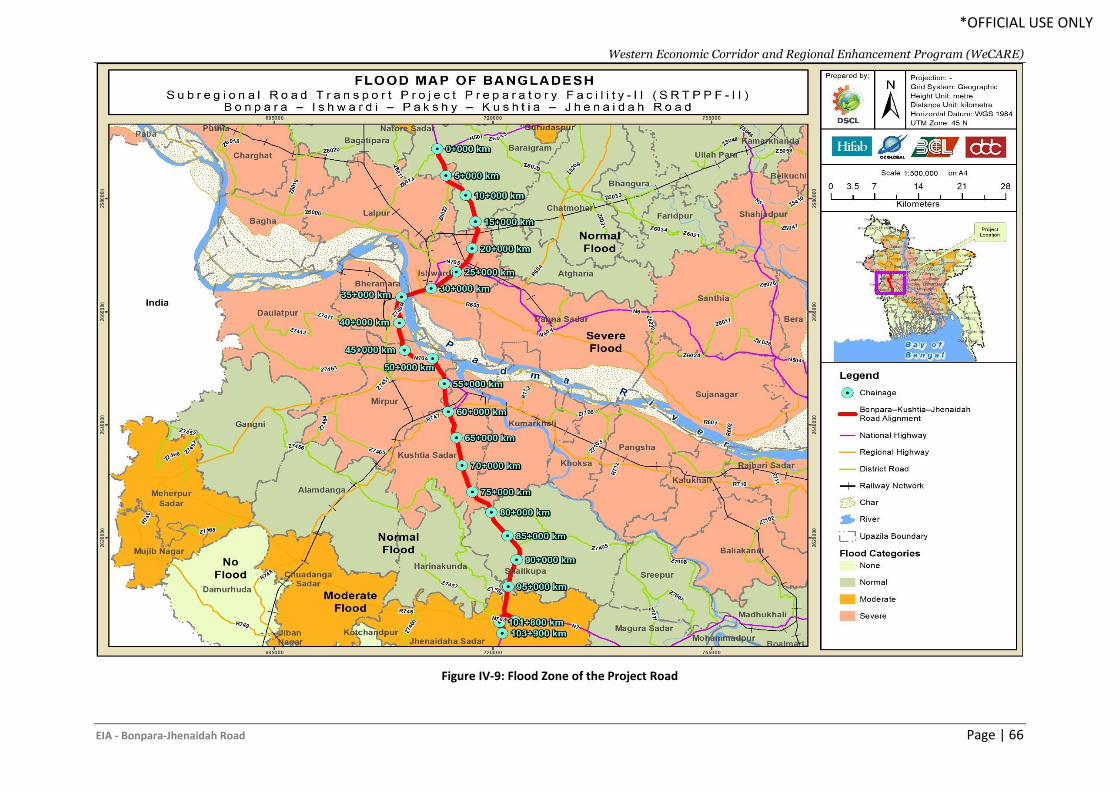
Western Economic Corridor and Regional Enhancement Program (WeCARE)
EIA - Bonpara-Jhenaidah Road Page | 66
*OFFICIAL USE ONLY
Figure IV-9: Flood Zone of the Project Road
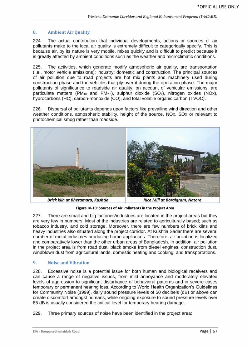
Western Economic Corridor and Regional Enhancement Program (WeCARE)
EIA - Bonpara-Jhenaidah Road Page | 67
*OFFICIAL USE ONLY
8. Ambient Air Quality
224. The actual contribution that individual developments, actions or sources of air pollutants make to the local air quality is extremely difficult to categorically specify. This is because air, by its nature is very mobile, mixes quickly and is difficult to predict because it is greatly affected by ambient conditions such as the weather and microclimatic conditions. 225. The activities, which generate modify atmospheric air quality, are transportation (i.e., motor vehicle emissions); industry; domestic and construction. The principal sources of air pollution due to road projects are hot mix plants and machinery used during construction phase and the vehicles that ply over it during the operation phase. The major pollutants of significance to roadside air quality, on account of vehicular emissions, are particulate matters (PM10 and PM2.5), sulphur dioxide (SO2), nitrogen oxides (NOx), hydrocarbons (HC), carbon-monoxide (CO), and total volatile organic carbon (TVOC). 226. Dispersal of pollutants depends upon factors like prevailing wind direction and other weather conditions, atmospheric stability, height of the source, NOx, SOx or relevant to photochemical smog rather than roadside.
Brick kiln at Bheramara, Kushtia Rice Mill at Boraigram, Natore
Figure IV-10: Sources of Air Pollutants in the Project Area
227. There are small and big factories/industries are located in the project areas but they are very few in numbers. Most of the industries are related to agriculturally based; such as tobacco industry, and cold storage. Moreover, there are few numbers of brick kilns and heavy industries also situated along the project corridor. At Kushtia Sadar there are several number of metal industries producing home appliances. Therefore, air pollution is localized and comparatively lower than the other urban areas of Bangladesh. In addition, air pollution in the project area is from road dust, black smoke from diesel engines, construction dust, windblown dust from agricultural lands, domestic heating and cooking, and transportations.
9. Noise and Vibration
228. Excessive noise is a potential issue for both human and biological receivers and can cause a range of negative issues, from mild annoyance and moderately elevated levels of aggression to significant disturbance of behavioral patterns and in severe cases temporary or permanent hearing loss. According to World Health Organization’s Guidelines for Community Noise (1999), daily sound pressure levels of 50 decibels (dB) or above can create discomfort amongst humans, while ongoing exposure to sound pressure levels over 85 dB is usually considered the critical level for temporary hearing damage. 229. Three primary sources of noise have been identified in the project area:
Western Economic Corridor and Regional Enhancement Program (WeCARE)
EIA - Bonpara-Jhenaidah Road Page | 68
*OFFICIAL USE ONLY
• Road Traffic: Road traffic is one of the major noise sources in the project area. The project road is common route of transportation for several districts and to the Benapole Land Port from northern region of the country. This highway carries a relatively high volume of both motorized and non-motorized vehicles, resulting in road traffic noise impacts along the road corridors.
• Industry: The project area has several industries and factories along the road corridor. Noise are generating from these industries and manufacturing factories in the project area. However, noise from agro based and other manufacturing industries are negligible.
• Commercial Areas: There are some commercial or refreshment areas where always significant number of people gather and makes chaos continuously. This is another source of noise pollution along the road.
C. Biological Environment
1. Bio-ecological Zones
230. Within a relatively small geographic boundary, Bangladesh enjoys a diverse array of ecosystems. Being a low-lying deltaic country, seasonal variation in water availability is the major factor, which generates different ecological scenarios of Bangladesh. Temperature, rainfall, physiographic variations in soil and different hydrological conditions play vital roles in the country's diverse ecosystems. The ecosystems of Bangladesh could be categorized into two major groups, i.e. (i) land based and (ii) aquatic. The land-based ecosystems include forest and hill ecosystems, agro-ecosystems and homestead ecosystems; while seasonal and perennial wetlands, rivers, lakes, coastal mangroves, coastal mudflats and chars, and marine ecosystems fall into the aquatic category. 231. Each of the ecosystems has many sub-units with distinct characteristics as well. IUCN Bangladesh in 2002 classified the country into twenty-five bio-ecological zones. The project road alignment falls in the Chalan Beel, Teesta Floodplain, Major Rivers and Ganges Floodplain bio-ecological zone (Figure IV.11).
232. Chalan beel is an extensive low land area at the lower Atrai basin in the northwestern region of Bangladesh, spreads across the district of Natore, Pabna and Sirajganj. It consists of a series of beels connected to one another by various channels to form more or less a continuous water body during the rainy season. Although, the beel area expands into a vast water body, so long the Jamuna remains flooded during the monsoon months with dense aquatic vegetation, it however, dries out in the winter leaving only patches of 'water-holes” in the central part of this zone. It is an ecologically diversified area due to its diversified physiological foundation. Biologically, the beel offers a vast variety of terrestrial, aquatic and marshy habitats, predominantly used by waterfowl. Chalan Beel was formerly an important wintering area for ducks, geese and shorebirds, but now that the wetland dries out in early winter, fewer migrant waterfowl visit the area. The Teesta floodplain spreads over several different landscapes in greater Rangpur and the adjoining regions. The diversity results from the fact that the Teesta river had occupied and later abandoned several different channels during the last few thousand years including the valleys now are occupied by the Mahananda, Punarnava, Atrai, Choto Jamuna, Karatoya and Ghaghat rivers. There were large patches of forests in this zone, but they have in most cases been ruthlessly cut down. However, this zone is still fairly wooded with many valuable indigenous timber species. Although most of the large mammals have been disappeared from this area but most of common bird species are still found in this location (IUCN, 2002f).
Western Economic Corridor and Regional Enhancement Program (WeCARE)
EIA - Bonpara-Jhenaidah Road Page | 69
*OFFICIAL USE ONLY
233. Bangladesh consists mainly of riverine and deltaic deposits of three large and extremely dynamic rivers entering the country: the Brahmaputra, Ganges and Meghna rivers. Newly accreted land, if it does not erode quickly, is initially colonized by grass, particularly catkin grass (Saccharum spontaneum, for example). Dense growth of catkin grass can accelerate silt deposition on chars. Jamuna river provide highest amount of char lands. Many of the species' natural distribution, migration and storage are primarily functioned via these rivers into other wetland ecosystems (GoB-IUCN, 1992). A diverse range of waterfowls are directly or ecologically dependent on these rivers and its associated ecosystems. However, it is quit alarming that, with the exception of few species of turtles, all other river biodiversity is threatened with extinction. The Ganges floodplain is basically consisted of the active floodplain of the Ganges River and the adjoining meandering floodplains, and is mostly situated in the Greater Jessore, Kustia, Faridpur and Barisal districts. This floodplain is comprising of ridges, basins and old channels. The Gangetic alluvium is readily distinguished from the old Brahmaputra, Jamuna and Meghna sediments by its high lime contents. Ganges channel is constantly shifting within its active floodplain, eroding and depositing large areas of new char lands in each flooding season, but it is less braided than that of the Brahmaputra- Jamuna. Both plants and animals are adapted with the pattern of flooding. The floodplains are characterized by mixed vegetation. Huge number of stagnant water bodies and channels, rivers and tributaries support a habitat of rich biodiversity. Free-floating aquatic vegetation is commonly shown in most of the wetlands. Both cultivated and wild plants species are found in homesteads forest. Major groups of the oriental birds are represented in this zone by many species. A large number of migratory birds are observed in winter. Different species of tortoises and turtles are found in perennial water bodies (IUCN, 2002f).
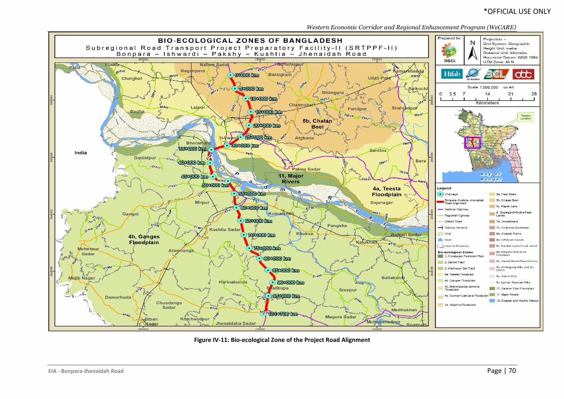
Western Economic Corridor and Regional Enhancement Program (WeCARE)
EIA - Bonpara-Jhenaidah Road Page | 70
*OFFICIAL USE ONLY
Figure IV-11: Bio-ecological Zone of the Project Road Alignment
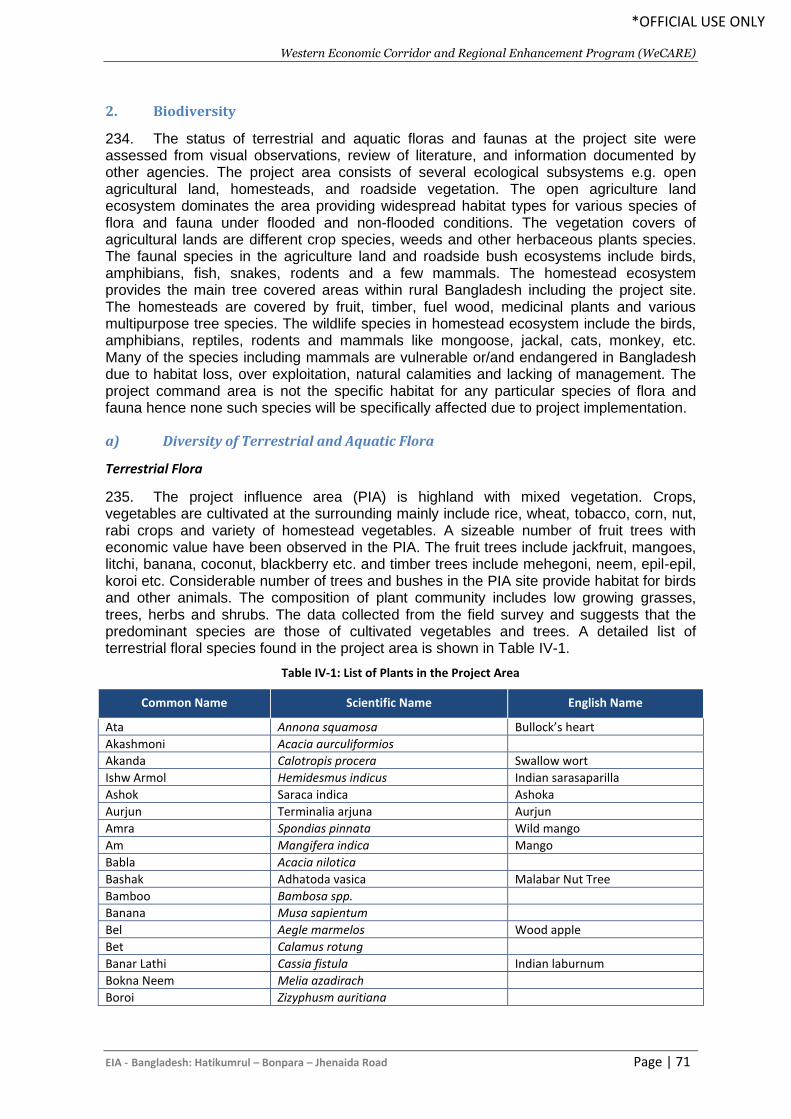
Western Economic Corridor and Regional Enhancement Program (WeCARE)
EIA - Bangladesh: Hatikumrul – Bonpara – Jhenaida Road Page | 71
*OFFICIAL USE ONLY
2. Biodiversity
234. The status of terrestrial and aquatic floras and faunas at the project site were assessed from visual observations, review of literature, and information documented by other agencies. The project area consists of several ecological subsystems e.g. open agricultural land, homesteads, and roadside vegetation. The open agriculture land ecosystem dominates the area providing widespread habitat types for various species of flora and fauna under flooded and non-flooded conditions. The vegetation covers of agricultural lands are different crop species, weeds and other herbaceous plants species. The faunal species in the agriculture land and roadside bush ecosystems include birds, amphibians, fish, snakes, rodents and a few mammals. The homestead ecosystem provides the main tree covered areas within rural Bangladesh including the project site. The homesteads are covered by fruit, timber, fuel wood, medicinal plants and various multipurpose tree species. The wildlife species in homestead ecosystem include the birds, amphibians, reptiles, rodents and mammals like mongoose, jackal, cats, monkey, etc. Many of the species including mammals are vulnerable or/and endangered in Bangladesh due to habitat loss, over exploitation, natural calamities and lacking of management. The project command area is not the specific habitat for any particular species of flora and fauna hence none such species will be specifically affected due to project implementation.
a) Diversity of Terrestrial and Aquatic Flora
Terrestrial Flora
235. The project influence area (PIA) is highland with mixed vegetation. Crops, vegetables are cultivated at the surrounding mainly include rice, wheat, tobacco, corn, nut, rabi crops and variety of homestead vegetables. A sizeable number of fruit trees with economic value have been observed in the PIA. The fruit trees include jackfruit, mangoes, litchi, banana, coconut, blackberry etc. and timber trees include mehegoni, neem, epil-epil, koroi etc. Considerable number of trees and bushes in the PIA site provide habitat for birds and other animals. The composition of plant community includes low growing grasses, trees, herbs and shrubs. The data collected from the field survey and suggests that the predominant species are those of cultivated vegetables and trees. A detailed list of terrestrial floral species found in the project area is shown in Table IV-1.
Table IV-1: List of Plants in the Project Area
Common Name Scientific Name English Name
Ata Annona squamosa Bullock’s heart
Akashmoni Acacia aurculiformios
Akanda Calotropis procera Swallow wort
Ishw Armol Hemidesmus indicus Indian sarasaparilla
Ashok Saraca indica Ashoka
Aurjun Terminalia arjuna Aurjun
Amra Spondias pinnata Wild mango
Am Mangifera indica Mango
Babla Acacia nilotica
Bashak Adhatoda vasica Malabar Nut Tree
Bamboo Bambosa spp.
Banana Musa sapientum
Bel Aegle marmelos Wood apple
Bet Calamus rotung
Banar Lathi Cassia fistula Indian laburnum
Bokna Neem Melia azadirach
Boroi Zizyphusm auritiana
Western Economic Corridor and Regional Enhancement Program (WeCARE)
EIA - Bangladesh: Hatikumrul – Bonpara – Jhenaida Road Page | 72
*OFFICIAL USE ONLY
Common Name Scientific Name English Name
Bot Ficus benghala nsis Banyan tree
Chatim Alstonia scholaris Chatian
Chalta Dellenia indica
Coconut Cocos nucifera
Debdaru Polyalthia longifolia -
Dhundul Luffa 72eregrine72l Sponge gourd
Dalim Panica granatum Pomegranate
EpilEpil Leucaenaleucocephala
Eucalyptus Eucalyptus citriodora
Gab Diospytos 72eregrine River ebony
Jarul Lagerstroemia speciosa Giant crepe-myrtle
Jolpai Elaeocarpus robustus Olive
Kalpanath/Kalo megh Andrographis paniculata Creat
Karamcha Carissa carandas Karuanda
Kamranga Averrhoa carambola Carambola apple
Kathal Artocarpus heterophyllus Jackfruit
Koroi Albizzia procera Porrot tree
Kodbel Feronia limonia
Lebu Citrus aurantifolia Lemon
Litchi Litchi chinenss
Mehedi/Mendi Lawsonia inermis -
Mehogoni Swietenia mahagoni
Mochi Ganda/Mochkanda Pterospermum acerifolium Hatipaila
Nayantara Vinca rosea Pri winkle
Nishinda Vitex negundo Five leaved caste tree
Papaya Carica papaya Papaw tree
Payara Psidium guajava Guava
Racta Jaba Hibiscus rosa-sinensis Rose of china
Radhachura Peltophorum pterocarpum Copperpod
Raktadrun Leucas sibiricus
Racta Chandal Pterocarpus santalinus Red sanders
Sal Shorea robusta
Segun Tectona grandis Teak
Shimul Bombax ceiba
Shishu Dalbergia sisoo
Sofeda Manilkara zapota Sapota
Tentul Tamarindus indica Tamarind
Venna Ricinus communes
Zamrul Syzygium samarangense
Ziga Lannea coromandelica
236. The roadside trees along the project corridor are primarily planted by the RHD and few trees are planted under the social forestation programme of Forest Department (FD). The number of trees planted by the FD is very few and mostly observed at the Kushtia district. Moreover, the British American Tobacco (BAT) has planted trees along the newly constructed Kushtia bypass after getting permission from the FD. Therefore, there are different authorities who are the owner of the trees along the project road.
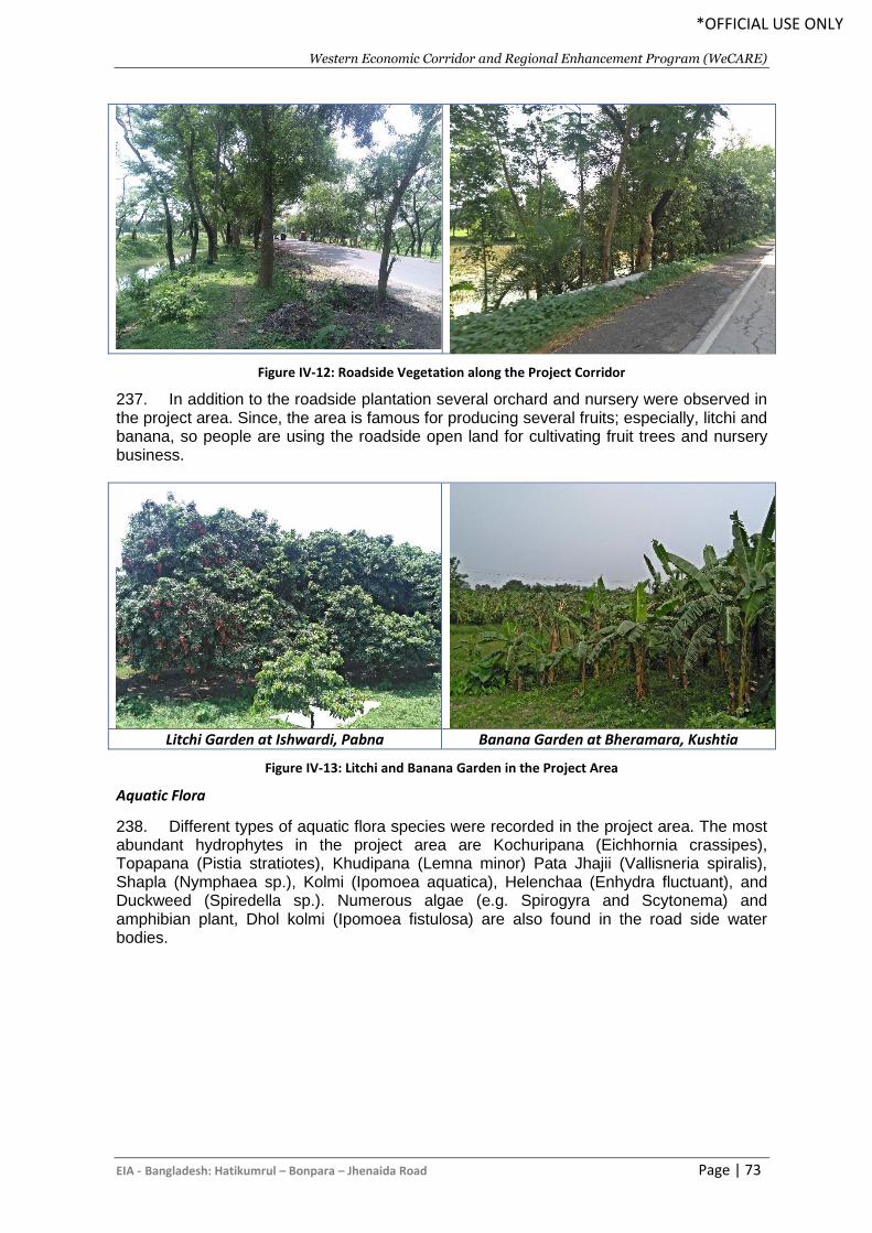
Western Economic Corridor and Regional Enhancement Program (WeCARE)
EIA - Bangladesh: Hatikumrul – Bonpara – Jhenaida Road Page | 73
*OFFICIAL USE ONLY
Figure IV-12: Roadside Vegetation along the Project Corridor
237. In addition to the roadside plantation several orchard and nursery were observed in the project area. Since, the area is famous for producing several fruits; especially, litchi and banana, so people are using the roadside open land for cultivating fruit trees and nursery business.
Litchi Garden at Ishwardi, Pabna Banana Garden at Bheramara, Kushtia
Figure IV-13: Litchi and Banana Garden in the Project Area
Aquatic Flora
238. Different types of aquatic flora species were recorded in the project area. The most abundant hydrophytes in the project area are Kochuripana (Eichhornia crassipes), Topapana (Pistia stratiotes), Khudipana (Lemna minor) Pata Jhajii (Vallisneria spiralis), Shapla (Nymphaea sp.), Kolmi (Ipomoea aquatica), Helenchaa (Enhydra fluctuant), and Duckweed (Spiredella sp.). Numerous algae (e.g. Spirogyra and Scytonema) and amphibian plant, Dhol kolmi (Ipomoea fistulosa) are also found in the road side water bodies.
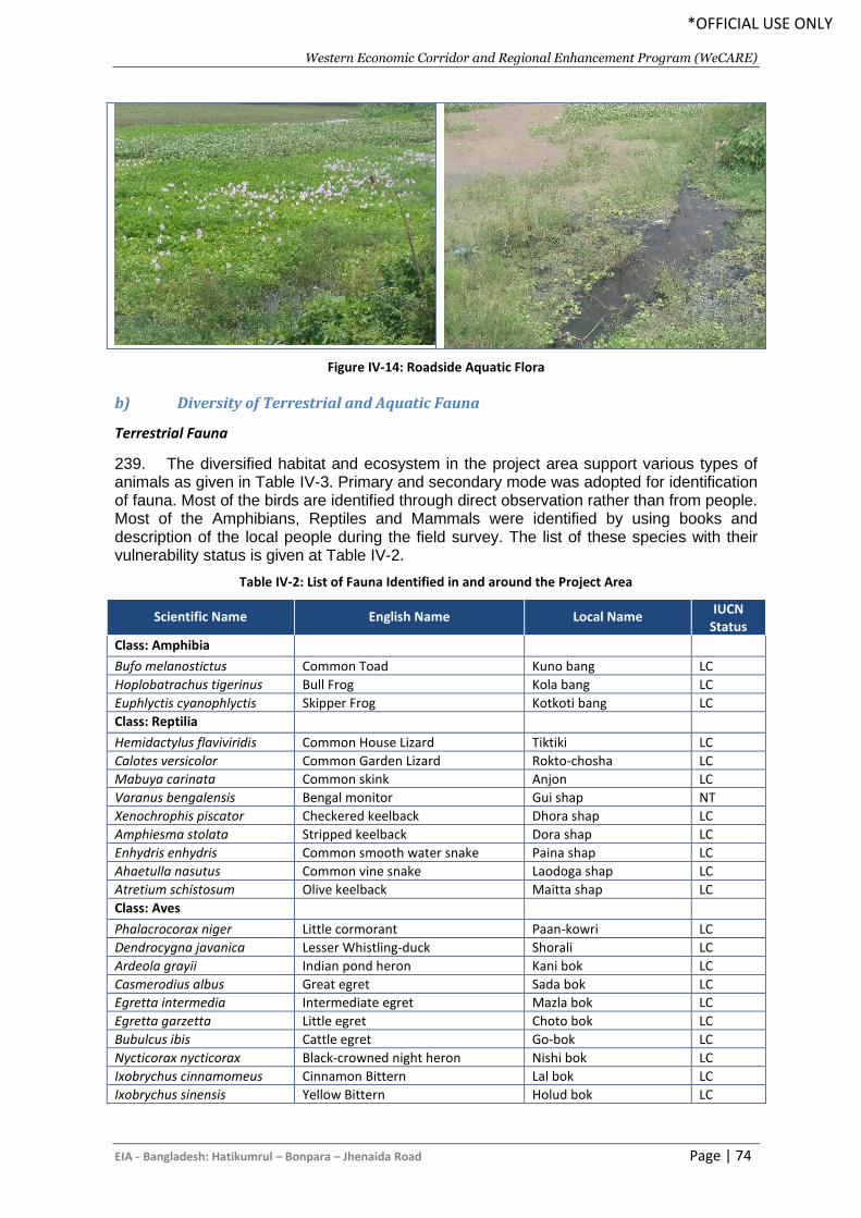
Western Economic Corridor and Regional Enhancement Program (WeCARE)
EIA - Bangladesh: Hatikumrul – Bonpara – Jhenaida Road Page | 74
*OFFICIAL USE ONLY
Figure IV-14: Roadside Aquatic Flora
b) Diversity of Terrestrial and Aquatic Fauna
Terrestrial Fauna
239. The diversified habitat and ecosystem in the project area support various types of animals as given in Table IV-3. Primary and secondary mode was adopted for identification of fauna. Most of the birds are identified through direct observation rather than from people. Most of the Amphibians, Reptiles and Mammals were identified by using books and description of the local people during the field survey. The list of these species with their vulnerability status is given at Table IV-2.
Table IV-2: List of Fauna Identified in and around the Project Area
Scientific Name English Name Local Name IUCN
Status
Class: Amphibia
Bufo melanostictus Common Toad Kuno bang LC
Hoplobatrachus tigerinus Bull Frog Kola bang LC
Euphlyctis cyanophlyctis Skipper Frog Kotkoti bang LC
Class: Reptilia
Hemidactylus flaviviridis Common House Lizard Tiktiki LC
Calotes versicolor Common Garden Lizard Rokto-chosha LC
Mabuya carinata Common skink Anjon LC
Varanus bengalensis Bengal monitor Gui shap NT
Xenochrophis piscator Checkered keelback Dhora shap LC
Amphiesma stolata Stripped keelback Dora shap LC
Enhydris enhydris Common smooth water snake Paina shap LC
Ahaetulla nasutus Common vine snake Laodoga shap LC
Atretium schistosum Olive keelback Maitta shap LC
Class: Aves
Phalacrocorax niger Little cormorant Paan-kowri LC
Dendrocygna javanica Lesser Whistling-duck Shorali LC
Ardeola grayii Indian pond heron Kani bok LC
Casmerodius albus Great egret Sada bok LC
Egretta intermedia Intermediate egret Mazla bok LC
Egretta garzetta Little egret Choto bok LC
Bubulcus ibis Cattle egret Go-bok LC
Nycticorax nycticorax Black-crowned night heron Nishi bok LC
Ixobrychus cinnamomeus Cinnamon Bittern Lal bok LC
Ixobrychus sinensis Yellow Bittern Holud bok LC
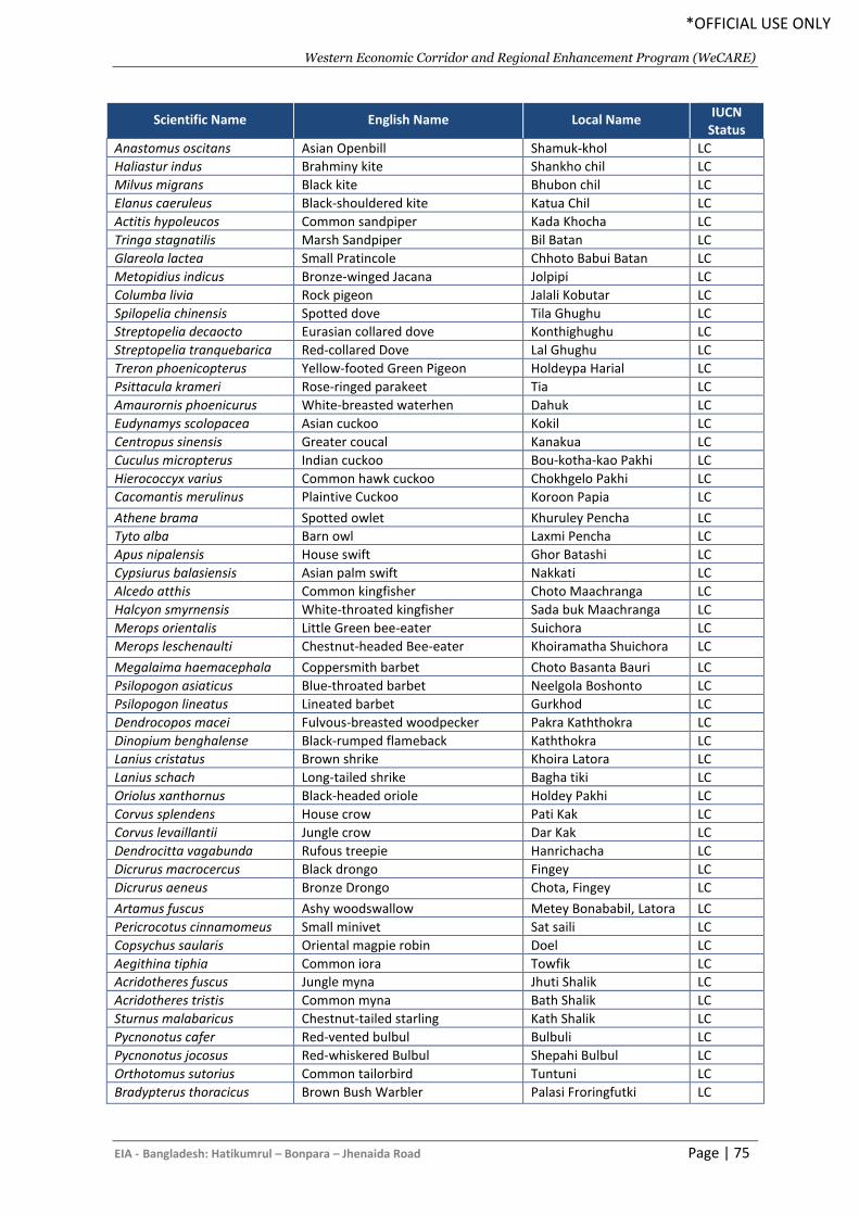
Western Economic Corridor and Regional Enhancement Program (WeCARE)
EIA - Bangladesh: Hatikumrul – Bonpara – Jhenaida Road Page | 75
*OFFICIAL USE ONLY
Scientific Name English Name Local Name IUCN
Status
Anastomus oscitans Asian Openbill Shamuk-khol LC
Haliastur indus Brahminy kite Shankho chil LC
Milvus migrans Black kite Bhubon chil LC
Elanus caeruleus Black-shouldered kite Katua Chil LC
Actitis hypoleucos Common sandpiper Kada Khocha LC
Tringa stagnatilis Marsh Sandpiper Bil Batan LC
Glareola lactea Small Pratincole Chhoto Babui Batan LC
Metopidius indicus Bronze-winged Jacana Jolpipi LC
Columba livia Rock pigeon Jalali Kobutar LC
Spilopelia chinensis Spotted dove Tila Ghughu LC
Streptopelia decaocto Eurasian collared dove Konthighughu LC
Streptopelia tranquebarica Red-collared Dove Lal Ghughu LC
Treron phoenicopterus Yellow-footed Green Pigeon Holdeypa Harial LC
Psittacula krameri Rose-ringed parakeet Tia LC
Amaurornis phoenicurus White-breasted waterhen Dahuk LC
Eudynamys scolopacea Asian cuckoo Kokil LC
Centropus sinensis Greater coucal Kanakua LC
Cuculus micropterus Indian cuckoo Bou-kotha-kao Pakhi LC
Hierococcyx varius Common hawk cuckoo Chokhgelo Pakhi LC
Cacomantis merulinus Plaintive Cuckoo Koroon Papia LC
Athene brama Spotted owlet Khuruley Pencha LC
Tyto alba Barn owl Laxmi Pencha LC
Apus nipalensis House swift Ghor Batashi LC
Cypsiurus balasiensis Asian palm swift Nakkati LC
Alcedo atthis Common kingfisher Choto Maachranga LC
Halcyon smyrnensis White-throated kingfisher Sada buk Maachranga LC
Merops orientalis Little Green bee-eater Suichora LC
Merops leschenaulti Chestnut-headed Bee-eater Khoiramatha Shuichora LC
Megalaima haemacephala Coppersmith barbet Choto Basanta Bauri LC
Psilopogon asiaticus Blue-throated barbet Neelgola Boshonto LC
Psilopogon lineatus Lineated barbet Gurkhod LC
Dendrocopos macei Fulvous-breasted woodpecker Pakra Kaththokra LC
Dinopium benghalense Black-rumped flameback Kaththokra LC
Lanius cristatus Brown shrike Khoira Latora LC
Lanius schach Long-tailed shrike Bagha tiki LC
Oriolus xanthornus Black-headed oriole Holdey Pakhi LC
Corvus splendens House crow Pati Kak LC
Corvus levaillantii Jungle crow Dar Kak LC
Dendrocitta vagabunda Rufous treepie Hanrichacha LC
Dicrurus macrocercus Black drongo Fingey LC
Dicrurus aeneus Bronze Drongo Chota, Fingey LC
Artamus fuscus Ashy woodswallow Metey Bonababil, Latora LC
Pericrocotus cinnamomeus Small minivet Sat saili LC
Copsychus saularis Oriental magpie robin Doel LC
Aegithina tiphia Common iora Towfik LC
Acridotheres fuscus Jungle myna Jhuti Shalik LC
Acridotheres tristis Common myna Bath Shalik LC
Sturnus malabaricus Chestnut-tailed starling Kath Shalik LC
Pycnonotus cafer Red-vented bulbul Bulbuli LC
Pycnonotus jocosus Red-whiskered Bulbul Shepahi Bulbul LC
Orthotomus sutorius Common tailorbird Tuntuni LC
Bradypterus thoracicus Brown Bush Warbler Palasi Froringfutki LC
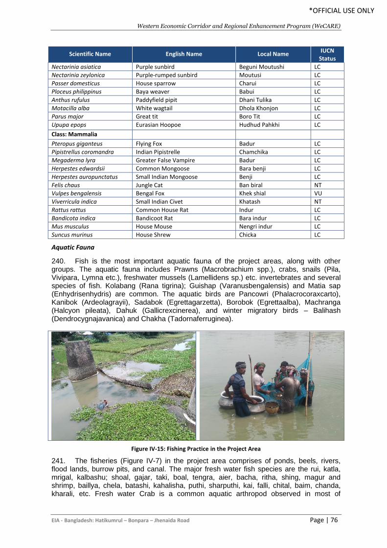
Western Economic Corridor and Regional Enhancement Program (WeCARE)
EIA - Bangladesh: Hatikumrul – Bonpara – Jhenaida Road Page | 76
*OFFICIAL USE ONLY
Scientific Name English Name Local Name IUCN
Status
Nectarinia asiatica Purple sunbird Beguni Moutushi LC
Nectarinia zeylonica Purple-rumped sunbird Moutusi LC
Passer domesticus House sparrow Charui LC
Ploceus philippinus Baya weaver Babui LC
Anthus rufulus Paddyfield pipit Dhani Tulika LC
Motacilla alba White wagtail Dhola Khonjon LC
Parus major Great tit Boro Tit LC
Upupa epops Eurasian Hoopoe Hudhud Pahkhi LC
Class: Mammalia
Pteropus giganteus Flying Fox Badur LC
Pipistrellus coromandra Indian Pipistrelle Chamchika LC
Megaderma lyra Greater False Vampire Badur LC
Herpestes edwardsii Common Mongoose Bara benji LC
Herpestes auropunctatus Small Indian Mongoose Benji LC
Felis chaus Jungle Cat Ban biral NT
Vulpes bengalensis Bengal Fox Khek shial VU
Viverricula indica Small Indian Civet Khatash NT
Rattus rattus Common House Rat Indur LC
Bandicota indica Bandicoot Rat Bara indur LC
Mus musculus House Mouse Nengri indur LC
Suncus murinus House Shrew Chicka LC
Aquatic Fauna
240. Fish is the most important aquatic fauna of the project areas, along with other groups. The aquatic fauna includes Prawns (Macrobrachium spp.), crabs, snails (Pila, Vivipara, Lymna etc.), freshwater mussels (Lamellidens sp.) etc. invertebrates and several species of fish. Kolabang (Rana tigrina); Guishap (Varanusbengalensis) and Matia sap (Enhydrisenhydris) are common. The aquatic birds are Pancowri (Phalacrocoraxcarto), Kanibok (Ardeolagrayii), Sadabok (Egrettagarzetta), Borobok (Egrettaalba), Machranga (Halcyon pileata), Dahuk (Gallicrexcinerea), and winter migratory birds – Balihash (Dendrocygnajavanica) and Chakha (Tadornaferruginea).
Figure IV-15: Fishing Practice in the Project Area
241. The fisheries (Figure IV-7) in the project area comprises of ponds, beels, rivers, flood lands, burrow pits, and canal. The major fresh water fish species are the rui, katla, mrigal, kalbashu; shoal, gajar, taki, boal, tengra, aier, bacha, ritha, shing, magur and shrimp, baillya, chela, batashi, kahalisha, puthi, sharputhi, kai, falli, chital, baim, chanda, kharali, etc. Fresh water Crab is a common aquatic arthropod observed in most of
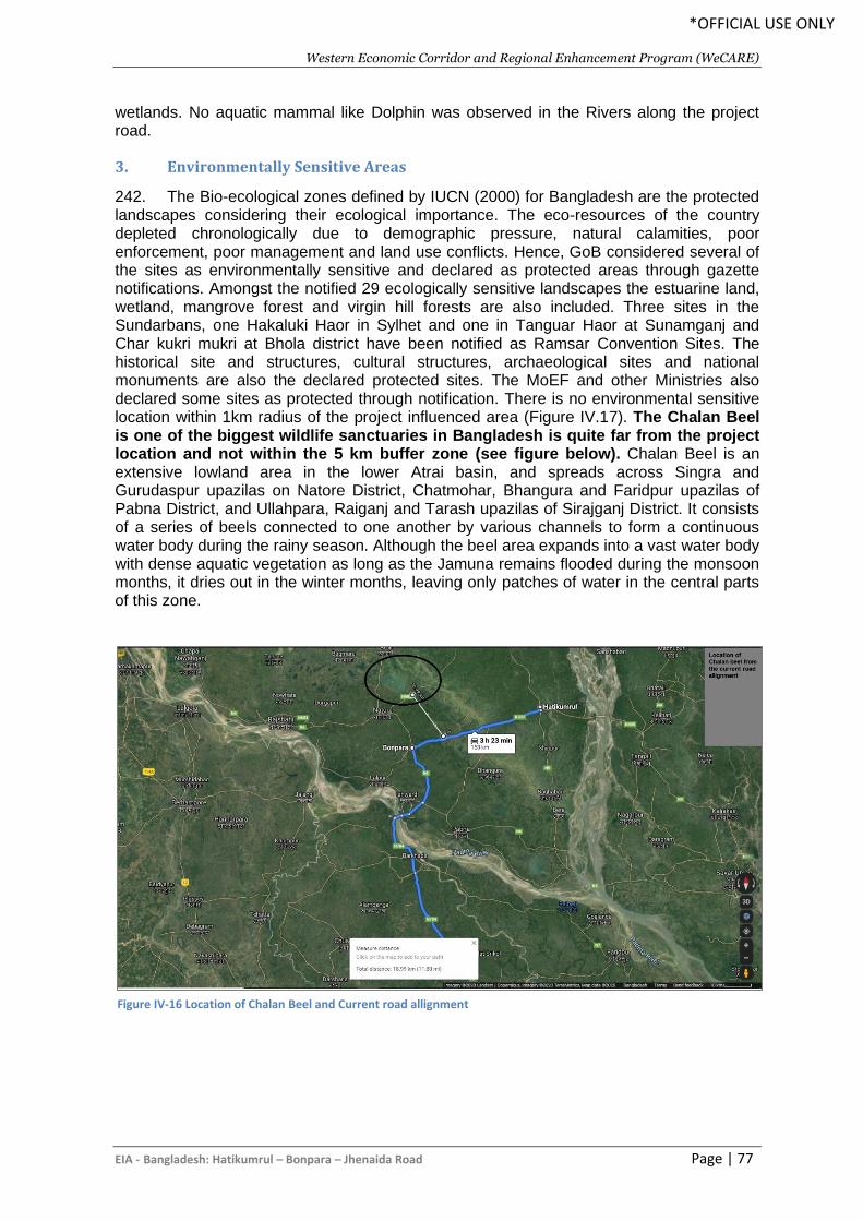
Western Economic Corridor and Regional Enhancement Program (WeCARE)
EIA - Bangladesh: Hatikumrul – Bonpara – Jhenaida Road Page | 77
*OFFICIAL USE ONLY
wetlands. No aquatic mammal like Dolphin was observed in the Rivers along the project road.
3. Environmentally Sensitive Areas
242. The Bio-ecological zones defined by IUCN (2000) for Bangladesh are the protected landscapes considering their ecological importance. The eco-resources of the country depleted chronologically due to demographic pressure, natural calamities, poor enforcement, poor management and land use conflicts. Hence, GoB considered several of the sites as environmentally sensitive and declared as protected areas through gazette notifications. Amongst the notified 29 ecologically sensitive landscapes the estuarine land, wetland, mangrove forest and virgin hill forests are also included. Three sites in the Sundarbans, one Hakaluki Haor in Sylhet and one in Tanguar Haor at Sunamganj and Char kukri mukri at Bhola district have been notified as Ramsar Convention Sites. The historical site and structures, cultural structures, archaeological sites and national monuments are also the declared protected sites. The MoEF and other Ministries also declared some sites as protected through notification. There is no environmental sensitive location within 1km radius of the project influenced area (Figure IV.17). The Chalan Beel is one of the biggest wildlife sanctuaries in Bangladesh is quite far from the project location and not within the 5 km buffer zone (see figure below). Chalan Beel is an extensive lowland area in the lower Atrai basin, and spreads across Singra and Gurudaspur upazilas on Natore District, Chatmohar, Bhangura and Faridpur upazilas of Pabna District, and Ullahpara, Raiganj and Tarash upazilas of Sirajganj District. It consists of a series of beels connected to one another by various channels to form a continuous water body during the rainy season. Although the beel area expands into a vast water body with dense aquatic vegetation as long as the Jamuna remains flooded during the monsoon months, it dries out in the winter months, leaving only patches of water in the central parts of this zone.
Figure IV-16 Location of Chalan Beel and Current road allignment

Western Economic Corridor and Regional Enhancement Program (WeCARE)
EIA - Bangladesh: Hatikumrul – Bonpara – Jhenaida Road Page | 78
*OFFICIAL USE ONLY
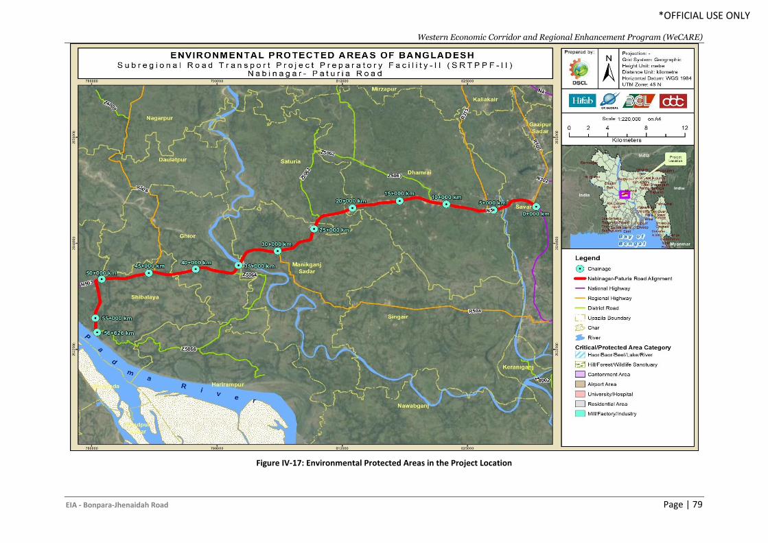
Western Economic Corridor and Regional Enhancement Program (WeCARE)
EIA - Bonpara-Jhenaidah Road Page | 79
*OFFICIAL USE ONLY
Figure IV-17: Environmental Protected Areas in the Project Location
Western Economic Corridor and Regional Enhancement Program (WeCARE)
EIA - Bangladesh: Hatikumrul – Bonpara – Jhenaida Road Page | 80
*OFFICIAL USE ONLY
D. Environmental Quality Test
243. The existing environmental quality in the project influence area serves as the basis for identification, prediction and evaluation of potential environmental impacts of the proposed project interventions. The baseline environmental quality has been assessed through field studies during 15 April to 17 April 2019 within the impact zone and analysis the information for various components of the environment, viz. air, noise, water, riverbed sediment, benthos and plankton etc. The sampling locations were in the following Figure IV.18.
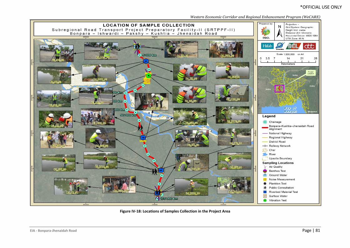
Western Economic Corridor and Regional Enhancement Program (WeCARE)
EIA - Bonpara-Jhenaidah Road Page | 81
*OFFICIAL USE ONLY
Figure IV-18: Locations of Samples Collection in the Project Area
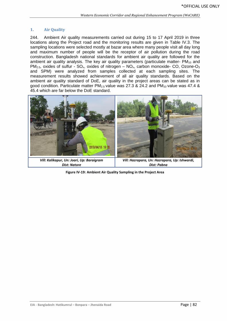
Western Economic Corridor and Regional Enhancement Program (WeCARE)
EIA - Bangladesh: Hatikumrul – Bonpara – Jhenaida Road Page | 82
*OFFICIAL USE ONLY
1. Air Quality
244. Ambient Air quality measurements carried out during 15 to 17 April 2019 in three locations along the Project road and the monitoring results are given in Table IV.3. The sampling locations were selected mostly at bazar area where many people visit all day long and maximum number of people will be the receptor of air pollution during the road construction. Bangladesh national standards for ambient air quality are followed for the ambient air quality analysis. The key air quality parameters (particulate matter- PM10 and PM2.5, oxides of sulfur - SOx, oxides of nitrogen – NOx, carbon monoxide- CO, Ozone-O3 and SPM) were analyzed from samples collected at each sampling sites. The measurement results showed achievement of all air quality standards. Based on the ambient air quality standard of DoE, air quality in the project areas can be stated as in good condition. Particulate matter PM2.5 value was 27.3 & 24.2 and PM10 value was 47.4 & 45.4 which are far below the DoE standard.
Vill: Kalikapur, Un: Joari, Up: Baraigram
Dist: Natore Vill: Hazrapara, Un: Hazrapara, Up: Ishwardi,
Dist: Pabna
Figure IV-19: Ambient Air Quality Sampling in the Project Area
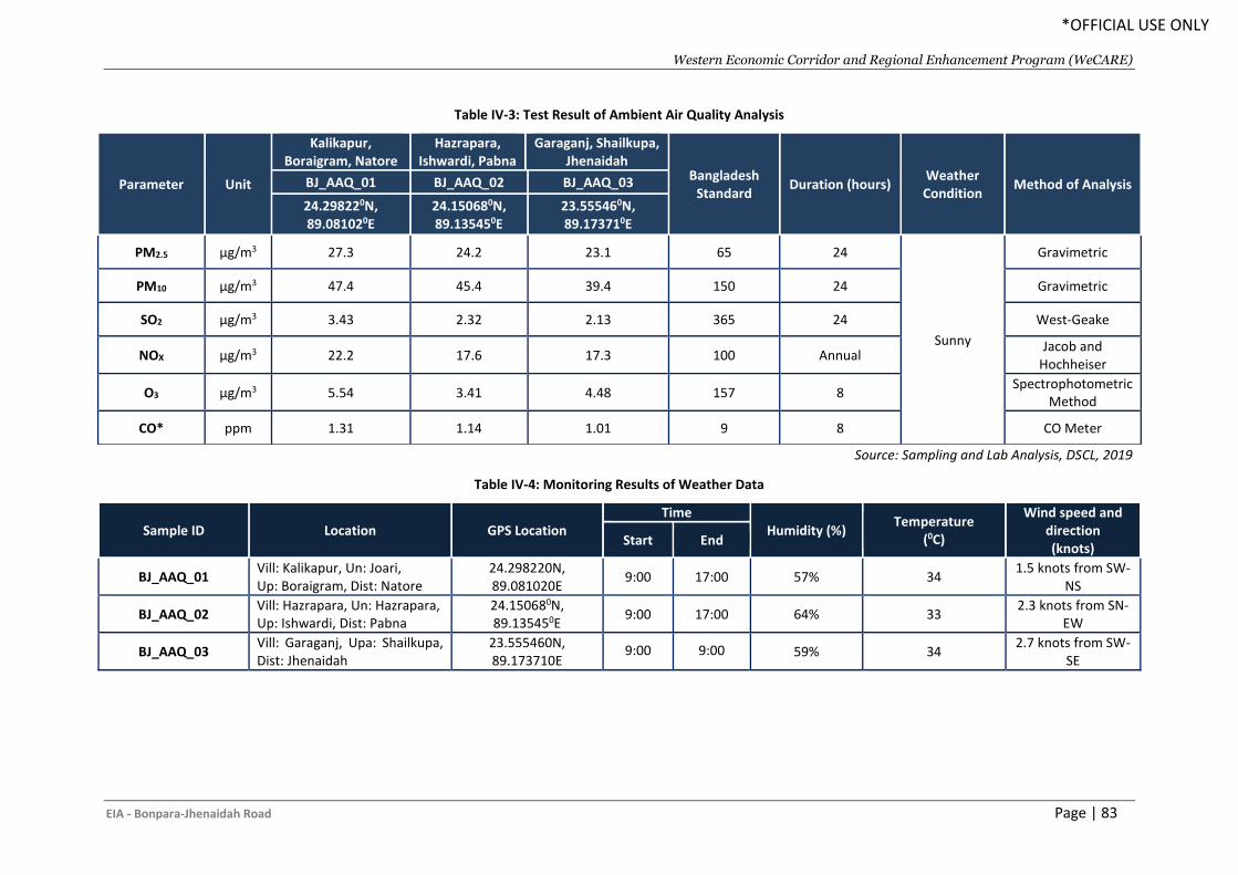
Western Economic Corridor and Regional Enhancement Program (WeCARE)
EIA - Bonpara-Jhenaidah Road Page | 83
*OFFICIAL USE ONLY
Table IV-3: Test Result of Ambient Air Quality Analysis
Source: Sampling and Lab Analysis, DSCL, 2019
Table IV-4: Monitoring Results of Weather Data
Sample ID Location GPS Location Time
Humidity (%) Temperature
(0C)
Wind speed and direction (knots)
Start End
BJ_AAQ_01 Vill: Kalikapur, Un: Joari, Up: Boraigram, Dist: Natore
24.298220N, 89.081020E
9:00 17:00 57% 34 1.5 knots from SW-
NS
BJ_AAQ_02 Vill: Hazrapara, Un: Hazrapara, Up: Ishwardi, Dist: Pabna
24.150680N, 89.135450E
9:00 17:00 64% 33 2.3 knots from SN-
EW
BJ_AAQ_03 Vill: Garaganj, Upa: Shailkupa, Dist: Jhenaidah
23.555460N, 89.173710E
9:00 9:00 59% 34 2.7 knots from SW-
SE
Parameter Unit
Kalikapur, Boraigram, Natore
Hazrapara, Ishwardi, Pabna
Garaganj, Shailkupa, Jhenaidah
Bangladesh Standard
Duration (hours) Weather Condition
Method of Analysis BJ_AAQ_01 BJ_AAQ_02 BJ_AAQ_03
24.298220N, 89.081020E
24.150680N, 89.135450E
23.555460N, 89.173710E
PM2.5 µg/m3 27.3 24.2 23.1 65 24
Sunny
Gravimetric
PM10 µg/m3 47.4 45.4 39.4 150 24 Gravimetric
SO2 µg/m3 3.43 2.32 2.13 365 24 West-Geake
NOX µg/m3 22.2 17.6 17.3 100 Annual Jacob and
Hochheiser
O3 µg/m3 5.54 3.41 4.48 157 8 Spectrophotometric
Method
CO* ppm 1.31 1.14 1.01 9 8 CO Meter
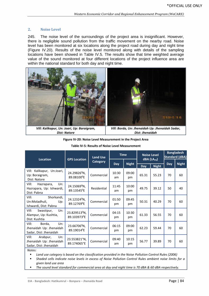
Western Economic Corridor and Regional Enhancement Program (WeCARE)
EIA - Bangladesh: Hatikumrul – Bonpara – Jhenaida Road Page | 84
*OFFICIAL USE ONLY
2. Noise Level
245. The noise level of the surroundings of the project area is insignificant. However, there is negligible sound pollution from the traffic movement on the nearby road. Noise level has been monitored at six locations along the project road during day and night time (Figure IV.20). Results of the noise level monitored along with details of the sampling locations have been showed in Table IV.5. The results show that time weighted average value of the sound monitored at four different locations of the project influence area are within the national standard for both day and night time.
Vill: Kalikapur, Un: Joari, Up: Baraigram,
Dist: Natore Vill: Borda, Un: Jhenaidah Up: Jhenaidah Sadar,
Dist: Jhenaidah
Figure IV-20: Noise Level Measurement in the Project Area
Table IV-5: Results of Noise Level Measurement
Location GPS Location Land Use Category
Time Noise Level dBA (LAeq)
Bangladesh Standard (dBA)
Day Night Day Night Day Night
Vill: Kalikapur, Un:Joari, Up: Boraigram, Dist: Natore
24.298260N, 89.081000E
Commercial 10:30
am 09:00
pm 65.31 55.23 70 60
Vill: Hazrapara, Un: Hazrapara, Up: Ishwardi, Dist: Pabna
24.150690N, 89.135450E
Residential 11:45
am 10:00
pm 49.75 39.12 50 40
Vill: Shorkandi, Un:Moladhuli, Up: Ishwardi, Dist: Pabna
24.123240N, 89.127690E
Commercial 01:50
pm 09:45
pm 50.31 40.29 70 60
Vill: Swastipur, Un: Alampur, Up: Kushtia, Dist: Kushtia
23.8295130N, 89.1039730E
Commercial 04:15
pm 10:30
pm 61.33 56.55 70 60
Vill: Borda, Un: Jhenaidah Up: Jhenaidah Sadar, Dist: Jhenaidah
23.667060N, 89.190140E
Commercial 06:15
pm 09:00
pm 62.23 59.44 70 60
Vill: Arabpur, Un: Jhenaidah Up: Jhenaidah Sadar, Dist: Jhenaidah
23.553821°N, 89.174065°E
Commercial 09:40
am 10:15
pm 56.77 39.89 70 60
Notes: ▪ Land use category is based on the classification provided in the Noise Pollution Control Rules (2006) ▪ Shaded cells indicate noise levels in excess of Noise Pollution Control Rules ambient noise limits for a
given land use area ▪ The sound level standard for commercial area at day and night time is 70 dBA & 60 dBA respectively.
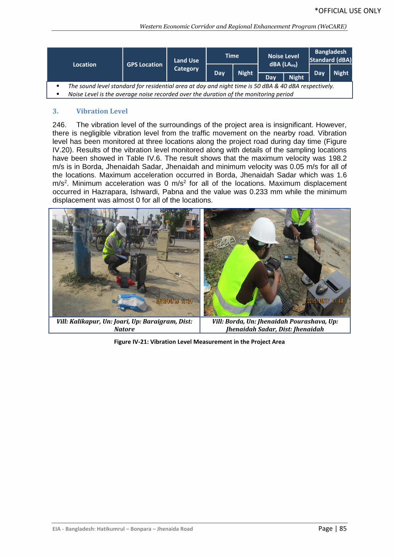
Western Economic Corridor and Regional Enhancement Program (WeCARE)
EIA - Bangladesh: Hatikumrul – Bonpara – Jhenaida Road Page | 85
*OFFICIAL USE ONLY
Location GPS Location Land Use Category
Time Noise Level dBA (LAeq)
Bangladesh Standard (dBA)
Day Night Day Night Day Night
▪ The sound level standard for residential area at day and night time is 50 dBA & 40 dBA respectively. ▪ Noise Level is the average noise recorded over the duration of the monitoring period
3. Vibration Level
246. The vibration level of the surroundings of the project area is insignificant. However, there is negligible vibration level from the traffic movement on the nearby road. Vibration level has been monitored at three locations along the project road during day time (Figure IV.20). Results of the vibration level monitored along with details of the sampling locations have been showed in Table IV.6. The result shows that the maximum velocity was 198.2 m/s is in Borda, Jhenaidah Sadar, Jhenaidah and minimum velocity was 0.05 m/s for all of the locations. Maximum acceleration occurred in Borda, Jhenaidah Sadar which was 1.6 m/s2. Minimum acceleration was 0 m/s2 for all of the locations. Maximum displacement occurred in Hazrapara, Ishwardi, Pabna and the value was 0.233 mm while the minimum displacement was almost 0 for all of the locations.
Figure IV-21: Vibration Level Measurement in the Project Area
Vill: Kalikapur, Un: Joari, Up: Baraigram, Dist:
Natore Vill: Borda, Un: Jhenaidah Pourashava, Up:
Jhenaidah Sadar, Dist: Jhenaidah
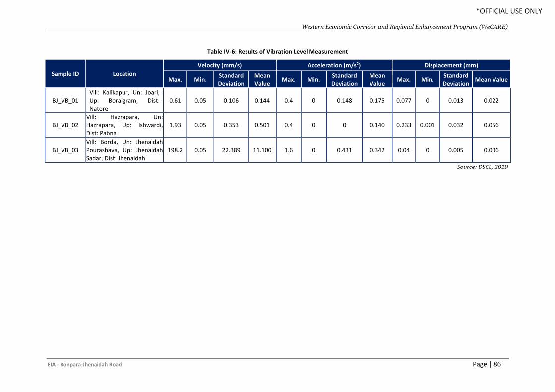
Western Economic Corridor and Regional Enhancement Program (WeCARE)
EIA - Bonpara-Jhenaidah Road Page | 86
*OFFICIAL USE ONLY
Table IV-6: Results of Vibration Level Measurement
Sample ID Location
Velocity (mm/s) Acceleration (m/s2) Displacement (mm)
Max. Min. Standard Deviation
Mean Value
Max. Min. Standard Deviation
Mean Value
Max. Min. Standard Deviation
Mean Value
BJ_VB_01 Vill: Kalikapur, Un: Joari, Up: Boraigram, Dist: Natore
0.61 0.05 0.106 0.144 0.4 0 0.148 0.175 0.077 0 0.013 0.022
BJ_VB_02 Vill: Hazrapara, Un: Hazrapara, Up: Ishwardi, Dist: Pabna
1.93 0.05 0.353 0.501 0.4 0 0 0.140 0.233 0.001 0.032 0.056
BJ_VB_03 Vill: Borda, Un: Jhenaidah Pourashava, Up: Jhenaidah Sadar, Dist: Jhenaidah
198.2 0.05 22.389 11.100 1.6 0 0.431 0.342 0.04 0 0.005 0.006
Source: DSCL, 2019
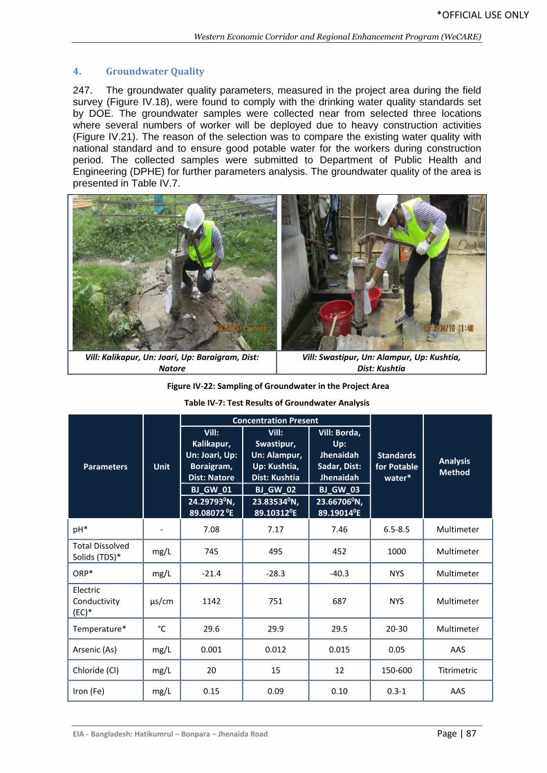
Western Economic Corridor and Regional Enhancement Program (WeCARE)
EIA - Bangladesh: Hatikumrul – Bonpara – Jhenaida Road Page | 87
*OFFICIAL USE ONLY
4. Groundwater Quality
247. The groundwater quality parameters, measured in the project area during the field survey (Figure IV.18), were found to comply with the drinking water quality standards set by DOE. The groundwater samples were collected near from selected three locations where several numbers of worker will be deployed due to heavy construction activities (Figure IV.21). The reason of the selection was to compare the existing water quality with national standard and to ensure good potable water for the workers during construction period. The collected samples were submitted to Department of Public Health and Engineering (DPHE) for further parameters analysis. The groundwater quality of the area is presented in Table IV.7.
Vill: Kalikapur, Un: Joari, Up: Baraigram, Dist:
Natore Vill: Swastipur, Un: Alampur, Up: Kushtia,
Dist: Kushtia
Figure IV-22: Sampling of Groundwater in the Project Area
Table IV-7: Test Results of Groundwater Analysis
Parameters Unit
Concentration Present
Standards for Potable
water*
Analysis Method
Vill: Kalikapur,
Un: Joari, Up: Boraigram, Dist: Natore
Vill: Swastipur,
Un: Alampur, Up: Kushtia, Dist: Kushtia
Vill: Borda, Up:
Jhenaidah Sadar, Dist: Jhenaidah
BJ_GW_01 BJ_GW_02 BJ_GW_03
24.297930N, 89.08072 0E
23.835340N, 89.103120E
23.667060N, 89.190140E
pH* - 7.08 7.17 7.46 6.5-8.5 Multimeter
Total Dissolved Solids (TDS)*
mg/L 745 495 452 1000 Multimeter
ORP* mg/L -21.4 -28.3 -40.3 NYS Multimeter
Electric Conductivity (EC)*
µs/cm 1142 751 687 NYS Multimeter
Temperature* °C 29.6 29.9 29.5 20-30 Multimeter
Arsenic (As) mg/L 0.001 0.012 0.015 0.05 AAS
Chloride (Cl) mg/L 20 15 12 150-600 Titrimetric
Iron (Fe) mg/L 0.15 0.09 0.10 0.3-1 AAS
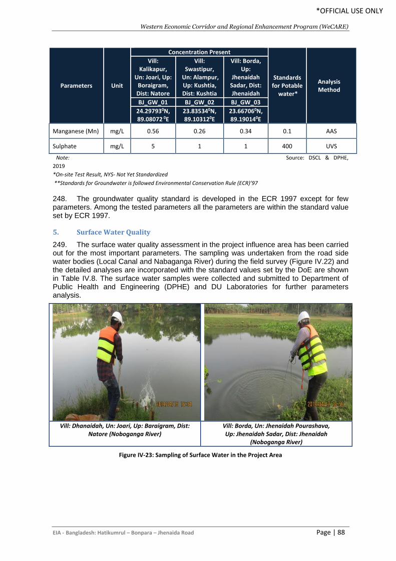
Western Economic Corridor and Regional Enhancement Program (WeCARE)
EIA - Bangladesh: Hatikumrul – Bonpara – Jhenaida Road Page | 88
*OFFICIAL USE ONLY
Parameters Unit
Concentration Present
Standards for Potable
water*
Analysis Method
Vill: Kalikapur,
Un: Joari, Up: Boraigram, Dist: Natore
Vill: Swastipur,
Un: Alampur, Up: Kushtia, Dist: Kushtia
Vill: Borda, Up:
Jhenaidah Sadar, Dist: Jhenaidah
BJ_GW_01 BJ_GW_02 BJ_GW_03
24.297930N, 89.08072 0E
23.835340N, 89.103120E
23.667060N, 89.190140E
Manganese (Mn) mg/L 0.56 0.26 0.34 0.1 AAS
Sulphate mg/L 5 1 1 400 UVS
Note: Source: DSCL & DPHE,
2019
*On-site Test Result, NYS- Not Yet Standardized
**Standards for Groundwater is followed Environmental Conservation Rule (ECR)’97
248. The groundwater quality standard is developed in the ECR 1997 except for few parameters. Among the tested parameters all the parameters are within the standard value set by ECR 1997.
5. Surface Water Quality
249. The surface water quality assessment in the project influence area has been carried out for the most important parameters. The sampling was undertaken from the road side water bodies (Local Canal and Nabaganga River) during the field survey (Figure IV.22) and the detailed analyses are incorporated with the standard values set by the DoE are shown in Table IV.8. The surface water samples were collected and submitted to Department of Public Health and Engineering (DPHE) and DU Laboratories for further parameters analysis.
Vill: Dhanaidah, Un: Joari, Up: Baraigram, Dist:
Natore (Noboganga River) Vill: Borda, Un: Jhenaidah Pourashava, Up: Jhenaidah Sadar, Dist: Jhenaidah
(Noboganga River)
Figure IV-23: Sampling of Surface Water in the Project Area
Western Economic Corridor and Regional Enhancement Program (WeCARE)
EIA - Bonpara-Jhenaidah Road Page | 89
*OFFICIAL USE ONLY
Table IV-8: Test Results of Surface Water Analysis
Parameters Unit
BJ_SW_01 BJ_SW_02 BJ_SW_03 BJ_SW_04 Standards for Surface Water (best practice for fishing) by
ECR’97 Analysis Method
Khal Nabaganga River Nabaganga River Nabaganga River
24.223590N, 89.123740E
23.835490N, 89.102930E
23.667060N, 89.190140E
23.550350N, 89.1694070E
pH* - 9.06 7.85 7.75 7.77 6.5-8.5 Multimeter
Temperature* (0C) 32.5 30.7 31.7 32.0 20-30 Multimeter
Electric Conductivity (EC)* µS/cm 506 382 385 390 NYS Multimeter
Oxidation Reduction Potential (ORP)
mV -139.1 -66.2 -64.3 -63.7 NYS Multimeter
Total Dissolved Solids (TDS)*
mg/L 318 255 257 253 NYS Multimeter
Dissolved Oxygen (DO) * mg/L 5.2 5.1 5.4 5.5 5 or More DO Meter
Biological Oxygen Demand (BOD5)
mg/L 17 15 18 20 6 or Less 5 days Incubation
Phosphate mg/L 0.71 0.54 1.34 4.57 NYS UVS
Total Suspended Solid (TSS)
mg/L 5 11 12 16 NYS Gravimetric
Method
Turbidity NTU 3.0 9.0 5.0 8.0 NYS Turbidity Meter
Oil & Grease mg/L Less than 2.0 Less than 2.0 Less than 2.0 Less than 2.0 NYS 5520.B
Note: Source: DSCL, DPHE and DU, 2019
*On-site Test Result
**Standards for Inland Surface Water is followed Environmental Conservation Rule (ECR)’97
NYS- Not Yet Standardized
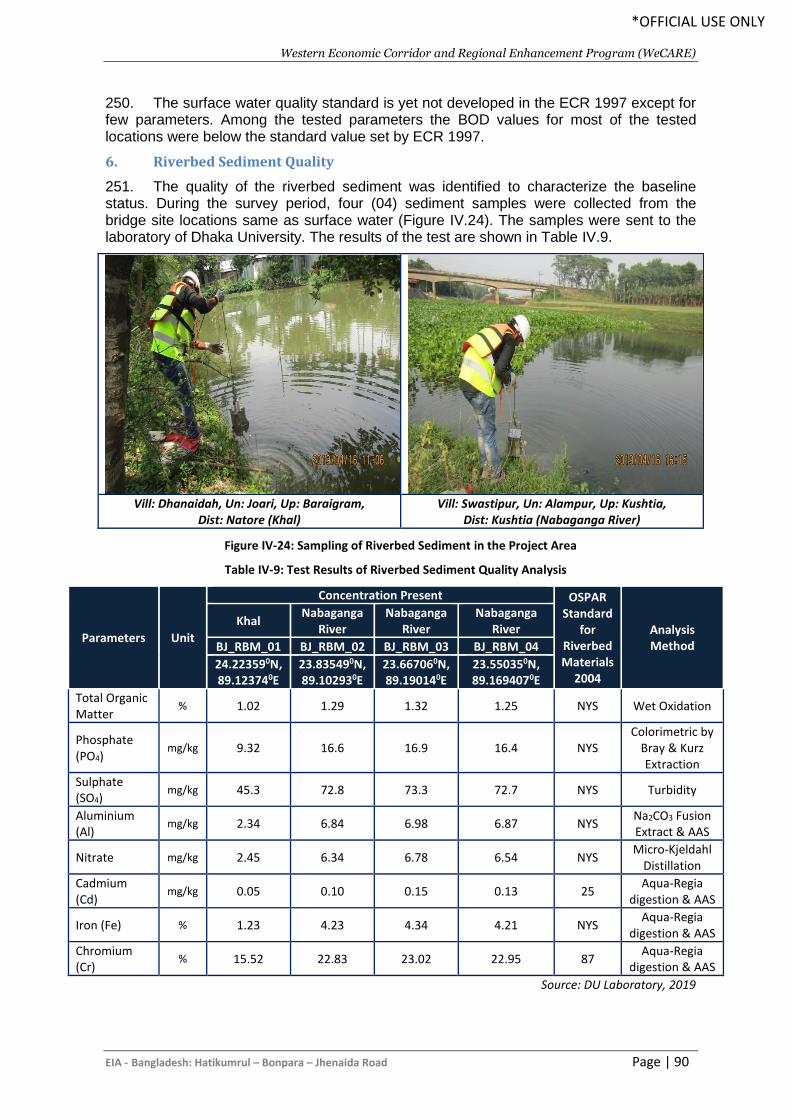
Western Economic Corridor and Regional Enhancement Program (WeCARE)
EIA - Bangladesh: Hatikumrul – Bonpara – Jhenaida Road Page | 90
*OFFICIAL USE ONLY
250. The surface water quality standard is yet not developed in the ECR 1997 except for few parameters. Among the tested parameters the BOD values for most of the tested locations were below the standard value set by ECR 1997.
6. Riverbed Sediment Quality
251. The quality of the riverbed sediment was identified to characterize the baseline status. During the survey period, four (04) sediment samples were collected from the bridge site locations same as surface water (Figure IV.24). The samples were sent to the laboratory of Dhaka University. The results of the test are shown in Table IV.9.
Figure IV-24: Sampling of Riverbed Sediment in the Project Area
Table IV-9: Test Results of Riverbed Sediment Quality Analysis
Parameters Unit
Concentration Present OSPAR Standard
for Riverbed Materials
2004
Analysis Method
Khal Nabaganga
River Nabaganga
River Nabaganga
River
BJ_RBM_01 BJ_RBM_02 BJ_RBM_03 BJ_RBM_04
24.223590N, 89.123740E
23.835490N, 89.102930E
23.667060N, 89.190140E
23.550350N, 89.1694070E
Total Organic Matter
% 1.02 1.29 1.32 1.25 NYS Wet Oxidation
Phosphate (PO4)
mg/kg 9.32 16.6 16.9 16.4 NYS Colorimetric by
Bray & Kurz Extraction
Sulphate (SO4)
mg/kg 45.3 72.8 73.3 72.7 NYS Turbidity
Aluminium (Al)
mg/kg 2.34 6.84 6.98 6.87 NYS Na2CO3 Fusion Extract & AAS
Nitrate mg/kg 2.45 6.34 6.78 6.54 NYS Micro-Kjeldahl
Distillation
Cadmium (Cd)
mg/kg 0.05 0.10 0.15 0.13 25 Aqua-Regia
digestion & AAS
Iron (Fe) % 1.23 4.23 4.34 4.21 NYS Aqua-Regia
digestion & AAS
Chromium (Cr)
% 15.52 22.83 23.02 22.95 87 Aqua-Regia
digestion & AAS
Source: DU Laboratory, 2019
Vill: Dhanaidah, Un: Joari, Up: Baraigram,
Dist: Natore (Khal) Vill: Swastipur, Un: Alampur, Up: Kushtia,
Dist: Kushtia (Nabaganga River)
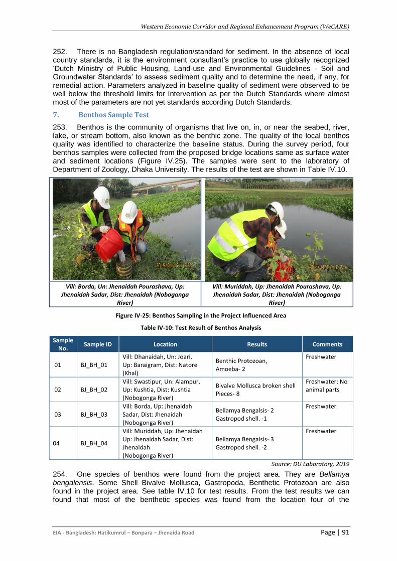
Western Economic Corridor and Regional Enhancement Program (WeCARE)
EIA - Bangladesh: Hatikumrul – Bonpara – Jhenaida Road Page | 91
252. There is no Bangladesh regulation/standard for sediment. In the absence of local country standards, it is the environment consultant’s practice to use globally recognized ‘Dutch Ministry of Public Housing, Land-use and Environmental Guidelines - Soil and Groundwater Standards’ to assess sediment quality and to determine the need, if any, for remedial action. Parameters analyzed in baseline quality of sediment were observed to be well below the threshold limits for Intervention as per the Dutch Standards where almost most of the parameters are not yet standards according Dutch Standards.
7. Benthos Sample Test
253. Benthos is the community of organisms that live on, in, or near the seabed, river, lake, or stream bottom, also known as the benthic zone. The quality of the local benthos quality was identified to characterize the baseline status. During the survey period, four benthos samples were collected from the proposed bridge locations same as surface water and sediment locations (Figure IV.25). The samples were sent to the laboratory of Department of Zoology, Dhaka University. The results of the test are shown in Table IV.10.
Vill: Borda, Un: Jhenaidah Pourashava, Up:
Jhenaidah Sadar, Dist: Jhenaidah (Noboganga River)
Vill: Muriddah, Up: Jhenaidah Pourashava, Up: Jhenaidah Sadar, Dist: Jhenaidah (Noboganga
River)
Figure IV-25: Benthos Sampling in the Project Influenced Area
Table IV-10: Test Result of Benthos Analysis
Sample No.
Sample ID Location Results Comments
01 BJ_BH_01 Vill: Dhanaidah, Un: Joari, Up: Baraigram, Dist: Natore (Khal)
Benthic Protozoan, Amoeba- 2
Freshwater
02 BJ_BH_02 Vill: Swastipur, Un: Alampur, Up: Kushtia, Dist: Kushtia (Nobogonga River)
Bivalve Mollusca broken shell Pieces- 8
Freshwater; No animal parts
03 BJ_BH_03 Vill: Borda, Up: Jhenaidah Sadar, Dist: Jhenaidah (Nobogonga River)
Bellamya Bengalsis- 2 Gastropod shell. -1
Freshwater
04 BJ_BH_04
Vill: Muriddah, Up: Jhenaidah Up: Jhenaidah Sadar, Dist: Jhenaidah (Nobogonga River)
Bellamya Bengalsis- 3 Gastropod shell. -2
Freshwater
Source: DU Laboratory, 2019
254. One species of benthos were found from the project area. They are Bellamya bengalensis. Some Shell Bivalve Mollusca, Gastropoda, Benthetic Protozoan are also found in the project area. See table IV.10 for test results. From the test results we can found that most of the benthetic species was found from the location four of the
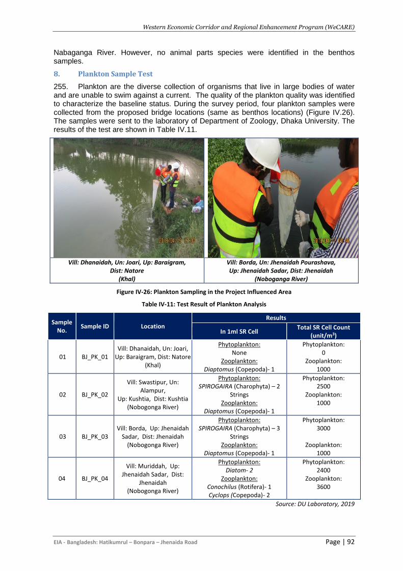
Western Economic Corridor and Regional Enhancement Program (WeCARE)
EIA - Bangladesh: Hatikumrul – Bonpara – Jhenaida Road Page | 92
Nabaganga River. However, no animal parts species were identified in the benthos samples.
8. Plankton Sample Test
255. Plankton are the diverse collection of organisms that live in large bodies of water and are unable to swim against a current. The quality of the plankton quality was identified to characterize the baseline status. During the survey period, four plankton samples were collected from the proposed bridge locations (same as benthos locations) (Figure IV.26). The samples were sent to the laboratory of Department of Zoology, Dhaka University. The results of the test are shown in Table IV.11.
Vill: Dhanaidah, Un: Joari, Up: Baraigram,
Dist: Natore (Khal)
Vill: Borda, Un: Jhenaidah Pourashava, Up: Jhenaidah Sadar, Dist: Jhenaidah
(Noboganga River)
Figure IV-26: Plankton Sampling in the Project Influenced Area
Table IV-11: Test Result of Plankton Analysis
Sample No.
Sample ID Location
Results
In 1ml SR Cell Total SR Cell Count
(unit/m3)
01 BJ_PK_01 Vill: Dhanaidah, Un: Joari,
Up: Baraigram, Dist: Natore (Khal)
Phytoplankton: None
Zooplankton: Diaptomus (Copepoda)- 1
Phytoplankton: 0
Zooplankton: 1000
02 BJ_PK_02
Vill: Swastipur, Un: Alampur,
Up: Kushtia, Dist: Kushtia (Nobogonga River)
Phytoplankton: SPIROGAIRA (Charophyta) – 2
Strings Zooplankton:
Diaptomus (Copepoda)- 1
Phytoplankton: 2500
Zooplankton: 1000
03 BJ_PK_03 Vill: Borda, Up: Jhenaidah
Sadar, Dist: Jhenaidah (Nobogonga River)
Phytoplankton: SPIROGAIRA (Charophyta) – 3
Strings Zooplankton:
Diaptomus (Copepoda)- 1
Phytoplankton: 3000
Zooplankton:
1000
04 BJ_PK_04
Vill: Muriddah, Up: Jhenaidah Sadar, Dist:
Jhenaidah (Nobogonga River)
Phytoplankton: Diatom- 2
Zooplankton: Conochilus (Rotifera)- 1 Cyclops (Copepoda)- 2
Phytoplankton: 2400
Zooplankton: 3600
Source: DU Laboratory, 2019
Western Economic Corridor and Regional Enhancement Program (WeCARE)
EIA - Bangladesh: Hatikumrul – Bonpara – Jhenaida Road Page | 93
256. Only 2 species of phytoplankton and 3 species of Zooplankton were found from the project area. Phytoplankton which occurs in the water of the project area is Diatom and SPIROGAIRA (Charophyta) while the zooplankton genera were Diaptomus (Copepoda), Cyclops (Copepoda) and Conochilus (Rotifera). Some of the strings were also found in the project area. The test result shows that highest amount of Phytoplankton was found in Nabaganga River while the lowest amount of Phytoplankton was found in Roadside Khal area. The test result shows that highest amount of Zooplankton was found in Nabaganga River while the lowest amount of Zooplankton was found in remaining locations.
E. Socio-economic Environment
1. General
257. It is essential for every development project, whether small or large, to understand the social, human and economic aspects of the primary stakeholders, i.e., people living in and around the project site. The following tools and techniques were used to collect the relevant data/information on the social and economic aspects of affected people:
• Literature review;
• Group discussion; and
• Informal meeting with various professionals. 258. In addition, data obtained from secondary sources were compared with the primary data/information gathered during the study. 259. Data on population, age/sex composition, household patterns, and sources of drinking water, sanitation facility, and ownership of agricultural land were enumerated from the latest community series census published by the Bangladesh Bureau of Statistics (BBS).
2. Administrative Structures
260. Bangladesh is divided into eight administrative Divisions. Each Division is divided into Districts/Zilas; there are 64 Districts within Bangladesh. Districts/ Zila’s are subdivided into Upazilas (there are 483 Upazilas in Bangladesh), which consist of a number of Union Parishads. Union Parishads of which there are 4486 in Bangladesh are the locally elected governments at the village level. 261. The Project area is located in Natore, Pabna, Kushtia, and Jhenaidah districts within Rajshahi and Khulna Division. The proposed alignment passes through 7 Upazilas (Baraigram, Ishwardi, Bheramara, Mirpur, Kushtia Sadar, Shailkupa, and Jhenaidah Sadar).
3. Demography
262. With an estimated 164.4 million inhabitants and an annual population growth rate of 1.4%, Bangladesh is considered to be one of the most densely populated countries in the world (UNFPA, 2010). The details of demographic profile of Bonpara-Jhenaidah area are presented below Table IV-12. 263. The demographic information collected from the Population Census, 2011 of Bangladesh Bureau of Statistics (BBS) shows that the population density is higher at the sadar upazila of each district. However, being an important place for trade and commerce Kushtia Sadar upazila has the highest population density among the all upazilas.
Western Economic Corridor and Regional Enhancement Program (WeCARE)
EIA - Bangladesh: Hatikumrul – Bonpara – Jhenaida Road Page | 94
Additionally, almost all the upazilas have ethnic people but at Jhenaidah district. The Pahari, Malpahari and Sawntal people are major ethnic groups living in the project area.
Table IV-12: Populations in the Project Road Area
Up
azila
Are
a
(Acr
es)
Ho
use
ho
lds
Po
pu
lati
on
Po
pu
lati
on
De
nsi
ty
Ethnic Population
Ora
o
Saw
nta
l
Pah
ari
Mo
nd
a
Mal
pah
ari
Co
ol
Ch
akm
a
Mar
ma
Oth
ers
Baraigram 74034 70104 279672 933 30 122 391 - - - - - 775
Ishwardi 61998 73373 313932 1251 - - 36 111 217 - - - 653
Bheramara 37983 47586 200084 1302 - - - - - 51 5 2 137
Mirpur 75383 82783 330115 1082 - - - - - 75 10 2 58
Kushtia Sadar 78636 120087 502255 1578 - - - - - - 14 10 1281
Shailkupa 92278 83348 361648 968
Jhenaidah
Sadar 116167 108924 455932 970
Source: Population Census, 2011
4. Settlement and Housing Pattern
264. The project is located in comparatively less densely settlements area than the other parts of the country. However, the urban areas of district sadar and major upazilas of the project road have dense population and settlements. Housing condition along the project alignment is predominantly kutcha, semi pucca and pucca structures. The average data about the main house of the dwelling households by type of structure shows that pucca and semi-pucca household structures remain higher in the semi-urban area comparing to the rural areas of the project road. According to the social survey, total 2582503 Sq.ft housing/settlement structures of different types will be affected.
5. Land Use Patterns
265. Lands at the project area are used for agriculture, fisheries, agro-forestry, homestead, homestead forestry and vegetation, animal husbandry, etc. The areas through which the existing alignment passes is characterized by an agricultural ecosystem with very little of the natural ecosystem remaining. The most heavily vegetated areas along the alignment are the homestead areas where several species of trees of economic value are present. 266. The land use pattern along the alignment like other areas has traditionally been devised based on soil condition, relief, climate, hydrology and flood conditions, availability of resources, etc. The road alignment would impact the local land uses positively due to establishment of fast, safe and convenient road linkages between the project command areas and small markets of rural areas.
6. Water Supply and Sanitation
267. Tube wells are the most common source of drinking water in both the urban and rural areas. Tap water is accessible only in urban areas. Most households do not treat water prior to drinking. Sewage facilities are available in most of the urban areas. 268. According to the observations during field survey it can be said that the sanitary facilities are better in the urban areas than the rural areas. Particularly, in the Kushtia
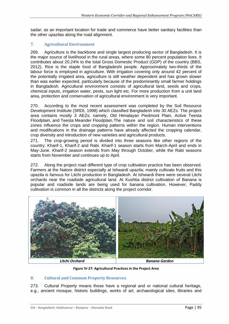
Western Economic Corridor and Regional Enhancement Program (WeCARE)
EIA - Bangladesh: Hatikumrul – Bonpara – Jhenaida Road Page | 95
sadar; as an important location for trade and commerce have better sanitary facilities than the other upazilas along the road alignment.
7. Agricultural Environment
269. Agriculture is the backbone and single largest producing sector of Bangladesh. It is the major source of livelihood in the rural areas, where some 80 percent population lives. It contributes about 20.24% to the total Gross Domestic Product (GDP) of the country (BBS, 2012). Rice is the staple food of Bangladeshi people. Approximately two-thirds of the labour force is employed in agriculture. With irrigation covering only around 42 percent of the potentially irrigated area, agriculture is still weather dependent and has grown slower than was earlier expected, particularly because of the predominantly small farmer holdings in Bangladesh. Agricultural environment consists of agricultural land, seeds and crops, chemical inputs, irrigation water, pests, sun light etc. For more production from a unit land area, protection and conservation of agricultural environment is very important. 270. According to the most recent assessment was completed by the Soil Resource Development Institute (SRDI, 1998) which classified Bangladesh into 30 AEZs. The project area contains mostly 3 AEZs; namely, Old Himalayan Piedmont Plain, Active Teesta Floodplain, and Teesta Meander Floodplain. The nature and soil characteristics of these zones influence the crops and cropping patterns within the region. Human interventions and modifications in the drainage patterns have already affected the cropping calendar, crop diversity and introduction of new varieties and agricultural products.
271. The crop-growing period is divided into three seasons like other regions of the country: Kharif-1, Kharif-2 and Rabi. Kharif-1 season starts from March-April and ends in May-June. Kharif-2 season extends from May through October, while the Rabi seasons starts from November and continues up to April. 272. Along the project road different type of crop cultivation practice has been observed. Farmers at the Natore district especially at Ishwardi upazila; mainly cultivate fruits and this upazila is famous for Litchi production in Bangladesh. At Ishwardi there were several Litchi orchards near the roadside agricultural land. At Kushtia district cultivation of Banana is popular and roadside lands are being used for banana cultivation. However, Paddy cultivation is common in all the districts along the project corridor.
Litchi Orchard Banana Garden
Figure IV-27: Agricultural Practices in the Project Area
8. Cultural and Common Property Resources
273. Cultural Property means those have a regional and or national cultural heritage, e.g., ancient mosque, historic buildings, works of art, archaeological sites, libraries and
Western Economic Corridor and Regional Enhancement Program (WeCARE)
EIA - Bangladesh: Hatikumrul – Bonpara – Jhenaida Road Page | 96
museums and Common Property Resources mean the property usually used by the local communities, e.g., educational institutes, religious institutes, Eidgah, Crematory etc. These properties require to be protected as they contribute to local culture and will remain in the Project area during operational period of the Project. Along the project road there are several numbers of mosques, temples, church, schools, colleges, madrashas, etc. as per the field observation and literature review there is no historical archeological site within 5 km buffer of the project alignment. A map showing the cultural and common properties within the 200m ROW is given in Appendix 11.
F. COVID-19 situation in the project influence area
274. With the outbreak and spread of COVID-19, people have been mandated by national or local law to exercise social distancing, and specifically to avoid public gatherings to prevent and reduce the risk of the virus transmission. Various restrictive measures have been adopted including some imposing strict restrictions on public gatherings, meetings and people’s movement, and others advising against public group events. At the same time, the general public has become increasingly aware and concerned about the risks of transmission, particularly through social interactions at large gatherings.
275. WHO has issued technical guidance in dealing with COVID-19, including: (i) Risk Communication and Community Engagement (RCCE) Action Plan Guidance Preparedness and Response; (ii) Risk Communication and Community engagement (RCCE) readiness and response; (iii) COVID-19 risk communication package for healthcare facilities; (iv) Getting your workplace ready for COVID-19; and (v) a guide to preventing and addressing social stigma associated with COVID-19. All these documents are available on the WHO website through the following link: https://www.who.int/emergencies/diseases/novel-coronavirus-2019/technical-guidance.
Western Economic Corridor and Regional Enhancement Program (WeCARE)
EIA - Bangladesh: Hatikumrul – Bonpara – Jhenaida Road Page | 97
V. ANALYSIS OF ALTERNATIVE
A. Background
276. Analysis of alternatives involves the examination of optional solutions, e.g., road improvement, or air service, instead of rail, and alternative alignments and/or technologies to be applied, such as electric versus diesel locomotives. Optional solutions have been assessed by RHD during the early stages of the Project planning with AIIB. Location of Project alignment is being identified during feasibility study (FS) by analysis of various possible alignments through technical, economic, social and environmental considerations.
B. Alternatives to the Project
277. The road alignment is predominantly rural for most of its length though there are some semi-urban uses and development at the township. Some disturbance to adjacent uses will be inevitable. It is assumed that the right of way is adequate for a 4-lane highway with SMVT in both sides mostly, but this needs to be confirmed. 278. In order to widen the carriageway some encroachment of adjacent agricultural land will be necessary, and this will need to be strictly managed during the construction phase. This is an existing road and there is likely to be cuttings of many roadside trees and vegetation. In addition, the social/resettlement issues are likely to be substantial in many areas where there are villages and markets adjacent to the road. Since the RoW is probably wide enough for 4 lanes, there may be less significant land acquisition resettlement problems at the market locations. There are a number of sensitive uses near to the project road such as schools, graveyards and other sensitive structures alongside the alignment. Some localized problems may occur, and special management will be necessary during the construction phase.
1. The Without-Project Alternative
279. From a purely physical and environmental point of view, the ‘do-nothing’ approach is preferable to any project implementation since it would avoid creation of any of the adverse impacts associated with a new road. The without project alternative is not acceptable since this will strongly reduce the potential for socio-economic development of the country. Despite having great potential, the industrial and commercial growth is retarded mainly due to absence of safe and reliable transportation facility. Further, as a common port facility of neighboring countries the Benapole Land Port does not yet have the required transportation infrastructure to give it the momentum to reach that status. A new highway to the rest of Bangladesh and to the region will help realise this objective. 280. Therefore, the ‘no-build’ alternative is unacceptable, and the potential socio-economic benefits of implementation of such Project far outweigh the adverse impacts, all of which can be controlled and minimised to an acceptable level.
C. The Alternatives Alignments
281. The proposed road development will be followed along the present ROW and there is no major route alternative. However, there are some minor alternative alignment options for ensuring the road safety and discussed in later sections.
1. Minor Route Alternatives
282. The present alignment between Bonpara and Jhenaidah will require numerous short distance (<1000m) straightening realignments to ensure the designed alignment is in
Western Economic Corridor and Regional Enhancement Program (WeCARE)
EIA - Bangladesh: Hatikumrul – Bonpara – Jhenaida Road Page | 98
accordance with the RHD standards (Table V.1). The selection of these minor realignments will need to ensure the minimum disturbance to the local environment (and to ensure minimum disturbance to the built environment, land acquisition and resettlement). This is particularly critical where the road passes through the settlement areas and disturbance to the local environment should occur.
Table V-1: Proposed Minor Route Alternatives
Sl. No. Chainage Environmental and Social Setup
1 Km 8+600 – Km 9+100 ▪ Rural settlement with homestead plantation; ▪ Bamboo garden.
2 Km 16+400 – Km 16+800 ▪ Rural settlement with homestead plantation; ▪ Rural bazaar; ▪ Small water bodies (ponds and ditches);
3 Km 22+400 – Km 23+200 ▪ Rural settlement with homestead plantation; ▪ Low land; ▪ Small water bodies (ponds and ditches);
4 Km 50+000 – Km 50+400 ▪ Rural settlement with homestead plantation; ▪ Bamboo garden.
5 Km 59+900 – Km 60+500 ▪ Semi urban settlement with homestead plantation; ▪ Agricultural land; ▪ Small water bodies (ponds and ditches).
D. Conclusions
283. The preferred alignment, taking into consideration not just environmental and social considerations, but also financial, economic and engineering requirements. Since the road alignment will be following mostly the current alignment with some minor changes, the proposed alignment is acceptable both from the social, economical and environmental perspective.
Western Economic Corridor and Regional Enhancement Program (WeCARE)
EIA - Bangladesh: Hatikumrul – Bonpara – Jhenaida Road Page | 99
VI. ANTICIPATED ENVIRONMENTAL IMPACTS AND MITIGATION
MEASURES
A. General
284. This section identifies the overall impacts on the physical, biological and socio-economic environment of the project area. An environmental impact is defined as any change to an existing condition of the environment. Identification of potential impacts has been done on the basis of baseline data collected from secondary and primary sources. Environmental impact assessment was carried out considering present environmental setting of the project area, and nature and extent of the proposed activities. Potential environmental impacts associated with the proposed project activities of both the project are classified as:
I. impacts during pre-construction/design phase; II. impacts during construction phase; and
III. impacts during operation phase.
B. Project Corridor
285. The Project corridor is delineated according to two criteria: right of way (RoW); which the RHD is legally entitled to, and Corridor of Impact (CoI), i.e. the width of the corridor that will be impacted, directly or indirectly, by the proposed project during the construction and operational phases.
1. Project Right of Way (RoW)
286. The proposed project corridor will have a well-defined RoW that will be approximately from 50m to 65m for the entire length of the highway. Major construction works will generally remain confined within the RoW. All the infrastructure and commercial activities within the existing or proposed RoW need to be relocated as they will have direct impact of the project.
2. Corridor of Impact (CoI)
287. The corridor of the proposed Impact (CoI) was delineated as the extent, which has direct or indirect impact of project. Direct impacts of the project are relocation of houses, utilities and air and noise pollution impact on workers during construction. All direct impacts are constrained within the RoW. Indirect impacts, caused by noise, dust emissions, camp sites and borrow sites could be beyond the RoW. The direct CoI of the surface water bodies will be confined within the RoW of the proposed project and will be temporary only for the construction period. 288. According to the type of impacts the project area is divided into two sections. One, those related to the project which is 50m for the project. Another section is those related to the background environmental features of the project site. This should cover not only the project site in proper, but generally an area of 1 km radius around the site during IEE preparation. However, due to the nature of the project, the direct or indirect impact will not go beyond 200m from the RoW of the road alignment. In this project 200m from the RoW have been considered as core impact zone and 1 km as buffer zone (as per DoE guideline) for better understanding.

Western Economic Corridor and Regional Enhancement Program (WeCARE)
EIA - Bangladesh: Hatikumrul – Bonpara – Jhenaida Road Page | 100
C. Anticipated Adverse Impacts and Mitigation Measures
1. Design/Pre-construction Stage
289. Following is a brief description of impacts envisaged during the Preconstruction/ Design Phase:
a) Climate
Impact
290. Bangladesh is one of the most vulnerable countries in the world in terms of global warming and climate change considerations. The two most important factors relevant to the road project are changes to rainfall patterns and sea level rises. It is noted, that due to Global Warming and Greenhouse gas impacts the trends of rainfall, temperatures and humidity are changing. The design of the road will therefore need to take into account changes and potential increases in rainfall, temperature, and wind speed.
Mitigation
291. More intensive and prolonged rainfall will need to be considered during the design phase and special design measures will need to be included in the final design. 292. Ensure road design, embankment height; pavement design and filling material selection are designed to withstand unusually high rainfall patterns. Design must include increased heath of road surface and increased sizes of drainage channels and culverts to accommodate additional rainfall and potential flooding. Bridge/culverts construction should be scheduled so that they are constructed during pre-monsoon season to avoid potential disaster caused by excessive rainfall and consequent flooding.
b) Landscape/Topography
Impact
293. Adverse impacts on the topography /landscape of the project area may occur. Since the project road mostly passes through flat terrain with no major changes of height, impacts on topography is likely to be minimal and no special design requirements are needed. 294. The topography in the project area will change to some extent because of construction of the proposed project related structures such as embankments, bridges, flyovers, interchanges etc. Visual changes to the topography would be permanent and minor negative in nature.
Mitigation
295. During the pre-construction phase, harmonization with the surrounding natural scenery was taken into consideration when designing flyovers, underpasses, bridges, auxiliary facilities, etc. Visual changes to the topography will be of permanent but slightly adverse in nature and need no mitigation measures except that the project design should consider aesthetic concerns.
c) Land Acquisition and Resettlement
Impact
296. One of the major project related impact will be the land acquisition for the Project RoW that will result in causing disturbance to the affected residents of the project area. The project activity involves widening of road. The required RoW of 50m is not available with RHD along the major sections of the project alignment. The total land to be acquired is
Western Economic Corridor and Regional Enhancement Program (WeCARE)
EIA - Bangladesh: Hatikumrul – Bonpara – Jhenaida Road Page | 101
694.94 acre of which 437.81 acre are crop lands, 97.29 acre are commercial lands, and 69.49 acre are homestead lands. 297. Land acquisition will cause removal of cultural and commercial structures, resettlement of affected people, removal of vegetation, relocation of utilities and inconvenience to the local people and animal living in and around the land area to be acquired. The resettlement is anticipated to cause mainly three types of social impacts such as psychological stress, split of communities, and loss of livelihoods or business opportunities. The adjacent crop land and water bodies will also be affected because of land acquisition.
Mitigation
298. The mitigation measures include:
• Careful alignment and route selection by the designer to minimize the impacts by avoiding the important environmental components, settlements etc.
• As far as possible the proposed alignment follows the existing alignment, with concentric widening.
• The land acquisition and involuntary resettlement should be restricted to bare minimum required.
• Where avoidance of Land Acquisition and/or Involuntary Resettlement is not feasible, enhance, or at least restore, the livelihoods of all displaced persons in real terms relative to pre-Project levels;
• Provision of protection works like retaining/toe wall is kept to confine the embankment with in RoW /minimizing the width to be acquires.
• Land acquisition and Resettlement Plan (LARP) or Land acquisition and Resettlement Planning Framework (LARPF) has to be prepared by the social and resettlement specialists following the national legal frameworks and AIIB’s ESS 2 of the ESF, in order to deliver proper compensation and resettlement of the affected people.
• Meaningful consultations should be carried out with persons to be displaced by the Project, host communities and nongovernmental organizations, and facilitate their informed participation in the consultations.
• Particular attention should be paid to the needs of people with disabilities, vulnerable groups, especially those below the poverty line, the landless, the elderly, women and children, Indigenous Peoples and those without legal title to land, and take all measures required for them to participate in consultations.
d) Loss of Agriculture Production
Impact
299. A total of 694.94 acre of land will directly occupied by the project road construction and its 437.81 acre is agricultural land. Different quantity of land and production of various crops from this agricultural land will be permanently lost. Rather a strip of land along proposed road and their subsequent production of standing crops will be hampered or destroyed. Moreover, this strip may remain unproductive for 1-2 years during construction period. Various vehicles, machineries, sheds etc. will need extra land which is mentioned here as a strip land.
Mitigation
300. A significant amount of land including agricultural land will be lost permanently; a few poor and marginal farmers will become vulnerable to meet their food security and livelihoods. An indirect negative impact will happen in nearby agricultural fields in the project corridor. A compensation program for creation of employment for victim family,
Western Economic Corridor and Regional Enhancement Program (WeCARE)
EIA - Bangladesh: Hatikumrul – Bonpara – Jhenaida Road Page | 102
initiatives to reduce negative impact on agricultural lands and increased crop production from limited land will keep the loss at an agreeable limit.
e) Removal of Commercial Infrastructure
Impact
301. The construction of the embankment of the road will require removal of several commercial infrastructures located within the ROW. As a result, commercial infrastructure such as shops, filling station, industries and so on located within the ROW will be essential to relocate and/or demolish. There are 1949 commercial infrastructures within ROW which will be directly affected because of the construction of the road’s embankment. There are number of filling stations, industries; and factories within ROW of the road alignment. Removal of commercial structure will cause financial loss of the businessman and the owner(s).
Mitigation
302. Emphasis has to be given on the appropriate selection of the alignment so that less destruction of commercial infrastructure can be ensured. However, some infrastructure felled within the ROW of the proposed alignment has to be demolished and relocated where possible. In this case, proper compensation must be provided at first as per the national legal frameworks and LARP or LARPF has to be prepared according to AIIB’s ESF. It should be kept in mind that consultation with the affected people has to be made before relocating any infrastructure.
f) Removal of Physical Cultural and other Community Structures
Impact
303. In order to construct the embankment for the proposed Bonpara-Jhenaidah Road project, 103 cultural and community property resources (e.g. mosque, eidgah, grave yard, shrine, school, college, hospital/clinic and so on) located within the ROW will be partially/fully affected. This will cause relocation and/or demolition of the physical cultural and other community structures.
Mitigation
304. The selection of the alignment should be such that there have fewer impacts on the cultural structure. However, the cultural structure felled within the ROW of the proposed road to be relocated/or demolished as per the existing condition through proper planning. In this case, the community using the structure shall be informed at the beginning. Through the consultation with the community, proper place for the relocation of the structure has to be selected. Before relocating and/or demolishing the structures like mosque, school, and temple temporary structure including required facilities have to be provided alternatively nearby the site as per the requirement of the community. The cost for the assets of the community infrastructure has to be paid as per the national legal frameworks and LARP or LARPF has to be prepared according to AIIB’s ESF. Using suitably qualified and experienced experts, resettlement outcomes under the Project should be monitored and assessed, their impacts on the standards of living of displaced persons and whether the objectives of the LARP have been achieved, by taking into account the baseline conditions and the results of resettlement monitoring.
g) Damage to Public Utilities
Impact
305. Due to the proposed project, public utilities will be affected creating disruption of public services and inconvenience to the local residents. This impact is temporary and may be considered as moderately negative in nature.
Western Economic Corridor and Regional Enhancement Program (WeCARE)
EIA - Bangladesh: Hatikumrul – Bonpara – Jhenaida Road Page | 103
Mitigation
306. Mitigation measures will include:
• Provision in the design and budget for the relocation of the existing utility infrastructures wherever required; and
• All public utilities (e.g. water pipes, gas pipes, power/ telephone lines likely to be affected by the proposed highway will be relocated well ahead of time before the actual commencement of the construction work.
h) Tree Cutting and Wildlife
Impact
307. Widening of the two lane project road to four lanes will require felling the existing planted roadside trees and homestead trees outside the ROW if realignment is necessary. Most of the trees and vegetation, now present in the affected stretches of lands are within the present ROW, but most will outside of the ROW. 308. It has been estimated that approximately 72000 banana/bamboo trees occupying government land and 5000 banana/bamboo trees occupying private land will felled during the construction phase of Phase 1. Phase 2 tree felling has not been identified yet. Tree felling will affect timber and bio-mass production potential directly at local level. Ecological impacts can be reversed planting site specific tree species as per the directives of Social Forestry Act (2004). 309. Any loss of trees will impact on other flora and may affect wildlife, particularly birds and mammals that rely on trees their food source. In addition, the loss of tree may increase soil erosion from rain cut. Apart from trees and undergrowth other vegetation affected will be agricultural crops, bamboo bush and other native vegetation. Excavation of borrow pits will add to the destruction of flora.
Mitigation
310. Mitigation measures will include:
• No trees shall be felled unless they are directly in the path of the project road and clearly defined, or unless they created a safety hazard to the future operation of road;
• Upon completion of embankment works turfing and planting should be done on embankment and slopes. Dense and well rooted growth of permanent grasses should be planted to eliminate dust and erosion;
• Replanting of 210736 trees along the roadway, should consist of a multi-species mix of local vegetation including fruit trees, fast growing (fuel) trees and timber trees;
• RHD will be responsible for the compensatory tree planting program by forming an “Environmental and Social Team” in coordination with the Forest Department (FD). The tree cutting programme will not start until RHD will get permission from Forest Department. RHD will inform the Upazilla Forest Officer regarding tree cutting and the compensatory tree plantation programme. The respective Forest Officers will encourage the local community (especially women) to participate in this programme. RHD’s compensatory planting will be in rows as per the prescription of FD e.g. two tree seedlings to be planted for each tree felled, after the project construction activities are completed. This ratio may be more in the case of social forestry trees as per any mutual understanding arrived at with tree owners before cutting the social trees. These trees will be planted primarily along the road within
Western Economic Corridor and Regional Enhancement Program (WeCARE)
EIA - Bangladesh: Hatikumrul – Bonpara – Jhenaida Road Page | 104
the RoW. The social forestry can be planted on the area allocated by local authorities;
• Permission from the Forest Department will be sought for cutting trees from the roadside or along the water courses if these fall within the RoW. Planting will be done as soon as the construction of the road is completed. Maintenance is the key to the establishment of the plantation and therefore regular monitoring of plantation will be carried out by the executing agency;
• Forestation programmes should be initiated, covering the road ROW, any embankments, and land near bridges and culverts to compensate for the loss of vegetation, to reduce the risk of erosion of the banks, and finally as a noise reducing wall.
i) Change of Local Hydrology/Drainage Congestion
Impact
311. No major impacts are expected on hydrological aspects of the river due to bridge construction. However, river hydrological, morphological, and ecological aspects have direct bearing on bridge location selection. Bridges already exist over the river and the new bridge will be constructed at the same locations. 312. The dredging and use of dredged material if involved may have its impact in terms of localized sedimentation level increase and dispersion of pollutants present in the dredged material in the river water. 313. The proposed project area is free from devastating flood/cyclone/storm surge and the project activities are to development of existing road alignment therefore, no major changes in hydrological regime will occur. As noted above, bridges currently cross the rivers/canals and therefore no change in water flow pattern will be caused. The major bridges (>100m) will be constructed beside the existing bridge. Moreover, water flow of this river is not vigorous and most of them are remain waterless during dry season. Thus, the hydrologist does not suggest a separate morphological study for these rivers due to bridge construction. From the environmental perspective, it is also realised that the morphological study is not essential as there will be no changes in river hydrology due to bridge construction. For the crossing of canals and drains small bridges will be constructed. For the crossing of water courses, culverts and other possible arrangement will be done. Runoff from storage of construction material near water bodies, or uncontrolled disposal may cause temporary drainage congestion, especially near the locations of small bridges, culverts, service areas, and construction sites. The direct CoI of the surface water bodies will be confined within the RoW of the project, and it will be minor and temporary in nature.
Mitigation
314. Possible impacts are temporary and minor negative, however following mitigation measures will be incorporated:
• Proper design of bridges on the river and canal to accommodate design flows;
• Small bridges will be constructed on canals and drains coming in the ROW;
• Provision of box culverts to control flood damages and provision of safety of embankments;
• Provision of sufficient sizes of drains to take design flows;
• Wastes should not be disposed near any water body. All waste depending on its characteristics, should be disposed off in a controlled manner.
• The dredged material from the riverbank shall be tested for presence for heavy metals and other pollutants before its reuse.
Western Economic Corridor and Regional Enhancement Program (WeCARE)
EIA - Bangladesh: Hatikumrul – Bonpara – Jhenaida Road Page | 105
j) Water Bodies and Fisheries
Impact
315. The Bonpara-Jhenaidah Road will cross several surface water bodies (e.g. rivers, canals, ponds, ditches). The wetland and ponds on both sides of the road where culture fish farming is a common practice. The bridge construction activities particularly during the in-river pile driving operations will temporarily affect the capture fisheries at the bridge sites. Fan formation at pier sites might impact the capture fisheries in the long run unless properly managed. The wetlands (ponds, ditches, canals) are located within ROW of the project alignment contain water round the year and are being used for fish culture. The water bodies will be directly affected because of earth filling for road’s embankment which will cause permanent loss of large amount of fish production.
Mitigation
316. For any construction/engineering work over the water bodies, proper measures need to be taken to keep the existing water flow as usual as possible. Moreover, to protect the fisheries habitat, erosion and siltation have to be kept in control at bridge and culvert sites. In order to minimize the production loss of fish, production capacity in the existing fish ponds in the CoI can be enhanced through excavating the ponds. Fallow lands can be prepared into fish ponds through excavation work. Farmers can be encouraged to practice of integrated fish farming (e.g. fish farming in the paddy field). However, In order to minimize the production loss of fish, production capacity in the existing fish enriched ponds in the CoI can be enhanced through excavating the ponds. Majority of the species recorded from the project area are common to less common within the project area. Again, these species are widely distributed throughout the country. Therefore, the project impact area (100 m on each side of the proposed road) is not essential for the survival of the species.
2. Construction Stage
a) Landscape/Topography
Impact
317. As a result of construction, topography of the project area will be changed. One of the important activities during construction will be the cutting and dismantling of existing infrastructure will have impact on the topography of the Project Area. Moreover, excavations of ponds/ditches for the filling materials may affect the nearby agricultural land. Clearing vegetation from the ROW will cause appearance change of the landscape. This impact is temporary and minor negative in nature.
Mitigation
318. Mitigation measure for this impact is proper landscaping. Construction camps should be constructed at suitable place to minimize this impact. Vegetation clearing has to be at minimum level as possible. After completion of road construction, trees shall be planted along sections of road near the populous residential areas to mitigate impact of traffic noise to residents living along the road, and to improve landscape along the road. All the affected areas will be restored to their original levels.
b) Loss Top Soil
Impact
319. The potential impacts on top soil are:
• Loss of top soil by wind and water erosion;
• Removal of top soil for construction from outside the ROW;
Western Economic Corridor and Regional Enhancement Program (WeCARE)
EIA - Bangladesh: Hatikumrul – Bonpara – Jhenaida Road Page | 106
• Compaction of top soil;
• Covering of top soil by project works. Mitigation
320. Mitigation measures will include:
• The stockpiles will be done in slopes of 2:1 to reduce surface runoff and enhance percolation through the mass of stored soil.
• Locate topsoil stockpiles in areas outside drainage lines and protect from erosion.
• Construct diversion channels and silt fences around the topsoil stockpiles to prevent erosion and loss of topsoil.
• Spread the topsoil to maintain the physico-chemical and biological activity of the soil. The stored top soil will be utilized for covering all disturbed area and along the proposed plantation sites.
• Prior to the re-spreading of topsoil, the ground surface will be ripped to assist the bonding of the soil layers, water penetration and revegetation.
• Limit equipment and vehicular movements to within the approved construction zone.
• Remove unwanted materials from top soil like grass, roots of trees and similar others.
c) Dredging and Dredged Materials
Impact
321. Dredging will be required to source borrow material for the construction of road embankments. It is estimated that about 12.42 million m3 of embankment materials including dredged sands will be required due to the construction of road embankments. These amounts of dredged materials will be collected from riverbed during the construction period after having required permission from relevant authorities and supervision engineers. Disposal of the dredged materials on the land for stockpiled and filling up of the project sites above HFL, generates a huge outflow from wet dredged materials that contain high turbidity and potentially impact of the soil quality of nearby agricultural lands, crops and other vegetation. Dredging of riverbed materials has physical and ecological impacts on the river. Dredging may cause increased river bank erosion and flood at downstream of the particular river. The quality of the surface water will be degraded because of dredging and spilling/seepage of oil and lubricants from the dredging machines. Local people will be temporarily disturbed due to noise during dredging.
Mitigation
322. Mitigative measures defined for this activity are (i) obtaining permits for extraction sites and quantities from appropriate authorities and adhering to the prescribed extraction volume limits per site, and (ii) conducting a survey at each dredging site to establish water quality conditions while the dredging is on-going. Moreover, a dredged materials management plan (DMMP) should be prepared to manage potential environmental impacts associated with the dredging, stockpiled of dredged materials and filling of the project sites by dredged materials. Prior to start dredging and disposal of dredged materials on land, the contractor should prepare site wise method statement (MS) in which environmental issue and its mitigation will be included. However, dredging must not be carried out when the fish are likely to be breeding in the affected surface water bodies, or in the period normally from April to August between spawning and the subsequent emergence of juvenile fish. To the end, water samples will be collected upstream and downstream of the dredger while in full operation and tested for nutrient, sediment loads, heavy metals as well as oil and grease concentrations, and river bed dredged materials of the selected rivers need to be tested by the contractor.
Western Economic Corridor and Regional Enhancement Program (WeCARE)
EIA - Bangladesh: Hatikumrul – Bonpara – Jhenaida Road Page | 107
d) Soil Erosion and Siltation
Impact
323. Rainfall is often considered to be one of the triggering elements for soil erosion at gravity which include water erosion, collapse and landslide. As the project is located in an area with adequate rainfall which often concentrates in a certain period, proper measures such as well construction and improvement of drainage system might considerably reduce the soil erosion that would occur due to land disturbance by road construction. 324. Erosion will be taken place at the slope of the proposed road embankment if slope protection measures are not taken immediately. Erosion can be happened at the bridge and culvert construction sites. The silt from erosion if run into the nearby surface water streams, the aquatic life living in the water body and the water body itself will be affected. The accumulation of suspended particulate matters will increase the turbidity of the water and will decrease the depth for navigation. In the highly turbid aquatic ecosystem normal photosynthesis is disrupted. Moreover, if eroded materials run into the agricultural land then crop production will be hampered.
Mitigation
325. The following mitigation measures are proposed to alleviate or avoid the impacts:
• The road embankments and road cuttings shall be vegetated with a fast-growing crop and a native seed mix immediately after fill placement to prevent scour and to encourage stabilization. Use of stone pitching or riprap shall be made at appropriate places especially around overpasses, bridges, culverts.
• Based on morphological consideration provide adequate bank protection and structures.
• The erosion tendency increases at water logged areas as well. Adequate drain and slope protection measures shall be applied at such locations specially as identified above.
• Spraying of water over the road bed from time to time and use of geo-grids on a layer by layer basis for better bonding in the pavement structure must be carried out to resist erosion.
• Particular attention needs to be taken while designing the bridge, which will be provided for the regime waterway width without narrowing the natural channel width. The portion of the highway that is in contact with river, channel and canal will be provided with slope protection measures.
e) Soil Contamination
Impact
326. Due to construction of the proposed project, soil contamination may take place around borrow pits, road cuttings, embankments, construction camps, workshop areas, equipment washing yards, asphalt plants, batching plants, fuel and chemical storage areas, etc. Soil contamination may affect the road stability in worst cases may reduce the economic productivity of land and biodiversity in the project area. 327. During transportation of machine and materials, the cultivable lands beyond the proposed ROW may get compacted due to movement of vehicle and construction equipment, setting up construction camps, resulting in reduction in agriculture yield. Dumping of construction debris on fields adjoining the acquired areas, may lead to impairment of soil for agriculture, especially when the nearby areas to the alignment is largely agriculture. Parking of vehicles by the side of roads also leads to soil compaction and may spoil the soil characteristics necessary for cultivation. Soil in the project area may
Western Economic Corridor and Regional Enhancement Program (WeCARE)
EIA - Bangladesh: Hatikumrul – Bonpara – Jhenaida Road Page | 108
also get contaminated particularly from the bituminous wastes, spillage of oil and grease, mixing with construction materials, at the construction sites. The impacts of soil contamination would be temporary and moderate negative.
Mitigation
328. The movement of construction vehicles, machinery and equipment will be restricted to the corridor or identified route. The unusable, non-saleable, non-hazardous construction waste shall be disposed of in the properly delineated places. The compacted land is restored for agricultural use. 329. All efforts shall be made to prevent soil contaminations. Following measures shall be taken to prevent the same:
• The construction vehicle shall be fueled or repaired/serviced at the designated place with proper arrangement of waste collection and disposal. The arrangement shall include, cemented floor with dyke around for fuel storage and filling as well repairing of construction equipment.
• Soil contamination by bitumen, fuel and chemical storages shall be minimized by siting them on an impervious base within an embanked area and secured by fencing. The base and walls of the embankment shall be impermeable and of sufficient capacity to contain of the total volume of stored fuels and chemicals.
• The disposal of waste asphalt shall be made in approved locations such as borrow pits or natural depressions and shall not be within the ROW. Unless located in areas with impervious soils, encapsulation with pre-laid impervious liners including walls and capping is required with the objective to prevent water percolating through the waste materials and leaching toxic chemicals into the surrounding soils. On completion of disposal at the site, the area shall be capped with a compacted thickness of impermeable soil covered and with the top soil and shall be finally landscaped.
f) Air Pollution and Dust
Impact
330. During construction phase, there are two main sources of air emissions i.e. mobile sources and fixed sources. Mobile sources are mostly vehicles involved in construction activities while emissions are from fixed sources that include diesel generator sets, construction equipment (e.g. compressors) and excavation/ grading activities. Certain amount of dust and gaseous emissions will be generated during the construction phase from road construction machineries. Pollutants of primary concern include Suspended Particulate Matter (SPM) and Respirable Suspended Particulate Matter (RSPM). However, suspended dust particles are coarse and settle within a short distance of construction area. Therefore, impact in nearby inhabited area will be direct but temporary and restricted within the closed vicinity of the construction activities only. 331. Localised emissions are also anticipated from hot mix plants and batching plants. These emissions would be in the form of coarse particulate matter and will settle down in close vicinity of construction site. Further, this will be a temporary phase. Hence, no significant impact is expected during the construction phase. Emissions may be carried over longer distances depending upon the wind speed, direction, temperature of surrounding air and atmospheric stability. Construction work involves breaking up, digging, crushing, transporting, and dumping large quantities of dry material. During construction, the continuous operation of machinery and movement of heavy trucks and vehicles may generate gaseous emissions. It will inevitably lead to an increase in suspended particulate matter (SPM) in and around the construction zones. Emissions from crushers and quarry
Western Economic Corridor and Regional Enhancement Program (WeCARE)
EIA - Bangladesh: Hatikumrul – Bonpara – Jhenaida Road Page | 109
sites can cause health impacts, i.e. coughing, flue, difficulty in inhaling, irritation in eyes and reduction in visibility. This impact is temporary and major negative in nature.
Mitigation
332. Mitigation measures will include:
• The stockpiles of construction material shall be sprinkled with water. Water should be sprayed at asphalt mixing site and temporary service and access roads. After compacting, water should be sprayed on the earthwork regularly to prevent dust. Construction equipment will be maintained to a good standard and idling of engines discouraged. Machinery causing excessive pollution (e.g. visible clouds of smoke) will be banned from construction sites;
• The Contractor(s) will submit a dust suppression program to RHD prior to construction. The plan will detail action to be taken to minimize dust generation (e.g. spraying of roads with water), and will identify equipment to be used.
• Road pavement design should be such that tyre friction due to vehicle movement will be reduced. Vehicles delivering loose and fine materials like sand and fine aggregates shall be covered to reduce dust pollution on existing road.
• Dust control by equipping asphalt hot mix and batching plants with fabric filters or wet scrubbers to reduce the level of dust emissions;
• Hot mix plants should be located at least 500 m away from the populated areas and be fitted with high stack (30m) to allow adequate dispersion of emissions. Further, the hot mix plants must be sited at least 1 km in the downwind direction from the nearest human settlement. Regular maintenance of machinery and equipment shall be carried out. Diesel Generating (DG) sets shall be fitted with stacks of adequate height. Low sulphur diesel will be used in DG sets as well as machineries. Dust mask will be provided to the workers. Proper dust collection system should be ensured at crushers and continuous sprinkling of water;
• Air pollution monitoring shall be carried out as per monitoring plan and corrective action shall be taken in case of deviation.
g) Noise and Vibration
Impact
333. During construction, noise is likely to be generated form site clearing, excavation, concrete mixing, crushers, piling in bridge construction. The general noise levels during construction phase such as due to working of heavy earth moving equipment and machineries installation may sometimes go up to 100 dB(A) or more at the work sites3. Under the worst-case scenario, it is assumed that all this equipment generate noise from a common point. The increase in noise levels due to operation of various construction equipment is expected to increase the noise level from 100 dB (A) at a distance of 1 m to 52.1 dB (A) at a distance of 250 m from the sources. The vehicular increase during construction is likely to be limited and may not have any significant contributions to increase in ambient noise level. 334. Vibrations caused by movements of heavy construction equipment, pile driving operations, operation of crushing, ballasting and aggregating plants will disturb the local
3 The noise level from various construction equipment /machinery is (all levels are in dB(A)): Dozers ( 95-100), front Loaders (72-84), Backhoes (72-93), Tractors (76-96), Toppers/Trucks (82-94), Concrete mixers (75-83), Concrete pumps (75-83), Concrete pumps (81-83), Cranes (movable) (75-86), Vehicular Traffic (construction material & plant & Machinery) (85-98), Dg Set ( 90-95), Pumps (69-71), Compressors (74-86), Pneumatic Wrenches (83-88), Jack Hammer and rock drills (81-98), Pile Drivers (peak) (95-105).
Western Economic Corridor and Regional Enhancement Program (WeCARE)
EIA - Bangladesh: Hatikumrul – Bonpara – Jhenaida Road Page | 110
residents unless operation times are fixed by discussing with local representatives. The vibration caused by some of the construction activities such as the roller compaction of the embankment, movement of heavy material transport vehicles, driving of piles and erection of bridges may be detrimental to the neighbouring structures.
Mitigation
335. All mitigation measures mentioned below should be taken in order to minimize the impacts of noise in the project area. These measures include, but are not limited to the following:
• Selection of latest equipment and plant with reduced noise level ensured by suitable in-built damping techniques and appropriate muffling devices.
• All powered mechanical equipment and machinery shall be fitted with noise abating gear such as mufflers for effective sound reducing, in full compliance with the DoE regulations.
• Vehicles and equipment should be fitted with silencer and maintained well. Mufflers should be used during pile driving hydraulic mechanism to ensure noise level is below 85 dB(A).
• The noisiest operations should be performed during daytime. Proper equipment maintenance and restricted operation between 0700 to 1800 hours will reduce noise.
• The construction equipment/machinery (stationary) shall be placed away from inhabited areas. Provision of temporary noise barrier shall be made near sensitive locations like schools, religious places and hospitals. If temporary noise barriers are not feasible then regulate construction activity and timing so as the impact intensity is minimized.
• The workers should be provided with personal protection devices as earplugs and earmuffs.
• In areas, where there are structures likely to be affected by vibrations because of the construction activities, precaution will be taken to minimize the vibration and the resulting impact.
• Noise and vibration monitoring shall be carried out as per the suggested monitoring plan.
h) Surface Water Quality
Impact
336. There are large number of ponds and borrow pits currently being used for fishing likely to be affected. Most of these ponds are seasonal in nature and become waterless during dry season. Most of these ponds are used for unorganised fishing. Project design has made provisions of about many lesser bridges and culverts. A total of 109 minor bridges and box culverts (in addition to 01 major bridge) will be sized to pass 50-year and 100-year model storms, respectively (as defined in the Feasibility Study). In addition to this design action, the next mitigative action will be undertaken. Hence, no significant impact is anticipated on these water bodies during this phase. 337. The project road crosses several important rivers. Most of the water bodies are seasonal in nature. One major bridge (>100m) is proposed on the Nabaganga River. Construction activities may have localised impact in terms increase TSS level in river water. Since this will be a temporary phenomenon, no significant adverse impact is anticipated during this phase. 338. Surface water might get contaminated due to the disposal of construction waste generated from the project activity. Uncontrolled dumping of wastes, sewage, dredge
Western Economic Corridor and Regional Enhancement Program (WeCARE)
EIA - Bangladesh: Hatikumrul – Bonpara – Jhenaida Road Page | 111
materials, and accidental spillage of fuels and chemicals into the water bodies may greatly pollute them. Disposal of sewage and wastes from the construction camps to surface water bodies without treatment will deteriorate the water quality. The seasonal ditches and ponds are unlikely to be affected from construction activities. This contamination will not only endanger the aquatic life but will also result in jeopardizing the health of natives that use this water for meeting domestic requirement. The impact on these water bodies will be only for the period of construction and will vanish as the construction work is over.
Mitigation
339. The Contractor shall undertake at all times to prevent water pollution as a result of his activities, and shall implement the measures to control water pollution that shall include, but not be limited to the followings:
• The Contractor shall comply with the national legislation and other regulations currently applied in Bangladesh as they relate to water pollution control.
• Protection of the water environment shall be recognized as a key constraint for any construction work. The Contractor shall devise and arrange methods of working to minimize water quality impacts to the satisfaction of the CSC.
• The Contractor shall at all times ensure that all existing water courses and drains within, and adjacent to, the site are kept safe and free from any debris and any excavated materials arising from the works.
• For construction of the bridge piers bundled site boundaries shall be established to prevent any wastewater discharging directly to the water body environment.
• The earthwork sites where exposed land surface is vulnerable to runoff, etc. shall be consolidated and/or covered;
• The Contractor shall ensure that rain run-off from the construction sites is not deposited directly into any watercourse.
• All drainage facilities and erosion and sediment control structures shall be regularly inspected and maintained to ensure proper and efficient operation at all times and particularly following rainstorms.
• Wastewater shall be collected, re-used and/or disposed of off-site after oil/grease removal and settlement of suspended solids. Sediment tanks of sufficient capacity, constructed from pre-formed individual cells of approximately 6-8m3 capacities shall be used at all sites for settling waste-waters prior to disposal.
• Construction wastes shall be collected and re-used wherever possible. Otherwise should be disposed in the small deposit area invulnerable to surface run-off, along with soil erosion prevention measures.
• The material stockpile sites shall be located far away from water bodies and areas prone to surface run-off. If some must be placed near bridge construction sites, the stockpiles should be surrounded by interception ditches or retaining structures to prevent the erosion and materials into the water bodies. The loose materials should be bagged and covered.
• The fuel storage and equipment maintenance yard should have weather/rain protection and should be on concrete pads to prevent dripping and leaking oils from entering the water bodies via surface runoff. All spoil soil disposal sites should only be allowed in the dedicated areas where will be erosion control measures and landscaping plan following the disposal operations.
• For construction for bridges, there should be strict waste control plan to restrict discharge or dumping of any directly discharge of wastewater, slurry, waste, fuels and waste oil into the water. All these materials should be collected and disposed at the banks. The slurry and sediment should be pumped to the banks for disposal and should not be allowed to discharge to the rivers directly.
• Drainage from vehicle maintenance areas, plant servicing areas and vehicle wash bays shall be passed via a petrol interceptor prior to discharge.
Western Economic Corridor and Regional Enhancement Program (WeCARE)
EIA - Bangladesh: Hatikumrul – Bonpara – Jhenaida Road Page | 112
• The Contractor shall ensure that no tools or machinery are washed in any water source or areas that drain into an existing watercourse.
• The Contractor shall weekly check all equipment for prevention of oil and or lubrication leaks and ensure that all equipment oil and lubrication replacements are performed only in bounded maintenance and repair areas.
i) Groundwater Quality
Impact
340. Increased demand of groundwater is anticipated during the construction phase for construction activities and domestic purposes. Since ground water is likely to be contaminated with arsenic at large places, consumption of arsenic contaminated groundwater may have adverse health effect on workers. Uncontrolled extraction of water may also affect availability of waters to locals. In addition to that, construction waste, if left unattended will result in forming leachate which will percolate through the soil strata and will reach underground water table and hence, will end up contaminating it. 341. Construction of bridges may cause impact to groundwater level and quality. The piles driven into the ground with multi layers to the depth of about 40 ~ 50 m (bottom of the quaternary deposits), would penetrate the aquiclude/aquitared and then cause the risk to pollute the water quality of the aquifer.
Mitigation
342. Mitigation measures will include
• Pumping of groundwater should be from deep aquifers of more than 300 m to supply arsenic free water. Safe and sustainable discharges are to be ascertained prior to selection of pumps.
• Tube wells will be installed with due regard for the surface environment, protection of groundwater from surface contaminants, and protection of aquifer cross contamination.
• All tube wells, test holes, monitoring wells that are no longer in use or needed shall be properly decommissioned.
• Install monitoring wells both upstream and downstream areas near construction yards and construction camps to regularly monitor the water quality and water levels.
• Protect groundwater supplies of adjacent lands.
j) Drainage Congestion
Impact
343. Run off from storage of construction material near water bodies, or uncontrolled disposal may cause temporary drainage congestion, especially near the locations of small bridges, culverts, service areas, and construction sites. Project design has made provisions of about many smaller bridges and culverts. Hence, no significant impact is anticipated on these water bodies during this phase. Stockpiling of fill materials dredged from the riverbeds for construction of the embankment may result erosion and subsequent deposition in the adjacent crop fields. The hydrological impacts of the project are primarily limited due to faster post monsoon drainage caused due to faster fall of water level in the drainage channels following the monsoon season. 344. The project area is not prone to flood. As per assessment and considering the existing road levels some parts of the road stretch is likely to be affected by flood respectively.
Western Economic Corridor and Regional Enhancement Program (WeCARE)
EIA - Bangladesh: Hatikumrul – Bonpara – Jhenaida Road Page | 113
Mitigation
345. Construction shall be so planned that there is no drainage congestion. Wastes should not be disposed near any water body. All waste depending on its characteristics, should be disposed off in a controlled manner. Adequate cross drainage structure shall be provided to easily drain off water to canals and other lowland areas. Drainage works can also be designed with the provision of lower volume of water to drain in other low-lying areas, but the regulators are to be provided in such cases to permit controlled drainage rates and the consequent water levels. The road elevation level in the project area should be designed considering the flood threat levels. Provision of 1m free board is proposed.
k) Clearing of Vegetation
Impact
346. The project implementation activities, at different locations, will invariably involve trees and vegetation to be removed for the upgrade, widening and geometric improvement of the project road. 347. The affected trees on both sides of the proposed road alignment of different fruit, timber and medicinal trees have proportionate economic, eco-functional and aesthetic significance. Removal of trees will affect the local ecosystem, habitat of local birds, animals and wildlife. Particularly, the wildlife that is living by the affected trees will permanently lose the ecological services from those trees. Therefore, removal of mature trees will cause ecological loss to the environment.
Mitigation
348. Road design engineer will select the best option to minimize the tree cutting by selecting road-widening option based on technical consideration. Public and NGOs will be consulted before cutting of the old trees if its felling is absolutely unavoidable due to technical consideration. Option may also be explored at detailed design stage to widen the road on other side of trees leaving them in the middle of the road as divider. 349. RHD will be responsible for the compensatory tree planting program by forming an ‘Environmental and Social Team’ in coordination with the Forest Department (FD). RHD will inform the Upazila Forest Officer regarding tree cutting and the compensatory tree plantation programme. The respective Forest Officers will encourage the local community (especially women) to participate in this programme. RHD’s compensatory planting will be in rows as per the prescription of FD e.g. two tree seedlings to be planted for each tree felled, after the project construction activities are completed. This ratio may be more in the case of social forestry trees as per any mutual understanding arrived at with tree owners before cutting the social trees. These trees will be planted primarily along the road within the ROW. The social forestry can be planted on the area allocated by local authorities. Permission from the Forest Department will be sought for cutting trees from the roadside or along the water courses if these fall within the ROW. Planting will be done as soon as the construction of the road is completed. Maintenance is the key to the establishment of the plantation and therefore regular monitoring of plantation will be carried out by the executing agency. 350. The vulnerable medicinal trees most suited to the tract like Arjun, Amloki, Hortoki, and Bohera will not be felled but uprooted and transplanted in close consultation with the Forest Department. If it is not avoidable to be felled then it will be planted. 351. The suitable trees for planting on homestead platforms are am (Mangifera indica), jam (Syzigium cumini), kul (ziziphus spp.), litchi (Litchi chinensis), jambura (Citrus grandis) amra (Spondias pinnata), narikel (Cocos nicifera), kathal, (Artocarpus heterophyllus), jalpai
Western Economic Corridor and Regional Enhancement Program (WeCARE)
EIA - Bangladesh: Hatikumrul – Bonpara – Jhenaida Road Page | 114
(Elaeocarpus floribundus), guava (Psidium guajava), and other species. Many of these species are multipurpose tree species (MPTS) with timber, fruit and fuel wood potentials. 352. The compact plantation shall be effective live screens against night glare, dust, noise and pollutant emissions. These vegetated strips shall develop into a complete ecosystem. Flowering and fruiting shrubs can be planted along the road to beautify the landscape. Planting should however be done keeping in view the principles of landscape designing.
l) Terrestrial Fauna
Impact
353. The vibration of equipment, noise, wastewater and exhausts gas are often considered to be disturbances to animals. These could drive animals away from their current habitats. However, impacts caused by construction works to terrestrial animals are considered manageable, due to the fact that the amphibians found along the project road inhabit mainly in the cultivated farmlands or brooks. 354. During the construction phase, trees around the construction sites may be cut down and cause damage to the habitat of wild animals. Illegal hunting may also occur and pose the threat to wild animals. The practice of consuming wild animals as food may widespread. It promotes catching and hunting wild animals such as reptiles (frogs, snakes), birds and beasts (hare). Biodiversity loss is usually observed as one or both of: (1) reduced area occupied by species and community types and (2) reduced abundance of species or condition of communities and ecosystems. The likelihood of any biodiversity component persisting or surviving in the long-term declines with both lower abundance and reduced habitat area. If biodiversity loss is out of control, it will trigger off over-exploitation of the natural biological resources and even exhaust the resources. 355. Ditching and construction of temporary construction sites and access roads may lead to damage and deterioration of local ecosystems. It is likely that the development of the expressway will generate significant quantities of spoil materials which will be required to be removed off-site and either disposed-of or contained in stable storage and dumping areas. 356. This will include temporary and permanent dumping areas, which will need to be managed with respect to landslide stability, embankment stability, drainage control, erosion protection (wind and water) and sediment. Spoil stockpiling in small valleys or river banks will directly affect the habitat of animals. However, these animals may find alternate habitats in the areas around the project road, and return to their previous habitat when the vegetation is recovered after the completion of construction. 357. During construction phase, air pollution, wastewater, and solid waste generated by the construction works may also deteriorate the animals’ habitat, and may force them to evacuate to another habitat. As an example, the construction of bridges may cause degradation of river water quality, loss of habitat, loss of food sources for reptiles, amphibians, fishes, etc.
Mitigation
358. In total of 69 and 38 species of wildlife are included in the Schedule 1 and 2 respectively under Wildlife (Conservation and Security) Act, 2012. Therefore, conservation activities need to be included without causing harm to the species. Almost all protected species are widely distributed and are less common to common within the area. Therefore, the species will not be at further risk due to much localized intervention. However, contractor shall
Western Economic Corridor and Regional Enhancement Program (WeCARE)
EIA - Bangladesh: Hatikumrul – Bonpara – Jhenaida Road Page | 115
• Setting up and implementation code of conducts to workers, including no catching or hunting fish and wildlife, and no consumption of wildlife products.
• Provision of environmental training with information on the importance of biological diversity, and its relationships with sustainable development.
• Limit the construction works within the designated sites allocated to the contractors.
• Minimize the tree removal during the bird breeding season. If works must be continued during the bird breeding season, a nest survey will be conducted by a qualified biologist prior to commence of works to identify and located active nests.
• Minimize the release of oil, oil wastes or any other substances harmful to migratory birds to any waters or any areas frequented by migratory birds.
• Provide adequate knowledge to the workers regarding protection of flora and fauna, and relevant government regulations and punishments for illegal poaching.
m) Aquatic Species
Impact
359. The water courses may be contaminated by the pollutants generated from the construction sites and workers’ camps, such as sediments in wastewater discharged from excavated areas, nutrients and biological contents in domestic sewage discharged from worker’s camps, and oil and grease leaked from construction machineries. Water pollution may change the dominance and the composition of the plankton. Water pollution will reduce species numbers and relative abundances of populations. Construction materials stored near the watercourses, uncovered excavated soil, stone dumps, and construction wastes may be easily washed out and flow into the water sources by rainfall, thus pollute the watercourses, change the water's pH value and deteriorate the aquatic animals' habitats. This can lead to plankton and benthos deaths and aquatic biomass reduction in the construction areas. However, impacts to plankton and benthos are considered insignificant. Plankton organisms can easily survive in water bodies with marginal water quality requirements, and benthos may move to other similar habitat near the bridge piers.
Mitigation
360. Mitigation measures will include
• The ponds and burrow pits could be netted before filling for removing turtles and its subsequent safe release elsewhere;
• Provision of environmental training with information on the importance of biological diversity, and its relationships with sustainable development;
• Ensure the riverine transports, vessels and ships are well maintained and do not have oil leakage to contaminate river water;
• Contain oil immediately on river in case of accidental spillage from vessels and ships and in this regard, make an emergency oil spill containment plan to be supported with enough equipment, materials and human resources;
• Do not dump wastes, be it hazardous or non-hazardous into the nearby water bodies or in the river.
n) Fisheries
Impact
361. The proposed project will include eight bridges crossing several rivers and waterbodies. The construction of bridges may lead to the loss of fish habitat due to increased turbidity, decreased dissolved oxygen in the water, and reduction of food sources including temporary decline of plankton and benthos organisms. Increase in suspended solids in the rivers would drive fishes away from the bridge construction sites
Western Economic Corridor and Regional Enhancement Program (WeCARE)
EIA - Bangladesh: Hatikumrul – Bonpara – Jhenaida Road Page | 116
during the construction phase. However, these impacts are short-term, reversible, and happen only during the construction phase. Fish populations would be restored after the bridges are built.
• Loss of floodplain areas and burrow pits/ponds with consequent loss of aquatic fauna and flora
• Ponds are used for exotic fish culture which has little conservation significance.
• Earth/sand filling activities may produce fine dust particle which affect the physiological functioning of plants and animals, in addition to respiratory disturbances to human.
Mitigation
362. Mitigation measures will include
• Ensure the riverine transports, vessels and ships are well maintained and do not have oil leakage to contaminate river water.
• Contain oil immediately on river in case of accidental spillage from vessels and ships and in this regard, make an emergency oil spill containment plan to be supported with enough equipment, materials and human resources
• Do not dump wastes, be it hazardous or non-hazardous into the nearby water bodies or in the river
• Inspect any area of a water body containing fish that is temporarily isolated for the presence of fish, and all fish shall be captured and released unharmed in adjacent fish habitat
• Install and maintain fish screens etc. on any water intake with drawing water from any water body that contain fish.
• Ensure the earth filling is done in dry season to avoid killing of the floodplain and many burrow pit fishes.
o) Loss of Agricultural Production
Impact
363. A significant amount of land including agricultural land will be lost permanently; a few poor and marginal farmers will become vulnerable to meet their food security and livelihoods. An irreversible conversion of a large agricultural land (437.81 acre) into road will happen. Thus, 437.81 acre agricultural land will be converted permanently into non-agricultural land. 364. The construction of the road will impact on agricultural land and crop production permanently; some impact will be for a time being. Some indirect negative impact will also happen in nearby agricultural fields in the project corridor.
• Earth filling may alter the soil development and soil structure, damage soil texture, lead to loss of organic matter and inorganic nutrients in soil, reduce soil fertility and water-holding capacity, deteriorate soil quality, cause soil erosion and limit soil production.
• Soil may be disturbed heavily by road construction activity, such as slope fill and slope cut, invasion of a huge number of artificial soils and destruction of organic soil and humus layer.
• Loss of floodplain areas and burrow pits with consequent loss of crops.
• Sand removal with wind blow and rain water runoff from road construction place to nearby agricultural field will result in increased sand percentage which will ultimately change the soil composition i.e. its texture. Thus, it may affect soils fertility level to the adjacent lands.
Western Economic Corridor and Regional Enhancement Program (WeCARE)
EIA - Bangladesh: Hatikumrul – Bonpara – Jhenaida Road Page | 117
• Most of the burrow pits will be filled; winter cropping will face some difficulties as water retention area will be shrunk.
• Various types of heavy vehicles and machineries will go also on the besides agricultural land; thus, soil compaction and direct loss of standing crop of one season will be completely or partially destroyed.
• Soils of adjacent area of the project road may be changed in texture and fertility with mixing up with external sand and soils, sometimes oil spills, pitch, dust, ash etc.
• Increased movement of construction laborers will have adverse impacts on adjacent crop fields.
• Some marginal and landless farmers may become unemployed due to loss of agricultural land and water logging.
• Fencing will obstruct cattle movement across the road and thus may cause adverse impacts on agricultural activity like ploughing and cow grazing.
• Photosynthesis of nearby crops in the corridor may become slower due to regular deposition of dust and smoke on leaves surfaces created in by vehicles movement.
Mitigation
365. During construction phase, the Contractor shall implement the measures to mitigate the loss of agricultural production that shall include, but not be limited to the followings:
• Fertile land where two or more crops grow at present or the land which has such potentiality, that land could be avoided. Non-agriculture khash land should be considered on a priority if non-agriculture khash land becomes available.
• Top soils of adjacent land could be preserved as these are most fertile and suitable for crop production.
• Install drainage system to drain out excessive water during rainy season. Irrigation and drainage system should be installed and reconstructed for a sustainable agricultural production.
• Shallow and deep tube well could be used for irrigation to cultivate Boro rice and Rabi crops. Winter cropping area may be increased by installing of deep tube wells.
• Movement of heavy vehicles and machineries should be confined within the right of way; if necessary, a minimum strip of land can only be used.
• Precaution should be maintained to keep soil erosion and flight of dust at a minimum level, wetting of soil may be helpful.
• Ensure maximum possible cleanliness of construction activity.
• There might have a provision of cattle pass at a regular interval, each width should be enough for cattle movement and agricultural machinery movement.
p) Pollution from Wastes
Impact
366. The construction process will take at least 3 years and as a result, the construction camps will take a semi-permanent appearance. The majority of waste generated will include construction wastes (solid wastes: piece of rods, woods, bricks, stones, containers, electric wire, pipes etc. liquid waste: paint, bitumen, oil etc.) and general wastes (solid wastes: papers, plastic containers, residues of food, fruits etc. and liquid waste: from kitchen and bathroom etc.). These wastes will be generated due to construction camps, construction activities and materials used for construction. If inadequate arrangements exist for the disposal of above-mentioned wastes, there will be negative impact on the soil, aesthetic beauty of area and workers’ health and safety. Possibilities of bitumen and oil leaks spread of contaminants brought through material transport including invasive species, etc.
Western Economic Corridor and Regional Enhancement Program (WeCARE)
EIA - Bangladesh: Hatikumrul – Bonpara – Jhenaida Road Page | 118
Mitigation
367. Mitigation measures will include
• Develop waste management plan for various specific waste streams (e.g., reusable waste, flammable waste, construction debris, food waste etc.) prior to commencing of construction and submit to RHD for approval.
• Prepare spill control procedures and submit the plan for RHD approval.
• Train the relevant construction personnel in handling of fuels and spill control procedures.
• Store dangerous goods in bunded areas on a top of a sealed plastic sheet away from watercourses.
• Refueling shall occur only within bunded areas.
• Make available MSDS for chemicals and dangerous goods on-site.
• Place a high emphasis on good housekeeping practices.
• Store hazardous materials above flood plain level.
• Put containers and drums in temporary storages in clearly marked areas, where they will not be run over by vehicles or heavy machinery. The area shall preferably slope or drain to a safe collection area in the event of a spill.
• Put containers and drums in permanent storage areas on an impermeable floor that slopes to a safe collection area in the event of a spill or leak.
• Take all precautionary measures when handling and storing fuels and lubricants, avoiding environmental pollution.
q) Asphalt Hot Mix Plant, Rock Crushing, and Bitumen Supply
Impact
368. Rock crushing activities will generate noise and dust, and asphalt hot-mix plant and pavement works will generate gas and odour while compaction of the pavement will also generate noise and dust. Notwithstanding those emissions from powered mechanical equipment that supply crushed rock and asphalt will be rapidly dispersed, they will need to be sited carefully to avoid complaints. It is also possible that soil may be contaminated by oils and chemicals at asphalt/bitumen plant sites, workshop areas, and equipment washing yards. The contamination may limit the future use of the land for agricultural purposes.
Mitigation
369. Although emissions from powered mechanical equipment that supply crushed rock and asphalt will be rapidly dispersed, they will need to be sited carefully to avoid complaint. In order to maintain the existing air quality of the project area in a condition acceptable to the local population, compliance with the following mitigation measures will be needed:
• Cement batching and aggregate mixing plant will be located as far as possible (at least 500 m from settlements and habitation near the project corridor, or as required by environmental regulations;
• All conditions of DoE permits and local guidelines will be observed;
• Dust suppression equipment will be installed at cement and aggregate mix plants;
• Areas of construction, as well as the haul road, will be kept damp by watering. The construction area where local roads are used for hauling, they shall be kept in serviceable condition, and any damage will be repaired promptly without interference to local travel routes;
• All hot-mix plants, crushers, and batching plants will be located in agreement with the local district or municipality, and installed in a sealed area only after receiving approval from the relevant local authority and DoE.
Western Economic Corridor and Regional Enhancement Program (WeCARE)
EIA - Bangladesh: Hatikumrul – Bonpara – Jhenaida Road Page | 119
r) Construction Waste Disposal
Impact
370. Due to construction activities waste will be generated at construction and contractors camp site. The construction waste will include wastewater, oil spillage from machinery, hazardous waste and solid waste etc. This will result in unhygienic conditions, health risk to work force and general public at the camp site. Following are the types and sources of construction waste:
• Oil, grease etc. from construction machinery;
• Hazardous and solid waste from waste construction material and food;
• Waste water from washing and sprinkling; and
• Sanitary waste from staff toilets.
Mitigation
371. Mitigation measures will include
• Organize disposal of all wastes generated during construction in an environmentally acceptable manner. This will include consideration of the nature and location of disposal site, so as to cause less environmental impact.
• Transport waste of dangerous goods, which cannot be recycled, to a designated disposal site approved by DOE. Vehicles transporting solid waste shall be covered with tarps or nets to prevent spilling waste along the route
• Train and instruct all personnel in waste disposal practices and procedures as a component of the environmental induction process.
• Provide absorbent and containment material (e.g., absorbent matting) where hazardous material is used and stored and personnel trained in the correct use.
• Provide protective clothing, safety boots, helmets, masks, gloves, goggles, to the construction personnel, appropriate to materials in use.
• Make sure all containers, drums, and tanks that are used for storage are in good condition and are labeled with expiry date. Any container, drum, or tank that is dented, cracked, or rusted might eventually leak. Check for leakage regularly to identify potential problems before they occur.
• Minimize the production of waste materials by 3R (Reduce, Recycle and Reuse) approach.
• Segregate and reuse or recycle all the wastes, wherever practical.
• Prohibit burning of solid waste.
• Provide reuse containers at each worksite.
• Request suppliers to minimize packaging where practicable.
• Avoid the use of material with greater potential for contamination by substituting them with more environmentally friendly materials.
• Maintain all construction sites in a cleaner, tidy and safe condition and provide and maintain appropriate facilities as temporary storage of all wastes before transportation and final disposal.
s) Construction Yard
Impact
372. The precise locations of construction camps and other facilities such as workshops, equipment washing yards, construction material storage areas, haul routes and disposal sites for construction waste will be finally decided by CSC and RHD in consultation with Contractors. However, the siting of these facilities may cause a number of issues such as loss of plantation and vegetation, permanent physical and visual impact on the area, siltation and pollution risks if construction materials are extracted from the river bed. The
Western Economic Corridor and Regional Enhancement Program (WeCARE)
EIA - Bangladesh: Hatikumrul – Bonpara – Jhenaida Road Page | 120
construction process will take several years, with the result that the camps will take on a semi-permanent appearance. The people and the changes they bring can have significant impacts on the local communities and social structures. Substantial numbers of workers will inhabit the area in temporary camps loading local infrastructure and causing ambient social influence. Most important aspects are: pollution risk of soil and surface water due to sanitation of the labour camps and wastes from the camps.
Mitigation
373. The Contractor shall
• Locate the construction camps at areas which are acceptable from environmental, cultural or social point of view.
• Consider the location of construction camps away from communities in order to avoid social conflict in using the natural resources such as water or to avoid the possible adverse impacts of the construction camps on the surrounding communities.
• Submit to the PIU for approval a detailed layout plan for the development of the construction camp showing the relative locations of all temporary buildings and facilities that are to be constructed together with the location of site roads, fuel storage areas (for use in power supply generators), solid waste management and dumping locations, and drainage facilities, prior to the development of the construction camps.
• Local authorities responsible for health, religious and security shall be duly informed on the set up of camp facilities so as to maintain effective surveillance over public health, social and security matters.
• Adequate housing, safe and reliable water supply for all workers.
• Hygienic sanitary facilities and sewerage system. The toilets and domestic waste water will be collected through a common sewerage. Provide separate latrines and bathing places for males and females with total isolation by wall or by location. The minimum number of toilet facilities required is one toilet for every ten persons.
• Paved internal roads. Ensure with grass/vegetation coverage to be made of the use of top soil that there is no dust generation from the loose/exposed sandy surface. Pave the internal roads of at least haring-bond bricks to suppress dusts and to work against possible muddy surface during monsoon.
• Provide in-house community/common entertainment facilities. Dependence of local entertainment outlets by the construction camps to be discouraged/prohibited to the extent possible.
• Ensure proper collection and disposal of solid wastes within the construction camps.
• Insist waste separation by source; organic wastes in one pot and inorganic wastes in another pot at household level.
• Locate the garbage pit/waste disposal site min 500 m away from the residence so that peoples are not disturbed with the odour likely to be produced from anaerobic decomposition of wastes at the waste dumping places. Encompass the waste dumping place by fencing and tree plantation to prevent children to enter and play with.
• Provide adequate health care facilities and first aid facility round the clock within construction sites. Maintain stock of medicines in the facility and appoint fulltime designated first aider or nurse.
• Train all construction workers in basic sanitation and health care issues and safety matters, and on the specific hazards of their work.
• Provide adequate drainage facilities throughout the camps to ensure that disease vectors such as stagnant water bodies and puddles do not form. Regular mosquito repellent sprays during monsoon.
Western Economic Corridor and Regional Enhancement Program (WeCARE)
EIA - Bangladesh: Hatikumrul – Bonpara – Jhenaida Road Page | 121
• Provide appropriate security personnel (police/home guard or private security guards) and enclosures to prevent unauthorized entry in to the camp area.
• Maintain register to keep a track on a head count of persons present in the camp at any given time.
• Dismantle camps in phases and as the work gets decreased and not wait for the entire work to be completed
• Reuse the demolition debris to a maximum extent. Dispose remaining debris at the designated waste disposal site by RHD.
• Handover the construction camps with all built facilities as it is if agreement between both parties (contactor and land-owner) has been made so.
• Restore the site to its condition prior to commencement of the works or to an agreed condition with the landowner.
t) Impact of Resource Efficiency
Impact
374. Consumption of energy and water, use of resources and material during the construction creates a great impact. Improper utilization of the resources will hamper the path to sustainable energy conservation.
Mitigation
375. Technically and financially feasible measures should be implemented under the Project for improving efficiency in consumption of energy and water, as well as other resources and material inputs.
376. Principles of cleaner production should be implemented into product design and production processes with the objective of conservation of raw materials, energy and water.
377. Construction waste should be recycled and other alternatives to new materials should be considered where feasible under the Project.
u) Labor impact
Impact
378. Child labor/forced labor is a huge problem in Bangladesh. A combination of poor living standards in urban settings and an influx of cheap labor from children perpetuate both poverty and the use of child labor. Oftentimes, families rely on the extra income produced by their children in order to sustain their livelihood. Many children are forced to work to help support the family. In other cases, children are forced to work for a living for themselves because their families abandoned or could not take care of them.
379. Mitigation
380. In order to protect children from jeopardy to their health, safety or morals, it should be ensured that children under the age of 18 are not employed for work under the Project. However, if the laws or regulations of the country in which the Project is located provide, in conformity with the International Labor Organization’s Minimum Age Convention, 1973, that children at least 16 years of age may be employed for such work on condition that their health, safety and morals are fully protected and that they have received adequate specific instruction or vocational training in the relevant branch of activity, such children may be employed, but only in conformity with these laws and regulations. In such cases of employment of children under the age of 18 under the Project, an appropriate risk assessment has to be conducted, together with regular monitoring, of their health, safety, working conditions and hours of work.
Western Economic Corridor and Regional Enhancement Program (WeCARE)
EIA - Bangladesh: Hatikumrul – Bonpara – Jhenaida Road Page | 122
381. It should be ensured that, in connection with the Project, there is no work or service not voluntarily performed that is exacted from an individual under threat of force or penalty (including any kind of forced or compulsory labor, such as indentured labor, bonded labor or similar labor-contracting arrangements, or labor by trafficked persons).
v) Occupational Health and Safety (OHS)
Impact
382. Construction workers are more likely to face occupational health hazards such as minor or major injuries due to lack of general safety requirements and precautions applicable while working at construction sites, and handling with machines and equipment, use of equipment and driving vehicles and so on. Poorly designed temporary labour camp and sanitation facilities may pose a health threat and nuisance to the workers. Uncontrolled vending of food and drinking water at the work site may also pose a risk with respect to the transmission of contagious diseases like Typhoid, Diarrhoea, Malaria, and Dengue in particular. Construction workers will be required to handle hazardous materials such as cement, bitumen, chemicals, fuels, and so on which will increase health risks of the workers if personal protective equipment are not used. Although presently total ratio of the affected people in Bangladesh by HIV/AIDS is far less than 0.1%, however this percentage is slowly being increased due to injection drug users and overseas migrant workers returned to Bangladesh.
Mitigation
383. Mitigation measures will include:
• Obligatory insurance against accidents for labourers/workers;
• Providing basic medical training to specified work staff and basic medical service and supplies to workers;
• Layout plan for camp site, indicating safety measures taken by the contractor, e.g. firefighting equipment, safe storage of hazardous material, first aid, security, fencing, and contingency measures in case of accidents;
• Protection devices (ear muffs) will be provided to the workers doing job in the vicinity of high noise generating machines;
• Provision of adequate sanitation, washing, cooking and dormitory facilities including light up to satisfaction;
• Provision of protective clothing for labourers handling hazardous materials, e.g. helmet, adequate footwear for bituminous pavement works, protective goggles, gloves etc.;
• Adequate signage, lightning devices, barriers, yellow tape and persons with flags during construction to manage traffic at construction sites, haulage and access roads.
w) Community Health and Safety
Impact
384. The construction activities and vehicular movement at construction sites and access service roads may result in road side accidents particularly inflicting local communities who are not familiar with presence of heavy equipment. This is a temporary and minor negative impact. Quality of groundwater and surface water resources available in the nearby local communities may be affected due to the construction activities, oil spillage and leakage, roadside accidents etc. The labour works with different transmittable diseases may cause spread out of those diseases in the local residents. The borrow pit areas located near the residential, settlements, may cause accident for the people moving near to those areas.
Western Economic Corridor and Regional Enhancement Program (WeCARE)
EIA - Bangladesh: Hatikumrul – Bonpara – Jhenaida Road Page | 123
Mitigation
385. Mitigation measures will include:
• There should be proper control on construction activities and oil spillage leakage of vehicles.
• The labour works with different transmittable diseases should be restricted within the construction site.
• Efforts will be made to create awareness about road safety among the drivers operating construction vehicles;
• Close consultation with local communities to identify optimal solutions for diversions to maintain community integrity and social links;
• Provision of proper safety and diversion signage, particularly at urban areas and at sensitive/accident-prone spots.
• Reducing the impacts of vector borne diseases on long-term health effect of workers should be accomplished through implementation of diverse interventions aimed at eliminating the factors that lead to disease;
• During construction work, pedestrian and vehicular passages should be provided for crossing near settlement
• Bridges and other structures have to be structurally stable enough to bear maximum ground acceleration recorded for the area in past.
• Use of water should not disturb public water availability. Source of water should be selected carefully.
x) Traffic Congestion/ Road Accidents
Impact
386. The existing NH5 is one of the busiest roads. The influx of heavy construction vehicles used for the construction work may cause road accident if they are not moved following traffic rules. The construction work beside the existing highway road will impede regular movement of the vehicles. The construction workers, pedestrians and onlookers are also prone to accidents. Road accident may also occur at road crossing during construction work. 387. Due to construction activities, traffic management may be a problem in the Project area. This may result in traffic jams and cause inconvenience to the people passing through the road crossings at proposed interchanges due to movement of vehicles carrying construction materials. The construction vehicles will add more traffic and as a result, traffic congestion and road accidents will be increased.
Mitigation
388. The Contractor shall
• Prepare and submit a traffic management plan to the RHD for his approval at least 30 days before commencing work on any project component involved in traffic diversion and management.
• Include in the traffic management plan to ensure uninterrupted traffic movement during construction: detailed drawings of traffic arrangements showing all detours, temporary road, temporary bridges temporary diversions, necessary barricades, warning signs / lights, road signs etc.
• Provide signs at strategic locations of the roads complying with the schedules of signs contained in the Bangladesh Traffic Regulations.
• Restrict truck deliveries, where practicable, to day time working hours.
• Restrict the transport of oversize loads.
Western Economic Corridor and Regional Enhancement Program (WeCARE)
EIA - Bangladesh: Hatikumrul – Bonpara – Jhenaida Road Page | 124
• Operate road traffics/transport vehicles, if possible, to non-peak periods to minimize traffic disruptions.
• Enforce on-site speed limit
• Install and maintain a display board at each important road intersection on the roads to be used during construction, which shall clearly show the project information in both Bangla and English.
• Identify, evaluate and monitor traffic and road safety risks to Project workers and affected communities throughout the Project life-cycle, develop measures and plans to address them, and incorporate technically and financially feasible road safety components into Project design, where applicable, to prevent and mitigate potential road safety impacts on the affected communities.
• Implement measures to avoid the occurrence of incidents and injuries to members of the public associated with the operation of such equipment. Where appropriate, undertake a road safety audit and implement measures to address identified risks and impacts.
• Provide appropriate training to Project workers on driver and vehicle safety, and ensure regular maintenance of all Project vehicles (owned or leased).
y) Income/Employment
Impact
389. Normal living of the local people will be affected for a certain period. Income loss in a lower scale will be happened due to the loss of agricultural lands and rehabilitation of the households. Some local roads will be disturbed being located on the road alignment during developing the road embankment. Unplanned occupation of roadside land for habitation and commercial purpose may alter the land use of the project area beyond the project-acquired area. 390. During construction activities, local unemployed people will get employment and increased income. The immediate benefits to the poorest residents in the project impact areas include employment in construction activities; and subsistence allowances and other benefits under resettlement, and increased income from petty business during construction. It is also expected that during the construction phase several other employment opportunities with contractor’s office would be available for local people.
Mitigation
391. In order to minimize the income loss, contractors as far as practicable will recruit construction workers from amongst the locals where possible, and shall maintain gender equity while employing the locals. Priority shall always be given to people from amongst the PAPs and from those unemployed and belong to the lower income group. Additional benefits will be derived by setting aside-areas within contractor camps/labour shed for local people to sell their products or to provide additional services to the workers. Replacement on a suitable location in a better form will be done with the help and consent of the affected local community. 392. Project authorities shall take necessary actions as per the recommendation of Resettlement Plan (RP) and Social Impact Assessment (SIA).
z) Tree Plantation
Impact
393. During the construction work of the road the compensatory tree plantation will be conducted which will provide positive impact on the natural environment. Inappropriate selection of tree species and plantation location may not ensure the inherent objective of
Western Economic Corridor and Regional Enhancement Program (WeCARE)
EIA - Bangladesh: Hatikumrul – Bonpara – Jhenaida Road Page | 125
the tree plantation plan. Moreover, lack of proper care (e.g. watering, securing with fence) by the respective authority will also hinder the process of proper growth of the planted trees.
Mitigation
394. 210736 of different species as per the tree plantation plan can be planted at the road shoulder (whereas possible), to substitute the ecological loss occurred because of the tree cutting for the road construction. Moreover, Contractor will be responsible to take measures of protecting the planted seedlings until the seedlings grow enough to survive independently. Scope of natural rehabilitation of the local wildlife to the habitat will be created in result of the tree plantation and growth of the vegetation. If possible, shifted homesteads may be compensated through providing seedlings. Especial care should be taken for biodiversity rich areas during construction.
3. Specific Impacts due to Bridge Construction
395. Bonpara-Jhenaidah road will cross several rivers and therefore one large bridge (>100m) will be required to construct at different locations. However, these bridges are within the same activities of Bonpara-Jhenaidah road construction thus there is no separate environmental impact assessment for this bridge. But details impact and mitigation measures for major bridges has been covered in this EIA and additionally this section will discuss some major impacts and mitigation measures due to these bridge constructions. Since construction of such bridges will involve earthwork, piling, concrete structures across rivers and over both the river-banks protection, restriction to plying of country boats, blockage of aquatic biodiversity movement, etc., environmental impacts due to such activities will be different from those due to the construction of the project road and, hence, different will be the environmental components and parameters to be addressed during the impact assessment and management processes.
a) Drainage Congestion
Impact
396. Inadequate waterway opening of the new bridges will cause drainage congestion and this may cause river bank erosion simultaneously. Run off from storage of construction material near water bodies, or uncontrolled disposal may cause temporary drainage congestion, especially near service areas, and construction sites. Stockpiling of fill materials dredged from the riverbeds for construction of the embankment may result erosion and subsequent deposition in the adjacent crop fields. The hydrological impacts of the project are primarily limited due to faster post monsoon drainage caused due to faster fall of water level in the drainage channels following the monsoon season.
Mitigation
397. Careful attention has to be given so that no negative impacts caused by the road at the bridge construction site. Adequate number and size of box culverts should be provided at the culvert sites to avoid drainage congestion. The opening of cross structures including bridges and culverts shall be kept as wide as possible to ensure the back water in the upstream is negligible. The list of cross structures is shown in the Chapter-III of this report. Care should also be taken so that there is no loss to navigability or reduction to water flow in the rivers or canals. Proper slope protection measures are required to avoid any drainage congestion caused by siltation/sedimentation from the road embankment. Drainage works can also be designed with the provision of lower volume of water to drain in other low-lying areas. The road elevation level in the project area should be designed considering the flood threat levels.
Western Economic Corridor and Regional Enhancement Program (WeCARE)
EIA - Bangladesh: Hatikumrul – Bonpara – Jhenaida Road Page | 126
b) Soil Erosion and Siltation
Impact
398. Soil erosion depends on various factors like slope of an area, geological structure, soil type, and climatic variation. Slope though is predominant factor amongst these. During construction phase, some trees, shrubs, grasses and will need to be cleared. This may create localised soil erosion problems during the rains. The potential risk of river erosion will increase after implementation of the project if the bridge crossings are provided with waterway width less than the regime width of the river. The portion of the road that is in contact with river will be provided with slope protection measures. The project is not expected to worsen the erosion risk particularly in areas where soil and topography are less vulnerable to erosion.
Mitigation
399. The following mitigation measures are proposed to alleviate or avoid the impacts:
• Adopt good engineering and construction practices;
• Based on morphological consideration provide adequate bank protection and structures;
• The erosion tendency increases at water logged areas as well. Adequate drain and slope protection measures shall be applied;
• Particular attention needs to be taken while designing the bridge, which will be provided for the regime waterway width without narrowing the natural channel width. The portion of the road is in contact with river, channel and canal will be provided with slope protection measures.
c) Disruption of Water Transport and Navigation
Impact
400. A small quantity of construction materials and equipment are to be transported using water transports that might create disruption in movements of mechanized and non-mechanized water-transports unless dealt with carefully and properly. The piling, dredging and other construction related operations might also disrupt movement of navigational transports in the main river channels. These disruptions however will only be localized and will last during construction only.
Mitigation
401. Contractor shall
• Not obstruct other normal riverine transport while doing riverine transport and works.
• Identify the channel to be followed clearly using navigation aids such as buoys, beacons, and lighting
• Provide proper buoyage, navigation lights and markings for bridge and dredging works to guide the other normal riverine transport.
• Keep regular and close contacts with Bangladesh Inland Water Transport Authority (BIWTA) regarding their needs during construction
• Plan the river transport and transportation of large loads in coordination with BIWTA to avoid traffic congestions.
• Provide signage for river traffic conforming to the BIWTA requirements.
• Position the dredge and pipeline in such a way that no disruption to the channel traffic will occur
Western Economic Corridor and Regional Enhancement Program (WeCARE)
EIA - Bangladesh: Hatikumrul – Bonpara – Jhenaida Road Page | 127
d) Water and Soil Quality
Impact
402. Spillage of hazardous materials such as fuel, solvents, lubricants and paint by leakage of tanks, careless handling of disposal of hazardous wastes and washing of construction vehicle/equipment in the rivers can cause severe pollution of water (groundwater and surface water) and soil. Soil and water pollution by liquid waste can cause serious impact on the community health and safety and aquatic animals (fish, snakes, frogs etc.) of the rivers.
Mitigation
403. The contractor should prepare waste management plan (WMP) and follow it. Handling and storage of all the hazardous materials and wastes as well as washing of vehicles/equipment will be organized under strict conditions through construction management plan to avoid water and soil pollution during construction of the bridge.
e) Noise and Vibration
Impact
404. It is expected that the noise level would increase due to other construction activities, transportation and loading, unloading of construction materials, placing box girders, dredging and electricity generation. It is expected that the noise caused by these activities will still be within acceptable levels. However, in placing the box girders the noise level is expected to exceed DoE specified levels. Movement of the heavy construction equipment and vehicles, pile driving operations, operation of crushing, and aggregating plants, and power generation plants will cause vibration.
Mitigation
405. The contractor should prepare proper construction management plan and follow it during construction of the piling activities. The workers will be provided with suitable ear muffs and community in the vicinity of will be informed of the period the excessive noise will be generated.
f) River Ecology
Impact
406. The construction of bridges may lead to the loss of aquatic animal habitat due to increased turbidity, decreased dissolved oxygen in the water, and reduction of food sources including temporary decline of plankton and benthos organisms. Increase in suspended solids in the rivers would drive fishes away from the bridge construction sites during the construction phase. The water courses may be contaminated by the pollutants generated from the bridge construction sites and workers’ camps, such as sediments in wastewater discharged from excavated areas, nutrients and biological contents in domestic sewage discharged from worker’s camps, and oil and grease leaked from construction machineries. Water pollution may change the dominance and the composition of the aquatic species.
Mitigation
407. In order to avoid impacts on these species, the construction works will be limited within the designated sites allocated to the contractors. Regular monitoring of the worksite for animals trapped in, or in danger will be done and contractor will use a qualified person to relocate the animal. Monitor work areas for endangered reptile and bird species to ensure they are well away from the piling site – scare them away if they are too close to the site. Acoustic enclosure will be placed to cover the hammer and the exposed pile to reduce the air noise.
Western Economic Corridor and Regional Enhancement Program (WeCARE)
EIA - Bangladesh: Hatikumrul – Bonpara – Jhenaida Road Page | 128
4. Operation Stage
a) Landscape/Topography
Impact
408. New infrastructure (e.g. residential and commercial building, shop, market etc.) are expected to be established beside the project road. The settlements in the immediate vicinity of the road will be directly affected which would be minor negative impact. Structures attached with the road, such as interchanges, flyovers, underpasses, bridges, etc. would cause slight negative effect on landscape.
Mitigation
409. This can be mitigated by tree plantation along the corridor. It would also serve as physical barrier between the road and the existing settlements as well as future developments. On the other hand, aesthetic beauty plays an important role. The construction of new structures such as flyovers, bridges and culverts as well as new improved road with side plantation will improve the aesthetics view of the project area.
b) Air Quality
Impact
410. The bad road conditions, the idling of vehicles and congestions are the main causes of the air and noise pollution at present. The improved road conditions will change this scenario, which will result in the improved ambient air quality. However, in the longer run, increased traffic levels and congestion will lead to PM10 and PM2.5 pollution levels above the national/international standards, which may result in causing public health risks, nuisance and other impacts on bio-physical environment. 411. These conditions will result in the rise of vehicular emissions (CO, NOx, SOx, PM10, PM2.5) associated with the adverse effects on the environment and human. This impact is permanent and positive, in case of improvement of road conditions and minor negative, when traffic volume is increased.
Mitigation
412. Mitigation measures will include:
• It is proposed to maintain the road conditions especially the shoulders and embankment turfing.
• Setting up of a system to monitor air quality along project area in accordance with the applicable standards/limits;
• Roadside tree plantations as applicable and feasible under harsh climatic conditions; plants should be selected in accordance to their ability to absorb emissions;
• Densely populated trees shall be planted close to school, and religious places.
• Provision of slip road shall be made in urban and congested areas as feasible to separate slow moving and localised traffic.
• Regular road maintenance to ensure good surface condition;
• Regular vehicle checks to control/ensure compliance with air quality standards;
• Best traffic management practices shall also be adopted to regulate the traffic. Enforcement and penalties against traffic rules violators.
c) Noise and Vibration
Impact
Western Economic Corridor and Regional Enhancement Program (WeCARE)
EIA - Bangladesh: Hatikumrul – Bonpara – Jhenaida Road Page | 129
413. During the operational phase, the noise levels are anticipated to increase due to traffic related noise pollution; vibrations from engines and tires and mainly use of pressure horns. The main source of noise during the operation phase is the traffic. It can be estimated that ambient noise level will increase due to the increased traffic. However, the better road condition and less congestion on roads will reduce the net noise levels at market and other crowded places. The Noise levels are likely to reach the acceptable levels at a distance of 500 m from the road. Some sensitive locations within 500m of the road may be affected due to higher noise levels than the stipulated 45 dB(A). Overall, impact on noise environment is considered moderate during the operation phase.
Mitigation
414. This impact is permanent and moderate negative in nature. Mitigation measures will include:
• It is suggested that suitable engineering measures such as noise barriers, road pavement design, underpasses/foot over bridges at market areas as feasible should be adopted to minimize the noise generation.
• According to monitoring results, additional sound barriers in form of trees and hedges will be discussed with the affected people and planted if agreed;
• It is also suggested that surface roughness of the roads is maintained as per the design characteristics and honking should be discouraged through signboard displays.
• Signs for sensitive zones (health centres / educational institutions etc.) to disallow the use of pressure horns;
• Enforcement and penalties against traffic rules violators; and
• Noise monitoring shall be carried out as per the suggested monitoring plan.
d) Water Pollution (Surface and Groundwater)
Impact
415. The surface water bodies may get flooded and polluted due to uncontrolled release of contaminated storm-water/road runoff from road surfaces. The pollutants associated with the road-runoff include, hydrocarbons, heavy, corrosive products and suspended solids including insoluble heavy metals as colloidal materials from traffic. The worst contamination generally takes place during the first flush of runoff from roads after a spell of dry weather. The level of pollution is directly related to the traffic volume. The pollution risk from accidental spillage may increase moderately. In the long run, the increased traffic volume and faster traffic speeds would increase the risk of accidental spillage, which could have medium adverse impact on surface water quality. The natural drainage of road runoff across embankments or discharge of runoff into water bodies from large area of carriageway may have medium adverse impacts on ponding and the flood risk to downstream locations. 416. Groundwater may get polluted due to contaminated road runoff on earthen shoulders and embankments planted with grasses. Additionally, the project may lead to faster urbanization near the project area especially along proposed new bypasses/minor route alternatives. This will exert stress on the availability of groundwater in the project area.
Mitigation
417. The following mitigation measures are proposed to attenuate water quality related impacts:

Western Economic Corridor and Regional Enhancement Program (WeCARE)
EIA - Bangladesh: Hatikumrul – Bonpara – Jhenaida Road Page | 130
• In order to discharge rapid removal of storm-water/road runoff, cross slopes and longitudinal drainage will be provided in the design. Well-designed cross drainage structures limit ponding across embankments;
• Proper drainage system with sedimentation ponds and oil separators will be provided to avoid contamination by run-off and oil spills, especially drainage will be provided for oil spills near water channels to prevent any contamination;
• Retention basins with reedbeds provided in the design will improve the quality of polluted storm-water/road runoff;
• Drainage and collection structures on the road project, particularly in areas near the river and irrigation canals, shall be designed such that spills of hazardous materials shall not result to contamination of these watercourses
• Prior to operation, an emergency response plan for spills of hazardous materials and oil will be prepared.
e) Cultural/Sensitive Structure
Impact
418. Loss of 103 cultural/sensitive structures such as mosques, prayer grounds, temples and madrasa, school and hospital will cause stress/tense on the PAPs. Cultural/sensitive structures (mosque, grave yards, temple, college, school, and madrasa) adjacent up to 250 m away from the ROW boundary will not be affected due to the noise and dust pollution.
Mitigation
419. Proper rehabilitation of the affected people and the religious and cultural monuments and structures will eventually ease out the stresses and this will not remain a significant issue over the time. Noise barrier through plantation on the boundary of the affected cultural sites may reduce the magnitude of noise level.
f) Road Accident/Road Safety
Impact
420. The increased vehicular movement and speed may result in road safety issues like traffic accidents. The accidents may also be due to tiredness. This impact is permanent but moderately adverse in nature, since the frequency of accidents may be lowered, but their intensity may be quite severe due to enhanced speeds at which vehicles will move.
Mitigation
421. Mitigation measure will include strict enforcement of speed limits, installation of speed guns and channelization of traffic with respect to categories (heavy vehicle traffic and light vehicle traffic) and enforcement of penalties for the violators. Traffic signs will be provided to facilitate road users about rest areas, eating establishments etc. All the lanes, median, sharp bends will be reflectorized to facilitate travelers in the night time. Proper lighting arrangement on the RoW will be done at required places.
g) Split of Communities
Impact
422. The existing NH5 road will be improved and widened in to four lanes. Thus, the community and residence will be divided due to the access controlled wide highway. The residential areas and agricultural land of the villages along the road would be divided into fragmented areas due to the proposed improvement. Local residents’ daily activities, production activities, etc. would be significantly affected. In several cases, the expressway would not only split the communities, but also cause hindrance to people in accessing to
Western Economic Corridor and Regional Enhancement Program (WeCARE)
EIA - Bangladesh: Hatikumrul – Bonpara – Jhenaida Road Page | 131
the schools, hospitals, markets, administrative agencies, mosques etc. This is considered as a major impact of the road during operation phase.
Mitigation
423. During the Detail Design study, efforts have to be paid to avoid split of communities by modification of road alignment. Besides, a number of cross structures (underpass and overpass) for local residents and local vehicles are designed. The locations of underpasses/overpasses have been carefully determined based on existing and future condition of local areas, and result of consultation with local communities. There are 08 cross structures (underpass, overpass) designed under the Project.
h) Income/Job Opportunities
Impact
424. The operation of the improved road would lead to opening up new markets to rural economic activities by reducing the production and transportation cost thereby stimulating agricultural production. The proposed Project will promote better business opportunities such as new petrol pumps and hotels. Due to increase of traffics, more people will be involved to operate the additional traffics.
Mitigation
425. As a regulatory authority RHD will monitor of the road. Illegal infrastructure development and encroachment along the road have to be checked and controlled by RHD. No infrastructure should be built just adjacent to the road.
VII. ANTICIPATED SOCIAL IMPACTS AND MITIGATION MEASURES
A. Introduction
426. During preparation of the Social Impact Assessment (SIA), team has conducted SES, census and relevant surveys in 2019. RHD was unable to collect any additional data in 2020 due to the COVID-19 pandemic. All the impact and risk assessment in this chapter are analyzed based on the feasibility design which is currently under upgradation. In addition, the surveys, team has also conducted several consultations and FGD’s with different stakeholders. Based on the collected qualitative and quantitative data, this chapter analyses potential impacts and risks following the guidelines of AIIB and government’s acts and regulations. This chapter will discuss both potential positive and negative social impacts due to the project interventions. This chapter is reported in the Social Impact Assessment (SIA) prepared for this project, although the SIA covers AIIB Phase-I.
B. Social Impact assessment procedure
427. The potential project impacts, socio-economic conditions will be assessed based on a Census, socio-economic survey and consultations with all directly and indirectly affected HHs. The extent and magnitude of impacts and data on socio-economic conditions will be collected both at household and community levels through various field surveys and stakeholder’s consultation meetings. The survey questionnaires will contain an inventory of losses of each affected household, which will include details of potentially affected structures (i.e. houses), agricultural land, trees and other assets belonging of each household. The survey will also include inventory of businesses/commercial structures as well as public and community structure on the Project right-of-way. Table VII-1 below presents the methodology that has been applied in this social impact assessment.
Western Economic Corridor and Regional Enhancement Program (WeCARE)
EIA - Bangladesh: Hatikumrul – Bonpara – Jhenaida Road Page | 132
Table VII-1 Social Impact Assessment methodology used in this EIA
Unit Level Data Collection Tools and Techniques
Household Level
• Households census/interviews
• Inventory of losses survey (structures, trees and other assets)
• Inventory of businesses/commercial units
• Affected agricultural plots survey
• Livelihood assessment survey
• Gender assessment survey
• Communication needs assessment survey
• Impacts of road intersections survey
Community Level
• Inventory of community structures
• Village profiles for livelihood impact assessment survey
• Stakeholders and community consultation meetings
• Focus group discussion
• Stakeholders meetings with Upazila administration
428. During preparation of the SIA, RHD together with its consultants visited selected sample sites to identify the initial impacts and risks. During screening and the consultations with different stakeholders, community people opined that construction of RHD roads will dramatically improve the living standards and livelihood opportunities lifestyle of local people with local economy and socio-cultural environs, trade and commerce, transport development, infrastructure expansion, establishment of small and medium scale industries and urbanization.
429. During preparation of SIA, RHD has conducted 02 consultation meetings and 10 FGD’s with different stakeholders including transport owners and users; local administration; local people; Bus track association, local business owners, police, female association etc. consisting of approximately 350 people.
C. Anticipated Potential Impacts and Mitigation measures
430. Due to the nature and scale of the program, the project is classified as ‘A’ for environmental and social risks and as defined under bank ESF-ESS1. The risk categorization also takes into account the limited capacity of RHD on E&S risk management, in particular with regard to the provisions of Bank’s ESF and specifically, the ESS2.
431. The potential risk and impacts are analyzed based on the census and SES carried out by RHD in 2019 for same proposed AIIB financed Kushtia to Jhenaidah 67 km road. However, the study was conducted based on the feasibility design which RHD is currently updating and the width of the RoW may be increased. Transforming the 2-lane road to 4-lane road will cause many positive and negative impacts. Aside from the positive impacts of the project, land acquisition and consequential displacement of people from their residence, places of work or from means of livelihood might give rise to various physical, economic, social and environmental problems. Displacement may also affect production systems, de-link income sources and productive assets, reduce access to employment opportunities in a new socio-economic environment, etc.; resulting in long-term hardship, impoverishment and environmental damages unless the resettlement and rehabilitation plan is carefully drawn with appropriate mitigating measures and properly implemented with. A huge number of migrant labors will be engaged during the road construction which may cause labor influx.
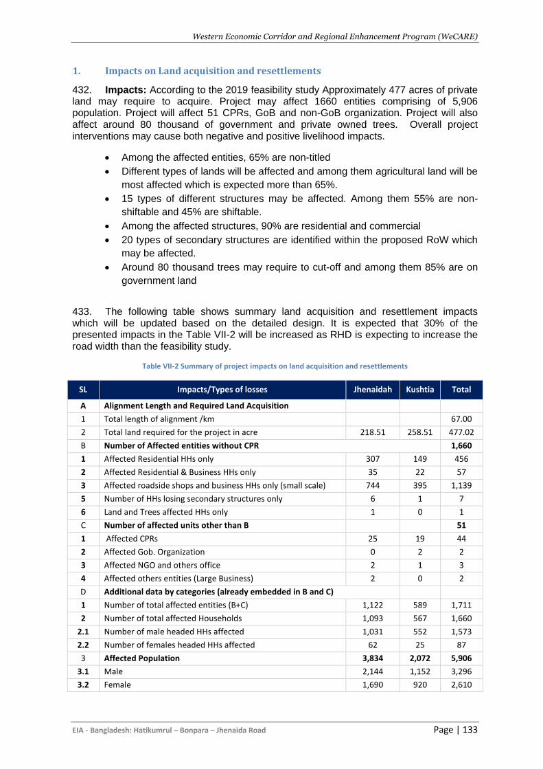
Western Economic Corridor and Regional Enhancement Program (WeCARE)
EIA - Bangladesh: Hatikumrul – Bonpara – Jhenaida Road Page | 133
1. Impacts on Land acquisition and resettlements
432. Impacts: According to the 2019 feasibility study Approximately 477 acres of private land may require to acquire. Project may affect 1660 entities comprising of 5,906 population. Project will affect 51 CPRs, GoB and non-GoB organization. Project will also affect around 80 thousand of government and private owned trees. Overall project interventions may cause both negative and positive livelihood impacts.
• Among the affected entities, 65% are non-titled
• Different types of lands will be affected and among them agricultural land will be
most affected which is expected more than 65%.
• 15 types of different structures may be affected. Among them 55% are non-
shiftable and 45% are shiftable.
• Among the affected structures, 90% are residential and commercial
• 20 types of secondary structures are identified within the proposed RoW which
may be affected.
• Around 80 thousand trees may require to cut-off and among them 85% are on
government land
433. The following table shows summary land acquisition and resettlement impacts which will be updated based on the detailed design. It is expected that 30% of the presented impacts in the Table VII-2 will be increased as RHD is expecting to increase the road width than the feasibility study.
Table VII-2 Summary of project impacts on land acquisition and resettlements
SL Impacts/Types of losses Jhenaidah Kushtia Total
A Alignment Length and Required Land Acquisition
1 Total length of alignment /km 67.00
2 Total land required for the project in acre 218.51 258.51 477.02
B Number of Affected entities without CPR 1,660
1 Affected Residential HHs only 307 149 456
2 Affected Residential & Business HHs only 35 22 57
3 Affected roadside shops and business HHs only (small scale) 744 395 1,139
5 Number of HHs losing secondary structures only 6 1 7
6 Land and Trees affected HHs only 1 0 1
C Number of affected units other than B 51
1 Affected CPRs 25 19 44
2 Affected Gob. Organization 0 2 2
3 Affected NGO and others office 2 1 3
4 Affected others entities (Large Business) 2 0 2
D Additional data by categories (already embedded in B and C)
1 Number of total affected entities (B+C) 1,122 589 1,711
2 Number of total affected Households 1,093 567 1,660
2.1 Number of male headed HHs affected 1,031 552 1,573
2.2 Number of females headed HHs affected 62 25 87
3 Affected Population 3,834 2,072 5,906
3.1 Male 2,144 1,152 3,296
3.2 Female 1,690 920 2,610
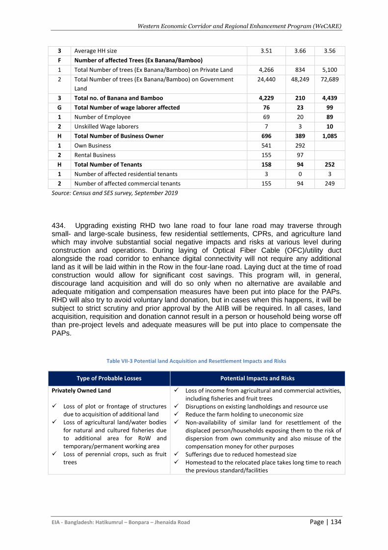
Western Economic Corridor and Regional Enhancement Program (WeCARE)
EIA - Bangladesh: Hatikumrul – Bonpara – Jhenaida Road Page | 134
3 Average HH size 3.51 3.66 3.56
F Number of affected Trees (Ex Banana/Bamboo)
1 Total Number of trees (Ex Banana/Bamboo) on Private Land 4,266 834 5,100
2 Total Number of trees (Ex Banana/Bamboo) on Government
Land
24,440 48,249 72,689
3 Total no. of Banana and Bamboo 4,229 210 4,439
G Total Number of wage laborer affected 76 23 99
1 Number of Employee 69 20 89
2 Unskilled Wage laborers 7 3 10
H Total Number of Business Owner 696 389 1,085
1 Own Business 541 292
2 Rental Business 155 97
H Total Number of Tenants 158 94 252
1 Number of affected residential tenants 3 0 3
2 Number of affected commercial tenants 155 94 249
Source: Census and SES survey, September 2019
434. Upgrading existing RHD two lane road to four lane road may traverse through small- and large-scale business, few residential settlements, CPRs, and agriculture land which may involve substantial social negative impacts and risks at various level during construction and operations. During laying of Optical Fiber Cable (OFC)/utility duct alongside the road corridor to enhance digital connectivity will not require any additional land as it will be laid within in the Row in the four-lane road. Laying duct at the time of road construction would allow for significant cost savings. This program will, in general, discourage land acquisition and will do so only when no alternative are available and adequate mitigation and compensation measures have been put into place for the PAPs. RHD will also try to avoid voluntary land donation, but in cases when this happens, it will be subject to strict scrutiny and prior approval by the AIIB will be required. In all cases, land acquisition, requisition and donation cannot result in a person or household being worse off than pre-project levels and adequate measures will be put into place to compensate the PAPs.
Table VII-3 Potential land Acquisition and Resettlement Impacts and Risks
Type of Probable Losses Potential Impacts and Risks
Privately Owned Land
✓ Loss of plot or frontage of structures due to acquisition of additional land
✓ Loss of agricultural land/water bodies for natural and cultured fisheries due to additional area for RoW and temporary/permanent working area
✓ Loss of perennial crops, such as fruit trees
✓ Loss of income from agricultural and commercial activities, including fisheries and fruit trees
✓ Disruptions on existing landholdings and resource use ✓ Reduce the farm holding to uneconomic size ✓ Non-availability of similar land for resettlement of the
displaced person/households exposing them to the risk of dispersion from own community and also misuse of the compensation money for other purposes
✓ Sufferings due to reduced homestead size ✓ Homestead to the relocated place takes long time to reach
the previous standard/facilities
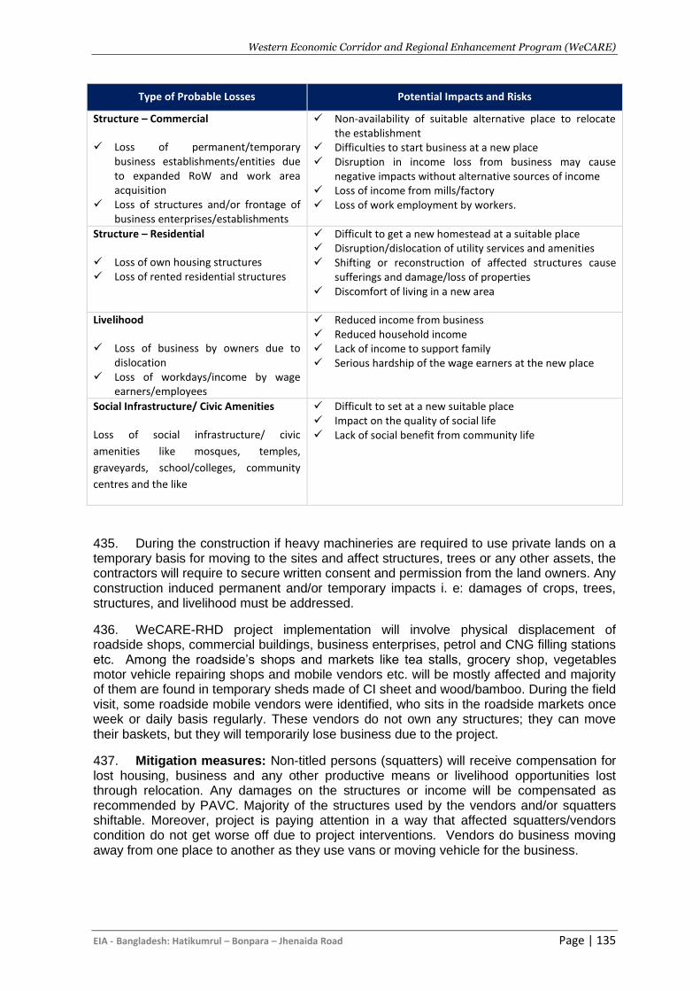
Western Economic Corridor and Regional Enhancement Program (WeCARE)
EIA - Bangladesh: Hatikumrul – Bonpara – Jhenaida Road Page | 135
Type of Probable Losses Potential Impacts and Risks
Structure – Commercial
✓ Loss of permanent/temporary business establishments/entities due to expanded RoW and work area acquisition
✓ Loss of structures and/or frontage of business enterprises/establishments
✓ Non-availability of suitable alternative place to relocate the establishment
✓ Difficulties to start business at a new place ✓ Disruption in income loss from business may cause
negative impacts without alternative sources of income ✓ Loss of income from mills/factory ✓ Loss of work employment by workers.
Structure – Residential
✓ Loss of own housing structures ✓ Loss of rented residential structures
✓ Difficult to get a new homestead at a suitable place ✓ Disruption/dislocation of utility services and amenities ✓ Shifting or reconstruction of affected structures cause
sufferings and damage/loss of properties ✓ Discomfort of living in a new area
Livelihood
✓ Loss of business by owners due to dislocation
✓ Loss of workdays/income by wage earners/employees
✓ Reduced income from business ✓ Reduced household income ✓ Lack of income to support family ✓ Serious hardship of the wage earners at the new place
Social Infrastructure/ Civic Amenities
Loss of social infrastructure/ civic
amenities like mosques, temples,
graveyards, school/colleges, community
centres and the like
✓ Difficult to set at a new suitable place ✓ Impact on the quality of social life ✓ Lack of social benefit from community life
435. During the construction if heavy machineries are required to use private lands on a temporary basis for moving to the sites and affect structures, trees or any other assets, the contractors will require to secure written consent and permission from the land owners. Any construction induced permanent and/or temporary impacts i. e: damages of crops, trees, structures, and livelihood must be addressed.
436. WeCARE-RHD project implementation will involve physical displacement of roadside shops, commercial buildings, business enterprises, petrol and CNG filling stations etc. Among the roadside’s shops and markets like tea stalls, grocery shop, vegetables motor vehicle repairing shops and mobile vendors etc. will be mostly affected and majority of them are found in temporary sheds made of CI sheet and wood/bamboo. During the field visit, some roadside mobile vendors were identified, who sits in the roadside markets once week or daily basis regularly. These vendors do not own any structures; they can move their baskets, but they will temporarily lose business due to the project.
437. Mitigation measures: Non-titled persons (squatters) will receive compensation for lost housing, business and any other productive means or livelihood opportunities lost through relocation. Any damages on the structures or income will be compensated as recommended by PAVC. Majority of the structures used by the vendors and/or squatters shiftable. Moreover, project is paying attention in a way that affected squatters/vendors condition do not get worse off due to project interventions. Vendors do business moving away from one place to another as they use vans or moving vehicle for the business.
Western Economic Corridor and Regional Enhancement Program (WeCARE)
EIA - Bangladesh: Hatikumrul – Bonpara – Jhenaida Road Page | 136
2. Impacts on Labor
438. Impacts: The construction of proposed road will entail employment of a significant number of labor especially during construction. The majority percent of labor will be locally hired, with the exception of skilled workers who may not be found in the program areas. For the proposed roads, labor requirements are expected to be more modest and satisfied by local labor. However, potential risks engaged both for the hired skilled and non-skilled workers especially during construction period includes health hazards, poor living condition, accidental hazards risks, etc. Similarly, hiring labor from external area may cause social risk on the local communities includes gender-based violence, price hiking of daily used products/foods, etc. Substantial risks are associated in-terms of hiring child labors or forced labors, and also due to border districts risk associated to the labor trafficking is also very high.
439. The main labour risks associated with the program are assessed to be related to the potentially hazardous work environment, the associated risk of accidents and labour influx. Based on current conditions it is assessed that the risk of a child or forced labour is negligible, and already managed through national legislation.
440. Potential labor risks include:
• Safety issues while at work like injuries/accidents/ fatalities leading to even death, while at work;
• Short terms effects due to exposure to dust and noise levels, while at work
• Long term effects on life due to exposure to chemical /hazardous wastes
• Inadequate accommodation facilities at work force camps, including inadequate sanitation and health facilities
• Non-payment of wages by Employer
• Non-payment of benefits (compensation, bonus, maternity benefits etc.) by Employer
• Discrimination in Employment (e.g. abrupt termination of the employment, working conditions, wages or benefits etc.)
• Engagement of child labor
• Sexual harassment at work
• Forced labor trafficking
• Security of women work force
• Inadequate facilities for pregnant women and lactating mothers
• Inadequate facilities for the children of the workforce at workforce camp sites
• Possibility of Gender based violence as the road shall traverse through sensitive locations such as hospitals, schools, etc. that are near to habitations.
• Health risks of labor relating to HIV/AIDS and other sexually transmitted diseases
• Unclear terms and conditions of employment
• Discrimination and denial of equal opportunity in hiring and promotions/incentives/training opportunities
• Denial for workers’ rights to form workers organizations, etc.
• Absence of a grievance mechanism for labor to seek redressal of their grievances/issues
441. Mitigation measures: The contractor will prepare the contractor’s EMP, which is known as the CEMP to address the labor issues. The CEMP will be reviewed and approved by RHD in accordance with the GoB Labour Act 2006 and Labour Rules 2015. During construction, implementation of the CEMP will be strictly monitored.
Western Economic Corridor and Regional Enhancement Program (WeCARE)
EIA - Bangladesh: Hatikumrul – Bonpara – Jhenaida Road Page | 137
3. Labor Influx
442. Impacts: Though project will create substantial number of jobs, it is expected that labor influx will not be significant as the construction will be over the period of 5 years. Most of the unskilled labors will be hired locally. As all the construction will be conducted in the urban areas, it is expected that skilled and unskilled labors will be hired locally. The contractor will be responsible for the accommodation of the stay in labor and ensuring labor travel from off site. Some accommodation on site, water supply and sanitation services, etc will be provided by the contractor. The labor site plan and facilities will be a part of the SMP. A stand alone Labor Management Plan will be prepared by contractors for each project site.
443. However, this labor influx may raise many complex issues, particularly regarding potential transmission risks for COVID-19 both within the worksite and for nearby communities. These risks are not only from workers that are mobilized from abroad or returning from abroad, but also workers moving from other regions, where it is likely that migrant workers are expected to work on the project. Adverse Social Impacts due to labor influx can be identified as follows:
• Risk of Social conflict between labors and community people
• Increased risk of illicit behavior and crime
• Influx of additional population and burden on public services
• Increased risk of communicable disease and burden on local health services
• Gender Based violence, child labor and school dropout
• Local inflation of price and increased pressure on accommodation and rent
• Increased of traffic and related accident
444. Mitigation measures: The contractor will prepare the contractor’s EMP, which is known as the CEMP to address the labor issues. The CEMP will be reviewed and approved by RHD in accordance with the GoB Labour Act 2006 and Labour Rules 2015. During construction, implementation of the CEMP will be strictly monitored.
4. Impacts on Gender and GBV
445. Impact: Gender Based Violence (GBV) risks can intensify within local communities when there are large influxes of male workers from outside the area during the construction period. Such workers often come without their families and have large disposable incomes relative to the local community, and can pose a risk in terms of sexual harassment, violence and exploitative transactional relationships. These risks are higher where workers come into close contact with the local community, for example on access routes or when living together in remote areas. A large influx of male labour may also lead to an increase in exploitative sexual relationships and human trafficking whereby women and girls are forced into sex work.
446. During the construction phase, female workers are also vulnerable to various forms of harassment, exploitation and abuse, aggravated by traditionally-male working environments and found that sexual harassment and exploitation are the common features of workplace life. This GBV was committed mostly by coworkers or construction supervisors and was largely due to gendered stereotypes about the sexual availability of female construction workers.
447. Land acquisition that occurs during the construction phase also increases the risks of GBV. Individuals who make decisions about resettlement and compensation can abuse this power to sexually exploit vulnerable female-headed households. This risk is
Western Economic Corridor and Regional Enhancement Program (WeCARE)
EIA - Bangladesh: Hatikumrul – Bonpara – Jhenaida Road Page | 138
exacerbated in places where women cannot legally hold land titles and are therefore more easily removed from their land.
Mitigation
448. However, a standalone Gender-Based Violence Action Plan (GVP) action plan & Gender Action Plan (GAP) will be prepared to deal with the such issues. Contractors must address the risk of gender-based violence, through:
• Mandatory training and awareness raising for the workforce about refraining
from unacceptable conduct toward local community members, specifically
women. Training may be repeated. All such training should be conducted in
Bengali;
• Informing workers about national laws that make sexual harassment and
gender-based violence a punishable offence which is prosecuted;
• Adopting a policy to cooperate with law enforcement agencies in investigating
complaints about gender-based violence;
• Developing a system to capture gender-based violence, sexual exploitation and
workplace sexual harassment related complaints/issues.
5. Occupational Health and Safety
449. There are several risks associated with project, especially during the construction period. Several hazards can be encountered while lifting cranes, drilling or using heavy machineries. Beside these, lack of clean and ventilated workspace and fire hazard are also associated risks during the project. OHS risk is likely to be soaring based on previous project experience. The expected risks may lead to personal injury, traffic-related accidents, fall from height, poor working and living conditions of workers, and lack of PPEs. RHD will make arrangements for contractors training on health and safety, records of their compliance have to be inspected monthly and audited bi-annually. The key potential OHS risk associated at construction and operation stages are listed below.
• Hazardous work and process: risk due to working at heights or in confined
spaces, use of heavy machinery, or use of hazardous materials.
• Accidents or emergencies: exposure to unsafe machineries, flammable
chemicals/fuel, construction materials, landslide at workplace.
• General understanding and implementation of occupational health and safety
requirements. Work related diseases (e.g. Allergies, Respiratory problems,
Muscular-skeletal disorder, Eye problem), communicable diseases including
Sexually Transmitted Infections (STIs)
450. Mitigation measures: The risk will be mitigated by contractor, providing personal protective equipment (PPE) for workers, such as safety shoes, helmets, safety vests, masks, gloves, protective clothing, goggles, full-face eye shields and ear protection based on the work requirements. The contractor is obliged of hiring trained operators, using appropriate equipment’s, providing appropriate cautions, training of fire extinguishment etc. Workers shall maintain the PPE properly by cleaning dirty ones and replacing damaged ones. PIC will require the contractors to prepare and implement Occupational Health & Safety Plan (OHSP) following the AIIB ESF, Health and Safety (EHS) Guidelines and local legislations.
451. Mitigation measures will include:
Western Economic Corridor and Regional Enhancement Program (WeCARE)
EIA - Bangladesh: Hatikumrul – Bonpara – Jhenaida Road Page | 139
• Obligatory insurance against accidents for labourers/workers;
• Providing basic medical training to specified work staff and basic medical service and supplies to workers;
• Layout plan for camp site, indicating safety measures taken by the contractor, e.g. firefighting equipment, safe storage of hazardous material, first aid, security, fencing, and contingency measures in case of accidents;
• Protection devices (ear muffs) will be provided to the workers doing job in the vicinity of high noise generating machines;
• Provision of adequate sanitation, washing, cooking and dormitory facilities including light up to satisfaction;
• Provision of protective clothing for labourers handling hazardous materials, e.g. helmet, adequate footwear for bituminous pavement works, protective goggles, gloves etc.;
• Adequate signage, lightning devices, barriers, yellow tape and persons with flags during construction to manage traffic at construction sites, haulage and access roads.
Western Economic Corridor and Regional Enhancement Program (WeCARE)
EIA - Bangladesh: Hatikumrul – Bonpara – Jhenaida Road Page | 140
VIII. ASSOCIATED FACILITIES
A. Associated Facilities
452. According to the AIIB ESS1, associated facilities (Associated Facilities) are activities that are not included in the description of the Project set out in the agreement governing the Project, but which, following consultation with the Client, the Bank determines are: (a) directly and materially related to the Project; (b) carried out, or planned to be carried out, contemporaneously with the Project; and (c) necessary for the Project to be viable and would not be constructed or expanded if the Project did not exist.
453. The World Bank-financed Jashore-Jhenaidah (48.7 km) section of the Program Corridor is considered an Associated Facility of the AIIB program corridor. World Bank has conducted E&S assessments, and prepared EIA, RPF, ESMF, and Labor Management Procedures in accordance with the WB ESS (1-10) which are in line with the AIIB ESS (1-3). During implementation, the Government will supervise and monitor E&S risks and impacts of the entire Program Corridor in accordance with the WB and AIIB ESF and will ensure that all supervision records and project sites are accessible to both the World Bank and AIIB. The World Bank and AIIB will also conduct joint supervision missions. The WB Environmental and Social Commitment plan (ESCP) includes both the Government's commitment to apply the ESF to the AIIB-financed works, and to facilitate and support supervision by the World Bank and AIIB. There will be a single Grievance Redressal Mechanism (GRM) covering the Program Corridor.
B. Assessment of location and existing condition of the WB phase 1 road
corridor
454. AIIB’s phase 1 road construction will be completed at Jhenaidah where WB’s phase 1 Jhenaidah – Jashore road begins. It begins at Al-Hera Mor in Jhenaidah and continues till Chashra Mor, Jashore (48.5km approx.). The route connects with the existing N7 national highway heading in a westerly direction through Magura and on to Jhenaidah before turning south to Jashore and finally south-east to Khulna. These districts are connected by roads, railway, and river launches (passenger and cargo). The nearest airport is situated at Jashore (within 5 km distance from the starting point). The horizontal alignment of the existing road is open and free-flowing; however, there are constrictions to the alignment in a number of areas. During the field visit, several structures were observed on both sides of the highway corridor. Examples of the observed structure include but not limited to schools, colleges, medical facilities, mills and factories, a portion of the Jashore cantonment, bazaars, cell phone towers, business and government-owned structures.
455. The road is situated close to the railway track, and this feature presents a number of challenges. The road and railway track run parallel to each other (in some locations) and the J-J road bypasses the railway line at a number of locations. Agricultural lands and trees were observed on both sides of the roads. Moreover, the J-J road is joined by various small and semi-paved road originating from nearby villages, and unions. While the road is mostly smooth, however, there are a number of locations (8-10) where the state of the road can
Western Economic Corridor and Regional Enhancement Program (WeCARE)
EIA - Bangladesh: Hatikumrul – Bonpara – Jhenaida Road Page | 141
be considered risky. This road is usually frequented by bus, trucks, cars and motorcycles, and locally improvised four and three wheelers (nasimun and karimun). The presence of smaller vehicles often leads to accidents on this route. Shalabhara part of the J-J road is infamous for the number of accidents observed per year. Temporary markets are set up on a regular basis in different places of the roadside that exacerbate the risks of accidents.
456. Currently, the width of the existing road is approximately 7.5 to 8 meters. Upgrading the 2-lane highway into a four-lane highway may require an increase in the RoW to approximately 50 to 60 meter in rural areas and 30 to 40 meter in urban areas. In some sections, the present RoW and its adjacent RHD lands in shoulders are sufficient for widening the road; however, this is not the case for the entire road, and hence land acquisition will be required. Land acquisition and civil works are likely to trigger involuntary physical (loss of agricultural and homestead land) and economic displacement (loss of income, business structures) and may cause environmental degradation through loss of trees along the ROW, including very old trees, changes to local drainage patterns and health and safety of workers and communities.
C. Key E&S impacts and risks of WB phase 1 road corridor
457. Key environmental and social risks (E&S) and impacts in road works, anticipated to occur largely during the construction phase and within existing footprints, are: (i) cutting of mature trees along the expanded Right of Way (ROW), which are not connected to any forests; (ii) health and safety of workers and communities within the corridor and along the transport routes of construction supplies, materials and equipment; (iii) settlements exposed to noise, vibration, air pollution and safety risks; (iv) siltation and sedimentation of waterways close to the physical works; (v) land acquisition along the expanded ROW; (vi) physical displacement of houses, mosques, temples, madrasah and graves; (vii) temporary economic displacement of businesses in project areas; (viii) increased risk of GBV and road crashes. The project will mainly employ local labor for unskilled labor requirements, but skilled laborers may come from other parts of the country. Labor influx risks from skilled laborers and their followers include increased GBV, child labor, criminality, conflict with host communities, and increased resource utilization and extraction.
458. The nature of the intervention is linear and will require land acquisition. In total 106.29 and 148 hectares of land will need to be acquired respectively from Jhenaidah and Jashore for the Jashore-Jhenaidah part of the project. Land acquisition will lead to loss of land for both title and non-title holders and cause disruption in income and livelihood streams for individual and groups of people. During the construction stage, land acquisition is anticipated to be required to establish construction camps, material stock yards, hot mix plants and machinery for road expansion. These land requirements will be fulfilled through using the encumbrance free government land adjacent to the road or by taking the land on lease from the willing parties or purchasing private lands. With the development of the road, avenues for economic activities and opportunities will be created. The RAP and entitlement matrix will be prepared. In managing lack acquisitions and involuntary land resettlement, relevant stakeholders will be consulted and engaged as proposed in the Stakeholder Engagement Plan. In addition, in cases of impacts on livelihood, rehabilitation through appropriate skill training/financial counselling would be required. Finally, concerns and needs of vulnerable groups will be addressed through a mix of measures that includes additional assistances as part of R&R measures.
Western Economic Corridor and Regional Enhancement Program (WeCARE)
EIA - Bangladesh: Hatikumrul – Bonpara – Jhenaida Road Page | 142
D. Key mitigation measures proposed by WB
459. An Environmental Impact Assessment (EIA) of the Jashore-Jhenaidah Road was conducted and consulted upon during preparation and publicly disclosed prior to appraisal to: assess the environmental and social risks and the impacts of the upgradation works; and to develop measures based on the mitigation hierarchy to manage risks and impacts. The EIA is based on a preliminary design and has been prepared in accordance with the World Bank Environmental and Social Framework (ESF) and its relevant Environmental and Social Standards (ESSs), as well as with the Government’s Environmental Conservation Rules 1997, EIA Guidelines 1997, and other relevant laws and policies. This EIA will be updated based on the final engineering design after the project is approved by the World Bank.
460. An ESMP has been developed as part of the EIA to mitigate the Project’s environmental and social risks and impacts. It includes mitigation measures, monitoring, capacity building, responsibilities, reporting system and budget. The ESMP provides measures to address GBV at the project level. The ESMP obligates contractors, prior to mobilization, to prepare the C-ESMP, which shall be approved prior to the commencement of construction. The C-ESMP shall include an OHS Plan, a Water and Waste Management Plan, an Influx Management Plan, a Workers Camp Management Plan, a CHS Plan, a Traffic Management and Road Safety Management Plan, a Borrow Area Management Plan, a Material Sourcing Plan and Site Restoration Plan, in accordance with the standards and guidelines of the Government and the World Bank. All such plans will be reviewed and approved by the PIU, RHD and the Bank prior to the commencement of construction. The approved C-ESMP shall be reviewed periodically (but not less than every six months) and updated in a timely manner.
461. Overall, WB has proposed adequate mitigation measures which is in line with the AIIB ESF. As part of the safeguard due diligence, World Bank has also prepared Resettlement Policy Framework (RPF), Environmental and Social Management Framework (ESMF), Environmental Impact Assessment (EIA) and Stakeholders Engagement Plan (SEP) based on the World Bank’s ESS 1-10. RHD-AIIB project team has reviewed the WB documents and found in-line with the AIIB ESF.
Western Economic Corridor and Regional Enhancement Program (WeCARE)
EIA - Bangladesh: Hatikumrul – Bonpara – Jhenaida Road Page | 143
IX. INFORMATION DISCLOSURE, CONSULTATION AND
PARTICIPATION
A. Purpose of Public Participation
462. The development and construction of any project will impact on the surrounding human and physical environment and will have beneficial or adverse effects. It is therefore essential that the community can fully understand the project, have the opportunity to express their views and to become directly involved in the project’s overall decision-making process. 463. Public authority developers must take account of the community’s views and include any useful suggestions to improve the project. This may include suggestions to help further develop environmental protection measures thereby reducing environmental pollution, reducing the loss of environmental resources and improve the project’s environmental and social benefits, thus helping achieve more sustainable development. 464. In accordance with the requirements of the AIIB as described in the ESF 2016, the client will engage in meaningful consultation with relevant stakeholders during the Project’s preparation and implementation, in a manner commensurate with the risks to and impacts on those affected by the Project. Consultation for this Category A Project should be undertaken in a manner proportional to its risks and impacts. AIIB may participate in consultation activities to understand the concerns of the affected people and to require the Client to address these concerns in the Project’s design and ESMP or ESMPF or other Bank-approved documentation. 465. The following activities have therefore been carried out in his project in accordance with the AIIB requirements.
B. Information Disclosure
466. One of the requirements of the AIIB ESP is the disclosure of information by the client. The bank requires the client to ensure that relevant information about environmental and social risks and impacts of the project is made available in the project area in a timely and accessible manner, and in a form and language understandable to the project affected people, other stakeholders and the general public, so they can provide meaningful inputs into the design and implementation of the project. 467. This documentation includes, as applicable, the following: draft, updated and final environmental and social assessment reports, ESMPs, ESMPFs, resettlement plans, RPFs, Indigenous Peoples plans and IPPFs, other approved forms of documentation and reports required to be prepared by clients under such plans. 468. The Bank also requires the client to disclose any material changes to the disclosed environmental and social information for the project as soon as they become available.
C. Consultation and Participation during Feasibility Stage
469. During the FS/IEE stage the level of consultation and participation has been limited to the following:
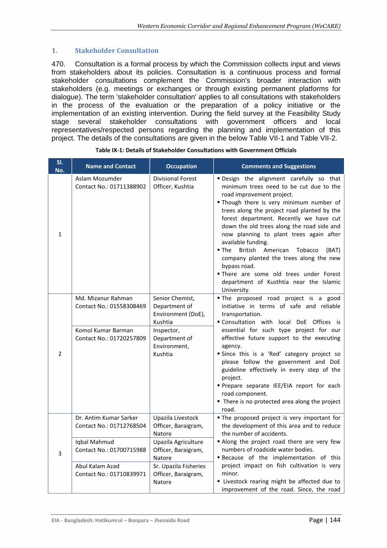
Western Economic Corridor and Regional Enhancement Program (WeCARE)
EIA - Bangladesh: Hatikumrul – Bonpara – Jhenaida Road Page | 144
1. Stakeholder Consultation
470. Consultation is a formal process by which the Commission collects input and views from stakeholders about its policies. Consultation is a continuous process and formal stakeholder consultations complement the Commission's broader interaction with stakeholders (e.g. meetings or exchanges or through existing permanent platforms for dialogue). The term 'stakeholder consultation' applies to all consultations with stakeholders in the process of the evaluation or the preparation of a policy initiative or the implementation of an existing intervention. During the field survey at the Feasibility Study stage several stakeholder consultations with government officers and local representatives/respected persons regarding the planning and implementation of this project. The details of the consultations are given in the below Table VII-1 and Table VII-2.
Table IX-1: Details of Stakeholder Consultations with Government Officials
Sl. No.
Name and Contact Occupation Comments and Suggestions
1
Aslam Mozumder Contact No.: 01711388902
Divisional Forest Officer, Kushtia
▪ Design the alignment carefully so that minimum trees need to be cut due to the road improvement project.
▪ Though there is very minimum number of trees along the project road planted by the forest department. Recently we have cut down the old trees along the road side and now planning to plant trees again after available funding.
▪ The British American Tobacco (BAT) company planted the trees along the new bypass road.
▪ There are some old trees under Forest department of Kusthtia near the Islamic University.
2
Md. Mizanur Rahman Contact No.: 01558308469
Senior Chemist, Department of Environment (DoE), Kushtia
▪ The proposed road project is a good initiative in terms of safe and reliable transportation.
▪ Consultation with local DoE Offices is essential for such type project for our effective future support to the executing agency.
▪ Since this is a ‘Red’ category project so please follow the government and DoE guideline effectively in every step of the project.
▪ Prepare separate IEE/EIA report for each road component.
▪ There is no protected area along the project road.
Komol Kumar Barman Contact No.: 01720257809
Inspector, Department of Environment, Kushtia
3
Dr. Antim Kumar Sarker Contact No.: 01712768504
Upazila Livestock Officer, Baraigram, Natore
▪ The proposed project is very important for the development of this area and to reduce the number of accidents.
▪ Along the project road there are very few numbers of roadside water bodies.
▪ Because of the implementation of this project impact on fish cultivation is very minor.
▪ Livestock rearing might be affected due to improvement of the road. Since, the road
Iqbal Mahmud Contact No.: 01700715988
Upazila Agriculture Officer, Baraigram, Natore
Abul Kalam Azad Contact No.: 01710839971
Sr. Upazila Fisheries Officer, Baraigram, Natore
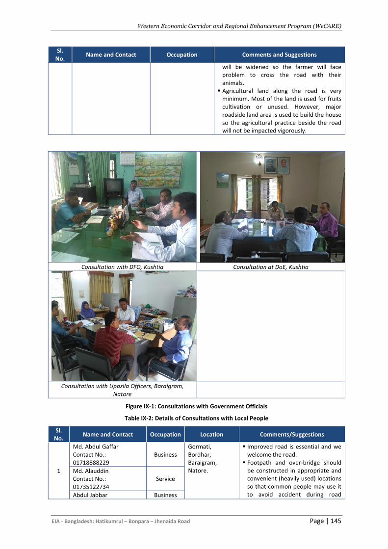
Western Economic Corridor and Regional Enhancement Program (WeCARE)
EIA - Bangladesh: Hatikumrul – Bonpara – Jhenaida Road Page | 145
Sl. No.
Name and Contact Occupation Comments and Suggestions
will be widened so the farmer will face problem to cross the road with their animals.
▪ Agricultural land along the road is very minimum. Most of the land is used for fruits cultivation or unused. However, major roadside land area is used to build the house so the agricultural practice beside the road will not be impacted vigorously.
Consultation with DFO, Kushtia Consultation at DoE, Kushtia
Consultation with Upazila Officers, Baraigram, Natore
Figure IX-1: Consultations with Government Officials
Table IX-2: Details of Consultations with Local People
Sl. No.
Name and Contact Occupation Location Comments/Suggestions
1
Md. Abdul Gaffar Contact No.: 01718888229
Business Gormati, Bordhar, Baraigram, Natore.
▪ Improved road is essential and we welcome the road.
▪ Footpath and over-bridge should be constructed in appropriate and convenient (heavily used) locations so that common people may use it to avoid accident during road
Md. Alauddin Contact No.: 01735122734
Service
Abdul Jabbar Business
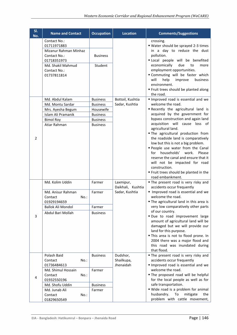
Western Economic Corridor and Regional Enhancement Program (WeCARE)
EIA - Bangladesh: Hatikumrul – Bonpara – Jhenaida Road Page | 146
Sl. No.
Name and Contact Occupation Location Comments/Suggestions
Contact No.: 01711971883
crossing. ▪ Water should be sprayed 2-3 times
in a day to reduce the dust pollution.
▪ Local people will be benefited economically due to more employment opportunities.
▪ Commuting will be faster which will help improve business environment.
▪ Fruit trees should be planted along the road.
Mizanur Rahman Minhaz Contact No.: 01718351973
Business
Md. Shakil Mahmud Contact No.: 01737811814
Student
2
Md. Abdul Kalam Business Bottoil, Kushtia Sadar, Kushtia
▪ Improved road is essential and we welcome the road.
▪ Recently the agricultural land is acquired by the government for bypass construction and again land acquisition will cause loss of agricultural land.
▪ The agricultural production from the roadside land is comparatively low but this is not a big problem.
▪ People use water from the Canal for households’ work. Please reserve the canal and ensure that it will not be impacted for road construction.
▪ Fruit trees should be planted in the road embankment.
Md. Montu Sardar Business
Mrs. Ayesha Begum Housewife
Islam Ali Pramanik Business
Bimol Roy Business
Atiar Rahman Business
3
Md. Kolim Uddin
Farmer Laxmipur, Daikhali, Kushtia Sadar, Kushtia
▪ The present road is very risky and accidents occur frequently
▪ Improved road is essential and we welcome the road.
▪ The agricultural land in this area is very low comparatively other parts of our country.
▪ Due to road improvement large amount of agricultural land will be damaged but we will provide our land for this purpose.
▪ This area is not to flood prone. In 2004 there was a major flood and this road was inundated during that flood.
Md. Anisur Rahman Contact No.: 01929194659
Farmer
Ballok Ali Mondol Farmer
Abdul Bari Mollah Business
4
Polash Baid Contact No.: 01736484613
Business Dudshor, Shailkupa, Jhenaidah
▪ The present road is very risky and accidents occur frequently
▪ Improved road is essential and we welcome the road.
▪ The proposed road will be helpful for the local people as well as for safe transportation.
▪ Wide road is a problem for animal husbandry. To mitigate the problem with cattle movement,
Md. Shimul Hossain Contact No.: 01932550196
Farmer
Md. Shofu Uddin Business
Md. Junab Ali Contact No.: 01829650549
Farmer
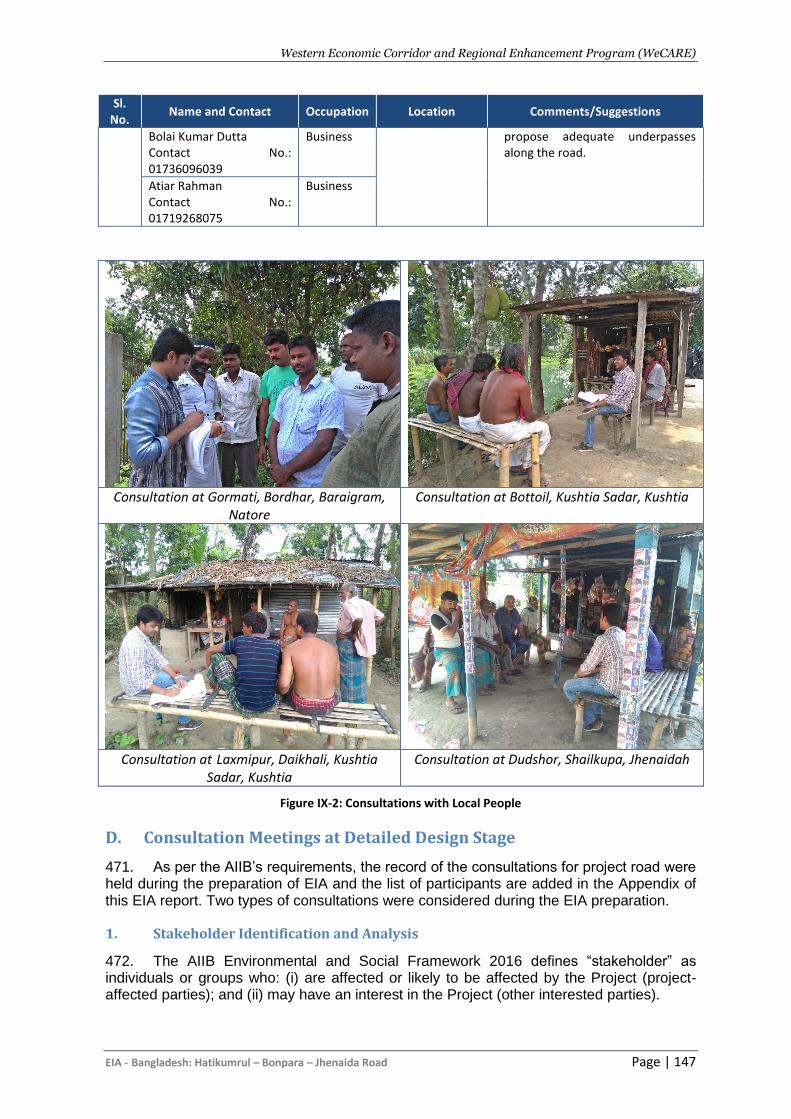
Western Economic Corridor and Regional Enhancement Program (WeCARE)
EIA - Bangladesh: Hatikumrul – Bonpara – Jhenaida Road Page | 147
Sl. No.
Name and Contact Occupation Location Comments/Suggestions
Bolai Kumar Dutta Contact No.: 01736096039
Business propose adequate underpasses along the road.
Atiar Rahman Contact No.: 01719268075
Business
Consultation at Gormati, Bordhar, Baraigram,
Natore Consultation at Bottoil, Kushtia Sadar, Kushtia
Consultation at Laxmipur, Daikhali, Kushtia
Sadar, Kushtia
Consultation at Dudshor, Shailkupa, Jhenaidah
Figure IX-2: Consultations with Local People
D. Consultation Meetings at Detailed Design Stage
471. As per the AIIB’s requirements, the record of the consultations for project road were held during the preparation of EIA and the list of participants are added in the Appendix of this EIA report. Two types of consultations were considered during the EIA preparation.
1. Stakeholder Identification and Analysis
472. The AIIB Environmental and Social Framework 2016 defines “stakeholder” as individuals or groups who: (i) are affected or likely to be affected by the Project (project-affected parties); and (ii) may have an interest in the Project (other interested parties).
Western Economic Corridor and Regional Enhancement Program (WeCARE)
EIA - Bangladesh: Hatikumrul – Bonpara – Jhenaida Road Page | 148
473. The stakeholders of Hatikumrul-Bonpara-Jhenaidah highway improvement project include the:
• financing agencies e.g. AIIB, GoB and other donor agencies.
• government organizations involved in planning, design and implementation e.g. RHD, DoE, Forest Department, Department of Agriculture Extension (DAE), Bangladesh Water Development Board (BWDB), Civil Administration (DCs), Public Representatives, NGOs, etc.
• Consultants and Contractor involved with feasibility study, detailed design and bidding document preparation and implementation phases; and
• PAPs affected positively and/or negatively directly and/or indirectly. 474. During the field survey, significant efforts were made to identify the possible categories of stakeholders and their stakes according to AIIB ESF. During the field survey different stakeholders identified were the villagers, local residents, government officials, shop owners, public representative, NGO’s and general public. All those stakeholders had different types of stakes according to their professions.
2. Focus Group Discussions (FGDs)
475. A focus group is a group of individuals were selected and assembled by the environmental specialists to discuss and comment on, from personal experience. Central to successful group discussion was to capture a wide range of opinions about the impact and mitigation because of the road project. The groups were consisted of more than 10 people and they were discussed for approximately half an hour to gather information and opinion they have. The FGDs were conducted at 04 locations along the project corridor at certain intervals or at bazaar areas to confirm more participants.
Table IX-3: Details of Consultations with Local People
Sl. No.
Location Date Time Comments/Suggestions
01
Vill: Kalikapur, Un: Bonpara Paurashava, Up: Baraigram Dist: Natore
15.04.2019 3:30 pm to
4:30pm
▪ This road becomes very busy due to the movement of goods and people.
▪ Due to movement of additional vehicle the road condition become very poor and traffic congestion is common.
▪ Improved road is essential and we welcome the road.
▪ Commuting will be faster which will help improve business environment.
▪ Local people will be benefited economically due to more employment opportunities.
▪ Water should be sprayed 2-3 times in a day to reduce the dust pollution.
▪ Since the road side trees will need to be cut so the local environment will degrade significantly.
▪ Plantation of 2 trees for each tree cutting at the road embankment.
▪ The project should be constructed in an environmentally friendly manner
02
Vill: Baliapara, Un: Alampur, Up: Kushtia, Dist: Kushtia
16.04.2019 10:00 am
to 11:00am
03
Vill: Arabpur, Un: Jhenaidah Pourashava, Up: Jhenaidah Sadar, Dist: Jhenaidah
17.04.2019 10:30 am
to 11:30am
04
Vill: Garaganj, Un: Ambikapur, Up: Shailkupa, Dist: Jhenaidah
17.04.2019 12:30 pm to 1.30pm
3. Public Consultation Meetings (PCM)
476. Public consultation is one of the key components of the environmental assessment. A number of informal public consultations will be held along the project road together with
Western Economic Corridor and Regional Enhancement Program (WeCARE)
EIA - Bangladesh: Hatikumrul – Bonpara – Jhenaida Road Page | 149
the social and resettlement team. The participants will be invited to attend at a certain place and time to discuss with the project design team to discuss on the environmental and social issues.
E. Conclusion
477. It will be essential to continue this consultation process to ensure that the community remains supportive and that they are fully informed of progress particularly before and during the construction period. It will be essential that the community is given information on the grievance redress mechanism and that regular meetings with the community are held in the future. Once the project has been approved and a construction program has been defined, the first of a number of community meetings must be held to provide details of the construction program and to give information on the grievance redress mechanism. A website should be set up including all this information, however, many of the community may not have access to the internet, therefore face to face meetings and hard copy handouts must be provided to the whole community.
Western Economic Corridor and Regional Enhancement Program (WeCARE)
EIA - Bangladesh: Hatikumrul – Bonpara – Jhenaida Road Page | 150
X. CLIMATE CHANGE ASSESSMENT
A. Overview
478. Climate change is a global issue. The world’s climate is changing and will continue to change in the coming century. Climate change is one of the significant factors considered in the Environmental/Ecological Assessment. Climate change assessment is done for the current assessment process with the objective to provide assurance that climate change implications are being appropriately considered in the design of the proposed project. The specific objectives are to:
▪ Support the project authority to manage or reduce the potential risk posed by the impacts of climate change to the project and contribute to climate change action;
▪ Provide project managers of the co-financiers with information that will assist their broader climate change action; and
▪ Help decision makers to address climate change implications in a risk management context.
479. The current assessment conducted climate change related investigation based on globally and nationally published climate change prediction reports focusing particularly on the variability of rainfall intensity, temperature changes, flooding and sea level rise. These variables are directly related to the functionality and durability of the proposed project. 480. To conduct the assessment literature review has been conducted available from different national climate change relevant agencies, such as Department of Disaster Management, Department of Environment and Bangladesh Meteorological Department. International and National Climate Change Communication reports, especially the 5th IPCC Assessment Report has been reviewed for relevant major sources of information for impact and vulnerability projection on global and regional temperature, sea level rise, rainfall fluctuation and their impacts on proposed infrastructures. This climate change projection information will help in designing climate resilient highways including all major bridges and other infrastructures.
B. Greenhouse Gas Emission
481. Bangladesh generated 190 million metric tons of greenhouse gas (expressed in MtCO2e) in 2012, with the agriculture industry contributing about 40% to overall emissions (WRI-CAIT, 2015). This is followed by the energy sector, of which transportation is one of the subsectors, with 33% contribution. The Bangladesh Climate Change Strategy and Action Plan in 2009 identified improving transportation sector energy consumption as a priority since its share of emissions is growing faster than any other sector. 482. The project road is heavily congested due to the transport moving to and from the Benapole Land Port to the northern region of the country, which handles significant amount of the country’s imported and exported goods. The transports moving through the corridor also has the contribution with the country’s GHG emission. GHG emission likely to be generated from the project road has been calculated using the Transport Emissions Evaluation Model for Projects (TEEMP)4 developed by Clean Air Asia5, the Institute for Transportation and Development Policy and with funding from AIIB.
4 TEEMP is an excel-based, free-of-charge spreadsheet models to evaluate emissions impacts of transport.
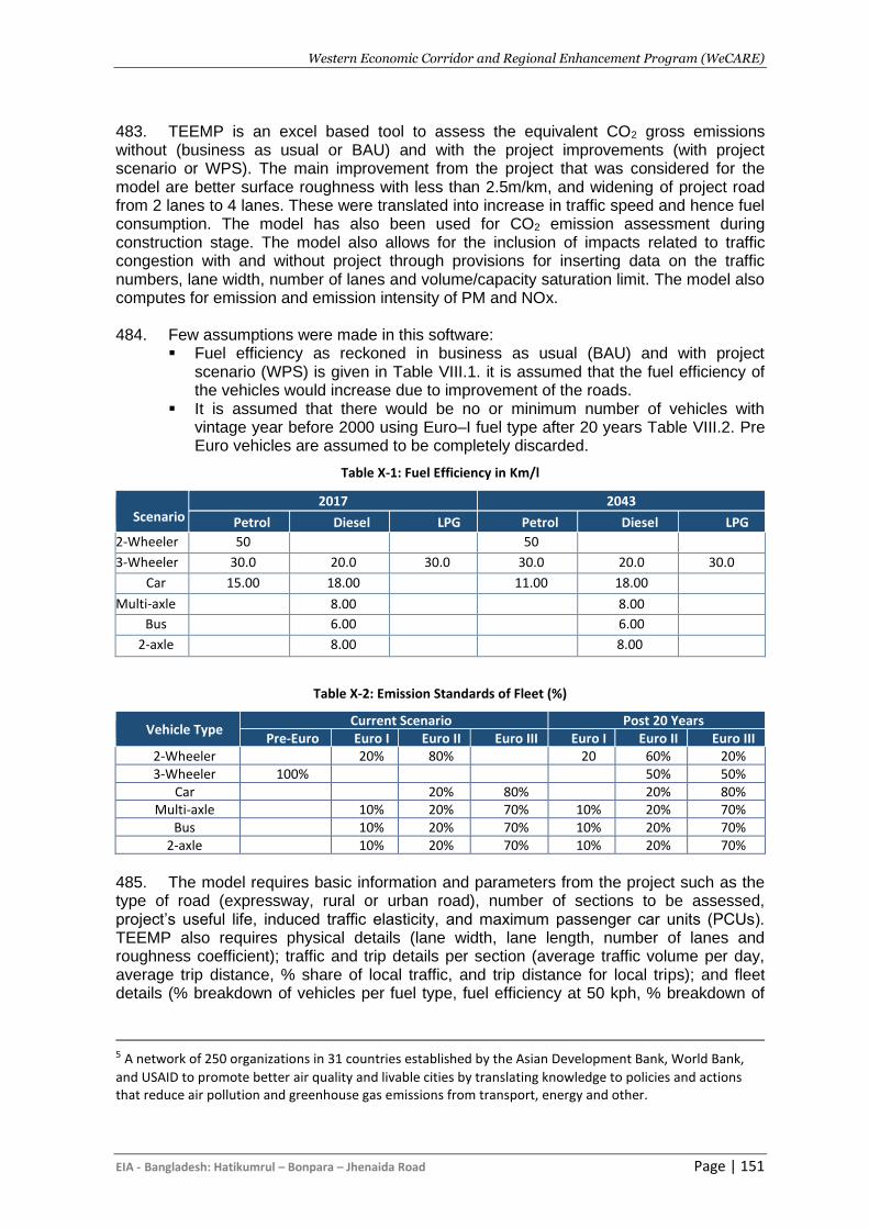
Western Economic Corridor and Regional Enhancement Program (WeCARE)
EIA - Bangladesh: Hatikumrul – Bonpara – Jhenaida Road Page | 151
483. TEEMP is an excel based tool to assess the equivalent CO2 gross emissions without (business as usual or BAU) and with the project improvements (with project scenario or WPS). The main improvement from the project that was considered for the model are better surface roughness with less than 2.5m/km, and widening of project road from 2 lanes to 4 lanes. These were translated into increase in traffic speed and hence fuel consumption. The model has also been used for CO2 emission assessment during construction stage. The model also allows for the inclusion of impacts related to traffic congestion with and without project through provisions for inserting data on the traffic numbers, lane width, number of lanes and volume/capacity saturation limit. The model also computes for emission and emission intensity of PM and NOx. 484. Few assumptions were made in this software:
▪ Fuel efficiency as reckoned in business as usual (BAU) and with project scenario (WPS) is given in Table VIII.1. it is assumed that the fuel efficiency of the vehicles would increase due to improvement of the roads.
▪ It is assumed that there would be no or minimum number of vehicles with vintage year before 2000 using Euro–I fuel type after 20 years Table VIII.2. Pre Euro vehicles are assumed to be completely discarded.
Table X-1: Fuel Efficiency in Km/l
Scenario 2017 2043
Petrol Diesel LPG Petrol Diesel LPG
2-Wheeler 50 50
3-Wheeler 30.0 20.0 30.0 30.0 20.0 30.0
Car 15.00 18.00 11.00 18.00
Multi-axle 8.00 8.00
Bus 6.00 6.00
2-axle 8.00 8.00
Table X-2: Emission Standards of Fleet (%)
Vehicle Type Current Scenario Post 20 Years
Pre-Euro Euro I Euro II Euro III Euro I Euro II Euro III 2-Wheeler 20% 80% 20 60% 20% 3-Wheeler 100% 50% 50%
Car 20% 80% 20% 80% Multi-axle 10% 20% 70% 10% 20% 70%
Bus 10% 20% 70% 10% 20% 70% 2-axle 10% 20% 70% 10% 20% 70%
485. The model requires basic information and parameters from the project such as the type of road (expressway, rural or urban road), number of sections to be assessed, project’s useful life, induced traffic elasticity, and maximum passenger car units (PCUs). TEEMP also requires physical details (lane width, lane length, number of lanes and roughness coefficient); traffic and trip details per section (average traffic volume per day, average trip distance, % share of local traffic, and trip distance for local trips); and fleet details (% breakdown of vehicles per fuel type, fuel efficiency at 50 kph, % breakdown of
5 A network of 250 organizations in 31 countries established by the Asian Development Bank, World Bank,
and USAID to promote better air quality and livable cities by translating knowledge to policies and actions that reduce air pollution and greenhouse gas emissions from transport, energy and other.
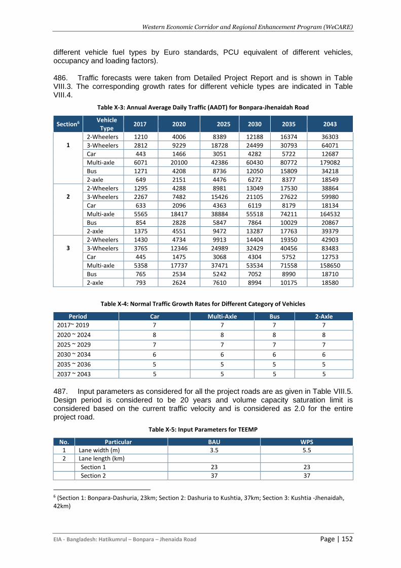
Western Economic Corridor and Regional Enhancement Program (WeCARE)
EIA - Bangladesh: Hatikumrul – Bonpara – Jhenaida Road Page | 152
different vehicle fuel types by Euro standards, PCU equivalent of different vehicles, occupancy and loading factors). 486. Traffic forecasts were taken from Detailed Project Report and is shown in Table VIII.3. The corresponding growth rates for different vehicle types are indicated in Table VIII.4.
Table X-3: Annual Average Daily Traffic (AADT) for Bonpara-Jhenaidah Road
Section6 Vehicle Type
2017 2020 2025 2030 2035 2043
1
2-Wheelers 1210 4006 8389 12188 16374 36303
3-Wheelers 2812 9229 18728 24499 30793 64071
Car 443 1466 3051 4282 5722 12687
Multi-axle 6071 20100 42386 60430 80772 179082
Bus 1271 4208 8736 12050 15809 34218
2-axle 649 2151 4476 6272 8377 18549
2
2-Wheelers 1295 4288 8981 13049 17530 38864
3-Wheelers 2267 7482 15426 21105 27622 59980
Car 633 2096 4363 6119 8179 18134
Multi-axle 5565 18417 38884 55518 74211 164532
Bus 854 2828 5847 7864 10029 20867
2-axle 1375 4551 9472 13287 17763 39379
3
2-Wheelers 1430 4734 9913 14404 19350 42903
3-Wheelers 3765 12346 24989 32429 40456 83483
Car 445 1475 3068 4304 5752 12753
Multi-axle 5358 17737 37471 53534 71558 158650
Bus 765 2534 5242 7052 8990 18710
2-axle 793 2624 7610 8994 10175 18580
Table X-4: Normal Traffic Growth Rates for Different Category of Vehicles
Period Car Multi-Axle Bus 2-Axle
2017~ 2019 7 7 7 7
2020 ~ 2024 8 8 8 8
2025 ~ 2029 7 7 7 7
2030 ~ 2034 6 6 6 6
2035 ~ 2036 5 5 5 5
2037 ~ 2043 5 5 5 5
487. Input parameters as considered for all the project roads are as given in Table VIII.5. Design period is considered to be 20 years and volume capacity saturation limit is considered based on the current traffic velocity and is considered as 2.0 for the entire project road.
Table X-5: Input Parameters for TEEMP
No. Particular BAU WPS 1 Lane width (m) 3.5 5.5 2 Lane length (km)
Section 1 23 23
Section 2 37 37
6 (Section 1: Bonpara-Dashuria, 23km; Section 2: Dashuria to Kushtia, 37km; Section 3: Kushtia -Jhenaidah, 42km)
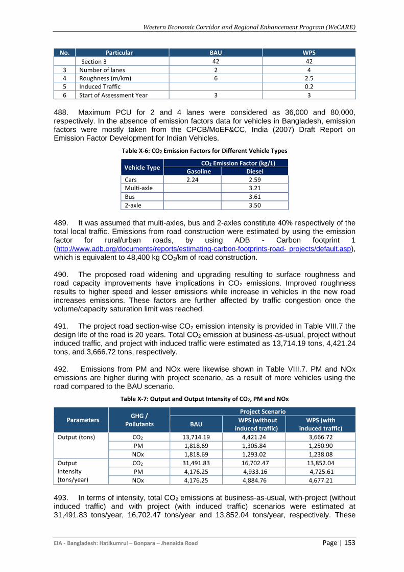
Western Economic Corridor and Regional Enhancement Program (WeCARE)
EIA - Bangladesh: Hatikumrul – Bonpara – Jhenaida Road Page | 153
No. Particular BAU WPS
Section 3 42 42
3 Number of lanes 2 4 4 Roughness (m/km) 6 2.5 5 Induced Traffic 0.2
6 Start of Assessment Year 3 3
488. Maximum PCU for 2 and 4 lanes were considered as 36,000 and 80,000, respectively. In the absence of emission factors data for vehicles in Bangladesh, emission factors were mostly taken from the CPCB/MoEF&CC, India (2007) Draft Report on Emission Factor Development for Indian Vehicles.
Table X-6: CO2 Emission Factors for Different Vehicle Types
Vehicle Type CO2 Emission Factor (kg/L)
Gasoline Diesel Cars 2.24 2.59 Multi-axle 3.21
Bus 3.61
2-axle 3.50
489. It was assumed that multi-axles, bus and 2-axles constitute 40% respectively of the total local traffic. Emissions from road construction were estimated by using the emission factor for rural/urban roads, by using ADB - Carbon footprint 1 (http://www.adb.org/documents/reports/estimating-carbon-footprints-road- projects/default.asp), which is equivalent to 48,400 kg CO2/km of road construction. 490. The proposed road widening and upgrading resulting to surface roughness and road capacity improvements have implications in CO2 emissions. Improved roughness results to higher speed and lesser emissions while increase in vehicles in the new road increases emissions. These factors are further affected by traffic congestion once the volume/capacity saturation limit was reached. 491. The project road section-wise CO2 emission intensity is provided in Table VIII.7 the design life of the road is 20 years. Total CO2 emission at business-as-usual, project without induced traffic, and project with induced traffic were estimated as 13,714.19 tons, 4,421.24 tons, and 3,666.72 tons, respectively. 492. Emissions from PM and NOx were likewise shown in Table VIII.7. PM and NOx emissions are higher during with project scenario, as a result of more vehicles using the road compared to the BAU scenario.
Table X-7: Output and Output Intensity of CO2, PM and NOx
Parameters GHG /
Pollutants
Project Scenario
BAU WPS (without
induced traffic) WPS (with
induced traffic)
Output (tons) CO2 13,714.19 4,421.24 3,666.72
PM 1,818.69 1,305.84 1,250.90
NOx 1,818.69 1,293.02 1,238.08
Output Intensity (tons/year)
CO2 31,491.83 16,702.47 13,852.04
PM 4,176.25 4,933.16 4,725.61
NOx 4,176.25 4,884.76 4,677.21
493. In terms of intensity, total CO2 emissions at business-as-usual, with-project (without induced traffic) and with project (with induced traffic) scenarios were estimated at 31,491.83 tons/year, 16,702.47 tons/year and 13,852.04 tons/year, respectively. These
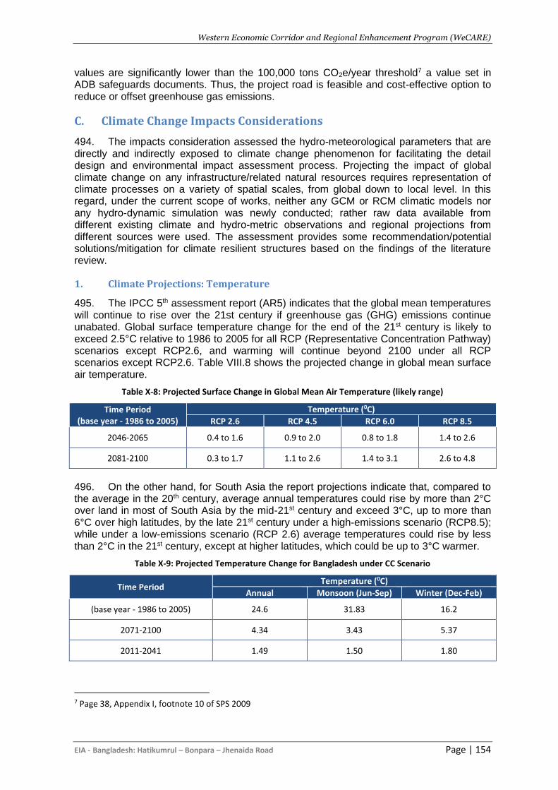
Western Economic Corridor and Regional Enhancement Program (WeCARE)
EIA - Bangladesh: Hatikumrul – Bonpara – Jhenaida Road Page | 154
values are significantly lower than the 100,000 tons CO2e/year threshold7 a value set in ADB safeguards documents. Thus, the project road is feasible and cost-effective option to reduce or offset greenhouse gas emissions.
C. Climate Change Impacts Considerations
494. The impacts consideration assessed the hydro-meteorological parameters that are directly and indirectly exposed to climate change phenomenon for facilitating the detail design and environmental impact assessment process. Projecting the impact of global climate change on any infrastructure/related natural resources requires representation of climate processes on a variety of spatial scales, from global down to local level. In this regard, under the current scope of works, neither any GCM or RCM climatic models nor any hydro-dynamic simulation was newly conducted; rather raw data available from different existing climate and hydro-metric observations and regional projections from different sources were used. The assessment provides some recommendation/potential solutions/mitigation for climate resilient structures based on the findings of the literature review.
1. Climate Projections: Temperature
495. The IPCC 5th assessment report (AR5) indicates that the global mean temperatures will continue to rise over the 21st century if greenhouse gas (GHG) emissions continue unabated. Global surface temperature change for the end of the 21st century is likely to exceed 2.5°C relative to 1986 to 2005 for all RCP (Representative Concentration Pathway) scenarios except RCP2.6, and warming will continue beyond 2100 under all RCP scenarios except RCP2.6. Table VIII.8 shows the projected change in global mean surface air temperature.
Table X-8: Projected Surface Change in Global Mean Air Temperature (likely range)
Time Period (base year - 1986 to 2005)
Temperature (0C)
RCP 2.6 RCP 4.5 RCP 6.0 RCP 8.5
2046-2065 0.4 to 1.6 0.9 to 2.0 0.8 to 1.8 1.4 to 2.6
2081-2100 0.3 to 1.7 1.1 to 2.6 1.4 to 3.1 2.6 to 4.8
496. On the other hand, for South Asia the report projections indicate that, compared to the average in the 20th century, average annual temperatures could rise by more than 2°C over land in most of South Asia by the mid-21st century and exceed 3°C, up to more than 6°C over high latitudes, by the late 21st century under a high-emissions scenario (RCP8.5); while under a low-emissions scenario (RCP 2.6) average temperatures could rise by less than 2°C in the 21st century, except at higher latitudes, which could be up to 3°C warmer.
Table X-9: Projected Temperature Change for Bangladesh under CC Scenario
Time Period Temperature (0C)
Annual Monsoon (Jun-Sep) Winter (Dec-Feb)
(base year - 1986 to 2005) 24.6 31.83 16.2
2071-2100 4.34 3.43 5.37
2011-2041 1.49 1.50 1.80
7 Page 38, Appendix I, footnote 10 of SPS 2009
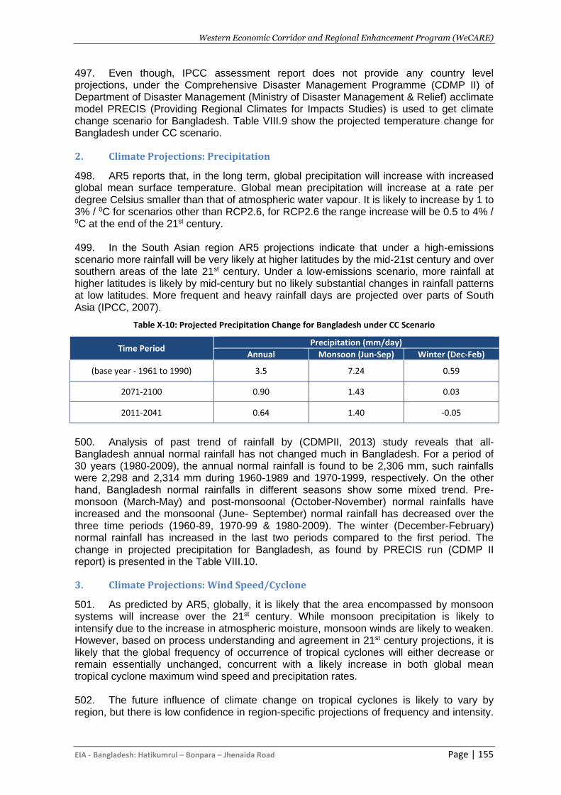
Western Economic Corridor and Regional Enhancement Program (WeCARE)
EIA - Bangladesh: Hatikumrul – Bonpara – Jhenaida Road Page | 155
497. Even though, IPCC assessment report does not provide any country level projections, under the Comprehensive Disaster Management Programme (CDMP II) of Department of Disaster Management (Ministry of Disaster Management & Relief) acclimate model PRECIS (Providing Regional Climates for Impacts Studies) is used to get climate change scenario for Bangladesh. Table VIII.9 show the projected temperature change for Bangladesh under CC scenario.
2. Climate Projections: Precipitation
498. AR5 reports that, in the long term, global precipitation will increase with increased global mean surface temperature. Global mean precipitation will increase at a rate per degree Celsius smaller than that of atmospheric water vapour. It is likely to increase by 1 to 3% / 0C for scenarios other than RCP2.6, for RCP2.6 the range increase will be 0.5 to 4% / 0C at the end of the 21st century. 499. In the South Asian region AR5 projections indicate that under a high-emissions scenario more rainfall will be very likely at higher latitudes by the mid-21st century and over southern areas of the late 21st century. Under a low-emissions scenario, more rainfall at higher latitudes is likely by mid-century but no likely substantial changes in rainfall patterns at low latitudes. More frequent and heavy rainfall days are projected over parts of South Asia (IPCC, 2007).
Table X-10: Projected Precipitation Change for Bangladesh under CC Scenario
Time Period Precipitation (mm/day)
Annual Monsoon (Jun-Sep) Winter (Dec-Feb)
(base year - 1961 to 1990) 3.5 7.24 0.59
2071-2100 0.90 1.43 0.03
2011-2041 0.64 1.40 -0.05
500. Analysis of past trend of rainfall by (CDMPII, 2013) study reveals that all-Bangladesh annual normal rainfall has not changed much in Bangladesh. For a period of 30 years (1980-2009), the annual normal rainfall is found to be 2,306 mm, such rainfalls were 2,298 and 2,314 mm during 1960-1989 and 1970-1999, respectively. On the other hand, Bangladesh normal rainfalls in different seasons show some mixed trend. Pre-monsoon (March-May) and post-monsoonal (October-November) normal rainfalls have increased and the monsoonal (June- September) normal rainfall has decreased over the three time periods (1960-89, 1970-99 & 1980-2009). The winter (December-February) normal rainfall has increased in the last two periods compared to the first period. The change in projected precipitation for Bangladesh, as found by PRECIS run (CDMP II report) is presented in the Table VIII.10.
3. Climate Projections: Wind Speed/Cyclone
501. As predicted by AR5, globally, it is likely that the area encompassed by monsoon systems will increase over the 21st century. While monsoon precipitation is likely to intensify due to the increase in atmospheric moisture, monsoon winds are likely to weaken. However, based on process understanding and agreement in 21st century projections, it is likely that the global frequency of occurrence of tropical cyclones will either decrease or remain essentially unchanged, concurrent with a likely increase in both global mean tropical cyclone maximum wind speed and precipitation rates. 502. The future influence of climate change on tropical cyclones is likely to vary by region, but there is low confidence in region-specific projections of frequency and intensity.
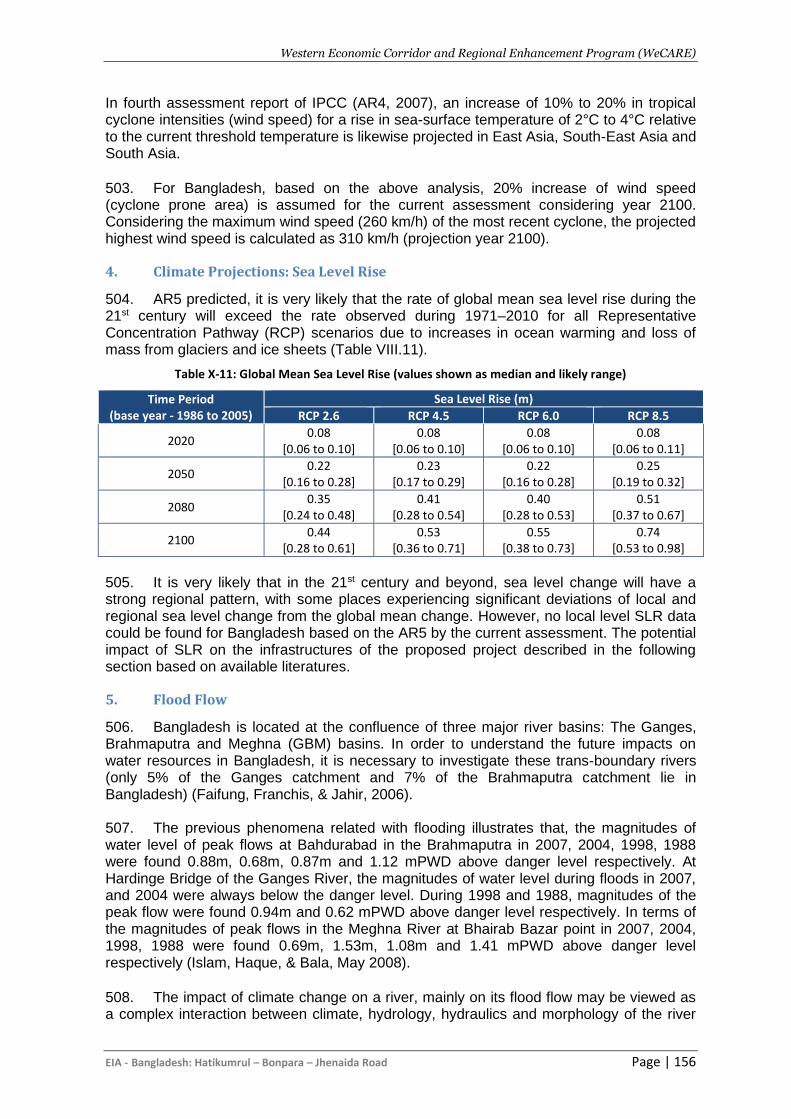
Western Economic Corridor and Regional Enhancement Program (WeCARE)
EIA - Bangladesh: Hatikumrul – Bonpara – Jhenaida Road Page | 156
In fourth assessment report of IPCC (AR4, 2007), an increase of 10% to 20% in tropical cyclone intensities (wind speed) for a rise in sea-surface temperature of 2°C to 4°C relative to the current threshold temperature is likewise projected in East Asia, South-East Asia and South Asia. 503. For Bangladesh, based on the above analysis, 20% increase of wind speed (cyclone prone area) is assumed for the current assessment considering year 2100. Considering the maximum wind speed (260 km/h) of the most recent cyclone, the projected highest wind speed is calculated as 310 km/h (projection year 2100).
4. Climate Projections: Sea Level Rise
504. AR5 predicted, it is very likely that the rate of global mean sea level rise during the 21st century will exceed the rate observed during 1971–2010 for all Representative Concentration Pathway (RCP) scenarios due to increases in ocean warming and loss of mass from glaciers and ice sheets (Table VIII.11).
Table X-11: Global Mean Sea Level Rise (values shown as median and likely range)
Time Period (base year - 1986 to 2005)
Sea Level Rise (m)
RCP 2.6 RCP 4.5 RCP 6.0 RCP 8.5
2020 0.08
[0.06 to 0.10] 0.08
[0.06 to 0.10] 0.08
[0.06 to 0.10] 0.08
[0.06 to 0.11]
2050 0.22
[0.16 to 0.28] 0.23
[0.17 to 0.29] 0.22
[0.16 to 0.28] 0.25
[0.19 to 0.32]
2080 0.35
[0.24 to 0.48] 0.41
[0.28 to 0.54] 0.40
[0.28 to 0.53] 0.51
[0.37 to 0.67]
2100 0.44
[0.28 to 0.61] 0.53
[0.36 to 0.71] 0.55
[0.38 to 0.73] 0.74
[0.53 to 0.98]
505. It is very likely that in the 21st century and beyond, sea level change will have a strong regional pattern, with some places experiencing significant deviations of local and regional sea level change from the global mean change. However, no local level SLR data could be found for Bangladesh based on the AR5 by the current assessment. The potential impact of SLR on the infrastructures of the proposed project described in the following section based on available literatures.
5. Flood Flow
506. Bangladesh is located at the confluence of three major river basins: The Ganges, Brahmaputra and Meghna (GBM) basins. In order to understand the future impacts on water resources in Bangladesh, it is necessary to investigate these trans-boundary rivers (only 5% of the Ganges catchment and 7% of the Brahmaputra catchment lie in Bangladesh) (Faifung, Franchis, & Jahir, 2006). 507. The previous phenomena related with flooding illustrates that, the magnitudes of water level of peak flows at Bahdurabad in the Brahmaputra in 2007, 2004, 1998, 1988 were found 0.88m, 0.68m, 0.87m and 1.12 mPWD above danger level respectively. At Hardinge Bridge of the Ganges River, the magnitudes of water level during floods in 2007, and 2004 were always below the danger level. During 1998 and 1988, magnitudes of the peak flow were found 0.94m and 0.62 mPWD above danger level respectively. In terms of the magnitudes of peak flows in the Meghna River at Bhairab Bazar point in 2007, 2004, 1998, 1988 were found 0.69m, 1.53m, 1.08m and 1.41 mPWD above danger level respectively (Islam, Haque, & Bala, May 2008). 508. The impact of climate change on a river, mainly on its flood flow may be viewed as a complex interaction between climate, hydrology, hydraulics and morphology of the river
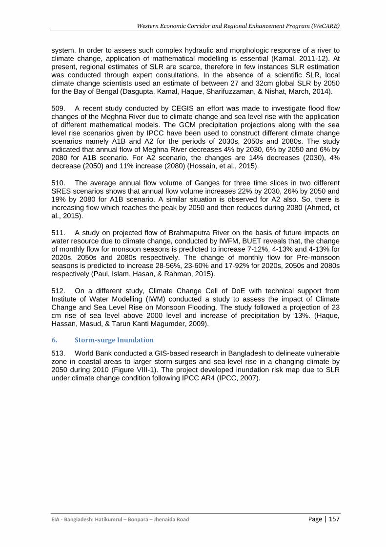
Western Economic Corridor and Regional Enhancement Program (WeCARE)
EIA - Bangladesh: Hatikumrul – Bonpara – Jhenaida Road Page | 157
system. In order to assess such complex hydraulic and morphologic response of a river to climate change, application of mathematical modelling is essential (Kamal, 2011-12). At present, regional estimates of SLR are scarce, therefore in few instances SLR estimation was conducted through expert consultations. In the absence of a scientific SLR, local climate change scientists used an estimate of between 27 and 32cm global SLR by 2050 for the Bay of Bengal (Dasgupta, Kamal, Haque, Sharifuzzaman, & Nishat, March, 2014). 509. A recent study conducted by CEGIS an effort was made to investigate flood flow changes of the Meghna River due to climate change and sea level rise with the application of different mathematical models. The GCM precipitation projections along with the sea level rise scenarios given by IPCC have been used to construct different climate change scenarios namely A1B and A2 for the periods of 2030s, 2050s and 2080s. The study indicated that annual flow of Meghna River decreases 4% by 2030, 6% by 2050 and 6% by 2080 for A1B scenario. For A2 scenario, the changes are 14% decreases (2030), 4% decrease (2050) and 11% increase (2080) (Hossain, et al., 2015). 510. The average annual flow volume of Ganges for three time slices in two different SRES scenarios shows that annual flow volume increases 22% by 2030, 26% by 2050 and 19% by 2080 for A1B scenario. A similar situation is observed for A2 also. So, there is increasing flow which reaches the peak by 2050 and then reduces during 2080 (Ahmed, et al., 2015). 511. A study on projected flow of Brahmaputra River on the basis of future impacts on water resource due to climate change, conducted by IWFM, BUET reveals that, the change of monthly flow for monsoon seasons is predicted to increase 7-12%, 4-13% and 4-13% for 2020s, 2050s and 2080s respectively. The change of monthly flow for Pre-monsoon seasons is predicted to increase 28-56%, 23-60% and 17-92% for 2020s, 2050s and 2080s respectively (Paul, Islam, Hasan, & Rahman, 2015). 512. On a different study, Climate Change Cell of DoE with technical support from Institute of Water Modelling (IWM) conducted a study to assess the impact of Climate Change and Sea Level Rise on Monsoon Flooding. The study followed a projection of 23 cm rise of sea level above 2000 level and increase of precipitation by 13%. (Haque, Hassan, Masud, & Tarun Kanti Magumder, 2009).
6. Storm-surge Inundation
513. World Bank conducted a GIS-based research in Bangladesh to delineate vulnerable zone in coastal areas to larger storm-surges and sea-level rise in a changing climate by 2050 during 2010 (Figure VIII-1). The project developed inundation risk map due to SLR under climate change condition following IPCC AR4 (IPCC, 2007).
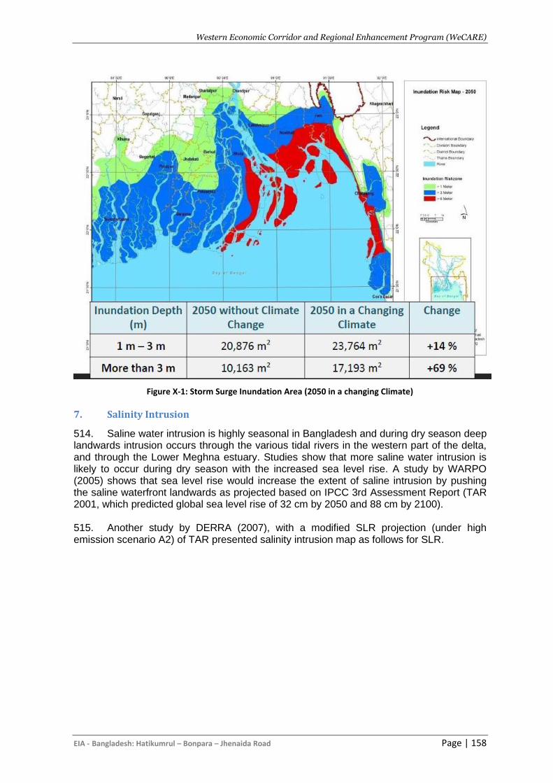
Western Economic Corridor and Regional Enhancement Program (WeCARE)
EIA - Bangladesh: Hatikumrul – Bonpara – Jhenaida Road Page | 158
Figure X-1: Storm Surge Inundation Area (2050 in a changing Climate)
7. Salinity Intrusion
514. Saline water intrusion is highly seasonal in Bangladesh and during dry season deep landwards intrusion occurs through the various tidal rivers in the western part of the delta, and through the Lower Meghna estuary. Studies show that more saline water intrusion is likely to occur during dry season with the increased sea level rise. A study by WARPO (2005) shows that sea level rise would increase the extent of saline intrusion by pushing the saline waterfront landwards as projected based on IPCC 3rd Assessment Report (TAR 2001, which predicted global sea level rise of 32 cm by 2050 and 88 cm by 2100). 515. Another study by DERRA (2007), with a modified SLR projection (under high emission scenario A2) of TAR presented salinity intrusion map as follows for SLR.
Western Economic Corridor and Regional Enhancement Program (WeCARE)
EIA - Bonpara-Jhenaidah Road Page | 159
Figure X-2: Salinity Intrusion for different Sea Level Rise during Dry Season (DEFRA 2007)
Western Economic Corridor and Regional Enhancement Program (WeCARE)
EIA - Bonpara-Jhenaidah Road Page | 160
D. Climate Adaptation
1. Introduction
516. The Bonpara-Jhenaidah Road is mainly linked to transport engineering aspects of augmentation, rehabilitation and in majority cases new infrastructures initiatives with the primary objective to supporting national poverty reduction. This climate risk and vulnerability adaptation (CRVA) is a crucial component where under AIIB’s requirements and for the purposes of subsequent project approval, the study needs to demonstrate that climate considerations have been integrated into the detailed designs of the road project.
2. Adaptation to Flooding
517. With increases projected both in terms of magnitude and intensity of precipitation, the concern is that of flood discharge. Although there is the need for new design and maintenance criteria to be based on future climate projections, the projection of flood values based on global or regional climate change scenarios is a difficult task, and is shrouded with some degree of uncertainty. Further, there is the lack of long-term measurement series on precipitation and run-off in the project area and that makes statistical work and future projections challenging. Possible ways of temporarily compensating for the lack of measurement data and predicted runoff are the use of more conservative return periods, or increasing the design capacity by an additional climate factor. 518. Weather is a complex system and so is climate change in which the prediction of absolute time and magnitude of future events cannot be envisaged with certainty. However, the EIA considers adaptation measures against flooding as described under:
a) Additional road embankment height to combat climate change induced flooding
519. Risk can be defined in terms of the recurrence interval, or the probability of a flood of stated magnitude, being equaled or exceeded in any given year. Drainage structures are designed to accommodate a flow of a given return period or probability of occurrence. The selection of the design flood recurrence interval involves an evaluation of the risk of disruption or damage to the road, possible loss of life, property damage, interruption of traffic, and the economic consequences. 520. The roads in Bangladesh are designed for 20-year recurrence period. However, as a safeguard, the hydrological study report (Chapter-8 of the FS) suggests that additional height should be applied over the design road height of 30-year return period (i.e. existing height). Thus, the design of the road embankment considers an adaptation allowance of 0.3m above flood level of sub-base of SMVT lane/ Main carriageway (whichever is lower) under a changed future climate to avoid any kind of inundation.
b) Additional freeboard for bridges to combat climate change induced flooding
521. The EIA reports that there are 8 bridges and 102 culverts along the Bonpara - Jhenaidah road alignment. One of the bridges is over 100m in length and is located on the Nabaganga River. The rest of the structures are mostly across undefined channels and carry only seasonal flow. Most bridges are located over depressions and low-lying ditches. Culverts are also located in depressions and at low lying agricultural land and operate merely as balancing structures, equalizing water levels on either side of the road embankment.
Western Economic Corridor and Regional Enhancement Program (WeCARE)
EIA - Bonpara-Jhenaidah Road Page | 161
522. Bridge designs are commonly based on a criterion to withstand the n-year flood event. For example, a highway bridge might be designed to pass the 100-year flood. Failure may occur if the structure faces an event larger than this. Climate change may necessitate different design criteria because of changes to flood frequency behavior. 523. As an adaptation measure the design height of bridges in the project area has considered from existing levels in line with the envisaged increase in flood level under a changed future climate as per the outcome of hydrological analysis. The bridges in the proposed roads are designed for 1 in 50-year return period. The climate change adaptation concept for bridges in the project area takes the bridge design to protect against a 1 in 50-year flood (i.e. 2% chance of occurrence of a 50-year flood magnitude in any given year).
c) Run-off and necessary drainage capacity
524. Higher precipitation intensity increases the risk of floods that exceed the capacity of the drainage infrastructure serving the road system. In Bangladesh where cyclonic storms are an annual occurrence and whose frequency has been observed to be on the rise, this will further aggravate the risk. This is an important safety issue that should be considered when discussing the capacity of drainage systems. 525. In line with the climate change literature summarized in this report acknowledges that inflows from the three major rivers Ganges, Brahmaputra and Meghna into Bangladesh are on average projected to increase over the monsoon period (driven primarily by increased basin precipitation). As a result of these increased discharges, the drainage structures throughout the roads have to drain much more water under climate change scenario. 526. The EIA report states that the present Bonpara–Jhenaidah road has no longitudinal drainage system and the existing cross-drainages are inadequate in terms of discharge capacity. The road area will need to drain additional discharge due to climate change induced by higher rainfall during extreme events. As an adaptation measure, the proposed road will incorporate longitudinal drains along the total highway length, increase the number of cross drainages per unit distance and replace existing pipe culverts with box culverts that provide larger discharge openings.
d) Engineering improvement in road design
527. Technological improvement is an option to address the emerging requirements linked to changes in climate. This is happening not only in the field of construction materials, aiming at providing a wider climate range of application, but also in the design of innovative structures for the operation of transport infrastructure. 528. Increased precipitation will lead to local elevation of groundwater levels. This, in addition to more infiltration into the road structure from above, will increase water content in the road sub-grade. This will lead to rutting of asphalt pavements (as is the case with higher temperature extremes) as a result of faster deterioration of materials in the road sub-base. The sub-base is meant to act as a drainage layer between the sub-grade and road base by preventing the sub-grade from wetting up to the road base. The design of the Bonpara – Jhenaidah road envisage to improve the sub-base as an effective drainage layer, by, in terms of quality of granular material required at that layer to barricade the upwards movement of moisture and lessening the deterioration of the road base.
3. Construction Materials Policy Adaptation
529. The Government of Bangladesh has recently adopted a policy to encourage construction of roadway embankments with river sand rather than clayey agricultural soil.
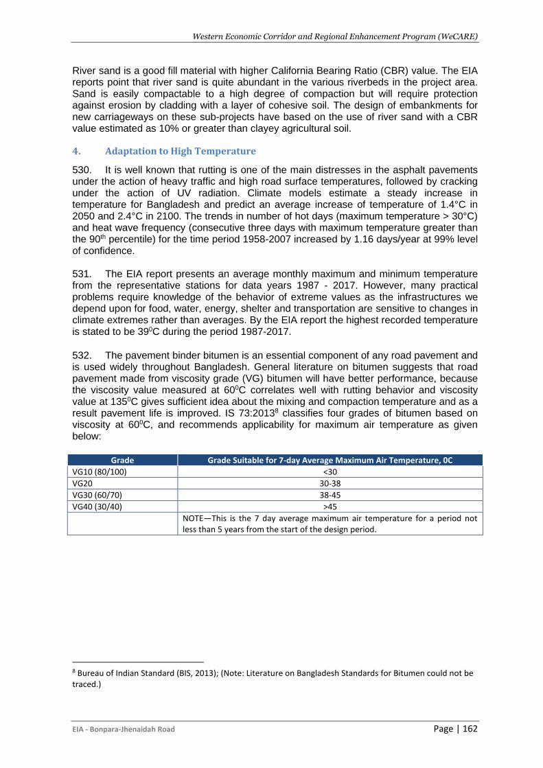
Western Economic Corridor and Regional Enhancement Program (WeCARE)
EIA - Bonpara-Jhenaidah Road Page | 162
River sand is a good fill material with higher California Bearing Ratio (CBR) value. The EIA reports point that river sand is quite abundant in the various riverbeds in the project area. Sand is easily compactable to a high degree of compaction but will require protection against erosion by cladding with a layer of cohesive soil. The design of embankments for new carriageways on these sub-projects have based on the use of river sand with a CBR value estimated as 10% or greater than clayey agricultural soil.
4. Adaptation to High Temperature
530. It is well known that rutting is one of the main distresses in the asphalt pavements under the action of heavy traffic and high road surface temperatures, followed by cracking under the action of UV radiation. Climate models estimate a steady increase in temperature for Bangladesh and predict an average increase of temperature of 1.4°C in 2050 and 2.4°C in 2100. The trends in number of hot days (maximum temperature > 30°C) and heat wave frequency (consecutive three days with maximum temperature greater than the 90th percentile) for the time period 1958-2007 increased by 1.16 days/year at 99% level of confidence. 531. The EIA report presents an average monthly maximum and minimum temperature from the representative stations for data years 1987 - 2017. However, many practical problems require knowledge of the behavior of extreme values as the infrastructures we depend upon for food, water, energy, shelter and transportation are sensitive to changes in climate extremes rather than averages. By the EIA report the highest recorded temperature is stated to be 390C during the period 1987-2017. 532. The pavement binder bitumen is an essential component of any road pavement and is used widely throughout Bangladesh. General literature on bitumen suggests that road pavement made from viscosity grade (VG) bitumen will have better performance, because the viscosity value measured at 600C correlates well with rutting behavior and viscosity value at 1350C gives sufficient idea about the mixing and compaction temperature and as a result pavement life is improved. IS 73:20138 classifies four grades of bitumen based on viscosity at 600C, and recommends applicability for maximum air temperature as given below:
Grade Grade Suitable for 7-day Average Maximum Air Temperature, 0C
VG10 (80/100) <30
VG20 30-38
VG30 (60/70) 38-45
VG40 (30/40) >45
NOTE—This is the 7 day average maximum air temperature for a period not less than 5 years from the start of the design period.
8 Bureau of Indian Standard (BIS, 2013); (Note: Literature on Bangladesh Standards for Bitumen could not be traced.)
Western Economic Corridor and Regional Enhancement Program (WeCARE)
EIA - Bonpara-Jhenaidah Road Page | 163
XI. ENVIRONMENTAL AND SOCIAL MANAGEMENT PLAN
A. General
533. Environmental mitigation measures and environmental monitoring requirements will be implemented through an Environmental and Social Management Plan (ESMP). The ESMP provides details of the environmental impacts, environmental mitigation measures, environment monitoring requirements, and environmental supervision responsibilities. 534. This section provides an approach for managing and monitoring environment related issues for environmental management and resource allocations to be carried out by the Roads and Highways Department (RHD) for mitigating negative impacts of the proposed Project.
B. Objectives of the Environmental and Social Management Plan
535. Environmental and Social management plan (ESMP) is prepared for all the identified environmental impacts (as illustrated in Chapter VI) during pre-construction, construction and operation stages due to implementation of various Project activities and associated development. The ESMP includes mitigation plan, monitoring plan and environmental cost. 536. The aim of the ESMP is to ensure implementation of the recommended mitigation measures effectively. The mitigation measures are designed either to prevent impacts or by mitigating those to reduce the effect to an acceptable level that complies with the environmental guidelines of DoE and with the guidelines of the AIIB’s ESF (2016) by adopting the most suitable techno-economic options. The ESMP also ensures that the positive impacts are conserved and enhanced. The main objectives of the ESMP for the construction of the Hatikumrul- Bonpara-Jhenaidah Road project are:
▪ Define the responsibilities of the project proponents in accordance with the three project phases (design, construction and operation);
▪ Facilitate the implementation of the mitigation measures by providing the technical details of each project impact, and proposing an implementation schedule of the proposed mitigation measures;
▪ Define a monitoring mechanism and identify monitoring parameters to ensure that all proposed mitigation measures are completely and effectively implemented;
▪ Identify training requirements at various levels and provide a plan for the implementation of training sessions;
▪ Identify the resources required to implement the ESMP and outline corresponding financing arrangements; and
▪ Providing a cost estimate for all proposed ESMP actions.
C. Environmental Mitigation Plan
537. Mitigation measures for each of the impacts listed in the Table IX-1 in accordance with the chapter VI. Responsible institutions/departments for the implementation and supervision of each of the environmental issues have also been illustrated. Mitigation measures have been suggested based on the knowledge of the Environmental Specialist, suggestions of the stakeholders collected during public consultation, and opinions from other relevant specialists.
538. The mitigation measures will be considered successful when comply with the Environmental Quality Standards (EQS), policies, legal requirements set by DOE and other

Western Economic Corridor and Regional Enhancement Program (WeCARE)
EIA - Bonpara-Jhenaidah Road Page | 164
relevant GOB organizations. In absence of DOE’s own EQS, other relevant international or other recognized organization’s quality standard will have to be followed.
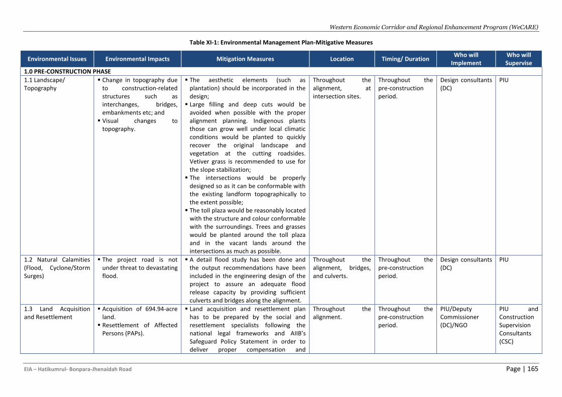
Western Economic Corridor and Regional Enhancement Program (WeCARE)
EIA – Hatikumrul- Bonpara-Jhenaidah Road Page | 165
Table XI-1: Environmental Management Plan-Mitigative Measures
Environmental Issues Environmental Impacts Mitigation Measures Location Timing/ Duration Who will
Implement Who will Supervise
1.0 PRE-CONSTRUCTION PHASE
1.1 Landscape/ Topography
▪ Change in topography due to construction-related structures such as interchanges, bridges, embankments etc; and
▪ Visual changes to topography.
▪ The aesthetic elements (such as plantation) should be incorporated in the design;
▪ Large filling and deep cuts would be avoided when possible with the proper alignment planning. Indigenous plants those can grow well under local climatic conditions would be planted to quickly recover the original landscape and vegetation at the cutting roadsides. Vetiver grass is recommended to use for the slope stabilization;
▪ The intersections would be properly designed so as it can be conformable with the existing landform topographically to the extent possible;
▪ The toll plaza would be reasonably located with the structure and colour conformable with the surroundings. Trees and grasses would be planted around the toll plaza and in the vacant lands around the intersections as much as possible.
Throughout the alignment, at intersection sites.
Throughout the pre-construction period.
Design consultants (DC)
PIU
1.2 Natural Calamities (Flood, Cyclone/Storm Surges)
▪ The project road is not under threat to devastating flood.
▪ A detail flood study has been done and the output recommendations have been included in the engineering design of the project to assure an adequate flood release capacity by providing sufficient culverts and bridges along the alignment.
Throughout the alignment, bridges, and culverts.
Throughout the pre-construction period.
Design consultants (DC)
PIU
1.3 Land Acquisition and Resettlement
▪ Acquisition of 694.94-acre land.
▪ Resettlement of Affected Persons (PAPs).
▪ Land acquisition and resettlement plan has to be prepared by the social and resettlement specialists following the national legal frameworks and AIIB’s Safeguard Policy Statement in order to deliver proper compensation and
Throughout the alignment.
Throughout the pre-construction period.
PIU/Deputy Commissioner (DC)/NGO
PIU and Construction Supervision Consultants (CSC)
Western Economic Corridor and Regional Enhancement Program (WeCARE)
EIA – Hatikumrul- Bonpara-Jhenaidah Road Page | 166
Environmental Issues Environmental Impacts Mitigation Measures Location Timing/ Duration Who will
Implement Who will Supervise
resettlement of the affected people; ▪ Careful alignment and route selection by
the designer to minimise resettlement; ▪ Acquire minimal area of land that meets
the requirement of the proposed road improvement; and
▪ Allocation of proper compensation according to Resettlement Plan (RP).
1.4 Agriculture Production Loss
▪ A total of 694.94 acre of land will directly occupied by the project and 437.81 acre of this area is agricultural land. Production of various crops from this agricultural land will be permanently lost.
▪ A compensation program for creation of employment for victim family, initiatives to reduce negative impact on agricultural lands and increased crop production from limited land will keep the loss at an agreeable limit.
Throughout the alignment.
Throughout the pre-construction period.
PIU/DC/NGO PIU and CSC
1.5 Removal of Commercial Structures
▪ 1949 commercial structures are located within the ROW which will be directly affected.
▪ The Project Affected People (PAPs) must be informed through notice in time as though they can get enough time to make plan for relocation/shifting; and
▪ The PAPs will have to be properly compensated and relocated as per the RP before commencing removal of commercial infrastructure;
Along the alignment at sites identified in the RP.
Early during the Feasibility Study work, during detailed design stage; always prior to construction starting in the area where the site is located.
PIU/DC/NGO PIU and CSC
1.6 Removal of Physical Cultural and Other Community Structures
▪ 103 cultural structures are located within ROW.
▪ The people using the infrastructure must be informed prior to removal and/or relocation; and
▪ Removal and/or relocation of community structures will have to be executed after discussion with the local people/users/associated stakeholders.
Along the alignment at CPRs sites identified in the RP.
Early during the Feasibility Study work, during detailed design stage; always prior to construction starting in the area where the site is located.
PIU/DC/NGO PIU and CSC
1.7 Damage to Public Utilities
▪ Utility lines will have to be moved disrupting services
▪ Provision in the design and budget for the relocation of the existing utility
Along the alignment. Permits and locations will be
PIU /DC/ PDB/BTCL/
PIU and CSC
Western Economic Corridor and Regional Enhancement Program (WeCARE)
EIA – Hatikumrul- Bonpara-Jhenaidah Road Page | 167
Environmental Issues Environmental Impacts Mitigation Measures Location Timing/ Duration Who will
Implement Who will Supervise
infrastructures, wherever required; ▪ All public utilities (e.g. water/gas pipes,
power/telephone lines, mobile tower) likely to be affected by the proposed project will be relocated before the actual commencement of the construction work.
▪ Informing all hospitals, schools, places of worship, and affected communities well in advance;
▪ Utilities will only be removed and relocated with proper agency approvals and permission;
▪ If utilities are damaged during construction, it will be reported to the Consultants and utility authority and repairs will be arranged immediately at the contractor’s expense.
▪ Reconnection of utilities will be completed at the shortest practicable time before construction commences.
established and included in construction drawing and relocation will take place prior to construction.
Contractor
1.8 Tree Cutting and Wildlife
▪ Cutting of ~79000 trees in Phase-1;
▪ Loss of habitat (roadside, floodplain, river and coastal mangrove habitats identified in the project area) of some wildlife in relation to the wetlands, trees and vegetation; and
▪ Relocation/migration of wildlife;
▪ Clearance of vegetation on the ROW along the alignment will cause permanent and/or temporary dislocation of some wildlife because of
▪ Get approval from CSC for clearance of vegetation.
▪ Prior notice to the owners of the trees and ensure proper compensation to the affected people according to the Resettlement Action Plan; and
▪ During cutting of trees cautious observation is essential regarding smooth and safe relocation/migration of wildlife (if any) and it has to be ensured that no wildlife becomes hurt during tree cutting.
▪ A total of minimum two time saplings against felled down trees will be planted during operation stage (preferably during monsoon period).
▪ If a tree of rare species is growing within the ROW and is required to be removed, it
Along the alignment. The Tree plantation plan (this plan will be developed during the detailed design stage) will be updated and completed early during the Pre-Construction period. Cutting will take place throughout the construction period and replanting immediately after each section of the road is completed.
FD/ PIU /DC PIU, MoEF, and CSC
Western Economic Corridor and Regional Enhancement Program (WeCARE)
EIA – Hatikumrul- Bonpara-Jhenaidah Road Page | 168
Environmental Issues Environmental Impacts Mitigation Measures Location Timing/ Duration Who will
Implement Who will Supervise
disturbance on their habitat.
▪ During survey, vegetation clearing, removal of infrastructure and utilities will make the wildlife panic.
▪ During site clearance there is a possibility to injure and/or death of any species.
▪ The birds and its nest on the trees will be directly affected.
will not be felled but uprooted and transplanted in close consultation with the Forest Department;
▪ During clearing of the vegetation, the security of the wildlife species must be ensured.
▪ While clearing vegetation it must be ensured that no wildlife (snakes, mongoose, fox, squirrel and other wildlife species) injure and/or die.
▪ Harming and/or killing of any types of wildlife by the workers of the project must be prohibited.
▪ In case of appearance of any endangered/threatened wildlife species respective regulatory authority must be informed as early as possible.
1.9 Change of Local Hydrology/Drainage Congestion
▪ Diversion across the 8 bridges and 102 culverts construction; and
▪ Temporary change in local hydrology.
▪ Design of diversion and approach road have to be designed in a way that does not bring any short/long term hydrological change and/or drainage congestion.
▪ A Dredge Material management plan must be developed, and wastes generated during dredging and piling must be disposed according to this plan.
▪ Wastes have to be disposed in controlled manner at designated site only according to the characteristics of the waste.
Bridges and embankments as well as at culvert construction sites.
Throughout the pre-construction period.
PIU / Design Consultant (DC)
PIU, BIWTA, BWDB and CSC
1.10 Water Bodies and Fisheries
▪ 50.73-acre waterbodies will be directly affected;
▪ Pile driving and dredging for the construction of 8 bridges and 102 culverts will force to migrate the fisheries and other aquatic species.
▪ Proper compensation to the affected people who will lose their culture fisheries ponds;
▪ Flow of water in the rivers must be undisturbed as possible; and
▪ Erosion and siltation have to be prevented at bridge and culvert construction site.
▪ Fallow lands can be prepared into fish ponds through excavation work.
Along the alignment, River, ponds and roadside borrow pit site areas
Throughout the pre-construction period.
PIU /DC/NGO
PIU, DOF and CSC
Western Economic Corridor and Regional Enhancement Program (WeCARE)
EIA – Hatikumrul- Bonpara-Jhenaidah Road Page | 169
Environmental Issues Environmental Impacts Mitigation Measures Location Timing/ Duration Who will
Implement Who will Supervise
▪ Farmers can be encouraged to practice of integrated fish farming (e.g. fish farming in the paddy field).
▪ In order to minimize the production loss of fish, production capacity in the existing fish enriched ponds in the CoI can be enhanced through excavating the ponds.
1.11 Labour Standard Inadequately prepared labour standards, leading to infractions regarding child labour, minimum wage, forced labour, and unsanitary working conditions and unsafe water supplies
Confirm that these standards are specifically incorporated into the contract documents either as clauses or by appending this ESMP to the contract.
Construction site and labour camp
Once as contract documentation is being prepared
Project Company PIU
1.12 Technical Capacity to undertake all environmental work
Inability of contractor and RHD or CSC to implement the EIA and it ESMP resulting in a breakdown of safeguards implementation.
▪ RHD/CSC to conduct a one day briefing and training for contractors and RHD staff on EIA and ESMP implementation, surveys and data recording
RHD/CSC Office Pre-construction period/Beginning of construction period.
PIU, and Construction Supervision Consultant (CSC)
RHD
2.0 CONSTRUCTION PHASE
2.1 Landscape/ Topography
▪ Cutting 105368 trees and dismantling of existing 3955 infrastructure will cause landscape change;
▪ Permanent acquisition of land used for agricultural (437.81 acre), residential (69.49 acre), commercial (97.29 acre) and other purposes to build road embankment will cause landscape change.
▪ Ensure minimal acquisition of agricultural land as possible and
▪ Proper landscaping; ▪ Construction camps should be constructed
at suitable place to minimize this impact. ▪ Vegetation clearing has to be at minimum
level as possible. After completion of road construction, trees shall be planted along sections of road near the populous residential areas to improve landscape along the road.
▪ All the affected areas will be restored to their original levels.
Embankment areas of the proposed alignment area as well as at all construction camp area.
Throughout the construction period.
Contractor PIU, and Construction Supervision Consultant (CSC)
2.2 Loss of Top Soil ▪ Typical activities during the road construction phase include ground clearing
▪ Minimize the extent of disturbance activities to minimize impacts to soil outside the CROW.
Embankment areas of the proposed alignment area as
Throughout the construction period.
Contractor CSC
Western Economic Corridor and Regional Enhancement Program (WeCARE)
EIA – Hatikumrul- Bonpara-Jhenaidah Road Page | 170
Environmental Issues Environmental Impacts Mitigation Measures Location Timing/ Duration Who will
Implement Who will Supervise
(removal of vegetative cover), grading, excavation, trenching, vehicular and pedestrian traffic, and construction and installation of facilities may lead to loss of topsoil (0.5 m from the surface) in CROW.
▪ Compaction of topsoil due to vehicular and pedestrian movement.
▪ Loss of top soil by wind and water erosion.
▪ Covering of top soil by project works.
▪ Clearing topsoil in proposed embankment area can lead to loss of nutrient.
▪ The stockpile slope to be no steeper than 2 (H):1 (V) to reduce surface runoff and enhance percolation through the mass of stored soil.
▪ Minimize erosion potential and weed species invasion by establishing a healthy plant cover.
▪ Keep soil storage periods as short as possible.
▪ Locate topsoil stockpiles outside drainage lines and protect stockpiles from erosion.
▪ Construct diversion channels and silt fences around the topsoil stockpiles to prevent erosion and loss of topsoil.
▪ Use stripped topsoil to cover all disturbed areas and along the proposed tree plantation sites.
▪ Mitigate construction-related soil compaction in tree plantation areas by ripping the soil to loosen its structure prior to the spreading of topsoil.
▪ Limit equipment and vehicular movements to within the approved construction zone.
▪ Fertile soil (or top soil) shall be distributed free to local people who need it for their own purpose. The residuals shall be reused to form the ground around the interchanges, the areas along the road within the acquired land, or recover the vegetation in some affected areas due to the road project.
well as at all construction camp area.
2.3 Dredging and Dredged Materials
▪ Riverbank erosion and flood at downstream;
▪ Increase of water turbidity and subsequent impact on the aquatic life;
▪ Obtaining permits for extraction sites and quantities from BIWTA authorities and adhering to the prescribed extraction volume limits per site.
▪ Site selection considering hydrological and
Dredging sites and dredge material placement sites.
Inspect weekly to ensure that dredge material is properly maintained.
Contractor CSC
Western Economic Corridor and Regional Enhancement Program (WeCARE)
EIA – Hatikumrul- Bonpara-Jhenaidah Road Page | 171
Environmental Issues Environmental Impacts Mitigation Measures Location Timing/ Duration Who will
Implement Who will Supervise
▪ Leakages and spillage from the hydraulic pipeline, impact of air quality and odor from dredge material carrying trucks; and
▪ Dispersion of sediments and release of high sediment laden runoff from the placement sites.
river morphological consideration. ▪ Water samples will be collected upstream
and downstream of the dredger while in full operation and tested for nutrient, sediment loads, heavy metals as well as oil and grease concentrations. Dredging must not be carried out when the fish are likely to be breeding in the affected surface water bodies, or in the period normally from April to August between spawning and the subsequent emergence of juvenile fish.
▪ Avoid sensitive areas (bird habitats, and fish spawning areas). No dredging will be carried out within 1 km from these sensitive areas.
▪ Prior to start dredging and during dredging, quality of river water and river bed dredged materials of the selected rivers need to be tested by the contractor.
▪ The transporting of the dredged materials using watertight dump trucks should not exceed the truck capacity to avoid spillage onto the road and carried out during the night time period (e.g. 21.00 to 05.00).
▪ Directly place the sediments for filling the proposed embankment areas. Prior to filling commencing, the areas being filled will be subdivided into compartments by construction of temporary containment bunds of suitable material (e.g. dredged sand). Filling will be achieved by progressively pumping slurry of sand and water into the bunded areas, allowing the surplus water to drain away to artificial and natural waterways in a controlled manner through the pipeline, without
Western Economic Corridor and Regional Enhancement Program (WeCARE)
EIA – Hatikumrul- Bonpara-Jhenaidah Road Page | 172
Environmental Issues Environmental Impacts Mitigation Measures Location Timing/ Duration Who will
Implement Who will Supervise
affecting floodplains.
2.4 Soil Erosion and Siltation
▪ Soil erosion due to construction activities, earthworks, cut and fill operations and from stockpiles; and
▪ Increase of the surface water turbidity and disruption of usual photosynthesis and fish spawning process.
▪ The Contractor is required to reuse the excavated soil as much as possible unless the soil is considered not suitable for filling.
▪ The Contractor shall plan his works to minimize surface excavation works during the rainy season where practicable.
▪ Precautions to be taken at any time of year when rainstorms are likely, actions to be taken when a rainstorm is imminent or forecast, and actions to be taken during or after rainstorms shall be developed by the Contractor. Particular attention shall be paid to the control of surface runoff during storm events, especially for sites located near steep slopes.
▪ Slope protection measures through turfing and bioengineering work;
▪ In rainy season, prior to construction of roadbed, culverts will be completed with drainage system. The storm water interception and drainage system should be constructed before construction of side slopes.
▪ Riprap or rock material should be used to embed the surface of the road side slopes. Planting at the surface of the road side slopes is also recommended. Retaining structures such as gabions, cribs, or other types of green barricades and grid work should be used to batter back against the cutting slopes.
▪ At the sections involving high filling, the construction of road should be scheduled to avoid rainy season. If cannot, drainage system will be improved to ensure that
At all work sites, in the impact corridor, including at cut areas.
Inspection as part of the engineering inspection cycle and reporting to CSC
Contractor CSC
Western Economic Corridor and Regional Enhancement Program (WeCARE)
EIA – Hatikumrul- Bonpara-Jhenaidah Road Page | 173
Environmental Issues Environmental Impacts Mitigation Measures Location Timing/ Duration Who will
Implement Who will Supervise
storm water be drained smoothly and quickly, and the working surface will be covered.
▪ The overall slope of the works areas and construction yards shall be kept to a minimum to reduce the erosive potential of surface water flows.
▪ The earthwork sites where exposed land surface is vulnerable to runoff, etc. shall be consolidated and/or covered.
▪ The material stockpile sites shall be far away from surface water bodies and areas prone to surface run-off. Loose materials shall be bagged and covered. Open ditch shall be built around the stockpile sites to intercept wastewater. If necessary, retarding basins shall be constructed to remove sands and other solids in storm water before it reaches the downstream rivers.
▪ Open stockpiles of construction materials (e.g. aggregates, sand and fill material) of more than 50m3 shall be covered with tarpaulin or similar fabric during rainstorms. Measures shall be taken to prevent the washing away of construction materials, soil, silt or debris into any drainage system.
▪ At the start of site establishment, perimeter cut-off drains to direct off-site water around the site shall be constructed and internal temporary drainage works and erosion and sediment control facilities shall be implemented.
▪ Cut-off drains should be built near sensitive areas to catch rainwater before it reaches the critical areas, and diverging
Western Economic Corridor and Regional Enhancement Program (WeCARE)
EIA – Hatikumrul- Bonpara-Jhenaidah Road Page | 174
Environmental Issues Environmental Impacts Mitigation Measures Location Timing/ Duration Who will
Implement Who will Supervise
drains should be built to avoid excessive concentration of rainwater flow. Concrete dissipation structures should be built to slow down storm water in drains, and hence reduce its downstream erosive potential.
▪ Channels, earth bunds, netting, tarpaulin and or sand bag barriers shall be used on site to manage surface water runoff and minimize erosion.
▪ All exposed earth areas shall be completed and revegetated as soon as possible after earthworks have been completed. If excavation of soil cannot be avoided during the rainy season, or at any time of year when rainstorms are likely, exposed slope surfaces shall be protected by temporary drainage measures.
▪ The overall slope of the works areas and construction yards shall be kept to a minimum to reduce the erosive potential of surface water flows.
2.5 Soil Contamination ▪ Contamination of nearby agricultural land if dredged material is contaminated.
▪ Dumping of construction debris on fields adjoining the acquired areas, may lead to impairment of soil for agriculture, especially when the nearby areas to the alignment is largely agriculture.
▪ Ensure that dredge materials do not contain heavy metals exceeding the international standards by testing prior to using it;
▪ Outflow from hydraulic fill should have max. retention time to enhance settling at the reclaimed site;
▪ Handling of bitumen, fuel and chemicals at designated site in the construction yards only;
▪ The movement of construction vehicles, machinery and equipment will be restricted to the corridor or identified route.
▪ The unusable, non-saleable, non-
At all work sites, in the impact corridor, including at cut areas.
Inspection as part of the engineering inspection cycle and reporting to CSC
Contractor CSC
Western Economic Corridor and Regional Enhancement Program (WeCARE)
EIA – Hatikumrul- Bonpara-Jhenaidah Road Page | 175
Environmental Issues Environmental Impacts Mitigation Measures Location Timing/ Duration Who will
Implement Who will Supervise
hazardous construction waste shall be dispose of in the properly delineated places.
▪ The compacted land is restored for agricultural use.
▪ The construction vehicles shall be fuelled or repaired/serviced at the designated place with proper arrangement of waste collection and disposal. The arrangement will include, cemented floor with dyke around for fuel storage and filling as well repairing of construction equipment.
▪ Soil contamination by bitumen, fuel and chemical storages shall be minimized by siting them on an impervious base within an embanked area and secured by fencing. The base and walls of the embankment shall be impermeable and of sufficient capacity to contain of the total volume of stored fuels and chemicals.
▪ The disposal of waste asphalt shall be made in approved locations such as not at natural depressions and shall not be within the ROW. Unless located in areas with impervious soils, encapsulation with pre-laid impervious liners including walls and capping is required with the objective to prevent water percolating through the waste materials and leaching toxic chemicals into the surrounding soils.
2.6 Air Pollution and Dust
▪ The ambient levels of COx, NOx, SOx, PM2.5, and PM10 may increase during construction phase is mainly caused by: (1) flying dust produced from mixing lime and soil, (2) material
▪ Earth, rock or debris shall not be deposited on public or private land as a result of Contractor’s operations, including any deposits arising from the movement of construction plant or vehicles.
▪ Provide water spray vehicles to water the
At all work sites, in the impact corridor.
Inspection as part of the engineering inspection cycle and reporting to CSC
Contractor CSC
Western Economic Corridor and Regional Enhancement Program (WeCARE)
EIA – Hatikumrul- Bonpara-Jhenaidah Road Page | 176
Environmental Issues Environmental Impacts Mitigation Measures Location Timing/ Duration Who will
Implement Who will Supervise
stock grounds, (3) Emission, leakage/ spillover of materials/spoils during transportation, (4) dust from temporary roads and unpaved road surfaces.
▪ Flow of particulate matter from uncovered construction materials carrying vehicles; and
▪ Emissions of air pollutants/GHGs from asphalt plant, machines/engines and firing for bitumen melting.
unpaved ground, storage piles and other areas where airborne dust may originate. The water spray operation should be carried out in dry and windy day, at least twice a day (morning and afternoon).
▪ Trucks transporting construction materials should meet allowable exhaust gas emission standards and should be carefully covered.
▪ Site for stockpiling soils and sand should be located far more than 500m from the populous residential areas.
▪ All soils excavated from the land surface during the works to construct road foundation shall be transported as soon as possible to the sites for reuse or disposal.
▪ Concentration of construction machinery and vehicles near the populous residential areas should be avoided.
▪ Measures to control air pollution at concrete batching plant, asphalt melting stations, etc.
1. Concrete batching plants, crushing plant sites and their ancillary areas shall be frequently cleaned and watered to minimize any dust emissions.
2. Dry mix batching shall be carried out in a totally enclosed area with exhaust to suitable fabric filters.
3. A suitable air pollution control system shall be installed and operated whenever the batching plant is in operation.
4. All stockpiles of sand and aggregate within the batching plant site shall be enclosed on three sides with geotextile
Western Economic Corridor and Regional Enhancement Program (WeCARE)
EIA – Hatikumrul- Bonpara-Jhenaidah Road Page | 177
Environmental Issues Environmental Impacts Mitigation Measures Location Timing/ Duration Who will
Implement Who will Supervise
sheets (if they are greater than 20m3), and shall be enclosed on three sides with walls extending above the stockpile and 2000mm beyond the front of the stockpile (if they are greater than 50m3).
5. The asphalt melting station should be equipped with flue gas control device, operation of asphalt melting will be in enclosed mode; cement and concrete will be mixed within an enclosed structure.
6. Cement and other such fine-grained materials delivered in bulk shall be stored in closed silos fitted with a high-level alarm indicator. The high-level alarm indicators shall be interlocked with the filling line such that in the event of the hopper approaching an overfill condition, an audible alarm will operate, and the pneumatic line to the filling tanker will close.
7. All air vents on cement silos shall be fitted with suitable fabric filters provided with either shaking or pulse-air cleaning mechanisms. ▪ Measures to control air pollution at
construction site:
1. Use temporary barriers to control dust around the construction sites near the populous residential areas.
2. All vehicles shall have their engine turned off while parked on the site.
3. Construction machinery should be located as far as possible from the construction site boundary.
Western Economic Corridor and Regional Enhancement Program (WeCARE)
EIA – Hatikumrul- Bonpara-Jhenaidah Road Page | 178
Environmental Issues Environmental Impacts Mitigation Measures Location Timing/ Duration Who will
Implement Who will Supervise
4. Areas within the construction site where there is a regular movement of vehicles shall have a hard surface and be kept clear of loose surface material to the satisfaction of the CSC.
5. Construction roads should be paved with gravel or asphalt to reduce generation of air-borne dust, and mitigate impacts to residential areas.
6. All roads within the construction sites and roads leading to the sites shall be sprayed by using water bowers with spray bars, hose pipes etc. to control dust to the satisfaction of the CSC.
2.7 Noise and Vibration ▪ Generation of noise due to project activities (e.g. movement of vehicle, construction work, maintenance etc.);
▪ Movement of the heavy construction equipment and vehicles, pile driving operations, operation of crushing, ballasting and aggregating plants, and power generation plants will cause vibration.
▪ The Contractor shall abide by the provisions of the Specifications of Contract regarding environmental protection and DOE regulations (≤60 dB levels at mosque, school, populated area and other sensitive sites).
▪ The Contractor shall at its own expense take all appropriate measures to ensure that work carried out (including works by sub-contractors), whether on or off the site, will not cause any unnecessary or excessive noise.
▪ Construction activity near residential areas should be scheduled in daytime only, and the noisy equipment should be prohibited from night operation. During construction in daytime, the construction site should be fenced.
▪ The Contractor shall select, use and maintain his plant and equipment, and adopt such methods for construction that
Sensitive sites within 100 m of ROW in the vicinity of the sensitive receptors.
Throughout the construction period, and based on noise measurement surveys
Contractor CSC and DOE
Western Economic Corridor and Regional Enhancement Program (WeCARE)
EIA – Hatikumrul- Bonpara-Jhenaidah Road Page | 179
Environmental Issues Environmental Impacts Mitigation Measures Location Timing/ Duration Who will
Implement Who will Supervise
the maximum vibration levels, measures on any building or structure outside or within the site limits, do not exceed the permitted levels specified in British Standard 5228-2:2009. The above are limits for vibrations.
▪ The Contractor shall be responsible for repairing any damage caused as a result of vibrations generated from or by the use of his equipment, plant.
▪ Although construction shall be banned in night time some may still occur for technical and other reasons (e.g., bridge piles required continued, around clock concrete pouring). If the work is occurred in the night time and near villages and other residential areas, which would result in particularly significant impacts, the Contractor shall submit to the CSC a noise statement including full and comprehensive details of all powered mechanical equipment proposed for use during night time hours 21:00 to 06:00 hours and the proposed working methods and noise level reduction measures. The noise statement shall include detailed noise calculations to demonstrate the anticipated noise generation. Special measures (such as use of noise barriers) shall be proposed if excessive noise and vibration is anticipated. The noise statement shall be submitted to the CSC at least seven days before the planned start of any works. No work shall be carried out until the CSC has notified the Contractor in writing of his consent based on the noise statement submitted in
Western Economic Corridor and Regional Enhancement Program (WeCARE)
EIA – Hatikumrul- Bonpara-Jhenaidah Road Page | 180
Environmental Issues Environmental Impacts Mitigation Measures Location Timing/ Duration Who will
Implement Who will Supervise
relation to such work. Such consent of the CSC shall not in any event relieve the Contractor of its obligations under the Contract or GOB law.
▪ Restriction of rock drilling to the shortest period possible.
▪ All powered mechanical equipment used in the works shall be effectively sound reduced using the most modern techniques. Equipment shall be selected with due consideration for having lowest noise levels, and ensuring that this equipment is regularly maintained to keep such levels during its operation.
▪ All equipment, engines and motors shall be equipped with proper silencers or mufflers during construction.
▪ Positioning air compressors for various construction plant / caisson foundations on rubber sheets.
▪ Construction equipment should be well maintained to keep it in a best operating conditions and lowest noise levels.
▪ The Contractor shall ensure that all equipment engines and motors are equipped with proper mufflers.
▪ Restrict long heavy vehicles and speed in the areas near the populous areas.
▪ Transportation of construction equipment and materials on existing roads shall be carefully designed to minimize adverse impact on residents, as well as traffic on the existing road. The transportation vehicles should be required to slow down and banned from horning when passing populous residential areas.
Western Economic Corridor and Regional Enhancement Program (WeCARE)
EIA – Hatikumrul- Bonpara-Jhenaidah Road Page | 181
Environmental Issues Environmental Impacts Mitigation Measures Location Timing/ Duration Who will
Implement Who will Supervise
▪ The use of temporary noise barriers, or acoustic screens or enclosures shall be properly examined at the road sections close to the populous residential houses to shield residences from road traffic noise.
▪ After completion of road construction, native tree species shall be planted along sections of road near the populous residential areas to mitigate impact of traffic noise to residents living along the road.
▪ For workers who must work with excessive noisy machines such as piling, explosion, mixing, etc., ear pieces should be provided for noise control and workers protection.
2.8 Surface Water Quality
▪ During the construction phase, wastewater from construction sites is mainly generated from the concrete watering, pier foundation drains, and sand washing. A medium size construction site generally generates about 20 tons/day of wastewater with high level of turbidity and pH. If this wastewater is discharged directly into the surrounding water bodies, it would pollute these water bodies.
▪ Water pollution may cause damage to the breeding and spawning of fish and may pose threat to other
▪ The Contractor shall comply with the national legislation and other regulations currently applied in Bangladesh as they relate to water pollution control.
▪ Protection of the water environment shall be recognized as a key constraint for any construction work. The Contractor shall devise and arrange methods of working to minimize water quality impacts to the satisfaction of the CSC.
▪ The Contractor shall at all times ensure that all existing water courses and drains within, and adjacent to, the Site are kept safe and free from any debris and any excavated materials arising from the Works.
▪ For construction of the bridge piers bundled site boundaries shall be established to prevent any wastewater discharging directly to the water body
Along the alignment and bridges/culverts locations
Throughout the construction period
Contractor CSC and DoE
Western Economic Corridor and Regional Enhancement Program (WeCARE)
EIA – Hatikumrul- Bonpara-Jhenaidah Road Page | 182
Environmental Issues Environmental Impacts Mitigation Measures Location Timing/ Duration Who will
Implement Who will Supervise
aquatic species; ▪ Oil leakage from the
operation of machinery during the bridge construction may also cause river water pollution. Loose materials such as cement and lime stockpiled near the river may also cause river water pollution during rainfall. In addition, domestic wastewater generated from construction camps may also cause water pollution unless it is properly controlled and treated at the site.
▪ During the construction phase, construction camps, warehouse, and material stockpile sites are planned to be set up along the proposed road. Domestic wastewater generated from construction camps may include fecal sewage and would be a potential source of water pollution. Main pollutants in domestic wastewater are COD and BOD5. This wastewater would pollute the surrounding water bodies if it is discharged directly into these water bodies without treatment.
environment. ▪ The earthwork sites where exposed land
surface is vulnerable to runoff, etc. shall be consolidated and/or covered;
▪ The Contractor shall ensure that rain run-off from the construction sites is not deposited directly into any watercourse or the coastal environment.
▪ All drainage facilities and erosion and sediment control structures shall be regularly inspected and maintained to ensure proper and efficient operation at all times and particularly following rainstorms.
▪ Wastewater shall be collected, re-used and/or disposed of off-site after oil/grease removal and settlement of suspended solids. Sediment tanks of sufficient capacity, constructed from pre-formed individual cells of approximately 6-8 m3 capacities shall be used at all sites for settling waste-waters prior to disposal.
▪ Construction wastes shall be collected and re-used wherever possible. Otherwise should be disposed in the small deposit area invulnerable to surface run-off, along with soil erosion prevention measures.
▪ The material stockpile sites shall be located far away from water bodies and areas prone to surface run-off. If some must be placed near bridge construction sites, the stockpiles should be surrounded by interception ditches or retaining structures to prevent the erosion and materials into the water bodies. The loose materials should be bagged and covered.
▪ The fuel storage and equipment
Western Economic Corridor and Regional Enhancement Program (WeCARE)
EIA – Hatikumrul- Bonpara-Jhenaidah Road Page | 183
Environmental Issues Environmental Impacts Mitigation Measures Location Timing/ Duration Who will
Implement Who will Supervise
maintenance yard should have weather/rain protection and should be on concrete pads to prevent dripping and leaking oils from entering the water bodies via surface runoff. All spoil soil disposal sites should only be allowed in the dedicated areas where will be erosion control measures and landscaping plan following the disposal operations.
▪ For construction of bridges, there should be strict waste control plan to restrict discharge or dumping of any directly discharge of wastewater, slurry, waste, fuels and waste oil into the water. All these materials should be collected and disposed at the banks. The slurry and sediment should be pumped to the banks for disposal and should not be allowed to discharge to the rivers directly.
▪ Drainage from vehicle maintenance areas, plant servicing areas and vehicle wash bays shall be passed via a petrol interceptor prior to discharge.
▪ The Contractor shall ensure that no tools or machinery are washed in any water source or areas that drain into an existing watercourse or to the coastal environment.
▪ The Contractor shall weekly check all equipment for prevention of oil and or lubrication leaks and ensure that all equipment oil and lubrication replacements are performed only in bounded maintenance and repair areas.
2.9 Groundwater Quality
▪ Spillage of oil and chemicals on the soil surface may percolate into
▪ Pumping of groundwater should be from deep aquifers of more than 300 m to supply arsenic free water. Safe and
Throughout the alignment, especially where the pile
If new wells are dug and toilet facilities built near wells
Contractor CSC and DoE
Western Economic Corridor and Regional Enhancement Program (WeCARE)
EIA – Hatikumrul- Bonpara-Jhenaidah Road Page | 184
Environmental Issues Environmental Impacts Mitigation Measures Location Timing/ Duration Who will
Implement Who will Supervise
the local groundwater aquifer and pollute the groundwater; and
▪ Extraction of excessive groundwater from the locality in the project area for construction work may decrease the level of groundwater table.
sustainable discharges are to be ascertained prior to selection of pumps.
▪ Tube wells will be installed with due regard for the surface environment, protection of groundwater from surface contaminants, and protection of aquifer cross contamination.
▪ All tube wells, test holes, monitoring wells that are no longer in use or needed shall be properly decommissioned.
▪ Install monitoring wells both upstream and downstream areas near construction yards and construction camps to regularly monitor the water quality and water levels.
▪ Protect groundwater supplies to adjacent lands.
placed to depths ≥ 30 m, and where any new wells were dug.
2.10 Drainage Congestion
▪ Construction of bridges and culverts over the waterways may cause drainage congestion; and
▪ Erosion from embankment may also cause drainage congestion through siltation/sedimentation.
▪ Prepare a program to prevent/avoid standing waters, which CSC will verify in advance and confirm during implementation.
▪ 6 major bridges and 197 culverts/minor bridges have to be constructed with sufficient vertical clearance; Diversion over the waterways during construction of bridges and culverts shall be made in such a way that does not cause any localized drainage congestion;
▪ Proper slope protection (normal conventional reinforced concrete retaining walls and mechanically stabilized earth) on the embankment shall be ensured;
▪ Regular cleaning of channels to avoid choking;
▪ Provide alternative drainage for rainwater if the construction works/earth-fillings cut
Throughout alignment earthworks inspection at all work camps and major construction sites such as bridges and embankments as well as at culvert construction sites.
Throughout the construction period
Contractor CSC
Western Economic Corridor and Regional Enhancement Program (WeCARE)
EIA – Hatikumrul- Bonpara-Jhenaidah Road Page | 185
Environmental Issues Environmental Impacts Mitigation Measures Location Timing/ Duration Who will
Implement Who will Supervise
the established drainage line. ▪ Rehabilitate road drainage structures
immediately if damaged by contractors’ road transports.
▪ Build new drainage lines as appropriate and required for wastewater from construction yards connecting to the available nearby recipient water bodies.
▪ Construct wide drains instead of deep drains to avoid sand deposition in the drains that require frequent cleaning.
▪ Provide appropriate silt collector and silt screen at the inlet and manholes and periodically clean the drainage system to avoid drainage congestion.
▪ Protect natural slopes of drainage channels to ensure adequate storm water drains.
▪ Regularly inspect and maintain all drainage channels to assess and alleviate any drainage congestion problem.
2.11 Vegetation ▪ During the construction phase, particularly at the sites around the bridge, there will be considerable flow of workers and trucks that will lead to the reduction of vegetation cover.
▪ Presence of trucks hauling loose materials which generates air-borne dust will pose a detrimental effect on the growth of plants near the proposed road. The dust accumulating on the leave
▪ Make selective and careful pruning of trees where possible to reduce need of tree removal.
▪ Control noxious weeds by disposing of at designated dump site or burn on site.
▪ Clear only the vegetation that needs to be cleared in accordance with the plans. These measures are applicable to both the construction areas as well as to any associated activities such as sites for stockpiles, disposal of fill and construction of diversion roads, etc.
▪ Don’t burn off cleared vegetation – where feasible, chip or mulch and reuse it for the rehabilitation of affected areas, temporary access tracks or landscaping. Mulch
Along the alignment, trees cutting, camp areas and River site areas
Throughout the construction period
Contractor CSC
Western Economic Corridor and Regional Enhancement Program (WeCARE)
EIA – Hatikumrul- Bonpara-Jhenaidah Road Page | 186
Environmental Issues Environmental Impacts Mitigation Measures Location Timing/ Duration Who will
Implement Who will Supervise
surface of plants will prevent the photosynthetic function.
▪ The lime and cement will produce hardpan soil if they are dumped to the soil. Although these impacts are short term, a certain period of time is required to restore the vegetation cover after the works are completed.
provides a seed source, can limit embankment erosion, retains soil moisture and nutrients, and encourages re-growth and protection from weeds.
▪ Return topsoil and mulched vegetation (in areas of native vegetation) to approximately the same area of the roadside it came from.
▪ Avoid work within the drip-line of trees to prevent damage to the tree roots and compacting the soil.
▪ Minimize the length of time the ground is exposed or excavation left open by clearing and re-vegetate the area at the earliest practically possible.
▪ Ensure excavation works occur progressively and re-vegetation done at the earliest.
▪ Provide adequate knowledge to the workers regarding nature protection and the need of avoid felling trees during construction.
▪ Supply appropriate fuel in the work camps to prevent fuel wood collection.
2.12 Terrestrial Fauna
▪ The vibration of equipment, noise, waste water and exhausts gas are often considered to be disturbances to animals. These could drive animals away from their current habitats.
▪ During the construction phase, trees around the construction sites may be cut down and cause damage to the habitat of
▪ Setting up and implementation code of conducts to workers, including no catching or hunting fish and wildlife, and no consumption of wildlife products.
▪ Provision of environmental training with information on the importance of biological diversity, and its relationships with sustainable development.
▪ Limit the construction works within the designated sites allocated to the contractors.
▪ Minimize the tree removal during the bird breeding season (February-July). If works
Along the alignment, trees cutting, camp areas and River site areas
Throughout the construction period
Contractor CSC
Western Economic Corridor and Regional Enhancement Program (WeCARE)
EIA – Hatikumrul- Bonpara-Jhenaidah Road Page | 187
Environmental Issues Environmental Impacts Mitigation Measures Location Timing/ Duration Who will
Implement Who will Supervise
wild animals. ▪ Illegal hunting may also
occur and pose the threat to wild animals.
▪ During construction phase, air pollution, wastewater, and solid waste generated by the construction works may also deteriorate the animals’ habitat, and may force them to evacuate to another habitat.
▪ Construction of temporary construction sites and access roads may lead to damage and deterioration of local ecosystems.
must be continued during the bird breeding season, a nest survey will be conducted by a qualified biologist prior to commence of works to identify and located active nests.
▪ Minimize the release of oil, oil wastes or any other substances harmful to migratory birds to any waters or any areas frequented by migratory birds.
▪ Provide adequate knowledge to the workers regarding protection of flora and fauna, and relevant government regulations and punishments for illegal poaching.
2.13 Aquatic Species ▪ Water pollution may change the dominance and the composition of the plankton. Water pollution will reduce species numbers and relative abundances of populations.
▪ Construction materials stored near the watercourses, uncovered excavated soil, stone dumps, and construction wastes may be easily washed out and flow into the water sources by rainfall, thus pollute the watercourses, change the water's pH value and deteriorate the aquatic animals' habitats. This can
▪ Provision of environmental training with information on the importance of biological diversity, and its relationship with sustainable development.
▪ Ensure the riverine transports, vessels and ships are well maintained and do not have oil leakage to contaminate river water.
▪ Do not dump wastes, be it hazardous or non-hazardous into the nearby water bodies or in the river.
▪ Use pingers upstream and downstream to chase away aquatic species;
▪ Monitor area for these creatures to ensure they are well away from the piling site – scare them away if they are two close to the site using pingers.
Water bodies, wetlands and River site areas along the alignment
Throughout the construction period
Contractor CSC
Western Economic Corridor and Regional Enhancement Program (WeCARE)
EIA – Hatikumrul- Bonpara-Jhenaidah Road Page | 188
Environmental Issues Environmental Impacts Mitigation Measures Location Timing/ Duration Who will
Implement Who will Supervise
lead to plankton and benthos deaths and aquatic biomass reduction in the construction areas.
2.14 Fisheries
▪ The construction of bridges may lead to the loss of fish habitat due to increased turbidity, decreased dissolved oxygen in the water, and reduction of food sources including temporary decline of plankton and benthos organisms. Increase in suspended solids in the rivers would drive fishes away from the bridge construction sites during the construction phase.
▪ Ponds are used for exotic fish culture which has little conservation significance.
▪ Ensure the riverine transports, vessels and ships are well maintained and do not have oil leakage to contaminate river water.
▪ Contain oil immediately on river in case of accidental spillage from vessels and ships and in this regard, make an emergency oil spill containment plan to be supported with enough equipment, materials and human resources.
▪ Do not dump wastes, be it hazardous or non-hazardous into the nearby water bodies or in the river.
▪ Inspect any area of a water body containing fish that is temporarily isolated for the presence of fish, and all fish shall be captured and released unharmed in adjacent fish habitat.
▪ Ensure the earth filling is done in dry season to avoid killing of the floodplain and many burrow pit fishes.
Water bodies, wetlands and River site areas along the alignment
Throughout the construction period
Contractor CSC
2.15 Loss of Agricultural Production
▪ Earth filling may alter the soil development and soil structure, damage soil texture, lead to loss of organic matter and inorganic nutrients in soil, soil fertility and water-holding capacity, deteriorate soil quality, cause soil erosion and limit of agricultural production.
▪ Loss of floodplain areas with consequent loss of
▪ Ensure the approval from National Land Use Committee presided by honourable Prime Minister to avoid any conflict with National Land Use Policy, 2001.
▪ Demonstrate measures for changing cropping pattern to compensate the loss of crop production including development of demonstrating plots.
▪ Provide training program for the farmers and technical support to them. They should get employment opportunity on a priority.
▪ Fertile land where two or more crops
Throughout the alignment
Throughout the construction period
Contractor CSC
Western Economic Corridor and Regional Enhancement Program (WeCARE)
EIA – Hatikumrul- Bonpara-Jhenaidah Road Page | 189
Environmental Issues Environmental Impacts Mitigation Measures Location Timing/ Duration Who will
Implement Who will Supervise
crops. ▪ Sand removal with wind
blow and rain water runoff from road construction place to nearby agricultural field will result in increased sand percentage which will ultimately change the soil composition i.e. its texture.
▪ Most of the burrow pits will be filled; winter cropping will face some difficulties as water retention area will be shrunk.
▪ Various types of heavy vehicles and machineries will go also on the besides agricultural land; thus, soil compaction and direct loss of standing crop of one season will be completely or partially destroyed.
▪ Soils of adjacent area of road may be changed in texture and fertility with mixing up with external sand and soils, sometimes oil spills, mobile, pitch, dust, ash etc.
▪ Increased movement of construction laborers will have adverse impacts on adjacent crop fields.
▪ Some marginal and landless farmers may become unemployed due
grow at present or the land which has such potentiality, that land could be avoided. Non-agriculture khash land should be considered on a priority if non-agriculture khash land becomes available.
▪ Top soils of adjacent land could be preserved as these are most fertile and suitable for crop production.
▪ Install drainage system to drain out excessive water during rainy season. Irrigation and drainage system should be installed and reconstructed for a sustainable agricultural production.
▪ Shallow and deep tube well could be used for irrigation to cultivate Boro rice and Rabi crops. Winter cropping area may be increased by installing of deep tube wells.
▪ Agricultural production could be compensated by increasing cropping intensity through introduce of short durational crops, hybrid seeds, HYVs, improved technologies etc.
▪ All fallow land could be cultivated properly. Marginal land like wide ‘ails’, bank of ponds, roof of semi pucca building may use for cultivation of different vegetables.
▪ The farmers could be made financially better off by crop diversifying (Maize, potato, sweet potato, mustard, groundnut, green gram, lentil etc.), vegetable and fruit crop which is much more labour intensive than rice production directly involves women and can employ many more marginal farmers and landless as labourers.
▪ Enhanced inter cropping may result in
Western Economic Corridor and Regional Enhancement Program (WeCARE)
EIA – Hatikumrul- Bonpara-Jhenaidah Road Page | 190
Environmental Issues Environmental Impacts Mitigation Measures Location Timing/ Duration Who will
Implement Who will Supervise
to loss of agricultural land and water logging.
▪ Fencing will obstruct cattle movement across the road and thus may cause adverse impacts on agricultural activity like ploughing and cow grazing.
▪ Photosynthesis of nearby crops in the corridor may become slower due to regular deposition of dust and smoke on leaves surfaces created in by vehicles movement.
more crop production. ▪ Movement of heavy vehicles and
machineries should be confined within the right of way; if necessary, a minimum strip of land can only be used.
▪ Precaution should be maintained to keep soil erosion and flight of dust at a minimum level, wetting of soil may be helpful.
▪ Ensure maximum possible cleanliness of construction activity.
▪ There might have a provision of cattle pass at a regular interval of 5km, each width should be enough for cattle movement and agricultural machinery movement.
2.16 Pollution from Wastes
▪ Dismantling of any structure will generate solid waste; and
▪ Kitchen and sewage wastes from labour camp will cause growth of flies and water born germs.
▪ Develop waste management plan for various specific waste (reusable waste, flammable waste, construction debris, food waste etc.) prior to commencing of construction and submit to CSC for approval.
▪ Prepare spill control procedures and submit the plan for CSC approval.
▪ Train the relevant construction personnel in handling of fuels and spill control procedures.
▪ Store dangerous goods in bunded areas on a top of a sealed plastic sheet away from watercourses.
▪ Refueling shall occur only within bunded areas.
▪ Make available MSDS for chemicals and dangerous goods on-site.
▪ Place a high emphasis on good housekeeping practices.
▪ Store hazardous materials above flood
All construction camp and contractor operations areas, such as batch plants and maintenance yards
Complete monthly Contractor CSC
Western Economic Corridor and Regional Enhancement Program (WeCARE)
EIA – Hatikumrul- Bonpara-Jhenaidah Road Page | 191
Environmental Issues Environmental Impacts Mitigation Measures Location Timing/ Duration Who will
Implement Who will Supervise
plain level. ▪ Put containers and drums in temporary
storages in clearly marked areas, where they will not be run over by vehicles or heavy machinery. The area shall preferably slope or drain to a safe collection area in the event of a spill.
▪ Put containers and drums in permanent storage areas on an impermeable floor that slopes to a safe collection area in the event of a spill or leak.
▪ Take all precautionary measures when handling and storing fuels and lubricants, avoiding environmental pollution.
2.17 Asphalt Hot Mix Plant, Rock Crushing, and Bitumen Supply
▪ Rock crushing activities will generate noise and dust, and asphalt hot-mix plant and pavement works will generate gas and odour while compaction of the pavement will also generate noise and dust.
▪ It is also possible that soil may be contaminated by oils and chemicals at asphalt/bitumen plant sites, workshop areas, and equipment washing yards.
▪ The contamination may limit the future use of the land for agricultural purposes.
▪ Cement batching and aggregate mixing plant will be located as far as possible (at least 500 m from settlements and habitation near the project corridor, or as required by environmental regulations;
▪ All conditions of DoE permits and local guidelines will be observed;
▪ Dust suppression equipment will be installed at cement and aggregate mix plants;
▪ Areas of construction, as well as the haul road, will be kept damp by watering. The construction area where local roads are used for hauling, they shall be kept in serviceable condition, and any damage will be repaired promptly without interference to local travel routes;
▪ All hot-mix plants, crushers, and batching plants will be located in agreement with the local district or municipality, and installed in a sealed area only after receiving approval from the relevant local authority and DoE.
All Asphalt hot mix plant, rock crushing plants
Complete monthly Contractor CSC
Western Economic Corridor and Regional Enhancement Program (WeCARE)
EIA – Hatikumrul- Bonpara-Jhenaidah Road Page | 192
Environmental Issues Environmental Impacts Mitigation Measures Location Timing/ Duration Who will
Implement Who will Supervise
2.18 Construction Waste Disposal (Waste water, Oil, Hazardous Waste etc.)
▪ Oil, grease etc. from construction machinery;
▪ Hazardous and solid waste from waste construction material and food;
▪ Waste water from washing and sprinkling; and
▪ Sanitary waste from staff toilets.
▪ Organize disposal of all wastes generated during construction in an environmentally acceptable manner. This will include consideration of the nature and location of disposal site, so as to cause less environmental impact.
▪ Transport waste of dangerous goods, which cannot be recycled, to a designated disposal site approved by DOE. Vehicles transporting solid waste shall be covered with tarps or nets to prevent spilling waste along the route
▪ Train and instruct all personnel in waste disposal practices and procedures as a component of the environmental induction process.
▪ Provide absorbent and containment material (e.g., absorbent matting) where hazardous material are used and stored and personnel trained in the correct use.
▪ Provide protective clothing, safety boots, helmets, masks, gloves, goggles, to the construction personnel, appropriate to materials in use.
▪ Make sure all containers, drums, and tanks that are used for storage are in good condition and are labelled with expiry date. Any container, drum, or tank that is dented, cracked, or rusted might eventually leak. Check for leakage regularly to identify potential problems before they occur.
▪ Minimize the production of waste materials by 3R (Reduce, Recycle and Reuse) approach.
▪ Segregate and reuse or recycle all the wastes, wherever practical.
All construction camp and contractor operations areas
Complete monthly Contractor CSC
Western Economic Corridor and Regional Enhancement Program (WeCARE)
EIA – Hatikumrul- Bonpara-Jhenaidah Road Page | 193
Environmental Issues Environmental Impacts Mitigation Measures Location Timing/ Duration Who will
Implement Who will Supervise
▪ Prohibit burning of solid waste. ▪ Provide reuse containers at each worksite. ▪ Request suppliers to minimize packaging
where practicable. ▪ Avoid the use of material with greater
potential for contamination by substituting them with more environmentally friendly materials.
▪ Maintain all construction sites in a cleaner, tidy and safe condition and provide and maintain appropriate facilities as temporary storage of all wastes before transportation and final disposal.
2.19 Construction Yards ▪ The siting of construction camps may cause loss of plantation and vegetation, permanent physical and visual impact on the area, siltation and pollution risks if construction materials are extracted from the river bed.
▪ The construction process will take several years, with the result that the camps will take on a semi-permanent appearance;
▪ Impacts on the local communities and social structures;
▪ Pollution risk of soil and surface water due to sanitation of the construction camp;
▪ The construction camps shall not be located within or nearby the sensitive cultural structures and shall not be within 500 meters distance from the existing settlements or might be selected after consultation with local people.
▪ Conducting special briefing and/or on-site training for the contractors and workers on the environmental requirement of the project to understand the environmental requirements of the proposed project and implementation of mitigation measures. The crushing plants, asphalt hot mix and batching plants will not be located in environmentally sensitive cultural sites, productive land or existing settlements.
▪ The construction camps shall not be located in sensitive areas and shall be sheltered or sited within hoardings. Water and good sanitation facilities should be provided for the camps. Solid waste and sewage shall be managed according to the national regulations.
▪ The sites for construction camps and
All construction camp and contractor operations areas, such as batch plants and maintenance yards
Complete monthly and submit to CSC
Contractor EU, and CSC
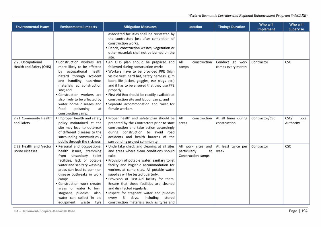
Western Economic Corridor and Regional Enhancement Program (WeCARE)
EIA – Hatikumrul- Bonpara-Jhenaidah Road Page | 194
Environmental Issues Environmental Impacts Mitigation Measures Location Timing/ Duration Who will
Implement Who will Supervise
associated facilities shall be reinstated by the contractors just after completion of construction works.
▪ Debris, construction wastes, vegetation or other materials shall not be burned on the site.
2.20 Occupational Health and Safety (OHS)
▪ Construction workers are more likely to be affected by occupational health hazard through accident and handling hazardous materials at construction site; and
▪ Construction workers are also likely to be affected by water borne diseases and food poisoning at construction camp.
▪ An OHS plan should be prepared and followed during construction work;
▪ Workers have to be provided PPE (high visible vest, hard hat, safety harness, gum boot, life jacket, goggles, ear plugs etc.) and it has to be ensured that they use PPE properly;
▪ First Aid Box should be readily available at construction site and labour camp; and
▪ Separate accommodation and toilet for female workers.
All construction camps
Conduct at work camps every month
Contractor CSC
2.21 Community Health and Safety
▪ Improper health and safety policy maintained at the site may lead to outbreak of different diseases to the surrounding communities / public through the sickness
▪ Proper health and safety plan should be prepared by the Contractors prior to start construction and take action accordingly during construction to avoid road accidents and health hazards of the surrounding project community.
All construction areas
At all times during construction
Contractor/CSC CSC/ Local Authority
2.22 Health and Vector Borne Diseases
▪ Personal and occupational health issues, stemming from unsanitary toilet facilities, lack of potable water and sanitary washing areas can lead to common disease outbreaks in work camps.
▪ Construction work creates areas for water to form stagnant puddles; Also, water can collect in old equipment waste tyre
▪ Undertake check and cleaning at all sites and areas where clean conditions should exist.
▪ Provision of potable water, sanitary toilet facility and hygienic accommodation for workers at camp sites. All potable water supplies will be tested quarterly.
▪ Provision of First-Aid facility for them. Ensure that these facilities are cleaned and disinfected regularly.
▪ Inspect for stagnant water and puddles every 3 days, including stored construction materials such as tyres and
All work sites and particularly at Construction camps
At least twice per week
Contractor CSC
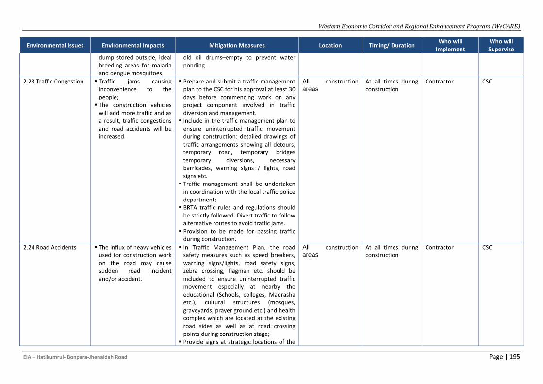
Western Economic Corridor and Regional Enhancement Program (WeCARE)
EIA – Hatikumrul- Bonpara-Jhenaidah Road Page | 195
Environmental Issues Environmental Impacts Mitigation Measures Location Timing/ Duration Who will
Implement Who will Supervise
dump stored outside, ideal breeding areas for malaria and dengue mosquitoes.
old oil drums–empty to prevent water ponding.
2.23 Traffic Congestion ▪ Traffic jams causing inconvenience to the people;
▪ The construction vehicles will add more traffic and as a result, traffic congestions and road accidents will be increased.
▪ Prepare and submit a traffic management plan to the CSC for his approval at least 30 days before commencing work on any project component involved in traffic diversion and management.
▪ Include in the traffic management plan to ensure uninterrupted traffic movement during construction: detailed drawings of traffic arrangements showing all detours, temporary road, temporary bridges temporary diversions, necessary barricades, warning signs / lights, road signs etc.
▪ Traffic management shall be undertaken in coordination with the local traffic police department;
▪ BRTA traffic rules and regulations should be strictly followed. Divert traffic to follow alternative routes to avoid traffic jams.
▪ Provision to be made for passing traffic during construction.
All construction
areas
At all times during construction
Contractor CSC
2.24 Road Accidents ▪ The influx of heavy vehicles used for construction work on the road may cause sudden road incident and/or accident.
▪ In Traffic Management Plan, the road safety measures such as speed breakers, warning signs/lights, road safety signs, zebra crossing, flagman etc. should be included to ensure uninterrupted traffic movement especially at nearby the educational (Schools, colleges, Madrasha etc.), cultural structures (mosques, graveyards, prayer ground etc.) and health complex which are located at the existing road sides as well as at road crossing points during construction stage;
▪ Provide signs at strategic locations of the
All construction
areas
At all times during construction
Contractor CSC
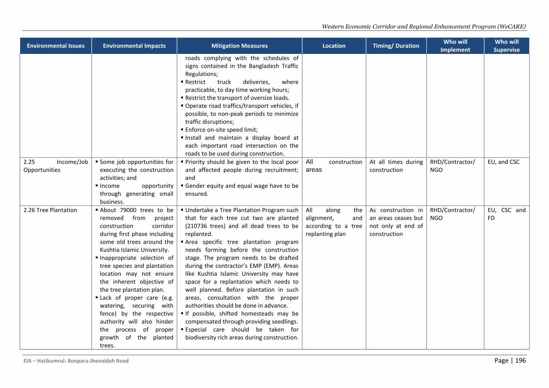
Western Economic Corridor and Regional Enhancement Program (WeCARE)
EIA – Hatikumrul- Bonpara-Jhenaidah Road Page | 196
Environmental Issues Environmental Impacts Mitigation Measures Location Timing/ Duration Who will
Implement Who will Supervise
roads complying with the schedules of signs contained in the Bangladesh Traffic Regulations;
▪ Restrict truck deliveries, where practicable, to day time working hours;
▪ Restrict the transport of oversize loads. ▪ Operate road traffics/transport vehicles, if
possible, to non-peak periods to minimize traffic disruptions;
▪ Enforce on-site speed limit; ▪ Install and maintain a display board at
each important road intersection on the roads to be used during construction.
2.25 Income/Job Opportunities
▪ Some job opportunities for executing the construction activities; and
▪ Income opportunity through generating small business.
▪ Priority should be given to the local poor and affected people during recruitment; and
▪ Gender equity and equal wage have to be ensured.
All construction
areas
At all times during construction
RHD/Contractor/ NGO
EU, and CSC
2.26 Tree Plantation ▪ About 79000 trees to be removed from project construction corridor during first phase including some old trees around the Kushtia Islamic University.
▪ Inappropriate selection of tree species and plantation location may not ensure the inherent objective of the tree plantation plan.
▪ Lack of proper care (e.g. watering, securing with fence) by the respective authority will also hinder the process of proper growth of the planted trees.
▪ Undertake a Tree Plantation Program such that for each tree cut two are planted (210736 trees) and all dead trees to be replanted.
▪ Area specific tree plantation program needs forming before the construction stage. The program needs to be drafted during the contractor’s EMP (EMP). Areas like Kushtia Islamic University may have space for a replantation which needs to well planned. Before plantation in such areas, consultation with the proper authorities should be done in advance.
▪ If possible, shifted homesteads may be compensated through providing seedlings.
▪ Especial care should be taken for biodiversity rich areas during construction.
All along the alignment, and according to a tree replanting plan
As construction in an areas ceases but not only at end of construction
RHD/Contractor/ NGO
EU, CSC and FD
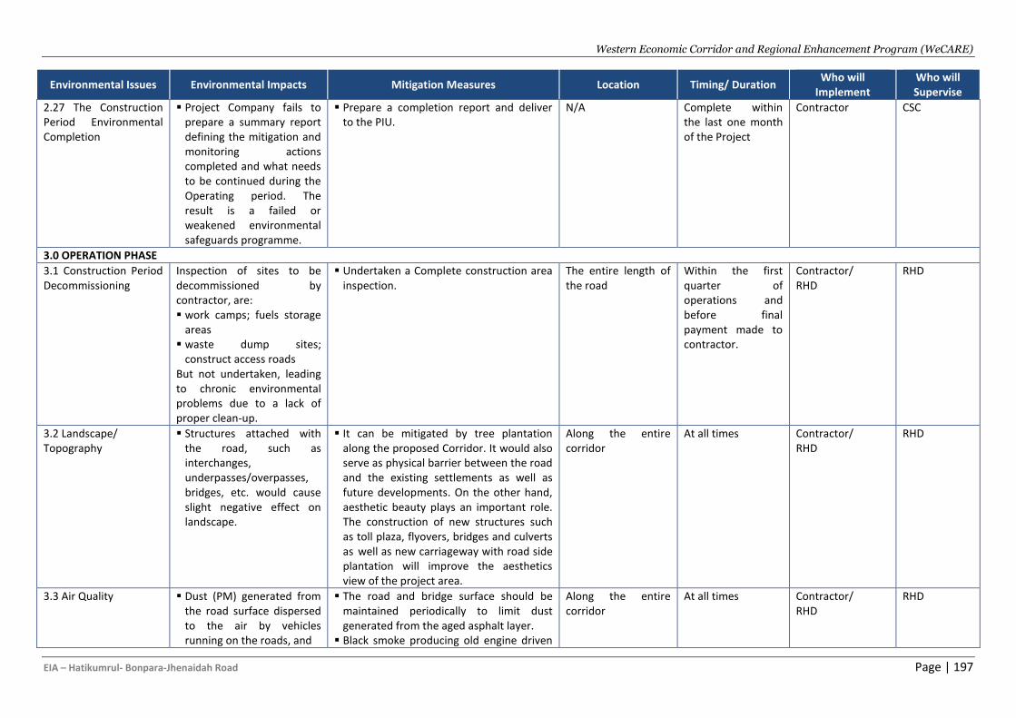
Western Economic Corridor and Regional Enhancement Program (WeCARE)
EIA – Hatikumrul- Bonpara-Jhenaidah Road Page | 197
Environmental Issues Environmental Impacts Mitigation Measures Location Timing/ Duration Who will
Implement Who will Supervise
2.27 The Construction Period Environmental Completion
▪ Project Company fails to prepare a summary report defining the mitigation and monitoring actions completed and what needs to be continued during the Operating period. The result is a failed or weakened environmental safeguards programme.
▪ Prepare a completion report and deliver to the PIU.
N/A Complete within the last one month of the Project
Contractor CSC
3.0 OPERATION PHASE
3.1 Construction Period Decommissioning
Inspection of sites to be decommissioned by contractor, are: ▪ work camps; fuels storage
areas ▪ waste dump sites;
construct access roads But not undertaken, leading to chronic environmental problems due to a lack of proper clean-up.
▪ Undertaken a Complete construction area inspection.
The entire length of the road
Within the first quarter of operations and before final payment made to contractor.
Contractor/ RHD
RHD
3.2 Landscape/ Topography
▪ Structures attached with the road, such as interchanges, underpasses/overpasses, bridges, etc. would cause slight negative effect on landscape.
▪ It can be mitigated by tree plantation along the proposed Corridor. It would also serve as physical barrier between the road and the existing settlements as well as future developments. On the other hand, aesthetic beauty plays an important role. The construction of new structures such as toll plaza, flyovers, bridges and culverts as well as new carriageway with road side plantation will improve the aesthetics view of the project area.
Along the entire corridor
At all times Contractor/ RHD
RHD
3.3 Air Quality ▪ Dust (PM) generated from the road surface dispersed to the air by vehicles running on the roads, and
▪ The road and bridge surface should be maintained periodically to limit dust generated from the aged asphalt layer.
▪ Black smoke producing old engine driven
Along the entire corridor
At all times Contractor/ RHD
RHD
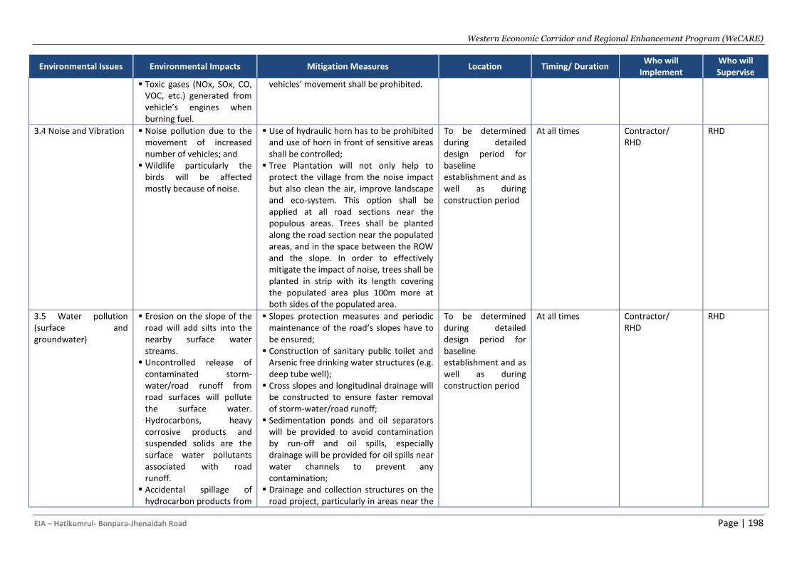
Western Economic Corridor and Regional Enhancement Program (WeCARE)
EIA – Hatikumrul- Bonpara-Jhenaidah Road Page | 198
Environmental Issues Environmental Impacts Mitigation Measures Location Timing/ Duration Who will
Implement Who will Supervise
▪ Toxic gases (NOx, SOx, CO, VOC, etc.) generated from vehicle’s engines when burning fuel.
vehicles’ movement shall be prohibited.
3.4 Noise and Vibration ▪ Noise pollution due to the movement of increased number of vehicles; and
▪ Wildlife particularly the birds will be affected mostly because of noise.
▪ Use of hydraulic horn has to be prohibited and use of horn in front of sensitive areas shall be controlled;
▪ Tree Plantation will not only help to protect the village from the noise impact but also clean the air, improve landscape and eco-system. This option shall be applied at all road sections near the populous areas. Trees shall be planted along the road section near the populated areas, and in the space between the ROW and the slope. In order to effectively mitigate the impact of noise, trees shall be planted in strip with its length covering the populated area plus 100m more at both sides of the populated area.
To be determined during detailed design period for baseline establishment and as well as during construction period
At all times Contractor/ RHD
RHD
3.5 Water pollution (surface and groundwater)
▪ Erosion on the slope of the road will add silts into the nearby surface water streams.
▪ Uncontrolled release of contaminated storm-water/road runoff from road surfaces will pollute the surface water. Hydrocarbons, heavy corrosive products and suspended solids are the surface water pollutants associated with road runoff.
▪ Accidental spillage of hydrocarbon products from
▪ Slopes protection measures and periodic maintenance of the road’s slopes have to be ensured;
▪ Construction of sanitary public toilet and Arsenic free drinking water structures (e.g. deep tube well);
▪ Cross slopes and longitudinal drainage will be constructed to ensure faster removal of storm-water/road runoff;
▪ Sedimentation ponds and oil separators will be provided to avoid contamination by run-off and oil spills, especially drainage will be provided for oil spills near water channels to prevent any contamination;
▪ Drainage and collection structures on the road project, particularly in areas near the
To be determined during detailed design period for baseline establishment and as well as during construction period
At all times Contractor/ RHD
RHD
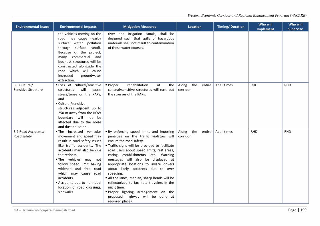
Western Economic Corridor and Regional Enhancement Program (WeCARE)
EIA – Hatikumrul- Bonpara-Jhenaidah Road Page | 199
Environmental Issues Environmental Impacts Mitigation Measures Location Timing/ Duration Who will
Implement Who will Supervise
the vehicles moving on the road may cause nearby surface water pollution through surface runoff. Because of the project, many commercial and business structures will be constructed alongside the road which will cause increased groundwater extraction.
river and irrigation canals, shall be designed such that spills of hazardous materials shall not result to contamination of these water courses.
3.6 Cultural/ Sensitive Structure
▪ Loss of cultural/sensitive structures will cause stress/tense on the PAPs; and
▪ Cultural/sensitive structures adjacent up to 250 m away from the ROW boundary will not be affected due to the noise and dust pollution.
▪ Proper rehabilitation of the cultural/sensitive structures will ease out the stresses of the PAPs.
Along the entire corridor
At all times RHD RHD
3.7 Road Accidents/ Road safety
▪ The increased vehicular movement and speed may result in road safety issues like traffic accidents. The accidents may also be due to tiredness.
▪ The vehicles may not follow speed limit having widened and free road which may cause road accidents.
▪ Accidents due to non-ideal location of road crossings, sidewalks
▪ By enforcing speed limits and imposing penalties on the traffic violators will ensure the road safety.
▪ Traffic signs will be provided to facilitate road users about speed limits, rest areas, eating establishments etc. Warning messages will also be displayed at appropriate locations to aware drivers about likely accidents due to over speeding.
▪ All the lanes, median, sharp bends will be reflectorized to facilitate travelers in the night time.
▪ Proper lighting arrangement on the proposed highway will be done at required places.
Along the entire corridor
At all times RHD RHD
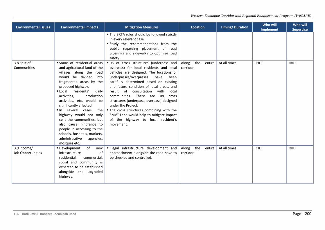
Western Economic Corridor and Regional Enhancement Program (WeCARE)
EIA – Hatikumrul- Bonpara-Jhenaidah Road Page | 200
Environmental Issues Environmental Impacts Mitigation Measures Location Timing/ Duration Who will
Implement Who will Supervise
▪ The BRTA rules should be followed strictly in every relevant case.
▪ Study the recommendations from the public regarding placement of road crossings and sidewalks to optimize road safety.
3.8 Split of Communities
▪ Some of residential areas and agricultural land of the villages along the road would be divided into fragmented areas by the proposed highway.
▪ Local residents’ daily activities, production activities, etc. would be significantly affected.
▪ In several cases, the highway would not only split the communities, but also cause hindrance to people in accessing to the schools, hospitals, markets, administrative agencies, mosques etc.
▪ 08 of cross structures (underpass and overpass) for local residents and local vehicles are designed. The locations of underpasses/overpasses have been carefully determined based on existing and future condition of local areas, and result of consultation with local communities. There are 08 cross structures (underpass, overpass) designed under the Project.
▪ The cross structures combining with the SMVT Lane would help to mitigate impact of the highway to local resident’s movement.
Along the entire corridor
At all times RHD RHD
3.9 Income/ Job Opportunities
▪ Development of new infrastructure of residential, commercial, social and community is expected to be established alongside the upgraded highway.
▪ Illegal infrastructure development and encroachment alongside the road have to be checked and controlled.
Along the entire corridor
At all times RHD RHD
Western Economic Corridor and Regional Enhancement Program (WeCARE)
EIA – Hatikumrul-Bonpara-Jhenaidah Road Page | 201
D. Environmental and Social Monitoring Plan
539. The monitoring plan is one of the important tools of the implementing the mitigation plan for the proposed road project. The Monitoring plan provides guidance regarding environmental issues/parameters, location, frequency and means of monitoring. 540. The aim of environmental monitoring during the pre-construction, construction and operation phases of the project road is to compare the monitored data against the baseline condition collected during the study period (particularly during the detailed design stage) to assess the effectiveness of the mitigation measures and the protection of environmental components (e.g. air, water, soil, noise etc.) based on the national environmental standards (e.g. ECR 1997). Since the project is likely to have impact on various components of the environment, a comprehensive monitoring plan covering soil erosion, drainage congestion, tree plantation, air quality, water quality, noise, wildlife movement, workers’ and community health and safety and so on need to be developed. 541. An Environmental and Social Monitoring Plan (ESMoP) has been prepared (Table IX.2) along with this EIA for the execution as a means to mitigate or minimize the adverse impacts associated with construction and operational activities of the project on the natural and social environments.
1. Objectives
542. The objective of environmental monitoring during the construction and operation phases is to compare the monitored data against the baseline condition collected during the study period to assess the effectiveness of the mitigation measures and the protection of the ambient environment based on national standards. The main objectives of the pre-construction, construction and operation phase monitoring plans will be to:
i. Monitor the actual impact of the works on physical, biological and socioeconomic receptors within the project corridor for indicating the adequacy of the EIA;
ii. Recommend mitigation measures for any unexpected impact or where the impact level exceeds that anticipated in the EIA;
iii. Ensure compliance with legal and community obligations including safety on construction sites;
iv. Monitor the rehabilitation of borrow areas and the restoration of construction campsites as described in the ESMP;
v. Ensure the safe disposal of excess construction materials.
vi. Appraise the adequacy of the EIA with respect to the project’s predicted long-term impacts on the corridor’s physical, biological and socio-economic environment;
vii. Evaluate the effectiveness of the mitigation measures proposed in the ESMP and recommend improvements, if and when necessary;
viii. Compile periodic accident data to support analyses that will help minimize future risks; and
ix. Monitor the survival rate of avenue plantations.
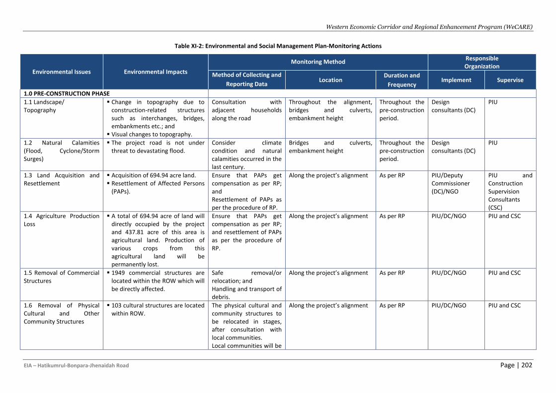
Western Economic Corridor and Regional Enhancement Program (WeCARE)
EIA – Hatikumrul-Bonpara-Jhenaidah Road Page | 202
Table XI-2: Environmental and Social Management Plan-Monitoring Actions
Environmental Issues Environmental Impacts
Monitoring Method Responsible Organization
Method of Collecting and
Reporting Data Location
Duration and
Frequency Implement Supervise
1.0 PRE-CONSTRUCTION PHASE
1.1 Landscape/ Topography
▪ Change in topography due to construction-related structures such as interchanges, bridges, embankments etc.; and
▪ Visual changes to topography.
Consultation with adjacent households along the road
Throughout the alignment, bridges and culverts, embankment height
Throughout the pre-construction period.
Design consultants (DC)
PIU
1.2 Natural Calamities (Flood, Cyclone/Storm Surges)
▪ The project road is not under threat to devastating flood.
Consider climate condition and natural calamities occurred in the last century.
Bridges and culverts, embankment height
Throughout the pre-construction period.
Design consultants (DC)
PIU
1.3 Land Acquisition and Resettlement
▪ Acquisition of 694.94 acre land. ▪ Resettlement of Affected Persons
(PAPs).
Ensure that PAPs get compensation as per RP; and Resettlement of PAPs as per the procedure of RP.
Along the project’s alignment As per RP PIU/Deputy Commissioner (DC)/NGO
PIU and Construction Supervision Consultants (CSC)
1.4 Agriculture Production Loss
▪ A total of 694.94 acre of land will directly occupied by the project and 437.81 acre of this area is agricultural land. Production of various crops from this agricultural land will be permanently lost.
Ensure that PAPs get compensation as per RP; and resettlement of PAPs as per the procedure of RP.
Along the project’s alignment As per RP PIU/DC/NGO PIU and CSC
1.5 Removal of Commercial Structures
▪ 1949 commercial structures are located within the ROW which will be directly affected.
Safe removal/or relocation; and Handling and transport of debris.
Along the project’s alignment As per RP PIU/DC/NGO PIU and CSC
1.6 Removal of Physical Cultural and Other Community Structures
▪ 103 cultural structures are located within ROW.
The physical cultural and community structures to be relocated in stages, after consultation with local communities. Local communities will be
Along the project’s alignment As per RP PIU/DC/NGO PIU and CSC
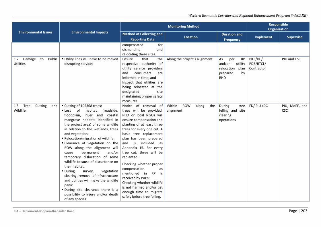
Western Economic Corridor and Regional Enhancement Program (WeCARE)
EIA – Hatikumrul-Bonpara-Jhenaidah Road Page | 203
Environmental Issues Environmental Impacts
Monitoring Method Responsible Organization
Method of Collecting and
Reporting Data Location
Duration and
Frequency Implement Supervise
compensated for dismantling and relocating these sites.
1.7 Damage to Public Utilities
▪ Utility lines will have to be moved disrupting services
Ensure that the respective authority of utility service providers and consumers are informed in time; and Inspect that utilities are being relocated at the designated site maintaining proper safety measures
Along the project’s alignment As per RP and/or utility relocation plan prepared by RHD
PIU /DC/ PDB/BTCL/ Contractor
PIU and CSC
1.8 Tree Cutting and Wildlife
▪ Cutting of 105368 trees; ▪ Loss of habitat (roadside,
floodplain, river and coastal mangrove habitats identified in the project area) of some wildlife in relation to the wetlands, trees and vegetation;
▪ Relocation/migration of wildlife; ▪ Clearance of vegetation on the
ROW along the alignment will cause permanent and/or temporary dislocation of some wildlife because of disturbance on their habitat.
▪ During survey, vegetation clearing, removal of infrastructure and utilities will make the wildlife panic.
▪ During site clearance there is a possibility to injure and/or death of any species.
Notice of removal of trees will be provided. RHD or local NGOs will ensure compensation and planting of at least three trees for every one cut. A basic tree replacement plan has been prepared and is included as Appendix 15. For every tree cut, three will be replanted.
Checking whether proper compensation as mentioned in RP is received by PAPs; Checking whether wildlife is not harmed and/or get enough time to migrate safely before tree felling.
Within ROW along the alignment
During tree felling and site clearing operations
FD/ PIU /DC PIU, MoEF, and CSC
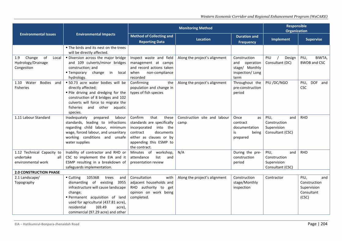
Western Economic Corridor and Regional Enhancement Program (WeCARE)
EIA – Hatikumrul-Bonpara-Jhenaidah Road Page | 204
Environmental Issues Environmental Impacts
Monitoring Method Responsible Organization
Method of Collecting and
Reporting Data Location
Duration and
Frequency Implement Supervise
▪ The birds and its nest on the trees will be directly affected.
1.9 Change of Local Hydrology/Drainage Congestion
▪ Diversion across the major bridge and 109 culverts/minor bridges construction; and
▪ Temporary change in local hydrology.
Inspect waste and field management at camps and record actions taken when non-compliance recorded
Along the project’s alignment Construction and operation stage/ Monthly inspection/ Long term
PIU / Design Consultant (DC)
PIU, BIWTA, BWDB and CSC
1.10 Water Bodies and Fisheries
▪ 50.73 acre water bodies will be directly affected;
▪ Pile driving and dredging for the construction of 8 bridges and 102 culverts will force to migrate the fisheries and other aquatic species.
Confirming the population and change in types of fish species
Along the project’s alignment Throughout the pre-construction period
PIU /DC/NGO
PIU, DOF and CSC
1.11 Labour Standard Inadequately prepared labour standards, leading to infractions regarding child labour, minimum wage, forced labour, and unsanitary working conditions and unsafe water supplies
Confirm that these standards are specifically incorporated into the contract documents either as clauses or by appending this ESMP to the contract.
Construction site and labour camp
Once as contract documentation is being prepared
PIU, and Construction Supervision Consultant (CSC)
RHD
1.12 Technical Capacity to undertake all environmental work
Inability of contractor and RHD or CSC to implement the EIA and it ESMP resulting in a breakdown of safeguards implementation.
Minutes of workshop, attendance list and presentation review
N/A During the pre-construction period
PIU, and Construction Supervision Consultant (CSC)
RHD
2.0 CONSTRUCTION PHASE
2.1 Landscape/ Topography
▪ Cutting 105368 trees and dismantling of existing 3955 infrastructure will cause landscape change;
▪ Permanent acquisition of land used for agricultural (437.81 acre), residential (69.49 acre), commercial (97.29 acre) and other
Consultation with adjacent households and RHD authority to get opinion on work being completed.
Along the project’s alignment Construction stage/Monthly inspection
Contractor PIU, and Construction Supervision Consultant (CSC)
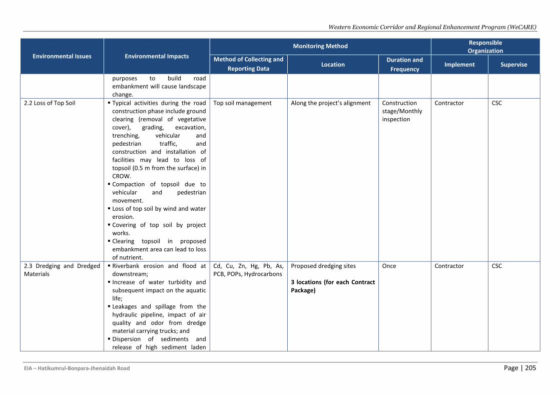
Western Economic Corridor and Regional Enhancement Program (WeCARE)
EIA – Hatikumrul-Bonpara-Jhenaidah Road Page | 205
Environmental Issues Environmental Impacts
Monitoring Method Responsible Organization
Method of Collecting and
Reporting Data Location
Duration and
Frequency Implement Supervise
purposes to build road embankment will cause landscape change.
2.2 Loss of Top Soil ▪ Typical activities during the road construction phase include ground clearing (removal of vegetative cover), grading, excavation, trenching, vehicular and pedestrian traffic, and construction and installation of facilities may lead to loss of topsoil (0.5 m from the surface) in CROW.
▪ Compaction of topsoil due to vehicular and pedestrian movement.
▪ Loss of top soil by wind and water erosion.
▪ Covering of top soil by project works.
▪ Clearing topsoil in proposed embankment area can lead to loss of nutrient.
Top soil management Along the project’s alignment Construction stage/Monthly inspection
Contractor CSC
2.3 Dredging and Dredged Materials
▪ Riverbank erosion and flood at downstream;
▪ Increase of water turbidity and subsequent impact on the aquatic life;
▪ Leakages and spillage from the hydraulic pipeline, impact of air quality and odor from dredge material carrying trucks; and
▪ Dispersion of sediments and release of high sediment laden
Cd, Cu, Zn, Hg, Pb, As, PCB, POPs, Hydrocarbons
Proposed dredging sites 3 locations (for each Contract Package)
Once Contractor CSC
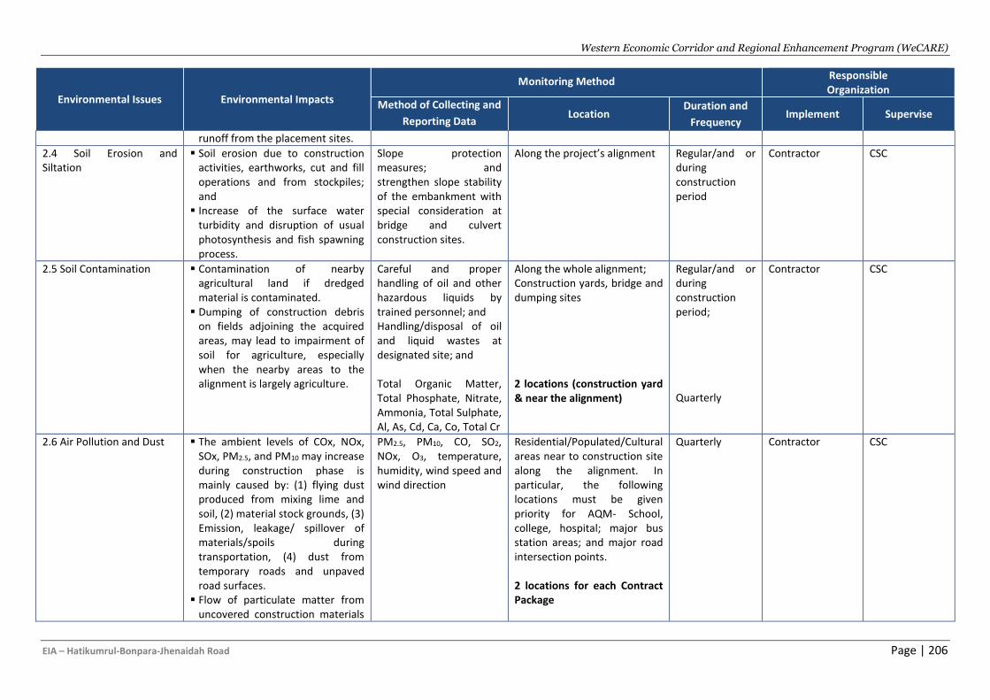
Western Economic Corridor and Regional Enhancement Program (WeCARE)
EIA – Hatikumrul-Bonpara-Jhenaidah Road Page | 206
Environmental Issues Environmental Impacts
Monitoring Method Responsible Organization
Method of Collecting and
Reporting Data Location
Duration and
Frequency Implement Supervise
runoff from the placement sites.
2.4 Soil Erosion and Siltation
▪ Soil erosion due to construction activities, earthworks, cut and fill operations and from stockpiles; and
▪ Increase of the surface water turbidity and disruption of usual photosynthesis and fish spawning process.
Slope protection measures; and strengthen slope stability of the embankment with special consideration at bridge and culvert construction sites.
Along the project’s alignment Regular/and or during construction period
Contractor CSC
2.5 Soil Contamination ▪ Contamination of nearby agricultural land if dredged material is contaminated.
▪ Dumping of construction debris on fields adjoining the acquired areas, may lead to impairment of soil for agriculture, especially when the nearby areas to the alignment is largely agriculture.
Careful and proper handling of oil and other hazardous liquids by trained personnel; and Handling/disposal of oil and liquid wastes at designated site; and Total Organic Matter, Total Phosphate, Nitrate, Ammonia, Total Sulphate, Al, As, Cd, Ca, Co, Total Cr
Along the whole alignment; Construction yards, bridge and dumping sites 2 locations (construction yard & near the alignment)
Regular/and or during construction period;
Quarterly
Contractor CSC
2.6 Air Pollution and Dust ▪ The ambient levels of COx, NOx, SOx, PM2.5, and PM10 may increase during construction phase is mainly caused by: (1) flying dust produced from mixing lime and soil, (2) material stock grounds, (3) Emission, leakage/ spillover of materials/spoils during transportation, (4) dust from temporary roads and unpaved road surfaces.
▪ Flow of particulate matter from uncovered construction materials
PM2.5, PM10, CO, SO2, NOx, O3, temperature, humidity, wind speed and wind direction
Residential/Populated/Cultural areas near to construction site along the alignment. In particular, the following locations must be given priority for AQM- School, college, hospital; major bus station areas; and major road intersection points. 2 locations for each Contract Package
Quarterly Contractor CSC
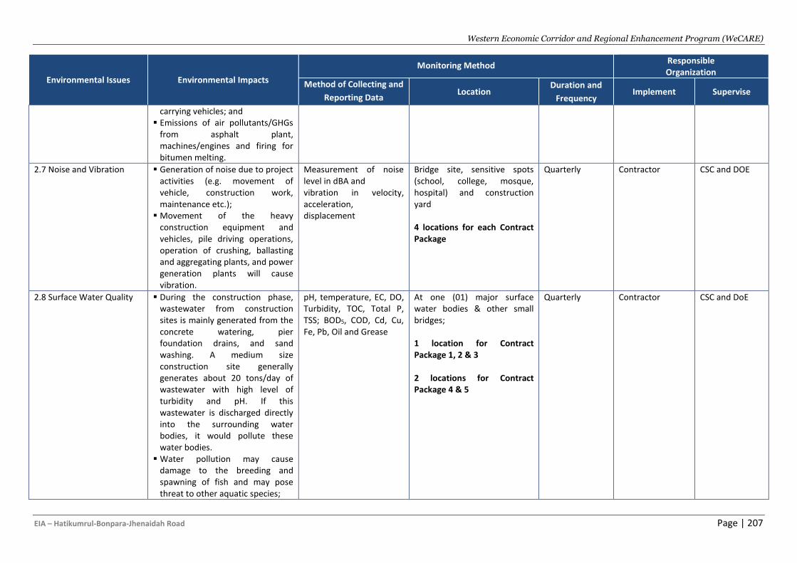
Western Economic Corridor and Regional Enhancement Program (WeCARE)
EIA – Hatikumrul-Bonpara-Jhenaidah Road Page | 207
Environmental Issues Environmental Impacts
Monitoring Method Responsible Organization
Method of Collecting and
Reporting Data Location
Duration and
Frequency Implement Supervise
carrying vehicles; and ▪ Emissions of air pollutants/GHGs
from asphalt plant, machines/engines and firing for bitumen melting.
2.7 Noise and Vibration ▪ Generation of noise due to project activities (e.g. movement of vehicle, construction work, maintenance etc.);
▪ Movement of the heavy construction equipment and vehicles, pile driving operations, operation of crushing, ballasting and aggregating plants, and power generation plants will cause vibration.
Measurement of noise level in dBA and vibration in velocity, acceleration, displacement
Bridge site, sensitive spots (school, college, mosque, hospital) and construction yard 4 locations for each Contract Package
Quarterly Contractor CSC and DOE
2.8 Surface Water Quality ▪ During the construction phase, wastewater from construction sites is mainly generated from the concrete watering, pier foundation drains, and sand washing. A medium size construction site generally generates about 20 tons/day of wastewater with high level of turbidity and pH. If this wastewater is discharged directly into the surrounding water bodies, it would pollute these water bodies.
▪ Water pollution may cause damage to the breeding and spawning of fish and may pose threat to other aquatic species;
pH, temperature, EC, DO, Turbidity, TOC, Total P, TSS; BOD5, COD, Cd, Cu, Fe, Pb, Oil and Grease
At one (01) major surface water bodies & other small bridges; 1 location for Contract Package 1, 2 & 3 2 locations for Contract Package 4 & 5
Quarterly Contractor CSC and DoE
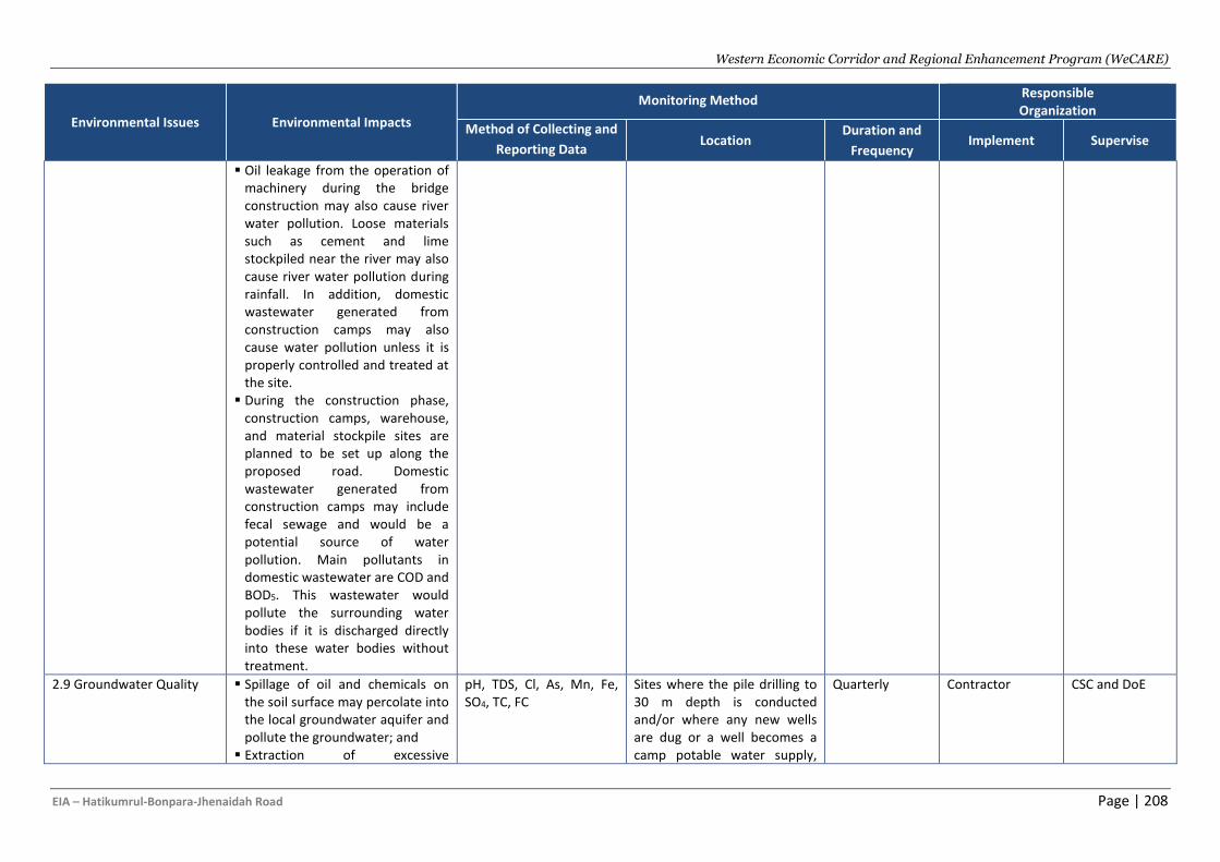
Western Economic Corridor and Regional Enhancement Program (WeCARE)
EIA – Hatikumrul-Bonpara-Jhenaidah Road Page | 208
Environmental Issues Environmental Impacts
Monitoring Method Responsible Organization
Method of Collecting and
Reporting Data Location
Duration and
Frequency Implement Supervise
▪ Oil leakage from the operation of machinery during the bridge construction may also cause river water pollution. Loose materials such as cement and lime stockpiled near the river may also cause river water pollution during rainfall. In addition, domestic wastewater generated from construction camps may also cause water pollution unless it is properly controlled and treated at the site.
▪ During the construction phase, construction camps, warehouse, and material stockpile sites are planned to be set up along the proposed road. Domestic wastewater generated from construction camps may include fecal sewage and would be a potential source of water pollution. Main pollutants in domestic wastewater are COD and BOD5. This wastewater would pollute the surrounding water bodies if it is discharged directly into these water bodies without treatment.
2.9 Groundwater Quality ▪ Spillage of oil and chemicals on the soil surface may percolate into the local groundwater aquifer and pollute the groundwater; and
▪ Extraction of excessive
pH, TDS, Cl, As, Mn, Fe, SO4, TC, FC
Sites where the pile drilling to 30 m depth is conducted and/or where any new wells are dug or a well becomes a camp potable water supply,
Quarterly Contractor CSC and DoE
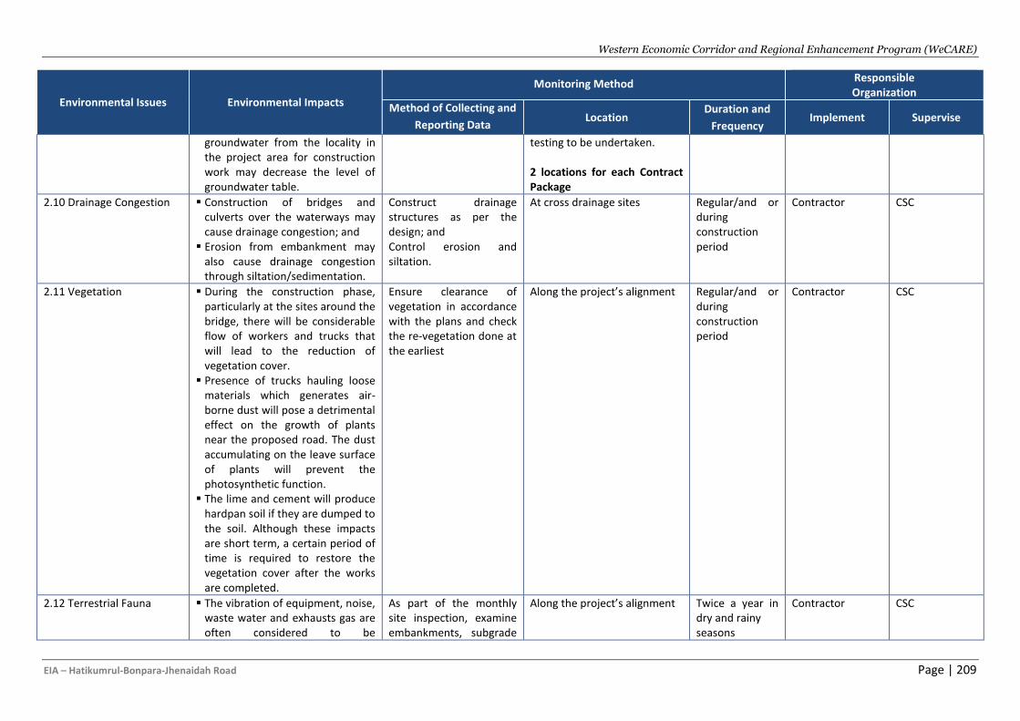
Western Economic Corridor and Regional Enhancement Program (WeCARE)
EIA – Hatikumrul-Bonpara-Jhenaidah Road Page | 209
Environmental Issues Environmental Impacts
Monitoring Method Responsible Organization
Method of Collecting and
Reporting Data Location
Duration and
Frequency Implement Supervise
groundwater from the locality in the project area for construction work may decrease the level of groundwater table.
testing to be undertaken. 2 locations for each Contract Package
2.10 Drainage Congestion ▪ Construction of bridges and culverts over the waterways may cause drainage congestion; and
▪ Erosion from embankment may also cause drainage congestion through siltation/sedimentation.
Construct drainage structures as per the design; and Control erosion and siltation.
At cross drainage sites Regular/and or during construction period
Contractor CSC
2.11 Vegetation ▪ During the construction phase, particularly at the sites around the bridge, there will be considerable flow of workers and trucks that will lead to the reduction of vegetation cover.
▪ Presence of trucks hauling loose materials which generates air-borne dust will pose a detrimental effect on the growth of plants near the proposed road. The dust accumulating on the leave surface of plants will prevent the photosynthetic function.
▪ The lime and cement will produce hardpan soil if they are dumped to the soil. Although these impacts are short term, a certain period of time is required to restore the vegetation cover after the works are completed.
Ensure clearance of vegetation in accordance with the plans and check the re-vegetation done at the earliest
Along the project’s alignment Regular/and or during construction period
Contractor CSC
2.12 Terrestrial Fauna
▪ The vibration of equipment, noise, waste water and exhausts gas are often considered to be
As part of the monthly site inspection, examine embankments, subgrade
Along the project’s alignment Twice a year in dry and rainy seasons
Contractor CSC
Western Economic Corridor and Regional Enhancement Program (WeCARE)
EIA – Hatikumrul-Bonpara-Jhenaidah Road Page | 210
Environmental Issues Environmental Impacts
Monitoring Method Responsible Organization
Method of Collecting and
Reporting Data Location
Duration and
Frequency Implement Supervise
disturbances to animals. These could drive animals away from their current habitats.
▪ During the construction phase, trees around the construction sites may be cut down and cause damage to the habitat of wild animals.
▪ Illegal hunting may also occur and pose the threat to wild animals.
▪ During construction phase, air pollution, wastewater, and solid waste generated by the construction works may also deteriorate the animals’ habitat, and may force them to evacuate to another habitat.
▪ Construction of temporary construction sites and access roads may lead to damage and deterioration of local ecosystems.
storage areas, to confirm these facilities are not contributing to environmental degradation
2.13 Aquatic Species ▪ Water pollution may change the dominance and the composition of the plankton. Water pollution will reduce species numbers and relative abundances of populations.
▪ Construction materials stored near the watercourses, uncovered excavated soil, stone dumps, and construction wastes may be easily washed out and flow into the water sources by rainfall, thus pollute the watercourses, change
Evaluation of existence of species; Benthos & Plankton
Major bridge locations and other water bodies 1 location for Contract Package 1, 2 & 3 2 locations for Contract Package 4 & 5
Quarterly Contractor CSC
Western Economic Corridor and Regional Enhancement Program (WeCARE)
EIA – Hatikumrul-Bonpara-Jhenaidah Road Page | 211
Environmental Issues Environmental Impacts
Monitoring Method Responsible Organization
Method of Collecting and
Reporting Data Location
Duration and
Frequency Implement Supervise
the water's pH value and deteriorate the aquatic animals' habitats. This can lead to plankton and benthos deaths and aquatic biomass reduction in the construction areas.
2.14 Fisheries
▪ The construction of bridges may lead to the loss of fish habitat due to increased turbidity, decreased dissolved oxygen in the water, and reduction of food sources including temporary decline of plankton and benthos organisms. Increase in suspended solids in the rivers would drive fishes away from the bridge construction sites during the construction phase.
▪ Ponds are used for exotic fish culture which has little conservation significance.
Confirming the population and change in types of fish species
Along the project’s alignment Twice a year in dry and rainy seasons
Contractor CSC
2.15 Loss of Agricultural Production
▪ Earth filling may alter the soil development and soil structure, damage soil texture, lead to loss of organic matter and inorganic nutrients in soil, soil fertility and water-holding capacity, deteriorate soil quality, cause soil erosion and loss of agricultural production.
▪ Loss of floodplain areas with consequent loss of crops.
▪ Sand removal with wind blow and rain water runoff from road
Measurement for changing cropping pattern to compensate the loss of crop production
Along the project’s alignment Twice a year in dry and rainy seasons
Contractor CSC
Western Economic Corridor and Regional Enhancement Program (WeCARE)
EIA – Hatikumrul-Bonpara-Jhenaidah Road Page | 212
Environmental Issues Environmental Impacts
Monitoring Method Responsible Organization
Method of Collecting and
Reporting Data Location
Duration and
Frequency Implement Supervise
construction place to nearby agricultural field will result in increased sand percentage which will ultimately change the soil composition i.e. its texture.
▪ Most of the burrow pits will be filled; winter cropping will face some difficulties as water retention area will be shrunk.
▪ Various types of heavy vehicles and machineries will go also on the besides agricultural land; thus, soil compaction and direct loss of standing crop of one season will be completely or partially destroyed.
▪ Soils of adjacent area of road may be changed in texture and fertility with mixing up with external sand and soils, sometimes oil spills, mobile, pitch, dust, ash etc.
▪ Increased movement of construction laborers will have adverse impacts on adjacent crop fields.
▪ Some marginal and landless farmers may become unemployed due to loss of agricultural land and water logging.
▪ Fencing will obstruct cattle movement across the road and thus may cause adverse impacts on agricultural activity like ploughing and cow grazing.
Western Economic Corridor and Regional Enhancement Program (WeCARE)
EIA – Hatikumrul-Bonpara-Jhenaidah Road Page | 213
Environmental Issues Environmental Impacts
Monitoring Method Responsible Organization
Method of Collecting and
Reporting Data Location
Duration and
Frequency Implement Supervise
▪ Photosynthesis of nearby crops in the corridor may become slower due to regular deposition of dust and smoke on leaves surfaces created in by vehicles movement.
2.16 Pollution from Wastes
▪ Dismantling of any structure will generate solid waste; and
▪ Kitchen and sewage wastes from labour camp will cause growth of flies and water born germs.
Waste and effluents to be collected and disposed safely to the designated sites;
Construction yard, bridge and dumping sites
Weekly Contractor CSC
2.17 Asphalt Hot Mix Plant, Rock Crushing, and Bitumen Supply
▪ Rock crushing activities will generate noise and dust, and asphalt hot-mix plant and pavement works will generate gas and odour while compaction of the pavement will also generate noise and dust.
▪ It is also possible that soil may be contaminated by oils and chemicals at asphalt/bitumen plant sites, workshop areas, and equipment washing yards.
▪ The contamination may limit the future use of the land for agricultural purposes.
Wastes and garbage from bridge construction sites to be disposed properly at the designated sites.
Construction yard, bridge and dumping sites
Weekly Contractor CSC
2.18 Construction Waste Disposal (Waste water, Oil, Hazardous Waste etc.)
▪ Oil, grease etc. from construction machinery;
▪ Hazardous and solid waste from waste construction material and food;
▪ Waste water from washing and sprinkling; and
▪ Sanitary waste from staff toilets.
Checking storage, transportation, handling, and disposal of hazardous waste;
Construction yard, bridge and dumping sites
Weekly Contractor CSC
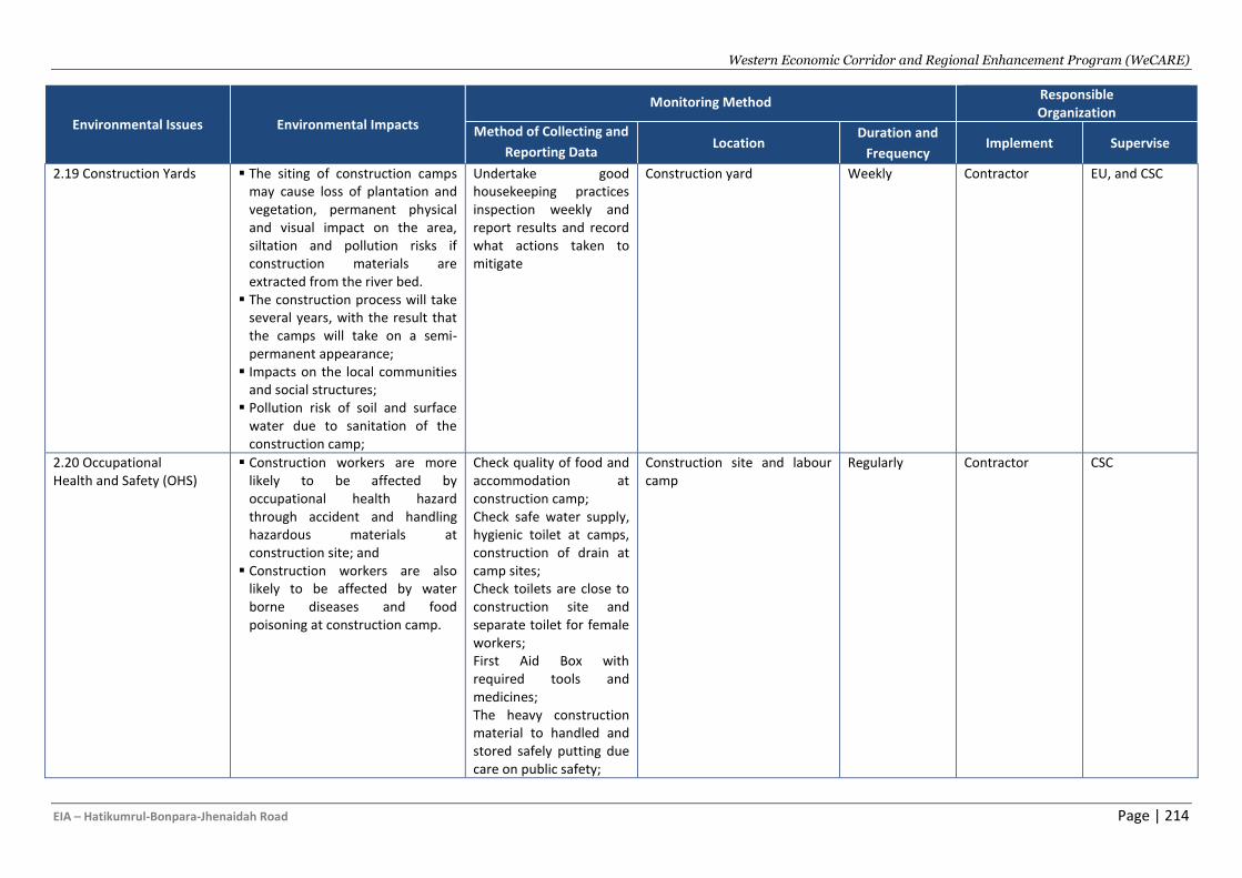
Western Economic Corridor and Regional Enhancement Program (WeCARE)
EIA – Hatikumrul-Bonpara-Jhenaidah Road Page | 214
Environmental Issues Environmental Impacts
Monitoring Method Responsible Organization
Method of Collecting and
Reporting Data Location
Duration and
Frequency Implement Supervise
2.19 Construction Yards ▪ The siting of construction camps may cause loss of plantation and vegetation, permanent physical and visual impact on the area, siltation and pollution risks if construction materials are extracted from the river bed.
▪ The construction process will take several years, with the result that the camps will take on a semi-permanent appearance;
▪ Impacts on the local communities and social structures;
▪ Pollution risk of soil and surface water due to sanitation of the construction camp;
Undertake good housekeeping practices inspection weekly and report results and record what actions taken to mitigate
Construction yard Weekly Contractor EU, and CSC
2.20 Occupational Health and Safety (OHS)
▪ Construction workers are more likely to be affected by occupational health hazard through accident and handling hazardous materials at construction site; and
▪ Construction workers are also likely to be affected by water borne diseases and food poisoning at construction camp.
Check quality of food and accommodation at construction camp; Check safe water supply, hygienic toilet at camps, construction of drain at camp sites; Check toilets are close to construction site and separate toilet for female workers; First Aid Box with required tools and medicines; The heavy construction material to handled and stored safely putting due care on public safety;
Construction site and labour camp
Regularly Contractor CSC
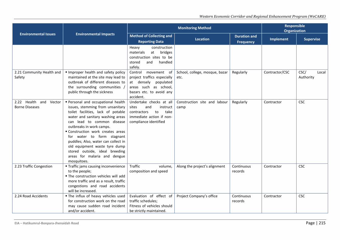
Western Economic Corridor and Regional Enhancement Program (WeCARE)
EIA – Hatikumrul-Bonpara-Jhenaidah Road Page | 215
Environmental Issues Environmental Impacts
Monitoring Method Responsible Organization
Method of Collecting and
Reporting Data Location
Duration and
Frequency Implement Supervise
Heavy construction materials at bridges construction sites to be stored and handled safely.
2.21 Community Health and Safety
▪ Improper health and safety policy maintained at the site may lead to outbreak of different diseases to the surrounding communities / public through the sickness
Control movement of project traffics especially at densely populated areas such as school, bazars etc. to avoid any accident.
School, college, mosque, bazar etc.
Regularly Contractor/CSC CSC/ Local Authority
2.22 Health and Vector Borne Diseases
▪ Personal and occupational health issues, stemming from unsanitary toilet facilities, lack of potable water and sanitary washing areas can lead to common disease outbreaks in work camps.
▪ Construction work creates areas for water to form stagnant puddles; Also, water can collect in old equipment waste tyre dump stored outside, ideal breeding areas for malaria and dengue mosquitoes.
Undertake checks at all sites and instruct contractors to take immediate action if non-compliance identified
Construction site and labour camp
Regularly Contractor CSC
2.23 Traffic Congestion ▪ Traffic jams causing inconvenience to the people;
▪ The construction vehicles will add more traffic and as a result, traffic congestions and road accidents will be increased.
Traffic volume, composition and speed
Along the project’s alignment Continuous records
Contractor CSC
2.24 Road Accidents ▪ The influx of heavy vehicles used for construction work on the road may cause sudden road incident and/or accident.
Evaluation of effect of traffic schedules; Fitness of vehicles should be strictly maintained.
Project Company’s office Continuous records
Contractor CSC
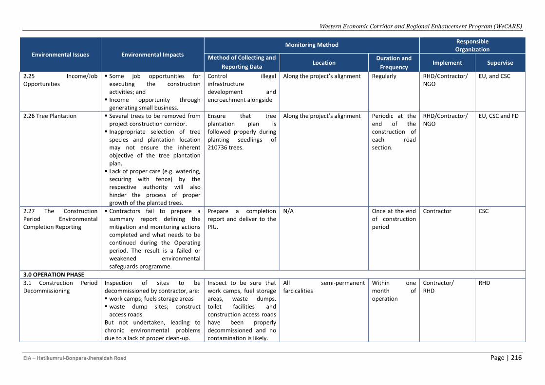
Western Economic Corridor and Regional Enhancement Program (WeCARE)
EIA – Hatikumrul-Bonpara-Jhenaidah Road Page | 216
Environmental Issues Environmental Impacts
Monitoring Method Responsible Organization
Method of Collecting and
Reporting Data Location
Duration and
Frequency Implement Supervise
2.25 Income/Job Opportunities
▪ Some job opportunities for executing the construction activities; and
▪ Income opportunity through generating small business.
Control illegal infrastructure development and encroachment alongside
Along the project’s alignment Regularly RHD/Contractor/ NGO
EU, and CSC
2.26 Tree Plantation ▪ Several trees to be removed from project construction corridor.
▪ Inappropriate selection of tree species and plantation location may not ensure the inherent objective of the tree plantation plan.
▪ Lack of proper care (e.g. watering, securing with fence) by the respective authority will also hinder the process of proper growth of the planted trees.
Ensure that tree plantation plan is followed properly during planting seedlings of 210736 trees.
Along the project’s alignment Periodic at the end of the construction of each road section.
RHD/Contractor/ NGO
EU, CSC and FD
2.27 The Construction Period Environmental Completion Reporting
▪ Contractors fail to prepare a summary report defining the mitigation and monitoring actions completed and what needs to be continued during the Operating period. The result is a failed or weakened environmental safeguards programme.
Prepare a completion report and deliver to the PIU.
N/A Once at the end of construction period
Contractor CSC
3.0 OPERATION PHASE
3.1 Construction Period Decommissioning
Inspection of sites to be decommissioned by contractor, are: ▪ work camps; fuels storage areas ▪ waste dump sites; construct
access roads But not undertaken, leading to chronic environmental problems due to a lack of proper clean-up.
Inspect to be sure that work camps, fuel storage areas, waste dumps, toilet facilities and construction access roads have been properly decommissioned and no contamination is likely.
All semi-permanent farcicalities
Within one month of operation
Contractor/ RHD
RHD

Western Economic Corridor and Regional Enhancement Program (WeCARE)
EIA – Hatikumrul-Bonpara-Jhenaidah Road Page | 217
Environmental Issues Environmental Impacts
Monitoring Method Responsible Organization
Method of Collecting and
Reporting Data Location
Duration and
Frequency Implement Supervise
3.2 Landscape/ Topography
▪ Structures attached with the road, such as interchanges, underpasses/overpasses, bridges, etc. would cause slight negative effect on landscape.
Consultation with adjacent households and RHD to get opinion on work being completed.
Along the alignment Regular Contractor/ RHD
RHD
3.3 Air Quality ▪ Dust (PM) generated from the road surface dispersed to the air by vehicles running on the roads, and
▪ Toxic gases (NOx, SOx, CO, VOC, etc.) generated from vehicle’s engines when burning fuel.
PM2.5, PM10, CO, SO2, NOx, O3, temperature, humidity, wind speed and wind direction
Most busy traffic points 1 Location for each Contract Package
Twice per year for operating Years 1, 3 and 5.
Contractor/ RHD
RHD
3.4 Noise and Vibration ▪ Noise pollution due to the movement of increased number of vehicles; and
▪ Wildlife particularly the birds will be affected mostly because of noise.
Measurement of noise dB(A) and vibration in velocity, acceleration, displacement
Bus Stoppages/cultural sites along the alignment 2 Locations for each Contract Package
Twice per year for operating Years 1, 3 and 5.
Contractor/ RHD
RHD
3.5 Water pollution (surface and groundwater)
▪ Erosion on the slope of the road will add silts into the nearby surface water streams.
▪ Uncontrolled release of contaminated storm-water/road runoff from road surfaces will pollute the surface water. Hydrocarbons, heavy corrosive products and suspended solids are the surface water pollutants associated with road runoff.
▪ Accidental spillage of hydrocarbon products from the vehicles moving on the road may cause nearby surface water pollution through surface runoff. Because of the
SW: pH, DO, Turbidity, TOC, Total P, TSS; TSS, BOD5, COD, Cd, Total Cr, Cu, Fe, Pb, Oil and Grease; GW: pH, TDS, Cl, As, Mn, Fe, SO4, TC, FC
At major surface water bodies; 1 Location for Contract Package 5 Public tube-well near the alignment; 1 Location for each Contract Package
Twice per year for operating Years 1, 3 and 5.
Contractor/ RHD
RHD

Western Economic Corridor and Regional Enhancement Program (WeCARE)
EIA – Hatikumrul-Bonpara-Jhenaidah Road Page | 218
Environmental Issues Environmental Impacts
Monitoring Method Responsible Organization
Method of Collecting and
Reporting Data Location
Duration and
Frequency Implement Supervise
project, many commercial and business structures will be constructed alongside the road which will cause increased groundwater extraction.
3.6 Cultural/ Sensitive Structure
▪ Loss of cultural/sensitive structures will cause stress/tense on the PAPs; and
▪ Cultural/sensitive structures adjacent up to 250 m away from the ROW boundary will not be affected due to the noise and dust pollution.
Cultural/sensitive structures adjacent up to 250 m away from the ROW boundary will not be affected due to the noise and dust pollution
Along the road side in front of the cultural structures
Regular RHD RHD
3.7 Road Accidents/ Road safety
▪ The increased vehicular movement and speed may result in road safety issues like traffic accidents. The accidents may also be due to tiredness.
▪ The vehicles may not follow speed limit having widened and free road which may cause road accidents.
Traffic signs, kilometre posts, speed breakers (where required) along the road and traffic signal at road crossing have to be provided.
At designated places (intersection points, cultural structures, School, hospital)
Regular RHD RHD
3.8 Split of Communities
▪ Some of residential areas and agricultural land of the villages along the road would be divided into fragmented areas by the proposed highway.
▪ Local residents’ daily activities, production activities, etc. would be significantly affected.
▪ In several cases, the highway would not only split the communities, but also cause hindrance to people in accessing
Clearance at important road such as district road and main road of village/towns
At designated places (intersection points, cultural structures, School, hospital)
Regular RHD RHD
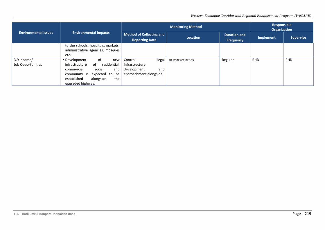
Western Economic Corridor and Regional Enhancement Program (WeCARE)
EIA – Hatikumrul-Bonpara-Jhenaidah Road Page | 219
Environmental Issues Environmental Impacts
Monitoring Method Responsible Organization
Method of Collecting and
Reporting Data Location
Duration and
Frequency Implement Supervise
to the schools, hospitals, markets, administrative agencies, mosques etc.
3.9 Income/ Job Opportunities
▪ Development of new infrastructure of residential, commercial, social and community is expected to be established alongside the upgraded highway.
Control illegal infrastructure development and encroachment alongside
At market areas Regular RHD RHD
Western Economic Corridor and Regional Enhancement Program (WeCARE)
EIA - Bangladesh: Hatikumrul – Bonpara – Jhenaida Road Page | 220
E. Institutional Arrangements
543. Roads and Highways Department (RHD) under the Ministry of Road Transport and Bridges (MoRTB)) is representing the Government of Bangladesh as the Executing Agency (EA) of the WeCARE RHD Program. RHD is responsible for undertaking all studies, design, and construction of this Project. It will also be responsible for operation and maintenance (O&M) of the project after its completion. RHD is mandated to undertake steps, as per guidelines of the MoRTB and advice of the Government, to secure required funds both from external and internal sources for the implementation of the Project.
544. For efficient and smooth implementation of the project, suitable institutional arrangements are necessary to manage and implement the RP. WeCARE-RHD Institutional arrangement consist of PSC, PIU, RSEC and PIC. Institutional arrangements required for implementation of Resettlement Plan includes capacity augmentation of RHD head office, RHD field offices, Deputy Commissioners offices, appointment of INGO/consulting firm, formation of various committees like: GRC, PAVC, RAC, etc. The Deputy Project Director at Head Office will function as the Chief Resettlement Officer (CRO). The CRO will have overall responsibility relating to resettlement and rehabilitation policy guidance, coordination, planning, monitoring and reporting. Secretarial Staffs at Head Office will assist the CRO. At the field level, the CRO will be assisted by PIC. Besides, an NGO will be appointed for the implementation of resettlement plan. The resettlement expert of the project Implementation Committee (PIC) would be engaged to carry out internal monitoring and evaluation of the project. External Monitoring Agency will be engaged for the project.
F. Implementation arrangements
545. Environmental management of the project requires a multidisciplinary approach with consolidated and coordinated efforts from a number of agencies. Various institutions will be involved during implementation of the Project. While contractor is responsible for implementation of ESMP during construction works, Construction Supervision Consultant (CSC) is primarily responsible for supervision of monitoring of the implementation of the ESMP and also reporting the progress to RHD. Ministry of Road Transport and Bridges (MoRTB) is the Executing Agency (EA). The RHD will be involved in the implementation and management of the works for which they are responsible by establishing a Project Implementation Unit (PIU). The Key organizations and people involved in environmental management of the project are as presented in Figure IX-1.
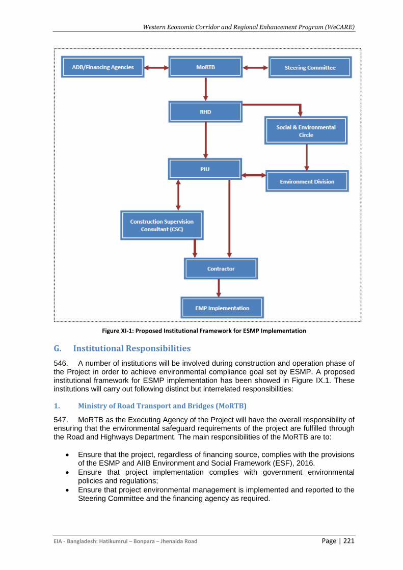
Western Economic Corridor and Regional Enhancement Program (WeCARE)
EIA - Bangladesh: Hatikumrul – Bonpara – Jhenaida Road Page | 221
Figure XI-1: Proposed Institutional Framework for ESMP Implementation
G. Institutional Responsibilities
546. A number of institutions will be involved during construction and operation phase of the Project in order to achieve environmental compliance goal set by ESMP. A proposed institutional framework for ESMP implementation has been showed in Figure IX.1. These institutions will carry out following distinct but interrelated responsibilities:
1. Ministry of Road Transport and Bridges (MoRTB)
547. MoRTB as the Executing Agency of the Project will have the overall responsibility of ensuring that the environmental safeguard requirements of the project are fulfilled through the Road and Highways Department. The main responsibilities of the MoRTB are to:
• Ensure that the project, regardless of financing source, complies with the provisions of the ESMP and AIIB Environment and Social Framework (ESF), 2016.
• Ensure that project implementation complies with government environmental policies and regulations;
• Ensure that project environmental management is implemented and reported to the Steering Committee and the financing agency as required.
Western Economic Corridor and Regional Enhancement Program (WeCARE)
EIA - Bangladesh: Hatikumrul – Bonpara – Jhenaida Road Page | 222
2. Inter-ministerial Steering Committee
548. A Steering Committee with representatives from related Ministries and Government agencies covering will be established at the time of implementation of this project. This committee will facilitate the coordination of various agencies under the ministries in the environmental management and monitoring process.
3. Roads and Highways Department
549. The Roads and Highways Department (RHD), as the main project implementing agency, is responsible for the effective execution of the environmental safeguards. Although not directly involved in the day to day monitoring activities, RHD will have oversight on the monitoring activities carried out by the CSC and contractor through PIU and will report to MoRTB.
4. The Social and Environmental Circle
550. There is a dedicated Social and Environmental Circle (RSEC) as a technical wing who is responsible for ES management of all RHD development projects. This RSES has two divisions namely Environment and Resettlement. The Resettlement division consist of 4 members comprise of one Executive engineer, one sub-divisional engineer and two assistant engineers. There is no dedicated social specialist with this Resettlement division. As RSEC will be the part of PIU, the RSEC will be responsible for overseeing the RAP implementation, supervision and monitoring with coordination of PIU Social Specialist/s .RSEC together with PIU is also responsible to monitor CSE to ensure safeguard compliance of the project. Senior Social/Resettlement specialist will keep good coordination with the RSEC to ensure compliance of social due-diligence.
5. Project Implementation Unit
551. The Project Implementation Unit will be established under the RHD will include an environmental unit (EU). The EU will consist of one Executive engineer, one sub-divisional engineer and two assistant engineers to monitor environmental compliance. The EU will be responsible for overseeing of the monitoring activities conducted by the CSC on its behalf. It will also be responsible for overseeing the activities of contractor through PIU. The main activities of the EU with regard to environmental safeguards are:
• Planning and implementation of ESMP
• Ensuring that environmental protection and mitigation measures in the ESMP are incorporated in the Construction Environmental Management Plan (CESMP);
• Ensuring that the CSC commits and retains dedicated staff as environment and safety managers to oversee CESMP implementation
• Supervision and monitoring of the progress of activities of the consultants and contractors for implementation of different components of ESMP
• Provide guidance to PIU, CSC and contractors in conducting subsequent monitoring and reporting and in undertaking corrective options
• Responsible for modifications of the ESMP when there were adaptation/changes during implementation.
• Ensure submission of periodical environmental management and monitoring reports to steering committee and co-financers through RHD;
• Submit semi-annual monitoring reports on ESMP implementation for co-financers review through RHD;
• Ensure establishment and implementation of an environmental management system;
Western Economic Corridor and Regional Enhancement Program (WeCARE)
EIA - Bangladesh: Hatikumrul – Bonpara – Jhenaida Road Page | 223
• Implementation of environmental monitoring measures (such as environmental quality monitoring, tree plantation, landscaping, wild life monitoring) during O/M stage of the Project.
• Promote improved social and environment performance through the effective use of management systems;
• External communications with other government, semi-government and non-government organizations, universities, research institutes in the country on the matters of mutual interest related to environmental management and filming of activities to be carried out under the project development.
6. Construction Supervision Consultant (CSC)
552. The CSC functioning under the RHD will be directly responsible for contract administration and day-to-day project supervision including environmental management. The CSC will consist of an environmental unit with 1 international and 1 national environmental expert. The CSC will advise the RHD and the PIUs on ESMP implementation, and monitor the work of the contractors in the field. The consultants will also help the PIUs prepare quarterly progress reports to be submitted to the RHD, who will submit semi-annual reports to co-financier for review. The CSC will, inter alia, be responsible for the following:
• Engage international/national environment specialists to ensure proper implementation of ESMP provisions;
• Undertake regular monitoring of the contractor’s environmental performance, as scheduled in the ESMP;
• Conduct periodical environmental audits;
• Prior to construction, review and approve CESMPs/method statements prepared by the contractors;
• Supervise site environmental management system of the contractors, and provide corrective instructions;
• Monitor the implementation of the CESMP and review the environmental management and monitoring reports prepared by the contractor;
• Review and report on CSEMP implementation by the contractor. 553. Overall, CSC is responsible for ensuring proper and timely implementation of all their tasks specified in the ESMP.
7. Contractor
554. The contractor will be primarily responsible for preparing an implementing the CESMP. Each contractor will be recommended to have one Environmental Specialist and one Occupational, Health and Safety (OHS) Specialist, who will be working in close coordination with the environmental staff of CSC and PIU. The main functions of the contractor with regard to environmental management and monitoring are to:
• Prior to start of construction, prepare the CESMP and other method statements and management plans according to requirements of ESMP and get them approved by CSC.
• Recruit qualified environmental and safety officers (ESO) to ensure compliance with environmental statutory and contractual obligations and proper implementation of CESMP;
• Provide sufficient funding and human resources for proper implementation of CESMP;
• Prepare monthly reports on environmental management and monitoring for review and verification by the CSC;
Western Economic Corridor and Regional Enhancement Program (WeCARE)
EIA - Bangladesh: Hatikumrul – Bonpara – Jhenaida Road Page | 224
• Prepare and implement an Environmental Management system according to requirement specified in EIA/ ISO 14001.
H. Environmental Monitoring Cost Estimation
555. Most of the mitigation measures require the contractors/project authority to adopt good site practice, which should be part of their normal procedures already, so there are unlikely to be major costs associated with compliance. 556. Mitigation that is the responsibility of RHD and contractor’s will be provided as part of their management of the project. The cost estimation for Environmental Mitigation
Measures and Monitoring is given in the following Table XI-3. The total mitigation and monitoring cost for the project is calculated as BDT 18944520, including the remuneration of Contractor’s Environment, Health and Safety Officer (EHSO). The total duration of the engagement of this expert will be continued for the entire construction period or as per the requirement of the project after getting approval from the CSC.
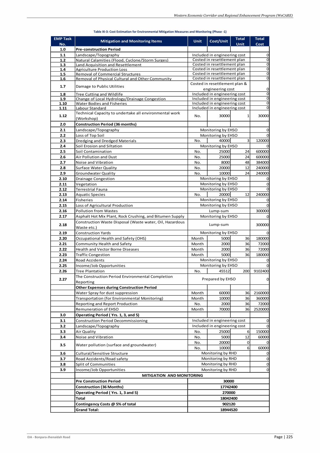
Western Economic Corridor and Regional Enhancement Program (WeCARE)
EIA - Bonpara-Jhenaidah Road Page | 225
Table XI-3: Cost Estimation for Environmental Mitigation Measures and Monitoring (Phase -1)
1.0 Pre-construction Period
1.1 Landscape/Topography 0
1.2 Natural Calamities (Flood, Cyclone/Storm Surges) 0
1.3 Land Acquisition and Resettlement 0
1.4 Agriculture Production Loss 0
1.5 Removal of Commercial Structures 0
1.6 Removal of Physical Cultural and Other Community 0
1.7 Damage to Public Utilities0
1.8 Tree Cutting and Wildlife 0
1.9 Change of Local Hydrology/Drainage Congestion 0
1.10 Water Bodies and Fisheries 0
1.11 Labour Standard 0
1.12Technical Capacity to undertake all environmental work
(Workshop)No. 30000 1 30000
2.0 Construction Period (36 months)
2.1 Landscape/Topography 0
2.2 Loss of Top Soil 0
2.3 Dredging and Dredged Materials No. 40000 3 120000
2.4 Soil Erosion and Siltation 0
2.5 Soil Contamination No. 25000 24 600000
2.6 Air Pollution and Dust No. 25000 24 600000
2.7 Noise and Vibration No. 8000 48 384000
2.8 Surface Water Quality No. 20000 12 240000
2.9 Groundwater Quality No. 10000 24 240000
2.10 Drainage Congestion 0
2.11 Vegetation 0
2.12 Terrestrial Fauna 0
2.13 Aquatic Species No. 20000 12 240000
2.14 Fisheries 0
2.15 Loss of Agricultural Production 0
2.16 Pollution from Wastes 300000
2.17 Asphalt Hot Mix Plant, Rock Crushing, and Bitumen Supply 0
2.18Construction Waste Disposal (Waste water, Oil, Hazardous
Waste etc.)300000
2.19 Construction Yards 0
2.20 Occupational Health and Safety (OHS) Month 5000 36 180000
2.21 Community Health and Safety Month 2000 36 72000
2.22 Health and Vector Borne Diseases Month 2000 36 72000
2.23 Traffic Congestion Month 5000 36 180000
2.24 Road Accidents 0
2.25 Income/Job Opportunities 0
2.26 Tree Plantation No. 45512 200 9102400
2.27The Construction Period Environmental Completion
Reporting0
Other Expenses during Construction Period
Water Spray for dust suppression Month 60000 36 2160000
Transportation (for Environmental Monitoring) Month 10000 36 360000
Reporting and Report Production No. 2000 36 72000
Remuneration of EHSO Month 70000 36 2520000
3.0 Operating Period ( Yrs. 1, 3, and 5)
3.1 Construction Period Decommissioning 0
3.2 Landscape/Topography 0
3.3 Air Quality No. 25000 6 150000
3.4 Noise and Vibration No. 5000 12 60000
No. 20000 0 0
No. 10000 6 60000
3.6 Cultural/Sensitive Structure 0
3.7 Road Accidents/Road safety 0
3.8 Split of Communities 0
3.9 Income/Job Opportunities 0
Pre Construction Period
Construction (36 Months)
Operating Period ( Yrs. 1, 3 and 5)
Total
Contingency Costs @ 5% of total
Grand Total:
270000
MITIGATION AND MONITORING
Monitoring by RHD
Monitoring by RHD
18944520
18042400
902120
30000
17742400
Included in engineering costIncluded in engineering cost
Monitoring by RHD
Monitoring by EHSO
Monitoring by EHSO
Monitoring by EHSO
Monitoring by EHSO
Lump-sum
Monitoring by EHSO
Lump-sum
Monitoring by EHSO
Monitoring by EHSO
Monitoring by EHSO
Prepared by EHSO
Included in engineering cost
Monitoring by RHD
Costed in resettlement planCosted in resettlement planCosted in resettlement plan
Costed in resettlement plan &
engineering costIncluded in engineering cost
Total
Cost
Costed in resettlement planIncluded in engineering cost
Costed in resettlement plan
EMP Task
No.Mitigation and Monitoring Items Unit Cost/Unit
Total
Unit
3.5 Water pollution (surface and groundwater)
Included in engineering cost
Monitoring by EHSO
Monitoring by EHSO
Monitoring by EHSO
Monitoring by EHSO
Included in engineering cost
Western Economic Corridor and Regional Enhancement Program (WeCARE)
EIA - Bangladesh: Hatikumrul – Bonpara – Jhenaida Road Page | 226
XII. GRIEVANCE REDRESS MECHANISM
A. Requirements of the AIIB
557. As a partner in the delivery of this project, the AIIB’s environmental safeguard requirements were carefully considered during the preparation of this EIA. The description of a grievance redress mechanism (GRM) is not required under the GoB environmental legislation but is mandatory for any AIIB-funded project. To that end a step-by-step process is defined in this chapter. 558. AIIB requires the RHD to establish, in accordance with the ESP and applicable ESSs, a suitable Project-level GRM to receive and facilitate resolution of the concerns or complaints of people who believe they have been adversely affected by the Project’s environmental or social impacts, and to inform Project-affected people of its availability. The Bank also requires the Client to establish a GRM for contracted workers under the Project to address workplace concerns and reflect this in the tender documents for these contracts. 559. Grievance redress refers to the set of actions available to anyone negatively impacted by the project and not properly dealt with, ignored or overlooked the implementation of mitigative and monitoring measures defined in the IEE. The overriding principle of any GRM is that it must be non-threatening, easily accessible, quick and impartial; delivering decisions to the complainant in an unbiased a-political manner. GRM’s have been developed for many past donor-funded projects and have been accepted by the GoB and been reasonably successful in doing what they are supposed to do. The GRM described in this chapter (Figure X-1) builds on that success.
B. Objectives
560. Project-affected-people for the AIIB funded construction activities in the WeCARE project and any other stakeholder may submit comments or complaints at any time by using the project’s Grievance Redress Mechanism (GRM). The overall objectives of the GRM are to:
• Provide a transparent process for timely identification and resolution of issues affecting the project and people, including issues related to the environmental impact, resettlement and compensation program.
• Strengthen accountability to beneficiaries, including project affected people. • Compensation payment, • Failure to fulfill commitments, • Poor management of construction activities, • Accidents due to inappropriate planning of vehicle movement, • Cultural conflicts between migrant workers and local communities, • Disturbance due to excessive noise or other nuisance during construction or
operation to unfair treatment of workers or unsafe working conditions. • GBV and gender issues • Complain on labor influx • Complain or comment from different public, private and international stakeholders • Complain, comments or suggestions from transport workers, labors, contractors,
students, teachers, business entrepreneurs etc.
Western Economic Corridor and Regional Enhancement Program (WeCARE)
EIA - Bangladesh: Hatikumrul – Bonpara – Jhenaida Road Page | 227
C. Grievance Redress Mechanism
561. The Grievance redress mechanism described here refers to the mechanism related to the EIA preparation, approval and implementation, and for construction activities. Grievance Redress for all resettlement and other social matters are covered separately in the Resettlement and Social reports. Nevertheless, the mechanisms described in this section will be compatible with and complementary to the Resettlement and Social mechanisms. 562. The GRM will be accessible to all Internal, external, regional and international stakeholders, including affected people, community members, civil society, media, vulnerable people and other interested parties. External stakeholders can use the GRM to submit complaints, feedback, queries, suggestions, or even compliments related to the overall management and implementation of the WeCARE-AIIB project. The GRM is intended to address issues and complaints in an efficient, timely, and cost-effective manner. A separate GRM is also proposed for the labors following the guidelines of Bangladesh Labor Act 2006 and Labor Rules 2015.
563. During COVID-19, if grievances are raised, there will be various options to submit grievances through mediums such as websites, emails, phones and other appropriate communication methods, which will be recorded and dealt with accordingly. Social-distancing restrictions/high transmission risks related to COVID-19 and significant resettlement.
564. Multichannel cloud GRM system will be established taking the best examples and practices to diminish the need for Project-affected people to physically interact with Project staff. A training program will be arranged with different stakeholders on how to raise grievances during this pandemic. It will ensure:
i. Accept, manage and respond to feedback/grievances through calls, text, social media and emails. Feedback is automatically logged and can be accessed remotely.
ii. Ready-made, off-the-shelf solution which requires minimum set-up and training to deploy and operate.
iii. It will be easier to access off/on-line with/out smart phone. iv. It can be easily integrated with limited on-the-ground footprint.
D. Details of Mechanism
1. Formation and Operation of the GRC
565. Rather than suggesting a route normally taken when a citizen has a concern, namely the local administrative official route, grievance redress committees (GRCs) will be formed in each Union Parishad (UP) the project passes through. Each project will likely trigger both environmental (as defined in this EIA) and social impacts (as defined in the project’s Resettlement Plan) and therefore the GRC will need be able to address both areas. Prior to the start of construction RHD will meet with UP heads to request the establishment of such committees, with the understanding that they will have to meet when complaints are received. As a minimum the composition of the GRC will be as follows:
• RHD Regional Director or Representative - GRC Chair and convener
• Union Parishad Chairman or Senior Representative- GRC Committee member
Western Economic Corridor and Regional Enhancement Program (WeCARE)
EIA - Bangladesh: Hatikumrul – Bonpara – Jhenaida Road Page | 228
• Female member of concerned ward(s) of the UP- GRC Committee member
• Implementing NGO Representative - GRC Committee member (Social)
• UP DoE representative - GRC Committee member (Environment)
• Female Representative of Affected People (AP) - GRC Committee member (Social)
• Representative from area where grievance was filed- GRC Committee member 566. When dealing with environmental matters, the GRC should have five permanent members, with the DoE representative replaced by the INGO and Female Representative of the AP when social or resettlement matters are on the agenda. In order to convene a GRC meeting a quorum of three persons will be required. 567. To function in a fair and transparent manner, GRC conditions of operation will form the framework for the decision-making process for the GRCs established for this Project. The following seven GRC operating conditions are:
i. GRC meetings must be announced and held locally; ii. The complainant must be given the opportunity to appear before the GRC, prior to
or during the GRC decision meeting; iii. The time between submission of the grievance by a citizen and a decision/
resolution should five days, and any decision/resolution must be placed with the office where grievance was made. If the decision will take longer than five days, the complainant must be notified with an explanation;
iv. Maximum time for resolution should be one month; v. GRC decisions should be based on majority vote, and should adhere to the
objectives defined in the EIA’s Environmental Management Plan and related Construction Contract Specifications;
vi. The GRC will not deal with any matters pending in the court of law; and vii. Any resolutions/decisions must, as a first priority, deal with eliminating the source of
the environmental effects resulting in the complaint and secondly finding ways to mitigate the effect to the satisfaction of the complainant.
568. Further, the GRC would only be convened if direct communication between the contractor, the complainant and the CSC cannot solve the issue quickly. Once the complaint reaches the GRC, the GRC has two weeks to render a decision, based on discussion with all parties involved. The GRC will be used as the third step when filing a complaint.
2. Steps to a Solution
569. Step 1: The complainant will be advised to first attempt to settle the complaint through direct communication with the either in person or by a phone, and a call to the local RHD office. If the discussion with the Complainant/Community is successful, the contractor will be responsible for undertaking corrective measures as defined in the grievance decision and recording the decision and filing that with RHD, via the CSC or the RHDPIU. 570. Step 2: Should the complaint not be addressed within a week; the next level would be to notify the Upazila office and RHD of the unresolved issue. The Upazila official will then communicate either to the contractor or RHD and a solution will be discussed with the complainant within one working week. If more time is required, The Upazila or RHD should communicate directly with the complainant describing the reasons of the delay. 571. Step 3: If Step 2 fails to resolve the issue within two weeks of the receipt of the complaint the GRC should be formed and a formal hearing undertaken. At this point a decision must be rendered within 2 weeks or the complainants concerns will be deemed
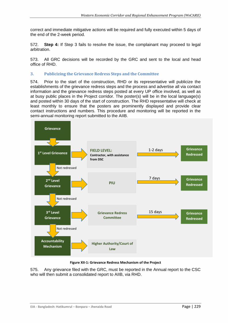
Western Economic Corridor and Regional Enhancement Program (WeCARE)
EIA - Bangladesh: Hatikumrul – Bonpara – Jhenaida Road Page | 229
correct and immediate mitigative actions will be required and fully executed within 5 days of the end of the 2-week period. 572. Step 4: If Step 3 fails to resolve the issue, the complainant may proceed to legal arbitration. 573. All GRC decisions will be recorded by the GRC and sent to the local and head office of RHD.
3. Publicizing the Grievance Redress Steps and the Committee
574. Prior to the start of the construction, RHD or its representative will publicize the establishments of the grievance redress steps and the process and advertise all via contact information and the grievance redress steps posted at every UP office involved, as well as at busy public places in the Project corridor. The poster(s) will be in the local language(s) and posted within 30 days of the start of construction. The RHD representative will check at least monthly to ensure that the posters are prominently displayed and provide clear contact instructions and numbers. This procedure and monitoring will be reported in the semi-annual monitoring report submitted to the AIIB.
Figure XII-1: Grievance Redress Mechanism of the Project
575. Any grievance filed with the GRC, must be reported in the Annual report to the CSC who will then submit a consolidated report to AIIB, via RHD.
Grievance
Redressed
Grievance
Redressed
Grievance
Redressed
7 days
15 days
1-2 days
days
FIELD LEVEL: Contractor, with assistance from DSC
PIU
Higher Authority/Court of
Law
Grievance Redress Committee
Grievance
1st Level Grievance
2nd Level
Grievance
3rd Level
Grievance
Accountability
Mechanism
Not redressed
Not redressed
Not redressed
Western Economic Corridor and Regional Enhancement Program (WeCARE)
EIA - Bangladesh: Hatikumrul – Bonpara – Jhenaida Road Page | 230
4. Construction Workers Grievance
576. At construction sites, work camps and on-the-job, laborers and other unskilled hired employees of the contractor have little recourse when either their living conditions are badly degraded, they are not paid according to agreement, or basics, such as potable water, are not supplied. Under this contract, as part of the written agreement with each hire, the contract or letter of assignment with the work will include the name and contact information of an RHD and/or the CSC’s employee for the worker to contact. The letter/agreement will contain a second statement indicating that the contractor will not penalize the worker for reporting a complaint and if that occurs, the contract will be levied a fine equal to the employees’ contract duration from the time of the incident to the end of the contract period. That amount will be paid to the complainant. 577. The contractor will provide a compliant box, sealed by the CSC and collected by the CSC, thus allowing the construction worker to file complaints by going directly to the CSC.
E. Composition of GRC
1. GRC at local level
578. First level GRC will be formed in the local level where community people will be able to complaint / raise grievances directly to the field level project office. INGO /Consulting firm together with Project Implementation Committee (PIC) will inform all affected people and local community about the project grievance Redress Mechanism in local language. This local GRC will ensure easy accessibility by the PAPs, local communities and interested stakeholders, so that any grievances can be solved directly or within a very short period of time. The members of the local GRC will be Upazila Engineer as convener; Safeguard Specialist from INGO / consulting firm as members secretary; and as members representative from local chairman, teacher from Local Educational Institution, representative from Local Women’s Group; and representative from the PAP Group.
579. The membership of the GRCs will ensure proper presentation of complaints and grievances as well as impartial hearings and investigations, and transparent resolutions. Where grievances are among the affected persons, the membership composition of the GRCs will take into account any traditional conflict resolution arrangements that communities may practice. If the aggrieved person is a female, RHD will ask the concerned female UP Member or Municipal Ward Councilor to participate in the hearings. Members of the GRCs will be nominated by the Upazila Engineer.
Table XII-1 GRC composition at local level
1. SDE/PD representative Convener
2. Social Specialist from INGO / consulting firm Member-Secretary
3. Local UP Member/Ward Councilor Member
4. Teacher from Local Educational Institution Member
5. Representative from Local Women’s Group Member
6. Representative from the PAP Group Member
580. All complaints will be received at the Office of the Upazila Engineer through the INGO/ Consulting firm. All cases at the local level will be heard within four weeks of their receipt. Grievances received through any channel will be registered and a notification of receipt with assurance of necessary review and resolution given in writing to the aggrieved persons.
Western Economic Corridor and Regional Enhancement Program (WeCARE)
EIA - Bangladesh: Hatikumrul – Bonpara – Jhenaida Road Page | 231
2. District level GRC
581. If a decision at district level is again found unacceptable by the aggrieved person(s), RHD can refer the case to the PIU with the minutes of the hearings at local and district levels. PD will be the convener and senior social specialist will be the member secretary at PIU level. All the unsolved cases At the PIU level, decisions on unresolved cases, if any, will be made in no more than four weeks by an official designated by the Secretary, MoRTB. A decision agreed with the aggrieved person(s) at any level of hearing will be binding upon RHD. There will be budgetary allocation for local and district committee members for participating meetings and refreshments during meeting.
582. To ensure that grievance redress decisions are made in formal hearings and in a transparent manner, the Convener will apply the following guidelines:
• Reject a grievance redress application with any recommendations written on it by a
GRC member or others such as politicians and other influential persons.
• Remove a recommendation by any person that may separately accompany the
grievance redress application.
• Disqualify a GRC member who has made a recommendation on the application or
separately before the formal hearing: Where a GRC member is removed, appoint
another person in consultation with the Project Director.
• The Convener will also ensure strict adherence to the impact mitigation policies and
guidelines adopted in this RPF and the mitigation standards, such as compensation
rates established through market price surveys.
583. The affected persons and their communities will be informed of the project’s grievance redress mechanism in open meetings at important locations and in PAP group meetings. Bangla translations of the RPF in the form of information brochures will be distributed among the affected persons. The PAPs will also be briefed on the scope of the GRC, the procedure for lodging grievances cases and the procedure of grievance resolution at the project level.
584. To ensure impartiality and transparency, hearings on complaints will remain open to the public. The GRCs will record the details of the complaints and their resolution in a register, including intake details, resolution process and the closing procedures. RHD will maintain the following three Grievance Registers:
585. Intake Register: (1) Case number, (2) Date of receipt, (3) Name of complainant, (4) Gender, (5) Father or husband, (6) Complete address, (7) Main objection (loss of land/property or entitlements), (8) Complainants’ story and expectation with evidence, and (8) Previous records of similar grievances.
586. Resolution Register: (1) Serial no., (2) Case no.,(3) Name of complainant, (4) Complainant’s story and expectation, (5) Date of hearing, (6) Date of field investigation (if any), (7) Results of hearing and field investigation, (8) Decision of GRC, (9) Progress (pending, solved), and (10) Agreements or commitments.
587. Closing Register: (1) Serial no., (2) Case no., (3) Name of complainant, (4) Decisions and response to complainants, (5) Mode and medium of communication, (6) Date of closing, (7) Confirmation of complainants’ satisfaction, and (8) Management actions to avoid recurrence.
588. Grievance resolution will be a continuous process in subproject level activities and implementation of those. The PIU will keep records of all resolved and unresolved complaints and grievances (one file for each case record) and make them available for
Western Economic Corridor and Regional Enhancement Program (WeCARE)
EIA - Bangladesh: Hatikumrul – Bonpara – Jhenaida Road Page | 232
review as and when asked for by Bank and any other interested persons/entities. The PIU also prepare periodic reports on the grievance resolution process and publish these on the RHD website.
589. The RHD program intends to strengthen the GRM through information and communication technology to ensure that all complaints including those of sexual exploitation and abuse are immediately reported to the Government. RHD will integrate the GRM on a web-based dashboard, to adequately and promptly address any potential grievance related to Gender Based Violence and SEA. The complaints registered in this system will be managed by a dedicated administrator that will liaise immediately any GBV and SEA complaints with the contractors, consultant and RHD/PIU for immediate measures. If the GRM receives a case on sexual exploitation and abuse related to the project, it will be recorded, and the complainant will be referred to the relevant assistance, if needed, for referral to any other service providers. The supervision consultant will keep the information confidential to protect privacy of GBV and SEA complainants. In cases, where the perpetrator(s) is linked to project activities then the contractor will take appropriate actions as per the Code of Conduct signed by the particular person and under the effective law in Bangladesh. RHD will report activities and outcomes of GBV and SEA surveillance and management to the AIIB on a regular basis.
Western Economic Corridor and Regional Enhancement Program (WeCARE)
EIA - Bangladesh: Hatikumrul – Bonpara – Jhenaida Road Page | 233
XIII. CONCLUSIONS AND RECOMMENDATIONS
590. The project will have a number of environmental impacts during the construction and operation periods. Assuming effective implementation of the mitigation measures and monitoring requirements as outlined in the Environmental Management Plan, the Project is not expected to have significant adverse environmental impacts. It should also be pointed out that the environmental benefits are likely to be important; an all-weather transport route will link between the Benapole Land Port at Jessore, Mongla Sea Port at Bagerhat and the other regions of Bangladesh. The potential for congestion will be reduced which will reduce vehicle emissions due to increased and more regular speeds and air quality adjacent to the road should improve. 591. The ESMP has identified several mitigative actions needing to be addressed during the pre-construction, construction, and during the operating period of the road. To track the mitigation work, an air, noise, and surface water quality monitoring programme will be started during the construction period. There is little chance that impacts will extend much beyond the 50 m or 100 m wide corridor of impact centered over the road, given that all work will be strictly confined to the road’s existing right of way. 592. The assessment concludes that this EIA is indicative in the lack of final design and packages and therefore addresses relevant likely impacts and proposes a full set of time-bounded mitigative and monitoring actions, including the assignment of responsibilities. Once the detail design is finalized, the EIA needs to be revised and updated. The application of the detailed ESMP will ensure that the nature and socio-cultural environmental are not unduly affected by the work or the operation of the second line. Additionally, an environmental approval has been granted by DoE, and that no further studies be required except the renewal of the approval. 593. The ESMP, its mitigation and monitoring programs, contained herewith shall be included within the contract documents for project works. The contract documents state that the Company shall be responsible for the implementation of the requirements of the ESMP through his own Site-Specific Environmental Management Plan that will adopt all of the conditions of the EMP and add site specific elements that are not currently known, such as the borrow pit locations. This ensures that the Contractor is aware of the environmental requirements of the project and its associated environmental costs. 594. The ESMP and all its requirements shall then be added to the contract, thereby making implementation of the ESMP a legal requirement according to the contract. He shall then prepare his CESMP which will be approved and monitored by the PIU/Environmental Specialist. Additionally, the prepared CESMP will be submitted to AIIB after reviewing by the PIU for AIIB’s record and future inspection. To ensure compliance with the CESMP the Contractor should employ a national environmental specialist to monitor and report project activities throughout the project construction phase. 595. RHD has social and environmental circle but they need capacity building and practical exposure. Adequate training shall be imparted as proposed under environmental management plan to enhance the capability of concerned EA officials. It is recommended to update environmental guidelines focused on effective implementation of mitigation measures. Performance indicators may also be developed as part of these guidelines to monitor and assess the effectiveness of the mitigation measures.
Western Economic Corridor and Regional Enhancement Program (WeCARE)
EIA - Bangladesh: Hatikumrul – Bonpara – Jhenaida Road Page | 234
REFERENCES
Banglapedia, 2015. National Encyclopedia of Bangladesh
[http://en.banglapedia.org/index.php?title=Main_Page]
International Union for Conservation of Nature (IUCN), 2002. Bio-ecological zones of
Bangladesh. Dhaka: IUCN Bangladesh.
IUCN Bangladesh. ed. 2002f. Bio-ecological Zones of Bangladesh. Dhaka: IUCN The
World Conservation Union.
Riemann, K.U. 1993. Geology of Bangladesh; Gubruder-Bornfraeger, Berlin, Germany.
Soil Resource Development Institute (SRDI), 1997. Physiography of Bangladesh. Dhaka:
SRDI, Ministry of Agriculture.
Soil Resource Development Institute (SRDI), 1998. Agro-ecological regions of Bangladesh.
Dhaka: SRDI, Ministry of Agriculture.
United Nations Population Fund (UNFPA), 2010. State of World Population 2010- From
Conflict and Crisis to Renewal: generations of change [Online]. Available at:
http://www.unfpa.org/webdav/site/global/shared/swp/2010/swop_2010_eng.pdf
Wikipedia. (2015). Geology of Bangladesh. Wikipedia. Retrieved from
wikipedia.org/wiki/Geology_of_Bangladesh
Zahiruddin, S.A., 1993. Bangladesh National Building Code. Dhaka: Housing and Building
Research Institute, Ministry of Housing and Public Works, Government of the
People‟s Republic of Bangladesh.
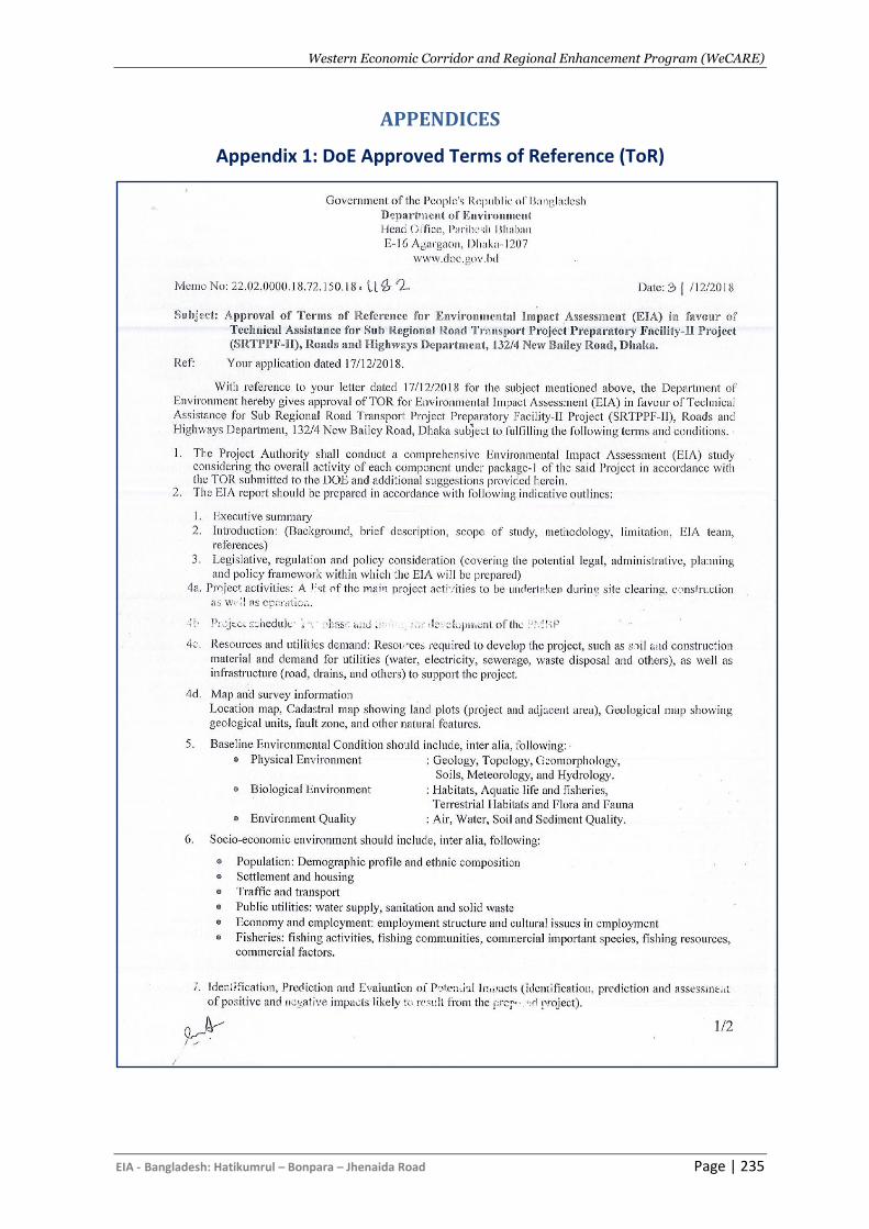
Western Economic Corridor and Regional Enhancement Program (WeCARE)
EIA - Bangladesh: Hatikumrul – Bonpara – Jhenaida Road Page | 235
APPENDICES
Appendix 1: DoE Approved Terms of Reference (ToR)
Western Economic Corridor and Regional Enhancement Program (WeCARE)
EIA - Bangladesh: Hatikumrul – Bonpara – Jhenaida Road Page | 236
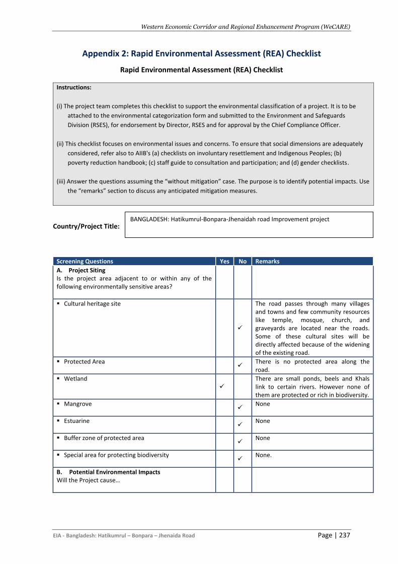
Western Economic Corridor and Regional Enhancement Program (WeCARE)
EIA - Bangladesh: Hatikumrul – Bonpara – Jhenaida Road Page | 237
Appendix 2: Rapid Environmental Assessment (REA) Checklist
Rapid Environmental Assessment (REA) Checklist
Instructions:
(i) The project team completes this checklist to support the environmental classification of a project. It is to be
attached to the environmental categorization form and submitted to the Environment and Safeguards
Division (RSES), for endorsement by Director, RSES and for approval by the Chief Compliance Officer.
(ii) This checklist focuses on environmental issues and concerns. To ensure that social dimensions are adequately
considered, refer also to AIIB's (a) checklists on involuntary resettlement and Indigenous Peoples; (b)
poverty reduction handbook; (c) staff guide to consultation and participation; and (d) gender checklists.
(iii) Answer the questions assuming the “without mitigation” case. The purpose is to identify potential impacts. Use
the “remarks” section to discuss any anticipated mitigation measures.
Country/Project Title:
Screening Questions Yes No Remarks
A. Project Siting Is the project area adjacent to or within any of the following environmentally sensitive areas?
▪ Cultural heritage site
✓
The road passes through many villages and towns and few community resources like temple, mosque, church, and graveyards are located near the roads. Some of these cultural sites will be directly affected because of the widening of the existing road.
▪ Protected Area ✓
There is no protected area along the road.
▪ Wetland ✓
There are small ponds, beels and Khals link to certain rivers. However none of them are protected or rich in biodiversity.
▪ Mangrove
✓
None
▪ Estuarine
✓
None
▪ Buffer zone of protected area
✓ None
▪ Special area for protecting biodiversity
✓
None.
B. Potential Environmental Impacts Will the Project cause…
BANGLADESH: Hatikumrul-Bonpara-Jhenaidah road Improvement project
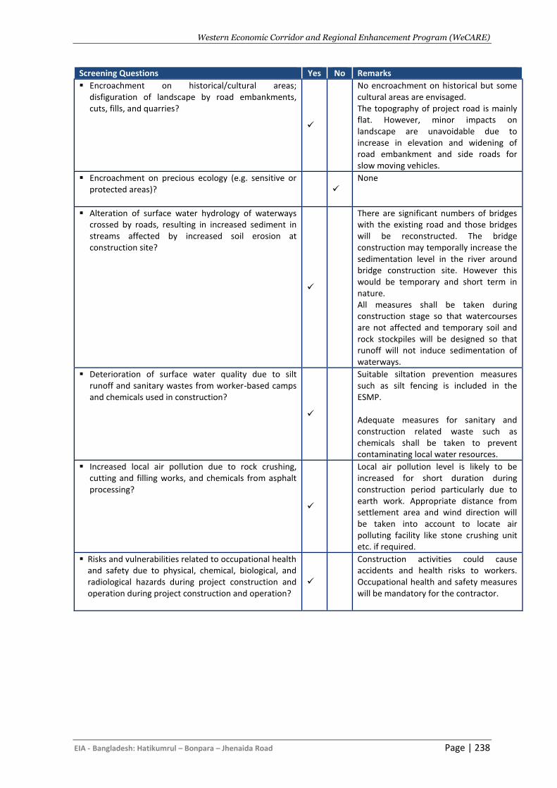
Western Economic Corridor and Regional Enhancement Program (WeCARE)
EIA - Bangladesh: Hatikumrul – Bonpara – Jhenaida Road Page | 238
Screening Questions Yes No Remarks
▪ Encroachment on historical/cultural areas; disfiguration of landscape by road embankments, cuts, fills, and quarries?
✓
No encroachment on historical but some cultural areas are envisaged. The topography of project road is mainly flat. However, minor impacts on landscape are unavoidable due to increase in elevation and widening of road embankment and side roads for slow moving vehicles.
▪ Encroachment on precious ecology (e.g. sensitive or protected areas)?
✓
None
▪ Alteration of surface water hydrology of waterways crossed by roads, resulting in increased sediment in streams affected by increased soil erosion at construction site?
✓
There are significant numbers of bridges with the existing road and those bridges will be reconstructed. The bridge construction may temporally increase the sedimentation level in the river around bridge construction site. However this would be temporary and short term in nature. All measures shall be taken during construction stage so that watercourses are not affected and temporary soil and rock stockpiles will be designed so that runoff will not induce sedimentation of waterways.
▪ Deterioration of surface water quality due to silt runoff and sanitary wastes from worker-based camps and chemicals used in construction?
✓
Suitable siltation prevention measures such as silt fencing is included in the ESMP. Adequate measures for sanitary and construction related waste such as chemicals shall be taken to prevent contaminating local water resources.
▪ Increased local air pollution due to rock crushing, cutting and filling works, and chemicals from asphalt processing?
✓
Local air pollution level is likely to be increased for short duration during construction period particularly due to earth work. Appropriate distance from settlement area and wind direction will be taken into account to locate air polluting facility like stone crushing unit etc. if required.
▪ Risks and vulnerabilities related to occupational health and safety due to physical, chemical, biological, and radiological hazards during project construction and operation during project construction and operation?
✓
Construction activities could cause accidents and health risks to workers. Occupational health and safety measures will be mandatory for the contractor.
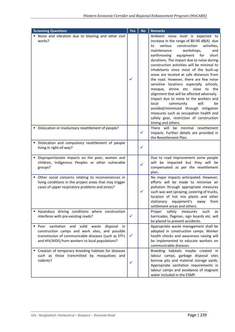
Western Economic Corridor and Regional Enhancement Program (WeCARE)
EIA - Bangladesh: Hatikumrul – Bonpara – Jhenaida Road Page | 239
Screening Questions Yes No Remarks
▪ Noise and vibration due to blasting and other civil works?
✓
Ambient noise level is expected to increase in the range of 80-90 dB(A) due to various construction activities, maintenance workshops, and earthmoving equipment for short durations. The impact due to noise during construction activities will be minimal to inhabitants since most of the built-up areas are located at safe distances from the road. However, there are few noise sensitive locations especially schools, mosque, shrine etc. close to the alignment that will be affected adversely. Impact due to noise to the workers and local community will be avoided/minimized through mitigation measures such as occupation health and safety gear, restriction of construction timing and others.
▪ Dislocation or involuntary resettlement of people?
✓
There will be minimal resettlement impacts. Further details are provided in the Resettlement Plan.
▪ Dislocation and compulsory resettlement of people living in right-of-way?
✓
▪ Disproportionate impacts on the poor, women and children, Indigenous Peoples or other vulnerable groups?
✓
Due to road improvement some people will be impacted but they will be compensated as per the resettlement plan.
▪ Other social concerns relating to inconveniences in living conditions in the project areas that may trigger cases of upper respiratory problems and stress?
✓
No major impacts anticipated. However, efforts will be made to minimize air pollution through appropriate measures such was wet spraying, covering of trucks, location of hot mix plants and other stationary equipment’s away from settlement areas and others.
▪ Hazardous driving conditions where construction interferes with pre-existing roads?
✓
Proper safety measures such as barricades, flagman, sign boards etc. will be placed to prevent accidents.
▪ Poor sanitation and solid waste disposal in construction camps and work sites, and possible transmission of communicable diseases (such as STI's and HIV/AIDS) from workers to local populations?
✓
Appropriate waste management shall be adopted in construction camps. Worker health checks and awareness raising will be implemented to educate workers on communicable diseases.
▪ Creation of temporary breeding habitats for diseases such as those transmitted by mosquitoes and rodents?
✓
Breeding habitats maybe created in labour camps, garbage disposal sites borrow pits and material storage yards. Appropriate sanitation requirements in labour camps and avoidance of stagnant water included in the ESMP.
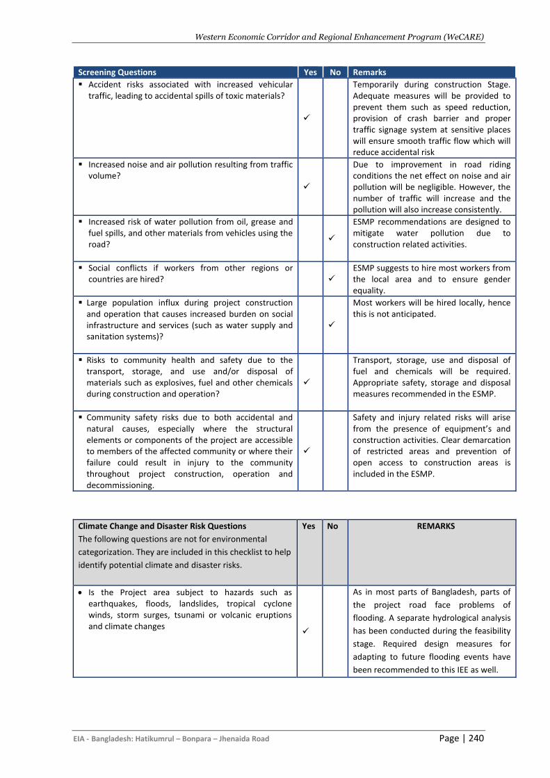
Western Economic Corridor and Regional Enhancement Program (WeCARE)
EIA - Bangladesh: Hatikumrul – Bonpara – Jhenaida Road Page | 240
Screening Questions Yes No Remarks
▪ Accident risks associated with increased vehicular traffic, leading to accidental spills of toxic materials?
✓
Temporarily during construction Stage. Adequate measures will be provided to prevent them such as speed reduction, provision of crash barrier and proper traffic signage system at sensitive places will ensure smooth traffic flow which will reduce accidental risk
▪ Increased noise and air pollution resulting from traffic volume?
✓
Due to improvement in road riding conditions the net effect on noise and air pollution will be negligible. However, the number of traffic will increase and the pollution will also increase consistently.
▪ Increased risk of water pollution from oil, grease and fuel spills, and other materials from vehicles using the road?
✓
ESMP recommendations are designed to mitigate water pollution due to construction related activities.
▪ Social conflicts if workers from other regions or countries are hired?
✓
ESMP suggests to hire most workers from the local area and to ensure gender equality.
▪ Large population influx during project construction and operation that causes increased burden on social infrastructure and services (such as water supply and sanitation systems)?
✓
Most workers will be hired locally, hence this is not anticipated.
▪ Risks to community health and safety due to the transport, storage, and use and/or disposal of materials such as explosives, fuel and other chemicals during construction and operation?
✓
Transport, storage, use and disposal of fuel and chemicals will be required. Appropriate safety, storage and disposal measures recommended in the ESMP.
▪ Community safety risks due to both accidental and natural causes, especially where the structural elements or components of the project are accessible to members of the affected community or where their failure could result in injury to the community throughout project construction, operation and decommissioning.
✓
Safety and injury related risks will arise from the presence of equipment’s and construction activities. Clear demarcation of restricted areas and prevention of open access to construction areas is included in the ESMP.
Climate Change and Disaster Risk Questions
The following questions are not for environmental
categorization. They are included in this checklist to help
identify potential climate and disaster risks.
Yes No REMARKS
• Is the Project area subject to hazards such as earthquakes, floods, landslides, tropical cyclone winds, storm surges, tsunami or volcanic eruptions and climate changes
✓
As in most parts of Bangladesh, parts of
the project road face problems of
flooding. A separate hydrological analysis
has been conducted during the feasibility
stage. Required design measures for
adapting to future flooding events have
been recommended to this IEE as well.
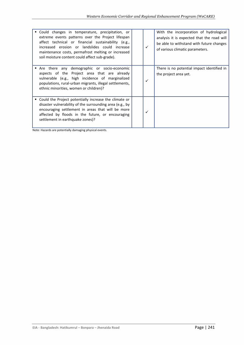
Western Economic Corridor and Regional Enhancement Program (WeCARE)
EIA - Bangladesh: Hatikumrul – Bonpara – Jhenaida Road Page | 241
Note: Hazards are potentially damaging physical events.
▪ Could changes in temperature, precipitation, or extreme events patterns over the Project lifespan affect technical or financial sustainability (e.g., increased erosion or landslides could increase maintenance costs, permafrost melting or increased soil moisture content could affect sub-grade).
✓
With the incorporation of hydrological
analysis it is expected that the road will
be able to withstand with future changes
of various climatic parameters.
▪ Are there any demographic or socio-economic aspects of the Project area that are already vulnerable (e.g., high incidence of marginalized populations, rural-urban migrants, illegal settlements, ethnic minorities, women or children)?
✓
There is no potential impact identified in
the project area yet.
▪ Could the Project potentially increase the climate or disaster vulnerability of the surrounding area (e.g., by encouraging settlement in areas that will be more affected by floods in the future, or encouraging settlement in earthquake zones)?
✓
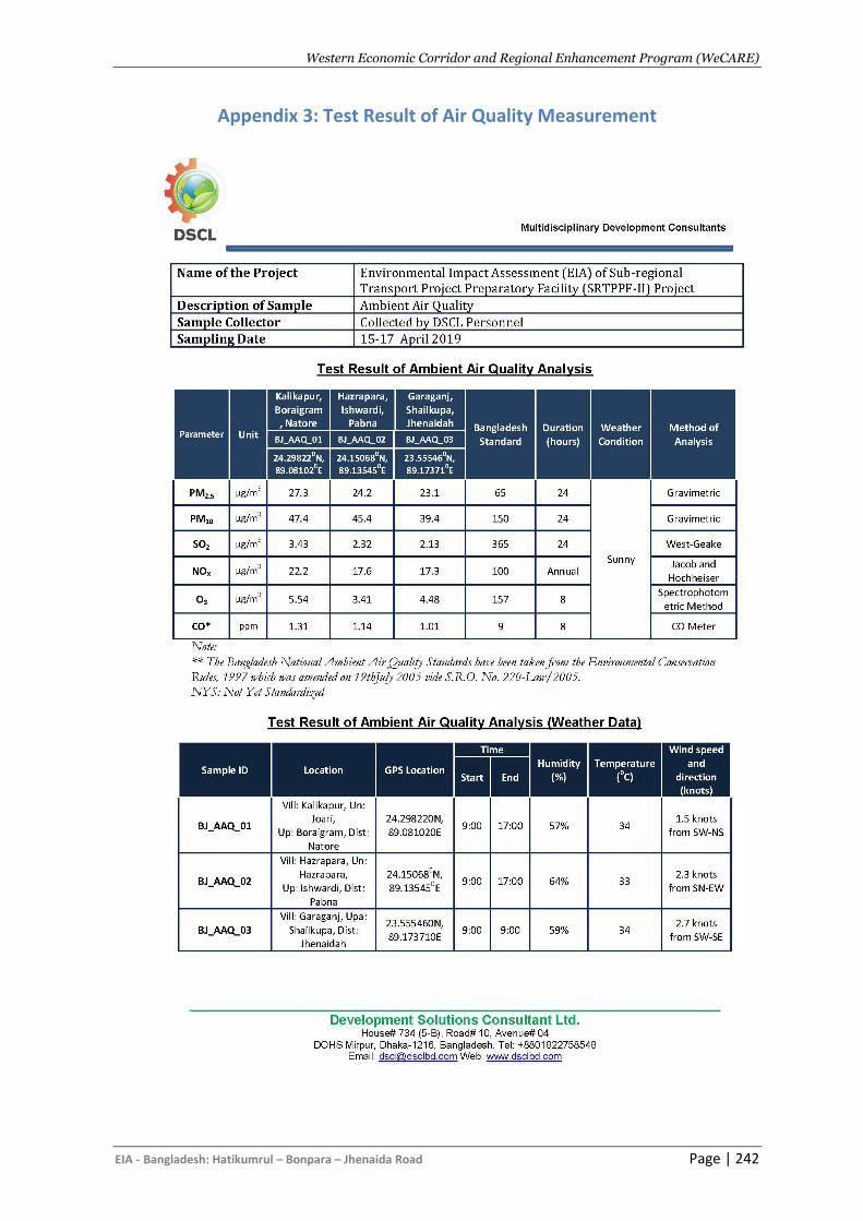
Western Economic Corridor and Regional Enhancement Program (WeCARE)
EIA - Bangladesh: Hatikumrul – Bonpara – Jhenaida Road Page | 242
Appendix 3: Test Result of Air Quality Measurement
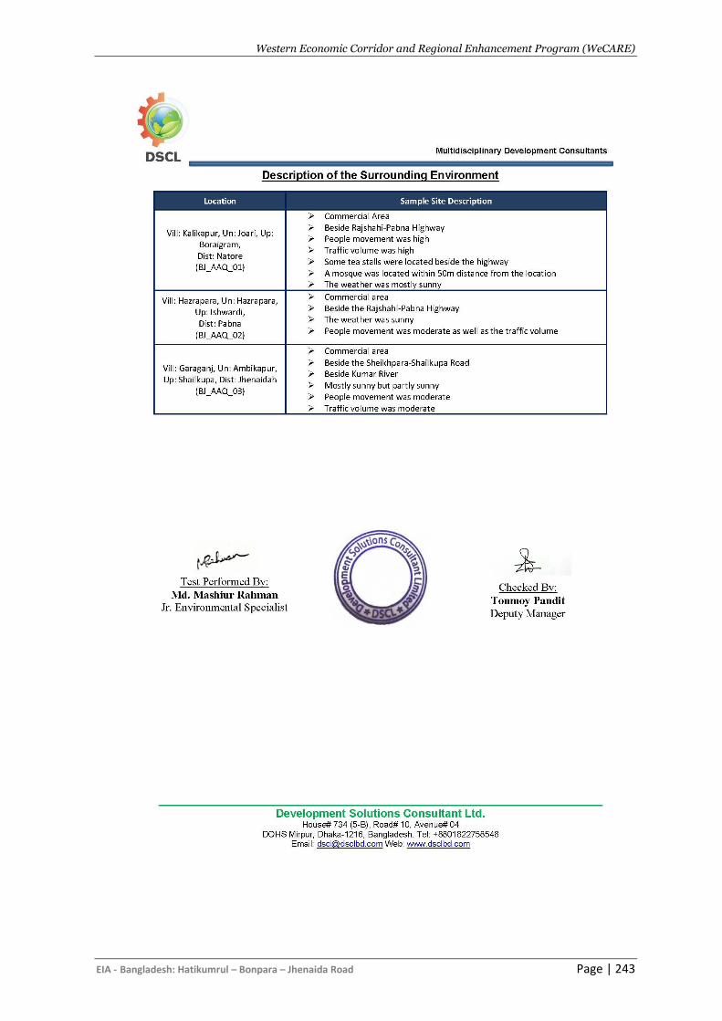
Western Economic Corridor and Regional Enhancement Program (WeCARE)
EIA - Bangladesh: Hatikumrul – Bonpara – Jhenaida Road Page | 243
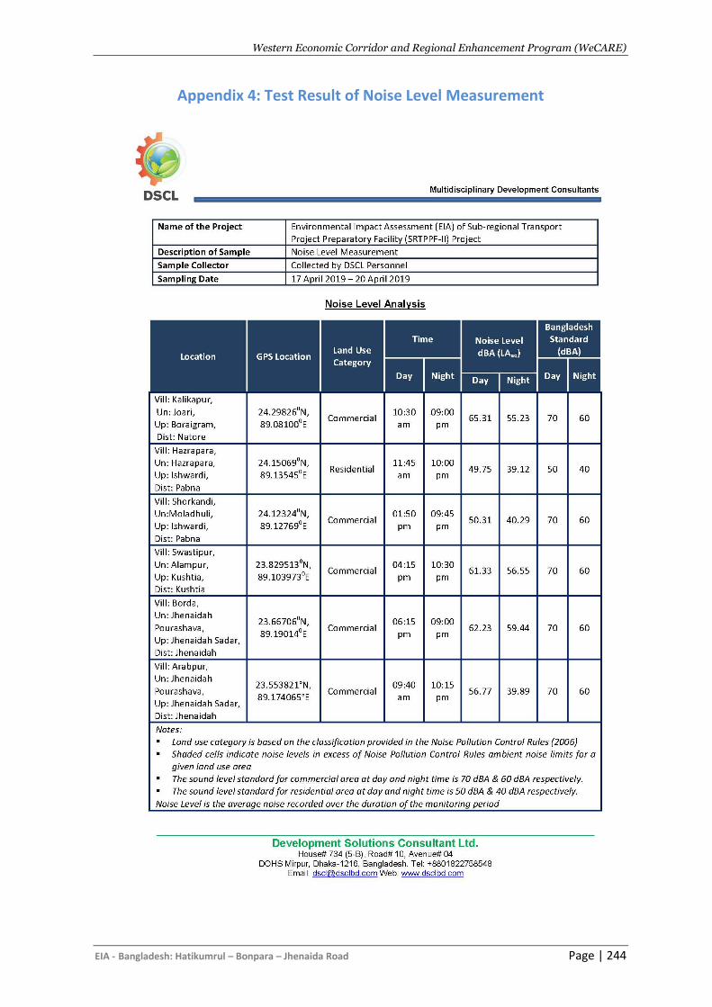
Western Economic Corridor and Regional Enhancement Program (WeCARE)
EIA - Bangladesh: Hatikumrul – Bonpara – Jhenaida Road Page | 244
Appendix 4: Test Result of Noise Level Measurement
Western Economic Corridor and Regional Enhancement Program (WeCARE)
EIA - Bangladesh: Hatikumrul – Bonpara – Jhenaida Road Page | 245
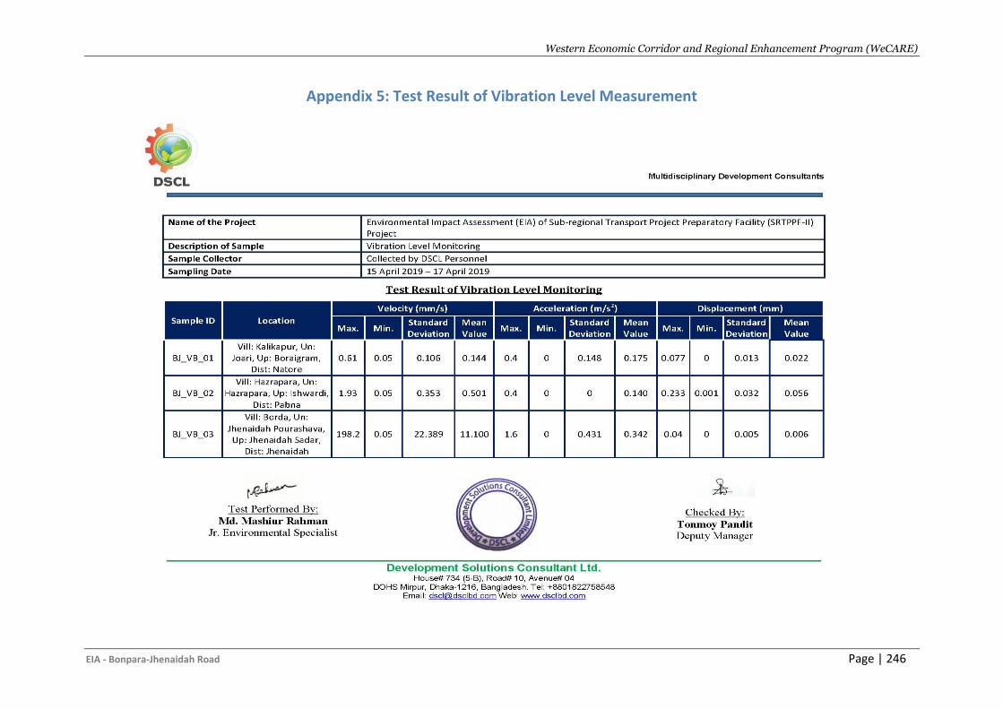
Western Economic Corridor and Regional Enhancement Program (WeCARE)
EIA - Bonpara-Jhenaidah Road Page | 246
Appendix 5: Test Result of Vibration Level Measurement
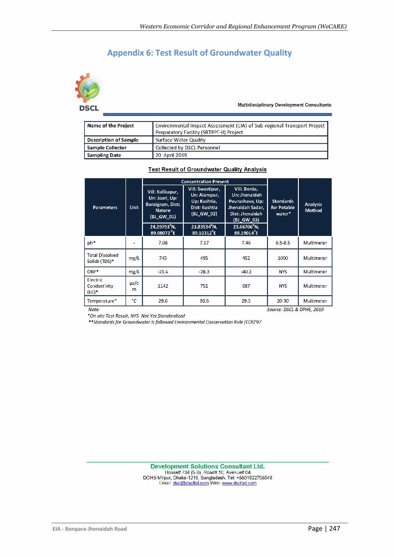
Western Economic Corridor and Regional Enhancement Program (WeCARE)
EIA - Bonpara-Jhenaidah Road Page | 247
Appendix 6: Test Result of Groundwater Quality
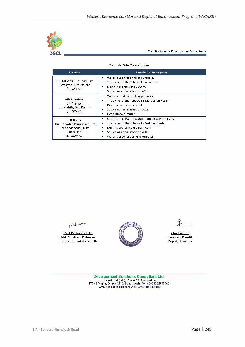
Western Economic Corridor and Regional Enhancement Program (WeCARE)
EIA - Bonpara-Jhenaidah Road Page | 248
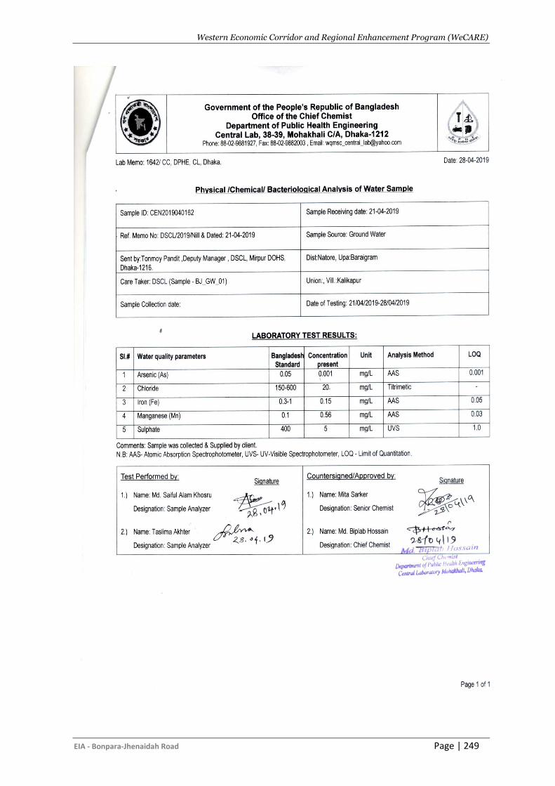
Western Economic Corridor and Regional Enhancement Program (WeCARE)
EIA - Bonpara-Jhenaidah Road Page | 249
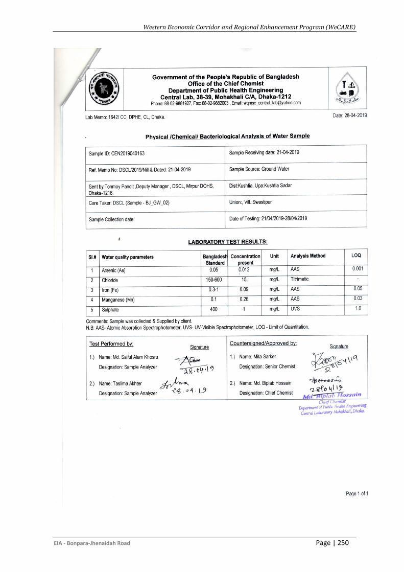
Western Economic Corridor and Regional Enhancement Program (WeCARE)
EIA - Bonpara-Jhenaidah Road Page | 250
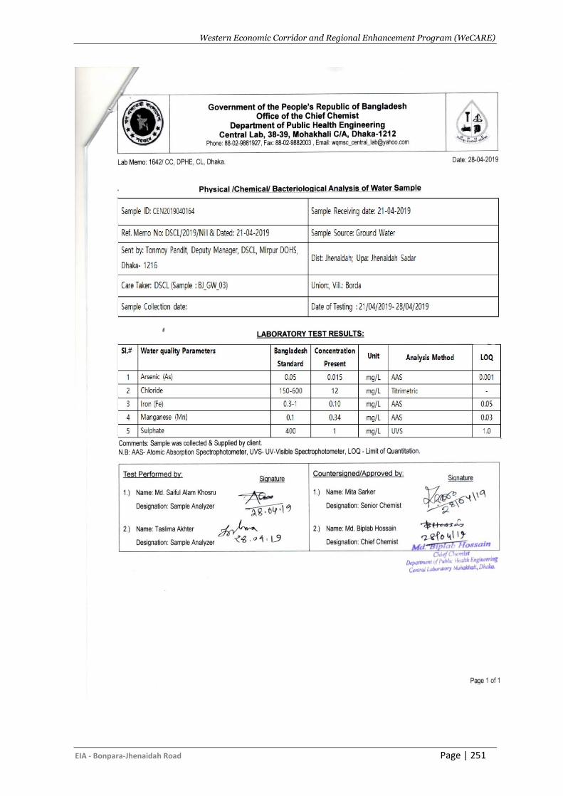
Western Economic Corridor and Regional Enhancement Program (WeCARE)
EIA - Bonpara-Jhenaidah Road Page | 251
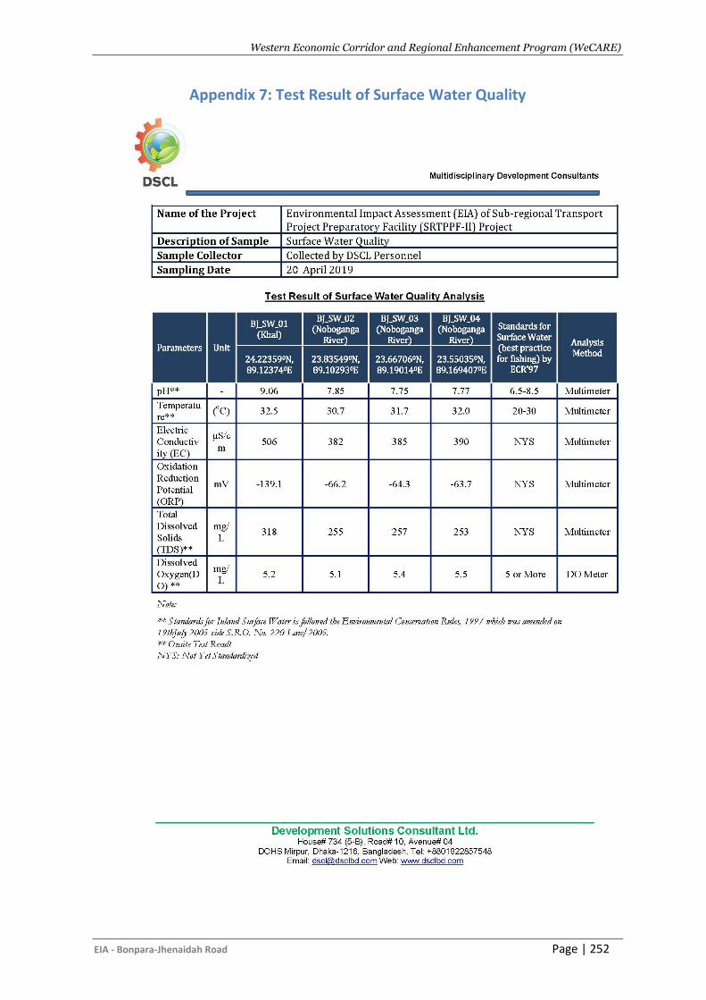
Western Economic Corridor and Regional Enhancement Program (WeCARE)
EIA - Bonpara-Jhenaidah Road Page | 252
Appendix 7: Test Result of Surface Water Quality
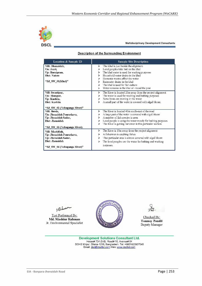
Western Economic Corridor and Regional Enhancement Program (WeCARE)
EIA - Bonpara-Jhenaidah Road Page | 253
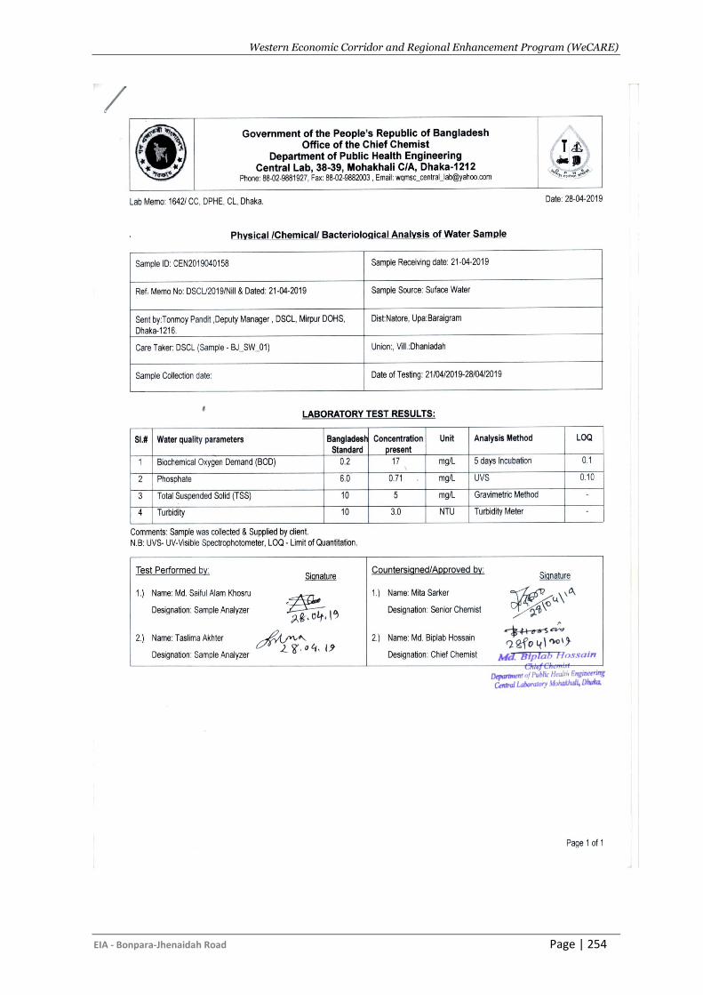
Western Economic Corridor and Regional Enhancement Program (WeCARE)
EIA - Bonpara-Jhenaidah Road Page | 254
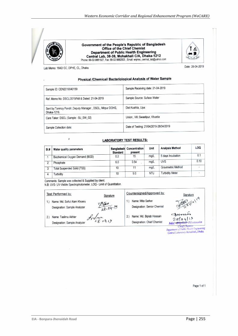
Western Economic Corridor and Regional Enhancement Program (WeCARE)
EIA - Bonpara-Jhenaidah Road Page | 255
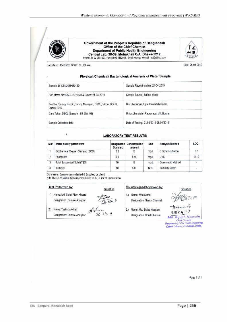
Western Economic Corridor and Regional Enhancement Program (WeCARE)
EIA - Bonpara-Jhenaidah Road Page | 256
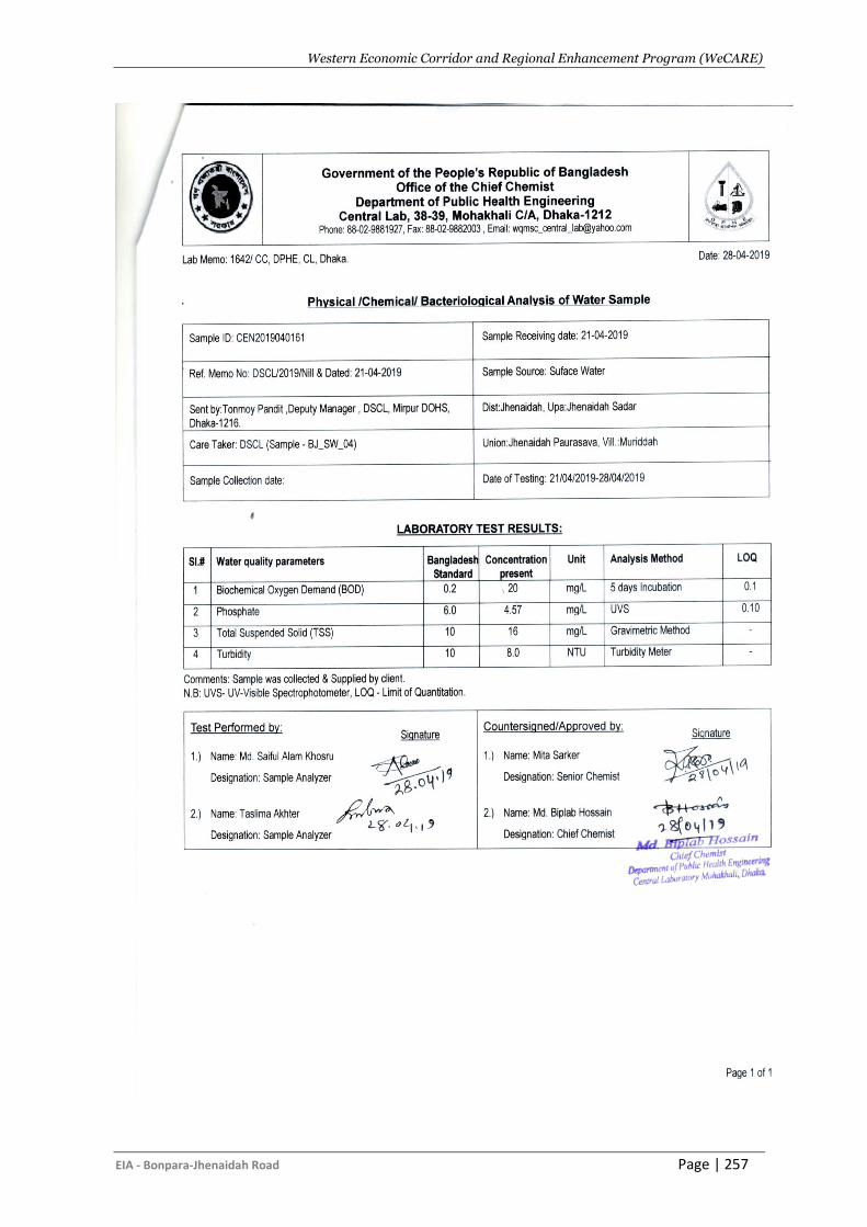
Western Economic Corridor and Regional Enhancement Program (WeCARE)
EIA - Bonpara-Jhenaidah Road Page | 257
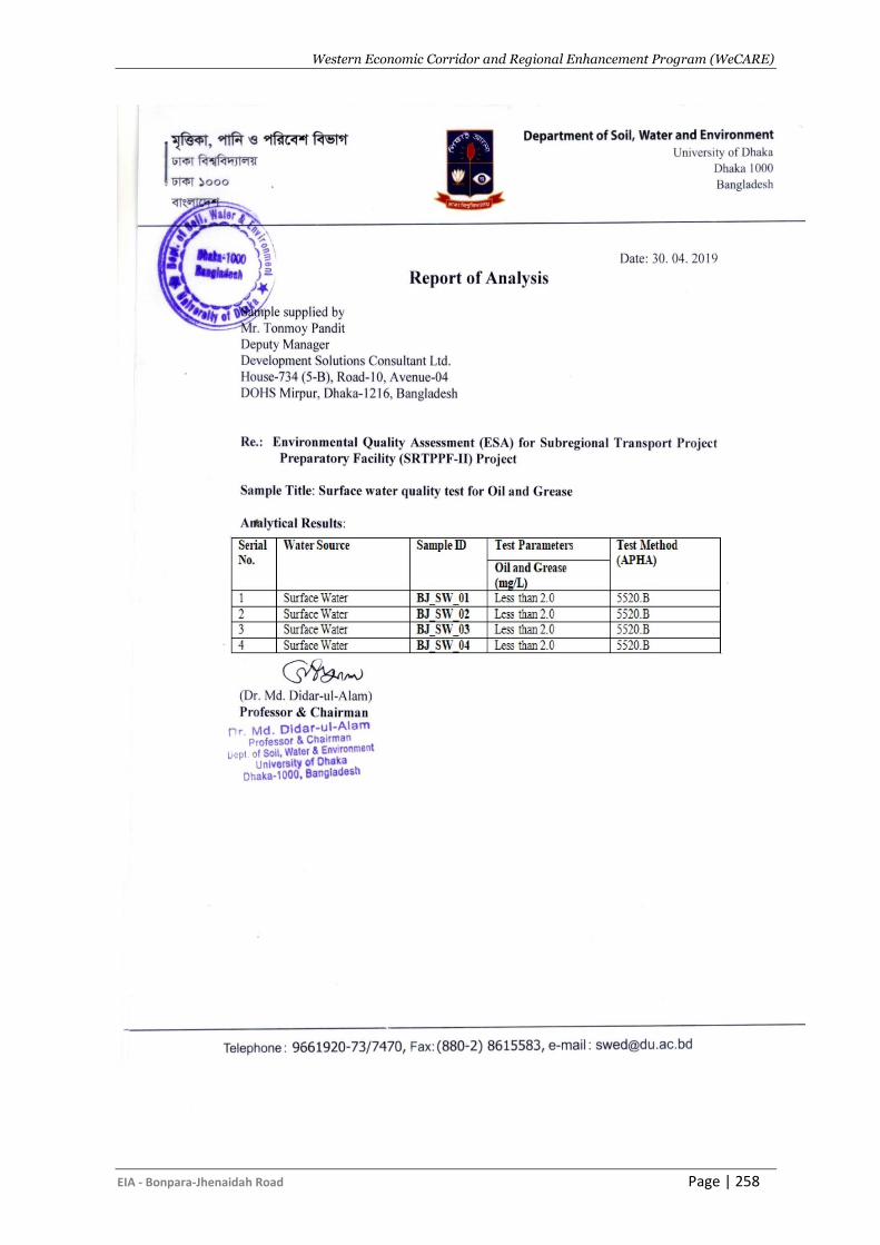
Western Economic Corridor and Regional Enhancement Program (WeCARE)
EIA - Bonpara-Jhenaidah Road Page | 258
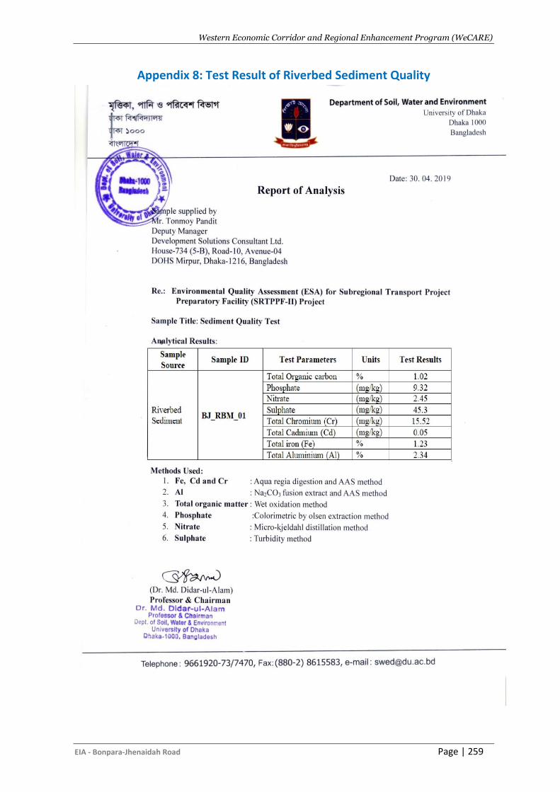
Western Economic Corridor and Regional Enhancement Program (WeCARE)
EIA - Bonpara-Jhenaidah Road Page | 259
Appendix 8: Test Result of Riverbed Sediment Quality
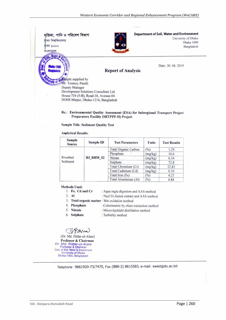
Western Economic Corridor and Regional Enhancement Program (WeCARE)
EIA - Bonpara-Jhenaidah Road Page | 260
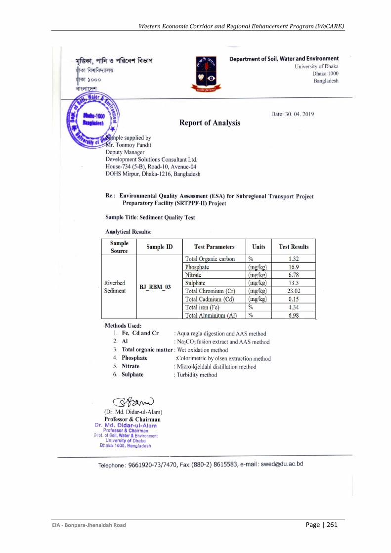
Western Economic Corridor and Regional Enhancement Program (WeCARE)
EIA - Bonpara-Jhenaidah Road Page | 261
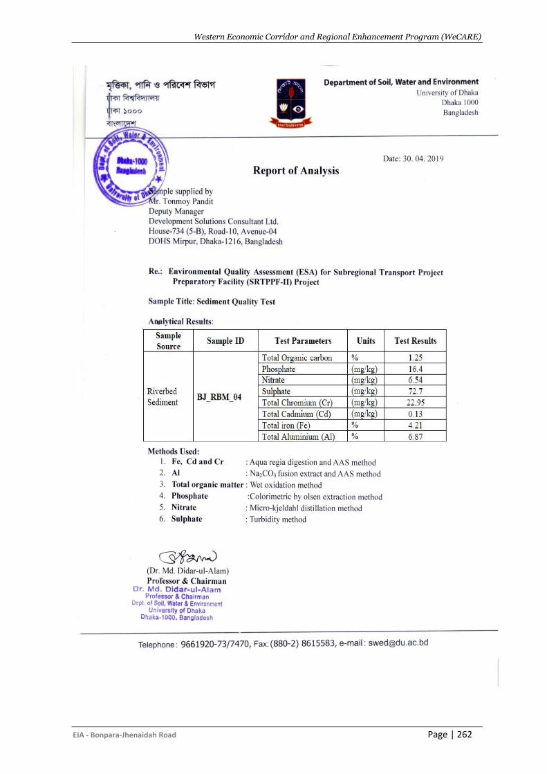
Western Economic Corridor and Regional Enhancement Program (WeCARE)
EIA - Bonpara-Jhenaidah Road Page | 262
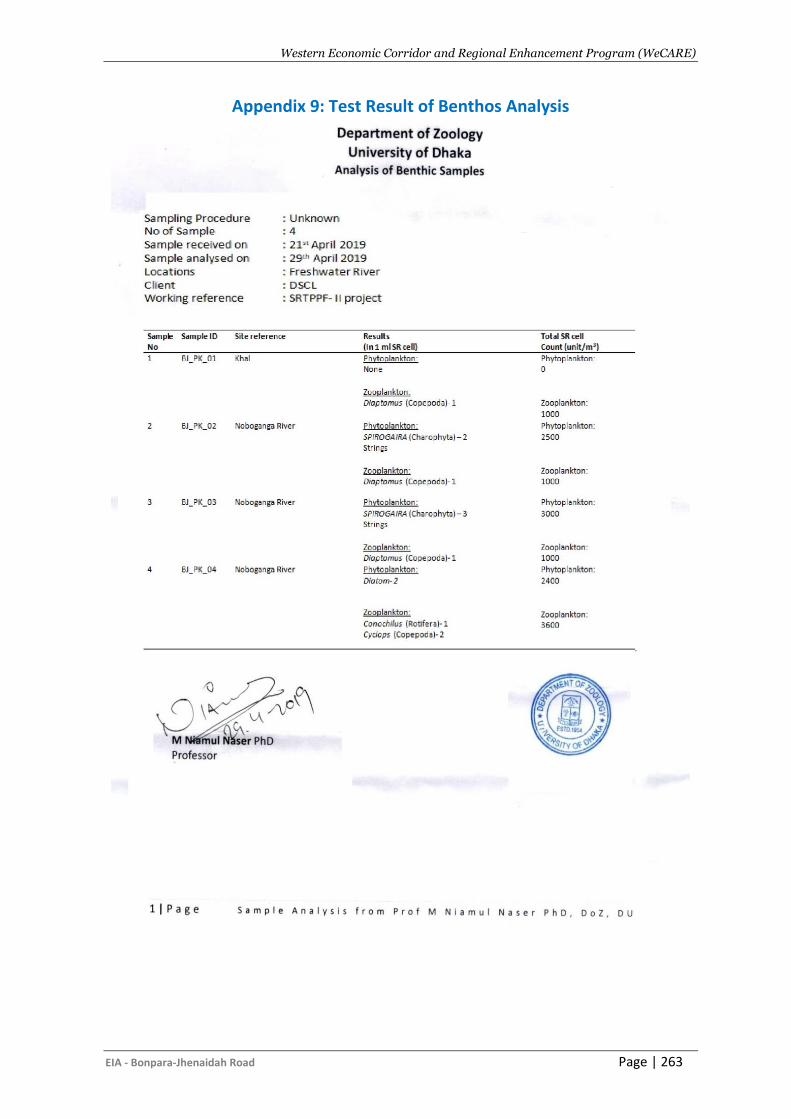
Western Economic Corridor and Regional Enhancement Program (WeCARE)
EIA - Bonpara-Jhenaidah Road Page | 263
Appendix 9: Test Result of Benthos Analysis
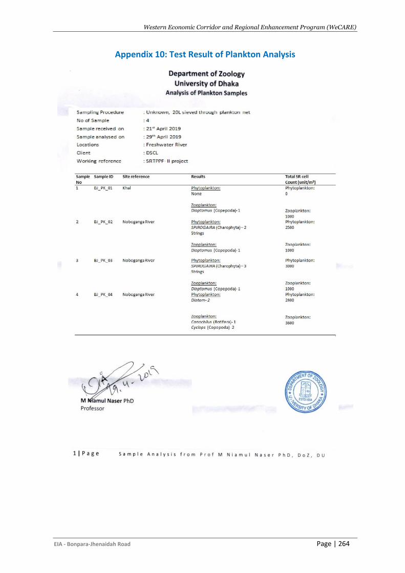
Western Economic Corridor and Regional Enhancement Program (WeCARE)
EIA - Bonpara-Jhenaidah Road Page | 264
Appendix 10: Test Result of Plankton Analysis
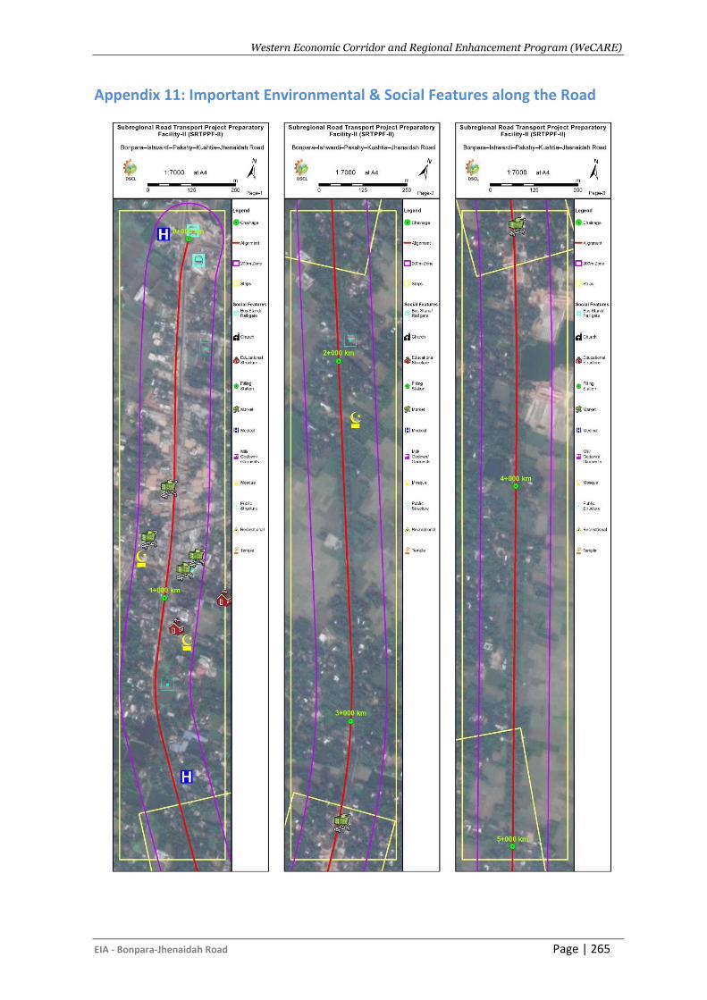
Western Economic Corridor and Regional Enhancement Program (WeCARE)
EIA - Bonpara-Jhenaidah Road Page | 265
Appendix 11: Important Environmental & Social Features along the Road
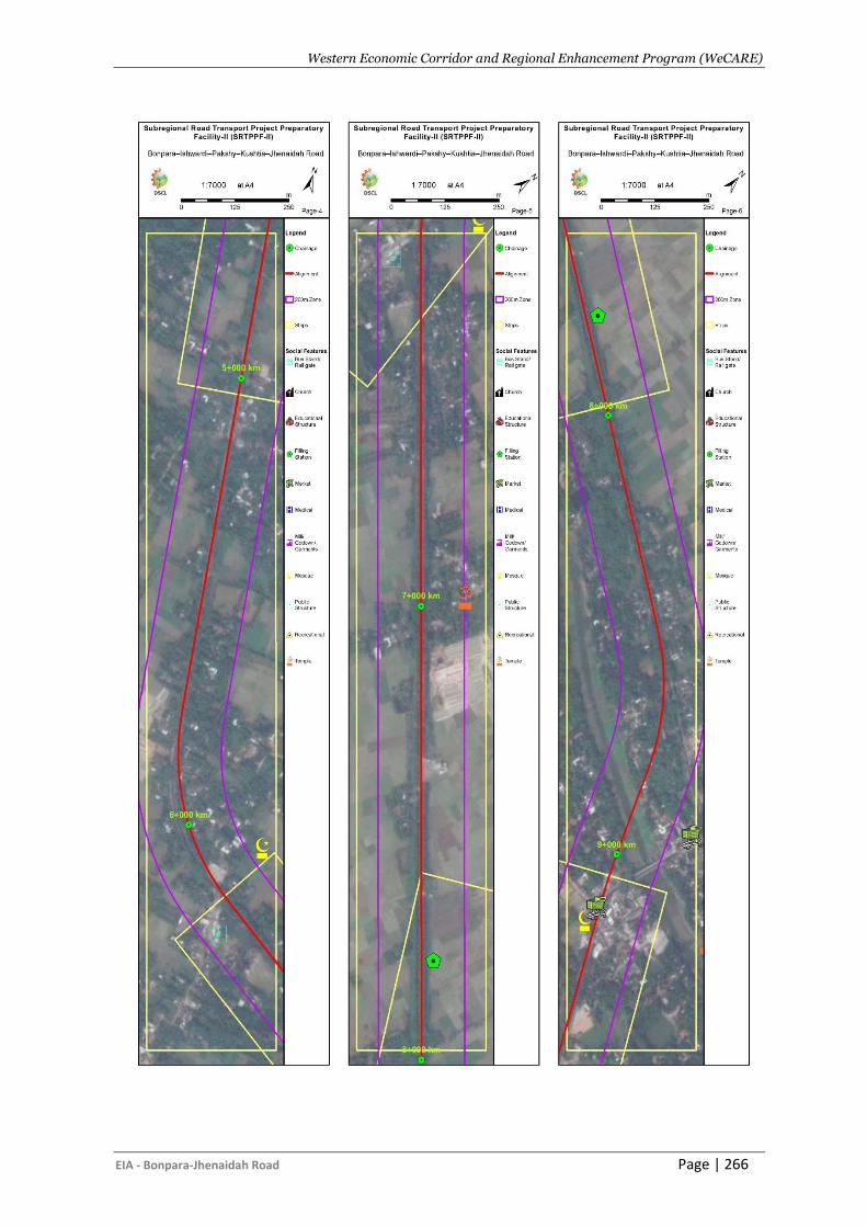
Western Economic Corridor and Regional Enhancement Program (WeCARE)
EIA - Bonpara-Jhenaidah Road Page | 266
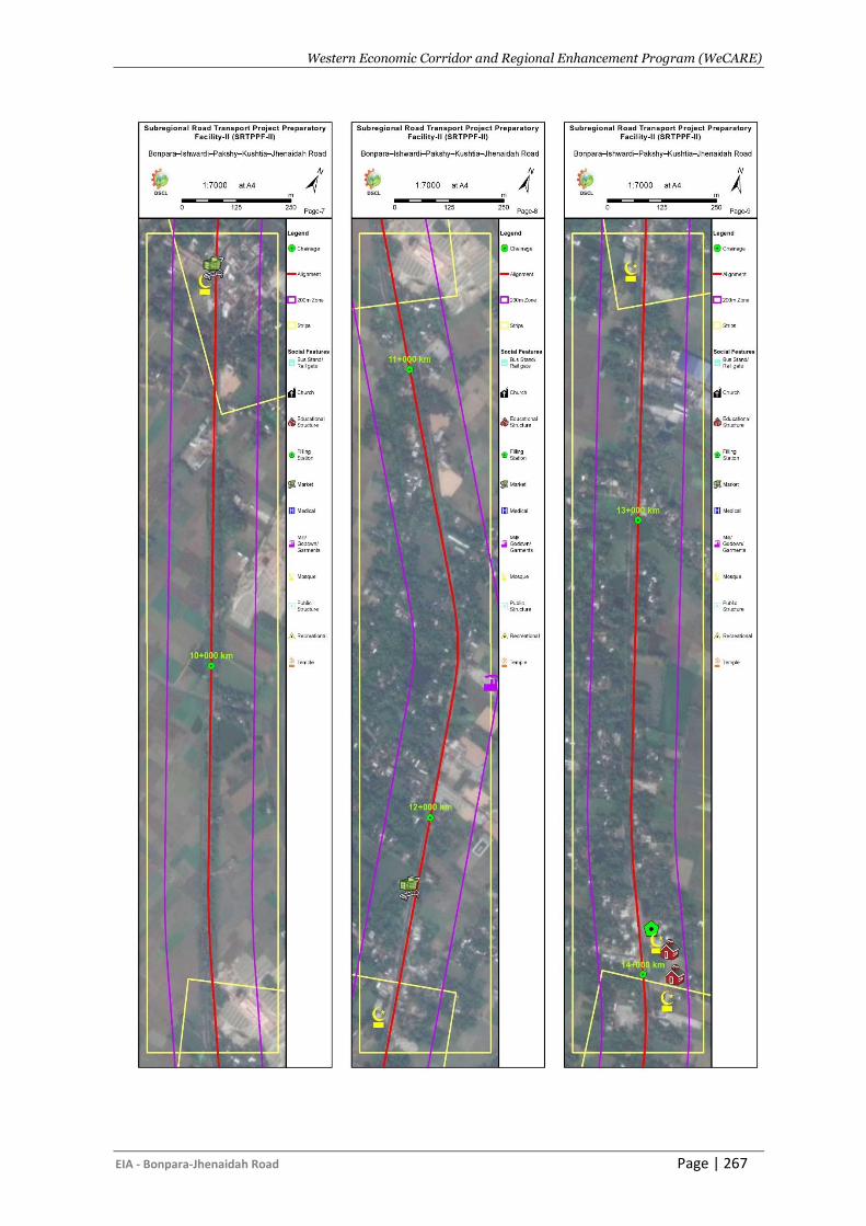
Western Economic Corridor and Regional Enhancement Program (WeCARE)
EIA - Bonpara-Jhenaidah Road Page | 267
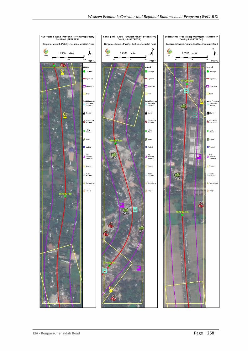
Western Economic Corridor and Regional Enhancement Program (WeCARE)
EIA - Bonpara-Jhenaidah Road Page | 268
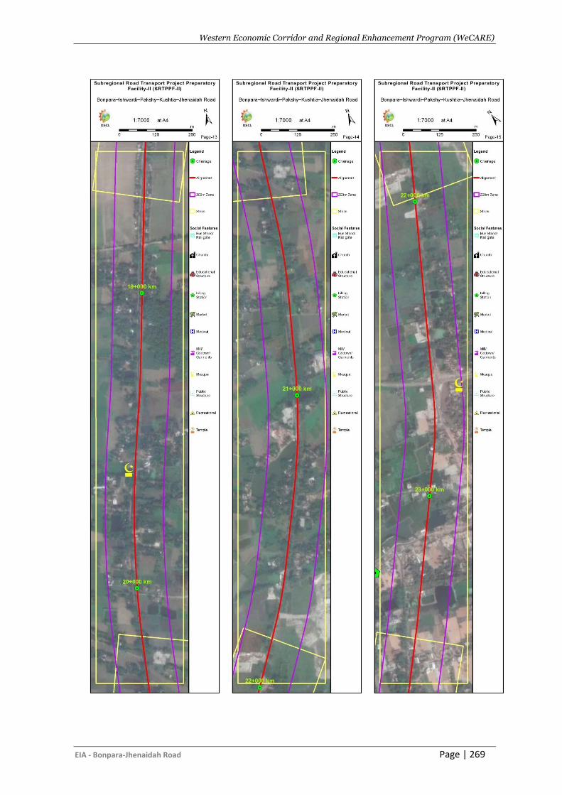
Western Economic Corridor and Regional Enhancement Program (WeCARE)
EIA - Bonpara-Jhenaidah Road Page | 269
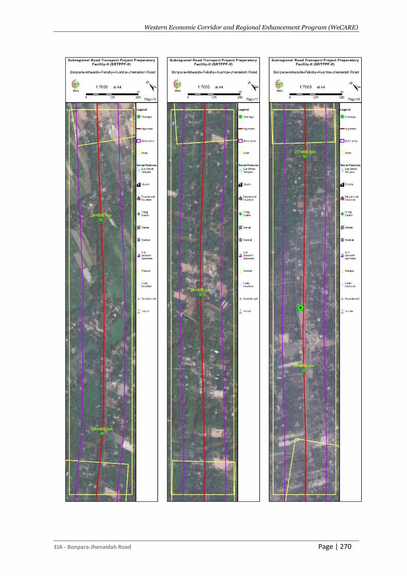
Western Economic Corridor and Regional Enhancement Program (WeCARE)
EIA - Bonpara-Jhenaidah Road Page | 270
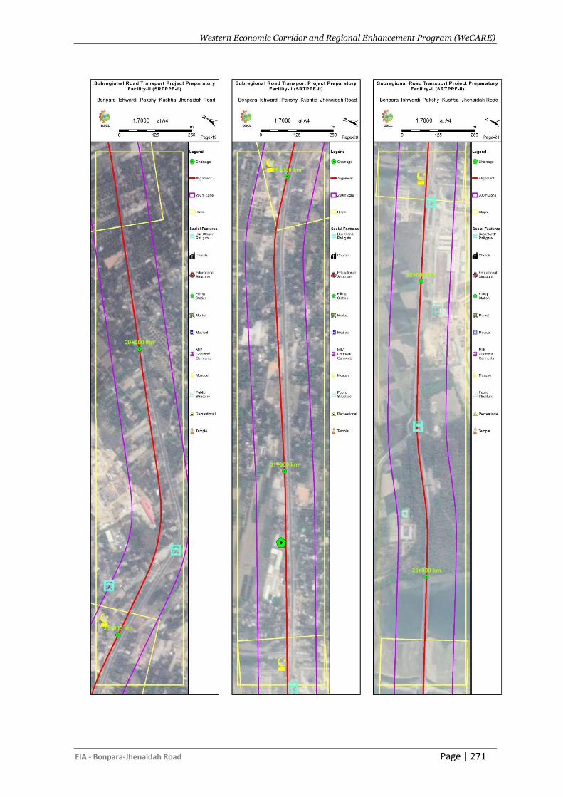
Western Economic Corridor and Regional Enhancement Program (WeCARE)
EIA - Bonpara-Jhenaidah Road Page | 271
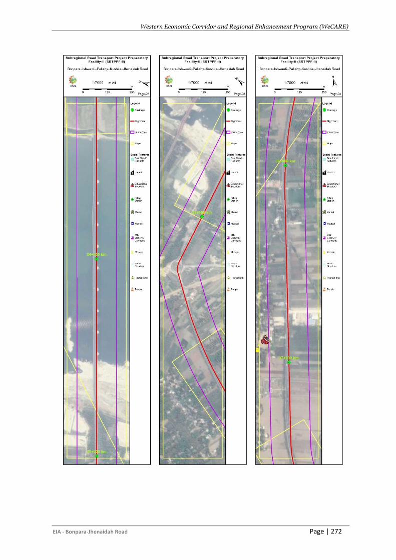
Western Economic Corridor and Regional Enhancement Program (WeCARE)
EIA - Bonpara-Jhenaidah Road Page | 272
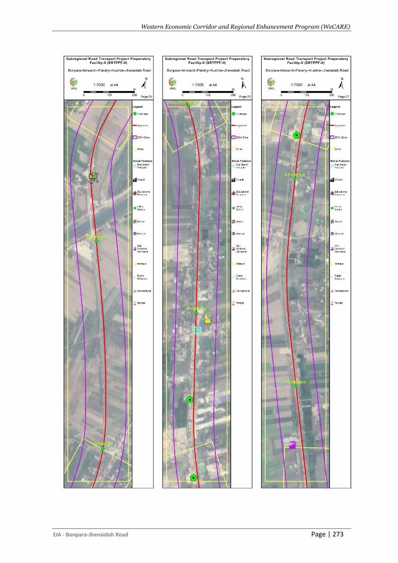
Western Economic Corridor and Regional Enhancement Program (WeCARE)
EIA - Bonpara-Jhenaidah Road Page | 273
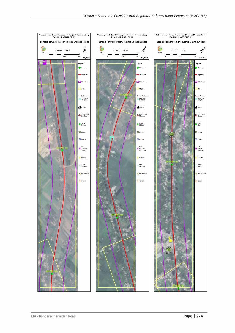
Western Economic Corridor and Regional Enhancement Program (WeCARE)
EIA - Bonpara-Jhenaidah Road Page | 274
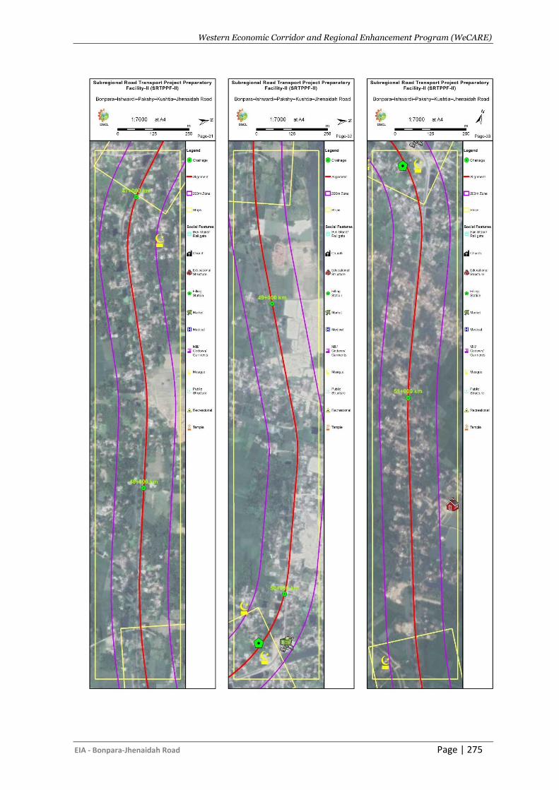
Western Economic Corridor and Regional Enhancement Program (WeCARE)
EIA - Bonpara-Jhenaidah Road Page | 275
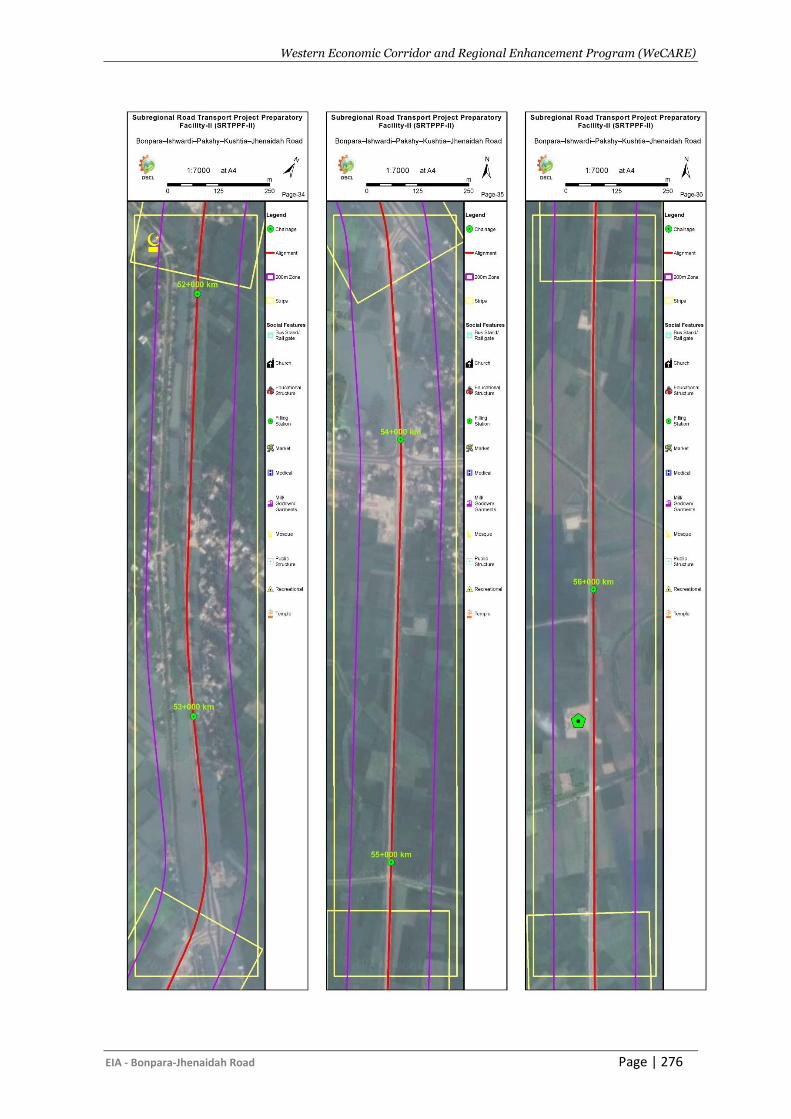
Western Economic Corridor and Regional Enhancement Program (WeCARE)
EIA - Bonpara-Jhenaidah Road Page | 276
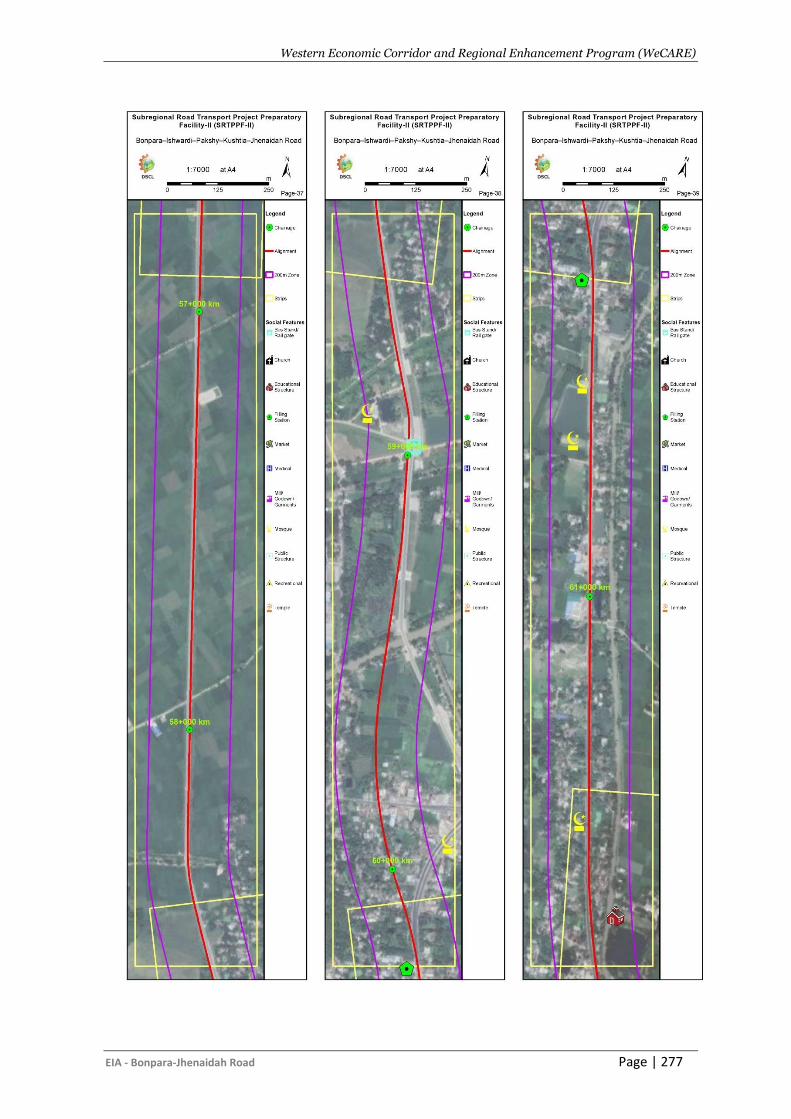
Western Economic Corridor and Regional Enhancement Program (WeCARE)
EIA - Bonpara-Jhenaidah Road Page | 277
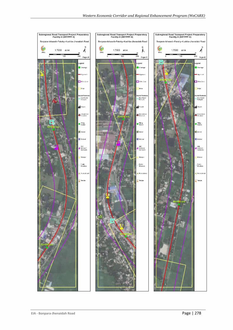
Western Economic Corridor and Regional Enhancement Program (WeCARE)
EIA - Bonpara-Jhenaidah Road Page | 278
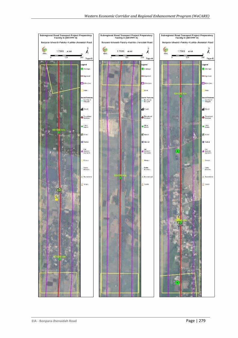
Western Economic Corridor and Regional Enhancement Program (WeCARE)
EIA - Bonpara-Jhenaidah Road Page | 279
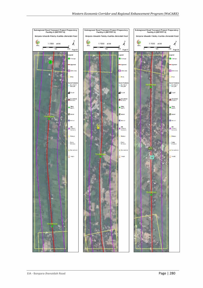
Western Economic Corridor and Regional Enhancement Program (WeCARE)
EIA - Bonpara-Jhenaidah Road Page | 280
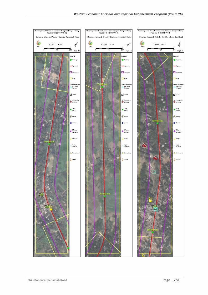
Western Economic Corridor and Regional Enhancement Program (WeCARE)
EIA - Bonpara-Jhenaidah Road Page | 281
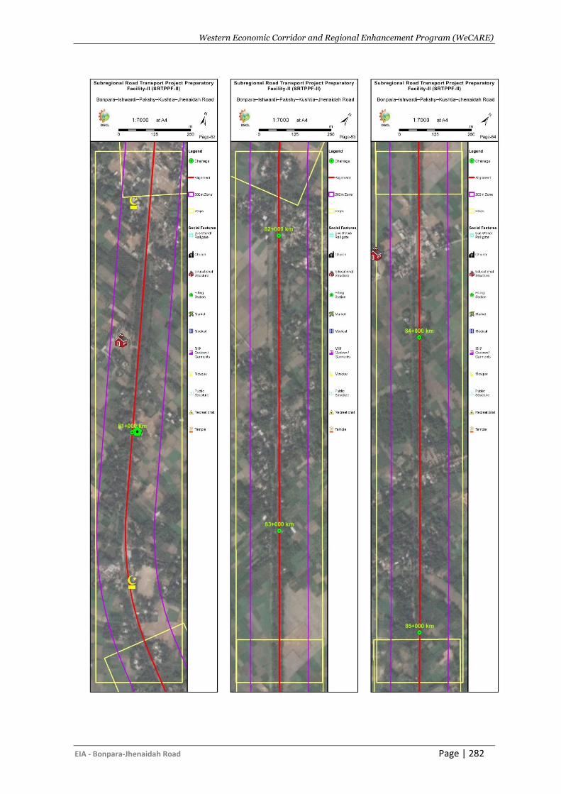
Western Economic Corridor and Regional Enhancement Program (WeCARE)
EIA - Bonpara-Jhenaidah Road Page | 282
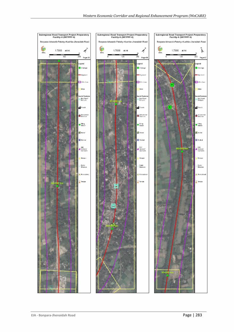
Western Economic Corridor and Regional Enhancement Program (WeCARE)
EIA - Bonpara-Jhenaidah Road Page | 283
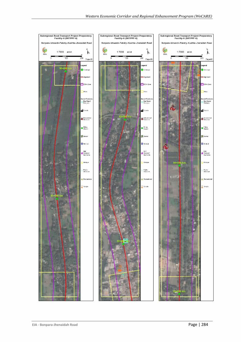
Western Economic Corridor and Regional Enhancement Program (WeCARE)
EIA - Bonpara-Jhenaidah Road Page | 284
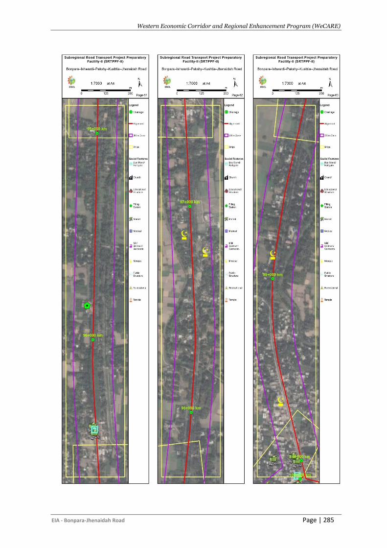
Western Economic Corridor and Regional Enhancement Program (WeCARE)
EIA - Bonpara-Jhenaidah Road Page | 285
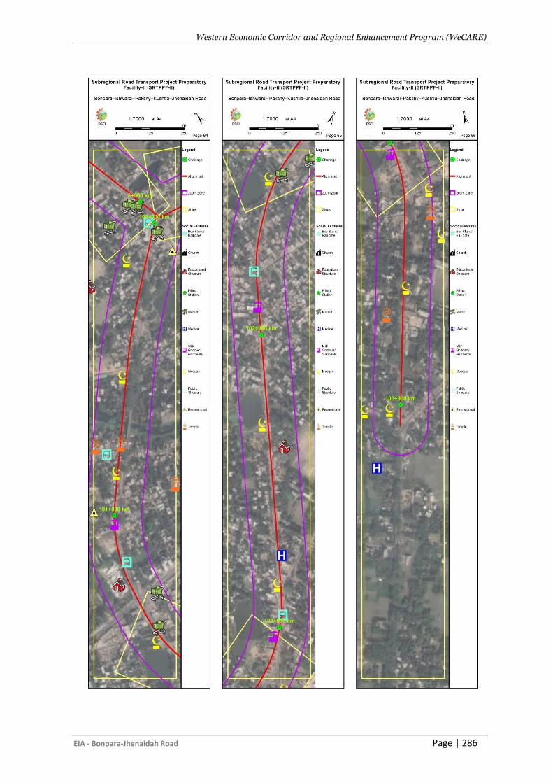
Western Economic Corridor and Regional Enhancement Program (WeCARE)
EIA - Bonpara-Jhenaidah Road Page | 286
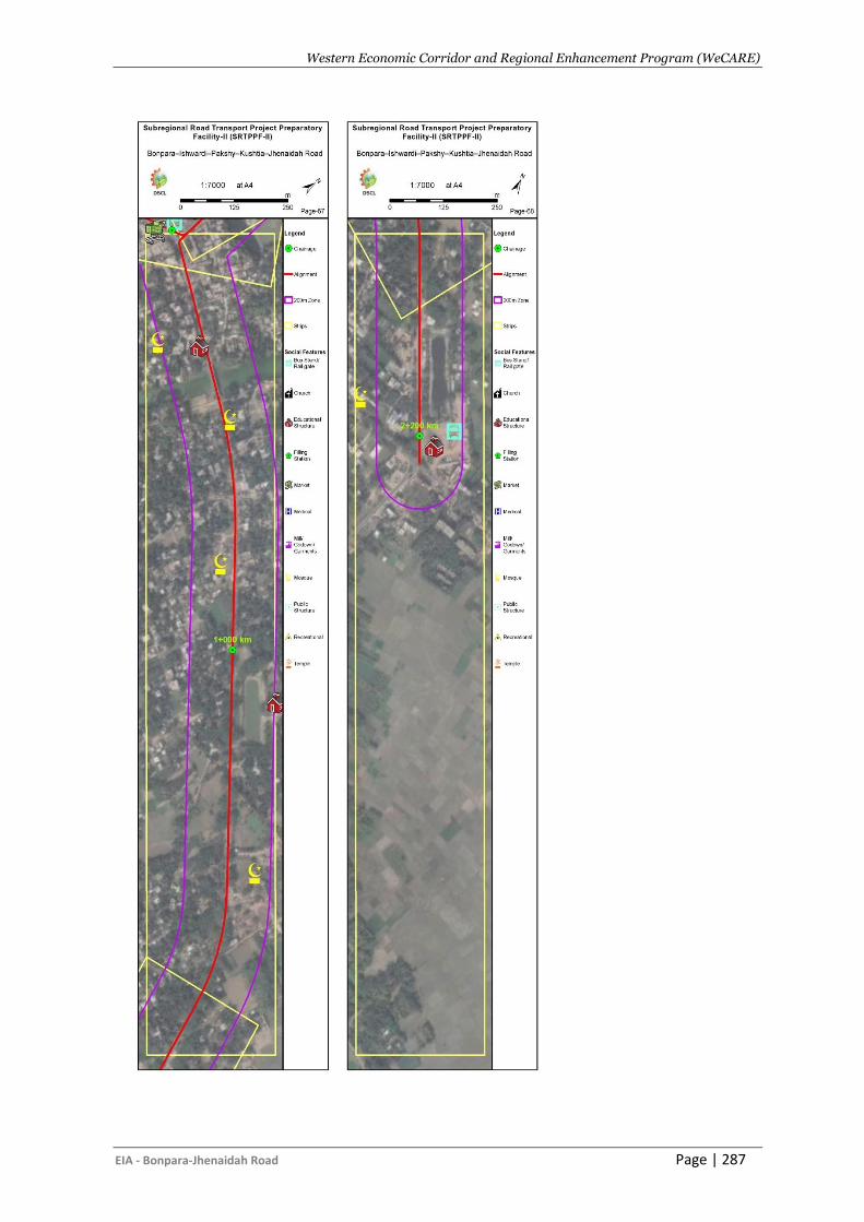
Western Economic Corridor and Regional Enhancement Program (WeCARE)
EIA - Bonpara-Jhenaidah Road Page | 287
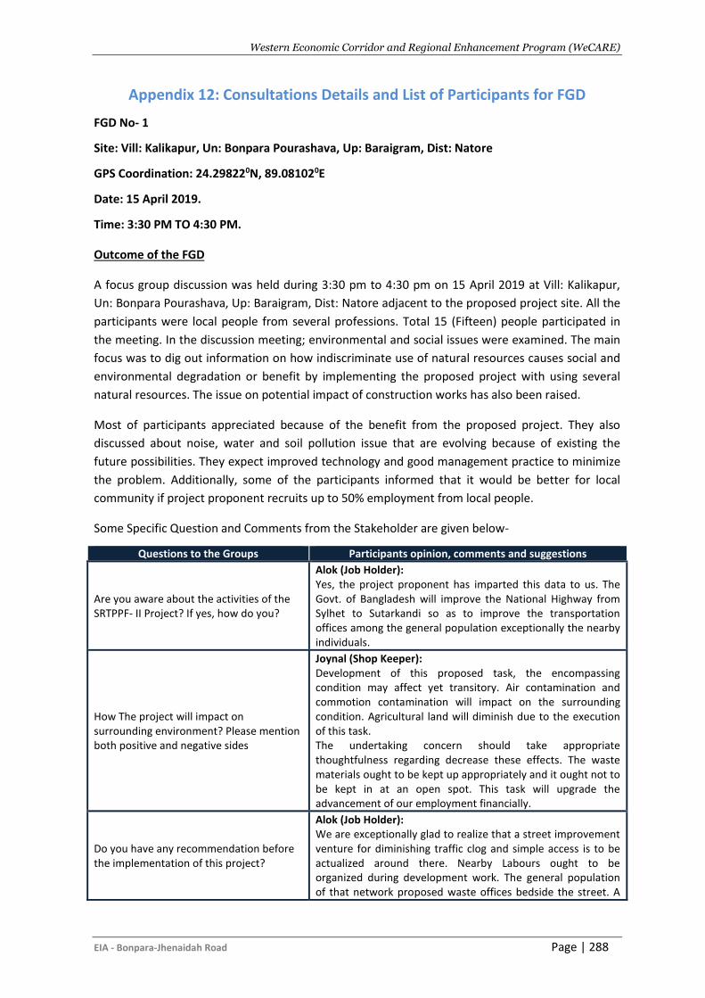
Western Economic Corridor and Regional Enhancement Program (WeCARE)
EIA - Bonpara-Jhenaidah Road Page | 288
Appendix 12: Consultations Details and List of Participants for FGD
FGD No- 1
Site: Vill: Kalikapur, Un: Bonpara Pourashava, Up: Baraigram, Dist: Natore
GPS Coordination: 24.298220N, 89.081020E
Date: 15 April 2019.
Time: 3:30 PM TO 4:30 PM.
Outcome of the FGD
A focus group discussion was held during 3:30 pm to 4:30 pm on 15 April 2019 at Vill: Kalikapur,
Un: Bonpara Pourashava, Up: Baraigram, Dist: Natore adjacent to the proposed project site. All the
participants were local people from several professions. Total 15 (Fifteen) people participated in
the meeting. In the discussion meeting; environmental and social issues were examined. The main
focus was to dig out information on how indiscriminate use of natural resources causes social and
environmental degradation or benefit by implementing the proposed project with using several
natural resources. The issue on potential impact of construction works has also been raised.
Most of participants appreciated because of the benefit from the proposed project. They also
discussed about noise, water and soil pollution issue that are evolving because of existing the
future possibilities. They expect improved technology and good management practice to minimize
the problem. Additionally, some of the participants informed that it would be better for local
community if project proponent recruits up to 50% employment from local people.
Some Specific Question and Comments from the Stakeholder are given below-
Questions to the Groups Participants opinion, comments and suggestions
Are you aware about the activities of the SRTPPF- II Project? If yes, how do you?
Alok (Job Holder): Yes, the project proponent has imparted this data to us. The Govt. of Bangladesh will improve the National Highway from Sylhet to Sutarkandi so as to improve the transportation offices among the general population exceptionally the nearby individuals.
How The project will impact on surrounding environment? Please mention both positive and negative sides
Joynal (Shop Keeper): Development of this proposed task, the encompassing condition may affect yet transitory. Air contamination and commotion contamination will impact on the surrounding condition. Agricultural land will diminish due to the execution of this task. The undertaking concern should take appropriate thoughtfulness regarding decrease these effects. The waste materials ought to be kept up appropriately and it ought not to be kept in at an open spot. This task will upgrade the advancement of our employment financially.
Do you have any recommendation before the implementation of this project?
Alok (Job Holder): We are exceptionally glad to realize that a street improvement venture for diminishing traffic clog and simple access is to be actualized around there. Nearby Labours ought to be organized during development work. The general population of that network proposed waste offices bedside the street. A
Western Economic Corridor and Regional Enhancement Program (WeCARE)
EIA - Bonpara-Jhenaidah Road Page | 289
Questions to the Groups Participants opinion, comments and suggestions
recovery plan for the influenced individual’s populace. Foot over the scaffold for the streets. As far as a possible billboard on the two sides of the proposed street.
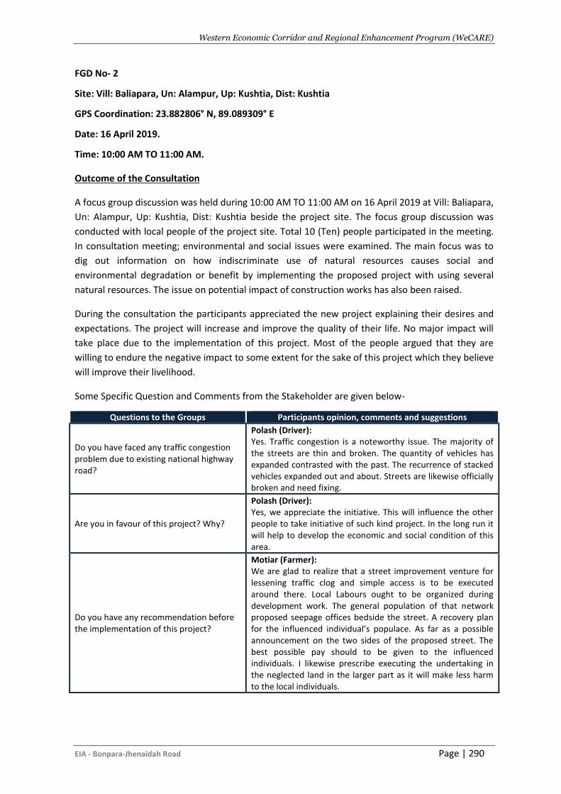
Western Economic Corridor and Regional Enhancement Program (WeCARE)
EIA - Bonpara-Jhenaidah Road Page | 290
FGD No- 2
Site: Vill: Baliapara, Un: Alampur, Up: Kushtia, Dist: Kushtia
GPS Coordination: 23.882806° N, 89.089309° E
Date: 16 April 2019.
Time: 10:00 AM TO 11:00 AM.
Outcome of the Consultation
A focus group discussion was held during 10:00 AM TO 11:00 AM on 16 April 2019 at Vill: Baliapara,
Un: Alampur, Up: Kushtia, Dist: Kushtia beside the project site. The focus group discussion was
conducted with local people of the project site. Total 10 (Ten) people participated in the meeting.
In consultation meeting; environmental and social issues were examined. The main focus was to
dig out information on how indiscriminate use of natural resources causes social and
environmental degradation or benefit by implementing the proposed project with using several
natural resources. The issue on potential impact of construction works has also been raised.
During the consultation the participants appreciated the new project explaining their desires and
expectations. The project will increase and improve the quality of their life. No major impact will
take place due to the implementation of this project. Most of the people argued that they are
willing to endure the negative impact to some extent for the sake of this project which they believe
will improve their livelihood.
Some Specific Question and Comments from the Stakeholder are given below-
Questions to the Groups Participants opinion, comments and suggestions
Do you have faced any traffic congestion problem due to existing national highway road?
Polash (Driver): Yes. Traffic congestion is a noteworthy issue. The majority of the streets are thin and broken. The quantity of vehicles has expanded contrasted with the past. The recurrence of stacked vehicles expanded out and about. Streets are likewise officially broken and need fixing.
Are you in favour of this project? Why?
Polash (Driver): Yes, we appreciate the initiative. This will influence the other people to take initiative of such kind project. In the long run it will help to develop the economic and social condition of this area.
Do you have any recommendation before the implementation of this project?
Motiar (Farmer): We are glad to realize that a street improvement venture for lessening traffic clog and simple access is to be executed around there. Local Labours ought to be organized during development work. The general population of that network proposed seepage offices bedside the street. A recovery plan for the influenced individual’s populace. As far as a possible announcement on the two sides of the proposed street. The best possible pay should to be given to the influenced individuals. I likewise prescribe executing the undertaking in the neglected land in the larger part as it will make less harm to the local individuals.
Western Economic Corridor and Regional Enhancement Program (WeCARE)
EIA - Bonpara-Jhenaidah Road Page | 291
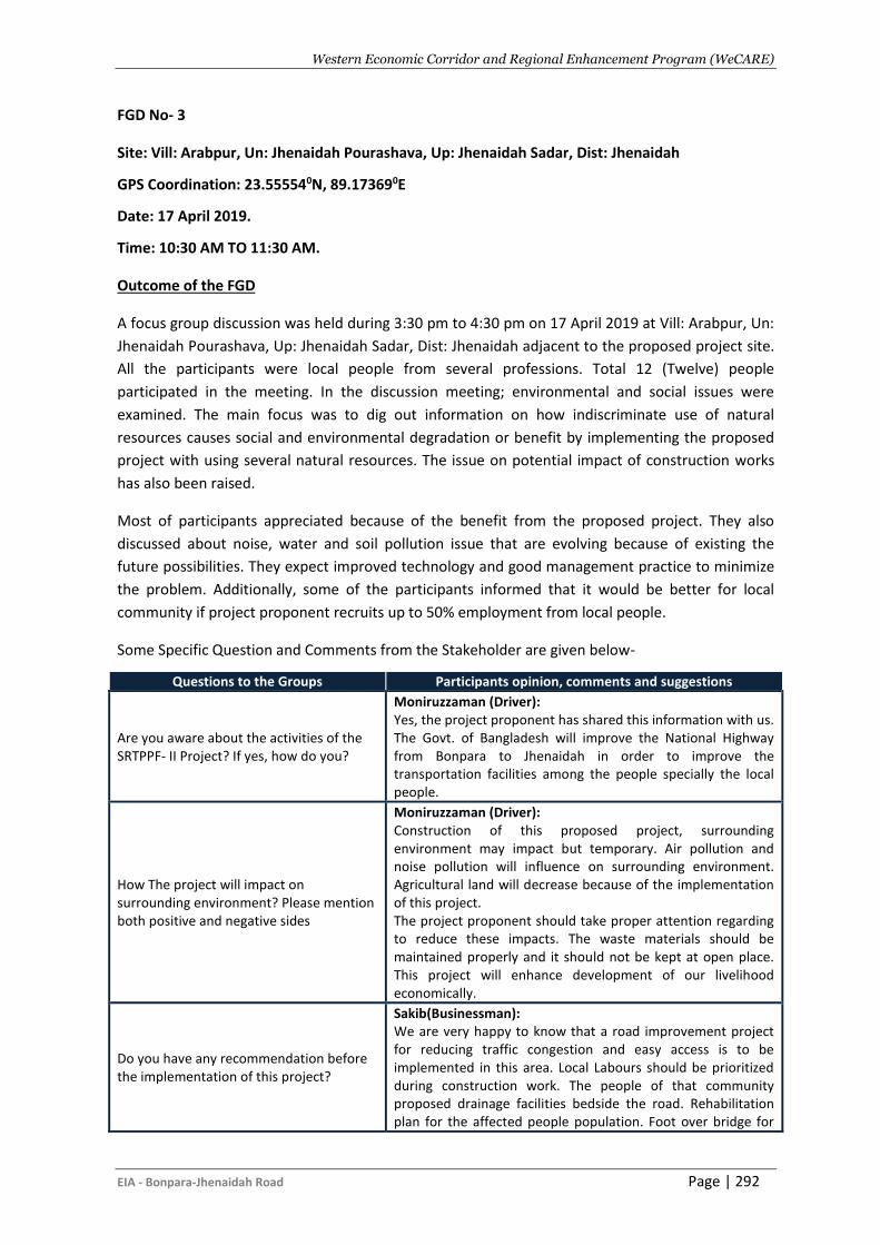
Western Economic Corridor and Regional Enhancement Program (WeCARE)
EIA - Bonpara-Jhenaidah Road Page | 292
FGD No- 3
Site: Vill: Arabpur, Un: Jhenaidah Pourashava, Up: Jhenaidah Sadar, Dist: Jhenaidah
GPS Coordination: 23.555540N, 89.173690E
Date: 17 April 2019.
Time: 10:30 AM TO 11:30 AM.
Outcome of the FGD
A focus group discussion was held during 3:30 pm to 4:30 pm on 17 April 2019 at Vill: Arabpur, Un:
Jhenaidah Pourashava, Up: Jhenaidah Sadar, Dist: Jhenaidah adjacent to the proposed project site.
All the participants were local people from several professions. Total 12 (Twelve) people
participated in the meeting. In the discussion meeting; environmental and social issues were
examined. The main focus was to dig out information on how indiscriminate use of natural
resources causes social and environmental degradation or benefit by implementing the proposed
project with using several natural resources. The issue on potential impact of construction works
has also been raised.
Most of participants appreciated because of the benefit from the proposed project. They also
discussed about noise, water and soil pollution issue that are evolving because of existing the
future possibilities. They expect improved technology and good management practice to minimize
the problem. Additionally, some of the participants informed that it would be better for local
community if project proponent recruits up to 50% employment from local people.
Some Specific Question and Comments from the Stakeholder are given below-
Questions to the Groups Participants opinion, comments and suggestions
Are you aware about the activities of the SRTPPF- II Project? If yes, how do you?
Moniruzzaman (Driver): Yes, the project proponent has shared this information with us. The Govt. of Bangladesh will improve the National Highway from Bonpara to Jhenaidah in order to improve the transportation facilities among the people specially the local people.
How The project will impact on surrounding environment? Please mention both positive and negative sides
Moniruzzaman (Driver): Construction of this proposed project, surrounding environment may impact but temporary. Air pollution and noise pollution will influence on surrounding environment. Agricultural land will decrease because of the implementation of this project. The project proponent should take proper attention regarding to reduce these impacts. The waste materials should be maintained properly and it should not be kept at open place. This project will enhance development of our livelihood economically.
Do you have any recommendation before the implementation of this project?
Sakib(Businessman): We are very happy to know that a road improvement project for reducing traffic congestion and easy access is to be implemented in this area. Local Labours should be prioritized during construction work. The people of that community proposed drainage facilities bedside the road. Rehabilitation plan for the affected people population. Foot over bridge for
Western Economic Corridor and Regional Enhancement Program (WeCARE)
EIA - Bonpara-Jhenaidah Road Page | 293
Questions to the Groups Participants opinion, comments and suggestions
roads. Speed limit signboard on both sides of the proposed road.
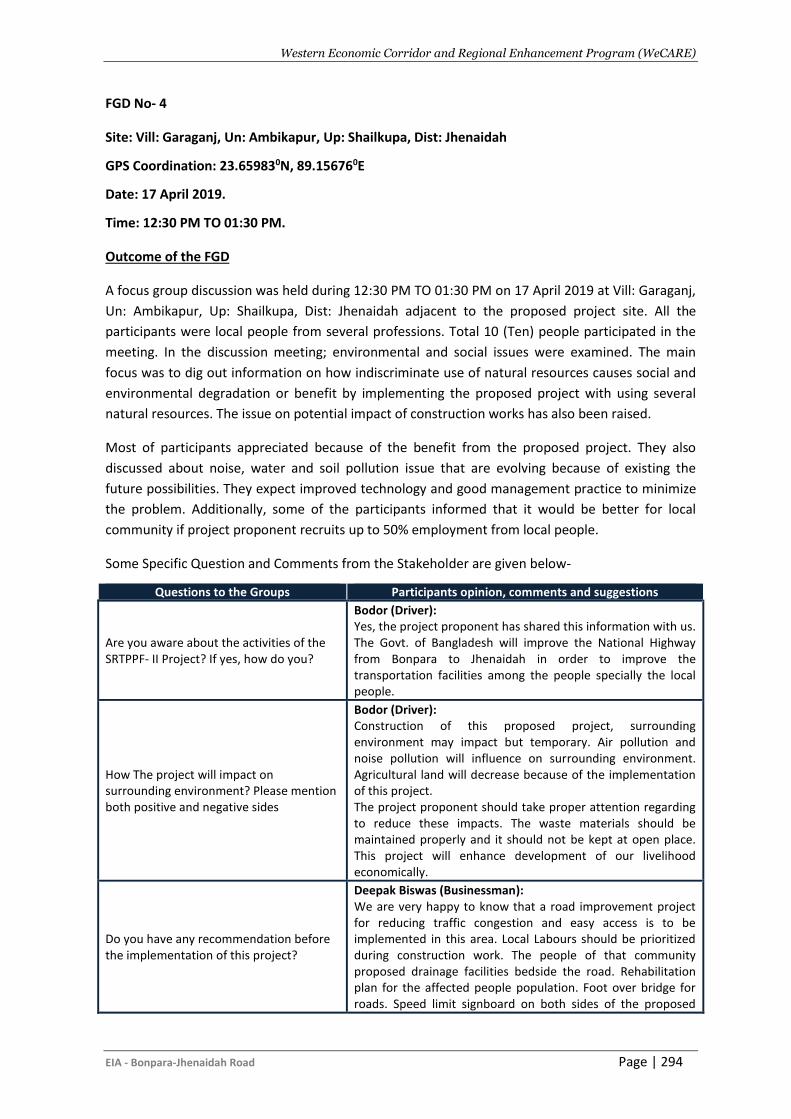
Western Economic Corridor and Regional Enhancement Program (WeCARE)
EIA - Bonpara-Jhenaidah Road Page | 294
FGD No- 4
Site: Vill: Garaganj, Un: Ambikapur, Up: Shailkupa, Dist: Jhenaidah
GPS Coordination: 23.659830N, 89.156760E
Date: 17 April 2019.
Time: 12:30 PM TO 01:30 PM.
Outcome of the FGD
A focus group discussion was held during 12:30 PM TO 01:30 PM on 17 April 2019 at Vill: Garaganj,
Un: Ambikapur, Up: Shailkupa, Dist: Jhenaidah adjacent to the proposed project site. All the
participants were local people from several professions. Total 10 (Ten) people participated in the
meeting. In the discussion meeting; environmental and social issues were examined. The main
focus was to dig out information on how indiscriminate use of natural resources causes social and
environmental degradation or benefit by implementing the proposed project with using several
natural resources. The issue on potential impact of construction works has also been raised.
Most of participants appreciated because of the benefit from the proposed project. They also
discussed about noise, water and soil pollution issue that are evolving because of existing the
future possibilities. They expect improved technology and good management practice to minimize
the problem. Additionally, some of the participants informed that it would be better for local
community if project proponent recruits up to 50% employment from local people.
Some Specific Question and Comments from the Stakeholder are given below-
Questions to the Groups Participants opinion, comments and suggestions
Are you aware about the activities of the SRTPPF- II Project? If yes, how do you?
Bodor (Driver): Yes, the project proponent has shared this information with us. The Govt. of Bangladesh will improve the National Highway from Bonpara to Jhenaidah in order to improve the transportation facilities among the people specially the local people.
How The project will impact on surrounding environment? Please mention both positive and negative sides
Bodor (Driver): Construction of this proposed project, surrounding environment may impact but temporary. Air pollution and noise pollution will influence on surrounding environment. Agricultural land will decrease because of the implementation of this project. The project proponent should take proper attention regarding to reduce these impacts. The waste materials should be maintained properly and it should not be kept at open place. This project will enhance development of our livelihood economically.
Do you have any recommendation before the implementation of this project?
Deepak Biswas (Businessman): We are very happy to know that a road improvement project for reducing traffic congestion and easy access is to be implemented in this area. Local Labours should be prioritized during construction work. The people of that community proposed drainage facilities bedside the road. Rehabilitation plan for the affected people population. Foot over bridge for roads. Speed limit signboard on both sides of the proposed
Western Economic Corridor and Regional Enhancement Program (WeCARE)
EIA - Bonpara-Jhenaidah Road Page | 295
Questions to the Groups Participants opinion, comments and suggestions
road.
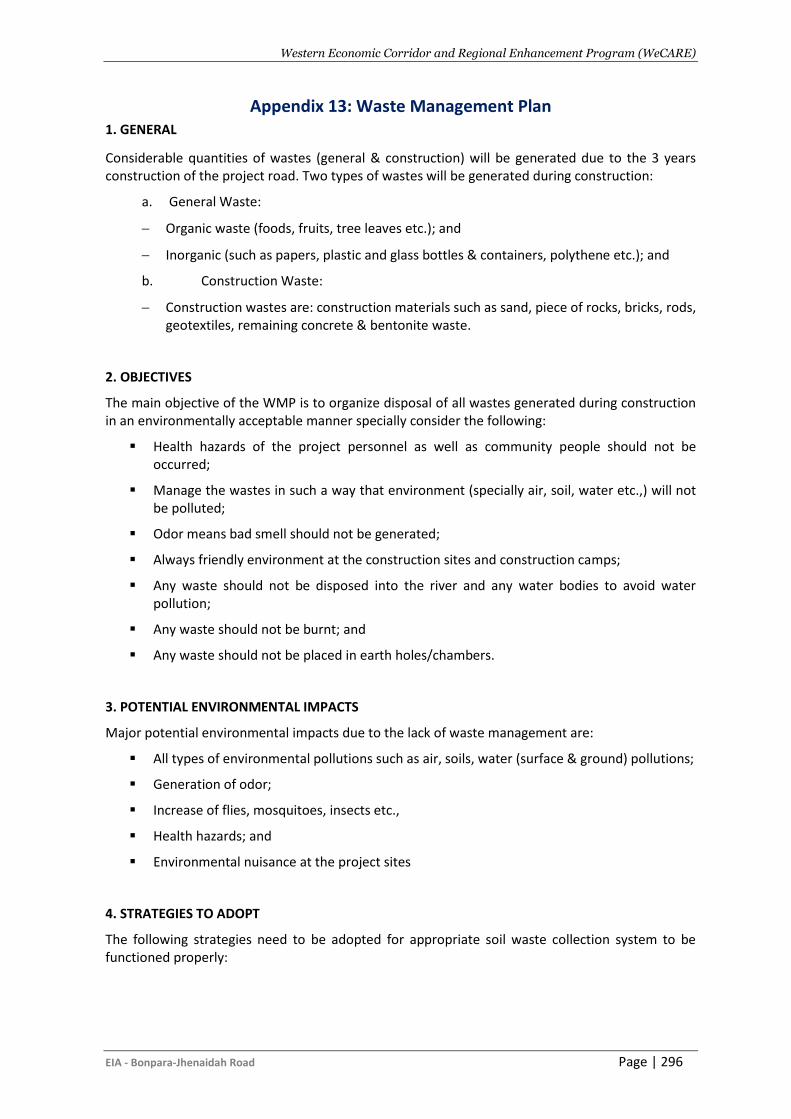
Western Economic Corridor and Regional Enhancement Program (WeCARE)
EIA - Bonpara-Jhenaidah Road Page | 296
Appendix 13: Waste Management Plan 1. GENERAL
Considerable quantities of wastes (general & construction) will be generated due to the 3 years construction of the project road. Two types of wastes will be generated during construction:
a. General Waste:
− Organic waste (foods, fruits, tree leaves etc.); and
− Inorganic (such as papers, plastic and glass bottles & containers, polythene etc.); and
b. Construction Waste:
− Construction wastes are: construction materials such as sand, piece of rocks, bricks, rods, geotextiles, remaining concrete & bentonite waste.
2. OBJECTIVES
The main objective of the WMP is to organize disposal of all wastes generated during construction in an environmentally acceptable manner specially consider the following:
▪ Health hazards of the project personnel as well as community people should not be occurred;
▪ Manage the wastes in such a way that environment (specially air, soil, water etc.,) will not be polluted;
▪ Odor means bad smell should not be generated;
▪ Always friendly environment at the construction sites and construction camps;
▪ Any waste should not be disposed into the river and any water bodies to avoid water pollution;
▪ Any waste should not be burnt; and
▪ Any waste should not be placed in earth holes/chambers.
3. POTENTIAL ENVIRONMENTAL IMPACTS
Major potential environmental impacts due to the lack of waste management are:
▪ All types of environmental pollutions such as air, soils, water (surface & ground) pollutions;
▪ Generation of odor;
▪ Increase of flies, mosquitoes, insects etc.,
▪ Health hazards; and
▪ Environmental nuisance at the project sites
4. STRATEGIES TO ADOPT
The following strategies need to be adopted for appropriate soil waste collection system to be functioned properly:
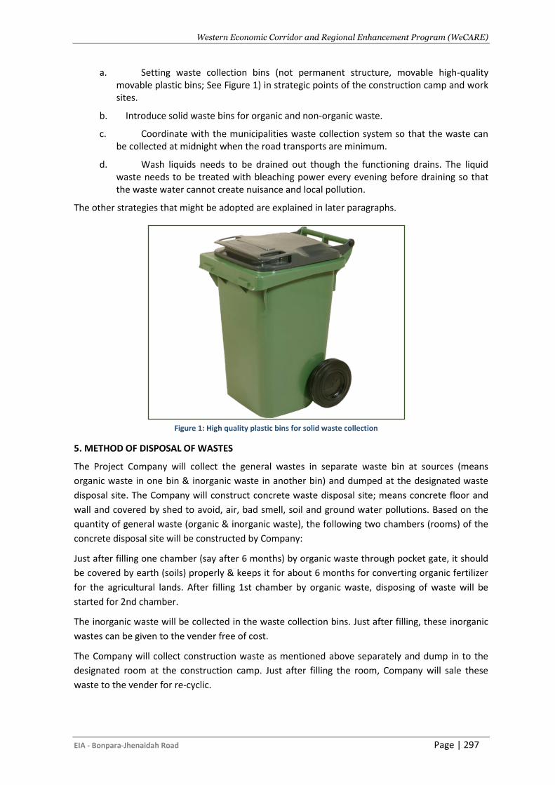
Western Economic Corridor and Regional Enhancement Program (WeCARE)
EIA - Bonpara-Jhenaidah Road Page | 297
a. Setting waste collection bins (not permanent structure, movable high-quality movable plastic bins; See Figure 1) in strategic points of the construction camp and work sites.
b. Introduce solid waste bins for organic and non-organic waste.
c. Coordinate with the municipalities waste collection system so that the waste can be collected at midnight when the road transports are minimum.
d. Wash liquids needs to be drained out though the functioning drains. The liquid waste needs to be treated with bleaching power every evening before draining so that the waste water cannot create nuisance and local pollution.
The other strategies that might be adopted are explained in later paragraphs.
5. METHOD OF DISPOSAL OF WASTES
The Project Company will collect the general wastes in separate waste bin at sources (means
organic waste in one bin & inorganic waste in another bin) and dumped at the designated waste
disposal site. The Company will construct concrete waste disposal site; means concrete floor and
wall and covered by shed to avoid, air, bad smell, soil and ground water pollutions. Based on the
quantity of general waste (organic & inorganic waste), the following two chambers (rooms) of the
concrete disposal site will be constructed by Company:
Just after filling one chamber (say after 6 months) by organic waste through pocket gate, it should
be covered by earth (soils) properly & keeps it for about 6 months for converting organic fertilizer
for the agricultural lands. After filling 1st chamber by organic waste, disposing of waste will be
started for 2nd chamber.
The inorganic waste will be collected in the waste collection bins. Just after filling, these inorganic
wastes can be given to the vender free of cost.
The Company will collect construction waste as mentioned above separately and dump in to the
designated room at the construction camp. Just after filling the room, Company will sale these
waste to the vender for re-cyclic.
Figure 1: High quality plastic bins for solid waste collection
Western Economic Corridor and Regional Enhancement Program (WeCARE)
EIA - Bonpara-Jhenaidah Road Page | 298
The Company will maintain log book for the measurement of quantity of the wastes (especially
hazardous wastes) disposed every day.
6. INSTITUTIONAL ARRANGEMENT
Company is mainly responsible for design, construction, maintenance as well as environmental
monitoring for the disposal of waste. Environmental Specialist of the CSC is responsible for
monitoring of the disposal. The PIU of the RHD will setup a ‘Waste Management Committee’ with
the representatives of the PIU and Company to effectively disposing the wastes and distribution of
organic fertilizer to the farmers and inorganic wastes to the venders. The committee is also
responsible for monitoring procedure for the collection and carrying of wastes without causing any
environmental hazards.
Western Economic Corridor and Regional Enhancement Program (WeCARE)
EIA - Bonpara-Jhenaidah Road Page | 299
Appendix 14: Tree Plantation Plan
1. Objectives
The GOB, as policy encourages road side plantation for two decades past for environmental
improvement, restoration of eco-balance and poverty alleviation through biomass energy, timber,
food, fodder and other marketable biological products. Trees absorb carbon dioxide and release
oxygen in daytime due to photosynthesis, thus clean air from noxious carbon-di-oxide gas. The
timber, fruit, fuel and medicine values of tree are immense. Roadside trees intercept dust with
leaves and twigs keeping ambient air dust free. Tree plantation has other general advantages like
improvement of environment, ecology and economy therefore, planting tree on road side slopes
and other available spaces within the ROW would enhance environment, environment, economy
and help alleviating rural poverty through work generation. In addition, dense tree plantation at
both sides of the road embankment has special positive impact like protection of the coastal area
from cyclonic storm.
The objective of the tree plantation and replacement programme is to compensate for the loss of
trees due to the proposed implementation of road upgrading. Other major objectives of the
programme are to protect the affected cultural/sensitive areas and to enhance the health of the
existing ecosystem.
About 79000 of various trees of different sizes will be cut due to clearing of project road to be
carried out under the Project for Phase 1.
A Tree Plantation Plan (TPP) is proposed to compensate the loss of these trees. To compensate
79000 trees and to improve the environmental and ecological status of the project area, a total of
210736 trees will be replanted along the road alignment.
The following areas have been identified for development of plantation sites in the Project areas:
• both side slopes of the constructed road embankment
• back side of the constructed bus stations
• along the affected cultural/sensitive areas
2. Selection and Planning of Tree Species
The species for the proposed tree plantation have been selected based on the statistics of the lost
vegetation and in consultations with the concerned officials of the Forest Department (FD) of
respective sections. In principal selection of species for the project should rather be on protection
of the road embankment from slope erosion, aesthetic and conservation than commercial. The list
of tree species to be used for the plantation on the proposed locations along the road is as follows:
- Timber Trees: Arjun (Terminalia arjuna), Garjan (Dipterocarpus turbinatus), Shal (Shorea
robusta), Shilkoroi (Albzia procera), Akasmoni (Acacia auricoliformis), Kat badam
(Terminalia calappa), Mehogani (Swietenia mahagoni), Epil –epil (Leucaena leucocephala)
and Raintree (Samania saman)
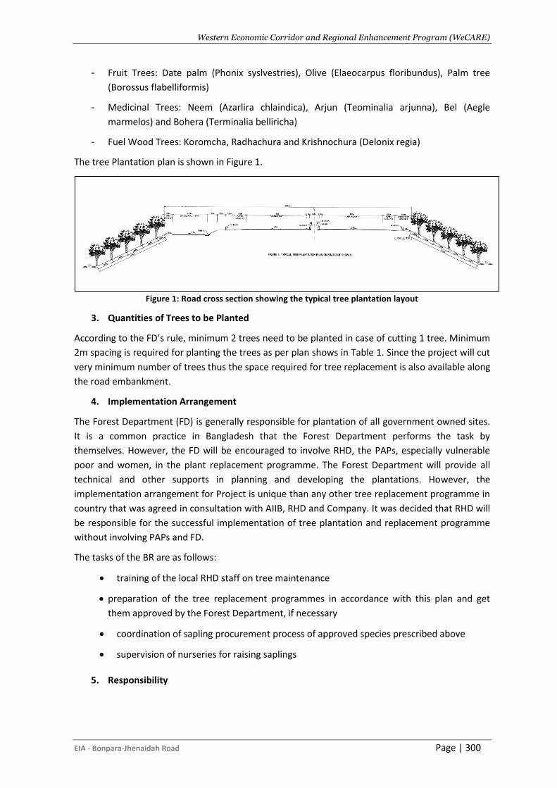
Western Economic Corridor and Regional Enhancement Program (WeCARE)
EIA - Bonpara-Jhenaidah Road Page | 300
- Fruit Trees: Date palm (Phonix syslvestries), Olive (Elaeocarpus floribundus), Palm tree
(Borossus flabelliformis)
- Medicinal Trees: Neem (Azarlira chlaindica), Arjun (Teominalia arjunna), Bel (Aegle
marmelos) and Bohera (Terminalia belliricha)
- Fuel Wood Trees: Koromcha, Radhachura and Krishnochura (Delonix regia)
The tree Plantation plan is shown in Figure 1.
Figure 1: Road cross section showing the typical tree plantation layout
3. Quantities of Trees to be Planted
According to the FD’s rule, minimum 2 trees need to be planted in case of cutting 1 tree. Minimum
2m spacing is required for planting the trees as per plan shows in Table 1. Since the project will cut
very minimum number of trees thus the space required for tree replacement is also available along
the road embankment.
4. Implementation Arrangement
The Forest Department (FD) is generally responsible for plantation of all government owned sites.
It is a common practice in Bangladesh that the Forest Department performs the task by
themselves. However, the FD will be encouraged to involve RHD, the PAPs, especially vulnerable
poor and women, in the plant replacement programme. The Forest Department will provide all
technical and other supports in planning and developing the plantations. However, the
implementation arrangement for Project is unique than any other tree replacement programme in
country that was agreed in consultation with AIIB, RHD and Company. It was decided that RHD will
be responsible for the successful implementation of tree plantation and replacement programme
without involving PAPs and FD.
The tasks of the BR are as follows:
• training of the local RHD staff on tree maintenance
• preparation of the tree replacement programmes in accordance with this plan and get
them approved by the Forest Department, if necessary
• coordination of sapling procurement process of approved species prescribed above
• supervision of nurseries for raising saplings
5. Responsibility
Western Economic Corridor and Regional Enhancement Program (WeCARE)
EIA - Bonpara-Jhenaidah Road Page | 301
It was decided that the Company will be responsible for planting trees throughout the alignment
and other areas as prescribed above. The Company will need to procure and raise saplings until
they survive. They can set up nurseries in consultation with RHD and the PIU at the early stage of
the Project. Alternatively, the Company can purchase saplings from the local nursery.
The Environmental Officer of RHD/PIU will be responsible for overall coordination with the FD,
PAPs, and supervision of the programme. It is recommended that RHD should start a dialogue with
the FD if required for the tree replacement programme in the pre-construction stage, so that
setting up of nurseries can be done in the early stages of the Project.
6. Budget and Payment
The budget for the proposed tree replacement programme for the project road e is provided in
Table 1 and this amount is added in the total environmental monitoring budget of Environmental
Management Plan chapter of this EIA. The budget also includes maintenance for three years from
the date of plantation to ensure that all planted saplings will survive and provision for an additional
plantation is available. The plantation on the slopes of road embankment, in the bus stations,
within the trumpet and along the affected cultural/sensitive areas will be taken up after
completion of construction work. The budget also includes procurement and development of all
facilities required to establish a nursery such as, collection of suitable soils, decomposing cow
dung, procurement of fertilisers etc. The budget also includes measure required for maintenance
of plantation, such as watering, weeding, fertiliser application, replacing of dead saplings (if any),
etc. for the first year after planting.
Related Documents


