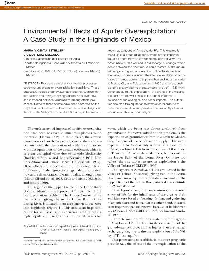
Environmental Effects of Aquifer Overexploitation: A Case Study in the Highlands of Mexico MARIA VICENTA ESTELLER* CARLOS DIAZ-DELGADO Centro Interamericano de Recursos del Agua Facultad de Ingenieria, Universidad Autonoma del Estado de Mexico Cerro Coatepec, S/N. C.U. 50130 Toluca (Estado de Mexico) Mexico ABSTRACT / There are several environmental processes occurring under aquifer overexploitation conditions. These processes include groundwater table decline, subsidence, attenuation and drying of springs, decrease of river flow, and increased pollution vulnerability, among others pro- cesses. Some of these effects have been observed on the Upper Basin of the Lerma River. The Lerma River begins in the SE of the Valley of Toluca at 2,600 m asl, in the wetland known as Lagoons of Almoloya del Rı ´o. This wetland is made up of a group of lagoons, which are an important aquatic system from an environmental point of view. The water inflow of this wetland is a discharge of springs, which occur between the fractured volcanic material of the moun- tain range and granular volcanic– continental deposits of the Valley of Toluca aquifer. The intensive exploitation of the Valley of Toluca aquifer to supply urban and industrial water to Mexico City and Toluca began in 1950 and is responsi- ble for a steady decline of piezometric levels of 1–3.5 m/yr. Other effects of this exploitation—the drying of the wetland, the decrease of river flow and the land subsidence— caused serious ecological and social impacts. The authori- ties declared this aquifer as overexploited in order to re- duce the exploitation and preserve the availability of water resources in this important region. The environmental impacts of aquifer overexploita- tion have been observed in numerous places around the world (Llamas 1992). In these places, the adverse consequences have been proven, one of the most im- portant being the desiccation of wetlands and rivers, with subsequent loss of the aquatic ecosystem, which is of great ecological value due to its wide biodiversity (Rodriguez-Estrella and Lopez-Bermudez 1992, Mar- tinez-Alfaro and others 1992, Cruickshank 1995). Other effects are a decline in the groundwater level, subsidence, the drying-up of springs, a decrease in river flow and a deterioration of water quality, among others (Martinelli and others 1998, Celik and Afsin 1998, Scott and others 1999). The region of the Upper Course of the Lerma River (Central Mexico) is a representative example of the overexploitation problem. The Upper Course of the Lerma River, giving rise to the Upper Basin of the Lerma River, is situated in an area known as the Mex- ican Highlands (Figure 1). This area is an important center for industrial and agricultural activity, with a high population density and enormous demands for water, which are being met almost exclusively from groundwater. Moreover, added to this problem, is the exportation of groundwater from this basin to Mexico City, for part of the city’s water supply. This water exportation to Mexico City is done at a rate of 14 m 3 /sec, a volume taken from the aquifers of the valleys of Toluca and Atlacomulco-Ixtlahuaca, both located in the Upper Basin of the Lerma River. Of these two valleys, the one subject to greater exploitation is the Valley of Toluca (CCRECRL 1993). The lagoons of Almoloya del Rio are located in the Valley of Toluca (SE sector), giving rise to the Lerma River, and make up the only natural wetland of the Upper Basin of the Lerma River, situated at an altitude of 2237–2600 m asl. These lagoons have, for many centuries, represented a way of life for the inhabitants of the area as their activities were based on hunting, fishing, and gathering of aquatic flora and fauna. On the other hand, this area is an important natural reserve, because of its biodiver- sity (Albores 1995, CCRECRL 1997, Boehm and Sando- val 1999). The deterioration of the ecosystem of the Lagoons of Almoloya del Rio is related to the exploitation of the groundwater resources at rates higher than the natural recharge, giving rise to the overexploitation of the Val- ley of Toluca aquifer. This paper aims to establish, in the most pragmatic possible way, the effects of the overexploitation of the KEY WORDS: Water resources exploitation; Water table decline; Dimi- nution of river flow; Wetland; Ecological impact; Social impact *Author to whom correspondence should be addressed; e-mail: [email protected] DOI: 10.1007/s00267-001-0024-0 Environmental Management Vol. 29, No. 2, pp. 266 –278 © 2002 Springer-Verlag New York Inc. CORE Metadata, citation and similar papers at core.ac.uk Provided by Repositorio Institucional de la Universidad Autónoma del Estado de México

Welcome message from author
This document is posted to help you gain knowledge. Please leave a comment to let me know what you think about it! Share it to your friends and learn new things together.
Transcript
Environmental Effects of Aquifer Overexploitation:A Case Study in the Highlands of MexicoMARIA VICENTA ESTELLER*CARLOS DIAZ-DELGADOCentro Interamericano de Recursos del AguaFacultad de Ingenieria, Universidad Autonoma del Estado de
MexicoCerro Coatepec, S/N. C.U. 50130 Toluca (Estado de Mexico)
Mexico
ABSTRACT / There are several environmental processesoccurring under aquifer overexploitation conditions. Theseprocesses include groundwater table decline, subsidence,attenuation and drying of springs, decrease of river flow,and increased pollution vulnerability, among others pro-cesses. Some of these effects have been observed on theUpper Basin of the Lerma River. The Lerma River begins inthe SE of the Valley of Toluca at 2,600 m asl, in the wetland
known as Lagoons of Almoloya del Rıo. This wetland ismade up of a group of lagoons, which are an importantaquatic system from an environmental point of view. Thewater inflow of this wetland is a discharge of springs, whichoccur between the fractured volcanic material of the moun-tain range and granular volcanic– continental deposits ofthe Valley of Toluca aquifer. The intensive exploitation of theValley of Toluca aquifer to supply urban and industrial waterto Mexico City and Toluca began in 1950 and is responsi-ble for a steady decline of piezometric levels of 1–3.5 m/yr.Other effects of this exploitation—the drying of the wetland,the decrease of river flow and the land subsidence—caused serious ecological and social impacts. The authori-ties declared this aquifer as overexploited in order to re-duce the exploitation and preserve the availability of waterresources in this important region.
The environmental impacts of aquifer overexploita-tion have been observed in numerous places aroundthe world (Llamas 1992). In these places, the adverseconsequences have been proven, one of the most im-portant being the desiccation of wetlands and rivers,with subsequent loss of the aquatic ecosystem, which isof great ecological value due to its wide biodiversity(Rodriguez-Estrella and Lopez-Bermudez 1992, Mar-tinez-Alfaro and others 1992, Cruickshank 1995).Other effects are a decline in the groundwater level,subsidence, the drying-up of springs, a decrease in riverflow and a deterioration of water quality, among others(Martinelli and others 1998, Celik and Afsin 1998, Scottand others 1999).
The region of the Upper Course of the Lerma River(Central Mexico) is a representative example of theoverexploitation problem. The Upper Course of theLerma River, giving rise to the Upper Basin of theLerma River, is situated in an area known as the Mex-ican Highlands (Figure 1). This area is an importantcenter for industrial and agricultural activity, with ahigh population density and enormous demands for
water, which are being met almost exclusively fromgroundwater. Moreover, added to this problem, is theexportation of groundwater from this basin to MexicoCity, for part of the city’s water supply. This waterexportation to Mexico City is done at a rate of 14m3/sec, a volume taken from the aquifers of the valleysof Toluca and Atlacomulco-Ixtlahuaca, both located inthe Upper Basin of the Lerma River. Of these twovalleys, the one subject to greater exploitation is theValley of Toluca (CCRECRL 1993).
The lagoons of Almoloya del Rio are located in theValley of Toluca (SE sector), giving rise to the LermaRiver, and make up the only natural wetland of theUpper Basin of the Lerma River, situated at an altitudeof 2237–2600 m asl.
These lagoons have, for many centuries, representeda way of life for the inhabitants of the area as theiractivities were based on hunting, fishing, and gatheringof aquatic flora and fauna. On the other hand, this areais an important natural reserve, because of its biodiver-sity (Albores 1995, CCRECRL 1997, Boehm and Sando-val 1999).
The deterioration of the ecosystem of the Lagoonsof Almoloya del Rio is related to the exploitation of thegroundwater resources at rates higher than the naturalrecharge, giving rise to the overexploitation of the Val-ley of Toluca aquifer.
This paper aims to establish, in the most pragmaticpossible way, the effects of the overexploitation of the
KEY WORDS: Water resources exploitation; Water table decline; Dimi-nution of river flow; Wetland; Ecological impact; Socialimpact
*Author to whom correspondence should be addressed; e-mail:[email protected]
DOI: 10.1007/s00267-001-0024-0
Environmental Management Vol. 29, No. 2, pp. 266–278 © 2002 Springer-Verlag New York Inc.
CORE Metadata, citation and similar papers at core.ac.uk
Provided by Repositorio Institucional de la Universidad Autónoma del Estado de México

Fig
ure
1.L
ocat
ion
ofth
eSt
ate
ofM
exic
o,sh
owin
gth
eU
pper
Cou
rse
ofth
eL
erm
aR
iver
,th
eL
agoo
ns
ofth
eA
lmol
oya
delR
io,a
nd
the
obse
rvat
ion
wel
lslo
cati
ons.
Environmental Effects of Aquifer Overexploitation 267
aquifer on the wetland, on the Lerma River, as well ason the land subsidence.
Materials and Methods
One of the main initial stages for analysis of the basin’sfunctioning is a physiographic understanding of the ba-sin. In this paper, the physiographic characteristics of thewatershed were obtained through digital elevation model(DEM) processing with a resolution of 90 m. The infor-mation source corresponds to the contours on the geo-graphic map of the State of Mexico (IGECEM 1995). TheDEM of the Upper Course of the Lerma River, where theValley of Toluca is located, was produced through GISArc/INFO software, ver. 7.1.2 [Triangular Irregular Net-work (TIN) module] and ArcVIEW 3.0a.
For the study of the piezometric evolution of theValley of Toluca aquifer data from the existing piezo-metric monitoring network, 66 observation wells, runby the National Water Commission [Comision Nacionaldel Agua (CNA)], were used. In addition, hydrometricdata from the Atenco and San Bartolo gauge stations,located in the wetland area, also operated by the CNA,were used.
In order to determine the flow of the Lerma Riverup to the limit of the Jose Antonio Alzate reservoir, ahydrological estimation was carried out, based on thedata from the three hydrometric gauge stations that arefound in the basin above the reservoir, as there is noone station that is pertinent for the whole tributaryarea. The time period for records used correspondscovered 1974–1990.
The evolution over time of the wetland surface areawas based on aerial photographs (1970 flight, scale1:25,000; 1971 flight, scale 1:10,000; 1989 flight, scale1:5000; and 1995 flight, scale 1:5000) and orthophotos(1983 flight, scale 1:10,000; 1989 flight, scale 1:5000;and 1995 flight, scale 1:5000).
Field surveys were also carried out to locate and geopo-sition cracks and differential collapses of the land.
Study Area
Geographic–Geologic Framework
The Valley of Toluca is located in the central area ofMexico, more specifically in the central zone of theState of Mexico, and is one of the highest in elevationin the Mexican Highlands. The Valley of Toluca, lo-cated in the Upper Course of the Lerma River (Figure1), has an average elevation of 2570 m, up to the JoseAntonio Alzate reservoir, which is the first receivingbody for water coming from the Lerma River. At ap-
proximately 9 km downstream from the dam, at analtitude of 2570 m, the Upper Course of the LermaRiver ends where the tectonic steps of the Valley ofAtlacomulco-Ixtlahuaca descend (CCRECRL 1997).
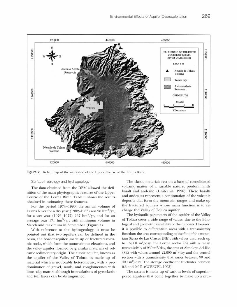
The Valley of Toluca covers an area of around 700km2, with the main axis running north–south with alength of almost 35 km, and the shorter axis runningeast–west about 20 km. The northern borders are theGuadalupana volcano, the Cerro El Aguila, and theSierra Monte Alto; to the south the Tenango and Zem-poala volcanoes; to the east the Sierra de Las Crucesand La Iglesia; and to the west the Nevado de Tolucaand Sierra Morelos. Figure 2 shows a relief map of thewatershed of the Upper Course of the Lerma River.The energy in the relief shown in the southern portionshould be noted, from the Nevado de Toluca volcano,and on the eastern side, due to the presence of theSierra de Las Cruces.
The Upper Course of the Lerma River is located intropical latitudes (parallels 19°05’ and 19°50’N), but itshigh altitude, as well as the adjacent mountains (Sierrade Las Cruces and the Nevado de Toluca), and withoutcontinental climate characteristics give rise to a moretemperate climate—semicold and cold. The averagemonthly temperature varies between 5°C (at placesabove 3000 m in altitude) and 20°C (areas situated inthe valley). The rainy season starts in the mid-May andlasts until mid-October. Average annual precipitation ishighest on the sides of the Nevado de Toluca, whereisohyets of 1200 mm can be found, decreasing towardsthe valley with averages of 900 mm. The highest recordsof precipitation come in the month of June, after thismonth there is a lack of rain, which generally coincideswith the month of August; this period is called themid-summer draught. Using Koppen’s climatic classifi-cation (Miller 1982), the Valley of Toluca presents aC(w2)(w)bi(g) climate, which corresponds to a subhu-mid temperate climate, with a long summer, winter rainof less than 5%, isothermal and maximum tempera-tures before the summer solstice.
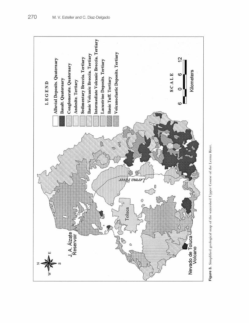
The area under study is located specifically in thephysiographic province called the Neovolcanic Trans-mexican Axis (Deman 1976), an area made up of a stripof volcanic material, calcoalkaline type, whose age dates itin the Upper Cenozoic. The lithological sequence is madeup of various types of tertiary volcanic rocks, mainly basaltand andesite, as well as pyroclastic matter and breaches,abundant in the mountain ranges surrounding the valley(Figure 3). Lacustrine and alluvial sediments can be iden-tified in the valley and are interspersed with clastic depos-its of volcanic origin. The age assigned to these deposits isLate Pliocene–Quaternary (Honorio and Hernandez1982, Herrera and Sanchez 1994).
268 M. V. Esteller and C. Diaz-Delgado
Surface hydrology and hydrogeology
The data obtained from the DEM allowed the defi-nition of the main physiographic features of the UpperCourse of the Lerma River. Table 1 shows the resultsobtained in estimating these features.
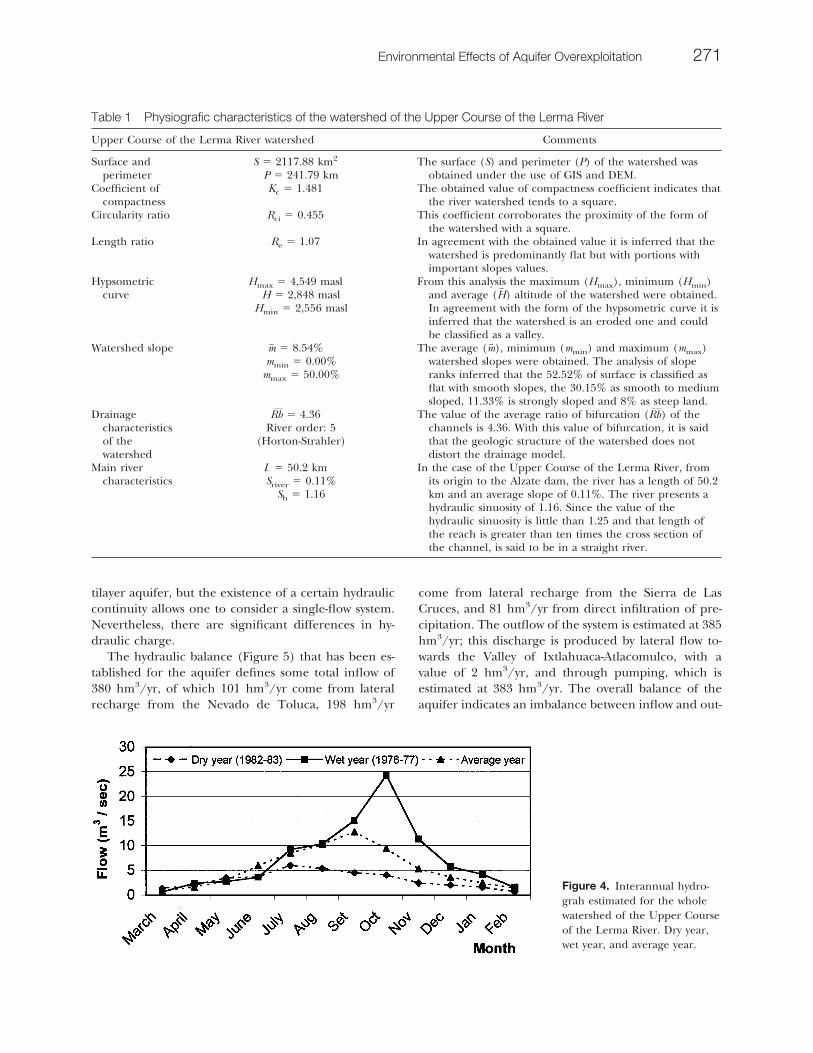
For the period 1974–1990, the annual volume ofLerma River for a dry year (1982–1983) was 98 hm3/yr,for a wet year (1976–1977) 267 hm3/yr, and for anaverage year 171 hm3/yr, with minimum volume inMarch and maximum in September (Figure 4).
With reference to the hydrogeology, it must bepointed out that two aquifers can be defined in thebasin, the border aquifer, made up of fractured volca-nic rocks, which form the mountainous elevations, andthe valley aquifer, formed by granular materials of vol-canic-sedimentary origin. The clastic aquifer, known asthe aquifer of the Valley of Toluca, is made up ofmaterial which is noticeably heterometric, with a pre-dominance of gravel, sands, and conglomerates withlime–clay matrix, although intercalations of pyroclasticand tuff layers can be distinguished.
The clastic materials rest on a base of consolidatedvolcanic matter of a variable nature, predominantlybasalt and andesite (Unitecnia, 1996). These basaltsand andesites represent a continuation of the volcanicdeposits that form the mountain ranges and make upthe fractured aquifers whose main function is to re-charge the Valley of Toluca aquifer.
The hydraulic parameters of the aquifer of the Valleyof Toluca cover a wide range of values, due to the litho-logical and geometric variability of the deposits. However,it is possible to differentiate areas with a transmissivityfunction: the area corresponding to the foot of the moun-tain Sierra de Las Cruces (NE), with values that reach upto 13,000 m2/day, the Lerma sector (S) with a meantransmissivity of 950 m2/day, the area of Almoloya del Rio(SE) with values around 22,000 m2/day and the centralsection with a transmissivity that varies between 90 and400 m2/day. The storage coefficient fluctuates between0.3 and 0.9% (CCRECEL 1993).
The system is made up of various levels of superim-posed aquifers that come together to make up a mul-
Figure 2. Relief map of the watershed of the Upper Course of the Lerma River.
Environmental Effects of Aquifer Overexploitation 269
Fig
ure
3.Si
mpl
ified
geol
ogic
alm
apof
the
wat
ersh
edU
pper
Cou
rse
ofth
eL
erm
aR
iver
.
270 M. V. Esteller and C. Diaz-Delgado
tilayer aquifer, but the existence of a certain hydrauliccontinuity allows one to consider a single-flow system.Nevertheless, there are significant differences in hy-draulic charge.
The hydraulic balance (Figure 5) that has been es-tablished for the aquifer defines some total inflow of380 hm3/yr, of which 101 hm3/yr come from lateralrecharge from the Nevado de Toluca, 198 hm3/yr
come from lateral recharge from the Sierra de LasCruces, and 81 hm3/yr from direct infiltration of pre-cipitation. The outflow of the system is estimated at 385hm3/yr; this discharge is produced by lateral flow to-wards the Valley of Ixtlahuaca-Atlacomulco, with avalue of 2 hm3/yr, and through pumping, which isestimated at 383 hm3/yr. The overall balance of theaquifer indicates an imbalance between inflow and out-
Figure 4. Interannual hydro-grah estimated for the wholewatershed of the Upper Courseof the Lerma River. Dry year,wet year, and average year.
Table 1 Physiografic characteristics of the watershed of the Upper Course of the Lerma River
Upper Course of the Lerma River watershed Comments
Surface andperimeter
S � 2117.88 km2
P � 241.79 kmThe surface (S) and perimeter (P) of the watershed was
obtained under the use of GIS and DEM.Coefficient of
compactnessKc � 1.481 The obtained value of compactness coefficient indicates that
the river watershed tends to a square.Circularity ratio Rci � 0.455 This coefficient corroborates the proximity of the form of
the watershed with a square.Length ratio Re � 1.07 In agreement with the obtained value it is inferred that the
watershed is predominantly flat but with portions withimportant slopes values.
Hypsometriccurve
Hmax � 4,549 maslH � 2,848 masl
Hmin � 2,556 masl
From this analysis the maximum (Hmax), minimum (Hmin)and average (H� ) altitude of the watershed were obtained.In agreement with the form of the hypsometric curve it isinferred that the watershed is an eroded one and couldbe classified as a valley.
Watershed slope m� � 8.54%mmin � 0.00%
mmax � 50.00%
The average (m� ), minimum (mmin) and maximum (mmax)watershed slopes were obtained. The analysis of sloperanks inferred that the 52.52% of surface is classified asflat with smooth slopes, the 30.15% as smooth to mediumsloped, 11.33% is strongly sloped and 8% as steep land.
Drainagecharacteristicsof thewatershed
Rb � 4.36River order: 5
(Horton-Strahler)
The value of the average ratio of bifurcation (Rb) of thechannels is 4.36. With this value of bifurcation, it is saidthat the geologic structure of the watershed does notdistort the drainage model.
Main rivercharacteristics
L � 50.2 kmSriver � 0.11%
Sh � 1.16
In the case of the Upper Course of the Lerma River, fromits origin to the Alzate dam, the river has a length of 50.2km and an average slope of 0.11%. The river presents ahydraulic sinuosity of 1.16. Since the value of thehydraulic sinuosity is little than 1.25 and that length ofthe reach is greater than ten times the cross section ofthe channel, is said to be in a straight river.
Environmental Effects of Aquifer Overexploitation 271
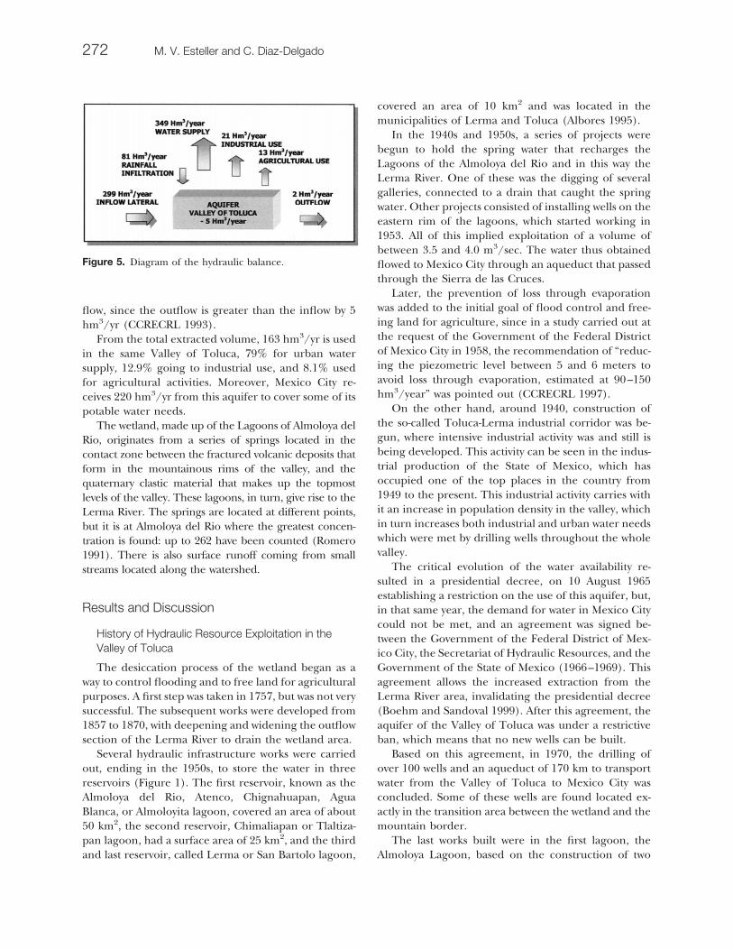
flow, since the outflow is greater than the inflow by 5hm3/yr (CCRECRL 1993).
From the total extracted volume, 163 hm3/yr is usedin the same Valley of Toluca, 79% for urban watersupply, 12.9% going to industrial use, and 8.1% usedfor agricultural activities. Moreover, Mexico City re-ceives 220 hm3/yr from this aquifer to cover some of itspotable water needs.
The wetland, made up of the Lagoons of Almoloya delRio, originates from a series of springs located in thecontact zone between the fractured volcanic deposits thatform in the mountainous rims of the valley, and thequaternary clastic material that makes up the topmostlevels of the valley. These lagoons, in turn, give rise to theLerma River. The springs are located at different points,but it is at Almoloya del Rio where the greatest concen-tration is found: up to 262 have been counted (Romero1991). There is also surface runoff coming from smallstreams located along the watershed.
Results and Discussion
History of Hydraulic Resource Exploitation in theValley of Toluca
The desiccation process of the wetland began as away to control flooding and to free land for agriculturalpurposes. A first step was taken in 1757, but was not verysuccessful. The subsequent works were developed from1857 to 1870, with deepening and widening the outflowsection of the Lerma River to drain the wetland area.
Several hydraulic infrastructure works were carriedout, ending in the 1950s, to store the water in threereservoirs (Figure 1). The first reservoir, known as theAlmoloya del Rio, Atenco, Chignahuapan, AguaBlanca, or Almoloyita lagoon, covered an area of about50 km2, the second reservoir, Chimaliapan or Tlaltiza-pan lagoon, had a surface area of 25 km2, and the thirdand last reservoir, called Lerma or San Bartolo lagoon,
covered an area of 10 km2 and was located in themunicipalities of Lerma and Toluca (Albores 1995).
In the 1940s and 1950s, a series of projects werebegun to hold the spring water that recharges theLagoons of the Almoloya del Rio and in this way theLerma River. One of these was the digging of severalgalleries, connected to a drain that caught the springwater. Other projects consisted of installing wells on theeastern rim of the lagoons, which started working in1953. All of this implied exploitation of a volume ofbetween 3.5 and 4.0 m3/sec. The water thus obtainedflowed to Mexico City through an aqueduct that passedthrough the Sierra de las Cruces.
Later, the prevention of loss through evaporationwas added to the initial goal of flood control and free-ing land for agriculture, since in a study carried out atthe request of the Government of the Federal Districtof Mexico City in 1958, the recommendation of “reduc-ing the piezometric level between 5 and 6 meters toavoid loss through evaporation, estimated at 90–150hm3/year” was pointed out (CCRECRL 1997).
On the other hand, around 1940, construction ofthe so-called Toluca-Lerma industrial corridor was be-gun, where intensive industrial activity was and still isbeing developed. This activity can be seen in the indus-trial production of the State of Mexico, which hasoccupied one of the top places in the country from1949 to the present. This industrial activity carries withit an increase in population density in the valley, whichin turn increases both industrial and urban water needswhich were met by drilling wells throughout the wholevalley.
The critical evolution of the water availability re-sulted in a presidential decree, on 10 August 1965establishing a restriction on the use of this aquifer, but,in that same year, the demand for water in Mexico Citycould not be met, and an agreement was signed be-tween the Government of the Federal District of Mex-ico City, the Secretariat of Hydraulic Resources, and theGovernment of the State of Mexico (1966–1969). Thisagreement allows the increased extraction from theLerma River area, invalidating the presidential decree(Boehm and Sandoval 1999). After this agreement, theaquifer of the Valley of Toluca was under a restrictiveban, which means that no new wells can be built.
Based on this agreement, in 1970, the drilling ofover 100 wells and an aqueduct of 170 km to transportwater from the Valley of Toluca to Mexico City wasconcluded. Some of these wells are found located ex-actly in the transition area between the wetland and themountain border.
The last works built were in the first lagoon, theAlmoloya Lagoon, based on the construction of two
Figure 5. Diagram of the hydraulic balance.
272 M. V. Esteller and C. Diaz-Delgado
reservoirs within the lagoon. One reservoir is theCUMAC, built in 1975, with Canadian financing meantto help preserve the ecosystem, and the outer reservoir,which encompasses the first, was begun in 1991; 8 kmhave been built, leaving 1.8 km still to be constructed.These works and other canal works are being carriedout by the Secretariat of Agricultural Development ofthe State of Mexico (SEDAGRO). The purpose of thislatter reservoir and the canal works is to reduce theflood area to a defined surface, to allow for the culti-vation of lands and exploit rain water to store irrigationin the dry season (Dıez-Perez 1998).
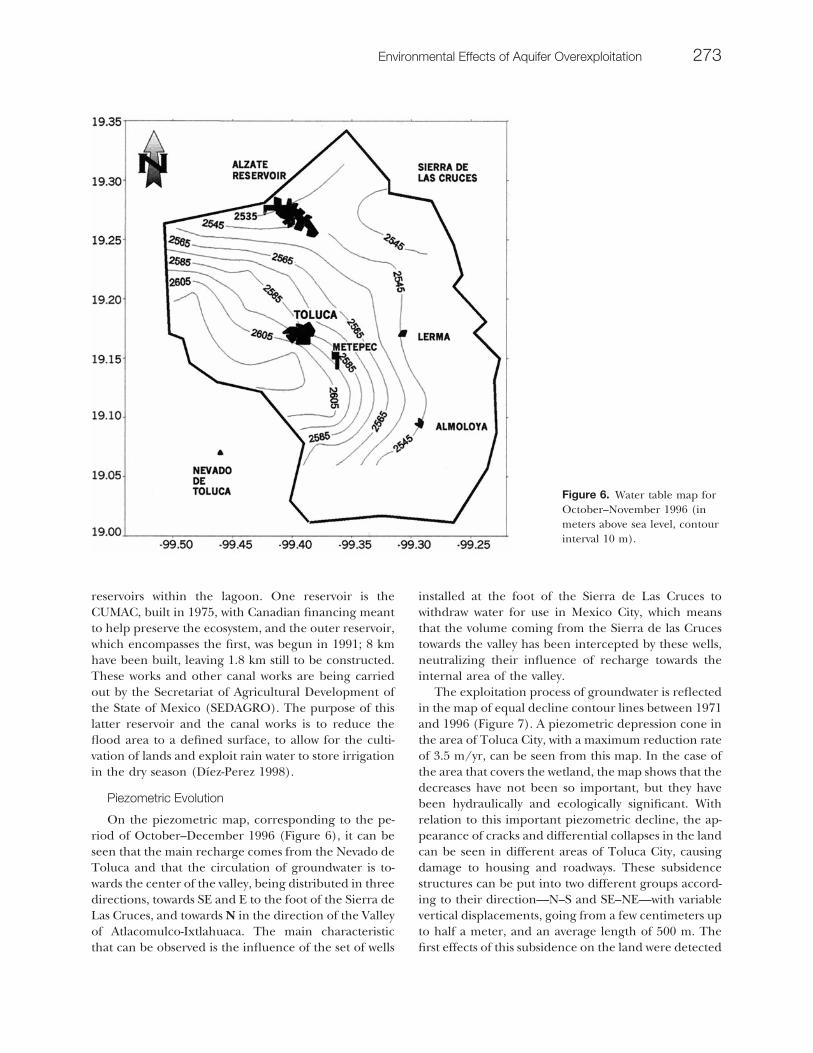
Piezometric Evolution
On the piezometric map, corresponding to the pe-riod of October–December 1996 (Figure 6), it can beseen that the main recharge comes from the Nevado deToluca and that the circulation of groundwater is to-wards the center of the valley, being distributed in threedirections, towards SE and E to the foot of the Sierra deLas Cruces, and towards N in the direction of the Valleyof Atlacomulco-Ixtlahuaca. The main characteristicthat can be observed is the influence of the set of wells
installed at the foot of the Sierra de Las Cruces towithdraw water for use in Mexico City, which meansthat the volume coming from the Sierra de las Crucestowards the valley has been intercepted by these wells,neutralizing their influence of recharge towards theinternal area of the valley.
The exploitation process of groundwater is reflectedin the map of equal decline contour lines between 1971and 1996 (Figure 7). A piezometric depression cone inthe area of Toluca City, with a maximum reduction rateof 3.5 m/yr, can be seen from this map. In the case ofthe area that covers the wetland, the map shows that thedecreases have not been so important, but they havebeen hydraulically and ecologically significant. Withrelation to this important piezometric decline, the ap-pearance of cracks and differential collapses in the landcan be seen in different areas of Toluca City, causingdamage to housing and roadways. These subsidencestructures can be put into two different groups accord-ing to their direction—N–S and SE–NE—with variablevertical displacements, going from a few centimeters upto half a meter, and an average length of 500 m. Thefirst effects of this subsidence on the land were detected
Figure 6. Water table map forOctober–November 1996 (inmeters above sea level, contourinterval 10 m).
Environmental Effects of Aquifer Overexploitation 273

in 1985 and currently continue, although they do notseem to be that important, as the rate of subsidence isat most between 2 and 3 mm/yr.
To carry out the study of evolution over time of thepiezometric level in the wetland zone, four observationwells were chosen, belonging to the monitoring net-work that exists in the aquifer (Figure 1). Figure 8shows the evolution of the piezometric level at thesepoints for the period between 1968 and 1996. A gradualdecline of the piezometric level can clearly be seen dueto the effect of pumping groundwater and a decrease inthe discharge of the springs, which are a source ofrecharge of the aquifer. In the case of observation wellpl145, located in the area around the first lagoon (Al-moloya Lagoon), stabilization of the level starting inthe 1980s can be seen. This stabilization of the piezo-metric level is related to the construction of theCUMAC reservoir, which has allowed some recharge ofthe aquifer. In other zones of the aquifer, the pi-ezometic level continues declining, with no stabiliza-tion of the level.
Figure 7. Map of equal declinecontour lines between 1971and 1996 (in meters, contourinterval 5 meters).
Figure 8. Water table hydrographs. Observation wells areshown in Figure 1.
274 M. V. Esteller and C. Diaz-Delgado

Evolution of Surface Water Flow
As mentioned above, the three lagoons of Almoloyaare primarily recharged by the water coming fromsprings and surface runoff. To establish the circulationbetween the lagoons and their outflow, the authoritiesinstalled two hydrometric gauge stations (Figure 1).The Atenco station is located between the first twolagoons and has recorded from 1942 to 1985 (althoughthere are no data from 1961 to 1970). The San Bartolostation is located at the outflow of the third lagoon,which is considered the source of the Lerma River, andthe recording period began in 1942 and ended in 1970.
It can be also seen in Figure 9, with respect to theAtenco hydrometric gauge station, that in the last de-cades recorded, the circulation of water between thefirst two lagoons was only occasional, due to the effectof the hydraulic works as well as the dam built above theAtenco hydrometric gauge station. The reservoir wasput into use in April 1951, and at times, wood pieceswere added to exploit water at higher levels than theconcrete dam, which is 0.9 m high (crest elevation2574.43 m asl).
In the case of the San Bartolo hydrometric gaugestation, the decrease in flow throughout the 1950s wasvery significant, but later the decrease has not been asmarked, as the lagoon and river were receiving impor-tant amounts of surface water and wastewater.
The study of the evolution of the flows of the above-mentioned two stations reflects the effect of the worksthat were carried out to export water to Mexico City, aswell as the works for storing water from the lagoons.The hydraulic infrastructure installed modified the pro-cess of the inflow of water to these lagoons, which is whytoday one can consider the only source of inflow for thewetland area to be the surface-water runoff.
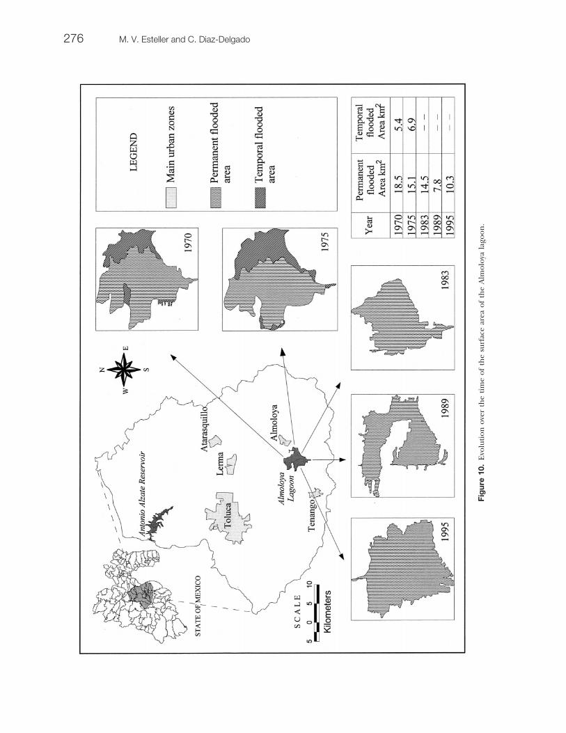
Decrease of Wetland Surface Area
The processes and strategies of hydraulic resourceexploitation of the basin have caused a reduction in thesurface area of the wetland over the years (Table 2),since the volume of water brought in from the springshas decreased and there has been a generalized de-crease in the piezometric level. An example of thisdecrease is the Almoloya Lagoon (Figure 10), whichhas gone from a surface area of 23.9 km2 in 1970 to 7.8km2 in 1989, although in the 1990s some of the area wasrecovered because of the building of the reservoirs, andtherefore in 1995 this lagoon covered an area of 10.3km2.
Other proof of the consequences of the drying pro-cess of the wetland is that before it started there weresmall islands, such as the Mirafuentes (Almoloya delRio) and temporary islands (in the rainy season), suchas San Antonio La Isla, San Juan La Isla, and San Pedro
Figure 9. Evolution of waterflow in Atenco and San Bartolohydrometric gauge stations.
Table 2 Evolution of surface area of reservoirs of the wetlands of the Lagoons of the Almoloya del Rio (km2)
SRH(1969)
Albores (1995)Data 1960–1970
IPESA (1984)
SARH(1986)
Wetperiod
Dryperiod
Almoloya Lagoon 29 50 33 0.2 32Tlaltizapan Lagoon 40 25 19 0.1 26San Bartolo Lagoon 32 10 34 0.3 25Total 101 85 86 0.6 83
Environmental Effects of Aquifer Overexploitation 275
Fig
ure
10.
Evo
luti
onov
erth
eti
me
ofth
esu
rfac
ear
eaof
the
Alm
oloy
ala
goon
.
276 M. V. Esteller and C. Diaz-Delgado
Tultepec de Quiroga La Isla, thus the origin of theirnames (Albores 1995). At the present time, these is-lands are surrounded by agricultural lands.
Water Quality
The water quality of the lagoons and that of theLerma River has been deteriorating over time as aresult of the inflow of both urban and industrial waste-water, which has combined with the effect of a decreasein water volume. This reduction in freshwater volumeand the deterioration of the water quality has resultedin an important decrease in lake, fluvial, and riparianlife in the region.
An example of this can be seen in a 25-km reach ofthe Lerma River between the Alzate Dam and theToluca-Mexico Highway, where there is no dissolvedoxygen present in the months from November to May,when the river flow is low and the organic charge levelsare high [biochemical oxygen demand (BOD) of 248mg/liter of O2]. During the rest of the year, the valuesof dissolved oxygen are less than 2 mg/liter (Garridoand Garcıa-Aragon 1997).
Within the Ecological Recovery Plan for the LermaRiver, developed by the Coordinating Commission forthe Ecological Recovery of the Lerma River Basin of theGovernment of the State of Mexico and the NationalProgram for Basin Improvement of the Federal Gov-ernment, actions to widen the drainage infrastructureand the wastewater treatment were set forth and havebeen carried out over the past few years. The impact ofthese actions has resulted in some recovery of the Le-rma River as an improvement in water quality of theriver water has been reported (Castillo-Escalante 2000).
On the other hand, with respect to groundwater, anincrease in salinity (electrical conductance increasefrom about 297 �S/cm in 1993 to about 978 �S/cm in1998) and an increase in the concentration of heavymetals, such as Fe (from 0.1 to 2.51 mg/liter) and Mn(from 0.13 to 0.22 mg/liter), which are above the al-lowed levels for drinking water according to Mexicanstandards, have been seen (Esteller and others 1999).This increase in the mineralization of the groundwatercould be related to the extraction of regional ground-water with a longer period of residence, since as thepiezometric level decreases, an incorporation of deepergroundwater is taking place.
Conclusions
The overexploitation of the Valley of Toluca aquiferis related to the industrialization process that began inthe 1940s and which has affected both the Valley ofToluca and the Valley of Mexico. This process implied
a greater demand for water to cover both the industrialand drinking water needs, demands that grew as thepopulation of the valleys grew.
This overexploitation has resulted in a drawdown ofthe piezometric level of the aquifer, at an average rateof 1.4 m/yr and an maximum of 3.5 m/yr, the emer-gence of cracks over the land surface due to subsi-dence, a decrease in the volume of the Lerma River,and a reduction in the wetland surface area.
The deterioration of the wetland of Almoloya delRio is directly related to the works to exploit the springsthat recharge the lagoons, works that were carried outto supply drinking water to Mexico City. This deterio-ration has had a huge environmental impact as it hasproduced a slow, but steady drying process of the la-goons, which has affected the flora and fauna of thearea, as well as the use of the land, as the drained landswere used for agricultural purposes.
The steps taken up to now to mitigate the effects ofoverexploitation of the aquifer have not resulted in therecovery of the aquifer, making it necessary to seekother means within the framework of integrated water-shed management, bearing in mind both the surfacewater and groundwater, as well as the reuse of treatedwaste water. For example, turning the exploitation ofwater from wells to other sources (superficial water,treated wastewater), reducing the pumping rate (Mar-tinelli and others 1998) and artificial recharge andrestoration of wetland with treated waste water (Whiteand Bayley 1999).
Acknowledgments
This study has been financially supported by theMexican National Research Council CONACyT (Mexi-co), under the projects 0391 and 0389, and by theUniversidad Autonoma del Estado de Mexico. The au-thors are grateful to all referees, who have contributedwith their comments to the improvement of this paper.Special thanks also to Dr. Alin Carsteanu, who did thefinal English corrections.
Literature Cited
Albores, B. A. 1995. Tules y Sirenas. El impacto ecologico ycultural de la industrializacion en el Alto Lerma. El ColegioMexiquense y Gobiemo del Estado de Mexico. Mexico, 478pp.
Boehm, B., and M. Sandoval. 1999. La sed saciada de laCiudad de Mexico y la nueva cuenca Lerma-Chapala-San-tiago. Un ensayo metodologico de lectura cartografica. Rela-ciones, Estudios de Historia y Sociedad 20(80):15–68.
Castillo-Escalante, I. 2000. El saneamiento y la calidad del
Environmental Effects of Aquifer Overexploitation 277
agua. Tlaloc-Revista de la Asociacion Mexicana de Hidraulica18:4–9.
CCRECRL (Comision Coordinadora para la RecuperacionEcologica de la Cuenca del Rio Lerma). 1993. Atlas Eco-logico de la Cuenca Hidrografica del Rıo Lerma. Tomo I.Cartografıa. Gobierno del Estado de Mexico, Mexico, 414pp.
CCRECRL (Comision Coordinadora para la RecuperacionEcologica de la Cuenca del Rio Lerma). 1997. Atlas Eco-logico de la Cuenca Hidrografica del Rio Lerma. Tomo III.Atlas de Ecosistemas Productivos. Gobierno del Estado deMexico, Mexico, 256 pp.
Celik, M., and M. Afsin. 1998. The role of hydrogeology insolution-sunsidence development and its environmental im-pacts; a case-study for Sazlica (Nigde, Turkey). Environmen-tal Geology 36(3–4):335–342.
Cruickshank, G. 1995. Proyecto Lago Texcoco: Rescate Hidro-ecologico. Comision Nacional del Agua. Gobierno de laCiudad de Mexico, Mexico. 111 pp.
Deman, M. S. 1976. El Eje Neovolcanico Transmexicano. InProcedeedings of the Congreso Latinoamericano de Geo-logia. Instituto de Geologia, UNAM, Mexico, 6 pp.
Diez-Perez, A. 1998. Analisis de las zonas de recarga de acuıf-eros mediante la percepcion remota: Aplicacion a laCuenca de Almoloya del Rio. Masters thesis. UniversidadAutonoma del Estado de Mexico, Mexico, 156 pp.
Esteller, M. V., C. Diaz-Delgado, and K. M. Ba. 1999. Presenciade hierro y manganeso en el acuıfero del Valle de Toluca.Pages 10–11 in Proceedings of the IV Congreso Nacional deCiencias Ambientales, 26–28 May 1999. Toluca, Mexico.
Garrido, S., and J. A. Garcia-Aragon. 1997. Alternativas eco-hidraulicas para la presa Jose Antonio Alzate con base en elcomportamiento de sus parametros de contaminacion.Ciencia Ergo Sum 4(3):305–309.
Herrera, M. E., and J. L. Sanchez Zavala. 1994. Estratificaciony Recursos Minerales del Estado de Mexico. Memoria ymapas. Gobierno del Estado de Mexico. Secretaria de De-sarrollo Economico. Mexico.
Honorio, R. J., and H. F. Hernandez. 1982. Origen, Estrati-grafıa y Petrologıa de la Cuenca de Mexico y Sierras Cir-cunvecinas. Thesis professional. Instituto Politecnico Nacio-nal, Mexico.
IGECEM (Instituto Cartografico, Estadistico y Catastratal delEstado de Mexico). 1995. Orthophotos IGECEM. Scale1:20,000 (orthophotos 87, 88, 89, 90, 91, 108, 419, 110, 118,119 and 120) flight 1983, 1989 and 1995. Gobierno delEstado de Mexico, Mexico.
IPESA. 1983. Rehabilitacion de la Laguna de Almoloya. Es-tado de Mexico. Technical report. Secretaria de DesarrolloAgropecuario (SEDAGRO). Gobierno del Estado de Mex-ico, Mexico.
Llamas, M. R. 1992. Wetlands: an important issue in Hydro-geology. Pages 69–86 in I. Simmers, F. Villarroya and L. F.Rebollo (eds.), Selected papers on aquifer overexploitation.Verlang Heinz Heisa, Hannover, Germany.
Martinelli, G., A. Minessale, and C. Varrucshi. 1998. Geo-chemistry of heavily exploited aquifers in the Emilia-Romagna Region (Po Valley, Northern Italy). EnvironmentalGeology 36(3–4):195–206.
Martinez-Alfaro, P. E., E. Montero-Gonzalez, and B. Lopez-Camacho. 1992. The impact of the overexploitation of theCampo de Montiel aquifer on the Lagunas de RuideraEcosystem. Pages 87–92 in I. Simmers, F. Villarroya, andL. F. Rebollo (eds.), Selected papers on aquifer overexploi-tation. Verlang Heinz Heisa, Hannover, Germany.
Miller, A. A. 1982 Climatologıa, 5th ed. Ediciones Omega,Barcelona, Espana, 379 pp.
Rodriguez-Estrella, T., and F. Lopez-Bermudez. 1992. Someecological consequences of aquifer overexploitation in wet-lands in Spain. Pages 93–106 in I. Simmers, F. Villarroya,and L. F. Rebollo (eds.), Selected papers on aquifer over-exploitation. Verlang Heinz Heisa, Hannover, Germany.
Romero, P. 1991. Historia de las obras de abstecimeinto deagua y drenaje de la Ciudad de Mexico y su impacto socio-ambiental. Masters thesis. Universidad Nacional Autonomade Mexico, Mexico, 120 pp.
SARH (Secretaria de Agricultura y Recursos Hidraulicos).1986. Planos de la Residencia General de Administracion yControl de Sistemas Hidrologicos. Gobierno de Mexico,Mexico.
Scott, M. L., P. B. Shafroth, and G. T. Auble. 1999. Responsesof Riparian cottonwoods to alluvial water table decline.Environmental Management 23:347–358.
SRH (Secretaria de Recursos Hidraulicos). 1969. Aprovecha-miento hidraulico. Pozos perforados en la Cuenca Alta delRio Lerma. Technical report. Gobierno de Mexico, Mexico.
Unitecnia. 1996. Estudio para el diseno de redes de moni-toreo de los acuıferos de los Valles de Toluca y Atlaco-mulco-Ixtlahuaca, en el Estado de Mexico. Technical re-port. Comision Nacional del Agua, 66 pp.
White, J. S., and S. E. Bayley. 1999. Restoration of a CanadianPrairie wetland with agricultural and municipal wastewater.Environmental Management 24:25–37.
278 M. V. Esteller and C. Diaz-Delgado
Related Documents