Trinity County Resource Conservation District South Fork Trinity Watershed Restoration Project Initial Study/Mitigated Negative Declaration June 2016 State of California Department of Parks and Recreation Off-Highway Motor Vehicle Recreation Division

Welcome message from author
This document is posted to help you gain knowledge. Please leave a comment to let me know what you think about it! Share it to your friends and learn new things together.
Transcript

Trinity County Resource Conservation District South Fork Trinity Watershed Restoration Project
Initial Study/Mitigated Negative Declaration
June 2016
State of California Department of Parks and Recreation
Off-Highway Motor Vehicle Recreation Division
Trinity County Resource Conservation District South Fork Trinity Watershed Restoration Project
Initial Study/Mitigated Negative Declaration
June 2016
Prepared for: State of California, Department of Parks and Recreation
Off-Highway Motor Vehicle Recreation Division 1725 23rd Street, Suite 200
Sacramento, CA 95816 (916) 324-4442
www.ohv.parks.ca.gov
Prepared by:
MIG | TRA Environmental Sciences, Inc. 2635 N. First Street, Suite 149
San Jose, CA 95134 (650) 327-0429
www.migcom.com | www.traenviro.com

Mitigated Negative Declaration Page 1
TCRCD South Fork Trinity Watershed Restoration Project Initial Study/Mitigated Negative Declaration – June 2016
California Department of Parks & Recreation, Off-Highway Motor Vehicle Recreation Division
MITIGATED NEGATIVE DECLARATION Project: South Fork Trinity Watershed Restoration Project
Project Sponsor: Trinity County Resource Conservation District (TCRCD)
Lead Agency: California Department of Parks and Recreation (CDPR), Off-Highway Motor Vehicle Recreation (OHMVR) Division Availability of Documents: The Initial Study (IS) for this Mitigated Negative Declaration (MND) is available for review at:
Shasta-Trinity National Forest Watershed Group 3644 Avtech Parkway Redding CA, 96002 Contact – Christine Mai Phone – 530 226-2428 Email – [email protected] Trinity County Resource Conservation District P.O. Box 1450 1 Horseshoe Lane Weaverville, CA 96093 Contact – Cynthia Tarwater, Project Administrator Phone – 530 623-6004 Email – [email protected] National Forest CDPR, OHMVR Division 1725 23rd Street, Suite 200 Sacramento, CA 95816 Contact: George MacDougall, Grant Administrator Phone: (916) 324-3788 Email – [email protected]
PROJECT DESCRIPTION The OHMVR Division proposes to award grant funds to the Trinity County Resource Conservation District (TCRCD) for the South Fork-Trinity River Road Decommissioning Project (the project). The project involves decommissioning approximately 22 miles of roads that currently pose risks to water quality and watershed resources and anadromous fisheries due to sedimentation issues. The roads are non-designated forest routes that are closed to public and administrative access. The project was created by the TCRCD by taking the highest priority routes identified by the Shasta-Trinity National Forest (STNF) in four watershed restoration and/or fuel reduction studies.
Phase 1, which involves restoring 20 stream crossings on approximately 5 miles of roads, has been awarded grant funds pending completion of the CEQA process. Stream courses to be addressed include Smoky Creek, Prospect Creek, and Dark Canyon located in the South Fork Trinity River Watershed, and Whiney Gulch, Baker Gulch, and several unnamed tributaries located in the Trinity River Watershed. Phase 2, which involves restoring 56 stream crossings on approximately 17 miles of road, could be funded by additional funds from the Grants and Cooperative Agreements Program if awarded in future years, or from other sources.
Road decommissioning involves the recontouring of a road to natural, pre-road condition, excavation of road-fill from all places where a road crosses waterways, reshaping banks, and

Mitigated Negative Declaration Page 2
TCRCD South Fork Trinity Watershed Restoration Project Initial Study/Mitigated Negative Declaration – June 2016
California Department of Parks & Recreation, Off-Highway Motor Vehicle Recreation Division
returning the stream course to the natural pre-road condition. The methodology for the project includes: 1) decommission roads utilizing heavy equipment (hydraulic excavator, dozer, and dump trucks) at stream, swale and spring areas that will be excavated and the spoil material stored in stable areas, 2) treat critically disturbed areas with native seed and weed-free straw and revegetate with container native species and native grass plugs, 3) install signage and/or physical barriers as appropriate, and 4) monitor project effectiveness.
PROPOSED FINDING The OHMVR Division has reviewed the IS for the proposed project and determined that the IS identifies potentially significant project effects, but:
1. Revisions to the project plans incorporated herein would avoid the effects or mitigate the effects to a point where clearly no significant effects would occur, and
2. There is no substantial evidence, in light of the whole record before the agency, that the project may have a significant effect on the environment. Pursuant to California Environmental Quality Act (CEQA) Guidelines sections 15064(f)(3) and 15070(b), a Mitigated Negative Declaration has been prepared for consideration as the appropriate CEQA document for the project.
BASIS OF FINDING Based on the environmental evaluation presented in the attached Initial Study, the project would not cause significant adverse effects related to aesthetics, agricultural and forestry resources, air quality, cultural resources, geology/soils, greenhouse gas emissions, hazards/hazardous materials, hydrology/water quality, land use/planning, mineral resources, noise, population/housing, public services, recreation, transportation, and utilities/service systems.
The project would not substantially reduce the habitat of a fish or wildlife species, cause a fish or wildlife population to drop below self-sustaining levels, threaten to eliminate a plant or animal community, or substantially reduce the number or restrict the range of a rare or endangered plant or animal. The project does not affect any important examples of the major periods of California prehistory or history. The project does not have impacts that are individually limited, but cumulatively considerable. The project would not cause substantial adverse effects on humans, either directly or indirectly.
The project has the potential to degrade the quality of the environment by causing significant adverse effects to biological resources. However, the project has been revised to include the following measures, which reduce these impacts to a less-than-significant level. IMPACT BIO-1: Project activities may result in direct impacts to CRPR listed special-status plant species that may occur within and adjacent to the project area. Such impacts could include damage to aboveground plant parts, uprooting or death of underground root structures, and loss of reproductive potential for short or extended periods of time, which would be considered potentially significant. This may include adverse impacts to Koehler’s stipitate rock-cress, Brandegee’s eriastrum, coast fawn lily, Dudley’s rush, Heckner’s lewisia, South Fork Mountain lupine, white-flowered rein orchid, Tracy’s sanicle, pale yellow stonecrop, Klamath Mountain catchfly, and oval-leaved viburnum.
Mitigation Measure BIO-1: Prior to the commencement of project activities, the location of special-status plant species shall be determined through appropriately timed surveys according to CNPS protocol; this shall apply to all areas of the proposed project subject to ground disturbance. Determination of potential habitat for special-status plant species, and surveys conducted to determine the presence of rare plant species shall be performed by a qualified

Mitigated Negative Declaration Page 3
TCRCD South Fork Trinity Watershed Restoration Project Initial Study/Mitigated Negative Declaration – June 2016
California Department of Parks & Recreation, Off-Highway Motor Vehicle Recreation Division
botanist. These surveys shall be timed to cover the blooming periods of special-status plant species with the potential to occur in the area.
Any rare plants within the proposed project area shall be flagged, mapped on improvement plans, and/or fenced to protect the occupied area during project activities. Where known populations of sensitive plant species exist on proposed road segments, soil piling, and/or any other activities that could bury plants or disrupt root structures significantly shall be avoided.
IMPACT BIO-2: The project could result in the loss and disturbance of Pacific tailed frog.
Mitigation Measure BIO-2: TCRCD shall carry out pre-activity biological resource surveys to identify the location of Pacific tailed frog within the project area. Pre-activity surveys shall be consistent with all survey protocols and requirements stipulated by resource agencies as a condition of project approval. Sensitive resource areas shall be clearly mapped and marked on project maps before road decommissioning commences. These areas shall be avoided to the greatest extent possible. Immediately prior to project activities scheduled to occur within sensitive resource areas, the qualified biologist shall survey the work area and if Pacific tailed frog individuals are found, a CDFG approved biologist shall move individuals downstream to a safe distance from project activities.
IMPACT BIO-3: The project could result in the loss and disturbance of Oregon snowshoe hare.
Mitigation Measure BIO-3: TCRCD shall carry out pre-activity biological resource surveys to identify the location of any Oregon snowshoe hare breeding site within the project area. Pre-activity surveys shall be consistent with all survey protocols and requirements stipulated by resource agencies as a condition of project approval. Breeding areas shall be clearly mapped and marked on project maps before road decommissioning commences. These areas shall be avoided until the breeding hare and offspring leave the project area.
IMPACT BIO-4: During the course of normal activity, project operations may harass and potentially harm wildlife that enters the project site. Individuals of special-status wildlife species such as Pacific tailed frog or Oregon snowshoe hare may become trapped within holes or trenches preventing wildlife from traveling through the project area without harm.
Mitigation Measure BIO-4: TCRCD shall impose the conditions defined below on all work-related personnel.
• Litter and other debris that may attract animals shall be removed from the project area daily and kept in enclosed containers when on the job site.
• No pets shall be allowed in the road decommissioning area, including staging areas. • TCRCD’s qualified biologist shall hold a tailgate environmental training program with
work-related personnel. Training shall be conducted prior to commencement of project activities, to inform work-related personnel of the wildlife and aquatic resources in the project area. The training program shall include information about the locations and extent of these sensitive species and areas, methods of resource avoidance, permit conditions, and possible fines for violations of permit conditions and state or federal environmental laws. A fact sheet conveying this information shall be prepared and provided to work-related personnel and any other project personnel who may enter the activity area.
• All excavated, steep-walled holes or trenches more than two feet deep shall be covered at the close of each working day by plywood or similar materials, or provided with one or more escape ramps constructed of earth fill or wooden planks. Before such holes or trenches are filled they must be thoroughly inspected for trapped animals.
• All equipment stored in the action area overnight shall be inspected before they are subsequently moved. If at any time a listed species is discovered, the environmental

Mitigated Negative Declaration Page 4
TCRCD South Fork Trinity Watershed Restoration Project Initial Study/Mitigated Negative Declaration – June 2016
California Department of Parks & Recreation, Off-Highway Motor Vehicle Recreation Division
monitor shall be immediately informed. The environmental monitor shall determine if relocating the species is necessary and shall work with the CDFG prior to handling or relocating unless otherwise authorized.
IMPACT BIO-5: The project could result in the loss and disturbance of Trinity bristle snail.
Mitigation Measure BIO-5: TCRCD shall carry out pre-activity biological resource surveys to identify the location of Trinity bristle snail individuals and habitat within the project area. Pre-activity surveys shall be consistent with all survey protocols and requirements stipulated by resource agencies as a condition of project approval. Sensitive resource areas shall be clearly mapped and marked on project maps before road decommissioning commences. These areas shall be avoided to the greatest extent possible. If a Trinity bristle snail individual is found during project activities, a CDFG approved biologist shall capture, handle for identification (or photograph), and promptly release back into the environment in the nearest suitable habitat and under the same conditions under which they were first found so as to cause minimal trauma (desiccation) to the individual and its associated microhabitat.
IMPACT BIO-6: Project construction activities during the nesting season could result in nest abandonment that would have an adverse impact on bird species and violate state and federal laws. Mitigation Measure BIO-6: Nesting Bird Survey. If project construction occurs during the nesting season of raptors and migratory birds, a focused survey for active nests shall be completed by a biologist approved by the California Department of Fish and Wildlife within one week before the start of any construction activities that could disturb nesting birds. Surveys shall be conducted in all suitable habitat located at the project work site(s), and in staging and storage areas. The minimum survey radius is 250 feet for passerines, 500 feet for small raptors such as accipiters, and 1,000 feet for larger raptors such as buteos. The bird survey methodology and the results of the survey shall be submitted to the California Department of Fish and Wildlife prior to the start of construction, and the radius may be modified in consultation with the Department if the project is in an urban area.
The nesting season is defined as March 15 to August 30 for smaller birds (passerines) and February 15 to September 15 for raptors. Nest Buffer and Monitoring: If active nests are found, the wildlife agency approved biologist shall consult with the California Department of Fish and Wildlife and the U.S. Fish and Wildlife Service migratory bird program regarding appropriate actions to comply with state and federal law. Active nest sites shall be designated as an environmentally sensitive area and protected while occupied during project activities. The protective buffer may be 250 feet for passerines, 500 feet for small raptors, and 1,000 feet for large raptors. A wildlife agency approved biologist shall monitor the behavior of the birds at the nest site to ensure that they are not disturbed by project-related construction work until the young have fully fledged, are no longer being fed by the parents and have left the nest site, as determined by the approved biologist.
No vegetation shall be disturbed, trimmed or pruned that contains active bird nests until all eggs have hatched, and young have fully fledged (no longer being fed, have completely left the nest). No habitat modification shall occur within the designated environmentally sensitive area even if the next continues to be active beyond the typical nesting season for the species. IMPACT BIO-7: Extra noise and vibration can lead to the disturbance of roosting bats which may have a negative impact on the animals. Human disturbance can also lead to a change in humidity, temperatures, or the approach to a roost that could force the animals to change their mode of egress and/or ingress to a roost. Disturbance of bat roost habitat may result in significant impacts to bat populations if an occupied or perennial (but unoccupied) maternity or colony roost is disturbed or removed.

Mitigated Negative Declaration Page 5
TCRCD South Fork Trinity Watershed Restoration Project Initial Study/Mitigated Negative Declaration – June 2016
California Department of Parks & Recreation, Off-Highway Motor Vehicle Recreation Division
Mitigation Measure BIO-7: A preconstruction survey for maternity (March 1 to August 1) or colony bat roosts (year-round) shall be conducted by a qualified biologist within one week prior to activities that remove vegetation or structures. If an occupied maternity or colony roost is detected, CDFW shall be contacted about how to proceed. Typically, a buffer exclusion zone would be established around each occupied roost until bat activities have ceased. The size of the buffer would take into account:
• Proximity and noise level of project activities; • Distance and amount of vegetation or screening between the roost and construction
activities; • Species-specific needs, if known, such as sensitivity to disturbance.
If a special-status bat species is found, construction work shall not start until authorized by the appropriate wildlife agencies.
Due to restrictions of the California Health Department, direct contact by workers with any bat is not allowed. The qualified bat biologist shall be contacted immediately if a bat roost is discovered during project construction.
IMPACT BIO-8: The project would remove road fill and culverts from up to 76 stream crossings to restore natural flow in drainage channels and improve overall hydrologic function. Work within stream channels may temporarily impact wetlands and Waters of the U.S. if present until the channel and its banks are restored.
Mitigation Measure BIO-8: TCRCD shall consult with the RWQCB to receive certification and the USACE for a Nationwide Permit or any other permit required by the USACE. Certain Nationwide Permits require prior notification to the USACE.
RECORD OF PROCEEDINGS AND CUSTODIAN OF DOCUMENTS
The record, upon which all findings and determinations related to the approval of the project are based, includes the following:
1. The Mitigated Negative Declaration and all documents referenced in or relied upon by the Mitigated Negative Declaration.
2. All information (including written evidence and testimony) provided by OHMVR Division staff to the decision maker(s) relating to the Mitigated Negative Declaration, the approvals, and the project.
3. All information (including written evidence and testimony) presented to the OHMVR Division by the environmental consultant who prepared the Mitigated Negative Declaration or incorporated into reports presented to the OHMVR Division.
4. All information (including written evidence and testimony) presented to the OHMVR Division from other public agencies and members of the public related to the project or the Mitigated Negative Declaration.
5. All applications, letters, testimony, and presentations relating to the project.
6. All other documents composing the record pursuant to Public Resources Code section 21167.6(e).
The OHMVR Division is the custodian of the documents and other materials that constitute the record of the proceedings upon which the OHMVR Division’s decisions are based. The contact for this material is:
George MacDougall CDPR, OHMVR Division 1725 23rd Street, Suite 200

Mitigated Negative Declaration Page 6
TCRCD South Fork Trinity Watershed Restoration Project Initial Study/Mitigated Negative Declaration – June 2016
California Department of Parks & Recreation, Off-Highway Motor Vehicle Recreation Division
Sacramento, CA 95816 [email protected]
Pursuant to section 21082.1 of the California Public Resources Code, the OHMVR Division has independently reviewed and analyzed the IS and Mitigated Negative Declaration for the proposed project and finds these documents reflect the independent judgment of the OHMVR Division.

Table of Contents Page i
TCRCD South Fork Trinity Watershed Restoration Project Initial Study/Mitigated Negative Declaration – June 2016
California Department of Parks & Recreation, Off-Highway Motor Vehicle Recreation Division
TRINITY COUNTY RESOURCE CONSERVATION DISTRICT
SOUTH FORK TRINITY WATERSHED RESTORATION PROJECT INITIAL STUDY
TABLE OF CONTENTS
CHAPTER 1 INTRODUCTION ...................................................................................................1
1.1 Introduction .......................................................................................................................1
1.2 Regulatory Guidance.........................................................................................................1
1.3 Lead Agency Contact Information .....................................................................................1
1.4 Purpose and Document Organization ................................................................................2
1.5 Incorporation by Reference ...............................................................................................2
CHAPTER 2 PROJECT DESCRIPTION .....................................................................................5
2.1 Project Location and Site Description ................................................................................5
2.2 Project Goal and Objectives ..............................................................................................5
2.3 Project Characteristics ......................................................................................................6
2.4 Project Monitoring and Evaluation .....................................................................................7
2.5 Construction Activity ..........................................................................................................8
2.6 Environmental Protection Measures Incorporated into the Project .....................................9
CHAPTER 3 ENVIRONMENTAL CHECKLIST AND RESPONSES ..........................................19
3.1 Aesthetics .......................................................................................................................22
3.2 Agriculture and Forestry Resources ................................................................................24
3.3 Air Quality .......................................................................................................................26
3.4 Biological Resources .......................................................................................................32
3.5 Cultural Resources ..........................................................................................................51
3.6 Geology and Soils ...........................................................................................................55
3.7 Greenhouse Gas Emissions ............................................................................................58
3.8 Hazards and Hazardous Materials ..................................................................................61
3.9 Hydrology and Water Quality ...........................................................................................64
3.10 Land Use and Planning .................................................................................................68
3.11 Mineral Resources ........................................................................................................69
3.12 Noise .............................................................................................................................70
3.13 Population and Housing ................................................................................................72
3.14 Public Services ..............................................................................................................73
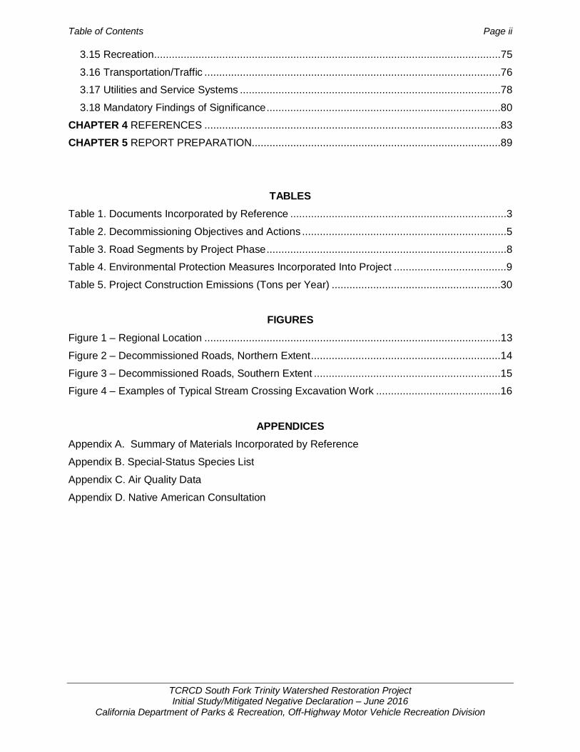
Table of Contents Page ii
TCRCD South Fork Trinity Watershed Restoration Project Initial Study/Mitigated Negative Declaration – June 2016
California Department of Parks & Recreation, Off-Highway Motor Vehicle Recreation Division
3.15 Recreation .....................................................................................................................75
3.16 Transportation/Traffic ....................................................................................................76
3.17 Utilities and Service Systems ........................................................................................78
3.18 Mandatory Findings of Significance ...............................................................................80
CHAPTER 4 REFERENCES ....................................................................................................83
CHAPTER 5 REPORT PREPARATION....................................................................................89
TABLES Table 1. Documents Incorporated by Reference .........................................................................3
Table 2. Decommissioning Objectives and Actions .....................................................................5
Table 3. Road Segments by Project Phase .................................................................................8
Table 4. Environmental Protection Measures Incorporated Into Project ......................................9
Table 5. Project Construction Emissions (Tons per Year) .........................................................30
FIGURES
Figure 1 – Regional Location ....................................................................................................13
Figure 2 – Decommissioned Roads, Northern Extent ................................................................14
Figure 3 – Decommissioned Roads, Southern Extent ...............................................................15
Figure 4 – Examples of Typical Stream Crossing Excavation Work ..........................................16
APPENDICES Appendix A. Summary of Materials Incorporated by Reference
Appendix B. Special-Status Species List
Appendix C. Air Quality Data
Appendix D. Native American Consultation

Introduction Page 1
TCRCD South Fork Trinity Watershed Restoration Project Initial Study/Mitigated Negative Declaration – June 2016
California Department of Parks & Recreation, Off-Highway Motor Vehicle Recreation Division
Chapter 1 INTRODUCTION
1.1 Introduction The Off-Highway Motor Vehicle Recreation (OHMVR) Division of the California Department of Parks and Recreation (CDPR) proposes to award grant funds to the Trinity County Resource Conservation District (TCRCD) for the South Fork Trinity Watershed Restoration Project located in the Shasta-Trinity National Forest. The project involves decommissioning and restoration of 27 road segments (22 miles) of non-designated forest system routes that are closed to public and administrative access.
Awarding grant funds is a project under the California Environmental Quality Act (CEQA; Pub. Resources Code § 21000 et seq.) and the CEQA Guidelines (14 CCR §15000 et seq.). The OHMVR Division has prepared this Initial Study to evaluate the potential environmental effects of awarding grant funding for the project.
1.2 Regulatory Guidance The California Environmental Quality Act (CEQA; Public Resources Code (PRC) §21000 et seq.) and the CEQA Guidelines (14 CCR §15000 et seq.) establish the OHMVR Division as the lead agency for the project. The lead agency is defined in CEQA Guidelines Section 15367 as “the public agency which has the principal responsibility for carrying out or approving a project.” The lead agency shall conduct an Initial Study to determine if the project may have a significant effect on the environment (CEQA Guidelines §15063(a)). According to CEQA Guidelines section 15070, a public agency shall prepare a proposed Negative Declaration or a Mitigated Negative Declaration when:
1. The Initial Study shows that there is no substantial evidence, in light of the whole record before the agency, that the project may have a significant effect on the environment, or
2. The Initial Study identifies potentially significant effects, but:
– Revisions in the project plans made before a proposed Mitigated Negative Declaration and Initial Study are released for public review would avoid the effects or mitigate the effects to a point where clearly no significant effects would occur, and
– There is no substantial evidence, in light of the whole record before the agency, that the project as revised may have a significant effect on the environment.
Pursuant to Section 15070, the OHMVR Division has determined a Mitigated Negative Declaration (MND) is the appropriate environmental review document for the TCRCD South Fork Trinity Watershed Restoration Project.
1.3 Lead Agency Contact Information The OHMVR Division is providing funding for the project and is the CEQA lead agency. The contact person for the lead agency is:
George MacDougall California Department of Parks and Recreation Off-Highway Motor Vehicle Recreation Division 1725 23rd Street, Suite 200, Sacramento CA 95816 Phone – (916) 324-3788 Email – [email protected]
Introduction Page 2
TCRCD South Fork Trinity Watershed Restoration Project Initial Study/Mitigated Negative Declaration – June 2016
California Department of Parks & Recreation, Off-Highway Motor Vehicle Recreation Division
1.4 Purpose and Document Organization The purpose of this document is to evaluate the potential environmental effects of the project. This document is organized as follows:
1. Chapter 1 – Introduction. This chapter provides an introduction to the project and describes the purpose and organization of this document.
2. Chapter 2 – Project Description. This chapter describes the project location, area, site, objectives, and characteristics.
3. Chapter 3 – Environmental Checklist and Responses. This chapter contains the Environmental Checklist that identifies the significance of potential environmental impacts (by environmental issue) and a brief discussion of each impact resulting from implementation of the proposed project. This chapter also contains the Mandatory Findings of Significance.
4. Chapter 4 – References. This chapter identifies the references and sources used in the preparation of this document.
5. Chapter 5 – Report Preparation. This chapter provides a list of those involved in the preparation of this document.
1.5 Incorporation by Reference CEQA Guidelines Section 15150 allows a MND to incorporate by reference all or portions of another document that is a matter of public record or is generally available to the public. Where all or part of another document is incorporated by reference, the incorporated language shall be considered to be set forth in full as part of the text of the MND.
This South Fork Trinity Watershed Restoration Project IS/MND incorporates by reference portions of five NEPA documents prepared by the U.S. Forest Service (USFS) Shasta-Trinity National Forest. Pursuant to CEQA Guidelines Section 15150(c), the incorporated parts of the referenced documents are identified below in Table 1 and briefly summarized in Appendix A. The information is referenced in each relevant discussion of the environmental analysis chapter (see Chapter 3, Environmental Checklist and Responses).
The incorporated documents listed in Table 1 have been previously made available for public review in accordance with NEPA and CEQA requirements. The documents incorporated by reference are available for public inspection at the following locations:
Shasta-Trinity National Forest Watershed Group 3644 Avtech Parkway Redding CA, 96002 Contact – Christine Mai Phone – 530 226-2428 Email – [email protected] Trinity County Resource Conservation District P.O. Box 1450 1 Horseshoe Lane Weaverville, CA 96093 Contact – Cynthia Tarwater, Project Administrator Phone – 530 623-6004 Email – [email protected]

Introduction Page 3
TCRCD South Fork Trinity Watershed Restoration Project Initial Study/Mitigated Negative Declaration – June 2016
California Department of Parks & Recreation, Off-Highway Motor Vehicle Recreation Division
CDPR, OHMVR Division 1725 23rd Street, Suite 200 Sacramento, CA 95816 Contact: George MacDougall, Grant Administrator Phone – (916) 324-3788 Email – [email protected]
Table 1. Documents Incorporated by Reference
Document Title Document Sections Incorporated Roads
Pettijohn Late-Successional Reserve Habitat Improvement and Fuels Reduction Project EIS 2013
Wildlife: Pages 54-81 Botany: Pages 92-104 Soils and Geology: Pages 104-117 Hydrology: Pages 117-131 Fisheries: Pages 131-145 Cultural Resources: Pages 147-149
34N85 34N34Y (2.3 miles)
Westside Watershed Restoration Project EA, 2011
Biological Resources: Pages 37-63 Cultural Resources: Page 64 Geology and Soils: Pages 65-66 Hydrology: Pages 72-73
33N04YA* 34N17YA* 34N34YA* 34N36 34N80B (4.17 miles)
Gemmill Thin Project EIS, 2009 Wildlife. Pages 46-73 Vegetation: Pages 73-83 Botany: Pages 83-96 Soils and Land Stability: Pages 118-126 Fisheries: Pages 126-136 Hydrology: Pages 136-153 Cultural Resources: Pages 156-157
30N65 30N65A 30N16B 30N04A 30N21E 29N83 29N83A U30N04D U30N37A (4.67 miles)
East Fork and Sims Watershed Restoration Project EA, 2006
Hydrology: Pages 22-26 Fisheries: Pages 26-31 Wildlife: Pages 31-40 Vegetation: Pages 40-47 Cultural Resources: Page 47
28N55* 28N55A* 28N10S* 29N30G 28N65 28N65A 28N63A 28N63B 28N63C (7.57 miles)
East Fork/Smoky Creek Watershed Record of Decision and Finding of No Significant Impact, 1998
All: Pages 1-7 28N12* 28N28 (3.22 miles)
* Phase 1 project
Introduction Page 4
TCRCD South Fork Trinity Watershed Restoration Project Initial Study/Mitigated Negative Declaration – June 2016
California Department of Parks & Recreation, Off-Highway Motor Vehicle Recreation Division
This page left intentionally blank.

Project Description Page 5
TCRCD South Fork Trinity Watershed Restoration Project Initial Study/Mitigated Negative Declaration – June 2016
California Department of Parks & Recreation, Off-Highway Motor Vehicle Recreation Division
Chapter 2 PROJECT DESCRIPTION
2.1 Project Location and Site Description TCRCD proposes decommissioning and restoration of existing unauthorized road segments in the Shasta-Trinity National Forest (STNF) in eastern Trinity County (Figure 1, Regional Location). The project restoration sites are located within the Trinity and South Fork Trinity River watersheds. A total of 27 road segments covering 22 miles are proposed for decommissioning and restoration. Locations span from Trinity Lake near Weaverville (Figure 2, Decommissioned Roads, Northern Extent) to Wildwood and areas further south off Wild Mad and Bramlet Roads (Figure 3, Decommissioned Roads, Southern Extent).
The TCRCD has selected the routes for this project based on the highest priority routes identified in watershed restoration studies by the STNF. All project sites currently pose risks to water quality and watershed resources in the Trinity River watershed. These routes also pose aquatic risks to anadromous fisheries due to sedimentation issues.
2.2 Project Goal and Objectives TCRCD has submitted a grant application to the OHMVRD for the purpose of “reduc[ing] sedimentation to watercourses caused by former motorized and unauthorized OHV use of these routes, return the aquatic resource systems to their natural, pre-road state and protect the restored area by installation of physical barriers and/or signage” (TCRCD 2015).
The primary objective of the project is to decommission roads, identified by the USFS through watershed analysis and the NEPA process, in order to reduce sedimentation risks to downstream anadromous fish habitat within the Trinity River and South Fork Trinity River and to eliminate unauthorized OHV use. Secondary objectives are listed in Table 2.
Table 2. Decommissioning Objectives and Actions
Need/Objective Action
1 Remove stream crossing failure potential. Remove fill and pipes at all stream crossings.
2 Restore more natural stream flow characteristics.
Match width and slope of fill removed to stream channel widths and slope.
3 Restore more natural hillslope hydrology while minimizing disturbance: • Reduce compaction, surface runoff, erosion, and sedimentation. • Promote infiltration. • Provide a seed bed for future vegetation.
• Remove cross pipes when the benefits of removal exceed the disturbance associated with the removal. Pipes would be left in place only when/where overall objectives for watershed improvement can be met. • Otherwise crush and leave in place cross drain pipes. • Block inlet and prevent flow through the pipe and/or down any remaining ditch. • Pull roadside berms and as much road fill as feasible into the road cut, placing it along cut banks. • Out-slope and compact the excavated material to a 3 to 5% slope. • Subsoil (till) road prism* along outsloped, crowned or along road sections where fill volume is insufficient to outslope the road. Avoid subsoiling in areas infested with non-native invasive plants, areas where tree root systems could be damaged, and areas with rocky soils.

Project Description Page 6
TCRCD South Fork Trinity Watershed Restoration Project Initial Study/Mitigated Negative Declaration – June 2016
California Department of Parks & Recreation, Off-Highway Motor Vehicle Recreation Division
Table 2. Decommissioning Objectives and Actions
Need/Objective Action
4 Reduce soil erosion by providing ground cover. Promote recovery of new vegetation.
Seed and mulch (using materials selected through consultation with a botanist) all stream crossings and other areas where slopes are steep and soils are disturbed.
6 Provide impediments to flow and sediment, discourage use of old road bed, and provide for enriched soil resources.
Stockpile large logs or hazard trees that are encountered along decommissioned routes to place on the contour in areas of disturbance. Logs impede sediment flow, provide for flow dispersal, and break down over time to enrich soil resources.
7 Prevent and discourage future vehicle traffic into restored areas.
Create an earthen berm at the start of the road or decommissioned road segment. Where needed, re-contour the start of the road to further reduce probability of access. Use of logs on contours will also discourage use.
*The road prism is the area of the ground containing the road surface, cut slope and fill slope. Source: STNF 2011
2.3 Project Characteristics 2.3.1 Project Overview In 2001, the USFS began implementing a science-based roads analysis process (RAP) in the STNF. A RAP is used before implementing any project activity that would change the road system or affect public access to national forest lands. A RAP is used to identify little-used roads that are having negative effects on fish and water quality, or are disproportionately difficult to maintain. These roads are then targeted for improvement or for elimination through the process of decommissioning, which is designed to improve water quality, fish habitat, and other watershed resources. The watershed restoration projects addressed in the project were developed based on management needs and opportunities identified as part of a RAP.
For the project, the TCRCD proposes to implement certain actions covered in the USFS Westside Watershed Restoration project, the East Fork/Sims Watershed Restoration project, the Pettijohn Late-successional Reserve Habitat Improvement and Fuels Reduction project, the Gemmill Thin project, and the East Fork Smoky Creek Watershed Restoration project all located in the STNF. The project was designed to reduce the risks to the environment associated with roads while addressing the need for a safe transportation network.
2.3.2 Road Decommissioning and Restoration The proposed project involves decommission approximately 22 miles (27 segments) of existing unauthorized or non-system routes by excavating road fill and recontrouring the ground surface to a natural, pre-road condition. Hydrologic flow patterns would be corrected along the entire length of the roadway. Road fill would be excavated at 76 stream crossings, stream, swale, and spring crossings. Banks would be reshaped to return the stream course to its natural pre-road condition. Specific decommissioning activities include the following:
• Removing culverts and fill from stream crossings • Deep ripping the road surface

Project Description Page 7
TCRCD South Fork Trinity Watershed Restoration Project Initial Study/Mitigated Negative Declaration – June 2016
California Department of Parks & Recreation, Off-Highway Motor Vehicle Recreation Division
• Pulling road fill from the downhill side onto the road surface to fill inboard ditches and to modify the road surface so that it slopes outward towards the downhill side (approximately a 3 to 5 percent slope)
• Pulling culverts and pipes (some pipes that drain inboard ditches would be crushed and left in place to minimize disturbance)
• Installing rolling dips where appropriate, and placing a log or berm at the entrance to the road to prevent access
Only the road prism would be disturbed during decommissioning. Road fill that is pulled onto the surface of the road primarily comes from the first 10 to 15 feet of fill downhill of the road bed, but in some cases a greater amount of fill from a greater distance downhill would be replaced onto the road surface. When pulling fill, no trees would be removed or disturbed greater than 14 inches in diameter at breast height (dbh). In areas where trees larger than 14 inches dbh occur on the road fill, no fill would be pulled from near the tree.
Three examples of typical stream crossing excavation work are shown in “before, during, and after” photographs taken in August 2009 by the TCRCD are shown in Figure 4. Note that “CMP” in the figure refers to corrugated metal pipe.
None of the road fill material (spoil) removed during road decommissioning would be taken off site; rather, it would be placed less than 1,500 feet from the source at a location determined in advance of the work at a specific site.
Following decommissioning all disturbed areas would be treated with native seed and weed-free straw and revegetated with container grass native species and native grass plugs. Signage would be posted to protect restored areas and rock barriers would be installed where necessary to prevent access.
2.4 Project Monitoring and Evaluation Project implementation and effectiveness monitoring would be used to determine how well objectives are being met and to document project effects on the environment. The USFS would assist the TCRCD by monitoring the project during and after its implementation to ensure that objectives are being met and to gather information used to improve the effectiveness of future projects. Information gathered in the monitoring plan would also be used to gauge appropriateness and timing of any future entries and necessity of follow-up rehabilitation measures. The Best Management Practices Evaluation Program (BMPEP) would be used to detect and measure the impacts of implementation. Project sites would be visited during and after implementation. Post-project monitoring would occur one and three years after project completion and/or after a large storm event. The monitoring would be used to detect and identify the needed corrections for long-term project success. USFS would also conduct best management practice (BMP) monitoring of TCRCD work on national forest lands.
Project implementation and effectiveness monitoring methods would be used to measure short- and long-term success. The objectives are to evaluate the implementation and effectiveness of the treatments that were prescribed for road decommissioning and to evaluate if federal and state BMP and water quality objectives are met. Monitoring would also attempt to measure the long-term improvement to watershed condition. Monitoring measures to determine the success of ecosystem management objectives include:
• Photo Points: before, during, after implementation, and after large storm event • Void measurement: CDFG California Salmonid Stream Habitat Restoration Manual
(length, width, and depth)
Project Description Page 8
TCRCD South Fork Trinity Watershed Restoration Project Initial Study/Mitigated Negative Declaration – June 2016
California Department of Parks & Recreation, Off-Highway Motor Vehicle Recreation Division
Signs would be posted and volunteers would be requested to report any illegal activity to the USFS. USFS employees regularly patrol this area to check for illegal OHV activity.
2.5 Construction Activity 2.5.1 Construction Equipment During each year of project implementation, the contactors would utilize the following number and type of heavy equipment: one excavator (315), one dozer (D4/D5), and one dump truck. A water truck would also be on site for fire protection and dust control purposes.
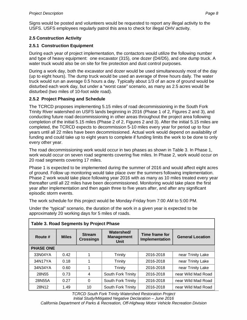
During a work day, both the excavator and dozer would be used simultaneously most of the day (up to eight hours). The dump truck would be used an average of three hours daily. The water truck would run an average 0.5 hours a day. Typically about 1/3 of an acre of ground would be disturbed each work day, but under a “worst case” scenario, as many as 2.5 acres would be disturbed (two miles of 10-foot wide road). 2.5.2 Project Phasing and Schedule The TCRCD proposes implementing 5.15 miles of road decommissioning in the South Fork Trinity River watershed on USFS lands beginning in 2016 (Phase 1 of 2, Figures 2 and 3), and conducting future road decommissioning in other areas throughout the project area following completion of the initial 5.15 miles (Phase 2 of 2, Figures 2 and 3). After the initial 5.15 miles are completed, the TCRCD expects to decommission 5-10 miles every year for period up to four years until all 22 miles have been decommissioned. Actual work would depend on availability of funding and could take up to eight years to complete if funding limits the work to be done to only every other year.
The road decommissioning work would occur in two phases as shown in Table 3. In Phase 1, work would occur on seven road segments covering five miles. In Phase 2, work would occur on 20 road segments covering 17 miles.
Phase 1 is expected to be implemented during the summer of 2016 and would affect eight acres of ground. Follow up monitoring would take place over the summers following implementation. Phase 2 work would take place following year 2016 with as many as 10 miles treated every year thereafter until all 22 miles have been decommissioned. Monitoring would take place the first year after implementation and then again three to five years after, and after any significant episodic storm events.
The work schedule for this project would be Monday-Friday from 7:00 AM to 5:00 PM.
Under the “typical” scenario, the duration of the work in a given year is expected to be approximately 20 working days for 5 miles of roads.
Table 3. Road Segments by Project Phase
Route # Miles Stream Crossings
Watershed/ Management
Unit Time frame for Implementation General Location
PHASE ONE 33N04YA 0.42 1 Trinity 2016-2018 near Trinity Lake 34N17YA 0.18 1 Trinity 2016-2018 near Trinity Lake 34N34YA 0.60 1 Trinity 2016-2018 near Trinity Lake
28N55 0.73 4 South Fork Trinity 2016-2018 near Wild Mad Road 28N55A 0.27 0 South Fork Trinity 2016-2018 near Wild Mad Road 28N12 1.49 10 South Fork Trinity 2016-2018 near Wild Mad Road

Project Description Page 9
TCRCD South Fork Trinity Watershed Restoration Project Initial Study/Mitigated Negative Declaration – June 2016
California Department of Parks & Recreation, Off-Highway Motor Vehicle Recreation Division
Table 3. Road Segments by Project Phase
Route # Miles Stream Crossings
Watershed/ Management
Unit Time frame for Implementation General Location
28N10S 1.46 3 South Fork Trinity 2016-2018 near Wild Mad Road TOTAL 5.15 20
PHASE TWO 28N28 1.73 7 South Fork Trinity 2016-2018 near Wild Mad Road 34N36 2.10 3 Trinity 2017-2020 near Trinity Lake
34N80B 0.87 4 Trinity 2017-2020 near Trinity Lake 34N85 1.30 5 Trinity 2017-2020 near Trinity Lake
34N34Y 1.00 2 Trinity 2017-2020 near Trinity Lake 30N65 0.90 2 South Fork Trinity 2017-2020 near Wildwood
30N65A 0.10 0 South Fork Trinity 2017-2020 near Wildwood 30N16B 0.40 2 South Fork Trinity 2017-2020 near Wildwood 30N04A 1.80 8 South Fork Trinity 2017-2020 near Wildwood 30N21E 0.10 0 South Fork Trinity 2017-2020 near Wildwood 29N83 0.70 3 South Fork Trinity 2017-2020 near Wildwood
29N83A 0.50 3 South Fork Trinity 2017-2020 near Wildwood U30N04D 0.07 1 South Fork Trinity 2017-2020 near Wildwood U30N37A 0.10 1 South Fork Trinity 2017-2020 near Wildwood 29N30G 1.32 5 South Fork Trinity 2017-2020 near Wild Mad Road 28N65 1.09 3 South Fork Trinity 2017-2020 near Wild Mad Road
28N65A 0.60 2 South Fork Trinity 2017-2020 near Wild Mad Road 28N63A 1.10 3 South Fork Trinity 2017-2020 near Wild Mad Road 28N63B 0.70 1 South Fork Trinity 2017-2020 near Wild Mad Road 28N63C 0.30 1 South Fork Trinity 2017-2020 near Wild Mad Road TOTAL 16.78 56
Source: TCRCD 2015
2.6 Environmental Protection Measures Incorporated into the Project The TCRCD and USFS incorporates environmental protection measures into its routine maintenance operations. These measures are intended to minimize or avoid potential impacts on natural resources such as water, soil, vegetation, and wildlife from park management actions. The measures listed in Table 4 would be implemented during project activity as needed depending on the site conditions.
Table 4. Environmental Protection Measures Incorporated Into Project
Geology 1. Consult with a geologist if any of the following is encountered:
• Excessive side cast; Incompetent bedrock. • Tension cracks or potential for a large failure

Project Description Page 10
TCRCD South Fork Trinity Watershed Restoration Project Initial Study/Mitigated Negative Declaration – June 2016
California Department of Parks & Recreation, Off-Highway Motor Vehicle Recreation Division
Table 4. Environmental Protection Measures Incorporated Into Project
• Presence of seepage water through fill/sidecast • Organic debris incorporated in fill.
2. Strategies for site stabilization: • Revegetate disturbed sites (seed with grasses or forbs utilizing a forest botanist approved mix
and plant tree seedlings where available). • Provide ground cover by mulching with weed-free rice straw, woodchips, or approved fine
slash to achieve 1.5 -2 tons/acre of cover. • Effective ground cover is between 50 and 70%, except on granitic soils it should be greater
than 90%. • 50% of ground cover occurs as organic matter (duff, plant leaves/needles, <3 inch diameter
fine slash, etc.). • Energy dissipaters (rock rip rap, mulch, straw waddles, etc.) are required where concentrated
surface flow would otherwise result in sediment transport. • Stockpile and replace existing down coarse woody debris (CWD) on disturbed slopes
whenever possible. • Retain 30-50% of existing surface duff mat (R5 SQS 2509.18-95-1).
Hydrology 1. Consult with a hydrologist or geologist if the following is encountered:
• If channel is vertically unstable (significantly aggraded above or downcut below), consult with geologist or hydrologist to ensure adequate grade controls are in place to prevent excessive or chronic sediment introduction.
• Lack of adequate drainage 2. Strategies for cutbanks, stream crossing fills, and berms
• Stream crossings are removed, and fill is generally placed along cutbanks to create outsloping roads.
• Cutbank overhangs are removed. • Culvert removal consists of excavation to pre-road construction level of channel, removal of
culvert, and pulling fill back until natural channel width is reestablished. • Remove organic debris from fill. • Dispose of unsuitable slide and waste material in relatively flat stable areas away from stream
courses. 3. Strategies to promote infiltration/minimize surface runoff
• Rip old roadbeds and compacted soils (with winged sub-soiler to 18 inches deep). 4. Strategies for surface drainage
• Remove berms or provide breaks in earth mass to allow dispersal of surface flow. • Disperse surface flow onto stable slopes with vegetation or rip-rap protection. • Insure that inboard ditch relief is provided by outsloping, maintaining, or adding dips to
disperse surface runoff. • Provide drainage to prevent ponding water.
5. Strategies to address stream flow • Isolate construction sites from stream flow before removing a culvert and performing work
inside the stream channel. The work site may be completely dewatered or the stream may be rerouted within the channel.
Biology 1. Consult with a botanist for the following:
• Survey all perennial streams for threatened, endangered, and sensitive species or noxious weed species or assume occupancy.

Project Description Page 11
TCRCD South Fork Trinity Watershed Restoration Project Initial Study/Mitigated Negative Declaration – June 2016
California Department of Parks & Recreation, Off-Highway Motor Vehicle Recreation Division
Table 4. Environmental Protection Measures Incorporated Into Project
• Survey for sensitive serpentinite-outcrop-loving sensitive plants or assume occupancy in these areas.
• Do not remove trees greater than 10 inches dbh when pulling road fill onto road surface. • Where known populations of sensitive plant species exist on proposed road segments, soil
piling, and/or any other activities that could bury plants or disrupt root structures significantly will be avoided.
• Where known populations of spotted or diffuse knapweed exist adjacent to project roads, roads will be individually evaluated to determine the least amount of soil disturbance that would still allow purpose and need to be met.
• The number of service vehicles used in monitoring or implementing treatments will be kept to a minimum to minimize spread of noxious weeds.
• When vehicles park on the side of the road, when possible sites will be chosen where little or no vegetation is present to minimize spread of noxious weed.
• Brief equipment operators of the need to minimize disturbance to existing vegetation within the road clearing limits, at stream crossings, and approved disposal sites to the extent necessary to restore hydrologic function. (Minimize turns.)
• Mechanical equipment is generally restricted to slopes less than 35%. • Clean equipment to remove noxious weeds and petroleum residues: 1) prior to all work and 2)
again after working in any areas containing noxious weeds. 2. Consult with a wildlife biologist for the following:
• Survey for northern spotted owls for roads within ¼ mile of suitable nesting habitat or historic activity centers, or implement a limited operating period (LOP) in these areas from February 1 through July 9 to prevent noise disturbance of nests.
• Survey for sensitive species within suitable habitat prior to disturbance. • Implement an LOP from February 1 to July 9 for northern spotted owl in suitable habitat unless
protocol surveys determine no owls to be in the area. • Implement an LOP from February 1 to August 15 within ½ mile from northern goshawk and
peregrine falcon nests. • Implement an LOP from January 1 to August 15 within ½ mile from bald eagle nest. • Project design features will be used to reduce or eliminate impacts to USFS Sensitive plant
species known to exist or have potential to exist in the proposed project area. These include deferring treatments on road segments that have known populations of Niles’ or Stebbins’ madia until after July 1 to allow seed set and dispersal.
3. Consult with a fisheries biologist for the following: • Isolate construction sites from stream flow before removing a culvert and performing work
inside the stream channel. The work site may be completely dewatered or the stream may be rerouted within the channel.
• When water is drafted from Pacific salmonid bearing stream reaches, follow NOAA National Marine Fisheries Service (NOAA Fisheries Service) Water Drafting Specifications (NOAA Fisheries 2001).
• When activities are proposed within a stream channel that may cause significant disturbance to coho salmon, a biologist will snorkel the work area to look for individuals prior to dewatering to encourage them to move out of the area and to estimate the number of individuals potentially affected.
Cultural Resources 1. Consult with an archeologist for the following:
• Flag any archeological resources that could be impacted by proposed restoration activities. • Determine where archeological site integrity is compromised if additional crossings or access is
needed in specific areas. If these areas occur, inform archeologist to provide onsite monitoring during activities.

Project Description Page 12
TCRCD South Fork Trinity Watershed Restoration Project Initial Study/Mitigated Negative Declaration – June 2016
California Department of Parks & Recreation, Off-Highway Motor Vehicle Recreation Division
Table 4. Environmental Protection Measures Incorporated Into Project
General 1. Protection Measures
• Implement all applicable BMPs. • Document daily monitoring related to BMP implementation and effectiveness especially any
additional corrective actions needed. Daily diaries or BMP forms can be used to provide this documentation.
2. Timing • Ground-based mechanical equipment can operate on fine-textured soils (non-rocky) when the
soils are dry down to eight inches (typically June to late September). • Implement LOP from October 15 to April 15th. Activities are permitted on soils with compaction
hazard ratings of less than high with restrictions. Seek consultation with earth scientist for further clarification.
• No ground disturbing wet weather operations on soils with severe or high compaction hazard. • Erosion control measures will be in place by October 1.
3. Mechanized ground based equipment limitations • Brief equipment operators of the need to minimize disturbance to existing vegetation within the
road clearing limits, at stream crossings, and approved disposal sites to the extent necessary to restore hydrologic function (e.g., minimize turns).
• Mechanical equipment is generally restricted to slopes less than 35%. • Implement an LOP from October 15 to April 15th. Activities are permitted on soils with
compaction hazard ratings of less than high with restrictions. Seek consultation with earth scientist for further clarification.
• Clean equipment to remove noxious weeds and petroleum residues: 1) prior to all work and 2) again after working in any areas containing noxious weeds.
• Areas of historic value that could be impacted by activities will be flagged and equipment restricted from these areas.
• In areas with sensitive snail species, do not compact soil, disturb herbaceous vegetation, degrade water quality, reduce woody debris, reduce canopy cover, or disturb ground cover.
4. Fueling • No fueling/refueling of mechanical equipment such as chainsaws will occur within 100 feet of
any flowing watercourse or intermittent drainage. • Fueling and servicing of vehicles used for proposed activities will be done outside of any
flowing watercourse or intermittent drainage. 5. Hazardous spills
• Any hazardous spills will be immediately cleaned up. • Report any chemical spills to the district ranger and fisheries biologist immediately. • NOAA Fisheries Service will be notified for emergency consultation and re-initiate Endangered
Species Act consultation if warranted. Source: Shasta-Trinity National Forest 2010

Figure 1 Regional Location TCRCD South Fork Trinity River Road Decommissioning Project
Project Description Page 13

Figure 2 Decommissioned Roads, Northern Extent TCRCD South Fork Trinity River Road Decommissioning Project
Project Description Page 14

Figure 3 Decommissioned Roads, Southern Extent TCRCD South Fork Trinity River Road Decommissioning Project
Project Description Page 15

Figure 4 Examples of Typical Stream Crossing Excavation Work TCRCD South Fork Trinity River Road Decommissioning Project
Project Description Page 16

Figure 4 Examples of Typical Stream Crossing Excavation Work TCRCD South Fork Trinity River Road Decommissioning Project
Project Description Page 17

Figure 4 Examples of Typical Stream Crossing Excavation Work TCRCD South Fork Trinity River Road Decommissioning Project
Project Description Page 18

Environmental Checklist and Responses Page 19
TCRCD South Fork Trinity Watershed Restoration Project Initial Study/Mitigated Negative Declaration – June 2016
California Department of Parks & Recreation, Off-Highway Motor Vehicle Recreation Division
Chapter 3 ENVIRONMENTAL CHECKLIST AND RESPONSES
PROJECT INFORMATION 1. Project Title: South Fork-Trinity River Road
Decommissioning Project 2. Lead Agency Name and Address: CDPR, OHMVR Division
1725 23rd Street, Suite 200, Sacramento, CA 95816
3. Contact Person and Phone Number: George MacDougall, Grants Administrator (916) 324-3788 4. Project Location: Shasta-Trinity National Forest, Trinity River and
South Fork-Trinity River watersheds 5. Project Sponsor’s Name and Address: Trinity County Resource Conservation District
P.O. Box 1450, 1 Horseshoe Lane Weaverville, CA 96093 Contact: Cynthia Tarwater, Project Administrator
7. General Plan Designation: Property is a national forest owned by the federal government. Local general plan designations do not apply to federal properties.
8. Zoning: Property is a national forest owned by the federal government. Local zoning designations do not apply to federal properties.
9. Description of the Project: Project involves decommissioning 27 road segments totaling 22 miles. See Chapter 2 for full project description.
10. Surrounding Land Uses and Setting: The project would take place in a national forest which comprises forested vegetation with a system of access and recreational roadways throughout the forest.
11. Other Public Agencies Whose Approval is Required: California Department of Fish and Wildlife (CDFW) Streambed Alteration Agreement for restoration of stream crossings.
ENVIRONMENTAL FACTORS POTENTIALLY AFFECTED The environmental factors checked below would be potentially affected by this project, involving at least one impact that is a “Potentially Significant Impact” as indicated by the checklist on the following pages.
Aesthetics Greenhouse Gas Emissions Population/Housing
Agricultural and Forestry Resources Hazards and Hazardous
Materials Public Services
Air Quality Hydrology/Water Quality Recreation
Biological Resources Land Use/Planning Transportation/Traffic
Cultural Resources Mineral Resources Utilities/Service Systems
Geology/Soils Noise Mandatory Findings of Significance
None


Environmental Checklist and Responses Page 21
TCRCD South Fork Trinity Watershed Restoration Project Initial Study/Mitigated Negative Declaration – June 2016
California Department of Parks & Recreation, Off-Highway Motor Vehicle Recreation Division
priate if there is substantial evidence that an effect may be significant. If there are one or more “Potentially Significant Impact” entries when the determination is made, an EIR is required.
4. “Negative Declaration: Less Than Significant with Mitigation Incorporated” applies where the incorporation of mitigation measures has reduced an effect from “Potentially Significant Impact” to a “Less Than Significant Impact.” The lead agency must describe the mitigation measures, and briefly explain how they reduce the effect to a less than significant level (mitigation measures from “Earlier Analyses,” as described in 5. below, may be cross-referenced).
5. Earlier analyses may be used where, pursuant to the tiering, program EIR, or other CEQA process, an effect has been adequately analyzed in an earlier EIR or negative declaration (Section 15063(c)(3)(D)). In this case, a brief discussion should identify the following:
a) Earlier Analysis Used. Identify and state where they are available for review.
b) Impacts Adequately Addressed. Identify which effects from the above checklist were within the scope of and adequately analyzed in an earlier document pursuant to applicable legal standards, and state whether such effects were addressed by mitigation measures based on the earlier analysis.
c) Mitigation Measures. For effects that are “Less Than Significant with Mitigation Measures Incorporated,” describe the mitigation measures which were incorporated or refined from the earlier document and the extent to which they address site-specific conditions for the project.
6. Lead agencies are encouraged to incorporate into the checklist references to information sources for potential impacts (e.g., general plans, zoning ordinances). Reference to a previously prepared or outside document should, where appropriate, include a reference to the page or pages where the statement is substantiated.
7. Supporting Information Sources. A source list should be attached, and other sources used or individuals contacted should be cited in the discussion.
8. Explanation(s) of each issue should identify:
a) The criteria or threshold, if any, used to evaluate the significance of the impact addressed by each question; and
b) The mitigation measures, if any, prescribed to reduce the impact below the level of significance.

Environmental Checklist and Responses Page 22
TCRCD South Fork Trinity Watershed Restoration Project Initial Study/Mitigated Negative Declaration – June 2016
California Department of Parks & Recreation, Off-Highway Motor Vehicle Recreation Division
3.1 Aesthetics
3.1.1 Environmental Setting The STNF is characterized by the dominant vegetation in the forest which includes montane hardwood, montane hardwood-conifer, Klamath mixed conifer, Douglas fir, and ponderosa/Jeffrey pine forests. Project areas for the most part consist of disturbed roadsides and roadbeds. Minor to moderate amounts of disturbance are present in the areas of proposed road decommissioning. Some of the roadbeds have been undisturbed long enough for native vegetation to return and stabilize, while most have been disturbed recently enough for little or no vegetation to be present.
3.1.2 Discussion Would the proposed project:
a. Have a substantial adverse effect on a scenic vista? No Impact. None of the specific project sites are located within areas designated as a scenic vista. Furthermore, the decommissioning of the road and trails would be temporary projects that would not change the scenic character of the project sites.
b. Substantially damage scenic resources, including, but not limited to, trees, rock outcroppings, and historic buildings within a state scenic highway?
No Impact. Some of the specific project sites are near scenic resources such as trees, rock outcroppings; however, none are within view of a state scenic highway. None of the work at the specific project sites would result in the removal of any trees, rock outcroppings, or historic buildings within view of a state scenic highway. Work to decommission roads is temporary and would not affect scenic resource or affect views from a state scenic highway.
c. Substantially degrade the existing visual character or quality of the site and its surroundings?
No Impact. The decommissioning of the road and trails are meant to reduce erosion, which results in unsightly erosion gullies and bare hillsides. Removing road fill at stream crossings, re-establishing natural drainage channels, controlling water flow to reduce erosion on
Potentially Significant
Impact
Less Than Significant with
Mitigation
Less Than Significant
Impact No
Impact
Would the project:
a) Have a substantial adverse effect on a scenic vista?
b) Substantially damage scenic resources, including, but not limited to, trees, rock outcroppings, and historic buildings within a state scenic highway?
c) Substantially degrade the existing visual character or quality of the site and its surroundings?
d) Create a new source of substantial light or glare which would adversely affect day or nighttime views in the area?

Environmental Checklist and Responses Page 23
TCRCD South Fork Trinity Watershed Restoration Project Initial Study/Mitigated Negative Declaration – June 2016
California Department of Parks & Recreation, Off-Highway Motor Vehicle Recreation Division
decommissioned road surfaces, and establishing a native vegetation cover would improve the visual character of each project site by restoring a more natural appearance.
d. Create a new source of substantial light or glare which would adversely affect day or nighttime views in the area?
No Impact. The project would not create a new source of substantial light or glare affecting day or nighttime views in the area as no exterior lighting, reflective surfaces, or nighttime construction is proposed.

Environmental Checklist and Responses Page 24
TCRCD South Fork Trinity Watershed Restoration Project Initial Study/Mitigated Negative Declaration – June 2016
California Department of Parks & Recreation, Off-Highway Motor Vehicle Recreation Division
3.2 Agriculture and Forestry Resources
3.2.1 Environmental Setting The project is located USFS land in mountainous areas of the STNF. Neither the project sites nor the surrounding lands contain any farmland, any lands under Williamson Act contracts, or any Prime Farmland, Unique Farmland, or Farmland of Statewide Importance, as defined by the Farmland Mapping and Monitoring Program.
3.2.2 Discussion Would the proposed project:
a. Convert Prime Farmland, Unique Farmland, or Farmland of Statewide Importance (Farmland), as shown on the maps prepared pursuant to the Farmland Mapping and Monitoring Program of the California Resources Agency, to non-agricultural use?
b. Conflict with existing zoning for agricultural use, or a Williamson Act contract?
Potentially Significant
Impact
Less Than Significant with
Mitigation
Less Than Significant
Impact No
Impact
Would the project*:
a) Convert Prime Farmland, Unique Farmland, or Farmland of Statewide Importance (Farmland), as shown on the maps prepared pursuant to the Farmland Mapping and Monitoring Program of the California Resources Agency, to non-agricultural use?
b) Conflict with existing zoning for agricultural use, or a Williamson Act contract?
c) Conflict with existing zoning for, or cause rezoning of forest land (as defined in Public Resources Code Section 12220(g)), timberland (as defined by Public Resources Code Section 4526), or timberland (as defined by Government Code Section 51104(g))?
d) Result in the loss of forest land or conversion of forest land to non-forest use?
e) Involve other changes in the existing environment which, due to their location or nature, could result in conversion of Farmland, to non-agricultural use or conversion of forest land to non-forest use?
*In determining whether impacts to agricultural resources are significant environmental effects, lead agencies may refer to the California Agricultural Land Evaluation and Site Assessment Model (1997) prepared by the California Dept. of Conservation as an optional model to use in assessing impacts on agriculture and farmland. In determining whether impacts to forest resources, including timberland, are significant environmental effects, lead agencies may refer to information compiled by the California Department of Forestry and Fire Protection regarding the state’s inventory of forest land, including the Forest and Range Assessment Project and the Forest Legacy Assessment Project, and forest carbon measurement methodology provided in Forest Protocols adopted by the California Air Resources Board (CARB).
Environmental Checklist and Responses Page 25
TCRCD South Fork Trinity Watershed Restoration Project Initial Study/Mitigated Negative Declaration – June 2016
California Department of Parks & Recreation, Off-Highway Motor Vehicle Recreation Division
c. Conflict with existing zoning for, or cause rezoning of forest land (as defined in Public Resources Code Section 12220(g)), timberland (as defined by Public Resources Code Section 4526), or timberland (as defined by Government Code Section 51104(g))?
d. Result in the loss of forest land or conversion of forest land to non-forest use? e. Involve other changes in the existing environment which, due to their location
or nature, could result in conversion of Farmland, to non-agricultural use or conversion of forest land to non-forest use?
No Impact. (Responses a-e) The project site and surrounding lands are located within a federal forest. No farmland or agricultural uses would be affected by the project.
Although the road decommissioning work would occur in a forested area, no commercial timberland would be affected by the work. The work is temporary and decommissioning is taking place on highly erodible roads that are no longer needed for forest access. The project would not cause the rezoning of forest or timberland. There would be no conversion of forest land to a non-forest use due to implementation of the road decommissioning project. No trees (timber resources) would be removed as a result of this project.

Environmental Checklist and Responses Page 26
TCRCD South Fork Trinity Watershed Restoration Project Initial Study/Mitigated Negative Declaration – June 2016
California Department of Parks & Recreation, Off-Highway Motor Vehicle Recreation Division
3.3 Air Quality
3.3.1 Environmental Setting Air quality is a function of pollutant emissions and topographic and meteorological influences. The physical features and atmospheric conditions of a landscape interact to affect the movement and dispersion of pollutants and determine its air quality. Federal, state, and local governments control air quality through the implementation of laws, ordinances, regulations, and standards.
The proposed project area is located in Trinity County, a county situated in the northwestern part of California. The county is characterized by heavily forested, and mountainous terrain. It contains a significant portion of the Shasta-Trinity National Forest, which is the largest national forest in California. Trinity County resides in the North Coast Air Basin (NCAB). The mountain ranges in the NCAB generally run north to south, and are divided by deep canyons cut by the many rivers in this area. Most of the rivers in this area flow into the Pacific Ocean within the boundaries of the NCAB, while often having their origins in areas outside of the NCAB (NCUAQMD 1995). The NCAB includes all of Del Norte, Humboldt, Mendocino, and Trinity County and the northern half of Sonoma County.
Topography and climate throughout the NCAB varies. The foothills, mountain peaks, and valleys of the Salmon/Klamath Mountains influence and cause local differences in precipitation, temperature, and wind patterns. Elevations within Trinity County range from sea level to points approximately 9,000 feet above sea level in the Trinity Alps. In general, high elevation areas in close proximity to the Trinity Alps have cooler temperatures and receive much more rainfall and snowfall than lower elevation foothill areas. During the summer, north to northwesterly winds, frequently strong, are common. In the winter, storms from the south Pacific increase the percentage of days that winds are from southerly quadrants (NCUAQMD 1995).
Potentially Significant
Impact
Less Than Significant with
Mitigation
Less Than Significant
Impact No
Impact
Would the project:
a) Conflict with or obstruct implementation of the applicable air quality plan?
b) Violate any air quality standard or contribute substantially to an existing or projected air quality violation?
c) Result in a cumulatively considerable net increase of any criteria pollutant for which the project region is non-attainment under an applicable federal or state ambient air quality standard (including releasing emissions which exceed quantitative thresholds for ozone precursors)?
d) Expose sensitive receptors to substantial pollutant concentrations?
e) Create objectionable odors affecting a substantial number of people?

Environmental Checklist and Responses Page 27
TCRCD South Fork Trinity Watershed Restoration Project Initial Study/Mitigated Negative Declaration – June 2016
California Department of Parks & Recreation, Off-Highway Motor Vehicle Recreation Division
Air quality and attainment status within the NCAB varies from county to county. Despite the fact that some of the other counties in the NCAB are in non-attainment for the State’s PM10 standard, Trinity County is in attainment or unclassified for all air quality standards at both the state and federal level (CARB 2014). From 1989-2012, Trinity County was listed as a region of non-attainment for the State’s PM10 standard but returned to a region of attainment in 2013.
Three different county or regional governing authorities have responsibility for maintaining air quality and regulating the emissions of criteria and toxic air pollutants from stationary sources within the NCAB. The North Coast Unified AQMD (NCUAQMD) is responsible for maintaining air quality and regulating emissions of criteria and toxic air pollutants within Trinity County. The NCUAQMD carries out its responsibility by preparing, adopting, and implementing plans, regulations, and rules that are designed to achieve attainment of state and national air quality standards. The NCUAQMD does not have an air quality plan in place, but did produce a draft Particulate Matter (PM10) Attainment Plan in 1995. The NCUAQMD also has not established any CEQA thresholds of significance, and instead leaves it up to the individual counties in the AQMD to establish plans as necessary for PM10.
The NCUAQMD currently has seven regulations, which contain rules designed to control and limit emissions from sources of air pollutants, and administer state and federal air pollution control requirements (CARB 2015b). For air quality planning purposes, the NCUAQMD works with neighboring air districts, (the Mendocino County AQMD and the Northern Sonoma County Air Pollution Control District,) to address PM10 non-attainment on a regional level.
3.3.2 Regulatory Setting The federal and state governments have established ambient air quality standards for “criteria” pollutants considered harmful to the environment and public health. National Ambient Air Quality Standards (NAAQS) have been established for carbon monoxide (CO), lead (Pb), nitrogen dioxide (NO2), ozone (O3), fine particulate matter (particles 2.5 microns in diameter and smaller, or PM2.5), inhalable coarse particulate matter (particles between 2.5 and 10 microns in diameter, or PM10), and sulfur dioxide (SO2). California Ambient Air Quality Standards (CAAQS) are more stringent than the national standards for the pollutants listed above and include the following additional pollutants: hydrogen sulfide (H2S), sulfates (SOX), and vinyl chloride. In addition to these criteria pollutants, the federal and state governments have classified certain pollutants as hazardous air pollutants (HAPs) or toxic air contaminants (TACs), such as asbestos. United States Environmental Protection Agency In November 1993, EPA promulgated two sets of regulations to implement Section 176(c) of the Clean Air Act. First, on November 24, EPA promulgated the Transportation Conformity Regulations, which apply to highways and mass transit. These regulations establish the criteria and procedures for determining whether transportation plans, programs, and projects funded under title 23 U.S. C. or the Federal Transit Act conform with the State Implementation Plan (SIP) (58 FR 62188). Then, on November 30, EPA promulgated a second set of regulations, known as the General Conformity Regulations, which apply to all other federal actions. 40 CFR 93 § 153 defines de minimis levels, that is, the minimum threshold for which a conformity determination must be performed, for various criteria pollutants in various areas (U.S. EPA 2015b).
Mobile Source Emission Standards In addition to ambient air quality standards, the federal and state governments have established exhaust emission standards for on- and off-road vehicles, such as cars, trucks, recreational vehicles, and heavy-duty diesel construction equipment as well as the fuels these vehicles use.

Environmental Checklist and Responses Page 28
TCRCD South Fork Trinity Watershed Restoration Project Initial Study/Mitigated Negative Declaration – June 2016
California Department of Parks & Recreation, Off-Highway Motor Vehicle Recreation Division
On-Road Vehicles
On-road vehicle exhaust emissions standards are regulated on a grams/mile basis according to the weight of the vehicle. The U.S. EPA has established progressive emission standards for on-road vehicles in a series of “tiers.” The state standards for on-road vehicles are contained in 13 California Code of Regulations (CCR), Division 3, Chapter 1, Motor Vehicle Pollution Control Devices.
Off-Road Diesel Engines
Similar to on-road vehicles, the EPA has established progressive emission standards for non-highway diesel engines to be implemented in a series of “tiers.” Tier 2 standards apply for equipment manufactured between 2001 and 2006. Tier 3 standards apply for equipment manufactured between 2006 and 2008. The most stringent standards, Tier 4 standards, consist of an interim and final set of standards. The standards for engines less than 75 horsepower (hp) began in 2008, the standards for engines between 76 and 174 hp begin in 2012, and the standards for engines 175 hp and greater began in 2011. The U.S. EPA estimates that Tier 2 and Tier 3 standards will reduce ozone precursor and PM emissions from non-highway diesel vehicles by 50 and 40 percent by 2020, and that Tier 4 standards will achieve a further 90 percent NOx reduction and 95 percent PM reduction from these vehicles by 2030 (U.S. EPA 1998 and 2004).
In addition, the California Air Resources Board’s (CARB) In-Use Off-Road Diesel Vehicles Regulation (13 CCR §2449 – 2449.3), adopted in 2007 and amended in 2010, aims to reduce emissions of NOx and PM from in-use off-road (i.e., non-highway) diesel vehicles over 25 horsepower. The regulation requires equipment reporting, imposes limits on engine idling (no more than five consecutive minutes), and buying and selling older (typically pre-1996) off-road diesel vehicles and, beginning in 2014, requires fleets to gradually reduce emissions of oxides of nitrogen and particulate matter by getting rid of older engines, using newer equipment, and installing exhaust retrofits (ARB 2015b). Naturally-Occurring Asbestos (NOA) Naturally occurring asbestos (NOA) includes fibrous minerals found in certain type of rock formations, such as serpentine rock. Serpentinite is a metamorphic rock, derived from ultramafic rock, which is an igneous rock composed mostly of iron- and magnesium-rich minerals. Serpentinite is a rock composed mostly of the serpentine group of minerals. The serpentine mineral group includes at least twenty different hydrous, magnesium and iron silicate minerals derived from the metamorphism of ultramafic rock. Only a few specific minerals in the serpentine group may exhibit a fibrous texture. Those minerals, such as chrysotile, are termed asbestos. Soil derived from serpentinite rock may contain asbestos.
The North Coast Unified AQMD enforces the U.S. EPA’s, and CARB’s regulations which control emissions of asbestos-laden dust. The U.S. EPA’s National Emission Standard for Asbestos (40 CFR Part 61, Subpart M) establishes inspection, notification, and asbestos emission control requirements for demolition and renovation activities. The standard defined demolition as the “wrecking or taking out of any load-supporting structural member of a facility together with any related handling operations or the intentional burning of any facility.” Thus, this standard would not apply to the project. In the North Coast Unified AQMD’s Regulation III: Control of Toxic Air Contaminants (Regulation III Rule 300 (C) (2) (e)), it specifies that the Air Quality Management District shall incorporate CARB’s Asbestos Airborne Toxic Control Measure (ATCM) for Construction, Grading, Quarrying, and Surface Mining Operations (17 CCR §93105) into its own regulations. Asbestos Airborne Toxic Control Measure (ATCM) for Construction, Grading, Quarrying, and Surface Mining Operations applies to any road construction and maintenance, or construction and grading operations on any property that is located in a geographic ultramafic rock unit or

Environmental Checklist and Responses Page 29
TCRCD South Fork Trinity Watershed Restoration Project Initial Study/Mitigated Negative Declaration – June 2016
California Department of Parks & Recreation, Off-Highway Motor Vehicle Recreation Division
has NOA, serpentine rock, or ultramafic rock. While NOA may be found throughout parts of Trinity County, none of the roads proposed for decommissioning would enter these areas (Trinity County 2014).
Fugitive Dust Control North Coast United AQMD Regulation I – Prohibitions, Rule 104-B, Visible Emissions, and Rule 104-D Fugitive Dust Emissions limits visible emissions, vehicle speeds, and activities under sustained winds that result in visible dust emissions.
3.3.3 Discussion
Would the proposed project:
a. Conflict with or obstruct implementation of the applicable air quality plan? No Impact. As the NCUAQMD does not have an air quality plan currently implemented, the project cannot conflict with any applicable air quality plan in the region (Steer 2016). As indicated in Section 3.3.3, the PM10 Attainment Plan is a draft report prepared in 1995 that does not apply to the current air quality conditions and NCAB attainment basin. The project would not result in new land uses, increase urban growth, or introduce new stationary sources of air pollutants into the NCUAQMD or the Shasta County AQMD.
b. Violate any air quality standard or contribute substantially to an existing or projected air quality violation?
Less than Significant Impact. The proposed road decommissioning project is located in Trinity County, an area of attainment for all state and federal standards. Emissions generated from the project would be related to road decommissioning activities. Road decommissioning involves the recontouring of a road to natural, pre-road condition, excavation of road-fill from all places where a road crosses waterways, reshaping banks, and returning the stream course to the natural pre-road condition. The project would involve the use of heavy equipment (hydraulic excavator, dozer, and dump trucks) at stream, swale and spring areas that would be excavated and the spoil material stored in stable areas. During construction, the project would use a water truck on site for fire protection and dust control purposes. Dust control measures would be implemented in compliance with the NCUAQMD’s Regulation I – Prohibitions, Rule 104-D Fugitive Dust Emissions.
Project emissions were estimated using the Sacramento Metropolitan AQMD’s Road Construction Emissions Model, Version 7.1.5.1. Model results are presented in Appendix B. The “typical” scenario is based on Phase 1 which is expected to be approximately 20 working days for 5 miles of roads in a given year. Phase 1 calculations assume 21 eight-hour days over the 5.15-mile stretch of land. The worst case scenario is based on Phase 2 of the project, and assumes that there are complications during the decommissioning of 16.78 miles of road. The worst case scenario accounts for 45 eight-hour work days, leaving room for any problems the project may encounter. The worst case scenario assumes: 12.5 acres of total project area with a maximum of 2.5 acres disturbed per day. This scenario assumes that no new equipment would be introduced if construction takes longer than expected.

Environmental Checklist and Responses Page 30
TCRCD South Fork Trinity Watershed Restoration Project Initial Study/Mitigated Negative Declaration – June 2016
California Department of Parks & Recreation, Off-Highway Motor Vehicle Recreation Division
Table 5. Project Construction Emissions (Tons per Year)
ROG CO NOx PM10 PM2.5
Project: Phase 1 0.0 0.1 0.2 0.1(A) 0.0
Project: Worst Case Scenario
0.0 0.2 0.5 0.2(B) 0.1
De Minimis Levels(C) 100 100 100 100 100
BAAQMD(D) 9.9 N/A 9.9 15 9.9
Source: USEPA 2014a; BAAQMD 2011 (A) Values listed in the table refer to Total PM(10) concentrations. <0.1 tons/year would be
contributed to exhaust, and 0.1 tons/year would be contributed to fugitive dust. (B) Values listed in the table refer to Total PM(10) concentrations. <0.1 tons/year would be
contributed to exhaust, and 0.2 tons/year would be contributed to fugitive dust. (C) 40 CFR 93 § 153 (D) Construction-Related Thresholds of Significance from Table 2-1 of BAAQMD CEQA
Guidelines (BAAQMD 2011)
Since Trinity County attains all standards, no thresholds of significance have been set by the NCUAQMD or the County. Accordingly, the projected emissions resulting from decommissioning activities are compared against the federal de minimis levels and Bay Area Air Quality Management District (BAAQMD) CEQA thresholds of significance. These standards are appropriate levels to compare project emissions against because they represent emissions levels established by federal and regional agencies that would not significantly deteriorate air quality conditions from attainment to non-attainment status (federal de minimis levels) or violate an air quality standard, if the area is already in non-attainment status (BAAQMD CEQA significance thresholds). Furthermore, a worst case scenario was not evaluated for Phase 1, because Phase 2 consists of a longer amount of roads that would need to be decommissioned. CEQA assessments analyze air quality on an annual basis. Because Phase 1 and Phase 2 would be staggered and occur in different years, Phase 1 would have less than significant emissions even if the project lasts longer than the typical 21 days as expected. As shown in Table 5, project emissions would be below federal de minimis levels and BAAQMD CEQA thresholds and would therefore result in a less than significant air quality impact.
c. Result in a cumulatively considerable net increase of any criteria pollutant for which the project region is non-attainment under an applicable federal or state ambient air quality standard (including releasing emissions which exceed quantitative thresholds for ozone precursors)?
Less Than Significant Impact. The proposed project areas are located in Trinity County; an area which is in attainment for all criteria air pollutants (CAPs). As discussed above, the project would not result in a cumulatively considerable net increase in CAPs. As such, the project is found to have a less-than-significant impact.
d. Expose sensitive receptors to substantial pollutant concentrations? Less than Significant Impact. Project construction would emit less than 0.1 tons of diesel particulate matter, a Toxic Air Contaminant (TAC), per year under worst-case conditions. These emissions would be generated in remote areas, away from sensitive receptors such as houses, schools, etc. that could be impacted by project construction emissions. Thus, the proposed project would not expose sensitive receptors to substantial pollutant concentrations.
Environmental Checklist and Responses Page 31
TCRCD South Fork Trinity Watershed Restoration Project Initial Study/Mitigated Negative Declaration – June 2016
California Department of Parks & Recreation, Off-Highway Motor Vehicle Recreation Division
e. Create objectionable odors affecting a substantial number of people? Less than Significant Impact. Equipment with diesel engines would be used during all phases off road decommissioning. While the project will produce odors associated with construction, such as diesel fuel, motor oil and exhaust, the odors would be temporary, intermittent and would not affect a substantial number of people due to the remoteness of the proposed work areas.
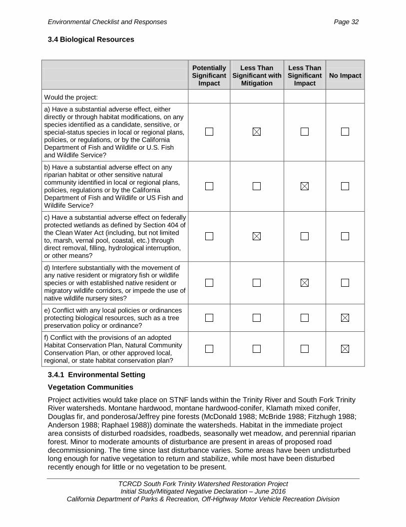
Environmental Checklist and Responses Page 32
TCRCD South Fork Trinity Watershed Restoration Project Initial Study/Mitigated Negative Declaration – June 2016
California Department of Parks & Recreation, Off-Highway Motor Vehicle Recreation Division
3.4 Biological Resources
3.4.1 Environmental Setting Vegetation Communities Project activities would take place on STNF lands within the Trinity River and South Fork Trinity River watersheds. Montane hardwood, montane hardwood-conifer, Klamath mixed conifer, Douglas fir, and ponderosa/Jeffrey pine forests (McDonald 1988; McBride 1988; Fitzhugh 1988; Anderson 1988; Raphael 1988)) dominate the watersheds. Habitat in the immediate project area consists of disturbed roadsides, roadbeds, seasonally wet meadow, and perennial riparian forest. Minor to moderate amounts of disturbance are present in areas of proposed road decommissioning. The time since last disturbance varies. Some areas have been undisturbed long enough for native vegetation to return and stabilize, while most have been disturbed recently enough for little or no vegetation to be present.
Potentially Significant
Impact
Less Than Significant with
Mitigation
Less Than Significant
Impact No Impact
Would the project:
a) Have a substantial adverse effect, either directly or through habitat modifications, on any species identified as a candidate, sensitive, or special-status species in local or regional plans, policies, or regulations, or by the California Department of Fish and Wildlife or U.S. Fish and Wildlife Service?
b) Have a substantial adverse effect on any riparian habitat or other sensitive natural community identified in local or regional plans, policies, regulations or by the California Department of Fish and Wildlife or US Fish and Wildlife Service?
c) Have a substantial adverse effect on federally protected wetlands as defined by Section 404 of the Clean Water Act (including, but not limited to, marsh, vernal pool, coastal, etc.) through direct removal, filling, hydrological interruption, or other means?
d) Interfere substantially with the movement of any native resident or migratory fish or wildlife species or with established native resident or migratory wildlife corridors, or impede the use of native wildlife nursery sites?
e) Conflict with any local policies or ordinances protecting biological resources, such as a tree preservation policy or ordinance?
f) Conflict with the provisions of an adopted Habitat Conservation Plan, Natural Community Conservation Plan, or other approved local, regional, or state habitat conservation plan?
Environmental Checklist and Responses Page 33
TCRCD South Fork Trinity Watershed Restoration Project Initial Study/Mitigated Negative Declaration – June 2016
California Department of Parks & Recreation, Off-Highway Motor Vehicle Recreation Division
Montane hardwood habitats in the project area typically consist of Douglas fir (Pseudotsuga menziesii), tanoak (Lithocarpus densiflorus), Pacific madrone (Arbutus menziesii), California laurel (Umbellularia californica), California black oak (Quercus kelloggii), and bristlecone fir (Abies bracteata). Understory vegetation is mostly scattered woody shrubs, such as manzanita (Arctostaphylos spp.), mountain mahogany (Cercocarpus betuloides), poison oak (Toxicodendron diversilobum) and a few forbs (McDonald 1988).
To be considered montane hardwood-conifer, at least one-third of the trees must be conifer and at least one-third must be broad-leaved (Anderson 1988). Montane hardwood-conifer habitat within the project area generally consists of California black oak, bigleaf maple (Acer macrophyllum), Pacific madrone, and tanoak are common with ponderosa pine (Pinus ponderosa), white fir (Abies concolor), incense-cedar (Calocedrus decurrens), Douglas fir, and sugar pine (Pinus lambertiana) forming the overstory (Anderson 1988).
Klamath mixed-conifer’s overstory layer is characterized by a mixture of conifers. Dominant conifers in the western portion of this habitat are white fir and Douglas fir. In the east, dominant conifers are white fir, Douglas fir, ponderosa pine, incense-cedar, and sugar pine (Benson 1988, updated by CWHR staff, 2005). Dense forests have a very rich shrub layer which can include Sadler oak (Quercus sadleriana), dwarf rose (Rosa gymnocarpa), or western thimbleberry (Rubus parviflorus). In open-to-moderately dense forests, shrub-size plants in the subcanopy include small individuals of overstory species, especially Shasta red fir (Abies magnifica var. shastensis) and white fir, as well as bitter cherry (Prunus emarginata), pinemat manzanita (Arctostaphylos nevadensis), squaw carpet (Ceanothus prostratus), huckleberry oak (Quercus vacciniifolia), Oregon-grape (Berberis aquifolium), greenleaf manzanita (Arctostaphylos patula), dwarf rose, and snowberry (Symphoricarpos albus; Benson 1988, updated by CWHR staff, 2005).
Douglas fir overstory composition varies with soil parent material, moisture, topography, and disturbance history (Raphael 1988). Dry steep slopes on metamorphic and granitic parent materials are dominated by canyon live oak (Quercus chrysolepis). Less rocky, drier soils support Douglas fir, tanoak, and Pacific madrone in association with sugar pine, ponderosa pine, California black oak, and canyon live oak. Deep mesic soils support an overstory of Douglas fir with a tanoak-dominated understory; wettest sites include Pacific yew (Taxus brevifolia; Raphael 1988).
Ponderosa pine/Jeffrey pine habitats consist of ponderosa pine or Jeffrey pine (Pinus jeffreyi) as the dominant species found in the upper tree layer. It usually forms pure stands but may have as its associates Coulter pine (Pinus coulteri), sugar pine, lodgepole pine (P. contorta), white fir, red fir, incense-cedar, black cottonwood (Populus balsamifera ssp. trichocarpa), California black oak, Pacific madrone, canyon live oak, and tanoak. Shrub species composition varies between geographical regions. In the Klamath Mountains manzanita, Fremont’s silktassel (Garrya fremontii) and coffeeberry (Rhamnus californica) dominate the shrub layer (Fitzhugh 1988 and McBride 1988). Wildlife Wildlife habitat values depend on the availability of water, food, and cover. While some wildlife species are restricted to specific vegetation communities, others range across communities and biotic zones. Many species are active in a higher zone in the summer and hibernate or migrate away from these zones in the winter. To give a sense of the variety, common species found in these biotic zones include mule deer (Odocoileus hemionus), black bear (Ursus americanus), coyote (Canis latrans), mountain lion (Puma concolor), western gray squirrel (Sciurus griseus), golden-mantled ground squirrel (Spermophilus lateralis), chipmunks (Neotamias spp.), big brown bat (Eptesicus fuscus), fringed myotis (Myotis thysanodes), Steller’s jay (Cyanocitta stelleri), mountain chickadee (Poecile gambeli), common yellowthroat (Geothlypis trichas), red-
Environmental Checklist and Responses Page 34
TCRCD South Fork Trinity Watershed Restoration Project Initial Study/Mitigated Negative Declaration – June 2016
California Department of Parks & Recreation, Off-Highway Motor Vehicle Recreation Division
tailed hawk (Buteo jamaicensis), red-breasted nuthatch (Sitta canadensis), downy woodpecker (Picoides pubescens), brown creeper (Certhia americana), western fence lizard (Sceloporus occidentalis), rubber boa (Charina bottae), ensatina (Ensatina eschscholtzii), Pacific chorus frog (Pseudacris regilla), and rainbow trout (Oncorhynchus mykiss). Rare species are described below under “Special-status Species.” Wildlife Movement Corridors Habitat corridors facilitate wildlife migration and movement within landscapes and are essential to the viability and persistence of many wildlife populations. Wildlife movement includes migration (i.e., usually one-way per season), inter-population movement (i.e., long-term genetic flow), and small travel pathways (i.e., daily movement corridors within an animal’s territory). While small travel pathways usually facilitate movement for daily home range activities, such as foraging or escape from predators, they also provide connection between outlying populations and the main corridor, permitting an increase in gene flow among populations. These linkages among habitats can extend for miles and occur on a large scale throughout California. Wildlife corridors are important to the long-term health of wildlife populations and the ecology of the Klamath Mountains.
Special-Status Species Special-status species are those plants and animals that are legally protected or otherwise recognized as vulnerable to habitat loss or population decline by federal, state, or local resource conservation agencies and organizations. In this analysis, special-status species include:
• Species that are federal and/or state listed threatened or endangered • Species considered as candidates or proposed for listing as threatened or endangered • CDFG Species of Special Concern • Fully protected species per California Fish and Game Code • Plants considered by the California Native Plant Society (CNPS) and CDFG to be rare,
threatened, or endangered [California rare plant ranked, (CRPR); e.g. CRPR 1B]
Federal special-status species potentially occurring in the project area were identified and evaluated in separate NEPA analyses prepared by the USFS. Biological analysis of these federal species contained in the documents listed in Table 1 are incorporated here by reference. A summary of the incorporated information is presented in Appendix A.
The special-status state species with potential for occurrence in the project area are listed in Appendix C, Table 1 (plants) and Table 2 (animals). These tables show state special-status species; in some cases, these species are also federal special-status species. The tables were prepared consistent with the CEQA Guidelines using information from the STNF (2006, 2009, 2012, and 2013), California Natural Diversity Database (CNDDB 2015), and the CNPS Rare Plant Inventory (2015).
The special-status plant species listed in Appendix C, Table 1 occur in a variety of habitats present in the Klamath Mountains, including areas with serpentinitic soil, broadleaf upland forest, and coniferous forest (CNDDB 2015) and have some potential of being impacted by project activities. Appendix C, Table 1 contains information on regulatory status, habitat, and flowering period derived from the CNDDB (2015) and CNPS Rare Plant Inventory (2015). Appendix C, Table 2 provides a list of state special-status animals potentially occurring within the project area. These species are known inhabitants of portions of the STNF.
Twenty-two of the 40 plant species listed in Appendix C, Table 1 and 11 of the 23 wildlife species listed in Appendix C, Table 2, have a low potential for occurrence within the project area. Either no occurrences were found during USFS surveys for the species, no appropriate
Environmental Checklist and Responses Page 35
TCRCD South Fork Trinity Watershed Restoration Project Initial Study/Mitigated Negative Declaration – June 2016
California Department of Parks & Recreation, Off-Highway Motor Vehicle Recreation Division
habitat is found within the project area, or the project area is outside of the geographic range of the species. Due to the low potential of occurrence and unlikelihood of being impacted by the project, these 22 plant species and 11 wildlife species are dismissed from further consideration. The remaining special-status species are discussed below.
Special-Status Plants Eighteen special-status plant species have moderate potential for occurrence due to suitable habitat within the project area (Appendix C). Five of these have been previously addressed by the USFS including Niles’ harmonia, Stebbins’ harmonia, elongate copper moss, peanut sandwort, and English peak greenbrier (Appendix C). The 13 remaining plant species are described below.
Koehler’s stipitate rock-cress (Arabis koehleri var. stipitata, CRPR 1B.3) occurs in chaparral and lower montane coniferous forest in rocky serpentinitic soils, from elevations of 155 to 1,660 meters. It commonly grows in association with Idaho fescue (Festuca idahoensis), California fescue (Festuca californica), California poppy (Eschscholzia californica), June grass (Koelaria macrantha), and dwarf mahonia (Berberis aquifolium var. repens). A perennial herb, it blooms March through July. The only known CNDDB occurrence within the project area is on Rattlesnake Ridge in the southwest portion of the project area. This occurrence is near road 29N58E.
Flagella-like atractylocarpus (Campylopodiella stenocarpa, CRPR 2.2) is a moss found on seep walls of exposed metasedimentary rock along roadsides. Little is known about the habitat requirements of this moss, but the one known occurrence within five miles of the project area occupies a vertical roadcut on Hwy 299 between Helena and Big Bar. Suitable roadcuts have a high component of bedrock material overlain with silty soil that seeps water until late in the season. Bedrock in these sites contains heavy minerals that provide the necessary substrate for bryophyte growth. Seeps would be avoided during treatments to prevent future erosion, so no impacts to potentially unidentified populations are expected. Brandegee’s eriastrum (Eriastrum brandegeeae, CNPS 1B.2) occurs in chaparral and cismontane woodland on volcanic, sandy soils, from 305 to 1,030 meters elevation. It commonly grows in association with blue elderberry (Sambucus Mexicana and Sambucus nigra ssp. caeluria), California poppy (Eschscholzia californica), valley oak (Quercus lobata), blue oak (Quercus douglasii) and silver lupine (Lupinus albifrons). An annual herb, it blooms from April to August. The nearest CNDDB occurrence to project roads is near Knob Peak in the southeast corner of the project site.
Coast fawn lily (Erythronium revolutum, CNPS 2.2) occurs in bogs and fens, broadleafed upland forest, and North Coast coniferous forest in mesic habitats and along streambanks from 0 to 1,350 meters elevation. It commonly grows in association with California bay laurel (Umbellularia californica), false Solomon seal (Smilacina stellata), dog violet (Viola adunca), five finger fern (Adiantum aleuticum) and star flower (Trientalis latifolia). A perennial bulbiferous herb, it blooms from March through August. The nearest CNDDB occurrence of this species in the project area is on Dubakella Mountain road.
Dudley’s rush (Juncus dudleyi, CNPS 2.3) occurs in lower montane coniferous forest in mesic habitats from 455 to 2,000 meters elevation. It commonly grows in association with creek dogwood (Cornus sericea ssp. sericea), sandbar willow (Salix exigua), arroyo willow (Salix lasiolepis), hair grass (Deschampsia elongata) and poverty rush (Juncus tenuis). A perennial herb, it blooms July through August. The only CNDDB occurrence of this species within the project area is within the town of Weaverville. Heckner’s lewisia (Lewisia cotyledon var. heckneri, CNPS 1B.2) occurs in lower montane coniferous forest in rocky soils from 225 to 2,100 meters elevation. It commonly grows in association with sword fern (Polystichum munitum), western raspberry (Rubus leucodermis),

Environmental Checklist and Responses Page 36
TCRCD South Fork Trinity Watershed Restoration Project Initial Study/Mitigated Negative Declaration – June 2016
California Department of Parks & Recreation, Off-Highway Motor Vehicle Recreation Division
western Douglas fir (Pseudotsuga menziesii var. menziesii), bush chinquapin (Chrysolepis sempervirens), and slender false lupine (Thermopsis macrophylla var. venosa). A perennial herb, it blooms May through July. This species is known to occur in the northern portion of the project area.
South Fork Mountain lupine (Lupinus elmeri, CNPS 1B.2) occurs in lower montane coniferous forest from 1,218 to 2,000 meters elevation. It commonly grows in association with California poppy (Eschscholzia californica), dwarf mahonia (Berberis aquifolium var. repens), hollyleaf redberry (Rhamnus ilicifolia), purple Chinese houses (Collinsia heterophylla) and Ithuriel’s spear (Triteleia laxa). This species is known to exist along old logging roads, but in general exists only on the slopes and ridges of South Fork Mountain.
White-flowered rein orchid (Piperia candida, CNPS 1B.2) occurs in broadleafed upland forest, lower montane coniferous forest and North Coast coniferous forest, sometimes on serpentinitic soils, from 30 to 1,310 meters elevation. It commonly grows in association with sword fern (Polystichum munitum), western Douglas fir (Pseudotsuga menziesii var. menziesii), western raspberry (Rubus leucodermis), blue elderberry (Sambucus Mexicana) and California poppy (Eschscholzia californica). There is one CNDDB recorded occurrence near Forest Glen along the South Fork of the Trinity River.
Tracy’s sanicle (Sanicula tracyi, CNPS 4.2) occurs in cismontane woodland, lower montane coniferous forest, and upper montane coniferous forests in open areas, from 100 to 1,585 meters elevation. It commonly grows in association with blue elderberry (Sambucus Mexicana), canyon live oak (Quercus chrysolepis), California goldenrod (Solidago californica), California brome (Bromus carinatus var. carinatus) and pine bluegrass (Poa secunda ssp. secunda). A perennial herb, it blooms April through July. The one CNDDB recorded occurrence in the project area southwest of South Dubakella Mountain. This area is near numerous road segments scheduled for road decommissioning.
Pale yellow stonecrop (Sedum laxum ssp. flavidum, CNPS 4.3) occurs in broadleafed upland forest, chaparral, cismontane woodland, lower montane coniferous forest, and upper montane coniferous forest, in serpentinitic or volcanic soil, from 455 to 2,000 meters elevation. It commonly grows in association with Yerba Santa (Eriodictyon californicum), rusty slender sedge (Carex subfusca), scytheleaf onion (Allium falcifolium), California poppy (Eschscholzia californica), and California fescue (Festuca californica). A perennial herb, it blooms May through July. There are numerous CNDDB recorded occurrences of this species in the southern extent of the project area.
Klamath Mountain catchfly (Silene salmonacea, CNPS 1B.2) occurs in lower montane coniferous forests in the Klamath Mountains in open areas on serpentinitic soils, from 775 to 1,345 meters elevation. A newly described species, it is known from only six sites, two of which have fewer than five plants and the largest of which has 250 plants (NatureServe 2010). A perennial herb, it blooms from May through July. There are four CNDDB recorded occurrences in the northeast extent of the project area near Trinity Lake. Buttercup-leaf suksdorfia (Suksdorfia ranunculifolia, CNPS 2) occurs in meadows and seeps and upper montane coniferous forest, in mesic, rocky, or granitic soils, from 1,500 to 2,500 meters elevation. It commonly grows in association with scarlet monkey flower (Mimulus cardinalis), yellow willow (Salix lucida ssp. lasiandra), panicled bulrush (Scirpus microcarpus), stream orchid (Epipactis gigantea) and mountain alder (Alnus incana ssp. tenuifolia). A perennial herb, it blooms June through August. There is one CNDDB recorded occurrence of this species in the northwest corner of the project area near the town of Helena. Oval-leaved viburnum (Viburnum ellipticum, CNPS 2.3) occurs in chaparral, cismontane woodland, and lower montane coniferous forest from 214 to 1,400 meters elevation. It commonly grows in association with California poppy (Eschscholzia californica), woodland

Environmental Checklist and Responses Page 37
TCRCD South Fork Trinity Watershed Restoration Project Initial Study/Mitigated Negative Declaration – June 2016
California Department of Parks & Recreation, Off-Highway Motor Vehicle Recreation Division
strawberry (Fragaria vesca), yellow stonecrop (Sedum spathulifolium), canyon live oak (Quercus chrysolepis) and California goldenrod (Solidago californica). A perennial deciduous shrub, it blooms May through June. The one CNDDB record of this species within five miles of the project area is found in the southeast corner of the project extent approximately four miles from the nearest project road. Special-Status Wildlife Twelve special-status plant wildlife species have moderate or high potential for occurrence in the project area due to suitable habitat or known occurrences (Appendix C). Nine of these have been previously addressed by the USFS including bald eagle, peregrine falcon, foothill yellow-legged frog, northern goshawk, northern spotted owl, Pacific fisher, western pond turtle, western red bat, and willow flycatcher (Appendix C). The three remaining special-status wildlife species with moderate potential for occurrence in the project area are described below. Oregon snowshoe hare (Lepus americanus klamathensis) is a California species of special concern and is found in the Cascade Mountains from Mt. Hood, Oregon, southward to Mt. Shasta and the Trinity Mountains of California. In California, it is known from the vicinity of Mt. Shasta, the Trinity Mountains, and rarely from the Warner Mountains (Williams 1986). The Warner Mountain population is probably isolated from all others by expanses of unsuitable habitat (Williams 1986). Uncommon within California, snowshoe hares are primarily found in riparian areas with thickets of deciduous trees such as alders and willows and in dense thickets of young conifers, particularly firs, above the yellow pine zone (Williams 1986). The snowshoe hare breeds mid-February to June or July with a gestation period is 35-37 days with 2-3 litters a year (Hoefler and Duke 1988).The project area contains numerous stream crossings containing suitable habitat for the Oregon snowshoe hare.
Pacific (coastal) tailed frog (Ascaphus truei) is a California species of special concern. This frog species occurs in permanent streams of low temperatures in conifer-dominated habitats including redwood, Douglas fir, Klamath mixed-conifer, and ponderosa pine habitats (Morey 1988). They do not inhabit ponds or lakes. A rocky streambed is necessary for cover for adults, eggs, and larvae (Morey 1988). Permanent water is critical because the aquatic larvae require two to three years to transform (Morey 1988). After heavy rains, adults may be found away from the stream (Morey 1988). This species is mostly nocturnal, but often can be seen on creek banks in daylight (Jennings and Hayes 1994). Adult are usually active from April to October, depending on the locality (Jennings and Hayes 1994). Adults are relatively long-lived, with speculation that they can live up to 15 - 20 years.
The project area contains numerous stream crossings containing suitable habitat for the Pacific tailed frog.
Trinity bristle snail (Monodenia infumata setosa) is a State of California threatened species currently known only from east of the Mad River along South Fork Mountain, and west of the North Fork of the Trinity River (CDFG 2011). This species occurs in isolated locations along the mainstem and South Fork of the Trinity River, Hayfork Creek, and nearby small streams in cool, wet, and shady riparian zones frequently associated with both riparian and upland late seral stage hardwood and conifer forest stands and stand elements (CDFG 2011). The Trinity bristle snail appears to be confined to habitats where there is plenty of shade, fairly low temperatures, and fairly high humidity. They also appear to be most active between dusk and dawn during the months of May and October when ambient air is cool and humid (CDFG 2011). The Trinity bristle snail has a lifespan of from 15 to 20 years, is slow growing, and may not reach an age of maturity for approximately 10 years. It is dormant during summer and winter and can remain dormant for more than 10 years (CDFG 2011). Both adults and juveniles live primarily on the ground, feeding upon and living within the uppermost layer of leaf litter. They also climb to feed

Environmental Checklist and Responses Page 38
TCRCD South Fork Trinity Watershed Restoration Project Initial Study/Mitigated Negative Declaration – June 2016
California Department of Parks & Recreation, Off-Highway Motor Vehicle Recreation Division
upon lichens growing on rocks and alder trees, ferns, petioles of violets, and tender stalks of other green plants (CDFG 2011).
The known range of the Trinity bristle snail encompasses several of the roads slated for decommissioning.
3.4.2 Regulatory Setting Federal, state and local laws and regulations governing biological resources are discussed below. Violation of these laws and regulations would constitute a significant biological impact.
Federal Endangered Species Act (FESA) FESA establishes a broad public and federal interest in identifying, protecting, and providing for the recovery of threatened or endangered species. The Secretary of the Interior and the Secretary of Commerce are designated in FESA as responsible for identifying endangered and threatened species and their critical habitat, carrying out programs for the conservation of these species, and rendering opinions regarding the impact of proposed federal actions on listed species. The U.S. Fish and Wildlife Service (USFWS) and the National Oceanic and Atmospheric Administration’s National Marine Fisheries Service (NOAA-NMFS) are charged with implementing and enforcing the ESA. USFWS has authority over terrestrial and continental aquatic species, and NMFS has authority over species that spend all or part of their life cycle at sea, such as salmonids.
Section 9 of FESA prohibits the unlawful “take” of any listed fish or wildlife species. “Take,” as defined by FESA, means “to harass, harm, pursue, hunt, shoot, wound, kill, trap, capture, or collect, or to attempt to engage in any such action.” The USFWS’s regulations define harm to mean “an act which actually kills or injures wildlife.” Such an act “may include “significant habitat modification or degradation where it actually kills or injures wildlife by significantly impairing essential behavioral patterns, including breeding, feeding or sheltering” (50 CFR § 17.3). Take can be permitted under FESA pursuant to Sections 7 and 10. Section 7 provides a process for take permits for federal projects or projects subject to a federal permit, and Section 10 provides a process for incidental take permits for projects without a federal nexus. FESA does not extend the take prohibition to federally listed plants on private land, other than prohibiting the removal, damage, or destruction of such species in violation of state law. The Migratory Bird Treaty Act of 1918 (MBTA) Under the MBTA, it is unlawful to “pursue, hunt, take, capture or kill; attempt to take, capture or kill; possess, offer to or sell, barter, purchase, deliver or cause to be shipped, exported, imported, transported, carried or received any migratory bird, part, nest, egg or product, manufactured or not.” In short, under the MBTA it is illegal to disturb a nest that is in active use, since this could result in killing a bird or destroying an egg. The USFWS oversees implementation of the MBTA. The Clean Water Act of 1972 (Section 404) The United States does not have a federal, comprehensive law protecting wetlands. However, through the regulation of activities in “waters of the United States,” the Clean Water Act of 1972 is the main federal law used to protect wetlands. Section 404 of the Clean Water Act regulates the discharge of dredged or fill material into “waters of the United States,” which includes traditional navigable waters, interstate waters, certain tributaries of any of these waters, and wetlands that meet these criteria or that are adjacent to any of these waters.
The United States Army Corps of Engineers (USACE) also regulates activities in waters of the United States under the federal Rivers and Harbors Act. Section 10 of the Rivers and Harbors Act requires permits for any work or structures in navigable waters of the United States, including wetlands within or adjacent to these waters. Both dredging and filling are regulated

Environmental Checklist and Responses Page 39
TCRCD South Fork Trinity Watershed Restoration Project Initial Study/Mitigated Negative Declaration – June 2016
California Department of Parks & Recreation, Off-Highway Motor Vehicle Recreation Division
activities under the Act. Navigable waters are defined as those waters that are subject to the ebb and flow of the tide, or that are presently, have been, or may be used for transport of interstate or foreign commerce.
California Endangered Species Act (CESA) Provisions of CESA protect state-listed threatened and endangered species. The Fish and Game Commission is charged with establishing a list of endangered and threatened species. CDFW regulates activities that may result in “take” of individuals (i.e., “hunt, pursue, catch, capture, or kill, or attempt to hunt, pursue, catch, capture, or kill”). Habitat degradation or modification is not expressly included in the definition of “take” under the California Fish and Game Code, but CDFW has interpreted “take” to include the killing of a member of a species which is the proximate result of habitat modification.
California Fish and Game Code Section 1602 requires an entity to notify CDFW of any proposed activity that may substantially divert or obstruct the natural flow of, or substantially change or use any material from the bed, channel, or bank of, any river, stream, or lake, or deposit or dispose of debris, waste, or other material containing pavement where it may pass into any stream, river, or lake. CDFW uses the USFWS definition of wetlands when regulating these activities.
Pursuant to Fish and Game Code section 3503, it is unlawful to “take, possess, or needlessly destroy the nest or eggs of any bird, except as otherwise provided by this code or any regulation made pursuant thereto.” Section 3503.5 provides similar protection specifically to raptors and their nests. Disturbance that causes nest abandonment and/or loss of reproductive effort is considered a “take” by CDFW.
Pursuant to Fish and Game Code section 4150, “[a]ll mammals occurring naturally in California which are not game mammals, fully protected mammals, or fur-bearing mammals, are nongame mammals. Nongame mammals or parts thereof may not be taken or possessed except as provided in this code or in accordance with regulations adopted by the commission.” California Native Plant Protection Act The California Native Plant Protection Act (CNPPA) of 1977 preserves, protects, and enhances endangered and rare plants in California by specifically prohibiting the importation, take, possession, or sale of any native plant designated by the California Fish and Game Commission as rare or endangered, except under specific circumstances identified in the CNPPA. Various activities are exempt from the CNPPA, although take as a result of these activities may require other authorization from CDFW under the California Fish and Game Code. Section 1911 of the CNPPA dictates that all state departments and agencies shall utilize their authority in furtherance of the purposes of the CNPPA by carrying out programs for the conservation of endangered or rare native plants. Notwithstanding that provision, CNPPA Section 1913 directs that the performance by a public agency of its obligation to provide service to the public shall not be restricted because of the presence of rare or endangered plants.
California Fully Protected Species and Species of Special Concern The classification of “fully protected” was the CDFW’s initial effort to identify and provide additional protection to those animals that were rare or faced possible extinction. Lists were created for fish, amphibians and reptiles, birds, and mammals. Most of the species on these lists have subsequently been listed under CESA and/or FESA. The Fish and Game Code sections (fish at §5515, amphibians and reptiles at §5050, birds at §3503 and §3511, and mammals at §4150 and §4700) dealing with “fully protected” species state that these species “…may not be taken or possessed at any time and no provision of this code or any other law shall be construed to authorize the issuance of permits or licenses to take any fully protected species,” although take may be authorized for necessary scientific research. This language

Environmental Checklist and Responses Page 40
TCRCD South Fork Trinity Watershed Restoration Project Initial Study/Mitigated Negative Declaration – June 2016
California Department of Parks & Recreation, Off-Highway Motor Vehicle Recreation Division
makes the “fully protected” designation the strongest and most restrictive regarding the “take” of these species. In 2003, the code sections dealing with “fully protected” species were amended to allow the CDFW to authorize take resulting from recovery activities for state-listed species.
California Species of Special Concern are broadly defined as animals not listed under the FESA or CESA, but which are nonetheless of concern to the CDFW because they are declining at a rate that could result in listing or because they historically occurred in low numbers and known threats to their persistence currently exist. This designation is intended to result in special consideration for these animals by the CDFW, land managers, consulting biologist, and others, and is intended to focus attention on the species to help avert the need for costly listing under FESA and CESA and cumbersome recovery efforts that might ultimately be required. This designation also is intended to stimulate collection of additional information on the biology, distribution, and status of poorly known at-risk species, and focus research and management attention on them. Although these species generally have no special legal status, they are given special consideration under the CEQA during project review.
CDFW and CEQA As a trustee agency, CDFW comments on the biological impacts of development projects reviewed under CEQA. CEQA gives CDFW jurisdiction to comment on the protection of habitats deemed necessary for any species to survive in self-sustaining numbers, but does not allow CDFW to govern land use. It stipulates that the state lead agency shall consult with, and obtain written findings from, CDFW in preparing an EIR on a project, as to the impact of the project on the continued existence of any endangered or threatened species (Public Resources Code § 21104.2). 3.4.3 Discussion Would the proposed project:
a. Have a substantial adverse effect, either directly or through habitat modifications, on any species identified as a candidate, sensitive, or special status species in local or regional plans, policies, or regulations, or by the California Department of Fish and Game or U.S. Fish and Wildlife Service?
Less Than Significant with Mitigation. Special-Status Plants: Federal Listed and Forest Sensitive Species
The USFS evaluated all project routes for potential impacts to federal special-status plant species (Appendix A). Due to the highly compacted nature of the soils, no documented populations of federal special-status plant species or their habitat have been found within any roadbed surface, including those that have been revegetated. A greater amount of habitat and number of documented populations can be found on road cut and fill slopes directly adjacent to road beds, and the riparian habitat associated with culverts.
USFS botanists would implement the following measures for federal listed and USFS sensitive species as needed depending on site conditions. These resource protection measures specified in the Westside Watershed Restoration EA and FONSI would be applied throughout the project sites and are adequate protection for the five federal species (Niles’ harmonia, Stebbins’ harmonia, elongate copper moss, peanut sandwort, and English peak greenbrier) as analyzed by the USFS (Appendix A); no additional mitigation is required.
• Survey all perennial streams for threatened, endangered, and sensitive species or noxious weed species or assume occupancy.
• Survey for sensitive serpentinitic-outcrop- loving sensitive plants or assume occupancy in these areas.

Environmental Checklist and Responses Page 41
TCRCD South Fork Trinity Watershed Restoration Project Initial Study/Mitigated Negative Declaration – June 2016
California Department of Parks & Recreation, Off-Highway Motor Vehicle Recreation Division
• Trees greater than 10 inches diameter at breast height (dbh) will not be removed when pulling road fill onto road surface.
• Where known or assumed populations of sensitive plant species exist on proposed road segments, soil piling, and/or any other activities that could bury plants or disrupt root structures significantly will be avoided.
• Where known populations of spotted or diffuse knapweed exist adjacent to project roads, roads will be individually evaluated to determine the least amount of soil disturbance that would still allow purpose and need to be met.
• The number of service vehicles used in monitoring or implementing treatments will be kept to a minimum to minimize spread of noxious weeds.
• When vehicles park on the side of the road, sites will be chosen where little or no vegetation is present to minimize spread of noxious weed.
• Brief equipment operators of the need to minimize disturbance to existing vegetation within the road clearing limits, at stream crossings, and approved disposal sites to the extent necessary to restore hydrologic function. (Minimize turns.)
• Mechanical equipment is generally restricted to slopes less than 35%. • Clean equipment to remove noxious weeds and petroleum residues: 1) prior to all work
and 2) again after working in any areas containing noxious weeds. • Project design features will be used to reduce or eliminate impacts to special-status
plant species that are known to exist or have potential to exist in the proposed project area. These features include deferring treatments on road segments that have known populations of Niles’ or Stebbins’ harmonia until after July 1 to allow seed set and dispersal.
Special-Status Plants: California Rare Plant Ranked
The proposed project would not impact species that occupy steep, rocky, vertical roadcuts. This includes flagella-like atractylocarpus and buttercup-leaf suksdorfia. Treatments would be excluded from these types of habitats both by USFS direction and to avoid compromising the integrity of slope stability. Therefore, no impacts to these two species are expected.
Serpentinitic soils are present within the decommissioning disturbance zone, and there is suitable habitat for several endemic special-status plant species associated with serpentinitic soils including Koehler’s stipitate rock-cress, white-flowered rein orchid, pale yellow stonecrop, and Klamath Mountain catchfly. In most cases, individuals of these four special-status species would not occur within roadbeds that traverse serpentinitic soil habitat, but they would be found in areas adjacent to existing roads. There is slight potential for individuals of some species to be present in road segments proposed for ripping or subsoiling, and movement of soil for outsloping. Potential impacts include damage to above or belowground plant parts, loss of reproductive potential for a short (seed production) or extended (loss of reproductive roots) time, and possible death of individuals. The preconstruction surveys and installation of protective fencing identified in Mitigation Measure BIO-1 would reduce the potential impact on these serpentinitic soil habitat species to a less-than-significant level.
Within perennial riparian zones where culvert removal is scheduled as part of decommissioning, two special-status plant species could potentially occupy these work sites including coast fawn lily and Dudley’s rush. Potential impacts include damage to aboveground plant parts, uprooting or death of underground root structures, and loss of reproductive potential for short or extended periods of time. The preconstruction surveys and installation of protective fencing identified in Mitigation Measure BIO-1 would reduce the potential impact on these riparian habitat species to a less-than-significant level.

Environmental Checklist and Responses Page 42
TCRCD South Fork Trinity Watershed Restoration Project Initial Study/Mitigated Negative Declaration – June 2016
California Department of Parks & Recreation, Off-Highway Motor Vehicle Recreation Division
Impacts to five other special-status plant species (Brandegee’s eriastrum, Heckner’s lewisia, South Fork Mountain lupine, Tracy’s sanicle, and oval-leaved viburnum) may occur due to the possibility of these species existing within the project area and near roads proposed for decommissioning. The preconstruction surveys and installation of protective fencing identified in Mitigation Measure BIO-1 would reduce the potential impact on these species to a less-than-significant level.
IMPACT BIO-1: Project activities may result in direct impacts to CRPR listed special-status plant species that may occur within and adjacent to the project area. Such impacts could include damage to aboveground plant parts, uprooting or death of underground root structures, and loss of reproductive potential for short or extended periods of time, which would be considered potentially significant. This may include adverse impacts to Koehler’s stipitate rock-cress, Brandegee’s eriastrum, coast fawn lily, Dudley’s rush, Heckner’s lewisia, South Fork Mountain lupine, white-flowered rein orchid, Tracy’s sanicle, pale yellow stonecrop, Klamath Mountain catchfly, and oval-leaved viburnum.
Mitigation Measure BIO-1: Prior to the commencement of project activities, the location of special-status plant species shall be determined through appropriately timed surveys according to CNPS protocol; this shall apply to all areas of the proposed project subject to ground disturbance. Determination of potential habitat for special-status plant species, and surveys conducted to determine the presence of rare plant species shall be performed by a qualified botanist. These surveys shall be timed to cover the blooming periods of special-status plant species with the potential to occur in the area.
Any rare plants within the proposed project area shall be flagged and/or fenced to protect the occupied area during project activities. Where known populations of sensitive plant species exist on proposed road segments, soil piling, and/or any other activities that could bury plants or disrupt root structures significantly shall be avoided.
Implementation: by TCRCD Effectiveness: Locating plants within the project area would enable plants to be
protected and avoided during project activities.
Timing: Prior to construction during blooming periods of plant species to be surveyed
Monitoring: TCRCD shall retain qualified biologists for conducting pre-activity surveys, staking sensitive resources, on site monitoring, documentation of violations and compliance, coordination with contract compliance inspectors, and post-activity documentation. Environmental monitors shall be familiar with the sensitive biological resources in the general project area and qualified to recognize potential project effects to these resources, and shall ensure that state and/or federal wetland/riparian and special status species protection guidelines are followed. An environmental monitor shall be present for all activities that encroach into sensitive areas (e.g., road decommissioning through riparian zones).
The biologist(s) shall prepare a written record of survey results and implementation of any avoidance/minimization measures to be kept on file at the OHMVR Division.
Special-Status Wildlife: Federal Listed and Forest Sensitive Species
The USFS evaluated all project routes for potential impacts to federal special-status wildlife species. The USFS determined that potential impacts associated with road decommissioning were consistent with the federal ESA. Analyses of federally-listed species and consultation with

Environmental Checklist and Responses Page 43
TCRCD South Fork Trinity Watershed Restoration Project Initial Study/Mitigated Negative Declaration – June 2016
California Department of Parks & Recreation, Off-Highway Motor Vehicle Recreation Division
the USFWS and the NMFS were been completed, fulfilling Section 7 of the ESA consultation requirements (19U.S.C. 1536 (c)).
Since the project impacts on federal species were previously assessed, the conclusions of the analyses contained in these NEPA documents are incorporated by reference as presented in Appendix A; no further analysis of impacts on federal special-status species is required for this Initial Study.
The USFS analyzed nine of the federally listed or USFS sensitive species with moderate to high potential for occurrence in the project area (Appendix C, Table 2). The USFS determined that the project would have no effect on bald eagle, peregrine falcon, northern goshawk, Pacific fisher, and northern spotted owl because the project does not modify habitat for these species and the following resource protection measures would be implemented (Appendix A).
The project as developed by STNF incorporates consultation with wildlife biologists who would implement the following resource protection measures as needed depending on site conditions for federally listed and USFS sensitive species.
• Survey for sensitive species within suitable habitat prior to disturbance. • Survey for northern spotted owls for roads within ¼ mile of suitable nesting habitat or
historic activity centers, or implement an LOP in these areas from February 1 through July 9 to prevent noise disturbance of nests.
• Implement an LOP from February 1 to July 9 for northern spotted owl in suitable habitat unless protocol surveys determine no owls to be in the area.
• Implement an LOP from February 1 to August 15 within ½ mile from northern goshawk and peregrine falcon nests. Surveys will be performed in moderately to highly suitable northern goshawk nesting habitat before implementation of the project where project roads fall within ½ mile of the habitat, or LOPs will be implemented. Any roads proposed for treatment that fall within ¼ mile of suitable peregrine falcon nesting habitat will be surveyed prior to implementation or LOPs will be implemented.
• Implement an LOP from January 1 to August 15 within ½ mile from bald eagle nests. • Isolate construction sites from stream flow before removing a culvert and performing
work inside the stream channel. The work site may be completely dewatered or the stream may be rerouted within the channel.
• When water is drafted from Pacific salmonid bearing stream reaches, follow NOAA Fisheries Service Water Drafting Specifications.
• Do not remove trees greater than 10 inches dbh when pulling road fill onto road surface. • Brief equipment operators of the need to minimize disturbance to existing vegetation
within the road clearing limits, at stream crossings, and approved disposal sites to the extent necessary to restore hydrologic function. (Minimize turns.)
The USFS determined that proposed actions in stream crossings and riparian areas could impact individual willow flycatcher, western red bat, foothill yellow-legged frog, and western pond turtle but would not cause a trend towards federal listing or a loss of viability due to the temporal nature of the project activities (Appendix A). The impact on these species is less than significant.
Special-Status Wildlife: California Listed and California Species of Special Concern
Three special-status wildlife species with moderate potential for occurrence in the project area are exclusively state listed special-status species and therefore were not addressed by the USFS. Pacific tailed frog, Oregon snowshoe hare, and Trinity bristle snail could be affected by project activities within riparian areas. Pacific tailed frog is known from perennial streams;

Environmental Checklist and Responses Page 44
TCRCD South Fork Trinity Watershed Restoration Project Initial Study/Mitigated Negative Declaration – June 2016
California Department of Parks & Recreation, Off-Highway Motor Vehicle Recreation Division
Oregon snowshoe hare is typically found in alder and willow thickets along riparian areas; and the Trinity bristle snail is known from only a few streams in the Trinity River drainage. The proposed removal of road fill from stream crossings could potentially disturb these species or result in loss of individuals if present at the time of project activity. Any potential loss of habitat would be temporal as the project would restore hydrologic function of the stream corridor to a natural condition. Mitigation Measures BIO-2 through BIO-5 require preconstruction surveys and avoidance measures to reduce impacts on individual Pacific tailed frogs, Oregon snowshoe hares, and Trinity bristle snails to a less-than-significant level.
IMPACT BIO-2: The project could result in the loss and disturbance of Pacific tailed frog.
Mitigation Measure BIO-2: TCRCD shall carry out pre-activity biological resource surveys to identify the location of Pacific tailed frog within the project area. Pre-activity surveys shall be consistent with all survey protocols and requirements stipulated by resource agencies as a condition of project approval. Sensitive resource areas shall be clearly mapped and marked on project maps before road decommissioning commences. These areas shall be avoided to the greatest extent possible. Immediately prior to project activities scheduled to occur within sensitive resource areas, the qualified biologist shall survey the work area and if Pacific tailed frog individuals are found, a CDFG approved biologist shall move individuals downstream to a safe distance from project activities.
Implementation: by TCRCD Effectiveness: Pre-activity surveys would ensure sensitive wildlife resources within
the project area are protected and avoided during project activities.
Timing: TCRCD shall submit the name and resume of a qualified biological monitor who is familiar with the appearance, habitat requirements and life history of the Pacific tailed frog to the CDFW in advance of the start of project construction for approval. Surveys shall occur within two week prior to start of construction.
Monitoring: The biologist(s) shall prepare a written record of survey results and implementation of any avoidance/minimization measures to be kept on file at the OHMVR Division.
IMPACT BIO-3: The project could result in the loss and disturbance of Oregon snowshoe hare.
Mitigation Measure BIO-3: TCRCD shall carry out pre-activity biological resource surveys to identify the location of any Oregon snowshoe hare breeding site within the project area. Pre-activity surveys shall be consistent with all survey protocols and requirements stipulated by resource agencies as a condition of project approval. Breeding areas shall be clearly mapped and marked on project maps before road decommissioning commences. These areas shall be avoided until the breeding hare and offspring leave the project area.
Implementation: by TCRCD Effectiveness: Pre-activity surveys would ensure sensitive wildlife resources within
the project area are protected and avoided during project activities. Timing: TCRCD shall submit the name and resume of a qualified biological
monitor who is familiar with the appearance, habitat requirements and life history of the Oregon snowshoe hare to the CDFW in advance of the start of project construction for approval. Surveys shall occur within two week prior to start of construction.
Monitoring: The biologist(s) shall prepare a written record of survey results and implementation of any avoidance/minimization measures to be kept on file at the OHMVR Division.

Environmental Checklist and Responses Page 45
TCRCD South Fork Trinity Watershed Restoration Project Initial Study/Mitigated Negative Declaration – June 2016
California Department of Parks & Recreation, Off-Highway Motor Vehicle Recreation Division
IMPACT BIO-4: During the course of normal activity, project operations may harass and potentially harm wildlife that enters the project site. Individuals of special-status wildlife species such as Pacific tailed frog or Oregon snowshoe hare may become trapped within holes or trenches preventing wildlife from traveling through the project area without harm.
Mitigation Measure BIO-4: TCRCD shall impose the conditions defined below on all work-related personnel.
• Litter and other debris that may attract animals shall be removed from the project area daily and kept in enclosed containers when on the job site.
• No pets shall be allowed in the road decommissioning area, including staging areas. • TCRCD’s qualified biologist shall hold a tailgate environmental training program with
work-related personnel. Training shall be conducted prior to commencement of project activities, to inform work-related personnel of the wildlife and aquatic resources in the project area. The training program shall include information about the locations and extent of these sensitive species and areas, methods of resource avoidance, permit conditions, and possible fines for violations of permit conditions and state or federal environmental laws. A fact sheet conveying this information shall be prepared and provided to work-related personnel and any other project personnel who may enter the activity area.
• All excavated, steep-walled holes or trenches more than two feet deep shall be covered at the close of each working day by plywood or similar materials, or provided with one or more escape ramps constructed of earth fill or wooden planks. Before such holes or trenches are filled they must be thoroughly inspected for trapped animals.
• All equipment stored in the action area overnight shall be inspected before they are subsequently moved. If at any time a listed species is discovered, the environmental monitor shall be immediately informed. The environmental monitor shall determine if relocating the species is necessary and shall work with the CDFG prior to handling or relocating unless otherwise authorized.
Implementation: by TCRCD
Effectiveness: Pre-activity surveys would ensure sensitive wildlife resources within the project area are protected and avoided during project activities.
Timing: During project construction
Monitoring: Personnel who have attended worker awareness training should be documented. Workers should sign a statement verifying that they have attended training and understood the material presented.
All new personnel should be trained throughout the duration of the project, with training to be provided prior to each worker starting his/her first day of work.
IMPACT BIO-5: The project could result in the loss and disturbance of Trinity bristle snail.
Mitigation Measure BIO-5: TCRCD shall carry out pre-activity biological resource surveys to identify the location of Trinity bristle snail individuals and habitat within the project area. Pre-activity surveys shall be consistent with all survey protocols and requirements stipulated by resource agencies as a condition of project approval. Sensitive resource areas shall be clearly mapped and marked on project maps before road decommissioning commences. These areas shall be avoided to the greatest extent possible. If a Trinity bristle snail individual is found during project activities, a CDFG approved biologist shall capture, handle for identification (or photograph), and promptly release back into the environment in the nearest suitable habitat and

Environmental Checklist and Responses Page 46
TCRCD South Fork Trinity Watershed Restoration Project Initial Study/Mitigated Negative Declaration – June 2016
California Department of Parks & Recreation, Off-Highway Motor Vehicle Recreation Division
under the same conditions under which they were first found so as to cause minimal trauma (desiccation) to the individual and its associated microhabitat.
Implementation: by TCRCD Effectiveness: Pre-activity surveys would ensure sensitive wildlife resources within
the project area are protected and avoided during project activities. Timing: TCRCD shall submit the name and resume of a qualified biological
monitor who is familiar with the appearance, habitat requirements and life history of the Trinity bristle snail to the CDFW in advance of the start of project construction for approval. Surveys shall occur within two week prior to start of construction.
Monitoring: The biologist(s) shall prepare a written record of survey results and implementation of any avoidance/minimization measures to be kept on file at the OHMVR Division.
Nesting Birds and Bats
Nesting birds, including raptors, and roosting bats are fully protected by state law and disturbance could result in a violation of the California Fish and Game Code. Project activities are scheduled for implementation during the summer months. This schedule overlaps the avian nesting season, February 1 through August 31.Noise from project construction activity could disturb nesting or foraging activities and potentially result in nest, roost, or territory abandonment and subsequent reproductive failure if these disturbances were to occur during an affected species’ breeding season. With the implementation of Mitigation Measures BIO-6 and BIO-7, the impacts from the project would be less than significant. IMPACT BIO-6: Project construction activities during the nesting season could result in nest abandonment that would have an adverse impact on bird species and violate state and federal laws. Mitigation Measure BIO-6: Nesting Bird Survey. If project construction occurs during the nesting season of raptors and migratory birds, a focused survey for active nests shall be completed by a biologist approved by the California Department of Fish and Wildlife within one week before the start of any construction activities that could disturb nesting birds. Surveys shall be conducted in all suitable habitat located at the project work site(s), and in staging and storage areas. The minimum survey radius is 250 feet for passerines, 500 feet for small raptors such as accipiters, and 1,000 feet for larger raptors such as buteos. The bird survey methodology and the results of the survey shall be submitted to the California Department of Fish and Wildlife prior to the start of construction, and the radius may be modified in consultation with the Department if the project is in an urban area.
The nesting season is defined as March 15 to August 30 for smaller birds (passerines) and February 15 to September 15 for raptors.
Nest Buffer and Monitoring: If active nests are found, the wildlife agency approved biologist shall consult with the California Department of Fish and Wildlife and the U.S. Fish and Wildlife Service migratory bird program regarding appropriate actions to comply with state and federal law. Active nest sites shall be designated as an environmentally sensitive area and protected while occupied during project activities. The protective buffer may be 250 feet for passerines, 500 feet for small raptors, and 1,000 feet for large raptors. A wildlife agency approved biologist shall monitor the behavior of the birds at the nest site to ensure that they are not disturbed by project-related construction work until the young have fully fledged, are no longer being fed by the parents and have left the nest site, as determined by the approved biologist.

Environmental Checklist and Responses Page 47
TCRCD South Fork Trinity Watershed Restoration Project Initial Study/Mitigated Negative Declaration – June 2016
California Department of Parks & Recreation, Off-Highway Motor Vehicle Recreation Division
No vegetation shall be disturbed, trimmed or pruned that contains active bird nests until all eggs have hatched, and young have fully fledged (no longer being fed, have completely left the nest). No habitat modification shall occur within the designated environmentally sensitive area even if the next continues to be active beyond the typical nesting season for the species.
Implementation: by TCRCD Effectiveness: Pre-activity surveys would ensure nesting birds within the project area
are protected and avoided during project activities. Timing: March 1 through August 1, no more than one week in advance of the
start of project construction. Monitoring: The biologist shall prepare a written record of survey results and
implementation of any avoidance/minimization measures to be kept on file at the OHMVR Division. The biologist shall monitor any active nests to determine when young have matured sufficiently to have fledged.
IMPACT BIO-7: Extra noise and vibration can lead to the disturbance of roosting bats which may have a negative impact on the animals. Human disturbance can also lead to a change in humidity, temperatures, or the approach to a roost that could force the animals to change their mode of egress and/or ingress to a roost. Disturbance of bat roost habitat may result in significant impacts to bat populations if an occupied or perennial (but unoccupied) maternity or colony roost is disturbed or removed.
Mitigation Measure BIO-7: A preconstruction survey for maternity (March 1 to August 1) or colony bat roosts (year-round) shall be conducted by a qualified biologist within one week prior to activities that remove vegetation or structures. If an occupied maternity or colony roost is detected, CDFW shall be contacted about how to proceed. Typically, a buffer exclusion zone would be established around each occupied roost until bat activities have ceased. The size of the buffer would take into account:
• Proximity and noise level of project activities; • Distance and amount of vegetation or screening between the roost and construction
activities; • Species-specific needs, if known, such as sensitivity to disturbance.
If a special-status bat species is found, construction work shall not start until authorized by the appropriate wildlife agencies.
Due to restrictions of the California Health Department, direct contact by workers with any bat is not allowed. The qualified bat biologist shall be contacted immediately if a bat roost is discovered during project construction.
Implementation: by TCRCD Effectiveness: Pre-activity surveys would ensure bat roosts within the project area
are protected and avoided during project activities.
Timing: March 1 through August 1, no more than one week in advance of the start of project construction.
Monitoring: The biologist shall prepare a written record of survey results and implementation of any avoidance/minimization measures and submit it to the OHMVR Division to be kept on file. The biologist shall monitor any active nests to determine when young have matured sufficiently to have fledged.
Environmental Checklist and Responses Page 48
TCRCD South Fork Trinity Watershed Restoration Project Initial Study/Mitigated Negative Declaration – June 2016
California Department of Parks & Recreation, Off-Highway Motor Vehicle Recreation Division
b. Have a substantial adverse effect on any riparian habitat or other sensitive natural community identified in local or regional plans, policies, and regulations or by the California Department of Fish and Game or U.S. Fish and Wildlife Service?
Less Than Significant Impact. The proposed project would have a minor impact on riparian habitat during culvert removal and road decommissioning activities. No mature overstory trees are scheduled for removal in riparian habitats; only shrubs, other understory vegetation, and seedling or sapling trees may be removed during road decommissioning. This vegetation is expected to grow back quickly after treatment activities are completed. Aquatic and riparian protections would be provided by BMPs, project design criteria, and Shasta-Trinity’s Land and Resource Management Plan (LRMP) standards. Dispersal of aquatic and riparian species would be improved by culvert removal. With the removal of roads, restoration of riparian and upland habitat function would occur in the treatment areas. Fragmentation of habitat would be substantially reduced.
Additionally, the following resource conservation measures have been incorporated into the project design by TCRCD:
• Stream crossings are removed and fill is generally placed along cutbanks to create outsloping roads.
• Cutbank overhangs are removed. • Culvert removal consists of excavation to pre-road construction level of channel, removal
of culvert, and pulling fill back until natural channel width is reestablished. • Remove organic debris from fill. • Dispose of unsuitable slide and waste material in relatively flat stable areas away from
stream courses. • Remove berms or provide breaks in earth mass to allow dispersal of surface flow. • Disperse surface flow onto stable slopes with vegetation or rip-rap protection. • Ensure that inboard ditch relief is provided by outsloping, maintaining or adding dips to
disperse surface runoff. • Provide drainage to prevent ponding water. • Isolate project activity sites from stream flow before removing a culvert and performing
work inside the stream channel. The work site may be completely dewatered or the stream may be rerouted within the channel.
If CDFW determines the activity may substantially adversely affect fish and wildlife resources, a Lake or Streambed Alteration Agreement (Agreement) would be required (Fish and Game Code §1602). A draft agreement must be provided within 60 days (Fish and Game Code §1603). The Agreement would include reasonable conditions necessary to protect those resources and must comply with CEQA. The applicant may proceed with the activity in accordance with the final Agreement.
CDFG regulations would not apply if the project was being funded and conducted solely by the USFS. However, because the work is being funded by the OHMVR Division and carried out by the TCRCD work conducted within a stream course the project requires compliance with Fish and Game Code Section 1602.
c. Have a substantial adverse effect on federally protected wetlands as defined by Section 404 of the Clean Water Act (including, but not limited to, marsh, vernal pool, coastal, etc.) through direct removal, filling, hydrological interruption, or other means?

Environmental Checklist and Responses Page 49
TCRCD South Fork Trinity Watershed Restoration Project Initial Study/Mitigated Negative Declaration – June 2016
California Department of Parks & Recreation, Off-Highway Motor Vehicle Recreation Division
Less Than Significant Impact with Mitigation. The purpose of the proposed project is to remove sediment sources within the watershed and improve water quality and aquatic habitat values. The project would remove road fill and culverts from up to 76 stream crossings to restore natural flow in drainage channels and improve overall hydrologic function. Work within stream channels may temporarily impact wetlands if present until the channel and its banks are restored. There would be no net loss of any wetland values. Mitigation Measure BIO-8 requires TCRCD to consult with appropriate agencies (RWQCB and the USACE) should direct impacts to wetlands and Waters of the U.S. be unavoidable. With the implementation of Mitigation Measure BIO-8, the project impacts are considered less than significant.
The USFS maintains an agreement and waiver process with the RWQCB. If the project is on federal land, the Management Agency Agreement and Waiver Process covers the RWQCB’s 401 certification process (see the 2010 Waiver of Waste Discharge Requirements for Nonpoint Source Discharges Related to Certain Federal Land Management Activities on National Forest System Lands in the North Coast Region, Order No. R1-2010-0029). A waiver must be filed and the implementation plan must include any specific applicable BMPs which align with the NEPA document that authorizes the work.
The 404 permit is usually a concurrent process with the 401 process. If the project is on national forest land, the project likely falls under an exempted category of 33 CFR 323.4. The most applicable exempted category is "Construction or maintenance of farm roads, forest roads, or temporary roads for moving mining equipment, where such roads are constructed and maintained in accordance with best management practices (BMPs) to assure that flow and circulation patterns and chemical and biological characteristics of waters of the United States are not impaired, that the reach of the waters of the United States is not reduced, and that any adverse effect on the aquatic environment will be otherwise minimized."
If the projects are on private land, 401/404 permits are required and the exemptions or waivers are not valid. For work on private land, TCRCD will consult with both the RWQCB and the USACE. This project would likely require a Nationwide Permit. The purpose of the Nationwide Permit Program (NWP) is to streamline the evaluation and approval process throughout the nation for certain types of activities that have only minimal impacts to the aquatic environment. NWPs authorize specific types of activity, including construction activities. Many of the NWPs require notification to the USACE.
IMPACT BIO-8: The project would remove road fill and culverts from up to 76 stream crossings to restore natural flow in drainage channels and improve overall hydrologic function. Work within stream channels may temporarily impact wetlands and Waters of the U.S. if present until the channel and its banks are restored.
Mitigation Measure BIO-8: TCRCD shall consult with the RWQCB to receive certification and the USACE for a Nationwide Permit or any other permit required by the USACE. Certain Nationwide Permits require prior notification to the USACE.
Implementation: by TCRCD Effectiveness: The above measures would ensure sensitive aquatic resources within
the project area are protected and avoided during project activities.
Feasibility: Feasible
Monitoring: TCRCD shall retain qualified biologists as environmental monitors to monitor project activities.
d. Interfere substantially with the movement of any native resident or migratory fish or wildlife species or with established native resident or migratory wildlife corridors, or impede the use of native wildlife nursery sites?

Environmental Checklist and Responses Page 50
TCRCD South Fork Trinity Watershed Restoration Project Initial Study/Mitigated Negative Declaration – June 2016
California Department of Parks & Recreation, Off-Highway Motor Vehicle Recreation Division
Less Than Significant Impact. Project activities could impact wildlife in adjacent areas by temporarily altering movement patterns, or causing animals to temporarily avoid those areas. Mobile species including birds and larger mammals are expected to disperse into adjacent areas during project activities. Vegetation removal activities and road decommissioning could interfere with movement patterns for wildlife that use riparian, wetlands, and other corridors for dispersal (e.g., black-tailed deer, raccoon, muskrat, bobcat, coyote, and skunks). Although local wildlife movement may be impacted near the project, the project area is confined to short road segments within large tracts of public, undeveloped, USFS land providing established native vegetation and habitat for a range of common and special status native wildlife species. Therefore, disruption to wildlife movement is considered less than significant.
Direct effects to fish migration corridors or nursery sites are not expected to occur. Water drafting is the only aspect of the project that may occur in suitable fish habitat. Following the NMFS water drafting guidelines is expected to fully protect listed fish species. Project design standards and BMPs would ensure that no fish would be affected directly. Flowing stream water would be carefully diverted and entrained within the existing channel to avoid possible sedimentation during heavy equipment operation. With the BMPs listed in response b, project impacts on fish migration corridors or wildlife nursery sites are considered less than significant.
e. Conflict with any local policies or ordinances protecting biological resources, such as a tree preservation policy or ordinance?
No Impact. The project does not conflict with any local policies or ordinances protecting biological resources. There would be no impact, directly or indirectly, on local policies or ordinances by the implementation of this project.
f. Conflict with the provisions of an adopted Habitat Conservation Plan, Natural Community Conservation Plan, or other approved local, regional, or state habitat conservation plan?
No Impact. The project area is not covered under a Habitat Conservation Plan, Natural Community Conservation Plan or other approved local, regional, or state habitat conservation plan. Therefore, there would be no impact, either directly or indirectly, on a Habitat Conservation Plan, Natural Community Conservation Plan or other approved local, regional, or state habitat conservation plan.

Environmental Checklist and Responses Page 51
TCRCD South Fork Trinity Watershed Restoration Project Initial Study/Mitigated Negative Declaration – June 2016
California Department of Parks & Recreation, Off-Highway Motor Vehicle Recreation Division
3.5 Cultural Resources
3.5.1 Environmental and Regulatory Setting The project sites comprise unpaved forest service roads. No archaeological or historic resources are known to occur within the project sites.
Assembly Bill (AB) 52, approved in September 2014, creates a formal role for California Native American tribes by creating a formal consultation process and establishing that a substantial adverse change to a tribal cultural resource has a significant effect on the environment. Tribal cultural resources are defined as:
1) Sites, features, places, cultural landscapes, sacred places, and objects with cultural value to a California Native American tribe that are either of the following: A) Included or determined to be eligible for inclusion in the CRHR B) Included in a local register of historical resources as defined in PRC
section 5020.1(k) 2) A resource determined by the lead agency, in its discretion and supported by
substantial evidence, to be significant pursuant to criteria set forth in PRC section 5024.1 (c). In applying the criteria set forth in PRC section 5024.1 (c) the lead agency shall consider the significance of the resource to a California Native American tribe.
A cultural landscape that meets the criteria above is also a tribal cultural resource to the extent that the landscape is geographically defined in terms of the size and scope of the landscape. In addition, a historical resource described in PRC section 21084.1, a unique archaeological resource as defined in PRC section 21083.2(g), or a “non-unique archaeological resource” as defined in PRC section 21083.2(h) may also be a tribal cultural resource if it conforms with above criteria.
AB 52 requires a lead agency, prior to the release of a negative declaration, mitigated negative declaration, or environmental impact report for a project, to begin consultation with a California Native American tribe that is traditionally and culturally affiliated with the geographic area of the proposed project if: (1) the California Native American tribe requested to the lead agency, in writing, to be informed by the lead agency through formal notification of proposed projects in the geographic area that is traditionally and culturally affiliated with the tribe, and (2) the California
Potentially Significant
Impact
Less Than Significant with
Mitigation
Less Than Significant
Impact No
Impact
Would the project:
a) Cause a substantial adverse change in the significance of a historical resource as defined in §15064.5?
b) Cause a substantial adverse change in the significance of an archaeological resource pursuant to §15064.5?
c) Directly or indirectly destroy a unique paleontological resource or site or unique geologic feature?
d) Disturb any human remains, including those interred outside of formal cemeteries?

Environmental Checklist and Responses Page 52
TCRCD South Fork Trinity Watershed Restoration Project Initial Study/Mitigated Negative Declaration – June 2016
California Department of Parks & Recreation, Off-Highway Motor Vehicle Recreation Division
Native American tribe responds, in writing, within 30 days of receipt of the formal notification, and requests the consultation. AB 52 states: “To expedite the requirements of this section, the Native American Heritage Commission shall assist the lead agency in identifying the California Native American tribes that are traditionally and culturally affiliated with the project area.”
3.5.2 Discussion Would the proposed project:
a. Cause a substantial adverse change in the significance of a historical resource as defined in §15064.5?
b. Cause a substantial adverse change in the significance of an archaeological resource pursuant to §15064.5?
Less than Significant Impact (responses a-b). Historical and Archaeological Resources
The potential for project activities to affect known historic and archaeological resources was addressed in the previous NEPA documents incorporated by reference (Appendix A). The project would not impact known cultural resources.
Unknown historic resources potentially encountered during project work are addressed by the Programmatic Agreement (PA) in effect between STNF and the State Historic Preservation Officer (SHPO; USFS 2006b). As specified in Appendix C of the PA (Heritage Resources Strategy; Evaluation of Historic Properties, p.51), “For the purposes of this strategy, all cultural resources within [Area of Potential Effect]s are considered historic properties, even if they have not been formally evaluated using NRHP Criteria (36 CFR 60.4), unless they already have been determined not eligible in consultation with the SHPO or through other agreed on procedures (36 CFR 60.4; 36 CFR 800; CARIDAP, etc.).”
By definitions within the PA, historic properties cover the following archaeological resources:
F. Historic Property is: any prehistoric or historic district, site, building, structure, or object, and its associated artifacts, remains, features, settings, and records, that is either listed in or determined eligible for inclusion in the NRHP [National Register of Historic Places]; or any feature that contributes to district NRHP eligibility; or any property, and its features, not yet evaluated to determine whether it is eligible for the NRHP, but that, for the purposes of this PA, may be assumed by the Forests to be NRHP eligible.
J. At Risk Historic Property is a property that the Forest Heritage Resource Manager identifies as susceptible to being adversely affected as a result of designating a motor vehicle route, or using or maintaining the designated motorized recreation system. An at risk historic property is identified based on property characteristics and proximity to designated routes (e.g., trail corridor, trail head, vista point).
The PA (Section VII, Inadvertent Effects and Unanticipated Discoveries) provides protection to unknown historic resources that may be discovered in a project area. It requires national forests to notify the SHPO immediately if unanticipated discovery of at risk historic properties is made during project implementation and sites have been impacted by project activities. “If undertakings have not been completed at the time effects are discovered, all activities in the vicinity of the affected historic properties shall cease and reasonable efforts shall be taken to avoid or minimize harm to the properties until the following consultations are completed. Forests shall consult with the SHPO for not more than 10 calendar days after discovery to agree on a mutually acceptable course of action regarding the historic properties.”
With this measure in place, project impacts to unknown historic resources are less than significant.
Environmental Checklist and Responses Page 53
TCRCD South Fork Trinity Watershed Restoration Project Initial Study/Mitigated Negative Declaration – June 2016
California Department of Parks & Recreation, Off-Highway Motor Vehicle Recreation Division
Tribal Cultural Resources
In accordance with AB 52, the TCRCD initiated consultation with Native American representatives beginning in March 2016. Documentation of the consultation is presented in Appendix D. All correspondence related to AB 52 compliance are available at TCRCD’s office and at OHMVR Division Headquarters (TCRCD 2016).
The following is the timeline associated with AB 52 Compliance for the OHV project named South Fork-Trinity River Road Decommissioning Project:
1. 3/29/2016: TCRCD contacted the Native American Heritage Commission (NAHC) and requested the list of tribes to be contacted.
2. 4/1/2016: the NAHC responded with list of tribes to notify in writing.
3. 4/5/2016: TCRCD sent letters, with certified return receipts, to 7 people at 6 different tribes. The letters were received by the people/Tribes between 4/5-4/7, 2016
4. 4/26/2016: TCRCD received one complimentary letter back within 30 days from the Tsnungwe Council, stating that they had no concerns with the project.
5. 5/9/2016: last day to receive reply to request letters under the 30-day time period; no other letters were received.
As a result of the consultation process it is determined that there are no tribal cultural resources that would be impacted by the project.
c. Directly or indirectly destroy a unique paleontological resource or site or unique geologic feature?
Less than Significant Impact. The road decommissioning and restoration sites have been disturbed by past grading to create the road prisms. As a result there is low likelihood for in situ paleontological resources to be disturbed by project activities.
d. Disturb any human remains, including those interred outside of formal cemeteries?
Less than Significant Impact. If human remains are inadvertently discovered, the TCRCD will follow the procedures as outlined in California Health and Safety Code section 7050.5. All project activities at the find site must come to a complete stop and no further excavation or disturbance of the area or vicinity will occur. The county coroner will be contacted immediately, and if the corner determines or has reason to believe that the remains are Native American, the coroner will contact the Native American Heritage Commission (NAHC) within 24 hours of making this determination. Whenever the NAHC receives notification of a discovery of Native American human remains from a county coroner the NAHC will follow the procedures as outlined in Public Resources Code section 5097.98.
The CEQA Guidelines (14 CCR §15064.5(e)) reference the appropriate state law (PRC §5097.98) that applies when human remains are accidentally discovered. This language states:
In the event that human remains are accidently discovered, the project must come to a complete stop and no further excavation or disturbance of the area or vicinity will occur. The county coroner is to be called immediately to determine that the remains are of Native American ancestry. If the coroner confirms that the remains are Native American, within 24 hours of the discovery the coroner is to contact the [NAHC]. The NAHC will identify the person(s) believed to be the Most Likely Descendent (MLD), and the MLD will decide, along with the property owner, to appropriate treatment or disposal of the human remains and associated grave goods as provided in PRC §5097.98. If the NAHC cannot identify the MLD, the MLD fails to make a recommendation, or the property

Environmental Checklist and Responses Page 54
TCRCD South Fork Trinity Watershed Restoration Project Initial Study/Mitigated Negative Declaration – June 2016
California Department of Parks & Recreation, Off-Highway Motor Vehicle Recreation Division
owner rejects the MLD’s recommendations, the property owner can rebury the remains and associated burial goods in an area not subject to ground disturbance (14 CCR §15064.5).
Existing state Public Resources Code and Health and Safety Code will ensure that the NAHC will be notified upon discovery of Native American human remains and that proper treatment measures will be implemented. Therefore, with these protective state laws in place, the project impact on human remains is less than significant.
Associate State Archaeologist for the OHMVR Division, Sarah Wallace, has reviewed the NEPA documents and IS/MND as part of the state’s CEQA review process for this project (Wallace 2016), and concurs with the findings that project impacts on cultural resources are less than significant due to implementation of USFS project design features. No further mitigation is warranted.
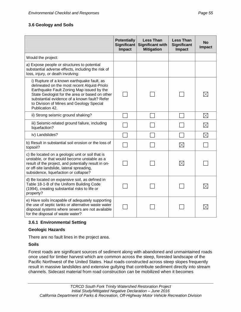
Environmental Checklist and Responses Page 55
TCRCD South Fork Trinity Watershed Restoration Project Initial Study/Mitigated Negative Declaration – June 2016
California Department of Parks & Recreation, Off-Highway Motor Vehicle Recreation Division
3.6 Geology and Soils
3.6.1 Environmental Setting Geologic Hazards There are no fault lines in the project area.
Soils Forest roads are significant sources of sediment along with abandoned and unmaintained roads once used for timber harvest which are common across the steep, forested landscape of the Pacific Northwest of the United States. Haul roads constructed across steep slopes frequently result in massive landslides and extensive gullying that contribute sediment directly into stream channels. Sidecast material from road construction can be mobilized when it becomes
Potentially Significant
Impact
Less Than Significant with
Mitigation
Less Than Significant
Impact No
Impact
Would the project:
a) Expose people or structures to potential substantial adverse effects, including the risk of loss, injury, or death involving:
i) Rupture of a known earthquake fault, as delineated on the most recent Alquist-Priolo Earthquake Fault Zoning Map issued by the State Geologist for the area or based on other substantial evidence of a known fault? Refer to Division of Mines and Geology Special Publication 42.
ii) Strong seismic ground shaking?
iii) Seismic-related ground failure, including liquefaction?
iv) Landslides?
b) Result in substantial soil erosion or the loss of topsoil?
c) Be located on a geologic unit or soil that is unstable, or that would become unstable as a result of the project, and potentially result in on- or off-site landslide, lateral spreading, subsidence, liquefaction or collapse?
d) Be located on expansive soil, as defined in Table 18-1-B of the Uniform Building Code (1994), creating substantial risks to life or property?
e) Have soils incapable of adequately supporting the use of septic tanks or alternative waste water disposal systems where sewers are not available for the disposal of waste water?

Environmental Checklist and Responses Page 56
TCRCD South Fork Trinity Watershed Restoration Project Initial Study/Mitigated Negative Declaration – June 2016
California Department of Parks & Recreation, Off-Highway Motor Vehicle Recreation Division
saturated, or gullies can form if road runoff is diverted onto previously unchanneled slopes (USFS 2011).
Three soil categories occur in the project roads: metasedimentary, serpentine, and granitic. Metasedimentary soils are moderately susceptible to erosion, serpentine soils are moderate to highly susceptible to erosion, and granitic soils are highly susceptible to erosion. Poorly maintained roads tend to develop into poorly functioning roads. Roads identified as poorly functioning (during RAP analysis, watershed analysis for various watersheds, and past environmental analysis) would continue to contribute significant amounts of sediment (USFS 2011) 3.6.2 Discussion
Would the proposed project: a. Expose people or structures to potential substantial adverse effects, including
the risk of loss, injury, or death involving: i. Rupture of a known earthquake fault, as delineated on the most recent
Alquist-Priolo Earthquake Fault Zoning Map issued by the State Geologist for the area or based on other substantial evidence of a known fault?
ii. Strong seismic ground shaking? iii. Seismic-related ground failure, including liquefaction?
iv. Landslides?
No Impact. (Responses i-iv). There are no fault lines in the project area. Rupture of a surface fault, seismic shaking, liquefaction, or landslides would not affect proposed road decommissioning project or expose people to potential substantial adverse effects such as loss, injury, or death. The project would not create potential for fault rupture or exacerbate existing fault rupture conditions on the project site. The project would not exacerbate seismic shaking conditions or create or exacerbate liquefaction conditions. The project soils would not be subject to seismic landslides.
b. Result in substantial soil erosion or the loss of topsoil? c. Be located on a geologic unit or soil that is unstable, or that would become
unstable as a result of the project, and potentially result in on- or off-site landslide, lateral spreading, subsidence, liquefaction or collapse?
Less Than Significant Impact. (Responses b-c). The proposed project would decommission 27 road segments (22 miles) which have been identified by the USFS as a sediment source within the Trinity River and South Fork Trinity River watersheds. These routes are a high priority for decommissioning and restoration. The project would remove road fill and culverts from 76 stream crossings which could be subject to mass wasting under a heavy precipitation event. The removal of the road fill from the drainages would remove the threat of soil wasting in these drainages. This is a beneficial impact. The project would not create unstable areas or exacerbate existing geologic conditions or instabilities.
Eroded soils can be entrained in storm water runoff and be discharged to surface waters, thereby affecting the water quality of receiving waters. Decommissioning the roads and removing road fill from drainages would reduce the amount of soil exposed to erosion. During project activity, erosion control measures would be implement by TCRCD (see BMPs listed in Projection Description (Section 2.6). The project would not result in substantial soil erosion or loss of topsoil.
Environmental Checklist and Responses Page 57
TCRCD South Fork Trinity Watershed Restoration Project Initial Study/Mitigated Negative Declaration – June 2016
California Department of Parks & Recreation, Off-Highway Motor Vehicle Recreation Division
d. Be located on expansive soil, as defined in Table 18-1-B of the Uniform Building Code (1994), creating substantial risks to life or property?
e. Have soils incapable of adequately supporting the use of septic tanks or alternative wastewater disposal systems where sewers are not available for the disposal of wastewater?
No Impact. (Responses d-e). Project activities do not involve building structures for human habitation or involve the use of septic leach fields. The project would not affect expansive soil conditions or septic capabilities of property soils.

Environmental Checklist and Responses Page 58
TCRCD South Fork Trinity Watershed Restoration Project Initial Study/Mitigated Negative Declaration – June 2016
California Department of Parks & Recreation, Off-Highway Motor Vehicle Recreation Division
3.7 Greenhouse Gas Emissions
3.7.1 Environmental Setting Gases that trap heat in the atmosphere and affect regulation of the Earth’s temperature are known as greenhouse gases (GHG). Common GHG include carbon dioxide (CO2), methane (CH4), nitrous oxide (N2O), hydrofluorocarbons (HFCs), and sulfur hexafluoride (SF6).
GHG emissions from human activities contribute to overall GHG concentrations in the atmosphere, and climate scientists have become increasingly concerned about the effects of these emissions on global climate change. Human (anthropogenic) production of GHGs has increased steadily since pre-industrial times and atmospheric CO2 concentrations have increased from a pre-industrial value of approximately 280 ppm to a global monthly mean of 400 ppm in November 2015 (NOAA 2015). The United Nations’ International Panel on Climate Change (IPCC) fourth assessment report (AR4) concluded that recent regional climate changes, particularly temperature increases, are affecting many natural systems including water, ecosystems, food, coasts, and health (IPCC 2007a). The AR4 concluded that most of the observed increase in global average temperature since the mid-20th century is very likely due to the observed increase in anthropogenic GHG concentrations (IPCC 2007b).
GHGs can remain in the atmosphere long after they are emitted. The potential for a GHG to absorb and trap heat in the atmosphere is considered its global warming potential (GWP). The reference gas for measuring GWP is CO2, which has a GWP of one. By comparison, CH4 has a GWP of 28-36 over a 100 year interval, which means that one molecule of CH4 has 28-36 times the effect on global warming, as one molecule of CO2 over 100 years (U.S. EPA 2015a). Multiplying the estimated emissions for non-CO2 GHGs by their GWP determines their carbon dioxide equivalent (CO2e), which enables a project’s combined global warming potential to be expressed in terms of mass CO2 emissions.
3.7.2 Regulatory Setting In 2006, the California State Legislature adopted the California Global Warming Solutions Act of 2006, Assembly Bill (AB) 32, which required CARB to: 1) determine 1990 statewide GHG emissions, 2) approve a 2020 statewide GHG limit that is equal to the 1990 emissions level, 3) adopt a mandatory GHG reporting rule for significant GHG emission sources, 4) adopt a Scoping Plan to achieve the 2020 statewide GHG emissions limit, and 5) adopt regulations to achieve the maximum technologically feasible and cost-effective reductions.
In 2015, Governor Jerry Brown established the most ambitious GHG reduction target in North America by issuing Executive Order B-30-15 This Executive Order establishes a mid-term GHG reduction target to reduce GHG emissions by 40% below 1990 levels by 2030. California is on track to meet the current target of reducing GHG emissions to 1990 levels by 2020, as
Potentially Significant
Impact
Less Than Significant with
Mitigation
Less Than Significant
Impact No
Impact
Would the project:
a) Generate greenhouse gas emissions, either directly or indirectly, that may have a significant impact on the environment?
b) Conflict with an applicable plan, policy, or regulation adopted for the purpose of reducing the emissions or greenhouse gases?
Environmental Checklist and Responses Page 59
TCRCD South Fork Trinity Watershed Restoration Project Initial Study/Mitigated Negative Declaration – June 2016
California Department of Parks & Recreation, Off-Highway Motor Vehicle Recreation Division
established in AB 32. Many of the GHG reduction measures (e.g. Low Carbon Fuel Standard, Advanced Clean Car standards, and Cap-and-Trade) have been adopted over the last five years and implementation activities are ongoing (CARB 2016). California’s new emission reduction target of 40% below 1990 levels by 2030 will make it possible to reach the ultimate goal of reducing emissions 80% under 1990 levels by 2050.
In 2007, CARB approved a statewide 1990 emissions level and corresponding 2020 GHG emissions limit of 427 million metric tons of carbon dioxide equivalents (MMTCO2e) (CARB 2007). In 2009, CARB adopted its 2008 Climate Change Scoping Plan, which projects, absent regulation or under a “business as usual” (BAU) scenario, 2020 statewide GHG emissions levels of 596 million MTCO2e and identifies the numerous measures (i.e., mandatory rules and regulations and voluntary measures) that will achieve at least 174 MMTCO2e of reductions and reduce statewide GHG emissions to 1990 levels by 2020 (ARB 2009). In 2011, CARB released a supplement to the 2008 Scoping Plan Functional Equivalent Document (FED) that included an updated 2020 BAU statewide GHG emissions level projection of 507 million MTCO2e (CARB 2011a). CARB has also adopted a Regulation for the Mandatory Reporting of Greenhouse Gas Emissions (Title 17, CCR, Section 95100 – 95133 (17 CCR §95100 – 95133)), which requires facilities that emit greater than or equal to 25,000 metric tons of CO2 annually to report their GHG emissions to CARB.
Regionally, the Trinity County Planning Department is responsible for developing recommendations relative to air quality, energy conservation, climate change, and related issues. The Trinity County Planning Department does not have a Climate Action Plan.
3.7.3 Discussion
Would the proposed project:
a. Generate greenhouse gas emissions, either directly or indirectly, that may have a significant impact on the environment?
Less Than Significant Impact. Global climate change is the result of GHG emissions worldwide; individual projects do not generate enough GHG emissions to influence global climate change. Thus, the analysis of GHG emissions is by nature a cumulative analysis focused on whether an individual project’s contribution to global climate change is cumulatively considerable.
The proposed project would produce GHG emissions from construction-related fuel combustion. As described in Section 3.3.3, project construction emissions were estimated using the SMAQMD’s Road Construction Emissions Model, Version 7.1.5.1 (Appendix B). Under worst-case conditions (45 eight-hour work days, 2.5 acres of total project area along 10 miles of road), the project is estimated to produce 23.4 Metric Tons of CO2 (MTCO2) per year. According to CARB’s 2013 GHG Emissions Inventory for off-road construction and mining equipment, emissions of CH4 and N2O would add approximately 0.3 percent in CO2 equivalent emissions, which would result in total GHG emissions of 23.5 metric tons of CO2 equivalent (MTCO2e) per year (CARB 2015a).
The NCUAQMD has not adopted a threshold of significance for construction-related GHG emissions; however, the project’s potential construction-related GHG emissions are less than Bay Area Air Quality Management District’s (BAAQMD) operational GHG significance threshold for land use development projects of 1,100 MTCO2e per year and are therefore considered to be a less than significant impact. The project is not anticipated to result in an increase in long-term operational GHG emissions because it does not involve new land uses or new trails that would induce recreation growth.
Environmental Checklist and Responses Page 60
TCRCD South Fork Trinity Watershed Restoration Project Initial Study/Mitigated Negative Declaration – June 2016
California Department of Parks & Recreation, Off-Highway Motor Vehicle Recreation Division
b. Conflict with an applicable plan, policy or regulation adopted for the purpose of reducing the emissions of greenhouse gases?
Less Than Significant Impact. The proposed project would not conflict with an applicable plan, policy, or regulations adopted for the purpose of reducing GHG emissions. The NCUAQMD does not have a current plan, policy or regulation that they have adopted for the purpose of reducing the emissions of GHGs for mobile sources; which is what the project consists of. The project does not include any stationary sources that are subject to state or federal GHG reporting regulations.
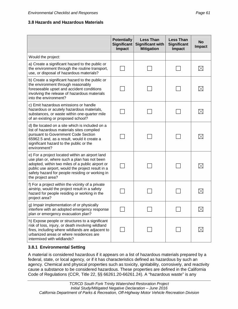
Environmental Checklist and Responses Page 61
TCRCD South Fork Trinity Watershed Restoration Project Initial Study/Mitigated Negative Declaration – June 2016
California Department of Parks & Recreation, Off-Highway Motor Vehicle Recreation Division
3.8 Hazards and Hazardous Materials
3.8.1 Environmental Setting A material is considered hazardous if it appears on a list of hazardous materials prepared by a federal, state, or local agency, or if it has characteristics defined as hazardous by such an agency. Chemical and physical properties such as toxicity, ignitability, corrosively, and reactivity cause a substance to be considered hazardous. These properties are defined in the California Code of Regulations (CCR, Title 22, §§ 66261.20-66261.24). A “hazardous waste” is any
Potentially Significant
Impact
Less Than Significant with
Mitigation
Less Than Significant
Impact No
Impact
Would the project:
a) Create a significant hazard to the public or the environment through the routine transport, use, or disposal of hazardous materials?
b) Create a significant hazard to the public or the environment through reasonably foreseeable upset and accident conditions involving the release of hazardous materials into the environment?
c) Emit hazardous emissions or handle hazardous or acutely hazardous materials, substances, or waste within one-quarter mile of an existing or proposed school?
d) Be located on a site which is included on a list of hazardous materials sites compiled pursuant to Government Code Section 65962.5 and, as a result, would it create a significant hazard to the public or the environment?
e) For a project located within an airport land use plan or, where such a plan has not been adopted, within two miles of a public airport or public use airport, would the project result in a safety hazard for people residing or working in the project area?
f) For a project within the vicinity of a private airstrip, would the project result in a safety hazard for people residing or working in the project area?
g) Impair implementation of or physically interfere with an adopted emergency response plan or emergency evacuation plan?
h) Expose people or structures to a significant risk of loss, injury, or death involving wildland fires, including where wildlands are adjacent to urbanized areas or where residences are intermixed with wildlands?
Environmental Checklist and Responses Page 62
TCRCD South Fork Trinity Watershed Restoration Project Initial Study/Mitigated Negative Declaration – June 2016
California Department of Parks & Recreation, Off-Highway Motor Vehicle Recreation Division
hazardous material that is discarded, abandoned, or to be recycled. The criteria that render a material hazardous also make a waste hazardous (California Health and Safety Code §25117). According to this definition, fuels, motor oil, and lubricants in use at a typical construction site could be considered hazardous.
A search of the Envirostor map search on the California Department of Toxic Substances Control website was made on August 26, 2015 to determine if any hazardous waste has been identified at the project site or within its vicinity (Department of Toxic Substances Control 2015). No recorded cleanup sites, permitted sites, or other hazardous sites were noted.
3.8.2 Discussion
Would the proposed project:
a. Create a significant hazard to the public or the environment through the routine transport, use, or disposal of hazardous materials?
b. Create a significant hazard to the public or the environment through reasonably foreseeable upset and accident conditions involving the release of hazardous materials into the environment?
No Impact. (Responses a-b) The project sites do not contain any hazardous materials nor are any hazardous materials planned to be brought to the project sites, with the exception of fuel required to power the heavy equipment, including diesel fuel and gasoline. These materials would be contained within the vehicle fuel tanks, and no refilling of the fuels would be conducted on site. Therefore, these fuels would not cause an impact either through transport, use, or disposal of hazardous materials or by posing a risk of release of hazardous materials into the environment.
c. Emit hazardous emissions or handle hazardous or acutely hazardous materials, substances, or hazardous waste within one-quarter mile of an existing or proposed school?
No Impact. The project sites do not contain any hazardous materials nor are any aspects of project implementation expected to emit hazardous emissions or wastes. There are no schools within one-quarter mile of the project sites.
d. Be located on a site which is included on a list of hazardous materials sites compiled pursuant to Government Code Section 65962.5 and, as a result, would it create a significant hazard to the public or the environment?
No Impact. None of the specific project sites are located on the list of hazardous materials sites pursuant to Government Code Section 65962.5. The sites are not anticipated to contain any hazardous materials and are therefore not considered to pose an impact related to hazardous materials.
e. For a project located within an airport land use plan or, where such a plan has not been adopted, within two miles of a public airport or public use airport, would the project result in a safety hazard for people residing or working in the project area?
No Impact. None of the specific project routes are located within an area that has an airport land use plan. The nearest public use airports to project routes are Lonnie Pool Field/Weaverville Airport in Weaverville, and the Hayfork Airport, both general aviation airports more than 10 miles away from any specific routes to be decommissioned (Delorme 2011). The project activities would not impact airport operations or create aviation related safety issues.
f. For a project within the vicinity of a private airstrip, would the project result in a safety hazard for people residing or working in the project area?

Environmental Checklist and Responses Page 63
TCRCD South Fork Trinity Watershed Restoration Project Initial Study/Mitigated Negative Declaration – June 2016
California Department of Parks & Recreation, Off-Highway Motor Vehicle Recreation Division
No Impact. There are no private airstrips near the specific project sites.
g. Impair implementation of or physically interfere with an adopted emergency response plan or emergency evacuation plan?
No Impact. Decommissioning of the project routes would not change access into or out of the STNF or otherwise impair implementation of or physically interfere with an adopted emergency response plan or emergency evacuation plan.
h. Expose people or structures to a significant risk of loss, injury or death involving wild land fires, including where wild lands are adjacent to urbanized areas or where residences are intermixed with wild lands?
No Impact. All of the specific project sites are in remote locations and do not involve the construction of structures that would be susceptible to wildfires.

Environmental Checklist and Responses Page 64
TCRCD South Fork Trinity Watershed Restoration Project Initial Study/Mitigated Negative Declaration – June 2016
California Department of Parks & Recreation, Off-Highway Motor Vehicle Recreation Division
3.9 Hydrology and Water Quality
Potentially Significant
Impact
Less Than Significant with
Mitigation
Less Than Significant
Impact No
Impact
Would the project:
a) Violate any water quality standards or waste discharge requirements?
b) Substantially deplete groundwater supplies or interfere substantially with groundwater recharge such that there would be a net deficit in aquifer volume or a lowering of the local groundwater table level (e.g., the production rate of pre-existing nearby wells would drop to a level which would not support existing land uses or planned uses for which permits have been granted)?
c) Substantially alter the existing drainage pattern of the site or area, including through the alteration of the course of a stream or river, in a manner which would result in substantial erosion or siltation on- or off-site?
d) Substantially alter the existing drainage pattern of the site or area, including through the alteration of the course of a stream or river, or substantially increase the rate or amount of surface runoff in a manner which would result in flooding on- or off-site?
e) Create or contribute runoff water which would exceed the capacity of existing or planned stormwater drainage systems or provide substantial additional sources of polluted runoff?
f) Otherwise substantially degrade water quality?
g) Place housing within a 100-year flood hazard area as mapped on a federal Flood Hazard Boundary or Flood Insurance Rate Map or other flood hazard delineation map?
h) Place within a 100-year flood hazard area structures which would impede or redirect flood flows?
i) Expose people or structures to a significant risk of loss, injury or death involving flooding, including flooding as a result of the failure of a levee or dam?
j) Inundation by seiche, tsunami, or mudflow?

Environmental Checklist and Responses Page 65
TCRCD South Fork Trinity Watershed Restoration Project Initial Study/Mitigated Negative Declaration – June 2016
California Department of Parks & Recreation, Off-Highway Motor Vehicle Recreation Division
3.9.1 Environmental Setting The project area is bounded to the west by a low gradient reach of Hayfork Creek and to the east by the Sacramento and Klamath Rivers watershed divide. The average annual precipitation is about 55 inches (USFS 2009a).
The hydrology of the project area includes seven perennial streams that drain either to Trinity Lake, the Trinity River, or Lewistown Lake. Trinity Dam flows are regulated to provide power as well as to promote recovery of anadromous fisheries in the Trinity River; surplus water is stored for future releases to meet these beneficial uses as well as to provide for recreation and irrigation. Perennial streams are primarily fed primarily by snowmelt and some spring-wetland complexes. Most of the stream courses in the project area are ephemeral or intermittent in character. Ephemeral channels typically have no riparian vegetation; have limited substrate and channel debris movement and flow only in response to precipitation events such as snowmelt, and thunderstorms. Average stream slopes are quite high, averaging about 10 to 14%, but range as low as 5% in the Hoadley Gulch-Trinity River watershed to as high as 19% in the Trinity Dam-Trinity Lake drainage. Steep streams cause relatively flashy flow regimes with runoff rapidly moving through the stream system (USFS 2013).
3.9.2 Regulatory Setting Federal Clean Water Act The Clean Water Act (CWA) is the primary federal legislation governing water quality and forms the basis for several state and local laws throughout the nation. The objective of the CWA is “to restore and maintain the chemical, physical, and biological integrity of the Nation’s waters.” Important and applicable sections of the Act are:
• Sections 303 and 304 provide for water quality standards, criteria, and guidelines. The State implements these sections through the State Water Resources Control Board (SWRCB) and Regional Water Quality Control Board (RWQCB).
• Section 401 requires an applicant for any Federal permit that proposes an activity that may result in a discharge to “waters of the United States” to obtain certification from the State that the discharge will comply with other provisions of the Act. In California, certification is provided by the SWRCB.
• Section 402 establishes the National Pollutant Discharge Elimination System (NPDES), a permitting system for the discharge of any pollutant (except for dredge or fill material) into waters of the United States. In California, this permit program is administered by the RWQCB.
Porter-Cologne Water Quality Control Act The state’s Porter-Cologne Water Quality Control Act, as revised in December 2007 (California Water Code Sections 13000-14290), provides for protection of the quality of all waters of the State of California for use and enjoyment by the people of California. The Porter-Cologne Act regulates Waters of the State, which includes “any surface water or groundwater, including saline waters, within the boundaries of the State.” The California regional water quality control boards (RWQCB) establish Waste Discharge Requirements (WDRs) pursuant to the Porter-Cologne Act for activities involving discharges such as those to land, groundwater, or from diffused sources. Such activities require a complete Report of Waste Discharge with the appropriate RWQCB to obtain WDRs. The project is in the Central Valley RWQCB and is not anticipated to involve discharges to land or groundwater; thus, WDRs are unlikely to be required.
Environmental Checklist and Responses Page 66
TCRCD South Fork Trinity Watershed Restoration Project Initial Study/Mitigated Negative Declaration – June 2016
California Department of Parks & Recreation, Off-Highway Motor Vehicle Recreation Division
3.9.3 Discussion Would the proposed project:
a. Violate any water quality standards or waste discharge requirements? No Impact. The decommissioning project would not create discharges or new sources of runoff. The project would not cause the violation of any water quality standards or waste discharge requirements.
b. Substantially deplete groundwater supplies or interfere substantially with groundwater recharge such that there would be a net deficit in aquifer volume or a lowering of the local groundwater table level (e.g., the production rate of pre-existing nearby wells would drop to a level which would not support existing land uses or planned uses for which permits have been granted)?
No Impact. The decommissioning project would not increase water use, create a demand on groundwater supply. Groundwater supplies would be unaffected by the project. No impervious surfaces would be added to the project routes or any project activity occur which would otherwise interfere with groundwater volumes or recharge rates. The project would not result in removal of stormwater runoff from the project area.
c. Substantially alter the existing drainage pattern of the site or area, including through the alteration of the course of a stream or river, in a manner which would result in substantial erosion or siltation on- or off-site?
No Impact. The project would improve watershed conditions by reducing road runoff, reducing stream diversion potential, removing stream-road crossings, and ultimately, reducing controllable sediment discharges. Decommissioned roads would have reduced road drainage and surface flow, and watershed conditions would be improved by reducing the magnitude, duration, timing, and frequency of hillslope runoff diversion. See Appendix A for additional discussion of soil erosion and hydrologic impacts addressed in previous NEPA analyses.
d. Substantially alter the existing drainage pattern of the site or area, including through the alteration of the course of a stream or river, or substantially increase the rate or amount of surface runoff in a manner which would result in flooding on- or off-site?
No Impact. Decommissioning activities would promote natural recovery of the road surface by restoring the natural hydrologic function (infiltration capacity) of the soil in the roadbed and reducing runoff and erosion. The project would remove road fill from stream crossings resulting in improved drainage function within the watershed. The project would not increase flooding.
e. Create or contribute runoff water which would exceed the capacity of existing or planned storm water drainage systems or provide substantial additional sources of polluted runoff?
No Impact. All project activities would occur on non-urbanized lands that lack engineered stormwater drainages systems. As a result, none would be affected.
f. Otherwise substantially degrade water quality?
No Impact. Road decommissioning would not create impervious surface or otherwise increase or contribute to stormwater runoff. Decommissioned roads would not provide a source of polluted runoff.
g. Place housing within a 100-year flood hazard area as mapped on a federal Flood Hazard Boundary or Flood Insurance Rate Map or other flood hazard delineation map?
Environmental Checklist and Responses Page 67
TCRCD South Fork Trinity Watershed Restoration Project Initial Study/Mitigated Negative Declaration – June 2016
California Department of Parks & Recreation, Off-Highway Motor Vehicle Recreation Division
h. Place within a 100-year flood hazard area structures which would impede or redirect flood flows?
No Impact (Responses g-h). The decommissioning project would not place housing or other structures in a 100-year flood zone. Road decommissioning would remove road fill from existing drainage courses resulting in improved flow.
i. Expose people or structures to a significant risk of loss, injury or death involving flooding, including flooding as a result of the failure of a levee or dam?
No Impact. The project routes are not located in an area which exposes people to flood risk such as a levee or dam failure.
j. Result in inundation by seiche, tsunami, or mudflow? No Impact. The decommissioning project is not located near a large body of water that could harm people by inundating the project area with water from a seiche or tsunami. It is also not create a risk of harm caused by a mudflow.

Environmental Checklist and Responses Page 68
TCRCD South Fork Trinity Watershed Restoration Project Initial Study/Mitigated Negative Declaration – June 2016
California Department of Parks & Recreation, Off-Highway Motor Vehicle Recreation Division
3.10 Land Use and Planning
3.10.1 Environmental Setting All project sites are located on federal land within a national forest. Local and state land use plans don not apply to federal lands. 3.10.2 Discussion
Would the proposed project:
a. Physically divide an established community?
No Impact. The project has no components that would divide an established community. All road decommissioning work would take place on national forest lands.
b. Conflict with any applicable land use plan, policy, or regulation of an agency with jurisdiction over the project (including, but not limited to the general plan, specific plan, local coastal program, or zoning ordinance) adopted for the purpose of avoiding or mitigating an environmental effect?
No Impact. Decommissioning of the proposed road segments have been previously analyzed by the USFS in prior NEPA documents. Reducing non-system roads within the watershed through decommissioning project roads have been found to be consistent with the long-term goals of the STNF Management Plan as required under the National Forest Management Act (USFS 1998; USFS 2006a; USFS 2009; USFS 2010; USFS 2013).
None of the proposed work would change the nature of any land use within the area. None of the specific projects conflict with governing land use policy. See Biology, Section 3.4.3 for discussion regarding compliance with CDFG regulations concerning streambed impacts and special-status species impacts.
c. Conflict with any applicable habitat conservation plan or natural community conservation plan?
No Impact. None of the project sites are located in an area covered by a habitat conservation plan or natural community conservation plan.
Potentially Significant
Impact
Less Than Significant with
Mitigation
Less Than Significant
Impact No
Impact
Would the project:
a) Physically divide an established community?
b) Conflict with any applicable land use plan, policy, or regulation of an agency with jurisdiction over the project (including, but not limited to the general plan, specific plan, local coastal program, or zoning ordinance) adopted for the purpose of avoiding or mitigating an environmental effect?
c) Conflict with any applicable habitat conservation plan or natural community conservation plan?

Environmental Checklist and Responses Page 69
TCRCD South Fork Trinity Watershed Restoration Project Initial Study/Mitigated Negative Declaration – June 2016
California Department of Parks & Recreation, Off-Highway Motor Vehicle Recreation Division
3.11 Mineral Resources
3.11.1 Environmental Setting Gold is the primary mineral of interest in the STNF. Most gold mining is done by small placer gold mining operations in streams flowing through the alluvial gold-bearing areas of Shasta and Trinity Counties (STNF 1995). 3.11.2 Discussion Would the proposed project:
a. Result in the loss of availability of a known mineral resource that would be of value to the region and the residents of the state?
b. Result in the loss of availability of a locally-important mineral resource recovery site delineated on a local general plan, specific plan, or other land use plan?
No Impact. (Responses a-b). No important mineral resources would be removed from the project area, nor would availability of any mineral resources be affected by work at the specific project sites.
Potentially Significant
Impact
Less Than Significant with
Mitigation
Less Than Significant
Impact No
Impact
Would the project:
a) Result in the loss of availability of a known mineral resource that would be of value to the region and the residents of the state?
b) Result in the loss of availability of a locally-important mineral resource recovery site delineated on a local -general plan, specific plan or other land use plan?

Environmental Checklist and Responses Page 70
TCRCD South Fork Trinity Watershed Restoration Project Initial Study/Mitigated Negative Declaration – June 2016
California Department of Parks & Recreation, Off-Highway Motor Vehicle Recreation Division
3.12 Noise
3.12.1 Environmental Setting The proposed road decommissioning sites are located within a national forest. The road segments are fairly isolated and not located near communities where noise sensitive receptors would occur. Background noise levels in undeveloped areas, such as open space recreational areas of national forests, are typically in the range of 35 to 45 dBA Leq. These noise levels are fairly quiet and reflect the surrounding natural forested land use. Sounds other than those naturally occurring in the forest include the sound of vehicle traffic on local roads and highways, aircraft overflight, and motorized vehicles on forest roads. 3.12.2 Discussion
Would the proposed project:
a. Expose persons to or generation of noise levels in excess of standards established in the local general plan or noise ordinance, or applicable standards of other agencies?
Less Than Significant Impact. Noise levels would increase during work on specific project routes due to the use of heavy equipment (bulldozer and excavator) to decompact and recontour road prisms, to remove loose fill in riparian areas, and to place large woody debris and boulders as barriers to motor vehicle use. Noise from heavy equipment would be limited to
Potentially Significant
Impact
Less Than Significant with
Mitigation
Less Than Significant
Impact No
Impact
Would the project result in:
a) Exposure of persons to or generation of noise levels in excess of standards established in the local general plan or noise ordinance, or applicable standards of other agencies?
b) Exposure of persons to or generation of excessive groundborne vibration or groundborne noise levels?
c) A substantial permanent increase in ambient noise levels in the project vicinity above levels existing without the project?
d) A substantial temporary or periodic increase in ambient noise levels in the project vicinity above levels existing without the project?
e) For a project located within an airport land use plan or, where such a plan has not been adopted, within two miles of a public airport or public use airport, would the project expose people residing or working in the project area to excessive noise levels?
f) For a project within the vicinity of a private airstrip, would the project expose people residing or working in the project area to excessive noise levels?

Environmental Checklist and Responses Page 71
TCRCD South Fork Trinity Watershed Restoration Project Initial Study/Mitigated Negative Declaration – June 2016
California Department of Parks & Recreation, Off-Highway Motor Vehicle Recreation Division
the hours between 7:00 a.m. and 5:00 p.m., Monday through Friday, and for a period of up to six months during the dry season (May through October) for a three year period (18 months total). Some roads to be decommissioned are located near rural residences, although most are located away from them. Because of the short duration of the heavy equipment work at any one location (1 to 5 days), no violations of noise standards are expected to occur.
b. Exposure of persons to or generation of excessive ground borne vibration or ground borne noise levels?
Less Than Significant Impact. Localized ground vibrations may occur during implementation of the project on the specific project routes due the use of heavy equipment. However, ground vibrations from heavy equipment would be limited to the hours between 7:00 a.m. and 5:00 p.m., Monday through Friday, and would last no more than 1 to 5 days at any one location.
c. A substantial permanent increase in ambient noise levels in the project vicinity above levels existing without the project?
No Impact. The decommissioning work on each specific project route could take anywhere from one to five days. After that time, the heavy equipment used to conduct the work would be removed and no other noise related to the project would be generated at the site.
d. A substantial temporary or periodic increase in ambient noise levels in the project vicinity above levels existing without the project?
No Impact. None of work conducted at the specific project sites would create a substantial temporary or periodic increase in ambient noise levels (refer to responses to a. and c. above).
e. For a project located within an airport land use plan or, where such a plan has not been adopted, within two miles of a public airport or public use airport, would the project expose people residing or working in the project area to excessive noise levels?
No Impact. None of the specific project routes are located within an area that has an airport land use plan. The nearest public use airports to project routes are Lonnie Pool Field/Weaverville Airport in Weaverville, and the Hayfork Airport, both general aviation airports more than 10 miles away from any specific routes to be decommissioned (Delorme 2011). None of the specific project routes are located within the 60 dB CNEL zone of an airport and none involve a change in recreational or other human use of the area. Implementation of the project would not affect or result in exposure of people to excessive noise levels from an airport.
f. For a project within the vicinity of a private airstrip, would the project expose people residing or working in the project area to excessive noise levels?
No Impact. None of the specific project sites are within the vicinity of a private airstrip.

Environmental Checklist and Responses Page 72
TCRCD South Fork Trinity Watershed Restoration Project Initial Study/Mitigated Negative Declaration – June 2016
California Department of Parks & Recreation, Off-Highway Motor Vehicle Recreation Division
3.13 Population and Housing
3.13.1 Environmental Setting The proposed project sites are located within remote areas of a national forest. There are no people living in the immediate vicinity of specific project sites.
3.13.2 Discussion
Would the proposed project:
a. Induce substantial population growth in an area, either directly (for example, by proposing new homes and businesses) or indirectly (for example, through extension of roads or other infrastructure)?
No Impact. The project is located in a national forest and would not induce population growth. The proposed project involves decommissioning 22 miles of unneeded roads/routes. These activities do not provide services that support population growth.
b. Displace substantial numbers of existing housing, necessitating the construction of replacement housing elsewhere?
No Impact. There are no residences in the immediate vicinity of project routes; there would be no displacement of housing that would require the construction of replacement housing elsewhere.
c. Displace substantial numbers of people, necessitating the construction of replacement housing elsewhere?
No Impact. There are no people living in the immediate vicinity of specific project sites. Therefore, there would be no displacement of people requiring the construction of replacement housing elsewhere.
Potentially Significant
Impact
Less Than Significant
with Mitigation
Less Than Significant
Impact No
Impact
Would the project:
a) Induce substantial population growth in an area, either directly (for example, by proposing new homes and businesses) or indirectly (for example, through extension of roads or other infrastructure)?
b) Displace substantial numbers of existing housing, necessitating the construction of replacement housing elsewhere?
c) Displace substantial numbers of people, necessitating the construction of replacement housing elsewhere?

Environmental Checklist and Responses Page 73
TCRCD South Fork Trinity Watershed Restoration Project Initial Study/Mitigated Negative Declaration – June 2016
California Department of Parks & Recreation, Off-Highway Motor Vehicle Recreation Division
3.14 Public Services
3.14.1 Environmental Setting The proposed project sites are located within remote areas of a national forest. There are no residential population located at the project sites and no community based public services in the immediate vicinity of specific project sites.
3.14.2 Discussion
Would the proposed project:
a. Would the project result in substantial adverse physical impacts associated with the provision of new or physically altered governmental facilities, need for new or physically altered governmental facilities, the construction of which could cause significant environmental impacts, in order to maintain acceptable service ratios, response times or other performance objectives for any of the public services:
i. Fire protection?
No Impact. The project would not increase the need for fire protection services or create an adverse impact on fire protection services.
ii. Police protection?
No Impact. The project would not increase the need for police protection services or create an adverse impact on police protection services.
iii. Schools?
No Impact. The project would not affect the number of students served by local schools, nor bring in new residents requiring the construction of additional schools.
Potentially Significant
Impact
Less Than Significant
with Mitigation
Less Than Significant
Impact No
Impact
a) Would the project result in substantial adverse physical impacts associated with the provision of new or physically altered governmental facilities, need for new or physically altered governmental facilities, the construction of which could cause significant environmental impacts, in order to maintain acceptable service ratios, response times or other performance objectives for any of the public services:
i) Fire protection?
ii) Police protection?
iii) Schools?
iv) Parks?
v) Other public facilities?

Environmental Checklist and Responses Page 74
TCRCD South Fork Trinity Watershed Restoration Project Initial Study/Mitigated Negative Declaration – June 2016
California Department of Parks & Recreation, Off-Highway Motor Vehicle Recreation Division
iv. Parks?
No Impact. The project would not generate increased numbers of residents or visitors in the area using community parks. The project is not expected to increase visitor use within the national forest or OHV use of the existing OHV Trail System.
v. Other public facilities? No Impact. No other public facilities would be affected by the project.

Environmental Checklist and Responses Page 75
TCRCD South Fork Trinity Watershed Restoration Project Initial Study/Mitigated Negative Declaration – June 2016
California Department of Parks & Recreation, Off-Highway Motor Vehicle Recreation Division
3.15 Recreation
3.15.1 Environmental Setting The proposed project sites are located within remote areas of a national forest. There are no neighborhood or regional park facilities provided in these locations. The project sites are unpaved roads within the USFS land, which have been identified by the USFS as unneeded for public recreation access.
3.15.2 Discussion
Would the proposed project:
a. Would the project increase the use of existing neighborhood and regional parks or other recreational facilities such that substantial physical deterioration of the facility would occur or be accelerated?
No Impact. The project would not increase visitor use at the national forest such that new recreational facilities would be needed, nor would the road decommissioning cause motorized recreationists to intensify uses on other facilities. The routes to be decommissioned have been identified by the USFS as non-system roads and are not needed for access or maintenance. No neighborhood or regional parks are located in the vicinity of specific work sites.
b. Does the project include recreational facilities or require the construction or expansion of recreational facilities which might have an adverse physical effect on the environment?
No Impact. The project would not include nor would it facilitate any new recreational facilities or activities. The road decommissioning would not cause an expansion of OHV use within the national forest.
Potentially Significant
Impact
Less Than Significant
with Mitigation
Less Than Significant
Impact No
Impact
a) Would the project increase the use of existing neighborhood and regional parks or other recreational facilities such that substantial physical deterioration of the facility would occur or be accelerated?
b) Does the project include recreational facilities or require the construction or expansion of recreational facilities which might have an adverse physical effect on the environment?

Environmental Checklist and Responses Page 76
TCRCD South Fork Trinity Watershed Restoration Project Initial Study/Mitigated Negative Declaration – June 2016
California Department of Parks & Recreation, Off-Highway Motor Vehicle Recreation Division
3.16 Transportation/Traffic
3.16.1 Environmental Setting For the most part roads proposed for decommissioning are mostly spur roads that were built in the 1970s and 1980s primarily for the removal of timber. The roads are not used frequently, so they are a low priority for maintenance. Lack of maintenance can cause roads to degrade over time to a condition that does not meet USFS standards.
3.16.2 Discussion Would the proposed project:
a. Conflict with an applicable plan, ordinance or policy establishing measures of effectiveness for the performance of the circulation system, taking into account all modes of transportation including mass transit and non-motorized travel and relevant components of the circulation system, including but not
Potentially Significant
Impact
Less Than Significant with
Mitigation
Less Than Significant
Impact No
Impact
Would the project:
a) Conflict with an applicable plan, ordinance or policy establishing measures of effectiveness for the performance of the circulation system, taking into account all modes of transportation including mass transit and non-motorized travel and relevant components of the circulation system, including but not limited to intersections, streets, highways and freeways, pedestrian and bicycle paths and mass transit?
b) Conflict with an applicable congestion management program, including, but not limited to level of service standards and travel demand measures, or other standards established by the county congestion management agency for designated roads or highways?
c) Result in a change in air traffic patterns, including either an increase in traffic levels or a change in location that results in substantial safety risks?
d) Substantially increase hazards due to a design feature (e.g., sharp curves or dangerous intersections) or incompatible uses (e.g., farm equipment)?
e) Result in inadequate emergency access?
f) Conflict with adopted policies, plans, or programs regarding public transit, bicycle, or pedestrian facilities, or otherwise decrease the performance or safety of such facilities?

Environmental Checklist and Responses Page 77
TCRCD South Fork Trinity Watershed Restoration Project Initial Study/Mitigated Negative Declaration – June 2016
California Department of Parks & Recreation, Off-Highway Motor Vehicle Recreation Division
limited to intersections, streets, highways and freeways, pedestrian and bicycle paths and mass transit?
b. Conflict with an applicable congestion management program, including, but not limited to a level of service standards and travel demand measures, or other standards established by the county congestion management agency for designated roads or highways?
c. Result in a change in air traffic patterns, including either an increase in traffic levels or a change in location that results in substantial safety risks?
d. Substantially increase hazards due to a design feature (e.g., sharp curves or dangerous intersections) or incompatible uses (e.g., farm equipment)?
e. Result in inadequate emergency access?
f. Conflict with adopted policies, plans, or programs regarding public transit, bicycle, or pedestrian facilities, or otherwise decrease the performance or safety of such facilities supporting alternative transportation (e.g., bus turnouts, bicycle racks)?
No Impact. (Responses a-f). The project would not increase vehicle trips to the project area, alter existing circulation systems, or conflict with any circulation or congestion management plans. The roads being decommissioned are no longer needed.
The project would not affect air traffic patterns or introduce road hazards. Emergency access to or from the project area would not be affected. No local traffic management plans are in effect in the project area. Modes of alternate transportation do not occur on the project routes, which are remotely located in the national forest.

Environmental Checklist and Responses Page 78
TCRCD South Fork Trinity Watershed Restoration Project Initial Study/Mitigated Negative Declaration – June 2016
California Department of Parks & Recreation, Off-Highway Motor Vehicle Recreation Division
3.17 Utilities and Service Systems
3.17.1 Environmental Setting The proposed project sites are existing roads located within remote areas of a national forest. There are no water supply, wastewater treatement, or solid waste utilities serving these project sites.
3.17.2 Discussion Would the proposed project:
a. Exceed wastewater treatment requirements of the applicable Regional Water Quality Control Board?
b. Require or result in the construction of new water or wastewater treatment facilities or expansion of existing facilities, the construction of which could cause significant environmental effects?
No Impact. (Responses a-b) No project activities involve or affect wastewater treatment. The project would not require construction of new or expanded water or wastewater treatment
Potentially Significant
Impact
Less Than Significant with
Mitigation
Less Than Significant
Impact No
Impact
Would the project:
a) Exceed wastewater treatment requirements of the applicable Regional Water Quality Control Board (RWQCB)?
b) Require or result in the construction of new water or wastewater treatment facilities or expansion of existing facilities, the construction of which could cause significant environmental effects?
c) Require or result in the construction of new storm water drainage facilities or expansion of existing facilities, the construction of which could cause significant environmental effects?
d) Have sufficient water supplies available to serve the project from existing entitlements and resources, or are new or expanded entitlements needed?
e) Result in a determination by the wastewater treatment provider which serves or may serve the project that it has adequate capacity to serve the project’s projected demand in addition to the provider’s existing commitments?
f) Be served by a landfill with sufficient permitted capacity to accommodate the project's solid waste disposal needs?
g) Comply with federal, state, and local statutes and regulations related to solid waste?
Environmental Checklist and Responses Page 79
TCRCD South Fork Trinity Watershed Restoration Project Initial Study/Mitigated Negative Declaration – June 2016
California Department of Parks & Recreation, Off-Highway Motor Vehicle Recreation Division
facilities. The project has no wastewater disposal needs. The few workers used would have access to portable toilets.
c. Require or result in the construction of new storm water drainage facilities or expansion of existing facilities, the construction of which could cause significant environmental effects?
No Impact. The project would be designed to convey stormwater off of the decommissioned route segments in accordance with national forest standards and guidelines so as to prevent erosion and siltation of downstream water bodies. BMPs that are summarized in Section 2.4 of the Project Description would be used to prevent/reduce impacts related to stormwater drainage. The project would remove road fill used as stream crossings and restore hydrologic function of drainages. No new storm water drainage facilities would be constructed.
d. Have sufficient water supplies available to serve the project from existing entitlements and resources, or are new or expanded entitlements needed?
No Impact. No new water supplies or entitlements would be needed to complete the project. The project would not cause an increase in water use or require construction of new water infrastructure.
e. Result in a determination by the wastewater treatment provider which serves or may serve the project that it has adequate capacity to serve the project’s projected demand in addition to the provider’s existing commitments?
No Impact. The project does not involve construction of new or expanded wastewater treatment facilities or increase wastewater treatment demand.
f. Be served by a landfill with sufficient permitted capacity to accommodate the project’s solid waste disposal needs?
No Impact. The project has no solid waste disposal needs. Workers would have access to existing portable solid waste disposal facilities at the project sites.
g. Comply with federal, state, and local statutes and regulations related to solid waste?
No Impact. The project has no solid waste disposal needs and thus would not violate any federal, state, or local statutes or regulations related to solid waste.
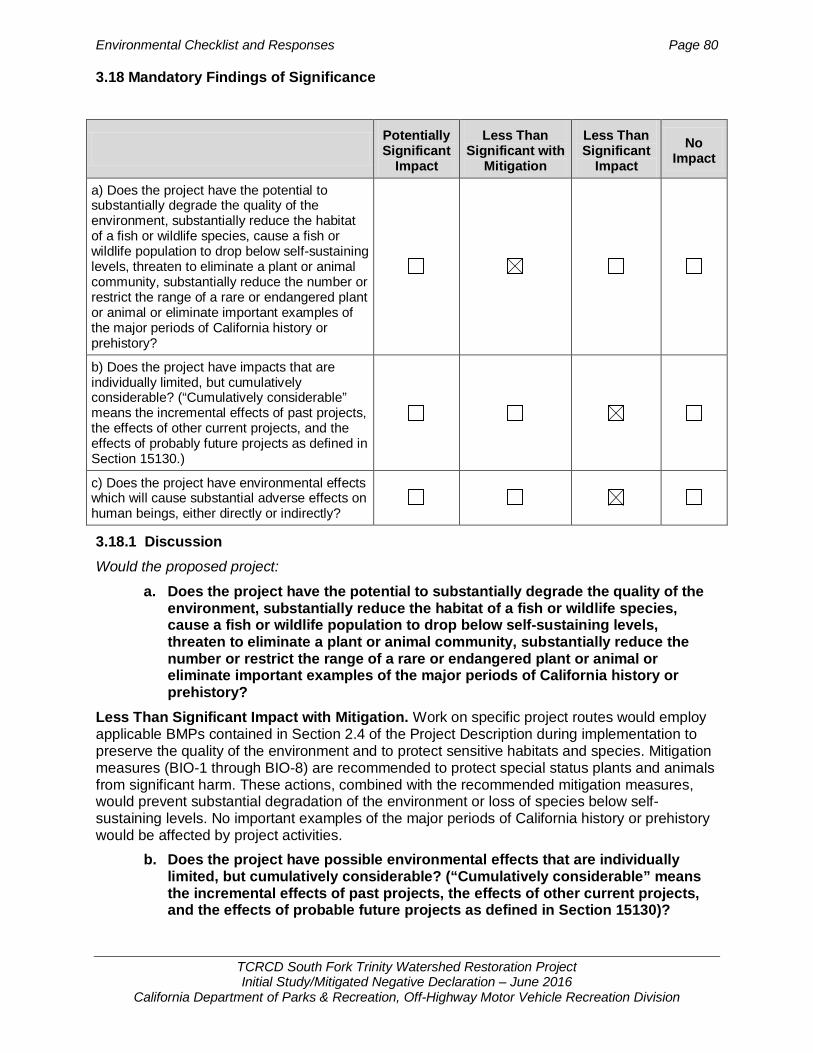
Environmental Checklist and Responses Page 80
TCRCD South Fork Trinity Watershed Restoration Project Initial Study/Mitigated Negative Declaration – June 2016
California Department of Parks & Recreation, Off-Highway Motor Vehicle Recreation Division
3.18 Mandatory Findings of Significance
3.18.1 Discussion Would the proposed project:
a. Does the project have the potential to substantially degrade the quality of the environment, substantially reduce the habitat of a fish or wildlife species, cause a fish or wildlife population to drop below self-sustaining levels, threaten to eliminate a plant or animal community, substantially reduce the number or restrict the range of a rare or endangered plant or animal or eliminate important examples of the major periods of California history or prehistory?
Less Than Significant Impact with Mitigation. Work on specific project routes would employ applicable BMPs contained in Section 2.4 of the Project Description during implementation to preserve the quality of the environment and to protect sensitive habitats and species. Mitigation measures (BIO-1 through BIO-8) are recommended to protect special status plants and animals from significant harm. These actions, combined with the recommended mitigation measures, would prevent substantial degradation of the environment or loss of species below self- sustaining levels. No important examples of the major periods of California history or prehistory would be affected by project activities.
b. Does the project have possible environmental effects that are individually limited, but cumulatively considerable? (“Cumulatively considerable” means the incremental effects of past projects, the effects of other current projects, and the effects of probable future projects as defined in Section 15130)?
Potentially Significant
Impact
Less Than Significant with
Mitigation
Less Than Significant
Impact No
Impact
a) Does the project have the potential to substantially degrade the quality of the environment, substantially reduce the habitat of a fish or wildlife species, cause a fish or wildlife population to drop below self-sustaining levels, threaten to eliminate a plant or animal community, substantially reduce the number or restrict the range of a rare or endangered plant or animal or eliminate important examples of the major periods of California history or prehistory?
b) Does the project have impacts that are individually limited, but cumulatively considerable? (“Cumulatively considerable” means the incremental effects of past projects, the effects of other current projects, and the effects of probably future projects as defined in Section 15130.)
c) Does the project have environmental effects which will cause substantial adverse effects on human beings, either directly or indirectly?

Environmental Checklist and Responses Page 81
TCRCD South Fork Trinity Watershed Restoration Project Initial Study/Mitigated Negative Declaration – June 2016
California Department of Parks & Recreation, Off-Highway Motor Vehicle Recreation Division
Less than Significant Impact. The project has no impacts related to aesthetics, agriculture/forestry, hazards/hazardous materials, land use planning, mineral resources, population/housing, public services, recreation, transportation, and utilities. Therefore, there are no cumulative impacts related to these environmental factors.
The project has less than significant impacts on air quality, biological resources, cultural resources, geology/soils, GHG emissions, hydrology/water quality, and noise. With the exception of GHG emissions, all project impacts are highly localized and do not contribute toward cumulative impacts. There are no other activities or proposed projects in the STNF that would contribute toward the site-specific project impacts.
Cumulative impacts related to climate change (GHG emissions) and air quality are not anticipated as the project activities would not expand recreational facilities or result in increased visitation at the STNF.
Less than Significant Impact. The project is the decommissioning of 22 miles of unneeded routes within an established OHV trail system. The routes are being decommissioned to better define public use areas, restore closed areas, and promote natural recovery of the road surface by restoring the natural hydrologic function (infiltration capacity) of the soil in the roadbed and reducing runoff and erosion Measures have been incorporated into the project that would prevent significant environmental effects. No substantial unavoidable adverse effects, either direct or indirect, are identified in this Initial Study.

Environmental Checklist and Responses Page 82
TCRCD South Fork Trinity Watershed Restoration Project Initial Study/Mitigated Negative Declaration – June 2016
California Department of Parks & Recreation, Off-Highway Motor Vehicle Recreation Division
This page left intentionally blank.
References Page 83
TCRCD South Fork Trinity Watershed Restoration Project Initial Study/Mitigated Negative Declaration – June 2016
California Department of Parks & Recreation, Off-Highway Motor Vehicle Recreation Division
Chapter 4 REFERENCES
AECOM. 2011. “Shasta Regional Climate Action Plan.” Redding City Council Meeting. Sponsored by Shasta County. January 18, 2011. http://www.co.shasta.ca.us/index/drm_index/aq_index.aspx
Anderson, R. 1988. Montane Hardwood-Conifer. In Mayer, K.E. and W.F. Laudenslayer,Jr., eds. A Guide to Wildlife Habitats of California. California Department of Forestry and Fire Protection. Sacramento, CA. Retrieved from http://www.dfg.ca.gov/biogeodata/cwhr/wildlife_habitats.asp
Benson, G. L. 1988. Updated by CWHR staff, 2005. In Mayer, K.E. and W.F. Laudenslayer,Jr., eds. A Guide to Wildlife Habitats of California. California Department of Forestry and Fire Protection. Sacramento, CA. Retrieved from http://www.dfg.ca.gov/biogeodata/cwhr/wildlife_habitats.asp
Bruckner. 2011. Eric Bruckner, North Coast Unified Air Quality Management District AP Inspector. “Re: NOA Notification.” Email message to Chris Dugan, TRA Environmental Sciences. March 1, 2011.
Calflora. 2015. Calflora.org. Taxon Reports: 572, 3404, 8797, 11197, 11235, and 11429. Accessed on September 1, 2015.
California Air Resources Board (CARB). 2007. Staff Report California 1990 Greenhouse Gas Emissions Level and 2020 Emissions Limit. Sacramento, CA. November 16, 2007. <http://www.arb.ca.gov/cc/inventory/pubs/reports/staff_report_1990_level.pdf>
______2009. Climate Change Scoping Plan – A Framework for Change. Endorsed by ARB December 2008. Sacramento, CA. May 11, 2009. <http://www.arb.ca.gov/cc/scopingplan/document/scopingplandocument.htm>
______2014. “Area Designation Maps / State and National.” Air Quality and Emissions, Standards and Area Designations. ARB. August 22, 2014. Web. January 21, 2016. <http://www.arb.ca.gov/desig/adm/adm.htm>
______2015a. GHG Emissions Inventory – Query Results. ARB. May 24, 2015. Web. February 9, 2016. <http://www.arb.ca.gov/app/ghg/2000_2013/ghg_sector_data.php>
______2015b. “North Coast Unified AQMD List of Current Rules.” Laws and Regulations, District Rules Database, List of the Current Rules in Each of the 35 Air Districts. ARB. July 2015. Web. January 21, 2016. <http://www.arb.ca.gov/drdb/ncu/cur.htm>
______2015c. “Knowledge Center for the Off-Road Diesel Vehicle Regulation.” In-Use Off-Road Diesel Vehicle Regulation. ARB. December 20, 2015. Web. February 9, 2016. <http://www.arb.ca.gov/msprog/ordiesel/ordiesel.htm>
______2016. AB 32 Scoping Plan. ARB. January 14, 2016. Web. February 9, 2016. <http://www.arb.ca.gov/cc/scopingplan/scopingplan.htm>
California Department of Fish and Game (CDFG). 2011. Trinity Bristle Snail. Region 1 Timber Harvest Program. Accessed May 1, 2011. https://r1.dfg.ca.gov/Portal/TimberHarvestProgram/Wildlife/WildlifeSpecies/Mollusks/TBS/tabid/761/Default.aspx
California Department of Parks and Recreation, Off-Highway Motor Vehicle Recreation Division, On Line Grant Application (OLGA), 2015, Application Information for Project: G14-07-02-R01.

References Page 84
TCRCD South Fork Trinity Watershed Restoration Project Initial Study/Mitigated Negative Declaration – June 2016
California Department of Parks & Recreation, Off-Highway Motor Vehicle Recreation Division
______2011. Trinity County Resource Conservation District Westside Watershed Restoration Project Initial Study/Mitigated Negative Declaration. August 2011
California Department of Toxic Substances, EnviroStor Database Search for areas near Weaverville and Wildwood, CA, August 26, 2015. http://www.envirostor.dtsc.ca.gov/public/mapfull.asp
California Environmental Protection Agency, Cortese List Search for areas near Weaverville and Wildwood, CA, August 26, 2015, http://www.calepa.ca.gov/SiteCleanup/CorteseList/
California Native Plant Society (CNPS). 2015. Online Inventory of Rare and Endangered Plants. 8th Ed. http://www.rareplants.cnps.org/
California Natural Diversity Database (CNDDB). 2015. Biogeographic Data Branch. California Department of Fish and Wildlife. April 30, 2015.
Comrack, L., B. Bolster, J. Gustafson, D. Steele, and E. Burkett. April 10, 2008. Species of Special Concern: A Brief Description of an Important California Department of Fish and Game Designation. California Department of Fish and Game, Wildlife Branch, Nongame Wildlife Program Report 2008-03, Sacramento, CA. 4 pp.
Delorme, Atlas and Gazetteer, 2011, California. Third Edition.
Fitzhugh, E.L. 1988. Ponderosa Pine. In Mayer, K.E. and W.F. Laudenslayer,Jr., eds. A Guide to Wildlife Habitats of California. California Department of Forestry and Fire Protection. Sacramento, CA. Retrieved from http://www.dfg.ca.gov/biogeodata/cwhr/wildlife_habitats.asp
Intergovernmental Panel on Climate Change (IPCC). 2007a. Summary for Policymakers. In:
“Climate Change 2007: Impacts, Adaptation and Vulnerability”. Contribution of Working Group II to the Fourth Assessment Report of the Intergovernmental Panel on Climate Change, M.L. Parry, O.F. Canziani, J.P. Palutikof, P.J. van der Linden and C.E. Hanson, Eds., Cambridge University Press, Cambridge, UK, 7-22.
______2007b. Climate Change 2007: Synthesis Report. Contribution of Working Groups I, II and III to the Fourth Assessment Report of the Intergovernmental Panel on Climate Change [Core Writing Team, Pachauri, R.K and Reisinger, A. (eds.)]. IPCC, Geneva, Switzerland, 104 pp.
Jennings, M. R., and M. P. Hayes. 1994. Amphibian and reptile species of special concern in California. State of California, The Resources Agency, Department of Fish and Game, Inland Fisheries Division, Rancho Cordova, CA. 255 pp.
McBride, J.R. 1988. Jeffrey Pine. In Mayer, K.E. and W.F. Laudenslayer,Jr., eds. A Guide to Wildlife Habitats of California. California Department of Forestry and Fire Protection. Sacramento, CA. Retrieved from http://www.dfg.ca.gov/biogeodata/cwhr/wildlife_habitats.asp
McDonald, P.M. 1988. Montane Hardwood. In Mayer, K.E. and W.F. Laudenslayer,Jr., eds. A Guide to Wildlife Habitats of California. California Department of Forestry and Fire Protection. Sacramento, CA. Retrieved from http://www.dfg.ca.gov/biogeodata/cwhr/wildlife_habitats.asp
Morey, S. 1988. (Updated by CWHR staff 2000.) Western tailed frog. Life History Accounts and Range Maps – California Wildlife Habitat Relationships System. Originally published in Caifornia’s wildlife: Vol. I-III. Zeiner, D.C., W.F. Laudenslayer Jr., K.E. Mayer, and M. White, eds. California Department of Fish and Game, Sacramento, California. Retreived from http://www.dfg.ca.gov/biogeodata/cwhr/cawildlife.aspx. Accessed May 1, 2011.

References Page 85
TCRCD South Fork Trinity Watershed Restoration Project Initial Study/Mitigated Negative Declaration – June 2016
California Department of Parks & Recreation, Off-Highway Motor Vehicle Recreation Division
National Oceanic and Atmospheric Administration (NOAA). 2015. “Recent Global CO2.” Trends in Atmospheric Carbon Dioxide. NOAA, Earth System Research Laboratory, Global Monitoring Division. November 2015. Web. January 21, 2016. <http://www.esrl.noaa.gov/gmd/ccgg/trends/global.html>
NatureServe. 2010. Silene salmonaceae. Retrieved from http://www.natureserve.org/explorer/servlet/NatureServe?searchName=Silene+salmonacea. Accessed May 10, 2010.
NOAA National Marine Fisheries Service (NOAA Fisheries). 2001. Fisheries Water Drafting Specifications.,
North Coast Unified Air Quality Management District (NCUAQMD). 1995. “PM10 Attainment Plan.” NCUAQMD. May 11, 1995.
Raphael, M.G. 1988. In Mayer, K.E. and W.F. Laudenslayer,Jr., eds. A Guide to Wildlife Habitats of California. California Department of Forestry and Fire Protection. Sacramento, CA. Retrieved from http://www.dfg.ca.gov/biogeodata/cwhr/wildlife_habitats.asp
Sacramento Valley Air Quality Engineering and Enforcement Professionals (SVAQEEP). 2009. “Northern Sacramento Valley Planning Area 2009 Triennial Air Quality Attainment Plan.” SVAQEEP. August 2009.
Shasta County. 1995.“Air Quality.” Shasta County General Plan. Shasta County Planning Division. May 9, 1995. Web. March 1, 2011. http://www.co.shasta.ca.us/index/drm_index/planning_index/plng_general_plan.aspx
Shasta-Trinity National Forest (STNF). 1995. Shasta-Trinity NF Land and Resource Management Plan, Final EIS and Record of Decision, Date: April 28, 1995
Steer. 2016. Al Steer, North Coast Unified Air Quality Management District Compliance and Enforcement Division Manager. Phone call with Phillip Gleason, MIG |TRA Environmental Sciences. January 21, 2016.
Trinity County. 2014. Trinity County General Plan Safety Element. Trinity County Planning Department. November 2014. Web. January 21, 2016. http://www.trinitycounty.org/modules/showdocument.aspx?documentid=1998
Trinity County Resource Conservation District (TCRCD). 2015. Application for OHV Grant to California Department of Parks and Recreation Off-Highway Motor Vehicle Recreation Division via the On Line Grant Application (OLGA) Program, May 2015.G14-07-02-R01
______2016. Correspondence related to AB 52 compliance for South Fork-Trinity River Road Decommissioning Project, Trinity County.
U.S. Environmental Protection Agency (U.S. EPA). 1998. “Control of Emissions of Air Pollution From Nonroad Diesel Engines; Final Rule.” Volume 63 Federal Register, October 23, 1998: 56967-57023.
______2004. “Control of Emissions of Air Pollution From Nonroad Diesel Engines and Fuel.” Volume 69 Federal Register, June 29, 2004: 38958-39273.
______2015a. “Emissions.” Understanding Global Warming Potentials. December 11, 2015. Web. January 21, 2016. <http://www3.epa.gov/climatechange/ghgemissions/gwps.html>
______2015b. “De Minimis Levels.” Understanding Global Warming Potentials. September 10, 2015. Web. January 21, 2016. <http://www3.epa.gov/airquality/genconform/deminimis.html>

References Page 86
TCRCD South Fork Trinity Watershed Restoration Project Initial Study/Mitigated Negative Declaration – June 2016
California Department of Parks & Recreation, Off-Highway Motor Vehicle Recreation Division
United States Forest Service (USFS). 1998. Decision Notice and Finding of No Significant Impact. East Fork/Smokey Creek Watershed Restoration Project. Shasta-Trinity National Forest. 9/28/98.
______2006a. Environmental Assessment (Preliminary). East Fork and Sims Watershed Restoration Project. Shasta-Trinity National Forest. South Fork Management Unit. May 2006.
______2006b. Programmatic Agreement Among the U.S.D.A. Forest Service, Pacific Southwest Region, U.S.D.A. Forest Service, Intermountain Region’s Humboldt-Toiyabe National Forest, California State Historic Preservation Officer, and Advisory Council on Historic Preservation Regarding the Process for Compliance with Section 106 of the National Historic Preservation Act for Designating Motor Vehicle Routes and Managing Motorized Recreation on the National Forests in California.
______2009a. Environmental Impact Statement (Final). Gemmill Thin Project. Shasta-Trinity National Forest. South Fork Management Unit. April 2009.
______2009b. Biological Evaluation for Sensitive Plant Species and Supplementary Botany Report. Gemmill Thin Project. Shasta-Trinity National Forest. Trinity River Management Unit. December 5, 2009.
______2009c. Westside Watershed Restoration Project Sensitive Botanical Species Biological Evaluation. May 22.
______2010a. Westside Watershed Restoration Fisheries Biological Assessment and Biological Evaluation. Shasta-Trinity National Forest. September. http://www.fs.fed.us/nepa/nepa_project_exp.php?project=25318
______2010b. Draft Fisheries Specialist Report. Westside Watershed Restoration Project. Shasta-Trinity National Forest. September. http://www.fs.fed.us/nepa/nepa_project_exp.php?project=25318
______2010c. Wildlife Sensitive Species Biological Evaluation for the Westside Watershed Restoration Project (Draft). Shasta-Trinity National Forest. July 2010.
______2010d. Wildlife Biological Assessment for the Westside Watershed Restoration Project (Final). Shasta-Trinity National Forest. December 2010. http://www.fs.fed.us/nepa/nepa_project_exp.php?project=25318
______2011. Environmental Assessment, Westside Watershed Restoration Project, January 2011.
______2012a. Biological Evaluation for Sensitive Plant and Fungi Species and Supplementary Botany Report. Pettijohn Project. Shasta-Trinity National Forest. Trinity River Management Unit. February 25, 2011, updated May 4, 2012.
______2012b. Environmental Impact Statement (Final). Pettijohn Late-successional Reserve Habitat Improvement and Fuels Reduction Projectc. Shasta-Trinity National Forest. Trinity River Management Unit. May 2012.
Wallace, S. 2016. OHMVR Grants Program Review: Letter Report. Restoration Project: South Fork-Trinity River Road Decommissioning Project. Prepared by OHMVR Division Associate State Archaeologist (ASA): Sarah Wallace. Dated January 20, 2016.
Weller, T.J. and D.C. Lee. 2007. Mist Net Effort Required to Inventory a Forest Bat Species Assemblage. Journal of Wildlife Management 71(1):251–257; 2007).
White, C. M., N. J. Clum, T. J. Cade, and W. G. Hunt. 2002. Peregrine Falcon (Falco peregrinus), The Birds of North America Online (A. Poole, Ed.). Ithaca: Cornell Lab of

References Page 87
TCRCD South Fork Trinity Watershed Restoration Project Initial Study/Mitigated Negative Declaration – June 2016
California Department of Parks & Recreation, Off-Highway Motor Vehicle Recreation Division
Ornithology; Retrieved from the Birds of North America Online: http://bna.birds.cornell.edu/bna/species/660
Personal Communications
Cynthia Tarwater, Project Administrator, Trinity County Resource Conservation District George MacDougall, Grant Administrator CDPR, OHMVR Division Sarah Wallace, Associate State Archaeologist California State Parks and Recreation Off-Highway Motor Vehicle Recreation Division

References Page 88
TCRCD South Fork Trinity Watershed Restoration Project Initial Study/Mitigated Negative Declaration – June 2016
California Department of Parks & Recreation, Off-Highway Motor Vehicle Recreation Division
This page left intentionally blank.
Report Preparation Page 89
TCRCD South Fork Trinity Watershed Restoration Project Initial Study/Mitigated Negative Declaration – June 2016
California Department of Parks & Recreation, Off-Highway Motor Vehicle Recreation Division
Chapter 5 REPORT PREPARATION
MIG | TRA Environmental Sciences, Inc. 2635 N. First Street, Suite 149 San Jose, CA 95134 650.327.0429 www.migcom.com | www.traenviro.com
Senior Project Manager: Victoria Harris Quality Control: Kate Werner Biologist: Sara Jones Air Quality/GHG: Becca Dannels, Christopher Dugan
Related Documents