Whitewater State Park Campground Development, Agency Review EAW - August 22, 2014 Page 1 July 2013 version ENVIRONMENTAL ASSESSMENT WORKSHEET This Environmental Assessment Worksheet (EAW) form and EAW Guidelines are available at the Environmental Quality Board’s website at: http://www.eqb.state.mn.us/EnvRevGuidanceDocuments.htm. The EAW form provides information about a project that may have the potential for significant environmental effects. The EAW Guidelines provide additional detail and resources for completing the EAW form. Cumulative potential effects can either be addressed under each applicable EAW Item, or can be addresses collectively under EAW Item 19. Note to reviewers: Comments must be submitted to the RGU during the 30-day comment period following notice of the EAW in the EQB Monitor. Comments should address the accuracy and completeness of information, potential impacts that warrant further investigation and the need for an EIS. 1. Project title: Whitewater State Park Campground Development 2. Proposer: MN Department of Natural Resources 3. RGU: MN Department of Natural Resources Contact person: Brent Anderson Contact person: Ronald Wieland Title: Park Manager Title: Environmental Review Planner Address: 19041 Highway 74 Address: 500 Lafayette Road City, State, ZIP: Altura, MN 55910 City, State, ZIP: St. Paul, MN 55155 Phone: 507-932-3007 Phone: 651-259-5157 Fax: 651-296-1811 Email: [email protected] Email: [email protected] 4. Reason for EAW Preparation: (check one) Required: Discretionary: X Mandatory EAW If EAW or EIS is mandatory give EQB rule category subpart number(s) and name(s): Minnesota Rules, part 4410.4300, subpart 20 (Campgrounds and RV Parks). Minnesota Rules, part 4410.1000, subpart 4, (Connected actions and phased actions). This project meets the definition of a phased action. 5. Project Location: County: Winona City/Township: Altura / Elba Township PLS Location (¼, ¼, Section, Township, Range): SESE of Sec 17, T107, R10 NENE, SWNE, SENE, and NESE of Sec 20, T107, R10 Watershed (81 major watershed scale): Mississippi River – Winona GPS Coordinates: Project location – Latitude: 44.06000 Longitude: -92.04333; DMS: Northing: 44 - 3 - 36.0; Easting 92 – 2 - 36.0 Tax Parcel Number: Multiple parcels: 02.000.1620; 02.000.1830; 02.000.1850; 02.000.1870

Welcome message from author
This document is posted to help you gain knowledge. Please leave a comment to let me know what you think about it! Share it to your friends and learn new things together.
Transcript
Whitewater State Park Campground Development, Agency Review EAW - August 22, 2014 Page 1
July 2013 version
ENVIRONMENTAL ASSESSMENT WORKSHEET This Environmental Assessment Worksheet (EAW) form and EAW Guidelines are available at the
Environmental Quality Board’s website at:
http://www.eqb.state.mn.us/EnvRevGuidanceDocuments.htm. The EAW form provides information
about a project that may have the potential for significant environmental effects. The EAW Guidelines
provide additional detail and resources for completing the EAW form.
Cumulative potential effects can either be addressed under each applicable EAW Item, or can be
addresses collectively under EAW Item 19.
Note to reviewers: Comments must be submitted to the RGU during the 30-day comment period
following notice of the EAW in the EQB Monitor. Comments should address the accuracy and
completeness of information, potential impacts that warrant further investigation and the need for an EIS.
1. Project title: Whitewater State Park Campground Development
2. Proposer: MN Department of Natural Resources 3. RGU: MN Department of Natural Resources
Contact person: Brent Anderson Contact person: Ronald Wieland Title: Park Manager Title: Environmental Review Planner
Address: 19041 Highway 74 Address: 500 Lafayette Road
City, State, ZIP: Altura, MN 55910 City, State, ZIP: St. Paul, MN 55155
Phone: 507-932-3007 Phone: 651-259-5157
Fax: 651-296-1811 Email: [email protected] Email: [email protected]
4. Reason for EAW Preparation: (check one)
Required: Discretionary:
X Mandatory EAW
If EAW or EIS is mandatory give EQB rule category subpart number(s) and name(s):
Minnesota Rules, part 4410.4300, subpart 20 (Campgrounds and RV Parks).
Minnesota Rules, part 4410.1000, subpart 4, (Connected actions and phased actions). This project meets the definition of a phased action.
5. Project Location:
County: Winona
City/Township: Altura / Elba Township
PLS Location (¼, ¼, Section, Township, Range): SESE of Sec 17, T107, R10 NENE, SWNE, SENE, and NESE of Sec 20, T107, R10
Watershed (81 major watershed scale): Mississippi River – Winona GPS Coordinates: Project location – Latitude: 44.06000 Longitude: -92.04333; DMS: Northing: 44 - 3 - 36.0; Easting 92 – 2 - 36.0 Tax Parcel Number: Multiple parcels: 02.000.1620; 02.000.1830; 02.000.1850; 02.000.1870
Whitewater State Park Campground Development, Agency Review EAW - August 22, 2014 Page 2
At a minimum attach each of the following to the EAW:
County map showing the general location of the project;
Figure 1: Whitewater State Park Campground Development Project, Winona County U.S. Geological Survey 7.5 minute, 1:24,000 scale map indicating project boundaries (photocopy
acceptable);
Figure 2: Whitewater State Park Campground Development Project, USGS Map, 1:24,000
And site plans showing all significant project and natural features. Pre-construction site plan and
post-construction site plan.
Figure 3: Whitewater State Park Visitor Map – Existing Conditions Figure 4: Whitewater State Park Campground Development Project, Natural Pant Communities and
Land Cover Figure 5: Whitewater State Park Campground Development Project, NRCS Soil Units Figure 6: Whitewater State Park Campground Development Project, Draft Concept Plan and Project
Details
Attachments
A. DNR Natural Heritage Information System Concurrence (June 02, 2014). B. State Historic Preservation Office Correspondence (April 25, 2014).
6. Project Description:
a. Provide the brief project summary to be published in the EQB Monitor, (approximately 50
words).
The Minnesota Department of Natural Resources is proposing to develop a new campground in Whitewater State Park, located in Winona County. The new campground area will include approximately 45 to 50 campsites with electric service, four camper cabins, three redesigned group camps with picnic shelters, and two new sanitation buildings.
b. Give a complete description of the proposed project and related new construction, including
infrastructure needs. If the project is an expansion include a description of the existing facility.
Emphasize: 1) construction, operation methods and features that will cause physical
manipulation of the environment or will produce wastes, 2) modifications to existing equipment
or industrial processes, 3) significant demolition, removal or remodeling of existing structures,
and 4) timing and duration of construction activities.
The Minnesota Department of Natural Resources (DNR) is proposing to develop a new campground within Whitewater State Park (WSP), in Winona County. Whitewater State Park is situated about two miles south of Elba, twenty miles west of Winona, and twenty miles east of Rochester, Minnesota. The WSP encompasses 2,733 acres of mostly steep, forested bluffland and river valley. The WSP is one of most popular state parks in Minnesota, receiving over 325,000 visitors in 2013 (Figures 1 through 6).
The proposed project will include the construction of approximately 45 to 50 campsites, three group camps, and four camper cabins. An existing intersection off of Minnesota State Trunk Highway 74 (TH 74) serves as a westward entrance to the WSP visitor center and the Cedar Hill Campground. The intersection will be reconfigured to add an eastward approach that will serve as the only public access to the proposed Whitewater State Park Campground Development project (Figure 6).
The 54-acre project area is located on state park lands on the east side of TH 74 across from the entrance to the park’s visitor center. The project area lies on a high terrace of the Middle Fork of the Whitewater (MFW) River, above its 100-year flood hazard area. The project area consists of a southern
Whitewater State Park Campground Development, Agency Review EAW - August 22, 2014 Page 3
and northern part, with an ephemeral stream bisecting the southern part. The southern part is presently occupied by three primitive group campsites and an aggregate-hardened parking loop road within woodland of young trees. The campsites are located on mown turf areas with drinking water, picnic tables, fire rings, and toilets provided. The northern part of the project area occupies an old field with mixed herb-shrub cover and sparsely planted trees. The only development in this part is a septic drain field that serves the existing campground west of the highway.
The campground development’s access road will run from the newly configured entrance off of TH 74 southward near the highway for a distance of about 0.3 miles. To serve the campsites, arterial roads will branch from the access road and loop through the proposed campground. Other arterials will extend to the group camp and camper cabins. Parts of the existing group camp road and its TH 74 entrance will be removed.
The access road will cross an ephemeral stream at two locations to reach the group camp and camper cabin locations. One of the crossings will need to be built and the other is already built but needs improvement. Properly sized culverts will be installed at both crossings. Additional improvements are under consideration, including rehabilitation of a segment of the ephemeral stream channel immediately east of TH 74.
The new campground will have campsites dispersed across about 22 acres in the northern part of the project area. Some campsites will be designed as pull-through sites to accommodate larger recreational vehicles (RVs). All campsites will be provided with electric service. A sanitation building and up to three vault toilets will be constructed to serve this part of the campground development.
The proposed group camp improvements will include relocating two of the campsites to level terrain, adding picnic shelters at each camp and constructing a sanitation building that serves all group camps. Two vault toilets will be constructed, including one located near the camper cabins. Two of the existing vault toilets will remain in use and one will be removed. One of the group camps will be modernized with electrical hookups at the picnic shelter and spurs for campers and RVs. The other two group camps will remain primitive as before but gain new picnic shelters (one shelter with electric service and one without). Four camper cabins will be constructed along the edge of the native forest in the southeastern part of the project area (Figure 6).
Construction planning to locate facilities, schedule construction activities, and develop stormwater management protocol is integral to the state park campground development. Disturbance corridors and the proposed impervious surfaces will be located within a planted area that is now sparsely covered with sapling- and seedling-sized trees. The larger trees that were plotted during early planning will be avoided as much as possible when configuring the project’s layout (construction zone). The plans will segment construction disturbance into sectors according to the stormwater management Best Management Practices (BMPs), as coordinated by the project engineer and contractor. Over the course of the development, approximately 23 percent of the project area will be disturbed during the construction of access roads, campsites, infiltration areas and other facilities. Ten percent of the project area will contain impervious surfaces. Sediment and erosion control BMPs will be utilized to minimize increases in runoff volume and sediment transport to surface waters.
Large machinery necessary for site preparation is anticipated to include backhoes, bull dozers, graders and trucks. Vegetation clearing and implementation of erosion control measures will be sequenced as construction proceeds. After clearing vegetation from the construction area, some top soils will be

Whitewater State Park Campground Development, Agency Review EAW - August 22, 2014 Page 4
stock piled for later application on areas designated for replanting. Initial coarse grading will prepare ground surfaces for road beds, parking areas, trail connections, campsite pads, and building sites. Fine grading of ground surfaces will be completed next with six inches of aggregate material applied as a base layer on areas to be hardened. The remaining use areas will be landscaped in a variety of ways: with mulching, native shrub and tree plantings, or seeded with approved grass seed mixtures.
Work will proceed with the construction of buildings and other facilities. Structures to be built include the sanitation buildings, camper cabins, and picnic shelters. Each campsite will include a tent pad, a fire ring, and picnic table. The septic wastewater system development will include siting and constructing sanitation buildings, septic tanks, wastewater pipes, vault toilets, and soil treatment system (drain field). Utilities to be developed include: electrical--main and power lines, and water system--pump/well house, water treatment, pressure system, water main, and service lines. Each group camp will be equipped with a dedicated parking area, a tenting area, and a large gathering-play area with fire ring, picnic shelter. One sanitation building will be constructed to serve all three group camps.
Construction is anticipated to begin in the spring of 2016, with site preparation and construction occurring during the growing season when soils are thawed and sufficiently drained. Finishing work on buildings may continue as needed through the winter. Some of the final grading, landscaping, and permanent seeding may occur during the following spring in 2017.
c. Project magnitude:
Total Project Acreage 54 Acres Linear project length N/A Number and type of residential units N/A Commercial building area (in square feet) N/A Industrial building area (in square feet) N/A Institutional building area (in square feet) N/A Other uses – specify (in square feet) N/A Structure height(s) in feet Camper cabin and vault toilets 12 Picnic shelters and sanitation buildings 18
d. Explain the project purpose; if the project will be carried out by a governmental unit, explain the
need for the project and identify its beneficiaries.
The proposed campground will improve visitor safety and replace campsites lost by closing the Gooseberry Glen campground. The proposed campground developments will be located above the MFW River’s 100-year flood hazard area. Due to its vulnerability to flooding, the Gooseberry Glen campground will be closed as a campground and repurposed as a day use area. The Gooseberry Glen campground is located only four to eight feet above the normal level of the MFW River. Flooding of the campground is a recurring problem that builds up quickly, forcing campers to leave on very short notice. Due to its flood-prone condition, the park staff relies on a river monitoring systems to activate emergency response mobilization during flood events.
Whitewater State Park is one of the busiest state parks for camping in the Minnesota State Park system, with over 53,000 overnight visitors in 2013. The new campground would also offer additional overnight capacity to the park. During the summer, the park is frequently unable to accommodate all prospective

Whitewater State Park Campground Development, Agency Review EAW - August 22, 2014 Page 5
overnight visitors because campgrounds fill to capacity. Visitors’ experience will improve with the additional amenities provided, including the larger campsites, better electric service options, and the alternative accommodations provided at the camper cabins.
e. Are future stages of this development including development on any other property planned or
likely to happen? X Yes No
If yes, briefly describe future stages, relationship to present project, timeline and plans for
environmental review.
After completing proposed campground developments in 2017, the Gooseberry Glen campground will be closed and reconfigured for use as a day use area. Closing the Gooseberry Glen campground will eliminate the risk to campers using a flood prone area and the need for staff mobilizing emergency evacuations of the campground. The proposed day use area will serve for gatherings and picnics and as a staging area for launching activities, such as hiking and bird watching.
The campground conversion to a day use area will involve removing some camping-related infrastructure, including segments of the campground loop road, campsite spurs, fire rings, picnic tables, and campsite markers. The sanitation building will be retained. Although designs for the day use area have not been finalized, development concepts include gravel-surface parking and naturalized play areas. The reworked site will be landscaped with native plantings that are intermixed with areas of lawn maintained for public enjoyment.
Also proposed in 2017 is the rehabilitation of the currently operational Cedar Hill campground, located west of TH 74 near the project area. Improvements include replacing two sanitation buildings, implementing soil stabilization and stormwater management, repaving road segments, raising some campsite spurs to improve flood protection, and rerouting traffic to improve flow.
A DNR construction project to restore a segment of the MFW River between the Gooseberry Glen and the Cedar Hill campgrounds is proposed in the fall of 2015. The project meets the definition of a ‘phased action’ with the campground development project according to Minnesota Rules, part 4410.0200, subpart 60. Accordingly, multiple projects or multiple stages of a single project that are connected actions or phased actions must be considered in total when determining the need for an EAW, preparing the EAW, and determining the need for an EIS (Minnesota Rules, part 4410.1000, subpart 4). The Whitewater River Channel Restoration project meets the threshold that mandates completion of an EAW for diversion of a designated trout stream (Minnesota Rules 4410.4300, subpart 26). The Whitewater River Channel Restoration project is in proximity to the proposed project’s campground improvements and would have a cumulative effect on the receiving waters, as discussed in Item No. 19 of this EAW. Its EAW will be available to the public soon after this one.
The DNR is actively investigating potential routes of a proposed segment of the Whitewater Country Loop (WCL) State Trail through WSP. Several routes for the legislatively authorized segment connecting the communities of St. Charles and Elba are presently under consideration. One of the potential routes through WSP may include a segment that passes through the project area along TH 74, as shown on Figure 6. A WSP Management Plan amendment is being prepared to address the proposed trail routes through the Whitewater State Park.
Other activities to maintain or improve existing park infrastructure and facilities will be implemented, depending on funding availability. The proposed improvements minor in nature and will not require Minnesota Environmental Policy Act reviews, i.e., the completion of an EAW.
Whitewater State Park Campground Development, Agency Review EAW - August 22, 2014 Page 6
f. Is this project a subsequent stage of an earlier project? X Yes No
If yes, briefly describe the past development, timeline and any past environmental review.
In 1919, the WSP was authorized as a state park by the Minnesota legislature and land purchases began in 1920. In the 1930’s, work relief programs of the Civilian Conservation Corps (CCC) and the Works Progress Administration (WPA) were operating out of camps established in the park. In 1934, a CCC camp was established upstream from the current site of the Gooseberry Glen Campground. In the 1940’s, camp buildings were used as a youth camp facility and, during later years of World War II, were used as a German prisoner of war camp. The prisoners provided labor to the main food processing industries in Rochester and Plainview. Many of the improvements made under the CCC and WPA programs are still in use today, however, the old CCC camp was destroyed by a tornado in 1953. Other buildings were damaged and many trees were uprooted in the area.
In 2007, over 11 inches of rain fell within a 24-hour period in the watershed upstream of the park. Impacts of this historic flood included damages to roads, bridges, group camps, campgrounds, picnic areas, trails and beaches, and dozens of landslides. The MFW River changed its course within the park along the segment between Gooseberry Glen Campground and Cedar Hill Campground. The damage caused by the storm was estimated at five million dollars. Infrastructure has been repaired but evidence of the flood is still noticeable.
Current facilities of WSP include the Whitewater Valley Visitor Center, two semi-modern campgrounds (Gooseberry Glen and Cedar Hill) with a total of 110 campsites (47 electric, 6 cart-in); a modern group camp with cabins and dining hall (132 person capacity); three primitive group camps (located in the project area); two picnic grounds with an open shelters (150 person capacity); and a swimming beach with changing rooms. Sanitation facilities at the campgrounds and visitor center include three bathrooms with showers and flush toilets; at the modern group camp, a central bathroom with showers and flush toilet; at-large, several vault toilets, and at the RV dump station, a wastewater system.
The WSP is open year round with interpretive programs offered throughout the year. During the summer, 10 miles of hiking trails and 2.5 miles of self-guided interpretive trails are available. In the winter, the hiking trails and six miles of cross-country ski trails are open for use. Snowshoeing is permitted anywhere in the park except on groomed ski trails (See Figure 3).
All past park facility and infrastructure developments in WSP occurred prior to the Minnesota Environmental Policy Act of 1973 or did not meet thresholds that required environmental review.
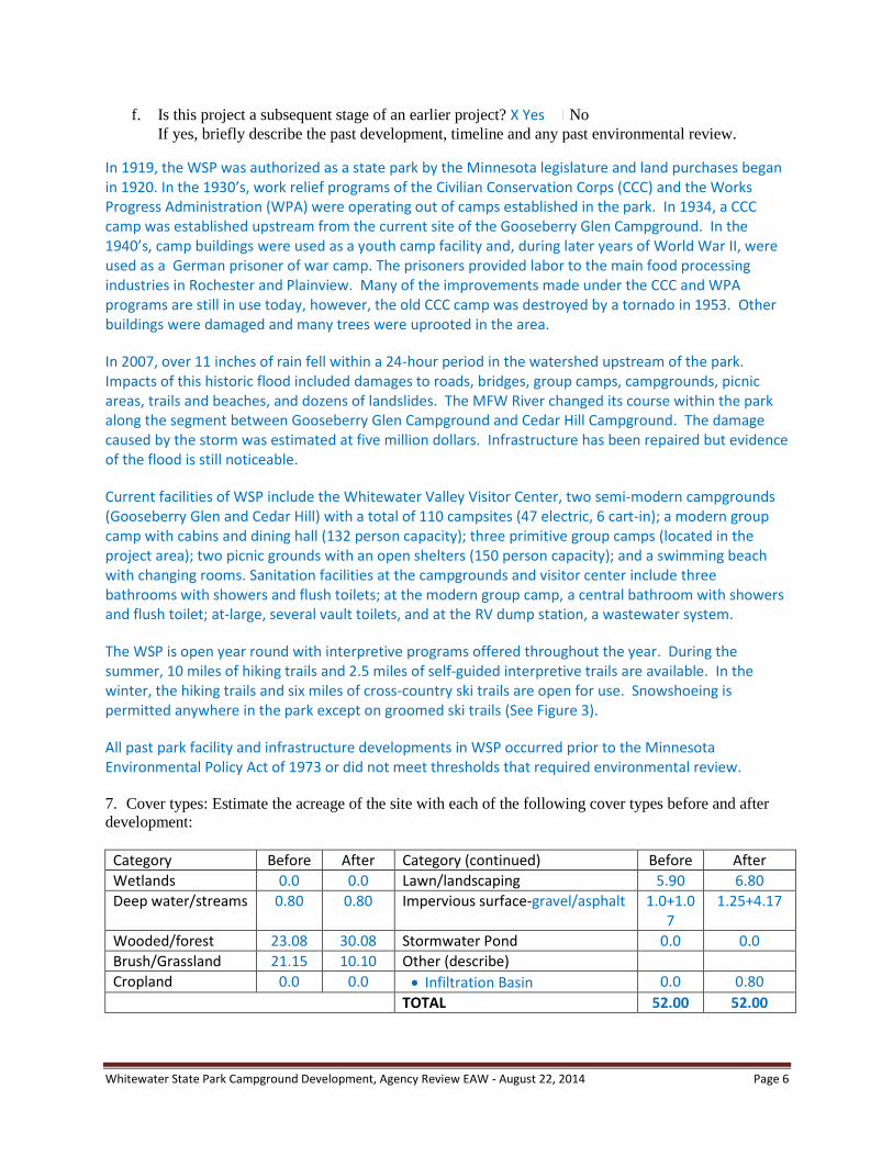
7. Cover types: Estimate the acreage of the site with each of the following cover types before and after
development:
Category Before After Category (continued) Before After
Wetlands 0.0 0.0 Lawn/landscaping 5.90 6.80
Deep water/streams 0.80 0.80 Impervious surface-gravel/asphalt 1.0+1.07
1.25+4.17
Wooded/forest 23.08 30.08 Stormwater Pond 0.0 0.0
Brush/Grassland 21.15 10.10 Other (describe)
Cropland 0.0 0.0 Infiltration Basin 0.0 0.80
TOTAL 52.00 52.00
Whitewater State Park Campground Development, Agency Review EAW - August 22, 2014 Page 7
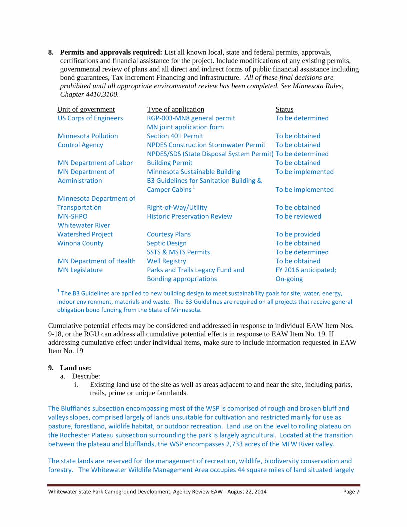
8. Permits and approvals required: List all known local, state and federal permits, approvals,
certifications and financial assistance for the project. Include modifications of any existing permits,
governmental review of plans and all direct and indirect forms of public financial assistance including
bond guarantees, Tax Increment Financing and infrastructure. All of these final decisions are
prohibited until all appropriate environmental review has been completed. See Minnesota Rules,
Chapter 4410.3100.
Unit of government Type of application Status
US Corps of Engineers RGP-003-MN8 general permit To be determined MN joint application form Minnesota Pollution Section 401 Permit To be obtained Control Agency NPDES Construction Stormwater Permit To be obtained NPDES/SDS (State Disposal System Permit) To be determined MN Department of Labor Building Permit To be obtained MN Department of Minnesota Sustainable Building To be implemented Administration B3 Guidelines for Sanitation Building &
Camper Cabins 1 To be implemented Minnesota Department of Transportation Right-of-Way/Utility To be obtained MN-SHPO Historic Preservation Review To be reviewed Whitewater River Watershed Project Courtesy Plans To be provided Winona County Septic Design To be obtained SSTS & MSTS Permits To be determined MN Department of Health Well Registry To be obtained MN Legislature Parks and Trails Legacy Fund and FY 2016 anticipated; Bonding appropriations On-going
1 The B3 Guidelines are applied to new building design to meet sustainability goals for site, water, energy,
indoor environment, materials and waste. The B3 Guidelines are required on all projects that receive general obligation bond funding from the State of Minnesota.
Cumulative potential effects may be considered and addressed in response to individual EAW Item Nos.
9-18, or the RGU can address all cumulative potential effects in response to EAW Item No. 19. If
addressing cumulative effect under individual items, make sure to include information requested in EAW
Item No. 19
9. Land use:
a. Describe:
i. Existing land use of the site as well as areas adjacent to and near the site, including parks,
trails, prime or unique farmlands.
The Blufflands subsection encompassing most of the WSP is comprised of rough and broken bluff and valleys slopes, comprised largely of lands unsuitable for cultivation and restricted mainly for use as pasture, forestland, wildlife habitat, or outdoor recreation. Land use on the level to rolling plateau on the Rochester Plateau subsection surrounding the park is largely agricultural. Located at the transition between the plateau and blufflands, the WSP encompasses 2,733 acres of the MFW River valley.
The state lands are reserved for the management of recreation, wildlife, biodiversity conservation and forestry. The Whitewater Wildlife Management Area occupies 44 square miles of land situated largely
Whitewater State Park Campground Development, Agency Review EAW - August 22, 2014 Page 8
to the north, west, and southeast of the park. The Callahan Unit of the WMA lies within the state park boundary and the North Branch Unit abuts WSP’s northern boundary. The Whitewater WMA is managed for outdoor recreation and natural resource conservation to provide habitat for forest-dependent wildlife, including deer, ruffed grouse and turkey, by maintaining a diverse mosaic of forest types and ages. The goal of WSP is to provide a variety of recreational opportunities while protecting and perpetuating the abundant natural and historic resources of the park.
Lands in the project area were under cultivation for many years until a few decades ago. At the time the WSP management plan was written in 1979, the northern part of the project area was in cropland and the southern part was already classified as old field. After cessation of cropland agriculture, the fields were likely sown to tame grasses, such as smooth brome grass. Since developing the management plan, efforts to reforest the old fields have been made. About 22 acres of the southern part of the project area is currently wooded, mostly through organized tree plantings. The most recent effort to reforest the project area is a direct seeding of 19 acres in the northern part. Sparse tree growth was achieved.
Some rural residential development is in the vicinity of the project area, including several private inholdings about 900 feet away. A few private campgrounds are nearby. The Lazy-D campground is north of the park boundary, less than a mile from the project area.
ii. Plans. Describe planned land use as identified in comprehensive plan (if available) and any
other applicable plan for land use, water, or resources management by a local, regional,
state, or federal agency.
The Whitewater State Park Management Plan (1979) included discussions proposing campground expansion into the project area. Guidelines within the management goals of the state park system emphasize the requirement that natural resources will be protected. State Park management plans communicate the DNR’s plans to balance resource protection and recreational opportunities in the unit.
An amendment to the park plan is in progress to reflect the current development plans and address the new campground proposal (see Item 9 part a.iii.b).
In 2008, the DNR completed the Whitewater Country Loop (WCL) State Trail master plan. One of the alternative corridors considered for connecting St. Charles to Elba passes through WSP. An option that takes the trail through WSP would follow TH 74 on the east side, bringing the trail into the project area, near the proposed campground developments. The selection of a preferred route has not been determined.
Although not subject to county approvals, the proposed project is placed in context with the goals and objectives of the preliminary draft of the Winona County Comprehensive Plan. Development goals, policies, and themes are identified in the Winona County draft comprehensive plan, including Natural Resource Protection, Source Water/Wellhead Protection, Open Space and Recreation, and Community Facilities that may be applicable to the proposed development.
iii. Zoning, including special districts or overlays such as shoreland, floodplain, wild and
scenic rivers, critical area, agricultural preserves, etc.
Although not subject to county approvals, the proposed project is considered in the context of Winona County zoning ordinances. The WSP land is zoned Agriculture/Resource Conservation. Winona County has a Steep Slopes and Bluffs ordinance regulating certain construction projects proposed on slopes

Whitewater State Park Campground Development, Agency Review EAW - August 22, 2014 Page 9
greater than 12 percent. Winona County has a Soil Erosion and Sediment Control ordinance that stipulates BMPs be applied in coordination with the Winona County Soil and Water Conservation District.
The shoreland zone for the MFW River is 300 feet wide measured from the ordinary high water level (OHWL) of the river. As a Tributary Class river, septic systems must be at least 75 feet away from the river, and structures, at least 100 feet away. The MFW River has a designated flood hazard area. Floodplain ordinances and Federal Emergency Management Agency (FEMA) regulations are applicable. The DNR constructed provisional floodplain maps for the MFW River, which are going through FEMA approval at this time. The DNR conducted a detailed analysis and used modelling to build the new flood regime maps, considered more reliable than others presently available (Figure 4).
b. Discuss the project’s compatibility with nearby land uses, zoning, and plans listed in Item 9a
above, concentrating on implications for environmental effects.
Parks, wildlife areas, game management, and forest preserves are permitted principal uses within Winona County’s Agriculture/Resource Conservation zone. Although not subject to county approvals in these areas, the DNR’s goal is to seek compatibility with applicable Winona County ordinances during the construction and operation of the proposed campground. Soil erosion and sedimentation control BMPs will be available for inspection to the Winona County Soils and Water Conservation District. No work within the project area will be conducted on slopes of twelve percent or greater. The DNR does not propose to construct developments in the shoreland zone or in the 100-year floodplain of the MFW River.
The removal of Gooseberry Glen campground and its conversion to a day use area will be within the MFW River shoreland zone and within its 100-yr floodplain. However, the work will mostly involve removing campground structures, trails, and roads and planting native ground cover in the disturbance zones. Gravel parking and naturalized play area construction is considered but final locations have not been determined.
An amendment to the park’s 1979 management plan is in progress to reflect current park development plans and address the new campground proposal. The WSP is considered an attractive link to the WCL State Trail and the project is considered compatible with the trail’s master plan.
Although not subject to the Winona County Comprehensive Plan, the project strives to achieve similar goals, policies, and implementation strategies as described under applicable themes of the preliminary draft plan. Included in the county draft plan are policies for wastewater treatment, construction stormwater management, and protection of wetlands/woodlands. Other strategies promoted in the comprehensive plan include implementation of best management practices for wellhead protection and establishment of nature conservancy zones.
Wastewater treatment is regulated under MPCA rules. A National Pollution Discharge Elimination System/State Disposal System (NPDES/SDS) permit may be needed for the proposed development. If an SDS permit is not required, Winona County would administer the Sub-Surface Treatment System (SSTS) permit application. The DNR will comply with all SSTS rules including those governing spacing between drainfields and existing wells. Any new wells will be located uphill, at least 200 feet from any SSTSs. The DNR will coordinate with Winona County Planning officers on these issues.
Whitewater State Park Campground Development, Agency Review EAW - August 22, 2014 Page 10
c. Identify measures incorporated into the proposed project to mitigate any potential incompatibility
as discussed in Item 9b above.
The project area was selected for development because it provides the best options to avoid and minimize potential environmental effects and to achieve compatibility with surrounding land uses. In addition, the project’s proximity to other facilities enables higher management efficiency and better recreational opportunities for park users.
10. Geology, soils and topography/land forms:
a. Geology - Describe the geology underlying the project area and identify and map any susceptible
geologic features such as sinkholes, shallow limestone formations, unconfined/shallow aquifers,
or karst conditions. Discuss any limitations of these features for the project and any effects the
project could have on these features. Identify any project designs or mitigation measures to
address effects to geologic features.
Nearly 450 million years ago, shallow seas covered most of North America, including the southeastern part of Minnesota. Bottom sediments accumulated and turned into rock hundreds of feet thick. When the sea withdrew, erosion carved through the bedrock, creating the original valleys and bluffs found in what is now encompassed by WSP. Glacial melt-waters further sculpted cliffs and valleys to conditions similar to those seen today. No karst features are known in the vicinity of the project area.
In the Blufflands Subsection, drift over bedrock varies from 0- to 50-feet deep. Bedrock is exposed along the stream valleys. Sediment thickness varies by landscape position, with large exposures in bedrock occurring along steeper ravines. Devonian dolomite and limestone are more locally exposed along the western edge of the subsection, where the WSP is located. The Minnesota blufflands are well represented in the park with dolomite cliffs, trout streams and hardwood forests.
b. Soils and topography - Describe the soils on the site, giving NRCS (SCS) classifications and
descriptions, including limitations of soils. Describe topography, any special site conditions
relating to erosion potential, soil stability or other soils limitations, such as steep slopes, highly
permeable soils. Provide estimated volume and acreage of soil excavation and/or grading.
Discuss impacts from project activities (distinguish between construction and operational
activities) related to soils and topography. Identify measures during and after project construction
to address soil limitations including stabilization, soil corrections or other measures.
Erosion/sedimentation control related to stormwater runoff should be addressed in response to
Item 11.b.ii.
NOTE: For silica sand projects, the EAW must include a hydrogeologic investigation assessing the potential
groundwater and surface water effects and geologic conditions that could create an increased risk of potentially
significant effects on groundwater and surface water. Descriptions of water resources and potential effects from
the project in EAW Item 11 must be consistent with the geology, soils and topography/land forms and potential
effects described in EAW Item 10.
A majority of the park lands are steep, wooded slopes, which are sensitive to erosion. The MFW River valley is heavily wooded with impressive dolomite cliffs that rise 600-feet above the valley floors. The project area is located on a relatively level terrace in the valley that was formerly an agricultural field.
The soil inventory for the entire park shows that loess soils occupy the gently rounded ridge tops (Winona County Soil Survey, Natural Resources Conservation Service (NRCS), via the NRCS Web Soil Survey). Loess and limestone residual soils occupy the upper valley slopes along the tributary streams and alluvial soils are found on the river terraces where the project is located. Its slopes range from one
Whitewater State Park Campground Development, Agency Review EAW - August 22, 2014 Page 11
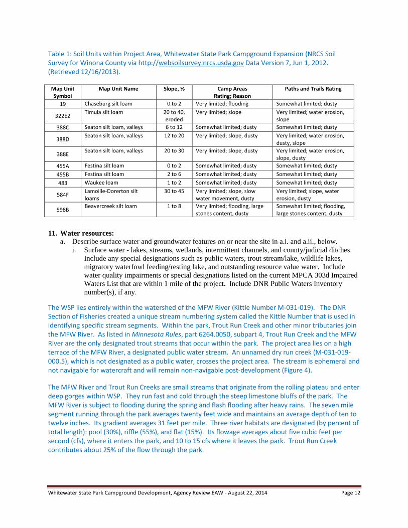
to five percent. The terrace abuts the bluff-line to the east, where slopes climb steeply from toe to ridge anywhere from 4:1 to 2:1 (25 to 50 percent). Most of the proposed project developments will occur on a gently sloping landscape consisting of Festina silt loam soils (455A, 455B). The proposed cabin sites are located on Chaseburg silt loam (19) soils of an intermittent drainage, where the terrace soils have slopes that range from zero to two percent (Figure 5 and Table 1).
Festina soils are composed of inorganic silt loams. The soils exhibit some limitations for development due to their susceptibility to frost heave, wind erosion, and water erosion, especially on compacted or trampled surfaces with limited vegetative cover. Preliminary geotechnical findings carried out by Chosen Valley Testing, Inc. concur with NRCS findings.
A soil’s frost-susceptibility impacts its ability to support structures such as pavements and buildings. Soil weakening and frost-heaving occurs due to water infiltration, which causes structural problems, such as differential foundation movement, cracking of pavement, and uneven ground. To rectify this effect, proposed structures will benefit from the construction of frost footings that use soil correction mixtures (i.e. granular or lime/cement soil correction materials, etc.) to reduce or eliminate frost heaving. Water management techniques, such as properly directed roof runoff and clay soil caps are used for reducing infiltration and frost heaving around building floors and foundations. Rock weepers and drainage tiling will be installed along pavement to convey water away from trails and roadways. Routine maintenance, such as crack sealing, landscaping and roof/gutter clearing, is essential for preventing water from affecting structures.
The silt loam soils found on the site become dry and powdery when exposed to heavy vehicular traffic and trampling, especially in construction areas where vegetation has been removed. During windy conditions and heavy traffic, the dust can become airborne, creating an annoyance to nearby residents. The potential for fugitive dust generation will be monitored by the project engineer.
The silt loam soils are prone to water erosion if compacted or left barren without plant cover. Silt loam soils have a good-to-well drained capability and a moderate infiltration rate, as identified by their Class B Hydrologic Soils Group designation. Because of the fine nature of the soils, care must be taken to retain infiltration capabilities during construction by keeping soils as non-impacted as possible, e.g. limiting the size of the construction zone clearings to an efficient work area and making other areas off-limits to heavy equipment. The project will have a site erosion control plan in place that stabilizes exposed soils and drainage zones as soon as possible. Areas of stormwater management, such as infiltration basins, will benefit from tilling and vegetation establishment to retain the well-drained properties of the soil.
The proposed construction slope grades created for the campsites, roadways, drainage features, building and other campground amenities will match the existing grade as close as possible. The proposed camper cabins and tent sites do not encroach on the bluff zone and therefore will not disturb steep slopes. Methods that will be utilized to stabilize on-site soils after construction include: direct seeding; hydro-seeding; mulching; no-net erosion control blankets; and strategic shrub and tree plantings. The target is to minimize the area of plant cover and ground disturbances. Saturated hydraulic conductivity of the least transmissive layer of Festina soils ranges from 5.67 to 1.42 inches per hour (in/hr). Although much of the project area soils would be sensitive to contamination from wastes or chemicals spills, there is a limited potential for accidental spills or other contamination of soils and groundwater during or after project development.
Whitewater State Park Campground Development, Agency Review EAW - August 22, 2014 Page 12
11. Water resources:
a. Describe surface water and groundwater features on or near the site in a.i. and a.ii., below.
i. Surface water - lakes, streams, wetlands, intermittent channels, and county/judicial ditches.
Include any special designations such as public waters, trout stream/lake, wildlife lakes,
migratory waterfowl feeding/resting lake, and outstanding resource value water. Include
water quality impairments or special designations listed on the current MPCA 303d Impaired
Waters List that are within 1 mile of the project. Include DNR Public Waters Inventory
number(s), if any.
The WSP lies entirely within the watershed of the MFW River (Kittle Number M-031-019). The DNR Section of Fisheries created a unique stream numbering system called the Kittle Number that is used in identifying specific stream segments. Within the park, Trout Run Creek and other minor tributaries join the MFW River. As listed in Minnesota Rules, part 6264.0050, subpart 4, Trout Run Creek and the MFW River are the only designated trout streams that occur within the park. The project area lies on a high terrace of the MFW River, a designated public water stream. An unnamed dry run creek (M-031-019-000.5), which is not designated as a public water, crosses the project area. The stream is ephemeral and not navigable for watercraft and will remain non-navigable post-development (Figure 4).
The MFW River and Trout Run Creeks are small streams that originate from the rolling plateau and enter deep gorges within WSP. They run fast and cold through the steep limestone bluffs of the park. The MFW River is subject to flooding during the spring and flash flooding after heavy rains. The seven mile segment running through the park averages twenty feet wide and maintains an average depth of ten to twelve inches. Its gradient averages 31 feet per mile. Three river habitats are designated (by percent of total length): pool (30%), riffle (55%), and flat (15%). Its flowage averages about five cubic feet per second (cfs), where it enters the park, and 10 to 15 cfs where it leaves the park. Trout Run Creek contributes about 25% of the flow through the park.
Table 1: Soil Units within Project Area, Whitewater State Park Campground Expansion (NRCS Soil Survey for Winona County via http://websoilsurvey.nrcs.usda.gov Data Version 7, Jun 1, 2012. (Retrieved 12/16/2013).
Map Unit Symbol
Map Unit Name Slope, % Camp Areas Rating; Reason
Paths and Trails Rating
19 Chaseburg silt loam 0 to 2 Very limited; flooding Somewhat limited; dusty
322E2 Timula silt loam 20 to 40,
eroded Very limited; slope Very limited; water erosion,
slope
388C Seaton silt loam, valleys 6 to 12 Somewhat limited; dusty Somewhat limited; dusty
388D Seaton silt loam, valleys 12 to 20 Very limited; slope, dusty Very limited; water erosion,
dusty, slope
388E Seaton silt loam, valleys 20 to 30 Very limited; slope, dusty Very limited; water erosion,
slope, dusty
455A Festina silt loam 0 to 2 Somewhat limited; dusty Somewhat limited; dusty
455B Festina silt loam 2 to 6 Somewhat limited; dusty Somewhat limited; dusty
483 Waukee loam 1 to 2 Somewhat limited; dusty Somewhat limited; dusty
584F Lamoille-Dorerton silt loams
30 to 45 Very limited; slope, slow water movement, dusty
Very limited; slope, water erosion, dusty
598B Beavercreek silt loam 1 to 8 Very limited; flooding, large
stones content, dusty Somewhat limited; flooding, large stones content, dusty
Whitewater State Park Campground Development, Agency Review EAW - August 22, 2014 Page 13
The ephemeral stream flows only during spring melt and storm events but may receive minor seepage from springs above the project area. The size of the unnamed creek’s watershed is less than 0.5 square miles (approximately 276 acres). The upper watershed, which is comprised of cropland and grassland on the plateau- and shoulder slope- landforms (1082-to 1182-feet elevation), makes up approximately 60 percent of the watershed. Most of the remaining watershed is comprised of steep forested bluff land, where the stream forms a deep v-shaped valley and runs a slope gradient of generally from 10 to 15 percent amidst valley slopes of 25 to 50 percent or greater. The two main creek draws have small farm ponds located at the approximate edge of the plateau (1082 feet), about 225 feet above the terrace on which the project area is located. Measuring from the main fork’s farm pond to the river, the creek runs about one mile in total. The ephemeral stream has a fairly undefined channel below the existing park road to the CCC culvert under TH 74. On the west side of TH 74, its channel is more pronounced, where it runs near the Cedar Hill campground about 0.2 miles to the Whitewater River.
The major runoff source is from cultivated lands near the state park. The stream appears to have more flashy flows and its morphology has changed from presettlement times, apparently due to agricultural runoff. In the recent past, there has been more evidence of flashy stream flows as indicated by some instances of downed trees, a wider channel, and larger areas of scouring along the channel.
According to the Minnesota Pollution Control Agency (MPCA) 303d Impaired Waters List, the segment of the MFW River, which extends for 12 miles from the west line of T107R11W Section 35 to the North Fork of the MFW River, is listed as impaired for several affected uses. The segment includes the portion of the river that passes through WSP. The segment’s relevant use classifications are 1B, 2A, and 3B. The overall condition of the segment, as reported by MPCA, is “not always suitable for swimming and wading due to high bacteria levels caused by the presence of human or animal waste in the water. The segment may not support a thriving community of fish and other aquatic organisms, as indicated by excessive turbidity (suspended solids).” Several impairments were listed on the Inventory of Impaired Waters: Aquatic recreation (2008) due to fecal coliform; Aquatic life due to turbidity (2010); and Drinking water (2012) due to nitrates.
ii. Groundwater – aquifers, springs, seeps. Include: 1) depth to groundwater; 2) if project is
within a MDH wellhead protection area; 3) identification of any onsite and/or nearby wells,
including unique numbers and well logs if available. If there are no wells known on site or
nearby, explain the methodology used to determine this.
1) The depth to groundwater in the vicinity of the project area is estimated at six to ten feet. Based on the Natural Resource Conservation Service (NRCS) soil survey data, the depth to groundwater rating for the Festina soils that occupy most of the project area is “more than 80 inches.” No springs or seeps are known within or near the project area. Specific measurements of ground water depths won’t be available until addition technical investigations are completed.
2) The proposed project is not located within a Minnesota Department of Health (MDH) wellhead protection area.
3) The County Well Index indicates 14 wells are within the statutory park boundary; five of them are private. The water supply for WSP is obtained from seven primary wells. The WSP does not currently monitor water usage at the campgrounds or other facilities. The five private wells nearby are identified with depth of well in parenthesis: No. 00219253 (82 ft), No. 00587335 (141 ft), No. 00101424 (103 ft), No. 00737902 (204 ft), and No. 00723764 (160 ft). The MDH information on WSP wells and their sensitivity is listed in the following table. None of the WSP wells are known to be abandoned.

Whitewater State Park Campground Development, Agency Review EAW - August 22, 2014 Page 14
Unique Well No Well ID Depth Well Use Aquifer Aquifer Sensitivity Well Sensitivity
00219107 Modern Group Center (P-1) 145 Primary Bedrock High No
00219217 (Cedar Hill Campground) (P-?) 60 Unknown Alluvium
00219221 Gooseberry Glen (P-3) 210 Primary Bedrock High Yes
00474596 Cedar Hills (P-4) 53 Primary Glacial Deposits High Yes
00219219 Gooseberry Glen (P-5) 150 Primary Bedrock High Yes
00219220 (South Group Camp?) (P-?) 223 Unknown
00219076 Primitive Group Camp (P-7) 294 Primary Bedrock High No
00164906 Maintenance Shop (P-8) 250 Primary Bedrock High No
00507586 Interpretive Center (P-9) 192 Primary Bedrock High No
Source: Minnesota Department of Health; P-numbers under Well ID are well reference numbers for the park.
Aquifer sensitivity refers to the degree of geological protection of the aquifer(s) used by the public water supply. The aquifer(s) that the wells draw from are classified as highly sensitive to contamination due to the local geological setting. Rapid infiltration and locally focused recharge of ground water is possible in karst landscape and the natural treatment that is normal for groundwater flow is often reduced. Therefore water pollutants entering from the surface are only partially abated.
Well sensitivity refers to the integrity of the wells, i.e., knowing whether construction and maintenance standards are achieved, regardless of aquifer sensitivity. The P-1, P-7, P-8 and P-9 wells meet current standards for construction and maintenance. They are less susceptible to contamination because they meet the standards and do not present a pathway for contamination to readily enter the water supply. The P-3, P-4, and P-5 wells are considered susceptible to contamination because either no information about well construction is available or they do not meet current construction standards. Well P-5 is not in use and has been disconnected from the system.
b. Describe effects from project activities on water resources and measures to minimize or mitigate
the effects in Item b.i. through Item b.iv., below.
i. Wastewater - For each of the following, describe the sources, quantities and composition of
all sanitary, municipal/domestic and industrial wastewater produced or treated at the site.
1) If the wastewater discharge is to a publicly owned treatment facility, identify any
pretreatment measures and the ability of the facility to handle the added water and waste
loadings, including any effects on, or required expansion of, municipal wastewater
infrastructure.
The wastewater conveyance system from this project will not discharge directly into a municipal treatment system. Municipal system service needs during project operation will be limited to the hauling and treatment of settling tank wastewater. A licensed septic tank pumping service will be hired to pump and transport the wastewater from the park.
2) If the wastewater discharge is to a subsurface sewage treatment systems (SSTS), describe
the system used, the design flow, and suitability of site conditions for such a system.
Most of the wastewater generated at the proposed campground will be discharged to a subsurface sewage treatment system (SSTS). The proposed system will consist of septic tank configurations followed by a soil-based treatment system, such as a mound, trench, or at-grade drain field. Two sanitation buildings with restroom and shower facilities are planned. The host campsite will have a direct hookup to sewer and water.
Whitewater State Park Campground Development, Agency Review EAW - August 22, 2014 Page 15
Sizing of the system is based on design flows specified for campgrounds, as provided under Minnesota Rules 7081.0130. The design flow for the new SSTS system is computed at 4900 gallons per day (GPD), which includes a safety factor of 15 percent. The total is a summation of the use for each usage type: 59 single-use campsites without direct hookup (2950 GPD); one single-use campsite with direct hookup (100 GPD); and three group camps (1,200 GPD).
The previous development of an SSTS drain field in the project area encountered suitable soils for wastewater treatment. The proposed area of SSTS development is on Festina soils (455A and 455B), which are not limited for the development of mound or at-grade drain field (NRCS Web Soil Survey). The soil achieves this rating because it has good capacity for infiltration, as measured in its saturated hydraulic conductivity (Ksat), and good capacity for absorbing effluent. The depth to its saturation zone or to bedrock is sufficient for handling a mound system. The soil unit does not have excessive slopes or a tendency for ponding or flooding.
Multiple SSTSs (septic tanks, mound drain fields) are utilized for the treatment of wastewater from several sanitation facilities located in WSP. The DNR is working with the MPCA to confirm whether or not a State Disposal System (SDS) permit is required as defined under Minnesota Rules, Chapter 7081. To determine whether an SDS permit is needed, an analysis of the proximity of multiple SSTSs within the park and their combined sewage flow treatment must be completed. The preliminary assessment will include: 1) mapping and location of all existing park SSTS systems; 2) findings of proximity of the existing systems; 3) designing and/or estimating flows for each existing system; and 4) fully assessing flow for the proposed project developments. The SDS permit would require an initial compliance check of all park systems as well as ongoing inspection and observation, as applicable.
If an MPCA SDS permit is not required, designs of the system are regulated under Minnesota Rules, Chapter 7080, for systems less than 5,000 gallons/day or Chapter 7081, for midsized subsurface sewage treatment system (MSTS) between 5,000 and 10,000 gallons/day. Winona County would administer the permit application, requiring a: site evaluation report, design report, and management plan, as certified by a licensed SSTS practitioner. The Sewer Permit is valid for a period of no more than one year. County inspection to insure conformance with approved plans are conducted within the permitting process. An Operating Permit is required of all owners of new holding tanks or midsized systems. Once the system is approved by the Winona County Planning Department, the County would issue the Operating Permit, which includes information on the system’s performance and operating requirements, monitoring procedures, maintenance schedules, compliance specifications, and other details.
3) If the wastewater discharge is to surface water, identify the wastewater treatment
methods and identify discharge points and proposed effluent limitations to mitigate
impacts. Discuss any effects to surface or groundwater from wastewater discharges.
No wastewater discharged to surface waters is proposed.
ii. Stormwater - Describe the quantity and quality of stormwater runoff at the site prior to and
post construction. Include the routes and receiving water bodies for runoff from the site
(major downstream water bodies as well as the immediate receiving waters). Discuss any
environmental effects from stormwater discharges. Describe stormwater pollution prevention
plans including temporary and permanent runoff controls and potential BMP site locations to
manage or treat stormwater runoff. Identify specific erosion control, sedimentation control or
stabilization measures to address soil limitations during and after project construction.

Whitewater State Park Campground Development, Agency Review EAW - August 22, 2014 Page 16
Stormwater runoff from the project area eventually reaches the MFW River over several pathways:
The intermittent stream (located just north of the project area) will receive most of the runoff from the newly developed campsites (via northerly CCC culvert under TH 74);
The ephemeral stream passing through the southern part of the project area will receive most of the runoff from the camper cabins and group camp areas and some tent sites of the main campground (via the mid-site CCC culvert under Hwy 74);
The Whitewater River bordering the south side of the project area will receive a small portion of the direct runoff from the group camp areas; and
The Whitewater River, which flows adjacent to the existing Gooseberry Glen campground area, receives direct runoff from the campground. The campground is to be converted to a day-use area after main project developments are completed.
As indicated under Item No. 7, the existing cover types of the project area include mostly vegetated surfaces on level to gently sloping ground. The Festina series normally achieves a moderate infiltration rate when thoroughly wet. Of the 54 acre site, 87 percent is vegetated by medium height grasses, mixed shrubs, and young to medium-aged trees. About 11 percent of the site supports short-grass lawn or landscaped cover types that may occupy compacted surfaces less able to absorb precipitation. Approximately four percent of the site contains areas of impervious surfaces with very limited infiltration capacity. Existing drainage from the site is intermittent and likely contains low amounts of soluble solids and nutrients.
Runoff rate increases as the areas of compaction and impervious surfaces increase. If runoff is not managed, controlled or filtered, the amount of soluble solids and nutrients it carries to surface waters can also increase. After project completion, the projected area of impervious surfaces will increase to ten percent, lawn and landscaping to thirteen percent and tree, shrub, or grass cover will decrease to seventy-seven percent of the project area. With the placement of campsites and the linear configuration of roads, the additional impervious surfaces will be dispersed throughout most of the project area. Based on the cover type calculation under Item No. 7 of this EAW, the proposed overall impervious surface quantity after completion of the project is 5.42 acres. Along with the increased runoff volume, the water quality of the runoff could deteriorate somewhat, with possible increases in pollutants, such as sediment and phosphorus. With the inclusion of impervious surface created with the potential development of the WCL State Trail through the project area, there would be an additional one percent increase in impervious surface area (0.8 acres).
Hydrologic analysis using the HydroCAD modelling tool was conducted for benchmarking runoff volumes of existing and proposed conditions. The modelling is based on cover types, landscape, and soil information noted in this EAW. The HydroCAD model indicated that the overall stormwater runoff and volume will increase with the new development. In comparing the 2-year, 10-year, and 100-year 24-hour storm events utilizing NOAA Atlas No. 14 precipitation frequency data, the preliminary post-project increases in runoff are: 120 percent for a 2-year storm event; 60% for a 10-year storm event; and 30% for a 100-year storm event. The storm event period is the length of interval in years within which one of these storms is likely to occur.
The increases identified represent the volume that will need to be managed according to the standards that will be applied in the stormwater pollution prevention plans. The overall goal for stormwater runoff mitigation from both the new campground and the post-project Gooseberry Glen day-use area conversion is to implement stormwater treatment guidelines of the NPDES Construction Stormwater Permit. The Minnesota B3 guidelines, which encourage higher standards and more stringent BMPs, will
Whitewater State Park Campground Development, Agency Review EAW - August 22, 2014 Page 17
be applied to a five foot radius around buildings. The B3 Site and Water Guidelines for stormwater management encourage maintaining a more natural hydrologic cycle through infiltration, evapotranspiration, and reuse.
Goals of project’s stormwater management plan are to meet the following stormwater control design objectives:
Infiltrate a minimum of 1 inch of proposed impervious surfaces, which includes non-vegetated, hardscaped surfacing such as gravel, concrete, or bituminous surfaces.
Provide BMPs necessary to meet Minnesota B3 guidelines around proposed buildings for achieving the removal of total phosphorus and total suspended solids.
Make adequate provisions for reducing the temperature of stormwater runoff prior to its entering the MFW River.
Meet the provisions of Appendix A of the NPDES Construction Stormwater Permit for discharges to Special Waters.
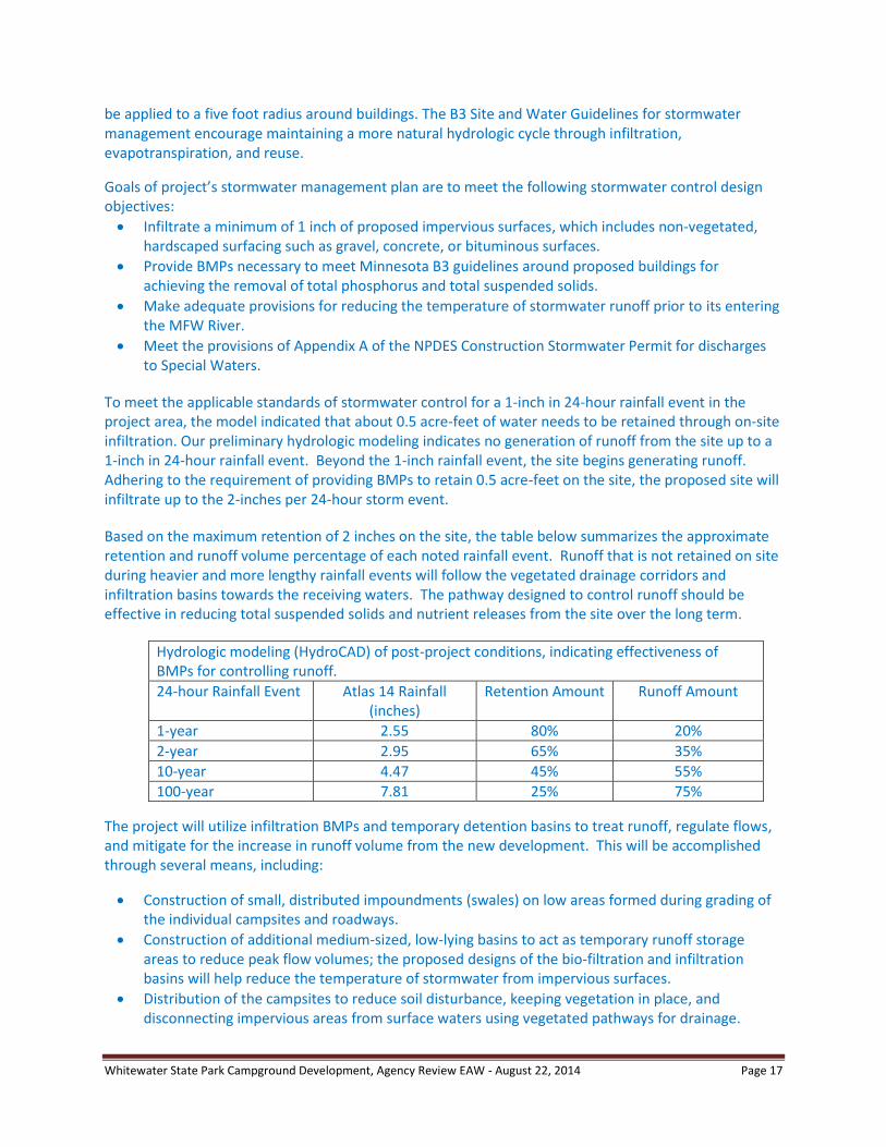
To meet the applicable standards of stormwater control for a 1-inch in 24-hour rainfall event in the project area, the model indicated that about 0.5 acre-feet of water needs to be retained through on-site infiltration. Our preliminary hydrologic modeling indicates no generation of runoff from the site up to a 1-inch in 24-hour rainfall event. Beyond the 1-inch rainfall event, the site begins generating runoff. Adhering to the requirement of providing BMPs to retain 0.5 acre-feet on the site, the proposed site will infiltrate up to the 2-inches per 24-hour storm event.
Based on the maximum retention of 2 inches on the site, the table below summarizes the approximate retention and runoff volume percentage of each noted rainfall event. Runoff that is not retained on site during heavier and more lengthy rainfall events will follow the vegetated drainage corridors and infiltration basins towards the receiving waters. The pathway designed to control runoff should be effective in reducing total suspended solids and nutrient releases from the site over the long term.
Hydrologic modeling (HydroCAD) of post-project conditions, indicating effectiveness of BMPs for controlling runoff.
24-hour Rainfall Event Atlas 14 Rainfall (inches)
Retention Amount Runoff Amount
1-year 2.55 80% 20%
2-year 2.95 65% 35%
10-year 4.47 45% 55%
100-year 7.81 25% 75%
The project will utilize infiltration BMPs and temporary detention basins to treat runoff, regulate flows, and mitigate for the increase in runoff volume from the new development. This will be accomplished through several means, including:
Construction of small, distributed impoundments (swales) on low areas formed during grading of the individual campsites and roadways.
Construction of additional medium-sized, low-lying basins to act as temporary runoff storage areas to reduce peak flow volumes; the proposed designs of the bio-filtration and infiltration basins will help reduce the temperature of stormwater from impervious surfaces.
Distribution of the campsites to reduce soil disturbance, keeping vegetation in place, and disconnecting impervious areas from surface waters using vegetated pathways for drainage.
Whitewater State Park Campground Development, Agency Review EAW - August 22, 2014 Page 18
Construction of landscaped areas around buildings to capture roof runoff prior to discharge according to B3 guidelines.
Retention of vegetation that increases shading around campsite and roadways to mitigate their heating effects on stormwater.
Provide additional green space and buffers for treating runoff as opportunities arise.
The DNR does not anticipate using wet sedimentation basins with dead storage for the treatment of stormwater runoff. Proposed infiltration basins on the site are for temporary storage and rate control only. An essential part of management of stormwater runoff will be the design and placement of numerous stormwater infiltration areas within the project area. The DNR anticipates meeting all provisions of Appendix A of the NPDES Construction Stormwater permit mainly by the treatment of the “first flush” water volume of a one inch rainfall event over all proposed impervious surfaces. Some road surfaces that will be re-vegetated have not been incorporated into the impervious surface calculations. The increases of sediment and nutrient in runoff will be controlled by a variety of measures, most importantly, achieving dispersed and disconnected spacing for nearly all impervious surfaces (gravel and paved).
The proposed stormwater mitigation plan and the overall development project itself will minimize the potential increase in temperature of runoff reaching the receiving waters. First, the design will minimize the widths of roads and paved areas. A landscaping plan for the campground will preserve existing vegetation as well as provide new vegetation for over-story growth and shading. Second, the design of the campground will channel, as much as possible, drainage from all developed areas across vegetated areas, into small infiltration basins and swales. Third, the volume control standard for retention will provide an added layer of mitigation. Finally, no permanent ponding is proposed, so runoff will have little or no opportunity to stand and absorb heat.
During construction, the project will use a variety of stormwater BMPs, including devices and methods to prevent turbulent water and chemical discharges to the MFW River. These include:
Construction phasing – opening up limited areas for disturbance.
Silt fence, bale checks, compost logs and other devices to act as barriers and filters for sediment-laden stormwater runoff.
Temporary sediment basins located near main concentrated discharge points sized appropriately to accept the drained area. Specifically, these will be located at the main CCC culvert discharge points from the site.
Disconnection of impervious surfaces by diverting runoff through swales, buffers and other green areas prior to its discharge into the primary drainage pathways.
The proposed design of the campground is intended to minimize the removal of trees, especially the larger specimens. An established tree canopy is desirable for the camping area because it increases visual aesthetics and available shade, among other benefits. The retention of established trees will reduce the necessity of planting additional trees.
After construction, a variety of stabilization measures will be utilized, which include:
Tackified hydromulch for stabilization of gently-sloped areas.
Wildlife-friendly erosion control blankets for channel stabilization.
Promoting growth of undisturbed vegetation including trees, brush and grasses.
Whitewater State Park Campground Development, Agency Review EAW - August 22, 2014 Page 19
Compaction of soils can slow infiltration and lead to increased runoff from the proposed development area. With large numbers of visitors using the facilities throughout the summer, pedestrian and bike riders could impact areas beyond designated pathways hardened for their use. Some compaction of native soils beyond the zone of proposed developments is anticipated, but trampling is generally not a problem within the existing park campgrounds. To encourage pedestrians and bikers to use designated campsite zones, road system, maintained trails, and mowed/trimmed areas, screens of dense vegetation will be strategically placed to restrict most use to those designated areas. If additional runoff occurs from the compacted soils, the drainage features that serve the campground will convey all drainage around and through the campground, through vegetated zones, and into infiltration basins and swales. Appropriately-sized drainage systems will provide for conveyance from surfaces assumed to be impacted by frequent use.
iii. Water appropriation - Describe if the project proposes to appropriate surface or groundwater
(including dewatering). Describe the source, quantity, duration, use and purpose of the water
use and if a DNR water appropriation permit is required. Describe any well abandonment. If
connecting to an existing municipal water supply, identify the wells to be used as a water
source and any effects on, or required expansion of, municipal water infrastructure. Discuss
environmental effects from water appropriation, including an assessment of the water
resources available for appropriation. Identify any measures to avoid, minimize, or mitigate
environmental effects from the water appropriation.
A search through the MDH County Online well index finds no indication of abandoned wells within the park area.
Water usage levels may reach 75- to 100-gallons per day (GPD) per campsite during periods of peak demand. Water use estimates from the Metropolitan Council assume 75 GPD per campsite for a facility with central sanitation facilities. However, a nearby state park campground with similar facilities uses approximately 100 GPD per campsite at peak levels. The new campground is considered to need the water equivalent typical for about 80 campsites, which includes a conversion factor of 24 campsites for the three group camps.
The new campground project will utilize existing wells where feasible and cost effective. If additional ground water sources are needed, the DNR will notify the MDH of its intent to drill a new well.
Water usage will be monitored to determine whether actual water use meets or exceeds the projected amounts. The proposed project is estimated to stay below the permit threshold. A DNR Appropriation permit would be needed if a water system takes more than 10,000 gallons in a single day, or one million gallons per year. The permit threshold is not applied to the project’s total water usage but to each independent well and to each group of wells that are connected together.
iv. Surface Waters
a) Wetlands - Describe any anticipated physical effects or alterations to wetland features
such as draining, filling, permanent inundation, dredging and vegetative removal.
Discuss direct and indirect environmental effects from physical modification of
wetlands, including the anticipated effects that any proposed wetland alterations may
have to the host watershed. Identify measures to avoid (e.g., available alternatives
that were considered), minimize, or mitigate environmental effects to wetlands.
Discuss whether any required compensatory wetland mitigation for unavoidable
wetland impacts will occur in the same minor or major watershed, and identify those
probable locations.

Whitewater State Park Campground Development, Agency Review EAW - August 22, 2014 Page 20
Wetlands have been delineated outside of the project area. No wetlands are located within the proposed project area and no other nearby wetlands will be affected.
b) Other surface waters- Describe any anticipated physical effects or alterations to
surface water features (lakes, streams, ponds, intermittent channels, county/judicial
ditches) such as draining, filling, permanent inundation, dredging, diking, stream
diversion, impoundment, aquatic plant removal and riparian alteration. Discuss
direct and indirect environmental effects from physical modification of water
features. Identify measures to avoid, minimize, or mitigate environmental effects to
surface water features, including in-water Best Management Practices that are
proposed to avoid or minimize turbidity/sedimentation while physically altering the
water features. Discuss how the project will change the number or type of watercraft
on any water body, including current and projected watercraft usage.
Construction is proposed to repair an existing crossing and build a new crossing over the ephemeral stream that transects the project area. Proposed plans are to install new culverts at both crossings, provide two sustainable crossing structures, re-establish the channel where necessary, and several hundred feet of existing road will be removed. Some soil disturbance and erosion potential is anticipated during the work.
The existing crossing and its two culverts have limited capacity to handle stormwater and may be causing the unnamed stream to abandon its former channel. The ephemeral stream leaves the project area through an historic culvert under TH 74.
The creek rises and recedes rapidly but normally does not cause significant flooding. At high flows, some of the water that is not able to pass through the existing culvert is diverted around the crossing to another portion of the road, where it overflows and causes erosion of the road surface. A new, resized culvert and additional floodplain culverts to handle the occasional high flow volume are proposed remedies. Disturbance of areas near the dry run creek will be avoided to help minimize additional erosion problems along this drainage. The new crossing for the access road will include a culvert with sufficient capacity and standard BMP’s for preventing erosion as described in the stormwater management section. The concrete head cut wall at the base of the historic culvert probably needs repair or enhancement to improve stream flow. It is likely that the structure was added to the historic culvert or modified after the culvert was completed. Any proposed modification to the concrete structure will be subject to a review by historic preservations officers.
Some work on rehabilitating the ephemeral stream channel crossing through the project area is under evaluation to consider potential effects of the proposed improvements. Priorities will be balanced between maintaining the natural course of the stream while protecting campground amenities. The DNR will continue to coordinate with the USACE on permitting and approval needs for the proposed construction and channel improvements associated with the ephemeral stream.
12. Contamination/Hazardous Materials/Wastes:
a. Pre-project site conditions - Describe existing contamination or potential environmental hazards
on or in close proximity to the project site such as soil or ground water contamination, abandoned
dumps, closed landfills, existing or abandoned storage tanks, and hazardous liquid or gas
pipelines. Discuss any potential environmental effects from pre-project site conditions that would
be caused or exacerbated by project construction and operation. Identify measures to avoid,
minimize or mitigate adverse effects from existing contamination or potential environmental
hazards. Include development of a Contingency Plan or Response Action Plan.

Whitewater State Park Campground Development, Agency Review EAW - August 22, 2014 Page 21
A small abandoned municipal waste dump site, likely from the mid-1900’s, is located east of the existing group camp area and north of the proposed camper cabin area (see Figure 6). The extent or depth of the waste is not known, but likely covers less than 0.25 acres. The DNR will commission Chosen Valley Testing, a geotechnical engineering firm, to conduct a preliminary exploration in this area for help in determining whether or not further study is required. MPCA staff will provide guidance for determining the best options available for mitigating this site after the technical report is available. At a nearby location, a vault toilet will be removed, with sampling and abatement processing of the site to follow.
Two other potential environmental hazard sites have been identified near the project area, as reported in MPCA’s - What’s in My Neighborhood data base (WIMN). According to MPCA records, a 500 gallon fuel tank was installed in 1979 at the site (Leak Site-13553), just north of the project area at the park’s service station. In 2000, when heating fuel was no longer needed, the tank was removed. A small volume of soil was found to be contaminated when removing the tank, possibly due to spills that occurred during routine fuel transfers. Less than ten gallons was released over a period of several years. The contaminated soils were removed and remaining soils were tested for contamination. The follow-up sampling confirmed that was cleared of contamination and did not pose a threat to public health. In 2001, MPCA closed the site file.
A second site, classified as an unreported dump (REM05397), existed about 1,000 feet southwest of the group camp area, according to WIMN. In 1972, the dump site was closed and steps were taken to secure the debris in place according to MPCA standards for closure. Measures were taken to protect ground and surface waters, prevent access, bury the disposal site with two feet of fill, and other requirements. The site is classified as inactive and does not pose a threat to public health.
b. Project related generation/storage of solid wastes - Describe solid wastes generated/stored during
construction and/or operation of the project. Indicate method of disposal. Discuss potential
environmental effects from solid waste handling, storage and disposal. Identify measures to
avoid, minimize or mitigate adverse effects from the generation/storage of solid waste including
source reduction and recycling.
Development of the site will generate typical construction waste and debris. Construction wastes generated will include lumber scraps, wood by-products, plastics, metals, glass, brick, stone, concrete, asphalt, wiring and other construction materials. Construction wastes will be disposed off-site at a qualified disposal area by the contractor.
Campground operations will generate general municipal solid waste that will require disposal. A local garbage hauler will be contracted to move the waste materials to an off-site location. Recycling containers will be placed in proximity to the RV dump station. A local waste management company will collect and haul these materials to a recycling depot for processing. Recycling is promoted under current park operations. Signage will be used to further promote recycling of food and beverage containers.
c. Project related use/storage of hazardous materials - Describe chemicals/hazardous materials
used/stored during construction and/or operation of the project including method of storage.
Indicate the number, location and size of any above or below ground tanks to store petroleum or
other materials. Discuss potential environmental effects from accidental spill or release of
hazardous materials. Identify measures to avoid, minimize or mitigate adverse effects from the
use/storage of chemicals/hazardous materials including source reduction and recycling. Include
development of a spill prevention plan.
Whitewater State Park Campground Development, Agency Review EAW - August 22, 2014 Page 22
Only non-hazardous cleaning supplies will be stored in proposed facilities. With the park’s vehicle service center located nearby, no additional fuel storage sites are proposed in the project area. During project construction and operation of the proposed campground development, releases of toxic or hazardous substances will be incidental. Major spills or releases are unlikely. Petroleum products are typically the largest potential sources of toxic or hazardous materials.
The NPDES Construction Stormwater permit requires a site specific Stormwater Pollution Prevention Plan (SWPPP) to be completed for construction. This SWPPP is required to include pollution prevention management measures for solid waste and hazardous material spills that occur during construction. Refueling spills and equipment breakdowns, such as broken hydraulic lines, could introduce contaminants into the soil during construction. Equipment operators are cognizant of precautions necessary during refueling. Refueling would be conducted away from surface waters and equipment would be regularly inspected and repaired to prevent inadvertent loss of fuels, oils, or other hazardous fluids. Spills will be reported to the DNR service center, the Minnesota Pollution Control Agency, and Winona County.
d. Project related generation/storage of hazardous wastes - Describe hazardous wastes
generated/stored during construction and/or operation of the project. Indicate method of disposal.
Discuss potential environmental effects from hazardous waste handling, storage, and disposal.
Identify measures to avoid, minimize or mitigate adverse effects from the generation/storage of
hazardous waste including source reduction and recycling.
Sludge, animal waste, and ash material will not be generated during project construction or its operation.
13. Fish, wildlife, plant communities, and sensitive ecological resources (rare features):
a. Describe fish and wildlife resources as well as habitats and vegetation on or near the site.
General Landscape and Vegetation. WSP is mainly located in the Blufflands subsection, west of the Mississippi River channel and floodplain. The subsection is characterized by bluff prairies, steep bluffs, and stream valleys, up to 500-600 feet deep. Numerous cold-water trout streams feed major rivers, including the Whitewater River. River-bottom forests grow along major streams and backwaters and upland forests are found along the bluff slopes.
When European settlers first arrived in the area, the vegetation around Whitewater Valley was a mixture of bottomland hardwoods, oak savanna, big woods (mesic hardwood forests), and dry prairie. Bottomland forest was located on the broad, moist floodplains near the Whitewater River. Both oak savanna and big woods vegetation were located on the steep valley walls. Big woods vegetation was established primarily on the north and east slopes, and oak savanna on the drier, south and west slopes. The upper gently rolling plateau, as influenced by natural and aboriginal fire, consisted primarily of prairie and oak savanna.
Most of the project area was under cultivation in the early to mid-1900s. Introduced grasses were planted and pioneer native trees spread into the area after farming was terminated. Several forest restoration projects were carried out over the past 30 years in an attempt to restore a forest canopy to the project area. The southern part of the project area is mostly covered with young forest trees (Figure 6). Green ash and walnut were planted in mixed plantations and a grove of white pines were planted in the southwest corner. Box elder trees have spread into the area. The trees now range in size from eight to twelve inches DBH (diameter at breast height).
Whitewater State Park Campground Development, Agency Review EAW - August 22, 2014 Page 23
A low quality old field occupies the northern portion of the project area. The ground cover consists mostly of smooth brome, Kentucky bluegrass, and forbs. The area has been direct seeded with hardwoods, including oak, maple, and hackberry trees that are only a foot or two tall. Some other species including box elder and walnut are eight to ten feet tall (two to three inches DBH). With further development of the canopy trees, native understory vegetation will likely reestablish on the periphery of the campsites, roadways, and trails. Construction corridors will be configured to limit the loss of trees from the site. Seven acres of forest cover is projected to develop within the project area (Figure 4).
Fisheries. Brown and rainbow trout are abundant and a small number of native brook trout are found in the MFW River. The river is regularly stocked with brown, rainbow, and brook trout. Most of the river is open for the winter catch-and-release season. The river supports non-game species including the longnose dace, blacknose dace, sculpin, and white suckers.
The MFW River is currently designated as a medium priority stream for DNR Fishery’s Long-Term Monitoring Program of southeast Minnesota. This requires measurements every four years of discharge, geomorphology, fish habitat, and aquatic plants. The monitoring station near WSP is scheduled to be surveyed again in 2014.
The ephemeral stream within the project area is not considered a regulated tributary of a designated trout stream because it is not spring fed. Channel work on the dry run creek will be completed prior to October 15 to minimize impacts to trout reproduction.
Wildlife. The Blufflands provides a critical migratory corridor for forest songbirds, raptors, and waterfowl. It is the most important subsection for reptiles and one of the most important subsections for mollusks in Minnesota. Nearly 50 kinds of mammals and 250 kinds of birds use the Whitewater River Valley throughout the year. Wild turkeys forage in the valley and bald eagles are year-around residents of the blufflands and Mississippi River bottomlands. Currently, the 54-acre project area provides habitat for a wide range of common wildlife species, some of which are referred to as edge species that prefer a mixture of grassy openings and woodlands.
b. Describe rare features such as state-listed (endangered, threatened or special concern) species, native
plant communities, Minnesota County Biological Survey Sites of Biodiversity Significance, and other
sensitive ecological resources on or within close proximity to the site. Provide the license agreement
number (LA-____) and/or correspondence number (ERDB #20140307) from which the data were
obtained and attach the Natural Heritage letter from the DNR. Indicate if any additional habitat or
species survey work has been conducted within the site and describe the results.
Several endangered, threatened and special concern (ETS) species occur within proximity to the proposed project area. The populations of the rare plant species like wolf’s bluegrass, cliff goldenrod, and woodland bluegrass are mostly found within the adjacent high quality forested areas on the upper slopes, where conditions tend to be dryer (Attachment A).
Timber rattlesnakes occur in the vicinity of proposed developments. Although timber rattlesnake occurrences are sporadic and widespread, their range includes WSP. Rattlesnakes are known to seek moist riverine areas during droughts.
The pickerel frog and other rare aquatic species were identified in the rare features inventory. A bat concentration was mapped near the proposed project area in the early 1980’s in an abandoned building. In 1989, the building was removed during construction of the current visitor center. No new bat

Whitewater State Park Campground Development, Agency Review EAW - August 22, 2014 Page 24
concentrations where documented on follow-up trips by Minnesota Biological Survey staff. However, several artificial bat structures that have been constructed near the visitor center are currently in use.
Species in Greatest Conservation Need (SGCN) are animals that have been identified as rare, declining, or vulnerable in Minnesota and their available habitats are declining in quality or extent. The Blufflands subsection contains 156 SGCN (the most of any subsection in Minnesota), including 82 species that are federal or state endangered, threatened, or of special concern. The Blufflands provides a critical migratory corridor for forest songbirds, raptors, and waterfowl. It is the most important subsection for reptiles and one of the most important subsections for mollusks. Specific areas that are important for SGCN include Whitewater WMA and WSP.
High quality native plant communities of the dry-mesic oak forest (MHs37) and a subtype of this forest (MHs37a) are found on valley slopes directly east and south of the project area.
c. Discuss how the identified fish, wildlife, plant communities, rare features and ecosystems may be
affected by the project. Include a discussion on introduction and spread of invasive species from the
project construction and operation. Separately discuss effects to known threatened and endangered
species.
Fish Resources. Fish resources will only be affected indirectly if the water quality of the MFW River is affected. Water quality of the river would be affected by erosion and sedimentation not contained in the project area. Water quality effects are discussed in Item No. 11 and potential cumulative effects on water quality are further discussed under Item No 19 in this EAW.
Wildlife Resources. Wildlife species currently using the project area are common and widespread throughout southeastern Minnesota. They are considered edge species, often preferring disturbed open habitats over closed canopy forest. Some of the common species currently using the site will be displaced by construction activities or by the conversion of some of the habitat to impervious surfaces. Noise disturbances during construction will cause wildlife to flee the area, at least temporarily. After the campground becomes operational, wildlife will likely use the site as they did prior to the construction. Some species however, may continue to avoid the area because of campground activities and loss of vegetation due to an increase of impervious surfaces.
Rare Features. No rare, threatened, or endangered species will be directly affected by the project. The conversion of old field to campground use will not affect native habitats for these species. Potential movements of some species could bring them into the project area, but this is rather unlikely. A very limited amount of aquatic habitat is available for use by the pickerel frog and other rare aquatic species. Rattlesnakes sometimes range further than normal during droughts to seek moisture. Bat species would forage in the project area but this activity should not be affected by the proposed development. The proposed project area does not provide habitat for forest interior species due to the broken canopy and the low quality of the ground flora. Some species are found in nearby high conservation value forest habitats on the slopes above the project area. These species could be indirectly affected by visitors scrambling through these areas, potentially causing trampling of some plants. Many SGCN animals are found in the blufflands. The habitats they require, regarded as key habitats, are not found in the project area.
Vegetation Types. Dry-mesic oak forest (MHs37) and a subtype of this forest (MHs37a) are found near the proposed development. Dry-mesic oak hickory woodland (FDs38) and dry bedrock prairie (UPs13c) occur higher up on nearby valley slopes. These are sensitive areas and will not be impacted by this

Whitewater State Park Campground Development, Agency Review EAW - August 22, 2014 Page 25
project because of the distance of separation from the project area and the steepness of the landform. Much of the bluffland to the east and south of the proposed project area are also mapped as moderate biodiversity significance by MBS.
Minor environmental effects to adjacent forest are anticipated. First, less than 1,000 feet of a four-foot wide aggregate trail is proposed within forested habitat in the northeastern project area. Second, camper cabin sites are propose either adjacent to the edge of forested area of MHs37 or tucked into natural canopy openings of MHs37. Minor disturbances will occur to the forest edge.
Invasive Species. Construction, campground use and maintenance, other resource management activities and visitor movements within the park can contribute to the spread of invasive species. Four problematic invasive plant species are known to exist within or near the project area: garlic mustard; wild parsnip; crown vetch; and dame’s rocket. Seed banks from each of these species are probably significant. Wild parsnip is located throughout the direct seeded restoration area and other sunny locations. Crown vetch plants are scattered in small patches throughout the site, especially in the more open areas. Garlic mustard is found in numerous patches in the current group campsite area on the southern periphery of the proposed project area. The park staff is currently implementing control strategies for garlic mustard at this site and throughout the park. Dame’s rocket plants are individually scattered or found in patches in the southern part of the project area.
Invasive species (primarily, garlic mustard, wild parsnip, dame’s rocket and crown vetch) will increase during and after construction. Initial grubbing and grading during preparation of the construction site will increase sunlight for parsnip and crown vetch, and other species like Canada thistle, sweet clovers, and Queen Anne’s lace.
Effects on Habitat Management. Preventing the deterioration of high quality forest occasionally requires management of resource areas to prevent their deterioration, due to the spread of invasive species or the inability of natural processes to occur on the developed landscape, such as fire sequencing. The campground development will not affect the management of the nearby areas of biodiversity significance. Vegetation management that is currently used in or adjacent to the project area will continue as described below:
1) Prescribed fire. Campground location will not significantly impact the management of high quality forest lands (MHs37) or other NPC surrounding the project area. Prescribed fire is used as a management tool on all adjacent bluffs. The campground will not significantly affect the ability to implement prescribed burns. Smoke management will be implemented when prescribed fires are planned. With the campground at a low position on the landscape, wind direction will be a factor in selecting burn date and smoke will generally move up-hill and away from the campground.
2) Hand pulling of invasive species. Garlic mustard and parsnip are hand pulled within and adjacent to the project area. Campground project will have no impact on the ability to implement these practices.
3) Spot spraying invasive species. Garlic mustard and crown vetch will need to be spot sprayed throughout the project area after construction. DNR uses late fall treatments for these species (often after the main camping season ends). Additional signing will be needed for these practices, but the new campground project would not the ability to implement this management strategy.
Whitewater State Park Campground Development, Agency Review EAW - August 22, 2014 Page 26
4) Restoration of forest cover and tree planting. Efforts to diversify plant communities within the project area are ongoing. The campground project will intensify these restoration efforts. Volunteers are often solicited to help with these activities. The campground project will not impact the ability to implement restoration practices.
d. Identify measures that will be taken to avoid, minimize, or mitigate adverse effects to fish,
wildlife, plant communities, and sensitive ecological resources.
General Habitat Management Goals. The goals of Minnesota State park land management are to maintain or reestablish plant and animal life which represents pre-European settlement biotic communities and to utilize resource management that will harmonize with the Park’s natural systems. Actions that would meet these goals include protecting habitats from further development, native plant community restorations, avoiding disturbances of sensitive plants and animals, applying BMPs for managing natural communities, controlling stormwater runoff, encouraging compatible types of outdoor recreation, and controlling invasive species.
The proposed project area was chosen to minimize natural resource impacts. The scope of the project is confined to old fields and forest restoration areas that have been significantly impacted in the past, e.g. used as row crop farmland. The topography of the site is very conducive to development, especially compared to many other areas of WSP. Large trees in the project area will be avoided where possible during design and construction. DNR has marked over 200 of the larger trees in the area that will soon provide benefit to wildlife as cavity/nesting habitat.
All non-use portions of the project area will be restored to native vegetation, largely to mimic a mesic oak forest, with the MHs37 and MHs49 NPCs used as restoration benchmarks. If management objectives are achieved, an additional seven acres of forest cover will be developed and mature over the next 30-50 years. The restoration of non-use areas will enhance surrounding native plant communities and benefit wildlife by creating more suitable habitat and travel corridors. Non-native turf grasses will be limited to campsite areas, road/trail shoulders, around buildings, and other use areas.
Mitigation for Rare Features and Sensitive Ecological Resources. Potential impacts to timber rattlesnakes are minimal although there is a minor chance of construction crews encountering a rattlesnake. All crews will be notified of this possibility. Any timber rattlesnakes discovered during project construction and operation will be left alone, if not a threat to personnel, or moved to a safe location if posing a hazard. In the event of any unintentional fatality due to construction activities, park staff will salvage the snake and coordinate with DNR nongame staff. Wildlife friendly erosion control blankets will be specified in construction documents to minimize entanglement issues for rattlesnakes and other wildlife.
Impacts to adjacent native plant communities (NPC) from surface runoff and potential erosion will be minimal. Minimizing the construction footprint and retaining current vegetation will maximize infiltration. MHs37 communities will not receive any surface runoff from the project area. Although not anticipated to occur, head cutting of erosional gullies from the construction site will not impact the MHs37 community. BMPs for stormwater management are a critical part of project design. The SWPPP practices will be followed to minimize erosional events during construction.
The current project design is configured to largely avoid impacts to MHs37. When constructing the graveled bike trail in the wooded northeastern project area, measures will be taken to avoid disturbing any rare species or high quality forested vegetation in the area. No removal of canopy trees will occur.
Whitewater State Park Campground Development, Agency Review EAW - August 22, 2014 Page 27
Siting of cabins and associated use areas will minimize impacts to adjacent MHs37 communities by using degraded areas at the interface of the forest. Cabin 3 is likely the furthest within the MHs37 forest canopy but the adjacent canopy trees will not be impacted and the ground layer vegetation is in fair condition.
Invasive Species Management. WSP staff will implement invasive species control programs for the identified plants after construction of the proposed development. Invasive species control will be critical during the establishment of ground cover on disturbed areas. The park staff will concentrate efforts at containing these species to the project location to reduce the potential of their expansion into surrounding high quality native plant communities. This strategy will protect high quality NPC first and then begin to reduce source populations. Access to the potential infestations will be good and a variety of measures can be implemented efficiently in the project area to achieve invasive species control.
DNR Operational Order 113 provides guidance and directives on agency procedures for implementing site-level management to prevent or limit the introduction, establishment, and spread of invasive species. As a subpart of the order, the DNR Division of Parks and Trails prepared guidelines specific to the lands and programs they administer. The guidance and governance for applying herbicides has also been completed under the DNR Operational Order 59. All herbicide applications would need to comply with labeling, safety protocols, and precautions as prescribed. Pesticide application must be preceded by a natural heritage information database review to insure endangered or threatened species or significant native plant communities are not harmed.
Implementation of Operational Order 113, as defined in the subpart specified for State Parks, State Recreation Areas and State Waysides (G-019), will be incorporated into the project design by reference to help prevent the introduction and spread of invasive species related to the campground development and group camp improvements. Prevention measures would include such activities as: assessing the project area for the presence of invasive species prior to initiating work; treatment of invasive species before work begins; locating sources of weed-free materials; cleaning equipment before it arrives and departs; and re-vegetating disturbed areas as soon as possible. The stormwater management protocol requires that re-vegetation of road shoulders be completed quickly after construction is completed. Invasive species that are found within the project area or along access routes will be managed to minimize their spread and potential for introduction to other areas. The DNR is partner to PlayCleanGo information resources and website, an education and outreach campaign for outdoor recreationalists. The objective is to slow the spread of terrestrial invasive species caused by recreational activities.
With the increased emphasis on the control of invasive species, as indicated by the updated operational orders, the DNR Division of Parks and Trails has mapped and treated terrestrial invasive species at priority locations throughout WSP for the past several years. Management priorities within WSP are to: keep new invasive species out of the Park by cooperating with other DNR Divisions and Minnesota Department of Transportation (MNDOT); manage existing populations of established species to limit spread; and minimize new establishments, especially during the project’s post-development period.
14. Historic properties:
Describe any historic structures, archeological sites, and/or traditional cultural properties on or in
close proximity to the site. Include: 1) historic designations, 2) known artifact areas, and 3)
architectural features. Attach letter received from the State Historic Preservation Office (SHPO).
Discuss any anticipated effects to historic properties during project construction and operation.
Identify measures that will be taken to avoid, minimize, or mitigate adverse effects to historic
properties.

Whitewater State Park Campground Development, Agency Review EAW - August 22, 2014 Page 28
1) Rustic style historic resources that are representative of living quarters and work project details of the Conservation Corps/Works Progress Administration (CCC/WPA) era are found in the WSP. A National Register of Historic Places (NRHP) Historic District has been formed to recognize the historic importance of the area and resources that encompass a diverse collection of buildings and structures of native limestone. The boundary of the 536 acre-historic district is the same as the boundary of WSP as it existed in 1941. The NRHP Historic District lies mostly south of the proposed campground, but includes a portion of the proposed group camp area, as shown on Figures 4 and 6. The historic district includes 29 contributing resources representing a particularly diverse collection of rustic style resources. These rustic style buildings and structures were built with native limestone quarried within the park between 1934 and 1941. A portion of the historic structures were destroyed in 1953, when a tornado completely destroyed an old CCC camp. The extant historic resources were listed on the National Register of Historic Places in 1989. No contributing resources of the historic district are located in the project area. Project developments are not anticipated to have an adverse effect on the resources recognized in the historic district.
An additional rustic style historic resource is located just outside of the NRHP historic district and is within the project area. Completed in 1941 by the WPA, Bridge 5836 (WN-ELT-041), is a historic culvert that serves an ephemeral stream passing under TH 74. The arched culvert consists of a multi-plate, corrugated steel culvert that rests upon limestone sidewalls. The culvert is faced with limestone and has limestone wing walls. The structure is eligible for listing in the NRHP as a contributing resource to the Whitewater State Park CCC/WPA/Rustic Style Historic Resources historic district. The culvert may be modified as part of the proposed project (Attach. B).
2) During archaeological surveys undertaken for review of past proposed park developments, four archaeological sites were identified within WSP. Three sites (21WN30, 21WN32, and 21WN39) are American Indian sites that are represented by lithic (stone) artifact scatters. Sites 21WN32 and 21WN39 are located north of the park visitor center and immediately west of TH 74 and the project area. Site 21WN30 is located south of proposed development areas. The fourth site (21WN43), also located south of the proposed development, contains archaeological remains of a CCC/WPA camp. The camp also served as a German prisoner of war camp during World War II. An unverified informant report indicates that an American Indian artifact was found on the ground surface north of the campground. Presently, this surface find is not considered a recorded archaeological site. None of these recorded archaeological sites will be affected by the proposed project (Attach. B).
3) A cultural resource reconnaissance survey will be completed for this project by the Minnesota State Parks and Trails Cultural Resource Management Program of the Minnesota Historical Society, State Historical Preservation Office (SHPO).
In summary, of the three element types describe above, one historic resource (the culvert under TH 74)) may be affected by the proposed development. The effects of the proposed project on the historic structure will be evaluated by Minnesota State Parks and Trails Cultural Resource Management Program staff. Additional site review will be implemented prior to construction. If any archaeological resources are encountered during the survey or construction, appropriate measures will be implemented to evaluate and, if necessary, protect the resources.
15. Visual:
Describe any scenic views or vistas on or near the project site. Describe any project related visual
effects such as vapor plumes or glare from intense lights. Discuss the potential visual effects from the
project. Identify any measures to avoid, minimize, or mitigate visual effects.

Whitewater State Park Campground Development, Agency Review EAW - August 22, 2014 Page 29
Several scenic overlooks are within the state park, including Chimney Rock, Signal Point, Eagle Point, Coyote Point, and Inspiration Point. All are located at high points of the park that provide overlooks of the river valley. The proposed project area may be visible from some of these overlooks. However, the project will not pose a negative impact to the views of the river valley or surrounding landscapes. Forest cover will eventually screen much of the campground area from view.
Proposed development of sanitation buildings will be designed to blend in with the surrounding environment and native vegetation will be planted to provide screening. Avoidance measures will be taken to prevent disturbance of existing trees in the group camp area. Native vegetation will be reestablished in areas disturbed and new plantings to enhance the surrounding campground will be completed.
No environmental effects associated with visual glare or vapor plumes will occur during construction or park operation. Sanitation buildings and some other park facilities are typically lit through the night to improve visitor safety and convenience. Proposed lighting will use low-intensity bulbs, stand below the level of a mature tree canopy and project downward to minimize light pollution.
16. Air:
a. Stationary source emissions - Describe the type, sources, quantities and compositions of any
emissions from stationary sources such as boilers or exhaust stacks. Include any hazardous air
pollutants, criteria pollutants, and any greenhouse gases. Discuss effects to air quality including
any sensitive receptors, human health or applicable regulatory criteria. Include a discussion of
any methods used assess the project’s effect on air quality and the results of that assessment.
Identify pollution control equipment and other measures that will be taken to avoid, minimize, or
mitigate adverse effects from stationary source emissions.
Stationary source emissions will not be generated during campground construction or its operation.
b. Vehicle emissions - Describe the effect of the project’s traffic generation on air emissions.
Discuss the project’s vehicle-related emissions effect on air quality. Identify measures (e.g. traffic
operational improvements, diesel idling minimization plan) that will be taken to minimize or
mitigate vehicle-related emissions.
Gasoline and diesel powered vehicles will generate air emissions during the construction and operation of the campground. Their exhaust emissions contain pollutants such as carbon monoxide, nitrogen oxides, reactive organic gasses, sulfur dioxide and suspended particulate matter, all of which may carry associated health risks. Project construction activities will temporary increase these airborne pollutant levels. Vehicle emissions could increase as more recreational vehicles are used in the campgrounds or greater numbers of visitors occur from opening the new facilities.
Construction phasing will be implemented to limit the size of the active work zone. Limited daily work hours will be established to minimize disturbance to park patrons and area residents. The increases in air emissions from construction will be temporary, local, and minor.
Increase in use levels would likely be less than twenty percent, as the number of new campsites is offset by the decommissioning of 31 campsites from the Gooseberry Glen campground on the west side of TH 74. Campground quiet hours are established to limit night and early morning vehicle operations in the campground. Normal campground etiquette engendered by most campers promotes quietude and a respect for nearby campers. This indirectly translates to limiting idling vehicles, revving engines, and traffic speeds. The ambient air quality standards will be met during project construction and operation.
Whitewater State Park Campground Development, Agency Review EAW - August 22, 2014 Page 30
c. Dust and odors - Describe sources, characteristics, duration, quantities, and intensity of dust and
odors generated during project construction and operation. (Fugitive dust may be discussed under
item 16a). Discuss the effect of dust and odors in the vicinity of the project including nearby
sensitive receptors and quality of life. Identify measures that will be taken to minimize or mitigate
the effects of dust and odors.
Dust and odors will result when large machinery is in operation. To minimize impacts, construction phasing will be implemented to limit the size of the active work zone. The DNR will establish limited daily working hours to minimize disturbance to park patrons and area residents. Surrounding forested areas will help reduce the potential of fugitive dust from spreading to adjacent campground areas (300 feet away) and to other receptor sites (over 900 feet away).
17. Noise
Describe sources, characteristics, duration, quantities, and intensity of noise generated during project
construction and operation. Discuss the effect of noise in the vicinity of the project including 1)
existing noise levels/sources in the area, 2) nearby sensitive receptors, 3) conformance to state noise
standards, and 4) quality of life. Identify measures that will be taken to minimize or mitigate the
effects of noise.
Construction activities that require the use of large equipment, electric tools, compressors, and other machinery and tools will temporarily increase noise levels in the Whitewater River Valley. Construction would be most active during the summer but some aspects of work would continue during the winter. Additional park maintenance activities and visitor using the campground will increase noise levels in the valley after construction is completed.
1) Existing noise includes traffic on TH 74, farm equipment above the bluff line, and the din from the campground area. Ambient noise within the state park is typical for wildlife and recreational areas, including noise generated from routine operations and maintenance activities, such as mowing and occasional chainsaw use. The through traffic generated along the TH 74 corridor also contributes to the ambient noise level in the valley. Common noise sources for the park may range from 30 decibel (dB) for secluded woods to 90 dB for a chainsaw or lawnmower at one meter.
2) Park campsites are the nearest sensitive receptor sites, approximately 300 feet away from the project area; the nearest private residences are about 900 feet away. The sensitive receptors include resident wildlife, which may be temporarily disturbed by the construction.
3) All construction work and future use of the developed area will conform to state noise standards. 4) Noise generated from the construction activities and future use of the developed campground is
expected to have minor effects on the quality of life to humans or wildlife.
Noise from construction activities will be temporary and limited to normal daily work periods. The existing vegetation in the valley will help buffer nearby receptors from the increased noise generated during project construction. The moderate distances to receptor sites will allow noise to dissipate before reaching the sites. The DNR will monitor noise generation if complaints arise. Wildlife affected by the increase in noise levels will likely move to areas away from the work zone. The bluff and valley lands provide ample areas for wildlife to use during construction and most of the resident wildlife presently using the project area will likely return to using vegetated zones in the project area once the campground is in operation.
18. Transportation
a. Describe traffic-related aspects of project construction and operation. Include: 1) existing and
proposed additional parking spaces, 2) estimated total average daily traffic generated, 3)
Whitewater State Park Campground Development, Agency Review EAW - August 22, 2014 Page 31
estimated maximum peak hour traffic generated and time of occurrence, 4) indicate source of trip
generation rates used in the estimates, and 5) availability of transit and/or other alternative
transportation modes.
1) Existing parking within WSP consists of parking near the visitor center, sanitation buildings, picnic areas, swimming beach and fishing sites, campsites, and dedicated roadside areas. Most of the 110 campsites have parking space for two vehicles. The pull-off (roadside) parking places are located at key locations to access hiking trails within the park. Parking along campsite roadway loops and access roads is unsigned, but typically discouraged.
A new access driveway for the campground will be located across from the park’s visitor center entrance. Additional parking spaces will be established at campsites, group camp and sanitation buildings, camper cabins, and other visitor accommodations. Proposed parking capacity for campsite visitors will include 100 to 150 passenger vehicles or 50 to 55 vehicle/trailer units. The group camp and sanitation building parking will include 15 or 20 stalls; the camper cabins, an additional 8 to 16 stalls, or 4 to 8 vehicle/trailer units; and miscellaneous visitor parking of 20 to 30 stalls.
2) Estimated Total Average Daily Traffic (ADT) Generated: The DNR tracks park attendance as well as vehicle counts on a daily basis. The period with the most active campground use typically occurs from April 1 to October 15, with peak usage occurring on weekends and holidays. The existing campground sees full occupancy during most weekends, from May through September. The estimated total average daily traffic generated in the park is expected to be similar to present levels, but would potentially increase somewhat, possibly up to twenty percent during peak usage. The Annual ADT level for the segment of TH 74 that passes through WSP is 1550, as provided by MNDOT Traffic Data (Traffic Mapping Application.)
3) Peak Hour Traffic: Park officials indicate that busy times at the park occur typically during campground check-in. This typically occurs between 10:00 AM and 5:00 PM with peak check-in and check-out times occurring between 3:00 PM and 5:00 PM daily. According to the ITE Trip Generation Manual, 0.79 PM peak hour trips per site is the factor used to estimate traffic. With an estimated 80 total sites, the peak hour trip estimate is 63 trips. Observations and existing park usage data of traffic generated in the valley suggest that the model overestimates the potential trip rate typically achieved during normal park operations. However it is possible that the 63 peak hour trip rate could infrequently.
4) The ITE Trip General Manual, 7th Edition used to estimate average daily trips applies a factor of 3.9 trips per campsite. Assuming 80 total sites, the expected maximum number of trips that could occur on any given day is 312 trips.
The source of the AADT rate was collected from the MNDOT Traffic Mapping Application http://mndotgis.dot.state.mn.us/tfa/Map )
5) There are no known transit services that provide service to the park. Traffic patterns through the park are expected to remain similar to existing patterns and volumes. With the potential for WCL State Trail to pass through the park, it is likely additional use of the campsites would be generated by trail users.
Whitewater State Park Campground Development, Agency Review EAW - August 22, 2014 Page 32
b. Discuss the effect on traffic congestion on affected roads and describe any traffic improvements
necessary. The analysis must discuss the project’s impact on the regional transportation system.
If the peak hour traffic generated exceeds 250 vehicles or the total daily trips exceeds 2,500, a
traffic impact study must be prepared as part of the EAW. Use the format and procedures
described in the Minnesota Department of Transportation’s Access Management Manual, Chapter
5 (available at: http://www.dot.state.mn.us/accessmanagement/resources.html) or a similar local
guidance,
The main thoroughfare to access WSP and the new campground project is via TH 74. Based on a qualitative assessment of visitor routes used to reach the park, most inbound traffic will originate from County Road 9 and U.S. Hwy 14 and from County Road 39 via the County Roads 10 and 4 collector routes to Plainview, MN. The regional impact to traffic will be negligible compared to current levels.
An entrance to the campground facilities from TH 74 will need to be constructed. An existing intersection provides westward access from the TH 74 to the visitor center and the Cedar Hill Campgrounds. The intersection will be reconfigured by adding an eastward approach for connecting the road serving all of the proposed project developments. In consultation with MNDOT, the northbound bypass lane will be converted to a right-turn lane at the proposed 4-way intersection. Introduction of east-bound (EB)- west bound (WB) thru trips across TH 74 to access the new campground after check-in and check-out at the contact station is anticipated. Given the revised traffic movements, it is proposed that the intersection operate as a through-stop condition, with TH 74 the through route. A designated pedestrian crossing will be included at the intersection. The existing entrance to the primitive group camp area will be removed.
c. Identify measures that will be taken to minimize or mitigate project related transportation effects.
DNR will continue to consult with MNDOT to facilitate the design of efficient and safe sight-lines and grades at the intersection. The proposed configuration of the intersection will handle all crossings/turning movements to the new campground, group camps, and camper cabins to the east and the existing visitor center and Cedar Hill Campground to the west, thus minimizing the number of park entrances for visitors along TH 74.
19. Cumulative potential effects: (Preparers can leave this item blank if cumulative potential effects are
addressed under the applicable EAW Items)
a. Describe the geographic scales and timeframes of the project related environmental effects that
could combine with other environmental effects resulting in cumulative potential effects.
Construction-related disturbances will affect over 23 percent of the proposed 54-acre project area, including increasing the amount of impervious surfaces. After the proposed campground development project is completed, the area of impervious surfaces will increase to ten percent (5.42 acres) and the area of lawn and landscaping will increase to thirteen percent. Plant cover in the project area will decrease by one percent to seventy-seven percent. The campground development project will increase soil compaction and decrease infiltration due to the addition of less permeable surfaces (campsites, spurs, roads, buildings, and other use areas). During construction, the area’s soil would be exposed and vulnerable to erosion. Along with increases in runoff volume, the quality of the runoff could deteriorate, with increases in pollutants, such as sediment and phosphorus, reaching the receiving waters.
The proposed project will contribute to the cumulative potential effects on water quality of the MFW River, which is listed on the current MPCA 303d Impaired Waters List for the following: aquatic

Whitewater State Park Campground Development, Agency Review EAW - August 22, 2014 Page 33
recreation, due to fecal coliform; aquatic life, due to turbidity; and drinking water, due to nitrates. The MFW River encompasses 53 square miles of mostly agriculture crop and pasture lands, and less than 15 percent forestland. Cropping systems expose mineral soils during cultivation, increasing the risk of erosion and sedimentation affecting the river’s water quality. The project area is 0.2 percent of the MFW River watershed.
b. Describe any reasonably foreseeable future projects (for which a basis of expectation has been
laid) that may interact with environmental effects of the proposed project within the geographic
scales and timeframes identified above.
Proposed projects in the immediate vicinity of the proposed campground development include: Gooseberry Glen Campground Closure, Whitewater River Channel Restoration, Whitewater Country Loop State Trail – segment from St. Charles to Elba, and several other park maintenance or improvement projects.
Gooseberry Glen Campground Closure. The Gooseberry Glen Campground is planned for closure after the proposed campground developments are completed. Designs have not been finalized for repurposing the campground as a day use area. The project concept includes relocating the parking lot on an area less prone to flooding from the MFW River. Although there will be additional impervious areas created with the construction of the new parking lot, the proposed removal of the campground loop roads, parking spurs, and campsites should result in an overall reduction in impervious surfaces, most near the stream bank. During the transition, soil will be exposed until cover is re-established.
Whitewater River Channel Restoration Project. The Whitewater River Channel Restoration project is proposed to be completed during the fall of 2015. The channel segment proposed for restoration provides important aquatic habitat within the larger matrix of actively managed public land and water resources. The river segment is about 600 feet from the campground development area. The restoration of this river segment is proposed in response to excessive stream bank erosion that was initiated by significant flooding from a 2007 storm event. The river segment is located where some of the runoff from the proposed campground development enters the river, but most of its runoff enters the river slightly downstream of the proposed restoration project area.
The existing channel will be abandoned and partially flooded by design to serve as a backwater area that will provide habitat for a variety of aquatic species, including fish, amphibians, reptiles, invertebrates, and birds. Based on the comparative metrics of a stable reference channel, the channel restoration will re-establish the dimension, pattern, and profile of the stream and revive its natural structure and function. A more complete channel restoration that is in line with natural channel design principles (including reconstructive riffles) is proposed to protect the campgrounds from stream bank erosion, improve the ecological integrity of the park resources, and partially correct degradation of the river.
Construction will include excavation of approximately 1,800 lineal feet of a new stream channel; removal of extreme slopes (headcuts) through the reach; and re-vegetation of the adjoining riparian zone. Channel excavation would move over 10,000 cubic yards. Most of the material used to form the channel and fill the existing channel will be from the existing riverbed. Several hundred boulders, at least four feet in diameter, will be imported for constructing the vertical control structures to improve stability and eliminate the potential for headcutting during construction. A potential increase in sedimentation could occur during construction, and if the project is not successful, after construction.

Whitewater State Park Campground Development, Agency Review EAW - August 22, 2014 Page 34
Whitewater Country Loop (WCL) State Trail – segment from St. Charles to Elba. A master plan that was prepared for the WCL State Trail identified the major corridors for the WCL State Trail. One of the eight segments of the WCL State Trail, the St. Charles to Elba-via Whitewater State Park segment, is proposed to cross WSP generally following TH 74, which partially runs through the campground development project area (Figure 6). The segment location and whether it is part of the state trail or a connecting link are yet to be determined. If the corridor along TH 74 is chosen, more than two miles of the WCLST would be built from the plateau through the bluffland to reach the WSP Visitor Center. The trail would increase impervious surfaces in the WSP area and runoff into MFW would be incrementally increased.
Cedar Hill Campground Improvements. Following the completion of the proposed project, a rehabilitation project for Cedar Hill Campground will be implemented. Cedar Hill Campground is adjacent to the MFW River segment slated for restoration (Figure 4). The project will include improving some campsites (reorienting campsite use areas, raising sunken use areas, adding vegetative screening between sites); improving traffic circulation within the campground; and replacing the sanitation buildings. Soil disturbances during construction could locally increase erosion and sedimentation.
c. Discuss the nature of the cumulative potential effects and summarize any other available
information relevant to determining whether there is potential for significant environmental
effects due to these cumulative effects.
The potential environmental effects related to the proposed project could combine with environmental effects from other past, present, or reasonably foreseeable future projects for which a basis of expectation has been laid. The proposed project will increase the quantity of runoff to the MFW River and may contribute to reducing water quality. These effects could combine with similar effects from the other future projects. Cumulative potential effects associated with the proposed project are primarily related to potential effects on water quality. If runoff is not managed, controlled or filtered during and after construction of these projects, the amount of soluble solids and nutrients carried to surface waters could increase. Some projects would increase the quantity of runoff to the MFW River. All projects could increase, at least temporarily, the amount of sediments and other pollutants entering the river.
Advanced hydrological modelling that has been used to develop the best alternative for repairing the river channel will provide the most benefit to river stabilization and the least environmental effect during construction. To reduce erosion along reworked areas, construction is proposed for the fall of 2015, during a period of low flow when the risk of a flood event is low. The work in public waters permit from the DNR stipulates that an alternatives analysis for the project be completed as part of the permitting process. The project’s in-stream sediment contributions will be evaluated further within a mandatory EAW for the Whitewater River Channel Restoration Project that is being drafted by the DNR. BMPs will be applied to help mitigate effects of the project on the stream, including timing of construction to minimize erosion, shortening the period of construction to reduce the time that soils are exposed, use and placement of sediment and rock structures that promote a stable channel, and other measures.
Development of the WCL State Trail will increase impervious surfaces in the watershed of MFW River. Additional runoff would be generated by the WCL State Trail segment through WSP, potentially contributing to a decrease in water quality. Minor increases in pollutants reaching the river could also occur from Gooseberry Glen Campground Closure and miscellaneous park improvement projects. Stormwater management of the proposed campground and other future developments will incorporate a variety of BMPs designed to limit these projects’ contribution to cumulative potential effects on water quality. Using infiltration capacity of surrounding natural and designed vegetated areas for stormwater

Whitewater State Park Campground Development, Agency Review EAW - August 22, 2014 Page 35
management will be fundamental to the development of these projects. Passive overland routing of runoff is a preferred method for handling runoff along linear corridors and campgrounds. Designs would incorporate the use of the adjacent filter strips to absorb runoff generated by the developments. If conditions allow, frequent slope breaks will be implemented to prevent drainage from accumulating along the trail. The BMPS for these projects would conform to similar ones used in the campground development (described in this EAW under Item No. 11.b.ii.).
The mitigation efforts will be applied in all projects to achieve standards of the NPDES Construction Stormwater permitting, special provisions under its Appendix A, and the accompanying SWPPPs. In certain cases of building construction, B3 Guidelines may be applied. The Minnesota B3 guidelines encourage higher standards with more stringent objectives that minimize the negative impacts of increased runoff and increased potential for pollutants to enter public waters. The guidelines encourage maintaining a more natural hydrologic cycle through infiltration, evapotranspiration, and reuse.
Although there is a greater risk of pollutants entering the MFW River during the construction period, only a small increase in pollutants entering the river is likely to occur over the long-term. Flash flooding during construction presents a small risk that would produce a large stormwater pulse of sedimentation into the river. The potential cumulative effects on water quality will be temporary in nature, with the MFW River being most vulnerable during project construction. The BMPs applied during construction should be sufficient to manage the temporary risk of higher sedimentation and stability of the landscape and river channel should be improved as vegetation is reestablished on the disturbed areas. In the context of the widespread use of lands for cropping and pasture, the incremental contribution of these proposed projects to the watershed will be small.
20. Other potential environmental effects: If the project may cause any additional environmental
effects not addressed by items 1 to 19, describe the effects here, discuss the how the environment will
be affected, and identify measures that will be taken to minimize and mitigate these effects.
RGU CERTIFICATION. (The Environmental Quality Board will only accept SIGNED Environmental
Assessment Worksheets for public notice in the EQB Monitor.)
I hereby certify that:
The information contained in this document is accurate and complete to the best of my
knowledge.
The EAW describes the complete project; there are no other projects, stages or components other
than those described in this document, which are related to the project as connected actions or
phased actions, as defined at Minnesota Rules, parts 4410.0200, subparts 9c and 60, respectively.
Copies of this EAW are being sent to the entire EQB distribution list.
Signature Ronald Wieland Date September 22, 2014
Title Environmental Review Planner
Related Documents


