ENVIRONMENTAL ASSESSMENT – ENVIRONMENTAL REVIEW RECORD (ERR) GUIDE (3-29-16) 1 Completing an environmental review record (ERR) for a CDBG assisted project can be complicated. This guide is a tool which can be used to assist in ensuring the required steps, notices and actions are taken to properly completed an ERR for an environmental assessment which requires a Combined Notice. GETTING STARTED: Resource Tools: o Grant Management Handbook Chapter 3 to help determine the level of EA o Environmental Assessment Checklist o Completing Environmental Review (http://portal.hud.gov/hudportal/HUD?src=/states/shared/working/r10/environment/oregon) and go through the checklist for each law or authority with the exception of the Endangered Species Act (ESA) Guidance. National Oceanic and Atmospheric Administration (NOAA) and HUD have recently updated the Oregon checklist. The checklist for the Endangered Species Act is found on our website http://www.orinfrastructure.org/Infrastructure-Programs/CDBG/Handbooks and should be used. o HUD Tribal Directory Assessment Tool for tribes with historic interest in the project site. http://egis.hud.gov/tdat/Tribal.aspx Steps: 1. Send letters to interested tribes (use the HUD Tribal Directory Assistance Tool-TDAT), signed by Mayor or Highest Elected Official. Federally recognized tribes must be contacted; RE should consider sending letters to non-federally recognized tribes that may have an interest in the area. 2. Send letters to State Historic Preservation Office (SHPO). Similar template letter for tribal consultation may be used. 3. Complete the ER checklists for the specific laws and authorities found on HUD’s website at (http://portal.hud.gov/hudportal/HUD?src=/states/shared/working/r10/environment/oregon) and simultaneously fill in the necessary information on the EA checklist. Based on the outcome of information noted in the EA checklist, initiate communication with the respective laws and authorities. Document all correspondence – incoming and outgoing. 4. Create a mailing log to document the response (or no response) along with any mitigation needed and the appropriate mitigation actions, if any. 5. Send letters to interested parties. These letters are intended for non-regulatory entities only, such as media outlets, entities or organizations that may have an interest in the project, etc. This is not required but is encouraged as a way to inform the public and community organizations about the proposed project. 6. Determine the needed permits. Should mitigation be required as condition of the permit, log into the log document appropriately and obtain permits at the soonest opportunity. If certain other accomplishments or mitigation needs to be completed before permits can be obtained, declare or note in the log document (date, activity to be accomplished, etc.). GENERAL LETTERS: ___________ Date general letters mailed to interested parties i.e. media outlets, other interested persons and/or community organizations – non-regulatory entities Exhibit 3J – PW and CF Environmental Assessment Guide Part 2 Community Development Block Grant Management Handbook – 2017 Page 1 of 15

Welcome message from author
This document is posted to help you gain knowledge. Please leave a comment to let me know what you think about it! Share it to your friends and learn new things together.
Transcript
ENVIRONMENTAL ASSESSMENT – ENVIRONMENTAL REVIEW RECORD (ERR) GUIDE (3-29-16)
1
Completing an environmental review record (ERR) for a CDBG assisted project can be complicated. This guide is a
tool which can be used to assist in ensuring the required steps, notices and actions are taken to properly completed an
ERR for an environmental assessment which requires a Combined Notice.
GETTING STARTED:
Resource Tools: o Grant Management Handbook Chapter 3 to help determine the level of EAo Environmental Assessment Checklisto Completing Environmental Review
(http://portal.hud.gov/hudportal/HUD?src=/states/shared/working/r10/environment/oregon) and gothrough the checklist for each law or authority with the exception of the Endangered Species Act(ESA) Guidance. National Oceanic and Atmospheric Administration (NOAA) and HUD have recentlyupdated the Oregon checklist. The checklist for the Endangered Species Act is found on our websitehttp://www.orinfrastructure.org/Infrastructure-Programs/CDBG/Handbooks and should be used.
o HUD Tribal Directory Assessment Tool for tribes with historic interest in the project site.http://egis.hud.gov/tdat/Tribal.aspx
Steps:
1. Send letters to interested tribes (use the HUD Tribal Directory Assistance Tool-TDAT), signed byMayor or Highest Elected Official. Federally recognized tribes must be contacted; RE shouldconsider sending letters to non-federally recognized tribes that may have an interest in the area.
2. Send letters to State Historic Preservation Office (SHPO). Similar template letter for tribalconsultation may be used.
3. Complete the ER checklists for the specific laws and authorities found on HUD’s website at(http://portal.hud.gov/hudportal/HUD?src=/states/shared/working/r10/environment/oregon) andsimultaneously fill in the necessary information on the EA checklist. Based on the outcome ofinformation noted in the EA checklist, initiate communication with the respective laws and authorities.Document all correspondence – incoming and outgoing.
4. Create a mailing log to document the response (or no response) along with any mitigation neededand the appropriate mitigation actions, if any.
5. Send letters to interested parties. These letters are intended for non-regulatory entities only, such asmedia outlets, entities or organizations that may have an interest in the project, etc. This is notrequired but is encouraged as a way to inform the public and community organizations about theproposed project.
6. Determine the needed permits. Should mitigation be required as condition of the permit, log into thelog document appropriately and obtain permits at the soonest opportunity. If certain otheraccomplishments or mitigation needs to be completed before permits can be obtained, declare ornote in the log document (date, activity to be accomplished, etc.).
GENERAL LETTERS:
___________ Date general letters mailed to interested parties i.e. media outlets, other interested persons
and/or community organizations – non-regulatory entities
Exhibit 3J – PW and CF Environmental Assessment Guide Part 2
Community Development Block Grant Management Handbook – 2017 Page 1 of 15
ENVIRONMENTAL ASSESSMENT – ENVIRONMENTAL REVIEW RECORD (ERR) GUIDE (3-29-16)
2
___________ Letters can be sent by regular mail or e-mail. RE should maintain a list of letters sent, what
documentation was included in the letters and any return correspondence received. If return
correspondence requires responses, those must be included in the ERR as well.
_________________________________________________________
Letters include:
_____ Project description
_____ Map of project location
__________ All letters and responses are included in the environmental review record (ERR)
FLOOD PLAIN DOCUMENTATION: Executive Order (EO) 13690, effective January 30, 2015 further identifies the
basis for establishing the floodplain. The new rule updated a provision requiring the use of FEMA preliminary maps
and advisory base flood elevations (ABFE or BFE), rather than the Flood Insurance Rate Maps (FIRMs).
When available, the latest interim FEMA information, such as an ABFE or preliminary map or study is the
“best available information” and must be used.
In instances where the latest “best available information” from FEMA has a lower BFE than the effective FIRM
the higher BFE must be used to comply with the regulation and the National Flood Insurance Program
requirements.
If the FEMA information is unavailable or insufficiently detailed, other Federal, state, or local data may be used as the
“best available information”. If using other Federal, state or local data, the data should be in adherence to Executive
Order 13690, dated January 30, 2015 which revises Section 6(c) of EO 11988:
1. The elevation and flood hazard area that result from using a climate-informed science approach that uses
the best available, actionable hydrologic and hydraulic data and methods that integrate current and future
changes in flooding based on climate science. This approach will also include an emphasis on whether
the action is a critical action as one of the factors to be considered when conducting the analysis;
NOTE: FEMA defines Critical Action as “an action for which even a slight chance of flooding istoo great. The minimum floodplain of concern for critical actions is the 500-year floodplain”.Structures or facilities such as whose which produce, use or store highly volatile, flammable,explosive, toxic or water-reactive materials. Hospitals and nursing homes and housing for theelderly which are likely to contain occupants who may not be sufficiently mobile to avoid the lossof life or injury during flood and storm events. Emergency operation centers or data storagecenters which contain records or services that may become lost or inoperative during flood andstorm events. Finally facilities or structures such as generating plants and other principal jointsof utility lines.
2. The elevation and flood hazard area that result from using the freeboard value, reached by adding anadditional 2 feet to the based flood elevation for non-critical actions and by adding an additional 3 feet tothe base flood elevation for critical actions;
3. The area subject to flooding by the 0.2 percent annual chance flood; or4. The elevation and flood hazard area that result from using any other method identified in an updated to
the Federal Flood Risk Management Standard (FFRMS).
Exhibit 3J – PW and CF Environmental Assessment Guide Part 2
Community Development Block Grant Management Handbook – 2017 Page 2 of 15
ENVIRONMENTAL ASSESSMENT – ENVIRONMENTAL REVIEW RECORD (ERR) GUIDE (3-29-16)
3
NOTE: HUD is in the rulemaking process to revise 24 CFR Part 55. The major changes are anticipated to incorporate
wetlands, prohibit new construction in coastal high hazard areas and allow individual Section 404 permits to cover first
5 steps of the 8-step process. While the rule has not yet been published, HUD has encouraged recipients to look at
new construction projects conservatively and consider moving those projects located within a 500-year flood plain as
that will likely become the revised 100-year flood plain.
8-STEP PROCESS (applies to projects that include improvements in floodplain, wetland or an outfall/intake in a
floodway):
Were all 8-steps completed and documented in the ERR:
_____ STEP #1 - Determination whether proposed action is located in 100 year floodplain or a 500 year
floodplain if the activity is a critical action, or within the floodway (only for outfall/intake) or wetlands
NOTE: HUD has determined that a bored pipeline under a floodway, conveying wastewater or drinking water from one side of a
river to the other, is not a functionally dependent use of the water way in accordance with 55.2(b)(5) which must be
conducted in close proximity to water (e.g. a dam, marina, port facility, water front park, drinking water intake, wastewater
outfall pipe, etc.). As a basis for this determination they indicated that a bored pipeline (simply conveying water or
wastewater from one side of the river to the other) is no different than a conventional transmission/collection line located
outside of a floodway which is not functionally dependent use of any waterway. If CDBG funds are needed to complete the
bored pipeline it is very important to negate the floodway concern and to make the case that the bored pipeline is going to
be so deep that it will never scour the surface and impact the floodway in any manner within the future.
In most situations a wastewater outfall pipeline or a drinking water intake can be determined to be a “functionally dependent
use” and is allowed if processed under 55.20 (the 8-step process).
_____ STEP #2 - Date first notice of a proposal to consider an action in the floodplain was advertised.
______ Notice allows 15 calendar days for comment.
_____ STEP #3 - Identification and evaluation of practicable alternatives
_____ STEP #4 - Identification of potential direct and indirect impacts associated with the occupancy or
modification of the floodplain.
_____ STEP #5 - Actions taken to minimize adverse impacts and preserve beneficial values of the
floodplain
_____ STEP #6 - Reevaluation of the proposed action to determine whether it is still practicable
_____ STEP #7 - Publish second notice of decision to identify reasons why there is no practicable
alternative and the mitigation measures to be taken.
_____ Notice allows 7 calendar days for comment
_____ STEP #8 - Implement the proposed action with mitigating measures
WETLANDS EXECUTIVE ORDER 11990 AND SECTION 404 PERMITS:
In general, wetlands means those areas that are inundated by surface or ground water with a frequency sufficient to
support and under normal circumstances do or would support a prevalence of vegetative or aquatic life that requires
saturated or seasonally saturated soil conditions for growth and reproduction. Wetlands generally include swamps,
Exhibit 3J – PW and CF Environmental Assessment Guide Part 2
Community Development Block Grant Management Handbook – 2017 Page 3 of 15
ENVIRONMENTAL ASSESSMENT – ENVIRONMENTAL REVIEW RECORD (ERR) GUIDE (3-29-16)
marshes, bogs and similar areas such as sloughs, potholes, wet meadows, river overflows, mud flats and natural
ponds. HUD further defines wetlands to include those wetland areas separated from their natural supply of water as a
result of activities such as the construction of structural flood protection methods or solid-fill road beds and activities
such as mineral extraction and navigation improvements. This definition includes both wetlands subject to and those
not subject to Section 404 of the Clean Water Act as well as construction wetland (24 CFR 55.2(b)(11).
For 11990 compliance the ERR contains documented actions to avoid an undertaking or new construction in a
wetlands. As a preliminary screening, the Responsible Entity (RE) shall verify whether the project area is located in
proximity to a wetlands identified on the National Wetlands Inventory (NWI). NWI maps are the official and primary
source of wetland data. NWI staff should be consulted for delineations of the wetland or of the NWI maps are thought
to be inaccurate. If NWI staff are unavailable a wetlands professional may be consulted. HUD encourages the use of
secondary resources such as the Natural Resource Conservation Service’s National Soil Survey’s and any state
(Oregon Division of State Lands) and local information.
NOTE: Under Oregon law and Section 404 of the CWA, the Oregon Division of State Lands must also be
contacted for the potential of any wetlands within the area of potential effect of the project.
:
___________ A finding that there is no practicable alternative to such construction or rehabilitation. Note:
(Step 3 of the 8 step process) This must be documented in the ERR, and or the Section 404 permit, if not this
analysis must be completed.
___________ A finding that the proposed action includes all practicable measures to minimize harm to
wetland which may result from such use. (Step 5 of the 8 step process) Note: Section 404 permit
may, upon review, be able to used for this on a case by case basis. The conditions on the Section 404 permit
may be used to meet documentation to minimize harm. If the Section 404 permit cannot used for this the ERR
must document compliance with detailed factors found in Section 4 of the EO 11990.
_____________ Date the responsible entity (RE) provided for “early” pubic review. If the Section 404 permit
provided for notice, it can used to meet this requirement. However, if the section 404 permit
did not provide for notice, it cannot be used and the RE must provide for early notice.
_____________ If a wetlands is found the 8-step process must be completed.
For Section 404, this rule allows the RE to use individual permits issued under section 404 of the CWA in lieu of performing the first 5 steps of the 8-step process as long as the RE provides a copy of the Section 404 permit from the U.S. Army Corps of Engineers (USACE) with the completed environmental review record. A Section 404 permit is required prior to beginning any nonexempt activity involving the placement of dredged or fill material in waters of the state, including wetlands.
Section 404 of the CWA allows states to administer an individual permit program in lieu of USACE
permit program. In Oregon, the Division of State Lands has this authority.
Exhibit 3J – PW and CF Environmental Assessment Guide Part 2
Community Development Block Grant Management Handbook – 2017 Page 4 of 15
ENVIRONMENTAL ASSESSMENT – ENVIRONMENTAL REVIEW RECORD (ERR) GUIDE (3-29-16)
The issuance of an individual Section 404 permit may not substitute for any portion of the 8-step
process when the property is located in a floodplain.
All wetlands subject to 404 of the CWA are considered wetlands.
COASTAL HIGH HAZARD AREAS: The new regulations, EFFECTIVE December 2013, prohibit construction of NEW
structures (roofed buildings) and infrastructure (roads, bridges and utility lines i.e. water and wastewater etc.) in
Coastal High Hazard Areas – V Zones. This change does not affect existing structures.
Note: A coastal high hazard area is an area of special flood hazard extending from offshore to the inland limit of a
primary frontal dune along an open coast and any other area subject to high velocity wave action from storms or seismic
sources (high velocity waters, for example hurricanes wave wash or tsunamis). The coastal high hazard area is identified
as Zone V on Flood Insurance Rate Maps (FIRMs). Special floodplain management requirements apply in V Zones
including the requirement that all buildings be elevated on piles or columns. The FEMA maps will have to be consulted
on a project by project basis to determine if there are any V zones that could affect a proposed project.
When FEMA provides interim flood hazard data, such as Advisory Base Flood Elevation or preliminary maps and
studies, these sources must be used. If the FEMA information is unavailable or insufficiently detailed, other Federal,
state, or local data may be used as the “best available information”. The base flood elevation from a FEMA interim or
preliminary or non-federal source cannot be used if it is lower than the current FIRM or Flood Insurance Study (FIS).
ENDANGERED SPECIES (ESA)
The Endangered Species Act of 1973 (ESA) mandates that actions that are authorized, funded, or carried
out by Federal agencies do not jeopardize the continued existence of listed species, or result in the
adverse modification or destruction of designated critical habitat. The ESA requires all federal agencies to
use their authorities to help conserve listed species. Therefore, as responsible entities, you are
encouraged to minimize the effects of your actions on listed species, designated critical habitat and
habitat identified in endangered species recovery plans.
The Endangered Species Act is administered by two Federal Agencies: The US Fish and Wildlife Service
(USFWS) and The National Marine Fisheries Service in the National Oceanic and Atmospheric
Administration (NOAA). The USFWS is mainly responsible for terrestrial plants and animals and inland
fishes. NOAA is mainly responsible for marine and anadromous fishes and marine mammals. Compliance
with the ESA requires screening for listed species under the jurisdiction of both agencies -- USFWS and
NOAA.
The ESA provides specific mechanisms to achieve its purposes and Section 7 is one of those. Section 7
requires that Federal agencies avoid actions that will further harm species and their critical habitat. Under
the Section 7(a)(2) implementing regulations (50 CFR 402), Federal agencies must review their actions and
determine whether the action may affect listed and proposed species or proposed or designated critical
Exhibit 3J – PW and CF Environmental Assessment Guide Part 2
Community Development Block Grant Management Handbook – 2017 Page 5 of 15
ENVIRONMENTAL ASSESSMENT – ENVIRONMENTAL REVIEW RECORD (ERR) GUIDE (3-29-16)
habitat. An ESA effects analysis must consider both the direct and indirect effects of the action. Indirect
effects are those that are caused by the proposed action and are later in time, but are still reasonably
certain to occur. Few HUD actions occur on habitat of listed species or within designated critical habitat,
where direct injury or harm to ESA-listed species or critical habitat is easy to discern. But many HUD
actions increase the area of the built environment, and thereby release post-construction runoff to the
off-site environment. The indirect effects of post-construction runoff on the aquatic environment are the
primary nexus between HUD actions and ESA-listed species and habitats under the jurisdiction of NOAA.
Note that project effects include those that extend beyond the project site itself, such as noise, water
quality, storm water discharge, visual disturbance, and habitat consideration – must include consideration
for feeding, spawning, rearing, overwintering sites, and migratory corridors.
In 2015 there were some changes made to the process for reviewing projects where species at risk or
pending at risk could be affected. HUD and National Oceanic and Atmospheric Administration (NOAA) are
working on establishing a Programmatic Agreement. Until that has been finalized, the following process
should be followed when working through the ESA portion of the Environmental Review.
To determine the level of Section 7 consultation with NOAA and USFWS, the Endangered Species Act
Guidance for Oregon (ESA Guidance) worksheet should be used.
NOTE: Please be aware, the Section 7 process may take 30 to 135 days depending on the effects
determination. The project cannot move forward until concurrence from NOAA and USFWS has been
received. It would be IFA’s recommendation the ESA review be started as soon as is reasonably feasible
following the completion of the Determination of Exemption. If you have any questions about the
effects determination, work with your Regional Coordinator to contact the nearest NOAA branch office
representative and/or USFWS early in the process.
“No Effect” Determination:
___________ Using the Endangered Species Act Guidance for Oregon (ESA Guidance) worksheet,
determine if any listed species are found in the project area. If no listed species are present, and no effects
extend beyond the project site itself, a No Effect determination can be achieved. No concurrence or
communication with NOAA is needed. The ERR must be properly documented to reflect the determination.
NOTE: USFWS has an online tool to assist RE’s in determining if any threatened or endangered species,
critical habitat, migratory birds or other natural resources may be impacted by the project. The tool also
provides resource maps for wetlands, critical habitat, etc. The tool can be located at: http://ecos.fws.gov/ipac/.
The use of this tool does not eliminate the need to contact and consult with USFWS and/or NOAA, if required,
but it may help to identify threatened or endangered species.
___________ If any listed species are present but the project will not have any impact, a “No Effect”
determination can be reached. Within the ESA Guidance there are examples of types of projects that have no
effect on ESA listed species. The list is not all-inclusive but provides examples of typical types of projects that
would meet a “No Effect” determination. Things to take into consideration are migration, nesting, breeding,
Exhibit 3J – PW and CF Environmental Assessment Guide Part 2
Community Development Block Grant Management Handbook – 2017 Page 6 of 15
ENVIRONMENTAL ASSESSMENT – ENVIRONMENTAL REVIEW RECORD (ERR) GUIDE (3-29-16)
feeding, noise, etc. If the project can reach a “No Effect” determination, consultation with NOAA or USFWS is
not needed. The ERR must be properly documented to reflect the determination.
“Not Likely to Adversely Affect” Determination:
___________ Species are listed in the project area but the project does not result in loss of trees,
complies with all state and local building codes and NOAA stormwater guidance by
infiltrating all stormwater or treating stormwater sufficiently to result in no stormwater runoff
leaving the project site (such as infiltration facilities like ponds, vaults and trenches,
dispersion so the landscape, engineered or natural, and bioretention with no underdrain.
___________ “Not Likely to Adversely to Affect” determination reached by RE. Send proper
documentation to NOAA and USFWS to obtain concurrence.
___________ Documentation to be sent to USFWS and NOAA. This level of review may take up to 30
days. If additional information is needed, the review could take longer.
Project name, street address, county, and zip code.
Township, Range, Section and ¼ Section.
Project description.
Brief description of current and recent land use and land management practices.
Please note if the site has been cleared previously.
USGS Map of project site showing wetlands, closest water bodies and stream names,
and U.S.G.S. Quadrangle name.
Detailed map showing project site boundaries, existing drainage features in relationship
to other properties, roads, and trees to be removed.
Any habitat information, descriptions of soil, vegetation, tree diameters and/or plant
species, and wetlands currently present on the site.
Color photos of the project site.
Aerial with the project boundary overlain – over vegetation cover helps greatly if
available.
Information about the proposed stormwater system including a stormwater
management plan that consists of low impact development, water quality treatment
(pollution reduction) for post-construction run-off from all contributing impervious
surfaces, water quantity treatment, and an operation and maintenance plan that details
what needs to be done, when and by whom for each stormwater facility. Please work
with your Regional Coordinator to contact the nearest NOAA branch office
representative at NOAA for any questions about NOAA’s stormwater treatment
standards.
Anything else you have that seems relevant or useful to assist NOAA and USFWS in
making a determination of the level of consultation needed or required.
___________ Possible NOAA/USFWS site visit.
Exhibit 3J – PW and CF Environmental Assessment Guide Part 2
Community Development Block Grant Management Handbook – 2017 Page 7 of 15
ENVIRONMENTAL ASSESSMENT – ENVIRONMENTAL REVIEW RECORD (ERR) GUIDE (3-29-16)
___________ Written concurrence from NOAA and USFWS with the “Not Likely to Adversely Affect”
determination. Retain concurrence documentation and all related correspondence with the EA.
Or;
___________ NOAA and/or USFWS does not concur with “Not Likely to Adversely Affect” determination and
determines the project is “Likely to Adversely Affect”, formal consultation is required. Document the
file and move to formal consultation process below.
“Likely to Adversely Affect” is determined if the results in effects, including those that extend beyond the project site
(noise, air pollution, water quality, stormwater discharge, visual disturbance) and overlap with identified federally listed
or proposed species occurrences or designated or proposed critical habitat or potential habitat (migration, nesting,
breeding, feeding, etc.) for ESA-listed species. For projects determined as “Likely to Adversely Affect”, formal
consultation with NOAA and USFWS will be required. Formal consultation process may take up to 135 days. NOAA
can also request a 60-eay extension if needed. Consultation must be completed and a concurrence with
NOAA/USFWS be achieved before the Environmental Assessment would be considered complete.
___________ Formal letter sent by RE with the information requested by NOAA and USFWS contacts. If, on initial
determination, the RE determined the project was “Likely to Adversely Affect” and require formal
consultation, along with the letter, include bulleted items noted above and any other detailed
information that would assist NOAA and USFWS in concurrence, potential mitigation or reaching a
different determination.
___________ Biological Assessment and/or stormwater management plan, if required, sent to NOAA for review. It
would expected the RE has discussed the project with NOAA and/or USFWS prior to a request for
consultation so a determination of what level of documentation is needed as this may change from
project-to-project.
___________ Biological Opinion prepared and received from NOAA outlining any mitigation efforts required.
___________ Mitigation efforts outlined and agreed upon by RE, NOAA and USFWS.
___________ Retain concurrence documentation and all related correspondence with the EA.
Exhibit 3J – PW and CF Environmental Assessment Guide Part 2
Community Development Block Grant Management Handbook – 2017 Page 8 of 15
ENVIRONMENTAL ASSESSMENT – ENVIRONMENTAL REVIEW RECORD (ERR) GUIDE (3-29-16)
TRIBAL HISTORIC PRESERVATION OFFICE (THPO):
___________ ERR contains the Tribal Directory Assessment Tool (TDAT) print out for the federally
recognized tribes in the project area
___________ ERR contains identification of any non-federally recognized Tribes with interest in the
project area
___________ Tribal letters::
_____ Prepared using Exhibit 3Q of the GMH
_____ Printed on RE letterhead and signed by the RE
_____ Map of project area
_____ Project description, details and plans (if possible). Also consider including some
Inadvertent Discovery Plan language in information provided.
_____ Allow the Tribes 30-calendar days to respond, upon receipt of the letter
___________ Date letters were mailed to the Tribes Letters may be sent via e-mail, regular mail or
certified mail/return receipt. Documentation, including date letters were mailed and any
responses received, should be maintained in the ERR
___________ If Tribe does not respond in 30-days, tribal consultation is complete and the RE can
commence with completion of the ERR.
___________ If Tribe responds and requests further consultation/negotiation/historical
assessment/archeological investigations RE must complete and receive concurrence from
the Tribe. All must be completed and if necessary a Memorandum of Agreement executed
PRIOR to the completion of the ERR and signature by the RE and PRIOR to dissemination
of the NOI-RROF or the combined notice.
___________ If Tribe requests an archeological survey, use HP Fact Sheet #6 (Guidance on
Archeological Investigation in HUD Projects – Revised June 2012). Factors to consider are
noted in the fact sheet. If concerns or questions, please contact your Regional Coordinator
for further guidance.
If, after 30 days or more Tribe does respond requesting consultation or assessments, RE
must stop project and complete the consultation and receive concurrence from the Tribe.
STATE HISTORIC PRESERVATION OFFICE (SHPO):
___________ SHPO letters (similar template letter for tribal consultation may be used) are/contain:
_____ Letters can be prepared by a representative of the RE, if the letters clearly states
that the representative is writing the letter on the RE’s behalf.
_____ Contain the RE’s initial determination “no historic properties present”, “no effect”,
“no adverse affect”, “adverse affect” in the letter.
_____ Map of project area
_____ Project description
_____ Allow SHPO 30-calendar days to respond, upon receipt of the letter
___________ Date letters were mailed to SHPO (certified mail/return receipt or other documentation
showing when the letters were received by SHPO to start the 30-day response period.
Exhibit 3J – PW and CF Environmental Assessment Guide Part 2
Community Development Block Grant Management Handbook – 2017 Page 9 of 15
ENVIRONMENTAL ASSESSMENT – ENVIRONMENTAL REVIEW RECORD (ERR) GUIDE (3-29-16)
___________ If SHPO does not respond in 30-days the RE can commence with completion of the ERR
___________ If SHPO responds, and does not concur with RE’s initial determination further
consultation/negotiation/historical assessment/archeological investigations may be required.
All must be completed and if necessary a Memorandum of Agreement executed PRIOR to
completion of the ERR and signature by the RE and PRIOR to dissemination of the NOI-
RROF or the combined notice.
STATUTORY CHECKLIST:
The responses/information obtained/documentation of completion of the: the general letters, 8-Step process; Wetlands
Executive Order 11990 and Section 404 Permits; THPO; and, SHPO items listed above MUST be incorporated into the
ERR checklist, and all corresponding mitigating actions MUST be incorporated into the ERR. Does the ERR checklist
contain:
___________ Project name
___________ Responsible Entity
___________ State and Local Identifier
___________ Preparer
___________ Certifying Officer Name and Title
___________ Consultant
___________ Whom to direct comments to
___________ A description of the physical project location, addresses and maps, etc
___________ Project description, (must include activities whether funded with CDBG funds or non-CDBG
funds)
___________ Statement of purpose and need for the project
___________ Existing Conditions and trends
___________ Funding Information
___________ Estimated total project cost
Exhibit 3J – PW and CF Environmental Assessment Guide Part 2
Community Development Block Grant Management Handbook – 2017 Page 10 of 15
ENVIRONMENTAL ASSESSMENT – ENVIRONMENTAL REVIEW RECORD (ERR) GUIDE (3-29-16)
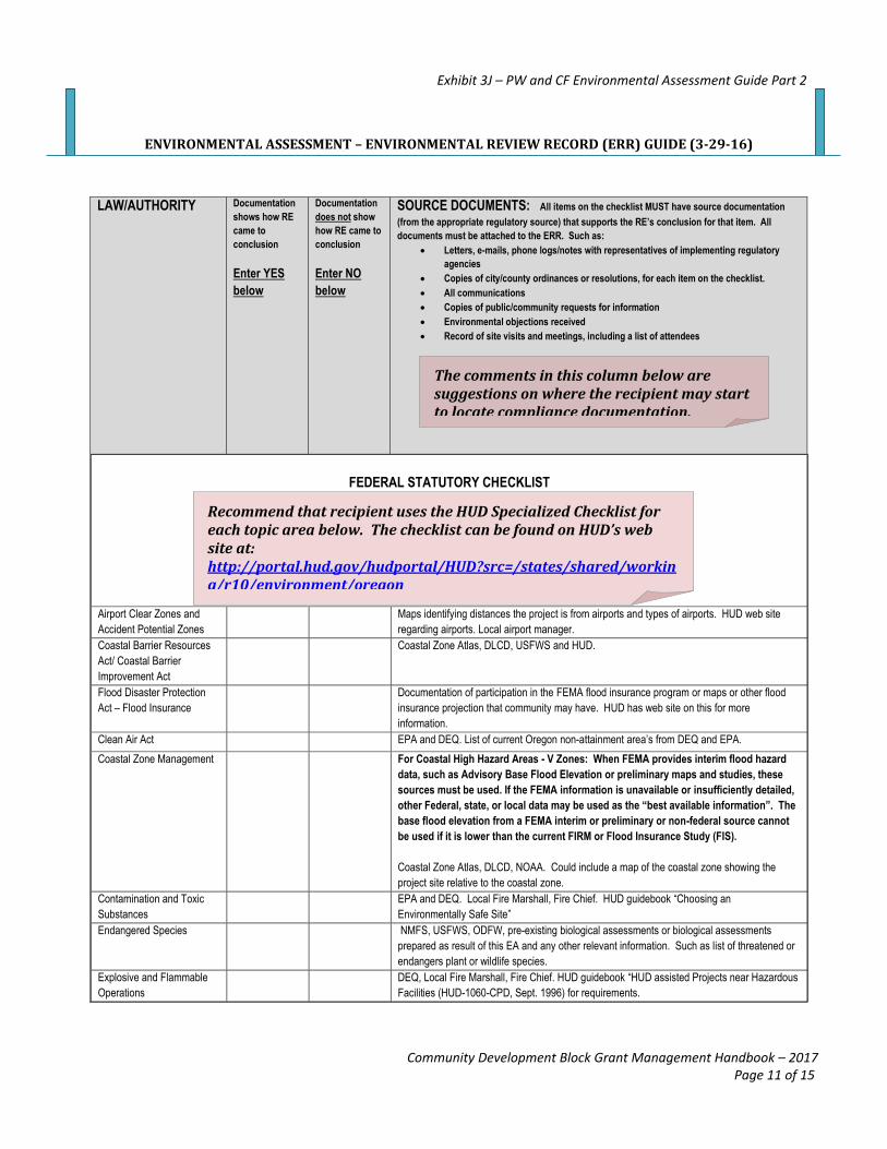
LAW/AUTHORITY Documentation
shows how RE
came to
conclusion
Enter YES
below
Documentation
does not show
how RE came to
conclusion
Enter NO
below
SOURCE DOCUMENTS: All items on the checklist MUST have source documentation
(from the appropriate regulatory source) that supports the RE’s conclusion for that item. All
documents must be attached to the ERR. Such as:
Letters, e-mails, phone logs/notes with representatives of implementing regulatory
agencies
Copies of city/county ordinances or resolutions, for each item on the checklist.
All communications
Copies of public/community requests for information
Environmental objections received
Record of site visits and meetings, including a list of attendees
FEDERAL STATUTORY CHECKLIST
Airport Clear Zones and
Accident Potential Zones
Maps identifying distances the project is from airports and types of airports. HUD web site
regarding airports. Local airport manager.
Coastal Barrier Resources
Act/ Coastal Barrier
Improvement Act
Coastal Zone Atlas, DLCD, USFWS and HUD.
Flood Disaster Protection
Act – Flood Insurance
Documentation of participation in the FEMA flood insurance program or maps or other flood
insurance projection that community may have. HUD has web site on this for more
information.
Clean Air Act EPA and DEQ. List of current Oregon non-attainment area’s from DEQ and EPA.
Coastal Zone Management For Coastal High Hazard Areas - V Zones: When FEMA provides interim flood hazard
data, such as Advisory Base Flood Elevation or preliminary maps and studies, these
sources must be used. If the FEMA information is unavailable or insufficiently detailed,
other Federal, state, or local data may be used as the “best available information”. The
base flood elevation from a FEMA interim or preliminary or non-federal source cannot
be used if it is lower than the current FIRM or Flood Insurance Study (FIS).
Coastal Zone Atlas, DLCD, NOAA. Could include a map of the coastal zone showing the
project site relative to the coastal zone.
Contamination and Toxic
Substances
EPA and DEQ. Local Fire Marshall, Fire Chief. HUD guidebook “Choosing an
Environmentally Safe Site”
Endangered Species NMFS, USFWS, ODFW, pre-existing biological assessments or biological assessments
prepared as result of this EA and any other relevant information. Such as list of threatened or
endangers plant or wildlife species.
Explosive and Flammable
Operations
DEQ, Local Fire Marshall, Fire Chief. HUD guidebook “HUD assisted Projects near Hazardous
Facilities (HUD-1060-CPD, Sept. 1996) for requirements.
The comments in this column below are suggestions on where the recipient may start to locate compliance documentation.
Recommend that recipient uses the HUD Specialized Checklist for each topic area below. The checklist can be found on HUD’s web site at: http://portal.hud.gov/hudportal/HUD?src=/states/shared/working/r10/environment/oregon
Exhibit 3J – PW and CF Environmental Assessment Guide Part 2
Community Development Block Grant Management Handbook – 2017 Page 11 of 15
ENVIRONMENTAL ASSESSMENT – ENVIRONMENTAL REVIEW RECORD (ERR) GUIDE (3-29-16)
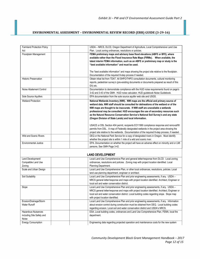
Farmland Protection Policy
Act
USDA – NRCS, DLCD, Oregon Department of Agriculture, Local Comprehensive Land Use
Plan. Local zoning ordinances, resolutions or policies.
Floodplain Management FEMA preliminary maps and advisory base flood elevations (ABFE or BFE), where
available rather than the Flood Insurance Rate Maps (FIRMs). When available, the
latest interim FEMA information, such as an ABFE or preliminary map or study is the
“best available information” and must be used.
The “best available information” and maps showing the project site relative to the floodplain.
Documentation of the required 8-step process if needed.
Historic Preservation Obtain tribal list from TDAT. All SHPO/THPO consultation documents, cultural monitoring
reports, pedestrian survey’s (pre-existing documents or documents prepared as result of this
EA) etc.
Noise Abatement Control Documentation to demonstrate compliance with the HUD noise requirements found on page’s
3-42 and 3-43 of the GMH. HUD noise calculator, HUD guidebook Noise Guidebook.
Sole Source Aquifers EPA documentation from the sole source aquifer web site and USGS.
Wetland Protection National Wetlands Inventory (NWI). NWI maps are the official and primary source of
wetland data. NWI staff should be consulted for delineations of the wetland or of the
NWI maps are thought to be inaccurate. If NWI staff are unavailable a wetlands
professional may be consulted. HUD encourages the use of secondary resources such
as the Natural Resource Conservation Service’s National Soil Survey’s and any state
(Oregon Division of State Lands) and local information.
USACE or DSL Section 404 permit, recipients EO11990 compliance response and removal/fill
permits from DSL. A map of Federally designated wetlands in the project area showing the
project site relative to the wetlands. Documentation of the required 8-step process, if needed.
Wild and Scenic Rivers DEQ or the National Park Service for a copy of designated rivers in Oregon. Must identify
whether the project site is within 1 mile of a wild and scenic river.
Environmental Justice EPA. Documentation on whether the project will have an adverse effect on minority and or LMI
persons, See GMH Page 3-42.
LAND DEVELOPMENT
Land Development/
Compatible Land Use
Zoning
Local Land Use Comprehensive Plan and general letter/response from DLCD. Local zoning
ordinances, resolutions and policies. Zoning map with project location identified. Local
Planning Department.
Scale and Urban Design Local Land Use Comprehensive Plan, or other local ordinances, resolutions, policies. Local
land use planning department, engineer or architect. Soil Suitability Local Land Use Comprehensive Plan and prior engineering assessments, if any. USDA –
NRCS general letter/response and maps with project location identified. Architect, Engineer or
local soil and water conservation district.
Slope Local Land Use Comprehensive Plan and prior engineering assessments, if any. USDA –
NRCS general letter/response and maps with project location identified. Architect, Engineer or
local soil and water conservation district. Local building codes regarding slope. Slope map
with project location identified.
Erosion/Drainage/Storm
Water Runoff
Local Land Use Comprehensive Plan and prior engineering assessments, if any. Information
about erosion control during construction must be obtained from DEQ. Local building codes
regarding erosion. Local soil and water conservation district and USDA’s NRCS.
Hazardous Nuisances
including Site Safety and
Noise
ESA, Local building codes, ordinances and Land Use Comprehensive Plan, FEMA, local fire
department.
Energy Consumption Engineering data regarding projected operation and maintenance costs for the new system
Exhibit 3J – PW and CF Environmental Assessment Guide Part 2
Community Development Block Grant Management Handbook – 2017 Page 12 of 15
ENVIRONMENTAL ASSESSMENT – ENVIRONMENTAL REVIEW RECORD (ERR) GUIDE (3-29-16)
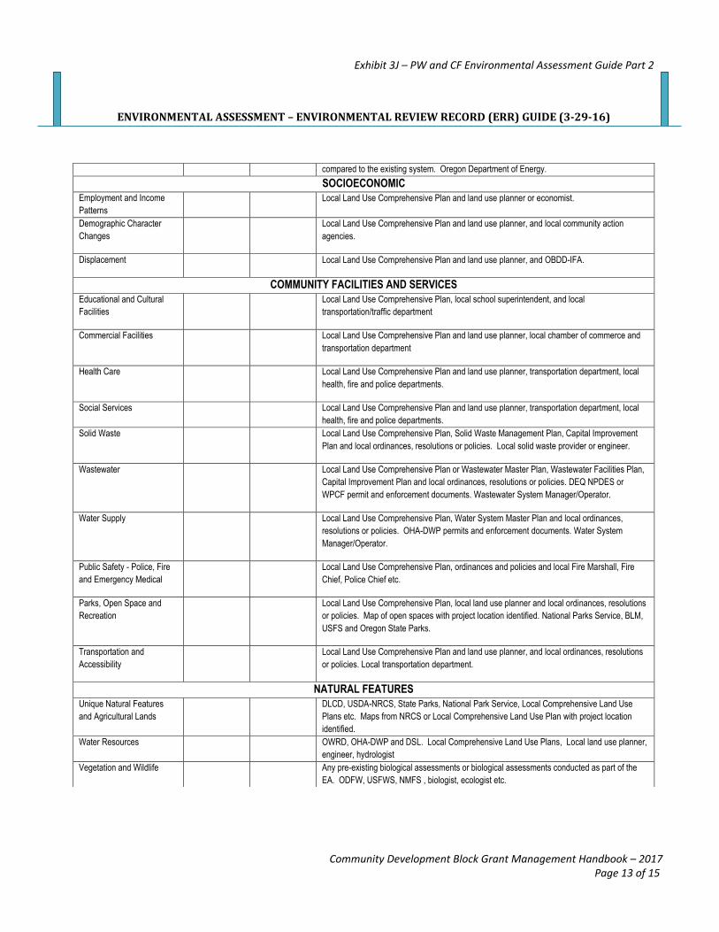
compared to the existing system. Oregon Department of Energy.
SOCIOECONOMIC
Employment and Income
Patterns
Local Land Use Comprehensive Plan and land use planner or economist.
Demographic Character
Changes
Local Land Use Comprehensive Plan and land use planner, and local community action
agencies.
Displacement Local Land Use Comprehensive Plan and land use planner, and OBDD-IFA.
COMMUNITY FACILITIES AND SERVICES
Educational and Cultural
Facilities
Local Land Use Comprehensive Plan, local school superintendent, and local
transportation/traffic department
Commercial Facilities Local Land Use Comprehensive Plan and land use planner, local chamber of commerce and
transportation department
Health Care Local Land Use Comprehensive Plan and land use planner, transportation department, local
health, fire and police departments.
Social Services Local Land Use Comprehensive Plan and land use planner, transportation department, local
health, fire and police departments.
Solid Waste Local Land Use Comprehensive Plan, Solid Waste Management Plan, Capital Improvement
Plan and local ordinances, resolutions or policies. Local solid waste provider or engineer.
Wastewater Local Land Use Comprehensive Plan or Wastewater Master Plan, Wastewater Facilities Plan,
Capital Improvement Plan and local ordinances, resolutions or policies. DEQ NPDES or
WPCF permit and enforcement documents. Wastewater System Manager/Operator.
Water Supply Local Land Use Comprehensive Plan, Water System Master Plan and local ordinances,
resolutions or policies. OHA-DWP permits and enforcement documents. Water System
Manager/Operator.
Public Safety - Police, Fire
and Emergency Medical
Local Land Use Comprehensive Plan, ordinances and policies and local Fire Marshall, Fire
Chief, Police Chief etc.
Parks, Open Space and
Recreation
Local Land Use Comprehensive Plan, local land use planner and local ordinances, resolutions
or policies. Map of open spaces with project location identified. National Parks Service, BLM,
USFS and Oregon State Parks.
Transportation and
Accessibility
Local Land Use Comprehensive Plan and land use planner, and local ordinances, resolutions
or policies. Local transportation department.
NATURAL FEATURES
Unique Natural Features
and Agricultural Lands
DLCD, USDA-NRCS, State Parks, National Park Service, Local Comprehensive Land Use
Plans etc. Maps from NRCS or Local Comprehensive Land Use Plan with project location
identified.
Water Resources OWRD, OHA-DWP and DSL. Local Comprehensive Land Use Plans, Local land use planner,
engineer, hydrologist
Vegetation and Wildlife Any pre-existing biological assessments or biological assessments conducted as part of the
EA. ODFW, USFWS, NMFS , biologist, ecologist etc.
Exhibit 3J – PW and CF Environmental Assessment Guide Part 2
Community Development Block Grant Management Handbook – 2017 Page 13 of 15
ENVIRONMENTAL ASSESSMENT – ENVIRONMENTAL REVIEW RECORD (ERR) GUIDE (3-29-16)
___________ Identification of all additional studies performed
___________ Field Inspection
___________ List of all sources, agencies and persons consulted, duties titles and roles
___________ List of permits obtained
___________ Public outreach
___________ Cumulative Impact Analysis
___________ Evaluation of Alternatives to the proposed action and project modifications
___________ No action alternative
___________ Summary of Findings and Conclusions
___________ A complete list of the mitigation actions necessary, and identification how each mitigating
action will be achieved
__________ A description of the monitoring and enforcement procedures and post environmental review
actions the RE will implement to ensure compliance with the ERR.
__________ Copies of any other relevant correspondence and notifications:
_____ Official notification letters providing environmental data
_____ Community requests for information
_____ Copies of environmental objections/comments
_____ Record of site visits and important meetings, including:
____ List of attendees
____ Meeting minutes
__________ RE’s determination of a FONSI or significant impact
___________ Date RE signed checklist
_____ Signed by RE’s chief elected official; or
_____ If signed by someone other than the RE’s chief elected official there must be
documentation that the RE officially designated and authorized another staff
person of the RE, by the city council or county board of commissioners (resolution
and or meeting minutes must be in the ERR) as the federal certifying officer.
_____ Checklist MUST be signed before the NOI-RROF or the combined notice is
disseminated (published, mailed etc.).
COMBINED NOTICE: Exhibit 3K of the GMH
___________ The dates within the combined Notice are accurate:
_____ Request for Release of Funds - Must be at least one day after the local
governments 15 day if advertised or 18 day if posted local comment period. Date
within Notice________________
_____ Public Comments – Must be the local governments 15 day if advertised or 18 day
if posted comment period. Date within Notice___________________________
_____ Objections to Release of Funds – Must the projected date in which OBDD-IFA
could issue the ROF and includes the 15 or 18 local comment period, a few days
to add public comments received to the ERR and send the entire ERR to OBDD-
Exhibit 3J – PW and CF Environmental Assessment Guide Part 2
Community Development Block Grant Management Handbook – 2017 Page 14 of 15
ENVIRONMENTAL ASSESSMENT – ENVIRONMENTAL REVIEW RECORD (ERR) GUIDE (3-29-16)
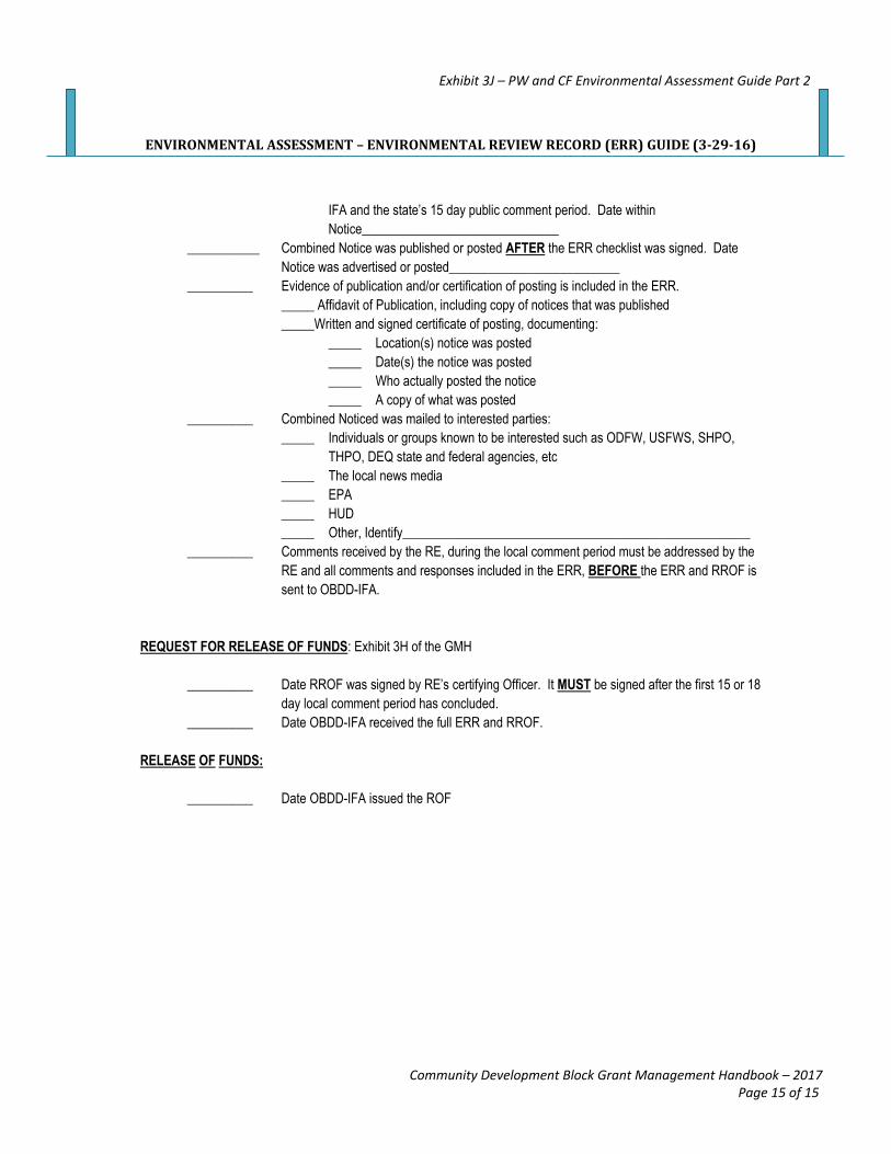
IFA and the state’s 15 day public comment period. Date within
Notice______________________________
___________ Combined Notice was published or posted AFTER the ERR checklist was signed. Date
Notice was advertised or posted__________________________
__________ Evidence of publication and/or certification of posting is included in the ERR.
_____ Affidavit of Publication, including copy of notices that was published
_____Written and signed certificate of posting, documenting:
_____ Location(s) notice was posted
_____ Date(s) the notice was posted
_____ Who actually posted the notice
_____ A copy of what was posted
__________ Combined Noticed was mailed to interested parties:
_____ Individuals or groups known to be interested such as ODFW, USFWS, SHPO,
THPO, DEQ state and federal agencies, etc
_____ The local news media
_____ EPA
_____ HUD
_____ Other, Identify_____________________________________________________
__________ Comments received by the RE, during the local comment period must be addressed by the
RE and all comments and responses included in the ERR, BEFORE the ERR and RROF is
sent to OBDD-IFA.
REQUEST FOR RELEASE OF FUNDS: Exhibit 3H of the GMH
__________ Date RROF was signed by RE’s certifying Officer. It MUST be signed after the first 15 or 18
day local comment period has concluded.
__________ Date OBDD-IFA received the full ERR and RROF.
RELEASE OF FUNDS:
__________ Date OBDD-IFA issued the ROF
Exhibit 3J – PW and CF Environmental Assessment Guide Part 2
Community Development Block Grant Management Handbook – 2017 Page 15 of 15
Related Documents