Environmental and Social Impact Mitigation Measures Study (ESIMMS) of the DFC Project Final Report Volume 1: Gujarat State OCTOBER 2007 MINISTRY OF RAILWAYS DFCC of India Ltd.

Welcome message from author
This document is posted to help you gain knowledge. Please leave a comment to let me know what you think about it! Share it to your friends and learn new things together.
Transcript
Environmental and Social Impact Mitigation Measures Study
(ESIMMS) of the DFC Project
Final Report
Volume 1: Gujarat State
OCTOBER 2007
MINISTRY OF RAILWAYS
DFCC of India Ltd.
Exchange Rates (31/OCTOBER/2007) US$1.00 = INR39.32 INR1.00 = JPY 2.93
Environmental and Social Impact Mitigation Measures
Study (ESIMMS) Report of the DFC Project
CONTENTS
Volume-1: Gujarat Volume-2: Rajasthan Volume-3: Haryana
i
Table of Contents
Pages
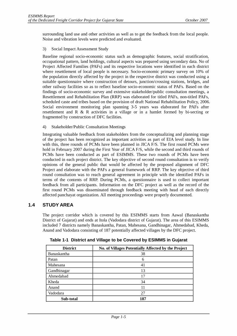
CHAPTER 1 INTRODUCTION.........................................................................................1-1 1.1 BACKGROUND ......................................................................................................1-1 1.2 OBJECTIVE OF ESIMMS.........................................................................................1-2 1.3 SCOPE OF ESIMMS .................................................................................................1-3 1.4 STUDY AREA...........................................................................................................1-5
CHAPTER 2 APPLICABLE GUIDELINES, POLICIES AND LAWS................................2-1 2.1 APPLICABLE NATIONAL POLICIES AND REGULATIONS .................................2-1 2.2 APPLICABLE REGULATIONS ................................................................................2-1 2.2.1 Environment Protection Act, 1986 ..........................................................................2-2 2.2.2 EIA Notification in India.........................................................................................2-2 2.2.3 Forest Conservation Act, 1980 ................................................................................2-3 2.2.4 Biological Diversity Act, 2002 ................................................................................2-5 2.2.5 Wildlife Protection Act, 1972..................................................................................2-5 2.2.6 Land Acquisition Act, 1894.....................................................................................2-6 2.2.7 Noise Pollution Regulation and Control Rules 2000 ................................................2-7 2.2.8 Air (Prevention and Control of Pollution) Act, 1981................................................2-7 2.2.9 Water (Prevention and Control Pollution) Act .........................................................2-7 2.2.10 Other Relevant Acts ................................................................................................2-7
2.3 APPLICABLE POLICIES AND STRATEGIES .........................................................2-9 2.3.1 JICA Guidelines on Environmental and Social Considerations ................................2-9 2.3.2 JBIC Guidelines on Environmental and Social Considerations ................................2-11 2.3.3 Asian Development Bank’s (ADB) Environmental Policy .......................................2-12 2.3.4 World Bank Safeguard Policies ...............................................................................2-13 2.3.5 National Environmental Policies .............................................................................2-13 2.3.6 National Forest Policies ..........................................................................................2-14 2.3.7 Resettlement & Rehabilitation Policy......................................................................2-14 2.3.8 Other Relevant Policies/Strategies...........................................................................2-16
CHAPTER 3 DESCRIPTION OF THE PROJECT..............................................................3-1 3.1 ALIGNMENT OF THE PROJECT.............................................................................3-1 3.2 ALIGNMENT IN GUJARAT STATE.........................................................................3-1 3.3 CONSTRUCTION WIDTH........................................................................................3-5 3.4 VILLAGES EN-ROUTE............................................................................................3-5 3.5 FORESTS EN-ROUTE ..............................................................................................3-21 3.6 FACILITY CONSTRUCTION PLAN ........................................................................3-21
CHAPTER 4 EXISTING ENVIRONMENT .......................................................................4-1 4.1 INTRODUCTION......................................................................................................4-1 4.2 APPROACH AND METHODOLOGY.......................................................................4-1 4.3 EXISTING NATURAL ENVIRONMENT .................................................................4-2 4.3.1 Banaskantha ...........................................................................................................4-2 4.3.2 Patan District ..........................................................................................................4-15 4.3.3 Mahesana District ...................................................................................................4-22 4.3.4 Gandhinagar District...............................................................................................4-31 4.3.5 Ahmedabad District ................................................................................................4-37 4.3.6 Kheda District ........................................................................................................4-44
ii
4.3.7 Anand District ........................................................................................................4-50 4.3.8 Vadodara District ....................................................................................................4-57
4.4 EXISTING SOCIAL ENVIRONMENT .....................................................................4-67 4.4.1 Demography...........................................................................................................4-67 4.4.2 Economic Condition ...............................................................................................4-78 4.4.3 Education ...............................................................................................................4-81 4.4.4 Employment ...........................................................................................................4-83 4.4.5 Health.....................................................................................................................4-90 4.4.6 Historical and Cultural Heritage..............................................................................4-90
CHAPTER 5 POTENTIAL ENVIRONMENT IMPACT EVALUATION AND
MITIGATION MEASURES..........................................................................5-1 5.1 INTRODUCTION......................................................................................................5-1 5.2 IMPACT EVALUATION METHODOLOGY.............................................................5-1 5.3 NATURAL ENVIRONMENT ....................................................................................5-1 5.3.1 Impacts & Mitigation Measures during Pre-Construction Phase ..............................5-1 5.3.2 Impacts & Mitigation Measures during Construction Phase.....................................5-4 5.3.3 Impacts & Mitigation Measures during Operation Phase .........................................5-8 5.3.4 Impact Matrix of Natural Environment ...................................................................5-9
5.4 SOCIAL IMPACT ASSESSMENT.............................................................................5-15 5.4.1 Introduction ............................................................................................................5-15 5.4.2 Methodology ..........................................................................................................5-16 5.4.3 District Demographic Profile ..................................................................................5-19 5.4.4 Sample Study..........................................................................................................5-31 5.4.5 DFC Specific Socio-Economic Survey Analysis, Conclusion and Mitigation
Measures ................................................................................................................5-36 5.5 IMPACT MATRIX OF SOCIAL ENVIRONMENT....................................................5-71 5.5.1 Banaskantha, Patan.................................................................................................5-71 5.5.2 Mahesana ...............................................................................................................5-74 5.5.3 Gandhinagar ...........................................................................................................5-77 5.5.4 Ahmedabad ............................................................................................................5-80 5.5.5 Kheda .....................................................................................................................5-83 5.5.6 Anand, Vadodara ....................................................................................................5-86
CHAPTER 6 POLLUTION CONTROL MEASURES ........................................................6-1 6.1 INTRODUCTION......................................................................................................6-1 6.2 EXISTING CONDITION OF ENVIRONMENTAL PARAMETERS..........................6-1 6.2.1 Air Quality .............................................................................................................6-1 6.2.2 Water Quality .........................................................................................................6-2 6.2.3 Soil Quality ............................................................................................................6-12 6.2.4 Solid Waste.............................................................................................................6-14 6.2.5 Noise & Vibration Level .........................................................................................6-15 6.2.6 Ground Subsistence ................................................................................................6-15
6.3 NOISE AND VIBRATION SURVEY.........................................................................6-15 6.3.1 Background ............................................................................................................6-15 6.3.2 Purpose of Noise and Vibration Monitoring ............................................................6-15 6.3.3 Approach and Methodology of Railway Noise and Vibration Measurement.............6-17 6.3.4 Detailed Railway Noise & Vibration Survey (DR Study).........................................6-19 6.3.5 Noise & Vibration Survey at Sensitive Receptors (SR Study) ..................................6-20 6.3.6 Result of Questionnaire Survey...............................................................................6-28 6.3.7 Prediction & Evaluation of Railway Noise & Vibration...........................................6-35
6.4 IMPACT & MITIGATION MEASURES: ENVIRONMENTAL PARAMETERS .......6-42 6.4.1 Air Quality .............................................................................................................6-42 6.4.2 Noise & Vibration Level .........................................................................................6-43 6.4.3 Water Quality .........................................................................................................6-44
iii
6.4.4 Soil Quality ............................................................................................................6-45 6.4.5 Land Subsidence.....................................................................................................6-46 6.4.6 Bottom Sediment ....................................................................................................6-46 6.4.7 Offensive Odor .......................................................................................................6-46
6.5 IMPACT MATRIX – ENVIRONMENTAL POLLUTION ..........................................6-46 CHAPTER 7 STAKEHOLDER/ PUBLIC CONSULTATION MEETINGS .........................7-1 7.1 INTRODUCTION......................................................................................................7-1 7.2 STAKEHOLDERS.....................................................................................................7-1 7.3 METHOD OF PUBLIC CONSULTATION MEETING ..............................................7-2 7.3.1 Meeting Facilitators ................................................................................................7-2 7.3.2 Method of Information Dissemination.....................................................................7-3
7.4 PUBLIC CONSULTATION SUMMARY SHEET.......................................................7-3 7.5 SUMMARY OF PROFILE OF THE PARTICIPANTS BASED ON DISTRIBUTED
QUESTIONNAIRE - SECOND (2ND) STAGE IN BANASKANTHA DISTRICT.....7-8 7.6 SUMMARY OF STAKE HOLDER/PUBLIC CONSULTATION - SECOND STAGE
IN BANASKANTHA.................................................................................................7-10 7.7 SUMMARY OF THE PROFILE OF PARTICIPANTS BASED ON THE
DISTRIBUTED QUESTIONNAIRE - THIRD (3RD) STAGE IN BANASKANTHA......................................................................................................7-11
7.8 SUMMARY OF FINDINGS – THIRD STAGE IN BANASKANTHA .......................7-13 7.9 SUMMARY OF PROFILE OF THE PARTICIPANTS BASED ON DISTRIBUTED
QUESTIONNAIRE –SECOND (2ND) STAGE IN PATAN ........................................7-14 7.10 SUMMARY OF STAKE HOLDER/PUBLIC CONSULTATION - SECOND STAGE
IN PATAN..................................................................................................................7-16 7.11 SUMMARY OF THE PROFILE OF PARTICIPANTS BASED ON THE
DISTRIBUTED QUESTIONNAIRE - THIRD (3RD) STAGE IN PATAN..................7-18 7.12 SUMMARY OF FINDINGS – THIRD STAGE IN PATAN.........................................7-20 7.13 SUMMARY OF PROFILE OF THE PARTICIPANTS BASED ON DISTRIBUTED
QUESTIONNAIRE-SECOND (2ND) STAGE IN MAHESANA................................7-20 7.14 SUMMARY OF STAKE HOLDER/PUBLIC CONSULTATION -SECOND STAGE
IN MAHESANA ........................................................................................................7-22 7.15 SUMMARY OF THE PROFILE OF PARTICIPANTS BASED ON THE
DISTRIBUTED QUESTIONNAIRE -THIRD (3RD) STAGE IN MAHESANA.........7-24 7.16 SUMMARY OF FINDINGS – THIRD STAGE IN MAHESANA...............................7-26 7.17 SUMMARY OF PROFILE OF THE PARTICIPANTS BASED ON DISTRIBUTED
QUESTIONNAIRE -SECOND (2ND) STAGE IN GANDHINAGAR........................7-27 7.18 SUMMARY OF FINDINGS – SECOND STAGE IN GANDHINAGAR ....................7-29 7.19 SUMMARY OF THE PROFILE OF PARTICIPANTS BASED ON THE
DISTRIBUTED QUESTIONNAIRE -THIRD (3RD) STAGE GANDHINAGAR.......7-30 7.20 SUMMARY OF FINDINGS - THIRD STAGE IN GANDHINAGAR ........................7-30 7.21 SUMMARY OF PROFILE OF THE PARTICIPANTS BASED ON DISTRIBUTED
QUESTIONNAIRE-SECOND (2ND) STAGE IN AHMEDABAD.............................7-30 7.22 SUMMARY OF STAKE HOLDER/PUBLIC CONSULTATION-SECOND STAGE
IN AHMEDABAD .....................................................................................................7-33 7.23 SUMMARY OF THE PROFILE OF PARTICIPANTS BASED ON THE
DISTRIBUTED QUESTIONNAIRE -THIRD (3RD) STAGE IN AHMEDABAD......7-33 7.24 SUMMARY OF FINDINGS – THIRD STAGE IN AHMEDABAD............................7-35 7.25 SUMMARY OF PROFILE OF THE PARTICIPANTS BASED ON DISTRIBUTED
QUESTIONNAIRE-SECOND (2ND) STAGE IN KHEDA ........................................7-37 7.26 SUMMARY OF STAKE HOLDER/PUBLIC CONSULTATION-SECOND STAGE
IN KHEDA ................................................................................................................7-39 7.27 SUMMARY OF THE PROFILE OF PARTICIPANTS BASED ON THE
DISTRIBUTED QUESTIONNAIRE -THIRD (3RD) STAGE IN KHEDA.................7-40 7.28 SUMMARY OF FINDINGS-THIRD STAGE IN KHEDA .........................................7-43
iv
7.29 SUMMARY OF PROFILE OF THE PARTICIPANTS BASED ON THE DISTRIBUTED QUESTIONNAIRE-SECOND (2ND) STAGE IN ANAND..............7-43
7.30 SUMMARY OF STAKE HOLDER/PUBLIC CONSULTATION-SECOND STAGE IN ANAND ................................................................................................................7-45
7.31 SUMMARY OF THE PROFILE OF PARTICIPANTS BASED ON THE DISTRIBUTED QUESTIONNAIRE -THIRD (3RD) STAGE IN ANAND.................7-47
7.32 SUMMARY OF FINDINGS -THIRD STAGE IN ANAND ........................................7-49 7.33 SUMMARY OF PROFILE OF THE PARTICIPANTS BASED ON DISTRIBUTED
QUESTIONNAIRE -SECOND (2ND) STAGE IN VADODARA ...............................7-49 7.34 SUMMARY OF STAKE HOLDER/PUBLIC CONSULTATION-SECOND STAGE
IN VADODARA ........................................................................................................7-51 7.35 SUMMARY OF THE PROFILE OF PARTICIPANTS BASED ON THE
DISTRIBUTED QUESTIONNAIRE -THIRD (3RD) STAGE IN VADODARA .........7-52 7.36 SUMMARY OF FINDINGS -THIRD STAGE IN VADODARA.................................7-54 7.37 FEEDBACK MEETINGS ..........................................................................................7-55
CHAPTER 8 ENVIRONMENT MANAGEMENT PLAN ..................................................8-1 8.1 INTRODUCTION......................................................................................................8-1 8.2 DETAILS OF MANAGEMENT PLANS....................................................................8-2 8.2.1 Greenbelt Development Plan...................................................................................8-2 8.2.2 Solid Waste Management Plan ................................................................................8-4 8.2.3 Management / Rehabilitation Plan for Quarry/Borrow Areas ...................................8-5 8.2.4 Guidelines for Sanitation and House Keeping at the Construction Labour Camps....8-6 8.2.5 Procedures for Storage, Handling & Emergency Response for Hazardous
Chemical ................................................................................................................8-8 8.3 STAGE WISE ENVIRONMENTAL MANAGEMENT MEASURES AND
RESPONSIBILITIES .................................................................................................8-9 8.3.1 Pre-construction Stage ............................................................................................8-9 8.3.2 Construction Stage..................................................................................................8-13 8.3.3 Operation Stage ......................................................................................................8-22
CHAPTER 9 RESETTLEMENT & REHABILITATION PLAN .........................................9-1 CHAPTER 10 ENVIRONMENTAL MONITORING PLAN.................................................10-1 10.1 ENVIRONMENTAL MONITORING PLAN FOR NATURAL AND SOCIAL
ENVIRONMENT.......................................................................................................10-1 10.1.1 Introduction ............................................................................................................10-1 10.1.2 Performance Indicators ...........................................................................................10-1 10.1.3 Environmental Monitoring Programme ...................................................................10-3 10.1.4 Key Players in the Implementation of EMP.............................................................10-4 10.1.5 Institutional Framework..........................................................................................10-4 10.1.6 Progress Monitoring and Reporting Arrangements ..................................................10-5 10.1.7 Training..................................................................................................................10-6
10.2 ENVIRONMENTAL MONITORING PLAN FOR RESETTLEMENT AND REHABILITATION PLAN (RRP)..............................................................................10-7
10.2.1 Internal Monitoring.................................................................................................10-7 10.2.2 External Monitoring................................................................................................10-8
v
List of Tables Table 1-1 District and Village to be Covered by this ESIMMS in Rajasthan...................1-5 Table 2-1 Summary of Applicable Regulations ..............................................................2-1 Table 2-2 Laws Relevant to Forestry .............................................................................2-4 Table 2-3 Forest Terminologies .....................................................................................2-4 Table 2-4 Laws on Biodiversity.....................................................................................2-5 Table 2-5 Laws on Wildlife ...........................................................................................2-6 Table 2-6 Cross Sectoral Laws that has Applicability in Infrastructural Development
Projects .........................................................................................................2-9 Table 2-7 Applicability of World Bank Safeguard Policies.............................................2-13 Table 2-8 Applicable GOI policies to the DFC Project...................................................2-17 Table 3-1 Details of Parallel and Detour Section in Gujarat State...................................3-1 Table 3-2 List of Stations in Banaskantha District..........................................................3-2 Table 3-3 List of Stations in Patan District.....................................................................3-3 Table 3-4 List of Stations in Mahesana District..............................................................3-4 Table 3-5 List of Stations in Vadodara District ...............................................................3-5 Table 3-6 List of Affected Villages in Banaskantha District ...........................................3-6 Table 3-7 List of Villages with Affected Structures ........................................................3-6 Table 3-8 List of Affected Villages in Patan District.......................................................3-7 Table 3-9 List of Affected Villages in Mahesana District................................................3-8 Table 3-10 List of Villages with Affected Structures ........................................................3-8 Table 3-11 List of Affected Villages in Gandhinagar District ........................................3-9 Table 3-12 List of Affected Villages in Ahmedabad District.............................................3-9 Table 3-13 List of Villages with Affected Structures ........................................................3-10 Table 3-14 List of Affected Villages in Kheda District ..................................................3-10 Table 3-15 List of Affected Villages in Anand District .....................................................3-11 Table 3-16 List of Villages with Affected Structures ........................................................3-11 Table 3-17 List of Affected Villages in Vadodara District.................................................3-12 Table 3-18 List of Villages with Affected Structures ........................................................3-12 Table 3-19 List of Reserve Forests En-route ....................................................................3-21 Table 3-20 Details of Junction stations, crossing stations and major bridges in Gujarat
State ..............................................................................................................3-21 Table 4-1 Major crops grown in Banaskantha district.....................................................4-6 Table 4-2 Land use profile of Banaskantha district.........................................................4-6 Table 4-3 Mean Monthly Climatological Records ..........................................................4-7 Table 4-4 Major tree species of Jethi and Bantawada Reserved Forest ...........................4-9 Table 4-5 Major tree species of Jethi and Bantawada Reserved Forest ...........................4-9 Table 4-6 Details of Railway side Plantation..................................................................4-11 Table 4-7 List of Tree Species and IUCN Category........................................................4-12 Table 4-8 Birds of Balaram -Ambaji Sanctuary included in ZSI Red Data Book .........4-13 Table 4-9 Birds of Balaram -Ambaji Sanctuary included in IUCN Red Data Book......4-13 Table 4-10 Summary of Average Girth Size & Height in all Sample Plots ........................4-14 Table 4-11 Species wise total number of trees in different sample plots ...........................4-14 Table 4-12 Results of Transect Analysis ..........................................................................4-14 Table 4-13 Major crops grown in Patan district................................................................4-19 Table 4-14 Mean Monthly Climatological Records ..........................................................4-20 Table 4-15 Details of Railway side Plantation..................................................................4-22 Table 4-16 Major crops grown in Mehasana district.........................................................4-26 Table 4-17 Mean Monthly Climatological Records ..........................................................4-27 Table 4-18 Location of River Crossing ............................................................................4-28 Table 4-19 Details of Railway side Plantation..................................................................4-31 Table 4-20 Crops grown in Gandhinagar district..............................................................4-35 Table 4-21 Mean Monthly Climatological Records ..........................................................4-36
vi
Table 4-22 Crops grown in Ahmedabad district ...............................................................4-41 Table 4-23 Mean Monthly Climatological Records ..........................................................4-42 Table 4-24 Location of River Crossing ............................................................................4-42 Table 4-25 Crops grown in Kheda district........................................................................4-48 Table 4-26 Mean Monthly Climatological Records ..........................................................4-49 Table 4-27 Location of River Crossing ............................................................................4-49 Table 4-28 Crops Grown in Anand district.......................................................................4-55 Table 4-29 Mean Monthly Climatological Records ..........................................................4-55 Table 4-30 Location of River Crossing ............................................................................4-56 Table 4-31 Crops grown in Vadodara district ...................................................................4-62 Table 4-32 Mean Monthly Climatological Records ..........................................................4-63 Table 4-33 Location of River Crossing ............................................................................4-64 Table 4-34 Details of Railway side Plantation..................................................................4-65 Table 4-35 Demographic Profile of District Banaskantha.................................................4-67 Table 4-36 Demographic Profile of District Patan............................................................4-69 Table 4-37 Demographic Profile of District Mahesana.....................................................4-70 Table 4-38 Demographic Profile of District Gandhinagar ................................................4-72 Table 4-39 Demographic Profile of District Ahmedabad ..................................................4-73 Table 4-40 Demographic Profile of District Kheda ..........................................................4-75 Table 4-41 Demographic Profile of District Anand ..........................................................4-76 Table 4-42 Demographic Profile of District Vadodara......................................................4-78 Table 4-43 List of Archaeological Sites ...........................................................................4-91 Table 5-1 Parameter and Scale of Impact Matrix............................................................5-1 Table 5-2 Number of Trees to be felled in Banaskantha and Patan districts ....................5-2 Table 5-3 Administrative Units/Village likely to be affected by the DFC Project in........5-16 Table 5-4 Demographic Profile of District Banaskantha.................................................5-20 Table 5-5 Demographic Profile of District Patan............................................................5-21 Table 5-6 Demographic Profile of District Mahesana.....................................................5-23 Table 5-7 Demographic Profile of District Gandhinagar ................................................5-25 Table 5-8 Demographic Profile of District Ahmedabad ..................................................5-26 Table 5-9 Demographic Profile of District Kheda ..........................................................5-28 Table 5-10 Demographic Profile of District Anand ..........................................................5-29 Table 5-11 Demographic Profile of District Vadodara......................................................5-30 Table 5-12 List of Affected Structures .............................................................................5-32 Table 5-13 List of Affected Structures .............................................................................5-32 Table 5-14 List of Affected Structures .............................................................................5-34 Table 5-15 List of Affected Structures .............................................................................5-34 Table 5-16 List of Affected Structures .............................................................................5-35 Table 5-17 Location of Household Interview ...................................................................5-36 Table 5-18 Size of agricultural land (in Bigha) ................................................................5-37 Table 5-19 Profile of Head of Household.........................................................................5-37 Table 5-20 Consumer Durables and other Assets of Household........................................5-38 Table 5-21 Debt Status of Household...............................................................................5-39 Table 5-22 Sources of Loan.............................................................................................5-39 Table 5-23 Status of Loan................................................................................................5-39 Table 5-24 Anticipated Impact of proposed DFC Project (Banaskantha District)..............5-40 Table 5-25 Location of Household Interview ...................................................................5-42 Table 5-26 Size of agricultural land (in Bigha) ................................................................5-42 Table 5-27 Profile of Head of Household.........................................................................5-43 Table 5-28 Consumer Durables and other Assets of Household........................................5-44 Table 5-29 Debt status of Household ...............................................................................5-45 Table 5-30 Sources of Loan.............................................................................................5-45 Table 5-31 Status of Loan................................................................................................5-45 Table 5-32 Anticipated Impact of proposed DFC Project (Patan District).........................5-46 Table 5-33 Location of Household Interview ...................................................................5-48
vii
Table 5-34 Size of agricultural land (in Bigha) ................................................................5-49 Table 5-35 Profile of Head of Household.........................................................................5-49 Table 5-36 Consumer Durables and other Assets of Household........................................5-51 Table 5-37 Opinion of Respondents on Resettlement Proposal.........................................5-51 Table 5-38 Opinion of Respondents on Compensation and R & R ...................................5-52 Table 5-39 Sources of Information about DFC.................................................................5-52 Table 5-40 Debt status of Household ...............................................................................5-53 Table 5-41 Anticipated Impact of proposed DFC Project (Mahesana District)..................5-53 Table 5-42 List of Affected Structures .............................................................................5-55 Table 5-43 Location of Household Interview ...................................................................5-56 Table 5-44 Size of Agricultural Land (in Bigha) ..............................................................5-56 Table 5-45 Profile of Head of Household.........................................................................5-57 Table 5-46 Consumer Durables and other Assets of Household........................................5-58 Table 5-47 Opinion of Respondents on Resettlement Proposal.........................................5-59 Table 5-48 Opinion of Respondents on Compensation and R & R ...................................5-59 Table 5-49 Sources of information about DFC.................................................................5-60 Table 5-50 Economic Benefits of the DFC Project...........................................................5-60 Table 5-51 Debt status of Household ...............................................................................5-60 Table 5-52 Sources of Loan.............................................................................................5-61 Table 5-53 Status of Loan................................................................................................5-61 Table 5-54 Anticipated Impact of proposed DFC Project (Ahmedabad District) ...............5-61 Table 5-55 Location of Household Interview ...................................................................5-64 Table 5-56 Profile of Head of Household.........................................................................5-65 Table 5-57 Consumer Durables and other Assets of Household........................................5-66 Table 5-58 Opinion of Respondents on Resettlement Proposal.........................................5-67 Table 5-59 Opinion of Respondents on Compensation and R & R ...................................5-67 Table 5-60 Sources of Information about DFC.................................................................5-68 Table 5-61 Economic Benefits of the DFC project ...........................................................5-68 Table 5-62 Debt Status of Household...............................................................................5-68 Table 5-63 Anticipated Impact of proposed DFC Project (Vadodara District) ...................5-69 Table 6-1 Ambient Air Quality ......................................................................................6-1 Table 6-2 Water Quality Data of the Sabarmati River.....................................................6-2 Table 6-3 Ground Water Quality Data............................................................................6-3 Table 6-4 Ground Water Quality Data............................................................................6-4 Table 6-5 Ground Water Quality Data............................................................................6-4 Table 6-6 Ground Water Quality Data of Kalol ..............................................................6-4 Table 6-7 Water Quality Data of the Sabarmati River.....................................................6-5 Table 6-8 Ground Water Quality Data............................................................................6-6 Table 6-9 Ground Water Quality Data............................................................................6-7 Table 6-10 Water Quality Data of the Mahi River ............................................................6-8 Table 6-11 Ground Water Quality Data............................................................................6-9 Table 6-12 Water Quality Data of the Mahi River ............................................................6-10 Table 6-13 Water Quality Data of the Vishwamitri River .................................................6-10 Table 6-14 Ground Water Quality Data............................................................................6-11 Table 6-15 Soil Quality Data of District Mahesana ..........................................................6-12 Table 6-16 Soil Quality Data of District Ahmedabad .......................................................6-13 Table 6-17 Soil Quality of Kheda ....................................................................................6-13 Table 6-18 Soil Quality Data of Anand ............................................................................6-14 Table 6-19 Soil Quality Data of District Vadodara ...........................................................6-14 Table 6-20 Categorizations of Trains ...............................................................................6-17 Table 6-21 Results of Ambient Noise & Vibration Survey at Sensitive Receptor ..............6-20 Table 6-22 Results of Ambient Noise & Vibration Survey at Sensitive Receptor ..............6-22 Table 6-23 Results of Railway Noise & Vibration Survey at Sensitive Receptor ..............6-22 Table 6-24 Results of Ambient Noise & Vibration Survey at Sensitive Receptor ..............6-24 Table 6-25 Results of Railway Noise & Vibration Survey at Sensitive Receptor ..............6-24
viii
Table 6-26 Results of Ambient Noise & Vibration Survey at Sensitive Receptor ..............6-26 Table 6-27 Results of Railway Noise & Vibration Survey at Sensitive Receptor ..............6-26 Table 6-28 Distance-wise anticipated Pollution Problem..................................................6-28 Table 6-29 Age-wise anticipated Pollution Problem.........................................................6-28 Table 6-30 Ranking of Pollution Severance by Respondents ............................................6-29 Table 6-31 Annoyance due to Noise: Respondent’s view .................................................6-29 Table 6-32 Annoyance due to Vibration: Respondent’s view............................................6-29 Table 6-33 Distance-wise anticipated Pollution Problem..................................................6-30 Table 6-34 Age-wise anticipated Pollution Problem.........................................................6-30 Table 6-35 Ranking of Pollution Severance by Respondents ..........................................6-31 Table 6-36 Annoyance due to Noise: Respondent’s view .................................................6-31 Table 6-37 Annoyance due to Vibration: Respondent’s view............................................6-31 Table 6-38 Distance-wise anticipated Pollution Problem..................................................6-32 Table 6-39 Age-wise anticipated Pollution Problem.........................................................6-32 Table 6-40 Ranking of Pollution Severance by Respondents ............................................6-33 Table 6-41 Annoyance due to Noise: Respondent’s view .................................................6-33 Table 6-42 Annoyance due to Vibration: Respondent’s view............................................6-33 Table 6-43 Distance-wise anticipated Pollution Problem..................................................6-34 Table 6-44 Age-wise anticipated Pollution Problem.........................................................6-34 Table 6-45 Ranking of Pollution Severance by Respondents ............................................6-35 Table 6-46 Annoyance due to Noise: Respondent’s view .................................................6-35 Table 6-47 Annoyance due to Vibration: Respondent’s view............................................6-35 Table 6-48 Predicted Railway Noise Level by Distance ...................................................6-37 Table 6-49 Predicted Railway Vibration Level by Distance..............................................6-37 Table 6-50 Predicted Results of Railway Noise ...............................................................6-38 Table 6-51 Predicted Results of Railway Vibration ..........................................................6-39 Table 6-52 Predicted Results of Railway Noise ...............................................................6-39 Table 6-53 Predicted Results of Railway Vibration ..........................................................6-40 Table 6-54 Predicted Results of Railway Noise ...............................................................6-40 Table 6-55 Predicted Results of Railway Vibration ..........................................................6-41 Table 6-56 Predicted Results of Railway Noise ...............................................................6-41 Table 6-57 Predicted Results of Railway Vibration ..........................................................6-42 Table 6-58 Minimum Distance Required from Stationary Noise Source...........................6-43 Table 6-59 Parameter and Scale of Impact Matrix............................................................6-46 Table 7-1 Distribution of Participants by Village (2nd Stage) .........................................7-8 Table 7-2 Family Size (2nd Stage) .................................................................................7-8 Table 7-3 Social Structure of the Participants (2nd Stage) ..............................................7-9 Table 7-4 Origin of the Participant (2nd Stage) ..............................................................7-9 Table 7-5 Education Level of the Participants (2nd Stage) .............................................7-9 Table 7-6 Occupation of the Participants (2nd Stage) .....................................................7-10 Table 7-7 Distribution of Participants By Village (3rd Stage) .........................................7-11 Table 7-8 Family Size (3rd Stage) .................................................................................7-11 Table 7-9 Social Structure of the Participants (3rd Stage)...............................................7-12 Table 7-10 Origin of the Participant (3rd Stage)...............................................................7-12 Table 7-11 Education Level of the Participants (3rd Stage) ..............................................7-12 Table 7-12 Occupation of the Participants (3rd Stage) .....................................................7-13 Table 7-13 Distribution of Participants by Village (2nd Stage) .........................................7-14 Table 7-14 Family Size (2nd Stage) .................................................................................7-15 Table 7-15 Social Structure of the Participants (2nd Stage) ..............................................7-15 Table 7-16 Origin of the Participant (2nd Stage) ..............................................................7-16 Table 7-17 Education Level of the Participants (2nd Stage) .............................................7-16 Table 7-18 Occupation of the Participants (2nd Stage) .....................................................7-16 Table 7-19 Distribution of Participants By Village (3rd Stage) .........................................7-18 Table 7-20 Family Size (3rd Stage) .................................................................................7-18 Table 7-21 Social Structure of the Participants (3rd Stage)...............................................7-19
ix
Table 7-22 Origin of the Participant (3rd Stage)...............................................................7-19 Table 7-23 Education Level of the Participants (3rd Stage) ..............................................7-19 Table 7-24 Occupation of the Participants (3rd Stage) .....................................................7-19 Table 7-25 Distribution of Participants by Village (2nd Stage) .........................................7-20 Table 7-26 Family Size (2nd Stage) .................................................................................7-21 Table 7-27 Social Structure of the Participants (2nd Stage) ..............................................7-21 Table 7-28 Origin of the Participant (2nd Stage) ..............................................................7-21 Table 7-29 Education Level of the Participants (2nd Stage) .............................................7-22 Table 7-30 Occupation of the Participants (2nd Stage) .....................................................7-22 Table 7-31 Distribution of Participants by Village (3rd Stage)..........................................7-24 Table 7-32 Family Size (3rd Stage) .................................................................................7-24 Table 7-33 Social Structure of the Participants (3rd Stage)...............................................7-25 Table 7-34 Origin of the Participant (3rd Stage)...............................................................7-25 Table 7-35 Education Level of the Participants (3rd Stage) ..............................................7-25 Table 7-36 Occupation of the Participants (3rd Stage) .....................................................7-26 Table 7-37 Distribution of Participants by Village (2nd Stage) .........................................7-27 Table 7-38 Family Size (2nd Stage) .................................................................................7-27 Table 7-39 Social Structure of the Participants (2nd Stage) ..............................................7-28 Table 7-40 Origin of the Participant (2nd Stage) ..............................................................7-28 Table 7-41 Education Level of the Participants (2nd Stage) .............................................7-28 Table 7-42 Occupation of the Participants (2nd Stage) .....................................................7-29 Table 7-43 Distribution of Participants by Village (2nd Stage) .........................................7-31 Table 7-44 Family Size (2nd Stage) .................................................................................7-31 Table 7-45 Social Structure of the Participants (2nd Stage) ..............................................7-31 Table 7-46 Origin of the Participant (2nd Stage) ..............................................................7-32 Table 7-47 Education Level of the Participants (2nd Stage) .............................................7-32 Table 7-48 Occupation of the Participants (2nd Stage) .....................................................7-33 Table 7-49 Social Structure of the Participants (2nd Stage) ..............................................7-35 Table 7-50 Family Size (3rd Stage) .................................................................................7-35 Table 7-51 Social Structure of the Participants (3rd Stage)...............................................7-36 Table 7-52 Origin of the Participant (3rd Stage)...............................................................7-36 Table 7-53 Education Level of the Participants (3rd Stage) ..............................................7-36 Table 7-54 Occupation of the Participants (3rd Stage) .....................................................7-36 Table 7-55 Distribution of Participants by Village (2nd Stage) .........................................7-37 Table 7-56 Family Size (2nd Stage) .................................................................................7-38 Table 7-57 Social Structure of the Participants (2nd Stage) ..............................................7-38 Table 7-58 Origin of the Participant (2nd Stage) ..............................................................7-38 Table 7-59 Education Level of the Participants (2nd Stage) .............................................7-39 Table 7-60 Occupation of the Participants (2nd Stage) .....................................................7-39 Table 7-61 Distribution of Participants By Village (3rd Stage) .........................................7-40 Table 7-62 Family Size (3rd Stage) .................................................................................7-41 Table 7-63 Social Structure of the Participants (3rd Stage)...............................................7-42 Table 7-64 Origin of the Participant (3rd Stage)...............................................................7-42 Table 7-65 Education Level of the Participants (3rd Stage) ..............................................7-42 Table 7-66 Occupation of the Participants (3rd Stage) .....................................................7-42 Table 7-67 Distribution of Participants by Village (2nd Stage) .........................................7-43 Table 7-68 Family Size (2nd Stage) .................................................................................7-43 Table 7-69 Social Structure of the Participants (2nd Stage) ..............................................7-44 Table 7-70 Origin of the Participant (2nd Stage) ..............................................................7-44 Table 7-71 Education Level of the Participants (2nd Stage) .............................................7-44 Table 7-72 Occupation of the Participants (2nd Stage) .....................................................7-45 Table 7-73 Distribution of Participants By Village (3rd Stage) .........................................7-47 Table 7-74 Family Size (3rd Stage) .................................................................................7-47 Table 7-75 Social Structure of the Participants (3rd Stage)...............................................7-48 Table 7-76 Origin of the Participant (3rd Stage)...............................................................7-48
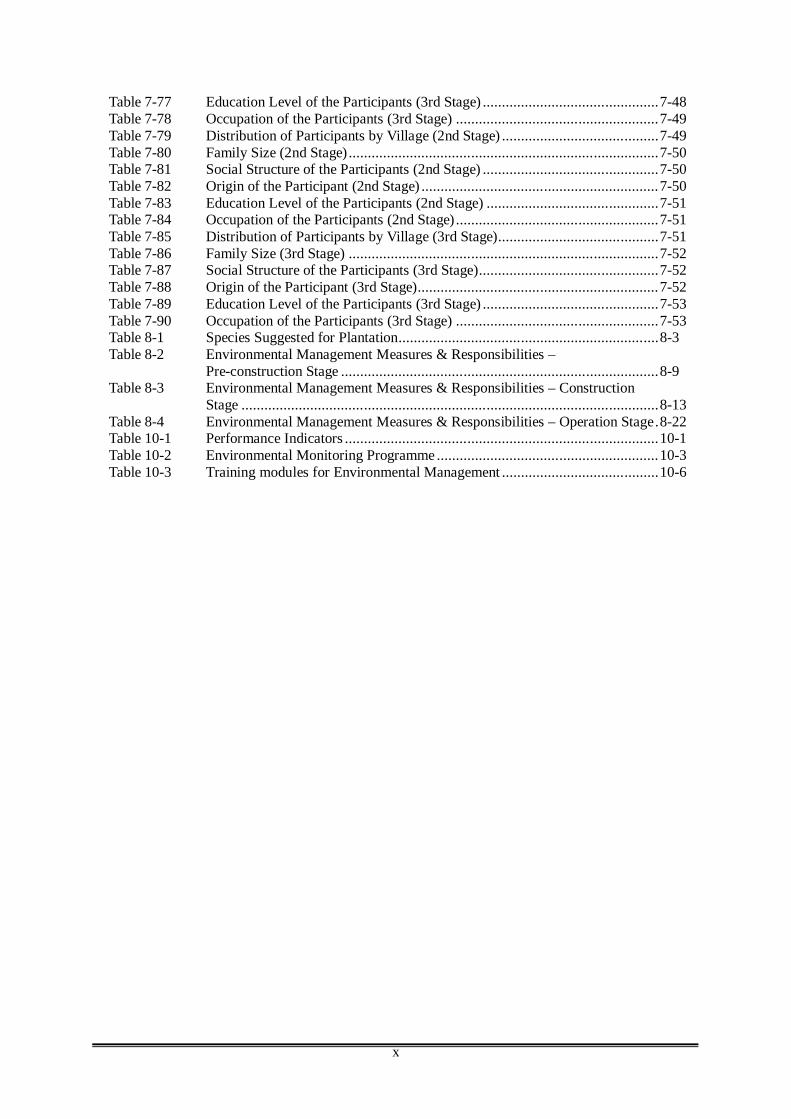
x
Table 7-77 Education Level of the Participants (3rd Stage) ..............................................7-48 Table 7-78 Occupation of the Participants (3rd Stage) .....................................................7-49 Table 7-79 Distribution of Participants by Village (2nd Stage) .........................................7-49 Table 7-80 Family Size (2nd Stage) .................................................................................7-50 Table 7-81 Social Structure of the Participants (2nd Stage) ..............................................7-50 Table 7-82 Origin of the Participant (2nd Stage) ..............................................................7-50 Table 7-83 Education Level of the Participants (2nd Stage) .............................................7-51 Table 7-84 Occupation of the Participants (2nd Stage) .....................................................7-51 Table 7-85 Distribution of Participants by Village (3rd Stage)..........................................7-51 Table 7-86 Family Size (3rd Stage) .................................................................................7-52 Table 7-87 Social Structure of the Participants (3rd Stage)...............................................7-52 Table 7-88 Origin of the Participant (3rd Stage)...............................................................7-52 Table 7-89 Education Level of the Participants (3rd Stage) ..............................................7-53 Table 7-90 Occupation of the Participants (3rd Stage) .....................................................7-53 Table 8-1 Species Suggested for Plantation....................................................................8-3 Table 8-2 Environmental Management Measures & Responsibilities –
Pre-construction Stage ...................................................................................8-9 Table 8-3 Environmental Management Measures & Responsibilities – Construction
Stage .............................................................................................................8-13 Table 8-4 Environmental Management Measures & Responsibilities – Operation Stage.8-22 Table 10-1 Performance Indicators ..................................................................................10-1 Table 10-2 Environmental Monitoring Programme ..........................................................10-3 Table 10-3 Training modules for Environmental Management .........................................10-6
xi
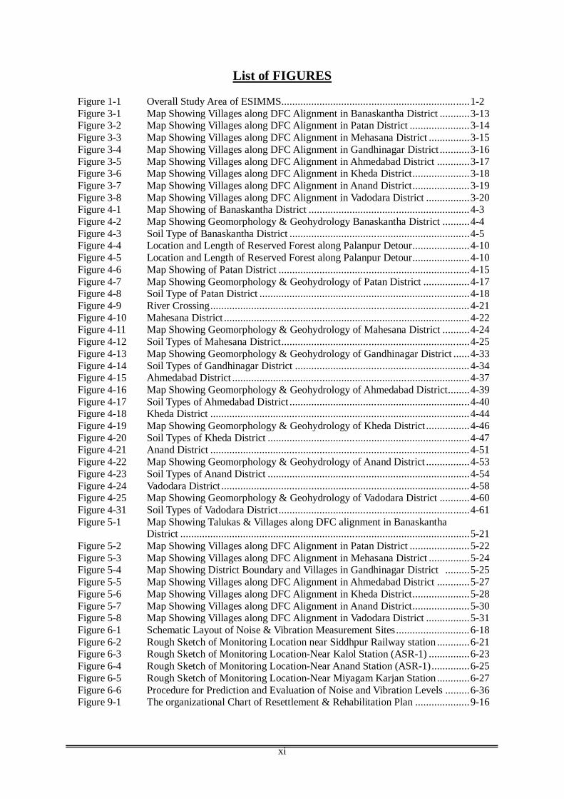
List of FIGURES Figure 1-1 Overall Study Area of ESIMMS.....................................................................1-2 Figure 3-1 Map Showing Villages along DFC Alignment in Banaskantha District ...........3-13 Figure 3-2 Map Showing Villages along DFC Alignment in Patan District ......................3-14 Figure 3-3 Map Showing Villages along DFC Alignment in Mehasana District ...............3-15 Figure 3-4 Map Showing Villages along DFC Alignment in Gandhinagar District ...........3-16 Figure 3-5 Map Showing Villages along DFC Alignment in Ahmedabad District ............3-17 Figure 3-6 Map Showing Villages along DFC Alignment in Kheda District.....................3-18 Figure 3-7 Map Showing Villages along DFC Alignment in Anand District.....................3-19 Figure 3-8 Map Showing Villages along DFC Alignment in Vadodara District ................3-20 Figure 4-1 Map Showing of Banaskantha District ...........................................................4-3 Figure 4-2 Map Showing Geomorphology & Geohydrology Banaskantha District ..........4-4 Figure 4-3 Soil Type of Banaskantha District ..................................................................4-5 Figure 4-4 Location and Length of Reserved Forest along Palanpur Detour.....................4-10 Figure 4-5 Location and Length of Reserved Forest along Palanpur Detour.....................4-10 Figure 4-6 Map Showing of Patan District ......................................................................4-15 Figure 4-7 Map Showing Geomorphology & Geohydrology of Patan District .................4-17 Figure 4-8 Soil Type of Patan District .............................................................................4-18 Figure 4-9 River Crossing...............................................................................................4-21 Figure 4-10 Mahesana District ..........................................................................................4-22 Figure 4-11 Map Showing Geomorphology & Geohydrology of Mahesana District ..........4-24 Figure 4-12 Soil Types of Mahesana District.....................................................................4-25 Figure 4-13 Map Showing Geomorphology & Geohydrology of Gandhinagar District ......4-33 Figure 4-14 Soil Types of Gandhinagar District ................................................................4-34 Figure 4-15 Ahmedabad District .......................................................................................4-37 Figure 4-16 Map Showing Geomorphology & Geohydrology of Ahmedabad District........4-39 Figure 4-17 Soil Types of Ahmedabad District ..................................................................4-40 Figure 4-18 Kheda District ...............................................................................................4-44 Figure 4-19 Map Showing Geomorphology & Geohydrology of Kheda District ................4-46 Figure 4-20 Soil Types of Kheda District ..........................................................................4-47 Figure 4-21 Anand District ...............................................................................................4-51 Figure 4-22 Map Showing Geomorphology & Geohydrology of Anand District ................4-53 Figure 4-23 Soil Types of Anand District ..........................................................................4-54 Figure 4-24 Vadodara District ...........................................................................................4-58 Figure 4-25 Map Showing Geomorphology & Geohydrology of Vadodara District ...........4-60 Figure 4-31 Soil Types of Vadodara District......................................................................4-61 Figure 5-1 Map Showing Talukas & Villages along DFC alignment in Banaskantha
District ..........................................................................................................5-21 Figure 5-2 Map Showing Villages along DFC Alignment in Patan District ......................5-22 Figure 5-3 Map Showing Villages along DFC Alignment in Mehasana District ...............5-24 Figure 5-4 Map Showing District Boundary and Villages in Gandhinagar District .........5-25 Figure 5-5 Map Showing Villages along DFC Alignment in Ahmedabad District ............5-27 Figure 5-6 Map Showing Villages along DFC Alignment in Kheda District.....................5-28 Figure 5-7 Map Showing Villages along DFC Alignment in Anand District.....................5-30 Figure 5-8 Map Showing Villages along DFC Alignment in Vadodara District ................5-31 Figure 6-1 Schematic Layout of Noise & Vibration Measurement Sites ...........................6-18 Figure 6-2 Rough Sketch of Monitoring Location near Siddhpur Railway station ............6-21 Figure 6-3 Rough Sketch of Monitoring Location-Near Kalol Station (ASR-1) ...............6-23 Figure 6-4 Rough Sketch of Monitoring Location-Near Anand Station (ASR-1)..............6-25 Figure 6-5 Rough Sketch of Monitoring Location-Near Miyagam Karjan Station ............6-27 Figure 6-6 Procedure for Prediction and Evaluation of Noise and Vibration Levels .........6-36 Figure 9-1 The organizational Chart of Resettlement & Rehabilitation Plan ....................9-16

xii
List of Annex ANNEX-4.1 RESULTS OF ‘T’ TEST & ‘ANOVA’ ANNEX-5.1 SUMMARY OF SOCIO-ECONOMIC SURVEY SHEET ANNEX-5.2 SOCIO-ECONOMIC QUESTIONNAIRE ANNEX-6.1 RELEVANT INDIAN STANDARDS ANNEX-6.2 QUESTIONNAIRE FOR NOISE & VIBRATION SURVEY ANNEX-6.3 NOISE & VIBRATION ANNEX-8.1 FORMS FOR ENVIRONMENTAL MANAGEMENT PLAN
xiii
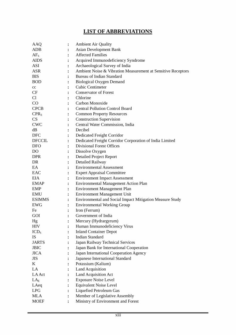
LIST OF ABBREVIATIONS
AAQ : Ambient Air Quality ADB : Asian Development Bank AFS : Affected Families AIDS : Acquired Immunodeficiency Syndrome ASI : Archaeological Survey of India ASR : Ambient Noise & Vibration Measurement at Sensitive Receptors BIS : Bureau of Indian Standard BOD : Biological Oxygen Demand cc : Cubic Centimeter CF : Conservator of Forest Cl : Chlorine CO : Carbon Monoxide CPCB : Central Pollution Control Board CPRS : Common Property Resources CS : Construction Supervision CWC : Central Water Commission, India dB : Decibel DFC : Dedicated Freight Corridor DFCCIL : Dedicated Freight Corridor Corporation of India Limited DFO : Divisional Forest Offices DO : Dissolve Oxygen DPR : Detailed Project Report DR : Detailed Railway EA : Environmental Assessment EAC : Expert Appraisal Committee EIA : Environment Impact Assessment EMAP : Environmental Management Action Plan EMP : Environment Management Plan EMU : Environment Management Unit ESIMMS : Environmental and Social Impact Mitigation Measure Study EWG : Environmental Working Group Fe : Iron (Ferrum) GOI : Government of India Hg : Mercury (Hydrargyrum) HIV : Human Immunodeficiency Virus ICDS : Inland Container Depot IS : Indian Standard JARTS : Japan Railway Technical Services JBIC : Japan Bank for International Cooperation JICA : Japan International Cooperation Agency JIS : Japanese International Standard K : Potassium (Kalium) LA : Land Acquisition LA Act : Land Acquisition Act LAE : Exposure Noise Level LAeq : Equivalent Noise Level LPG : Liquefied Petroleum Gas MLA : Member of Legislative Assembly MOEF : Ministry of Environment and Forest
xiv
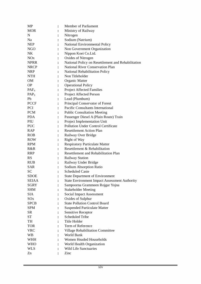
MP : Member of Parliament MOR : Ministry of Railway N : Nitrogen Na : Sodium (Natrium) NEP : National Environmental Policy NGO : Non Government Organization NK : Nippon Koei Co.Ltd. NOx : Oxides of Nitrogen NPRR : National Policy on Resettlement and Rehabilitation NRCP : National River Conservation Plan NRP : National Rehabilitation Policy NTH : Non Titleholder OM : Organic Matter OP : Operational Policy PAFS : Project Affected Families PAPS : Project Affected Person Pb : Lead (Plumbum) PCCF : Principal Conservator of Forest PCI : Pacific Consultants International PCM : Public Consultation Meeting PDA : Passenger Diesel A (Plain Route) Train PIU : Project Implementation Unit PUC : Pollution Under Control Certificate RAP : Resettlement Action Plan ROB : Railway Over Bridge ROW : Right of Way RPM : Respiratory Particulate Matter R&R : Resettlement & Rehabilitation RRP : Resettlement and Rehabilitation Plan RS : Railway Station RUB : Railway Under Bridge SAR : Sodium Absorption Ratio SC : Scheduled Caste SDOE : State Department of Environment SEIAA : State Environment Impact Assessment Authority SGRY : Sampoorna Grammeen Rojgar Yojna SHM : Stakeholder Meeting SIA : Social Impact Assessment SOx : Oxides of Sulphur SPCB : State Pollution Control Board SPM : Suspended Particulate Matter SR : Sensitive Receptor ST : Scheduled Tribe TH : Title Holder TOR : Term of Reference VRC : Village Rehabilitation Committee WB : World Bank WHH : Women Headed Households WHO : World Health Organization WLS : Wild Life Sanctuaries Zn : Zinc
ESIMMS Report of the Dedicated Freight Corridor Project for Gujarat State October 2007
Page 1-1
CHAPTER 1 INTRODUCTION
1.1 BACKGROUND
Indian Railways, the prime movers of the nation, have the distinction of being one of the largest railway systems in the world under a single management. Its contribution to the nation’s progress is immeasurable and it has a dual role to play as a commercial organization as well as a vehicle for fulfillment of aspirations of the society at large. It is an important catalyst to growth of trade, industry and the economy as a whole, with immense potential for providing indirect employment. Considering this, Indian Government attaches the highest priority to the development and expansion of railway infrastructure. The Golden Quadrilateral and diagonals of the railway system are heavily congested routes and strengthening/widening of these routes has been taken up as part of National Rail Vikas Yojana. Surveys and construction of gauge conversion and new lines have been undertaken with a view to provide alternate routes to decongest the heavily utilized ones. Delhi-Mumbai and Delhi-Howrah stretches of Quadrilateral railway system have been identified as heavily congested routes and need to be decongested on priority basis.
In view of this, on the request of Ministry of Railways (MOR), Japan International Cooperation Agency (JICA) has conducted the feasibility study for the “The Development of Dedicated Multimodal High Axle Load Freight Corridor with computerized Control for Delhi-Mumbai and Delhi-Howrah in India (JICA F/S)”. Objective of JICA F/S was to review the PETS and Final Location Survey (FLS) of the Dedicated Freight Corridor (DFC) Project that was supposed to be prepared by the GOI. However, since the FLS could not be available during JICA F/S, Guideline Design (GLD) and General Arrangement Drawings (GAD) have been proposed for the preparation of FLS for both Eastern and Western Corridors during JICA F/S.
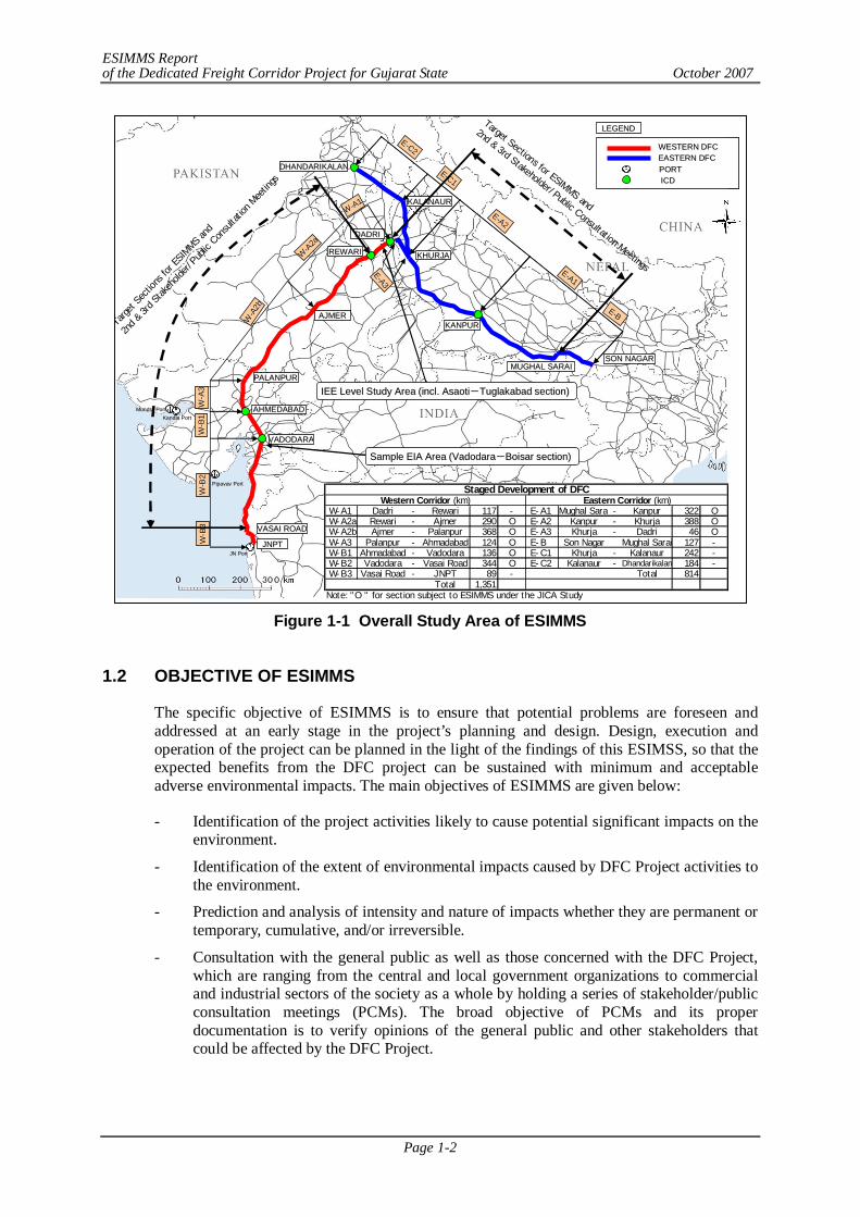
The Environmental and Social Considerations Study (ESCS), which was equivalent to Initial Environmental Examination (IEE) level study, was conducted from November 2006 to March 2007 in the First Year of JICA F/S. In the Second Year of JICA F/S, Environmental and Social Impact Mitigation Measures Study (ESIMMS), which is equivalent to Environmental Impact Assessment (EIA) level study, has been conducted base on GLD and GAD covering the development stage sections between Rewari, Haryana and Vasai Road, Maharashtra (approx. 1,262 km) for the Western Corridor and between Dadri and Mughal Sarai, Uttar Pradesh (approx. 756 km) for the Eastern Corridor. The overall study area of ESIMMS is shown in Figure 1-1.
For the Western Corridor, ESIMMS has been conducted for the DFC route from Rewari to JNPT Mumbai which includes 2 districts of Haryana, 7 districts of Rajasthan, 12 districts of Gujarat and 1 district of Maharashtra. However, this ESIMMS report elaborates environmental and social impact mitigation measures for the DFC route in Gujarat state upto Vadodara. The districts covered in this ESIMMS are Banaskantha, Patan, Mahesana, Gandhinagar, Ahmedabad, Kheda, Anand and Vadodara.
ESIMMS Report of the Dedicated Freight Corridor Project for Gujarat State October 2007
Page 1-2
Figure 1-1 Overall Study Area of ESIMMS
1.2 OBJECTIVE OF ESIMMS
The specific objective of ESIMMS is to ensure that potential problems are foreseen and addressed at an early stage in the project’s planning and design. Design, execution and operation of the project can be planned in the light of the findings of this ESIMSS, so that the expected benefits from the DFC project can be sustained with minimum and acceptable adverse environmental impacts. The main objectives of ESIMMS are given below:
- Identification of the project activities likely to cause potential significant impacts on the environment.
- Identification of the extent of environmental impacts caused by DFC Project activities to the environment.
- Prediction and analysis of intensity and nature of impacts whether they are permanent or temporary, cumulative, and/or irreversible.
- Consultation with the general public as well as those concerned with the DFC Project, which are ranging from the central and local government organizations to commercial and industrial sectors of the society as a whole by holding a series of stakeholder/public consultation meetings (PCMs). The broad objective of PCMs and its proper documentation is to verify opinions of the general public and other stakeholders that could be affected by the DFC Project.
KHURJAKHURJA
KALANAURKALANAUR
DHANDARIKALANDHANDARIKALAN
KANPURKANPUR
DADRIDADRI
REWARIREWARI
PALANPURPALANPUR
AHMEDABADAHMEDABAD
VADODVADODAARARA
VASAI ROADVASAI ROAD
JNPTJNPT
MUGHAL SARAIMUGHAL SARAISON NAGARSON NAGAR
AJMERAJMER
EE--C2C2
EE--A3A3
WESTERN DFC WESTERN DFC EASTERN DFC EASTERN DFC PORT PORT ICD ICD
LEGENDLEGEND
WW-- B
3B3WW
-- B2B2
WW-- B
1B1WW
-- A3A3
WW--A
2bA2b
WW--A
2aA2a
WW--A1A1
EE--C1C1
EE--A2A2
EE--A1A1
EE--BB
PipavavPipavav PortPort
KandlaKandla PortPortMundraMundra PortPort
JN PortJN Port
Target Sections for ESIMMS and
2nd & 3rd Stakeholder/Public Consultation Meetings
Target
Sec
tions
for E
SIMMS
and
2nd &
3rd St
akeh
olde
r/Pu
blic Con
sulta
tion Mee
tings
IEE Level Study Area (incl. IEE Level Study Area (incl. AsaotiAsaoti--TuglakabadTuglakabad section) section)
Sample EIA Area (VadodaraSample EIA Area (Vadodara--Boisar section) Boisar section)
Staged Development of DFCWestern Corridor (km) Eastern Corridor (km)
W-A1 Dadri - Rewari 117 - E-A1 Mughal Sarai - Kanpur 322 O W-A2a Rewari - Ajmer 290 O E-A2 Kanpur - Khurja 388 O W-A2b Ajmer - Palanpur 368 O E-A3 Khurja - Dadri 46 O W-A3 Palanpur - Ahmadabad 124 O E-B Son Nagar Mughal Sarai 127 - W-B1 Ahmadabad - Vadodara 136 O E-C1 Khurja - Kalanaur 242 - W-B2 Vadodara - Vasai Road 344 O E-C2 Kalanaur - Dhandarikalan 184 - W-B3 Vasai Road - JNPT 89 - Total 814
Total 1,351Note: "O " for section subject to ESIMMS under the JICA Study
KHURJAKHURJA
KALANAURKALANAUR
DHANDARIKALANDHANDARIKALAN
KANPURKANPUR
DADRIDADRI
REWARIREWARI
PALANPURPALANPUR
AHMEDABADAHMEDABAD
VADODVADODAARARA
VASAI ROADVASAI ROAD
JNPTJNPT
MUGHAL SARAIMUGHAL SARAISON NAGARSON NAGAR
AJMERAJMER
EE--C2C2
EE--A3A3
WESTERN DFC WESTERN DFC EASTERN DFC EASTERN DFC PORT PORT ICD ICD
LEGENDLEGEND
WW-- B
3B3WW
-- B2B2
WW-- B
1B1WW
-- A3A3
WW--A
2bA2b
WW--A
2aA2a
WW--A1A1
EE--C1C1
EE--A2A2
EE--A1A1
EE--BB
PipavavPipavav PortPort
KandlaKandla PortPortMundraMundra PortPort
JN PortJN Port
Target Sections for ESIMMS and
2nd & 3rd Stakeholder/Public Consultation Meetings
Target
Sec
tions
for E
SIMMS
and
2nd &
3rd St
akeh
olde
r/Pu
blic Con
sulta
tion Mee
tings
IEE Level Study Area (incl. IEE Level Study Area (incl. AsaotiAsaoti--TuglakabadTuglakabad section) section)
Sample EIA Area (VadodaraSample EIA Area (Vadodara--Boisar section) Boisar section)
Staged Development of DFCWestern Corridor (km) Eastern Corridor (km)
W-A1 Dadri - Rewari 117 - E-A1 Mughal Sarai - Kanpur 322 O W-A2a Rewari - Ajmer 290 O E-A2 Kanpur - Khurja 388 O W-A2b Ajmer - Palanpur 368 O E-A3 Khurja - Dadri 46 O W-A3 Palanpur - Ahmadabad 124 O E-B Son Nagar Mughal Sarai 127 - W-B1 Ahmadabad - Vadodara 136 O E-C1 Khurja - Kalanaur 242 - W-B2 Vadodara - Vasai Road 344 O E-C2 Kalanaur - Dhandarikalan 184 - W-B3 Vasai Road - JNPT 89 - Total 814
Total 1,351Note: "O " for section subject to ESIMMS under the JICA Study
ESIMMS Report of the Dedicated Freight Corridor Project for Gujarat State October 2007
Page 1-3
1.3 SCOPE OF ESIMMS
In ESCS which was mainly conducted based on the collected secondary data as IEE level study, the major environmental and social consideration items were identified. Based on the results of ESCS, further EIA level study has been required for the following components.
(1) Natural Environment
The secondary data collection and survey of natural reserves, such as national parks and wildlife sanctuaries along the DFC alignment shall be conducted. Reserved forests and protected forests along the DFC alignment shall be examined to assess their impacts.
(2) Pollution Control
1) Sensitive Receptors (SRs) along the DFC alignment shall be identified for noise and vibration measurement. Ambient and railway noise/vibration levels shall be measured at the selected SRs. In addition, railway noise and vibration measurements were conducted along the DFC alignment to obtain unit sample data at 15 sites in total.
2) The secondary data collection of water quality, air quality and other components shall be conducted. The mitigation measures shall be proposed based on the analysis of the collected data.
(3) Social Environment
1) Field survey to identify the number of Project Affected Families (PAFs)1 shall be identified.
2) Socio-economic questionnaire survey shall be conducted at 10% of total number of the identified PAFs.
3) The social impact assessment along the DFC alignment shall be conducted. The Resettlement and Rehabilitation Plan Framework shall be formulated.
(4) Stakeholder/Public Consultation Meetings
1) The 2nd Stage PCM was planned to be conducted at each district to be directly affected by the DFC Project.
2) Targeted PCM participants shall be representatives of Panchayats, villages and towns.
3) After the 2nd Stage PCM participated representatives of Panchayats, villages and towns shall disseminate the information obtained from the PCM amongst villagers and town residents, discuss with the issues and exchange opinions with residents at a village feedback meeting. The results of the village meeting shall be recorded.
4) In the 3rd Stage PCM, either one representative of each Panchayats, villages or towns or one representative of potential Project Affected Persons (PAPs) shall present their outcomes of the village meeting. The outcomes shall be discussed, and components of the suggested RRP Framework shall be agreed by the participants of the 3rd Stage PCM.
1 PAF is defined as Project Affected Families to be relocated; however, at the stage of ESIMMS, the number of affected
residential structures is considered as PAF. The exact number of the PAF shall be identified by the detailed field survey at the next stage of the project.
ESIMMS Report of the Dedicated Freight Corridor Project for Gujarat State October 2007
Page 1-4
(5) Formulation of the Resettlement and Plan Framework
1) In the village feedback meetings to be organised before the 3rd Stage PCM, the RRP Framework shall be introduced to village residents. The components shall be confirmed and discussed by village residents.
2) The components of the RRP Framework shall be discussed and agreed by participants of the 3rd Stage PCM.
3) The social environmental monitoring plan shall be formulated in order to use for 3-5 years after the resettlement is completed.
(6) Environmental Management Plan (EMAP) and Environmental Monitoring Plan (EMOP)
EMAP and EMOP for construction of relevant railway facilities of each district shall be prepared.
Scope of ESIMMS as EIA level study has been elaborated in a well defined manner in Terms of Reference (TOR) as Technical Working Paper as part of JICA F/S. As per the TOR, major issues to be covered are summarized under four major heads as the details of major four components are discussed below:
1) Natural Environment Impact Assessment Study 2) Pollution Control Study 3) Social Impact Assessment Study 4) Stakeholder/Public Consultation Meeting
1) Natural Environment Impact Assessment Study
The significant environmental issues, particularly ecologically sensitive areas on natural environmental components such as topography, geology, soil, climate, land use, water bodies, and ecology etc. likely to be impacted due to proposed activities of DFC, were identified and a suitable and effective environmental management and monitoring plan to mitigate negative impacts and enhance positive impacts was prepared. Monitoring Plan was elaborated for construction period as well as spanning over 3-5 years covering locations sensitive to other pollution aspects as well as areas covering protected areas, wildlife sanctuary, eco-sensitive along DFC alignment. Effective and feasible measures were identified and elaborated necessary to take in order to mitigate, reduce, rectify or compensate adverse impacts caused by the project to the areas subject to protection of forest, wildlife, or any other species of fauna and flora and eco-sensitive areas. Baseline status of natural environmental components was prepared based on reconnaissance environmental survey and secondary data available. Detailed field survey was carried out to substantiate the findings focusing on forestry and railway side plantation using quadrate survey representing each forest by three minimum plots with size 10 m x 10 m. This was further supported by interview survey with relevant expert and local residents covering confirmation of the present situation in flora and fauna including avifauna.
2) Pollution Control Survey
The current status of water quality in rivers, air quality, noise, vibration along the proposed alignment was grasped based on mainly secondary data supported with reconnaissance field survey. Primary survey was carried out for ambient and railway noise and vibration including its attenuation at the selected sensitive receptors near proposed DFC alignment. Interview survey on noise and vibration with local residents living along the existing railway side at each monitoring location using suitable questionnaire was conducted so as to record the
ESIMMS Report of the Dedicated Freight Corridor Project for Gujarat State October 2007
Page 1-5
surrounding land use and other activities as well as to get the feedback from the local people. Noise and vibration levels were predicted and evaluated.
3) Social Impact Assessment Study
Baseline regional socio-economic status such as demographic features, social stratification, occupational pattern, land holdings, cultural aspects was prepared using secondary data. No of Project Affected Families (PAFs) and its respective locations were identified in each district where resettlement of local people is necessary. Socio-economic primary survey on 10% of the population directly affected by the project in the respective district was conducted using a suitable questionnaire where construction of detours, junction/crossing stations, bridges, and other railway facilities so as to reflect baseline socio-economic status of PAFs. Based on the findings of socio-economic survey and extensive stakeholder/public consultation meetings, a Resettlement and Rehabilitation Plan (RRP) was elaborated for titled PAFs, non-titled PAFs, scheduled caste and tribes based on the provision of draft National Rehabilitation Policy, 2006. Social environment monitoring plan spanning 3-5 years was elaborated for PAFs after resettlement and R & R activities in a village or in a hamlet formed by bi-secting or fragmented by construction of DFC facilities.
4) Stakeholder/Public Consultation Meetings
Integrating valuable feedback from stakeholders from the conceptualizing and planning stage of the project has been recognized as important activities as part of EIA level study. In line with this, three rounds of PCMs have been planned in JICA F/S. The first round PCMs were hold in February 2007 during the First Year of JICA F/S, while the second and third rounds of PCMs have been conducted as part of ESIMMS. These two rounds of PCMs have been conducted in each project district. The key objective of second round consultation is to verify opinions of the general public that would be affected by the proposed alignment of DFC Project and elaborate with the PAFs a general framework of RRP. The key objective of third round consultation was to reach general agreement in principle with the identified PAFs in terms of the contents of RRP. During PCMs, a questionnaire is used to collect important feedback from all participants. Information on the DFC project as well as the record of the first round PCMs was disseminated through feedback meeting with head of each directly affected panchayat organization. All meeting proceedings were properly documented.
1.4 STUDY AREA
The project corridor which is covered by this ESIMMS starts from Aawal (Banaskantha District of Gujarat) and ends at Itola (Vadodara district of Gujarat). The area of this ESIMMS included 7 districts namely Banaskantha, Patan, Mahesana, Gandhinagar, Ahmedabad, Kheda, Anand and Vadodara consisting of 187 potentially affected villages by the DFC project.
Table 1-1 District and Village to be Covered by ESIMMS in Gujarat
District No. of Villages Potentially Affected by the Project Banaskantha 38 Patan 6 Mahesana 41 Gandhinagar 13 Ahmedabad 17 Kheda 34 Anand 11 Vadodara 27
Sub-total 187
ESIMMS Report of the Dedicated Freight Corridor Project for Gujarat State October 2007
Page 2-1
CHAPTER 2 APPLICABLE GUIDELINES, POLICIES AND LAWS
2.1 APPLICABLE NATIONAL POLICIES AND REGULATIONS
This chapter describes applicable guidelines, policies and laws at national and international levels that ensure certain level of quality in the infrastructure projects for ensuring sustainable development. The objective is that the railway project should not lead to major ecological or other losses to the country and the people that could nullify the otherwise immediately available project benefits. The various regulations apply to the design (project preparation stage), construction (implementation stage) and post project stage (operational stage) are provided in details in this chapter.
The primary responsibility of administration and implementation of the GOI’s policy with respect to environmental management, conservation, ecologically sustainable development, and pollution control rests with the Ministry of Environment and Forests (MoEF). The MoEF has agencies and institutions to implement the environmental polices such as:
- Central Pollution Control Board (CPCB): It is a statutory authority attached to
Ministry of Environment and Forests (MoEF),
- MoEF Regional Offices: The country is divided into several regions, with each region having a Regional Office,
- State Pollution Control Board (SPCB): These play the role in environmental management at the state level, with emphasis on air and water qualities, and
- State Department of Environment and Forests: These perform function similar to MoEF only at the state level.
2.2 APPLICABLE REGULATIONS
List of all most important applicable GOI regulations are summarized in Table 2-1 below.
Table 2-1 Summary of Applicable Regulations Applicable Policies &
Regulations Year Objective Applicability
Environment (Protection) Act 1986 To protect and improve over-all environment
Protect environment in general
Environment Impact Assessment (EIA) Notification
1994 Requirement of Environmental Impact Assessment
Direct
Air (Prevention and Control of Pollution) Act
1974 To control air pollution by controlling emission and air pollutants according to prescribed standards
Control of air pollution
Water (Prevention and Control of Pollution)
1974 To control water pollution by controlling emission and water pollutants according to prescribed standards
Control of Water Pollution
Indian Forest Act 1927 Protection and management of forests
Forests
Forest (Conservation) Act 1980 To regulate the conversion of forests for non-forestry purposes
Forests
The Wildlife (Protection) Act 1972 Protection of wildlife Wildlife Ancient Monuments and Archaeological sites &
1958 Conservation of Cultural and Historical Remains found in India
Archaeological Remains
ESIMMS Report of the Dedicated Freight Corridor Project for Gujarat State October 2007
Page 2-2
Applicable Policies & Regulations Year Objective Applicability
Remains Act Land Acquisition Act 1894 &
1989 Set out rule for Acquisition of land by Government
Land acquisition
Noise Pollution (Regulation and Control) Rules, 2000
2001 Noise pollution regulation and controls
Control of Noise pollution
Public Liability Insurance Act 1991 Assessment of Hazardous materials and accidents hazards
Health and safety
Biological Diversity Act 2002 Control of access to biodiversity Biodiversity EIA Notification 2006 For environmental impact
assessment of major development projects
Environmental clearance
International environmental treaties to which India is a Party, such as Convention on Biological Diversity, Ramsar Convention on Wetlands, Bonn Convention on Migratory Species, UN Framework Convention on Climate Change and its Kyoto Protocol,, etc
International cooperation and domestic commitments in biodiversity conservation, greenhouse gas emission, etc
Environmental protection
Source: www.envfor.nic.in
The following sections elaborate relevant acts in the context of this project.
2.2.1 Environment Protection Act, 1986
The Environment Protection Act 1986 is an umbrella act providing for the protection and improvement of environment and for matters connected therewith. This act authorizes the central government to intervene directly in order to protect the environment and also allows public interest litigation for the same purpose. In terms of responsibilities, this Act and the associated Rules require obtaining environmental clearances for specific type of new/expansion projects addressed under EIA notification. Environmental clearance is not applicable for Railway Projects in India. Since Railway is one of the most environmental friendly mode of transport and basically non polluting in nature and do not involve any disposal of solid waste, effluents and hazardous substances on land, air and water, so limited requirements of Environmental (Protection) Act, 1986 are applicable particularly during construction stage of project.
2.2.2 EIA Notification in India
This is the Indian Government’s guidelines for environmental impact assessment governing all of the development interventions that takes place within the boundaries of India. EIA notification was issued by Ministry of Environment and Forests (MoEF) in 1994 and later amended in 2002. Purpose of this was to impose restrictions and prohibitions on the expansion and modernization of any activity or new projects as specified in Schedule 1 in any part of India unless environmental clearance has been accorded by the Central Government or State Government in accordance with the procedure specified in the notification. The EIA notification was revised and notified on September 14, 2006 in order to make the EIA process more transparent and effective.
According to new latest gazette notification, there are two categories of projects via, category A and Category B. Category A will be cleared by the Ministry of Environment and forests at central level (Expert Appraisal Committee or EAC constituted by MOEF)) and the category B project will be cleared by the State Environmental Impact Assessment authority (SEIAA)
ESIMMS Report of the Dedicated Freight Corridor Project for Gujarat State October 2007
Page 2-3
constituted by MoEF at State level. If there is no State level authority constituted, all categories of projects as spelt out in Schedule 1 would be dealt at central level.
The objective of the notification is:
- To formulate a transparent, decentralized and efficient regulatory mechanism to:
- Incorporate necessary environmental safeguards at planning stage
- Involve stakeholders in the public consultation process
- Identify developmental projects based on impact potential instead of the investment criteria
Differences between EIA Notifications, 1994 & 2006
- Public consultation structured; to be conducted by SPCB and presided by DM (within 45 days); proceedings to be videographed; MOEF to intervene if Public Hearing not held in time
- Time limits with consequences at each stage
- State Environment Impact Assessment Authority (SEIAA) at the state level and Expert Appraisal Committee (EAC) at central level
According to latest EIA notification, Railway and Bridge construction projects do not appear in the list of Schedule 1 and as such, are exempted from the Environmental Clearance.
2.2.3 Forest Conservation Act, 1980
This Act provides for the conservation of forests and regulating diversion of forestlands for non-forestry purposes. When any projects falls within forestlands, prior clearance is required from relevant authorities under the Forest (Conservation) Act, 1980. State governments cannot de-reserve any forestland or authorize its use for any non-forest purposes without approval from the Central government.
Applicability of Forest Conservation Act to Railway side Strip Plantations
In 1986, when MOEF enacted the Environmental Protection Act, the entire linear stretches of roadside, railway line and canal plantations were declared as protected forests. The February 18, 1998 MOEF circular on linear plantations on roadsides, canal and railway lines modified the applicability of provisions of Forest (Conservation) Act, 1980 to linear plantations. The new modification recognizes that the spirit behind the Forest (Conservation) Act was conservation of natural forests and not strips plantations. In the case of the “notified to be protected” railway side plantations, the clearance may be given by the concerned regional office of the MOEF, irrespective of the area of plantation lost. While issuing the approval, in place of normal provision for compensatory afforestation, the regional offices will stipulate a condition that for every tree removed at least two trees should be planted. If the concerned Regional office does not issue the decision within thirty days of the receipt of fully completed application, the project proponent may proceed with widening/expansion under intimation to the State Forest Department and the MOEF.
Central Rules, Guidelines and Acts related to forest are listed in Table 2-2.
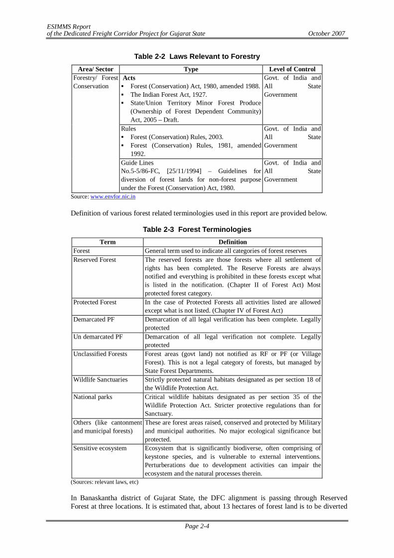
ESIMMS Report of the Dedicated Freight Corridor Project for Gujarat State October 2007
Page 2-4
Table 2-2 Laws Relevant to Forestry Area/ Sector Type Level of Control
Acts Forest (Conservation) Act, 1980, amended 1988. The Indian Forest Act, 1927. State/Union Territory Minor Forest Produce
(Ownership of Forest Dependent Community) Act, 2005 – Draft.
Govt. of India and All State Government
Rules Forest (Conservation) Rules, 2003. Forest (Conservation) Rules, 1981, amended
1992.
Govt. of India and All State Government
Forestry/ Forest Conservation
Guide Lines No.5-5/86-FC, [25/11/1994] – Guidelines for diversion of forest lands for non-forest purpose under the Forest (Conservation) Act, 1980.
Govt. of India and All State Government
Source: www.envfor.nic.in
Definition of various forest related terminologies used in this report are provided below.
Table 2-3 Forest Terminologies Term Definition
Forest General term used to indicate all categories of forest reserves Reserved Forest The reserved forests are those forests where all settlement of
rights has been completed. The Reserve Forests are always notified and everything is prohibited in these forests except what is listed in the notification. (Chapter II of Forest Act) Most protected forest category.
Protected Forest In the case of Protected Forests all activities listed are allowed except what is not listed. (Chapter IV of Forest Act)
Demarcated PF Demarcation of all legal verification has been complete. Legally protected
Un demarcated PF Demarcation of all legal verification not complete. Legally protected
Unclassified Forests Forest areas (govt land) not notified as RF or PF (or Village Forest). This is not a legal category of forests, but managed by State Forest Departments.
Wildlife Sanctuaries Strictly protected natural habitats designated as per section 18 of the Wildlife Protection Act.
National parks Critical wildlife habitats designated as per section 35 of the Wildlife Protection Act. Stricter protective regulations than for Sanctuary.
Others (like cantonment and municipal forests)
These are forest areas raised, conserved and protected by Military and municipal authorities. No major ecological significance but protected.
Sensitive ecosystem Ecosystem that is significantly biodiverse, often comprising of keystone species, and is vulnerable to external interventions. Perturberations due to development activities can impair the ecosystem and the natural processes therein.
(Sources: relevant laws, etc)
In Banaskantha district of Gujarat State, the DFC alignment is passing through Reserved Forest at three locations. It is estimated that, about 13 hectares of forest land is to be diverted
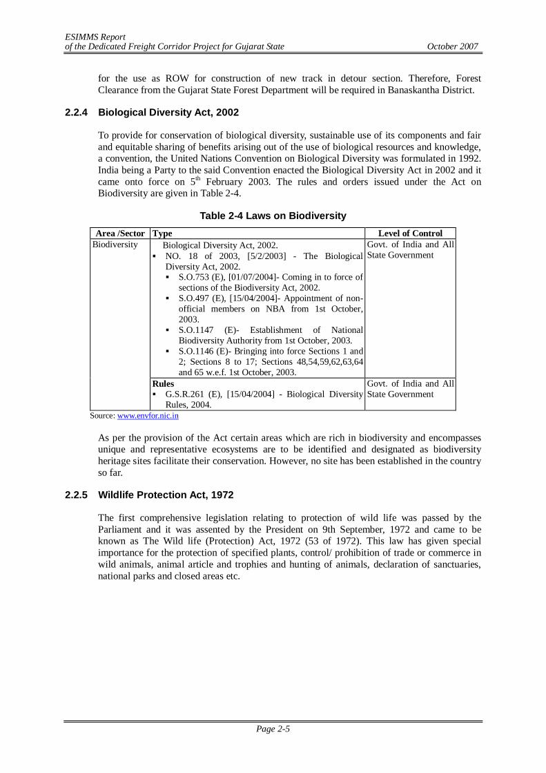
ESIMMS Report of the Dedicated Freight Corridor Project for Gujarat State October 2007
Page 2-5
for the use as ROW for construction of new track in detour section. Therefore, Forest Clearance from the Gujarat State Forest Department will be required in Banaskantha District.
2.2.4 Biological Diversity Act, 2002
To provide for conservation of biological diversity, sustainable use of its components and fair and equitable sharing of benefits arising out of the use of biological resources and knowledge, a convention, the United Nations Convention on Biological Diversity was formulated in 1992. India being a Party to the said Convention enacted the Biological Diversity Act in 2002 and it came onto force on 5th February 2003. The rules and orders issued under the Act on Biodiversity are given in Table 2-4.
Table 2-4 Laws on Biodiversity Area /Sector Type Level of Control
Biological Diversity Act, 2002. NO. 18 of 2003, [5/2/2003] - The Biological
Diversity Act, 2002. S.O.753 (E), [01/07/2004]- Coming in to force of
sections of the Biodiversity Act, 2002. S.O.497 (E), [15/04/2004]- Appointment of non-
official members on NBA from 1st October, 2003.
S.O.1147 (E)- Establishment of National Biodiversity Authority from 1st October, 2003.
S.O.1146 (E)- Bringing into force Sections 1 and 2; Sections 8 to 17; Sections 48,54,59,62,63,64 and 65 w.e.f. 1st October, 2003.
Govt. of India and All State Government
Biodiversity
Rules G.S.R.261 (E), [15/04/2004] - Biological Diversity
Rules, 2004.
Govt. of India and All State Government
Source: www.envfor.nic.in
As per the provision of the Act certain areas which are rich in biodiversity and encompasses unique and representative ecosystems are to be identified and designated as biodiversity heritage sites facilitate their conservation. However, no site has been established in the country so far.
2.2.5 Wildlife Protection Act, 1972
The first comprehensive legislation relating to protection of wild life was passed by the Parliament and it was assented by the President on 9th September, 1972 and came to be known as The Wild life (Protection) Act, 1972 (53 of 1972). This law has given special importance for the protection of specified plants, control/ prohibition of trade or commerce in wild animals, animal article and trophies and hunting of animals, declaration of sanctuaries, national parks and closed areas etc.
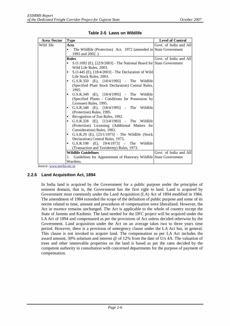
ESIMMS Report of the Dedicated Freight Corridor Project for Gujarat State October 2007
Page 2-6
Table 2-5 Laws on Wildlife Area /Sector Type Level of Control
Acts The Wildlife (Protection) Act, 1972 (amended in
1993 and 2002. )
Govt. of India and All State Government
Rules S.O.1092 (E), [22/9/2003] - The National Board for
Wild Life Rules, 2003. S.O.445 (E), [18/4/2003] - The Declaration of Wild
Life Stock Rules, 2003. G.S.R.350 (E), [18/4/1995] - The Wildlife
(Specified Plant Stock Declaration) Central Rules, 1995.
G.S.R.349 (E), [18/4/1995] - The Wildlife (Specified Plants - Conditions for Possession by Licensee) Rules, 1995.
G.S.R.348 (E), [18/4/1995] - The Wildlife (Protection) Rules, 1995.
Recognition of Zoo Rules, 1992. G.S.R.328 (E), [13/4/1983] - The Wildlife
(Protection) Licensing (Additional Matters for Consideration) Rules, 1983.
G.S.R.29 (E), [25/1/1973] - The Wildlife (Stock Declaration) Central Rules, 1973.
G.S.R.198 (E), [9/4/1973] - The Wildlife (Transaction and Taxidermy) Rules, 1973.
Govt. of India and All State Government
Wild life
Wildlife Guidelines 1. Guidelines for Appointment of Honorary Wildlife Wardens.
Govt. of India and All State Government
Source: www.envfor.nic.in
2.2.6 Land Acquisition Act, 1894
In India land is acquired by the Government for a public purpose under the principles of eminent domain, that is, the Government has the first right to land. Land is acquired by Government most commonly under the Land Acquisition (LA) Act of 1894 modified in 1984. The amendment of 1984 extended the scope of the definition of public purpose and some of its norms related to time, amount and procedures of compensation were liberalized. However, the Act in essence remains unchanged. The Act is applicable to the whole of country except the State of Jammu and Kashmir. The land needed for the DFC project will be acquired under the LA Act of 1894 and compensated as per the provisions of Act unless decided otherwise by the Government. Land acquisition under the Act on an average takes two to three years time period. However, there is a provision of emergency clause under the LA Act but, in general. This clause is not invoked to acquire land. The compensation as per LA Act includes the award amount, 30% solatium and interest @ of 12% from the date of U/s 4A. The valuation of trees and other immovable properties on the land is based as per the rates decided by the competent authority in consultation with concerned departments for the purpose of payment of compensation.
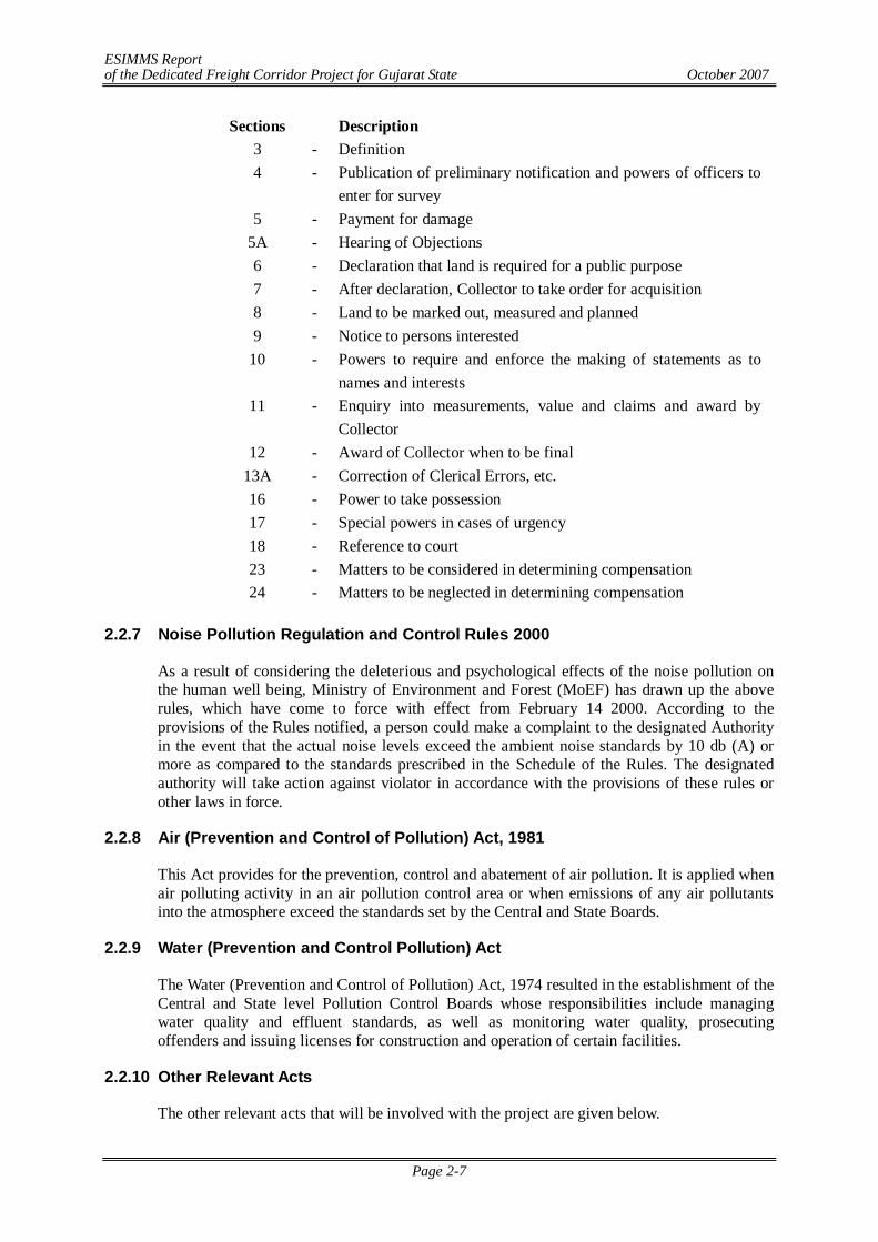
ESIMMS Report of the Dedicated Freight Corridor Project for Gujarat State October 2007
Page 2-7
Sections Description 3 - Definition 4 - Publication of preliminary notification and powers of officers to
enter for survey 5 - Payment for damage
5A - Hearing of Objections 6 - Declaration that land is required for a public purpose 7 - After declaration, Collector to take order for acquisition 8 - Land to be marked out, measured and planned 9 - Notice to persons interested
10 - Powers to require and enforce the making of statements as to names and interests
11 - Enquiry into measurements, value and claims and award by Collector
12 - Award of Collector when to be final 13A - Correction of Clerical Errors, etc. 16 - Power to take possession 17 - Special powers in cases of urgency 18 - Reference to court 23 - Matters to be considered in determining compensation 24 - Matters to be neglected in determining compensation
2.2.7 Noise Pollution Regulation and Control Rules 2000
As a result of considering the deleterious and psychological effects of the noise pollution on the human well being, Ministry of Environment and Forest (MoEF) has drawn up the above rules, which have come to force with effect from February 14 2000. According to the provisions of the Rules notified, a person could make a complaint to the designated Authority in the event that the actual noise levels exceed the ambient noise standards by 10 db (A) or more as compared to the standards prescribed in the Schedule of the Rules. The designated authority will take action against violator in accordance with the provisions of these rules or other laws in force.
2.2.8 Air (Prevention and Control of Pollution) Act, 1981
This Act provides for the prevention, control and abatement of air pollution. It is applied when air polluting activity in an air pollution control area or when emissions of any air pollutants into the atmosphere exceed the standards set by the Central and State Boards.
2.2.9 Water (Prevention and Control Pollution) Act
The Water (Prevention and Control of Pollution) Act, 1974 resulted in the establishment of the Central and State level Pollution Control Boards whose responsibilities include managing water quality and effluent standards, as well as monitoring water quality, prosecuting offenders and issuing licenses for construction and operation of certain facilities.
2.2.10 Other Relevant Acts
The other relevant acts that will be involved with the project are given below.
ESIMMS Report of the Dedicated Freight Corridor Project for Gujarat State October 2007
Page 2-8
Cultural Environment Related Act, 1958
As a result of growing interest in cultural heritage in the nation, both government agencies and NGOs concerned with the preservation and conservation of this heritage have been established. The Archaeological Survey of India (ASI) is the organization working on the protection and conservation of monuments and archeological sites. It is supported in its endeavors by the state Directorate of Archeology. The ASI administers the Ancient Monuments and Archaeological Sites and Remains Act, 1958. According to this act, areas within radii of 100 m and 300 m from the “protected property” are designated as “protected” and “controlled” respectively. No development activity is permitted in the protected area, without prior permission of the GOI. Similarly, certain development (likely to damage the protected property) activities require prior permission from GOI. Conservation for the designated protected monuments/sites/remains is addressed by the existing legislation. However, there are several railway side cultural properties that are not “protected”, but are of significant cultural or religious value to the community. No procedure exists at present for conservation of these “smaller” cultural properties.
Motor Vehicle Act, 1988
In 1988, the Indian Motor Vehicle Act empowered the State Transport Authority to enforce standards for vehicular pollution and prevention control. The authority also checks emission standards of registered vehicles, collects road taxes, and issues licenses. In August 1997, the “Pollution Under Control Certificate” (PUC) programme was launched in an attempt to crackdown on the amount of vehicular emissions in the state. To date it has not been highly effective.
Regulation/Act governing Vibration
There is no prevailing regulation/standard in India governing train induced ground vibrations. Regulations/standards prevailing in other countries such as USA, Japan, and Sweden etc. have been reviewed and compared with the findings of vibration monitoring in its respective chapter. Vibration Regulation Law in Japan issued by Ministry of the Environment, Government of Japan stipulates to preserve living environment and contribute to protection of the people’s health by regulating vibration. As per this law, standards for vibration emitted from specified construction works and limits for motor vehicle vibration have been provided for different land use pattern. As per USA Federal Transit Administration, the criteria for environment impact from ground-borne vibration are based on the maximum root-mean-square (rms) vibration levels for repeated events from same source. Experience based on international standards provides a good foundation for predicting and controlling annoyance from ground-borne vibrations in residential areas as well as interference with vibration-sensitive activities.
Applicable Cross Sectoral Laws
There are a number of laws that are cutting across all sectors and development process of the country. Some of these are directly relevant especially during the construction stage are listed in the Table 2-6.
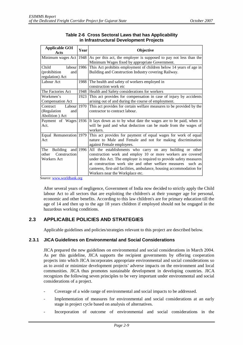
ESIMMS Report of the Dedicated Freight Corridor Project for Gujarat State October 2007
Page 2-9
Table 2-6 Cross Sectoral Laws that has Applicability in Infrastructural Development Projects
Applicable GOI Acts Year Objective
Minimum wages Act 1948 As per this act, the employer is supposed to pay not less than the Minimum Wages fixed by appropriate Government.
Child labour (prohibition and regulation) Act
1986 This Act prohibits employment of children below 14 years of age in Building and Construction Industry covering Railway.
Labour Act 1988 The health and safety of workers employed in construction work etc
The Factories Act 1948 Health and Safety considerations for workers Workmen’s Compensation Act
1923 This act provides for compensation in case of injury by accidents arising out of and during the course of employment.
Contract Labour (Regulation and Abolition ) Act
1970 This act provides for certain welfare measures to be provided by the contractor to contract labour.
Payment of Wages Act.
1936 It lays down as to by what date the wages are to be paid, when it will be paid and what deduction can be made from the wages of workers.
Equal Remuneration Act
1979 This act provides for payment of equal wages for work of equal nature to Male and Female and not for making discrimination against Female employees.
The Building and other Construction Workers Act
1996 All the establishments who carry on any building or other construction work and employ 10 or more workers are covered under this Act. The employer is required to provide safety measures at construction work site and other welfare measures such as canteens, first-aid facilities, ambulance, housing accommodation for Workers near the Workplace etc.
Source: www.worldbank.org After several years of negligence, Government of India now decided to strictly apply the Child labour Act to all sectors that are exploiting the children's at their younger age for personal, economic and other benefits. According to this law children's are for primary education till the age of 14 and then up to the age 18 years children if employed should not be engaged in the hazardous working conditions.
2.3 APPLICABLE POLICIES AND STRATEGIES
Applicable guidelines and policies/strategies relevant to this project are described below.
2.3.1 JICA Guidelines on Environmental and Social Considerations
JICA prepared the new guidelines on environmental and social considerations in March 2004. As per this guideline, JICA supports the recipient governments by offering cooperation projects into which JICA incorporates appropriate environmental and social considerations so as to avoid or minimize development projects’ adverse impacts on the environment and local communities. JICA thus promotes sustainable development in developing countries. JICA recognizes the following seven principles to be very important under environmental and social considerations of a project.
- Coverage of a wide range of environmental and social impacts to be addressed.
- Implementation of measures for environmental and social considerations at an early stage in project cycle based on analysis of alternatives.
- Incorporation of outcome of environmental and social considerations in the
ESIMMS Report of the Dedicated Freight Corridor Project for Gujarat State October 2007
Page 2-10
implementation of projects after cooperation projects is terminated.
- Paying attention to accountability and transparency when implementing cooperation projects.
- Ensuring the meaning participation of stakeholders in order to take consideration of environmental and social factors and to reach consensus accordingly.
- Disclosing information on environmental and social considerations in order to ensure accountability and to promote participation of various stakeholders.
- Capacity building of Organizations to consider environmental and social factors appropriately and effectively at all times.
JICA classifies projects under three categories (A, B and C) according to extent of environmental and social impacts similar to the funding agencies categorization like World Bank, ADB and JBIC. To make this classification, JICA takes into account an outline of the project, the scale, site condition, and environmental impact assessment study scheme in host countries.
As per JICA guidelines, the impacts to be assessed with regard to environmental and social considerations include impacts on human health and safety as well as the natural environment. Impacts on the natural environment include trans-boundary or global-scale impacts through air, water, soil, waste, accidents, water usage, climate change, ecosystems and biodiversity. The impacts to be assessed also include social impacts, which include the migration of populations and involuntary resettlement; local economy such as employment and livelihood; utilization of land and local resources; social institutions such as social infrastructure and local decision-making institutions; existing social infrastructures and services; vulnerable social groups such as the poverty level and indigenous peoples; equality of benefits and losses and equality in development process; gender; children’s rights; cultural heritage; local conflict of interests and infectious diseases such as HIV/AIDS.
In addition to the direct and immediate impacts of projects, derivative, secondary and cumulative impacts are also to be assessed in regard to environmental and social considerations within the extent possible. JICA takes into account the importance of good governance surrounding projects so that measures for appropriate environmental and social considerations are implemented. JICA respects the principles of internationally established human rights standards like the International Convention on Human Rights, and gives special attention to the human rights of vulnerable social groups – including women, peoples, persons with disabilities, and minorities – when implementing cooperation projects. JICA obtains country reports and information issued by related institutions about human rights, and JICA understands local human rights situations by disclosing information about cooperation projects.
When JICA’s assessment differs from the review by JBIC, JICA conveys its own relevant information to Japan Bank for International Corporation (JBIC), and requires JBIC to undertake adequate measures. JICA discloses the information after making inquiries to the recipient governments and related organizations. When significant impacts become clear and JICA judges it difficult to address them, JICA makes recommendations to the Ministry of Foreign Affairs of JAPAN (MOFA) to stop the studies. JICA discloses recommendations after making inquiries to the recipient governments and related organizations.
The present project is committed to address all requirements of JICA guidelines on environmental and social considerations.
ESIMMS Report of the Dedicated Freight Corridor Project for Gujarat State October 2007
Page 2-11
2.3.2 JBIC Guidelines on Environmental and Social Considerations
JBIC established "Japan Bank for International Cooperation Guidelines for Confirmation of Environmental and Social Considerations" on April 1, 2002, as unified guidelines of two environmental guidelines applied to International Financial Operations and Overseas Economic Cooperation Operations respectively. The Guidelines has been implemented from October 1, 2003.
JBIC Guidelines give guiding principles related to environmental consideration by JBIC in its appraisal of a project. They also give the environmental matters to be considered and environmental measures to be prepared by the recipient country in the planning and preparation stages of a project. Projects have been categorized into three basic categories A, B and C depending upon extent of involvement of significant environmental and social issues similar to other funding agencies such as World Bank and ADB.
As per JBIC guideline, projects must, in principle, be undertaken outside protected areas that are specifically designated by laws or ordinances of the government for the conservation of nature or cultural heritage (excluding projects whose primary objectives are to promote the protection or restoration of such designated areas). Projects are also not to impose significant adverse impact on designated conservation areas.
JBIC guidelines focus on participation by stakeholders as local community inhabitants who will be affected by the project. They require the project executor to solicit stakeholders' participation from the project planning stage. The checklist to be confirmed by JBIC now includes social considerations pertaining to resettlement, indigenous people and women. Also more strengthened than in the previous guidelines is a provision on information disclosure. JBIC is required to make public such items as the category classification of the project prior to loan approval.
Projects must be adequately coordinated so that they are accepted in a manner that is socially appropriate to the country and locality in which the project is planned. For projects with a potentially large environmental impact, sufficient consultations with stakeholders, such as local residents, must be conducted via disclosure of information from an early stage where alternative proposals for the project plans may be examined. The outcome of such consultations must be incorporated into the contents of the project plan; Appropriate consideration must be given to vulnerable social groups, such as women, children, the elderly, the poor and ethnic minorities, all of whom are susceptible to environmental and social impact and who may have little access to the decision-making process within society.
Involuntary resettlement and loss of means of livelihood are to be avoided where feasible, exploring all viable alternatives. When, after such examination, it is proved unfeasible, effective measures to minimize impact and to compensate for losses must be agreed upon with the people who will be affected;
People to be resettled involuntarily and people whose means of livelihood will be hindered or lost must be sufficiently compensated and supported by the project proponents, etc. in timely manner. The project proponents, etc. must make efforts to enable the people affected by the project, to improve their standard of living, income opportunities and production levels, or at least to restore them to pre-project levels.
Appropriate participation by the people affected and their communities must be promoted in planning, implementation and monitoring of involuntary resettlement plans and against the loss of their means of livelihood.
ESIMMS Report of the Dedicated Freight Corridor Project for Gujarat State October 2007
Page 2-12
The present study integrated the basic concerns on environmental and social considerations as per the JBIC guidelines.
2.3.3 Asian Development Bank’s (ADB) Environmental Policy
ADB’s Environment Policy has been prepared to address five main challenges:
- the need for environmental interventions to reduce poverty
- the need to mainstream environmental considerations into economic growth and development planning
- the need to maintain regional and global life support systems
- the need to work in partnership with others
- the need to further strengthen the processes and procedures for addressing environmental concerns in ADB’s own operations
The Policy highlights a number of areas that require attention in ADB’s environmental assessment process. It addresses the need for more upstream environmental assessment at the level of country programming, the need for more structured consultation in the conduct of environmental assessments, the need for greater emphasis on monitoring and compliance with environmental requirements during project implementation, and finally the need to view environmental assessment as an ongoing process rather than a one-time event.
Similar to other funding agencies, projects are classified into category A (with potentially significant environmental impacts); category B (with potentially less significant impacts); category C (unlikely to have significant environmental impacts); and a new category, FI, (credit line for subprojects through a financial intermediary, or equity investment in a financial intermediary). A project’s environment assessment category is determined by the category of its most environmentally sensitive component, including both direct and indirect impacts. An IEE is required for category B projects, and an EIA, requiring greater depth of analysis, for category A projects. No environmental assessment is required for category C projects although their environmental implications nevertheless need to be reviewed. The classification scheme helps conserve resources for project preparation, by ensuring that the greatest effort is deployed on projects with potentially the most significant adverse environmental impacts.
As per ADB’s environmental policy, important considerations in preparing the environmental assessment include assessing indirect and cumulative impacts, examining alternatives, achieving environmental standards, designing least-cost mitigation measures, developing appropriate environmental management plans and monitoring requirements, formulating institutional arrangements, and ensuring meaningful public consultation.
The objectives of ADB’s Policy on Involuntary Resettlement (November 1995), are to avoid involuntary resettlement whenever feasible, to minimize resettlement where population displacement is unavoidable, and to ensure that displaced persons receive assistance so that they are at least as well-off as they would have been in the absence of the Project. The policy stipulates three important elements in involuntary resettlement: (i) compensation for lost assets and loss of livelihood and income, (ii) assistance in relocation including provision of relocation sites with appropriate facilities and services, and (iii) assistance with rehabilitation so as to achieve at least the same level of well-being with the Project as before. The policy further specifies that the absence of legal title to land cannot be considered an obstacle to compensation and rehabilitation privileges. All persons affected by the Project, especially the poor, landless, vulnerable, and disadvantaged households should be included in the compensation, transition allowance, and rehabilitation package.
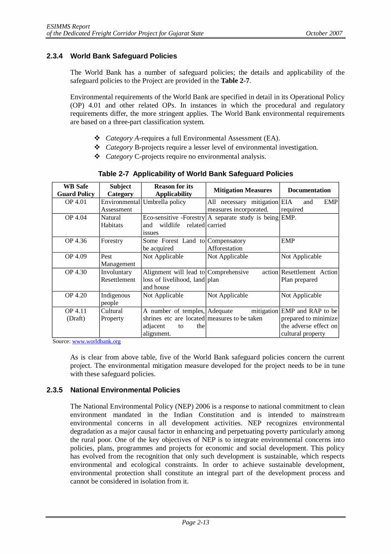
ESIMMS Report of the Dedicated Freight Corridor Project for Gujarat State October 2007
Page 2-13
2.3.4 World Bank Safeguard Policies
The World Bank has a number of safeguard policies; the details and applicability of the safeguard policies to the Project are provided in the Table 2-7.
Environmental requirements of the World Bank are specified in detail in its Operational Policy (OP) 4.01 and other related OPs. In instances in which the procedural and regulatory requirements differ, the more stringent applies. The World Bank environmental requirements are based on a three-part classification system.
Category A-requires a full Environmental Assessment (EA). Category B-projects require a lesser level of environmental investigation. Category C-projects require no environmental analysis.
Table 2-7 Applicability of World Bank Safeguard Policies
WB Safe Guard Policy
Subject Category
Reason for its Applicability Mitigation Measures Documentation
OP 4.01 Environmental Assessment
Umbrella policy All necessary mitigation measures incorporated.
EIA and EMP required
OP 4.04 Natural Habitats
Eco-sensitive -Forestry and wildlife related issues
A separate study is being carried
EMP.
OP 4.36 Forestry Some Forest Land to be acquired
Compensatory Afforestation
EMP
OP 4.09 Pest Management
Not Applicable Not Applicable Not Applicable
OP 4.30 Involuntary Resettlement
Alignment will lead to loss of livelihood, land and house
Comprehensive action plan
Resettlement Action Plan prepared
OP 4.20 Indigenous people
Not Applicable Not Applicable Not Applicable
OP 4.11 (Draft)
Cultural Property
A number of temples, shrines etc are located adjacent to the alignment.
Adequate mitigation measures to be taken
EMP and RAP to be prepared to minimize the adverse effect on cultural property
Source: www.worldbank.org
As is clear from above table, five of the World Bank safeguard policies concern the current project. The environmental mitigation measure developed for the project needs to be in tune with these safeguard policies.
2.3.5 National Environmental Policies
The National Environmental Policy (NEP) 2006 is a response to national commitment to clean environment mandated in the Indian Constitution and is intended to mainstream environmental concerns in all development activities. NEP recognizes environmental degradation as a major causal factor in enhancing and perpetuating poverty particularly among the rural poor. One of the key objectives of NEP is to integrate environmental concerns into policies, plans, programmes and projects for economic and social development. This policy has evolved from the recognition that only such development is sustainable, which respects environmental and ecological constraints. In order to achieve sustainable development, environmental protection shall constitute an integral part of the development process and cannot be considered in isolation from it.
ESIMMS Report of the Dedicated Freight Corridor Project for Gujarat State October 2007
Page 2-14
2.3.6 National Forest Policies
Government of India in the erstwhile Ministry of Food and Agriculture enunciated a National Forest Policy to be followed in the management of State Forests in the country long time back in 1952. However, forests in the country have serious depletion over the years. The need to review the situation and to evolve a new strategy of forest conservation for the future has become imperative. In view of this, National Forest Policy was revised in 1988. The principal aim of new Forest Policy is to ensure environmental stability and maintenance of ecological balance including atmospheric equilibrium which is vital for sustenance of all life forms, human, animal and plant. The derivation of direct economic impact must be subordinated to this principal aim. The policy envisions to enhance the forest coverage of the country to 33% of total geographical area of the country.
2.3.7 Resettlement & Rehabilitation Policy
There is no comprehensive legislation, as yet, at the National or State level that governs the resettlement and rehabilitation of PAPs. Ministry of Rural Development (Department of Land Resources) approved a National Policy on Resettlement and Rehabilitation (NPRR) for PAFs, 2003, published in the Gazette of India on 17th February 2004. It recognizes the following essential features:
- That PAFs not only lose their lands, other assets and livelihoods, they also experience adverse psychological and social/cultural consequences;
- The need to minimize large-scale displacement and where displacement is inevitable, resettlement and rehabilitation has to be handled with utmost care. This is especially necessary for tribal, small and marginal farmers and women;
- That cash compensation alone is often inadequate to replace lost agricultural land, homesteads and other resources. Landless laborers, forest dwellers, tenants, artisans are not eligible for cash compensation;
- The need to provide relief especially to the rural poor (with no assets), small and marginal farmers, SCs/ STs and women;
- The importance of dialogue between PAFs and the administration responsible for resettlement for smoother implementation of projects and R &R.
- The policy is in the form of broad guidelines and executive instructions and will be applicable to projects displacing 500 families or more in plain areas and 250 families or more in hilly areas.
The NPRR does not meet some of the International Funding Agencies (World Bank, ADB etc.) resettlement policy's key requirements. Firstly, the NPRR states that in acquisitions for highways, railway lines, transmission lines and pipelines, project affected families will be offered an ex-gratia payment of Rs 10,000 and no other resettlement and rehabilitation benefits. Secondly, the cut-off numbers of affected persons for whom World Bank requires resettlement plans are much lower. Thirdly, replacement value is not clearly defined and more importantly is not taken into account in the various lump-sum compensation payments that have been decreed in the policy. Fourthly, no specific entitlements have been provided for untitled persons such as squatters and encroachers. However, the policy does recognize some significant principles. It requires projects to (a) minimize displacement and to identify non-displacing or least-displacing alternatives; (b) plan the resettlement and rehabilitation of PAPs including special needs of tribal and vulnerable sections; (c) provide a better standard of living to PAFs; and (d) facilitate harmonious relationships between the requiring body and PAFs through mutual cooperation. A National Monitoring Committee will be set up comprising the Secretary Land Resources (Chair), Secretary Planning Commission, Secretary Social Justice
ESIMMS Report of the Dedicated Freight Corridor Project for Gujarat State October 2007
Page 2-15
and, Secretary Water Resources, Secretary Tribal Affairs, Secretary Railways, Secretary Power and Secretary Coal. In addition a National Monitoring Cell will be established in the Department of Land Resources in the Ministry of Rural Development under a Joint Secretary, assisted by zonal directors, subject matter specialists, deputy directors and other support staff.
In view of many deficiencies identified in NPRR, a new National Rehabilitation Policy has been formulated after reviewing the NPRR many times. The new NPRR has been cleared by the union cabinet very recently on 11th October 2007. The Government of India now plans to give the policy Statutory Status by amending Land Acquisition Act, 1894.
R & R under Current Project
Resettlement & Rehabilitation Framework for this project has been elaborated and subjected to the objectives and the scope of following guidelines and policies.
National Policy on Resettlement & Rehabilitation 2007 JICA Guidelines JBIC Guidelines World bank Safeguard Policies ADB Environmental Policies
Entitlement framework for this project has been recommended derived from specific project requirement identified by a baseline socio-economic census and exhaustive community consultation sessions. Considerable references were made to the earlier R&R experiences from the Railway project financed by ADB and other best-demonstrated practices in Gujarat and India.
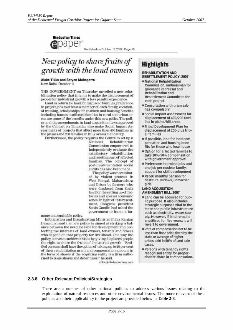
ESIMMS Report of the Dedicated Freight Corridor Project for Gujarat State October 2007
Page 2-16
2.3.8 Other Relevant Policies/Strategies
There are a number of other national policies to address various issues relating to the exploitation of natural resources and other environmental issues. The more relevant of these policies and their applicability to the project are provided below in Table 2-8.
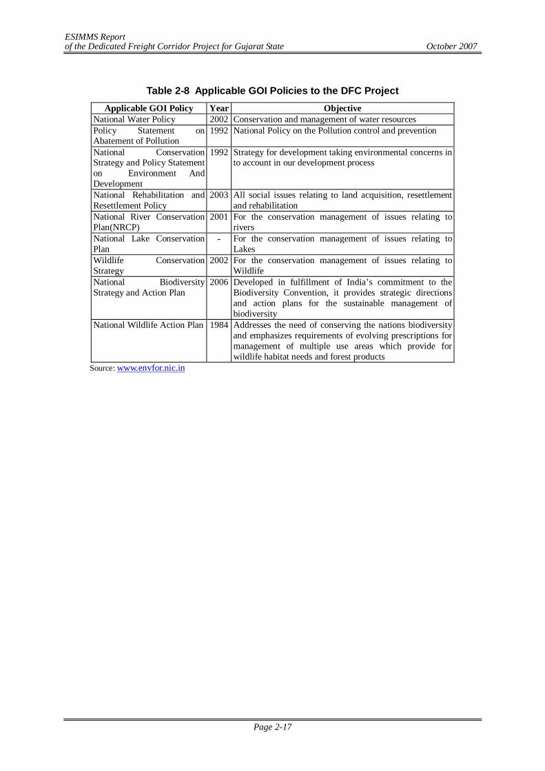
ESIMMS Report of the Dedicated Freight Corridor Project for Gujarat State October 2007
Page 2-17
Table 2-8 Applicable GOI Policies to the DFC Project
Applicable GOI Policy Year Objective National Water Policy 2002 Conservation and management of water resources Policy Statement on Abatement of Pollution
1992 National Policy on the Pollution control and prevention
National Conservation Strategy and Policy Statement on Environment And Development
1992 Strategy for development taking environmental concerns in to account in our development process
National Rehabilitation and Resettlement Policy
2003 All social issues relating to land acquisition, resettlement and rehabilitation
National River Conservation Plan(NRCP)
2001 For the conservation management of issues relating to rivers
National Lake Conservation Plan
- For the conservation management of issues relating to Lakes
Wildlife Conservation Strategy
2002 For the conservation management of issues relating to Wildlife
National Biodiversity Strategy and Action Plan
2006 Developed in fulfillment of India’s commitment to the Biodiversity Convention, it provides strategic directions and action plans for the sustainable management of biodiversity
National Wildlife Action Plan 1984 Addresses the need of conserving the nations biodiversity and emphasizes requirements of evolving prescriptions for management of multiple use areas which provide for wildlife habitat needs and forest products
Source: www.envfor.nic.in
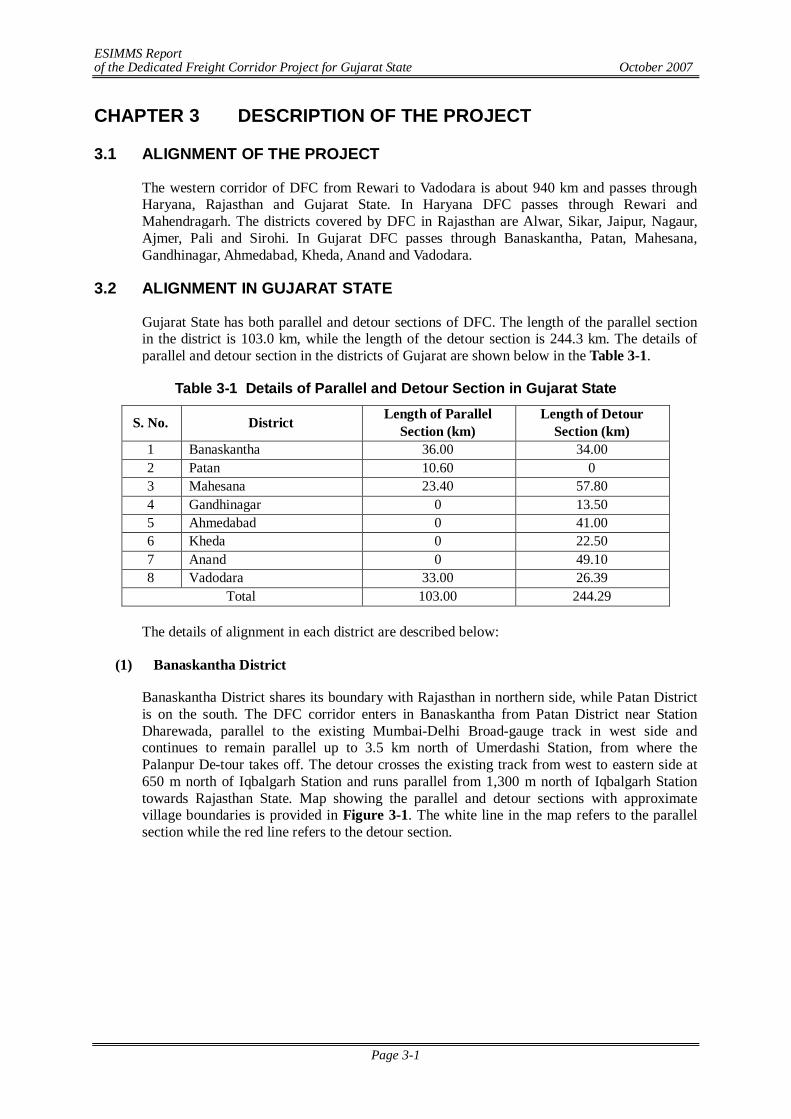
ESIMMS Report of the Dedicated Freight Corridor Project for Gujarat State October 2007
Page 3-1
CHAPTER 3 DESCRIPTION OF THE PROJECT
3.1 ALIGNMENT OF THE PROJECT
The western corridor of DFC from Rewari to Vadodara is about 940 km and passes through Haryana, Rajasthan and Gujarat State. In Haryana DFC passes through Rewari and Mahendragarh. The districts covered by DFC in Rajasthan are Alwar, Sikar, Jaipur, Nagaur, Ajmer, Pali and Sirohi. In Gujarat DFC passes through Banaskantha, Patan, Mahesana, Gandhinagar, Ahmedabad, Kheda, Anand and Vadodara.
3.2 ALIGNMENT IN GUJARAT STATE
Gujarat State has both parallel and detour sections of DFC. The length of the parallel section in the district is 103.0 km, while the length of the detour section is 244.3 km. The details of parallel and detour section in the districts of Gujarat are shown below in the Table 3-1.
Table 3-1 Details of Parallel and Detour Section in Gujarat State
S. No. District Length of Parallel Section (km)
Length of Detour Section (km)
1 Banaskantha 36.00 34.00 2 Patan 10.60 0 3 Mahesana 23.40 57.80 4 Gandhinagar 0 13.50 5 Ahmedabad 0 41.00 6 Kheda 0 22.50 7 Anand 0 49.10 8 Vadodara 33.00 26.39
Total 103.00 244.29
The details of alignment in each district are described below:
(1) Banaskantha District
Banaskantha District shares its boundary with Rajasthan in northern side, while Patan District is on the south. The DFC corridor enters in Banaskantha from Patan District near Station Dharewada, parallel to the existing Mumbai-Delhi Broad-gauge track in west side and continues to remain parallel up to 3.5 km north of Umerdashi Station, from where the Palanpur De-tour takes off. The detour crosses the existing track from west to eastern side at 650 m north of Iqbalgarh Station and runs parallel from 1,300 m north of Iqbalgarh Station towards Rajasthan State. Map showing the parallel and detour sections with approximate village boundaries is provided in Figure 3-1. The white line in the map refers to the parallel section while the red line refers to the detour section.
ESIMMS Report of the Dedicated Freight Corridor Project for Gujarat State October 2007
Page 3-2
The list of stations en-route is provided in Table 3-2.
Table 3-2 List of Stations in Banaskantha District S. N. Name of Stations Northing Easting
1 Dharewada 23°58'3.99"N 72°22'51.04"E 2 Chappi 24° 2'8.11"N 72°24'2.27"E 3 Umardashi 24° 5'59.78"N 72°25'12.46"E 4 Palanpur 24°10'35.62"N 72°25'51.66"E 5 Karjora 24°13'14.72"N 72°27'24.86"E 6 Chitrasani 24°15'48.22"N 72°29'6.73"E 7 Jethi 24°17'47.75"N 72°30'33.61"E 8 Iqbalgarh 24°20'49.94"N 72°32'4.72"E 9 Satotra Road 24°22'43.10"N 72°35'45.85"E
10 Amirgarh 24°24'16.67"N 72°38'31.42"E Source: JICA Study Team
(2) Patan District
The proposed DFC corridor runs parallel to the existing track on the western side throughout the Patan District. The length of the track within the district is approximately 10.6 km. The district shares its boundary with Mehasana District on the south and Banaskantha District in the north. The DFC corridor enters in Patan District from Mehasana District at about 1.6 km north of Station Kamli, parallel to the existing Mumbai-Delhi Broad-gauge track in west side. It runs parallel to the existing track towards north till the end of the district boundary and enters in Banaskantha District close to Dharewada Station. Map showing proposed DFC track with approximate village boundaries is provided in Figure 3-2. The white line in the map refers to the proposed DFC corridor in Parallel Section.
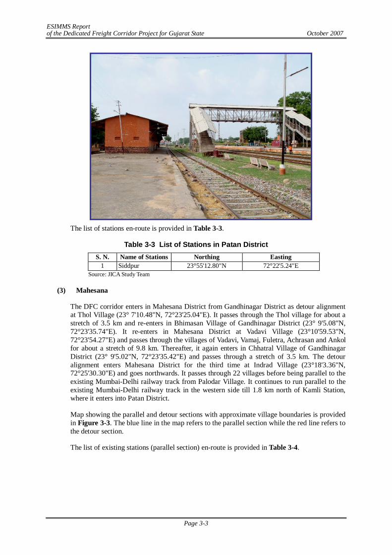
ESIMMS Report of the Dedicated Freight Corridor Project for Gujarat State October 2007
Page 3-3
The list of stations en-route is provided in Table 3-3.
Table 3-3 List of Stations in Patan District S. N. Name of Stations Northing Easting
1 Siddpur 23°55'12.80"N 72°22'5.24"E Source: JICA Study Team
(3) Mahesana
The DFC corridor enters in Mahesana District from Gandhinagar District as detour alignment at Thol Village (23° 7'10.48"N, 72°23'25.04"E). It passes through the Thol village for about a stretch of 3.5 km and re-enters in Bhimasan Village of Gandhinagar District (23° 9'5.08"N, 72°23'35.74"E). It re-enters in Mahesana District at Vadavi Village (23°10'59.53"N, 72°23'54.27"E) and passes through the villages of Vadavi, Vamaj, Fuletra, Achrasan and Ankol for about a stretch of 9.8 km. Thereafter, it again enters in Chhatral Village of Gandhinagar District (23° 9'5.02"N, 72°23'35.42"E) and passes through a stretch of 3.5 km. The detour alignment enters Mahesana District for the third time at Indrad Village (23°18'3.36"N, 72°25'30.30"E) and goes northwards. It passes through 22 villages before being parallel to the existing Mumbai-Delhi railway track from Palodar Village. It continues to run parallel to the existing Mumbai-Delhi railway track in the western side till 1.8 km north of Kamli Station, where it enters into Patan District.
Map showing the parallel and detour sections with approximate village boundaries is provided in Figure 3-3. The blue line in the map refers to the parallel section while the red line refers to the detour section.
The list of existing stations (parallel section) en-route is provided in Table 3-4.
ESIMMS Report of the Dedicated Freight Corridor Project for Gujarat State October 2007
Page 3-4
Table 3-4 List of Stations in Mahesana District S. N. Name of Stations Northing Easting
1 Kamli 23°51'40.44"N 72°22'33.11"E 2 Unjha 23°47'53.45"N 72°22'53.51"E 3 Unava Aithor 23°45'11.22"N 72°23'8.36"E 4 Bhandu Moti Dau 23°41'21.32"N 72°23'26.70"E
Source: JICA Study Team
(4) Gandhinagar
The entire stretch of DFC alignment in Gandhinagar District is a part of Ahmedabad detour. The alignment passes through the western most villages of Gandhinagar District bordering Mahesana District and frequently goes in and out of Gandhinagar District.
The district shares its borders with Mahesana District on west and north, and with Ahmedabad District on the south. The alignment enters Gandhinagar District at Unali Village (23° 3'58.39"N, 72°24'47.30"E) and passes through Unali, Rancharada, Nasmed and Adhana Villages before entering into Mahesana.
After going through a stretch of 3.5 km in Mahesana District, the alignment re-enters in Gandhinagar District at Bhimasan Village (23° 9'5.08"N, 72°23'35.74"E). After passing through the villages of Bhimasan and Hajipur, it again enters into Mahesana District and goes through a stretch of 9.8 km. Thereafter, it enters Gandhinagar District for third time at Chhatral Village (23° 9'5.02"N, 72°23'35.42"E) and passes through Chhatral and Dhanot Villages before entering into Mahesana District finally.
Map showing proposed DFC track with approximate village boundaries is provided in Figure3-4.
(5) Ahmedabad
The entire stretch of DFC alignment in Ahmedabad District is a part of Ahmedabad detour. The district shares its borders with Gandhinagar District on north, and with Kheda District on the south. The alignment enters Ahmedabad District from Kheda District at Sathal Village (22°44'28.44"N, 72°31'54.94"E) and runs for a stretch of 41 km through 18 villages before entering into Gandhinagar District at Garodia Village (23° 3'58.39"N, 72°24'47.30"E).
Map showing proposed DFC track with approximate village boundaries is provided in Figure 3-5.
(6) Kheda
The entire stretch of DFC alignment in Kheda District is a part of Ahmedabad detour. The district shares its borders with Ahmedabad District on West and North, and with Anand District on the South. River Sabarmati acts as the north-western boundary of the district. The alignment enters Kheda District at Khandhli Village (22°37'42.33"N, 72°41'21.42"E) and passes though a stretch of 22.5 km before entering into Ahmedabad District at Kaloli Village (22°44'28.44"N, 72°31'54.94"E). Map showing proposed DFC track with approximate village boundaries is provided in Figure 3-6.
(7) Anand
The entire stretch of DFC alignment in Anand District is a part of Ahmedabad detour. The district shares its borders with Kheda District on North and with Vadodara District on the
ESIMMS Report of the Dedicated Freight Corridor Project for Gujarat State October 2007
Page 3-5
South. River Mahi acts as the south-eastern boundary of the district. The alignment enters Anand District at Amrol Village (22°22'28.59"N, 73° 3'15.96"E) and passes though a stretch of 49.1 km before entering into Kheda District after Badkhad Village (22°37'42.11"N, 72°41'21.30"E). Map showing proposed DFC track with approximate village boundaries is provided in Figure 3-7.
(8) Vadodara
Vadodara District shares its boundary with Anand in northern side, while Bharuch District is on the south. River Mahi acts as the boundary between Vadodara and Anand Districts.
The DFC corridor enters in Vadodara from Bharuch District at about 2.5 km north of station Varediya. It passes through two villages of Vadodara District for about a stretch of 2.7 km and re-enters into Bharuch District. It passes through a short stretch of 1.90 km and re-enters in Vadodara District at Mankan Village at about 705 m north of Palej Station.
The DFC alignment in Vadodara District run parallel to the existing Mumbai-Delhi broad gauge railway track from its entry near Varediya Station up to 3.8 km north of Varnama station, from where the Ahmedabad detour takes off. The detour alignment gradually moves to the west of the existing Mumbai-Delhi railway track. The aerial distance between the farthest point of the detour route with the existing track is about 11.5 km.
Map showing the parallel and detour sections with approximate village boundaries is provided in Figure 3-8. The blue line in the map refers to the parallel section while the red line refers to the detour section.
The list of existing stations (parallel sections) en-route is provided in Table 3-5.
Table 3-5 List of Stations in Vadodara District S. N. Name of Stations Northing Easting
1 Lakodra 21°59'0.60"N 73° 5'43.76"E 2 Miyagam Karjan Jn 22° 3'6.52"N 73° 7'14.45"E 3 Itola 22° 9'2.89"N 73° 9'26.12"E 4 Varnama 22°10'59.75"N 73°10'9.36"E
Source: JICA Study Team 3.3 CONSTRUCTION WIDTH
The construction width of DFC in sections running parallel to the existing Mumbai-Delhi broad-gauge railway tracks is 25 m. In detour sections, the proposed construction width is 45m. However, the width of the land may vary depending on the height of embankments in low lying areas.
3.4 VILLAGES EN-ROUTE
(1) Banaskantha
In Banaskantha District, the alignment is passing through 31 villages. About 15 villages will be affected by the parallel section while 14 villages will be affected by the detour section. 2 villages are affected by both parallel and de-tour section. The list of affected villages by parallel and detour section are provided in Table 3-6. Out of the 31 affected villages, 11 villages belong to Amirgarh Taluka, 14 villages belong to Palanpur Taluka and 6 villages belong to Vadgam Taluka.
ESIMMS Report of the Dedicated Freight Corridor Project for Gujarat State October 2007
Page 3-6
Table 3-6 List of Affected Villages in Banaskantha District Affected By Section SN Taluka Village
Parallel Detour 1 Amirgadh 2 Dungarpura 3 Kirotar 4 Jorapura 5 Dhanpura 6 Dholia 7 Juni Roh Sarothi 8 Zanzarvav
8 villages
9 Iqbalgarh 10 Jethi 11
Amirgadh
Bantawada 12 Pirojpura 13 Antroli 14 Malana 15 Rajpur 16 Pakhanava 17 Moriya 18 Parpada 19 Palanpur 20 Chadotar 21 Akesan 22 Gathaman 23 Jagana
16 villages
24 Sedrasana 25
Palanpur
Jasleni 26 Malosana 27 Majadar 28 Kotadi 29 Teniwada 30 Manpura 31
Vadgam
Dharewada
9 villages
Code Affected Villages
Source: Census of India Map and field study
The DFC alignment passes mostly through the agricultural land, except the villages of Iqbalgarh, Kirotar, Majadar, Antroli and Jagana where a few residential and commercial structures will be affected. Details of villages with affected number of structures are provided in Table 3-7.
Table 3-7 List of Villages with Affected Structures S. N. Village DFC Section No of Structures
1 Majadar Parallel 14 2 Gathaman De-tour 1 3 Pakhanwa De-tour 1 4 Antroli De-tour 10 5 Iqbalgarh De-tour 3 6 Kirotar Parallel 1
Total: 6 Villages 30 Source: Field Survey
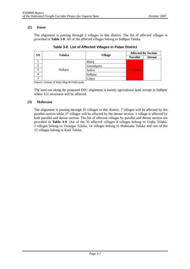
ESIMMS Report of the Dedicated Freight Corridor Project for Gujarat State October 2007
Page 3-7
(2) Patan
The alignment is passing through 5 villages in this district. The list of affected villages is provided in Table 3-8. All of the affected villages belong to Sidhpur Taluka.
Table 3-8 List of Affected Villages in Patan District Affected By Section SN Taluka Village
Parallel Detour 1 Maloj 2 Ganeshpura 3 Ankvi 4 Sidhpur 5
Sidhpur
Lalpur
5 villages
Source: Census of India Map & Field study
The land use along the proposed DFC alignment is mainly agricultural land, except in Sidhpur where 151 structures will be affected.
(3) Mahesana
The alignment is passing through 35 villages in this district. 7 villages will be affected by the parallel section while 27 villages will be affected by the detour section. 1 village is affected by both parallel and detour section. The list of affected villages by parallel and detour section are provided in Table 3-9. Out of the 35 affected villages 4 villages belong to Unjha Taluka, 2 villages belong to Visnagar Taluka, 14 villages belong to Mahesana Taluka and rest of the 15 villages belong to Kadi Taluka.
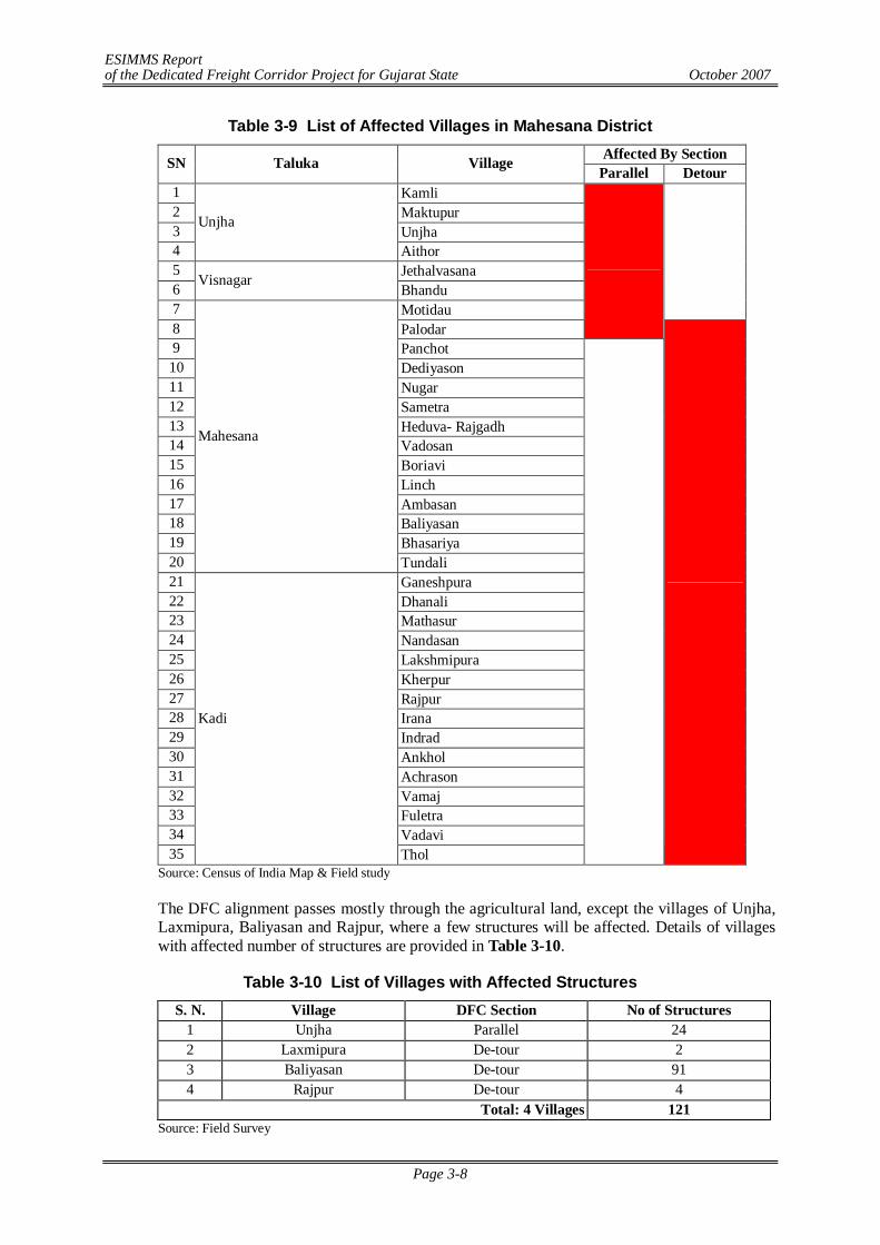
ESIMMS Report of the Dedicated Freight Corridor Project for Gujarat State October 2007
Page 3-8
Table 3-9 List of Affected Villages in Mahesana District Affected By Section SN Taluka Village
Parallel Detour 1 Kamli 2 Maktupur 3 Unjha 4
Unjha
Aithor 5 Jethalvasana 6 Visnagar
Bhandu 7 Motidau
8 Palodar
9 Panchot 10 Dediyason 11 Nugar 12 Sametra 13 Heduva- Rajgadh 14 Vadosan 15 Boriavi 16 Linch 17 Ambasan 18 Baliyasan 19 Bhasariya 20
Mahesana
Tundali 21 Ganeshpura 22 Dhanali 23 Mathasur 24 Nandasan 25 Lakshmipura 26 Kherpur 27 Rajpur 28 Irana 29 Indrad 30 Ankhol 31 Achrason 32 Vamaj 33 Fuletra 34 Vadavi 35
Kadi
Thol
Source: Census of India Map & Field study
The DFC alignment passes mostly through the agricultural land, except the villages of Unjha, Laxmipura, Baliyasan and Rajpur, where a few structures will be affected. Details of villages with affected number of structures are provided in Table 3-10.
Table 3-10 List of Villages with Affected Structures S. N. Village DFC Section No of Structures
1 Unjha Parallel 24 2 Laxmipura De-tour 2 3 Baliyasan De-tour 91 4 Rajpur De-tour 4
Total: 4 Villages 121 Source: Field Survey
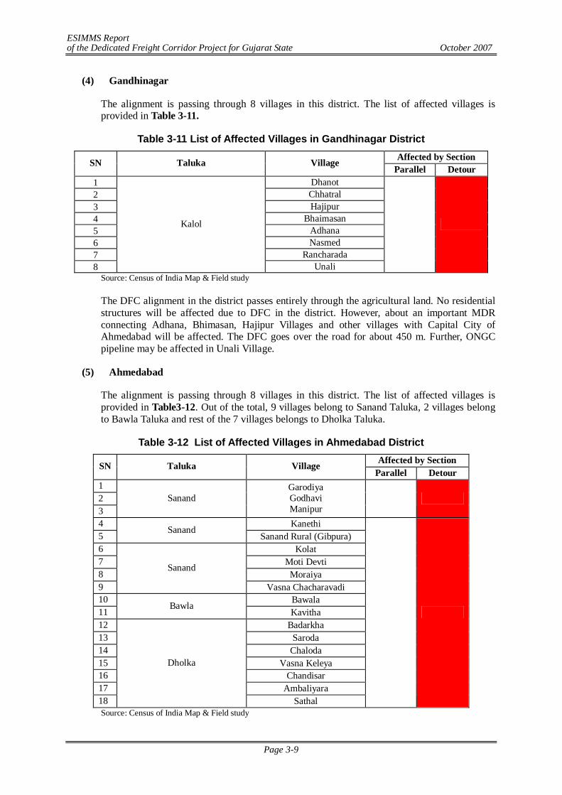
ESIMMS Report of the Dedicated Freight Corridor Project for Gujarat State October 2007
Page 3-9
(4) Gandhinagar
The alignment is passing through 8 villages in this district. The list of affected villages is provided in Table 3-11.
Table 3-11 List of Affected Villages in Gandhinagar District Affected by Section SN Taluka Village
Parallel Detour 1 Dhanot 2 Chhatral 3 Hajipur 4 Bhaimasan 5 Adhana 6 Nasmed 7 Rancharada 8
Kalol
Unali
Source: Census of India Map & Field study
The DFC alignment in the district passes entirely through the agricultural land. No residential structures will be affected due to DFC in the district. However, about an important MDR connecting Adhana, Bhimasan, Hajipur Villages and other villages with Capital City of Ahmedabad will be affected. The DFC goes over the road for about 450 m. Further, ONGC pipeline may be affected in Unali Village.
(5) Ahmedabad
The alignment is passing through 8 villages in this district. The list of affected villages is provided in Table3-12. Out of the total, 9 villages belong to Sanand Taluka, 2 villages belong to Bawla Taluka and rest of the 7 villages belongs to Dholka Taluka.
Table 3-12 List of Affected Villages in Ahmedabad District Affected by Section SN Taluka Village
Parallel Detour 1 2 3
Sanand Garodiya Godhavi Manipur
4 Kanethi 5
Sanand Sanand Rural (Gibpura)
6 Kolat 7 Moti Devti 8 Moraiya 9
Sanand
Vasna Chacharavadi 10 Bawala 11
Bawla Kavitha
12 Badarkha 13 Saroda 14 Chaloda 15 Vasna Keleya 16 Chandisar 17 Ambaliyara 18
Dholka
Sathal
Source: Census of India Map & Field study
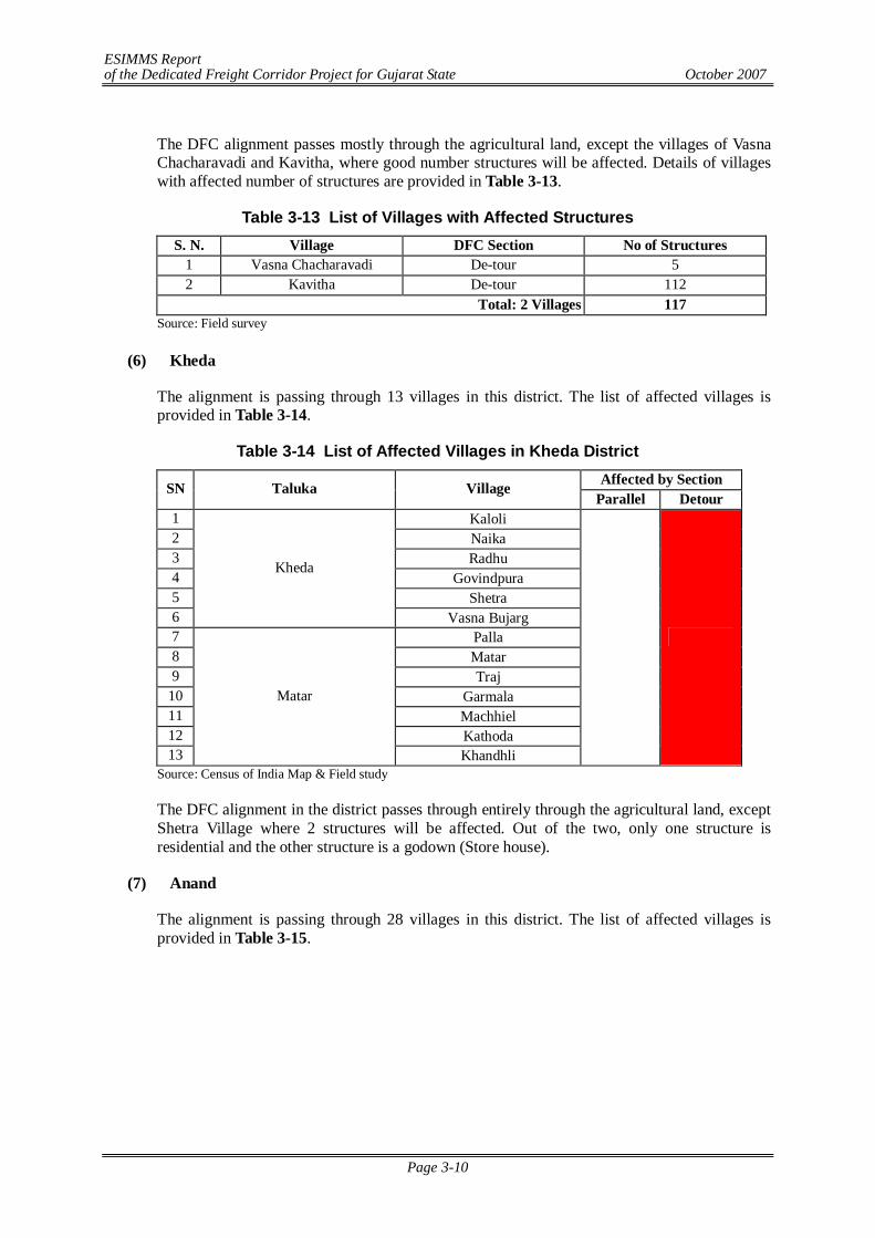
ESIMMS Report of the Dedicated Freight Corridor Project for Gujarat State October 2007
Page 3-10
The DFC alignment passes mostly through the agricultural land, except the villages of Vasna Chacharavadi and Kavitha, where good number structures will be affected. Details of villages with affected number of structures are provided in Table 3-13.
Table 3-13 List of Villages with Affected Structures S. N. Village DFC Section No of Structures
1 Vasna Chacharavadi De-tour 5 2 Kavitha De-tour 112
Total: 2 Villages 117 Source: Field survey
(6) Kheda
The alignment is passing through 13 villages in this district. The list of affected villages is provided in Table 3-14.
Table 3-14 List of Affected Villages in Kheda District Affected by Section SN Taluka Village
Parallel Detour 1 Kaloli 2 Naika 3 Radhu 4 Govindpura 5 Shetra 6
Kheda
Vasna Bujarg 7 Palla 8 Matar 9 Traj
10 Garmala 11 Machhiel 12 Kathoda 13
Matar
Khandhli
Source: Census of India Map & Field study
The DFC alignment in the district passes through entirely through the agricultural land, except Shetra Village where 2 structures will be affected. Out of the two, only one structure is residential and the other structure is a godown (Store house).
(7) Anand
The alignment is passing through 28 villages in this district. The list of affected villages is provided in Table 3-15.
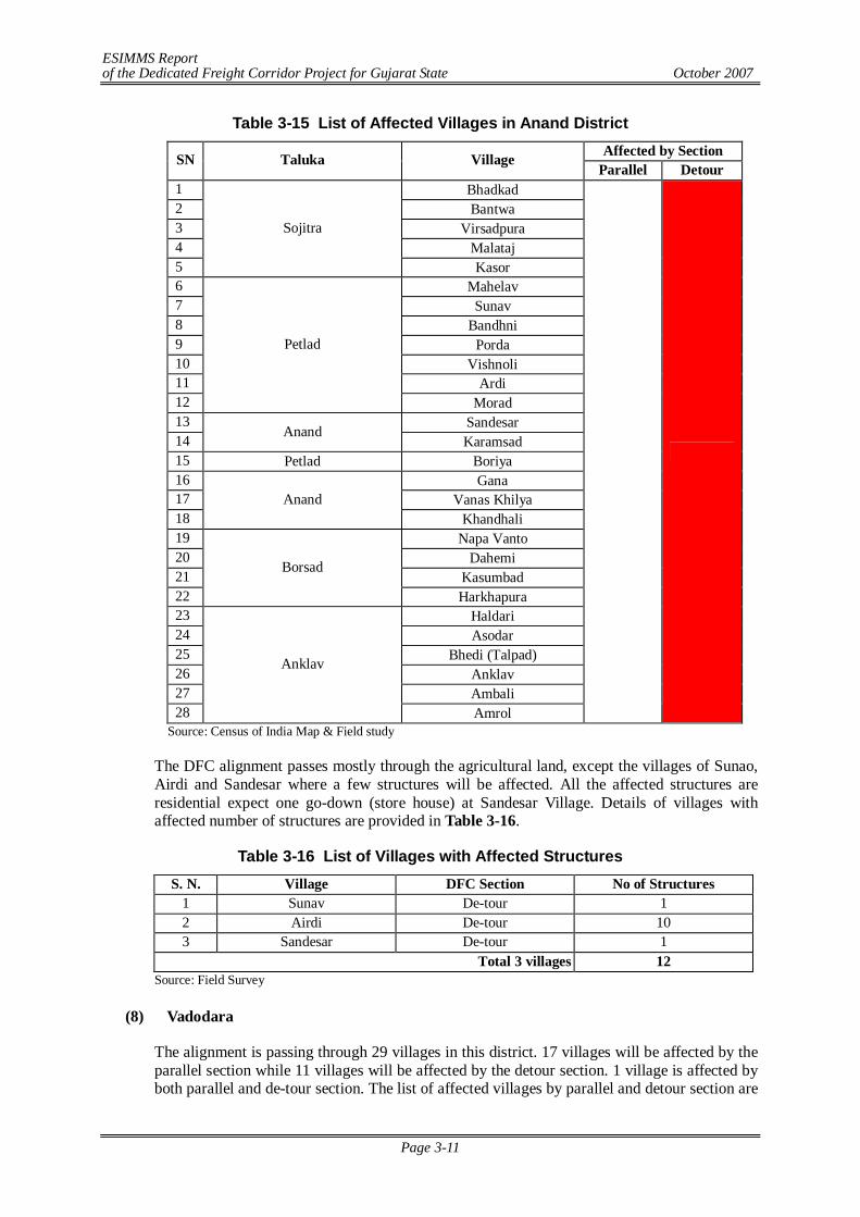
ESIMMS Report of the Dedicated Freight Corridor Project for Gujarat State October 2007
Page 3-11
Table 3-15 List of Affected Villages in Anand District Affected by Section SN Taluka Village
Parallel Detour 1 Bhadkad 2 Bantwa 3 Virsadpura 4 Malataj 5
Sojitra
Kasor 6 Mahelav 7 Sunav 8 Bandhni 9 Porda 10 Vishnoli 11 Ardi 12
Petlad
Morad 13 Sandesar 14 Anand
Karamsad 15 Petlad Boriya 16 Gana 17 Vanas Khilya 18
Anand Khandhali
19 Napa Vanto 20 Dahemi 21 Kasumbad 22
Borsad
Harkhapura 23 Haldari 24 Asodar 25 Bhedi (Talpad) 26 Anklav 27 Ambali 28
Anklav
Amrol
Source: Census of India Map & Field study
The DFC alignment passes mostly through the agricultural land, except the villages of Sunao, Airdi and Sandesar where a few structures will be affected. All the affected structures are residential expect one go-down (store house) at Sandesar Village. Details of villages with affected number of structures are provided in Table 3-16.
Table 3-16 List of Villages with Affected Structures S. N. Village DFC Section No of Structures
1 Sunav De-tour 1 2 Airdi De-tour 10 3 Sandesar De-tour 1
Total 3 villages 12 Source: Field Survey
(8) Vadodara
The alignment is passing through 29 villages in this district. 17 villages will be affected by the parallel section while 11 villages will be affected by the detour section. 1 village is affected by both parallel and de-tour section. The list of affected villages by parallel and detour section are
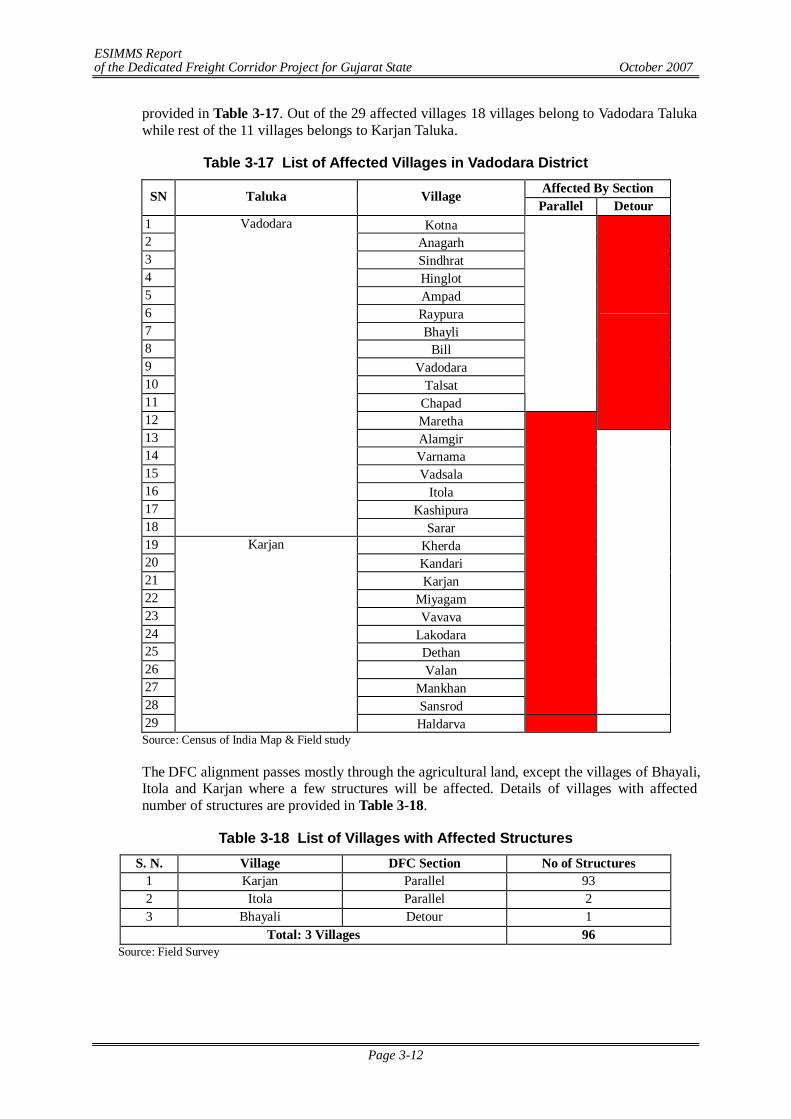
ESIMMS Report of the Dedicated Freight Corridor Project for Gujarat State October 2007
Page 3-12
provided in Table 3-17. Out of the 29 affected villages 18 villages belong to Vadodara Taluka while rest of the 11 villages belongs to Karjan Taluka.
Table 3-17 List of Affected Villages in Vadodara District Affected By Section SN Taluka Village
Parallel Detour 1 Kotna 2 Anagarh 3 Sindhrat 4 Hinglot 5 Ampad 6 Raypura 7 Bhayli 8 Bill 9 Vadodara 10 Talsat 11 Chapad
12 Maretha
13 Alamgir 14 Varnama 15 Vadsala 16 Itola 17 Kashipura 18
Vadodara
Sarar 19 Kherda 20 Kandari 21 Karjan 22 Miyagam 23 Vavava 24 Lakodara 25 Dethan 26 Valan 27 Mankhan 28 Sansrod
29
Karjan
Haldarva Source: Census of India Map & Field study
The DFC alignment passes mostly through the agricultural land, except the villages of Bhayali, Itola and Karjan where a few structures will be affected. Details of villages with affected number of structures are provided in Table 3-18.
Table 3-18 List of Villages with Affected Structures S. N. Village DFC Section No of Structures
1 Karjan Parallel 93 2 Itola Parallel 2 3 Bhayali Detour 1
Total: 3 Villages 96 Source: Field Survey
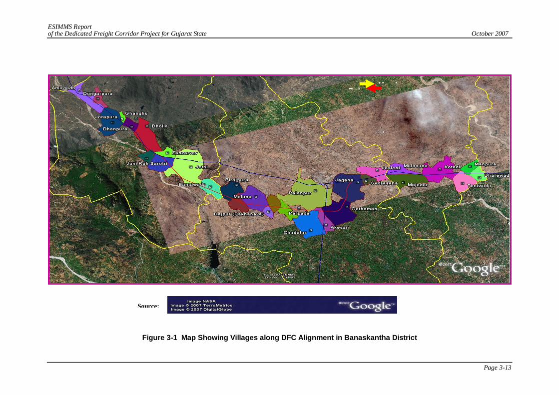
ESIMMS Report of the Dedicated Freight Corridor Project for Gujarat State October 2007
Page 3-13
Figure 3-1 Map Showing Villages along DFC Alignment in Banaskantha District
MumbDel
Source:
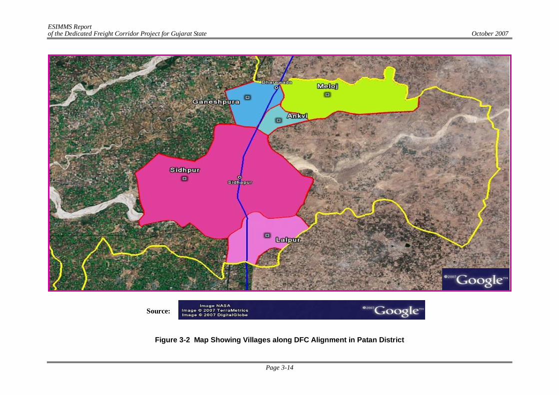
ESIMMS Report of the Dedicated Freight Corridor Project for Gujarat State October 2007
Page 3-14
Figure 3-2 Map Showing Villages along DFC Alignment in Patan District
Source:
ESIMMS Report of the Dedicated Freight Corridor Project for Gujarat State October 2007
Page 3-15
Figure 3-3 Map Showing Villages along DFC Alignment in Mahesana District
Source:
ESIMMS Report of the Dedicated Freight Corridor Project for Gujarat State October 2007
Page 3-16
Figure 3-4 Map Showing Villages along DFC Alignment in Gandhinagar District
Source:
ESIMMS Report of the Dedicated Freight Corridor Project for Gujarat State October 2007
Page 3-17
Figure 3-5 Map Showing Villages along DFC Alignment in Ahmedabad District
Source:
ESIMMS Report of the Dedicated Freight Corridor Project for Gujarat State October 2007
Page 3-18
Figure 3-6 Map Showing Villages along DFC Alignment in Kheda District
Source:
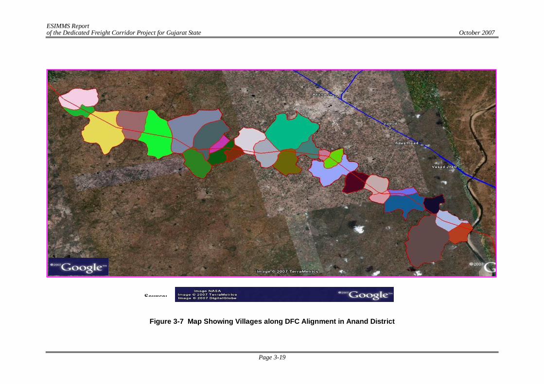
ESIMMS Report of the Dedicated Freight Corridor Project for Gujarat State October 2007
Page 3-19
Figure 3-7 Map Showing Villages along DFC Alignment in Anand District
Source:
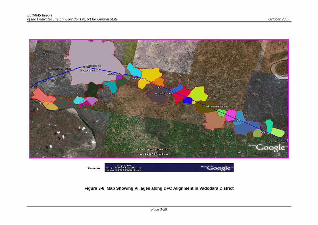
ESIMMS Report of the Dedicated Freight Corridor Project for Gujarat State October 2007
Page 3-20
Figure 3-8 Map Showing Villages along DFC Alignment in Vadodara District
Source:
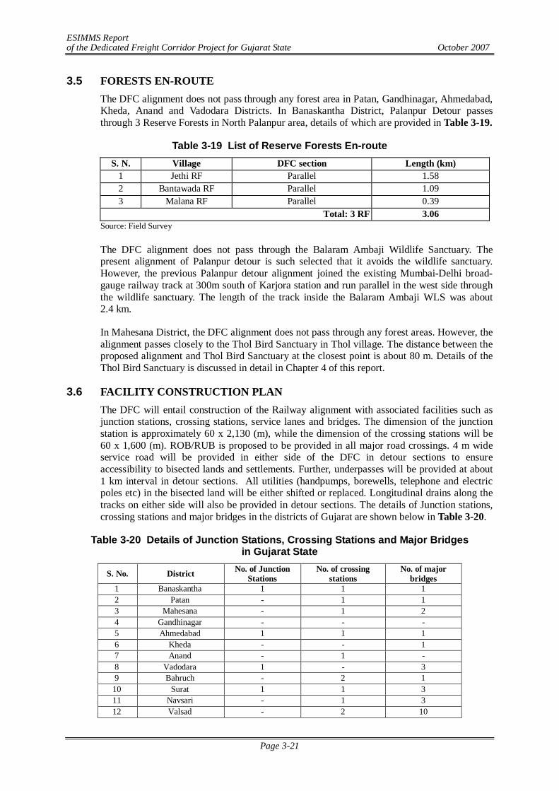
ESIMMS Report of the Dedicated Freight Corridor Project for Gujarat State October 2007
Page 3-21
3.5 FORESTS EN-ROUTE The DFC alignment does not pass through any forest area in Patan, Gandhinagar, Ahmedabad, Kheda, Anand and Vadodara Districts. In Banaskantha District, Palanpur Detour passes through 3 Reserve Forests in North Palanpur area, details of which are provided in Table 3-19.
Table 3-19 List of Reserve Forests En-route S. N. Village DFC section Length (km)
1 Jethi RF Parallel 1.58 2 Bantawada RF Parallel 1.09 3 Malana RF Parallel 0.39
Total: 3 RF 3.06 Source: Field Survey
The DFC alignment does not pass through the Balaram Ambaji Wildlife Sanctuary. The present alignment of Palanpur detour is such selected that it avoids the wildlife sanctuary. However, the previous Palanpur detour alignment joined the existing Mumbai-Delhi broad-gauge railway track at 300m south of Karjora station and run parallel in the west side through the wildlife sanctuary. The length of the track inside the Balaram Ambaji WLS was about 2.4 km.
In Mahesana District, the DFC alignment does not pass through any forest areas. However, the alignment passes closely to the Thol Bird Sanctuary in Thol village. The distance between the proposed alignment and Thol Bird Sanctuary at the closest point is about 80 m. Details of the Thol Bird Sanctuary is discussed in detail in Chapter 4 of this report.
3.6 FACILITY CONSTRUCTION PLAN The DFC will entail construction of the Railway alignment with associated facilities such as junction stations, crossing stations, service lanes and bridges. The dimension of the junction station is approximately 60 x 2,130 (m), while the dimension of the crossing stations will be 60 x 1,600 (m). ROB/RUB is proposed to be provided in all major road crossings. 4 m wide service road will be provided in either side of the DFC in detour sections to ensure accessibility to bisected lands and settlements. Further, underpasses will be provided at about 1 km interval in detour sections. All utilities (handpumps, borewells, telephone and electric poles etc) in the bisected land will be either shifted or replaced. Longitudinal drains along the tracks on either side will also be provided in detour sections. The details of Junction stations, crossing stations and major bridges in the districts of Gujarat are shown below in Table 3-20.
Table 3-20 Details of Junction Stations, Crossing Stations and Major Bridges in Gujarat State
S. No. District No. of Junction Stations
No. of crossing stations
No. of major bridges
1 Banaskantha 1 1 1 2 Patan - 1 1 3 Mahesana - 1 2 4 Gandhinagar - - - 5 Ahmedabad 1 1 1 6 Kheda - - 1 7 Anand - 1 - 8 Vadodara 1 - 3 9 Bahruch - 2 1 10 Surat 1 1 3 11 Navsari - 1 3 12 Valsad - 2 10

ESIMMS Report of the Dedicated Freight Corridor Project for Gujarat State October 2007
Page 3-22
ESIMMS Report of the Dedicated Freight Corridor Project for Gujarat State October 2007
Page 4-1
CHAPTER 4 EXISTING ENVIRONMENT
4.1 INTRODUCTION Gujarat has three distinct geographical regions, namely, the eastern hilly region, the plains and the peninsular region of Saurashtra and Kachchh. The hilly region is composed of the terminal parts of four mountain ranges: Sahyadri and Satpura in the South, Vindhyan range to the centre and the Aravalli range in the North. The plains extend from north-east to the south, constituting about half of the area of the state. The peninsular region of Saurashtra and Kachchh in the west is joined to the mainland by a connecting low lying land. The major soil type found is the black cotton soil that covers about 38% of the state’s area, while the sandy type of soil covers about 33% of the area.
The state has about 185 rivers of various sizes, the major ones being Sabarmati, Mahi, Tapti and Narmada. The average annual precipitation is reported to be 828, though there is significant variation in the geographic distribution of rainfall.
Although the forest cover in Gujarat is only 9.5%, the state has a rich and varied biodiversity. The ecosystem diversity includes inland wetlands, grasslands, the forests, saline desert ecosystem, desert, mangroves and the marine ecosystem. The state’s flora comprises of 4,320 species. The vertebrate fauna recorded stands at 1,318 species, representing 27% of the vertebrate fauna of the country. The key fauna include the Asiatic lion, Leopard, Sloth bear, Blackbuck. Gujarat’s wetlands attract millions of migratory birds in the winter months.
This chapter presents the results of the study conducted on the state of natural environment of each of the 8 districts.
4.2 APPROACH AND METHODOLOGY The approach of the study involved review of secondary data and primary survey of the project area. Secondary data is used to compile the regional features whereas primary data is used to describe project Influence area. The Natural Environment Assessment consist review of Topography, Geology, Soil, Groundwater, Hydrology, Flora and Fauna of the project Area. Primary survey is followed by consultation with local people to get the relevant information about the area.
The methodology for carrying out the study for the proposed project is based on the guidelines issued by Ministry of Environment & forest (MoEF) and JICA guidelines. The component wise methodology adopted for this study is given below.
- Air Quality: To establish the air quality of the study corridor, secondary data have been collected from the Annual Report (2006-2007) of Gujarat Pollution Control Board. Based on the Annual Report, the ambient air quality of major towns/cities along the DFC corridor has been established.
- Surface & Ground Water Quality: To establish the water quality of major rivers coming within the study area, secondary data have been collected from the Annual Report (2006-2007) of Gujarat Pollution Control Board. Based on the Annual Report, the ground water quality of major towns/cities along the DFC corridor and water quality of major rivers has been established.
- Geology & Soil Quality: Information about topography, geology and soil quality of the study area has been collected from Geological Survey of India.
- Biological Environment (Flora, Fauna & Forest): To characterize the vegetation of Forest Area, standard quadrat method and random sampling approach has been adopted. The detailed methodology if given below:
ESIMMS Report of the Dedicated Freight Corridor Project for Gujarat State October 2007
Page 4-2
The density measurements reflect as to how many individuals were present, the dominance measurements denote which species is largest in terms of its presence and the frequency measurements indicate how widely species is distributed among the same plots. Importance value is a reasonable measure to assess the overall significance of a species since it takes into account several properties of the species in the vegetation. Importance value index will be calculated as per Curtes & Mc Intosh (1950). The following parameters will be assessed from the field data measurements.
Quadrate Size = 10 m x 10 m = 100m2 Scale = Per m2. Frequency (F) = Relative Frequency of a species (RF) = Density of a species per unit area (D) = Relative density of a species (RD) = Abundance of a species (AB) = Relative Dominance of the species (RDO) = Index of Similarity =
Importance Value Index = (Relative Density Relative Dominance Relative Frequency) 4.3 EXISTING NATURAL ENVIRONMENT 4.3.1 Banaskantha
The Banaskantha District lies between 2335’ to 2443’ north latitudes and 710’ to 730’ east longitudes on the banks of the Banas River, in the north-western part of Gujarat. The district occupies an area of 12,702 km2, with a population of 2,162578. To the north of this district lies Rajasthan State. In the south it is bounded by Mahesana District. Sabarkantha District lies to the east while the Kachchh District occupies the area west of it. At present, the district is divided into 12 talukas for administrative purpose. All C.D. block boundaries of this district are co-terminus with taluka boundaries. The terrain of this district can be divided into two broad physiographic sub-divisions viz., eastern hilly region and western plain region. The eastern part of the district is rugged and hilly. The region is highly elevated in the district and the altitude ranges between 100 m and 300 m above M.S.L. The region is well forested. The western region of the district is a vast level plain with an elevation of below 100 m from mean sea level. This tract is devoid of any significant vegetation and the area touching on the Rann of Kachchh is an extensive salt marsh. The general slope of the district is from north-east to south-west in which direction all the rivers flow. Banas is the principal river of the district.
Total no. Of quadrates in which the species occur x 100 Total No of quadrate studied
Frequency of the species in stand x X 100 Sum of the frequencies for all species in stand x
Total No Of individuals of species in all the sample plot Total No of sample plots studied
Total no of individuals of a species 100
Total No of individual of all species
Total number of individual of the species in all quadrates Total number of quadrate in which the species occurred
Total Basal area of a species in all the quadrates X 100 Total Basal area of all the species in all the quadrates
2 X No. of common species X 100
Total number of species in both associations
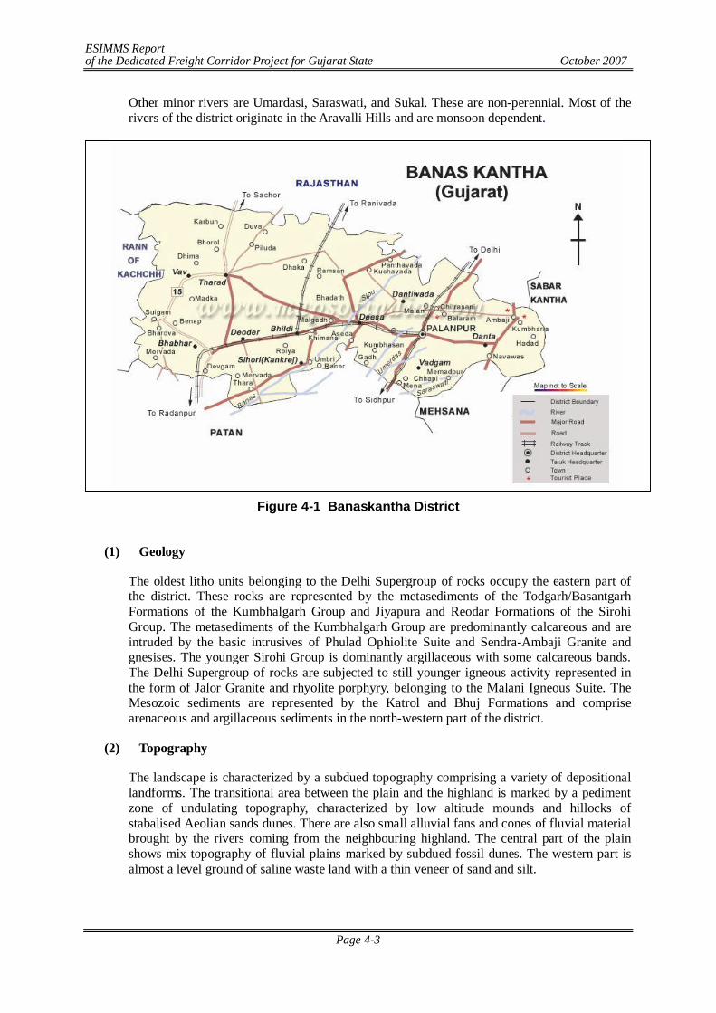
ESIMMS Report of the Dedicated Freight Corridor Project for Gujarat State October 2007
Page 4-3
Other minor rivers are Umardasi, Saraswati, and Sukal. These are non-perennial. Most of the rivers of the district originate in the Aravalli Hills and are monsoon dependent.
Figure 4-1 Banaskantha District
(1) Geology
The oldest litho units belonging to the Delhi Supergroup of rocks occupy the eastern part of the district. These rocks are represented by the metasediments of the Todgarh/Basantgarh Formations of the Kumbhalgarh Group and Jiyapura and Reodar Formations of the Sirohi Group. The metasediments of the Kumbhalgarh Group are predominantly calcareous and are intruded by the basic intrusives of Phulad Ophiolite Suite and Sendra-Ambaji Granite and gnesises. The younger Sirohi Group is dominantly argillaceous with some calcareous bands. The Delhi Supergroup of rocks are subjected to still younger igneous activity represented in the form of Jalor Granite and rhyolite porphyry, belonging to the Malani Igneous Suite. The Mesozoic sediments are represented by the Katrol and Bhuj Formations and comprise arenaceous and argillaceous sediments in the north-western part of the district.
(2) Topography
The landscape is characterized by a subdued topography comprising a variety of depositional landforms. The transitional area between the plain and the highland is marked by a pediment zone of undulating topography, characterized by low altitude mounds and hillocks of stabalised Aeolian sands dunes. There are also small alluvial fans and cones of fluvial material brought by the rivers coming from the neighbouring highland. The central part of the plain shows mix topography of fluvial plains marked by subdued fossil dunes. The western part is almost a level ground of saline waste land with a thin veneer of sand and silt.
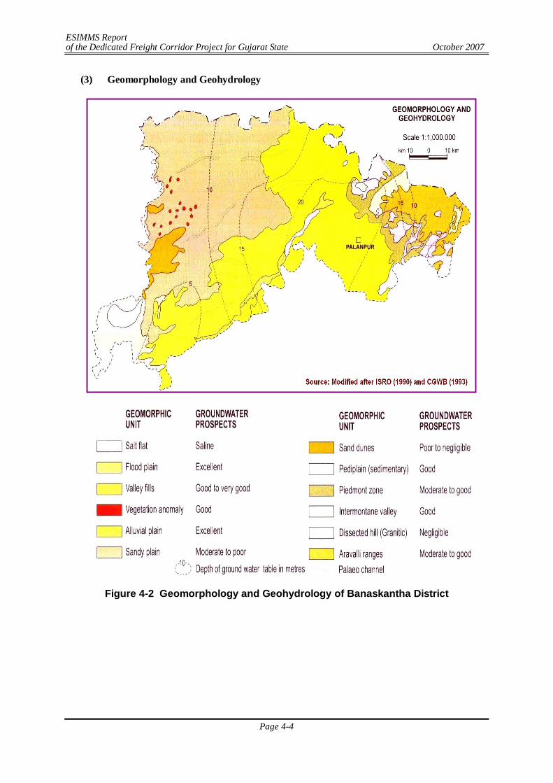
ESIMMS Report of the Dedicated Freight Corridor Project for Gujarat State October 2007
Page 4-4
(3) Geomorphology and Geohydrology
Figure 4-2 Geomorphology and Geohydrology of Banaskantha District
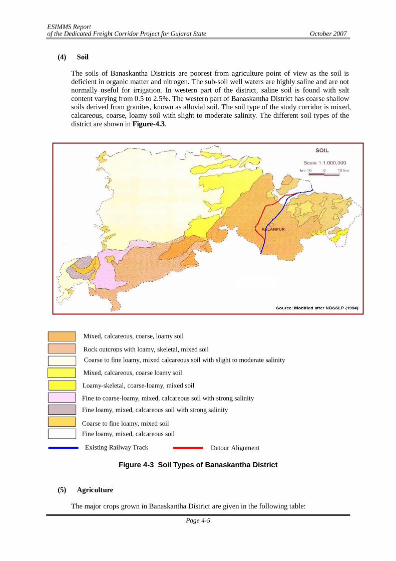
ESIMMS Report of the Dedicated Freight Corridor Project for Gujarat State October 2007
Page 4-5
(4) Soil
The soils of Banaskantha Districts are poorest from agriculture point of view as the soil is deficient in organic matter and nitrogen. The sub-soil well waters are highly saline and are not normally useful for irrigation. In western part of the district, saline soil is found with salt content varying from 0.5 to 2.5%. The western part of Banaskantha District has coarse shallow soils derived from granites, known as alluvial soil. The soil type of the study corridor is mixed, calcareous, coarse, loamy soil with slight to moderate salinity. The different soil types of the district are shown in Figure-4.3.
Figure 4-3 Soil Types of Banaskantha District
(5) Agriculture
The major crops grown in Banaskantha District are given in the following table:
Mixed, calcareous, coarse, loamy soil
Rock outcrops with loamy, skeletal, mixed soil Coarse to fine loamy, mixed calcareous soil with slight to moderate salinity
Mixed, calcareous, coarse loamy soil
Loamy-skeletal, coarse-loamy, mixed soil Fine to coarse-loamy, mixed, calcareous soil with strong salinity Fine loamy, mixed, calcareous soil with strong salinity Coarse to fine loamy, mixed soil Fine loamy, mixed, calcareous soil
Existing Railway Track Detour Alignment
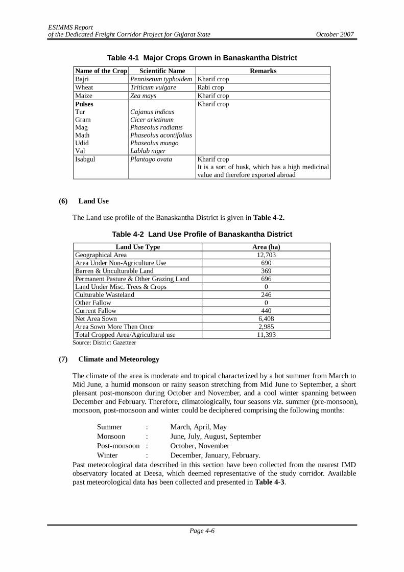
ESIMMS Report of the Dedicated Freight Corridor Project for Gujarat State October 2007
Page 4-6
Table 4-1 Major Crops Grown in Banaskantha District Name of the Crop Scientific Name Remarks Bajri Pennisetum typhoidem Kharif crop Wheat Triticum vulgare Rabi crop Maize Zea mays Kharif crop Pulses Tur Gram Mag Math Udid Val
Cajanus indicus Cicer arietinum Phaseolus radiatus Phaseolus acontifolius Phaseolus mungo Lablab niger
Kharif crop
Isabgul Plantago ovata Kharif crop It is a sort of husk, which has a high medicinal value and therefore exported abroad
(6) Land Use
The Land use profile of the Banaskantha District is given in Table 4-2.
Table 4-2 Land Use Profile of Banaskantha District Land Use Type Area (ha)
Geographical Area 12,703 Area Under Non-Agriculture Use 690 Barren & Unculturable Land 369 Permanent Pasture & Other Grazing Land 696 Land Under Misc. Trees & Crops 0 Culturable Wasteland 246 Other Fallow 0 Current Fallow 440 Net Area Sown 6,408 Area Sown More Then Once 2,985 Total Cropped Area/Agricultural use 11,393
Source: District Gazetteer
(7) Climate and Meteorology
The climate of the area is moderate and tropical characterized by a hot summer from March to Mid June, a humid monsoon or rainy season stretching from Mid June to September, a short pleasant post-monsoon during October and November, and a cool winter spanning between December and February. Therefore, climatologically, four seasons viz. summer (pre-monsoon), monsoon, post-monsoon and winter could be deciphered comprising the following months:
Summer : March, April, May Monsoon : June, July, August, September Post-monsoon : October, November Winter : December, January, February.
Past meteorological data described in this section have been collected from the nearest IMD observatory located at Deesa, which deemed representative of the study corridor. Available past meteorological data has been collected and presented in Table 4-3.
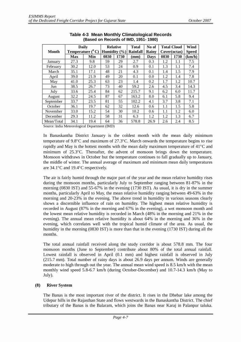
ESIMMS Report of the Dedicated Freight Corridor Project for Gujarat State October 2007
Page 4-7
Table 4-3 Mean Monthly Climatological Records (Based on Records of IMD, 1951- 1980)
Daily Temperature (0 C)
Relative Humidity (%)
Total Rainfall
No of Rainy
Total Cloud Cover(octas)
Wind Speed Month
Max Min 0830 1730 (mm) Days 0830 1730 (km/h) January 27.3 9.8 59 29 2.7 0.3 1.2 1.1 7.5 February 30.2 12.0 53 24 0.9 0.1 1.3 1.1 7.4 March 35.1 17.1 48 21 4.3 0.1 1.4 1.5 7.9 April 39.0 21.9 49 20 0.1 0.0 1.2 1.4 7.8 May 41.0 25.3 63 23 1.4 0.2 1.7 1.2 10.7 Jun 38.5 26.7 73 40 59.2 2.6 4.5 3.4 14.3 July 33.6 25.4 84 62 215.7 9.1 6.2 6.0 11.7
August 32.2 24.5 87 67 163.2 8.0 6.1 5.8 9.4 September 33.7 23.5 81 55 102.2 4.1 3.7 3.8 7.1
October 36.1 19.7 62 32 12.6 0.6 1.1 1.5 5.8 November 33.0 15.2 54 30 10.2 0.6 1.1 1.2 6.0 December 29.3 11.2 58 31 6.3 1.2 1.2 1.3 6.7
Mean/Total 34.1 19.4 64 36 578.8 26.9 2.6 2.4 8.5 Source: India Meteorological Department (IMD)
In Banaskantha District January is the coldest month with the mean daily minimum temperature of 9.8C and maximum of 27.3C. March onwards the temperature begins to rise rapidly and May is the hottest months with the mean daily maximum temperature of 41C and minimum of 25.3C. Thereafter, the advent of monsoon brings down the temperature. Monsoon withdraws in October but the temperature continues to fall gradually up to January, the middle of winter. The annual average of maximum and minimum mean daily temperatures are 34.1C and 19.4C respectively.
The air is fairly humid through the major part of the year and the mean relative humidity rises during the monsoon months, particularly July to September ranging between 81-87% in the morning (0830 IST) and 55-67% in the evening (1730 IST). As usual, it is dry in the summer months, particularly April to May, the mean relative humidity ranging between 49-63% in the morning and 20-23% in the evening. The above trend in humidity in various seasons clearly shows a discernible influence of rain on humidity. The highest mean relative humidity is recorded in August (87% in the morning and 67% in the evening), a wet monsoon month and the lowest mean relative humidity is recorded in March (48% in the morning and 21% in the evening). The annual mean relative humidity is about 64% in the morning and 36% in the evening, which correlates well with the tropical humid climate of the area. As usual, the humidity in the morning (0830 IST) is more than that in the evening (1730 IST) during all the months.
The total annual rainfall received along the study corridor is about 578.8 mm. The four monsoon months (June to September) contribute about 80% of the total annual rainfall. Lowest rainfall is observed in April (0.1 mm) and highest rainfall is observed in July (215.7 mm). Total number of rainy days is about 26.9 days per annum. Winds are generally moderate to high through out the year. The annual mean wind speed is 8.5 km/h with the mean monthly wind speed 5.8-6.7 km/h (during October-December) and 10.7-14.3 km/h (May to July).
(8) River System
The Banas is the most important river of the district. It rises in the Dhebar lake among the Udepur hills in the Rajasthan State and flows westwards in the Banaskantha District. The chief tributary of the Banas is the Balaram, which joins the Banas near Karaj in Palanpur taluka.
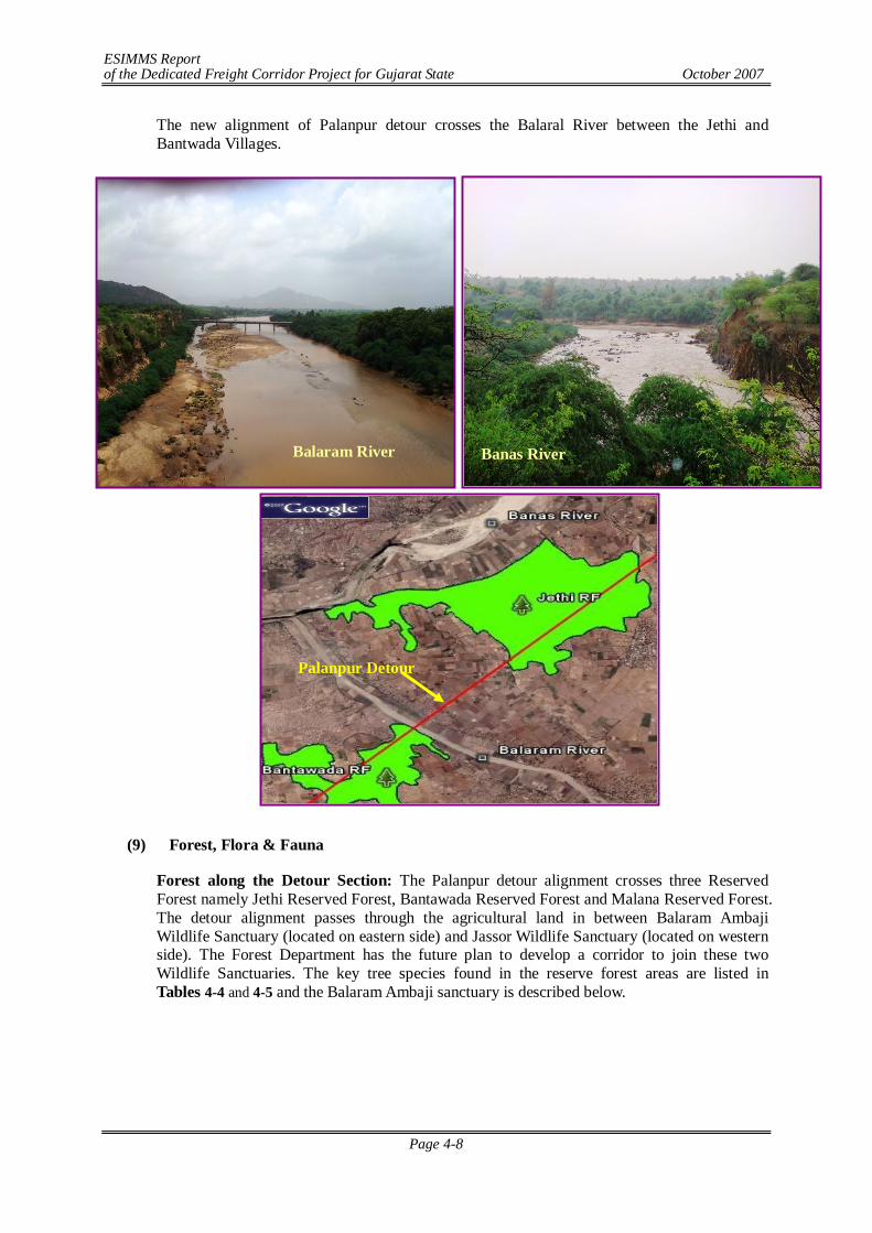
ESIMMS Report of the Dedicated Freight Corridor Project for Gujarat State October 2007
Page 4-8
The new alignment of Palanpur detour crosses the Balaral River between the Jethi and Bantwada Villages.
(9) Forest, Flora & Fauna
Forest along the Detour Section: The Palanpur detour alignment crosses three Reserved Forest namely Jethi Reserved Forest, Bantawada Reserved Forest and Malana Reserved Forest. The detour alignment passes through the agricultural land in between Balaram Ambaji Wildlife Sanctuary (located on eastern side) and Jassor Wildlife Sanctuary (located on western side). The Forest Department has the future plan to develop a corridor to join these two Wildlife Sanctuaries. The key tree species found in the reserve forest areas are listed in Tables 4-4 and 4-5 and the Balaram Ambaji sanctuary is described below.
Balaram River Banas River
Palanpur Detour
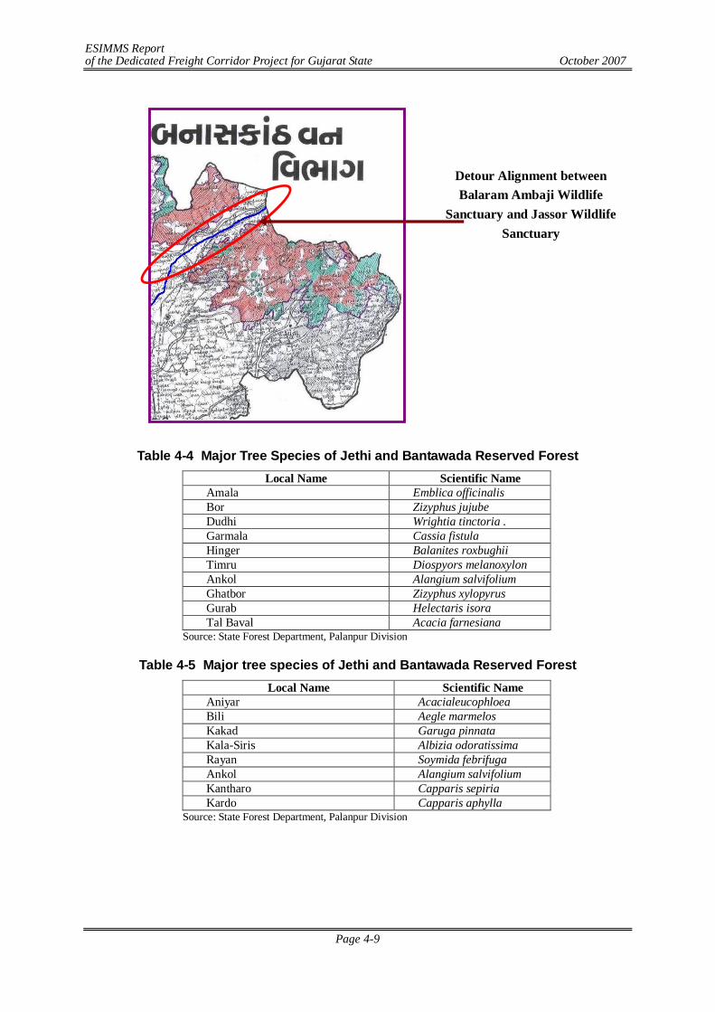
ESIMMS Report of the Dedicated Freight Corridor Project for Gujarat State October 2007
Page 4-9
Detour Alignment between Balaram Ambaji Wildlife
Sanctuary and Jassor Wildlife Sanctuary
Table 4-4 Major Tree Species of Jethi and Bantawada Reserved Forest Local Name Scientific Name
Amala Emblica officinalis Bor Zizyphus jujube Dudhi Wrightia tinctoria . Garmala Cassia fistula Hinger Balanites roxbughii Timru Diospyors melanoxylon Ankol Alangium salvifolium Ghatbor Zizyphus xylopyrus Gurab Helectaris isora Tal Baval Acacia farnesiana
Source: State Forest Department, Palanpur Division
Table 4-5 Major tree species of Jethi and Bantawada Reserved Forest Local Name Scientific Name
Aniyar Acacialeucophloea Bili Aegle marmelos Kakad Garuga pinnata Kala-Siris Albizia odoratissima Rayan Soymida febrifuga Ankol Alangium salvifolium Kantharo Capparis sepiria Kardo Capparis aphylla
Source: State Forest Department, Palanpur Division
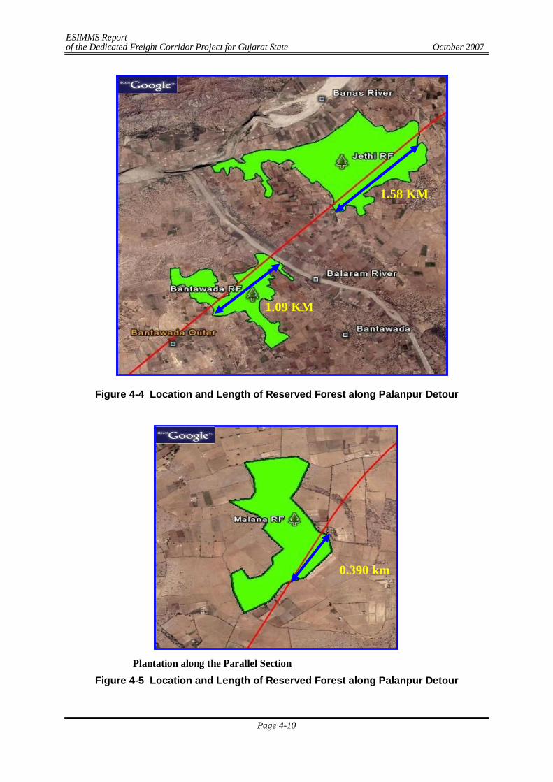
ESIMMS Report of the Dedicated Freight Corridor Project for Gujarat State October 2007
Page 4-10
Figure 4-4 Location and Length of Reserved Forest along Palanpur Detour
Plantation along the Parallel Section
Figure 4-5 Location and Length of Reserved Forest along Palanpur Detour
1.58 KM
1.09 KM
0.390 km
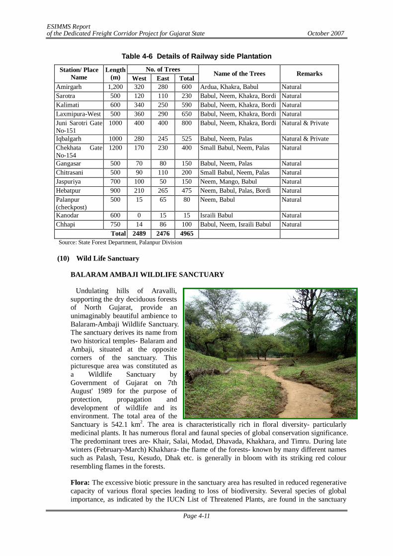
ESIMMS Report of the Dedicated Freight Corridor Project for Gujarat State October 2007
Page 4-11
Table 4-6 Details of Railway side Plantation
No. of Trees Station/ Place Name
Length (m) West East Total
Name of the Trees Remarks
Amirgarh 1,200 320 280 600 Ardua, Khakra, Babul Natural Sarotra 500 120 110 230 Babul, Neem, Khakra, Bordi Natural Kalimati 600 340 250 590 Babul, Neem, Khakra, Bordi Natural Laxmipura-West 500 360 290 650 Babul, Neem, Khakra, Bordi Natural Juni Sarotri Gate No-151
1000 400 400 800 Babul, Neem, Khakra, Bordi Natural & Private
Iqbalgarh 1000 280 245 525 Babul, Neem, Palas Natural & Private Chekhata Gate No-154
1200 170 230 400 Small Babul, Neem, Palas Natural
Gangasar 500 70 80 150 Babul, Neem, Palas Natural Chitrasani 500 90 110 200 Small Babul, Neem, Palas Natural Jaspuriya 700 100 50 150 Neem, Mango, Babul Natural Hebatpur 900 210 265 475 Neem, Babul, Palas, Bordi Natural Palanpur (checkpost)
500 15 65 80 Neem, Babul Natural
Kanodar 600 0 15 15 Israili Babul Natural Chhapi 750 14 86 100 Babul, Neem, Israili Babul Natural
Total 2489 2476 4965 Source: State Forest Department, Palanpur Division
(10) Wild Life Sanctuary
BALARAM AMBAJI WILDLIFE SANCTUARY
Undulating hills of Aravalli, supporting the dry deciduous forests of North Gujarat, provide an unimaginably beautiful ambience to Balaram-Ambaji Wildlife Sanctuary. The sanctuary derives its name from two historical temples- Balaram and Ambaji, situated at the opposite corners of the sanctuary. This picturesque area was constituted as a Wildlife Sanctuary by Government of Gujarat on 7th August' 1989 for the purpose of protection, propagation and development of wildlife and its environment. The total area of the Sanctuary is 542.1 km2. The area is characteristically rich in floral diversity- particularly medicinal plants. It has numerous floral and faunal species of global conservation significance. The predominant trees are- Khair, Salai, Modad, Dhavada, Khakhara, and Timru. During late winters (February-March) Khakhara- the flame of the forests- known by many different names such as Palash, Tesu, Kesudo, Dhak etc. is generally in bloom with its striking red colour resembling flames in the forests.
Flora: The excessive biotic pressure in the sanctuary area has resulted in reduced regenerative capacity of various floral species leading to loss of biodiversity. Several species of global importance, as indicated by the IUCN List of Threatened Plants, are found in the sanctuary
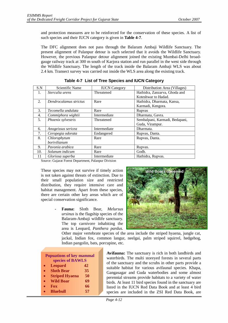
ESIMMS Report of the Dedicated Freight Corridor Project for Gujarat State October 2007
Page 4-12
Wild Boars observed
Popuations of key mammal species of BAWLS
Leopard 42 Sloth Bear 35 Striped Hyaena 50 Wild Boar 69 Fox 66 Bluebull 57 Porcupine 7
and protection measures are to be reinforced for the conservation of these species. A list of such species and their IUCN category is given in Table 4-7.
The DFC alignment does not pass through the Balaram Ambaji Wildlife Sanctuary. The present alignment of Palanpur detour is such selected that it avoids the Wildlife Sanctuary. However, the previous Palanpur detour alignment joined the existing Mumbai-Delhi broad-gauge railway track at 300 m south of Karjora station and run parallel in the west side through the Wildlife Sanctuary. The length of the track inside the Balaram Ambaji WLS was about 2.4 km. Transect survey was carried out inside the WLS area along the existing track.
Table 4-7 List of Tree Species and IUCN Category S.N Scientific Name IUCN Category Distribution Area (Villages) 1. Sterculia urens Threatened Hathidra, Zanzarva, Ghoda and
Koteshwar to Hadad. 2. Dendrocalamus strictus Rare Hathidra, Dharmata, Kansa,
Karmadi, Kengora. 3. Tecomella undulata Rare Rupvas 4. Commiphora wightii Intermediate Dharmata, Gavra. 5. Phoenix sylvestris Threatened Sembalpani, Karmadi, Bedapani,
Guda, Virampur. 6. Anogeissus sericea Intermediate Dharmata. 7. Ceropegia odorata Endangered Rupvas, Danta. 8. Chlorophytum
borivilianum Rare Rupvas, Danta.
9. Pavonia arabica Rare Rupvas. 10. Solanum indicum Rare Godh. 11 Gloriosa superba Intermediate Hathidra, Rupvas.
Source: Gujarat Forest Department, Palanpur Division
These species may not survive if timely action is not taken against threats of extinction. Due to their small population size and restricted distribution, they require intensive care and habitat management. Apart from these species, there are certain other key areas which are of special conservation significance.
- Fauna: Sloth Bear, Melursus ursinus is the flagship species of the Balaram-Ambaji wildlife sanctuary. The top carnivore inhabiting the area is Leopard, Panthera pardus. Other major vertebrate species of the area include the striped hyaena, jungle cat, jackal, Indian fox, common langur, neelgai, palm striped squirrel, hedgehog, Indian pangolin, bats, porcupine, etc.
Avifauna: The sanctuary is rich in both landbirds and waterbirds. The multi storeyed forests in several parts of the sanctuary and the scrubs in other parts provide a suitable habitat for various avifaunal species. Khapa, Gangasagar and Guda waterbodies and some almost perennial streams provide habitats to a variety of water birds. At least 11 bird species found in the sanctuary are listed in the IUCN Red Data Book and at least 4 bird species are included in the ZSI Red Data Book, are
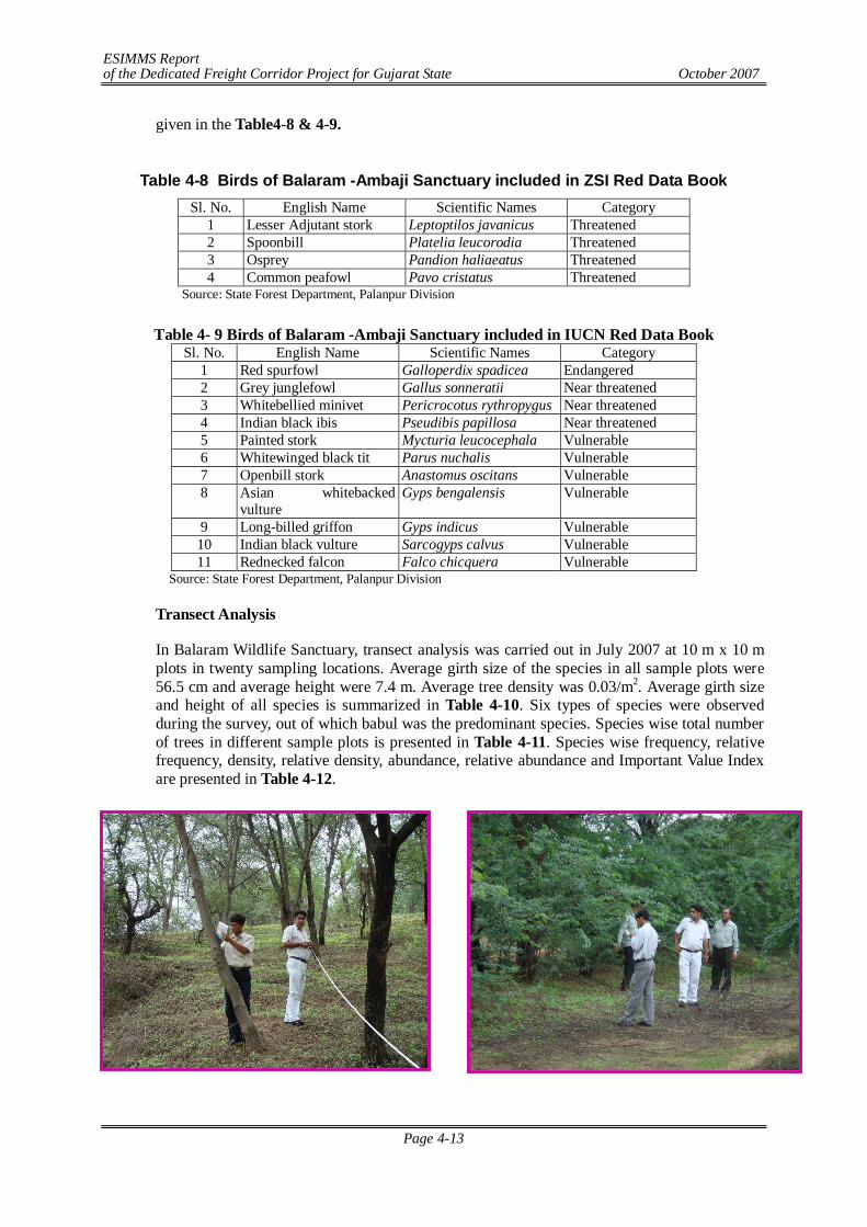
ESIMMS Report of the Dedicated Freight Corridor Project for Gujarat State October 2007
Page 4-13
given in the Table4-8 & 4-9.
Table 4-8 Birds of Balaram -Ambaji Sanctuary included in ZSI Red Data Book
Sl. No. English Name Scientific Names Category 1 Lesser Adjutant stork Leptoptilos javanicus Threatened 2 Spoonbill Platelia leucorodia Threatened 3 Osprey Pandion haliaeatus Threatened 4 Common peafowl Pavo cristatus Threatened
Source: State Forest Department, Palanpur Division
Table 4- 9 Birds of Balaram -Ambaji Sanctuary included in IUCN Red Data Book Sl. No. English Name Scientific Names Category
1 Red spurfowl Galloperdix spadicea Endangered 2 Grey junglefowl Gallus sonneratii Near threatened 3 Whitebellied minivet Pericrocotus rythropygus Near threatened 4 Indian black ibis Pseudibis papillosa Near threatened 5 Painted stork Mycturia leucocephala Vulnerable 6 Whitewinged black tit Parus nuchalis Vulnerable 7 Openbill stork Anastomus oscitans Vulnerable 8 Asian whitebacked
vulture Gyps bengalensis Vulnerable
9 Long-billed griffon Gyps indicus Vulnerable 10 Indian black vulture Sarcogyps calvus Vulnerable 11 Rednecked falcon Falco chicquera Vulnerable
Source: State Forest Department, Palanpur Division
Transect Analysis
In Balaram Wildlife Sanctuary, transect analysis was carried out in July 2007 at 10 m x 10 m plots in twenty sampling locations. Average girth size of the species in all sample plots were 56.5 cm and average height were 7.4 m. Average tree density was 0.03/m2. Average girth size and height of all species is summarized in Table 4-10. Six types of species were observed during the survey, out of which babul was the predominant species. Species wise total number of trees in different sample plots is presented in Table 4-11. Species wise frequency, relative frequency, density, relative density, abundance, relative abundance and Important Value Index are presented in Table 4-12.
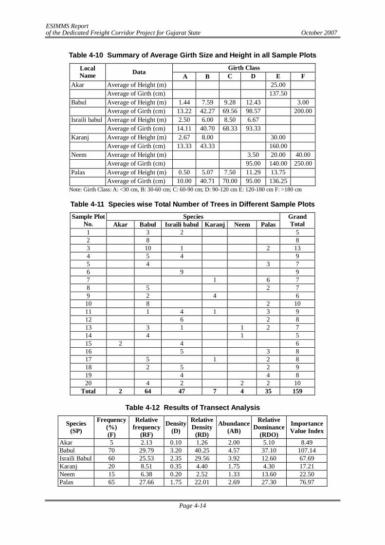
ESIMMS Report of the Dedicated Freight Corridor Project for Gujarat State October 2007
Page 4-14
Table 4-10 Summary of Average Girth Size and Height in all Sample Plots
Girth Class Local Name Data
A B C D E F Akar Average of Height (m) 25.00 Average of Girth (cm) 137.50 Babul Average of Height (m) 1.44 7.59 9.28 12.43 3.00 Average of Girth (cm) 13.22 42.27 69.56 98.57 200.00 Israili babul Average of Height (m) 2.50 6.00 8.50 6.67 Average of Girth (cm) 14.11 40.70 68.33 93.33 Karanj Average of Height (m) 2.67 8.00 30.00 Average of Girth (cm) 13.33 43.33 160.00 Neem Average of Height (m) 3.50 20.00 40.00 Average of Girth (cm) 95.00 140.00 250.00 Palas Average of Height (m) 0.50 5.07 7.50 11.29 13.75 Average of Girth (cm) 10.00 40.71 70.00 95.00 136.25
Note: Girth Class: A: <30 cm, B: 30-60 cm; C: 60-90 cm; D: 90-120 cm E: 120-180 cm F: >180 cm
Table 4-11 Species wise Total Number of Trees in Different Sample Plots Species Sample Plot
No. Akar Babul Israili babul Karanj Neem Palas Grand Total
1 3 2 5 2 8 8 3 10 1 2 13 4 5 4 9 5 4 3 7 6 9 9 7 1 6 7 8 5 2 7 9 2 4 6 10 8 2 10 11 1 4 1 3 9 12 6 2 8 13 3 1 1 2 7 14 4 1 5 15 2 4 6 16 5 3 8 17 5 1 2 8 18 2 5 2 9 19 4 4 8 20 4 2 2 2 10
Total 2 64 47 7 4 35 159
Table 4-12 Results of Transect Analysis
Species (SP)
Frequency (%) (F)
Relative frequency
(RF)
Density (D)
Relative Density
(RD)
Abundance (AB)
Relative Dominance
(RDO)
Importance Value Index
Akar 5 2.13 0.10 1.26 2.00 5.10 8.49 Babul 70 29.79 3.20 40.25 4.57 37.10 107.14 Israili Babul 60 25.53 2.35 29.56 3.92 12.60 67.69 Karanj 20 8.51 0.35 4.40 1.75 4.30 17.21 Neem 15 6.38 0.20 2.52 1.33 13.60 22.50 Palas 65 27.66 1.75 22.01 2.69 27.30 76.97
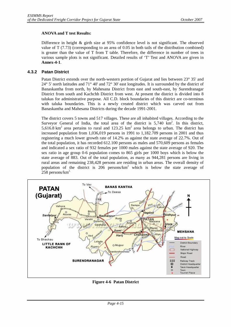
ESIMMS Report of the Dedicated Freight Corridor Project for Gujarat State October 2007
Page 4-15
ANOVA and T test Results:
Difference in height & girth size at 95% confidence level is not significant. The observed value of T (7.73) (corresponding to an area of 0.05 in both tails of the distribution combined) is greater than the value of T from T table. Therefore, the difference in number of trees in various sample plots is not significant. Detailed results of ‘T’ Test and ANOVA are given in Annex-4-1.
4.3.2 Patan District Patan District extends over the north-western portion of Gujarat and lies between 23° 35' and 24° 5' north latitudes and 71° 40' and 72° 30' east longitudes. It is surrounded by the district of Banaskantha from north, by Mahesana District from east and south-east, by Surendranagar District from south and Kachchh District from west. At present the district is divided into 8 talukas for administrative purpose. All C.D. block boundaries of this district are co-terminus with taluka boundaries. This is a newly created district which was carved out from Banaskantha and Mahesana Districts during the decade 1991-2001.
The district covers 5 towns and 517 villages. These are all inhabited villages. According to the Surveyor General of India, the total area of the district is 5,740 km2. In this district, 5,616.8 km2 area pertains to rural and 123.25 km2 area belongs to urban. The district has increased population from 1,036,019 persons in 1991 to 1,182.709 persons in 2001 and thus registering a much lower growth rate of 14.2% as against the state average of 22.7%. Out of the total population, it has recorded 612.100 persons as males and 570,609 persons as females and indicated a sex ratio of 932 females per 1000 males against the state average of 920. The sex ratio in age group 0-6 population comes to 865 girls per 1000 boys which is below the state average of 883. Out of the total population, as many as 944,281 persons are living in rural areas and remaining 238,428 persons are residing in urban areas. The overall density of population of the district is 206 persons/km2 which is below the state average of 258 persons/km2.
Figure 4-6 Patan District
ESIMMS Report of the Dedicated Freight Corridor Project for Gujarat State October 2007
Page 4-16
(1) Geology
The sediments of the plain belong to the youngest geological formation, mostly upper Quaternary, and consist of a thick succession of sandy and clayey layers of fluvial, fluviomarine and Aeolian origin. The depositional environments provide a good example of the control of fluctuating of sea level and climatic changes, which was subjected to neotectonic disturbances from time to time. The deposition has taken place in the N-S trending structural depression of the Cambay basin. The maximum thickness of the deposits is more than 500 m in the central and western part. The sediments in the east are dominantly of fluvial origin. Traced west, they progressively grade into fluviomarine to marine. The western part of the region along the Rann border represents a palaeomudflat.
(2) Topography
The landscape is characterized by a subdued topography comprising a variety of depositional landforms. The transitional area between the plain and the highland is marked by a pediment zone of undulating topography, characterized by low altitude mounds and hillocks of stabilized Aeolian sands dunes. There are also small alluvial fans and cones of fluvial material brought by the rivers coming from the neighbouring highland. The central part of the plain shows mix topography of fluvial plains marked by subdued fossil dunes. The western part is almost a level ground of saline waste land with a thin veneer of sand and silt.
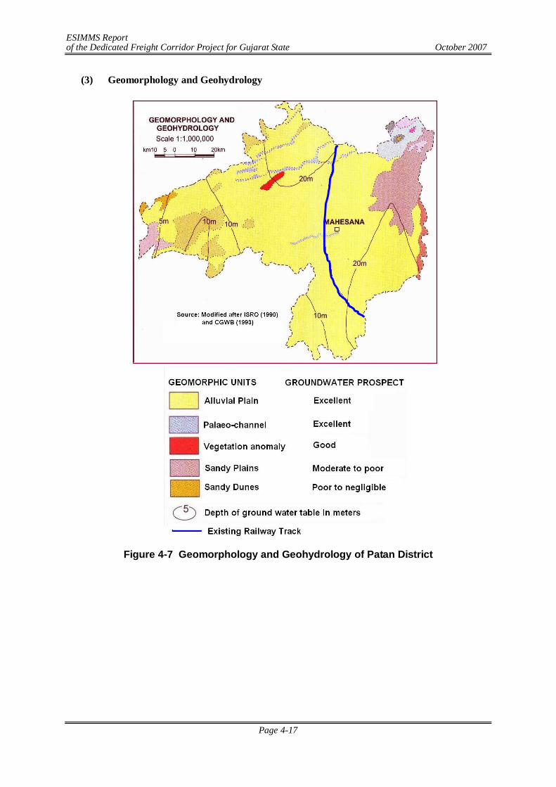
ESIMMS Report of the Dedicated Freight Corridor Project for Gujarat State October 2007
Page 4-17
(3) Geomorphology and Geohydrology
Figure 4-7 Geomorphology and Geohydrology of Patan District
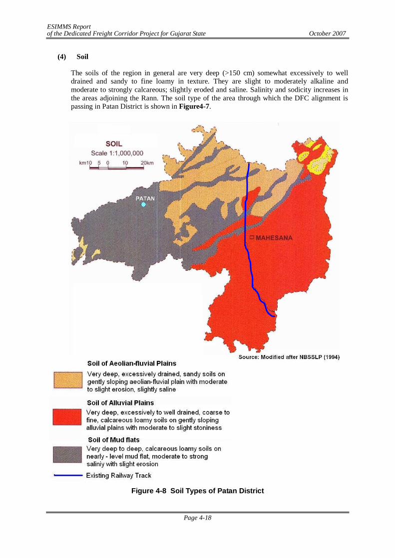
ESIMMS Report of the Dedicated Freight Corridor Project for Gujarat State October 2007
Page 4-18
(4) Soil
The soils of the region in general are very deep (>150 cm) somewhat excessively to well drained and sandy to fine loamy in texture. They are slight to moderately alkaline and moderate to strongly calcareous; slightly eroded and saline. Salinity and sodicity increases in the areas adjoining the Rann. The soil type of the area through which the DFC alignment is passing in Patan District is shown in Figure4-7.
Figure 4-8 Soil Types of Patan District
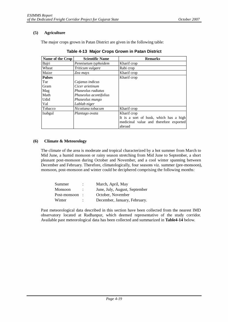
ESIMMS Report of the Dedicated Freight Corridor Project for Gujarat State October 2007
Page 4-19
(5) Agriculture
The major crops grown in Patan District are given in the following table:
Table 4-13 Major Crops Grown in Patan District Name of the Crop Scientific Name Remarks Bajri Pennisetum typhoidem Kharif crop Wheat Triticum vulgare Rabi crop Maize Zea mays Kharif crop Pulses Tur Gram Mag Math Udid Val
Cajanus indicus Cicer arietinum Phaseolus radiatus Phaseolus acontifolius Phaseolus mungo Lablab niger
Kharif crop
Tobacco Nicotiana tobacum Kharif crop Isabgul Plantago ovata Kharif crop
It is a sort of husk, which has a high medicinal value and therefore exported abroad
(6) Climate & Meteorology
The climate of the area is moderate and tropical characterized by a hot summer from March to Mid June, a humid monsoon or rainy season stretching from Mid June to September, a short pleasant post-monsoon during October and November, and a cool winter spanning between December and February. Therefore, climatologically, four seasons viz. summer (pre-monsoon), monsoon, post-monsoon and winter could be deciphered comprising the following months:
Summer : March, April, May Monsoon : June, July, August, September Post-monsoon : October, November Winter : December, January, February.
Past meteorological data described in this section have been collected from the nearest IMD observatory located at Radhanpur, which deemed representative of the study corridor. Available past meteorological data has been collected and summarized in Table4-14 below.
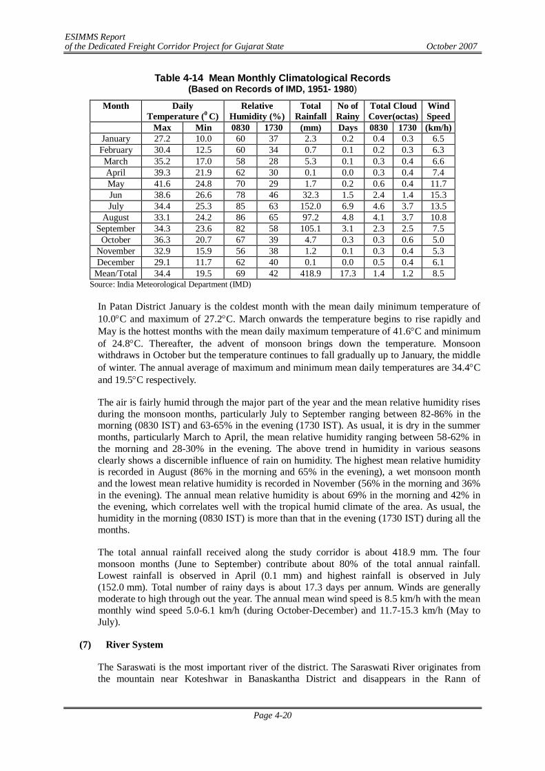
ESIMMS Report of the Dedicated Freight Corridor Project for Gujarat State October 2007
Page 4-20
Table 4-14 Mean Monthly Climatological Records (Based on Records of IMD, 1951- 1980)
Month Daily Temperature (0 C)
Relative Humidity (%)
Total Rainfall
No of Rainy
Total Cloud Cover(octas)
Wind Speed
Max Min 0830 1730 (mm) Days 0830 1730 (km/h) January 27.2 10.0 60 37 2.3 0.2 0.4 0.3 6.5 February 30.4 12.5 60 34 0.7 0.1 0.2 0.3 6.3 March 35.2 17.0 58 28 5.3 0.1 0.3 0.4 6.6 April 39.3 21.9 62 30 0.1 0.0 0.3 0.4 7.4 May 41.6 24.8 70 29 1.7 0.2 0.6 0.4 11.7 Jun 38.6 26.6 78 46 32.3 1.5 2.4 1.4 15.3 July 34.4 25.3 85 63 152.0 6.9 4.6 3.7 13.5
August 33.1 24.2 86 65 97.2 4.8 4.1 3.7 10.8 September 34.3 23.6 82 58 105.1 3.1 2.3 2.5 7.5
October 36.3 20.7 67 39 4.7 0.3 0.3 0.6 5.0 November 32.9 15.9 56 38 1.2 0.1 0.3 0.4 5.3 December 29.1 11.7 62 40 0.1 0.0 0.5 0.4 6.1
Mean/Total 34.4 19.5 69 42 418.9 17.3 1.4 1.2 8.5 Source: India Meteorological Department (IMD)
In Patan District January is the coldest month with the mean daily minimum temperature of 10.0C and maximum of 27.2C. March onwards the temperature begins to rise rapidly and May is the hottest months with the mean daily maximum temperature of 41.6C and minimum of 24.8C. Thereafter, the advent of monsoon brings down the temperature. Monsoon withdraws in October but the temperature continues to fall gradually up to January, the middle of winter. The annual average of maximum and minimum mean daily temperatures are 34.4C and 19.5C respectively.
The air is fairly humid through the major part of the year and the mean relative humidity rises during the monsoon months, particularly July to September ranging between 82-86% in the morning (0830 IST) and 63-65% in the evening (1730 IST). As usual, it is dry in the summer months, particularly March to April, the mean relative humidity ranging between 58-62% in the morning and 28-30% in the evening. The above trend in humidity in various seasons clearly shows a discernible influence of rain on humidity. The highest mean relative humidity is recorded in August (86% in the morning and 65% in the evening), a wet monsoon month and the lowest mean relative humidity is recorded in November (56% in the morning and 36% in the evening). The annual mean relative humidity is about 69% in the morning and 42% in the evening, which correlates well with the tropical humid climate of the area. As usual, the humidity in the morning (0830 IST) is more than that in the evening (1730 IST) during all the months.
The total annual rainfall received along the study corridor is about 418.9 mm. The four monsoon months (June to September) contribute about 80% of the total annual rainfall. Lowest rainfall is observed in April (0.1 mm) and highest rainfall is observed in July (152.0 mm). Total number of rainy days is about 17.3 days per annum. Winds are generally moderate to high through out the year. The annual mean wind speed is 8.5 km/h with the mean monthly wind speed 5.0-6.1 km/h (during October-December) and 11.7-15.3 km/h (May to July).
(7) River System
The Saraswati is the most important river of the district. The Saraswati River originates from the mountain near Koteshwar in Banaskantha District and disappears in the Rann of
ESIMMS Report of the Dedicated Freight Corridor Project for Gujarat State October 2007
Page 4-21
Kachhchha. The river does not meet the sea. The river is considered extremely sacred. The DFC alignment crosses Saraswati River in Sidhapur Town.
Figure 4-9 River Crossing
(8) Forest, Flora & Fauna
Forest: In Patan District, DFC alignment does not pass through any Reserved Forest or Protected Forest.
Plantation along the Existing Railway Track There is no detour in Patan District. Along the existing track, plantation has been raised by the Forest Department on the railway land. Total number of trees along the track is 2740 and major species are Babul, Neem, Israili babul etc. A detail of Railway side plantation is presented in Table 4-15.
DFC Alignment
Saraswati River
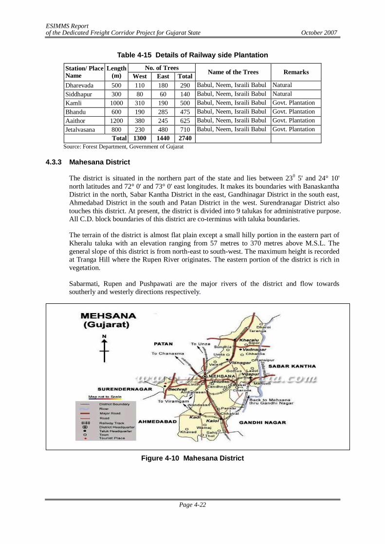
ESIMMS Report of the Dedicated Freight Corridor Project for Gujarat State October 2007
Page 4-22
Table 4-15 Details of Railway side Plantation
No. of Trees Station/ Place Name
Length (m) West East Total Name of the Trees Remarks
Dharevada 500 110 180 290 Babul, Neem, Israili Babul Natural Siddhapur 300 80 60 140 Babul, Neem, Israili Babul Natural Kamli 1000 310 190 500 Babul, Neem, Israili Babul Govt. Plantation Bhandu 600 190 285 475 Babul, Neem, Israili Babul Govt. Plantation Aaithor 1200 380 245 625 Babul, Neem, Israili Babul Govt. Plantation Jetalvasana 800 230 480 710 Babul, Neem, Israili Babul Govt. Plantation
Total 1300 1440 2740 Source: Forest Department, Government of Gujarat
4.3.3 Mahesana District
The district is situated in the northern part of the state and lies between 230 5' and 24° 10' north latitudes and 72° 0' and 73° 0' east longitudes. It makes its boundaries with Banaskantha District in the north, Sabar Kantha District in the east, Gandhinagar District in the south east, Ahmedabad District in the south and Patan District in the west. Surendranagar District also touches this district. At present, the district is divided into 9 talukas for administrative purpose. All C.D. block boundaries of this district are co-terminus with taluka boundaries.
The terrain of the district is almost flat plain except a small hilly portion in the eastern part of Kheralu taluka with an elevation ranging from 57 metres to 370 metres above M.S.L. The general slope of this district is from north-east to south-west. The maximum height is recorded at Tranga Hill where the Rupen River originates. The eastern portion of the district is rich in vegetation.
Sabarmati, Rupen and Pushpawati are the major rivers of the district and flow towards southerly and westerly directions respectively.
Figure 4-10 Mahesana District
ESIMMS Report of the Dedicated Freight Corridor Project for Gujarat State October 2007
Page 4-23
(1) Geology
Calc-gneiss and para-gneiss belonging to the Kumbhalgarh Group of the Delhi Supergroup are the oldest rocks exposed in the northeastern parts of the district. These are intruded by the Sendra- Amabaji and Idar (Malani) granites. The Tertiary sediments are represented by the Gaj and Miliolite and the Vend Formation of the Porbandar Group. The Gaj Formation comprises a repetitive sequence of fossiliferous sandstone, limestone, calcareous siltstone and gypseous clays. The calcareous and oolitic deposits in the area containing calcareous grit, calcareous sandstone, grapestone, calcareous siltstone and polymictic conglomerate, (associated with Mililoid foraminifer) are included in the Miliolite Formation. The Vend Formation occurs as small inliers within the Holocene sediments and is represented by very finely laminated, variegated calcareous clay, siltstone and sandy gravel- pebbly marl. The Holocene sediments comprise marine, fluvial, aeoline and fluvio marine facies. The marine sediments grouped under the Rann Clay Formation include dark grey to greenish clay. The fluvial counterpart of the Rann clay Formation is the Katpur Formation representing flood plain and levee deposits. These unimodal to bimodal deposits of fine to medium grained sand, sand –silt granules occur as widespread sheets. The Akhaj Formation forms Aeolian sand sheets and sand dunes comprising medium to fine grained, sub-angular and subrounded silty sand. The present- day fluvial deposits confined to either side of the present day river channels of the Sabarmati, Rupen and Saraswati Rivers are grouped under the Varahi Formation, and consist of immature, unconsolidated sand and silt. The Jantral Formation represents comparatively unstablised sand sheet and sand dunes made up of unimodal fine sand.
(2) Topography
The landscape is characterized by a subdued topography comprising a variety of depositional landforms. The transitional area between the plain and the highland is marked by a pediment zone of undulating topography, characterized by low altitude mounds and hillocks of stabilized Aeolian sands dunes. There are also small alluvial fans and cones of fluvial material brought by the rivers coming from the neighbouring highland. The central part of the plain shows a mix topography of fluvial plains marked by subdued fossil dunes. The western part is almost a level ground of saline waste land with a thin veneer of sand and silt.
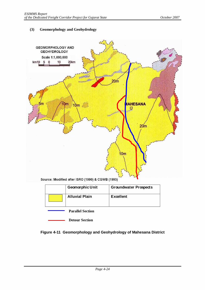
ESIMMS Report of the Dedicated Freight Corridor Project for Gujarat State October 2007
Page 4-24
(3) Geomorphology and Geohydrology
Geomorphic Unit Groundwater Prospects
Alluvial Plain Excellent
Figure 4-11 Geomorphology and Geohydrology of Mahesana District
Parallel Section
Detour Section
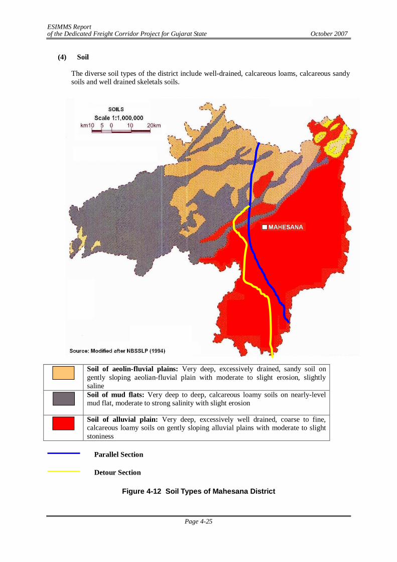
ESIMMS Report of the Dedicated Freight Corridor Project for Gujarat State October 2007
Page 4-25
(4) Soil
The diverse soil types of the district include well-drained, calcareous loams, calcareous sandy soils and well drained skeletals soils.
Soil of aeolin-fluvial plains: Very deep, excessively drained, sandy soil on gently sloping aeolian-fluvial plain with moderate to slight erosion, slightly saline
Soil of mud flats: Very deep to deep, calcareous loamy soils on nearly-level mud flat, moderate to strong salinity with slight erosion
Soil of alluvial plain: Very deep, excessively well drained, coarse to fine, calcareous loamy soils on gently sloping alluvial plains with moderate to slight stoniness
Figure 4-12 Soil Types of Mahesana District
Parallel Section
Detour Section
ESIMMS Report of the Dedicated Freight Corridor Project for Gujarat State October 2007
Page 4-26
(5) Agriculture
The Soils of Mahesana District is poorest from agriculture point of view as the soil is deficient in organic matter and nitrogen. The sub soil well waters are however, highly saline and are not normally useful for irrigation. In western part of the district, saline soil is found with salt content varying from 0.5 to 2.5%. However, 90% of the soils of this area is of sandy nature, a soil which is black in colour is met with in patches, chiefly in south-west parts of Mahesana District. The western part of Mahesana District has coarse shallow soils derived from granites, known as alluvial soil. The major crops grown in Mahesana District are given in the following table:
Table 4-16 Major Crops Grown in Mahesana District Name of the Crop Scientific Name Remarks
Bajri Pennisetum typhoidem Kharif crop Wheat Triticum vulgare Rabi crop Isabgul Plantago ovata Kharif crop Tobacco Nicotiana tobacum Kharif crop Cotton Gossypium herbaccum
(6) Climate & Meteorology
The climate of the area is moderate and tropical, characterized by a hot summer from March to Mid June, a humid monsoon or rainy season stretching from Mid June to September, a short pleasant post-monsoon during October and November, and a cool winter spanning between December and February. Therefore, climatologically, four seasons viz. summer (pre-monsoon), monsoon, post-monsoon and winter could be deciphered comprising the following months:
Summer : March, April, May Monsoon : June, July, August, September Post-monsoon : October, November Winter : December, January, February.
Past meteorological data described in this section have been collected from the nearest IMD observatory located at Idar, which deemed representative of the study corridor. Available past meteorological data has been collected and summarized in Table 4-17.
ESIMMS Report of the Dedicated Freight Corridor Project for Gujarat State October 2007
Page 4-27
Table 4-17 Mean Monthly Climatological Records (Based on Records of IMD, 1951- 1980)
Month Daily Temperature (0 C)
Relative Humidity (%)
Total Rainfall
No of Rainy
Total Cloud Cover (octas)
Wind Speed
Max Min 0830 1730 (mm) Days 0830 1730 (km/h) January 27.5 14.5 39 27 1.4 0.1 1.0 1.0 7.1 February 30.1 15.8 36 21 0.9 0.0 0.8 0.8 7.2 March 34.6 19.7 34 17 3.3 0.2 1.3 1.3 7.5 April 38.8 23.4 38 15 1.1 0.0 1.2 1.4 7.8 May 40.5 25.1 56 19 5.9 0.4 1.3 0.7 9.0 Jun 37.7 25.5 73 41 106.5 4.4 4.9 3.5 10.3 July 32.3 24.2 87 66 308.7 12.7 6.9 6.4 7.6 August 30.5 23.6 90 72 248.9 12.5 7.1 6.6 5.9 September 32.3 22.9 81 58 147.2 5.4 4.5 4.4 5.2 October 35.0 21.6 50 33 17.8 0.8 1.3 1.2 4.9 November 32.4 19.0 37 29 2.3 0.1 1.1 1.2 5.5 December 29.1 16.2 40 30 3.7 0.2 1.4 1.5 6.4 Mean/Total 33.4 21.0 55 36 847.7 36.8 2.7 2.5 7.0 Source: India Meteorological Department (IMD)
In Mahesana District January is the coldest month with the mean daily minimum temperature of 14.5C and maximum of 27.5C. March onwards the temperature begins to rise rapidly and May is the hottest months with the mean daily maximum temperature of 40.5C and minimum of 25.1C. Thereafter, the advent of monsoon brings down the temperature. Monsoon withdraws in October but the temperature continues to fall gradually up to January, the middle of winter. The annual average of maximum and minimum mean daily temperatures are 33.4C and 21.0C respectively.
The air is fairly humid through the major part of the year and the mean relative humidity rises during the monsoon months, particularly July to September ranging between 81-90% in the morning (0830 IST) and 58-72% in the evening (1730 IST). The trend in humidity in various seasons clearly shows a discernible influence of rain on humidity. The highest mean relative humidity is recorded in August (90% in the morning and 72% in the evening), a wet monsoon month and the lowest mean relative humidity is recorded in March (34% in the morning and 17% in the evening). The annual mean relative humidity is about 55% in the morning and 36% in the evening, which correlates well with the tropical humid climate of the area. As usual, the humidity in the morning (0830 IST) is more than that in the evening (1730 IST) during all the months.
The total annual rainfall received along the study corridor is about 847.7 mm. The four monsoon months (June to September) contribute about 80% of the total annual rainfall. Lowest rainfall is observed in February (0.9 mm) and highest rainfall is observed in July (308.7 mm). Total number of rainy days is about 36.8 days per annum. Winds are generally moderate to high through out the year. The annual mean wind speed is 7.0 km/h with the mean monthly wind speed 4.9-6.4 km/h (during October-December) and 7.6-10.3 km/h (May to July).
(7) River System
The district is drained by three south westerly flowing rivers namely the Saraswati, Khari, Rupen, and their tributaries. DFC alignment crosses Khari River twice in Mahesana District. In Vamaj Village, DFC alignment crosses Narmada Canal (23°14'58.88"N, 72° 24'44.16"E). The details of river crossing are given in Table 4-18.
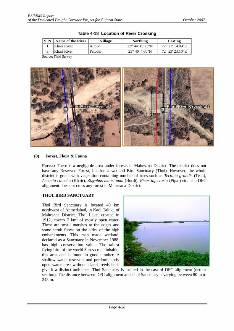
ESIMMS Report of the Dedicated Freight Corridor Project for Gujarat State October 2007
Page 4-28
Table 4-18 Location of River Crossing S. N. Name of the River Village Northing Easting
1. Khari River Aithor 23° 44' 10.73"N 72° 23' 14.09"E 3. Khari River Palodar 23° 40' 4.60"N 72° 23' 23.10"E
Source: Field Survey
(8) Forest, Flora & Fauna
Forest: There is a negligible area under forests in Mahesana District. The district does not have any Reserved Forest, but has a wetland Bird Sanctuary (Thol). However, the whole district is green with vegetation containing number of trees such as Tectona grandis (Teak), Accacia catechu (Khair), Zizyphus mauritania (Bordi), Ficus infectoria (Pipal) etc. The DFC alignment does not cross any forest in Mahesana District.
THOL BIRD SANCTUARY
Thol Bird Sanctuary is located 40 km northwest of Ahmedabad, in Kadi Taluka of Mahesana District. Thol Lake, created in 1912, covers 7 km2 of mostly open water. There are small marshes at the edges and some scrub forest on the sides of the high embankments. This man made wetland, declared as a Sanctuary in November 1988, has high conservation value. The tallest flying bird of the world Sarus crane inhabits this area and is found in good number. A shallow water reservoir and predominantly open water area without island, reeds beds give it a distinct ambience. Thol Sanctuary is located in the east of DFC alignment (detour section). The distance between DFC alignment and Thol Sanctuary is varying between 80 m to 245 m.
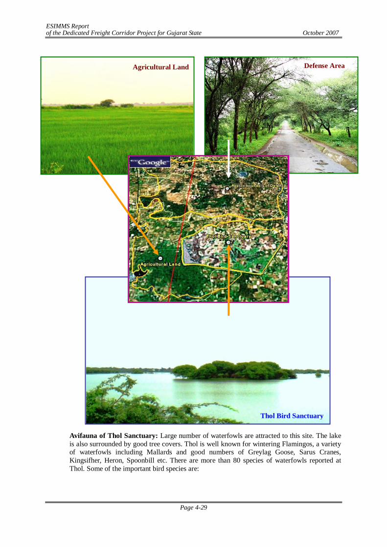
ESIMMS Report of the Dedicated Freight Corridor Project for Gujarat State October 2007
Page 4-29
Avifauna of Thol Sanctuary: Large number of waterfowls are attracted to this site. The lake is also surrounded by good tree covers. Thol is well known for wintering Flamingos, a variety of waterfowls including Mallards and good numbers of Greylag Goose, Sarus Cranes, Kingsifher, Heron, Spoonbill etc. There are more than 80 species of waterfowls reported at Thol. Some of the important bird species are:
Thol Bird Sanctuary
Defense Area Agricultural Land
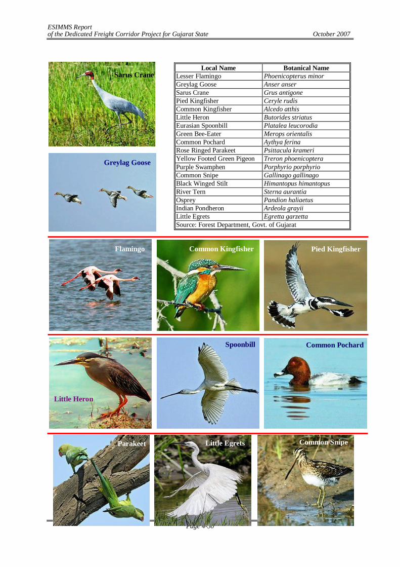
ESIMMS Report of the Dedicated Freight Corridor Project for Gujarat State October 2007
Page 4-30
Local Name Botanical Name
Lesser Flamingo Phoenicopterus minor Greylag Goose Anser anser Sarus Crane Grus antigone Pied Kingfisher Ceryle rudis Common Kingfisher Alcedo atthis Little Heron Butorides striatus Eurasian Spoonbill Platalea leucorodia Green Bee-Eater Merops orientalis Common Pochard Aythya ferina Rose Ringed Parakeet Psittacula krameri Yellow Footed Green Pigeon Treron phoenicoptera Purple Swamphen Porphyrio porphyrio Common Snipe Gallinago gallinago Black Winged Stilt Himantopus himantopus River Tern Sterna aurantia Osprey Pandion haliaetus Indian Pondheron Ardeola grayii Little Egrets Egretta garzetta Source: Forest Department, Govt. of Gujarat
Sarus Crane
Greylag Goose
Flamingo Common Kingfisher Pied Kingfisher
Little Heron
Spoonbill Common Pochard
Parakeet Little Egrets Common Snipe
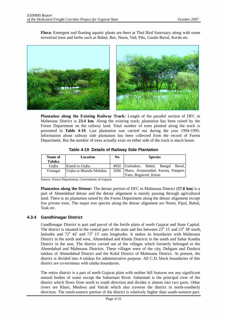
ESIMMS Report of the Dedicated Freight Corridor Project for Gujarat State October 2007
Page 4-31
Flora: Emergent and floating aquatic plants are there at Thol Bird Sanctuary along with some terrestrial trees and herbs such as Babul, Bor, Neem, Vad, Pilu, Gando Baval, Kerdo etc.
Plantation along the Existing Railway Track: Length of the parallel section of DFC in Mahesana District is 23.4 km. Along the existing track; plantation has been raised by the Forest Department on the railway land. Total number of trees planted along the track is presented in Table 4-19. Last plantation was carried out during the year 1994-1995. Information about railway side plantation has been collected from the record of Forest Department. But the number of trees actually exist on either side of the track is much lesser.
Table 4-19 Details of Railway Side Plantation Name of Taluka
Location No Species
Unjha Kamli to Unjha 4950 Visnagar Unjha to Bhandu-Motidau 3500
Gulmahor, Babul, Bangal Baval, Sharu, Arujunsadad, Karanj, Pangaro, Vans, Boganvel, Karan
Source: Forest Department, Government of Gujarat
Plantation along the Detour: The detour portion of DFC in Mahesana District (57.8 km) is a part of Ahmedabad detour and the detour alignment is mainly passing through agricultural land. There is no plantation raised by the Forest Department along the detour alignment except few private trees. The major tree species along the detour alignment are Neem, Pipal, Babul, Teak etc.
4.3.4 Gandhinagar District Gandhinagar District is part and parcel of the fertile plain of north Gujarat and State Capital. The district is situated in the central part of the state and lies between 230 15' and 230 38' north, latitudes and 720 42' and 730 15' east longitudes. It makes its boundaries with Mahesana District in the north and west, Ahmedabad and Kheda Districts in the south and Sabar Kantha District in the east. The district carved out of the villages which formerly belonged to the Ahmedabad and Mahesana Districts. These villages were of the city, Dehgam and Daskroi talukas of Ahmedabad District and the Kalol District of Mahesana District. At present, the district is divided into 4 talukas for administrative purpose. All C.D. block boundaries of this district are co-terminus with taluka boundaries.
The entire district is a part of north Gujarat plain with neither hill features nor any significant natural bodies of water except the Sabarmati River. Sabarmati is the principal river of the district which flows from north to south direction and divides it almost into two parts. Other rivers are Khari, Meshwa and Vatrak which also traverse the district in north-southerly direction. The north-eastern portion of the district is relatively higher than south-western part.
ESIMMS Report of the Dedicated Freight Corridor Project for Gujarat State October 2007
Page 4-32
The elevation varies between 68 metres and 100 metres above M.S.L. The district has no forests of any significance.
(1) Geology
The geological structure of this region is formed of Alluvium, blown sand, etc., formations. The sediments of the plain belong to the youngest geological formation, mostly upper Quaternary, and consist of a thick succession of sandy and clayey layers of fluvial, fluviomarine and aeolian origin. The depositional environment provides a good example of the control of fluctuating of sea level and climatic changes, which was subjected to neotectonic disturbances from time to time. The deposition has taken place in the N-S trending structural depression of the Cambay basin. The maximum thickness of the deposits is more than 500 m in the central and western part. The sediments in the east are dominantly of fluvial origin. Ttraced west, they progressively grade into fluviomarine to marine. The western part of the region along the Rann border represents a palaeomudflat.
(2) Topography
The landscape is characterized by a subdued topography comprising a variety of depositional transitional area between the plain and the highland is marked by a pediment zone of undulating topography, characterized by low altitude mounds and hillocks of stabalised aeolian sands dunes. There are also small alluvial fans and cones of fluvial material brought by the rivers coming from the neighbouring highland. The central part of the plain shows mix topography of fluvial plains marked by subdued fossil dunes. The western part is almost a level ground of saline waste land with a thin veneer of sand and silt.
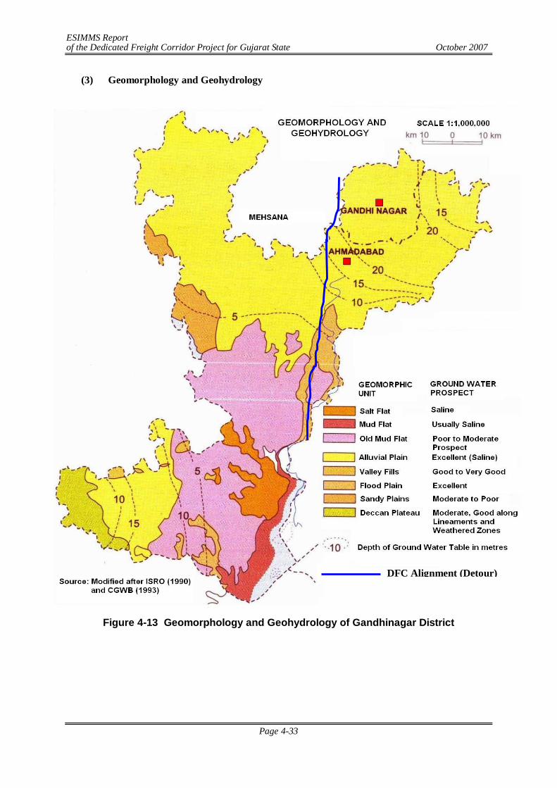
ESIMMS Report of the Dedicated Freight Corridor Project for Gujarat State October 2007
Page 4-33
(3) Geomorphology and Geohydrology
Figure 4-13 Geomorphology and Geohydrology of Gandhinagar District
DFC Alignment (Detour)
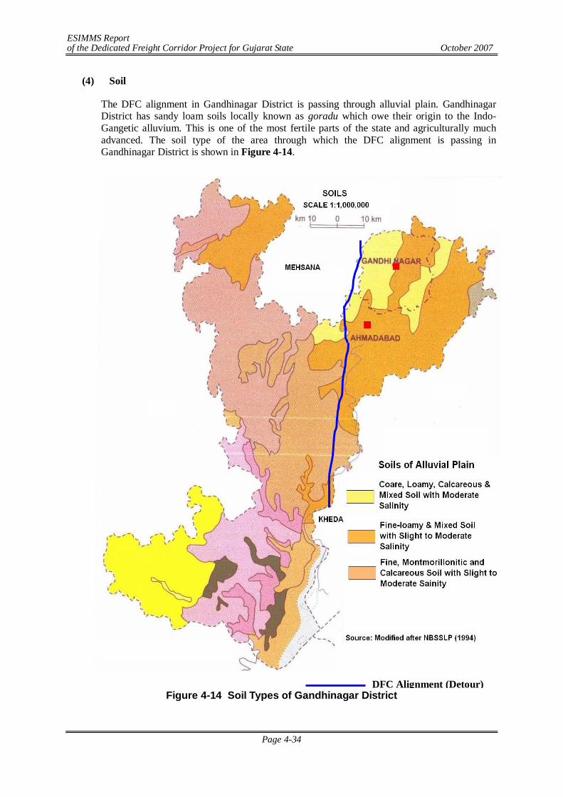
ESIMMS Report of the Dedicated Freight Corridor Project for Gujarat State October 2007
Page 4-34
(4) Soil
The DFC alignment in Gandhinagar District is passing through alluvial plain. Gandhinagar District has sandy loam soils locally known as goradu which owe their origin to the Indo-Gangetic alluvium. This is one of the most fertile parts of the state and agriculturally much advanced. The soil type of the area through which the DFC alignment is passing in Gandhinagar District is shown in Figure 4-14.
Figure 4-14 Soil Types of Gandhinagar District DFC Alignment (Detour)
ESIMMS Report of the Dedicated Freight Corridor Project for Gujarat State October 2007
Page 4-35
(5) Agriculture
DFC alignment is mainly passing through the agricultural land in Gandhinagar District. Agriculture plays a prominent part in the economy of the district. The district has a total area of 67,600 ha, of which 48,800 ha are under cultivation. The agricultural land of Gandhinagar is irrigated by wells and tube-wells. The Sabarmati and Khari Rivers flows through this district but they are not utilized for irrigation purpose. The major crops grown in Gandhinagar District are given in the following table:
Table 4-20 Crops grown in Gandhinagar District Name of the Crop Scientific Name Remarks Bajri Pennisetum typhoidem Kharif crop Paddy Oryza sativa Kharif crop Jowar Andropogau sorghum Rabi crop
Mainly for fodder purpose Cotton Gossypium herbaccum Pulses Tur Gram Mag Math Udid Val
Cajanus indicus Cicer arietinum Phaseolus radiatus Phaseolus acontifolius Phaseolus mungo Lablab niger
Kharif crop
(6) Climate and Meteorology
The climate of the area is moderate and tropical characterized by a hot summer from March to Mid June, a humid monsoon or rainy season stretching from Mid June to September, a short pleasant post-monsoon during October and November, and a cool winter spanning between December and February. Therefore, climatologically, four seasons viz. summer (pre-monsoon), monsoon, post-monsoon and winter could be deciphered comprising the following months:
Summer : March, April, May Monsoon : June, July, August, September Post-monsoon : October, November Winter : December, January, February.
Past meteorological data described in this section have been collected from the nearest IMD observatory located at Ahmedabad, which deemed representative of the study corridor. Available past meteorological data has been collected and summarized in Table 4-21.
In Gandhinagar Districts January is the coldest month with the mean daily minimum temperature of 11.7C and maximum of 28.4C. March onwards the temperature begins to rise rapidly and May is the hottest months with the mean daily maximum temperature of 41.8C and minimum of 26.2C. Thereafter, the advent of monsoon brings down the temperature. Monsoon withdraws in October but the temperature continues to fall gradually up to January, the middle of winter. The annual average of maximum and minimum mean daily temperatures are 34.4C and 20.5C respectively.
ESIMMS Report of the Dedicated Freight Corridor Project for Gujarat State October 2007
Page 4-36
Table 4-21 Mean Monthly Climatological Records (Based on Records of IMD, 1951- 1980)
Daily Temperature (0 C)
Relative Humidity (%)
Total Rainfall
No of Rainy
Total Cloud Cover (octas)
Wind Speed
Month
Max Min 0830 1730 (mm) Days 0830 1730 km/h January 28.4 11.7 57 29 2.6 0.3 1.3 1.4 5.8 February 31.3 13.8 50 22 1.1 0.2 1.2 1.2 5.9 March 36.0 18.8 46 18 1.0 0.1 1.4 1.6 6.3 April 39.9 23.4 51 18 0.9 0.1 1.5 1.7 7.0 May 41.8 26.2 63 22 6.0 0.4 1.8 1.2 9.2 Jun 38.4 27.0 74 45 108.7 5.0 4.9 4.0 10.1 July 33.3 25.7 85 67 265.3 11.3 6.6 6.4 8.7 August 31.9 24.8 88 70 219.8 10.7 6.8 6.4 7.2 September 33.4 24.1 83 59 171.9 6.2 4.5 4.2 6.0 October 35.8 20.9 64 37 10.8 0.7 1.7 1.7 4.3 November 33.2 16.5 53 33 8.9 0.6 1.5 1.5 4.6 December 29.8 13.0 57 33 2.6 0.2 1.6 1.6 5.3 Mean/Total 34.4 20.5 64 38 803.4 35.8 2.9 2.7 6.7 Source: India Meteorological Department (IMD)
The air is fairly humid through the major part of the year and the mean relative humidity rises during the monsoon months, particularly July to September ranging between 83-88% in the morning (0830 IST) and 59-70% in the evening (1730 IST). The trend in humidity in various seasons clearly shows a discernible influence of rain on humidity. The highest mean relative humidity is recorded in August (88% in the morning and 70% in the evening), a wet monsoon month and the lowest mean relative humidity is recorded in March (46% in the morning and 18% in the evening). The annual mean relative humidity is about 64% in the morning and 38% in the evening, which correlates well with the tropical humid climate of the area. As usual, the humidity in the morning (0830 IST) is more than that in the evening (1730 IST) during all the months.
The total annual rainfall received along the study corridor is about 803.4 mm. The four monsoon months (June to September) contribute about 80% of the total annual rainfall. Lowest rainfall is observed in April (0.9 mm) and highest rainfall is observed in July (265.3 mm). Total number of rainy days is about 35.8 days per annum. Winds are generally moderate to low through out the year. The annual mean wind speed is 6.7 km/h with the mean monthly wind speed 4.3-5.3 km/h (during October-December) and 8.7-10.1 km/h (May to July).
(7) River System
There are only two rivers flowing through the district, viz., the Sabarmati and the Khari. The Sabarmati River enters this district near the Rajpur Village and out of its total length of 416 km, the Sabarmati flows for only 34 km in the Gandhinagar District. The Khari River is a tributary of the Sabarmati River. The rivers in the district do not flow throughout the year. The DFC alignment in Gandhinagar District does not cross any rivers.
(8) Forest, Flora & Fauna
Forest: There is a negligible area under forests in Gandhinagar District. No part of this district has been declared as forest area. However, the whole district is green with vegetation containing number of trees such as Zizyphus mauratiana (Bordi), Magnifera indica (Mango), Ficus infectoria (Pipal) etc.
Plantation along the Detour: The entire stretch of DFC in Gandhinagar District is a part of Ahmedabad detour and the detour alignment is mainly passing through agricultural land.
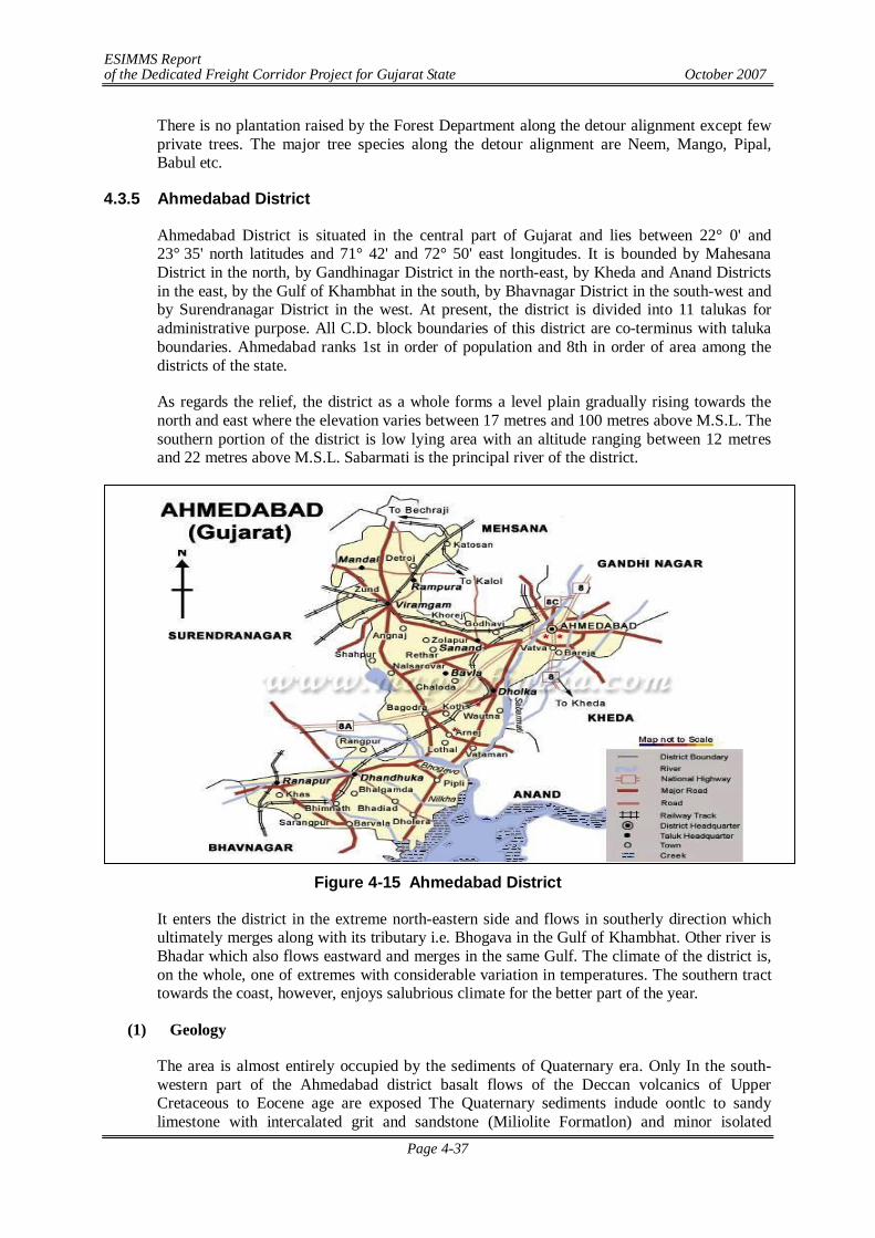
ESIMMS Report of the Dedicated Freight Corridor Project for Gujarat State October 2007
Page 4-37
There is no plantation raised by the Forest Department along the detour alignment except few private trees. The major tree species along the detour alignment are Neem, Mango, Pipal, Babul etc.
4.3.5 Ahmedabad District
Ahmedabad District is situated in the central part of Gujarat and lies between 22° 0' and 23° 35' north latitudes and 71° 42' and 72° 50' east longitudes. It is bounded by Mahesana District in the north, by Gandhinagar District in the north-east, by Kheda and Anand Districts in the east, by the Gulf of Khambhat in the south, by Bhavnagar District in the south-west and by Surendranagar District in the west. At present, the district is divided into 11 talukas for administrative purpose. All C.D. block boundaries of this district are co-terminus with taluka boundaries. Ahmedabad ranks 1st in order of population and 8th in order of area among the districts of the state.
As regards the relief, the district as a whole forms a level plain gradually rising towards the north and east where the elevation varies between 17 metres and 100 metres above M.S.L. The southern portion of the district is low lying area with an altitude ranging between 12 metres and 22 metres above M.S.L. Sabarmati is the principal river of the district.
Figure 4-15 Ahmedabad District
It enters the district in the extreme north-eastern side and flows in southerly direction which ultimately merges along with its tributary i.e. Bhogava in the Gulf of Khambhat. Other river is Bhadar which also flows eastward and merges in the same Gulf. The climate of the district is, on the whole, one of extremes with considerable variation in temperatures. The southern tract towards the coast, however, enjoys salubrious climate for the better part of the year.
(1) Geology
The area is almost entirely occupied by the sediments of Quaternary era. Only In the south-western part of the Ahmedabad district basalt flows of the Deccan volcanics of Upper Cretaceous to Eocene age are exposed The Quaternary sediments indude oontlc to sandy limestone with intercalated grit and sandstone (Miliolite Formatlon) and minor isolated
ESIMMS Report of the Dedicated Freight Corridor Project for Gujarat State October 2007
Page 4-38
outcrops of variegated clay, siltstone and marl (Vend formation) of Pleistocene age. Sediments of Holocene age comprise Rann Clay Formation (tidal flat deposits] and Mahuva Formation (Shoal spit/bar, tidal flat and tidal marsh deposits) deposited by marine agencies, Katpur Formation (Flood plain and deltaic deposits) and larahi Formationb (channel/fill and flood plane deposits) by fluvial agencies , Akhaj Formation (sand sheet and sand dune, stabilized) and Jantral formation (sand sheet and sand dunes unstabilized) by Aeolian agencies and Nalsarobar Formation deposited by lacustrine agencies.
(2) Topography
The landscape is characterized by a subdued topography comprising a variety of depositional transitional area between the plain and the highland is marked by a pediment zone of undulating topography, characterized by low altitude mounds and hillocks of stabalised aeolian sands dunes. There are also small alluvial fans and cones of fluvial material brought by the rivers coming from the neighbouring highland. The central part of the plain shows mix topography of fluvial plains marked by subdued fossil dunes. The western part is almost a level ground of saline waste land with a thin veneer of sand and silt.

ESIMMS Report of the Dedicated Freight Corridor Project for Gujarat State October 2007
Page 4-39
(3) Geomorphology and Geohydrology
Figure 4-16 Geomorphology and Geohydrology of Ahmedabad District
DFC Alignment (Detour)
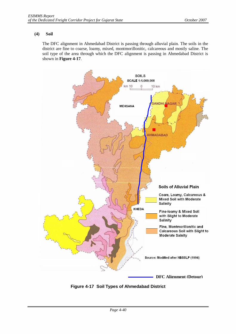
ESIMMS Report of the Dedicated Freight Corridor Project for Gujarat State October 2007
Page 4-40
(4) Soil
The DFC alignment in Ahmedabad District is passing through alluvial plain. The soils in the district are fine to coarse, loamy, mixed, montmorillonitic, calcareous and mostly saline. The soil type of the area through which the DFC alignment is passing in Ahmedabad District is shown in Figure 4-17.
Figure 4-17 Soil Types of Ahmedabad District
DFC Alignment (Detour)
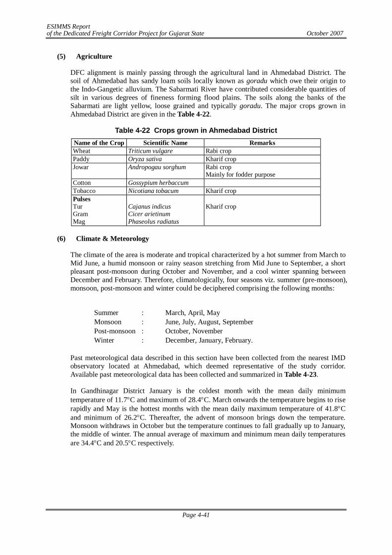
ESIMMS Report of the Dedicated Freight Corridor Project for Gujarat State October 2007
Page 4-41
(5) Agriculture
DFC alignment is mainly passing through the agricultural land in Ahmedabad District. The soil of Ahmedabad has sandy loam soils locally known as goradu which owe their origin to the Indo-Gangetic alluvium. The Sabarmati River have contributed considerable quantities of silt in various degrees of fineness forming flood plains. The soils along the banks of the Sabarmati are light yellow, loose grained and typically goradu. The major crops grown in Ahmedabad District are given in the Table 4-22.
Table 4-22 Crops grown in Ahmedabad District Name of the Crop Scientific Name Remarks Wheat Triticum vulgare Rabi crop Paddy Oryza sativa Kharif crop Jowar Andropogau sorghum Rabi crop
Mainly for fodder purpose Cotton Gossypium herbaccum Tobacco Nicotiana tobacum Kharif crop Pulses Tur Gram Mag
Cajanus indicus Cicer arietinum Phaseolus radiatus
Kharif crop
(6) Climate & Meteorology
The climate of the area is moderate and tropical characterized by a hot summer from March to Mid June, a humid monsoon or rainy season stretching from Mid June to September, a short pleasant post-monsoon during October and November, and a cool winter spanning between December and February. Therefore, climatologically, four seasons viz. summer (pre-monsoon), monsoon, post-monsoon and winter could be deciphered comprising the following months:
Summer : March, April, May Monsoon : June, July, August, September Post-monsoon : October, November Winter : December, January, February.
Past meteorological data described in this section have been collected from the nearest IMD observatory located at Ahmedabad, which deemed representative of the study corridor. Available past meteorological data has been collected and summarized in Table 4-23.
In Gandhinagar District January is the coldest month with the mean daily minimum temperature of 11.7C and maximum of 28.4C. March onwards the temperature begins to rise rapidly and May is the hottest months with the mean daily maximum temperature of 41.8C and minimum of 26.2C. Thereafter, the advent of monsoon brings down the temperature. Monsoon withdraws in October but the temperature continues to fall gradually up to January, the middle of winter. The annual average of maximum and minimum mean daily temperatures are 34.4C and 20.5C respectively.
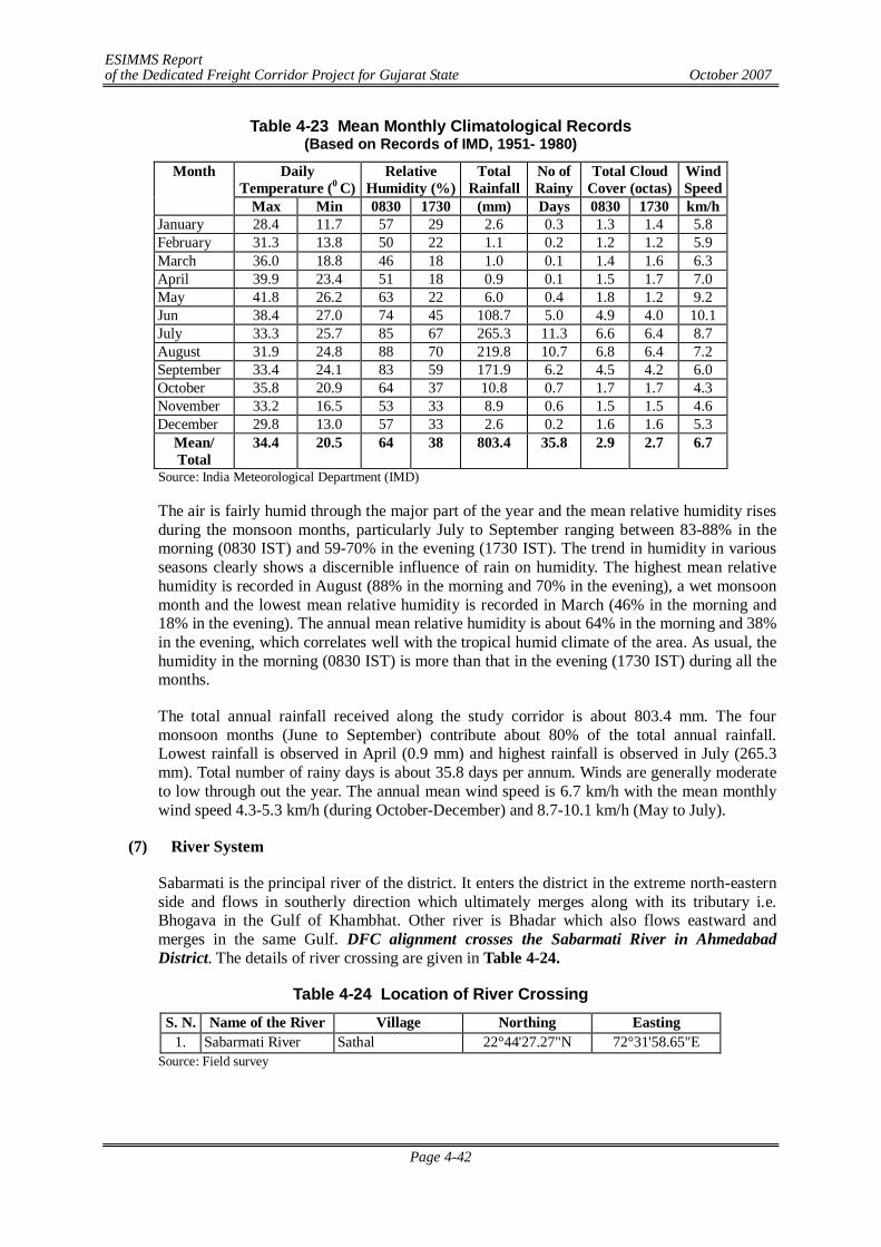
ESIMMS Report of the Dedicated Freight Corridor Project for Gujarat State October 2007
Page 4-42
Table 4-23 Mean Monthly Climatological Records (Based on Records of IMD, 1951- 1980)
Daily Temperature (0 C)
Relative Humidity (%)
Total Rainfall
No of Rainy
Total Cloud Cover (octas)
Wind Speed
Month
Max Min 0830 1730 (mm) Days 0830 1730 km/h January 28.4 11.7 57 29 2.6 0.3 1.3 1.4 5.8 February 31.3 13.8 50 22 1.1 0.2 1.2 1.2 5.9 March 36.0 18.8 46 18 1.0 0.1 1.4 1.6 6.3 April 39.9 23.4 51 18 0.9 0.1 1.5 1.7 7.0 May 41.8 26.2 63 22 6.0 0.4 1.8 1.2 9.2 Jun 38.4 27.0 74 45 108.7 5.0 4.9 4.0 10.1 July 33.3 25.7 85 67 265.3 11.3 6.6 6.4 8.7 August 31.9 24.8 88 70 219.8 10.7 6.8 6.4 7.2 September 33.4 24.1 83 59 171.9 6.2 4.5 4.2 6.0 October 35.8 20.9 64 37 10.8 0.7 1.7 1.7 4.3 November 33.2 16.5 53 33 8.9 0.6 1.5 1.5 4.6 December 29.8 13.0 57 33 2.6 0.2 1.6 1.6 5.3
Mean/ Total
34.4 20.5 64 38 803.4 35.8 2.9 2.7 6.7
Source: India Meteorological Department (IMD)
The air is fairly humid through the major part of the year and the mean relative humidity rises during the monsoon months, particularly July to September ranging between 83-88% in the morning (0830 IST) and 59-70% in the evening (1730 IST). The trend in humidity in various seasons clearly shows a discernible influence of rain on humidity. The highest mean relative humidity is recorded in August (88% in the morning and 70% in the evening), a wet monsoon month and the lowest mean relative humidity is recorded in March (46% in the morning and 18% in the evening). The annual mean relative humidity is about 64% in the morning and 38% in the evening, which correlates well with the tropical humid climate of the area. As usual, the humidity in the morning (0830 IST) is more than that in the evening (1730 IST) during all the months.
The total annual rainfall received along the study corridor is about 803.4 mm. The four monsoon months (June to September) contribute about 80% of the total annual rainfall. Lowest rainfall is observed in April (0.9 mm) and highest rainfall is observed in July (265.3 mm). Total number of rainy days is about 35.8 days per annum. Winds are generally moderate to low through out the year. The annual mean wind speed is 6.7 km/h with the mean monthly wind speed 4.3-5.3 km/h (during October-December) and 8.7-10.1 km/h (May to July).
(7) River System
Sabarmati is the principal river of the district. It enters the district in the extreme north-eastern side and flows in southerly direction which ultimately merges along with its tributary i.e. Bhogava in the Gulf of Khambhat. Other river is Bhadar which also flows eastward and merges in the same Gulf. DFC alignment crosses the Sabarmati River in Ahmedabad District. The details of river crossing are given in Table 4-24.
Table 4-24 Location of River Crossing S. N. Name of the River Village Northing Easting
1. Sabarmati River Sathal 22°44'27.27"N 72°31'58.65"E Source: Field survey
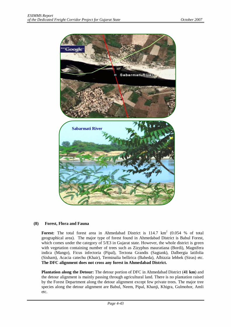
ESIMMS Report of the Dedicated Freight Corridor Project for Gujarat State October 2007
Page 4-43
(8) Forest, Flora and Fauna
Forest: The total forest area in Ahmedabad District is 114.7 km2 (0.054 % of total geographical area). The major type of forest found in Ahmedabad District is Babul Forest, which comes under the category of 5/E3 in Gujarat state. However, the whole district is green with vegetation containing number of trees such as Zizyphus mauratiana (Bordi), Magnifera indica (Mango), Ficus infectoria (Pipal), Tectona Grandis (Sagtank), Dalbergia latifolia (Sisham), Acacia catechu (Khair), Terminalia bellirica (Baheda), Albizzia lebbek (Siras) etc. The DFC alignment does not cross any forest in Ahmedabad District.
Plantation along the Detour: The detour portion of DFC in Ahmedabad District (41 km) and the detour alignment is mainly passing through agricultural land. There is no plantation raised by the Forest Department along the detour alignment except few private trees. The major tree species along the detour alignment are Babul, Neem, Pipal, Khanji, Khigra, Gulmohor, Amli etc.
Sabarmati River
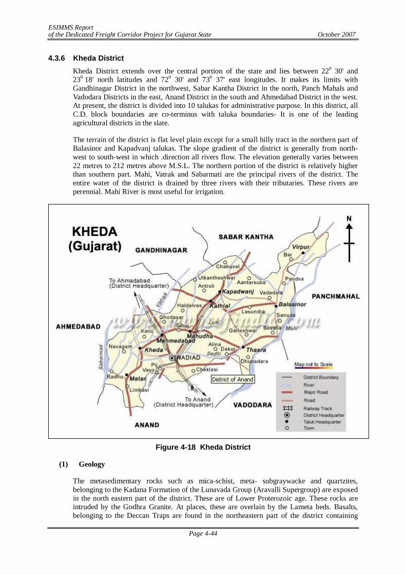
ESIMMS Report of the Dedicated Freight Corridor Project for Gujarat State October 2007
Page 4-44
4.3.6 Kheda District Kheda District extends over the central portion of the state and lies between 220 30' and 230 18' north latitudes and 720 30' and 730 37' east longitudes. It makes its limits with Gandhinagar District in the northwest, Sabar Kantha District in the north, Panch Mahals and Vadodara Districts in the east, Anand District in the south and Ahmedabad District in the west. At present, the district is divided into 10 talukas for administrative purpose. In this district, all C.D. block boundaries are co-terminus with taluka boundaries- It is one of the leading agricultural districts in the slate.
The terrain of the district is flat level plain except for a small hilly tract in the northern part of Balasinor and Kapadvanj talukas. The slope gradient of the district is generally from north-west to south-west in which .direction all rivers flow. The elevation generally varies between 22 metres to 212 metres above M.S.L. The northern portion of the district is relatively higher than southern part. Mahi, Vatrak and Sabarmati are the principal rivers of the district. The entire water of the district is drained by three rivers with their tributaries. These rivers are perennial. Mahi River is most useful for irrigation.
Figure 4-18 Kheda District
(1) Geology
The metasedimentary rocks such as mica-schist, meta- subgraywacke and quartzites, belonging to the Kadana Formation of the Lunavada Group (Aravalli Supergroup) are exposed in the north eastern part of the district. These are of Lower Proterozoic age. These rocks are intruded by the Godhra Granite. At places, these are overlain by the Lameta beds. Basalts, belonging to the Deccan Traps are found in the northeastern part of the district containing
ESIMMS Report of the Dedicated Freight Corridor Project for Gujarat State October 2007
Page 4-45
intertrappean sediments. Laterite and bauxite cappings (Salod Formation) are found over the Deccan Traps at many places. Limestone, sandstone and marl belonging to the Vagadkhol Formation of the Eocene age are found in the area between Dakor and Kapadvanj. Calcareous sand belonging to the Miliolite Formation of the Porbandar Group is found WNW of Khambhat. The district is mostly occupied by Holocene sediments. These sediments are of marine, fluvial and aeolian origin. The marine sediments include the older tidal flats and tidal marsh of Rann Clay Formation and shoal, tidal flat and marsh of younger Mahuva Formation.The fluvial sediments include flood plain and delta of Katpur Formation and channel-fill and flood plain of younger Varahi Formation. The Aeolian sediments include stabilized sand sheet and sand dune of Akhaj Formation and sand sheet of younger Jantral Formation.
(2) Topography
The region shows more or less a flat topography with a series of sections cut by deeply incised channels of rivers flowing across the region. The sections are 10 to 30 m deep, and the river banks are generally marked by levee deposits, creating a ridge type banks with higher elevations than the general ground level. The flat topography is dotted by low height sandy mounds of stabilized dunes. Formation of ravine landscape is quite common on most of the river banks due to deep gully erosion.
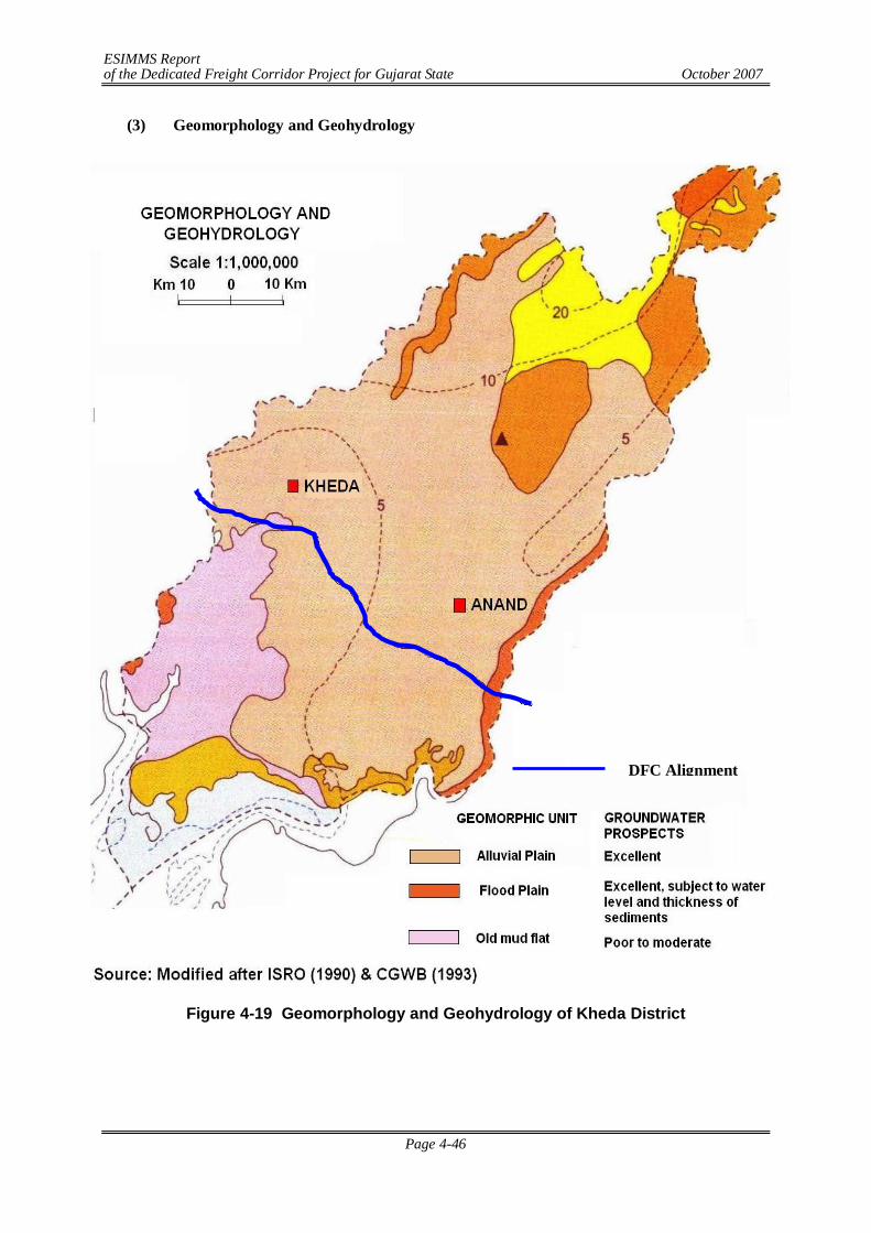
ESIMMS Report of the Dedicated Freight Corridor Project for Gujarat State October 2007
Page 4-46
(3) Geomorphology and Geohydrology
Figure 4-19 Geomorphology and Geohydrology of Kheda District
DFC Alignment
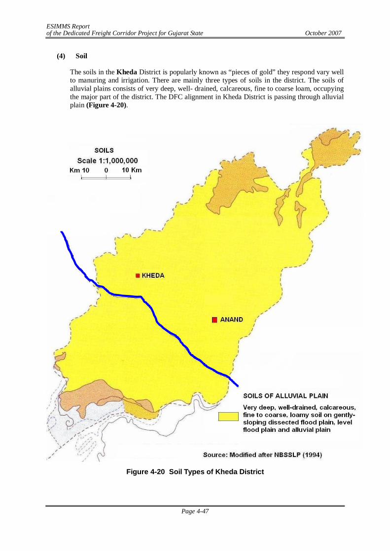
ESIMMS Report of the Dedicated Freight Corridor Project for Gujarat State October 2007
Page 4-47
(4) Soil
The soils in the Kheda District is popularly known as “pieces of gold” they respond vary well to manuring and irrigation. There are mainly three types of soils in the district. The soils of alluvial plains consists of very deep, well- drained, calcareous, fine to coarse loam, occupying the major part of the district. The DFC alignment in Kheda District is passing through alluvial plain (Figure 4-20).
Figure 4- 20 Soil Types of Kheda District
Figure 4-20 Soil Types of Kheda District
DFC Alignment
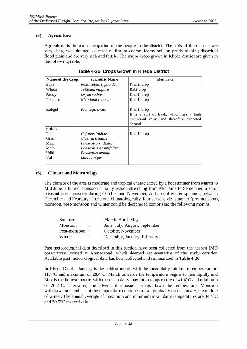
ESIMMS Report of the Dedicated Freight Corridor Project for Gujarat State October 2007
Page 4-48
(5) Agriculture
Agriculture is the main occupation of the people in the district. The soils of the districts are very deep, well drained, calcareous, fine to coarse, loamy soil on gently sloping dissedted flood plain and are very rich and fertile. The major crops grown in Kheda district are given in the following table.
Table 4-25 Crops Grown in Kheda District Name of the Crop Scientific Name Remarks Bajri Pennisetum typhoidem Kharif crop Wheat Triticum vulgare Rabi crop Paddy Oryza sativa Kharif crop Tobacco Nicotiana tobacum Kharif crop
Isabgul Plantago ovata Kharif crop
It is a sort of husk, which has a high medicinal value and therefore exported abroad
Pulses Tur Gram Mag Math Udid Val
Cajanus indicus Cicer arietinum Phaseolus radiatus Phaseolus acontifolius Phaseolus mungo Lablab niger
Kharif crop
(6) Climate and Meteorology
The climate of the area is moderate and tropical characterized by a hot summer from March to Mid June, a humid monsoon or rainy season stretching from Mid June to September, a short pleasant post-monsoon during October and November, and a cool winter spanning between December and February. Therefore, climatologically, four seasons viz. summer (pre-monsoon), monsoon, post-monsoon and winter could be deciphered comprising the following months:
Summer : March, April, May Monsoon : June, July, August, September Post-monsoon : October, November Winter : December, January, February.
Past meteorological data described in this section have been collected from the nearest IMD observatory located at Ahmedabad, which deemed representative of the study corridor. Available past meteorological data has been collected and summarized in Table 4-26.
In Kheda District January is the coldest month with the mean daily minimum temperature of 11.7C and maximum of 28.4C. March onwards the temperature begins to rise rapidly and May is the hottest months with the mean daily maximum temperature of 41.8C and minimum of 26.2C. Thereafter, the advent of monsoon brings down the temperature. Monsoon withdraws in October but the temperature continues to fall gradually up to January, the middle of winter. The annual average of maximum and minimum mean daily temperatures are 34.4C and 20.5C respectively.
ESIMMS Report of the Dedicated Freight Corridor Project for Gujarat State October 2007
Page 4-49
Table 4-26 Mean Monthly Climatological Records (Based on Records of IMD, 1951- 1980)
Month Daily
Temperature (0 C)
Relative Humidity (%)
Total Rainfall
No of Rainy
Total Cloud Cover(octas)
Wind Speed
Max Min 0830 1730 (mm) Days 0830 1730 (km/h) January 28.4 11.7 57 29 2.6 0.3 1.3 1.4 5.8 February 31.3 13.8 50 22 1.1 0.2 1.2 1.2 5.9 March 36.0 18.8 46 18 1.0 0.1 1.4 1.6 6.3 April 39.9 23.4 51 18 0.9 0.1 1.5 1.7 7.0 May 41.8 26.2 63 22 6.0 0.4 1.8 1.2 9.2 Jun 38.4 27.0 74 45 108.7 5.0 4.9 4.0 10.1 July 33.3 25.7 85 67 265.3 11.3 6.6 6.4 8.7 August 31.9 24.8 88 70 219.8 10.7 6.8 6.4 7.2 September 33.4 24.1 83 59 171.9 6.2 4.5 4.2 6.0 October 35.8 20.9 64 37 10.8 0.7 1.7 1.7 4.3 November 33.2 16.5 53 33 8.9 0.6 1.5 1.5 4.6 December 29.8 13.0 57 33 2.6 0.2 1.6 1.6 5.3 Mean/Total 34.4 20.5 64 38 803.4 35.8 2.9 2.7 6.7
Source: India Meteorological Department (IMD)
The air is fairly humid through the major part of the year and the mean relative humidity rises during the monsoon months, particularly July to September ranging between 83-88% in the morning (0830 IST) and 59-70% in the evening (1730 IST). The trend in humidity in various seasons clearly shows a discernible influence of rain on humidity. The highest mean relative humidity is recorded in August (88% in the morning and 70% in the evening), a wet monsoon month and the lowest mean relative humidity is recorded in March (46% in the morning and 18% in the evening). The annual mean relative humidity is about 64% in the morning and 38% in the evening, which correlates well with the tropical humid climate of the area. As usual, the humidity in the morning (0830 IST) is more than that in the evening (1730 IST) during all the months.
The total annual rainfall received along the study corridor is about 803.4 mm. The four monsoon months (June to September) contribute about 80% of the total annual rainfall. Lowest rainfall is observed in April (0.9 mm) and highest rainfall is observed in July (265.3 mm). Total number of rainy days is about 35.8 days per annum. Winds are generally moderate to low through out the year. The annual mean wind speed is 6.7 km/h with the mean monthly wind speed 4.3-5.3 km/h (during October-December) and 8.7-10.1 km/h (May to July).
(7) River System
The Sabarmati, Mahi, Vatrak & Khari are the main rivers of the district. The DFC alignment crosses Vatrak & Sabarmati Rivers in Kheda. The details of river crossing are given in Table 4-27.
Table 4-27 Location of River Crossing S. N. Name of the River Village/Town Northing Easting
1. Vatrak River Vasna Bujarg 22°42'52.94"N 72°37'29.15"E 2. Sabarmati River Kaloli 22°44'27.27"N 72°31'58.65"E
Source: Field Survey
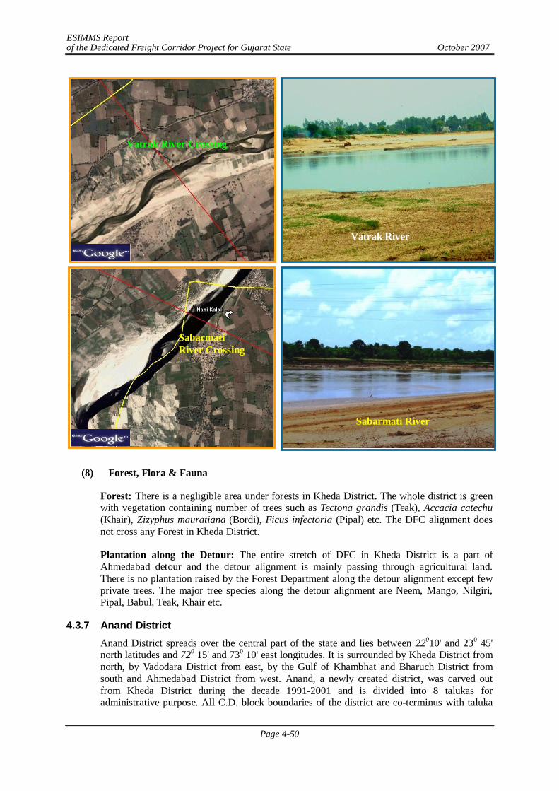
ESIMMS Report of the Dedicated Freight Corridor Project for Gujarat State October 2007
Page 4-50
(8) Forest, Flora & Fauna
Forest: There is a negligible area under forests in Kheda District. The whole district is green with vegetation containing number of trees such as Tectona grandis (Teak), Accacia catechu (Khair), Zizyphus mauratiana (Bordi), Ficus infectoria (Pipal) etc. The DFC alignment does not cross any Forest in Kheda District.
Plantation along the Detour: The entire stretch of DFC in Kheda District is a part of Ahmedabad detour and the detour alignment is mainly passing through agricultural land. There is no plantation raised by the Forest Department along the detour alignment except few private trees. The major tree species along the detour alignment are Neem, Mango, Nilgiri, Pipal, Babul, Teak, Khair etc.
4.3.7 Anand District Anand District spreads over the central part of the state and lies between 22010' and 230 45' north latitudes and 720 15' and 730 10' east longitudes. It is surrounded by Kheda District from north, by Vadodara District from east, by the Gulf of Khambhat and Bharuch District from south and Ahmedabad District from west. Anand, a newly created district, was carved out from Kheda District during the decade 1991-2001 and is divided into 8 talukas for administrative purpose. All C.D. block boundaries of the district are co-terminus with taluka
Vatrak River Crossing
Vatrak River
Sabarmati River Crossing
Sabarmati River
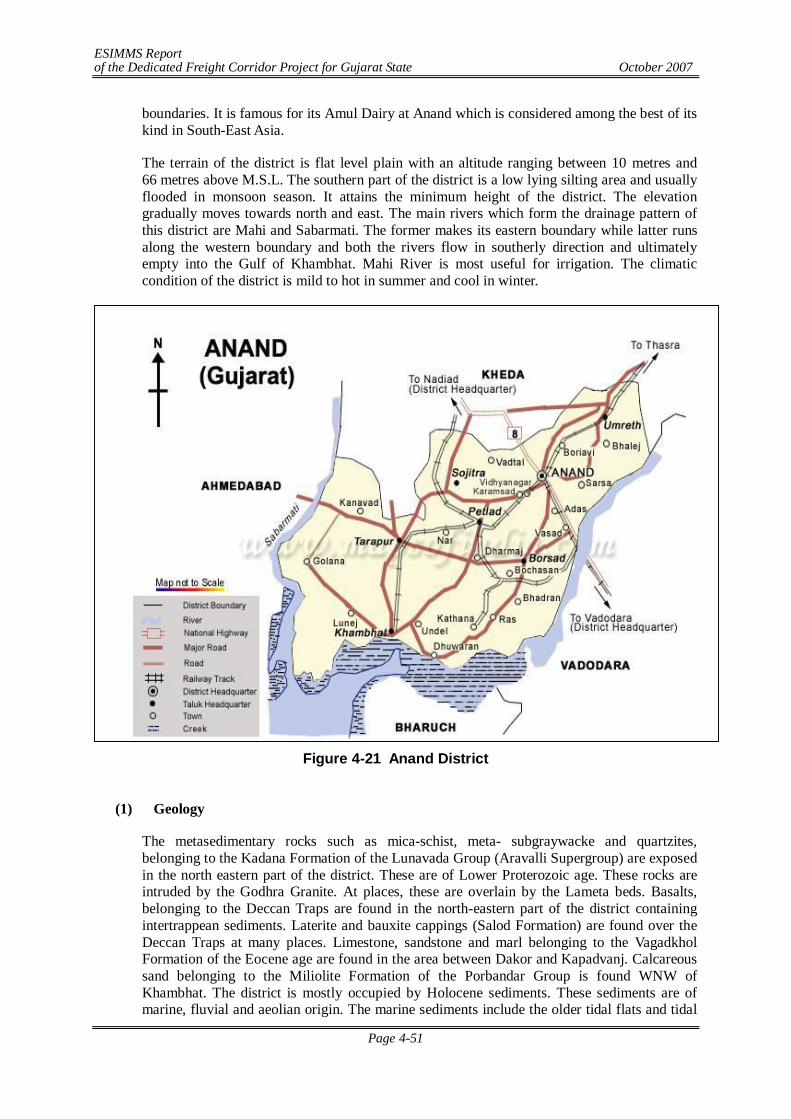
ESIMMS Report of the Dedicated Freight Corridor Project for Gujarat State October 2007
Page 4-51
boundaries. It is famous for its Amul Dairy at Anand which is considered among the best of its kind in South-East Asia.
The terrain of the district is flat level plain with an altitude ranging between 10 metres and 66 metres above M.S.L. The southern part of the district is a low lying silting area and usually flooded in monsoon season. It attains the minimum height of the district. The elevation gradually moves towards north and east. The main rivers which form the drainage pattern of this district are Mahi and Sabarmati. The former makes its eastern boundary while latter runs along the western boundary and both the rivers flow in southerly direction and ultimately empty into the Gulf of Khambhat. Mahi River is most useful for irrigation. The climatic condition of the district is mild to hot in summer and cool in winter.
Figure 4-21 Anand District
(1) Geology
The metasedimentary rocks such as mica-schist, meta- subgraywacke and quartzites, belonging to the Kadana Formation of the Lunavada Group (Aravalli Supergroup) are exposed in the north eastern part of the district. These are of Lower Proterozoic age. These rocks are intruded by the Godhra Granite. At places, these are overlain by the Lameta beds. Basalts, belonging to the Deccan Traps are found in the north-eastern part of the district containing intertrappean sediments. Laterite and bauxite cappings (Salod Formation) are found over the Deccan Traps at many places. Limestone, sandstone and marl belonging to the Vagadkhol Formation of the Eocene age are found in the area between Dakor and Kapadvanj. Calcareous sand belonging to the Miliolite Formation of the Porbandar Group is found WNW of Khambhat. The district is mostly occupied by Holocene sediments. These sediments are of marine, fluvial and aeolian origin. The marine sediments include the older tidal flats and tidal
ESIMMS Report of the Dedicated Freight Corridor Project for Gujarat State October 2007
Page 4-52
marsh of Rann Clay Formation and shoal, tidal flat and marsh of younger Mahuva Formation.The fluvial sediments include flood plain and delta of Katpur Formation and channel-fill and flood plain of younger Varahi Formation. The Aeolian sediments include stabilized sand sheet and sand dune of Akhaj Formation and sand sheet of younger Jantral Formation.
(2) Topography
The region shows more or less a flat topography with a series of sections cut by deeply incised channels of rivers flowing across the region. The sections are 10 to 30 m deep, and the river banks are generally marked by levee deposits, creating a ridge type banks with higher elevations than the general ground level.

ESIMMS Report of the Dedicated Freight Corridor Project for Gujarat State October 2007
Page 4-53
(3) Geomorphology and Geohydrology
Figure 4-22 Geomorphology and Geohydrology of Anand District
DFC Alignment
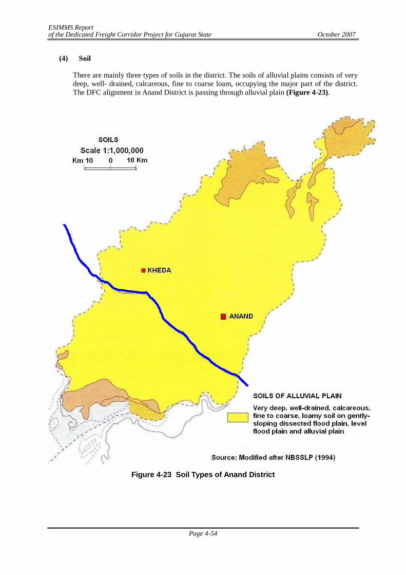
ESIMMS Report of the Dedicated Freight Corridor Project for Gujarat State October 2007
Page 4-54
(4) Soil
There are mainly three types of soils in the district. The soils of alluvial plains consists of very deep, well- drained, calcareous, fine to coarse loam, occupying the major part of the district. The DFC alignment in Anand District is passing through alluvial plain (Figure 4-23).
Figure 4-23 Soil Types of Anand District
DFC Alignment
ESIMMS Report of the Dedicated Freight Corridor Project for Gujarat State October 2007
Page 4-55
(5) Agriculture
The soils of the districts are very deep, well drained, calcareous, fine to coarse, loamy soil on gently sloping dissedted flood plain and are very rich and fertile. The major crops grown in Anand district are given in the following table.
Table 4-28 Crops Grown in Anand District Name of the Crop Scientific Name Remarks Bajri Pennisetum typhoidem Kharif crop Wheat Triticum vulgare Rabi crop Paddy Oryza sativa Kharif crop Pulses Tur Gram Mag Math Udid Val
Cajanus indicus Cicer arietinum Phaseolus radiatus Phaseolus acontifolius Phaseolus mungo Lablab niger
Kharif crop
(6) Climate and Meteorology
The climate of the area is moderate and tropical characterized by a hot summer from March to Mid June, a humid monsoon or rainy season stretching from Mid June to September, a short pleasant post-monsoon during October and November, and a cool winter spanning between December and February. Therefore, climatologically, four seasons viz. summer (pre-monsoon), monsoon, post-monsoon and winter could be deciphered comprising the following months:
Summer : March, April, May Monsoon : June, July, August, September Post-monsoon : October, November Winter : December, January, February.
Past meteorological data described in this section have been collected from the nearest IMD observatory located at Vadodara, which deemed representative of the study corridor. Available past meteorological data has been collected and summarized in Table 4-29.
Table 4-29 Mean Monthly Climatological Records (Based on Records of IMD, 1951- 1980)
Month Daily Temperature (0 C)
Relative Humidity (%)
Total Rainfall
No of Rainy
Total Cloud Cover(octas)
Wind Speed
Max Min 0830 1730 (mm) Days 0830 1730 (km/h) January 30.3 12.0 67 33 1.2 0.1 1.1 1.1 4.0 February 33.0 13.8 61 25 0.6 0.1 0.9 0.9 4.1 March 37.1 18.4 53 20 2.2 0.2 1.1 1.2 4.2 April 40.2 22.9 53 20 0.9 0.1 1.1 1.2 4.8 May 40.9 26.5 64 27 4.4 0.3 1.7 0.7 8.7 Jun 37.1 27.0 76 51 146.8 5.6 4.5 3.4 10.3 July 32.7 25.7 88 72 297.6 13.8 6.5 6.4 8.4 August 31.5 25.0 90 74 284.7 12.0 6.7 6.5 7.1 September 33.2 24.3 86 63 141.7 7.1 4.3 4.0 5.1 October 36.0 21.3 72 44 22.0 1.3 1.5 1.4 3.0 November 34.3 16.7 64 41 16.2 0.7 1.3 1.3 3.0 December 31.4 13.4 70 40 4.4 0.2 1.3 1.3 3.6 Mean/Total 34.8 20.6 70 43 922.7 41.5 2.7 2.5 5.5
Source: India Meteorological Department (IMD)
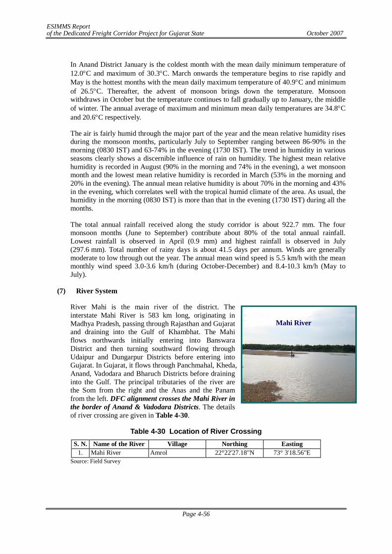
ESIMMS Report of the Dedicated Freight Corridor Project for Gujarat State October 2007
Page 4-56
Mahi River
In Anand District January is the coldest month with the mean daily minimum temperature of 12.0C and maximum of 30.3C. March onwards the temperature begins to rise rapidly and May is the hottest months with the mean daily maximum temperature of 40.9C and minimum of 26.5C. Thereafter, the advent of monsoon brings down the temperature. Monsoon withdraws in October but the temperature continues to fall gradually up to January, the middle of winter. The annual average of maximum and minimum mean daily temperatures are 34.8C and 20.6C respectively.
The air is fairly humid through the major part of the year and the mean relative humidity rises during the monsoon months, particularly July to September ranging between 86-90% in the morning (0830 IST) and 63-74% in the evening (1730 IST). The trend in humidity in various seasons clearly shows a discernible influence of rain on humidity. The highest mean relative humidity is recorded in August (90% in the morning and 74% in the evening), a wet monsoon month and the lowest mean relative humidity is recorded in March (53% in the morning and 20% in the evening). The annual mean relative humidity is about 70% in the morning and 43% in the evening, which correlates well with the tropical humid climate of the area. As usual, the humidity in the morning (0830 IST) is more than that in the evening (1730 IST) during all the months.
The total annual rainfall received along the study corridor is about 922.7 mm. The four monsoon months (June to September) contribute about 80% of the total annual rainfall. Lowest rainfall is observed in April (0.9 mm) and highest rainfall is observed in July (297.6 mm). Total number of rainy days is about 41.5 days per annum. Winds are generally moderate to low through out the year. The annual mean wind speed is 5.5 km/h with the mean monthly wind speed 3.0-3.6 km/h (during October-December) and 8.4-10.3 km/h (May to July).
(7) River System
River Mahi is the main river of the district. The interstate Mahi River is 583 km long, originating in Madhya Pradesh, passing through Rajasthan and Gujarat and draining into the Gulf of Khambhat. The Mahi flows northwards initially entering into Banswara District and then turning southward flowing through Udaipur and Dungarpur Districts before entering into Gujarat. In Gujarat, it flows through Panchmahal, Kheda, Anand, Vadodara and Bharuch Districts before draining into the Gulf. The principal tributaries of the river are the Som from the right and the Anas and the Panam from the left. DFC alignment crosses the Mahi River in the border of Anand & Vadodara Districts. The details of river crossing are given in Table 4-30.
Table 4-30 Location of River Crossing S. N. Name of the River Village Northing Easting
1. Mahi River Amrol 22°22'27.18"N 73° 3'18.56"E Source: Field Survey
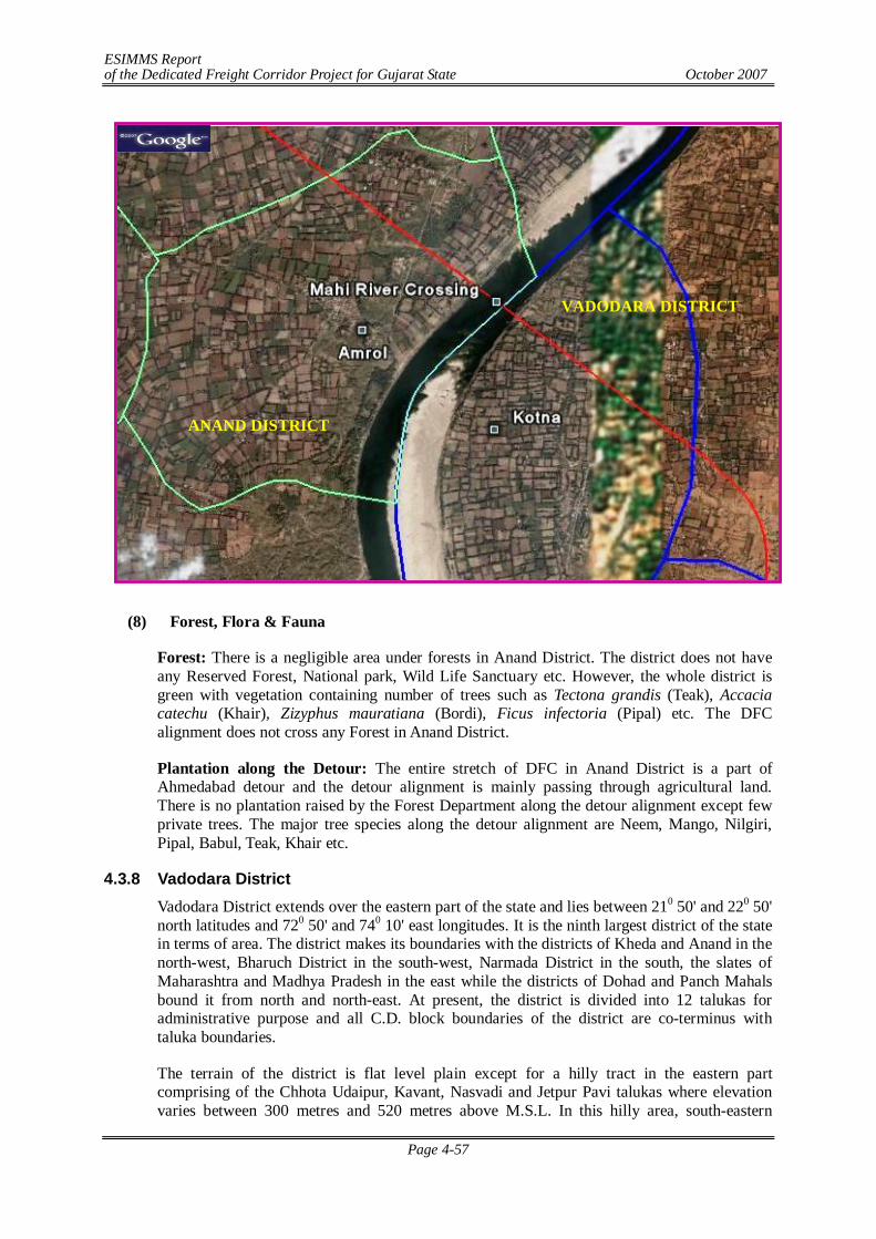
ESIMMS Report of the Dedicated Freight Corridor Project for Gujarat State October 2007
Page 4-57
(8) Forest, Flora & Fauna
Forest: There is a negligible area under forests in Anand District. The district does not have any Reserved Forest, National park, Wild Life Sanctuary etc. However, the whole district is green with vegetation containing number of trees such as Tectona grandis (Teak), Accacia catechu (Khair), Zizyphus mauratiana (Bordi), Ficus infectoria (Pipal) etc. The DFC alignment does not cross any Forest in Anand District.
Plantation along the Detour: The entire stretch of DFC in Anand District is a part of Ahmedabad detour and the detour alignment is mainly passing through agricultural land. There is no plantation raised by the Forest Department along the detour alignment except few private trees. The major tree species along the detour alignment are Neem, Mango, Nilgiri, Pipal, Babul, Teak, Khair etc.
4.3.8 Vadodara District Vadodara District extends over the eastern part of the state and lies between 210 50' and 220 50' north latitudes and 720 50' and 740 10' east longitudes. It is the ninth largest district of the state in terms of area. The district makes its boundaries with the districts of Kheda and Anand in the north-west, Bharuch District in the south-west, Narmada District in the south, the slates of Maharashtra and Madhya Pradesh in the east while the districts of Dohad and Panch Mahals bound it from north and north-east. At present, the district is divided into 12 talukas for administrative purpose and all C.D. block boundaries of the district are co-terminus with taluka boundaries.
The terrain of the district is flat level plain except for a hilly tract in the eastern part comprising of the Chhota Udaipur, Kavant, Nasvadi and Jetpur Pavi talukas where elevation varies between 300 metres and 520 metres above M.S.L. In this hilly area, south-eastern
ANAND DISTRICT
VADODARA DISTRICT
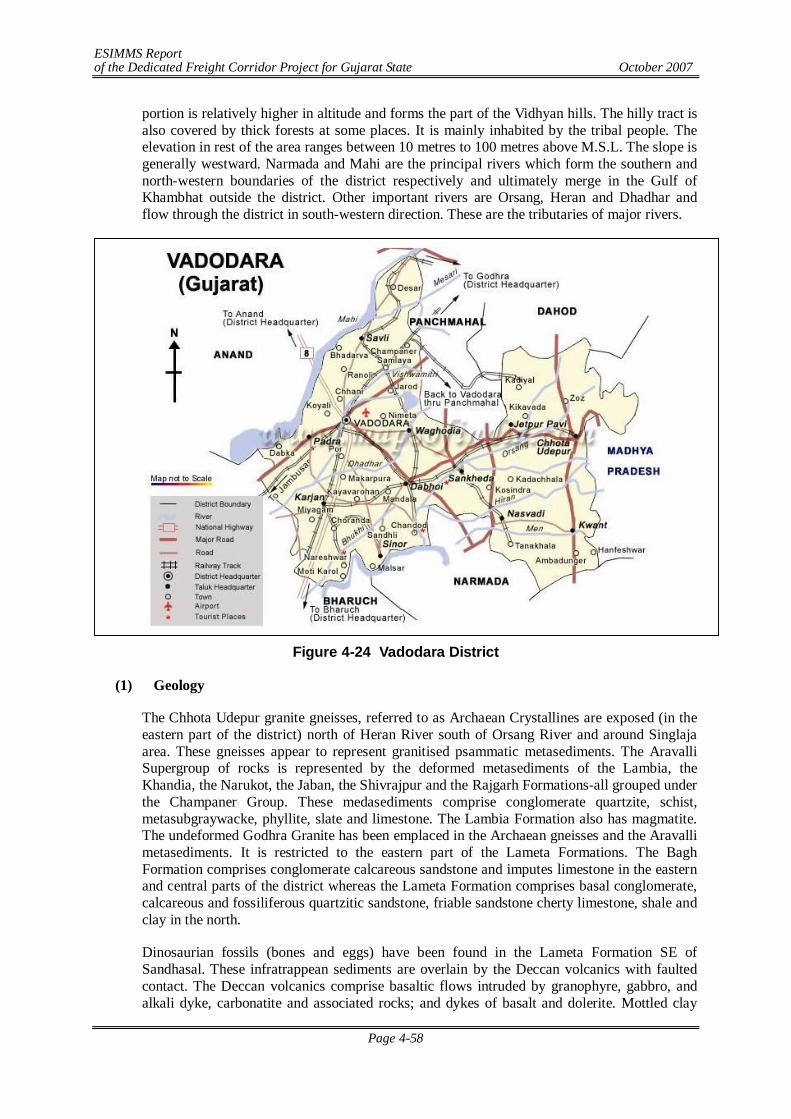
ESIMMS Report of the Dedicated Freight Corridor Project for Gujarat State October 2007
Page 4-58
portion is relatively higher in altitude and forms the part of the Vidhyan hills. The hilly tract is also covered by thick forests at some places. It is mainly inhabited by the tribal people. The elevation in rest of the area ranges between 10 metres to 100 metres above M.S.L. The slope is generally westward. Narmada and Mahi are the principal rivers which form the southern and north-western boundaries of the district respectively and ultimately merge in the Gulf of Khambhat outside the district. Other important rivers are Orsang, Heran and Dhadhar and flow through the district in south-western direction. These are the tributaries of major rivers.
Figure 4-24 Vadodara District
(1) Geology
The Chhota Udepur granite gneisses, referred to as Archaean Crystallines are exposed (in the eastern part of the district) north of Heran River south of Orsang River and around Singlaja area. These gneisses appear to represent granitised psammatic metasediments. The Aravalli Supergroup of rocks is represented by the deformed metasediments of the Lambia, the Khandia, the Narukot, the Jaban, the Shivrajpur and the Rajgarh Formations-all grouped under the Champaner Group. These medasediments comprise conglomerate quartzite, schist, metasubgraywacke, phyllite, slate and limestone. The Lambia Formation also has magmatite. The undeformed Godhra Granite has been emplaced in the Archaean gneisses and the Aravalli metasediments. It is restricted to the eastern part of the Lameta Formations. The Bagh Formation comprises conglomerate calcareous sandstone and imputes limestone in the eastern and central parts of the district whereas the Lameta Formation comprises basal conglomerate, calcareous and fossiliferous quartzitic sandstone, friable sandstone cherty limestone, shale and clay in the north.
Dinosaurian fossils (bones and eggs) have been found in the Lameta Formation SE of Sandhasal. These infratrappean sediments are overlain by the Deccan volcanics with faulted contact. The Deccan volcanics comprise basaltic flows intruded by granophyre, gabbro, and alkali dyke, carbonatite and associated rocks; and dykes of basalt and dolerite. Mottled clay
ESIMMS Report of the Dedicated Freight Corridor Project for Gujarat State October 2007
Page 4-59
and represent the Pliocene sediments. The Holocene sediments are restricted to the western part and are represented by the sands of the Akhaj Formation tidal flat and marsh deposits of the Rann Clay Formation. Flood plain and delta deposits of Katpur Formation and channel-fill and flood plain deposits of the Varahi Formation.
(2) Topography
The overall topography is highly rugged and is characterised by linear E-W trending hill ranges with deeply dissected intervening valleys. The ranges are generally flat topped and valleys are deep and narrow. The hills when traced from N to S show a progressive increase in elevation. They are made up of lava flows and plutonic intrusives of Deccan Trap. The Trappean highlands shows a strong structural control and the entire landscape is characterized by E-W trending step faults, horsts and graben related to Narmada rift system. The region is drained by numerous rivers flowing from E to W.
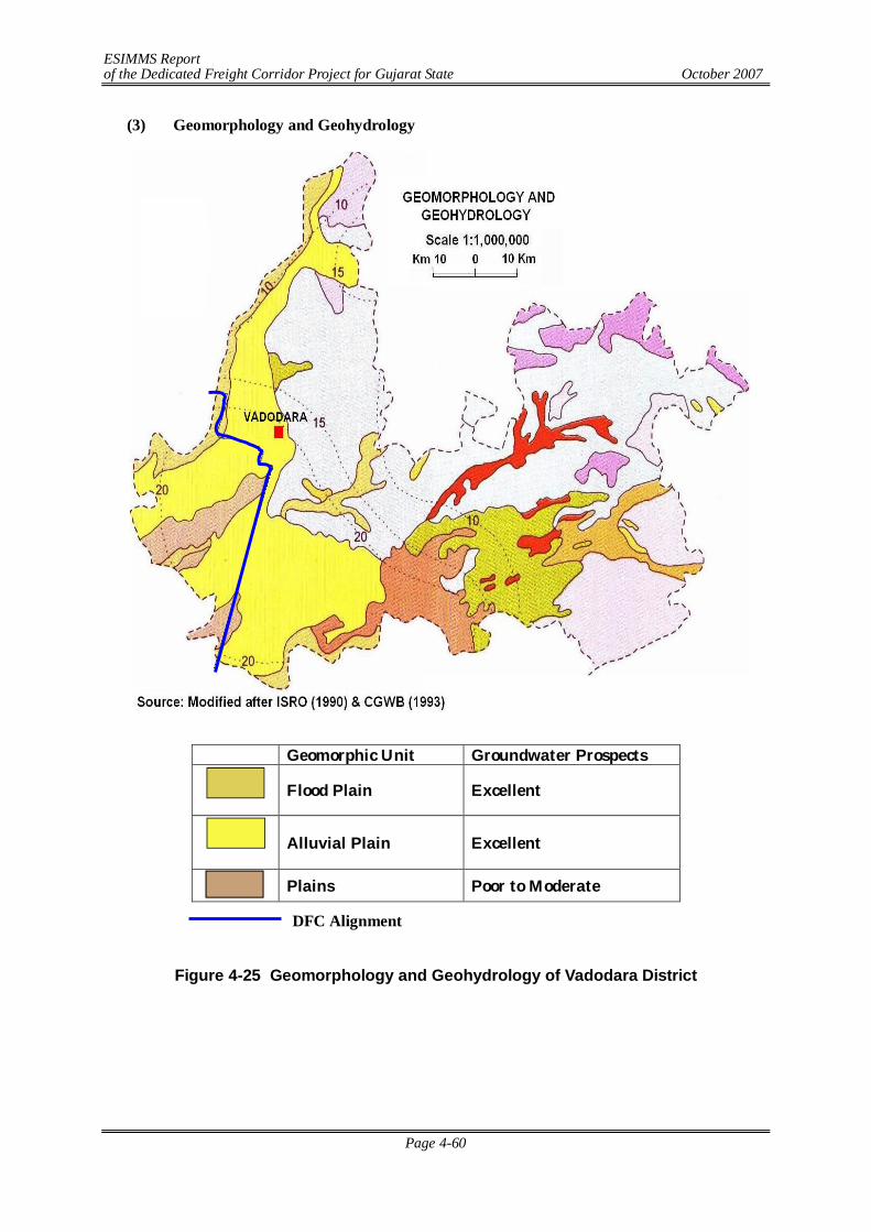
ESIMMS Report of the Dedicated Freight Corridor Project for Gujarat State October 2007
Page 4-60
(3) Geomorphology and Geohydrology
Geomorphic Unit Groundwater Prospects
Flood Plain Excellent
Alluvial Plain Excellent
Plains Poor to Moderate
Figure 4-25 Geomorphology and Geohydrology of Vadodara District
DFC Alignment
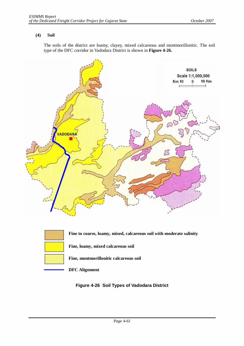
ESIMMS Report of the Dedicated Freight Corridor Project for Gujarat State October 2007
Page 4-61
(4) Soil
The soils of the district are loamy, clayey, mixed calcareous and montmorillonitic. The soil type of the DFC corridor in Vadodara District is shown in Figure 4-26.
Figure 4-26 Soil Types of Vadodara District
Fine to coarse, loamy, mixed, calcareous soil with moderate salinity
Fine, loamy, mixed calcareous soil
Fine, montmorillonitic calcareous soil
DFC Alignment
ESIMMS Report of the Dedicated Freight Corridor Project for Gujarat State October 2007
Page 4-62
(5) Agriculture
The soils of Vadodara District are deep black and are very rich and fertile and suitable for cotton, jawar, rice, wheat and other garden crops. The black soil is clayey containing 45% clay and 20% sand. The soils are extremely fertile and do not require manuring for long periods. The rich alluvial deposits along the banks of the Narmada are known as bhatha soils. The major crops grown in Vadodara District are given in the following table:
Table 4-31 Crops Grown in Vadodara District Name of the Crop Scientific Name Remarks
Paddy Oryza sativa Kharif crop Wheat Triticum vulgare Rabi crop Jowar Andropogau sorghum Rabi crop Cotton Gossypium herbaccum Tobacco Nicotiana tobacum Kharif crop Pulses Tur Gram Mag Math Udid Val
Cajanus indicus Cicer arietinum Phaseolus radiatus Phaseolus acontifolius Phaseolus mungo Lablab niger
Kharif crop
(6) Climate and Meteorology
The climate of the area is moderate and tropical characterized by a hot summer from March to Mid June, a humid monsoon or rainy season stretching from Mid June to September, a short pleasant post-monsoon during October and November, and a cool winter spanning between December and February. Therefore, climatologically, four seasons viz. summer (pre-monsoon), monsoon, post-monsoon and winter could be deciphered comprising the following months:
Summer : March, April, May Monsoon : June, July, August, September Post-monsoon : October, November Winter : December, January, February.
Past meteorological data described in this section have been collected from the nearest IMD observatory located at Vadodara, which deemed representative of the study corridor. Available past meteorological data has been collected and summarized in Table 4-32.
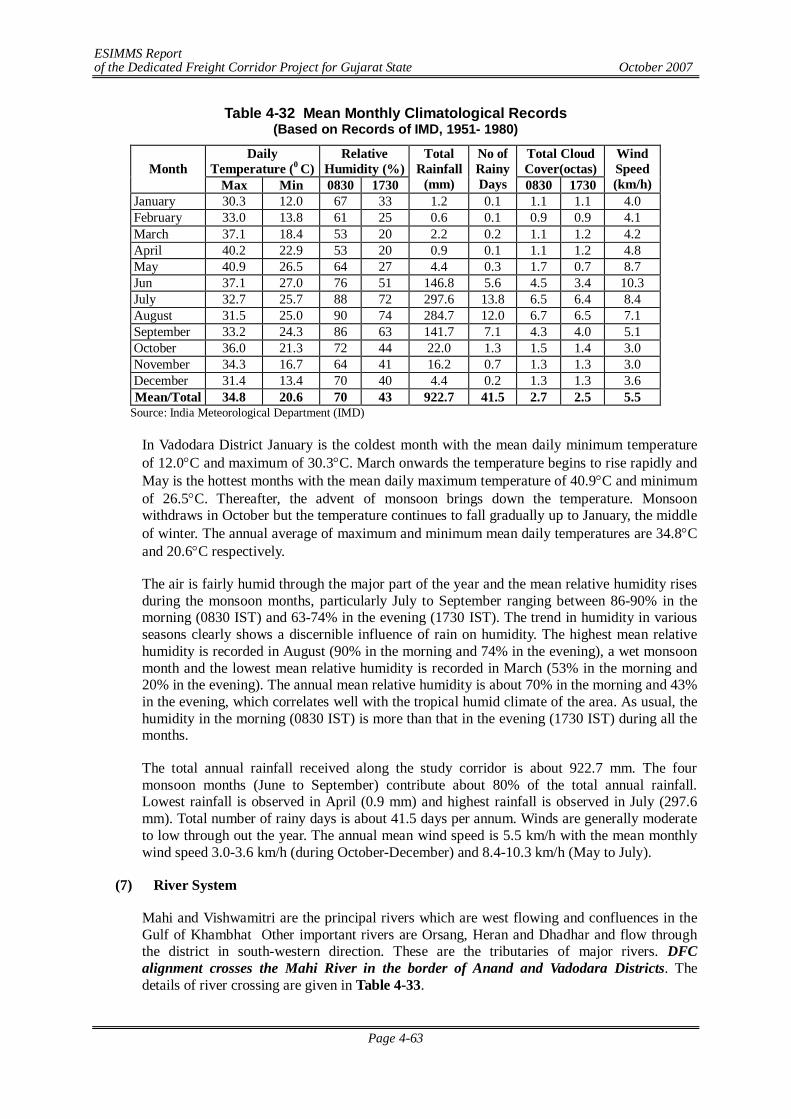
ESIMMS Report of the Dedicated Freight Corridor Project for Gujarat State October 2007
Page 4-63
Table 4-32 Mean Monthly Climatological Records (Based on Records of IMD, 1951- 1980)
Daily Temperature (0 C)
Relative Humidity (%)
Total Cloud Cover(octas) Month
Max Min 0830 1730
Total Rainfall
(mm)
No of Rainy Days 0830 1730
Wind Speed (km/h)
January 30.3 12.0 67 33 1.2 0.1 1.1 1.1 4.0 February 33.0 13.8 61 25 0.6 0.1 0.9 0.9 4.1 March 37.1 18.4 53 20 2.2 0.2 1.1 1.2 4.2 April 40.2 22.9 53 20 0.9 0.1 1.1 1.2 4.8 May 40.9 26.5 64 27 4.4 0.3 1.7 0.7 8.7 Jun 37.1 27.0 76 51 146.8 5.6 4.5 3.4 10.3 July 32.7 25.7 88 72 297.6 13.8 6.5 6.4 8.4 August 31.5 25.0 90 74 284.7 12.0 6.7 6.5 7.1 September 33.2 24.3 86 63 141.7 7.1 4.3 4.0 5.1 October 36.0 21.3 72 44 22.0 1.3 1.5 1.4 3.0 November 34.3 16.7 64 41 16.2 0.7 1.3 1.3 3.0 December 31.4 13.4 70 40 4.4 0.2 1.3 1.3 3.6 Mean/Total 34.8 20.6 70 43 922.7 41.5 2.7 2.5 5.5
Source: India Meteorological Department (IMD)
In Vadodara District January is the coldest month with the mean daily minimum temperature of 12.0C and maximum of 30.3C. March onwards the temperature begins to rise rapidly and May is the hottest months with the mean daily maximum temperature of 40.9C and minimum of 26.5C. Thereafter, the advent of monsoon brings down the temperature. Monsoon withdraws in October but the temperature continues to fall gradually up to January, the middle of winter. The annual average of maximum and minimum mean daily temperatures are 34.8C and 20.6C respectively.
The air is fairly humid through the major part of the year and the mean relative humidity rises during the monsoon months, particularly July to September ranging between 86-90% in the morning (0830 IST) and 63-74% in the evening (1730 IST). The trend in humidity in various seasons clearly shows a discernible influence of rain on humidity. The highest mean relative humidity is recorded in August (90% in the morning and 74% in the evening), a wet monsoon month and the lowest mean relative humidity is recorded in March (53% in the morning and 20% in the evening). The annual mean relative humidity is about 70% in the morning and 43% in the evening, which correlates well with the tropical humid climate of the area. As usual, the humidity in the morning (0830 IST) is more than that in the evening (1730 IST) during all the months.
The total annual rainfall received along the study corridor is about 922.7 mm. The four monsoon months (June to September) contribute about 80% of the total annual rainfall. Lowest rainfall is observed in April (0.9 mm) and highest rainfall is observed in July (297.6 mm). Total number of rainy days is about 41.5 days per annum. Winds are generally moderate to low through out the year. The annual mean wind speed is 5.5 km/h with the mean monthly wind speed 3.0-3.6 km/h (during October-December) and 8.4-10.3 km/h (May to July).
(7) River System
Mahi and Vishwamitri are the principal rivers which are west flowing and confluences in the Gulf of Khambhat Other important rivers are Orsang, Heran and Dhadhar and flow through the district in south-western direction. These are the tributaries of major rivers. DFC alignment crosses the Mahi River in the border of Anand and Vadodara Districts. The details of river crossing are given in Table 4-33.
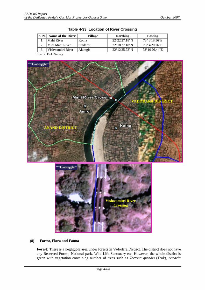
ESIMMS Report of the Dedicated Freight Corridor Project for Gujarat State October 2007
Page 4-64
Table 4-33 Location of River Crossing S. N. Name of the River Village Northing Easting
1. Mahi River Kotna 22°22'27.18"N 73° 3'18.56"E 2. Mini Mahi River Sindhrot 22°18'27.18"N 73° 4'20.76"E 3. Vishwamitri River Alamgir 22°12'25.73"N 73°10'26.44"E
Source: Field Survey
(8) Forest, Flora and Fauna
Forest: There is a negligible area under forests in Vadodara District. The district does not have any Reserved Forest, National park, Wild Life Sanctuary etc. However, the whole district is green with vegetation containing number of trees such as Tectona grandis (Teak), Accacia
Vishwamitri River Crossing
ANAND DISTRICT
VADODARA DISTRICT
ESIMMS Report of the Dedicated Freight Corridor Project for Gujarat State October 2007
Page 4-65
catechu (Khair), Zizyphus mauratiana (Bordi), Ficus infectoria (Pipal) etc. The DFC alignment does not cross any Forest in Vadodara District.
Plantation along the Detour: The detour portion of DFC in Vadodara District (26.4 km) is a part of Ahmedabad detour and the detour alignment is mainly passing through agricultural land. There is no plantation raised by the Forest Department along the detour alignment except few private trees. The major tree species along the detour alignment are Neem, Pipal, Babul, Teak etc.
Plantation along the Existing Railway Track: Length of the parallel section of DFC in Vadodara District is 33 km. Along the existing track; plantation has been raised by the Forest Department on the railway land. Total number of trees planted along the track is presented in Table 4-34 Last plantation was carried out during the year 1984-1985. Information about railway side plantation has been collected from the record of Forest Department. But the number of trees actually exist on either side of the track is much lesser.
Table 4-34 Details of Railway side Plantation Year of
Plantation Name of Taluka Location No Species
1984-85 Vadodara Vadodara to Bharuch
8000
1984-85 Karjan Karjan to Palej
5000
Kaijeliya, Gulmahor, Kashid, Bangal Baval, Sharu, Arujunsadad, Karanj, Pangaro, Vans, Boganvel, Karan
Source: Forest Department, Government of Gujarat
Fauna:
Indian soft shelled terrapin has been observed along the bank of Mahi River and river side agricultural field in Kotna Village of Vadodara District. This area is an active tidal zone. However, the species is reported (Source: Department of Zoology, MS University, Vadodara) to be distributed along the bank of Mahi River and river side agricultural fields of Anand and also in neighbouring Kheda and Bharuch Districts. As per the IUCN Red List 2006, the Indian soft shelled terrapin is a threatened species. Some details about the species are given below:
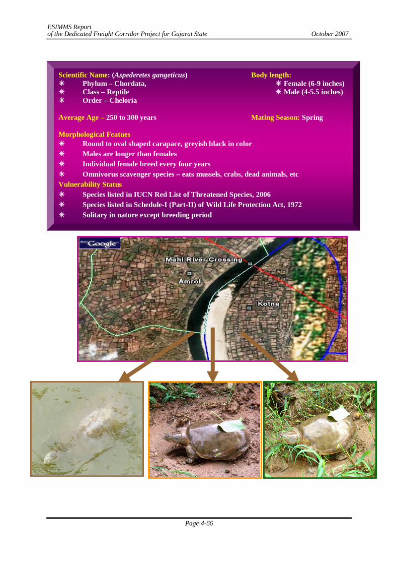
ESIMMS Report of the Dedicated Freight Corridor Project for Gujarat State October 2007
Page 4-66
Scientific Name: (Aspederetes gangeticus) Body length: Phylum – Chordata, Female (6-9 inches) Class – Reptile Male (4-5.5 inches) Order – Cheloria Average Age – 250 to 300 years Mating Season: Spring Morphological Featues Round to oval shaped carapace, greyish black in color Males are longer than females Individual female breed every four years Omnivorus scavenger species – eats mussels, crabs, dead animals, etc Vulnerability Status Species listed in IUCN Red List of Threatened Species, 2006 Species listed in Schedule-I (Part-II) of Wild Life Protection Act, 1972 Solitary in nature except breeding period
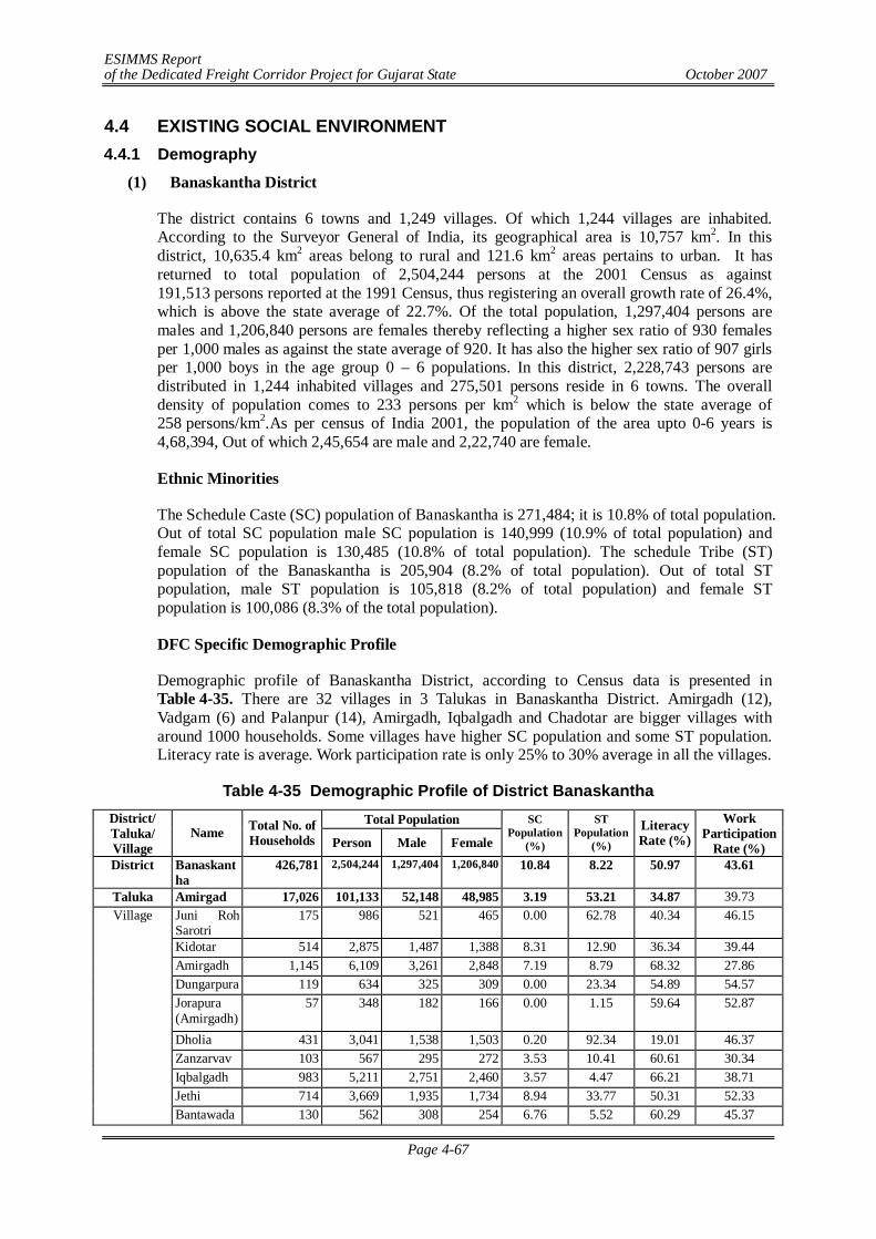
ESIMMS Report of the Dedicated Freight Corridor Project for Gujarat State October 2007
Page 4-67
4.4 EXISTING SOCIAL ENVIRONMENT 4.4.1 Demography
(1) Banaskantha District
The district contains 6 towns and 1,249 villages. Of which 1,244 villages are inhabited. According to the Surveyor General of India, its geographical area is 10,757 km2. In this district, 10,635.4 km2 areas belong to rural and 121.6 km2 areas pertains to urban. It has returned to total population of 2,504,244 persons at the 2001 Census as against 191,513 persons reported at the 1991 Census, thus registering an overall growth rate of 26.4%, which is above the state average of 22.7%. Of the total population, 1,297,404 persons are males and 1,206,840 persons are females thereby reflecting a higher sex ratio of 930 females per 1,000 males as against the state average of 920. It has also the higher sex ratio of 907 girls per 1,000 boys in the age group 0 – 6 populations. In this district, 2,228,743 persons are distributed in 1,244 inhabited villages and 275,501 persons reside in 6 towns. The overall density of population comes to 233 persons per km2 which is below the state average of 258 persons/km2.As per census of India 2001, the population of the area upto 0-6 years is 4,68,394, Out of which 2,45,654 are male and 2,22,740 are female.
Ethnic Minorities
The Schedule Caste (SC) population of Banaskantha is 271,484; it is 10.8% of total population. Out of total SC population male SC population is 140,999 (10.9% of total population) and female SC population is 130,485 (10.8% of total population). The schedule Tribe (ST) population of the Banaskantha is 205,904 (8.2% of total population). Out of total ST population, male ST population is 105,818 (8.2% of total population) and female ST population is 100,086 (8.3% of the total population).
DFC Specific Demographic Profile
Demographic profile of Banaskantha District, according to Census data is presented in Table 4-35. There are 32 villages in 3 Talukas in Banaskantha District. Amirgadh (12), Vadgam (6) and Palanpur (14), Amirgadh, Iqbalgadh and Chadotar are bigger villages with around 1000 households. Some villages have higher SC population and some ST population. Literacy rate is average. Work participation rate is only 25% to 30% average in all the villages.
Table 4-35 Demographic Profile of District Banaskantha Total Population District/
Taluka/ Village
Name Total No. of Households Person Male Female
SC Population
(%)
ST Population
(%)
Literacy Rate (%)
Work Participation
Rate (%) District Banaskant
ha 426,781 2,504,244 1,297,404 1,206,840 10.84 8.22 50.97 43.61
Taluka Amirgad 17,026 101,133 52,148 48,985 3.19 53.21 34.87 39.73 Juni Roh Sarotri
175 986 521 465 0.00 62.78 40.34 46.15
Kidotar 514 2,875 1,487 1,388 8.31 12.90 36.34 39.44 Amirgadh 1,145 6,109 3,261 2,848 7.19 8.79 68.32 27.86 Dungarpura 119 634 325 309 0.00 23.34 54.89 54.57 Jorapura (Amirgadh)
57 348 182 166 0.00 1.15 59.64 52.87
Dholia 431 3,041 1,538 1,503 0.20 92.34 19.01 46.37 Zanzarvav 103 567 295 272 3.53 10.41 60.61 30.34 Iqbalgadh 983 5,211 2,751 2,460 3.57 4.47 66.21 38.71 Jethi 714 3,669 1,935 1,734 8.94 33.77 50.31 52.33
Village
Bantawada 130 562 308 254 6.76 5.52 60.29 45.37
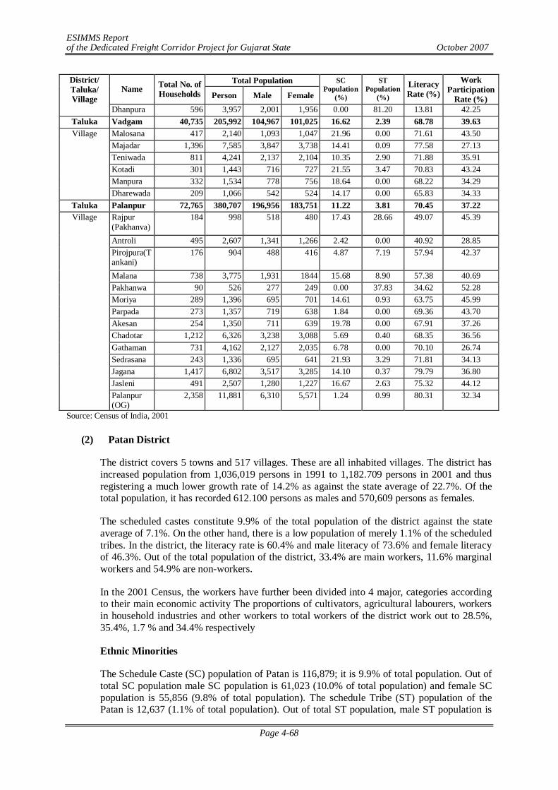
ESIMMS Report of the Dedicated Freight Corridor Project for Gujarat State October 2007
Page 4-68
Total Population District/ Taluka/ Village
Name Total No. of Households Person Male Female
SC Population
(%)
ST Population
(%)
Literacy Rate (%)
Work Participation
Rate (%) Dhanpura 596 3,957 2,001 1,956 0.00 81.20 13.81 42.25
Taluka Vadgam 40,735 205,992 104,967 101,025 16.62 2.39 68.78 39.63 Malosana 417 2,140 1,093 1,047 21.96 0.00 71.61 43.50 Majadar 1,396 7,585 3,847 3,738 14.41 0.09 77.58 27.13 Teniwada 811 4,241 2,137 2,104 10.35 2.90 71.88 35.91 Kotadi 301 1,443 716 727 21.55 3.47 70.83 43.24 Manpura 332 1,534 778 756 18.64 0.00 68.22 34.29
Village
Dharewada 209 1,066 542 524 14.17 0.00 65.83 34.33 Taluka Palanpur 72,765 380,707 196,956 183,751 11.22 3.81 70.45 37.22
Rajpur (Pakhanva)
184 998 518 480 17.43 28.66 49.07 45.39
Antroli 495 2,607 1,341 1,266 2.42 0.00 40.92 28.85 Pirojpura(Tankani)
176 904 488 416 4.87 7.19 57.94 42.37
Malana 738 3,775 1,931 1844 15.68 8.90 57.38 40.69 Pakhanwa 90 526 277 249 0.00 37.83 34.62 52.28 Moriya 289 1,396 695 701 14.61 0.93 63.75 45.99 Parpada 273 1,357 719 638 1.84 0.00 69.36 43.70 Akesan 254 1,350 711 639 19.78 0.00 67.91 37.26 Chadotar 1,212 6,326 3,238 3,088 5.69 0.40 68.35 36.56 Gathaman 731 4,162 2,127 2,035 6.78 0.00 70.10 26.74 Sedrasana 243 1,336 695 641 21.93 3.29 71.81 34.13 Jagana 1,417 6,802 3,517 3,285 14.10 0.37 79.79 36.80 Jasleni 491 2,507 1,280 1,227 16.67 2.63 75.32 44.12
Village
Palanpur (OG)
2,358 11,881 6,310 5,571 1.24 0.99 80.31 32.34
Source: Census of India, 2001
(2) Patan District
The district covers 5 towns and 517 villages. These are all inhabited villages. The district has increased population from 1,036,019 persons in 1991 to 1,182.709 persons in 2001 and thus registering a much lower growth rate of 14.2% as against the state average of 22.7%. Of the total population, it has recorded 612.100 persons as males and 570,609 persons as females.
The scheduled castes constitute 9.9% of the total population of the district against the state average of 7.1%. On the other hand, there is a low population of merely 1.1% of the scheduled tribes. In the district, the literacy rate is 60.4% and male literacy of 73.6% and female literacy of 46.3%. Out of the total population of the district, 33.4% are main workers, 11.6% marginal workers and 54.9% are non-workers.
In the 2001 Census, the workers have further been divided into 4 major, categories according to their main economic activity The proportions of cultivators, agricultural labourers, workers in household industries and other workers to total workers of the district work out to 28.5%, 35.4%, 1.7 % and 34.4% respectively
Ethnic Minorities
The Schedule Caste (SC) population of Patan is 116,879; it is 9.9% of total population. Out of total SC population male SC population is 61,023 (10.0% of total population) and female SC population is 55,856 (9.8% of total population). The schedule Tribe (ST) population of the Patan is 12,637 (1.1% of total population). Out of total ST population, male ST population is
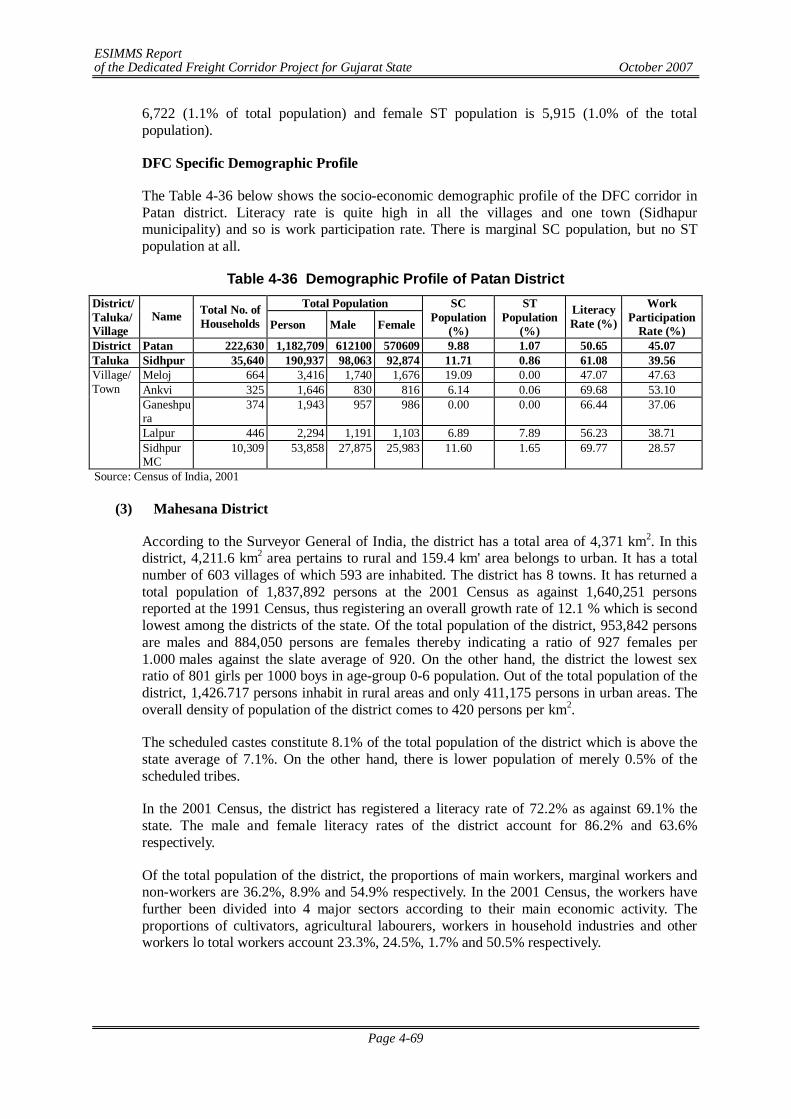
ESIMMS Report of the Dedicated Freight Corridor Project for Gujarat State October 2007
Page 4-69
6,722 (1.1% of total population) and female ST population is 5,915 (1.0% of the total population).
DFC Specific Demographic Profile
The Table 4-36 below shows the socio-economic demographic profile of the DFC corridor in Patan district. Literacy rate is quite high in all the villages and one town (Sidhapur municipality) and so is work participation rate. There is marginal SC population, but no ST population at all.
Table 4-36 Demographic Profile of Patan District Total Population District/
Taluka/ Village
Name Total No. of Households Person Male Female
SC Population
(%)
ST Population
(%)
Literacy Rate (%)
Work Participation
Rate (%) District Patan 222,630 1,182,709 612100 570609 9.88 1.07 50.65 45.07 Taluka Sidhpur 35,640 190,937 98,063 92,874 11.71 0.86 61.08 39.56
Meloj 664 3,416 1,740 1,676 19.09 0.00 47.07 47.63 Ankvi 325 1,646 830 816 6.14 0.06 69.68 53.10 Ganeshpura
374 1,943 957 986 0.00 0.00 66.44 37.06
Lalpur 446 2,294 1,191 1,103 6.89 7.89 56.23 38.71
Village/ Town
Sidhpur MC
10,309 53,858 27,875 25,983 11.60 1.65 69.77 28.57
Source: Census of India, 2001
(3) Mahesana District
According to the Surveyor General of India, the district has a total area of 4,371 km2. In this district, 4,211.6 km2 area pertains to rural and 159.4 km' area belongs to urban. It has a total number of 603 villages of which 593 are inhabited. The district has 8 towns. It has returned a total population of 1,837,892 persons at the 2001 Census as against 1,640,251 persons reported at the 1991 Census, thus registering an overall growth rate of 12.1 % which is second lowest among the districts of the state. Of the total population of the district, 953,842 persons are males and 884,050 persons are females thereby indicating a ratio of 927 females per 1.000 males against the slate average of 920. On the other hand, the district the lowest sex ratio of 801 girls per 1000 boys in age-group 0-6 population. Out of the total population of the district, 1,426.717 persons inhabit in rural areas and only 411,175 persons in urban areas. The overall density of population of the district comes to 420 persons per km2.
The scheduled castes constitute 8.1% of the total population of the district which is above the state average of 7.1%. On the other hand, there is lower population of merely 0.5% of the scheduled tribes.
In the 2001 Census, the district has registered a literacy rate of 72.2% as against 69.1% the state. The male and female literacy rates of the district account for 86.2% and 63.6% respectively.
Of the total population of the district, the proportions of main workers, marginal workers and non-workers are 36.2%, 8.9% and 54.9% respectively. In the 2001 Census, the workers have further been divided into 4 major sectors according to their main economic activity. The proportions of cultivators, agricultural labourers, workers in household industries and other workers lo total workers account 23.3%, 24.5%, 1.7% and 50.5% respectively.
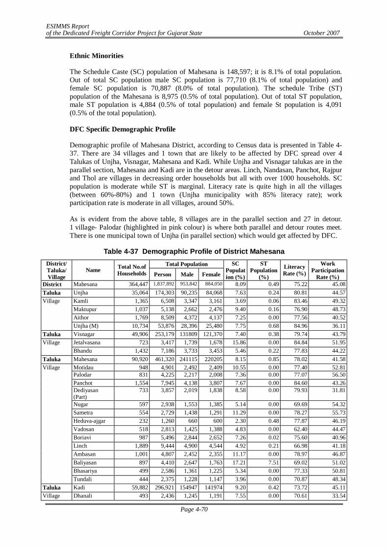
ESIMMS Report of the Dedicated Freight Corridor Project for Gujarat State October 2007
Page 4-70
Ethnic Minorities
The Schedule Caste (SC) population of Mahesana is 148,597; it is 8.1% of total population. Out of total SC population male SC population is 77,710 (8.1% of total population) and female SC population is 70,887 (8.0% of total population). The schedule Tribe (ST) population of the Mahesana is 8,975 (0.5% of total population). Out of total ST population, male ST population is 4,884 (0.5% of total population) and female St population is 4,091 (0.5% of the total population).
DFC Specific Demographic Profile
Demographic profile of Mahesana District, according to Census data is presented in Table 4-37. There are 34 villages and 1 town that are likely to be affected by DFC spread over 4 Talukas of Unjha, Visnagar, Mahesana and Kadi. While Unjha and Visnagar talukas are in the parallel section, Mahesana and Kadi are in the detour areas. Linch, Nandasan, Panchot, Rajpur and Thol are villages in decreasing order households but all with over 1000 households. SC population is moderate while ST is marginal. Literacy rate is quite high in all the villages (between 60%-80%) and 1 town (Unjha municipality with 85% literacy rate); work participation rate is moderate in all villages, around 50%.
As is evident from the above table, 8 villages are in the parallel section and 27 in detour. 1 village- Palodar (highlighted in pink colour) is where both parallel and detour routes meet. There is one municipal town of Unjha (in parallel section) which would get affected by DFC.
Table 4-37 Demographic Profile of District Mahesana Total Population District/
Taluka/ Village
Name Total No.of Households Person Male Female
SC Population (%)
ST Population
(%)
Literacy Rate (%)
Work Participation
Rate (%) District Mahesana 364,447 1,837,892 953,842 884,050 8.09 0.49 75.22 45.08 Taluka Unjha 35,064 174,303 90,235 84,068 7.63 0.24 80.81 44.57
Kamli 1,365 6,508 3,347 3,161 3.69 0.06 83.46 49.32 Maktupur 1,037 5,138 2,662 2,476 9.40 0.16 76.90 48.73 Aithor 1,769 8,509 4,372 4,137 7.25 0.00 77.56 40.52
Village
Unjha (M) 10,734 53,876 28,396 25,480 7.75 0.68 84.96 36.11 Taluka Visnagar 49,906 253,179 131809 121,370 7.40 0.38 79.74 43.79
Jetalvasana 723 3,417 1,739 1,678 15.86 0.00 84.84 51.95 Village Bhandu 1,432 7,186 3,733 3,453 5.46 0.22 77.83 44.22
Taluka Mahesana 90,920 461,320 241115 220205 8.15 0.85 78.02 41.58 Motidau 948 4,901 2,492 2,409 10.55 0.00 77.40 52.81 Palodar 831 4,225 2,217 2,008 7.36 0.00 77.07 56.50 Panchot 1,554 7,945 4,138 3,807 7.67 0.00 84.60 43.26 Dediyasan (Part)
733 3,857 2,019 1,838 8.58 0.00 79.93 31.81
Nugar 597 2,938 1,553 1,385 5.14 0.00 69.69 54.32 Sametra 554 2,729 1,438 1,291 11.29 0.00 78.27 55.73 Heduva-ajgar 232 1,260 660 600 2.30 0.48 77.87 46.19 Vadosan 518 2,813 1,425 1,388 4.83 0.00 62.40 44.47 Boriavi 987 5,496 2,844 2,652 7.26 0.02 75.60 40.96 Linch 1,889 9,444 4,900 4,544 4.92 0.21 66.98 41.18 Ambasan 1,001 4,807 2,452 2,355 11.17 0.00 78.97 46.87 Baliyasan 897 4,410 2,647 1,763 17.21 7.51 69.02 51.02 Bhasariya 499 2,586 1,361 1,225 5.34 0.00 77.33 50.81
Village
Tundali 444 2,375 1,228 1,147 3.96 0.00 70.87 48.34 Taluka Kadi 59,882 296,921 154947 141974 9.20 0.42 73.72 45.11 Village Dhanali 493 2,436 1,245 1,191 7.55 0.00 70.61 33.54
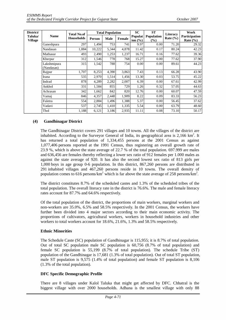
ESIMMS Report of the Dedicated Freight Corridor Project for Gujarat State October 2007
Page 4-71
Total Population District/ Taluka/ Village
Name Total No.of Households Person Male Female
SC Population (%)
ST Population
(%)
Literacy Rate (%)
Work Participation
Rate (%) Ganeshpura 297 1,494 753 741 9.97 0.00 71.20 29.32 Nandasan 1,884 10,222 5,344 4,878 11.42 0.17 80.24 42.23 Mathasur 493 2,490 1,253 1,237 16.71 0.16 77.62 39.36 Kherpur 312 1,546 778 768 15.27 0.00 77.62 37.90 Lakshmipura (Nandasan)
315 1,542 788 754 0.00 0.00 89.61 44.23
Rajpur 1,707 8,253 4,390 3,863 7.43 0.13 66.28 43.90 Irana 535 2,970 1,514 1,456 13.30 0.03 53.75 45.22 Indrad 878 4,289 2,282 2,007 6.39 0.00 67.61 42.99 Ankhol 331 1,584 855 729 1.26 0.32 57.05 44.63 Achrasan 342 1,662 842 820 12.76 0.00 60.07 47.59 Vamaj 846 4,357 2,448 1,909 8.22 0.09 83.33 56.23 Fuletra 554 2,884 1,496 1,388 5.37 0.00 56.45 37.62 Vadavi 537 2,745 1,410 1,335 5.54 0.00 63.79 48.60 Thol 1,188 6,121 3,186 2,935 11.11 0.08 73.10 50.17
(4) Gandhinagar District
The Gandhinagar District covers 291 villages and 10 towns. All the villages of the district are inhabited. According to the Surveyor General of India, its geographical area is 2,166 km2. It has returned a total population of 1,334,455 persons at the 2001 Census as against 1,077,406 persons reported at the 1991 Census, thus registering an overall growth rate of 23.9 %, which is above the state average of 22.7 % of the total population. 697.999 are males and 636,456 are females thereby reflecting a lower sex ratio of 912 females per 1.000 males as against the state average of 920. It has also the second lowest sex ratio of 813 girls per 1,000 boys in age group 0-6 population. In this district, 867,260 persons are distributed in 291 inhabited villages and 467,260 persons reside in 10 towns. The overall density of population comes to 616 persons/km2 which is far above the state average of 258 persons/km2.
The district constitutes 8.7% of the scheduled castes and 1.3% of the scheduled tribes of the total population. The overall literacy rate in the district is 76.6%. The male and female literacy rates account for 87.7% and 64.6% respectively.
Of the total population of the district, the proportions of main workers, marginal workers and non-workers are 35.0%, 6.5% and 58.5% respectively. In the 2001 Census, the workers have further been divided into 4 major sectors according to their main economic activity. The proportions of cultivators, agricultural workers, workers in household industries and other workers to total workers account for 18.6%, 21.6%, 1.3% and 58.5% respectively.
Ethnic Minorities
The Schedule Caste (SC) population of Gandhinagar is 115,955; it is 8.7% of total population. Out of total SC population male SC population is 60,756 (8.7% of total population) and female SC population is 55,199 (8.7% of total population). The schedule Tribe (ST) population of the Gandhinagar is 17,681 (1.3% of total population). Out of total ST population, male ST population is 9,575 (1.4% of total population) and female ST population is 8,106 (1.3% of the total population).
DFC Specific Demographic Profile
There are 8 villages under Kalol Taluka that might get affected by DFC. Chhatral is the biggest village with over 2000 households. Adhana is the smallest village with only 88
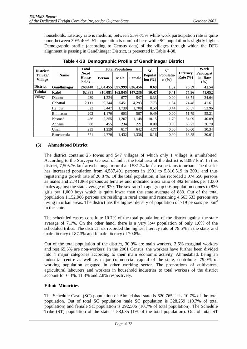
ESIMMS Report of the Dedicated Freight Corridor Project for Gujarat State October 2007
Page 4-72
households. Literacy rate is medium, between 55%-75% while work participation rate is quite poor, between 30%-40%. ST population is nominal here while SC population is slightly higher. Demographic profile (according to Census data) of the villages through which the DFC alignment is passing in Gandhinagar District, is presented in Table 4-38.
Table 4-38 Demographic Profile of Gandhinagar District Total Population District/
Taluka/ Village
Name
Total No.of House holds
Person Male Female
SC Population (%)
ST Populatio
n (%)
Literacy Rate (%)
Work Participation Rate
(%) District Gandhinagar 269,440 1,334,455 697,999 636,456 8.69 1.32 76.59 41.54 Taluka Kalol 62,381 310,081 162,845 147,236 10.47 0.41 75.96 41.052
Dhanot 239 1,224 677 547 8.33 0.00 63.74 34.64 Chhatral 2,111 9,744 5451 4,293 7.73 1.64 74.48 41.61 Hajipur 623 3,447 1,739 1,708 8.50 0.44 63.37 53.96 Bhimasan 202 1,170 603 567 9.49 0.00 51.79 55.21 Nasmed 486 2,355 1,207 1,148 10.15 1.70 54.99 40.09 Adhana 88 455 234 221 0.00 0.00 68.23 36.70 Unali 235 1,259 617 642 4.77 0.00 60.00 30.34
Village
Rancharada 571 2,770 1,432 1,338 8.16 0.90 66.55 30.61
(5) Ahmedabad District
The district contains 25 towns and 547 villages of which only 1 village is uninhabited. According to the Surveyor General of India, the total area of the district is 8,087 km2. In this district, 7,505.76 km2 area belongs to rural and 581.24 km2 area pertains to urban. The district has increased population from 4,587,491 persons in 1991 to 5.816.519 in 2001 and thus registering a growth rate of 26.8 %. Of the total population, it has recorded 3.074,556 persons as males and 2,741,963 persons as females and indicated a sex ratio of 892 females per 1,000 males against the state average of 920. The sex ratio in age group 0-6 population comes to 836 girls per 1,000 boys which is quite lower than the state average of 883. Out of the total population 1,152.986 persons are residing in rural areas and remaining 4,663.533 persons are living in urban areas. The district has the highest density of population of 719 persons per km2 in the state.
The scheduled castes constitute 10.7% of the total population of the district against the state average of 7.1%. On the other hand, there is a very low population of only 1.0% of the scheduled tribes. The district has recorded the highest literacy rate of 79.5% in the state, and male literacy of 87.3% and female literacy of 70.8%.
Out of the total population of the district, 30.9% are main workers, 3.6% marginal workers and rest 65.5% are non-workers. In the 2001 Census, the workers have further been divided into 4 major categories according to their main economic activity. Ahmedabad, being an industrial centre as well as major commercial capital of the state, contributes 79.0% of working population engaged in other working sector. The proportions of cultivators, agricultural labourers and workers in household industries to total workers of the district account for 6.3%, 11.8% and 2.8% respectively.
Ethnic Minorities
The Schedule Caste (SC) population of Ahmedabad state is 620,765; it is 10.7% of the total population. Out of total SC population male SC population is 328,259 (10.7% of total population) and female SC population is 292,506 (10.7% of total population). The Schedule Tribe (ST) population of the state is 58,035 (1% of the total population). Out of total ST
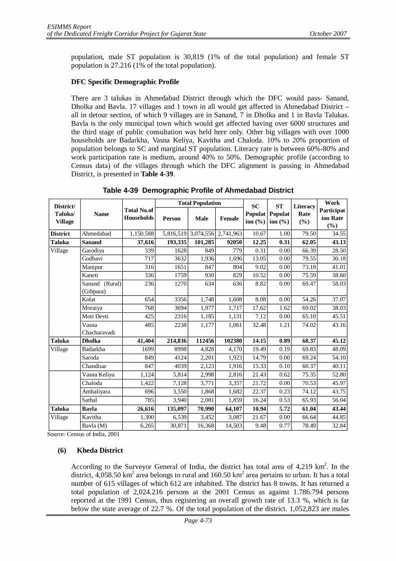
ESIMMS Report of the Dedicated Freight Corridor Project for Gujarat State October 2007
Page 4-73
population, male ST population is 30,819 (1% of the total population) and female ST population is 27.216 (1% of the total population).
DFC Specific Demographic Profile
There are 3 talukas in Ahmedabad District through which the DFC would pass- Sanand, Dholka and Bavla. 17 villages and 1 town in all would get affected in Ahmedabad District – all in detour section, of which 9 villages are in Sanand, 7 in Dholka and 1 in Bavla Talukas. Bavla is the only municipal town which would get affected having over 6000 structures and the third stage of public consultation was held here only. Other big villages with over 1000 households are Badarkha, Vasna Keliya, Kavitha and Chaloda. 10% to 20% proportion of population belongs to SC and marginal ST population. Literacy rate is between 60%-80% and work participation rate is medium, around 40% to 50%. Demographic profile (according to Census data) of the villages through which the DFC alignment is passing in Ahmedabad District, is presented in Table 4-39.
Table 4-39 Demographic Profile of Ahmedabad District Total Population District/
Taluka/ Village
Name Total No.of Households Person Male Female
SC Population (%)
ST Population (%)
Literacy Rate (%)
Work Participation Rate
(%) District Ahmedabad 1,150,588 5,816,519 3,074,556 2,741,963 10.67 1.00 79.50 34.55 Taluka Sanand 37,616 193,335 101,285 92050 12.25 0.31 62.05 43.13
Garodiya 339 1628 849 779 0.31 0.00 66.39 28.50 Godhavi 717 3632 1,936 1,696 13.05 0.00 79.55 30.18 Manipur 316 1651 847 804 9.02 0.00 73.18 41.01 Kaneti 336 1759 930 829 10.52 0.00 75.59 38.60 Sanand (Rural) (Gibpura)
236 1270 634 636 8.82 0.00 69.47 58.03
Kolat 654 3356 1,748 1,608 8.08 0.00 54.26 37.07 Moraiya 768 3694 1,977 1,717 17.62 1.62 69.02 38.03 Moti Devti 425 2316 1,185 1,131 7.12 0.00 65.10 45.51
Village
Vasna Chacharavadi
485 2238 1,177 1,061 32.48 1.21 74.02 43.16
Taluka Dholka 41,404 214,836 112456 102380 14.15 0.89 68.37 45.12 Badarkha 1699 8998 4,828 4,170 19.49 0.19 69.83 48.09 Saroda 849 4124 2,201 1,923 14.79 0.00 69.24 54.10
Village
Chandisar 847 4039 2,123 1,916 15.33 0.10 60.37 40.11 Vasna Keliya 1,124 5,814 2,998 2,816 21.43 0.62 75.35 52.80 Chaloda 1,422 7,128 3,771 3,357 21.72 0.00 70.53 45.97 Ambaliyara 696 3,550 1,868 1,682 22.37 0.23 74.12 43.75
Sathal 785 3,940 2,081 1,859 16.24 0.53 65.93 56.04 Taluka Bavla 26,616 135,097 70,990 64,107 10.94 5.72 61.04 43.44
Kavitha 1,300 6,539 3,452 3,087 21.67 0.00 66.64 44.85 Village Bavla (M) 6,265 30,871 16,368 14,503 9.48 0.77 78.49 32.84
Source: Census of India, 2001
(6) Kheda District
According to the Surveyor General of India, the district has total area of 4,219 km2. In the district, 4,058.50 km2 area belongs to rural and 160.50 km2 area pertains to urban. It has a total number of 615 villages of which 612 are inhabited. The district has 8 towns. It has returned a total population of 2,024.216 persons at the 2001 Census as against 1.786.794 persons reported at the 1991 Census, thus registering an overall growth rate of 13.3 %, which is far below the state average of 22.7 %. Of the total population of the district. 1,052,823 are males
ESIMMS Report of the Dedicated Freight Corridor Project for Gujarat State October 2007
Page 4-74
and 971,393 are females thereby indicating a sex ratio of 923 females per 1.000 males, which is just above the state average of 920. The district has recorded a sex ratio of 876 girls per 1,000 boys in age group 0-6 population. Out of the total population of the district, 1,617,766 persons reside in rural areas and 406,450 persons in urban areas. The overall density of population of the district comes to 480 persons per km2 against the state average of 258 persons/km2.
The scheduled castes constitute 5.2% of the total population of the district which is below the state average of 7.1%. On the other hand, there is a low population of only 1.6 % of the scheduled tribes. In the district, the literacy rate is 72.0% and male literacy of 86.0% and female literacy of 56.9%.
Out of the total population of the district, 34.3% are main workers, 10.6% marginal workers and 55.1% are non-workers. In the 2001 Census, the workers have further been classified into four major sectors according to their main economic activity. The proportions of cultivators, agricultural labourers, workers in household industries and other workers to total working population work out to 27.4%, 31.3%, 1.4% and 39.8% respectively.
Ethnic Minorities
The Schedule Caste (SC) population of Kheda is 106,111; it is 5.2% of total population. Out of total SC population male SC population is 55,324 (5.3% of total population) and female SC population is 50,787 (5.2% of total population). The schedule Tribe (ST) population of the Surat is 32,394 (1.6% of total population). Out of total ST population, male ST population is 16,942 (1.6% of total population) and female ST population is 15,452 (1.2% of the total population).
DFC Specific Demographic Profile
The Table 4-40 below shows the socio-economic demographic profile of the DFC corridor in Kheda District. Literacy rate is moderate in all the villages and so is work participation rate. There is marginal SC population, and still less is ST population. Matar is the largest village with over 2500 households, followed by Radhu, nearly 2000. Naika is the third largest village with over 1000 households.
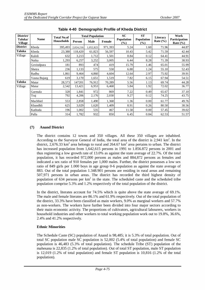
ESIMMS Report of the Dedicated Freight Corridor Project for Gujarat State October 2007
Page 4-75
Table 4-40 Demographic Profile of Kheda District Total Population District/
Taluka/ Village
Name Total No.of Households Person Male Female
SC Population
(%)
ST Population
(%)
Literacy Rate (%)
Work Participation
Rate (%) District Kheda 395,493 2,024,216 1,052,823 971,393 5.24 1.60 71.96 44.87 Taluka Kheda 23,388 118,420 61,823 56,597 10.43 5.42 71.59 42.44
Kaloli 632 3,213 1,712 1,501 8.84 0.12 64.41 44.91 Naika 1,293 6,257 3,252 3,005 6.44 8.28 71.39 38.93 Govindpura 181 893 474 419 15.79 1.46 65.01 55.99 Shetra 236 1,133 575 558 6.88 1.24 55.10 52.43 Radhu 1,861 9,464 4,860 4,604 12.64 2.97 75.92 39.91
Village
Vasna Bujarg 619 3,170 1,651 1,519 7.82 6.15 67.94 54.51 Taluka Matar 28,573 147201 76,912 70,289 5.56 1.13 69.74 44.28
Matar 2,542 13,421 6,953 6,468 5.84 1.92 72.02 36.77
Garmala 328 1,841 972 869 7.22 0.49 65.67 37.10 Traj 792 4,206 2,176 2,030 9.27 0.12 74.25 43.75
Machhiel 553 2,858 1,490 1,368 1.36 0.00 61.77 49.76 Khandhli 625 3,029 1,620 1,409 8.91 0.26 80.50 38.56 Kathoda 196 1,002 535 467 11.58 0.00 57.45 39.02
Village
Palla 314 1,782 932 850 6.45 0.84 62.53 51.57
(7) Anand District
The district contains 12 towns and 350 villages. All these 350 villages are inhabited. According to the Surveyor General of India, the total area of the district is 2,941 km2. In the district, 2,676.33 km2 area belongs to rural and 264.67 km2 area pertains to urban. The district has increased population from 1,642,615 persons in 1991 to 1.856.872 persons in 2001 and thus registering a low growth rate of 13.0% as against the state average of 22.7%. Of the total population, it has recorded 972,000 persons as males and 884,872 persons as females and indicated a sex ratio of 910 females per 1,000 males. Further, the district possesses a low sex ratio of 849 girls per 1.000 boys in age group 0-6 population as against the state average of 883. Out of the total population 1.348.901 persons are residing in rural areas and remaining 507,971 persons in urban areas. The district has recorded the third highest density of population of 634 persons per km2 in the state. The scheduled caste and the scheduled tribe population comprise 5.3% and 1.2% respectively of the total population of the district.
In the district, literates account for 74.5% which is quite above the state average of 69.1%. The male and female literates are 86.1% and 61.9% respectively. Out of the total population of the district, 33.3% have been classified as main workers, 9.0% as marginal workers and 57.7% as non-workers. The workers have further been divided into four major sectors according to their main economic activity. The proportions of cultivators, agricultural labourers, workers in household industries and other workers to total working population work out to 19.8%, 36.6%, 2.4% and 41.2% respectively.
Ethnic Minorities
The Schedule Caste (SC) population of Anand is 98,485; it is 5.3% of total population. Out of total SC population male SC population is 52,002 (5.4% of total population) and female SC population is 46,483 (5.3% of total population). The schedule Tribe (ST) population of the mahesana is 22,835 (1.2% of total population). Out of total ST population, male ST population is 12,019 (1.2% of total population) and female ST population is 10,816 (1.2% of the total population).
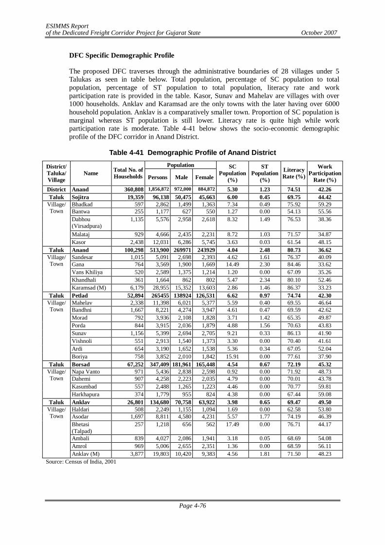
ESIMMS Report of the Dedicated Freight Corridor Project for Gujarat State October 2007
Page 4-76
DFC Specific Demographic Profile
The proposed DFC traverses through the administrative boundaries of 28 villages under 5 Talukas as seen in table below. Total population, percentage of SC population to total population, percentage of ST population to total population, literacy rate and work participation rate is provided in the table. Kasor, Sunav and Mahelav are villages with over 1000 households. Anklav and Karamsad are the only towns with the later having over 6000 household population. Anklav is a comparatively smaller town. Proportion of SC population is marginal whereas ST population is still lower. Literacy rate is quite high while work participation rate is moderate. Table 4-41 below shows the socio-economic demographic profile of the DFC corridor in Anand District.
Table 4-41 Demographic Profile of Anand District Population District/
Taluka/ Village
Name Total No. of Households Persons Male Female
SC Population
(%)
ST Population
(%)
Literacy Rate (%)
Work Participation
Rate (%) District Anand 360,808 1,856,872 972,000 884,872 5.30 1.23 74.51 42.26 Taluk Sojitra 19,359 96,138 50,475 45,663 6.00 0.45 69.75 44.42
Bhadkad 597 2,862 1,499 1,363 7.34 0.49 75.92 59.29 Bantwa 255 1,177 627 550 1.27 0.00 54.13 55.56 Dabhou (Virsadpura)
1,135 5,576 2,958 2,618 8.32 1.49 76.53 38.36
Malataj 929 4,666 2,435 2,231 8.72 1.03 71.57 34.87
Village/ Town
Kasor 2,438 12,031 6,286 5,745 3.63 0.03 61.54 48.15 Taluk Anand 100,298 513,900 269971 243929 4.04 2.48 80.73 36.62
Sandesar 1,015 5,091 2,698 2,393 4.62 1.61 76.37 40.09 Gana 764 3,569 1,900 1,669 14.49 2.30 84.46 33.62 Vans Khiliya 520 2,589 1,375 1,214 1.20 0.00 67.09 35.26 Khandhali 361 1,664 862 802 5.47 2.34 80.10 52.46
Village/ Town
Karamsad (M) 6,179 28,955 15,352 13,603 2.86 1.46 86.37 33.23 Taluk Petlad 52,894 265455 138924 126,531 6.62 0.97 74.74 42.30
Mahelav 2,338 11,398 6,021 5,377 5.59 0.40 69.55 46.64 Bandhni 1,667 8,221 4,274 3,947 4.61 0.47 69.59 42.62 Morad 792 3,936 2,108 1,828 3.71 1.42 65.35 49.87 Porda 844 3,915 2,036 1,879 4.88 1.56 70.63 43.83 Sunav 1,156 5,399 2,694 2,705 9.21 0.33 86.13 41.90 Vishnoli 551 2,913 1,540 1,373 3.30 0.00 70.40 41.61 Ardi 654 3,190 1,652 1,538 5.36 0.34 67.05 52.04
Village/ Town
Boriya 758 3,852 2,010 1,842 15.91 0.00 77.61 37.90 Taluk Borsad 67,252 347,409 181,961 165,448 4.54 0.67 72.19 45.32
Napa Vanto 971 5,436 2,838 2,598 0.92 0.00 71.92 48.73 Dahemi 907 4,258 2,223 2,035 4.79 0.00 70.01 43.78 Kasumbad 557 2,488 1,265 1,223 4.46 0.00 70.77 59.81
Village/ Town
Harkhapura 374 1,779 955 824 4.38 0.00 67.44 59.08 Taluk Anklav 26,801 134,680 70,758 63,922 3.98 0.65 69.47 49.50
Haldari 508 2,249 1,155 1,094 1.69 0.00 62.58 53.80 Asodar 1,697 8,811 4,580 4,231 5.57 1.77 74.19 46.39 Bhetasi (Talpad)
257 1,218 656 562 17.49 0.00 76.71 44.17
Ambali 839 4,027 2,086 1,941 3.18 0.05 68.69 54.08 Amrol 969 5,006 2,655 2,351 1.36 0.00 68.59 56.11
Village/ Town
Anklav (M) 3,877 19,803 10,420 9,383 4.56 1.81 71.50 48.23 Source: Census of India, 2001
ESIMMS Report of the Dedicated Freight Corridor Project for Gujarat State October 2007
Page 4-77
(8) Vadodara District
The district contains 16 towns and 1,553 villages. Of which 1,548 villages are inhabited. According to the Surveyor General of India, its geographical area is 7,550 km2. In this district, 7,278.8 km2 area belongs to rural and 271.2 km2 area pertains to urban. It has returned a total population of 3,641,802 persons at the 2001 Census as against 3,038,127 persons reported at the 1991 Census and thus registering an overall growth rate of 19.9% against the state average of 22.7%. Of the total population, 1,897,368 persons are males and 1,744,434 persons are females thereby reflecting a sex ratio of 919 females per 1,000 males which is just below the state average of 920. The district has recorded the child sex ratio of 886 girls per 1,000 boys. In this district, as many as 1,995,580 persons are residing in rural areas and rest 1,646,222 persons in urban areas. The density of population of the district comes to 482 persons/km2.
The literacy rate in the district is 70.8% which is above the state average of 69.1%. Further, the male and female literacy rates account for 80.0% and 60.7% respectively. Out of the total population of the district, 33.0% have been classified as main workers, 8.7% as marginal workers and 58.3% as non-workers. Further, the working population has been divided into four major categories according to their economic activity. The percentage shares of cultivators, agricultural labourers, workers in household industries and other workers are 22.0%, 31.0%, 1.5% and 45.5% respectively.
Agriculture is the main occupation of the people of the district and they grow cotton, jowar, rice, bajri, tobacco and groundnut as principal crops.
Ethnic Minorities
The Schedule Caste (SC) population of Vadodara is 204,285; it is 5.6 % of total population. Out of total SC population male SC population is 106,497 (5.6% of total population) and female SC population is 97,788 (5.6% of total population). The schedule Tribe (ST) population of the Vadodara is 967,393 (26.6% of total population). Out of total ST population, male ST population is 496,058 (26.1% of total population) and female St population is 471,335 (27.0% of the total population).
DFC Specific Demographic Profile
Vadodara District is divided into two talukas- Vadodara and Karjan. While the former is mostly in detour section, Karjan lies in the parallel section of DFC. The proposed DFC traverses through the administrative boundaries of 27 villages (17 in Vadodara and 10 in Karjan), 1 town and 1 city with outgrowth under 2 Talukas as seen in Table 4-42. Besides Vadodara City and out growth, Karjan is another important town with over 5,000 population. Of all 27 villages, Valan (1,611) and Bhayli (1,553) are the bigger villages with over 1,500 population. Other villages over 1,000 households are Sindhrot, Kandari, Miyagam and Sansrod.
ST population is remarkably more than SC population in most villages; literacy rate is quite high across all villages but highest in Vadodara city as is expected (famous with many educational institutions) but work participation rate is moderate though, hardly crossing 50% mark. Table 4-42 below shows the socio-economic demographic profile of the DFC corridor in Vadodara district.
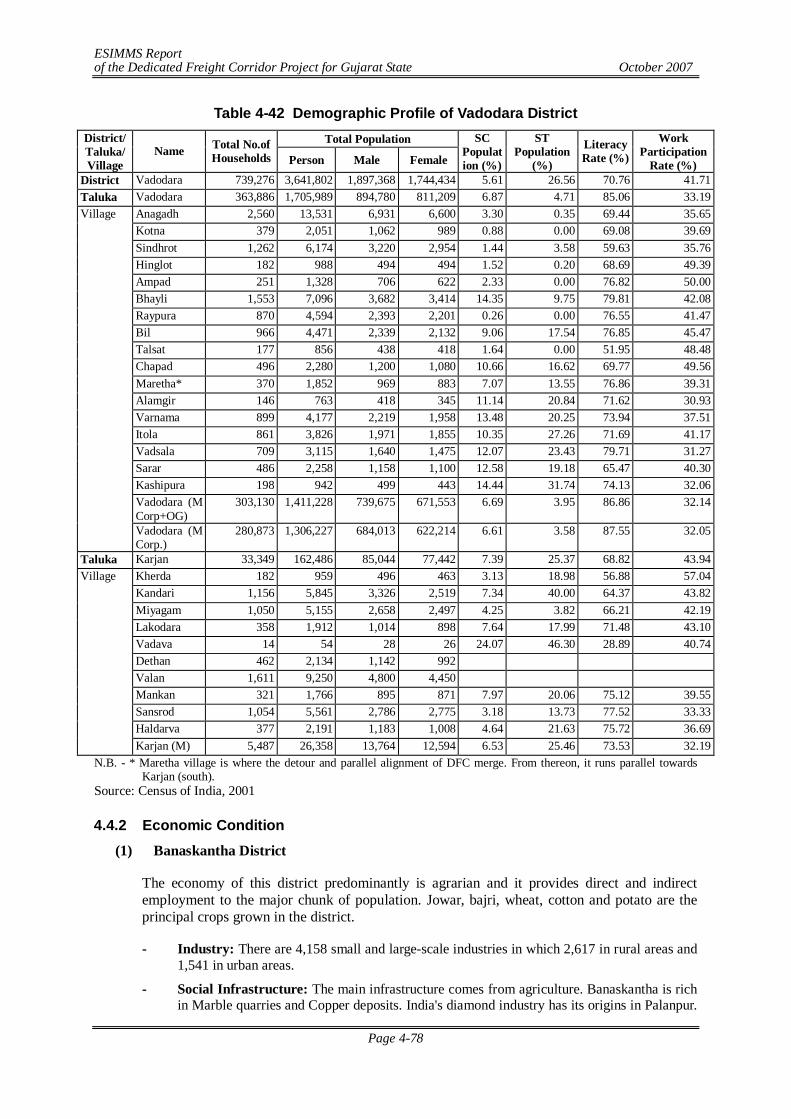
ESIMMS Report of the Dedicated Freight Corridor Project for Gujarat State October 2007
Page 4-78
Table 4-42 Demographic Profile of Vadodara District Total Population District/
Taluka/ Village
Name Total No.of Households Person Male Female
SC Population (%)
ST Population
(%)
Literacy Rate (%)
Work Participation
Rate (%) District Vadodara 739,276 3,641,802 1,897,368 1,744,434 5.61 26.56 70.76 41.71 Taluka Vadodara 363,886 1,705,989 894,780 811,209 6.87 4.71 85.06 33.19
Anagadh 2,560 13,531 6,931 6,600 3.30 0.35 69.44 35.65 Kotna 379 2,051 1,062 989 0.88 0.00 69.08 39.69 Sindhrot 1,262 6,174 3,220 2,954 1.44 3.58 59.63 35.76 Hinglot 182 988 494 494 1.52 0.20 68.69 49.39 Ampad 251 1,328 706 622 2.33 0.00 76.82 50.00 Bhayli 1,553 7,096 3,682 3,414 14.35 9.75 79.81 42.08 Raypura 870 4,594 2,393 2,201 0.26 0.00 76.55 41.47 Bil 966 4,471 2,339 2,132 9.06 17.54 76.85 45.47 Talsat 177 856 438 418 1.64 0.00 51.95 48.48 Chapad 496 2,280 1,200 1,080 10.66 16.62 69.77 49.56 Maretha* 370 1,852 969 883 7.07 13.55 76.86 39.31 Alamgir 146 763 418 345 11.14 20.84 71.62 30.93 Varnama 899 4,177 2,219 1,958 13.48 20.25 73.94 37.51 Itola 861 3,826 1,971 1,855 10.35 27.26 71.69 41.17 Vadsala 709 3,115 1,640 1,475 12.07 23.43 79.71 31.27 Sarar 486 2,258 1,158 1,100 12.58 19.18 65.47 40.30 Kashipura 198 942 499 443 14.44 31.74 74.13 32.06 Vadodara (M Corp+OG)
303,130 1,411,228 739,675 671,553 6.69 3.95 86.86 32.14
Village
Vadodara (M Corp.)
280,873 1,306,227 684,013 622,214 6.61 3.58 87.55 32.05
Taluka Karjan 33,349 162,486 85,044 77,442 7.39 25.37 68.82 43.94 Kherda 182 959 496 463 3.13 18.98 56.88 57.04 Kandari 1,156 5,845 3,326 2,519 7.34 40.00 64.37 43.82 Miyagam 1,050 5,155 2,658 2,497 4.25 3.82 66.21 42.19 Lakodara 358 1,912 1,014 898 7.64 17.99 71.48 43.10 Vadava 14 54 28 26 24.07 46.30 28.89 40.74 Dethan 462 2,134 1,142 992 Valan 1,611 9,250 4,800 4,450 Mankan 321 1,766 895 871 7.97 20.06 75.12 39.55 Sansrod 1,054 5,561 2,786 2,775 3.18 13.73 77.52 33.33 Haldarva 377 2,191 1,183 1,008 4.64 21.63 75.72 36.69
Village
Karjan (M) 5,487 26,358 13,764 12,594 6.53 25.46 73.53 32.19 N.B. - * Maretha village is where the detour and parallel alignment of DFC merge. From thereon, it runs parallel towards
Karjan (south). Source: Census of India, 2001
4.4.2 Economic Condition
(1) Banaskantha District
The economy of this district predominantly is agrarian and it provides direct and indirect employment to the major chunk of population. Jowar, bajri, wheat, cotton and potato are the principal crops grown in the district.
- Industry: There are 4,158 small and large-scale industries in which 2,617 in rural areas and 1,541 in urban areas.
- Social Infrastructure: The main infrastructure comes from agriculture. Banaskantha is rich in Marble quarries and Copper deposits. India's diamond industry has its origins in Palanpur.
ESIMMS Report of the Dedicated Freight Corridor Project for Gujarat State October 2007
Page 4-79
It has got prestigious State Agricultural University Sardarkrushinagar Dantiwada Agricultural University, Sardarkrushinagar. The main agriculture is of Bajra crops.
- Transportation: Transportation plays a principle role in Economic and general development. A well laid out road network is essential for efficient and cost effective movement of men and materials, without which trade and industry cannot maintain a competitive edge. Transport network in this district is mainly formed by roads and broad/meter gauge railway lines. National Highway No. 15, state highways and other metalled roads also passes through this district.
(2) Patan District
- Industry Facility: There are 2,582 small and large-scale industries in which 1,015 in rural areas and 1,567 in urban areas.
- Social Infrastructure: The main economy of Patan District comes from Agricultural sector. Main Crops grown in the district are Bajra, Jowar, cotton and oilseeds.
- Transportation: There is a well-developed network of roads and railways in this district.
(3) Mehasana District
- Industry: Gujarat is developing industries. A large no of small scale and large-scale industries in the state. There are 4,857 small and large-scale industries in which 2336 in rural area and 2,521 in urban area.
- Major Infrastructure: Mahesana being the earliest gas fields discovered in the country. During 2003-04, Gujarat produced 2216 MCM of gas, which was 7% of the country's production. Gujarat has 26.02 MMSCD of gas allocation, which is 25% of the country's total allocation. Gujarat holds the unique distinction of being the only state with more than one gas producer. Apart from ONGC, Gujarat State Petroleum Corporation Ltd. (GSPC), Cairn Energy and Niko Resources are engaged in the production of natural gas in the state.
- Transportation: There is a well-developed transportation system in this district.
(4) Gandhinagar District
- Industry: There are 3,137 small and large-scale industries in which 1,203 in rural areas and 1,934 in urban areas.
- Transportation: Gandhinagar is capital of Gujarat. It is well linked by rail and road.
(5) Ahmedabad District
- Industry: The State has constituted a mechanism of single window clearance in the form of Gujarat Infrastructure Development Board (GIDB), headed by Chief Minister. Concession agreements are finalised in a transparent manner. GIDB had prepared a detailed Master Plan. "Infrastructure Agenda - Vision 2010", laying down 383 projects estimating an investment of Rs. 1.16,993 crore. Almost 70% of the investment is envisaged to come from private sector Blue prints for development of power generating plants, ports, roads, LNG platforms, a common gas grid, industrial parks, urban infrastructure, airports and information infrastructure have been detailed to form a part of the Infrastructure Agenda : Vision 2010. In fact. Gujarat is the first State to have legislated a law governing private sector investment in infrastructure. The statute, interalia. lays down the framework and methodology to be used in awarding of projects, concession agreements, develop risk allocating mechanisms, the rights and obligations of not only the private investors but that of the role of Government itself.
- Major Infrastructure: Ahmedabad is the largest inland industrial centre in western India,
ESIMMS Report of the Dedicated Freight Corridor Project for Gujarat State October 2007
Page 4-80
and has historically enjoyed a reputation as an important base of commerce, trade and industry. Under Muzaffarid rule, the city was a major trade destination for western India, because of its proximity to the port at Surat and for its access to the hinterland of Gujarat. In the 19th century, the textile and garments industry developed and thrived in the city — on 30 May 1861 Ranchhodlal Chhotalal founded the first Indian textile mill, the Ahmedabad Spinning and Weaving Company Limited. This was followed by the establishment of a series of textile mills such as the Calico Mills in 1880 by Maganbhai, and mills founded by industrialists such as Ambalal Sarabhai and Kasturbhai Lalbhai. Arvind Mills, located in Ahmedabad, is one of the largest textile mills in the country.
Ahmedabad has a thriving chemicals and pharmaceuticals industry. Two of the biggest pharmaceutical companies of India — Zydus Cadila and Torrent Pharmaceuticals — are based in the city. The city serves as the corporate headquarters of the Adani Group, which is a leading multinational trading company. The Nirma group of industries, which runs a large number of detergent and chemical industrial units, has its corporate headquarters in the city. In recent year many foreign companies have set up their sales offices and production facilities in Ahmedabad. Amongst them are Bosch Rexroth, Germany (hydraulic components); Stork, Netherlands (textile machinery; joint venture with ATE, India's leading textile equipment trading house); Rollepaal, Netherlands (pipe extrusion equipment); and Johnson Pumps, Sweden.
The completion and operation of the Sardar Sarovar Project of dams and canals has improved the supply of potable water and electricity for the city. In recent years, the Gujarat government has increased investment in the modernisation of the city's infrastructure, providing for the construction of larger roads and improvements to water supply, electricity and communications. The information technology industry has developed significantly in Ahmedabad. A NASSCOM survey in 2002 on the "Super Nine Indian Destinations" for IT-enabled services ranked Ahmedabad fifth among the top nine most competitive cities in the country.
- Transportation: Ahmedabad is one of the six operating divisions of the Western Railway. Railway lines connect the city to all towns in Gujarat, and to major cities in the rest of India. The Ahmedabad Railway Station and the Maninagar Railway Station are the main terminals for the city. The Sardar Vallabhbhai Patel International Airport provides for both domestic and international aviation for the city and the neighbouring cities of Gandhinagar, Mahesana and Nadiad. The airport connects the city with destinations across India and to cities in the Middle East, East Asia and destinations in Western Europe.
National Highway 8, linking Delhi to Mumbai, passes though Ahmedabad. Ahmedabad is connected to Vadodara through National Expressway 1, a 94 km (58 mi) long highway with only two exits. This expressway is part of the Golden Quadrilateral project. Ahmedabad is directly connected by highways to Bhavnagar, Nadiad, Mahesana, Surendranagar, Bhuj, Rajkot and Gandhinagar.
The city's main traffic arteries are the Mahatma Gandhi Road, C. G. Road, the Jawaharlal Nehru Road, the Ashram Road and the Sarkhej-Gandhinagar highway (S.G. Highway).
(6) Kheda District
- Industry Facility: There are 3282 small and large-scale industries in which 2,138 in rural areas and 1,144 in urban areas.
- Transportation: There is a very well developed network of roads and railways in this district.
(7) Anand District
- Industry Facility: There are 4,399 small and large-scale industries in which 1,703 in rural areas and 2,696 in urban areas.
ESIMMS Report of the Dedicated Freight Corridor Project for Gujarat State October 2007
Page 4-81
(8) Vadodara District
- Industry: At a state level, Vadodara has only 3.1% of the total state functioning units and attracts a fixed investment of Rs. 46,941 crores. However, this investment is not substantial enough and forms only 6.3% of the total state investment; it cannot provide any impetus for industrial growth. Employment in Vadodara’s small-scale industries (SSI) is 4% as against 17.5% and 14.1% respectively in Ahmedabad and Surat. The exports from SSI in Vadodara amount to only 1% against 5.4% in the case of Ahmedabad. The percentage of plant and machinery to fixed investments is 36% in Vadodara, implying that the industries are mostly labour intensive in nature.
- Industry Facility: There are 11,088 small and large-scale industries in which 2,202 in rural areas and 8886 in urban areas, 217 medium and large-scale industries (MLI) in and around Vadodara. The maximum number of Medium and Large Industries (MLI) is concentrated in Nandesari and account for 40% of MLI. Some of these are: Gujarat State Fertilizers and Chemicals Limited, Gujarat Refinery, Indian Petrochemicals Corporation Limited and Gujarat Alkalis and Chemicals Limited.
- Major Infrastructure: In Vadodara various large-scale industries such as Gujarat State Fertilisers & Chemicals, Indian Petrochemicals Corporation Limited and Gujarat Alkalies and Chemicals Limited have come up in the vicinity of Gujarat Refinery and all of them are dependent on it for their fuel and feedstock. Other large-scale public sector units are Heavy Water Project, Gujarat Industries Power Company Limited, ONGC & GAIL. In addition to these public sector enterprises, a number of other large-scale enterprises have come up in the private sector. The products of these industries have wide applications in various sectors of the Indian economy.
The discovery of oil and gas in Ankleshwar led to the industrial development of Gujarat in a big way. The Vadodara region is the largest beneficiary in the process of this industrialisation. Gujarat Refinery went into the first phase of production in 1965. The refinery being a basic industry made vital contributions on several fronts at the regional and national levels.
- Transportation: The city is on the major rail and road arteries joining Mumbai with Delhi and Mumbai with Ahmedabad. Because of this Vadodara is known as a ‘Gateway to the Golden Corridor’. National Highway No. 8 passes through the city. Vadodara is also connected with Ahmedabad through National Expressway No. 1, a stretch of 97 km Super Highway with only 2 exits. The Vadodara Railway Station belongs to the Western Railways division of Indian Railways and is a major station on the Mumbai-Delhi and Mumbai-Ahmedabad routes. Public transport vehicles within the city include buses, autorickshaws and taxis.
4.4.3 Education
(1) Banaskantha District
- Literacy level: In the district, the overall literacy rate is 51.0% which is far below the state average of 69.1 %. The male and female literacy rates of the district account for 66.5% and 34.4 % respectively. The total number of literate in district is 10,37,619 out of which male literate population is 6,99,080 and female literate population is 3,38,539.The literacy rate of Banaskantha is 51.0%, out of this literacy rate of male is 66.5% and female literacy rate is 34.4%.
- Education Facility: There are 3,838 school and colleges out of which 3,566 in rural area and 272 in urban area.
ESIMMS Report of the Dedicated Freight Corridor Project for Gujarat State October 2007
Page 4-82
(2) Patan District
- Literacy level: The total number of literate in district is 5.99.082 out of which male literate population is 375,588 and female literate population is 223,494.The literacy rate of Patan 60.4%, out of this literacy rate of male is 73.6% and female literacy rate is 46.3%.
- Education Facility: There are 1,725 school and colleges out of which, 300 in rural area and 2,626 in urban area
(3) Mahesana District
- Education Level: The total number of literate in district is 1,188,224 out of which male literate population is 698,626 and female literate population is 489,598.
- Literacy Rate: The literacy rate of Mahesana is 75.2%, out of this literacy rate of male is 86.2% and female literacy rate is 63.6%.
- Education Facility: There are 2,626 schools, colleges in which 2,184 in rural area and 442 in urban area. Sardarkrushinagar Dantiwada Agricultural University, Sardarkrushinagar is one of the study centre in the district.
(4) Gandhinagar District
- Education level: The total number of literate in district is 1,879,834 out of which male literate population is 522,575 and female literate population is 357,259.
- Literacy Rate: The literacy rate of Gandhinagar 76.6%, out of this literacy rate of male is 87.7% and female literacy rate is 64.6%.
- Education Facility: There are 1,718 school and colleges out of which, 1,350 in rural area and 368 in urban area
(5) Ahmedabad District
- Literacy Level: The total number of literate in Ahmedabad is 40,12,140 out of which male literate population is 23,18,295 and female literate population is 16,93,845.The literacy rate of Ahmedabad is 79.5%, out of this literacy rate of male is 10.7% and female literacy rate is 70.8%.
- Education Facility: Education has a multiplier effect on other social sectors like health, women development, employment, child development, labour etc. It is also of great instrumental value in the process of economic growth and development. Education not only improves the quality of life of the people, it also provides opportunities for progress.
(6) Kheda District
- Education level: The total number of literate in district is 1,243,363 out of which male literate population is 769,426 and female literate population is 473,937.
- Literacy Rate: The literacy rate of Kheda 72.0%, out of this literacy rate of male is 86.0 % and female literacy rate is 56.9%.
- Education Facility: There are 3,263 school and colleges out of which, 2,895 in rural area and 368 in urban area
(7) Anand District
- Education Level: The total number of literate in district is 1,193,404 out of which male
ESIMMS Report of the Dedicated Freight Corridor Project for Gujarat State October 2007
Page 4-83
literate population is 717,909 and female literate population is 475,495.
- Literacy Rate: The literacy rate of Anand is 74.5%, out of this literacy rate of male is 86.1 % and female literacy rate is 61.9%.
- Education Facility: There are 2,180 school and colleges out of which, 1,645 in rural area and 535 in urban area.
Anand Agricultural University, Anand
Institute of Rural Management, Anand
Dadabhai Navaroji High School,Anand (Mostly Known as D N High School)
Anand homeopathic college,Anand
Anandalaya Education Society,Anand
(8) Vadodara District
- Education Level: The total number of literate in district is 2,228,008 out of which male literate population is 1,309,347 and female literate population is 918,661.
- Literacy Rate: The literacy rate of Vadodara is 70.8%, out of this literacy rate of male is 80.0 % and female literacy rate is 60.7%.
- Education Facility: There are 5,242 school and colleges out of which, 3947 in rural area and 1295 in urban area. Vadodara has a legacy of being a rich cultural and educational centre. Vadodara is known for imparting quality education. The patronage of educational institutions in Vadodara started with Maharaja Sayajirao; the city has built further on the academic infrastructure established by him.
4.4.4 Employment
(1) Banaskantha District
- Occupational Structure: The occupational structure of the population in Banaskantha has been taken from census of India. The study area has been studied with reference to total workers, main workers, marginal workers and non-workers. The total workers in the district are 1,092,201 (43.6% of total population), out of which 664,253 (51.2%) are male and 427,945 (35.5%) are female. Total main workers of district are 830,579 (33.2% of total population), out of which 619,198 (47.7%) are male and 211,381 (17.5%) are female. Of the total population of the district, the proportions of main workers, marginal workers and non workers are 33.2%, 10.4% and 56.4% respectively. In the 2001 census, the workers have further been divided into 4 major sectors according to their main economic activity. The proportions of cultivators, agricultural labourers, workers in the household industries and other workers to total workers account for 44.2 %, 22.2%, 1.7 % and 31.8% respectively. Apart from the above said values workers, the occupational structure also consists of cultivators, agricultural labourers, workers in household industries and other workers.
- Cultivators: The person who is engaged either as employer, single workers or family worker in cultivation of land owned is termed as cultivator. Total cultivator in the district are 482,803 (44.2% of total working population), out of which 336,184 (50.6%) are male and 146,679 (34.3%) are female.
- Agricultural labourers: Persons working on the land of others for wages or share in the yield have been treated as agricultural labourers. The total workers of this category are about 242,728 (22.2% of total working population), out of which 116,893 (17.6%) are male and 125,835 (29.4%) are female.
- Workers in household industries: Household in industry is defined as an industry conducted by one or more members of the household at home or within the village in rural
ESIMMS Report of the Dedicated Freight Corridor Project for Gujarat State October 2007
Page 4-84
area and only within the precincts of the house where the household lives in urban areas. The larger proportion of workers in the household industry consists of members of the household. The industry is not run on the scale of a registered factory, which could qualify or has to be registered under the Indian Factories Act. The total numbers of workers in household factories under the study area is 18,875 (1.7% of total population), out of which 10,726 (1.6%) are male and 8,149 (1.9%) are female.
- Other workers: All workers other than cultivators or agricultural labourers, who have been engaged in some economic activity, are other workers. The workers that come under this category include plantation workers, commerce, business, transport, mining, construction, workers etc. the total number of other workers under the study area is 347,795 (31.8% of total population), out of which 200,450 (30.2%) are male and 147,345 (34.4%) are female.
- Marginal Workers: The marginal workers are those workers, who are engaged in some work for a period of less than six months, during the reference year prior to the census survey. The total marginal workers in the district are 261,622 (10.4% of total population), out of which 45,055 (3.5%) are male and 216,567 (17.9%) are female
- Non-Workers: The non-workers include those engaged in unpaid household duties, students, retired persons, dependents, beginners etc. The total non-workers in the district are 1,412,043 (56.4% of total population), out of which 633,151 (48.8%) are male and 778,892 (64.5%) are female.
(2) Patan District
- Occupational Structure: The occupational structure of the population in Patan has been taken from census of India. The study area has been studied with reference to total workers, main workers, marginal workers and non-workers. The total workers in the district are 533,078 (45.1% of total population), out of which 325,825 (53.2%) are male and 207,253 (36.3%) are female. Total main workers of district are 395,470 (33.4% of total population), out of which 298,380 (48.7%) are male and 97,090 (17.0%) are female. Apart from the above said values workers, the occupational structure also consists of cultivators, agricultural labourers, workers in household industries and other workers. The details of these are given below:
- Cultivators: The person who is engaged either as employer, single workers or family worker in cultivation of land owned is termed as cultivator. Total cultivator in the district are 151,828 (28.5% of total population), out of which 110,477 (33.9%) are male and 41,351 (20.0%) are female
- Agricultural Labourers: Persons working on the land of others for wages or share in the yield have been treated as agricultural labourers. The total workers of this category are about 188,699 (35.4% of total working population), out of which 88,443 (27.1%) are male and 100,256 (48.4%) are female.
- Workers in household industries: Household in industry is defined as an industry conducted by one or more members of the household at home or within the village in rural area and only within the precincts of the house where the household lives in urban areas. The larger proportion of workers in the household industry consists of members of the household. The industry is not run on the scale of a registered factory, which could qualify or has to be registered under the Indian Factories Act. The total numbers of workers in household factories under the study area is 9,057 (1.7% of total population), out of which 4,406(1.4%) are male and 4,651 (2.2%) are female.
- Other Workers: All workers other than cultivators or agricultural labourers, who have been engaged in some economic activity, are other workers. The workers that come under this category include plantation workers, commerce, business, transport, mining, construction, workers etc. the total number of other workers under the study area is 183,494 (34.4% of total population), out of which 122,499 (37.6%) are male and 60,995 (29.4%) are female.
ESIMMS Report of the Dedicated Freight Corridor Project for Gujarat State October 2007
Page 4-85
- Marginal Workers: The marginal workers are those workers, who are engaged in some work for a period of less than six months, during the reference year prior to the census survey. The total marginal workers in the district are 137,608 (11.6% of total population), out of which 27,445 (4.5%) are male and 110,163 (19.3%) are female
- Non-Workers: The non-workers include those engaged in unpaid household duties, students, retired persons, dependents, beginners etc. The total non-workers in the district are 649,631 (54.9% of total population), out of which 286,275 (46.8%) are male and 363,356 (63.7%) are female.
(3) Mehasana District
- Occupational Structure: The occupational structure of the population in Mahesana has been taken from census of India. The study area has been studied with reference to total workers, main workers, marginal workers and non-workers. The total workers in the district are 828,519 (45.1% of total population), out of which 512,458 (61.9%) are male and 316,061 (38.1%) are female. Total main workers of district are 665,080 (36.2% of total population), out of which 474,349 (71.3% ) are male and 190,731 (28.7%) are female.
Apart from the above said values workers, the occupational structure also consists of cultivators, agricultural labourers, workers in household industries and other workers. The details of these are given below:
- Cultivators: The person who is engaged either as employer, single workers or family worker in cultivation of land owned is termed as cultivator. Total cultivator in the district are 193,337 (23.3 % of total working population), out of which 159,654 (31.2 %) are male and 33,683 (10.7 %) are female.
- Agricultural Labourers: Persons working on the land of others for wages or share in the yield have been treated as agricultural labourers. The total workers of this category are about 202,733 (24.5 % of total working population), out of which 104,160 (20.3%) are male and 98,573 (31.2%) are female.
- Workers in Household Industries: Household in industry is defined as an industry conducted by one or more members of the household at home or within the village in rural area and only within the precincts of the house where the household lives in urban areas. The larger proportion of workers in the household industry consists of members of the household. The industry is not run on the scale of a registered factory, which could qualify or has to be registered under the Indian Factories Act.
The total numbers of workers in household factories under the study area is 13,967 (1.7% of total population), out of which 7,302 (1.4%) are male and 6,665 (2.1%) are female.
- Other Workers: All workers other than cultivators or agricultural labourers, who have been engaged in some economic activity, are other workers. The workers that come under this category include plantation workers, commerce, business, transport, mining, construction, workers etc. the total number of other workers under the study area is 418,482 (50.5 % of total population), out of which 241,342 (47.1%) are male and 177,140 (56.0%) are female.
Marginal Workers: The marginal workers are those workers, who are engaged in some work for a period of less than six months, during the reference year prior to the census survey. The total marginal workers in the district are 163,439 (8.9 % of total population), out of which 38,109 (4.0%) are male and 125,330 (14.2%) are female
- Non-Workers: The non-workers include those engaged in unpaid household duties, students, retired persons, dependents, beginners etc. The total non-workers in the district are 1,009,373 (54.9 % of total population), out of which 441,384 (46.3 %) are male and 567,989 (64.2 %) are female.
ESIMMS Report of the Dedicated Freight Corridor Project for Gujarat State October 2007
Page 4-86
(4) Gandhinagar District
- Occupational Structure: The occupational structure of the population in Gandhinagar has been taken from census of India. The study area has been studied with reference to total workers, main workers, marginal workers and non-workers. The total workers in the district are 554,336 (41.5% of total population), out of which 370,462 (53.1%) are male and 183,874 (28.9%) are female. Total main workers of district are 467,413 (35.0% of total population), out of which 343,992 (49.3%) are male and 123,874 (19.4%) are female.
Apart from the above said values workers, the occupational structure also consists of cultivators, agricultural labourers, workers in household industries and other workers. The details of these are given below:
- Cultivators: The person who is engaged either as employer, single workers or family worker in cultivation of land owned is termed as cultivator. Total cultivator in the district are 102,849 (18.6% of total working population), out of which 90,404 (24.4%) are male and 12,446 (6.8%) are female.
- Agricultural Labourers: Persons working on the land of others for wages or share in the yield have been treated as agricultural labourers. The total workers of this category are about 120,849 (21.6% of total working population), out of which 68,607 (18.5%) are male and 51,396 (28.0%) are female.
- Workers in Household Industries: Household in industry is defined as an industry conducted by one or more members of the household at home or within the village in rural area and only within the precincts of the house where the household lives in urban areas. The larger proportion of workers in the household industry consists of members of the household. The industry is not run on the scale of a registered factory, which could qualify or has to be registered under the Indian Factories Act.
The total numbers of workers in household factories under the study area is 7,195 (1.3 % of total population), out of which 4,313(1.2%) are male and 2,882 (1.6 %) are female.
- Other Workers: All workers other than cultivators or agricultural labourers, who have been engaged in some economic activity, are other workers. The workers that come under this category include plantation workers, commerce, business, transport, mining, construction, workers etc. the total number of other workers under the study area is 324,289 (58.5 % of total population), out of which 207,138 (55.9 %) are male and 117,151 (63.7%) are female.
- Marginal Workers: The marginal workers are those workers, who are engaged in some work for a period of less than six months, during the reference year prior to the census survey. The total marginal workers in the district are 86,923 (6.5% of total population), out of which 26,470 (3.8%) are male and 60,453 (9.5%) are female
- Non-Workers: The non-workers include those engaged in unpaid household duties, students, retired persons, dependents, beginners etc. The total non-workers in the district are 780,119 (58.5% of total population), out of which 327,537 (46.9%) are male and 452,582 (71.1%) are female.
(5) Ahmedabad District
- The occupational structure of the population in Ahmedabad state has been taken from Census of India. The study area has been studied with reference to total workers, main workers, marginal workers and non-workers. The total workers in the state are 2,009,365 (34.5% of total population), out of which 632,223 (53.1%) are male and 377,142 (13.8 %) are female. Total main workers of Ahmedabad are 1,799,126 (30.9% of total population), out of which 1,562,354 (50.8 %) are male and 236,772 (8.6%) are female.
- Apart from the above-said workers, the occupational structure also consists of cultivators, agricultural labourers, workers in household industries and other workers. The details of these are given below:
ESIMMS Report of the Dedicated Freight Corridor Project for Gujarat State October 2007
Page 4-87
- Cultivators: The person who is engaged either as employer; single worker or family worker in cultivation of land owned is termed as cultivator. Total cultivators in the district are 127,345 (6.3% of total working population), where 103,807 (6.4%) are male and 23,538 (6.2%) are female.
- Agricultural Labourers: Persons working on the land of others for wages or share in the yield have been treated as agricultural labourers. The total workers of this category are about 237,871 (11.8% of total working population), where 123,479 (7.6%) are male and 114,392 (30.3 %) are female.
- Workers in Household Industries: Household Industry is defined as an industry conducted by one or more members of the household at home or within the village in rural areas and only within the precincts of the house where the household lives in urban areas. The larger proportion of workers in the household industry consists of members of the household. The industry is not run on the scale of a registered factory, which would qualify or has to be registered under the Indian Factories Act. The total number of workers in household industries under the study area is 56,715 (2.8 % of the total working population) out of which 27,287 (1.7 %) are male and 29,428 (7.8 %) are female.
- Other Workers: All workers other than cultivators or agricultural labourers, who have been engaged in some economic activity, are other workers. The workers that come under this category include plantation workers, commerce, business, transport, mining, construction worker etc. The total number of other workers under the study area is 1,587,434 (79 % of the total working population) out of which 1,377,650 (84.4 %) are male and 209,784 (55.6 %) are female.
- Marginal Workers: The marginal workers are those workers, who are engaged in some work for a period of less than six months, during the reference year prior to the census survey. The total marginal workers in the state are 210,239 (3.6 % of total working population), out of which 69,869 (2.3 %) are male and 140,370 (5.1 %) are female.
- Non-Workers: The non-workers include those engaged in unpaid household duties, students, retired persons, dependants, beggars etc. The total non-workers in the state are 3,807,154 (65.5 % of total working population), out of which 1,442,333 (46.9 %) are male and 2,364,821 (86.2%) are female.
(6) Kheda District
- Occupational Structure: The occupational structure of the population in Kheda has been taken from census of India. The study area has been studied with reference to total workers, main workers, marginal workers and non-workers. The total workers in the district are 908,180 (44.9% of total population), out of which 579,830 (55.1%) are male and 328,350 (33.8%) are female. Total main workers of district are 694,400 (34.3% of total population), out of which 524,383 (49.8%) are male and 170,017 (17.5%) are female.
Apart from the above said values workers, the occupational structure also consists of cultivators, agricultural labourers, workers in household industries and other workers. The details of these are given below:
- Cultivators: The person who is engaged either as employer, single workers or family worker in cultivation of land owned is termed as cultivator. Total cultivator in the district are 248,958 (27.4% of total working population), out of which 210,955 (36.4%) are male and 38,003 (11.6%) are female.
- Agricultural Labourers: Persons working on the land of others for wages or share in the yield have been treated as agricultural labourers. The total workers of this category are about 284,703 (31.3% of total working population), out of which 157,371 (27.1%) are male and 127,332 (38.8%) are female.
- Workers in Household Industries: Household in industry is defined as an industry conducted by one or more members of the household at home or within the village in rural
ESIMMS Report of the Dedicated Freight Corridor Project for Gujarat State October 2007
Page 4-88
area and only within the precincts of the house where the household lives in urban areas. The larger proportion of workers in the household industry consists of members of the household. The industry is not run on the scale of a registered factory, which could qualify or has to be registered under the Indian Factories Act.
The total numbers of workers in household factories under the study area is 12,940 (1.4% of total population), out of which 7,520 (1.3%) are male and 5,420 (1.7%) are female.
- Other Workers: All workers other than cultivators or agricultural labourers, who have been engaged in some economic activity, are other workers. The workers that come under this category include plantation workers, commerce, business, transport, mining, construction, workers etc. the total number of other workers under the study area is 361,579 (39.8% of total population), out of which 203,984 (35.2%) are male and 157,595(48.0%) are female.
- Marginal Workers: The marginal workers are those workers, who are engaged in some work for a period of less than six months, during the reference year prior to the census survey. The total marginal workers in the district are 213,780 (10.6% of total population), out of which 55,447 (5.3%) are male and 158,333 (16.3%) are female
- Non-Workers: The non-workers include those engaged in unpaid household duties, students, retired persons, dependents, beginners etc. The total non-workers in the district are 1,116,036 (55.1% of total population), out of which 472,993 (44.9% ) are male and 643,043 (66.2%) are female.
(7) Anand District
- Occupational Structure: The occupational structure of the population in Anand has been taken from census of India. The study area has been studied with reference to total workers, main workers, marginal workers and non-workers. The total workers in the district are 784,711 (42.3% of total population), out of which 535,444 (55.1%) are male and 249,267 (28.2%) are female. Total main workers of district are 617,669 (33.3% of total population), out of which 489,100 (50.3%) are male and 128,569 (14.5 %) are female.
Apart from the above said values workers, the occupational structure also consists of cultivators, agricultural labourers, workers in household industries and other workers. The details of these are given below:
- Cultivators: The person who is engaged either as employer, single workers or family worker in cultivation of land owned is termed as cultivator. Total cultivator in the district are 155,403 (19.8% of total working population), out of which 138,969 (26.0%) are male and 16,434 (6.6%) are female.
- Agricultural Labourers: Persons working on the land of others for wages or share in the yield have been treated as agricultural labourers. The total workers of this category are about 287,179 (36.6% of total working population), out of which 173,485 (32.4%) are male and 113,694 (45.6%) are female.
- Workers in Household Industries: Household in industry is defined as an industry conducted by one or more members of the household at home or within the village in rural area and only within the precincts of the house where the household lives in urban areas. The larger proportion of workers in the household industry consists of members of the household. The industry is not run on the scale of a registered factory, which could qualify or has to be registered under the Indian Factories Act.
The total numbers of workers in household factories under the study area is 18,864 (2.4% of total population), out of which 14,017 (2.6%) are male and 4,847 (1.9%) are female.
- Other Workers: All workers other than cultivators or agricultural labourers, who have been engaged in some economic activity, are other workers. The workers that come under this category include plantation workers, commerce, business, transport, mining, construction, workers etc. the total number of other workers under the study area is 323,265 (41.2% of
ESIMMS Report of the Dedicated Freight Corridor Project for Gujarat State October 2007
Page 4-89
total population), out of which 208,973 (39.20 %) are male and 114,292 (45.9 %) are female.
- Marginal Workers: The marginal workers are those workers, who are engaged in some work for a period of less than six months, during the reference year prior to the census survey. The total marginal workers in the district are 167,042 (9.0 % of total population), out of which 46,344 (4.8%) are male and 120,698 (13.6 %) are female
- Non-Workers: The non-workers include those engaged in unpaid household duties, students, retired persons, dependents, beginners etc. The total non-workers in the district are 1,072,161 (57.7% of total population), out of which 436,556 (44.9%) are male and 635,605 (71.8%) are female.
(8) Vadodara District
- Occupational Structure: The occupational structure of the population in Vadodara has been taken from census of India. The study area has been studied with reference to total workers, main workers, marginal workers and non-workers. The total workers in the district are 1,518,845 (41.7% of total population), out of which 1,059,861 (55.9%) are male and 458,984 (26.3%) are female. Total main workers of district are 1,202,620 (51.5% of total population), out of which 977,232 (51.5%) are male and 225,388 (12.9%) are female.
Apart from the above said values workers, the occupational structure also consists of cultivators, agricultural labourers, workers in household industries and other workers. The details of these are given below:
- Cultivators: The person who is engaged either as employer, single workers or family worker in cultivation of land owned is termed as cultivator. Total cultivator in the district are 334,590 (22.0% of total working population), out of which 240,500 (22.7%) are male and 94,090 (20.5%) are female.
- Agricultural Labourers: Persons working on the land of others for wages or share in the yield have been treated as agricultural labourers. The total workers of this category are about 471,256 (31.0% of total working population), out of which 232,602 (21.9%) are male and 238,654 (52.0%) are female.
- Workers in Household Industries: Household in industry is defined as an industry conducted by one or more members of the household at home or within the village in rural area and only within the precincts of the house where the household lives in urban areas. The larger proportion of workers in the household industry consists of members of the household. The industry is not run on the scale of a registered factory, which could qualify or has to be registered under the Indian Factories Act.
The total numbers of workers in household factories under the study area is 22,645 (1.5% of total population), out of which 13,468 (1.3%) are male and 9,177 (2.0%) are female.
- Other Workers: All workers other than cultivators or agricultural labourers, who have been engaged in some economic activity, are other workers. The workers that come under this category include plantation workers, commerce, business, transport, mining, construction, workers etc. the total number of other workers under the study area is 690,354 (45.5% of total population), out of which 573,291 (54.1%) are male and 117,063 (25.5%) are female.
- Marginal Workers: The marginal workers are those workers, who are engaged in some work for a period of less than six months, during the reference year prior to the census survey. The total marginal workers in the district are 316,225 (8.7% of total population), out of which 82,629 (4.4%) are male and 233,596 (13.4%) are female
- Non-Workers: The non-workers include those engaged in unpaid household duties, students, retired persons, dependents, beginners etc. The total non-workers in the district are 2,122,957 (58.3% of total population), out of which 837,507 (44.1%) are male and 1285,450 (73.7%) are female.
- Poverty Level: A survey of basic services in the urban slums of Vadodara identified 96,000
ESIMMS Report of the Dedicated Freight Corridor Project for Gujarat State October 2007
Page 4-90
families (2.8 lakhs) as falling below the poverty line i.e. the families were drawing an income of Rs 373 per capita per month. In other words, it would appear that 36% of the population of Vadodara lives below the poverty line. No analogies could be drawn between VMC data and the recent survey carried out by SEWA in the year 2006.
4.4.5 Health
(1) Banaskantha District
There are 907 hospitals, dispensaries in which 641 in rural area and 266 in urban areas.
(2) Patan District
There are 364 hospitals, dispensaries in which 302 in rural area and 1,143 in urban areas.
(3) Mehasana District
There are 1143 hospitals and dispensaries in which 623 in rural area and 520 in urban area.
(4) Gandhinagar District
There are 890 hospitals, dispensaries in which 504 in rural area and 386 in urban areas.
(5) Ahmedabad District
There are well equipped and modern type hospital , health centre, eye care centre are found in city.
(6) Kheda District
There are 1,118 hospitals, dispensaries in which 566 in rural area and 552 in urban areas.
(7) Anand District
There are 1,155 hospitals, dispensaries in which 522 in rural area and 633 in urban areas.
(8) Vadodara District
There are 2744 hospitals, dispensaries in which 644 in rural area and 2100 in urban areas. There are four hospitals run by the state government in the city. In addition to these hospitals, a number of hospitals are run by various trusts.
4.4.6 Historical and Cultural Heritage
(1) Banaskantha District
Famous Ambaji temple in Ambaji in Banaskantha District, is at the foot of Aravalli mountains near the mouth of Saraswati River. One of the well-known religious place is Dhima which is 12 km away from Vav and Tharad and has a great Shamlaji Temple. A lot of people visit this temple for worship and especially when it's a full-moon-day. The list of archaeological sites along with details of location and district is given in Table 4-43.
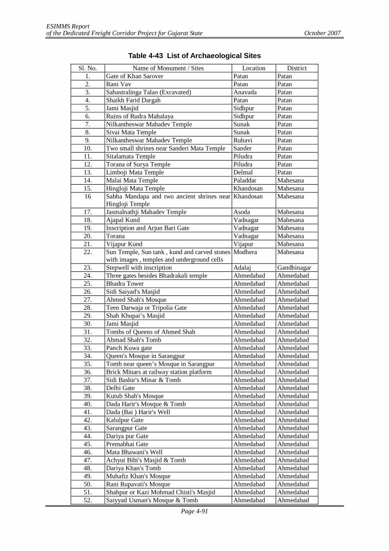
ESIMMS Report of the Dedicated Freight Corridor Project for Gujarat State October 2007
Page 4-91
Table 4-43 List of Archaeological Sites Sl. No. Name of Monument / Sites Location District
1. Gate of Khan Sarover Patan Patan 2. Rani Vav Patan Patan 3. Sahastralinga Talao (Excavated) Anavada Patan 4. Shaikh Farid Dargah Patan Patan 5. Jami Masjid Sidhpur Patan 6. Ruins of Rudra Mahalaya Sidhpur Patan 7. Nilkantheswar Mahadev Temple Sunak Patan 8. Sivai Mata Temple Sunak Patan 9. Nilkantheswar Mahadev Temple Ruhavi Patan 10. Two small shrines near Sanderi Mata Temple Sander Patan 11. Sitalamata Temple Piludra Patan 12. Torana of Surya Temple Piludra Patan 13. Limboji Mata Temple Delmal Patan 14. Malai Mata Temple Paladdar Mahesana 15. Hingloji Mata Temple Khandosan Mahesana 16 Sabha Mandapa and two ancient shrines near
Hingloji Temple Khandosan Mahesana
17. Jasmalnathji Mahadev Temple Asoda Mahesana 18. Ajapal Kund Vadnagar Mahesana 19. Inscription and Arjun Bari Gate Vadnagar Mahesana 20. Torana Vadnagar Mahesana 21. Vijapur Kund Vijapur Mahesana 22. Sun Temple, Sun tank , kund and carved stones
with images , temples and underground cells Modhera Mahesana
23. Stepwell with inscription Adalaj Gandhinagar 24. Three gates besides Bhadrakali temple Ahmedabad Ahmedabad 25. Bhadra Tower Ahmedabad Ahmedabad 26. Sidi Saiyad's Masjid Ahmedabad Ahmedabad 27. Ahmed Shah's Mosque Ahmedabad Ahmedabad 28. Teen Darwaja or Tripolia Gate Ahmedabad Ahmedabad 29. Shah Khupai’s Masjid Ahmedabad Ahmedabad 30. Jami Masjid Ahmedabad Ahmedabad 31. Tombs of Queens of Ahmed Shah Ahmedabad Ahmedabad 32. Ahmad Shah's Tomb Ahmedabad Ahmedabad 33. Panch Kuwa gate Ahmedabad Ahmedabad 34. Queen's Mosque in Sarangpur Ahmedabad Ahmedabad 35. Tomb near queen’s Mosque in Sarangpur Ahmedabad Ahmedabad 36. Brick Minars at railway station platform Ahmedabad Ahmedabad 37. Sidi Bashir's Minar & Tomb Ahmedabad Ahmedabad 38. Delhi Gate Ahmedabad Ahmedabad 39. Kutub Shah's Mosque Ahmedabad Ahmedabad 40. Dada Harir's Mosque & Tomb Ahmedabad Ahmedabad 41. Dada (Bai ) Harir's Well Ahmedabad Ahmedabad 42. Kalulpur Gate Ahmedabad Ahmedabad 43. Sarangpur Gate Ahmedabad Ahmedabad 44. Dariya pur Gate Ahmedabad Ahmedabad 45. Premabhai Gate Ahmedabad Ahmedabad 46. Mata Bhawani's Well Ahmedabad Ahmedabad 47. Achyut Bibi's Masjid & Tomb Ahmedabad Ahmedabad 48. Dariya Khan's Tomb Ahmedabad Ahmedabad 49. Muhafiz Khan's Mosque Ahmedabad Ahmedabad 50. Rani Rupavati's Mosque Ahmedabad Ahmedabad 51. Shahpur or Kazi Mohmad Chisti's Masjid Ahmedabad Ahmedabad 52. Saiyyad Usman's Mosque & Tomb Ahmedabad Ahmedabad
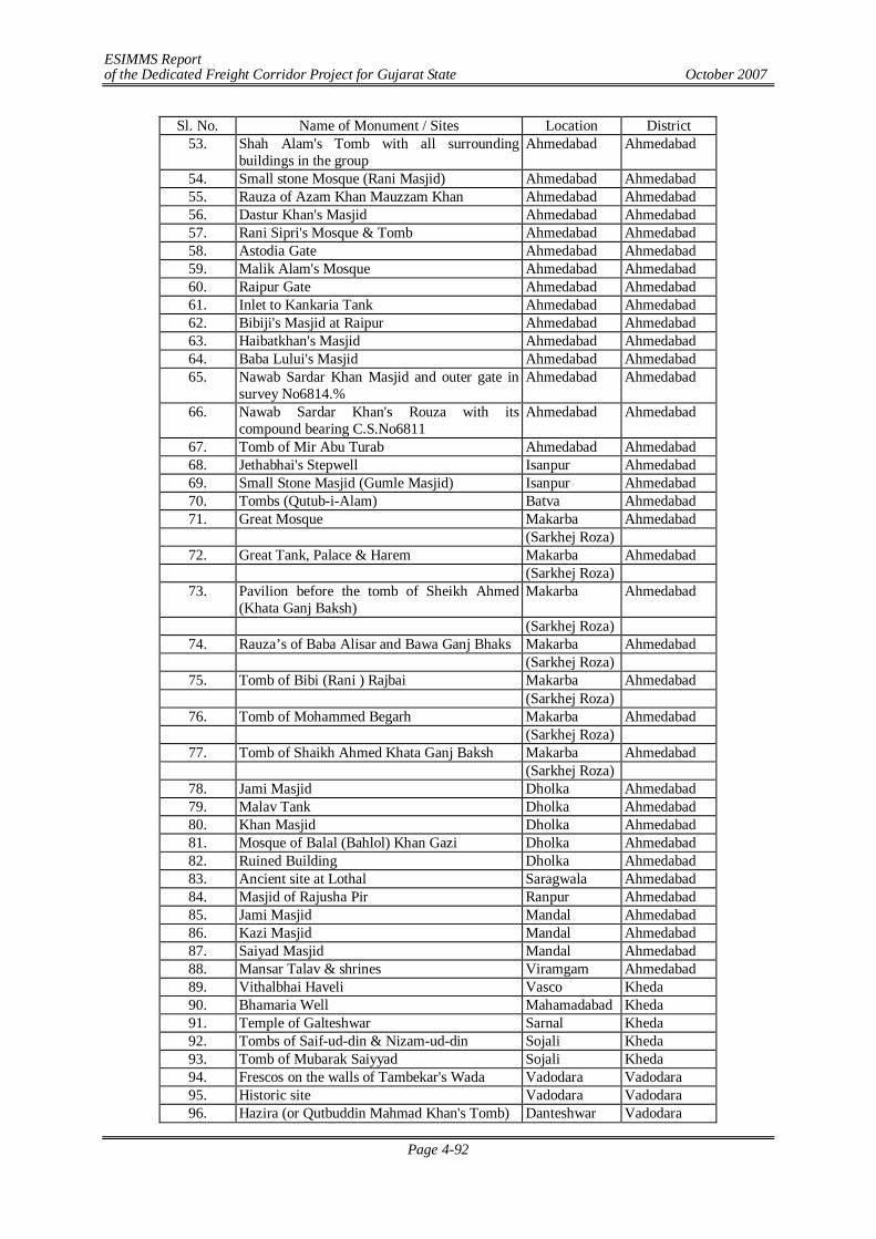
ESIMMS Report of the Dedicated Freight Corridor Project for Gujarat State October 2007
Page 4-92
Sl. No. Name of Monument / Sites Location District 53. Shah Alam's Tomb with all surrounding
buildings in the group Ahmedabad Ahmedabad
54. Small stone Mosque (Rani Masjid) Ahmedabad Ahmedabad 55. Rauza of Azam Khan Mauzzam Khan Ahmedabad Ahmedabad 56. Dastur Khan's Masjid Ahmedabad Ahmedabad 57. Rani Sipri's Mosque & Tomb Ahmedabad Ahmedabad 58. Astodia Gate Ahmedabad Ahmedabad 59. Malik Alam's Mosque Ahmedabad Ahmedabad 60. Raipur Gate Ahmedabad Ahmedabad 61. Inlet to Kankaria Tank Ahmedabad Ahmedabad 62. Bibiji's Masjid at Raipur Ahmedabad Ahmedabad 63. Haibatkhan's Masjid Ahmedabad Ahmedabad 64. Baba Lului's Masjid Ahmedabad Ahmedabad 65. Nawab Sardar Khan Masjid and outer gate in
survey No6814.% Ahmedabad Ahmedabad
66. Nawab Sardar Khan's Rouza with its compound bearing C.S.No6811
Ahmedabad Ahmedabad
67. Tomb of Mir Abu Turab Ahmedabad Ahmedabad 68. Jethabhai's Stepwell Isanpur Ahmedabad 69. Small Stone Masjid (Gumle Masjid) Isanpur Ahmedabad 70. Tombs (Qutub-i-Alam) Batva Ahmedabad 71. Great Mosque Makarba Ahmedabad
(Sarkhej Roza) 72. Great Tank, Palace & Harem Makarba Ahmedabad
(Sarkhej Roza) 73. Pavilion before the tomb of Sheikh Ahmed
(Khata Ganj Baksh) Makarba Ahmedabad
(Sarkhej Roza) 74. Rauza’s of Baba Alisar and Bawa Ganj Bhaks Makarba Ahmedabad
(Sarkhej Roza) 75. Tomb of Bibi (Rani ) Rajbai Makarba Ahmedabad
(Sarkhej Roza) 76. Tomb of Mohammed Begarh Makarba Ahmedabad
(Sarkhej Roza) 77. Tomb of Shaikh Ahmed Khata Ganj Baksh Makarba Ahmedabad
(Sarkhej Roza) 78. Jami Masjid Dholka Ahmedabad 79. Malav Tank Dholka Ahmedabad 80. Khan Masjid Dholka Ahmedabad 81. Mosque of Balal (Bahlol) Khan Gazi Dholka Ahmedabad 82. Ruined Building Dholka Ahmedabad 83. Ancient site at Lothal Saragwala Ahmedabad 84. Masjid of Rajusha Pir Ranpur Ahmedabad 85. Jami Masjid Mandal Ahmedabad 86. Kazi Masjid Mandal Ahmedabad 87. Saiyad Masjid Mandal Ahmedabad 88. Mansar Talav & shrines Viramgam Ahmedabad 89. Vithalbhai Haveli Vasco Kheda 90. Bhamaria Well Mahamadabad Kheda 91. Temple of Galteshwar Sarnal Kheda 92. Tombs of Saif-ud-din & Nizam-ud-din Sojali Kheda 93. Tomb of Mubarak Saiyyad Sojali Kheda 94. Frescos on the walls of Tambekar's Wada Vadodara Vadodara 95. Historic site Vadodara Vadodara 96. Hazira (or Qutbuddin Mahmad Khan's Tomb) Danteshwar Vadodara
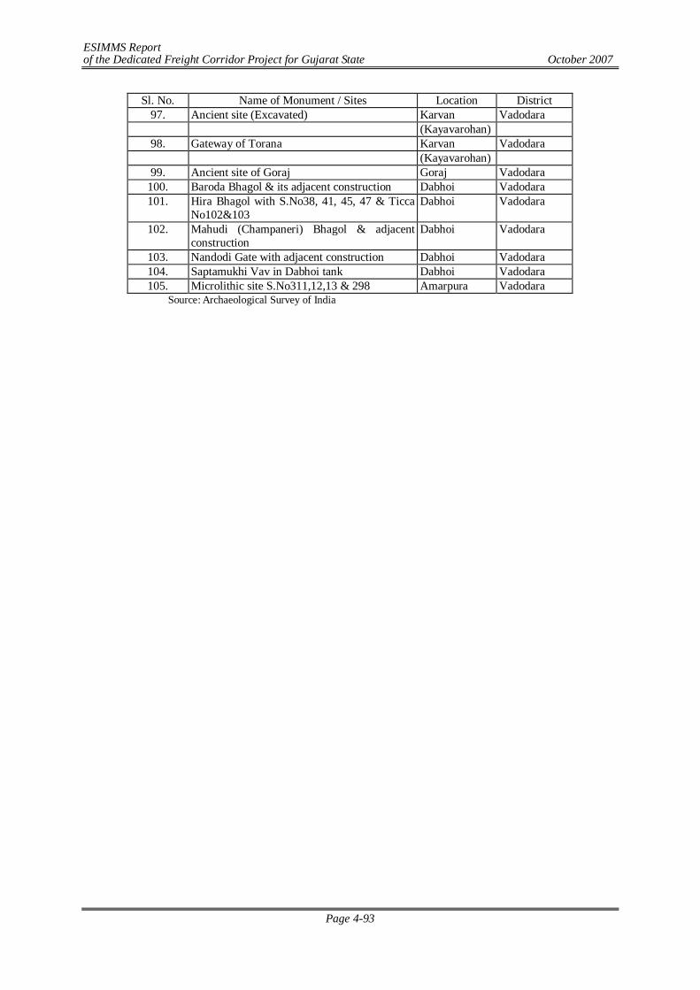
ESIMMS Report of the Dedicated Freight Corridor Project for Gujarat State October 2007
Page 4-93
Sl. No. Name of Monument / Sites Location District 97. Ancient site (Excavated) Karvan Vadodara
(Kayavarohan) 98. Gateway of Torana Karvan Vadodara
(Kayavarohan) 99. Ancient site of Goraj Goraj Vadodara
100. Baroda Bhagol & its adjacent construction Dabhoi Vadodara 101. Hira Bhagol with S.No38, 41, 45, 47 & Ticca
No102&103 Dabhoi Vadodara
102. Mahudi (Champaneri) Bhagol & adjacent construction
Dabhoi Vadodara
103. Nandodi Gate with adjacent construction Dabhoi Vadodara 104. Saptamukhi Vav in Dabhoi tank Dabhoi Vadodara 105. Microlithic site S.No311,12,13 & 298 Amarpura Vadodara
Source: Archaeological Survey of India
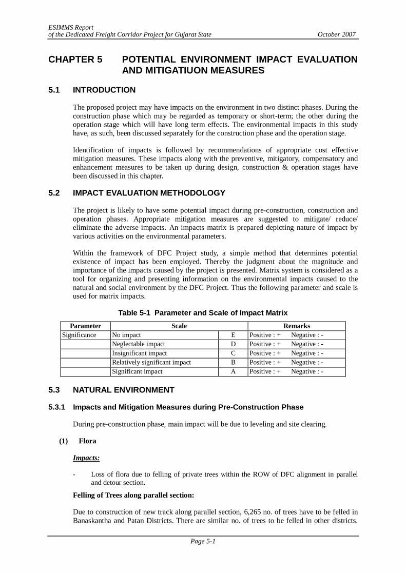
ESIMMS Report of the Dedicated Freight Corridor Project for Gujarat State October 2007
Page 5-1
CHAPTER 5 POTENTIAL ENVIRONMENT IMPACT EVALUATION AND MITIGATIUON MEASURES
5.1 INTRODUCTION
The proposed project may have impacts on the environment in two distinct phases. During the construction phase which may be regarded as temporary or short-term; the other during the operation stage which will have long term effects. The environmental impacts in this study have, as such, been discussed separately for the construction phase and the operation stage.
Identification of impacts is followed by recommendations of appropriate cost effective mitigation measures. These impacts along with the preventive, mitigatory, compensatory and enhancement measures to be taken up during design, construction & operation stages have been discussed in this chapter.
5.2 IMPACT EVALUATION METHODOLOGY
The project is likely to have some potential impact during pre-construction, construction and operation phases. Appropriate mitigation measures are suggested to mitigate/ reduce/ eliminate the adverse impacts. An impacts matrix is prepared depicting nature of impact by various activities on the environmental parameters.
Within the framework of DFC Project study, a simple method that determines potential existence of impact has been employed. Thereby the judgment about the magnitude and importance of the impacts caused by the project is presented. Matrix system is considered as a tool for organizing and presenting information on the environmental impacts caused to the natural and social environment by the DFC Project. Thus the following parameter and scale is used for matrix impacts.
Table 5-1 Parameter and Scale of Impact Matrix Parameter Scale Remarks
Significance No impact E Positive : + Negative : - Neglectable impact D Positive : + Negative : - Insignificant impact C Positive : + Negative : - Relatively significant impact B Positive : + Negative : - Significant impact A Positive : + Negative : -
5.3 NATURAL ENVIRONMENT
5.3.1 Impacts and Mitigation Measures during Pre-Construction Phase
During pre-construction phase, main impact will be due to leveling and site clearing.
(1) Flora
Impacts:
- Loss of flora due to felling of private trees within the ROW of DFC alignment in parallel and detour section.
Felling of Trees along parallel section:
Due to construction of new track along parallel section, 6,265 no. of trees have to be felled in Banaskantha and Patan Districts. There are similar no. of trees to be felled in other districts.
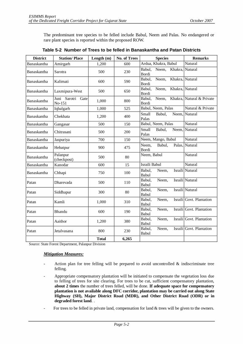
ESIMMS Report of the Dedicated Freight Corridor Project for Gujarat State October 2007
Page 5-2
The predominant tree species to be felled include Babul, Neem and Palas. No endangered or rare plant species is reported within the proposed ROW.
Table 5-2 Number of Trees to be felled in Banaskantha and Patan Districts
District Station/ Place Length (m) No. of Trees Species Remarks Banaskantha Amirgarh 1,200 600 Ardua, Khakra, Babul Natural
Banaskantha Sarotra 500 230 Babul, Neem, Khakra, Bordi
Natural
Banaskantha Kalimati 600 590 Babul, Neem, Khakra, Bordi
Natural
Banaskantha Laxmipura-West 500 650 Babul, Neem, Khakra, Bordi
Natural
Banaskantha Juni Sarotri Gate No-151 1,000 800 Babul, Neem, Khakra,
Bordi Natural & Private
Banaskantha Iqbalgarh 1,000 525 Babul, Neem, Palas Natural & Private
Banaskantha Chekhata 1,200 400 Small Babul, Neem, Palas
Natural
Banaskantha Gangasar 500 150 Babul, Neem, Palas Natural
Banaskantha Chitrasani 500 200 Small Babul, Neem, Palas
Natural
Banaskantha Jaspuriya 700 150 Neem, Mango, Babul Natural
Banaskantha Hebatpur 900 475 Neem, Babul, Palas, Bordi
Natural
Banaskantha Palanpur (checkpost) 500 80 Neem, Babul Natural
Banaskantha Kanodar 600 15 Israili Babul Natural
Banaskantha Chhapi 750 100 Babul, Neem, Israili Babul
Natural
Patan Dharevada 500 110 Babul, Neem, Israili Babul
Natural
Patan Siddhapur 300 80 Babul, Neem, Israili Babul
Natural
Patan Kamli 1,000 310 Babul, Neem, Israili Babul
Govt. Plantation
Patan Bhandu 600 190 Babul, Neem, Israili Babul
Govt. Plantation
Patan Aaithor 1,200 380 Babul, Neem, Israili Babul
Govt. Plantation
Patan Jetalvasana 800 230 Babul, Neem, Israili Babul
Govt. Plantation
Total 6,265 Source: State Forest Department, Palanpur Division
Mitigation Measures:
- Action plan for tree felling will be prepared to avoid uncontrolled & indiscriminate tree felling.
- Appropriate compensatory plantation will be initiated to compensate the vegetation loss due to felling of trees for site clearing. For trees to be cut, sufficient compensatory plantation, about 2 times the number of trees felled, will be done. If adequate space for compensatory plantation is not available along DFC corridor, plantation may be carried out along State Highway (SH), Major District Road (MDR), and Other District Road (ODR) or in degraded forest land. .
- For trees to be felled in private land, compensation for land & trees will be given to the owners.
ESIMMS Report of the Dedicated Freight Corridor Project for Gujarat State October 2007
Page 5-3
Rate of trees will be decided by the State Forest Department.
- Preferential mixed plantation consisting of flowering shrubs and evergreen ornamental trees with less timber & fruit value will be carried out.
- Under the plantation programme, more valuable tree species will be planted in place of existing non-valuable mono crops of the project area, if any.
Diversion of Forest Land:
In Banaskantha District, there exist three patches of Reserved Forest through which the detour alignment is passing. It is estimated that, 13.311 hectares of forest land is to be diverted for the use as ROW for construction of new track in detour section. The details breakup of the forest land to be acquired is given below:
Name of the Forest Land to be acquired (ha) Jethi Reserved Forest 6.873
Bantwada Reserved Forest 4.742 Malana Reserved Forest 1.696
Total 13.311 Source: Field survey
Mitigation Measures:
- 100% monetary compensation will be provided to Forest Dept. towards the cost of forest land to be diverted and cost of compensatory afforestation.
- Before start any activity within the Reserved Forest area, Forest Clearance must be obtained as per Forest Conservation Act, 1980 and it’s amendments from the State Forest Department.
(2) Fauna
Impacts:
Except Mahesana District, other districts do not have national parks and sanctuaries along the DFC alignment except the small stretches of Reserved Forest and practically no animal except some common birds, lizards & snakes are reported. Due to the acquisition of Reserved Forest land, there will be no loss in wildlife habitat in these districts. There might be minor temporary loss of habitat of avian fauna due to felling of trees in these districts.
In Mahesana District, Thol Bird Sanctuary is located in the east of DFC alignment (detour section) and the distance between DFC alignment & Thol Sanctuary is varying between 80m to 245m. Large number of waterfowls gets attracted to this site due to the agricultural fields surrounding the lake, which provide sufficient food to them. The lake is also surrounded by good tree covers. The tallest flying bird of the world Sarus crane inhabits this area and is found in good number. The proposed project may have same impacts on the avifauna of the sanctuary.
Further, the Nilgai (Boselaphus tragocamelus) is found in good number in the surrounding agricultural field. Due to acquisition of agricultural land for construction of detour section, they will loose their habitat and food.
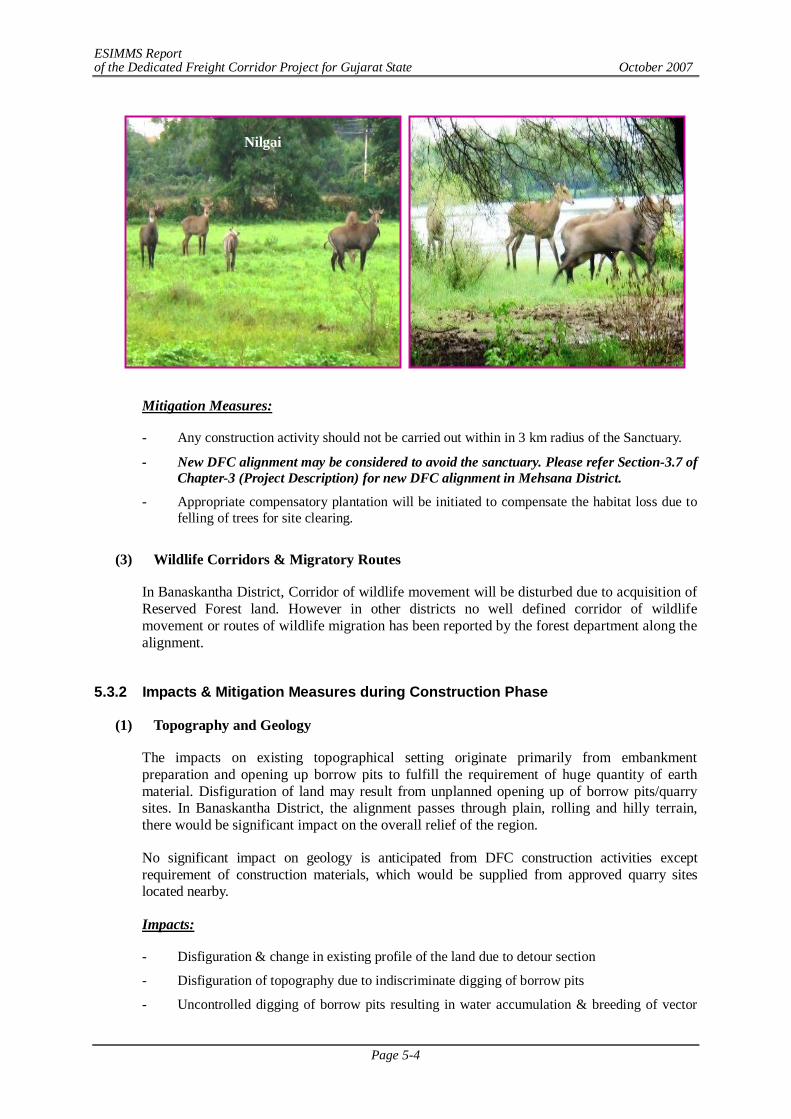
ESIMMS Report of the Dedicated Freight Corridor Project for Gujarat State October 2007
Page 5-4
Mitigation Measures:
- Any construction activity should not be carried out within in 3 km radius of the Sanctuary.
- New DFC alignment may be considered to avoid the sanctuary. Please refer Section-3.7 of Chapter-3 (Project Description) for new DFC alignment in Mehsana District.
- Appropriate compensatory plantation will be initiated to compensate the habitat loss due to felling of trees for site clearing.
(3) Wildlife Corridors & Migratory Routes
In Banaskantha District, Corridor of wildlife movement will be disturbed due to acquisition of Reserved Forest land. However in other districts no well defined corridor of wildlife movement or routes of wildlife migration has been reported by the forest department along the alignment.
5.3.2 Impacts & Mitigation Measures during Construction Phase
(1) Topography and Geology
The impacts on existing topographical setting originate primarily from embankment preparation and opening up borrow pits to fulfill the requirement of huge quantity of earth material. Disfiguration of land may result from unplanned opening up of borrow pits/quarry sites. In Banaskantha District, the alignment passes through plain, rolling and hilly terrain, there would be significant impact on the overall relief of the region.
No significant impact on geology is anticipated from DFC construction activities except requirement of construction materials, which would be supplied from approved quarry sites located nearby.
Impacts:
- Disfiguration & change in existing profile of the land due to detour section
- Disfiguration of topography due to indiscriminate digging of borrow pits
- Uncontrolled digging of borrow pits resulting in water accumulation & breeding of vector
Nilgai
ESIMMS Report of the Dedicated Freight Corridor Project for Gujarat State October 2007
Page 5-5
disease.
- Disturbance on geological setting due to quarrying
Mitigation Measures:
- Only identified borrow pits & quarry sites will be used to avoid any disfiguration of topography.
- Opening up new borrow pits will be in accordance with the IRC: 10-1961 specifications. Opening up of new borrow pits will be restricted to 1 m depth followed by resurfacing of pits with top soil (15 cm).
- Uncontrolled digging of borrow pits will be avoided to prevent water accumulation in abandoned pits which results in breeding ground of vector disease.
- Construction materials will be procured from existing approved and licensed quarries only where crusher is already operating. Therefore, mitigative measure for the environmental impacts due to quarrying and rehabilitation plan of the quarries is the responsibility and scope of the license holder of the quarry.
- Suitable seismic design of the CD structures will be adopted to mitigate the earthquake impacts in future.
- On owner’s choice, borrow pits will be converted to water bodies (pond) with proper landscaping (i.e. rectangular in shape, proper sloping and plantation on the bank) which will add scenic beauty in those localities.
(2) Soil
Placing of loose soil for embankment preparation would cause significant soil erosion in case appropriate compaction & stabilization measures are not adopted promptly. The erosion at construction stretches will result in increased sediment load in recipient streams. Loss of productive soil may result from uncontrolled opening up of borrow pits. Any leakage of lubricants in equipment yard and spills at batch mix plant sites will cause soil contamination.
Impacts:
- Disruption & loss of productive top soil from agricultural fields due to creation of borrow pits and development of detour section, which may reduce crop yield.
- Loosening of top soil & loss of vegetative cover along detour and parallel section due to excavation & back filling which will lead to enhanced soil erosion.
Mitigation Measures:
- Fly ash, if available within 100 km distance of the DFC alignment will be utilized for construction of embankment to save soil resource.
- Adequate measures like adequate drainage, embankment consolidation & slope stabilization will be taken along the track to avoid soil erosion.
- Top soils (15 cm) of the borrow pit sites will be conserved and restored after excavation is over.
- Accidental spills of lubricants/oil will be avoided by adherence to good practices.
ESIMMS Report of the Dedicated Freight Corridor Project for Gujarat State October 2007
Page 5-6
(3) Land Use
Widening of parallel section and development of detour section will lead to change in land use pattern of areas that comes under the proposed ROW. As the DFC alignment in most of the district passes through the agricultural land, it will change the land use pattern of the corridor.
Preparatory activities like clearing of ROW, construction of temporary construction camps and godowns, storage of construction materials etc. will be confined within the camp & ROW. This will not hamper the land use aspects outside ROW. However, indirectly there may be some change in the land use pattern of the proximate area due to influx of construction work-force and supplier who are likely to construct temporary tents in the vicinity. The on-site land use will more or less have a temporary impact in terms of fugitive emission from handling of construction material.
Impacts:
- Loss of agricultural land resources due to land acquisition for the detour
- Generation of solid waste in the form of construction spoils from construction sites
- Changes in existing land use pattern of the ROW for construction of DFC in detour & parallel sections
Mitigation Measures:
- Earth material generated from excavation will be reused to the maximum possible extent as filling material during site development.
- The small amount of construction debris and surplus excavated material will be disposed of by mechanical transport in suitable pre-identified (jointly by project proponent & local administration) dumping areas in tune with the local condition to avoid land degradation & water logging due to indiscriminate dumping.
- Dumping areas will be reclaimed through top soil cover & plantation.
- Construction camp will be provided for construction personnel to avoid indiscriminate settlement of construction workers and labourers.
- Regular inspection of haul roads and construction site will be carried out to ensure regular and timely removal of construction debris to the designated dumping sites.
(4) Drainage
Impacts:
- Change in drainage pattern of the land around detour
- Increased incidence and duration of floods due to obstruction of natural drainage courses by the embankment
- Chances of filling of existing drainage courses during earth filling.
Mitigation Measures:
- Adequate drains (longitudinal & median drains) will be provided along the track to facilitate its better maintenance. This will also help in avoiding soil erosion and land degradation due to water stagnation on the either side of the track.
- Capacity of existing drainage works and cross drainage (CD) structures in the parallel section will be duly augmented, wherever necessary, to accommodate high discharges to avoid flooding & formation of water pool.
ESIMMS Report of the Dedicated Freight Corridor Project for Gujarat State October 2007
Page 5-7
- Adequate new drainage works & cross drainage (CD) structures will be provided for smooth passage of runoff to avoid flooding & formation of water pool.
- Suitable drainage at construction site & camp will be provided to eliminate the chances of formation of stagnant water pools that lead to soil erosion & breeding of mosquitoes.
(5) Water Bodies
Impacts:
No loss of water resources as no filling up of ponds/water bodies is involved along the parallel and detour section.
(6) Water Use
During construction period water is required for compaction of embankment, dust suppression, concrete making and domestic use in construction camp. The water demand for construction will be met from the existing sources like rivers close to the alignment and water for domestic use & drinking purpose will be purchased by the contractor from local municipality. However the quantity being very small it is not likely to have significant impacts on other users.
Impacts:
- Impact on the local water sources due to use of construction water.
Mitigation Measures:
- Minimum use of water from existing sources for construction purpose will be ensured to minimize likely impacts on other users.
(7) Flora
Impacts:
- Deposition of fugitive dust on pubescent leaves of nearby vegetation may lead to temporary reduction of photosynthesis. Such impacts will, however, be confined mostly to the initial periods of the construction phase and in the immediate vicinity of the construction area.
- In long term the proposed plantation will have positive impacts on the ecological resources.
Mitigation Measures:
- Strip plantation in available open spaces on both sides of the railway track will not only enhance the floral cover, land use features and scenic beauty but also act as air pollutants sink dust and noise barrier.
- Cooking fuel will be provided to construction workers to avoid cutting/felling of trees for fuel wood.
(8) Fauna
Impacts:
- In Vadodara District, Soft shelled Terrapin is found along the bank of the Mahi River in village Kotna. Temporary loss of habitat of Terrapin during construction of bridge over Mahi River could happen.
ESIMMS Report of the Dedicated Freight Corridor Project for Gujarat State October 2007
Page 5-8
Mitigation Measures:
- New DFC alignment may be considered to avoid the sanctuary in Mahesana District.
- Bridge will be constructed during dry season to minimize the temporary loss of habitat of Terrapin.
5.3.3 Impacts & Mitigation Measures during Operation Phase
(1) Topography, Geology and Soil
No impact is envisaged on Topography, Geology & soil in the operation phase.
(2) Land Use & Encroachment
Impacts:
- Likely change of land use due to squatter/encroachment within ROW at junction station, cross station
- Likely change of land use due to induced railway side development outside the ROW
Mitigation Measures:
- Squatter development along the project shall be strictly avoided by proper regulation and vigilance.
- Land use control measures will be prepared & administered to avoid occurrence of induced development as far as possible.
- Planning agencies and Collector/Revenue Officer/Railway Officer will be made involved for controlled development and prohibiting squatter/ encroachment within ROW.
(3) Drainage & Water Quality
Impacts:
- Filthy environment due to improper maintenance of drainage
- Local drainage is likely to be affected due to formation of Railway Embankment
Mitigation Measures:
- Longitudinal drains of sufficient capacity will be provided on both sides of the track to accommodate increased run-off. The out fall for these drains is generally the nearby culverts/bridges on nallas/rivers/drains.
- Contingent actions will be taken for speedy cleaning up of oil spills, fuel and toxic chemicals in the event of accidents
(4) Flora & Fauna
Impacts:
- Illegal felling of railway side plantation
- Effect on aquatic fauna in case of accidental oil spill & toxic chemical release find its way

ESIMMS Report of the Dedicated Freight Corridor Project for Gujarat State October 2007
Page 5-9
into the water bodies.
Mitigation Measures:
- Plantation along the ROW will be maintained properly
- Plantation along the ROW will be protected from illegal felling
- Contingent actions will be taken for speedy cleaning up of oil spills, fuel and toxic chemicals in the event of accidents.
5.3.4 Impact Matrix of Natural Environment
Based of the potential impacts on natural environment in pre-construction, construction and operation phase an impact matrix has been framed. The scale of impact is discussed above under individual parameter with mitigation measures. Most the impacts are insignificant and temporary in nature with localized impact.
(1) Banaskantha District
PRE-CONSTRUCTION STAGE
Sl. No.
Project Activities Environmental & Social Issues
Overall Evaluation on
the Project Surveying of
Planned Areas and Sites
Selection of the Project Location
& Sites
Land Acquisition
and Resettlement
1. Topography and Geology D- E E E 2. Soil Erosion D- E E E 3. Groundwater D- E E E 4. Hydrological Conditions D- E E E 5. Fauna, Flora and Biodiversity C- E E C-
6. Protected Areas, Reserved Forest and Sanctuaries A- E E B-
7. Landscape D- E E D-
8. Local Meteorological Conditions E E E E
9. Global Warming E E E E A: Significant impact, B: Relatively Significant impact, C: Insignificant impact, D: Neglectable impact, E: No impact , : Negative impact, + : Positive impact
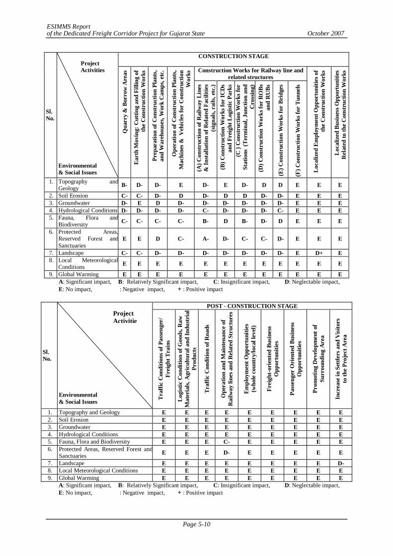
ESIMMS Report of the Dedicated Freight Corridor Project for Gujarat State October 2007
Page 5-10
CONSTRUCTION STAGE
Construction Works for Railway line and related structures
Sl. No.
Environmental & Social Issues
Qua
rry
& B
orro
w A
reas
Eart
h M
ovin
g: C
uttin
g an
d Fi
lling
of
the
Con
stru
ctio
n W
orks
Prep
arat
ion
of C
onst
ruct
ion
Plan
ts,
and
War
ehou
ses,
Wor
k C
amps
, etc
.
Ope
ratio
n of
Con
stru
ctio
n Pl
ants
, M
achi
nes &
Veh
icle
s for
Con
stru
ctio
n W
orks
(A) C
onst
ruct
ion
of R
ailw
ay L
ines
&
Inst
alla
tion
of R
elat
ed F
acili
ties
(sig
nals,
rai
ls, e
tc.)
(B) C
onst
ruct
ion
Wor
ks fo
r IC
Ds
and
Frei
ght L
ogist
ic P
arks
(C
) C
onst
ruct
ion
Wor
ks fo
r St
atio
ns (
Term
inal
, Jun
ctio
n an
d C
ross
ing)
(D
) Con
stru
ctio
n W
orks
for
RO
Bs
and
RU
Bs
(E) C
onst
ruct
ion
Wor
ks fo
r Br
idge
s
(F) C
onst
ruct
ion
Wor
ks fo
r Tu
nnel
s
Loca
lized
Em
ploy
men
t Opp
ortu
nitie
s of
the
Con
stru
ctio
n W
orks
Loca
lized
Bus
ines
s Opp
ortu
nitie
s R
elat
ed to
the
Con
stru
ctio
n W
orks
1. Topography and Geology B- D- D- E D- E D- D D E E E
2. Soil Erosion C- C- D- D D- D D D- D- E E E 3. Groundwater D- E D D- D- D- D- D- D- E E E 4. Hydrological Conditions D- D- D- D- C- D- D- D- C- E E E 5. Fauna, Flora and
Biodiversity C- C- C- C- B- D B- D- D E E E
6. Protected Areas, Reserved Forest and Sanctuaries
E E D C- A- D- C- C- D- E E E
7. Landscape C- C- D- D- D- D- D- D- D- E D+ E 8. Local Meteorological
Conditions E E E E E E E E E E E E
9. Global Warming E E E E E E E E E E E E A: Significant impact, B: Relatively Significant impact, C: Insignificant impact, D: Neglectable impact, E: No impact, : Negative impact, + : Positive impact
POST - CONSTRUCTION STAGE
Sl. No.
Environmental & Social Issues Tr
affic
Con
ditio
ns o
f Pas
seng
er/
Frei
ght T
rain
s
Logi
stic
Con
ditio
n of
Goo
ds, R
aw
Mat
eria
ls, A
gric
ultu
ral a
nd In
dust
rial
Pr
oduc
ts
Traf
fic C
ondi
tion
of R
oads
Ope
ratio
n an
d M
aint
enan
ce o
f R
ailw
ay li
nes a
nd R
elat
ed S
truc
ture
s
Empl
oym
ent O
ppor
tuni
ties
(who
le c
ount
ry/lo
cal l
evel
)
Frei
ght-o
rien
ted
Busi
ness
O
ppor
tuni
ties
Pass
enge
r O
rien
ted
Busi
ness
O
ppor
tuni
ties
Prom
otin
g D
evel
opm
ent o
f Su
rrou
ndin
g A
rea
Incr
ease
in S
ettle
rs a
nd V
isito
rs
to th
e Pr
ojec
t Are
a
1. Topography and Geology E E E E E E E E E 2. Soil Erosion E E E E E E E E E 3. Groundwater E E E E E E E E E 4. Hydrological Conditions E E E E E E E E E 5. Fauna, Flora and Biodiversity E E E C- E E E E E 6. Protected Areas, Reserved Forest and
Sanctuaries E E E D- E E E E E
7. Landscape E E E E E E E E D- 8. Local Meteorological Conditions E E E E E E E E E 9. Global Warming E E E E E E E E E
A: Significant impact, B: Relatively Significant impact, C: Insignificant impact, D: Neglectable impact, E: No impact, : Negative impact, + : Positive impact
Project Activities
Project Activitie
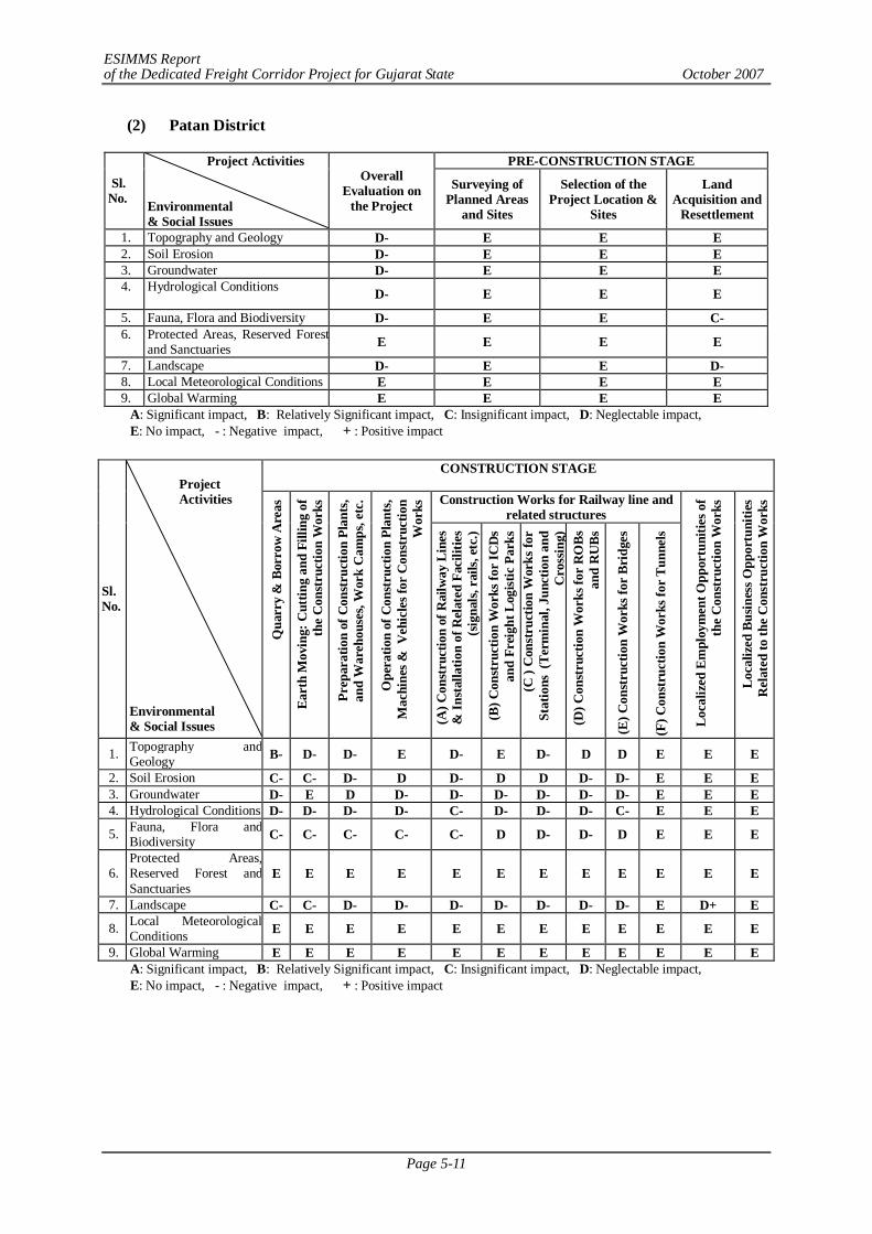
ESIMMS Report of the Dedicated Freight Corridor Project for Gujarat State October 2007
Page 5-11
(2) Patan District
PRE-CONSTRUCTION STAGE
Sl. No.
Project Activities Environmental & Social Issues
Overall Evaluation on
the Project Surveying of
Planned Areas and Sites
Selection of the Project Location &
Sites
Land Acquisition and
Resettlement
1. Topography and Geology D- E E E 2. Soil Erosion D- E E E 3. Groundwater D- E E E 4. Hydrological Conditions
D- E E E
5. Fauna, Flora and Biodiversity D- E E C- 6. Protected Areas, Reserved Forest
and Sanctuaries E E E E
7. Landscape D- E E D- 8. Local Meteorological Conditions E E E E 9. Global Warming E E E E
A: Significant impact, B: Relatively Significant impact, C: Insignificant impact, D: Neglectable impact, E: No impact, - : Negative impact, + : Positive impact
CONSTRUCTION STAGE
Construction Works for Railway line and
related structures
Sl. No.
Environmental & Social Issues
Qua
rry
& B
orro
w A
reas
Eart
h M
ovin
g: C
uttin
g an
d Fi
lling
of
the
Con
stru
ctio
n W
orks
Prep
arat
ion
of C
onst
ruct
ion
Plan
ts,
and
War
ehou
ses,
Wor
k C
amps
, etc
.
Ope
ratio
n of
Con
stru
ctio
n Pl
ants
, M
achi
nes &
Veh
icle
s for
Con
stru
ctio
n W
orks
(A) C
onst
ruct
ion
of R
ailw
ay L
ines
&
Inst
alla
tion
of R
elat
ed F
acili
ties
(sig
nals,
rai
ls, e
tc.)
(B) C
onst
ruct
ion
Wor
ks fo
r IC
Ds
and
Frei
ght L
ogist
ic P
arks
(C
) C
onst
ruct
ion
Wor
ks fo
r St
atio
ns (
Term
inal
, Jun
ctio
n an
d C
ross
ing)
(D
) Con
stru
ctio
n W
orks
for
RO
Bs
and
RU
Bs
(E) C
onst
ruct
ion
Wor
ks fo
r Br
idge
s
(F) C
onst
ruct
ion
Wor
ks fo
r Tu
nnel
s
Loca
lized
Em
ploy
men
t Opp
ortu
nitie
s of
the
Con
stru
ctio
n W
orks
Loca
lized
Bus
ines
s Opp
ortu
nitie
s R
elat
ed to
the
Con
stru
ctio
n W
orks
1. Topography and Geology B- D- D- E D- E D- D D E E E
2. Soil Erosion C- C- D- D D- D D D- D- E E E 3. Groundwater D- E D D- D- D- D- D- D- E E E 4. Hydrological Conditions D- D- D- D- C- D- D- D- C- E E E
5. Fauna, Flora and Biodiversity C- C- C- C- C- D D- D- D E E E
6. Protected Areas, Reserved Forest and Sanctuaries
E E E E E E E E E E E E
7. Landscape C- C- D- D- D- D- D- D- D- E D+ E
8. Local Meteorological Conditions E E E E E E E E E E E E
9. Global Warming E E E E E E E E E E E E A: Significant impact, B: Relatively Significant impact, C: Insignificant impact, D: Neglectable impact, E: No impact, - : Negative impact, + : Positive impact
Project Activities
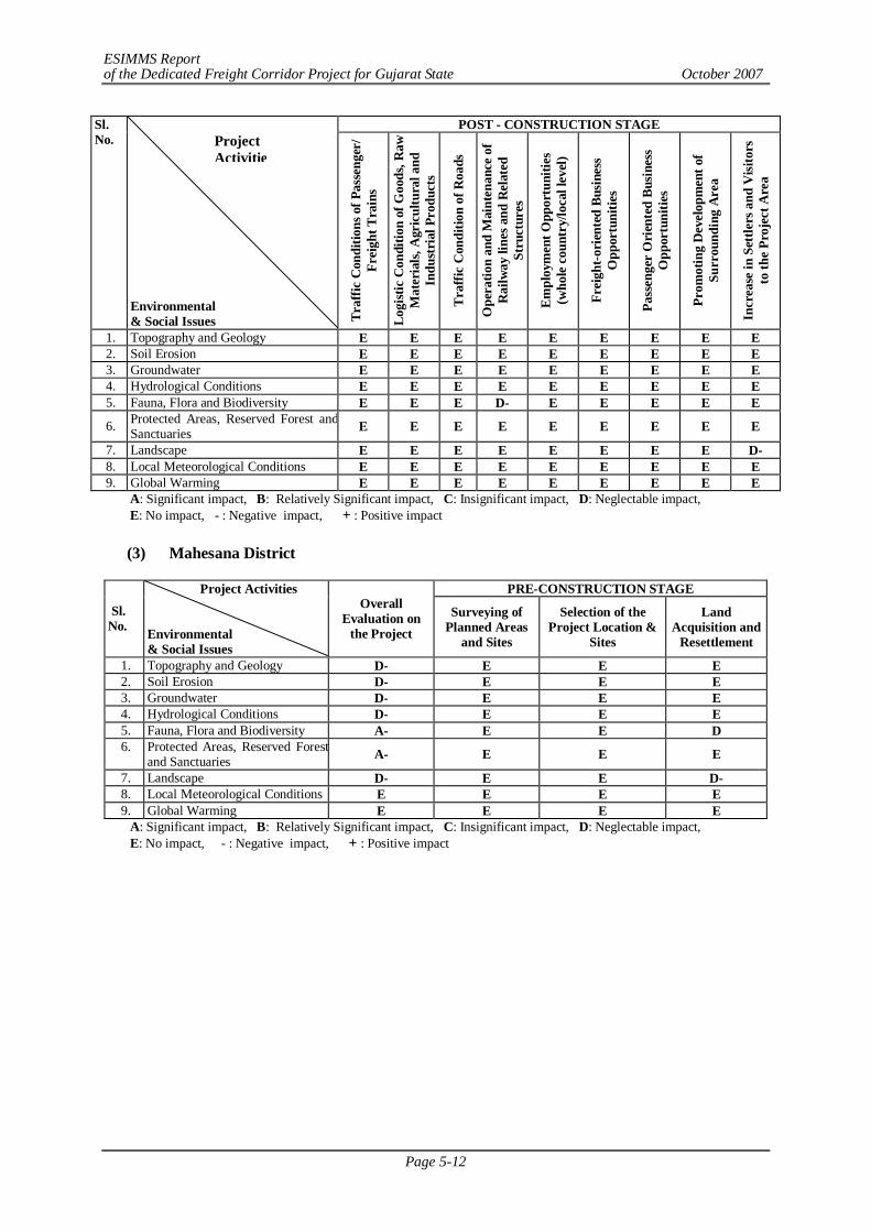
ESIMMS Report of the Dedicated Freight Corridor Project for Gujarat State October 2007
Page 5-12
POST - CONSTRUCTION STAGE Sl. No.
Environmental & Social Issues Tr
affic
Con
ditio
ns o
f Pas
seng
er/
Frei
ght T
rain
s
Logi
stic
Con
ditio
n of
Goo
ds, R
aw
Mat
eria
ls, A
gric
ultu
ral a
nd
Indu
stri
al P
rodu
cts
Traf
fic C
ondi
tion
of R
oads
Ope
ratio
n an
d M
aint
enan
ce o
f R
ailw
ay li
nes a
nd R
elat
ed
Stru
ctur
es
Empl
oym
ent O
ppor
tuni
ties
(who
le c
ount
ry/lo
cal l
evel
)
Frei
ght-o
rien
ted
Busi
ness
O
ppor
tuni
ties
Pass
enge
r O
rien
ted
Busi
ness
O
ppor
tuni
ties
Prom
otin
g D
evel
opm
ent o
f Su
rrou
ndin
g A
rea
Incr
ease
in S
ettle
rs a
nd V
isito
rs
to th
e Pr
ojec
t Are
a
1. Topography and Geology E E E E E E E E E 2. Soil Erosion E E E E E E E E E 3. Groundwater E E E E E E E E E 4. Hydrological Conditions E E E E E E E E E 5. Fauna, Flora and Biodiversity E E E D- E E E E E
6. Protected Areas, Reserved Forest and Sanctuaries E E E E E E E E E
7. Landscape E E E E E E E E D- 8. Local Meteorological Conditions E E E E E E E E E 9. Global Warming E E E E E E E E E
A: Significant impact, B: Relatively Significant impact, C: Insignificant impact, D: Neglectable impact, E: No impact, - : Negative impact, + : Positive impact
(3) Mahesana District
PRE-CONSTRUCTION STAGE
Sl. No.
Project Activities Environmental & Social Issues
Overall Evaluation on
the Project Surveying of
Planned Areas and Sites
Selection of the Project Location &
Sites
Land Acquisition and
Resettlement
1. Topography and Geology D- E E E 2. Soil Erosion D- E E E 3. Groundwater D- E E E 4. Hydrological Conditions D- E E E 5. Fauna, Flora and Biodiversity A- E E D 6. Protected Areas, Reserved Forest
and Sanctuaries A- E E E
7. Landscape D- E E D- 8. Local Meteorological Conditions E E E E 9. Global Warming E E E E
A: Significant impact, B: Relatively Significant impact, C: Insignificant impact, D: Neglectable impact, E: No impact, - : Negative impact, + : Positive impact
Project Activitie
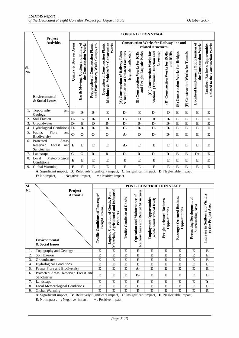
ESIMMS Report of the Dedicated Freight Corridor Project for Gujarat State October 2007
Page 5-13
CONSTRUCTION STAGE
Construction Works for Railway line and related structures
Sl. No.
Environmental & Social Issues
Qua
rry
& B
orro
w A
reas
Eart
h M
ovin
g: C
uttin
g an
d Fi
lling
of
the
Con
stru
ctio
n W
orks
Prep
arat
ion
of C
onst
ruct
ion
Plan
ts,
and
War
ehou
ses,
Wor
k C
amps
, etc
.
Ope
ratio
n of
Con
stru
ctio
n Pl
ants
, M
achi
nes &
Veh
icle
s for
Con
stru
ctio
n W
orks
(A) C
onst
ruct
ion
of R
ailw
ay L
ines
&
Inst
alla
tion
of R
elat
ed F
acili
ties
(sig
nals,
rai
ls, e
tc.)
(B) C
onst
ruct
ion
Wor
ks fo
r IC
Ds
and
Frei
ght L
ogist
ic P
arks
(C )
Con
stru
ctio
n W
orks
for
Stat
ions
(Te
rmin
al, J
unct
ion
and
Cro
ssin
g)
(D) C
onst
ruct
ion
Wor
ks fo
r R
OBs
an
d R
UBs
(E) C
onst
ruct
ion
Wor
ks fo
r Br
idge
s
(F) C
onst
ruct
ion
Wor
ks fo
r Tu
nnel
s
Loca
lized
Em
ploy
men
t Opp
ortu
nitie
s of
the
Con
stru
ctio
n W
orks
Loca
lized
Bus
ines
s Opp
ortu
nitie
s R
elat
ed to
the
Con
stru
ctio
n W
orks
1. Topography and Geology B- D- D- E D- E D- D E E E E
2. Soil Erosion C- C- D- D D- D D D- E E E E 3. Groundwater D- E D D- D- D- D- D- E E E E 4. Hydrological Conditions D- D- D- D- C- D- D- D- E E E E 5. Fauna, Flora and
Biodiversity C- C- C- C- A- D D- D- E E E E
6. Protected Areas, Reserved Forest and Sanctuaries
E E E E A- E E E E E E E
7. Landscape C- C- D- D- D- D- D- D- E E D+ E 8. Local Meteorological
Conditions E E E E E E E E E E E E
9. Global Warming E E E E E E E E E E E E A: Significant impact, B: Relatively Significant impact, C: Insignificant impact, D: Neglectable impact, E: No impact, - : Negative impact, + : Positive impact
POST - CONSTRUCTION STAGE Sl.
No. Environmental & Social Issues Tr
affic
Con
ditio
ns o
f Pas
seng
er/
Frei
ght T
rain
s
Logi
stic
Con
ditio
n of
Goo
ds, R
aw
Mat
eria
ls, A
gric
ultu
ral a
nd In
dust
rial
Pr
oduc
ts
Traf
fic C
ondi
tion
of R
oads
Ope
ratio
n an
d M
aint
enan
ce o
f R
ailw
ay li
nes a
nd R
elat
ed S
truc
ture
s
Empl
oym
ent O
ppor
tuni
ties
(who
le c
ount
ry/lo
cal l
evel
)
Frei
ght-o
rien
ted
Busi
ness
O
ppor
tuni
ties
Pass
enge
r O
rien
ted
Busi
ness
O
ppor
tuni
ties
Prom
otin
g D
evel
opm
ent o
f Su
rrou
ndin
g A
rea
Incr
ease
in S
ettle
rs a
nd V
isito
rs
to th
e Pr
ojec
t Are
a
1. Topography and Geology E E E E E E E E E 2. Soil Erosion E E E E E E E E E 3. Groundwater E E E E E E E E E 4. Hydrological Conditions E E E E E E E E E 5. Fauna, Flora and Biodiversity E E E A- E E E E E 6. Protected Areas, Reserved Forest and
Sanctuaries E E E B- E E E E E
7. Landscape E E E E E E E E D- 8. Local Meteorological Conditions E E E E E E E E E 9. Global Warming E E E E E E E E E
A: Significant impact, B: Relatively Significant impact, C: Insignificant impact, D: Neglectable impact, E: No impact , - : Negative impact, + : Positive impact
Project Activities
Project Activitie
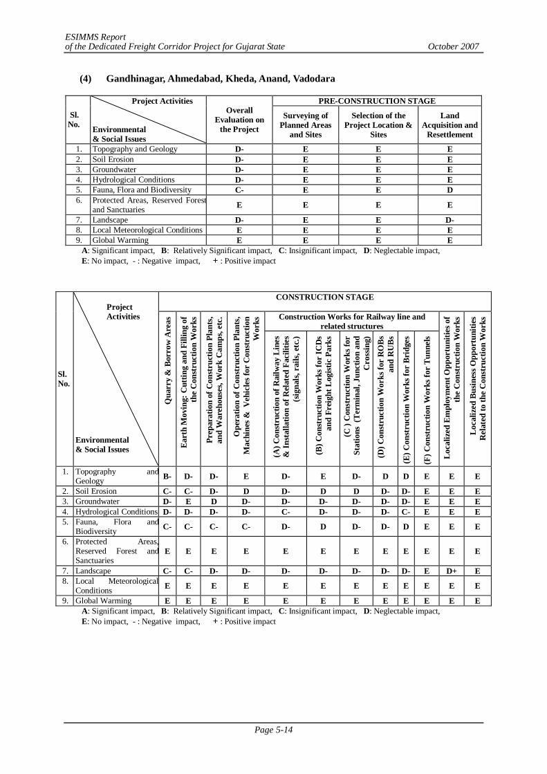
ESIMMS Report of the Dedicated Freight Corridor Project for Gujarat State October 2007
Page 5-14
(4) Gandhinagar, Ahmedabad, Kheda, Anand, Vadodara
PRE-CONSTRUCTION STAGE
Sl. No.
Project Activities Environmental & Social Issues
Overall Evaluation on
the Project Surveying of
Planned Areas and Sites
Selection of the Project Location &
Sites
Land Acquisition and
Resettlement
1. Topography and Geology D- E E E 2. Soil Erosion D- E E E 3. Groundwater D- E E E 4. Hydrological Conditions D- E E E 5. Fauna, Flora and Biodiversity C- E E D 6. Protected Areas, Reserved Forest
and Sanctuaries E E E E
7. Landscape D- E E D- 8. Local Meteorological Conditions E E E E 9. Global Warming E E E E
A: Significant impact, B: Relatively Significant impact, C: Insignificant impact, D: Neglectable impact, E: No impact, - : Negative impact, + : Positive impact
CONSTRUCTION STAGE
Construction Works for Railway line and related structures
Sl. No.
Environmental & Social Issues
Qua
rry
& B
orro
w A
reas
Eart
h M
ovin
g: C
uttin
g an
d Fi
lling
of
the
Con
stru
ctio
n W
orks
Prep
arat
ion
of C
onst
ruct
ion
Plan
ts,
and
War
ehou
ses,
Wor
k C
amps
, etc
.
Ope
ratio
n of
Con
stru
ctio
n Pl
ants
, M
achi
nes &
Veh
icle
s for
Con
stru
ctio
n W
orks
(A) C
onst
ruct
ion
of R
ailw
ay L
ines
&
Inst
alla
tion
of R
elat
ed F
acili
ties
(sig
nals,
rai
ls, e
tc.)
(B) C
onst
ruct
ion
Wor
ks fo
r IC
Ds
and
Frei
ght L
ogist
ic P
arks
(C )
Con
stru
ctio
n W
orks
for
Stat
ions
(Te
rmin
al, J
unct
ion
and
Cro
ssin
g)
(D) C
onst
ruct
ion
Wor
ks fo
r R
OBs
an
d R
UBs
(E) C
onst
ruct
ion
Wor
ks fo
r Br
idge
s
(F) C
onst
ruct
ion
Wor
ks fo
r Tu
nnel
s
Loca
lized
Em
ploy
men
t Opp
ortu
nitie
s of
the
Con
stru
ctio
n W
orks
Loca
lized
Bus
ines
s Opp
ortu
nitie
s R
elat
ed to
the
Con
stru
ctio
n W
orks
1. Topography and Geology B- D- D- E D- E D- D D E E E
2. Soil Erosion C- C- D- D D- D D D- D- E E E 3. Groundwater D- E D D- D- D- D- D- D- E E E 4. Hydrological Conditions D- D- D- D- C- D- D- D- C- E E E 5. Fauna, Flora and
Biodiversity C- C- C- C- D- D D- D- D E E E
6. Protected Areas, Reserved Forest and Sanctuaries
E E E E E E E E E E E E
7. Landscape C- C- D- D- D- D- D- D- D- E D+ E 8. Local Meteorological
Conditions E E E E E E E E E E E E
9. Global Warming E E E E E E E E E E E E A: Significant impact, B: Relatively Significant impact, C: Insignificant impact, D: Neglectable impact, E: No impact, - : Negative impact, + : Positive impact
Project Activities
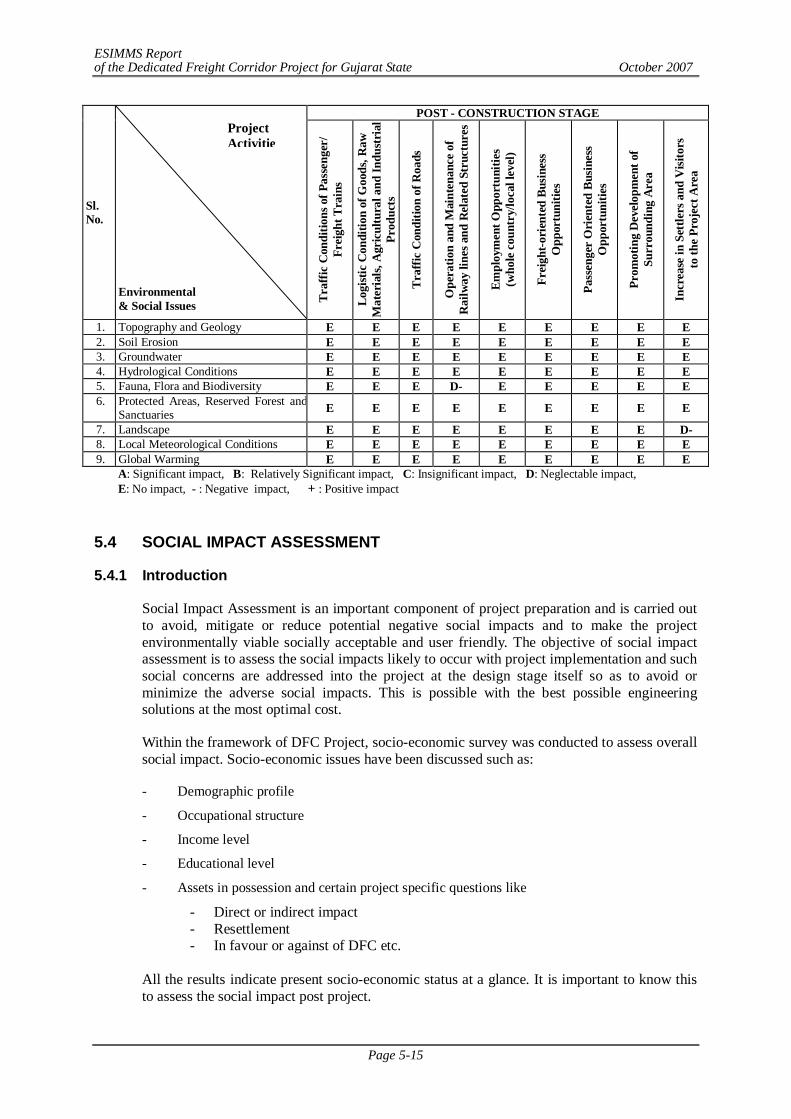
ESIMMS Report of the Dedicated Freight Corridor Project for Gujarat State October 2007
Page 5-15
POST - CONSTRUCTION STAGE
Sl. No.
Environmental & Social Issues Tr
affic
Con
ditio
ns o
f Pas
seng
er/
Frei
ght T
rain
s
Logi
stic
Con
ditio
n of
Goo
ds, R
aw
Mat
eria
ls, A
gric
ultu
ral a
nd In
dust
rial
Pr
oduc
ts
Traf
fic C
ondi
tion
of R
oads
Ope
ratio
n an
d M
aint
enan
ce o
f R
ailw
ay li
nes a
nd R
elat
ed S
truc
ture
s
Empl
oym
ent O
ppor
tuni
ties
(who
le c
ount
ry/lo
cal l
evel
)
Frei
ght-o
rien
ted
Busi
ness
O
ppor
tuni
ties
Pass
enge
r O
rien
ted
Busi
ness
O
ppor
tuni
ties
Prom
otin
g D
evel
opm
ent o
f Su
rrou
ndin
g A
rea
Incr
ease
in S
ettle
rs a
nd V
isito
rs
to th
e Pr
ojec
t Are
a
1. Topography and Geology E E E E E E E E E 2. Soil Erosion E E E E E E E E E 3. Groundwater E E E E E E E E E 4. Hydrological Conditions E E E E E E E E E 5. Fauna, Flora and Biodiversity E E E D- E E E E E 6. Protected Areas, Reserved Forest and
Sanctuaries E E E E E E E E E
7. Landscape E E E E E E E E D- 8. Local Meteorological Conditions E E E E E E E E E 9. Global Warming E E E E E E E E E
A: Significant impact, B: Relatively Significant impact, C: Insignificant impact, D: Neglectable impact, E: No impact, - : Negative impact, + : Positive impact
5.4 SOCIAL IMPACT ASSESSMENT
5.4.1 Introduction
Social Impact Assessment is an important component of project preparation and is carried out to avoid, mitigate or reduce potential negative social impacts and to make the project environmentally viable socially acceptable and user friendly. The objective of social impact assessment is to assess the social impacts likely to occur with project implementation and such social concerns are addressed into the project at the design stage itself so as to avoid or minimize the adverse social impacts. This is possible with the best possible engineering solutions at the most optimal cost.
Within the framework of DFC Project, socio-economic survey was conducted to assess overall social impact. Socio-economic issues have been discussed such as:
- Demographic profile
- Occupational structure
- Income level
- Educational level
- Assets in possession and certain project specific questions like
- Direct or indirect impact - Resettlement - In favour or against of DFC etc.
All the results indicate present socio-economic status at a glance. It is important to know this to assess the social impact post project.
Project Activitie
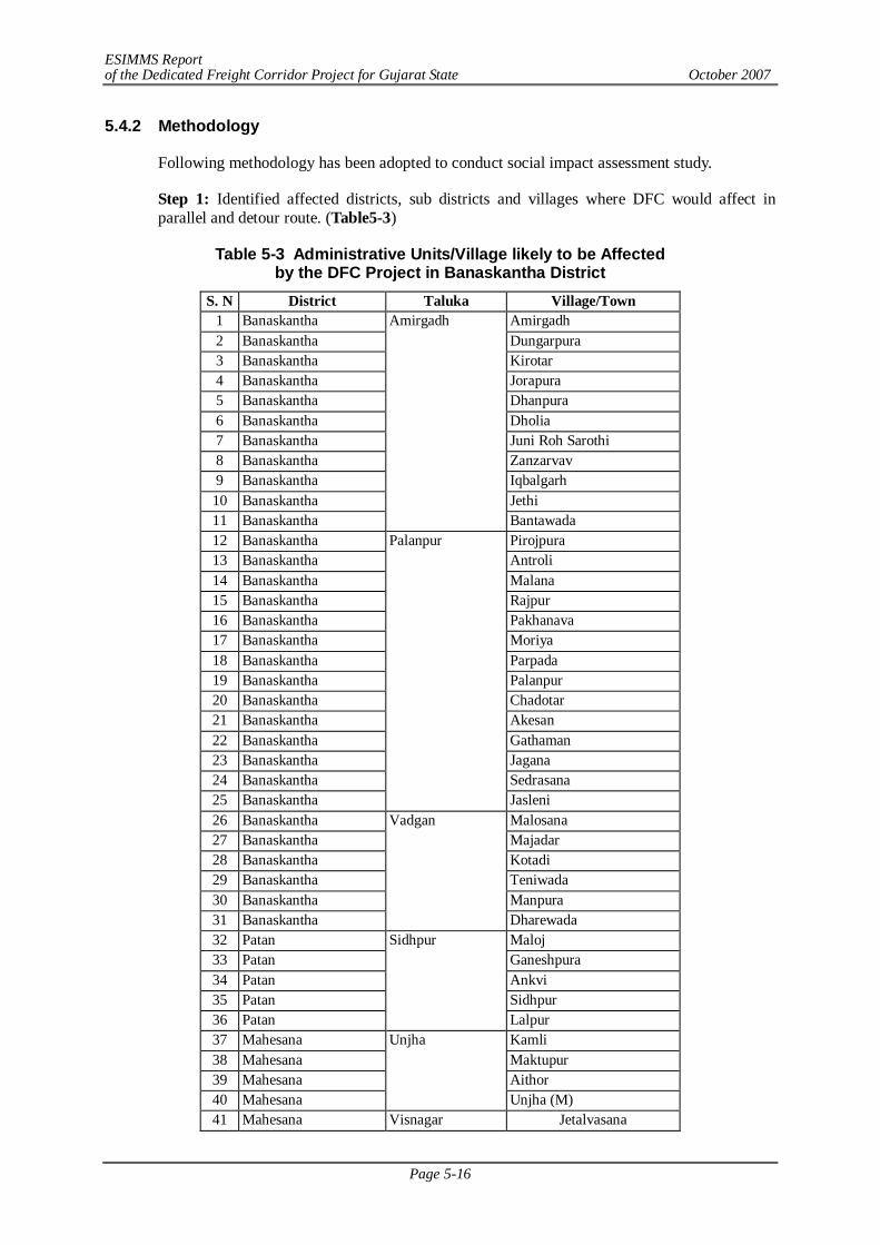
ESIMMS Report of the Dedicated Freight Corridor Project for Gujarat State October 2007
Page 5-16
5.4.2 Methodology
Following methodology has been adopted to conduct social impact assessment study.
Step 1: Identified affected districts, sub districts and villages where DFC would affect in parallel and detour route. (Table5-3)
Table 5-3 Administrative Units/Village likely to be Affected by the DFC Project in Banaskantha District
S. N District Taluka Village/Town 1 Banaskantha Amirgadh 2 Banaskantha Dungarpura 3 Banaskantha Kirotar 4 Banaskantha Jorapura 5 Banaskantha Dhanpura 6 Banaskantha Dholia 7 Banaskantha Juni Roh Sarothi 8 Banaskantha Zanzarvav 9 Banaskantha Iqbalgarh 10 Banaskantha Jethi 11 Banaskantha
Amirgadh
Bantawada 12 Banaskantha Pirojpura 13 Banaskantha Antroli 14 Banaskantha Malana 15 Banaskantha Rajpur 16 Banaskantha Pakhanava 17 Banaskantha Moriya 18 Banaskantha Parpada 19 Banaskantha Palanpur 20 Banaskantha Chadotar 21 Banaskantha Akesan 22 Banaskantha Gathaman 23 Banaskantha Jagana 24 Banaskantha Sedrasana 25 Banaskantha
Palanpur
Jasleni 26 Banaskantha Malosana 27 Banaskantha Majadar 28 Banaskantha Kotadi 29 Banaskantha Teniwada 30 Banaskantha Manpura 31 Banaskantha
Vadgan
Dharewada 32 Patan Maloj 33 Patan Ganeshpura 34 Patan Ankvi 35 Patan Sidhpur 36 Patan
Sidhpur
Lalpur 37 Mahesana Kamli 38 Mahesana Maktupur 39 Mahesana Aithor 40 Mahesana
Unjha
Unjha (M) 41 Mahesana Visnagar Jetalvasana
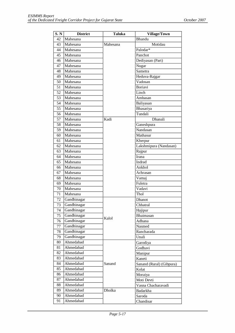
ESIMMS Report of the Dedicated Freight Corridor Project for Gujarat State October 2007
Page 5-17
S. N District Taluka Village/Town 42 Mahesana Bhandu 43 Mahesana Motidau 44 Mahesana Palodar* 45 Mahesana Panchot 46 Mahesana Dediyasan (Part) 47 Mahesana Nugar 48 Mahesana Sametra 49 Mahesana Heduva-Rajgar 50 Mahesana Vadosan 51 Mahesana Boriavi 52 Mahesana Linch 53 Mahesana Ambasan 54 Mahesana Baliyasan 55 Mahesana Bhasariya 56 Mahesana
Mahesana
Tundali 57 Mahesana Dhanali 58 Mahesana Ganeshpura 59 Mahesana Nandasan 60 Mahesana Mathasur 61 Mahesana Kherpur 62 Mahesana Lakshmipura (Nandasan) 63 Mahesana Rajpur 64 Mahesana Irana 65 Mahesana Indrad 66 Mahesana Ankhol 67 Mahesana Achrasan 68 Mahesana Vamaj 69 Mahesana Fuletra 70 Mahesana Vadavi 71 Mahesana
Kadi
Thol 72 Gandhinagar Dhanot 73 Gandhinagar Chhatral 74 Gandhinagar Hajipur 75 Gandhinagar Bhaimasan 76 Gandhinagar Adhana 77 Gandhinagar Nasmed 78 Gandhinagar Rancharada 79 Gandhinagar
Kalol
Unali 80 Ahmedabad Garodiya 81 Ahmedabad Godhavi 82 Ahmedabad Manipur 83 Ahmedabad Kaneti 84 Ahmedabad Sanand (Rural) (Gibpura) 85 Ahmedabad Kolat 86 Ahmedabad Moraiya 87 Ahmedabad Moti Devti 88 Ahmedabad
Sanand
Vasna Chacharavadi 89 Ahmedabad Badarkha 90 Ahmedabad Saroda 91 Ahmedabad
Dholka
Chandisar
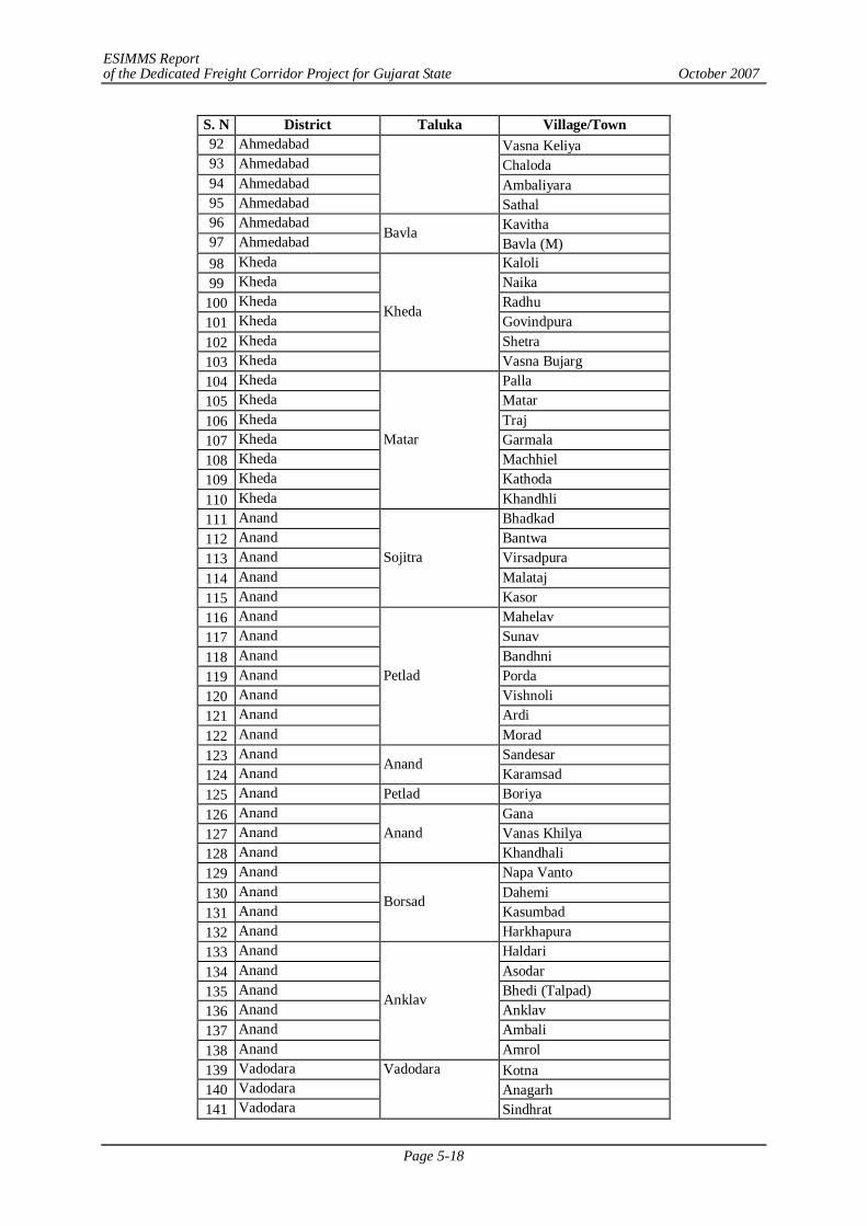
ESIMMS Report of the Dedicated Freight Corridor Project for Gujarat State October 2007
Page 5-18
S. N District Taluka Village/Town 92 Ahmedabad Vasna Keliya 93 Ahmedabad Chaloda 94 Ahmedabad Ambaliyara 95 Ahmedabad Sathal 96 Ahmedabad Kavitha 97 Ahmedabad Bavla
Bavla (M) 98 Kheda Kaloli 99 Kheda Naika
100 Kheda Radhu 101 Kheda Govindpura 102 Kheda Shetra 103 Kheda
Kheda
Vasna Bujarg 104 Kheda Palla 105 Kheda Matar 106 Kheda Traj 107 Kheda Garmala 108 Kheda Machhiel 109 Kheda Kathoda 110 Kheda
Matar
Khandhli 111 Anand Bhadkad 112 Anand Bantwa 113 Anand Virsadpura 114 Anand Malataj 115 Anand
Sojitra
Kasor 116 Anand Mahelav 117 Anand Sunav 118 Anand Bandhni 119 Anand Porda 120 Anand Vishnoli 121 Anand Ardi 122 Anand
Petlad
Morad 123 Anand Sandesar 124 Anand Anand
Karamsad 125 Anand Petlad Boriya 126 Anand Gana 127 Anand Vanas Khilya 128 Anand
Anand Khandhali
129 Anand Napa Vanto 130 Anand Dahemi 131 Anand Kasumbad 132 Anand
Borsad
Harkhapura 133 Anand Haldari 134 Anand Asodar 135 Anand Bhedi (Talpad) 136 Anand Anklav 137 Anand Ambali 138 Anand
Anklav
Amrol 139 Vadodara Kotna 140 Vadodara Anagarh 141 Vadodara
Vadodara
Sindhrat
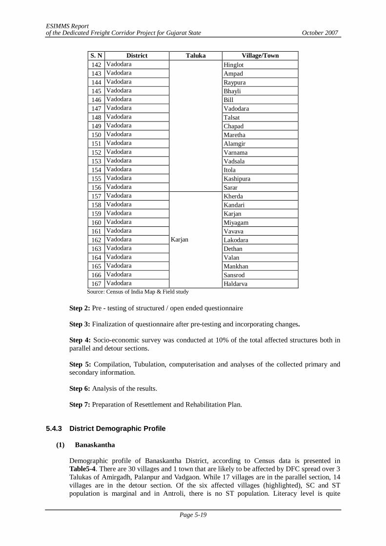
ESIMMS Report of the Dedicated Freight Corridor Project for Gujarat State October 2007
Page 5-19
S. N District Taluka Village/Town 142 Vadodara Hinglot 143 Vadodara Ampad 144 Vadodara Raypura 145 Vadodara Bhayli 146 Vadodara Bill 147 Vadodara Vadodara 148 Vadodara Talsat 149 Vadodara Chapad 150 Vadodara Maretha 151 Vadodara Alamgir 152 Vadodara Varnama 153 Vadodara Vadsala 154 Vadodara Itola 155 Vadodara Kashipura 156 Vadodara Sarar 157 Vadodara Kherda 158 Vadodara Kandari 159 Vadodara Karjan 160 Vadodara Miyagam 161 Vadodara Vavava 162 Vadodara Lakodara 163 Vadodara Dethan 164 Vadodara Valan 165 Vadodara Mankhan 166 Vadodara Sansrod 167 Vadodara
Karjan
Haldarva Source: Census of India Map & Field study
Step 2: Pre - testing of structured / open ended questionnaire
Step 3: Finalization of questionnaire after pre-testing and incorporating changes.
Step 4: Socio-economic survey was conducted at 10% of the total affected structures both in parallel and detour sections.
Step 5: Compilation, Tubulation, computerisation and analyses of the collected primary and secondary information.
Step 6: Analysis of the results.
Step 7: Preparation of Resettlement and Rehabilitation Plan.
5.4.3 District Demographic Profile
(1) Banaskantha
Demographic profile of Banaskantha District, according to Census data is presented in Table5-4. There are 30 villages and 1 town that are likely to be affected by DFC spread over 3 Talukas of Amirgadh, Palanpur and Vadgaon. While 17 villages are in the parallel section, 14 villages are in the detour section. Of the six affected villages (highlighted), SC and ST population is marginal and in Antroli, there is no ST population. Literacy level is quite
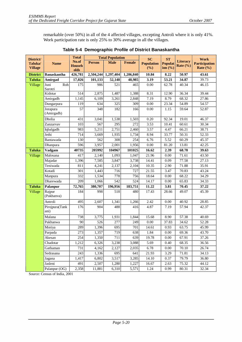
ESIMMS Report of the Dedicated Freight Corridor Project for Gujarat State October 2007
Page 5-20
remarkable (over 50%) in all of the 4 affected villages, excepting Antroli where it is only 41%. Work participation rate is only 25% to 30% average in all the villages.
Table 5-4 Demographic Profile of District Banaskantha Total Population District/
Taluka/ Village
Name
Total No.of
Households
Person Male Female SC
Population (%)
ST Population (%)
Literacy Rate (%)
Work Participation
Rate (%)
District Banaskantha 426,781 2,504,244 1,297,404 1,206,840 10.84 8.22 50.97 43.61 Taluka Amirgad 17,026 101,133 52,148 48,985 3.19 53.21 34.87 39.73
Juni Roh Sarotri
175 986 521 465 0.00 62.78 40.34 46.15
Kidotar 514 2,875 1,487 1,388 8.31 12.90 36.34 39.44 Amirgadh 1,145 6,109 3,261 2,848 7.19 8.79 68.32 27.86 Dungarpura 119 634 325 309 0.00 23.34 54.89 54.57 Jorapura (Amirgadh)
57 348 182 166 0.00 1.15 59.64 52.87
Dholia 431 3,041 1,538 1,503 0.20 92.34 19.01 46.37 Zanzarvav 103 567 295 272 3.53 10.41 60.61 30.34 Iqbalgadh 983 5,211 2,751 2,460 3.57 4.47 66.21 38.71 Jethi 714 3,669 1,935 1,734 8.94 33.77 50.31 52.33 Bantawada 130 562 308 254 6.76 5.52 60.29 45.37
Village
Dhanpura 596 3,957 2,001 1,956 0.00 81.20 13.81 42.25 Taluka Vadgam 40735 205992 104967 101025 16.62 2.39 68.78 39.63
Malosana 417 2,140 1,093 1,047 21.96 0.00 71.61 43.50 Majadar 1,396 7,585 3,847 3,738 14.41 0.09 77.58 27.13 Teniwada 811 4,241 2,137 2,104 10.35 2.90 71.88 35.91 Kotadi 301 1,443 716 727 21.55 3.47 70.83 43.24 Manpura 332 1,534 778 756 18.64 0.00 68.22 34.29
Village
Dharewada 209 1,066 542 524 14.17 0.00 65.83 34.33 Taluka Palanpur 72,765 380,707 196,956 183,751 11.22 3.81 70.45 37.22
Rajpur (Pakhanva)
184 998 518 480 17.43 28.66 49.07 45.39
Antroli 495 2,607 1,341 1,266 2.42 0.00 40.92 28.85 Pirojpura(Tankani)
176 904 488 416 4.87 7.19 57.94 42.37
Malana 738 3,775 1,931 1,844 15.68 8.90 57.38 40.69 Pakhanwa 90 526 277 249 0.00 37.83 34.62 52.28 Moriya 289 1,396 695 701 14.61 0.93 63.75 45.99 Parpada 273 1,357 719 638 1.84 0.00 69.36 43.70 Akesan 254 1,350 711 639 19.78 0.00 67.91 37.26 Chadotar 1,212 6,326 3,238 3,088 5.69 0.40 68.35 36.56 Gathaman 731 4,162 2,127 2,035 6.78 0.00 70.10 26.74 Sedrasana 243 1,336 695 641 21.93 3.29 71.81 34.13 Jagana 1,417 6,802 3,517 3,285 14.10 0.37 79.79 36.80 Jasleni 491 2,507 1,280 1,227 16.67 2.63 75.32 44.12
Village
Palanpur (OG) 2,358 11,881 6,310 5,571 1.24 0.99 80.31 32.34 Source: Census of India, 2001
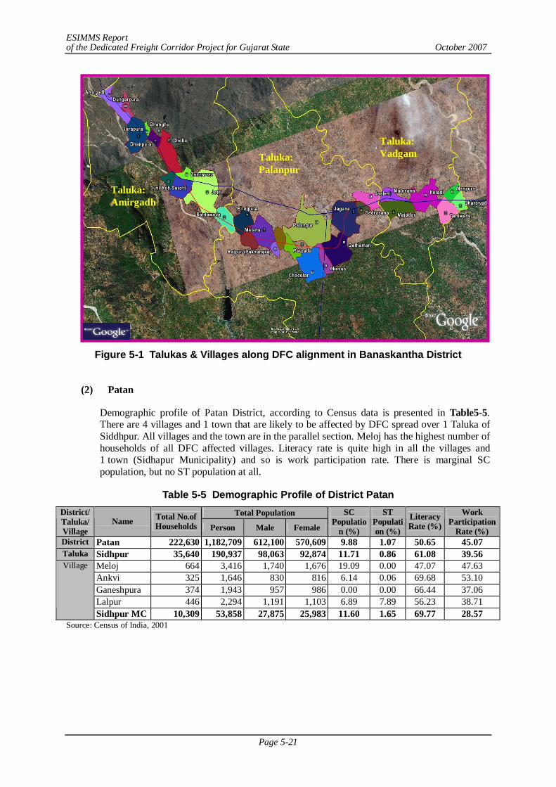
ESIMMS Report of the Dedicated Freight Corridor Project for Gujarat State October 2007
Page 5-21
Figure 5-1 Talukas & Villages along DFC alignment in Banaskantha District
(2) Patan
Demographic profile of Patan District, according to Census data is presented in Table5-5. There are 4 villages and 1 town that are likely to be affected by DFC spread over 1 Taluka of Siddhpur. All villages and the town are in the parallel section. Meloj has the highest number of households of all DFC affected villages. Literacy rate is quite high in all the villages and 1 town (Sidhapur Municipality) and so is work participation rate. There is marginal SC population, but no ST population at all.
Table 5-5 Demographic Profile of District Patan Total Population District/
Taluka/ Village
Name Total No.of Households Person Male Female
SC Populatio
n (%)
ST Population (%)
Literacy Rate (%)
Work Participation
Rate (%) District Patan 222,630 1,182,709 612,100 570,609 9.88 1.07 50.65 45.07 Taluka Sidhpur 35,640 190,937 98,063 92,874 11.71 0.86 61.08 39.56
Meloj 664 3,416 1,740 1,676 19.09 0.00 47.07 47.63 Ankvi 325 1,646 830 816 6.14 0.06 69.68 53.10 Ganeshpura 374 1,943 957 986 0.00 0.00 66.44 37.06 Lalpur 446 2,294 1,191 1,103 6.89 7.89 56.23 38.71
Village
Sidhpur MC 10,309 53,858 27,875 25,983 11.60 1.65 69.77 28.57 Source: Census of India, 2001
Taluka: Amirgadh
Taluka: Palanpur
Taluka: Vadgam
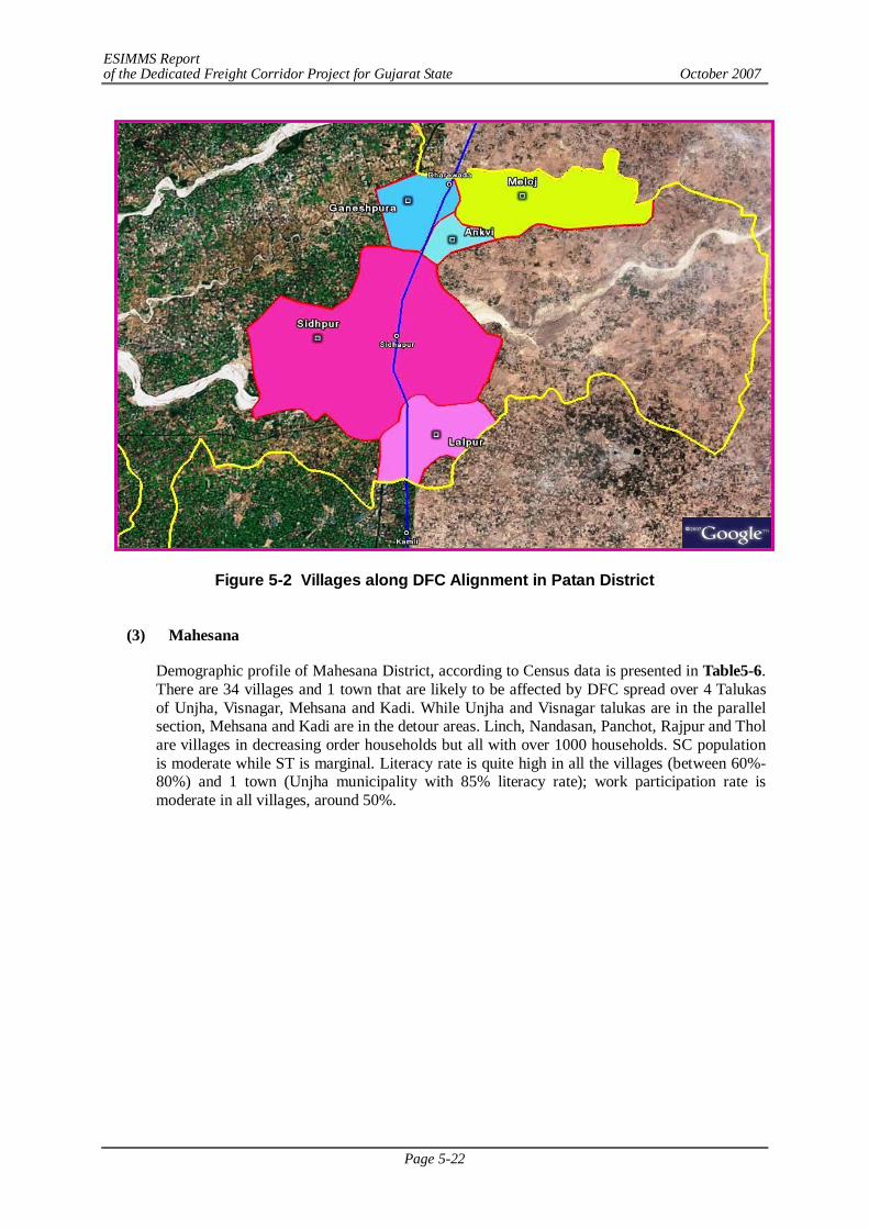
ESIMMS Report of the Dedicated Freight Corridor Project for Gujarat State October 2007
Page 5-22
Figure 5-2 Villages along DFC Alignment in Patan District
(3) Mahesana
Demographic profile of Mahesana District, according to Census data is presented in Table5-6. There are 34 villages and 1 town that are likely to be affected by DFC spread over 4 Talukas of Unjha, Visnagar, Mehsana and Kadi. While Unjha and Visnagar talukas are in the parallel section, Mehsana and Kadi are in the detour areas. Linch, Nandasan, Panchot, Rajpur and Thol are villages in decreasing order households but all with over 1000 households. SC population is moderate while ST is marginal. Literacy rate is quite high in all the villages (between 60%-80%) and 1 town (Unjha municipality with 85% literacy rate); work participation rate is moderate in all villages, around 50%.
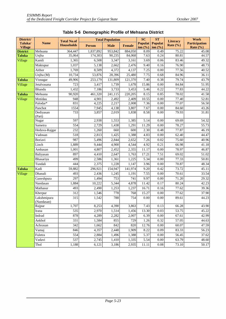
ESIMMS Report of the Dedicated Freight Corridor Project for Gujarat State October 2007
Page 5-23
Table 5-6 Demographic Profile of Mehsana District Total Population District/
Taluka/ Village
Name Total No.of Households Person Male Female
SC Population (%)
ST Population (%)
Literacy Rate (%)
Work Participation
Rate (%) District Mehsana 364,447 1,837,892 953,842 884,050 8.09 0.49 75.22 45.08 Taluka Unjha 35,064 174,303 90,235 84,068 7.63 0.24 80.81 44.57
Kamli 1,365 6,508 3,347 3,161 3.69 0.06 83.46 49.32 Maktupur 1,037 5,138 2,662 2,476 9.40 0.16 76.90 48.73 Aithor 1,769 8,509 4,372 4,137 7.25 0.00 77.56 40.52
Village
Unjha (M) 10,734 53,876 28,396 25,480 7.75 0.68 84.96 36.11 Taluka Visnagar 49,906 253,179 131,809 121,370 7.40 0.38 79.74 43.79
Jetalvasana 723 3,417 1,739 1,678 15.86 0.00 84.84 51.95 Village Bhandu 1,432 7,186 3,733 3,453 5.46 0.22 77.83 44.22
Taluka Mehsana 90,920 461,320 241,115 220,205 8.15 0.85 78.02 41.58 Motidau 948 4,901 2,492 2,409 10.55 0.00 77.40 52.81 Palodar* 831 4,225 2,217 2,008 7.36 0.00 77.07 56.50 Panchot 1554 7,945 4,138 3,807 7.67 0.00 84.60 43.26 Dediyasan (Part)
733 3,857 2,019 1,838 8.58 0.00 79.93 31.81
Nugar 597 2,938 1,553 1,385 5.14 0.00 69.69 54.32 Sametra 554 2,729 1,438 1,291 11.29 0.00 78.27 55.73 Heduva-Rajgar 232 1,260 660 600 2.30 0.48 77.87 46.19 Vadosan 518 2,813 1,425 1,388 4.83 0.00 62.40 44.47 Boriavi 987 5,496 2,844 2,652 7.26 0.02 75.60 40.96 Linch 1,889 9,444 4,900 4,544 4.92 0.21 66.98 41.18 Ambasan 1,001 4,807 2,452 2,355 11.17 0.00 78.97 46.87 Baliyasan 897 4,410 2,647 1,763 17.21 7.51 69.02 51.02 Bhasariya 499 2,586 1,361 1,225 5.34 0.00 77.33 50.81
Village
Tundali 444 2,375 1,228 1,147 3.96 0.00 70.87 48.34 Taluka Kadi 59,882 296,921 154,947 141,974 9.20 0.42 73.72 45.11
Dhanali 493 2,436 1,245 1,191 7.55 0.00 70.61 33.54 Ganeshpura 297 1,494 753 741 9.97 0.00 71.20 29.32 Nandasan 1,884 10,222 5,344 4,878 11.42 0.17 80.24 42.23 Mathasur 493 2,490 1,253 1,237 16.71 0.16 77.62 39.36 Kherpur 312 1,546 778 768 15.27 0.00 77.62 37.90 Lakshmipura (Nandasan)
315 1,542 788 754 0.00 0.00 89.61 44.23
Rajpur 1,707 8,253 4,390 3,863 7.43 0.13 66.28 43.90 Irana 535 2,970 1,514 1,456 13.30 0.03 53.75 45.22 Indrad 878 4,289 2,282 2,007 6.39 0.00 67.61 42.99 Ankhol 331 1,584 855 729 1.26 0.32 57.05 44.63 Achrasan 342 1,662 842 820 12.76 0.00 60.07 47.59 Vamaj 846 4,357 2,448 1,909 8.22 0.09 83.33 56.23 Fuletra 554 2,884 1,496 1,388 5.37 0.00 56.45 37.62 Vadavi 537 2,745 1,410 1,335 5.54 0.00 63.79 48.60
Village
Thol 1,188 6,121 3,186 2,935 11.11 0.08 73.10 50.17
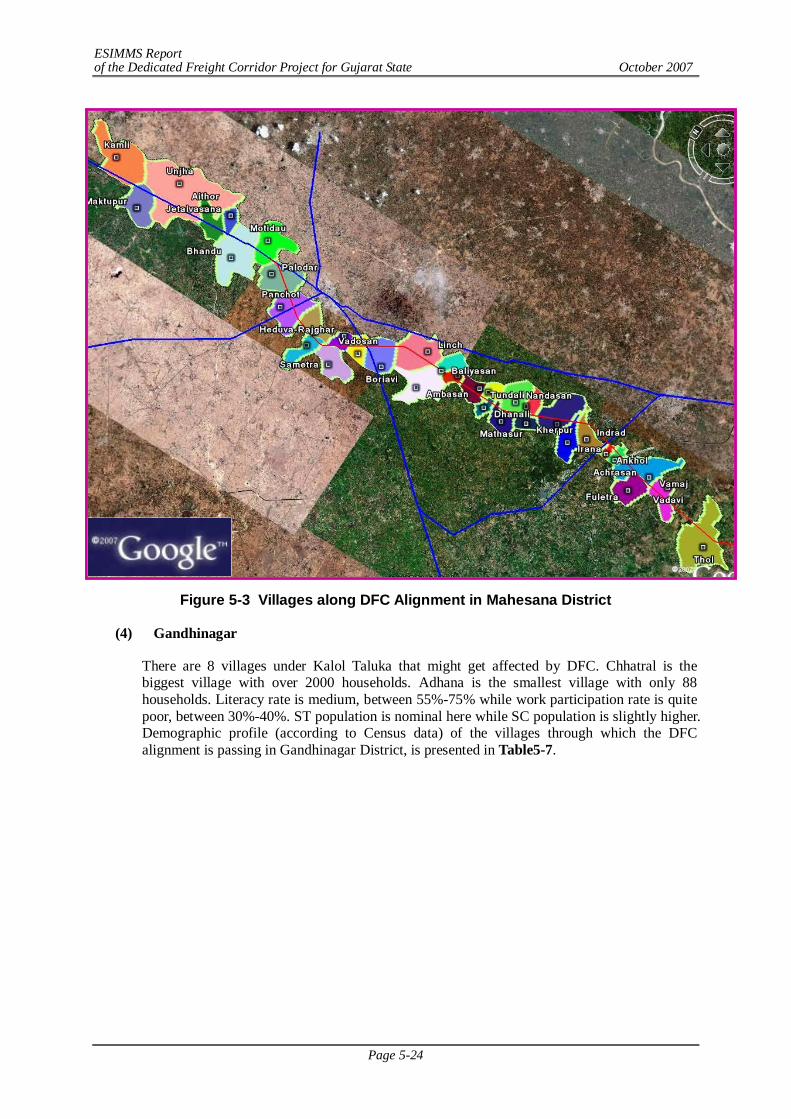
ESIMMS Report of the Dedicated Freight Corridor Project for Gujarat State October 2007
Page 5-24
Figure 5-3 Villages along DFC Alignment in Mahesana District
(4) Gandhinagar
There are 8 villages under Kalol Taluka that might get affected by DFC. Chhatral is the biggest village with over 2000 households. Adhana is the smallest village with only 88 households. Literacy rate is medium, between 55%-75% while work participation rate is quite poor, between 30%-40%. ST population is nominal here while SC population is slightly higher. Demographic profile (according to Census data) of the villages through which the DFC alignment is passing in Gandhinagar District, is presented in Table5-7.
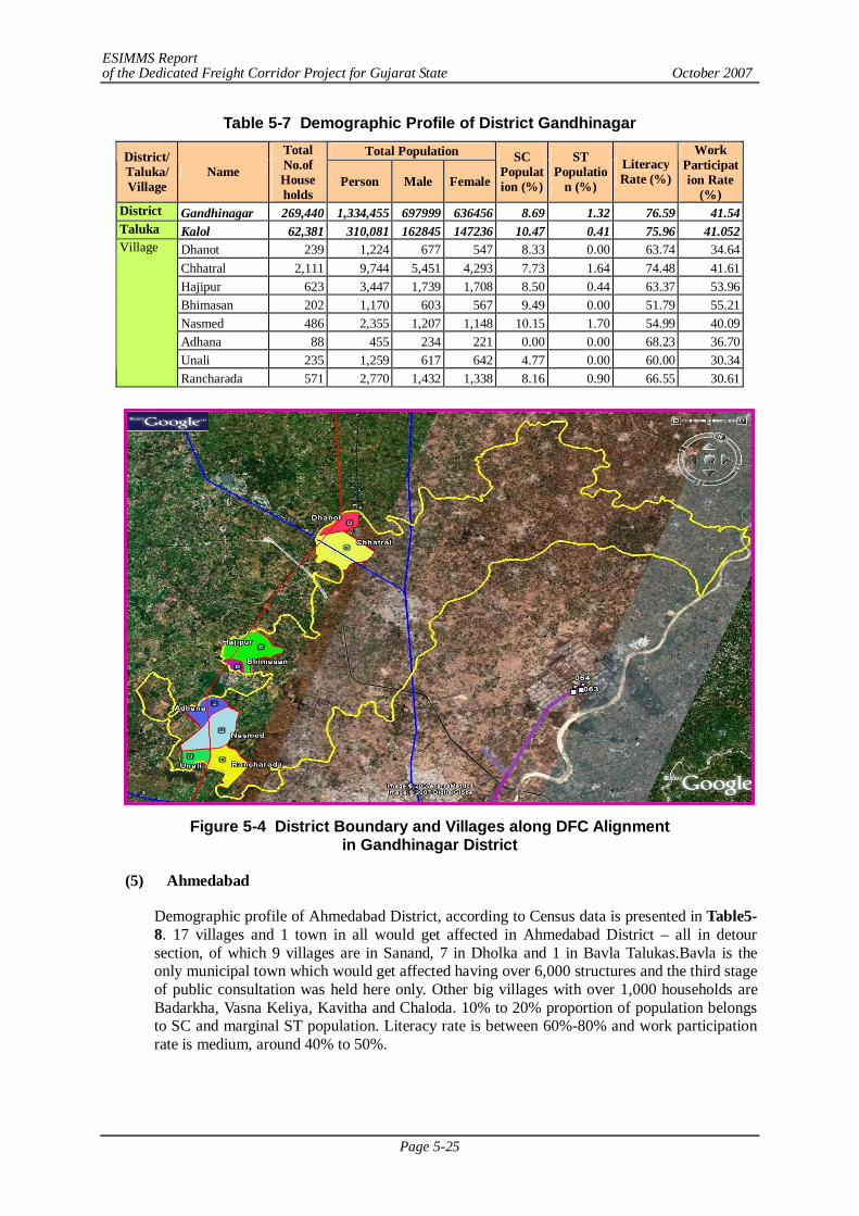
ESIMMS Report of the Dedicated Freight Corridor Project for Gujarat State October 2007
Page 5-25
Table 5-7 Demographic Profile of District Gandhinagar Total Population District/
Taluka/ Village
Name
Total No.of House holds
Person Male Female
SC Population (%)
ST Populatio
n (%)
Literacy Rate (%)
Work Participation Rate
(%) District Gandhinagar 269,440 1,334,455 697999 636456 8.69 1.32 76.59 41.54 Taluka Kalol 62,381 310,081 162845 147236 10.47 0.41 75.96 41.052
Dhanot 239 1,224 677 547 8.33 0.00 63.74 34.64 Chhatral 2,111 9,744 5,451 4,293 7.73 1.64 74.48 41.61 Hajipur 623 3,447 1,739 1,708 8.50 0.44 63.37 53.96 Bhimasan 202 1,170 603 567 9.49 0.00 51.79 55.21 Nasmed 486 2,355 1,207 1,148 10.15 1.70 54.99 40.09 Adhana 88 455 234 221 0.00 0.00 68.23 36.70 Unali 235 1,259 617 642 4.77 0.00 60.00 30.34
Village
Rancharada 571 2,770 1,432 1,338 8.16 0.90 66.55 30.61
Figure 5-4 District Boundary and Villages along DFC Alignment
in Gandhinagar District
(5) Ahmedabad
Demographic profile of Ahmedabad District, according to Census data is presented in Table5-8. 17 villages and 1 town in all would get affected in Ahmedabad District – all in detour section, of which 9 villages are in Sanand, 7 in Dholka and 1 in Bavla Talukas.Bavla is the only municipal town which would get affected having over 6,000 structures and the third stage of public consultation was held here only. Other big villages with over 1,000 households are Badarkha, Vasna Keliya, Kavitha and Chaloda. 10% to 20% proportion of population belongs to SC and marginal ST population. Literacy rate is between 60%-80% and work participation rate is medium, around 40% to 50%.
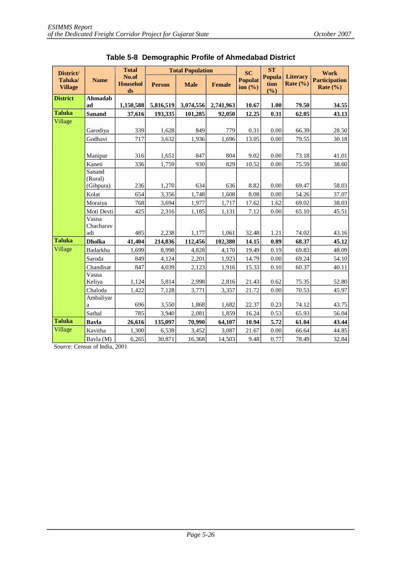
ESIMMS Report of the Dedicated Freight Corridor Project for Gujarat State October 2007
Page 5-26
Table 5-8 Demographic Profile of Ahmedabad District Total Population District/
Taluka/ Village
Name
Total No.of
Households
Person Male Female
SC Population (%)
ST Popula
tion (%)
Literacy Rate (%)
Work Participation
Rate (%)
District Ahmadabad 1,150,588 5,816,519 3,074,556 2,741,963 10.67 1.00 79.50 34.55
Taluka Sanand 37,616 193,335 101,285 92,050 12.25 0.31 62.05 43.13
Garodiya 339 1,628 849 779 0.31 0.00 66.39 28.50 Godhavi 717 3,632 1,936 1,696 13.05 0.00 79.55 30.18
Manipur 316 1,651 847 804 9.02 0.00 73.18 41.01 Kaneti 336 1,759 930 829 10.52 0.00 75.59 38.60 Sanand (Rural) (Gibpura) 236 1,270 634 636 8.82 0.00 69.47 58.03 Kolat 654 3,356 1,748 1,608 8.08 0.00 54.26 37.07 Moraiya 768 3,694 1,977 1,717 17.62 1.62 69.02 38.03 Moti Devti 425 2,316 1,185 1,131 7.12 0.00 65.10 45.51
Village
Vasna Chacharavadi 485 2,238 1,177 1,061 32.48 1.21 74.02 43.16
Taluka Dholka 41,404 214,836 112,456 102,380 14.15 0.89 68.37 45.12 Badarkha 1,699 8,998 4,828 4,170 19.49 0.19 69.83 48.09 Saroda 849 4,124 2,201 1,923 14.79 0.00 69.24 54.10 Chandisar 847 4,039 2,123 1,916 15.33 0.10 60.37 40.11 Vasna Keliya 1,124 5,814 2,998 2,816 21.43 0.62 75.35 52.80 Chaloda 1,422 7,128 3,771 3,357 21.72 0.00 70.53 45.97 Ambaliyara 696 3,550 1,868 1,682 22.37 0.23 74.12 43.75
Village
Sathal 785 3,940 2,081 1,859 16.24 0.53 65.93 56.04 Taluka Bavla 26,616 135,097 70,990 64,107 10.94 5.72 61.04 43.44
Kavitha 1,300 6,539 3,452 3,087 21.67 0.00 66.64 44.85 Village Bavla (M) 6,265 30,871 16,368 14,503 9.48 0.77 78.49 32.84
Source: Census of India, 2001
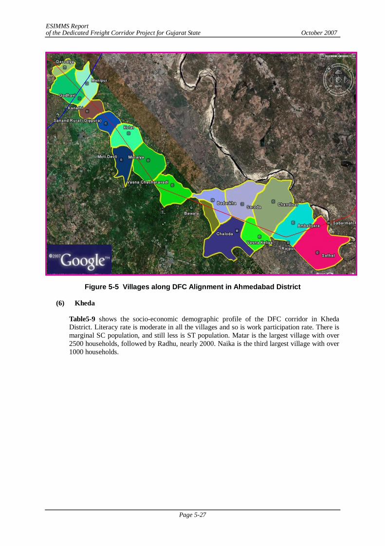
ESIMMS Report of the Dedicated Freight Corridor Project for Gujarat State October 2007
Page 5-27
Figure 5-5 Villages along DFC Alignment in Ahmedabad District
(6) Kheda
Table5-9 shows the socio-economic demographic profile of the DFC corridor in Kheda District. Literacy rate is moderate in all the villages and so is work participation rate. There is marginal SC population, and still less is ST population. Matar is the largest village with over 2500 households, followed by Radhu, nearly 2000. Naika is the third largest village with over 1000 households.
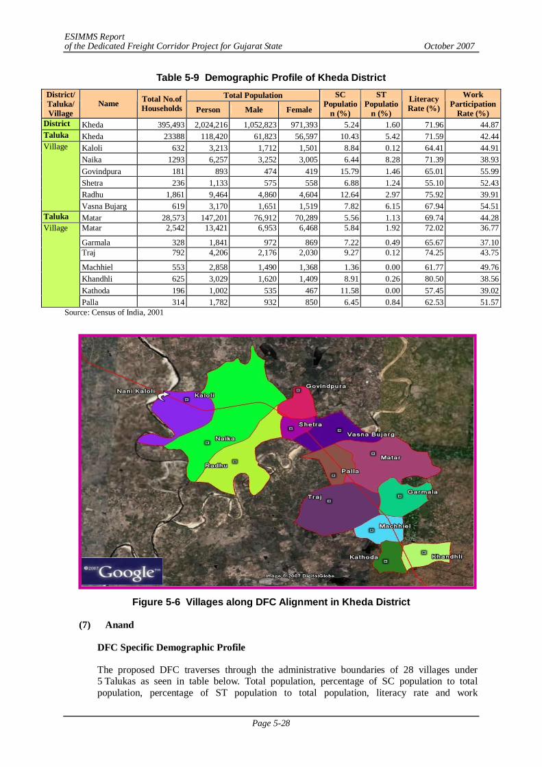
ESIMMS Report of the Dedicated Freight Corridor Project for Gujarat State October 2007
Page 5-28
Table 5-9 Demographic Profile of Kheda District Total Population District/
Taluka/ Village
Name Total No.of Households Person Male Female
SC Populatio
n (%)
ST Populatio
n (%)
Literacy Rate (%)
Work Participation
Rate (%) District Kheda 395,493 2,024,216 1,052,823 971,393 5.24 1.60 71.96 44.87 Taluka Kheda 23388 118,420 61,823 56,597 10.43 5.42 71.59 42.44
Kaloli 632 3,213 1,712 1,501 8.84 0.12 64.41 44.91 Naika 1293 6,257 3,252 3,005 6.44 8.28 71.39 38.93 Govindpura 181 893 474 419 15.79 1.46 65.01 55.99 Shetra 236 1,133 575 558 6.88 1.24 55.10 52.43 Radhu 1,861 9,464 4,860 4,604 12.64 2.97 75.92 39.91
Village
Vasna Bujarg 619 3,170 1,651 1,519 7.82 6.15 67.94 54.51 Taluka Matar 28,573 147,201 76,912 70,289 5.56 1.13 69.74 44.28
Matar 2,542 13,421 6,953 6,468 5.84 1.92 72.02 36.77
Garmala 328 1,841 972 869 7.22 0.49 65.67 37.10 Traj 792 4,206 2,176 2,030 9.27 0.12 74.25 43.75
Machhiel 553 2,858 1,490 1,368 1.36 0.00 61.77 49.76 Khandhli 625 3,029 1,620 1,409 8.91 0.26 80.50 38.56 Kathoda 196 1,002 535 467 11.58 0.00 57.45 39.02
Village
Palla 314 1,782 932 850 6.45 0.84 62.53 51.57 Source: Census of India, 2001
Figure 5-6 Villages along DFC Alignment in Kheda District
(7) Anand
DFC Specific Demographic Profile
The proposed DFC traverses through the administrative boundaries of 28 villages under 5 Talukas as seen in table below. Total population, percentage of SC population to total population, percentage of ST population to total population, literacy rate and work
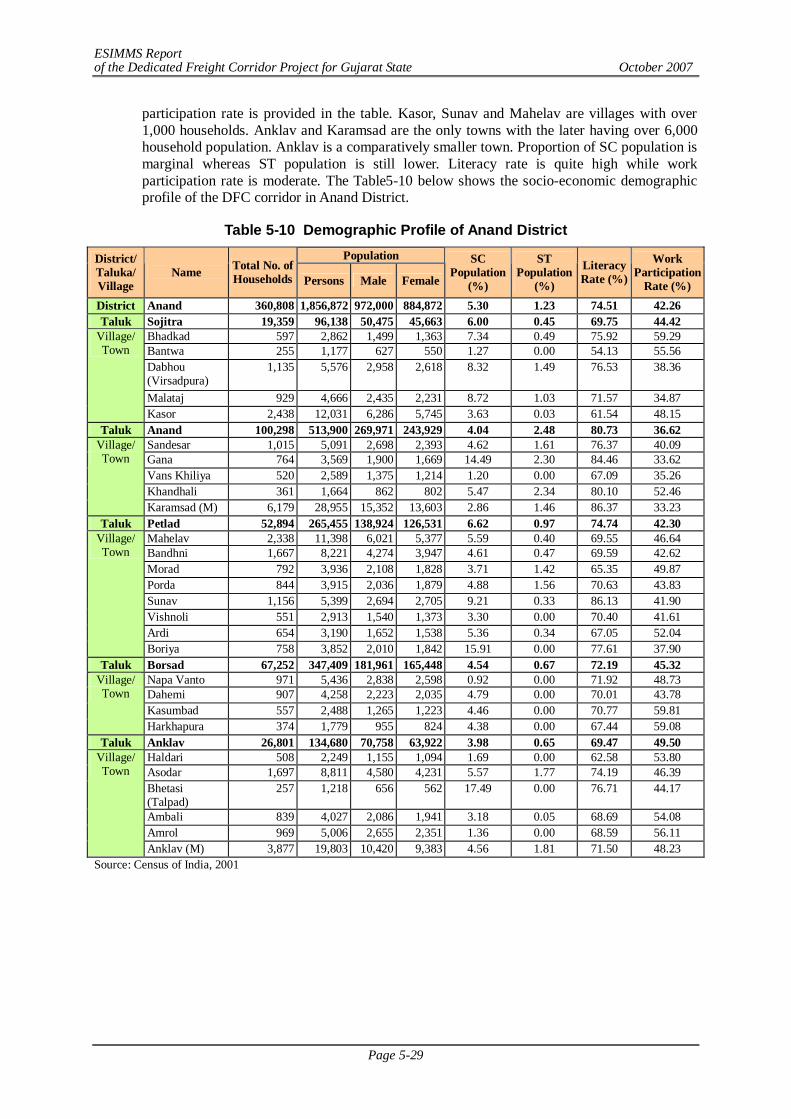
ESIMMS Report of the Dedicated Freight Corridor Project for Gujarat State October 2007
Page 5-29
participation rate is provided in the table. Kasor, Sunav and Mahelav are villages with over 1,000 households. Anklav and Karamsad are the only towns with the later having over 6,000 household population. Anklav is a comparatively smaller town. Proportion of SC population is marginal whereas ST population is still lower. Literacy rate is quite high while work participation rate is moderate. The Table5-10 below shows the socio-economic demographic profile of the DFC corridor in Anand District.
Table 5-10 Demographic Profile of Anand District Population District/
Taluka/ Village
Name Total No. of Households Persons Male Female
SC Population
(%)
ST Population
(%)
Literacy Rate (%)
Work Participation
Rate (%) District Anand 360,808 1,856,872 972,000 884,872 5.30 1.23 74.51 42.26 Taluk Sojitra 19,359 96,138 50,475 45,663 6.00 0.45 69.75 44.42
Bhadkad 597 2,862 1,499 1,363 7.34 0.49 75.92 59.29 Bantwa 255 1,177 627 550 1.27 0.00 54.13 55.56 Dabhou (Virsadpura)
1,135 5,576 2,958 2,618 8.32 1.49 76.53 38.36
Malataj 929 4,666 2,435 2,231 8.72 1.03 71.57 34.87
Village/ Town
Kasor 2,438 12,031 6,286 5,745 3.63 0.03 61.54 48.15 Taluk Anand 100,298 513,900 269,971 243,929 4.04 2.48 80.73 36.62
Sandesar 1,015 5,091 2,698 2,393 4.62 1.61 76.37 40.09 Gana 764 3,569 1,900 1,669 14.49 2.30 84.46 33.62 Vans Khiliya 520 2,589 1,375 1,214 1.20 0.00 67.09 35.26 Khandhali 361 1,664 862 802 5.47 2.34 80.10 52.46
Village/ Town
Karamsad (M) 6,179 28,955 15,352 13,603 2.86 1.46 86.37 33.23 Taluk Petlad 52,894 265,455 138,924 126,531 6.62 0.97 74.74 42.30
Mahelav 2,338 11,398 6,021 5,377 5.59 0.40 69.55 46.64 Bandhni 1,667 8,221 4,274 3,947 4.61 0.47 69.59 42.62 Morad 792 3,936 2,108 1,828 3.71 1.42 65.35 49.87 Porda 844 3,915 2,036 1,879 4.88 1.56 70.63 43.83 Sunav 1,156 5,399 2,694 2,705 9.21 0.33 86.13 41.90 Vishnoli 551 2,913 1,540 1,373 3.30 0.00 70.40 41.61 Ardi 654 3,190 1,652 1,538 5.36 0.34 67.05 52.04
Village/ Town
Boriya 758 3,852 2,010 1,842 15.91 0.00 77.61 37.90 Taluk Borsad 67,252 347,409 181,961 165,448 4.54 0.67 72.19 45.32
Napa Vanto 971 5,436 2,838 2,598 0.92 0.00 71.92 48.73 Dahemi 907 4,258 2,223 2,035 4.79 0.00 70.01 43.78 Kasumbad 557 2,488 1,265 1,223 4.46 0.00 70.77 59.81
Village/ Town
Harkhapura 374 1,779 955 824 4.38 0.00 67.44 59.08 Taluk Anklav 26,801 134,680 70,758 63,922 3.98 0.65 69.47 49.50
Haldari 508 2,249 1,155 1,094 1.69 0.00 62.58 53.80 Asodar 1,697 8,811 4,580 4,231 5.57 1.77 74.19 46.39 Bhetasi (Talpad)
257 1,218 656 562 17.49 0.00 76.71 44.17
Ambali 839 4,027 2,086 1,941 3.18 0.05 68.69 54.08 Amrol 969 5,006 2,655 2,351 1.36 0.00 68.59 56.11
Village/ Town
Anklav (M) 3,877 19,803 10,420 9,383 4.56 1.81 71.50 48.23 Source: Census of India, 2001
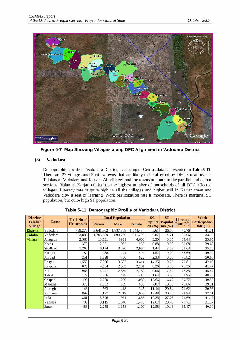
ESIMMS Report of the Dedicated Freight Corridor Project for Gujarat State October 2007
Page 5-30
Figure 5-7 Map Showing Villages along DFC Alignment in Vadodara District
(8) Vadodara
Demographic profile of Vadodara District, according to Census data is presented in Table5-11. There are 27 villages and 2 cities/towns that are likely to be affected by DFC spread over 2 Talukas of Vadodara and Karjan. All villages and the towns are both in the parallel and detour sections. Valan in Karjan taluka has the highest number of households of all DFC affected villages. Literacy rate is quite high in all the villages and higher still in Karjan town and Vadodara city- a seat of learning. Work participation rate is moderate. There is marginal SC population, but quite high ST population.
Table 5-11 Demographic Profile of Vadodara District Total Population District/
Taluka/ Village
Name Total No.of Households Person Male Female
SC Population (%)
ST Population (%)
Literacy Rate (%)
Work Participation
Rate (%) District Vadodara 739,276 3,641,802 1,897,368 1,744,434 5.61 26.56 70.76 41.71 Taluka Vadodara 363,886 1,705,989 894,780 811,209 6.87 4.71 85.06 33.19
Anagadh 2,560 13,531 6931 6,600 3.30 0.35 69.44 35.65 Kotna 379 2,051 1,062 989 0.88 0.00 69.08 39.69 Sindhrot 1,262 6,174 3,220 2,954 1.44 3.58 59.63 35.76 Hinglot 182 988 494 494 1.52 0.20 68.69 49.39 Ampad 251 1,328 706 622 2.33 0.00 76.82 50.00 Bhayli 1,553 7,096 3,682 3,414 14.35 9.75 79.81 42.08 Raypura 870 4,594 2,393 2,201 0.26 0.00 76.55 41.47 Bil 966 4,471 2,339 2,132 9.06 17.54 76.85 45.47 Talsat 177 856 438 418 1.64 0.00 51.95 48.48 Chapad 496 2,280 1,200 1,080 10.66 16.62 69.77 49.56 Maretha 370 1,852 969 883 7.07 13.55 76.86 39.31 Alamgir 146 763 418 345 11.14 20.84 71.62 30.93 Varnama 899 4,177 2,219 1,958 13.48 20.25 73.94 37.51 Itola 861 3,826 1,971 1,855 10.35 27.26 71.69 41.17 Vadsala 709 3,115 1,640 1,475 12.07 23.43 79.71 31.27
Village
Sarar 486 2,258 1,158 1,100 12.58 19.18 65.47 40.30
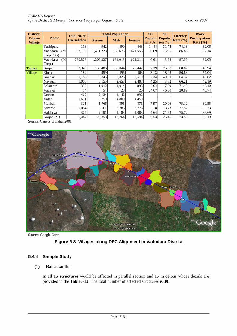
ESIMMS Report of the Dedicated Freight Corridor Project for Gujarat State October 2007
Page 5-31
Total Population District/ Taluka/ Village
Name Total No.of Households Person Male Female
SC Population (%)
ST Population (%)
Literacy Rate (%)
Work Participation
Rate (%) Kashipura 198 942 499 443 14.44 31.74 74.13 32.06 Vadodara (M Corp+OG)
303,130 1,411,228 739,675 671,553 6.69 3.95 86.86 32.14
Vadodara (M Corp.)
280,873 1,306,227 684,013 622,214 6.61 3.58 87.55 32.05
Taluka Karjan 33,349 162,486 85,044 77,442 7.39 25.37 68.82 43.94 Kherda 182 959 496 463 3.13 18.98 56.88 57.04 Kandari 1,156 5,845 3,326 2,519 7.34 40.00 64.37 43.82 Miyagam 1,050 5,155 2,658 2,497 4.25 3.82 66.21 42.19 Lakodara 358 1,912 1,014 898 7.64 17.99 71.48 43.10 Vadava 14 54 28 26 24.07 46.30 28.89 40.74 Dethan 462 2,134 1,142 992 Valan 1,611 9,250 4,800 4,450 Mankan 321 1,766 895 871 7.97 20.06 75.12 39.55 Sansrod 1,054 5,561 2,786 2,775 3.18 13.73 77.52 33.33 Haldarva 377 2,191 1,183 1,008 4.64 21.63 75.72 36.69
Village
Karjan (M) 5,487 26,358 13,764 12,594 6.53 25.46 73.53 32.19 Source: Census of India, 2001
Source: Google Earth
Figure 5-8 Villages along DFC Alignment in Vadodara District
5.4.4 Sample Study
(1) Banaskantha
In all 15 structures would be affected in parallel section and 15 in detour whose details are provided in the Table5-12. The total number of affected structures is 30.
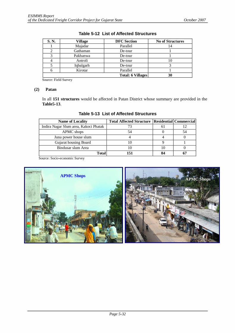
ESIMMS Report of the Dedicated Freight Corridor Project for Gujarat State October 2007
Page 5-32
Table 5-12 List of Affected Structures S. N. Village DFC Section No of Structures
1 Majadar Parallel 14 2 Gathaman De-tour 1 3 Pakhanwa De-tour 1 4 Antroli De-tour 10 5 Iqbalgarh De-tour 3 6 Kirotar Parallel 1
Total: 6 Villages 30 Source: Field Survey
(2) Patan
In all 151 structures would be affected in Patan District whose summary are provided in the Table5-13.
Table 5-13 List of Affected Structures Name of Locality Total Affected Structure Residential Commercial
Indira Nagar Slum area, Kakoci Phatak 73 61 12 APMC shops 54 0 54
Juna power house slum 4 4 0 Gujarat housing Board 10 9 1
Bindusar slum Area 10 10 0 Total 151 84 67
Source: Socio-economic Survey
APMC Shops APMC Shops
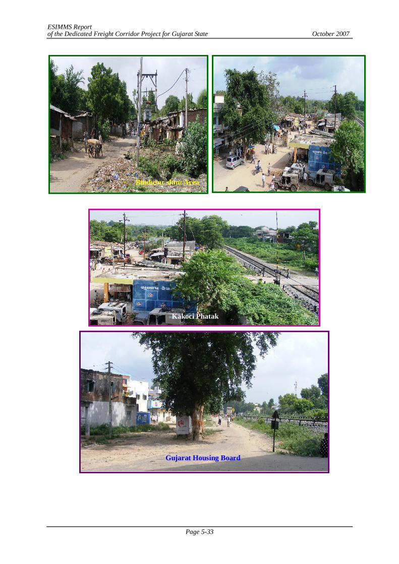
ESIMMS Report of the Dedicated Freight Corridor Project for Gujarat State October 2007
Page 5-33
Bindusar slum Area
Gujarat Housing Board
Kakoci Phatak
ESIMMS Report of the Dedicated Freight Corridor Project for Gujarat State October 2007
Page 5-34
(3) Mahesana
In all 121 structures (Unjha 24, Laxmipura 2, Baliyasan 91, Rajpur 4) would be affected in Mahesana District.
In all 121 structures would be affected in Mahesana District whose details are provided in the Table5-14.
Table 5-14 List of Affected Structures Name of Locality Total Affected Structure
Unjha 24 Laxmipura 2 Baliyasan 91
Rajpur 4 Total 121
Source: Field Survey
(4) Gandhinagar
In Gandhinagar District, no structures would be affected by the DFC. There are 8 villages in the Kalol taluka through which DFC passes. However one ONGC pipeline (in Unali village) and one road (major road connecting Ahmedabad with the villages of Adhana, Nasmed, Unali) is getting affected which has no social concern as such. Budget pertaining to social aspects (affected structure) is therefore not required.
The road stretch likely to be affected by DFC alignment is about 431 m in Adhana village. Here the alignment has been superimposed on the road it seems. This is a serious engineering concern.
Again, in Unali village, ONGC has dug wells at several locations and pipeline is crossing underground across this village. It may be suggested that it would be best to avoid this village altogether, meaning re-alignment of the DFC at least in this stretch.
(5) Ahmedabad
In all 117 structures would be affected in Ahmedabad District whose details are provided in the Table5-15.
Table 5-15 List of Affected Structures Name of Locality Total Affected Structure
Vasna Chancharwadi 5 Kavitha 112 Total 117
Source: Field Survey
(6) Kheda
In Kheda District, which lies in detour section DFC crosses mostly agricultural land with only two structures being affected. There are 6 villages in the Kheda Taluka and seven villages in Matar Taluka respectively through which the proposed DFC passes.
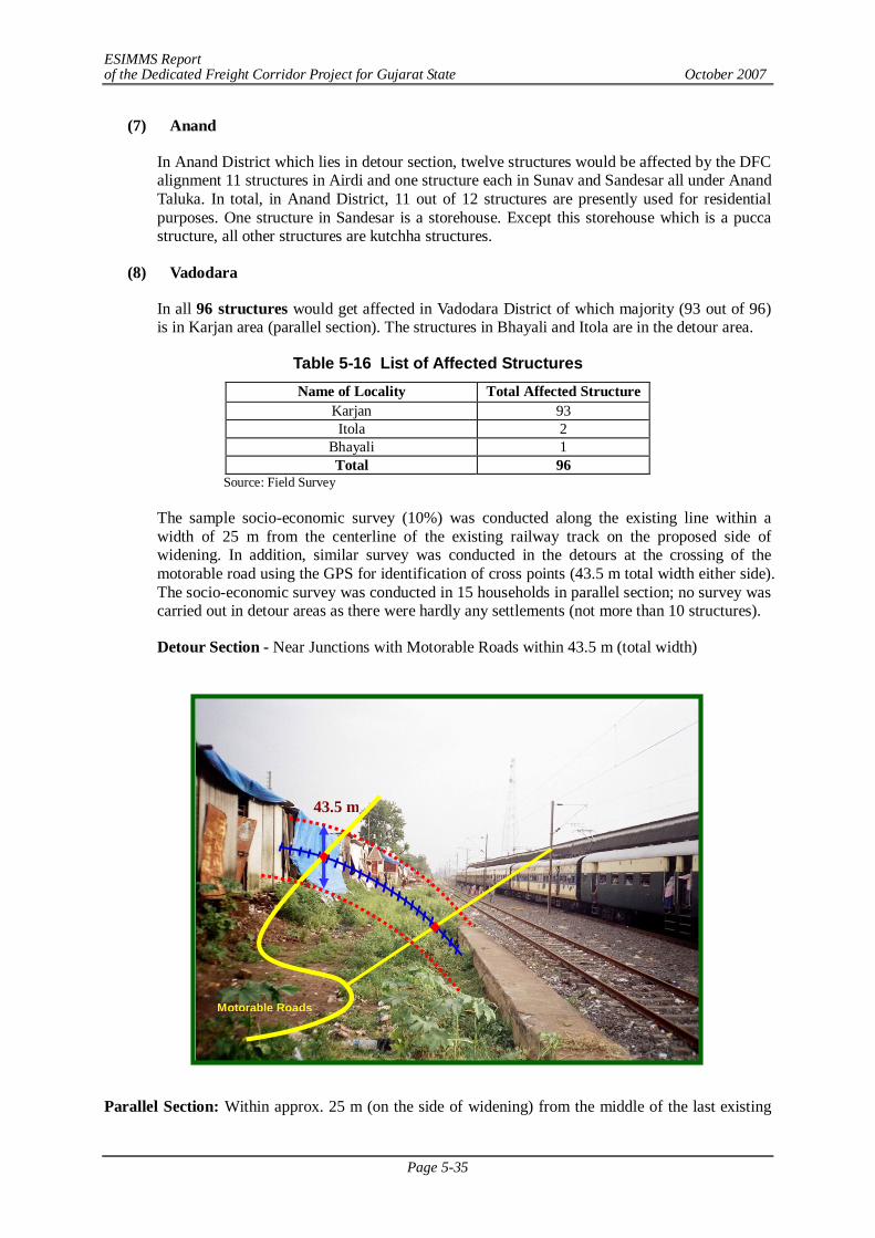
ESIMMS Report of the Dedicated Freight Corridor Project for Gujarat State October 2007
Page 5-35
(7) Anand
In Anand District which lies in detour section, twelve structures would be affected by the DFC alignment 11 structures in Airdi and one structure each in Sunav and Sandesar all under Anand Taluka. In total, in Anand District, 11 out of 12 structures are presently used for residential purposes. One structure in Sandesar is a storehouse. Except this storehouse which is a pucca structure, all other structures are kutchha structures.
(8) Vadodara
In all 96 structures would get affected in Vadodara District of which majority (93 out of 96) is in Karjan area (parallel section). The structures in Bhayali and Itola are in the detour area.
Table 5-16 List of Affected Structures Name of Locality Total Affected Structure
Karjan 93 Itola 2
Bhayali 1 Total 96
Source: Field Survey
The sample socio-economic survey (10%) was conducted along the existing line within a width of 25 m from the centerline of the existing railway track on the proposed side of widening. In addition, similar survey was conducted in the detours at the crossing of the motorable road using the GPS for identification of cross points (43.5 m total width either side). The socio-economic survey was conducted in 15 households in parallel section; no survey was carried out in detour areas as there were hardly any settlements (not more than 10 structures).
Detour Section - Near Junctions with Motorable Roads within 43.5 m (total width)
Parallel Section: Within approx. 25 m (on the side of widening) from the middle of the last existing
Motorable Roads
43.5 m
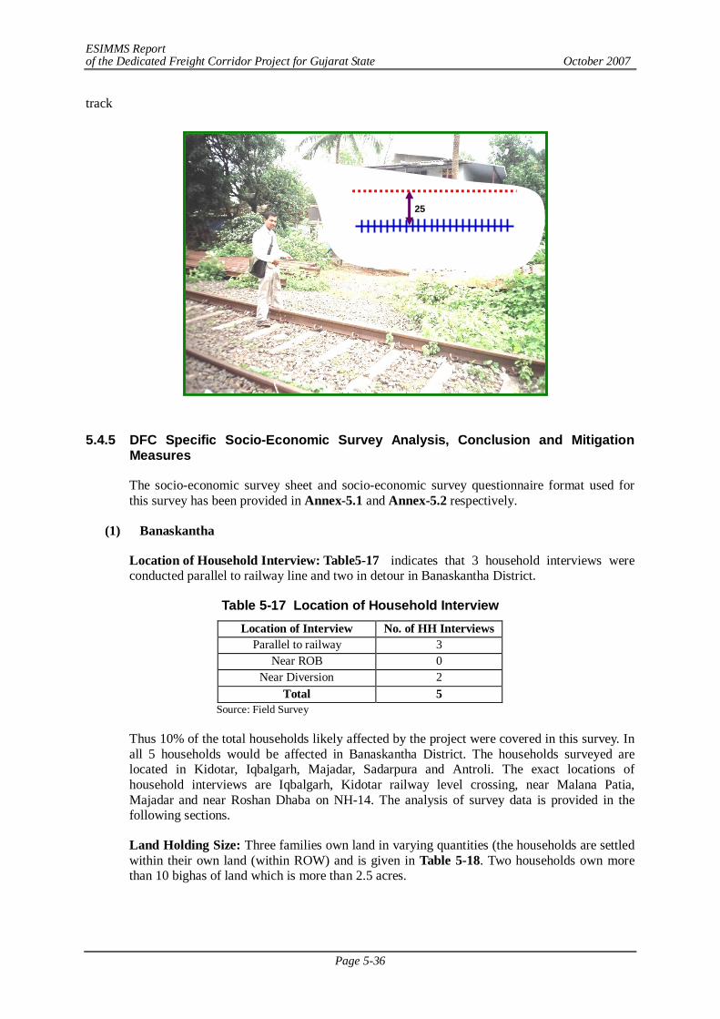
ESIMMS Report of the Dedicated Freight Corridor Project for Gujarat State October 2007
Page 5-36
track
5.4.5 DFC Specific Socio-Economic Survey Analysis, Conclusion and Mitigation
Measures
The socio-economic survey sheet and socio-economic survey questionnaire format used for this survey has been provided in Annex-5.1 and Annex-5.2 respectively.
(1) Banaskantha
Location of Household Interview: Table5-17 indicates that 3 household interviews were conducted parallel to railway line and two in detour in Banaskantha District.
Table 5-17 Location of Household Interview Location of Interview No. of HH Interviews
Parallel to railway 3 Near ROB 0
Near Diversion 2 Total 5
Source: Field Survey
Thus 10% of the total households likely affected by the project were covered in this survey. In all 5 households would be affected in Banaskantha District. The households surveyed are located in Kidotar, Iqbalgarh, Majadar, Sadarpura and Antroli. The exact locations of household interviews are Iqbalgarh, Kidotar railway level crossing, near Malana Patia, Majadar and near Roshan Dhaba on NH-14. The analysis of survey data is provided in the following sections.
Land Holding Size: Three families own land in varying quantities (the households are settled within their own land (within ROW) and is given in Table 5-18. Two households own more than 10 bighas of land which is more than 2.5 acres.
25
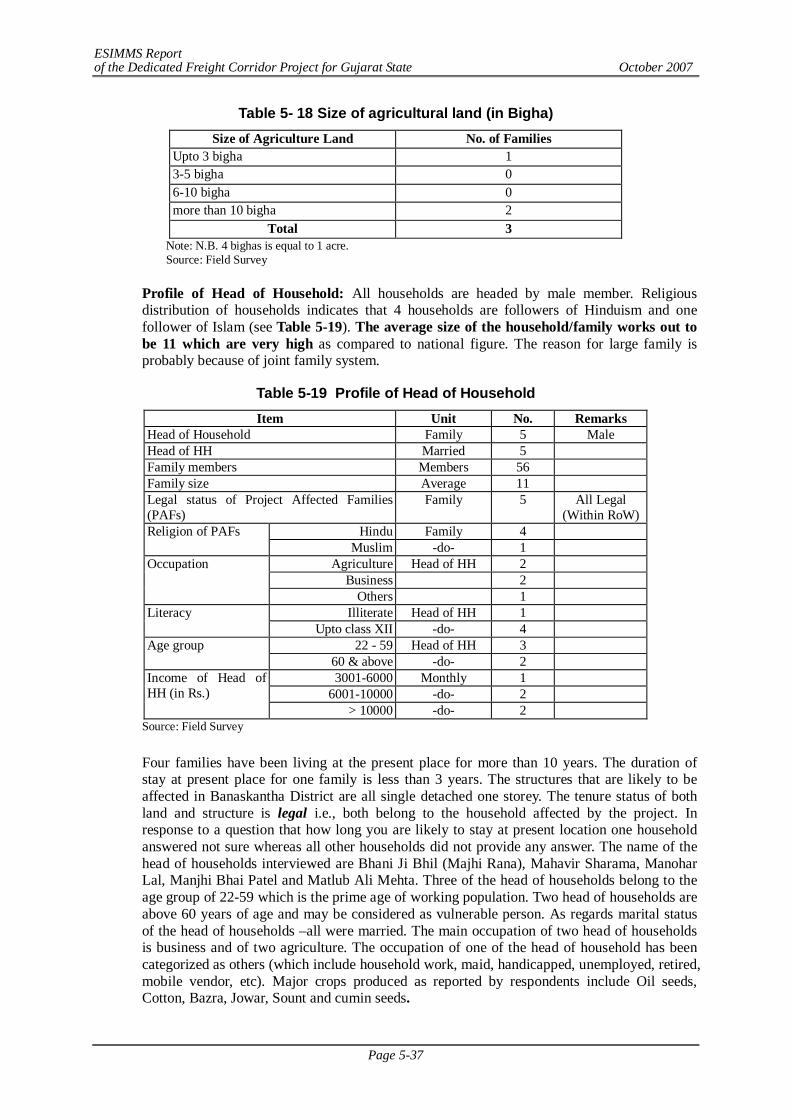
ESIMMS Report of the Dedicated Freight Corridor Project for Gujarat State October 2007
Page 5-37
Table 5- 18 Size of agricultural land (in Bigha) Size of Agriculture Land No. of Families
Upto 3 bigha 1 3-5 bigha 0 6-10 bigha 0 more than 10 bigha 2
Total 3 Note: N.B. 4 bighas is equal to 1 acre. Source: Field Survey
Profile of Head of Household: All households are headed by male member. Religious distribution of households indicates that 4 households are followers of Hinduism and one follower of Islam (see Table 5-19). The average size of the household/family works out to be 11 which are very high as compared to national figure. The reason for large family is probably because of joint family system.
Table 5-19 Profile of Head of Household Item Unit No. Remarks
Head of Household Family 5 Male Head of HH Married 5 Family members Members 56 Family size Average 11 Legal status of Project Affected Families (PAFs)
Family 5 All Legal (Within RoW)
Hindu Family 4 Religion of PAFs Muslim -do- 1
Agriculture Head of HH 2 Business 2
Occupation
Others 1 Illiterate Head of HH 1 Literacy
Upto class XII -do- 4 22 - 59 Head of HH 3 Age group
60 & above -do- 2 3001-6000 Monthly 1
6001-10000 -do- 2 Income of Head of HH (in Rs.)
> 10000 -do- 2 Source: Field Survey
Four families have been living at the present place for more than 10 years. The duration of stay at present place for one family is less than 3 years. The structures that are likely to be affected in Banaskantha District are all single detached one storey. The tenure status of both land and structure is legal i.e., both belong to the household affected by the project. In response to a question that how long you are likely to stay at present location one household answered not sure whereas all other households did not provide any answer. The name of the head of households interviewed are Bhani Ji Bhil (Majhi Rana), Mahavir Sharama, Manohar Lal, Manjhi Bhai Patel and Matlub Ali Mehta. Three of the head of households belong to the age group of 22-59 which is the prime age of working population. Two head of households are above 60 years of age and may be considered as vulnerable person. As regards marital status of the head of households –all were married. The main occupation of two head of households is business and of two agriculture. The occupation of one of the head of household has been categorized as others (which include household work, maid, handicapped, unemployed, retired, mobile vendor, etc). Major crops produced as reported by respondents include Oil seeds, Cotton, Bazra, Jowar, Sount and cumin seeds.
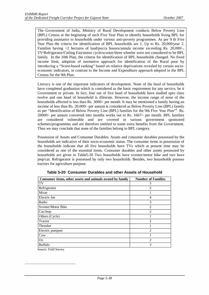
ESIMMS Report of the Dedicated Freight Corridor Project for Gujarat State October 2007
Page 5-38
The Government of India, Ministry of Rural Development conducts Below Poverty Line (BPL) Census at the beginning of each Five Year Plan to identify households living BPL for providing assistance to households under various anti-poverty programmes. As per 9 th Five Year Plan the criteria for identification of BPL households are 1. Up to Rs. 20,000/year 2. Families having >2 hectares of land/pucca houses/annula income exceeding Rs. 20,000/-, TV/Refrigerator/Ceiling Fan/motor cycle/scooter/three wheeler were not considered to be BPL family. In the 10th Plan, the criteria for identification of BPL households changed. No fixed income limit, adoption of normative approach for identification of the Rural poor by introducing a “Score-based ranking” based on relative deprivations revealed by certain socio-economic indicators, in contrast to the Income and Expenditure approach adopted in the BPL Census for the 9th Plan.
Literacy is one of the important indicators of development. None of the head of households have completed graduation which is considered as the basic requirement for any service, be it Government or private. In fact, four out of five head of households have studied upto class twelve and one head of household is illiterate. However, the income range of none of the households affected is less than Rs. 3000/- per month. It may be mentioned a family having an income of less than Rs. 20,000/- per annum is considered as Below Poverty Line (BPL) family as per “Identification of Below Poverty Line (BPL) families for the 9th Five Year Plan”1. Rs. 20000/- per annum converted into months works out to Rs. 1667/- per month. BPL families are considered vulnerable and are covered in various government sponsored schemes/programmes and are therefore entitled to some extra benefits from the Government. Thus we may conclude that none of the families belong to BPL category.
Possession of Assets and Consumer Durables: Assets and consumer durables possessed by the households are indicative of their socio-economic status. The consumer items in possession of the households indicate that all five households have TVs which at present time may be considered as one of the essential items. Consumer durables and other assets possessed by households are given in Table5-20 Two households have scooter/motor bike and two have jeep/car. Refrigerator is possessed by only two households. Besides, two households possess tractors for agriculture purpose.
Table 5-20 Consumer Durables and other Assets of Household Consumer items, other assets and animals owned by family Number of Families TV 5 Refrigerator 2 Mixer 1 Electric fan 4 Radio 3 Scooter/Motor Bike 2 Car/Jeep 2 Others (Cycle) 1 Tractor 2 Thresher 1 Electric pumpset 2 Cow 1 Ox 2 Buffalo 3
Source: Field Survey
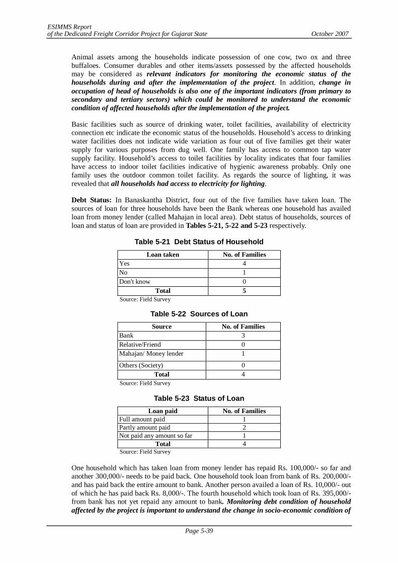
ESIMMS Report of the Dedicated Freight Corridor Project for Gujarat State October 2007
Page 5-39
Animal assets among the households indicate possession of one cow, two ox and three buffaloes. Consumer durables and other items/assets possessed by the affected households may be considered as relevant indicators for monitoring the economic status of the households during and after the implementation of the project. In addition, change in occupation of head of households is also one of the important indicators (from primary to secondary and tertiary sectors) which could be monitored to understand the economic condition of affected households after the implementation of the project.
Basic facilities such as source of drinking water, toilet facilities, availability of electricity connection etc indicate the economic status of the households. Household’s access to drinking water facilities does not indicate wide variation as four out of five families get their water supply for various purposes from dug well. One family has access to common tap water supply facility. Household’s access to toilet facilities by locality indicates that four families have access to indoor toilet facilities indicative of hygienic awareness probably. Only one family uses the outdoor common toilet facility. As regards the source of lighting, it was revealed that all households had access to electricity for lighting.
Debt Status: In Banaskantha District, four out of the five families have taken loan. The sources of loan for three households have been the Bank whereas one household has availed loan from money lender (called Mahajan in local area). Debt status of households, sources of loan and status of loan are provided in Tables 5-21, 5-22 and 5-23 respectively.
Table 5-21 Debt Status of Household Loan taken No. of Families
Yes 4 No 1 Don't know 0
Total 5 Source: Field Survey
Table 5-22 Sources of Loan Source No. of Families
Bank 3 Relative/Friend 0 Mahajan/ Money lender 1
Others (Society) 0 Total 4
Source: Field Survey
Table 5-23 Status of Loan Loan paid No. of Families
Full amount paid 1 Partly amount paid 2 Not paid any amount so far 1
Total 4 Source: Field Survey
One household which has taken loan from money lender has repaid Rs. 100,000/- so far and another 300,000/- needs to be paid back. One household took loan from bank of Rs. 200,000/- and has paid back the entire amount to bank. Another person availed a loan of Rs. 10,000/- out of which he has paid back Rs. 8,000/-. The fourth household which took loan of Rs. 395,000/- from bank has not yet repaid any amount to bank. Monitoring debt condition of household affected by the project is important to understand the change in socio-economic condition of
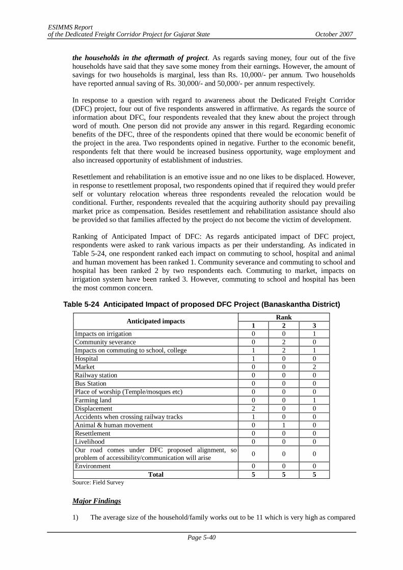
ESIMMS Report of the Dedicated Freight Corridor Project for Gujarat State October 2007
Page 5-40
the households in the aftermath of project. As regards saving money, four out of the five households have said that they save some money from their earnings. However, the amount of savings for two households is marginal, less than Rs. 10,000/- per annum. Two households have reported annual saving of Rs. 30,000/- and 50,000/- per annum respectively.
In response to a question with regard to awareness about the Dedicated Freight Corridor (DFC) project, four out of five respondents answered in affirmative. As regards the source of information about DFC, four respondents revealed that they knew about the project through word of mouth. One person did not provide any answer in this regard. Regarding economic benefits of the DFC, three of the respondents opined that there would be economic benefit of the project in the area. Two respondents opined in negative. Further to the economic benefit, respondents felt that there would be increased business opportunity, wage employment and also increased opportunity of establishment of industries.
Resettlement and rehabilitation is an emotive issue and no one likes to be displaced. However, in response to resettlement proposal, two respondents opined that if required they would prefer self or voluntary relocation whereas three respondents revealed the relocation would be conditional. Further, respondents revealed that the acquiring authority should pay prevailing market price as compensation. Besides resettlement and rehabilitation assistance should also be provided so that families affected by the project do not become the victim of development.
Ranking of Anticipated Impact of DFC: As regards anticipated impact of DFC project, respondents were asked to rank various impacts as per their understanding. As indicated in Table 5-24, one respondent ranked each impact on commuting to school, hospital and animal and human movement has been ranked 1. Community severance and commuting to school and hospital has been ranked 2 by two respondents each. Commuting to market, impacts on irrigation system have been ranked 3. However, commuting to school and hospital has been the most common concern.
Table 5-24 Anticipated Impact of proposed DFC Project (Banaskantha District) Rank Anticipated impacts 1 2 3
Impacts on irrigation 0 0 1 Community severance 0 2 0 Impacts on commuting to school, college 1 2 1 Hospital 1 0 0 Market 0 0 2 Railway station 0 0 0 Bus Station 0 0 0 Place of worship (Temple/mosques etc) 0 0 0 Farming land 0 0 1 Displacement 2 0 0 Accidents when crossing railway tracks 1 0 0 Animal & human movement 0 1 0 Resettlement 0 0 0 Livelihood 0 0 0 Our road comes under DFC proposed alignment, so problem of accessibility/communication will arise 0 0 0
Environment 0 0 0 Total 5 5 5
Source: Field Survey
Major Findings
1) The average size of the household/family works out to be 11 which is very high as compared
ESIMMS Report of the Dedicated Freight Corridor Project for Gujarat State October 2007
Page 5-41
to national figure. The reason for large family is probably because of joint family system.
2) The structures that are likely to be affected in Banaskantha District are all single detached one storey. The tenure status of both land and structure is legal i.e., both belong to the household affected by the project.
3) Major crops produced as reported by respondents include Oil seeds, Cotton, Bajra, Jowar, ani seeds and cumin seeds.
4) The income range of none of the households affected is less than Rs. 3000/- per month. None of the families belong to BPL category. BPL families are considered vulnerable and are covered in various government sponsored schemes/programmes and are therefore entitled to some extra benefits from the Government.
5) Assets and consumer durables possessed by the households are indicative of their socio-economic status. Consumer durables and other items/assets possessed by the affected households may be considered as relevant indicators for monitoring the economic status of the households during and after the implementation of the project. In addition, change in occupation of head of households is also one of the important indicators (from primary to secondary and tertiary sectors) which could be monitored to understand the economic condition of affected households after the implementation of the project. TV has been the most common consumer durable/asset indicating two things: visual entertainment is popular and that information dissemination via visual media may be a tool for DFC implementation.
6) As regards the source of lighting, it was revealed that all households had access to electricity for lighting indicating rural electrification here is prevalent.
7) Monitoring debt condition of household affected by the project is important to understand the change in socio-economic condition of the households in the aftermath of the project. As regards saving money, respondents do save money depending upon their income level.
8) Commuting to school and hospital has been the most common concern of the people with regard to DFC.
9) However, in response to resettlement proposal, they would prefer self or voluntary relocation whereas three respondents revealed the relocation would be conditional. Further, respondents revealed that the acquiring authority should pay prevailing market price as compensation. Besides resettlement and rehabilitation assistance should also be provided so that families affected by the project do not become the victim of development.
10) In response to a question with regard to awareness about the Dedicated Freight Corridor (DFC) project, respondents answered in affirmative. As regards the source of information about DFC, respondents revealed that they knew about the project through word of mouth. Regarding economic benefits of the DFC, respondents were divided; some opined that there would be overall economic benefit of the area due to the project. Other respondents opined in negative. Further to the economic benefit, respondents felt that there would be increased business opportunity, wage employment and also increased opportunity of establishment of industries-indicating positive impact of DFC project though indirect and time consuming.
Mitigation Measures
- Provide appropriate/enough compensation
- Replacement cost of structures affected
- Provide some job opportunity for PAPs according to capability
- Retention of farmers’ title/status even after losing all land in DFC project so that in future can buy land at any other place
- Provision of basic infrastructure at resettlement site
- Impart some training to PAPs by which they can earn their livelihood.
- To take care of sensitive CPRs( common property resources) like places of worships,
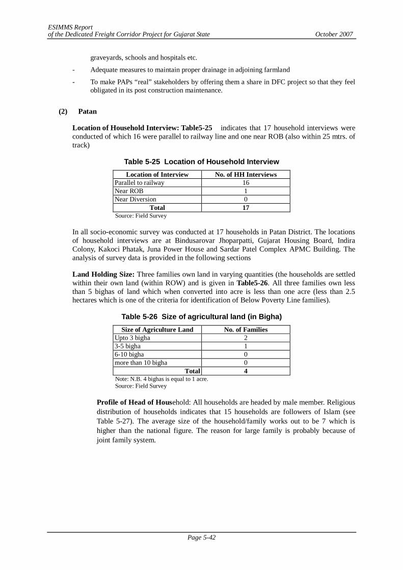
ESIMMS Report of the Dedicated Freight Corridor Project for Gujarat State October 2007
Page 5-42
graveyards, schools and hospitals etc.
- Adequate measures to maintain proper drainage in adjoining farmland
- To make PAPs “real” stakeholders by offering them a share in DFC project so that they feel obligated in its post construction maintenance.
(2) Patan
Location of Household Interview: Table5-25 indicates that 17 household interviews were conducted of which 16 were parallel to railway line and one near ROB (also within 25 mtrs. of track)
Table 5-25 Location of Household Interview Location of Interview No. of HH Interviews
Parallel to railway 16 Near ROB 1 Near Diversion 0
Total 17 Source: Field Survey
In all socio-economic survey was conducted at 17 households in Patan District. The locations of household interviews are at Bindusarovar Jhoparpatti, Gujarat Housing Board, Indira Colony, Kakoci Phatak, Juna Power House and Sardar Patel Complex APMC Building. The analysis of survey data is provided in the following sections
Land Holding Size: Three families own land in varying quantities (the households are settled within their own land (within ROW) and is given in Table5-26. All three families own less than 5 bighas of land which when converted into acre is less than one acre (less than 2.5 hectares which is one of the criteria for identification of Below Poverty Line families).
Table 5-26 Size of agricultural land (in Bigha) Size of Agriculture Land No. of Families
Upto 3 bigha 2 3-5 bigha 1 6-10 bigha 0 more than 10 bigha 0
Total 4 Note: N.B. 4 bighas is equal to 1 acre. Source: Field Survey
Profile of Head of Household: All households are headed by male member. Religious distribution of households indicates that 15 households are followers of Islam (see Table 5-27). The average size of the household/family works out to be 7 which is higher than the national figure. The reason for large family is probably because of joint family system.
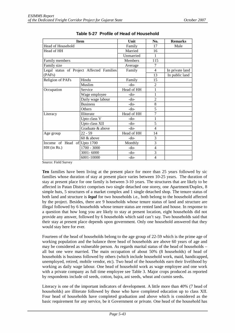
ESIMMS Report of the Dedicated Freight Corridor Project for Gujarat State October 2007
Page 5-43
Table 5-27 Profile of Head of Household Item Unit No. Remarks
Head of Household Family 17 Male Married 16 Head of HH
Unmarried 1 Family members Members 115 Family size Average 7
4 In private land Legal status of Project Affected Families (PAFs)
Family 13 In public land
Hindu Family 15 Religion of PAFs Muslim -do- 2 Service Head of HH 1 Wage employee -do- 1 Daily wage labour -do- 2 Business -do- 8
Occupation
Others -do- 5 Illiterate Head of HH 7 Upto class V -do- 1 Upto class XII -do- 5
Literacy
Graduate & above -do- 4 22 - 59 Head of HH 14 Age group 60 & above -do- 3 Upto 1700 Monthly 3 1700 - 3000 -do- 4 3001- 6000 -do- 3
Income of Head of HH (in Rs.)
6001-10000 -do- 4 Source: Field Survey
Ten families have been living at the present place for more than 25 years followed by sic families whose duration of stay at present place varies between 10-25 years. The duration of stay at present place for one family is between 3-10 years. The structures that are likely to be affected in Patan District comprises two single detached one storey, one Apartment/Duplex, 8 simple huts, 5 structures of a market complex and 1 single detached shop. The tenure status of both land and structure is legal for two households i.e., both belong to the household affected by the project. Besides, there are 9 households whose tenure status of land and structure are illegal followed by 6 households whose tenure status are rented land and house. In response to a question that how long you are likely to stay at present location, eight households did not provide any answer, followed by 6 households which said can’t say. Two households said that their stay at present place depends upon government. Only one household answered that they would stay here for ever.
Fourteen of the head of households belong to the age group of 22-59 which is the prime age of working population and the balance three head of households are above 60 years of age and may be considered as vulnerable person. As regards marital status of the head of households –all but one were married. The main occupation of about 50% (8 households) of head of households is business followed by others (which include household work, maid, handicapped, unemployed, retired, mobile vendor, etc). Two head of the households earn their livelihood by working as daily wage labour. One head of household work as wage employee and one work with a private company as full time employee see Table 3. Major crops produced as reported by respondents include oil seeds, cotton, bajra, ani seeds, wheat and cumin seeds.
Literacy is one of the important indicators of development. A little more than 40% (7 head of households) are illiterate followed by those who have completed education up to class XII. Four head of households have completed graduation and above which is considered as the basic requirement for any service, be it Government or private. One head of the household has
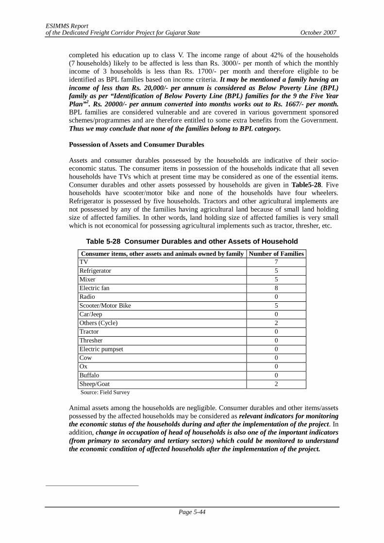
ESIMMS Report of the Dedicated Freight Corridor Project for Gujarat State October 2007
Page 5-44
completed his education up to class V. The income range of about 42% of the households (7 households) likely to be affected is less than Rs. 3000/- per month of which the monthly income of 3 households is less than Rs. 1700/- per month and therefore eligible to be identified as BPL families based on income criteria. It may be mentioned a family having an income of less than Rs. 20,000/- per annum is considered as Below Poverty Line (BPL) family as per “Identification of Below Poverty Line (BPL) families for the 9 the Five Year Plan”2. Rs. 20000/- per annum converted into months works out to Rs. 1667/- per month. BPL families are considered vulnerable and are covered in various government sponsored schemes/programmes and are therefore entitled to some extra benefits from the Government. Thus we may conclude that none of the families belong to BPL category.
Possession of Assets and Consumer Durables
Assets and consumer durables possessed by the households are indicative of their socio-economic status. The consumer items in possession of the households indicate that all seven households have TVs which at present time may be considered as one of the essential items. Consumer durables and other assets possessed by households are given in Table5-28. Five households have scooter/motor bike and none of the households have four wheelers. Refrigerator is possessed by five households. Tractors and other agricultural implements are not possessed by any of the families having agricultural land because of small land holding size of affected families. In other words, land holding size of affected families is very small which is not economical for possessing agricultural implements such as tractor, thresher, etc.
Table 5-28 Consumer Durables and other Assets of Household Consumer items, other assets and animals owned by family Number of Families TV 7 Refrigerator 5 Mixer 5 Electric fan 8 Radio 0 Scooter/Motor Bike 5 Car/Jeep 0 Others (Cycle) 2 Tractor 0 Thresher 0 Electric pumpset 0 Cow 0 Ox 0 Buffalo 0 Sheep/Goat 2 Source: Field Survey
Animal assets among the households are negligible. Consumer durables and other items/assets possessed by the affected households may be considered as relevant indicators for monitoring the economic status of the households during and after the implementation of the project. In addition, change in occupation of head of households is also one of the important indicators (from primary to secondary and tertiary sectors) which could be monitored to understand the economic condition of affected households after the implementation of the project.
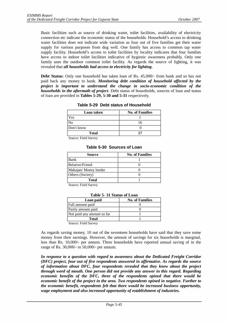
ESIMMS Report of the Dedicated Freight Corridor Project for Gujarat State October 2007
Page 5-45
Basic facilities such as source of drinking water, toilet facilities, availability of electricity connection etc indicate the economic status of the households. Household’s access to drinking water facilities does not indicate wide variation as four out of five families get their water supply for various purposes from dug well. One family has access to common tap water supply facility. Household’s access to toilet facilities by locality indicates that four families have access to indoor toilet facilities indicative of hygienic awareness probably. Only one family uses the outdoor common toilet facility. As regards the source of lighting, it was revealed that all households had access to electricity for lighting.
Debt Status: Only one household has taken loan of Rs. 45,000/- from bank and so has not paid back any money to bank. Monitoring debt condition of household affected by the project is important to understand the change in socio-economic condition of the households in the aftermath of project. Debt status of households, sources of loan and status of loan are provided in Tables 5-29, 5-30 and 5-31 respectively.
Table 5-29 Debt status of Household Loan taken No. of Families
Yes 1 No 16 Don't know 0
Total 17 Source: Field Survey
Table 5-30 Sources of Loan Source No. of Families
Bank 1 Relative/Friend 0 Mahajan/ Money lender 0 Others (Society) 0
Total 1 Source: Field Survey
Table 5- 31 Status of Loan
Loan paid No. of Families Full amount paid 0 Partly amount paid 0 Not paid any amount so far 1
Total 1 Source: Field Survey
As regards saving money, 10 out of the seventeen households have said that they save some money from their earnings. However, the amount of savings for six households is marginal, less than Rs. 10,000/- per annum. Three households have reported annual saving of in the range of Rs. 30,000/- to 50,000/- per annum.
In response to a question with regard to awareness about the Dedicated Freight Corridor (DFC) project, four out of five respondents answered in affirmative. As regards the source of information about DFC, four respondents revealed that they knew about the project through word of mouth. One person did not provide any answer in this regard. Regarding economic benefits of the DFC, three of the respondents opined that there would be economic benefit of the project in the area. Two respondents opined in negative. Further to the economic benefit, respondents felt that there would be increased business opportunity, wage employment and also increased opportunity of establishment of industries.
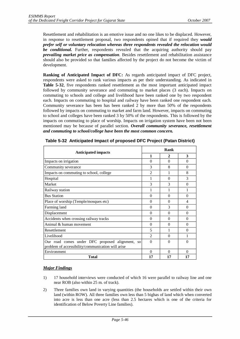
ESIMMS Report of the Dedicated Freight Corridor Project for Gujarat State October 2007
Page 5-46
Resettlement and rehabilitation is an emotive issue and no one likes to be displaced. However, in response to resettlement proposal, two respondents opined that if required they would prefer self or voluntary relocation whereas three respondents revealed the relocation would be conditional. Further, respondents revealed that the acquiring authority should pay prevailing market price as compensation. Besides resettlement and rehabilitation assistance should also be provided so that families affected by the project do not become the victim of development.
Ranking of Anticipated Impact of DFC: As regards anticipated impact of DFC project, respondents were asked to rank various impacts as per their understanding. As indicated in Table 5-32, five respondents ranked resettlement as the most important anticipated impact followed by community severance and commuting to market places (3 each). Impacts on commuting to schools and college and livelihood have been ranked one by two respondent each. Impacts on commuting to hospital and railway have been ranked one respondent each. Community severance has been has been ranked 2 by more than 50% of the respondents followed by impacts on commuting to market and farm land. However, impacts on commuting to school and colleges have been ranked 3 by 50% of the respondents. This is followed by the impacts on commuting to place of worship. Impacts on irrigation system have been not been mentioned may be because of parallel section. Overall community severance, resettlement and commuting to school/college have been the most common concern.
Table 5-32 Anticipated Impact of proposed DFC Project (Patan District)
Rank Anticipated impacts 1 2 3
Impacts on irrigation 0 0 0 Community severance 3 8 0 Impacts on commuting to school, college 2 1 8 Hospital 1 0 3 Market 3 3 0 Railway station 1 1 1 Bus Station 0 0 0 Place of worship (Temple/mosques etc) 0 0 4 Farming land 0 3 0 Displacement 0 0 0 Accidents when crossing railway tracks 0 0 0 Animal & human movement 0 0 0 Resettlement 5 1 0 Livelihood 2 0 1 Our road comes under DFC proposed alignment, so problem of accessibility/communication will arise
0 0 0
Environment 0 0 0 Total 17 17 17
Major Findings
1) 17 household interviews were conducted of which 16 were parallel to railway line and one near ROB (also within 25 m. of track).
2) Three families own land in varying quantities (the households are settled within their own land (within ROW). All three families own less than 5 bighas of land which when converted into acre is less than one acre (less than 2.5 hectares which is one of the criteria for identification of Below Poverty Line families).
ESIMMS Report of the Dedicated Freight Corridor Project for Gujarat State October 2007
Page 5-47
3) The average size of the household/family works out to be 7 which is very high as compared to national figure. The reason for large family is probably because of joint family system.
4) The structures that are likely to be affected in Patan District comprises two single detached one storey, one Apartment/Duplex, 8 simple huts, 5 structures of a market complex and 1 single detached shop. The tenure status of both land and structure is legal for two households i.e., both belong to the household affected by the project. Besides, there are 9 households whose tenure status of land and structure are illegal followed by 6 households whose tenure status are rented land and house.
5) Major crops produced as reported by respondents include Oil seeds, Cotton, Bajra, Jowar, ani seeds and cumin seeds.
6) The income range of about 42% of the households (7 households) likely to be affected is less than Rs.3,000/- per month of which the monthly income of 3 households is less than Rs.1,700/- per month and therefore eligible to be identified as BPL families based on income criteria.
7) Assets and consumer durables possessed by the households are indicative of their socio-economic status. Consumer durables and other items/assets possessed by the affected households may be considered as relevant indicators for monitoring the economic status of the households during and after the implementation of the project. In addition, change in occupation of head of households is also one of the important indicators (from primary to secondary and tertiary sectors) which could be monitored to understand the economic condition of affected households after the implementation of the project. TV has been the most common consumer durable/asset indicating two things: visual entertainment is popular and that information dissemination via visual media may be a tool for DFC implementation. Five households have scooter/motor bike and none of the households have four wheelers. Refrigerator is possessed by five households. Tractors and other agricultural implements are not possessed by any of the families having agricultural land because of small land holding size of affected families. In other words, land holding size of affected families is very small which is not economical for possessing agricultural implements such as tractor, thresher, etc.
8) Animal assets among the households are negligible. Consumer durables and other items/assets possessed by the affected households may be considered as relevant indicators for monitoring the economic status of the households during and after the implementation of the project. In addition, change in occupation of head of households is also one of the important indicators (from primary to secondary and tertiary sectors) which could be monitored to understand the economic condition of affected households after the implementation of the project.
9) As regards the source of lighting, it was revealed that all households had access to electricity for lighting.
10) Monitoring debt condition of household affected by the project is important to understand the change in socio-economic condition of the households in the aftermath of the project. Only one household has taken loan of Rs.45,000/- from bank and so has not paid back any money to bank. As regards saving money, respondents do save money depending upon their income level. As regards saving money, 10 out of the seventeen households have said that they save some money from their earnings. However, the amount of savings for six households is marginal, less than Rs.10,000/- per annum.
11) Overall community severance, resettlement and commuting to school/college have been the most common concern.
12) Resettlement and rehabilitation is an emotive issue and no one likes to be displaced. However, in response to resettlement proposal, two respondents opined that if required they would prefer self or voluntary relocation whereas three respondents revealed the relocation would be conditional. Further, respondents revealed that the acquiring authority should pay prevailing market price as compensation. Besides resettlement and rehabilitation assistance should also be provided so that families affected by the project do
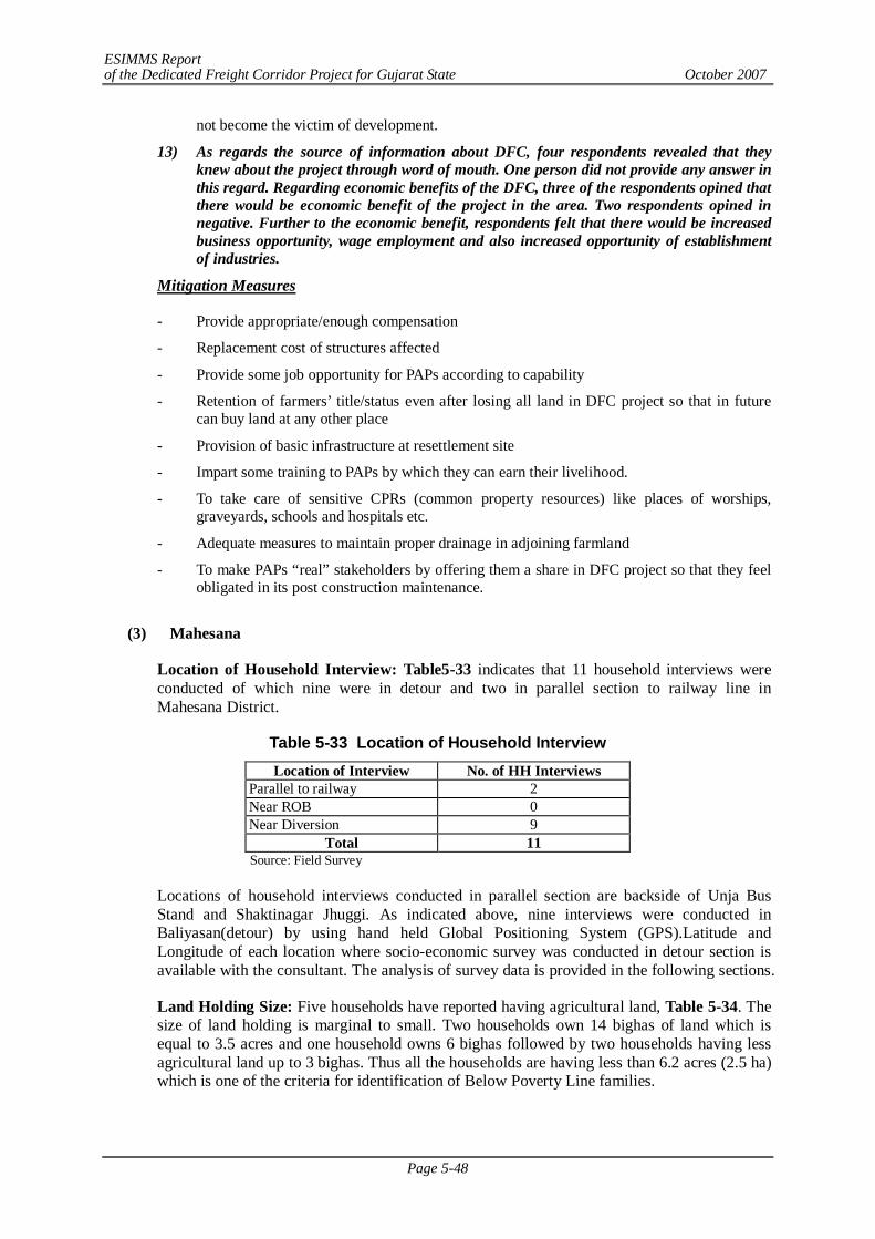
ESIMMS Report of the Dedicated Freight Corridor Project for Gujarat State October 2007
Page 5-48
not become the victim of development.
13) As regards the source of information about DFC, four respondents revealed that they knew about the project through word of mouth. One person did not provide any answer in this regard. Regarding economic benefits of the DFC, three of the respondents opined that there would be economic benefit of the project in the area. Two respondents opined in negative. Further to the economic benefit, respondents felt that there would be increased business opportunity, wage employment and also increased opportunity of establishment of industries.
Mitigation Measures
- Provide appropriate/enough compensation
- Replacement cost of structures affected
- Provide some job opportunity for PAPs according to capability
- Retention of farmers’ title/status even after losing all land in DFC project so that in future can buy land at any other place
- Provision of basic infrastructure at resettlement site
- Impart some training to PAPs by which they can earn their livelihood.
- To take care of sensitive CPRs (common property resources) like places of worships, graveyards, schools and hospitals etc.
- Adequate measures to maintain proper drainage in adjoining farmland
- To make PAPs “real” stakeholders by offering them a share in DFC project so that they feel obligated in its post construction maintenance.
(3) Mahesana
Location of Household Interview: Table5-33 indicates that 11 household interviews were conducted of which nine were in detour and two in parallel section to railway line in Mahesana District.
Table 5-33 Location of Household Interview Location of Interview No. of HH Interviews
Parallel to railway 2 Near ROB 0 Near Diversion 9
Total 11 Source: Field Survey
Locations of household interviews conducted in parallel section are backside of Unja Bus Stand and Shaktinagar Jhuggi. As indicated above, nine interviews were conducted in Baliyasan(detour) by using hand held Global Positioning System (GPS).Latitude and Longitude of each location where socio-economic survey was conducted in detour section is available with the consultant. The analysis of survey data is provided in the following sections.
Land Holding Size: Five households have reported having agricultural land, Table 5-34. The size of land holding is marginal to small. Two households own 14 bighas of land which is equal to 3.5 acres and one household owns 6 bighas followed by two households having less agricultural land up to 3 bighas. Thus all the households are having less than 6.2 acres (2.5 ha) which is one of the criteria for identification of Below Poverty Line families.

ESIMMS Report of the Dedicated Freight Corridor Project for Gujarat State October 2007
Page 5-49
Table 5-34 Size of Agricultural Land (in Bigha) Size of Agriculture Land No. of Families
Upto 3 bigha 2 3-5 bigha 0 6-10 bigha 1 more than 10 bigha 2
Total 5 Note: N.B. 4 bighas is equal to 1 acre. Source: Field Survey
Profile of Head of Household: The profile of head of household and relevant social and economic information is provided in Table5-35. All eleven households interviewed are headed by male member and ten are Hindu and one is Muslim. Out of the total households interviewed, one household belong to Schedule Caste, two of general category and eight belong to other backward castes. None of the households interviewed belong to ST category. It is important to mention here that SC and ST are considered vulnerable on the basis social considerations and are eligible for various kinds of assistances under government sponsored programmes/schemes. The average size of the households interviewed works out to be 4 which is less than the average household size of 5 for Mahesana District.
Table 5-35 Profile of Head of Household Item Unit No. Remarks
Male Family 11 Head of Household Female -do- 0
Married 11 Head of HH Unmarried 0
Family members Members 47 Family size Average 4
Family 9 In private land Legal status of Project Affected Families (PAFs) -do- 2 In public land
Hindu Family 10 Religion of PAFs Muslim -do- 1 General -do- 2 SC -do- 1 ST -do- 0
Social category of PAFs
OBC -do- 8 Service Head of HH 1 Wage employee -do- 7 Daily wage labour -do- 2 Business -do- 1
Occupation
Others -do- 0 Illiterate Head of HH 3 Can read & write -do- 0 Upto class V -do- 4 Upto class XII -do- 4
Literacy
Graduate & above -do- 0 22 - 59 Head of HH 7 Age group 60 & above -do- 4 Upto 1700 Monthly 9 1700 - 3000 -do- 1
Income of Head of HH (in Rs.)
3001- 6000 -do- 0 6001-10000 -do- 0 > 10000 -do- 1
Source: Field Survey
ESIMMS Report of the Dedicated Freight Corridor Project for Gujarat State October 2007
Page 5-50
Nine out of eleven families have been living at the present place for more than 25 years. Duration of stay of one family at present place is ten years and one family has recently shifted to the present place of stay. Structures that are likely to be affected by the project include seven single detached one storey, two single detached two storeys, one simple hut and one commercial structure (shop). The tenure status of both land and structure is legal for seven households i.e., both belong to the household affected by the project. Besides, there are three households whose tenure status of land are illegal but have constructed own house and six shops connected to each other are commercial squatter i.e., tenure status of land is illegal but have constructed own structure. In response to a question that how long you are likely to stay at present location, all the respondents said that they would be staying here for ever.
Majority of the head of households (7) belongs to the age group of 22-59 which is the prime age of working population and others are above 60 years of age and all head of households are married. The main occupation of seven head of households is agriculture as almost the entire alignment in the district traverses through the agricultural land. Two head of households earn their livelihood by working as daily wage labour. One head of household is employed in service and one is engaged in business. Crops grown by households having agricultural land include wheat, rice and sugar cane.
Literacy is one of the important indicators of development. Three head of the households are illiterate and four each head of households have completed education up to class V and class XII respectively. None of the head of household is graduate and above. The income range of majority of households (seven) is less than Rs.1,700/- per month which is the criteria for identification of BPL families. Only one household has reported income of Rs.10,000/- or more. It may be mentioned a family having an income of less than Rs.20,000/- per annum is considered as Below Poverty Line (BPL) family as per “Identification of Below Poverty Line (BPL) families for the 9 th Five Year Plan”3. Rs.20,000/- per annum converted into months works out to Rs.1,667/- per month. BPL families are considered vulnerable and are covered in various government sponsored schemes/programmes and are therefore entitled to some extra benefits from the Government. Overall the socio-economic condition of majority of households interviewed may be categorized as low socio-economic group.
Possession of Assets and Consumer Durables: Assets and consumer durables possessed by the households are indicators of the socio-economic status. Consumer durables and other assets possessed by households are given in Table 5-36. The consumer items in possession of the households indicate that six households have TVs which at present time is considered as one of the essential items. None of the households have scooter/motor bike or four wheelers. Refrigerator and mixer is possessed by only one household. Tractors and other agricultural implements are not possessed by any of the households though seven households possess agricultural land but all are marginal to small land holders. In other words, land holding size of affected families is very small which may not be economical for possessing agricultural implements such as tractor, thresher, etc.
3 The Government of India, Ministry of Rural Development conducts Below Poverty Line Census at the beginning of each
Five Year Plan to identify households living Below Poverty Line for providing assistance to households under various anti-poverty programmes implemented by the Ministry of Rural Development, Govt. of India. As per 9th Five Year Plan the criteria for identification of BPL households are 1. Up to Rs. 20,000/- per annum 2. Families having >2 hectares of land/pucca houses/annula income exceeding Rs. 20,000/-, TV/Refrigerator/Ceiling Fan/motor cycle/scooter/three wheeler were not considered to be BPL family. In the 10th Plan, the criteria for identification of BPL households changed. No fixed income limit, adoption of normative approach for identification of the Rural poor by introducing a “Score-based ranking” based on relative deprivations revealed by certain socio-economic indicators, in contrast to the Income and Expenditure approach adopted in the BPL Census for the 9th Plan.
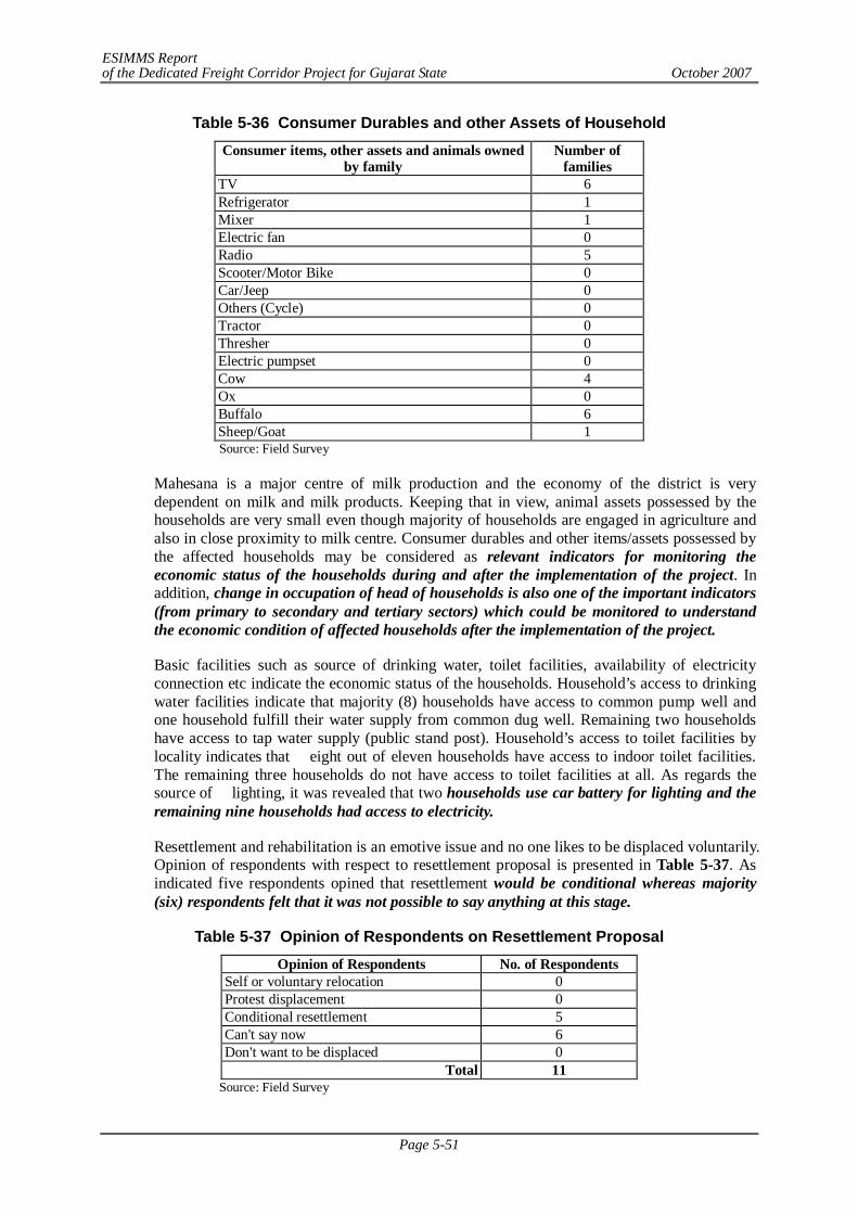
ESIMMS Report of the Dedicated Freight Corridor Project for Gujarat State October 2007
Page 5-51
Table 5-36 Consumer Durables and other Assets of Household Consumer items, other assets and animals owned
by family Number of
families TV 6 Refrigerator 1 Mixer 1 Electric fan 0 Radio 5 Scooter/Motor Bike 0 Car/Jeep 0 Others (Cycle) 0 Tractor 0 Thresher 0 Electric pumpset 0 Cow 4 Ox 0 Buffalo 6 Sheep/Goat 1 Source: Field Survey
Mahesana is a major centre of milk production and the economy of the district is very dependent on milk and milk products. Keeping that in view, animal assets possessed by the households are very small even though majority of households are engaged in agriculture and also in close proximity to milk centre. Consumer durables and other items/assets possessed by the affected households may be considered as relevant indicators for monitoring the economic status of the households during and after the implementation of the project. In addition, change in occupation of head of households is also one of the important indicators (from primary to secondary and tertiary sectors) which could be monitored to understand the economic condition of affected households after the implementation of the project.
Basic facilities such as source of drinking water, toilet facilities, availability of electricity connection etc indicate the economic status of the households. Household’s access to drinking water facilities indicate that majority (8) households have access to common pump well and one household fulfill their water supply from common dug well. Remaining two households have access to tap water supply (public stand post). Household’s access to toilet facilities by locality indicates that eight out of eleven households have access to indoor toilet facilities. The remaining three households do not have access to toilet facilities at all. As regards the source of lighting, it was revealed that two households use car battery for lighting and the remaining nine households had access to electricity.
Resettlement and rehabilitation is an emotive issue and no one likes to be displaced voluntarily. Opinion of respondents with respect to resettlement proposal is presented in Table 5-37. As indicated five respondents opined that resettlement would be conditional whereas majority (six) respondents felt that it was not possible to say anything at this stage.
Table 5-37 Opinion of Respondents on Resettlement Proposal Opinion of Respondents No. of Respondents
Self or voluntary relocation 0 Protest displacement 0 Conditional resettlement 5 Can't say now 6 Don't want to be displaced 0
Total 11 Source: Field Survey
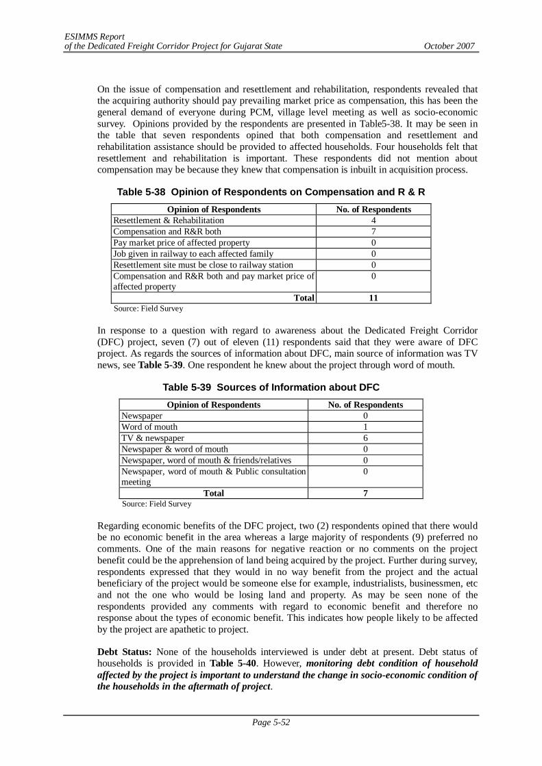
ESIMMS Report of the Dedicated Freight Corridor Project for Gujarat State October 2007
Page 5-52
On the issue of compensation and resettlement and rehabilitation, respondents revealed that the acquiring authority should pay prevailing market price as compensation, this has been the general demand of everyone during PCM, village level meeting as well as socio-economic survey. Opinions provided by the respondents are presented in Table5-38. It may be seen in the table that seven respondents opined that both compensation and resettlement and rehabilitation assistance should be provided to affected households. Four households felt that resettlement and rehabilitation is important. These respondents did not mention about compensation may be because they knew that compensation is inbuilt in acquisition process.
Table 5-38 Opinion of Respondents on Compensation and R & R Opinion of Respondents No. of Respondents
Resettlement & Rehabilitation 4 Compensation and R&R both 7 Pay market price of affected property 0 Job given in railway to each affected family 0 Resettlement site must be close to railway station 0 Compensation and R&R both and pay market price of affected property
0
Total 11 Source: Field Survey
In response to a question with regard to awareness about the Dedicated Freight Corridor (DFC) project, seven (7) out of eleven (11) respondents said that they were aware of DFC project. As regards the sources of information about DFC, main source of information was TV news, see Table 5-39. One respondent he knew about the project through word of mouth.
Table 5-39 Sources of Information about DFC Opinion of Respondents No. of Respondents
Newspaper 0 Word of mouth 1 TV & newspaper 6 Newspaper & word of mouth 0 Newspaper, word of mouth & friends/relatives 0 Newspaper, word of mouth & Public consultation meeting
0
Total 7 Source: Field Survey
Regarding economic benefits of the DFC project, two (2) respondents opined that there would be no economic benefit in the area whereas a large majority of respondents (9) preferred no comments. One of the main reasons for negative reaction or no comments on the project benefit could be the apprehension of land being acquired by the project. Further during survey, respondents expressed that they would in no way benefit from the project and the actual beneficiary of the project would be someone else for example, industrialists, businessmen, etc and not the one who would be losing land and property. As may be seen none of the respondents provided any comments with regard to economic benefit and therefore no response about the types of economic benefit. This indicates how people likely to be affected by the project are apathetic to project.
Debt Status: None of the households interviewed is under debt at present. Debt status of households is provided in Table 5-40. However, monitoring debt condition of household affected by the project is important to understand the change in socio-economic condition of the households in the aftermath of project.
ESIMMS Report of the Dedicated Freight Corridor Project for Gujarat State October 2007
Page 5-53
Table 5-40 Debt status of Household Loan taken No. of Families
Yes 0 No 11 Don't know 0
Total 11 Source: Field Survey
As regards saving money, only two households aid that they saved some money from their earnings. However, the amount of savings for both the households is less than Rs. 5000/- per annum
Ranking of Anticipated Impact of DFC:
As regards anticipated impacts of DFC project, respondents were asked to rank various impacts as per their understanding. As indicated in Table 5-41 five respondents ranked impacts on irrigation as the most important impact followed by impacts on commuting to school and college. Community severance and resettlement have been ranked 1 by one respondent each. Community severance has been ranked 2 by as many as seven respondents. One respondent has ranked impact on commuting to hospital as rank 2. Impacts on commuting to school and college have been ranked 3 by five respondents. Impacts on irrigation and community severance have been ranked 3 by two respondents each. Concerns due to DFC project on irrigation system, commuting to school/college, farm land, community severance etc were raised by participants in the public consultation meeting at Mehsana which have been again substantiated through the socio-economic survey. Overall impacts on irrigation, community severance and commuting to school/college have been the major concerns of respondents.
Table 5-41 Anticipated Impact of proposed DFC Project (Mahesana District) Rank Anticipated impacts 1 2 3
Impacts on irrigation 5 2 2 Community severance 1 7 2 Impacts on commuting to school, college 4 1 5 Hospital 0 1 0 Market 0 0 1 Railway station 0 0 0 Bus Station 0 0 0 Place of worship (Temple/mosques etc) 0 0 1 Farming land 0 0 0 Displacement 0 0 0 Accidents when crossing railway tracks 0 0 0 Animal & human movement 0 0 0 Resettlement 1 0 0 Livelihood 0 0 0 Our road comes under DFC proposed alignment, so problem of accessibility/communication will arise 0 0 0 Environment 0 0 0
Total 11 11 11 Source: Field Survey
Major Findings
1) In all 121 structures would be affected in Mahesana District. In Unjha, 24 structures would
ESIMMS Report of the Dedicated Freight Corridor Project for Gujarat State October 2007
Page 5-54
get affected and so 2 HH survey was conducted. And in Baliyasan, 9 HH survey conducted as a total of 91 Structures would be affected by DFC. Rajpur and Laxmipura were left out for obvious reasons.
2) Locations of household interviews conducted in parallel section are backside of Unjha Bus Stand and Shaktinagar Jhuggi. As indicated above, nine interviews were conducted in Baliyasan (detour) by using hand held Global Positioning System (GPS).
3) Five households have reported having agricultural land. The size of land holding is marginal to small. All the households are having less than 6.17 acres (2.5 hectare) which is one of the criteria for identification of Below Poverty Line families.
4) All eleven households interviewed are headed by male member and ten are Hindu and one is Muslim. Out of the total households interviewed, one household belong to Schedule Caste, two of general category and eight belong to other backward castes. None of the households interviewed belong to ST category.
5) The average size of the households interviewed works out to be 4 which is less than the average household size of 5 for Mahesana District.
6) Nine out of eleven families have been living at the present place for more than 25 years. Duration of stay of one family at present place is ten years and one family has recently shifted to the present place of stay. Structures that are likely to be affected by the project include seven single detached one storey, two single detached two storeys, one simple hut and one commercial structure (shop). The tenure status of both land and structure is legal for seven households i.e., both belong to the household affected by the project.
The main occupation of seven head of households is agriculture as almost the entire alignment in the district traverses through the agricultural land. Two head of households earn their livelihood by working as daily wage labour. One head of household is employed in service and one is engaged in business. Crops grown by households having agricultural land include wheat, rice and sugar cane.
Literacy is one of the important indicators of development. Three head of the households are illiterate and four each head of households have completed education up to class V and class XII respectively. None of the head of household is graduate and above. The income range of majority of households (seven) is less than Rs. 1700/- per month which is the criteria for identification of BPL families. Only one household has reported income of Rs. 10000/- or more. Overall the socio-economic condition of majority of households interviewed may be categorized as low socio-economic group.
None of the households have scooter/motor bike or four wheelers. Refrigerator and mixer is possessed by only one household. Tractors and other agricultural implements are not possessed by any of the households though seven households possess agricultural land but all are marginal to small land holders. In other words, land holding size of affected families is very small which may not be economical for possessing agricultural implements such as tractor, thresher, etc.
Mahesana is a major centre of milk production and the economy of the district is very dependent on milk and milk products. Keeping that in view, animal assets possessed by the households are very small even though majority of households are engaged in agriculture and also in close proximity to milk centre.
As indicated five respondents opined that resettlement would be conditional whereas majority (six) respondents felt that it was not possible to say anything at this stage.
On the issue of compensation and resettlement and rehabilitation, respondents revealed that the acquiring authority should pay prevailing market price as compensation, this has been the general demand of everyone during PCM, village level meeting as well as socio-economic survey.
Respondents expressed that they would in no way benefit from the project and the actual beneficiary of the project would be someone else for example, industrialists, businessmen,
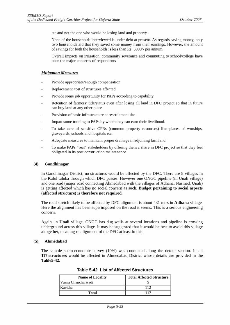
ESIMMS Report of the Dedicated Freight Corridor Project for Gujarat State October 2007
Page 5-55
etc and not the one who would be losing land and property.
None of the households interviewed is under debt at present. As regards saving money, only two households aid that they saved some money from their earnings. However, the amount of savings for both the households is less than Rs. 5000/- per annum.
Overall impacts on irrigation, community severance and commuting to school/college have been the major concerns of respondents
Mitigation Measures
- Provide appropriate/enough compensation
- Replacement cost of structures affected
- Provide some job opportunity for PAPs according to capability
- Retention of farmers’ title/status even after losing all land in DFC project so that in future can buy land at any other place
- Provision of basic infrastructure at resettlement site
- Impart some training to PAPs by which they can earn their livelihood.
- To take care of sensitive CPRs (common property resources) like places of worships, graveyards, schools and hospitals etc.
- Adequate measures to maintain proper drainage in adjoining farmland
- To make PAPs “real” stakeholders by offering them a share in DFC project so that they feel obligated in its post construction maintenance.
(4) Gandhinagar
In Gandhinagar District, no structures would be affected by the DFC. There are 8 villages in the Kalol taluka through which DFC passes. However one ONGC pipeline (in Unali village) and one road (major road connecting Ahmedabad with the villages of Adhana, Nasmed, Unali) is getting affected which has no social concern as such. Budget pertaining to social aspects (affected structure) is therefore not required.
The road stretch likely to be affected by DFC alignment is about 431 mtrs in Adhana village. Here the alignment has been superimposed on the road it seems. This is a serious engineering concern.
Again, in Unali village, ONGC has dug wells at several locations and pipeline is crossing underground across this village. It may be suggested that it would be best to avoid this village altogether, meaning re-alignment of the DFC at least in this.
(5) Ahmedabad
The sample socio-economic survey (10%) was conducted along the detour section. In all 117 structures would be affected in Ahmedabad District whose details are provided in the Table5-42.
Table 5-42 List of Affected Structures Name of Locality Total Affected Structure
Vasna Chancharwadi 5 Kavitha 112
Total 117
ESIMMS Report of the Dedicated Freight Corridor Project for Gujarat State October 2007
Page 5-56
Source: Field Survey
Location of Household Interview: 10% of the total households likely affected by the project were covered for the socio-economic survey. Table 5-43 indicates that in all, twelve (12) household were interviewed and all of them are in detour.
Table 5-43 Location of Household Interview Location of Interview No. of HH Interviews
Parallel to railway 0 Near ROB 0 Near Diversion 0 In Detour 12
Total 12 Source: Field Survey
Locations in the detour section for conducting the socio-economic survey was identified using hand held Global Positioning System (GPS). Latitude and Longitude of each location where socio-economic survey was conducted in detour section is available with the consultant. The analysis of survey data is provided in the following sections.
Land Holding Size: Only one family is having agricultural land, Table 5-44. The size of land holding is very small i.e., less than an acre. As per the criteria for identification of Below Poverty Line families, a family is eligible for identification as BPL family if the land holding of the family is less than 2.5 hectare.
Table 5-44 Size of Agricultural Land (in Bigha) Size of Agriculture Land No. of Families
Upto 3 bigha 1 3-5 bigha 0 6-10 bigha 0 more than 10 bigha 0
Total 1 Note: N.B. 4 bighas is equal to 1 acre. Source: Field Survey
Profile of Head of Household: The profile of head of household and relevant social and economic information is provided in Table 5-45. All twelve households interviewed are headed by male member and all belong to Hindu religion. Out of the households interviewed, two households belong to Schedule Caste, one of general category and nine comes under other backward castes. None of the households interviewed belong to ST category. It is important to mention here that SC and ST are considered vulnerable on the basis social considerations and are eligible for various kinds of assistances under government sponsored programmes/schemes. The average size of the household interviewed works out to be 7 which is very high compared to average household size of 5 for Ahmedabad District.
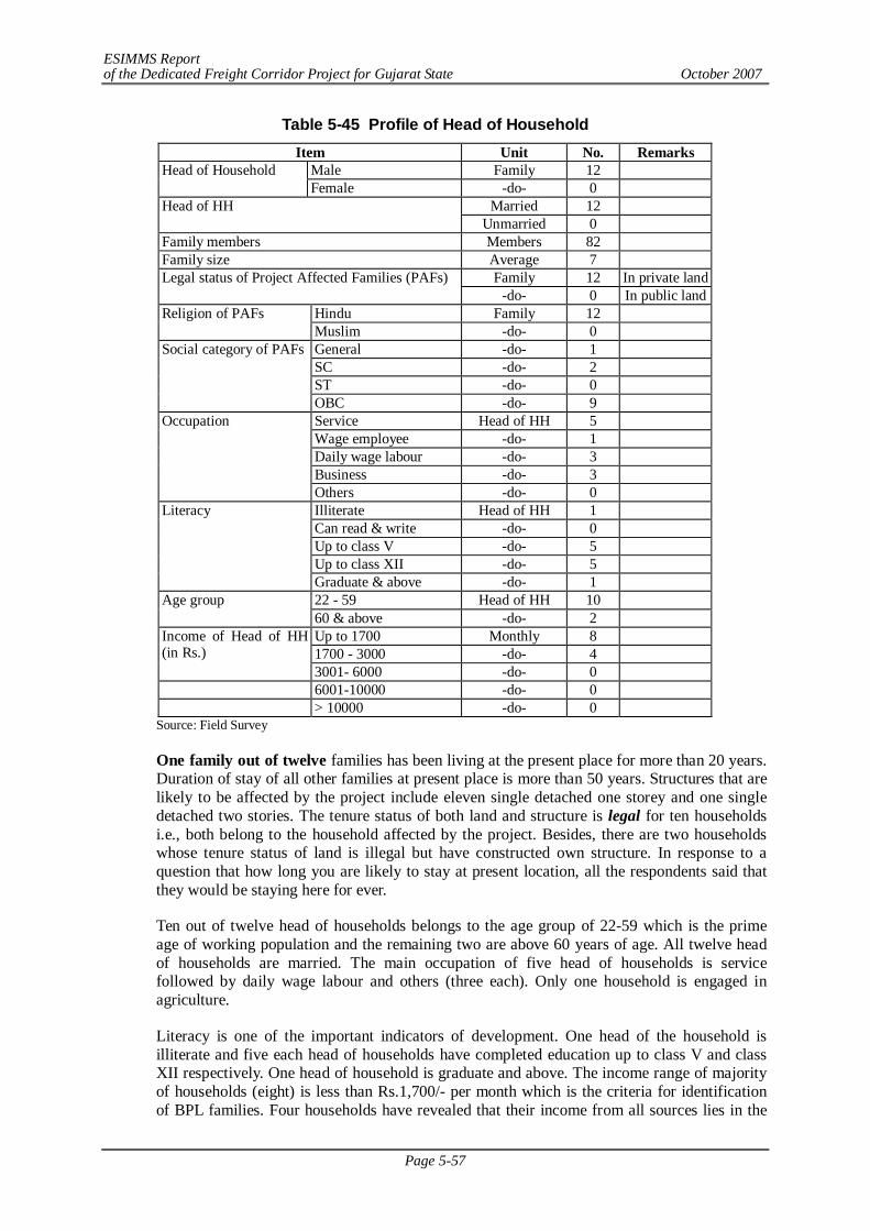
ESIMMS Report of the Dedicated Freight Corridor Project for Gujarat State October 2007
Page 5-57
Table 5-45 Profile of Head of Household Item Unit No. Remarks
Male Family 12 Head of Household Female -do- 0
Married 12 Head of HH Unmarried 0
Family members Members 82 Family size Average 7
Family 12 In private land Legal status of Project Affected Families (PAFs) -do- 0 In public land
Hindu Family 12 Religion of PAFs Muslim -do- 0 General -do- 1 SC -do- 2 ST -do- 0
Social category of PAFs
OBC -do- 9 Service Head of HH 5 Wage employee -do- 1 Daily wage labour -do- 3 Business -do- 3
Occupation
Others -do- 0 Illiterate Head of HH 1 Can read & write -do- 0 Up to class V -do- 5 Up to class XII -do- 5
Literacy
Graduate & above -do- 1 22 - 59 Head of HH 10 Age group 60 & above -do- 2 Up to 1700 Monthly 8 1700 - 3000 -do- 4
Income of Head of HH (in Rs.)
3001- 6000 -do- 0 6001-10000 -do- 0 > 10000 -do- 0
Source: Field Survey
One family out of twelve families has been living at the present place for more than 20 years. Duration of stay of all other families at present place is more than 50 years. Structures that are likely to be affected by the project include eleven single detached one storey and one single detached two stories. The tenure status of both land and structure is legal for ten households i.e., both belong to the household affected by the project. Besides, there are two households whose tenure status of land is illegal but have constructed own structure. In response to a question that how long you are likely to stay at present location, all the respondents said that they would be staying here for ever.
Ten out of twelve head of households belongs to the age group of 22-59 which is the prime age of working population and the remaining two are above 60 years of age. All twelve head of households are married. The main occupation of five head of households is service followed by daily wage labour and others (three each). Only one household is engaged in agriculture.
Literacy is one of the important indicators of development. One head of the household is illiterate and five each head of households have completed education up to class V and class XII respectively. One head of household is graduate and above. The income range of majority of households (eight) is less than Rs.1,700/- per month which is the criteria for identification of BPL families. Four households have revealed that their income from all sources lies in the
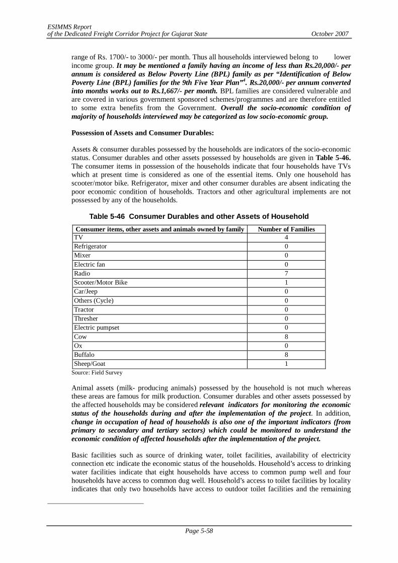
ESIMMS Report of the Dedicated Freight Corridor Project for Gujarat State October 2007
Page 5-58
range of Rs. 1700/- to 3000/- per month. Thus all households interviewed belong to lower income group. It may be mentioned a family having an income of less than Rs.20,000/- per annum is considered as Below Poverty Line (BPL) family as per “Identification of Below Poverty Line (BPL) families for the 9th Five Year Plan”4. Rs.20,000/- per annum converted into months works out to Rs.1,667/- per month. BPL families are considered vulnerable and are covered in various government sponsored schemes/programmes and are therefore entitled to some extra benefits from the Government. Overall the socio-economic condition of majority of households interviewed may be categorized as low socio-economic group.
Possession of Assets and Consumer Durables:
Assets & consumer durables possessed by the households are indicators of the socio-economic status. Consumer durables and other assets possessed by households are given in Table 5-46. The consumer items in possession of the households indicate that four households have TVs which at present time is considered as one of the essential items. Only one household has scooter/motor bike. Refrigerator, mixer and other consumer durables are absent indicating the poor economic condition of households. Tractors and other agricultural implements are not possessed by any of the households.
Table 5-46 Consumer Durables and other Assets of Household Consumer items, other assets and animals owned by family Number of Families TV 4 Refrigerator 0 Mixer 0 Electric fan 0 Radio 7 Scooter/Motor Bike 1 Car/Jeep 0 Others (Cycle) 0 Tractor 0 Thresher 0 Electric pumpset 0 Cow 8 Ox 0 Buffalo 8 Sheep/Goat 1
Source: Field Survey
Animal assets (milk- producing animals) possessed by the household is not much whereas these areas are famous for milk production. Consumer durables and other assets possessed by the affected households may be considered relevant indicators for monitoring the economic status of the households during and after the implementation of the project. In addition, change in occupation of head of households is also one of the important indicators (from primary to secondary and tertiary sectors) which could be monitored to understand the economic condition of affected households after the implementation of the project.
Basic facilities such as source of drinking water, toilet facilities, availability of electricity connection etc indicate the economic status of the households. Household’s access to drinking water facilities indicate that eight households have access to common pump well and four households have access to common dug well. Household’s access to toilet facilities by locality indicates that only two households have access to outdoor toilet facilities and the remaining
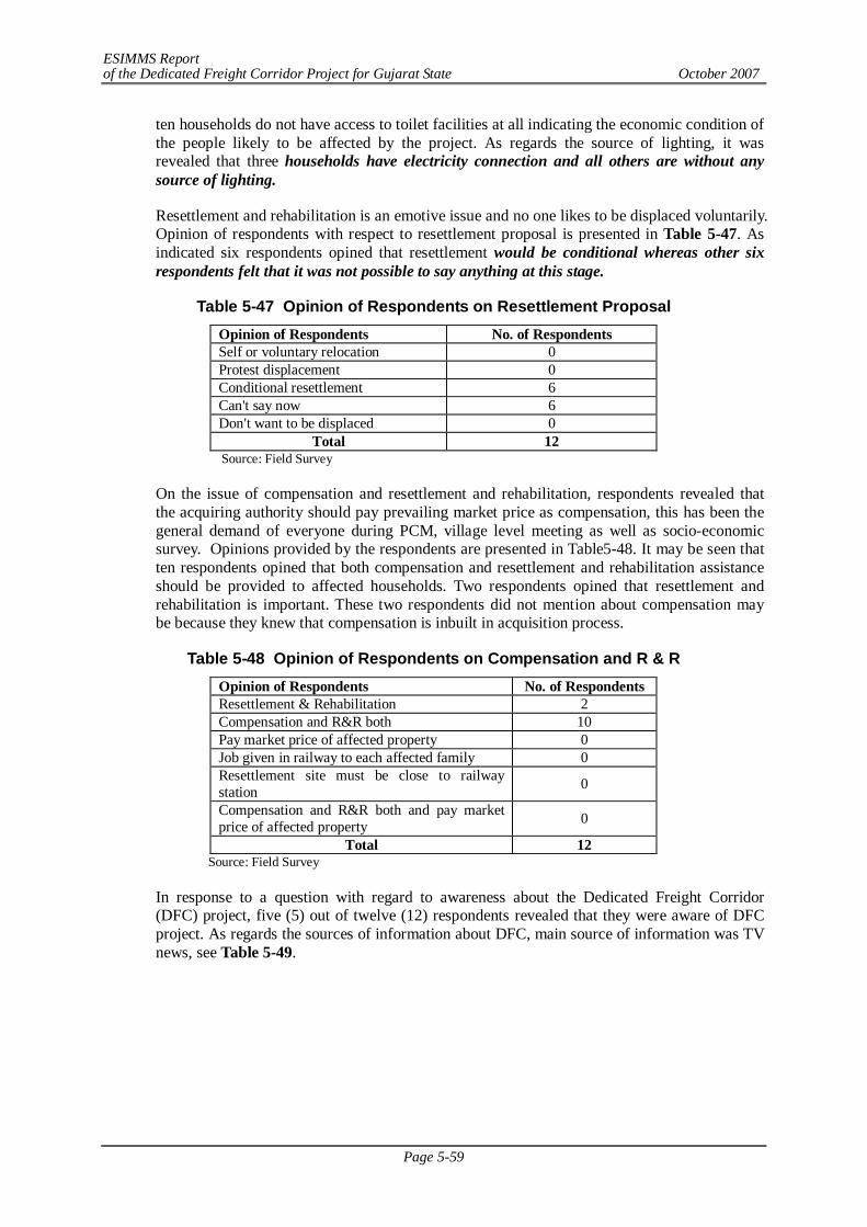
ESIMMS Report of the Dedicated Freight Corridor Project for Gujarat State October 2007
Page 5-59
ten households do not have access to toilet facilities at all indicating the economic condition of the people likely to be affected by the project. As regards the source of lighting, it was revealed that three households have electricity connection and all others are without any source of lighting.
Resettlement and rehabilitation is an emotive issue and no one likes to be displaced voluntarily. Opinion of respondents with respect to resettlement proposal is presented in Table 5-47. As indicated six respondents opined that resettlement would be conditional whereas other six respondents felt that it was not possible to say anything at this stage.
Table 5-47 Opinion of Respondents on Resettlement Proposal Opinion of Respondents No. of Respondents Self or voluntary relocation 0 Protest displacement 0 Conditional resettlement 6 Can't say now 6 Don't want to be displaced 0
Total 12 Source: Field Survey
On the issue of compensation and resettlement and rehabilitation, respondents revealed that the acquiring authority should pay prevailing market price as compensation, this has been the general demand of everyone during PCM, village level meeting as well as socio-economic survey. Opinions provided by the respondents are presented in Table5-48. It may be seen that ten respondents opined that both compensation and resettlement and rehabilitation assistance should be provided to affected households. Two respondents opined that resettlement and rehabilitation is important. These two respondents did not mention about compensation may be because they knew that compensation is inbuilt in acquisition process.
Table 5-48 Opinion of Respondents on Compensation and R & R Opinion of Respondents No. of Respondents Resettlement & Rehabilitation 2 Compensation and R&R both 10 Pay market price of affected property 0 Job given in railway to each affected family 0 Resettlement site must be close to railway station 0
Compensation and R&R both and pay market price of affected property 0
Total 12 Source: Field Survey
In response to a question with regard to awareness about the Dedicated Freight Corridor (DFC) project, five (5) out of twelve (12) respondents revealed that they were aware of DFC project. As regards the sources of information about DFC, main source of information was TV news, see Table 5-49.
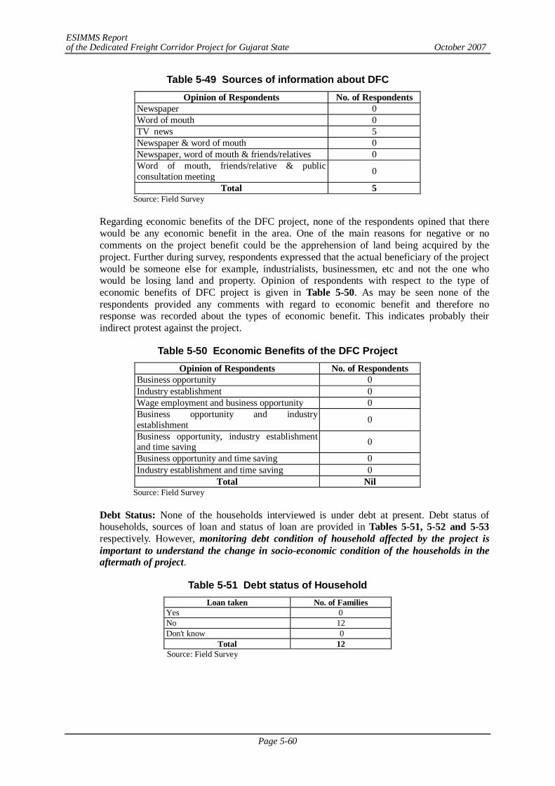
ESIMMS Report of the Dedicated Freight Corridor Project for Gujarat State October 2007
Page 5-60
Table 5-49 Sources of information about DFC Opinion of Respondents No. of Respondents
Newspaper 0 Word of mouth 0 TV news 5 Newspaper & word of mouth 0 Newspaper, word of mouth & friends/relatives 0 Word of mouth, friends/relative & public consultation meeting 0
Total 5 Source: Field Survey
Regarding economic benefits of the DFC project, none of the respondents opined that there would be any economic benefit in the area. One of the main reasons for negative or no comments on the project benefit could be the apprehension of land being acquired by the project. Further during survey, respondents expressed that the actual beneficiary of the project would be someone else for example, industrialists, businessmen, etc and not the one who would be losing land and property. Opinion of respondents with respect to the type of economic benefits of DFC project is given in Table 5-50. As may be seen none of the respondents provided any comments with regard to economic benefit and therefore no response was recorded about the types of economic benefit. This indicates probably their indirect protest against the project.
Table 5-50 Economic Benefits of the DFC Project Opinion of Respondents No. of Respondents
Business opportunity 0 Industry establishment 0 Wage employment and business opportunity 0 Business opportunity and industry establishment 0
Business opportunity, industry establishment and time saving 0
Business opportunity and time saving 0 Industry establishment and time saving 0
Total Nil Source: Field Survey
Debt Status: None of the households interviewed is under debt at present. Debt status of households, sources of loan and status of loan are provided in Tables 5-51, 5-52 and 5-53 respectively. However, monitoring debt condition of household affected by the project is important to understand the change in socio-economic condition of the households in the aftermath of project.
Table 5-51 Debt status of Household Loan taken No. of Families
Yes 0 No 12 Don't know 0
Total 12 Source: Field Survey

ESIMMS Report of the Dedicated Freight Corridor Project for Gujarat State October 2007
Page 5-61
Table 5-52 Sources of Loan Source No. of Families
Bank 0 Relative/Friend 0 Mahajan/ Money lender 0 Others (Society) 0
Total Not applicable Source: Field Survey
Table 5-53 Status of Loan
Loan paid No. of Families Full amount paid 0 Partly amount paid 0 Not paid any amount so far 0
Total Not Applicable Source: Field Survey
As regards saving money, none of families revealed that they save any money. This is possible as income of all the families surveyed is less than Rs.3,000/- per month and the average size of family is quite high.
Ranking of Anticipated Impact of DFC:
As regards anticipated impacts of DFC project, respondents were asked to rank various impacts as per their understanding. As indicated in Table 5-54, seven respondents ranked impacts on commuting to school and college as the most important impacts followed by impacts on irrigation as the most important impact followed by impacts on commuting to school and college. Community severance has been perceived as second and third important impacts by six respondents each. Overall community severance, impacts on community to school/college and impacts on irrigation are the major concerns of respondents. Some of the perceived impacts may be addressed by integrating social and engineering components. For example, provision of underpass based on ground realities and in built provision for laying irrigation pipeline across the railway line would address some of the concerns of the people in the area.
Table 5-54 Anticipated Impact of proposed DFC Project (Ahmedabad District) Rank Anticipated impacts 1 2 3
Impacts on irrigation 5 4 3 Community severance 0 6 6 Impacts on commuting to school, college 7 2 3 Hospital 0 0 0 Market 0 0 0 Railway station 0 0 0 Bus Station 0 0 0 Place of worship (Temple/mosques etc) 0 0 0 Farming land 0 0 0 Displacement 0 0 0 Accidents when crossing railway tracks 0 0 0 Animal & human movement 0 0 0 Resettlement 0 0 0 Livelihood 0 0 0 Our road comes under DFC proposed alignment, so problem of accessibility/communication will arise 0 0 0 Environment 0 0 0
Total 12 12 12 Source: Field Survey
ESIMMS Report of the Dedicated Freight Corridor Project for Gujarat State October 2007
Page 5-62
Summary of the survey results
- In all, twelve (12) household were interviewed and all of them are in detour.
- Only one family is having agricultural land. The size of land holding is very small i.e., less than an acre.
- All twelve households interviewed are headed by male member and all belong to Hindu religion. Out of the total households interviewed, two households belong to Schedule Caste, one of general category and nine comes under other backward castes. None of the households interviewed belong to ST category. The average size of the household interviewed works out to be 7 which is very high compared to average household size of 5 for Ahmedabad District.
- Structures that are likely to be affected by the project include eleven single detached one storey and one single detached two stories. The tenure status of both land and structure is legal for ten households i.e., both belong to the household affected by the project. Besides, there are two households whose tenure status of land is illegal but have constructed own structure.
- One head of the household is illiterate and five each head of households have completed education up to class V and class XII respectively. One head of household is graduate and above. The income range of majority of households (eight) is less than Rs. 1700/- per month which is the criteria for identification of BPL families. Four households have revealed that their income from all sources lies in the range of Rs. 1700/- to 3000/- per month. Thus all households interviewed belong to lower income group. Overall the socio-economic condition of majority of households interviewed may be categorized as low socio-economic group.
- Only one household has scooter/motor bike. Refrigerator, mixer and other consumer durables are absent indicating the poor economic condition of households. Tractors and other agricultural implements are not possessed by any of the households.
- Household’s access to drinking water facilities indicate that eight households have access to common pump well and four households have access to common dug well. Household’s access to toilet facilities by locality indicates that only two households have access to outdoor toilet facilities and the remaining ten households do not have access to toilet facilities at all indicating the economic condition of the people likely to be affected by the project.
- As indicated six respondents opined that resettlement would be conditional whereas other six respondents felt that it was not possible to say anything at this stage.
- On the issue of compensation and resettlement and rehabilitation, respondents revealed that the acquiring authority should pay prevailing market price as compensation, this has been the general demand of everyone during PCM, village level meeting as well as socio-economic survey.
- Regarding economic benefits of the DFC project, none of the respondents opined that there would be any economic benefit in the area. One of the main reasons for negative or no comments on the project benefit could be the apprehension of land being acquired by the project. Further during survey, respondents expressed that the actual beneficiary of the project would be someone else for example, industrialists, businessmen, etc and not the one who would be losing land and property.
- None of the households interviewed is under debt at present.
- Overall community severance, impacts on community to school/college and impacts on irrigation are the major concerns of respondents. Some of the perceived impacts may be addressed by integrating social and engineering components. For example, provision of underpass based on ground realities and in built provision for laying irrigation pipeline
ESIMMS Report of the Dedicated Freight Corridor Project for Gujarat State October 2007
Page 5-63
across the railway line would address some of the concerns of the people in the area.
Mitigation Measures
- Provide appropriate/enough compensation
- Replacement cost of structures affected
- Provide some job opportunity for PAPs according to capability
- Retention of farmers’ title/status even after losing all land in DFC project so that in future can buy land at any other place
- Provision of basic infrastructure at resettlement site
- Impart some training to PAPs by which they can earn their livelihood.
- To take care of sensitive CPRs (common property resources) like places of worships, graveyards, schools and hospitals etc.
- Adequate measures to maintain proper drainage in adjoining farmland
- To make PAPs “real” stakeholders by offering them a share in DFC project so that they feel obligated in its post construction maintenance.
(6) Kheda
In Kheda District, which lies in detour section DFC crosses mostly agricultural land with only two structures being affected. There are 6 villages in the Kheda Taluka and seven villages in Matar Taluka respectively through which the proposed DFC passes. The socio-economic household survey was not conducted because of lack of requisite number of structures (less than ten) likely to be affected. Both the structures affected are in Shetra village which comes under Kheda Taluka. The residential structure is made of kutcha material and the storehouse is a pucca structure. The name of head of household of residential structure is Parmar Ramtu Atmarambhai. The owner of the godown is Pathan Gulamghose Usmanbhai. One of the owners is Muslim whereas another one is a Hindu and both come under the social category of other backward castes. The occupation of storehouse owner is business whereas that of other person is agriculture. The tenure status of both land and structures is legal. Therefore, on social environment, no significant impact is involved
(7) Anand
In Anand District which lies in detour section, twelve structures would be affected by the DFC alignment- 11 structures in Airdi and one structure each in Sunav and Sandesar -- all under Anand Taluka. In total, in Anand District, 11 out of 12 structures are presently used for residential purposes. One structure in Sandesar is a storehouse. Except this storehouse which is a pucca structure, all other structures are kutchha structures. The owner of the storehouse is a businessman and all others are farmers.
All affected persons belong to Hindu religion and their social category is OBC (other backward castes). The tenure status of both land and structure is legal for all except one residential structure owner. The proposed DFC traverses through the administrative boundaries of 28 villages under 5 Talukas.
The socio-economic household survey was conducted at only 1 structure at Airdi village as total of ten structures would be affected in the village (as per 10% socio-economic survey).
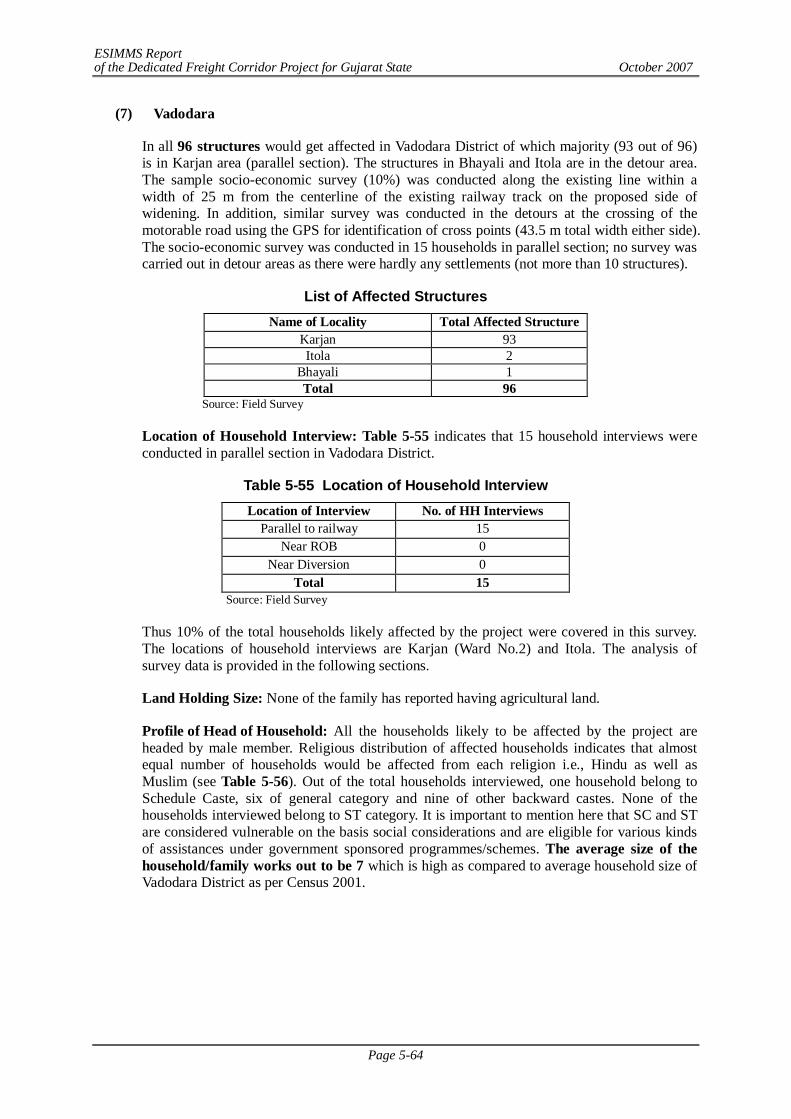
ESIMMS Report of the Dedicated Freight Corridor Project for Gujarat State October 2007
Page 5-64
(7) Vadodara
In all 96 structures would get affected in Vadodara District of which majority (93 out of 96) is in Karjan area (parallel section). The structures in Bhayali and Itola are in the detour area. The sample socio-economic survey (10%) was conducted along the existing line within a width of 25 m from the centerline of the existing railway track on the proposed side of widening. In addition, similar survey was conducted in the detours at the crossing of the motorable road using the GPS for identification of cross points (43.5 m total width either side). The socio-economic survey was conducted in 15 households in parallel section; no survey was carried out in detour areas as there were hardly any settlements (not more than 10 structures).
List of Affected Structures Name of Locality Total Affected Structure
Karjan 93 Itola 2
Bhayali 1 Total 96
Source: Field Survey
Location of Household Interview: Table 5-55 indicates that 15 household interviews were conducted in parallel section in Vadodara District.
Table 5-55 Location of Household Interview Location of Interview No. of HH Interviews
Parallel to railway 15 Near ROB 0
Near Diversion 0 Total 15
Source: Field Survey
Thus 10% of the total households likely affected by the project were covered in this survey. The locations of household interviews are Karjan (Ward No.2) and Itola. The analysis of survey data is provided in the following sections.
Land Holding Size: None of the family has reported having agricultural land.
Profile of Head of Household: All the households likely to be affected by the project are headed by male member. Religious distribution of affected households indicates that almost equal number of households would be affected from each religion i.e., Hindu as well as Muslim (see Table 5-56). Out of the total households interviewed, one household belong to Schedule Caste, six of general category and nine of other backward castes. None of the households interviewed belong to ST category. It is important to mention here that SC and ST are considered vulnerable on the basis social considerations and are eligible for various kinds of assistances under government sponsored programmes/schemes. The average size of the household/family works out to be 7 which is high as compared to average household size of Vadodara District as per Census 2001.
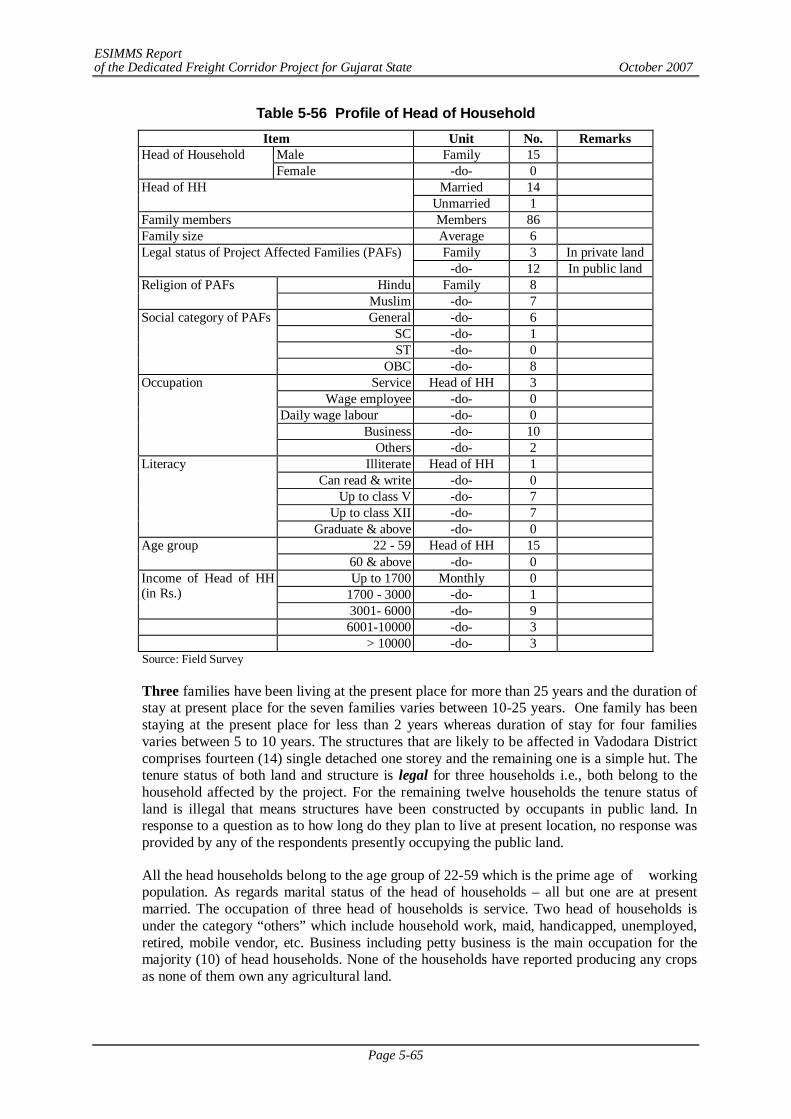
ESIMMS Report of the Dedicated Freight Corridor Project for Gujarat State October 2007
Page 5-65
Table 5-56 Profile of Head of Household Item Unit No. Remarks
Male Family 15 Head of Household Female -do- 0
Married 14 Head of HH Unmarried 1
Family members Members 86 Family size Average 6
Family 3 In private land Legal status of Project Affected Families (PAFs) -do- 12 In public land
Hindu Family 8 Religion of PAFs Muslim -do- 7 General -do- 6
SC -do- 1 ST -do- 0
Social category of PAFs
OBC -do- 8 Service Head of HH 3
Wage employee -do- 0 Daily wage labour -do- 0
Business -do- 10
Occupation
Others -do- 2 Illiterate Head of HH 1
Can read & write -do- 0 Up to class V -do- 7
Up to class XII -do- 7
Literacy
Graduate & above -do- 0 22 - 59 Head of HH 15 Age group
60 & above -do- 0 Up to 1700 Monthly 0
1700 - 3000 -do- 1 Income of Head of HH (in Rs.)
3001- 6000 -do- 9 6001-10000 -do- 3 > 10000 -do- 3
Source: Field Survey
Three families have been living at the present place for more than 25 years and the duration of stay at present place for the seven families varies between 10-25 years. One family has been staying at the present place for less than 2 years whereas duration of stay for four families varies between 5 to 10 years. The structures that are likely to be affected in Vadodara District comprises fourteen (14) single detached one storey and the remaining one is a simple hut. The tenure status of both land and structure is legal for three households i.e., both belong to the household affected by the project. For the remaining twelve households the tenure status of land is illegal that means structures have been constructed by occupants in public land. In response to a question as to how long do they plan to live at present location, no response was provided by any of the respondents presently occupying the public land.
All the head households belong to the age group of 22-59 which is the prime age of working population. As regards marital status of the head of households – all but one are at present married. The occupation of three head of households is service. Two head of households is under the category “others” which include household work, maid, handicapped, unemployed, retired, mobile vendor, etc. Business including petty business is the main occupation for the majority (10) of head households. None of the households have reported producing any crops as none of them own any agricultural land.
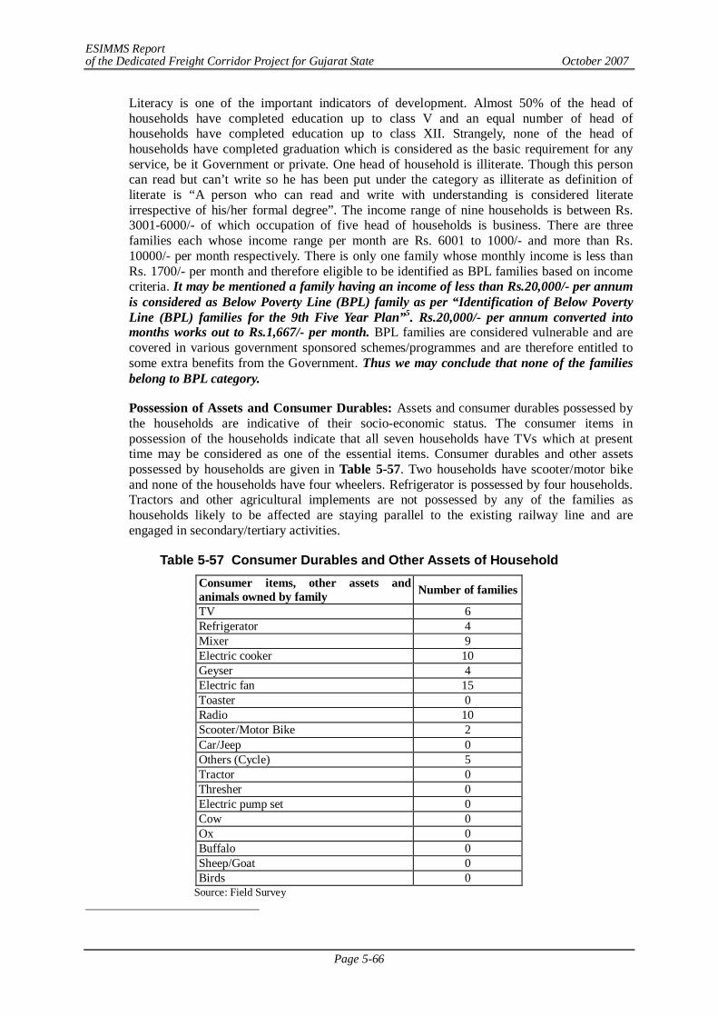
ESIMMS Report of the Dedicated Freight Corridor Project for Gujarat State October 2007
Page 5-66
Literacy is one of the important indicators of development. Almost 50% of the head of households have completed education up to class V and an equal number of head of households have completed education up to class XII. Strangely, none of the head of households have completed graduation which is considered as the basic requirement for any service, be it Government or private. One head of household is illiterate. Though this person can read but can’t write so he has been put under the category as illiterate as definition of literate is “A person who can read and write with understanding is considered literate irrespective of his/her formal degree”. The income range of nine households is between Rs. 3001-6000/- of which occupation of five head of households is business. There are three families each whose income range per month are Rs. 6001 to 1000/- and more than Rs. 10000/- per month respectively. There is only one family whose monthly income is less than Rs. 1700/- per month and therefore eligible to be identified as BPL families based on income criteria. It may be mentioned a family having an income of less than Rs.20,000/- per annum is considered as Below Poverty Line (BPL) family as per “Identification of Below Poverty Line (BPL) families for the 9th Five Year Plan”5. Rs.20,000/- per annum converted into months works out to Rs.1,667/- per month. BPL families are considered vulnerable and are covered in various government sponsored schemes/programmes and are therefore entitled to some extra benefits from the Government. Thus we may conclude that none of the families belong to BPL category.
Possession of Assets and Consumer Durables: Assets and consumer durables possessed by the households are indicative of their socio-economic status. The consumer items in possession of the households indicate that all seven households have TVs which at present time may be considered as one of the essential items. Consumer durables and other assets possessed by households are given in Table 5-57. Two households have scooter/motor bike and none of the households have four wheelers. Refrigerator is possessed by four households. Tractors and other agricultural implements are not possessed by any of the families as households likely to be affected are staying parallel to the existing railway line and are engaged in secondary/tertiary activities.
Table 5-57 Consumer Durables and Other Assets of Household Consumer items, other assets and animals owned by family Number of families
TV 6 Refrigerator 4 Mixer 9 Electric cooker 10 Geyser 4 Electric fan 15 Toaster 0 Radio 10 Scooter/Motor Bike 2 Car/Jeep 0 Others (Cycle) 5 Tractor 0 Thresher 0 Electric pump set 0 Cow 0 Ox 0 Buffalo 0 Sheep/Goat 0 Birds 0
Source: Field Survey
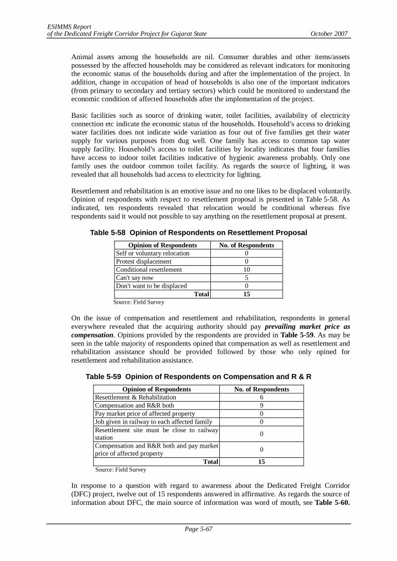
ESIMMS Report of the Dedicated Freight Corridor Project for Gujarat State October 2007
Page 5-67
Animal assets among the households are nil. Consumer durables and other items/assets possessed by the affected households may be considered as relevant indicators for monitoring the economic status of the households during and after the implementation of the project. In addition, change in occupation of head of households is also one of the important indicators (from primary to secondary and tertiary sectors) which could be monitored to understand the economic condition of affected households after the implementation of the project.
Basic facilities such as source of drinking water, toilet facilities, availability of electricity connection etc indicate the economic status of the households. Household’s access to drinking water facilities does not indicate wide variation as four out of five families get their water supply for various purposes from dug well. One family has access to common tap water supply facility. Household’s access to toilet facilities by locality indicates that four families have access to indoor toilet facilities indicative of hygienic awareness probably. Only one family uses the outdoor common toilet facility. As regards the source of lighting, it was revealed that all households had access to electricity for lighting.
Resettlement and rehabilitation is an emotive issue and no one likes to be displaced voluntarily. Opinion of respondents with respect to resettlement proposal is presented in Table 5-58. As indicated, ten respondents revealed that relocation would be conditional whereas five respondents said it would not possible to say anything on the resettlement proposal at present.
Table 5-58 Opinion of Respondents on Resettlement Proposal Opinion of Respondents No. of Respondents
Self or voluntary relocation 0 Protest displacement 0 Conditional resettlement 10 Can't say now 5 Don't want to be displaced 0
Total 15 Source: Field Survey
On the issue of compensation and resettlement and rehabilitation, respondents in general everywhere revealed that the acquiring authority should pay prevailing market price as compensation. Opinions provided by the respondents are provided in Table 5-59. As may be seen in the table majority of respondents opined that compensation as well as resettlement and rehabilitation assistance should be provided followed by those who only opined for resettlement and rehabilitation assistance.
Table 5-59 Opinion of Respondents on Compensation and R & R Opinion of Respondents No. of Respondents
Resettlement & Rehabilitation 6 Compensation and R&R both 9 Pay market price of affected property 0 Job given in railway to each affected family 0 Resettlement site must be close to railway station 0
Compensation and R&R both and pay market price of affected property 0
Total 15 Source: Field Survey
In response to a question with regard to awareness about the Dedicated Freight Corridor (DFC) project, twelve out of 15 respondents answered in affirmative. As regards the source of information about DFC, the main source of information was word of mouth, see Table 5-60.
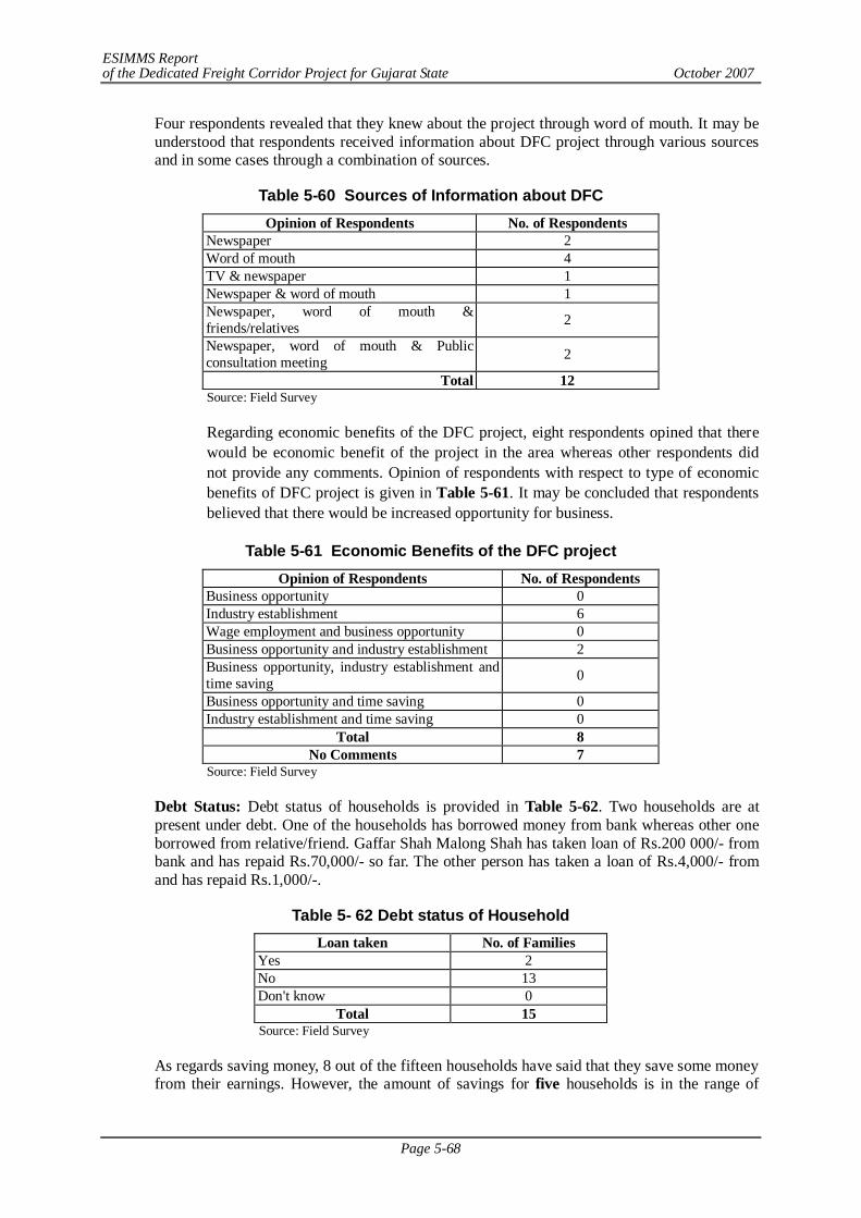
ESIMMS Report of the Dedicated Freight Corridor Project for Gujarat State October 2007
Page 5-68
Four respondents revealed that they knew about the project through word of mouth. It may be understood that respondents received information about DFC project through various sources and in some cases through a combination of sources.
Table 5-60 Sources of Information about DFC Opinion of Respondents No. of Respondents
Newspaper 2 Word of mouth 4 TV & newspaper 1 Newspaper & word of mouth 1 Newspaper, word of mouth & friends/relatives 2
Newspaper, word of mouth & Public consultation meeting 2
Total 12 Source: Field Survey
Regarding economic benefits of the DFC project, eight respondents opined that there would be economic benefit of the project in the area whereas other respondents did not provide any comments. Opinion of respondents with respect to type of economic benefits of DFC project is given in Table 5-61. It may be concluded that respondents believed that there would be increased opportunity for business.
Table 5-61 Economic Benefits of the DFC project
Opinion of Respondents No. of Respondents Business opportunity 0 Industry establishment 6 Wage employment and business opportunity 0 Business opportunity and industry establishment 2 Business opportunity, industry establishment and time saving 0
Business opportunity and time saving 0 Industry establishment and time saving 0
Total 8 No Comments 7
Source: Field Survey
Debt Status: Debt status of households is provided in Table 5-62. Two households are at present under debt. One of the households has borrowed money from bank whereas other one borrowed from relative/friend. Gaffar Shah Malong Shah has taken loan of Rs.200 000/- from bank and has repaid Rs.70,000/- so far. The other person has taken a loan of Rs.4,000/- from and has repaid Rs.1,000/-.
Table 5- 62 Debt status of Household Loan taken No. of Families
Yes 2 No 13 Don't know 0
Total 15 Source: Field Survey
As regards saving money, 8 out of the fifteen households have said that they save some money from their earnings. However, the amount of savings for five households is in the range of
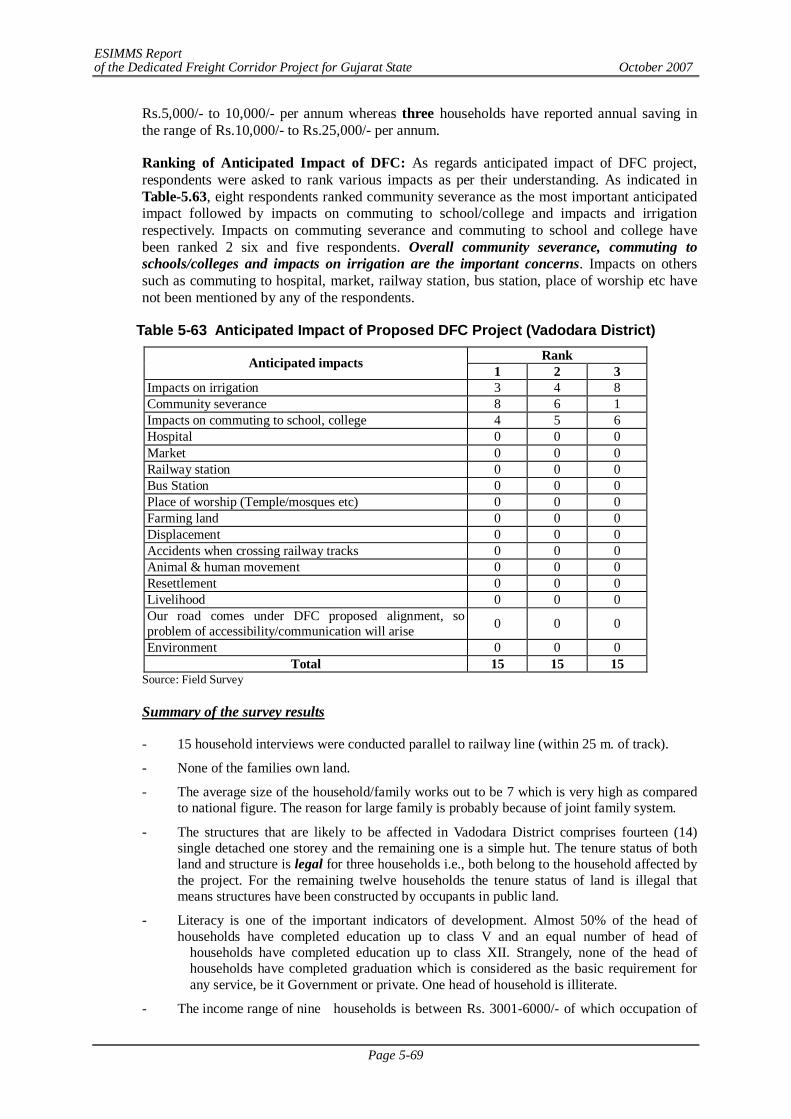
ESIMMS Report of the Dedicated Freight Corridor Project for Gujarat State October 2007
Page 5-69
Rs.5,000/- to 10,000/- per annum whereas three households have reported annual saving in the range of Rs.10,000/- to Rs.25,000/- per annum.
Ranking of Anticipated Impact of DFC: As regards anticipated impact of DFC project, respondents were asked to rank various impacts as per their understanding. As indicated in Table-5.63, eight respondents ranked community severance as the most important anticipated impact followed by impacts on commuting to school/college and impacts and irrigation respectively. Impacts on commuting severance and commuting to school and college have been ranked 2 six and five respondents. Overall community severance, commuting to schools/colleges and impacts on irrigation are the important concerns. Impacts on others such as commuting to hospital, market, railway station, bus station, place of worship etc have not been mentioned by any of the respondents.
Table 5-63 Anticipated Impact of Proposed DFC Project (Vadodara District) Rank Anticipated impacts 1 2 3
Impacts on irrigation 3 4 8 Community severance 8 6 1 Impacts on commuting to school, college 4 5 6 Hospital 0 0 0 Market 0 0 0 Railway station 0 0 0 Bus Station 0 0 0 Place of worship (Temple/mosques etc) 0 0 0 Farming land 0 0 0 Displacement 0 0 0 Accidents when crossing railway tracks 0 0 0 Animal & human movement 0 0 0 Resettlement 0 0 0 Livelihood 0 0 0 Our road comes under DFC proposed alignment, so problem of accessibility/communication will arise 0 0 0
Environment 0 0 0 Total 15 15 15
Source: Field Survey
Summary of the survey results
- 15 household interviews were conducted parallel to railway line (within 25 m. of track).
- None of the families own land.
- The average size of the household/family works out to be 7 which is very high as compared to national figure. The reason for large family is probably because of joint family system.
- The structures that are likely to be affected in Vadodara District comprises fourteen (14) single detached one storey and the remaining one is a simple hut. The tenure status of both land and structure is legal for three households i.e., both belong to the household affected by the project. For the remaining twelve households the tenure status of land is illegal that means structures have been constructed by occupants in public land.
- Literacy is one of the important indicators of development. Almost 50% of the head of households have completed education up to class V and an equal number of head of households have completed education up to class XII. Strangely, none of the head of households have completed graduation which is considered as the basic requirement for any service, be it Government or private. One head of household is illiterate.
- The income range of nine households is between Rs. 3001-6000/- of which occupation of
ESIMMS Report of the Dedicated Freight Corridor Project for Gujarat State October 2007
Page 5-70
five head of households is business. There are three families each whose income range per month are Rs. 6001 to 1000/- and more than Rs. 10000/- per month respectively. There is only one family whose monthly income is less than Rs. 1700/- per month and therefore eligible to be identified as BPL families based on income criteria.
- Assets and consumer durables possessed by the households are indicative of their socio-economic status. Consumer durables and other items/assets possessed by the affected households may be considered as relevant indicators for monitoring the economic status of the households during and after the implementation of the project. In addition, change in occupation of head of households is also one of the important indicators (from primary to secondary and tertiary sectors) which could be monitored to understand the economic condition of affected households after the implementation of the project. TV has been the most common consumer durable/asset indicating two things: visual entertainment is popular and that information dissemination via visual media may be a tool for DFC implementation. Two households have scooter/motor bike and none of the households have four wheelers. Refrigerator is possessed by four households. Tractors and other agricultural implements are not possessed by any of the families as households likely to be affected are staying parallel to the existing railway line and are engaged in secondary/tertiary activities.
- Animal assets among the households are nil. Consumer durables and other items/assets possessed by the affected households may be considered as relevant indicators for monitoring the economic status of the households during and after the implementation of the project. In addition, change in occupation of head of households is also one of the important indicators (from primary to secondary and tertiary sectors) which could be monitored to understand the economic condition of affected households after the implementation of the project.
- As regards the source of lighting, it was revealed that all households had access to electricity for lighting.
- Monitoring debt condition of household affected by the project is important to understand the change in socio-economic condition of the households in the aftermath of the project. Two households are at present under debt. One of the households has borrowed money from bank whereas other one borrowed from relative/friend
- Overall community severance, commuting to schools/colleges and impacts on irrigation are the important concerns. Impacts on others such as commuting to hospital, market, railway station, bus station, place of worship etc have not been mentioned by any of the respondents.
- Resettlement and rehabilitation is an emotive issue and no one likes to be displaced. However, in response to resettlement proposal, two respondents opined that if required they would prefer self or voluntary relocation whereas three respondents revealed the relocation would be conditional. Further, respondents revealed that the acquiring authority should pay prevailing market price as compensation. Besides resettlement and rehabilitation assistance should also be provided so that families affected by the project do not become the victim of development.
- In response to a question with regard to awareness about the Dedicated Freight Corridor (DFC) project, twelve out of 15 respondents answered in affirmative. As regards the source of information about DFC, the main source of information was word of mouth. Four respondents revealed that they knew about the project through word of mouth. It may be understood that respondents received information about DFC project through various sources and in some cases through a combination of sources
Mitigation Measures
- Provide appropriate/enough compensation
- Replacement cost of structures affected
ESIMMS Report of the Dedicated Freight Corridor Project for Gujarat State October 2007
Page 5-71
- Provide some job opportunity for PAPs according to capability
- Retention of farmers’ title/status even after losing all land in DFC project so that in future can buy land at any other place
- Provision of basic infrastructure at resettlement site
- Impart some training to PAPs by which they can earn their livelihood.
- To take care of sensitive CPRs (common property resources) like places of worships, graveyards, schools and hospitals etc.
- Adequate measures to maintain proper drainage in adjoining farmland
- To make PAPs “real” stakeholders by offering them a share in DFC project so that they feel obligated in its post construction maintenance.
5.5 IMPACT MATRIX OF SOCIAL ENVIRONMENT
5.5.1 Banaskantha, Patan
PRE-CONSTRUCTION STAGE
Sl. No.
Project Activities Environmental & Social Issues
Overall Evaluation on
the Project Surveying of
Planned Areas and Sites
Selection of the Project Location &
Sites
Land Acquisition and Resettlement
1 Involuntary Resettlement a. General People C- E A- A-
b. Socially and Physically Disadvantaged C- E D- D-
c. Minorities & Scheduled Castes/Tribes C- E A- A-
2 Local Economy such as Employment and Livelihood etc. C+ E E E
3 Land Use and Utilization of Local Resources B- E E A-
4 Social Institutions, Social Infrastructures and Local Decision-making Process C+ E C+ B+
5 Existing Infrastructures and Services B+ E E E
6 Vulnerable Social Groups such as the Poor and Indigenous People
a. Households below the Poverty Line D- D- D- D- b. Scheduled Castes and Tribes D- D- D- D- 7 Gender D+ E E E 8 Children's Rights E E E E
9 Distribution of Benefits and Losses and Equality in the Development Process B+ E E E
10 Local Conflict of Interests B- E A- A- 11 Cultural Property and Heritage C- E C- C- 12 Public Health Conditions
a. Infectious Diseases (including HIV/AIDS) D- E E E
b. Other Health Problems D+ E E E 13 Water Rights/Rights of Common Land D- E E E 14 Hazards and Risk a. Traffic Accidents D- E E E b. Natural Hazards D- E E E
A: Significant impact, B: Relatively Significant impact, C: Insignificant impact, D: Neglectable impact, E: No impact , - : Negative impact, + : Positive impact
ESIMMS Report of the Dedicated Freight Corridor Project for Gujarat State October 2007
Page 5-72
CONSTRUCTION STAGE
Construction Works for Railway line and related structures
Sl. No.
Environmental & Social Issues
Qua
rry
& B
orro
w A
reas
Ear
th M
ovin
g: C
uttin
g an
d Fi
lling
of
the
Con
stru
ctio
n W
orks
Prep
arat
ion
of C
onst
ruct
ion
Plan
ts,
and
W
areh
ouse
s, W
ork
Cam
ps, e
tc.
Ope
ratio
n of
Con
stru
ctio
n Pl
ants
, Mac
hine
s &
Veh
icle
s for
Con
stru
ctio
n W
orks
(A)
Con
stru
ctio
n of
Rai
lway
Lin
es &
In
stal
latio
n of
Rel
ated
Fac
ilitie
s (s
igna
ls,
rails
, etc
.)
(B)
Con
stru
ctio
n W
orks
for
IC
Ds
and
Frei
ght L
ogis
tic P
arks
(C )
Con
stru
ctio
n W
orks
for
Sta
tions
(T
erm
inal
, Jun
ctio
n an
d C
ross
ing)
(D)
Con
stru
ctio
n W
orks
for
RO
Bs
and
RU
Bs
(E) C
onst
ruct
ion
Wor
ks fo
r B
ridg
es
(F) C
onst
ruct
ion
Wor
ks fo
r T
unne
ls
Loc
aliz
ed E
mpl
oym
ent
Opp
ortu
nitie
s of
the
C
onst
ruct
ion
Wor
ks
Loc
aliz
ed B
usin
ess
Opp
ortu
nitie
s R
elat
ed t
o th
e C
onst
ruct
ion
Wor
ks
1 Involuntary Resettlement a. General People C- E C- E A- D- B- C- E E A+ A+
b. Socially and
Physically Disadvantaged
C- E C- E A- D- B- C- E E A+ A+
c. Minorities &
Scheduled Castes/Tribes
C- E C- E A- D- B- C- E E A+ A+
2 Local Economy such as Employment and Livelihood etc.
B+ B+ E C+ B+ B+ B+ B+ B+ E A+ A+
3 Land Use and Utilization of Local Resources B- B- C- E A- B- B- C- D- C- C+ C+
4 Social Institutions, Social Infrastructures and Local Decision-making Process
E E B+ E B+ B+ B+ B+ B+ E D+ D+
5 Existing Infrastructures and Services E E E D+ B+ B+ B+ B+ B+ B+ C+ C+
6 Vulnerable Social Groups such as the Poor and Indigenous People
a. Households below the Poverty Line E E C+ E C- C- C- C- C- E C+ D+
b. Scheduled Castes and Tribes E E C+ E C- C- C- C- C- E C+ D+
7 Gender E E E E E E E E E E D+ D+ 8 Children's Rights E E E E E E E E E E E E
9 Distribution of Benefits and Losses and Equality in the Development Processes
C+ E E E E E E E E E B+ B+
10 Local Conflict of Interests B- C- B- D- D- B- A- A- E E C- C-
11 Cultural Property and Heritage E E E E C- E E E E E E E
12 Public Health Conditions
a. Infectious Diseases
(including HIV/AIDS)
E E D- D- D- D- D- D- D- D- E E
b. Other Health Problems D- D- D- D- D- D- D- D- D- D- D- D-
13 Water Rights/Rights of Common Land D- D- D- D- D- D- D- D- D- E E E
14 Hazards and Risk
a. Traffic Accidents E E E D- D- D- D- D- D- E E E
b. Natural Hazards C- C- E E E E E E D- C- E E
A: Significant impact, B: Relatively Significant impact, C: Insignificant impact, D: Neglectable impact, E: No impact , - : Negative impact, + : Positive impact
Project Activities
ESIMMS Report of the Dedicated Freight Corridor Project for Gujarat State October 2007
Page 5-73
POST - CONSTRUCTION STAGE Sl. No.
Environmental & Social Issues Tr
affic
Con
ditio
ns o
f Pas
seng
er/
Frei
ght T
rain
s
Logi
stic
C
ondi
tion
of
Goo
ds,
Raw
M
ater
ials,
Agr
icul
tura
l and
Ind
ustr
ial
Prod
ucts
Traf
fic C
ondi
tion
of R
oads
Ope
ratio
n an
d M
aint
enan
ce
of
Rai
lway
line
s and
Rel
ated
Str
uctu
res
Empl
oym
ent
Opp
ortu
nitie
s (w
hole
cou
ntry
/loca
l lev
el)
Frei
ght-o
rien
ted
Busin
ess
Opp
ortu
nitie
s
Pass
enge
r O
rien
ted
Busin
ess
Opp
ortu
nitie
s
Prom
otin
g D
evel
opm
ent o
f Su
rrou
ndin
g A
rea
Incr
ease
in S
ettle
rs a
nd V
isito
rs
to th
e Pr
ojec
t Are
a
1 Involuntary Resettlement a. General People C+ A+ B+ C+ A+ B+ C+ C+ C-
b. Socially and Physically Disadvantaged C+ A+ B+ C+ A+ B+ C+ C+ C-
c. Minorities & Scheduled Castes/Tribes C+ A+ B+ C+ A+ B+ C+ C+ C-
2 Local Economy such as Employment and Livelihood etc. B+ B+ E C+ C+ C+ D+ C+ D-
3 Land Use and Utilization of Local Resources E E E E D- D- E E C-
4 Social Institutions, Social Infrastructures and Local Decision-making Process
E E E E D+ D+ D+ D+ C+
5 Existing Infrastructures and Services B+ A+ B+ C+ D+ B+ D+ B+ C+
6 Vulnerable Social Groups such as the Poor and Indigenous People
a. Households below the Poverty Line E E E E C+ C+ B+ C+ E
b. Scheduled Castes and Tribes E E E E C+ C+ B+ C+ E 7 Gender E E E E C+ E C+ E E 8 Children's Rights E E E E E E E E E
9 Distribution of Benefits and Losses and Equality in the Development Process
E E E E B+ B+ D+ C+ E
10 Local Conflict of Interests E E E E B- D- D- E B- 11 Cultural Property and Heritage E E E E E E E E C- 12 Public Health Conditions
a. Infectious Diseases (including HIV/AIDS) E E D+ E D+ D+ D+ E C-
b. Other Health Problems E E C+ E C+ C+ C+ C+ E
13 Water Rights/Rights of Common Land E E E E E E E E C-
14 Hazards and Risk a. Traffic Accidents E E D+ E E E E E E b. Natural Hazards E E E E E E E E E
A: Significant impact, B: Relatively Significant impact, C: Insignificant impact, D: Neglectable impact, E: No impact , - : Negative impact, + : Positive impact
Project Activities

ESIMMS Report of the Dedicated Freight Corridor Project for Gujarat State October 2007
Page 5-74
5.5.2 Mahesana
PRE-CONSTRUCTION STAGE Sl. No.
Project Activities Environmental & Social Issues
Overall Evaluation on
the Project Surveying of
Planned Areas and Sites
Selection of the Project Location &
Sites
Land Acquisition and Resettlement
1 Involuntary Resettlement d. General People C- E A- A-
e. Socially and Physically Disadvantaged C- E D- D-
f. Minorities & Scheduled Castes/Tribes C- E A- A-
2 Local Economy such as Employment and Livelihood etc. C+ E E E
3 Land Use and Utilization of Local Resources B- E E A-
4 Social Institutions, Social Infrastructures and Local Decision-making Process C+ E C+ B+
5 Existing Infrastructures and Services B+ E E E
6 Vulnerable Social Groups such as the Poor and Indigenous People
c. Households below the Poverty Line D- D- D- D- d. Scheduled Castes and Tribes D- D- D- D- 7 Gender D+ E E E 8 Children's Rights E E E E
9 Distribution of Benefits and Losses and Equality in the Development Process B+ E E E
10 Local Conflict of Interests B- E A- A- 11 Cultural Property and Heritage D- E D- D- 12 Public Health Conditions
c. Infectious Diseases (including HIV/AIDS) D- E E E
d. Other Health Problems D+ E E E 13 Water Rights/Rights of Common Land D- E E E 14 Hazards and Risk c. Traffic Accidents D- E E E d. Natural Hazards D- E E E
A: Significant impact, B: Relatively Significant impact, C: Insignificant impact, D: Neglectable impact, E: No impact , - : Negative impact, + : Positive impact

ESIMMS Report of the Dedicated Freight Corridor Project for Gujarat State October 2007
Page 5-75
CONSTRUCTION STAGE
Construction Works for Railway line and related structures
Sl. No.
Environmental & Social Issues
Qua
rry
& B
orro
w A
reas
Ear
th M
ovin
g: C
uttin
g an
d Fi
lling
of
the
Con
stru
ctio
n W
orks
Prep
arat
ion
of C
onst
ruct
ion
Plan
ts,
and
W
areh
ouse
s, W
ork
Cam
ps, e
tc.
Ope
ratio
n of
Con
stru
ctio
n Pl
ants
, Mac
hine
s &
Veh
icle
s for
Con
stru
ctio
n W
orks
(A)
Con
stru
ctio
n of
Rai
lway
Lin
es &
In
stal
latio
n of
Rel
ated
Fac
ilitie
s (s
igna
ls,
rails
, etc
.)
(B)
Con
stru
ctio
n W
orks
for
IC
Ds
and
Frei
ght L
ogis
tic P
arks
(C )
Con
stru
ctio
n W
orks
for
Sta
tions
(T
erm
inal
, Jun
ctio
n an
d C
ross
ing)
(D)
Con
stru
ctio
n W
orks
for
RO
Bs
and
RU
Bs
(E) C
onst
ruct
ion
Wor
ks fo
r B
ridg
es
(F) C
onst
ruct
ion
Wor
ks fo
r T
unne
ls
Loc
aliz
ed E
mpl
oym
ent
Opp
ortu
nitie
s of
the
C
onst
ruct
ion
Wor
ks
Loc
aliz
ed B
usin
ess
Opp
ortu
nitie
s R
elat
ed t
o th
e C
onst
ruct
ion
Wor
ks
1 Involuntary Resettlement d. General People C- E C- E A- D- B- C- E E A+ A+
e. Socially and
Physically Disadvantaged
C- E C- E A- D- B- C- E E A+ A+
f. Minorities &
Scheduled Castes/Tribes
C- E C- E A- D- B- C- E E A+ A+
2 Local Economy such as Employment and Livelihood etc.
B+ B+ E C+ B+ B+ B+ B+ B+ E A+ A+
3 Land Use and Utilization of Local Resources B- B- C- E A- B- B- C- D- C- C+ C+
4 Social Institutions, Social Infrastructures and Local Decision-making Process
E E B+ E B+ B+ B+ B+ B+ E D+ D+
5 Existing Infrastructures and Services E E E D+ B+ B+ B+ B+ B+ B+ C+ C+
6 Vulnerable Social Groups such as the Poor and Indigenous People
c. Households below the Poverty Line E E C+ E C- C- C- C- C- E C+ D+
d. Scheduled Castes and Tribes E E C+ E C- C- C- C- C- E C+ D+
7 Gender E E E E E E E E E E D+ D+ 8 Children's Rights E E E E E E E E E E E E
9 Distribution of Benefits and Losses and Equality in the Development Processes
C+ E E E E E E E E E B+ B+
10 Local Conflict of Interests B- C- B- D- D- B- A- A- E E C- C-
11 Cultural Property and Heritage E E E E D- E E E E E E E
12 Public Health Conditions
c. Infectious Diseases
(including HIV/AIDS)
E E D- D- D- D- D- D- D- D- E E
d. Other Health Problems D- D- D- D- D- D- D- D- D- D- D- D-
13 Water Rights/Rights of Common Land D- D- D- D- D- D- D- D- D- E E E
14 Hazards and Risk
c. Traffic Accidents E E E D- D- D- D- D- D- E E E
d. Natural Hazards C- C- E E E E E E D- C- E E
A: Significant impact, B: Relatively Significant impact, C: Insignificant impact, D: Neglectable impact, E: No impact , - : Negative impact, + : Positive impact
Project Activities

ESIMMS Report of the Dedicated Freight Corridor Project for Gujarat State October 2007
Page 5-76
POST - CONSTRUCTION STAGE
Sl. No.
Environmental & Social Issues
Traf
fic C
ondi
tions
of P
asse
nger
/ Fr
eigh
t Tra
ins
Logi
stic
C
ondi
tion
of
Goo
ds,
Raw
M
ater
ials,
Agr
icul
tura
l and
Ind
ustr
ial
Prod
ucts
Traf
fic C
ondi
tion
of R
oads
Ope
ratio
n an
d M
aint
enan
ce
of
Rai
lway
line
s and
Rel
ated
Str
uctu
res
Empl
oym
ent
Opp
ortu
nitie
s (w
hole
cou
ntry
/loca
l lev
el)
Frei
ght-o
rien
ted
Busin
ess
Opp
ortu
nitie
s
Pass
enge
r O
rien
ted
Busin
ess
Opp
ortu
nitie
s
Prom
otin
g D
evel
opm
ent o
f Su
rrou
ndin
g A
rea
Incr
ease
in S
ettle
rs a
nd V
isito
rs
to th
e Pr
ojec
t Are
a
1 Involuntary Resettlement d. General People C+ A+ B+ C+ A+ B+ C+ C+ C-
e. Socially and Physically Disadvantaged C+ A+ B+ C+ A+ B+ C+ C+ C-
f. Minorities & Scheduled Castes/Tribes C+ A+ B+ C+ A+ B+ C+ C+ C-
2 Local Economy such as Employment and Livelihood etc. B+ B+ E C+ C+ C+ D+ C+ D-
3 Land Use and Utilization of Local Resources E E E E D- D- E E C-
4 Social Institutions, Social Infrastructures and Local Decision-making Process
E E E E D+ D+ D+ D+ C+
5 Existing Infrastructures and Services B+ A+ B+ C+ D+ B+ D+ B+ C+
6 Vulnerable Social Groups such as the Poor and Indigenous People
c. Households below the Poverty Line E E E E C+ C+ B+ C+ E
d. Scheduled Castes and Tribes E E E E C+ C+ B+ C+ E 7 Gender E E E E C+ E C+ E E 8 Children's Rights E E E E E E E E E
9 Distribution of Benefits and Losses and Equality in the Development Process
E E E E B+ B+ D+ C+ E
10 Local Conflict of Interests E E E E B- D- D- E B- 11 Cultural Property and Heritage E E E E E E E E D- 12 Public Health Conditions
c. Infectious Diseases (including HIV/AIDS) E E D+ E D+ D+ D+ E C-
d. Other Health Problems E E C+ E C+ C+ C+ C+ E
13 Water Rights/Rights of Common Land E E E E E E E E C-
14 Hazards and Risk c. Traffic Accidents E E D+ E E E E E E d. Natural Hazards E E E E E E E E E
A: Significant impact, B: Relatively Significant impact, C: Insignificant impact, D: Neglectable impact, E: No impact , - : Negative impact, + : Positive impact
Project Activities
ESIMMS Report of the Dedicated Freight Corridor Project for Gujarat State October 2007
Page 5-77
5.5.3 Gandhinagar
PRE-CONSTRUCTION STAGE Sl. No.
Project Activities Environmental & Social Issues
Overall Evaluation on
the Project Surveying of
Planned Areas and Sites
Selection of the Project Location &
Sites
Land Acquisition and Resettlement
1 Involuntary Resettlement g. General People D- E D- D-
h. Socially and Physically Disadvantaged D- E D- D-
i. Minorities & Scheduled Castes/Tribes D- E D- D-
2 Local Economy such as Employment and Livelihood etc. C+ E E E
3 Land Use and Utilization of Local Resources B- E E A-
4 Social Institutions, Social Infrastructures and Local Decision-making Process C+ E C+ B+
5 Existing Infrastructures and Services B+ E E E
6 Vulnerable Social Groups such as the Poor and Indigenous People
e. Households below the Poverty Line D- D- D- D- f. Scheduled Castes and Tribes D- D- D- D- 7 Gender D+ E E E 8 Children's Rights E E E E
9 Distribution of Benefits and Losses and Equality in the Development Process B+ E E E
10 Local Conflict of Interests C- E D- D- 11 Cultural Property and Heritage E E E E 12 Public Health Conditions
e. Infectious Diseases (including HIV/AIDS) D- E E E
f. Other Health Problems D+ E E E 13 Water Rights/Rights of Common Land D- E E E 14 Hazards and Risk e. Traffic Accidents D- E E E f. Natural Hazards D- E E E
A: Significant impact, B: Relatively Significant impact, C: Insignificant impact, D: Neglectable impact, E: No impact , - : Negative impact, + : Positive impact
ESIMMS Report of the Dedicated Freight Corridor Project for Gujarat State October 2007
Page 5-78
CONSTRUCTION STAGE Construction Works for Railway line and related
structures
Sl. No.
Environmental & Social Issues
Qua
rry
& B
orro
w A
reas
Ear
th M
ovin
g: C
uttin
g an
d Fi
lling
of
the
Con
stru
ctio
n W
orks
Prep
arat
ion
of C
onst
ruct
ion
Plan
ts,
and
W
areh
ouse
s, W
ork
Cam
ps, e
tc.
Ope
ratio
n of
Con
stru
ctio
n Pl
ants
, Mac
hine
s &
Veh
icle
s for
Con
stru
ctio
n W
orks
(A)
Con
stru
ctio
n of
Rai
lway
Lin
es &
In
stal
latio
n of
Rel
ated
Fac
ilitie
s (s
igna
ls,
rails
, etc
.)
(B)
Con
stru
ctio
n W
orks
for
IC
Ds
and
Frei
ght L
ogis
tic P
arks
(C )
Con
stru
ctio
n W
orks
for
Sta
tions
(T
erm
inal
, Jun
ctio
n an
d C
ross
ing)
(D)
Con
stru
ctio
n W
orks
for
RO
Bs
and
RU
Bs
(E) C
onst
ruct
ion
Wor
ks fo
r B
ridg
es
(F) C
onst
ruct
ion
Wor
ks fo
r T
unne
ls
Loc
aliz
ed E
mpl
oym
ent
Opp
ortu
nitie
s of
the
C
onst
ruct
ion
Wor
ks
Loc
aliz
ed B
usin
ess
Opp
ortu
nitie
s R
elat
ed t
o th
e C
onst
ruct
ion
Wor
ks
1 Involuntary Resettlement g. General People D- E D- E D- D- D- D- E E D+ D+
h. Socially and
Physically Disadvantaged
D- E D- E D- D- D- D- E E D+ D+
i. Minorities &
Scheduled Castes/Tribes
D- E D- E D- D- D- D- E E D+ D+
2 Local Economy such as Employment and Livelihood etc.
B+ B+ E C+ B+ B+ B+ B+ B+ E A+ A+
3 Land Use and Utilization of Local Resources B- B- C- E A- B- B- C- D- C- C+ C+
4 Social Institutions, Social Infrastructures and Local Decision-making Process
E E B+ E B+ B+ B+ B+ B+ E D+ D+
5 Existing Infrastructures and Services E E E D+ B+ B+ B+ B+ B+ B+ C+ C+
6 Vulnerable Social Groups such as the Poor and Indigenous People
e. Households below the Poverty Line E E C+ E C- C- C- C- C- E C+ D+
f. Scheduled Castes and Tribes E E C+ E C- C- C- C- C- E C+ D+
7 Gender E E E E E E E E E E D+ D+ 8 Children's Rights E E E E E E E E E E E E
9 Distribution of Benefits and Losses and Equality in the Development Processes
C+ E E E E E E E E E B+ B+
10 Local Conflict of Interests B- C- B- D- D- B- A- A- E E C- C-
11 Cultural Property and Heritage E E E E E E E E E E E E
12 Public Health Conditions
e. Infectious Diseases
(including HIV/AIDS)
E E D- D- D- D- D- D- D- D- E E
f. Other Health Problems D- D- D- D- D- D- D- D- D- D- D- D-
13 Water Rights/Rights of Common Land D- D- D- D- D- D- D- D- D- E E E
14 Hazards and Risk
e. Traffic Accidents E E E D- D- D- D- D- D- E E E
f. Natural Hazards C- C- E E E E E E D- C- E E
A: Significant impact, B: Relatively Significant impact, C: Insignificant impact, D: Neglectable impact, E: No impact , - : Negative impact, + : Positive impact
Project Activities

ESIMMS Report of the Dedicated Freight Corridor Project for Gujarat State October 2007
Page 5-79
POST - CONSTRUCTION STAGE
Sl. No.
Environmental & Social Issues
Traf
fic C
ondi
tions
of P
asse
nger
/ Fr
eigh
t Tra
ins
Logi
stic
C
ondi
tion
of
Goo
ds,
Raw
M
ater
ials,
Agr
icul
tura
l and
Ind
ustr
ial
Prod
ucts
Traf
fic C
ondi
tion
of R
oads
Ope
ratio
n an
d M
aint
enan
ce
of
Rai
lway
line
s and
Rel
ated
Str
uctu
res
Empl
oym
ent
Opp
ortu
nitie
s (w
hole
cou
ntry
/loca
l lev
el)
Frei
ght-o
rien
ted
Busin
ess
Opp
ortu
nitie
s
Pass
enge
r O
rien
ted
Busin
ess
Opp
ortu
nitie
s
Prom
otin
g D
evel
opm
ent o
f Su
rrou
ndin
g A
rea
Incr
ease
in S
ettle
rs a
nd V
isito
rs
to th
e Pr
ojec
t Are
a
1 Involuntary Resettlement g. General People C+ A+ B+ C+ A+ B+ C+ C+ C-
h. Socially and Physically Disadvantaged C+ A+ B+ C+ A+ B+ C+ C+ C-
i. Minorities & Scheduled Castes/Tribes C+ A+ B+ C+ A+ B+ C+ C+ C-
2 Local Economy such as Employment and Livelihood etc. B+ B+ E C+ C+ C+ D+ C+ D-
3 Land Use and Utilization of Local Resources E E E E D- D- E E C-
4 Social Institutions, Social Infrastructures and Local Decision-making Process
E E E E D+ D+ D+ D+ C+
5 Existing Infrastructures and Services B+ A+ B+ C+ D+ B+ D+ B+ C+
6 Vulnerable Social Groups such as the Poor and Indigenous People
e. Households below the Poverty Line E E E E C+ C+ B+ C+ E
f. Scheduled Castes and Tribes E E E E C+ C+ B+ C+ E 7 Gender E E E E C+ E C+ E E 8 Children's Rights E E E E E E E E E
9 Distribution of Benefits and Losses and Equality in the Development Process
E E E E B+ B+ D+ C+ E
10 Local Conflict of Interests E E E E B- D- D- E B- 11 Cultural Property and Heritage E E E E E E E E E 12 Public Health Conditions
e. Infectious Diseases (including HIV/AIDS) E E D+ E D+ D+ D+ E C-
f. Other Health Problems E E C+ E C+ C+ C+ C+ E
13 Water Rights/Rights of Common Land E E E E E E E E C-
14 Hazards and Risk e. Traffic Accidents E E D+ E E E E E E f. Natural Hazards E E E E E E E E E
A: Significant impact, B: Relatively Significant impact, C: Insignificant impact, D: Neglectable impact, E: No impact , - : Negative impact, + : Positive impact
Project Activities

ESIMMS Report of the Dedicated Freight Corridor Project for Gujarat State October 2007
Page 5-80
5.5.4 Ahmedabad
PRE-CONSTRUCTION STAGE Sl. No.
Project Activities Environmental & Social Issues
Overall Evaluation on
the Project Surveying of
Planned Areas and Sites
Selection of the Project Location &
Sites
Land Acquisition and Resettlement
1 Involuntary Resettlement j. General People C- E A- A-
k. Socially and Physically Disadvantaged C- E D- D-
l. Minorities & Scheduled Castes/Tribes C- E A- A-
2 Local Economy such as Employment and Livelihood etc. C+ E E E
3 Land Use and Utilization of Local Resources B- E E A-
4 Social Institutions, Social Infrastructures and Local Decision-making Process C+ E C+ B+
5 Existing Infrastructures and Services B+ E E E
6 Vulnerable Social Groups such as the Poor and Indigenous People
g. Households below the Poverty Line D- D- D- D- h. Scheduled Castes and Tribes D- D- D- D- 7 Gender D+ E E E 8 Children's Rights E E E E
9 Distribution of Benefits and Losses and Equality in the Development Process B+ E E E
10 Local Conflict of Interests B- E A- A- 11 Cultural Property and Heritage E E E E 12 Public Health Conditions
g. Infectious Diseases (including HIV/AIDS) D- E E E
h. Other Health Problems D+ E E E 13 Water Rights/Rights of Common Land D- E E E 14 Hazards and Risk g. Traffic Accidents D- E E E h. Natural Hazards D- E E E
A: Significant impact, B: Relatively Significant impact, C: Insignificant impact, D: Neglectable impact, E: No impact , - : Negative impact, + : Positive impact

ESIMMS Report of the Dedicated Freight Corridor Project for Gujarat State October 2007
Page 5-81
CONSTRUCTION STAGE
Construction Works for Railway line and related structures
Sl. No.
Environmental & Social Issues
Qua
rry
& B
orro
w A
reas
Ear
th M
ovin
g: C
uttin
g an
d Fi
lling
of
the
Con
stru
ctio
n W
orks
Prep
arat
ion
of C
onst
ruct
ion
Plan
ts,
and
W
areh
ouse
s, W
ork
Cam
ps, e
tc.
Ope
ratio
n of
Con
stru
ctio
n Pl
ants
, Mac
hine
s &
Veh
icle
s for
Con
stru
ctio
n W
orks
(A)
Con
stru
ctio
n of
Rai
lway
Lin
es &
In
stal
latio
n of
Rel
ated
Fac
ilitie
s (s
igna
ls,
rails
, etc
.)
(B)
Con
stru
ctio
n W
orks
for
IC
Ds
and
Frei
ght L
ogis
tic P
arks
(C )
Con
stru
ctio
n W
orks
for
Sta
tions
(T
erm
inal
, Jun
ctio
n an
d C
ross
ing)
(D)
Con
stru
ctio
n W
orks
for
RO
Bs
and
RU
Bs
(E) C
onst
ruct
ion
Wor
ks fo
r B
ridg
es
(F) C
onst
ruct
ion
Wor
ks fo
r T
unne
ls
Loc
aliz
ed E
mpl
oym
ent
Opp
ortu
nitie
s of
the
C
onst
ruct
ion
Wor
ks
Loc
aliz
ed B
usin
ess
Opp
ortu
nitie
s R
elat
ed t
o th
e C
onst
ruct
ion
Wor
ks
1 Involuntary Resettlement j. General People C- E C- E A- D- B- C- E E A+ A+
k. Socially and
Physically Disadvantaged
C- E C- E A- D- B- C- E E A+ A+
l. Minorities &
Scheduled Castes/Tribes
C- E C- E A- D- B- C- E E A+ A+
2 Local Economy such as Employment and Livelihood etc.
B+ B+ E C+ B+ B+ B+ B+ B+ E A+ A+
3 Land Use and Utilization of Local Resources B- B- C- E A- B- B- C- D- C- C+ C+
4 Social Institutions, Social Infrastructures and Local Decision-making Process
E E B+ E B+ B+ B+ B+ B+ E D+ D+
5 Existing Infrastructures and Services E E E D+ B+ B+ B+ B+ B+ B+ C+ C+
6 Vulnerable Social Groups such as the Poor and Indigenous People
g. Households below the Poverty Line E E C+ E C- C- C- C- C- E C+ D+
h. Scheduled Castes and Tribes E E C+ E C- C- C- C- C- E C+ D+
7 Gender E E E E E E E E E E D+ D+ 8 Children's Rights E E E E E E E E E E E E
9 Distribution of Benefits and Losses and Equality in the Development Processes
C+ E E E E E E E E E B+ B+
10 Local Conflict of Interests B- C- B- D- D- B- A- A- E E C- C-
11 Cultural Property and Heritage E E E E E E E E E E E E
12 Public Health Conditions
g. Infectious Diseases
(including HIV/AIDS)
E E D- D- D- D- D- D- D- D- E E
h. Other Health Problems D- D- D- D- D- D- D- D- D- D- D- D-
13 Water Rights/Rights of Common Land D- D- D- D- D- D- D- D- D- E E E
14 Hazards and Risk
g. Traffic Accidents E E E D- D- D- D- D- D- E E E
h. Natural Hazards C- C- E E E E E E D- C- E E
A: Significant impact, B: Relatively Significant impact, C: Insignificant impact, D: Neglectable impact, E: No impact , - : Negative impact, + : Positive impact
Project Activities

ESIMMS Report of the Dedicated Freight Corridor Project for Gujarat State October 2007
Page 5-82
POST - CONSTRUCTION STAGE
Sl. No.
Environmental & Social Issues
Traf
fic C
ondi
tions
of P
asse
nger
/ Fr
eigh
t Tra
ins
Logi
stic
C
ondi
tion
of
Goo
ds,
Raw
M
ater
ials,
Agr
icul
tura
l and
Ind
ustr
ial
Prod
ucts
Traf
fic C
ondi
tion
of R
oads
Ope
ratio
n an
d M
aint
enan
ce
of
Rai
lway
line
s and
Rel
ated
Str
uctu
res
Empl
oym
ent
Opp
ortu
nitie
s (w
hole
cou
ntry
/loca
l lev
el)
Frei
ght-o
rien
ted
Busin
ess
Opp
ortu
nitie
s
Pass
enge
r O
rien
ted
Busin
ess
Opp
ortu
nitie
s
Prom
otin
g D
evel
opm
ent o
f Su
rrou
ndin
g A
rea
Incr
ease
in S
ettle
rs a
nd V
isito
rs
to th
e Pr
ojec
t Are
a
1 Involuntary Resettlement j. General People C+ A+ B+ C+ A+ B+ C+ C+ C-
k. Socially and Physically Disadvantaged C+ A+ B+ C+ A+ B+ C+ C+ C-
l. Minorities & Scheduled Castes/Tribes C+ A+ B+ C+ A+ B+ C+ C+ C-
2 Local Economy such as Employment and Livelihood etc. B+ B+ E C+ C+ C+ D+ C+ D-
3 Land Use and Utilization of Local Resources E E E E D- D- E E C-
4 Social Institutions, Social Infrastructures and Local Decision-making Process
E E E E D+ D+ D+ D+ C+
5 Existing Infrastructures and Services B+ A+ B+ C+ D+ B+ D+ B+ C+
6 Vulnerable Social Groups such as the Poor and Indigenous People
g. Households below the Poverty Line E E E E C+ C+ B+ C+ E
h. Scheduled Castes and Tribes E E E E C+ C+ B+ C+ E 7 Gender E E E E C+ E C+ E E 8 Children's Rights E E E E E E E E E
9 Distribution of Benefits and Losses and Equality in the Development Process
E E E E B+ B+ D+ C+ E
10 Local Conflict of Interests E E E E B- D- D- E B- 11 Cultural Property and Heritage E E E E E E E E E 12 Public Health Conditions
g. Infectious Diseases (including HIV/AIDS) E E D+ E D+ D+ D+ E C-
h. Other Health Problems E E C+ E C+ C+ C+ C+ E
13 Water Rights/Rights of Common Land E E E E E E E E C-
14 Hazards and Risk g. Traffic Accidents E E D+ E E E E E E h. Natural Hazards E E E E E E E E E
A: Significant impact, B: Relatively Significant impact, C: Insignificant impact, D: Neglectable impact, E: No impact , - : Negative impact, + : Positive impact
Project Activities
ESIMMS Report of the Dedicated Freight Corridor Project for Gujarat State October 2007
Page 5-83
5.5.5 Kheda
PRE-CONSTRUCTION STAGE Sl. No.
Project Activities Environmental & Social Issues
Overall Evaluation on
the Project Surveying of
Planned Areas and Sites
Selection of the Project Location &
Sites
Land Acquisition and Resettlement
1 Involuntary Resettlement m. General People C- E C- C-
n. Socially and Physically Disadvantaged C- E D- D-
o. Minorities & Scheduled Castes/Tribes C- E C- C-
2 Local Economy such as Employment and Livelihood etc. C+ E E E
3 Land Use and Utilization of Local Resources B- E E A-
4 Social Institutions, Social Infrastructures and Local Decision-making Process C+ E C+ B+
5 Existing Infrastructures and Services B+ E E E
6 Vulnerable Social Groups such as the Poor and Indigenous People
i. Households below the Poverty Line D- D- D- D- j. Scheduled Castes and Tribes D- D- D- D- 7 Gender D+ E E E 8 Children's Rights E E E E
9 Distribution of Benefits and Losses and Equality in the Development Process B+ E E E
10 Local Conflict of Interests B- E A- A- 11 Cultural Property and Heritage E E E E 12 Public Health Conditions
i. Infectious Diseases (including HIV/AIDS) D- E E E
j. Other Health Problems D+ E E E 13 Water Rights/Rights of Common Land D- E E E 14 Hazards and Risk i. Traffic Accidents D- E E E j. Natural Hazards D- E E E
A: Significant impact, B: Relatively Significant impact, C: Insignificant impact, D: Neglectable impact, E: No impact , - : Negative impact, + : Positive impact

ESIMMS Report of the Dedicated Freight Corridor Project for Gujarat State October 2007
Page 5-84
CONSTRUCTION STAGE
Construction Works for Railway line and related structures
Sl. No.
Environmental & Social Issues
Qua
rry
& B
orro
w A
reas
Ear
th M
ovin
g: C
uttin
g an
d Fi
lling
of
the
Con
stru
ctio
n W
orks
Prep
arat
ion
of C
onst
ruct
ion
Plan
ts,
and
W
areh
ouse
s, W
ork
Cam
ps, e
tc.
Ope
ratio
n of
Con
stru
ctio
n Pl
ants
, Mac
hine
s &
Veh
icle
s for
Con
stru
ctio
n W
orks
(A)
Con
stru
ctio
n of
Rai
lway
Lin
es &
In
stal
latio
n of
Rel
ated
Fac
ilitie
s (s
igna
ls,
rails
, etc
.)
(B)
Con
stru
ctio
n W
orks
for
IC
Ds
and
Frei
ght L
ogis
tic P
arks
(C )
Con
stru
ctio
n W
orks
for
Sta
tions
(T
erm
inal
, Jun
ctio
n an
d C
ross
ing)
(D)
Con
stru
ctio
n W
orks
for
RO
Bs
and
RU
Bs
(E) C
onst
ruct
ion
Wor
ks fo
r B
ridg
es
(F) C
onst
ruct
ion
Wor
ks fo
r T
unne
ls
Loc
aliz
ed E
mpl
oym
ent
Opp
ortu
nitie
s of
the
C
onst
ruct
ion
Wor
ks
Loc
aliz
ed B
usin
ess
Opp
ortu
nitie
s R
elat
ed t
o th
e C
onst
ruct
ion
Wor
ks
1 Involuntary Resettlement m. General People C- E C- E A- D- B- C- E E A+ A+
n. Socially and
Physically Disadvantaged
C- E C- E A- D- B- C- E E A+ A+
o. Minorities &
Scheduled Castes/Tribes
C- E C- E A- D- B- C- E E A+ A+
2 Local Economy such as Employment and Livelihood etc.
B+ B+ E C+ B+ B+ B+ B+ B+ E A+ A+
3 Land Use and Utilization of Local Resources B- B- C- E A- B- B- C- D- C- C+ C+
4 Social Institutions, Social Infrastructures and Local Decision-making Process
E E B+ E B+ B+ B+ B+ B+ E D+ D+
5 Existing Infrastructures and Services E E E D+ B+ B+ B+ B+ B+ B+ C+ C+
6 Vulnerable Social Groups such as the Poor and Indigenous People
i. Households below the Poverty Line E E C+ E C- C- C- C- C- E C+ D+
j. Scheduled Castes and Tribes E E C+ E C- C- C- C- C- E C+ D+
7 Gender E E E E E E E E E E D+ D+ 8 Children's Rights E E E E E E E E E E E E
9 Distribution of Benefits and Losses and Equality in the Development Processes
C+ E E E E E E E E E B+ B+
10 Local Conflict of Interests B- C- B- D- D- B- A- A- E E C- C-
11 Cultural Property and Heritage E E E E E E E E E E E E
12 Public Health Conditions
i. Infectious Diseases
(including HIV/AIDS)
E E D- D- D- D- D- D- D- D- E E
j. Other Health Problems D- D- D- D- D- D- D- D- D- D- D- D-
13 Water Rights/Rights of Common Land D- D- D- D- D- D- D- D- D- E E E
14 Hazards and Risk
i. Traffic Accidents E E E D- D- D- D- D- D- E E E
j. Natural Hazards C- C- E E E E E E D- C- E E
A: Significant impact, B: Relatively Significant impact, C: Insignificant impact, D: Neglectable impact, E: No impact , - : Negative impact, + : Positive impact
Project Activities
ESIMMS Report of the Dedicated Freight Corridor Project for Gujarat State October 2007
Page 5-85
POST - CONSTRUCTION STAGE Sl. No.
Environmental & Social Issues
Traf
fic C
ondi
tions
of P
asse
nger
/ Fr
eigh
t Tra
ins
Logi
stic
C
ondi
tion
of
Goo
ds,
Raw
M
ater
ials,
Agr
icul
tura
l and
Ind
ustr
ial
Prod
ucts
Traf
fic C
ondi
tion
of R
oads
Ope
ratio
n an
d M
aint
enan
ce
of
Rai
lway
line
s and
Rel
ated
Str
uctu
res
Empl
oym
ent
Opp
ortu
nitie
s (w
hole
cou
ntry
/loca
l lev
el)
Frei
ght-o
rien
ted
Busin
ess
Opp
ortu
nitie
s
Pass
enge
r O
rien
ted
Busin
ess
Opp
ortu
nitie
s
Prom
otin
g D
evel
opm
ent o
f Su
rrou
ndin
g A
rea
Incr
ease
in S
ettle
rs a
nd V
isito
rs
to th
e Pr
ojec
t Are
a
1 Involuntary Resettlement m. General People C+ A+ B+ C+ A+ B+ C+ C+ C-
n. Socially and Physically Disadvantaged C+ A+ B+ C+ A+ B+ C+ C+ C-
o. Minorities & Scheduled Castes/Tribes C+ A+ B+ C+ A+ B+ C+ C+ C-
2 Local Economy such as Employment and Livelihood etc. B+ B+ E C+ C+ C+ D+ C+ D-
3 Land Use and Utilization of Local Resources E E E E D- D- E E C-
4 Social Institutions, Social Infrastructures and Local Decision-making Process
E E E E D+ D+ D+ D+ C+
5 Existing Infrastructures and Services B+ A+ B+ C+ D+ B+ D+ B+ C+
6 Vulnerable Social Groups such as the Poor and Indigenous People
i. Households below the Poverty Line E E E E C+ C+ B+ C+ E
j. Scheduled Castes and Tribes E E E E C+ C+ B+ C+ E 7 Gender E E E E C+ E C+ E E 8 Children's Rights E E E E E E E E E
9 Distribution of Benefits and Losses and Equality in the Development Process
E E E E B+ B+ D+ C+ E
10 Local Conflict of Interests E E E E B- D- D- E B- 11 Cultural Property and Heritage E E E E E E E E E 12 Public Health Conditions
i. Infectious Diseases (including HIV/AIDS) E E D+ E D+ D+ D+ E C-
j. Other Health Problems E E C+ E C+ C+ C+ C+ E
13 Water Rights/Rights of Common Land E E E E E E E E C-
14 Hazards and Risk i. Traffic Accidents E E D+ E E E E E E j. Natural Hazards E E E E E E E E E
A: Significant impact, B: Relatively Significant impact, C: Insignificant impact, D: Neglectable impact, E: No impact , - : Negative impact, + : Positive impact
Project Activities
ESIMMS Report of the Dedicated Freight Corridor Project for Gujarat State October 2007
Page 5-86
5.5.6 Anand, Vadodara
PRE-CONSTRUCTION STAGE Sl. No.
Project Activities Environmental & Social Issues
Overall Evaluation on
the Project Surveying of
Planned Areas and Sites
Selection of the Project Location &
Sites
Land Acquisition and Resettlement
1 Involuntary Resettlement p. General People C- E C- C-
q. Socially and Physically Disadvantaged C- E D- D-
r. Minorities & Scheduled Castes/Tribes C- E C- C-
2 Local Economy such as Employment and Livelihood etc. C+ E E E
3 Land Use and Utilization of Local Resources B- E E A-
4 Social Institutions, Social Infrastructures and Local Decision-making Process C+ E C+ B+
5 Existing Infrastructures and Services B+ E E E
6 Vulnerable Social Groups such as the Poor and Indigenous People
k. Households below the Poverty Line D- D- D- D- l. Scheduled Castes and Tribes D- D- D- D- 7 Gender D+ E E E 8 Children's Rights E E E E
9 Distribution of Benefits and Losses and Equality in the Development Process B+ E E E
10 Local Conflict of Interests B- E A- A- 11 Cultural Property and Heritage E E E E 12 Public Health Conditions
k. Infectious Diseases (including HIV/AIDS) D- E E E
l. Other Health Problems D+ E E E 13 Water Rights/Rights of Common Land D- E E E 14 Hazards and Risk k. Traffic Accidents D- E E E l. Natural Hazards D- E E E
A: Significant impact, B: Relatively Significant impact, C: Insignificant impact, D: Neglectable impact, E: No impact , - : Negative impact, + : Positive impact

ESIMMS Report of the Dedicated Freight Corridor Project for Gujarat State October 2007
Page 5-87
CONSTRUCTION STAGE
Construction Works for Railway line and related structures
Sl. No.
Environmental & Social Issues
Qua
rry
& B
orro
w A
reas
Ear
th M
ovin
g: C
uttin
g an
d Fi
lling
of
the
Con
stru
ctio
n W
orks
Prep
arat
ion
of C
onst
ruct
ion
Plan
ts,
and
W
areh
ouse
s, W
ork
Cam
ps, e
tc.
Ope
ratio
n of
Con
stru
ctio
n Pl
ants
, Mac
hine
s &
Veh
icle
s for
Con
stru
ctio
n W
orks
(A)
Con
stru
ctio
n of
Rai
lway
Lin
es &
In
stal
latio
n of
Rel
ated
Fac
ilitie
s (s
igna
ls,
rails
, etc
.)
(B)
Con
stru
ctio
n W
orks
for
IC
Ds
and
Frei
ght L
ogis
tic P
arks
(C )
Con
stru
ctio
n W
orks
for
Sta
tions
(T
erm
inal
, Jun
ctio
n an
d C
ross
ing)
(D)
Con
stru
ctio
n W
orks
for
RO
Bs
and
RU
Bs
(E) C
onst
ruct
ion
Wor
ks fo
r B
ridg
es
(F) C
onst
ruct
ion
Wor
ks fo
r T
unne
ls
Loc
aliz
ed E
mpl
oym
ent
Opp
ortu
nitie
s of
the
C
onst
ruct
ion
Wor
ks
Loc
aliz
ed B
usin
ess
Opp
ortu
nitie
s R
elat
ed t
o th
e C
onst
ruct
ion
Wor
ks
1 Involuntary Resettlement p. General People C- E C- E A- D- B- C- E E A+ A+
q. Socially and
Physically Disadvantaged
C- E C- E A- D- B- C- E E A+ A+
r. Minorities &
Scheduled Castes/Tribes
C- E C- E A- D- B- C- E E A+ A+
2 Local Economy such as Employment and Livelihood etc.
B+ B+ E C+ B+ B+ B+ B+ B+ E A+ A+
3 Land Use and Utilization of Local Resources B- B- C- E A- B- B- C- D- C- C+ C+
4 Social Institutions, Social Infrastructures and Local Decision-making Process
E E B+ E B+ B+ B+ B+ B+ E D+ D+
5 Existing Infrastructures and Services E E E D+ B+ B+ B+ B+ B+ B+ C+ C+
6 Vulnerable Social Groups such as the Poor and Indigenous People
k. Households below the Poverty Line E E C+ E C- C- C- C- C- E C+ D+
l. Scheduled Castes and Tribes E E C+ E C- C- C- C- C- E C+ D+
7 Gender E E E E E E E E E E D+ D+ 8 Children's Rights E E E E E E E E E E E E
9 Distribution of Benefits and Losses and Equality in the Development Processes
C+ E E E E E E E E E B+ B+
10 Local Conflict of Interests B- C- B- D- D- B- A- A- E E C- C-
11 Cultural Property and Heritage E E E E E E E E E E E E
12 Public Health Conditions
k. Infectious Diseases
(including HIV/AIDS)
E E D- D- D- D- D- D- D- D- E E
l. Other Health Problems D- D- D- D- D- D- D- D- D- D- D- D-
13 Water Rights/Rights of Common Land D- D- D- D- D- D- D- D- D- E E E
14 Hazards and Risk
k. Traffic Accidents E E E D- D- D- D- D- D- E E E
l. Natural Hazards C- C- E E E E E E D- C- E E
A: Significant impact, B: Relatively Significant impact, C: Insignificant impact, D: Neglectable impact, E: No impact , - : Negative impact, + : Positive impact
Project Activities
ESIMMS Report of the Dedicated Freight Corridor Project for Gujarat State October 2007
Page 5-88
POST - CONSTRUCTION STAGE
Sl. No.
Environmental & Social Issues
Traf
fic C
ondi
tions
of P
asse
nger
/ Fr
eigh
t Tra
ins
Logi
stic
C
ondi
tion
of
Goo
ds,
Raw
M
ater
ials,
Agr
icul
tura
l and
Ind
ustr
ial
Prod
ucts
Traf
fic C
ondi
tion
of R
oads
Ope
ratio
n an
d M
aint
enan
ce
of
Rai
lway
line
s and
Rel
ated
Str
uctu
res
Empl
oym
ent
Opp
ortu
nitie
s (w
hole
cou
ntry
/loca
l lev
el)
Frei
ght-o
rien
ted
Busin
ess
Opp
ortu
nitie
s
Pass
enge
r O
rien
ted
Busin
ess
Opp
ortu
nitie
s
Prom
otin
g D
evel
opm
ent o
f Su
rrou
ndin
g A
rea
Incr
ease
in S
ettle
rs a
nd V
isito
rs
to th
e Pr
ojec
t Are
a
1 Involuntary Resettlement p. General People C+ A+ B+ C+ A+ B+ C+ C+ C-
q. Socially and Physically Disadvantaged C+ A+ B+ C+ A+ B+ C+ C+ C-
r. Minorities & Scheduled Castes/Tribes C+ A+ B+ C+ A+ B+ C+ C+ C-
2 Local Economy such as Employment and Livelihood etc. B+ B+ E C+ C+ C+ D+ C+ D-
3 Land Use and Utilization of Local Resources E E E E D- D- E E C-
4 Social Institutions, Social Infrastructures and Local Decision-making Process
E E E E D+ D+ D+ D+ C+
5 Existing Infrastructures and Services B+ A+ B+ C+ D+ B+ D+ B+ C+
6 Vulnerable Social Groups such as the Poor and Indigenous People
k. Households below the Poverty Line E E E E C+ C+ B+ C+ E
l. Scheduled Castes and Tribes E E E E C+ C+ B+ C+ E 7 Gender E E E E C+ E C+ E E 8 Children's Rights E E E E E E E E E
9 Distribution of Benefits and Losses and Equality in the Development Process
E E E E B+ B+ D+ C+ E
10 Local Conflict of Interests E E E E B- D- D- E B- 11 Cultural Property and Heritage E E E E E E E E E 12 Public Health Conditions
k. Infectious Diseases (including HIV/AIDS) E E D+ E D+ D+ D+ E C-
l. Other Health Problems E E C+ E C+ C+ C+ C+ E
13 Water Rights/Rights of Common Land E E E E E E E E C-
14 Hazards and Risk k. Traffic Accidents E E D+ E E E E E E l. Natural Hazards E E E E E E E E E
A: Significant impact, B: Relatively Significant impact, C: Insignificant impact, D: Neglectable impact, E: No impact , - : Negative impact, + : Positive impact
Project Activities
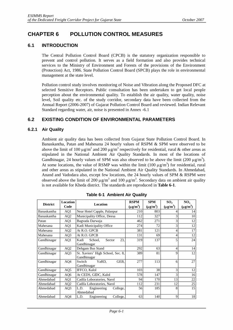
ESIMMS Report of the Dedicated Freight Corridor Project for Gujarat State October 2007
Page 6-1
CHAPTER 6 POLLUTION CONTROL MEASURES
6.1 INTRODUCTION
The Central Pollution Control Board (CPCB) is the statutory organization responsible to prevent and control pollution. It serves as a field formation and also provides technical services to the Ministry of Environment and Forests of the provisions of the Environment (Protection) Act, 1986. State Pollution Control Board (SPCB) plays the role in environmental management at the state level.
Pollution control study involves monitoring of Noise and Vibration along the Proposed DFC at selected Sensitive Receptors. Public consultation has been undertaken to get local people perception about the environmental quality. To establish the air quality, water quality, noise level, Soil quality etc. of the study corridor, secondary data have been collected from the Annual Report (2006-2007) of Gujarat Pollution Control Board and reviewed. Indian Relevant Standard regarding water, air, noise is presented in Annex -6.1
6.2 EXISTING CONDITION OF ENVIRONMENTAL PARAMETERS
6.2.1 Air Quality
Ambient air quality data has been collected from Gujarat State Pollution Control Board. In Banaskantha, Patan and Mahesana 24 hourly values of RSPM & SPM were observed to be above the limit of 100 g/m3 and 200 g/m3 respectively for residential, rural & other areas as stipulated in the National Ambient Air Quality Standards. In most of the locations of Gandhinagar, 24 hourly values of SPM was also observed to be above the limit (200 g/m3). At some locations, the value of RSMP was within the limit (100 g/m3) for residential, rural and other areas as stipulated in the National Ambient Air Quality Standards. In Ahmedabad, Anand and Vadodara also, except few locations, the 24 hourly values of SPM & RSPM were observed above the limit of 200 g/m3 and 100 g/m3. Secondary data on ambient air quality is not available for Kheda district. The standards are reproduced in Table 6-1.
Table 6-1 Ambient Air Quality
District Location Code Location RSPM
(g/m3) SPM
(g/m3) SO2
(g/m3) NOx
(g/m3) Banaskantha AQ1 Near Hotel Capple, Palanpur 210 803 4 14 Banaskantha AQ2 Municipality Office, Deesa 112 327 3 10 Patan AQ1 Bagvada Darwaja 462 271 3 12 Mahesana AQ1 Kadi Municipality Office 274 72 3 12 Mahesana AQ2 At R.O. GPCB 381 121 4 17 Mahesana AQ3 At R.O. GPCB 131 69 4 12 Gandhinagar AQ1 Kadi School, Sector 23,
Gandhinagar 319 137 5 24
Gandhinagar AQ2 Dehgam Bus Stand 292 63 4 14 Gandhinagar AQ3 St. Xaviers’ High School, Sec. 8,
Gandhinagar 389 81 9 12
Gandhinagar AQ4 Switch YaRD, GEB, Gandhinagar
277 113 6 27
Gandhinagar AQ5 IFFCO, Kalol 103 38 3 12 Gandhinagar AQ6 At CEDS, GIDC, Kalol 578 147 3 16 Ahmedabad AQ1 Cadila Loboratories, Narol 94 170 13 22 Ahmedabad AQ2 Cadila Loboratories, Narol 112 231 12 25 Ahmedabad AQ3 L.D. Engineering College,
Ahmedabad 56 185 8 15
Ahmedabad AQ4 L.D. Engineering College, 63 140 9 18
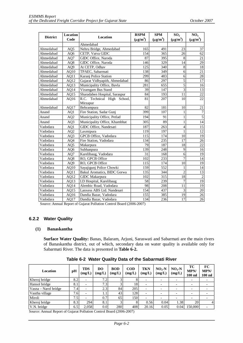
ESIMMS Report of the Dedicated Freight Corridor Project for Gujarat State October 2007
Page 6-2
District Location Code Location RSPM
(g/m3) SPM
(g/m3) SO2
(g/m3) NOx
(g/m3) Ahmedabad
Ahmedabad AQ5 Nehru Bridge, Ahmedabad 165 491 23 37 Ahmedabad AQ6 CETP, Vatva GIDC 154 365 26 62 Ahmedabad AQ7 GIDC Office, Naroda 87 395 8 21 Ahmedabad AQ8 GIDC Office, Naroda 146 329 14 29 Ahmedabad AQ9 At CETP, Odhav 125 340 8 18 Ahmedabad AQ10 TPAEC, Sabarmati 138 349 6 21 Ahmedabad AQ11 Karanj Police Station 299 483 6 28 Ahmedabad AQ12 Gujarat Vidhyapith, Ahmedabad 86 297 5 17 Ahmedabad AQ13 Municipality Office, Bavla 281 655 5 16 Ahmedabad AQ14 Viramgam Bus Stand 39 147 3 13 Ahmedabad AQ15 Sharadaben Hospital, Saraspur 84 193 11 22 Ahmedabad AQ16 R.C. Technical High School,
Mirzapur 81 207 10 22
Ahmedabad AQ17 Behrampura 82 181 10 21 Anand AQ1 Fire Station, Sadar Gunj 399 107 1 7 Anand AQ2 Municipality Office, Petlad 194 91 1 5 Anand AQ3 Municipality Office, Khambhat 305 89 1 14 Vadodara AQ1 GIDC Office, Nandesari 187 263 4 15 Vadodara AQ2 Laxmipura 119 197 1 12 Vadodara AQ3 GPCB Office, Vadodara 115 174 10 19 Vadodara AQ4 Fire Station, Vadodara 134 235 17 26 Vadodara AQ5 Makarpura 79 187 18 22 Vadodara AQ6 Subhanpura 139 248 9 16 Vadodara AQ7 Karelibaug, Vadodara 31 168 6 19 Vadodara AQ8 RO, GPCB Office 102 233 7 14 Vadodara AQ9 RO, GPCB Office 115 174 10 19 Vadodara AQ10 Sayajigunj Police Chowki 159 552 1 14 Vadodara AQ11 Bakul Aromatics, BIDC Gorwa 135 344 2 13 Vadodara AQ12 GIDC Makarpura 102 315 18 2 Vadodara AQ13 I.D Hospital, Karelibaug 58 239 7 19 Vadodara AQ14 Alembic Road, Vadodara 98 208 11 19 Vadodara AQ15 Lanxess ABS Ltd. Nandesari 154 437 3 20 Vadodara AQ16 Dandia Bazar, Vadodara 155 385 19 26 Vadodara AQ17 Dandia Bazar, Vadodara 134 236 17 26 Source: Annual Report of Gujarat Pollution Control Board (2006-2007)
6.2.2 Water Quality
(1) Banaskantha
Surface Water Quality: Banas, Balaram, Arjuni, Saraswati and Sabarmati are the main rivers of Banaskantha district, out of which, secondary data on water quality is available only for Sabarmati River. The data is presented in Table 6-2.
Table 6-2 Water Quality Data of the Sabarmati River
Location pH TDS (mg/L)
DO (mg/L)
BOD (mg/L)
COD (mg/L)
TKN (mg/L)
NO2-N (mg/L)
NO3-N (mg/L)
TC MPN/ 100 ml
FC MPN/ 100 ml
Kheroj bridge 8.2 - 7.2 3 8 - - - - - Hansol bridge 8.1 - 7.3 3 18 - - - - - Vasna – Narol bridge 7.4 - 2.3 84 205 - - - - - Vautha village 7.6 - 1.1 43 128 - - - - - Miroli 7.5 - 0.7 65 150 - - - - - Kheroj bridge 8.3 294 8.1 3 8 0.56 0.04 1.38 20 4 V.N. bridge 6.5 2,058 0.0 280 408 20.16 0.05 0.04 150,000 - Source: Annual Report of Gujarat Pollution Control Board (2006-2007)
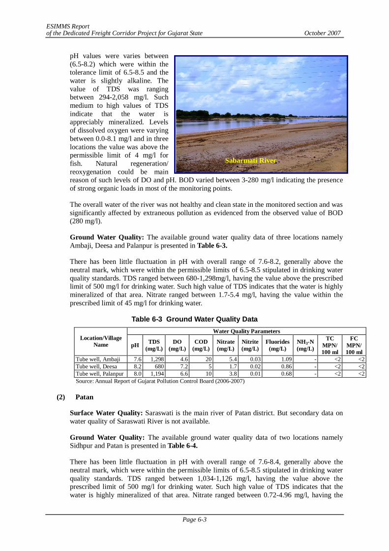
ESIMMS Report of the Dedicated Freight Corridor Project for Gujarat State October 2007
Page 6-3
Sabarmati River
pH values were varies between (6.5-8.2) which were within the tolerance limit of 6.5-8.5 and the water is slightly alkaline. The value of TDS was ranging between 294-2,058 mg/l. Such medium to high values of TDS indicate that the water is appreciably mineralized. Levels of dissolved oxygen were varying between 0.0-8.1 mg/l and in three locations the value was above the permissible limit of 4 mg/l for fish. Natural regeneration/ reoxygenation could be main reason of such levels of DO and pH. BOD varied between 3-280 mg/l indicating the presence of strong organic loads in most of the monitoring points.
The overall water of the river was not healthy and clean state in the monitored section and was significantly affected by extraneous pollution as evidenced from the observed value of BOD (280 mg/l).
Ground Water Quality: The available ground water quality data of three locations namely Ambaji, Deesa and Palanpur is presented in Table 6-3.
There has been little fluctuation in pH with overall range of 7.6-8.2, generally above the neutral mark, which were within the permissible limits of 6.5-8.5 stipulated in drinking water quality standards. TDS ranged between 680-1,298mg/l, having the value above the prescribed limit of 500 mg/l for drinking water. Such high value of TDS indicates that the water is highly mineralized of that area. Nitrate ranged between 1.7-5.4 mg/l, having the value within the prescribed limit of 45 mg/l for drinking water.
Table 6-3 Ground Water Quality Data Water Quality Parameters
Location/Village Name pH TDS
(mg/L) DO
(mg/L) COD
(mg/L) Nitrate (mg/L)
Nitrite (mg/L)
Fluorides (mg/L)
NH3-N (mg/L)
TC MPN/ 100 ml
FC MPN/ 100 ml
Tube well, Ambaji 7.6 1,298 4.6 20 5.4 0.03 1.09 - <2 <2 Tube well, Deesa 8.2 680 7.2 5 1.7 0.02 0.86 - <2 <2 Tube well, Palanpur 8.0 1,194 6.6 10 3.8 0.01 0.68 - <2 <2 Source: Annual Report of Gujarat Pollution Control Board (2006-2007)
(2) Patan
Surface Water Quality: Saraswati is the main river of Patan district. But secondary data on water quality of Saraswati River is not available.
Ground Water Quality: The available ground water quality data of two locations namely Sidhpur and Patan is presented in Table 6-4.
There has been little fluctuation in pH with overall range of 7.6-8.4, generally above the neutral mark, which were within the permissible limits of 6.5-8.5 stipulated in drinking water quality standards. TDS ranged between 1,034-1,126 mg/l, having the value above the prescribed limit of 500 mg/l for drinking water. Such high value of TDS indicates that the water is highly mineralized of that area. Nitrate ranged between 0.72-4.96 mg/l, having the
ESIMMS Report of the Dedicated Freight Corridor Project for Gujarat State October 2007
Page 6-4
value within the prescribed limit of 45 mg/l for drinking water. The ground water of the area has fecal contamination.
Table 6-4 Ground Water Quality Data Water Quality Parameters
Location/Village Name pH TDS
(mg/L) DO
(mg/L) COD
(mg/L) Nitrate (mg/L)
Nitrite (mg/L)
Fluorides (mg/L)
NH3-N (mg/L)
TC MPN/ 100 ml
FC MPN/ 100 ml
Tube well, Sidhapur 8.4 1,034 6.2 9 4.96 0.01 1.42 - <2 <2 Tube well, Patan 7.6 1,126 5.5 9 0.72 0.01 1.78 - <2 <2 Source: Annual Report of Gujarat Pollution Control Board (2006-2007)
(3) Mahesana
Surface Water Quality: The Saraswati, Khari and Rupen are the main rivers of Mahesana district. DFC alignment crosses Khari River twice in Mahesana district. However, secondary data of river water quality is not available.
Ground Water Quality: The State Pollution Control Boards of Gujarat are doing the ground water quality monitoring of Mahesana District at several locations. The available ground water quality monitoring data is presented in Table 6-5.
There has been little fluctuation in pH with overall range of 7.6-7.9, generally above the neutral mark, which was within the permissible limits of 6.5-8.5 stipulated in drinking water quality standards. TDS ranged between 1,098-1,436 mg/l, having the value above the prescribed limit of 500 mg/l for drinking water in most of the locations. Such high value of TDS indicates that the water is highly mineralized of that area. Nitrate ranged between 1.9-4.8 mg/l, having the value within the prescribed limit of 45 mg/l for drinking water.
Table 6-5 Ground Water Quality Data Water Quality Parameters
Location/Village Name pH TDS
(mg/L) DO
(mg/L) COD
(mg/L) Nitrate (mg/L)
Nitrite (mg/L)
Fluorides (mg/L)
NH3-N (mg/L)
TC MPN/ 100 ml
FC MPN/ 100 ml
Tube well, Kadi 7.6 1,098 4.9 10 4.8 0.04 1.09 - <2 <2 Tube well, Mehsana 7.9 1,436 3.3 6 1.9 0.02 1.31 - 05 <2 Source: Annual Report of Gujarat Pollution Control Board (2006-2007)
(4) Gandhinagar
Surface Water Quality: There are only Sabarmati and Khari Rivers flowing through the district. Secondary data on water quality of Sabarmati River is not available. Further, the DFC alignment in Gandhinagar district does not cross any rivers.
Ground Water Quality: The available ground water quality data of one location is presented in Table 6-6.
Table 6-6 Ground Water Quality Data of Kalol Water Quality Parameters Location/
Village Name pH TDS
(mg/L) DO
(mg/L) COD
(mg/L) Nitrate (mg/L)
Nitrite (mg/L)
Fluorides (mg/L)
NH3-N (mg/L)
TC MPN/ 100 ml
FC MPN/ 100 ml
Tube well, Kalol 7.5 1540 6.4 15 4.3 0.04 1.02 - <2 <2
Source: Annual Report of Gujarat Pollution Control Board (2006-2007)
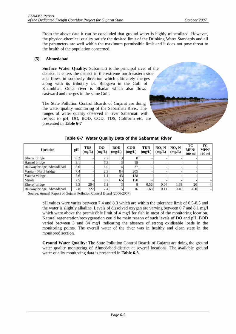
ESIMMS Report of the Dedicated Freight Corridor Project for Gujarat State October 2007
Page 6-5
From the above data it can be concluded that ground water is highly mineralized. However, the physico-chemical quality satisfy the desired limit of the Drinking Water Standards and all the parameters are well within the maximum permissible limit and it does not pose threat to the health of the population concerned.
(5) Ahmedabad
Surface Water Quality: Sabarmati is the principal river of the district. It enters the district in the extreme north-eastern side and flows in southerly direction which ultimately merges along with its tributary i.e. Bhogava in the Gulf of Khambhat. Other river is Bhadar which also flows eastward and merges in the same Gulf.
The State Pollution Control Boards of Gujarat are doing the water quality monitoring of the Sabarmati River. The ranges of water quality observed in river Sabarmati with respect to pH, DO, BOD, COD, TDS, Coliform etc. are presented in Table 6-7
Table 6-7 Water Quality Data of the Sabarmati River
Location pH TDS (mg/L)
DO (mg/L)
BOD (mg/L)
COD (mg/L)
TKN (mg/L)
NO2-N (mg/L)
NO3-N (mg/L)
TC MPN/ 100 ml
FC MPN/ 100 ml
Kheroj bridge 8.2 - 7.2 3 8 - - - - - Hansol bridge 8.1 - 7.3 3 18 - - - - - Railway bridge, Ahmadabad 8.0 - 6.0 4 27 - - - - - Vasna – Narol bridge 7.4 - 2.3 84 205 - - - - - Vautha village 7.6 - 1.1 43 128 - - - - - Miroli 7.5 - 0.7 65 150 - - - - - Kheroj bridge 8.3 294 8.1 3 8 0.56 0.04 1.38 20 4 Railway bridge, Ahmadabad 7.8 222 7.4 5 16 1.68 0.11 0.46 460 -
Source: Annual Report of Gujarat Pollution Control Board (2006-2007)
pH values were varies between 7.4 and 8.3 which are within the tolerance limit of 6.5-8.5 and the water is slightly alkaline. Levels of dissolved oxygen are varying between 0.7 and 8.1 mg/l which were above the permissible limit of 4 mg/l for fish in most of the monitoring location. Natural regeneration/reoxygenation could be main reason of such levels of DO and pH. BOD varied between 3 and 84 mg/l indicating the absence of strong oxidisable loads in the monitoring points. The overall water of the river was in healthy and clean state in the monitored section.
Ground Water Quality: The State Pollution Control Boards of Gujarat are doing the ground water quality monitoring of Ahmedabad district at several locations. The available ground water quality monitoring data is presented in Table 6-8.
ESIMMS Report of the Dedicated Freight Corridor Project for Gujarat State October 2007
Page 6-6
Table 6-8 Ground Water Quality Data Water Quality Parameters
Location/Village Name pH TDS (mg/L)
DO (mg/L)
COD (mg/L)
Nitrate (mg/L)
Nitrite (mg/L)
Fluorides (mg/L)
NH3-N (mg/L)
TC MPN/ 100 ml
FC MPN/ 100 ml
Tube well, Piplaj 8.1 1,388 0.0 19 3.20 0.07 1.84 - <2 <2 Tube well, Viramgam 8.2 1,306 4.4 8 0.04 0.01 1.82 - <2 <2 Tube well, Bavala 7.9 1,340 3.8 6 0.14 0.01 1.82 - <2 <2 Tube well, Dholka 7.7 1,564 6.0 6 14.64 0.5 1.86 - <2 <2 Tube well, Bareja 7.9 1,882 4.2 8 1.54 0.02 1.88 - <2 <2 Tube well, Kalok 7.2 502 - 14 0.38 0.05 0.33 - 0 0 Source: Annual Report of Gujarat Pollution Control Board (2006-2007)
There has been little fluctuation in pH with overall range of 7.2-8.2, generally above the neutral mark, which were within the permissible limits of 6.5-8.5 stipulated in drinking water quality standards. TDS ranged between 502-1,882 mg/l, having the value above the prescribed limit of 500 mg/l for drinking water. Such high value of TDS indicates that the water is highly mineralized of that area. Nitrate ranged between 0.04-14.64 mg/l, having the value within the prescribed limit of 45 mg/l for drinking water. The ground water of the area has fecal contamination.
(6) Kheda
Surface Water Quality: The Sabarmati, Mahi, Vatrak and Khari are the main rivers of the district. Secondary data on river water quality (Sabarmati, Mahi, Vatrak and Khari Rivers) is not available.
Ground Water Quality: Ground water quality of Kheda district is presented in Table 6-9.
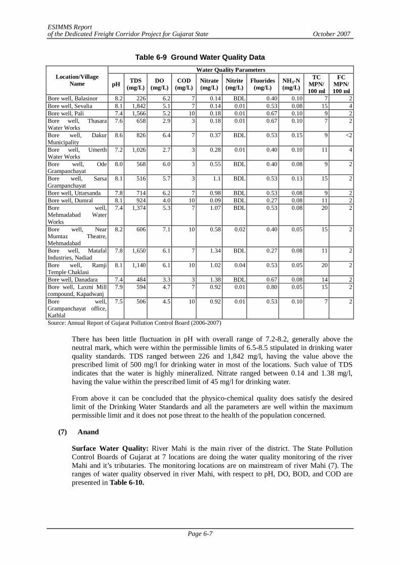
ESIMMS Report of the Dedicated Freight Corridor Project for Gujarat State October 2007
Page 6-7
Table 6-9 Ground Water Quality Data Water Quality Parameters
Location/Village Name pH TDS
(mg/L) DO
(mg/L) COD
(mg/L) Nitrate (mg/L)
Nitrite (mg/L)
Fluorides (mg/L)
NH3-N (mg/L)
TC MPN/ 100 ml
FC MPN/ 100 ml
Bore well, Balasinor 8.2 226 6.2 7 0.14 BDL 0.40 0.10 7 2 Bore well, Sevalia 8.1 1,842 5.1 7 0.14 0.01 0.53 0.08 15 4 Bore well, Pali 7.4 1,566 5.2 10 0.18 0.01 0.67 0.10 9 2 Bore well, Thasara Water Works
7.6 658 2.9 3 0.18 0.01 0.67 0.10 7 2
Bore well, Dakur Municipality
8.6 826 6.4 7 0.37 BDL 0.53 0.15 9 <2
Bore well, Umerth Water Works
7.2 1,026 2.7 3 0.28 0.01 0.40 0.10 11 4
Bore well, Ode Grampanchayat
8.0 568 6.0 3 0.55 BDL 0.40 0.08 9 2
Bore well, Sarsa Grampanchayat
8.1 516 5.7 3 1.1 BDL 0.53 0.13 15 2
Bore well, Uttarsanda 7.8 714 6.2 7 0.98 BDL 0.53 0.08 9 2 Bore well, Dumral 8.1 924 4.0 10 0.09 BDL 0.27 0.08 11 2 Bore well, Mehmadabad Water Works
7.4 1,374 5.3 7 1.07 BDL 0.53 0.08 20 2
Bore well, Near Mumtaz Theatre, Mehmadabad
8.2 606 7.1 10 0.58 0.02 0.40 0.05 15 2
Bore well, Matafal Industries, Nadiad
7.8 1,650 6.1 7 1.34 BDL 0.27 0.08 11 2
Bore well, Ramji Temple Chaklasi
8.1 1,140 6.1 10 1.02 0.04 0.53 0.05 20 2
Bore well, Danadara 7.4 484 3.3 3 1.38 BDL 0.67 0.08 14 2 Bore well, Laxmi Mill compound, Kapadwanj
7.9 594 4.7 7 0.92 0.01 0.80 0.05 15 2
Bore well, Grampanchayat office, Kathlal
7.5 506 4.5 10 0.92 0.01 0.53 0.10 7 2
Source: Annual Report of Gujarat Pollution Control Board (2006-2007)
There has been little fluctuation in pH with overall range of 7.2-8.2, generally above the neutral mark, which were within the permissible limits of 6.5-8.5 stipulated in drinking water quality standards. TDS ranged between 226 and 1,842 mg/l, having the value above the prescribed limit of 500 mg/l for drinking water in most of the locations. Such value of TDS indicates that the water is highly mineralized. Nitrate ranged between 0.14 and 1.38 mg/l, having the value within the prescribed limit of 45 mg/l for drinking water.
From above it can be concluded that the physico-chemical quality does satisfy the desired limit of the Drinking Water Standards and all the parameters are well within the maximum permissible limit and it does not pose threat to the health of the population concerned.
(7) Anand
Surface Water Quality: River Mahi is the main river of the district. The State Pollution Control Boards of Gujarat at 7 locations are doing the water quality monitoring of the river Mahi and it’s tributaries. The monitoring locations are on mainstream of river Mahi (7). The ranges of water quality observed in river Mahi, with respect to pH, DO, BOD, and COD are presented in Table 6-10.
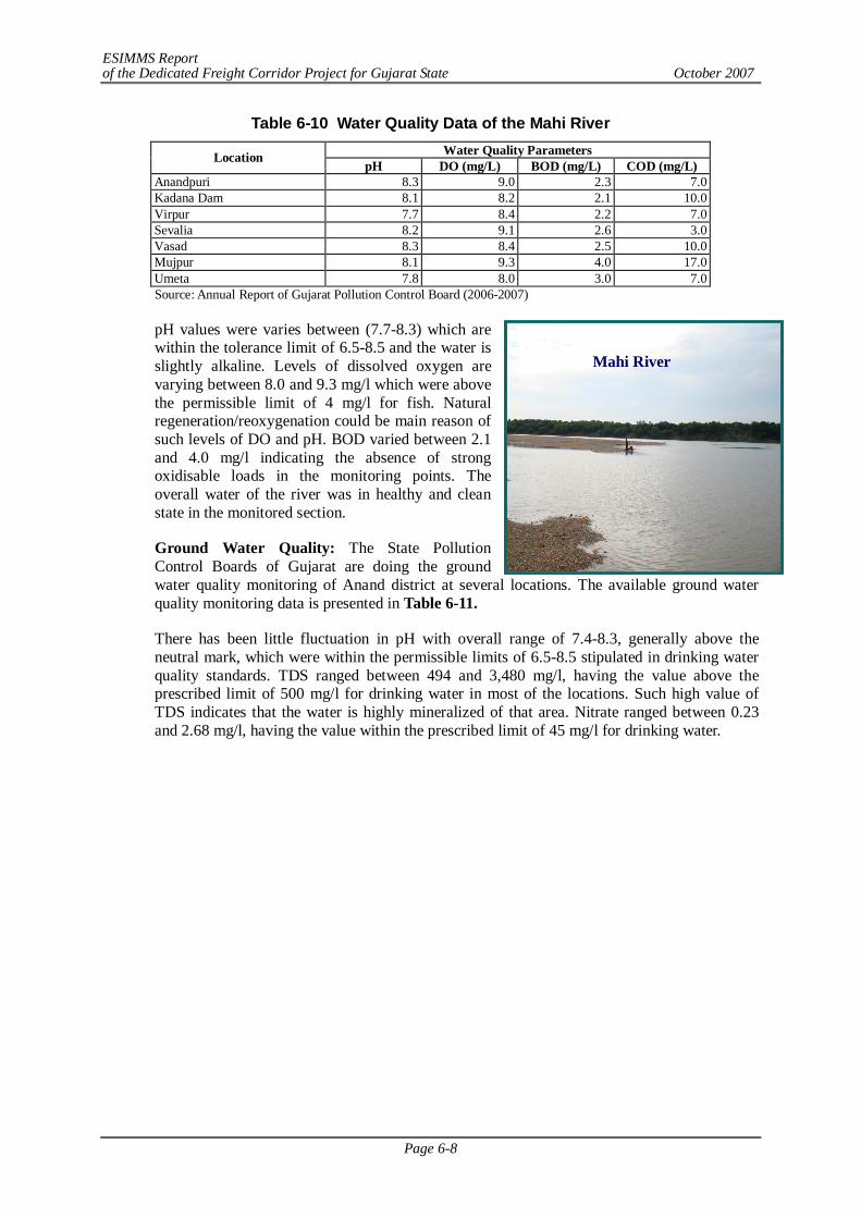
ESIMMS Report of the Dedicated Freight Corridor Project for Gujarat State October 2007
Page 6-8
Mahi River
Table 6-10 Water Quality Data of the Mahi River Water Quality Parameters Location pH DO (mg/L) BOD (mg/L) COD (mg/L)
Anandpuri 8.3 9.0 2.3 7.0 Kadana Dam 8.1 8.2 2.1 10.0 Virpur 7.7 8.4 2.2 7.0 Sevalia 8.2 9.1 2.6 3.0 Vasad 8.3 8.4 2.5 10.0 Mujpur 8.1 9.3 4.0 17.0 Umeta 7.8 8.0 3.0 7.0 Source: Annual Report of Gujarat Pollution Control Board (2006-2007)
pH values were varies between (7.7-8.3) which are within the tolerance limit of 6.5-8.5 and the water is slightly alkaline. Levels of dissolved oxygen are varying between 8.0 and 9.3 mg/l which were above the permissible limit of 4 mg/l for fish. Natural regeneration/reoxygenation could be main reason of such levels of DO and pH. BOD varied between 2.1 and 4.0 mg/l indicating the absence of strong oxidisable loads in the monitoring points. The overall water of the river was in healthy and clean state in the monitored section.
Ground Water Quality: The State Pollution Control Boards of Gujarat are doing the ground water quality monitoring of Anand district at several locations. The available ground water quality monitoring data is presented in Table 6-11.
There has been little fluctuation in pH with overall range of 7.4-8.3, generally above the neutral mark, which were within the permissible limits of 6.5-8.5 stipulated in drinking water quality standards. TDS ranged between 494 and 3,480 mg/l, having the value above the prescribed limit of 500 mg/l for drinking water in most of the locations. Such high value of TDS indicates that the water is highly mineralized of that area. Nitrate ranged between 0.23 and 2.68 mg/l, having the value within the prescribed limit of 45 mg/l for drinking water.

ESIMMS Report of the Dedicated Freight Corridor Project for Gujarat State October 2007
Page 6-9
Table 6-11 Ground Water Quality Data Water Quality Parameters
Location/Village Name pH TDS
(mg/L) DO
(mg/L) COD
(mg/L) Nitrate (mg/L)
Nitrite (mg/L)
Fluorides (mg/L)
NH3-N (mg/L)
TC MPN/ 100 ml
FC MPN/ 100 ml
Tube well, Vasad 7.6 494 5.1 7 0.23 BDL 0.30 0.10 9 2 Bore well, Khambhat 8.0 3,480 5.8 7 2.3 0.01 0.80 0.10 9 2 Bore well, Vasad 8.1 852 6.1 29 2.68 0.01 0.67 0.05 7 2 Bore well, Anklav 7.5 596 7.2 3 1.27 0.01 0.40 0.10 7 <2 Bore well, Umeta 7.8 626 6.7 6 0.89 0.01 0.53 0.10 9 2 Bore well, Mota Bazar, V.V. Nagar 7.5 700 5.8 7 1.56 0.01 0.27 0.10 9 2
Bore well, Karmsad 7.7 1,160 5.3 10 1.78 0.01 0.53 0.08 4 <2 Bore well, Anand-Sojitra Road 7.7 730 6.8 6 0.58 BDL 0.67 0.08 9 2
Bore well, Anand-Vidyanagar Road 7.4 636 5.0 3 1.15 BDL 0.40 0.08 15 4
Bore well, Lambhvel 7.7 580 6.9 7 0.81 0.01 0.40 0.10 9 2 Bore well, Hadgud 8.0 580 7.1 6 1.96 0.01 0.53 0.10 7 2 Bore well, Near Jalaram Temple, Dharmaj 7.6 894 4.0 6 1.84 0.01 0.27 0.08 9 2
Bore well, Opposite Ranchodraiji Temple, Petlad
7.4 722 3.7 7 1.56 0.01 0.40 0.08 7 2
Bore well, Municipality Office, Borsad 7.6 766 7.0 3 1.49 0.01 0.27 0.10 7 2
Bore well, Surya Temple, Borsad 7.6 904 4.8 10 0.81 BDL 0.53 0.10 15 2
Bore well, Khambhat 7.8 2,750 6.9 3 2.30 0.01 0.53 0.05 15 2 Bore well, Sokhada 8.2 1,160 6.8 10 1.38 0.02 0.40 0.08 7 2 Bore well, ONGC Colony, Khambhat 7.5 2,208 4.7 7 1.38 0.01 0.67 0.08 7 2
Bore well, GIDC Kansari 7.7 2,200 7.0 7 1.84 0.02 0.53 0.10 15 2
Bore well, Near Primary School, Kalamsar
8.3 580 6.5 10 0.69 BDL 0.53 0.10 7 2
Bore well, GWSSB, Dhuvaran 8.2 1,166 6.3 3 0.69 BDL 0.67 0.08 15 2
Bore well, Virsad 7.8 1,650 7.0 7 0.23 0.02 0.27 0.10 15 2 Source: Annual Report of Gujarat Pollution Control Board (2006-2007)
(8) Vadodara
Surface Water Quality: Mahi and Vishwamitri are the principal rivers of Vadodara district. DFC alignment crosses the Mahi River, Mini Mahi River and Vishwamitri River in Vadodara district. The State Pollution Control Boards of Gujarat are doing the water quality monitoring of the river Mahi, Vishwamitri and it’s tributaries. The ranges of water quality observed in river Mahi & Vishwamitri with respect to pH, DO, BOD, COD, Coliform etc. are presented in Table 6-12 and Table 6-13.
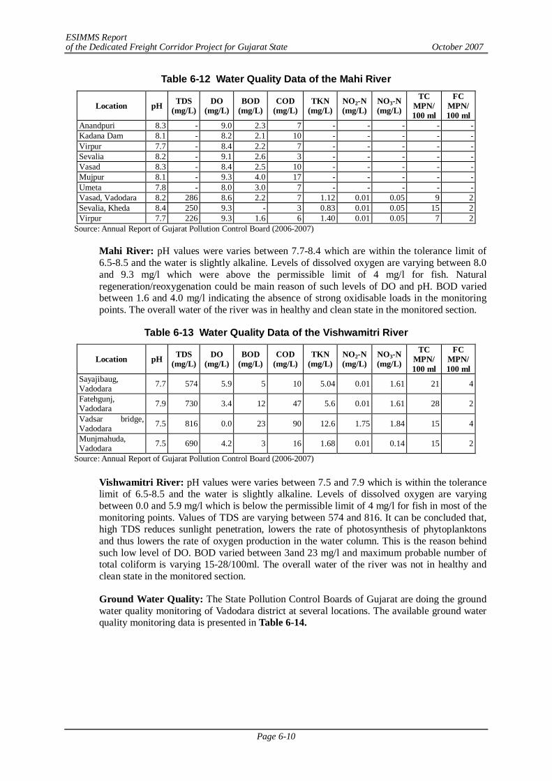
ESIMMS Report of the Dedicated Freight Corridor Project for Gujarat State October 2007
Page 6-10
Table 6-12 Water Quality Data of the Mahi River
Location pH TDS (mg/L)
DO (mg/L)
BOD (mg/L)
COD (mg/L)
TKN (mg/L)
NO2-N (mg/L)
NO3-N (mg/L)
TC MPN/ 100 ml
FC MPN/ 100 ml
Anandpuri 8.3 - 9.0 2.3 7 - - - - - Kadana Dam 8.1 - 8.2 2.1 10 - - - - - Virpur 7.7 - 8.4 2.2 7 - - - - - Sevalia 8.2 - 9.1 2.6 3 - - - - - Vasad 8.3 - 8.4 2.5 10 - - - - - Mujpur 8.1 - 9.3 4.0 17 - - - - - Umeta 7.8 - 8.0 3.0 7 - - - - - Vasad, Vadodara 8.2 286 8.6 2.2 7 1.12 0.01 0.05 9 2 Sevalia, Kheda 8.4 250 9.3 - 3 0.83 0.01 0.05 15 2 Virpur 7.7 226 9.3 1.6 6 1.40 0.01 0.05 7 2
Source: Annual Report of Gujarat Pollution Control Board (2006-2007)
Mahi River: pH values were varies between 7.7-8.4 which are within the tolerance limit of 6.5-8.5 and the water is slightly alkaline. Levels of dissolved oxygen are varying between 8.0 and 9.3 mg/l which were above the permissible limit of 4 mg/l for fish. Natural regeneration/reoxygenation could be main reason of such levels of DO and pH. BOD varied between 1.6 and 4.0 mg/l indicating the absence of strong oxidisable loads in the monitoring points. The overall water of the river was in healthy and clean state in the monitored section.
Table 6-13 Water Quality Data of the Vishwamitri River
Location pH TDS (mg/L)
DO (mg/L)
BOD (mg/L)
COD (mg/L)
TKN (mg/L)
NO2-N (mg/L)
NO3-N (mg/L)
TC MPN/ 100 ml
FC MPN/ 100 ml
Sayajibaug, Vadodara 7.7 574 5.9 5 10 5.04 0.01 1.61 21 4
Fatehgunj, Vadodara 7.9 730 3.4 12 47 5.6 0.01 1.61 28 2
Vadsar bridge, Vadodara 7.5 816 0.0 23 90 12.6 1.75 1.84 15 4
Munjmahuda, Vadodara 7.5 690 4.2 3 16 1.68 0.01 0.14 15 2
Source: Annual Report of Gujarat Pollution Control Board (2006-2007)
Vishwamitri River: pH values were varies between 7.5 and 7.9 which is within the tolerance limit of 6.5-8.5 and the water is slightly alkaline. Levels of dissolved oxygen are varying between 0.0 and 5.9 mg/l which is below the permissible limit of 4 mg/l for fish in most of the monitoring points. Values of TDS are varying between 574 and 816. It can be concluded that, high TDS reduces sunlight penetration, lowers the rate of photosynthesis of phytoplanktons and thus lowers the rate of oxygen production in the water column. This is the reason behind such low level of DO. BOD varied between 3and 23 mg/l and maximum probable number of total coliform is varying 15-28/100ml. The overall water of the river was not in healthy and clean state in the monitored section.
Ground Water Quality: The State Pollution Control Boards of Gujarat are doing the ground water quality monitoring of Vadodara district at several locations. The available ground water quality monitoring data is presented in Table 6-14.
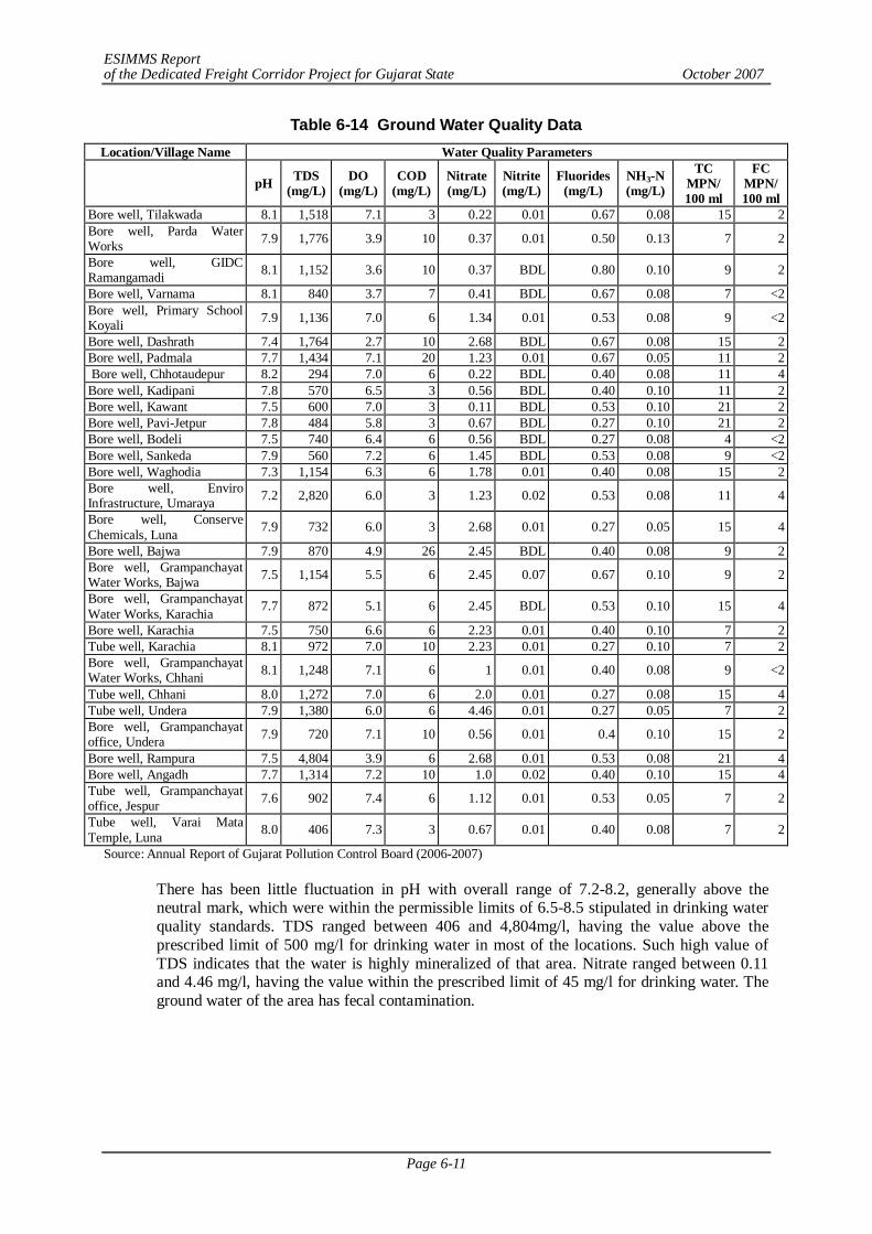
ESIMMS Report of the Dedicated Freight Corridor Project for Gujarat State October 2007
Page 6-11
Table 6-14 Ground Water Quality Data Location/Village Name Water Quality Parameters
pH TDS (mg/L)
DO (mg/L)
COD (mg/L)
Nitrate (mg/L)
Nitrite (mg/L)
Fluorides (mg/L)
NH3-N (mg/L)
TC MPN/ 100 ml
FC MPN/ 100 ml
Bore well, Tilakwada 8.1 1,518 7.1 3 0.22 0.01 0.67 0.08 15 2 Bore well, Parda Water Works 7.9 1,776 3.9 10 0.37 0.01 0.50 0.13 7 2
Bore well, GIDC Ramangamadi 8.1 1,152 3.6 10 0.37 BDL 0.80 0.10 9 2
Bore well, Varnama 8.1 840 3.7 7 0.41 BDL 0.67 0.08 7 <2 Bore well, Primary School Koyali 7.9 1,136 7.0 6 1.34 0.01 0.53 0.08 9 <2
Bore well, Dashrath 7.4 1,764 2.7 10 2.68 BDL 0.67 0.08 15 2 Bore well, Padmala 7.7 1,434 7.1 20 1.23 0.01 0.67 0.05 11 2 Bore well, Chhotaudepur 8.2 294 7.0 6 0.22 BDL 0.40 0.08 11 4 Bore well, Kadipani 7.8 570 6.5 3 0.56 BDL 0.40 0.10 11 2 Bore well, Kawant 7.5 600 7.0 3 0.11 BDL 0.53 0.10 21 2 Bore well, Pavi-Jetpur 7.8 484 5.8 3 0.67 BDL 0.27 0.10 21 2 Bore well, Bodeli 7.5 740 6.4 6 0.56 BDL 0.27 0.08 4 <2 Bore well, Sankeda 7.9 560 7.2 6 1.45 BDL 0.53 0.08 9 <2 Bore well, Waghodia 7.3 1,154 6.3 6 1.78 0.01 0.40 0.08 15 2 Bore well, Enviro Infrastructure, Umaraya 7.2 2,820 6.0 3 1.23 0.02 0.53 0.08 11 4
Bore well, Conserve Chemicals, Luna 7.9 732 6.0 3 2.68 0.01 0.27 0.05 15 4
Bore well, Bajwa 7.9 870 4.9 26 2.45 BDL 0.40 0.08 9 2 Bore well, Grampanchayat Water Works, Bajwa 7.5 1,154 5.5 6 2.45 0.07 0.67 0.10 9 2
Bore well, Grampanchayat Water Works, Karachia 7.7 872 5.1 6 2.45 BDL 0.53 0.10 15 4
Bore well, Karachia 7.5 750 6.6 6 2.23 0.01 0.40 0.10 7 2 Tube well, Karachia 8.1 972 7.0 10 2.23 0.01 0.27 0.10 7 2 Bore well, Grampanchayat Water Works, Chhani 8.1 1,248 7.1 6 1 0.01 0.40 0.08 9 <2
Tube well, Chhani 8.0 1,272 7.0 6 2.0 0.01 0.27 0.08 15 4 Tube well, Undera 7.9 1,380 6.0 6 4.46 0.01 0.27 0.05 7 2 Bore well, Grampanchayat office, Undera 7.9 720 7.1 10 0.56 0.01 0.4 0.10 15 2
Bore well, Rampura 7.5 4,804 3.9 6 2.68 0.01 0.53 0.08 21 4 Bore well, Angadh 7.7 1,314 7.2 10 1.0 0.02 0.40 0.10 15 4 Tube well, Grampanchayat office, Jespur 7.6 902 7.4 6 1.12 0.01 0.53 0.05 7 2
Tube well, Varai Mata Temple, Luna 8.0 406 7.3 3 0.67 0.01 0.40 0.08 7 2
Source: Annual Report of Gujarat Pollution Control Board (2006-2007)
There has been little fluctuation in pH with overall range of 7.2-8.2, generally above the neutral mark, which were within the permissible limits of 6.5-8.5 stipulated in drinking water quality standards. TDS ranged between 406 and 4,804mg/l, having the value above the prescribed limit of 500 mg/l for drinking water in most of the locations. Such high value of TDS indicates that the water is highly mineralized of that area. Nitrate ranged between 0.11 and 4.46 mg/l, having the value within the prescribed limit of 45 mg/l for drinking water. The ground water of the area has fecal contamination.
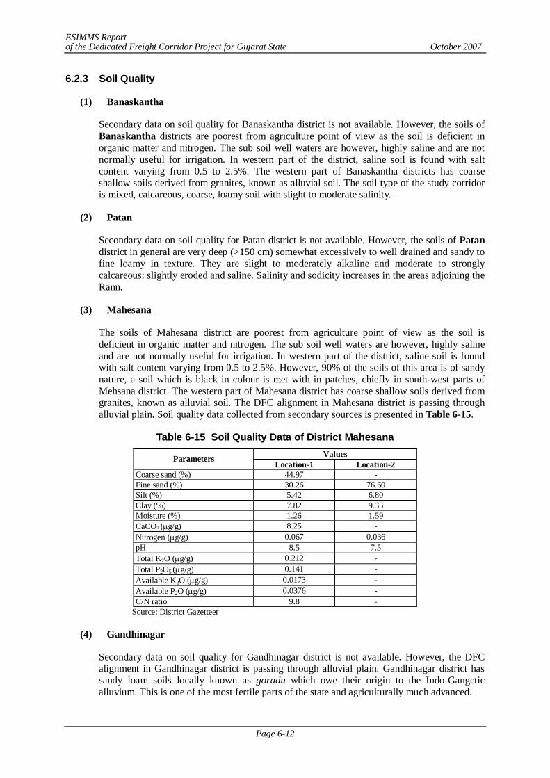
ESIMMS Report of the Dedicated Freight Corridor Project for Gujarat State October 2007
Page 6-12
6.2.3 Soil Quality
(1) Banaskantha
Secondary data on soil quality for Banaskantha district is not available. However, the soils of Banaskantha districts are poorest from agriculture point of view as the soil is deficient in organic matter and nitrogen. The sub soil well waters are however, highly saline and are not normally useful for irrigation. In western part of the district, saline soil is found with salt content varying from 0.5 to 2.5%. The western part of Banaskantha districts has coarse shallow soils derived from granites, known as alluvial soil. The soil type of the study corridor is mixed, calcareous, coarse, loamy soil with slight to moderate salinity.
(2) Patan
Secondary data on soil quality for Patan district is not available. However, the soils of Patan district in general are very deep (>150 cm) somewhat excessively to well drained and sandy to fine loamy in texture. They are slight to moderately alkaline and moderate to strongly calcareous: slightly eroded and saline. Salinity and sodicity increases in the areas adjoining the Rann.
(3) Mahesana
The soils of Mahesana district are poorest from agriculture point of view as the soil is deficient in organic matter and nitrogen. The sub soil well waters are however, highly saline and are not normally useful for irrigation. In western part of the district, saline soil is found with salt content varying from 0.5 to 2.5%. However, 90% of the soils of this area is of sandy nature, a soil which is black in colour is met with in patches, chiefly in south-west parts of Mehsana district. The western part of Mahesana district has coarse shallow soils derived from granites, known as alluvial soil. The DFC alignment in Mahesana district is passing through alluvial plain. Soil quality data collected from secondary sources is presented in Table 6-15.
Table 6-15 Soil Quality Data of District Mahesana Values Parameters
Location-1 Location-2 Coarse sand (%) 44.97 - Fine sand (%) 30.26 76.60 Silt (%) 5.42 6.80 Clay (%) 7.82 9.35 Moisture (%) 1.26 1.59 CaCO3 (g/g) 8.25 - Nitrogen (g/g) 0.067 0.036 pH 8.5 7.5 Total K2O (g/g) 0.212 - Total P2O5 (g/g) 0.141 - Available K2O (g/g) 0.0173 - Available P2O (g/g) 0.0376 - C/N ratio 9.8 -
Source: District Gazetteer
(4) Gandhinagar
Secondary data on soil quality for Gandhinagar district is not available. However, the DFC alignment in Gandhinagar district is passing through alluvial plain. Gandhinagar district has sandy loam soils locally known as goradu which owe their origin to the Indo-Gangetic alluvium. This is one of the most fertile parts of the state and agriculturally much advanced.
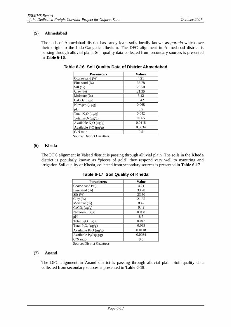
ESIMMS Report of the Dedicated Freight Corridor Project for Gujarat State October 2007
Page 6-13
(5) Ahmedabad
The soils of Ahmedabad district has sandy loam soils locally known as goradu which owe their origin to the Indo-Gangetic alluvium. The DFC alignment in Ahmedabad district is passing through alluvial plain. Soil quality data collected from secondary sources is presented in Table 6-16.
Table 6-16 Soil Quality Data of District Ahmedabad Parameters Values
Coarse sand (%) 4.21 Fine sand (%) 33.78 Silt (%) 23.50 Clay (%) 21.35 Moisture (%) 8.42 CaCO3 (g/g) 9.42 Nitrogen (g/g) 0.068 pH 8.5 Total K2O (g/g) 0.042 Total P2O5 (g/g) 0.065 Available K2O (g/g) 0.0118 Available P2O (g/g) 0.0034 C/N ratio 9.5
Source: District Gazetteer
(6) Kheda
The DFC alignment in Valsad district is passing through alluvial plain. The soils in the Kheda district is popularly known as “pieces of gold” they respond vary well to manuring and irrigation Soil quality of Kheda, collected from secondary sources is presented in Table 6-17.
Table 6-17 Soil Quality of Kheda Parameters Value
Coarse sand (%) 4.21 Fine sand (%) 33.78 Silt (%) 23.50 Clay (%) 21.35 Moisture (%) 8.42 CaCO3 (g/g) 9.42 Nitrogen (g/g) 0.068 pH 8.5 Total K2O (g/g) 0.042 Total P2O5 (g/g) 0.065 Available K2O (g/g) 0.0118 Available P2O (g/g) 0.0034 C/N ratio 9.5 Source: District Gazetteer
(7) Anand
The DFC alignment in Anand district is passing through alluvial plain. Soil quality data collected from secondary sources is presented in Table 6-18.
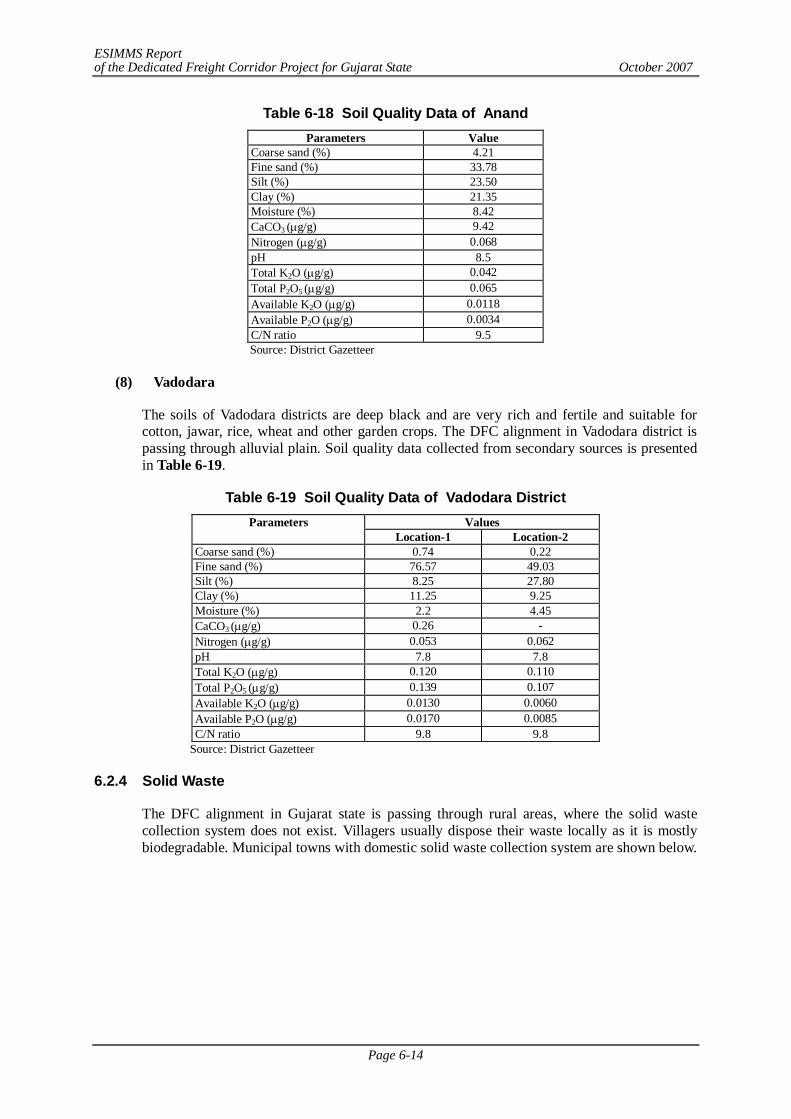
ESIMMS Report of the Dedicated Freight Corridor Project for Gujarat State October 2007
Page 6-14
Table 6-18 Soil Quality Data of Anand Parameters Value
Coarse sand (%) 4.21 Fine sand (%) 33.78 Silt (%) 23.50 Clay (%) 21.35 Moisture (%) 8.42 CaCO3 (g/g) 9.42 Nitrogen (g/g) 0.068 pH 8.5 Total K2O (g/g) 0.042 Total P2O5 (g/g) 0.065 Available K2O (g/g) 0.0118 Available P2O (g/g) 0.0034 C/N ratio 9.5 Source: District Gazetteer
(8) Vadodara
The soils of Vadodara districts are deep black and are very rich and fertile and suitable for cotton, jawar, rice, wheat and other garden crops. The DFC alignment in Vadodara district is passing through alluvial plain. Soil quality data collected from secondary sources is presented in Table 6-19.
Table 6-19 Soil Quality Data of Vadodara District Values Parameters
Location-1 Location-2 Coarse sand (%) 0.74 0.22 Fine sand (%) 76.57 49.03 Silt (%) 8.25 27.80 Clay (%) 11.25 9.25 Moisture (%) 2.2 4.45 CaCO3 (g/g) 0.26 - Nitrogen (g/g) 0.053 0.062 pH 7.8 7.8 Total K2O (g/g) 0.120 0.110 Total P2O5 (g/g) 0.139 0.107 Available K2O (g/g) 0.0130 0.0060 Available P2O (g/g) 0.0170 0.0085 C/N ratio 9.8 9.8
Source: District Gazetteer 6.2.4 Solid Waste
The DFC alignment in Gujarat state is passing through rural areas, where the solid waste collection system does not exist. Villagers usually dispose their waste locally as it is mostly biodegradable. Municipal towns with domestic solid waste collection system are shown below.
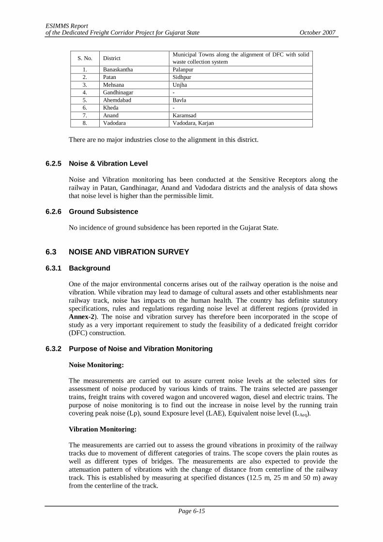
ESIMMS Report of the Dedicated Freight Corridor Project for Gujarat State October 2007
Page 6-15
S. No. District Municipal Towns along the alignment of DFC with solid waste collection system
1. Banaskantha Palanpur 2. Patan Sidhpur 3. Mehsana Unjha 4. Gandhinagar - 5. Ahemdabad Bavla 6. Kheda - 7. Anand Karamsad 8. Vadodara Vadodara, Karjan
There are no major industries close to the alignment in this district.
6.2.5 Noise & Vibration Level
Noise and Vibration monitoring has been conducted at the Sensitive Receptors along the railway in Patan, Gandhinagar, Anand and Vadodara districts and the analysis of data shows that noise level is higher than the permissible limit.
6.2.6 Ground Subsistence
No incidence of ground subsidence has been reported in the Gujarat State.
6.3 NOISE AND VIBRATION SURVEY
6.3.1 Background
One of the major environmental concerns arises out of the railway operation is the noise and vibration. While vibration may lead to damage of cultural assets and other establishments near railway track, noise has impacts on the human health. The country has definite statutory specifications, rules and regulations regarding noise level at different regions (provided in Annex-2). The noise and vibration survey has therefore been incorporated in the scope of study as a very important requirement to study the feasibility of a dedicated freight corridor (DFC) construction.
6.3.2 Purpose of Noise and Vibration Monitoring
Noise Monitoring:
The measurements are carried out to assure current noise levels at the selected sites for assessment of noise produced by various kinds of trains. The trains selected are passenger trains, freight trains with covered wagon and uncovered wagon, diesel and electric trains. The purpose of noise monitoring is to find out the increase in noise level by the running train covering peak noise (Lp), sound Exposure level (LAE), Equivalent noise level (LAeq).
Vibration Monitoring:
The measurements are carried out to assess the ground vibrations in proximity of the railway tracks due to movement of different categories of trains. The scope covers the plain routes as well as different types of bridges. The measurements are also expected to provide the attenuation pattern of vibrations with the change of distance from centerline of the railway track. This is established by measuring at specified distances (12.5 m, 25 m and 50 m) away from the centerline of the track.
ESIMMS Report of the Dedicated Freight Corridor Project for Gujarat State October 2007
Page 6-16
6.3.3 Approach and Methodology of Railway Noise and Vibration Measurement
(1) Selection of Sensitive Receptors
As per the agreed methodologies, for noise and vibration survey a primary field visit was conducted to identify the locations of sensitive receptors. Total 20 points for ambient noise and vibration survey and 5 points of detailed railway noise and vibration survey were identified, along with a few other optional points where the measurement could be done if any of the scheduled point is missed. A few of the points selected for ambient noise and vibration measurement have also been chosen for measuring the noise and vibration level at the time of when a train either passenger or freight is passing by the existing railway track. Hence, the noise and vibration survey was conducted in three categories like detailed railway noise & vibration survey (DR) along the existing railway, ambient noise and vibration survey at sensitive receptors (ASR) and railway noise and vibration survey at sensitive receptors (RSR).
Along with the noise and vibration measurement and collection of secondary information on the sampling locations, a questionnaire survey was also done at all the points of noise and vibration survey to assess the people’s perception regarding existing problem of railway noise and vibration at their neighbourhood. For each of the points total ten persons were interviewed on the aspect.
(2) Detailed Railway Noise and Vibration Survey along Railway Lines
1) Background and Purpose of the Survey
In order to predict and evaluate the noise and vibration levels due to new freight trains, it is necessary to collect data on unit level of the railway noise and vibration with respect of the features such as train categories, railway track characteristics, structural characteristics, attenuation patterns with distance/train speed, etc. However, in India, there is no published data on railway noise and vibration.
2) Survey Method
Selection of Survey Sites: There have been total 5 numbers of detailed railway survey points chosen along the whole railway track covered in this package. Among those, two have been done near bridges and rests at the areas of plain running rail track on embankment.
Categorisation of Trains with Different Railway Traffic Conditions: Railway traffic conditions are initially classified into 16 categories considering (i) the train type (freight or passenger), (ii) the traction system (diesel or electrified), (iii) the loading for freight train (container, covered wagon or open wagon) and (iv) the railway track (plain route or bridge) as shown in Table 6-20.
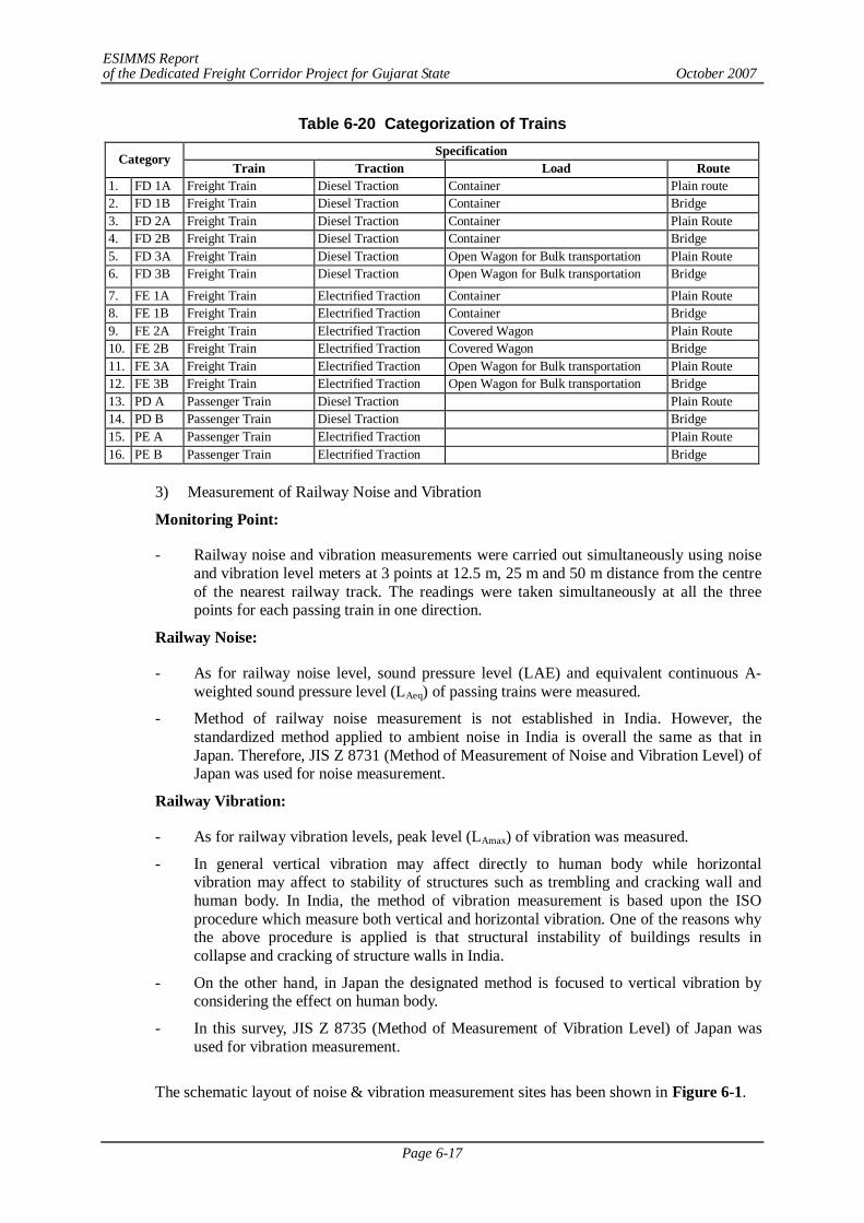
ESIMMS Report of the Dedicated Freight Corridor Project for Gujarat State October 2007
Page 6-17
Table 6-20 Categorization of Trains Specification Category
Train Traction Load Route 1. FD 1A Freight Train Diesel Traction Container Plain route 2. FD 1B Freight Train Diesel Traction Container Bridge 3. FD 2A Freight Train Diesel Traction Container Plain Route 4. FD 2B Freight Train Diesel Traction Container Bridge 5. FD 3A Freight Train Diesel Traction Open Wagon for Bulk transportation Plain Route 6. FD 3B Freight Train Diesel Traction Open Wagon for Bulk transportation Bridge
7. FE 1A Freight Train Electrified Traction Container Plain Route 8. FE 1B Freight Train Electrified Traction Container Bridge 9. FE 2A Freight Train Electrified Traction Covered Wagon Plain Route 10. FE 2B Freight Train Electrified Traction Covered Wagon Bridge 11. FE 3A Freight Train Electrified Traction Open Wagon for Bulk transportation Plain Route 12. FE 3B Freight Train Electrified Traction Open Wagon for Bulk transportation Bridge 13. PD A Passenger Train Diesel Traction Plain Route 14. PD B Passenger Train Diesel Traction Bridge 15. PE A Passenger Train Electrified Traction Plain Route 16. PE B Passenger Train Electrified Traction Bridge
3) Measurement of Railway Noise and Vibration
Monitoring Point:
- Railway noise and vibration measurements were carried out simultaneously using noise and vibration level meters at 3 points at 12.5 m, 25 m and 50 m distance from the centre of the nearest railway track. The readings were taken simultaneously at all the three points for each passing train in one direction.
Railway Noise:
- As for railway noise level, sound pressure level (LAE) and equivalent continuous A-weighted sound pressure level (LAeq) of passing trains were measured.
- Method of railway noise measurement is not established in India. However, the standardized method applied to ambient noise in India is overall the same as that in Japan. Therefore, JIS Z 8731 (Method of Measurement of Noise and Vibration Level) of Japan was used for noise measurement.
Railway Vibration:
- As for railway vibration levels, peak level (LAmax) of vibration was measured.
- In general vertical vibration may affect directly to human body while horizontal vibration may affect to stability of structures such as trembling and cracking wall and human body. In India, the method of vibration measurement is based upon the ISO procedure which measure both vertical and horizontal vibration. One of the reasons why the above procedure is applied is that structural instability of buildings results in collapse and cracking of structure walls in India.
- On the other hand, in Japan the designated method is focused to vertical vibration by considering the effect on human body.
- In this survey, JIS Z 8735 (Method of Measurement of Vibration Level) of Japan was used for vibration measurement.
The schematic layout of noise & vibration measurement sites has been shown in Figure 6-1.
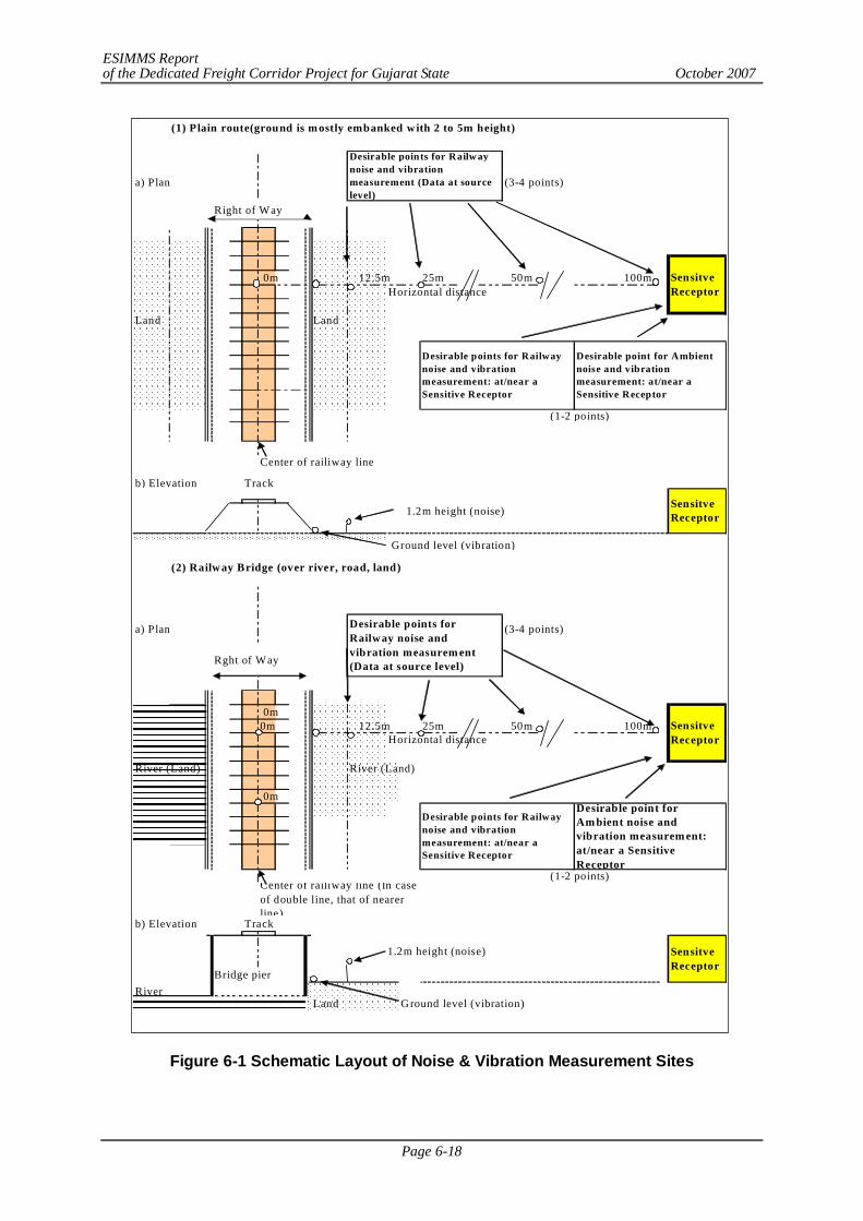
ESIMMS Report of the Dedicated Freight Corridor Project for Gujarat State October 2007
Page 6-18
Figure 6-1 Schematic Layout of Noise & Vibration Measurement Sites
(1) Plain route(ground is m ostly embanked with 2 to 5m height)
a) Plan (3-4 points)
Right of Way
0m 12.5m 25m 50m 100mHorizontal distance
Land Land
(1-2 points)
Center of railiway line
b) Elevation Track
1.2m height (noise)
Ground level (vibration)
(2) Railway Bridge (over river, road, land)
a) Plan (3-4 points)
Rght of Way
0m0m 12.5m 25m 50m 100m
Horizontal distance
River (Land) River (Land)
0m
(1-2 points)
b) Elevation Track
1.2m height (noise)
Bridge pierRiver
Land Ground level (vibration)
Figure 1 Schematic plan and elevation of railway and ambient noise and vibration
Desirable points for Railw aynoise and vibrationmeasurement (Data at sourcelevel)
SensitveReceptor
Desirable points for Railwaynoise and vibrationmeasurement: at/near aSensitive Receptor
Desirable points for Railwaynoise and vibrationmeasurement: at/near aSensitive Receptor
SensitveReceptor
SensitveReceptor
Desirable points forRailway noise andvibration measurem ent(Data at source level)
Center of railiway line (In caseof double line, that of nearerline)
Desirable point for Ambientnoise and vibrationmeasurement: at/near aSensitive Receptor
Desirable point forAm bient noise andvibration measurem ent:at/near a SensitiveReceptor
SensitveReceptor
ESIMMS Report of the Dedicated Freight Corridor Project for Gujarat State October 2007
Page 6-19
Definition of SR Sites: Facilities and structures such as schools, hospitals, temples, historical and cultural assets and parks have important roles to community and residents and need to have quietness and substantial structural stability. If these facilities are close to the railway line, adverse impact of noise and vibration due to traffic of freight trains may occur to some extent. Thus, these facilities are defined as Sensitive Receptor (SR) sites which serve as indicators for the evaluation of noise and vibration impacts.
ASR Study: Sensitive receptors are identified as educational institutes, hospitals and health centres, courts and religious establishments. Ambient noise and vibration were surveyed at or in near proximity of different identified sensitive receptors located close to the railway track or along the proposed DFC. The readings were taken continuously for 4 hours.
RSR Study: The noise and vibration survey conducted at the sensitive receptor points at the time of any train passing by the track is considered as railway noise and vibration survey at sensitive receptors or RSR. In case of RSR almost the same procedure of ASR is followed. The RSR measurements were conducted for all the trains passing including crossing trains passing both directions for a time interval of 2 hours. Among the total 20 SR points along whole of the DFC alignment RSR study was done in 10 points.
Stepwise general methodology of noise and vibration measurement near sensitive receptors is as follows,
- The measurement is done at a point near to the sensitive receptors for the stipulated time span of 4 or 2 hrs.
- Ambient noise and vibration levels were measured for LAeq and ambient vibration levels were also measured for LAmax and L10 at each SR sites.
- Together with ambient noise and vibration measurement, railway noise and vibration measurement at SR sites were measured for LAeq and LAmax, respectively.
- Measurement was conducted in accordance with JIS Z 8731 for noise and JIS Z 8735 for vibration.
- The detailed site conditions, like land use, urban/rural condition, structures and facilities prevailing around the sampling sites etc.
- Four photographs of each of the point have been taken to show the area profile of the point.
Questionnaire Survey Methodology: Parallel to the noise and vibration measurement, a questionnaire survey was also conducted among the local people residing around the Sensitive receptor point. They were asked to answer a few questions related to their perceptions over the disturbances and annoyance caused by railway noise and vibration due to existing railway track. 10 respondents were chosen randomly from each of the sampling sites and interviewed only after making them understand the purpose of the survey.
6.3.4 Detailed Railway Noise and Vibration Survey (DR Study)
Along the DFC alignment, detailed railway noise and vibration survey has been conducted at five selected points, but none of them falls in Patan, Gandhinagar, Anand and Vadodara district. Therefore, for these districts no DR study has been conducted.
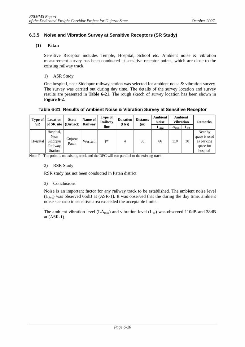
ESIMMS Report of the Dedicated Freight Corridor Project for Gujarat State October 2007
Page 6-20
6.3.5 Noise and Vibration Survey at Sensitive Receptors (SR Study)
(1) Patan
Sensitive Receptor includes Temple, Hospital, School etc. Ambient noise & vibration measurement survey has been conducted at sensitive receptor points, which are close to the existing railway track.
1) ASR Study
One hospital, near Siddhpur railway station was selected for ambient noise & vibration survey. The survey was carried out during day time. The details of the survey location and survey results are presented in Table 6-21. The rough sketch of survey location has been shown in Figure 6-2.
Table 6-21 Results of Ambient Noise & Vibration Survey at Sensitive Receptor Ambient
Noise Ambient Vibration Type of
SR Location of SR site
State (District)
Name of Railway
Type of Railway
line
Duration (Hrs)
Distance (m)
LAeq LAmax L10 Remarks
Hospital
Hospital, Near
Siddhpur Railway Station
Gujarat Patan Western P* 4 35 66 110 38
Near by space is used
as parking space for hospital
Note: P - The point is on existing track and the DFC will run parallel to the existing track
2) RSR Study
RSR study has not been conducted in Patan district
3) Conclusions
Noise is an important factor for any railway track to be established. The ambient noise level (LAeq) was observed 66dB at (ASR-1). It was observed that the during the day time, ambient noise scenario in sensitive area exceeded the acceptable limits.
The ambient vibration level (LAmax) and vibration level (L10) was observed 110dB and 38dB at (ASR-1).
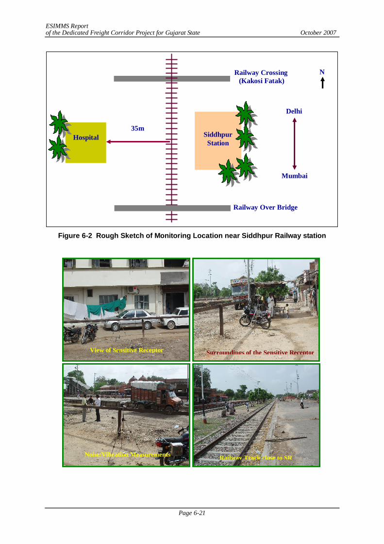
ESIMMS Report of the Dedicated Freight Corridor Project for Gujarat State October 2007
Page 6-21
Figure 6-2 Rough Sketch of Monitoring Location near Siddhpur Railway station
Railway Crossing (Kakosi Fatak)
Delhi
Mumbai
Siddhpur Station
Railway Over Bridge
Hospital
35m
N
Surroundings of the Sensitive Receptor View of Sensitive Receptor
Railway Track close to SR Noise/Vibration Measurements Instrument
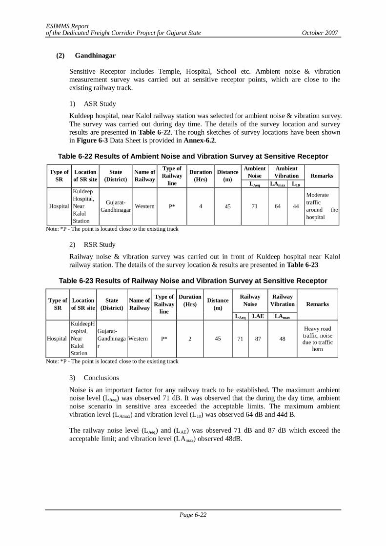
ESIMMS Report of the Dedicated Freight Corridor Project for Gujarat State October 2007
Page 6-22
(2) Gandhinagar
Sensitive Receptor includes Temple, Hospital, School etc. Ambient noise & vibration measurement survey was carried out at sensitive receptor points, which are close to the existing railway track.
1) ASR Study
Kuldeep hospital, near Kalol railway station was selected for ambient noise & vibration survey. The survey was carried out during day time. The details of the survey location and survey results are presented in Table 6-22. The rough sketches of survey locations have been shown in Figure 6-3 Data Sheet is provided in Annex-6.2.
Table 6-22 Results of Ambient Noise and Vibration Survey at Sensitive Receptor Ambient
Noise Ambient Vibration Type of
SR Location of SR site
State (District)
Name of Railway
Type of Railway
line
Duration (Hrs)
Distance (m)
LAeq LAmax L10 Remarks
Hospital
Kuldeep Hospital, Near Kalol Station
Gujarat- Gandhinagar Western P* 4 45 71 64 44
Moderate traffic around the hospital
Note: *P - The point is located close to the existing track
2) RSR Study
Railway noise & vibration survey was carried out in front of Kuldeep hospital near Kalol railway station. The details of the survey location & results are presented in Table 6-23
Table 6-23 Results of Railway Noise and Vibration Survey at Sensitive Receptor
Railway Noise
Railway Vibration Type of
SR Location of SR site
State (District)
Name of Railway
Type of Railway
line
Duration (Hrs)
Distance (m)
LAeq LAE LAmax
Remarks
Hospital
KuldeepHospital, Near Kalol Station
Gujarat- Gandhinagar
Western P* 2 45 71 87 48
Heavy road traffic, noise due to traffic
horn
Note: *P - The point is located close to the existing track
3) Conclusions
Noise is an important factor for any railway track to be established. The maximum ambient noise level (LAeq) was observed 71 dB. It was observed that the during the day time, ambient noise scenario in sensitive area exceeded the acceptable limits. The maximum ambient vibration level (LAmax) and vibration level (L10) was observed 64 dB and 44d B.
The railway noise level (LAeq) and (LAE) was observed 71 dB and 87 dB which exceed the acceptable limit; and vibration level (LAmax) observed 48dB.
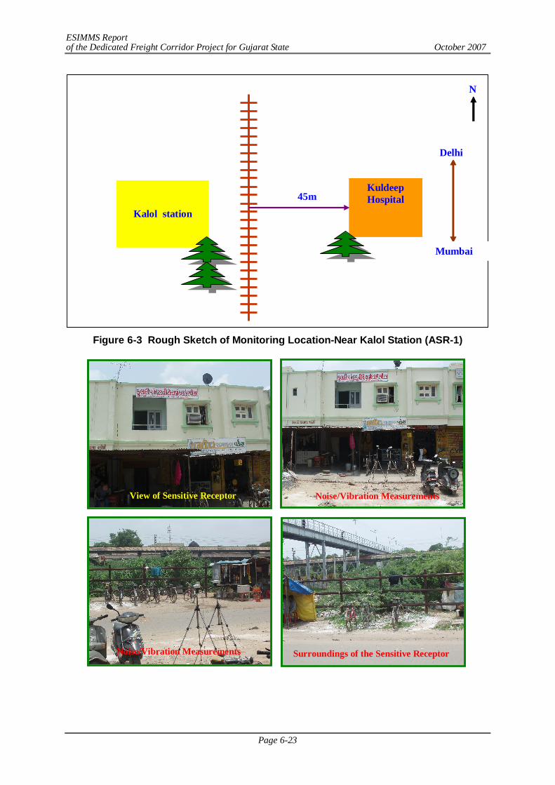
ESIMMS Report of the Dedicated Freight Corridor Project for Gujarat State October 2007
Page 6-23
Figure 6-3 Rough Sketch of Monitoring Location-Near Kalol Station (ASR-1)
View of Sensitive Receptor
Noise/Vibration Measurements
Surroundings of the Sensitive Receptor Noise/Vibration Measurements
Kalol station
Kuldeep Hospital
Mumbai
Delhi
N
45m
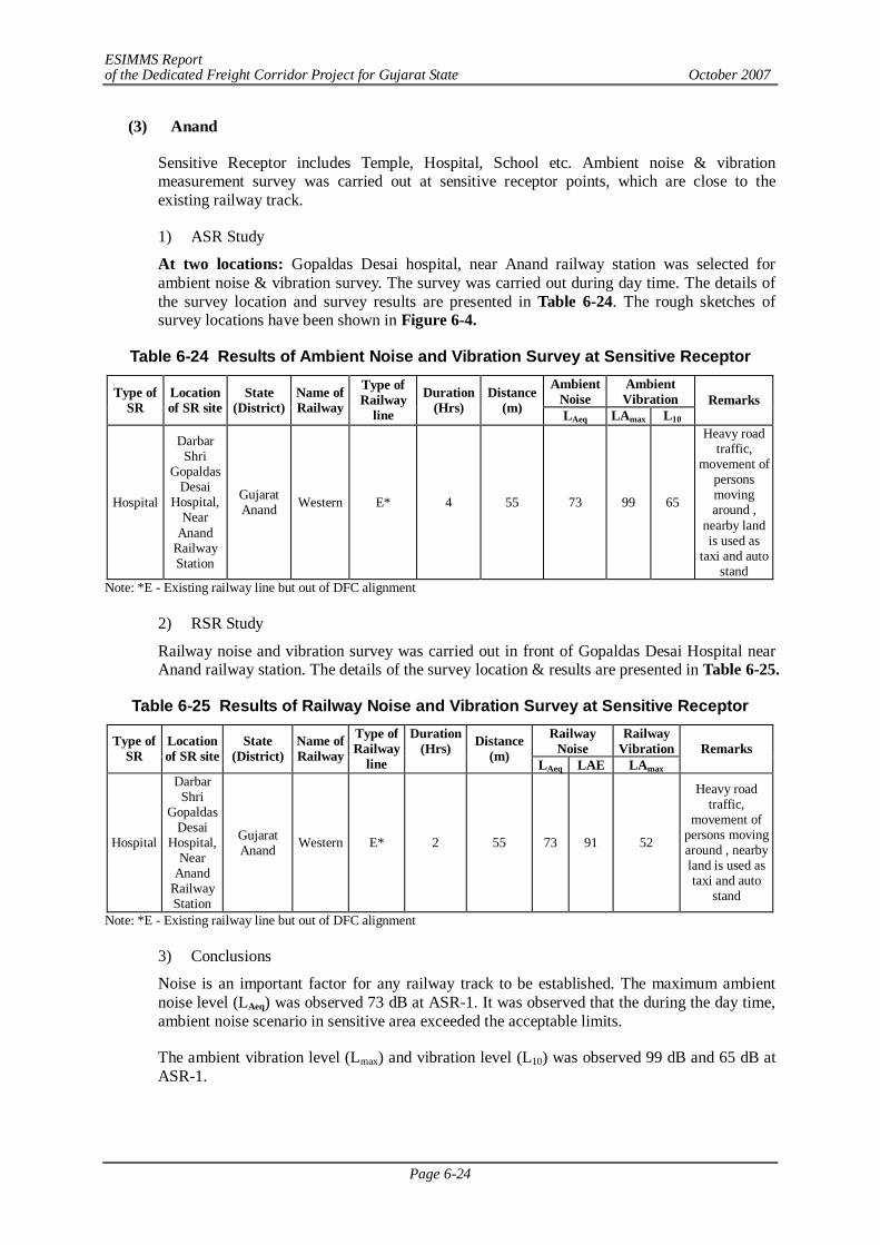
ESIMMS Report of the Dedicated Freight Corridor Project for Gujarat State October 2007
Page 6-24
(3) Anand
Sensitive Receptor includes Temple, Hospital, School etc. Ambient noise & vibration measurement survey was carried out at sensitive receptor points, which are close to the existing railway track.
1) ASR Study
At two locations: Gopaldas Desai hospital, near Anand railway station was selected for ambient noise & vibration survey. The survey was carried out during day time. The details of the survey location and survey results are presented in Table 6-24. The rough sketches of survey locations have been shown in Figure 6-4.
Table 6-24 Results of Ambient Noise and Vibration Survey at Sensitive Receptor Ambient
Noise Ambient Vibration Type of
SR Location of SR site
State (District)
Name of Railway
Type of Railway
line
Duration (Hrs)
Distance (m) LAeq LAmax L10
Remarks
Hospital
Darbar Shri
Gopaldas Desai
Hospital, Near
Anand Railway Station
Gujarat Anand Western E* 4 55 73 99 65
Heavy road traffic,
movement of persons moving around ,
nearby land is used as
taxi and auto stand
Note: *E - Existing railway line but out of DFC alignment
2) RSR Study
Railway noise and vibration survey was carried out in front of Gopaldas Desai Hospital near Anand railway station. The details of the survey location & results are presented in Table 6-25.
Table 6-25 Results of Railway Noise and Vibration Survey at Sensitive Receptor Railway
Noise Railway
Vibration Type of SR
Location of SR site
State (District)
Name of Railway
Type of Railway
line
Duration (Hrs)
Distance (m) LAeq LAE LAmax
Remarks
Hospital
Darbar Shri
Gopaldas Desai
Hospital, Near
Anand Railway Station
Gujarat Anand Western E* 2 55 73 91 52
Heavy road traffic,
movement of persons moving around , nearby land is used as taxi and auto
stand
Note: *E - Existing railway line but out of DFC alignment
3) Conclusions
Noise is an important factor for any railway track to be established. The maximum ambient noise level (LAeq) was observed 73 dB at ASR-1. It was observed that the during the day time, ambient noise scenario in sensitive area exceeded the acceptable limits.
The ambient vibration level (Lmax) and vibration level (L10) was observed 99 dB and 65 dB at ASR-1.
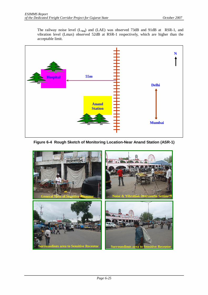
ESIMMS Report of the Dedicated Freight Corridor Project for Gujarat State October 2007
Page 6-25
The railway noise level (LAeq) and (LAE) was observed 73dB and 91dB at RSR-1, and vibration level (Lmax) observed 52dB at RSR-1 respectively, which are higher than the acceptable limit.
Figure 6-4 Rough Sketch of Monitoring Location-Near Anand Station (ASR-1)
Anand Station
Mumbai
Delhi
N
Hospital
55m
General View of Sensitive Receptor Noise & Vibration Instrument Setting
Surroundings area to Sensitive Receptor Surroundings area to Sensitive Receptor
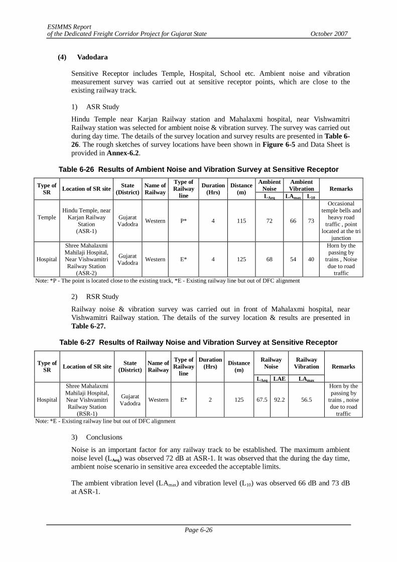
ESIMMS Report of the Dedicated Freight Corridor Project for Gujarat State October 2007
Page 6-26
(4) Vadodara
Sensitive Receptor includes Temple, Hospital, School etc. Ambient noise and vibration measurement survey was carried out at sensitive receptor points, which are close to the existing railway track.
1) ASR Study
Hindu Temple near Karjan Railway station and Mahalaxmi hospital, near Vishwamitri Railway station was selected for ambient noise & vibration survey. The survey was carried out during day time. The details of the survey location and survey results are presented in Table 6-26. The rough sketches of survey locations have been shown in Figure 6-5 and Data Sheet is provided in Annex-6.2.
Table 6-26 Results of Ambient Noise and Vibration Survey at Sensitive Receptor Ambient
Noise Ambient Vibration Type of
SR Location of SR site State (District)
Name of Railway
Type of Railway
line
Duration (Hrs)
Distance (m) LAeq LAmax L10
Remarks
Temple
Hindu Temple, near Karjan Railway
Station (ASR-1)
Gujarat Vadodra Western P* 4 115 72 66 73
Occasional temple bells and
heavy road traffic , point
located at the tri junction
Hospital
Shree Mahalaxmi Mahilaji Hospital, Near Vishwamitri Railway Station
(ASR-2)
Gujarat Vadodra Western E* 4 125 68 54 40
Horn by the passing by
trains , Noise due to road
traffic Note: *P - The point is located close to the existing track, *E - Existing railway line but out of DFC alignment
2) RSR Study
Railway noise & vibration survey was carried out in front of Mahalaxmi hospital, near Vishwamitri Railway station. The details of the survey location & results are presented in Table 6-27.
Table 6-27 Results of Railway Noise and Vibration Survey at Sensitive Receptor
Railway Noise
Railway Vibration Type of
SR Location of SR site State (District)
Name of Railway
Type of Railway
line
Duration (Hrs)
Distance (m)
LAeq LAE LAmax
Remarks
Hospital
Shree Mahalaxmi Mahilaji Hospital, Near Vishvamitri Railway Station
(RSR-1)
Gujarat Vadodra Western E* 2 125 67.5 92.2 56.5
Horn by the passing by
trains , noise due to road
traffic Note: *E - Existing railway line but out of DFC alignment
3) Conclusions
Noise is an important factor for any railway track to be established. The maximum ambient noise level (LAeq) was observed 72 dB at ASR-1. It was observed that the during the day time, ambient noise scenario in sensitive area exceeded the acceptable limits.
The ambient vibration level (LAmax) and vibration level (L10) was observed 66 dB and 73 dB at ASR-1.
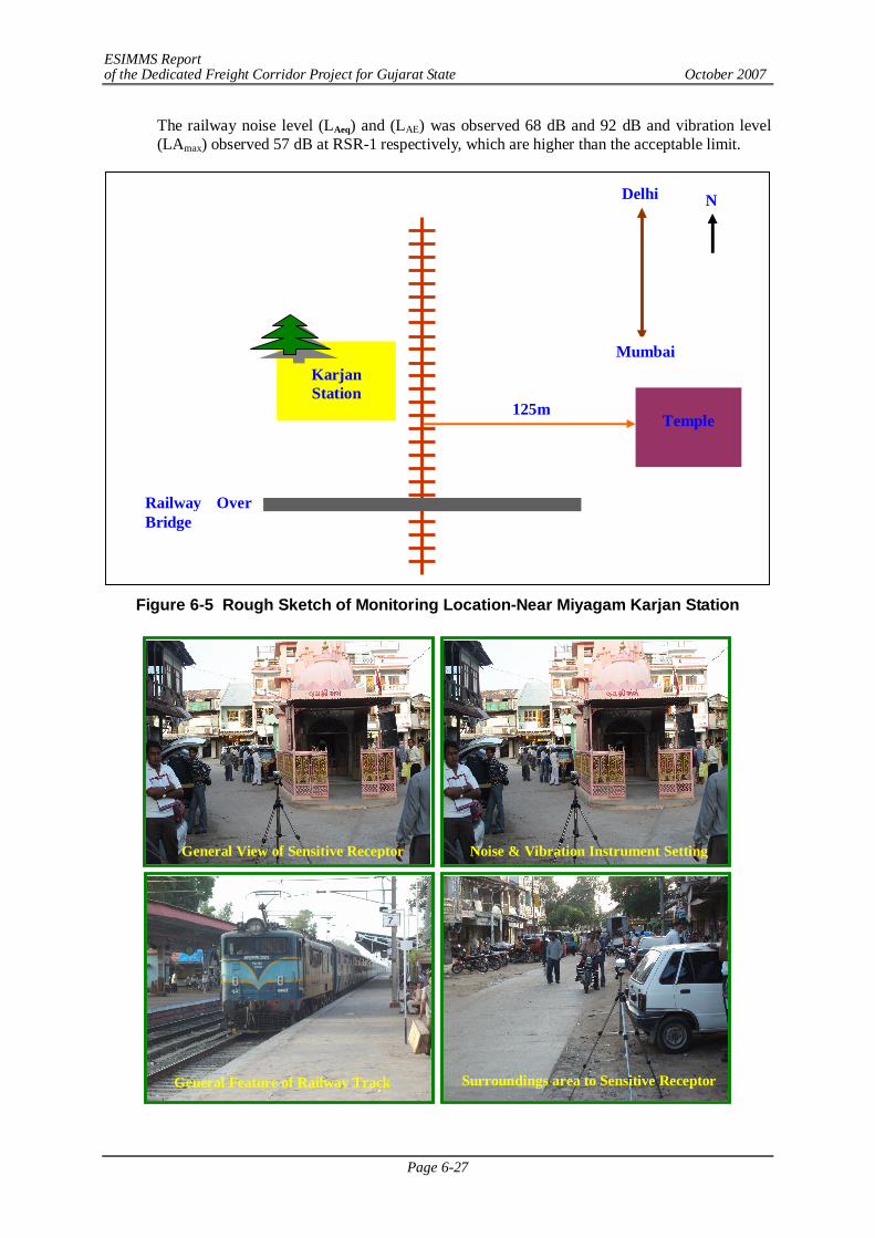
ESIMMS Report of the Dedicated Freight Corridor Project for Gujarat State October 2007
Page 6-27
The railway noise level (LAeq) and (LAE) was observed 68 dB and 92 dB and vibration level (LAmax) observed 57 dB at RSR-1 respectively, which are higher than the acceptable limit.
Figure 6-5 Rough Sketch of Monitoring Location-Near Miyagam Karjan Station
Karjan Station
Mumbai
Delhi N
Railway Over Bridge
Temple
125m
Surroundings area to Sensitive Receptor General Feature of Railway Track
General View of Sensitive Receptor Noise & Vibration Instrument Setting
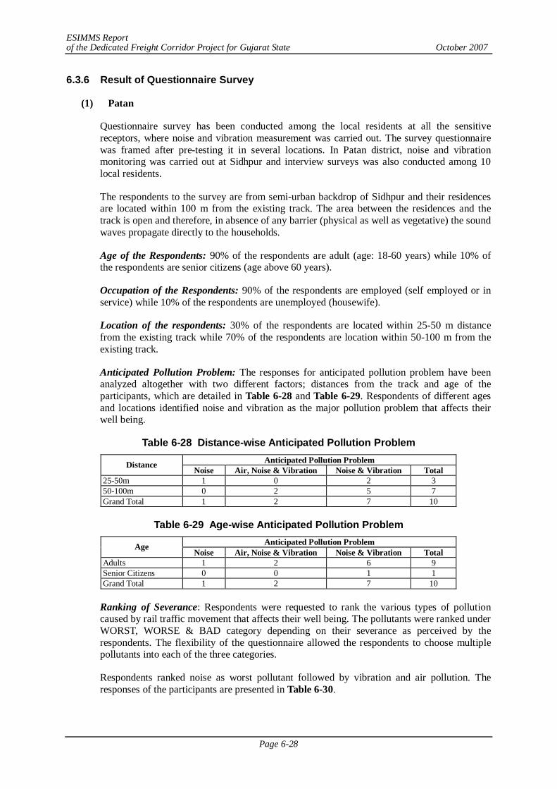
ESIMMS Report of the Dedicated Freight Corridor Project for Gujarat State October 2007
Page 6-28
6.3.6 Result of Questionnaire Survey
(1) Patan
Questionnaire survey has been conducted among the local residents at all the sensitive receptors, where noise and vibration measurement was carried out. The survey questionnaire was framed after pre-testing it in several locations. In Patan district, noise and vibration monitoring was carried out at Sidhpur and interview surveys was also conducted among 10 local residents.
The respondents to the survey are from semi-urban backdrop of Sidhpur and their residences are located within 100 m from the existing track. The area between the residences and the track is open and therefore, in absence of any barrier (physical as well as vegetative) the sound waves propagate directly to the households.
Age of the Respondents: 90% of the respondents are adult (age: 18-60 years) while 10% of the respondents are senior citizens (age above 60 years).
Occupation of the Respondents: 90% of the respondents are employed (self employed or in service) while 10% of the respondents are unemployed (housewife).
Location of the respondents: 30% of the respondents are located within 25-50 m distance from the existing track while 70% of the respondents are location within 50-100 m from the existing track.
Anticipated Pollution Problem: The responses for anticipated pollution problem have been analyzed altogether with two different factors; distances from the track and age of the participants, which are detailed in Table 6-28 and Table 6-29. Respondents of different ages and locations identified noise and vibration as the major pollution problem that affects their well being.
Table 6-28 Distance-wise Anticipated Pollution Problem Anticipated Pollution Problem Distance Noise Air, Noise & Vibration Noise & Vibration Total
25-50m 1 0 2 3 50-100m 0 2 5 7 Grand Total 1 2 7 10
Table 6-29 Age-wise Anticipated Pollution Problem
Anticipated Pollution Problem Age Noise Air, Noise & Vibration Noise & Vibration Total
Adults 1 2 6 9 Senior Citizens 0 0 1 1 Grand Total 1 2 7 10
Ranking of Severance: Respondents were requested to rank the various types of pollution caused by rail traffic movement that affects their well being. The pollutants were ranked under WORST, WORSE & BAD category depending on their severance as perceived by the respondents. The flexibility of the questionnaire allowed the respondents to choose multiple pollutants into each of the three categories.
Respondents ranked noise as worst pollutant followed by vibration and air pollution. The responses of the participants are presented in Table 6-30.
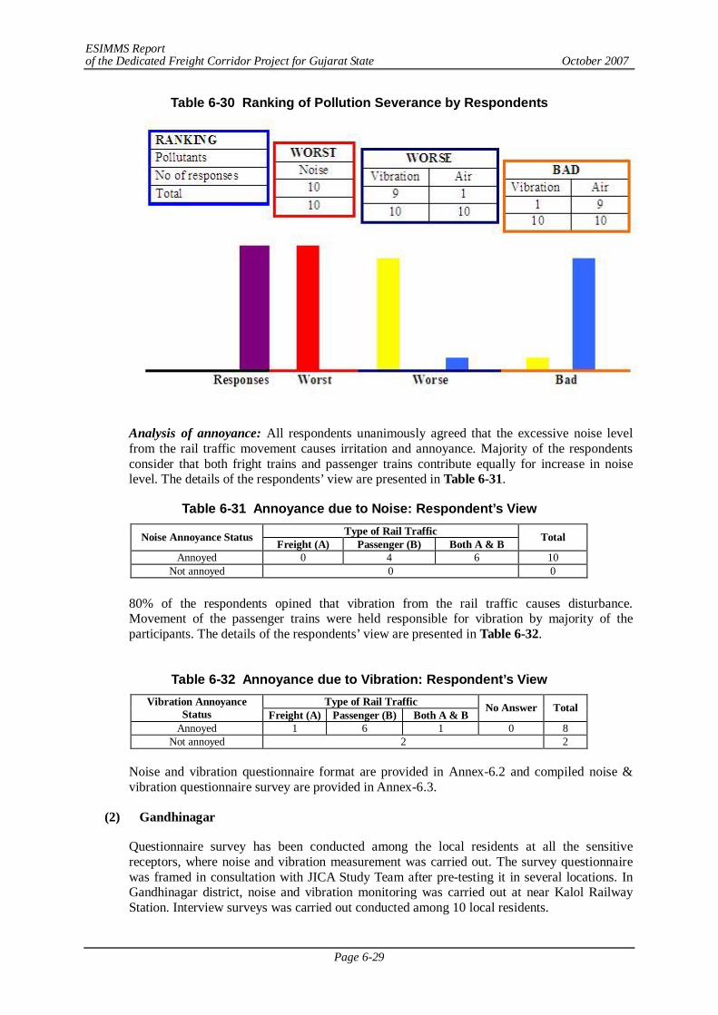
ESIMMS Report of the Dedicated Freight Corridor Project for Gujarat State October 2007
Page 6-29
Table 6-30 Ranking of Pollution Severance by Respondents
Analysis of annoyance: All respondents unanimously agreed that the excessive noise level from the rail traffic movement causes irritation and annoyance. Majority of the respondents consider that both fright trains and passenger trains contribute equally for increase in noise level. The details of the respondents’ view are presented in Table 6-31.
Table 6-31 Annoyance due to Noise: Respondent’s View Type of Rail Traffic Noise Annoyance Status Freight (A) Passenger (B) Both A & B Total
Annoyed 0 4 6 10 Not annoyed 0 0
80% of the respondents opined that vibration from the rail traffic causes disturbance. Movement of the passenger trains were held responsible for vibration by majority of the participants. The details of the respondents’ view are presented in Table 6-32.
Table 6-32 Annoyance due to Vibration: Respondent’s View
Type of Rail Traffic Vibration Annoyance Status Freight (A) Passenger (B) Both A & B
No Answer Total
Annoyed 1 6 1 0 8 Not annoyed 2 2
Noise and vibration questionnaire format are provided in Annex-6.2 and compiled noise & vibration questionnaire survey are provided in Annex-6.3.
(2) Gandhinagar
Questionnaire survey has been conducted among the local residents at all the sensitive receptors, where noise and vibration measurement was carried out. The survey questionnaire was framed in consultation with JICA Study Team after pre-testing it in several locations. In Gandhinagar district, noise and vibration monitoring was carried out at near Kalol Railway Station. Interview surveys was carried out conducted among 10 local residents.
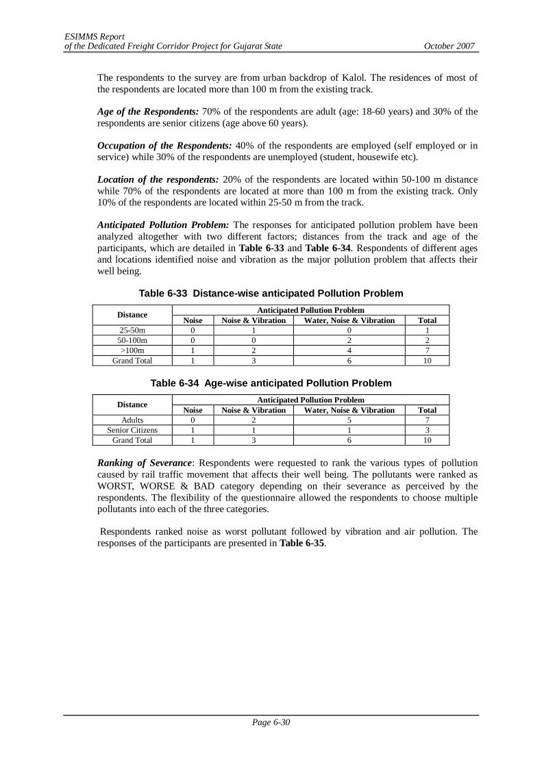
ESIMMS Report of the Dedicated Freight Corridor Project for Gujarat State October 2007
Page 6-30
The respondents to the survey are from urban backdrop of Kalol. The residences of most of the respondents are located more than 100 m from the existing track.
Age of the Respondents: 70% of the respondents are adult (age: 18-60 years) and 30% of the respondents are senior citizens (age above 60 years).
Occupation of the Respondents: 40% of the respondents are employed (self employed or in service) while 30% of the respondents are unemployed (student, housewife etc).
Location of the respondents: 20% of the respondents are located within 50-100 m distance while 70% of the respondents are located at more than 100 m from the existing track. Only 10% of the respondents are located within 25-50 m from the track.
Anticipated Pollution Problem: The responses for anticipated pollution problem have been analyzed altogether with two different factors; distances from the track and age of the participants, which are detailed in Table 6-33 and Table 6-34. Respondents of different ages and locations identified noise and vibration as the major pollution problem that affects their well being.
Table 6-33 Distance-wise anticipated Pollution Problem Anticipated Pollution Problem Distance
Noise Noise & Vibration Water, Noise & Vibration Total 25-50m 0 1 0 1
50-100m 0 0 2 2 >100m 1 2 4 7
Grand Total 1 3 6 10
Table 6-34 Age-wise anticipated Pollution Problem Anticipated Pollution Problem Distance
Noise Noise & Vibration Water, Noise & Vibration Total Adults 0 2 5 7
Senior Citizens 1 1 1 3 Grand Total 1 3 6 10
Ranking of Severance: Respondents were requested to rank the various types of pollution caused by rail traffic movement that affects their well being. The pollutants were ranked as WORST, WORSE & BAD category depending on their severance as perceived by the respondents. The flexibility of the questionnaire allowed the respondents to choose multiple pollutants into each of the three categories.
Respondents ranked noise as worst pollutant followed by vibration and air pollution. The responses of the participants are presented in Table 6-35.
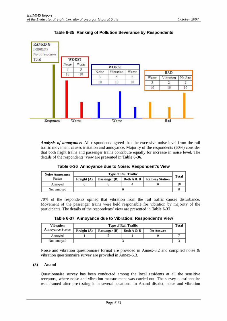
ESIMMS Report of the Dedicated Freight Corridor Project for Gujarat State October 2007
Page 6-31
Table 6-35 Ranking of Pollution Severance by Respondents
Analysis of annoyance: All respondents agreed that the excessive noise level from the rail traffic movement causes irritation and annoyance. Majority of the respondents (60%) consider that both fright trains and passenger trains contribute equally for increase in noise level. The details of the respondents’ view are presented in Table 6-36.
Table 6-36 Annoyance due to Noise: Respondent’s View
Type of Rail Traffic Noise Annoyance Status Freight (A) Passenger (B) Both A & B Railway Station
Total
Annoyed 0 6 4 0 10 Not annoyed 0 0
70% of the respondents opined that vibration from the rail traffic causes disturbance. Movement of the passenger trains were held responsible for vibration by majority of the participants. The details of the respondents’ view are presented in Table 6-37.
Table 6-37 Annoyance due to Vibration: Respondent’s View Type of Rail Traffic Vibration
Annoyance Status Freight (A) Passenger (B) Both A & B No Answer Total
Annoyed 1 5 1 0 7 Not annoyed 3 3
Noise and vibration questionnaire format are provided in Annex-6.2 and compiled noise & vibration questionnaire survey are provided in Annex-6.3.
(3) Anand
Questionnaire survey has been conducted among the local residents at all the sensitive receptors, where noise and vibration measurement was carried out. The survey questionnaire was framed after pre-testing it in several locations. In Anand district, noise and vibration
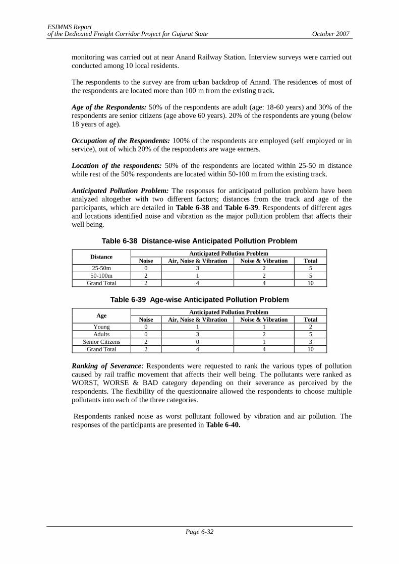
ESIMMS Report of the Dedicated Freight Corridor Project for Gujarat State October 2007
Page 6-32
monitoring was carried out at near Anand Railway Station. Interview surveys were carried out conducted among 10 local residents.
The respondents to the survey are from urban backdrop of Anand. The residences of most of the respondents are located more than 100 m from the existing track.
Age of the Respondents: 50% of the respondents are adult (age: 18-60 years) and 30% of the respondents are senior citizens (age above 60 years). 20% of the respondents are young (below 18 years of age).
Occupation of the Respondents: 100% of the respondents are employed (self employed or in service), out of which 20% of the respondents are wage earners.
Location of the respondents: 50% of the respondents are located within 25-50 m distance while rest of the 50% respondents are located within 50-100 m from the existing track.
Anticipated Pollution Problem: The responses for anticipated pollution problem have been analyzed altogether with two different factors; distances from the track and age of the participants, which are detailed in Table 6-38 and Table 6-39. Respondents of different ages and locations identified noise and vibration as the major pollution problem that affects their well being.
Table 6-38 Distance-wise Anticipated Pollution Problem Anticipated Pollution Problem Distance Noise Air, Noise & Vibration Noise & Vibration Total
25-50m 0 3 2 5 50-100m 2 1 2 5
Grand Total 2 4 4 10
Table 6-39 Age-wise Anticipated Pollution Problem Anticipated Pollution Problem Age Noise Air, Noise & Vibration Noise & Vibration Total
Young 0 1 1 2 Adults 0 3 2 5
Senior Citizens 2 0 1 3 Grand Total 2 4 4 10
Ranking of Severance: Respondents were requested to rank the various types of pollution caused by rail traffic movement that affects their well being. The pollutants were ranked as WORST, WORSE & BAD category depending on their severance as perceived by the respondents. The flexibility of the questionnaire allowed the respondents to choose multiple pollutants into each of the three categories.
Respondents ranked noise as worst pollutant followed by vibration and air pollution. The responses of the participants are presented in Table 6-40.
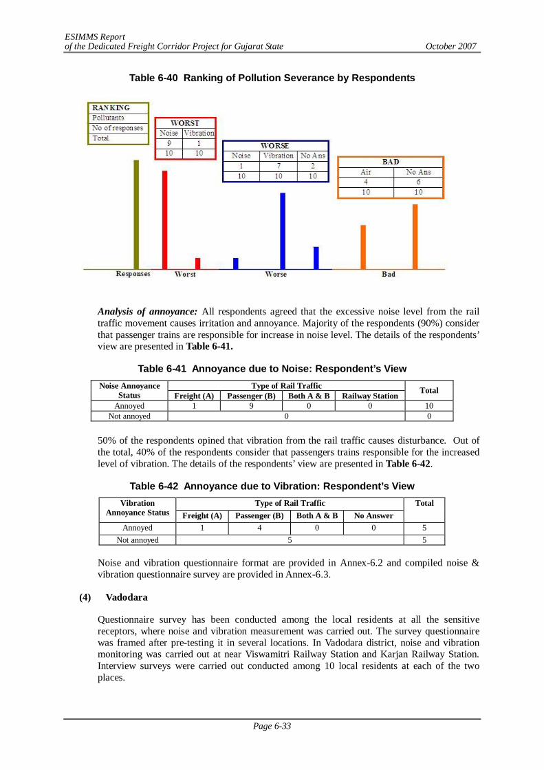
ESIMMS Report of the Dedicated Freight Corridor Project for Gujarat State October 2007
Page 6-33
Table 6-40 Ranking of Pollution Severance by Respondents
Analysis of annoyance: All respondents agreed that the excessive noise level from the rail traffic movement causes irritation and annoyance. Majority of the respondents (90%) consider that passenger trains are responsible for increase in noise level. The details of the respondents’ view are presented in Table 6-41.
Table 6-41 Annoyance due to Noise: Respondent’s View Type of Rail Traffic Noise Annoyance
Status Freight (A) Passenger (B) Both A & B Railway Station Total
Annoyed 1 9 0 0 10 Not annoyed 0 0
50% of the respondents opined that vibration from the rail traffic causes disturbance. Out of the total, 40% of the respondents consider that passengers trains responsible for the increased level of vibration. The details of the respondents’ view are presented in Table 6-42.
Table 6-42 Annoyance due to Vibration: Respondent’s View Type of Rail Traffic Vibration
Annoyance Status Freight (A) Passenger (B) Both A & B No Answer Total
Annoyed 1 4 0 0 5 Not annoyed 5 5
Noise and vibration questionnaire format are provided in Annex-6.2 and compiled noise & vibration questionnaire survey are provided in Annex-6.3.
(4) Vadodara
Questionnaire survey has been conducted among the local residents at all the sensitive receptors, where noise and vibration measurement was carried out. The survey questionnaire was framed after pre-testing it in several locations. In Vadodara district, noise and vibration monitoring was carried out at near Viswamitri Railway Station and Karjan Railway Station. Interview surveys were carried out conducted among 10 local residents at each of the two places.
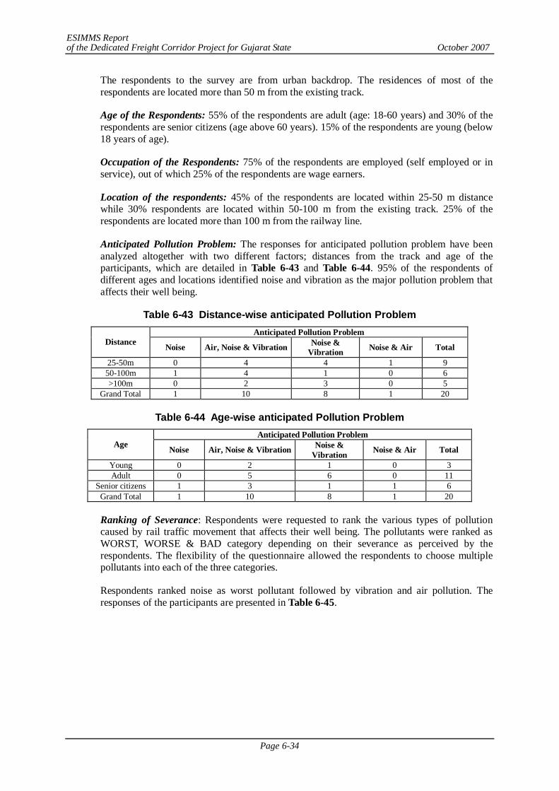
ESIMMS Report of the Dedicated Freight Corridor Project for Gujarat State October 2007
Page 6-34
The respondents to the survey are from urban backdrop. The residences of most of the respondents are located more than 50 m from the existing track.
Age of the Respondents: 55% of the respondents are adult (age: 18-60 years) and 30% of the respondents are senior citizens (age above 60 years). 15% of the respondents are young (below 18 years of age).
Occupation of the Respondents: 75% of the respondents are employed (self employed or in service), out of which 25% of the respondents are wage earners.
Location of the respondents: 45% of the respondents are located within 25-50 m distance while 30% respondents are located within 50-100 m from the existing track. 25% of the respondents are located more than 100 m from the railway line.
Anticipated Pollution Problem: The responses for anticipated pollution problem have been analyzed altogether with two different factors; distances from the track and age of the participants, which are detailed in Table 6-43 and Table 6-44. 95% of the respondents of different ages and locations identified noise and vibration as the major pollution problem that affects their well being.
Table 6-43 Distance-wise anticipated Pollution Problem Anticipated Pollution Problem
Distance Noise Air, Noise & Vibration Noise & Vibration Noise & Air Total
25-50m 0 4 4 1 9 50-100m 1 4 1 0 6 >100m 0 2 3 0 5
Grand Total 1 10 8 1 20
Table 6-44 Age-wise anticipated Pollution Problem Anticipated Pollution Problem
Age Noise Air, Noise & Vibration Noise & Vibration Noise & Air Total
Young 0 2 1 0 3 Adult 0 5 6 0 11
Senior citizens 1 3 1 1 6 Grand Total 1 10 8 1 20
Ranking of Severance: Respondents were requested to rank the various types of pollution caused by rail traffic movement that affects their well being. The pollutants were ranked as WORST, WORSE & BAD category depending on their severance as perceived by the respondents. The flexibility of the questionnaire allowed the respondents to choose multiple pollutants into each of the three categories.
Respondents ranked noise as worst pollutant followed by vibration and air pollution. The responses of the participants are presented in Table 6-45.
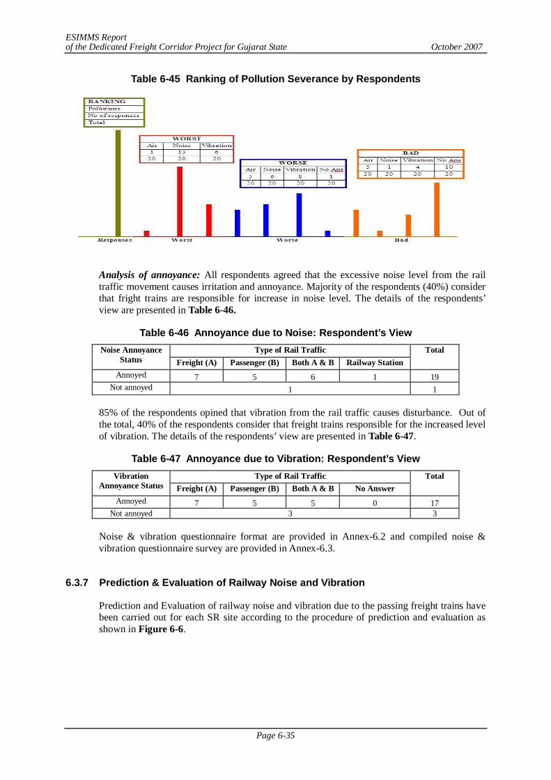
ESIMMS Report of the Dedicated Freight Corridor Project for Gujarat State October 2007
Page 6-35
Table 6-45 Ranking of Pollution Severance by Respondents
Analysis of annoyance: All respondents agreed that the excessive noise level from the rail traffic movement causes irritation and annoyance. Majority of the respondents (40%) consider that fright trains are responsible for increase in noise level. The details of the respondents’ view are presented in Table 6-46.
Table 6-46 Annoyance due to Noise: Respondent’s View Type of Rail Traffic Noise Annoyance
Status Freight (A) Passenger (B) Both A & B Railway Station Total
Annoyed 7 5 6 1 19 Not annoyed 1 1
85% of the respondents opined that vibration from the rail traffic causes disturbance. Out of the total, 40% of the respondents consider that freight trains responsible for the increased level of vibration. The details of the respondents’ view are presented in Table 6-47.
Table 6-47 Annoyance due to Vibration: Respondent’s View Type of Rail Traffic Vibration
Annoyance Status Freight (A) Passenger (B) Both A & B No Answer Total
Annoyed 7 5 5 0 17 Not annoyed 3 3
Noise & vibration questionnaire format are provided in Annex-6.2 and compiled noise & vibration questionnaire survey are provided in Annex-6.3.
6.3.7 Prediction & Evaluation of Railway Noise and Vibration
Prediction and Evaluation of railway noise and vibration due to the passing freight trains have been carried out for each SR site according to the procedure of prediction and evaluation as shown in Figure 6-6.
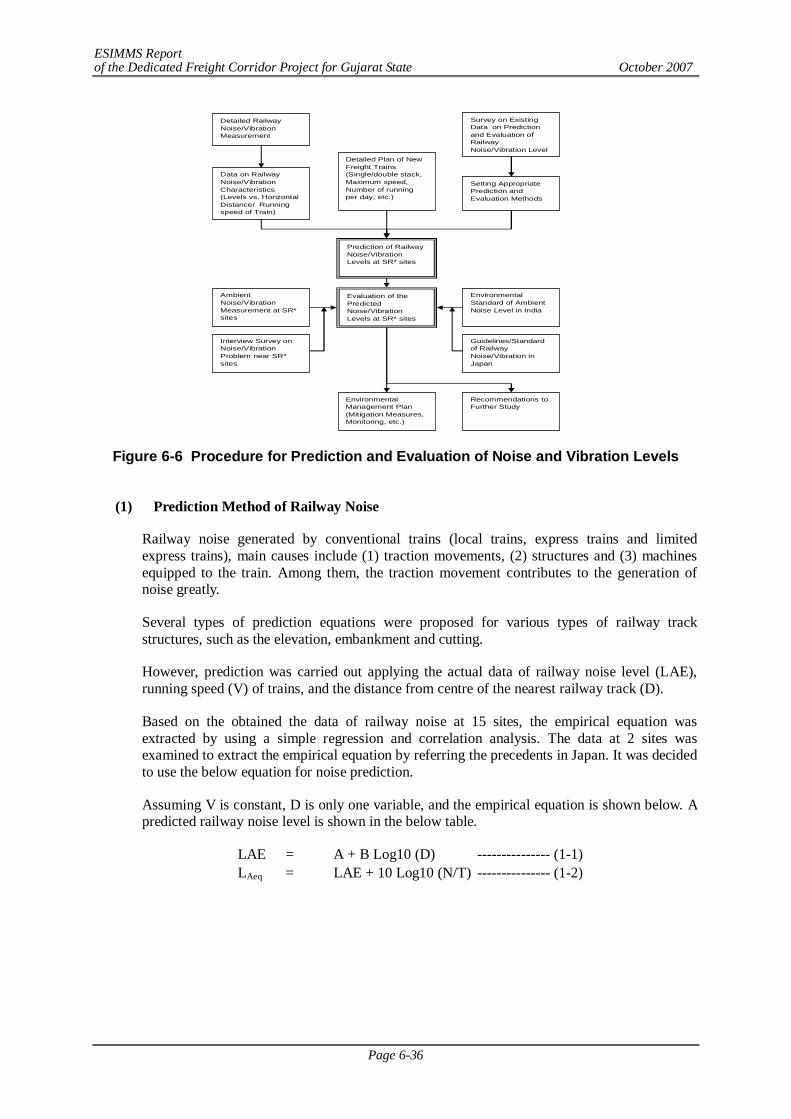
ESIMMS Report of the Dedicated Freight Corridor Project for Gujarat State October 2007
Page 6-36
Figure 6-6 Procedure for Prediction and Evaluation of Noise and Vibration Levels
(1) Prediction Method of Railway Noise
Railway noise generated by conventional trains (local trains, express trains and limited express trains), main causes include (1) traction movements, (2) structures and (3) machines equipped to the train. Among them, the traction movement contributes to the generation of noise greatly.
Several types of prediction equations were proposed for various types of railway track structures, such as the elevation, embankment and cutting.
However, prediction was carried out applying the actual data of railway noise level (LAE), running speed (V) of trains, and the distance from centre of the nearest railway track (D).
Based on the obtained the data of railway noise at 15 sites, the empirical equation was extracted by using a simple regression and correlation analysis. The data at 2 sites was examined to extract the empirical equation by referring the precedents in Japan. It was decided to use the below equation for noise prediction.
Assuming V is constant, D is only one variable, and the empirical equation is shown below. A predicted railway noise level is shown in the below table.
LAE = A + B Log10 (D) --------------- (1-1) LAeq = LAE + 10 Log10 (N/T) --------------- (1-2)
Detailed RailwayNoise/VibrationMeasurement
Data on RailwayNoise/VibrationCharacteristics(Levels vs. HorizontalDistance/ Runningspeed of Train)
Prediction of RailwayNoise/VibrationLevels at SR* sites
Detailed Plan of NewFreight Trains(Single/double stack,Maximum speed,Number of runningper day, etc.)
Evaluation of thePredictedNoise/VibrationLevels at SR* sites
AmbientNoise/VibrationMeasurement at SR*sites
Interview Survey onNoise/VibrationProblem near SR*sites
EnvironmentalManagement Plan(Mitigation Measures,Monitoring, etc.)
EnvironmentalStandard of AmbientNoise Level in India
Guidelines/Standardof RailwayNoise/Vibration inJapan
Recommendations toFurther Study
Setting AppropriatePrediction andEvaluation Methods
Survey on ExistingData on Predictionand Evaluation ofRailwayNoise/Vibration Level

ESIMMS Report of the Dedicated Freight Corridor Project for Gujarat State October 2007
Page 6-37
Table 6-48 Predicted Railway Noise Level by Distance Railway Noise Level [ LAeq(dB)] Trains Category A B
12.5m 25m 50m 100m 200m Noise Level
101 98 96 93 90 LAE Freight Electric FEP 110.59 -8.89
76 73 71 68 65 LAeq Note 1: Electrified Freight Train (Plain Route) Running at 100km/h Note 2: LAE=A+BLog10(D), LAeq=LAE-10Long10(N/T) Note 3: Number of Sample: 6 data, r2 = 0.899
(2) Prediction Method of Railway Vibration
The methodology of railway vibration prediction is not fully established, compared to that of railway noise. Based on the data on the running speed of trains, track types, structures and the distance from the centre of the nearest railway track, a few empirical equations were proposed by Tokyo Metropolitan Government and Osaka Prefecture Government.
However, prediction was carried out applying in the similar manner by applying the actual data of the railway vibration level (LAmax), the running speed (V) of train, and the distance from centre of the nearest railway track (D).
Based on the actual data obtained through railway vibration measurement at 15 sites along the existing the railway, the equation was prepared for the prediction of vibration levels:
Assuming V is constant, D is only one variable, and the empirical equation is shown below. A predicted railway noise level is shown in the below table.
LAmax2 = A2+ B2 Log10 (D) -------------- (2)
Table 6-49 Predicted Railway Vibration Level by Distance
Railway Vibration Level [LAMAX (dB)] Trains Category A B 12.5m 25m 50m 100m 200m
Freight Electric FEP 120.86 -38.04 80 68 56 45 33
Note 1: Electrified Freight Train (Plain Route) Running at 100km/h Note 2: LAmax=A+BLog10(D) Note 3: Number of Sample: 6 data, r2 = 0.973
(3) Prediction and Evaluation of Railway Noise and Vibration due to Dedicated Freight
Trains
Condition of Prediction: Following conditions are assumed:
- Type of traction: electrified traction (electric locomotive)
- Running operation: 140 trains/direction/day with the same time interval (approximately one train for every five minutes)
- Maximum running velocity: 100 km/h
- Targeted railway structures:
- Majority of the existing railway line structures is the embankment structures with approximately 2 to 5 m high from the ground level at the site. Therefore, railway tracks are expected to be located at the same as ground level.
- Railway noise and vibration generation level due to planned dedicated freight train:
ESIMMS Report of the Dedicated Freight Corridor Project for Gujarat State October 2007
Page 6-38
remains the same as the existing freight train, although DFC plan would have various factors contributing to reduction in railway noise and vibration.
(4) Prediction and Evaluation Points
- SR sites along the existing railway lines within the parallel sections of the DFC Project
- SR sites along the existing railway lines within the detour sections of the DFC Project
- Sites along the planned detour routes where no railway noise and vibration were observed as a reference point of the background level monitoring because SR sites were hardly found alongside the detour sectors.
(5) Prediction and Evaluation Results
1) Patan
a) Prediction of Railway Noise Levels
Estimated noise levels (LAeq) in Patan district due to additional new freight trains are shown in Table 6-50. The results were evaluated by comparing with (i) the ambient noise standard in India, (ii) existing ambient noise levels at SR and (iii) existing railway noise at SR. Predicted railway noise level is 72 dB and existing noise level is 66 dB. Both existing & predicted noise levels exceed the ambient noise standard of India. It is considered that road traffic contributes to the higher noise levels at SR sites since at most SR measurement sites, heavy road traffic or relatively heavy traffic was observed during the survey. Moreover, the silent zone which standard level is the lowest is specified not in accordance with the land use type but the building use, such as schools, temples, hospitals, etc. Therefore, it is relatively difficult to meet the standard at the places where a SR is located within the industrial area or commercial area. SRs along the railway lines are located in the urban area and city area, the existing noise levels are already higher; it is recommended that DFC alignment should avoid the urban and city areas not to increase the noise levels. While the review of the DFC alignment has been conducted from the view point of social environment and land acquisition, it is suggested to review the alignment in terms of ambient noise control as well.
Table 6-50 Predicted Results of Railway Noise
Predicted Noise Level
(dB)
Standard Noise Level
(dB)
Present Ambient
Noise Level (dB)
Present Railway
Noise Level (dB)
S.N. Type of SR Location of SR State-District
LAeq LAeq LAeq LAeq
1 Hospital Hospital near Siddhpur railway station G-Patan 72 50 66 -
b) Prediction of Railway Vibration Levels
Estimated vibration levels (LAmax) due to additional new freight trains are shown in Table 6-51. Estimated vibration levels (LAmax) due to additional new freight trains are evaluated by comparing with (i) the existing ambient vibration level at SR sites and (ii) the existing railway vibration level at SR sites. Compared to the existing ambient vibration levels, which is 110 dB, the predicted railway vibration level is 62 dB, which is much lower. Since this was observed in the areas with heavy traffic, it is considered that the major contributor of the vibration levels is not the railway but also the other vibration sources such as road traffic near the measurement sites.
ESIMMS Report of the Dedicated Freight Corridor Project for Gujarat State October 2007
Page 6-39
Table 6-51 Predicted Results of Railway Vibration
Predicted Vibration
Level (dB)
Ambient Vibration Level (dB)
Railway Vibration
Level (dB)
S.N. Type of SR Location of SR State-District
LAmax LAmax L 10 LAmax
1 Hospital Hospital near Siddhpur railway station G-Patan 62 110 38 -
2) Gandhinagar
a) Prediction of Railway Noise Levels
Estimated noise levels (LAeq) in Thane district due to additional new freight trains are shown in Table 6-52. The results were evaluated by comparing with (i) the ambient noise standard in India, (ii) existing ambient noise levels at SR and (iii) existing railway noise at SR. Predicted railway noise level is 71 dB and existing noise level is also 71 dB. Both existing & predicted noise levels exceed the ambient noise standard of India. It is considered that road traffic contributes to the higher noise levels at SR sites since at most SR measurement sites, heavy road traffic or relatively heavy traffic was observed during the survey. Moreover, the silent zone which standard level is the lowest, is specified not in accordance with the land use type but the building use, such as schools, temples, hospitals, etc. Therefore, it is relatively difficult to meet the standard at the places where a SR is located within the industrial area or commercial area. SRs along the railway lines are located in the urban area and city area, the existing noise levels are already higher; it is recommended that DFC alignment should avoid the urban and city areas not to increase the noise levels. While the review of the DFC alignment has been conducted from the view point of social environment and land acquisition, it is suggested to review the alignment in terms of ambient noise control as well. Although in the detour routes the impacts to residents would be small, the railway noise would be newly added to the residents’ life, and the appropriate mitigation measures should be prepared for SRs and residences along the railway line. It is suggested to adopt necessary mitigation measurements such as lowering the train speeds and establishing soundproof walls in the Detailed Deign stage.
Table 6-52 Predicted Results of Railway Noise
S.N. Type of SR Location of SR State-District Predicted
Noise Level (dB)
Standard Noise Level
(dB)
Present Ambient
Noise Level (dB)
Present Railway
Noise Level (dB)
LAeq LAeq LAeq LAeq
1 Hospital Kuldeep Hospital near Kakol railway station G-Gandhinagar 71 50 71 71
b) Prediction of Railway Vibration Levels
Estimated vibration levels (LAmax) due to additional new freight trains are shown in Table 6-53. Estimated vibration levels (LAmax) due to additional new freight trains are evaluated by comparing with (i) the existing ambient vibration level at SR sites and (ii) the existing railway vibration level at SR sites. Compared to the existing ambient vibration levels, which is 64 dB, the predicted railway vibration level is 58 dB, which is much lower. Since this was observed in the areas with heavy traffic, it is considered that the major contributor of the vibration
ESIMMS Report of the Dedicated Freight Corridor Project for Gujarat State October 2007
Page 6-40
levels is not the railway but also the other vibration sources such as road traffic near the measurement sites.
Table 6-53 Predicted Results of Railway Vibration
Predicted Vibration
Level (dB)
Ambient Vibration Level (dB)
Railway Vibration
Level (dB)
S.N. Type of SR Location of SR State-District
LAmax LAmax L 10 LAmax
1 Hospital Kuldeep Hospital near Kakol railway station G-Gandhinagar 58 64 44 48
Package wise measurement, prediction & evaluation results of noise and vibration are provided in Annex-6.5.
3) Anand
a) Prediction of Railway Noise Levels
Estimated noise levels (LAeq) in Anand district due to additional new freight trains are shown in Table 6-54. The results were evaluated by comparing with (i) the ambient noise standard in India, (ii) existing ambient noise levels at SR and (iii) existing railway noise at SR. Predicted railway noise level is 70 dB and existing noise level is 63 dB. Both existing & predicted noise levels exceed the ambient noise standard of India. It is considered that road traffic contributes to the higher noise levels at SR sites since at most SR measurement sites, heavy road traffic or relatively heavy traffic was observed during the survey. Moreover, the silent zone which standard level is the lowest is specified not in accordance with the land use type but the building use, such as schools, temples, hospitals, etc. Therefore, it is relatively difficult to meet the standard at the places where a SR is located within the industrial area or commercial area. SRs along the railway lines are located in the urban area and city area, the existing noise levels are already higher; it is recommended that DFC alignment should avoid the urban and city areas not to increase the noise levels. While the review of the DFC alignment has been conducted from the view point of social environment and land acquisition, it is suggested to review the alignment in terms of ambient noise control as well.
Table 6-54 Predicted Results of Railway Noise
Predicted Noise Level
(dB)
Standard Noise Level
(dB)
Present Ambient
Noise Level (dB)
Present Railway
Noise Level (dB)
S.N. Type of SR Location of SR State-District
LAeq LAeq LAeq LAeq
1 Hospital Darbar Shri Gopaldas Desai Hospital, near Anand railway
station G-Anand 70 50 73 73
b) Prediction of Railway Vibration Levels
Estimated vibration levels (LAmax) due to additional new freight trains are shown in Table 6-55. Estimated vibration levels (LAmax) due to additional new freight trains are evaluated by comparing with (i) the existing ambient vibration level at SR sites and (ii) the existing railway vibration level at SR sites. Compared to the existing ambient vibration levels, which is 99 dB, the predicted railway vibration level is 54 dB, which is much lower. Since this was observed in the
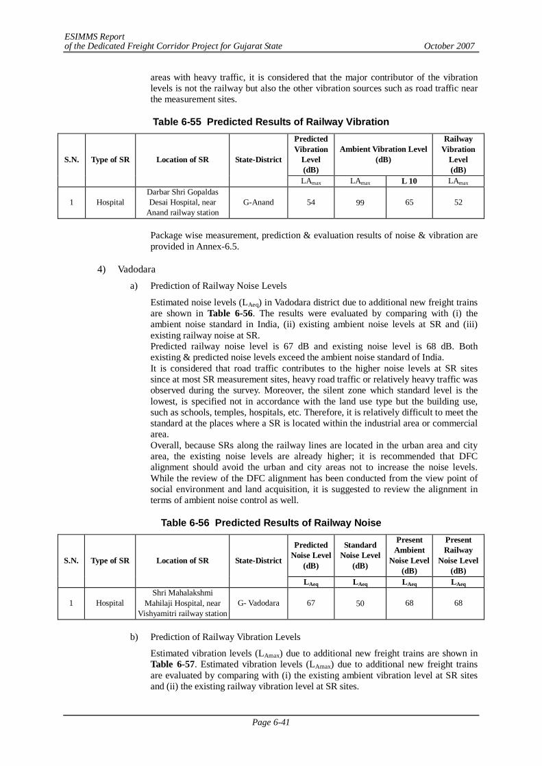
ESIMMS Report of the Dedicated Freight Corridor Project for Gujarat State October 2007
Page 6-41
areas with heavy traffic, it is considered that the major contributor of the vibration levels is not the railway but also the other vibration sources such as road traffic near the measurement sites.
Table 6-55 Predicted Results of Railway Vibration
Predicted Vibration
Level (dB)
Ambient Vibration Level (dB)
Railway Vibration
Level (dB)
S.N. Type of SR Location of SR State-District
LAmax LAmax L 10 LAmax
1 Hospital Darbar Shri Gopaldas Desai Hospital, near
Anand railway station G-Anand 54 99 65 52
Package wise measurement, prediction & evaluation results of noise & vibration are provided in Annex-6.5.
4) Vadodara
a) Prediction of Railway Noise Levels
Estimated noise levels (LAeq) in Vadodara district due to additional new freight trains are shown in Table 6-56. The results were evaluated by comparing with (i) the ambient noise standard in India, (ii) existing ambient noise levels at SR and (iii) existing railway noise at SR. Predicted railway noise level is 67 dB and existing noise level is 68 dB. Both existing & predicted noise levels exceed the ambient noise standard of India. It is considered that road traffic contributes to the higher noise levels at SR sites since at most SR measurement sites, heavy road traffic or relatively heavy traffic was observed during the survey. Moreover, the silent zone which standard level is the lowest, is specified not in accordance with the land use type but the building use, such as schools, temples, hospitals, etc. Therefore, it is relatively difficult to meet the standard at the places where a SR is located within the industrial area or commercial area. Overall, because SRs along the railway lines are located in the urban area and city area, the existing noise levels are already higher; it is recommended that DFC alignment should avoid the urban and city areas not to increase the noise levels. While the review of the DFC alignment has been conducted from the view point of social environment and land acquisition, it is suggested to review the alignment in terms of ambient noise control as well.
Table 6-56 Predicted Results of Railway Noise
Predicted Noise Level
(dB)
Standard Noise Level
(dB)
Present Ambient
Noise Level (dB)
Present Railway
Noise Level (dB)
S.N. Type of SR Location of SR State-District
LAeq LAeq LAeq LAeq
1 Hospital Shri Mahalakshmi
Mahilaji Hospital, near Vishyamitri railway station
G- Vadodara 67 50 68 68
b) Prediction of Railway Vibration Levels
Estimated vibration levels (LAmax) due to additional new freight trains are shown in Table 6-57. Estimated vibration levels (LAmax) due to additional new freight trains are evaluated by comparing with (i) the existing ambient vibration level at SR sites and (ii) the existing railway vibration level at SR sites.
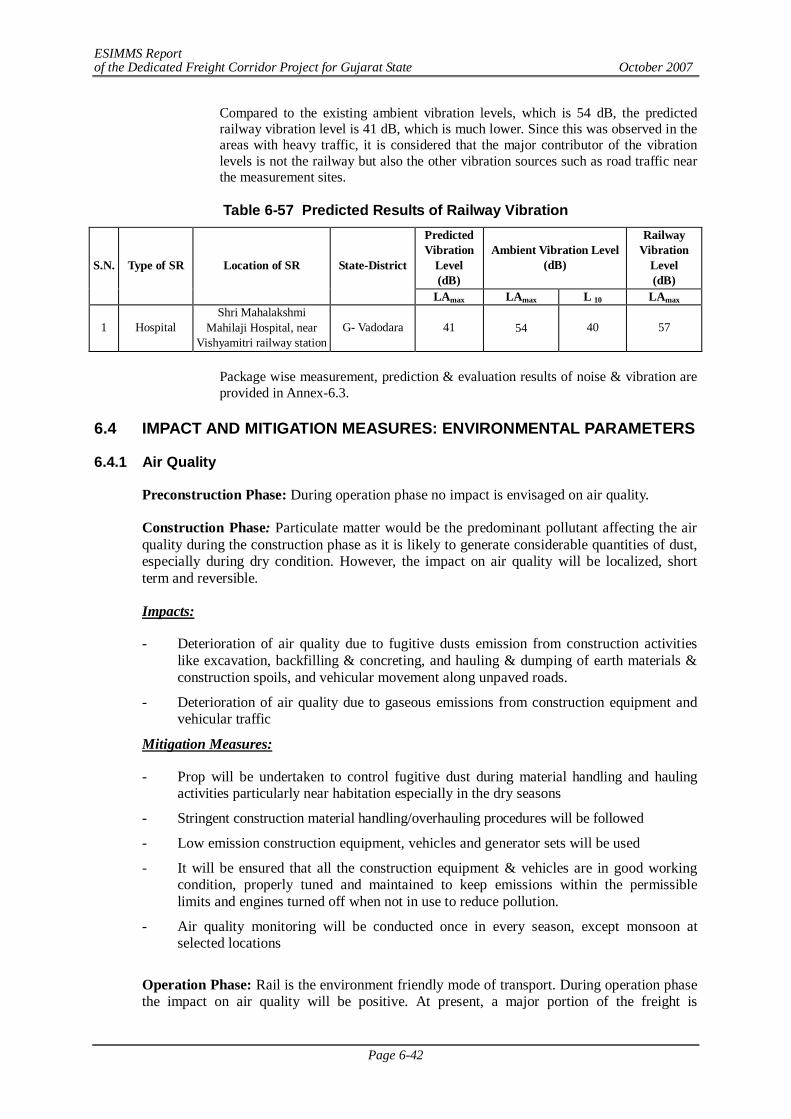
ESIMMS Report of the Dedicated Freight Corridor Project for Gujarat State October 2007
Page 6-42
Compared to the existing ambient vibration levels, which is 54 dB, the predicted railway vibration level is 41 dB, which is much lower. Since this was observed in the areas with heavy traffic, it is considered that the major contributor of the vibration levels is not the railway but also the other vibration sources such as road traffic near the measurement sites.
Table 6-57 Predicted Results of Railway Vibration
Predicted Vibration
Level (dB)
Ambient Vibration Level (dB)
Railway Vibration
Level (dB)
S.N. Type of SR Location of SR State-District
LAmax LAmax L 10 LAmax
1 Hospital Shri Mahalakshmi
Mahilaji Hospital, near Vishyamitri railway station
G- Vadodara 41 54 40 57
Package wise measurement, prediction & evaluation results of noise & vibration are provided in Annex-6.3.
6.4 IMPACT AND MITIGATION MEASURES: ENVIRONMENTAL PARAMETERS
6.4.1 Air Quality
Preconstruction Phase: During operation phase no impact is envisaged on air quality.
Construction Phase: Particulate matter would be the predominant pollutant affecting the air quality during the construction phase as it is likely to generate considerable quantities of dust, especially during dry condition. However, the impact on air quality will be localized, short term and reversible.
Impacts:
- Deterioration of air quality due to fugitive dusts emission from construction activities like excavation, backfilling & concreting, and hauling & dumping of earth materials & construction spoils, and vehicular movement along unpaved roads.
- Deterioration of air quality due to gaseous emissions from construction equipment and vehicular traffic
Mitigation Measures:
- Prop will be undertaken to control fugitive dust during material handling and hauling activities particularly near habitation especially in the dry seasons
- Stringent construction material handling/overhauling procedures will be followed
- Low emission construction equipment, vehicles and generator sets will be used
- It will be ensured that all the construction equipment & vehicles are in good working condition, properly tuned and maintained to keep emissions within the permissible limits and engines turned off when not in use to reduce pollution.
- Air quality monitoring will be conducted once in every season, except monsoon at selected locations
Operation Phase: Rail is the environment friendly mode of transport. During operation phase the impact on air quality will be positive. At present, a major portion of the freight is
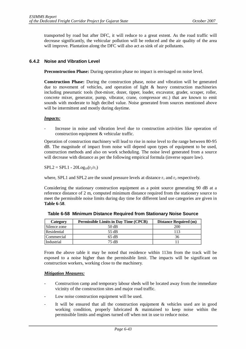
ESIMMS Report of the Dedicated Freight Corridor Project for Gujarat State October 2007
Page 6-43
transported by road but after DFC, it will reduce to a great extent. As the road traffic will decrease significantly, the vehicular pollution will be reduced and the air quality of the area will improve. Plantation along the DFC will also act as sink of air pollutants.
6.4.2 Noise and Vibration Level
Preconstruction Phase: During operation phase no impact is envisaged on noise level.
Construction Phase: During the construction phase, noise and vibration will be generated due to movement of vehicles, and operation of light & heavy construction machineries including pneumatic tools (hot-mixer, dozer, tipper, loader, excavator, grader, scraper, roller, concrete mixer, generator, pump, vibrator, crane, compressor etc.) that are known to emit sounds with moderate to high decibel value. Noise generated from sources mentioned above will be intermittent and mostly during daytime.
Impacts:
- Increase in noise and vibration level due to construction activities like operation of construction equipment & vehicular traffic.
Operation of construction machinery will lead to rise in noise level to the range between 80-95 dB. The magnitude of impact from noise will depend upon types of equipment to be used, construction methods and also on work scheduling. The noise level generated from a source will decrease with distance as per the following empirical formula (inverse square law).
SPL2 = SPL1 - 20Log10(r2/r1)
where, SPL1 and SPL2 are the sound pressure levels at distance r1 and r2 respectively.
Considering the stationary construction equipment as a point source generating 90 dB at a reference distance of 2 m, computed minimum distance required from the stationery source to meet the permissible noise limits during day time for different land use categories are given in Table 6-58.
Table 6-58 Minimum Distance Required from Stationary Noise Source Category Permissible Limits in Day Time (CPCB) Distance Required (m)
Silence zone 50 dB 200 Residential 55 dB 113 Commercial 65 dB 36 Industrial 75 dB 11
From the above table it may be noted that residence within 113m from the track will be exposed to a noise higher than the permissible limit. The impacts will be significant on construction workers, working close to the machinery.
Mitigation Measures:
- Construction camp and temporary labour sheds will be located away from the immediate vicinity of the construction sites and major road traffic.
- Low noise construction equipment will be used.
- It will be ensured that all the construction equipment & vehicles used are in good working condition, properly lubricated & maintained to keep noise within the permissible limits and engines turned off when not in use to reduce noise.
ESIMMS Report of the Dedicated Freight Corridor Project for Gujarat State October 2007
Page 6-44
- Stationary construction equipment will be placed away from inhabited areas.
- Stationary construction equipment will be placed away from the sensitive receptors (SRs) i.e. school, hospital etc.
- Construction activities carried out near residential area will be scheduled to the daytime only so that minimum disturbances are caused to people.
- The construction methods with lower vibration generation shall be applied.
- Machines and vehicles equipped with lower vibration devices such as vibration-proofing cover shall be used.
- Vibration propagation shall be prevented by keeping the distance and changing the direction and location of machines.
- Near settlement and forest areas, construction activities shall be conducted only during daytime, and vibration generating activities shall be prohibited during night time.
- Vibration level monitoring shall be conducted during the construction phase.
Operation Phase: During operation phase noise and vibration are likely to occur due to movement of trains and related facilities such as loading and unloading.
Mitigation Measures:
- Vibration level monitoring shall be conducted during the construction phase.
- New technologies shall be incorporated to lower vibration generation with respect to structures and rolling stocks.
- Use of long welded rails without fishplate joint is suggested for reduction in vibration.
- Crushed stones shall be used for ballast materials, and accumulation of crushed ballast by passing trains is to be removed through frequent ballast cleaning.
- For a railway bridge girder, steel may be replaced with concrete materials such as PC and RC to minimise oscillation of the bridge girder which generates vibration in addition to noise.
- If necessary, building the vibration-proof trench and underground wall may be built to prevent the vibration propagation.
- Provide appropriate maintenance of locomotives, tracks and structures.
- Running speed of freight trains in the urban area and the railway station shall be controlled, if required.
- Fences and structures to shelter and absorb vibration in addition to noise are duly provided to the sections where houses and Sensitive Receptors are located near railway tracks, if required.
- Monitoring of railway noise and vibration generated from dedicated freight trains shall be conducted.
6.4.3 Water Quality
Preconstruction Phase: During preconstruction phase no impact is envisaged on water quality.
Construction Phase: Small quantity of water will be used in the compaction of embankment during construction process. Wastewater from construction activities would mostly contain
ESIMMS Report of the Dedicated Freight Corridor Project for Gujarat State October 2007
Page 6-45
suspended impurities. Other pollutants which may find their way to it will be in insignificant concentrations and may be safely disregarded.
The deterioration of water quality during construction phase is expected due to wastewater disposal from the workers camp and sullage generated from construction sites. If adequate arrangements are not made to ensure proper drainage of wastewater from the construction sites, such waters may form stagnant pools and aggravate soil erosion. Stagnant pools of water promote breeding of mosquitoes and create generally unsanitary conditions.
Impacts:
- Water quality of Balaram river will be deteriorated during construction of bridge
- Increase of sediment load in the run off from construction sites and increase in turbidity in receiving streams/water bodies
- Water pollution due to sewage from construction camps
- Chances of groundwater contamination from fly ash
Mitigation Measures:
- Silt fencing may be provided near water bodies
- Quality of construction wastewater emanating from the construction site will be controlled through suitable drainage system with sediment traps (silting basin as water intercepting ditch) for arresting the silt/sediment load before its disposal into the main natural drainage system around the site
- Proper sanitation facilities will be provided at the construction site to prevent health related problems due water contamination.
- All the construction and preparatory activities including construction of culverts and bridges will be carried out during dry seasons only.
Operation Phase: During operation phase no impact is envisaged on water quality. However, the wastewater generated from rail depot, train washing, workshops and maintenance activities will be treated properly prior to discharge into the sewer.
6.4.4 Soil Quality
Preconstruction Phase: During preconstruction phase no impact is envisaged on soil quality.
Construction Phase:
- During construction phase soil contamination is likely to take place due to leakage of asphalt emulsifier at pavement of road.
- Soil contamination may also take place during filling of oil in vehicles or leakage from vehicles.
Mitigation Measures
- Asphalt emulsifier must be handled with caution and any leakage detected should be immediately rectified.
- Construction work should not be done during rainy season to avoid soil contamination
ESIMMS Report of the Dedicated Freight Corridor Project for Gujarat State October 2007
Page 6-46
Operation Phase: During operation phase no impact is envisaged on soil quality.
6.4.5 Land Subsidence
Land subsidence is not envisaged as the DFC alignment is passing through plain terrain except at few stretches where it is passing through undulating terrain. Therefore, during construction and operation phase no impact is envisaged.
6.4.6 Bottom Sediment
Preconstruction Phase: During operation phase no impact is envisaged on bottom sediment.
Construction Phase:
Impacts:
- The DFC alignment crosses Balaram River twice in Banaskantha district. During construction of bridge over Balaram River, sediment pollution may occur.
Mitigation Measures:
- Silt fencing will be provided to restrict runoff into the water.
- Bridge construction and preparatory activities will be carried out during dry seasons only.
During operation phase, no significant impact is envisaged except accidental spillage.
6.4.7 Offensive Odor
No activities causing offensive odor is envisaged however cleanliness must be maintained at construction site during construction and at stations during operation phase to avoid any foul odor.
6.5 IMPACT MATRIX – ENVIRONMENTAL POLLUTION
A simple method that determines potential existence of impact has been employed. Matrix system is considered as a tool for organizing and presenting information on the environmental impacts caused to the natural and social environment by the DFC Project. Thus the following parameter and scale is used for producing matrix impacts
Table 6-59 Parameter and Scale of Impact Matrix Parameter Scale Remarks
Significance No impact E Positive : + Negative : - Neglectable impact D Positive : + Negative : - Insignificant impact C Positive : + Negative : - Relatively significant impact B Positive : + Negative : - Significant impact A Positive : + Negative : -
The Environmental Impact Matrix is given below.
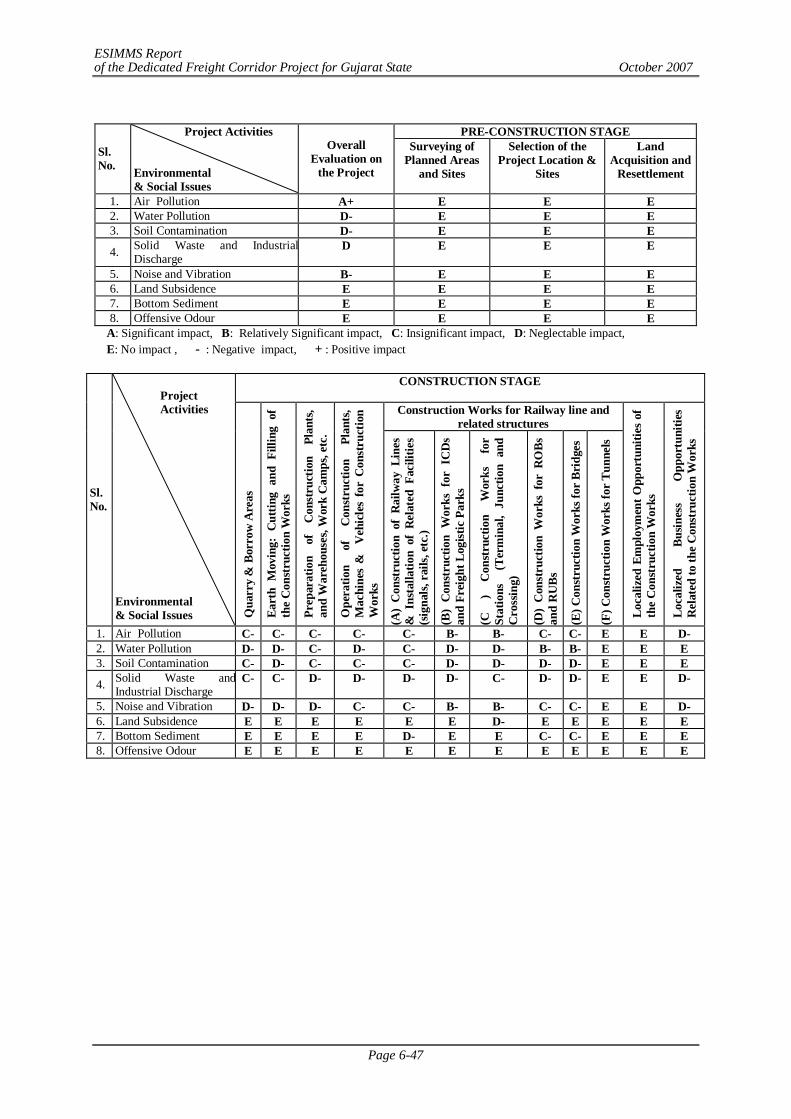
ESIMMS Report of the Dedicated Freight Corridor Project for Gujarat State October 2007
Page 6-47
PRE-CONSTRUCTION STAGE
Sl. No.
Project Activities Environmental & Social Issues
Overall Evaluation on
the Project
Surveying of Planned Areas
and Sites
Selection of the Project Location &
Sites
Land Acquisition and
Resettlement
1. Air Pollution A+ E E E 2. Water Pollution D- E E E 3. Soil Contamination D- E E E
4. Solid Waste and Industrial Discharge
D E E E
5. Noise and Vibration B- E E E 6. Land Subsidence E E E E 7. Bottom Sediment E E E E 8. Offensive Odour E E E E
A: Significant impact, B: Relatively Significant impact, C: Insignificant impact, D: Neglectable impact, E: No impact , - : Negative impact, + : Positive impact
CONSTRUCTION STAGE
Construction Works for Railway line and related structures
Sl. No.
Environmental & Social Issues Q
uarr
y &
Bor
row
Are
as
Eart
h M
ovin
g: C
uttin
g an
d Fi
lling
of
the
Con
stru
ctio
n W
orks
Prep
arat
ion
of
Con
stru
ctio
n Pl
ants
, an
d W
areh
ouse
s, W
ork
Cam
ps, e
tc.
Ope
ratio
n of
C
onst
ruct
ion
Plan
ts,
Mac
hine
s &
V
ehic
les
for
Con
stru
ctio
n W
orks
(A)
Con
stru
ctio
n of
Rai
lway
Lin
es
& I
nsta
llatio
n of
Rel
ated
Fac
ilitie
s (s
igna
ls, r
ails,
etc
.)
(B)
Con
stru
ctio
n W
orks
for
IC
Ds
and
Frei
ght L
ogist
ic P
arks
(C
) C
onst
ruct
ion
Wor
ks
for
Stat
ions
(T
erm
inal
, Ju
nctio
n an
d C
ross
ing)
(D)
Con
stru
ctio
n W
orks
for
RO
Bs
and
RU
Bs
(E) C
onst
ruct
ion
Wor
ks fo
r Br
idge
s
(F) C
onst
ruct
ion
Wor
ks fo
r Tu
nnel
s
Loca
lized
Em
ploy
men
t Opp
ortu
nitie
s of
th
e C
onst
ruct
ion
Wor
ks
Loca
lized
Bu
sines
s O
ppor
tuni
ties
Rel
ated
to th
e C
onst
ruct
ion
Wor
ks
1. Air Pollution C- C- C- C- C- B- B- C- C- E E D- 2. Water Pollution D- D- C- D- C- D- D- B- B- E E E 3. Soil Contamination C- D- C- C- C- D- D- D- D- E E E
4. Solid Waste andIndustrial Discharge
C- C- D- D- D- D- C- D- D- E E D-
5. Noise and Vibration D- D- D- C- C- B- B- C- C- E E D- 6. Land Subsidence E E E E E E D- E E E E E 7. Bottom Sediment E E E E D- E E C- C- E E E 8. Offensive Odour E E E E E E E E E E E E
Project Activities
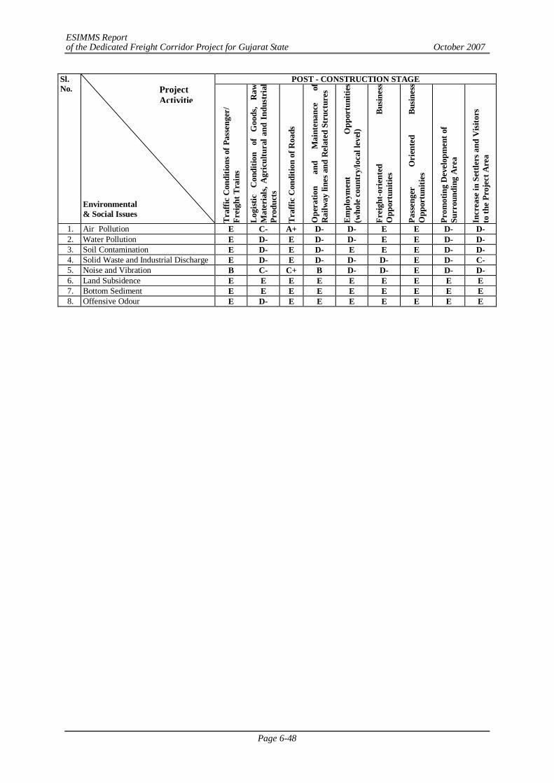
ESIMMS Report of the Dedicated Freight Corridor Project for Gujarat State October 2007
Page 6-48
POST - CONSTRUCTION STAGE Sl. No.
Environmental & Social Issues
Traf
fic C
ondi
tions
of P
asse
nger
/ Fr
eigh
t Tra
ins
Logi
stic
C
ondi
tion
of
Goo
ds,
Raw
M
ater
ials,
Agr
icul
tura
l and
Ind
ustr
ial
Prod
ucts
Traf
fic C
ondi
tion
of R
oads
Ope
ratio
n an
d M
aint
enan
ce
of
Rai
lway
line
s and
Rel
ated
Str
uctu
res
Empl
oym
ent
Opp
ortu
nitie
s (w
hole
cou
ntry
/loca
l lev
el)
Frei
ght-o
rien
ted
Busin
ess
Opp
ortu
nitie
s
Pass
enge
r O
rien
ted
Busin
ess
Opp
ortu
nitie
s
Prom
otin
g D
evel
opm
ent o
f Su
rrou
ndin
g A
rea
Incr
ease
in S
ettle
rs a
nd V
isito
rs
to th
e Pr
ojec
t Are
a
1. Air Pollution E C- A+ D- D- E E D- D- 2. Water Pollution E D- E D- D- E E D- D- 3. Soil Contamination E D- E D- E E E D- D- 4. Solid Waste and Industrial Discharge E D- E D- D- D- E D- C- 5. Noise and Vibration B C- C+ B D- D- E D- D- 6. Land Subsidence E E E E E E E E E 7. Bottom Sediment E E E E E E E E E 8. Offensive Odour E D- E E E E E E E
Project Activitie
ESIMMS Report of the Dedicated Freight Corridor Project for Gujarat State October 2007
Page 7-1
CHAPTER 7 STAKEHOLDER/ PUBLIC CONSULTATION MEETINGS
7.1 INTRODUCTION
Public Consultations or Stake holders meetings are the platforms where the project affected or project concerned individuals get to express their views and opinions on several issues related to the project without any biasness and on a public place. Since this is a process, it must be remembered in this context that the meetings were not the end of the public consultation process but rather the initiation of discussion among the participants whose opinions were incorporated not only in the meetings at the second and third stages but also during feedback/village meetings conducted subsequently. Precisely with this objective in mind, stakeholders were identified and invited to attend the meetings; meetings were held at venues most convenient to attend for the concerned and timings were fixed to suit their preferences. It was kept in mind to invite stakeholders from almost all villages so that opinion from all concerned could be addressed. Along with them, NGOs, local media were also invited to attend the meetings not only for the purpose of information dissemination but also for taking their views into consideration for overall policy making.
In order to assess feasibility of development of dedicated multimodal high-axle load freight corridor with computerized control for DFC Western Corridor stakeholder/public consultation meetings were organized in all three phases of the study.
- Phase I First Stage (February 2007)
- Phase II Second Stage (June-July 2007)
- Phase III Third Stage (August-September 2007)
In the 2nd and 3rd phase, public consultation meetings were conducted in the district to disseminate information and make likely to be affected people aware about the project and seek their opinions about proposed DFC respectively. Stakeholders were invited from all the villages, gram panchayats and blocks and towns which were likely to be affected in both the parallel and detour section due to land acquisition in the proposed DFC corridor. The stakeholders expressed their views and provided valuable suggestions in respect to rehabilitation and resettlement issues and other socio-environmental concerns. It was followed by village feedback meetings in order to know the understanding and opinions of the villagers about the proposed DFC Project. The village meetings were conducted in each affected village of each district.
7.2 STAKEHOLDERS
Various categories of stakeholders ranging from Project Affected Persons to government officials to other opinion leaders such as NGOs, activists and media persons were identified in order to seek opinions on the “dedicated high axle load multimodal freight corridor” and to discuss social and environmental impacts, including the issue of resettlement and rehabilitation. The various categories of stakeholders who were invited to attend the public consultation meetings are as follows:
a) PAPS: Project Affected Persons (likely)
b) Govt. Officials local administration, revenue department, land acquisition officer, forest officers, railway officials, DFFCCIL officials, Central & State Pollution Control Boards etc
c) Representation from Gram Panchayat, Pradhan, local municipal bodies, M.Ps and M.L.A.s in the area.
ESIMMS Report of the Dedicated Freight Corridor Project for Gujarat State October 2007
Page 7-2
d) Local NGOs actively working on environmental & social issues in the district
e) Transporters Local transport operators, freight operators, stevedores
f) Media Local press reporters, State level & National level reporters, electronic media (local and National level news channel)
g) Industries Local industry owners
h) Academicians in the field of Social and Environment Sciences, Head of reputed educational institutions
i) Citizens Residents, merchants/businessmen, advocates, farmers, senior citizens etc.
7.3 METHOD OF PUBLIC CONSULTATION MEETING
The following steps were taken into account for conducting public consultation meetings: Ministry of Railways has issued formal letter to Secretary, revenue department, Government of Gujarat dated May 11, 2007. The letter clearly indicated that, public consultation and stakeholder meetings are to be undertaken as part of studies on environmental and social issues. An Inter Ministerial Working group called Environmental Working Group (EWG) has been set up to coordinate this aspect of the study. District Magistrate, Additional District Magistrate, Tahsildar, and Block Development officer and District Forest Officers were formally invited to participate in the Public Consultation Meetings.
The representatives of Panchayat Raj institutions and local Municipal bodies were personally invited.
Invitation letters were issued to the representatives of local media, opinion leaders and members of academician with the request to participate and contribute in the deliberations. Sincere efforts were made to meet likely affected PAPs personally along with the letter of invitation.
Due care was taken to address the issues of the poor, vulnerable groups, landless and other disadvantaged sections of the society likely to be affected by the project. The main objective of the stakeholders/public consultation meeting was to
- Disseminate the information about DFC project to the general public.
- Create awareness about the project among the likely PAPs.
- Discuss the positive/adverse environmental and social impacts of the project.
- Seek the suggestion of Gram Panchayat, PAPs and other stakeholders on the various issues related to compensation, resettlement and rehabilitation, social and environmental impacts.
7.3.1 Meeting Facilitators
Suitable agencies having strong local contacts were identified to carry out stakeholders/public consultation meeting. Preference was given to appoint non-government organization, who had good track record and experience in social work. The acquaintance with different cross sections of society and the ability to mobilize the stakeholders of the meeting were the major selection criteria. The ability to facilitate the following activities was taken into consideration:
- Fixation of Venue for the meetings;
- Logistic Arrangements like food, stationary distribution, public address system etc to be made;
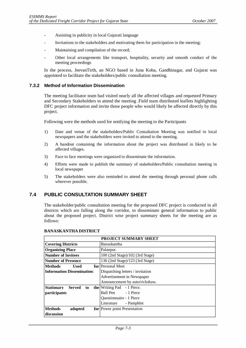
ESIMMS Report of the Dedicated Freight Corridor Project for Gujarat State October 2007
Page 7-3
- Assisting in publicity in local Gujarati language
- Invitations to the stakeholders and motivating them for participation in the meeting;
- Maintaining and compilation of the record;
- Other local arrangements like transport, hospitality, security and smooth conduct of the meeting proceedings
In the process, JeevanTirth, an NGO based in Juna Koba, Gandhinagar, and Gujarat was appointed to facilitate the stakeholders/public consultation meeting.
7.3.2 Method of Information Dissemination
The meeting facilitator team had visited nearly all the affected villages and requested Primary and Secondary Stakeholders to attend the meeting .Field team distributed leaflets highlighting DFC project information and invite those people who would likely be affected directly by this project.
Following were the methods used for notifying the meeting to the Participants
1) Date and venue of the stakeholders/Public Consultation Meeting was notified in local newspapers and the stakeholders were invited to attend to the meeting.
2) A handout containing the information about the project was distributed in likely to be affected villages.
3) Face to face meetings were organized to disseminate the information.
4) Efforts were made to publish the summary of stakeholders/Public consultation meeting in local newspaper
5) The stakeholders were also reminded to attend the meeting through personal phone calls wherever possible.
7.4 PUBLIC CONSULTATION SUMMARY SHEET
The stakeholder/public consultation meeting for the proposed DFC project is conducted in all districts which are falling along the corridor, to disseminate general information to public about the proposed project. District wise project summary sheets for the meeting are as follows:
BANASKANTHA DISTRICT
PROJECT SUMMARY SHEET Covering Districts Banaskantha Organizing Place Palanpur. Number of Invitees 100 (2nd Stage)/102 (3rd Stage) Number of Presence 136 (2nd Stage)/123 (3rd Stage) Methods Used for Information Dissemination:
Personal Meet Dispatching letters / invitation Advertisement in Newspaper Announcement by auto/rickshaw.
Stationary Served to the participants
Writing Pad - 1 Piece. Ball Pen - 1 Piece Questionnaire - 1 Piece Literature - Pamphlet
Methods adopted for discussion
Power point Presentation
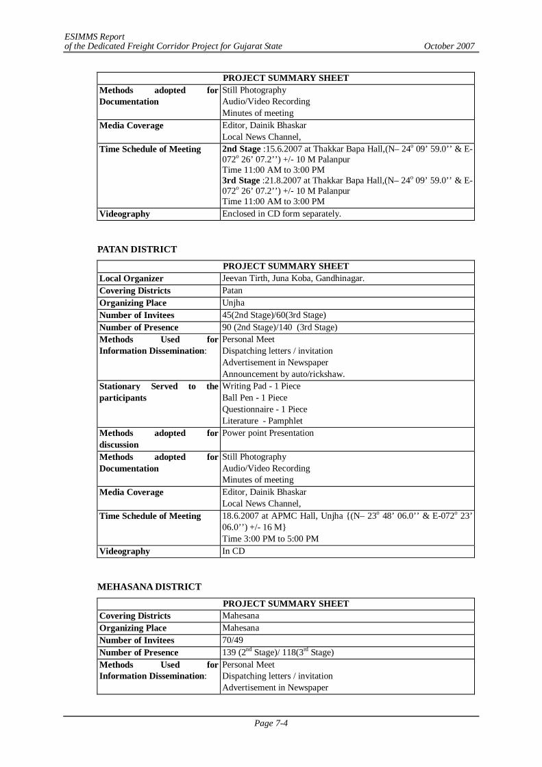
ESIMMS Report of the Dedicated Freight Corridor Project for Gujarat State October 2007
Page 7-4
PROJECT SUMMARY SHEET Methods adopted for Documentation
Still Photography Audio/Video Recording Minutes of meeting
Media Coverage Editor, Dainik Bhaskar Local News Channel,
Time Schedule of Meeting 2nd Stage :15.6.2007 at Thakkar Bapa Hall,(N– 24o 09’ 59.0’’ & E-072o 26’ 07.2’’) +/- 10 M Palanpur Time 11:00 AM to 3:00 PM 3rd Stage :21.8.2007 at Thakkar Bapa Hall,(N– 24o 09’ 59.0’’ & E-072o 26’ 07.2’’) +/- 10 M Palanpur Time 11:00 AM to 3:00 PM
Videography Enclosed in CD form separately.
PATAN DISTRICT
PROJECT SUMMARY SHEET Local Organizer Jeevan Tirth, Juna Koba, Gandhinagar. Covering Districts Patan Organizing Place Unjha Number of Invitees 45(2nd Stage)/60(3rd Stage) Number of Presence 90 (2nd Stage)/140 (3rd Stage) Methods Used for Information Dissemination:
Personal Meet Dispatching letters / invitation Advertisement in Newspaper Announcement by auto/rickshaw.
Stationary Served to the participants
Writing Pad - 1 Piece Ball Pen - 1 Piece Questionnaire - 1 Piece Literature - Pamphlet
Methods adopted for discussion
Power point Presentation
Methods adopted for Documentation
Still Photography Audio/Video Recording Minutes of meeting
Media Coverage Editor, Dainik Bhaskar Local News Channel,
Time Schedule of Meeting 18.6.2007 at APMC Hall, Unjha {(N– 23o 48’ 06.0’’ & E-072o 23’ 06.0’’) +/- 16 M} Time 3:00 PM to 5:00 PM
Videography In CD
MEHASANA DISTRICT
PROJECT SUMMARY SHEET Covering Districts Mahesana Organizing Place Mahesana Number of Invitees 70/49 Number of Presence 139 (2nd Stage)/ 118(3rd Stage) Methods Used for Information Dissemination:
Personal Meet Dispatching letters / invitation Advertisement in Newspaper
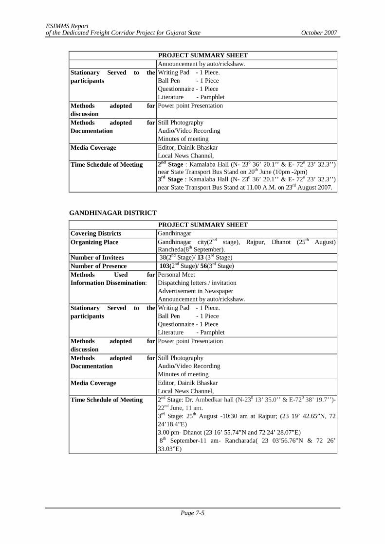
ESIMMS Report of the Dedicated Freight Corridor Project for Gujarat State October 2007
Page 7-5
PROJECT SUMMARY SHEET Announcement by auto/rickshaw.
Stationary Served to the participants
Writing Pad - 1 Piece. Ball Pen - 1 Piece Questionnaire - 1 Piece Literature - Pamphlet
Methods adopted for discussion
Power point Presentation
Methods adopted for Documentation
Still Photography Audio/Video Recording Minutes of meeting
Media Coverage Editor, Dainik Bhaskar Local News Channel,
Time Schedule of Meeting 2nd Stage : Kamalaba Hall (N- 23o 36’ 20.1’’ & E- 72o 23’ 32.3’’) near State Transport Bus Stand on 20th June (10pm -2pm) 3rd Stage : Kamalaba Hall (N- 23o 36’ 20.1’’ & E- 72o 23’ 32.3’’) near State Transport Bus Stand at 11.00 A.M. on 23rd August 2007.
GANDHINAGAR DISTRICT
PROJECT SUMMARY SHEET Covering Districts Gandhinagar Organizing Place Gandhinagar city(2nd stage), Rajpur, Dhanot (25th August)
Rancheda(8th September). Number of Invitees 38(2nd Stage)/ 13 (3rd Stage) Number of Presence 103(2nd Stage)/ 56(3rd Stage) Methods Used for Information Dissemination:
Personal Meet Dispatching letters / invitation Advertisement in Newspaper Announcement by auto/rickshaw.
Stationary Served to the participants
Writing Pad - 1 Piece. Ball Pen - 1 Piece Questionnaire - 1 Piece Literature - Pamphlet
Methods adopted for discussion
Power point Presentation
Methods adopted for Documentation
Still Photography Audio/Video Recording Minutes of meeting
Media Coverage Editor, Dainik Bhaskar Local News Channel,
Time Schedule of Meeting 2nd Stage: Dr. Ambedkar hall (N-230 13’ 35.0’’ & E-720 38’ 19.7’’)-22nd June, 11 am. 3rd Stage: 25th August -10:30 am at Rajpur; (23 19’ 42.65”N, 72 24’18.4”E) 3.00 pm- Dhanot (23 16’ 55.74”N and 72 24’ 28.07”E) 8th September-11 am- Rancharada( 23 03’56.76”N & 72 26’ 33.03”E)
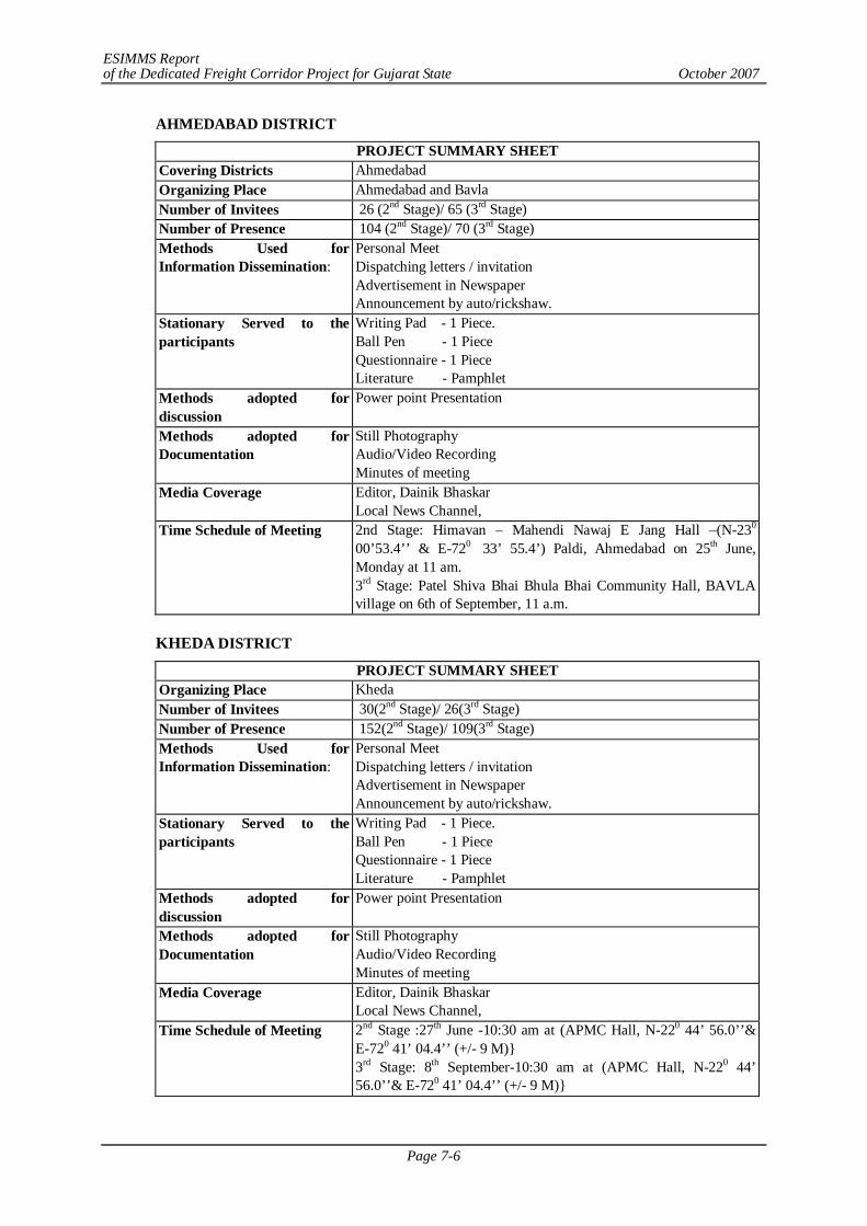
ESIMMS Report of the Dedicated Freight Corridor Project for Gujarat State October 2007
Page 7-6
AHMEDABAD DISTRICT
PROJECT SUMMARY SHEET Covering Districts Ahmedabad Organizing Place Ahmedabad and Bavla Number of Invitees 26 (2nd Stage)/ 65 (3rd Stage) Number of Presence 104 (2nd Stage)/ 70 (3rd Stage) Methods Used for Information Dissemination:
Personal Meet Dispatching letters / invitation Advertisement in Newspaper Announcement by auto/rickshaw.
Stationary Served to the participants
Writing Pad - 1 Piece. Ball Pen - 1 Piece Questionnaire - 1 Piece Literature - Pamphlet
Methods adopted for discussion
Power point Presentation
Methods adopted for Documentation
Still Photography Audio/Video Recording Minutes of meeting
Media Coverage Editor, Dainik Bhaskar Local News Channel,
Time Schedule of Meeting 2nd Stage: Himavan – Mahendi Nawaj E Jang Hall –(N-230 00’53.4’’ & E-720 33’ 55.4’) Paldi, Ahmedabad on 25th June, Monday at 11 am. 3rd Stage: Patel Shiva Bhai Bhula Bhai Community Hall, BAVLA village on 6th of September, 11 a.m.
KHEDA DISTRICT
PROJECT SUMMARY SHEET Organizing Place Kheda Number of Invitees 30(2nd Stage)/ 26(3rd Stage) Number of Presence 152(2nd Stage)/ 109(3rd Stage) Methods Used for Information Dissemination:
Personal Meet Dispatching letters / invitation Advertisement in Newspaper Announcement by auto/rickshaw.
Stationary Served to the participants
Writing Pad - 1 Piece. Ball Pen - 1 Piece Questionnaire - 1 Piece Literature - Pamphlet
Methods adopted for discussion
Power point Presentation
Methods adopted for Documentation
Still Photography Audio/Video Recording Minutes of meeting
Media Coverage Editor, Dainik Bhaskar Local News Channel,
Time Schedule of Meeting 2nd Stage :27th June -10:30 am at (APMC Hall, N-220 44’ 56.0’’& E-720 41’ 04.4’’ (+/- 9 M)} 3rd Stage: 8th September-10:30 am at (APMC Hall, N-220 44’ 56.0’’& E-720 41’ 04.4’’ (+/- 9 M)}
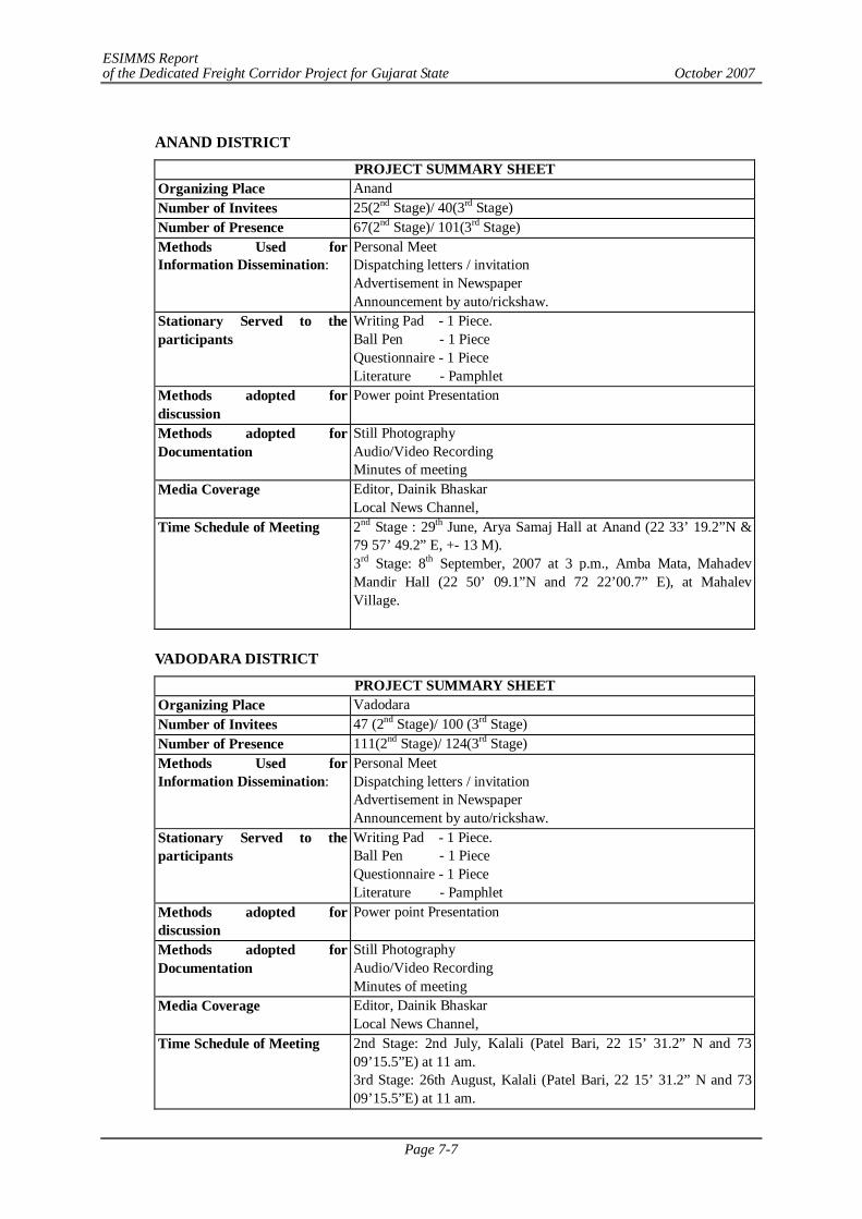
ESIMMS Report of the Dedicated Freight Corridor Project for Gujarat State October 2007
Page 7-7
ANAND DISTRICT
PROJECT SUMMARY SHEET Organizing Place Anand Number of Invitees 25(2nd Stage)/ 40(3rd Stage) Number of Presence 67(2nd Stage)/ 101(3rd Stage) Methods Used for Information Dissemination:
Personal Meet Dispatching letters / invitation Advertisement in Newspaper Announcement by auto/rickshaw.
Stationary Served to the participants
Writing Pad - 1 Piece. Ball Pen - 1 Piece Questionnaire - 1 Piece Literature - Pamphlet
Methods adopted for discussion
Power point Presentation
Methods adopted for Documentation
Still Photography Audio/Video Recording Minutes of meeting
Media Coverage Editor, Dainik Bhaskar Local News Channel,
Time Schedule of Meeting 2nd Stage : 29th June, Arya Samaj Hall at Anand (22 33’ 19.2”N & 79 57’ 49.2” E, +- 13 M). 3rd Stage: 8th September, 2007 at 3 p.m., Amba Mata, Mahadev Mandir Hall (22 50’ 09.1”N and 72 22’00.7” E), at Mahalev Village.
VADODARA DISTRICT
PROJECT SUMMARY SHEET Organizing Place Vadodara Number of Invitees 47 (2nd Stage)/ 100 (3rd Stage) Number of Presence 111(2nd Stage)/ 124(3rd Stage) Methods Used for Information Dissemination:
Personal Meet Dispatching letters / invitation Advertisement in Newspaper Announcement by auto/rickshaw.
Stationary Served to the participants
Writing Pad - 1 Piece. Ball Pen - 1 Piece Questionnaire - 1 Piece Literature - Pamphlet
Methods adopted for discussion
Power point Presentation
Methods adopted for Documentation
Still Photography Audio/Video Recording Minutes of meeting
Media Coverage Editor, Dainik Bhaskar Local News Channel,
Time Schedule of Meeting 2nd Stage: 2nd July, Kalali (Patel Bari, 22 15’ 31.2” N and 73 09’15.5”E) at 11 am. 3rd Stage: 26th August, Kalali (Patel Bari, 22 15’ 31.2” N and 73 09’15.5”E) at 11 am.
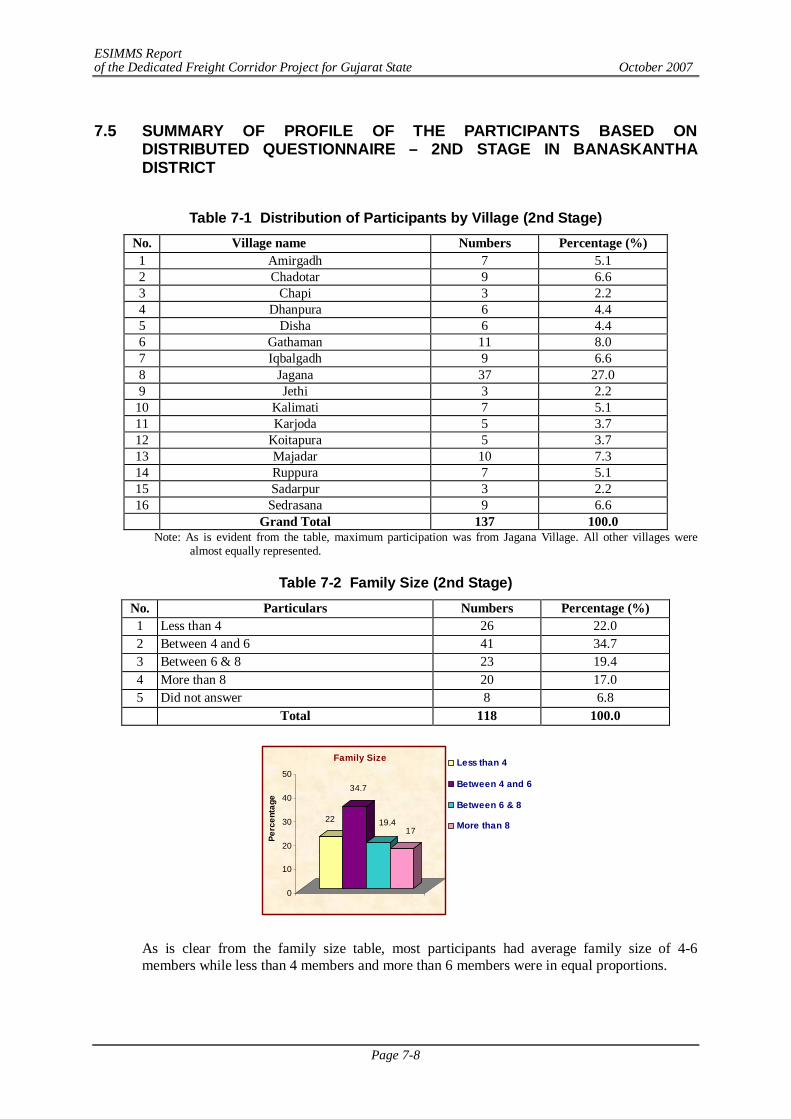
ESIMMS Report of the Dedicated Freight Corridor Project for Gujarat State October 2007
Page 7-8
7.5 SUMMARY OF PROFILE OF THE PARTICIPANTS BASED ON
DISTRIBUTED QUESTIONNAIRE – 2ND STAGE IN BANASKANTHA DISTRICT
Table 7-1 Distribution of Participants by Village (2nd Stage)
No. Village name Numbers Percentage (%) 1 Amirgadh 7 5.1 2 Chadotar 9 6.6 3 Chapi 3 2.2 4 Dhanpura 6 4.4 5 Disha 6 4.4 6 Gathaman 11 8.0 7 Iqbalgadh 9 6.6 8 Jagana 37 27.0 9 Jethi 3 2.2
10 Kalimati 7 5.1 11 Karjoda 5 3.7 12 Koitapura 5 3.7 13 Majadar 10 7.3 14 Ruppura 7 5.1 15 Sadarpur 3 2.2 16 Sedrasana 9 6.6
Grand Total 137 100.0 Note: As is evident from the table, maximum participation was from Jagana Village. All other villages were
almost equally represented.
Table 7-2 Family Size (2nd Stage) No. Particulars Numbers Percentage (%) 1 Less than 4 26 22.0 2 Between 4 and 6 41 34.7 3 Between 6 & 8 23 19.4 4 More than 8 20 17.0 5 Did not answer 8 6.8 Total 118 100.0
22
34.7
19.417
0
10
20
30
40
50
Perc
enta
ge
Family Size Less than 4
Between 4 and 6
Between 6 & 8
More than 8
As is clear from the family size table, most participants had average family size of 4-6 members while less than 4 members and more than 6 members were in equal proportions.
ESIMMS Report of the Dedicated Freight Corridor Project for Gujarat State October 2007
Page 7-9
Table 7-3 Social Structure of the Participants (2nd Stage) No. Particulars Numbers Percentage (%) 1 General 30 25.4 2 Other Backward Caste 53 44.9 3 Schedule Caste 17 14.4 4 Schedule Tribes 1 0.9 5 Other 12 10.2 5 Did not answer 5 4.2 Total 118 100.0
Most participants were from OBC (other backward caste) and general category. Proportion of scheduled castes was more than scheduled tribes.
Table 7-4 Origin of the Participant (2nd Stage) No. Particulars Numbers Percentage (%) 1 Native 90 76.3 2 Non-Native 8 6.8 3 Did not answer 20 17.0 Total 118 100.0
Most participants in this district were of native origin, meaning non-natives were of little significance. This hints that the respondents were very attached to their native place and would by all possibility resist to move out.
Table 7-5 Education Level of the Participants (2nd Stage) No. Particulars Numbers Percentage (%) 1 Illiterate 15 12.7 2 Can read 10 8.7 3 Can read & write 17 14.4 4 Up to 7th Standard 12 10.2 5 Up to 12th Standard 25 21.2 6 Graduate 23 19.5 7 Other Professional 11 9.3 8 Did not answer 5 4.2 Total 118 100.0
It was interesting to find that most participants were educated up to 12th standard and quite a few up to graduation level (ranking next). Literate and semi literate were next in rank and professional were few in number.
ESIMMS Report of the Dedicated Freight Corridor Project for Gujarat State October 2007
Page 7-10
Table 7-6 Occupation of the Participants (2nd Stage) No. Particulars Numbers Percentage (%) 1 Agriculture 68 57.6 2 Daily wage 12 10.2 3 Government Service 4 3.4 4 Private Service 13 11.0 5 Business 5 4.2 6 Self Employed 6 5.1 7 Others 9 7.6 8 Did not answer 1 0.9 Total 118 100.0
From the table above, agriculture stands out to be the dominant occupation of maximum participants. Daily wage earners and private service are far less important and other occupation not important at all.
7.6 SUMMARY OF STAKE HOLDER/PUBLIC CONSULTATION – 2ND STAGE
IN BANASKANTHA
Summarizing, several issues were raised in the question – answer session. In sequence they were as follows:
1) DFC why not parallel to existing railway line? There seems to be enough land along the alignment so why bypass in the first place as it passes through rich farm land. Why can’t it be avoided.
2) Concern over farm land being divided into two parts because of DFC project. In that case, communication between them becomes difficult and risky ( crossing railway line (by farmers and cattle)and also water supply, irrigation mechanisms and electricity lines get severed and has to be reinstalled. There was a demand that such facilities prevailing before the DFC project should be ensured in the divided land as well without much hassle and that should be incorporated in the policy itself.
3) Kanti Bhai Patel of Iqbalgarh raised farmer’s concern over how DFC would address hidden cost such as the tedious process of making a piece of land fertile over years, boring tube well, constructing well etc. They demanded that they need to be compensated for such hidden costs before they receive any compensation for the land acquired. Only then can the process of implementation start.
4) One issue raised was that why not divert the bypass or take the DFC line along wasteland and forests? Why are funding/ implementing agencies so concerned over flora and fauna when livelihoods of human beings are at stake because of the DFC bypass? Are humans then less important?
5) People want development but not at the cost of farmers.
6) Compensation and other things should be provided before the start the project.
7) Certain common concerns were as follows which were repetitive.
- Compensation package. - Provision of employment of any family member - Compensation for each PAF even if they are living as a single HH under joint
family setup.
ESIMMS Report of the Dedicated Freight Corridor Project for Gujarat State October 2007
Page 7-11
7.7 SUMMARY OF THE PROFILE OF PARTICIPANTS BASED ON THE DISTRIBUTED QUESTIONNAIRE - 3RD STAGE IN BANASKANTHA
Table 7-7 Distribution of Participants By Village (3rd Stage) No. Village name Numbers Percentage (%) 1 Akesan 16 13.0 2 Antroli 7 5.7 3 Chadotar 17 13.8 4 Devpura 12 9.8 5 Dharewada 3 2.4 6 Dhuliya 1 0.8 7 Gathaman 2 1.6 8 Iqbalgarh 7 5.7 9 Jagana 7 5.7 10 Jorapura 1 0.8 11 Kalimati 3 2.4 12 Koitapura 2 1.6 13 Laxmanpura 1 0.8 14 Laxmipura 2 1.6 15 Lunava 1 0.8 16 Madhupura 2 1.6 17 Majadar 12 9.8 18 Malana 4 3.3 19 Moriya 4 3.3 20 Muriya 3 2.4 21 Pakhanava 1 0.8 22 Palanpur 6 4.9 23 Parpada 3 2.4 24 Sadrasan 4 3.3 25 Sonpura 1 0.8 26 Umardasi 1 0.8
Grand Total 123 100.0
As is evident, out of 26 villages, the prominent ones from where participants came in large numbers are Chadotar, Akesan, Devpura and Majadar in decreasing order.
Table 7-8 Family Size (3rd Stage) No. Particulars Numbers Percentage (%) 1 Less than 4 34 34.3 2 Between 4 and 6 33 33.3 3 Between 6 & 8 15 15.2 4 More than 8 12 12.2 5 Did not answer 5 5.1 TOTAL 99 100.0
As is clear from the family size table, most participants had average family size of less than 4 members while more than 4 and less than 6 members were next in number.
ESIMMS Report of the Dedicated Freight Corridor Project for Gujarat State October 2007
Page 7-12
34 33
15 12
0
10
20
30
40
50
Perc
enta
ge
Family SizeLess than 4
Between 4 and 6
Between 6 & 8
More than 8
Table 7-9 Social Structure of the Participants (3rd Stage) No. Particulars Numbers Percentage (%) 1 General 40 40.4 2 Other Backward Caste 45 45.5 3 Schedule Caste 6 6.1 4 Schedule Tribes 3 3.0 5 Other 2 2.0 5 Did not answer 3 3.0 TOTAL 99 100.0
Most participants were from general category and OBC (other backward caste). Proportion of scheduled castes were more than scheduled tribes.
Table 7-10 Origin of the Participant (3rd Stage) No. Particulars Numbers Percentage (%) 1 Native 94 64.7 2 Non-Native 5 5.1 3 Did not answer 0 0.0 TOTAL 99 100.0
Most participants in this district were of native origin (65%), meaning non-natives were of little significance. This hints that the respondents were very attached to their native place and would by all possibility resist to move out.
Table 7-11 Education Level of the Participants (3rd Stage) No. Particulars Numbers Percentage (%) 1 Illiterate 12 12.1 2 Can read 19 19.2 3 Can read & write 15 15.2 4 Up to 7th Standard 16 16.2 5 Up to 12th Standard 17 17.2 6 Graduate 11 11.1 7 Other Professional 5 5.1 8 Did not answer 4 4.1 TOTAL 99 100.0
ESIMMS Report of the Dedicated Freight Corridor Project for Gujarat State October 2007
Page 7-13
It was interesting to find that participants who could read and were educated upto 12th standard were about 20% each. Literate and semi literate were next in rank and professionals were few in number.
Table 7-12 Occupation of the Participants (3rd Stage) No. Particulars Numbers Percentage (%) 1 Agriculture 74 74.8 2 Daily wage 2 2.0 3 Government Service 0 0.0 4 Private Service 6 6.1 5 Business 5 5.1 6 Self Employed 3 3.0 7 Others 4 4.0 8 Did not answer 5 5.1 TOTAL 99 100.0
From the table above, agriculture stands out to be the dominant occupation of maximum participants. Other occupations are almost insignificant.
7.8 SUMMARY OF FINDINGS – 3RD STAGE IN BANASKANTHA
In Conclusion it may be summarized that people at Palanpur PCM objected to the bypass proposal and expressed resistance to DFC project. Some went to the extent to say that they would commit suicide if JICA acquired their land for this purpose. They were surprised and expressed annoyance that how was Balaram Sanctuary more important than the poor marginal farmers. Some suggested tube rail option. Others mentioned there exists enough land along the existing railway track so why the need of bypass at all?
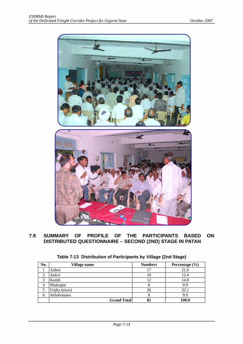
ESIMMS Report of the Dedicated Freight Corridor Project for Gujarat State October 2007
Page 7-14
7.9 SUMMARY OF PROFILE OF THE PARTICIPANTS BASED ON
DISTRIBUTED QUESTIONNAIRE – SECOND (2ND) STAGE IN PATAN
Table 7-13 Distribution of Participants by Village (2nd Stage)
No. Village name Numbers Percentage (%) 1 Aithor 17 21.0 2 Ankvi 10 12.4 3 Kamli 12 14.8 4 Muktapur 8 9.9 5 Unjha (town) 26 32.1 6 Jethalvasana 8 9.9 Grand Total 81 100.0
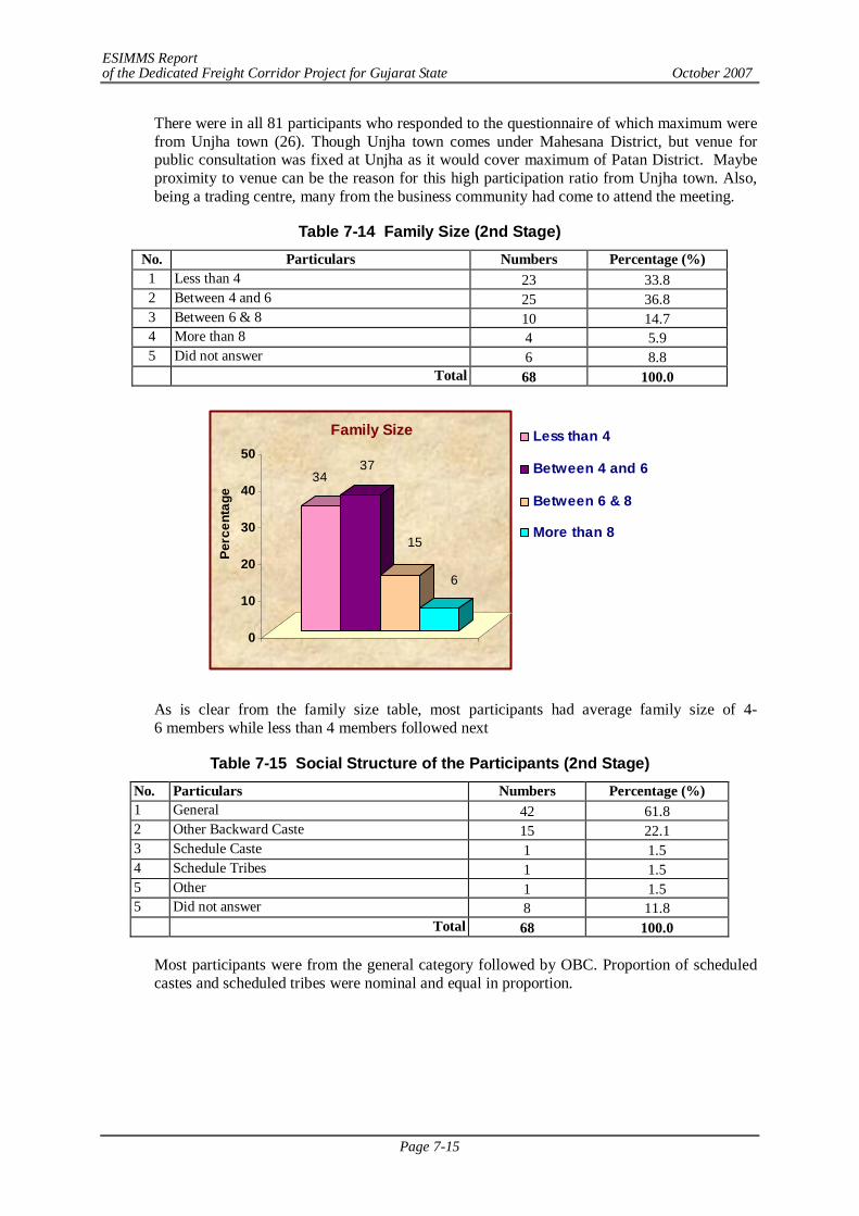
ESIMMS Report of the Dedicated Freight Corridor Project for Gujarat State October 2007
Page 7-15
There were in all 81 participants who responded to the questionnaire of which maximum were from Unjha town (26). Though Unjha town comes under Mahesana District, but venue for public consultation was fixed at Unjha as it would cover maximum of Patan District. Maybe proximity to venue can be the reason for this high participation ratio from Unjha town. Also, being a trading centre, many from the business community had come to attend the meeting.
Table 7-14 Family Size (2nd Stage) No. Particulars Numbers Percentage (%) 1 Less than 4 23 33.8 2 Between 4 and 6 25 36.8 3 Between 6 & 8 10 14.7 4 More than 8 4 5.9 5 Did not answer 6 8.8 Total 68 100.0
3437
15
6
0
10
20
30
40
50
Perc
enta
ge
Family Size Less than 4
Between 4 and 6
Between 6 & 8
More than 8
As is clear from the family size table, most participants had average family size of 4-6 members while less than 4 members followed next
Table 7-15 Social Structure of the Participants (2nd Stage) No. Particulars Numbers Percentage (%) 1 General 42 61.8 2 Other Backward Caste 15 22.1 3 Schedule Caste 1 1.5 4 Schedule Tribes 1 1.5 5 Other 1 1.5 5 Did not answer 8 11.8 Total 68 100.0
Most participants were from the general category followed by OBC. Proportion of scheduled castes and scheduled tribes were nominal and equal in proportion.
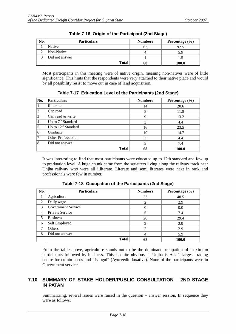
ESIMMS Report of the Dedicated Freight Corridor Project for Gujarat State October 2007
Page 7-16
Table 7-16 Origin of the Participant (2nd Stage) No. Particulars Numbers Percentage (%) 1 Native 63 92.5 2 Non-Native 4 5.9 3 Did not answer 1 1.5 Total 68 100.0
Most participants in this meeting were of native origin, meaning non-natives were of little significance. This hints that the respondents were very attached to their native place and would by all possibility resist to move out in case of land acquisition.
Table 7-17 Education Level of the Participants (2nd Stage) No. Particulars Numbers Percentage (%) 1 Illiterate 14 20.6 2 Can read 8 11.8 3 Can read & write 9 13.2 4 Up to 7th Standard 3 4.4 5 Up to 12th Standard 16 23.5 6 Graduate 10 14.7 7 Other Professional 3 4.4 8 Did not answer 5 7.4 Total 68 100.0
It was interesting to find that most participants were educated up to 12th standard and few up to graduation level. A huge chunk came from the squatters living along the railway track near Unjha railway who were all illiterate. Literate and semi literates were next in rank and professionals were few in number.
Table 7-18 Occupation of the Participants (2nd Stage) No. Particulars Numbers Percentage (%) 1 Agriculture 33 48.5 2 Daily wage 2 2.9 3 Government Service 0 0.0 4 Private Service 5 7.4 5 Business 20 29.4 6 Self Employed 2 2.9 7 Others 2 2.9 8 Did not answer 4 5.9 Total 68 100.0
From the table above, agriculture stands out to be the dominant occupation of maximum participants followed by business. This is quite obvious as Unjha is Asia’s largest trading centre for cumin seeds and “Isabgul” (Ayurvedic laxative). None of the participants were in Government service.
7.10 SUMMARY OF STAKE HOLDER/PUBLIC CONSULTATION – 2ND STAGE
IN PATAN
Summarizing, several issues were raised in the question – answer session. In sequence they were as follows:
ESIMMS Report of the Dedicated Freight Corridor Project for Gujarat State October 2007
Page 7-17
1) In general, the participants welcomed the DFC project as they agreed that any development
project would have positive trickle down effect which would benefit the country at large. But the businessmen (mostly dealing in jeera, isabgul, 80% of it is exported, demanded a stop at Unjha (even a weekly stoppage would do) so that they can directly benefit from the DFC project. They justified their demand by the volume of freight that they daily load.
2) Waiting time at railway crossing causes lot of inconvenience to local movement with loss of time. At frequent intervals railway crossing is closed at Unjha and people suffer a lot due to it, therefore there is urgent need of ROB or RUB at Unjha.
3) He further added that when a piece of farmland is divided in to two pieces due to railway line, then, firstly railway authorities do not allow taking water pipe line across the railway line for irrigation. In that case, also water supply, irrigation mechanisms and electricity lines get severed and have to be reinstalled. Moreover, crossing railway line by farmers and cattle becomes difficult and risky. There was a demand that such facilities should be ensured in the divided land as well without much hassle and that should be incorporated in the policy itself.
4) If enough land is available to Railway authority on the eastern side, then new alignment should be laid on the eastern side so that there is no need to acquire new land. If there is no option left, then only land should be acquired.
5) A squatter representative requested the Government and representatives of DFC that justice should be made to them by providing alternative place to build their houses and their case should be considered sympathetically. Alternative land/ structure should be provided and one of the family members should be offered employment in DFC.
6) So the common demands from PAF in general were compensation at market rate, employment in Railway and access to water, electricity when farmland gets severed by the DFC.
7) Another issue was the drainage problem in the adjoining areas near the railway line. People requested that more number of broad drain/nala should be provided so that water drains off easily. Before the commencement of monsoon season, cleaning of drains/nalas are also needed to prevent water logging.
8) To determine value of any land, it has to be agreed upon through mutual consent between the implementing authority and the PAP. With the help of good active NGO, farmers should approach the authority directly so that agents and brokers do not play any negative role so that land acquisition becomes easy and transparent with no middlemen intervention. There was also a suggestion that land value assessment committee should be formed to decide on the rate of land for compensation. If any land gets divided into two parts, then some method should be worked out for redistribution as it is done in town planning scheme.
9) DFC may consider to give lump sum amount every year to the project affected families to compensate loss as it is being done in the case of ONGC, (when they acquired land).
10) Certain common concerns were as follows which were repetitive.
- Compensation package. - Provision of employment of any family member of PAF in DFC. - Provision of DFC station at Unjha, where loading/unloading can take place at
least weekly. - Solving water pipeline issue when land gets divided due to laying of new railway
line. - Water drainage problem. - RUB/ROB at railway junction – Unjha to facilitate free flow of traffic with no
time wasted at railway crossing.
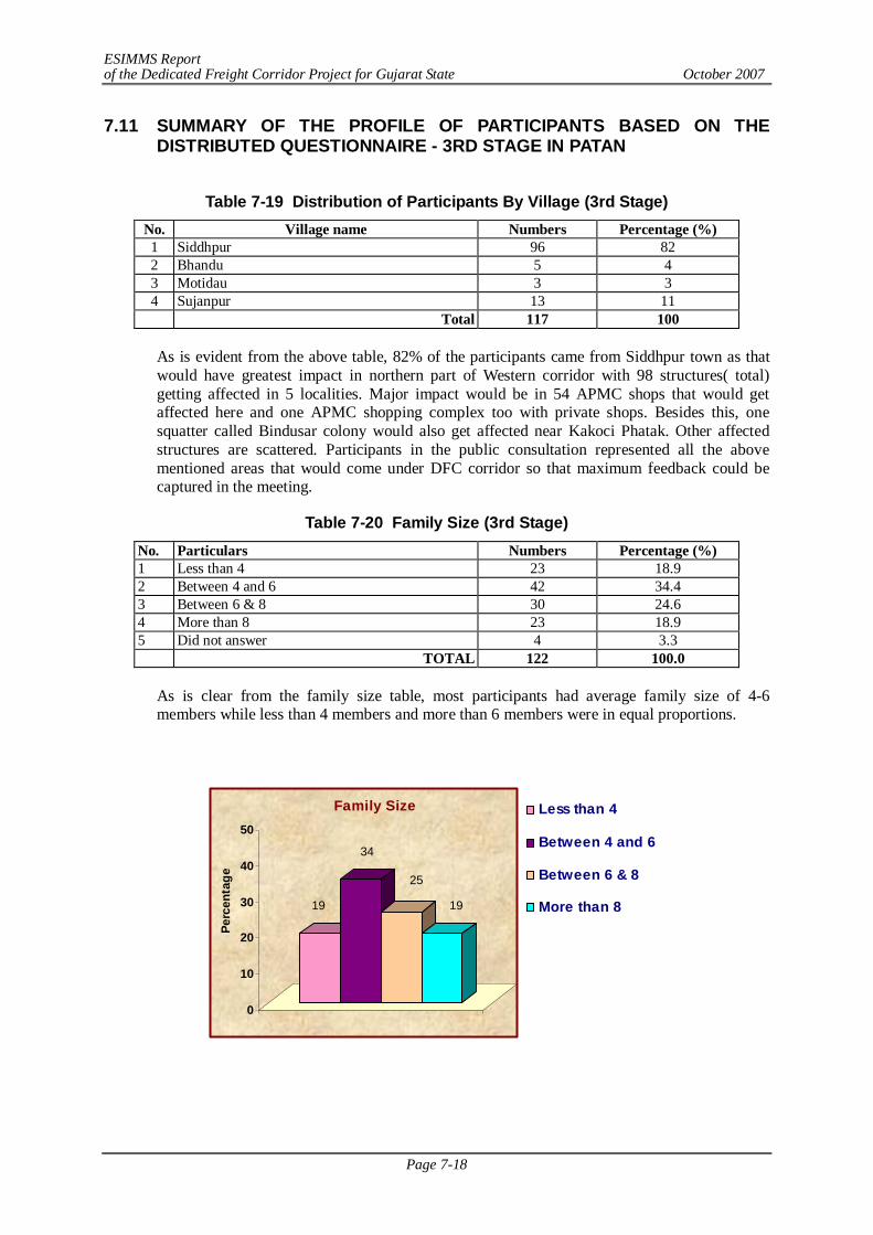
ESIMMS Report of the Dedicated Freight Corridor Project for Gujarat State October 2007
Page 7-18
7.11 SUMMARY OF THE PROFILE OF PARTICIPANTS BASED ON THE DISTRIBUTED QUESTIONNAIRE - 3RD STAGE IN PATAN
Table 7-19 Distribution of Participants By Village (3rd Stage)
No. Village name Numbers Percentage (%) 1 Siddhpur 96 82 2 Bhandu 5 4 3 Motidau 3 3 4 Sujanpur 13 11 Total 117 100
As is evident from the above table, 82% of the participants came from Siddhpur town as that would have greatest impact in northern part of Western corridor with 98 structures( total) getting affected in 5 localities. Major impact would be in 54 APMC shops that would get affected here and one APMC shopping complex too with private shops. Besides this, one squatter called Bindusar colony would also get affected near Kakoci Phatak. Other affected structures are scattered. Participants in the public consultation represented all the above mentioned areas that would come under DFC corridor so that maximum feedback could be captured in the meeting.
Table 7-20 Family Size (3rd Stage) No. Particulars Numbers Percentage (%) 1 Less than 4 23 18.9 2 Between 4 and 6 42 34.4 3 Between 6 & 8 30 24.6 4 More than 8 23 18.9 5 Did not answer 4 3.3 TOTAL 122 100.0
As is clear from the family size table, most participants had average family size of 4-6 members while less than 4 members and more than 6 members were in equal proportions.
19
34
25
19
0
10
20
30
40
50
Perc
enta
ge
Family Size Less than 4
Between 4 and 6
Between 6 & 8
More than 8
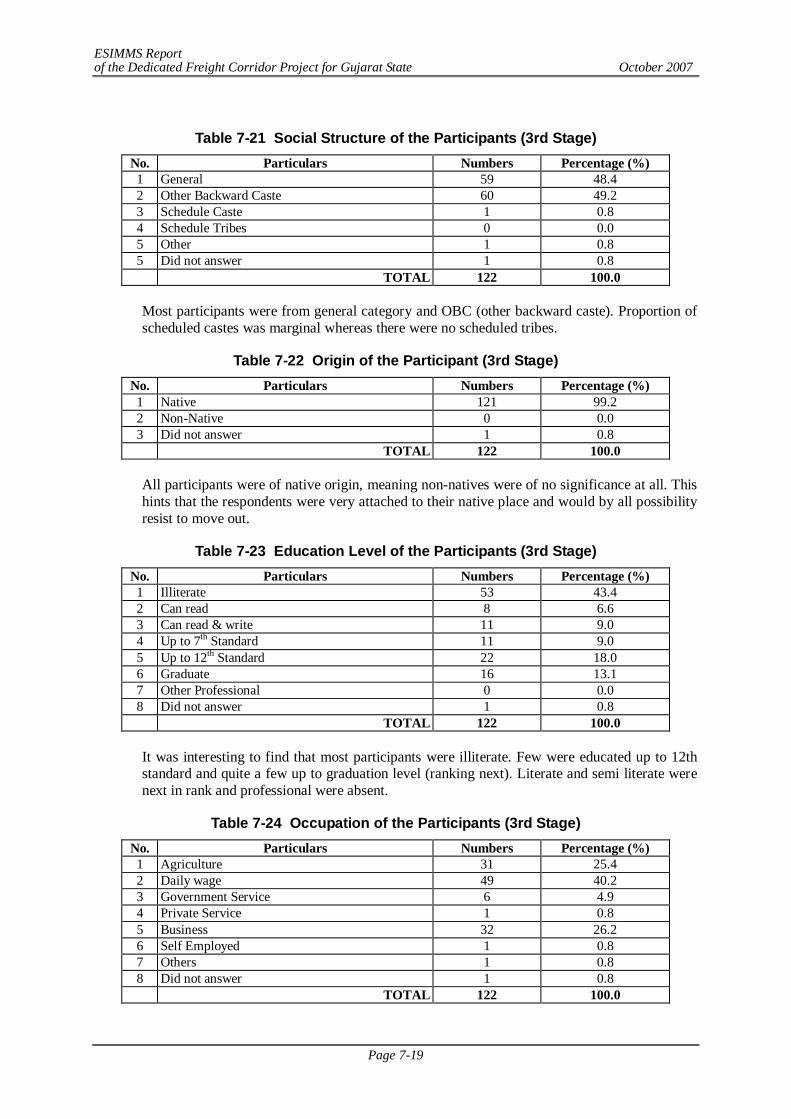
ESIMMS Report of the Dedicated Freight Corridor Project for Gujarat State October 2007
Page 7-19
Table 7-21 Social Structure of the Participants (3rd Stage)
No. Particulars Numbers Percentage (%) 1 General 59 48.4 2 Other Backward Caste 60 49.2 3 Schedule Caste 1 0.8 4 Schedule Tribes 0 0.0 5 Other 1 0.8 5 Did not answer 1 0.8 TOTAL 122 100.0
Most participants were from general category and OBC (other backward caste). Proportion of scheduled castes was marginal whereas there were no scheduled tribes.
Table 7-22 Origin of the Participant (3rd Stage) No. Particulars Numbers Percentage (%) 1 Native 121 99.2 2 Non-Native 0 0.0 3 Did not answer 1 0.8 TOTAL 122 100.0
All participants were of native origin, meaning non-natives were of no significance at all. This hints that the respondents were very attached to their native place and would by all possibility resist to move out.
Table 7-23 Education Level of the Participants (3rd Stage) No. Particulars Numbers Percentage (%) 1 Illiterate 53 43.4 2 Can read 8 6.6 3 Can read & write 11 9.0 4 Up to 7th Standard 11 9.0 5 Up to 12th Standard 22 18.0 6 Graduate 16 13.1 7 Other Professional 0 0.0 8 Did not answer 1 0.8 TOTAL 122 100.0
It was interesting to find that most participants were illiterate. Few were educated up to 12th standard and quite a few up to graduation level (ranking next). Literate and semi literate were next in rank and professional were absent.
Table 7-24 Occupation of the Participants (3rd Stage) No. Particulars Numbers Percentage (%) 1 Agriculture 31 25.4 2 Daily wage 49 40.2 3 Government Service 6 4.9 4 Private Service 1 0.8 5 Business 32 26.2 6 Self Employed 1 0.8 7 Others 1 0.8 8 Did not answer 1 0.8 TOTAL 122 100.0
ESIMMS Report of the Dedicated Freight Corridor Project for Gujarat State October 2007
Page 7-20
From the table above, daily wage earners stand out to be the dominant occupation of maximum participants. This is expected as 80% of participants were from various areas of Siddhpur town as it would have maximum impact in the northern section of DFC corridor affecting over 1,000 PAPs and affecting 98 structures. Business seems to be the next important category as shop owners of APMC had participated in the meeting in large numbers as 54 shops on the front line of APMC would be affected. Few came from neighbouring villages so agriculture comparatively was not important here.
7.12 SUMMARY OF FINDINGS – 3RD STAGE IN PATAN
People from Siddhpur municipality strongly opposed the DFC and suggested alternative bypass. Daily wage earners from Indiranagar belonged to BPL category but had no cards. Women representatives from Pattani community also opposed. Representatives from Siddhpur municipality also proposed bypass and so did the APMC at Siddhpur and Unjha. Since there is no stoppage at Unjha station, traders would get no direct benefit from DFC and were simply not interested in DFC.
7.13 SUMMARY OF PROFILE OF THE PARTICIPANTS BASED ON
DISTRIBUTED QUESTIONNAIRE – 2ND STAGE IN MAHESANA
Table 7-25 Distribution of Participants by Village (2nd Stage)
No. Village name Numbers Percentage (%) 1. Ambasan 3 2.2 2. Fatepura 2 1.4 3. Heduva 16 11.5 4. Jagusan 1 0.7 5. Linch 3 2.2 6. Mehsana 17 12.2 7. Mavad 3 2.2 8. Nandasan 3 2.2 9. Palodar 12 8.6 10. Panchot 13 9.4 11. Ramosana 8 5.8 12. Sakhpurda 5 3.6 13. Sametra 4 2.9 14. Samri 5 3.6 15. Sobhason 9 6.5 16. Soneripura 20 14.4 17. Vadosana 2 1.4 18. Dediasan 13 9.4 19. Grand Total 139 100.0
As is evident, out of 18 villages, the prominent ones from where participants came in large numbers are Soneripura, Mehsana, Hedwa, Panchot and Dediasan are other important villages.
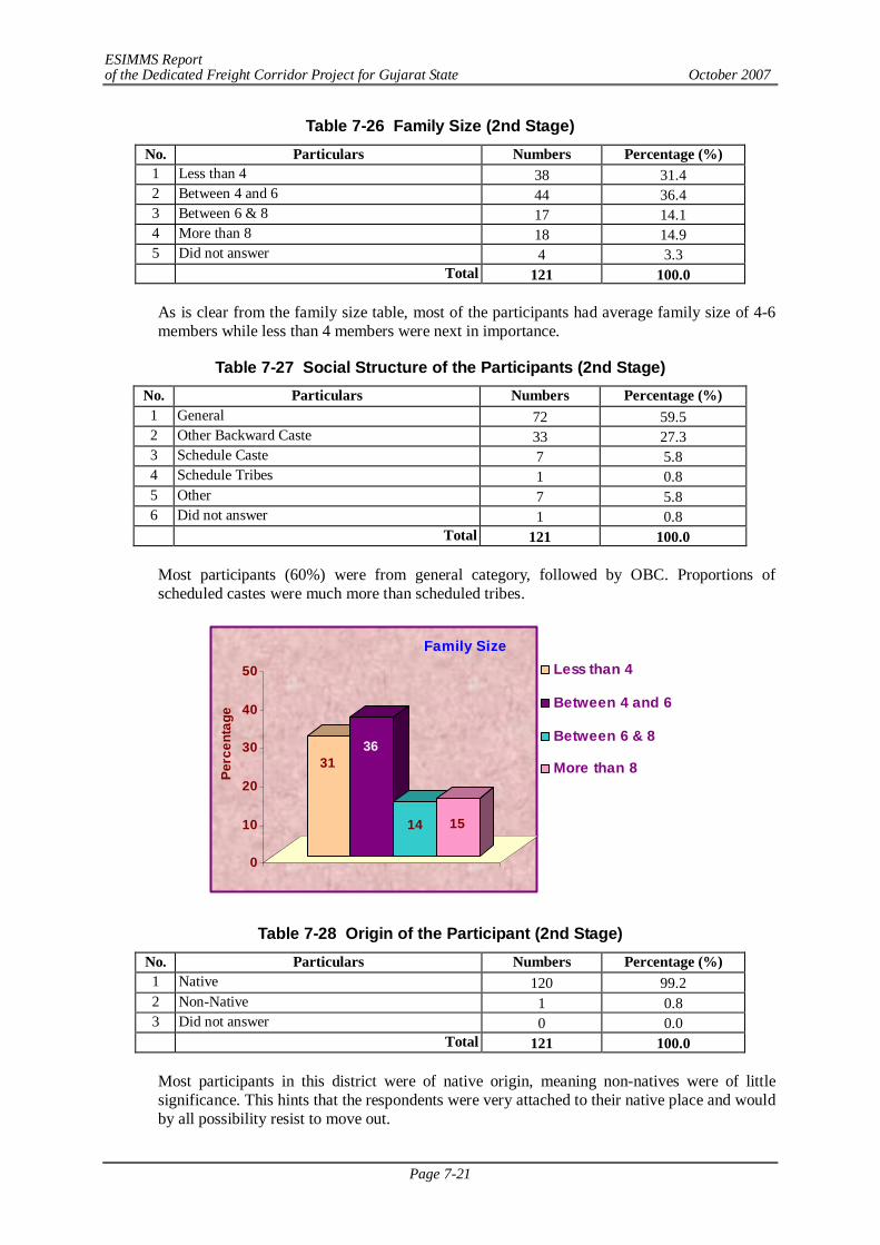
ESIMMS Report of the Dedicated Freight Corridor Project for Gujarat State October 2007
Page 7-21
Table 7-26 Family Size (2nd Stage) No. Particulars Numbers Percentage (%) 1 Less than 4 38 31.4 2 Between 4 and 6 44 36.4 3 Between 6 & 8 17 14.1 4 More than 8 18 14.9 5 Did not answer 4 3.3 Total 121 100.0
As is clear from the family size table, most of the participants had average family size of 4-6 members while less than 4 members were next in importance.
Table 7-27 Social Structure of the Participants (2nd Stage) No. Particulars Numbers Percentage (%) 1 General 72 59.5 2 Other Backward Caste 33 27.3 3 Schedule Caste 7 5.8 4 Schedule Tribes 1 0.8 5 Other 7 5.8 6 Did not answer 1 0.8 Total 121 100.0
Most participants (60%) were from general category, followed by OBC. Proportions of scheduled castes were much more than scheduled tribes.
3136
14 15
0
10
20
30
40
50
Perc
enta
ge
Family SizeLess than 4
Between 4 and 6
Between 6 & 8
More than 8
Table 7-28 Origin of the Participant (2nd Stage) No. Particulars Numbers Percentage (%) 1 Native 120 99.2 2 Non-Native 1 0.8 3 Did not answer 0 0.0 Total 121 100.0
Most participants in this district were of native origin, meaning non-natives were of little significance. This hints that the respondents were very attached to their native place and would by all possibility resist to move out.
ESIMMS Report of the Dedicated Freight Corridor Project for Gujarat State October 2007
Page 7-22
Table 7-29 Education Level of the Participants (2nd Stage) No. Particulars Numbers Percentage (%) 1 Illiterate 15 12.4 2 Can read 17 14.1 3 Can read & write 31 25.6 4 Up to 7th Standard 14 11.6 5 Up to 12th Standard 28 21.5 6 Graduate 8 6.6 7 Other Professional 6 5.0 8 Did not answer 4 3.3 Total 121 100.0
It was interesting to find that most participants were educated up to 12th standard and quite a few up to graduation level (ranking next). Literate and semi literates were next in rank and professionals were few in number.
Table 7-30 Occupation of the Participants (2nd Stage) No. Particulars Numbers Percentage (%) 1 Agriculture 87 71.9 2 Daily wage 7 5.8 3 Government Service 7 5.8 4 Private Service 4 3.3 5 Business 5 4.1 6 Self Employed 2 1.7 7 Others 6 5.0 8 Did not answer 3 2.5 Total 121 100.0
From the table above, agriculture stands out to be the dominant occupation of maximum participants. Daily wage earners and private service are far less important and other occupation not important at all.
7.14 SUMMARY OF STAKE HOLDER/PUBLIC CONSULTATION – 2ND STAGE
IN MEHSANA
Summarizing, several issues were raised in the question – answer session. In sequence they were as follows:
1) To consider DFC being made parallel to existing railway line so that the acquisition of land could be avoided altogether.
2) If at all that is not possible then alignment should be made with due considerations keeping in view the growth of Mahesana town. In other words, expected population projection should be considered before the final alignment is fixed. Keeping the perspective of Gujarat developing very fast, within next 15 years of time cities would expand and at that time DFC would probably be cutting across the city.
3) Past experience with development projects has been disappointing so far. So farmers / common people are skeptical. When farmers have lost land in various development schemes such as Narmada Water Pipe Line or Canal, Gas Pipe Line, Express Highway etc. conditions of farmers have deteriorated and they never benefited directly/indirectly from such projects. So participants were skeptical about DFC project as well.
ESIMMS Report of the Dedicated Freight Corridor Project for Gujarat State October 2007
Page 7-23
4) Another issue has been when farm land is split into two because of any railway line, it becomes difficult to cross water pipe line, electricity supply etc. from one side to another. It takes a long time to get NOC and it is expensive also. Therefore, some simple solution is needed with respect to this at district level.
5) Most of the farmers of Mahesana District were small/marginal farmers and so there are a number of associated problems. They might lose whole of their land and become land less without any title or legal status. There was question as to how JICA would tackle this problem in their policy implementation.
6) There is always a difference between documented price and market value of any land. In any sale deed, the registered price is far below (15-20 times difference in price depending on the type and location of the land) the current market rate. So while giving compensation JICA should consider market price keeping in minds that the affected individual is in a position to purchase new land.
7) There was a demand that one person from each PAF should get a Government job.
8) In extremity, many participants (about 30%) simply refused to co-operate with this project. They were not ready to negotiate even if the compensation was at the market rate. Further, in case of corridor development and land leveling, land filling would be required, and at that time they would refuse to give even a pinch of soil from their farms.
9) Some other common concerns were:
10) Demand for RUB/ROB in railway crossings to facilitate smooth traffic flow. Milk and associated items like ice-cream are perishable commodities so waiting in transit is a huge loss to people who trade with these products.
- Environmental clearance for DFC required. - Compensation package for different categories of PAPs. - Exact alignment details so that the affected land plots can be identified.
ESIMMS Report of the Dedicated Freight Corridor Project for Gujarat State October 2007
Page 7-24
7.15 SUMMARY OF THE PROFILE OF PARTICIPANTS BASED ON THE DISTRIBUTED QUESTIONNAIRE - 3RD STAGE IN MAHESANA
Table 7-31 Distribution of Participants by Village (3rd Stage)
No. Village name Numbers Percentage (%) 1. Ganeshpura 6 5.1 2. Hedva 16 13.6 3. Motidau 4 3.4 4. Panchot 34 28.8 5. Palodar 6 5.1 6. Sunehripura 22 18.6 7. Nandasan 1 0.9 8. Mathasur 2 1.7 9. Dhanali 2 1.7 10. Baliyasan 5 4.2 11. Linch 3 2.5 12. Heduva 1 0.9 13. Dediyasan 1 0.9 14. Vadosan 2 1.7 15. Sametra 6 5.1 16. Tundali 7 5.9 17. Grand Total 118 100.0
As is evident, out of 16 villages, the prominent ones from where participants came in large numbers are Panchot, other villages which followed are Sunheripura, Hedwa in decreasing order.
Table 7-32 Family Size (3rd Stage) No. Particulars Numbers Percentage (%) 1 Less than 4 26 27.7 2 Between 4 and 6 33 35.1 3 Between 6 & 8 10 10.6 4 More than 8 13 13.8 5 Did not answer 12 12.8 TOTAL 94 100.0
As is clear from the family size table, most participants had average family size of less than 4 members while more than 4 and less than 6 members were next in number.
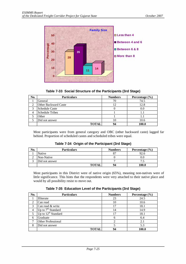
ESIMMS Report of the Dedicated Freight Corridor Project for Gujarat State October 2007
Page 7-25
28
35
11 14
0
10
20
30
40
50
Perc
enta
ge
Family SizeLess than 4
Between 4 and 6
Between 6 & 8
More than 8
Table 7-33 Social Structure of the Participants (3rd Stage) No. Particulars Numbers Percentage (%) 1 General 70 74.5 2 Other Backward Caste 12 12.8 3 Schedule Caste 0 0.0 4 Schedule Tribes 1 1.1 5 Other 1 1.1 5 Did not answer 10 10.6 TOTAL 94 100.0
Most participants were from general category and OBC (other backward caste) lagged far behind. Proportion of scheduled castes and scheduled tribes were equal.
Table 7-34 Origin of the Participant (3rd Stage) No. Particulars Numbers Percentage (%) 1 Native 87 92.6 2 Non-Native 0 0.0 3 Did not answer 7 7.5 TOTAL 94 100.0
Most participants in this District were of native origin (65%), meaning non-natives were of little significance. This hints that the respondents were very attached to their native place and would by all possibility resist to move out.
Table 7-35 Education Level of the Participants (3rd Stage) No. Particulars Numbers Percentage (%) 1 Illiterate 23 24.5 2 Can read 10 10.6 3 Can read & write 17 18.1 4 Up to 7th Standard 14 14.9 5 Up to 12th Standard 17 18.1 6 Graduate 6 6.4 7 Other Professional 2 2.1 8 Did not answer 5 5.3 TOTAL 94 100.0

ESIMMS Report of the Dedicated Freight Corridor Project for Gujarat State October 2007
Page 7-26
It was interesting to find that maximum participants were illiterate; few could read. Literate and semi literate were next in rank and professionals were few in number.
Table 7-36 Occupation of the Participants (3rd Stage) No. Particulars Numbers Percentage (%) 1 Agriculture 82 87.2 2 Daily wage 5 5.3 3 Government Service 0 0.0 4 Private Service 0 0.0 5 Business 2 2.1 6 Self Employed 1 1.1 7 Others 1 1.1 8 Did not answer 3 3.2 TOTAL 94 100.0
From the table above, agriculture stands out to be the dominant occupation of maximum participants. Other occupations are almost insignificant.
7.16 SUMMARY OF FINDINGS – 3RD STAGE IN MEHSANA
Since Mahesana town would extend its limits (3times) in near future, DFC should shift its bypass further away. Of all villages, Panchot resisted the most as several independent projects are all acquiring land for their work in the same area. Sunheripura too supported Panchot. Residents of Baliyasan Village have also strongly opposed the project as the present alignment will result in large scale displacement of people as well as demolition of good number of residential structures. In general, participants opposed DFC as they would not be the direct beneficiary.
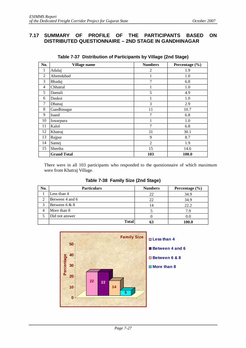
ESIMMS Report of the Dedicated Freight Corridor Project for Gujarat State October 2007
Page 7-27
7.17 SUMMARY OF PROFILE OF THE PARTICIPANTS BASED ON DISTRIBUTED QUESTIONNAIRE – 2ND STAGE IN GANDHINAGAR
Table 7-37 Distribution of Participants by Village (2nd Stage)
No. Village name Numbers Percentage (%) 1 Adalaj 2 1.9 2 Ahemdabad 1 1.0 3 Bhadaj 7 6.8 4 Chhatral 1 1.0 5 Dantali 5 4.9 6 Daskoi 1 1.0 7 Dhanaj 3 2.9 8 Gandhinagar 11 10.7 9 Isand 7 6.8
10 Iswarpura 1 1.0 11 Kalol 7 6.8 12 Khatraj 31 30.1 13 Rajpur 9 8.7 14 Santej 2 1.9 15 Shertha 15 14.6
Grand Total 103 100.0
There were in all 103 participants who responded to the questionnaire of which maximum were from Khatraj Village.
Table 7-38 Family Size (2nd Stage) No. Particulars Numbers Percentage (%) 1 Less than 4 22 34.9 2 Between 4 and 6 22 34.9 3 Between 6 & 8 14 22.2 4 More than 8 5 7.9 5 Did not answer 0 0.0 Total 63 100.0
22 2214
50
10
20
30
40
50
Per
cent
age
Family Size Less than 4
Between 4 and 6
Between 6 & 8
More than 8
ESIMMS Report of the Dedicated Freight Corridor Project for Gujarat State October 2007
Page 7-28
As is clear from the family size table, most participants had average family size of 4-6 members while less than 4 members followed next.
Table 7-39 Social Structure of the Participants (2nd Stage) No. Particulars Numbers Percentage (%) 1 General 29 46.0 2 Other Backward Caste 27 42.9 3 Schedule Caste 6 9.5 4 Schedule Tribes 0 0.0 5 Other 1 1.6 5 Did not answer 0 0.0 Total 63 100.0
Most participants were from the general category followed by OBC. Proportion of scheduled castes was negligible and none were from scheduled tribes.
Table 7-40 Origin of the Participant (2nd Stage) No. Particulars Numbers Percentage (%) 1 Native 63 100.0 2 Non-Native 0 0.0 3 Did not answer 0 0.0 Total 63 100
All participants in this meeting were of native origin, meaning non-natives were of little significance. This hints that the respondents were very attached to their native place and would by all possibility resist to move out in case of land acquisition.
Table 7-41 Education Level of the Participants (2nd Stage) No. Particulars Numbers Percentage (%) 1 Illiterate 11 17.5 2 Can read 5 8.0 3 Can read & write 9 14.3 4 Up to 7th Standard 9 14.3 5 Up to 12th Standard 15 23.8 6 Graduate 10 15.9 7 Other Professional 3 4.8 8 Did not answer 1 1.6 Total 63 100.0
It was interesting to find that most participants were educated up to 12th standard and few up to graduation levels. A huge chunk was illiterate marginal farmers. Literate and semi literates were next in rank and professionals were few in number.
ESIMMS Report of the Dedicated Freight Corridor Project for Gujarat State October 2007
Page 7-29
Table 7-42 Occupation of the Participants (2nd Stage) No. Particulars Numbers Percentage (%) 1 Agriculture 33 52.4 2 Daily wage 8 12.7 3 Government Service 6 9.5 4 Private Service 7 1.1 5 Business 1 1.6 6 Self Employed 1 1.6 7 Others 5 7.9 8 Did not answer 2 3.2 Total 63 100.0
From the table above, agriculture stands out to be the dominant occupation of maximum participants followed by daily wage earners.
7.18 SUMMARY OF FINDINGS – 2ND STAGE IN GANDHINAGAR
1) DFC should be laid down parallel to existing railway line. By doing so, money would be
saved and also land of many farmers. When farm gets fragmented into pieces because of railway line, then the farmer has problems in supplying irrigation water to the other side. He had to sell his land under such compulsion. He requested to grant compensation as per market rate.
2) It is possible that authority may acquire land today and put in to use after some years. In that case he suggested that the implementing agency should give them rent for the in between years and pay compensation at the time of implementation so that they may get the benefit of price escalation, if any.
3) After considering the new town planning scheme of Ahmedabad city, it would be prudent to shift the DFC 9-10 km. away from the existing alignment. JICA should consider that too.
4) Giving options to farmers while deciding upon compensation.
5) Cash compensation is of no value because they spent it in short span of time and in mostly unproductive ways. So employment opportunity to PAF is the only sustainable way as in that case their livelihood problem would be solved permanently.
6) Local employment should be generated by DFC projects; unlike past experience when the entrepreneur mobilized human labour from outside Gujarat which is not fair.
7) There is a great potential for water recharge structures. If rain water harvesting and recharge systems are build along with DFC then there would be green belt- an attempt to restore ecological balance. In this way, we can solve storm water problems and make positive impact on ecology by proper water management.
8) Laying DFC parallel to the existing line is beneficial in three ways; like capital investment would be reduced, time would be saved and no diversification would be required.
9) DFC should consider the case about farmers whose land would be divided into two because of DFC. It might so happen that the division would result in unequal pieces of land, and it often happens that the smaller piece of land becomes economically unviable. In other words, it becomes useless to the farmer was he would not be able to cultivate nor sell. DFC should consider such cases while framing the compensation package.
- Both Central and State Government should work in tandem across party lines so that DFC should work smoothly and peoples’ interests are protected
ESIMMS Report of the Dedicated Freight Corridor Project for Gujarat State October 2007
Page 7-30
7.19 SUMMARY OF THE PROFILE OF PARTICIPANTS BASED ON THE
DISTRIBUTED QUESTIONNAIRE - 3RD STAGE GANDHINAGAR
With the final DFC alignment, it was found that in Gandhinagar District, DFC passes through only 8 villages where no structures are getting affected. Therefore, during the third stage, instead of full fledged public consultation, village meetings were conducted at three suitable locations (Rajpur, Dhanot and Rancharada) to cover most of the villages in Gandhinagar district along the DFC. Since they were small meetings, questionnaire survey was not conducted as they might be misleading statistics –wise. Therefore analysis of the same has not been provided in this section. However, detailed proceedings of all the village meetings have been provided in the annexure.
7.20 SUMMARY OF FINDINGS – 3RD STAGE IN GANDHINAGAR
It may well be said that in all the village level public consultations, people were concerned about what JICA would offer as compensation in terms of land acquired, job in the railways, and compensating for fruit bearing trees like chiku and mangoes (Rajpura)and vegetables (Dhanot). In general they showed no strong opposition against DFC. But people who attended the meeting at Rancharda were in general not in favour of DFC as they were in no way benefited. However, only by offering current market rate of land perhaps some could be made to agree in case of land acquisition. Many suggested shifting DFC further as it would soon come within the urban growth of the twin cities of Ahmedabad and Gandhinagar adding to urban chaos and turmoil.
7.21 SUMMARY OF PROFILE OF THE PARTICIPANTS BASED ON
DISTRIBUTED QUESTIONNAIRE – 2ND STAGE IN AHMEDABAD
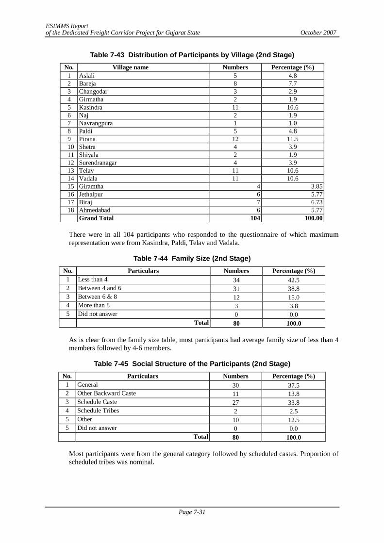
ESIMMS Report of the Dedicated Freight Corridor Project for Gujarat State October 2007
Page 7-31
Table 7-43 Distribution of Participants by Village (2nd Stage) No. Village name Numbers Percentage (%)
1 Aslali 5 4.8 2 Bareja 8 7.7 3 Changodar 3 2.9 4 Girmatha 2 1.9 5 Kasindra 11 10.6 6 Naj 2 1.9 7 Navrangpura 1 1.0 8 Paldi 5 4.8 9 Pirana 12 11.5 10 Shetra 4 3.9 11 Shiyala 2 1.9 12 Surendranagar 4 3.9 13 Telav 11 10.6 14 Vadala 11 10.6 15 Giramtha 4 3.85 16 Jethalpur 6 5.77 17 Biraj 7 6.73 18 Ahmedabad 6 5.77
Grand Total 104 100.00
There were in all 104 participants who responded to the questionnaire of which maximum representation were from Kasindra, Paldi, Telav and Vadala.
Table 7-44 Family Size (2nd Stage) No. Particulars Numbers Percentage (%) 1 Less than 4 34 42.5 2 Between 4 and 6 31 38.8 3 Between 6 & 8 12 15.0 4 More than 8 3 3.8 5 Did not answer 0 0.0 Total 80 100.0
As is clear from the family size table, most participants had average family size of less than 4 members followed by 4-6 members.
Table 7-45 Social Structure of the Participants (2nd Stage) No. Particulars Numbers Percentage (%) 1 General 30 37.5 2 Other Backward Caste 11 13.8 3 Schedule Caste 27 33.8 4 Schedule Tribes 2 2.5 5 Other 10 12.5 5 Did not answer 0 0.0 Total 80 100.0
Most participants were from the general category followed by scheduled castes. Proportion of scheduled tribes was nominal.
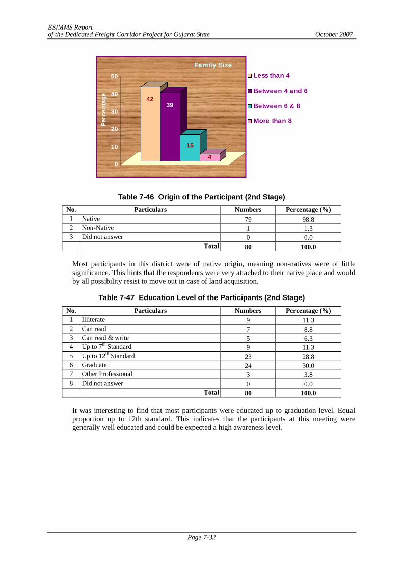
ESIMMS Report of the Dedicated Freight Corridor Project for Gujarat State October 2007
Page 7-32
4239
15
40
10
20
30
40
50
Perc
enta
ge
Family SizeLess than 4
Between 4 and 6
Between 6 & 8
More than 8
Table 7-46 Origin of the Participant (2nd Stage) No. Particulars Numbers Percentage (%) 1 Native 79 98.8 2 Non-Native 1 1.3 3 Did not answer 0 0.0 Total 80 100.0
Most participants in this district were of native origin, meaning non-natives were of little significance. This hints that the respondents were very attached to their native place and would by all possibility resist to move out in case of land acquisition.
Table 7-47 Education Level of the Participants (2nd Stage) No. Particulars Numbers Percentage (%) 1 Illiterate 9 11.3 2 Can read 7 8.8 3 Can read & write 5 6.3 4 Up to 7th Standard 9 11.3 5 Up to 12th Standard 23 28.8 6 Graduate 24 30.0 7 Other Professional 3 3.8 8 Did not answer 0 0.0 Total 80 100.0
It was interesting to find that most participants were educated up to graduation level. Equal proportion up to 12th standard. This indicates that the participants at this meeting were generally well educated and could be expected a high awareness level.
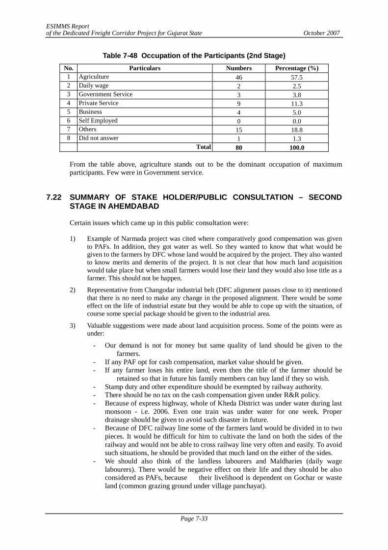
ESIMMS Report of the Dedicated Freight Corridor Project for Gujarat State October 2007
Page 7-33
Table 7-48 Occupation of the Participants (2nd Stage) No. Particulars Numbers Percentage (%) 1 Agriculture 46 57.5 2 Daily wage 2 2.5 3 Government Service 3 3.8 4 Private Service 9 11.3 5 Business 4 5.0 6 Self Employed 0 0.0 7 Others 15 18.8 8 Did not answer 1 1.3 Total 80 100.0
From the table above, agriculture stands out to be the dominant occupation of maximum participants. Few were in Government service.
7.22 SUMMARY OF STAKE HOLDER/PUBLIC CONSULTATION – SECOND
STAGE IN AHEMDABAD
Certain issues which came up in this public consultation were:
1) Example of Narmada project was cited where comparatively good compensation was given to PAFs. In addition, they got water as well. So they wanted to know that what would be given to the farmers by DFC whose land would be acquired by the project. They also wanted to know merits and demerits of the project. It is not clear that how much land acquisition would take place but when small farmers would lose their land they would also lose title as a farmer. This should not be happen.
2) Representative from Changodar industrial belt (DFC alignment passes close to it) mentioned that there is no need to make any change in the proposed alignment. There would be some effect on the life of industrial estate but they would be able to cope up with the situation, of course some special package should be given to the industrial area.
3) Valuable suggestions were made about land acquisition process. Some of the points were as under:
- Our demand is not for money but same quality of land should be given to the farmers.
- If any PAF opt for cash compensation, market value should be given. - If any farmer loses his entire land, even then the title of the farmer should be
retained so that in future his family members can buy land if they so wish. - Stamp duty and other expenditure should be exempted by railway authority. - There should be no tax on the cash compensation given under R&R policy. - Because of express highway, whole of Kheda District was under water during last
monsoon - i.e. 2006. Even one train was under water for one week. Proper drainage should be given to avoid such disaster in future.
- Because of DFC railway line some of the farmers land would be divided in to two pieces. It would be difficult for him to cultivate the land on both the sides of the railway and would not be able to cross railway line very often and easily. To avoid such situations, he should be provided that much land on the either of the sides.
- We should also think of the landless labourers and Maldharies (daily wage labourers). There would be negative effect on their life and they should be also considered as PAFs, because their livelihood is dependent on Gochar or waste land (common grazing ground under village panchayat).
ESIMMS Report of the Dedicated Freight Corridor Project for Gujarat State October 2007
Page 7-34
4) An interesting suggestion that if project is to be implemented by some private company then PAFs should be made share holders of the company so that they can get life time benefit in addition to employment in DFC. DFC implementing authority should keep that in mind while framing R&R policy that local Gujarati people should get employment opportunity. In DFC developmental project, Gujarati people should get job opportunity at least in Gujarat stretch.
5) In case of DFC, farmers should be given rent benefit so they do not face hardship in the interim period between acquisition and compensation.
6) In 90% of cases, cash compensation is given in the developmental projects like this, out of that it has been observed that only 5% of the PAFs purchase land. This has maximum impact on small and marginal farmers who become land less in such cases.
7) There exists a vast difference between market value and documented value of the land, some reasonable value, midway, should be decided upon. Secondly, he mentioned that Bareja is fast developing as a trading centre. In nearby villages there are more then 100 Rice mills and latest Agriculture Productivity Market and the Apron Park are also coming up soon, along the Ring Road. On an average they produce 400 to 500 truck loads daily. So he demanded that if loading facility at Bareja can be provided by DFC.
8) A participant questioned what opportunity the local contractor would get and how they would be benefited? Secondly he mentioned that each year land yields and farmers get returns out of it. But when DFC would acquire land, they may get one-time good compensation, but no care is taken after that. He suggested a farmers committee to get co- operation from fellow farmers for deciding R&R policy.
9) One person from each PAF should get employment in DFC. If a family has more than one adult member and when only one gets a govt. job, it creates family tension and sometime creates even bigger economical and sociological imbalance within the family. This has to be looked into as well.
10) Land price also depends upon the location of land i.e. “road touch” or interior. Raju Bhai of Jeevantirth added that there are seasonal changes in value of land also.
11) It was common experience of the people that M.P. & M.L.A., get information about Govt.’s development project well in advance. Accordingly, they purchase land on very large scale at a comparatively lower price and when implementing authority acquires land, and then they bargain for the land at a very high price and are mostly successful.
12) Afforestation is also important. Some villages have their forest under Joint Forest Management or Social Forestry Scheme. Afforestation should be encouraged so that landless or marginal farmers may not find any difficulty in grazing their cattle. Compensation should be given at the village level (through gram panchayat maybe) for such forest land.
ESIMMS Report of the Dedicated Freight Corridor Project for Gujarat State October 2007
Page 7-35
7.23 SUMMARY OF THE PROFILE OF PARTICIPANTS BASED ON THE DISTRIBUTED QUESTIONNAIRE - 3RD STAGE IN AHMEDABAD
Table 7-49 Distribution of Participants By Village (3rd Stage)
No. Village name Numbers Percentage (%) 1 Ambaliyara 3 4.3 2 Godhavi 12 17.1 3 Jalalpur 1 1.4 4 Kanethi 5 7.1 5 Kavitha 1 1.4 6 Matoda 7 10.0 7 Moriya 7 10.0 8 Moti Devti 10 14.3 9 Saroda 2 2.9
10 Vasna Chacharwadi 18 25.7 11 Bawala 2 2.9 12 Badarkha 2 2.9
Grand Total 70 100.0
As is evident from the above table, out of 70 participants who attended the third stage of the meeting, Maximum came from Vasna Chacharwadi. Other villages from where maximum representatives came are Godhavi, Matoda, Moriya, Moti Devti.
Table 7-50 Family Size (3rd Stage) No. Particulars Numbers Percentage (%) 1 Less than 4 12 18.5 2 Between 4 and 6 25 38.5 3 Between 6 & 8 2 3.1 4 More than 8 1 1.5 5 Did not answer 25 38.5 TOTAL 65 100.0
As is clear from the family size table, most participants had average family size of 4-6 members while less than 4 members and more than 6 members were in equal proportions.
18
38
3 2
0
10
20
30
40
50
Perc
enta
ge
Family SizeLess than 4
Between 4 and 6
Between 6 & 8
More than 8
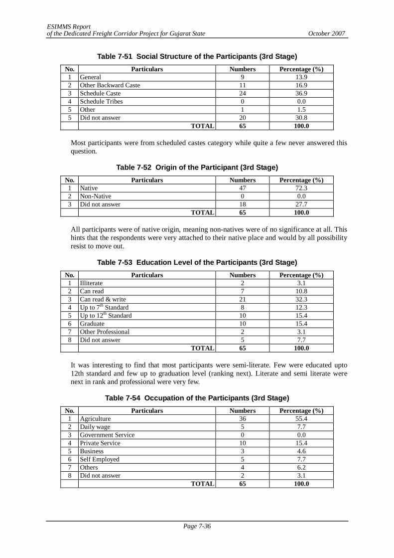
ESIMMS Report of the Dedicated Freight Corridor Project for Gujarat State October 2007
Page 7-36
Table 7-51 Social Structure of the Participants (3rd Stage) No. Particulars Numbers Percentage (%) 1 General 9 13.9 2 Other Backward Caste 11 16.9 3 Schedule Caste 24 36.9 4 Schedule Tribes 0 0.0 5 Other 1 1.5 5 Did not answer 20 30.8 TOTAL 65 100.0
Most participants were from scheduled castes category while quite a few never answered this question.
Table 7-52 Origin of the Participant (3rd Stage) No. Particulars Numbers Percentage (%) 1 Native 47 72.3 2 Non-Native 0 0.0 3 Did not answer 18 27.7 TOTAL 65 100.0
All participants were of native origin, meaning non-natives were of no significance at all. This hints that the respondents were very attached to their native place and would by all possibility resist to move out.
Table 7-53 Education Level of the Participants (3rd Stage) No. Particulars Numbers Percentage (%) 1 Illiterate 2 3.1 2 Can read 7 10.8 3 Can read & write 21 32.3 4 Up to 7th Standard 8 12.3 5 Up to 12th Standard 10 15.4 6 Graduate 10 15.4 7 Other Professional 2 3.1 8 Did not answer 5 7.7 TOTAL 65 100.0
It was interesting to find that most participants were semi-literate. Few were educated upto 12th standard and few up to graduation level (ranking next). Literate and semi literate were next in rank and professional were very few.
Table 7-54 Occupation of the Participants (3rd Stage) No. Particulars Numbers Percentage (%) 1 Agriculture 36 55.4 2 Daily wage 5 7.7 3 Government Service 0 0.0 4 Private Service 10 15.4 5 Business 3 4.6 6 Self Employed 5 7.7 7 Others 4 6.2 8 Did not answer 2 3.1 TOTAL 65 100.0
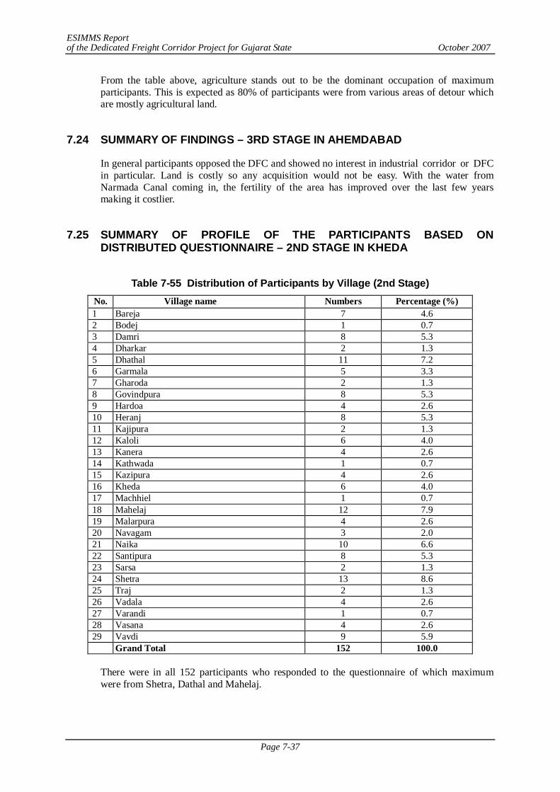
ESIMMS Report of the Dedicated Freight Corridor Project for Gujarat State October 2007
Page 7-37
From the table above, agriculture stands out to be the dominant occupation of maximum participants. This is expected as 80% of participants were from various areas of detour which are mostly agricultural land.
7.24 SUMMARY OF FINDINGS – 3RD STAGE IN AHEMDABAD
In general participants opposed the DFC and showed no interest in industrial corridor or DFC in particular. Land is costly so any acquisition would not be easy. With the water from Narmada Canal coming in, the fertility of the area has improved over the last few years making it costlier.
7.25 SUMMARY OF PROFILE OF THE PARTICIPANTS BASED ON
DISTRIBUTED QUESTIONNAIRE – 2ND STAGE IN KHEDA
Table 7-55 Distribution of Participants by Village (2nd Stage)
No. Village name Numbers Percentage (%) 1 Bareja 7 4.6 2 Bodej 1 0.7 3 Damri 8 5.3 4 Dharkar 2 1.3 5 Dhathal 11 7.2 6 Garmala 5 3.3 7 Gharoda 2 1.3 8 Govindpura 8 5.3 9 Hardoa 4 2.6 10 Heranj 8 5.3 11 Kajipura 2 1.3 12 Kaloli 6 4.0 13 Kanera 4 2.6 14 Kathwada 1 0.7 15 Kazipura 4 2.6 16 Kheda 6 4.0 17 Machhiel 1 0.7 18 Mahelaj 12 7.9 19 Malarpura 4 2.6 20 Navagam 3 2.0 21 Naika 10 6.6 22 Santipura 8 5.3 23 Sarsa 2 1.3 24 Shetra 13 8.6 25 Traj 2 1.3 26 Vadala 4 2.6 27 Varandi 1 0.7 28 Vasana 4 2.6 29 Vavdi 9 5.9
Grand Total 152 100.0
There were in all 152 participants who responded to the questionnaire of which maximum were from Shetra, Dathal and Mahelaj.
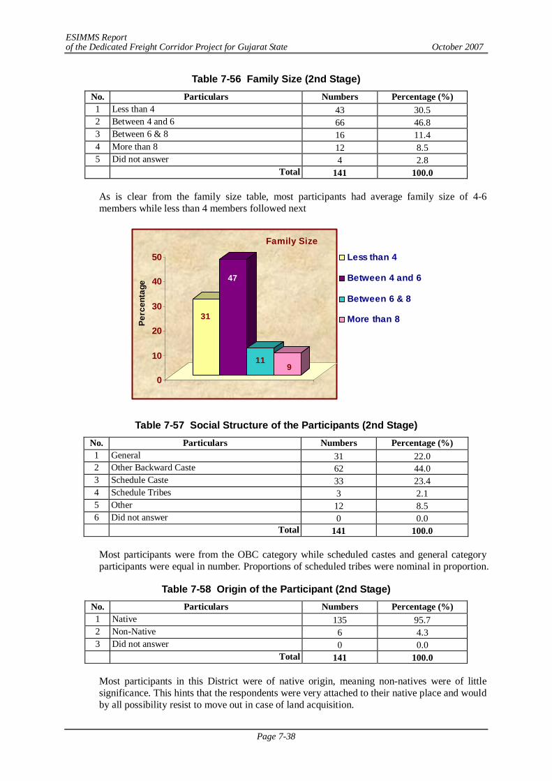
ESIMMS Report of the Dedicated Freight Corridor Project for Gujarat State October 2007
Page 7-38
Table 7-56 Family Size (2nd Stage) No. Particulars Numbers Percentage (%) 1 Less than 4 43 30.5 2 Between 4 and 6 66 46.8 3 Between 6 & 8 16 11.4 4 More than 8 12 8.5 5 Did not answer 4 2.8 Total 141 100.0
As is clear from the family size table, most participants had average family size of 4-6 members while less than 4 members followed next
31
47
119
0
10
20
30
40
50
Perc
enta
ge
Family Size
Less than 4
Between 4 and 6
Between 6 & 8
More than 8
Table 7-57 Social Structure of the Participants (2nd Stage) No. Particulars Numbers Percentage (%) 1 General 31 22.0 2 Other Backward Caste 62 44.0 3 Schedule Caste 33 23.4 4 Schedule Tribes 3 2.1 5 Other 12 8.5 6 Did not answer 0 0.0 Total 141 100.0
Most participants were from the OBC category while scheduled castes and general category participants were equal in number. Proportions of scheduled tribes were nominal in proportion.
Table 7-58 Origin of the Participant (2nd Stage) No. Particulars Numbers Percentage (%) 1 Native 135 95.7 2 Non-Native 6 4.3 3 Did not answer 0 0.0 Total 141 100.0
Most participants in this District were of native origin, meaning non-natives were of little significance. This hints that the respondents were very attached to their native place and would by all possibility resist to move out in case of land acquisition.
ESIMMS Report of the Dedicated Freight Corridor Project for Gujarat State October 2007
Page 7-39
Table 7-59 Education Level of the Participants (2nd Stage) No. Particulars Numbers Percentage (%) 1 Illiterate 7 5.0 2 Can read 12 8.5 3 Can read & write 28 19.9 4 Up to 7th Standard 17 12.1 5 Up to 12th Standard 37 26.2 6 Graduate 29 20.6 7 Other Professional 4 2.8 8 Did not answer 7 5.0 Total 141 100.0
It was interesting to find that most participants were educated up to 12th standard and few up to graduation level. Literate and semi literates were next in rank and professionals were few in number.
Table 7-60 Occupation of the Participants (2nd Stage) No. Particulars Numbers Percentage (%) 1 Agriculture 97 68.8 2 Daily wage 8 5.7 3 Government Service 6 4.3 4 Private Service 3 2.1 5 Business 3 2.1 6 Self Employed 8 5.7 7 Others 9 6.4 8 Did not answer 7 5.0 Total 141 100.0
From the table above, agriculture stands out to be the dominant occupation of maximum participants.
7.26 SUMMARY OF STAKE HOLDER/PUBLIC CONSULTATION – 2ND STAGE
IN KHEDA
Summarizing, several issues were raised. In sequence they were as follows:
1) A fortnight for information to disseminate properly so that firstly they could understand the pros and cons of the project and then pass on the information to the public in general.
2) Only compensation is not enough as when PAPs receive cash compensation, people tend to spend it within no time. Rather employment for the family is a better option.
3) To avoid difficulties, concrete plan need to be prepared.
4) People were aware that none can stop any development work nor is it advisable to do so. State and Central Govt. has the right to acquire land in the interest of the Nation. So when they cannot stop that, the least they can do is ask for good compensation package. Regarding compensation, he also suggested that if market rate is offered, most of the PAFs would be satisfied and so fewer litigation cases would come up. JICA should offer a package which would be acceptable without many grievances.
5) Kheda does not have any passenger train facilities; neither would they get any benefit of goods train facility from DFC. There was a demand therefore that MEMU train on the same track can ply when it is not in use for DFC.
ESIMMS Report of the Dedicated Freight Corridor Project for Gujarat State October 2007
Page 7-40
6) Previously, all planning and development schemes were prepared at office level and when everything was ready, the implementing authority informed people when they were left with no choice. In contrast, at PCM organized by CES-JICA, concerned people could raise their concerns and let their voices heard. He appreciated the public consultation mechanism as organized by JICA study team. They were appreciated for their efforts towards this and their new way of thinking.
7) Village level meetings should be organized when the actual survey numbers come forth.
8) Another suggestion was that DFC should provide 1% to 3% of its earning for the development of the project affected villages.
9) Problem of water logging is very serious. So enough nalas/ water drainage channels should be provided by DFC.
10) It is difficult for an individual to pursue his/her case. So if they could form a committee, then their representation becomes strong.
11) Whether JICA had any provision for PAFs of old couples who do not have any children? Something like a pension scheme/or some social security measure was recommended. Life long pension/measures of social security to old project affected families who have no other option and who has no other caretakers, as a part of social security scheme on humanitarian basis.
12) For deciding actual value of land, they could form a neutral land valuation committee at village level. Perhaps they could decide on some thumb rule for land valuation.
13) Compensation against social forestry for which his panchayat had made effort. He informed that local people got fuel and fodder from forests and village panchayat also got some income from such ‘Joint Forest Management’ scheme. In the same way compensation against Gauchar land - Free Grazing land’ to the people should be given.
14) Whenever railway line passes, every care should be taken for storm water management so that standing crops and top soil erosion do not take place. He also advised that JICA representatives should meet local experienced people to know about water flow during monsoon.
15) Women participants were concerned about approach roads and ROB or RUB in the case of emergency like delivery or accident cases.
7.27 SUMMARY OF THE PROFILE OF PARTICIPANTS BASED ON THE
DISTRIBUTED QUESTIONNAIRE - 3RD STAGE IN KHEDA
Table 7-61 Distribution of Participants By Village (3rd Stage)
No. Village name Numbers Percentage (%) 1 Damari 7 6.4 2 Dathal 6 5.5 3 Dharampur 1 0.9 4 Garmala 3 2.8 5 Govindpura 4 3.7 6 Heranj 10 9.2 7 Khandhli 6 5.5 8 Limbashi 1 0.9 9 Machhiel 2 1.8
10 Matar 4 3.7 11 Radhu 2 1.8
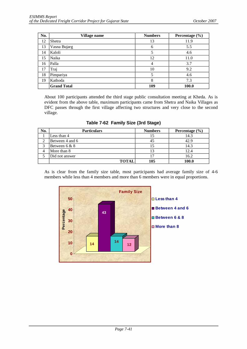
ESIMMS Report of the Dedicated Freight Corridor Project for Gujarat State October 2007
Page 7-41
No. Village name Numbers Percentage (%) 12 Shetra 13 11.9 13 Vasna Bujarg 6 5.5 14 Kaloli 5 4.6 15 Naika 12 11.0 16 Palla 4 3.7 17 Traj 10 9.2 18 Pimpariya 5 4.6 19 Kathoda 8 7.3
Grand Total 109 100.0
About 100 participants attended the third stage public consultation meeting at Kheda. As is evident from the above table, maximum participants came from Shetra and Naika Villages as DFC passes through the first village affecting two structures and very close to the second village.
Table 7-62 Family Size (3rd Stage) No. Particulars Numbers Percentage (%) 1 Less than 4 15 14.3 2 Between 4 and 6 45 42.9 3 Between 6 & 8 15 14.3 4 More than 8 13 12.4 5 Did not answer 17 16.2 TOTAL 105 100.0
As is clear from the family size table, most participants had average family size of 4-6 members while less than 4 members and more than 6 members were in equal proportions.
14
43
1412
0
10
20
30
40
50
Perc
enta
ge
Family Size
Less than 4
Between 4 and 6
Between 6 & 8
More than 8
ESIMMS Report of the Dedicated Freight Corridor Project for Gujarat State October 2007
Page 7-42
Table 7-63 Social Structure of the Participants (3rd Stage) No. Particulars Numbers Percentage (%) 1 General 27 25.7 2 Other Backward Caste 49 46.7 3 Schedule Caste 11 10.5 4 Schedule Tribes 1 1.0 5 Other 7 6.7 6 Did not answer 10 9.5 TOTAL 105 100.0
Most participants were from OBC (other backward caste) and general category. Proportion of scheduled castes was marginal whereas there were hardly any scheduled tribes.
Table 7-64 Origin of the Participant (3rd Stage) No. Particulars Numbers Percentage (%) 1 Native 96 95.1 2 Non-Native 2 2.0 3 Did not answer 3 3.0 TOTAL 101 100.0
All participants were of native origin, meaning non-natives were of no significance at all. This hints that the respondents were very attached to their native place and would by all possibility resist moving out.
Table 7-65 Education Level of the Participants (3rd Stage) No. Particulars Numbers Percentage (%) 1 Illiterate 5 4.8 2 Can read 5 4.8 3 Can read & write 39 37.1 4 Up to 7th Standard 8 7.6 5 Up to 12th Standard 25 23.8 6 Graduate 15 14.3 7 Other Professional 4 3.8 8 Did not answer 4 3.8 TOTAL 105 100.0
It was interesting to find that most participants could read and write. Few were educated up to 12th standard. Literate and semi literates were next in rank and professional were absent.
Table 7.66 Occupation of the Participants (3rd Stage) No. Particulars Numbers Percentage (%) 1 Agriculture 80 76.2 2 Daily wage 2 1.9 3 Government Service 1 1.0 4 Private Service 2 1.9 5 Business 4 3.8 6 Self Employed 6 5.7 7 Others 7 6.7 8 Did not answer 3 2.9 TOTAL 105 100.0
From the table above, agriculture stands out to be the dominant occupation of maximum participants.
ESIMMS Report of the Dedicated Freight Corridor Project for Gujarat State October 2007
Page 7-43
7.28 SUMMARY OF FINDINGS – 3RD STAGE IN KHEDA
It may well be concluded that in Kheda District, participants vehemently opposed the project in totality. They also mentioned that the most important concern of the people here was the floods which occur almost every alternate year by over-flooding of the 7 rivers which cross through the district. The 5 m high embankment proposed for DFC corridor was the main point of contention as the people felt that this would aggravate the flood situation further, adding to misery of the farmers. They unanimously opposed the project and requested the alignment to be shifted further from the present one.
7.29 SUMMARY OF PROFILE OF THE PARTICIPANTS BASED ON THE
DISTRIBUTED QUESTIONNAIRE – 2ND STAGE IN ANAND
Table 7-67 Distribution of Participants by Village (2nd Stage)
No. Village name Numbers Percentage (%) 1. Changa 11 16.4 2. Chapad 3 4.5 3. Kasor 27 40.3 4. Meghva 1 1.5 5. Shihol 2 3.0 6. Shilol 1 1.5 7. Sunav 20 29.9 8. Visnoli 2 3.0 Grand Total 67 100.0
There were in all participants who responded to the questionnaire of which maximum were from Kasor Village (40%) followed by Sunav (30%). Changa was another important village that would be affected by DFC.
Table 7-68 Family Size (2nd Stage) No. Particulars Numbers Percentage (%) 1 Less than 4 23 41.1 2 Between 4 and 6 12 21.4 3 Between 6 & 8 13 23.2 4 More than 8 7 12.5 5 Did not answer 1 1.8 Total 56 100.0
As is clear from the family size table, most participants had average family size of less than 4 members while between 4 -6 members followed next.
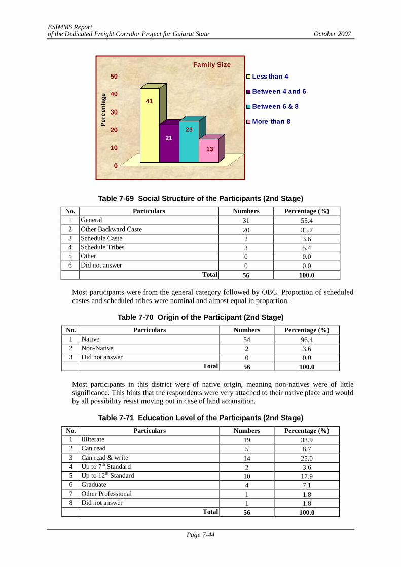
ESIMMS Report of the Dedicated Freight Corridor Project for Gujarat State October 2007
Page 7-44
41
2123
13
0
10
20
30
40
50
Perc
enta
ge
Family Size
Less than 4
Between 4 and 6
Between 6 & 8
More than 8
Table 7-69 Social Structure of the Participants (2nd Stage) No. Particulars Numbers Percentage (%) 1 General 31 55.4 2 Other Backward Caste 20 35.7 3 Schedule Caste 2 3.6 4 Schedule Tribes 3 5.4 5 Other 0 0.0 6 Did not answer 0 0.0 Total 56 100.0
Most participants were from the general category followed by OBC. Proportion of scheduled castes and scheduled tribes were nominal and almost equal in proportion.
Table 7-70 Origin of the Participant (2nd Stage) No. Particulars Numbers Percentage (%) 1 Native 54 96.4 2 Non-Native 2 3.6 3 Did not answer 0 0.0 Total 56 100.0
Most participants in this district were of native origin, meaning non-natives were of little significance. This hints that the respondents were very attached to their native place and would by all possibility resist moving out in case of land acquisition.
Table 7-71 Education Level of the Participants (2nd Stage) No. Particulars Numbers Percentage (%) 1 Illiterate 19 33.9 2 Can read 5 8.7 3 Can read & write 14 25.0 4 Up to 7th Standard 2 3.6 5 Up to 12th Standard 10 17.9 6 Graduate 4 7.1 7 Other Professional 1 1.8 8 Did not answer 1 1.8 Total 56 100.0
ESIMMS Report of the Dedicated Freight Corridor Project for Gujarat State October 2007
Page 7-45
It was interesting to find that most participants were illiterates and few educated upto 12th standard. A huge chunk was semi literates next in rank and professionals were few in number.
Table 7-72 Occupation of the Participants (2nd Stage) No. Particulars Numbers Percentage (%) 1 Agriculture 41 73.2 2 Daily wage 5 8.9 3 Government Service 1 1.8 4 Private Service 4 7.1 5 Business 0 0.0 6 Self Employed 4 7.1 7 Others 1 1.8 8 Did not answer 0 0.0 Total 56 100.0
From the table above, agriculture stands out to be the dominant occupation of maximum participants.
7.30 SUMMARY OF STAKE HOLDER/PUBLIC CONSULTATION – 2ND STAGE
IN ANAND
Summarizing, several issues were raised in the question – answer session. In sequence they were as follows:
1) Amul dairy products, (a brand name today), are supplied all over India and if DFC project has provision for trains with special facility to load perishable items , then Amul would surely emerge as a bulk user of DFC in future.
2) People were not happy with the past experiences like Narmada project , Express Highway, ONGC etc. They would not like DFC to repeat that.
3) Some engineering industries exist near Charotar Village. More than 150 people from the village are employed there and have their source of livelihood. DFC alignment should not affect them adversely so that they may continue their work and do not lose their livelihood source.
4) Land at ‘Charotar’ Village is precious like gold, so maximum compensation is expected if land is acquired by DFC.
5) In each village the market rate of land is different. Not only that, in any particular village, the market value of land different from one place to another depending upon its location, i.e. if it is near the road in the village or is far from the road. Value of land decreases with increasing distance from the highway/ road connectivity. This is however, an universal rule.
6) The meeting of all the farmers and leaders should be arranged once the alignment gets finalized. Land here is very fertile and if land is lost, then it would disturb their livelihood. The market value of land is so high that affected family would not be able to purchase new land out of what usually compensation package offers. So if they do not get satisfactory land compensation money, they would oppose the project. Besides, the ROBs & RUBs should be constructed with consultation of the villagers.
7) Some agreement could be worked out between the implementing agency and the PAPs but even for that consent of each farmer is required. One committee should be formed which will evaluate the land cost neutrally and meeting of all PAFs should be organized to come to some justifiable agreement.
ESIMMS Report of the Dedicated Freight Corridor Project for Gujarat State October 2007
Page 7-46
8) Due to establishment of an international college at Changa which would be an university in near future, the cost of land has increased many fold. Presently, land is being purchased to build hostel blocks. So, Changa would demand quite a high rate of land, employment opportunity in public sector undertaking and provision of RUB, ROBs.
9) The small farmers and landless labourers, especially whose life is dependent on cattle rearing – (maldharies) suffer a lot with land acquisition as they graze their animals on Gauchar land (common village property): they should also be considered as project affected by JICA and some assistance should be provided to them as well.
10) The provisions of JICA when land would be divided by DFC. Proper information dissemination among PAFs after advertisement and written documents. Also there was demand for house against house, or implementing authority could built it on their behalf or else grant construction cost at current rate.
11) The market value of land should be considered at the time of actual acquisition.
12) Small farmers should not lose their title as a farmer. Secondly he said that more than 3000 students study in that college and the college authority do not want DFC railway line to pass near the college as it would create noise pollution and vibration disturbing students.
13) Small farmers should not lose their title as a farmer.
14) More than 3000 students study in Changa international college and the college authority would not want DFC railway line to pass near the college as it would create noise pollution and vibration disturbing students.
15) With implementation of new development project like DFC, crop production suffers and even the crops of adjoining fields may suffer due to some reason or the other like theft, disturbances etc. They should also get compensation for loss of crop when DFC project would be implemented.
16) Some times it so happens that the road towards a farm passes through another farm and then the farmer loses his right to pass through. He also should be considered as a PAP and be eligible for compensation or else his right to pass should be retained.
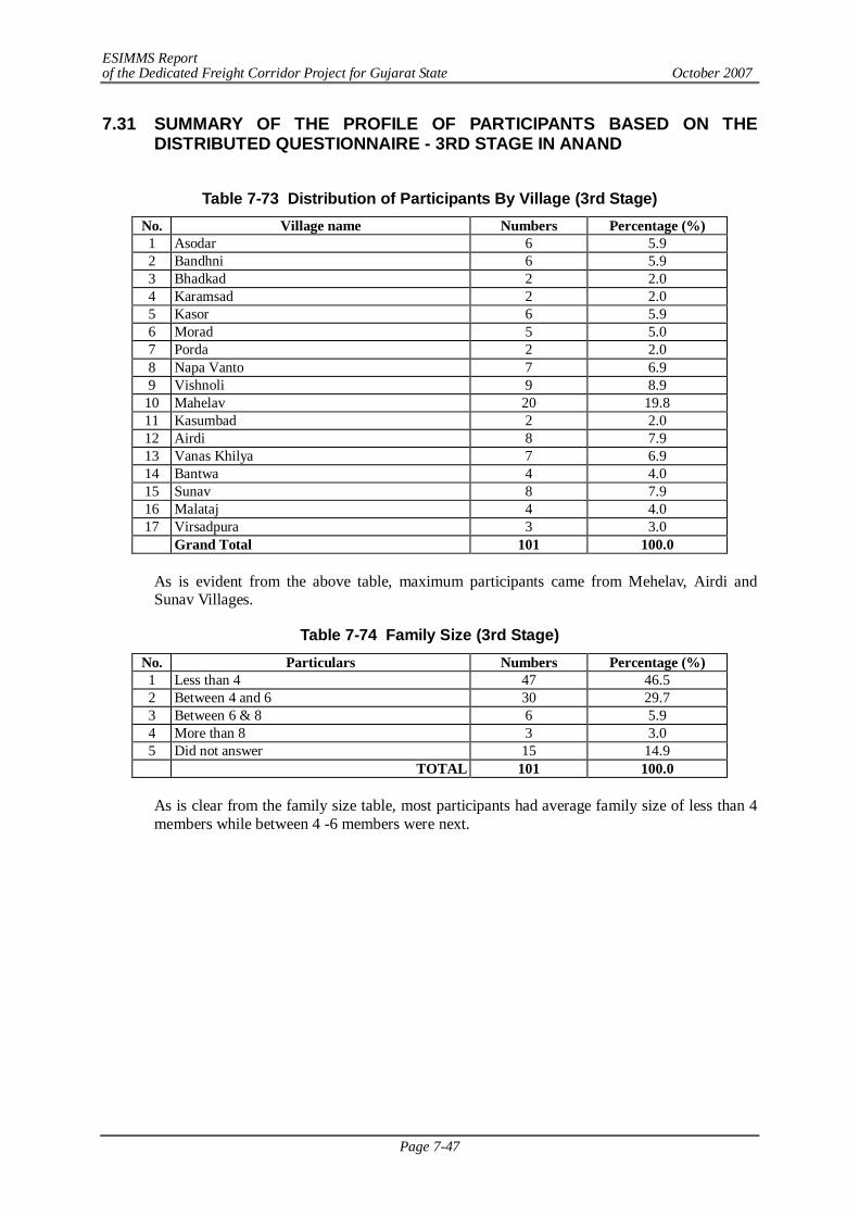
ESIMMS Report of the Dedicated Freight Corridor Project for Gujarat State October 2007
Page 7-47
7.31 SUMMARY OF THE PROFILE OF PARTICIPANTS BASED ON THE DISTRIBUTED QUESTIONNAIRE - 3RD STAGE IN ANAND
Table 7-73 Distribution of Participants By Village (3rd Stage)
No. Village name Numbers Percentage (%) 1 Asodar 6 5.9 2 Bandhni 6 5.9 3 Bhadkad 2 2.0 4 Karamsad 2 2.0 5 Kasor 6 5.9 6 Morad 5 5.0 7 Porda 2 2.0 8 Napa Vanto 7 6.9 9 Vishnoli 9 8.9
10 Mahelav 20 19.8 11 Kasumbad 2 2.0 12 Airdi 8 7.9 13 Vanas Khilya 7 6.9 14 Bantwa 4 4.0 15 Sunav 8 7.9 16 Malataj 4 4.0 17 Virsadpura 3 3.0
Grand Total 101 100.0
As is evident from the above table, maximum participants came from Mehelav, Airdi and Sunav Villages.
Table 7-74 Family Size (3rd Stage) No. Particulars Numbers Percentage (%) 1 Less than 4 47 46.5 2 Between 4 and 6 30 29.7 3 Between 6 & 8 6 5.9 4 More than 8 3 3.0 5 Did not answer 15 14.9 TOTAL 101 100.0
As is clear from the family size table, most participants had average family size of less than 4 members while between 4 -6 members were next.
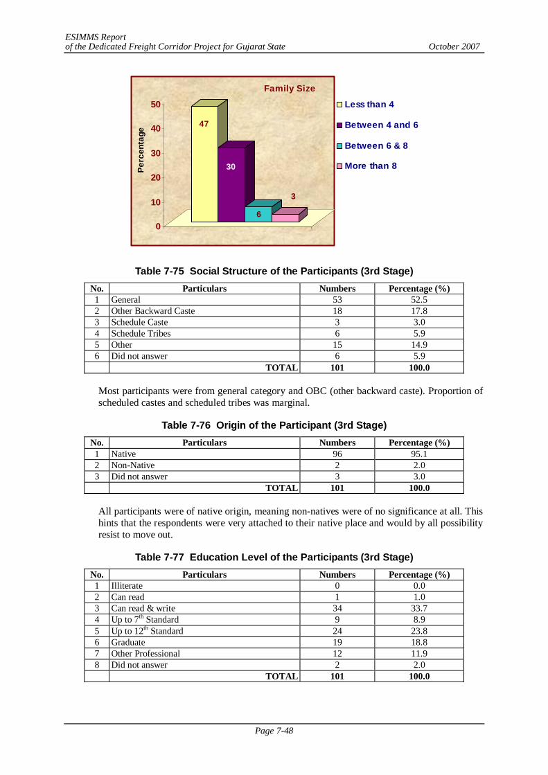
ESIMMS Report of the Dedicated Freight Corridor Project for Gujarat State October 2007
Page 7-48
47
30
6
3
0
10
20
30
40
50
Perc
enta
ge
Family Size
Less than 4
Between 4 and 6
Between 6 & 8
More than 8
Table 7-75 Social Structure of the Participants (3rd Stage) No. Particulars Numbers Percentage (%) 1 General 53 52.5 2 Other Backward Caste 18 17.8 3 Schedule Caste 3 3.0 4 Schedule Tribes 6 5.9 5 Other 15 14.9 6 Did not answer 6 5.9 TOTAL 101 100.0
Most participants were from general category and OBC (other backward caste). Proportion of scheduled castes and scheduled tribes was marginal.
Table 7-76 Origin of the Participant (3rd Stage) No. Particulars Numbers Percentage (%) 1 Native 96 95.1 2 Non-Native 2 2.0 3 Did not answer 3 3.0 TOTAL 101 100.0
All participants were of native origin, meaning non-natives were of no significance at all. This hints that the respondents were very attached to their native place and would by all possibility resist to move out.
Table 7-77 Education Level of the Participants (3rd Stage) No. Particulars Numbers Percentage (%) 1 Illiterate 0 0.0 2 Can read 1 1.0 3 Can read & write 34 33.7 4 Up to 7th Standard 9 8.9 5 Up to 12th Standard 24 23.8 6 Graduate 19 18.8 7 Other Professional 12 11.9 8 Did not answer 2 2.0 TOTAL 101 100.0
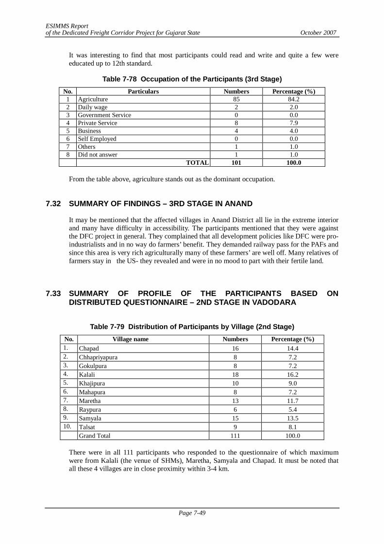
ESIMMS Report of the Dedicated Freight Corridor Project for Gujarat State October 2007
Page 7-49
It was interesting to find that most participants could read and write and quite a few were educated up to 12th standard.
Table 7-78 Occupation of the Participants (3rd Stage) No. Particulars Numbers Percentage (%) 1 Agriculture 85 84.2 2 Daily wage 2 2.0 3 Government Service 0 0.0 4 Private Service 8 7.9 5 Business 4 4.0 6 Self Employed 0 0.0 7 Others 1 1.0 8 Did not answer 1 1.0 TOTAL 101 100.0
From the table above, agriculture stands out as the dominant occupation.
7.32 SUMMARY OF FINDINGS – 3RD STAGE IN ANAND
It may be mentioned that the affected villages in Anand District all lie in the extreme interior and many have difficulty in accessibility. The participants mentioned that they were against the DFC project in general. They complained that all development policies like DFC were pro-industrialists and in no way do farmers’ benefit. They demanded railway pass for the PAFs and since this area is very rich agriculturally many of these farmers’ are well off. Many relatives of farmers stay in the US- they revealed and were in no mood to part with their fertile land.
7.33 SUMMARY OF PROFILE OF THE PARTICIPANTS BASED ON
DISTRIBUTED QUESTIONNAIRE – 2ND STAGE IN VADODARA
Table 7-79 Distribution of Participants by Village (2nd Stage)
No. Village name Numbers Percentage (%) 1. Chapad 16 14.4 2. Chhapriyapura 8 7.2 3. Gokulpura 8 7.2 4. Kalali 18 16.2 5. Khajipura 10 9.0 6. Mahapura 8 7.2 7. Maretha 13 11.7 8. Raypura 6 5.4 9. Samyala 15 13.5 10. Talsat 9 8.1
Grand Total 111 100.0
There were in all 111 participants who responded to the questionnaire of which maximum were from Kalali (the venue of SHMs), Maretha, Samyala and Chapad. It must be noted that all these 4 villages are in close proximity within 3-4 km.
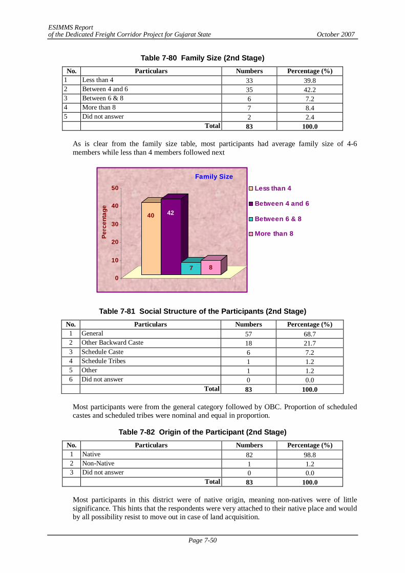
ESIMMS Report of the Dedicated Freight Corridor Project for Gujarat State October 2007
Page 7-50
Table 7-80 Family Size (2nd Stage) No. Particulars Numbers Percentage (%)
1 Less than 4 33 39.8 2 Between 4 and 6 35 42.2 3 Between 6 & 8 6 7.2 4 More than 8 7 8.4 5 Did not answer 2 2.4 Total 83 100.0
As is clear from the family size table, most participants had average family size of 4-6 members while less than 4 members followed next
40 42
7 8
0
10
20
30
40
50
Perc
enta
ge
Family Size
Less than 4
Between 4 and 6
Between 6 & 8
More than 8
Table 7-81 Social Structure of the Participants (2nd Stage) No. Particulars Numbers Percentage (%) 1 General 57 68.7 2 Other Backward Caste 18 21.7 3 Schedule Caste 6 7.2 4 Schedule Tribes 1 1.2 5 Other 1 1.2 6 Did not answer 0 0.0 Total 83 100.0
Most participants were from the general category followed by OBC. Proportion of scheduled castes and scheduled tribes were nominal and equal in proportion.
Table 7-82 Origin of the Participant (2nd Stage) No. Particulars Numbers Percentage (%) 1 Native 82 98.8 2 Non-Native 1 1.2 3 Did not answer 0 0.0 Total 83 100.0
Most participants in this district were of native origin, meaning non-natives were of little significance. This hints that the respondents were very attached to their native place and would by all possibility resist to move out in case of land acquisition.
ESIMMS Report of the Dedicated Freight Corridor Project for Gujarat State October 2007
Page 7-51
Table 7-83 Education Level of the Participants (2nd Stage) No. Particulars Numbers Percentage (%) 1 Illiterate 16 19.3 2 Can read 9 10.8 3 Can read & write 23 27.7 4 Up to 7th Standard 6 7.2 5 Up to 12th Standard 17 20.5 6 Graduate 11 13.3 7 Other Professional 1 1.2 8 Did not answer 0 0.0 Total 83 100.0
It was interesting to find that most participants could read and write and quite a few were educated upto 12th standard and few up to graduation level as well. Literate and semi literates were next in rank and professionals were few in number.
Table 7-84 Occupation of the Participants (2nd Stage) No. Particulars Numbers Percentage (%) 1 Agriculture 63 75.9 2 Daily wage 8 9.6 3 Government Service 3 3.6 4 Private Service 3 3.6 5 Business 2 2.4 6 Self Employed 3 3.6 7 Others 1 1.2 8 Did not answer 0 0.0 Total 83 100.0
From the table above, agriculture stands out to be the dominant occupation of maximum participants.
7.34 SUMMARY OF STAKE HOLDER/PUBLIC CONSULTATION – 2ND STAGE
IN VADODARA
Summarizing, several issues were raised in the question – answer session. In sequence they were as follows:
1) Questions were raised like who was organizing this consultation and whether this meeting was in the individual capacity of Jeevantirth or organized by JICA?
- How much would be the breath of railway line? - How many Yards and Junctions would be in Gujarat?
2) Demand for compensation at market rate (market value of land was Rs 50 lakhs /Bigha) and employment of one member of PAF in DFC. People expressed dissatisfaction about what compensation they received from Narmada dam canal project. He said that they wanted compensation at Market Rate and not at Jantri Rate or any lump sump amount. Some amicable solution must be found out to bridge the difference between Jantri Rate and Market Rate of land.
3) The provisions for small farmers who would lose their entire land and cease to be a farmer. If PAF loses entire land, their family members should be given title of “farmer” so that they can purchase land from anywhere in Gujarat.
ESIMMS Report of the Dedicated Freight Corridor Project for Gujarat State October 2007
Page 7-52
4) Maretha Village would be covered under Vadodara Urban Development Authority (VUDA) in near future. One road of 600 meter width has already been proposed and now DFC would require additional land. In that case he questioned that how much land from the village would be acquired in total?
5) The Vishwamitra River passes through the area and all the villages on the bank of river are flood prone. He was skeptical that with DFC, the problem of flood and water logging would increase manifold.
6) Several surveys were going on from different agencies but there is no co-ordination between the various departments of government organization and as a result it so happens that many times land is acquired in excess of what is required causing pain to people which could have been avoided with proper planning beforehand.
7) If small farmers lose their land, they would lose everything. It is the basic question of their survival. Even if JICA gives compensation, even then what about their livelihood and employment restoration plans?
8) Provisions for the farmers whose land would get divided due to DFC implementation? What about water pipe line, electricity line etc across DFC? Does JICA have any guideline on this? When farm is divided, at that time prior permission should be given to transfer pipeline for irrigation across the DFC. Maintenance cost should be given in the case of breakage of electricity/irrigation pipelines due to vibration and losses which should be compensated
9) VUDA is developing fast so in that perspective, there was that DFC should be laid down 20 km. away from the village.
10) Lack of co-ordination among various agencies; every now and then common people become victimized of inconvenience and harassment created by various departments.
7.35 SUMMARY OF THE PROFILE OF PARTICIPANTS BASED ON THE
DISTRIBUTED QUESTIONNAIRE - 3RD STAGE IN VADODARA
Table 7-85 Distribution of Participants by Village (3rd Stage)
No. Village name Numbers Percentage (%) 1 Alamgir 5 4.0 2 Atladar 1 0.8 3 Bhayali 2 1.6 4 Chapad 15 12.1 5 Gohukhana 3 2.4 6 Gokulpura 5 4.0 7 Itola 2 1.6 8 Kalali 16 12.9 9 Raypura 5 4.0 10 Samiyala 9 7.3 11 Sarar 2 1.6 12 Talsat 6 4.8 13 Vadodara 2 1.6 14 Varnama 6 4.8 15 Vadsala 6 4.8 16 Hinglot 8 6.5 17 Miyagam 6 4.8 18 Kherda 3 2.4 19 Maretha 11 8.9 20 Bill 11 8.9
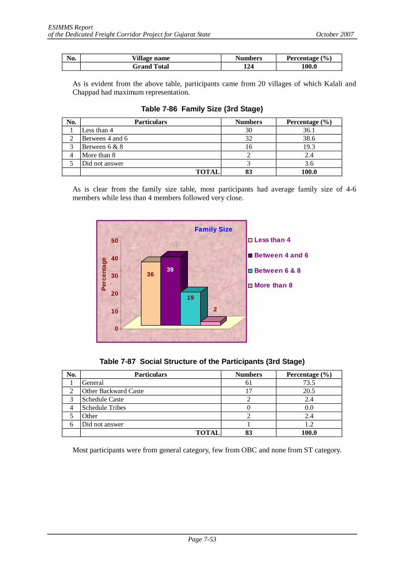
ESIMMS Report of the Dedicated Freight Corridor Project for Gujarat State October 2007
Page 7-53
No. Village name Numbers Percentage (%) Grand Total 124 100.0
As is evident from the above table, participants came from 20 villages of which Kalali and Chappad had maximum representation.
Table 7-86 Family Size (3rd Stage) No. Particulars Numbers Percentage (%) 1 Less than 4 30 36.1 2 Between 4 and 6 32 38.6 3 Between 6 & 8 16 19.3 4 More than 8 2 2.4 5 Did not answer 3 3.6 TOTAL 83 100.0
As is clear from the family size table, most participants had average family size of 4-6 members while less than 4 members followed very close.
3639
19
2
0
10
20
30
40
50
Perc
enta
ge
Family SizeLess than 4
Between 4 and 6
Between 6 & 8
More than 8
Table 7-87 Social Structure of the Participants (3rd Stage) No. Particulars Numbers Percentage (%) 1 General 61 73.5 2 Other Backward Caste 17 20.5 3 Schedule Caste 2 2.4 4 Schedule Tribes 0 0.0 5 Other 2 2.4 6 Did not answer 1 1.2 TOTAL 83 100.0
Most participants were from general category, few from OBC and none from ST category.
ESIMMS Report of the Dedicated Freight Corridor Project for Gujarat State October 2007
Page 7-54
Table 7-88 Origin of the Participant (3rd Stage) No. Particulars Numbers Percentage (%) 1 Native 81 97.6 2 Non-Native 2 2.4 3 Did not answer 0 0.0 TOTAL 83 100.0
All participants were of native origin, meaning non-natives were of no significance at all. This hints that the respondents were very attached to their native place and would by all possibility resist to move out.
Table 7-89 Education Level of the Participants (3rd Stage) No. Particulars Numbers Percentage (%) 1 Illiterate 4 4.8 2 Can read 8 9.6 3 Can read & write 22 26.5 4 Up to 7th Standard 8 9.6 5 Up to 12th Standard 25 30.1 6 Graduate 12 14.5 7 Other Professional 3 3.6 8 Did not answer 1 1.2 TOTAL 83 100.0
It was interesting to find that most participants were educated up to 12th standard followed by semi-literates and quite a few up to graduation level (ranking next). Literate and semi literate were next in rank and professional were negligible.
Table 7-90 Occupation of the Participants (3rd Stage) No. Particulars Numbers Percentage (%) 1 Agriculture 66 79.5 2 Daily wage 3 3.6 3 Government Service 2 2.4 4 Private Service 6 7.2 5 Business 3 3.6 6 Self Employed 2 2.4 7 Others 1 1.2 8 Did not answer 0 0.0 TOTAL 83 100.0
From the table above, agriculture stands out to be the dominant occupation of maximum participants.
7.36 SUMMARY OF FINDINGS – 3RD SATGE IN VADODARA
It needs to be mentioned that since the SHM was held at Kalali Village, quite obviously most participants were from this village. Besides the usual concerns of compensation, exact alignment and job assurance etc, few issues were raised typical of this meeting. Firstly, it was pointed out that there has been no coordination between different Government projects, leave aside private ones. This has created confusion among the people of Vadodara and has caused severe scarcity of land due to land acquisition on account of several projects. About 600 m of land has been acquired off late by the Government for some project which the local people
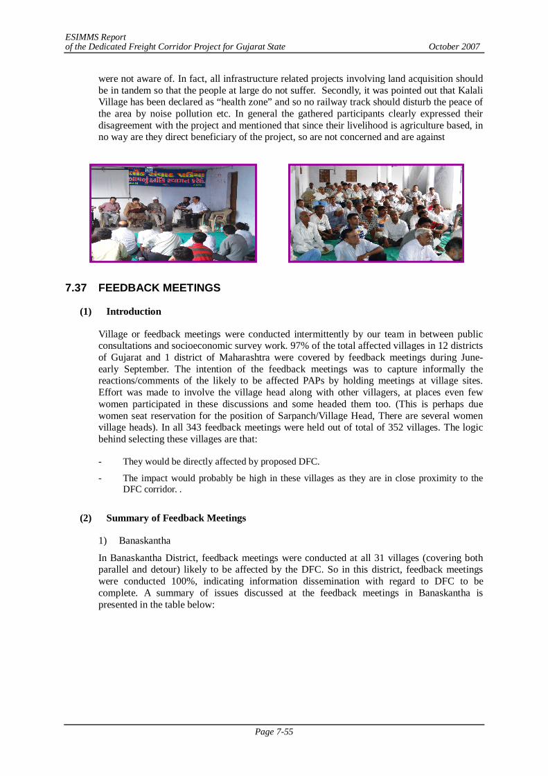
ESIMMS Report of the Dedicated Freight Corridor Project for Gujarat State October 2007
Page 7-55
were not aware of. In fact, all infrastructure related projects involving land acquisition should be in tandem so that the people at large do not suffer. Secondly, it was pointed out that Kalali Village has been declared as “health zone” and so no railway track should disturb the peace of the area by noise pollution etc. In general the gathered participants clearly expressed their disagreement with the project and mentioned that since their livelihood is agriculture based, in no way are they direct beneficiary of the project, so are not concerned and are against
7.37 FEEDBACK MEETINGS
(1) Introduction
Village or feedback meetings were conducted intermittently by our team in between public consultations and socioeconomic survey work. 97% of the total affected villages in 12 districts of Gujarat and 1 district of Maharashtra were covered by feedback meetings during June- early September. The intention of the feedback meetings was to capture informally the reactions/comments of the likely to be affected PAPs by holding meetings at village sites. Effort was made to involve the village head along with other villagers, at places even few women participated in these discussions and some headed them too. (This is perhaps due women seat reservation for the position of Sarpanch/Village Head, There are several women village heads). In all 343 feedback meetings were held out of total of 352 villages. The logic behind selecting these villages are that:
- They would be directly affected by proposed DFC.
- The impact would probably be high in these villages as they are in close proximity to the DFC corridor. .
(2) Summary of Feedback Meetings
1) Banaskantha
In Banaskantha District, feedback meetings were conducted at all 31 villages (covering both parallel and detour) likely to be affected by the DFC. So in this district, feedback meetings were conducted 100%, indicating information dissemination with regard to DFC to be complete. A summary of issues discussed at the feedback meetings in Banaskantha is presented in the table below:
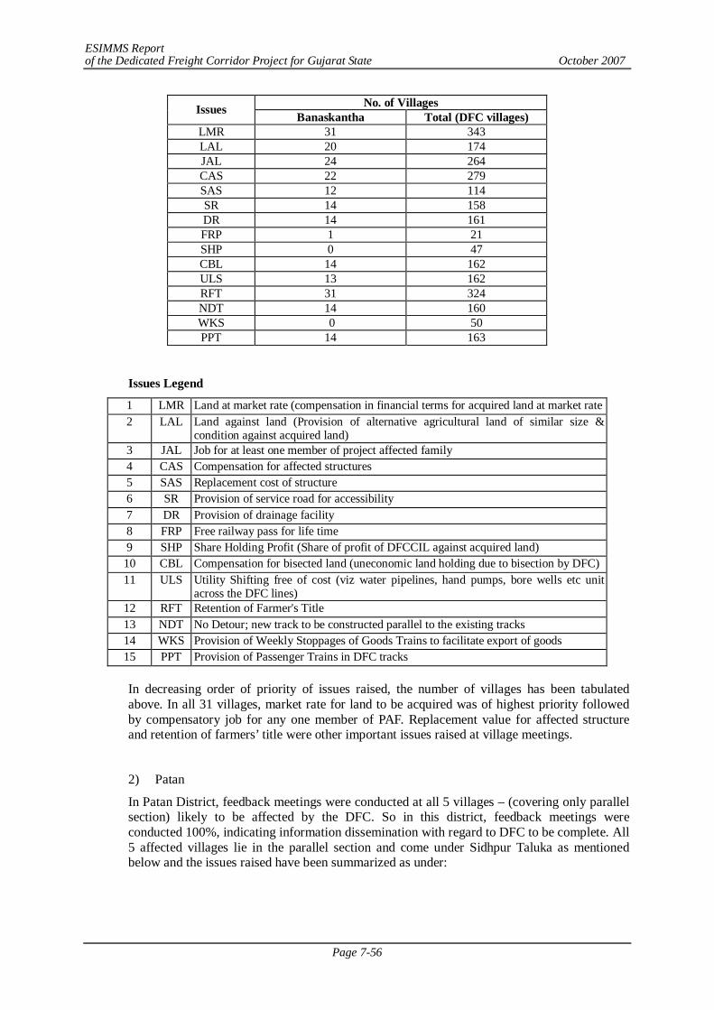
ESIMMS Report of the Dedicated Freight Corridor Project for Gujarat State October 2007
Page 7-56
No. of Villages Issues Banaskantha Total (DFC villages) LMR 31 343 LAL 20 174 JAL 24 264 CAS 22 279 SAS 12 114 SR 14 158 DR 14 161 FRP 1 21 SHP 0 47 CBL 14 162 ULS 13 162 RFT 31 324 NDT 14 160 WKS 0 50 PPT 14 163
Issues Legend
1 LMR Land at market rate (compensation in financial terms for acquired land at market rate 2 LAL Land against land (Provision of alternative agricultural land of similar size &
condition against acquired land) 3 JAL Job for at least one member of project affected family 4 CAS Compensation for affected structures 5 SAS Replacement cost of structure 6 SR Provision of service road for accessibility 7 DR Provision of drainage facility 8 FRP Free railway pass for life time 9 SHP Share Holding Profit (Share of profit of DFCCIL against acquired land) 10 CBL Compensation for bisected land (uneconomic land holding due to bisection by DFC) 11 ULS Utility Shifting free of cost (viz water pipelines, hand pumps, bore wells etc unit
across the DFC lines) 12 RFT Retention of Farmer's Title 13 NDT No Detour; new track to be constructed parallel to the existing tracks 14 WKS Provision of Weekly Stoppages of Goods Trains to facilitate export of goods 15 PPT Provision of Passenger Trains in DFC tracks
In decreasing order of priority of issues raised, the number of villages has been tabulated above. In all 31 villages, market rate for land to be acquired was of highest priority followed by compensatory job for any one member of PAF. Replacement value for affected structure and retention of farmers’ title were other important issues raised at village meetings.
2) Patan
In Patan District, feedback meetings were conducted at all 5 villages – (covering only parallel section) likely to be affected by the DFC. So in this district, feedback meetings were conducted 100%, indicating information dissemination with regard to DFC to be complete. All 5 affected villages lie in the parallel section and come under Sidhpur Taluka as mentioned below and the issues raised have been summarized as under:
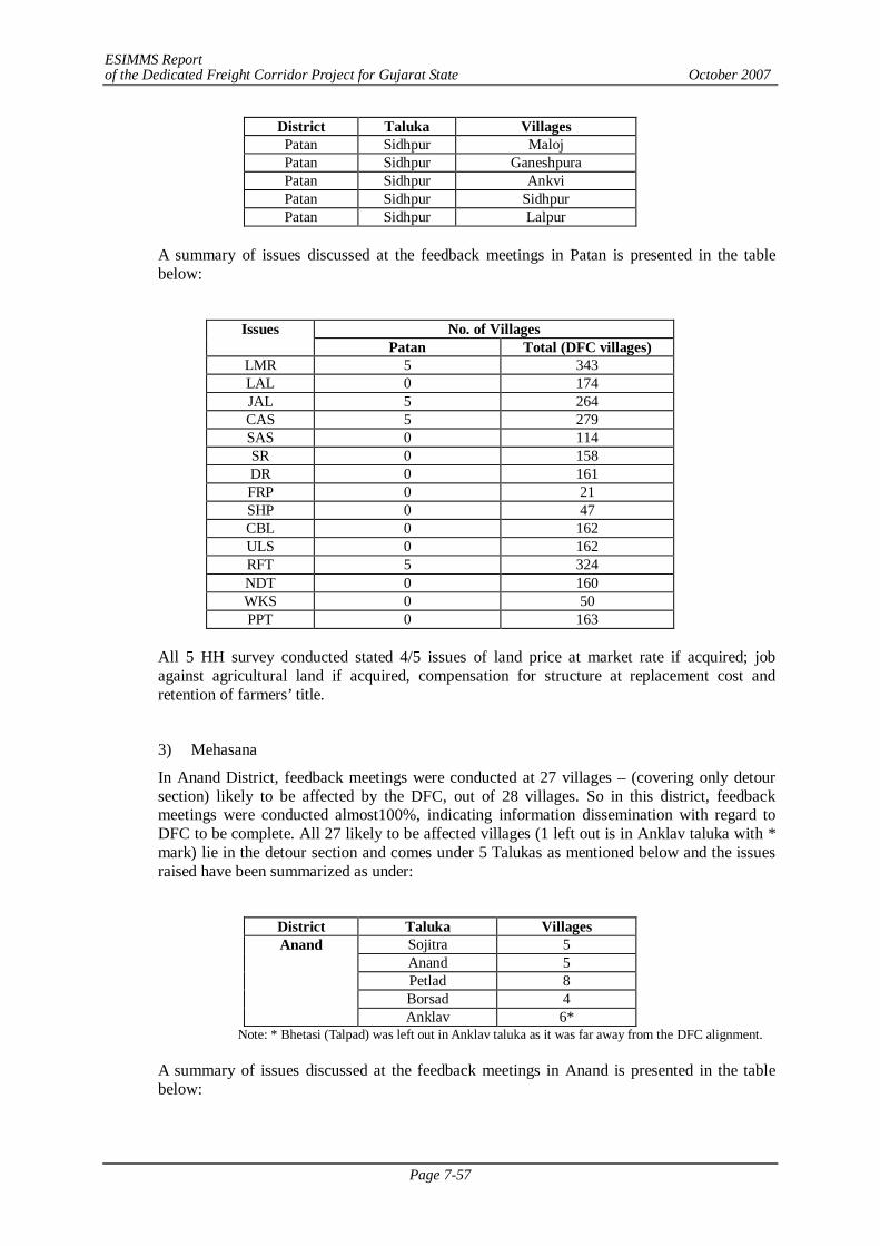
ESIMMS Report of the Dedicated Freight Corridor Project for Gujarat State October 2007
Page 7-57
District Taluka Villages Patan Sidhpur Maloj Patan Sidhpur Ganeshpura Patan Sidhpur Ankvi Patan Sidhpur Sidhpur Patan Sidhpur Lalpur
A summary of issues discussed at the feedback meetings in Patan is presented in the table below:
No. of Villages Issues
Patan Total (DFC villages) LMR 5 343 LAL 0 174 JAL 5 264 CAS 5 279 SAS 0 114 SR 0 158 DR 0 161 FRP 0 21 SHP 0 47 CBL 0 162 ULS 0 162 RFT 5 324 NDT 0 160 WKS 0 50 PPT 0 163
All 5 HH survey conducted stated 4/5 issues of land price at market rate if acquired; job against agricultural land if acquired, compensation for structure at replacement cost and retention of farmers’ title.
3) Mehasana
In Anand District, feedback meetings were conducted at 27 villages – (covering only detour section) likely to be affected by the DFC, out of 28 villages. So in this district, feedback meetings were conducted almost100%, indicating information dissemination with regard to DFC to be complete. All 27 likely to be affected villages (1 left out is in Anklav taluka with * mark) lie in the detour section and comes under 5 Talukas as mentioned below and the issues raised have been summarized as under:
District Taluka Villages
Sojitra 5 Anand 5 Petlad 8 Borsad 4
Anand
Anklav 6* Note: * Bhetasi (Talpad) was left out in Anklav taluka as it was far away from the DFC alignment.
A summary of issues discussed at the feedback meetings in Anand is presented in the table below:
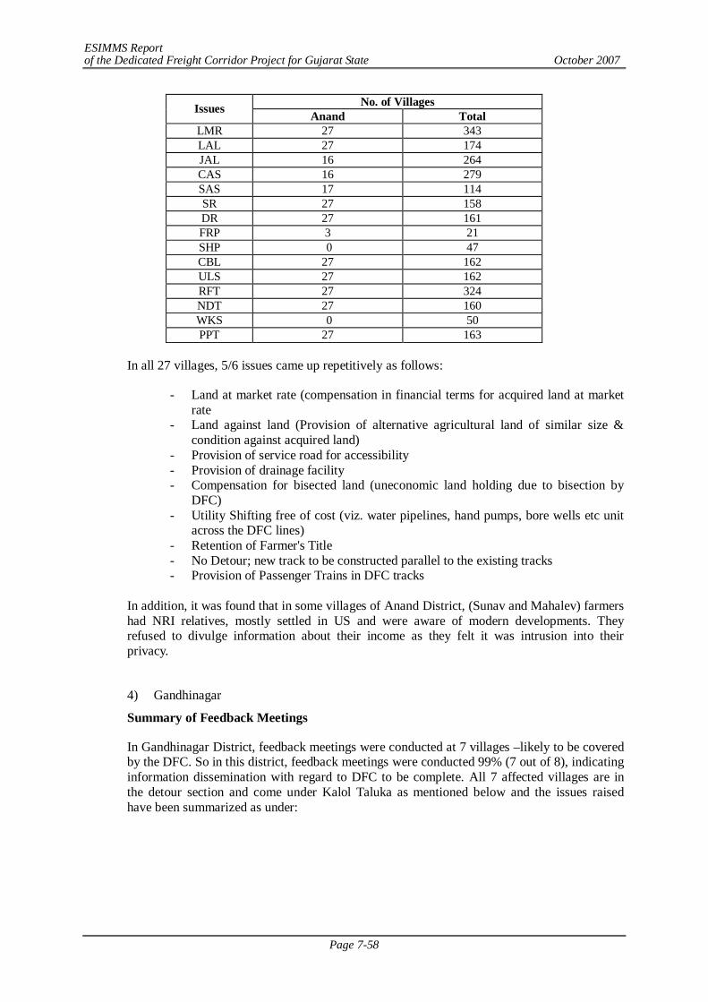
ESIMMS Report of the Dedicated Freight Corridor Project for Gujarat State October 2007
Page 7-58
No. of Villages Issues Anand Total LMR 27 343 LAL 27 174 JAL 16 264 CAS 16 279 SAS 17 114 SR 27 158 DR 27 161 FRP 3 21 SHP 0 47 CBL 27 162 ULS 27 162 RFT 27 324 NDT 27 160 WKS 0 50 PPT 27 163
In all 27 villages, 5/6 issues came up repetitively as follows:
- Land at market rate (compensation in financial terms for acquired land at market rate
- Land against land (Provision of alternative agricultural land of similar size & condition against acquired land)
- Provision of service road for accessibility - Provision of drainage facility - Compensation for bisected land (uneconomic land holding due to bisection by
DFC) - Utility Shifting free of cost (viz. water pipelines, hand pumps, bore wells etc unit
across the DFC lines) - Retention of Farmer's Title - No Detour; new track to be constructed parallel to the existing tracks - Provision of Passenger Trains in DFC tracks
In addition, it was found that in some villages of Anand District, (Sunav and Mahalev) farmers had NRI relatives, mostly settled in US and were aware of modern developments. They refused to divulge information about their income as they felt it was intrusion into their privacy.
4) Gandhinagar
Summary of Feedback Meetings
In Gandhinagar District, feedback meetings were conducted at 7 villages –likely to be covered by the DFC. So in this district, feedback meetings were conducted 99% (7 out of 8), indicating information dissemination with regard to DFC to be complete. All 7 affected villages are in the detour section and come under Kalol Taluka as mentioned below and the issues raised have been summarized as under:
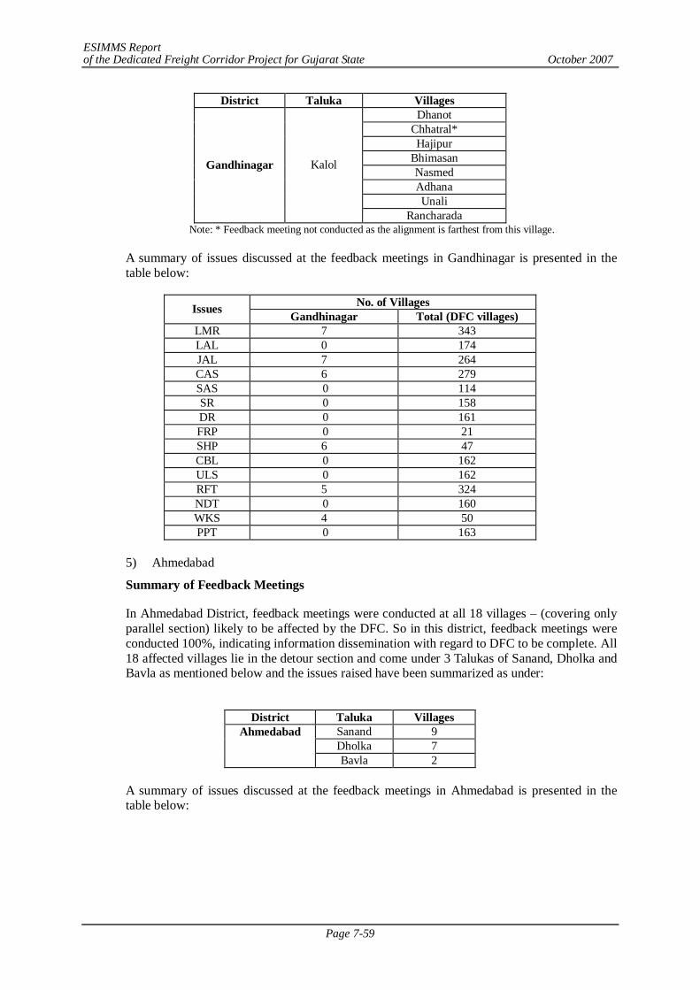
ESIMMS Report of the Dedicated Freight Corridor Project for Gujarat State October 2007
Page 7-59
District Taluka Villages Dhanot
Chhatral* Hajipur
Bhimasan Nasmed Adhana Unali
Gandhinagar Kalol
Rancharada Note: * Feedback meeting not conducted as the alignment is farthest from this village.
A summary of issues discussed at the feedback meetings in Gandhinagar is presented in the table below:
No. of Villages Issues Gandhinagar Total (DFC villages) LMR 7 343 LAL 0 174 JAL 7 264 CAS 6 279 SAS 0 114 SR 0 158 DR 0 161 FRP 0 21 SHP 6 47 CBL 0 162 ULS 0 162 RFT 5 324 NDT 0 160 WKS 4 50 PPT 0 163
5) Ahmedabad
Summary of Feedback Meetings
In Ahmedabad District, feedback meetings were conducted at all 18 villages – (covering only parallel section) likely to be affected by the DFC. So in this district, feedback meetings were conducted 100%, indicating information dissemination with regard to DFC to be complete. All 18 affected villages lie in the detour section and come under 3 Talukas of Sanand, Dholka and Bavla as mentioned below and the issues raised have been summarized as under:
District Taluka Villages
Ahmedabad Sanand 9 Dholka 7 Bavla 2
A summary of issues discussed at the feedback meetings in Ahmedabad is presented in the table below:
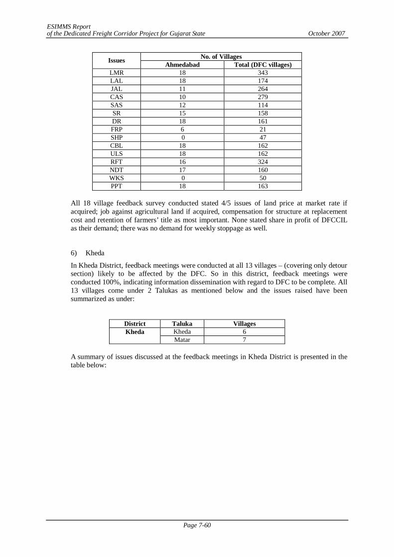
ESIMMS Report of the Dedicated Freight Corridor Project for Gujarat State October 2007
Page 7-60
No. of Villages Issues Ahmedabad Total (DFC villages) LMR 18 343 LAL 18 174 JAL 11 264 CAS 10 279 SAS 12 114 SR 15 158 DR 18 161 FRP 6 21 SHP 0 47 CBL 18 162 ULS 18 162 RFT 16 324 NDT 17 160 WKS 0 50 PPT 18 163
All 18 village feedback survey conducted stated 4/5 issues of land price at market rate if acquired; job against agricultural land if acquired, compensation for structure at replacement cost and retention of farmers’ title as most important. None stated share in profit of DFCCIL as their demand; there was no demand for weekly stoppage as well.
6) Kheda
In Kheda District, feedback meetings were conducted at all 13 villages – (covering only detour section) likely to be affected by the DFC. So in this district, feedback meetings were conducted 100%, indicating information dissemination with regard to DFC to be complete. All 13 villages come under 2 Talukas as mentioned below and the issues raised have been summarized as under:
District Taluka Villages Kheda Kheda 6
Matar 7
A summary of issues discussed at the feedback meetings in Kheda District is presented in the table below:
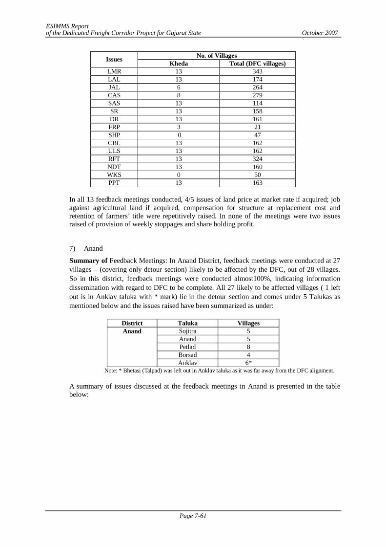
ESIMMS Report of the Dedicated Freight Corridor Project for Gujarat State October 2007
Page 7-61
No. of Villages Issues Kheda Total (DFC villages) LMR 13 343 LAL 13 174 JAL 6 264 CAS 8 279 SAS 13 114 SR 13 158 DR 13 161 FRP 3 21 SHP 0 47 CBL 13 162 ULS 13 162 RFT 13 324 NDT 13 160 WKS 0 50 PPT 13 163
In all 13 feedback meetings conducted, 4/5 issues of land price at market rate if acquired; job against agricultural land if acquired, compensation for structure at replacement cost and retention of farmers’ title were repetitively raised. In none of the meetings were two issues raised of provision of weekly stoppages and share holding profit.
7) Anand
Summary of Feedback Meetings: In Anand District, feedback meetings were conducted at 27 villages – (covering only detour section) likely to be affected by the DFC, out of 28 villages. So in this district, feedback meetings were conducted almost100%, indicating information dissemination with regard to DFC to be complete. All 27 likely to be affected villages ( 1 left out is in Anklav taluka with * mark) lie in the detour section and comes under 5 Talukas as mentioned below and the issues raised have been summarized as under:
District Taluka Villages
Sojitra 5 Anand 5 Petlad 8 Borsad 4
Anand
Anklav 6* Note: * Bhetasi (Talpad) was left out in Anklav taluka as it was far away from the DFC alignment.
A summary of issues discussed at the feedback meetings in Anand is presented in the table below:

ESIMMS Report of the Dedicated Freight Corridor Project for Gujarat State October 2007
Page 7-62
No. of Villages Issues Anand Total LMR 27 343 LAL 27 174 JAL 16 264 CAS 16 279 SAS 17 114 SR 27 158 DR 27 161 FRP 3 21 SHP 0 47 CBL 27 162 ULS 27 162 RFT 27 324 NDT 27 160 WKS 0 50 PPT 27 163
In all 27 villages, 5/6 issues came up repetitively like:
- Land at market rate (compensation in financial terms for acquired land at market rate
- Land against land (Provision of alternative agricultural land of similar size & condition against acquired land)
- Provision of service road for accessibility - Provision of drainage facility - Compensation for bisected land (uneconomic land holding due to bisection by
DFC) - Utility Shifting free of cost (viz. water pipelines, hand pumps, bore wells etc unit
across the DFC lines) - Retention of Farmer's Title - No Detour; new track to be constructed parallel to the existing tracks - Provision of Passenger Trains in DFC tracks
In addition, it was found that in some villages of Anand District, (Sunav and Mahalev) farmers had NRI relatives, mostly settled in US and were aware of modern developments. They refused to divulge information about their income as they felt it was intrusion into their privacy.
8) Vadodara
In Vadodara District, feedback meetings were conducted at all 29 villages – (covering both detour and parallel sections) likely to be affected by the DFC. So in this district, feedback meetings were conducted 100%, indicating information dissemination with regard to DFC to be complete. All 29 affected villages comes under 2 Talukas of Vadodara and Karjan as mentioned below and the issues raised have been summarized as under:
District Taluka Villages/Towns
Vadodara Vadodara 17/1 Karjan 10/1
A summary of issues discussed at the feedback meetings in Vadodara is presented in the table below:
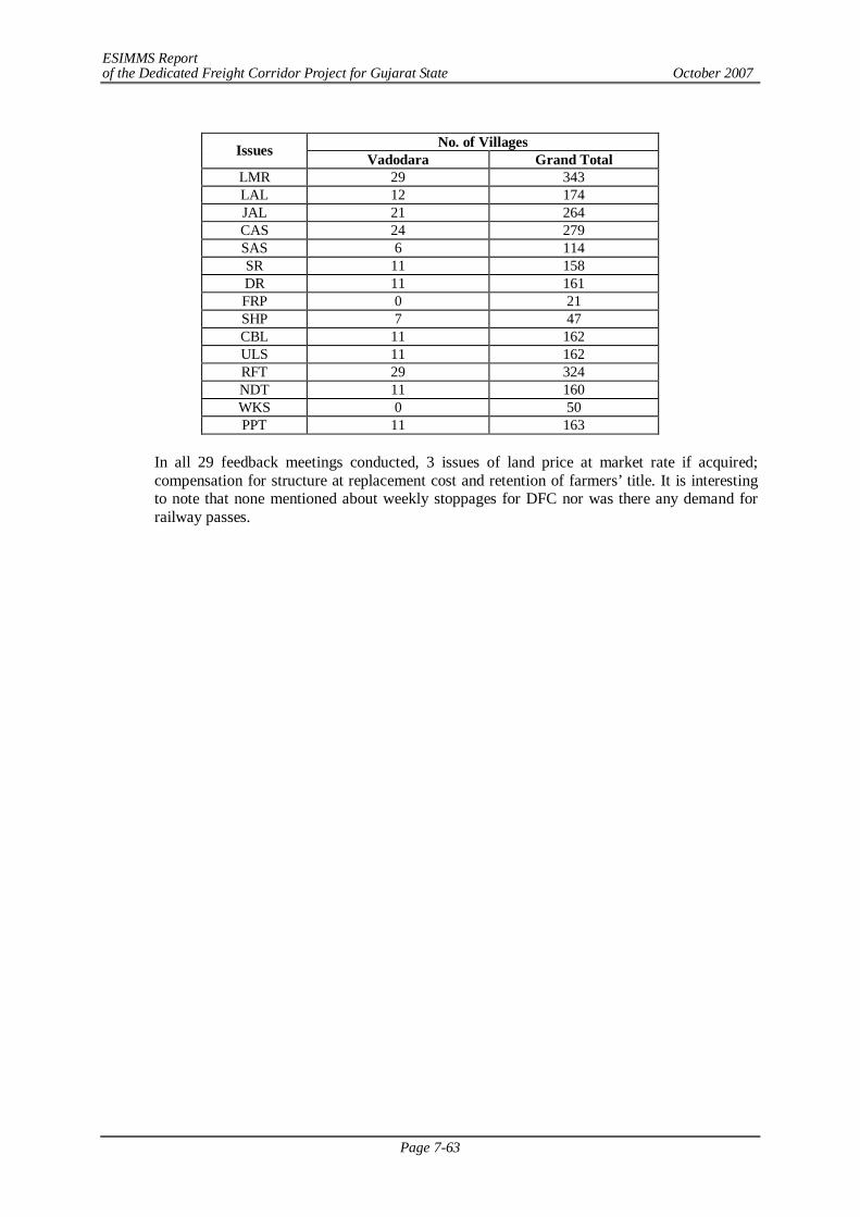
ESIMMS Report of the Dedicated Freight Corridor Project for Gujarat State October 2007
Page 7-63
No. of Villages Issues Vadodara Grand Total
LMR 29 343 LAL 12 174 JAL 21 264 CAS 24 279 SAS 6 114 SR 11 158 DR 11 161 FRP 0 21 SHP 7 47 CBL 11 162 ULS 11 162 RFT 29 324 NDT 11 160 WKS 0 50 PPT 11 163
In all 29 feedback meetings conducted, 3 issues of land price at market rate if acquired; compensation for structure at replacement cost and retention of farmers’ title. It is interesting to note that none mentioned about weekly stoppages for DFC nor was there any demand for railway passes.
ESIMMS Report of the Dedicated Freight Corridor Project for Gujarat State October 2007
Page 8-1
CHAPTER 8 ENVIRONMENT MANAGEMENT PLAN
8.1 INTRODUCTION
Environmental Management Plan (EMP) is the key to ensure a safe and clean environment. The desired results from the environmental mitigation measures proposed in the project may not be obtained without a management plan to assure its proper implementation & function. The EMP envisages the plans for the proper implementation of mitigation measures to reduce the adverse impacts arising out of the project activities during pre-construction, construction and operation stage.
Pre-construction Stage:
During the pre-construction stage, management measures required will include land acquisition, the clearance of the ROW, borrow area & quarry area identification, arrangement of construction water, measures for relocation of community property resources such as hand pumps and other utilities likely to be impacted etc.
Construction Stage:
Construction stage is the most crucial and active stage of the EMP. The construction of freight corridor includes civil work including construction of cross stations, junction stations etc. The construction activities may increase pollution load in the atmosphere as well as there will be some other impacts. Therefore, in addition to the monitoring of construction activity to ensure that the environment is not impacted beyond permissible limits, safety of the workers, labour camp management, disposal of construction waste and risks associated with construction activities such as accidental spillages and consequent damage to the surrounding environment in terms of loss of flora, fauna, agricultural crops or loss of fertile land will be monitored simultaneously.
Operation Stage
The operation stage will essentially entail monitoring activity along the corridor. The monitoring for pollutants specified in the monitoring plan will serve two purposes. In addition to checking the efficacy of the protection/mitigation/enhancement measures implemented, this will help verify or refute the predictions made as a part of impact assessment. Thus, it will complete a very important feedback loop for DFCCI.
EMP has been prepared addressing the issues like:
- Details of Management Plan
- Greenbelt Development Plan - Solid Waste Management Plan - Management / Rehabilitation Plan for Quarry/Borrow Areas - Guidelines for Sanitation and House Keeping at the Construction Labour Camps - Procedures for Storage, Handling & Emergency Response for Hazardous
Chemical
- Stage wise Environmental Management Measures & Responsibilities
- Expenditures for environmental protection measures and budget for implementation of the EMP.
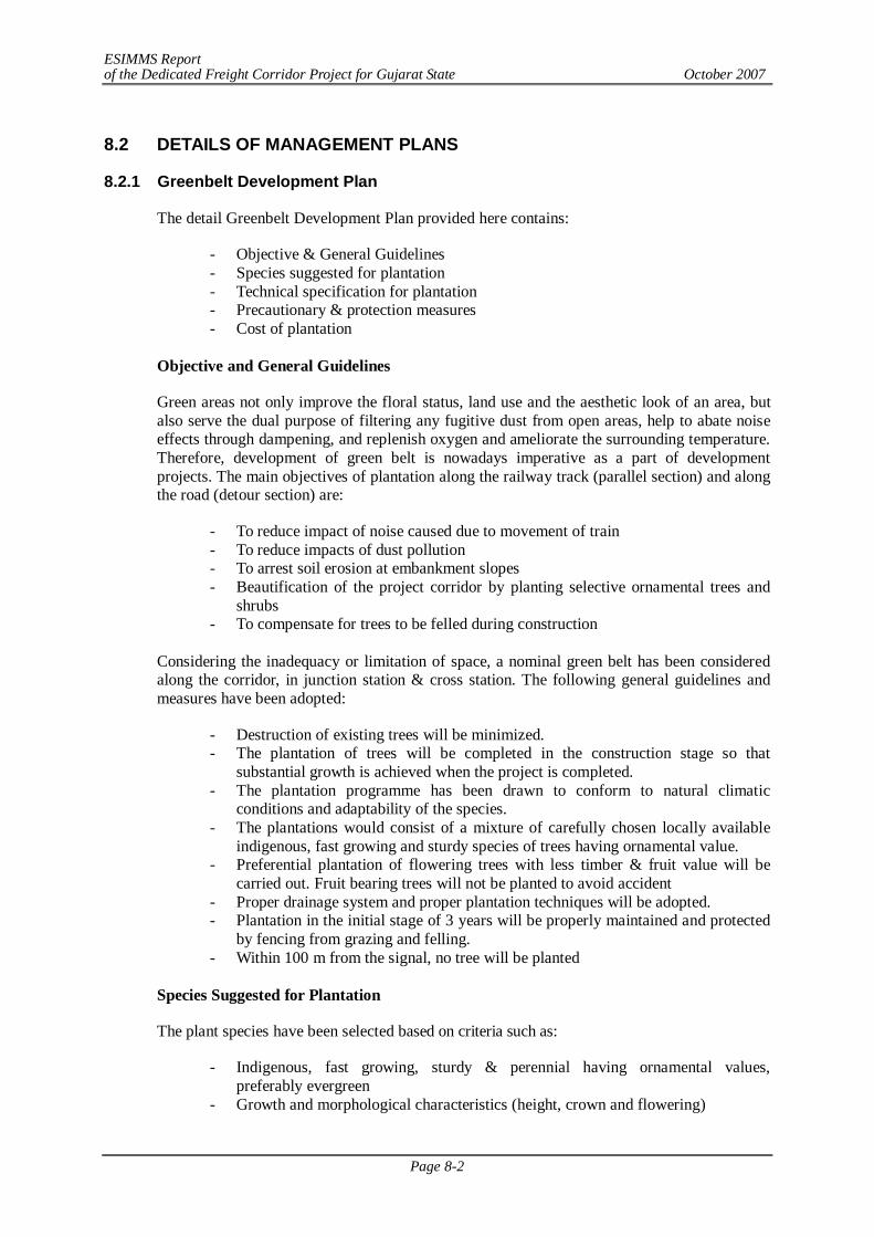
ESIMMS Report of the Dedicated Freight Corridor Project for Gujarat State October 2007
Page 8-2
8.2 DETAILS OF MANAGEMENT PLANS
8.2.1 Greenbelt Development Plan
The detail Greenbelt Development Plan provided here contains:
- Objective & General Guidelines - Species suggested for plantation - Technical specification for plantation - Precautionary & protection measures - Cost of plantation
Objective and General Guidelines
Green areas not only improve the floral status, land use and the aesthetic look of an area, but also serve the dual purpose of filtering any fugitive dust from open areas, help to abate noise effects through dampening, and replenish oxygen and ameliorate the surrounding temperature. Therefore, development of green belt is nowadays imperative as a part of development projects. The main objectives of plantation along the railway track (parallel section) and along the road (detour section) are:
- To reduce impact of noise caused due to movement of train - To reduce impacts of dust pollution - To arrest soil erosion at embankment slopes - Beautification of the project corridor by planting selective ornamental trees and
shrubs - To compensate for trees to be felled during construction
Considering the inadequacy or limitation of space, a nominal green belt has been considered along the corridor, in junction station & cross station. The following general guidelines and measures have been adopted:
- Destruction of existing trees will be minimized. - The plantation of trees will be completed in the construction stage so that
substantial growth is achieved when the project is completed. - The plantation programme has been drawn to conform to natural climatic
conditions and adaptability of the species. - The plantations would consist of a mixture of carefully chosen locally available
indigenous, fast growing and sturdy species of trees having ornamental value. - Preferential plantation of flowering trees with less timber & fruit value will be
carried out. Fruit bearing trees will not be planted to avoid accident - Proper drainage system and proper plantation techniques will be adopted. - Plantation in the initial stage of 3 years will be properly maintained and protected
by fencing from grazing and felling. - Within 100 m from the signal, no tree will be planted
Species Suggested for Plantation
The plant species have been selected based on criteria such as:
- Indigenous, fast growing, sturdy & perennial having ornamental values, preferably evergreen
- Growth and morphological characteristics (height, crown and flowering)
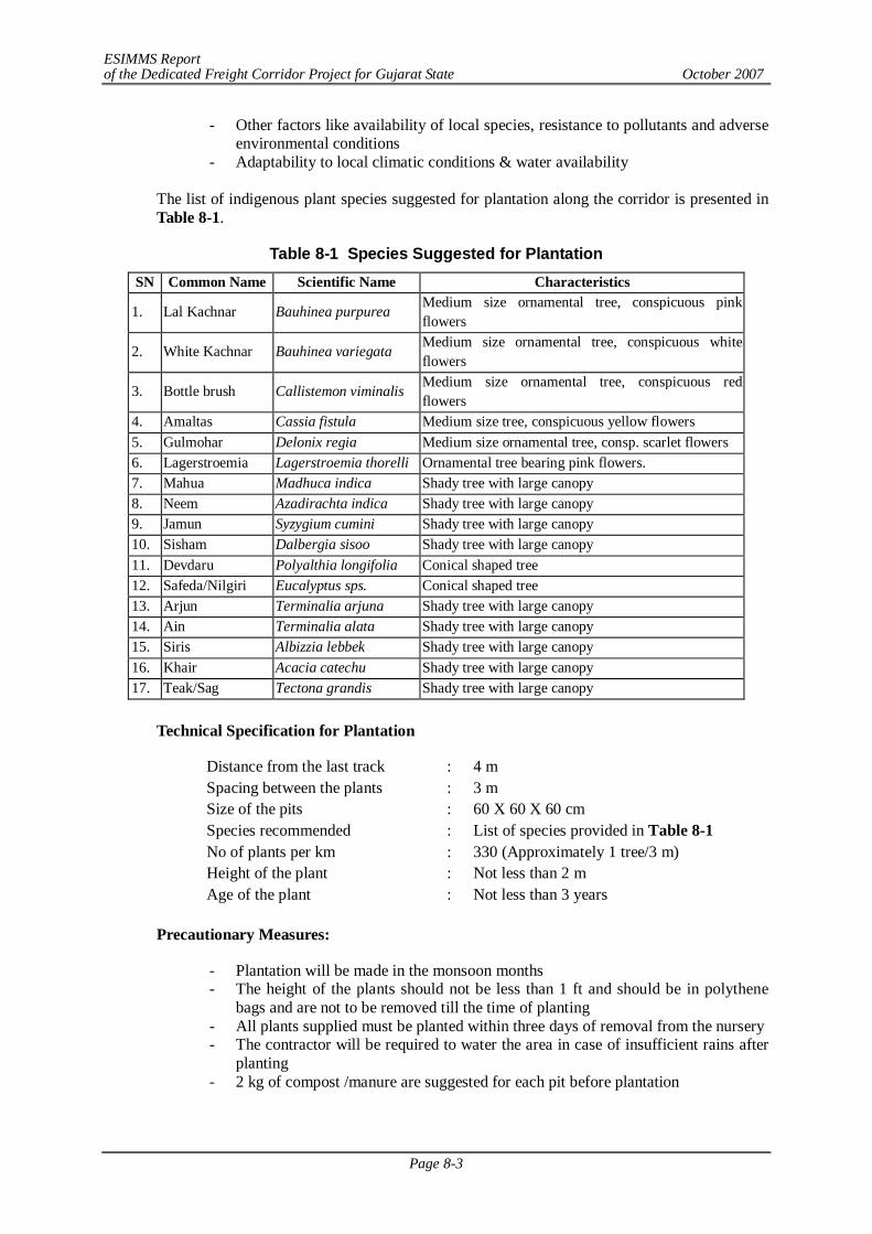
ESIMMS Report of the Dedicated Freight Corridor Project for Gujarat State October 2007
Page 8-3
- Other factors like availability of local species, resistance to pollutants and adverse environmental conditions
- Adaptability to local climatic conditions & water availability
The list of indigenous plant species suggested for plantation along the corridor is presented in Table 8-1.
Table 8-1 Species Suggested for Plantation SN Common Name Scientific Name Characteristics
1. Lal Kachnar Bauhinea purpurea Medium size ornamental tree, conspicuous pink flowers
2. White Kachnar Bauhinea variegata Medium size ornamental tree, conspicuous white flowers
3. Bottle brush Callistemon viminalis Medium size ornamental tree, conspicuous red flowers
4. Amaltas Cassia fistula Medium size tree, conspicuous yellow flowers 5. Gulmohar Delonix regia Medium size ornamental tree, consp. scarlet flowers 6. Lagerstroemia Lagerstroemia thorelli Ornamental tree bearing pink flowers. 7. Mahua Madhuca indica Shady tree with large canopy 8. Neem Azadirachta indica Shady tree with large canopy 9. Jamun Syzygium cumini Shady tree with large canopy 10. Sisham Dalbergia sisoo Shady tree with large canopy 11. Devdaru Polyalthia longifolia Conical shaped tree 12. Safeda/Nilgiri Eucalyptus sps. Conical shaped tree 13. Arjun Terminalia arjuna Shady tree with large canopy 14. Ain Terminalia alata Shady tree with large canopy 15. Siris Albizzia lebbek Shady tree with large canopy 16. Khair Acacia catechu Shady tree with large canopy 17. Teak/Sag Tectona grandis Shady tree with large canopy
Technical Specification for Plantation
Distance from the last track : 4 m Spacing between the plants : 3 m Size of the pits : 60 X 60 X 60 cm Species recommended : List of species provided in Table 8-1 No of plants per km : 330 (Approximately 1 tree/3 m) Height of the plant : Not less than 2 m Age of the plant : Not less than 3 years
Precautionary Measures:
- Plantation will be made in the monsoon months - The height of the plants should not be less than 1 ft and should be in polythene
bags and are not to be removed till the time of planting - All plants supplied must be planted within three days of removal from the nursery - The contractor will be required to water the area in case of insufficient rains after
planting - 2 kg of compost /manure are suggested for each pit before plantation
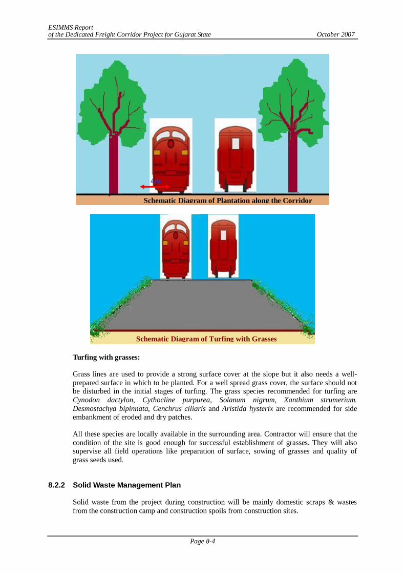
ESIMMS Report of the Dedicated Freight Corridor Project for Gujarat State October 2007
Page 8-4
Turfing with grasses:
Grass lines are used to provide a strong surface cover at the slope but it also needs a well-prepared surface in which to be planted. For a well spread grass cover, the surface should not be disturbed in the initial stages of turfing. The grass species recommended for turfing are Cynodon dactylon, Cythocline purpurea, Solanum nigrum, Xanthium strumerium. Desmostachya bipinnata, Cenchrus ciliaris and Aristida hysterix are recommended for side embankment of eroded and dry patches.
All these species are locally available in the surrounding area. Contractor will ensure that the condition of the site is good enough for successful establishment of grasses. They will also supervise all field operations like preparation of surface, sowing of grasses and quality of grass seeds used.
8.2.2 Solid Waste Management Plan
Solid waste from the project during construction will be mainly domestic scraps & wastes from the construction camp and construction spoils from construction sites.
4m
Schematic Diagram of Plantation along the Corridor
Schematic Diagram of Turfing with Grasses
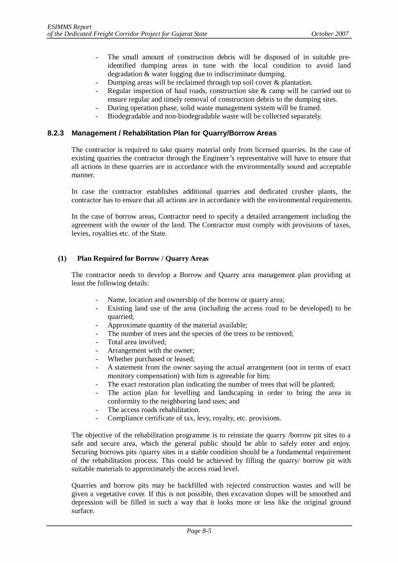
ESIMMS Report of the Dedicated Freight Corridor Project for Gujarat State October 2007
Page 8-5
- The small amount of construction debris will be disposed of in suitable pre-identified dumping areas in tune with the local condition to avoid land degradation & water logging due to indiscriminate dumping.
- Dumping areas will be reclaimed through top soil cover & plantation. - Regular inspection of haul roads, construction site & camp will be carried out to
ensure regular and timely removal of construction debris to the dumping sites. - During operation phase, solid waste management system will be framed. - Biodegradable and non-biodegradable waste will be collected separately.
8.2.3 Management / Rehabilitation Plan for Quarry/Borrow Areas
The contractor is required to take quarry material only from licensed quarries. In the case of existing quarries the contractor through the Engineer’s representative will have to ensure that all actions in these quarries are in accordance with the environmentally sound and acceptable manner.
In case the contractor establishes additional quarries and dedicated crusher plants, the contractor has to ensure that all actions are in accordance with the environmental requirements.
In the case of borrow areas, Contractor need to specify a detailed arrangement including the agreement with the owner of the land. The Contractor must comply with provisions of taxes, levies, royalties etc. of the State.
(1) Plan Required for Borrow / Quarry Areas
The contractor needs to develop a Borrow and Quarry area management plan providing at least the following details:
- Name, location and ownership of the borrow or quarry area; - Existing land use of the area (including the access road to be developed) to be
quarried; - Approximate quantity of the material available; - The number of trees and the species of the trees to be removed; - Total area involved; - Arrangement with the owner; - Whether purchased or leased; - A statement from the owner saying the actual arrangement (not in terms of exact
monitory compensation) with him is agreeable for him; - The exact restoration plan indicating the number of trees that will be planted; - The action plan for levelling and landscaping in order to bring the area in
conformity to the neighboring land uses; and - The access roads rehabilitation. - Compliance certificate of tax, levy, royalty, etc. provisions.
The objective of the rehabilitation programme is to reinstate the quarry /borrow pit sites to a safe and secure area, which the general public should be able to safely enter and enjoy. Securing borrows pits /quarry sites in a stable condition should be a fundamental requirement of the rehabilitation process. This could be achieved by filling the quarry/ borrow pit with suitable materials to approximately the access road level.
Quarries and borrow pits may be backfilled with rejected construction wastes and will be given a vegetative cover. If this is not possible, then excavation slopes will be smoothed and depression will be filled in such a way that it looks more or less like the original ground surface.
ESIMMS Report of the Dedicated Freight Corridor Project for Gujarat State October 2007
Page 8-6
During works execution, the contractor shall ensure preservation of trees during piling of materials; spreading of stripping material to facilitate water percolation and allow natural vegetation growth; re-establishment of previous natural drainage flows; improvement of site appearance; digging of ditches to collect runoff; and maintenance of roadways where a pit or quarry is declared useable water source for livestock or people nearby. Once the works are completed, the contractor shall restore the environment his own expense around the work site to its original splits.
8.2.4 Guidelines for Sanitation and House Keeping at the Construction Labour
Camps
(1) Site Selection
- The construction camps will be located at least 200 - 500 m away from habitations at identified sites. The living accommodation and ancillary facilities for labour shall be erected and maintained to standards and scales approved by the resident engineer.
- All sites used for camps must be adequately drained. They must not be subject to periodic flooding, nor located within 200 feet of swamps, pools, sink holes or other surface collections of water unless such water surface can be subjected to mosquito control measures.
- The camps must be located such that the drainage from and through the camps will not endanger any domestic or public water supply.
- All sites must be graded, ditched and rendered free from depressions such that water may get stagnant and become a nuisance.
(2) Water Supply
- An adequate and convenient water supply, approved by the appropriate health authority, must be provided in each camp for drinking, cooking, bathing and laundry purposes.
- Potable water supply systems for labour camps occupants shall be as per the design approved by the Local Public Health Engineering Department and meet the water quality standards as prescribed by the State Pollution Control Board. In addition, the design of water system facilities shall be based on the suppliers Engineer’s estimates of water demands.
- The drinking water system must be monitored in accordance with the water quality parameters as prescribed by the State Pollution Control Board. The water supply system used for cooking purposes that is drained seasonally must be cleaned, flushed, and disinfected prior to use. Furthermore, a water sample of satisfactory bacteriologic quality, i.e. a sample showing not more than one coliform bacteria per 100 ml sample must be obtained before being placed into service.
- At all construction camps and other workplace, good and sufficient water supply shall be maintained to eliminate chances of waterborne/water-related/water-based diseases to ensure the health and hygiene of the workers.
(3) Toilet Facilities and Hygiene
- There shall be adequate supply of water, close to latrines and urinals.
- Within the precincts of every workplace, latrines and urinals shall be provided in an accessible place, and the accommodation, separately for each of these, as per standards set by the Building and other Construction Workers (regulation of Employment and Conditions of Service) Act, 1996. Except in workplaces provided with water-flushed latrines connected with a water borne sewage system, all latrines shall be provided with dry-earth system
ESIMMS Report of the Dedicated Freight Corridor Project for Gujarat State October 2007
Page 8-7
(receptacles) which shall be cleaned at least four times daily and at least twice during working hours and kept in a strict sanitary condition. Receptacles shall be tarred inside and outside at least once a year.
- Toilet facilities adequate for the capacity of the camp must be provided. Each toilet room must be located so as to be accessible, without any individual passing through any sleeping room.
- A toilet room must be located within 200 feet of the door of each sleeping room. No toilet may be closer than 100 feet to any sleeping room, lunch area or kitchen.
- Where the toilet rooms are shared, such as in multifamily shelters and in barracks type facilities; separate toilet rooms must be provided for male & female. These rooms must be distinctly marked “for men” and “for women” by signs printed in the native language of the persons occupying the camp, or marked with easily understood pictures or symbols. If the facilities for each sex are in the same building, they must be separated by solid walls or partitions; extending from the floor to the roof or ceiling.
- Urinals must be provided on the basis of one unit or 2 linear feet of urinal trough for each 25 men. The floor from the wall and for a distance not less than 15 inches measured from the outward edge of the urinals must be constructed of materials impervious to moisture. Where water under pressure is available, urinals must be provided with an adequate water flush. Urinals troughs in privies must drain freely into the pit or vault, and the construction of this drain must be such as to exclude flies and rodents from the pit.
(4) Waste Disposal
- The sewage system for the camp must be designed, built and operated to the satisfaction of the concerned local State Govt. Department so that no health hazard occurs and no pollution to the air, ground or adjacent watercourse takes place. Compliance with the relevant legislation must be strictly adhered to.
- Garbage bins must be provided in the camps and regularly emptied and the garbage disposed off in a hygienic manner to the satisfaction of relevant norms.
- Unless otherwise arranged for by the local sanitary authority, arrangement for disposal of excreta by incineration at the workplace shall be made by means of a suitable incinerator approved by the local medical health or municipal authorities. Alternatively, excreta may be disposed off by putting a layer of night soils at the bottom of permanent tank prepared for the purpose and covering it with 15 cm layer of waste or refuse and then covering it with a layer of earth for a fortnight (by then it will turn into manure).
- On completion of the works, all such temporary structures shall be cleared away, all rubbish burnt, excreta tank and other disposal pits or trenches filled in and effectively sealed off and the outline site left clean and tidy, at the Contractor’s expense, to the entire satisfaction of the engineer.
(5) Maintenance
- All buildings, rooms and equipment and the grounds surrounding them shall be maintained in a clean and operable condition and be protected from rubbish accumulation.
- All necessary means shall be employed to eliminate and control any infestations of insects and rodents within all parts of any labor camp. This shall include approved screening or other control of outside openings in structures intended for occupancy or food service facilities.
- Each structure made available for occupancy shall be of sound construction, shall assure adequate protection against weather, and shall include essential facilities to permit maintenance in a clean and operable condition. Comfort and safety of occupants shall be
ESIMMS Report of the Dedicated Freight Corridor Project for Gujarat State October 2007
Page 8-8
provided by adequate heating, lighting, ventilation or insulation when necessary, to reduce excessive heat.
- Each structure made available for occupancy shall comply with the requirements of the Uniform Building Code. This shall not apply to tent camps.
8.2.5 Procedures for Storage, Handling & Emergency Response for Hazardous
Chemical
Refuelling/Maintenance Procedure
- Truck or suitable containers will bring in all fuel and fluids. There will be no storage of fuel, oil or fluids within 100 m of any surface water body.
- Prior to re-fuelling or maintenance, drip pans and containment pans will be placed under the equipment. Absorbent blankets may also be required to be placed under the equipment and hoses where there is a possibility of spillage to occur.
- All used oils or fluids will be properly contained and transported to appropriately licensed (authorized) disposal sites.
Spill Procedure (inside the stream, river or pond /open surface)
In the case of an accidental spill, overflow or release of fluid occurs into the stream, river, pond /open surface, the following steps will be followed:
1) Stop the follow - Stop the release into the stream waterway
- Shut down the equipment
- Close valves and pumps
- Plug hoses
2) Remove Ignition Sources
- Shut down the vehicles and other engines
- Do not allow tiger torches, vehicles, smoking or other sources of ignition near the area. Keep a fire extinguisher on hand but keep it a safe distance away from the potential ignition source (if a fire starts, the extinguisher must be easily accessible)
3) Contact the Environmental Officer and initiate emergency response - Notify the site supervisor and the Contractor’s Environmental Officer as soon as possible
- The Environmental Officer will review the situation and decide if Emergency Services (like Fire Brigade) are required or not.
- Appropriate parties to be informed:
- The Contractor’s Project Manager - The Site Engineer of SC through his designated Environmental Officer - The Client - Regulatory Agencies like Pollution Control Board, Municipal Authorities, as
applicable - Site Safety Officer
ESIMMS Report of the Dedicated Freight Corridor Project for Gujarat State October 2007
Page 8-9
4) Cleanup and Disposal
- Emergency Services will be engaged for the cleanup and disposal of contaminants released into the environment.
5) Reporting
- The Contractor’s Environmental Officer will document the event and submit the reports to the Client and appropriate regulatory agencies like the State Pollution Control Board etc.
6) Procedure Review
- The Site Engineer of SC will review the report, determine if changes are required to the procedures and will recommend to implement all required changes.
8.3 STAGE WISE ENVIRONMENTAL MANAGEMENT MEASURES AND
RESPONSIBILITIES
8.3.1 Pre-construction Stage
Table 8-2 Environmental Management Measures and Responsibilities
in Pre-construction Stage Responsibility
Sl. No.
Environmental Issues Management Measures Planning and
Execution Supervision/ Monitoring
P1. Land Acquisition The acquisition of land and private properties will be carried out in accordance with the RAP and entitlement framework for the project. Environmental Management Unit (EMU) has to ascertain that any additional environmental impacts resulting from acquisition of land shall be addressed and integrated into the EMP and other relevant documents.
Land Acquisition Unit, EMU,
Revenue Dept., NGOs
Revenue Dept, DFCCIL
P 2. Preservation of Trees All efforts will be made to preserve trees including evaluation of minor design adjustments/alternatives (as applicable) to save trees. Specific attention will be given for protecting giant trees and green tunnels. Tree cutting is to proceed only after all the legal requirements including attaining of In-principle and Formal Clearances from the State Forest Department are completed and subsequently a written order is issued to the Contractor. Stacking, transport and storage of the wood will be done as per the relevant norms. Systematic corridor level documentation for
EMU, Forest Department
DFCCIL
ESIMMS Report of the Dedicated Freight Corridor Project for Gujarat State October 2007
Page 8-10
Responsibility Sl. No.
Environmental Issues Management Measures Planning and
Execution Supervision/ Monitoring
the trees cut and those saved will be maintained by the EMU.
P3. Relocation of Common Property Resources
All community utilities and properties will be relocated before construction starts, on any section of the project corridor. The EMU will relocate these properties in consultation and written agreement with the agency/ owner/community. The relocation sites will be identified in accordance with the choice of the community.
EMU DFCCIL
P4. Field verification and Modification of the Contract Documents P.4.1 Joint Field Verification The Environmental Expert of EMU and the
Contractor will carry out joint field verification to ascertain the possibility to saving trees, environmental and community resources. The verification exercise should assess the need for addition or changes in design/scale/nature of protection measures including the efficacy of enhancement measures suggested in the EMP. Proper documentation and justifications/reasons shall be maintained in all such cases where deviation from the original EMP is proposed.
The Contractor & EMU
DFCCIL
P.4.2 Construction vehicles, equipment and machinery
All vehicles, equipment and machinery to be procured and brought to site for construction will confirm to the relevant Bureau of India Standard (BIS) norms and the manufacturer’s specifications. The discharge standards promulgated under the Environment Protection Act, 1986 will be strictly adhered to. Noise limits for construction equipment to be procured such as compactors, rollers, front loaders concrete mixers, cranes (moveable) will not exceed the value specified in the Environment (Protection) Rules, 1986. The equipment proposed to be used for bridge and culvert construction and installed close to waterway/streams, must be checked and certified fit, especially with respect to the potential leakage of oil and grease. The inspection should verify that: Equipment is clean (free of mud, dirt and
The Contractor Environmental Expert of EMU
ESIMMS Report of the Dedicated Freight Corridor Project for Gujarat State October 2007
Page 8-11
Responsibility Sl. No.
Environmental Issues Management Measures Planning and
Execution Supervision/ Monitoring
oil) Equipment is in good working order. A drip pan is available for equipment that
will be stored on site. Contractor has a spill kit Operator is trained on the refuelling,
maintenance and emergency spill procedures. A log book will be maintained
documenting all fuelling and maintenance events (date, time, location, condition of site, weather conditions, amount of fuel on maintenance event, issues). Adequate inspections will be conducted
during the construction period.
P.5 Borrow Areas Finalizing borrow areas for borrowing earth and all logistic arrangements as well as compliance to environmental requirements, as applicable, will be the sole responsibility of the contractor. The Contractor will not start borrowing earth from select borrow area until the formal agreement is signed between the land owner and the Contractor and a copy is submitted to the Supervision Consultant (SC) and EMU . Locations finalized by the Contractor shall be reported to the Environmental Expert of SC and who will in turn report to EMU. Format for reporting will be as per the Reporting Format for Borrow Area (Form P.1 of Annex-5) and will include a reference map. In addition to testing for the quality of borrow materials by the SC, the environmental experts of the SC will be required to inspect every borrow area location prior to approval.
The Contractor Environmental Expert of SC
and EMU
P.6 Quarry Areas The quarry materials requirement of this project may be fulfilled from the existing quarries. However, detail investigation regarding the availability and suitability of quarry materials from these locations will be finalized by the DPR Consultant. In case the Contractor decides to use quarries other than recommended by DPR consultants, then it will be selected based on
The Contractor Environmental Expert of SC
and EMU
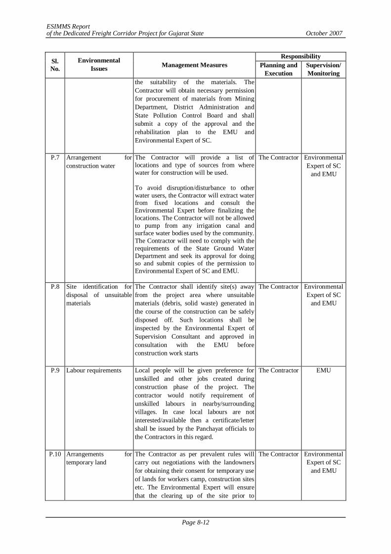
ESIMMS Report of the Dedicated Freight Corridor Project for Gujarat State October 2007
Page 8-12
Responsibility Sl. No.
Environmental Issues Management Measures Planning and
Execution Supervision/ Monitoring
the suitability of the materials. The Contractor will obtain necessary permission for procurement of materials from Mining Department, District Administration and State Pollution Control Board and shall submit a copy of the approval and the rehabilitation plan to the EMU and Environmental Expert of SC.
P.7 Arrangement for construction water
The Contractor will provide a list of locations and type of sources from where water for construction will be used. To avoid disruption/disturbance to other water users, the Contractor will extract water from fixed locations and consult the Environmental Expert before finalizing the locations. The Contractor will not be allowed to pump from any irrigation canal and surface water bodies used by the community. The Contractor will need to comply with the requirements of the State Ground Water Department and seek its approval for doing so and submit copies of the permission to Environmental Expert of SC and EMU.
The Contractor Environmental Expert of SC
and EMU
P.8 Site identification for disposal of unsuitable materials
The Contractor shall identify site(s) away from the project area where unsuitable materials (debris, solid waste) generated in the course of the construction can be safely disposed off. Such locations shall be inspected by the Environmental Expert of Supervision Consultant and approved in consultation with the EMU before construction work starts
The Contractor Environmental Expert of SC
and EMU
P.9 Labour requirements Local people will be given preference for unskilled and other jobs created during construction phase of the project. The contractor would notify requirement of unskilled labours in nearby/surrounding villages. In case local labours are not interested/available then a certificate/letter shall be issued by the Panchayat officials to the Contractors in this regard.
The Contractor EMU
P.10 Arrangements for temporary land
The Contractor as per prevalent rules will carry out negotiations with the landowners for obtaining their consent for temporary use of lands for workers camp, construction sites etc. The Environmental Expert will ensure that the clearing up of the site prior to
The Contractor Environmental Expert of SC
and EMU
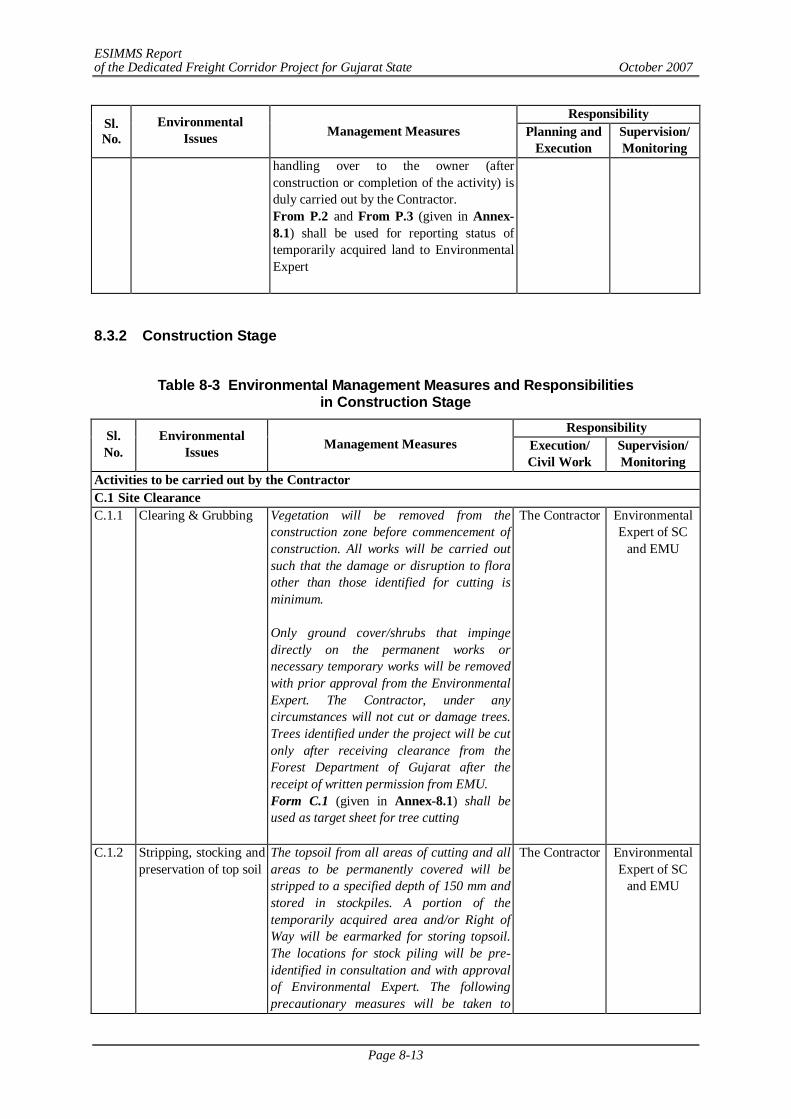
ESIMMS Report of the Dedicated Freight Corridor Project for Gujarat State October 2007
Page 8-13
Responsibility Sl. No.
Environmental Issues Management Measures Planning and
Execution Supervision/ Monitoring
handling over to the owner (after construction or completion of the activity) is duly carried out by the Contractor. From P.2 and From P.3 (given in Annex-8.1) shall be used for reporting status of temporarily acquired land to Environmental Expert
8.3.2 Construction Stage
Table 8-3 Environmental Management Measures and Responsibilities
in Construction Stage Responsibility Sl.
No. Environmental
Issues Management Measures Execution/ Civil Work
Supervision/ Monitoring
Activities to be carried out by the Contractor C.1 Site Clearance C.1.1 Clearing & Grubbing Vegetation will be removed from the
construction zone before commencement of construction. All works will be carried out such that the damage or disruption to flora other than those identified for cutting is minimum. Only ground cover/shrubs that impinge directly on the permanent works or necessary temporary works will be removed with prior approval from the Environmental Expert. The Contractor, under any circumstances will not cut or damage trees. Trees identified under the project will be cut only after receiving clearance from the Forest Department of Gujarat after the receipt of written permission from EMU. Form C.1 (given in Annex-8.1) shall be used as target sheet for tree cutting
The Contractor Environmental Expert of SC
and EMU
C.1.2 Stripping, stocking and preservation of top soil
The topsoil from all areas of cutting and all areas to be permanently covered will be stripped to a specified depth of 150 mm and stored in stockpiles. A portion of the temporarily acquired area and/or Right of Way will be earmarked for storing topsoil. The locations for stock piling will be pre-identified in consultation and with approval of Environmental Expert. The following precautionary measures will be taken to
The Contractor Environmental Expert of SC
and EMU
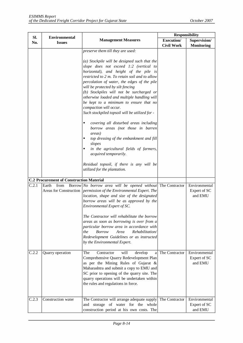
ESIMMS Report of the Dedicated Freight Corridor Project for Gujarat State October 2007
Page 8-14
Responsibility Sl. No.
Environmental Issues Management Measures Execution/
Civil Work Supervision/ Monitoring
preserve them till they are used: (a) Stockpile will be designed such that the slope does not exceed 1:2 (vertical to horizontal), and height of the pile is restricted to 2 m. To retain soil and to allow percolation of water, the edges of the pile will be protected by silt fencing (b) Stockpiles will not be surcharged or otherwise loaded and multiple handling will be kept to a minimum to ensure that no compaction will occur. Such stockpiled topsoil will be utilized for - covering all disturbed areas including
borrow areas (not those in barren areas)
top dressing of the embankment and fill slopes
in the agricultural fields of farmers, acquired temporarily.
Residual topsoil, if there is any will be utilized for the plantation.
C.2 Procurement of Construction Material C.2.1 Earth from Borrow
Areas for Construction No borrow area will be opened without permission of the Environmental Expert. The location, shape and size of the designated borrow areas will be as approved by the Environmental Expert of SC. The Contractor will rehabilitate the borrow areas as soon as borrowing is over from a particular borrow area in accordance with the Borrow Area Rehabilitation/ Redevelopment Guidelines or as instructed by the Environmental Expert.
The Contractor Environmental Expert of SC
and EMU
C.2.2 Quarry operation The Contractor will develop a Comprehensive Quarry Redevelopment Plan as per the Mining Rules of Gujarat & Maharashtra and submit a copy to EMU and SC prior to opening of the quarry site. The quarry operations will be undertaken within the rules and regulations in force.
The Contractor Environmental Expert of SC
and EMU
C.2.3 Construction water The Contractor will arrange adequate supply and storage of water for the whole construction period at his own costs. The
The Contractor Environmental Expert of SC
and EMU
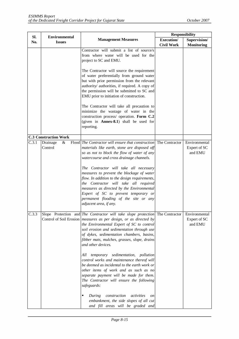
ESIMMS Report of the Dedicated Freight Corridor Project for Gujarat State October 2007
Page 8-15
Responsibility Sl. No.
Environmental Issues Management Measures Execution/
Civil Work Supervision/ Monitoring
Contractor will submit a list of source/s from where water will be used for the project to SC and EMU. The Contractor will source the requirement of water preferentially from ground water but with prior permission from the relevant authority/ authorities, if required. A copy of the permission will be submitted to SC and EMU prior to initiation of construction. The Contractor will take all precaution to minimize the wastage of water in the construction process/ operation. Form C.2 (given in Annex-8.1) shall be used for reporting.
C.3 Construction Work C.3.1 Drainage & Flood
Control The Contractor will ensure that construction materials like earth, stone are disposed off so as not to block the flow of water of any watercourse and cross drainage channels. The Contractor will take all necessary measures to prevent the blockage of water flow. In addition to the design requirements, the Contractor will take all required measures as directed by the Environmental Expert of SC to prevent temporary or permanent flooding of the site or any adjacent area, if any.
The Contractor Environmental Expert of SC
and EMU
C.3.3 Slope Protection and Control of Soil Erosion
The Contractor will take slope protection measures as per design, or as directed by the Environmental Expert of SC to control soil erosion and sedimentation through use of dykes, sedimentation chambers, basins, fibber mats, mulches, grasses, slope, drains and other devices. All temporary sedimentation, pollution control works and maintenance thereof will be deemed as incidental to the earth work or other items of work and as such as no separate payment will be made for them. The Contractor will ensure the following safeguards: During construction activities on
embankment, the side slopes of all cut and fill areas will be graded and
The Contractor Environmental Expert of SC
and EMU
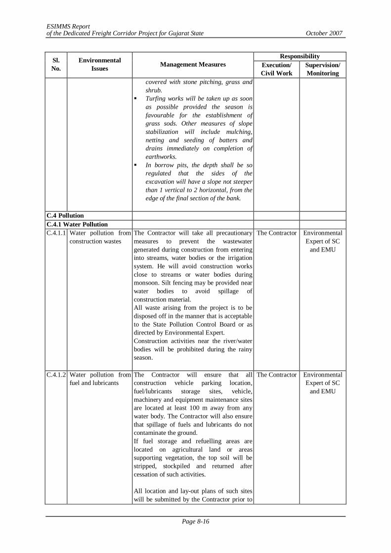
ESIMMS Report of the Dedicated Freight Corridor Project for Gujarat State October 2007
Page 8-16
Responsibility Sl. No.
Environmental Issues Management Measures Execution/
Civil Work Supervision/ Monitoring
covered with stone pitching, grass and shrub.
Turfing works will be taken up as soon as possible provided the season is favourable for the establishment of grass sods. Other measures of slope stabilization will include mulching, netting and seeding of batters and drains immediately on completion of earthworks.
In borrow pits, the depth shall be so regulated that the sides of the excavation will have a slope not steeper than 1 vertical to 2 horizontal, from the edge of the final section of the bank.
C.4 Pollution C.4.1 Water Pollution C.4.1.1 Water pollution from
construction wastes The Contractor will take all precautionary measures to prevent the wastewater generated during construction from entering into streams, water bodies or the irrigation system. He will avoid construction works close to streams or water bodies during monsoon. Silt fencing may be provided near water bodies to avoid spillage of construction material. All waste arising from the project is to be disposed off in the manner that is acceptable to the State Pollution Control Board or as directed by Environmental Expert. Construction activities near the river/water bodies will be prohibited during the rainy season.
The Contractor Environmental Expert of SC
and EMU
C.4.1.2 Water pollution from fuel and lubricants
The Contractor will ensure that all construction vehicle parking location, fuel/lubricants storage sites, vehicle, machinery and equipment maintenance sites are located at least 100 m away from any water body. The Contractor will also ensure that spillage of fuels and lubricants do not contaminate the ground. If fuel storage and refuelling areas are located on agricultural land or areas supporting vegetation, the top soil will be stripped, stockpiled and returned after cessation of such activities. All location and lay-out plans of such sites will be submitted by the Contractor prior to
The Contractor Environmental Expert of SC
and EMU
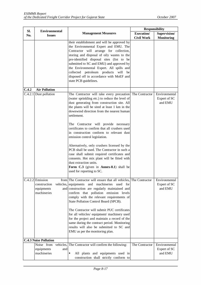
ESIMMS Report of the Dedicated Freight Corridor Project for Gujarat State October 2007
Page 8-17
Responsibility Sl. No.
Environmental Issues Management Measures Execution/
Civil Work Supervision/ Monitoring
their establishment and will be approved by the Environmental Expert and EMU. The Contractor will arrange for collection, storing and disposal of oily wastes to the pre-identified disposal sites (list to be submitted to SC and EMU) and approved by the Environmental Expert. All spills and collected petroleum products will be disposed off in accordance with MoEF and state PCB guidelines.
C.4.2 Air Pollution C.4.2.1 Dust pollution The Contractor will take every precaution
(water sprinkling etc.) to reduce the level of dust generating from construction site. All the plants will be sited at least 1 km in the downwind direction from the nearest human settlement. The Contractor will provide necessary certificates to confirm that all crushers used in construction conform to relevant dust emission control legislation. Alternatively, only crushers licensed by the PCB shall be used. The Contractor in such a case shall submit required certificates and consents. Hot mix plant will be fitted with dust extraction units. Form C.3 (given in Annex-8.1) shall be used for reporting to SC.
The Contractor Environmental Expert of SC
and EMU
C.4.2.2 Emission from construction vehicles, equipments and machineries
The Contractor will ensure that all vehicles, equipments and machineries used for construction are regularly maintained and confirm that pollution emission levels comply with the relevant requirements of State Pollution Control Board (SPCB). The Contractor will submit PUC certificates for all vehicles/ equipment/ machinery used for the project and maintain a record of the same during the contract period. Monitoring results will also be submitted to SC and EMU as per the monitoring plan.
The Contractor Environmental Expert of SC
and EMU
C.4.3 Noise Pollution Noise from vehicles,
equipments and machineries
The Contractor will confirm the following: All plants and equipments used in
construction shall strictly conform to
The Contractor Environmental Expert of SC
and EMU
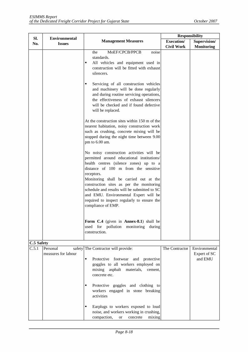
ESIMMS Report of the Dedicated Freight Corridor Project for Gujarat State October 2007
Page 8-18
Responsibility Sl. No.
Environmental Issues Management Measures Execution/
Civil Work Supervision/ Monitoring
the MoEF/CPCB/PPCB noise standards.
All vehicles and equipment used in construction will be fitted with exhaust silencers.
Servicing of all construction vehicles
and machinery will be done regularly and during routine servicing operations, the effectiveness of exhaust silencers will be checked and if found defective will be replaced.
At the construction sites within 150 m of the nearest habitation, noisy construction work such as crushing, concrete mixing will be stopped during the night time between 9.00 pm to 6.00 am. No noisy construction activities will be permitted around educational institutions/ health centres (silence zones) up to a distance of 100 m from the sensitive receptors. Monitoring shall be carried out at the construction sites as per the monitoring schedule and results will be submitted to SC and EMU. Environmental Expert will be required to inspect regularly to ensure the compliance of EMP. Form C.4 (given in Annex-8.1) shall be used for pollution monitoring during construction.
C.5 Safety C.5.1 Personal safety
measures for labour The Contractor will provide: Protective footwear and protective
goggles to all workers employed on mixing asphalt materials, cement, concrete etc.
Protective goggles and clothing to
workers engaged in stone breaking activities
Earplugs to workers exposed to loud
noise, and workers working in crushing, compaction, or concrete mixing
The Contractor Environmental Expert of SC
and EMU
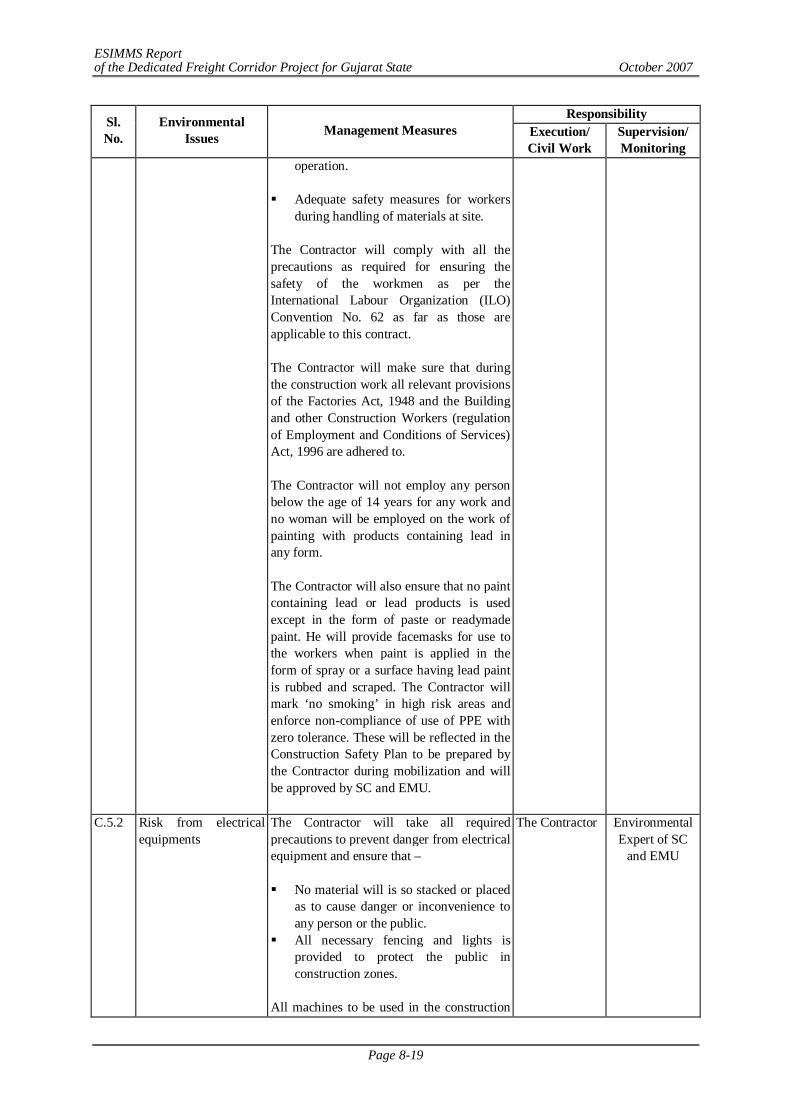
ESIMMS Report of the Dedicated Freight Corridor Project for Gujarat State October 2007
Page 8-19
Responsibility Sl. No.
Environmental Issues Management Measures Execution/
Civil Work Supervision/ Monitoring
operation. Adequate safety measures for workers
during handling of materials at site. The Contractor will comply with all the precautions as required for ensuring the safety of the workmen as per the International Labour Organization (ILO) Convention No. 62 as far as those are applicable to this contract. The Contractor will make sure that during the construction work all relevant provisions of the Factories Act, 1948 and the Building and other Construction Workers (regulation of Employment and Conditions of Services) Act, 1996 are adhered to. The Contractor will not employ any person below the age of 14 years for any work and no woman will be employed on the work of painting with products containing lead in any form. The Contractor will also ensure that no paint containing lead or lead products is used except in the form of paste or readymade paint. He will provide facemasks for use to the workers when paint is applied in the form of spray or a surface having lead paint is rubbed and scraped. The Contractor will mark ‘no smoking’ in high risk areas and enforce non-compliance of use of PPE with zero tolerance. These will be reflected in the Construction Safety Plan to be prepared by the Contractor during mobilization and will be approved by SC and EMU.
C.5.2 Risk from electrical equipments
The Contractor will take all required precautions to prevent danger from electrical equipment and ensure that – No material will is so stacked or placed
as to cause danger or inconvenience to any person or the public.
All necessary fencing and lights is provided to protect the public in construction zones.
All machines to be used in the construction
The Contractor Environmental Expert of SC
and EMU
ESIMMS Report of the Dedicated Freight Corridor Project for Gujarat State October 2007
Page 8-20
Responsibility Sl. No.
Environmental Issues Management Measures Execution/
Civil Work Supervision/ Monitoring
will conform to the relevant Indian Standards (IS) codes, are free from patent defect, are kept in good working order, regularly inspected and properly maintained as per IS provision and to the satisfaction of the Environmental Expert.
C.5.3 First aid The Contractor will arrange for – A readily available first aid unit
including adequate supply of sterilized dressing materials and appliances as per the Factories Rules in every work zone
Availability of suitable transport at all
times to take injured or sick person(s) to the nearest hospital
Equipment and trained nursing staff at
construction camp.
The Contractor Environmental Expert of SC
and EMU
C.6 Labour Camp Management C.6.1 Accommodation The Contractor will follow all relevant
provisions of the Factories Act, 1948 and the Building and the other Construction Workers (Regulation of Employment and Conditions of Service) Act, 1996 for construction and maintenance of labour camp.
The Contractor Environmental Expert of SC
and EMU
C.6.2 Potable water The Contractor will also guarantee the following: a) Supply of sufficient quantity of potable
water (as per IS) in every workplace/labour camp at suitable and easily accessible places and regular maintenance of such facilities.
b) If any water storage tank is provided, the bottom of the tank will be kept at least 1mt. from the surrounding ground level.
c) If water is drawn from any existing well, which is within 30mt. proximity of any toilet, drain or other source of pollution, the well will be disinfected before water is used for drinking.
d) All such wells will be entirely covered and provided with a trap door, which will be dust proof and waterproof.
e) A reliable pump will be fitted to each covered well. The trap door will be kept
The Contractor Environmental Expert of SC
and EMU
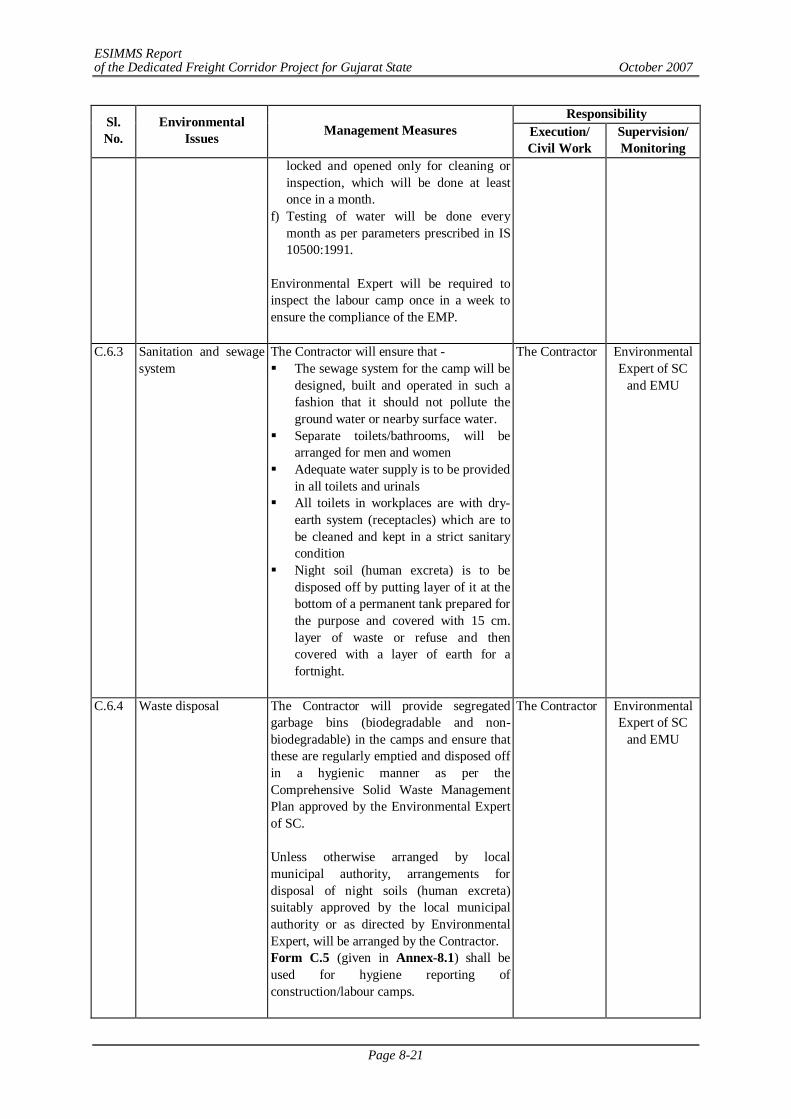
ESIMMS Report of the Dedicated Freight Corridor Project for Gujarat State October 2007
Page 8-21
Responsibility Sl. No.
Environmental Issues Management Measures Execution/
Civil Work Supervision/ Monitoring
locked and opened only for cleaning or inspection, which will be done at least once in a month.
f) Testing of water will be done every month as per parameters prescribed in IS 10500:1991.
Environmental Expert will be required to inspect the labour camp once in a week to ensure the compliance of the EMP.
C.6.3 Sanitation and sewage system
The Contractor will ensure that - The sewage system for the camp will be
designed, built and operated in such a fashion that it should not pollute the ground water or nearby surface water.
Separate toilets/bathrooms, will be arranged for men and women
Adequate water supply is to be provided in all toilets and urinals
All toilets in workplaces are with dry-earth system (receptacles) which are to be cleaned and kept in a strict sanitary condition
Night soil (human excreta) is to be disposed off by putting layer of it at the bottom of a permanent tank prepared for the purpose and covered with 15 cm. layer of waste or refuse and then covered with a layer of earth for a fortnight.
The Contractor Environmental Expert of SC
and EMU
C.6.4 Waste disposal The Contractor will provide segregated garbage bins (biodegradable and non- biodegradable) in the camps and ensure that these are regularly emptied and disposed off in a hygienic manner as per the Comprehensive Solid Waste Management Plan approved by the Environmental Expert of SC. Unless otherwise arranged by local municipal authority, arrangements for disposal of night soils (human excreta) suitably approved by the local municipal authority or as directed by Environmental Expert, will be arranged by the Contractor. Form C.5 (given in Annex-8.1) shall be used for hygiene reporting of construction/labour camps.
The Contractor Environmental Expert of SC
and EMU
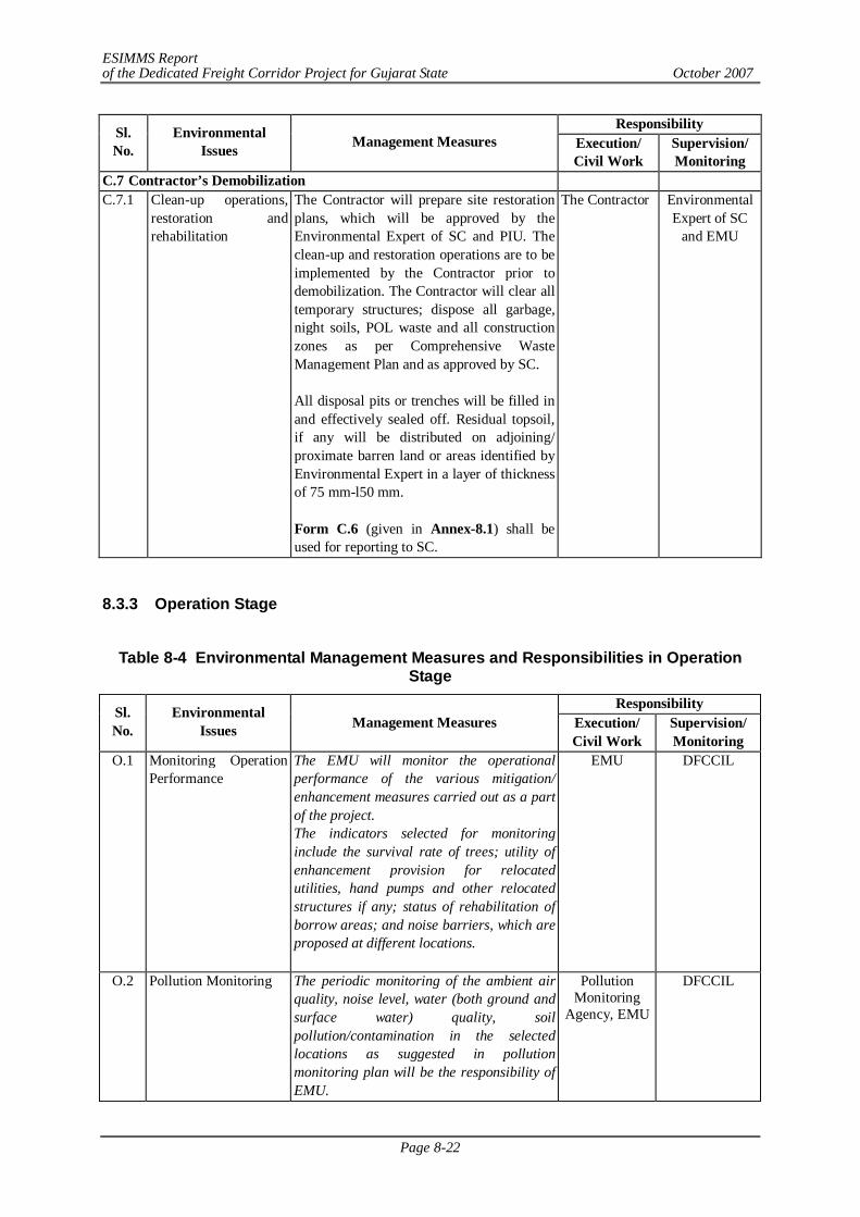
ESIMMS Report of the Dedicated Freight Corridor Project for Gujarat State October 2007
Page 8-22
Responsibility Sl. No.
Environmental Issues Management Measures Execution/
Civil Work Supervision/ Monitoring
C.7 Contractor’s Demobilization C.7.1 Clean-up operations,
restoration and rehabilitation
The Contractor will prepare site restoration plans, which will be approved by the Environmental Expert of SC and PIU. The clean-up and restoration operations are to be implemented by the Contractor prior to demobilization. The Contractor will clear all temporary structures; dispose all garbage, night soils, POL waste and all construction zones as per Comprehensive Waste Management Plan and as approved by SC. All disposal pits or trenches will be filled in and effectively sealed off. Residual topsoil, if any will be distributed on adjoining/ proximate barren land or areas identified by Environmental Expert in a layer of thickness of 75 mm-l50 mm. Form C.6 (given in Annex-8.1) shall be used for reporting to SC.
The Contractor Environmental Expert of SC
and EMU
8.3.3 Operation Stage
Table 8-4 Environmental Management Measures and Responsibilities in Operation
Stage Responsibility Sl.
No. Environmental
Issues Management Measures Execution/ Civil Work
Supervision/ Monitoring
O.1 Monitoring Operation Performance
The EMU will monitor the operational performance of the various mitigation/ enhancement measures carried out as a part of the project. The indicators selected for monitoring include the survival rate of trees; utility of enhancement provision for relocated utilities, hand pumps and other relocated structures if any; status of rehabilitation of borrow areas; and noise barriers, which are proposed at different locations.
EMU DFCCIL
O.2 Pollution Monitoring The periodic monitoring of the ambient air quality, noise level, water (both ground and surface water) quality, soil pollution/contamination in the selected locations as suggested in pollution monitoring plan will be the responsibility of EMU.
Pollution Monitoring
Agency, EMU
DFCCIL
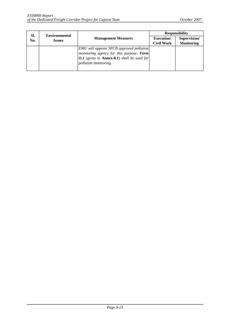
ESIMMS Report of the Dedicated Freight Corridor Project for Gujarat State October 2007
Page 8-23
Responsibility Sl. No.
Environmental Issues Management Measures Execution/
Civil Work Supervision/ Monitoring
EMU will appoint SPCB approved pollution monitoring agency for this purpose. Form O.1 (given in Annex-8.1) shall be used for pollution monitoring.
ESIMMS Report of the Dedicated Freight Corridor Project for Gujarat State October 2007
Page 9-1
CHAPTER 9 RESETTLEMENT AND REHABILITATION PLAN
Resettlement and Rehabilitation Policy including "RRP Frame Work" is under consideration with Government of India and will be disclosed as a separate process.
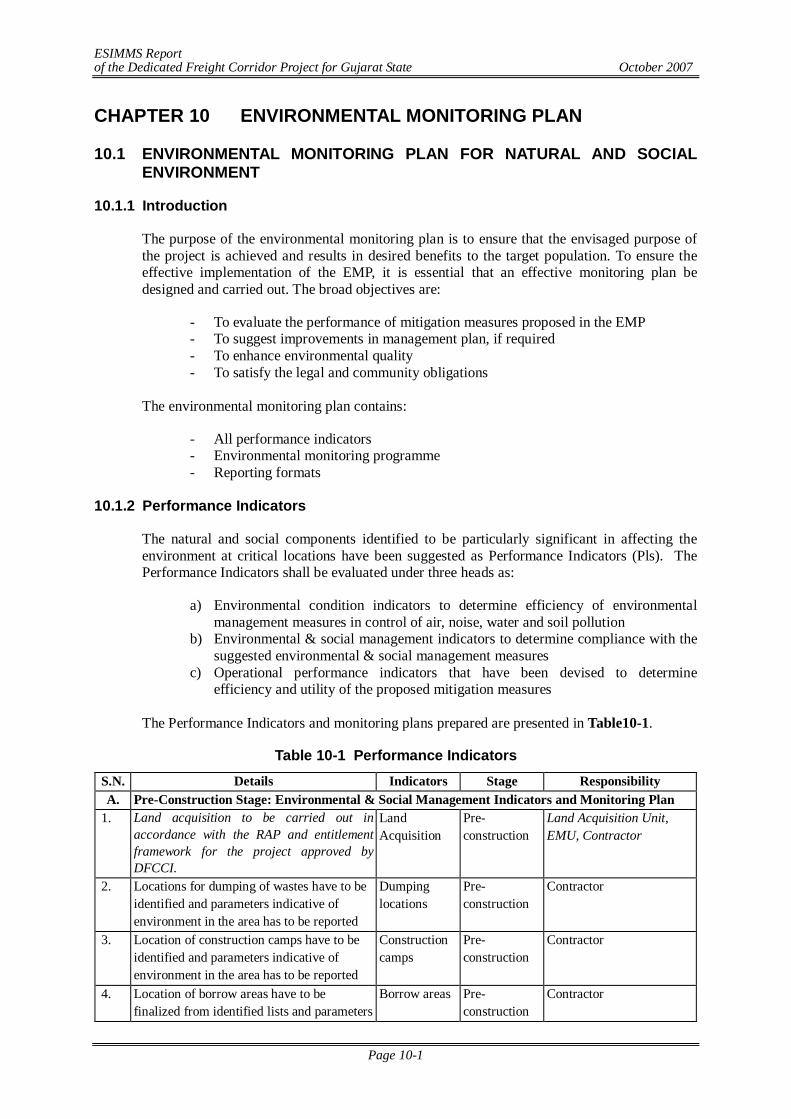
ESIMMS Report of the Dedicated Freight Corridor Project for Gujarat State October 2007
Page 10-1
CHAPTER 10 ENVIRONMENTAL MONITORING PLAN
10.1 ENVIRONMENTAL MONITORING PLAN FOR NATURAL AND SOCIAL ENVIRONMENT
10.1.1 Introduction
The purpose of the environmental monitoring plan is to ensure that the envisaged purpose of the project is achieved and results in desired benefits to the target population. To ensure the effective implementation of the EMP, it is essential that an effective monitoring plan be designed and carried out. The broad objectives are:
- To evaluate the performance of mitigation measures proposed in the EMP - To suggest improvements in management plan, if required - To enhance environmental quality - To satisfy the legal and community obligations
The environmental monitoring plan contains:
- All performance indicators - Environmental monitoring programme - Reporting formats
10.1.2 Performance Indicators
The natural and social components identified to be particularly significant in affecting the environment at critical locations have been suggested as Performance Indicators (Pls). The Performance Indicators shall be evaluated under three heads as:
a) Environmental condition indicators to determine efficiency of environmental management measures in control of air, noise, water and soil pollution
b) Environmental & social management indicators to determine compliance with the suggested environmental & social management measures
c) Operational performance indicators that have been devised to determine efficiency and utility of the proposed mitigation measures
The Performance Indicators and monitoring plans prepared are presented in Table10-1.
Table 10-1 Performance Indicators S.N. Details Indicators Stage Responsibility A. Pre-Construction Stage: Environmental & Social Management Indicators and Monitoring Plan
1. Land acquisition to be carried out in accordance with the RAP and entitlement framework for the project approved by DFCCI.
Land Acquisition
Pre-construction
Land Acquisition Unit, EMU, Contractor
2. Locations for dumping of wastes have to be identified and parameters indicative of environment in the area has to be reported
Dumping locations
Pre-construction
Contractor
3. Location of construction camps have to be identified and parameters indicative of environment in the area has to be reported
Construction camps
Pre-construction
Contractor
4. Location of borrow areas have to be finalized from identified lists and parameters
Borrow areas Pre-construction
Contractor
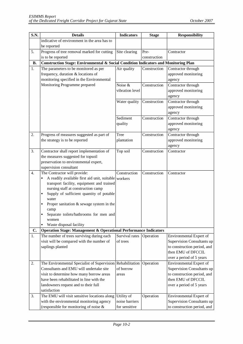
ESIMMS Report of the Dedicated Freight Corridor Project for Gujarat State October 2007
Page 10-2
S.N. Details Indicators Stage Responsibility indicative of environment in the area has to be reported
5. Progress of tree removal marked for cutting is to be reported
Site clearing
Pre-construction
Contractor
B. Construction Stage: Environmental & Social Condition Indicators and Monitoring Plan Air quality Construction Contractor through
approved monitoring agency
Noise & vibration level
Construction Contractor through approved monitoring agency
Water quality Construction Contractor through approved monitoring agency
1. The parameters to be monitored as per frequency, duration & locations of monitoring specified in the Environmental Monitoring Programme prepared
Sediment quality
Construction Contractor through approved monitoring agency
2. Progress of measures suggested as part of the strategy is to be reported
Tree plantation
Construction Contractor through approved monitoring agency
3. Contractor shall report implementation of the measures suggested for topsoil preservation to environmental expert, supervision consultant
Top soil Construction Contractor
4. The Contractor will provide: A readily available first aid unit, suitable
transport facility, equipment and trained nursing staff at construction camp
Supply of sufficient quantity of potable water
Proper sanitation & sewage system in the camp
Separate toilets/bathrooms for men and women
Waste disposal facility
Construction workers
Construction Contractor
C. Operation Stage: Management & Operational Performance Indicators 1. The number of trees surviving during each
visit will be compared with the number of saplings planted
Survival rates of trees
Operation Environmental Expert of Supervision Consultants up to construction period, and then EMU of DFCCIL over a period of 5 years
2. The Environmental Specialist of Supervision Consultants and EMU will undertake site visit to determine how many borrow areas have been rehabilitated in line with the landowners request and to their full satisfaction
Rehabilitation of borrow areas
Operation Environmental Expert of Supervision Consultants up to construction period, and then EMU of DFCCIL over a period of 5 years
3. The EMU will visit sensitive locations along with the environmental monitoring agency (responsible for monitoring of noise &
Utility of noise barriers for sensitive
Operation Environmental Expert of Supervision Consultants up to construction period, and
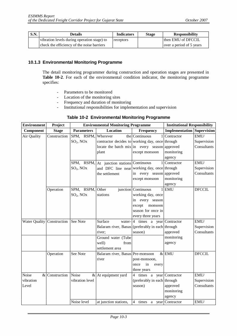
ESIMMS Report of the Dedicated Freight Corridor Project for Gujarat State October 2007
Page 10-3
S.N. Details Indicators Stage Responsibility vibration levels during operation stage) to check the efficiency of the noise barriers
receptors then EMU of DFCCIL over a period of 5 years
10.1.3 Environmental Monitoring Programme
The detail monitoring programmer during construction and operation stages are presented in Table 10-2. For each of the environmental condition indicator, the monitoring programme specifies:
- Parameters to be monitored - Location of the monitoring sites - Frequency and duration of monitoring - Institutional responsibilities for implementation and supervision
Table 10-2 Environmental Monitoring Programme
Environment Project Environmental Monitoring Programme Institutional Responsibility Component Stage Parameters Location Frequency Implementation Supervision
SPM, RSPM, SO2, NOx
Wherever the contractor decides to locate the batch mix plant
Continuous 1 working day, once in every season except monsoon
Contractor through approved monitoring agency
EMU/ Supervision Consultants
Construction
SPM, RSPM, SO2, NOx
At junction stations and DFC line near the settlement
Continuous 1 working day, once in every season except monsoon
Contractor through approved monitoring agency
EMU/ Supervision Consultants
Air Quality
Operation SPM, RSPM, SO2, NOx
Other junction stations
Continuous 1 working day, once in every season except monsoon season for once in every three years
EMU DFCCIL
Water Quality Construction See Note Surface water- Balaram river, Banas river;
4 times a year (preferably in each season)
Ground water (Tube well) from settlement area
Contractor through approved monitoring agency
EMU/ Supervision Consultants
Operation See Note Balaram river, Banas river
Pre-monsoon & post-monsoon, once in every three years
EMU DFCCIL
Noise & vibration level
At equipment yard 4 times a year (preferably in each season)
Contractor through approved monitoring agency
EMU/ Supervision Consultants
Noise & vibration Level
Construction
Noise level at junction stations, 4 times a year Contractor EMU/
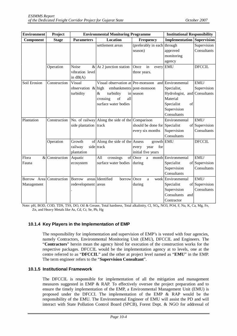
ESIMMS Report of the Dedicated Freight Corridor Project for Gujarat State October 2007
Page 10-4
Environment Project Environmental Monitoring Programme Institutional Responsibility Component Stage Parameters Location Frequency Implementation Supervision
settlement areas (preferably in each season)
through approved monitoring agency
Supervision Consultants
Operation Noise & vibration level in dB(A)
At 2 junction station Once in every three years.
EMU DFCCIL
Soil Erosion Construction Visual observation & turbidity
Visual observation at high embankments & turbidity in crossing of all surface water bodies
Pre-monsoon and post-monsoon season
Environmental Specialist, Hydrologist, and Material Specialist of Supervision Consultants
EMU/ Supervision Consultants
Construction No. of railway side plantation
Along the side of the track
Comparison should be done for every six months
Environmental Specialist of Supervision Consultants
EMU/ Supervision Consultants
Plantation
Operation Growth of railway side plantation
Along the side of the track
Assess growth every year for initial five years
EMU DFCCIL
Flora & Fauna
Construction Aquatic ecosystem
All crossings of surface water bodies
Once a month during
Environmental Specialist of Supervision Consultants
EMU/ Supervision Consultants
Borrow Area Management
Construction Borrow areas redevelopment.
Identified borrow areas
Once a week during
Environmental Specialist of Supervision Consultants and Contractor
EMU/ Supervision Consultants
Note: pH, BOD, COD, TDS, TSS, DO, Oil & Grease, Total hardness, Total alkalinity, Cl, SO4, NO3, PO4, F, Na, K, Ca, Mg, Fe, Zn, and Heavy Metals like As, Cd, Cr, Se, Pb, Hg
10.1.4 Key Players in the Implementation of EMP
The responsibility for implementation and supervision of EMP’s is vested with four agencies, namely Contractors, Environmental Monitoring Unit (EMU), DFCCIL and Engineers. The “Contractors” herein mean the agency hired for execution of the construction works for the respective packages. DFCCIL would be the implementation agency at to levels, one at the centre referred to as “DFCCIL” and the other at project level named as “EMU” in the EMP. The term engineer refers to the “Supervision Consultant”.
10.1.5 Institutional Framework
The DFCCIL is responsible for implementation of all the mitigation and management measures suggested in EMP & RAP. To effectively oversee the project preparation and to ensure the timely implementation of the EMP, a Environmental Management Unit (EMU) is proposed under the DFCCI. The implementation of the EMP & RAP would be the responsibility of the EMU. The Environmental Engineer of EMU will assist the PD and will interact with State Pollution Control Board (SPCB), Forest Dept. & NGO for addressal of
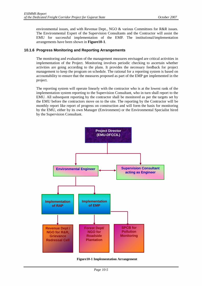
ESIMMS Report of the Dedicated Freight Corridor Project for Gujarat State October 2007
Page 10-5
environmental issues, and with Revenue Dept., NGO & various Committees for R&R issues. The Environmental Expert of the Supervision Consultants and the Contractor will assist the EMU for successful implementation of the EMP. The institutional/implementation arrangements have been shown in Figure10-1.
10.1.6 Progress Monitoring and Reporting Arrangements
The monitoring and evaluation of the management measures envisaged are critical activities in implementation of the Project. Monitoring involves periodic checking to ascertain whether activities are going according to the plans. It provides the necessary feedback for project management to keep the program on schedule. The rational for a reporting system is based on accountability to ensure that the measures proposed as part of the EMP get implemented in the project.
The reporting system will operate linearly with the contractor who is at the lowest rank of the implementation system reporting to the Supervision Consultant, who in turn shall report to the EMU. All subsequent reporting by the contractor shall be monitored as per the targets set by the EMU before the contractors move on to the site. The reporting by the Contractor will be monthly report like report of progress on construction and will form the basis for monitoring by the EMU, either by its own Manager (Environment) or the Environmental Specialist hired by the Supervision Consultant.
Figure10-1 Implementation Arrangement
Project Director (EMU-DFCCIL)
Environmental Engineer
Implementation
of RAP
Supervision Consultant acting as Engineer
Implementation
of EMP
Revenue Dept / NGO for R&R,
Grievance Redressal Cell
Forest Dept/ NGO for
Roadside Plantation
SPCB for Pollution
Monitoring
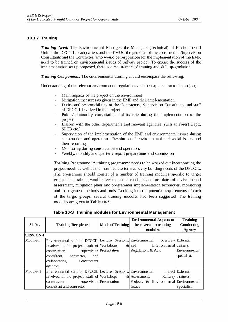
ESIMMS Report of the Dedicated Freight Corridor Project for Gujarat State October 2007
Page 10-6
10.1.7 Training
Training Need: The Environmental Manager, the Managers (Technical) of Environmental Unit at the DFCCIL headquarters and the EMUs, the personal of the construction Supervision Consultants and the Contractor, who would be responsible for the implementation of the EMP, need to be trained on environmental issues of railway project. To ensure the success of the implementation set up proposed, there is a requirement of training and skill up-gradation.
Training Components: The environmental training should encompass the following:
Understanding of the relevant environmental regulations and their application to the project;
- Main impacts of the project on the environment - Mitigation measures as given in the EMP and their implementation - Duties and responsibilities of the Contractors, Supervision Consultants and staff
of DFCCIL involved in the project - Public/community consultation and its role during the implementation of the
project - Liaison with the other departments and relevant agencies (such as Forest Deptt,
SPCB etc.) - Supervision of the implementation of the EMP and environmental issues during
construction and operation. Resolution of environmental and social issues and their reporting
- Monitoring during construction and operation; - Weekly, monthly and quarterly report preparations and submission
Training Programme: A training programme needs to be worked out incorporating the project needs as well as the intermediate-term capacity building needs of the DFCCIL. The programme should consist of a number of training modules specific to target groups. The training would cover the basic principles and postulates of environmental assessment, mitigation plans and programmes implementation techniques, monitoring and management methods and tools. Looking into the potential requirements of each of the target groups, several training modules had been suggested. The training modules are given in Table 10-3.
Table 10-3 Training modules for Environmental Management
Sl. No. Training Recipients Mode of Training Environmental Aspects to
be covered in training modules
Training Conducting
Agency SESSION-I Module-I Environmental staff of DFCCIL
involved in the project, staff of construction supervision consultant, contractor, and collaborating Government agencies
Lecture Sessions, Workshops & Presentation
Environmental overview and Environmental Regulations & Acts
External trainers, Environmental specialist,
Module-II Environmental staff of DFCCIL involved in the project, staff of construction supervision consultant and contractor
Lecture Sessions, Workshops & Presentation
Environmental Impact Assessment: Railway Projects & Environmental Issues
External Trainers; Environmental Specialist,
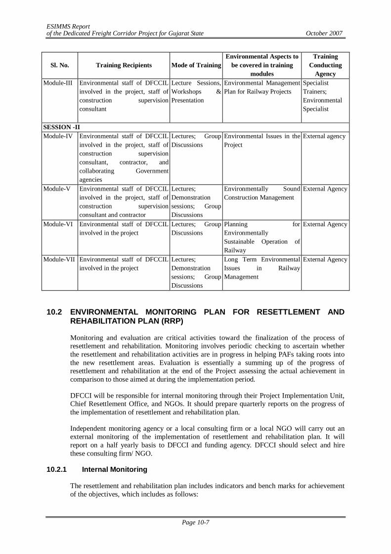
ESIMMS Report of the Dedicated Freight Corridor Project for Gujarat State October 2007
Page 10-7
Sl. No. Training Recipients Mode of Training Environmental Aspects to
be covered in training modules
Training Conducting
Agency Module-III Environmental staff of DFCCIL
involved in the project, staff of construction supervision consultant
Lecture Sessions, Workshops & Presentation
Environmental Management Plan for Railway Projects
Specialist Trainers; Environmental Specialist
SESSION -II Module-IV Environmental staff of DFCCIL
involved in the project, staff of construction supervision consultant, contractor, and collaborating Government agencies
Lectures; Group Discussions
Environmental Issues in the Project
External agency
Module-V Environmental staff of DFCCIL involved in the project, staff of construction supervision consultant and contractor
Lectures; Demonstration sessions; Group Discussions
Environmentally Sound Construction Management
External Agency
Module-VI Environmental staff of DFCCIL involved in the project
Lectures; Group Discussions
Planning for Environmentally Sustainable Operation of Railway
External Agency
Module-VII Environmental staff of DFCCIL involved in the project
Lectures; Demonstration sessions; Group Discussions
Long Term Environmental Issues in Railway Management
External Agency
10.2 ENVIRONMENTAL MONITORING PLAN FOR RESETTLEMENT AND
REHABILITATION PLAN (RRP)
Monitoring and evaluation are critical activities toward the finalization of the process of resettlement and rehabilitation. Monitoring involves periodic checking to ascertain whether the resettlement and rehabilitation activities are in progress in helping PAFs taking roots into the new resettlement areas. Evaluation is essentially a summing up of the progress of resettlement and rehabilitation at the end of the Project assessing the actual achievement in comparison to those aimed at during the implementation period.
DFCCI will be responsible for internal monitoring through their Project Implementation Unit, Chief Resettlement Office, and NGOs. It should prepare quarterly reports on the progress of the implementation of resettlement and rehabilitation plan.
Independent monitoring agency or a local consulting firm or a local NGO will carry out an external monitoring of the implementation of resettlement and rehabilitation plan. It will report on a half yearly basis to DFCCI and funding agency. DFCCI should select and hire these consulting firm/ NGO.
10.2.1 Internal Monitoring
The resettlement and rehabilitation plan includes indicators and bench marks for achievement of the objectives, which includes as follows:
ESIMMS Report of the Dedicated Freight Corridor Project for Gujarat State October 2007
Page 10-8
Process Indicators
Process of the resettlement and rehabilitation which includes project inputs, expenditures, staff deployments, etc will be monitored by DFCCI and its project office. DFCCI should collect the information from the project site and assimilate in the form of quarterly progress report to assess the progress and results of the implementation of resettlement and rehabilitation plan. In case there was a delay or any obstacles on the implementation works, adjust the work programme. The following is major items of monitoring for process indicators;
- Information campaign and consultation with PAFs; - Status of land acquisition and payments on land compensation; - Resettlement of PAFs;
Output Indicators
Output indicators are as follows:
- The results in terms of numbers of affected persons compensated and resettle; and - Incomes restored; and - Additional assistance provides
Impact Assessment Indicators
Impact indicators are the factors related to the long-term effect of the project not only on PAFs but also on those people in the project affected area as a whole. Field level monitoring will be carried out as follows:
- Review of census information for all PAFs; - Consultation and informal interviews with PAFs on the up-to-date feeling of them
on their life in the resettlement areas; - In-depth case studies if there were any particular case worth paying special
attention; - Informal sample survey of PAFs; - Key informant interviews and - Holding a number of community meetings at the resettlement site as well as the
site directly affected by the Project. 10.2.2 External Monitoring
External monitoring consultants/NGO will be hired for the monitoring works. They should identify and select impact indicators, impact assessment through formal and informal surveys with the PAFs, consultation with local government officials and community leaders, assess efficiency of the process of rehabilitation procedures in terms of effectiveness, sustainability of the lives of PAFs, draw attentions for the lessons learned during the period since resettlement and rehabilitation activities commenced and formulate the future rehabilitation policy and planning method.
Major items of monitoring would be as follows:
- Review and verification of the internal monitoring reports prepared by Project Implementation Unit and the field offices;
- Review of the socio-economic baseline census information of the PAFs; - Socio-economic conditions of the PAFs in the post-resettlement period;
ESIMMS Report of the Dedicated Freight Corridor Project for Gujarat State October 2007
Page 10-9
- Opinions of the PAFs on the entitlements, compensations, general assistance, alternative development programmes to livelihood restoration programmes and their timetable;
- Actual changes of the conditions of housing and income levels of the post-resettlement period;
- Livelihood rehabilitation of non-title settlers; and - Grievance procedures.
After the project implementation, NGOs assisting chief resettlement officer will conduct information and community consultation programme (ICCP) in the project area in respect of resettlement and rehabilitation plan. It is a part of social environment monitoring plan of the resettlement and rehabilitation of PAFs. The following is the tasks of NGOs:
a) Assist chief resettlement officer in implementation of resettlement and rehabilitation plan including mitigation measures for avoiding adverse effects imposed on PAFs by the Project;
b) Prepare information materials in local language explaining resettlement and rehabilitation plan such as project brochures and pamphlets to be used for disclosure of information regarding the project objectives, entitlement, compensation principles and procedures, and implementation schedules;
c) Advise and assist chief resettlement office in the provisions of implementation of resettlement and rehabilitation plan concerning livelihood and income restoration programmes;
d) Work in close cooperation with relevant state and central government departments and district administration involved in the valuation of assets acquired and payment of compensation;
e) Educate the PAFs on their right to entitlements and obligations;
f) Ensure that the PAFs are paid their full entitlements due to them;
g) Facilitate and organize training programmes and provide support and gather information to PAFs for income restoration programme;
h) Assist the PAFs in redressing of their grievances through the grievance redress mechanism set up for the Project;
i) Disseminate information for all the PAFs about the functional aspects of the various district level committees set up for the Project and assist the PAFs in benefiting from such institutional mechanism;
j) Assist the Project Implementation Unit of DFCCI in ensuring social responsibilities of the Project, such as compliance with the labour laws, safety regulations, prohibition of child labour, HIV/AIDS and gender issues; and Participate in monitoring system and prepare progress reports
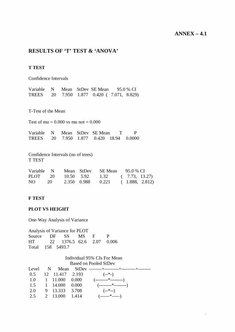
.
ANNEX – 4.1
RESULTS OF ‘T’ TEST & ‘ANOVA’ T TEST Confidence Intervals Variable N Mean StDev SE Mean 95.0 % CI TREES 20 7.950 1.877 0.420 ( 7.071, 8.829) T-Test of the Mean Test of mu = 0.000 vs mu not = 0.000 Variable N Mean StDev SE Mean T P TREES 20 7.950 1.877 0.420 18.94 0.0000 Confidence Intervals (no of trees) T TEST Variable N Mean StDev SE Mean 95.0 % CI PLOT 20 10.50 5.92 1.32 ( 7.73, 13.27) NO 20 2.350 0.988 0.221 ( 1.888, 2.812) F TEST PLOT VS HEIGHT One-Way Analysis of Variance Analysis of Variance for PLOT Source DF SS MS F P HT 22 1376.5 62.6 2.07 0.006 Total 158 5493.7
Individual 95% CIs For Mean Based on Pooled StDev Level N Mean StDev --------+---------+---------+-------- 0.5 12 11.417 2.193 (--*-) 1.0 1 11.000 0.000 (--------*--------) 1.5 1 14.000 0.000 (--------*--------) 2.0 9 13.333 3.708 (--*--) 2.5 2 13.000 1.414 (------*-----)
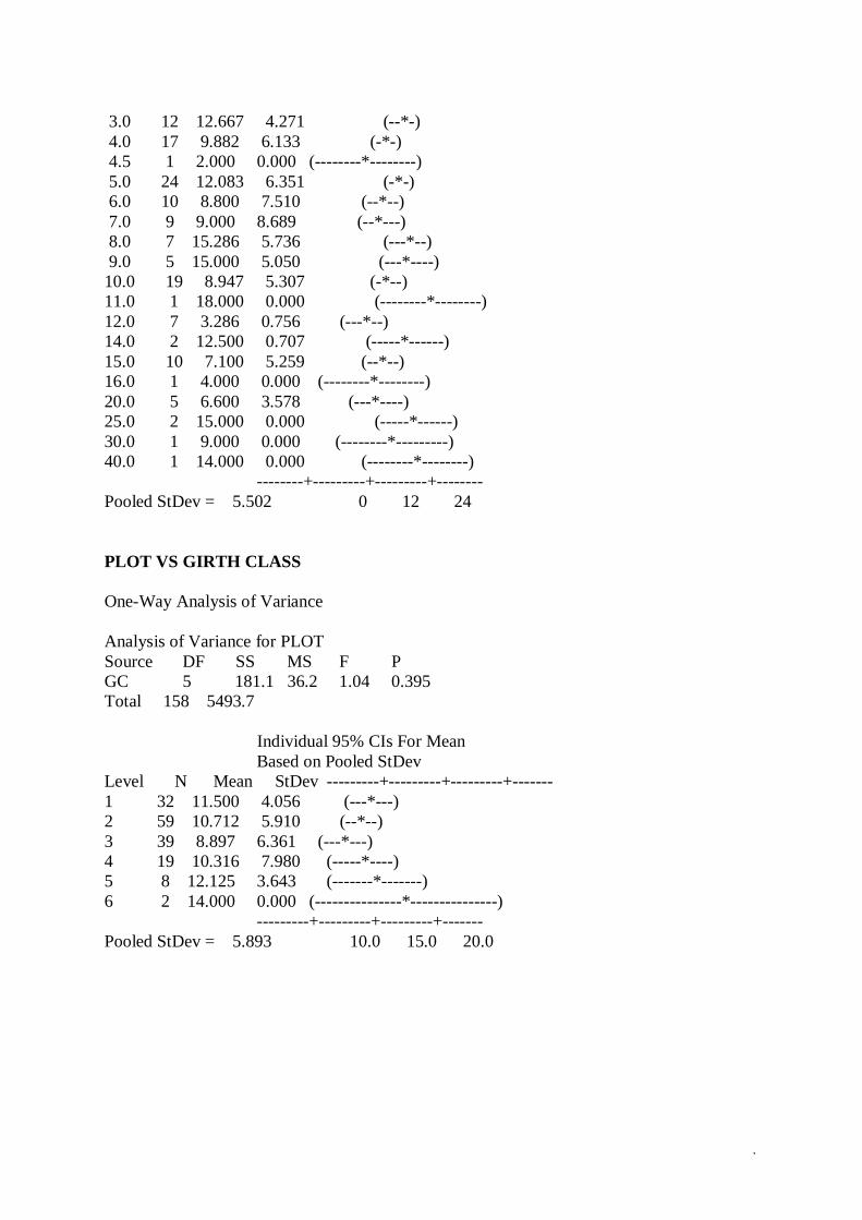
.
3.0 12 12.667 4.271 (--*-) 4.0 17 9.882 6.133 (-*-) 4.5 1 2.000 0.000 (--------*--------) 5.0 24 12.083 6.351 (-*-) 6.0 10 8.800 7.510 (--*--) 7.0 9 9.000 8.689 (--*---) 8.0 7 15.286 5.736 (---*--) 9.0 5 15.000 5.050 (---*----) 10.0 19 8.947 5.307 (-*--) 11.0 1 18.000 0.000 (--------*--------) 12.0 7 3.286 0.756 (---*--) 14.0 2 12.500 0.707 (-----*------) 15.0 10 7.100 5.259 (--*--) 16.0 1 4.000 0.000 (--------*--------) 20.0 5 6.600 3.578 (---*----) 25.0 2 15.000 0.000 (-----*------) 30.0 1 9.000 0.000 (--------*---------) 40.0 1 14.000 0.000 (--------*--------) --------+---------+---------+-------- Pooled StDev = 5.502 0 12 24 PLOT VS GIRTH CLASS One-Way Analysis of Variance Analysis of Variance for PLOT Source DF SS MS F P GC 5 181.1 36.2 1.04 0.395 Total 158 5493.7 Individual 95% CIs For Mean Based on Pooled StDev Level N Mean StDev ---------+---------+---------+------- 1 32 11.500 4.056 (---*---) 2 59 10.712 5.910 (--*--) 3 39 8.897 6.361 (---*---) 4 19 10.316 7.980 (-----*----) 5 8 12.125 3.643 (-------*-------) 6 2 14.000 0.000 (---------------*---------------) ---------+---------+---------+------- Pooled StDev = 5.893 10.0 15.0 20.0
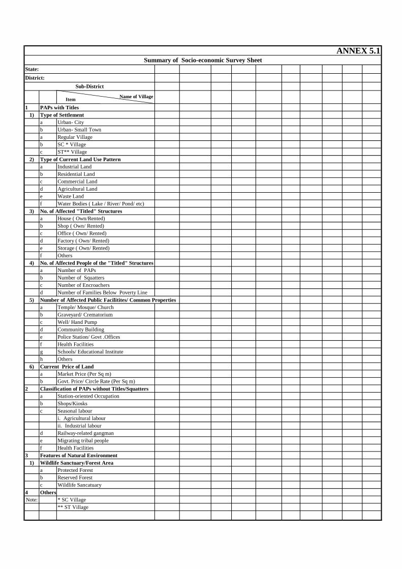
1 PAPs with Titles1) Type of Settlement
a Urban- Cityb Urban- Small Towna Regular Villageb SC * Villagec ST** Village
2) Type of Current Land Use Pattern a Industrial Landb Residential Landc Commercial Landd Agricultural Lande Waste Landf Water Bodies ( Lake / River/ Pond/ etc)
3) No. of Affected "Titled" Structuresa House ( Own/Rented)b Shop ( Own/ Rented)c Office ( Own/ Rented)d Factory ( Own/ Rented)e Storage ( Own/ Rented)f Others
4) No. of Affected People of the "Titled" Structuresa Number of PAPsb Number of Squattersc Number of Encroachers d Number of Families Below Poverty Line
5) Number of Affected Public Facilitites/ Common Propertiesa Temple/ Mosque/ Church b Graveyard/ Crematoriumc Well/ Hand Pumpd Community Buildinge Police Station/ Govt .Officesf Health Facilities g Schools/ Educational Instituteh Others
6) Current Price of Landa Market Price (Per Sq m)b Govt. Price/ Circle Rate (Per Sq m)
2 Classification of PAPs without Titles/Squattersa Station-oriented Occupationb Shops/Kiosksc Seasonal labour
i. Agricultural labourii. Industrial labour
d Railway-related gangmane Migrating tribal peoplef Health Facilities
3 Features of Natural Environment1) Wildlife Sanctuary/Forest Area a Protected Forest b Reserved Forest c Wildlife Sancatuary
4 OthersNote: * SC Village
** ST Village
ANNEX 5.1 Summary of Socio-economic Survey Sheet
State:District:
Sub-District
Name of Village Item
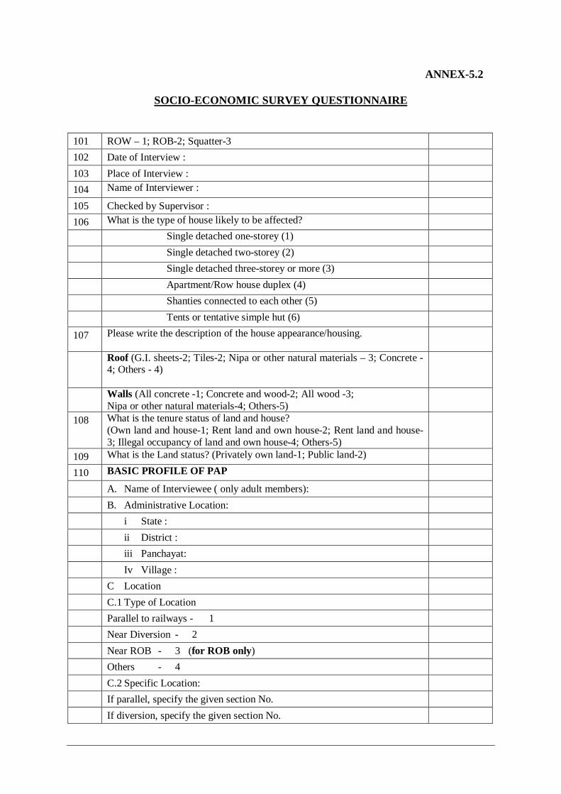
ANNEX-5.2
SOCIO-ECONOMIC SURVEY QUESTIONNAIRE
101 ROW – 1; ROB-2; Squatter-3 102 Date of Interview : 103 Place of Interview : 104 Name of Interviewer : 105 Checked by Supervisor : 106 What is the type of house likely to be affected? Single detached one-storey (1) Single detached two-storey (2) Single detached three-storey or more (3) Apartment/Row house duplex (4) Shanties connected to each other (5) Tents or tentative simple hut (6) 107 Please write the description of the house appearance/housing.
Roof (G.I. sheets-2; Tiles-2; Nipa or other natural materials – 3; Concrete -4; Others - 4)
Walls (All concrete -1; Concrete and wood-2; All wood -3; Nipa or other natural materials-4; Others-5)
108 What is the tenure status of land and house? (Own land and house-1; Rent land and own house-2; Rent land and house-3; Illegal occupancy of land and own house-4; Others-5)
109 What is the Land status? (Privately own land-1; Public land-2) 110 BASIC PROFILE OF PAP A. Name of Interviewee ( only adult members): B. Administrative Location: i State : ii District : iii Panchayat: Iv Village : C Location C.1 Type of Location Parallel to railways - 1 Near Diversion - 2 Near ROB - 3 (for ROB only) Others - 4 C.2 Specific Location: If parallel, specify the given section No. If diversion, specify the given section No.
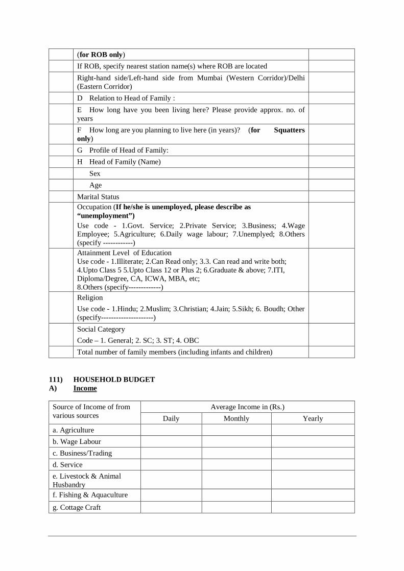
(for ROB only) If ROB, specify nearest station name(s) where ROB are located Right-hand side/Left-hand side from Mumbai (Western Corridor)/Delhi
(Eastern Corridor)
D Relation to Head of Family : E How long have you been living here? Please provide approx. no. of
years
F How long are you planning to live here (in years)? (for Squatters only)
G Profile of Head of Family: H Head of Family (Name) Sex Age Marital Status Occupation (If he/she is unemployed, please describe as
“unemployment”) Use code - 1.Govt. Service; 2.Private Service; 3.Business; 4.Wage Employee; 5.Agriculture; 6.Daily wage labour; 7.Unemplyed; 8.Others (specify ------------)
Attainment Level of Education Use code - 1.Illiterate; 2.Can Read only; 3.3. Can read and write both; 4.Upto Class 5 5.Upto Class 12 or Plus 2; 6.Graduate & above; 7.ITI, Diploma/Degree, CA, ICWA, MBA, etc; 8.Others (specify-------------)
Religion Use code - 1.Hindu; 2.Muslim; 3.Christian; 4.Jain; 5.Sikh; 6. Boudh; Other (specify---------------------)
Social Category Code – 1. General; 2. SC; 3. ST; 4. OBC
Total number of family members (including infants and children) 111) HOUSEHOLD BUDGET A) Income
Average Income in (Rs.) Source of Income of from
various sources Daily Monthly Yearly a. Agriculture b. Wage Labour c. Business/Trading d. Service e. Livestock & Animal Husbandry
f. Fishing & Aquaculture
g. Cottage Craft
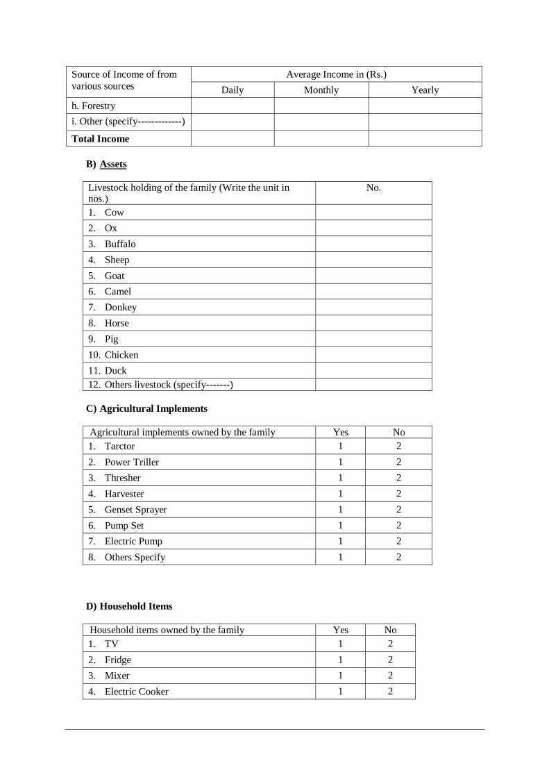
Average Income in (Rs.) Source of Income of from various sources Daily Monthly Yearly h. Forestry i. Other (specify-------------)
Total Income B) Assets Livestock holding of the family (Write the unit in nos.)
No.
1. Cow 2. Ox 3. Buffalo 4. Sheep 5. Goat 6. Camel 7. Donkey 8. Horse 9. Pig 10. Chicken 11. Duck 12. Others livestock (specify-------) C) Agricultural Implements Agricultural implements owned by the family Yes No 1. Tarctor 1 2 2. Power Triller 1 2 3. Thresher 1 2 4. Harvester 1 2 5. Genset Sprayer 1 2 6. Pump Set 1 2 7. Electric Pump 1 2 8. Others Specify 1 2
D) Household Items Household items owned by the family Yes No 1. TV 1 2 2. Fridge 1 2 3. Mixer 1 2 4. Electric Cooker 1 2

5. Geyser 1 2 6. Electric Fan 1 2 7. OTG 1 2 8. Toaster 1 2 9. Microwave 1 2 10. Radio 1 2 11. Others Specify 1 2
E) Other Assets of Family Other assets owned by the family Yes No 1. Scooter/Motorcycle 1 2 2. Jeep/Car 1 2 3. Truck 1 2 4. Bus 1 2 5. Bullock/Camel Cart 1 2 6. Others Specify 1 2
F) Total Annual Saving: ------------------------------ (Rs.)
G) Loan a. Have you taken any loan? 1. Yes, 2. No, 3. Don’t Know b. If yes, then please tell us the following:
Name of the loan provider Amount (in Rs.) Re-paid (in Rs.) Balance (in Rs.) 1. Bank 2. Relative/Friend 3. Mahajan 4. Other (specify -----------)
112 PRODUCTION AND EMPLOYMENT
Land Title Response Own with Title (1)
A-1
Own without Title (2) Tenure Status: If Own with Title, please select one or more:
Borrow at No Charge (1) Rent from Authorities (2) Rent from Individuals (3)
A-2
Other Status (4)
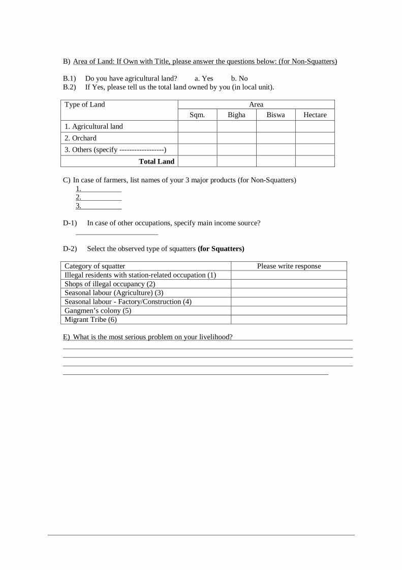
B) Area of Land: If Own with Title, please answer the questions below: (for Non-Squatters) B.1) Do you have agricultural land? a. Yes b. No B.2) If Yes, please tell us the total land owned by you (in local unit).
Area Type of Land Sqm. Bigha Biswa Hectare
1. Agricultural land
2. Orchard
3. Others (specify ------------------)
Total Land
C) In case of farmers, list names of your 3 major products (for Non-Squatters) 1. 2. 3.
D-1) In case of other occupations, specify main income source?
D-2) Select the observed type of squatters (for Squatters) Category of squatter Please write response Illegal residents with station-related occupation (1) Shops of illegal occupancy (2) Seasonal labour (Agriculture) (3) Seasonal labour - Factory/Construction (4) Gangmen’s colony (5) Migrant Tribe (6) E) What is the most serious problem on your livelihood?
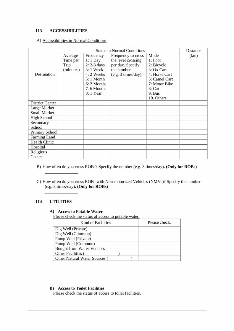
113 ACCESSIBILITIES A) Accessibilities in Normal Conditions
Status in Normal Conditions Distance
Destination
Average Time per Trip (minutes)
Frequency 1: 1 Day 2: 2-3 days 3: 1 Week 4: 2 Weeks 5: 1 Month 6: 2 Months 7. 6 Months 8: 1 Year
Frequency to cross the level crossing per day. Specify the number (e.g. 3 times/day).
Mode 1: Foot 2: Bicycle 3: Ox Cart 4: Horse Cart 5: Camel Cart 7: Motor Bike 8: Car 9. Bus 10. Others
(km)
District Center Large Market Small Market High School Secondary School
Primary School Farming Land Health Clinic Hospital Religious Center
B) How often do you cross ROBs? Specify the number (e.g. 3 times/day). (Only for ROBs)
C) How often do you cross ROBs with Non-motorized Vehicles (NMVs)? Specify the number (e.g. 3 times/day). (Only for ROBs)
114 UTILITIES
A) Access to Potable Water Please check the status of access to potable water.
Kind of Facilities Please check. Dig Well (Private) Dig Well (Common) Pump Well (Private) Pump Well (Common) Bought from Water Vendors Other Facilities ( ) Other Natural Water Sources ( )
B) Access to Toilet Facilities Please check the status of access to toilet facilities.
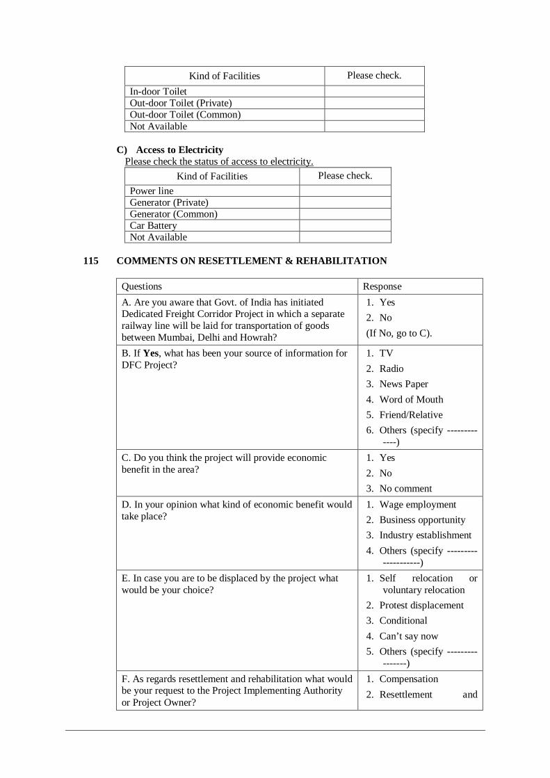
Kind of Facilities Please check. In-door Toilet Out-door Toilet (Private) Out-door Toilet (Common) Not Available
C) Access to Electricity
Please check the status of access to electricity. Kind of Facilities Please check.
Power line Generator (Private) Generator (Common) Car Battery Not Available
115 COMMENTS ON RESETTLEMENT & REHABILITATION
Questions Response A. Are you aware that Govt. of India has initiated Dedicated Freight Corridor Project in which a separate railway line will be laid for transportation of goods between Mumbai, Delhi and Howrah?
1. Yes 2. No (If No, go to C).
B. If Yes, what has been your source of information for DFC Project?
1. TV 2. Radio 3. News Paper 4. Word of Mouth 5. Friend/Relative 6. Others (specify ---------
----) C. Do you think the project will provide economic benefit in the area?
1. Yes 2. No 3. No comment
D. In your opinion what kind of economic benefit would take place?
1. Wage employment 2. Business opportunity 3. Industry establishment 4. Others (specify ---------
-----------) E. In case you are to be displaced by the project what would be your choice?
1. Self relocation or voluntary relocation
2. Protest displacement 3. Conditional 4. Can’t say now 5. Others (specify ---------
-------) F. As regards resettlement and rehabilitation what would be your request to the Project Implementing Authority or Project Owner?
1. Compensation 2. Resettlement and

Rehabilitation 3. Compensation & R&R
both 4. Other (specify ----------
-------)
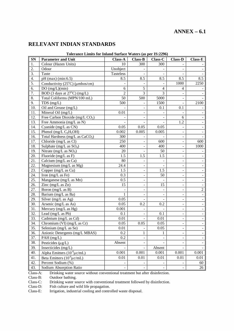
ANNEX – 6.1 RELEVANT INDIAN STANDARDS
Tolerance Limits for Inland Surface Waters (as per IS:2296)
SN Parameter and Unit Class-A Class-B Class-C Class-D Class-E 1. Colour (Hazen Units) 10 300 300 - - 2. Odour Unobject - - - - 3. Taste Tasteless - - - - 4. pH (max) (min:6.5) 8.5 8.5 8.5 8.5 8.5 5. Conductivity (25oC) (mhos/cm) - - - 1000 2250 6. DO (mg/L)(min) 6 5 4 4 - 7. BOD (3 days at 27oC) (mg/L) 2 3 3 - - 8. Total Coliforms (MPN/100 mL) 50 500 5000 - - 9. TDS (mg/L) 500 - 1500 - 2100 10. Oil and Grease (mg/L) - - 0.1 0.1 - 11. Mineral Oil (mg/L) 0.01 - - - - 12. Free Carbon Dioxide (mg/L CO2) - - - 6 - 13. Free Ammonia (mg/L as N) - - - 1.2 - 14. Cyanide (mg/L as CN) 0.05 0.05 0.05 - - 15. Phenol (mg/L C6H5OH) 0.002 0.005 0.005 - - 16. Total Hardness (mg/L as CaCO3) 300 - - - - 17. Chloride (mg/L as Cl) 250 - 600 - 600 18. Sulphate (mg/L as SO4) 400 - 400 - 1000 19. Nitrate (mg/L as NO3) 20 - 50 - - 20. Fluoride (mg/L as F) 1.5 1.5 1.5 - - 21. Calcium (mg/L as Ca) 80 - - - - 22. Magnesium (mg/L as Mg) 24.4 - - - - 23. Copper (mg/L as Cu) 1.5 - 1.5 - - 24. Iron (mg/L as Fe) 0.3 - 50 - - 25. Manganese (mg/L as Mn) 0.5 - - - - 26. Zinc (mg/L as Zn) 15 - 15 - - 27. Boron (mg/L as B) - - - - 2 28. Barium (mg/L as Ba) 1 - - - - 29. Silver (mg/L as Ag) 0.05 - - - - 30. Arsenic (mg/L as As) 0.05 0.2 0.2 - - 31. Mercury (mg/L as Hg) 0.001 - - - - 32. Lead (mg/L as Pb) 0.1 - 0.1 - - 33. Cadmium (mg/L as Cd) 0.01 - 0.01 - - 34. Chromium (VI) (mg/L as Cr) 0.05 0.05 0.05 - - 35. Selenium (mg/L as Se) 0.01 - 0.05 - - 36. Anionic Detergents (mg/L MBAS) 0.2 1 1 - - 37. PAH (mg/L) 0.2 - - - - 38. Pesticides (g/L) Absent - - - - 39. Insecticides (mg/L) - - Absent - - 40. Alpha Emitters (10-6c/mL) 0.001 0.001 0.001 0.001 0.001 41. Beta Emitters (10-6c/mL) 0.01 0.01 0.01 0.01 0.01 42. Percent Sodium (%) - - - - 60 43. Sodium Absorption Ratio - - - - 26
Class-A: Drinking water source without conventional treatment but after disinfection. Class-B: Outdoor bathing. Class-C: Drinking water source with conventional treatment followed by disinfection. Class-D: Fish culture and wild life propagation. Class-E: Irrigation, industrial cooling and controlled waste disposal.
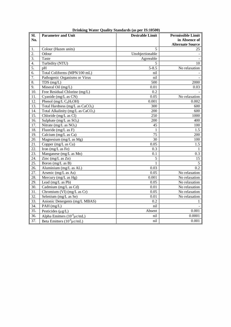
Drinking Water Quality Standards (as per IS:10500) Sl. No.
Parameter and Unit Desirable Limit Permissible Limit in Absence of
Alternate Source 1. Colour (Hazen units) 5 25 2. Odour Unobjectionable - 3. Taste Agreeable - 4. Turbidity (NTU) 5 10 5. pH 5-8.5 No relaxation 6. Total Coliforms (MPN/100 mL) nil - 7. Pathogenic Organisms or Virus nil - 8. TDS (mg/L) 500 2000 9. Mineral Oil (mg/L) 0.01 0.03 10. Free Residual Chlorine (mg/L) 0.2 - 11. Cyanide (mg/L as CN) 0.05 No relaxation 12. Phenol (mg/L C6H5OH) 0.001 0.002 13. Total Hardness (mg/L as CaCO3) 300 600 14. Total Alkalinity (mg/L as CaCO3) 200 600 15. Chloride (mg/L as Cl) 250 1000 16. Sulphate (mg/L as SO4) 200 400 17. Nitrate (mg/L as NO3) 45 100 18. Fluoride (mg/L as F) 1 1.5 19. Calcium (mg/L as Ca) 75 200 20. Magnesium (mg/L as Mg) 30 100 21. Copper (mg/L as Cu) 0.05 1.5 22. Iron (mg/L as Fe) 0.3 1 23. Manganese (mg/L as Mn) 0.1 0.3 24. Zinc (mg/L as Zn) 5 15 25. Boron (mg/L as B) 1 5 26. Aluminium (mg/L as AL) 0.03 0.2 27. Arsenic (mg/L as As) 0.05 No relaxation 28. Mercury (mg/L as Hg) 0.001 No relaxation 29. Lead (mg/L as Pb) 0.05 No relaxation 30. Cadmium (mg/L as Cd) 0.01 No relaxation 31. Chromium (VI) (mg/L as Cr) 0.05 No relaxation 32. Selenium (mg/L as Se) 0.01 No relaxation 33. Anionic Detergents (mg/L MBAS) 0.2 1 34. PAH (mg/L) nil - 35. Pesticides (g/L) Absent 0.001 36. Alpha Emitters (10-6c/mL) nil 0.0001 37. Beta Emitters (10-6c/mL) nil 0.001
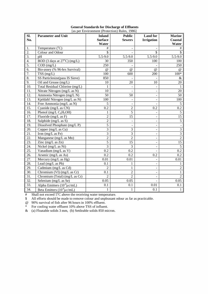
General Standards for Discharge of Effluents [as per Environment (Protection) Rules, 1986]
Sl. No.
Parameter and Unit Inland Surface
Water
Public Sewers
Land for Irrigation
Marine Coastal Water
1. Temperature (oC) # - - # 2. Colour and Odour $ - $ $ 3. pH 5.5-9.0 5.5-9.0 5.5-9.0 5.5-9.0 4. BOD (3 days at 27oC) (mg/L) 30 350 100 100 5. COD (mg/L) 250 - - 250 6. Bio-assey (% 96-hrs Survival) @ @ @ @ 7. TSS (mg/L) 100 600 200 100* 8. SS Particlesize(pass IS Sieve) 850 - - & 9. Oil and Grease (mg/L) 10 20 10 20 10. Total Residual Chlorine (mg/L) 1 - - 1 11. Nitrate Nitrogen (mg/L as N) 10 - - 20 12. Ammonia Nitrogen (mg/L N) 50 50 - 50 13. Kjeldahl Nitrogen (mg/L as N) 100 - - 100 14. Free Ammonia (mg/L as N) 5 - - 5 15. Cyanide (mg/L as CN) 0.2 2 0.2 0.2 16. Phenol (mg/L C6H5OH) 1 5 - 5 17. Fluoride (mg/L as F) 2 15 - 15 18. Sulphide (mg/L as S) 2 - - 5 19. Dissolved Phosphate (mg/L P) 5 - - - 20. Copper (mg/L as Cu) 3 3 - 3 21. Iron (mg/L as Fe) 3 3 - 3 22. Manganese (mg/L as Mn) 2 2 - 2 23. Zinc (mg/L as Zn) 5 15 - 15 24. Nickel (mg/L as Ni) 3 3 - 5 25. Vanadium (mg/L as V) 0.2 0.2 - 0.2 26. Arsenic (mg/L as As) 0.2 0.2 0.2 0.2 27. Mercury (mg/L as Hg) 0.01 0.01 - 0.01 28. Lead (mg/L as Pb) 0.1 1 - 1 29. Cadmium (mg/L as Cd) 2 1 - 2 30. Chromium (VI) (mg/L as Cr) 0.1 2 - 1 31. Chromium (Total) (mg/L as Cr) 2 2 - 2 32. Selenium (mg/L as Se) 0.05 0.05 - 0.05 33. Alpha Emitters (10-6c/mL) 0.1 0.1 0.01 0.1 34. Beta Emitters (10-6c/mL) 1 1 0.1 1
# Shall not exceed 5oC above the receiving water temperature. $ All efforts should be made to remove colour and unpleasant odour as far as practicable. @ 90% survival of fish after 96 hours in 100% effluent. * For cooling water effluent 10% above TSS of influent. & (a) Floatable solids 3 mm, (b) Settleable solids 850 micron.
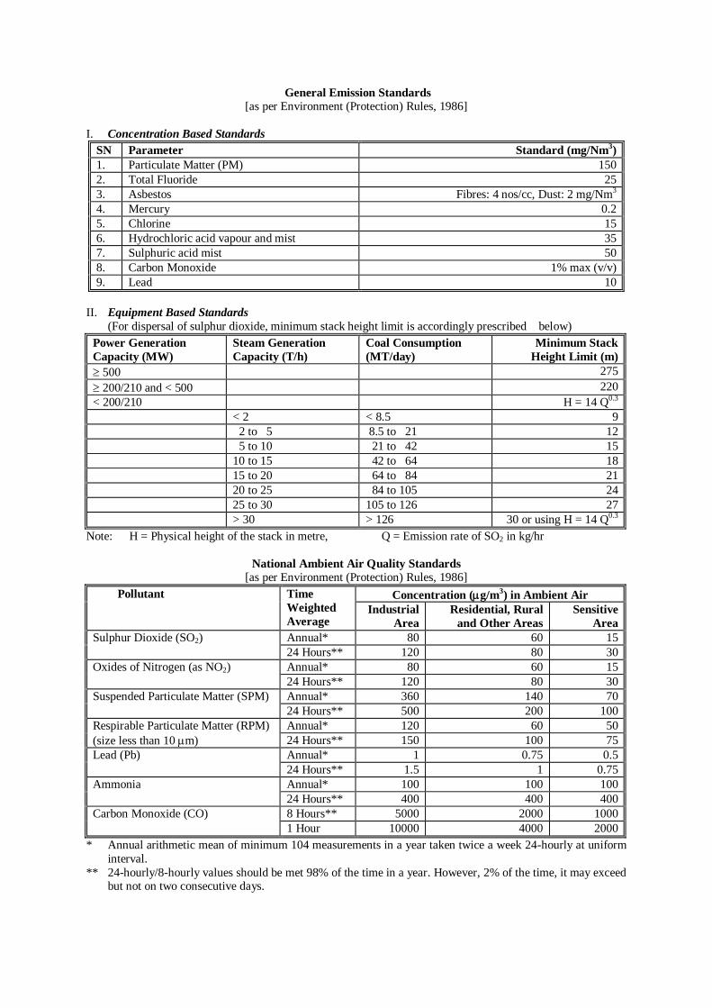
General Emission Standards [as per Environment (Protection) Rules, 1986]
I. Concentration Based Standards
SN Parameter Standard (mg/Nm3) 1. Particulate Matter (PM) 150 2. Total Fluoride 25 3. Asbestos Fibres: 4 nos/cc, Dust: 2 mg/Nm3 4. Mercury 0.2 5. Chlorine 15 6. Hydrochloric acid vapour and mist 35 7. Sulphuric acid mist 50 8. Carbon Monoxide 1% max (v/v) 9. Lead 10
II. Equipment Based Standards
(For dispersal of sulphur dioxide, minimum stack height limit is accordingly prescribed below) Power Generation Capacity (MW)
Steam Generation Capacity (T/h)
Coal Consumption (MT/day)
Minimum Stack Height Limit (m)
500 275 200/210 and < 500 220 < 200/210 H = 14 Q0.3 < 2 < 8.5 9 2 to 5 8.5 to 21 12 5 to 10 21 to 42 15 10 to 15 42 to 64 18 15 to 20 64 to 84 21 20 to 25 84 to 105 24 25 to 30 105 to 126 27 > 30 > 126 30 or using H = 14 Q0.3
Note: H = Physical height of the stack in metre, Q = Emission rate of SO2 in kg/hr
National Ambient Air Quality Standards [as per Environment (Protection) Rules, 1986]
Concentration (g/m3) in Ambient Air Pollutant Time Weighted Average
Industrial Area
Residential, Rural and Other Areas
Sensitive Area
Annual* 80 60 15 Sulphur Dioxide (SO2) 24 Hours** 120 80 30 Annual* 80 60 15 Oxides of Nitrogen (as NO2) 24 Hours** 120 80 30 Annual* 360 140 70 Suspended Particulate Matter (SPM) 24 Hours** 500 200 100 Annual* 120 60 50 Respirable Particulate Matter (RPM)
(size less than 10 m) 24 Hours** 150 100 75 Annual* 1 0.75 0.5 Lead (Pb) 24 Hours** 1.5 1 0.75 Annual* 100 100 100 Ammonia
24 Hours** 400 400 400 8 Hours** 5000 2000 1000 Carbon Monoxide (CO) 1 Hour 10000 4000 2000
* Annual arithmetic mean of minimum 104 measurements in a year taken twice a week 24-hourly at uniform interval.
** 24-hourly/8-hourly values should be met 98% of the time in a year. However, 2% of the time, it may exceed but not on two consecutive days.
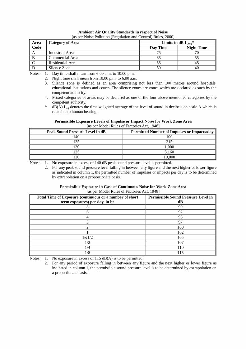
Ambient Air Quality Standards in respect of Noise [as per Noise Pollution (Regulation and Control) Rules, 2000]
Limits in dB LAeq* Area Code
Category of Area Day Time Night Time
A Industrial Area 75 70 B Commercial Area 65 55 C Residential Area 55 45 D Silence Zone 50 40
Notes: 1. Day time shall mean from 6.00 a.m. to 10.00 p.m. 2. Night time shall mean from 10.00 p.m. to 6.00 a.m. 3. Silence zone is defined as an area comprising not less than 100 metres around hospitals,
educational institutions and courts. The silence zones are zones which are declared as such by the competent authority.
4. Mixed categories of areas may be declared as one of the four above mentioned categories by the competent authority.
* dB(A) Leq denotes the time weighted average of the level of sound in decibels on scale A which is relatable to human hearing.
Permissible Exposure Levels of Impulse or Impact Noise for Work Zone Area
[as per Model Rules of Factories Act, 1948] Peak Sound Pressure Level in dB Permitted Number of Impulses or Impacts/day
140 100 135 315 130 1,000 125 3,160 120 10,000
Notes: 1. No exposure in excess of 140 dB peak sound pressure level is permitted. 2. For any peak sound pressure level falling in between any figure and the next higher or lower figure
as indicated in column 1, the permitted number of impulses or impacts per day is to be determined by extrapolation on a proportionate basis.
Permissible Exposure in Case of Continuous Noise for Work Zone Area
[as per Model Rules of Factories Act, 1948] Total Time of Exposure (continuous or a number of short
term exposures) per day, in hr Permissible Sound Pressure Level in
dB 8 90 6 92 4 95 3 97 2 100 1 102
1&1/2 105 1/2 107 1/4 110 1/8 115
Notes: 1. No exposure in excess of 115 dB(A) is to be permitted. 2. For any period of exposure falling in between any figure and the next higher or lower figure as
indicated in column 1, the permissible sound pressure level is to be determined by extrapolation on a proportionate basis.
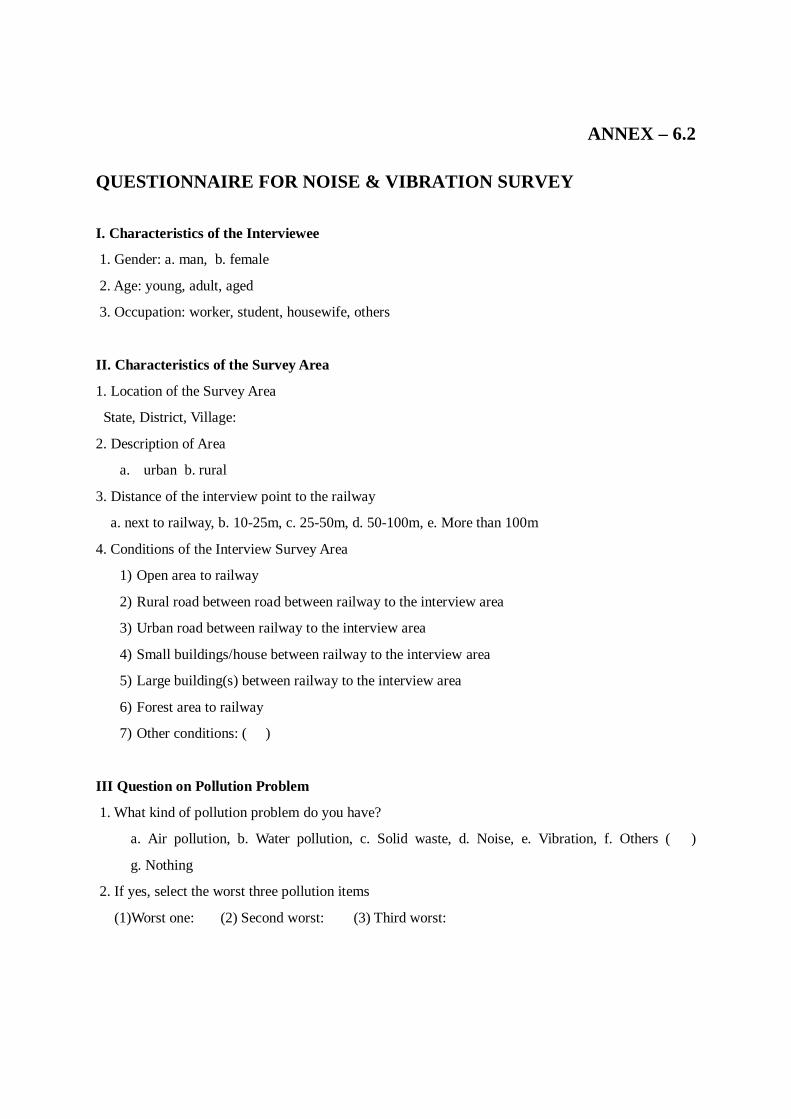
ANNEX – 6.2
QUESTIONNAIRE FOR NOISE & VIBRATION SURVEY
I. Characteristics of the Interviewee
1. Gender: a. man, b. female
2. Age: young, adult, aged
3. Occupation: worker, student, housewife, others
II. Characteristics of the Survey Area
1. Location of the Survey Area
State, District, Village:
2. Description of Area
a. urban b. rural
3. Distance of the interview point to the railway
a. next to railway, b. 10-25m, c. 25-50m, d. 50-100m, e. More than 100m
4. Conditions of the Interview Survey Area
1) Open area to railway
2) Rural road between road between railway to the interview area
3) Urban road between railway to the interview area
4) Small buildings/house between railway to the interview area
5) Large building(s) between railway to the interview area
6) Forest area to railway
7) Other conditions: ( )
III Question on Pollution Problem
1. What kind of pollution problem do you have?
a. Air pollution, b. Water pollution, c. Solid waste, d. Noise, e. Vibration, f. Others ( )
g. Nothing
2. If yes, select the worst three pollution items
(1)Worst one: (2) Second worst: (3) Third worst:
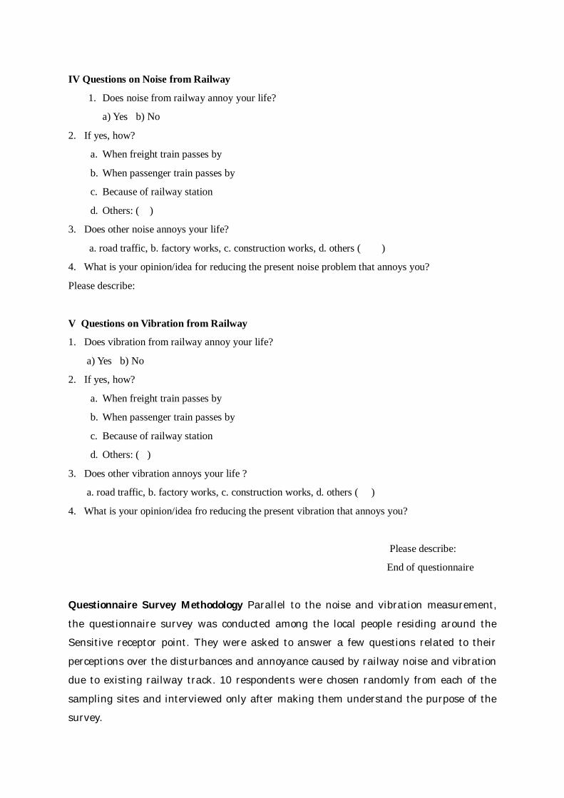
IV Questions on Noise from Railway
1. Does noise from railway annoy your life?
a) Yes b) No
2. If yes, how?
a. When freight train passes by
b. When passenger train passes by
c. Because of railway station
d. Others: ( )
3. Does other noise annoys your life?
a. road traffic, b. factory works, c. construction works, d. others ( )
4. What is your opinion/idea for reducing the present noise problem that annoys you?
Please describe:
V Questions on Vibration from Railway
1. Does vibration from railway annoy your life?
a) Yes b) No
2. If yes, how?
a. When freight train passes by
b. When passenger train passes by
c. Because of railway station
d. Others: ( )
3. Does other vibration annoys your life ?
a. road traffic, b. factory works, c. construction works, d. others ( )
4. What is your opinion/idea fro reducing the present vibration that annoys you?
Please describe:
End of questionnaire
Questionnaire Survey Methodology Parallel to the noise and vibration measurement, the questionnaire survey was conducted among the local people residing around the Sensitive receptor point. They were asked to answer a few questions related to their perceptions over the disturbances and annoyance caused by railway noise and vibration due to existing railway track. 10 respondents were chosen randomly from each of the sampling sites and interviewed only after making them understand the purpose of the survey.
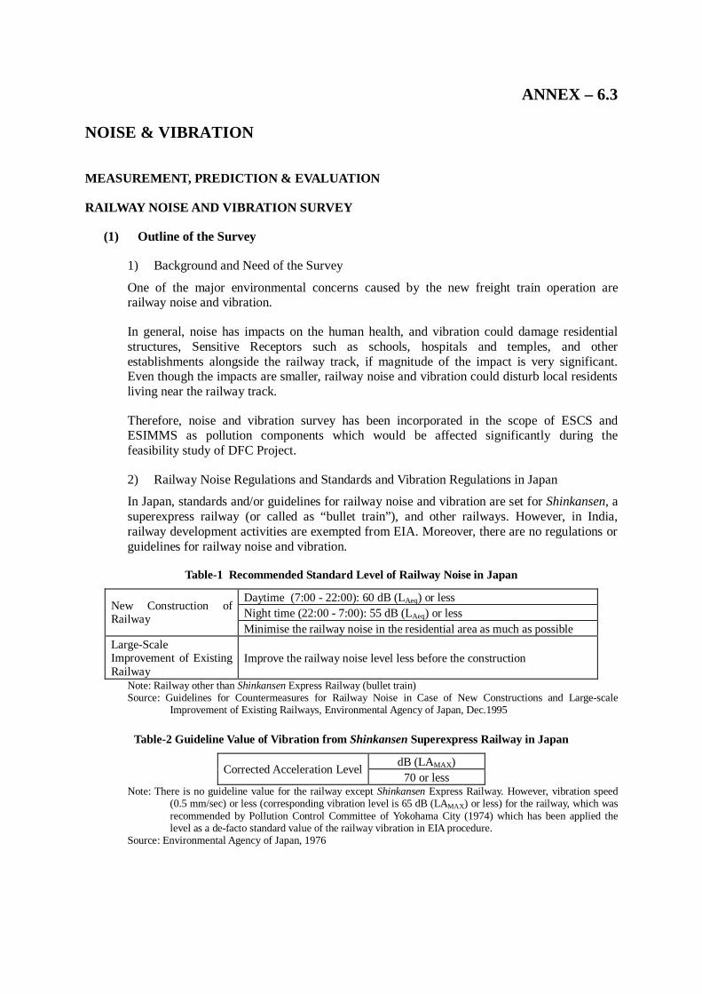
ANNEX – 6.3 NOISE & VIBRATION
MEASUREMENT, PREDICTION & EVALUATION
RAILWAY NOISE AND VIBRATION SURVEY
(1) Outline of the Survey
1) Background and Need of the Survey
One of the major environmental concerns caused by the new freight train operation are railway noise and vibration.
In general, noise has impacts on the human health, and vibration could damage residential structures, Sensitive Receptors such as schools, hospitals and temples, and other establishments alongside the railway track, if magnitude of the impact is very significant. Even though the impacts are smaller, railway noise and vibration could disturb local residents living near the railway track.
Therefore, noise and vibration survey has been incorporated in the scope of ESCS and ESIMMS as pollution components which would be affected significantly during the feasibility study of DFC Project.
2) Railway Noise Regulations and Standards and Vibration Regulations in Japan
In Japan, standards and/or guidelines for railway noise and vibration are set for Shinkansen, a superexpress railway (or called as “bullet train”), and other railways. However, in India, railway development activities are exempted from EIA. Moreover, there are no regulations or guidelines for railway noise and vibration.
Table-1 Recommended Standard Level of Railway Noise in Japan
Daytime (7:00 - 22:00): 60 dB (LAeq) or less Night time (22:00 - 7:00): 55 dB (LAeq) or less New Construction of
Railway Minimise the railway noise in the residential area as much as possible
Large-Scale Improvement of Existing Railway
Improve the railway noise level less before the construction
Note: Railway other than Shinkansen Express Railway (bullet train) Source: Guidelines for Countermeasures for Railway Noise in Case of New Constructions and Large-scale
Improvement of Existing Railways, Environmental Agency of Japan, Dec.1995
Table-2 Guideline Value of Vibration from Shinkansen Superexpress Railway in Japan
dB (LAMAX) Corrected Acceleration Level 70 or less
Note: There is no guideline value for the railway except Shinkansen Express Railway. However, vibration speed (0.5 mm/sec) or less (corresponding vibration level is 65 dB (LAMAX) or less) for the railway, which was recommended by Pollution Control Committee of Yokohama City (1974) which has been applied the level as a de-facto standard value of the railway vibration in EIA procedure.
Source: Environmental Agency of Japan, 1976
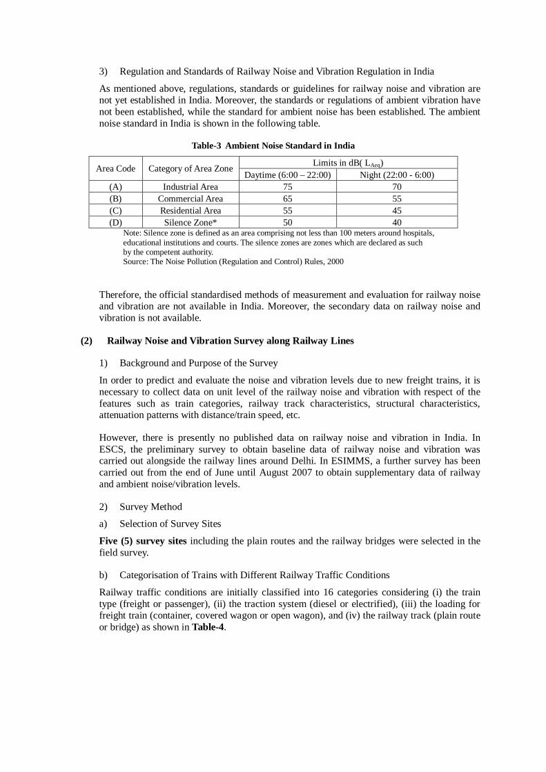
3) Regulation and Standards of Railway Noise and Vibration Regulation in India
As mentioned above, regulations, standards or guidelines for railway noise and vibration are not yet established in India. Moreover, the standards or regulations of ambient vibration have not been established, while the standard for ambient noise has been established. The ambient noise standard in India is shown in the following table.
Table-3 Ambient Noise Standard in India
Limits in dB( LAeq) Area Code Category of Area Zone Daytime (6:00 – 22:00) Night (22:00 - 6:00)
(A) Industrial Area 75 70 (B) Commercial Area 65 55 (C) Residential Area 55 45 (D) Silence Zone* 50 40
Note: Silence zone is defined as an area comprising not less than 100 meters around hospitals, educational institutions and courts. The silence zones are zones which are declared as such by the competent authority. Source: The Noise Pollution (Regulation and Control) Rules, 2000
Therefore, the official standardised methods of measurement and evaluation for railway noise and vibration are not available in India. Moreover, the secondary data on railway noise and vibration is not available.
(2) Railway Noise and Vibration Survey along Railway Lines
1) Background and Purpose of the Survey
In order to predict and evaluate the noise and vibration levels due to new freight trains, it is necessary to collect data on unit level of the railway noise and vibration with respect of the features such as train categories, railway track characteristics, structural characteristics, attenuation patterns with distance/train speed, etc.
However, there is presently no published data on railway noise and vibration in India. In ESCS, the preliminary survey to obtain baseline data of railway noise and vibration was carried out alongside the railway lines around Delhi. In ESIMMS, a further survey has been carried out from the end of June until August 2007 to obtain supplementary data of railway and ambient noise/vibration levels.
2) Survey Method
a) Selection of Survey Sites
Five (5) survey sites including the plain routes and the railway bridges were selected in the field survey.
b) Categorisation of Trains with Different Railway Traffic Conditions
Railway traffic conditions are initially classified into 16 categories considering (i) the train type (freight or passenger), (ii) the traction system (diesel or electrified), (iii) the loading for freight train (container, covered wagon or open wagon), and (iv) the railway track (plain route or bridge) as shown in Table-4.
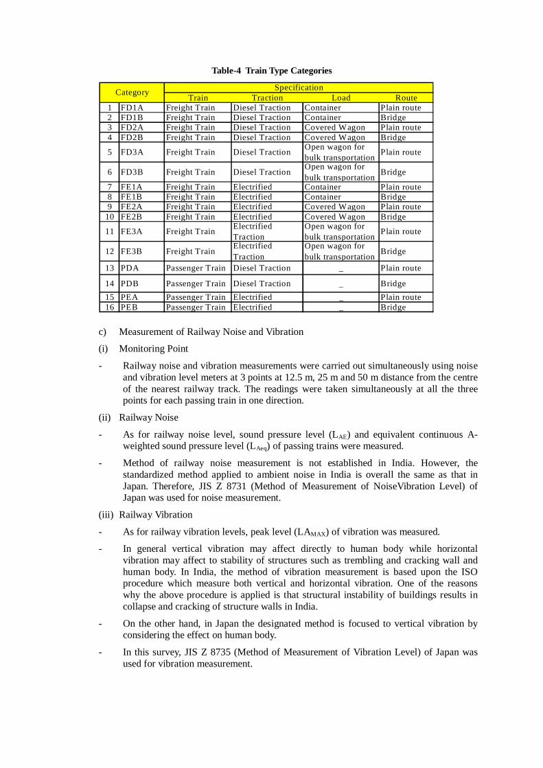
Table-4 Train Type Categories
c) Measurement of Railway Noise and Vibration
(i) Monitoring Point
- Railway noise and vibration measurements were carried out simultaneously using noise and vibration level meters at 3 points at 12.5 m, 25 m and 50 m distance from the centre of the nearest railway track. The readings were taken simultaneously at all the three points for each passing train in one direction.
(ii) Railway Noise
- As for railway noise level, sound pressure level (LAE) and equivalent continuous A-weighted sound pressure level (LAeq) of passing trains were measured.
- Method of railway noise measurement is not established in India. However, the standardized method applied to ambient noise in India is overall the same as that in Japan. Therefore, JIS Z 8731 (Method of Measurement of NoiseVibration Level) of Japan was used for noise measurement.
(iii) Railway Vibration
- As for railway vibration levels, peak level (LAMAX) of vibration was measured.
- In general vertical vibration may affect directly to human body while horizontal vibration may affect to stability of structures such as trembling and cracking wall and human body. In India, the method of vibration measurement is based upon the ISO procedure which measure both vertical and horizontal vibration. One of the reasons why the above procedure is applied is that structural instability of buildings results in collapse and cracking of structure walls in India.
- On the other hand, in Japan the designated method is focused to vertical vibration by considering the effect on human body.
- In this survey, JIS Z 8735 (Method of Measurement of Vibration Level) of Japan was used for vibration measurement.
Train Traction Load Route
1 FD1A Freight Train Diesel Traction Container Plain route2 FD1B Freight Train Diesel Traction Container Bridge3 FD2A Freight Train Diesel Traction Covered Wagon Plain route4 FD2B Freight Train Diesel Traction Covered Wagon Bridge
5 FD3A Freight Train Diesel Traction Open wagon forbulk transportation Plain route
6 FD3B Freight Train Diesel Traction Open wagon forbulk transportation Bridge
7 FE1A Freight Train Electrified Container Plain route8 FE1B Freight Train Electrified Container Bridge9 FE2A Freight Train Electrified Covered Wagon Plain route
10 FE2B Freight Train Electrified Covered Wagon Bridge
11 FE3A Freight Train ElectrifiedTraction
Open wagon forbulk transportation Plain route
12 FE3B Freight Train ElectrifiedTraction
Open wagon forbulk transportation Bridge
13 PDA Passenger Train Diesel Traction _ Plain route
14 PDB Passenger Train Diesel Traction _ Bridge15 PEA Passenger Train Electrified _ Plain route16 PEB Passenger Train Electrified _ Bridge
SpecificationCategory
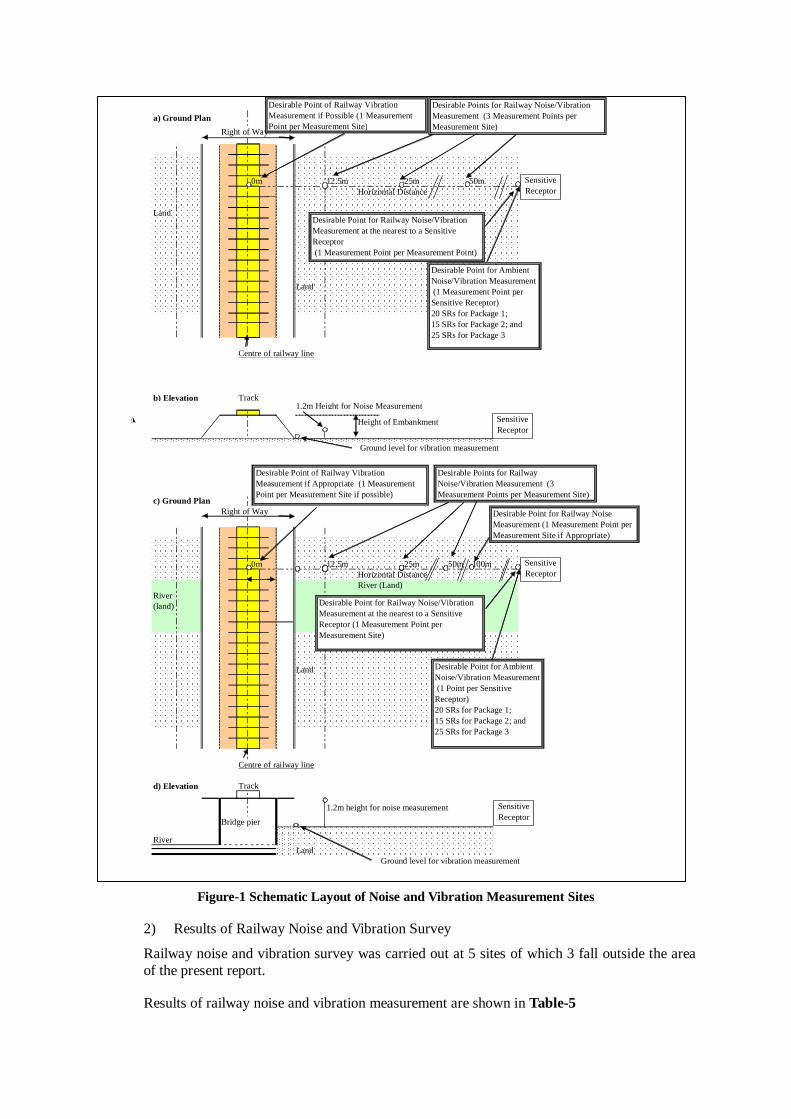
Figure-1 Schematic Layout of Noise and Vibration Measurement Sites
2) Results of Railway Noise and Vibration Survey
Railway noise and vibration survey was carried out at 5 sites of which 3 fall outside the area of the present report.
Results of railway noise and vibration measurement are shown in Table-5
a) Ground Plan
Right of Way
0m 12.5m 25m 50mHorizontal Distance
Land
Land
Centre of railway line
b) Elevation Track1.2m Height for Noise Measurement
Height of Embankment
Ground level for vibration measurement
c) Ground PlanRight of Way
0m 12.5m 25m 50m 100mHorizontal DistanceRiver (Land)
River(land)
Land
Centre of railway line
d) Elevation Track
1.2m height for noise measurement
Bridge pier
RiverLand
Ground level for vibration measurement
SensitiveReceptor
SensitiveReceptor
Desirable Points for Railway Noise/VibrationMeasurement (3 Measurement Points perMeasurement Site)
Desirable Point for Railway Noise/VibrationMeasurement at the nearest to a SensitiveReceptor (1 Measurement Point per Measurement Point)
Desirable Point for AmbientNoise/Vibration Measurement (1 Measurement Point perSensitive Receptor)20 SRs for Package 1;15 SRs for Package 2; and25 SRs for Package 3
Desirable Point of Railway VibrationMeasurement if Possible (1 MeasurementPoint per Measurement Site)
SensitiveReceptor
Desirable Point for Railway Noise/VibrationMeasurement at the nearest to a SensitiveReceptor (1 Measurement Point perMeasurement Site)
Desirable Point for AmbientNoise/Vibration Measurement (1 Point per SensitiveReceptor)20 SRs for Package 1;15 SRs for Package 2; and25 SRs for Package 3
Desirable Point of Railway VibrationMeasurement if Appropriate (1 MeasurementPoint per Measurement Site if possible)
Desirable Points for RailwayNoise/Vibration Measurement (3Measurement Points per Measurement Site)
Desirable Point for Railway NoiseMeasurement (1 Measurement Point perMeasurement Site if Appropriate)
SensitiveReceptor

Table-5 Result of Railway Noise and Vibration Measurement (including 3 sites outside the study area)
Note: "Category of Trains” consisting of 16 freight and passenger train types in Table-6.4.4 were applied.
3) Overall Findings of Railway Noise and Vibration Survey
Figure 10-4 also shows a typical attenuation pattern of railway noise and vibration level with distance from centre of the nearest railway track. In this survey, the measurement points were selected in order to evaluate the noise and vibration levels by considering Indian and Japanese evaluation methodologies. There are 3 trends of railway noise and vibration levels along the existing railway lines.
12.5m 25m 50m 12.5m 25m 50m 12.5m 25m 50m
PEA 21 110 72 84 79 74 97 95 92 78 65 56FE1A 47 40 97 86 82 77 100 98 95 78 68 54PEA 12 10 99 87 77 69 95 91 86 80 70 55FE1A 47 30 96 87 84 79 102 98 97 79 71 57PEA 19 22 72 84 82 77 100 97 95 78 67 55PEA 22 23 79 86 81 74 99 95 92 77 66 54PEA 23 21 91 85 83 74 48 48 47 75 67 53PEA 13 15 72 81 75 72 92 89 84 64 51 43PEA 19 24 83 82 78 73 96 92 87 63 52 44
FD3A 16 17 37 80 76 80 92 89 84 64 53 44PDA 18 37 40 78 74 70 93 89 85 60 52 43PEA 12 15 66 89 84 80 101 96 92 63 54 45PDA 14 14 83 94 90 88 106 102 100 64 53 47PDA 22 35 52 78 74 70 93 90 84 63 52 44PEA 24 30 66 82 80 66 97 95 66 63 51 44PEA 22 43 42 77 72 80 94 88 94 61 51 40FE3B 60 100 23 91 88 82 102 88 83 81 76 54FE3B 11 18 24 90 88 83 102 87 83 74 71 53PEB 22 20 91 88 86 81 102 87 82 75 71 53PEB 17 15 94 90 88 82 101 97 90 94 69 57PEB 13 15 72 93 90 84 105 98 92 77 76 54FE2B 42 40 55 88 87 82 102 97 92 97 72 52PEB 24 17 116 89 87 82 101 95 89 76 74 53PEB 23 48 40 75 59 64 70 66 71 65 52 56PEB 13 48 22 63 64 63 70 71 70 68 55 53PEB 14 40 29 65 66 65 72 73 72 65 55 53PEB 20 42 39 62 75 67 69 82 74 68 56 56PEB 19 100 16 79 68 61 86 75 68 67 56 55
FD1B 41 56 61 86 81 79 105 100 98 54 58 46PDB 13 25 43 79 80 75 100 94 89 52 54 48PDB 18 25 60 87 82 78 103 97 93 56 53 53PDB 14 40 29 87 82 82 105 99 99 48 53 46
FD1B 44 110 33 83 77 73 103 98 94 56 54 52PDB 23 65 29 81 76 72 99 94 90 51 55 52PDB 15 26 48 89 83 78 103 97 93 57 56 49
Railway Vibration Level
Leak (dB)
Railway Noise LevelDR Site
No.Type ofTrack
Location of DR site(District, State)
PassageTime(sec)
Categoryof trains
Numberof trains
Lea (dB) LEA (dB)RunningSpeed
(km/hr)
P1-DRB-2 RailwayBridge
Narmada River Bridge(Bharuch, Gujarat)
P1-DRP-2 Plain Route Malinger (Ahmedabad,Gujarat)
P1-DRB-3 RailwayBridge
Sabarmati Bridge(Ahmedabad, Gujarat)
P1-DRB-1 RailwayBridge
Ambica River Bridge(Navsari, Gujarat)
P1-DRP-1 Plain Route Near Biltmore Station(Navarre, Gujarat)
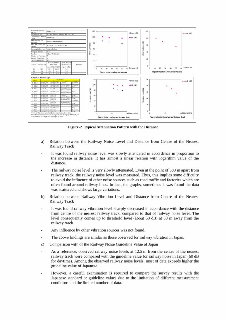
Figure-2 Typical Attenuation Pattern with the Distance
a) Relation between the Railway Noise Level and Distance from Centre of the Nearest
Railway Track
- It was found railway noise level was slowly attenuated in accordance in proportion to the increase in distance. It has almost a linear relation with logarithm value of the distance.
- The railway noise level is very slowly attenuated. Even at the point of 500 m apart from railway track, the railway noise level was measured. Thus, this implies some difficulty to avoid the influence of other noise sources such as road traffic and factories which are often found around railway lines. In fact, the graphs, sometimes it was found the data was scattered and shows large variations.
b) Relation between Railway Vibration Level and Distance from Centre of the Nearest Railway Track
- It was found railway vibration level sharply decreased in accordance with the distance from centre of the nearest railway track, compared to that of railway noise level. The level consequently comes up to threshold level (about 50 dB) at 50 m away from the railway track.
- Any influence by other vibration sources was not found.
- The above findings are similar as those observed for railway vibration in Japan.
c) Comparison with of the Railway Noise Guideline Value of Japan
- As a reference, observed railway noise levels at 12.5 m from the centre of the nearest railway track were compared with the guideline value for railway noise in Japan (60 dB for daytime). Among the observed railway noise levels, most of data exceeds higher the guideline value of Japanese.
- However, a careful examination is required to compare the survey results with the Japanese standard or guideline values due to the limitation of different measurement conditions and the limited number of data.
Urban ( Residential)
(2) RV (Railwayvibration level)
LAeq (dB) LAE (dB) Lpeak (dB)D1 12.5 87.1 101.6 79.3D2 25 83.8 98.3 70.5D3 50 78.7 96.6 56.8
Category of the Train Type
* Others: Other train types besides the types in the above table.Describe its specifications as much as possible in "Category of Train Type"and whether it is "Freight" or "Passenger" at least.
(1) RN (Railwaynoise level)
473096.4
Remarks
Classification of theDR siteName of the SiteType/Name of RailwayTrack
Running Railway Line
Description of theLocationDate and Time of theSurvey
Category of Train
Site No. Distance (m)
Number of Train CarsPassage Time (sec.)Train Speed (km/hr)
Land use
DR-P1 -G -1
Plain Route
Western Railway
FE1A
Half way between Bilimora and Jora Vasan
Out skirt of Bilimora city
30,June,07 (7.45 am to 9.45 am)
Figure1 Noise Level versus Distance
0
20
40
60
80
100
120
0 10 20 30 40 50 60 Distance (m)
Nois
e Leve
l (d
B)
LAeq (dB)
LAE (dB)
Figure3 Vibration Level versus Distance
0
20
40
60
80
100
0 10 20 30 40 50 60 Distance (m)
Vib
ration
Leve
l (dB
)
Lpeak (dB)
Figure2 Noise Level versus Distance (Log)
0
20
40
60
80
100
120
1 10 100Distance (m)
Vib
ration L
evel (d
B)
LAeq (dB)
LAE (dB)
Figure4 Vibration Level versus Distance (Log)
0
20
40
60
80
100
1 10 100Distance (m)
Vib
ration L
evel (d
B)
Lpeak (dB)T rain T raction Load Route1 FD1A Freight Train Diesel T raction Container Plain route2 FD1B Freight Train Diesel T raction Container Bridge3 FD2A Freight Train Diesel T raction Covered Wagon Plain route4 FD2B Freight Train Diesel T raction Covered Wagon Bridge
5 FD3A Freight Train Diesel T raction Open wagon forbulk transportation
Plain route
6 FD3B Freight Train Diesel T raction Open wagon forbulk transportation
Bridge
7 FE 1A Freight Train Electrified Container Plain route8 FE 1B Freight Train Electrified Container Bridge9 FE 2A Freight Train Electrified Covered Wagon Plain route
10 FE 2B Freight Train Electrified Covered Wagon Bridge
11 FE 3A Freight TrainElectrifiedTraction
Open wagon forbulk transportation Plain route
12 FE 3B Freight TrainElectrifiedTraction
Open wagon forbulk transportation Bridge
13 PDA Passenger Train Diesel T raction _ Plain route
14 PDB Passenger Train Diesel T raction _ Bridge15 PEA Passenger Train Electrified _ Plain route16 PEB Passenger Train Electrified _ Bridge
SpecificationCategory
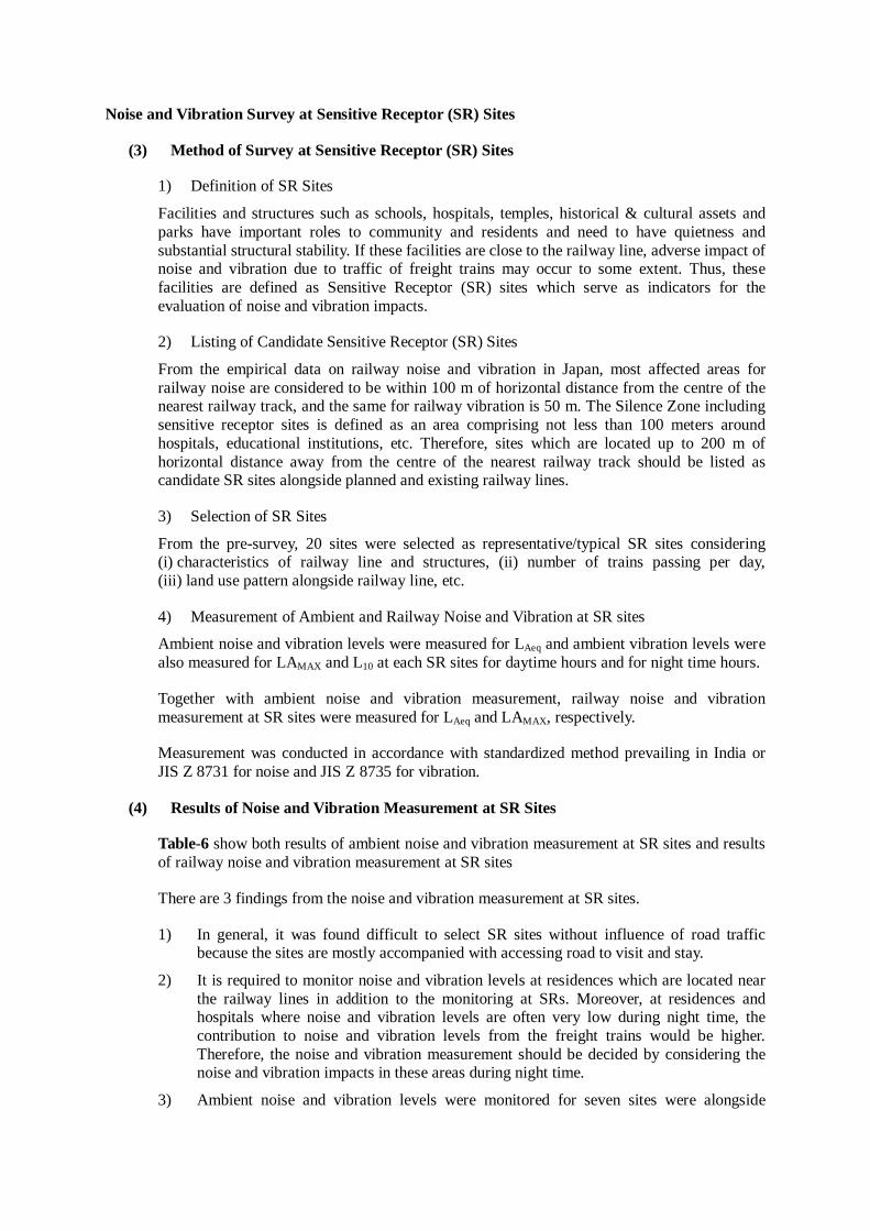
Noise and Vibration Survey at Sensitive Receptor (SR) Sites
(3) Method of Survey at Sensitive Receptor (SR) Sites
1) Definition of SR Sites
Facilities and structures such as schools, hospitals, temples, historical & cultural assets and parks have important roles to community and residents and need to have quietness and substantial structural stability. If these facilities are close to the railway line, adverse impact of noise and vibration due to traffic of freight trains may occur to some extent. Thus, these facilities are defined as Sensitive Receptor (SR) sites which serve as indicators for the evaluation of noise and vibration impacts.
2) Listing of Candidate Sensitive Receptor (SR) Sites
From the empirical data on railway noise and vibration in Japan, most affected areas for railway noise are considered to be within 100 m of horizontal distance from the centre of the nearest railway track, and the same for railway vibration is 50 m. The Silence Zone including sensitive receptor sites is defined as an area comprising not less than 100 meters around hospitals, educational institutions, etc. Therefore, sites which are located up to 200 m of horizontal distance away from the centre of the nearest railway track should be listed as candidate SR sites alongside planned and existing railway lines.
3) Selection of SR Sites
From the pre-survey, 20 sites were selected as representative/typical SR sites considering (i) characteristics of railway line and structures, (ii) number of trains passing per day, (iii) land use pattern alongside railway line, etc.
4) Measurement of Ambient and Railway Noise and Vibration at SR sites
Ambient noise and vibration levels were measured for LAeq and ambient vibration levels were also measured for LAMAX and L10 at each SR sites for daytime hours and for night time hours.
Together with ambient noise and vibration measurement, railway noise and vibration measurement at SR sites were measured for LAeq and LAMAX, respectively.
Measurement was conducted in accordance with standardized method prevailing in India or JIS Z 8731 for noise and JIS Z 8735 for vibration.
(4) Results of Noise and Vibration Measurement at SR Sites
Table-6 show both results of ambient noise and vibration measurement at SR sites and results of railway noise and vibration measurement at SR sites
There are 3 findings from the noise and vibration measurement at SR sites.
1) In general, it was found difficult to select SR sites without influence of road traffic because the sites are mostly accompanied with accessing road to visit and stay.
2) It is required to monitor noise and vibration levels at residences which are located near the railway lines in addition to the monitoring at SRs. Moreover, at residences and hospitals where noise and vibration levels are often very low during night time, the contribution to noise and vibration levels from the freight trains would be higher. Therefore, the noise and vibration measurement should be decided by considering the noise and vibration impacts in these areas during night time.
3) Ambient noise and vibration levels were monitored for seven sites were alongside
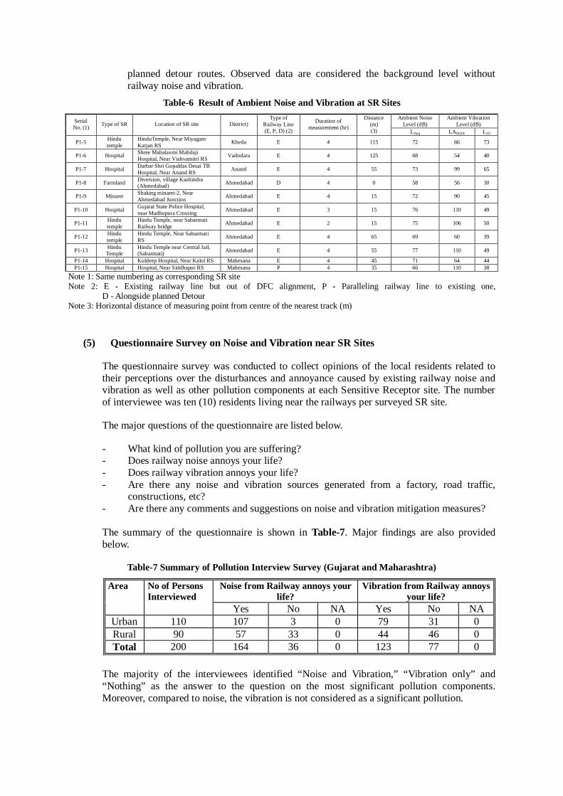
planned detour routes. Observed data are considered the background level without railway noise and vibration.
Table-6 Result of Ambient Noise and Vibration at SR Sites Ambient Noise
Level (dB) Ambient Vibration
Level (dB) Serial No. (1) Type of SR Location of SR site District)
Type of Railway Line (E, P, D) (2)
Duration of measurement (hr)
Distance (m) (3) LAeq LAMAX L10
P1-5 Hindu temple
HinduTemple, Near Miyagam Karjan RS Kheda E 4 115 72 66 73
P1-6 Hospital Shree Mahalaxmi Mahilaji Hospital, Near Vishvamitri RS Vadodara E 4 125 68 54 40
P1-7 Hospital Darbar Shri Gopaldas Desai TB Hospital, Near Anand RS Anand E 4 55 73 99 65
P1-8 Farmland Diversion, village Kashindra (Ahmedabad) Ahmedabad D 4 0 58 56 30
P1-9 Minaret Shaking minaret-2, Near Ahmedabad Junction Ahmedabad E 4 15 72 90 45
P1-10 Hospital Gujarat State Police Hospital, near Madhupura Crossing Ahmedabad E 3 15 76 110 49
P1-11 Hindu temple
Hindu Temple, near Sabarmati Railway bridge Ahmedabad E 2 15 75 106 50
P1-12 Hindu temple
Hindu Temple, Near Sabarmati RS Ahmedabad E 4 65 69 60 39
P1-13 Hindu Temple
Hindu Temple near Central Jail, (Sabarmati) Ahmedabad E 4 55 77 110 49
P1-14 Hospital Kuldeep Hospital, Near Kalol RS Mahesana E 4 45 71 64 44 P1-15 Hospital Hospital, Near Siddhapur RS Mahesana P 4 35 66 110 38
Note 1: Same numbering as corresponding SR site Note 2: E - Existing railway line but out of DFC alignment, P - Paralleling railway line to existing one,
D - Alongside planned Detour Note 3: Horizontal distance of measuring point from centre of the nearest track (m)
(5) Questionnaire Survey on Noise and Vibration near SR Sites
The questionnaire survey was conducted to collect opinions of the local residents related to their perceptions over the disturbances and annoyance caused by existing railway noise and vibration as well as other pollution components at each Sensitive Receptor site. The number of interviewee was ten (10) residents living near the railways per surveyed SR site.
The major questions of the questionnaire are listed below.
- What kind of pollution you are suffering? - Does railway noise annoys your life? - Does railway vibration annoys your life? - Are there any noise and vibration sources generated from a factory, road traffic,
constructions, etc? - Are there any comments and suggestions on noise and vibration mitigation measures? The summary of the questionnaire is shown in Table-7. Major findings are also provided below.
Table-7 Summary of Pollution Interview Survey (Gujarat and Maharashtra)
Noise from Railway annoys your life?
Vibration from Railway annoys your life?
Area No of Persons Interviewed
Yes No NA Yes No NA Urban 110 107 3 0 79 31 0 Rural 90 57 33 0 44 46 0 Total 200 164 36 0 123 77 0
The majority of the interviewees identified “Noise and Vibration,” “Vibration only” and “Nothing” as the answer to the question on the most significant pollution components. Moreover, compared to noise, the vibration is not considered as a significant pollution.

Prediction and Evaluation of Railway Noise and Vibration
(6) Procedure of Prediction and Evaluation
Prediction and evaluation of railway noise and vibration due to the passing freight trains have been carried out for each SR site according to the procedure of prediction and evaluation as shown in Figure-3.
Figure-3 Procedure for Prediction and Evaluation of Noise and Vibration Levels
(7) Examination of Prediction Method
1) Railway Noise
As mentioned above, in Japan regarding railway noise generated by conventional trains (local trains, express trains and limited express trains), main causes include (1) traction movements, (2) structures and (3) machines equipped to the train. Among them, the traction movement contributes to the generation of noise greatly.
In Japan, several types of prediction equations were proposed for various types of railway track structures, such as the elevation, embankment and cutting. The equation proposed by Railway Technical Research Institute of Japan (1996), one of the potential equations to be applied for this survey, is based on the data of passenger trains in Japan. By considering differences in tracks, trains, structures between India and Japan, it is not desirable to apply the equation and relevant parameters directly to predict the noise level of freight trains in India.
Therefore, prediction was carried out applying the actual data of railway noise level (LAE), running speed (V) of trains, and the distance from centre of the nearest railway track (D).
Detailed RailwayNoise/VibrationMeasurement
Data on RailwayNoise/VibrationCharacteristics(Levels vs. HorizontalDistance/ Runningspeed of Train)
Prediction of RailwayNoise/VibrationLevels at SR* sites
Detailed Plan of NewFreight Trains(Single/double stack,Maximum speed,Number of runningper day, etc.)
Evaluation of thePredictedNoise/VibrationLevels at SR* sites
AmbientNoise/VibrationMeasurement at SR*sites
Interview Survey onNoise/VibrationProblem near SR*sites
EnvironmentalManagement Plan(Mitigation Measures,Monitoring, etc.)
EnvironmentalStandard of AmbientNoise Level in India
Guidelines/Standardof RailwayNoise/Vibration inJapan
Recommendations toFurther Study
Setting AppropriatePrediction andEvaluation Methods
Survey on ExistingData on Predictionand Evaluation ofRailwayNoise/Vibration Level
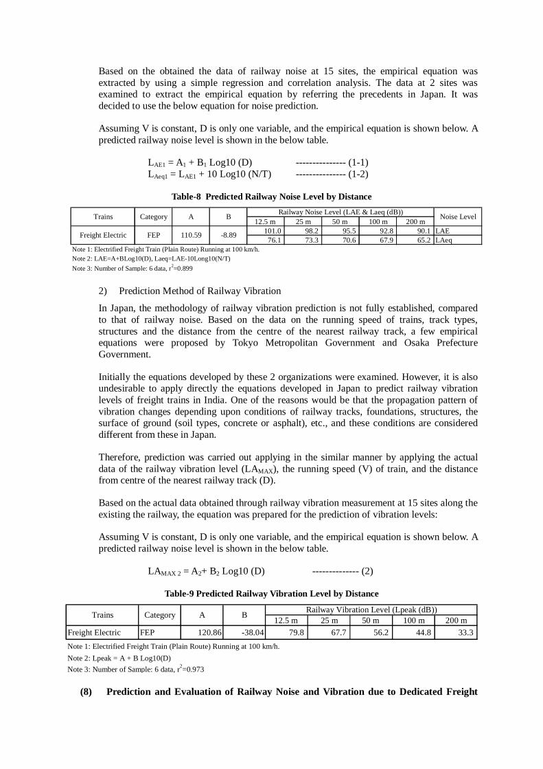
Based on the obtained the data of railway noise at 15 sites, the empirical equation was extracted by using a simple regression and correlation analysis. The data at 2 sites was examined to extract the empirical equation by referring the precedents in Japan. It was decided to use the below equation for noise prediction.
Assuming V is constant, D is only one variable, and the empirical equation is shown below. A predicted railway noise level is shown in the below table.
LAE1 = A1 + B1 Log10 (D) --------------- (1-1) LAeq1 = LAE1 + 10 Log10 (N/T) --------------- (1-2)
Table-8 Predicted Railway Noise Level by Distance
12.5 m 25 m 50 m 100 m 200 m101.0 98.2 95.5 92.8 90.1 LAE76.1 73.3 70.6 67.9 65.2 LAeq
Note 1: Electrified Freight Train (Plain Route) Running at 100 km/h. Note 2: LAE=A+BLog10(D), Laeq=LAE-10Long10(N/T)Note 3: Number of Sample: 6 data, r2=0.899
B
Freight Electric
Noise LevelRailway Noise Level (LAE & Laeq (dB))
-8.89110.59
Trains Category A
FEP
2) Prediction Method of Railway Vibration
In Japan, the methodology of railway vibration prediction is not fully established, compared to that of railway noise. Based on the data on the running speed of trains, track types, structures and the distance from the centre of the nearest railway track, a few empirical equations were proposed by Tokyo Metropolitan Government and Osaka Prefecture Government.
Initially the equations developed by these 2 organizations were examined. However, it is also undesirable to apply directly the equations developed in Japan to predict railway vibration levels of freight trains in India. One of the reasons would be that the propagation pattern of vibration changes depending upon conditions of railway tracks, foundations, structures, the surface of ground (soil types, concrete or asphalt), etc., and these conditions are considered different from these in Japan.
Therefore, prediction was carried out applying in the similar manner by applying the actual data of the railway vibration level (LAMAX), the running speed (V) of train, and the distance from centre of the nearest railway track (D).
Based on the actual data obtained through railway vibration measurement at 15 sites along the existing the railway, the equation was prepared for the prediction of vibration levels:
Assuming V is constant, D is only one variable, and the empirical equation is shown below. A predicted railway noise level is shown in the below table.
LAMAX 2 = A2+ B2 Log10 (D) -------------- (2)
Table-9 Predicted Railway Vibration Level by Distance
12.5 m 25 m 50 m 100 m 200 mFreight Electric FEP 120.86 -38.04 79.8 67.7 56.2 44.8 33.3Note 1: Electrified Freight Train (Plain Route) Running at 100 km/h. Note 2: Lpeak = A + B Log10(D)Note 3: Number of Sample: 6 data, r2=0.973
Trains Category A B Railway Vibration Level (Lpeak (dB))
(8) Prediction and Evaluation of Railway Noise and Vibration due to Dedicated Freight
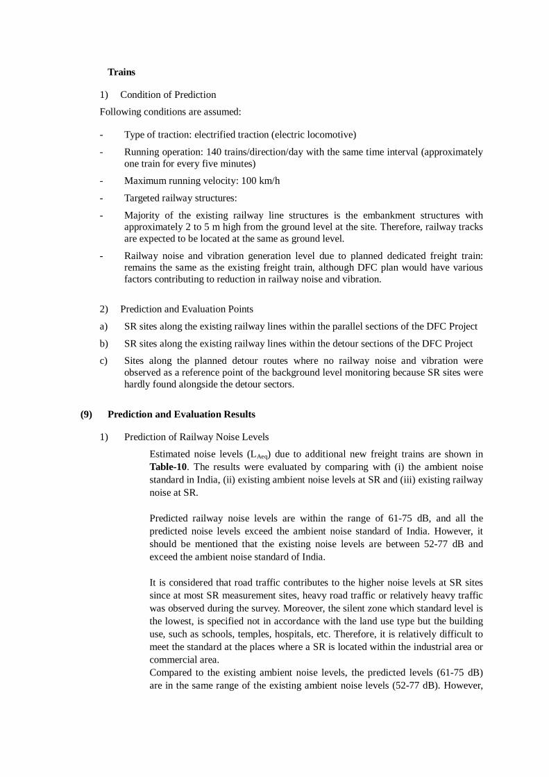
Trains
1) Condition of Prediction
Following conditions are assumed:
- Type of traction: electrified traction (electric locomotive)
- Running operation: 140 trains/direction/day with the same time interval (approximately one train for every five minutes)
- Maximum running velocity: 100 km/h
- Targeted railway structures:
- Majority of the existing railway line structures is the embankment structures with approximately 2 to 5 m high from the ground level at the site. Therefore, railway tracks are expected to be located at the same as ground level.
- Railway noise and vibration generation level due to planned dedicated freight train: remains the same as the existing freight train, although DFC plan would have various factors contributing to reduction in railway noise and vibration.
2) Prediction and Evaluation Points
a) SR sites along the existing railway lines within the parallel sections of the DFC Project
b) SR sites along the existing railway lines within the detour sections of the DFC Project
c) Sites along the planned detour routes where no railway noise and vibration were observed as a reference point of the background level monitoring because SR sites were hardly found alongside the detour sectors.
(9) Prediction and Evaluation Results
1) Prediction of Railway Noise Levels
Estimated noise levels (LAeq) due to additional new freight trains are shown in Table-10. The results were evaluated by comparing with (i) the ambient noise standard in India, (ii) existing ambient noise levels at SR and (iii) existing railway noise at SR. Predicted railway noise levels are within the range of 61-75 dB, and all the predicted noise levels exceed the ambient noise standard of India. However, it should be mentioned that the existing noise levels are between 52-77 dB and exceed the ambient noise standard of India. It is considered that road traffic contributes to the higher noise levels at SR sites since at most SR measurement sites, heavy road traffic or relatively heavy traffic was observed during the survey. Moreover, the silent zone which standard level is the lowest, is specified not in accordance with the land use type but the building use, such as schools, temples, hospitals, etc. Therefore, it is relatively difficult to meet the standard at the places where a SR is located within the industrial area or commercial area. Compared to the existing ambient noise levels, the predicted levels (61-75 dB) are in the same range of the existing ambient noise levels (52-77 dB). However,
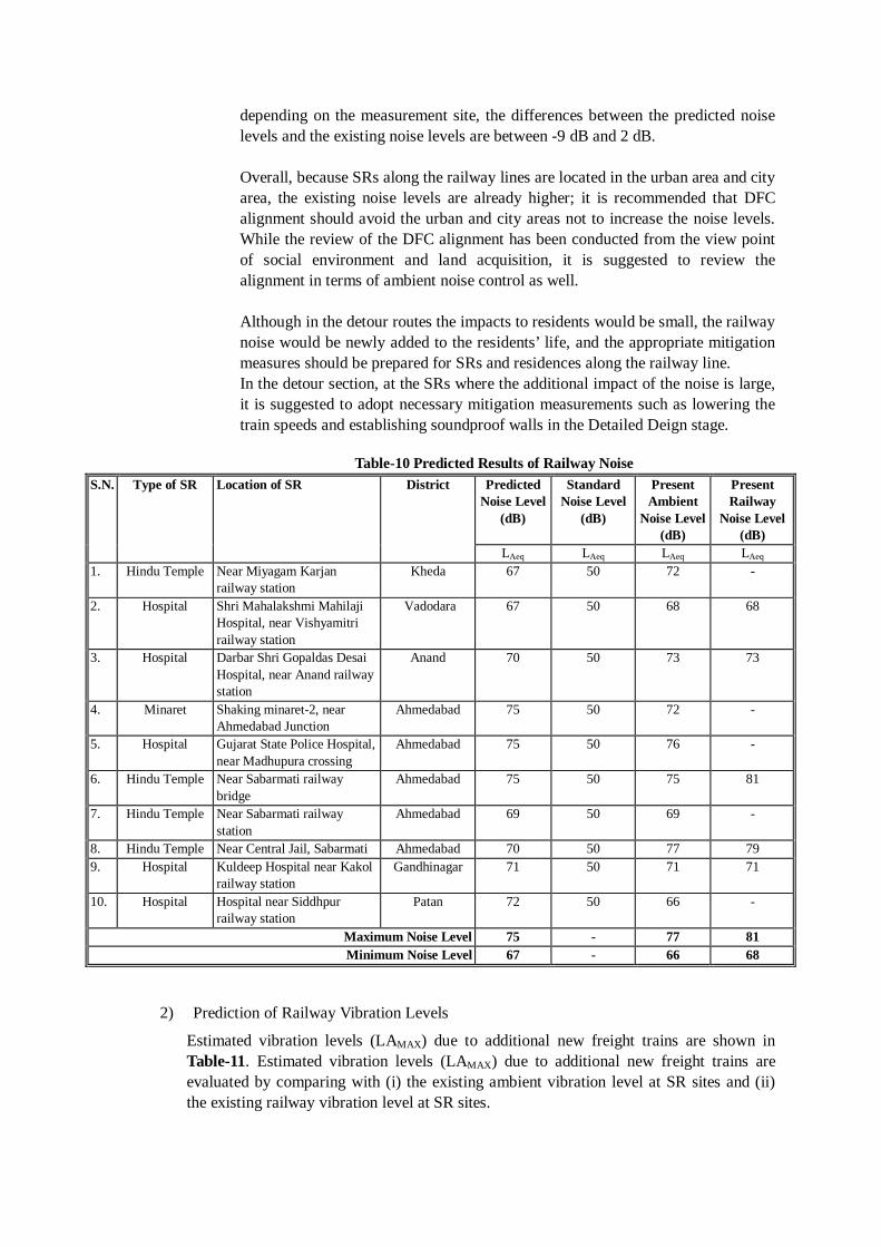
depending on the measurement site, the differences between the predicted noise levels and the existing noise levels are between -9 dB and 2 dB. Overall, because SRs along the railway lines are located in the urban area and city area, the existing noise levels are already higher; it is recommended that DFC alignment should avoid the urban and city areas not to increase the noise levels. While the review of the DFC alignment has been conducted from the view point of social environment and land acquisition, it is suggested to review the alignment in terms of ambient noise control as well. Although in the detour routes the impacts to residents would be small, the railway noise would be newly added to the residents’ life, and the appropriate mitigation measures should be prepared for SRs and residences along the railway line. In the detour section, at the SRs where the additional impact of the noise is large, it is suggested to adopt necessary mitigation measurements such as lowering the train speeds and establishing soundproof walls in the Detailed Deign stage.
Table-10 Predicted Results of Railway Noise
S.N. Type of SR Location of SR District Predicted Noise Level
(dB)
Standard Noise Level
(dB)
Present Ambient
Noise Level (dB)
Present Railway
Noise Level (dB)
LAeq LAeq LAeq LAeq 1. Hindu Temple Near Miyagam Karjan
railway station Kheda 67 50 72 -
2. Hospital Shri Mahalakshmi Mahilaji Hospital, near Vishyamitri railway station
Vadodara 67 50 68 68
3. Hospital Darbar Shri Gopaldas Desai Hospital, near Anand railway station
Anand 70 50 73 73
4. Minaret Shaking minaret-2, near Ahmedabad Junction
Ahmedabad 75 50 72 -
5. Hospital Gujarat State Police Hospital, near Madhupura crossing
Ahmedabad 75 50 76 -
6. Hindu Temple Near Sabarmati railway bridge
Ahmedabad 75 50 75 81
7. Hindu Temple Near Sabarmati railway station
Ahmedabad 69 50 69 -
8. Hindu Temple Near Central Jail, Sabarmati Ahmedabad 70 50 77 79 9. Hospital Kuldeep Hospital near Kakol
railway station Gandhinagar 71 50 71 71
10. Hospital Hospital near Siddhpur railway station
Patan 72 50 66 -
Maximum Noise Level 75 - 77 81 Minimum Noise Level 67 - 66 68
2) Prediction of Railway Vibration Levels
Estimated vibration levels (LAMAX) due to additional new freight trains are shown in Table-11. Estimated vibration levels (LAMAX) due to additional new freight trains are evaluated by comparing with (i) the existing ambient vibration level at SR sites and (ii) the existing railway vibration level at SR sites.
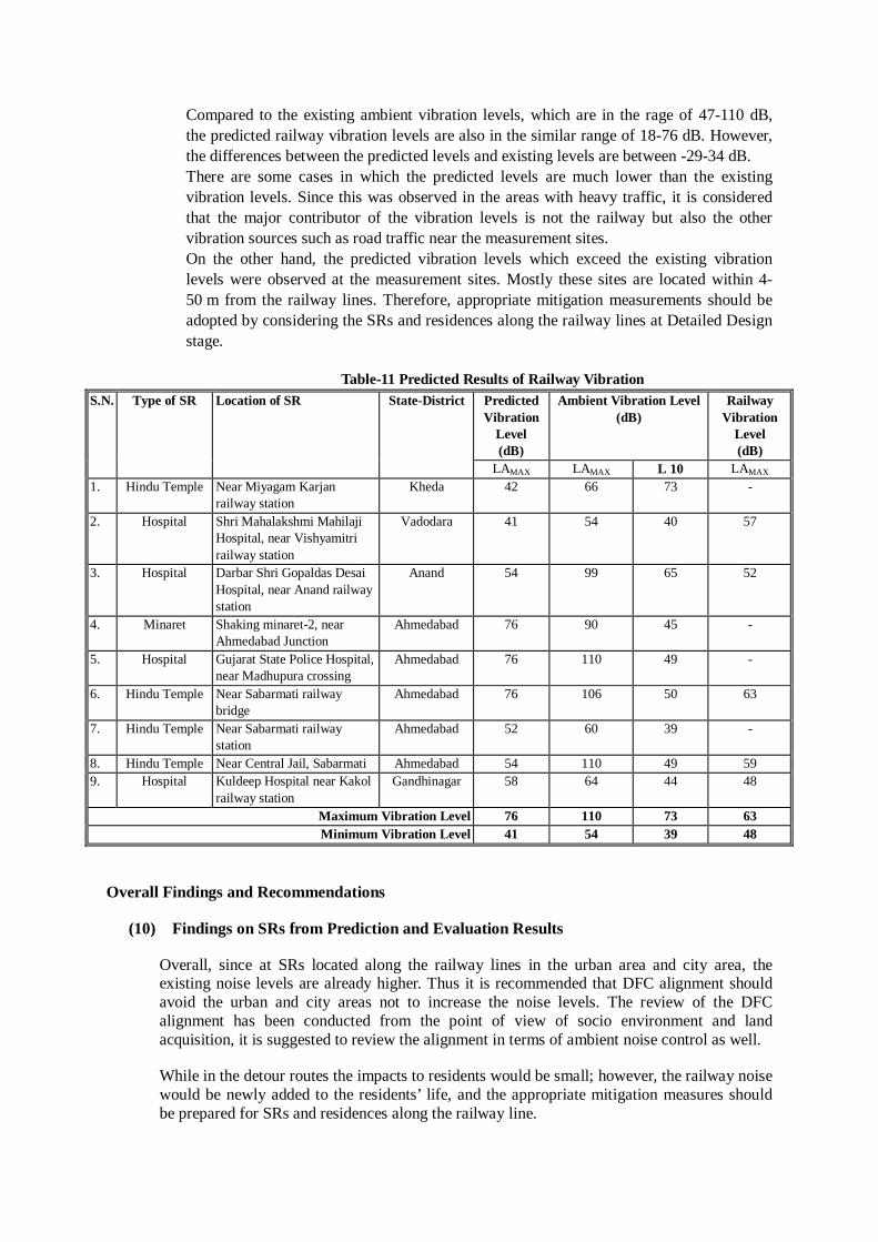
Compared to the existing ambient vibration levels, which are in the rage of 47-110 dB, the predicted railway vibration levels are also in the similar range of 18-76 dB. However, the differences between the predicted levels and existing levels are between -29-34 dB. There are some cases in which the predicted levels are much lower than the existing vibration levels. Since this was observed in the areas with heavy traffic, it is considered that the major contributor of the vibration levels is not the railway but also the other vibration sources such as road traffic near the measurement sites. On the other hand, the predicted vibration levels which exceed the existing vibration levels were observed at the measurement sites. Mostly these sites are located within 4-50 m from the railway lines. Therefore, appropriate mitigation measurements should be adopted by considering the SRs and residences along the railway lines at Detailed Design stage.
Table-11 Predicted Results of Railway Vibration
S.N. Type of SR Location of SR State-District Predicted Vibration
Level (dB)
Ambient Vibration Level (dB)
Railway Vibration
Level (dB)
LAMAX LAMAX L 10 LAMAX 1. Hindu Temple Near Miyagam Karjan
railway station Kheda 42 66 73 -
2. Hospital Shri Mahalakshmi Mahilaji Hospital, near Vishyamitri railway station
Vadodara 41 54 40 57
3. Hospital Darbar Shri Gopaldas Desai Hospital, near Anand railway station
Anand 54 99 65 52
4. Minaret Shaking minaret-2, near Ahmedabad Junction
Ahmedabad 76 90 45 -
5. Hospital Gujarat State Police Hospital, near Madhupura crossing
Ahmedabad 76 110 49 -
6. Hindu Temple Near Sabarmati railway bridge
Ahmedabad 76 106 50 63
7. Hindu Temple Near Sabarmati railway station
Ahmedabad 52 60 39 -
8. Hindu Temple Near Central Jail, Sabarmati Ahmedabad 54 110 49 59 9. Hospital Kuldeep Hospital near Kakol
railway station Gandhinagar 58 64 44 48
Maximum Vibration Level 76 110 73 63 Minimum Vibration Level 41 54 39 48
Overall Findings and Recommendations
(10) Findings on SRs from Prediction and Evaluation Results
Overall, since at SRs located along the railway lines in the urban area and city area, the existing noise levels are already higher. Thus it is recommended that DFC alignment should avoid the urban and city areas not to increase the noise levels. The review of the DFC alignment has been conducted from the point of view of socio environment and land acquisition, it is suggested to review the alignment in terms of ambient noise control as well.
While in the detour routes the impacts to residents would be small; however, the railway noise would be newly added to the residents’ life, and the appropriate mitigation measures should be prepared for SRs and residences along the railway line.
In the detour section, at the SRs where the additional impact of the noise is large, it is suggested to adopt necessary mitigation measurements such as lowering the train speed,s and establishing soundproof walls in the Detailed Deign stage.
(11) Consideration of the Noise and Vibration Measurement at Residences besides SRs
In this study, SRs were selected as noise and vibration measurement sites as the representative or typical sites by considering various factors of the study such as the purpose, the survey period, availability of the measurement methodology, noise and vibration standards and environmental consultants in India. It is suggested that the noise and vibration survey should be conducted at residences along the railway lines where actual affected people live in the Detailed Design stage.
(12) Implementation of Railway Noise and Vibration Mitigation Measures
As this study result shows, at SRs in the urban and city area, the existing ambient noise and vibration tend to be high due to the traffic, people nearby, their own religious activities, etc. Moreover, the interview survey results show that not only railway noise but also road traffic are environmental concerns of the residents. Additionally the horns from trains were also identified a significant noise contributor. Therefore, the railway noise and vibration mitigation measures should be adopted gradually in accordance with the rise in environmental awareness especially for noise and vibration.
(13) Baseline Data Collection of Railway Noise and Vibration and Establishment of Prediction and Evaluation Methods
1) Establishment of the Methods of Railway Noise Monitoring
For further detailed noise and vibration monitoring, it is necessary to obtain the baseline data as well as the established methodologies of railway noise and vibration measurement. Since there is very limited data on noise and vibration in India. It is considered that extensive railway noise and vibration survey was conducted in ESCS and ESIMMS for the first time in India. Although there are railway noise and vibration survey data and methodologies available in Japan, they are not applicable to India since there are various different conditions such as the railway and train design and operation.
2) Establishment of the Methods of Railway Vibration Monitoring
In Japan, the ambient and railway vibration measurement covers only direct impacts to human beings and vertical movement of vibration. However, in India, the horizontal impacts are considered because the major concern of vibration is impacts on buildings. Therefore, vibration measurement in buildings should be also considered for the further study in the Detailed Design stage.

ANNEX – 8.1 FORMS FOR ENVIRONMENTAL MANAGEMENT PLAN
FORM P.1 - BORROW AREAS IDENTIFICATION
(Reporting by Contractor to Environmental Expert) Construction Stage Report – Date ………………… Month …………………..Year………… Site Layout of Borrow Area and Proposed Borrow Area Redevelopment Plan to be attached with format. Borrow Area No. Location of Borrow Area (km) ……………… Package……………….. S. N. Item Unit Details Remarks by SC 1. Date of borrow Area becoming operational dd/mm/yy 2. Current Land use 3. No of settlements within 500m of Borrow Area Nos. 4. Total Capacity Cum 5. No. of Trees with girth more than 30 cm Nos. 6. Length of Haul Road Km 7. Width of Haul road M 8. Type of Haul road Metal / dirt 9. No. of settlements within 200m of Haul Road Nos. 10. Size of Borrow Area Sq km 11. Area of Borrow Area Km x km 12. Quantity Available Cum 13. Dist of Nearest Water Source Type/Size/Cap-
acity/Present Use/ Ownership
14. Quantity of top soil removed Cum 15. Details of storage of topsoil Certified that the furnished information is correct and all relevant information as required is attached. Environmental Specialist Contractor (Supervision Consultant)
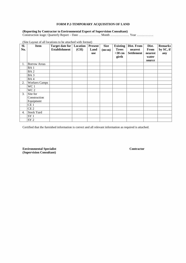
FORM P.2-TEMPORARY ACQUISITION OF LAND (Reporting by Contractor to Environmental Expert of Supervision Consultant) Construction stage: Quarterly Report – Date ………………… Month ……………… Year ……………. (Site Layout of all locations to be attached with format)
Sl. No.
Item Target date for Establishment
Location (CH)
Present Land use
Size (mm)
Existing Trees
>30 cm girth
Dist. From nearest
Settlement
Dist. From
nearest water source
Remarks by SC, if
any
1. Borrow Areas BA 1 BA 2 BA 3 BA 4
2. Workers Camps WC 1 WC 2
3. Site for Construction Equipment
CE 1 CE 2
4. Stock Yard SY 1 SY 2
Certified that the furnished information is correct and all relevant information as required is attached. Environmental Specialist Contractor (Supervision Consultant)
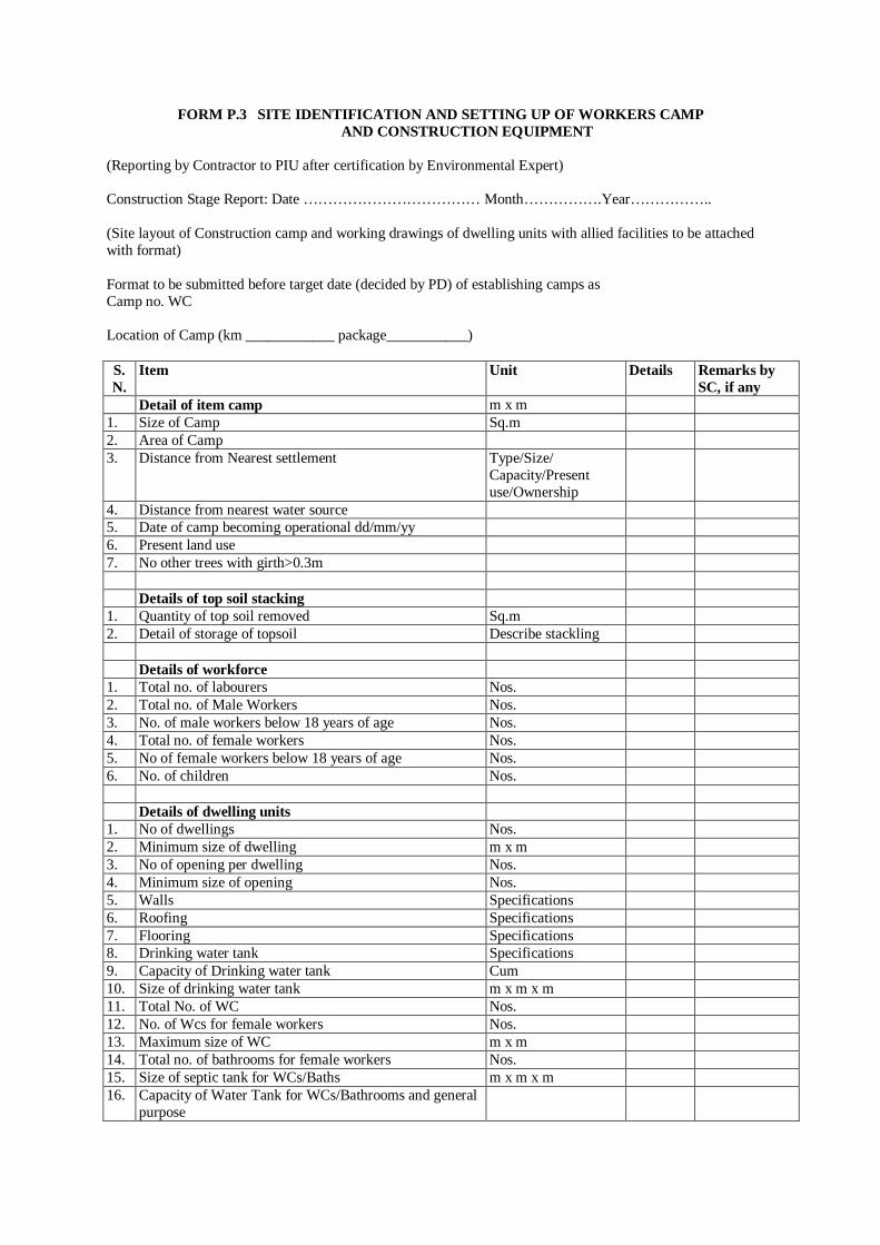
FORM P.3 SITE IDENTIFICATION AND SETTING UP OF WORKERS CAMP AND CONSTRUCTION EQUIPMENT
(Reporting by Contractor to PIU after certification by Environmental Expert) Construction Stage Report: Date ……………………………… Month…………….Year…………….. (Site layout of Construction camp and working drawings of dwelling units with allied facilities to be attached with format) Format to be submitted before target date (decided by PD) of establishing camps as Camp no. WC Location of Camp (km ____________ package___________) S. N.
Item Unit Details Remarks by SC, if any
Detail of item camp m x m 1. Size of Camp Sq.m 2. Area of Camp 3. Distance from Nearest settlement Type/Size/
Capacity/Present use/Ownership
4. Distance from nearest water source 5. Date of camp becoming operational dd/mm/yy 6. Present land use 7. No other trees with girth>0.3m Details of top soil stacking 1. Quantity of top soil removed Sq.m 2. Detail of storage of topsoil Describe stackling Details of workforce 1. Total no. of labourers Nos. 2. Total no. of Male Workers Nos. 3. No. of male workers below 18 years of age Nos. 4. Total no. of female workers Nos. 5. No of female workers below 18 years of age Nos. 6. No. of children Nos. Details of dwelling units 1. No of dwellings Nos. 2. Minimum size of dwelling m x m 3. No of opening per dwelling Nos. 4. Minimum size of opening Nos. 5. Walls Specifications 6. Roofing Specifications 7. Flooring Specifications 8. Drinking water tank Specifications 9. Capacity of Drinking water tank Cum 10. Size of drinking water tank m x m x m 11. Total No. of WC Nos. 12. No. of Wcs for female workers Nos. 13. Maximum size of WC m x m 14. Total no. of bathrooms for female workers Nos. 15. Size of septic tank for WCs/Baths m x m x m 16. Capacity of Water Tank for WCs/Bathrooms and general
purpose
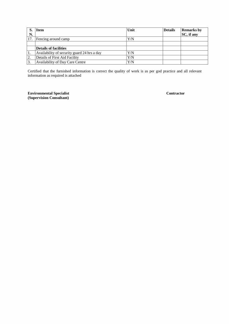
S. N.
Item Unit Details Remarks by SC, if any
17. Fencing around camp Y/N Details of facilities 1. Availability of security guard 24 hrs a day Y/N 2. Details of First Aid Facility Y/N 3. Availability of Day Care Centre Y/N Certified that the furnished information is correct the quality of work is as per god practice and all relevant information as required is attached Environmental Specialist Contractor (Supervision Consultant)
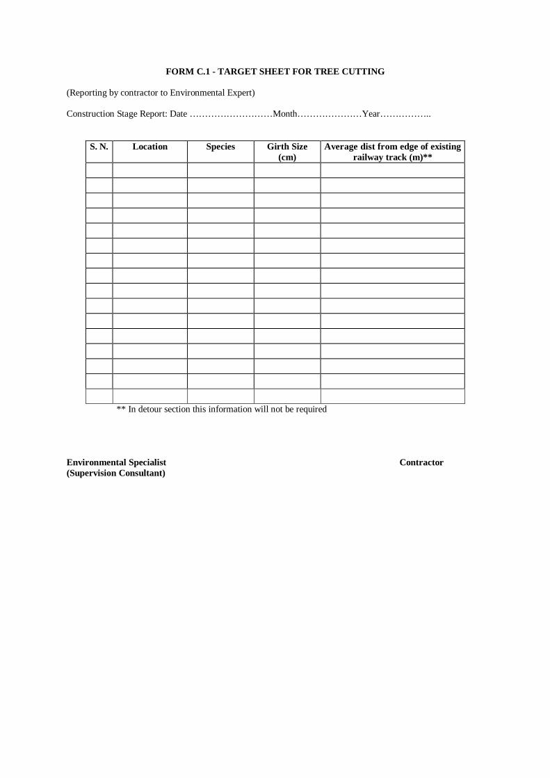
FORM C.1 - TARGET SHEET FOR TREE CUTTING (Reporting by contractor to Environmental Expert) Construction Stage Report: Date ………………………Month…………………Year……………..
S. N. Location Species Girth Size (cm)
Average dist from edge of existing railway track (m)**
** In detour section this information will not be required Environmental Specialist Contractor (Supervision Consultant)

FORM C.2 - WATER REQUIRED FOR CONSTRUCTION (Reporting by contractor to Environmental Expert) Construction Stage: Monthly Report – Date………………. Month……………..Year
Sl. No.
Source (Name) Location Distance from Railway Track
Water Drawn (m3/day)
Remarks
1. Rivers
2. Streams/Canal
3. Ponds
4. Tube well
5. Other source / tankers Total Water Used
Certified that the above information is correct Environmental Specialist Contractor (Supervision Consultant)
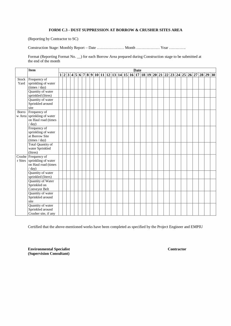
FORM C.3 - DUST SUPPRESSION AT BORROW & CRUSHER SITES AREA (Reporting by Contractor to SC) Construction Stage: Monthly Report – Date ………………… Month ……………… Year …………. Format (Reporting Format No. __) for each Borrow Area prepared during Construction stage to be submitted at the end of the month
Date Item 1 2 3 4 5 6 7 8 9 10 11 12 13 14 15 16 17 18 19 20 21 22 23 24 25 26 27 28 29 30
Frequency of sprinkling of water (times / day)
Quantity of water sprinkled (litres)
Stock Yard
Quantity of water Sprinkled around site
Frequency of sprinkling of water on Haul road (times / day)
Frequency of sprinkling of water at Borrow Site (times / day)
Borrow Area
Total Quantity of water Sprinkled (litres)
Frequency of sprinkling of water on Haul road (times / day)
Quantity of water sprinkled (liters)
Quantity of Water Sprinkled on Conveyor Belt
Quantity of water Sprinkled around site
Crusher Sites
Quantity of water Sprinkled around Crusher site, if any
Certified that the above-mentioned works have been completed as specified by the Project Engineer and EMPIU Environmental Specialist Contractor (Supervision Consultant)
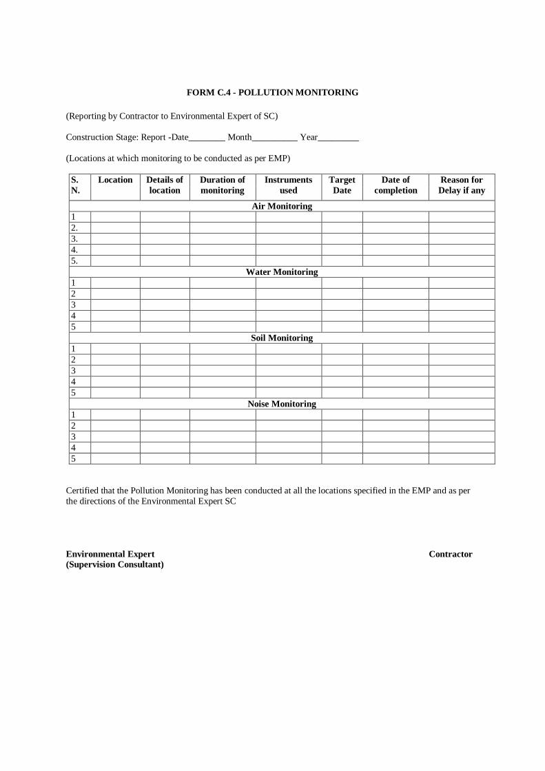
FORM C.4 - POLLUTION MONITORING (Reporting by Contractor to Environmental Expert of SC) Construction Stage: Report -Date________ Month__________ Year_________ (Locations at which monitoring to be conducted as per EMP)
S. N.
Location Details of location
Duration of monitoring
Instruments used
Target Date
Date of completion
Reason for Delay if any
Air Monitoring 1 2. 3. 4. 5.
Water Monitoring 1 2 3 4 5
Soil Monitoring 1 2 3 4 5
Noise Monitoring 1 2 3 4 5
Certified that the Pollution Monitoring has been conducted at all the locations specified in the EMP and as per the directions of the Environmental Expert SC Environmental Expert Contractor (Supervision Consultant)
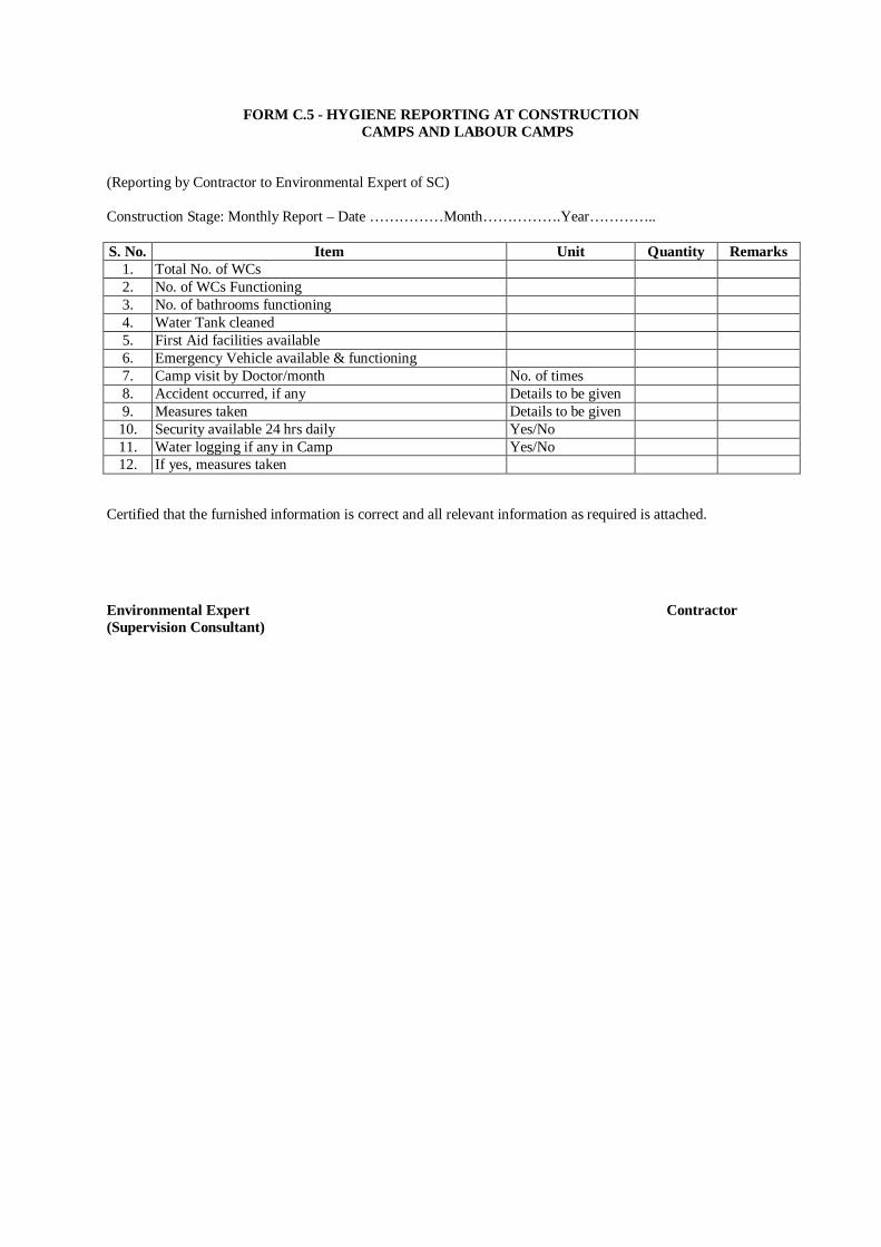
FORM C.5 - HYGIENE REPORTING AT CONSTRUCTION CAMPS AND LABOUR CAMPS
(Reporting by Contractor to Environmental Expert of SC) Construction Stage: Monthly Report – Date ……………Month…………….Year………….. S. No. Item Unit Quantity Remarks
1. Total No. of WCs 2. No. of WCs Functioning 3. No. of bathrooms functioning 4. Water Tank cleaned 5. First Aid facilities available 6. Emergency Vehicle available & functioning 7. Camp visit by Doctor/month No. of times 8. Accident occurred, if any Details to be given 9. Measures taken Details to be given 10. Security available 24 hrs daily Yes/No 11. Water logging if any in Camp Yes/No 12. If yes, measures taken
Certified that the furnished information is correct and all relevant information as required is attached.
Environmental Expert Contractor (Supervision Consultant)
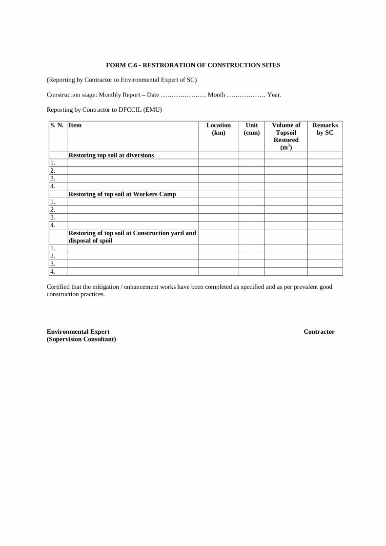
FORM C.6 - RESTRORATION OF CONSTRUCTION SITES (Reporting by Contractor to Environmental Expert of SC) Construction stage: Monthly Report – Date ………………… Month ……………… Year. Reporting by Contractor to DFCCIL (EMU)
S. N. Item Location (km)
Unit (cum)
Volume of Topsoil
Restored (m3)
Remarks by SC
Restoring top soil at diversions 1. 2. 3. 4. Restoring of top soil at Workers Camp 1. 2. 3. 4. Restoring of top soil at Construction yard and
disposal of spoil
1. 2. 3. 4.
Certified that the mitigation / enhancement works have been completed as specified and as per prevalent good construction practices. Environmental Expert Contractor (Supervision Consultant)
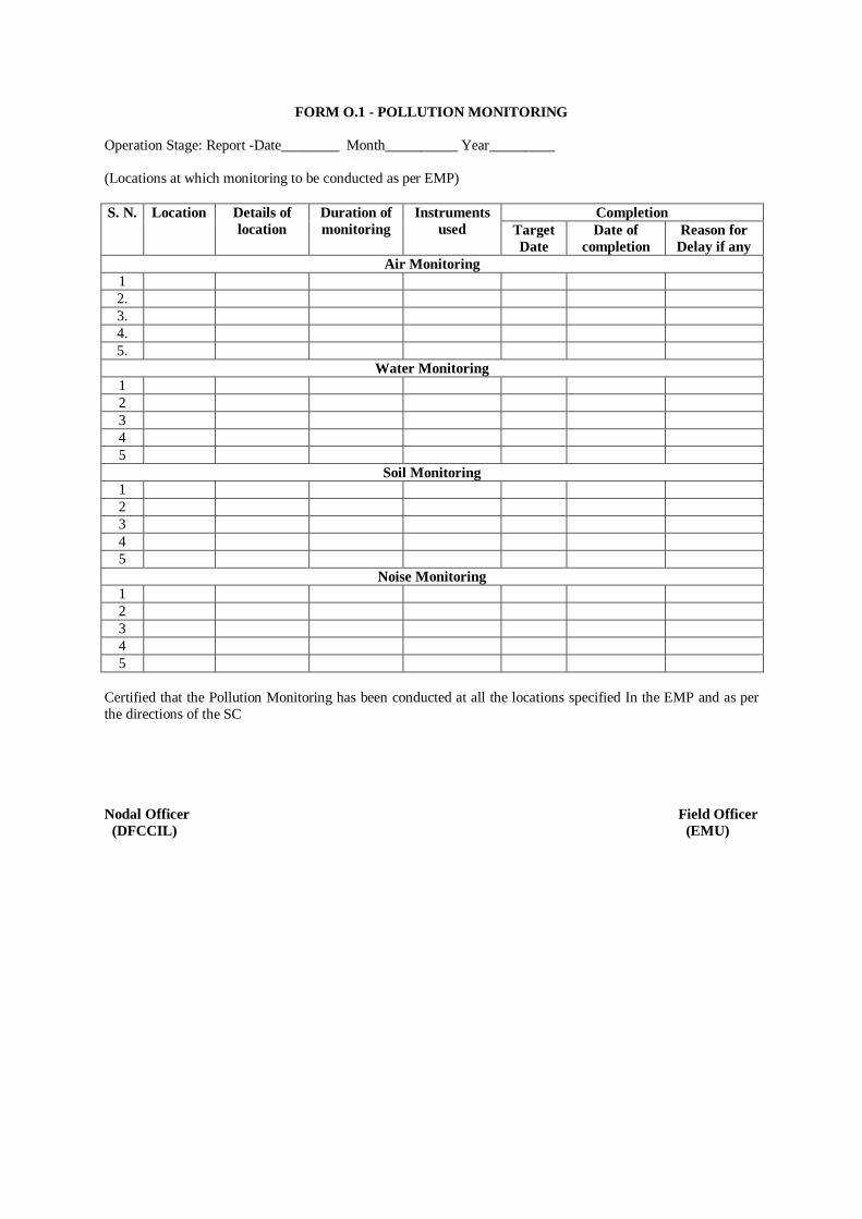
FORM O.1 - POLLUTION MONITORING Operation Stage: Report -Date________ Month__________ Year_________ (Locations at which monitoring to be conducted as per EMP)
Completion S. N. Location Details of location
Duration of monitoring
Instruments used Target
Date Date of
completion Reason for
Delay if any Air Monitoring
1 2. 3. 4. 5.
Water Monitoring 1 2 3 4 5
Soil Monitoring 1 2 3 4 5
Noise Monitoring 1 2 3 4 5
Certified that the Pollution Monitoring has been conducted at all the locations specified In the EMP and as per the directions of the SC Nodal Officer Field Officer (DFCCIL) (EMU)
Related Documents