West Bengal Major Irrigation and Flood Management Project (WBMIFMP) (Funded by The World Bank) November 2018 SPMU- WBMIFMP Irrigation & Waterways Directorate Government of West Bengal India Environmental and Social Impact Assessment (ESIA) Report (Including ESMP)

Welcome message from author
This document is posted to help you gain knowledge. Please leave a comment to let me know what you think about it! Share it to your friends and learn new things together.
Transcript
West Bengal Major Irrigation and Flood
Management Project (WBMIFMP)
(Funded by The World Bank)
November
2018
SPMU- WBMIFMP
Irrigation & Waterways Directorate
Government of West Bengal
India
Environmental and Social Impact
Assessment (ESIA) Report
(Including ESMP)
Table of Contents
ABBREVIATIONS ............................................................................................................................................... I
EXECUTIVE SUMMARY ...................................................................................................................................... I
CHAPTER 1: INTRODUCTION ...................................................................................................................... 1
1.1 BASIN FEATURES ........................................................................................................................................ 1
1.2 SALIENT FEATURES OF DAMODAR VALLEY CORPORATION ................................................................................... 2
1.3 DRAINAGE SYSTEM ..................................................................................................................................... 3
1.4 RESERVOIRS ON DAMODAR RIVER ................................................................................................................. 4
1.5 IRRIGATION SYSTEM.................................................................................................................................... 4
1.6 FLOOD IN LOWER DAMODAR ........................................................................................................................ 4
1.7 JUSTIFICATION OF THE PROJECT ..................................................................................................................... 4
1.7.1 Dilapidated Irrigation Structures ...................................................................................................... 4
1.7.2 Affected Canal Lining ........................................................................................................................ 5
1.7.3 Occurrence of Flood .......................................................................................................................... 5
1.8 NEED OF THE PROJECT ................................................................................................................................ 6
1.9 OBJECTIVE OF THE ESIA REPORT ................................................................................................................... 6
1.10 LEGAL AND PLANNING CONTEXT OF ESIA ....................................................................................................... 7
1.11 GENERAL APPROACH TO ESIA PREPARATION ................................................................................................... 8
1.11.1 Sources of Information Used in the Preparation of the ESIA ........................................................ 8
1.11.2 ESIA Methodology ........................................................................................................................ 8
1.12 PROJECT AFFECTED AREA .......................................................................................................................... 12
1.13 SCOPE OF ESMP OF THE PROJECT ............................................................................................................... 13
1.14 STRUCTURE OF THE REPORT ....................................................................................................................... 14
CHAPTER 2: BRIEF PROJECT DESCRIPTION ................................................................................................ 15
2.1 PROJECT BACKGROUND ............................................................................................................................. 15
2.2 HISTORY OF FLOOD EVENTS ....................................................................................................................... 15
2.3 IMPLEMENTATION OF FLOOD MANAGEMENT ................................................................................................ 16
2.4 PERFORMANCE OF DAMODAR VALLEY RESERVOIRS IN FLOOD MODERATION ....................................................... 16
2.5 FLOOD MANAGEMENT APPROACH IN THE LOWER VALLEY ................................................................................ 16
2.6 LESSONS LEARNT FOR FLOOD MANAGEMENT ................................................................................................ 17
2.7 DRAINAGE CONGESTION ............................................................................................................................ 17
2.7.1 Congestion due to Heavy Flow ........................................................................................................ 17
2.7.2 Cross Bunds ..................................................................................................................................... 17
2.7.3 Water Logging in the Streams ........................................................................................................ 17
2.7.4 River Bank Erosion & its Control ..................................................................................................... 17
2.8 OBJECTIVE OF WBMIFMP ........................................................................................................................ 18
2.9 PROJECT LOCATION .................................................................................................................................. 18
2.10 PROJECT COMPONENTS ............................................................................................................................. 20
2.11 PROJECT COST ......................................................................................................................................... 26
CHAPTER 3: LEGAL AND REGULATORY COMPLIANCE ............................................................................... 27
3.1 SOCIAL POLICIES AND REGULATIONS ............................................................................................................ 34
3.1.1 Land Acquisition Related Act / Policy .............................................................................................. 34
3.1.2 Panchayati Raj Act .......................................................................................................................... 35
3.1.3 Agricultural Produce Market Committee Act, 2003 ........................................................................ 35
3.2 WORLD BANK SAFEGUARD POLICIES ............................................................................................................ 36
CHAPTER 4: ENVIRONMENTAL AND SOCIAL BASELINE ............................................................................. 38
4.1 INTRODUCTION ........................................................................................................................................ 38
4.2 DATA COLLECTION ................................................................................................................................... 38
4.3 PRIMARY BASELINE DATA .......................................................................................................................... 38
4.4 PHYSICAL ENVIRONMENT ........................................................................................................................... 38
4.4.1 Physiography .................................................................................................................................. 38
4.4.2 Agroclimatic Zone ........................................................................................................................... 42
4.4.3 Geology ........................................................................................................................................... 43
4.4.4 Earthquake Zone ............................................................................................................................. 44
4.4.5 Meteorology ................................................................................................................................... 45
4.5 GROUND WATER UTILIZATION .................................................................................................................... 48
4.6 USE OF DRIP AND SPRINKLER IRRIGATION SYSTEMS ......................................................................................... 49
4.7 ENVIRONMENTAL FLOW............................................................................................................................. 49
4.8 LAND USE & LAND COVER ......................................................................................................................... 50
4.9 SOIL QUALITY .......................................................................................................................................... 52
4.10 SEDIMENT QUALITY .................................................................................................................................. 53
4.10.1 Testing by RRI ............................................................................................................................. 53
4.10.2 Testing by MoEF & WBPCB recognised laboratory ..................................................................... 55
4.10.3 Present use of Silted Material ..................................................................................................... 57
4.11 AMBIENT AIR QUALITY .............................................................................................................................. 58
4.12 AMBIENT NOISE QUALITY .......................................................................................................................... 58
4.13 SURFACE WATER QUALITY ......................................................................................................................... 59
4.14 GROUND WATER AVAILABILITY ................................................................................................................... 60
4.15 GROUND WATER QUALITY ......................................................................................................................... 61
4.16 SENSITIVE RECEPTORS IN PROJECT AREA ....................................................................................................... 62
4.17 BIOLOGICAL ENVIRONMENT ....................................................................................................................... 62
4.17.1 Forest Profile............................................................................................................................... 62
4.17.2 Flora in Project Area ................................................................................................................... 63
4.17.3 Fauna in Project Area ................................................................................................................. 64
4.17.4 Aquatic Flora and Fauna ............................................................................................................ 67
4.17.5 Fish Biodiversity .......................................................................................................................... 68
4.17.6 Fishers Population ...................................................................................................................... 69
4.17.7 Migratory Path ........................................................................................................................... 70
4.17.8 Sensitive Areas ............................................................................................................................ 70
4.17.9 Cropping Pattern ........................................................................................................................ 70
4.17.10 Farming Practices ............................................................................................................................ 72
4.17.11 Nutrient Management .................................................................................................................... 72
4.17.12 Pest Management ........................................................................................................................... 72
4.18 SOCIAL ENVIRONMENT .............................................................................................................................. 74
4.18.1 Demography ............................................................................................................................... 74
4.18.2 ST & SC Population ..................................................................................................................... 74
4.18.3 Distribution by Age Group .......................................................................................................... 75
4.18.4 Women Headed Families ............................................................................................................ 75
4.18.5 Distribution of Affected Structures by Social Groups .................................................................. 75
4.18.6 Literacy ....................................................................................................................................... 78
4.18.7 Working Population .................................................................................................................... 78
4.18.8 Livelihood.................................................................................................................................... 79
4.18.9 Operational Holding ................................................................................................................... 79
4.18.10 Water User Association / Chalk Committee .................................................................................... 80
CHAPTER 5: ANALYSIS OF ALTERNATIVE .................................................................................................. 82
5.1 PROJECT DEVELOPMENT ALTERNATIVES ........................................................................................................ 82
5.2 LOCATIONAL ALTERNATIVE ......................................................................................................................... 84
5.3 TECHNICAL ALTERNATIVES ......................................................................................................................... 88
5.4 POST IMPLEMENTATION BENEFIT ................................................................................................................ 90
CHAPTER-6: POTENTIAL ENVIRONMENTAL AND SOCIAL IMPACTS AND MITIGATION............................... 96
6.1 INTRODUCTION ........................................................................................................................................ 96
6.2 APPROACH AND METHODOLOGY ................................................................................................................. 96
6.2.1 Criteria for Determining degree of Importance of Impacts ............................................................ 96
6.2.2 Environmental Screening ................................................................................................................ 96
6.2.3 Categorization of Components ....................................................................................................... 96
6.2.4 Categorisation of Project Aspects ................................................................................................... 97
6.3 SCREENING OF ENVIRONMENTAL & SOCIAL IMPACTS ...................................................................................... 98
6.4 AVOIDANCE PRINCIPLES ........................................................................................................................... 101
6.5 IMPACTS AND MITIGATIONS ..................................................................................................................... 101
6.5.1 Impacts During Design & Pre-Constructional Phase: .................................................................... 101
6.5.2 Impact on National Parks/Wildlife Sanctuary ............................................................................... 106
6.5.3 Impacts During Construction Phase .............................................................................................. 106
6.5.4 Impact on Fishers and Fishery Activity .......................................................................................... 113
6.5.5 Impact on Environmental flow ...................................................................................................... 114
6.5.6 Mitigation Measures of Generic Impact ....................................................................................... 114
6.6 GENERIC MITIGATION MEASURES ............................................................................................................. 115
CHAPTER 7: ENVIRONMENTAL AND SOCIAL MANAGEMENT PLAN (ESMP) ............................................ 116
7.1 OVERVIEW OF ENVIRONMENTAL AND SOCIAL MANAGEMENT PLANS (ESMPS) .................................................. 116
7.2 MITIGATION MEASURES SPECIFIC TO EACH ACTIVITY TYPE ............................................................................. 118
7.3 WASTE MANAGEMENT PLAN ................................................................................................................... 140
7.3.1 Construction and Demolition Waste Management Plan .............................................................. 140
7.3.2 Hazardous Waste Management Plan ........................................................................................... 142
7.3.3 Silt Management Plan................................................................................................................... 144
7.3.4 Vegetation Waste Management Plan: ......................................................................................... 147
7.4 GENERIC WASTE MANAGEMENT PLAN ....................................................................................................... 148
7.5 LABOUR INFLUX AND CONSTRUCTION WORKERS’ CAMP MANAGEMENT PLAN ................................................... 150
7.5.1 Workers’ Camp Management Plan ............................................................................................... 150
7.5.2 Gender based violence .................................................................................................................. 155
7.6 MITIGATION MEASURES AND MANAGEMENT PLAN FOR CONSTRUCTION RELATED ISSUES .................................... 156
7.7 COMPENSATORY AFFORESTATION PLAN ..................................................................................................... 161
7.8 TRAFFIC MANAGEMENT PLAN .................................................................................................................. 162
CHAPTER 8: TRIBAL PEOPLE’S PLANS (TPP)............................................................................................. 165
8.1 INTRODUCTION ...................................................................................................................................... 165
8.2 ST POPULATION IN PROJECT LOCATIONS ..................................................................................................... 165
8.3 ECONOMIC CONDITION OF TRIBAL ............................................................................................................. 165
8.4 OBJECTIVE OF TPP ................................................................................................................................. 166
8.5 KEY PRINCIPLES OF TRIBAL INCLUSION ........................................................................................................ 167
8.6 INCLUSION OF TRIBAL IN PROJECT ACTIVITIES ............................................................................................... 167
8.7 IMPLEMENTATION ARRANGEMENT ............................................................................................................ 168
8.8 MONITORING AND EVALUATION ............................................................................................................... 169
CHAPTER 9: PEST MANAGEMENT PLAN ................................................................................................. 170
9.1 THE WORLD BANK OPERATIONAL GUIDELINES ............................................................................................. 170
9.2 OBJECTIVES OF IPM PLAN ....................................................................................................................... 171
9.3 SALIENT FEATURES OF THE PROJECT APPROACH ........................................................................................... 171
9.4 INTEGRATED PEST MANAGEMENT APPROACH.............................................................................................. 171
9.5 IDENTIFICATION PROCESS......................................................................................................................... 172
9.6 ASSESSMENT OF ECONOMIC THRESHOLD LEVEL ........................................................................................... 172
9.7 PEST AND DISEASE SURVEILLANCE ............................................................................................................. 172
9.8 MAJOR ACTIVITIES UNDER IPM STRATEGY .................................................................................................. 173
9.9 ASSOCIATED RISKS AND MITIGATION MEASURES .......................................................................................... 173
9.10 CRITERIA FOR PESTICIDE SELECTION AND USE .............................................................................................. 174
9.11 PESTICIDE STORAGE, HANDLING AND DISPOSAL ........................................................................................... 174
9.11.1 Precautionary Measures ........................................................................................................... 174
9.11.2 Storage ..................................................................................................................................... 174
9.11.3 Transportation .......................................................................................................................... 174
9.11.4 Disposal System ........................................................................................................................ 174
9.12 CAPACITY BUILDING ON IPM .................................................................................................................... 175
9.13 PMP IMPLEMENTATION ARRANGEMENT .................................................................................................... 175
9.14 MONITORING AND SUPERVISION ............................................................................................................... 175
CHAPTER 10: ENVIRONMENTAL AND SOCIAL MONITORING PLAN .......................................................... 177
10.1 MONITORING OF STATUTORY COMPLIANCES ............................................................................................... 177
10.2 ENVIRONMENT AND SOCIAL ASPECTS TO BE MONITORED ............................................................................... 177
10.2.1 Water Quality ........................................................................................................................... 178
10.2.2 Ambient Air Quality (AAQ) Monitoring ..................................................................................... 178
10.2.3 Ambient Noise Level Monitoring .............................................................................................. 178
10.2.4 Soil Quality ................................................................................................................................ 178
10.2.5 Sediment Quality ...................................................................................................................... 178
10.2.6 Erosion Control Measures ......................................................................................................... 179
10.2.7 Flora and Fauna ........................................................................................................................ 179
10.2.8 Compensatory Afforestation and Plant Survival Rate .............................................................. 179
10.2.9 Construction Camp Management ............................................................................................ 179
10.2.10 Waste Management and Debris Removal ................................................................................ 179
10.2.11 Site Restoration ........................................................................................................................ 179
10.2.12 Resettlement and Compensation for Asset Acquisition ............................................................ 179
10.2.13 Livelihood Restoration of PAFs / PAPs ...................................................................................... 179
10.2.14 Safety at Works ........................................................................................................................ 180
10.2.15 Living Standard of Workers ...................................................................................................... 180
10.2.16 Employment of Local Population .............................................................................................. 180
10.2.17 Gender Participation in Works ................................................................................................. 180
10.2.18 HIV/AIDS Awareness Program .................................................................................................. 180
10.2.19 Dam Safety ............................................................................................................................... 180
10.3 BUDGET FOR ENVIRONMENTAL MONITORING .............................................................................................. 197
10.4 REPORTING SYSTEM OF ENVIRONMENTAL AND SOCIAL MONITORING ............................................................... 198
10.5 MID-TERM AND END-TERM AUDIT ............................................................................................................. 198
CHAPTER 11: STAKEHOLDER CONSULTATION .......................................................................................... 200
11.1 APPROACH ............................................................................................................................................ 200
11.1.1 Project Area Coverage under Assessment ................................................................................ 200
11.1.2 Consultation with Potential PAFs / PAPs: ................................................................................. 200
11.1.3 Focus Group Discussion ............................................................................................................ 200
11.1.4 Consultation Meeting with Govt. Departments........................................................................ 202
11.2 STAKEHOLDER’S CONCERNS / OPINION ...................................................................................................... 203
11.3 OPINION CATEGORIZATION ...................................................................................................................... 209
11.4 ISSUES ADDRESSED IN ESMP .................................................................................................................... 210
11.5 INFORMATION DISCLOSURE ...................................................................................................................... 212
CHAPTER 12: CAPACITY BUILDING ........................................................................................................... 213
12.1 STRATEGY FOR CAPACITY BUILDING ........................................................................................................... 213
12.2 CAPACITY BUILDING PLAN ........................................................................................................................ 213
CHAPTER 13: GRIEVANCE REDRESSAL MECHANISM ................................................................................ 215
CHAPTER 14: INSTITUTIONAL ARRANGEMENT FOR IMPLEMENTATION OF ESMP ................................... 217
14.1 PROJECT MANAGEMENT CONSULTANT (PMC) ............................................................................................ 218
14.1.1 Senior Safeguard Specialist at SPMU level (under PMC) .......................................................... 219
14.1.2 Junior Safeguard Specialist at DPMU level (under PMC) .......................................................... 219
14.2 M&E AGENCY ....................................................................................................................................... 220
14.3 ROLE OF IWD STAFF IN IMPLEMENTATION OF EMP ..................................................................................... 220
14.4 INSTITUTIONAL ARRANGEMENTS BY CONTRACTOR ......................................................................................... 220
CHAPTER 15: BUDGET FOR ESMP IMPLEMENTATION .............................................................................. 225
List of Table
Table 1: Basin Specification ___________________________________________________________________ 2
Table 2: DVC and its Achievements _____________________________________________________________ 2
Table 3: Irrigation Structures __________________________________________________________________ 5
Table 4: Canal lining _________________________________________________________________________ 5
Table 5: Surface irrigation potential and utilized in project districts (considering project blocks only) _________ 6
Table 6: Project activity wise assessment area ___________________________________________________ 13
Table 7: Flood Moderation from Upstream Dam of Damodar _______________________________________ 16
Table 8: Sub-Components/Activities under Irrigation Management ___________________________________ 20
Table 9: Sub-Components/Activities under Irrigation Modernization __________________________________ 21
Table 10: Sub-Components/Activities under Flood Management _____________________________________ 23
Table 11: Applicable Relevant Acts, Policies, Legislations and Guidelines ______________________________ 28
Table 12: World Bank Safeguard Policies and its Applicability _______________________________________ 36
Table 13: Physiography of Study Locations in Project Areas _________________________________________ 39
Table 14: Districts by Agroclimatic Zone and Main Crops Grown _____________________________________ 42
Table 15: Lithology of project area _____________________________________________________________ 43
Table 16: Project Districts Under Seismic Zone ___________________________________________________ 45
Table 17: Mean Maximum and Minimum Temperature in Project Area for 2014 ________________________ 45
Table 18: Season wise average annual rainfall ___________________________________________________ 46
Table 19: Total Seasonal Rainfall in different Rain-gauges during Monsoon, 2016 _______________________ 46
Table 20: Month wise rainfall from 2013-17 in Bankura ____________________________________________ 47
Table 21: Month wise rainfall from 2013-17 in Bardhhaman ________________________________________ 47
Table 22: Month wise rainfall from 2013-17 in Hooghly ____________________________________________ 48
Table 23: Month wise rainfall from 2013-17 in Howrah ____________________________________________ 48
Table 24:Relative Humidity (in %) by station and month____________________________________________ 48
Table 25: Flood Discharge and Sharing _________________________________________________________ 49
Table 26: Land Use (LU) and land Cover (LC) of Project Locations ____________________________________ 50
Table 27: Project district wise major soil class and area coverage ____________________________________ 52
Table 28: Sampling location of silted material ____________________________________________________ 55
Table 29: Quality of silted material of Mundeswari and other drainage canal considered for desiltation _____ 56
Table 30: Ambient air quality of project sites _____________________________________________________ 58
Table 31: Noise Quality in Project Locations _____________________________________________________ 58
Table 32: Water Quality of Damodar River ______________________________________________________ 59
Table 33: Physio-Chemical Characteristics of Channel Water ________________________________________ 59
Table 34: Ground Water Status in Project Districts (As on 31st March 2013) ___________________________ 60
Table 35: Ground Water Quality Data of Project District ___________________________________________ 61
Table 36: Avalability of School, Hospital, Park within 100 meter periphery of Embankment _______________ 62
Table 37: Area under Forest in project district ____________________________________________________ 62
Table 38: List of common trees found in project area ______________________________________________ 63
Table 39: Embankment wise tree required to be removed __________________________________________ 64
Table 40: fauna species present in project area ___________________________________________________ 65
Table 41: Most Dominant Flora and Fauna of Wetland/ pond _______________________________________ 67
Table 42: Fish Diversity in the Lower Damodar under section of Mundeshwari Bifurcation ________________ 68
Table 43: Fisherman Population in Project Blocks and Project Flood Plain Area _________________________ 69
Table 44: Crops Grown in Project District and Area under Different Crops ______________________________ 71
Table 45: Cropping Pattern among Farmers in Project Districts ______________________________________ 71
Table 46: Pesticide consumption in the year of 2012_______________________________________________ 73
Table 47: Key Pests by Crop Categories in Project Districts __________________________________________ 73
Table 48: Chemical Pesticides in use by the Farmers in Project Districts _______________________________ 73
Table 49: Demographic profile of whole project district ____________________________________________ 74
Table 50: Project district wise SC & ST population concentration _____________________________________ 75
Table 51: Distribution of Head of the Households by Age Group _____________________________________ 75
Table 52: Distribution of Head of Household by Sex _______________________________________________ 75
Table 53: Structural Typology by Social Groups ___________________________________________________ 76
Table 54: Average Area of the Structures by Social Groups __________________________________________ 77
Table 55: Literacy Rate in Project District ________________________________________________________ 78
Table 56: Worker and Non-Worker Population ___________________________________________________ 78
Table 57: Male Work Force (Main and Marginal) _________________________________________________ 79
Table 58: Female Work Force (Main and Marginal) _______________________________________________ 79
Table 59: Project district wise land holding status _________________________________________________ 79
Table 60: Land Holding Pattern _______________________________________________________________ 80
Table 61: Operational Holding Pattern among Farmers in Project Districts _____________________________ 80
Table 62: Selection of project activities to meet project objectives ____________________________________ 82
Table 63: Locational Alternative _______________________________________________________________ 85
Table 64: Technical Alternative ________________________________________________________________ 88
Table 65: Alternative by Project Activity ________________________________________________________ 90
Table 66: Categorization Criteria ______________________________________________________________ 97
Table 67: Categorization of Project Activities based on Impact Category ______________________________ 97
Table 68: Categorization of Project Planned Activities _____________________________________________ 97
Table 69: Screening of Environmental and Social Impact ___________________________________________ 99
Table 70: Impact Areas Within Project Cycle ____________________________________________________ 100
Table 71: Private Structure to be affected (in nos.) due to Flood wall and Embankment strengthening _____ 102
Table 72: Social Categories of the Affected Households ___________________________________________ 103
Table 73: Utilities / Facilities to be impacted due to flood wall and embankment strengthening work ______ 104
Table 74: Embankment wise tree required to be removed _________________________________________ 105
Table 75: Intervention wise generation quantity of excavated material ______________________________ 107
Table 76: Avalability of School, Hospital within 100 meter periphery _________________________________ 111
Table 77: Flood Discharge and Sharing ________________________________________________________ 114
Table 78: Generic Mitigation Measures for All Project Activities ____________________________________ 115
Table 79: Overview of ESMP _________________________________________________________________ 116
Table 80: ESMP for Modernization of Irrigation Infrastructure ______________________________________ 119
Table 81: ESMP for Flood Management ________________________________________________________ 129
Table 82: Utilization plan for C&D waste _______________________________________________________ 140
Table 83: Re-utilization plan of desilted material ________________________________________________ 145
Table 84: Waste Management Plan ___________________________________________________________ 148
Table 85: Selection of Sites for Construction Camp Establishment ___________________________________ 151
Table 86: Camp Site Management Plan ________________________________________________________ 152
Table 87: Construction Related Issues and Mitigation Measures ____________________________________ 156
Table 88: Social Categories of the Affected Households ___________________________________________ 165
Table 89: Average Income by Social Categories in Project Locations _________________________________ 166
Table 90: Integrated Pest Management Approach _______________________________________________ 171
Table 91: Adoption of IPM Methods and its Priority ______________________________________________ 172
Table 92: IPM Strategy and Key Activities ______________________________________________________ 173
Table 93: Risks and Mitigation Measures_______________________________________________________ 173
Table 94: Monitoring of IPM _________________________________________________________________ 176

Table 95: Monitoring of Impact Areas _________________________________________________________ 178
Table 96: Environmental and Social Monitoring Action Plan during different project stage _______________ 182
Table 97: Budget for Environmental Monitoring _________________________________________________ 197
Table 98: FGD with stakeholder community ____________________________________________________ 201
Table 99: Environmental and social concern by different stakeholders _______________________________ 203
Table 100: Concerns / Opinion of Stakeholders __________________________________________________ 209
Table 101: Issues Addressed in ESMP __________________________________________________________ 210
Table 102: Capacity Building Plan ____________________________________________________________ 213
Table 103: Grievance Redressal Plan __________________________________________________________ 216
Table 104: Institutional Arrangement for ESMP Implementation ____________________________________ 221
List of Figures
Figure 1: River Basin Map of West Bengal Including Damodar Sub-Basin ............................................................. 1
Figure 2: Map showing location of sample village where field study was carried out ......................................... 10
Figure 3: Map showing location of census survey covered under RAP study ....................................................... 11
Figure 4: Map of the project districts .................................................................................................................... 18
Figure 5: Map showing project district wise blocks .............................................................................................. 19
Figure 6: Index map showing project district wise blocks within DV command area ........................................... 20
Figure 7: Map showingintervention location under Irrigation Modernization ..................................................... 22
Figure 8: Map showing intervention location under flood management ............................................................. 25
Figure 9: Geohydrology map of Project District Bankura, West Bengal ............................................................... 44
Figure 10: Hydrogeological map of Project District Bardhhaman, West Bengal .................................................. 44
Figure 11: Hydrogeological map of Project District Hooghly, West Bengal .......................................................... 44
Figure 12: Hydrogeological map of Project District Howrah, West Bengal .......................................................... 44
Figure 13: Earthquake Hazard Map of West Bengal ............................................................................................ 45
Figure 14: LU & LC of Mundeswari river near the planned working zone and 3 km. influence zone .................... 50
Figure 15: LU&LC of Damodar Left & Right Embankment near the planned working zone and 3 km. influence
zone ...................................................................................................................................................................... 50
Figure 16: LU&LC of Hurhura canal near the planned working zone and 3 km. influence zone ........................... 51
Figure 17: LU&LC of Upper Rampur canal near the planned working zone and 3 km. influence zone ................. 51
Figure 18: LU&LC of Madaria Khal near the planned working zone and 3 km. influence zone ............................ 51
Figure 19: LU&LC of 41 canals near the planned working zone and 3 km. influence zone ................................... 51
Figure 20: Soil classification map of DV Command area ...................................................................................... 53
Figure 21: Sand heap on agricultural land at Markunda village of Howrah (Mundeswari river) ......................... 57
Figure 22: Sand heap by sand miners ................................................................................................................... 57
Figure 23: Monsoon cultivation of paddy on breach affected -2017 (5 feet sand deposited on almost 33 Acre
agli land)country side, located opposite side of River Lift pump house at Dihivut ............................................... 57
Figure 24: Arsenic Affected Blocks in DV Command ............................................................................................. 61
Figure 25: Salinity Affected Blocks in DV Command ............................................................................................. 61
Figure 26: Forest Map of Howrah & Hooghly District ........................................................................................... 63
Figure 27: Forest Map of Bankura District ............................................................................................................ 63
Figure 28: Forest Map of Bardhhaman District .................................................................................................... 63
Figure 29: Location map showing Ramnabagan WLS at Bardhhaman- 1 block of East Bardhhaman district ..... 70
Figure 30: View of Mundeswari River in the month of September, 2018 ........................................................... 113
Figure 31: View of Mundeswari River near Markunda Village in the month of September, 2018 ..................... 113
Figure 32: Overall project grievance redress mechanism ................................................................................... 216
Figure 33: ESMP Implementation Structure ....................................................................................................... 218
i
Abbreviations
AIIB Asian Infrastructure Investment Bank APD Additional Project Director APMC Agricultural Produce Market Committees ARG Automated Rain Gauge ASI Archeological Survey of India BDO Block Development Officer BL&LRO Block Land and Land Reform Officer BLC Block Level Committee BMP Best Management Practices BOCWA Building and Other Construction Workers Act C&D Construction and Demolition CCA Certified Command Area CEDAW Convention on Elimination of All Forms of Discrimination against Women CHC Custom Hiring Centre CIB & RC Central Insecticides Board and Registration Committees CITES Convention on International Trade in Endangered Species CMS Convention on Migratory Species COI Corridor of Impact CPCB Central Pollution Control Board CRIS Customized Rainfall Information System CRZMA Coastal Regulation Zone Management Authority CTE Consent to Establish CWC Central Water Commission DAP Diammonium Phosphate DG Diesel Generator DL&LRO District Land and Land Reform Officer DLC District Level Committee DLLR Dept. of Land and Land Reforms DoA Department of Agriculture DPIU District Project Implementation Unit DPMU District Project Management Unit DPR Detail Project Report DPSP Directive Principles of State Policies DRB Damodar River Basin DV Damodar Valley DVC Damodar Valley Corporation DVCA Damodar Valley Corporation Area E&W East and West EC Electrical Conductivity EC Environment Clearance ECoPs Environmental Code of Practices EE Executive Engineer EIA Environment Impact Assessment EHS Environmental Health and Safety EKW East Kolkata Wetlands ESIA Environment and Social Impact Assessment ESMF Environment and Social Management Framework ESMP Environment and Social Management Plan ESZ Eco Sensitive Zones ETL Economic Threshold Level FFS Farmer’s Field School FGD Focus Group Discussion FPC Farmer Producer Company FPG Farmer Producer Group FPG Farmer / Fishermen Producer Groups FPO Farmer Producer Organization
ii
GAP Gender Action Plan GBH Girth by Breast Height GHG Green House Gas GoI Government of India GoWB Government of West Bengal GP Gram Panchayat GRC Grievance Redressal Committee GRC Grievance Redressal Committee GRM Grievance Redressal Mechanism HFL High Flood Level HTL High Tide Line IBRD International Bank for Reconstruction and Development IEC Information Education and Communication ILO International Labour Organization IMD Indian Meteorological Department INM Integrated Nutrition Management IP Indigenous People IPM Integrated Pest Management IPNM Integrated Plant Nutrient Management ITDP / ITDA Integrated Tribal Development Project / Agency IUCN International Union for Conservation of Nature and Natural Resources IWD/ I&WD Irrigation and Waterways Department LARR Land Acquisition Rehabilitation and Resettlement LBMC Left Bank Main Canal LTL Low Tide Line LU & LC Land Use and Land Cover M&E Monitoring and Evaluation M&E Monitoring and Evaluation MADA Modified Area Development Approach MGNREGA/S Mahatma Gandhi National Rural Employment Guarantee Act / Scheme MIS Management Information System MoEFCC Ministry of Environment, Forests and Climate Change MOP Muriate of Potash MPL Maximum Permissible Limit MSW Management of Solid Waste MTR Mid-Term Review NDC Nationally Determined Contributions NEP National Environment Policy NGO Non-Government Organization NGO Non-Government Organization NGT National Green Tribunal NPK Nitrogen, Phosphorous and Potash O&M Operation and Maintenance OP Operational Policy ORG Optimal Rain Gauge PAF Project Affected Family PAP Project Affected Person PCR Physical Cultural Resource PCR Physical Cultural Resources PD Project Director PESA Panchayat Extension to Scheduled Area PIA Project Implementing Agency PIM Project Implementation Manual PIs Performance Indicators PMAY (G) Pradhan Mantri Awas Yojana (Gramin) PMC Project Management Consultant PMU Project Management Unit PWD Public Works Department R&R Rehabilitation and Resettlement RAP Resettlement Action Plan
iii
RBMC Right Bank Main Canal ROW Right of Way RPF Resettlement Policy Framework SARP System of Assured Rice Production SAU State Agriculture University SC Scheduled Caste SEAC State Level Expert Appraisal Committee SEIAA State Environment Impact Assessment Authority SHG Self-Help Group SIA Social Impact Assessment SLF Scientific Land Filling SPCB State Pollution Control Board SPMU State Project Management Unit SRI System of Rice Intensification ST Scheduled Tribe SWID State Water Investigation Directorate ToR Terms of Reference TPP Tribal People’s Plan TPPF Tribal People’s Plan Framework UNESCO United Nations Educational, Scientific and Cultural Organization UNFCCC United Nations Framework Convention for Climate Change WB World Bank WBMIFMP West Bengal Major Irrigation and Flood Management Project WBSLGWRDA West Bengal State Level Ground Water Resource Development Authority WBSPCB West Bengal State Pollution Control Board WHO World Health Organization WLS Wild Life Sanctuary
Executive Summary of ESIA and ESMP Report for WBMIFMP
I | P a g e
Executive Summary
1.0 INTRODUCTION
The command area of the Damodar Valley Corporation (DVC) is served by a canal network having a
total length of 2734 km in the downstream of Durgapur Barrage. It is spread over 41 administrative
development blocks in the districts of Bankura, East Bardhhaman, West Bardhhaman, Hooghly and
Howrah. The Damodar Valley Corporation Area (DVCA) canals currently irrigate around 3,32,000 ha
in the Kharif season (out of a design area of 3,93,800 hectares), 20,000 ha in the Rabi season on the
basis of an earmarked allocation, and an average of 28,000 ha in the summer (Boro) season, depending
on the amount of water remaining in upstream reservoirs and after meeting priority needs. The total
area irrigated (including all sources of water) is approximately 1,00,000 hectares each in the Rabi and
Boro seasons. The main sources of water in areas that are not covered by canal water are wells and
ponds.
The DVCA was developed more than six decades ago and is now degraded. Numerous regulating
structures and cross drainage structures, distributaries and minors have been severely damaged. The
silted up canal network along with loss of water due to seepage in critical zones of unlined canals has
led to reduction in efficiency and scanty irrigation, particularly in tail reaches. This has resulted in
increased ground water use especially during Rabi and Boro seasons by the tail end farmers as they are
not getting the required amount of water at the time of need as per the irrigation schedule. The gap
between irrigation potential created and utilized is increasing, in spite of adequate water availability at
the barrage point in normal monsoon years. It is therefore necessary to revamp structures and critically
affected canal stretches and develop a suitable system for real-time operation and monitoring of
irrigation by embracing latest technologies.
The Lower Damodar sub-basin adjoining the two branches of main Damodar, i.e. Mundeswari River
and Lower Damodar (Amta) Channel is historically flood prone. This area measures around 1.887 lakh
hectare (1887 sq. km.) and is spread over two Municipalities and 20 Administrative Development
Blocks. Around 4.61 lakh people and 0.335 lakh hectare (335 sq. km.) of cropped area are affected
annually due to flood related inundation in the Lower Damodar sub-basin.
The Irrigation and Waterways Department (I&WD), Government of West Bengal plan to undertake
comprehensive interventions to rejuvenate the irrigation system and manage floods under the project
titled ‘West Bengal Major Irrigation and Flood Management Project (WBMIFMP)’ with financial
support from the World Bank.
The Environmental and Social Impact Assessment (ESIA) of the WBMIFMP has been carried out to
identify potential adverse impacts due to implementation of the proposed project. An Environmental
and Social Management Plan (ESMP) has been developed to mitigate identified adverse impacts. This
document includes the ESIA and the ESMP. A Pest Management Plan (PMP) and Tribal People’s Plan
(TPP) have been developed and are included in this document. A standalone Resettlement Action Plan
(RAP) has also been prepared.
2.0 Project Description
The prime objective of the proposed project is to rejuvenate and rehabilitate the existing irrigation
network for sustainable development in the DVCA and management of floods in Lower Damodar Sub-
Basin. The project will be implemented over a period of five years in 31 irrigated, 10 irrigated as well
as flood affected and 10 non-irrigated flood affected blocks spread across five districts (Bankura, East
Executive Summary of ESIA and ESMP Report for WBMIFMP
II | P a g e
Bardhhaman, West Bardhhaman, Howrah and Hooghly). The expected results of the project are to
improve irrigation in order to benefit agriculture in the DVCA and to reduce annual flooding in the
Lower Damodar sub-basin area.
The project has four components:
Component A: Irrigation Management: This component will improve the management of the DVC irrigation scheme. The component includes the following subcomponents: (i) establishment of MIS and performance monitoring, (ii) improving the quality of service delivery, (iii) aquifer management, and (iv) capacity strengthening.
Component B: Modernization of Irrigation Infrastructure: This component will invest in the modernization of irrigation infrastructure at main, branch, distributary and minor level. The component includes the following subcomponents: (i) Main and Branch Canal Modernization, and (ii) Distributary and Minor Canal Infrastructure Modernization.
Component C: Flood Management: This Component will invest in structural measures to reduce flooding in the Project area. The investments include channel de-silting works, flow regulation structure modification and embankment reconstruction at key locations. In close collaboration with the World Bank-funded Dam Rehabilitation and Improvement Project, the investment would also include measures to strengthen forecasting and analysis capability to improve dam operation and water storage management in upstream reservoirs.
Component D: Project Management: This component will strengthen IWD and the SPMU’s capacity for Project management, monitoring and evaluation (M&E) (including, inter alia, the areas procurement and financial management) through the provision of goods, consultant services, training, and financing incremental operating costs.
The total project cost is 413 Million USD, of which 145 Million USD will be financed by the
International Bank for Reconstruction and Development (IBRD), 145 Million USD will be financed by
the Asian Infrastructure Investment Bank for (AIIB) and 123 Million USD will be financed by the
Government of West Bengal.
3.0 Legal & Regulatory Compliance
The legal and regulatory requirements for the project interventions under applicable acts / rules and
policies for social and environment safeguards have been identified. This includes the requirement of
permits / licenses under different rules /regulations for various interventions in the project. All agencies
involved in implementing project activities, including contractors, shall follow applicable state and
central government laws and regulations. These include: prior permission for tree felling from the
Department of Forest; consent for establishment of hot mixing plant, batching plant, etc., from the West
Bengal Pollution Control Board; approval of local government authority and the State Project
Management Unit (SPMU) in the I&WD for sites identified for camp establishment, temporary storage
and disposal of waste materials, etc.
An outline of the applicable environmental and social safeguards policies of the World Bank has been
presented. These are: 1) OP- 4.01 Environmental Assessment, 2) OP- 4.04 Natural Habitat, 3) OP- 4.09
Pest Management, 4) OP- 4.10 Indigenous People, 5) OP- 4.11 Cultural property 6) OP– 4.12
Involuntary displacement and resettlement and 7) OP– 4.37 Safety of dams.
There is presence of tribal population in the project area hence OP- 4.10 on Indigenous People has been
triggered. Presence of huge number encroachers/ squatter on left embankment of Damodar, Upper
Rampur and Hurhura canal and Damodar right dwarf embankment has triggered OP- 4.12 on
Involuntary Resettlement. OP 4.11 on Cultural property has been triggered as 46 Bedi’s and 31 temples
Executive Summary of ESIA and ESMP Report for WBMIFMP
III | P a g e
will be affected. A standalone document on RAP is prepared to deal with encroachers/ squatters, public
utilities, community property resources (temples, bedi, burning ghats, etc.).
4.0 Environmental and Social Baseline
Information on the environmental and social baseline status of the project area has been collected
through site visits, field survey and interactions with key stakeholders supplemented by secondary data
sources. The baseline status covers three aspects (1) physical (2) biological and (3) social environment.
The zone of influence of the project is considered as the area within a radius of 500 m, 3 km and 10 km
for all Category-1 and Category- 2 activities (except for the activity flood wall and sheet pile
construction for which a 5 m radius is considered). Various environmental and social features present
within the delineated zones were captured by means of primary as well as secondary study. Sensitive
receptors such as schools, hospitals, parks, etc., located within 100 m of the proposed worksites have
also been identified.
The baseline study included analysis of various environmental parameters such as ambient air quality,
river water quality, sediment quality of river bed and ambient noise quality. Information on ground
water quality and biodiversity was obtained from secondary sources. Information on trees likely to be
felled, status of ground water utilization, use of sprinkler and drip irrigation system, use of agro-
chemicals was collected through primary study.
A sample of 703 House Hold (HH) was drawn from the project area. The details are as under: Block wise details of sample households
Sl. No District No. of blocks No. of municipality No. of sample households
1 Bankura 2 57
2 Purba Bardhaman 8 188
3 Paschim Bardhaman 1 30
4 Howrah 8 1 197
5 Hooghly 7 1 231
Total 26 2 703
Maximum two villages from each sample block were selected randomly for HH sample collection.
Proximity to Damodar river, main canal and branch canal were considered for village selection. 28 HH
from each sample block were selected taking 14 HH from each sample village. At least one FGD with
local community was conducted at each sample village.
Among all the project districts, Howrah is having highest population density and Bankura has the
lowest. The sex ratio of Hooghly district is highest and the decadal growth rate of project district varies
from 9.5 percent in Hooghly to maximum of (13.5 %) at Howrah. All these districts have Scheduled
Caste (SC) population and average SC population (31.2%) in project districts is marginally below the
state average (32.65%). All five Project districts have a presence of tribes. Bankura has the highest
percentage of tribal population (11 percent of the total population), followed by Bardhaman (7 %) and
Hooghly (4 %). The tribal population in Howrah is less than one percent of the total population. The
average literacy rate (78.7) in project districts is higher than state (76.3%) and national (73%) average.
There is a gap between male and female literacy, which is most pronounced in Bankura. Elsewhere the
gender gap is less than the national average (16.2%). The male worker population in the project districts
is around 51.0 percent and female worker population is around 49.0 percent. The average land holding
of farmers / families in the project areas (villages near the project sites in the project blocks) found to
be 77 Katha or 1.28 acres.
Executive Summary of ESIA and ESMP Report for WBMIFMP
IV | P a g e
A census survey of probable impacted encroachers/ squatters/ utilities/ community resources followed
by socio-economic study was conducted for development of Resettlement Action Plan (RAP).
The key information on the baseline environmental and social status is as follows:
Availability of surface water for cultivation has not changed during Kharif in last five years. But, in 35.7 percent cases, there is short supply of water during Rabi and in 41.5 percent cases, there is short supply in Boro season in comparison to the situation 5 years before. As a result, ground water extraction and utilization has increased. Growth in utilization of ground water during Kharif is less than that of Rabi and Boro.
There are no instance of drip and sprinkler irrigation system within command area. Eventually, more than 87% farmers are not aware of drip and sprinkler-based irrigation system. Only 34% farmers haves shown interest with subsidy provision on introduction of drip and sprinkler-based irrigation specially for Rabi and Boro cultivation.
Pesticide use in project area is significant and includes use of pesticides in WHO classes Ia, Ib and II.
Ambient air quality and noise levels at sampled locations are within the Maximum Permissible Limits.Water quality of Damodar at the sampled locations meets the standards for ‘drinking water source with/without conventional treatment’.
Since the year 2001, the Mundeswari River is completely dry except in the monsoon season, due to sand deposition and low channel gradient.
The physical quality tests of Mundeswari River sediment reveal that it can be safely used for embankment or road construction. The chemical quality tests of the Mundeswari River and canal sediments reveal that concentrations of Chromium, Zinc, Lead are within Threshold Effect Level (TEL) and Probable Effect Levels (PEL). Copper and Cadmuim concentrations exceed TEL but are within/at PEL.
The significant faunal species in the project area include the Fishing Cat, Mongoose, Asian Small Clawed Otter, Fresh Water Turtles/Terrapins, Jungle Cat, Jackal, Monitor Lizard, etc., in addition to several species of birds including the White-eyed Pochard. There are also a few threatened fish species found in the Damodar river.
There is no forest area in the identified working zone of the project. The Ramnabagan Wild Life Sanctuary is located at a distance of 2.5 km away from the DVC canal and 3.7 km away from the Damodar river.
5.0 Environmental and Social Impact
Based on the social and environment parameters, taking all components and activities in to account, the project activities are placedin following three impact categories:
There will be impact on environmental and social aspects mainly due to implementation of category 1 & 2 project activity. All impacts due to project activity proposed under irrigation modernization are reversible in nature. Positive impact will be much more than negative impact for irrigation modernization work. There exist Ramnabagan WLS which is some 2.5 Km. away from nearest work zone where canal side lining work is proposed. Few irrigation structures will also be renovated in this area. However, no such adverse impact is anticipated due proposed activities in this area. Canal sectioning work will help in increasing carrying capacity of canal system; which in turn will increase ground water recharge. However, soil and sediment transportation in downstream water will me main matter of concern. Removal of all constructed bund and proper cleaning of canal bed immediate after completion of work and before monsoon is proposed as mitigation measures to minimize impact. Dust pollution from piled up excavated material, storing of construction material on agricultural field, dewatering of active work zone (in case of presence of water) will be few of other concerns. Dust
Executive Summary of ESIA and ESMP Report for WBMIFMP
V | P a g e
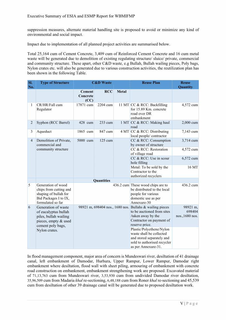
suppression measures, alternate material handling site is proposed to avoid or minimize any kind of environmental and social impact. Impact due to implementation of all planned project activities are summarised below. Total 25,164 cum of Cement Concrete, 3,409 cum of Reinforced Cement Concrete and 16 cum metal waste will be generated due to demolition of existing regulating structure/ sluice/ private, commercial and community structure. These apart, other C&D waste, e.g Bullah, Bullah wailing pieces, Poly bags, Nylon crates etc. will also be generated due to various construction activities, the reutilization plan has been shown in the following Table. Sl.
No.
Type of Structure C&D Waste Reuse Plan Reuse
Quantity
Cement
Concrete
(CC)
RCC Metal
1 CR/HR/Fall cum Regulator
17871 cum 2204 cum 11 MT CC & RCC: Backfilling for 15.89 Km. concrete road over DR embankment
4,572 cum
2 Syphon (RCC Barrel) 428 cum 233 cum 1 MT CC & RCC: Making haul road
2,000 cum
3 Aqueduct 1865 cum 847 cum 4 MT CC & RCC: Distributing local people/ contractor
7,143 cum
4 Demolition of Private, commercial and community structure
5000 cum 125 cum
CC & RCC: Consumption by owner of structure
3,714 cum
CC & RCC: Restoration of village road
4,572 cum
CC & RCC: Use in scour hole filling
6,572 cum
Metal: To be sold by the Contractor to the authorized recyclers
16 MT
Quantities
5 Generation of wood chips from cutting and shaping of bullah for Bid Packages I to IX, formulated so far
436.2 cum These wood chips are to be distributed to the local people for various domestic use as per Annexure-30
436.2 cum
6 Generation of waste of eucalyptus bullah piles, bullah wailing pieces, empty & used cement poly bags, Nylon crates.
98921 m, 698404 nos., 1680 nos. Bullahs & wailing pieces to be auctioned from sites /taken away by the Contractor on payment of reserve price.
98921 m, 698404
nos.,1680 nos.
Plastic/Polyethene/Nylon waste shall be collected and stored separately and sold to authorised recycler as per Annexure-31.
In flood management component, major area of concern is Mundeswari river, desiltation of 41 drainage canal, left embankment of Damodar, Hurhura, Upper Rampur, Lower Rampur, Damodar right embankment where desiltation, flood wall with sheet piling, armouring of embankment with concrete road construction on embankment, embankment strengthening work are proposed. Excavated material of 71,13,763 cum from Mundeswari river, 3,53,930 cum from undivided Damodar river desiltation, 35,96,509 cum from Madaria khal re-sectioning, 6,48,188 cum from Roner khal re-sectioning and 45,539 cum from desiltation of other 39 drainage canal will be generated due to proposed desiltation work.
Executive Summary of ESIA and ESMP Report for WBMIFMP
VI | P a g e
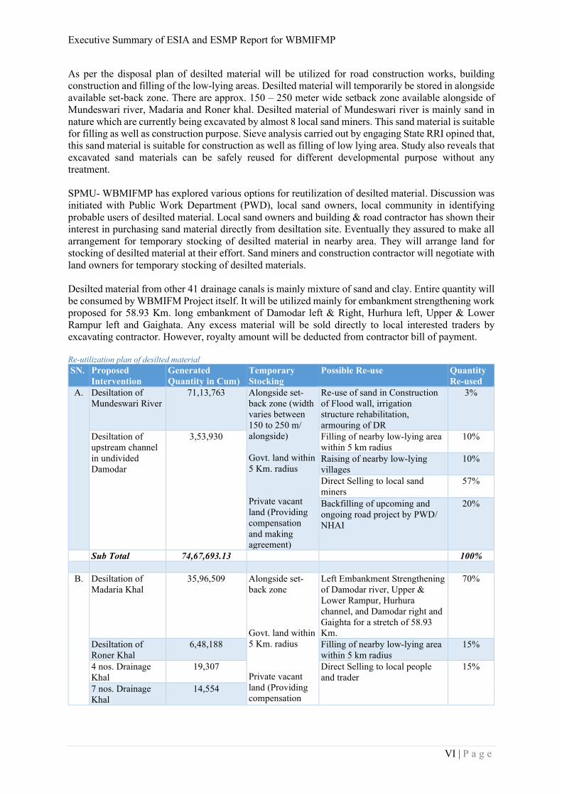
As per the disposal plan of desilted material will be utilized for road construction works, building construction and filling of the low-lying areas. Desilted material will temporarily be stored in alongside available set-back zone. There are approx. 150 – 250 meter wide setback zone available alongside of Mundeswari river, Madaria and Roner khal. Desilted material of Mundeswari river is mainly sand in nature which are currently being excavated by almost 8 local sand miners. This sand material is suitable for filling as well as construction purpose. Sieve analysis carried out by engaging State RRI opined that, this sand material is suitable for construction as well as filling of low lying area. Study also reveals that excavated sand materials can be safely reused for different developmental purpose without any treatment. SPMU- WBMIFMP has explored various options for reutilization of desilted material. Discussion was initiated with Public Work Department (PWD), local sand owners, local community in identifying probable users of desilted material. Local sand owners and building & road contractor has shown their interest in purchasing sand material directly from desiltation site. Eventually they assured to make all arrangement for temporary stocking of desilted material in nearby area. They will arrange land for stocking of desilted material at their effort. Sand miners and construction contractor will negotiate with land owners for temporary stocking of desilted materials. Desilted material from other 41 drainage canals is mainly mixture of sand and clay. Entire quantity will be consumed by WBMIFM Project itself. It will be utilized mainly for embankment strengthening work proposed for 58.93 Km. long embankment of Damodar left & Right, Hurhura left, Upper & Lower Rampur left and Gaighata. Any excess material will be sold directly to local interested traders by excavating contractor. However, royalty amount will be deducted from contractor bill of payment. Re-utilization plan of desilted material
SN. Proposed
Intervention Generated
Quantity in Cum) Temporary
Stocking Possible Re-use Quantity
Re-used
A. Desiltation of Mundeswari River
71,13,763 Alongside set-back zone (width varies between 150 to 250 m/ alongside) Govt. land within 5 Km. radius Private vacant land (Providing compensation and making agreement)
Re-use of sand in Construction of Flood wall, irrigation structure rehabilitation, armouring of DR
3%
Desiltation of upstream channel in undivided Damodar
3,53,930 Filling of nearby low-lying area within 5 km radius
10%
Raising of nearby low-lying villages
10%
Direct Selling to local sand miners
57%
Backfilling of upcoming and ongoing road project by PWD/ NHAI
20%
Sub Total 74,67,693.13 100%
B. Desiltation of Madaria Khal
35,96,509 Alongside set-back zone Govt. land within 5 Km. radius Private vacant land (Providing compensation
Left Embankment Strengthening of Damodar river, Upper & Lower Rampur, Hurhura channel, and Damodar right and Gaighta for a stretch of 58.93 Km.
70%
Desiltation of Roner Khal
6,48,188 Filling of nearby low-lying area within 5 km radius
15%
4 nos. Drainage Khal
19,307 Direct Selling to local people and trader
15%
7 nos. Drainage Khal
14,554
Executive Summary of ESIA and ESMP Report for WBMIFMP
VII | P a g e
28 nos. Drainage Khal
11,678 and making agreement)
Sub- Total 42,90,236 100%
Total 1,17,57,929 100%
There will be common impact due to each construction related activities. A generic mitigation plan for
all construction work along with plan to manage labour influx is proposed. Management plan also
covers plan for pest management and indigenous people. Standalone Resettlement Action Plan (RAP)
is also prepared for entire project.
6.0 Environmental and Social Monitoring Plan
Monitoring plan to evaluate effect after implementation of mitigation plan is developed and
responsibility is given to project authority. Different parameters including air, water, soil/silt and noise
quality will be observed on periodic basic. Sensitive locations where any kind of work is proposed are
identified and earmarked in map for future monitoring of various environmental parameters. Total 13
location for air, 18 location for inland surface water, 13 location for ground water, 13 location for noise
quality, 13 location for soil and 10 location for silt quality are to be monitored on quarterly basic. Social
parameters also identified and plan for regular monitoring is formulated. Monitoring and evaluation
work shall be carried out throughout the project implementation period of 5 years and initial two years
of project operation. Monitoring aspects are summarised and tabulated in below table.
Monitoring of Impact Areas
Monitoring of Environmental Impact Areas Monitoring of Social Impact Areas
1. Water quality (Surface & Ground) 2. Air quality 3. Noise levels around sensitive locations 4. Soil Quality 5. Sediment Quality 6. Compensatory afforestation & plant survival rate 7. Construction camp management 8. Waste Management & Debris Removal 9. Pesticide Management (agricultural component) 10. Site Restoration
1. Resettlement and Compensation for Acquisition 2. Livelihood Restoration of PAFs / PAPs 3. Safety at Work 4. Gender participation in works 5. Awareness program on HIV/AIDS
7.0 Stakeholder Consultation
All potential stakeholders were consulted during the process of impact assessment study. Total 51
project villages from five project districts were covered during field assessment. At-least one FGD with
local community were conducted at each sample village. District as well as state level officials of all
stakeholder’s department like Dept. of Irrigation, Agriculture, Agri-marketing, Food Processing
Industries and Horticulture, Fishery, Biodiversity, Pollution Control Board etc. were consulted to record
their concern on proposed project implementation. A state level workshop also was conducted on
sharing of Environmental and Social Management Framework (ESMF) prepared for this project. In
addition to that four (4) number district level workshop was carried out by Feasibility Study consultant
in finalizing feasible project alternatives.
Local community are much more concern about project components rather than any kind of
environmental and social concerns. However, concerned departments are very much concern in their
respective field on environmental and social angle.
8.0 Capacity Building
Executive Summary of ESIA and ESMP Report for WBMIFMP
VIII | P a g e
Capacity building plan for each executing project authority as well as implementing contractor on
implementation of ESMP is formulated. Training programme, exposure visit on different thematic
matter is proposed as capacity budding plan. Training on EHS and code of conduct for workers
associated by contractor is also considered in capacity building plan. A budget amounting INR
7,24,92,500.00/- for Training with refresher, Exposure visit and Demonstration and INR 78,55,000.00/-
for Awareness Drive is allotted for capacity building.
9.0 Grievance Redressal Mechanism
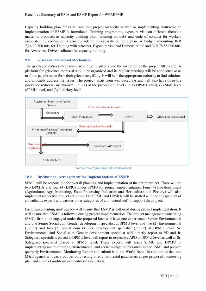
The grievance redress mechanism would be in place since the inception of the project till its life. A
platform for grievance redressal should be organized and its regular meetings will be conducted so as
to allow people to put forth their grievances, if any. It will help the appropriate authority to find solutions
and amicably address the issues. The project, apart from web-based system, will also have three-tire
grievance redressal mechanism, i.e., (1) at the project site level (up to DPMU level), (2) State level
(SPMU level) and (3) Judiciary level.
Overall project grievance redress mechanism
10.0 Institutional Arrangement for Implementation of ESMP
SPMU will be responsible for overall planning and implementation of the entire project. There will be two DPMUs and four (4) DPIUs under SPMU for project implementation. Four (4) line department (Agriculture, Agri Marketing, Food Processing Industries and Horticulture and Fishery) will also implement respective project activities. The SPMU and DPMUs will be staffed with the engagement of consultants, experts and various other categories of contractual staff to support the project. Each implementing unit/ agency will ensure that ESMP is followed during project implementation. It
will ensure that ESMP is followed during project implementation. The project management consulting
(PMC) firm to be engaged under the proposed loan will have one experienced Senior Environmental
and one Senior Social cum Gender development specialist at SPMU level and two (2) Environmental
(Junior) and two (2) Social cum Gender development specialist (Junior) at DPMU level. Sr.
Environmental and Social cum Gender development specialist will directly report to PD and Jr.
Safeguard specialists placed at DPMU level will report to respective APD at DPMU level as well as Sr.
Safeguard specialist placed at SPMU level. These experts will assist SPMU and DPMU in
implementing and monitoring environmental and social mitigation measures as per ESMP and prepare
quarterly Environmental Monitoring Report and submit it to the World Bank. In addition to that one
M&E agency will carry out periodic testing of environmental parameters as per proposed monitoring
plan and conduct mid-term and end-term evaluation.
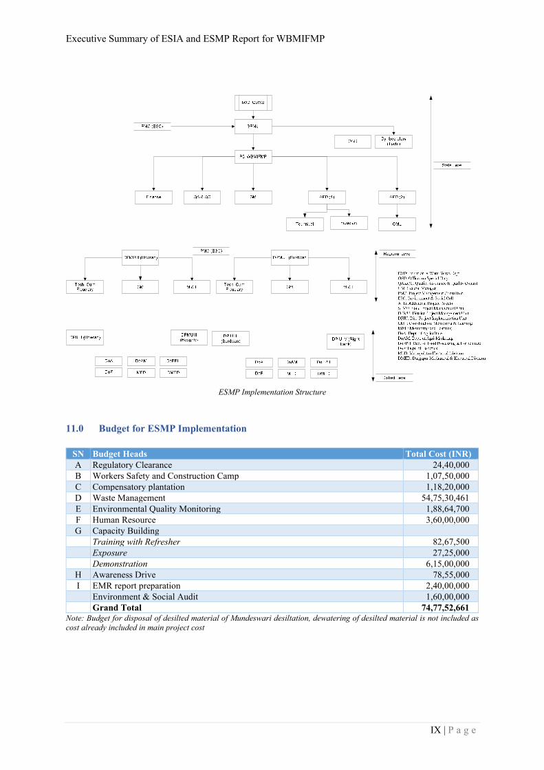
Executive Summary of ESIA and ESMP Report for WBMIFMP
IX | P a g e
ESMP Implementation Structure
11.0 Budget for ESMP Implementation
SN Budget Heads Total Cost (INR)
A Regulatory Clearance 24,40,000
B Workers Safety and Construction Camp 1,07,50,000
C Compensatory plantation 1,18,20,000
D Waste Management 54,75,30,461
E Environmental Quality Monitoring 1,88,64,700
F Human Resource 3,60,00,000
G Capacity Building
Training with Refresher 82,67,500 Exposure 27,25,000 Demonstration 6,15,00,000
H Awareness Drive 78,55,000
I EMR report preparation 2,40,00,000 Environment & Social Audit 1,60,00,000 Grand Total 74,77,52,661
Note: Budget for disposal of desilted material of Mundeswari desiltation, dewatering of desilted material is not included as
cost already included in main project cost
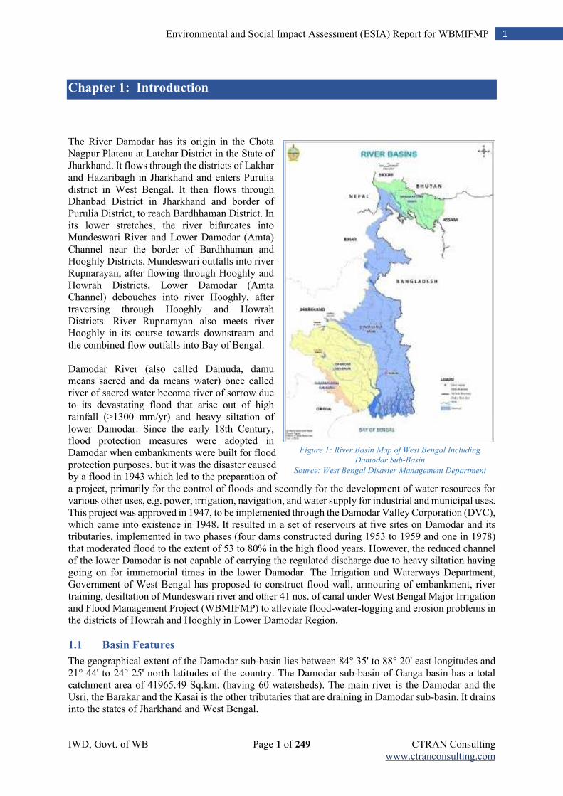
IWD, Govt. of WB Page 1 of 249 CTRAN Consulting www.ctranconsulting.com
1 Environmental and Social Impact Assessment (ESIA) Report for WBMIFMP
Chapter 1: Introduction
The River Damodar has its origin in the Chota Nagpur Plateau at Latehar District in the State of Jharkhand. It flows through the districts of Lakhar and Hazaribagh in Jharkhand and enters Purulia district in West Bengal. It then flows through Dhanbad District in Jharkhand and border of Purulia District, to reach Bardhhaman District. In its lower stretches, the river bifurcates into Mundeswari River and Lower Damodar (Amta) Channel near the border of Bardhhaman and Hooghly Districts. Mundeswari outfalls into river Rupnarayan, after flowing through Hooghly and Howrah Districts, Lower Damodar (Amta Channel) debouches into river Hooghly, after traversing through Hooghly and Howrah Districts. River Rupnarayan also meets river Hooghly in its course towards downstream and the combined flow outfalls into Bay of Bengal. Damodar River (also called Damuda, damu means sacred and da means water) once called river of sacred water become river of sorrow due to its devastating flood that arise out of high rainfall (>1300 mm/yr) and heavy siltation of lower Damodar. Since the early 18th Century, flood protection measures were adopted in Damodar when embankments were built for flood protection purposes, but it was the disaster caused by a flood in 1943 which led to the preparation of a project, primarily for the control of floods and secondly for the development of water resources for various other uses, e.g. power, irrigation, navigation, and water supply for industrial and municipal uses. This project was approved in 1947, to be implemented through the Damodar Valley Corporation (DVC), which came into existence in 1948. It resulted in a set of reservoirs at five sites on Damodar and its tributaries, implemented in two phases (four dams constructed during 1953 to 1959 and one in 1978) that moderated flood to the extent of 53 to 80% in the high flood years. However, the reduced channel of the lower Damodar is not capable of carrying the regulated discharge due to heavy siltation having going on for immemorial times in the lower Damodar. The Irrigation and Waterways Department, Government of West Bengal has proposed to construct flood wall, armouring of embankment, river training, desiltation of Mundeswari river and other 41 nos. of canal under West Bengal Major Irrigation and Flood Management Project (WBMIFMP) to alleviate flood-water-logging and erosion problems in the districts of Howrah and Hooghly in Lower Damodar Region.
1.1 Basin Features
The geographical extent of the Damodar sub-basin lies between 84° 35' to 88° 20' east longitudes and 21° 44' to 24° 25' north latitudes of the country. The Damodar sub-basin of Ganga basin has a total catchment area of 41965.49 Sq.km. (having 60 watersheds). The main river is the Damodar and the Usri, the Barakar and the Kasai is the other tributaries that are draining in Damodar sub-basin. It drains into the states of Jharkhand and West Bengal.
Figure 1: River Basin Map of West Bengal Including
Damodar Sub-Basin
Source: West Bengal Disaster Management Department
IWD, Govt. of WB Page 2 of 249 CTRAN Consulting www.ctranconsulting.com
2 Environmental and Social Impact Assessment (ESIA) Report for WBMIFMP
The Damodar River Basin (DRB) is a sub-basin and part of the Ganges river basin spreading over an area of about 23,370.98 sq. km in the states of Jharkhand and West Bengal. The geographical extremity lies between 2215' to 2430' N latitude and 8430' to 8815' E longitude. The Damodar river in its upper reaches flows over plateau followed by a flat alluvial plain in the south east and east ward towards the Bay of Bengal. The river basin traverses conjointly over five districts of West Bengal, viz., Purulia, Bankura, Bardhhaman, Hooghly and Howrah and six districts of Jharkhand viz., Palamau, Hazaribagh, Giridih, Dhanbad, Santhal Pargana respectively. A few districts of Bengal-Jharkhand belt like Giridih and Santhal Pargana trans-bounded the river basin in the north; Hazaribagh and Palamau districts in the west; Ranchi, Purulia and Bankura districts in the south; and Hooghly and Howrah districts in the east and southeast representing about 8.1% and 10.4% of the total population of Undivided Bihar and West Bengal, respectively. The river basin represents about three-fourth of its area as the upper catchment situated in Jharkhand, while the low-lying flood plains entirely lie in West Bengal. Table 1: Basin Specification
Sl.
No.
District Total area
(Sq.km)
Area in the basin
(Sq.km)
% Area of district in
the basin
% Share in
the basin
Jharkhand Sub-Region
1 Palamau 12677 736.84 5.01 3.15
2 Ranchi 18311 910.33 4.97 3.90
3 Hazaribag 11152 6631.56 59.47 28.38
4 Giridi 6908 5376.81 77.83 23.01
5 Dhanbad 2996.80 2996.80 100.00 12.82
6 Santhal Parganas 14129 571.05 4.04 2.44
Sub total 17223.39 73.70
West Bengal Sub-Region
1 Purulia 6259 1383.28 22.10 5.92
2 Bankura 6881 1564.67 22.74 6.69
3 Bardhhaman 7028 2113.61 30.07 9.04
4 Hooghly 3145 359.87 11.44 1.54
5 Howrah 1474 726.16 49.29 3.11
Sub total 6147.59 26.30
Total 23370.98 100.0
1.2 Salient Features of Damodar Valley Corporation
Objectives of DVC are the promotion and operation of schemes for irrigation, water supply, drainage, generation, transmission and distribution of electrical energy (both hydro & thermal); flood control; navigation; afforestation and soil erosion etc. The DVC over the years have developed an integrated network of benefits, a brief picture of their achievement is given below: Table 2: DVC and its Achievements
Items Description
DVC control area 24,235 sq. km.
Thermal Power Generation 4 stations (TPS) Capacity 1950 MW
Hydel Power Generation 3 stations Capacity 144 MW
Gas Turbine Station 1 station Capacity 82.5 MW
Major Dams 4 & Barrage (Total flood Reserve) 1,270 mcm
Total Irrigation Potential Created 364,000 ha
Canals 2,495 km
Check Dams (soil conservation) 1,689 Nos.
Afforestation 121,500 ha
IWD, Govt. of WB Page 3 of 249 CTRAN Consulting www.ctranconsulting.com
3 Environmental and Social Impact Assessment (ESIA) Report for WBMIFMP
1.3 Drainage System
The Damodar river originates in the Khamarpet hill, Palamou district of Chotonagpur Plateue of Jharkhand in the eastern part of India and ends to the river Hooghly at lower Ganga near Syampur at 55 kms downstream of Howrah. During its course the river flows through the large cities like Ramgarh, Bokaro, Dhanbad, Asansol, Durgapur, Bardhhaman and Howrah. The core drainage system of the Damodar river basin constructed by the Damodar river and its principal tributary, the river Barakar, that drains about 23,370.98 sq. km. area of Jharkhand and West Bengal states. In its upper reaches the Damodar is known as the Deonad, and originates in Khamarpet hill range (1,062 m) near Chandwa in Palamau district and drains into a catchment area of about 25,820 sq km. The waters of the Deonad traverse through the steep slope of the pat region to descend on the gneissic flat plain of Chandwa basin and the sluggish flow of the river over the flat top surface, which later on got dissected into tabular blocks by fluvial action. The river Damodar enters the Gondwana Basin after the confluence of the Dharamauti near Mahuamilan, and the topography around the river changes. The gradient of the stream becomes steeper and waterfalls abound the course traverses through the hilly region and woody country carved out of hard sandstone and grit of the Gondwana age. In this section, the Damodar receives a number of tributaries both from the southern and the northern slopes. The southern tributaries like Chati, Saphi, Batuka, Dainkata, Nalkari and Dhobdhab and flow over the granite-gneissic surface of Ranchi plateau, while the northern tributaries are Haharo (W), Bakri-Garhi, Haharo (E) and Marmarhar originate from the Hazaribagh plateau and flow for considerable distance over the Archaean gneiss before entering the Gondwana basin. The Konar and Bokaro streams originate in the Hazaribagh plateau near Hazaribagh town flows over the Archaean gneiss country while Bokaro traverses through the Archaean gneiss country for some distance and finally enters the Gondwana basin near Bokaro coalfields. The combined courses of the Konar and Bokaro rivers meet the Damodar near Tenughat. The Damodar flows eastward from Tenughat and receives a few other tributaries from the north and south before reaching Panchet. From the north the Jamunia and the Khudia join the Damodar after flowing over the Jharia coalfields, while from the south Ijri and the Gowai meander eastward to meet the Damodar near the western end of Panchet hill reservoir. The Barakar river basin is a sub-basin and part of the Damodar river basin has an area of 7026 sq. km. rising from the Koderma plateau and runs for a long distance to meet the Damodar near Dishergarh and traverses through a steep sided valley. The Barakar river has two important tributaries the Barsoti and the Usri. After Dishergarh, the Damodar river enters flat alluvial plains and runs eastward up to Barsul in Bardhhaman and the flow of the river becomes very sluggish at this stage. In this portion Damodar receives its last tributary, the Sali from the south and after-wards the Damodar river takes a sharp turn towards south near the village Chachai, 24 km south-east of Bardhhaman. After traverse some area the river turning towards south and it has a distributary named the Kana Damodar, which ultimately drains out water in the Hooghly. Traversing further towards south Damodar splits into two important channels, the Mundeswari and the Damodar. After Bardhhaman subdivision the Damodar river flows over the Arambagh sub-division of Hooghly district and Uluberia subdivision of Howrah district to meet the Hooghly opposite Falta. At present 75% of the runoff from the Damodar river is carried by the river Mundeswari through the Begor and the Mushir hanas and drains out water in the Rupnarayan. This channel cannot carry the total discharge of flood of the Damodar and as a result the elbow area of the Damodar gets inundated occasionally notwithstanding the construction of the barrage and dams over the Damodar in its upstream area. In the downstream area the flood protection embankments have been constructed along the banks of the Damodar, but are not sufficient to cope up with the steadily rising river bed due to silting. The entire Damodar valley can be divided into the upper, middle and lower valleys depending to the gradient of the river. The undulating upper and the middle valleys are wider than the flat lower valley. The river has a total length of 540 km, out of which 380 km is in Jharkhand and the next 160 km is in West Bengal. The river slope is 1.86 m per km for 241 km, 57 m per km in the next 167 km and 16 m per km in the last reach. In final 145 km the Damodar takes a southward course before joining the river
IWD, Govt. of WB Page 4 of 249 CTRAN Consulting www.ctranconsulting.com
4 Environmental and Social Impact Assessment (ESIA) Report for WBMIFMP
Hooghly. The upper and middle catchment area, constituting over 4/5th of the total catchment area is a hilly terrain with a steep slope while the lower valley is strikingly narrow and flat. Thus, in the event of heavy rain in the upper valley, there is a natural tendency for water to overflow in the lower alluvial plain where most of the farm lands and human habitats are located.
1.4 Reservoirs on Damodar River
There are 5 reservoirs across river Damodar and its tributaries in Jharkhand. Of these reservoirs, four reservoirs constructed by Damodar Valley Corporation (DVC) and one reservoir by the Government of Jharkhand. Apart from this, a barrage is constructed at Durgapur across river Damodar in Bardhhaman district. Irrigation canal network off taking from the barrage was constructed by the DVC. West Bengal regularly receives its share of allocated and earmarked quantum of water from DVC reservoirs for irrigation (Kharif and Rabi), drinking and other municipal and industrial uses. Apart from the committed allocation, surplus water in the post monsoon season after meeting other committed needs is also released for irrigating Boro (post winter) paddy in West Bengal.
1.5 Irrigation System
Command area of the DVC served by canal network having total length of around 2734 km in the downstream of Durgapur Barrage and spread over 41 Administrative Development Blocks in the districts of Bankura, PurbaBardhhaman, PaschimBardhhaman, Hooghly and Howrah. The DVCA canals currently irrigate around 332,000 ha in the Kharif season (out of a design area of 393,800 hectares), 20,000 ha in the Rabi season on the basis of an earmarked allocation, and an average of 28,000 ha in the summer (Boro) season, depending on the amount of water remaining in upstream reservoirs and after meeting the priority needs. The total area irrigated (including all sources of water) is approximately 100,000 hectares in Rabi and Boro season each. The main sources of water of those parts that are not covered by canal water are ground water, and household and village ponds.
1.6 Flood in Lower Damodar
Flooding of extensive areas of the Lower Damodar is a frequent phenomenon within parts of Howrah and Hooghly districts causing significant economic damage and social distress. The situation occurs because these areas are on low-lying alluvial plains of the lower reaches of the river, a naturally accreting zone where tidal backwater restricts outflow of extensive floodwaters from the upland headwaters of the basin. Development of “Boro bunds” to store water in the summer season aggravates the situation.
1.7 Justification of the Project
1.7.1 Dilapidated Irrigation Structures
The DVCA was developed more than six decades ago and is now degraded. Numerous regulating structures including cross and tail regulators, outlet gates, distributaries and minors have been severely damaged. Cross drainage structures, including aqueducts are damaged and are leaking, resulting in a loss of irrigation water. Tail end farmers are not getting the required amount of water at the time of need as per the irrigation schedule, and are using groundwater, especially during Rabi and Boro seasons. These degraded regulating structures need to be replaced / repaired so that efficiency in irrigation can be achieved. The conditions that determined the original design of the irrigation and flood management infrastructure are no longer in place and the current needs and conditions need to be addressed in a comprehensive manner. The proposed project aims at replacing / repairing the degraded hydraulic assets with the objective of making the system functional capably.
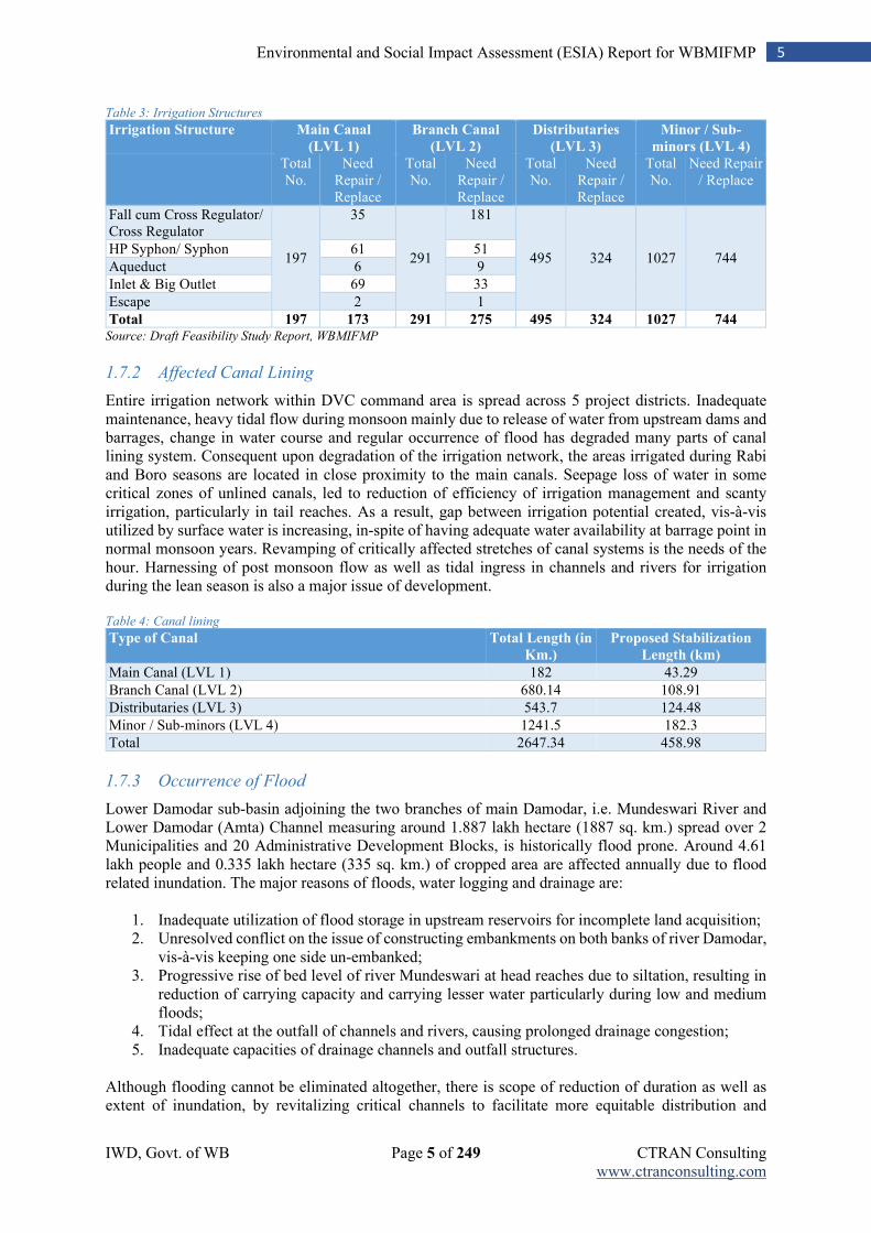
IWD, Govt. of WB Page 5 of 249 CTRAN Consulting www.ctranconsulting.com
5 Environmental and Social Impact Assessment (ESIA) Report for WBMIFMP
Table 3: Irrigation Structures
Irrigation Structure Main Canal
(LVL 1)
Branch Canal
(LVL 2)
Distributaries
(LVL 3)
Minor / Sub-
minors (LVL 4) Total No.
Need Repair / Replace
Total No.
Need Repair / Replace
Total No.
Need Repair / Replace
Total No.
Need Repair / Replace
Fall cum Cross Regulator/ Cross Regulator
197
35
291
181
495 324 1027 744 HP Syphon/ Syphon 61 51
Aqueduct 6 9
Inlet & Big Outlet 69 33
Escape 2 1
Total 197 173 291 275 495 324 1027 744 Source: Draft Feasibility Study Report, WBMIFMP
1.7.2 Affected Canal Lining
Entire irrigation network within DVC command area is spread across 5 project districts. Inadequate maintenance, heavy tidal flow during monsoon mainly due to release of water from upstream dams and barrages, change in water course and regular occurrence of flood has degraded many parts of canal lining system. Consequent upon degradation of the irrigation network, the areas irrigated during Rabi and Boro seasons are located in close proximity to the main canals. Seepage loss of water in some critical zones of unlined canals, led to reduction of efficiency of irrigation management and scanty irrigation, particularly in tail reaches. As a result, gap between irrigation potential created, vis-à-vis utilized by surface water is increasing, in-spite of having adequate water availability at barrage point in normal monsoon years. Revamping of critically affected stretches of canal systems is the needs of the hour. Harnessing of post monsoon flow as well as tidal ingress in channels and rivers for irrigation during the lean season is also a major issue of development. Table 4: Canal lining
Type of Canal Total Length (in
Km.)
Proposed Stabilization
Length (km)
Main Canal (LVL 1) 182 43.29
Branch Canal (LVL 2) 680.14 108.91
Distributaries (LVL 3) 543.7 124.48
Minor / Sub-minors (LVL 4) 1241.5 182.3
Total 2647.34 458.98
1.7.3 Occurrence of Flood
Lower Damodar sub-basin adjoining the two branches of main Damodar, i.e. Mundeswari River and Lower Damodar (Amta) Channel measuring around 1.887 lakh hectare (1887 sq. km.) spread over 2 Municipalities and 20 Administrative Development Blocks, is historically flood prone. Around 4.61 lakh people and 0.335 lakh hectare (335 sq. km.) of cropped area are affected annually due to flood related inundation. The major reasons of floods, water logging and drainage are:
1. Inadequate utilization of flood storage in upstream reservoirs for incomplete land acquisition; 2. Unresolved conflict on the issue of constructing embankments on both banks of river Damodar,
vis-à-vis keeping one side un-embanked; 3. Progressive rise of bed level of river Mundeswari at head reaches due to siltation, resulting in
reduction of carrying capacity and carrying lesser water particularly during low and medium floods;
4. Tidal effect at the outfall of channels and rivers, causing prolonged drainage congestion; 5. Inadequate capacities of drainage channels and outfall structures.
Although flooding cannot be eliminated altogether, there is scope of reduction of duration as well as extent of inundation, by revitalizing critical channels to facilitate more equitable distribution and
IWD, Govt. of WB Page 6 of 249 CTRAN Consulting www.ctranconsulting.com
6 Environmental and Social Impact Assessment (ESIA) Report for WBMIFMP
quicker passage of flood water. Remodeling of regulating structures and various other structural measures are also required.
1.8 Need of the Project
Groundwater utilization in the DVC command area is increasing due to inadequate supply of surface water. Increase in utilization of ground water is mainly during Rabi and Boro seasons. Current ground water development status in project districts are (1) 46% in Bankura, (2) 44% in Bardhhaman, (3) 49% in Hooghly and (4) 25% in Howrah1. In coming years, further increase in ground water utilization may pose serious threat to the ground water potential in-spite of having scope for surface water utilization. Though, surface water is available, its distribution has emerged as an issue for which ground water utilization is increasing. In surface irrigation, the current irrigation potential used is 81.72 % of the total irrigation potential created through irrigation networks. It indicates that the gap ayacut is 18.24 % which can be reduced through improving irrigation system and regulation mechanisms. Table 5: Surface irrigation potential and utilized in project districts (considering project blocks only)
Sl.
No.
Project area in project District IPC (in Ha.) IPU (in Ha.) % of
Utilization
Gap in Utilization
(in Ha.)
1 Bankura (4 project blocks) 10982.37 7767.30 70.73 3215.07
2 Purba Bardhhaman (19 project blocks) 27208.51 22095.24 81.21 5113.27
3 Paschim Bardhhaman (2 project blocks) 4439.00 3702.00 83.40 737.00
4 Howrah (3 project blocks) 13042.14 10271.29 78.75 2770.85
5 Hooghly (14 project blocks) 34439.19 29806.66 86.55 4632.53 Total 90111.21 73642.49 81.72 16468.72
Source: State Water Investigation Department (SWID), West Bengal
Note: Pursura block of Hooghly and 8 blocks (except Amta-II, Jagatballavpur, Udainarayanpur) of Howrah districts is not
assessed due to salinity problem
IPC: Irrigation Potential Created; IPU: Irrigation Potential Utilised
Flood is a common phenomenon in Hooghly and Howrah due to inadequate current flood management system. The impact has been severe on socio-economic condition of people. Different measures taken over the years has reduced the damage due to flood but reduction in flood and its effective management is essential.
1.9 Objective of the ESIA Report
The main objectives for ESIA of the project are:
Comprehensive description of current natural environment and socio-economic conditions in the project area.
Identification of potential impacts of the project on natural environment and socioeconomic conditions of the population. The ESIA concentrates on analysis and scientific assessment of the physical, chemical, biological and socioeconomic impacts of the project when it is implemented and put on operation.
Recommendations for technically feasible and management measures to minimize negative impacts of the project on natural environment during construction and operation phases to ensure that the project go along with the Indian regulation on environmental protection as well as World Bank requirements.
1Source: Dynamic ground water resources of India – June 2017 (data as on 31st March, 2013)
IWD, Govt. of WB Page 7 of 249 CTRAN Consulting www.ctranconsulting.com
7 Environmental and Social Impact Assessment (ESIA) Report for WBMIFMP
1.10 Legal and Planning Context of ESIA
The ESIA report has been prepared according to key legal instruments in India for environmental protection and natural resource management and World Bank’s policies.As per the EIA notification, 2006 (and subsequent amendment) of MoEF&CC, Government of India,the project WBMIFMP does not fall either under Category A or B for the prior environmental clearance. Proposed project is not going for any expansion in terms of increasing the ayacut area or any capacity addition is going to be made by this project or any change is visualized in terms of designed ayacut of this project. Flood protection projects does not cover under any category. However, the project will be abided by the following environmental legislation and the World Bank’s Operational Policies (OP).
Environmental (Protection) Act, 1986 amended 1991 and associated rules / notifications;
The Water (Prevention and Control of Pollution) Act, 1974;
The Air (Prevention and Control of Pollution) Act, 1981;
The Noise Pollution (Regulation and control) Rules, 2000 and its subsequent amendments;
LARR Act 2013 or similar provisions of the State Government;
Construction and Demolition Waste Management Rules, 2016;
Central Motor Vehicle Act, 1988 and Central Motor Vehicle Rules,1989;
Contract Labour (Regulation and Abolition) Act, 1970;
The Building and Other Construction Workers (Regulation of Employment and Conditions of Service) Act, 1996 and the Cess Act of 1996;
The Inter-State Migrant Workmen (Regulation of Employment and Conditions of Service) Act, 1979;
Minimum Wages Act, 1948;
Workmen Compensation Act, 1923;
Equal Remuneration Act, 1979;
West Bengal Inland Fisheries Act, 1984;
West Bengal Trees (Protection and Conservation in Non-Forest Areas) Act, 2006 and Rules, 2007;
WB Preservation of Historical Monuments and Objects and Excavation of Archaeological Sites Act, 1957;
West Bengal Building and Other Construction Workers (Regulation of employment and Conditions of Service) Rules, 2004;
World Bank’s Policies that are examined are as follows.
OP 4.01: Environmental Assessment OP 4.04: Natural Habitats OP 4.09: Pest Management OP 4.10: Indigenous People OP 4.11: Physical Cultural Resources (PCR) OP 4.12 Involuntary Resettlement OP 4.36: Forests OP 4.37: Dam Safety OP 7.50: International Water Ways OP 7.60: Projects in Disputed Areas
Other related Institutional and Policy Framework
National Commission on Floods in 1980
National Commission for Integrated Water Resources Development and Management Plan 1999
National Water Policy, 2012
IWD, Govt. of WB Page 8 of 249 CTRAN Consulting www.ctranconsulting.com
8 Environmental and Social Impact Assessment (ESIA) Report for WBMIFMP
Damodar Valley Reservoir Regulation Committee (DVRRC) and CWC Reservoir Manual for Integrated Operation of Reservoir for Flood Management and Other Purposes
1.11 General Approach to ESIA Preparation
1.11.1 Sources of Information Used in the Preparation of the ESIA
Information used in preparing the ESIA report was obtained from a number of sources:
1. Information provided by survey team of the project area; 2. Current environment situation reports of project area and Damodar Valley; 3. Data on environmental quality and natural conditions in the area of category 1 and 2 project
activity that are proposed to be implemented; 4. Stakeholder consultation carried out during the preparation of ESIA; 5. Results of socio-economic investigation and assessment in the project area; 6. The gathering of secondary data and information from various sources in government
departments at the State, district, and block level in project area in which category 1 and 2 project activity are located in;
7. Government acts / regulations and operational policies of the World Bank; and 8. Environmental Screening report.
1.11.2 ESIA Methodology
Methodologies used to perform the ESIA report was based on the World Bank’s Environmental Assessment Sourcebook. The methodologies have been used to perform the ESIA are as follows:
Reviewing of literature
A kickoff meeting was undertaken, with Feasibility Study Consultant and I&WD, immediate after signing of contract for conducting environmental and social impact assessment study. Project Appraisal Documents (PAD), DPR to alleviate flood-water-logging and erosion problems in the districts of Howrah and Hooghly in Lower Damodar Region, Dam Safety Review Panel (DSRP) Reports on DVC for its four reservoirs and Baseline study report prepared by Feasibility Study consultant for WBMIFMP project were collected from I&WD during kick-off meeting. Project objective and district wise project blocks were thoroughly discussed during initial meeting. Irrigation and flood affected blocks falling within jurisdiction of Damodar Valley Command (DVC) boundary and present irrigation and flood scenario were discussed thoroughly to get preliminary idea about project location. Terms of Reference (ToR) for conducting ESIA study was evaluated thoroughly and discussed with I&WD and feasibility study consultant. Different stakeholders for associated with this project were identified in consultation with I&WD and Feasibility study consultant for WBMIFMP project.
Reconnaissance Study
Team of experts comprising various sectoral experts has conducted reconnaissance study in Howrah and Hooghly district in association with district level irrigation officials. A rapid assessment checklist was developed for ESMF purpose. Two separate field study team were deployed for primary data collection purpose. Study team has conducted field study in all five project districts. However, a representative sample were drawn from each project district for the purpose of ESMF development. Sample were drawn from 10 blocks out of total 41 project blocks. From each block only one village was selected for conducting household survey, FGD with community. Damodar river and main canal adjacent villages were selected for rapid assessment for ESMF development and screening study. 28 household were interview from each village. One FGD with farmer community was conducted at each study village. Village infrastructure survey also was carried out in each study village.
IWD, Govt. of WB Page 9 of 249 CTRAN Consulting www.ctranconsulting.com
9 Environmental and Social Impact Assessment (ESIA) Report for WBMIFMP
EGD as well as Key Informants Interview (KII) was carried out with each stakeholders agency/ group. Secondary data/ information on Soil Health card, year wise flood damage, project block wise agricultural practices, project block wise ground water information also were collected from concerned stakeholder’s department during KII.
Developing ESMF
Components wise project activities were ranked in three different categories i.e.1, 2, 3 based on potential adverse impact environmental and social impacts. An ESMF detailing baseline environmental conditions and guidance for conducting detail ESIA study was developed.
Study Tools for ESIA study
Different study tools like HH questionnaire, FGD checklist, checklist for village infrastructure survey, were developed in initial stage of detail ESIA study. Questionnaire for census survey of encroachers/ squatter was developed in later stage as exact location for implementation of different project activity were not finalized at this stage. Various kind of study method was used for conducting detail ESIA study mainly for category -1&2 activities under flood management component. Rapid environmental assessment was conducted for all category-2 activities under irrigation modernization components.
Sampling for Field Study during ESIA stage
Total 703 HH sample were drawn from entire project area. 57 HH from 2 blocks of Bankura, 188 HH from 8 blocks of Purba Bardhhaman, 30 HH from 1 block of Paschim Bardhhaman, 197 HH from 8 blocks and 1 municipality of Howrah and 231 HH from 7 blocks and 1 municipality of Hooghly district. Maximum two villages from each sample block were selected for HH sample collection. 28 HH sample from each sample block were collected taking 14 HH from each sample village. Thus, maximum 2 villages were considered from each sample blocks. Villages were selected randomly. However, proximity to Damodar river, Main canal and branch canal were considered for village selection. At least one FGD with local community were conducted at each sample village. DGPS survey of encroachers/ squatter followed by socio-economic study was conducted for development of Resettlement Action Plan (RAP).
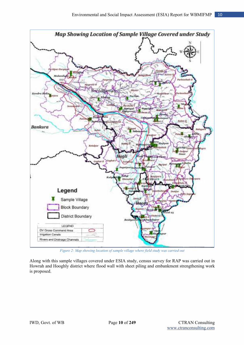
IWD, Govt. of WB Page 10 of 249 CTRAN Consulting www.ctranconsulting.com
10 Environmental and Social Impact Assessment (ESIA) Report for WBMIFMP
Figure 2: Map showing location of sample village where field study was carried out
Along with this sample villages covered under ESIA study, census survey for RAP was carried out in Howrah and Hooghly district where flood wall with sheet piling and embankment strengthening work is proposed.
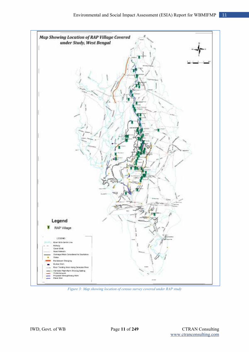
IWD, Govt. of WB Page 11 of 249 CTRAN Consulting www.ctranconsulting.com
11 Environmental and Social Impact Assessment (ESIA) Report for WBMIFMP
Figure 3: Map showing location of census survey covered under RAP study
IWD, Govt. of WB Page 12 of 249 CTRAN Consulting www.ctranconsulting.com
12 Environmental and Social Impact Assessment (ESIA) Report for WBMIFMP
Monitoring of Environmental Parameters
MoEF & CC recognized environmental laboratory was engaged for collection and analysis of various environmental parameters of Ambient Air quality, River Water quality, soil quality of river bed, and ambient noise quality. River water quality of Damodar river was compared with regular real time monitoring and testing of Damador river water quality at project districts carried out by WBPCB. Ground water quality data of project districts were obtained from secondary sources- Ground Water Year Book of West Bengal & Andaman & Nicobar Islands (2014-15). In addition to these, water quality of Mundeswari and Damodar river tested by State Water Investigation and Directorate (SWID), GoWB was also considered. Sieve analysis of sediment of Mundeswari River bed was carried out by engaging State River Research Institute (RRI), Mohanpur. Presence of environmentally sensitive location, critically polluted area, forest patch, protected area, migratory route, nearby town, market place on which project may have potential adverse impact were identified in consultation with stakeholders’ departments and local community.
Method of expert consultations
Key Informants Interview (KII) with all stake stakeholders’ departments at district level as well as State level were conducted to record their view/ concerns on different environmental and social aspects. Details on stakeholder’s consultation is provided in Chapter - 11. Special emphasis was given to capture Environmental and Social concern of WBPCB, Bio-diversity board, Dept. of Forest &RRI. KII was entirely open ended.
Impact Prediction and Management Plan Collected data/ information were analyzed to ascertain baseline environmental and social conditions. Primary as well as secondary information were used for profiling baseline conditions. Impact due to implementation of category -1&2 activities were identified and mitigation measures alongwith management plan is proposed for each identified adverse impact.
1.12 Project Affected Area
For this ESIA, the project affected area is defined as:
Corridor of Impact (COI): 5 meter of either side of Damodar, Upper Rampur & Hurhura Left Embankment & Right Dwarf Embankment where flood wall with sheet piling, embankment strengthening is proposed is taken as COI where more intensive survey and study are conducted for project impact assessment. Study on encroachers/ squatter is defined within 5 meter area (as per instruction from I&WD) from either side of crest line of project activity zone.
Immediate 500-meterzones of influence were considered for all project activities including flood wall construction with sheet piling, embankment strengthening activities.
3 km zones of influence on both the sides along Damodar, Upper Rampur & Hurhura Left Embankment & Right Dwarf Embankment where flood wall with sheet piling, embankment strengthening is proposed and Mundeshwari river and other irrigation and drainage canal considered for desiltation and bank side lining work - where direct and indirect impact of the project can be explored on the biological and socioeconomic condition;
The adjacent of the construction area, where desiltation/embankment strengthening/structural components will be implemented;
Irrigation structures likely to be rehabilitated or newly constructed under the project. Influence zone for study of impact assessment considered are 5 m, 500 m, 3 km. and 10 km. for different project activities. The basis of this classification is also presented in below table.
IWD, Govt. of WB Page 13 of 249 CTRAN Consulting www.ctranconsulting.com
13 Environmental and Social Impact Assessment (ESIA) Report for WBMIFMP
Table 6: Project activity wise assessment area
Sl. No. Project Activities Assessment aspects
5 meter and ROW
Flood wall with sheet piling, Embankment Strengthening
Encroachers/ squatter, public utility (like electric pole, RLI centre, bus stand and etc.), trees, Cultural property resource (like Temple, bedi, burning ghat), school, financial institution, post office, pond.
500 meter All activities under irrigation modernization and flood Management Components
Presence of Archaeological sites, Sensitive area like school, college, mandir, masque, church, burning ghat.
3 Km. All activities under irrigation modernization and flood Management Components
Small city Chapadanga, local bazar (24 pur bazar), bird congregation areas, fishery sites.
10 Km. All activities under irrigation modernization and flood Management Components
National Parks (presence of Ramnabagan WLS 2.5 km. away from DVC canal at Bardhhaman city), Wildlife Sanctuaries, Critically polluted area, wet/ marshy land
1.13 Scope of ESMP of the Project
The environmental and social management plan for the project contains the following components:
Mitigation and monitoring requirements to minimize adverts impacts due to desiltation of Mundeswari river and 41 nos. drainage canal, Re-sectioning of irrigation canal and structural component of the projects including cost estimates; Waste management plan for disposal of desilted material, C&D waste;
ESMP is prepared for all Category-1 & 2 activities proposed under Irrigation modernization and Flood Management component
Pest Management Plan (PMP) and Tribal People Plan including monitoring and evaluation mechanism for evaluation of proper implementation of management plan.
Implementation arrangements and implementation schedule for the overall environmental management plan, PMP and TPP;
Standalone document on RAP is prepared to handle encroachment on embankment where flood wall with sheet piling and embankment strengthening is proposed;
The programmatic framework which specifies how the specific mitigation and monitoring activities associated with the later part of the project may be implemented;
Requirements for technical assistance to support implementation of the environmental management plan including supervision and training;
Monitoring plan for evaluation of ambient environmental and social parameters; Post implementation monitoring plan is also included in ESMP;
Budgetary provision for each mitigation plan and M&E of management plan evaluation; Provision for Mid-term and end-term review of project implementation is also kept under ESMP;
Capacity building of plan for all implementing agency;
Avoidance principal for selection of project activities, location are also included in ESMP;
IWD, Govt. of WB Page 14 of 249 CTRAN Consulting www.ctranconsulting.com
14 Environmental and Social Impact Assessment (ESIA) Report for WBMIFMP
1.14 Structure of The Report
The ESIA report is presented based on the following structure:
Chapter 1: Introduction
Chapter 2: Brief Project Description
Chapter 3: Legal and Regulatory Compliance
Chapter 4: Environmental and Social Baseline
Chapter 5: Analysis of Alternatives
Chapter 6: Potential Environmental and Social Impacts and Mitigation
Chapter 7: Environmental and Social Management Plan
Chapter 8: Tribal People’s Plan
Chapter 9: Pest Management Plan
Chapter 10: Environmental and Social Monitoring Plan
Chapter 11: Stakeholder Consultation
Chapter 12: Capacity Building
Chapter 13: Grievance Redressal Mechanism
Chapter 14: Institutional Arrangement for Implementation of ESMP
Chapter 15: Budget for ESMP Implementation
IWD, Govt. of WB Page 15 of 249 CTRAN Consulting www.ctranconsulting.com
15 Environmental and Social Impact Assessment (ESIA) Report for WBMIFMP
Chapter 2: Brief Project Description
2.1 Project Background
River Damodar used to inundate large tracts of the districts of Bardhhaman, Hooghly and Howrah in the state of West Bengal, every year. The river erodes Jharkhand and floods West Bengal with water and silt and causes much distress and loss in both states. The cross section of the lower Damodar in the delta area has become considerably reduced and spread, straining its drainage capacity. Heavy floods in Damodar River basin often breach the embankment causing breaches in the G.T. Road in the state of West Bengal. Regular flood causes immense misery to those people particularly living in the districts of Howrah and Hooghly. The population of the area affected by Damodar floods may presently be around 8.9 million. Areas in the districts of Hooghly and Howrah in the lower Damodar region, which spreads over 1087.63 sq.km, suffers most adverse effects during flood causing congestion, water-logging and also erosion. After creation of the reservoirs in the upstream, though the severity and frequency of high flood was reduced, but in 1959 and 1978 the area faced devastating floods. Afterwards, the flooding problem of the lower Damodar area even in normal floods also went out of control. Meanwhile, 2 (two) other Schemes namely i) Lower Damodar Improvement Scheme, in the Year 1972, & ii) Excavation of Short-Cut Diversion Channel, in the Year, 2002, have been taken up to alleviate the flood and drainage congestion problem in the Lower Damodar region. However, owing to limitation of scopes in both of the above two schemes for various reasons; only localized benefit was achieved for some extremely affected portions of the said region. But, in absence of any comprehensive Flood Management Scheme, the overall improvement of the situation covering the entire region could not be envisaged during last six decades. Residents of Hooghly and Howrah are thus crippled by these flooding and drainage congestion problems through generations. This has hampered the economic growth of this area. The major reasons creating flooding, waterlogging and drainage congestion in lower Damodar area are:
Inadequate utilization of the flood control potential of Maithon and Panchet storage dams due to incomplete acquisition of land required for full reservoir area.
Constructing cross bands across the river to utilize flood plains on either side of the river for agriculture and not removing it before the monsoon has prohibited the natural process of spilling of sediment made the actual river section shallow and aggravated the drainage problem.
Encroachment in the flood plain area has increased the chances of more flood damages. Similarly, encroachment/ illegal construction over bunds makes the embankment weak and vulnerable to breach even in normal flood condition.
Insufficient capacity of the drainage channels to meet the demand of present population and cropping cycle.
Unscientific removal of silt from the riverbed in dry season has resulted in siltation in river bed especially during high tide.
2.2 History of Flood Events
The challenge of taming the Damodar seems to have engaged attention for some considerable time even before the British India. The disastrous flood of 1900 revived deliberations on the issue and a scheme for construction of three masonry dams at a cost of Indian Rs. 6 million (US$ 133,000) was drawn up. The emphasis was on irrigation, but the investment of Rs. 272 (US$6) per ha. of reclaimed and benefited land was considered extravagant. It was, therefore, decided to take ad-hoc measures from time to time to repair the damage and alleviate the miseries caused by floods. The subsequent high floods of 1907, 1909 and 1911 were apparently dealt with in the ad-hoc manner. The flood of 1913 once again brought matters to the head. With a peak discharge of 650,000 cusec (18,406 cumec.) the flood caused wide
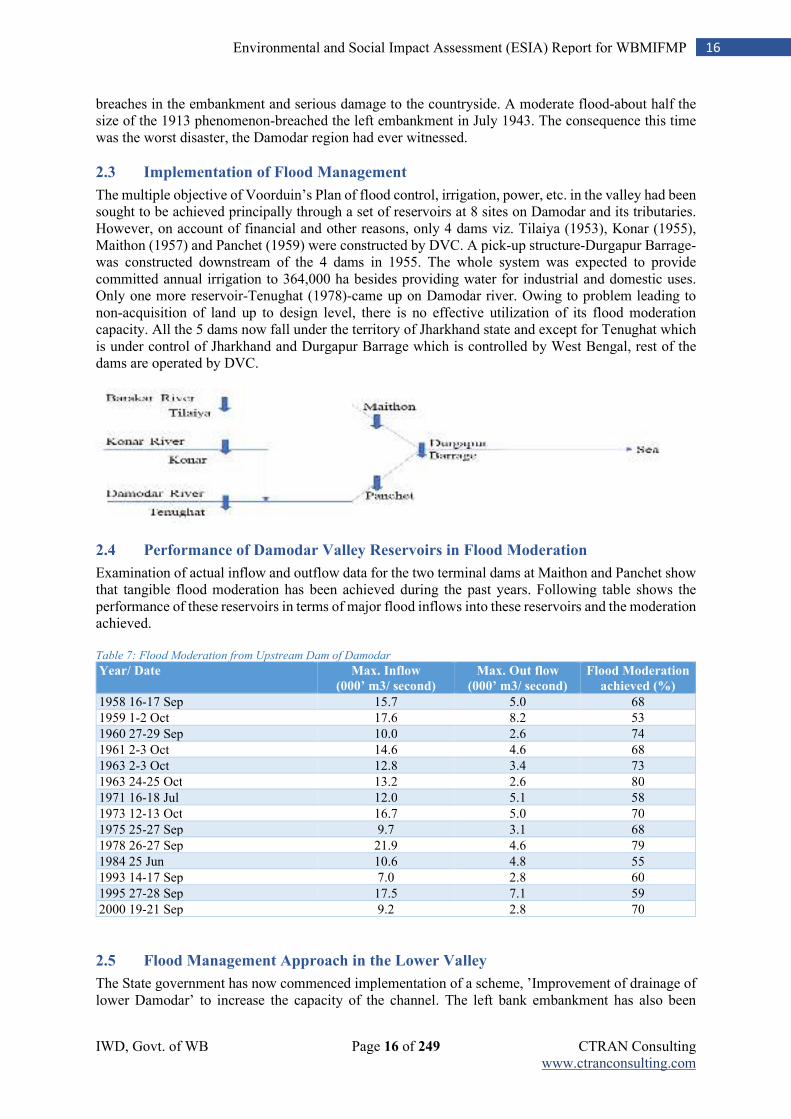
IWD, Govt. of WB Page 16 of 249 CTRAN Consulting www.ctranconsulting.com
16 Environmental and Social Impact Assessment (ESIA) Report for WBMIFMP
breaches in the embankment and serious damage to the countryside. A moderate flood-about half the size of the 1913 phenomenon-breached the left embankment in July 1943. The consequence this time was the worst disaster, the Damodar region had ever witnessed.
2.3 Implementation of Flood Management
The multiple objective of Voorduin’s Plan of flood control, irrigation, power, etc. in the valley had been sought to be achieved principally through a set of reservoirs at 8 sites on Damodar and its tributaries. However, on account of financial and other reasons, only 4 dams viz. Tilaiya (1953), Konar (1955), Maithon (1957) and Panchet (1959) were constructed by DVC. A pick-up structure-Durgapur Barrage-was constructed downstream of the 4 dams in 1955. The whole system was expected to provide committed annual irrigation to 364,000 ha besides providing water for industrial and domestic uses. Only one more reservoir-Tenughat (1978)-came up on Damodar river. Owing to problem leading to non-acquisition of land up to design level, there is no effective utilization of its flood moderation capacity. All the 5 dams now fall under the territory of Jharkhand state and except for Tenughat which is under control of Jharkhand and Durgapur Barrage which is controlled by West Bengal, rest of the dams are operated by DVC.
2.4 Performance of Damodar Valley Reservoirs in Flood Moderation
Examination of actual inflow and outflow data for the two terminal dams at Maithon and Panchet show that tangible flood moderation has been achieved during the past years. Following table shows the performance of these reservoirs in terms of major flood inflows into these reservoirs and the moderation achieved. Table 7: Flood Moderation from Upstream Dam of Damodar
Year/ Date Max. Inflow
(000’ m3/ second)
Max. Out flow
(000’ m3/ second)
Flood Moderation
achieved (%)
1958 16-17 Sep 15.7 5.0 68
1959 1-2 Oct 17.6 8.2 53
1960 27-29 Sep 10.0 2.6 74
1961 2-3 Oct 14.6 4.6 68
1963 2-3 Oct 12.8 3.4 73
1963 24-25 Oct 13.2 2.6 80
1971 16-18 Jul 12.0 5.1 58
1973 12-13 Oct 16.7 5.0 70
1975 25-27 Sep 9.7 3.1 68
1978 26-27 Sep 21.9 4.6 79
1984 25 Jun 10.6 4.8 55
1993 14-17 Sep 7.0 2.8 60
1995 27-28 Sep 17.5 7.1 59
2000 19-21 Sep 9.2 2.8 70
2.5 Flood Management Approach in the Lower Valley
The State government has now commenced implementation of a scheme, ’Improvement of drainage of lower Damodar’ to increase the capacity of the channel. The left bank embankment has also been
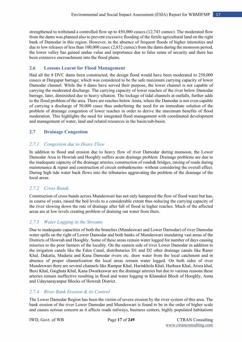
IWD, Govt. of WB Page 17 of 249 CTRAN Consulting www.ctranconsulting.com
17 Environmental and Social Impact Assessment (ESIA) Report for WBMIFMP
strengthened to withstand a controlled flow up to 450,000 cusecs (12,743 cumec). The moderated flow from the dams was planned also to prevent excessive flooding of the fertile agricultural land on the right bank of Damodar in this region. However, in the absence of frequent floods of higher intensities and due to low releases of less than 100,000 cusec (2,832 cumec) from the dams during the monsoon period, the lower valley has gained undue value and importance due to false sense of security and there has been extensive encroachment into the flood plains.
2.6 Lessons Learnt for Flood Management
Had all the 8 DVC dams been constructed, the design flood would have been moderated to 250,000 cusecs at Durgapur barrage; which was considered to be the safe maximum carrying capacity of lower Damodar channel. While the 4 dams have served their purpose, the lower channel is not capable of carrying the moderated discharge. The carrying capacity of lower reaches of the river below Damodar barrage, later, diminished due to heavy siltation. The lockage of tidal channels at outfalls, further adds to the flood problem of the area. There are reaches below Amta, where the Damodar is not even capable of carrying a discharge of 50,000 cusec thus underlining the need for an immediate solution of the problem of drainage congestion of lower reaches in order to derive the maximum benefits of flood moderation. This highlights the need for integrated flood management with coordinated development and management of water, land and related resources in the basin/sub-basin.
2.7 Drainage Congestion
2.7.1 Congestion due to Heavy Flow
In addition to flood and erosion due to heavy flow of river Damodar during monsoon, the Lower Damodar Area in Howrah and Hooghly suffers acute drainage problem. Drainage problems are due to the inadequate capacity of the drainage arteries, construction of roads& bridges, raising of roads during maintenance & repair and construction of circuit embankments- without considering the overall effect. During high tide water back flows into the tributaries aggravating the problem of the drainage of the local areas.
2.7.2 Cross Bunds
Construction of cross bunds across Mundeswari has not only hampered the flow of flood water but has, in course of years, raised the bed levels to a considerable extent thus reducing the carrying capacity of the river slowing down the rate of drainage after fall of flood in higher reaches. Much of the affected areas are at low levels creating problem of draining out water from there.
2.7.3 Water Logging in the Streams
Due to inadequate capacities of both the branches (Mundeswari and Lower Damodar) of river Damodar water spills on the right of Lower Damodar and both banks of Mundeswari inundating vast areas of the Districts of Howrah and Hooghly. Some of these areas remain water logged for number of days causing miseries to the poor farmers of the locality. On the eastern side of river Lower Damodar in addition to the irrigation canals like the Eden Canal, distributaries D1 and D2 other drainage canals like Raner Khal, Dakatia, Madaria and Kana Damodar rivers etc. draw water from the local catchment and in absence of proper channelization the local areas remain water logged. On both sides of river Mundeswari there are several channels like Rampur Khal, Harinkhola Khal, Hurhura Khal, Arora khal, Buxi Khal, Gaighata Khal, Kana Dwarkeswar are the drainage arteries but due to various reasons these arteries remain ineffective resulting in flood and water logging in Khanakul Block of Hooghly, Amta and Udaynarayanpur Blocks of Howrah District.
2.7.4 River Bank Erosion & its Control
The Lower Damodar Region has been the victim of severe erosion by the river system of this area. The bank erosion of the river Lower Damodar and Mundeswari is found to be in the order of higher scale and causes serious concern as it affects roads railways, business centers, highly populated habitations
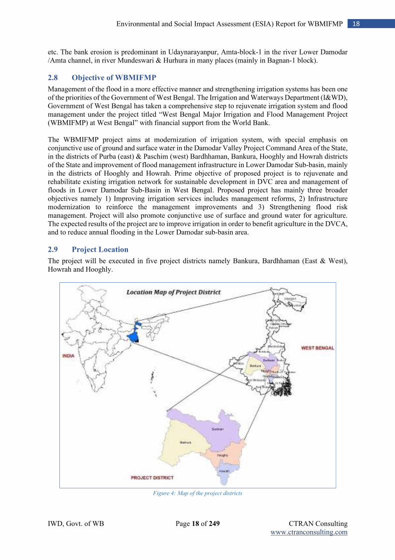
IWD, Govt. of WB Page 18 of 249 CTRAN Consulting www.ctranconsulting.com
18 Environmental and Social Impact Assessment (ESIA) Report for WBMIFMP
etc. The bank erosion is predominant in Udaynarayanpur, Amta-block-1 in the river Lower Damodar /Amta channel, in river Mundeswari & Hurhura in many places (mainly in Bagnan-1 block).
2.8 Objective of WBMIFMP
Management of the flood in a more effective manner and strengthening irrigation systems has been one of the priorities of the Government of West Bengal. The Irrigation and Waterways Department (I&WD), Government of West Bengal has taken a comprehensive step to rejuvenate irrigation system and flood management under the project titled “West Bengal Major Irrigation and Flood Management Project (WBMIFMP) at West Bengal” with financial support from the World Bank. The WBMIFMP project aims at modernization of irrigation system, with special emphasis on conjunctive use of ground and surface water in the Damodar Valley Project Command Area of the State, in the districts of Purba (east) & Paschim (west) Bardhhaman, Bankura, Hooghly and Howrah districts of the State and improvement of flood management infrastructure in Lower Damodar Sub-basin, mainly in the districts of Hooghly and Howrah. Prime objective of proposed project is to rejuvenate and rehabilitate existing irrigation network for sustainable development in DVC area and management of floods in Lower Damodar Sub-Basin in West Bengal. Proposed project has mainly three broader objectives namely 1) Improving irrigation services includes management reforms, 2) Infrastructure modernization to reinforce the management improvements and 3) Strengthening flood risk management. Project will also promote conjunctive use of surface and ground water for agriculture. The expected results of the project are to improve irrigation in order to benefit agriculture in the DVCA, and to reduce annual flooding in the Lower Damodar sub-basin area.
2.9 Project Location
The project will be executed in five project districts namely Bankura, Bardhhaman (East & West), Howrah and Hooghly.
Figure 4: Map of the project districts
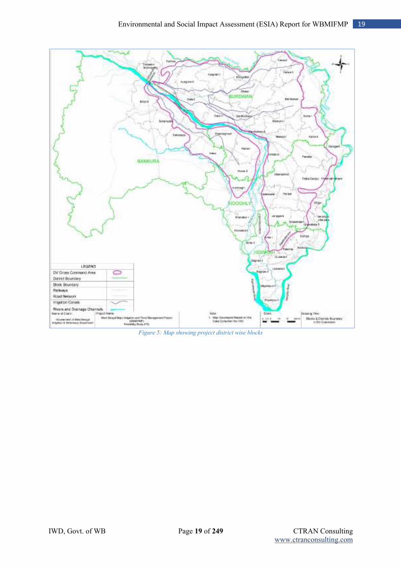
IWD, Govt. of WB Page 19 of 249 CTRAN Consulting www.ctranconsulting.com
19 Environmental and Social Impact Assessment (ESIA) Report for WBMIFMP
Figure 5: Map showing project district wise blocks
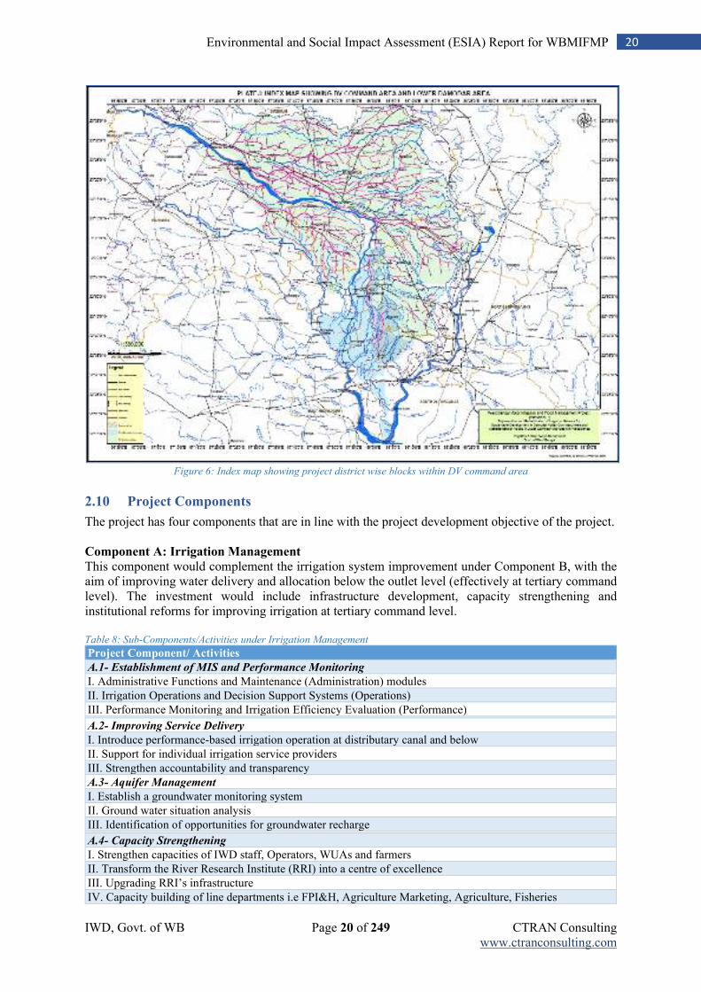
IWD, Govt. of WB Page 20 of 249 CTRAN Consulting www.ctranconsulting.com
20 Environmental and Social Impact Assessment (ESIA) Report for WBMIFMP
Figure 6: Index map showing project district wise blocks within DV command area
2.10 Project Components
The project has four components that are in line with the project development objective of the project.
Component A: Irrigation Management
This component would complement the irrigation system improvement under Component B, with the aim of improving water delivery and allocation below the outlet level (effectively at tertiary command level). The investment would include infrastructure development, capacity strengthening and institutional reforms for improving irrigation at tertiary command level. Table 8: Sub-Components/Activities under Irrigation Management
Project Component/ Activities
A.1- Establishment of MIS and Performance Monitoring
I. Administrative Functions and Maintenance (Administration) modules
II. Irrigation Operations and Decision Support Systems (Operations)
III. Performance Monitoring and Irrigation Efficiency Evaluation (Performance) A.2- Improving Service Delivery
I. Introduce performance-based irrigation operation at distributary canal and below
II. Support for individual irrigation service providers
III. Strengthen accountability and transparency
A.3- Aquifer Management
I. Establish a groundwater monitoring system
II. Ground water situation analysis
III. Identification of opportunities for groundwater recharge A.4- Capacity Strengthening
I. Strengthen capacities of IWD staff, Operators, WUAs and farmers
II. Transform the River Research Institute (RRI) into a centre of excellence
III. Upgrading RRI’s infrastructure
IV. Capacity building of line departments i.e FPI&H, Agriculture Marketing, Agriculture, Fisheries
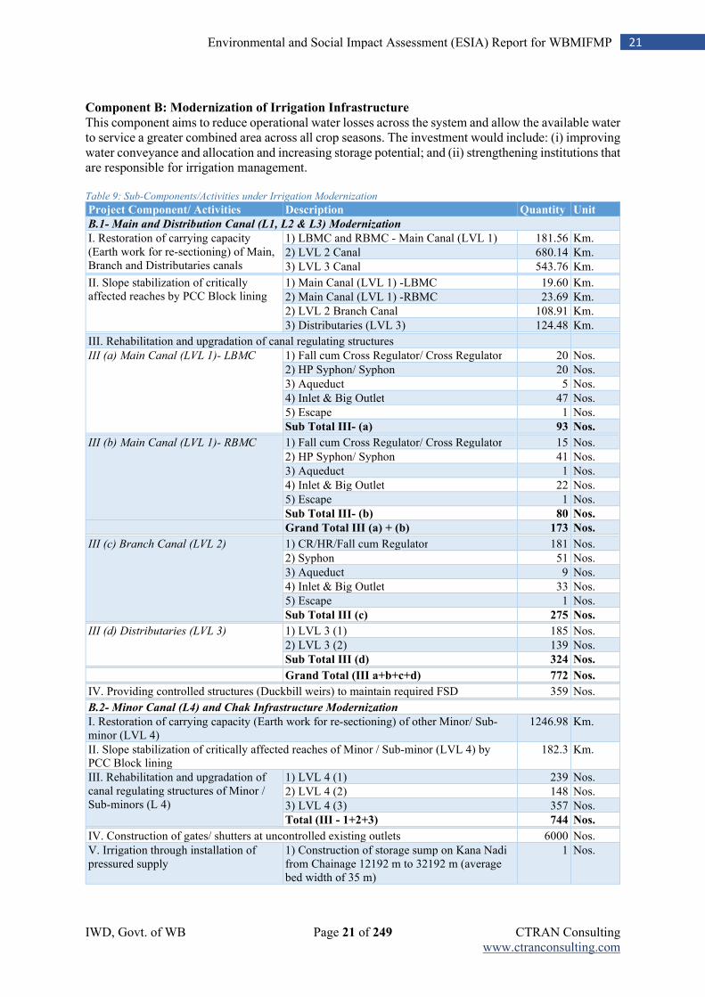
IWD, Govt. of WB Page 21 of 249 CTRAN Consulting www.ctranconsulting.com
21 Environmental and Social Impact Assessment (ESIA) Report for WBMIFMP
Component B: Modernization of Irrigation Infrastructure This component aims to reduce operational water losses across the system and allow the available water to service a greater combined area across all crop seasons. The investment would include: (i) improving water conveyance and allocation and increasing storage potential; and (ii) strengthening institutions that are responsible for irrigation management. Table 9: Sub-Components/Activities under Irrigation Modernization
Project Component/ Activities Description Quantity Unit
B.1- Main and Distribution Canal (L1, L2 & L3) Modernization
I. Restoration of carrying capacity (Earth work for re-sectioning) of Main, Branch and Distributaries canals
1) LBMC and RBMC - Main Canal (LVL 1) 181.56 Km.
2) LVL 2 Canal 680.14 Km.
3) LVL 3 Canal 543.76 Km. II. Slope stabilization of critically affected reaches by PCC Block lining
1) Main Canal (LVL 1) -LBMC 19.60 Km.
2) Main Canal (LVL 1) -RBMC 23.69 Km.
2) LVL 2 Branch Canal 108.91 Km.
3) Distributaries (LVL 3) 124.48 Km. III. Rehabilitation and upgradation of canal regulating structures
III (a) Main Canal (LVL 1)- LBMC 1) Fall cum Cross Regulator/ Cross Regulator 20 Nos.
2) HP Syphon/ Syphon 20 Nos.
3) Aqueduct 5 Nos.
4) Inlet & Big Outlet 47 Nos.
5) Escape 1 Nos.
Sub Total III- (a) 93 Nos. III (b) Main Canal (LVL 1)- RBMC 1) Fall cum Cross Regulator/ Cross Regulator 15 Nos.
2) HP Syphon/ Syphon 41 Nos.
3) Aqueduct 1 Nos.
4) Inlet & Big Outlet 22 Nos.
5) Escape 1 Nos.
Sub Total III- (b) 80 Nos. Grand Total III (a) + (b) 173 Nos.
III (c) Branch Canal (LVL 2) 1) CR/HR/Fall cum Regulator 181 Nos.
2) Syphon 51 Nos.
3) Aqueduct 9 Nos.
4) Inlet & Big Outlet 33 Nos.
5) Escape 1 Nos.
Sub Total III (c) 275 Nos. III (d) Distributaries (LVL 3) 1) LVL 3 (1) 185 Nos.
2) LVL 3 (2) 139 Nos.
Sub Total III (d) 324 Nos. Grand Total (III a+b+c+d) 772 Nos.
IV. Providing controlled structures (Duckbill weirs) to maintain required FSD 359 Nos. B.2- Minor Canal (L4) and Chak Infrastructure Modernization
I. Restoration of carrying capacity (Earth work for re-sectioning) of other Minor/ Sub-minor (LVL 4)
1246.98 Km.
II. Slope stabilization of critically affected reaches of Minor / Sub-minor (LVL 4) by PCC Block lining
182.3 Km.
III. Rehabilitation and upgradation of canal regulating structures of Minor / Sub-minors (L 4)
1) LVL 4 (1) 239 Nos.
2) LVL 4 (2) 148 Nos.
3) LVL 4 (3) 357 Nos.
Total (III - 1+2+3) 744 Nos. IV. Construction of gates/ shutters at uncontrolled existing outlets 6000 Nos.
V. Irrigation through installation of pressured supply
1) Construction of storage sump on Kana Nadi from Chainage 12192 m to 32192 m (average bed width of 35 m)
1 Nos.
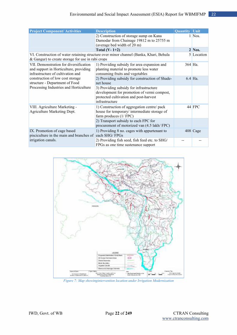
IWD, Govt. of WB Page 22 of 249 CTRAN Consulting www.ctranconsulting.com
22 Environmental and Social Impact Assessment (ESIA) Report for WBMIFMP
Project Component/ Activities Description Quantity Unit
2) Construction of storage sump on Kana Damodar from Chainage 19812 m to 25755 m (average bed width of 20 m)
1 Nos.
Total (V- 1+2) 2 Nos.
VI. Construction of water retaining structure over minor channel (Banka, Khari, Behula & Gangur) to create storage for use in rabi crops
5 Location
VII. Demonstration for diversification and support in Horticulture, providing infrastructure of cultivation and construction of low cost storage structure - Department of Food Processing Industries and Horticulture
1) Providing subsidy for area expansion and planting material to promote less water consuming fruits and vegetables
364 Ha.
2) Providing subsidy for construction of Shade-net house
6.4 Ha.
3) Providing subsidy for infrastructure development for promotion of vermi compost, protected cultivation and post-harvest infrastructure
VIII. Agriculture Marketing - Agriculture Marketing Dept.
1) Construction of aggregation centre/ pack house for temporary/ intermediate storage of farm produces (1/ FPC)
44 FPC
2) Transport subsidy to each FPC for procurement of motorized van (4.5 lakh/ FPC)
IX. Promotion of cage based pisciculture in the main and branches of irrigation canals.
1) Providing 8 no. cages with appurtenant to each SHG/ FPGs
408 Cage
2) Providing fish seed, fish feed etc. to SHG/ FPGs as one time sustenance support
-- --
Figure 7: Map showingintervention location under Irrigation Modernization
IWD, Govt. of WB Page 23 of 249 CTRAN Consulting www.ctranconsulting.com
23 Environmental and Social Impact Assessment (ESIA) Report for WBMIFMP
Component C: Flood Management
This component mainly aims to alleviate annualized flooding in the Lower Damodar sub-basin area. The investment would mitigate flooding hotspots by carrying out channel desilting works, flow regulation structure modification and embankment reconstruction at key locations. In close collaboration with the World Bank-funded Dam Rehabilitation and Improvement Project, the investment would also include measures to strengthen forecasting and analysis capability to improve dam operation and water storage management in upstream reservoirs. Opportunities will also be explored for ways to capture and direct wet season water in order to recharge groundwater. Table 10: Sub-Components/Activities under Flood Management
Project Component/ Activities Description Quantity Unit
I. Desiltation of Mundeswari river from Beguahana to further downstream **
1) Mundeswari River 19.24 Km.
2) Upstream channel in undivided Damodar 0.43 Km.
Sub Total (I - 1+2) 19.67 Km.
II. Desiltation of other 41 drainage channels
1) Madaria Khal of 100 metre bed width 12.9 Km.
2) 4 nos. Drainage Khal of 12 metre bed width 29.94 Km.
3) 7 nos. Drainage Khal of 7 metre bed width 25.24 Km.
4) Roner Khal 13.79 Km.
5) 28 nos. Drainage Khal of 5 metre bed width 113.28 Km.
Total (II - 1+2+3+4+5) 195.15 Km.
III. Armouring of Damodar Right Dwarf embankment to act as Broad Crested Weir to allow controlled spilling of flood water
1) Protection with Broad Crested Weir 19.25 Km.
2) Concrete Road over embankment 15.89 Km.
IV. Improving Damodar Protected Left Embankment by providing adequate free board to withstand flood through construction of flood walls at identified locations
“I” type Flood Wall with sheet pile + concrete top 40.93 Km.
V. Improving Upper Rampur & Hurhura Channels by providing adequate freeboard through provision of flood wall
1) Upper Rampur left embankment 15 Km.
2) Hurhura left embankment 16 Km.
Total (V- 1+2) 31 Km.
VI. Strengthening of countryside existing earthen embankments to its design section
1) Damodar left embankment 32.58 Km.
2) Damodar right Embankment 6 Km.
3) Hurhurah left embankment 2.4 Km.
4) Upper Rampur left embankment 5.15 Km.
5) Lower Rampur left embankments 2.8 Km.
6) Gaighata 10 Km.
Total (VI- 1+2+3+4+5+6) 58.93 Km.
VII. Protection / River training works 1) Damodar (Left + Right) 15.83 Km.
2) Mundeswari 15.4 Km.
3) Upper Rampur 0.8 Km.
4) Lower Rampur 1.8 Km.
Total (VII- 1+2+3+4) 33.83 Km.
VIII. Remodelling & Reconstruction of sluices at the outfalls of drainage channels
1) Remodelling of sluices 63 Nos.
2) Reconstruction of single vent sluices 15 Nos.
3) Reconstruction of double vent sluices 4 Nos.
4) New sluices 1 Nos.
Total (VIII- 1+2+3+4) 83 Nos.
** Note: Desiltation of Mundeswari river (including 430 m upstream channel in undivided Damodar) and 41 drainage channels will be carried out only during non-monsoon period. Mundeswari river remain dry throughout the year except shallow water in selected patches. Due to two (2) meter high bed height than Amta channel at bifurcation point at Buguahaha, Mundeswari river do not receive water if discharge at Durgapur barrage is less than 30,000 cusec. Dry desiltation is proposed for all River (including undivided portion of Damodar river) and drainage channel.
IWD, Govt. of WB Page 24 of 249 CTRAN Consulting www.ctranconsulting.com
24 Environmental and Social Impact Assessment (ESIA) Report for WBMIFMP
River weed will be removed manually followed by vibration arrangement to allow fauna species to migrate in nearby area. Nine (9) primary, twelve (12) intermediate cross bundhs across Mundeswari and three (3) cross bunds across mouths of other out falling drainage channels will be constructed to facilitate desiltation work. Cross bundh will be constructed at the upstream of working zone and the river bed will be dried by bailing out of residual water, if any and then earthmoving machineries will enter the river bed to desilt the earth which will be brought to river/canal/channel banks and onward to the designated disposal locations by trucks. Desilted material will either be stored temporary at set-back zone and transferred to designated places within 5 km. radius or directly transferred to designated places. Few Govt. land is available within 5 km. radius will be used for temporary storing of desilted material. Local sand miners and civil contractor have shown interest for purchase of sand material directly from desilted sites. Sand miners/ civil contractors will evacuate desilted material directly from desilted site. Desilted material will be used to backfill low lying area or to raise low-lying nearby villages. IWD is in the process of earmarking low-lying Govt. land and low-lying villages require raising up. After fulfilling above three demands, excess desilted material will be stored in nearby area. It will be responsibility of desilting contractor to arrange land for temporarily storing of excess land. Contractor will negotiate with local person interested to store desilted material in his own land. Contractor will pay one time premium to land owner for storing sand material in his land. Desilted material will be sold either by land owner or District Magistrate (DM) to designated users. Land owner will sell desilted material and pay royalty amount to DM or DM will directly sell it to different end users. SPMU – WBMIFMP is in constant touch with Public Works Department (PWD) to use desilted material in on-going or upcoming road construction work in nearby area. Possibility of use of desilted material in backfilling of road will be finalized immediate before excavation/ during excavation work in consultation with PWD.
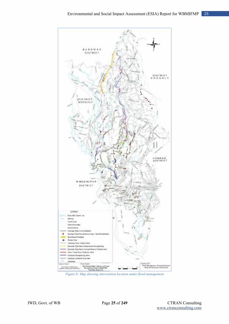
IWD, Govt. of WB Page 25 of 249 CTRAN Consulting www.ctranconsulting.com
25 Environmental and Social Impact Assessment (ESIA) Report for WBMIFMP
Figure 8: Map showing intervention location under flood management
IWD, Govt. of WB Page 26 of 249 CTRAN Consulting www.ctranconsulting.com
26 Environmental and Social Impact Assessment (ESIA) Report for WBMIFMP
Component D: Project Management
This component will strengthen IWD and the SPMU’s capacity for Project management, monitoring and evaluation (M&E) (including, inter alia, the areas procurement and financial management) through the provision of goods, consultant services, training, and financing incremental operating costs. Intermediate results indicators include the number of Project monitoring reports submitted on time annually. Staffing of the SPMU will be strengthened, prior to Project effectiveness, to include a number of technical, financial management, M&E and safeguards (social and environmental) experts. A Project Management Consultant (PMC) will be recruited to assist the SPMU in managing and coordinating Project activities, and setting up the MIS. The PMC will also conduct construction supervision of civil works. This component will also launch a communications campaign to inform stakeholders about the details of the project, including the performance nature of service delivery through private Operators, the importance of efficient water use, and the benefits of pressurized micro-irrigation for groundwater.
2.11 Project Cost
Total project cost is 413 Million USD, of which 290 Million USD (70%) will be financed by the International Bank for Reconstruction and Development (IBRD) and remaining 123 Million USD (30%) by Govt. of West Bengal towards the implementation of WBMIFMP. Entire project will be implemented over a period of 5 years, starting from financial year 2019 to 2024.
IWD, Govt. of WB Page 27 of 249 CTRAN Consulting www.ctranconsulting.com
27 Environmental and Social Impact Assessment (ESIA) Report for WBMIFMP
Chapter 3: Legal and Regulatory Compliance
This section explains the legal & regularity requirements under different acts / rules and policies for social and environment safeguards. It also identifies the requirement of permits / licenses in the project under different rules /regulation as different stages of the project period. Further, an outline of the environmental and social safeguards policies of the World Bank has been presented. As is evident from the section below, there are no substantial differences in principle between the two set of policies and operational procedures applicable - Different acts / policies and its implications / applicability to the WBMIFMP is detailed out in the table below.
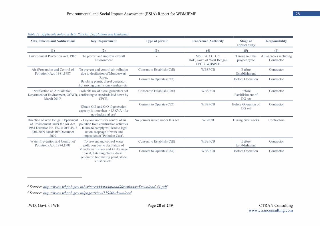
IWD, Govt. of WB Page 28 of 249 CTRAN Consulting www.ctranconsulting.com
28 Environmental and Social Impact Assessment (ESIA) Report for WBMIFMP
Table 11: Applicable Relevant Acts, Policies, Legislations and Guidelines
Acts, Policies and Notifications Key Requirement Type of permit Concerned Authority Stage of
applicability
Responsibility
(1) (2) (3) (4) (5) (6)
Environment Protection Act, 1986 To protect and improve overall Environment
- MoEF & CC, GoI DoE, Govt. of West Bengal,
CPCB, WBSPCB
Throughout the project cycle
All agencies including Contractor
Air (Prevention and Control of Pollution) Act, 1981,1987
To prevent and control air pollution due to desiltation of Mundeswari
River, Batching plants, diesel generator,
hot mixing plant, stone crushers etc.
Consent to Establish (CtE)
WBSPCB Before Establishment
Contractor
Consent to Operate (CtO) Before Operation Contractor
Notification on Air Pollution, Department of Environment, GOWB,
March 20102
Prohibits use of diesel generators not confirming to standards laid down by
CPCB.
Obtain CtE and CtO if generation capacity is more than > 15 KVA - for
non-Industrial use3
Consent to Establish (CtE)
WBSPCB Before Establishment of
DG set
Contractor
Consent to Operate (CtO) WBSPCB Before Operation of DG set
Contractor
Direction of West Bengal Department of Environment under the Air Act,
1981 Direction No. EN/3170/T-IV-7 /001/2009 dated: 10th December
2009
- Lays out norms for control of air pollution from construction activities - failure to comply will lead to legal
action, stoppage of work and imposition of `Pollution Cost’.
No permits issued under this act WBPCB During civil works Contractors
Water Prevention and Control of Pollution) Act, 1974,1988
To prevent and control water pollution due to desiltation of
Mundeswari River and 41 drainage canal, batching plants, diesel
generator, hot mixing plant, stone crushers etc.
Consent to Establish (CtE)
WBSPCB Before Establishment
Contractor
Consent to Operate (CtO) WBSPCB Before Operation Contractor
2 Source: http://www.wbpcb.gov.in/writereaddata/upload/downloads/Download-41.pdf
3 Source: http://www.wbpcb.gov.in/pages/view/119/46-download
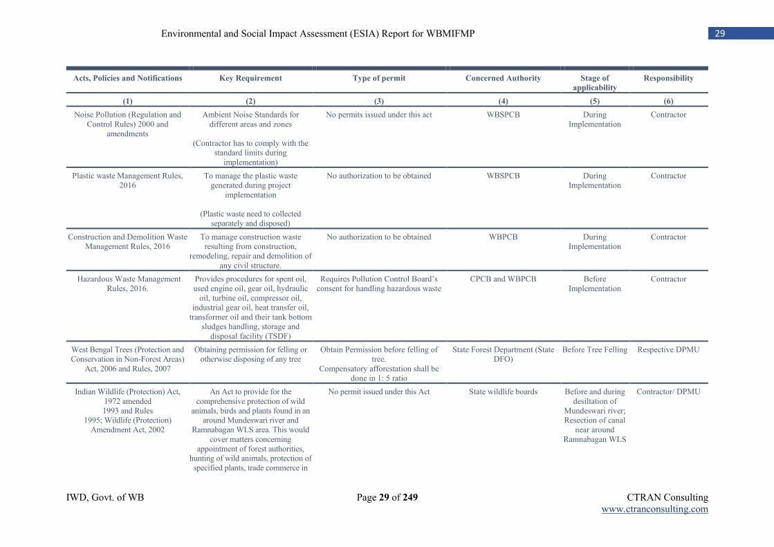
IWD, Govt. of WB Page 29 of 249 CTRAN Consulting www.ctranconsulting.com
29 Environmental and Social Impact Assessment (ESIA) Report for WBMIFMP
Acts, Policies and Notifications Key Requirement Type of permit Concerned Authority Stage of
applicability
Responsibility
(1) (2) (3) (4) (5) (6)
Noise Pollution (Regulation and Control Rules) 2000 and
amendments
Ambient Noise Standards for different areas and zones
(Contractor has to comply with the
standard limits during implementation)
No permits issued under this act WBSPCB During Implementation
Contractor
Plastic waste Management Rules, 2016
To manage the plastic waste generated during project
implementation
(Plastic waste need to collected separately and disposed)
No authorization to be obtained WBSPCB During Implementation
Contractor
Construction and Demolition Waste Management Rules, 2016
To manage construction waste resulting from construction,
remodeling, repair and demolition of any civil structure.
No authorization to be obtained WBPCB During Implementation
Contractor
Hazardous Waste Management Rules, 2016.
Provides procedures for spent oil, used engine oil, gear oil, hydraulic
oil, turbine oil, compressor oil, industrial gear oil, heat transfer oil,
transformer oil and their tank bottom sludges handling, storage and
disposal facility (TSDF)
Requires Pollution Control Board’s consent for handling hazardous waste
CPCB and WBPCB Before Implementation
Contractor
West Bengal Trees (Protection and Conservation in Non-Forest Areas)
Act, 2006 and Rules, 2007
Obtaining permission for felling or otherwise disposing of any tree
Obtain Permission before felling of tree.
Compensatory afforestation shall be done in 1: 5 ratio
State Forest Department (State DFO)
Before Tree Felling Respective DPMU
Indian Wildlife (Protection) Act, 1972 amended 1993 and Rules
1995; Wildlife (Protection) Amendment Act, 2002
An Act to provide for the comprehensive protection of wild
animals, birds and plants found in an around Mundeswari river and
Ramnabagan WLS area. This would cover matters concerning
appointment of forest authorities, hunting of wild animals, protection of specified plants, trade commerce in
No permit issued under this Act State wildlife boards Before and during desiltation of
Mundeswari river; Resection of canal
near around Ramnabagan WLS
Contractor/ DPMU
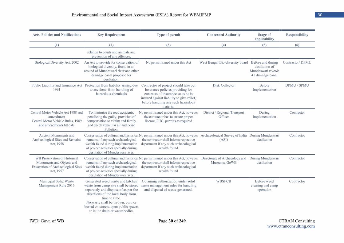
IWD, Govt. of WB Page 30 of 249 CTRAN Consulting www.ctranconsulting.com
30 Environmental and Social Impact Assessment (ESIA) Report for WBMIFMP
Acts, Policies and Notifications Key Requirement Type of permit Concerned Authority Stage of
applicability
Responsibility
(1) (2) (3) (4) (5) (6)
relation to plants and animals and prevention of any offences.
Biological Diversity Act, 2002 An Act to provide for conservation of biological diversity, found in an
around of Mundeswari river and other drainage canal proposed for
desiltation.
No permit issued under this Act West Bengal Bio-diversity board Before and during desiltation of
Mundeswari river& 41 drainage canal
Contractor/ DPMU
Public Liability and Insurance Act 1991
Protection from liability arising due to accidents from handling of
hazardous chemicals
Contractor of project should take out Insurance policies providing for contracts of insurance so as he is
insured against liability to give relief, before handling any such hazardous
material
Dist. Collector Before Implementation
DPMU / SPMU
Central Motor Vehicle Act 1988 and amendment
Central Motor Vehicle Rules, 1989 and amendments till date
To minimize the road accidents, penalizing the guilty, provision of compensation to victim and family and check vehicular air and noise
Pollution.
No permit issued under this Act, however the contractor has to ensure proper license, PUC, permits as required
District / Regional Transport Officer
During Implementation
Contractor
Ancient Monuments and Archaeological Sites and Remains
Act, 1958
Conservation of cultural and historical remains; if any such archaeological
wealth found during implementation of project activities specially during
desiltation of Mundeswari river.
No permit issued under this Act, however the contractor shall inform respective
department if any such archaeological wealth found
Archaeological Survey of India (ASI)
During Mundeswari desiltation
Contractor
WB Preservation of Historical Monuments and Objects and
Excavation of Archaeological Sites Act, 1957
Conservation of cultural and historical remains; if any such archaeological
wealth found during implementation of project activities specially during
desiltation of Mundeswari river.
No permit issued under this Act, however the contractor shall inform respective
department if any such archaeological wealth found
Directorate of Archaeology and Museums, GoWB
During Mundeswari desiltation
Contractor
Municipal Solid Waste Management Rule 2016
Generated weed waste and kitchen waste from camp site shall be stored separately and dispose of as per the
directions of the local body from time to time.
No waste shall be thrown, burn or buried on streets, open public spaces
or in the drain or water bodies.
Obtaining authorization under solid waste management rules for handling
and disposal of waste generated.
WBSPCB
Before weed clearing and camp
operation
Contractor
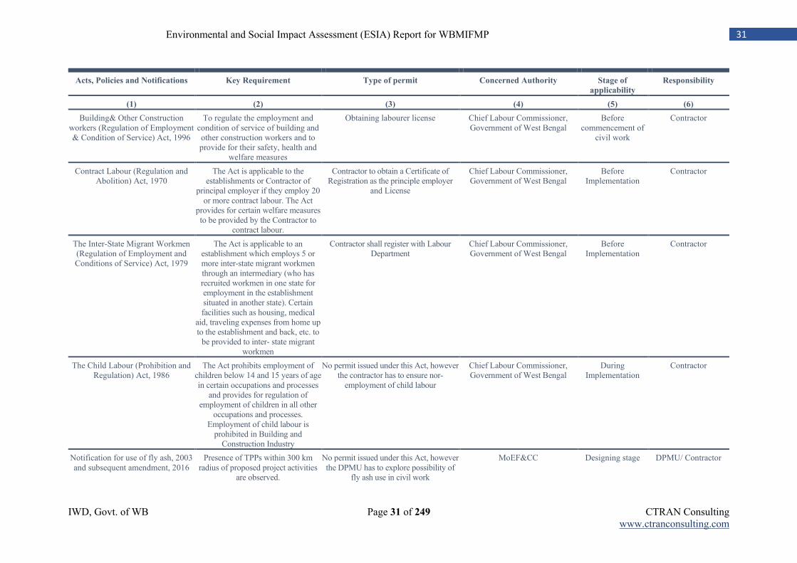
IWD, Govt. of WB Page 31 of 249 CTRAN Consulting www.ctranconsulting.com
31 Environmental and Social Impact Assessment (ESIA) Report for WBMIFMP
Acts, Policies and Notifications Key Requirement Type of permit Concerned Authority Stage of
applicability
Responsibility
(1) (2) (3) (4) (5) (6)
Building& Other Construction workers (Regulation of Employment & Condition of Service) Act, 1996
To regulate the employment and condition of service of building and other construction workers and to provide for their safety, health and
welfare measures
Obtaining labourer license Chief Labour Commissioner, Government of West Bengal
Before commencement of
civil work
Contractor
Contract Labour (Regulation and Abolition) Act, 1970
The Act is applicable to the establishments or Contractor of
principal employer if they employ 20 or more contract labour. The Act
provides for certain welfare measures to be provided by the Contractor to
contract labour.
Contractor to obtain a Certificate of Registration as the principle employer
and License
Chief Labour Commissioner, Government of West Bengal
Before Implementation
Contractor
The Inter-State Migrant Workmen (Regulation of Employment and Conditions of Service) Act, 1979
The Act is applicable to an establishment which employs 5 or more inter-state migrant workmen through an intermediary (who has recruited workmen in one state for employment in the establishment situated in another state). Certain facilities such as housing, medical
aid, traveling expenses from home up to the establishment and back, etc. to
be provided to inter- state migrant workmen
Contractor shall register with Labour Department
Chief Labour Commissioner, Government of West Bengal
Before Implementation
Contractor
The Child Labour (Prohibition and Regulation) Act, 1986
The Act prohibits employment of children below 14 and 15 years of age in certain occupations and processes
and provides for regulation of employment of children in all other
occupations and processes. Employment of child labour is
prohibited in Building and Construction Industry
No permit issued under this Act, however the contractor has to ensure nor-
employment of child labour
Chief Labour Commissioner, Government of West Bengal
During Implementation
Contractor
Notification for use of fly ash, 2003 and subsequent amendment, 2016
Presence of TPPs within 300 km radius of proposed project activities
are observed.
No permit issued under this Act, however the DPMU has to explore possibility of
fly ash use in civil work
MoEF&CC Designing stage DPMU/ Contractor
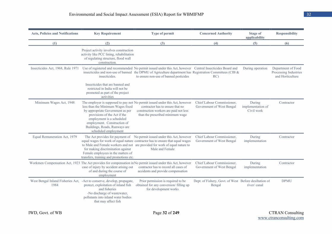
IWD, Govt. of WB Page 32 of 249 CTRAN Consulting www.ctranconsulting.com
32 Environmental and Social Impact Assessment (ESIA) Report for WBMIFMP
Acts, Policies and Notifications Key Requirement Type of permit Concerned Authority Stage of
applicability
Responsibility
(1) (2) (3) (4) (5) (6)
Project activity involves construction activity like PCC lining, rehabilitation
of regulating structure, flood wall construction.
Insecticides Act, 1968, Rule 1971 Use of registered and recommended insecticides and non-use of banned
insecticides.
Insecticides that are banned and restricted in India will not be
promoted as part of the project activities
No permit issued under this Act, however the DPMU of Agriculture department has
to ensure non-use of banned pesticides
Central Insecticides Board and Registration Committees (CIB &
RC)
During operation Department of Food Processing Industries
and Horticulture
Minimum Wages Act, 1948 The employer is supposed to pay not less than the Minimum Wages fixed by appropriate Government as per
provisions of the Act if the employment is a scheduled
employment. Construction of Buildings, Roads, Runways are
scheduled employment
No permit issued under this Act, however contractor has to ensure that no
construction workers are paid not less than the prescribed minimum wage
Chief Labour Commissioner, Government of West Bengal
During implementation of
Civil work
Contractor
Equal Remuneration Act, 1979 The Act provides for payment of equal wages for work of equal nature to Male and Female workers and not
for making discrimination against Female employees in the matters of
transfers, training and promotions etc.
No permit issued under this Act, however contractor has to ensure that equal wages are provided for work of equal nature to
Male and Female
Chief Labour Commissioner, Government of West Bengal
During implementation
Contractor
Workmen Compensation Act, 1923 The Act provides for compensation in case of injury by accident arising out
of and during the course of employment
No permit issued under this Act, however contractor has to record all cases of accidents and provide compensation
Chief Labour Commissioner, Government of West Bengal
During implementation
Contractor
West Bengal Inland Fisheries Act, 1984
-Act to conserve, develop, propagate, protect, exploitation of inland fish
and fisheries -No discharge of wastewater,
pollutants into inland water bodies that may affect fish
Prior permission is required to be obtained for any conversion/ filling up
for development works
Dept. of Fishery, Govt. of West Bengal
Before desiltation of river/ canal
DPMU
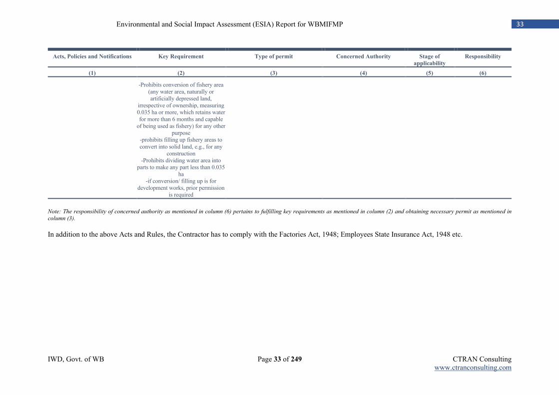
IWD, Govt. of WB Page 33 of 249 CTRAN Consulting www.ctranconsulting.com
33 Environmental and Social Impact Assessment (ESIA) Report for WBMIFMP
Acts, Policies and Notifications Key Requirement Type of permit Concerned Authority Stage of
applicability
Responsibility
(1) (2) (3) (4) (5) (6)
-Prohibits conversion of fishery area (any water area, naturally or artificially depressed land,
irrespective of ownership, measuring 0.035 ha or more, which retains water for more than 6 months and capable
of being used as fishery) for any other purpose
-prohibits filling up fishery areas to convert into solid land, e.g., for any
construction -Prohibits dividing water area into
parts to make any part less than 0.035 ha
-if conversion/ filling up is for development works, prior permission
is required
Note: The responsibility of concerned authority as mentioned in column (6) pertains to fulfilling key requirements as mentioned in column (2) and obtaining necessary permit as mentioned in
column (3).
In addition to the above Acts and Rules, the Contractor has to comply with the Factories Act, 1948; Employees State Insurance Act, 1948 etc.
34 Environmental and Social Impact Assessment (ESIA) Report for WBMIFMP
3.1 Social Policies and Regulations
In this section, some of the policies and legislations of the Government of India and the Government of West Bengal are briefly discussed, that will have bearing on the Project. This is followed by a brief description of the project relevant development programmes and schemes being implemented by the Government of India and the Government of West Bengal. Later, at the end of the section, the World Bank Safeguard Policies are presented.
3.1.1 Land Acquisition Related Act / Policy
Government of West Bengal has issued a memorandum vide Gazette Notification, dated March 1, 2016 to ensure the optimal utilization of public funds and early implementation of projects where direct land purchase from land owners may become necessary. The salient features of the memorandum are; The Right to Fair Compensation and Transparency in Land Acquisition, Resettlement and Rehabilitation (RFCTLAR&R) Act, 2013, enacted by the Government of India is the latest legislation. This is in force and supersedes all other old acts for land acquisition and to determining R&R activities. For land acquisition for different development projects, Government of West Bengal has published gazette notification dated March 1, 2016. The act shall apply, when the Government acquires land for its own use, hold and control, including for Public Sector Undertakings and for public purpose; The Memorandum of Government of West Bengal for purchasing land for project purposes and RFCTLAR&R Act, 2013 will not be applicable to the WBMIFMP as the project does not involve any additional fresh land acquisition for the purpose of implementation of the project. The project will be executed within the river bed and ROW that belongs to Government. However, the Government of West Bengal has decided to compensate the encroachers and squatters for their temporary loss of livelihood due to project activities and impact on residential structures. The financial provisions of GITANJALI scheme of the Government of West Bengal will be adopted and accordingly eviction will be done from the embankment during implementation stage. It is also provisioned that for temporary purposes, farmers land may require to be utilized. In such cases, the concerned farmer / land holder / lease holder / registered share cropper will be compensated for crop loss along with provision of rendering rental value of the land. Refer Resettlement Action Plan (RAP) for details. GITANJALI Scheme: The scheme is being implemented by the Department of Housing of Government of West Bengal. As per the scheme guidelines, the houses would be constructed by beneficiaries themselves and no contracting agency will be engaged for the purpose. The revised guidelines came into effect from 01/04/2014. As per the revised guidelines, the scheme serves the purpose of three categories of beneficiaries, i.e., (a) Poor People in Rural and Urban areas, (b) Poor People in Erosion/ Flood/ Other calamity affected/ Disaster prone areas, and (c) Poor People affected by Government Projects (As part of rehabilitation measures). The scheme follows the income-based criteria, i.e., the people having family income of Rs 6,000/- per month or less whereas people in the BPL list gets priority. The scheme is applicable to all over the state of West Bengal including Rural and Urban areas. Provision of Land: The scheme is being implemented in rural areas on the land of the beneficiary. As per the guidelines, required land is to be provided by the beneficiary of his / her own land / patta land and must be free from all encumbrances. In case of urban areas where land of beneficiaries is not available, the Group Housing may be built on the land supplied by District Administration, Municipality or any Development Authority. The dwelling unit is in IAY (currently PMAY-G) pattern. It is mandated that district authority will provide a low-cost toilet in every case. Cost of the Dwelling Units: The cost of dwelling unit is in line with the PMAY-G scheme, i.e., Rs.1.20 lakhs per unit of housing.
IWD, Govt. of WB Page 35 of 249 CTRAN Consulting www.ctranconsulting.com
35 Environmental and Social Impact Assessment (ESIA) Report for WBMIFMP
Implementation Modalities: The scheme is being implemented by Housing Department through District Magistrate of the concerned District. He will nominate one of the Additional District Magistrate of the District to look after daily activities of the scheme on his behalf. District Planning Officer of the District acts as the Nodal Officer of the scheme.
3.1.2 Panchayati Raj Act
As per the 73rd constitutional amendment act, 1992, the panchayats as the local self-government are empowered to plan execute and monitor certain activities as per the activity mapping. As per the status of devolution, 11 subjects have been fully devolved in the State of Maharashtra and 18 subjects / schemes are implemented by the PRIs. The act strengthens the decentralized governance system and promotes bottom-up planning. As per the act, the GP level plans are to be prepared in Gram Sabha which is having an important bearing on the planning process of the proposed project. The act is having both mandatory and discretionary provisions and of the mandatory provisions of the Panchayati Raj Act, the most critical are those that strengthen the structure of representative democracy and political representation at the local level. Some of the salient features of the mandatory provisions of the Act are;
1. The establishment in every state (except those with populations below 2 million) of rural local bodies (panchayats) at the village, intermediate and district levels (Article 243B)
2. Direct elections to all seats in the panchayats at all levels (Article 243C) 3. Compulsory elections to panchayats every five years with the elections being held before the
end of the term of the incumbent panchayat in the event that a panchayat is dissolved prematurely, elections must be held within six months, with the newly elected members serving out the remainder of the five-year term (Article 243E)
4. Mandatory reservation of seats in all panchayats at all levels for Davits and Advises in proportion to their share of the panchayat population (Article 243D)
5. Mandatory reservation of one-third of all seats in all panchayats at all levels for women, with the reservation for women applying to the seats reserved for Davits and Advises as well (Article 243D)
6. Indirect elections to the position of panchayat chairperson at the intermediate and district levels (Article 243C)
7. Mandatory reservation of the position of panchayat chairperson at all levels for Davits and Advises in proportion to their share in the state population (Article 243D)
8. Mandatory reservation of one-third of the positions of panchayat chairperson at all three levels for women (Article 243D)
9. In addition, the act mandates the constitution of two state-level commissions: an independent election commission to supervise and manage elections to local bodies, much as the Election Commission of India manages state assembly and parliamentary elections (Article 243K); and a state finance commission, established every five years, to review the financial position of local bodies and recommend the principles that should govern the allocation of funds and taxation authority to local bodies (Article 2431).
The Article 243ZD, mandates the constitution of District Planning Committees to consolidate the plans prepared by both rural and urban local bodies. In order to facilitate. This is an essential pre-requisite for each tier of the Panchayati Raj system to prepare plans for its areas, as defined through Activity Mapping, and then for all these plans, along with plans of municipalities, to be "consolidated" by the District Planning Committees (DPC) as mandated by Article 243 ZD of the Constitution.
3.1.3 Agricultural Produce Market Committee Act, 2003
The Agricultural Produce Market Committee Act, 1963 (APMC, 1963) operate on two principles, i.e., (1) to ensure that farmers are not exploited by intermediaries (or money lenders) who compel farmers to sell their produce at the farm gate for an extremely low price; (2) all food produce should first be brought to a market yard and then sold through auction.
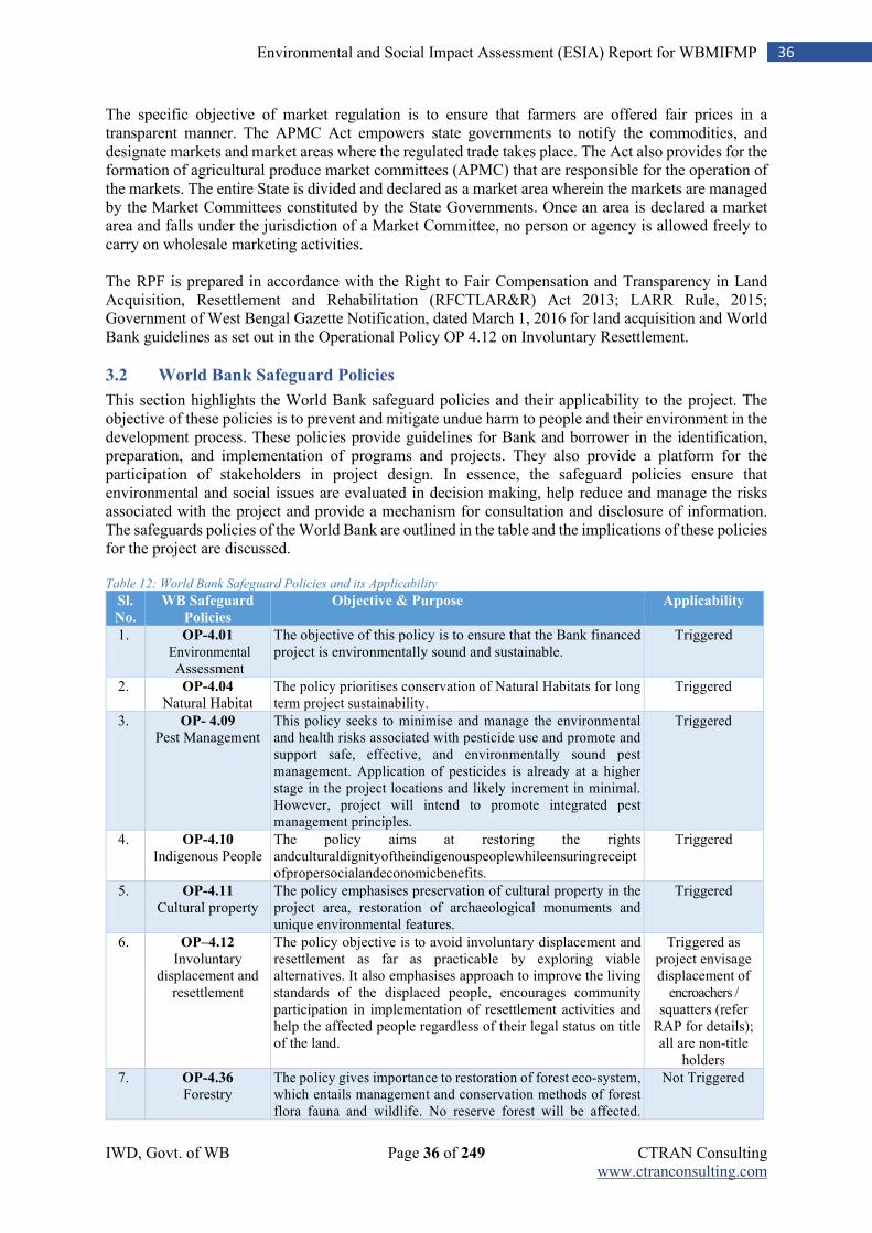
IWD, Govt. of WB Page 36 of 249 CTRAN Consulting www.ctranconsulting.com
36 Environmental and Social Impact Assessment (ESIA) Report for WBMIFMP
The specific objective of market regulation is to ensure that farmers are offered fair prices in a transparent manner. The APMC Act empowers state governments to notify the commodities, and designate markets and market areas where the regulated trade takes place. The Act also provides for the formation of agricultural produce market committees (APMC) that are responsible for the operation of the markets. The entire State is divided and declared as a market area wherein the markets are managed by the Market Committees constituted by the State Governments. Once an area is declared a market area and falls under the jurisdiction of a Market Committee, no person or agency is allowed freely to carry on wholesale marketing activities. The RPF is prepared in accordance with the Right to Fair Compensation and Transparency in Land Acquisition, Resettlement and Rehabilitation (RFCTLAR&R) Act 2013; LARR Rule, 2015; Government of West Bengal Gazette Notification, dated March 1, 2016 for land acquisition and World Bank guidelines as set out in the Operational Policy OP 4.12 on Involuntary Resettlement.
3.2 World Bank Safeguard Policies
This section highlights the World Bank safeguard policies and their applicability to the project. The objective of these policies is to prevent and mitigate undue harm to people and their environment in the development process. These policies provide guidelines for Bank and borrower in the identification, preparation, and implementation of programs and projects. They also provide a platform for the participation of stakeholders in project design. In essence, the safeguard policies ensure that environmental and social issues are evaluated in decision making, help reduce and manage the risks associated with the project and provide a mechanism for consultation and disclosure of information. The safeguards policies of the World Bank are outlined in the table and the implications of these policies for the project are discussed. Table 12: World Bank Safeguard Policies and its Applicability
Sl.
No.
WB Safeguard
Policies
Objective & Purpose Applicability
1. OP-4.01 Environmental Assessment
The objective of this policy is to ensure that the Bank financed project is environmentally sound and sustainable.
Triggered
2. OP-4.04 Natural Habitat
The policy prioritises conservation of Natural Habitats for long term project sustainability.
Triggered
3. OP- 4.09
Pest Management This policy seeks to minimise and manage the environmental and health risks associated with pesticide use and promote and support safe, effective, and environmentally sound pest management. Application of pesticides is already at a higher stage in the project locations and likely increment in minimal. However, project will intend to promote integrated pest management principles.
Triggered
4. OP-4.10 Indigenous People
The policy aims at restoring the rights andculturaldignityoftheindigenouspeoplewhileensuringreceiptofpropersocialandeconomicbenefits.
Triggered
5. OP-4.11 Cultural property
The policy emphasises preservation of cultural property in the project area, restoration of archaeological monuments and unique environmental features.
Triggered
6. OP–4.12 Involuntary
displacement and resettlement
The policy objective is to avoid involuntary displacement and resettlement as far as practicable by exploring viable alternatives. It also emphasises approach to improve the living standards of the displaced people, encourages community participation in implementation of resettlement activities and help the affected people regardless of their legal status on title of the land.
Triggered as project envisage displacement of
encroachers / squatters (refer
RAP for details); all are non-title
holders
7. OP-4.36
Forestry The policy gives importance to restoration of forest eco-system, which entails management and conservation methods of forest flora fauna and wildlife. No reserve forest will be affected.
Not Triggered
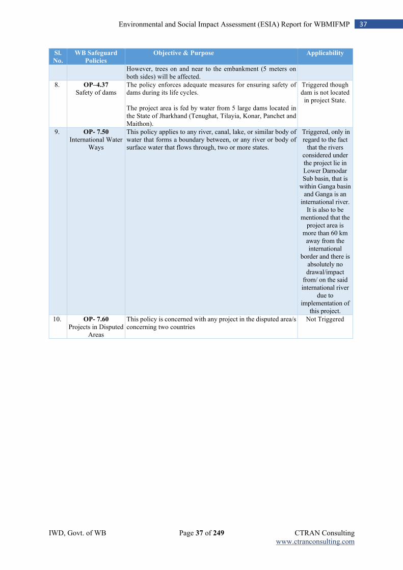
IWD, Govt. of WB Page 37 of 249 CTRAN Consulting www.ctranconsulting.com
37 Environmental and Social Impact Assessment (ESIA) Report for WBMIFMP
Sl.
No.
WB Safeguard
Policies
Objective & Purpose Applicability
However, trees on and near to the embankment (5 meters on both sides) will be affected.
8. OP–4.37 Safety of dams
The policy enforces adequate measures for ensuring safety of dams during its life cycles. The project area is fed by water from 5 large dams located in the State of Jharkhand (Tenughat, Tilayia, Konar, Panchet and Maithon).
Triggered though dam is not located
in project State.
9. OP- 7.50
International Water Ways
This policy applies to any river, canal, lake, or similar body of water that forms a boundary between, or any river or body of surface water that flows through, two or more states.
Triggered, only in regard to the fact
that the rivers considered under the project lie in Lower Damodar Sub basin, that is
within Ganga basin and Ganga is an
international river. It is also to be
mentioned that the project area is
more than 60 km away from the international
border and there is absolutely no drawal/impact
from/ on the said international river
due to implementation of
this project.
10. OP- 7.60
Projects in Disputed Areas
This policy is concerned with any project in the disputed area/s concerning two countries
Not Triggered
IWD, Govt. of WB Page 38 of 249 CTRAN Consulting www.ctranconsulting.com
38 Environmental and Social Impact Assessment (ESIA) Report for WBMIFMP
Chapter 4: Environmental and Social Baseline
4.1 Introduction
The objective of conducting baseline survey of the existing environmental and social status in the study area is to provide a data base for predicting the likely changes that are expected in implementation of the project. This chapter deals with the approach for data collection, environmental scoping / identification of social and environmental attributes and baseline survey details. As the project activities are limited to the river and canal systems of five project districts, surrounding environments of project activity zones were also considered for baseline study. 3 km. influence zone from project activity zone was considered for each category -1 project activity and rapid assessment was done for category -2 activities. Category -1 activities (desiltation of Mundeswari River and 41 nos. drainage canal) are concentrated at Howrah and Hooghly districts.
4.2 Data Collection
Baseline data were collected through sight visits and on sampling basis, interaction with local people and discussion with project authority, stakeholder consultation, collection of data from relevant project records, collected data from secondary sources and analysis. The studied parameters include land, water, air, noise, soil, sediment and biological environment as well as the pre-project Socio–economic status of the people of study area.
4.3 Primary Baseline Data
The primary baseline information on different social and environmental components were collected through field survey. Field surveys were carried out to collect information on the major social and environmental features such as human settlements, forest, trees within RoW of the embankment, waterbodies, sensitive locations, air, water, noise and soil quality etc. Further primary samples surveys for the environmental components, such as air, surface water, noise and soil characteristics that are critical in the context of the project were carried out during the study period. Sampling stations are strategically located in and around the project sites. Soil & Water samples were collected as per recommended procedure. Suitable equipment was used to record Air quality and Noise level at site / near to site. Literature and authentic records were consulted to study the Environment & Socio–Economic status concerning the study areas. Status of pre-project social and environmental conditions were considered in three aspects, i.e., (1) physical environment, (2) biological environment and (3) social environment.
4.4 Physical Environment
Baseline environmental parameters for physical environment include survey for pre-project status of land, air, water and climatic conditions of the study area.
4.4.1 Physiography
The study area is flat and plain areas and topographically, it is a vast low lying plain. The area is devoid of hill locks and terrine is smooth. It is the alluvial plane area and known for agricultural activities. The physiography of the study area is presented in the map.
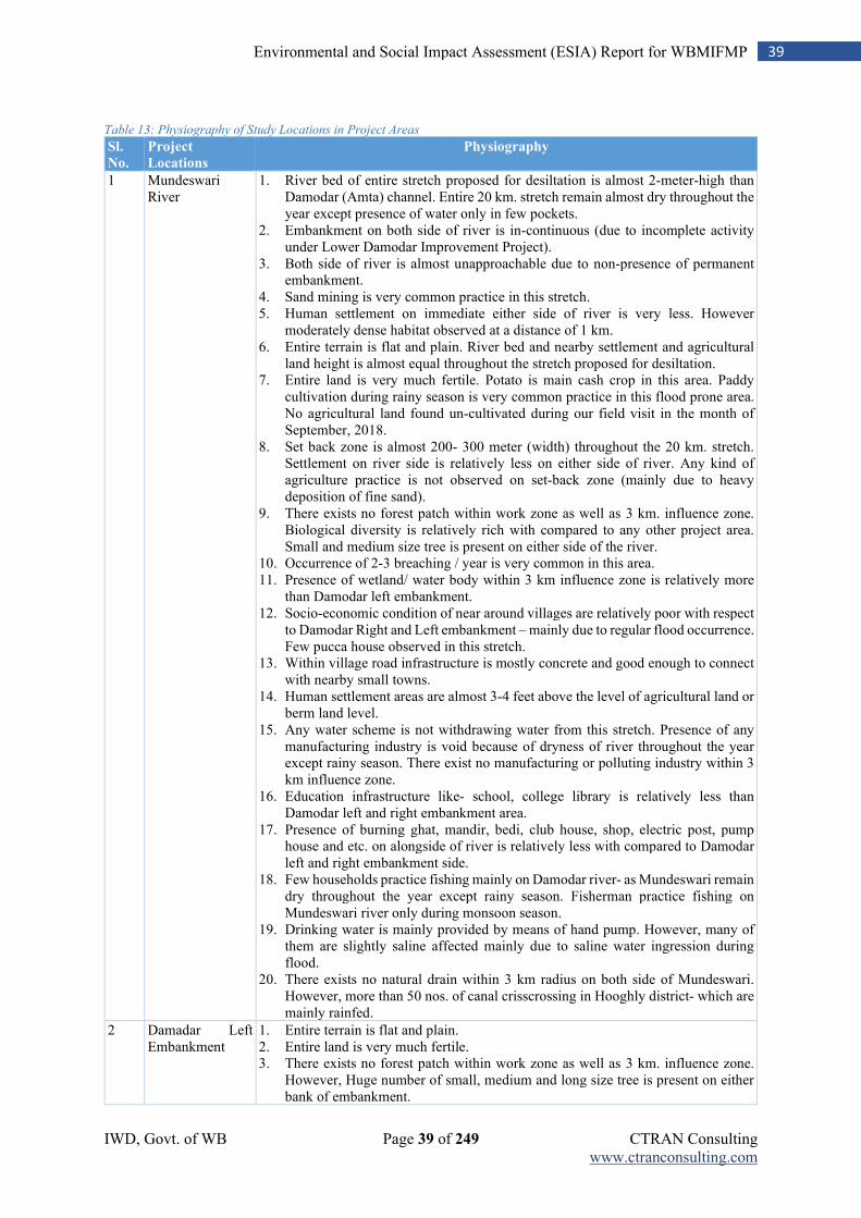
IWD, Govt. of WB Page 39 of 249 CTRAN Consulting www.ctranconsulting.com
39 Environmental and Social Impact Assessment (ESIA) Report for WBMIFMP
Table 13: Physiography of Study Locations in Project Areas
Sl.
No.
Project
Locations
Physiography
1 Mundeswari River
1. River bed of entire stretch proposed for desiltation is almost 2-meter-high than Damodar (Amta) channel. Entire 20 km. stretch remain almost dry throughout the year except presence of water only in few pockets.
2. Embankment on both side of river is in-continuous (due to incomplete activity under Lower Damodar Improvement Project).
3. Both side of river is almost unapproachable due to non-presence of permanent embankment.
4. Sand mining is very common practice in this stretch. 5. Human settlement on immediate either side of river is very less. However
moderately dense habitat observed at a distance of 1 km. 6. Entire terrain is flat and plain. River bed and nearby settlement and agricultural
land height is almost equal throughout the stretch proposed for desiltation. 7. Entire land is very much fertile. Potato is main cash crop in this area. Paddy
cultivation during rainy season is very common practice in this flood prone area. No agricultural land found un-cultivated during our field visit in the month of September, 2018.
8. Set back zone is almost 200- 300 meter (width) throughout the 20 km. stretch. Settlement on river side is relatively less on either side of river. Any kind of agriculture practice is not observed on set-back zone (mainly due to heavy deposition of fine sand).
9. There exists no forest patch within work zone as well as 3 km. influence zone. Biological diversity is relatively rich with compared to any other project area. Small and medium size tree is present on either side of the river.
10. Occurrence of 2-3 breaching / year is very common in this area. 11. Presence of wetland/ water body within 3 km influence zone is relatively more
than Damodar left embankment. 12. Socio-economic condition of near around villages are relatively poor with respect
to Damodar Right and Left embankment – mainly due to regular flood occurrence. Few pucca house observed in this stretch.
13. Within village road infrastructure is mostly concrete and good enough to connect with nearby small towns.
14. Human settlement areas are almost 3-4 feet above the level of agricultural land or berm land level.
15. Any water scheme is not withdrawing water from this stretch. Presence of any manufacturing industry is void because of dryness of river throughout the year except rainy season. There exist no manufacturing or polluting industry within 3 km influence zone.
16. Education infrastructure like- school, college library is relatively less than Damodar left and right embankment area.
17. Presence of burning ghat, mandir, bedi, club house, shop, electric post, pump house and etc. on alongside of river is relatively less with compared to Damodar left and right embankment side.
18. Few households practice fishing mainly on Damodar river- as Mundeswari remain dry throughout the year except rainy season. Fisherman practice fishing on Mundeswari river only during monsoon season.
19. Drinking water is mainly provided by means of hand pump. However, many of them are slightly saline affected mainly due to saline water ingression during flood.
20. There exists no natural drain within 3 km radius on both side of Mundeswari. However, more than 50 nos. of canal crisscrossing in Hooghly district- which are mainly rainfed.
2 Damadar Left Embankment
1. Entire terrain is flat and plain. 2. Entire land is very much fertile. 3. There exists no forest patch within work zone as well as 3 km. influence zone.
However, Huge number of small, medium and long size tree is present on either bank of embankment.
IWD, Govt. of WB Page 40 of 249 CTRAN Consulting www.ctranconsulting.com
40 Environmental and Social Impact Assessment (ESIA) Report for WBMIFMP
Sl.
No.
Project
Locations
Physiography
4. Huge number encroachers / squatters present within work zone of flood wall construction and embankment strengthening. Human settlement is observed majorly on country side of the embankment throughout the linear stretch of embankment. Villages located along embankment are relatives less developed with respect to other villages located beyond 3 km. radius.
5. Educational infrastructure like – college, library is not present within 3 km. radius of work zone.
6. However, primary school, secondary and higher secondary school and primary health center is located within villages located within 3 km. radius. District hospital is located at nearby town Amta.
7. Anganwadi centre is located within 3 km. radius of work zone. 8. Presence of wetland/ water body within 3 km influence zone is less with compared
to right bank. 9. Any water scheme is not withdrawing water from this stretch. Presence of any
manufacturing industry is almost nil because of dryness of river throughout the year except rainy season. There exist no manufacturing or polluting industry within 3 km influence zone.
10. Nearby small town Amta is only approx. 2 km away from 0.0 km chainage of Damodar left embankment
11. Presence of burning ghat, mandir, bedi, club house, shop, electric post, pump house and etc. within work zone as well as influence zone is shown in Annexure- 11.
12. Many people practice fishing on river water. 13. Village roads are either Pucca or Murom layered. 14. Drinking water is mainly provided by means of hand pump. 15. Sand mining is not observed in this stretch.
3 Damodar Right Embankment
1. Entire terrain is flat and plain. This portion of land is low lying with compared to left bank side.
2. Entire land is very much fertile. However, many lands are not being cultivated during monsoon season in fear of flood occurrence.
3. Few Agri. land located on set-back zone have lost fertility due to sand deposition – mainly around breach area.
4. There exists no forest patch within work zone as well as 3 km. influence zone. Biological diversity is relatively less with compared to left bank. Very few numbers of small, medium and long size tree are present on either bank of embankment.
5. Number of encroacher encroachers / squatters within work zone is very less- mainly due to regular occurrence of flood. Nearby settlement (dense in nature) is observed only at Village- Tokapur, Muslim para (East). Concrete flood is already in place in this Muslim para area.
6. Educational infrastructure like – college, library is not present within 3 km. radius of work zone.
7. However, primary school, secondary and higher secondary school and primary health center is located within villages located within 3 km. radius. District hospital is located at nearby town Amta – which is almost 20 km. away from Dihivursut bus stand.
8. 2 - Anganwadi centre is located within 3 km. radius of work zone. 9. Bakpota children park is located adjacent to Damodar Right embankment near
Bakpota river over bridge. 10. Occurrence of 2-3 breaching / year is very common in this area. 11. Presence of wetland/ water body within 3 km influence zone is relatively more
than right bank. 12. Ferry survive over river is observed at two location, i.e., Dihivursut and near to
Muslim para. 13. Bathing practice on river water is observed in this stretch. 14. Socio-economic condition of near around villages are fairly good even though
embankment breaching and flood occurrence is regular phenomenon. Many
IWD, Govt. of WB Page 41 of 249 CTRAN Consulting www.ctranconsulting.com
41 Environmental and Social Impact Assessment (ESIA) Report for WBMIFMP
Sl.
No.
Project
Locations
Physiography
double stored / single stored pucca house observed in this stretch. However, human settlement is almost 0.5 km away from embankment site.
15. Within village road infrastructure is good enough with compared to embankment road.
16. Ring band is observed at this side almost all along the river. 17. Human settlement areas are almost 3-4 feet above the level of agricultural land or
berm land level. 18. Any water scheme is not withdrawing water from this stretch. Presence of any
manufacturing industry is void because of dryness of river throughout the year except rainy season. There exist no manufacturing or polluting industry within 3 km influence zone.
19. Nearby small town located at Dihivurshut area- less than 1 km. away from Dihivursut ferry ghat (0.0 km. chainage of DR embankment).
20. Presence of burning ghat, mandir, bedi, club house, shop, electric post, pump house and etc. within work zone is negligible with compared to left bank. Establishment within work zone is shown in Annexure- 11.
21. Fishing practice on river water on is relatively less with compared to left bank area.
22. Drinking water is mainly provided by means of hand pump. However, many of them are slightly saline affected mainly due to saline water ingression during flood.
23. Sand mining is not observed in this stretch. 24. There exist many natural as well as man-made drain within influence zone.
4 Hurhura Left Embankment
1. Proposed work zone falls in two blocks namely- Khanakul-II and Amta-II. It intersects Palashpur, Hayatpur, Sibgeche and Salbaga.
2. Entire terrain is flat and plain. 3. Agricultural land on country side is very much fertile. Set back zone is almost nil
throughout the canal stretch. 4. There exists no forest patch within work zone as well as 3 km. influence zone.
However, Huge number of small, medium and long size tree is present on either bank of embankment.
5. Huge number encroachers / squatters present within work zone of flood wall construction and embankment strengthening.
6. Presence of wetland/ water body within 3 km influence zone is less with compared to Damodar left embankment.
7. Any water scheme is not withdrawing water from this stretch. There exist no manufacturing or polluting industry within 3 km influence zone.
8. Nearby small town Chapadanga is only approx. 20 km away from this left embankment
9. Presence of burning ghat, mandir, bedi, club house, shop, electric post, pump house and etc. within work zone as well as influence zone is shown in Annexure- 11.
10. Human settlement is observed at Mastafa-para on country side. 11. Many people practice fishing on canal water. 12. Village roads are mostly kutcha or morum layered. 13. Drinking water is mainly provided by means of hand pump. 14. Illegal sand mining is observed in this stretch.
5 Upper Rampur 1. Proposed work zone of Left embankment of Upper Rampur is situated over 3 blocks namely Udainarayanpur, Khanakul-I & II. It intersects almost 13 villages [Mastafapur, Balaichak, Chingra, Chabbish (24) pur, Ramsaran, Dhara simul, Kangrai, Pacharul, Etarai, Goza, Piar pur, Horal and Rampur)
2. Entire terrain is flat and plain. 3. Agricultural land on country side is very much fertile. Setback zone is almost nil
throughout the canal stretch. 4. There exists no forest patch within work zone as well as 3 km. influence zone.
However, Huge number of small, medium and long size tree is present on either bank of embankment.
IWD, Govt. of WB Page 42 of 249 CTRAN Consulting www.ctranconsulting.com
42 Environmental and Social Impact Assessment (ESIA) Report for WBMIFMP
Sl.
No.
Project
Locations
Physiography
5. Huge number encroachers / squatters present within work zone of flood wall construction and embankment strengthening.
6. Presence of wetland/ water body within 3 km influence zone is very high with compared to Hurhura left embankment. Borrow pit is observed on country side throughout continuous stretch of canal. Country side is very low lying.
7. Nearby small town Chapadanga is only approx. 30 km away from this left embankment
8. Presence of burning ghat, mandir, bedi, club house, shop, electric post, pump house and etc. within work zone as well as influence zone is shown in Annexure- 11.
9. Huge human settlement is observed at 24-pur Bazar area. This area is one of major source of canal pollution due to thronging of vegetable waste from local market place to canal water.
10. Bibhudhar Gramin Hospital is located almost 2.5 km away from Rampur canal. 11. Shemro Pvt. School is located almost 3 km. away from Rampur canal. 12. Jute is prime cash crop after potato. Through-out the canal Jute cultivation is very
common practice. 13. Canal water looks very dirty due to practice of jute making in canal water. 14. Canal water remains almost stagnant throughout the year. 15. Entire embankment road is kutcha. 16. Village roads are mostly kutcha or morum layered. 17. Drinking water is mainly provided by means of hand pump.
4.4.2 Agroclimatic Zone
The physiographic setting of the State come under three Agroclimatic Regions. Agriculturally, the three broad regions are Eastern Himalayan Region (Zone II), Lower Gangetic Plain Region (Zone III) and Eastern Plateau & Hilly Region (Zone VIII). Three broad regions are further stratified into six agroclimatic sub regions. Salient features of these sub regions are as follows. Different parts of the project districts fall under different agroclimatic zone. The project district Bankura falls under old alluvial zone and red lateritic zone. Hooghly district share two agroclimatic zones, i.e., old alluvial zone and new alluvial zone. The project district Bardhhaman falls under three agroclimatic zones. Project districts by agroclimatic zone is presented in the table below. Table 14: Districts by Agroclimatic Zone and Main Crops Grown
Sl. No. Agroclimatic
Zone
Area (ha) Project Districts Main Crops
1 Old Alluvial Zone 17,53,757 (20.20%)
Bankura, Howrah, Hooghly,
Bardhhaman,
Rice, wheat, maize, jute, mustard, Niger, groundnut, sesame, linseed, lentil, black gram, green gram, pigeon pea, vegetables etc.
2 New Alluvial Zone
15,30,415 (17.62%)
Bardhhaman, Hooghly, and
Howrah
Rice, wheat, maize, jute, green gram, black gram, pigeon pea, lentil, rapeseed, mustard, groundnut, sesame, linseed, Niger, vegetables etc.
3 Red Lateritic Zone
24,84,244 (28.61%)
Part of Bardhhamanand
Bankura
Rice, maize, millets, vegetables, Niger, toria, safflower, mustard, sesame, pulses, potato, vetiver, sabai etc.
4 Coastal Saline Zone
14,56,879 (16.77%)
Howrah Rice, chilli, vegetables, sunflower, sesame watermelon, Lathyrus etc.
Source: SOE Report; Data in parenthesis indicate the percentage of land under the concerned agroclimatic zones
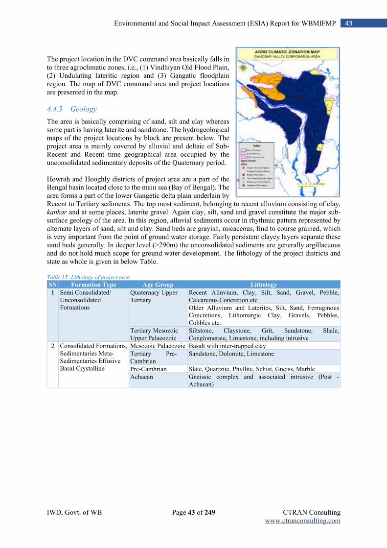
IWD, Govt. of WB Page 43 of 249 CTRAN Consulting www.ctranconsulting.com
43 Environmental and Social Impact Assessment (ESIA) Report for WBMIFMP
The project location in the DVC command area basically falls in to three agroclimatic zones, i.e., (1) Vindhiyan Old Flood Plain, (2) Undulating lateritic region and (3) Gangatic floodplain region. The map of DVC command area and project locations are presented in the map.
4.4.3 Geology
The area is basically comprising of sand, silt and clay whereas some part is having laterite and sandstone. The hydrogeological maps of the project locations by block are present below. The project area is mainly covered by alluvial and deltaic of Sub-Recent and Recent time geographical area occupied by the unconsolidated sedimentary deposits of the Quaternary period. Howrah and Hooghly districts of project area are a part of the Bengal basin located close to the main sea (Bay of Bengal). The area forms a part of the lower Gangetic delta plain underlain by Recent to Tertiary sediments. The top most sediment, belonging to recent alluvium consisting of clay, kankar and at some places, laterite gravel. Again clay, silt, sand and gravel constitute the major sub-surface geology of the area. In this region, alluvial sediments occur in rhythmic pattern represented by alternate layers of sand, silt and clay. Sand beds are grayish, micaceous, find to course grained, which is very important from the point of ground water storage. Fairly persistent clayey layers separate these sand beds generally. In deeper level (>290m) the unconsolidated sediments are generally argillaceous and do not hold much scope for ground water development. The lithology of the project districts and state as whole is given in below Table. Table 15: Lithology of project area
SN Formation Type Age Group Lithology
I Semi Consolidated/ Unconsolidated Formations
Quaternary Upper Tertiary
Recent Alluvium, Clay, Silt, Sand, Gravel, Pebble, Calcareous Concretion etc
Older Alluvium and Laterites, Silt, Sand, Ferruginous Concretions, Lithomargic Clay, Gravels, Pebbles, Cobbles etc.
Tertiary Mesozoic Upper Palaeozoic
Siltstone, Claystone, Grit, Sandstone, Shale, Conglomerate, Limestone, including intrusive
2 Consolidated Formations, Sedimentaries Meta- Sedimentaries Effusive Basal Crystalline
Mesozoic Palaeozoic Basalt with inter-trapped clay
Tertiary Pre- Cambrian
Sandstone, Dolomite, Limestone
Pre-Cambrian Slate, Quartzite, Phyllite, Schist, Gneiss, Marble
Achaean Gneissic complex and associated intrusive (Post - Achaean)
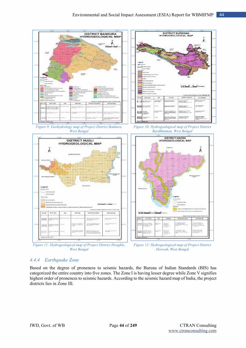
IWD, Govt. of WB Page 44 of 249 CTRAN Consulting www.ctranconsulting.com
44 Environmental and Social Impact Assessment (ESIA) Report for WBMIFMP
Figure 9: Geohydrology map of Project District Bankura,
West Bengal
Figure 10: Hydrogeological map of Project District
Bardhhaman, West Bengal
Figure 11: Hydrogeological map of Project District Hooghly,
West Bengal
Figure 12: Hydrogeological map of Project District
Howrah, West Bengal
4.4.4 Earthquake Zone
Based on the degree of proneness to seismic hazards, the Bureau of Indian Standards (BIS) has categorized the entire country into five zones. The Zone I is having lesser degree while Zone V signifies highest order of proneness to seismic hazards. According to the seismic hazard map of India, the project districts lies in Zone III.
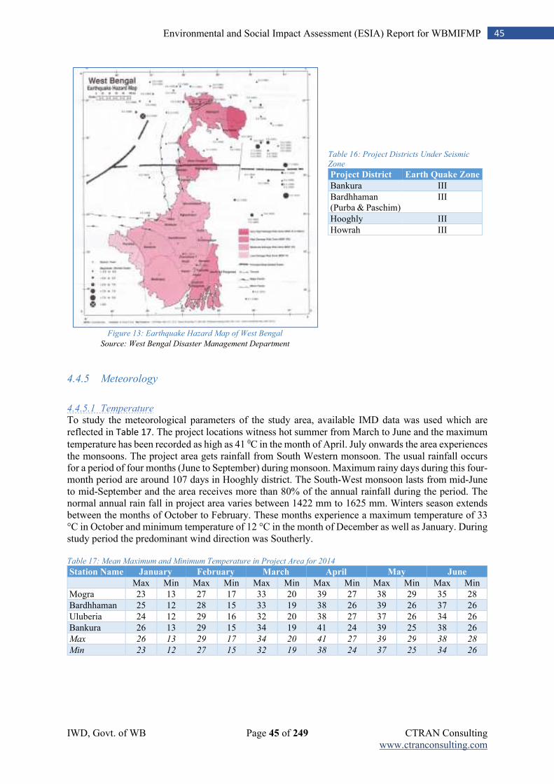
IWD, Govt. of WB Page 45 of 249 CTRAN Consulting www.ctranconsulting.com
45 Environmental and Social Impact Assessment (ESIA) Report for WBMIFMP
Table 16: Project Districts Under Seismic
Zone
Project District Earth Quake Zone
Bankura III
Bardhhaman (Purba & Paschim)
III
Hooghly III
Howrah III
Figure 13: Earthquake Hazard Map of West Bengal
Source: West Bengal Disaster Management Department
4.4.5 Meteorology
4.4.5.1 Temperature
To study the meteorological parameters of the study area, available IMD data was used which are reflected in Table 17. The project locations witness hot summer from March to June and the maximum
temperature has been recorded as high as 41 0C in the month of April. July onwards the area experiences the monsoons. The project area gets rainfall from South Western monsoon. The usual rainfall occurs for a period of four months (June to September) during monsoon. Maximum rainy days during this four-month period are around 107 days in Hooghly district. The South-West monsoon lasts from mid-June to mid-September and the area receives more than 80% of the annual rainfall during the period. The normal annual rain fall in project area varies between 1422 mm to 1625 mm. Winters season extends between the months of October to February. These months experience a maximum temperature of 33 °C in October and minimum temperature of 12 °C in the month of December as well as January. During study period the predominant wind direction was Southerly. Table 17: Mean Maximum and Minimum Temperature in Project Area for 2014
Station Name January February March April May June Max Min Max Min Max Min Max Min Max Min Max Min
Mogra 23 13 27 17 33 20 39 27 38 29 35 28
Bardhhaman 25 12 28 15 33 19 38 26 39 26 37 26
Uluberia 24 12 29 16 32 20 38 27 37 26 34 26
Bankura 26 13 29 15 34 19 41 24 39 25 38 26
Max 26 13 29 17 34 20 41 27 39 29 38 28
Min 23 12 27 15 32 19 38 24 37 25 34 26
IWD, Govt. of WB Page 46 of 249 CTRAN Consulting www.ctranconsulting.com
46 Environmental and Social Impact Assessment (ESIA) Report for WBMIFMP
Station Name July August September October November December
Max Min Max Min Max Min Max Min Max Min Max Min
Mogra 33 26 33 26 33 28 32 25 28 20 24 15
Bardhhaman 32 26 31 26 32 25 31 24 -- -- -- --
Uluberia 34 26 33 25 34 27 33 26 30 20 26 13
Bankura 33 26 33 26 33 26 32 23 31 16 27 12
Max 34 26 33 26 34 28 33 26 31 20 27 15
Min 32 26 31 25 32 25 31 23 28 16 24 12 Source: Meteorological Department, Govt. of India
4.4.5.2 Rainfall
Catchment area of Damodar River experiences seasonal rains due to the South- West Monsoon every year and depending upon the intensity of the storms, floods occur. During the monsoon season, the rainfall in the area is mainly due to either the passage of depressions over and near the area or active monsoon conditions due to accentuation of the seasonal trough. The normal track of the monsoon depression from Bay of Bengal towards Orissa-West Bengal coast in west north- west direction lies to the south of Damodar valley. The Damodar is a shallow, wide, seasonal and flashy river. During the rains, its flow is torrential; and in the hot weather, it reduced drastically. There are three rain gauge station namely Durgapur, Champadanga and Amta situated within entire project area. Month wise cumulative rainfall data as recorded in these three rain gauge stations during monsoon season are presented in the tables below by district. The normal annual rainfall in the project area varies from 1422 to 1625 mm. The season wise and annual rainfall in the project districts is presented in the table below. Table 18: Season wise average annual rainfall
Sl. No. District Normal Rainfall in mm
Monsoon Non-monsoon Total
1 Bankura 1109 313 1422
2 Bardhhaman 1140 356 1496
3 Howrah 1208 417 1625
4 Hooghly 1137 386 1523 Average 1148.5 368 1516.5
Source: Ground Water Year Book of West Bengal & Andaman & Nicobar Islands (2014-15)
Damodar, Mundeswari and Amta channel are the main three rivers flowing in DVC command area. Many irrigation and drainage canal receive water mainly from these three rivers. There are total 14 rain gauge station installed by different agency on these three rivers. Out of total 8 rain gauge stations located over river Damodar 4 falls in Jharkhand district. Rainfall measurements of these rain gauge indicates substantial amount of rainfall receive by these three rivers system. Table 19: Total Seasonal Rainfall in different Rain-gauges during Monsoon, 2016
Sl.
No.
River District Location of Rain
Gauge Station
Type District wise
Normal Annual
Rainfall (mm)
Total Seasonal
Rainfall (mm)
1 Damodar Kodarma Tilaiya CWC 1116.20 1195.40
2
Bokaro Tenughat CWC 1247.50 1051.10
3
Dhanbad Maithon CWC 1355.20 1473.60
4
Dhanbad Panchet CWC
1423.80
5
Bardhhaman Asansol CWC 1315.20 1227.40
6
Bardhhaman Durgapur CWC
1257.92
7
Bardhhaman Bardhhaman ORG
1125.50
8
Bankura Sonamukhi ARG 1330.90 1128.95
9 Mundeswari Bardhhaman Seharabazar ORG 1315.20 827.00
10
Bardhhaman Raina ORG
599.00
IWD, Govt. of WB Page 47 of 249 CTRAN Consulting www.ctranconsulting.com
47 Environmental and Social Impact Assessment (ESIA) Report for WBMIFMP
Sl.
No.
River District Location of Rain
Gauge Station
Type District wise
Normal Annual
Rainfall (mm)
Total Seasonal
Rainfall (mm)
11 Amta Channel (Damodar)
Hooghly Champadanga ORG 1418.70 636.75
12
Hooghly Singur ORG 1600.00 979.75
13
Howrah Amta ORG
1273.00
14
Howrah Domjur ORG
1002.72 Total (Damodar + Mundeswari + Amta)
1337.36 1085.85
Note: CWC: Central Water Commission, ORG: Optimal Rain Gauge, ARG: Automated Rain Gauge
Bankura: It is evident that during 2014 and 2015, quantum of rainfall was less in comparison to other three years, i.e., 1075.5 mm and 1127.2 mm. respectively. However, in 2013, the district received 60.21 percent of total annual precipitation during JJAS (June, July August and Sept.) which increased gradually till 2016 and marginally reduced during 2017 (82.46 percent during 2014, 84.0 percent during 2015, 86.41 percent during 2016 and 77.49 percent during 2017). So, monsoon months are gradually experiencing high rainfall and rainfall during post-monsoon months have decreased. Table 20: Month wise rainfall from 2013-17 in Bankura YEAR JAN FEB MAR APR MAY JUN JUL AUG SEPT OCT NOV DEC
R/F %DEP R/F %DEP R/F %DEP R/F %DEP R/F %DEP R/F %DEP R/F %DEP R/F %DEP R/F %DEP R/F %DEP R/F %DEP R/F %DEP
2013 0.9 -93 15.0 -17 22.9 4 72.6 100 342.4 412 369.7 72 289.8 -4 368.4 27 260.8 8 398.0 278 0.0 -100 0.0 -100
2014 0.8 -93 38.3 113 8.0 -64 3.3 -91 84.7 27 85.7 -60 313.7 3 323.4 11 164.1 -32 53.2 -49 0.0 -100 0.3 -97
2015 17.4 45 1.5 -91 7.1 -68 85.6 136 55.9 -16 152.2 -29 467.5 54 230.6 -21 96.5 -60 12.7 -88 0.0 -100 0.2 -98
2016 6.1 -49 10.2 -43 15.6 -29 0.8 -98 101.3 51 175.1 -19 264.8 -13 445.5 53 268.9 11 46.9 -55 0.7 -93 0.0 -100
2017 0.0 -100 0.0 -100 16.9 -23 27.9 -23 76.3 14 228.8 6 634.2 109 330.4 14 186.1 -23 249.1 137 25.3 159 5.2 -45
Source:Customized Rainfall Information System (CRIS), Hydromet Division, India; Meteorological Department, Ministry of
EarthSciences; <http://hydro.imd.gov.in/hydrometweb/(S(vuluke45w5upcxmigpsnmt55))/DistrictRaifall.aspx>
Bardhhaman: The district Bardhhaman also reflect more or less similar trend like that of Bankura. In 2013, the district received 61.71 percent of the total annual rainfall in the monsoon months (JJAS) and rest rainfalls were in the pre-monsoon and post-monsoon period. In the year 2014, 2015 and 2016, the district received maximum rainfall during monsoon (85.18 percent in 2014, 85.55 percent in 2015 and 84.10 percent in 2016) and rainfall in other months was relatively less. In 2017, the district received 69 percent of the total annual rainfall during monsoon of the total rainfall of 1668 mm. Table 21: Month wise rainfall from 2013-17 in Bardhhaman YEAR JAN FEB MAR APR MAY JUN JUL AUG SEPT OCT NOV DEC
R/F %DEP R/F %DEP R/F %DEP R/F %DEP R/F %DEP R/F %DEP R/F %DEP R/F %DEP R/F %DEP R/F %DEP R/F %DEP R/F %DEP
2013 6.8 -36 17.5 -21 4.6 -77 41.5 10 175.1 122 210.2 6 145.5 -51 341.1 20 250.7 0 342.5 243 0.0 -100 0.0 -100
2014 1.1 -90 35.1 58 32.0 62 0.7 -98 74.6 -5 233.9 18 280.6 -5 256.5 -10 195.3 -22 23.9 -76 0.0 -100 0.7 -88
2015 8.5 -20 10.1 -54 29.4 48 76.3 102 64.2 -19 338.1 71 587.3 100 285.8 0 111.8 -55 34.1 -66 0.0 -100 0.9 -85
2016 13.5 26 29.3 32 15.0 -24 0.0 -100 120.0 52 182.5 -8 263.9 -10 463.5 62 274.5 9 44.3 -56 1.9 -84 0.0 -100
2017 1.2 -88 0.0 -100 32.6 65 28.3 -25 171.2 117 255.8 29 464.1 58 252.9 -11 178.2 -29 260.1 161 14.5 27 9.1 51
Source: Customized Rainfall Information System (CRIS), Hydromet Division, India Meteorological Department, Ministry of
Earth Sciences<http://hydro.imd.gov.in/hydrometweb/(S(vuluke45w5upcxmigpsnmt55))/DistrictRaifall.aspx>
Hooghly: Between 2013 to 2017, the district received average annual rainfall of 1336.96 mm with variance in receipt of rainfall during pre-monsoon, monsoon and post monsoon. The rainfall received during monsoon was 67.30 percent of the total annual rainfall which increased during 2014-2017. In the year 2013, percentage of departure from actual rainfall during June was (-)8.0 which increased to (-)23.0 during 2017. Similarly, highest percentage of departure in the month of July was in the year 2015, i.e., 112 percent and highest negative departure in 2015 in the same year (2015). In post-monsoon months, i.e., in November and December, percentage of departure was (-)100.0 percent during 2013 and 2014 and 188 percent during 2017.
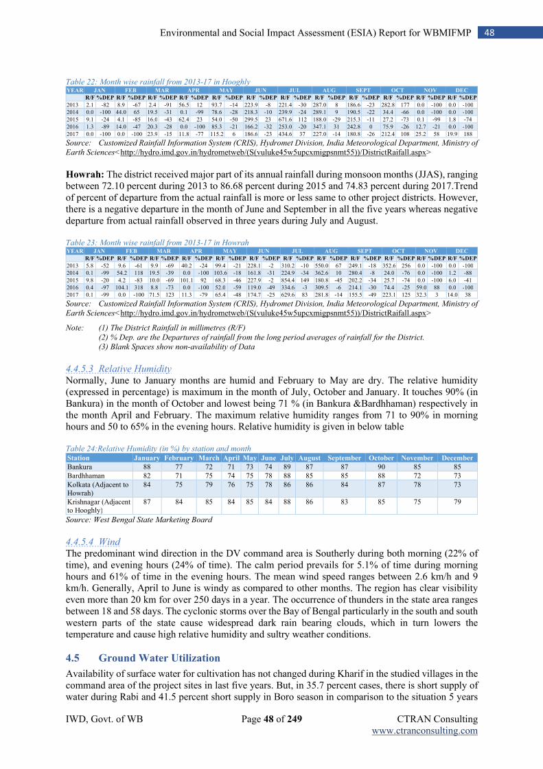
IWD, Govt. of WB Page 48 of 249 CTRAN Consulting www.ctranconsulting.com
48 Environmental and Social Impact Assessment (ESIA) Report for WBMIFMP
Table 22: Month wise rainfall from 2013-17 in Hooghly YEAR JAN FEB MAR APR MAY JUN JUL AUG SEPT OCT NOV DEC
R/F %DEP R/F %DEP R/F %DEP R/F %DEP R/F %DEP R/F %DEP R/F %DEP R/F %DEP R/F %DEP R/F %DEP R/F %DEP R/F %DEP
2013 2.1 -82 8.9 -67 2.4 -91 56.5 12 93.7 -14 223.9 -8 221.4 -30 287.0 8 186.6 -23 282.8 177 0.0 -100 0.0 -100
2014 0.0 -100 44.0 65 19.5 -31 0.1 -99 78.6 -28 218.3 -10 239.9 -24 289.1 9 190.5 -22 34.4 -66 0.0 -100 0.0 -100
2015 9.1 -24 4.1 -85 16.0 -43 62.4 23 54.0 -50 299.5 23 671.6 112 188.0 -29 215.3 -11 27.2 -73 0.1 -99 1.8 -74
2016 1.3 -89 14.0 -47 20.3 -28 0.0 -100 85.3 -21 166.2 -32 253.0 -20 347.1 31 242.8 0 75.9 -26 12.7 -21 0.0 -100
2017 0.0 -100 0.0 -100 23.9 -15 11.8 -77 115.2 6 186.6 -23 434.6 37 227.0 -14 180.8 -26 212.4 108 25.2 58 19.9 188
Source: Customized Rainfall Information System (CRIS), Hydromet Division, India Meteorological Department, Ministry of
Earth Sciences<http://hydro.imd.gov.in/hydrometweb/(S(vuluke45w5upcxmigpsnmt55))/DistrictRaifall.aspx>
Howrah: The district received major part of its annual rainfall during monsoon months (JJAS), ranging between 72.10 percent during 2013 to 86.68 percent during 2015 and 74.83 percent during 2017.Trend of percent of departure from the actual rainfall is more or less same to other project districts. However, there is a negative departure in the month of June and September in all the five years whereas negative departure from actual rainfall observed in three years during July and August. Table 23: Month wise rainfall from 2013-17 in Howrah YEAR JAN FEB MAR APR MAY JUN JUL AUG SEPT OCT NOV DEC
R/F %DEP R/F %DEP R/F %DEP R/F %DEP R/F %DEP R/F %DEP R/F %DEP R/F %DEP R/F %DEP R/F %DEP R/F %DEP R/F %DEP
2013 5.8 -52 9.6 -61 9.9 -69 40.2 -24 99.4 -21 228.1 -2 310.2 -10 550.0 67 249.1 -18 352.6 256 0.0 -100 0.0 -100
2014 0.1 -99 54.2 118 19.5 -39 0.0 -100 103.6 -18 161.8 -31 224.9 -34 362.6 10 280.4 -8 24.0 -76 0.0 -100 1.2 -88
2015 9.8 -20 4.2 -83 10.0 -69 101.1 92 68.3 -46 227.9 -2 854.4 149 180.8 -45 202.2 -34 25.7 -74 0.0 -100 6.0 -41
2016 0.4 -97 104.1 318 8.8 -73 0.0 -100 52.0 -59 119.0 -49 334.6 -3 309.5 -6 214.1 -30 74.4 -25 59.0 88 0.0 -100
2017 0.1 -99 0.0 -100 71.5 123 11.3 -79 65.4 -48 174.7 -25 629.6 83 281.8 -14 155.5 -49 223.1 125 32.3 3 14.0 38
Source: Customized Rainfall Information System (CRIS), Hydromet Division, India Meteorological Department, Ministry of
Earth Sciences<http://hydro.imd.gov.in/hydrometweb/(S(vuluke45w5upcxmigpsnmt55))/DistrictRaifall.aspx>
Note: (1) The District Rainfall in millimetres (R/F)
(2) % Dep. are the Departures of rainfall from the long period averages of rainfall for the District.
(3) Blank Spaces show non-availability of Data
4.4.5.3 Relative Humidity
Normally, June to January months are humid and February to May are dry. The relative humidity (expressed in percentage) is maximum in the month of July, October and January. It touches 90% (in Bankura) in the month of October and lowest being 71 % (in Bankura &Bardhhaman) respectively in the month April and February. The maximum relative humidity ranges from 71 to 90% in morning hours and 50 to 65% in the evening hours. Relative humidity is given in below table Table 24:Relative Humidity (in %) by station and month Station January February March April May June July August September October November December
Bankura 88 77 72 71 73 74 89 87 87 90 85 85
Bardhhaman 82 71 75 74 75 78 88 85 85 88 72 73
Kolkata (Adjacent to Howrah)
84 75 79 76 75 78 86 86 84 87 78 73
Krishnagar (Adjacent to Hooghly)
87 84 85 84 85 84 88 86 83 85 75 79
Source: West Bengal State Marketing Board
4.4.5.4 Wind
The predominant wind direction in the DV command area is Southerly during both morning (22% of time), and evening hours (24% of time). The calm period prevails for 5.1% of time during morning hours and 61% of time in the evening hours. The mean wind speed ranges between 2.6 km/h and 9 km/h. Generally, April to June is windy as compared to other months. The region has clear visibility even more than 20 km for over 250 days in a year. The occurrence of thunders in the state area ranges between 18 and 58 days. The cyclonic storms over the Bay of Bengal particularly in the south and south western parts of the state cause widespread dark rain bearing clouds, which in turn lowers the temperature and cause high relative humidity and sultry weather conditions.
4.5 Ground Water Utilization
Availability of surface water for cultivation has not changed during Kharif in the studied villages in the command area of the project sites in last five years. But, in 35.7 percent cases, there is short supply of water during Rabi and 41.5 percent short supply in Boro season in comparison to the situation 5 years
IWD, Govt. of WB Page 49 of 249 CTRAN Consulting www.ctranconsulting.com
49 Environmental and Social Impact Assessment (ESIA) Report for WBMIFMP
before. As a result, ground water extraction and utilization has increased in the nearby villages in the command area in last five years. Growth in utilization of ground water during kharif is less than that of Rabi and Boro. About 9 % farmers have been extracting more ground water in Kharif in comparison to earlier years (5 years before) whereas 28.4 percent farmers extracting more ground water for irrigation during Rabi and 30.5 percent farmers in Boro season. Overall, it is evident that ground water extraction and its use for agricultural purposes has increased in the command area due to reduced supply of surface water. As the project intends to increase surface water supply in the existing irrigation system, it is expected that ground water dependency will reduce. Further conjunctive water use and promotion of pressurized irrigation system will help in improving the water use efficiency and productivity.
4.6 Use of Drip and Sprinkler Irrigation Systems
There are no instance of drip and sprinkler irrigation system within command area. Eventually, more than 87% farmers are not aware of drip and sprinkler-based irrigation system. Only 34% farmers haves shown interest with subsidy provision on introduction of drip and sprinkler-based irrigation specially for Rabi and Boro cultivation. As surface water is most convenient way of irrigation, more numbers of farmers are also not interested in adopting these irrigation systems. Farmers faced irrigation scarcity only during Rabi and Boro season due to non-availability of water at river/ canal system. Drip and sprinkler-based irrigation has recently been introduced in some other districts of West Bengal under Pradhan Mantri Krishi Sinchayee Yojana (PMKSY). Outcome of such initiative are not so convincing so far as these initiatives is hardly 2 years old. Benefit of such initiative can only be measured after 3-4 years of implementation. Eventually, limited fund has created hindrance in promoting such modern technology and awareness raising among farmers.
4.7 Environmental flow
Since the year 2001 the River Mundeswari has become completely dry, except in the rainy season, due to sand deposition at the mouth of the river and the remarkably low channel gradient. In the monsoon season, these factors reduce the flow velocity of water and create a flood situation. The monsoon flow of water also depends upon the discharge volume from the upstream barrage. The bank full discharges of Damodar (Amta Channel) and Mundeswari are 1400 m3/s and 2600 m3/s respectively, i.e. the rivers spill practically every year during monsoon. Spilling in case of Amta Channel starts at a flood of return period of 1.3 years. The flood situation arises almost every year due to such spilling along the right bank. At this stage, the corresponding bank full discharge in Amta Channel is 1,455 m3/s downstream of the bifurcation at Beguahana. Similarly, in case of Mundeswari, bank overtopping commences at a discharge of about 2,675 m3/s, which may be ranked as 2.6 year return period of flood. Sharing of flood discharge at the Beguahana bifurcation point by the Mundeswari River is practically insignificant at the initial stage (only 14%). This sharply increases to 51% at 2 year return period of flood. The project interventions focus on restoring the flow regime and environmental flows that will mitigate floods, support a healthy river ecosystem and provide for human use. Table 25: Flood Discharge and Sharing
Flood Frequency Flood Discharge (m3/s) Current Sharing (%)
Mundeswari Amta Channel
1 503.03 14.0 86.0
1.3 2152.36 33.4 67.6
2 3590.14 49.0 51.0
2.6 4631.00 57.8 42.2
3 4789.29 59.0 41.0
4 5590.57 59.6 40.4
5 6210.18 59.4 40.6 Source: Feasibility Study Report
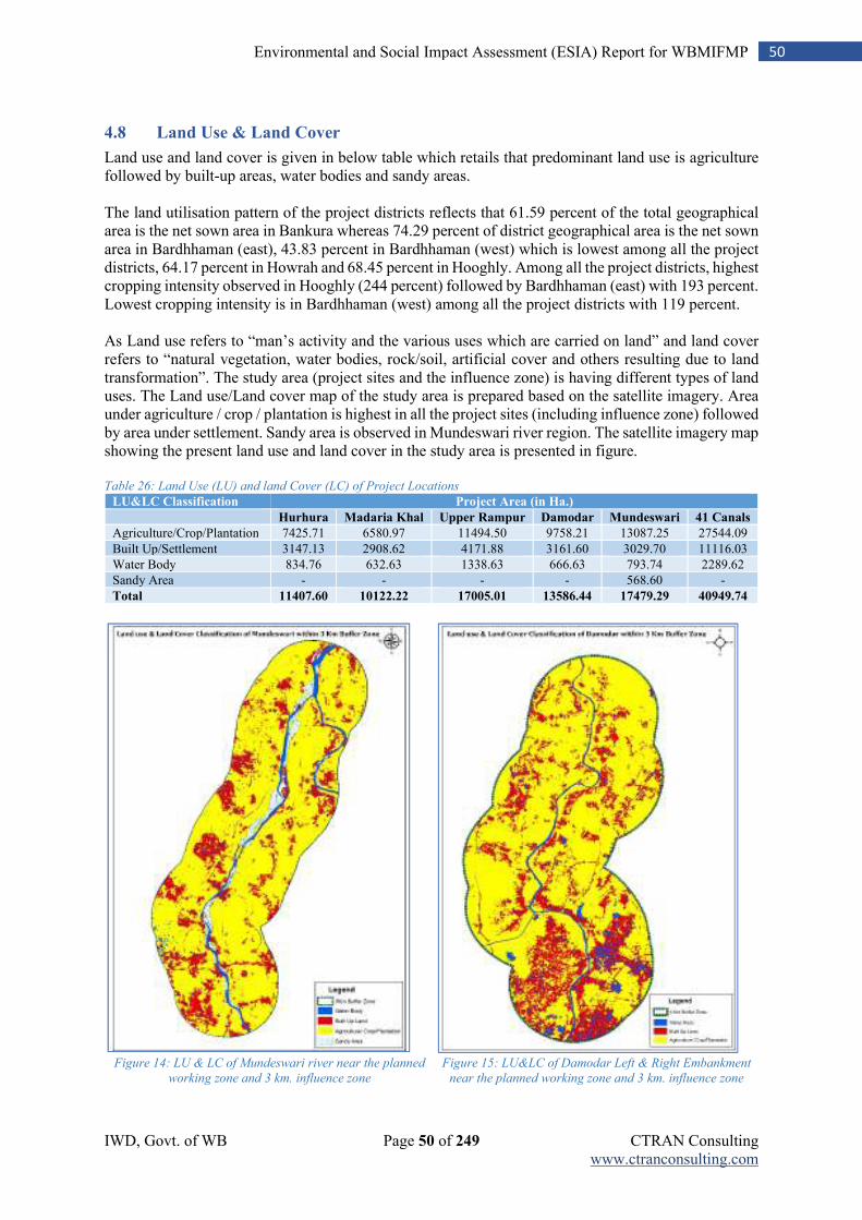
IWD, Govt. of WB Page 50 of 249 CTRAN Consulting www.ctranconsulting.com
50 Environmental and Social Impact Assessment (ESIA) Report for WBMIFMP
4.8 Land Use & Land Cover
Land use and land cover is given in below table which retails that predominant land use is agriculture followed by built-up areas, water bodies and sandy areas. The land utilisation pattern of the project districts reflects that 61.59 percent of the total geographical area is the net sown area in Bankura whereas 74.29 percent of district geographical area is the net sown area in Bardhhaman (east), 43.83 percent in Bardhhaman (west) which is lowest among all the project districts, 64.17 percent in Howrah and 68.45 percent in Hooghly. Among all the project districts, highest cropping intensity observed in Hooghly (244 percent) followed by Bardhhaman (east) with 193 percent. Lowest cropping intensity is in Bardhhaman (west) among all the project districts with 119 percent. As Land use refers to “man’s activity and the various uses which are carried on land” and land cover refers to “natural vegetation, water bodies, rock/soil, artificial cover and others resulting due to land transformation”. The study area (project sites and the influence zone) is having different types of land uses. The Land use/Land cover map of the study area is prepared based on the satellite imagery. Area under agriculture / crop / plantation is highest in all the project sites (including influence zone) followed by area under settlement. Sandy area is observed in Mundeswari river region. The satellite imagery map showing the present land use and land cover in the study area is presented in figure. Table 26: Land Use (LU) and land Cover (LC) of Project Locations
LU&LC Classification Project Area (in Ha.) Hurhura Madaria Khal Upper Rampur Damodar Mundeswari 41 Canals
Agriculture/Crop/Plantation 7425.71 6580.97 11494.50 9758.21 13087.25 27544.09
Built Up/Settlement 3147.13 2908.62 4171.88 3161.60 3029.70 11116.03
Water Body 834.76 632.63 1338.63 666.63 793.74 2289.62
Sandy Area - - - - 568.60 -
Total 11407.60 10122.22 17005.01 13586.44 17479.29 40949.74
Figure 14: LU & LC of Mundeswari river near the planned
working zone and 3 km. influence zone
Figure 15: LU&LC of Damodar Left & Right Embankment
near the planned working zone and 3 km. influence zone
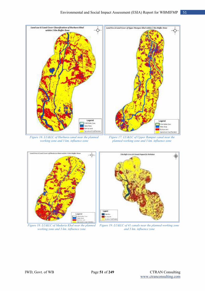
IWD, Govt. of WB Page 51 of 249 CTRAN Consulting www.ctranconsulting.com
51 Environmental and Social Impact Assessment (ESIA) Report for WBMIFMP
Figure 16: LU&LC of Hurhura canal near the planned
working zone and 3 km. influence zone
Figure 17: LU&LC of Upper Rampur canal near the
planned working zone and 3 km. influence zone
Figure 18: LU&LC of Madaria Khal near the planned
working zone and 3 km. influence zone
Figure 19: LU&LC of 41 canals near the planned working zone
and 3 km. influence zone
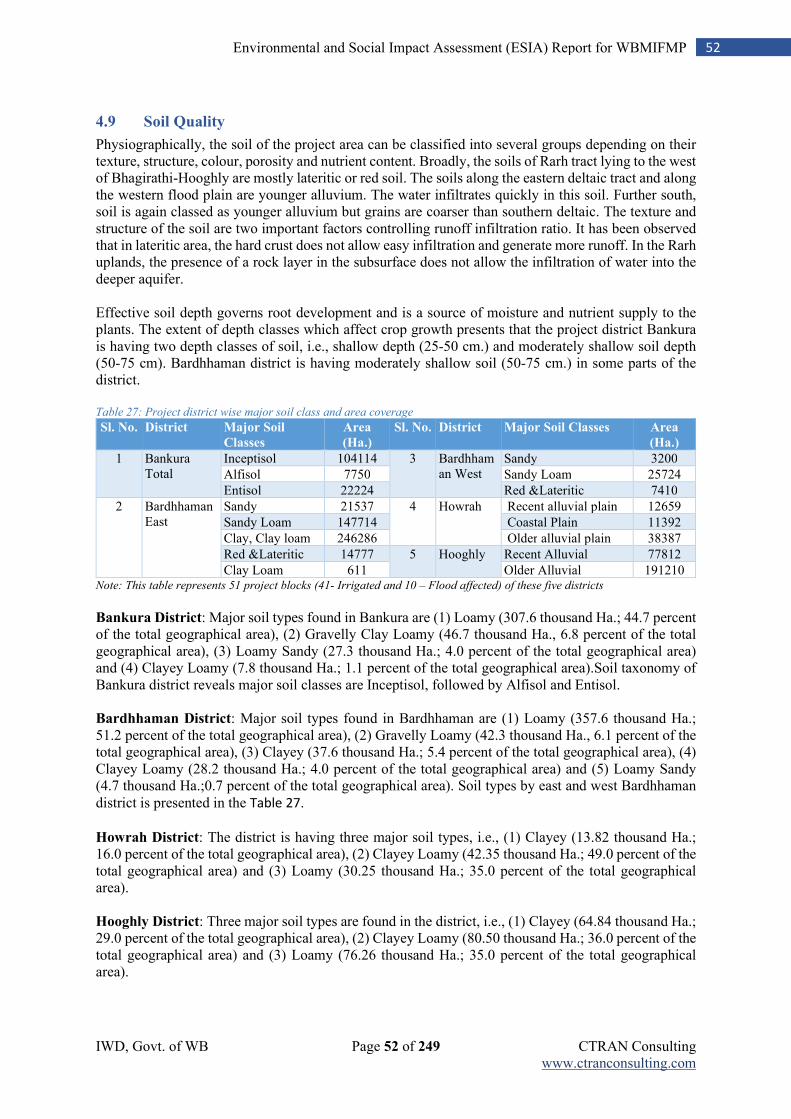
IWD, Govt. of WB Page 52 of 249 CTRAN Consulting www.ctranconsulting.com
52 Environmental and Social Impact Assessment (ESIA) Report for WBMIFMP
4.9 Soil Quality
Physiographically, the soil of the project area can be classified into several groups depending on their texture, structure, colour, porosity and nutrient content. Broadly, the soils of Rarh tract lying to the west of Bhagirathi-Hooghly are mostly lateritic or red soil. The soils along the eastern deltaic tract and along the western flood plain are younger alluvium. The water infiltrates quickly in this soil. Further south, soil is again classed as younger alluvium but grains are coarser than southern deltaic. The texture and structure of the soil are two important factors controlling runoff infiltration ratio. It has been observed that in lateritic area, the hard crust does not allow easy infiltration and generate more runoff. In the Rarh uplands, the presence of a rock layer in the subsurface does not allow the infiltration of water into the deeper aquifer. Effective soil depth governs root development and is a source of moisture and nutrient supply to the plants. The extent of depth classes which affect crop growth presents that the project district Bankura is having two depth classes of soil, i.e., shallow depth (25-50 cm.) and moderately shallow soil depth (50-75 cm). Bardhhaman district is having moderately shallow soil (50-75 cm.) in some parts of the district. Table 27: Project district wise major soil class and area coverage
Sl. No. District Major Soil
Classes
Area
(Ha.)
Sl. No. District Major Soil Classes Area
(Ha.)
1 Bankura Total
Inceptisol 104114 3 Bardhhaman West
Sandy 3200
Alfisol 7750 Sandy Loam 25724
Entisol 22224 Red &Lateritic 7410
2 Bardhhaman East
Sandy 21537 4 Howrah Recent alluvial plain 12659
Sandy Loam 147714 Coastal Plain 11392
Clay, Clay loam 246286 Older alluvial plain 38387
Red &Lateritic 14777 5 Hooghly Recent Alluvial 77812
Clay Loam 611 Older Alluvial 191210 Note: This table represents 51 project blocks (41- Irrigated and 10 – Flood affected) of these five districts Bankura District: Major soil types found in Bankura are (1) Loamy (307.6 thousand Ha.; 44.7 percent of the total geographical area), (2) Gravelly Clay Loamy (46.7 thousand Ha., 6.8 percent of the total geographical area), (3) Loamy Sandy (27.3 thousand Ha.; 4.0 percent of the total geographical area) and (4) Clayey Loamy (7.8 thousand Ha.; 1.1 percent of the total geographical area).Soil taxonomy of Bankura district reveals major soil classes are Inceptisol, followed by Alfisol and Entisol. Bardhhaman District: Major soil types found in Bardhhaman are (1) Loamy (357.6 thousand Ha.; 51.2 percent of the total geographical area), (2) Gravelly Loamy (42.3 thousand Ha., 6.1 percent of the total geographical area), (3) Clayey (37.6 thousand Ha.; 5.4 percent of the total geographical area), (4) Clayey Loamy (28.2 thousand Ha.; 4.0 percent of the total geographical area) and (5) Loamy Sandy (4.7 thousand Ha.;0.7 percent of the total geographical area). Soil types by east and west Bardhhaman district is presented in the Table 27.
Howrah District: The district is having three major soil types, i.e., (1) Clayey (13.82 thousand Ha.; 16.0 percent of the total geographical area), (2) Clayey Loamy (42.35 thousand Ha.; 49.0 percent of the total geographical area) and (3) Loamy (30.25 thousand Ha.; 35.0 percent of the total geographical area). Hooghly District: Three major soil types are found in the district, i.e., (1) Clayey (64.84 thousand Ha.; 29.0 percent of the total geographical area), (2) Clayey Loamy (80.50 thousand Ha.; 36.0 percent of the total geographical area) and (3) Loamy (76.26 thousand Ha.; 35.0 percent of the total geographical area).
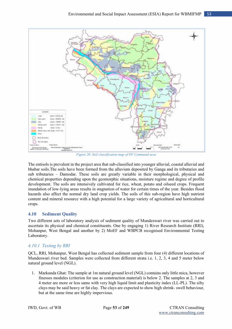
IWD, Govt. of WB Page 53 of 249 CTRAN Consulting www.ctranconsulting.com
53 Environmental and Social Impact Assessment (ESIA) Report for WBMIFMP
Figure 20: Soil classification map of DV Command area
The entisols is prevalent in the project area that sub-classified into younger alluvial, coastal alluvial and bhabar soils.The soils have been formed from the alluvium deposited by Ganga and its tributaries and sub tributaries – Damodar. These soils are greatly variable in their morphological, physical and chemical properties depending upon the geomorphic situations, moisture regime and degree of profile development. The soils are intensively cultivated for rice, wheat, potato and oilseed crops. Frequent inundation of low-lying areas results in stagnation of water for certain times of the year. Besides flood hazards also affect the normal dry land crop yields. The soils of this sub-region have high nutrient content and mineral resource with a high potential for a large variety of agricultural and horticultural crops.
4.10 Sediment Quality
Two different sets of laboratory analysis of sediment quality of Mundeswari river was carried out to ascertain its physical and chemical constituents. One by engaging 1) River Research Institute (RRI), Mohanpur, West Bengal and another by 2) MoEF and WBPCB recognised Environmental Testing Laboratory.
4.10.1 Testing by RRI
QCL, RRI, Mohanpur, West Bengal has collected sediment sample from four (4) different locations of Mundeswari river bed. Samples were collected from different strata i.e. 1, 2, 3, 4 and 5 meter below natural ground level (NGL).
1. Markunda Ghat: The sample at 1m natural ground level (NGL) contains only little mica, however finesses modules (criterion for use as construction material) is below 2. The samples at 2, 3 and 4 meter are more or less same with very high liquid limit and plasticity index (LL-PL). The silty clays may be said heavy or fat clay. The clays are expected to show high shrink- swell behaviour, but at the same time are highly impervious.
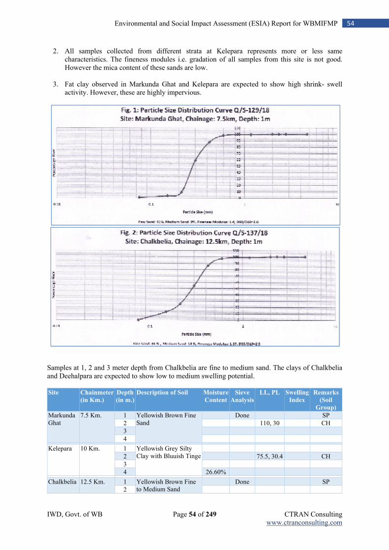
IWD, Govt. of WB Page 54 of 249 CTRAN Consulting www.ctranconsulting.com
54 Environmental and Social Impact Assessment (ESIA) Report for WBMIFMP
2. All samples collected from different strata at Kelepara represents more or less same characteristics. The fineness modules i.e. gradation of all samples from this site is not good. However the mica content of these sands are low.
3. Fat clay observed in Markunda Ghat and Kelepara are expected to show high shrink- swell activity. However, these are highly impervious.
Samples at 1, 2 and 3 meter depth from Chalkbelia are fine to medium sand. The clays of Chalkbelia and Deehalpara are expected to show low to medium swelling potential.
Site Chainmeter
(in Km.)
Depth
(in m.)
Description of Soil Moisture
Content
Sieve
Analysis
LL, PL Swelling
Index
Remarks
(Soil
Group)
Markunda Ghat
7.5 Km. 1 Yellowish Brown Fine Sand
Done
SP
2
110, 30
CH
3
4
Kelepara 10 Km. 1 Yellowish Grey Silty Clay with Bluuish Tinge
2
75.5, 30.4
CH
3
4 26.60%
Chalkbelia 12.5 Km. 1 Yellowish Brown Fine to Medium Sand
Done
SP
2
IWD, Govt. of WB Page 55 of 249 CTRAN Consulting www.ctranconsulting.com
55 Environmental and Social Impact Assessment (ESIA) Report for WBMIFMP
Site Chainmeter
(in Km.)
Depth
(in m.)
Description of Soil Moisture
Content
Sieve
Analysis
LL, PL Swelling
Index
Remarks
(Soil
Group)
3 Brownish Dirty Fine to Medium Sand
4 Yellowish Brown Silty Clay with Kankars
58.8, 21.2 54% CH
(Medium Swelling)
5 Yellowish Brown Silty Clay containing some sand and Kankars with Bluish Tinge
Deehalpara 16 Km. 1 Yellowish Grey, Loamy Clay with Kankars
2 Brownish Grey, Loamy Clay with Bluish Tinge
3
38.6, 17.2
CI
4 Brownish Clayey Sand with Bluish Tinge
19.70%
5 Whitish Loamy sand with Reddish and Bluish Tinge
Testing report by RRI also mention non-presence of any mine or city, from where chances of disposal or accumulation of toxic or heavy metals are more on vacant land, in nearby areas of Mundeswari river. Natural moisture contents of samples indicate medium to stiff consistency; which represent similar feature of older alluvium (distinctly different to the grey Gangetic alluvium) of the other Rath plain (parts of Birbhum, Bankura, Bardhhaman, Hooghly and West Medinipur) sites. Finally, RRI has recommended to safely use these silted materials without any further processing for embankment or road construction.
4.10.2 Testing by MoEF & WBPCB recognised laboratory
Two sample were collected from river bed of Mundeswari river and another three from bed of drainage canal where desiltation is proposed. 1st sample was collected from bifurcation point of Damodar river at Beguahana point and 2nd one almost 12 km. downstream point of Mundeswari river. Remaining three sediment samples were collected from confluence point of different drainage canal to represent
sediment quality of many canals. Sampling points are presented in Table 28 and map showing sampling
locations are given in Annexure- 17(b). Table 28: Sampling location of silted material
Location Description Sample collection description No. of Sample
Bifurcation point of Mundeswari and Damodar (Amta) Canal
Sample drawn from Mundeswari river bed 1
Connecting point of Mundeswari river and Harinkhola canal
Sample drawn from Mundeswari river bed 1
Connecting point of Upper Rampur and Harinkhola Khal
Sample drawn from bed of canal at this point 1
Connecting point of Kamaria, Raner and Madaria khal
Sample drawn from bed of canal at this point 1
Connecting point of Maja Damodar and Kashmoli khal
Sample drawn from bed of canal at this point 1
Total (5 Location) 5
Physical and chemical characteristics of all collected samples were analysed and heavy mental parameters were compared against US EPA standard for sediment quality in absence of any related national standard in India. Heavy metal (Copper, Chromium, Zinc, Lead and Cadmium) concentration in sediment samples were found within Probable Effect Level (PEL). Copper and Cadmium
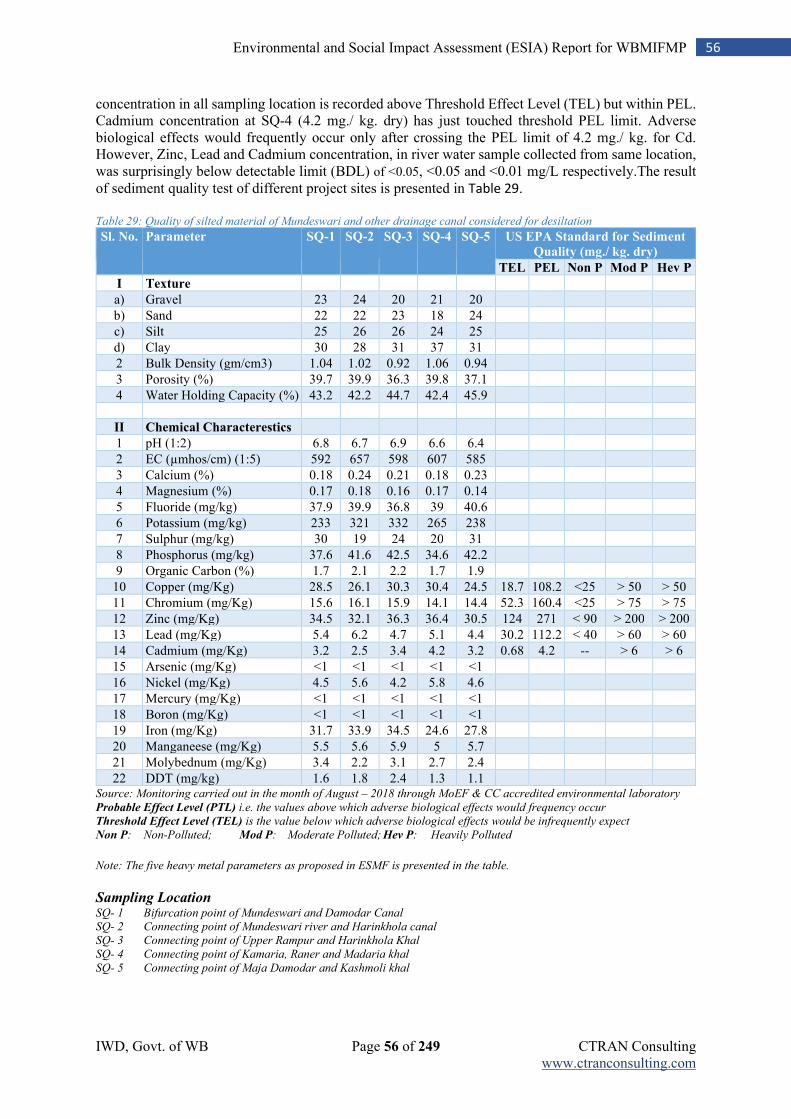
IWD, Govt. of WB Page 56 of 249 CTRAN Consulting www.ctranconsulting.com
56 Environmental and Social Impact Assessment (ESIA) Report for WBMIFMP
concentration in all sampling location is recorded above Threshold Effect Level (TEL) but within PEL. Cadmium concentration at SQ-4 (4.2 mg./ kg. dry) has just touched threshold PEL limit. Adverse biological effects would frequently occur only after crossing the PEL limit of 4.2 mg./ kg. for Cd. However, Zinc, Lead and Cadmium concentration, in river water sample collected from same location, was surprisingly below detectable limit (BDL) of <0.05, <0.05 and <0.01 mg/L respectively.The result of sediment quality test of different project sites is presented in Table 29.
Table 29: Quality of silted material of Mundeswari and other drainage canal considered for desiltation
Sl. No. Parameter SQ-1 SQ-2 SQ-3 SQ-4 SQ-5 US EPA Standard for Sediment
Quality (mg./ kg. dry)
TEL PEL Non P Mod P Hev P
I Texture
a) Gravel 23 24 20 21 20
b) Sand 22 22 23 18 24
c) Silt 25 26 26 24 25
d) Clay 30 28 31 37 31
2 Bulk Density (gm/cm3) 1.04 1.02 0.92 1.06 0.94
3 Porosity (%) 39.7 39.9 36.3 39.8 37.1
4 Water Holding Capacity (%) 43.2 42.2 44.7 42.4 45.9
II Chemical Characterestics
1 pH (1:2) 6.8 6.7 6.9 6.6 6.4
2 EC (µmhos/cm) (1:5) 592 657 598 607 585
3 Calcium (%) 0.18 0.24 0.21 0.18 0.23
4 Magnesium (%) 0.17 0.18 0.16 0.17 0.14
5 Fluoride (mg/kg) 37.9 39.9 36.8 39 40.6
6 Potassium (mg/kg) 233 321 332 265 238
7 Sulphur (mg/kg) 30 19 24 20 31
8 Phosphorus (mg/kg) 37.6 41.6 42.5 34.6 42.2
9 Organic Carbon (%) 1.7 2.1 2.2 1.7 1.9
10 Copper (mg/Kg) 28.5 26.1 30.3 30.4 24.5 18.7 108.2 <25 > 50 > 50
11 Chromium (mg/Kg) 15.6 16.1 15.9 14.1 14.4 52.3 160.4 <25 > 75 > 75
12 Zinc (mg/Kg) 34.5 32.1 36.3 36.4 30.5 124 271 < 90 > 200 > 200
13 Lead (mg/Kg) 5.4 6.2 4.7 5.1 4.4 30.2 112.2 < 40 > 60 > 60
14 Cadmium (mg/Kg) 3.2 2.5 3.4 4.2 3.2 0.68 4.2 -- > 6 > 6
15 Arsenic (mg/Kg) <1 <1 <1 <1 <1
16 Nickel (mg/Kg) 4.5 5.6 4.2 5.8 4.6
17 Mercury (mg/Kg) <1 <1 <1 <1 <1
18 Boron (mg/Kg) <1 <1 <1 <1 <1
19 Iron (mg/Kg) 31.7 33.9 34.5 24.6 27.8
20 Manganeese (mg/Kg) 5.5 5.6 5.9 5 5.7
21 Molybednum (mg/Kg) 3.4 2.2 3.1 2.7 2.4
22 DDT (mg/kg) 1.6 1.8 2.4 1.3 1.1 Source: Monitoring carried out in the month of August – 2018 through MoEF & CC accredited environmental laboratory
Probable Effect Level (PTL) i.e. the values above which adverse biological effects would frequency occur
Threshold Effect Level (TEL) is the value below which adverse biological effects would be infrequently expect
Non P: Non-Polluted; Mod P: Moderate Polluted; Hev P: Heavily Polluted
Note: The five heavy metal parameters as proposed in ESMF is presented in the table.
Sampling Location SQ- 1 Bifurcation point of Mundeswari and Damodar Canal
SQ- 2 Connecting point of Mundeswari river and Harinkhola canal
SQ- 3 Connecting point of Upper Rampur and Harinkhola Khal
SQ- 4 Connecting point of Kamaria, Raner and Madaria khal
SQ- 5 Connecting point of Maja Damodar and Kashmoli khal
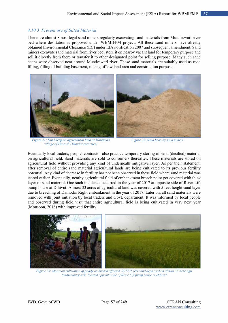
IWD, Govt. of WB Page 57 of 249 CTRAN Consulting www.ctranconsulting.com
57 Environmental and Social Impact Assessment (ESIA) Report for WBMIFMP
4.10.3 Present use of Silted Material
There are almost 8 nos. legal sand miners regularly excavating sand materials from Mundeswari river bed where desiltation is proposed under WBMIFPM project. All these sand miners have already obtained Environmental Clearance (EC) under EIA notification 2007 and subsequent amendment. Sand miners excavate sand material from river bed, store it on nearby vacant land for temporary purpose and sell it directly from there or transfer it to other designated point for selling purpose. Many such sand heaps were observed near around Mundeswari river. These sand materials are suitably used as road filling, filling of building basement, raising of low land area and construction purpose.
Figure 21: Sand heap on agricultural land at Markunda
village of Howrah (Mundeswari river)
Figure 22: Sand heap by sand miners
Eventually local traders, people, contractor also practice temporary storing of sand (desilted) material on agricultural field. Sand materials are sold to consumers thereafter. These materials are stored on agricultural field without providing any kind of underneath mitigative layer. As per their statement, after removal of entire sand material agricultural lands are being cultivated to its previous fertility potential. Any kind of decrease in fertility has not been observed in these field where sand material was stored earlier. Eventually, nearby agricultural field of embankment breach point got covered with thick layer of sand material. One such incidence occurred in the year of 2017 at opposite side of River Lift pump house at Dihivut. Almost 33 acres of agricultural land was covered with 5 feet height sand layer due to breaching of Damodar Right embankment in the year of 2017. Later on, all sand materials were removed with joint initiation by local traders and Govt. department. It was informed by local people and observed during field visit that entire agricultural field is being cultivated in very next year (Monsoon, 2018) with improved fertility.
Figure 23: Monsoon cultivation of paddy on breach affected -2017 (5 feet sand deposited on almost 33 Acre agli
land)country side, located opposite side of River Lift pump house at Dihivut
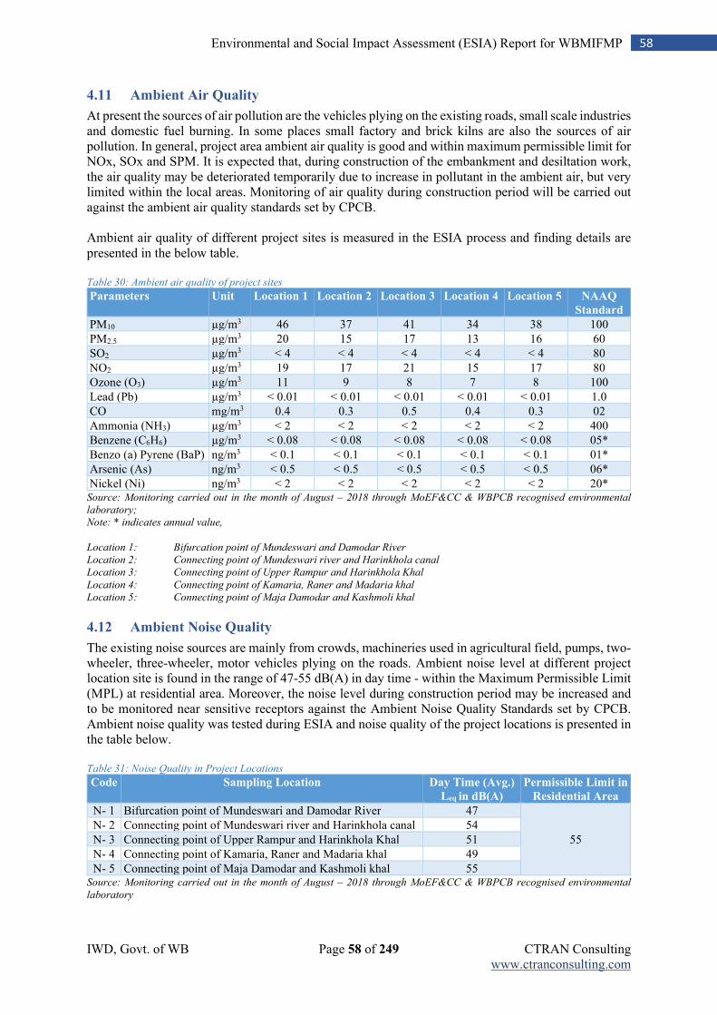
IWD, Govt. of WB Page 58 of 249 CTRAN Consulting www.ctranconsulting.com
58 Environmental and Social Impact Assessment (ESIA) Report for WBMIFMP
4.11 Ambient Air Quality
At present the sources of air pollution are the vehicles plying on the existing roads, small scale industries and domestic fuel burning. In some places small factory and brick kilns are also the sources of air pollution. In general, project area ambient air quality is good and within maximum permissible limit for NOx, SOx and SPM. It is expected that, during construction of the embankment and desiltation work, the air quality may be deteriorated temporarily due to increase in pollutant in the ambient air, but very limited within the local areas. Monitoring of air quality during construction period will be carried out against the ambient air quality standards set by CPCB. Ambient air quality of different project sites is measured in the ESIA process and finding details are presented in the below table. Table 30: Ambient air quality of project sites
Parameters Unit Location 1 Location 2 Location 3 Location 4 Location 5 NAAQ
Standard
PM10 µg/m3 46 37 41 34 38 100
PM2.5 µg/m3 20 15 17 13 16 60
SO2 µg/m3 < 4 < 4 < 4 < 4 < 4 80
NO2 µg/m3 19 17 21 15 17 80
Ozone (O3) µg/m3 11 9 8 7 8 100
Lead (Pb) µg/m3 < 0.01 < 0.01 < 0.01 < 0.01 < 0.01 1.0
CO mg/m3 0.4 0.3 0.5 0.4 0.3 02
Ammonia (NH3) µg/m3 < 2 < 2 < 2 < 2 < 2 400
Benzene (C6H6) µg/m3 < 0.08 < 0.08 < 0.08 < 0.08 < 0.08 05*
Benzo (a) Pyrene (BaP) ng/m3 < 0.1 < 0.1 < 0.1 < 0.1 < 0.1 01*
Arsenic (As) ng/m3 < 0.5 < 0.5 < 0.5 < 0.5 < 0.5 06*
Nickel (Ni) ng/m3 < 2 < 2 < 2 < 2 < 2 20* Source: Monitoring carried out in the month of August – 2018 through MoEF&CC & WBPCB recognised environmental
laboratory;
Note: * indicates annual value,
Location 1: Bifurcation point of Mundeswari and Damodar River
Location 2: Connecting point of Mundeswari river and Harinkhola canal
Location 3: Connecting point of Upper Rampur and Harinkhola Khal
Location 4: Connecting point of Kamaria, Raner and Madaria khal
Location 5: Connecting point of Maja Damodar and Kashmoli khal
4.12 Ambient Noise Quality
The existing noise sources are mainly from crowds, machineries used in agricultural field, pumps, two- wheeler, three-wheeler, motor vehicles plying on the roads. Ambient noise level at different project location site is found in the range of 47-55 dB(A) in day time - within the Maximum Permissible Limit (MPL) at residential area. Moreover, the noise level during construction period may be increased and to be monitored near sensitive receptors against the Ambient Noise Quality Standards set by CPCB. Ambient noise quality was tested during ESIA and noise quality of the project locations is presented in the table below. Table 31: Noise Quality in Project Locations
Code Sampling Location Day Time (Avg.)
Leq in dB(A)
Permissible Limit in
Residential Area
N- 1 Bifurcation point of Mundeswari and Damodar River 47
55
N- 2 Connecting point of Mundeswari river and Harinkhola canal 54
N- 3 Connecting point of Upper Rampur and Harinkhola Khal 51
N- 4 Connecting point of Kamaria, Raner and Madaria khal 49
N- 5 Connecting point of Maja Damodar and Kashmoli khal 55 Source: Monitoring carried out in the month of August – 2018 through MoEF&CC & WBPCB recognised environmental
laboratory
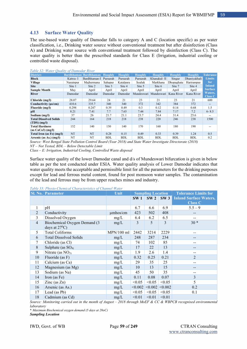
IWD, Govt. of WB Page 59 of 249 CTRAN Consulting www.ctranconsulting.com
59 Environmental and Social Impact Assessment (ESIA) Report for WBMIFMP
4.13 Surface Water Quality
The use-based water quality of Damodar falls to category A and C (location specific) as per water classification, i.e., Drinking water source without conventional treatment but after disinfection (Class A) and Drinking water source with conventional treatment followed by disinfection (Class C). The water quality is better than the prescribed standards for Class E (Irrigation, industrial cooling or controlled waste disposal). Table 32: Water Quality of Damodar River District: Bardhhaman Bardhhaman Hooghly Hooghly Hooghly Hooghly Hooghly Hooghly Tolerance
Limits
for
Inland
Surface
Waters,
Class C
Block Katwa- I Bardhhaman-I Pursurah Pursurah Pursurah Khanakul- II Singur Dhaniyakhali
Village Narainpur Majhermana Sahapur Katalpara Soaluk Markhana Dhopaghata Harirampur
Site Site 1 Site 2 Site 3 Site 4 Site 5 Site 6 Site 7 Site 4
Sample Month May April April April April April April April
River Damodar Damodar Damodar Damodar Mundeswari Mundeswari Kana River Kana River
Chloride (mg/l) 28.07 29.64 24 21 23 21 23 21 600
Conductivity (µs/cm) 410.6 335.7 340 340 372 342 384 372 --
Fluoride (mg/l) 0.298 0.247 0.39 0.49 0.3 0.12 0.14 0.68 1.5
pH 8.21 7.41 7.7 7.65 7.44 7.84 7.17 7.2 6- 8.5
Sodium (mg/l) 37 26 21.7 21.1 23.7 24.4 31.4 25.6 --
Total Dissolved Solids
(TDS) (mg/l)
244 164 218 218 238 220 246 238 1500
Total Hardness
(as CaCo3) (mg/l)
152 140 150 140 170 160 180 190 --
Total Iron (as Fe) (mg/l) NT NT 0.28 0.15 0.49 0.33 0.39 1.24 0.5
Arsenic (as As.) (mg/l) NT NT BDL BDL BDL BDL BDL BDL 0.2
Source: West Bengal State Pollution Control Board (Year 2018) and State Water Investigate Directorate (2018)
NT – Not Tested, BDL – Below Detectable Limit
Class – E: Irrigation, Industrial Cooling, Controlled Waste disposal
Surface water quality of the lower Damodar canal and d/s of Mundeswari bifurcation is given in below table as per the test conducted under ESIA. Water quality analysis of Lower Damodar indicates that water quality meets the acceptable and permissible limit for all the parameters for the drinking purposes except for lead and ferrous metal content, found for post monsoon water samples. The contamination of the lead and ferrous may be from upper reaches mines and industry.
Table 33: Physio-Chemical Characteristics of Channel Water
Sl. No. Parameter Unit Sampling Location Tolerance Limits for
Inland Surface Waters,
Class C
SW 1 SW 2 SW 3
1 pH
6.7 6.6 6.9 5.5 – 9
2 Conductivity µmhos/cm 423 502 408 --
3 Dissolved Oxygen mg/L 6.4 6.2 6.5 --
4 Biochemical Oxygen Demand (3 days at 270C)
mg/L 3 5 3 30 *
5 Total Coliforms MPN/100 ml 2442 3214 2229 --
6 Total Dissolved Solids mg/L 248 287 234 --
7 Chloride (as Cl) mg/L 74 102 85 --
8 Sulphate (as SO4) mg/L 17 22 13 --
9 Nitrate (as NO3) mg/L 1.9 2.6 1.4 --
10 Fluoride (as F) mg/L 0.32 0.25 0.21 2
11 Calcium (as Ca) mg/L 29 35 25 --
12 Magnesium (as Mg) mg/L 10 13 15 --
13 Sodium (as Na) mg/L 45 50 35 --
14 Iron (as Fe) mg/L 0.11 0.08 0.07 3
15 Zinc (as Zn) mg/L <0.05 <0.05 <0.05 5
16 Arsenic (as As.) mg/L <0.002 <0.002 <0.002 0.2
17 Lead (as Pb) mg/L <0.05 <0.05 <0.05 0.1
18 Cadmium (as Cd) mg/L <0.01 <0.01 <0.01 Source: Monitoring carried out in the month of August – 2018 through MoEF & CC & WBPCB recognised environmental
laboratory * Maximum Biochemical oxygen demand (5 days at 20oC)
Sampling Location
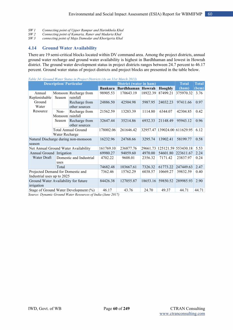
IWD, Govt. of WB Page 60 of 249 CTRAN Consulting www.ctranconsulting.com
60 Environmental and Social Impact Assessment (ESIA) Report for WBMIFMP
SW 1 Connecting point of Upper Rampur and Harinkhola Khal
SW 2 Connecting point of Kamaria, Raner and Madaria Khal
SW 3 connecting point of Maja Damodar and Khorigeria Khal
4.14 Ground Water Availability
There are 19 semi-critical blocks located within DV command area. Among the project districts, annual ground water recharge and ground water availability is highest in Bardhhaman and lowest in Howrah district. The ground water development status in project districts ranges between 24.7 percent to 46.17 percent. Ground water status of project districts and project blocks are presented in the table below. Table 34: Ground Water Status in Project Districts (As on 31st March 2013)
Description/ Particular District (water in ham) Total
(ham)
Total
(bcm) Bankura Bardhhaman Howrah Hooghly
Annual Replenishable
Ground Water
Resource
Monsoon Season
Recharge from rainfall
98905.53 170643.19 18922.39 87499.21 375970.32 3.76
Recharge from other sources
24886.50 42504.98 5987.95 24032.23 97411.66 0.97
Non-Monsoon Season
Recharge from rainfall
21562.59 13283.39 1114.80 6344.07 42304.85 0.42
Recharge from other sources
32647.44 35214.86 6932.33 21148.49 95943.12 0.96
Total Annual Ground Water Recharge
178002.06 261646.42 32957.47 139024.00 611629.95 6.12
Natural Discharge during non-monsoon season
16232.96 24768.66 3295.74 13902.41 58199.77 0.58
Net Annual Ground Water Availability 161769.10 236877.76 29661.73 125121.59 553430.18 5.53
Annual Ground Water Draft
Irrigation 69980.27 94059.60 4970.00 54601.80 223611.67 2.24
Domestic and Industrial uses
4702.22 9608.01 2356.32 7171.42 23837.97 0.24
Total 74682.48 103667.61 7326.32 61773.22 247449.63 2.47
Projected Demand for Domestic and Industrial uses up to 2025
7362.46 15762.29 6038.57 10669.27 39832.59 0.40
Ground Water Availability for future irrigation
84426.38 127055.87 18653.16 59850.52 289985.93 2.90
Stage of Ground Water Development (%) 46.17 43.76 24.70 49.37 44.71 44.71 Source: Dynamic Ground Water Resources of India (June 2017)
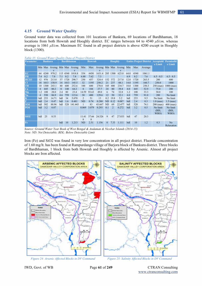
IWD, Govt. of WB Page 61 of 249 CTRAN Consulting www.ctranconsulting.com
61 Environmental and Social Impact Assessment (ESIA) Report for WBMIFMP
4.15 Ground Water Quality
Ground water data was collected from 101 locations of Bankura, 69 locations of Bardhhaman, 18 locations from both Howrah and Hooghly district. EC ranges between 64 to 4540 μS/cm, whereas
average is 1061 μS/cm. Maximum EC found in all project districts is above 4200 except in Hooghly block (1300). Table 35: Ground Water Quality Data of Project District Parameter
s
Bankura Bardhhaman Howrah Hooghly Entire Project District Acceptabl
e Limit
Permissibl
e Limit Min Max Averag
e Min Max Averag
e Min Max Averag
e Min Max Averag
e Min Max Average
EC 64 4240 970.2 115 4540 1018.8 554 4450 1631.4 285 1300 623.8 64.0 4540 1061.1
PH 7.4 8.2 7.8 7.1 8.2 7.8 6.88 7.62 7.3
6.9 8.2 7.6 6.5 - 8.5 6.5 - 8.5
HCO3 12 976 213.0 37 1720 298.7 250 457 324.4 152 372 217.8 12.0 1720 263.5 200 600
Cl 18 1013 158.9 14 1013 145.5 32 1195 250.2 21 237 88.1 14.0 1195 160.7 250.0 1000
TH 10 1300 243.1 40 600 252.6 100 600 270.8 105 400 234.7 10.0 1300 250.3 250 (max) 1000 (max)
Ca 4 445 80.2 8 140 64.2 8 104 27.7 24 80 39.4 4.0 445 52.9 75.0 200
Mg 1.2 108 28.0 2.4 80 23.4 14.59 93.63 49.0 6 74 32.8 1.2 108 33.3 30.0 100
Na 4 550 86.9 4.6 759 115.6 30 400 129.6 12 50 32.1 4.0 759 91.0 200 No limit
K bdl 253 14.71 bdl 34 5.070 2 51 13 0.2 19.8 5.2 bdl 253 9.5 No limit No limit
F bdl 2.4 0.47 bdl 1.6 0.481 ND 0.74 0.280 ND 0.12 0.087 bdl 2.4 0.3 1.0 (max) 1.5 (max)
SO4 bdl 502 88.96 bdl 528 141.443 1 83 43.667 ND 69 22.477 bdl 528 74.1 200 (max) 400 (max)
PO4 bdl 3.2 0.87
0.069 3.079 0.293 0.1 2 0.272 bdl 3.2 0.5 No limit (BIS,
WHO)
No limit (BIS,
WHO)
SiO2 bdl 25 8.53
11.418
37.668
24.526 9 47 27.833 bdl 47 20.3
Fe
bdl 10 1.213 ND 2.51 1.156 0 7.33 1.111 bdl 10 1.2 0.3 No Relaxation
Source: Ground Water Year Book of West Bengal & Andaman & Nicobar Islands (2014-15) Note: ND: Not Detectable; BDL: Below Detectable Limit
Iron (Fe) and SiO2 was found in very low concentration in all project district. Fluoride concentration of 1.60 mg/lt. has been found at Rampurdanga village of Barjora block of Bankura district. Three blocks of Bardhhaman, 1 block from both Howrah and Hooghly is affected by Arsenic. Almost all project blocks are Iron affected.
Figure 24: Arsenic Affected Blocks in DV Command Figure 25: Salinity Affected Blocks in DV Command
IWD, Govt. of WB Page 62 of 249 CTRAN Consulting www.ctranconsulting.com
62 Environmental and Social Impact Assessment (ESIA) Report for WBMIFMP
4.16 Sensitive Receptors in Project Area
Temple, Bedi, Masque, Burning ghat, School, Hospital, Railway station, Market place, Town, Govt. offices, Playground, Park and etc. are located within corridor of impact and and zone of influence. Many of these features like market place, town, hospital, temple, burning ghat and etc. which are located immediate vicinity of river/ canal causes river pollution. There are river/ canal stretches where set back zone varies between 100- 300 meter (width). Agriculture is very common practice in setback zone located on embankment of Damodar, Hurhura and Upper Rampur. Any water scheme is not withdrawing water from this stretch. Presence of any manufacturing industry is void because of dryness of river throughout the year except rainy season. There exist no manufacturing or polluting industry within 3 km influence zone. One sacred grove (300 years old Banyan Tree) on Upper Rampur left Embankment at Bhut Bhanga More is present where any kind of intervention is not proposed. Intervention activity wise details list of environmental and social features located within delineated zones are presented in Annexure- 9 & 10 and described in Table 13.
Sensitive receptors like school, hospital, Anganwadi centre, park area located within 100 m radius of active work site have increased sensitivity to the impacts of the project activities by virtue of their nature and location. Project intervention wise list of sensitive receptors located within 100 m zone of influence is listed below. Table 36: Avalability of School, Hospital, Park within 100 meter periphery of Embankment
Embankment Sensitive Receptor Availability within 100 m radius from river/
Canal embankment
Left / Right Distance
(in Meter)
Lat Long
Mundeswari River Nil
Hurhura Left Mostafapur Gandhi high School Right 103.36 m 22.658481 87.90203
Damodar Left & Right
High School Left 32.65 m 22.665562 87.996938
Damodar Public Park Left 54.03 m 22.723106 87.988942
Kansona park Right 53.06 m 22.643879 87.984285
Bokpota Eco park Right 5.0 m 22.723472 87.989380
Upper Rampur Pursuraha PHC Right 10.28 m 22.825256 87.954478
Madaria Khal Purash high School Right 81.92 22.681215 88.034816
41 Drainage Canal Nil
4.17 Biological Environment
4.17.1 Forest Profile
Some part of DVC command area in Bankura and Bardhhaman district intersect small patches of forest land. As it is evident from the land use and land cover map, there is no forest area in the identified working zone of the project in different sites. Further, none of the project activities under WBMIFMP is proposed in forest area or any part of forest is located adjacent to proposed work zone. Bankura district has maximum forest cover followed by Bardhhaman among all 5 project districts. Project district wise forest cover is tabulated below and shown in following figures: Table 37: Area under Forest in project district
Area Under Forest (in Sq. Km.)
District Reserved Forests Protected Forests Unclassed State Forests Total Area
Bankura 80 1311 91 1482
Bardhhaman 3 192 82 277
Howrah - - - -
Hooghly 3 - - 3
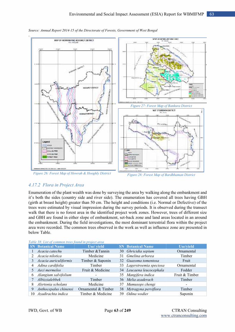
IWD, Govt. of WB Page 63 of 249 CTRAN Consulting www.ctranconsulting.com
63 Environmental and Social Impact Assessment (ESIA) Report for WBMIFMP
Source: Annual Report 2014-15 of the Directorate of Forests, Government of West Bengal
.
Figure 26: Forest Map of Howrah & Hooghly District
Figure 27: Forest Map of Bankura District
Figure 28: Forest Map of Bardhhaman District
4.17.2 Flora in Project Area
Enumeration of the plant wealth was done by surveying the area by walking along the embankment and it’s both the sides (country side and river side). The enumeration has covered all trees having GBH (girth at breast height) greater than 50 cm. The height and conditions (i.e. Normal or Defective) of the trees were estimated by visual impression during the survey periods. It is observed during the transect walk that there is no forest area in the identified project work zones. However, trees of different size and GBH are found in either slope of embankment, set-back zone and land areas located in an around the embankment. During the field investigations, the most dominant terrestrial flora within the project area were recorded. The common trees observed in the work as well as influence zone are presented in below Table. Table 38: List of common trees found in project area
SN Botanical Name Use/ yield SN Botanical Name Use/yield
1 Acacia catechu Timber &Tannin 30 Ghricidia sepium Ornamental
2 Acacia nilotica Medicine 31 Gmelina arborea Timber
3 Acacia auriculiformis Timber & Saponin 32 Guazoma tomentosa Fruit
4 Adina cardifolia Timber 33 Lagerstroemia speciosa Ornamental
5 Aeci mermelos Fruit & Medicine 34 Leucaena leucocephala Fodder
6 Alangium salvifolium - 35 Mangifera indica Fruit & Timber
7 Albizzialebbek Timber 36 Melia azaderach Timber
8 Alsrtonia scholans Medicine 37 Mumusops chengi -
9 Anthocepalus chinensi Ornamental & Timber 38 Mytragyna perviflora Timber
10 Azadirachta indica Timber & Medicine 39 Odina wodier Saponin
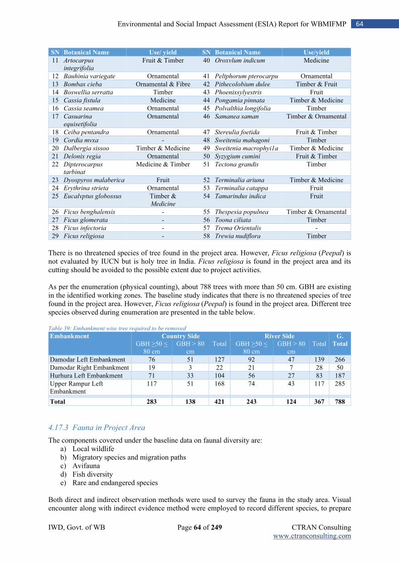
IWD, Govt. of WB Page 64 of 249 CTRAN Consulting www.ctranconsulting.com
64 Environmental and Social Impact Assessment (ESIA) Report for WBMIFMP
SN Botanical Name Use/ yield SN Botanical Name Use/yield
11 Artocarpus
integrifolia
Fruit & Timber 40 Oroxvlum indicum Medicine
12 Bauhinia variegate Ornamental 41 Peltphorum pterocarpu Ornamental
13 Bombax cieba Ornamental & Fibre 42 Pithecolobium dulee Timber & Fruit
14 Boswellia serratta Timber 43 Phoenixsylyestris Fruit
15 Cassia fistula Medicine 44 Pongamia pinnata Timber & Medicine
16 Cassia seamea Ornamental 45 Polvalthia longifolia Timber
17 Casuarina
equisetifolia
Ornamental 46 Samanea saman Timber & Ornamental
18 Ceiba pentandra Ornamental 47 Stereulia foetida Fruit & Timber
19 Cordia mvxa - 48 Sweitenia mahagoni Timber
20 Dalbergia sissoo Timber & Medicine 49 Sweitenia macrophyi1a Timber & Medicine
21 Delonix regia Ornamental 50 Syzygium cumini Fruit & Timber
22 Dipterocarpus
tarbinat
Medicine & Timber 51 Tectona grandis Timber
23 Dyospyros malaberica Fruit 52 Terminalia ariuna Timber & Medicine
24 Erythrina strieta Ornamental 53 Terminalia catappa Fruit
25 Eucalvptus globossus Timber & Medicine
54 Tamarindus indica Fruit
26 Ficus benghalensis - 55 Thespesia populnea Timber & Ornamental
27 Ficus glomerata - 56 Toona ciliata Timber
28 Ficus infectoria - 57 Trema Orientalis -
29 Ficus religiosa - 58 Trewia nudiflora Timber
There is no threatened species of tree found in the project area. However, Ficus religiosa (Peepal) is not evaluated by IUCN but is holy tree in India. Ficus religiosa is found in the project area and its cutting should be avoided to the possible extent due to project activities. As per the enumeration (physical counting), about 788 trees with more than 50 cm. GBH are existing in the identified working zones. The baseline study indicates that there is no threatened species of tree found in the project area. However, Ficus religiosa (Peepal) is found in the project area. Different tree species observed during enumeration are presented in the table below. Table 39: Embankment wise tree required to be removed
Embankment Country Side River Side G.
Total GBH >50 < 80 cm
GBH > 80 cm
Total GBH >50 < 80 cm
GBH > 80 cm
Total
Damodar Left Embankment 76 51 127 92 47 139 266
Damodar Right Embankment 19 3 22 21 7 28 50
Hurhura Left Embankment 71 33 104 56 27 83 187
Upper Rampur Left Embankment
117 51 168 74 43 117 285
Total 283 138 421 243 124 367 788
4.17.3 Fauna in Project Area
The components covered under the baseline data on faunal diversity are: a) Local wildlife b) Migratory species and migration paths c) Avifauna d) Fish diversity e) Rare and endangered species
Both direct and indirect observation methods were used to survey the fauna in the study area. Visual encounter along with indirect evidence method were employed to record different species, to prepare
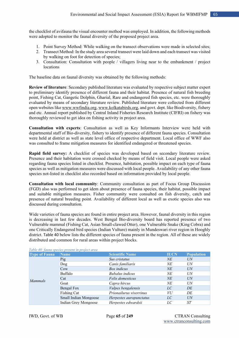
IWD, Govt. of WB Page 65 of 249 CTRAN Consulting www.ctranconsulting.com
65 Environmental and Social Impact Assessment (ESIA) Report for WBMIFMP
the checklist of avifauna the visual encounter method was employed. In addition, the following methods were adopted to monitor the faunal diversity of the proposed project area.
1. Point Survey Method: While walking on the transect observations were made in selected sites; 2. Transect Method: In the study area several transect were laid down and each transect was visited
by walking on foot for detection of species; 3. Consultation: Consultation with people / villagers living near to the embankment / project
locations The baseline data on faunal diversity was obtained by the following methods: Review of literature: Secondary published literature was evaluated by respective subject matter expert to preliminary identify presence of different fauna and their habitat. Presence of natural fish breeding point, Fishing Cat, Gangetic Dolphin, Gharial, Rare and endangered fish species, etc. were thoroughly evaluated by means of secondary literature review. Published literature were collected from different open websites like www.wwfindia.org, www.kolkatabirds.org, and govt. dept. like Biodiversity, fishery and etc. Annual report published by Central Inland Fisheries Research Institute (CIFRI) on fishery was thoroughly reviewed to get idea on fishing activity in project area. Consultation with experts: Consultation as well as Key Informants Interview were held with departmental staff of Bio-diversity, fishery to identify presence of different fauna species. Consultation were held at district as well as state level office of respective department. Local office of WWF also was consulted to frame mitigation measures for identified endangered or threatened species. Rapid field survey: A checklist of species was developed based on secondary literature review. Presence and their habitation were crossed checked by means of field visit. Local people were asked regarding fauna species listed in checklist. Presence, habitation, possible impact on each type of fauna species as well as mitigation measures were discussed with local people. Availability of any other fauna species not-listed in checklist also recorded based on information provided by local people. Consultation with local community: Community consultation as part of Focus Group Discussion (FGD) also was performed to get idem about presence of fauna species, their habitat, possible impact and suitable mitigation measures. Fisher community were consulted on fish diversity, catch and presence of natural breeding point. Availability of different local as well as exotic species also was discussed during consultation. Wide varieties of fauna species are found in entire project area. However, faunal diversity in this region is decreasing in last few decades. West Bengal Bio-diversity board has reported presence of two Vulnerable mammal (Fishing Cat, Asian Small-clawed Otter), one Vulnerable Snake (King Cobra) and one Critically Endangered bird species (Indian Vulture) mainly in Mundeswari river region in Hooghly district. Table 40 below lists the different species of fauna present in the region. All of these are widely
distributed and common for rural areas within project blocks. Table 40: fauna species present in project area
Type of Fauna Name Scientific Name IUCN Population
Mammals
Pig Sus cristatus NE UN
Dog Canis familiaris NE UN
Cow Bos indicus NE UN
Buffalo Bubalus indicus NE UN
Cat Felis domesticus NE UN
Goat Capra hircus NE UN
Bengal Fox Vulpes bengalensis LC DE
Fishing Cat Prionailurus viverrinus VU DE
Small Indian Mongoose Herpestes auropunctatus LC UN
Indian Grey Mongoose Herpestes edwardsii LC ST
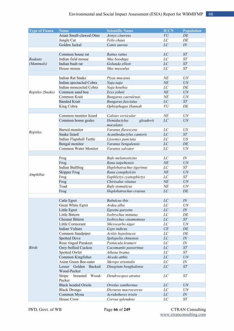
IWD, Govt. of WB Page 66 of 249 CTRAN Consulting www.ctranconsulting.com
66 Environmental and Social Impact Assessment (ESIA) Report for WBMIFMP
Type of Fauna Name Scientific Name IUCN Population
Asian Small-clawed Otter Aonyx cinereus VU DE
Jungle Cat Felis chaus LC DE
Golden Jackal Canis aureus LC IN
Rodents
(Mammals)
Common house rat Rattus rattus LC ST
Indian field mouse Mus booduga LC ST
Indian bush rat Golunda ellioti LC ST
House mouse Mus museulus LC ST
Reptiles (Snake)
Indian Rat Snake Ptyas mucasus NE UN
Indian spectacled Cobra Naja naja NE UN
Indian moncocled Cobra Naja kouthia LC DE
Common sand boa Eryx johnii NE UN
Common Krait Bungarus caerulenas NE UN
Banded Krait Bungarus fasciatus LC ST
King Cobra Ophiophagus Hannah VU DE
Reptiles
Common monitor lizard Calotes versiculor NE UN
Common house geeko Hemidactylus gleadovii
maculates
LC UN
Barred monitor Varanus flavescens LC US
Snake lizard Acanthodactylus cantoris LC ST
Indian Flapshell Turtle Lissemys punctata LC US
Bengal monitor Varanus bengalensis LC DE
Common Water Monitor Varanus salvator LC UN
Amphibia
Frog Bufo melanostictus LC IN
Frog Rana taipehensis NE UN
Indian Bullfrog Hoplobatrachus tigerinus LC ST
Skipper Frog Rana cynophylctis NE UN
Frog Euphlictys cyanophictys LC ST
Frog Chirixalus vittatus NE UN
Toad Bufo stomaticus NE UN
Frog Hoplobatrachus crassus LC DE
Birds
Catle Egret Bubulcus ibis LC IN
Great White Egret Ardea alba LC UN
Little Egret Egretta garzetta LC IN
Little Bittern Ixobrychus minutus LC DE
Chesnut Bittern Ixobrychus cinamomeus LC ST
Little Cormorant Microcarbo niger LC UN
Indian Vulture Gyps indicus CE DE
Common Sandpiper Actitis hypoleucos LC DE
Spotted Dove Spilopelia chinensis LC IN
Rose ringed Parakeet Psittacula krameri LC IN
Grey-bellied Cuckoo Cacomantis passerinus LC ST
Spotted Owlet Athena brama LC ST
Common Kingfisher Alcedo atthis LC UN
Asian Green Bee-eater Merops orientalis LC IN
Lesser Golden Backed Wood-Pecker
Dinopium benghalense LC ST
Stripe breasted Wood- Pecker
Dendrocopos atratus LC ST
Black headed Oriole Oriolus xanthornus LC UN
Black Drongo Dicrurus macrocercus LC UN
Common Myna Acridotheres tristis LC IN
House Crow Corvus splendens LC ST
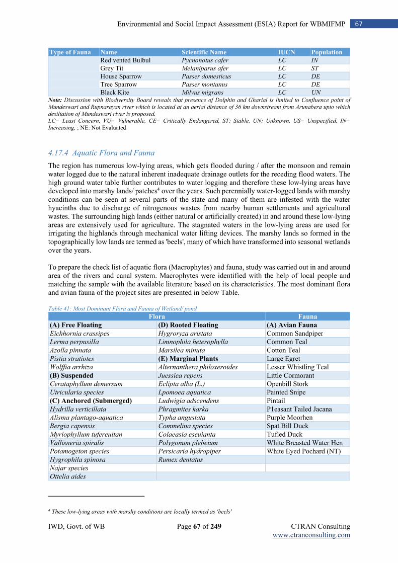
IWD, Govt. of WB Page 67 of 249 CTRAN Consulting www.ctranconsulting.com
67 Environmental and Social Impact Assessment (ESIA) Report for WBMIFMP
Type of Fauna Name Scientific Name IUCN Population
Red vented Bulbul Pycnonotus cafer LC IN
Grey Tit Melaniparus afer LC ST
House Sparrow Passer domesticus LC DE
Tree Sparrow Passer montanus LC DE
Black Kite Milvus migrans LC UN Note: Discussion with Biodiversity Board reveals that presence of Dolphin and Gharial is limited to Confluence point of
Mundeswari and Rupnarayan river which is located at an aerial distance of 36 km downstream from Arunabera upto which
desiltation of Mundeswari river is proposed.
LC= Least Concern, VU= Vulnerable, CE= Critically Endangered, ST: Stable, UN: Unknown, US= Unspecified, IN=
Increasing, ; NE: Not Evaluated
4.17.4 Aquatic Flora and Fauna
The region has numerous low-lying areas, which gets flooded during / after the monsoon and remain water logged due to the natural inherent inadequate drainage outlets for the receding flood waters. The high ground water table further contributes to water logging and therefore these low-lying areas have developed into marshy lands/ patches4 over the years. Such perennially water-logged lands with marshy conditions can be seen at several parts of the state and many of them are infested with the water hyacinths due to discharge of nitrogenous wastes from nearby human settlements and agricultural wastes. The surrounding high lands (either natural or artificially created) in and around these low-lying areas are extensively used for agriculture. The stagnated waters in the low-lying areas are used for irrigating the highlands through mechanical water lifting devices. The marshy lands so formed in the topographically low lands are termed as 'beels', many of which have transformed into seasonal wetlands over the years. To prepare the check list of aquatic flora (Macrophytes) and fauna, study was carried out in and around area of the rivers and canal system. Macrophytes were identified with the help of local people and matching the sample with the available literature based on its characteristics. The most dominant flora and avian fauna of the project sites are presented in below Table. Table 41: Most Dominant Flora and Fauna of Wetland/ pond
Flora Fauna
(A) Free Floating (D) Rooted Floating (A) Avian Fauna
Eichhornia crassipes Hygroryza aristata Common Sandpiper
Lerma perpusilIa Limnophila heterophylla Common Teal
Azolla pinnata Marsilea minuta Cotton Teal
Pistia stratiotes (E) Marginal Plants Large Egret
Wolffia arrhiza Alternanthera philoxeroides Lesser Whistling Teal
(B) Suspended Juessiea repens Little Cormorant
Cerataphyllum demersum Eclipta alba (L.) Openbill Stork
Utricularia species Lpomoea aquatica Painted Snipe
(C) Anchored (Submerged) Ludwigia adscendens Pintail
Hydrilla verticillata Phragmites karka P1easant Tailed Jacana
Alisma plantago-aquatica Typha angustata Purple Moorhen
Bergia capensis Commelina species Spat Bill Duck
Myriophyllum tufereuitan Colaeasia eseuianta Tufled Duck
Vallisneria spiralis Polygonum plebeium White Breasted Water Hen
Potamogeton species Persicaria hydropiper White Eyed Pochard (NT)
Hygrophila spinosa Rumex dentatus
Najar species
Ottelia aides
4 These low-lying areas with marshy conditions are locally termed as 'beels'
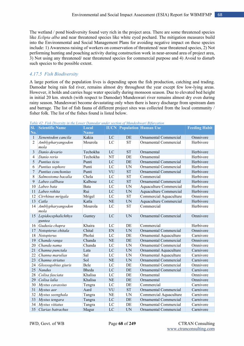
IWD, Govt. of WB Page 68 of 249 CTRAN Consulting www.ctranconsulting.com
68 Environmental and Social Impact Assessment (ESIA) Report for WBMIFMP
The wetland / pond biodiversity found very rich in the project area. There are some threatened species like Eclipta alba and near threatened species like white eyed pochard. The mitigation measures build into the Environmental and Social Management Plans for avoiding negative impact on these species include: 1) Awareness raising of workers on conservation of threatened/ near threatened species, 2) Not performing hunting and poaching activity during construction work in near-around area of project area, 3) Not using any threatened/ near threatened species for commercial purpose and 4) Avoid to disturb such species to the possible extent.
4.17.5 Fish Biodiversity
A large portion of the population lives is depending upon the fish production, catching and trading. Damodar being rain fed river, remains almost dry throughout the year except few low-lying areas. However, it holds and carries huge water specially during monsoon season. Due to elevated bed height in initial 20 km. stretch (with respect to Damodar) Mundeswari river remains almost dry even during rainy season. Mundeswari become devastating only when there is heavy discharge from upstream dam and barrage. The list of fish fauna of different project sites was collected from the local community / fisher folk. The list of the fishes found is listed below. Table 42: Fish Diversity in the Lower Damodar under section of Mundeshwari Bifurcation
Sl.
No.
Scientific Name Local
Name
IUCN Population Human Use Feeding Habit
1 Xenentodon cancila Kakia LC DE Ornamental Commercial Omnivore
2 Amblypharyangodon
mola
Mourola LC ST Ornamental Commercial Herbivore
3 Danio devario Techokha LC ST Ornamental Herbivore
4 Danio rerio Techokha NT DE Ornamental Herbivore
5 Puntius ticto Punti LC DE Ornamental Commercial Herbivore
6 Puntius sophore Punti LC UN Ornamental Commercial Herbivore
7 Puntius conchonius Punti VU ST Ornamental Commercial Herbivore
8 Salmostoma bacalia Chela LC ST Commercial Herbivore
9 Labeo callbasu Kalbose LC ST Ornamental Commercial Herbivore
10 Labeo bata Bata LC UN Aquaculture Commercial Herbivore
11 Labeo rohita Rui LC UN Aquaculture Commercial Herbivore
12 Cirrhinus mrigala Mrigel LC ST Commercial Aquaculture Omnivore
13 Catla Katla NE UN Aquaculture Commercial Herbivore
14 Amblypharyangodon
mola
Mourola LC ST Commercial Herbivore
15 Lepidocephalichthys
guntea
Guntey LC UN Ornamental Commercial Omnivore
16 Gudusia chapra Khaira LC DE Commercial Herbivore
17 Notopterus chitala Chital EN UN Ornamental Commercial Omnivore
18 Notopterus Pholui LC DE Ornamental Aquaculture Carnivore
19 Chanda ranga Chanda NE DE Ornamental Commercial Omnivore
20 Chanda nama Chanda LC UN Ornamental Commercial Omnivore
21 Channa punctala Lata LC UN Ornamental Aquaculture Carnivore
22 Channa marulias Sal LC UN Ornamental Aquaculture Carnivore
23 Channa striatus Sol NE UN Ornamental Commercial Carnivore
24 Glossogobius giuris Bele LC DE Ornamental Commercial Omnivore
25 Nandus Bheda LC DE Ornamental Commercial Carnivore
28 Colisa fasciata Khalisa LC DE Ornamental Omnivore
29 Colisa lalia Khalisa NE DE Ornamental Omnivore
30 Mystus cavassius Tengra LC DE Commercial Carnivore
31 Mystus aor Aard VU ST Ornamental Commercial Carnivore
32 Mystus seenghala Tangra NE UN Commercial Aquaculture Carnivore
33 Mystus tengara Tangra LC DE Ornamental Commercial Carnivore
34 Mystus vittatus Tangra LC DE Ornamental Commercial Carnivore
35 Clarias batrachus Magur LC UN Ornamental Commercial Carnivore
IWD, Govt. of WB Page 69 of 249 CTRAN Consulting www.ctranconsulting.com
69 Environmental and Social Impact Assessment (ESIA) Report for WBMIFMP
Sl.
No.
Scientific Name Local
Name
IUCN Population Human Use Feeding Habit
36 Pungasius Pangus LC DE Ornamental Commercial Omnivore
37 Bagarius Garua VU DE Commercial Herbivore
38 Wallago attu Boal NT DE Commercial Carnivore
39 Heteropneustea fossilis Singi LC ST Ornamental Commercial Carnivore
40 Macrognathus armatus Ban LC UN Commercial Carnivore
41 Tetradon cutcutia Tepa NT DE Ornamental Herbivore Source: International Journal of Scientific and Research Publications, Volume 3, Issue 6, June 2013 Note: IUCN Category: LC: Least Concern; NT: Near threatened; VU: Vulnerable; NE: Not Evaluated; Population Trend: DE: Decreasing, UN: Unknown, ST: Stable
More than forty species of fish are found in Lower Damodar. Roughly one third species are found either vulnerable (3), endangered (1), near threatened (3) and not evaluated (5) as per IUCN categorization. The mitigation measures build into the Environmental and Social Management Plans for avoiding negative impact on these species include: 1) Awareness raising of workers on conservation of vulnerable, endangered, near threatened and not evaluated species, 2) Not performing fishing activity during construction work in river/ canal or near-around area water-bodies, 3) Not using any threatened/ near threatened species for commercial purpose, 4) Any kind of work on river / canal bed like re-sectioning/ desiltation shall only be performed during non-monsoon period and5) Any such species found during dewatering of active desiltation zone shall be preserved and immediately release to downstream river/ canal water.
4.17.6 Fishers Population
Fishery is mainly depending upon large number of tanks prevalent in the project area and fishing in the river. Fishing practice on Damodar river is decreasing gradually due to unavailability of water throughout the year, except monsoon period. Any kind of pisciculture activity is not observed in river. Discussion with Fishery Department confirms that non-presence of any natural breeding point in Damodar due to reduced water flow and siltation. Number of fishers in the project blocks and project area is considerable. The same is reviewed, analysed and given in Table 43. Table 43: Fisherman Population in Project Blocks and Project Flood Plain Area
Name of District Name of Block Block Fisherman 2011 Project Area Fisherman 2011
Hooghly
Dhaniakhali 8217 1643
Tarakeswar 8027 7626
Tarakeswar(M)
Haripal 5951 1012
Jangipara 4757 3663
Arambag 4191 796
Khankul I 9493 8449
Khankul II 7084 7084
Prusurah 3657 3657
Howrah
Jagatballavpur 5180 2227
Uluberia I 9063 9063
Uluberia II 7870 7870
Uluberia (M)
Amta I 8192 8192
Amta II 6928 6928
Udaynarayanpur 6906 6906
Bagnan I 8960 8960
Bagnan II 5877 5877
Bardhhaman Jamalpur 5417 1571
All
115770 97247 Source: Statistical Handbook, West Bengal
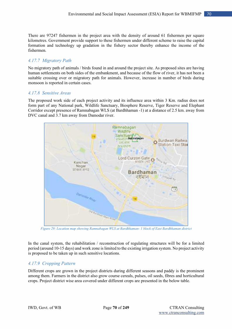
IWD, Govt. of WB Page 70 of 249 CTRAN Consulting www.ctranconsulting.com
70 Environmental and Social Impact Assessment (ESIA) Report for WBMIFMP
There are 97247 fishermen in the project area with the density of around 61 fishermen per square kilometres. Government provide support to these fishermen under different scheme to raise the capital formation and technology up gradation in the fishery sector thereby enhance the income of the fishermen.
4.17.7 Migratory Path
No migratory path of animals / birds found in and around the project site. As proposed sites are having human settlements on both sides of the embankment, and because of the flow of river, it has not been a suitable crossing over or migratory path for animals. However, increase in number of birds during monsoon is reported in certain cases.
4.17.8 Sensitive Areas
The proposed work side of each project activity and its influence area within 3 Km. radius does not form part of any National park, Wildlife Sanctuary, Biosphere Reserve, Tiger Reserve and Elephant Corridor except presence of Ramnabagan WLS (at Bardhhaman -1) at a distance of 2.5 km. away from DVC canal and 3.7 km away from Damodar river.
Figure 29: Location map showing Ramnabagan WLS at Bardhhaman- 1 block of East Bardhhaman district
In the canal system, the rehabilitation / reconstruction of regulating structures will be for a limited period (around 10-15 days) and work zone is limited to the existing irrigation system. No project activity is proposed to be taken up in such sensitive locations.
4.17.9 Cropping Pattern
Different crops are grown in the project districts during different seasons and paddy is the prominent among them. Farmers in the district also grow course cereals, pulses, oil seeds, fibres and horticultural crops. Project district wise area covered under different crops are presented in the below table.
IWD, Govt. of WB Page 71 of 249 CTRAN Consulting www.ctranconsulting.com
71 Environmental and Social Impact Assessment (ESIA) Report for WBMIFMP
Table 44: Crops Grown in Project District and Area under Different Crops
Project District Crop Type Kharif (Area in Ha) Rabi (Area in Ha) Summer (Area in Ha)
Bankura
Cereals 79997 754 28290
Coarse Cereals 135 67 0
Pulses 116 669 70
Oil seeds 34 5795 7759
Fibre 222 0 0
Hort. & Other crops 2037 12996 1355
Total 82541 20281 37474
Purba
Bardhhaman
Cereals 350919 21415 117260
Coarse Cereals 8 0 10
Pulses 731 23145 2112
Oil Seeds 30 29634 17560
Fibre 2551 0 0
Potato including Horticulture
2710 78217 4440
Total 356949 153611 141382
Paschim
Bardhhaman
Cereals 23900 100 1100
Coarse Cereals 500 20 15
Pulses 0 155 5
Oil Seeds 0 460 100
Fibre 0 0 0
Potato including Horticulture
450 1715 250
Total 24850 2450 1470
Hooghly
Cereals 159753 0 61095
Coarse Cereals 40 0 0
Pulses 0 4374 861
Oil seed 0 11601 48934
Fibre 16117 0 0
Other crops (potato) 0 78856 0
Total 175910 94831 110890
Primary study (villages adjacent to project locations in project blocks) observed that in villages adjacent to the project, paddy is the prominent crop grown by the farmers in all the agricultural seasons, Diversification in crop is observed in Rabi and Summer seasons when farmers take up vegetables, oil seeds and pulses along with floriculture. Findings of the primary study in project locations are presented in the table below. Table 45: Cropping Pattern among Farmers in Project Districts
Project District In Kharif In Rabi In Summer
Bankura Paddy Paddy, Mustard, Potato, Wheat
Paddy
Purba Bardhhaman Paddy Paddy, Oilseed (Mustard),
Vegetables (Potato, Bitter Gourd)
Paddy
Paschim Bardhhaman
Paddy Mustard Paddy
Howrah Paddy, Flowers,
Vegetables
Paddy, Potato, Other Vegetables,
Pulses, Flowers, Groundnut
Jute, Flowers, Vegetables (Okra, Potato etc.)
Paddy, Til
Hooghly Paddy Vegetable (Okra)
Paddy, Potato,
Mustard, Groundnut
Banana, Brinjal, Chilly, Ground Nut, Jute,
Paddy, Watermelon Source: Field Study
IWD, Govt. of WB Page 72 of 249 CTRAN Consulting www.ctranconsulting.com
72 Environmental and Social Impact Assessment (ESIA) Report for WBMIFMP
4.17.10 Farming Practices
Mulching is not a common practice of farmers in the study area / villages in project blocks. Only 7.4 percent farmers use mulching for specific crops (mostly vegetables) whereas remaining farmers do not use mulching. Similarly, about 66.2 percent farmers do not adopt mixed cropping during agricultural seasons, though some farmers do that practice in Boro and Rabi season. Similar trend is observed in adoption and practice of intercropping system in project areas. Integrated farming system and crop rotation status is also not encouraging as 90.3 percent farmers and 91.9 percent farmers respectively do not practice. Some families are engaged in pisciculture activities (13.7 percent) in the command villages as a supportive livelihood.
4.17.11 Nutrient Management
Soil nutrient management is a critical aspect in the agriculture system. The soil fertility map of the project districts reveals that high soil organic carbon (0.75) is observed in 79 percent area of Bardhhaman followed by 52 percent area in Hooghly and 19 percent area of Bankura. It reveals that major part of Bankura district is low to medium in soil organic carbon. Further, pH value indicates that soil of these districts is mostly acidic and deficient in Boron and Zinc. Nitrogen content of soil in these districts are low in majority parts and for which Nitrogenous fertiliser application is high in these districts. Use of Phosphorous and Potassium in these districts are low as substantial part of these districts are having moderate to high Phosphorous and Potassium content. Primary field study reveals that 59.3 percent farmers have never tested their soil to understand soil composition and micronutrient content. About 7.4 percent farmers have done it in 5-7 years back whereas only 3.0 percent families conduct soil testing annually. Cultivation of nitrogen fixing crops is normally practiced by 5.8 percent families and green manuring by about 2.5 percent families. Use of vermi compost, though not very prominent, is used by 10.6 percent farming families. Similarly, use of Azolla / blue green algae is also very uncommon (less than 1.0 percent cases). Farmers of the project area mostly use Urea, NPK, DAP and MOP fertilizers. Consumption of urea is more than other fertilizers. Approximately 150 kg/ha of NPK fertilizer is used in paddy fields (Irrigated) and 75-80 Kg/ha of NPK fertilizer is used in rainfed paddy fields. Use of organic manure (farmyard manure, compost, green manure) is the oldest practiced means of nutrient replenishment. But due to increasing trend of using cow dung as fuel and using crop residue as animal feed, use of organic manure is reduced. People in command area of the project also used animal waste as organic manure for their crops, However the use of organic manure is less than that of Mineral fertilizers. Key issues related to fertilizer application in the project districts are;
1. Unscientific application of fertilizer (higher doses); 2. Many farmers use fertilizer without soil test; 3. Inadequate technical inputs on fertilizer application; 4. Poor adoption of Integrated Plant Nutrient Management; 5. Input supplier to farmer extension which is more commercial and less technical; 6. Less use of organic manure in comparison to synthetic fertilizers 7. Less fertilizer efficiency and less adoption of fertigation method of application
4.17.12 Pest Management
In the process of preparation of ESIA, Focus Group Discussion (FGD) were conducted with the farmers of the project locations, in project districts to understand about the type of pesticides they mostly use. The discussions reveal that in most cases, pesticides are used by the farmers as prescribed by the local agrochemical shops. In many cases, farmers are also use a particular type of pesticide that is used and recommended by the fellow farmer of the locality for the specific crop. So, farmer to farmer sharing of pesticide use and advised by the local agrochemical shop play a vital role. Most of the farmers purchase pesticides from agrochemical shops by telling the type of infections or disease the plants are suffering from. Consumption of pesticides in project districts (figure of 2012) are presented in the below table.
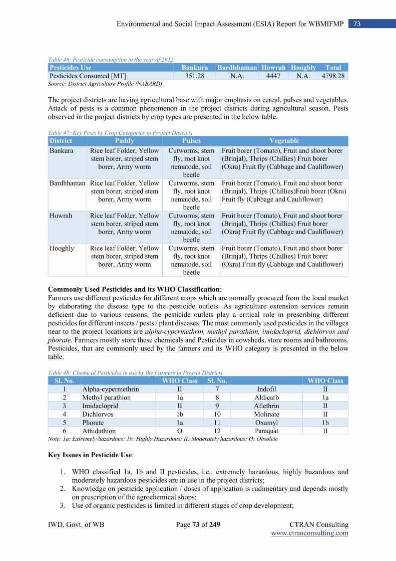
IWD, Govt. of WB Page 73 of 249 CTRAN Consulting www.ctranconsulting.com
73 Environmental and Social Impact Assessment (ESIA) Report for WBMIFMP
Table 46: Pesticide consumption in the year of 2012
Pesticides Use Bankura Bardhhaman Howrah Hooghly Total
Pesticides Consumed [MT] 351.28 N.A. 4447 N.A. 4798.28 Source: District Agriculture Profile (NABARD)
The project districts are having agricultural base with major emphasis on cereal, pulses and vegetables. Attack of pests is a common phenomenon in the project districts during agricultural season. Pests observed in the project districts by crop types are presented in the below table. Table 47: Key Pests by Crop Categories in Project Districts
District Paddy Pulses Vegetable
Bankura Rice leaf Folder, Yellow stem borer, striped stem
borer, Army worm
Cutworms, stem fly, root knot
nematode, soil beetle
Fruit borer (Tomato), Fruit and shoot borer (Brinjal), Thrips (Chillies) Fruit borer (Okra) Fruit fly (Cabbage and Cauliflower)
Bardhhaman Rice leaf Folder, Yellow stem borer, striped stem
borer, Army worm
Cutworms, stem fly, root knot
nematode, soil beetle
Fruit borer (Tomato), Fruit and shoot borer (Brinjal), Thrips (Chillies)Fruit borer (Okra) Fruit fly (Cabbage and Cauliflower)
Howrah Rice leaf Folder, Yellow stem borer, striped stem
borer, Army worm
Cutworms, stem fly, root knot
nematode, soil beetle
Fruit borer (Tomato), Fruit and shoot borer (Brinjal), Thrips (Chillies) Fruit borer (Okra) Fruit fly (Cabbage and Cauliflower)
Hooghly Rice leaf Folder, Yellow stem borer, striped stem
borer, Army worm
Cutworms, stem fly, root knot
nematode, soil beetle
Fruit borer (Tomato), Fruit and shoot borer (Brinjal), Thrips (Chillies) Fruit borer (Okra) Fruit fly (Cabbage and Cauliflower)
Commonly Used Pesticides and its WHO Classification: Farmers use different pesticides for different crops which are normally procured from the local market by elaborating the disease type to the pesticide outlets. As agriculture extension services remain deficient due to various reasons, the pesticide outlets play a critical role in prescribing different pesticides for different insects / pests / plant diseases. The most commonly used pesticides in the villages near to the project locations are alpha-cypermethrin, methyl parathion, imidacloprid, dichlorvos and
phorate. Farmers mostly store these chemicals and Pesticides in cowsheds, store rooms and bathrooms. Pesticides, that are commonly used by the farmers and its WHO category is presented in the below table. Table 48: Chemical Pesticides in use by the Farmers in Project Districts
Sl. No. WHO Class Sl. No. WHO Class
1 Alpha-cypermethrin II 7 Indofil II
2 Methyl parathion 1a 8 Aldicarb 1a
3 Imidacloprid II 9 Allethrin II
4 Dichlorvos 1b 10 Molinate II
5 Phorate 1a 11 Oxamyl 1b
6 Athidathion O 12 Paraquat II Note: 1a: Extremely hazardous; 1b: Highly Hazardous; II: Moderately hazardous; O: Obsolete
Key Issues in Pesticide Use:
1. WHO classified 1a, 1b and II pesticides, i.e., extremely hazardous, highly hazardous and moderately hazardous pesticides are in use in the project districts;
2. Knowledge on pesticide application / doses of application is rudimentary and depends mostly on prescription of the agrochemical shops;
3. Use of organic pesticides is limited in different stages of crop development;
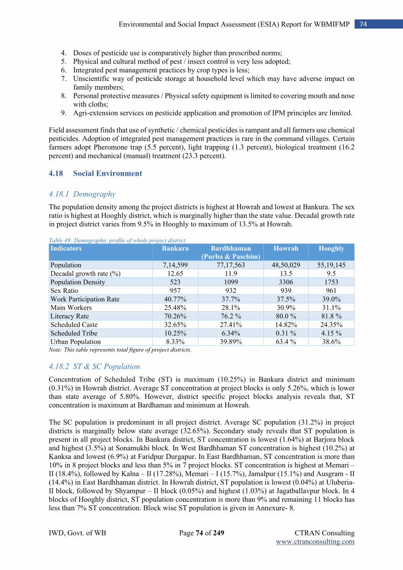
IWD, Govt. of WB Page 74 of 249 CTRAN Consulting www.ctranconsulting.com
74 Environmental and Social Impact Assessment (ESIA) Report for WBMIFMP
4. Doses of pesticide use is comparatively higher than prescribed norms; 5. Physical and cultural method of pest / insect control is very less adopted; 6. Integrated pest management practices by crop types is less; 7. Unscientific way of pesticide storage at household level which may have adverse impact on
family members; 8. Personal protective measures / Physical safety equipment is limited to covering mouth and nose
with cloths; 9. Agri-extension services on pesticide application and promotion of IPM principles are limited.
Field assessment finds that use of synthetic / chemical pesticides is rampant and all farmers use chemical pesticides. Adoption of integrated pest management practices is rare in the command villages. Certain farmers adopt Pheromone trap (5.5 percent), light trapping (1.3 percent), biological treatment (16.2 percent) and mechanical (manual) treatment (23.3 percent).
4.18 Social Environment
4.18.1 Demography
The population density among the project districts is highest at Howrah and lowest at Bankura. The sex ratio is highest at Hooghly district, which is marginally higher than the state value. Decadal growth rate in project district varies from 9.5% in Hooghly to maximum of 13.5% at Howrah. Table 49: Demographic profile of whole project district
Indicators Bankura Bardhhaman
(Purba & Paschim)
Howrah Hooghly
Population 7,14,599 77,17,563 48,50,029 55,19,145
Decadal growth rate (%) 12.65 11.9 13.5 9.5
Population Density 523 1099 3306 1753
Sex Ratio 957 932 939 961
Work Participation Rate 40.77% 37.7% 37.5% 39.0%
Main Workers 25.48% 28.1% 30.9% 31.1%
Literacy Rate 70.26% 76.2 % 80.0 % 81.8 %
Scheduled Caste 32.65% 27.41% 14.82% 24.35%
Scheduled Tribe 10.25% 6.34% 0.31 % 4.15 %
Urban Population 8.33% 39.89% 63.4 % 38.6% Note: This table represents total figure of project districts.
4.18.2 ST & SC Population
Concentration of Scheduled Tribe (ST) is maximum (10.25%) in Bankura district and minimum (0.31%) in Howrah district. Average ST concentration at project blocks is only 5.26%, which is lower than state average of 5.80%. However, district specific project blocks analysis reveals that, ST concentration is maximum at Bardhaman and minimum at Howrah. The SC population is predominant in all project district. Average SC population (31.2%) in project districts is marginally below state average (32.65%). Secondary study reveals that ST population is present in all project blocks. In Bankura district, ST concentration is lowest (1.64%) at Barjora block and highest (3.5%) at Sonamukhi block. In West Bardhhaman ST concentration is highest (10.2%) at Kanksa and lowest (6.9%) at Faridpur Durgapur. In East Bardhhaman, ST concentration is more than 10% in 8 project blocks and less than 5% in 7 project blocks. ST concentration is highest at Memari – II (18.4%), followed by Kalna – II (17.28%), Memari – I (15.7%), Jamalpur (15.1%) and Ausgram - II (14.4%) in East Bardhhaman district. In Howrah district, ST population is lowest (0.04%) at Uluberia-II block, followed by Shyampur – II block (0.05%) and highest (1.03%) at Jagatballavpur block. In 4 blocks of Hooghly district, ST population concentration is more than 9% and remaining 11 blocks has less than 7% ST concentration. Block wise ST population is given in Annexure- 8.
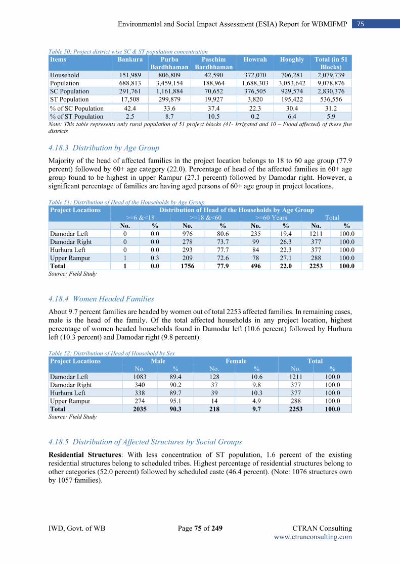
IWD, Govt. of WB Page 75 of 249 CTRAN Consulting www.ctranconsulting.com
75 Environmental and Social Impact Assessment (ESIA) Report for WBMIFMP
Table 50: Project district wise SC & ST population concentration
Items Bankura Purba
Bardhhaman
Paschim
Bardhhaman
Howrah Hooghly Total (in 51
Blocks)
Household 151,989 806,809 42,590 372,070 706,281 2,079,739
Population 688,813 3,459,154 188,964 1,688,303 3,053,642 9,078,876
SC Population 291,761 1,161,884 70,652 376,505 929,574 2,830,376
ST Population 17,508 299,879 19,927 3,820 195,422 536,556 % of SC Population 42.4 33.6 37.4 22.3 30.4 31.2
% of ST Population 2.5 8.7 10.5 0.2 6.4 5.9 Note: This table represents only rural population of 51 project blocks (41- Irrigated and 10 – Flood affected) of these five
districts
4.18.3 Distribution by Age Group
Majority of the head of affected families in the project location belongs to 18 to 60 age group (77.9 percent) followed by 60+ age category (22.0). Percentage of head of the affected families in 60+ age group found to be highest in upper Rampur (27.1 percent) followed by Damodar right. However, a significant percentage of families are having aged persons of 60+ age group in project locations. Table 51: Distribution of Head of the Households by Age Group
Project Locations Distribution of Head of the Households by Age Group
>=6 &<18 >=18 &<60 >=60 Years Total
No. % No. % No. % No. %
Damodar Left 0 0.0 976 80.6 235 19.4 1211 100.0
Damodar Right 0 0.0 278 73.7 99 26.3 377 100.0
Hurhura Left 0 0.0 293 77.7 84 22.3 377 100.0
Upper Rampur 1 0.3 209 72.6 78 27.1 288 100.0
Total 1 0.0 1756 77.9 496 22.0 2253 100.0 Source: Field Study
4.18.4 Women Headed Families
About 9.7 percent families are headed by women out of total 2253 affected families. In remaining cases, male is the head of the family. Of the total affected households in any project location, highest percentage of women headed households found in Damodar left (10.6 percent) followed by Hurhura left (10.3 percent) and Damodar right (9.8 percent). Table 52: Distribution of Head of Household by Sex
Project Locations Male Female Total
No. % No. % No. %
Damodar Left 1083 89.4 128 10.6 1211 100.0
Damodar Right 340 90.2 37 9.8 377 100.0
Hurhura Left 338 89.7 39 10.3 377 100.0
Upper Rampur 274 95.1 14 4.9 288 100.0
Total 2035 90.3 218 9.7 2253 100.0 Source: Field Study
4.18.5 Distribution of Affected Structures by Social Groups
Residential Structures: With less concentration of ST population, 1.6 percent of the existing residential structures belong to scheduled tribes. Highest percentage of residential structures belong to other categories (52.0 percent) followed by scheduled caste (46.4 percent). (Note: 1076 structures own by 1057 families).
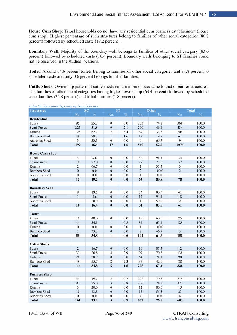
IWD, Govt. of WB Page 76 of 249 CTRAN Consulting www.ctranconsulting.com
76 Environmental and Social Impact Assessment (ESIA) Report for WBMIFMP
House Cum Shop: Tribal households do not have any residential cum business establishment (house cum shop). Highest percentage of such structures belong to families of other social categories (80.8 percent) followed by scheduled caste (19.2 percent). Boundary Wall: Majority of the boundary wall belongs to families of other social category (83.6 percent) followed by scheduled caste (16.4 percent). Boundary walls belonging to ST families could not be observed in the studied locations. Toilet: Around 64.6 percent toilets belong to families of other social categories and 34.8 percent to scheduled caste and only 0.6 percent belongs to tribal families. Cattle Sheds: Ownership pattern of cattle sheds remain more or less same to that of earlier structures. The families of other social categories having highest ownership (63.4 percent) followed by scheduled caste families (34.8 percent) and tribal families (1.8 percent). Table 53: Structural Typology by Social Groups
Structures SC ST Other Total
No. % No. % No. % No. %
Residential
Pucca 95 25.8 0 0.0 273 74.2 368 100.0
Semi-Pucca 225 51.8 9 2.1 200 46.1 434 100.0
Kutcha 128 62.7 7 3.4 69 33.8 204 100.0
Bamboo Shed 48 78.7 1 1.6 12 19.7 61 100.0
Asbestos Shed 3 33.3 0 0.0 6 66.7 9 100.0
Total 499 46.4 17 1.6 560 52.0 1076 100.0
House Cum Shop
Pucca 3 8.6 0 0.0 32 91.4 35 100.0
Semi-Pucca 10 27.0 0 0.0 27 73.0 37 100.0
Kutcha 2 66.7 0 0.0 1 33.3 3 100.0
Bamboo Shed 0 0.0 0 0.0 2 100.0 2 100.0
Asbestos Shed 0 0.0 0 0.0 1 100.0 1 100.0
Total 15 19.2 0 0.0 63 80.8 78 100.0
Boundary Wall
Pucca 8 19.5 0 0.0 33 80.5 41 100.0
Semi-Pucca 1 5.6 0 0.0 17 94.4 18 100.0
Asbestos Shed 1 50.0 0 0.0 1 50.0 2 100.0
Total 10 16.4 0 0.0 51 83.6 61 100.0
Toilet
Pucca 10 40.0 0 0.0 15 60.0 25 100.0
Semi-Pucca 44 34.1 1 0.8 84 65.1 129 100.0
Kutcha 0 0.0 0 0.0 1 100.0 1 100.0
Bamboo Shed 1 33.3 0 0.0 2 66.7 3 100.0
Total 55 34.8 1 0.6 102 64.6 158 100.0
Cattle Sheds
Pucca 2 16.7 0 0.0 10 83.3 12 100.0
Semi-Pucca 37 26.8 4 2.9 97 70.3 138 100.0
Kutcha 26 28.9 0 0.0 64 71.1 90 100.0
Bamboo Shed 49 55.7 2 2.3 37 42.0 88 100.0
Total 114 34.8 6 1.8 208 63.4 328 100.0
Business Shop
Pucca 55 19.7 2 0.7 222 79.6 279 100.0
Semi-Pucca 93 25.0 3 0.8 276 74.2 372 100.0
Kutcha 3 20.0 0 0.0 12 80.0 15 100.0
Bamboo Shed 10 43.5 0 0.0 13 56.5 23 100.0
Asbestos Shed 0 0.0 0 0.0 4 100.0 4 100.0
Total 161 23.2 5 0.7 527 76.0 693 100.0
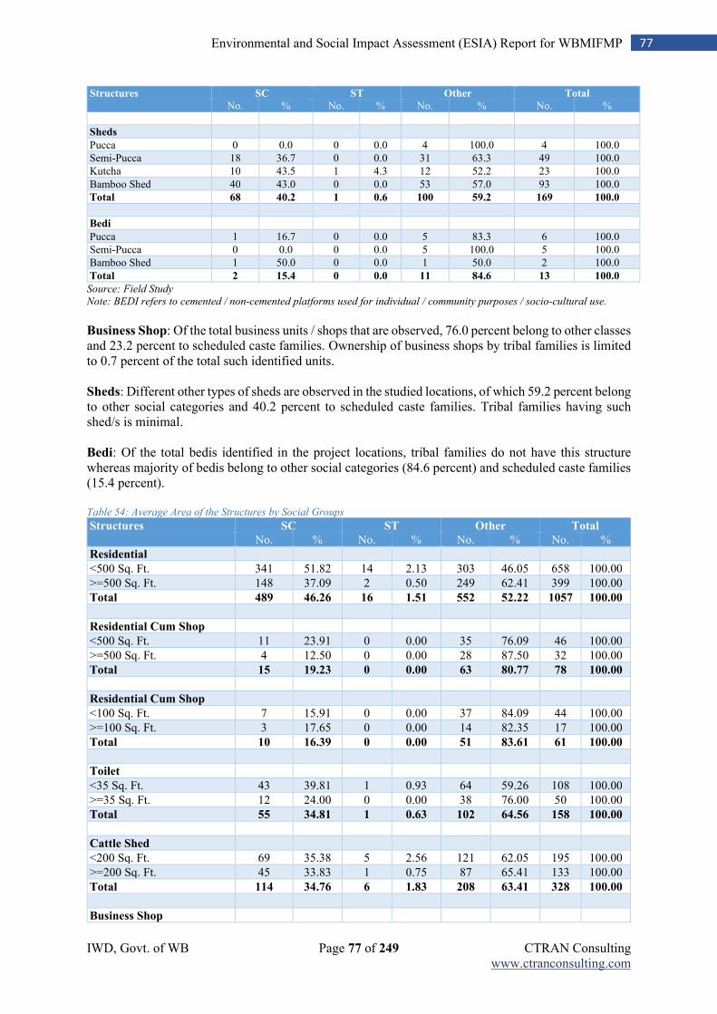
IWD, Govt. of WB Page 77 of 249 CTRAN Consulting www.ctranconsulting.com
77 Environmental and Social Impact Assessment (ESIA) Report for WBMIFMP
Structures SC ST Other Total
No. % No. % No. % No. %
Sheds
Pucca 0 0.0 0 0.0 4 100.0 4 100.0
Semi-Pucca 18 36.7 0 0.0 31 63.3 49 100.0
Kutcha 10 43.5 1 4.3 12 52.2 23 100.0
Bamboo Shed 40 43.0 0 0.0 53 57.0 93 100.0
Total 68 40.2 1 0.6 100 59.2 169 100.0
Bedi
Pucca 1 16.7 0 0.0 5 83.3 6 100.0
Semi-Pucca 0 0.0 0 0.0 5 100.0 5 100.0
Bamboo Shed 1 50.0 0 0.0 1 50.0 2 100.0
Total 2 15.4 0 0.0 11 84.6 13 100.0
Source: Field Study Note: BEDI refers to cemented / non-cemented platforms used for individual / community purposes / socio-cultural use. Business Shop: Of the total business units / shops that are observed, 76.0 percent belong to other classes and 23.2 percent to scheduled caste families. Ownership of business shops by tribal families is limited to 0.7 percent of the total such identified units. Sheds: Different other types of sheds are observed in the studied locations, of which 59.2 percent belong to other social categories and 40.2 percent to scheduled caste families. Tribal families having such shed/s is minimal. Bedi: Of the total bedis identified in the project locations, tribal families do not have this structure whereas majority of bedis belong to other social categories (84.6 percent) and scheduled caste families (15.4 percent). Table 54: Average Area of the Structures by Social Groups
Structures SC ST Other Total
No. % No. % No. % No. %
Residential
<500 Sq. Ft. 341 51.82 14 2.13 303 46.05 658 100.00
>=500 Sq. Ft. 148 37.09 2 0.50 249 62.41 399 100.00
Total 489 46.26 16 1.51 552 52.22 1057 100.00
Residential Cum Shop
<500 Sq. Ft. 11 23.91 0 0.00 35 76.09 46 100.00
>=500 Sq. Ft. 4 12.50 0 0.00 28 87.50 32 100.00
Total 15 19.23 0 0.00 63 80.77 78 100.00
Residential Cum Shop
<100 Sq. Ft. 7 15.91 0 0.00 37 84.09 44 100.00
>=100 Sq. Ft. 3 17.65 0 0.00 14 82.35 17 100.00
Total 10 16.39 0 0.00 51 83.61 61 100.00
Toilet
<35 Sq. Ft. 43 39.81 1 0.93 64 59.26 108 100.00
>=35 Sq. Ft. 12 24.00 0 0.00 38 76.00 50 100.00
Total 55 34.81 1 0.63 102 64.56 158 100.00
Cattle Shed
<200 Sq. Ft. 69 35.38 5 2.56 121 62.05 195 100.00
>=200 Sq. Ft. 45 33.83 1 0.75 87 65.41 133 100.00
Total 114 34.76 6 1.83 208 63.41 328 100.00
Business Shop
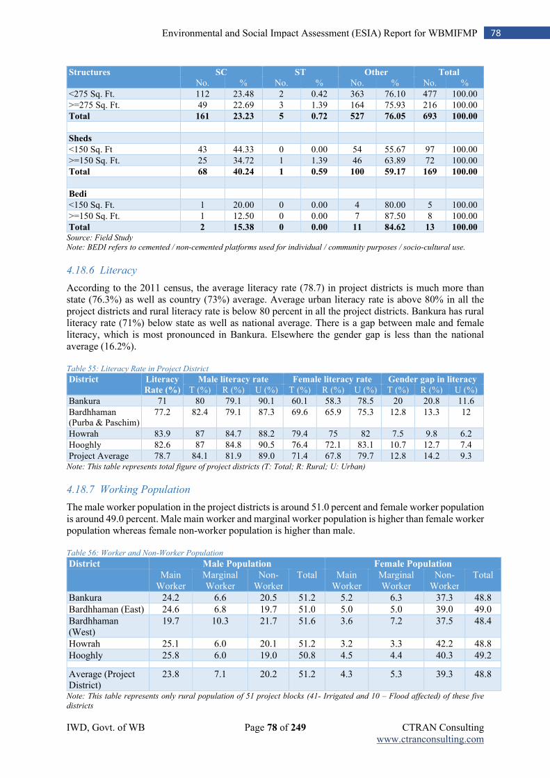
IWD, Govt. of WB Page 78 of 249 CTRAN Consulting www.ctranconsulting.com
78 Environmental and Social Impact Assessment (ESIA) Report for WBMIFMP
Structures SC ST Other Total
No. % No. % No. % No. %
<275 Sq. Ft. 112 23.48 2 0.42 363 76.10 477 100.00
>=275 Sq. Ft. 49 22.69 3 1.39 164 75.93 216 100.00
Total 161 23.23 5 0.72 527 76.05 693 100.00
Sheds
<150 Sq. Ft 43 44.33 0 0.00 54 55.67 97 100.00
>=150 Sq. Ft. 25 34.72 1 1.39 46 63.89 72 100.00
Total 68 40.24 1 0.59 100 59.17 169 100.00
Bedi
<150 Sq. Ft. 1 20.00 0 0.00 4 80.00 5 100.00
>=150 Sq. Ft. 1 12.50 0 0.00 7 87.50 8 100.00
Total 2 15.38 0 0.00 11 84.62 13 100.00 Source: Field Study Note: BEDI refers to cemented / non-cemented platforms used for individual / community purposes / socio-cultural use.
4.18.6 Literacy
According to the 2011 census, the average literacy rate (78.7) in project districts is much more than state (76.3%) as well as country (73%) average. Average urban literacy rate is above 80% in all the project districts and rural literacy rate is below 80 percent in all the project districts. Bankura has rural literacy rate (71%) below state as well as national average. There is a gap between male and female literacy, which is most pronounced in Bankura. Elsewhere the gender gap is less than the national average (16.2%). Table 55: Literacy Rate in Project District
District Literacy
Rate (%)
Male literacy rate Female literacy rate Gender gap in literacy
T (%) R (%) U (%) T (%) R (%) U (%) T (%) R (%) U (%)
Bankura 71 80 79.1 90.1 60.1 58.3 78.5 20 20.8 11.6
Bardhhaman (Purba & Paschim)
77.2 82.4 79.1 87.3 69.6 65.9 75.3 12.8 13.3 12
Howrah 83.9 87 84.7 88.2 79.4 75 82 7.5 9.8 6.2
Hooghly 82.6 87 84.8 90.5 76.4 72.1 83.1 10.7 12.7 7.4
Project Average 78.7 84.1 81.9 89.0 71.4 67.8 79.7 12.8 14.2 9.3 Note: This table represents total figure of project districts (T: Total; R: Rural; U: Urban)
4.18.7 Working Population
The male worker population in the project districts is around 51.0 percent and female worker population is around 49.0 percent. Male main worker and marginal worker population is higher than female worker population whereas female non-worker population is higher than male. Table 56: Worker and Non-Worker Population
District Male Population Female Population Main
Worker Marginal Worker
Non-Worker
Total Main Worker
Marginal Worker
Non-Worker
Total
Bankura 24.2 6.6 20.5 51.2 5.2 6.3 37.3 48.8
Bardhhaman (East) 24.6 6.8 19.7 51.0 5.0 5.0 39.0 49.0
Bardhhaman (West)
19.7 10.3 21.7 51.6 3.6 7.2 37.5 48.4
Howrah 25.1 6.0 20.1 51.2 3.2 3.3 42.2 48.8
Hooghly 25.8 6.0 19.0 50.8 4.5 4.4 40.3 49.2
Average (Project District)
23.8 7.1 20.2 51.2 4.3 5.3 39.3 48.8
Note: This table represents only rural population of 51 project blocks (41- Irrigated and 10 – Flood affected) of these five
districts
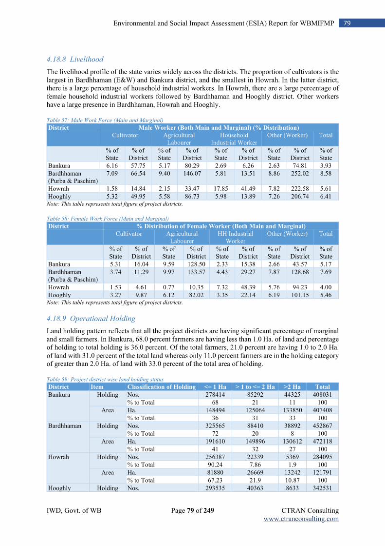
IWD, Govt. of WB Page 79 of 249 CTRAN Consulting www.ctranconsulting.com
79 Environmental and Social Impact Assessment (ESIA) Report for WBMIFMP
4.18.8 Livelihood
The livelihood profile of the state varies widely across the districts. The proportion of cultivators is the largest in Bardhhaman (E&W) and Bankura district, and the smallest in Howrah. In the latter district, there is a large percentage of household industrial workers. In Howrah, there are a large percentage of female household industrial workers followed by Bardhhaman and Hooghly district. Other workers have a large presence in Bardhhaman, Howrah and Hooghly. Table 57: Male Work Force (Main and Marginal)
District Male Worker (Both Main and Marginal) (% Distribution)
Cultivator Agricultural Labourer
Household Industrial Worker
Other (Worker) Total
% of State
% of District
% of State
% of District
% of State
% of District
% of State
% of District
% of State
Bankura 6.16 57.75 5.17 80.29 2.69 6.26 2.63 74.81 3.93
Bardhhaman (Purba & Paschim)
7.09 66.54 9.40 146.07 5.81 13.51 8.86 252.02 8.58
Howrah 1.58 14.84 2.15 33.47 17.85 41.49 7.82 222.58 5.61
Hooghly 5.32 49.95 5.58 86.73 5.98 13.89 7.26 206.74 6.41 Note: This table represents total figure of project districts. Table 58: Female Work Force (Main and Marginal)
District % Distribution of Female Worker (Both Main and Marginal) Cultivator Agricultural
Labourer HH Industrial
Worker Other (Worker) Total
% of State
% of District
% of State
% of District
% of State
% of District
% of State
% of District
% of State
Bankura 5.31 16.04 9.59 128.50 2.33 15.38 2.66 43.57 5.17
Bardhhaman (Purba & Paschim)
3.74 11.29 9.97 133.57 4.43 29.27 7.87 128.68 7.69
Howrah 1.53 4.61 0.77 10.35 7.32 48.39 5.76 94.23 4.00
Hooghly 3.27 9.87 6.12 82.02 3.35 22.14 6.19 101.15 5.46 Note: This table represents total figure of project districts.
4.18.9 Operational Holding
Land holding pattern reflects that all the project districts are having significant percentage of marginal and small farmers. In Bankura, 68.0 percent farmers are having less than 1.0 Ha. of land and percentage of holding to total holding is 36.0 percent. Of the total farmers, 21.0 percent are having 1.0 to 2.0 Ha. of land with 31.0 percent of the total land whereas only 11.0 percent farmers are in the holding category of greater than 2.0 Ha. of land with 33.0 percent of the total area of holding. Table 59: Project district wise land holding status
District Item Classification of Holding <= 1 Ha > 1 to <= 2 Ha >2 Ha Total
Bankura Holding Nos. 278414 85292 44325 408031
% to Total 68 21 11 100
Area Ha. 148494 125064 133850 407408
% to Total 36 31 33 100
Bardhhaman Holding Nos. 325565 88410 38892 452867
% to Total 72 20 8 100
Area Ha. 191610 149896 130612 472118
% to Total 41 32 27 100
Howrah Holding Nos. 256387 22339 5369 284095
% to Total 90.24 7.86 1.9 100
Area Ha. 81880 26669 13242 121791
% to Total 67.23 21.9 10.87 100
Hooghly Holding Nos. 293535 40363 8633 342531
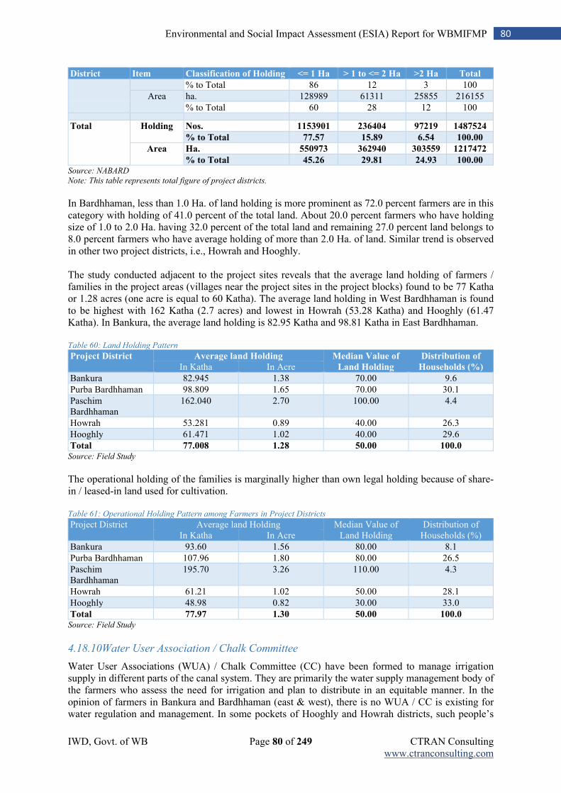
IWD, Govt. of WB Page 80 of 249 CTRAN Consulting www.ctranconsulting.com
80 Environmental and Social Impact Assessment (ESIA) Report for WBMIFMP
District Item Classification of Holding <= 1 Ha > 1 to <= 2 Ha >2 Ha Total
% to Total 86 12 3 100
Area ha. 128989 61311 25855 216155
% to Total 60 28 12 100
Total Holding Nos. 1153901 236404 97219 1487524
% to Total 77.57 15.89 6.54 100.00
Area Ha. 550973 362940 303559 1217472
% to Total 45.26 29.81 24.93 100.00 Source: NABARD
Note: This table represents total figure of project districts. In Bardhhaman, less than 1.0 Ha. of land holding is more prominent as 72.0 percent farmers are in this category with holding of 41.0 percent of the total land. About 20.0 percent farmers who have holding size of 1.0 to 2.0 Ha. having 32.0 percent of the total land and remaining 27.0 percent land belongs to 8.0 percent farmers who have average holding of more than 2.0 Ha. of land. Similar trend is observed in other two project districts, i.e., Howrah and Hooghly. The study conducted adjacent to the project sites reveals that the average land holding of farmers / families in the project areas (villages near the project sites in the project blocks) found to be 77 Katha or 1.28 acres (one acre is equal to 60 Katha). The average land holding in West Bardhhaman is found to be highest with 162 Katha (2.7 acres) and lowest in Howrah (53.28 Katha) and Hooghly (61.47 Katha). In Bankura, the average land holding is 82.95 Katha and 98.81 Katha in East Bardhhaman. Table 60: Land Holding Pattern
Project District Average land Holding Median Value of
Land Holding
Distribution of
Households (%) In Katha In Acre
Bankura 82.945 1.38 70.00 9.6
Purba Bardhhaman 98.809 1.65 70.00 30.1
Paschim Bardhhaman
162.040 2.70 100.00 4.4
Howrah 53.281 0.89 40.00 26.3
Hooghly 61.471 1.02 40.00 29.6
Total 77.008 1.28 50.00 100.0 Source: Field Study
The operational holding of the families is marginally higher than own legal holding because of share-in / leased-in land used for cultivation. Table 61: Operational Holding Pattern among Farmers in Project Districts
Project District Average land Holding Median Value of Land Holding
Distribution of Households (%) In Katha In Acre
Bankura 93.60 1.56 80.00 8.1
Purba Bardhhaman 107.96 1.80 80.00 26.5
Paschim Bardhhaman
195.70 3.26 110.00 4.3
Howrah 61.21 1.02 50.00 28.1
Hooghly 48.98 0.82 30.00 33.0
Total 77.97 1.30 50.00 100.0 Source: Field Study
4.18.10Water User Association / Chalk Committee
Water User Associations (WUA) / Chalk Committee (CC) have been formed to manage irrigation supply in different parts of the canal system. They are primarily the water supply management body of the farmers who assess the need for irrigation and plan to distribute in an equitable manner. In the opinion of farmers in Bankura and Bardhhaman (east & west), there is no WUA / CC is existing for water regulation and management. In some pockets of Hooghly and Howrah districts, such people’s
IWD, Govt. of WB Page 81 of 249 CTRAN Consulting www.ctranconsulting.com
81 Environmental and Social Impact Assessment (ESIA) Report for WBMIFMP
organizations are existing. Overall, in 6.0 percent farmers are of the opinion that the WUA / CC is defunct whereas 10.6 percent farmers are of the view that they are existing and in majority of 83.4 percent cases, farmers are of the opinion of non-existence of such association / committee. In such a situation, it is important for the project to examine the current status of WUA / CC in each canal system (main / branch / distributaries) and take promotional and strengthening measures under the project.
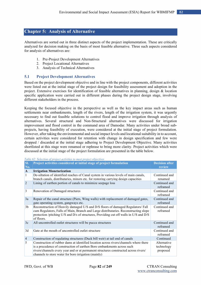
IWD, Govt. of WB Page 82 of 249 CTRAN Consulting www.ctranconsulting.com
82 Environmental and Social Impact Assessment (ESIA) Report for WBMIFMP
Chapter 5: Analysis of Alternative
Alternatives are sorted out in three distinct aspects of the project implementation. These are critically analyzed for decision making on the basis of most feasible alternative. Three such aspects considered for analysis of alternatives are:
1. Pre-Project Development Alternatives 2. Project Locational Alternatives 3. Analysis of Technical Alternatives
5.1 Project Development Alternatives
Based on the project development objective and in line with the project components, different activities were listed out at the initial stage of the project design for feasibility assessment and adoption in the project. Extensive exercises for identification of feasible alternatives in planning, design & location specific application were carried out in different phases during the project design stage, involving different stakeholders in the process. Keeping the focused objective in the perspective as well as the key impact areas such as human settlements near embankments, length of the rivers, length of the irrigation system, it was urgently necessary to find out feasible solutions to control flood and improve irrigation through analysis of alternatives. Several structural and Non-Structural alternatives were discussed for irrigation improvement and flood control in the command area of Damodar. Many activities under broad sub-projects, having feasibility of execution, were considered at the initial stage of project formulation. However, after taking the environmental and social impact levels and locational suitability in to account, certain activities were considered for retention with change in design specification and few were dropped / discarded at the initial stage adhering to Project Development Objective. Many activities shortlisted at this stage were renamed or rephrase to bring more clarity. Project activities which were discussed at the initial stage of the project formulation are presented in the table below. Table 62: Selection of project activities to meet project objectives
Sl.
No.
Project activities considered at initial stage of project formulation Decision after
review
A Irrigation Monetarization
1 De-siltation of identified reaches of Canal system in various levels of main canals, branch canals, distributaries, minors etc. for restoring carrying design capacities
Continued and renamed
2 Lining of earthen portion of canals to minimize seepage loss Continued and reframed
3 Renovation of Damaged structures Continued and reframed
3a Repair of the canal structure (Piers, Wing walls) with replacement of damaged gates, gate operating system, gangways etc.
Continued and reframed
3b Reconstruction of Heavily damaged U/S and D/S floors of damaged Regulators/ Fall cum Regulators, Falls of Main, Branch and Large distributaries. Reconstructing slope protection /pitching U/S and D/s of structures, Providing cut off walls in U/S and D/S of floors.
Continued and reframed
3c All uncontrolled outlet structures will be pucca structures Continued and reframed
3d Gate at the mouth of uncontrolled outlet structure Continued and reframed
4 Construction of regulating structures (Duck bill weir) at tail end of canals Continued
5 Construction of rubber dams at identified location across rivers/channels where there is a precedence of construction of earthen Boro embankments across such rivers/channels every year and or at permanent structures constructed across rivers/ channels to store water for boro irrigation (mainly)
Alternative technology proposed
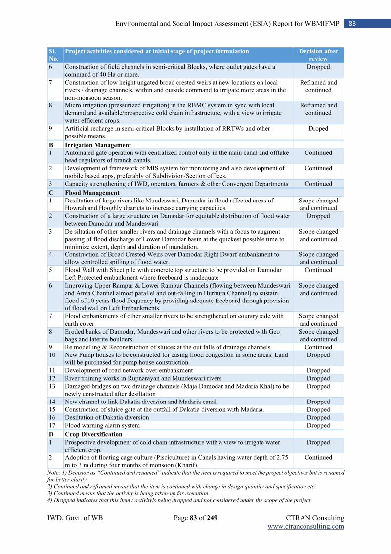
IWD, Govt. of WB Page 83 of 249 CTRAN Consulting www.ctranconsulting.com
83 Environmental and Social Impact Assessment (ESIA) Report for WBMIFMP
Sl.
No.
Project activities considered at initial stage of project formulation Decision after
review
6 Construction of field channels in semi-critical Blocks, where outlet gates have a command of 40 Ha or more.
Dropped
7 Construction of low height ungated broad crested weirs at new locations on local rivers / drainage channels, within and outside command to irrigate more areas in the non-monsoon season.
Reframed and continued
8 Micro irrigation (pressurized irrigation) in the RBMC system in sync with local demand and available/prospective cold chain infrastructure, with a view to irrigate water efficient crops.
Reframed and continued
9 Artificial recharge in semi-critical Blocks by installation of RRTWs and other possible means.
Droped
B Irrigation Management
1 Automated gate operation with centralized control only in the main canal and offtake head regulators of branch canals.
Continued
2 Development of framework of MIS system for monitoring and also development of mobile based apps, preferably of Subdivision/Section offices.
Continued
3 Capacity strengthening of IWD, operators, farmers & other Convergent Departments Continued C Flood Management
1 Desiltation of large rivers like Mundeswari, Damodar in flood affected areas of Howrah and Hooghly districts to increase carrying capacities.
Scope changed and continued
2 Construction of a large structure on Damodar for equitable distribution of flood water between Damodar and Mundeswari
Dropped
3 De siltation of other smaller rivers and drainage channels with a focus to augment passing of flood discharge of Lower Damodar basin at the quickest possible time to minimize extent, depth and duration of inundation.
Scope changed and continued
4 Construction of Broad Crested Weirs over Damodar Right Dwarf embankment to allow controlled spilling of flood water.
Scope changed and continued
5 Flood Wall with Sheet pile with concrete top structure to be provided on Damodar Left Protected embankment where freeboard is inadequate
Continued
6 Improving Upper Rampur & Lower Rampur Channels (flowing between Mundeswari and Amta Channel almost parallel and out-falling in Hurhura Channel) to sustain flood of 10 years flood frequency by providing adequate freeboard through provision of flood wall on Left Embankments.
Scope changed and continued
7 Flood embankments of other smaller rivers to be strengthened on country side with earth cover
Scope changed and continued
8 Eroded banks of Damodar, Mundeswari and other rivers to be protected with Geo bags and laterite boulders.
Scope changed and continued
9 Re modelling & Reconstruction of sluices at the out falls of drainage channels. Continued
10 New Pump houses to be constructed for easing flood congestion in some areas. Land will be purchased for pump house construction
Dropped
11 Development of road network over embankment Dropped
12 River training works in Rupnarayan and Mundeswari rivers Dropped
13 Damaged bridges on two drainage channels (Maja Damodar and Madaria Khal) to be newly constructed after desiltation
Dropped
14 New channel to link Dakatia diversion and Madaria canal Dropped
15 Construction of sluice gate at the outfall of Dakatia diversion with Madaria. Dropped
16 Desiltation of Dakatia diversion Dropped
17 Flood warning alarm system Dropped D Crop Diversification
1 Prospective development of cold chain infrastructure with a view to irrigate water efficient crop.
Dropped
2 Adoption of floating cage culture (Pisciculture) in Canals having water depth of 2.75 m to 3 m during four months of monsoon (Kharif).
Continued
Note: 1) Decision as “Continued and renamed” indicate that the item is required to meet the project objectives but is renamed
for better clarity.
2) Continued and reframed means that the item is continued with change in design quantity and specification etc.
3) Continued means that the activity is being taken-up for execution.
4) Dropped indicates that this item / activityis being dropped and not considered under the scope of the project.
IWD, Govt. of WB Page 84 of 249 CTRAN Consulting www.ctranconsulting.com
84 Environmental and Social Impact Assessment (ESIA) Report for WBMIFMP
5.2 Locational Alternative
Different alternative locations and other alternatives for all project activities were initially thought of during feasibility study process for irrigation improvement and flood management works. Based on the alternative analysis, decision was taken to the best possible alternatives. Environmental & Social implications of selected project activities are considered for alternative study inter-alia supporting the decision-making mechanism. These are analyzed for project activities in construction phase and post-construction phases. The final selected options with quantity for components wise project activity are given in table below.
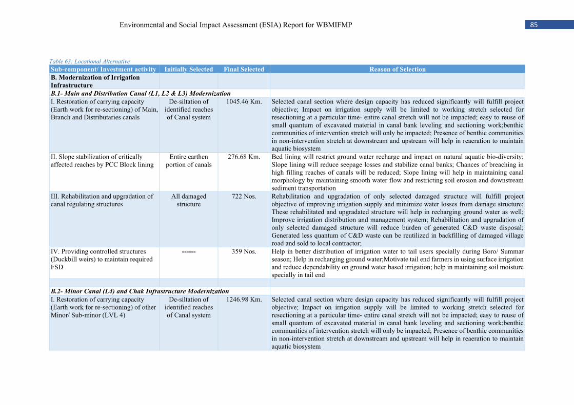
85 Environmental and Social Impact Assessment (ESIA) Report for WBMIFMP
Table 63: Locational Alternative
Sub-component/ Investment activity Initially Selected Final Selected Reason of Selection
B. Modernization of Irrigation
Infrastructure
B.1- Main and Distribution Canal (L1, L2 & L3) Modernization
I. Restoration of carrying capacity (Earth work for re-sectioning) of Main, Branch and Distributaries canals
De-siltation of identified reaches of Canal system
1045.46 Km. Selected canal section where design capacity has reduced significantly will fulfill project objective; Impact on irrigation supply will be limited to working stretch selected for resectioning at a particular time- entire canal stretch will not be impacted; easy to reuse of small quantum of excavated material in canal bank leveling and sectioning work;benthic communities of intervention stretch will only be impacted; Presence of benthic communities in non-intervention stretch at downstream and upstream will help in reaeration to maintain aquatic biosystem
II. Slope stabilization of critically affected reaches by PCC Block lining
Entire earthen portion of canals
276.68 Km. Bed lining will restrict ground water recharge and impact on natural aquatic bio-diversity; Slope lining will reduce seepage losses and stabilize canal banks; Chances of breaching in high filling reaches of canals will be reduced; Slope lining will help in maintaining canal morphology by maintaining smooth water flow and restricting soil erosion and downstream sediment transportation
III. Rehabilitation and upgradation of canal regulating structures
All damaged structure
722 Nos. Rehabilitation and upgradation of only selected damaged structure will fulfill project objective of improving irrigation supply and minimize water losses from damage structure; These rehabilitated and upgradated structure will help in recharging ground water as well; Improve irrigation distribution and management system; Rehabilitation and upgradation of only selected damaged structure will reduce burden of generated C&D waste disposal; Generated less quantum of C&D waste can be reutilized in backfilling of damaged village road and sold to local contractor;
IV. Providing controlled structures (Duckbill weirs) to maintain required FSD
------ 359 Nos. Help in better distribution of irrigation water to tail users specially during Boro/ Summar season; Help in recharging ground water;Motivate tail end farmers in using surface irrigation and reduce dependability on ground water based irrigation; help in maintaining soil moisture specially in tail end
B.2- Minor Canal (L4) and Chak Infrastructure Modernization
I. Restoration of carrying capacity (Earth work for re-sectioning) of other Minor/ Sub-minor (LVL 4)
De-siltation of identified reaches of Canal system
1246.98 Km. Selected canal section where design capacity has reduced significantly will fulfill project objective; Impact on irrigation supply will be limited to working stretch selected for resectioning at a particular time- entire canal stretch will not be impacted; easy to reuse of small quantum of excavated material in canal bank leveling and sectioning work;benthic communities of intervention stretch will only be impacted; Presence of benthic communities in non-intervention stretch at downstream and upstream will help in reaeration to maintain aquatic biosystem
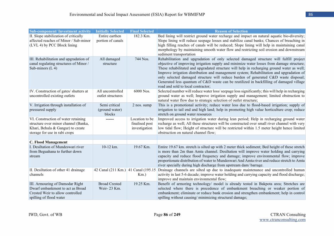
IWD, Govt. of WB Page 86 of 249 CTRAN Consulting www.ctranconsulting.com
86 Environmental and Social Impact Assessment (ESIA) Report for WBMIFMP
Sub-component/ Investment activity Initially Selected Final Selected Reason of Selection
II. Slope stabilization of critically affected reaches of Minor / Sub-minor (LVL 4) by PCC Block lining
Entire earthen portion of canals
182.3 Km. Bed lining will restrict ground water recharge and impact on natural aquatic bio-diversity; Slope lining will reduce seepage losses and stabilize canal banks; Chances of breaching in high filling reaches of canals will be reduced; Slope lining will help in maintaining canal morphology by maintaining smooth water flow and restricting soil erosion and downstream sediment transportation
III. Rehabilitation and upgradation of canal regulating structures of Minor / Sub-minors (L 4)
All damaged structure
744 Nos. Rehabilitation and upgradation of only selected damaged structure will fulfill project objective of improving irrigation supply and minimize water losses from damage structure; These rehabilitated and upgradated structure will help in recharging ground water as well; Improve irrigation distribution and management system; Rehabilitation and upgradation of only selected damaged structure will reduce burden of generated C&D waste disposal; Generated less quantum of C&D waste can be reutilized in backfilling of damaged village road and sold to local contractor;
IV. Construction of gates/ shutters at uncontrolled existing outlets
All uncontrolled outlet structures
6000 Nos. Selected number will reduce water loss/ seepage loss significantly; this will help in recharging ground water as well; Improve irrigation supply and management; limited obstruction to natural water flow due to strategic selection of outlet structure;
V. Irrigation through installation of pressured supply
Semi critical (ground water)
blocks
2 nos. sump This is a promotional activity; reduce water loss due to flood-based irrigation; supply of irrigation to tail end and high land; help in promoting high value horticulture crop; reduce stretch on ground water resources
VI. Construction of water retaining structure over minor channel (Banka, Khari, Behula & Gangur) to create storage for use in rabi crops
------ Location to be finalised post investigation
Improved access to irrigation water during lean period; Help in recharging ground water recharge as well; All these structures will be constructed over small river channel with very low tidal flow; Height of structure will be restricted within 1.5 meter height hence limited obstruction on natural channel flow;
C. Flood Management
I. Desiltation of Mundeswari river from Beguahana to further down stream
10-12 km. 19.67 Km. Entire 19.67 km. stretch is silted up with 2 meter thick sediment; Bed height of these stretch is more than 2m than Amta channel. Desiltation will improve water holding and carrying capacity and reduce flood frequency and damage; improve environmental flow; improve proportionate distribution of water to Mundeswari And Amta river and reduce stretch to Amta river specially during high discharge from upstream dam/ barrage.
II. Desiltation of other 41 drainage channels
42 Canal (211 Km.) 41 Canal (195.15 Km.)
Drainage channels are silted up due to inadequate maintenance and uncontrolled human activity in last 5-6 decade; improve water holding and carrying capacity and flood discharge; improve and maintain environmental flow;
III. Armouring of Damodar Right Dwarf embankment to act as Broad Crested Weir to allow controlled spilling of flood water
Broad Crested Weir- 23 Km.
19.25 Km. Benefit of armoring technology/ model is already tested in Bakpota area; Stretches are selected where there is precedence of embankment breaching or weaker portion of embankment; eliminate or reduce bank erosion and strengthen embankment; help in control spilling without causing/ minimizing structural damage;
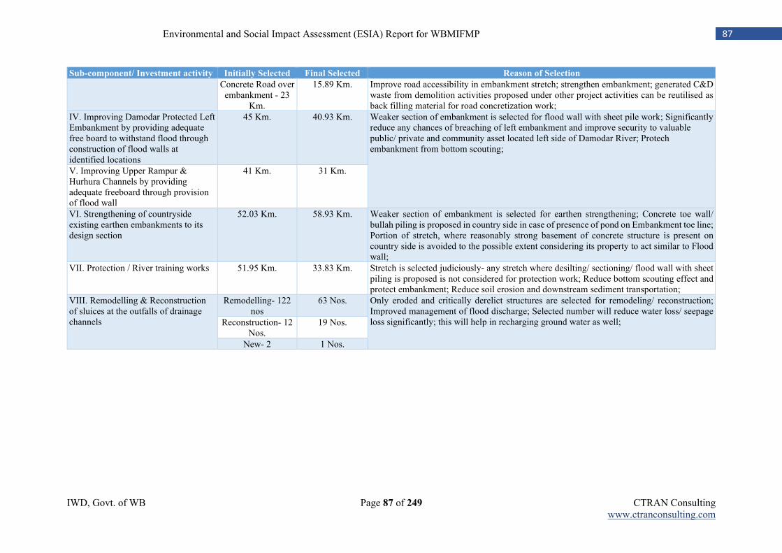
IWD, Govt. of WB Page 87 of 249 CTRAN Consulting www.ctranconsulting.com
87 Environmental and Social Impact Assessment (ESIA) Report for WBMIFMP
Sub-component/ Investment activity Initially Selected Final Selected Reason of Selection
Concrete Road over embankment - 23
Km.
15.89 Km. Improve road accessibility in embankment stretch; strengthen embankment; generated C&D waste from demolition activities proposed under other project activities can be reutilised as back filling material for road concretization work;
IV. Improving Damodar Protected Left Embankment by providing adequate free board to withstand flood through construction of flood walls at identified locations
45 Km. 40.93 Km. Weaker section of embankment is selected for flood wall with sheet pile work; Significantly reduce any chances of breaching of left embankment and improve security to valuable public/ private and community asset located left side of Damodar River; Protech embankment from bottom scouting;
V. Improving Upper Rampur & Hurhura Channels by providing adequate freeboard through provision of flood wall
41 Km. 31 Km.
VI. Strengthening of countryside existing earthen embankments to its design section
52.03 Km. 58.93 Km. Weaker section of embankment is selected for earthen strengthening; Concrete toe wall/ bullah piling is proposed in country side in case of presence of pond on Embankment toe line; Portion of stretch, where reasonably strong basement of concrete structure is present on country side is avoided to the possible extent considering its property to act similar to Flood wall;
VII. Protection / River training works 51.95 Km. 33.83 Km. Stretch is selected judiciously- any stretch where desilting/ sectioning/ flood wall with sheet piling is proposed is not considered for protection work; Reduce bottom scouting effect and protect embankment; Reduce soil erosion and downstream sediment transportation;
VIII. Remodelling & Reconstruction of sluices at the outfalls of drainage channels
Remodelling- 122 nos
63 Nos. Only eroded and critically derelict structures are selected for remodeling/ reconstruction; Improved management of flood discharge; Selected number will reduce water loss/ seepage loss significantly; this will help in recharging ground water as well; Reconstruction- 12
Nos. 19 Nos.
New- 2 1 Nos.
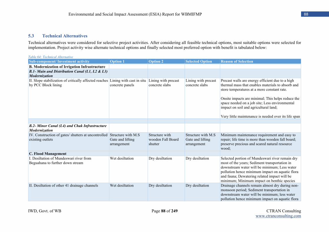
IWD, Govt. of WB Page 88 of 249 CTRAN Consulting www.ctranconsulting.com
88 Environmental and Social Impact Assessment (ESIA) Report for WBMIFMP
5.3 Technical Alternatives
Technical alternatives were considered for selective project activities. After considering all feasible technical options, most suitable options were selected for implementation. Project activity wise alternate technical options and finally selected most preferred option with benefit is tabulated below: Table 64: Technical Alternative
Sub-component/ Investment activity Option 1 Option 2 Selected Option Reason of Selection B. Modernization of Irrigation Infrastructure
B.1- Main and Distribution Canal (L1, L2 & L3)
Modernization
II. Slope stabilization of critically affected reaches by PCC Block lining
Lining with cast in situ concrete panels
Lining with precast concrete slabs
Lining with precast concrete slabs
Precast walls are energy efficient due to a high thermal mass that enables materials to absorb and store temperatures at a more constant rate. Onsite impacts are minimal; This helps reduce the space needed on a job site; Less environmental impact on soil and agricultural land; Very little maintenance is needed over its life span
B.2- Minor Canal (L4) and Chak Infrastructure
Modernization
IV. Construction of gates/ shutters at uncontrolled existing outlets
Structure with M.S Gate and lifting arrangement
Structure with wooden Fall Board shutter
Structure with M.S Gate and lifting arrangement
Minimum maintenance requirement and easy to repair; life time is more than wooden fall board; preserve precious and scared natural resource wood;
C. Flood Management
I. Desiltation of Mundeswari river from Beguahana to further down stream
Wet desiltation Dry desiltation Dry desiltation Selected portion of Mundeswari river remain dry most of the years; Sediment transportation in downstream water will be minimum; Less water pollution hence minimum impact on aquatic flora and fauna; Dewatering related impact will be minimum; Minimum impact on benthic species
II. Desiltation of other 41 drainage channels Wet desiltation Dry desiltation Dry desiltation Drainage channels remain almost dry during non-monsoon period; Sediment transportation in downstream water will be minimum; less water pollution hence minimum impact on aquatic flora
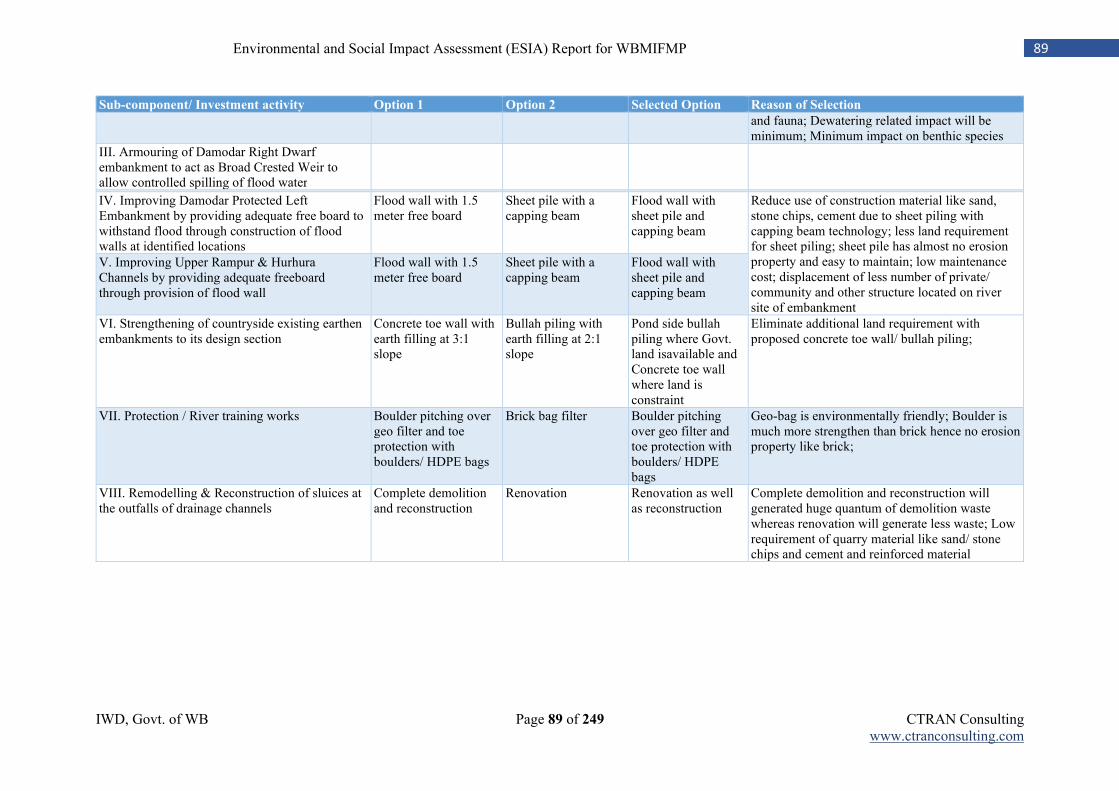
IWD, Govt. of WB Page 89 of 249 CTRAN Consulting www.ctranconsulting.com
89 Environmental and Social Impact Assessment (ESIA) Report for WBMIFMP
Sub-component/ Investment activity Option 1 Option 2 Selected Option Reason of Selection
and fauna; Dewatering related impact will be minimum; Minimum impact on benthic species
III. Armouring of Damodar Right Dwarf embankment to act as Broad Crested Weir to allow controlled spilling of flood water
IV. Improving Damodar Protected Left Embankment by providing adequate free board to withstand flood through construction of flood walls at identified locations
Flood wall with 1.5 meter free board
Sheet pile with a capping beam
Flood wall with sheet pile and capping beam
Reduce use of construction material like sand, stone chips, cement due to sheet piling with capping beam technology; less land requirement for sheet piling; sheet pile has almost no erosion property and easy to maintain; low maintenance cost; displacement of less number of private/ community and other structure located on river site of embankment
V. Improving Upper Rampur & Hurhura Channels by providing adequate freeboard through provision of flood wall
Flood wall with 1.5 meter free board
Sheet pile with a capping beam
Flood wall with sheet pile and capping beam
VI. Strengthening of countryside existing earthen embankments to its design section
Concrete toe wall with earth filling at 3:1 slope
Bullah piling with earth filling at 2:1 slope
Pond side bullah piling where Govt. land isavailable and Concrete toe wall where land is constraint
Eliminate additional land requirement with proposed concrete toe wall/ bullah piling;
VII. Protection / River training works Boulder pitching over geo filter and toe protection with boulders/ HDPE bags
Brick bag filter Boulder pitching over geo filter and toe protection with boulders/ HDPE bags
Geo-bag is environmentally friendly; Boulder is much more strengthen than brick hence no erosion property like brick;
VIII. Remodelling & Reconstruction of sluices at the outfalls of drainage channels
Complete demolition and reconstruction
Renovation Renovation as well as reconstruction
Complete demolition and reconstruction will generated huge quantum of demolition waste whereas renovation will generate less waste; Low requirement of quarry material like sand/ stone chips and cement and reinforced material
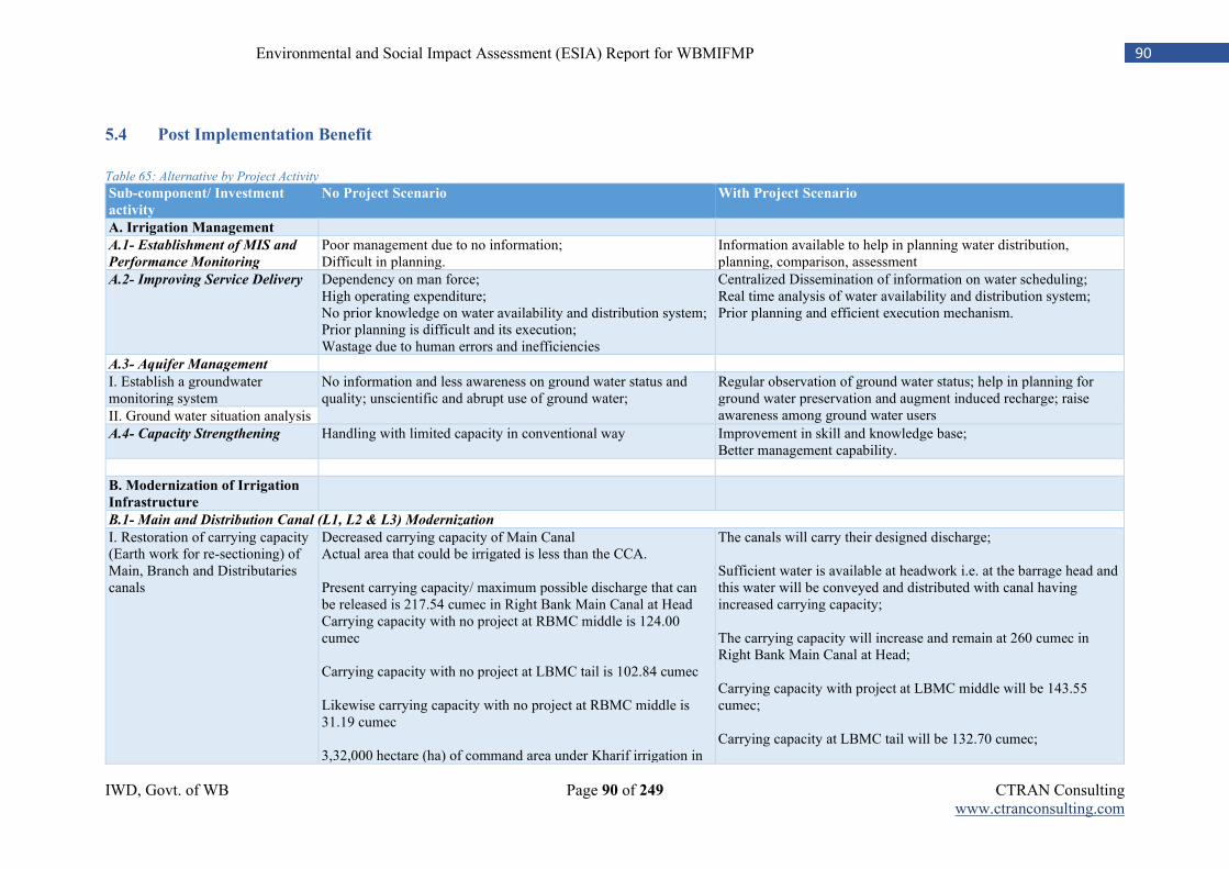
IWD, Govt. of WB Page 90 of 249 CTRAN Consulting www.ctranconsulting.com
90 Environmental and Social Impact Assessment (ESIA) Report for WBMIFMP
5.4 Post Implementation Benefit
Table 65: Alternative by Project Activity
Sub-component/ Investment
activity
No Project Scenario With Project Scenario
A. Irrigation Management
A.1- Establishment of MIS and
Performance Monitoring
Poor management due to no information; Difficult in planning.
Information available to help in planning water distribution, planning, comparison, assessment
A.2- Improving Service Delivery Dependency on man force; High operating expenditure; No prior knowledge on water availability and distribution system; Prior planning is difficult and its execution; Wastage due to human errors and inefficiencies
Centralized Dissemination of information on water scheduling; Real time analysis of water availability and distribution system; Prior planning and efficient execution mechanism.
A.3- Aquifer Management
I. Establish a groundwater monitoring system
No information and less awareness on ground water status and quality; unscientific and abrupt use of ground water;
Regular observation of ground water status; help in planning for ground water preservation and augment induced recharge; raise awareness among ground water users II. Ground water situation analysis
A.4- Capacity Strengthening Handling with limited capacity in conventional way Improvement in skill and knowledge base; Better management capability.
B. Modernization of Irrigation
Infrastructure
B.1- Main and Distribution Canal (L1, L2 & L3) Modernization
I. Restoration of carrying capacity (Earth work for re-sectioning) of Main, Branch and Distributaries canals
Decreased carrying capacity of Main Canal Actual area that could be irrigated is less than the CCA. Present carrying capacity/ maximum possible discharge that can be released is 217.54 cumec in Right Bank Main Canal at Head Carrying capacity with no project at RBMC middle is 124.00 cumec Carrying capacity with no project at LBMC tail is 102.84 cumec Likewise carrying capacity with no project at RBMC middle is 31.19 cumec 3,32,000 hectare (ha) of command area under Kharif irrigation in
The canals will carry their designed discharge; Sufficient water is available at headwork i.e. at the barrage head and this water will be conveyed and distributed with canal having increased carrying capacity; The carrying capacity will increase and remain at 260 cumec in Right Bank Main Canal at Head; Carrying capacity with project at LBMC middle will be 143.55 cumec; Carrying capacity at LBMC tail will be 132.70 cumec;
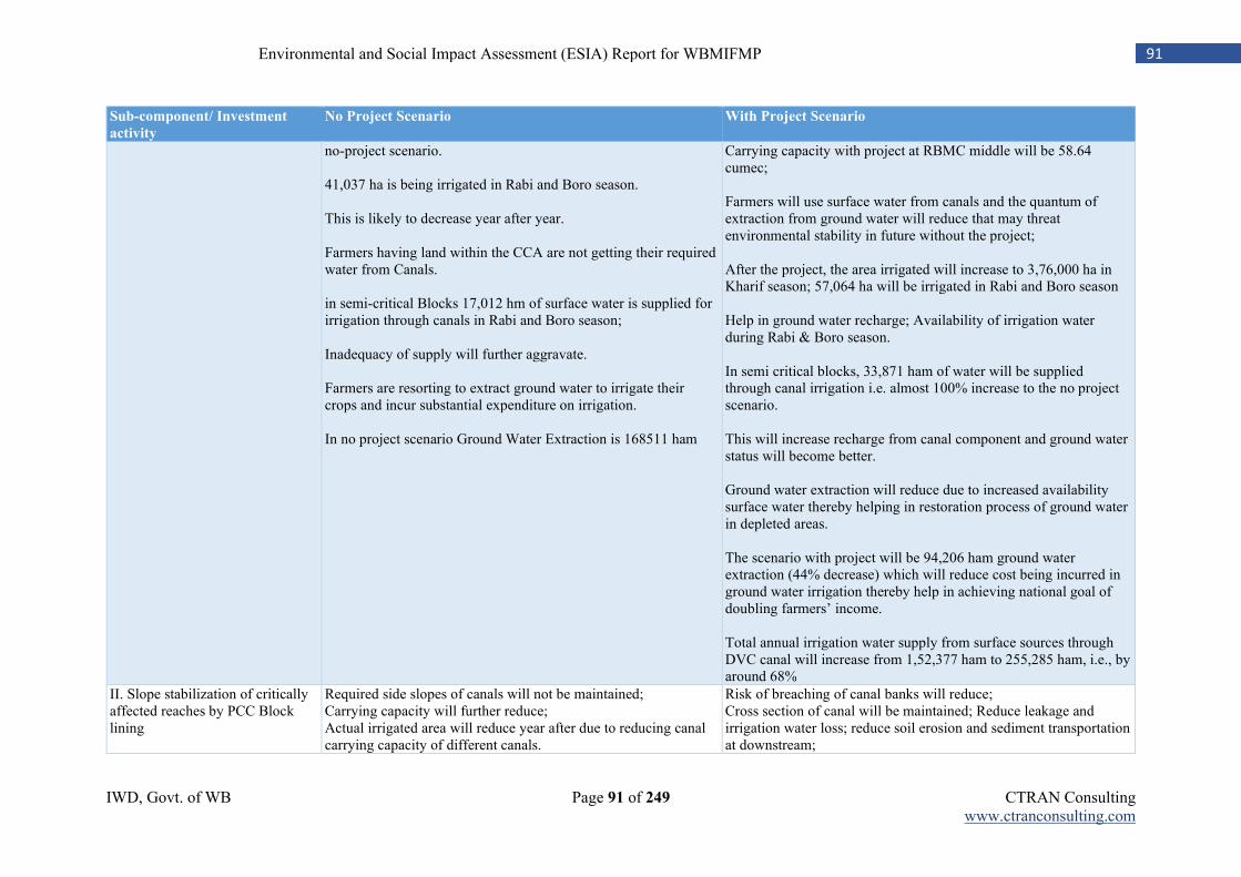
IWD, Govt. of WB Page 91 of 249 CTRAN Consulting www.ctranconsulting.com
91 Environmental and Social Impact Assessment (ESIA) Report for WBMIFMP
Sub-component/ Investment
activity
No Project Scenario With Project Scenario
no-project scenario. 41,037 ha is being irrigated in Rabi and Boro season. This is likely to decrease year after year. Farmers having land within the CCA are not getting their required water from Canals. in semi-critical Blocks 17,012 hm of surface water is supplied for irrigation through canals in Rabi and Boro season; Inadequacy of supply will further aggravate. Farmers are resorting to extract ground water to irrigate their crops and incur substantial expenditure on irrigation. In no project scenario Ground Water Extraction is 168511 ham
Carrying capacity with project at RBMC middle will be 58.64 cumec; Farmers will use surface water from canals and the quantum of extraction from ground water will reduce that may threat environmental stability in future without the project; After the project, the area irrigated will increase to 3,76,000 ha in Kharif season; 57,064 ha will be irrigated in Rabi and Boro season Help in ground water recharge; Availability of irrigation water during Rabi & Boro season. In semi critical blocks, 33,871 ham of water will be supplied through canal irrigation i.e. almost 100% increase to the no project scenario. This will increase recharge from canal component and ground water status will become better. Ground water extraction will reduce due to increased availability surface water thereby helping in restoration process of ground water in depleted areas. The scenario with project will be 94,206 ham ground water extraction (44% decrease) which will reduce cost being incurred in ground water irrigation thereby help in achieving national goal of doubling farmers’ income. Total annual irrigation water supply from surface sources through DVC canal will increase from 1,52,377 ham to 255,285 ham, i.e., by around 68%
II. Slope stabilization of critically affected reaches by PCC Block lining
Required side slopes of canals will not be maintained; Carrying capacity will further reduce; Actual irrigated area will reduce year after due to reducing canal carrying capacity of different canals.
Risk of breaching of canal banks will reduce; Cross section of canal will be maintained; Reduce leakage and irrigation water loss; reduce soil erosion and sediment transportation at downstream;
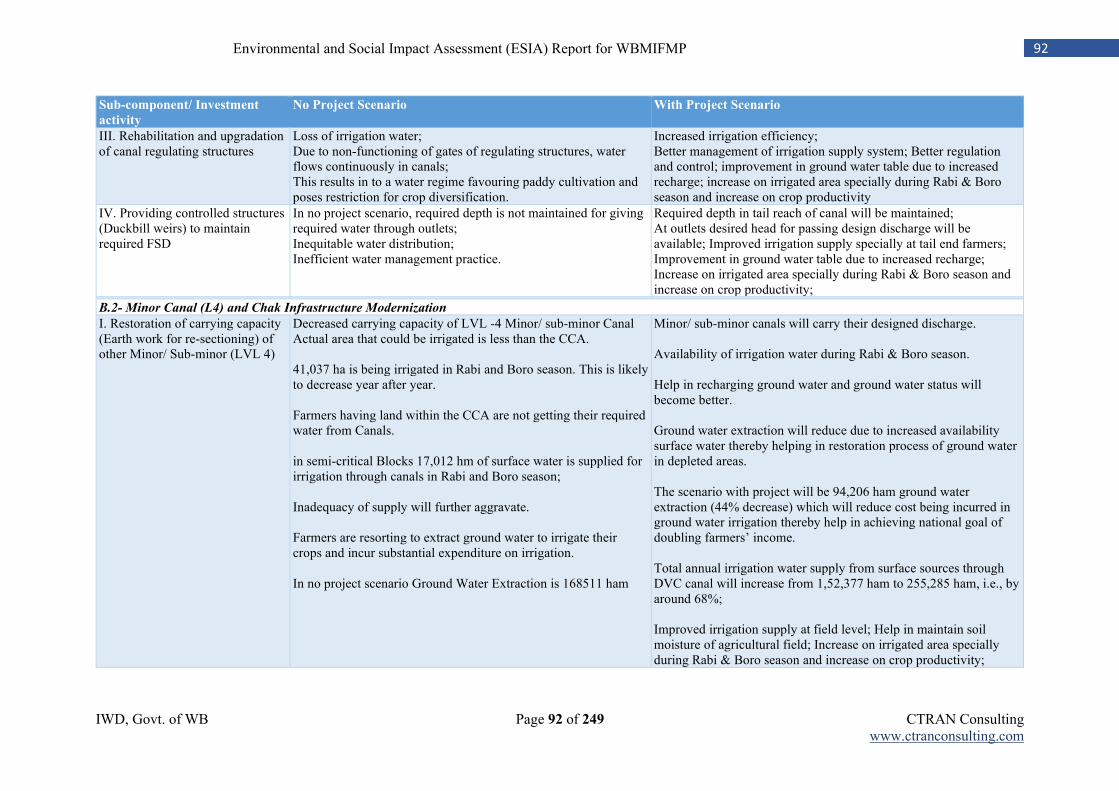
IWD, Govt. of WB Page 92 of 249 CTRAN Consulting www.ctranconsulting.com
92 Environmental and Social Impact Assessment (ESIA) Report for WBMIFMP
Sub-component/ Investment
activity
No Project Scenario With Project Scenario
III. Rehabilitation and upgradation of canal regulating structures
Loss of irrigation water; Due to non-functioning of gates of regulating structures, water flows continuously in canals; This results in to a water regime favouring paddy cultivation and poses restriction for crop diversification.
Increased irrigation efficiency; Better management of irrigation supply system; Better regulation and control; improvement in ground water table due to increased recharge; increase on irrigated area specially during Rabi & Boro season and increase on crop productivity
IV. Providing controlled structures (Duckbill weirs) to maintain required FSD
In no project scenario, required depth is not maintained for giving required water through outlets; Inequitable water distribution; Inefficient water management practice.
Required depth in tail reach of canal will be maintained; At outlets desired head for passing design discharge will be available; Improved irrigation supply specially at tail end farmers; Improvement in ground water table due to increased recharge; Increase on irrigated area specially during Rabi & Boro season and increase on crop productivity;
B.2- Minor Canal (L4) and Chak Infrastructure Modernization
I. Restoration of carrying capacity (Earth work for re-sectioning) of other Minor/ Sub-minor (LVL 4)
Decreased carrying capacity of LVL -4 Minor/ sub-minor Canal Actual area that could be irrigated is less than the CCA. 41,037 ha is being irrigated in Rabi and Boro season. This is likely to decrease year after year. Farmers having land within the CCA are not getting their required water from Canals. in semi-critical Blocks 17,012 hm of surface water is supplied for irrigation through canals in Rabi and Boro season; Inadequacy of supply will further aggravate. Farmers are resorting to extract ground water to irrigate their crops and incur substantial expenditure on irrigation. In no project scenario Ground Water Extraction is 168511 ham
Minor/ sub-minor canals will carry their designed discharge. Availability of irrigation water during Rabi & Boro season. Help in recharging ground water and ground water status will become better. Ground water extraction will reduce due to increased availability surface water thereby helping in restoration process of ground water in depleted areas. The scenario with project will be 94,206 ham ground water extraction (44% decrease) which will reduce cost being incurred in ground water irrigation thereby help in achieving national goal of doubling farmers’ income. Total annual irrigation water supply from surface sources through DVC canal will increase from 1,52,377 ham to 255,285 ham, i.e., by around 68%; Improved irrigation supply at field level; Help in maintain soil moisture of agricultural field; Increase on irrigated area specially during Rabi & Boro season and increase on crop productivity;
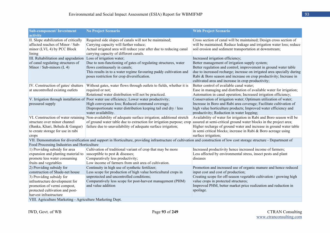
IWD, Govt. of WB Page 93 of 249 CTRAN Consulting www.ctranconsulting.com
93 Environmental and Social Impact Assessment (ESIA) Report for WBMIFMP
Sub-component/ Investment
activity
No Project Scenario With Project Scenario
II. Slope stabilization of critically affected reaches of Minor / Sub-minor (LVL 4) by PCC Block lining
Required side slopes of canals will not be maintained; Carrying capacity will further reduce; Actual irrigated area will reduce year after due to reducing canal carrying capacity of different canals.
Cross section of canal will be maintained; Design cross section of will be maintained; Reduce leakage and irrigation water loss; reduce soil erosion and sediment transportation at downstream;
III. Rehabilitation and upgradation of canal regulating structures of Minor / Sub-minors (L 4)
Loss of irrigation water; Due to non-functioning of gates of regulating structures, water flows continuously in canals; This results in to a water regime favouring paddy cultivation and poses restriction for crop diversification.
Increased irrigation efficiency; Better management of irrigation supply system; Better regulation and control; improvement in ground water table due to increased recharge; increase on irrigated area specially during Rabi & Boro season and increase on crop productivity; Increase in cultivated area and increase in crop productivity;
IV. Construction of gates/ shutters at uncontrolled existing outlets
Without gates, water flows through outlets to fields, whether it is required or not; Rotational water distribution will not be practiced.
Better control of available canal water; Ease in managing and distribution of available water for irrigation; Automation in canal operation; Increased irrigation efficiency;
V. Irrigation through installation of pressured supply
Poor water use efficiency; Lower water productivity; High conveyance loss; Reduced command coverage; Disproportionate water distribution keeping tail end dry / less water availability.
Conservation of irrigation water; Optimum utilization of water; Increase in Boro and Rabi area coverage; Facilitate cultivation of high value horticulture products; Improved water efficiency and productivity; Reduction in water logging;
VI. Construction of water retaining structure over minor channel (Banka, Khari, Behula & Gangur) to create storage for use in rabi crops
Non-availability of adequate surface irrigation; additional stretch of ground water table due to extraction for irrigation purpose; crop failure due to unavailability of adequate surface irrigation;
Availability of water for irrigation in Rabi and Boro season will be assured at semi-critical ground water blocks in the project area; Higher recharge of ground water and increase in ground water table in semi critical blocks; increase in Rabi & Boro acreage using surface irrigation;
VII. Demonstration for diversification and support in Horticulture, providing infrastructure of cultivation and construction of low cost storage structure - Department of Food Processing Industries and Horticulture
1) Providing subsidy for area expansion and planting material to promote less water consuming fruits and vegetables
Cultivation of traditional variant of crop that may be more susceptible to pest & diseases; Comparatively less productivity; Low income of farmers from unit area of cultivation.
Increased productivity hence increased income of farmers; Less affected by environmental stress, insect pests and plant diseases
2) Providing subsidy for construction of Shade-net house
Continuity in high use of synthetic fertilizer; Less scope for production of high value horticultural crops in unprotected and uncontrolled conditions; Comparatively less scope for post-harvest management (PHM) and value addition
Promotion and increased use of organic manure and hence reduced input cost and cost of production; Creating scope for off-season vegetable cultivation / growing high value crops in protected structures; Improved PHM, better market price realization and reduction in spoilage.
3) Providing subsidy for infrastructure development for promotion of vermi compost, protected cultivation and post-harvest infrastructure
VIII. Agriculture Marketing - Agriculture Marketing Dept.
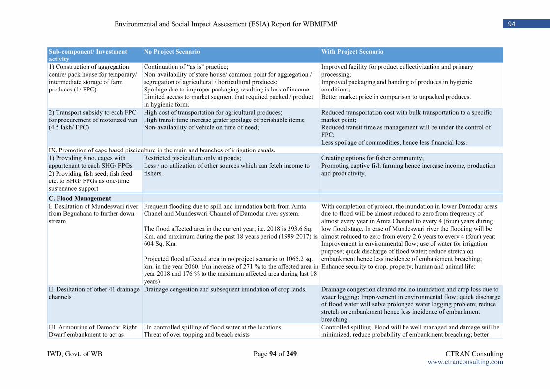
IWD, Govt. of WB Page 94 of 249 CTRAN Consulting www.ctranconsulting.com
94 Environmental and Social Impact Assessment (ESIA) Report for WBMIFMP
Sub-component/ Investment
activity
No Project Scenario With Project Scenario
1) Construction of aggregation centre/ pack house for temporary/ intermediate storage of farm produces (1/ FPC)
Continuation of “as is” practice; Non-availability of store house/ common point for aggregation / segregation of agricultural / horticultural produces; Spoilage due to improper packaging resulting is loss of income. Limited access to market segment that required packed / product in hygienic form.
Improved facility for product collectivization and primary processing; Improved packaging and handing of produces in hygienic conditions; Better market price in comparison to unpacked produces.
2) Transport subsidy to each FPC for procurement of motorized van (4.5 lakh/ FPC)
High cost of transportation for agricultural produces; High transit time increase grater spoilage of perishable items; Non-availability of vehicle on time of need;
Reduced transportation cost with bulk transportation to a specific market point; Reduced transit time as management will be under the control of FPC; Less spoilage of commodities, hence less financial loss.
IX. Promotion of cage based pisciculture in the main and branches of irrigation canals.
1) Providing 8 no. cages with appurtenant to each SHG/ FPGs
Restricted pisciculture only at ponds; Less / no utilization of other sources which can fetch income to fishers.
Creating options for fisher community; Promoting captive fish farming hence increase income, production and productivity. 2) Providing fish seed, fish feed
etc. to SHG/ FPGs as one-time sustenance support C. Flood Management
I. Desiltation of Mundeswari river from Beguahana to further down stream
Frequent flooding due to spill and inundation both from Amta Chanel and Mundeswari Channel of Damodar river system. The flood affected area in the current year, i.e. 2018 is 393.6 Sq. Km. and maximum during the past 18 years period (1999-2017) is 604 Sq. Km. Projected flood affected area in no project scenario to 1065.2 sq. km. in the year 2060. (An increase of 271 % to the affected area in year 2018 and 176 % to the maximum affected area during last 18 years)
With completion of project, the inundation in lower Damodar areas due to flood will be almost reduced to zero from frequency of almost every year in Amta Channel to every 4 (four) years during low flood stage. In case of Mundeswari river the flooding will be almost reduced to zero from every 2.6 years to every 4 (four) year; Improvement in environmental flow; use of water for irrigation purpose; quick discharge of flood water; reduce stretch on embankment hence less incidence of embankment breaching; Enhance security to crop, property, human and animal life;
II. Desiltation of other 41 drainage channels
Drainage congestion and subsequent inundation of crop lands. Drainage congestion cleared and no inundation and crop loss due to water logging; Improvement in environmental flow; quick discharge of flood water will solve prolonged water logging problem; reduce stretch on embankment hence less incidence of embankment breaching
III. Armouring of Damodar Right Dwarf embankment to act as
Un controlled spilling of flood water at the locations. Threat of over topping and breach exists
Controlled spilling. Flood will be well managed and damage will be minimized; reduce probability of embankment breaching; better
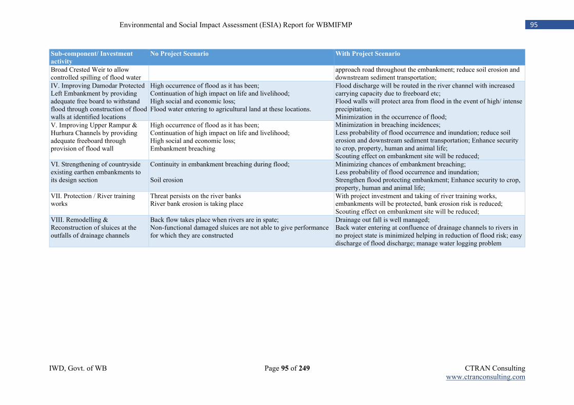
IWD, Govt. of WB Page 95 of 249 CTRAN Consulting www.ctranconsulting.com
95 Environmental and Social Impact Assessment (ESIA) Report for WBMIFMP
Sub-component/ Investment
activity
No Project Scenario With Project Scenario
Broad Crested Weir to allow controlled spilling of flood water
approach road throughout the embankment; reduce soil erosion and downstream sediment transportation;
IV. Improving Damodar Protected Left Embankment by providing adequate free board to withstand flood through construction of flood walls at identified locations
High occurrence of flood as it has been; Continuation of high impact on life and livelihood; High social and economic loss; Flood water entering to agricultural land at these locations.
Flood discharge will be routed in the river channel with increased carrying capacity due to freeboard etc; Flood walls will protect area from flood in the event of high/ intense precipitation; Minimization in the occurrence of flood; Minimization in breaching incidences; Less probability of flood occurrence and inundation; reduce soil erosion and downstream sediment transportation; Enhance security to crop, property, human and animal life; Scouting effect on embankment site will be reduced;
V. Improving Upper Rampur & Hurhura Channels by providing adequate freeboard through provision of flood wall
High occurrence of flood as it has been; Continuation of high impact on life and livelihood; High social and economic loss; Embankment breaching
VI. Strengthening of countryside existing earthen embankments to its design section
Continuity in embankment breaching during flood; Soil erosion
Minimizing chances of embankment breaching; Less probability of flood occurrence and inundation; Strengthen flood protecting embankment; Enhance security to crop, property, human and animal life;
VII. Protection / River training works
Threat persists on the river banks River bank erosion is taking place
With project investment and taking of river training works, embankments will be protected, bank erosion risk is reduced; Scouting effect on embankment site will be reduced;
VIII. Remodelling & Reconstruction of sluices at the outfalls of drainage channels
Back flow takes place when rivers are in spate; Non-functional damaged sluices are not able to give performance for which they are constructed
Drainage out fall is well managed; Back water entering at confluence of drainage channels to rivers in no project state is minimized helping in reduction of flood risk; easy discharge of flood discharge; manage water logging problem
96 Environmental and Social Impact Assessment (ESIA) Report for WBMIFMP
Chapter-6: Potential Environmental and Social Impacts and Mitigation
6.1 Introduction
Environmental Impact Assessment (EIA) is a process to forecast the future social and environmental conditions of the project area that might be expected to occur because of implementation of the sub-projects / activities. Amongst several techniques suggested for prediction of impacts due to various project activities spread throughout the project cycle, the present EIA study refers to a combination of “activities and impact evaluation checklist method”.
6.2 Approach and Methodology
The basic approach is adopted for conducting the environmental impact study for the proposed project to assess the existing environmental scenario in and around the project area, components and activities of the project having potential environmental impacts, analyse the project proposals with respect to prevailing institutional and legislative setup of the Government of India (GoI), Govt. of West Bengal and World Bank Safeguard Policies on this subject. The main approaches for the assessment covers:
1. Identification and analysis of positive and negative impacts, direct and indirect impacts, and short-term and long-term impacts likely to result from project intervention;
2. Identification of feasible and cost-effective mitigation measures to minimize negative impacts and enhance positive impacts by incorporating in the preliminary engineering design.
3. Exploration towards the opportunities for environmental enhancement; 4. Preparation of Environmental Management Plan for effective implementation of environmental
mitigation measures at different stages of the project.
6.2.1 Criteria for Determining degree of Importance of Impacts
Many social and environment components cannot be reliably quantified due to inherent association of complex inter-relationships. Most impacts have been predicated qualitatively justifying its importance for the project point. Significance of impacts regulated by the degree of importance of impacts covering the areas is (i) Area of Impact, (ii) Duration, (iii) Intensity and (iv) Reversibility factors.
6.2.2 Environmental Screening
Screening exercises are carried out to delineate the potential environmental and social impacts due to the project components / activities and defining the scope for further analysis depending upon the significance and extent of the impacts. Screening of impacts is presently considered for pre-construction, construction & operation stages. The steps followed for screening are detailed below.
6.2.3 Categorization of Components
Categorization of components is necessary to assist in determining the environmental and social consequences with regards to their severity, significance and duration. It ultimately entails convenient approach for deciding appropriate mitigation measures or a long-term management intervention.
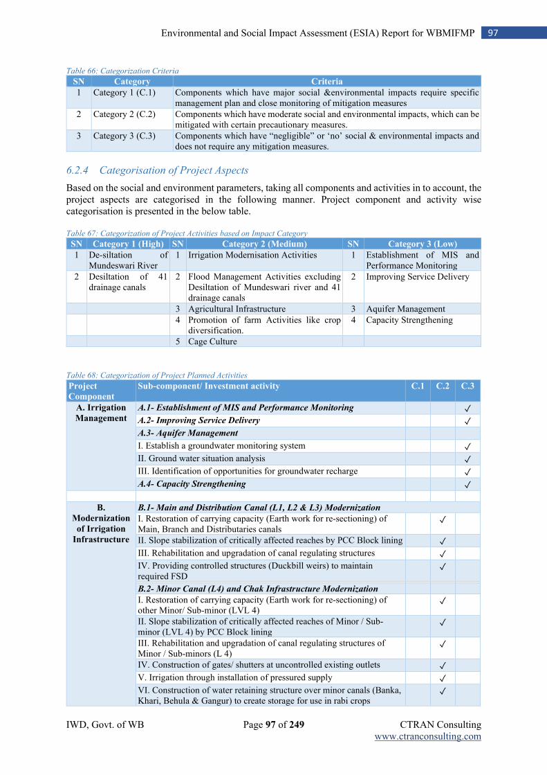
IWD, Govt. of WB Page 97 of 249 CTRAN Consulting www.ctranconsulting.com
97 Environmental and Social Impact Assessment (ESIA) Report for WBMIFMP
Table 66: Categorization Criteria
SN Category Criteria
1 Category 1 (C.1) Components which have major social &environmental impacts require specific management plan and close monitoring of mitigation measures
2 Category 2 (C.2) Components which have moderate social and environmental impacts, which can be mitigated with certain precautionary measures.
3 Category 3 (C.3) Components which have “negligible” or ‘no’ social & environmental impacts and does not require any mitigation measures.
6.2.4 Categorisation of Project Aspects
Based on the social and environment parameters, taking all components and activities in to account, the project aspects are categorised in the following manner. Project component and activity wise categorisation is presented in the below table. Table 67: Categorization of Project Activities based on Impact Category
SN Category 1 (High) SN Category 2 (Medium) SN Category 3 (Low)
1 De-siltation of Mundeswari River
1 Irrigation Modernisation Activities 1 Establishment of MIS and Performance Monitoring
2 Desiltation of 41 drainage canals
2 Flood Management Activities excluding Desiltation of Mundeswari river and 41 drainage canals
2 Improving Service Delivery
3 Agricultural Infrastructure 3 Aquifer Management
4 Promotion of farm Activities like crop diversification.
4 Capacity Strengthening
5 Cage Culture
Table 68: Categorization of Project Planned Activities
Project
Component
Sub-component/ Investment activity C.1 C.2 C.3
A. Irrigation
Management A.1- Establishment of MIS and Performance Monitoring
✓
A.2- Improving Service Delivery
✓
A.3- Aquifer Management
I. Establish a groundwater monitoring system ✓
II. Ground water situation analysis ✓
III. Identification of opportunities for groundwater recharge ✓
A.4- Capacity Strengthening
✓
B.
Modernization
of Irrigation
Infrastructure
B.1- Main and Distribution Canal (L1, L2 & L3) Modernization
I. Restoration of carrying capacity (Earth work for re-sectioning) of Main, Branch and Distributaries canals
✓
II. Slope stabilization of critically affected reaches by PCC Block lining
✓
III. Rehabilitation and upgradation of canal regulating structures
✓
IV. Providing controlled structures (Duckbill weirs) to maintain required FSD
✓
B.2- Minor Canal (L4) and Chak Infrastructure Modernization
I. Restoration of carrying capacity (Earth work for re-sectioning) of other Minor/ Sub-minor (LVL 4)
✓
II. Slope stabilization of critically affected reaches of Minor / Sub-minor (LVL 4) by PCC Block lining
✓
III. Rehabilitation and upgradation of canal regulating structures of Minor / Sub-minors (L 4)
✓
IV. Construction of gates/ shutters at uncontrolled existing outlets
✓
V. Irrigation through installation of pressured supply
✓
VI. Construction of water retaining structure over minor canals (Banka, Khari, Behula & Gangur) to create storage for use in rabi crops
✓
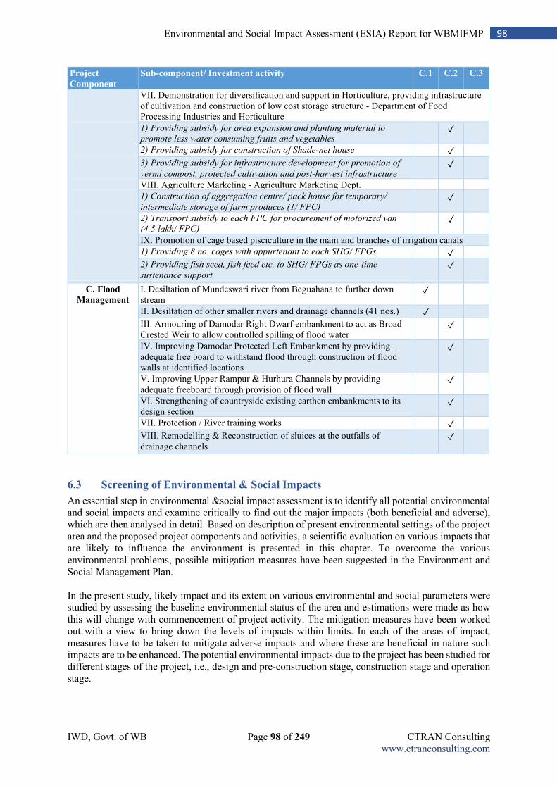
IWD, Govt. of WB Page 98 of 249 CTRAN Consulting www.ctranconsulting.com
98 Environmental and Social Impact Assessment (ESIA) Report for WBMIFMP
Project
Component
Sub-component/ Investment activity C.1 C.2 C.3
VII. Demonstration for diversification and support in Horticulture, providing infrastructure of cultivation and construction of low cost storage structure - Department of Food Processing Industries and Horticulture
1) Providing subsidy for area expansion and planting material to
promote less water consuming fruits and vegetables
✓
2) Providing subsidy for construction of Shade-net house
✓
3) Providing subsidy for infrastructure development for promotion of
vermi compost, protected cultivation and post-harvest infrastructure
✓
VIII. Agriculture Marketing - Agriculture Marketing Dept.
1) Construction of aggregation centre/ pack house for temporary/
intermediate storage of farm produces (1/ FPC)
✓
2) Transport subsidy to each FPC for procurement of motorized van
(4.5 lakh/ FPC)
✓
IX. Promotion of cage based pisciculture in the main and branches of irrigation canals
1) Providing 8 no. cages with appurtenant to each SHG/ FPGs
✓
2) Providing fish seed, fish feed etc. to SHG/ FPGs as one-time
sustenance support
✓
C. Flood
Management I. Desiltation of Mundeswari river from Beguahana to further down stream
✓
II. Desiltation of other smaller rivers and drainage channels (41 nos.) ✓
III. Armouring of Damodar Right Dwarf embankment to act as Broad Crested Weir to allow controlled spilling of flood water
✓
IV. Improving Damodar Protected Left Embankment by providing adequate free board to withstand flood through construction of flood walls at identified locations
✓
V. Improving Upper Rampur & Hurhura Channels by providing adequate freeboard through provision of flood wall
✓
VI. Strengthening of countryside existing earthen embankments to its design section
✓
VII. Protection / River training works
✓
VIII. Remodelling & Reconstruction of sluices at the outfalls of drainage channels
✓
6.3 Screening of Environmental & Social Impacts
An essential step in environmental &social impact assessment is to identify all potential environmental and social impacts and examine critically to find out the major impacts (both beneficial and adverse), which are then analysed in detail. Based on description of present environmental settings of the project area and the proposed project components and activities, a scientific evaluation on various impacts that are likely to influence the environment is presented in this chapter. To overcome the various environmental problems, possible mitigation measures have been suggested in the Environment and Social Management Plan. In the present study, likely impact and its extent on various environmental and social parameters were studied by assessing the baseline environmental status of the area and estimations were made as how this will change with commencement of project activity. The mitigation measures have been worked out with a view to bring down the levels of impacts within limits. In each of the areas of impact, measures have to be taken to mitigate adverse impacts and where these are beneficial in nature such impacts are to be enhanced. The potential environmental impacts due to the project has been studied for different stages of the project, i.e., design and pre-construction stage, construction stage and operation stage.
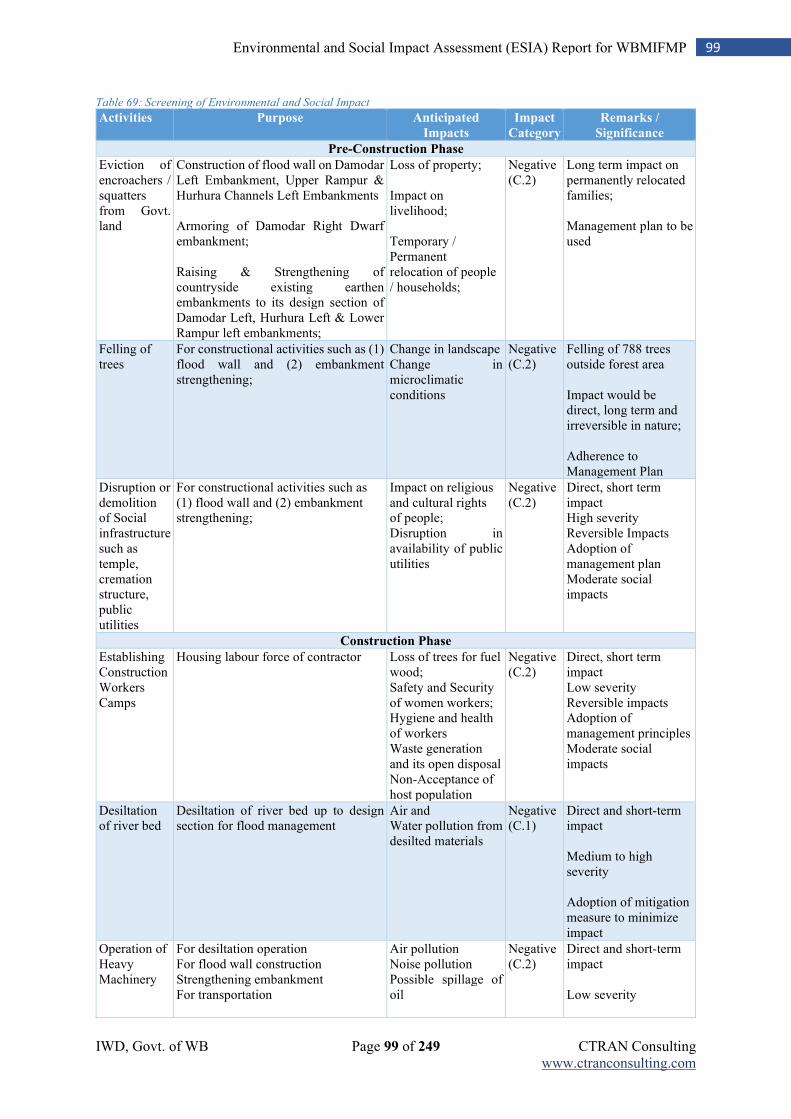
IWD, Govt. of WB Page 99 of 249 CTRAN Consulting www.ctranconsulting.com
99 Environmental and Social Impact Assessment (ESIA) Report for WBMIFMP
Table 69: Screening of Environmental and Social Impact
Activities Purpose Anticipated
Impacts
Impact
Category
Remarks /
Significance
Pre-Construction Phase
Eviction of encroachers / squatters from Govt. land
Construction of flood wall on Damodar Left Embankment, Upper Rampur & Hurhura Channels Left Embankments Armoring of Damodar Right Dwarf embankment; Raising & Strengthening of countryside existing earthen embankments to its design section of Damodar Left, Hurhura Left & Lower Rampur left embankments;
Loss of property; Impact on livelihood; Temporary / Permanent relocation of people / households;
Negative (C.2)
Long term impact on permanently relocated families; Management plan to be used
Felling of trees
For constructional activities such as (1) flood wall and (2) embankment strengthening;
Change in landscape Change in microclimatic conditions
Negative (C.2)
Felling of 788 trees outside forest area Impact would be direct, long term and irreversible in nature; Adherence to Management Plan
Disruption or demolition of Social infrastructure such as temple, cremation structure, public utilities
For constructional activities such as (1) flood wall and (2) embankment strengthening;
Impact on religious and cultural rights of people; Disruption in availability of public utilities
Negative (C.2)
Direct, short term impact High severity Reversible Impacts Adoption of management plan Moderate social impacts
Construction Phase
Establishing Construction Workers Camps
Housing labour force of contractor Loss of trees for fuel wood; Safety and Security of women workers; Hygiene and health of workers Waste generation and its open disposal Non-Acceptance of host population
Negative (C.2)
Direct, short term impact Low severity Reversible impacts Adoption of management principles Moderate social impacts
Desiltation of river bed
Desiltation of river bed up to design section for flood management
Air and Water pollution from desilted materials
Negative (C.1)
Direct and short-term impact Medium to high severity Adoption of mitigation measure to minimize impact
Operation of Heavy Machinery
For desiltation operation For flood wall construction Strengthening embankment For transportation
Air pollution Noise pollution Possible spillage of oil
Negative (C.2)
Direct and short-term impact Low severity
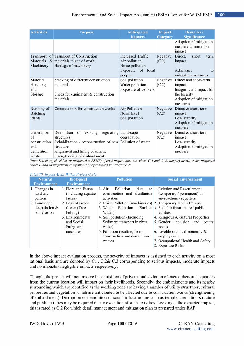
IWD, Govt. of WB Page 100 of 249 CTRAN Consulting www.ctranconsulting.com
100 Environmental and Social Impact Assessment (ESIA) Report for WBMIFMP
Activities Purpose Anticipated
Impacts
Impact
Category
Remarks /
Significance
Adoption of mitigation measure to minimize impact
Transport of Materials & Machinery
Transport of Construction materials to site of work; Haulage of machinery
Increased Traffic Air pollution, Noise pollution Exposure of local people
Negative (C.2)
Direct, short term impact Adherence to mitigation measures
Material Handling and Storage
Stacking of different construction materials Sheds for equipment & construction materials
Soil pollution Water pollution Exposure of workers
Negative (C.2)
Direct and short-term impact Insignificant impact for the locality Adoption of mitigation measures
Running of Batching Plants
Concrete mix for construction works Air Pollution Noise level Soil pollution
Negative (C.2)
Direct & short-term impact Low severity Adoption of mitigation measure
Generation of construction and demolition waste
Demolition of existing regulating structures; Rehabilitation / reconstruction of new structures; Alignment and lining of canals; Strengthening of embankments
Landscape degradation Pollution of water
Negative (C.2)
Direct & short-term impact Low severity Adoption of mitigation measure
Note: Screening checklist (as proposed in ESMF) of each project location where C-1 and C- 2 category activities are proposed
under Flood Management components are presented in Annexure -9.
Table 70: Impact Areas Within Project Cycle
Natural
Environment
Biological
Environment
Pollution Social Environment
1. Changes in land use pattern
2. Landscape degradation & soil erosion
1. Flora and Fauna (including aquatic fauna)
2. Loss of Green Cover (Tree Felling)
3. Environmental and Social Safeguard measures
1. Air Pollution due to construction and desiltation activities
2. Noise Pollution (machineries) 3. Water Pollution (Surface
Water) 4. Soil pollution (Including
Sediment transport in river water)
5. Pollution resulting from construction and demolition wastes
1. Eviction and Resettlement (temporary / permanent) of encroachers / squatters
2. Temporary labour Camps 3. Social infrastructure / public
utilities 4. Religious & cultural Properties 5. Gender inclusion and equity
issues 6. Livelihood, local economy &
employment 7. Occupational Health and Safety 8. Exposure Risks
In the above impact evaluation process, the severity of impacts is assigned to each activity on a most rational basis and are denoted by C.1, C.2& C.3 corresponding to serious impacts, moderate impacts and no impacts / negligible impacts respectively. Though, the project will not involve in acquisition of private land, eviction of encroachers and squatters from the current location will impact on their livelihoods. Secondly, the embankments and its nearby surrounding which are identified as the working zone are having a number of utility structures, cultural properties and vegetation which are anticipated to be affected due to construction works (strengthening of embankment). Disruption or demolition of social infrastructure such as temple, cremation structure and public utilities may be required due to execution of such activities. Looking at the expected impact, this is rated as C.2 for which detail management and mitigation plan is prepared under RAP.
IWD, Govt. of WB Page 101 of 249 CTRAN Consulting www.ctranconsulting.com
101 Environmental and Social Impact Assessment (ESIA) Report for WBMIFMP
Desiltataion of river bed of Mundeswari and 41 drainage channels is an important activity under the project. It will generate significant amount of sand, silt, clay and sediment which need to be utilized appropriately and/or disposed-off scientifically. Since huge quantity of desilted materials will be generated because of this activity and its stocking and disposal will remain a challenge, this activity is considered as C.1. A detail management plan is suggested to ensure that desilted materials will not have adverse impact on the environment. Remaining activities, based on the assessed impacts are either ‘C.2’ or ‘C.3’ category which is common attributes of the implementation / construction phase of the project. All ‘C.2’ category impacts i.e. moderate impacts will be addressed through Mitigation Measures.
6.4 Avoidance Principles
Avoidance (Non-Permissible Activities)
The project will not support following activities which may have severe, irreversible, long-term, adverse environmental impacts. List of Non-permissible Activities / Project Financing Limitations
1. Any activity located within a notified Eco Sensitive Zone (ESZ) and is prohibited from being implemented within an ESZ;
2. Any activity that converts or leads to conversion and/or degradation of significant areas of critical natural habitats (areas officially protected) and/or other natural habitats (including wetlands of significance) and designated forest areas;
3. Any activity that promotes or supports pesticides that are banned by the Government of India5; 4. Any activity that promote or support pesticides that are in Classes Ia, Ib and II of the WHO classified
pesticides by hazard6; 5. Any activity that involves construction within 100 meters from an archeological site/monument. 6. Any activity that involves use of Asbestos Containing Materials (e.g., AC pipes for irrigation, AC
sheets for roof); 7. Any activity that violates the provisions of applicable National and State laws; 8. Construction of any new irrigation reservoir dam; 9. Construction of new canals, new branch canals and new offtake structures;
6.5 Impacts and Mitigations
6.5.1 Impacts During Design & Pre-Constructional Phase:
6.5.1.1 Impact on Topography & Land Use
The proposed project includes irrigation modernization, under which 2632.49 Km of main and branch canal will be restored. The slope stabilization with PCC block lining will be done in 458.95 Km of critically affected reaches canal systems which includes branch canals, distributaries, minor and sub-minor canals. The canal regulating structures will be rehabilitated / upgraded (1515 Nos.). To control and manage flood, project proposes desiltation of Mundeswari river for a length of 19.24 Km and upstream channel of Damodar (undivided, 430.0 Mtr.). De-siltation will also be taken up in other 41 drainage channels flowing in flood plain areas of Howrah & Hooghly district. Apart from de-siltation of Mundeswari river and 41 drainage channel, re-sectioning of canal system, flood wall construction, and armoring Damodar Right embankment, river training works will also be taken up by the project in Damodar and Mundeswari river, Hurhura and Rampurkhal.
5 For list of pesticides banned in India, refer to: http://cibrc.nic.in/ibr2012.doc 6 For list of pesticides in WHO classes Ia, Ib and II, refer to: http://www.who.int/ipcs/publications/pesticides_hazard_2009.pdf
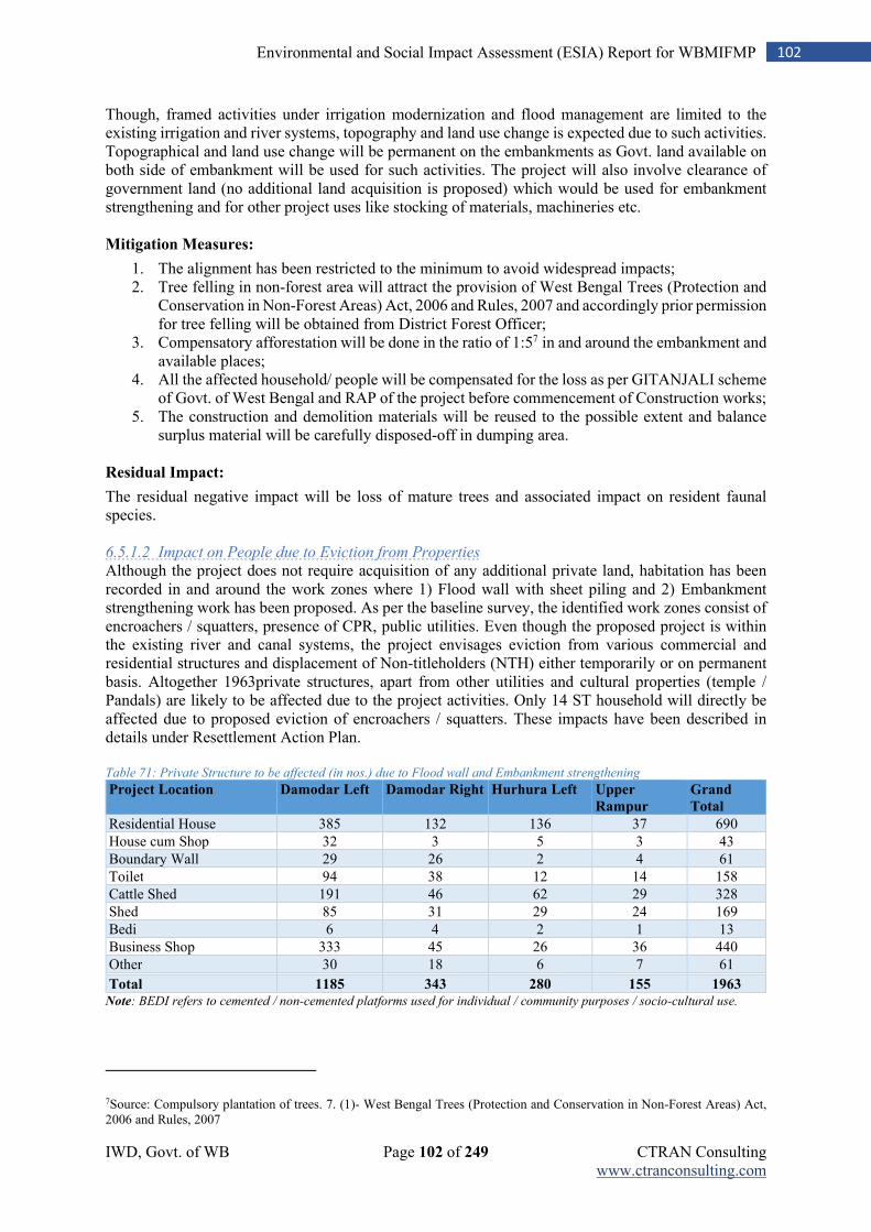
IWD, Govt. of WB Page 102 of 249 CTRAN Consulting www.ctranconsulting.com
102 Environmental and Social Impact Assessment (ESIA) Report for WBMIFMP
Though, framed activities under irrigation modernization and flood management are limited to the existing irrigation and river systems, topography and land use change is expected due to such activities. Topographical and land use change will be permanent on the embankments as Govt. land available on both side of embankment will be used for such activities. The project will also involve clearance of government land (no additional land acquisition is proposed) which would be used for embankment strengthening and for other project uses like stocking of materials, machineries etc. Mitigation Measures:
1. The alignment has been restricted to the minimum to avoid widespread impacts; 2. Tree felling in non-forest area will attract the provision of West Bengal Trees (Protection and
Conservation in Non-Forest Areas) Act, 2006 and Rules, 2007 and accordingly prior permission for tree felling will be obtained from District Forest Officer;
3. Compensatory afforestation will be done in the ratio of 1:57 in and around the embankment and available places;
4. All the affected household/ people will be compensated for the loss as per GITANJALI scheme of Govt. of West Bengal and RAP of the project before commencement of Construction works;
5. The construction and demolition materials will be reused to the possible extent and balance surplus material will be carefully disposed-off in dumping area.
Residual Impact:
The residual negative impact will be loss of mature trees and associated impact on resident faunal species. 6.5.1.2 Impact on People due to Eviction from Properties
Although the project does not require acquisition of any additional private land, habitation has been recorded in and around the work zones where 1) Flood wall with sheet piling and 2) Embankment strengthening work has been proposed. As per the baseline survey, the identified work zones consist of encroachers / squatters, presence of CPR, public utilities. Even though the proposed project is within the existing river and canal systems, the project envisages eviction from various commercial and residential structures and displacement of Non-titleholders (NTH) either temporarily or on permanent basis. Altogether 1963private structures, apart from other utilities and cultural properties (temple / Pandals) are likely to be affected due to the project activities. Only 14 ST household will directly be affected due to proposed eviction of encroachers / squatters. These impacts have been described in details under Resettlement Action Plan. Table 71: Private Structure to be affected (in nos.) due to Flood wall and Embankment strengthening
Project Location Damodar Left Damodar Right Hurhura Left Upper
Rampur
Grand
Total
Residential House 385 132 136 37 690
House cum Shop 32 3 5 3 43
Boundary Wall 29 26 2 4 61
Toilet 94 38 12 14 158
Cattle Shed 191 46 62 29 328
Shed 85 31 29 24 169
Bedi 6 4 2 1 13
Business Shop 333 45 26 36 440
Other 30 18 6 7 61 Total 1185 343 280 155 1963
Note: BEDI refers to cemented / non-cemented platforms used for individual / community purposes / socio-cultural use.
7Source: Compulsory plantation of trees. 7. (1)- West Bengal Trees (Protection and Conservation in Non-Forest Areas) Act, 2006 and Rules, 2007
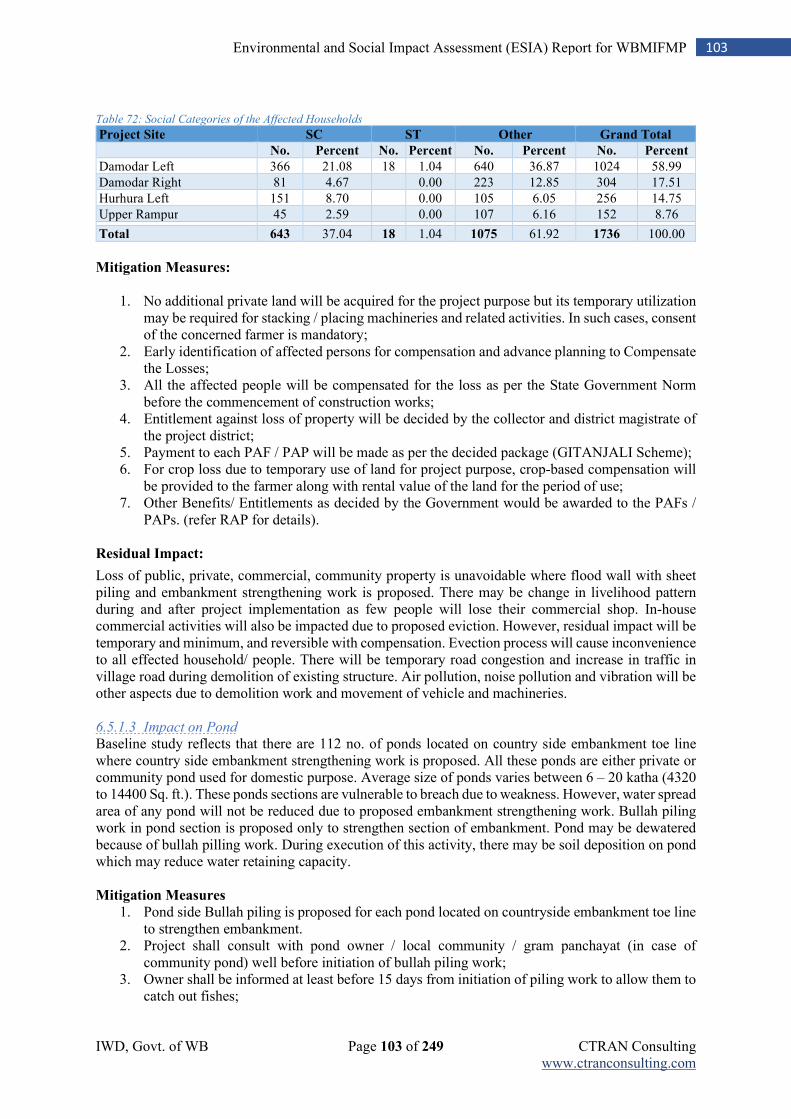
IWD, Govt. of WB Page 103 of 249 CTRAN Consulting www.ctranconsulting.com
103 Environmental and Social Impact Assessment (ESIA) Report for WBMIFMP
Table 72: Social Categories of the Affected Households
Project Site SC ST Other Grand Total
No. Percent No. Percent No. Percent No. Percent
Damodar Left 366 21.08 18 1.04 640 36.87 1024 58.99
Damodar Right 81 4.67 0.00 223 12.85 304 17.51
Hurhura Left 151 8.70 0.00 105 6.05 256 14.75
Upper Rampur 45 2.59 0.00 107 6.16 152 8.76
Total 643 37.04 18 1.04 1075 61.92 1736 100.00
Mitigation Measures:
1. No additional private land will be acquired for the project purpose but its temporary utilization
may be required for stacking / placing machineries and related activities. In such cases, consent of the concerned farmer is mandatory;
2. Early identification of affected persons for compensation and advance planning to Compensate the Losses;
3. All the affected people will be compensated for the loss as per the State Government Norm before the commencement of construction works;
4. Entitlement against loss of property will be decided by the collector and district magistrate of the project district;
5. Payment to each PAF / PAP will be made as per the decided package (GITANJALI Scheme); 6. For crop loss due to temporary use of land for project purpose, crop-based compensation will
be provided to the farmer along with rental value of the land for the period of use; 7. Other Benefits/ Entitlements as decided by the Government would be awarded to the PAFs /
PAPs. (refer RAP for details). Residual Impact:
Loss of public, private, commercial, community property is unavoidable where flood wall with sheet piling and embankment strengthening work is proposed. There may be change in livelihood pattern during and after project implementation as few people will lose their commercial shop. In-house commercial activities will also be impacted due to proposed eviction. However, residual impact will be temporary and minimum, and reversible with compensation. Evection process will cause inconvenience to all effected household/ people. There will be temporary road congestion and increase in traffic in village road during demolition of existing structure. Air pollution, noise pollution and vibration will be other aspects due to demolition work and movement of vehicle and machineries. 6.5.1.3 Impact on Pond
Baseline study reflects that there are 112 no. of ponds located on country side embankment toe line where country side embankment strengthening work is proposed. All these ponds are either private or community pond used for domestic purpose. Average size of ponds varies between 6 – 20 katha (4320 to 14400 Sq. ft.). These ponds sections are vulnerable to breach due to weakness. However, water spread area of any pond will not be reduced due to proposed embankment strengthening work. Bullah piling work in pond section is proposed only to strengthen section of embankment. Pond may be dewatered because of bullah pilling work. During execution of this activity, there may be soil deposition on pond which may reduce water retaining capacity. Mitigation Measures
1. Pond side Bullah piling is proposed for each pond located on countryside embankment toe line to strengthen embankment.
2. Project shall consult with pond owner / local community / gram panchayat (in case of community pond) well before initiation of bullah piling work;
3. Owner shall be informed at least before 15 days from initiation of piling work to allow them to catch out fishes;
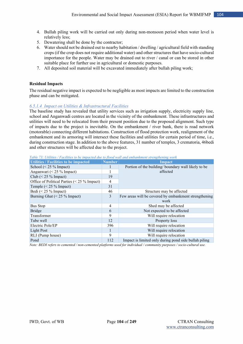
IWD, Govt. of WB Page 104 of 249 CTRAN Consulting www.ctranconsulting.com
104 Environmental and Social Impact Assessment (ESIA) Report for WBMIFMP
4. Bullah piling work will be carried out only during non-monsoon period when water level is relatively less;
5. Dewatering shall be done by the contractor; 6. Water should not be drained out to nearby habitation / dwelling / agricultural field with standing
crops (if the crop does not require additional water) and other structures that have socio-cultural importance for the people. Water may be drained out to river / canal or can be stored in other suitable place for further use in agricultural or domestic purposes.
7. All deposited soil material will be excavated immediately after bullah piling work; Residual Impacts
The residual negative impact is expected to be negligible as most impacts are limited to the construction phase and can be mitigated. 6.5.1.4 Impact on Utilities & Infrastructural Facilities
The baseline study has revealed that utility services such as irrigation supply, electricity supply line, school and Anganwadi centres are located in the vicinity of the embankment. These infrastructures and utilities will need to be relocated from their present position due to the proposed alignment. Such type of impacts due to the project is inevitable. On the embankment / river bank, there is road network (motorable) connecting different habitations. Construction of flood protection work, realignment of the embankment and its armoring will intersect these facilities and utilities for certain period of time, i.e., during construction stage. In addition to the above features, 31 number of temples, 3 crematoria, 46bedi and other structures will be affected due to the project. Table 73: Utilities / Facilities to be impacted due to flood wall and embankment strengthening work
Utilities / Facilities to be impacted Number Impact
School (< 25 % Impact) 1 Portion of the building/ boundary wall likely to be affected Anganwari (< 25 % Impact) 1
Club (< 25 % Impact) 19
Office of Political Parties (< 25 % Impact) 4
Temple (< 25 % Impact) 31
Bedi (< 25 % Impact) 46 Structure may be affected
Burning Ghat (< 25 % Impact) 3 Few areas will be covered by embankment strengthening work
Bus Stop 4 Shed may be affected
Bridge 6 Not expected to be affected
Transformer 9 Will require relocation
Tube well 12 Property loss
Electric Pole/EP 396 Will require relocation
Light Post 1 Will require relocation
RLI (Pump house) 9 Will require relocation
Pond 112 Impact is limited only during pond side bullah piling Note: BEDI refers to cemented / non-cemented platforms used for individual / community purposes / socio-cultural use.
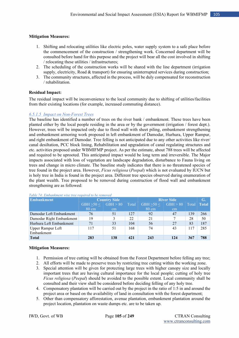
IWD, Govt. of WB Page 105 of 249 CTRAN Consulting www.ctranconsulting.com
105 Environmental and Social Impact Assessment (ESIA) Report for WBMIFMP
Mitigation Measures:
1. Shifting and relocating utilities like electric poles, water supply system to a safe place before
the commencement of the construction / strengthening work. Concerned department will be consulted before hand for this purpose and the project will bear all the cost involved in shifting / relocating these utilities / infrastructures;
2. The scheduling of the construction works will be shared with the line department (irrigation supply, electricity, Road & transport) for ensuring uninterrupted services during construction;
3. The community structures, affected in the process, will be duly compensated for reconstruction / rehabilitation.
Residual Impact:
The residual impact will be inconvenience to the local community due to shifting of utilities/facilities from their existing locations (for example, increased commuting distance). 6.5.1.5 Impact on Non-Forest Trees
The baseline has identified a number of trees on the river bank / embankment. These trees have been planted either by the local people residing in the area or by the government (irrigation / forest dept.). However, trees will be impacted only due to flood wall with sheet piling, embankment strengthening and embankment armoring work proposed in left embankment of Damodar, Hurhura, Upper Rampur, and right embankment of Damodar. Tree felling is not anticipated due to any other activities like river/ canal desiltation, PCC block lining, Rehabilitation and upgradation of canal regulating structures and etc. activities proposed under WBMIFMP project. As per the estimate, about 788 trees will be affected and required to be uprooted. This anticipated impact would be long term and irreversible. The Major impacts associated with loss of vegetation are landscape degradation, disturbance to Fauna living on trees and change in micro climate. The baseline study indicates that there is no threatened species of tree found in the project area. However, Ficus religiosa (Peepal) which is not evaluated by IUCN but is holy tree in India is found in the project area. Different tree species observed during enumeration of the plant wealth. Tree proposed to be removed during construction of flood wall and embankment strengthening are as followed: Table 74: Embankment wise tree required to be removed
Embankment Country Side River Side G.
Total GBH >50 < 80 cm
GBH > 80 cm
Total GBH >50 < 80 cm
GBH > 80 cm
Total
Damodar Left Embankment 76 51 127 92 47 139 266
Damodar Right Embankment 19 3 22 21 7 28 50
Hurhura Left Embankment 71 33 104 56 27 83 187
Upper Rampur Left Embankment
117 51 168 74 43 117 285
Total 283 138 421 243 124 367 788
Mitigation Measures:
1. Permission of tree cutting will be obtained from the Forest Department before felling any tree; 2. All efforts will be made to preserve trees by restricting tree cutting within the working zone. 3. Special attention will be given for protecting large trees with higher canopy size and locally
important trees that are having cultural importance for the local people; cutting of holy tree Ficus religiosa (Peepal) should be avoided to the possible extent. Local community shall be consulted and their view shall be considered before deciding felling of any holy tree.
4. Compensatory plantation will be carried out by the project in the ratio of 1:5 in and around the project area or based on the availability of land in consultation with the forest department;
5. Other than compensatory afforestation, avenue plantation, embankment plantation around the project location, plantation on waste dumps etc. are to be taken up.
IWD, Govt. of WB Page 106 of 249 CTRAN Consulting www.ctranconsulting.com
106 Environmental and Social Impact Assessment (ESIA) Report for WBMIFMP
6. Mixed plantation with locally grown species will be promoted in consultation with Forest Department and local community / Gram Panchayat;
7. Bamboo palisade will be provided around plantation area; after care measures for a period of thee year will be taken up
Residual Impact:
Loss of mature trees and associated impact on resident faunal species.
6.5.2 Impact on National Parks/Wildlife Sanctuary
The analysis of baseline study reflects that there is no ecological protected area such as national park, wildlife sanctuary, notified eco-sensitive area located within 3 km of project influence area of any category 1, 2 project activity, so any impact on such feature due to the project is not visualized. However, Ramnabagan WLS (at Bardhhaman -1) is located at a distance of 2.5 km. away from DVC canal and 3.7 km away from Damodar river. Only restoration of carrying capacity of canal, PCC block lining and renovation work of few irrigation structure is proposed in this area. Endangered species like Fishing Cat, Mongoose, Otter, Turtles, Jungle Cat, Jackal, Varanus and etc. are found in an around area of Mundeswari river, where river desiltation work is proposed. However, there is no migratory route situated in an around the project area. Mitigation Measures:
1. Workers shall not perform any kind of hunting/ poaching of any such animals or birds/ migratory bird;
2. The contractor and its workers will be educated / sensitized on endangered/ vulnerable species and its protection measures;
3. Contractor shall inform local authority of WLS or Zoological Survey of India (ZSI) on observing any such animal;
4. Any kind of work proposed under WBMIFMP within 2 km. periphery of Ramnabagan WLS or desiltation of Mundeswari river shall be limited within 6 A.M – 6 PM,
5. Silencer shall be provided with all noise generating machineries operating in this area; 6. Reducing the noise produced from a vibrating machine by vibration damping i.e. making a
layer of damping material (rubber, neoprene, cork or plastic) beneath the machine; 7. Explosion or blasting operation shall not be performed within 2 Km. periphery of Ramnabagan
WLS; Residual Impact:
Any kind of residual impact on Ramnabagan WLS is not anticipated due to implementation of any project activities proposed within 3 km. influence area of Ramnabagan WLS. Project activities like re- sectioning, lining proposed in this area are limited within existing canal section.
6.5.3 Impacts During Construction Phase
Most of the anticipated adverse environmental impacts are related to construction works which are inevitable but are manageable through practices that are environment friendly. The negative environmental effects can be taken care of at an early stage through proper engineering design and through the contract during construction practices. The construction works will involve are site clearance, desilting / re-sectioning, filling of earth materials, concreting, laying of bituminous mixtures, handling of hazardous materials like bitumen, diesel, etc., dumping of unusable debris materials, transportation of materials from production site to construction site, and other construction activities and associated works like mobilization of construction equipment, setting up of different construction plants, setting up of workforce camps, material storage etc. These activities have certain impacts of various magnitudes on different components of environment. As component wise work packages are not done at this stage, package
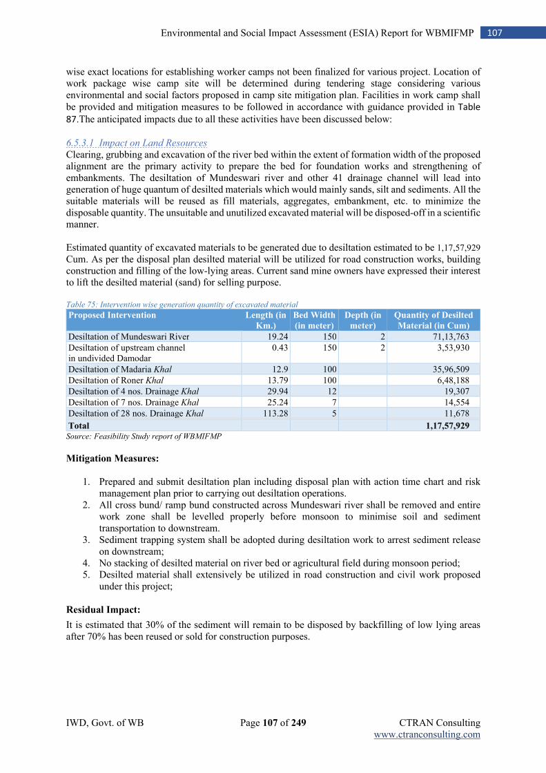
IWD, Govt. of WB Page 107 of 249 CTRAN Consulting www.ctranconsulting.com
107 Environmental and Social Impact Assessment (ESIA) Report for WBMIFMP
wise exact locations for establishing worker camps not been finalized for various project. Location of work package wise camp site will be determined during tendering stage considering various environmental and social factors proposed in camp site mitigation plan. Facilities in work camp shall be provided and mitigation measures to be followed in accordance with guidance provided in Table
87.The anticipated impacts due to all these activities have been discussed below:
6.5.3.1 Impact on Land Resources
Clearing, grubbing and excavation of the river bed within the extent of formation width of the proposed alignment are the primary activity to prepare the bed for foundation works and strengthening of embankments. The desiltation of Mundeswari river and other 41 drainage channel will lead into generation of huge quantum of desilted materials which would mainly sands, silt and sediments. All the suitable materials will be reused as fill materials, aggregates, embankment, etc. to minimize the disposable quantity. The unsuitable and unutilized excavated material will be disposed-off in a scientific manner. Estimated quantity of excavated materials to be generated due to desiltation estimated to be 1,17,57,929 Cum. As per the disposal plan desilted material will be utilized for road construction works, building construction and filling of the low-lying areas. Current sand mine owners have expressed their interest to lift the desilted material (sand) for selling purpose. Table 75: Intervention wise generation quantity of excavated material
Proposed Intervention Length (in
Km.)
Bed Width
(in meter)
Depth (in
meter)
Quantity of Desilted
Material (in Cum)
Desiltation of Mundeswari River 19.24 150 2 71,13,763
Desiltation of upstream channel in undivided Damodar
0.43 150 2 3,53,930
Desiltation of Madaria Khal 12.9 100 35,96,509
Desiltation of Roner Khal 13.79 100 6,48,188
Desiltation of 4 nos. Drainage Khal 29.94 12 19,307
Desiltation of 7 nos. Drainage Khal 25.24 7 14,554
Desiltation of 28 nos. Drainage Khal 113.28 5 11,678
Total
1,17,57,929
Source: Feasibility Study report of WBMIFMP
Mitigation Measures:
1. Prepared and submit desiltation plan including disposal plan with action time chart and risk
management plan prior to carrying out desiltation operations. 2. All cross bund/ ramp bund constructed across Mundeswari river shall be removed and entire
work zone shall be levelled properly before monsoon to minimise soil and sediment transportation to downstream.
3. Sediment trapping system shall be adopted during desiltation work to arrest sediment release on downstream;
4. No stacking of desilted material on river bed or agricultural field during monsoon period; 5. Desilted material shall extensively be utilized in road construction and civil work proposed
under this project; Residual Impact:
It is estimated that 30% of the sediment will remain to be disposed by backfilling of low lying areas after 70% has been reused or sold for construction purposes.
IWD, Govt. of WB Page 108 of 249 CTRAN Consulting www.ctranconsulting.com
108 Environmental and Social Impact Assessment (ESIA) Report for WBMIFMP
6.5.3.2 Impact on Top Soil
The site clearance process will involve excavation and vegetation clearance. Site clearance activity will induce loss of top soil. Since vegetation clearance shall be confined to the minimum area required for construction works on the embankment, the area affected would be limited to the identified zones where embankment strengthening and flood wall construction is proposed. The activities associated with the site preparation and excavation plus movement of vehicles can disturb the surrounding land. There is chance of loss to top soil due to various activities such as temporary camp site, stockyards, workshops, and other ancillary sites. Mitigation Measures:
1. The top soil will be preserved separately and will be reused for landscaping, grass turfing and
site restoration work; 2. The top soil will be stripped to a specified depth of 6-8 inches and stored in stockpiles of height
not exceeding 2 m. Piling of the top soil should be made away from water ways. The heap of the top soil will be covered with tarpaulin cover to minimize air pollution;
3. The stored topsoil will be spread back to maintain the soil physio-chemical and biological activity. The preserved top soil will be used for restoration of sites, in landscaping and avenue plantation;
4. The preserved top soil should be used for plantation as soon as possible to prevent loss of quality and quantity
Residual Impact:
The residual negative impact is expected to be negligible. 6.5.3.3 Soil Erosion:
The problem of soil erosion may arise due to restoration of carrying capacity of LVL-1, 2, 3 & 4 canal, desiltation of Mundeswari river and 41 nos. other drainage canal. Construction of cross bund over river/ canal for dewatering purpose during construction work/ ramp across Mundeswari river for transportation purpose may lead to soil and sediment transportation in downstream if not removed properly after completion of work. As per FSR, nine (9) primary, twelve (12) intermediate cross bundhs across Mundeswari and three (3) cross bunds across mouths of other out falling drainage channels will be constructed to facilitate desiltation work. To facilitate carriage of desilted materials from the point of desiltation, access road over river bed has been considered for a length of 25.50 Km., including ramps. The desiltation activities may aggravate the erosion problem in the area if not addressed properly. The earthen embankment may suffer with soil erosion problem if it is not properly compacted. The desilted area may also face the problem of sediment deposition due to erosion. Mitigation Measures
1. The earthen embankments will be provided with chutes and drains, where ever required, to
minimize soil erosion; 2. All cross bund/ ramp constructed for dewatering or transportation of vehicle/ machineries shall
be removed immediate after completion of proposed work; all bund/ ramp shall be cleared and leveled properly before monsoon season to maintain natural water flow;
3. Stone pitching and retaining walls will be made at embankments in critical areas. 4. The slopes of the embankment will have Rip Raps, where ever required, as per design;
Residual Impact:
There will minimal soil and sediment transport to downstream river water which will lead to increased TDS and water pollution.
IWD, Govt. of WB Page 109 of 249 CTRAN Consulting www.ctranconsulting.com
109 Environmental and Social Impact Assessment (ESIA) Report for WBMIFMP
6.5.3.4 Soil Contamination
Contamination of soil during construction stage is primarily due to construction and allied activities. The sites where construction vehicles are parked and serviced are likely to be contaminated because of leakage or spillage of fuel and lubricants. Refuse (garbage and rubbish) generated from temporary labour camps can also contaminate the soil. Contamination of soil during construction might be a major long-term residual negative impact. Unwarranted disposal of construction spoil and debris will add to soil contamination. This contamination is likely to be carried over to water bodies in case of dumping being done near water body locations. Mitigation Measures:
1. The provision for oil interception chamber for treating the waste water generated from vehicle
washing, refilling and maintenance areas. 2. Fuel storage and refilling sites should be kept away from water sources / water bodies and water
supply sources; 3. The petroleum products will be stored in containers / drums and should be kept in raised
impervious platform; 4. All spoils shall be disposed-off and the site shall be maintained cleaned; 5. The movement of construction vehicles will be restricted to only designated route; 6. Designated storage site with proper sign board for oil, lubricants and similar produces.
Residual Impact:
With implementation of the waste management plan, the residual negative impact is expected to be negligible. 6.5.3.5 Impact on Water Resources
The baseline study indicates that the water table in most of the areas, excluding 19 blocks, falls under safe zones. There will be increased load on existing drinking water sources for consumption of workers. The water demands for the construction work will not pose any serious stress on the public water supply as water of the river / canal will be utilized for construction activities through lifting and storing mechanism. In semi-critical ground water level, measures will be taken to filter the surface water supply through RO/UV filter instruments to make it portable. However, there will be requirement for the use of supply / ground water for consumptive use in work places / sites. In addition to that, tube well will be installed in each camp site for withdrawal of water for consumption purpose. Mitigation Measures
Use of public water supply sources for fetching water for consumptive will be a requirement and, in such cases, local people / GP should be intimated and consulted accordingly. However, any major impact on ground water table in the project area is not anticipated due to consumption use at the camp and working sites.
1. Water for construction and other related activities shall be met from existing river / canal/ pond by pumping to the possible extent; Use of ground water for construction purpose shall be avoided to the possible extent;
2. Additional tube well on requirement will be provided to each camp site for ground water extraction for drinking purpose.
Residual Impact:
The residual negative impact is expected to be negligible. 6.5.3.6 Impact on Water Quality
No permanent impact is anticipated on water quality due to the project. Construction, desiltation of Mundeswari river and other 41 drainage canal and resectioning of irrigation canal activity may temporarily deteriorate surface water quality near the alignment through increase in turbidity as well as spill of oil and grease. Waste water from the construction area charged with cement slurry, Grease and
IWD, Govt. of WB Page 110 of 249 CTRAN Consulting www.ctranconsulting.com
110 Environmental and Social Impact Assessment (ESIA) Report for WBMIFMP
oils etc. are likely to flow to the nearest water body causing contamination of water. The water contamination may be caused due to waste discharge from construction camps and labour camps. These short-term impacts will be mitigated with the adoption of following measures. Mitigation Measures:
1. Desiltation of Mundeswari river and other 41 drainage canal and resectioning of irrigation
canals operation will be carried out only during non-monsoon period; 2. The Contractor will take all precautionary measures to prevent the wastewater generated during
construction works from entering into water bodies; 3. Generated waste and earth will be properly disposed-off so as to avoid its in-flow to the water
source; 4. The camp sites, plant site, stockyards and servicing centres will be established sufficiently away
from water sources (river stream, canal and nearest water bodies) and will be provided with proper drainage system to regulate water flow from such sites;
5. All water and liquid wastes arising from construction activities will be properly disposed-off and will not be discharged into river / canal / water bodies around the project area without treatment;
6. No construction materials / spoils will be stored along the water bodies and adequate provision will be made for preventing spillage of materials into these water bodies.
7. All construction vehicle parking location, fuels/lubricants storage sites, vehicles, machinery and equipment maintenance sites are located at least 100 m away from any water body. It should be ensured that spillage of fuels and lubricants do not contaminate the ground.
8. Collection and storage of oily wastes and its handing over to the authorized hazardous waste collector;
9. Deposit the excavated material only at the specified site without disturbing the natural drainage. 10. Water quality to be monitored periodically, at least once in three months
Residual Impact:
River water quality will temporarily deteriorate due to soil and sediment transport from desilted/ excavated river/ canal site (until the bed and surface material stabilizes) and due to mixing of oil and grease from construction equipment and vehicles. 6.5.3.7 Impact on Ambient Air Quality
Deterioration of air quality due to various construction activities along the project site is the most common impact. However, such impacts associated with construction activities are mainly localized and temporary in nature. Anticipated cause of air pollution during construction phase are because of desiltation of Mundeswari river and other 41 drainage canals and resectioning of irrigation canals, embankment strengthening, river training and other construction activities like disposal of wastes, construction spoils & debris, movement of vehicles and machineries, running of batching plant, mixing plant and dismantling of existing structures (sluice gates and other water regulating structures). These activities are expected to generate fugitive dusts which can be settle down quickly. The effect will be localized in nature but may have spread over effect on local habilitations that are close to the embankment. The construction activities may give rise temporary deterioration of air quality in the habitation areas near the proposed project sites and will have impact on human health. Mitigation Measures:
1. Water will be sprayed frequently during construction phase, in earth handling sites, plant sites
and other excavation areas for suppressing fugitive dust. Special attention will be given when working near settlement areas, educational institutions and health centers;
2. All possible precautionary measure to control dust nuisance at all the construction and allied sites where works are under progress;
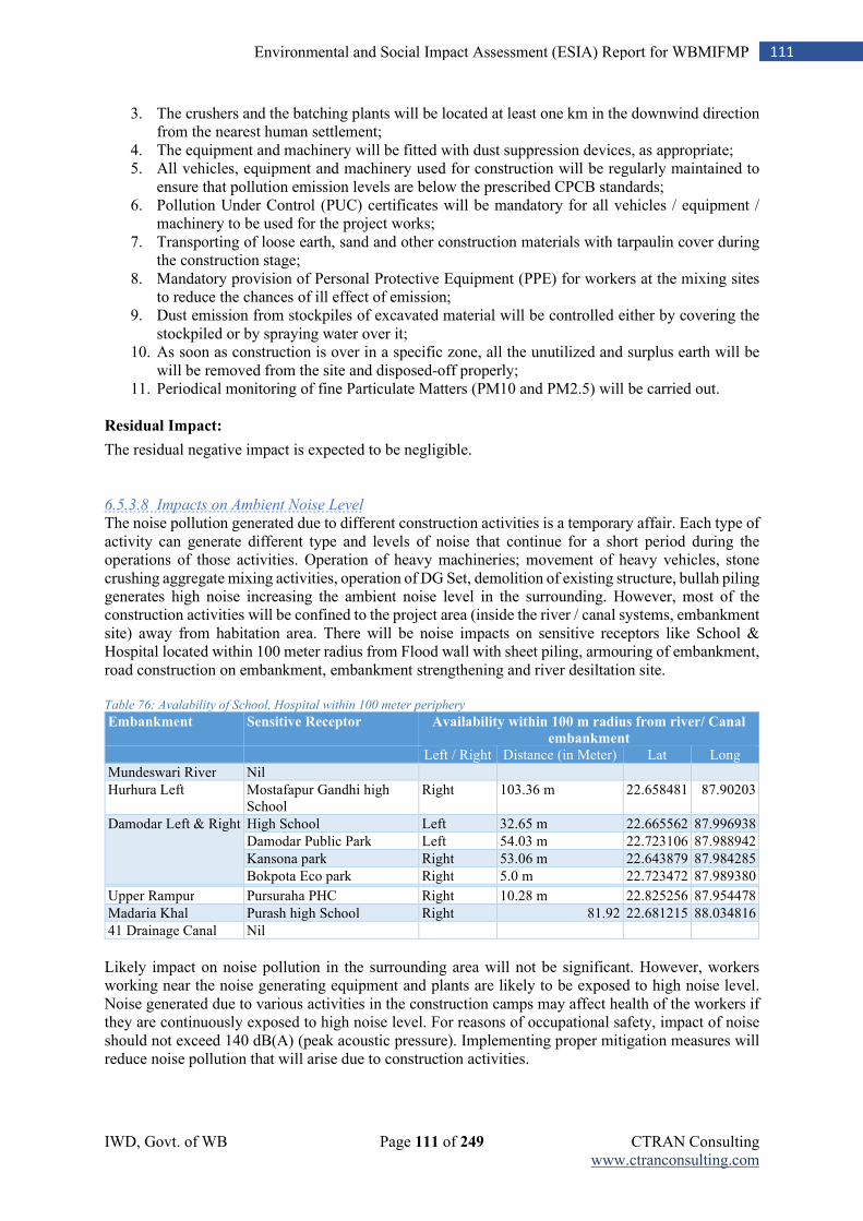
IWD, Govt. of WB Page 111 of 249 CTRAN Consulting www.ctranconsulting.com
111 Environmental and Social Impact Assessment (ESIA) Report for WBMIFMP
3. The crushers and the batching plants will be located at least one km in the downwind direction from the nearest human settlement;
4. The equipment and machinery will be fitted with dust suppression devices, as appropriate; 5. All vehicles, equipment and machinery used for construction will be regularly maintained to
ensure that pollution emission levels are below the prescribed CPCB standards; 6. Pollution Under Control (PUC) certificates will be mandatory for all vehicles / equipment /
machinery to be used for the project works; 7. Transporting of loose earth, sand and other construction materials with tarpaulin cover during
the construction stage; 8. Mandatory provision of Personal Protective Equipment (PPE) for workers at the mixing sites
to reduce the chances of ill effect of emission; 9. Dust emission from stockpiles of excavated material will be controlled either by covering the
stockpiled or by spraying water over it; 10. As soon as construction is over in a specific zone, all the unutilized and surplus earth will be
will be removed from the site and disposed-off properly; 11. Periodical monitoring of fine Particulate Matters (PM10 and PM2.5) will be carried out.
Residual Impact:
The residual negative impact is expected to be negligible. 6.5.3.8 Impacts on Ambient Noise Level
The noise pollution generated due to different construction activities is a temporary affair. Each type of activity can generate different type and levels of noise that continue for a short period during the operations of those activities. Operation of heavy machineries; movement of heavy vehicles, stone crushing aggregate mixing activities, operation of DG Set, demolition of existing structure, bullah piling generates high noise increasing the ambient noise level in the surrounding. However, most of the construction activities will be confined to the project area (inside the river / canal systems, embankment site) away from habitation area. There will be noise impacts on sensitive receptors like School & Hospital located within 100 meter radius from Flood wall with sheet piling, armouring of embankment, road construction on embankment, embankment strengthening and river desiltation site. Table 76: Avalability of School, Hospital within 100 meter periphery
Embankment Sensitive Receptor Availability within 100 m radius from river/ Canal
embankment Left / Right Distance (in Meter) Lat Long
Mundeswari River Nil
Hurhura Left Mostafapur Gandhi high School
Right 103.36 m 22.658481 87.90203
Damodar Left & Right High School Left 32.65 m 22.665562 87.996938
Damodar Public Park Left 54.03 m 22.723106 87.988942
Kansona park Right 53.06 m 22.643879 87.984285
Bokpota Eco park Right 5.0 m 22.723472 87.989380 Upper Rampur Pursuraha PHC Right 10.28 m 22.825256 87.954478
Madaria Khal Purash high School Right 81.92 22.681215 88.034816
41 Drainage Canal Nil
Likely impact on noise pollution in the surrounding area will not be significant. However, workers working near the noise generating equipment and plants are likely to be exposed to high noise level. Noise generated due to various activities in the construction camps may affect health of the workers if they are continuously exposed to high noise level. For reasons of occupational safety, impact of noise should not exceed 140 dB(A) (peak acoustic pressure). Implementing proper mitigation measures will reduce noise pollution that will arise due to construction activities.
IWD, Govt. of WB Page 112 of 249 CTRAN Consulting www.ctranconsulting.com
112 Environmental and Social Impact Assessment (ESIA) Report for WBMIFMP
Mitigation Measures:
1. All plants and equipment used in construction shall strictly conform to the CPCB noise
standards; 2. All noise generating equipment will be installed sufficiently away from settlement areas and
sensitive receptors like school and hospital; 3. Any kind of demolition or other heavy noise generating activity will not be permitted within
100 meter radius of sensitive receptors/ silence area or zone(i.e. school/ college/ hospital)during active working hours (10 AM to 5 PM);work in sensitive receptors/ silence area shall preferably be carried out on weekend and holiday or between 6 A.M to 10 A.M and 5 PM to 9 PM of other weekdays.
4. Reducing the noise produced from a vibrating machine by vibration damping i.e. making a layer of damping material (rubber, neoprene, cork or plastic) beneath the machine.
5. All the construction sites within 100m periphery of the nearest habitation, noisy construction work such as crushing, concrete mixing will be stopped during the night time between 7.00 pm to 6.00 am.;
6. The stationary noise producing sources such as generator sets shall be provided with noise shields around them. The noise shields can either be a brick masonry structure or any other physical barrier which is effective in adequate attenuation of noise levels;
7. Vehicles and equipment used will be fitted with silencer/ noise barrier and maintained as per the regulation; Any noise generating machineries used within 100 m periphery of Hospital shall be provided with noise shields/ barrier and vibrating damper.
8. All the workers working very close to the noise generating machinery shall be provided earplugs to avoid any ill impacts on their health.
9. Noise levels to be monitored as per monitoring plan and if the noise level at any time found to be higher than immediate measure to reduce noise in that area will be ensured.
Residual Impact:
Periodic spikes in noise levels are expected from construction/ demolition/ desilting activity. However, these will be limited to the construction phase. 6.5.3.9 Impact on Ecological Resources
The significant faunal species in the project area include the Fishing Cat, Mongoose, Asian Small Clawed Otter, Fresh Water Turtles/Terrapins, Jungle Cat, Jackal, Monitor Lizard, etc., in addition to several species of birds including the White-eyed Pochard. There are also a few threatened fish species found in the Damodar river. The flora species of significance include Eclipta alba (a medicinal plant) and Ficus religiosa (a culturally significant tree). About 788 large trees are identified to be uprooted for flood wall construction and embankment strengthening work. Many other small trees, shrubs, and aquatic plants (including weeds such as Water Hyacinth) located within the active work zone will be removed. The project activities will lead to loss of vegetation and loss of or disturbance to the natural habitat. To mitigate such impacts, the following measures may be taken: Mitigation Measures:
1. No tree felling will be allowed beyond the identified working zone; cutting of Ficus religiosa
(Peepal) shall be avoided to the possible extent; 2. All the trees located in camp site, stockyards, disposal area and other allied sites will be
preserved; 3. The construction and excavated materials will be staked at a safe distance from tree located in
such areas to avoid any damage to the trees;
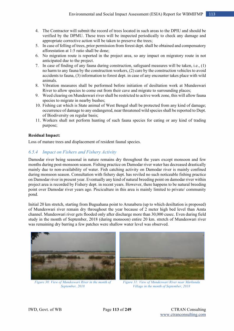
IWD, Govt. of WB Page 113 of 249 CTRAN Consulting www.ctranconsulting.com
113 Environmental and Social Impact Assessment (ESIA) Report for WBMIFMP
4. The Contractor will submit the record of trees located in such areas to the DPIU and should be verified by the DPMU. These trees will be inspected periodically to check any damage and appropriate corrective action will be taken to preserve the trees;
5. In case of felling of trees, prior permission from forest dept. shall be obtained and compensatory afforestation at 1:5 ratio shall be done;
6. No migration route is reported in the project area, so any impact on migratory route in not anticipated due to the project.
7. In case of finding of any fauna during construction, safeguard measures will be taken, i.e., (1) no harm to any fauna by the construction workers, (2) care by the construction vehicles to avoid accidents to fauna, (3) information to forest dept. in case of any encounter takes place with wild animals.
8. Vibration measures shall be performed before initiation of desiltation work at Mundeswari River to allow species to come out from their cave and migrate to surrounding places;
9. Weed clearing on Mundeswari river shall be restricted to active work zone, this will allow fauna species to migrate in nearby bushes;
10. Fishing cat which is State animal of West Bengal shall be protected from any kind of damage; occurrence of damage to any endangered, near threatened wild species shall be reported to Dept. of Biodiversity on regular basis;
11. Workers shall not perform hunting of such fauna species for eating or any kind of trading purpose;
Residual Impact:
Loss of mature trees and displacement of resident faunal species.
6.5.4 Impact on Fishers and Fishery Activity
Damodar river being seasonal in nature remains dry throughout the years except monsoon and few months during post-monsoon season. Fishing practice on Damodar river water has decreased drastically mainly due to non-availability of water. Fish catching activity on Damodar river is mainly confined during monsoon season. Consultation with fishery dept. has reviled no such noticeable fishing practice on Damodar river in present year. Eventually any kind of natural breeding point on damodar river within project area is recorded by Fishery dept. in recent years. However, there happens to be natural breeding point over Damodar river years ago. Pisciculture in this area is mainly limited to private/ community pond. Initial 20 km stretch, starting from Buguahana point to Arunabera (up to which desiltation is proposed) of Mundeswari river remain dry throughout the year because of 2 meter high bed level than Amta channel. Mundeswari river gets flooded only after discharge more than 30,000 cusec. Even during field study in the month of September, 2018 (during monsoon) entire 20 km. stretch of Mundeswari river was remaining dry barring a few patches were shallow water level was observed.
Figure 30: View of Mundeswari River in the month of
September, 2018
Figure 31: View of Mundeswari River near Markunda
Village in the month of September, 2018
IWD, Govt. of WB Page 114 of 249 CTRAN Consulting www.ctranconsulting.com
114 Environmental and Social Impact Assessment (ESIA) Report for WBMIFMP
Fishing activity may be found in further downstream of Mundeswari river which is not proposed for any project activity. Commercial fishing activity is recorded on Rupnarayan river; confluence point of Mundeswari and Rupnarayan River is aerially about 36 km away from Arunabera area (up to which desiltation of Mundeswari is proposed). However, project will be implemented only during non-monsoon season. Any kind of impact on fish catching is not anticipated due to proposed implementation of project activities proposed under WBMIFM project.
6.5.5 Impact on Environmental flow
The project intervention will enhance grater sharing of flood water between Mundeswari and Amta and hence will ensure better flow of flood water in Mundeswari. It is expected to increase the flow from 14.0 percent to 100.0 percent with a discharge of 503.03 m3/s. With increased flood discharge, percentage of sharing gets more balanced causing reduction in the occurrence of flood and return period. Table 77: Flood Discharge and Sharing
Flood
Frequency
Flood Discharge
(m3/s)
Current Sharing (%) Prospective Sharing (%)
Mundeswari Amta Channel Mundeswari Amta Channel
1 503.03 14.0 86.0 100.0 0.0
1.3 2152.36 33.4 67.6 75.6 24.4
2 3590.14 49.0 51.0 74.6 25.6
2.6 4631.00 57.8 42.2 74.0 26.0
3 4789.29 59.0 41.0 74.0 26.0
4 5590.57 59.6 40.4 74.0 26.0
5 6210.18 59.4 40.6 73.9 26.1 Source: Feasibility Study Report of WBMIFMP
Based on this, it can be concluded that while the water flow in Mundeswari is dependent upon the discharge from the barrage, which happens in monsoon, there is no flow of water in other seasons. Secondly, current level of flow of water is more in Amta than Mundeswari. Hence, adverse impact of the project on current water flow or creating obstruction in maintaining the environmental flow can be negated. Rather, the project is expected to improve water sharing and enhancing the flow during monsoon and reducing socio-economic and environmental vulnerability.
6.5.6 Mitigation Measures of Generic Impact
The mitigation measures are proposed to address identified negative impacts as well as anticipated potential adverse impacts that may arise due to the implementation of various activities of the project. The mitigation measures shall be applied during pre-construction, construction and operation stage. Project shall first try to avoid any adverse impact due to implementation of proposed project activities. Wherever, avoidance is not possible, impact minimization approach shall be adopted either by changing project location or change in design alternatives. Any adverse impact arising during project implementation stage shall be addressed using appropriate mitigation measures. Unforeseen impact raised during implementation shall be bought to the notice of respective concern department as well as safeguard specialist of The World Bank. Mitigation measures shall be adopted accordingly, as per the direction from respective authority or safeguard specialist of The World Bank. Mitigation Measures:
Mitigation measures are measures to remove or reduce the potential adverse environmental and social impacts of the project activities. These include generic mitigation measures that are applicable to all project supported activities and specific mitigation measures that are specific to each activity. The mitigation measures are presented as follows:
IWD, Govt. of WB Page 115 of 249 CTRAN Consulting www.ctranconsulting.com
115 Environmental and Social Impact Assessment (ESIA) Report for WBMIFMP
1. Mitigation measures applicable to all or majority of the project activities based on the activity typology;
2. Construction related Mitigation Measures for all project activities involving construction; 3. Mitigation Measures specific to each activity type presented as part of activity-specific
Environmental and Social Management Plan.
6.6 Generic Mitigation Measures
This section provides details of the generic mitigation measures applicable to all relevant project activities. Table 78: Generic Mitigation Measures for All Project Activities
Environmental
Aspect
Generic Mitigation Measures
Site Selection & Materials
1. The site selected for the activity must not be in areas that are protected areas (National Parks or Wildlife Sanctuaries), archaeological sites, and other sites that are of critical conservation importance.
2. Materials required for construction are of specified quality and are only procured from authorized suppliers.
Resource Conservation
1. Promotion of water conservation measures by the use of efficient irrigation methods such as drip and sprinkler irrigation, mulching, ridge and furrow method etc. based on its field suitability and applicability;
2. Restricted use of ground water and optimizing surface water for irrigation (conjunctive water use);
3. Emphasis on crop diversification; discouraging water intensive crops and encouraging less water consuming crops;
4. Encourage adoption of renewable energy where ever feasible (e.g., solar lights, solar water pumps, etc.);
5. Adopt energy efficient farm equipment / machinery (e.g., BEE 3-5 star rated pumps). 6. Use of PPC cement in all civil measures like concrete lining/ flood wall construction/
renovation of existing structure and construction of new structure.
Pollution Control
1. All vehicles to be used for the work should have a valid Pollution Under Control (PUC) certificate;
2. Use of generator sets (diesel, petrol, kerosene, LPG, CNG) that meet CPCB noise and emission control standards;
3. Meeting CPCB prescribed “Ambient Air Quality Standards”; 4. Avoid release of waste water into water bodies, streams, etc., without any treatment. 5. All waste water meets the ‘CPCB General Standards’ prior to disposal; 6. Use of construction machinery / equipment that conforms to CPCB noise standards; 7. Dispose toxic and non-biodegradable wastes at locations specified by the government
/ local body. 8. Proper disposal plan for desilted material and its adherence by the engaged contractor; 9. No burning of generated wastes (crop residues, leaf litter, plastic wastes, etc.).
Biodiversity Conservation
1. Avoid felling of trees in the embankment, work place or camp sites; 2. Obtain permission from Dept. of Forest in case tree felling is unavoidable; 3. In case tree felling is unavoidable, compensatory plantation should be done with not
less than 5 times of the number of plants cut down / uprooted; 4. Avoid mono species plantation and promote mixed plantation with locally grown
species.
Health and Safety
1. Adopting prescribed safety practices during handling of equipment, manual labour, handling of pesticides, etc.
2. Provision of required safety measures at the work sites and labour camps (fire safety, chemical safety, etc.)
3. Mandatory use of personal protection gears by workers (helmets, safety harness while working at heights, etc.).
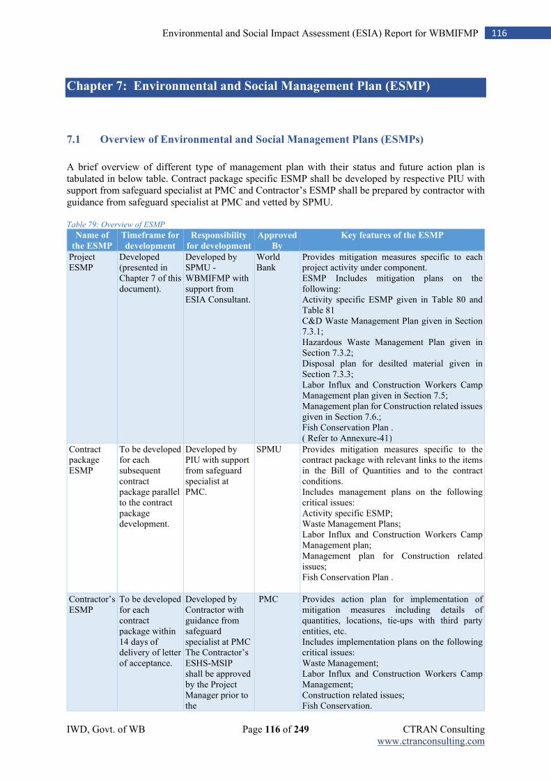
IWD, Govt. of WB Page 116 of 249 CTRAN Consulting www.ctranconsulting.com
116 Environmental and Social Impact Assessment (ESIA) Report for WBMIFMP
Chapter 7: Environmental and Social Management Plan (ESMP)
7.1 Overview of Environmental and Social Management Plans (ESMPs)
A brief overview of different type of management plan with their status and future action plan is tabulated in below table. Contract package specific ESMP shall be developed by respective PIU with support from safeguard specialist at PMC and Contractor’s ESMP shall be prepared by contractor with guidance from safeguard specialist at PMC and vetted by SPMU. Table 79: Overview of ESMP
Name of
the ESMP
Timeframe for
development
Responsibility
for development
Approved
By
Key features of the ESMP
Project ESMP
Developed (presented in Chapter 7 of this document).
Developed by SPMU -WBMIFMP with support from ESIA Consultant.
World Bank
Provides mitigation measures specific to each project activity under component. ESMP Includes mitigation plans on the following: Activity specific ESMP given in Table 80 and Table 81 C&D Waste Management Plan given in Section 7.3.1; Hazardous Waste Management Plan given in Section 7.3.2; Disposal plan for desilted material given in Section 7.3.3; Labor Influx and Construction Workers Camp Management plan given in Section 7.5; Management plan for Construction related issues given in Section 7.6.; Fish Conservation Plan . ( Refer to Annexure-41)
Contract package ESMP
To be developed for each subsequent contract package parallel to the contract package development.
Developed by PIU with support from safeguard specialist at PMC.
SPMU Provides mitigation measures specific to the contract package with relevant links to the items in the Bill of Quantities and to the contract conditions. Includes management plans on the following critical issues: Activity specific ESMP; Waste Management Plans; Labor Influx and Construction Workers Camp Management plan; Management plan for Construction related issues; Fish Conservation Plan .
Contractor’s ESMP
To be developed for each contract package within 14 days of delivery of letter of acceptance.
Developed by Contractor with guidance from safeguard specialist at PMC The Contractor’s ESHS-MSIP shall be approved by the Project Manager prior to the
PMC Provides action plan for implementation of mitigation measures including details of quantities, locations, tie-ups with third party entities, etc. Includes implementation plans on the following critical issues: Waste Management; Labor Influx and Construction Workers Camp Management; Construction related issues; Fish Conservation.
IWD, Govt. of WB Page 117 of 249 CTRAN Consulting www.ctranconsulting.com
117 Environmental and Social Impact Assessment (ESIA) Report for WBMIFMP
commencement of construction activities. The approved Contractor’s ESHS-MSIP shall be reviewed periodically by the Project Manager and updated in a timely manner, as required, by the Contractor with prior approval of the Project Manager.
A key provision for ensuring implementation of environmental and social safeguards is the
Environmental, Social, Health and Safety (ESHS) Performance Security, amounting to 2%
percent of the Contract Amount, which is to be submitted by every successful Bidder (Contractor)
within twenty-one (21) days of the receipt of the Letter of Acceptance.
IWD, Govt. of WB Page 118 of 249 CTRAN Consulting www.ctranconsulting.com
118 Environmental and Social Impact Assessment (ESIA) Report for WBMIFMP
7.2 Mitigation Measures Specific to Each Activity Type
Project activity specific ESIA is undertaken for all activities belonging to category 1, and, a Rapid assessment was undertaken for all activities belonging to category 2. For both category 1 and 2 activities, an activity-specific mitigation plan is prepared. This section provides activity-specific mitigation measures.
1. Mitigation measures for Modernization of Irrigation Infrastructure component; 2. Mitigation measures for activities under Flood Management component;
In addition to the above, the following mitigation plans are prepared for additional emphasis on critical issues:
Waste Management Plan
Labor Influx and Construction Workers Camp Management Plan
Management plan for construction related issues
Fish Conservation Plan
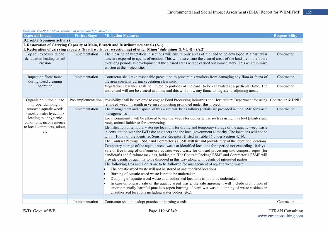
IWD, Govt. of WB Page 119 of 249 CTRAN Consulting www.ctranconsulting.com
119 Environmental and Social Impact Assessment (ESIA) Report for WBMIFMP
Table 80: ESMP for Modernization of Irrigation Infrastructure
Expected Impact Project Stage Mitigation Measures Responsibility
B.1 &B.2 (common activity)
I. Restoration of Carrying Capacity of Main, Branch and Distributaries canals (A.1)
I. Restoration of carrying capacity (Earth work for re-sectioning) of other Minor/ Sub-minor (LVL 4) – (A.2)
Top soil exposure due to denudation leading to soil
erosion
Implementation The clearing of vegetation in sections will ensure only areas of the land to be developed at a particular time are exposed to agents of erosion. This will also ensure the cleared areas of the land are not left bare over long periods as development at the cleared areas will be carried out immediately. This will minimize erosion at the project site.
Contractor
Impact on flora/ fauna during weed cleaning
operation
Implementation Contractor shall take reasonable precaution to prevent his workers from damaging any flora or fauna of the area specially during vegetation clearance.
Contractor
Vegetation clearance shall be limited to portions of the canal to be excavated at a particular time. The entire land will not be cleared at a time and this will allow any fauna to migrate to adjoining areas.
Contractor
Organic pollution due to improper dumping of
removed aquatic weeds (mostly water hyacinth) leading to unhygienic
conditions, inconvenience to local commuters, odour,
etc
Pre- implementation Possibility shall be explored to engage Food Processing Industries and Horticulture Department for using removed weed/ hyacinth in vermi composting promoted under this project.
Contractor & DPIU
Implementation The management and disposal of this waste will be as follows (details are provided in the ESMP for waste management):
Contractor
Local community will be allowed to use the weeds for domestic use such as using it as fuel (shrub stem, root), animal fodder or for composting.
Identification of temporary storage locations for drying and temporary storage of the aquatic weed waste in consultation with the IWD site engineers and the local government authority. The locations will not be within 100 m of the identified Sensitive Receptors (listed in Table 36 under Section 4.16).
The Contract Package ESMP and Contractor’s ESMP will list and provide map of the identified locations.
Temporary storage of the aquatic weed waste at identified locations for a period not exceeding 10 days.
Sale or free lifting of dry/semi-dry aquatic weed waste for onward processing into compost, ropes (for handicrafts and furniture making), fodder, etc. The Contract Package ESMP and Contractor’s ESMP will provide details of quantity to be disposed in this way along with details of interested parties.
The following Dos and Don’ts are to be followed for management of aquatic weed waste:
The aquatic weed waste will not be stored at unauthorized locations.
Burning of aquatic weed waste is not to be undertaken.
Dumping of aquatic weed waste at unauthorized locations is not to be undertaken.
In case on onward sale of the aquatic weed waste, the sale agreement will include prohibition of environmentally harmful practices (open burning of semi-wet waste, dumping of waste residues in unauthorized locations including water bodies, etc.).
Implementation Contractor shall not adopt practice of burning weeds; Contractor
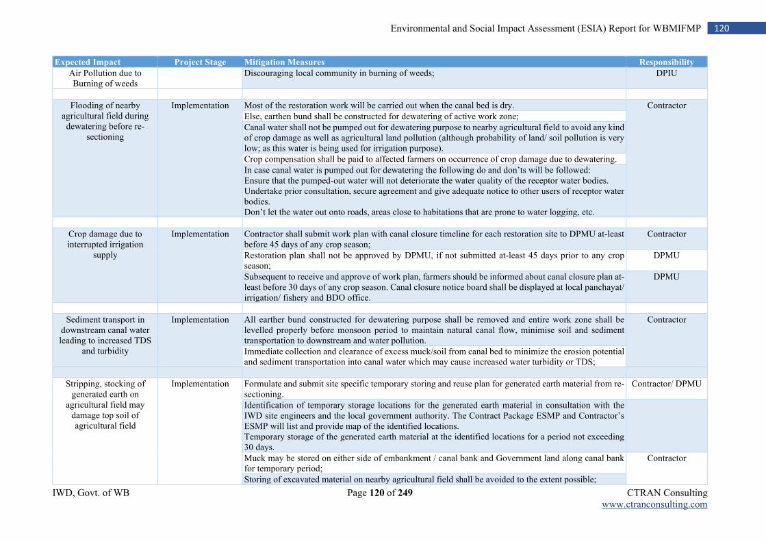
IWD, Govt. of WB Page 120 of 249 CTRAN Consulting www.ctranconsulting.com
120 Environmental and Social Impact Assessment (ESIA) Report for WBMIFMP
Expected Impact Project Stage Mitigation Measures Responsibility
Air Pollution due to Burning of weeds
Discouraging local community in burning of weeds; DPIU
Flooding of nearby agricultural field during dewatering before re-
sectioning
Implementation Most of the restoration work will be carried out when the canal bed is dry. Contractor
Else, earthen bund shall be constructed for dewatering of active work zone;
Canal water shall not be pumped out for dewatering purpose to nearby agricultural field to avoid any kind of crop damage as well as agricultural land pollution (although probability of land/ soil pollution is very low; as this water is being used for irrigation purpose).
Crop compensation shall be paid to affected farmers on occurrence of crop damage due to dewatering.
In case canal water is pumped out for dewatering the following do and don’ts will be followed: Ensure that the pumped-out water will not deteriorate the water quality of the receptor water bodies. Undertake prior consultation, secure agreement and give adequate notice to other users of receptor water bodies. Don’t let the water out onto roads, areas close to habitations that are prone to water logging, etc.
Crop damage due to interrupted irrigation
supply
Implementation Contractor shall submit work plan with canal closure timeline for each restoration site to DPMU at-least before 45 days of any crop season;
Contractor
Restoration plan shall not be approved by DPMU, if not submitted at-least 45 days prior to any crop season;
DPMU
Subsequent to receive and approve of work plan, farmers should be informed about canal closure plan at-least before 30 days of any crop season. Canal closure notice board shall be displayed at local panchayat/ irrigation/ fishery and BDO office.
DPMU
Sediment transport in downstream canal water leading to increased TDS
and turbidity
Implementation All earther bund constructed for dewatering purpose shall be removed and entire work zone shall be levelled properly before monsoon period to maintain natural canal flow, minimise soil and sediment transportation to downstream and water pollution.
Contractor
Immediate collection and clearance of excess muck/soil from canal bed to minimize the erosion potential and sediment transportation into canal water which may cause increased water turbidity or TDS;
Stripping, stocking of generated earth on
agricultural field may damage top soil of agricultural field
Implementation Formulate and submit site specific temporary storing and reuse plan for generated earth material from re-sectioning.
Contractor/ DPMU
Identification of temporary storage locations for the generated earth material in consultation with the IWD site engineers and the local government authority. The Contract Package ESMP and Contractor’s ESMP will list and provide map of the identified locations. Temporary storage of the generated earth material at the identified locations for a period not exceeding 30 days.
Muck may be stored on either side of embankment / canal bank and Government land along canal bank for temporary period;
Contractor
Storing of excavated material on nearby agricultural field shall be avoided to the extent possible;
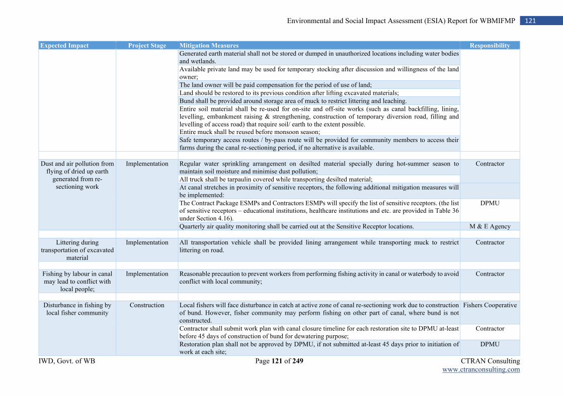
IWD, Govt. of WB Page 121 of 249 CTRAN Consulting www.ctranconsulting.com
121 Environmental and Social Impact Assessment (ESIA) Report for WBMIFMP
Expected Impact Project Stage Mitigation Measures Responsibility
Generated earth material shall not be stored or dumped in unauthorized locations including water bodies and wetlands.
Available private land may be used for temporary stocking after discussion and willingness of the land owner;
The land owner will be paid compensation for the period of use of land;
Land should be restored to its previous condition after lifting excavated materials;
Bund shall be provided around storage area of muck to restrict littering and leaching.
Entire soil material shall be re-used for on-site and off-site works (such as canal backfilling, lining, levelling, embankment raising & strengthening, construction of temporary diversion road, filling and levelling of access road) that require soil/ earth to the extent possible. Entire muck shall be reused before monsoon season;
Safe temporary access routes / by-pass route will be provided for community members to access their farms during the canal re-sectioning period, if no alternative is available.
Dust and air pollution from flying of dried up earth
generated from re-sectioning work
Implementation Regular water sprinkling arrangement on desilted material specially during hot-summer season to maintain soil moisture and minimise dust pollution;
Contractor
All truck shall be tarpaulin covered while transporting desilted material;
At canal stretches in proximity of sensitive receptors, the following additional mitigation measures will be implemented:
The Contract Package ESMPs and Contractors ESMPs will specify the list of sensitive receptors. (the list of sensitive receptors – educational institutions, healthcare institutions and etc. are provided in Table 36 under Section 4.16).
DPMU
Quarterly air quality monitoring shall be carried out at the Sensitive Receptor locations. M & E Agency
Littering during transportation of excavated
material
Implementation All transportation vehicle shall be provided lining arrangement while transporting muck to restrict littering on road.
Contractor
Fishing by labour in canal may lead to conflict with
local people;
Implementation Reasonable precaution to prevent workers from performing fishing activity in canal or waterbody to avoid conflict with local community;
Contractor
Disturbance in fishing by local fisher community
Construction Local fishers will face disturbance in catch at active zone of canal re-sectioning work due to construction of bund. However, fisher community may perform fishing on other part of canal, where bund is not constructed.
Fishers Cooperative
Contractor shall submit work plan with canal closure timeline for each restoration site to DPMU at-least before 45 days of construction of bund for dewatering purpose;
Contractor
Restoration plan shall not be approved by DPMU, if not submitted at-least 45 days prior to initiation of work at each site;
DPMU
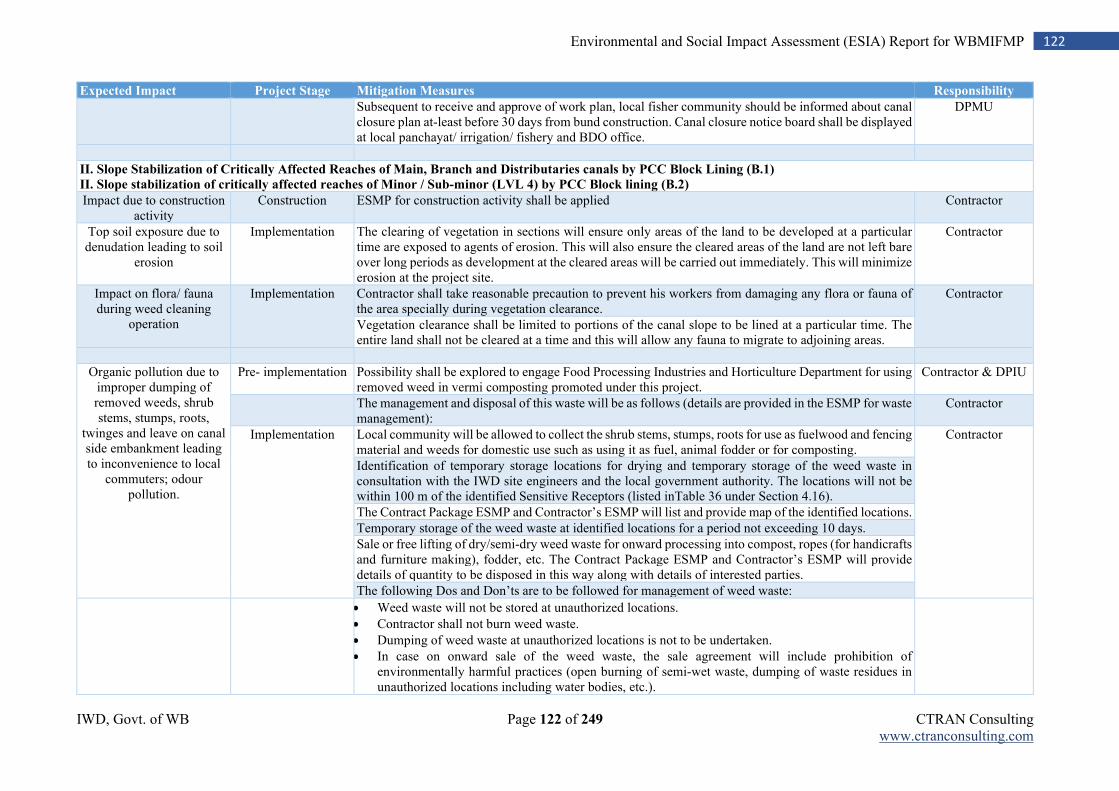
IWD, Govt. of WB Page 122 of 249 CTRAN Consulting www.ctranconsulting.com
122 Environmental and Social Impact Assessment (ESIA) Report for WBMIFMP
Expected Impact Project Stage Mitigation Measures Responsibility
Subsequent to receive and approve of work plan, local fisher community should be informed about canal closure plan at-least before 30 days from bund construction. Canal closure notice board shall be displayed at local panchayat/ irrigation/ fishery and BDO office.
DPMU
II. Slope Stabilization of Critically Affected Reaches of Main, Branch and Distributaries canals by PCC Block Lining (B.1) II. Slope stabilization of critically affected reaches of Minor / Sub-minor (LVL 4) by PCC Block lining (B.2)
Impact due to construction activity
Construction ESMP for construction activity shall be applied Contractor
Top soil exposure due to denudation leading to soil
erosion
Implementation The clearing of vegetation in sections will ensure only areas of the land to be developed at a particular time are exposed to agents of erosion. This will also ensure the cleared areas of the land are not left bare over long periods as development at the cleared areas will be carried out immediately. This will minimize erosion at the project site.
Contractor
Impact on flora/ fauna during weed cleaning
operation
Implementation Contractor shall take reasonable precaution to prevent his workers from damaging any flora or fauna of the area specially during vegetation clearance.
Contractor
Vegetation clearance shall be limited to portions of the canal slope to be lined at a particular time. The entire land shall not be cleared at a time and this will allow any fauna to migrate to adjoining areas.
Organic pollution due to improper dumping of removed weeds, shrub stems, stumps, roots,
twinges and leave on canal side embankment leading to inconvenience to local
commuters; odour pollution.
Pre- implementation Possibility shall be explored to engage Food Processing Industries and Horticulture Department for using removed weed in vermi composting promoted under this project.
Contractor & DPIU
The management and disposal of this waste will be as follows (details are provided in the ESMP for waste management):
Contractor
Implementation Local community will be allowed to collect the shrub stems, stumps, roots for use as fuelwood and fencing material and weeds for domestic use such as using it as fuel, animal fodder or for composting.
Contractor
Identification of temporary storage locations for drying and temporary storage of the weed waste in consultation with the IWD site engineers and the local government authority. The locations will not be within 100 m of the identified Sensitive Receptors (listed inTable 36 under Section 4.16).
The Contract Package ESMP and Contractor’s ESMP will list and provide map of the identified locations.
Temporary storage of the weed waste at identified locations for a period not exceeding 10 days.
Sale or free lifting of dry/semi-dry weed waste for onward processing into compost, ropes (for handicrafts and furniture making), fodder, etc. The Contract Package ESMP and Contractor’s ESMP will provide details of quantity to be disposed in this way along with details of interested parties.
The following Dos and Don’ts are to be followed for management of weed waste:
Weed waste will not be stored at unauthorized locations.
Contractor shall not burn weed waste.
Dumping of weed waste at unauthorized locations is not to be undertaken.
In case on onward sale of the weed waste, the sale agreement will include prohibition of environmentally harmful practices (open burning of semi-wet waste, dumping of waste residues in unauthorized locations including water bodies, etc.).
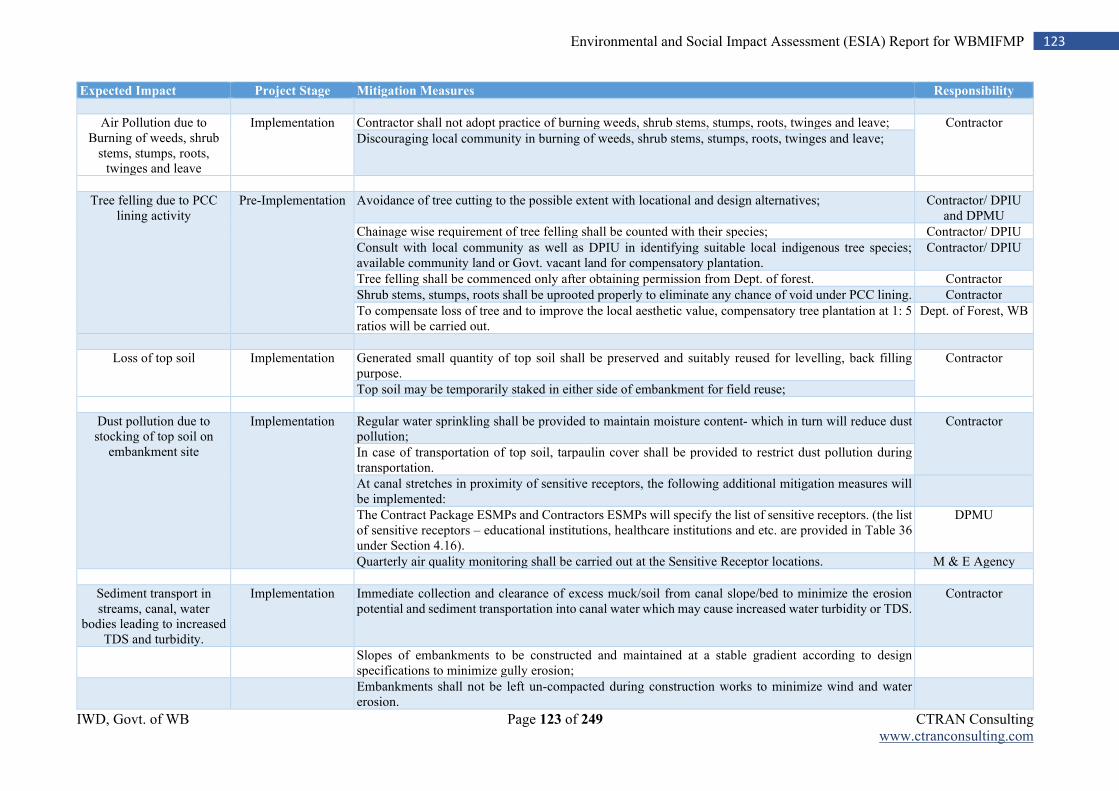
IWD, Govt. of WB Page 123 of 249 CTRAN Consulting www.ctranconsulting.com
123 Environmental and Social Impact Assessment (ESIA) Report for WBMIFMP
Expected Impact Project Stage Mitigation Measures Responsibility
Air Pollution due to Burning of weeds, shrub
stems, stumps, roots, twinges and leave
Implementation Contractor shall not adopt practice of burning weeds, shrub stems, stumps, roots, twinges and leave; Contractor
Discouraging local community in burning of weeds, shrub stems, stumps, roots, twinges and leave;
Tree felling due to PCC lining activity
Pre-Implementation Avoidance of tree cutting to the possible extent with locational and design alternatives; Contractor/ DPIU and DPMU
Chainage wise requirement of tree felling shall be counted with their species; Contractor/ DPIU
Consult with local community as well as DPIU in identifying suitable local indigenous tree species; available community land or Govt. vacant land for compensatory plantation.
Contractor/ DPIU
Tree felling shall be commenced only after obtaining permission from Dept. of forest. Contractor
Shrub stems, stumps, roots shall be uprooted properly to eliminate any chance of void under PCC lining. Contractor
To compensate loss of tree and to improve the local aesthetic value, compensatory tree plantation at 1: 5 ratios will be carried out.
Dept. of Forest, WB
Loss of top soil Implementation Generated small quantity of top soil shall be preserved and suitably reused for levelling, back filling purpose.
Contractor
Top soil may be temporarily staked in either side of embankment for field reuse;
Dust pollution due to stocking of top soil on
embankment site
Implementation Regular water sprinkling shall be provided to maintain moisture content- which in turn will reduce dust pollution;
Contractor
In case of transportation of top soil, tarpaulin cover shall be provided to restrict dust pollution during transportation.
At canal stretches in proximity of sensitive receptors, the following additional mitigation measures will be implemented:
The Contract Package ESMPs and Contractors ESMPs will specify the list of sensitive receptors. (the list of sensitive receptors – educational institutions, healthcare institutions and etc. are provided in Table 36 under Section 4.16).
DPMU
Quarterly air quality monitoring shall be carried out at the Sensitive Receptor locations. M & E Agency
Sediment transport in streams, canal, water
bodies leading to increased TDS and turbidity.
Implementation Immediate collection and clearance of excess muck/soil from canal slope/bed to minimize the erosion potential and sediment transportation into canal water which may cause increased water turbidity or TDS.
Contractor
Slopes of embankments to be constructed and maintained at a stable gradient according to design specifications to minimize gully erosion;
Embankments shall not be left un-compacted during construction works to minimize wind and water erosion.
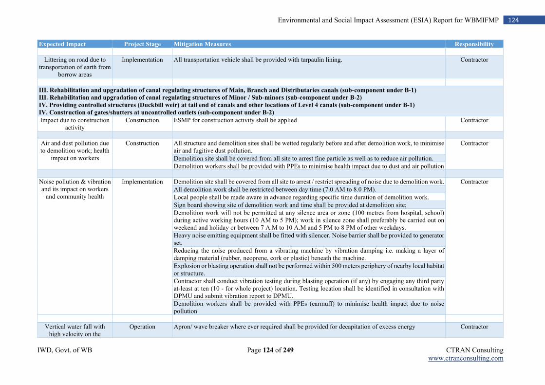
IWD, Govt. of WB Page 124 of 249 CTRAN Consulting www.ctranconsulting.com
124 Environmental and Social Impact Assessment (ESIA) Report for WBMIFMP
Expected Impact Project Stage Mitigation Measures Responsibility
Littering on road due to transportation of earth from
borrow areas
Implementation All transportation vehicle shall be provided with tarpaulin lining. Contractor
III. Rehabilitation and upgradation of canal regulating structures of Main, Branch and Distributaries canals (sub-component under B-1)
III. Rehabilitation and upgradation of canal regulating structures of Minor / Sub-minors (sub-component under B-2)
IV. Providing controlled structures (Duckbill weir) at tail end of canals and other locations of Level 4 canals (sub-component under B-1) IV. Construction of gates/shutters at uncontrolled outlets (sub-component under B-2)
Impact due to construction activity
Construction ESMP for construction activity shall be applied Contractor
Air and dust pollution due to demolition work; health
impact on workers
Construction All structure and demolition sites shall be wetted regularly before and after demolition work, to minimise air and fugitive dust pollution.
Contractor
Demolition site shall be covered from all site to arrest fine particle as well as to reduce air pollution.
Demolition workers shall be provided with PPEs to minimise health impact due to dust and air pollution
Noise pollution & vibration and its impact on workers
and community health
Implementation Demolition site shall be covered from all site to arrest / restrict spreading of noise due to demolition work. Contractor
All demolition work shall be restricted between day time (7.0 AM to 8.0 PM).
Local people shall be made aware in advance regarding specific time duration of demolition work.
Sign board showing site of demolition work and time shall be provided at demolition site;
Demolition work will not be permitted at any silence area or zone (100 metres from hospital, school) during active working hours (10 AM to 5 PM); work in silence zone shall preferably be carried out on weekend and holiday or between 7 A.M to 10 A.M and 5 PM to 8 PM of other weekdays.
Heavy noise emitting equipment shall be fitted with silencer. Noise barrier shall be provided to generator set.
Reducing the noise produced from a vibrating machine by vibration damping i.e. making a layer of damping material (rubber, neoprene, cork or plastic) beneath the machine.
Explosion or blasting operation shall not be performed within 500 meters periphery of nearby local habitat or structure.
Contractor shall conduct vibration testing during blasting operation (if any) by engaging any third party at-least at ten (10 - for whole project) location. Testing location shall be identified in consultation with DPMU and submit vibration report to DPMU.
Demolition workers shall be provided with PPEs (earmuff) to minimise health impact due to noise pollution
Vertical water fall with high velocity on the
Operation Apron/ wave breaker where ever required shall be provided for decapitation of excess energy Contractor
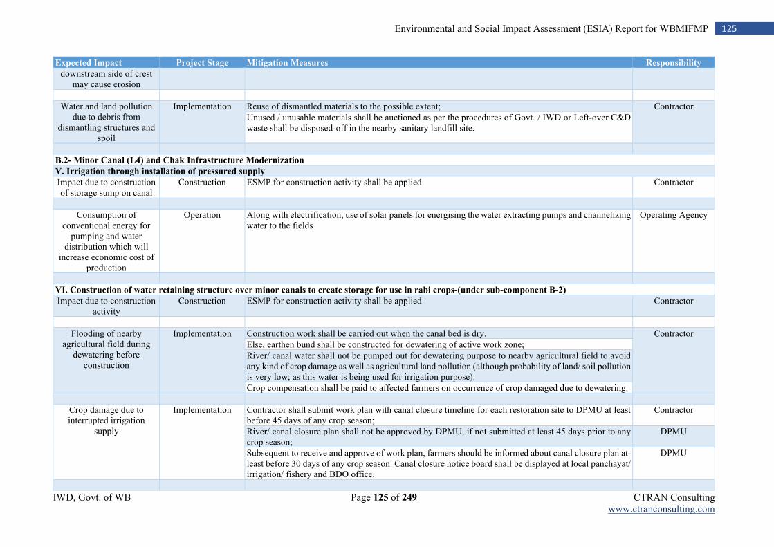
IWD, Govt. of WB Page 125 of 249 CTRAN Consulting www.ctranconsulting.com
125 Environmental and Social Impact Assessment (ESIA) Report for WBMIFMP
Expected Impact Project Stage Mitigation Measures Responsibility
downstream side of crest may cause erosion
Water and land pollution due to debris from
dismantling structures and spoil
Implementation Reuse of dismantled materials to the possible extent; Contractor
Unused / unusable materials shall be auctioned as per the procedures of Govt. / IWD or Left-over C&D waste shall be disposed-off in the nearby sanitary landfill site.
B.2- Minor Canal (L4) and Chak Infrastructure Modernization
V. Irrigation through installation of pressured supply
Impact due to construction of storage sump on canal
Construction ESMP for construction activity shall be applied Contractor
Consumption of conventional energy for
pumping and water distribution which will
increase economic cost of production
Operation Along with electrification, use of solar panels for energising the water extracting pumps and channelizing water to the fields
Operating Agency
VI. Construction of water retaining structure over minor canals to create storage for use in rabi crops-(under sub-component B-2)
Impact due to construction activity
Construction ESMP for construction activity shall be applied Contractor
Flooding of nearby agricultural field during
dewatering before construction
Implementation Construction work shall be carried out when the canal bed is dry. Contractor
Else, earthen bund shall be constructed for dewatering of active work zone;
River/ canal water shall not be pumped out for dewatering purpose to nearby agricultural field to avoid any kind of crop damage as well as agricultural land pollution (although probability of land/ soil pollution is very low; as this water is being used for irrigation purpose).
Crop compensation shall be paid to affected farmers on occurrence of crop damaged due to dewatering.
Crop damage due to interrupted irrigation
supply
Implementation Contractor shall submit work plan with canal closure timeline for each restoration site to DPMU at least before 45 days of any crop season;
Contractor
River/ canal closure plan shall not be approved by DPMU, if not submitted at least 45 days prior to any crop season;
DPMU
Subsequent to receive and approve of work plan, farmers should be informed about canal closure plan at-least before 30 days of any crop season. Canal closure notice board shall be displayed at local panchayat/ irrigation/ fishery and BDO office.
DPMU
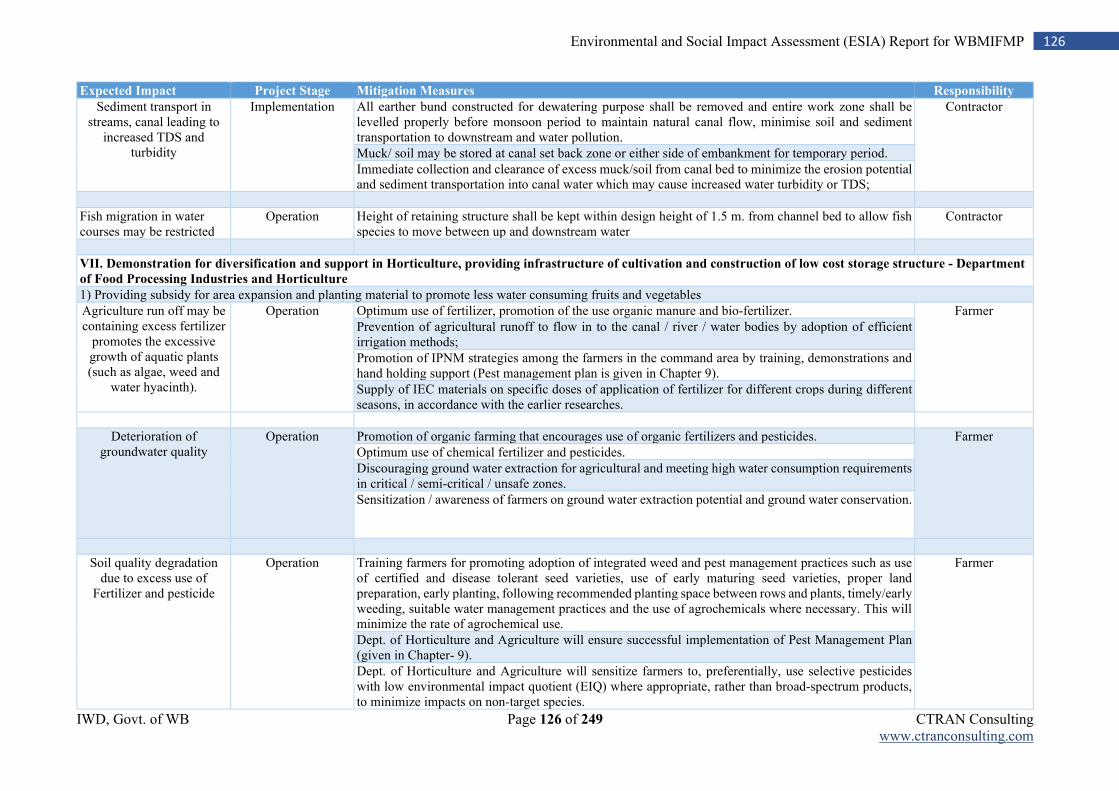
IWD, Govt. of WB Page 126 of 249 CTRAN Consulting www.ctranconsulting.com
126 Environmental and Social Impact Assessment (ESIA) Report for WBMIFMP
Expected Impact Project Stage Mitigation Measures Responsibility
Sediment transport in streams, canal leading to
increased TDS and turbidity
Implementation All earther bund constructed for dewatering purpose shall be removed and entire work zone shall be levelled properly before monsoon period to maintain natural canal flow, minimise soil and sediment transportation to downstream and water pollution.
Contractor
Muck/ soil may be stored at canal set back zone or either side of embankment for temporary period.
Immediate collection and clearance of excess muck/soil from canal bed to minimize the erosion potential and sediment transportation into canal water which may cause increased water turbidity or TDS;
Fish migration in water courses may be restricted
Operation Height of retaining structure shall be kept within design height of 1.5 m. from channel bed to allow fish species to move between up and downstream water
Contractor
VII. Demonstration for diversification and support in Horticulture, providing infrastructure of cultivation and construction of low cost storage structure - Department
of Food Processing Industries and Horticulture
1) Providing subsidy for area expansion and planting material to promote less water consuming fruits and vegetables
Agriculture run off may be containing excess fertilizer
promotes the excessive growth of aquatic plants (such as algae, weed and
water hyacinth).
Operation Optimum use of fertilizer, promotion of the use organic manure and bio-fertilizer. Farmer
Prevention of agricultural runoff to flow in to the canal / river / water bodies by adoption of efficient irrigation methods;
Promotion of IPNM strategies among the farmers in the command area by training, demonstrations and hand holding support (Pest management plan is given in Chapter 9).
Supply of IEC materials on specific doses of application of fertilizer for different crops during different seasons, in accordance with the earlier researches.
Deterioration of groundwater quality
Operation Promotion of organic farming that encourages use of organic fertilizers and pesticides. Farmer
Optimum use of chemical fertilizer and pesticides.
Discouraging ground water extraction for agricultural and meeting high water consumption requirements in critical / semi-critical / unsafe zones.
Sensitization / awareness of farmers on ground water extraction potential and ground water conservation.
Soil quality degradation due to excess use of
Fertilizer and pesticide
Operation Training farmers for promoting adoption of integrated weed and pest management practices such as use of certified and disease tolerant seed varieties, use of early maturing seed varieties, proper land preparation, early planting, following recommended planting space between rows and plants, timely/early weeding, suitable water management practices and the use of agrochemicals where necessary. This will minimize the rate of agrochemical use.
Farmer
Dept. of Horticulture and Agriculture will ensure successful implementation of Pest Management Plan (given in Chapter- 9).
Dept. of Horticulture and Agriculture will sensitize farmers to, preferentially, use selective pesticides with low environmental impact quotient (EIQ) where appropriate, rather than broad-spectrum products, to minimize impacts on non-target species.
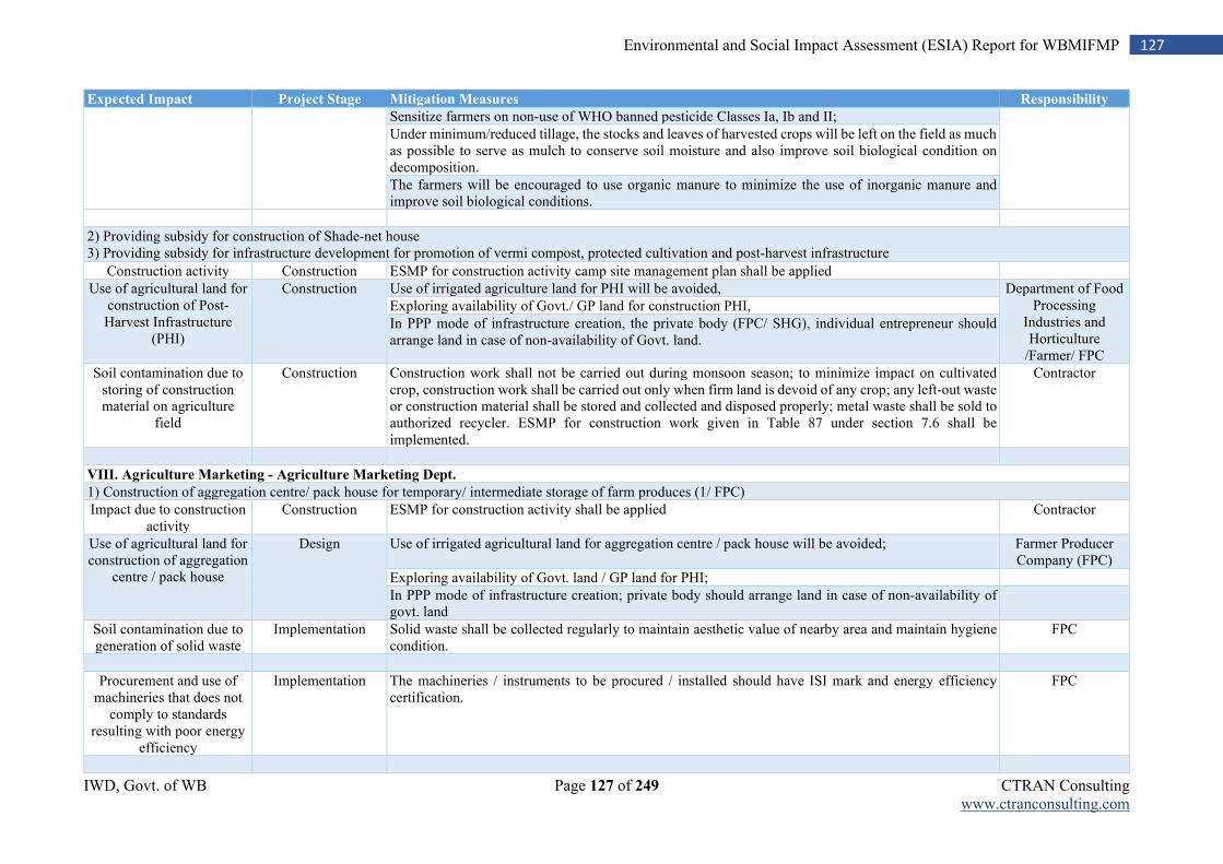
IWD, Govt. of WB Page 127 of 249 CTRAN Consulting www.ctranconsulting.com
127 Environmental and Social Impact Assessment (ESIA) Report for WBMIFMP
Expected Impact Project Stage Mitigation Measures Responsibility
Sensitize farmers on non-use of WHO banned pesticide Classes Ia, Ib and II;
Under minimum/reduced tillage, the stocks and leaves of harvested crops will be left on the field as much as possible to serve as mulch to conserve soil moisture and also improve soil biological condition on decomposition.
The farmers will be encouraged to use organic manure to minimize the use of inorganic manure and improve soil biological conditions.
2) Providing subsidy for construction of Shade-net house 3) Providing subsidy for infrastructure development for promotion of vermi compost, protected cultivation and post-harvest infrastructure
Construction activity Construction ESMP for construction activity camp site management plan shall be applied
Use of agricultural land for construction of Post-Harvest Infrastructure
(PHI)
Construction Use of irrigated agriculture land for PHI will be avoided, Department of Food Processing
Industries and Horticulture
/Farmer/ FPC
Exploring availability of Govt./ GP land for construction PHI,
In PPP mode of infrastructure creation, the private body (FPC/ SHG), individual entrepreneur should arrange land in case of non-availability of Govt. land.
Soil contamination due to storing of construction material on agriculture
field
Construction Construction work shall not be carried out during monsoon season; to minimize impact on cultivated crop, construction work shall be carried out only when firm land is devoid of any crop; any left-out waste or construction material shall be stored and collected and disposed properly; metal waste shall be sold to authorized recycler. ESMP for construction work given in Table 87 under section 7.6 shall be implemented.
Contractor
VIII. Agriculture Marketing - Agriculture Marketing Dept.
1) Construction of aggregation centre/ pack house for temporary/ intermediate storage of farm produces (1/ FPC)
Impact due to construction activity
Construction ESMP for construction activity shall be applied Contractor
Use of agricultural land for construction of aggregation
centre / pack house
Design Use of irrigated agricultural land for aggregation centre / pack house will be avoided; Farmer Producer Company (FPC)
Exploring availability of Govt. land / GP land for PHI;
In PPP mode of infrastructure creation; private body should arrange land in case of non-availability of govt. land
Soil contamination due to generation of solid waste
Implementation Solid waste shall be collected regularly to maintain aesthetic value of nearby area and maintain hygiene condition.
FPC
Procurement and use of machineries that does not
comply to standards resulting with poor energy
efficiency
Implementation The machineries / instruments to be procured / installed should have ISI mark and energy efficiency certification.
FPC
IWD, Govt. of WB Page 128 of 249 CTRAN Consulting www.ctranconsulting.com
128 Environmental and Social Impact Assessment (ESIA) Report for WBMIFMP
Expected Impact Project Stage Mitigation Measures Responsibility
2) Transport subsidy to each FPC for procurement of motorized van (4.5 lakh/ FPC)
Procurement and use of vans that are not as per the
standard for agricultural commodity transportation
Implementation The van to be procured should comply to prescribed standards for transportation of agricultural commodities;
FPC
IX. Promotion of cage based pisciculture in the main and branches of irrigation canals
1) Providing 8 no. cages with appurtenant to each SHG/ FPGs
2) Providing fish seed, fish feed etc. to SHG/ FPGs as one-time sustenance support
Pollution from overstocking and
overfeeding
Operation Avoiding overfeeding; Fish Producers Group (FPG)/ Self Help Group (SHG)
Avoiding or minimize or control use of medication
Risk of cultivation of exotic species that may
impact native populations
Operation Maintaining proper stocking density; FPG/ SHG
Avoiding stocking exotic and invasive species;
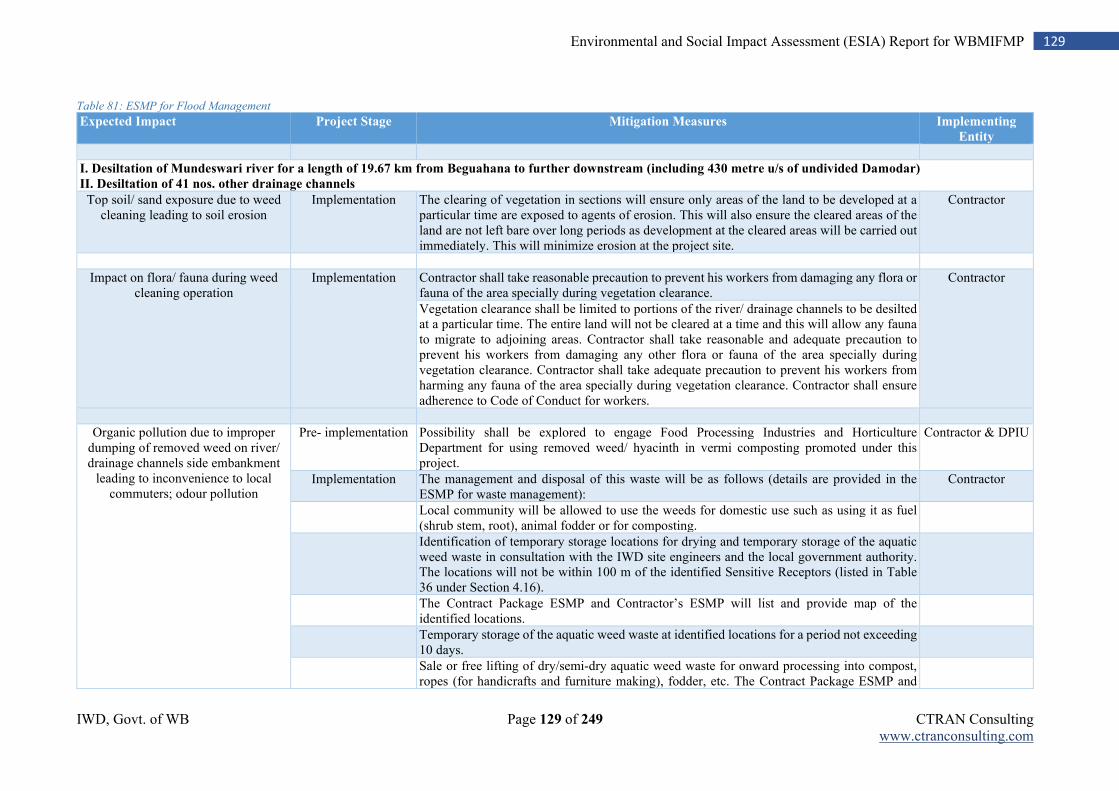
IWD, Govt. of WB Page 129 of 249 CTRAN Consulting www.ctranconsulting.com
129 Environmental and Social Impact Assessment (ESIA) Report for WBMIFMP
Table 81: ESMP for Flood Management
Expected Impact Project Stage Mitigation Measures Implementing
Entity
I. Desiltation of Mundeswari river for a length of 19.67 km from Beguahana to further downstream (including 430 metre u/s of undivided Damodar)
II. Desiltation of 41 nos. other drainage channels
Top soil/ sand exposure due to weed cleaning leading to soil erosion
Implementation The clearing of vegetation in sections will ensure only areas of the land to be developed at a particular time are exposed to agents of erosion. This will also ensure the cleared areas of the land are not left bare over long periods as development at the cleared areas will be carried out immediately. This will minimize erosion at the project site.
Contractor
Impact on flora/ fauna during weed cleaning operation
Implementation Contractor shall take reasonable precaution to prevent his workers from damaging any flora or fauna of the area specially during vegetation clearance.
Contractor
Vegetation clearance shall be limited to portions of the river/ drainage channels to be desilted at a particular time. The entire land will not be cleared at a time and this will allow any fauna to migrate to adjoining areas. Contractor shall take reasonable and adequate precaution to prevent his workers from damaging any other flora or fauna of the area specially during vegetation clearance. Contractor shall take adequate precaution to prevent his workers from harming any fauna of the area specially during vegetation clearance. Contractor shall ensure adherence to Code of Conduct for workers.
Organic pollution due to improper dumping of removed weed on river/ drainage channels side embankment
leading to inconvenience to local commuters; odour pollution
Pre- implementation Possibility shall be explored to engage Food Processing Industries and Horticulture Department for using removed weed/ hyacinth in vermi composting promoted under this project.
Contractor & DPIU
Implementation The management and disposal of this waste will be as follows (details are provided in the ESMP for waste management):
Contractor
Local community will be allowed to use the weeds for domestic use such as using it as fuel (shrub stem, root), animal fodder or for composting.
Identification of temporary storage locations for drying and temporary storage of the aquatic weed waste in consultation with the IWD site engineers and the local government authority. The locations will not be within 100 m of the identified Sensitive Receptors (listed in Table 36 under Section 4.16).
The Contract Package ESMP and Contractor’s ESMP will list and provide map of the identified locations.
Temporary storage of the aquatic weed waste at identified locations for a period not exceeding 10 days.
Sale or free lifting of dry/semi-dry aquatic weed waste for onward processing into compost, ropes (for handicrafts and furniture making), fodder, etc. The Contract Package ESMP and
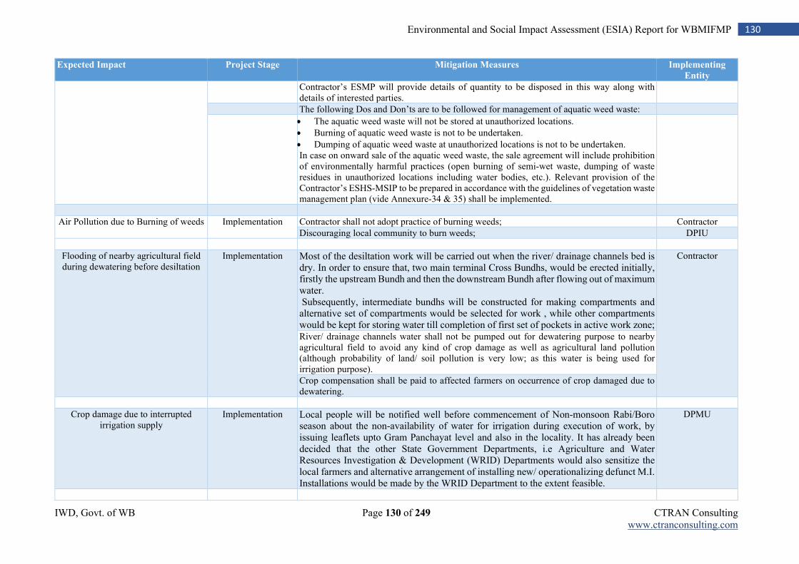
IWD, Govt. of WB Page 130 of 249 CTRAN Consulting www.ctranconsulting.com
130 Environmental and Social Impact Assessment (ESIA) Report for WBMIFMP
Expected Impact Project Stage Mitigation Measures Implementing
Entity
Contractor’s ESMP will provide details of quantity to be disposed in this way along with details of interested parties.
The following Dos and Don’ts are to be followed for management of aquatic weed waste:
The aquatic weed waste will not be stored at unauthorized locations.
Burning of aquatic weed waste is not to be undertaken.
Dumping of aquatic weed waste at unauthorized locations is not to be undertaken. In case on onward sale of the aquatic weed waste, the sale agreement will include prohibition of environmentally harmful practices (open burning of semi-wet waste, dumping of waste residues in unauthorized locations including water bodies, etc.). Relevant provision of the Contractor’s ESHS-MSIP to be prepared in accordance with the guidelines of vegetation waste management plan (vide Annexure-34 & 35) shall be implemented.
Air Pollution due to Burning of weeds Implementation Contractor shall not adopt practice of burning weeds; Contractor
Discouraging local community to burn weeds; DPIU
Flooding of nearby agricultural field during dewatering before desiltation
Implementation Most of the desiltation work will be carried out when the river/ drainage channels bed is dry. In order to ensure that, two main terminal Cross Bundhs, would be erected initially, firstly the upstream Bundh and then the downstream Bundh after flowing out of maximum water. Subsequently, intermediate bundhs will be constructed for making compartments and alternative set of compartments would be selected for work , while other compartments would be kept for storing water till completion of first set of pockets in active work zone;
Contractor
River/ drainage channels water shall not be pumped out for dewatering purpose to nearby agricultural field to avoid any kind of crop damage as well as agricultural land pollution (although probability of land/ soil pollution is very low; as this water is being used for irrigation purpose).
Crop compensation shall be paid to affected farmers on occurrence of crop damaged due to dewatering.
Crop damage due to interrupted irrigation supply
Implementation Local people will be notified well before commencement of Non-monsoon Rabi/Boro season about the non-availability of water for irrigation during execution of work, by issuing leaflets upto Gram Panchayat level and also in the locality. It has already been decided that the other State Government Departments, i.e Agriculture and Water Resources Investigation & Development (WRID) Departments would also sensitize the local farmers and alternative arrangement of installing new/ operationalizing defunct M.I. Installations would be made by the WRID Department to the extent feasible.
DPMU
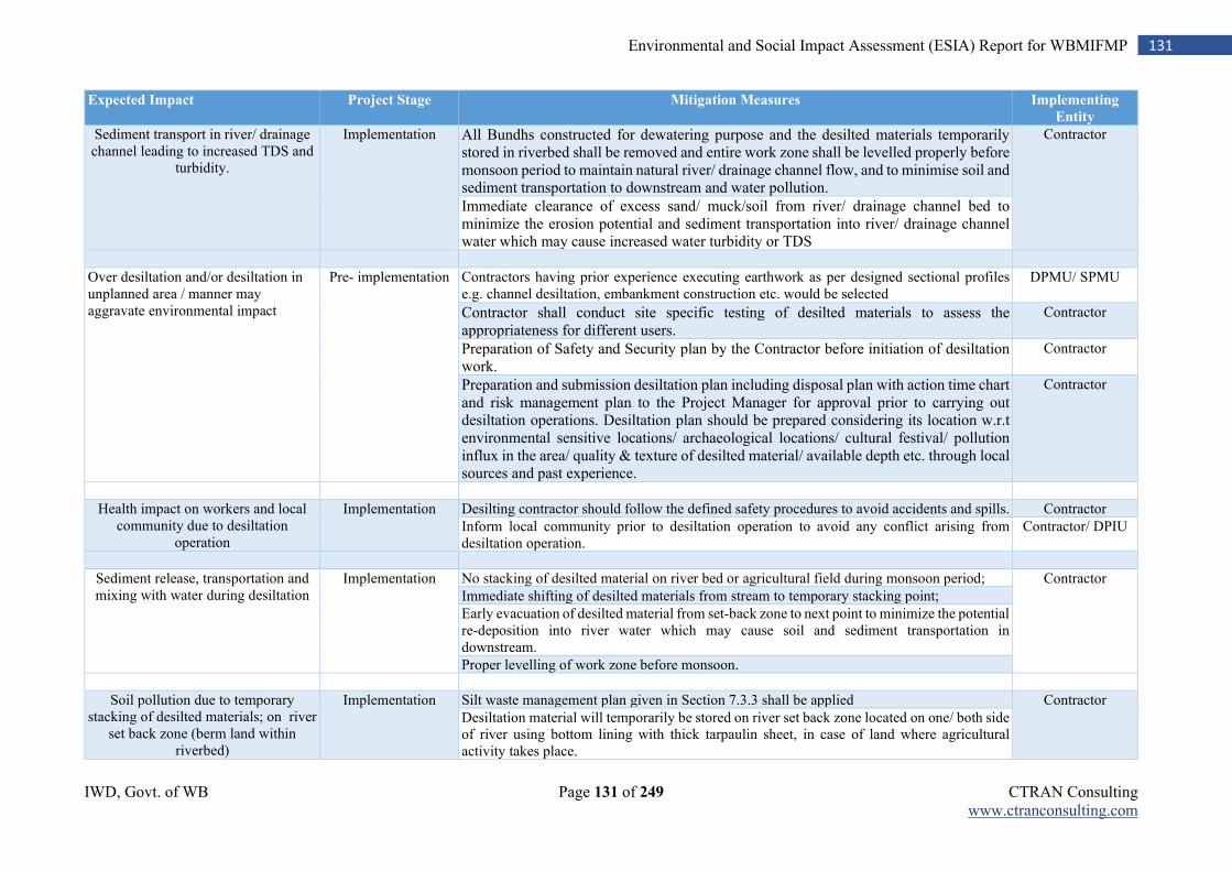
IWD, Govt. of WB Page 131 of 249 CTRAN Consulting www.ctranconsulting.com
131 Environmental and Social Impact Assessment (ESIA) Report for WBMIFMP
Expected Impact Project Stage Mitigation Measures Implementing
Entity
Sediment transport in river/ drainage channel leading to increased TDS and
turbidity.
Implementation All Bundhs constructed for dewatering purpose and the desilted materials temporarily stored in riverbed shall be removed and entire work zone shall be levelled properly before monsoon period to maintain natural river/ drainage channel flow, and to minimise soil and sediment transportation to downstream and water pollution.
Contractor
Immediate clearance of excess sand/ muck/soil from river/ drainage channel bed to minimize the erosion potential and sediment transportation into river/ drainage channel water which may cause increased water turbidity or TDS
Over desiltation and/or desiltation in unplanned area / manner may aggravate environmental impact
Pre- implementation Contractors having prior experience executing earthwork as per designed sectional profiles e.g. channel desiltation, embankment construction etc. would be selected
DPMU/ SPMU
Contractor shall conduct site specific testing of desilted materials to assess the appropriateness for different users.
Contractor
Preparation of Safety and Security plan by the Contractor before initiation of desiltation work.
Contractor
Preparation and submission desiltation plan including disposal plan with action time chart and risk management plan to the Project Manager for approval prior to carrying out desiltation operations. Desiltation plan should be prepared considering its location w.r.t environmental sensitive locations/ archaeological locations/ cultural festival/ pollution influx in the area/ quality & texture of desilted material/ available depth etc. through local sources and past experience.
Contractor
Health impact on workers and local community due to desiltation
operation
Implementation Desilting contractor should follow the defined safety procedures to avoid accidents and spills. Contractor
Inform local community prior to desiltation operation to avoid any conflict arising from desiltation operation.
Contractor/ DPIU
Sediment release, transportation and mixing with water during desiltation
Implementation No stacking of desilted material on river bed or agricultural field during monsoon period; Contractor
Immediate shifting of desilted materials from stream to temporary stacking point;
Early evacuation of desilted material from set-back zone to next point to minimize the potential re-deposition into river water which may cause soil and sediment transportation in downstream.
Proper levelling of work zone before monsoon.
Soil pollution due to temporary stacking of desilted materials; on river
set back zone (berm land within riverbed)
Implementation Silt waste management plan given in Section 7.3.3 shall be applied Contractor
Desiltation material will temporarily be stored on river set back zone located on one/ both side of river using bottom lining with thick tarpaulin sheet, in case of land where agricultural activity takes place.
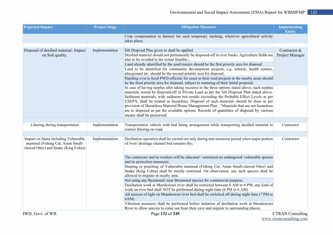
IWD, Govt. of WB Page 132 of 249 CTRAN Consulting www.ctranconsulting.com
132 Environmental and Social Impact Assessment (ESIA) Report for WBMIFMP
Expected Impact Project Stage Mitigation Measures Implementing
Entity
Crop compensation to farmers for such temporary stacking, wherever agricultural activity takes place;
Disposal of desilted material- Impact on Soil quality.
Implementation Silt Disposal Plan given in shall be applied Contractor & Project Manager Desilted material should not permanently be disposed-off in river banks. Agriculture fields are
also to be avoided to the extent feasible.;
Land already identified by the sand miners should be the first priority area for disposal
Land to be identified for community development projects, e.g. schools, health centres, playground etc. should be the second priority area for disposal.
Handing over to local PWD officials for reuse in their road projects in the nearby areas should be the third priority area for disposal, subject to maturing of their initial proposal.
In case of having surplus after taking recourse to the three options stated above, such surplus materials would be disposed-off in Private Land as per the Silt Disposal Plan stated above. Sediment materials, with sediment test results exceeding the Probable Effect Levels as per USEPA, shall be treated as hazardous. Disposal of such materials should be done as per provision of Hazardous Material/Waste Management Plan . “Materials that are not hazardous
are to disposed as per the available options. Records of quantities of disposal by various means shall be preserved
Littering during transportation Implementation Transportation vehicle with bed lining arrangement while transporting desilted material to restrict littering on road.
Contractor
Impact on fauna including Vulnerable mammal (Fishing Cat, Asian Small-
clawed Otter) and Snake (King Cobra)
Implementation Desiltation operation shall be carried out only during non-monsoon period when major portion of river/ drainage channel bed remains dry;
Contractor
The contractor and its workers will be educated / sensitized on endangered/ vulnerable species and its protection measures;
Hunting or poaching of Vulnerable mammal (Fishing Cat, Asian Small-clawed Otter) and Snake (King Cobra) shall be strictly restricted. On observation, any such species shall be allowed to migrate in nearby area.
Not using any threatened/ near threatened species for commercial purpose;
Desiltation work at Mundeswari river shall be restricted between 6 AM to 6 PM; any kind of work on river bed shall NOT be performed during night time (6 PM to 6 AM)
All sources of light on Mundeswari river bed shall be switched off during night time (7 PM to 6AM)
Vibration measures shall be performed before initiation of desiltation work at Mundeswari River to allow species to come out from their cave and migrate to surrounding places;
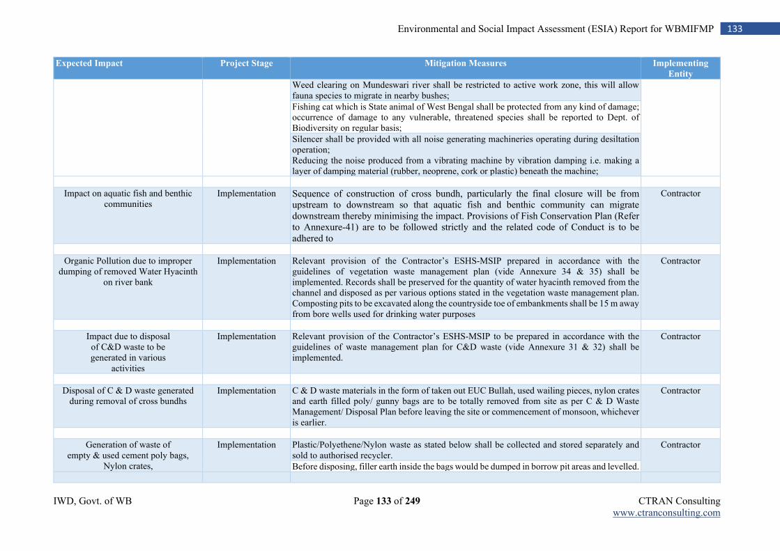
IWD, Govt. of WB Page 133 of 249 CTRAN Consulting www.ctranconsulting.com
133 Environmental and Social Impact Assessment (ESIA) Report for WBMIFMP
Expected Impact Project Stage Mitigation Measures Implementing
Entity
Weed clearing on Mundeswari river shall be restricted to active work zone, this will allow fauna species to migrate in nearby bushes;
Fishing cat which is State animal of West Bengal shall be protected from any kind of damage; occurrence of damage to any vulnerable, threatened species shall be reported to Dept. of Biodiversity on regular basis;
Silencer shall be provided with all noise generating machineries operating during desiltation operation; Reducing the noise produced from a vibrating machine by vibration damping i.e. making a layer of damping material (rubber, neoprene, cork or plastic) beneath the machine;
Impact on aquatic fish and benthic communities
Implementation Sequence of construction of cross bundh, particularly the final closure will be from upstream to downstream so that aquatic fish and benthic community can migrate downstream thereby minimising the impact. Provisions of Fish Conservation Plan (Refer to Annexure-41) are to be followed strictly and the related code of Conduct is to be adhered to
Contractor
Organic Pollution due to improper dumping of removed Water Hyacinth
on river bank
Implementation Relevant provision of the Contractor’s ESHS-MSIP prepared in accordance with the guidelines of vegetation waste management plan (vide Annexure 34 & 35) shall be implemented. Records shall be preserved for the quantity of water hyacinth removed from the channel and disposed as per various options stated in the vegetation waste management plan. Composting pits to be excavated along the countryside toe of embankments shall be 15 m away from bore wells used for drinking water purposes
Contractor
Impact due to disposal of C&D waste to be generated in various
activities
Implementation Relevant provision of the Contractor’s ESHS-MSIP to be prepared in accordance with the guidelines of waste management plan for C&D waste (vide Annexure 31 & 32) shall be implemented.
Contractor
Disposal of C & D waste generated during removal of cross bundhs
Implementation C & D waste materials in the form of taken out EUC Bullah, used wailing pieces, nylon crates and earth filled poly/ gunny bags are to be totally removed from site as per C & D Waste Management/ Disposal Plan before leaving the site or commencement of monsoon, whichever is earlier.
Contractor
Generation of waste of empty & used cement poly bags,
Nylon crates,
Implementation Plastic/Polyethene/Nylon waste as stated below shall be collected and stored separately and sold to authorised recycler.
Contractor
Before disposing, filler earth inside the bags would be dumped in borrow pit areas and levelled.
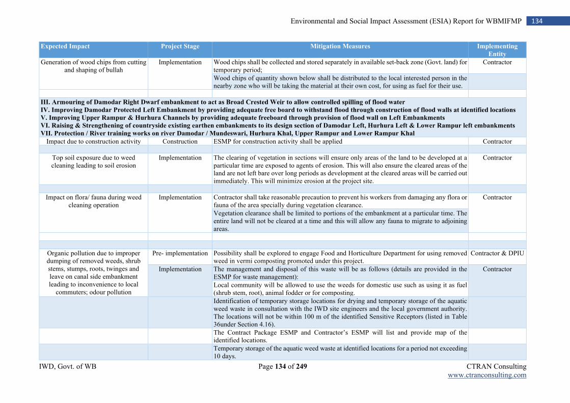
IWD, Govt. of WB Page 134 of 249 CTRAN Consulting www.ctranconsulting.com
134 Environmental and Social Impact Assessment (ESIA) Report for WBMIFMP
Expected Impact Project Stage Mitigation Measures Implementing
Entity
Generation of wood chips from cutting and shaping of bullah
Implementation Wood chips shall be collected and stored separately in available set-back zone (Govt. land) for temporary period;
Contractor
Wood chips of quantity shown below shall be distributed to the local interested person in the nearby zone who will be taking the material at their own cost, for using as fuel for their use.
III. Armouring of Damodar Right Dwarf embankment to act as Broad Crested Weir to allow controlled spilling of flood water
IV. Improving Damodar Protected Left Embankment by providing adequate free board to withstand flood through construction of flood walls at identified locations
V. Improving Upper Rampur & Hurhura Channels by providing adequate freeboard through provision of flood wall on Left Embankments
VI. Raising & Strengthening of countryside existing earthen embankments to its design section of Damodar Left, Hurhura Left & Lower Rampur left embankments
VII. Protection / River training works on river Damodar / Mundeswari, Hurhura Khal, Upper Rampur and Lower Rampur Khal
Impact due to construction activity Construction ESMP for construction activity shall be applied Contractor
Top soil exposure due to weed cleaning leading to soil erosion
Implementation The clearing of vegetation in sections will ensure only areas of the land to be developed at a particular time are exposed to agents of erosion. This will also ensure the cleared areas of the land are not left bare over long periods as development at the cleared areas will be carried out immediately. This will minimize erosion at the project site.
Contractor
Impact on flora/ fauna during weed cleaning operation
Implementation Contractor shall take reasonable precaution to prevent his workers from damaging any flora or fauna of the area specially during vegetation clearance.
Contractor
Vegetation clearance shall be limited to portions of the embankment at a particular time. The entire land will not be cleared at a time and this will allow any fauna to migrate to adjoining areas.
Organic pollution due to improper dumping of removed weeds, shrub stems, stumps, roots, twinges and leave on canal side embankment leading to inconvenience to local
commuters; odour pollution
Pre- implementation Possibility shall be explored to engage Food and Horticulture Department for using removed weed in vermi composting promoted under this project.
Contractor & DPIU
Implementation The management and disposal of this waste will be as follows (details are provided in the ESMP for waste management):
Contractor
Local community will be allowed to use the weeds for domestic use such as using it as fuel (shrub stem, root), animal fodder or for composting.
Identification of temporary storage locations for drying and temporary storage of the aquatic weed waste in consultation with the IWD site engineers and the local government authority. The locations will not be within 100 m of the identified Sensitive Receptors (listed in Table 36under Section 4.16).
The Contract Package ESMP and Contractor’s ESMP will list and provide map of the identified locations.
Temporary storage of the aquatic weed waste at identified locations for a period not exceeding 10 days.
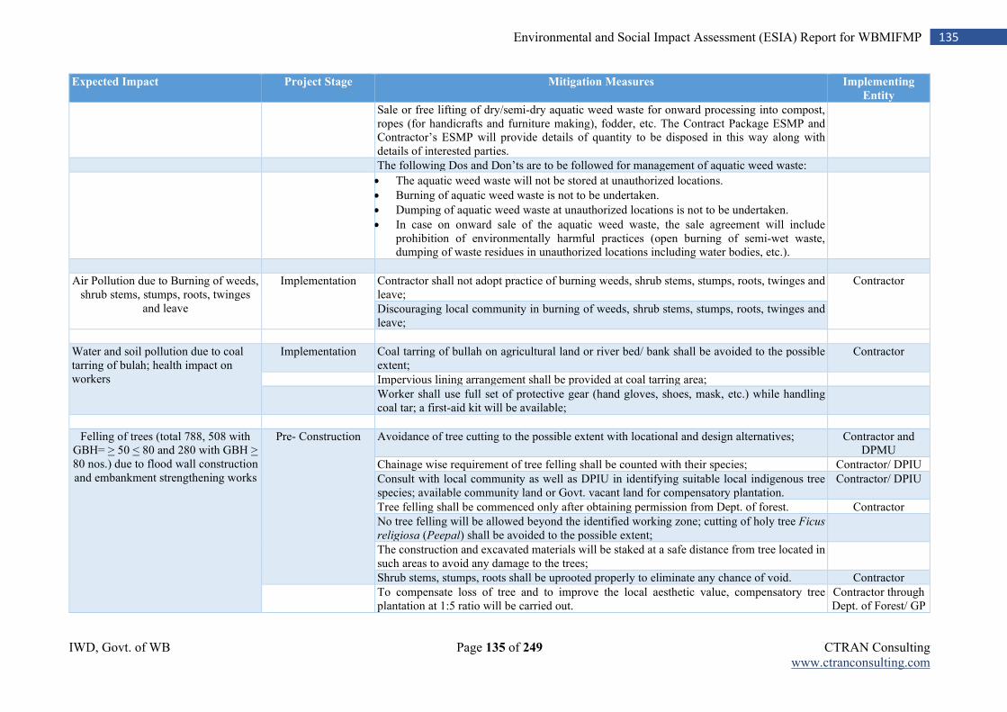
IWD, Govt. of WB Page 135 of 249 CTRAN Consulting www.ctranconsulting.com
135 Environmental and Social Impact Assessment (ESIA) Report for WBMIFMP
Expected Impact Project Stage Mitigation Measures Implementing
Entity
Sale or free lifting of dry/semi-dry aquatic weed waste for onward processing into compost, ropes (for handicrafts and furniture making), fodder, etc. The Contract Package ESMP and Contractor’s ESMP will provide details of quantity to be disposed in this way along with details of interested parties.
The following Dos and Don’ts are to be followed for management of aquatic weed waste:
The aquatic weed waste will not be stored at unauthorized locations.
Burning of aquatic weed waste is not to be undertaken.
Dumping of aquatic weed waste at unauthorized locations is not to be undertaken.
In case on onward sale of the aquatic weed waste, the sale agreement will include prohibition of environmentally harmful practices (open burning of semi-wet waste, dumping of waste residues in unauthorized locations including water bodies, etc.).
Air Pollution due to Burning of weeds, shrub stems, stumps, roots, twinges
and leave
Implementation Contractor shall not adopt practice of burning weeds, shrub stems, stumps, roots, twinges and leave;
Contractor
Discouraging local community in burning of weeds, shrub stems, stumps, roots, twinges and leave;
Water and soil pollution due to coal tarring of bulah; health impact on workers
Implementation Coal tarring of bullah on agricultural land or river bed/ bank shall be avoided to the possible extent;
Contractor
Impervious lining arrangement shall be provided at coal tarring area;
Worker shall use full set of protective gear (hand gloves, shoes, mask, etc.) while handling coal tar; a first-aid kit will be available;
Felling of trees (total 788, 508 with GBH= > 50 < 80 and 280 with GBH > 80 nos.) due to flood wall construction and embankment strengthening works
Pre- Construction Avoidance of tree cutting to the possible extent with locational and design alternatives; Contractor and DPMU
Chainage wise requirement of tree felling shall be counted with their species; Contractor/ DPIU
Consult with local community as well as DPIU in identifying suitable local indigenous tree species; available community land or Govt. vacant land for compensatory plantation.
Contractor/ DPIU
Tree felling shall be commenced only after obtaining permission from Dept. of forest. Contractor
No tree felling will be allowed beyond the identified working zone; cutting of holy tree Ficus
religiosa (Peepal) shall be avoided to the possible extent;
The construction and excavated materials will be staked at a safe distance from tree located in such areas to avoid any damage to the trees;
Shrub stems, stumps, roots shall be uprooted properly to eliminate any chance of void. Contractor
To compensate loss of tree and to improve the local aesthetic value, compensatory tree plantation at 1:5 ratio will be carried out.
Contractor through Dept. of Forest/ GP
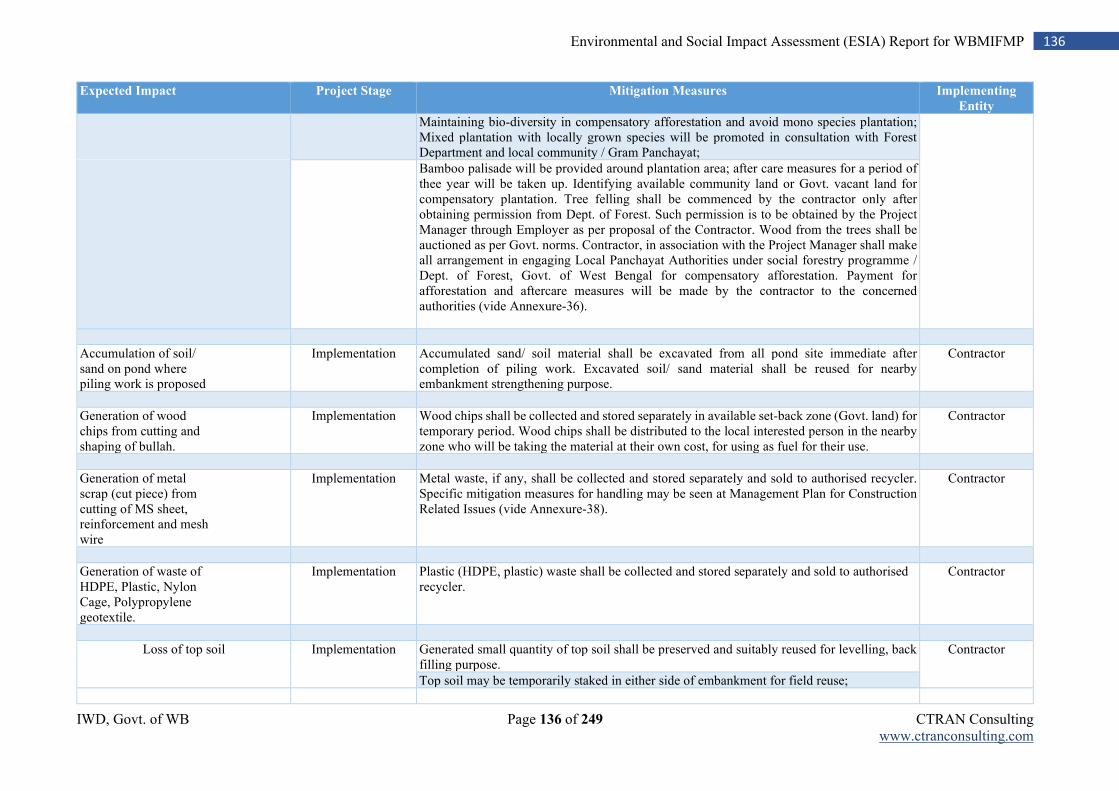
IWD, Govt. of WB Page 136 of 249 CTRAN Consulting www.ctranconsulting.com
136 Environmental and Social Impact Assessment (ESIA) Report for WBMIFMP
Expected Impact Project Stage Mitigation Measures Implementing
Entity
Maintaining bio-diversity in compensatory afforestation and avoid mono species plantation; Mixed plantation with locally grown species will be promoted in consultation with Forest Department and local community / Gram Panchayat;
Bamboo palisade will be provided around plantation area; after care measures for a period of thee year will be taken up. Identifying available community land or Govt. vacant land for compensatory plantation. Tree felling shall be commenced by the contractor only after obtaining permission from Dept. of Forest. Such permission is to be obtained by the Project Manager through Employer as per proposal of the Contractor. Wood from the trees shall be auctioned as per Govt. norms. Contractor, in association with the Project Manager shall make all arrangement in engaging Local Panchayat Authorities under social forestry programme / Dept. of Forest, Govt. of West Bengal for compensatory afforestation. Payment for afforestation and aftercare measures will be made by the contractor to the concerned authorities (vide Annexure-36).
Accumulation of soil/ sand on pond where piling work is proposed
Implementation Accumulated sand/ soil material shall be excavated from all pond site immediate after completion of piling work. Excavated soil/ sand material shall be reused for nearby embankment strengthening purpose.
Contractor
Generation of wood chips from cutting and shaping of bullah.
Implementation Wood chips shall be collected and stored separately in available set-back zone (Govt. land) for temporary period. Wood chips shall be distributed to the local interested person in the nearby zone who will be taking the material at their own cost, for using as fuel for their use.
Contractor
Generation of metal scrap (cut piece) from cutting of MS sheet, reinforcement and mesh wire
Implementation Metal waste, if any, shall be collected and stored separately and sold to authorised recycler. Specific mitigation measures for handling may be seen at Management Plan for Construction Related Issues (vide Annexure-38).
Contractor
Generation of waste of HDPE, Plastic, Nylon Cage, Polypropylene geotextile.
Implementation Plastic (HDPE, plastic) waste shall be collected and stored separately and sold to authorised recycler.
Contractor
Loss of top soil Implementation Generated small quantity of top soil shall be preserved and suitably reused for levelling, back filling purpose.
Contractor
Top soil may be temporarily staked in either side of embankment for field reuse;
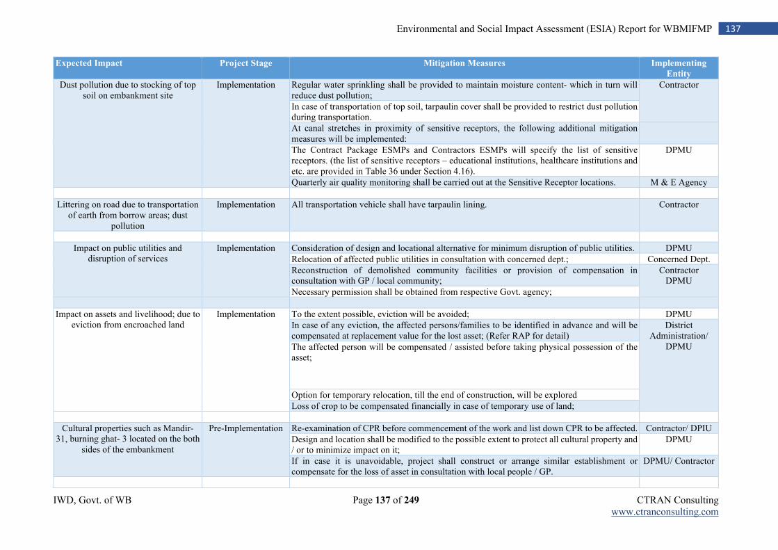
IWD, Govt. of WB Page 137 of 249 CTRAN Consulting www.ctranconsulting.com
137 Environmental and Social Impact Assessment (ESIA) Report for WBMIFMP
Expected Impact Project Stage Mitigation Measures Implementing
Entity
Dust pollution due to stocking of top soil on embankment site
Implementation Regular water sprinkling shall be provided to maintain moisture content- which in turn will reduce dust pollution;
Contractor
In case of transportation of top soil, tarpaulin cover shall be provided to restrict dust pollution during transportation.
At canal stretches in proximity of sensitive receptors, the following additional mitigation measures will be implemented:
The Contract Package ESMPs and Contractors ESMPs will specify the list of sensitive receptors. (the list of sensitive receptors – educational institutions, healthcare institutions and etc. are provided in Table 36 under Section 4.16).
DPMU
Quarterly air quality monitoring shall be carried out at the Sensitive Receptor locations. M & E Agency
Littering on road due to transportation of earth from borrow areas; dust
pollution
Implementation All transportation vehicle shall have tarpaulin lining. Contractor
Impact on public utilities and disruption of services
Implementation Consideration of design and locational alternative for minimum disruption of public utilities. DPMU
Relocation of affected public utilities in consultation with concerned dept.; Concerned Dept.
Reconstruction of demolished community facilities or provision of compensation in consultation with GP / local community;
Contractor DPMU
Necessary permission shall be obtained from respective Govt. agency;
Impact on assets and livelihood; due to eviction from encroached land
Implementation To the extent possible, eviction will be avoided; DPMU
In case of any eviction, the affected persons/families to be identified in advance and will be compensated at replacement value for the lost asset; (Refer RAP for detail)
District Administration/
DPMU The affected person will be compensated / assisted before taking physical possession of the asset;
Option for temporary relocation, till the end of construction, will be explored
Loss of crop to be compensated financially in case of temporary use of land;
Cultural properties such as Mandir- 31, burning ghat- 3 located on the both
sides of the embankment
Pre-Implementation Re-examination of CPR before commencement of the work and list down CPR to be affected. Contractor/ DPIU
Design and location shall be modified to the possible extent to protect all cultural property and / or to minimize impact on it;
DPMU
If in case it is unavoidable, project shall construct or arrange similar establishment or compensate for the loss of asset in consultation with local people / GP.
DPMU/ Contractor
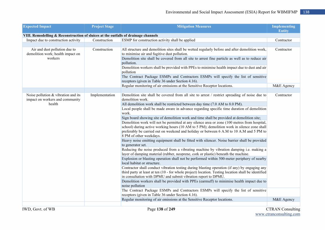
IWD, Govt. of WB Page 138 of 249 CTRAN Consulting www.ctranconsulting.com
138 Environmental and Social Impact Assessment (ESIA) Report for WBMIFMP
Expected Impact Project Stage Mitigation Measures Implementing
Entity
VIII. Remodelling & Reconstruction of sluices at the outfalls of drainage channels
Impact due to construction activity Construction ESMP for construction activity shall be applied Contractor
Air and dust pollution due to demolition work; health impact on
workers
Construction All structure and demolition sites shall be wetted regularly before and after demolition work, to minimise air and fugitive dust pollution.
Contractor
Demolition site shall be covered from all site to arrest fine particle as well as to reduce air pollution.
Demolition workers shall be provided with PPEs to minimise health impact due to dust and air pollution
The Contract Package ESMPs and Contractors ESMPs will specify the list of sensitive receptors (given in Table 36 under Section 4.16).
Regular monitoring of air emissions at the Sensitive Receptor locations. M&E Agency
Noise pollution & vibration and its impact on workers and community
health
Implementation Demolition site shall be covered from all site to arrest / restrict spreading of noise due to demolition work.
Contractor
All demolition work shall be restricted between day time (7.0 AM to 8.0 PM).
Local people shall be made aware in advance regarding specific time duration of demolition work.
Sign board showing site of demolition work and time shall be provided at demolition site;
Demolition work will not be permitted at any silence area or zone (100 metres from hospital, school) during active working hours (10 AM to 5 PM); demolition work in silence zone shall preferably be carried out on weekend and holiday or between 6 A.M to 10 A.M and 5 PM to 8 PM of other weekdays.
Heavy noise emitting equipment shall be fitted with silencer. Noise barrier shall be provided to generator set.
Reducing the noise produced from a vibrating machine by vibration damping i.e. making a layer of damping material (rubber, neoprene, cork or plastic) beneath the machine.
Explosion or blasting operation shall not be performed within 500-meter periphery of nearby local habitat or structure.
Contractor shall conduct vibration testing during blasting operation (if any) by engaging any third party at least at ten (10 - for whole project) location. Testing location shall be identified in consultation with DPMU and submit vibration report to DPMU.
Demolition workers shall be provided with PPEs (earmuff) to minimise health impact due to noise pollution
The Contract Package ESMPs and Contractors ESMPs will specify the list of sensitive receptors (given in Table 36 under Section 4.16).
Regular monitoring of air emissions at the Sensitive Receptor locations. M&E Agency
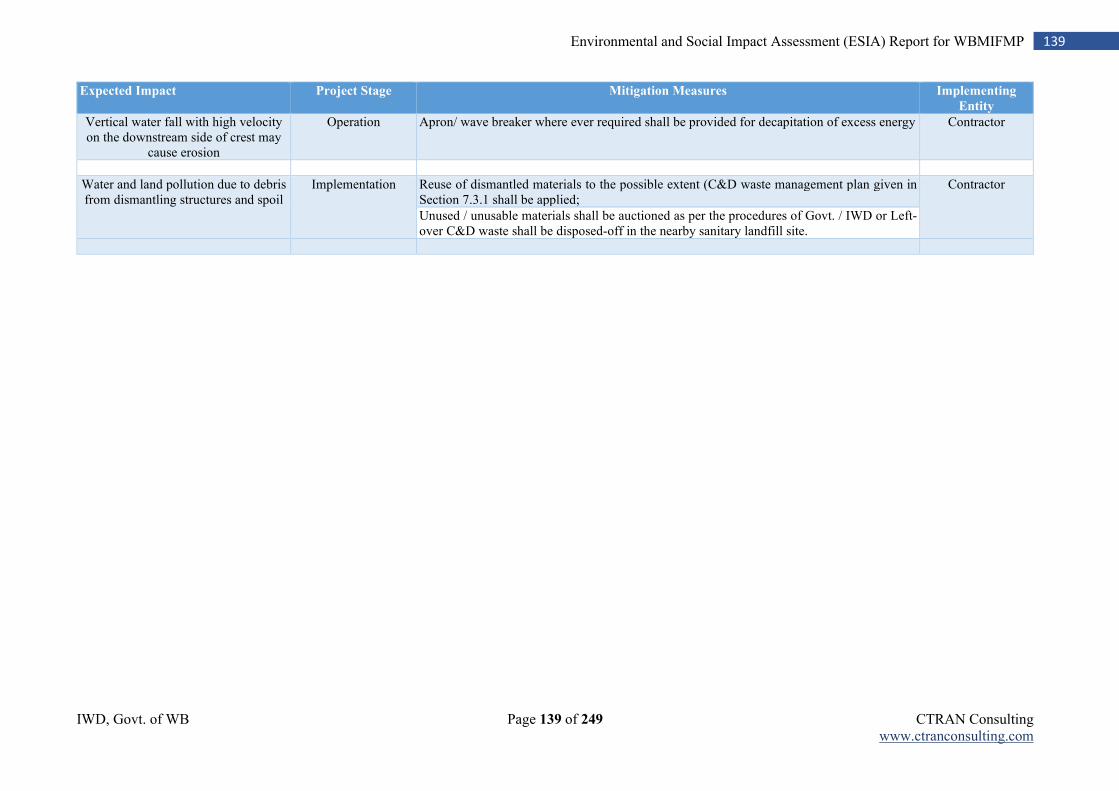
IWD, Govt. of WB Page 139 of 249 CTRAN Consulting www.ctranconsulting.com
139 Environmental and Social Impact Assessment (ESIA) Report for WBMIFMP
Expected Impact Project Stage Mitigation Measures Implementing
Entity
Vertical water fall with high velocity on the downstream side of crest may
cause erosion
Operation Apron/ wave breaker where ever required shall be provided for decapitation of excess energy Contractor
Water and land pollution due to debris from dismantling structures and spoil
Implementation Reuse of dismantled materials to the possible extent (C&D waste management plan given in Section 7.3.1 shall be applied;
Contractor
Unused / unusable materials shall be auctioned as per the procedures of Govt. / IWD or Left-over C&D waste shall be disposed-off in the nearby sanitary landfill site.
IWD, Govt. of WB Page 140 of 249 CTRAN Consulting www.ctranconsulting.com
140 Environmental and Social Impact Assessment (ESIA) Report for WBMIFMP
7.3 Waste Management Plan
Management of the following types of waste generated from the construction activity is a key aspect of the ESMP:
1. General construction and demolition waste 2. Hazardous Waste 3. Waste from river and canal de-siltation
For each construction contract, within 30 days of the appointed date, the contractor is required prepare and submit a Waste Management Plan to Sr. Environmental Expert at SPMU level (as one activity maybe may be packaged as one or as multiple contracts). The Contractor’s obligation for proper waste management must be included in contract document. These plans spell out specific measures that will be undertaken to segregate, store and appropriately dispose wastes generated from the proposed construction activities.
7.3.1 Construction and Demolition Waste Management Plan
Construction and demolition activity lead to generation of solid wastes, which include sand, gravel, concrete, stone, bricks, wood, metal, glass, plastic, paper etc. The management of construction and demolition waste will be a major concern of WBMIFMP project due to the huge quantum of demolition’s rubble, shortage of dumping sites, cost involvement for transportation and disposal and above all growing concern about pollution and environmental deterioration. C&D waste will be generated due to 1) Rehabilitation and upgradation of canal regulating structures and 2) Remodeling& Reconstruction of sluices at the outfalls of drainage channels activity proposed under WBMIFMP, demolition of private, commercial and community structure due to flood wall with sheet piling work and embankment strengthening work. Total 25,164 cum Cement Concrete and 3,409 cum Reinforced Cement Concrete waste will be generated. These apart, other C&D waste, e.g Bullah, Bullah wailing pieces, Poly bags, Nylon crates etc. will also be generated due to various construction activities, the reutilization plan has been shown in the following Table. Table 82: Utilization plan for C&D waste
Sl.
No.
Type of Structure C&D Waste Reuse Plan Reuse
Quantity
Cement
Concrete
(CC)
RCC Metal
1 CR/HR/Fall cum Regulator
17871 cum 2204 cum 11 MT CC & RCC: Backfilling for 15.89 Km. concrete road over DR embankment
4,572 cum
2 Syphon (RCC Barrel) 428 cum 233 cum 1 MT CC & RCC: Making haul road
2,000 cum
3 Aqueduct 1865 cum 847 cum 4 MT CC & RCC: Distributing local people/ contractor
7,143 cum
4 Demolition of Private, commercial and community structure
5000 cum 125 cum
CC & RCC: Consumption by owner of structure
3,714 cum
CC & RCC: Restoration of village road
4,572 cum
CC & RCC: Use in scour hole filling
6,572 cum
Metal: To be sold by the Contractor to the authorized recyclers
16 MT
Quantities
IWD, Govt. of WB Page 141 of 249 CTRAN Consulting www.ctranconsulting.com
141 Environmental and Social Impact Assessment (ESIA) Report for WBMIFMP
Sl.
No.
Type of Structure C&D Waste Reuse Plan Reuse
Quantity
5 Generation of wood chips from cutting and shaping of bullah for Bid Packages I to IX, formulated so far
436.2 cum These wood chips are to be distributed to the local people for various domestic use as per Annexure-30
436.2 cum
6 Generation of waste of eucalyptus bullah piles, bullah wailing pieces, empty & used cement poly bags, Nylon crates.
98921 m, 698404 nos., 1680 nos. Bullahs & wailing pieces to be auctioned from sites /taken away by the Contractor on payment of reserve price.
98921 m, 698404
nos.,1680 nos.
Plastic/Polyethene/Nylon waste shall be collected and stored separately and sold to authorised recycler as per Annexure-31.
Note: Only regulating structure on LVL-1 and 2 canals are considered. Quantity of C&D waste arrived using sample unit wise
generation of C&D waste provided in final feasibility report of WBMIFMP. All generated construction and demolition waste material will be stored temporarily occupier land or else it will be stored on adjacent river/ or canal side setback zone. Occupier of property (affected household) will first be allowed to take concrete as well as reinforced material. In such case, occupier will make arrangement for storing C&D waste in his custody at his own cost. Else, C&D waste will temporarily be stored on river/ canal site set-back zone. Reinforce metal waste will be auctioned to authorized recycler as per approved rate set by project manager and concrete material will be distributed to local interested people. Excess concrete material will extensively be used for road construction and restoration of damage road under WBMIFM project. Local contractor will be allowed to take concrete material for using in backfilling in construction industry. However, contractor shall prepare site specific plan for generation and utilization of C&D waste generated due to demolition activity proposed under WBMIFM project. Guideline for preparing C&D Waste Management Plan:
Contractor shall segregate construction and demolition waste and deposit at collection center
or handover it to the authorized processing facilities. Shall ensure that there is no littering or deposition so as to prevent obstruction to the traffic or
the public or drains. Contractor (who generate more than 20 tons or more in one day or 300 tons per project in a
month) shall prepare and submit comprehensive waste management plan for waste generated within their jurisdiction and get appropriate approvals from the local authority (UDD in the State Government) before starting construction or demolition or remodeling work,
Contractor shall segregate the waste into four streams such as concrete, soil, steel, wood and plastics, bricks and mortar, keep the concerned authorities informed regarding the relevant activities from the planning stage to the implementation stage and this should be on project to project basis.
Contractor shall ensure that other waste (such as solid waste) does not get mixed with this C&D waste and is stored and disposed separately.
Contractor shall have environment management plan to address the likely environmental issues from construction, demolition, storage, transportation process and disposal / reuse of C & D Waste.
Contractor shall remove all construction and demolition waste in consultation with the concerned local authority (UDD in the State Government) on their own or through any agency.
IWD, Govt. of WB Page 142 of 249 CTRAN Consulting www.ctranconsulting.com
142 Environmental and Social Impact Assessment (ESIA) Report for WBMIFMP
Contractor shall pay relevant charges for collection, transportation, processing and disposal as notified by the concerned authorities;
7.3.2 Hazardous Waste Management Plan
WBMIPM project does not envisage use or generation of any hazardous material except use of coal tar in piling work. Mitigation measures for safe use of this material is already included in activity specific ESMP (given in Table 81). However, quantity of coal tar will be very small and limited only to pond
site bullah piling work. In addition to coal tar, there will also be generation of waste engine oil from the machinery/vehicles. Package specific hazardous waste management plan shall be formulated in packages specific ESMP. It will be responsibility of PMC to prepare package specific ESMP. Detail quantification of hazardous waste utilization and generation and reuse plan shall be developed and included in package specific ESMP. Package specific hazardous waste management plan shall be included in bid document and contractor’s contract.
Contractor shall follow following steps for management of hazardous and other wastes(a) prevention; (b) minimization; (c) reuse (only non-hazardous waste) and (d) safe disposal.
The contractor shall implement safe and environmentally sound management practice for handling of hazardous and other wastes.
The hazardous and other wastes generated at any of project site shall be sent or sold to an authorised actual user or shall be disposed of in an authorised disposal facility.
The hazardous and other wastes shall be transported from a project site to an authorized actual user or to an authorized disposal facility in accordance with the provisions of Hazardous Waste Management Rules, 2016.
To prevent accidents and limit their consequences on human beings and the environment, contractor shall consider all the safeguard aspects, provide appropriate training, equipment and necessary information to the persons involved in managing hazardous and other wastes to ensure their safety.
Contractor shall obtain Consent to Establish (CtE), Consent to Operate (CtO) and Authorization letter from WBPCB for handling and management of hazardous and other wastes
Handling and management of any hazardous and other wastes by contractor (implementing project activities) shall be limited to collection, storage, packaging, transportation, offering for sale, transfer activities. Treatment, processing, use, destruction, recycling, recovery, pre-processing, co-processing, utilization, disposal of the hazardous wastes shall not be permitted to the contractor implementing project activities. However, contractor may reuse and dispose only construction and demolition waste, other non-hazardous waste.
Contractor shall maintain a maintain records of hazardous and other wastes generation, reuse (only non-hazardous waste), sale and dispose. Record book (in a passbook issued by the State Pollution Control Board) shall contain name and address of purchaser, area of dispose with date wise quantity.
The contractor shall not store any kind of hazardous and other wastes for more than ninety days and shall maintain a record of sale, transfer, storage, reuse (only non-hazardous waste) and disposed quantity.
Contractor shall ensure proper packaging and leveling (as per Form 8) of all hazardous and other wastes in a manner suitable for safe handling, storage and transport. The label shall be of non-washable material, weather proof and easily visible.
The contractor shall provide the transporter with the relevant information in Form 9,
regarding the hazardous nature of the wastes and measures to be taken in case of an emergency.
IWD, Govt. of WB Page 143 of 249 CTRAN Consulting www.ctranconsulting.com
143 Environmental and Social Impact Assessment (ESIA) Report for WBMIFMP
In case of transportation of hazardous and other waste for final disposal to a facility existing in a State other than the State where the waste is generated, the contractor shall obtain ‘No Objection Certificate’ from the State Pollution Control Board of both the States.
In case of transportation of hazardous and other waste, the responsibility of safe transport shall be either of the sender (contractor) or the receiver whosoever arranges the transport. This responsibility should be clearly indicated in the manifest.
The authorization for transport from the concerned State Pollution Control Board shall be obtained either by the sender (contractor) or the receiver on whose behalf the transport is being arranged.
Where an accident occurs at the facility of the contractor handling hazardous or other wastes or during transportation, the contractor shall immediately intimate the State Pollution Control Board through telephone, e-mail about the accident and subsequently send a report in Form 11.
The contractor and receiver of the disposal facility shall be liable for all damages caused to the environment or third party due to improper handling and management of the hazardous and other waste.
Asbestos containing waste materials (such as C&D waste comprising of Asbestos-Cement
roof sheets and pipes) shall be considered hazardous waste and an appropriate hazardous
waste disposal plan will be prepared in consultation with the State Pollution Control Board.
IWD, Govt. of WB Page 144 of 249 CTRAN Consulting www.ctranconsulting.com
144 Environmental and Social Impact Assessment (ESIA) Report for WBMIFMP
7.3.3 Silt Management Plan
Total 19,67 Km. stretch of Mundeswari river (including 430 meters of undivided Damodar river) will be desilted up to a depth of 2 meter and 150 m width. Proposed desilted Length, Depth and Width of all 41drainage channel is given in Annexure- 7. Estimated quantity of excavated materials to be generated due to desilting estimated to be 1,17,57,929 Cum. As per the disposal plan of desilted material will be utilized for road construction works, building construction and filling of the low-lying areas. Desilted material will temporarily be stored in alongside available set-back zone. There are approx. 150 – 250 meter wide setback zone available alongside of Mundeswari river, Madaria and Roner khal. Desilted material of Mundeswari river is mainly sand in nature which are currently being excavated by almost 8 local sand miners. This sand material is suitable for filling as well as construction purpose. Testing carried out by RRI mention non-presence of any mine or city, from where chances of disposal or accumulation of toxic or heavy metals are more on vacant land, in nearby areas of Mundeswari river. Natural moisture contents of samples indicate medium to stiff consistency; which represent similar feature of older alluvium (distinctly different to the grey Gangetic alluvium) of the other Rath plain (parts of Birbhum, Bankura, Bardhhaman, Hooghly and West Medinipur) sites. Finally, RRI has recommended to safely use these silted materials without any further processing for embankment or road construction. Sieve analysis of silt from Mundeswari river is given in Annexure- 15 (a). In addition to that, soil testing of Mundeswari river and other drainage channel considered for desiltation also was carried out by engaging MoEF & CC and WBPCB approved laboratory- Report given in Annexure- 15(b). Heavy metal (Copper, Chromium, Zinc, Lead and Cadmium) concentration in sediment samples were found within Probable Effect Level (PEL)8. Copper and Cadmium concentration in all sampling location is recorded above Threshold Effect Level (TEL) but within PEL. Cadmium concentration at sampling location at Connecting point of Kamaria, Raner and Madaria khal (4.2 mg./ kg. dry) has just touched threshold PEL limit. Adverse biological effects would frequently occur only after crossing the PEL limit of 4.2 mg./ kg. for Cd. However, Zinc, Lead and Cadmium concentration, in river water sample collected from same location, was surprisingly below detectable limit (BDL)of
<0.05, <0.05 and <0.01 mg/L respectively. As a confirmation measures, contractor is also given responsibility for carrying out sediment quality testing from each desilting river/ channel before commencement of desiltation work. Any such contaminated sediment if found after testing by contractor shall be disposed at WBPCB approved nearby TSDF site. For pre-desiltation testing by Contractor, samples will be taken from every 1 km stretch of each lot; Testing will be as per US EPA parameters; Test results will be communicated immediately by contractor to IWD through PMC; Action plan for disposal will be prepared in consultation with State Pollution Control Board in case parameters exceed PEL (probable effect level). SPMU- WBMIFMP has explored various options for reutilization of desilted material. Discussion was initiated with Public Work Department (PWD), local sand owners, local community in identifying probable users of desilted material. Local sand owners and building & road contractor has shown their interest in purchasing sand material directly from desiltation site. Eventually they assured to make all arrangement for temporary stocking of desilted material in nearby area. They will arrange land for stocking of desilted material at their effort. Sand miners and construction contractor will negotiate with land owners for temporary stocking of desilted materials. Finally, it was decided that, desilted material will either be stored temporary at set-back zone and transferred to designated places within 5 km. radius or directly transferred to designated places. Few Govt. land is available within 5 km. radius will be used for temporary storing of desilted material.
8Heavy metal parameters were compared against US EPA standard for sediment quality in absence of any related national standard in India.
IWD, Govt. of WB Page 145 of 249 CTRAN Consulting www.ctranconsulting.com
145 Environmental and Social Impact Assessment (ESIA) Report for WBMIFMP
Desilted materials which are not hazardous would be temporarily stored in the form of spoil bank at berm land (relatively high land in channel bed near the bank toe and acquired by / vested with the government), keeping a distance of at least 3m from the designed section of the cutting zone to be adopted in the first and next phase, on both sides of the designed cutting section, in the form of spoil bank, using a bottom lining with thick tarpaulin sheet, wherever such land is used for seasonal cultivation purpose. Crop compensation shall be provided to the local farmers by the Contractor for the period of temporary occupation of land. Materials excavated from riverbed would be brought to the temporary spoil bank zone, either by multiple handling with earth cutting machinery or by dumpers. Maximum height of the spoil bank height would be kept restricted to 2.0m, riverside slope as 1.5 H : 1 V and countryside flush with the rising berm level. In order to dispose the spoil from the wedge-shaped spoil bank, there would be a number of ramps at around 100m c/c, starting from the roads on top of the embankments upto the end of spoil bank and removal of spoil bank would be done in dumpers, which would be loaded by earthmoving machineries. The materials shall be removed periodically from the temporary storage site within a maximum period of 5 days. Temporary storage sites shall be restored to their original condition if not improved by the end of the works. Local sand miners and civil contractor have shown interest for purchase of sand material directly from desilted sites. Sand miners/ civil contractors will evacuate desilted material directly from desilted site. Sand material will also be re-used for construction of flood wall, armoring and concrete road over Damodar right embankment and re-construction of irrigation regulating structure and sluice gates proposed under WBMIFMP project. Desilted material will be used to backfill low lying area or to raise low lying nearby villages. IWD is in the process of earmarking low-lying Govt. land and low-lying villages require raising up. In case of temporary storage on Government land and disposal through back-filling of vacant low-lying Government land, it will be ensured that the land is identified and approved both by the SPMU- WBMIFMP and by the local government authority. After fulfilling above three demands, excess desilted material will be stored in nearby area. It will be responsibility of desilting contractor to arrange land for temporarily storing of excess land. Contractor will negotiate with local person interested to store desilted material in his own land. Contractor will pay one time premium to land owner for storing sand material in his land. Desilted material will be sold either by land owner or District Magistrate (DM) to designated users. Land owner will sell desilted material and pay royalty amount to DM or DM will directly sell it to different end users. SPMU- WBMIFMP has already initiated discussion with Public Works Department (PWD) for re-using of desilted sand material in road construction by PWD. Possibility of use of desilted material in backfilling of road will be finalized immediate before excavation/ during excavation work in consultation with PWD. Desilted material from other 41 drainage canal is mainly mixture of sand and clay. Entire quantity will be consumed by WBMIFM Project itself. It will be utilized mainly for embankment strengthening work proposed for 58.93 Km. long embankment of Damodar left & Right, Hurhura left, Upper & Lower Rampur left and Gaighata. Any excess material will be sold directly to local interested traders by excavating contractor. However, royalty amount will be deducted from contractor bill of payment. Reutilization plan of generated desilted material is given in below table. Table 83: Re-utilization plan of desilted material
SN. Proposed
Intervention
Quantity of Desilted
Material (in Cum)
Temporary
Stocking
Possible Re-use Quantity
Re-used
A. Desiltation of Mundeswari River
71,13,763 Alongside set-back zone (width varies between
Re-use of sand in Construction of Flood wall, irrigation
3%
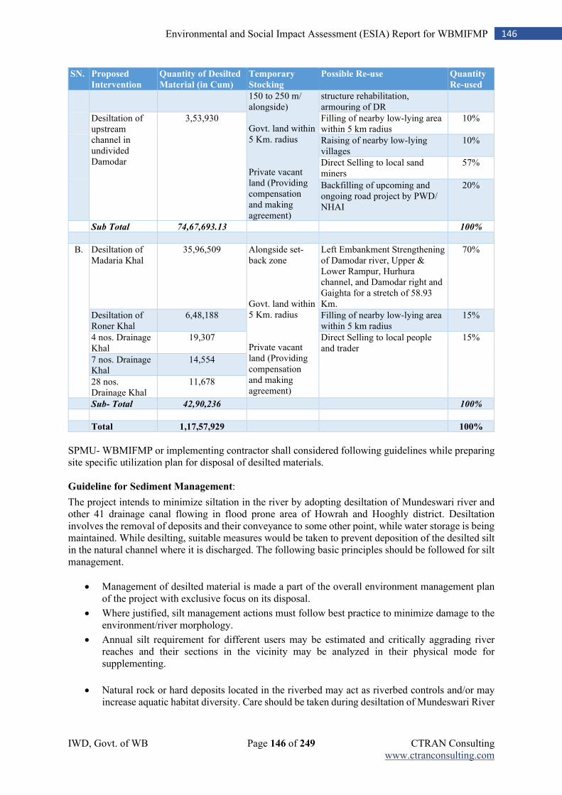
IWD, Govt. of WB Page 146 of 249 CTRAN Consulting www.ctranconsulting.com
146 Environmental and Social Impact Assessment (ESIA) Report for WBMIFMP
SN. Proposed
Intervention
Quantity of Desilted
Material (in Cum)
Temporary
Stocking
Possible Re-use Quantity
Re-used
150 to 250 m/ alongside) Govt. land within 5 Km. radius Private vacant land (Providing compensation and making agreement)
structure rehabilitation, armouring of DR
Desiltation of upstream channel in undivided Damodar
3,53,930 Filling of nearby low-lying area within 5 km radius
10%
Raising of nearby low-lying villages
10%
Direct Selling to local sand miners
57%
Backfilling of upcoming and ongoing road project by PWD/ NHAI
20%
Sub Total 74,67,693.13 100%
B. Desiltation of Madaria Khal
35,96,509 Alongside set-back zone Govt. land within 5 Km. radius Private vacant land (Providing compensation and making agreement)
Left Embankment Strengthening of Damodar river, Upper & Lower Rampur, Hurhura channel, and Damodar right and Gaighta for a stretch of 58.93 Km.
70%
Desiltation of Roner Khal
6,48,188 Filling of nearby low-lying area within 5 km radius
15%
4 nos. Drainage Khal
19,307 Direct Selling to local people and trader
15%
7 nos. Drainage Khal
14,554
28 nos. Drainage Khal
11,678
Sub- Total 42,90,236 100%
Total 1,17,57,929 100%
SPMU- WBMIFMP or implementing contractor shall considered following guidelines while preparing site specific utilization plan for disposal of desilted materials.
Guideline for Sediment Management:
The project intends to minimize siltation in the river by adopting desiltation of Mundeswari river and other 41 drainage canal flowing in flood prone area of Howrah and Hooghly district. Desiltation involves the removal of deposits and their conveyance to some other point, while water storage is being maintained. While desilting, suitable measures would be taken to prevent deposition of the desilted silt in the natural channel where it is discharged. The following basic principles should be followed for silt management.
Management of desilted material is made a part of the overall environment management plan of the project with exclusive focus on its disposal.
Where justified, silt management actions must follow best practice to minimize damage to the environment/river morphology.
Annual silt requirement for different users may be estimated and critically aggrading river reaches and their sections in the vicinity may be analyzed in their physical mode for supplementing.
Natural rock or hard deposits located in the riverbed may act as riverbed controls and/or may increase aquatic habitat diversity. Care should be taken during desiltation of Mundeswari River
IWD, Govt. of WB Page 147 of 249 CTRAN Consulting www.ctranconsulting.com
147 Environmental and Social Impact Assessment (ESIA) Report for WBMIFMP
not to dislodge any hard deposits and restrictions concerning natural rock deposits will have to be dealt case by case basis.
Desilting close to river banks have a high potential to adversely impact the stability of those banks, especially when desilting occurs near the outside of sharp river bends. Bank erosion induced by such desilting can result in the loss of land, damages to man-made structures, and adverse impact to environmental resources. Therefore, no desilting will be allowed within a minimum of 60 m of the most upstream and downstream point of such banks.
The modus operandi for disposal of desilted material should be finalized before carrying out desiltation. The methodology to be adopted should be clearly laid down before starting the desiltation work.
Contractor shall formulate environmentally acceptable, practically possible disposal plan for desilted material and get it approved from SPMU before commencement of desiltation operation;
Contractor shall obtain permission from local Gram Panchayat (GP) or local authority for temporary staking of desilted material in Govt. Land/ barren land/ fallow land. Contractor shall also make agreement with loan owner for temporary staking of desilted material;
Negative impact on ecology and environment due to desilting may also be studied as per instruction from SPMU- WBMIFMP.
Since it is very difficult to find lands for disposal of huge quantum of desilted material, therefore it should be ensured that all desilted material should be utilized for various purpose.
Under no circumstances, disposal should create any contamination of water bodies, harmful to the flora and fauna existing adjacent to the disposal sites or disposed material should come back into the river again.
Desilted material should not be used for filling up of wetlands and water bodies, as these are important for recharging the ground water and providing base flow in rivers during lean season.
Post desiltation, sediment flux studies may be carried out. This shall be responsibility of SPMU- WBMIFMP to engage any other third-party river research agency to quantify the amount of silt likely to be deposited in future.
Desilted riverbed materials shall be considered hazardous waste, in case sediment test results exceed the Probable Effect Levels as per USEPA. In such a case, the Project Manager needs to be informed, within 24 hours of getting the test results, to formulate an appropriate hazardous waste disposal plan in consultation with the State Pollution Control Board.
7.3.4 Vegetation Waste Management Plan:
Vegetation waste will be generated due weed cleaning, felling of large & small tree and cutting of shrub located on either side of embankment. Big size tree and many other tree with GBH < 50 cm. located along side of embankment required to be felled. Many bush, shrub, terrestrial weed also will be cleared during the process of cleaning of active work zone. Big as well as small size tree will be auctioned after felling. However, residual material like Leaves, Twigs & Bough, Branch, Shrub Stem, Stumps, Roots, Wood Chips and Logs will form vegetation waste due to tree felling and weed cleaning operation. It is estimated that entire vegetation quantum will be reused for different purpose. It is expected that, contractor will take entire waste material for trading purpose leaving few quantities of Leaves, Twigs, Roots and Wood Chips and Logs. At any circumstances, if it is realized that generated vegetation waste may not be fully utilized by following measures, the contractor has to formulate case-specific plans.
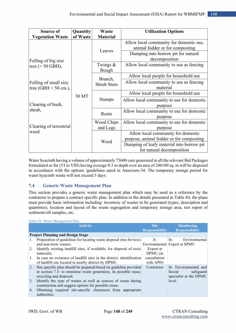
IWD, Govt. of WB Page 148 of 249 CTRAN Consulting www.ctranconsulting.com
148 Environmental and Social Impact Assessment (ESIA) Report for WBMIFMP
Source of
Vegetation Waste
Quantity
of Waste
Waste
Material
Utilization Options
Felling of big size tree (> 50 GBH), Felling of small size tree (GBH < 50 cm.), Clearing of bush, shrub, Clearing of terrestrial weed
30 MT
Leaves
Allow local community for domestic use, animal fodder or for composting
Dumping into borrow pit for natural decomposition
Twings & Bough
Allow local community to use as fencing
Branch, Shrub Stem
Allow local people for household use
Allow local community to use as fencing material
Stumps
Allow local people for household use
Allow local community to use for domestic purpose
Roots Allow local community to use for domestic
purpose
Wood Chips and Logs
Allow local community to use for domestic purpose
Weed
Allow local community for domestic purpose, animal fodder or for composting
Dumping of leafy material into borrow pit for natural decomposition
Water hyacinth having a volume of approximately 73600 cum generated in all the relevant Bid Packages formulated so far (VI to VIII) having average 0.3 m depth over an area of 246100 sq. m will be disposed in accordance with the options /guidelines sated in Annexure-34. The temporary storage period for water hyacinth waste will not exceed 5 days.
7.4 Generic Waste Management Plan
This section provides a generic waste management plan which may be used as a reference by the contractor to prepare a contract specific plan. In addition to the details presented in Table 84, the plans must provide basic information including: inventory of wastes to be generated (types, description and quantities), location and layout of the waste segregation and temporary storage area, test report of sediment/silt samples, etc.
Table 84: Waste Management Plan
Activity Site
Responsibility
Monitoring
Responsibility
Project Planning and Design Stage
1. Preparation of guidelines for locating waste disposal sites for toxic and non-toxic wastes;
2. Identify existing landfill sites, if available, for disposal of toxic materials;
1. In case no existence of landfill sites in the district, identification of landfill site located in nearby district by DPMU
Jr. Environmental
Expert at DPMU (in
consultation with APD)
Sr. Environmental Expert at SPMU
2. Site specific plan should be prepared based on guideline provided at section 7.3- to minimise waste generation, its possible reuse, recycling and disposal;
3. Identify the type of wastes as well as sources of waste during construction and suggest options for possible reuse;
4. Obtaining required site-specific clearances from appropriate authorities.
Contractor Sr. Environmental and Social safeguard specialist at the DPMU level
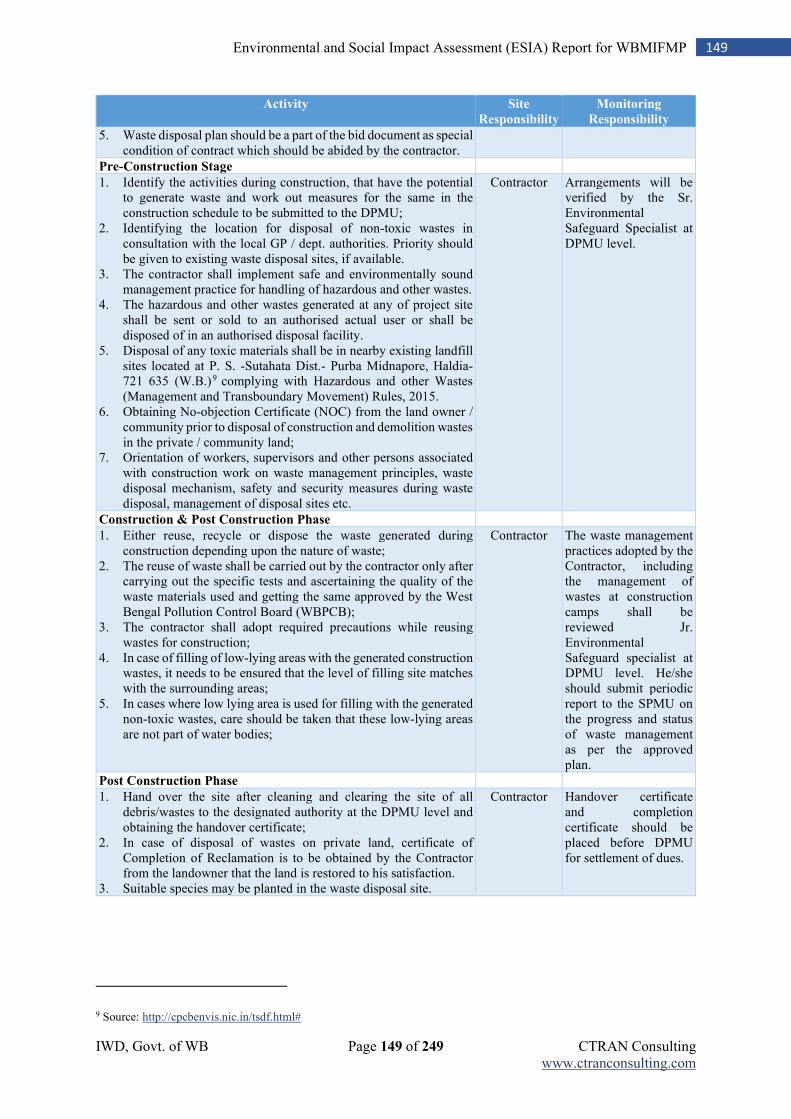
IWD, Govt. of WB Page 149 of 249 CTRAN Consulting www.ctranconsulting.com
149 Environmental and Social Impact Assessment (ESIA) Report for WBMIFMP
Activity Site
Responsibility
Monitoring
Responsibility
5. Waste disposal plan should be a part of the bid document as special condition of contract which should be abided by the contractor.
Pre-Construction Stage
1. Identify the activities during construction, that have the potential to generate waste and work out measures for the same in the construction schedule to be submitted to the DPMU;
2. Identifying the location for disposal of non-toxic wastes in consultation with the local GP / dept. authorities. Priority should be given to existing waste disposal sites, if available.
3. The contractor shall implement safe and environmentally sound management practice for handling of hazardous and other wastes.
4. The hazardous and other wastes generated at any of project site shall be sent or sold to an authorised actual user or shall be disposed of in an authorised disposal facility.
5. Disposal of any toxic materials shall be in nearby existing landfill sites located at P. S. -Sutahata Dist.- Purba Midnapore, Haldia- 721 635 (W.B.)9 complying with Hazardous and other Wastes (Management and Transboundary Movement) Rules, 2015.
6. Obtaining No-objection Certificate (NOC) from the land owner / community prior to disposal of construction and demolition wastes in the private / community land;
7. Orientation of workers, supervisors and other persons associated with construction work on waste management principles, waste disposal mechanism, safety and security measures during waste disposal, management of disposal sites etc.
Contractor Arrangements will be verified by the Sr. Environmental Safeguard Specialist at DPMU level.
Construction & Post Construction Phase
1. Either reuse, recycle or dispose the waste generated during construction depending upon the nature of waste;
2. The reuse of waste shall be carried out by the contractor only after carrying out the specific tests and ascertaining the quality of the waste materials used and getting the same approved by the West Bengal Pollution Control Board (WBPCB);
3. The contractor shall adopt required precautions while reusing wastes for construction;
4. In case of filling of low-lying areas with the generated construction wastes, it needs to be ensured that the level of filling site matches with the surrounding areas;
5. In cases where low lying area is used for filling with the generated non-toxic wastes, care should be taken that these low-lying areas are not part of water bodies;
Contractor The waste management practices adopted by the Contractor, including the management of wastes at construction camps shall be reviewed Jr. Environmental Safeguard specialist at DPMU level. He/she should submit periodic report to the SPMU on the progress and status of waste management as per the approved plan.
Post Construction Phase
1. Hand over the site after cleaning and clearing the site of all debris/wastes to the designated authority at the DPMU level and obtaining the handover certificate;
2. In case of disposal of wastes on private land, certificate of Completion of Reclamation is to be obtained by the Contractor from the landowner that the land is restored to his satisfaction.
3. Suitable species may be planted in the waste disposal site.
Contractor Handover certificate and completion certificate should be placed before DPMU for settlement of dues.
9 Source: http://cpcbenvis.nic.in/tsdf.html#
IWD, Govt. of WB Page 150 of 249 CTRAN Consulting www.ctranconsulting.com
150 Environmental and Social Impact Assessment (ESIA) Report for WBMIFMP
7.5 Labour Influx and Construction Workers’ Camp Management Plan
During implementation phase, worker population is likely to influx in the project area. Management of this labour influx and of issues related to the labour campsite are a critical part of environmental and social management of the project. To address the probable impact due to labour influx, and establishment of labour / workers camp, a detail camp management plan is prepared to minimise and mitigate the environment and social impact. For each construction contract, within 14 days of the appointed date, the contractor is required to prepare and submit a “Labour Influx and Construction Workers’ Camp Management Plan” to the Sr. Environmental Expert at SPMU / DPMU level (as one activity may be packaged as one or as multiple contracts). The Contractor’s obligation to provide and maintain these facilities and undertake these activities must be included in contract document. These Plans spells out specific measures that will be undertaken to control degradation of the surrounding landscape due to the location and operation of the proposed construction camp and will minimize the impact on the local community. The Plans will include elements such as details on living condition and ancillary facilities, worker codes of conduct, training programs on HIV/AIDS, etc. The key elements that will enable the preparation of the Labour Influx and Construction Workers’ Camp Management Plan are:
1. List of key environmental and social aspects to be considered for preparation of a Labor Influx and Construction Workers’ Camp Management Plan;
2. Guidelines for locating construction workers’ campsites; 3. Labour Influx and Construction Workers’ Camp Management Plan.
7.5.1 Workers’ Camp Management Plan
The key environmental aspects to be considered for preparation of a Labour Influx and Construction Workers’ Camp Management Plan include:
1. Sufficient supply of potable water to camps and working sites. If the drinking water is obtained from the intermittent public water supply then storage tanks must be provided;
2. Adequate washing and bathing facility must be provided in clean and drained condition; 3. Adequate sanitary facilities may be provided within camp. The place must be cleaned daily and
kept in strict sanitary condition. Separate latrine must be provided for women; 4. Collection of camp wastes and its disposal should be carried out regularly; 5. The contractor must ensure that there is proper drainage system to avoid creation of stagnant
water bodies; 6. Periodic health check-ups should be conducted for the camp workers. These activities should
be conducted in consultation with the local health institutions / State Public Health Department; 7. In every camp, first aid facility may be provided, ambulance must be provided to take injured
or ill person to the nearest hospital; 8. Adequate supply of fuel in the form of kerosene or LPG should be provided to construction
labours to avoid felling of trees for cooking and other household activities. No open fires will be allowed in camps;
9. The sites should be secured by temporary fencing which can be disposed-off during dismantling of the camp;
10. Proper lighting and cross ventilation must be provided; 11. Construction camps may be located away from forest areas, settlements, cultural heritage &
historical sites and water bodies; 12. It should be ensured by the construction contractor that area of the construction camp be cleared
of the debris and other wastes deposited on completion of construction. The land should be
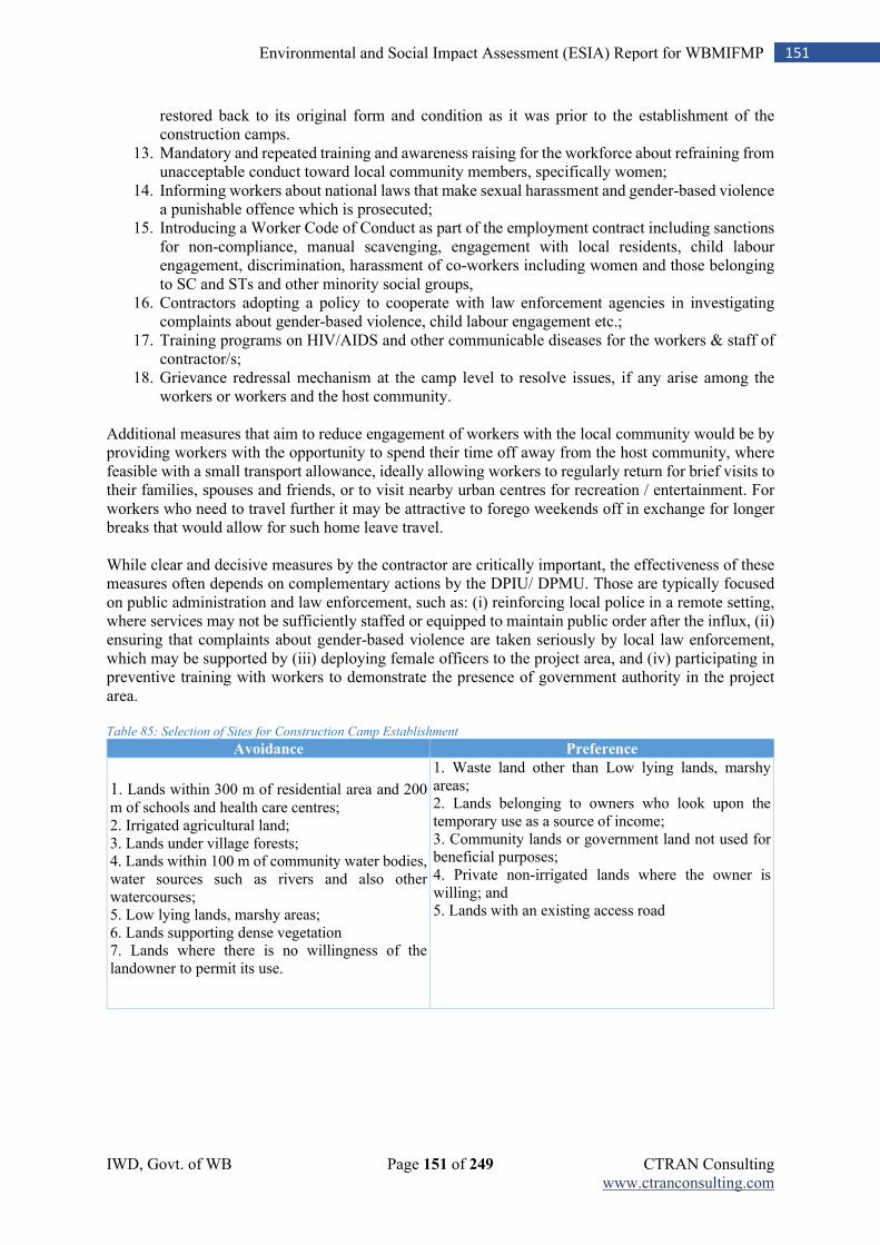
IWD, Govt. of WB Page 151 of 249 CTRAN Consulting www.ctranconsulting.com
151 Environmental and Social Impact Assessment (ESIA) Report for WBMIFMP
restored back to its original form and condition as it was prior to the establishment of the construction camps.
13. Mandatory and repeated training and awareness raising for the workforce about refraining from unacceptable conduct toward local community members, specifically women;
14. Informing workers about national laws that make sexual harassment and gender-based violence a punishable offence which is prosecuted;
15. Introducing a Worker Code of Conduct as part of the employment contract including sanctions for non-compliance, manual scavenging, engagement with local residents, child labour engagement, discrimination, harassment of co-workers including women and those belonging to SC and STs and other minority social groups,
16. Contractors adopting a policy to cooperate with law enforcement agencies in investigating complaints about gender-based violence, child labour engagement etc.;
17. Training programs on HIV/AIDS and other communicable diseases for the workers & staff of contractor/s;
18. Grievance redressal mechanism at the camp level to resolve issues, if any arise among the workers or workers and the host community.
Additional measures that aim to reduce engagement of workers with the local community would be by providing workers with the opportunity to spend their time off away from the host community, where feasible with a small transport allowance, ideally allowing workers to regularly return for brief visits to their families, spouses and friends, or to visit nearby urban centres for recreation / entertainment. For workers who need to travel further it may be attractive to forego weekends off in exchange for longer breaks that would allow for such home leave travel. While clear and decisive measures by the contractor are critically important, the effectiveness of these measures often depends on complementary actions by the DPIU/ DPMU. Those are typically focused on public administration and law enforcement, such as: (i) reinforcing local police in a remote setting, where services may not be sufficiently staffed or equipped to maintain public order after the influx, (ii) ensuring that complaints about gender-based violence are taken seriously by local law enforcement, which may be supported by (iii) deploying female officers to the project area, and (iv) participating in preventive training with workers to demonstrate the presence of government authority in the project area. Table 85: Selection of Sites for Construction Camp Establishment
Avoidance Preference
1. Lands within 300 m of residential area and 200 m of schools and health care centres; 2. Irrigated agricultural land; 3. Lands under village forests; 4. Lands within 100 m of community water bodies, water sources such as rivers and also other watercourses; 5. Low lying lands, marshy areas; 6. Lands supporting dense vegetation 7. Lands where there is no willingness of the landowner to permit its use.
1. Waste land other than Low lying lands, marshy areas; 2. Lands belonging to owners who look upon the temporary use as a source of income; 3. Community lands or government land not used for beneficial purposes; 4. Private non-irrigated lands where the owner is willing; and 5. Lands with an existing access road
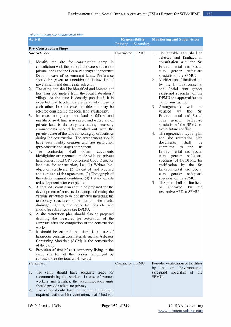
IWD, Govt. of WB Page 152 of 249 CTRAN Consulting www.ctranconsulting.com
152 Environmental and Social Impact Assessment (ESIA) Report for WBMIFMP
Table 86: Camp Site Management Plan
Activity Responsibility Monitoring and Supervision
Primary Secondary
Pre-Construction Stage
Site Selection: 1. Identify the site for construction camp in
consultation with the individual owners in case of private lands and the Gram Panchayat / concerned Dept. in case of government lands. Preference should be given to uncultivated fallow land / government land during site selection;
2. The camp site shall be identified and located not less than 500 meters from the local habitation / village. As the state is densely populated, it is expected that habitations are relatively close to each other. In such case, suitable site may be selected considering the local land availability.
3. In case, no government land / fallow and unutilised govt. land is available and where use of private land is the only alternative, necessary arrangements should be worked out with the private owner of the land for setting up of facilities during the construction. The arrangement should have both facility creation and site restoration (pre-construction stage) component.
4. The contractor shall obtain documents highlighting arrangements made with the private land owner / local GP / concerned Govt. Dept. for land use for construction, i.e., (1) Written No-objection certificate; (2) Extent of land required and duration of the agreement; (3) Photograph of the site in original condition; (4) Details of site redevelopment after completion.
5. A detailed layout plan should be prepared for the development of construction camp, indicating the various structures to be constructed including the temporary structures to be put up, site roads, drainage, lighting and other facilities etc. and should be submitted to the DPMU.
6. A site restoration plan should also be prepared detailing the measures for restoration of the campsite after the completion of the construction works.
7. It should be ensured that there is no use of hazardous construction materials such as Asbestos Containing Materials (ACM) in the construction of the camp.
8. Provision of free of cost temporary living in the camp site for all the workers employed by contractor for the total work period.
Contractor DPMU 1. The suitable sites shall be selected and finalized in consultation with the Sr. Environmental and Social cum gender safeguard specialist of the SPMU.
2. Verification of finalised site by the Jr. Environmental and Social cum gender safeguard specialist of the DPMU and approval for site camp construction.
3. Arrangements will be verified by the Sr. Environmental and Social cum gender safeguard specialist of the SPMU to avoid future conflict.
4. The agreement, layout plan and site restoration plan documents shall be submitted to the Jr. Environmental and Social cum gender safeguard specialist of the DPMU for verification by the Sr. Environmental and Social cum gender safeguard specialist of the SPMU
5. The plan shall be finalized or approved by the respective APD at SPMU.
Facilities: 1. The camp should have adequate space for
accommodating the workers. In case of women workers and families, the accommodation units should provide adequate privacy.
2. The camp should have all common minimum required facilities like ventilation, bed / bed roll
Contractor DPMU Periodic verification of facilities by the Sr. Environmental safeguard specialist of the SPMU.
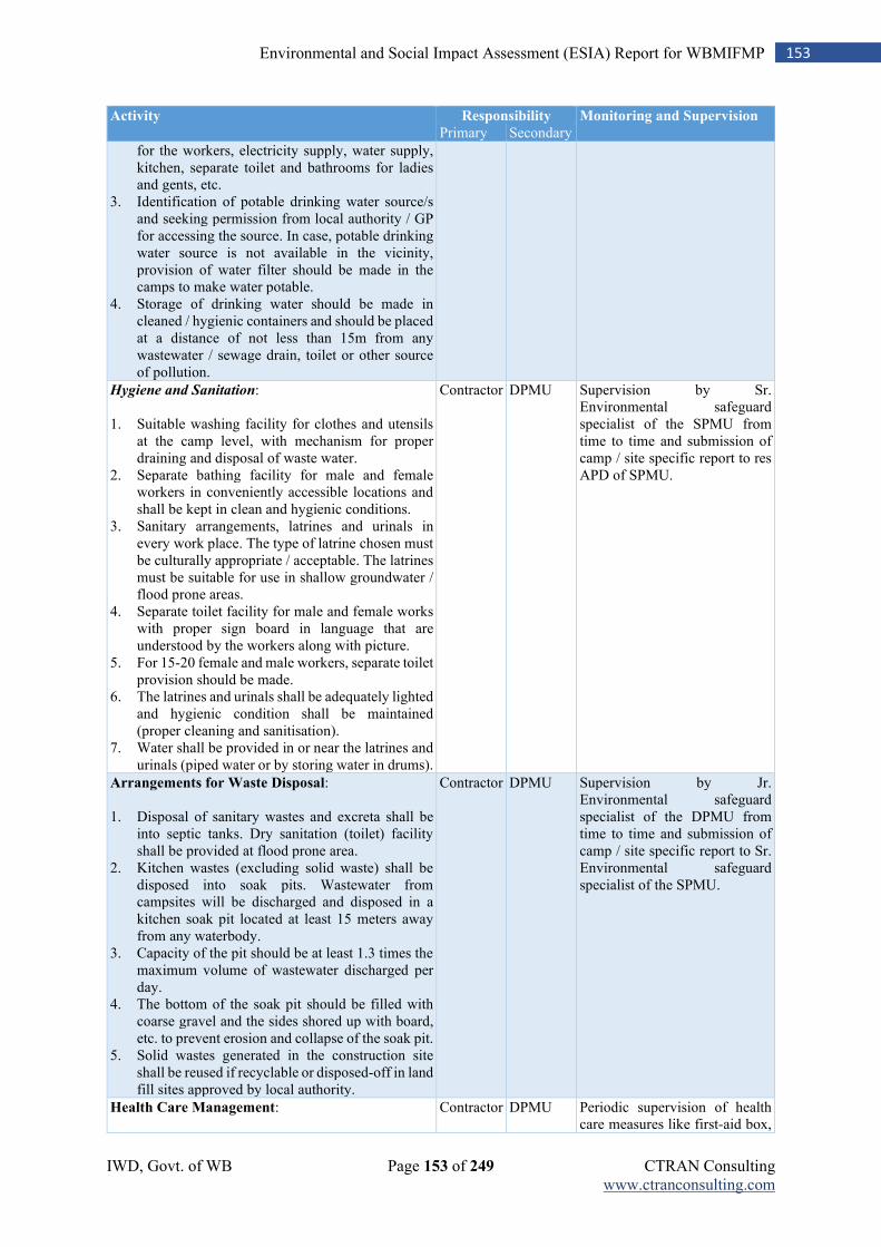
IWD, Govt. of WB Page 153 of 249 CTRAN Consulting www.ctranconsulting.com
153 Environmental and Social Impact Assessment (ESIA) Report for WBMIFMP
Activity Responsibility Monitoring and Supervision
Primary Secondary
for the workers, electricity supply, water supply, kitchen, separate toilet and bathrooms for ladies and gents, etc.
3. Identification of potable drinking water source/s and seeking permission from local authority / GP for accessing the source. In case, potable drinking water source is not available in the vicinity, provision of water filter should be made in the camps to make water potable.
4. Storage of drinking water should be made in cleaned / hygienic containers and should be placed at a distance of not less than 15m from any wastewater / sewage drain, toilet or other source of pollution.
Hygiene and Sanitation: 1. Suitable washing facility for clothes and utensils
at the camp level, with mechanism for proper draining and disposal of waste water.
2. Separate bathing facility for male and female workers in conveniently accessible locations and shall be kept in clean and hygienic conditions.
3. Sanitary arrangements, latrines and urinals in every work place. The type of latrine chosen must be culturally appropriate / acceptable. The latrines must be suitable for use in shallow groundwater / flood prone areas.
4. Separate toilet facility for male and female works with proper sign board in language that are understood by the workers along with picture.
5. For 15-20 female and male workers, separate toilet provision should be made.
6. The latrines and urinals shall be adequately lighted and hygienic condition shall be maintained (proper cleaning and sanitisation).
7. Water shall be provided in or near the latrines and urinals (piped water or by storing water in drums).
Contractor DPMU Supervision by Sr. Environmental safeguard specialist of the SPMU from time to time and submission of camp / site specific report to res APD of SPMU.
Arrangements for Waste Disposal: 1. Disposal of sanitary wastes and excreta shall be
into septic tanks. Dry sanitation (toilet) facility shall be provided at flood prone area.
2. Kitchen wastes (excluding solid waste) shall be disposed into soak pits. Wastewater from campsites will be discharged and disposed in a kitchen soak pit located at least 15 meters away from any waterbody.
3. Capacity of the pit should be at least 1.3 times the maximum volume of wastewater discharged per day.
4. The bottom of the soak pit should be filled with coarse gravel and the sides shored up with board, etc. to prevent erosion and collapse of the soak pit.
5. Solid wastes generated in the construction site shall be reused if recyclable or disposed-off in land fill sites approved by local authority.
Contractor DPMU Supervision by Jr. Environmental safeguard specialist of the DPMU from time to time and submission of camp / site specific report to Sr. Environmental safeguard specialist of the SPMU.
Health Care Management:
Contractor DPMU Periodic supervision of health care measures like first-aid box,
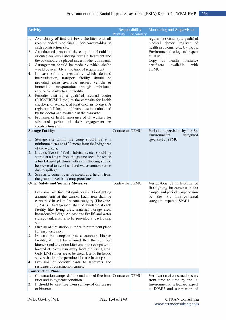
IWD, Govt. of WB Page 154 of 249 CTRAN Consulting www.ctranconsulting.com
154 Environmental and Social Impact Assessment (ESIA) Report for WBMIFMP
Activity Responsibility Monitoring and Supervision
Primary Secondary
1. Availability of first aid box / facilities with all recommended medicines / non-consumables in each construction site.
2. An educated person in the camp site should be oriented on administering first aid treatment and the box should be placed under his/her command.
3. Arrangement should be made by which she/he would be available at the time of requirement.
4. In case of any eventuality which demand hospitalisation, transport facility should be provided using available project vehicle or immediate transportation through ambulance service to nearby health facility.
5. Periodic visit by a qualified medical doctor (PHC/CHC/SDH etc.) to the campsite for health check-up of workers, at least once in 15 days. A register of all health problems must be maintained by the doctor and available at the campsite.
6. Provision of health insurance of all workers for stipulated period of their engagement in construction sites.
regular site visits by a qualified medical doctor, register of health problems, etc., by the Jr. Environmental safeguard expert at DPMU. Copy of health insurance certificate available with DPMU.
Storage Facility: 1. Storage site within the camp should be at a
minimum distance of 30 meter from the living area of the workers.
2. Liquids like oil / fuel / lubricants etc. should be stored at a height from the ground level for which a brick-based platform with sand flooring should be prepared to avoid soil and water contamination due to spillage.
3. Similarly, cement can be stored at a height from the ground level in a damp-proof area.
Contractor DPMU Periodic supervision by the Sr. Environmental safeguard specialist at SPMU
Other Safety and Security Measures 1. Provision of fire extinguishers / Fire-fighting
arrangements at the camps. Each area shall be earmarked based on fire zone category (Fire zone- 1, 2 & 3). Arrangement shall be available at each facility like living area, material storage area, hazardous building. At least one fire lift and water storage tank shall also be provided at each camp site.
2. Display of fire station number in prominent place for easy visibility.
3. In case the campsite has a common kitchen facility, it must be ensured that the common kitchen (and any other kitchens in the campsite) is located at least 20 m away from the living area. Only LPG stoves are to be used. Use of fuelwood stoves shall not be permitted for use in camp site.
4. Provision of identity cards to labourers and residents of construction camps.
Contractor DPMU Verification of installation of fire-fighting instruments in the camp/s and periodic supervision by the Sr. Environmental safeguard expert at SPMU.
Construction Phase
1. Construction camps shall be maintained free from litter and in hygienic condition.
2. It should be kept free from spillage of oil, grease or bitumen.
Contractor DPMU Verification of construction sites from time to time by the Jr. Environmental safeguard expert at DPMU and submission of
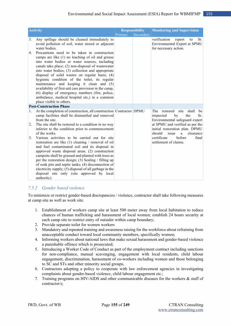
IWD, Govt. of WB Page 155 of 249 CTRAN Consulting www.ctranconsulting.com
155 Environmental and Social Impact Assessment (ESIA) Report for WBMIFMP
Activity Responsibility Monitoring and Supervision
Primary Secondary
3. Any spillage should be cleaned immediately to avoid pollution of soil, water stored or adjacent water bodies.
4. Precautions need to be taken in construction camps are like (1) no leaching of oil and grease into water bodies or water sources, including canals take place; (2) non-disposal of wastewater into water bodies; (3) collection and appropriate disposal of solid wastes on regular basis; (4) hygienic condition of the toilet, its regular maintenance and keeping it clean and (5) availability of first-aid care provision in the camp, (6) display of emergency numbers (fire, police, ambulance, medical hospital etc,) in a common place visible to others.
verification report to Sr. Environmental Expert at SPMU for necessary action.
Post-Construction Phase
1. At the completion of construction, all construction camp facilities shall be dismantled and removed from the site.
2. The site shall be restored to a condition in no way inferior to the condition prior to commencement of the works.
3. Various activities to be carried out for site restoration are like (1) cleaning / removal of oil and fuel contaminated soil and its disposal in approved waste disposal areas. (2) construction campsite shall be grassed and planted with trees as per the restoration design; (3) Sealing / filling up of soak pits and septic tanks; (4) disconnection of electricity supply; (5) disposal of all garbage in the disposal site only (site approved by local authority).
Contractor DPMU The restored site shall be inspected by the Sr. Environmental safeguard expert at SPMU and verified as per the initial restoration plan. DPMU should issue a clearance certificate before final settlement of claims.
7.5.2 Gender based violence
To minimize or restrict gender-based discrepancies / violence, contractor shall take following measures at camp site as well as work site.
1. Establishment of workers camp site at least 500 meter away from local habitation to reduce chances of human trafficking and harassment of local women; establish 24 hours security at each camp site to restrict entry of outsider within camp boundary;
2. Provide separate toilet for women workers 3. Mandatory and repeated training and awareness raising for the workforce about refraining from
unacceptable conduct toward local community members, specifically women; 4. Informing workers about national laws that make sexual harassment and gender-based violence
a punishable offence which is prosecuted; 5. Introducing a Worker Code of Conduct as part of the employment contract including sanctions
for non-compliance, manual scavenging, engagement with local residents, child labour engagement, discrimination, harassment of co-workers including women and those belonging to SC and STs and other minority social groups,
6. Contractors adopting a policy to cooperate with law enforcement agencies in investigating complaints about gender-based violence, child labour engagement etc.;
7. Training programs on HIV/AIDS and other communicable diseases for the workers & staff of contractor/s;
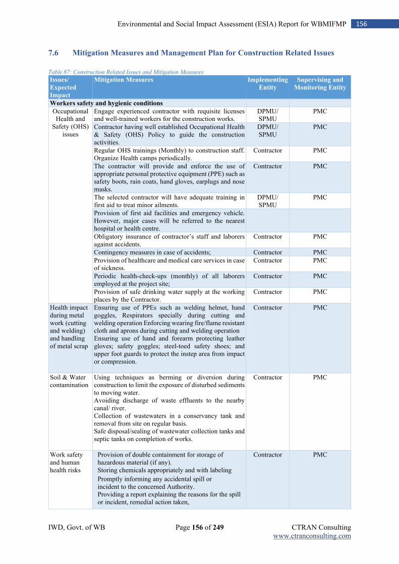
IWD, Govt. of WB Page 156 of 249 CTRAN Consulting www.ctranconsulting.com
156 Environmental and Social Impact Assessment (ESIA) Report for WBMIFMP
7.6 Mitigation Measures and Management Plan for Construction Related Issues
Table 87: Construction Related Issues and Mitigation Measures
Issues/
Expected
Impact
Mitigation Measures Implementing
Entity
Supervising and
Monitoring Entity
Workers safety and hygienic conditions
Occupational Health and
Safety (OHS) issues
Engage experienced contractor with requisite licenses and well-trained workers for the construction works.
DPMU/ SPMU
PMC
Contractor having well established Occupational Health & Safety (OHS) Policy to guide the construction activities.
DPMU/ SPMU
PMC
Regular OHS trainings (Monthly) to construction staff. Organize Health camps periodically.
Contractor PMC
The contractor will provide and enforce the use of appropriate personal protective equipment (PPE) such as safety boots, rain coats, hand gloves, earplugs and nose masks.
Contractor PMC
The selected contractor will have adequate training in first aid to treat minor ailments.
DPMU/ SPMU
PMC
Provision of first aid facilities and emergency vehicle. However, major cases will be referred to the nearest hospital or health centre.
Obligatory insurance of contractor’s staff and laborers against accidents.
Contractor PMC
Contingency measures in case of accidents; Contractor PMC
Provision of healthcare and medical care services in case of sickness.
Contractor PMC
Periodic health-check-ups (monthly) of all laborers employed at the project site;
Contractor PMC
Provision of safe drinking water supply at the working places by the Contractor.
Contractor PMC
Health impact during metal work (cutting and welding) and handling of metal scrap
Ensuring use of PPEs such as welding helmet, hand goggles, Respirators specially during cutting and welding operation Enforcing wearing fire/flame resistant cloth and aprons during cutting and welding operation Ensuring use of hand and forearm protecting leather gloves; safety goggles; steel-toed safety shoes; and upper foot guards to protect the instep area from impact or compression.
Contractor PMC
Soil & Water contamination
Using techniques as berming or diversion during construction to limit the exposure of disturbed sediments to moving water. Avoiding discharge of waste effluents to the nearby canal/ river. Collection of wastewaters in a conservancy tank and removal from site on regular basis. Safe disposal/sealing of wastewater collection tanks and septic tanks on completion of works.
Contractor PMC
Work safety and human health risks
Provision of double containment for storage of hazardous material (if any).
Storing chemicals appropriately and with labeling Promptly informing any accidental spill or incident to the concerned Authority.
Providing a report explaining the reasons for the spill or incident, remedial action taken,
Contractor PMC
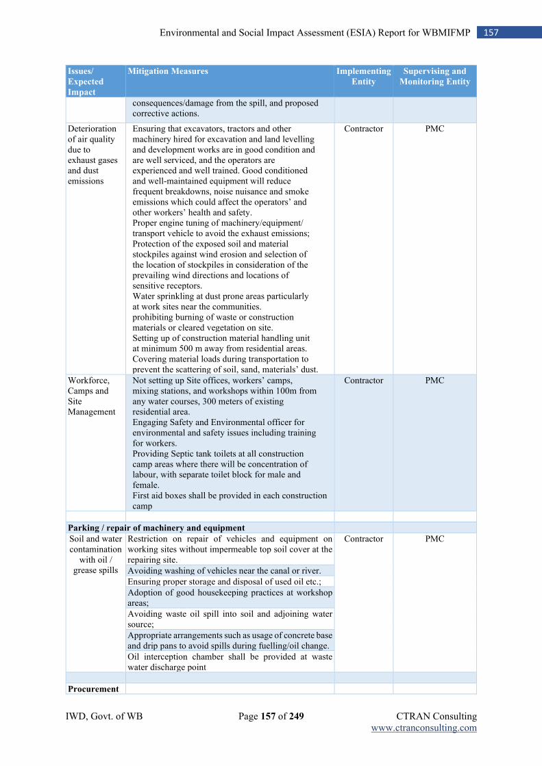
IWD, Govt. of WB Page 157 of 249 CTRAN Consulting www.ctranconsulting.com
157 Environmental and Social Impact Assessment (ESIA) Report for WBMIFMP
Issues/
Expected
Impact
Mitigation Measures Implementing
Entity
Supervising and
Monitoring Entity
consequences/damage from the spill, and proposed corrective actions.
Deterioration of air quality due to exhaust gases and dust emissions
Ensuring that excavators, tractors and other machinery hired for excavation and land levelling and development works are in good condition and are well serviced, and the operators are experienced and well trained. Good conditioned and well-maintained equipment will reduce frequent breakdowns, noise nuisance and smoke emissions which could affect the operators’ and other workers’ health and safety.
Proper engine tuning of machinery/equipment/ transport vehicle to avoid the exhaust emissions;
Protection of the exposed soil and material stockpiles against wind erosion and selection of the location of stockpiles in consideration of the prevailing wind directions and locations of sensitive receptors.
Water sprinkling at dust prone areas particularly at work sites near the communities.
prohibiting burning of waste or construction materials or cleared vegetation on site.
Setting up of construction material handling unit at minimum 500 m away from residential areas.
Covering material loads during transportation to prevent the scattering of soil, sand, materials’ dust.
Contractor PMC
Workforce, Camps and Site Management
Not setting up Site offices, workers’ camps, mixing stations, and workshops within 100m from any water courses, 300 meters of existing residential area.
Engaging Safety and Environmental officer for environmental and safety issues including training for workers.
Providing Septic tank toilets at all construction camp areas where there will be concentration of labour, with separate toilet block for male and female.
First aid boxes shall be provided in each construction camp
Contractor PMC
Parking / repair of machinery and equipment
Soil and water contamination
with oil / grease spills
Restriction on repair of vehicles and equipment on working sites without impermeable top soil cover at the repairing site.
Contractor PMC
Avoiding washing of vehicles near the canal or river.
Ensuring proper storage and disposal of used oil etc.;
Adoption of good housekeeping practices at workshop areas;
Avoiding waste oil spill into soil and adjoining water source;
Appropriate arrangements such as usage of concrete base and drip pans to avoid spills during fuelling/oil change.
Oil interception chamber shall be provided at waste water discharge point
Procurement
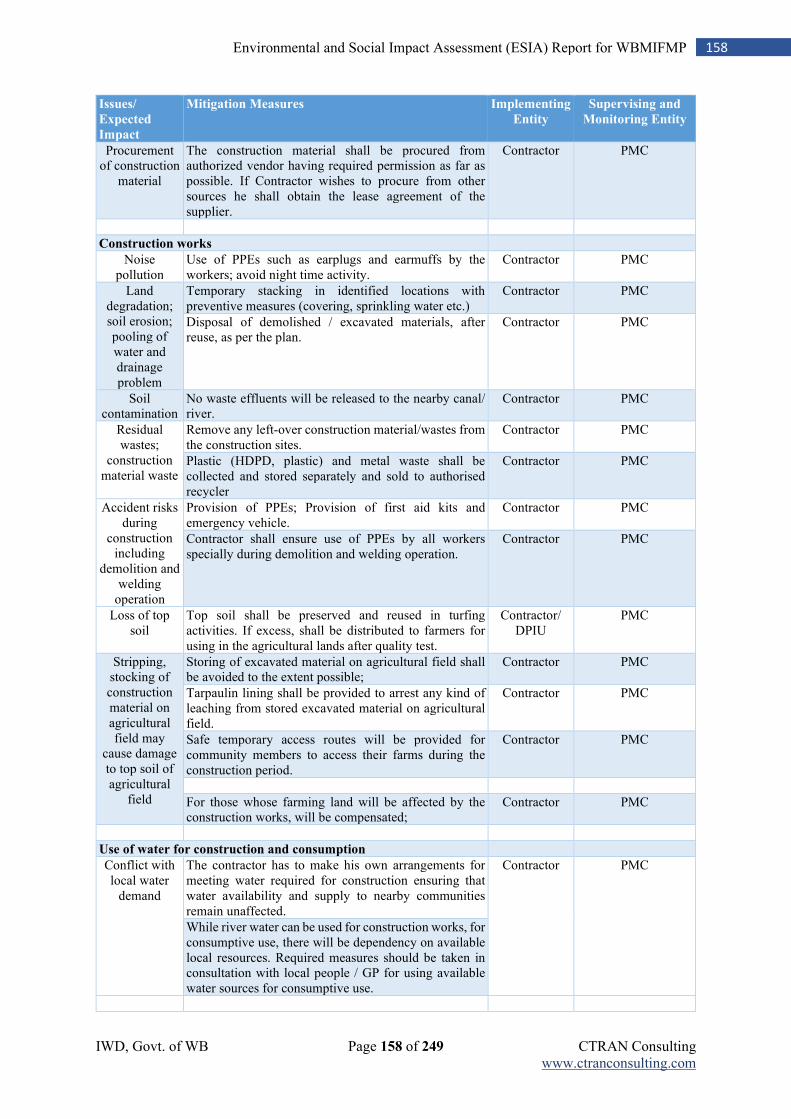
IWD, Govt. of WB Page 158 of 249 CTRAN Consulting www.ctranconsulting.com
158 Environmental and Social Impact Assessment (ESIA) Report for WBMIFMP
Issues/
Expected
Impact
Mitigation Measures Implementing
Entity
Supervising and
Monitoring Entity
Procurement of construction
material
The construction material shall be procured from authorized vendor having required permission as far as possible. If Contractor wishes to procure from other sources he shall obtain the lease agreement of the supplier.
Contractor PMC
Construction works
Noise pollution
Use of PPEs such as earplugs and earmuffs by the workers; avoid night time activity.
Contractor PMC
Land degradation; soil erosion; pooling of water and drainage problem
Temporary stacking in identified locations with preventive measures (covering, sprinkling water etc.)
Contractor PMC
Disposal of demolished / excavated materials, after reuse, as per the plan.
Contractor PMC
Soil contamination
No waste effluents will be released to the nearby canal/ river.
Contractor PMC
Residual wastes;
construction material waste
Remove any left-over construction material/wastes from the construction sites.
Contractor PMC
Plastic (HDPD, plastic) and metal waste shall be collected and stored separately and sold to authorised recycler
Contractor PMC
Accident risks during
construction including
demolition and welding
operation
Provision of PPEs; Provision of first aid kits and emergency vehicle.
Contractor PMC
Contractor shall ensure use of PPEs by all workers specially during demolition and welding operation.
Contractor PMC
Loss of top soil
Top soil shall be preserved and reused in turfing activities. If excess, shall be distributed to farmers for using in the agricultural lands after quality test.
Contractor/ DPIU
PMC
Stripping, stocking of construction material on agricultural field may
cause damage to top soil of agricultural
field
Storing of excavated material on agricultural field shall be avoided to the extent possible;
Contractor PMC
Tarpaulin lining shall be provided to arrest any kind of leaching from stored excavated material on agricultural field.
Contractor PMC
Safe temporary access routes will be provided for community members to access their farms during the construction period.
Contractor PMC
For those whose farming land will be affected by the construction works, will be compensated;
Contractor PMC
Use of water for construction and consumption
Conflict with local water
demand
The contractor has to make his own arrangements for meeting water required for construction ensuring that water availability and supply to nearby communities remain unaffected.
Contractor PMC
While river water can be used for construction works, for consumptive use, there will be dependency on available local resources. Required measures should be taken in consultation with local people / GP for using available water sources for consumptive use.

IWD, Govt. of WB Page 159 of 249 CTRAN Consulting www.ctranconsulting.com
159 Environmental and Social Impact Assessment (ESIA) Report for WBMIFMP
Issues/
Expected
Impact
Mitigation Measures Implementing
Entity
Supervising and
Monitoring Entity
Storage, handling and transport of hazardous materials
Work safety and human health risks
Provision of double containment for storage of hazardous material (if any).
Contractor PMC
Work site sanitation
Unhygienic construction
site environment
may have health impact on public and
workers
Provide waste bins on site for collection and disposal of plastic waste, cans and food waste. These bins shall be frequently emptied at approved dump sites.
Contractor PMC
Regularly remove and dispose construction waste such as metal scrap, wood chippings, rubber seals, nails, etc. for disposal at approved dumpsites.
Provide temporary toilet facilities at the construction sites for use by the construction workers. The workers will be educated against open defecation or “free range” defecation.
Potable water shall be provided to workers at all time.
Appropriately and immediately cover trenches and/or excavations after they have served their purpose to prevent accidents and collection of stagnant water which could serve as a breeding ground for disease causing vectors.
Environmental damage during flood
Environmental damage from
accidental release of
toxic, infectious, or
otherwise harmful
material from construction site during flooding
Find alternative material handling sites that is located above flood plain, if possible.
Contractor PMC
Maintain design features, such as drainage structures, during construction and operation.
Avoid constructing sanitation or other facilities that will use and store harmful materials at flood-prone areas.
Chose dry sanitation options or closed disposal systems, instead of wet ones such as septic tanks or detention ponds
Operation and movement of machinery and equipment including DG set
Deterioration of air quality
due to exhaust gases and dust
emissions
Ensure that excavators, tractors and other machinery hired for excavation and land levelling and development works are in good condition and are well serviced, and the operators are experienced and well trained. Good conditioned and well-maintained equipment will reduce frequent breakdowns, noise nuisance and smoke emissions which could affect the operators’ and other workers’ health and safety.
Contractor PMC
Proper engine tuning of machinery/equipment/ transport vehicle to avoid the exhaust emissions;
Contractor PMC
Water sprinkling at dust prone areas particularly at work sites near the communities.
Contractor PMC
Noise from vehicles,
compaction rollers,
concrete mixers and
All vehicles and machineries should have a valid Pollution Under Control (PUC) certificate.
Contractor PMC
Use of noise reduction devices; Regular inspection, maintenance and lubrication of the construction vehicle and equipment.
Contractor PMC
Use of muffles (silencers) in vehicles to minimize noise; Contractor PMC
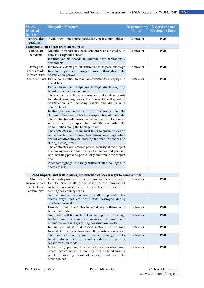
IWD, Govt. of WB Page 160 of 249 CTRAN Consulting www.ctranconsulting.com
160 Environmental and Social Impact Assessment (ESIA) Report for WBMIFMP
Issues/
Expected
Impact
Mitigation Measures Implementing
Entity
Supervising and
Monitoring Entity
construction equipment
Avoid night time traffic particularly near communities. Contractor PMC
Transportation of construction material
Chance of accidents
Material transport in closed containers or covered with canvas (Tarpaulin) sheets.
Contractor PMC
Restrict vehicle speeds to 30km/h near habitations / settlements
Damage to access roads/ infrastructure
Restore any damaged infrastructure to its pervious stage Contractor PMC
Regular repair of damaged roads throughout the construction period.
Accident risks Public consultation to maintain community integrity and social links;
Contractor PMC
Public awareness campaigns through displaying sign board at site and haulage routes;
The contractor will use warning signs at vantage points to indicate ongoing works. The contractor will guard all construction site including canals and drains with caution tapes.
Restriction on movement of machinery on the designated haulage routes for transportation of materials;
The contractor will ensure that all haulage trucks comply with the approved speed limit of 30km/hr within the communities along the haulage road;
The contractor will adjust haul times to ensure trucks do not move to the communities during mornings when school children may be crossing the road to school and during closing time.
The contractor will enforce proper security at the project site during works to limit entry of unauthorized persons, non- working persons, particularly children to the project site;
Adequate signage to manage traffic at sites, haulage and access roads;
Road impacts and traffic issues, Obstruction of access ways to communities
Mobility inconvenience
to the local community
New roads provided in the designs will be constructed first to serve as alternative roads for the transport of materials obtained in-situ. This will ease pressure on existing community roads.
Contractor PMC
Safe alternative access routes shall be provided for access ways that are obstructed/ destroyed during construction works.
Provide sirens in vehicles to avoid any collision with human/animals
Contractor PMC
Sign posts will be erected at vantage points to manage traffic, guide community members through safe alternative access ways during construction works.
Contractor PMC
Repair and maintain damaged sections of the road located at project site throughout the construction period.
Contractor PMC
The contractor will ensure that all haulage trucks hired/contracted are in good condition to prevent breakdowns on roads.
Contractor PMC
Not allowing parking of the vehicle in areas which may create inconvenience in mobility such as blind turning point or meeting point of village road with the embankment.
Contractor PMC
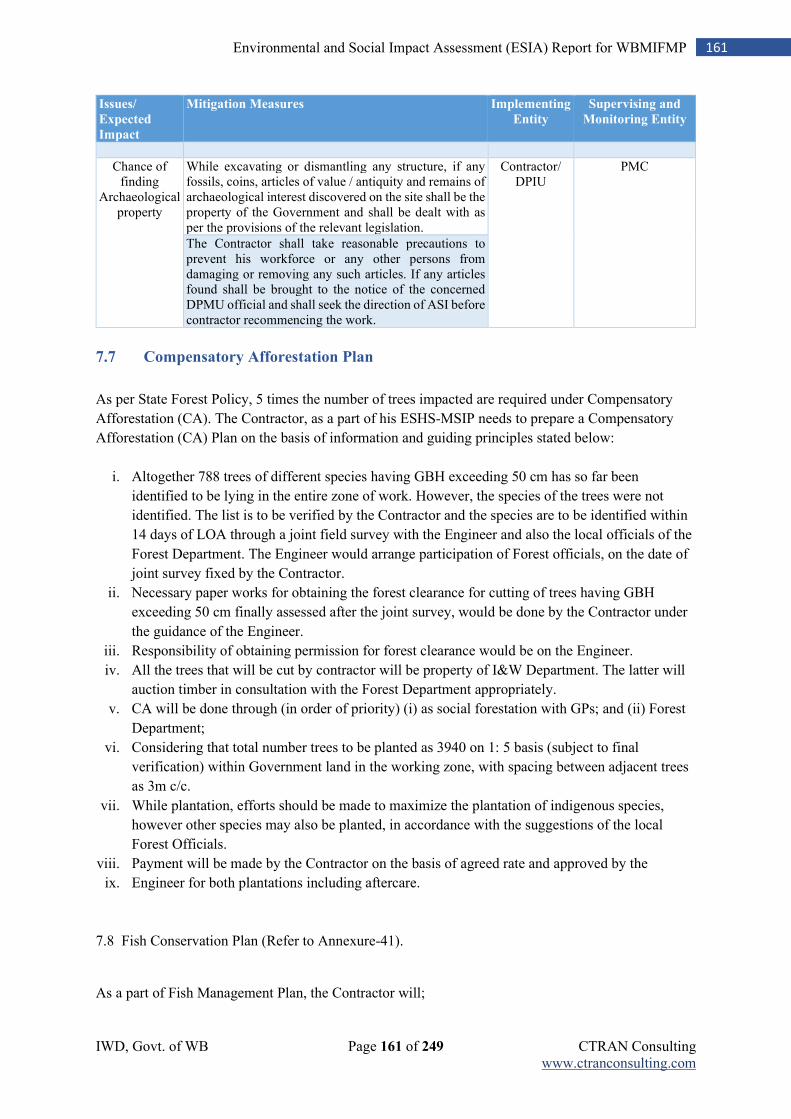
IWD, Govt. of WB Page 161 of 249 CTRAN Consulting www.ctranconsulting.com
161 Environmental and Social Impact Assessment (ESIA) Report for WBMIFMP
Issues/
Expected
Impact
Mitigation Measures Implementing
Entity
Supervising and
Monitoring Entity
Chance of finding
Archaeological property
While excavating or dismantling any structure, if any fossils, coins, articles of value / antiquity and remains of archaeological interest discovered on the site shall be the property of the Government and shall be dealt with as per the provisions of the relevant legislation.
Contractor/ DPIU
PMC
The Contractor shall take reasonable precautions to prevent his workforce or any other persons from damaging or removing any such articles. If any articles found shall be brought to the notice of the concerned DPMU official and shall seek the direction of ASI before contractor recommencing the work.
7.7 Compensatory Afforestation Plan
As per State Forest Policy, 5 times the number of trees impacted are required under Compensatory
Afforestation (CA). The Contractor, as a part of his ESHS-MSIP needs to prepare a Compensatory
Afforestation (CA) Plan on the basis of information and guiding principles stated below:
i. Altogether 788 trees of different species having GBH exceeding 50 cm has so far been
identified to be lying in the entire zone of work. However, the species of the trees were not
identified. The list is to be verified by the Contractor and the species are to be identified within
14 days of LOA through a joint field survey with the Engineer and also the local officials of the
Forest Department. The Engineer would arrange participation of Forest officials, on the date of
joint survey fixed by the Contractor.
ii. Necessary paper works for obtaining the forest clearance for cutting of trees having GBH
exceeding 50 cm finally assessed after the joint survey, would be done by the Contractor under
the guidance of the Engineer.
iii. Responsibility of obtaining permission for forest clearance would be on the Engineer.
iv. All the trees that will be cut by contractor will be property of I&W Department. The latter will
auction timber in consultation with the Forest Department appropriately.
v. CA will be done through (in order of priority) (i) as social forestation with GPs; and (ii) Forest
Department;
vi. Considering that total number trees to be planted as 3940 on 1: 5 basis (subject to final
verification) within Government land in the working zone, with spacing between adjacent trees
as 3m c/c.
vii. While plantation, efforts should be made to maximize the plantation of indigenous species,
however other species may also be planted, in accordance with the suggestions of the local
Forest Officials.
viii. Payment will be made by the Contractor on the basis of agreed rate and approved by the
ix. Engineer for both plantations including aftercare.
7.8 Fish Conservation Plan (Refer to Annexure-41).
As a part of Fish Management Plan, the Contractor will;
IWD, Govt. of WB Page 162 of 249 CTRAN Consulting www.ctranconsulting.com
162 Environmental and Social Impact Assessment (ESIA) Report for WBMIFMP
Ensure that cross bundhs are constructed as per sequence, so that fishes can safely migrate
downstream.
Keep water in the alternative compartments constructed by intermediate partition bundhs to
the extent feasible so that any remnant of the fishing and benthic community can survive in
those water filled components.
Report to the Local officers of the Fishery Department within 12 hours in case any ’vulnerable’,
‘near threatened’ or ‘endangered’ species of fish is found in the working zone, (The ‘vulnerable’
fishes are Puntius conchonius – local name ‘Punti’, Mystus aor – local name ‘Aard’ and
Bagarius – local name ‘Garua’), endangered (Notopterus chitala – local name ‘Chital’) or near
threatened (Danio rerio – local name ‘Techokha’, Wallago attu – local name ‘Boal’ and
Tetradon cutcutia – local name ‘Tepa’). All works shall be suspended till Fishery Department
has taken measures to preserve such species and provided permission to proceed with works.
Adhere to the Code of Conduct in respect of conservation of fishes.
Organize worker awareness programs to make workers aware of the identification and
protection of vulnerable species of fish and other animals.
Undertake water quality testing 200 meters downstream from the last terminal bund.
7.9 Traffic Management Plan
Before initiation of the construction work, proper traffic management plan shall be prepared by
contractor and submitted to the Engineer as a part of the Contractor’s ESHS-MSIP, for approval. The
plan should include haulage and work site routes, traffic control devices, temporary fencing, barriers
and barricades, diversion plans & detours, traffic signs and speed limits, safe passage of pedestrians
and provision of access to private properties. Contingency plan in case of major road accidents shall
also be provided in plan.
Regarding temporary impacts to local roads and traffic, contractor should consider the following
while preparing traffic management plan:
o New roads provided in the designs shall be constructed first to serve as alternative roads for the
transport of materials obtained in-situ. This will ease pressure on existing community roads.
o Safe alternative access routes shall be provided for access ways that are obstructed/ destroyed
during construction works.
o Sign posts shall be erected at vantage points to manage traffic, guide community members through
safe alternative access ways during construction works.
o Prior to construction activities, the contractor will install all signs, barriers and control devices
needed to ensure the safe use of the road by traffic and pedestrians, as required by the traffic control
plan;
o Signs, crossing guards and other appropriate safety features will be incorporated at road crossings
and vantage points;
o Close consultation with local authorities and communities in a working area to identify optimal
solutions for diversions to maintain community integrity & social links; will be made before any
detours for construction or diverted public traffic are established;
o Haul routes for accessing worksites and temporary disposal sites to the extent required and feasible
will be identified and coordinated with local officials; Movement of machinery on the designated
IWD, Govt. of WB Page 163 of 249 CTRAN Consulting www.ctranconsulting.com
163 Environmental and Social Impact Assessment (ESIA) Report for WBMIFMP
haulage routes for transportation of materials will be restricted. All haulage trucks shall comply
with the approved speed limit within the communities along the haulage road;
o Adjustment in haul times to ensure trucks do not move to the communities during mornings when
school children may be crossing the road to school and during closing time, shall be made to the
extent feasible;
o Construction vehicles will use temporary roads constructed for that purpose to minimize damage
to agricultural land and local access roads. Wherever possible, rerouting of construction traffic to
wider, less-restrictive road shall be preferred.
o Damaged sections of the haul roads leading to project site shall be repaired throughout the
construction period. Where local roads are used, they will also be maintained periodically.
o Provision of signboards directing the drivers about the diversion and the road crossing,
overpass/underpass, signage, road shoulders, relocation of school’s entrance and other required
action will be included in the traffic control plan by the contractor; Provision of proper safety
signage at sensitive/accident-prone spots.
o Providing and maintaining traffic management will require and include diversion warning, guiding
and regulatory signage, channelizers and delineators, lightening etc;
o Positioning of agile flagman with an orange vest and a helmet and a red flag 600 x 600 mm securely
fastened to a staff 1 m in length will be made for guiding/managing the traffic; Contractor staff
could be trained and put on the duty to manage the traffic during the construction activities taking
place along the road; Secure assistance from local civic police for traffic control during the
construction;
o On possibility, the movement of heavy vehicles to be restricted to the night times particularly near
communities;
o Unnecessary parking and sound pollution to be strictly avoided especially when vehicles are
passing through the settlements and sensitive receptor such as schools, hospital and cultural centre.
o Parking of the vehicle in areas which may create inconvenience in mobility such as blind turning
point or meeting point of village road with the embankment, shall not be allowed.
o The contractor shall provide training to the drivers regarding the traffic rules and management
provisions. Training records shall be maintained by the contractor.
o Sirens will be provided in vehicles to avoid any collision with human/animals
o Contractor will ensure that no construction materials and debris are lying on the road. It will be
collected and disposed of properly.
o The contractor will ensure that all haulage trucks hired/contracted are in good condition to prevent
breakdowns on roads.
Accident Reporting on Occurrence of Accident
(i) In case of traffic accidents involving project vehicles & equipment, relevant information
including date, location, damage, cause, and follow-up action need to be provided;
Monitoring by Project Authority
(i) Traffic management plan is to be vetted by the Engineer.
(ii) Necessary permissions for traffic diversion obtained from the concerned Authorities are to be
submitted to the Engineer for verification
(iii) Traffic safety at worksites will be monitored and reviewed by the Engineer on regular basis.
(iv) Report on the condition of the vehicles/equipment (to be given by the Environment, Health
and Safety (EHS) officer engaged by Contractor on the basis of his subjective judgment) and non-
routine repairs and maintenance needed to improve safety and/or environmental performance etc. will
be reviewed by the Engineer on monthly basis.

IWD, Govt. of WB Page 164 of 249 CTRAN Consulting www.ctranconsulting.com
164 Environmental and Social Impact Assessment (ESIA) Report for WBMIFMP
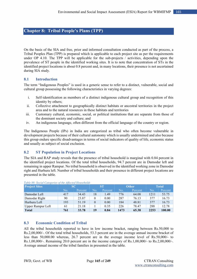
IWD, Govt. of WB Page 165 of 249 CTRAN Consulting www.ctranconsulting.com
165 Environmental and Social Impact Assessment (ESIA) Report for WBMIFMP
Chapter 8: Tribal People’s Plans (TPP)
On the basis of the SIA and free, prior and informed consultation conducted as part of the process, a Tribal Peoples Plan (TPP) is prepared which is applicable to each project site as per the requirements under OP 4.10. The TPP will be applicable for the sub-projects / activities, depending upon the prevalence of ST people in the identified working sites. It is to note that concentration of STs in the identified project locations is about 0.8 percent and, in many locations, their presence is not ascertained during SIA study.
8.1 Introduction
The term “Indigenous Peoples” is used in a generic sense to refer to a distinct, vulnerable, social and cultural group possessing the following characteristics in varying degrees:
i. Self-identification as members of a distinct indigenous cultural group and recognition of this identity by others;
ii. Collective attachment to geographically distinct habitats or ancestral territories in the project area and to the natural resources in these habitats and territories
iii. Customary cultural, economic, social, or political institutions that are separate from those of the dominant society and culture; and
iv. An indigenous language, often different from the official language of the country or region. The Indigenous People (IPs) in India are categorized as tribal who often become vulnerable in development projects because of their cultural autonomy which is usually undermined and also because this group endure specific disadvantages in terms of social indicators of quality of life, economic status and usually as subject of social exclusion.
8.2 ST Population in Project Locations
The SIA and RAP study reveals that the presence of tribal household is marginal with 0.84 percent in the identified project locations. Of the total tribal households, 94.7 percent are in Damodar left and remaining in upper Rampur. No tribal household is observed in the identified working zone in Damodar right and Hurhura left. Number of tribal households and their presence in different project locations are presented in the table. Table 88: Social Categories of the Affected Households
Project Sites SC ST Other Total No. Percent No. Percent No. Percent No. Percent
Damodar Left 417 34.43 18 1.49 776 64.08 1211 53.75
Damodar Right 90 23.87 0 0.00 287 76.13 377 16.73
Hurhura Left 193 51.19 0 0.00 184 48.81 377 16.73
Upper Rampur Left 61 21.18 1 0.35 226 78.47 288 12.78
Total 761 33.78 19 0.84 1473 65.38 2253 100.00
8.3 Economic Condition of Tribal
All the tribal households reported to have in low income bracket, ranging between Rs.50,000 to Rs.2,00,000/-. Of the total tribal households, 53.3 percent are in the average annual income bracket of less than 50,000.00 whereas, 26.7 percent are in the average income level of Rs.50,000/- to Rs.1,00,000/-. Remaining 20.0 percent are in the income category of Rs.1,00,000/- to Rs.2,00,000/-. Average annual income of the tribal families in presented in the table.
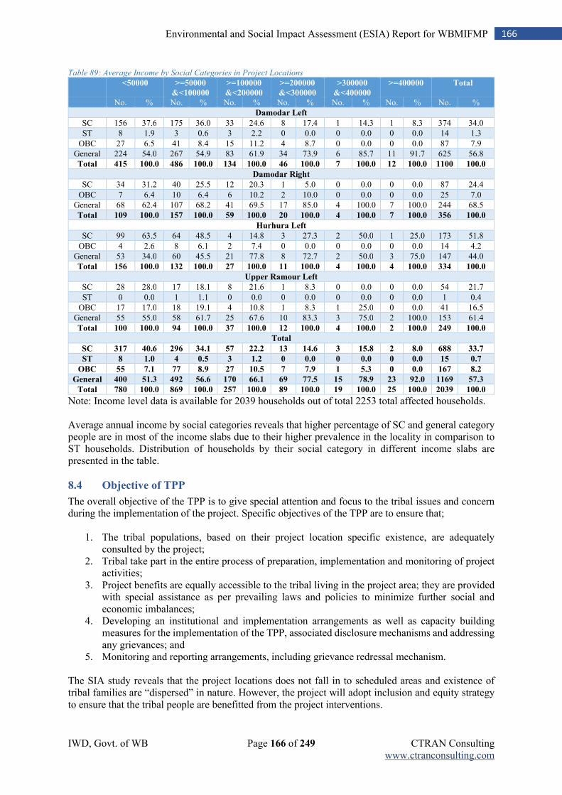
IWD, Govt. of WB Page 166 of 249 CTRAN Consulting www.ctranconsulting.com
166 Environmental and Social Impact Assessment (ESIA) Report for WBMIFMP
Table 89: Average Income by Social Categories in Project Locations <50000 >=50000
&<100000
>=100000
&<200000
>=200000
&<300000
>300000
&<400000
>=400000 Total
No. % No. % No. % No. % No. % No. % No. %
Damodar Left
SC 156 37.6 175 36.0 33 24.6 8 17.4 1 14.3 1 8.3 374 34.0
ST 8 1.9 3 0.6 3 2.2 0 0.0 0 0.0 0 0.0 14 1.3
OBC 27 6.5 41 8.4 15 11.2 4 8.7 0 0.0 0 0.0 87 7.9
General 224 54.0 267 54.9 83 61.9 34 73.9 6 85.7 11 91.7 625 56.8
Total 415 100.0 486 100.0 134 100.0 46 100.0 7 100.0 12 100.0 1100 100.0
Damodar Right
SC 34 31.2 40 25.5 12 20.3 1 5.0 0 0.0 0 0.0 87 24.4
OBC 7 6.4 10 6.4 6 10.2 2 10.0 0 0.0 0 0.0 25 7.0
General 68 62.4 107 68.2 41 69.5 17 85.0 4 100.0 7 100.0 244 68.5
Total 109 100.0 157 100.0 59 100.0 20 100.0 4 100.0 7 100.0 356 100.0
Hurhura Left
SC 99 63.5 64 48.5 4 14.8 3 27.3 2 50.0 1 25.0 173 51.8
OBC 4 2.6 8 6.1 2 7.4 0 0.0 0 0.0 0 0.0 14 4.2
General 53 34.0 60 45.5 21 77.8 8 72.7 2 50.0 3 75.0 147 44.0
Total 156 100.0 132 100.0 27 100.0 11 100.0 4 100.0 4 100.0 334 100.0
Upper Ramour Left
SC 28 28.0 17 18.1 8 21.6 1 8.3 0 0.0 0 0.0 54 21.7
ST 0 0.0 1 1.1 0 0.0 0 0.0 0 0.0 0 0.0 1 0.4
OBC 17 17.0 18 19.1 4 10.8 1 8.3 1 25.0 0 0.0 41 16.5
General 55 55.0 58 61.7 25 67.6 10 83.3 3 75.0 2 100.0 153 61.4
Total 100 100.0 94 100.0 37 100.0 12 100.0 4 100.0 2 100.0 249 100.0
Total
SC 317 40.6 296 34.1 57 22.2 13 14.6 3 15.8 2 8.0 688 33.7
ST 8 1.0 4 0.5 3 1.2 0 0.0 0 0.0 0 0.0 15 0.7
OBC 55 7.1 77 8.9 27 10.5 7 7.9 1 5.3 0 0.0 167 8.2
General 400 51.3 492 56.6 170 66.1 69 77.5 15 78.9 23 92.0 1169 57.3
Total 780 100.0 869 100.0 257 100.0 89 100.0 19 100.0 25 100.0 2039 100.0
Note: Income level data is available for 2039 households out of total 2253 total affected households. Average annual income by social categories reveals that higher percentage of SC and general category people are in most of the income slabs due to their higher prevalence in the locality in comparison to ST households. Distribution of households by their social category in different income slabs are presented in the table.
8.4 Objective of TPP
The overall objective of the TPP is to give special attention and focus to the tribal issues and concern during the implementation of the project. Specific objectives of the TPP are to ensure that;
1. The tribal populations, based on their project location specific existence, are adequately consulted by the project;
2. Tribal take part in the entire process of preparation, implementation and monitoring of project activities;
3. Project benefits are equally accessible to the tribal living in the project area; they are provided with special assistance as per prevailing laws and policies to minimize further social and economic imbalances;
4. Developing an institutional and implementation arrangements as well as capacity building measures for the implementation of the TPP, associated disclosure mechanisms and addressing any grievances; and
5. Monitoring and reporting arrangements, including grievance redressal mechanism. The SIA study reveals that the project locations does not fall in to scheduled areas and existence of tribal families are “dispersed” in nature. However, the project will adopt inclusion and equity strategy to ensure that the tribal people are benefitted from the project interventions.
IWD, Govt. of WB Page 167 of 249 CTRAN Consulting www.ctranconsulting.com
167 Environmental and Social Impact Assessment (ESIA) Report for WBMIFMP
8.5 Key Principles of Tribal Inclusion
The project will follow below mentioned principles to ensure that tribal development issues are amicably addressed within the scope of the project and in line with the tribal development principles of the government.
1. Proactive initiatives for convergence with tribal development schemes of Government, based on the feasibility;
2. Equal opportunity to dispersed tribal (living in a mixed community) for accessing project benefits, as per the plan for beneficiary coverage;
3. Ensuring greater participation of tribal community in activities / sub-activities taken up under each component / sub-components of the project;
4. Taking measures, adhering to the scope of the project, to build the capacity of tribal farmers in agricultural technologies, marketing, institution management etc., as per the project requirements;
5. Monitoring of actions taken under the project for inclusion of tribal by project component / sub-components and initiating corrective measures accordingly;
8.6 Inclusion of Tribal in Project Activities
As irrigation and flood management activities are equally beneficial for both tribal and non-tribal, certain activities which need exclusive focus for tribal inclusion and having the potential of benefitting the tribal families directly are discussed in following sections. The project will take inclusion strategy, focusing appropriate inclusion and representation of tribal in project locations and their active association in project interventions. The inclusion strategy to be followed is presented below. Tribal Encroacher and Squatters: The SIA study identify insignificant presence of tribal families near the identified working zones. However, the project will take all required measures to ensure that their interest is fully protected during project execution. If no other alternative is available and their eviction is highly essential from the identified work zones, they should be compensated appropriately as per the entitlement provisions of the Government. Government will take all required measures to ensure that their entitlements are addressed and their livelihood is restored through schematic convergence and related measures. Temporary Acquisition / Use of Tribal Holdings: In no case, project will acquire or use cultivated agricultural land, own by tribal or their association as a legal / registered share cropped. In certain activities, such as temporary stocking of desilted materials, placing of machineries, construction of haul roads, setting up of work camps etc. the land under the possession of tribal families should not be used. Compensation for Damage to Standing Crop: Because of the project activities, if any damage occurs to the standing crop, grown by tribal family in his/her legal land or share cropped land, project will compensate the tribal family for the extent of damage caused due to project activity in consultation with the Agriculture / Horticulture Department. Compensation for Residential / Non-Residential Structures: The Government of West Bengal has taken a policy decision to compensate all encroachers and squatters, treating them equally, irrespective of the size of the structure. The replacement cost of the structures, to be affected due to project intervention, will be compensated as per the provision of Gitanjali scheme of govt. of west Bengal. However, if government wishes, additional assistance may be provided to the tribal families who are likely to be affected due to project works. Work Participation: Any person from tribal family, interested to work as a skilled / unskilled / semi-skilled labour / worker, should be given priority in work engagements. Providing subsidy for area expansion and planting material to promote less water consuming
fruits and vegetables: The project will take an inclusive approach and will give priority to ensure that
IWD, Govt. of WB Page 168 of 249 CTRAN Consulting www.ctranconsulting.com
168 Environmental and Social Impact Assessment (ESIA) Report for WBMIFMP
interested tribal farmers access these benefits. Subsidy norms applicable to tribal, at par with other schemes and schematic provisions should be adhered to in finalising subsidy component. The tribal farmers should be educated on the benefit of horticultural crops and expansion of its area in terms of economic return and allied benefits. Providing subsidy for construction of Shade-net house: During finalisation of farmers to access subsidy for construction of shade net houses, tribal families of the area would be consulted and their interest would be taken care. The subsidy norms, normally applicable for the tribal would be considered for the construction of shade net houses. The tribal families would be given required training on protected cultivation and crop management in shade nets. Providing subsidy for infrastructure development for promotion of vermi compost, protected
cultivation and post-harvest infrastructure: The project will ensure that tribal families are educated and mobilised to avail the benefit of such project measures. The subsidy norms, as stipulated by the government for the tribal beneficiaries will be adhered to. In case of group approach, it will be ensured that the tribal families, who are member of such groups should have equal access to the benefits. Construction of aggregation centre / pack house for temporary / intermediate storage of farm
produces: While construction of such infrastructure on tribal owned land should be avoided, emphasis would be given to ensure their accessibility to the facility and services. In the aggregation and product packaging, FPOs should ensure that produces of tribal also equally treated and storage house is also accessed and utilised by them. Transport subsidy to each FPC for procurement of motorized van: The FPCs will give equal opportunity to use the transportation means for the transportation of commodities grown / produced by the tribal families who are the members of the FPCs. The local FPCs will be encouraged to include left out tribal farmers in the FPCs following the group norm and inclusion procedures. Providing cages with appurtenant to SHG/ FPGs: Tribal women SHGs/ FPGs (SHGs / FPGs having more than 50.0 % tribal member) / would be given priority in cage culture and appropriate training and orientation would be given to them on different aspects of managing cage culture. Providing fish seed, fish feed etc. to SHG / FPGs as onetime sustenance support: Tribal women SHGs/ FPGs (SHGs / FPGs having more than 50.0 % tribal member) / would be given priority and appropriate training and orientation would be given to them on fishery and aquaculture. Capacity Building: The project will take all required measures to develop the capacity of the tribal farmers in different project framed activities, such as water management, crop planning and diversification, agricultural technology, aquaculture, management of pressurised irrigation system, post-harvest management etc. It will be supportive to the tribal farmers to have enhanced knowledge on these aspects and helping them to adopt such practices. Apart from training and orientation, hand holding and escorting support would also be provided to the tribal farmers on these aspects for enhanced adoption.
8.7 Implementation Arrangement
The overall responsibility of the implementation of the TPP rests with the SPMU. The social and gender expert at the DPMU level will be responsible to see that TPP is implemented and inclusion criteria are met in project activities. Detail inclusion plan by project location and activity will be prepared by the social and gender expert at the DPMU level and will monitor accordingly. The Social and Gender expert at the SPMU will also conduct periodic monitoring and evaluation. Disaggregated data by beneficiary coverage, worker engagement, compensation disbursement etc. will be prepared reflecting percentage coverage of STs in different activities, apart from women participation. The PMC will also conduct periodic monitoring and review of these aspects, guided and supervised by the Social and Gender Development Expert at the SPMU level. A competent person with a long experience in Bank safeguard
IWD, Govt. of WB Page 169 of 249 CTRAN Consulting www.ctranconsulting.com
169 Environmental and Social Impact Assessment (ESIA) Report for WBMIFMP
policies will be hired as the Safeguard Coordinator who will ensure a full compliance of all actions taken at the central as well as village levels, and supervise the third-party service provider. A tribal capacity development plan will also be prepared, based on the identified needs and capacity building measures will be initiated by the experts at the DPMU level.
8.8 Monitoring and Evaluation
Throughout the implementation of the project, the PMC along with the social and gender experts of SPMU and DPMU will monitor the project compliance with Bank safeguard policies. The social expert of PMC will visit on a monthly basis to project locations and discuss with the affected tribal households and project beneficiaries and those who do not directly receive project benefits. Upon the completion of a TPP, the IWD, under the assistance of the concerned expert of the PMU, will carry out an TPP completion assessment to confirm that all measures under this TPP have been fully implemented and that the negative impacts on tribal communities have been adequately addressed. The project MIS will collect key data on TPP such as the presence and absence of tribal community in the command areas of respective irrigation system, the number of tribal population and their name of ethnicity, enrolment of tribal in different project activities etc.
IWD, Govt. of WB Page 170 of 249 CTRAN Consulting www.ctranconsulting.com
170 Environmental and Social Impact Assessment (ESIA) Report for WBMIFMP
Chapter 9: Pest Management Plan
The project interventions on improved irrigation may lead to agricultural intensification and associated use of agro-chemicals such as pesticides and fertilizers. In order to minimise the level of impact, the project will promote Integrated Pest and Nutrient Management (IPNM) sensitizing farmers and educating them on scientific application of fertilizer and pesticides along with the application of organic farming methods. Effective implementation of IPNM practices will reduce the risk of water pollution through leaching of chemicals from farmlands to water sources, both surface and sub-surface. This section discusses about Pest Management Plan (PMP) in line with the project activities. All the project framed activities do not give rise to requirement for PMP. There are specific agricultural promotion activities that requires pest management plan such as crop diversification. It is worth mentioning that use of pesticides, including WHO enlisted pesticides of category 1a, 1b and II are already identified in different project sites and has been a practice of the farmers. The use of pesticides is already in a higher stage but its management is essential as a part of environment and health improvement measures. The project intends to adopted appropriate strategies to minimize the environmental impact of pesticides and promotion of IPM in project locations. IPM combines different approach to control the pests, minimize the economic loss and protect the environment. While the importance of chemical pesticides in controlling pests and its use by the farmers cannot be fully denied, better management approach can be promoted to ensure that its adverse impact on the environment is minimized. IPM is a broad ecological approach of pest control (insects, diseases, weeds, rodents etc.) employing different appropriate and suitable methods and techniques in an integrated manner to keep pest population below Economic Threshold Level (ETL) and also reduces the residual effects of chemicals on both plants and animals. The project will adopt Integrated Pest Management (IPM) as the key strategy to combat pests and diseases in the project and regulate its environmental impact. However, appropriate strategy to be adopted for its promotion among the farmers like sensitization on environment, awareness on environmental impact of indiscriminate use of pesticides, educating farmers on restricted and banned pesticides, regular orientation training and follow up, providing hand holding / field guidance and monitoring the implementation of IPM.
9.1 The World Bank Operational Guidelines
The World Bank & IFC pesticide guidelines aims to ensure that;
1. It should have negligible adverse human health effects 2. Should be effective against target pests and minimal effect on non-target species 3. Development of pest resistance to be kept in view 4. Public health pesticides must be safe for inhabitants and animals 5. Integrated pesticide management specifically identifies the following as the key in pest control. 6. A categorical preference for bio control methods along with institutional and capacity building
for the same. 7. Reducing reliance on synthetic chemical pesticides and only if approved by IPM approach. 8. Does not permit under any circumstance the use IA, IB and II classified pesticides (WHO
Classified). 9. Recommends the use of Participatory IPM along with specific investment components for the
same. 10. Permits WHO enlisted category III type chemicals as a part of the IPM strategy.
IWD, Govt. of WB Page 171 of 249 CTRAN Consulting www.ctranconsulting.com
171 Environmental and Social Impact Assessment (ESIA) Report for WBMIFMP
9.2 Objectives of IPM Plan
The objective of IPM Plan is to promote and support safe, effective and environmentally sound pest management under the project. Along with regulating the use of synthetic pesticides (based on prescribed doses and type of pesticides to be used), the objective of IPM is to promote the use of biological and environmental control methods and the reduction in reliance on synthetic chemical pesticides. Promotion of IPM is objectively driven to achieve the followings.
1. Minimize crop loss, augment farm production with scientific application of synthetic pesticides; 2. Reduce environmental pollution caused due to the application of synthetic pesticides; 3. Introduction and adoption of biological and cultural methods and managing pests below ETL; 4. Reduction in health hazards arising due to chemical pesticides during handling; 5. Minimizing pesticide residues through the application of appropriate doses; 6. Promotion of bio pesticides
9.3 Salient Features of the Project Approach
1. Popularising IPM approach among farming community through demonstration, awareness,
training and exposure; 2. Organising regular pest surveillance and monitoring to assess pest/disease situation and study
agro-eco-system to advise timely IPM control measures in a convergence mode; 3. Encourage farmers to rear biological control agents for their field use and conservation of
naturally occurring biological control agents for control of crop pests; 4. Promoting use of bio-pesticides, neem based pesticides, bacillus based bio-pesticides, insect
pathogen as alternative to chemical pesticides; 5. To play a catalytic role in transfer of innovative IPM skills/methods/ techniques to farmers
through extension services, training and awareness. 6. Issuing insect-pest and disease related information and control measures to farmers.
9.4 Integrated Pest Management Approach
Alternative pest control strategies such as IPM that deploys a combination of different control measures such as cultural control, use of resistant genotype, physical and mechanical control, and rational use of pesticide would reduce the number and amount of pesticide applications. Sensitization, awareness and extension support would educate and encourage farmers to adopt the innovative IPM strategies that would be key to reduce the harmful impact of pesticides on life and environment. Table 90: Integrated Pest Management Approach
SN Standard Pest Control Measures Integrated Pest Management
1 Use of synthetic pesticides is common and widespread
More knowledge intensive
2 Less emphasis on preventive approach Emphasis on prevention of pest problems
3 More reactive to pest outbreaks Systematic approach for long-term pest control
4 Pesticide application is more chemical intensive Change in field conditions that prevent pest attack
5 Use of synthetic pesticides focus more on killing pests directly
Regular inspection / monitor and taking recommended actions
6 Use of Higher Doses Doses and type of pesticides use as per need
The project will adopt the suggested steps for IPM implementation. Specific IPM measures that the project will promote / encourage farmers to adopt are;
Deep summer ploughing (only in suitable cases). Recycling and appropriate disposal of crop residues, weeds etc. Seed treatment. Growing pest and disease resistant/tolerant varieties. Timely and synchronous sowing operation.
IWD, Govt. of WB Page 172 of 249 CTRAN Consulting www.ctranconsulting.com
172 Environmental and Social Impact Assessment (ESIA) Report for WBMIFMP
Maintaining optimum plant spacing. Post-sowing cultural operations. Balanced use of fertilizers. Proper water management. Timely weed control. Use of light, yellow, sticky and pheromone traps for monitoring of pests. Regular monitoring on pests and their natural enemies. Conservation of crop defenders (parasites, predators and pathogens). Use of bio-pesticides against crop pests. Observation of pests and defenders ratio (2:1) before taking control action. Need based and judicious use of the pesticides on the basis of ETL as a last resort.
The IPM strategy will cover (1) identification of pests & diseases for the crop in the area through regular monitoring, (2) assessment of ETL for major pests/diseases for different crops, (3) promotion of physical / mechanical / cultural / biological control methods, (4) facilitating use of bio-pesticides and (5) prescribing appropriate use of synthetic pesticides with recommended doses.
9.5 Identification Process
Field monitoring helps to keep track of the pests and their potential damage, which forms the base of IPM. So, the process starts with monitoring, which includes inspection and identification, followed by the establishment of ETL (crop specific). This provides knowledge about the current pests and crop situation and is helpful in selecting the best possible combinations of the pest management methods. Identification of minor and major pests, diseases in the project areas will be conducted regularly for the purpose. Package of practices developed by the State Agriculture Universities can be adopted accordingly.
9.6 Assessment of Economic Threshold Level
The ETL differs by pest and also by crop types. Pest population is expected to be maintained at levels below those causing economic loss. It is generally assumed that pest tolerant capacity of different crops is limited and when it exceeds or approaching the ETL, chemical control methods can be used. Different pest / disease control methods of IPM will be applied, based on the determination of ETL and pest density. A priority list of different control methods of IPM is presented below. Table 91: Adoption of IPM Methods and its Priority
IPM Procedures Methods of Executing Priority in Application
Cultural Avoidance of monoculture; Improved disease resistant varieties; Summer ploughing; Optimum plant densities; Avoiding excessive irrigation; Avoiding high nitrogenous fertilization; Trap crops
To be given preference as preventive mechanism
Biological Conservation / promotion of bio agents like birds, parasites & pathogens for biological control of pests.
Second Priority
Mechanical Damage/Destroying all the eggs of the insect; Destroy any material infested by insect, pest and diseases.
Third Priority
Chemical Chemical Control when the loss is beyond ETL Use of recommended chemicals only
Last Priority when crop loss is beyond ETL
9.7 Pest and Disease Surveillance
As part of IPM strategy, a pest and disease surveillance will be undertaken electronically. Pest surveillance is an effective tool as an information system, which renders all pest control methods more effective. It aims at monitoring and forewarning of likely build-up of pests in order to facilitate planning and adoption of suitable control strategy based on ETL. It acts as a guiding principle in determining the areas and time needing the pest control. The existing pest and disease surveillance system of the Government will be inbuilt in to the project.
IWD, Govt. of WB Page 173 of 249 CTRAN Consulting www.ctranconsulting.com
173 Environmental and Social Impact Assessment (ESIA) Report for WBMIFMP
9.8 Major Activities under IPM Strategy
Table 92: IPM Strategy and Key Activities
Key Activities Execution Strategy
Training of project officials on IPM (all levels) Orientation training by crop type
Training of Farmers and FPCs Crop specific orientation on IPM in phased manner
Developing IEC materials and distribution with list of banned / WHO enlisted / restricted pesticides
IEC materials (crop specific IPM) in local language with visual display; Using these materials in orientation
Organizing awareness camps at village level (crop specific during seasons)
Awareness camps covering IPM concept, safe use, handling and disposal of insecticides / pesticides, IPM methods, vermi-composting etc.
Demonstration of IPM in demonstration plots / FFS (Crop Specific IPM Practices)
Involving farmers, irrespective of land holding size
Extending technical inputs and support to farmers
Inputs support, i.e., bio-pesticides, bio-weedicides, bio-fungicides, bio-fertilizers, bio-control agents (predators) etc.; Converge with relevant departments and schemes
Conduct study and preparing checklist of pests/pathogens by crop types
As part of pest surveillance for adopting appropriate IPM by crop type
Legume plantations (in farm bunds and fields), promoting use of mulch, setting up of vermi-compost units
Encouraging farmers for inter-cropping / planting of legume plants; technical support for vermi-compost establishment.
Providing / supporting farmers with bio-control agents
Collaboration with other agencies / state bio-control labs.
Process monitoring and documentation of learning cases / best practices
Periodic on-field assessment and documentation of economic gain.
9.9 Associated Risks and Mitigation Measures
The plan for implementation of IPM may be constrains due to various factors which are discussed below. However, the project will take multi prong remedial measures to minimize the associated risks, in collaboration with different other research institutions, agricultural universities and technical support organizations. Table 93: Risks and Mitigation Measures
Constraint/Risks Mitigation
Availability of prescribed / selective pesticides, effective against pests but not against natural enemies of pests.
Making available selective bio-pesticides to farmers, as per their requirements through linkage and collaboration.
Determining the ETL for different crops taking location specific characteristics, pest species and pest density.
Support participatory research programs with farmers and research organizations to work out ETL for various pests within different project districts
Potential of bio-control agents to deal with different insects / pests / diseases.
Use of only duly approved bio-control agents.
Techniques of mass rearing of several bio-agents are still not well developed.
Fostering collaboration / convergence with different institutions / universities for timely supply of bio-agents to farmers.
Limited access to new technologies may result with non-adoption of technology.
Ensuring availability of technologies at village / farmer end as per the demonstrations conducted in FFS or their exposure to such technologies.
On field guidance and providing hand holding support to the farmers during different cropping seasons through extension services.
Project envisages to develop a cadre at the cluster level who are trained in IPM for extending support. Apart from this, the existing extension mechanism of ATMA will be useful for supporting farmers in adopting IPM.
IWD, Govt. of WB Page 174 of 249 CTRAN Consulting www.ctranconsulting.com
174 Environmental and Social Impact Assessment (ESIA) Report for WBMIFMP
9.10 Criteria for Pesticide Selection and Use
The criteria to be followed for the selection and use of pesticides are (1) they must have negligible adverse human health effects, (2) they must be shown to be effective against the target species and (3) they must have minimal effect on non-target species and the natural environment, (4) must not be in the 1a, 1b and II category as enlisted by WHO, (5) must not be banned or proposed for restricted use in the country.
9.11 Pesticide Storage, Handling and Disposal
9.11.1 Precautionary Measures
The farmers will be educated / sensitised on the following general precaution measures when administering synthetic pesticides.
1. Wearing protective body cover by the operator, use of personal protection equipment (PPE); 2. While applying pesticide, restraining from taking food items, drink or smoke; 3. Washing hands, face and other body parts with soap after spraying; 4. Wash overalls and other protective clothing at the end of every working day in soap and water
and keep them separate from the rest of the family’s clothes. 5. In case if any part of the body is exposed and come in contact with the pesticide, it should be
washed-off immediately; 6. Change clothes immediately after spray and cleaning body properly. 7. Visit to doctor in case of feeling unwell.
9.11.2 Storage
Farmers will be oriented to take precautions in storing the pesticides, such as (1) keeping the place of storing of pesticides away from human and animals, (2) keeping away from water sources, (3) keeping at a height which should be out of reach of children, (4) keeping away from exposure to sunlight and moisture, (5) well ventilated place of storing, (6) well stacking to avoid of spillage, (7) the place of storage should be out of reach of children.
9.11.3 Transportation
The farmers will be advised to take protective measures during transportation of the synthetic pesticides, like (1) transportation in well-sealed and labelled containers, (2) should be transported separately, i.e. not with any other consumable items, cloths, drugs etc., (3) proper stacking to prevent leakage, (4) display of warning notice on the vehicle transporting pesticides, if transported in bulk with regular checking during transportation.
9.11.4 Disposal System
Appropriate disposal of the containers / unused remains is essential to prevent contamination of soil, water or its adverse impact on human health. Farmers will be oriented on these aspects covering following disposal systems.
1. At the end of the day’s work, the inside of the spray pump should be washed and any residual pesticides should be flushed out.
2. The rinsing water should be collected and carefully contained in clearly marked drums with a tightly fitted lid. This should be used to dilute the next day’s tank loads or disposed properly at disposal sites like pits or digs.
3. Pour the remaining pesticides into surface water sources like stream, nala, rivers, wells or any drinking-water sources is strictly prohibited.
4. Decontaminate containers where possible. For glass, plastic or metal containers are used, this can be achieved by triple rinsing, i.e. part-filling the empty container with water three times and emptying into a bucket or sprayer for the next application.
IWD, Govt. of WB Page 175 of 249 CTRAN Consulting www.ctranconsulting.com
175 Environmental and Social Impact Assessment (ESIA) Report for WBMIFMP
5. All empty packaging should be kept away from common approach space and should be returned to the designated organisation / individual for safe disposal. Re-use of empty insecticide containers will be prohibited. The used packages shall not be left outside to prevent their re-use. Used packages shall be broken and buried away from habitation.
6. While purchasing, date of manufacture and date of expiry will be reviewed, as per the print; 7. In case the stock remained unutilised and crossed the date of expiry, it should be returned to
the supplier.
9.12 Capacity Building on IPM
Under the promotion of IPM, it is important that farmers understand its importance and adopt it in their field, following the prescribed procedures. To improve the understanding of farmers, it is essential to develop their knowledge base through training, exposures, handholding and extension services. While the Farmer’s Field School (FFS) will be a good place for exposure of farmers for practical learning (demonstration of IPM), classroom teaching and field level support is also essential. For the capacity building of farmers, the project will adopt training and extension support services in a convergent mode with the existing government schemes. The extension service providers, operating at the local level will also be trained and exposed to IPM initiatives. They will be providing hand holding support to farmers at the time of need in consultation with the department.
9.13 PMP Implementation Arrangement
The PMP implementation will be the primary responsibility of the Department of Agriculture and Department of Food Processing Industries and Horticulture. They will organize required training and awareness drive to make people understand about the importance of IPM, including other methods of pest control. Different IEC materials will be developed and distributed by them along with providing required extension and hand holding support to the farmers. Selection of crop and pest / disease specific appropriate pesticides and personal safety measures will also be a part of the promotion of IPM and PMP implementation strategy. The concerned departments will also facilitate promotion of bio-control agents and bio-pesticides so that farmers can have this control mechanisms. The SPMU and DPMU of IWD will assess the PMP implementation with the support of the M&E agency (concurrent monitoring, mid-term review and end-line assessment) and PMC. The M&E agency and PMC will look in to the implementation of PMP and they will submit periodic report (quarterly during Kharif, Rabi and Boro season) to the SPMU for review and onward reporting. The DPMU will also monitor the PMP implementation process from time to time, specifically during cropping seasons and report to IWD-SPMU.
9.14 Monitoring and Supervision
The IPM approach adopted for different crops in project locations will be monitored on regular intervals by the executing entities and the farmers. The participatory monitoring system will help to understand the key challenges and emerging good practices. The challenges will be taken up for amicable solution at implementation level, with the support of technical institutions / SAUs whereas the learning will be replicated in different other areas. The project will also evaluate the impact of adopting IPM approaches (change in use of different IPM methods, incidence of pest attack, application of pesticide vis-a-vis pollination, economic damage, success of the package of practices including IPM, crop production and productivity etc.), with the support of technical institutions / SAUs. Key monitoring indicators covering both adoption as well as knowledge of IPM among the farmers will be assessed periodically as part of internal monitoring and periodic monitoring by the SPMU, DPMU, DPIUs and PMC.
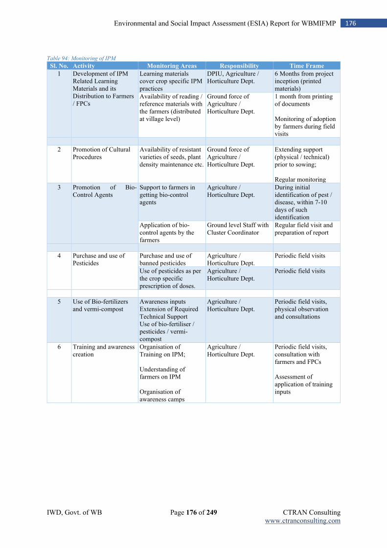
IWD, Govt. of WB Page 176 of 249 CTRAN Consulting www.ctranconsulting.com
176 Environmental and Social Impact Assessment (ESIA) Report for WBMIFMP
Table 94: Monitoring of IPM
Sl. No. Activity Monitoring Areas Responsibility Time Frame
1 Development of IPM Related Learning Materials and its Distribution to Farmers / FPCs
Learning materials cover crop specific IPM practices
DPIU, Agriculture / Horticulture Dept.
6 Months from project inception (printed materials)
Availability of reading / reference materials with the farmers (distributed at village level)
Ground force of Agriculture / Horticulture Dept.
1 month from printing of documents Monitoring of adoption by farmers during field visits
2 Promotion of Cultural Procedures
Availability of resistant varieties of seeds, plant density maintenance etc.
Ground force of Agriculture / Horticulture Dept.
Extending support (physical / technical) prior to sowing; Regular monitoring
3 Promotion of Bio-Control Agents
Support to farmers in getting bio-control agents
Agriculture / Horticulture Dept.
During initial identification of pest / disease, within 7-10 days of such identification
Application of bio-control agents by the farmers
Ground level Staff with Cluster Coordinator
Regular field visit and preparation of report
4 Purchase and use of Pesticides
Purchase and use of banned pesticides
Agriculture / Horticulture Dept.
Periodic field visits
Use of pesticides as per the crop specific prescription of doses.
Agriculture / Horticulture Dept.
Periodic field visits
5 Use of Bio-fertilizers and vermi-compost
Awareness inputs Extension of Required Technical Support Use of bio-fertiliser / pesticides / vermi-compost
Agriculture / Horticulture Dept.
Periodic field visits, physical observation and consultations
6 Training and awareness creation
Organisation of Training on IPM; Understanding of farmers on IPM Organisation of awareness camps
Agriculture / Horticulture Dept.
Periodic field visits, consultation with farmers and FPCs Assessment of application of training inputs
IWD, Govt. of WB Page 177 of 249 CTRAN Consulting www.ctranconsulting.com
177 Environmental and Social Impact Assessment (ESIA) Report for WBMIFMP
Chapter 10: Environmental and Social Monitoring Plan
The project will take up monitoring and evaluation of the ESMP implementation covering process, output and outcome indicators in different intervals during the life of the project. The Monitoring (M&E) of ESMP implementation shall be conducted in continuous basic to assess the progress and achievements made in line with the identified risks and mitigation measures. By providing a feedback loop, the M&E will enable decision makers to take up mid-course corrections if required. The M&E framework is designed to measure the impacts that have taken place; evaluate the performance of mitigation measures proposed; suggest improvements in management plan, if so required; achievement of benefits expected from the implementation of safeguard measures; and ensure compliance with the legal obligations. The M&E is to be undertaken at two levels as below. Monitoring and Evaluation of the ESMP implementation of the project as a whole: The application and effectiveness of ESMP elements including preparation of Contract Package ESMPs, preparation and implementation of Contractor’s ESMPs, monitoring, capacity building and institutional arrangements will be monitored. Mid-term and end-term audit of the environmental and social management aspects of the project will also be undertaken by engaging third party M&E agency. Monitoring of Mitigation Measures and Environmental Quality: This will monitor the effectiveness of implementation of the identified mitigation measures and the environmental quality parameters relevant to each project activity. To ascertain the implementation of the project activities in a socially and environmentally acceptable manner and in line with the acts / policies of Government and World Bank, periodic monitoring will be conducted by SPMU (PMC), DPMUs and DPIUs. It will help to assess the progress made in implementation of social and environmental safeguards and measures required for its improvement. It will provide necessary feedback for project management for timely decision making and achieving the objectives.
10.1 Monitoring of Statutory Compliances
For every contract under the project, statutory compliances of the contractor will be monitored. The statutory compliances include availability of (1) Consent to Establish (CtE) and Consent to Operate (CtO) for erection of batching plants, diesel generator, hot mixing plant etc., (2) Approval of local government authority and IWD for sites identified for temporary storage and disposal of waste materials including de-silted material, vegetation waste, C&D waste, etc., (3) Explosive permit (In case blasting is required), (4) permission from Gram Panchayat (GP) for labour camp establishment, (5) labour license and (6) permission for tree felling etc. SPMU shall monitor status of each clearance/ permission condition before implementation of the project.
10.2 Environment and Social Aspects to be Monitored
The social, physical, biological and environmental components, which are significant impact areas at work locations, have been suggested for periodic monitoring. The following specific environmental parameters should be measured, in terms of qualitative and quantitative terms, and compared over a period of 5 years project implementation and post project implementation with the baseline figures. The impact areas of monitoring would encompass the followings.
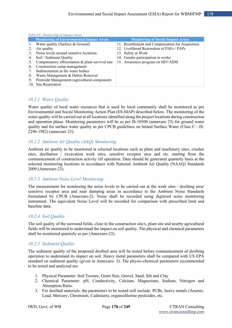
IWD, Govt. of WB Page 178 of 249 CTRAN Consulting www.ctranconsulting.com
178 Environmental and Social Impact Assessment (ESIA) Report for WBMIFMP
Table 95: Monitoring of Impact Areas
Monitoring of Environmental Impact Areas Monitoring of Social Impact Areas
1. Water quality (Surface & Ground) 2. Air quality 3. Noise levels around sensitive locations 4. Soil / Sediment Quality 5. Compensatory afforestation & plant survival rate 6. Construction camp management 7. Sedimentation in the water bodies 8. Waste Management & Debris Removal 9. Pesticide Management (agricultural component) 10. Site Restoration
11. Resettlement and Compensation for Acquisition 12. Livelihood Restoration of PAFs / PAPs 13. Safety at Work 14. Gender participation in works 15. Awareness program on HIV/AIDS
10.2.1 Water Quality
Water quality of local water resources that is used by local community shall be monitored as per Environmental and Social Monitoring Action Plan (ES-MAP) described below. The monitoring of the water quality will be carried out at all locations identified along the project locations during construction and operation phase. Monitoring parameters will be as per IS-10500 (annexure 23) for ground water quality and for surface water quality as per CPCB guidelines on Inland Surface Water (Class C - IS: 2296-1982) (annexure 23).
10.2.2 Ambient Air Quality (AAQ) Monitoring
Ambient air quality to be monitored at selected locations such as plant and machinery sites, crusher sites, desiltation / excavation work sites, sensitive receptor area and etc. starting from the commencement of construction activity till operation. Data should be generated quarterly basis at the selected monitoring locations in accordance with National Ambient Air Quality (NAAQ) Standards 2009 (Annexure-23).
10.2.3 Ambient Noise Level Monitoring
The measurement for monitoring the noise levels to be carried out at the work sites / desilting area/ sensitive receptor area and near dumping areas in accordance to the Ambient Noise Standards formulated by CPCB (Annexure-2). Noise shall be recorded using digitized noise monitoring instrument. The equivalent Noise Level will be recorded for comparison with prescribed limit and baseline data.
10.2.4 Soil Quality
The soil quality of the surround fields, close to the construction site/s, plant site and nearby agricultural fields will be monitored to understand the impact on soil quality. The physical and chemical parameters shall be monitored quarterly as per (Annexure-23).
10.2.5 Sediment Quality
The sediment quality of the proposed desilted area will be tested before commencement of desilting operation to understand its impact on soil. Heavy metal parameters shall be compared with US EPA standard on sediment quality (given in Annexure- 3). The physio-chemical parameters recommended to be tested and analyzed are:
1. Physical Parameter: Soil Texture, Grain Size, Gravel, Sand, Silt and Clay 2. Chemical Parameter: pH, Conductivity, Calcium, Magnesium, Sodium, Nitrogen and
Absorption Ratio. 3. For desilted materials, the parameters to be tested will include: PCBs, heavy metals (Arsenic,
Lead, Mercury, Chromium, Cadmium), organochlorine pesticides, etc.
IWD, Govt. of WB Page 179 of 249 CTRAN Consulting www.ctranconsulting.com
179 Environmental and Social Impact Assessment (ESIA) Report for WBMIFMP
10.2.6 Erosion Control Measures
Inspection of work zone (during project implementation and operation), vulnerable locations such as embankment slopes, temporary staked area, etc. will be carried out on periodical basis, at-least once before and once after monsoon.
10.2.7 Flora and Fauna
Construction activities and its impacts on local flora and fauna will be monitored at least on quarterly basis during construction phase. Along with this, monitoring would also cover the afforestation / plantation works taken up under proposed project activities in different locations. The key aspects to be monitored on quarterly basis would be (1) local bio-diversity and its management, (2) water quality and its impact on aquatic flora and fauna, (3) fish species and any change in its density / availability etc.
10.2.8 Compensatory Afforestation and Plant Survival Rate
Compensatory afforestation measures and plant survival rates will be monitored to understand the measures taken for ensuring restoration of the vegetation coverage. This component will be monitored throughout the life of the project, covering all sites. Visual observation of the tree survival will be recorded at every quarter.
10.2.9 Construction Camp Management
The visual inspection of site will be done every month to check the labour standards and facilities provided in the camp and access to facilities by the workers.
10.2.10 Waste Management and Debris Removal
Clearance and disposal of construction and demolition wastes will be monitored on a quarterly basis. A record of the types and quantities of the waste generated, their clearance and disposal mechanisms will be recorded along with details of residual wastes. Monitoring will be carried out on periodical basis at quarterly frequency. Waste management registers will be maintained for each construction contract along with photographic evidence. Visual observation on management of waste and debris at different site will be made on regular basis.
10.2.11 Site Restoration
The restoration of all the temporary sites/ local village road utilized for construction such as stock yards, camp site, movement of transportation vehicle etc. will be monitored after completion of works to ensure that appropriate restoration measures are taken and it is in improved or in the same condition before its use for the works purpose. Plantation works will also be monitored if such activity is planned for the site/s. Visual observation will be made to verify the site restoration activities after completion of works.
10.2.12 Resettlement and Compensation for Asset Acquisition
Number of persons affected due to loss of assets and their coverage under compensation awards will be monitored as per RAP. The grievance redressal on compensation disbursement and other assistance will also be a part of the overall monitoring mechanism under RAP.
10.2.13 Livelihood Restoration of PAFs / PAPs
The project will support the affected persons / families for restoring their livelihood that may be affected due to acquisition of their assets. Livelihood measures taken up by the affected persons and improvement in livelihood will be monitored as per RAP. Livelihood restoration measures and its
IWD, Govt. of WB Page 180 of 249 CTRAN Consulting www.ctranconsulting.com
180 Environmental and Social Impact Assessment (ESIA) Report for WBMIFMP
impact will be monitored where temporary / permanent eviction / displacement is involved. There will be periodic monitoring on coverage of identified families / persons and payment of compensation.
10.2.14 Safety at Works
Regular auditing of safety at works including supply and use of PPEs, safe working conditions, first Aid facilities, incidence report, safety trainings, etc. will be carried to check the effectiveness of safety measures at site. For each construction activity, safety aspects at the work and camp sites will be supervised on day to day basis by the site supervisor/ Engineer to ascertain (1) number of labourers – men and women – working at the site, (2) percentage of workers using PPEs, (3) safe access to worksite and safe working platform, (4) availability of first-aid kit, (5) display of emergency numbers in a prominently visible place, (6) orientation of workers on safety protocols to be followed at camp and work sites, (7) periodic health check-up of workers and health issues reported, (8) number and type of safety incidents including minor injuries, major injuries requiring hospitalization, near-miss incidents, fatal injuries, etc.
10.2.15 Living Standard of Workers
Normally, camps are placed for the workers nearer to working site, especially for outside labourers. The standard of living at the camp sites will be periodically assessed to understand the provisions of basic facilities for the workers, its use and maintenance, including sanitation and hygiene.
10.2.16 Employment of Local Population
Percentage of local and migrant labour engaged for different works will be assessed periodically to indicate total employment generated verses local employment status.
10.2.17 Gender Participation in Works
Gender inclusiveness and their participation in the project activities will be assessed at each stage of the project cycle, including labour force participation. Verification of labour records followed by random checking at site will be conducted to analyze the gender participation in the work force.
10.2.18 HIV/AIDS Awareness Program
Awareness program will be taken up among the workers on HIV / AIDs periodically which will be monitored with regard to participation of number of persons, days of orientation conducted, frequency of orientation etc. Records maintained in this regard will be reviewed and verified.
10.2.19 Dam Safety
The dam safety aspects should be monitored twice a year by the dam safety panel / committee members, i.e., before monsoon and after monsoon. Dam safety report should be placed before the PD-WBMIFMP for necessary action. An Environmental and Social Monitoring Action Plan (ES-MAP) has been framed for implementation and post implementation phases covering monitoring of major social and environmental parameters, frequency of monitoring, methods of monitoring, indicators to be measured and responsibility of monitoring.
10.2.20 ESHS Performance Security
The successful Bidder (Contractor) for works in the Project shall be required to submit an Environmental, Social, Health and Safety (ESHS) Performance Security, within twenty-one (21) days of the receipt of the Letter of Acceptance from the Employer. The Environmental, Social,
IWD, Govt. of WB Page 181 of 249 CTRAN Consulting www.ctranconsulting.com
181 Environmental and Social Impact Assessment (ESIA) Report for WBMIFMP
Safety and Health (ESHS) Performance Security amount is 2% percent of Contract Amount in form of unconditional Bank Guarantee from scheduled or Nationalized Banks in India.
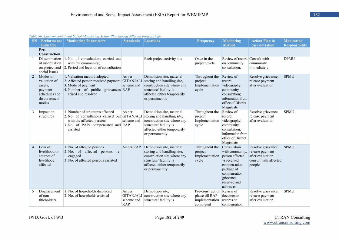
IWD, Govt. of WB Page 182 of 249 CTRAN Consulting www.ctranconsulting.com
182 Environmental and Social Impact Assessment (ESIA) Report for WBMIFMP
Table 96: Environmental and Social Monitoring Action Plan during different project stage
SN Performance
Indicator
Monitoring Parameters Standards Locations Frequency Monitoring
Method
Action Plan in
case deviation
Monitoring
Responsibility
Pre-
Construction
1 Dissemination of information on project and social issues
1. No. of consultations carried out with the community;
2. Period and location of consultation
Each project activity site Once in the project cycle
Review of record on community consultation;
Consult with community immediately
DPMU
2 Modes of valuation of assets, payment schedules and disbursement modes
1. Valuation method adopted; 2. Affected person received payment 3. Mode of payment 4. Number of public grievances
arised and resolved
As per GITANJALI scheme and RAP
Demolition site, material storing and handling site, construction site where any structure/ facility is affected either temporarily or permanently
Throughout the project Implementation cycle
Review of record, videography; community consultation; information from office of District Magistrate
Resolve grievance, release payment after evaluation
SPMU
3 Impact on structures
1. Number of structures affected 2. No. of consultations carried out
with the affected persons 3. No. of PAPs compensated and
assisted
As per GITANJALI scheme and RAP
Demolition site, material storing and handling site, construction site where any structure/ facility is affected either temporarily or permanently
Throughout the project Implementation cycle
Review of record, videography; community consultation; information from office of District Magistrate
Resolve grievance, release payment after evaluation
SPMU
4 Loss of livelihood or sources of livelihood affected
1. No. of affected persons 2. No. of affected persons re-
engaged 3. No. of affected persons assisted
As per RAP Demolition site, material storing and handling site, construction site where any structure/ facility is affected either temporarily or permanently
Throughout the project Implementation cycle
Consultation with community, person affected vs received compensation, package of compensation, grievance received and addressed
Resolve grievance, release payment after evaluation, consult with affected people
SPMU
5 Displacement of non-titleholders
1. No. of households displaced 2. No. of households assisted
As per GITANJALI scheme and RAP
Demolition site, construction site where any structure/ facility is
Pre-construction phase till RAP implementation completed
Review of documents/ records on compensation;
Resolve grievance, release payment after evaluation,
SPMU
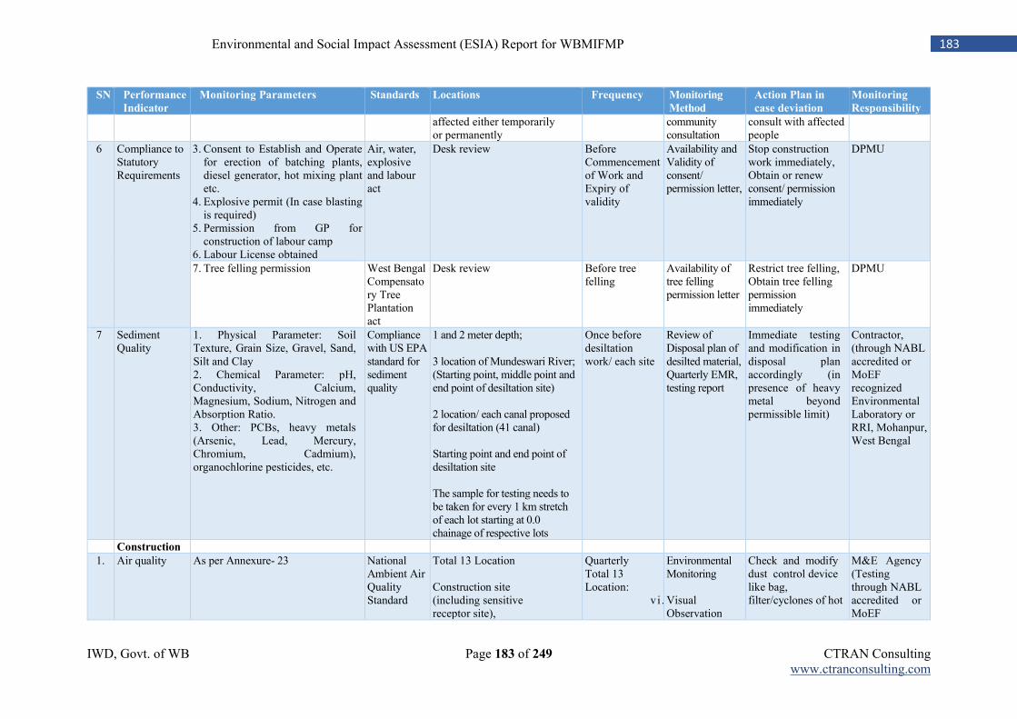
IWD, Govt. of WB Page 183 of 249 CTRAN Consulting www.ctranconsulting.com
183 Environmental and Social Impact Assessment (ESIA) Report for WBMIFMP
SN Performance
Indicator
Monitoring Parameters Standards Locations Frequency Monitoring
Method
Action Plan in
case deviation
Monitoring
Responsibility
affected either temporarily or permanently
community consultation
consult with affected people
6 Compliance to Statutory Requirements
3. Consent to Establish and Operate for erection of batching plants, diesel generator, hot mixing plant etc.
4. Explosive permit (In case blasting is required)
5. Permission from GP for construction of labour camp
6. Labour License obtained
Air, water, explosive and labour act
Desk review Before Commencement of Work and Expiry of validity
Availability and Validity of consent/ permission letter,
Stop construction work immediately, Obtain or renew consent/ permission immediately
DPMU
7. Tree felling permission West Bengal Compensatory Tree Plantation act
Desk review Before tree felling
Availability of tree felling permission letter
Restrict tree felling, Obtain tree felling permission immediately
DPMU
7 Sediment Quality
1. Physical Parameter: Soil Texture, Grain Size, Gravel, Sand, Silt and Clay 2. Chemical Parameter: pH, Conductivity, Calcium, Magnesium, Sodium, Nitrogen and Absorption Ratio. 3. Other: PCBs, heavy metals (Arsenic, Lead, Mercury, Chromium, Cadmium), organochlorine pesticides, etc.
Compliance with US EPA standard for sediment quality
1 and 2 meter depth; 3 location of Mundeswari River; (Starting point, middle point and end point of desiltation site) 2 location/ each canal proposed for desiltation (41 canal) Starting point and end point of desiltation site The sample for testing needs to be taken for every 1 km stretch of each lot starting at 0.0 chainage of respective lots
Once before desiltation work/ each site
Review of Disposal plan of desilted material, Quarterly EMR, testing report
Immediate testing and modification in disposal plan accordingly (in presence of heavy metal beyond permissible limit)
Contractor, (through NABL accredited or MoEF recognized Environmental Laboratory or RRI, Mohanpur, West Bengal
Construction
1. Air quality As per Annexure- 23 National Ambient Air Quality Standard
Total 13 Location Construction site (including sensitive receptor site),
Quarterly Total 13 Location:
v i .
Environmental Monitoring Visual Observation
Check and modify dust control device like bag, filter/cyclones of hot
M&E Agency (Testing through NABL accredited or MoEF
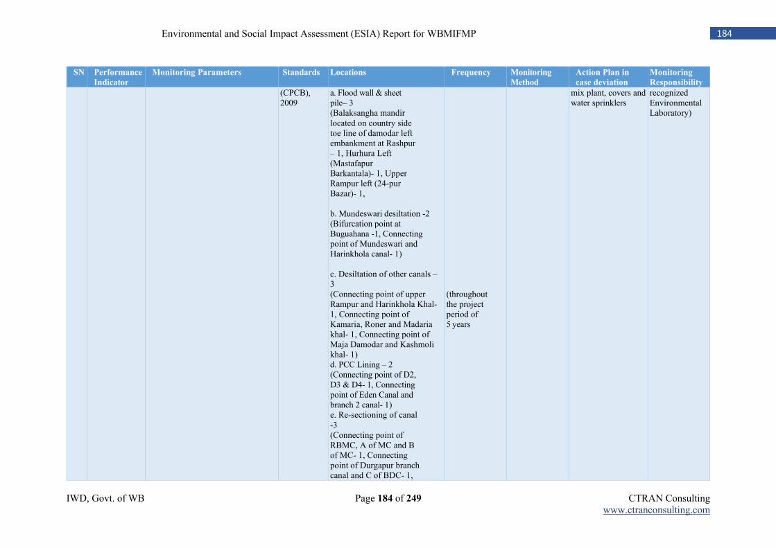
IWD, Govt. of WB Page 184 of 249 CTRAN Consulting www.ctranconsulting.com
184 Environmental and Social Impact Assessment (ESIA) Report for WBMIFMP
SN Performance
Indicator
Monitoring Parameters Standards Locations Frequency Monitoring
Method
Action Plan in
case deviation
Monitoring
Responsibility
(CPCB), 2009
a. Flood wall & sheet pile– 3 (Balaksangha mandir located on country side toe line of damodar left embankment at Rashpur – 1, Hurhura Left (Mastafapur Barkantala)- 1, Upper Rampur left (24-pur Bazar)- 1, b. Mundeswari desiltation -2 (Bifurcation point at Buguahana -1, Connecting point of Mundeswari and Harinkhola canal- 1) c. Desiltation of other canals – 3 (Connecting point of upper Rampur and Harinkhola Khal- 1, Connecting point of Kamaria, Roner and Madaria khal- 1, Connecting point of Maja Damodar and Kashmoli khal- 1) d. PCC Lining – 2 (Connecting point of D2, D3 & D4- 1, Connecting point of Eden Canal and branch 2 canal- 1) e. Re-sectioning of canal -3 (Connecting point of RBMC, A of MC and B of MC- 1, Connecting point of Durgapur branch canal and C of BDC- 1,
(throughout the project period of 5 years
mix plant, covers and water sprinklers
recognized Environmental Laboratory)
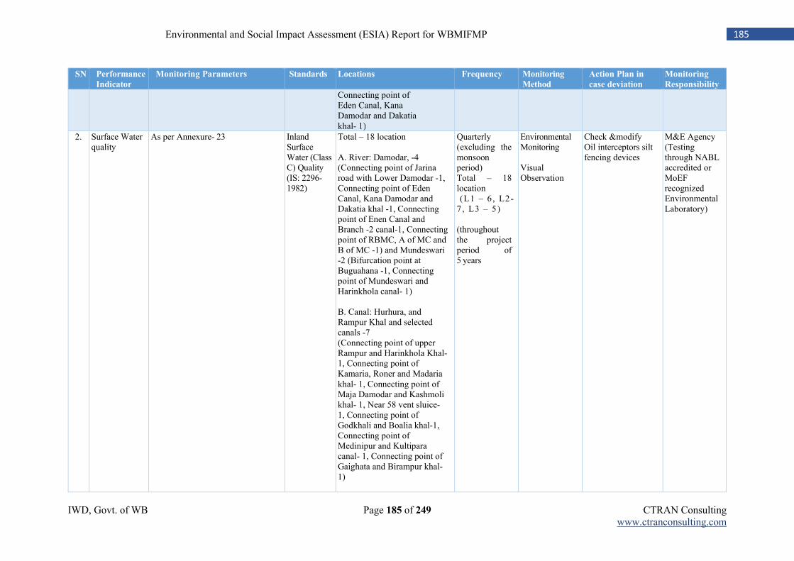
IWD, Govt. of WB Page 185 of 249 CTRAN Consulting www.ctranconsulting.com
185 Environmental and Social Impact Assessment (ESIA) Report for WBMIFMP
SN Performance
Indicator
Monitoring Parameters Standards Locations Frequency Monitoring
Method
Action Plan in
case deviation
Monitoring
Responsibility
Connecting point of Eden Canal, Kana Damodar and Dakatia khal- 1)
2. Surface Water quality
As per Annexure- 23 Inland Surface Water (Class C) Quality (IS: 2296-1982)
Total – 18 location A. River: Damodar, -4 (Connecting point of Jarina road with Lower Damodar -1, Connecting point of Eden Canal, Kana Damodar and Dakatia khal -1, Connecting point of Enen Canal and Branch -2 canal-1, Connecting point of RBMC, A of MC and B of MC -1) and Mundeswari -2 (Bifurcation point at Buguahana -1, Connecting point of Mundeswari and Harinkhola canal- 1) B. Canal: Hurhura, and Rampur Khal and selected canals -7 (Connecting point of upper Rampur and Harinkhola Khal- 1, Connecting point of Kamaria, Roner and Madaria khal- 1, Connecting point of Maja Damodar and Kashmoli khal- 1, Near 58 vent sluice- 1, Connecting point of Godkhali and Boalia khal-1, Connecting point of Medinipur and Kultipara canal- 1, Connecting point of Gaighata and Birampur khal- 1)
Quarterly (excluding the monsoon period) Total – 18 location (L1 – 6 , L2- 7 , L3 – 5) (throughout the project period of 5 years
Environmental Monitoring Visual Observation
Check &modify Oil interceptors silt fencing devices
M&E Agency (Testing through NABL accredited or MoEF recognized Environmental Laboratory)
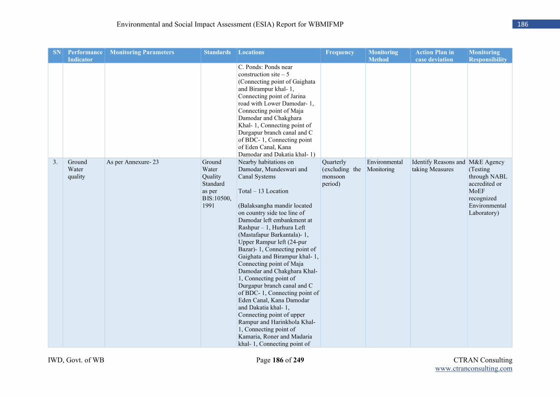
IWD, Govt. of WB Page 186 of 249 CTRAN Consulting www.ctranconsulting.com
186 Environmental and Social Impact Assessment (ESIA) Report for WBMIFMP
SN Performance
Indicator
Monitoring Parameters Standards Locations Frequency Monitoring
Method
Action Plan in
case deviation
Monitoring
Responsibility
C. Ponds: Ponds near construction site – 5 (Connecting point of Gaighata and Birampur khal- 1, Connecting point of Jarina road with Lower Damodar- 1, Connecting point of Maja Damodar and Chakghara Khal- 1, Connecting point of Durgapur branch canal and C of BDC- 1, Connecting point of Eden Canal, Kana Damodar and Dakatia khal- 1)
3. Ground Water quality
As per Annexure- 23 Ground Water Quality Standard as per BIS:10500, 1991
Nearby habitations on Damodar, Mundeswari and Canal Systems Total – 13 Location (Balaksangha mandir located on country side toe line of Damodar left embankment at Rashpur – 1, Hurhura Left (Mastafapur Barkantala)- 1, Upper Rampur left (24-pur Bazar)- 1, Connecting point of Gaighata and Birampur khal- 1, Connecting point of Maja Damodar and Chakghara Khal- 1, Connecting point of Durgapur branch canal and C of BDC- 1, Connecting point of Eden Canal, Kana Damodar and Dakatia khal- 1, Connecting point of upper Rampur and Harinkhola Khal- 1, Connecting point of Kamaria, Roner and Madaria khal- 1, Connecting point of
Quarterly (excluding the monsoon period)
Environmental Monitoring
Identify Reasons and taking Measures
M&E Agency (Testing through NABL accredited or MoEF recognized Environmental Laboratory)
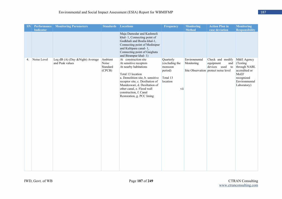
IWD, Govt. of WB Page 187 of 249 CTRAN Consulting www.ctranconsulting.com
187 Environmental and Social Impact Assessment (ESIA) Report for WBMIFMP
SN Performance
Indicator
Monitoring Parameters Standards Locations Frequency Monitoring
Method
Action Plan in
case deviation
Monitoring
Responsibility
Maja Damodar and Kashmoli khal- 1, Connecting point of Godkhali and Boalia khal-1, Connecting point of Medinipur and Kultipara canal- 1, Connecting point of Gaighata and Birampur khal- 1)
4. Noise Level Leq dB (A) (Day &Night) Average and Peak values
Ambient Noise Standard (CPCB)
At construction site At sensitive receptors At nearby habitations Total 13 location a. Demolition site, b. sensitive receptor site, c. Desiltation of Mundeswari, d. Desiltation of other canal, e. Flood wall construction, f. Canal Restoration, g. PCC lining
Quarterly (excluding the monsoon period) Total 13 location
vii.
Environmental Monitoring Site Observation
Check and modify equipment and devices used to protect noise level
M&E Agency (Testing through NABL accredited or MoEF recognized Environmental Laboratory)
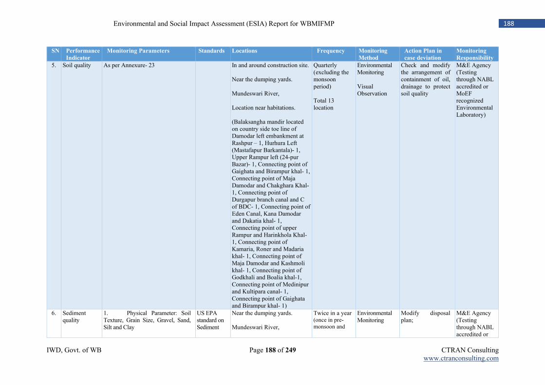
IWD, Govt. of WB Page 188 of 249 CTRAN Consulting www.ctranconsulting.com
188 Environmental and Social Impact Assessment (ESIA) Report for WBMIFMP
SN Performance
Indicator
Monitoring Parameters Standards Locations Frequency Monitoring
Method
Action Plan in
case deviation
Monitoring
Responsibility
5. Soil quality As per Annexure- 23 In and around construction site. Near the dumping yards. Mundeswari River, Location near habitations. (Balaksangha mandir located on country side toe line of Damodar left embankment at Rashpur – 1, Hurhura Left (Mastafapur Barkantala)- 1, Upper Rampur left (24-pur Bazar)- 1, Connecting point of Gaighata and Birampur khal- 1, Connecting point of Maja Damodar and Chakghara Khal- 1, Connecting point of Durgapur branch canal and C of BDC- 1, Connecting point of Eden Canal, Kana Damodar and Dakatia khal- 1, Connecting point of upper Rampur and Harinkhola Khal- 1, Connecting point of Kamaria, Roner and Madaria khal- 1, Connecting point of Maja Damodar and Kashmoli khal- 1, Connecting point of Godkhali and Boalia khal-1, Connecting point of Medinipur and Kultipara canal- 1, Connecting point of Gaighata and Birampur khal- 1)
Quarterly (excluding the monsoon period) Total 13 location
Environmental Monitoring Visual Observation
Check and modify the arrangement of containment of oil, drainage to protect soil quality
M&E Agency (Testing through NABL accredited or MoEF recognized Environmental Laboratory)
6. Sediment quality
1. Physical Parameter: Soil Texture, Grain Size, Gravel, Sand, Silt and Clay
US EPA standard on Sediment
Near the dumping yards. Mundeswari River,
Twice in a year (once in pre-monsoon and
Environmental Monitoring
Modify disposal plan;
M&E Agency (Testing through NABL accredited or
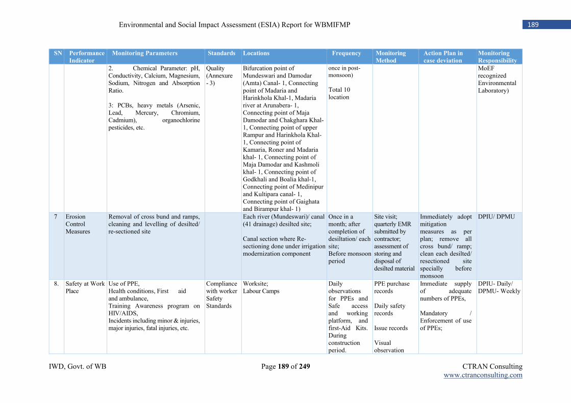
IWD, Govt. of WB Page 189 of 249 CTRAN Consulting www.ctranconsulting.com
189 Environmental and Social Impact Assessment (ESIA) Report for WBMIFMP
SN Performance
Indicator
Monitoring Parameters Standards Locations Frequency Monitoring
Method
Action Plan in
case deviation
Monitoring
Responsibility
2. Chemical Parameter: pH, Conductivity, Calcium, Magnesium, Sodium, Nitrogen and Absorption Ratio. 3: PCBs, heavy metals (Arsenic, Lead, Mercury, Chromium, Cadmium), organochlorine pesticides, etc.
Quality (Annexure - 3)
Bifurcation point of Mundeswari and Damodar (Amta) Canal- 1, Connecting point of Madaria and Harinkhola Khal-1, Madaria river at Arunabera- 1, Connecting point of Maja Damodar and Chakghara Khal- 1, Connecting point of upper Rampur and Harinkhola Khal- 1, Connecting point of Kamaria, Roner and Madaria khal- 1, Connecting point of Maja Damodar and Kashmoli khal- 1, Connecting point of Godkhali and Boalia khal-1, Connecting point of Medinipur and Kultipara canal- 1, Connecting point of Gaighata and Birampur khal- 1)
once in post-monsoon) Total 10 location
MoEF recognized Environmental Laboratory)
7 Erosion Control Measures
Removal of cross bund and ramps, cleaning and levelling of desilted/ re-sectioned site
Each river (Mundeswari)/ canal (41 drainage) desilted site; Canal section where Re-sectioning done under irrigation modernization component
Once in a month; after completion of desiltation/ each site; Before monsoon period
Site visit; quarterly EMR submitted by contractor; assessment of storing and disposal of desilted material
Immediately adopt mitigation measures as per plan; remove all cross bund/ ramp; clean each desilted/ resectioned site specially before monsoon
DPIU/ DPMU
8. Safety at Work Place
Use of PPE, Health conditions, First aid and ambulance, Training Awareness program on HIV/AIDS, Incidents including minor & injuries, major injuries, fatal injuries, etc.
Compliance with worker Safety Standards
Worksite; Labour Camps
Daily observations for PPEs and Safe access and working platform, and first-Aid Kits. During construction period.
PPE purchase records Daily safety records Issue records Visual observation
Immediate supply of adequate numbers of PPEs, Mandatory / Enforcement of use of PPEs;
DPIU- Daily/ DPMU- Weekly
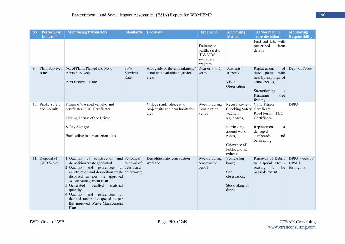
IWD, Govt. of WB Page 190 of 249 CTRAN Consulting www.ctranconsulting.com
190 Environmental and Social Impact Assessment (ESIA) Report for WBMIFMP
SN Performance
Indicator
Monitoring Parameters Standards Locations Frequency Monitoring
Method
Action Plan in
case deviation
Monitoring
Responsibility
Training on health, safety, HIV/AIDS awareness program
First aid kits with prescribed item details
9 Plant Survival Rate
No. of Plants Planted and No. of Plants Survived; Plant Growth Rate
80% Survival Rate
Alongside of the embankment / canal and available degraded areas
Quarterly till5 years
Analysis Reports Visual Observation
Replacement of dead plants with healthy saplings of same species, Strengthening / Repairing tree fencing
Dept. of Forest
10. Public Safety and Security
Fitness of the used vehicles and certificates, PUC Certificates Driving license of the Driver, Safety Signages, Barricading in construction sites
Village roads adjacent to project site and near habitation area
Weekly during Construction Period
Record Review; Checking Safety /caution signboards, Barricading around work zones, Grievance of Public and its redressal
Valid Fitness Certificate; Road Permit; PUC Certificate Replacement of damaged signboards and barricading
DPIU
11. Disposal of C&D Waste
1. Quantity of construction and demolition waste generated
2. Quantity and percentage of construction and demolition waste disposed as per the approved Waste Management Plan
3. Generated desilted material quantity
4. Quantity and percentage of desilted material disposed as per the approved Waste Management Plan
Periodical removal of debris and other waste
Demolition site; construction worksite
Weekly during construction period
Vehicle log book; Site observation; Stock taking of debris
Removal of Debris to disposal sites / reusing to the possible extent
DPIU- weekly / DPMU- fortnightly
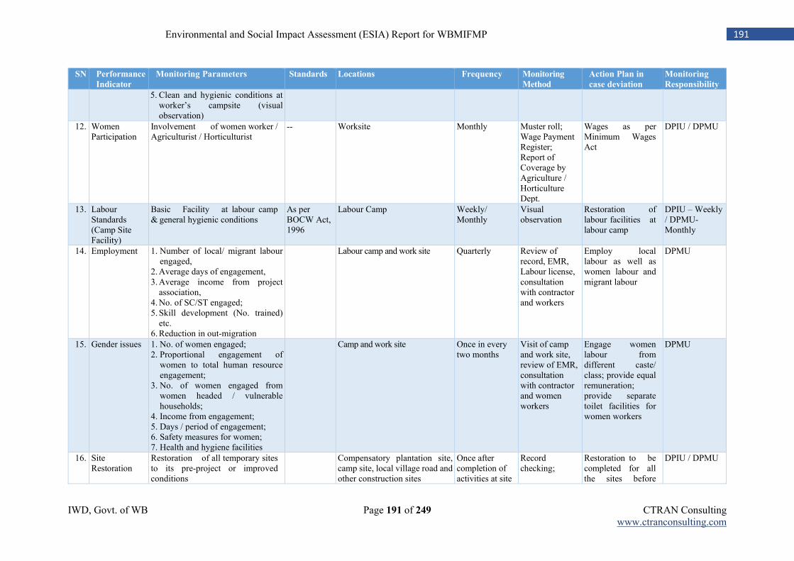
IWD, Govt. of WB Page 191 of 249 CTRAN Consulting www.ctranconsulting.com
191 Environmental and Social Impact Assessment (ESIA) Report for WBMIFMP
SN Performance
Indicator
Monitoring Parameters Standards Locations Frequency Monitoring
Method
Action Plan in
case deviation
Monitoring
Responsibility
5. Clean and hygienic conditions at worker’s campsite (visual observation)
12. Women Participation
Involvement of women worker / Agriculturist / Horticulturist
-- Worksite Monthly Muster roll; Wage Payment Register; Report of Coverage by Agriculture / Horticulture Dept.
Wages as per Minimum Wages Act
DPIU / DPMU
13. Labour Standards (Camp Site Facility)
Basic Facility at labour camp & general hygienic conditions
As per BOCW Act, 1996
Labour Camp Weekly/ Monthly
Visual observation
Restoration of labour facilities at labour camp
DPIU – Weekly / DPMU- Monthly
14. Employment 1. Number of local/ migrant labour engaged,
2. Average days of engagement, 3. Average income from project
association, 4. No. of SC/ST engaged; 5. Skill development (No. trained)
etc. 6. Reduction in out-migration
Labour camp and work site Quarterly Review of record, EMR, Labour license, consultation with contractor and workers
Employ local labour as well as women labour and migrant labour
DPMU
15. Gender issues 1. No. of women engaged; 2. Proportional engagement of
women to total human resource engagement;
3. No. of women engaged from women headed / vulnerable households;
4. Income from engagement; 5. Days / period of engagement; 6. Safety measures for women; 7. Health and hygiene facilities
Camp and work site Once in every two months
Visit of camp and work site, review of EMR, consultation with contractor and women workers
Engage women labour from different caste/ class; provide equal remuneration; provide separate toilet facilities for women workers
DPMU
16. Site Restoration
Restoration of all temporary sites to its pre-project or improved conditions
Compensatory plantation site, camp site, local village road and other construction sites
Once after completion of activities at site
Record checking;
Restoration to be completed for all the sites before
DPIU / DPMU
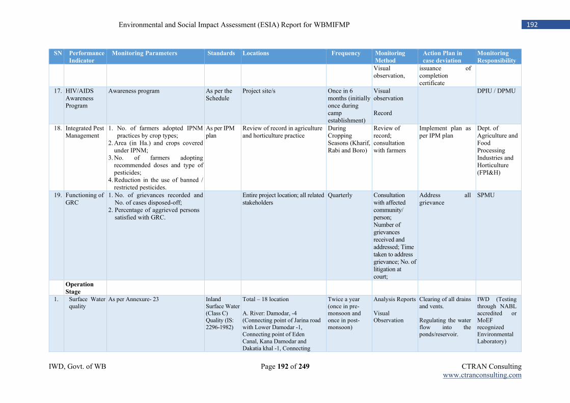
IWD, Govt. of WB Page 192 of 249 CTRAN Consulting www.ctranconsulting.com
192 Environmental and Social Impact Assessment (ESIA) Report for WBMIFMP
SN Performance
Indicator
Monitoring Parameters Standards Locations Frequency Monitoring
Method
Action Plan in
case deviation
Monitoring
Responsibility
Visual observation,
issuance of completion certificate
17. HIV/AIDS Awareness Program
Awareness program As per the Schedule
Project site/s Once in 6 months (initially once during camp establishment)
Visual observation Record
DPIU / DPMU
18. Integrated Pest Management
1. No. of farmers adopted IPNM practices by crop types;
2. Area (in Ha.) and crops covered under IPNM;
3. No. of farmers adopting recommended doses and type of pesticides;
4. Reduction in the use of banned / restricted pesticides.
As per IPM plan
Review of record in agriculture and horticulture practice
During Cropping Seasons (Kharif, Rabi and Boro)
Review of record; consultation with farmers
Implement plan as per IPM plan
Dept. of Agriculture and Food Processing Industries and Horticulture (FPI&H)
19. Functioning of GRC
1. No. of grievances recorded and No. of cases disposed-off;
2. Percentage of aggrieved persons satisfied with GRC.
Entire project location; all related stakeholders
Quarterly Consultation with affected community/ person; Number of grievances received and addressed; Time taken to address grievance; No. of litigation at court;
Address all grievance
SPMU
Operation
Stage
1. Surface Water quality
As per Annexure- 23 Inland Surface Water (Class C) Quality (IS: 2296-1982)
Total – 18 location A. River: Damodar, -4 (Connecting point of Jarina road with Lower Damodar -1, Connecting point of Eden Canal, Kana Damodar and Dakatia khal -1, Connecting
Twice a year (once in pre-monsoon and once in post-monsoon)
Analysis Reports Visual Observation
Clearing of all drains and vents. Regulating the water flow into the ponds/reservoir.
IWD (Testing through NABL accredited or MoEF recognized Environmental Laboratory)
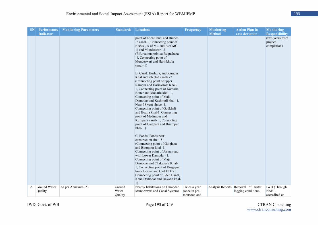
IWD, Govt. of WB Page 193 of 249 CTRAN Consulting www.ctranconsulting.com
193 Environmental and Social Impact Assessment (ESIA) Report for WBMIFMP
SN Performance
Indicator
Monitoring Parameters Standards Locations Frequency Monitoring
Method
Action Plan in
case deviation
Monitoring
Responsibility
point of Eden Canal and Branch -2 canal-1, Connecting point of RBMC, A of MC and B of MC -1) and Mundeswari -2 (Bifurcation point at Buguahana -1, Connecting point of Mundeswari and Harinkhola canal- 1) B. Canal: Hurhura, and Rampur Khal and selected canals -7 (Connecting point of upper Rampur and Harinkhola Khal- 1, Connecting point of Kamaria, Roner and Madaria khal- 1, Connecting point of Maja Damodar and Kashmoli khal- 1, Near 58 vent sluice- 1, Connecting point of Godkhali and Boalia khal-1, Connecting point of Medinipur and Kultipara canal- 1, Connecting point of Gaighata and Birampur khal- 1) C. Ponds: Ponds near construction site – 5 (Connecting point of Gaighata and Birampur khal- 1, Connecting point of Jarina road with Lower Damodar- 1, Connecting point of Maja Damodar and Chakghara Khal- 1, Connecting point of Durgapur branch canal and C of BDC- 1, Connecting point of Eden Canal, Kana Damodar and Dakatia khal- 1)
(two years from project completion)
2. Ground Water Quality
As per Annexure- 23 Ground Water Quality
Nearby habitations on Damodar, Mundeswari and Canal Systems
Twice a year (once in pre-monsoon and
Analysis Reports
Removal of water logging conditions.
IWD (Through NABL accredited or
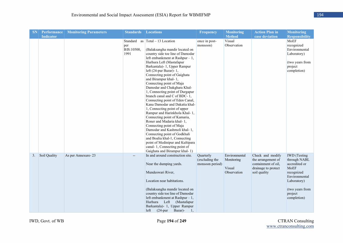
IWD, Govt. of WB Page 194 of 249 CTRAN Consulting www.ctranconsulting.com
194 Environmental and Social Impact Assessment (ESIA) Report for WBMIFMP
SN Performance
Indicator
Monitoring Parameters Standards Locations Frequency Monitoring
Method
Action Plan in
case deviation
Monitoring
Responsibility
Standard as per BIS:10500, 1991
Total – 13 Location (Balaksangha mandir located on country side toe line of Damodar left embankment at Rashpur – 1, Hurhura Left (Mastafapur Barkantala)- 1, Upper Rampur left (24-pur Bazar)- 1, Connecting point of Gaighata and Birampur khal- 1, Connecting point of Maja Damodar and Chakghara Khal- 1, Connecting point of Durgapur branch canal and C of BDC- 1, Connecting point of Eden Canal, Kana Damodar and Dakatia khal- 1, Connecting point of upper Rampur and Harinkhola Khal- 1, Connecting point of Kamaria, Roner and Madaria khal- 1, Connecting point of Maja Damodar and Kashmoli khal- 1, Connecting point of Godkhali and Boalia khal-1, Connecting point of Medinipur and Kultipara canal- 1, Connecting point of Gaighata and Birampur khal- 1)
once in post-monsoon)
Visual Observation
MoEF recognized Environmental Laboratory) (two years from project completion)
3. Soil Quality As per Annexure- 23 -- In and around construction site. Near the dumping yards. Mundeswari River, Location near habitations. (Balaksangha mandir located on country side toe line of Damodar left embankment at Rashpur – 1, Hurhura Left (Mastafapur Barkantala)- 1, Upper Rampur left (24-pur Bazar)- 1,
Quarterly (excluding the monsoon period)
Environmental Monitoring Visual Observation
Check and modify the arrangement of containment of oil, drainage to protect soil quality
IWD (Testing through NABL accredited or MoEF recognized Environmental Laboratory) (two years from project completion)
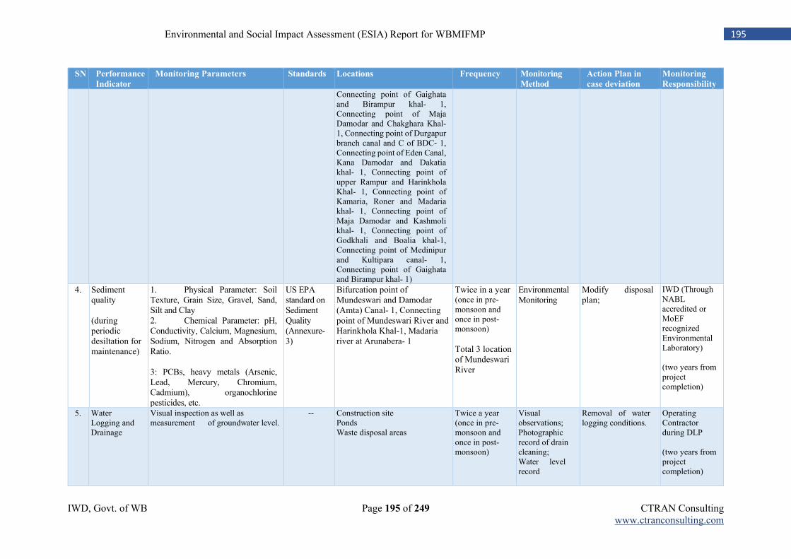
IWD, Govt. of WB Page 195 of 249 CTRAN Consulting www.ctranconsulting.com
195 Environmental and Social Impact Assessment (ESIA) Report for WBMIFMP
SN Performance
Indicator
Monitoring Parameters Standards Locations Frequency Monitoring
Method
Action Plan in
case deviation
Monitoring
Responsibility
Connecting point of Gaighata and Birampur khal- 1, Connecting point of Maja Damodar and Chakghara Khal- 1, Connecting point of Durgapur branch canal and C of BDC- 1, Connecting point of Eden Canal, Kana Damodar and Dakatia khal- 1, Connecting point of upper Rampur and Harinkhola Khal- 1, Connecting point of Kamaria, Roner and Madaria khal- 1, Connecting point of Maja Damodar and Kashmoli khal- 1, Connecting point of Godkhali and Boalia khal-1, Connecting point of Medinipur and Kultipara canal- 1, Connecting point of Gaighata and Birampur khal- 1)
4. Sediment quality (during periodic desiltation for maintenance)
1. Physical Parameter: Soil Texture, Grain Size, Gravel, Sand, Silt and Clay 2. Chemical Parameter: pH, Conductivity, Calcium, Magnesium, Sodium, Nitrogen and Absorption Ratio. 3: PCBs, heavy metals (Arsenic, Lead, Mercury, Chromium, Cadmium), organochlorine pesticides, etc.
US EPA standard on Sediment Quality (Annexure- 3)
Bifurcation point of Mundeswari and Damodar (Amta) Canal- 1, Connecting point of Mundeswari River and Harinkhola Khal-1, Madaria river at Arunabera- 1
Twice in a year (once in pre-monsoon and once in post-monsoon) Total 3 location of Mundeswari River
Environmental Monitoring
Modify disposal plan;
IWD (Through NABL accredited or MoEF recognized Environmental Laboratory) (two years from project completion)
5. Water Logging and Drainage
Visual inspection as well as measurement of groundwater level.
-- Construction site Ponds Waste disposal areas
Twice a year (once in pre-monsoon and once in post-monsoon)
Visual observations; Photographic record of drain cleaning; Water level record
Removal of water logging conditions.
Operating Contractor during DLP (two years from project completion)
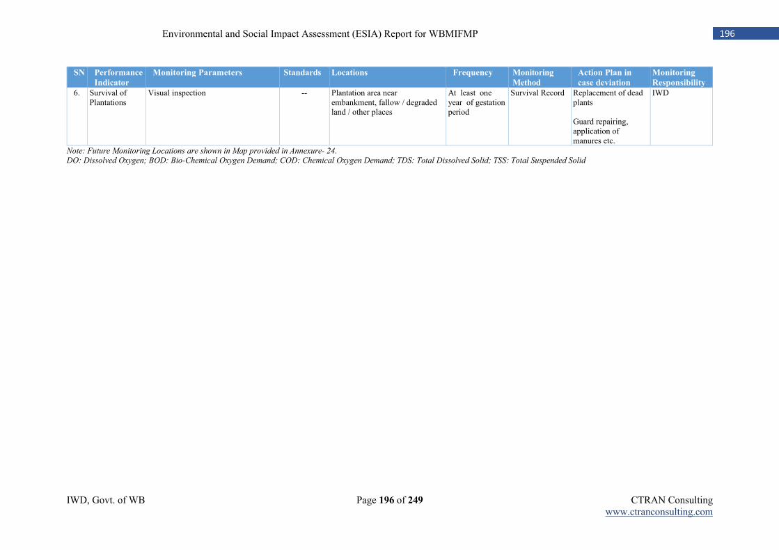
IWD, Govt. of WB Page 196 of 249 CTRAN Consulting www.ctranconsulting.com
196 Environmental and Social Impact Assessment (ESIA) Report for WBMIFMP
SN Performance
Indicator
Monitoring Parameters Standards Locations Frequency Monitoring
Method
Action Plan in
case deviation
Monitoring
Responsibility
6. Survival of Plantations
Visual inspection -- Plantation area near embankment, fallow / degraded land / other places
At least one year of gestation period
Survival Record Replacement of dead plants Guard repairing, application of manures etc.
IWD
Note: Future Monitoring Locations are shown in Map provided in Annexure- 24.
DO: Dissolved Oxygen; BOD: Bio-Chemical Oxygen Demand; COD: Chemical Oxygen Demand; TDS: Total Dissolved Solid; TSS: Total Suspended Solid
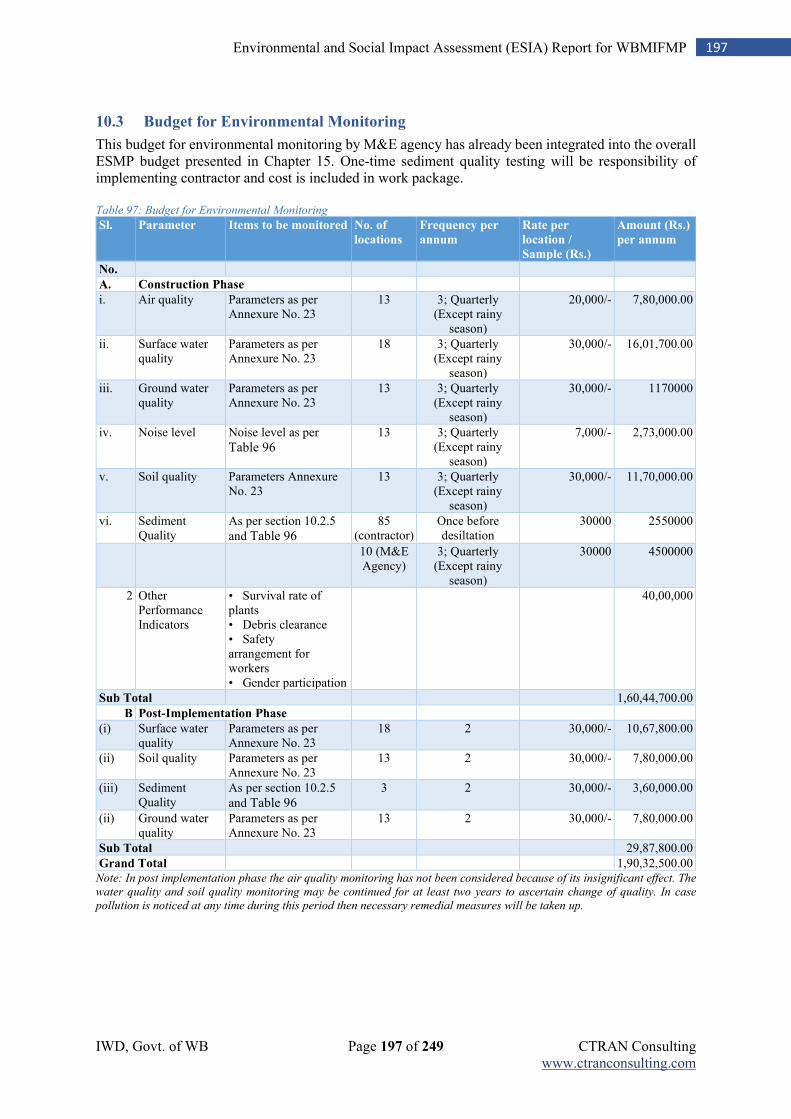
IWD, Govt. of WB Page 197 of 249 CTRAN Consulting www.ctranconsulting.com
197 Environmental and Social Impact Assessment (ESIA) Report for WBMIFMP
10.3 Budget for Environmental Monitoring
This budget for environmental monitoring by M&E agency has already been integrated into the overall ESMP budget presented in Chapter 15. One-time sediment quality testing will be responsibility of implementing contractor and cost is included in work package. Table 97: Budget for Environmental Monitoring
Sl. Parameter Items to be monitored No. of
locations
Frequency per
annum
Rate per
location /
Sample (Rs.)
Amount (Rs.)
per annum
No.
A. Construction Phase
i. Air quality Parameters as per Annexure No. 23
13 3; Quarterly (Except rainy
season)
20,000/- 7,80,000.00
ii. Surface water quality
Parameters as per Annexure No. 23
18 3; Quarterly (Except rainy
season)
30,000/- 16,01,700.00
iii. Ground water quality
Parameters as per Annexure No. 23
13 3; Quarterly (Except rainy
season)
30,000/- 1170000
iv. Noise level Noise level as per
Table 96
13 3; Quarterly (Except rainy
season)
7,000/- 2,73,000.00
v. Soil quality Parameters Annexure No. 23
13 3; Quarterly (Except rainy
season)
30,000/- 11,70,000.00
vi. Sediment Quality
As per section 10.2.5
and Table 96
85 (contractor)
Once before desiltation
30000 2550000
10 (M&E Agency)
3; Quarterly (Except rainy
season)
30000 4500000
2 Other Performance Indicators
• Survival rate of plants • Debris clearance • Safety arrangement for workers • Gender participation
40,00,000
Sub Total
1,60,44,700.00
B Post-Implementation Phase
(i) Surface water quality
Parameters as per Annexure No. 23
18 2 30,000/- 10,67,800.00
(ii) Soil quality Parameters as per Annexure No. 23
13 2 30,000/- 7,80,000.00
(iii) Sediment Quality
As per section 10.2.5
and Table 96
3 2 30,000/- 3,60,000.00
(ii) Ground water quality
Parameters as per Annexure No. 23
13 2 30,000/- 7,80,000.00
Sub Total
29,87,800.00
Grand Total
1,90,32,500.00 Note: In post implementation phase the air quality monitoring has not been considered because of its insignificant effect. The
water quality and soil quality monitoring may be continued for at least two years to ascertain change of quality. In case
pollution is noticed at any time during this period then necessary remedial measures will be taken up.
IWD, Govt. of WB Page 198 of 249 CTRAN Consulting www.ctranconsulting.com
198 Environmental and Social Impact Assessment (ESIA) Report for WBMIFMP
10.4 Reporting System of Environmental and Social Monitoring
The reporting system will be bottom-up and feedback mechanism will be in a top-down approach in the implementation frame. The Contractor will prepare report on environmental and social safeguards implementation, making it a part of the monthly progress report (Annexure- 25(a)). The Environment / Social Expert at the DPMU level will review the reports and prepare the action taken report on monthly basis and appraise to the APD-DPMU. The APD-DPMU, based on the review of the environment and social safeguard measures taken at the project level, should discuss with the PD-WBMIFMP at SPMU on critical issues for decision. The experts at the DPMU level will prepare quarterly environmental and social monitoring reports (as per Annexure- 25(a)) for onwards submission to SPMU. SPMU, after review of the report, may seek further clarification from DPMU on critical aspects, whichever it feels appropriate. The report submitted by the PMC would be examined by the SPMU along with the report of the DPMU. The environment / social expert at the SPMU will compile the quarterly report and submit half-yearly progress report (as per Annexure 25(b)) to the World Bank.
10.5 Mid-term and end-term audit
The Third-Party M&E Agency hired by the SPMU will undertake an mid-term and end-term audit of the ESMP implementation in order to identify issues, good practices and make recommendations for strengthening E&S management. The audit will be undertaken twice in the project duration – at mid-term and at the end of the project. Mid-term audit shall be carried out only after implementation of 40% -45% of project activities or after 2.5 years but before 3.5 years from the date of Loan Agreement with The WB; whichever is prior. The audit reports will be shared by the SPMU with the DPMUs, the DPIUs, other implementing agencies and the World Bank. The audit of the ESMF will cover the following aspects. Preparation of Package Specific ESMP:
Has the package specific ESMP, contractors EHS been prepared within stipulated time period?
Was ESMP and contractors EHS conditions were included in bid documents and contractor agreement documents?
Was cost for ESMP implementation considered in contractors contract packages or BoQ documents?
Preparation of Plan Before Implementation:
Has contractor prepared OHS plan and vetted it from implementing agency?
Was testing of silted material done by contractor before initiation of desiltation of Mundeswari river and other 41 drainage channel?
Was detail disposal plan prepared and implemented accordingly? Regulatory Compliance:
Has contractor/ implementing agency has obtained and regularly updated all regulatory permissions?
Does project violate any related environmental or social laws of State Govt. of West Bengal or Govt. of India
Has contractor obtained permission from Gram Panchayat or Local Governance before establishment of Camp or storing of waste material?
Implementation of ESMPs:
Whether all ESMP measures were followed during project implementation?
Whether EHS measures are adopted as per plan?
Was equipment/ machineries maintained properly and pollution testing (PUC) done regularly? Monitoring of E&S aspects in project activities:
IWD, Govt. of WB Page 199 of 249 CTRAN Consulting www.ctranconsulting.com
199 Environmental and Social Impact Assessment (ESIA) Report for WBMIFMP
Is the SPMU/ DPMU/ DPIU undertaking periodic and regular monitoring of the E&S implementation in the project activities?
Has contractor prepared and submitted all monthly report on ESMP implementation on time?
Has DPMU & SPMU prepared and submitted monthly and quarterly report?
Was half-yearly assessment was done by SPMU on ESMP implementation?
Was testing of environmental parameters carried out on regular basis? Institutional arrangements for management of E&S aspects:
Are the E&S Specialists at the SPMU and DPMU available?
Whether M&E agency was engaged for entire project implementation? Capacity building arrangements for management of E&S aspects:
What training programs on E&S aspects have been organized for the SPMU and DPMU staff?
What training programs on E&S aspects have been organized for the contractors? The format for the ‘Audit Report on ESMP Implementation’ is provided in Annexure-25(b).
IWD, Govt. of WB Page 200 of 249 CTRAN Consulting www.ctranconsulting.com
200 Environmental and Social Impact Assessment (ESIA) Report for WBMIFMP
Chapter 11: Stakeholder Consultation
11.1 Approach
Stakeholder consultation is an integral part of the environmental and social assessment which provides inputs for the preparation of Social and Environment Management Plan (ESMP). The overall objective of such consultations was to document the concerns of the stakeholders with specific reference to the project planned interventions. The consultation meetings were organized basically for two important purposes, i.e., (1) to share project objectives and proposed project interventions with the identified stakeholder groups and (2) to consult with the stakeholders and document their concern, with particular reference to social and environmental impacts of the proposed project interventions. During the field assessment, community consultations were taken up as an integral part of social and environmental assessment process of the project. Public participation has been viewed as a continuous two-way process, i.e., developing people’s understanding on the project, activities and process of ESIA and capturing their opinion on expected environmental and social concerns / issues. To understand the expected project benefits / risks and people’s perception on the project, field visits were conducted to different places within the planned project jurisdiction. In the process of assessment, mapping of stakeholders was done in the visited areas to understand how the project is going to impact upon the stakeholders. The field visit and stakeholder consultations were conducted in five project districts, namely Bankura, Bardhhaman (E), Bardhhaman (W), Hooghly and Howrah. The interaction with different stakeholders covered farmers of different social and economic categories, women group like SHG, fisherman, people / households expected to be affected due to the project, local service providers etc. in project districts to understand their concerns.
11.1.1 Project Area Coverage under Assessment
In the process, stakeholder consultations were carried out in all the five project districts, covering different stakeholders such as farmers of different holding category, local service providers, state and district level line departments and agencies, extension institutions (for example, ATMA and Krishi Vigyan Kendra) etc. Consultation was also held with Local office of WWF to confirm presence of vulnerable/ endangered flora and fauna species within project area. Potential impact as well as mitigation measures for each identified vulnerable species also were discussed thoroughly. Detail discussion was held with West Bengal Bio-diversity Board and Dept. of Fishery in the process of impact assessment. The details of consultations held in the five districts are given in Table 98.
11.1.2 Consultation with Potential PAFs / PAPs:
The consultation meetings were conducted with the encroachers / squatters who have the establishment near the left embankment of Damodar, Mundeswari, Hurhura and Rampur Khal and right embankment of Damodar. Discussion was primarily on project planned improvement and strengthening measures and its anticipated impact on their livelihood, accessibility to utilities and services. District level workshop/s were conducted in each project district during finalization of project activities. Environmental and social concerns of each project activities were thoroughly discussed to find out suitable project alternatives. Generic environmental and social concerns of each alternatives were disseminated among all stakeholders to bring out baseline environmental and social concerns.
11.1.3 Focus Group Discussion
A number of Focused Group Discussions (FGD) were conducted with the villagers residing adjacent to the aforementioned embankment and in different project locations in the DVC command area to understand their opinion on the project dimensions. Opinion of SHG / FPO local CBOs were also noted during FGD. Discussions were conducted at different points of time during the assessment phase. The

IWD, Govt. of WB Page 201 of 249 CTRAN Consulting www.ctranconsulting.com
201 Environmental and Social Impact Assessment (ESIA) Report for WBMIFMP
discussions were primarily related to the project and its activities, people’s current livelihood engagement and expected environmental and social implications of the project. Project activity wise generic environmental and social issues were discussed with different people / groups and location as well as activity specific environmental concern were captured. However, people/ community were much more interested about project activities without enough environmental and social concern. The details of community consultations/ FGD held in the five districts are given in the below table. Table 98: FGD with stakeholder community
District Date Place No. of
Participant
Name of Participant
Bankura 20th March, 2018
Vill.- Kendra Bedia, G.P.- Kharari, Bargora
7 1. Mrs. Riju Datt, 2. Thulikala Dutta, 3. Mrs. Mita Roy, 4. Mrs. Susma Roy, 5. Prodeep Roy, 6. Sanjib Dutta, 7. Rathin Rakshit
21st March, 2018
Vill. - Patrasayer, GP. - Patrasayer, Block- Patrasayer
8 Female: 1. Simanti Murmu, Male: 1. Sk. Imam, 2. Siraj Mallik, 3. Ajizul Mallik, 4. Sushanta Murmu, 5. Akbar Midda, 6. Sk Hafijul, 7. Nur Alam Midda
21st March, 2018
Vill. – Baganpara, GP.- Patrasayer, Block- Patrasayer
7 1. Mrs. Sukhir Hansda, 2. Mrs. Sakuntala Murmu, 3. Mrs. Putul Baski, 4. Mrs. Keya Hembrom 5. Mrs. Krishna Murmu, 6. Mongal Baske, 7. Kanchan Hansda,
Purba Bardhhaman
11th March, 2018
Vill.- Bizara, GP.- Amodpur, Block- Memari-I
6 1. Mrs. Bhabna Sadhukha, 2. Mrs. Fatema Bibi, 3. Nilanjan Rudra, 4. Mafik Mahammad, 5. Seikh Ysuf, 6. Seikh Ansar Ali
11th March, 2018
Vill.- Shajpur, GP.- Shamsundar, Block- Raina-1
7 1. Mrs. Chandana pandit, 2. Mrs. Suchitra Dutta, 3. Samar Dutta, 4. Dilip Mandal, 5. Sunil Mallick, 6. Madhu Sudan Bag, 7. Chanchala Majumdar
22nd March, 2018
Vill.- Tilkoria, GP.- Jarugrame, Block- Jamalpur
9 1. Atanu Mandal, 2. Somnath Ghosh, 3. Raghupati Ghosh, 4. Chinmay Ghosh, 5. Tanmay Ghosh, 6. Mahadeb Bhumik, 7. Debashis mondal, 8. Kuntal Ghosh, 9. Bimalendu Dey
22nd March, 2018
Vill.- Kaligram, GP.- Belkash, Block- Bardhhaman- 1
11 1. Tina Ghosh, 2. Buddhadev Gorai, 3. Joydev Gorai, 4. Saif Ahammed Mirza, 5. Sahalom Mirza, 6. Sk Robiul Alam, 7. Samir Pandit, 8. Jaydeb Ghorui, 9. Naba Ghoroi, 10. Sanat Majhi, 11. Jagai Loher
Paschim Bardhhaman
21st March, 2018
Vill.- Malandighi, GP.- Malandighi, Block- Kanksa
7 Female: 1. Mrs. Ila Mukherjee Male: 1. Tapan Kesh, 2. Avijit Garai, 3. Mr. Prahlad Chandra, 4. Mr. Parimal Kumbhakar, 5. Monasa Ruidas, 7. Uday Badyakar
21st March, 2018
Vill.- Kuldiha, GP.- Molandighi, Block- Kanksa
6 1. Mrs. Sabita Mallik, 2. Mrs. Chandana ruydas, 3. Sannasi Hazra, 4. Ajit Hazra 5. Bhujanga Roy, 6. Nitai Mondal
Hooghly 13th March, 2018
Vill.- Nandanpur, GP.- Jagatpur, Block- Khanakul- II
10 Female: 1. Tukun Kar 1. Sasanka Shekhar Dolui, 2. Prasanta Majhi, 3. Sishir Dolui, 4. Bhaskar Dolui, 5. Rabibdranath Mandal, 6. Ashok Bera, 7. Bibhutibhusan Kar, 8. Ashok Kumar Samanta, 9. Utpal Bera
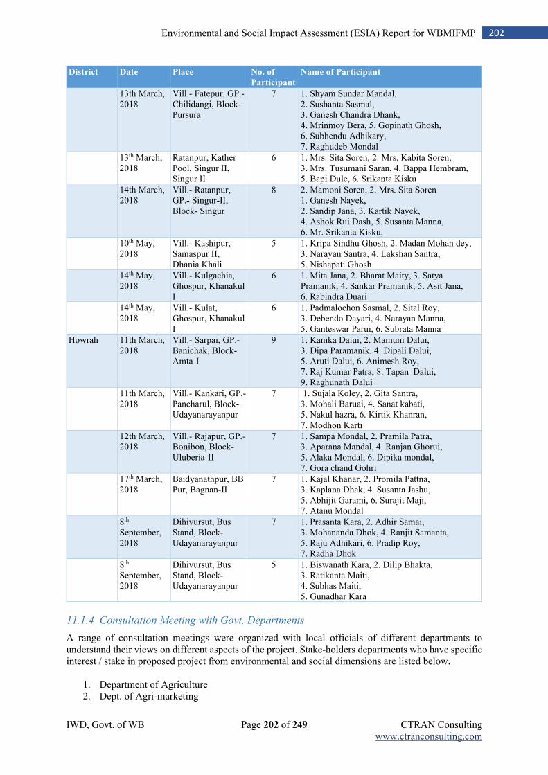
IWD, Govt. of WB Page 202 of 249 CTRAN Consulting www.ctranconsulting.com
202 Environmental and Social Impact Assessment (ESIA) Report for WBMIFMP
District Date Place No. of
Participant
Name of Participant
13th March, 2018
Vill.- Fatepur, GP.- Chilidangi, Block- Pursura
7 1. Shyam Sundar Mandal, 2. Sushanta Sasmal, 3. Ganesh Chandra Dhank, 4. Mrinmoy Bera, 5. Gopinath Ghosh, 6. Subhendu Adhikary, 7. Raghudeb Mondal
13th March, 2018
Ratanpur, Kather Pool, Singur II, Singur II
6 1. Mrs. Sita Soren, 2. Mrs. Kabita Soren, 3. Mrs. Tusumani Saran, 4. Bappa Hembram, 5. Bapi Dule, 6. Srikanta Kisku
14th March, 2018
Vill.- Ratanpur, GP.- Singur-II, Block- Singur
8 2. Mamoni Soren, 2. Mrs. Sita Soren 1. Ganesh Nayek, 2. Sandip Jana, 3. Kartik Nayek, 4. Ashok Rui Dash, 5. Susanta Manna, 6. Mr. Srikanta Kisku,
10th May, 2018
Vill.- Kashipur, Samaspur II, Dhania Khali
5 1. Kripa Sindhu Ghosh, 2. Madan Mohan dey, 3. Narayan Santra, 4. Lakshan Santra, 5. Nishapati Ghosh
14th May, 2018
Vill.- Kulgachia, Ghospur, Khanakul I
6 1. Mita Jana, 2. Bharat Maity, 3. Satya Pramanik, 4. Sankar Pramanik, 5. Asit Jana, 6. Rabindra Duari
14th May, 2018
Vill.- Kulat, Ghospur, Khanakul I
6 1. Padmalochon Sasmal, 2. Sital Roy, 3. Debendo Dayari, 4. Narayan Manna, 5. Ganteswar Parui, 6. Subrata Manna
Howrah 11th March, 2018
Vill.- Sarpai, GP.- Banichak, Block- Amta-I
9 1. Kanika Dalui, 2. Mamuni Dalui, 3. Dipa Paramanik, 4. Dipali Dalui, 5. Aruti Dalui, 6. Animesh Roy, 7. Raj Kumar Patra, 8. Tapan Dalui, 9. Raghunath Dalui
11th March, 2018
Vill.- Kankari, GP.- Pancharul, Block- Udayanarayanpur
7 1. Sujala Koley, 2. Gita Santra, 3. Mohali Baruai, 4. Sanat kabati, 5. Nakul hazra, 6. Kirtik Khanran, 7. Modhon Karti
12th March, 2018
Vill.- Rajapur, GP.- Bonibon, Block- Uluberia-II
7 1. Sampa Mondal, 2. Pramila Patra, 3. Aparana Mandal, 4. Ranjan Ghorui, 5. Alaka Mondal, 6. Dipika mondal, 7. Gora chand Gohri
17th March, 2018
Baidyanathpur, BB Pur, Bagnan-II
7 1. Kajal Khanar, 2. Promila Pattna, 3. Kaplana Dhak, 4. Susanta Jashu, 5. Abhijit Garami, 6. Surajit Maji, 7. Atanu Mondal
8th September, 2018
Dihivursut, Bus Stand, Block- Udayanarayanpur
7 1. Prasanta Kara, 2. Adhir Samai, 3. Mohananda Dhok, 4. Ranjit Samanta, 5. Raju Adhikari, 6. Pradip Roy, 7. Radha Dhok
8th September, 2018
Dihivursut, Bus Stand, Block- Udayanarayanpur
5 1. Biswanath Kara, 2. Dilip Bhakta, 3. Ratikanta Maiti, 4. Subhas Maiti, 5. Gunadhar Kara
11.1.4 Consultation Meeting with Govt. Departments
A range of consultation meetings were organized with local officials of different departments to understand their views on different aspects of the project. Stake-holders departments who have specific interest / stake in proposed project from environmental and social dimensions are listed below.
1. Department of Agriculture 2. Dept. of Agri-marketing
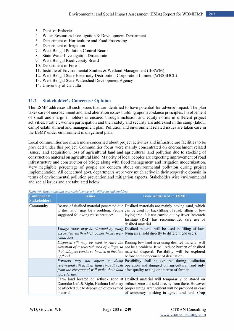
IWD, Govt. of WB Page 203 of 249 CTRAN Consulting www.ctranconsulting.com
203 Environmental and Social Impact Assessment (ESIA) Report for WBMIFMP
3. Dept. of Fisheries 4. Water Resources Investigation & Development Department 5. Department of Horticulture and Food Processing 6. Department of Irrigation 7. West Bengal Pollution Control Board 8. State Water Investigation Directorate 9. West Bengal Biodiversity Board 10. Department of Forest 11. Institute of Environmental Studies & Wetland Management (IESWM) 12. West Bengal State Electricity Distribution Corporation Limited (WBSEDCL) 13. West Bengal State Watershed Development Agency 14. University of Calcutta
11.2 Stakeholder’s Concerns / Opinion
The ESMP addresses all such issues that are identified to have potential for adverse impact. The plan takes care of encroachment and land alienation issues building upon avoidance principles. Involvement of small and marginal holders is ensured through inclusion and equity norms in different project activities. Further, women participation and their safety and security are addressed in the camp (labour camp) establishment and management plan. Pollution and environment related issues are taken care in the ESMP under environment management plan. Local communities are much more concerned about project activities and infrastructure facilities to be provided under this project. Communities focus were mainly concentrated on encroachment related issues, land acquisition, loss of agricultural land and agricultural land pollution due to stocking of construction material on agricultural land. Majority of local peoples are expecting improvement of road infrastructure and construction of bridge along with flood management and irrigation modernization. Very negligible percentage of people are concern about environmental pollution during project implementation. All concerned govt. departments were very much active in their respective domain in terms of environmental pollution prevention and mitigation aspects. Stakeholder wise environmental and social issues and are tabulated below. Table 99: Environmental and social concern by different stakeholders
Component/
Stakeholders
Issues Issue Addressed in ESMP
Community Re-use of desilted material generated due
to desiltation may be a problem. People suggested following reuse practice:
Desilted materials are mainly having sand, which can be used for backfilling of road, filling of low laying area. Silt test carried out by River Research Institute (RRI) has recommended safe use of desilted material.
Village roads may be elevated by using
excavated earth which comes from river/
canal bed.
Desilted material will be used in filling of low-lying area, sold directly to different end users.
Disposed silt may be used to raise the
elevation of a selected area of village so
that villagers can be re-located at the time
of flood.
Raising low land area using desilted material will not be a problem. It will reduce burden of desilted material disposal. Possibility will be explored before commencement of desiltation.
Farmers may not object to dump
river/canal silt in their land since the silt
from the river/canal will make their land
more fertile.
Possibility shall be explored during desiltation operation and dumped on agricultural land only after quality testing on interest of farmer.
Farm land located on setback zone at Damodar Left & Right, Hurhura Left may be affected due to deposition of excavated material.
Desilted material will temporarily be stored on setback zone and sold directly from there. However proper lining arrangement will be provided in case of temporary stocking in agricultural land. Crop
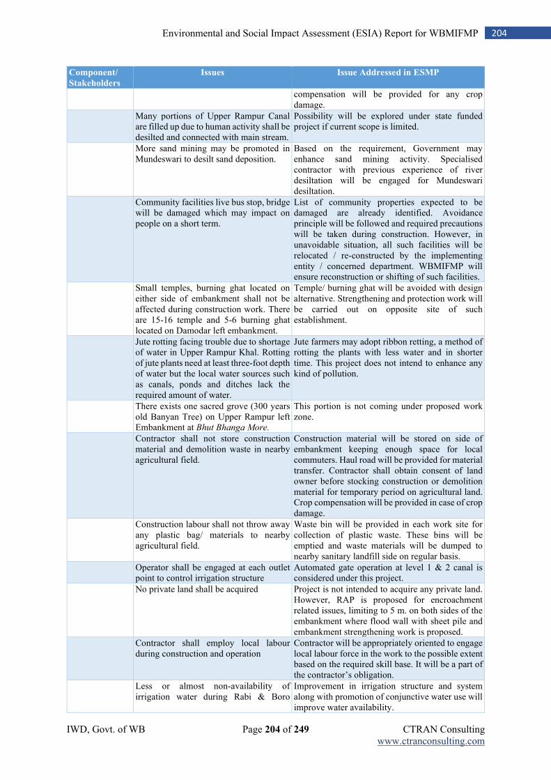
IWD, Govt. of WB Page 204 of 249 CTRAN Consulting www.ctranconsulting.com
204 Environmental and Social Impact Assessment (ESIA) Report for WBMIFMP
Component/
Stakeholders
Issues Issue Addressed in ESMP
compensation will be provided for any crop damage.
Many portions of Upper Rampur Canal are filled up due to human activity shall be desilted and connected with main stream.
Possibility will be explored under state funded project if current scope is limited.
More sand mining may be promoted in Mundeswari to desilt sand deposition.
Based on the requirement, Government may enhance sand mining activity. Specialised contractor with previous experience of river desiltation will be engaged for Mundeswari desiltation.
Community facilities live bus stop, bridge will be damaged which may impact on people on a short term.
List of community properties expected to be damaged are already identified. Avoidance principle will be followed and required precautions will be taken during construction. However, in unavoidable situation, all such facilities will be relocated / re-constructed by the implementing entity / concerned department. WBMIFMP will ensure reconstruction or shifting of such facilities.
Small temples, burning ghat located on either side of embankment shall not be affected during construction work. There are 15-16 temple and 5-6 burning ghat located on Damodar left embankment.
Temple/ burning ghat will be avoided with design alternative. Strengthening and protection work will be carried out on opposite site of such establishment.
Jute rotting facing trouble due to shortage of water in Upper Rampur Khal. Rotting of jute plants need at least three-foot depth of water but the local water sources such as canals, ponds and ditches lack the required amount of water.
Jute farmers may adopt ribbon retting, a method of rotting the plants with less water and in shorter time. This project does not intend to enhance any kind of pollution.
There exists one sacred grove (300 years old Banyan Tree) on Upper Rampur left Embankment at Bhut Bhanga More.
This portion is not coming under proposed work zone.
Contractor shall not store construction material and demolition waste in nearby agricultural field.
Construction material will be stored on side of embankment keeping enough space for local commuters. Haul road will be provided for material transfer. Contractor shall obtain consent of land owner before stocking construction or demolition material for temporary period on agricultural land. Crop compensation will be provided in case of crop damage.
Construction labour shall not throw away any plastic bag/ materials to nearby agricultural field.
Waste bin will be provided in each work site for collection of plastic waste. These bins will be emptied and waste materials will be dumped to nearby sanitary landfill side on regular basis.
Operator shall be engaged at each outlet point to control irrigation structure
Automated gate operation at level 1 & 2 canal is considered under this project.
No private land shall be acquired Project is not intended to acquire any private land. However, RAP is proposed for encroachment related issues, limiting to 5 m. on both sides of the embankment where flood wall with sheet pile and embankment strengthening work is proposed.
Contractor shall employ local labour during construction and operation
Contractor will be appropriately oriented to engage local labour force in the work to the possible extent based on the required skill base. It will be a part of the contractor’s obligation.
Less or almost non-availability of irrigation water during Rabi & Boro
Improvement in irrigation structure and system along with promotion of conjunctive water use will improve water availability.
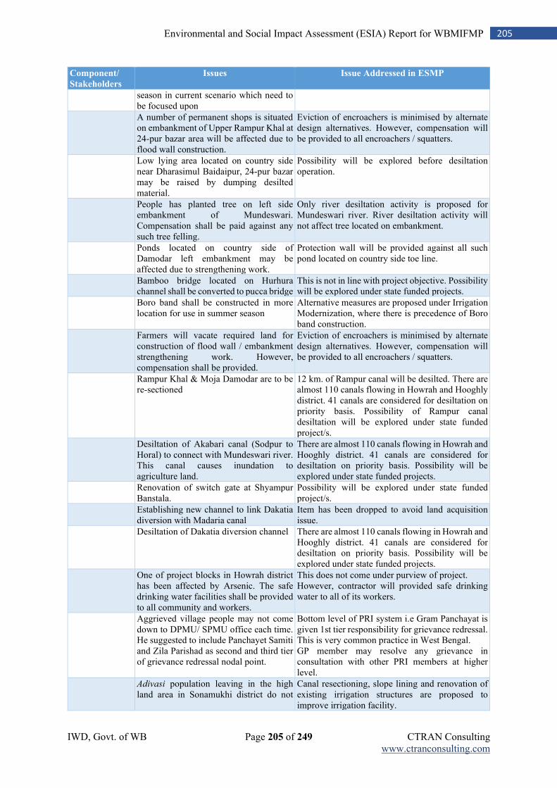
IWD, Govt. of WB Page 205 of 249 CTRAN Consulting www.ctranconsulting.com
205 Environmental and Social Impact Assessment (ESIA) Report for WBMIFMP
Component/
Stakeholders
Issues Issue Addressed in ESMP
season in current scenario which need to be focused upon A number of permanent shops is situated on embankment of Upper Rampur Khal at 24-pur bazar area will be affected due to flood wall construction.
Eviction of encroachers is minimised by alternate design alternatives. However, compensation will be provided to all encroachers / squatters.
Low lying area located on country side near Dharasimul Baidaipur, 24-pur bazar may be raised by dumping desilted material.
Possibility will be explored before desiltation operation.
People has planted tree on left side embankment of Mundeswari. Compensation shall be paid against any such tree felling.
Only river desiltation activity is proposed for Mundeswari river. River desiltation activity will not affect tree located on embankment.
Ponds located on country side of Damodar left embankment may be affected due to strengthening work.
Protection wall will be provided against all such pond located on country side toe line.
Bamboo bridge located on Hurhura channel shall be converted to pucca bridge
This is not in line with project objective. Possibility will be explored under state funded projects.
Boro band shall be constructed in more location for use in summer season
Alternative measures are proposed under Irrigation Modernization, where there is precedence of Boro band construction.
Farmers will vacate required land for construction of flood wall / embankment strengthening work. However, compensation shall be provided.
Eviction of encroachers is minimised by alternate design alternatives. However, compensation will be provided to all encroachers / squatters.
Rampur Khal & Moja Damodar are to be re-sectioned
12 km. of Rampur canal will be desilted. There are almost 110 canals flowing in Howrah and Hooghly district. 41 canals are considered for desiltation on priority basis. Possibility of Rampur canal desiltation will be explored under state funded project/s.
Desiltation of Akabari canal (Sodpur to Horal) to connect with Mundeswari river. This canal causes inundation to agriculture land.
There are almost 110 canals flowing in Howrah and Hooghly district. 41 canals are considered for desiltation on priority basis. Possibility will be explored under state funded projects.
Renovation of switch gate at Shyampur Banstala.
Possibility will be explored under state funded project/s.
Establishing new channel to link Dakatia diversion with Madaria canal
Item has been dropped to avoid land acquisition issue.
Desiltation of Dakatia diversion channel There are almost 110 canals flowing in Howrah and Hooghly district. 41 canals are considered for desiltation on priority basis. Possibility will be explored under state funded projects.
One of project blocks in Howrah district has been affected by Arsenic. The safe drinking water facilities shall be provided to all community and workers.
This does not come under purview of project. However, contractor will provided safe drinking water to all of its workers.
Aggrieved village people may not come down to DPMU/ SPMU office each time. He suggested to include Panchayet Samiti and Zila Parishad as second and third tier of grievance redressal nodal point.
Bottom level of PRI system i.e Gram Panchayat is given 1st tier responsibility for grievance redressal. This is very common practice in West Bengal. GP member may resolve any grievance in consultation with other PRI members at higher level.
Adivasi population leaving in the high land area in Sonamukhi district do not
Canal resectioning, slope lining and renovation of existing irrigation structures are proposed to improve irrigation facility.
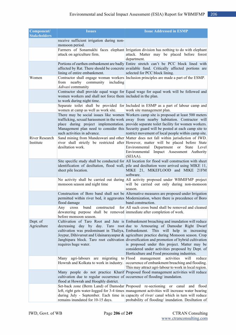
IWD, Govt. of WB Page 206 of 249 CTRAN Consulting www.ctranconsulting.com
206 Environmental and Social Impact Assessment (ESIA) Report for WBMIFMP
Component/
Stakeholders
Issues Issue Addressed in ESMP
receive sufficient irrigation during non-monsoon period.
Farmers of Sonamukhi faces elephant attack on agriculture firm.
Irrigation division has nothing to do with elephant attack. Matter may be placed before forest department.
Portions of earthen embankment are badly affected by Rat. There should be concrete lining of entire embankment.
Entire stretch can’t be PCC block lined with available fund. Critically affected portions are selected for PCC block lining.
Women Contractor shall engage woman workers from nearby community including Adivasi community
Inclusion principles are made a part of the ESMP.
Contractor shall provide equal wage for women workers and shall not force them to work during night time.
Equal wage for equal work will be followed and included in the plan.
Separate toilet shall be provided for women at camp as well as work site.
Included in ESMP as a part of labour camp and work site management plan.
There may be social issues like women trafficking, sexual harassment in the work place during project implementation. Management plan need to consider this such activities in advance.
Workers camp site is proposed at least 500 meters away from nearby habitation. Contractor will provide separate toilet facility for women workers. Security guard will be posted at each camp site to restrict movement of local people within camp site.
River Research Institute
Sand mining from Mundeswari and other river shall strictly be restricted after desiltation work.
Matter does not fall within jurisdiction of IWD. However, matter will be placed before State Environmental Department or State Level Environmental Impact Assessment Authority (SEIAA).
Site specific study shall be conducted for identification of desiltation, flood wall, sheet pile location.
All location for flood wall construction with sheet pile and desiltation were arrived using MIKE 11, MIKE 21, MIKEFLOOD and MIKE 21FM software.
No activity shall be carried out during monsoon season and night time
All activity proposed under WBMIFMP project will be carried out only during non-monsoon season.
Construction of Boro band shall not be permitted within river bed, it aggravates flood damage
Alternative measures are proposed under Irrigation Modernization, where there is precedence of Boro band construction.
Any cross bund constructed for dewatering purpose shall be removed before monsoon season.
All such cross bund shall be removed and cleaned immediate after completion of work.
Dept. of Agriculture
Cultivation of Taro Root and Jute is decreasing day by day. Taro root cultivation was predominant in Thaliya, Joypur, Dihivursut and Udainarayanpur & Janghipara block. Taro root cultivation requires huge water.
Embankment breaching and inundation will reduce due to Armouring of Damodar Right Dwarf Embankment. This will help in increasing agriculture practice during Monsoon season. Crop diversification and promotion of hybrid cultivation is proposed under this project. Matter may be considered under activities proposed by Dept. of Horticulture and Food processing industries.
Many agri-labours are migrating to Howrah and Kolkata to work in industry.
Flood management activities will reduce occurrence of embankment breaching and flooding. This may attract agri-labour to work in local region.
Many people do not practice Kharif cultivation due to regular occurrence of flood at Howrah and Hooghly district.
Proposed flood management activities will reduce occurrence of flooding/ inundation.
Set-back zone (Berm Land) of Damodar left, right gets water-logged for 3-4 times during July - September. Each time in remains inundated for 10-15 days.
Proposed re-sectioning or canal and flood management activities will increase water bearing capacity of river/ canal which in turn will reduce probability of flooding/ inundation. Desiltation of
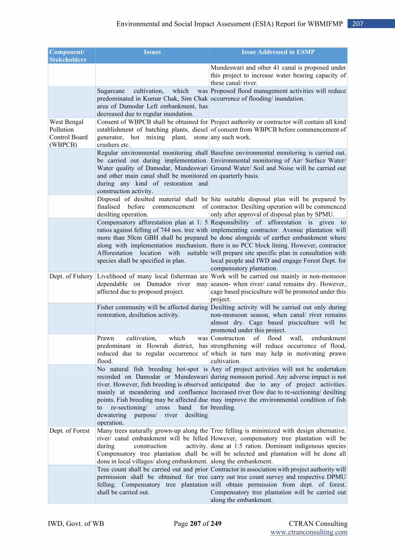
IWD, Govt. of WB Page 207 of 249 CTRAN Consulting www.ctranconsulting.com
207 Environmental and Social Impact Assessment (ESIA) Report for WBMIFMP
Component/
Stakeholders
Issues Issue Addressed in ESMP
Mundeswari and other 41 canal is proposed under this project to increase water bearing capacity of these canal/ river.
Sugarcane cultivation, which was predominated in Kumar Chak, Sim Chak area of Damodar Left embankment, has decreased due to regular inundation.
Proposed flood management activities will reduce occurrence of flooding/ inundation.
West Bengal Pollution Control Board (WBPCB)
Consent of WBPCB shall be obtained for establishment of batching plants, diesel generator, hot mixing plant, stone crushers etc.
Project authority or contractor will contain all kind of consent from WBPCB before commencement of any such work.
Regular environmental monitoring shall be carried out during implementation. Water quality of Damodar, Mundeswari and other main canal shall be monitored during any kind of restoration and construction activity.
Baseline environmental monitoring is carried out. Environmental monitoring of Air/ Surface Water/ Ground Water/ Soil and Noise will be carried out on quarterly basis.
Disposal of desilted material shall be finalised before commencement of desilting operation.
Site suitable disposal plan will be prepared by contractor. Desilting operation will be commenced only after approval of disposal plan by SPMU.
Compensatory afforestation plan at 1: 5 ratios against felling of 744 nos. tree with more than 50cm GBH shall be prepared along with implementation mechanism. Afforestation location with suitable species shall be specified in plan.
Responsibility of afforestation is given to implementing contractor. Avenue plantation will be done alongside of earther embankment where there is no PCC block lining. However, contractor will prepare site specific plan in consultation with local people and IWD and engage Forest Dept. for compensatory plantation.
Dept. of Fishery Livelihood of many local fisherman are dependable on Damador river may affected due to proposed project.
Work will be carried out mainly in non-monsoon season- when river/ canal remains dry. However, cage based pisciculture will be promoted under this project.
Fisher community will be affected during restoration, desiltation activity.
Desilting activity will be carried out only during non-monsoon season, when canal/ river remains almost dry. Cage based pisciculture will be promoted under this project.
Prawn cultivation, which was predominant in Howrah district, has reduced due to regular occurrence of flood.
Construction of flood wall, embankment strengthening will reduce occurrence of flood, which in turn may help in motivating prawn cultivation.
No natural fish breeding hot-spot is recorded on Damodar or Mundeswari river. However, fish breeding is observed mainly at meandering and confluence points. Fish breeding may be affected due to re-sectioning/ cross band for dewatering purpose/ river desilting operation.
Any of project activities will not be undertaken during monsoon period. Any adverse impact is not anticipated due to any of project activities. Increased river flow due to re-sectioning/ desilting may improve the environmental condition of fish breeding.
Dept. of Forest Many trees naturally grown-up along the river/ canal embankment will be felled during construction activity. Compensatory tree plantation shall be done in local villages/ along embankment.
Tree felling is minimized with design alternative. However, compensatory tree plantation will be done at 1:5 ration. Dominant indigenous species will be selected and plantation will be done all along the embankment.
Tree count shall be carried out and prior permission shall be obtained for tree felling. Compensatory tree plantation shall be carried out.
Contractor in association with project authority will carry out tree count survey and respective DPMU will obtain permission from dept. of forest. Compensatory tree plantation will be carried out along the embankment.
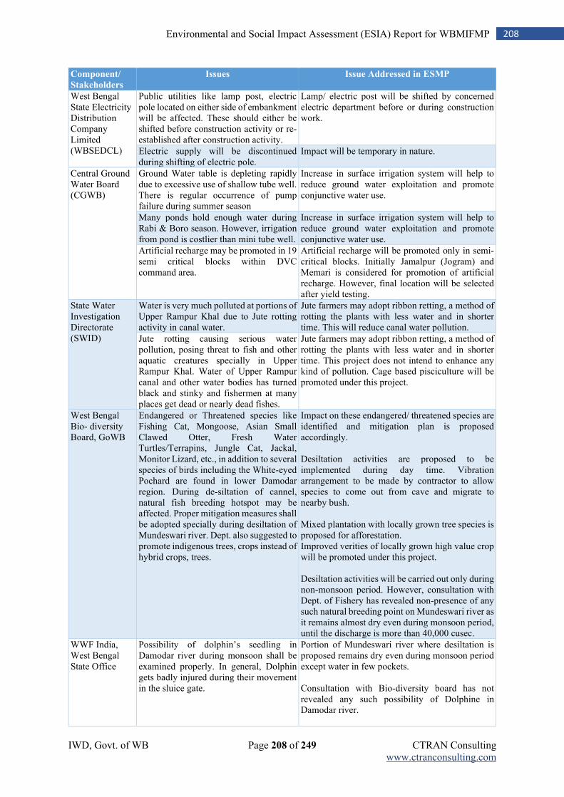
IWD, Govt. of WB Page 208 of 249 CTRAN Consulting www.ctranconsulting.com
208 Environmental and Social Impact Assessment (ESIA) Report for WBMIFMP
Component/
Stakeholders
Issues Issue Addressed in ESMP
West Bengal State Electricity Distribution Company Limited (WBSEDCL)
Public utilities like lamp post, electric pole located on either side of embankment will be affected. These should either be shifted before construction activity or re-established after construction activity.
Lamp/ electric post will be shifted by concerned electric department before or during construction work.
Electric supply will be discontinued during shifting of electric pole.
Impact will be temporary in nature.
Central Ground Water Board (CGWB)
Ground Water table is depleting rapidly due to excessive use of shallow tube well. There is regular occurrence of pump failure during summer season
Increase in surface irrigation system will help to reduce ground water exploitation and promote conjunctive water use.
Many ponds hold enough water during Rabi & Boro season. However, irrigation from pond is costlier than mini tube well.
Increase in surface irrigation system will help to reduce ground water exploitation and promote conjunctive water use.
Artificial recharge may be promoted in 19 semi critical blocks within DVC command area.
Artificial recharge will be promoted only in semi-critical blocks. Initially Jamalpur (Jogram) and Memari is considered for promotion of artificial recharge. However, final location will be selected after yield testing.
State Water Investigation Directorate (SWID)
Water is very much polluted at portions of Upper Rampur Khal due to Jute rotting activity in canal water.
Jute farmers may adopt ribbon retting, a method of rotting the plants with less water and in shorter time. This will reduce canal water pollution.
Jute rotting causing serious water pollution, posing threat to fish and other aquatic creatures specially in Upper Rampur Khal. Water of Upper Rampur canal and other water bodies has turned black and stinky and fishermen at many places get dead or nearly dead fishes.
Jute farmers may adopt ribbon retting, a method of rotting the plants with less water and in shorter time. This project does not intend to enhance any kind of pollution. Cage based pisciculture will be promoted under this project.
West Bengal Bio- diversity Board, GoWB
Endangered or Threatened species like Fishing Cat, Mongoose, Asian Small Clawed Otter, Fresh Water Turtles/Terrapins, Jungle Cat, Jackal, Monitor Lizard, etc., in addition to several species of birds including the White-eyed Pochard are found in lower Damodar region. During de-siltation of cannel, natural fish breeding hotspot may be affected. Proper mitigation measures shall be adopted specially during desiltation of Mundeswari river. Dept. also suggested to promote indigenous trees, crops instead of hybrid crops, trees.
Impact on these endangered/ threatened species are identified and mitigation plan is proposed accordingly. Desiltation activities are proposed to be implemented during day time. Vibration arrangement to be made by contractor to allow species to come out from cave and migrate to nearby bush. Mixed plantation with locally grown tree species is proposed for afforestation. Improved verities of locally grown high value crop will be promoted under this project. Desiltation activities will be carried out only during non-monsoon period. However, consultation with Dept. of Fishery has revealed non-presence of any such natural breeding point on Mundeswari river as it remains almost dry even during monsoon period, until the discharge is more than 40,000 cusec.
WWF India, West Bengal State Office
Possibility of dolphin’s seedling in Damodar river during monsoon shall be examined properly. In general, Dolphin gets badly injured during their movement in the sluice gate.
Portion of Mundeswari river where desiltation is proposed remains dry even during monsoon period except water in few pockets. Consultation with Bio-diversity board has not revealed any such possibility of Dolphine in Damodar river.
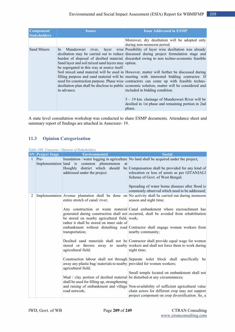
IWD, Govt. of WB Page 209 of 249 CTRAN Consulting www.ctranconsulting.com
209 Environmental and Social Impact Assessment (ESIA) Report for WBMIFMP
Component/
Stakeholders
Issues Issue Addressed in ESMP
Moreover, dry desiltation will be adopted only during non-monsoon period.
Sand Miners In Mundeswari river, layer wise desiltation may be carried out to reduce burden of disposal of desilted material. Sand layer and soil mixed sand layers may be segregated in this way at source itself. Soil mixed sand material will be used in filling purpose and sand material will be used for construction purpose. Phase wise desiltation plan shall be disclose to public in advance.
Possibility of layer wise desiltation was already discussed during project formulation stage and discarded owing to non techno-economic feasible option. However, matter will further be discussed during meeting with interested bidding contractor. If contractors can come up with feasible techno-economic solution, matter will be considered and included in bidding condition. 5 – 19 km. chainage of Mundeswari River will be desilted in 1st phase and remaining portion in 2nd phase.
A state level consultation workshop was conducted to share ESMP documents. Attendance sheet and summary report of findings are attached in Annexure- 19.
11.3 Opinion Categorization
Table 100: Concerns / Opinion of Stakeholders
SN Project Stage Environmental Social
1 Pre-Implementation
Inundation / water logging in agriculture land is common phenomenon at Hooghly district which should be addressed under the project.
No land shall be acquired under the project; Compensation shall be provided for any kind of relocation or loss of assets as per GITANJALI Scheme of Govt. of West Bengal; Spreading of water borne diseases after flood is commonly observed which need to be addressed;
2 Implementation Avenue plantation shall be done on entire stretch of canal/ river; Any construction or waste material generated during construction shall not be stored on nearby agricultural field, rather it shall be stored on inner side of embankment without disturbing road transportation; Desilted sand materials shall not be stored or thrown away to nearby agricultural field; Construction labour shall not through away any plastic bag/ materials to nearby agricultural field; Mud / clay portion of desilted material shall be used for filling up, strengthening and raising of embankment and village road network;
No activity shall be carried out during monsoon season and night time; Canal embankment where encroachment has occurred, shall be avoided from rehabilitation work; Contractor shall engage woman workers from nearby community; Contractor shall provide equal wage for women workers and shall not force them to work during night time; Separate toilet block shall specifically be provided for women workers; Small temple located on embankment shall not be disturbed at any circumstances; Non-availability of sufficient agricultural value chain actors for different crop may not support project component on crop diversification. So, a
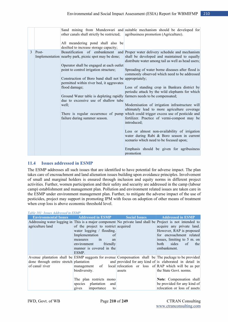
IWD, Govt. of WB Page 210 of 249 CTRAN Consulting www.ctranconsulting.com
210 Environmental and Social Impact Assessment (ESIA) Report for WBMIFMP
Sand mining from Mundeswari and other canals shall strictly be restricted; All meandering pond shall also be desilted to increase storage capacity;
suitable mechanism should be developed for agribusiness promotion (Agriculture).
3 Post-Implementation
Beautification of embankment and nearby park, picnic spot may be done; Operator shall be engaged at each outlet point to control irrigation structure; Construction of Boro band shall not be permitted within river bed, it aggravates flood damage; Ground Water table is depleting rapidly due to excessive use of shallow tube well; There is regular occurrence of pump failure during summer season.
Proper water delivery schedule and mechanism shall be developed and maintained to equally distribute water among tail as well as head users; Spreading of water borne diseases after flood is commonly observed which need to be addressed appropriately; Loss of standing crop in Bankura district by periodic attack by the wild elephants for which farmers needs to be compensated; Modernisation of irrigation infrastructure will ultimately lead to more agriculture coverage which could trigger excess use of pesticide and fertilizer. Practice of vermi-compost may be introduced; Less or almost non-availability of irrigation water during Rabi & Boro season in current scenario which need to be focused upon; Emphasis should be given for agribusiness promotion
11.4 Issues addressed in ESMP
The ESMP addresses all such issues that are identified to have potential for adverse impact. The plan takes care of encroachment and land alienation issues building upon avoidance principles. Involvement of small and marginal holders is ensured through inclusion and equity norms in different project activities. Further, women participation and their safety and security are addressed in the camp (labour camp) establishment and management plan. Pollution and environment related issues are taken care in the ESMP under environment management plan. Further, to mitigate the adverse impact of the use of pesticides, project may support in promoting IPM with focus on adoption of other means of treatment when crop loss is above economic threshold level. Table 101: Issues Addressed in ESMP
Environmental Issues Addressed in ESMP Social Issues Addressed in ESMP
Addressing water logging in agriculture land
This is a major component of the project to restrict water logging / flooding. Implementation of measures in an environment friendly manner is covered in the ESMP.
No private land shall be acquired
Project is not intended to acquire any private land. However, RAP is proposed for encroachment related issues, limiting to 5 m. on both sides of the embankment.
Avenue plantation shall be done through entire stretch of canal/ river
ESMP suggests for avenue plantation and management of local biodiversity. The plan restricts mono species plantation and gives importance to
Compensation shall be provided for any kind of relocation or loss of assets
The package to be provided is elaborated in detail in RAP which will be as per the State Govt. norms. Note: Compensation shall be provided for any kind of relocation or loss of assets
IWD, Govt. of WB Page 211 of 249 CTRAN Consulting www.ctranconsulting.com
211 Environmental and Social Impact Assessment (ESIA) Report for WBMIFMP
Environmental Issues Addressed in ESMP Social Issues Addressed in ESMP
consultation with the local people during plantation.
as per GITANJALI Scheme of GoWB;
Any construction or waste material generated during construction shall not be stored on nearby agricultural field, rather it shall be stored on inner side of embankment without disturbing road transportation
Management plan prepared for disposition of debris / sediments
Spreading of water borne diseases after flood is commonly observed which need to be addressed appropriately
As project will reduce occurrence of flood, so also related diseases will be reduced. Periodic health check-up camps to be organized for workers staying in labour camps.
Desilted sand materials shall not be stored or thrown away to nearby agricultural field
Reuse / disposal plan suggested for desilted material
No activity shall be carried out during monsoon season and night time
ESMP suggests specific activities which will not be taken up during night and monsoon period.
Construction labour shall not throw away any plastic bag/ materials to nearby agricultural field
The management plan covers labour camp management including sensitisation of workers on this aspect.
Contractor shall employ local labour during construction and operation
Contractor will be appropriately oriented to engage local labour force in the work to the possible extent based on the required skill base. It will be a part of the contractor’s obligation.
Mud / clay portion of desilted material shall be used for filling up, strengthening and raising of embankment and village road network
Scientific application of desilted materials will be done after soil testing and its usability in such works. The plan gives emphasis on reusing the materials in different construction works
Canal embankment where encroachment has occurred, shall be avoided from rehabilitation work
Avoidance as one of the principles and in cases, where it is highly necessary for the project and cannot be avoided, RAP will be followed.
Sand mining from Mundeswari and other river shall strictly be restricted
Desilting of river bed for improving water carrying capacity and flood control is part of the project intervention and ESMP suggests scientific management of sediments and its disposal
Contractor shall engage woman workers from nearby Adivasi community
Inclusion principles are made a part of the ESMP
All meandering pond shall also be desilted to increase storage capacity
Out of the scope of the project. However, measures will be taken to restore / rehabilitate the ponds that are falling within the working zone.
Contractor shall provide equal wage for women workers and shall not force them to work during night time
Equal wage for equal work will be followed and included in the plan.
Beautification of embankment and nearby park, picnic spot may be done
Plantation and protection measures for ROW is made a part of the environment restoration and improvement plan.
Separate toilet block shall specifically be provided for women workers
Included in ESMP as a part of labour camp management plan.
Operator shall be engaged at each outlet point to control irrigation structure
In modernised / automated structures, no manual operator will be required.
Small temple located on embankment shall not be disturbed at any circumstances
No such cultural properties envisaged to get affected by the project.
Proper water delivery schedule and mechanism shall be developed and maintained to equally distribute water among tail as well as head users
Renovation / installation of irrigation regulation structures and scientific regulatory mechanisms will improve distribution and efficiency.
Local farmers organisation / Gram Panchayat involvement
For water management, local farmers organisation will play a role along with GP.
IWD, Govt. of WB Page 212 of 249 CTRAN Consulting www.ctranconsulting.com
212 Environmental and Social Impact Assessment (ESIA) Report for WBMIFMP
Environmental Issues Addressed in ESMP Social Issues Addressed in ESMP
Construction of Boro band shall not be permitted within river bed, it aggravates flood damage
With suggested project measures, requirement of constructing boro bunds will reduce.
Drip/ sprinkler irrigation may be introduced for horticulture with 50-70% subsidy
Under irrigation efficiency and productivity improvement, micro irrigation promotion is made a part of the ESMP.
Ground Water table is depleting rapidly due to excessive use of shallow tube well. There is regular occurrence of pump failure during summer season
Increase in surface irrigation system will help to reduce ground water exploitation and promote conjunctive water use
Excess use of pesticide and fertilizer. Practice of vermi-compost may be introduced
Crop diversification will reduce use of fertilizer / pesticides. However, ESMP suggests adoption of IPM to minimize pesticide related impact.
Less or almost non-availability of irrigation water during Rabi &Boro season in current scenario which need to be focused upon
Improvement in irrigation structure and system along with promotion of conjunctive water use will improve water availability.
Emphasis should be given for agribusiness promotion
Agribusiness promotion is one of the interventions of the project.
11.5 Information Disclosure
The draft ESMP will be disclosed for public knowledge through the website of the IWD and the World Bank. The Executive Summary of the ESIP will also be disclosed in both Bengali and English languages in the web. Following information shall be displayed / disclosed / disseminated, wherever applicable.
i. Project specific information need to be made available at each project site (hard / soft / display); ii. Project information brochures shall be made available at all the construction sites as well as the
office of SPMU / DPMU / DPIU and the office of Engineer in charge. iii. Reports and publications, as deemed fit, shall be expressly prepared for public dissemination
e.g., English versions of the ESIA, EMP and RAP and Executive Summary of ESIA, EMP and RAP in local language.
iv. Wherever civil work will be carried out a board will be put up for public information which will disclose all desired information to the public, as a part of pro-active and Suo-motto disclosure, transparency and accountability.
v. All information will be translated into local language and will be disclosed to the public through the Panchayat, District Magistrate’s office, concerned project offices, websites of IWD.
IWD, Govt. of WB Page 213 of 249 CTRAN Consulting www.ctranconsulting.com
213 Environmental and Social Impact Assessment (ESIA) Report for WBMIFMP
Chapter 12: Capacity Building
Effective implementation of the safeguard measures requires proper understanding of the implementing entities and their capacity to manage these aspects in an acceptable manner. The project will take proactive measures to improve the understanding of the project personnel at SPMU, DPMU and DPIU level and building the capacity of the contractor/s engaged to carry out the activities. The IWD, through its SPMU will organize training and workshops for the project implementing entities, i.e., SPMU, DPMU, DPIU, Contractor and other Govt. agencies associated in the project execution. Apart from in-house training, the design of capacity building would also include field / site visit and interaction. The key stakeholders to be covered under capacity building measures are;
1. Training of the IWD team at State and district level, including the field personnel of the project; 2. Training of the PMC staff 3. Training of the DPMU and DPIU Staff 4. Training of the Contractor and its staff 5. Training of officials of other line depts. such as Agriculture and Agri-marketing dept.
12.1 Strategy for Capacity Building
The project will adopt following strategy for building capacity of the associated implementing institutions / agencies.
1. The training and capacity building strategy will form as integral part of the project management procedure at the SPMU / DPMU level.
2. There will be Capacity Need Assessment (CNA) of the officials and contractors on current understanding of environment and social management and safeguard measures;
3. The training curriculum will be designed based on the findings of the CNA; 4. Training will be organized for the identified stakeholders, covering practical issues and
challenges, in line with the designed training module; 5. The capacity building will involve training in-house and field / site visit and consultation; 6. Experts from different institutions may be engaged to conduct training. In case of requirement,
IWD may collaborate with National / State level institutions for organizing / imparting training; 7. Capacity building will be taken up from the inception of the project activity till the end of
implementation stage; 8. A schedule for capacity building activities will be prepared and executed during the life of the
project.
12.2 Capacity Building Plan
The SPMU-WBMIFMP may collaborate / engage with different National and State level institutions to facilitate the training program to be organized at the State and district levels. Table 102: Capacity Building Plan
SN CB Theme Training / Orientation /
Workshop Aspects
Periodicity Duration Project
Level
Participant
Category
1 Concept and Contextual Relevance of ESIA / ESMP
1. National and State Environmental Acts / legislations
2. World Bank’s safeguard Policies
3. Implementation, Monitoring and Supervision Mechanism
Inception of the Project
3 Days State Level
SPMU DPMU DPIU
IWD, Govt. of WB Page 214 of 249 CTRAN Consulting www.ctranconsulting.com
214 Environmental and Social Impact Assessment (ESIA) Report for WBMIFMP
SN CB Theme Training / Orientation /
Workshop Aspects
Periodicity Duration Project
Level
Participant
Category
4. Social and Environmental Audit
5. Provision made in Contract Documents
2 Implementation of ESMP
1. Salient Features of ESMP 2. Identification of
Environmental and social issues
3. Addressing environmental and social impacts
4. Preparing mitigation plans 5. Implementation Mechanism 6. Monitoring Mechanism 7. Roles and Responsibilities of
different Stakeholders
Pre-Construction
Stage
3 Days State Level
SPMU DPMU DPIU
3 Implementation of ESMP
1. Salient Features of ESMP 2. Identification of
Environmental and social issues
3. Addressing environmental and social impacts
4. Preparing mitigation plans 5. Implementation Mechanism 6. Monitoring Mechanism 7. Roles and Responsibilities of
different Stakeholders
Construction Stage
2 Days District Level
Contractor and its
Officials
4 Good Practices and Learning Workshops
Good Practices and Learning by Project Components on Environment and Social Management
Once per year for Five
Years
2 Days State Level
SPMU DPMU DPIU
Contractors
Training Plan on ESMP Implementation * (SPMU will arrange training programme on regular interval to raise awareness of construction workers on EHS aspect
and Workers Code of Conduct)
5. Training of workers on EHS aspect
1. Sources of health and fire hazard 2. List of flammable items 3. Mock drill on fire fighting 4. Mitigation measures to deal with occurrence of fire 5. Use of PPE 6. Training on first- aid facilities 7. Reporting of accident 8. Waste Management 9. Camp and work-related sanitation
Once in each two months
1 day Contract package wise/ or
camp site wise
All workers
6. Training of workers on Code of Conduct
1. Dealing with local community 2. Respecting culture of local community and migrant labour 3. Restricted practices like fishing, hunting 4. Non-permitted items under WBMIFMP 5. Reporting system on siting of endangered / wild animals and “Chance finding” 6. Waste management plan
Quarterly 1 day Contract package wise/ or
camp site wise
All workers
* Note: Training Plan on ESMP Implementation must be included in the Contract Package Specific ESMPs
IWD, Govt. of WB Page 215 of 249 CTRAN Consulting www.ctranconsulting.com
215 Environmental and Social Impact Assessment (ESIA) Report for WBMIFMP
Chapter 13: Grievance Redressal Mechanism
Effective grievance redressal mechanism gives an opportunity to the organization to implement a set of specific measures to ensure good governance accountability and transparency in managing and mitigation of environmental and social issue of a particular project. This consists of defining the process for recording/receiving complaints and their redressal in respect of environmental and social matters. An integrated system will be established with Grievance Redressal Cell (GRCs), with necessary officers, officials and systems, at the SPMU-IWD level. Grievances, if any, may be submitted through various mediums, including in person, in written form to a noted address, e-mail, or through direct calls to concerned official/s. The Social / Environmental Expert in the concerned agency shall be responsible for coordination of grievance/complaints received. The grievance redress mechanism would be in place since the inception of the project till its life. A platform for grievance redressal should be organized and its regular meetings will be conducted so as to allow people to put forth their grievances, if any. It will help the appropriate authority to find solutions and amicably address the issues. The project, apart from web-based system, will also have three-tire grievance redressal mechanism, i.e., (1) at the project site level (up to DPMU level), (2) State level (SPMU level) and (3) Judiciary level. Web based grievance mechanism10: In case of grievances received through toll free number or web-based system, a person will be made in-charge of screening and resolution of the same/communicating with the concerned divisions for resolution of the same. The person in-charge based on nature of complaint, will forward the same to the concerned official. A receipt or a unique number will be generated for all such complaints. The complainant will follow up based on that unique number. All calls and messages will be responded within two weeks. If response is not received within 15 days, the complaint will be escalated to project head. Tier I: Under this project, the local Gram Panchayat and Community level organizations will serve as the first-tier mechanism to handle complaints and grievances. The local Sarpanch of the Gram panchayat will be the focal point who will receive, address, and keep record of the complaints and feedbacks. The grievance focal point will first review the grievances submitted. If grievances or disputes cannot be solved at the GP level within 30 days of the submission of the grievances, the issue will be brought to DPMU level for mediation. DPMU is expected to inform aggrieved persons or parties to disputes of the resolution in 30 days. Tier II: If the aggrieved person is not satisfied with the verdict of site level grievance cell, he or she can escalate the grievance to state level grievance cell. The tier II cell will be under the Chairmanship of Secretary, Department of Water Resources. The other members will include Chief Engineer; Project Director and Environmental and Social Officer of the Project. The second level of grievance cell will provide its view within 30 days of receiving the grievance. Tier III: The aggrieved person if not satisfied with the verdict given by State level grievance cell, will have the right to approach the Judiciary. Project will help the aggrieved person in all respect if person wants to approach the judiciary.
10 IWD website will include a link where affected person(s) can register their complaints online. A telephone number will also be on the website of IWD and the project sites, so that the general public can register their complaint with the SPMU office.
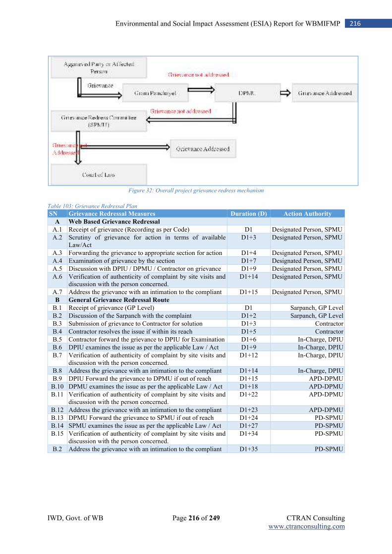
IWD, Govt. of WB Page 216 of 249 CTRAN Consulting www.ctranconsulting.com
216 Environmental and Social Impact Assessment (ESIA) Report for WBMIFMP
Figure 32: Overall project grievance redress mechanism
Table 103: Grievance Redressal Plan
SN Grievance Redressal Measures Duration (D) Action Authority
A Web Based Grievance Redressal
A.1 Receipt of grievance (Recording as per Code) D1 Designated Person, SPMU
A.2 Scrutiny of grievance for action in terms of available Law/Act
D1+3 Designated Person, SPMU
A.3 Forwarding the grievance to appropriate section for action D1+4 Designated Person, SPMU
A.4 Examination of grievance by the section D1+7 Designated Person, SPMU
A.5 Discussion with DPIU / DPMU / Contractor on grievance D1+9 Designated Person, SPMU
A.6 Verification of authenticity of complaint by site visits and discussion with the person concerned.
D1+14 Designated Person, SPMU
A.7 Address the grievance with an intimation to the compliant D1+15 Designated Person, SPMU
B General Grievance Redressal Route
B.1 Receipt of grievance (GP Level) D1 Sarpanch, GP Level
B.2 Discussion of the Sarpanch with the complaint D1+2 Sarpanch, GP Level
B.3 Submission of grievance to Contractor for solution D1+3 Contractor
B.4 Contractor resolves the issue if within its reach D1+5 Contractor
B.5 Contractor forward the grievance to DPIU for Examination D1+6 In-Charge, DPIU
B.6 DPIU examines the issue as per the applicable Law / Act D1+9 In-Charge, DPIU
B.7 Verification of authenticity of complaint by site visits and discussion with the person concerned.
D1+12 In-Charge, DPIU
B.8 Address the grievance with an intimation to the compliant D1+14 In-Charge, DPIU
B.9 DPIU Forward the grievance to DPMU if out of reach D1+15 APD-DPMU
B.10 DPMU examines the issue as per the applicable Law / Act D1+18 APD-DPMU
B.11 Verification of authenticity of complaint by site visits and discussion with the person concerned.
D1+22 APD-DPMU
B.12 Address the grievance with an intimation to the compliant D1+23 APD-DPMU
B.13 DPMU Forward the grievance to SPMU if out of reach D1+24 PD-SPMU
B.14 SPMU examines the issue as per the applicable Law / Act D1+27 PD-SPMU
B.15 Verification of authenticity of complaint by site visits and discussion with the person concerned.
D1+34 PD-SPMU
B.2 Address the grievance with an intimation to the compliant D1+35 PD-SPMU
IWD, Govt. of WB Page 217 of 249 CTRAN Consulting www.ctranconsulting.com
217 Environmental and Social Impact Assessment (ESIA) Report for WBMIFMP
Chapter 14: Institutional Arrangement for Implementation of ESMP
Irrigation & Waterways Department (IWD) would be the nodal department for the implementation of West Bengal Major Irrigation and Flood Management Project (WBMIFMP). To manage and oversee implementation of the project, a dedicated State Project Management Unit (SPMU) and two District Project Management Units (DPMUs) will be constituted. The SPMU will be headed by a Project Director in the rank of Chief Engineer and the DPMUs will be headed by Additional Project Directors in the rank of Superintending Engineers (Civil). In addition to the dedicated SPMU and two (2) DPMUs, four Irrigation Divisions (i.e. Howrah Irrigation Division, Hooghly Irrigation Division, Bardhhaman Irrigation Division and Right Bank Irrigation Division) under the Irrigation & Waterways Directorate will be constituted for implementing field works of the project exclusively, and these Divisions will be designated as District Project Implementation Units (DPIUs) of the Department 11 . The overall institutional arrangement for the implementation of the project is outlined in the diagram (Figure 33).
SPMU will be responsible for overall planning and implementation of the entire project. The SPMU and DPMUs will have different sub-units for their effective functioning. The SPMU and DPMUs will be staffed with the engagement of consultants, experts and various other categories of contractual staff to support the project. IWD will be responsible for overall planning and implementation of the entire project. It will ensure that ESMP is followed during project implementation. The project management consulting (PMC) firm to be engaged under the proposed loan will have one experienced Senior Environmental and one Senior Social cum Gender development specialist at SPMU level and two (2) Environmental (Junior) and two (2) Social cum Gender development specialist (Junior) at DPMU level. Sr. Environmental and Social cum Gender development specialist will directly report to PD and Jr. Safeguard specialists placed at DPMU level will report to respective APD at DPMU level as well as Sr. Safeguard specialist placed at SPMU level. These experts will assist SPMU and DPMU in implementing and monitoring environmental and social mitigation measures as per ESMP. Safeguard specialist together will also assist SPMU in preparing semi-annual safeguards monitoring reports as required by the World Bank.
11Orders for opening of new SPMU and DPMUs, manning of the Department staff in the said SPMU, DPMUs and also in DPIUs along with restructuring and redistribution of jurisdiction of these DPIUs have since been brought out in the Notification on Restructuring of the Irrigation & Waterways Department, vide No.12-W/2017-18 dated 8th August 2017 (Para-7 and Annex - 10 & 11 of the said Notification)
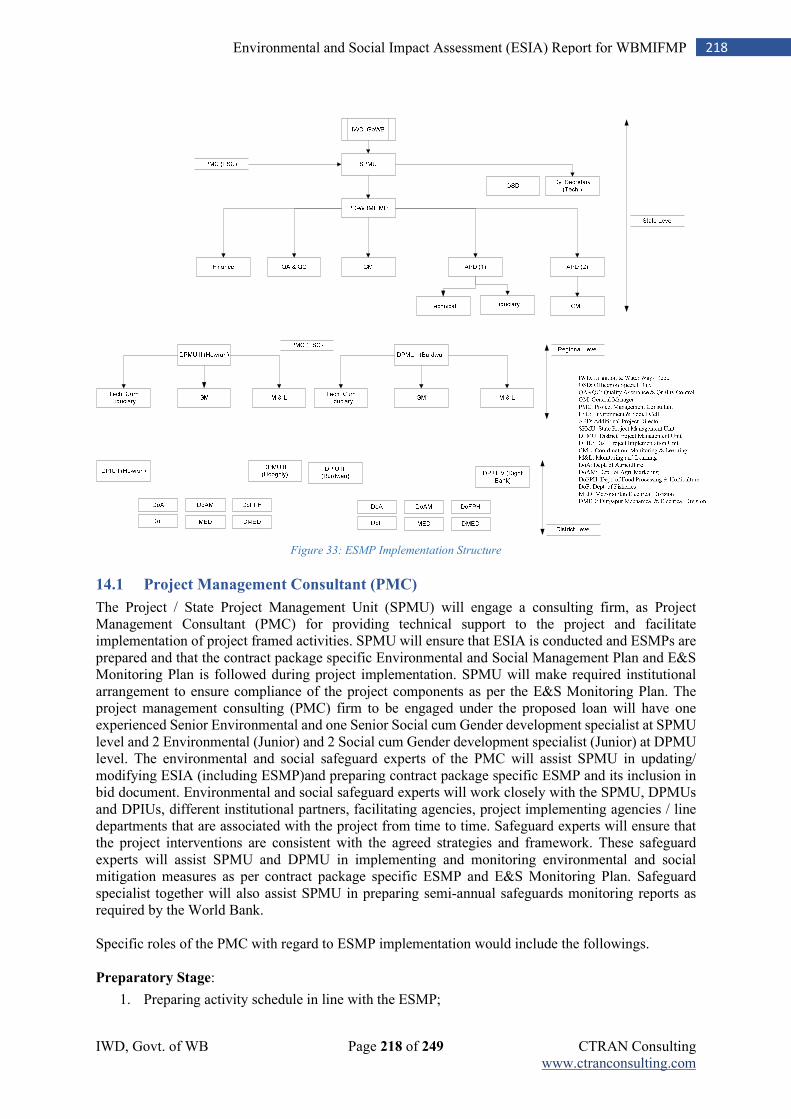
IWD, Govt. of WB Page 218 of 249 CTRAN Consulting www.ctranconsulting.com
218 Environmental and Social Impact Assessment (ESIA) Report for WBMIFMP
Figure 33: ESMP Implementation Structure
14.1 Project Management Consultant (PMC)
The Project / State Project Management Unit (SPMU) will engage a consulting firm, as Project Management Consultant (PMC) for providing technical support to the project and facilitate implementation of project framed activities. SPMU will ensure that ESIA is conducted and ESMPs are prepared and that the contract package specific Environmental and Social Management Plan and E&S Monitoring Plan is followed during project implementation. SPMU will make required institutional arrangement to ensure compliance of the project components as per the E&S Monitoring Plan. The project management consulting (PMC) firm to be engaged under the proposed loan will have one experienced Senior Environmental and one Senior Social cum Gender development specialist at SPMU level and 2 Environmental (Junior) and 2 Social cum Gender development specialist (Junior) at DPMU level. The environmental and social safeguard experts of the PMC will assist SPMU in updating/ modifying ESIA (including ESMP)and preparing contract package specific ESMP and its inclusion in bid document. Environmental and social safeguard experts will work closely with the SPMU, DPMUs and DPIUs, different institutional partners, facilitating agencies, project implementing agencies / line departments that are associated with the project from time to time. Safeguard experts will ensure that the project interventions are consistent with the agreed strategies and framework. These safeguard experts will assist SPMU and DPMU in implementing and monitoring environmental and social mitigation measures as per contract package specific ESMP and E&S Monitoring Plan. Safeguard specialist together will also assist SPMU in preparing semi-annual safeguards monitoring reports as required by the World Bank. Specific roles of the PMC with regard to ESMP implementation would include the followings. Preparatory Stage:
1. Preparing activity schedule in line with the ESMP;
IWD, Govt. of WB Page 219 of 249 CTRAN Consulting www.ctranconsulting.com
219 Environmental and Social Impact Assessment (ESIA) Report for WBMIFMP
2. Initial field visit to project sites and assessment of environmental and social aspects of project activities;
3. Discussion with different stakeholders, including implementing agencies (Dept. of agriculture, Food Processing and Horticulture, Fishery and Agri-Marketing) on safeguard measures and their expected role;
4. Finalizing TOR of the contractors incorporating safeguard measures to be taken; 5. Facilitate / organize training / workshops on safeguard measures for the stakeholders; 6. Designing study / assessment tools for periodic assessment, its piloting and finalization.
Implementation Stage:
1. Conducting periodic site visits and observe the measures taken as per the safeguard norms; 2. On the spot guidance to contractor / implementing agencies on safeguards; 3. Preparation of site-specific reports and sharing with SPMU-WBMIFMP; 4. Documentation of learning cases for sharing and dissemination; 5. Visual documentation of site-specific safeguard measures; 6. Tracking activity specific environmental and social monitoring indicators; 7. Organizing / facilitating refresher training courses for stakeholders; 8. Monthly and quarterly progress report preparation and submission to SPMU-WBMIFMP.
Post-Implementation Stage:
1. Consolidation of periodic monitoring reports; 2. Support in conducting environment and social audit; 3. Consolidation of good practice documents and its submission to SPMU-WBMIFMP; 4. Final sharing workshop on environment and social safeguard practices and its outcome.
14.1.1 Senior Safeguard Specialist at SPMU level (under PMC)
Environmental Specialist: The Environmental specialist at the SPMU level will look after environment issues in line with the ESIP. He/ she will guide the project team on environmental aspects and support in building environmental parameters to be built in the bids. He/ she will also guide the contracts and monitor their works with regards to ESMP implementation from time to time. In case of requirement, he/ she will prepare a detail environment management plan for different activities to be executed by the project. The expert will be guided by the Project Director and reporting to the Project Director directly. The detailed Terms of Reference for the Environment and Social cum gender development specialist is provided in Annexure-26. Social cum Gender Development Specialist: The Social cum Gender development specialist at the SPMU level will be the responsible person to guide the overall process related to social and gender aspects. The district / sub-district level implementing agencies will execute and monitor the social / gender components in consultation with the Social cum Gender development specialist. She / he will be associated in the screening process of such activities that require eviction of encroachers/ squatters and/or involvement of women and/or need special focus on tribal involvement. She/he will monitor the social processes followed in execution of the planned activities and realisation of the social / gender inclusion parameters. She / he will be looking after social / gender aspects of the project, including monitoring of social / gender indicators and coordinating with different agencies / institutions. The expert will be guided by the Project Director and reporting to the Project Director directly.
14.1.2 Junior Safeguard Specialist at DPMU level (under PMC)
In the similar fashion like SPMU, there will be one Environmental Expert (Junior) and one Social cum Gender expert (Junior) at each DPMU level to facilitate and support in implementation of ESMP.
IWD, Govt. of WB Page 220 of 249 CTRAN Consulting www.ctranconsulting.com
220 Environmental and Social Impact Assessment (ESIA) Report for WBMIFMP
14.2 M&E Agency
Along with PMC, one M&E agency will be engaged to monitor and periodic evaluation of project
implementation work. M&E agency will evaluate implementation of ESMP along with other
monitoring activities. Agency will be responsible for conducting quarterly monitoring of environmental
parameters for Air, Surface Water, Ground Water, Soil and Noise quality and mid-term as well as end-
term evaluation of ESMP implementation.
14.3 Role of IWD Staff in Implementation of EMP
The concept of PMC is inculcated in to the project delivery design to support the SPMU in monitoring, supervision, reporting and documentation. So, primary role of PMC will be providing planning and monitoring support to the SPMU as per the project design. The PMC will play a major role in ensuring the effective implementation of the ESMP. The PMU officials, including the Project Director will play a crucial role in terms of ensuring the adherence of the project to the ESMP, taking periodic stock of the progress in this direction and amicable settlement of issues, if any with regard to environment and social aspects. Role and responsibility of key officials of the SPMU is discussed below. The Project Director: The Project Director is having the overall responsibility of the project with regard to its planning, execution, monitoring and evaluation. The implementation of ESMP will be guided by him and will be the point person for reporting to the World Bank on environment and social safeguard measures and its outcome. He/she will take review of the progress periodically and discuss with the safeguard specialists from time to time on issues and its amicable solution. The grievance redressal mechanism at the State level will be steered by him/her. He/she will conduct periodic monitoring to assess the execution of safeguard measures and advising on required improvement, if any. He/she will also be coordinating with different relevant institutions / organization and Govt. departments for support and services.
APD-Technical: The Additional Project Director, Technical is responsible for preparation of bidding documents for works, supply of goods, consultancy &non-consultancy services, invitation of bids, acceptance and agreement. He will oversee the construction related mitigation measures, as per the ESMP such as management of construction waste, adherence of contractor to proposed safeguard measures during construction etc. He/she will advise the contractor to adhere to the environmental and social norms.
The APD-CML: The Additional Project Director, responsible for Coordination, Monitoring and Learning (CML) will support in monitoring and supervision of environmental and social safeguard measures from time to time and report to PD-WBMIFMP. She/he will coordinate with the safeguard specialists of the SPMU and DPMU and take stock of the situation.
14.4 Institutional arrangements by contractor
Each implementing contractor will appoint an Environment, Health and Safety (EHS)officer with graduate qualifications in Civil or Environmental Engineering with specialization and/or additional qualification in Occupational Health and Safety, and, at least 7 years of relevant experience. EHS officer will primary be responsible for compliance of workers EHS aspects at Camp as well as work site. He will also be responsible for implementation of EHS measures for different kind of allied project activities like material transportation, vehicular movement and etc. Summary of EHS compliance report shall also be included with “Monthly compliance report on ESMP implementation” submitted by contractors.
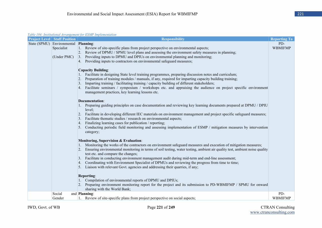
IWD, Govt. of WB Page 221 of 249 CTRAN Consulting www.ctranconsulting.com
221 Environmental and Social Impact Assessment (ESIA) Report for WBMIFMP
Table 104: Institutional Arrangement for ESMP Implementation
Project Level Staff Position Responsibility Reporting To
State (SPMU) Environmental Specialist (Under PMC)
Planning: 1. Review of site-specific plans from project perspective on environmental aspects; 2. Review of DPMU / SPMU level plans and assessing the environment safety measures in planning; 3. Providing inputs to DPMU and DPIUs on environmental planning and monitoring; 4. Providing inputs to contractors on environmental safeguard measures; Capacity Building: 1. Facilitate in designing State level training programmes, preparing discussion notes and curriculum; 2. Preparation of training modules / manuals, if any, required for imparting capacity building training; 3. Imparting training / facilitating training / capacity building of different stakeholders; 4. Facilitate seminars / symposium / workshops etc. and appraising the audience on project specific environment
management practices, key learning lessons etc. Documentation: 1. Preparing guiding principles on case documentation and reviewing key learning documents prepared at DPMU / DPIU
level; 2. Facilitate in developing different IEC materials on environment management and project specific safeguard measures; 3. Facilitate thematic studies / research on environmental aspects; 4. Finalizing learning cases for publication / reporting; 5. Conducting periodic field monitoring and assessing implementation of ESMP / mitigation measures by intervention
category; Monitoring, Supervision & Evaluation: 1. Monitoring the works of the contractors on environment safeguard measures and execution of mitigation measures; 2. Ensuring environmental monitoring in terms of soil testing, water testing, ambient air quality test, ambient noise quality
test etc. and compare the changes; 3. Facilitate in conducting environment management audit during mid-term and end-line assessment; 4. Coordinating with Environment Specialist of DPMUs and reviewing the progress from time to time; 5. Liaison with relevant Govt. agencies and addressing their quarries, if any; Reporting: 1. Compilation of environmental reports of DPMU and DPIUs; 2. Preparing environment monitoring report for the project and its submission to PD-WBMIFMP / SPMU for onward
sharing with the World Bank;
PD-WBMIFMP
Social and Gender
Planning: 1. Review of site-specific plans from project perspective on social aspects;
PD-WBMIFMP
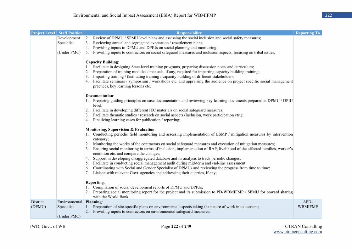
IWD, Govt. of WB Page 222 of 249 CTRAN Consulting www.ctranconsulting.com
222 Environmental and Social Impact Assessment (ESIA) Report for WBMIFMP
Project Level Staff Position Responsibility Reporting To
Development Specialist (Under PMC)
2. Review of DPMU / SPMU level plans and assessing the social inclusion and social safety measures; 3. Reviewing annual and segregated evacuation / resettlement plans; 4. Providing inputs to DPMU and DPIUs on social planning and monitoring; 5. Providing inputs to contractors on social safeguard measures and inclusion aspects, focusing on tribal issues; Capacity Building: 1. Facilitate in designing State level training programs, preparing discussion notes and curriculum; 2. Preparation of training modules / manuals, if any, required for imparting capacity building training; 3. Imparting training / facilitating training / capacity building of different stakeholders; 4. Facilitate seminars / symposium / workshops etc. and appraising the audience on project specific social management
practices, key learning lessons etc. Documentation: 1. Preparing guiding principles on case documentation and reviewing key learning documents prepared at DPMU / DPIU
level; 2. Facilitate in developing different IEC materials on social safeguard measures; 3. Facilitate thematic studies / research on social aspects (inclusion, work participation etc.); 4. Finalizing learning cases for publication / reporting; Monitoring, Supervision & Evaluation: 1. Conducting periodic field monitoring and assessing implementation of ESMP / mitigation measures by intervention
category; 2. Monitoring the works of the contractors on social safeguard measures and execution of mitigation measures; 3. Ensuring social monitoring in terms of inclusion, implementation of RAP, livelihood of the affected families, worker’s
condition etc. and compare the changes; 4. Support in developing disaggregated database and its analysis to track periodic changes; 5. Facilitate in conducting social management audit during mid-term and end-line assessment; 6. Coordinating with Social and Gender Specialist of DPMUs and reviewing the progress from time to time; 7. Liaison with relevant Govt. agencies and addressing their quarries, if any; Reporting: 1. Compilation of social development reports of DPMU and DPIUs; 2. Preparing social monitoring report for the project and its submission to PD-WBMIFMP / SPMU for onward sharing
with the World Bank;
District (DPMU)
Environmental Specialist (Under PMC)
Planning: 1. Preparation of site-specific plans on environmental aspects taking the nature of work in to account; 2. Providing inputs to contractors on environmental safeguard measures;
APD-WBMIFMP
IWD, Govt. of WB Page 223 of 249 CTRAN Consulting www.ctranconsulting.com
223 Environmental and Social Impact Assessment (ESIA) Report for WBMIFMP
Project Level Staff Position Responsibility Reporting To
Capacity Building: 1. Facilitate in designing district level training programs, preparing discussion notes and curriculum; 2. Preparation of training modules / manuals, if any, required for imparting capacity building training; 3. Imparting training / facilitating training / capacity building of different stakeholders; 4. Facilitate seminars / symposium / workshops etc. and appraising the audience on project specific environment
management practices, key learning lessons etc. Documentation: 1. Preparing case studies and learning lesson documents based on field visits; 2. Developing different IEC materials on environment management and project specific safeguard measures; 3. Conducting / support in conducting thematic studies / research on environmental aspects; 4. Finalizing learning cases for publication / reporting; Monitoring, Supervision & Evaluation: 1. Conducting field monitoring and assessing implementation of ESMP / mitigation measures by intervention category; 2. Monitoring the works of the contractors on environment safeguard measures and execution of mitigation measures; 3. Ensuring environmental monitoring in terms of soil testing, water testing, ambient air quality test, ambient noise quality
test etc. and compare the changes; 4. Support in conducting environment management audit during mid-term and end-line assessment; 5. Coordinating with Environment Specialist of SPMUs and appraising the progress from time to time; 6. Liaison with relevant Govt. agencies and addressing their quarries, if any; Reporting: Preparing environment monitoring report for the DPMU and its submission to SPMU for review and finalization.
Social and Gender Development Specialist (Under PMC)
Planning: 1. Preparation of site-specific plans on social aspects taking the nature of work in to account; 2. Providing inputs to contractors on social safeguard measures, inclusion of tribal, female works and their safety measures
etc.; 3. Discussing with RAP implementing agencies (DLC / BLC) and ensuring coverage of all the project affected families; Capacity Building: 1. Facilitate in designing district level training programs, preparing discussion notes and curriculum; 2. Preparation of training modules / manuals, if any, required for imparting capacity building training; 3. Imparting training / facilitating training / capacity building of different stakeholders; 4. Facilitate seminars / symposium / workshops etc. and appraising the audience on project specific social safeguard
measures, key learning lessons etc.; Documentation:
APD-WBMIFMP
IWD, Govt. of WB Page 224 of 249 CTRAN Consulting www.ctranconsulting.com
224 Environmental and Social Impact Assessment (ESIA) Report for WBMIFMP
Project Level Staff Position Responsibility Reporting To
1. Preparing case studies and learning lesson documents based on field visits; 2. Developing different IEC materials on social safeguard measures of the project; 3. Conducting / support in conducting thematic studies / research on social issues, project benefits in addressing social
development etc.; 4. Finalizing learning cases for publication / reporting; Monitoring, Supervision & Evaluation: 1. Conducting field monitoring and assessing implementation of ESMP / mitigation measures by intervention category; 2. Development and management of disaggregated database by sex, social groups, economic groups etc. 3. Monitoring the works of the contractors on social safeguard measures and execution of mitigation measures; 4. Coordinating with Social cum Gender Development Specialist of SPMUs and appraising the progress from time to time; 5. Liaison with relevant Govt. agencies and addressing their quarries, if any; Reporting: Preparing social monitoring report for the DPMU and its submission to APD-WBMIFMP and to SPMU for review and finalization.
IWD, Govt. of WB Page 225 of 249 CTRAN Consulting www.ctranconsulting.com
225 Environmental and Social Impact Assessment (ESIA) Report for WBMIFMP
Chapter 15: Budget for ESMP Implementation
SN Budget Heads Unit Qt. Unit Qt. Unit Cost Total Cost Reference
A Regulatory Clearance
Consent for establishment of hot mixing plant, HMM, batching plants, diesel generator and etc. (to be built into Contractor's contract specifications)
Lumpsum
18,00,000 Built into project cost
Permission for tree cutting Lumpsum
6,40,000 Built into project cost
B Workers Safety and Construction Camp
Camp establishment (to be built into Contractor's contract specifications)
40,00,000 Built into project cost
Workers EHS Measures
67,50,000 Built into project cost
C Compensatory plantation 3720 Nos.
3,000 1,18,20,000 Included in Provisional Sum D Waste Management
Disposal of desilted material (Except Mundeswari River) 4290236 Cum
113 48,47,96,668
Vegitation waste
Lumpsum
7,00,000 Built into project cost
Disposal of C&D Waste 558863 Cum
111 6,20,33,793 Built into project cost E Environmental Quality Monitoring by Contractor Lumpsum
25,50,000 Built into project cost
Environmental Quality Monitoring by M&E agency 3 Times
10,74,833 94,94,700 Built into M&E cost EQM of other parameters Lumpsum
40,00,000 Built into project cost
Post Project EQM (2 Years) 2 Times/ Year 47 30,000 28,20,000
F Human Resource
SPMU-Social & Gender Expert No. 1 Month 60 1,50,000 90,00,000
SPMU-Environment Expert No. 1 Month 60 1,50,000 90,00,000
DPMU-Social & Gender Asst. No. 2 Month 60 75,000 90,00,000
DPMU-Environment Asst. No. 2 Month 60 75,000 90,00,000
Sub-Total
3,60,00,000
G Capacity Building
Training with Refresher
SPMU Days 5 Person 6 3,500 1,05,000 Built into project cost DPMU Days 5 Person 15 2,500 1,87,500 Built into project cost DPIU Days 5 Person 25 2,000 2,50,000 Built into project cost Contractors Days 3 Person 75 1,000 2,25,000 Built into project cost Farmers / FPO training on IPNM Days 3 Person 5000 500 75,00,000 Built into project cost
IWD, Govt. of WB Page 226 of 249 CTRAN Consulting www.ctranconsulting.com
226 Environmental and Social Impact Assessment (ESIA) Report for WBMIFMP
SN Budget Heads Unit Qt. Unit Qt. Unit Cost Total Cost Reference Sub-Total
82,67,500
Exposure
SPMU Days 5 Person 6 5,000 1,50,000 Built into project cost DPMU Days 5 Person 5 3,500 87,500 Built into project cost SPIU Days 5 Person 5 3,500 87,500 Built into project cost FPOs Days 2 Person 25 3,000 1,50,000 Built into project cost Lead Farmers Days 3 Person 500 1,500 22,50,000 Built into project cost Sub-Total
27,25,000
Demonstration
INM No. 25 Blocks 41 15,000 1,53,75,000 Built into project cost IPM No. 25 Blocks 41 15,000 1,53,75,000 Built into project cost Climate Resilient Farming Tech. No. 50 Blocks 41 15,000 3,07,50,000 Built into project cost Sub-Total
6,15,00,000
H Awareness Drive
Workers / Labour Force No. 2 Camps 41 15,000 12,30,000 Built into project cost Villages / Community No. 5 Blocks 41 25,000 51,25,000 Built into project cost IEC Materials No. 3 Copy 50,000 10 15,00,000 Built into project cost Sub-Total
78,55,000
I EMR report preparation Quarter 2 Year/ Package 5 1,20,000 2,40,00,000
Environment & Social Audit No. 2 Times
80,00,000 1,60,00,000
Sub-Total
4,00,00,000
Grand Total
74,77,52,661
Note: Budget for disposal of desilted material of Mundeswari river, dewatering of desilted material is not included as cost already included in main project cost
IWD, Govt. of WB Page 227 of 249 CTRAN Consulting www.ctranconsulting.com
227 Environmental and Social Impact Assessment (ESIA) Report for WBMIFMP
Related Documents