Environment Committee Published 16 October 2019 24 September 2019 16 October 2019 ENVIRONMENT COMMITTEE A meeting of the Environment Committee will be held on THURSDAY 24 OCTOBER 2019 in the Council Chamber, Ebley Mill, Ebley Wharf, Stroud at 7.00 pm. Kathy O’Leary Chief Executive Please Note: This meeting will be filmed for live or subsequent broadcast via the Council’s internet site (www.stroud.gov.uk ). By entering the Council Chamber you are consenting to being filmed. The whole of the meeting will be filmed except where there are confidential or exempt items, which may need to be considered in the absence of the press and public. A G E N D A 1 APOLOGIES To receive apologies for absence. 2 DECLARATIONS OF INTEREST To receive declarations of interest. 3 MINUTES To approve the minutes of the meeting held on 12 September 2019. 4 PUBLIC QUESTION TIME The Chair of Committee will answer questions from members of the public submitted in accordance with the Council’s procedures. DEADLINE FOR RECEIPT OF QUESTIONS Noon on MONDAY 21 OCTOBER 2019. Questions must be submitted in writing to the Chief Executive, Democratic Services, Ebley Mill, Ebley Wharf, Stroud and sent by post or by Email: [email protected] 5 COMMUNITY INFRASTRUCTURE LEVY (CIL) SPENDING ALLOCATIONS To recommend CIL spending allocations to Strategy and Resources Committee. 6 LOCAL PLAN REVIEW – DRAFT LOCAL PLAN FOR PUBLIC CONSULTATION To approve the content of the Draft Plan document for the purposes of public consultation and to delegate to the Head of Planning Strategy the authority to make minor map, textual and formatting changes to the draft document for public consultation. Page 1 of 288 Page 1 of 288

ENVIRONMENT COMMITTEE - Stroud District Council · Krista Harris, Senior Community Infrastructure Officer Tel: 01453 754325 Email: [email protected] Options Options are:
May 31, 2020
Welcome message from author
This document is posted to help you gain knowledge. Please leave a comment to let me know what you think about it! Share it to your friends and learn new things together.
Transcript

Environment Committee Published 16 October 2019 24 September 2019
16 October 2019
ENVIRONMENT COMMITTEE
A meeting of the Environment Committee will be held on THURSDAY 24 OCTOBER 2019 in the Council Chamber, Ebley Mill, Ebley Wharf, Stroud at 7.00 pm.
Kathy O’Leary
Chief Executive Please Note: This meeting will be filmed for live or subsequent broadcast via the Council’s internet site (www.stroud.gov.uk). By entering the Council Chamber you are consenting to being filmed. The whole of the meeting will be filmed except where there are confidential or exempt items, which may need to be considered in the absence of the press and public.
A G E N D A 1 APOLOGIES To receive apologies for absence. 2 DECLARATIONS OF INTEREST
To receive declarations of interest. 3 MINUTES To approve the minutes of the meeting held on 12 September 2019.
4 PUBLIC QUESTION TIME The Chair of Committee will answer questions from members of the public submitted
in accordance with the Council’s procedures. DEADLINE FOR RECEIPT OF QUESTIONS Noon on MONDAY 21 OCTOBER 2019. Questions must be submitted in writing to the Chief Executive, Democratic Services,
Ebley Mill, Ebley Wharf, Stroud and sent by post or by Email: [email protected]
5 COMMUNITY INFRASTRUCTURE LEVY (CIL) SPENDING ALLOCATIONS To recommend CIL spending allocations to Strategy and Resources Committee. 6 LOCAL PLAN REVIEW – DRAFT LOCAL PLAN FOR PUBLIC CONSULTATION
To approve the content of the Draft Plan document for the purposes of public consultation and to delegate to the Head of Planning Strategy the authority to make minor map, textual and formatting changes to the draft document for public consultation.
Page 1 of 288Page 1 of 288
Environment Committee Published 16 October 2019 24 September 2019
7 MEMBERS' QUESTIONS
See Agenda Item 4 for deadline for submission.
Members of Environment Committee 2019-2020 Councillor Simon Pickering (Chair) Councillor Nick Hurst Councillor George James (Vice-Chair) Councillor Haydn Jones Councillor Chris Brine Councillor Skeena Rathor Councillor Paul Denney Councillor Haydn Sutton Councillor Jim Dewey Councillor Jessica Tomblin Councillor Trevor Hall Councillor Tim Williams
Page 2 of 288Page 2 of 288
2019/20
Environment Committee Subject to approval at the next meeting 12 September 2019
ENVIRONMENT COMMITTEE
12 September 2019
7.00 pm – 9.05 pm
Council Chamber, Ebley Mill, Stroud
Minutes
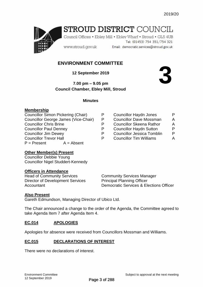
3 Membership Councillor Simon Pickering (Chair) P Councillor Haydn Jones P Councillor George James (Vice-Chair) P Councillor Dave Mossman A Councillor Chris Brine P Councillor Skeena Rathor A Councillor Paul Denney P Councillor Haydn Sutton P Councillor Jim Dewey P Councillor Jessica Tomblin P Councillor Trevor Hall P Councillor Tim Williams A P = Present A = Absent Other Member(s) Present Councillor Debbie Young Councillor Nigel Studdert-Kennedy Officers in Attendance Head of Community Services Community Services Manager Director of Development Services Principal Planning Officer Accountant Democratic Services & Elections Officer Also Present Gareth Edmundson, Managing Director of Ubico Ltd. The Chair announced a change to the order of the Agenda, the Committee agreed to take Agenda Item 7 after Agenda Item 4. EC.014 APOLOGIES Apologies for absence were received from Councillors Mossman and Williams. EC.015 DECLARATIONS OF INTEREST There were no declarations of interest.
Page 3 of 288Page 3 of 288

2019/20
Environment Committee Subject to approval at the next meeting 12 September 2019
EC.016 MINUTES RESOLVED That the Minutes of the meeting held on 6 June 2019 are
accepted as a correct record. EC.017 PUBLIC QUESTION TIME Public questions were submitted. They were answered by Councillor Pickering. (Refer to the Council’s webcast and Agenda Item 4). EC.018 ADOPT CHALFORD DESIGN STATEMENT AS SUPPLEMENTARY
PLANNING DOCUMENT The Principal Planning Officer introduced the above report and advised that it was recommended that the statement should be adopted as a Supplementary Planning Document (SPD) which would be a material consideration in planning decisions. He commended the hard work of Chalford Design Group who had been working on this since 2016 and had worked closely with Officers. Councillor Jones asked whether the Chalford Design Statement would need to be taken into consideration on current ongoing planning applications. The Principal Planning Officer confirmed that it would need to be considered as it would be a material consideration. Councillor Jones stated it was useful for Councillors involved in planning to have a source of local community input on top of the National Planning Policy Framework and the Local Plan. He also advised it would be helpful to have hard copies of the adopted SPD’s available to Members at the Development Control Committees. Councillor Young stated that this had been worked on for a considerable length of time and that it was fantastic to see it completed. She offered her thanks to the large number of people who had been involved and had contributed to the Design Statement. Councillor Pickering advised that it would be great if we had more design statements. He also advised that the Design Statement did not contain anything regarding integrating renewables, and that moving forward anyone considering creating a Design Statement should consider including this. On being put to the vote, the Motion was carried unanimously. RESOLVED To adopt the Chalford Design Statement as a Supplementary
Planning Document (SPD) EC.019 BUDGET MONITORING REPORT 2019/20 Q1 In presenting the above report, the Accountant drew attention to several paragraphs, and advised that the report focused on the budget holders estimated spend up to the end of the financial year. Councillor Sutton raised a question regarding the frequency of grass/hedge cutting in the District. The Chair and Head of Community Services advised that the frequency of grass cutting had been decided by the Environment Committee in 2018 and that if
Page 4 of 288Page 4 of 288

2019/20
Environment Committee Subject to approval at the next meeting 12 September 2019
Councillor Sutton would like this changed then the issue would need to be raised by the Committee and then the budget could be revisited. Councillor Pickering brought the overspend listed in paragraph 8 to the Committee’s attention, he stated that although it was an overspend it was a good thing that we had revaluated job descriptions and were trying to retain staff so a good planning service could be provided. Councillor Denney stated that it was great that the cycling and walking plan was coming together. On being put to the vote, the Motion was carried unanimously. RESOLVED To note the outturn forecast for the General Fund Revenue
budget and the Capital programme for this Committee. EC.020 UBICO PERFORMANCE UPDATE The Managing Director of UBICO paid tribute to Jim Hill a UBICO driver who had passed away in August, he thanked him for all his work with UBICO and sent condolences to his family. The Managing Director of UBICO gave a presentation which provided an overview of the operations, a wider view of the company and it’s focus and the potential themes being looked at for next years business plan. Members asked questions and received replies on the following topics:
Evening waste collection Commercial waste collection Compressed natural gas / hybrid vehicles Trade Unions Health and Safety Weekly recycling Garden waste The range and type of materials recycled The incinerator – has this effected how Stroud District residents recycle? Contaminants – ways we can highlight to residents what can and cannot be
recycled.
EC.021 APPOINTMENT OF PERFORMANCE MONITORING REPRESENTATIVES
Councillors Brine and Sutton were appointed as Performance Monitors. EC.022 MEMBER REPORTS a) Planning Review Panel - A verbal summary was provided by Councillor Jones, he
advised that the cross-party panel had been reviewing the Local Plan and that they had a challenging target of approximately 7,000 houses to meet. He also advised that there may be a requirement to take on more housing from an adjoining authority under the duty to cooperate rules. They were waiting for the results of an ongoing Gloucestershire wide review of housing requirements which
Page 5 of 288Page 5 of 288

2019/20
Environment Committee Subject to approval at the next meeting 12 September 2019
should be released in September or October. The Local Plan final draft consultation will hopefully be brought to the Environment Committee on 24 October 2019.
b) Stroud Concordat – Councillor Pickering advised that the last meeting only had two items on the agenda, the first item was to receive the minutes and report from the car park working group, they had been looking at whether there was a different way of allocating the short stay and long stay parking. The conclusion that they reached was to increase the opportunities for short stay parking and move some of the long stay parking. If changes were required a report would be taken to the Strategy and Resources Committee for a decision. The second item was a meeting with Ian Mean from Business West and David Owen from GFirst LEP and a discussion around regeneration opportunities in Stroud.
c) Performance Monitoring Report – The Director of Development Services updated
the Committee referring to the report that had been circulated prior to the meeting. EC.023 WORK PROGRAMME The Director of Development Services advised the Committee of additions to the Work Programme as follows:
Report on the Glover Review to be added to 5 December 2019 Committee Meeting.
Cam and Horsley Neighbourhood Development Plans to be added to 6 February 2020 Committee Meeting.
Local Plan – Regulation 19 – Recommend to Council for submission to be added to the June/July 2020 Committee Meeting.
CIL spending proposals to be added to September/October 2020 Committee Meeting
Ash dieback report to be added to 5 December 2019 Committee Meeting. RESOLVED To note the work programme. EC.024 MEMBERS’ QUESTIONS There were none. The meeting ended at 9.05 pm.
Chair
Page 6 of 288Page 6 of 288

Environment Committee Agenda Item 5 24 October 2019
STROUD DISTRICT COUNCIL
ENVIRONMENT COMMITTEE
24 OCTOBER 2019
AGENDA ITEM NO
5
Report Title COMMUNITY INFRASTRUCTURE LEVY (CIL) SPENDING ALLOCATIONS
Purpose of Report To recommend CIL spending allocations to Strategy and Resources Committee.
Decision(s) The Committee RECOMMENDS to Strategy & Resources Committee that funding commitments are agreed according to the report below.
Consultation and Feedback
Members of Planning Review Panel have considered these proposals and they have been amended to take account of points raised.
Financial Implications and Risk Assessment
There are sufficient funds collected by CIL to date to cover the spend as outlined in Appendix, and that it meets the criteria required for the Regulation 123 list. Adele Rudkin, Accountant Tel: 01453 754109 Email: [email protected] Risk Assessment: Having a robust governance system in place for managing CIL spending is intending to mitigate the risk of development taking place without adequate infrastructure in place to support it.
Legal Implications
Local authorities must spend the levy on infrastructure needed to support the development of their area, who will decide what infrastructure is needed in line with adopted policy. Patrick Arran, Interim Head of Legal Services Tel: 01453 754369 Email: [email protected]
Report Author
Pippa Stroud, Policy Implementation Manager Tel: 01453 754099 Email: [email protected]
Krista Harris, Senior Community Infrastructure Officer Tel: 01453 754325 Email: [email protected]
Options Options are: 1. approve the proposed CIL spending allocations; or 2. amend the proposed CIL spending allocations, or 3. delay the proposed CIL spending allocations for further internal discussion.
Performance Management Follow Up
Annual reports will be considered by Environment Committee as part of the governance and budgetary process to manage the spending of CIL income.
Background Papers/ Appendices
Appendix A: Funding recommendations
Page 7 of 288Page 7 of 288

Environment Committee Agenda Item 5 24 October 2019
INTRODUCTION / BACKGROUND
1.1 Community Infrastructure Levy (CIL) was introduced by government in 2010 as a
mechanism to fund the infrastructure required to deliver Local Plan growth strategies. The District Council adopted CIL in February 2017 and implemented the charge from April 2017.
1.2 CIL partially replaces the s.106 arrangements which secure payments through the
planning system for the infrastructure necessary for new development. 1.3 CIL liability is calculated per m² of new dwellings (£90.72/m²) and retail warehouses
(£85.05/m²), of which either 15% or 25% goes to local Town and Parish Councils as a ‘neighbourhood portion’ according to their NDP status and 5% is retained by the local authority to cover the costs of administrating the scheme. The remainder of the funding collected is held by the local authority to be spent on strategic capital infrastructure projects.
1.4 CIL payments are triggered by the commencement of development and can be paid
in instalments. At time of writing, two and a half years after CIL launch, funds of £431,100 have been collected and a further £241,200 is currently due for collection. Profiles show that a total of £1,750,400 funds could be collected by CIL, dependent on a number of factors.
1.5 Council resolved in December 2018 to approve a mechanism to priorities spending
on qualifying infrastructure projects. This report covers the results of the implementation of that mechanism and sets out a recommended spend.
2. ISSUES FOR CONSIDERATION 2.1 The strategic infrastructure projects that CIL can be spent on are outlined in the
adopted Regulation 123 list and related Infrastructure Delivery Plan, and are broadly grouped into capital infrastructure items such as education, social infrastructure, transport and strategic flood risk. Projects must also align with the objectives of the Councils adopted Local Plan.
2.2 However, CIL income will not be sufficient to meet all the district’s infrastructure
needs. Instead, CIL should be viewed as one aspect of a number of infrastructure funding streams available to providers. CIL Strategic funding cannot be used to support current existing funding programmes or deficiencies.
2.3 Given that the Regulation 123 list is the basis for eligible project types, all the
strategic infrastructure providers who deliver these service types were contacted with information on how to apply for CIL strategic funding. These providers included the County Council (for Education, Highways, and Libraries), the Environment Agency, local colleges, Emergency Services, and certain service areas within the District Council especially those known to deliver unique capital infrastructure projects.
Page 8 of 288Page 8 of 288

Environment Committee Agenda Item 5 24 October 2019
2.4 Since CIL has the two funding routes; 1) the neighbourhood portion to Town and Parish Councils for local projects and 2) the strategic infrastructure delivery fund, it is important that applicants note the difference in order to understand their eligibility. Strategic infrastructure must serve a significant population or cover a geographical area much wider than their immediate area. Social infrastructure projects such as community halls, local open space or parish sports provision are not therefore seen to be ‘strategic’ and as such should be funded via the parish proportion of CIL, should the relevant town or parish council wish to do so
2.5 Some strategic delivery agencies that were contacted did not have projects ready to
deliver in 2020/2021. We have allowed these organisations to submit basic project information in the form of an ‘Expression of Interest’. This illustrates providers’ interest in seeking funding for that project in future years. This approach also gives SDC useful evidence as it proves that the infrastructure demand for future years is significant, and this project data can be used in the formulation of the Infrastructure Delivery Statement which will ultimately replace the Regulation 123 list.
2.6 Bids received were recorded and assessed for their fit against the CIL Strategic
Funding core objectives; in particular for their ability to directly meet the priorities of the Infrastructure Delivery Plan, align with the Council’s Local Plan and help to address the infrastructure needs arising from development. A meeting with CIL Officers and Senior Managers was held to discuss and assess the merits of individual applications.
2.7 The projects that best aligned with the policy requirements also appear to offer good
value, and could be easily accommodated within the available CIL budget. 2.8 Officers also noted that there were a significant number of projects submitted as
‘Expressions of Interest’ for future years. The County Council has indicated a need for investment of around £852k in Education, alongside a need for £20 million to fund highways improvements and sustainable travel provision. In addition, expressions of interest show £300k is required for strategic waste provision, £200k for flood risk management infrastructure, £14 million for social infrastructure, £1 million for the canal and £3 million for health and wellbeing projects. Clearly these sums are likely to be far in excess of what may be collected by CIL within the Stroud District, but it provides justification for the need to retain some funding for use in years beyond 2020/2021.
3. CONCLUSION / RECOMMENDATION 3.1 It is proposed that payments are made to infrastructure providers in accordance with
the recommendations made at Appendix A. This totals £114,000, which is 26% of the total funding currently available (£431,100).
3.2 Members will note that not all of the available funding is proposed to be spent this
year; instead, it is considered prudent to retain some funding to create a larger fund over time in order to support more significant infrastructure projects in future.
Page 9 of 288Page 9 of 288
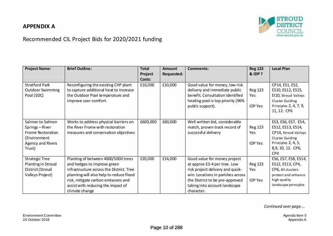
Environment Committee Agenda Item 5 24 October 2019 Appendix A
APPENDIX A
Recommended CIL Project Bids for 2020/2021 funding
Project Name:
Brief Outline: Total Project Costs:
Amount Requested:
Comments: Reg 123 & IDP ?
Local Plan
Stratford Park Outdoor Swimming Pool (SDC)
Reconfiguring the existing CHP plant to capture additional heat to increase the Outdoor Pool temperature and improve user comfort.
£10,000 £10,000 Good value for money, low risk delivery and immediate public benefit. Consultation identified heating pool is top priority (96% public support).
Reg 123 Yes IDP Yes
CP14, ES1, ES2, ES10, ES12, ES15, EI10, Stroud Valleys
Cluster Guiding
Principles 2, 4, 7, 9, 11, 12. CP6
Salmon to Salmon Springs – River Frome Restoration (Environment Agency and Rivers Trust)
Works to address physical barriers on the River Frome with restoration measures and conservation objectives
£600,000 £60,000 Well written bid, considerable match, proven track record of successful delivery
Reg 123 Yes IDP Yes
ES3, ES6, ES7, ES4, ES12, ES13, ES14, CP14, Stroud Valleys
Cluster Guiding Principles 2, 4, 5, 8,9, 10, 12. CP6, CP4
Strategic Tree Planting in Stroud District (Stroud Valleys Project)
Planting of between 4000/5000 trees and hedges to improve green infrastructure across the District. Tree planning will also help to reduce flood risk, mitigate carbon emissions and assist with reducing the impact of climate change
£20,000 £14,000
Good value for money project at approx £3-4 per tree. Low risk project delivery and quick-win. Locations in parishes across the District to be pre-approved taking into account landscape character.
Reg 123 Yes IDP Yes
ES6, ES7, ES8, ES14, ES12, ES13, CP4, CP6, All clusters
protect and enhance high quality
landscape principles
Continued over page....
Page 10 of 288Page 10 of 288

Environment Committee Agenda Item 5 24 October 2019 Appendix A
Rural SuDS (SDC) Working with natural processes to elevate flooding and to protect/enhance riverine habitats
£85,000 £30,000 For capital works, good project bid. Benefits to environment and amenity.
Reg 123 Yes IDP Yes
Cp4, Cp6, Es4, CP14, All clusters
protect and enhance high quality
landscape principles
Total £114,000
CIL Bids for 2020/2021 funding – not recommended for approval
Project Name:
Brief Outline: Total Project Costs:
Amount Requested:
Comments: Reg 123 / IDP ?
Local Plan
Waste Container provision (SDC)
Provision of waste receptacles for new properties essential to continuation of existing waste regime
£25,000/annum
£15,000 No capital match. Reg 123 List excludes on site collection facilities.
Reg 123 No IDP No
No
The REACH (South Glos & Stroud College)
Special support facility for 14-16 year olds who have been permanently excluded from school especially with social and mental health issues, enables them to engage and achieve in education
£595,000 revenue + £540,000 capital
£540,000 (capital costs)
Not primary infrastructure with direct causal link to increase in development. No capital match, amount beyond CIL funding availability.
Reg 123 not direct link IDP Yes 58
CP6 but not direct. Berkeley Cluster
Guiding Principles 2.
College Multi-use Gaming Area (MUGA), South Glos & Stroud College, Berkeley
Sporting facilities for students studying at Berkeley University Tech, which would be made available to the public outside working hours
£240,000 £240,000 Large request with no capital match. 127 learners from Stroud District attend Berkeley UTC. Project not identified in latest open space and GI study.
Reg 123 not direct IDP Yes
ES15 and CP6 but not direct. Berkeley
Cluster Guiding
Principles 2.
Stroud Sub Rooms – Development Phase (Stroud Town Council)
Full refurbishment of building and forecourt to provide more accessible and inclusive services. Improvements will help grow the potential of the building.
£1.2mil £ tbc Specific project needs to be presented that more aligns with CIL Regs. To be treated as expression of interest for future years.
Reg 123 Yes IDP yes but not direct
ES16, EI10, CP14, ES10, Stroud Valleys
Cluster Guiding Principles 7, 9.
Page 11 of 288Page 11 of 288

Environment Committee Agenda Item 6 24 October 2019
STROUD DISTRICT COUNCIL
ENVIRONMENT COMMITTEE
24 OCTOBER 2019
AGENDA ITEM NO
6
Report Title LOCAL PLAN REVIEW – DRAFT LOCAL PLAN FOR PUBLIC CONSULTATION
Purpose of Report
To agree a Draft Local Plan document for public consultation.
Decision(s) The Committee RESOLVES:- 1. To approve the content of the Draft Local Plan (Appendix A)
for the purposes of public consultation commencing November 2019
2. To delegate to the Head of Planning Strategy the authority to make minor map, textual and formatting changes to the draft document for public consultation.
Consultation and Feedback
The Emerging Strategy was subject to public consultation in 2018. A consultation report is set out in Appendix B and shows how views have been taken into consideration. There has been further internal consultation with relevant departments, and discussions held at Planning Review Panel. The Draft Local Plan has been amended to take account of points raised.
Financial Implications and Risk Assessment
As the decision is to approve the content for the purposes of public consultation, then there are no direct financial implications to this report. Future financial implications may arise after consultation if there is a delay in the progress of the local plan review. Adele Rudkin, Accountant Tel: 01453 754109 Email: [email protected] There are risks associated with delaying the progress of the Local Plan Review or in not seeking to address the minimum level of housing need using the new national standard method. Both would be contrary to national policy and would result in potential speculative housing applications not in accordance with the current Local Plan. Continuing to progress this timely review will ensure that the Local Plan remains up-to-date and the planned for housing supply can be maintained.
Legal Implications
A review of the Local Plan must be completed every five years from the date of adoption and is required to keep the Local Plan considered up-to-date and sound. The general principles are set out in the report and this report requests authority to go out to consultation on the draft Local Plan. There is a legal duty on local planning authorities to engage constructively with the Local Plan. This Authority adopted a Statement of Community Involvement in March 2019. Any consultation must
Page 12 of 288Page 12 of 288

Environment Committee Agenda Item 6 24 October 2019
adhere to the Statement of Community Involvement and be adequate and fair. Legal advice on any updated or amended Local Plan resulting from the process will be provided as appropriate and required. Patrick Arran, Interim Head of Legal and Monitoring Officer Tel: 01453 754369 Email: [email protected]
Report Author
Mark Russell, Planning Strategy Manager Tel: 01453 754305 Email: [email protected]
Options Options are: 1. approve the Draft Local Plan for public consultation; or 2. amend the Draft Local Plan for public consultation, or 3. delay the Draft Local Plan for further internal discussion. A series of spatial options have been identified and assessed during the preparation of the Draft Local Plan.
Performance Management Follow Up
Key stages of the Local Plan review are subject to reports to both Planning Review Panel and Environment Committee. Council will approve the final Draft Local Plan at pre-submission and submission stages (scheduled for 2020).
Background Papers/ Appendices
Appendix A - Draft Local Plan Appendix B - Emerging Strategy public consultation report Background papers
1. BACKGROUND 1.1 Council adopted the Stroud District Local Plan in November 2015. The Plan continues
to provide an up-to-date planning framework to assess planning applications and identifies sufficient housing and employment land to meet needs to 2031. The Plan included a commitment to undertake an early review.
1.2 The Government expects local planning authorities to review plans regularly to keep
them up-to-date and to update them in whole or in part at least every five years. 1.3 In September 2017 Committee approved a timetable for the Local Plan Review and
approved an Issues and Options paper for public consultation. In October 2018 Committee approved an Emerging Strategy for further public consultation. Consultation to date has included public exhibitions, meetings with parish councils and key stakeholders. A report of the latest public consultation is set out in Appendix B.
2. DRAFT LOCAL PLAN 2.1 In July 2018 Government published the new National Planning Policy Framework
(NPPF). As expected, the NPPF included a number of proposals to boost significantly the supply of housing, including the introduction of a standard method for determining the minimum number of houses required which local authorities should follow in drafting their new plans. The method uses a formula based on projections of local household needs adjusted to take account of the relative cost of housing in each
Page 13 of 288Page 13 of 288

Environment Committee Agenda Item 6 24 October 2019
area. Departing from these minimum figures can only be justified in exceptional circumstances. For Stroud, the Government requires the delivery of at least 638 homes per year. This is a 40% increase from the figure in our current Local Plan of 456 homes per year. Last year 564 homes were built in the district.
2.2 A Draft Local Plan (Appendix A) has now been prepared to identify how this housing
requirement could be distributed across the district, as well as addressing employment, retail and town centre, open space and community needs over the next twenty years.
2.3 In summary, the Draft Local Plan includes the following:
0) Introduction– what it is about and how people can get involved 1) Setting the scene – explains why we need a plan and identifies the key issues for
the district building upon the previously identified 40 key issues grouped by Corporate Delivery Plan priority areas: economy; affordable housing; environment; health and wellbeing; delivery.
2) The development strategy – A vision, strategic objectives and core policies for the future of the district. An explanation of the preferred development strategy and what it will mean for delivering: Housing Employment and economic growth Town centres and retailing Local green spaces and community facilities
3) Making places – Mini-visions, key issues and top priorities for each of the eight parish cluster areas. Identification of sites for allocation.
4) Homes and communities – Policies to deliver and manage new housing 5) Economy and infrastructure - Policies to deliver and manage new employment
development, retail and tourism facilities 6) Our environment and surroundings – Policies for the conservation and
enhancement of the environment, including climate change mitigation, adaptation and resilience.
7) Delivery and monitoring – How the plan policies and sites will be delivered 8) Policies map – Other proposed changes to the current policies map
3. CHANGES MADE SINCE THE EMERGING STRATEGY 3.1 A number of factors have resulted in the Draft Local Plan being different to the
Emerging Strategy paper subject to public consultation in 2018/19. Firstly, the results of public consultation have been taken into account in deciding whether any changes needed to be made to the emerging strategy or particular sites for allocation. Secondly, a number of technical studies have informed the development of the strategy, sites and policies. Thirdly, the new NPPF and subsequent national planning guidance has informed the development of core and delivery policies. Fourthly, the Sustainability Appraisal and Habitat Regulation Assessment reports of the Emerging Strategy paper have informed the contents of the Draft Local Plan.
3.2 The main changes are:
Refinement of the development strategy to include additional opportunities for small scale growth at Tier 3a settlements and to achieve social sustainability, at Tier 4 and 5 settlements, subject to local support
Page 14 of 288Page 14 of 288

Environment Committee Agenda Item 6 24 October 2019
Addition of sites with potential for employment Deletion of sites with likely impact on the AONB and its setting Deletion of sites where there is no evidence of deliverability
3.3 Officers have looked again at the merits of concentrated growth v dispersal in the light
of public consultation results. However sustainability appraisal and transport assessment work has identified the clear benefits of concentrating most growth in terms of maximising the use of infrastructure and minimising the need to travel. Whilst some people may like the concept of organic growth at settlements, the actual scale of the growth required (i.e. 8000 additional dwellings) would mean that a pro-rata dispersal strategy would lead to significant growth even at the smallest settlement. Officers do not consider that the evidence or local views would support such an approach.
3.4 A major change since the publication of the Emerging Strategy in 2018 has been the
Council’s declaration of a climate emergency, the pledge to do everything within the Council’s power to make the district carbon neutral by 2030 and a commitment to adequately reflect this in the development of all strategies and plans. Consequently, the Draft Local Plan includes a number of policies which seek to contribute to the achievement of a carbon neutral district by 2030, including supporting zero carbon construction and design standards, increasing renewable energy provision, prioritising sustainable transport options and seeking exemplar strategic developments.
3.5 The Local Housing Needs Assessment has now established Gloucester City
Council’s housing requirements to 2040/1 and as a result the City Council has informed Gloucestershire authorities that new homes will need to be accommodated in adjoining districts due to a lack of land within the Gloucester administrative area. The interim conclusions of assessment work are that land areas with most potential to meet needs close to where they arise in Gloucester include land within Stroud District. Under current agreements, the sites that can best accommodate Gloucester’s unmet needs should be allocated in their respective local plans. Failure to do so would likely lead to the Council failing the Duty to Cooperate and/or the Plan being found unsound, as the new NPPF strengthens the tests of soundness to require authorities to accommodate unmet needs from neighbouring areas where it is practical to do so and consistent with achieving sustainable development. Land at Whaddon has therefore been identified as having the potential to address Gloucester’s housing needs and is safeguarded in the Draft Plan for such purposes, subject to it being required and provided it is consistent with the approved strategy of the Joint Core Strategy Review.
3.6 The Draft Local Plan sets out preferred sites at the main towns and larger villages,
together with two new settlements, to meet Stroud’s needs for future housing, employment and/or community uses. These sites have been subject to assessment, including through the Strategic Assessment of Land Availability (SALA) process and as part of Sustainability Appraisal of the Local Plan. However, the document makes clear that the identification of these sites does not indicate final Council approval for development at these locations at this stage. The purpose of the consultation is to seek local views on these preferred sites but to ask whether other site options may be better.
Page 15 of 288Page 15 of 288

Environment Committee Agenda Item 6 24 October 2019
3.7 The Draft Local Plan is supported by a number of new studies and assessments which will be published alongside the Draft Plan for public consultation. These include: Local Housing Needs Assessment, Sustainable Transport Strategy, Open Space and Green Infrastructure Study, Renewable Energy Assessment, Assessment of Strategic Development Opportunities in Parts of Gloucestershire. A Sustainability Appraisal Report and Habitat Regulation Assessment Report of the Draft Local Plan are being prepared and will also accompany the Plan for public consultation.
4. NEXT STEPS 4.1 The Draft Local Plan and supporting documents will be subject to public consultation
for eight weeks commencing w/c 18 November and ending w/c 6 January 2020. The following activities are proposed during that time: Press release and newspaper advertisement Emails to groups and individuals on Planning Strategy mailing list Consultation paper and supporting documents on website On-line questionnaire via website Consultation paper at deposit points Public exhibitions at locations throughout the district Meetings with statutory consultees, key stakeholders, interest groups
4.2 The results of public consultation, together with the completion of other technical
studies, including an Employment Land Assessment, Infrastructure and Delivery Plan and viability studies, will help inform the development of the final draft Plan during 2020.
4.3 The Council’s timetable for progressing the Local Plan will require Council to approve
the final Draft Plan in July 2020. After six weeks of statutory consultation in September-October 2020, the Draft Plan, supporting documents and representations received, will be submitted to the Government in November 2020. If the Plan submission is delayed, the housing requirement will increase, as the current Local Plan will be more than 5 years old.
Page 16 of 288Page 16 of 288
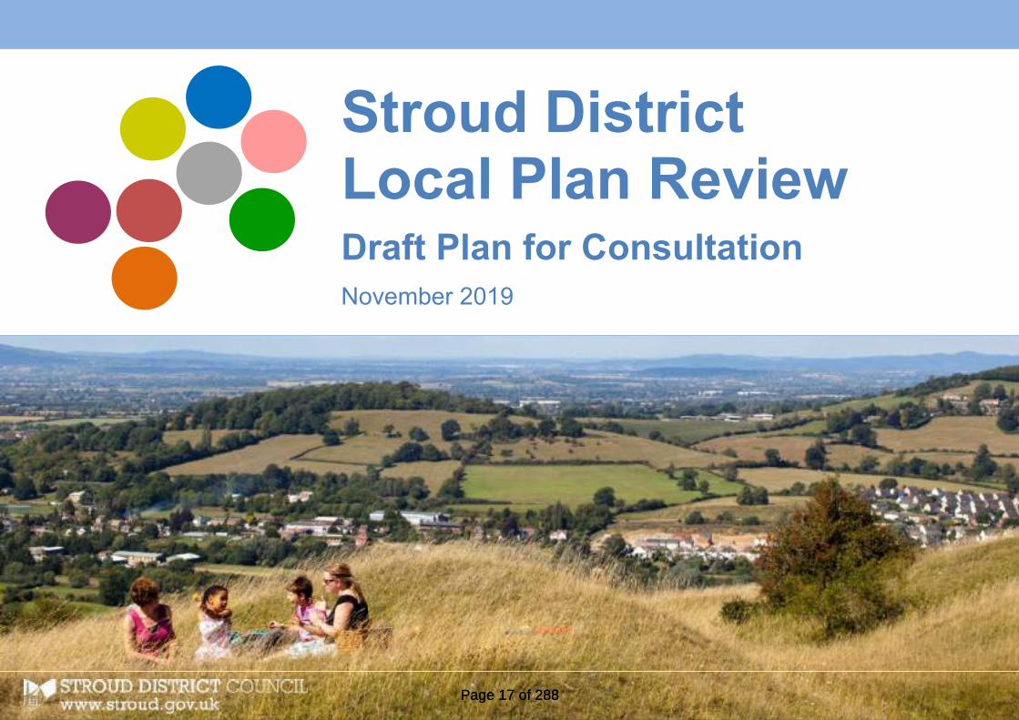
Stroud DistrictLocal Plan ReviewDraft Plan for ConsultationNovember 2019
Stroud DistrictLocal Plan ReviewDraft Plan for ConsultationNovember 2019
Stroud DistrictLocal Plan ReviewDraft Plan for ConsultationNovember 2019
Page 17 of 288Page 17 of 288

Development ServicesStroud District CouncilEbley MillStroudGloucestershireGL5 4UB
The Planning Strategy Team01453 [email protected]
visit www.stroud.gov.uk/localplanreview
Page 18 of 288Page 18 of 288

ContentsLocal Plan ReviewDraft Plan for Consultation
1
What is this document about? 1How can you get involved? 2Events and exhibitions 3“Parish clusters” 3
1. Setting the Scene |Why do we need a plan?
x
1.0 What is a Local Plan for? x1.1 Putting it into perspective:
Our District’s issues,challenges and needs
x
2. Making Places |The Development Strategy
x
2.1 A Vision for the future x2.2 Strategic Objectives x2.3 An introduction to the
development strategyx
Making Places |The Development Strategy
2.4 Our towns and villages x2.5 Housing x2.6 Local economy and jobs x2.7 Our town centres x2.8 Local green spaces and
community facilitiesx
2.9 Core Policies: x Delivering Carbon Neutral by2030
x
Strategic growth anddevelopment locations
x
Settlement hierarchy andsettlement boundaries
x
Making places x Infrastructure and developercontributions
x
3. Making Places | Shaping thefuture of Stroud District
xx
3.0 A spatial vision for StroudDistrict
x
5.1 The Stroud Valleys x5.2 The Stonehouse cluster x5.3 Cam & Dursley x5.4 Gloucester’s rural fringe x5.5 The Berkeley cluster x5.6 The Severn Vale x5.7 The Wotton cluster x5.8 The Cotswold cluster xMini Visions x Site Allocations x
4. Homes and Communities xxCore Policies: xx Achieving healthy and inclusivecommunities
xx
Affordable housing xx
Page 19 of 288Page 19 of 288

Homes and Communities Gypsies, Travellers and Travellingshowpeople
xx
Delivery Policies: xx Residential development atdefined settlements and onstrategic development sites
xx
Detailed criteria for new housingdevelopments
xx
Community-led housing schemes xx Other forms of residentialdevelopment
xx
Extending your home xx Planning for healthycommunities
xx
5. Economy and Infrastructure xxCore Policies: xx Economic growth and strategicemployment needs
xx
Retail and town centres xx Travel and transport xxDelivery Policies: xx Protection and development ofemployment sites
xx
Shopping, leisure, tourism andcommunity facilities
xx
Travel and transport xx
6. Our environment andsurroundings
xx
Core Policies: xx A ‘checklist’ for quality designand development
xx
A quality living and workingcountryside
xx
Delivery Policies: xx A sustainable future: living,working and growing within ourenvironmental limits
xx
Protecting our built and naturalheritage
xx
Quality of design: places andspaces
xx
7. Delivery and Monitoring xxx7.0 Delivery and monitoring xxx
AppendicesA Potential changes to
settlement development limitsxxx
B Areas of search for renewableenergy locations
xxx
C Parking standards for vehiclesand cycles
xxx
Image credits and information xxx
Maps and figures
xxxxxxxxxxxxxxxxxxxxx
Page 20 of 288Page 20 of 288

STROUD DISTRICT LOCAL PLAN REVIEW | DRAFT PLAN 2019 Page | 1
Local Plan Review | Draft Plan for ConsultationWhat is this document about?The Stroud District Local Plan identifies thehousing, employment, retail and communitydevelopment that is required to meet local needsup until 2031. It sets out the strategy fordistributing development within the District andpolicies for protecting and conserving the naturaland built environment.
The District Council started the process ofreviewing the current Local Plan in 2017. Thisconsultation Draft Plan sets out the Council’spreferred strategy for meeting growth anddevelopment needs over the next 20 years.
Why are we reviewing theLocal Plan now?The Government wants all local authorities toreview their local plans every 5 years. The currentLocal Plan was approved in November 2015. Newplans can take 5 or more years to finalise and so itis important that we make progress now.
What is our programme?We have built into the timetable plenty oftime to discuss issues, options andproposals with local communities. We havealready completed public consultation onIssues and Options during Autumn 2017and we sought views about an EmergingStrategy (and alternative options) last year.
There will be ongoing engagement withorganisations, but the main publicconsultation activities will be...
The current Local Plan
Issues and options consultation Autumn 2017:An opportunity to discuss emerging issues andidentify ways of distributing and managingfuture development needs.
Emerging strategy consultation Winter 2018:We now know the minimum number of housesthat we need to provide for and we haveidentified a potential strategy for delivery.
Final draft plan consultation Autumn 2019:A chance to check that we have the right draftplan in place.
Pre-submission consultation Autumn 2020:The formal stages of making representations onthe plan.
Modifications Summer 2021: Consultation onany proposed modifications to the plan
Adoption: It is anticipated that the new LocalPlan will be adopted by Winter 2021/22.
Page 21 of 288Page 21 of 288

STROUD DISTRICT LOCAL PLAN REVIEW | DRAFT PLAN 2019 Page | 2
How can I get involved?The purpose of this Draft Plan consultation is tounderstand:-
Do you support the Council’s preferred strategyfor meeting Stroud District’s future growth anddevelopment needs?
Are there any additional issues or constraintsrelating to the proposed sites? And how shouldspecific constraints, needs and opportunities bereflected in the final site allocation policies?
Are any further changes to the proposedpolicies necessary? Are there specific thingsthat should be included in supporting text?
We want people to engage fully in this process sothat responses can be fed into the next stage (thepre-submission draft, next year).
This Draft Plan consultation will involve:
Public exhibitions... We are holding publicexhibitions around the District during theconsultation period. This will provide anopportunity to chat to officers working on theLocal Plan review. Time and venue details can befound on the following page.
Direct communication... We will be emailingagents, developers, key stakeholders, localinterest groups, town and parish councils andmembers of the public who have expressed aninterest in being kept informed.
Individual groups... We are particularly interestedin making contact with groups and individuals whoare often under-represented in consultationevents, such as community groups and youngpeople. Please contact us if you know of a groupthat would like to get involved.
Documents... This document and backgrounddocuments can be accessed through our webpages www.stroud.gov.uk/localplanreview. Youcan view paper copies at the following locations:
Parish council offices open to the public Public libraries Stroud District Council offices, Ebley Mill
How can you make comments?We have not posed specific questions in thisdocument and there is no set ‘questionnaire’.However, there are a few prompts based aroundspecific themes or proposals, to help focusfeedback. If you would like to make comments,please reference site numbers, policy numbers orparagraph numbers and be as specific as possible.Electronic responses (by email or online) would beappreciated, as scanning and processing paperletters and documents significantly slows ourability to analyse and respond to representations.
Find out more and submit yourcomments via our online portal:www.stroud.gov.uk/localplanreview
Local Plan ReviewThe Planning Strategy TeamStroud District CouncilEbley MillStroud GL5 4UB
01453 754143
@
Please respond bythe closing date of
XXth January 2020.
Page 22 of 288Page 22 of 288

STROUD DISTRICT LOCAL PLAN REVIEW | DRAFT PLAN 2019 Page | 3
How can I get involved? | Events and exhibitionsWe are holding drop-in exhibitions around theDistrict during early December. You will be able tochat to officers working on the Local Plan reviewand find out more about the draft plan, sites andissues.
Copies of all the documents we have publishedin connection with this consultation will beavailable to view alongside exhibition boards.
There will be exhibitions at XX venues,focusing on sites and proposals forsurrounding parishes. You can come along toany one of these, but we are hoping that this‘clustering’ will help us to build up a pictureof the particular proposals that mostconcern different parts of the District.
“Parish clusters”The current Local Plan is built arounda series of eight ‘mini visions’ foreight distinctive parts of the District.Look out for the colour coding in thisconsultation document, which aimsto help flag up needs and proposalsthat are of particular local relevance.
Severn ValeAlthough there are nopotential sites in this area,you can come along toexhibitions elsewhere.
Arlingham, Fretherne-with-Saul,Frampton on Severn, Whitminster,Moreton Valence, Longney, Elmore
Cotswold clusterPainswick Town Hall,Victoria Square.Wednesday 28th Nov.2.30pm – 6.30pm
Painswick, Bisley-with-Lypiatt,Miserden, Cranham,Pitchcombe
Stroud ValleysStroud Sub Rooms. Saturday 24th
Nov. 10.30am – 1.30pm
Nailsworth Library. Wednesday5th Dec. 2.30pm – 6.30pm
Minchinhampton Youth Hub,Tobacconist Rd. Wednesday 12th
Dec. 2.30pm – 6pm
Stroud, Whiteshill & Ruscombe, Randwick,Cainscross, Rodborough, Brimscombe &Thrupp, Chalford, Woodchester,Minchinhampton, Horsley, Nailsworth
Gloucester fringeHardwicke VillageHall, Green Lane.Tuesday 18th Dec.2.30pm – 6.30pm
Hardwicke, Haresfield,Harescombe, Brookthorpe-with-Whaddon, Upton StLeonards
Berkeley clusterSharpness Village Hall,Oldminster Lane.Saturday 1st Dec.10.30am – 1.30pm
Slimbridge Village Hall, St.John’s Road.Monday 3rd Dec.2.30pm – 6.30pm
Berkeley, Ham & Stone, Alkington,Hamfallow, Hinton, Slimbridge
Stonehouse clusterStonehouse Town Hall,High StreetThursday 13th Dec.2.30pm – 6.30pm
Stonehouse, Standish,Eastington, Frocester, LeonardStanley, Kings Stanley
Wotton ClusterKingswood Village Hall, WickwarRoad. Monday 26th Nov.2.30pm – 6.30pm
Wotton Town Hall, MarketStreet. Monday 17th Dec.1.30pm – 5.30pm
Wotton-Under-Edge, North Nibley,Kingswood, Alderley, Hillesley & Tresham
Cam & DursleyCam Parish Council Office.Saturday 8th Dec.10.30am – 1.30pm
Dursley MethodistChurch, Castle Street.Tuesday 11th Dec.2.30pm – 6.30pm
Dursley, Cam, Coaley, Stinchcombe,Uley, Nympsfield, Owlpen
Dates and venues of anyexhibitions to beconfirmed
Dates and venues ofany exhibitions to beconfirmed
Dates and venues ofany exhibitions to beconfirmed
Dates and venues of anyexhibitions to be confirmed
Dates and venues of anyexhibitions to beconfirmed
Dates and venues ofany exhibitions to beconfirmed
Dates and venues of anyexhibitions to be confirmed
Dates and venues of anyexhibitions to be confirmed
Page 23 of 288Page 23 of 288

STROUD DISTRICT LOCAL PLAN REVIEW | DRAFT PLAN 2019 Page | 4
1.
Page 24 of 288Page 24 of 288

STROUD DISTRICT LOCAL PLAN REVIEW | DRAFT PLAN 2019 Page | 5
1. Setting the Scene | Why do weneed a plan?
1.0 What is a Local Plan for?1.1 Putting it into perspective: our District’s issues,
challenges and needs
Page 25 of 288Page 25 of 288

STROUD DISTRICT LOCAL PLAN REVIEW | DRAFT PLAN 2019 Page | 6
1.0 What is a Local Plan for?1.1 The purpose of the planning system is to achieve sustainable
development, which has been defined internationally as meeting theneeds of the present without compromising the ability of futuregenerations to meet their own needs. Planning applications must bedetermined in accordance with the development plan, unless materialconsiderations indicate otherwise. The Stroud District Local Plan is partof the development plan and therefore a very important document tohelp local communities within Stroud District achieve sustainabledevelopment.
1.2 At the centre of the Local Plan is a Development Strategy, whichprovides an overview of the District and how it should evolve during theplan period (up to 2040). This Strategy establishes broad principlesabout acceptable levels of development in both the towns and thecountryside, creating a policy framework that sets the scene for a widerange of planning decisions in the future. Crucially, it determines how,where and when various kinds of development will be distributedaround the District, including the provision of new homes andemployment land. The Development Strategy is articulated through anumber of “Core Policies”.
1.3 The Local Plan also includes more detailed “Delivery Policies” formanaging and directing development, as well as specific site allocations,area designations, protections and planning controls. These will acttogether to put the Development Strategy into practice and to helpachieve an overall vision for how our District should evolve betweennow and 2040.
1.4 To avoid unnecessary complexity, cross references within policies andsupporting text are kept to a minimum. The Plan should be read as awhole. The relationship of the policies to the strategic objectives and toeach other is explained in discrete sections through the Plan. A glossary isset out in an appendix to explain technical terms.
Why do we need a new Local Plan?1.5 The previous Stroud District Local Plan was adopted in 2015 and sought to
identify development needs for the period to 2031.
1.6 National policy, contained within the National Planning Policy Framework(NPPF), requires local plans to be kept up to date. There is now arequirement to plan for current and future development needs over atleast a 15 year time horizon.
1.7 Local plans can be reviewed in whole or in part. The intention of this newLocal Plan is to replace in one document the 2005 Local Plan. However,the planning system allows for further additional development plandocuments to be prepared, if required, and when these are adopted theywill become part of the Local Plan. The District Council does not, currently,envisage producing any further development plan documents, but this willbe kept under review.
1.8 Supplementary planning documents can be produced by local planningauthorities to provide more detail on how policies in the Local Plan will beimplemented and to help applicants make successful planning
Page 26 of 288Page 26 of 288

STROUD DISTRICT LOCAL PLAN REVIEW | DRAFT PLAN 2019 Page | 7
applications. This Local Plan identifies where supplementary planningdocuments will be prepared by the District Council.
What is the wider context?1.9 Local plans must be consistent with the principles and policies
contained within the NPPF. The NPPF covers most forms ofdevelopment and sets out the Government's economic, environmentaland social priorities for planning in England. The NPPF providesguidance for local planning authorities and decision-takers, both indrawing up plans and making decisions about planning applications.
1.10 Local planning authorities are expected to work collaboratively withother bodies to ensure that strategic priorities are properly co-ordinated across administrative boundaries. Joint working is expectedbetween neighbouring authorities to enable local planning authoritiesto meet development requirements which cannot wholly be met withintheir own areas.
1.11 Waste local plans and mineral local plans are produced byGloucestershire County Council. This Local Plan identifies two sitessuitable for strategic residual recovery facilities on the Policies Map,which have been allocated in the adopted Gloucestershire Waste CoreStrategy.
1.12 Parish councils within Stroud District can produce neighbourhood planswhich, when adopted, will also form part of the development plan,together with the Stroud District Local Plan. Neighbourhood plans mustbe in general conformity with and reflect the strategic policies in theStroud District Local Plan. Neighbourhood plans should not promote
less development than set out in the Local Plan, but can promote moredevelopment.
Diagram: Local Plan in context
Page 27 of 288Page 27 of 288

STROUD DISTRICT LOCAL PLAN REVIEW | DRAFT PLAN 2019 Page | 8
What evidence supports the Local Plan?1.13 The Local Plan is founded on an extensive evidence base, which has been
prepared and reviewed over the course of several years. The aim hasbeen to produce a clear picture of how our District functions as a place,what its characteristics, special qualities and needs are, and whatchanges are required to meet those needs.
1.14 The evidence is made up of two elements:
The views of local communities and those with a stake in thefuture of the area;
Research and fact finding evidence.
1.15 We consulted on Issues and Options in Autumn 2017 and an EmergingStrategy in Winter 2018. We have talked with a wide range oforganisations and individuals about the Local Plan and with ourneighbouring local planning authorities. We have considered communityviews expressed through parish plans and other documents. We havetaken into account all of the views expressed during these consultationsin preparing the Local Plan.
1.16 The Local Plan is underpinned by a wealth of national, county and localstatistical information and technical studies. These are referred to in theLocal Plan and a list of the evidence base can be found on the Council’swebsite.
Testing the Local Plan1.17 All local plans must be accompanied by a sustainability appraisal of the
plan. The purpose of this is to assess the likely social, environmental andeconomic effects of a plan and to inform the development of that plan.
1.18 The sustainability appraisal (SA) of the Stroud District Local Plan has beenfully integrated into the plan preparation process, so that it has informedand influenced the plan as it has evolved. The SAs done at earlier stagesof the process tested each possible alternative strategy against a numberof sustainability objectives. We have used the results of these tests indeciding on our final strategy, as well as the policies and proposals thatsupport it.
1.19 All local plans are required to assess whether any policies or proposalsmay affect any nature conservation sites of European importance and tosuggest ways in which they could be avoided.
1.20 A Habitats Regulations Assessment (HRA) has been carried out at keystages in the production of the Stroud District Local Plan. The Local Planhas been amended to reflect recommendations from the HRA.
Page 28 of 288Page 28 of 288

STROUD DISTRICT LOCAL PLAN REVIEW | DRAFT PLAN 2019 Page | 9
BIRMINGHAM
BRISTOL
SWINDON
CheltenhamGloucester
CARDIFF
Routes east toCirencester, Swindonand London
Routes to Gloucester,Cheltenham, Birminghamand the North
Routes toBristol, theSouth Westand Wales
Cirencester
1.1 Putting it into perspective | our District’sissues, challenges and needsStroud District in its context
1.21 The District of Stroud is located in the county of Gloucestershire, andcovers an area of approximately 45,325 hectares (about 175 squaremiles). Stroud lies about 20 miles north of Bristol and immediately southof Gloucester and Cheltenham. Gloucestershire sits at the periphery ofEngland’s south west and has close links with the Midlands, as well assouth Wales. Stroud District shares boundaries with Cotswold District,Gloucester City, Tewkesbury Borough and the unitary authority of SouthGloucestershire. Our neighbour to the west is the Forest of Dean, whichsits on the opposite bank of the River Severn estuary.
1.22 Much of the eastern half of the District falls into the Cotswold Area ofOutstanding Natural Beauty (AONB), which covers just over 50% of theDistrict’s total land area. The western half of the District, characterisedby the low lying landscape of the Severn Vale, is bounded by the SevernEstuary and includes extensive areas of land liable to flooding whichextend eastwards along the river corridors within the Stroud Valleys. TheDistrict contains internationally important wildlife sites at the SevernEstuary, at Rodborough Common (south of Stroud) and at beechwoodland straddling the north eastern boundary of the District withTewkesbury Borough.
Stroud District’s regional context...*We
are here
Page 29 of 288Page 29 of 288

STROUD DISTRICT LOCAL PLAN REVIEW | DRAFT PLAN 2019 Page | 10
Stroud District
The Cotswolds Area ofOutstanding NaturalBeauty (AONB)
Internationally designatedwildlife sites
The River Severn estuary
Estuarine and riverfloodplain (indicative)
Settlements and urbanareas
Main line rail stations
A roads
B roads
... Stroud District’s geographic context andlandscape constraints
Main town centres
© Crown copyright and database rights 2019Ordnance Survey 100019682
M5 Motorway
Cotswold District
South Gloucestershire
Forest of Dean
GLOUCESTER
CHELTENHAM
J12
J11a
J13
J14
CAM
DURSLEY
Wotton-Under-Edge
Berkeley Nailsworth
SharpnessDocks
Minchinhampton
STROUDSTONEHOUSE
Hardwicke
Painswick
Page 30 of 288Page 30 of 288

STROUD DISTRICT LOCAL PLAN REVIEW | DRAFT PLAN 2019 Page | 11
1.23 The District has a rich built heritage, including 42 conservation areas in awide variety of towns and villages. Amongst these is the unique and verylarge Industrial Heritage Conservation Area, which extends through theStroud Valleys, in recognition of the area’s important industrial legacy –including historic mill buildings and canal- and river-related structures.
1.24 The main town, Stroud, acts as the focal point of the wider functionalurban area within the Stroud Valleys. The Valleys are home to some49,000 people (just over 40% of the District’s population), including justunder 6,000 in the town of Nailsworth. Stroud town is the District’slargest commercial centre, yet in terms of retail and leisure offer it facescompetition from larger towns and cities, including Bristol, Cheltenham,Gloucester and Cirencester.
1.25 With the Gloucester-London main railway line running through it, Stroudhas easy rail access to the north and east, including to Birmingham andLondon; junction 13 of the M5 lies five miles to the west of the towncentre.
1.26 Towards the south of the District lie the towns of Cam and Dursley(population approximately 15,000), which jointly act as a focus for theSouth Vale area. Cam and Dursley have a rail station on the Bristol-Birmingham main railway line.
1.27 Stonehouse (just under 8,000 people) lies just outside the topographicalStroud Valleys (3.5 miles west of Stroud), but the town functions as partof this urban area. Close to the M5 junction 13, Stonehouse also benefitsfrom a rail station on the Gloucester-London line.
1.28 To the north of the District, Hardwicke (just under 4,000 people) formspart of the Gloucester urban area. The remaining countryside areas of theDistrict are mainly used for agriculture and contain a large number ofsmaller towns, villages and hamlets.
1
Page 31 of 288Page 31 of 288

STROUD DISTRICT LOCAL PLAN REVIEW | DRAFT PLAN 2019 Page | 12
Stroud District today1.29 The facts, figures and studies that make up the Local Plan evidence base
have helped to build up a picture of the District today, the pressures itfaces, how it has been changing, what its current needs are and whatmay be needed in the future.
1.30 This ‘snapshot’ should help to put the key issues facing Stroud Districtbetween now and 2040 into context:
Ours is a rural district with several market towns, each with theirown distinct characteristics, assets and issues
We have a high quality environment; this is a desirable place to liveand work
Our population is ageing; the population is generally affluent, butthere are pockets of deprivation
We have low levels of unemployment, but too few jobs availablewithin the District itself – leading to high levels of out-commuting
We have a significant shortage of affordable housing and highaverage house prices compared to the Gloucestershire average
We have generally good educational standards and a well qualifiedresident workforce
There are low levels of crime, but a disproportionate fear of crime
Our CO2 emissions from transport continue to rise
Public transport is limited across the District
There is poor accessibility east to west through the District
Significant growth is occurring along the M5 corridor (focused onGloucester, Cheltenham and Bristol) – which impacts on StroudDistrict now and in the future
Stroud District at a Glance
Area 175 sq.miles / 45,325 ha / 112,000acres
Population (2018) 119,019 a
Population density (2018) 2.6 persons per hectare
No. of households (2019) 51,796 b
Average household size (2011) 2.35 c
Life expectancy women 83.2 yrs / men 80.1 yrs d
Mean age of population 42.3 years e
No. of dwellings (2018) 53,078 f
Total economically active (2019) 66,700 people g
Average income £28,423 g
Unemployed (August 2019) 1.3% h
a Source: ONS Mid-2018 Population Estimatesb Source: CLG 2014 household projectionsc Source: Census 2011d Source: NHS - Stroud Health Profile 2017e Source: Census 2011f Source: Census 2011 ( baseline) + Stroud District HLA (housing completions)g Source: ONS/NOMIS - Labour Market Profile Stroud 2019h Source: NOMIS Claimant Count
Table xx ... key facts about our district
Page 32 of 288Page 32 of 288

STROUD DISTRICT LOCAL PLAN REVIEW | DRAFT PLAN 2019 Page | 13
[1] [2]
[3]
*[image credits see page xxx]
Page 33 of 288Page 33 of 288
STROUD DISTRICT LOCAL PLAN REVIEW | DRAFT PLAN 2019 Page | 14
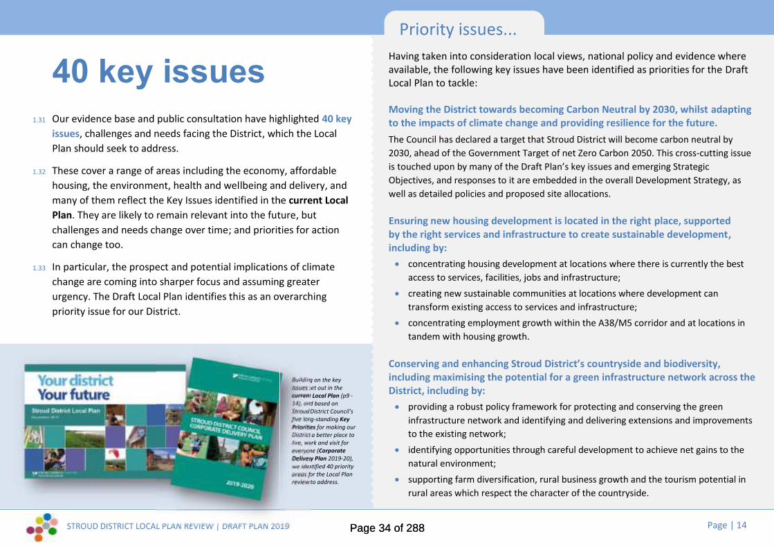
40 key issues1.31 Our evidence base and public consultation have highlighted 40 key
issues, challenges and needs facing the District, which the LocalPlan should seek to address.
1.32 These cover a range of areas including the economy, affordablehousing, the environment, health and wellbeing and delivery, andmany of them reflect the Key Issues identified in the current LocalPlan. They are likely to remain relevant into the future, butchallenges and needs change over time; and priorities for actioncan change too.
1.33 In particular, the prospect and potential implications of climatechange are coming into sharper focus and assuming greaterurgency. The Draft Local Plan identifies this as an overarchingpriority issue for our District.
Priority issues...Having taken into consideration local views, national policy and evidence whereavailable, the following key issues have been identified as priorities for the DraftLocal Plan to tackle:
Moving the District towards becoming Carbon Neutral by 2030, whilst adaptingto the impacts of climate change and providing resilience for the future.The Council has declared a target that Stroud District will become carbon neutral by2030, ahead of the Government Target of net Zero Carbon 2050. This cross-cutting issueis touched upon by many of the Draft Plan’s key issues and emerging StrategicObjectives, and responses to it are embedded in the overall Development Strategy, aswell as detailed policies and proposed site allocations.
Ensuring new housing development is located in the right place, supportedby the right services and infrastructure to create sustainable development,including by: concentrating housing development at locations where there is currently the best
access to services, facilities, jobs and infrastructure; creating new sustainable communities at locations where development can
transform existing access to services and infrastructure; concentrating employment growth within the A38/M5 corridor and at locations in
tandem with housing growth.
Conserving and enhancing Stroud District’s countryside and biodiversity,including maximising the potential for a green infrastructure network across theDistrict, including by: providing a robust policy framework for protecting and conserving the green
infrastructure network and identifying and delivering extensions and improvementsto the existing network;
identifying opportunities through careful development to achieve net gains to thenatural environment;
supporting farm diversification, rural business growth and the tourism potential inrural areas which respect the character of the countryside.
Building on the keyissues set out in thecurrent Local Plan (p9 -14), and based onStroud District Council’sfive long-standing KeyPriorities for making ourDistrict a better place tolive, work and visit foreveryone (CorporateDelivery Plan 2019-20),we identified 40 priorityareas for the Local Planreview to address.
STROUD DISTRICT LOCAL PLAN REVIEW | DRAFT PLAN 2019 Page | 14
40 key issues1.31 Our evidence base and public consultation have highlighted 40 key
issues, challenges and needs facing the District, which the LocalPlan should seek to address.
1.32 These cover a range of areas including the economy, affordablehousing, the environment, health and wellbeing and delivery, andmany of them reflect the Key Issues identified in the current LocalPlan. They are likely to remain relevant into the future, butchallenges and needs change over time; and priorities for actioncan change too.
1.33 In particular, the prospect and potential implications of climatechange are coming into sharper focus and assuming greaterurgency. The Draft Local Plan identifies this as an overarchingpriority issue for our District.
Priority issues...Having taken into consideration local views, national policy and evidence whereavailable, the following key issues have been identified as priorities for the DraftLocal Plan to tackle:
Moving the District towards becoming Carbon Neutral by 2030, whilst adaptingto the impacts of climate change and providing resilience for the future.The Council has declared a target that Stroud District will become carbon neutral by2030, ahead of the Government Target of net Zero Carbon 2050. This cross-cutting issueis touched upon by many of the Draft Plan’s key issues and emerging StrategicObjectives, and responses to it are embedded in the overall Development Strategy, aswell as detailed policies and proposed site allocations.
Ensuring new housing development is located in the right place, supportedby the right services and infrastructure to create sustainable development,including by: concentrating housing development at locations where there is currently the best
access to services, facilities, jobs and infrastructure; creating new sustainable communities at locations where development can
transform existing access to services and infrastructure; concentrating employment growth within the A38/M5 corridor and at locations in
tandem with housing growth.
Conserving and enhancing Stroud District’s countryside and biodiversity,including maximising the potential for a green infrastructure network across theDistrict, including by: providing a robust policy framework for protecting and conserving the green
infrastructure network and identifying and delivering extensions and improvementsto the existing network;
identifying opportunities through careful development to achieve net gains to thenatural environment;
supporting farm diversification, rural business growth and the tourism potential inrural areas which respect the character of the countryside.
Building on the keyissues set out in thecurrent Local Plan (p9 -14), and based onStroud District Council’sfive long-standing KeyPriorities for making ourDistrict a better place tolive, work and visit foreveryone (CorporateDelivery Plan 2019-20),we identified 40 priorityareas for the Local Planreview to address.
Page 34 of 288Page 34 of 288

STROUD DISTRICT LOCAL PLAN REVIEW | DRAFT PLAN 2019 Page | 15
Economy...Helping to create a sustainable and vibrant economy thatworks for all
1. Continuing to provide for job opportunities across the District,with a focus on knowledge based industries, environmentaltechnologies, engineering and manufacturing, creative industriesand high quality social care.
2. Rebalancing and regenerating the existing employment stock tosecure modern office premises with business support services andfreehold small industrial sites.
3. Addressing the high level of daily commuting out of and into theDistrict, particularly out commuting to Bristol, Gloucester,Cheltenham and Swindon.
4. Working with other local authorities and statutory agencies toinvestigate transport improvements to link Stroud to Bristol, theMidlands and Wales.
5. Improving the vitality and viability of our town centres within achanging environment of regional and on-line shopping.
6. Continuing to develop the tourism potential of our area as aunique selling point for living, working, visiting and investing inthe District.
7. Responding to the requirements of the digital economy for super-fast broadband connections and good coverage across the District,together with the implications for living and working patterns.
8. Ensuring that the local economy can respond positively tochallenges and any new trading opportunities following Brexit.
Maximising the potential of brownfield and underused sites tocontribute to housing supply, including by: regenerating large scale brownfield sites for housing, employment and
canal related tourism
allocating smaller brownfield sites within settlements for redevelopmentand exploring other opportunities through the Brownfield Register
prioritising the use of brownfield, under used and infill land through the useof settlement boundaries
Developing strategies to avoid, reduce and mitigate the indirect impactsof development on the natural environment, including by: safeguarding local wildlife-rich habitats and wider ecological
networks/areas identified for habitat management, enhancement,restoration or creation;
promoting the conservation, restoration and enhancement of priorityhabitats and ecological networks, and the protection and recovery ofpriority species;
managing growth to secure mitigation and measurable net gains forbiodiversity.
Tackling the acute lack of affordable housing in the District, including by: ensuring a proportion of affordable homes on all sites of 10 dwellings or
above in urban areas and on all sites of above 5 dwellings in designatedrural areas;
identifying opportunities for additional affordable homes, working withparish councils, co-operatives, community land trusts and communityhousing groups;
encouraging rural exception sites and exception sites for first time buyersand renters, subject to local needs.
Page 35 of 288Page 35 of 288

STROUD DISTRICT LOCAL PLAN REVIEW | DRAFT PLAN 2019 Page | 16
Affordable housing...
Providing affordable, energy efficient homes for our diverseand changing population
9. Meeting the District’s identified future housing needs includingthe particular needs of the elderly and the needs of the travellingcommunities.
10. Working with neighbouring authorities to meet the needs of thehousing market area as a whole.
11. Tackling the acute lack of affordable housing in the District.
12. Ensuring new housing development is located in the right place,supported by the right services and infrastructure to createsustainable development.
13. Providing the right size of accommodation to meet local needs(particularly for smaller, cheaper market and affordable homes)and to help with social cohesion.
14. Ensuring new housing design is flexible and adaptable, to meetthe changing needs of diverse households.
15. Updating existing housing stock across the District, to make itmore fuel efficient, warmer and healthier to live in.
16. Providing opportunities for self-build/custom housing, smallersized developments and new models for housing delivery, todiversify and stimulate the housing market.
17. Maximising the potential of brownfield and underused sites tocontribute to housing supply.
[1]
[2]
[ILLUSTRATIONS HERE]
(as page 6 of the Issues and Options Paper, 2017)
Page 36 of 288Page 36 of 288

STROUD DISTRICT LOCAL PLAN REVIEW | DRAFT PLAN 2019 Page | 17
Environment...
Helping the District community minimise its carbonfootprint, adapt to the changing climate and recycle more
18. Achieving a better transport system, to help reduce CO2 emissions,with an emphasis on limiting car use by extending the cycling andwalking network and making improvements to public transport.
19. Conserving and enhancing Stroud District’s countryside, landscapeand biodiversity, including maximising the potential for a greeninfrastructure network across the District.
20. Moving the District towards becoming Carbon Neutral by 2030,whilst adapting to the impacts of climate change and providingresilience for the future.
21. Protecting and enhancing our exceptional historic environment,whilst adapting to modern demands.
22. Promoting high quality and locally distinctive design, incorporatingwhere possible innovative, space efficient and flexible forms formodern living and working.
23. Reconciling the need for energy efficient and low carbon buildingtechnologies and design with the traditional character and localdistinctiveness of places.
24. Contributing to the provision of renewable and low-carbon energygeneration in the District.
25. Providing resilience to flood risk, releasing regeneration sites fromthe floodplain for housing and employment, and promoting naturalflood management projects.
26. Developing strategies to avoid, reduce and mitigate the indirectimpacts of development on the natural environment.
Health and wellbeing...
Promoting the health and wellbeing of our communitiesand working with others to deliver the public health agenda
27. Maintaining and improving the sustainability of our villages asplaces for living and working, by improving access to services,such as health and education, and jobs.
28. Meeting the needs of young people.
29. Meeting the needs of an increasingly elderly population,enabling people to live independently for longer.
30. Supporting and capitalising on the District’s artistic, cultural andsporting assets.
31. Improving the provision of good quality sports facilities, to meetthe District’s needs and increase participation in sports andphysical activity, particularly among children and young people.
32. Developing a Green Infrastructure network of public open spaceprovision throughout the District, to increase accessibility,ensuring public open spaces are adaptable and capable ofaccommodating multiple uses.
33. Achieving mixed, balanced and cohesive communities offering asense of community identity and belonging, tolerance, respectand engagement with people from different cultures,background and beliefs.
Page 37 of 288Page 37 of 288

STROUD DISTRICT LOCAL PLAN REVIEW | DRAFT PLAN 2019 Page | 18
[ILLUSTRATIONS HERE]
(as page 8 of the Issues and Options Paper, 2017)
Page 38 of 288Page 38 of 288
STROUD DISTRICT LOCAL PLAN REVIEW | DRAFT PLAN 2019 Page | 19
Providing value for money to our tax payers and highquality services to our customers
34. Working with neighbouring authorities to meet the housing,economic and infrastructure needs of the wider market area.
35. Working with public health providers to ensure that health andwellbeing is central to the planning and design of newdevelopment, including the provision of well designed and insulatedhomes, the creation of vibrant places, and a network of open spaceswith opportunities for play, enhanced biodiversity and flood riskresilience.
36. Working with neighbourhood groups to deliver improvements tolocal services and infrastructure, housing and jobs growth at thelocal level, including through Neighbourhood Development Plans.
37. Continuing to ensure that the Cotswolds Canals restoration plays apositive role in the District, bringing health and wellbeing benefitsand enhancing employment opportunities, whilst also conservingthe historic and often rural character of the canal.
38. Ensuring that changes in public sector service delivery providecontinued and improved accessibility to services.
39. Facilitating community infrastructure projects through innovativefunding mechanisms.
40. Developing mitigation strategies to fund environmental projects.
Delivery...
Page 39 of 288Page 39 of 288

STROUD DISTRICT LOCAL PLAN REVIEW | DRAFT PLAN 2019 Page | 20
This chapter sets out the Local Plan’s overallstrategy for managing growth and developmentacross the District, up to 2040. It describes thePlan’s overarching objectives for the future. It setsout where future strategic development will goand explains the levels and types of growth thathave been planned for, in order to meet theDistrict’s needs.
Making Places | the developmentstrategy2.
Page 40 of 288Page 40 of 288

STROUD DISTRICT LOCAL PLAN REVIEW | DRAFT PLAN 2019 Page | 21
2. Making Places | the developmentstrategy2.1 Stroud District tomorrow | a vision for the future2.2 Strategic objectives for the future2.3 An introduction to the development strategy2.4 Our towns and villages2.5 Housing2.6 Employment and economic growth2.7 Town centres and retailing2.8 Local green spaces and community facilities2.9 Core Policies | CP1 – CP6
Page 41 of 288Page 41 of 288
STROUD DISTRICT LOCAL PLAN REVIEW | DRAFT PLAN 2019 Page | 22
2.1 Stroud District tomorrow| a vision for the future
2.1 What do you want Stroud District to be like in20 years time? In developing a Local Plan forthe District, it is important to have a vision ofthe kind of place we want to be living in,working in or visiting in the future, so that clearobjectives can be set for the policies andproposals that will help us to shape that place.
2.2 A clear vision is an essential part of developingobjectives and measuring the likely impacts ofany strategies that aim to influence theDistrict’s future growth and development.
2.3 We have drafted a broad and over-archingvision, which expresses aspirations for thefuture of our District, building on the visioncontained in the current Local Plan (2015),drawn from issues arising in our evidence baseand refined through public consultation.1 Thisvision offers an aspirational glimpse of thefuture: something that we can all work towards
1 Issues and Options Consultation, Autumn 2017; Emerging StrategyConsultation, Winter 2018
and a goal that will continue to guide futurepolicy and strategy.
2.4 Derived from this District-wide vision, the Planalso sets out a series of eight ‘mini visions’ fordistinct parts of the District. These aim to focusthe over-arching goals of the main vision andthe strategic objectives in a way that respondsmore specifically to local priorities, issues andneeds. The place-making mini visions are setout in Chapter 3 | Making Places. Core PolicyCP4 (page xx) explains how these visions areintegral to the Draft Plan’s developmentstrategy.
Vision to 2040...Stroud District sits at the south-western edge of theCotswolds Area of Outstanding Natural Beauty andextends westward across the Severn Vale, which isbordered by a rich estuarine landscape. This Visiondraws upon our special environmental, social andeconomic qualities.
Our rural District is living, modern and innovative. Wehave responded to climate change, becoming carbonneutral by 2030 and continuing to adapt our lifestylesto live within our environmental limits, includingtravelling in sustainable ways.
Our District supports a network of market towns, wellconnected to their rural hinterlands andcomplementary to the role of wider regional centres.Each contributes to our sustainable and thriving localeconomy. We capitalise on our heritage, skills, andknowledge – exploiting our unique assets to nurturegrowth, particularly in high tech, green technologies,creative industries and tourism. We are adaptable andable to respond to changing needs and modernlifestyles.
We enjoy a high quality of life within our healthy,vibrant and diverse communities – large and small,urban and rural. These have a strong sense of theirown identity and local distinctiveness – from Wotton-under-Edge in the south, to Stroud Town in the centreand Upton St. Leonards in the north. They are all safeand secure places, where the elderly and vulnerableare supported and young people have opportunities.
Every day we see the richness, diversity and beauty ofour District. We nurture our high quality landscapes,green spaces, flourishing wildlife and historic andcultural heritage, from our arts and crafts, through tothe Cotswold Canals and our wool and cloth mills.
A Vision of Stroud District in 2040...What do you think of this draft vision, which builds
upon the vision in the current Local Plan? Does itreflect what you value about Stroud District and where
you would like us to be in 20 years’ time?
Page 42 of 288Page 42 of 288

STROUD DISTRICT LOCAL PLAN REVIEW | DRAFT PLAN 2019 Page | 23
2.2 Strategic objectives for the future2.5 Taking account of the identified issues and
priorities, the current Local Plan lists sixprincipal objectives to provide a more tangibleway of taking forward the overall vision for theDistrict, and to help us to assess the relativemerits of potential locations for strategicgrowth.
2.6 Having considered your views,recommendations from the Council’sSustainability Appraisal (SA), national policyand new evidence where available, we areproposing to refine the strategic objectives, totake forward through the Draft Local Plan.
2.7 Whilst there is considerable overlap, these sixobjectives fall loosely into three topic areas:Homes and Communities, Economy andInfrastructure and Our Environment andSurroundings. Each of these forms the basis ofa suite of policies later in this Plan (Chapter 4,Chapter 5 and Chapter 6).
2.8 We are interested to hear what you thinkabout the following revised StrategicObjectives:
Homes and communities:Strategic Objective SO1: Accessible communitiesMaintaining and improving accessibility to servicesand amenities, with: Affordable and quality housing for local needs Healthcare for all residents Active social, leisure and recreation
opportunities Youth and adult learning opportunities
Strategic Objective SO1a: Healthy, inclusive andsafe communitiesDeveloping communities that enable healthylifestyles; promote social interaction; support theelderly, the young and the vulnerable; ensurepublic safety and reduce the fear of crime.
The current Local Plan...Visit our Local Plan web page tosee how these revisionscompare to the six StrategicObjectives in the current LocalPlan (page 18).
www.stroud.gov.uk/localplan
Page 43 of 288Page 43 of 288

STROUD DISTRICT LOCAL PLAN REVIEW | DRAFT PLAN 2019 Page | 24
Economy and infrastructure: Our environment and surroundings:Strategic Objective SO2: Local economy and jobsProviding for a strong, diverse, vibrant localeconomy that supports existing businesses andencourages new enterprise – enabling balancedeconomic growth, coupled with enhancing skillsand job opportunities across the District.
Strategic Objective SO3: Town centres and ruralhinterlandsImproving the safety, vitality and viability of ourtown centres, which link to and support the needsof their rural hinterlands.
Strategic Objective SO4: Transport and travelPromoting healthier alternatives to the use of theprivate car and seeking to reduce CO2 emissionsby using new technologies, active travel and/orsmarter choices, working towards a moreintegrated transport system to improve access tolocal goods and services.
Strategic Objective SO5: Climate Change andenvironmental limitsPromoting a development strategy that reducesour District’s carbon footprint, adapts to climatechange and respects our environmental limits by: Securing zero carbon development through
building design Maximising the re-use of buildings and
recycling of building materials Minimising the amount of waste produced
and seeking to recover energy Promoting the use of appropriately located
brownfield land Supporting a pattern of development that
prioritises the use of sustainable modes oftransport
Minimising and mitigating against future floodrisks, recycling water resources and protectingand enhancing the quality of our District’ssurface and groundwater resources
Strategic Objective SO6: Our District’sdistinctive qualitiesConserving and enhancing Stroud District’sdistinctive qualities, based on landscape,heritage, townscape and biodiversity.
[2]
Page 44 of 288Page 44 of 288

STROUD DISTRICT LOCAL PLAN REVIEW | DRAFT PLAN 2019 Page | 25
2.3 An introduction to the developmentstrategy
2.9 The Draft Local Plan’s development strategysets out how we will deliver the vision andobjectives for the District. It identifies howmuch development will be supported, in orderto meet objectively assessed needs, and wherethat development will be accommodated. Itseeks to define the role of settlements withinthe District and how development will be co-ordinated with services and facilities at thosesettlements.
2.10 The strategy recognises the close relationshipof the District with the surrounding area. Forexample, the city of Gloucester lies adjacent toour boundaries and the M5/A38 corridor is animportant link to the Midlands and Bristol andthe South West. There are established net out-commuting patterns which the strategy seeksto influence.
2.11 There has been extensive consultation andanalysis of the type of development strategymost appropriate to deliver the desired visionand strategic objectives for the District. A rangeof alternatives has been tested.
The Local Plan Review’s Issues and Optionsdocument (Autumn 2017) detailed fouralternative patterns for future growth in theDistrict. We asked you what you thought of thefour; whether a combination or ‘hybrid’ might beanother option; or whether there was anotheralternative we should consider.
The four options were:
Option 1: Continue to concentrate housing andemployment development at a few large sites,located adjacent to the main towns in the District
Option 2: Take a more dispersed approach withsome medium sized housing and employment siteson the edge of the larger villages, as well as towns
Option 3: Disperse development across the Districtwith most villages including at least one small tomedium site allocated to meet local needs
Option 4: Identify a growth point in the District toinclude significant growth, either as an expansion ofan existing settlement, or to create a newsettlement.
In order to test whether these options werereasonable and deliverable (and to compare thepotential impacts of each option), we identifiedpotentially suitable and available sites from a rangeof sources. We then assigned them to each option,depending upon their location and size.
The findings of this exercise were detailed in lastyear’s Emerging Strategy consultation paper. Thediagram in Fig.x (Chapter 3 | Making Places)illustrates the ‘filtration’ process through whicheach potential site was passed, as the sites wereassessed alongside the emergence of a preferredstrategy. New potential sites that were promotedthrough last year’s consultation have also beensubject to assessment, to determine whether theyhave potential to contribute to the preferreddevelopment strategy.
The preferred development strategy now set out inthis Draft Local Plan is a ‘hybrid’, which incorporatessome of the most sustainable and deliverableaspects of the four strategy options we consultedon in 2017 and makes use of the most suitablepotential sites.
Testing the options...
Page 45 of 288Page 45 of 288

STROUD DISTRICT LOCAL PLAN REVIEW | DRAFT PLAN 2019 Page | 26
The draft strategy’s headlines2.11 The Draft Local Plan’s development strategy
will distribute at least 12,800 additionaldwellings and sufficient new employment landto meet needs for the next 20 years.
2.12 The strategy supports the development ofinclusive, diverse communities, with housingand employment in close proximity and goodaccess to wider services and facilities, toreduce our carbon footprint and to improvethe District’s sustainability and self-containment.
2.13 The strategy will concentrate housing growthat the main towns of Cam and Dursley,Stonehouse and Stroud, where there is bestaccess to services, facilities, jobs andinfrastructure.
2.14 Housing and employment growth will also becentred at two new settlements at Sharpnessand at Wisloe within the Severn Vale (A38/M5corridor), where there is the potential to createnew sustainable communities along gardenvillage principles. Further strategic employmentgrowth will also be concentrated at accessiblelocations within the A38/M5 corridor.
2.15 In order to meet wider development needs andto support and improve existing services andfacilities at smaller towns and larger villages,modest levels of growth will be delivered at thelocal service centres of Berkeley,Minchinhampton, Nailsworth and Painswick.
2.16 Lesser levels of growth will be delivered at thevillages of Brimscombe & Thrupp, Eastington,Frampton-on-Severn, Kings Stanley, Kingswood,Leonard Stanley, North Woodchester andWhitminster. These are villages that have arange of local facilities and already benefit fromgood transport links, or they have the potentialto develop better transport links to strategicfacilities at the nearby towns of Stroud andWotton-under-Edge, where growth potential islimited by environmental constraints.
2.17 Further infill development to maximise the useof brownfield land will be supported at theseand other settlements, within settlementdevelopment limits.
2.18 Some limited development at small andmedium- sized sites immediately adjoiningsettlement development limits at Tier 1-3settlements will be allowed, to meet specificidentified local development needs (i.e.
exception sites for first time buyers, self buildand custom build housing, rural exceptionsites), subject to being able to overcomeenvironmental constraints.
2.19 At Tier 4a and 4b settlements, in addition torural exception sites, the development of smallsites of up to 9 dwellings outside settlementdevelopment limits will be supported in theinterests of maintaining social sustainability,provided that the policy is supported by thelocal community.
Page 46 of 288Page 46 of 288

STROUD DISTRICT LOCAL PLAN REVIEW | DRAFT PLAN 2019 Page | 27
The development strategy...This proposed growth strategy seeks todistribute at least 12,800 additionaldwellings and sufficient new employmentland to meet needs for the next 20 years.
This is the Council’s preferred strategy andit incorporates some of the mostsustainable and deliverable aspects of thefour strategy options we consulted on in2017.
Key to map
Stroud District boundary
Proposed strategic locations forfuture growth (housing, communityinfrastructure and facilities)
Proposed strategic locations forfuture employment growth
Proposedl sites for future growth(see more detailed maps inChapter 5 of this document)
Settlements and urban areas
Estuarine and river floodplain
The Cotswolds AONB
Natural environment constraints(including key wildlife sites, ancientwoodland, SSSI, RAMSAR...)
CAM
DURSLEY
Wotton-Under-Edge
Berkeley Nailsworth
Newtown &Sharpness Wisloe
Kingswood
Thrupp
BrimscombeNorth
Woodchester
Minchinhampton
STROUDSTONEHOUSE
Hardwicke
Painswick
The Stanleys
© Crown copyright and database rights 2018 Ordnance Survey 100019682
Whaddon
[NOTE: this image shows thedevelopment strategy diagram
from the Emerging Strategyconsultation document (2018).The consultation Draft Plan will
include an updated diagram (andmap key), showing the Draft
Plan’s proposed site allocationsand strategic locations.]
Page 47 of 288Page 47 of 288

STROUD DISTRICT LOCAL PLAN REVIEW | DRAFT PLAN 2019 Page | 28
What this strategy means for where you live2.20 At Cam, the strategy envisages: regenerating
brownfield sites within the settlement; theconsolidation of growth to the north east of thetown, linking the parish centre with improvedfacilities at Cam and Dursley railway station andcompleting the linear park and local cycling andwalking network; new housing development,community and open space uses to the northwest, improving access to Jubilee Playing Fieldand creating a landscaped buffer between theexisting edge of Cam and the M5 motorway.
2.21 At Dursley, the strategy envisages:regenerating brownfield sites within thesettlement; supporting town centreimprovements; improvements to the localcycling and walking network.
2.22 At Stonehouse, the strategy envisages:regenerating brownfield sites within thesettlement; supporting town centreimprovements; extensions to planned growthto the north west of the town includingenhancing community facilities and additionalopen space; supporting improvements to thecanal corridor and local walking and cyclingroutes.
2.23 At Stroud, the strategy envisages: regeneratinglarge scale brownfield sites for housing,employment and canal related tourism;supporting the better use of edge of towncentre sites and public realm improvements;supporting improvements to the canal corridorand local walking and cycling routes.
2.24 At Newtown/Sharpness the strategy envisages:delivery of a new garden village communityincorporating housing, employment, shopping,a new secondary school and other communityand open space uses; with the opportunity totransform local transport facilities through anew rail station with services to Gloucester andrapid bus services to main towns includingBristol; and access to new and enhancedfacilities for existing residents and businesses.
2.25 At Wisloe (south of Cambridge and Slimbridge)the strategy envisages: delivery of a newgarden village community incorporatinghousing, employment, shopping, communityand open space uses, with the opportunity toimprove access to Cam & Dursley rail stationand to local facilities for existing residents andbusinesses whilst protecting the setting ofexisting villages.
2.26 At Berkeley, Minchinhampton, Nailsworth,Painswick and the smaller villages ofBrimscombe and Thrupp, Eastington,Frampton-on-Severn, Kings Stanley,Kingswood, Leonard Stanley, NorthWoodchester and Whitminster, the fewer andsmaller development sites will be focused onmeeting local housing needs and on enhancingor delivering new services and facilities whichhave been identified as lacking in those places,as set out in Chapter 2 (2.4). The focus willtherefore be on using development toovercome existing infrastructure deficienciesand to deliver enhancements to places.
What are the key challengesto this emerging strategy?
2.27 Delivering the growth expected by centralGovernment within the next 20 year timehorizon will be challenging. The strategydemands an increase in house building ratesbeyond levels achieved in recent memory. Thestrategy includes supply from a range of small,medium, large and very large sites at a numberof different locations, which together provideopportunities for all levels of the market to
Page 48 of 288Page 48 of 288

STROUD DISTRICT LOCAL PLAN REVIEW | DRAFT PLAN 2019 Page | 29
deliver. However, delivery rates are vulnerableto changes in economic cycles, brownfield sitescan be complex and expensive to develop andthe creation of new settlements is an ambitiousundertaking. We may need to identifyadditional reserve sites, should the sitesidentified in this document not come forwardat the rates envisaged, and we are interested tohear views on this.
2.28 The increased levels of growth will putadditional pressure on our roads, particularly atkey network junctions within the District. Initialtransport work has identified the likely need formajor improvements at M5 junctions 12, 13and 14, together with improvements along theA419 and A38 corridors. These improvementsare likely to be required whatever the patternof growth envisaged. Larger sites have morepotential to help fund major infrastructureschemes and are more likely to attract publicfunding.
2.29 Improvements to public transport will need toinclude increasing rail and bus services alongmain transport corridors and improvements tointerchanges and to Cam & Dursley rail station.The Council continues to support the provisionof an additional rail station on the Bristol-
Birmingham main line. Sites at Bristol Road,Stonehouse and Hunts Grove, Haresfield aresafeguarded in the current Local Plan for thispurpose.
Meeting Gloucester’s needs2.30 The Joint Core Strategy for the Gloucester City,
Tewkesbury Borough and Cheltenham Boroughareas has identified that in the longer termadditional sites will be required to meetGloucester’s housing needs beyond 2028.Stroud District Council is committed to workingtogether with these authorities and otherauthorities to Gloucestershire to identify themost sustainable sites to meet these futureneeds.
2.31 An assessment of potential alternative sites tomeet Gloucester’s long term housing needs hasidentified that sites within Stroud District at theGloucester fringe are functionally related toGloucester and offer the potential to meetGloucester’s needs in accessible locations.
2.32 At this stage, pending further work on the JointCore Strategy Review, a site at Whaddon issafeguarded in the Draft Plan to contribute tomeeting Gloucester’s needs. Further work is
required with our neighbours before the LocalPlan is finalised to agree how Gloucester’s unmetneeds will be accommodated in full.
The South of the District2.33 The West of England authorities have been
preparing a Joint Spatial Plan that identifiesproposed housing growth at Charfield andBuckover Garden Village, together withtransport improvements at M5 Junction 14, thepotential reopening of Charfield station andMetrobus and rural bus improvements.
2.34 Growth and infrastructure improvementsbeyond Stroud District, but near to settlementsin Stroud District, may have an impact on thefinal Local Plan. At this stage, the strategy forthe south of the District (including growth andinfill within settlements at Berkeley, Cam,Dursley, Kingswood, Newtown/Sharpness,Wisloe and Wotton-under-Edge) will requireimprovements to M5 Junction 14, but may alsobenefit from public transport and otherplanned improvements to services and facilitieswithin this wider area.
Page 49 of 288Page 49 of 288
STROUD DISTRICT LOCAL PLAN REVIEW | DRAFT PLAN 2019 Page | 30
2.4 Our towns and villages2.35 The Draft Local Plan establishes a Settlement
Hierarchy (Core Policy CP3), based upon theroles and functionality of the district’s individualtowns and villages. The development strategyaims to prioritise growth at sustainablelocations, in accordance with this hierarchy.
2.36 Each of the settlements identified in thehierarchy has a defined settlement boundary or“settlement development limit” (SDL), withinand adjacent to which suitable developmentmay be permitted. The nature and extent of“suitable” development is defined through theDraft Plan’s Core and Delivery policies, many ofwhich refer directly to the CP3 hierarchy.
2.37 Very small settlements not mentioned in thesettlement hierarchy will be treated simply ascountryside, where development will contributeto farming enterprises, recreation, tourism, orinvolve the conversion of rural buildings andprovision of essential community facilities, inaccordance with Core Policy CP15.
2.38 Chapter 5 | Making Places provides a briefsummary of the characteristics, constraints, roleand function of each of Stroud District’s current
Study findings...
The current Local Plan identifies a hierarchy of settlements, consisting of five distinct tiers. Theevidence for the current hierarchy is contained within the 2014 Settlement Role and FunctionStudy, which compares the District’s towns and villages against a range of criteria, including size,access to services and facilities, level of retail provision and employment role.
In order to understand the current and expected future roles and functions of each of the maintowns and villages in the District, and to help determine which places can support future growthand which places cannot, we have undertaken further work to assess each settlement’s keycharacteristics and functions, relative to other settlements in the District (the 2018 SettlementRole and Function Study Update).
Refreshing the data and extending the analysis has suggested some changes to the currenthierarchy. Information about individual settlements’ key characteristics and functionality, andhow they compare to others in the District, has also helped to build a ‘case for growth’ for eachsettlement, which is reflected in the selection of proposed site allocations as well as policywording throughout this Draft Plan. The ‘development strategy’ for each individual town andvillage seeks to address identified needs and opportunities that are particular to the settlementand its community.
Where can I find out more about the characteristics,role and function of particular settlements? ...
You can find fuller analysis, data and an explanation ofindividual settlements “case for growth” in our Settlements
Role and Function Study (2014) and Update (2018), which areavailable through the Evidence Base pages of our website.
Page 50 of 288Page 50 of 288

STROUD DISTRICT LOCAL PLAN REVIEW | DRAFT PLAN 2019 Page | 31
settlements and sets out the envisageddevelopment strategy for each, including anyproposed site allocations. The hierarchydistinguishes between settlements suited to(and capable of) meeting strategic growth needsand those with a more local community focus.
New settlements2.39 The Draft Plan’s development strategy
anticipates that Hunts Grove (a planned urbanextension to Gloucester) and the proposed“Garden Village” at Newtown/Sharpness willboth include sufficient local facilities to achieveLocal Service Centre status (Tier 2) in the future;while Wisloe “Garden Village” will function as anew Accessible Settlement with Local Facilitiesonce complete (Tier 3a).
2.40 These future settlements are not included withinthe Settlement Hierarchy at present and thescale and nature of their growth anddevelopment is determined through theirrespective site allocation policies andsubsequent planning applications. However,once development is sufficiently advanced toestablish their anticipated role and function, it isexpected that (through a future Local PlanReview) they will be defined as settlements intheir own right, with settlement developmentlimits, and CP3 will then apply.
future growth targeted to settlements thathave better access to services, facilities andinfrastructure and which offer the bestopportunities for sustainable development.
appropriate limitation on the amount, scaleand nature of any development at lower tiersettlements.
managed growth at each settlement, through acombination of site allocations and a policyframework that identifies an appropriateoverall scale of growth, to be delivered throughwindfalls and other exceptions.
growth that is sustainable and proportionate toeach settlement’s functionality, capacity andcharacter, taking account of each settlement’srelative constraints and opportunities.
a policy framework that takes account of thecumulative impact of successivedevelopments at a settlement, to ensure thatthe impacts of each individual proposal areseen in the context of the settlement’s overallcapacity for growth over the lifetime of thePlan.
The draft strategy...
...Meeting the future needs of our individual towns and villages
Having taken into consideration local views, national policy and evidence where available, the strategyset out within this Draft Plan seeks to deliver:
Page 51 of 288Page 51 of 288

STROUD DISTRICT LOCAL PLAN REVIEW | DRAFT PLAN 2019 Page | 32
2.5 HousingStroud District’s housing requirement up to 2040
2.41 One of the Government’s top priorities is to significantly boost the supply of homes in the countryto meet housing needs and to address long term affordability issues. To deliver the housingrequired, the Government has introduced housing targets to be met by every local authority inthe country. These are based on projections of local household needs and the relative cost ofhousing in each area. Departing from these minimum targets can only be justified in exceptionalcircumstances.
2.42 The Council has worked with adjoining authorities in Gloucestershire to prepare a Local HousingNeeds Assessment that identifies the amount and types of housing that are likely to be neededduring the Plan period to 2040. The assessment confirms the Government’s requirement for theDraft Local Plan to provide for at least 638 new homes per year. This is a 40% increase from thefigure in our current Local Plan of 456 homes per year. Last year 564 homes were built in theDistrict.
2.43 Much of our natural population growth is due to increasing life expectancy, while changes inlifestyles and family structures mean that small and single-person households are on the rise.People are also moving here from other parts of Gloucestershire and the rest of the country,attracted by the quality of the environment. 638 new homes per year will address housing needswhilst also being sufficient to provide the future workers to support the economic growth likely totake place within the District. In addition to this figure, the Draft Plan identifies a target of 650additional bedspaces in Class C2 care homes, to meet the needs of elderly people, although theprovision of extra care dwellings may reduce this requirement.
2.44 To meet this new challenging target every year over a 20 year period requires the Draft Local Planto identify land for at least 12,800 new homes. Some of the dwellings likely to be built from 2020
[1]
Calculating our residual housing requirementup to 2040
Supp
ly
A Large sites commitments, at April2019 (on sites with permission /under construction)
5,044
B Small sites commitments, at April2019 (on sites with permission /under construction)
532
C Other firm commitments, at April2019 (on sites subject toresolutions to grant permission)
164
D Total commitments (= A + B + C) 5,740
E Commitments (D) minusundeliverable sites
5,223
Requ
irem
ent
F Housing requirement 1 April 2019to 31 March 2020
456
G Draft housing requirement 1 April2020 to 31 March 2040 (= 638 pax 20 years)
12,760
H Minimum residual housingrequirement to 2040 (= F + G - E)
7,993
Allocated sites in Draft Local Plan 7,525Small sites allowance (75 pa x 18 years) 1,350Total housing supply in Draft Local Plan 8,875
The development strategy needs toestablish just how and where at least
8,000 new homes are to be locatedacross the District by 2040
Table xx ... housing requirement to 2040
Page 52 of 288Page 52 of 288
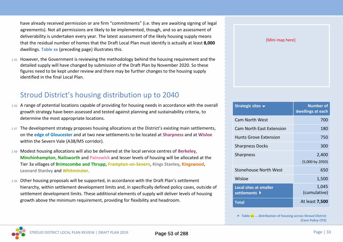
STROUD DISTRICT LOCAL PLAN REVIEW | DRAFT PLAN 2019 Page | 33
have already received permission or are firm “commitments” (i.e. they are awaiting signing of legalagreements). Not all permissions are likely to be implemented, though, and so an assessment ofdeliverability is undertaken every year. The latest assessment of the likely housing supply meansthat the residual number of homes that the Draft Local Plan must identify is actually at least 8,000dwellings. Table xx (preceding page) illustrates this.
2.45 However, the Government is reviewing the methodology behind the housing requirement and thedetailed supply will have changed by submission of the Draft Plan by November 2020. So thesefigures need to be kept under review and there may be further changes to the housing supplyidentified in the final Local Plan.
Stroud District’s housing distribution up to 20402.46 A range of potential locations capable of providing for housing needs in accordance with the overall
growth strategy have been assessed and tested against planning and sustainability criteria, todetermine the most appropriate locations.
2.47 The development strategy proposes housing allocations at the District’s existing main settlements,on the edge of Gloucester and at two new settlements to be located at Sharpness and at Wisloewithin the Severn Vale (A38/M5 corridor).
2.48 Modest housing allocations will also be delivered at the local service centres of Berkeley,Minchinhampton, Nailsworth and Painswick and lesser levels of housing will be allocated at theTier 3a villages of Brimscombe and Thrupp, Frampton-on-Severn, Kings Stanley, Kingswood,Leonard Stanley and Whitminster.
2.49 Other housing proposals will be supported, in accordance with the Draft Plan’s settlementhierarchy, within settlement development limits and, in specifically defined policy cases, outside ofsettlement development limits. These additional elements of supply will deliver levels of housinggrowth above the minimum requirement, providing for flexibility and headroom.
Strategic sites Number ofdwellings at each
Cam North West 700
Cam North East Extension 180
Hunts Grove Extension 750
Sharpness Docks 300
Sharpness 2,400(5,000 by 2050)
Stonehouse North West 650
Wisloe 1,500
Local sites at smallersettlements
1,045(cumulative)
Total At least 7,500
Table xx ... distribution of housing across Stroud District(Core Policy CP2)
[Mini map here]
Page 53 of 288Page 53 of 288

STROUD DISTRICT LOCAL PLAN REVIEW | DRAFT PLAN 2019 Page | 34
2.50 Public consultation has highlighted a range of housing issues facing Stroud District, while our LocalHousing Needs Assessment identifies the amount and types of housing that are likely to be neededduring the Plan period to 2040.
2.51 The Draft Plan’s development strategy seeks to tackle local housing needs that aren’t currently beingaddressed by the market, including opportunities to grow the rented sector and to meet those wishingto build their own homes. We also highlighted the need to find ways for young people to be able to staywithin rural neighbourhoods and to meet the needs of older people or those with disabilities throughflexible forms of accommodation including ‘lifetime homes’.
2.52 The Stroud District Settlement Role and Function Study Update (2018) highlighted the fact that housingaccessibility and housing affordability varies markedly across different parts of the District. Effects onsocial cohesion and the vitality of communities may be particularly acute in settlements that have seenlow levels of housing growth in recent decades, including some communities in the AONB, many ofwhich are highly constrained, yet have some of the District’s highest property prices and are likely to beamongst the most affected by the District-wide trend towards an ageing population.
2.53 Evidence shows that:
House prices have increased by the highest percentage within the South West when compared tothe other regions of England.
Much of the housing stock in the District is quite old and the worst housing conditions are mostevident in the private rented sector.
Stroud on average is one of the least deprived districts/unitary authorities in the country. However,there are pockets of deprivation, particularly in relation to housing and service provision.
Local needs...
Local need...Residents were able tomove into brand newCouncil homes completed inCam recently. Like manyplaces in the UK, housingaffordability is a particularissue for young families andfirst time buyers across theDistrict. Nationally, homeownership among 25- to34-year-olds has fallenfrom 59 % just over adecade ago to just 37 %today.
Page 54 of 288Page 54 of 288

STROUD DISTRICT LOCAL PLAN REVIEW | DRAFT PLAN 2019 Page | 35
...Meeting Stroud District’s housing needs up to 2040
Having taken into consideration local views, national policy and evidence where available, the housing strategy set out within this Draft Plan seeks to deliver:
at least 638 new homes per year for a 20 yearperiod
a mix of brownfield and greenfield allocatedhousing sites of varying sizes to ensure deliveryis maintained throughout the plan period
opportunities to bring forward housingdevelopment on brownfield sites through theidentification and potential allocation of sitesappropriate for housing on the Brownfield LandRegister
a proportion of affordable homes on all sites of10 dwellings or above in urban areas and on allsites of above 5 dwellings in designated ruralareas
additional affordable homes working withparish councils, co-operatives, community landtrusts and community housing groups
minimum dwelling sizes, subject to evidence ofneed, to avoid town cramming
a mix of dwelling types (1 bed, 2 bed, 3 bed, 4+bed, flats, houses, bungalows, etc.) on LocalPlan housing sites, in proportion to identifiedlocal needs
design guidance that supports flexibleaccommodation to ‘lifetime homes’ standardsand in support of healthy living
build to rent homes as a proportion of LocalPlan housing sites, subject to local needs
exception sites for first time buyers andrenters, subject to local needs
rural exception sites to meet local affordableneeds
small scale housing in rural areas in theinterests of social sustainability, subject to localcommunity support
self and custom built homes to meet needsidentified on the self and custom built register,through a combination of site allocations,proportionate development on Local Planhousing sites and rural exception sites
homes for older people, including sheltered,enhanced sheltered, extra care, registered careprovision on Local Plan housing sites, designedto standards allowing people to live for longerin their own homes
sites to meet the specific needs of local gypsiesand travellers and travelling showpeople
housing for local people, including whereappropriate, using local occupier clauses toensure local housing needs are met within oradjacent to existing communities
*[image credits see page 67]
The draft strategy...
Page 55 of 288Page 55 of 288

STROUD DISTRICT LOCAL PLAN REVIEW | DRAFT PLAN 2019 Page | 36
2.6 Local economy and jobsStroud District’s employment requirement up to 2040
2.50 Stroud District has a strong and prosperous economy and is home to world class companies andan innovative, resilient and successful small business sector. The Council has a commitment towork closely with the business community to grow the local economy and increase employment.The Local Plan has a role in providing certainty to the business community to make long terminvestment decisions, while also providing the framework for creating an attractive environment,including providing for a range and choice of sites and premises.
2.51 Work on developing an economic and employment strategy for Gloucestershire is ongoing. TheLocal Enterprise Partnership GFirstLEP is in the process of producing a Local Industrial Strategy.Working with other Gloucestershire councils, the District Council is commissioning an EconomicNeeds Assessment to explore options for a future economic growth strategy for Gloucestershireand what this will mean in terms of employment policies and sites.
2.52 The latest job forecasts for the District suggest the need to plan for between 2,300 and 6,300 netnew jobs (2020-2040). Previous forecast models have suggested that the District has a significantoversupply of employment land to meet these requirements. However, these models take noaccount of pent up demand, failures in the property market or the need for a range of sites andlocations to provide for choice and a continuum of supply beyond the Plan period.
2.53 Further work is required to identify future land requirements. However, based upon past take uprates, there is a need to provide at least 50 ha of additional employment (B1-B8) land (2020 to2040). In quantitative terms, a significant amount of land and premises likely to be required from2020 have already received permission or are firm “commitments” (i.e. they are awaiting signingof legal agreements). However, not all permissions are likely to be implemented and there hasbeen a steady and significant loss of employment land to other uses which needs to be reflected
The development strategy needs toensure that sufficient employmentland is provided to meet the futureneeds of business and balance the
planned housing growth
Table xx ... employment requirement up to 2040 (hectares)
Calculating our residual employmentrequirement up to 2040
Supp
ly
A Commitments, at April 2019 (onsites with permission / underconstruction)
5.10 ha
B Potential losses from ‘B’ uses,at April 2019 (on sites withpermission)
16.7 ha
C Total commitments net ofpotential losses (= A - B)
34.3 ha
Requ
irem
ent D Employment requirement for
1 April 2019 to 31 March 2020(=2.32 ha p/a x 21 years)
48.7 ha
H Minimum residualemployment requirement to2040 (= D - C)
14.4 ha
Page 56 of 288Page 56 of 288

STROUD DISTRICT LOCAL PLAN REVIEW | DRAFT PLAN 2019 Page | 37
in calculations. The latest assessment of thelikely employment land supply means that theresidual amount of land that the Local Planmust identify is actually only 14 hectares.Table xx (preceding page) illustrates this.
2.54 However, these overall figures take no specificaccount of the locational needs of particularsectors of the economy. Nor do they reflectthe need for qualitative improvements inexisting stock which may not be able to beachieved on existing sites.
2.55 One of the key challenges facing the localeconomy of the future is the predicted sharprise over the next 20 years in the number ofolder people living in the District comparedwith the very small rise in the number ofyounger people of traditional working age. Inaddition many young people are choosing notto remain in Gloucestershire. Supporting localbusinesses and avoiding skills and jobshortages will require a range of solutionsincluding trying to retain our young peoplewithin Gloucestershire and encouraginginward migration. A higher value economyand better quality jobs will also be part of thesolution.
2.56 There is considerable out-commuting to work,which presents a big challenge if we are toreduce our District’s carbon footprint: as a
[ILLUSTRATIONS HERE]
Page 57 of 288Page 57 of 288

STROUD DISTRICT LOCAL PLAN REVIEW | DRAFT PLAN 2019 Page | 38
rural district, many people are car-dependent, sowe also need to ensure that access to jobs, servicesand facilities can be improved in the future and ourchosen strategy must enable more sustainableforms of transport to be used. In order to stem out-commuting Stroud will need to attract moreknowledge-based industries, enabling greateremployment opportunities for the highly skilled andwell qualified working population. This suggests aneed for the District to both increase and diversifyits employment base, in order to provide local jobopportunities appropriate to the workforce and tohelp reduce the number of people travelling totowns and cities beyond the District for work.
2.57 In seeking to address some of the District’semployment trends and commuting imbalances,the current Plan supports growth in the followingsectors:- construction, distribution, retailing,computing services, hotel & catering, transport,professional services, other business services andhealth and social work. Professional services, otherbusiness services, computing services and healthand social work are identified as key growth areasto provide higher skilled jobs. The emerging LocalIndustrial Strategy is likely to focus on theeconomy’s strengths within manufacturing servicesfor the advanced engineering sector, agricultureand food manufacturing and emergingopportunities within the Green sector for cleangrowth and for supporting Cyber-tech innovation.
Stroud District’s employment distribution up to 20402.58 The current Local Plan provides for new employment land located at the key employment
property market areas: south of Gloucester; M5/A38 corridor and Stroud Valleys. These includeareas adjoining existing successful business parks at Quedgeley East (Hardwicke), SevernDistribution Park (Sharpness) and Stroudwater Business Park (Stonehouse), together withareas next to new housing at North East Cam and West of Stonehouse. The Local EnterprisePartnership has a focus on the A38/M5/rail corridor as a location for growth reflecting the goodconnections to the Midlands and the South West.
2.59 Whilst a review of employment land provision is underway and the needs of particular sectorswill need to be fully taken into account, the current key employment property areas are likelyto continue to be priority locations for future growth under this development strategy. Inaddition, co–locating employment with housing provides the best opportunity for greater selfcontainment and shorter journeys to work by means of transport other than the car. A sidebenefit may be that higher value residential land uses can help improve the viability of lowervalue employment land uses in mixed development proposals.
2.60 There are particular opportunities associated with developing new modern business parkpremises at Quedegely East and at Stonehouse and for growing Green technologies atBerkeley-Sharpness.
2.61 Whilst the identification of large new allocations forms part of the strategy, Stroud District hasabove average levels of self employment and home working. Changes in working practices,linked to the roll out of fast broadband, could see a further increase in home working and anincrease in the demand for smaller, more flexible work environments, including co-workingspace and live-work units. These local forms of development are also supported in the Plan.
Page 58 of 288Page 58 of 288

STROUD DISTRICT LOCAL PLAN REVIEW | DRAFT PLAN 2019 Page | 39
...Meeting Stroud District’s employment needs up to 2040
Having taken into consideration local views, national policy and evidence where available, theemployment strategy set out within this Draft Plan seeks to deliver:
economic growth and additional jobs on andadjacent to existing high value employmentsites and within the M5/A38/rail growthcorridor
new employment sites of varying sizes andlocations to meet the specific locationalrequirements of different sectors, withparticular support for green technology hubs
support for affordable, low cost sites andpremises with flexible terms for businessstart ups
opportunities to foster on-goingemployment-education links
new employment together with newhousing to create sustainable communitiesand to reduce the potential for further outcommuting
support for the faster roll out of broadband
support for co-working facilities,particularly at town centres
continued support for appropriate farmdiversification proposals, subject toenvironmental criteria
a more flexible approach towardsencouraging tourism businesses includingaccommodation, subject to moreappropriate locational and environmentalcriteria
regeneration of under-utilised or low valueemployment sites for other uses, providedthis does not undermine key employmentsectors.
The draft strategy...
[3]
[6]
Strategic sites Hectares at each
Quedgeley East Extension 5 ha
Javelin Park 9 ha
Sharpness Docks 7 ha
Sharpness 10 ha
Stonehouse North West 5 ha
Stonehouse Eco-Park(M5 J13)
10 ha
Wisloe 5 ha
Renishaw New Mills 10 ha
Total 61 ha
Table xx ... distribution of new employment land(Core Policy CP2)
[Mini map here]
Page 59 of 288Page 59 of 288

STROUD DISTRICT LOCAL PLAN REVIEW | DRAFT PLAN 2019 Page | 40
2.7 Our town centres2.62 Nationally, shopping patterns have changed
significantly since the 1970s. The rise of theout of town supermarkets and retail parks inthe 1980s started a decline in the traditionalrole of high streets providing for all of ourshopping needs. The more recent onset of e-retailing in all its forms: click and collect;home deliveries; and online shopping hasprovided a new and growing challenge.Services such as banks, building societies andestate agents are closing with the continuedgrowth of on–line banking and web basedservices where a presence on the high streetis no longer required.
2.63 However, there is also a positive story to tellwith the rise in local food stores and foodoutlets, giving evidence to the trend of anewly emerging food and cafe culture. This isreinforced by the trend for increased ‘eatingout’. A further factor may be the growth ininterest in locally sourced and organic foodsand also the trend towards healthy eating.
2.64 Recent investment in Stroud town centre atMerrywalks demonstrates that despitedifficult market conditions it remains
feasible to improve existing and attract newcomparison goods floorspace. Stroud has astrong independent retailing sector andthere are opportunities to further enhanceboth this and the evening economy.
2.65 Wotton-under-Edge, Stonehouse andNailsworth have the potential to increasetheir market share in terms of conveniencegoods floorspace, via qualitativeimprovements in the retail offer andclawback convenience goods capacity whichis currently being lost to other settlements(including Stroud). There are opportunitiesto improve the quality of comparison goodsfloorspace provision within each of the maintown centres in the District, althoughrealism is required in relation to the abilityfor the main towns to significantly improvetheir respective market shares.
2.66 The ongoing pattern of change suggests thatfor smaller centres such as those within ourDistrict, town centre strategies which supportthe evolution of the high street are vital so wecan capitalise on what makes our towncentres distinctive and unique.
Study findings...
A Future of Town Centres report, which haslooked at the top tier town centres of Stroud,Dursley, Nailsworth, Stonehouse and Wotton-under-Edge, is suggesting the following optionsfor helping our town centres to meet thesechallenges:
Supporting existing retailers to make betteruse of websites and e-retailing to widentheir appeal and increase footfall
Marketing our town centres on-line fortheir leisure and tourism potential
Reviewing town centre car parking charges
Reviewing town centre planning policiesand boundaries to reflect a smaller futureretail area and to be more flexible toencourage other uses into town centres
Supporting small town centre office useswhich provide work spaces with flexiblerental arrangements
These recommendations equally may apply toother town centres in the District.
Strategic sites Number ofdwellings at each
Cam North West 700
Cam North East Extension 180
Hunts Grove Extension 750
Sharpness Docks 300
Sharpness 2,400(5,000 by 2050)
Stonehouse North West 700
Wisloe 1,500
Local sites at smallersettlements
1,140(cumulative)
Page 60 of 288Page 60 of 288

STROUD DISTRICT LOCAL PLAN REVIEW | DRAFT PLAN 2019 Page | 41
2.67 The Draft Local Plan establishes a retailhierarchy (Core Policy CP12) based upon thefunction of the town centres and supportsproposals for improving the quantity andquality of retail floorspace at the main towncentres, particularly at Stroud. Proposals aredirected in the first instance to town centrelocations, with edge and out of centreproposals tested against their impact on thehealth of nearby town centres. However, it isrecognised that the core area for shoppingneeds to be balanced with a more flexibleapproach to other uses outside of these areas,so that other leisure, community, employmentand residential uses can help to retain vitalityand viability in our town centres.
2.68 Before the Draft Local Plan is submitted toGovernment, the Council will assess the latestretail forecasts to determine whether anyadditional comparative or comparisonfloorspace is required to address needs. At thisstage, it is anticipated that the growth of newcommunities will require modest provision ofadditional convenience floorspace, to belocated at planned local centres. However, inthe current retail climate, additionalcomparative floorspace is unlikely to berequired. The Draft Local Plan does, however,identify a number of physical enhancements tosupport the District’s main town centres.
[3]
[ILLUSTRATIONS HERE]
Page 61 of 288Page 61 of 288

STROUD DISTRICT LOCAL PLAN REVIEW | DRAFT PLAN 2019 Page | 42
Having taken into consideration local views,national policy and evidence where available, thetown centre strategy set out within the DraftPlan seeks to deliver:
the level and type of future retail floorspaceneeded for at least a ten year period
a more flexible planning policy framework,which prioritises retail uses within primaryfrontages but allows for a more diverse rangeof supporting uses in secondary areas
continued support for town centres as themost appropriate location for main retail andleisure uses especially for young people
office uses providing work spaces with flexiblerental arrangements in town centres
support for existing markets and sites and/orpolicies which support further markets
Stroud improvements to the Merrywalks shopping
centre and retail and leisure offer the redevelopment of brownfield sites
(including those identified in the StroudTown Centre Neighbourhood Plan) forappropriate uses including housing, retailand leisure
improvements to Stroud station; andinvestigate the potential for an integratedtransport hub
walking and cycling links to and from theStroudwater canal and the wider Stroudvalleys network
Nailsworth pedestrian improvements to Market Street redevelopment of the town square area to
provide a better retail and leisureexperience, including new homes and openspace
an improved and centrally located towncouncil, library and tourism facility
improved walking and cycling links to thewider Stroud valleys network
Dursley brownfield sites for redevelopment for housing
and town centre uses access improvements to Market Hall, if practical environmental improvements to Parsonage Street urban design, signage and public realm
improvements and other proposals as set out inthe Dursley Neighbourhood Plan
improved walking and cycling links connectingwith Cam and Uley
Wotton-under-Edge opportunities for town centre improvements
facilitated by the provision of additional parking priorities set out in the Community Plan Update
2016 the Greenway cycle and walking route, subject to
further feasibility work
Stonehouse better cycling and walking links, with signage to /
from the canal to the wider Stroud valleys network proposals set out in the Stonehouse
Neighbourhood Plan
The draft strategy...
Page 62 of 288Page 62 of 288

STROUD DISTRICT LOCAL PLAN REVIEW | DRAFT PLAN 2019 Page | 43
Other centresAt the District Centres of Berkeley, Cam,Minchinhampton and Painswick, the Draft Plansupports public realm improvements, signage andimproved walking and cycling links from existingand future development. At Cam centre, theproximity of new development will provideopportunities to complete the Greenway cycle andwalking link connecting the centre with Cam &Dursley rail station and Dursley, to enhance use ofthe adjacent Rackleaze wildlife area for leisure useand to improve walking and cycling from Draycottto the centre.
[7]
Leisure...Recent years have seen a rise in the
number of leisure uses at towncentre locations; many of our town
centres benefit from independentcafes and shops, traditional marketsand an attractive landscape setting.
[8]
*[image credits see page 111]
©Nick Turner
Page 63 of 288Page 63 of 288

STROUD DISTRICT LOCAL PLAN REVIEW | DRAFT PLAN 2019 Page | 44
2.8 Local green spaces and communityfacilities
2.69 The review of the Local Plan provides theopportunity to consider whether there arelocal community needs within existing townsand villages that are not currently beingprovided for. The loss of public houses, villageshops and other facilities can leavecommunities without places to meet andenjoy together. A more active or growingcommunity can need more or differing playand sports facilities. Sometimes developmentcan offer opportunities to deliver newcommunity facilities in places where existingdeficiencies exist.
2.70 Equally, there may be existing places andspaces that are valued by the community butare not explicitly recognised in existing plans.Existing community facilities can be identifiedfor protection. Local green spaces can beidentified for special protection. These are localareas of particular importance to localcommunities for their beauty, tranquillityand/or historic, wildlife or recreation value butshould not involve extensive tracts of land.
Study findings...
A new Open Space, Green Infrastructure (GI), Sport and Recreation Study has been produced for theDistrict, which includes a full audit of all accessible open spaces across the District. The studyidentifies the quality, quantity and accessibility of current provision, produces local provisionstandard recommendations in accordance with relevant guidance and local needs, and identifiesopportunities to protect and extend the green infrastructure network.
Key findings include:
The distribution of open space varies across the District, however, there are identified shortagesof at least 1 typology of open space in all Parishes and clusters/sub areas.
Access to formal open space is concentrated within populated areas. There is generally goodaccess to large areas of natural green space across the eastern half of the district, with large gapsin the western part of the district.
The majority of open spaces surveyed are of good quality. Local households however ratedfacilities for teenagers, artificial turf pitches and tennis/netball courts as poor or worse. Incontrast, households rated parks and recreation grounds, woodlands, wildlife areas and naturereserves as being good or very good.
A series of strategic and district GI corridors have been identified and key opportunitieshighlighted where gaps in the network could be filled through positive intervention.
Potential sport, health and wellbeing hubs focused around playing pitches have been identified inthe north and south of the District as well as a number of other priority pitch related projects.
Page 64 of 288Page 64 of 288
STROUD DISTRICT LOCAL PLAN REVIEW | DRAFT PLAN 2019 Page | 45
2.71 Future housing and population growth willincrease localised demand for many forms ofopen space and sports facilities and it will beimportant to review the level of provision,especially in areas of rapid population change.
[1]
There is scope for further health and fitnessfacilities at leisure centres and for furtherindoor waterspace opportunities. ExistingCouncil owned pools are in good conditionand well used.
Whilst the quantity of sports halls is goodand there is a strong record of communityuse and management of school facilities,some of the older school sports halls are inneed of upgrade and repair and some sportswould benefit from bespoke facilities e.g.gymnastics.
There is a lack of “track and field” trainingfacilities for athletes and indoor tennisfacilities, although there is provision inGloucester.
There is generally a good spread ofcommunity halls across the District. In somelocations their upgrading will help to meetcommunity needs where access to morecentrally planned leisure centres is difficult.
[ILLUSTRATIONS HERE]
Page 65 of 288Page 65 of 288
STROUD DISTRICT LOCAL PLAN REVIEW | DRAFT PLAN 2019 Page | 46
...Meeting Stroud District’s community and green space needs up to 2040
Having taken into consideration local views, national policy and evidence where available, the open space and community strategy set out within this DraftPlan seeks to deliver:
policy protection for important open spaceswithin settlements, outdoor recreationfacilities, playing fields or allotments, within orrelating to settlements
a mapped GI network, linking urban areas tothe wider countryside, identifying importanthabitats, landscape features, river and greencorridors and ecological networks
a set of standards for local open space, sportand recreation facility provision, to guide futuredevelopment
site opportunities to address shortfalls in localopen space, sport, recreation and communityfacility provision and to address gaps in the GInetwork and enhance the network function
restoration of the derelict canal betweenStonehouse and Saul Junction, reconnectingStroudwater Navigation to the Gloucester &Sharpness Canal, including creating 30 hectaresof biodiverse habitat and canal towpath
improvements to the Stonehouse to Nailsworthcycleway, including biodiversity improvementand resurfacing work; creation of the Cam,Dursley and Uley Greenway and provision of anew Greenway linking Wotton under Edge,Kingswood and Charfield
support for the identification of local greenspaces through Neighbourhood DevelopmentPlans and the protection of community facilitiesthrough existing Assets of Community Valuelegislation
opportunities to address identified communityneeds in association with new developmentthrough the Community Infrastructure Levy(CIL) and s106 agreements
support for the planned provision ofcommunity facilities alongside housing growth,through masterplanning of strategic and othermajor developments
continued protection of identified areas ofbiodiversity, landscape, and heritageimportance
a mitigation strategy for the CotswoldBeechwoods SAC to assess and addressrecreational pressures including from growthwithin Gloucester.
The draft strategy...
Page 66 of 288Page 66 of 288

STROUD DISTRICT LOCAL PLAN REVIEW | DRAFT PLAN 2019 Page | 47
2.8 Core policies2.11 The six ‘Core Policies’ in this chapter sit at the heart of the Plan. They are
the principal means of defining and delivering the Draft Plan’s proposeddevelopment strategy. There are further Core Policies relating to Homesand Communities, Economy and Infrastructure and Our Environmentand Surroundings in Chapters 4, 5 and 6, along with detailed ‘DeliveryPolicies’ on a range of topics.
2.12 This chapter sets out six proposed Core Policies and summarises why thewording of these draft policies may differ from the Core Policies in thecurrent (2015) Local Plan. At this stage, the policies are not accompaniedby full supporting text. This will be developed and refined for the nextiteration of the Local Plan (the Pre-submission Plan, anticipated Autumn2020), taking account of evidence and relevant views expressed throughthis public consultation.
Delivering Carbon Neutral by 2030* NEW * Core Policy DCP1 Summary of proposed changes to this policy:
2.13 Replacement of current presumption in favour of sustainabledevelopment policy, as the NPPF provides this national policy framework.New overarching policy reflects the Council’s commitment for the Districtto become Carbon Neutral by 2030.
Stroud District will become Carbon Neutral by 2030 ahead of the Governmenttarget of net Zero Carbon 2050. To support this target all new developmentmust be:
located where the form and mix of development itself or proximity toessential services and facilities minimises the need to travel;
designed to discourage the use of the private car, irrespective of fuelsource, by prioritising in order of importance: walking, cycling and publictransport to deliver the highest possible share of trips by the mostsustainable travel modes;
designed to maximise green infrastructure to sequester carbon and tosupport local food production;
designed to follow the Energy Hierarchy principle of reducing energydemand, supplying energy efficiently / cleanly and using onsite low or zerocarbon energy generation to meet standards which move progressivelytowards zero carbon, in terms both of regulated and unregulatedemissions. Accordingly, new development should be constructed toachieve the highest viable energy efficiency and designed to maximise thedelivery of decentralised renewable or low-carbon energy generation;
designed to reduce vulnerability to and provide resilience from the impactsarising from a changing climate whilst not increasing the potential forincreased greenhouse gas emissions in doing so.
* NEW * Core Policy DCP1Delivering Carbon Neutral by 2030
Page 67 of 288Page 67 of 288

STROUD DISTRICT LOCAL PLAN REVIEW | DRAFT PLAN 2019 Page | 48
Strategic growth and developmentlocations
Core Policy CP2 Summary of proposed changes to this policy:
2.11 Additional growth requirements reflect national policy and the results oflocal needs assessments. Locations reflect the proposed developmentstrategy and Duty to Cooperate requirements and take account of thedetailed assessment of sites.
Stroud District will accommodate at least 12,800 additional dwellings, 650additional care home bedspaces and at least 50 hectares of additionalemployment land to meet the needs of the District for the period 2020-2040.
Strategic development sites to meet needs are allocated at the followinglocations:
Location Employment HousingCam North West 700Cam North East Extension 180Hunts Grove Extension 750Javelin Park 9 haQuedgeley East Extension 5 haRenishaw New Mills 10 haSharpness Docks 7 ha 300Sharpness 10 ha 2,400 (5,000 by 2050)
Stonehouse North West 5 ha 650Stonehouse - Eco Park M5 J13 10 haWisloe 5 ha 1,500
Local development sites are allocated at the following settlements:
Settlement Housing (cumulative total)Berkeley 120Brimscombe & Thrupp 190Cam 15Dursley 10
Core Policy CP2Strategic growth and development locations
Page 68 of 288Page 68 of 288

STROUD DISTRICT LOCAL PLAN REVIEW | DRAFT PLAN 2019 Page | 49
Settlement Housing (cumulative total)Frampton-on-Severn 30Kingswood 50Leonard Stanley 40Minchinhampton 80Nailsworth 105Newtown & Sharpness 70Painswick 20Stonehouse 10Stroud 265Whitminster 40
In addition to allocated sites, development will take place in accordance with theSettlement Hierarchy set out in this Plan (Core Policy CP3).
Housing development will take place within settlement development limits, B-class employment development will take place at designated employment areasand retail development will take place in accordance with the Retail Hierarchy(Core Policy CP12).
Limited development will take place outside of these designated areas and inaccordance with other policies of the Plan.
Stroud District will make a contribution to meeting the unmet housing needs ofGloucester City for the Plan period by providing for growth at the followinglocation, subject to it being required to meet needs and provided locating growthat this location is consistent with the approved strategy for the Joint CoreStrategy Review:
Location HousingLand at Whaddon 2,500
Our towns and villagesCore Policy CP3 A hierarchy for growth and development across the District’ssettlements
2.12 The settlements identified in Core Policy CP3 all have definedsettlement boundaries or “settlement development limits” (SDL), withinand (exceptionally) adjacent to which suitable development may bepermitted.
2.13 Very small settlements not mentioned in the settlement hierarchy willbe treated as open countryside, where development will be restricted tothat which contributes to diverse and sustainable farming enterprises,recreation, tourism, or involves the conversion of rural buildings and theprovision of essential community facilities, in accordance with CorePolicy CP15.
Summary of proposed changes to this policy:
2.14 Proposed changes reflect additional support for brownfielddevelopment, evidence from the Settlement Role and FunctionStudy Update (2018) and the proposed development strategy. SDLsare shown on the Policies Map for the current Local Plan; proposedchanges to some individual SDLs are set out in APPENDIX A.
Core Policy CP2Strategic growth and development locations ...(contd.)
Page 69 of 288Page 69 of 288

STROUD DISTRICT LOCAL PLAN REVIEW | DRAFT PLAN 2019 Page | 50
Proposals for new development should be located in accordance with the District'ssettlement hierarchy. This will ensure that development reduces the need to traveland promotes sustainable communities, based on the services and facilities that areavailable in each settlement. The use of previously developed land and buildingswithin settlements will be given substantial weight.
Tier 1 - Main settlementsCam and Dursley, Stonehouse, StroudThese are the District’s largest and most populous settlements, each of whichbenefits from transport infrastructure that enables good access to key services andfacilities, with good links to their suburbs and “satellite” communities. They are theprimary focus for growth and development, with a view to safeguarding andenhancing their strategic roles as employment and service centres. They will continueto provide significant levels of jobs and homes, together with supporting communityfacilities and infrastructure to meet their economic potential in the most sustainableway. Further development will be achieved through strategic allocations,development within settlement development limits, town centres and employmentsites and (exceptionally) adjacent to settlement development limits, subject tofulfilling the criteria set out in the Plan’s Core and Delivery policies.
Tier 2 - Local Service CentresBerkeley, Minchinhampton, Nailsworth, Painswick, Wotton Under Edge; HuntsGrove (anticipated)These market towns and large villages have the ability to support sustainablepatterns of living in the District because of the facilities, services and employmentopportunities they each offer. They have the potential to provide for modest levelsof jobs and homes, including through sites allocated in this Plan, in order to helpsustain and, where necessary, enhance their services and facilities, promotingbetter levels of self containment and viable, sustainable communities. Furtherdevelopment will be achieved through strategic allocations, development withinsettlement development limits, town centres and employment sites and(exceptionally) adjacent to settlement development limits, subject to fulfilling thecriteria set out in the Plan’s Core and Delivery policies.
Tier 3a - Accessible Settlements with Local FacilitiesHardwicke, Chalford, Manor Village (Bussage), Brimscombe & Thrupp,Eastington, Kings Stanley, Leonard Stanley, Frampton on Severn, Newtown &Sharpness, Kingswood, Whitminster, North WoodchesterThese medium-sized and large villages are generally well-connected andaccessible places, which provide a good range of local services and facilities fortheir communities. These villages benefit from their proximity and/or connectivityto higher tier settlements or transport corridors, which enables access toemployment and key services and facilities elsewhere, and which may offer somescope for further transport and accessibility improvements. These are relativelysustainable locations for development, offering the best opportunities outside theDistrict’s Main Settlements and Local Service Centres for greater self-containment. Some of these settlements outside the AONB may have scope tohelp meet the housing needs of more constrained Tier 1 or Tier 2 settlements.However, their scope for future growth (in addition to any sites already allocatedin this Plan) is constrained. Further development will be focused inside settlementdevelopment limits or (exceptionally) on the edge of settlements, subject tomeeting criteria set out in the Plan’s Core and Delivery policies, and will principallymeet specific local housing, employment and community infrastructure needs,with a view to safeguarding or enhancing each settlement’s current role, functionand accessibility.
Tier 3b – Settlements with Local FacilitiesWhiteshill & Ruscombe, Upton St Leonards, Uley, Slimbridge, Bisley, Coaley,North Nibley, Oakridge Lynch, Amberley, Horsley, MiserdenThese small and medium-sized rural villages provide a range of services andfacilities for their communities, but some have poor access to key services andfacilities elsewhere and they all face significant environmental constraints togrowth. There are no site allocations at any of these settlements. However, theremay be scope for some development to meet specific local housing, employment orcommunity infrastructure needs, either within or (exceptionally) adjacent to thesettlement development limit, subject to fulfilling the criteria set out in this Plan’s
Core Policy CP3Settlement Hierarchy
Page 70 of 288Page 70 of 288

STROUD DISTRICT LOCAL PLAN REVIEW | DRAFT PLAN 2019 Page | 51
Core and Delivery policies. Any such development will seek to sustain or enhancethe settlement’s existing role, function and accessibility.
Tier 4a - Accessible Settlements with Basic Facilities“Old” Bussage, Cambridge, Eastcombe, Newport, Nympsfield, Selsley, SouthWoodchester
These small and very small villages provide a limited range of services and facilitiesfor their communities. Whilst they may be unable to meet residents’ day to dayrequirements, these are relatively well-connected and accessible settlements,which benefit from their proximity and/or connectivity to higher tier settlements ortransport corridors. These settlements are relatively less sustainable locations forgrowth, compared to Tier 1-3 settlements, and most face significant environmentalconstraints. However, there may be scope for very limited development to meetspecific local housing, employment or community needs, either within or(exceptionally) adjacent to the settlement development limit, subject to fulfillingthe criteria set out in this Plan’s Core and Delivery policies. Any such developmentwill seek to sustain or enhance the settlement’s existing role, function andaccessibility and to boost community vitality and social sustainability.
Tier 4b – Settlements with Basic FacilitiesArlingham, Box, Brookthorpe, Cranham, France Lynch, Haresfield, Hillesley,Longney, Middleyard, Randwick, Saul, Sheepscombe, Stinchcombe, Stone
These small and very small rural settlements provide basic or minimal facilities fortheir communities, but lack the range of services to meet day to day requirements.These are generally inaccessible and unsustainable locations for growth, withsignificant environmental constraints. However, there could be scope for verylimited development to meet specific local housing, employment or communityneeds, either within or (exceptionally) adjacent to the settlement developmentlimit, subject to fulfilling the criteria set out in this Plan’s Core and Delivery policies,to boost community vitality and social sustainability.
Core Policy CP3Settlement Hierarchy ...(contd.)
The settlements named in this hierarchy all have defined settlement boundaries or “settlementdevelopment limits” (SDL). Suitable development may be permitted within and (exceptionally)
adjacent to SDLs, in accordance with other detailed policies in the Plan.
Very small settlements not mentioned in the settlement hierarchy will be treated as opencountryside, where Core Policy CP15 will apply.
Site allocations – including mixed-usesites to meet strategic housing,employment, retail and communityneeds, including healthcare andeducation
A minimum of 2% of dwellings onstrategic site allocations to be self-build / custom-build plots At least 30% affordable housing on
all sites capable of providing 10 ormore dwellings
Main Settlements
1
Within SDL – Infill and re-
development(including housing,employment, live-work, retail/towncentre,tourism/leisure andcommunity uses) At least 30%
affordable housingon all sites capableof providing 10 ormore dwellings
Adjoining SDL – Exception sites: 100% affordable housing,
including entry-level homes and affordableself-build/custom build homes Single plots: affordable self-build or
custom- build homes Live-work development Tourism / leisure development, subject to
criteria
Outside SDL –Core Policy CP15applies
Fig. xx ... Our towns and villages | Proposed development strategy for Tiers 1-4
Page 71 of 288Page 71 of 288
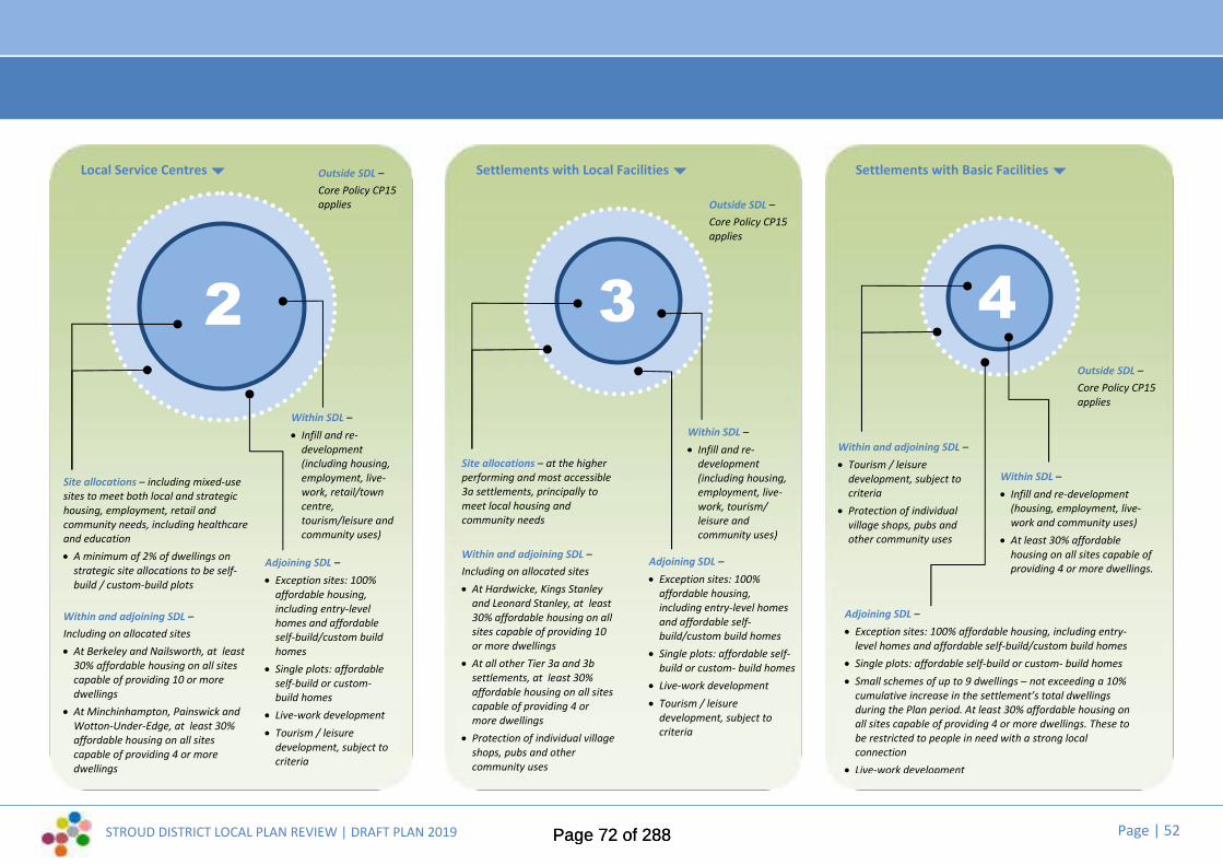
STROUD DISTRICT LOCAL PLAN REVIEW | DRAFT PLAN 2019 Page | 52
Site allocations – including mixed-usesites to meet both local and strategichousing, employment, retail andcommunity needs, including healthcareand education A minimum of 2% of dwellings on
strategic site allocations to be self-build / custom-build plots
Within and adjoining SDL –Including on allocated sites At Berkeley and Nailsworth, at least
30% affordable housing on all sitescapable of providing 10 or moredwellings At Minchinhampton, Painswick and
Wotton-Under-Edge, at least 30%affordable housing on all sitescapable of providing 4 or moredwellings
Local Service Centres
2Within SDL – Infill and re-
development(including housing,employment, live-work, retail/towncentre,tourism/leisure andcommunity uses)
Adjoining SDL – Exception sites: 100%
affordable housing,including entry-levelhomes and affordableself-build/custom buildhomes Single plots: affordable
self-build or custom-build homes Live-work development Tourism / leisure
development, subject tocriteria
Settlements with Local Facilities Settlements with Basic Facilities
3 4
Outside SDL –Core Policy CP15applies
Within SDL – Infill and re-
development(including housing,employment, live-work, tourism/leisure andcommunity uses)
Site allocations – at the higherperforming and most accessible3a settlements, principally tomeet local housing andcommunity needs
Within and adjoining SDL –Including on allocated sites At Hardwicke, Kings Stanley
and Leonard Stanley, at least30% affordable housing on allsites capable of providing 10or more dwellings At all other Tier 3a and 3b
settlements, at least 30%affordable housing on all sitescapable of providing 4 ormore dwellings Protection of individual village
shops, pubs and othercommunity uses
Outside SDL –Core Policy CP15applies
Adjoining SDL – Exception sites: 100%
affordable housing,including entry-level homesand affordable self-build/custom build homes Single plots: affordable self-
build or custom- build homes Live-work development Tourism / leisure
development, subject tocriteria
Within SDL – Infill and re-development
(housing, employment, live-work and community uses) At least 30% affordable
housing on all sites capable ofproviding 4 or more dwellings.
Within and adjoining SDL – Tourism / leisure
development, subject tocriteria Protection of individual
village shops, pubs andother community uses
Adjoining SDL – Exception sites: 100% affordable housing, including entry-
level homes and affordable self-build/custom build homes Single plots: affordable self-build or custom- build homes Small schemes of up to 9 dwellings – not exceeding a 10%
cumulative increase in the settlement’s total dwellingsduring the Plan period. At least 30% affordable housing onall sites capable of providing 4 or more dwellings. These tobe restricted to people in need with a strong localconnection Live-work development
Outside SDL –Core Policy CP15applies
Page 72 of 288Page 72 of 288

STROUD DISTRICT LOCAL PLAN REVIEW | DRAFT PLAN 2019 Page | 53
Making placesCore Policy CP4 Making Places: a Spatial Vision for the Stroud District
2.11 The Local Plan includes a spatial vision for the whole District, which is setout at the start of this chapter (Chapter 2 | Development Strategy). Italso includes a series of “mini visions” for parish cluster areas, whichreflect the distinct qualities, issues, constraints and opportunities thatexist in different parts of the overall area (see Chapter 3 | MakingPlaces). The visions set out the envisaged and desired effects that thedevelopment strategy should have on particular parts of the District.
2.12 Core Policy CP4 is intended to underpin both the Local Plan visions andthe strategic objectives.
Summary of proposed changes to this policy:
2.13 There are no proposed changes to this policy, aside from punctuation.
All development proposals shall accord with the Mini Visions and have regard tothe Guiding Principles for that locality, as set out in this Plan and shall beinformed by other relevant documents, such as any design statements adoptedas Supplementary Planning Documents. Proposals will be expected to:
1. Integrate into the neighbourhood: take account of connectivity; be locatedclose to appropriate levels of facilities and services; reduce car dependency;improve transport choice; support local community services and facilities;and meet local employment or housing requirements in terms of mix, tenureand type;
2. Place shape and protect or enhance a sense of place: create a place with alocally-inspired or distinctive character (whether historic, traditional orcontemporary) using appropriate materials, textures, colours and locally-distinctive architectural styles; working with the site topography, orientationand landscape features; as well as protecting or enhancing local biodiversity,the historic environment and any heritage assets;
3. Create safe streets, homes and workplaces: where buildings are positionedwith landscaping to define and enhance streets and spaces; assist findingyour way around with focal points or landmarks; provide permeability,reduce car domination of the street and reduce vehicle speeds; provideshared or social spaces on the streets (where appropriate); create safe wellmanaged attractive public and private amenity spaces; and provide adequateexternal storage space for waste bins, recycling materials and bicycle storage.
Core Policy CP4Place Making
Page 73 of 288Page 73 of 288

STROUD DISTRICT LOCAL PLAN REVIEW | DRAFT PLAN 2019 Page | 54
Core Policy CP5 Principles for the siting, design and construction of strategicdevelopment.
2.14 Proposed strategic sites are identified in Core Policy CP2. Any developmentof a strategic scale will be expected to fulfil the requirements of CorePolicy CP5.
Summary of proposed changes to this policy:
2.15 There are no proposed changes to this policy.
Strategic sites will:
1. Be built at an appropriate density that is acceptable in townscape, localenvironment, character and amenity terms
2. Be low impact in terms of the environment and the use of resources3. Be readily accessible by bus, bicycle and foot to shopping and employment
opportunities, key services and community facilities; and will contributetowards the provision of new sustainable transport infrastructure to servethe area, in seeking to minimise the number and distance of single purposejourneys by private cars
4. Have a layout, access, parking, landscaping and community facilities inaccordance with an approved indicative masterplan
5. Be located to achieve a sustainable form of development and/or supportregeneration. Development proposals should incorporate a negotiateddesign code/framework.
Applications for all strategic sites (both residential and non-residential) will berequired to provide a statement demonstrating how sustainable constructionprinciples have been incorporated. This should address demolition, constructionand long term management. This will be expected to show how the proposalmaximises its contribution towards the following objectives:
A. Sustainable sourcing of materials and their efficient and appropriate use,including their durability
B. Minimising waste and maximising recyclingC. Incorporating Sustainable Drainage SystemsD. Minimising water consumptionE. Minimising energy consumption and improving energy performanceF. Minimising net greenhouse gas emissions of the proposed developmentG. Maximising low or zero carbon energy generation.
Where the Council considers it could be likely that the proposal will result insignificant adverse environmental effects during the construction phase, aConstruction Environmental Management Plan (CEMP) will be required.
Core Policy CP5Environmental development principles for strategic sites
Page 74 of 288Page 74 of 288

STROUD DISTRICT LOCAL PLAN REVIEW | DRAFT PLAN 2019 Page | 55
Infrastructure and developercontributions
Core Policy CP6 2.16 Most infrastructure required by a new development will be provided on-
site by the developer and incorporated within the overall design conceptfor the scheme. In cases where off-site provision is required, varioustypes of contributions can be secured, depending upon the nature of theproposed development.
2.15 The Community Infrastructure Levy (CIL) enables contributions fromdevelopment to be pooled to deliver District infrastructure priorities. CILwill be subject to review in accordance with national legislation andadvice.
Summary of proposed changes to this policy:
2.16 There are no proposed changes to this policy.
Core Policy CP6Infrastructure and developer contributions
The Council will work with partners to ensure that infrastructure will be in place atthe right time to meet the needs of the District and to support the developmentstrategy. This will be achieved by:
1. The preparation and regular review of the Infrastructure Delivery Plan (IDP) forthe District that will set out the infrastructure to be provided by partners,including the public sector and utilities
2. Securing contributions to all aspects of land use, infrastructure and services thatmay be affected by development, in accordance with the District Council’sidentified priorities and objectives for delivering sustainable communities
3. The preparation of a Community Infrastructure Levy (CIL) charging schedule thatsets out the level of developer contributions towards new or upgradedinfrastructure to support the overall development strategy
4. Negotiating appropriate planning obligations to mitigate any adverse impacts ofproposed development, while avoiding duplication of payments made throughCIL.
Where implementation of a development would create a need to provide additionalor improved infrastructure and amenities, would have an impact on the existingstandard of infrastructure provided, or would exacerbate an existing deficiency intheir provision, the developer will be expected to make up that provision for thoselocal communities affected. Where the developer is unable to make such provision,the Council will require the developer to make a proportionate contribution to theoverall cost of such provision through a legal agreement and/or CommunityInfrastructure Levy.
Various types of contribution will be used, including the following:i) In-kind contributions and financial paymentsii) Phased payments and one-off paymentsiii) Maintenance paymentsiv) Pooled contributionsv) A combination of the above.
In determining the nature and scale of any provision, the Council will have regard toviability considerations and site specific circumstances.
Page 75 of 288Page 75 of 288

STROUD DISTRICT LOCAL PLAN REVIEW | DRAFT PLAN 2019 Page | 56
Making Places | Shaping the futureof Stroud District
[1] ©Nick Turner
3.
Page 76 of 288Page 76 of 288
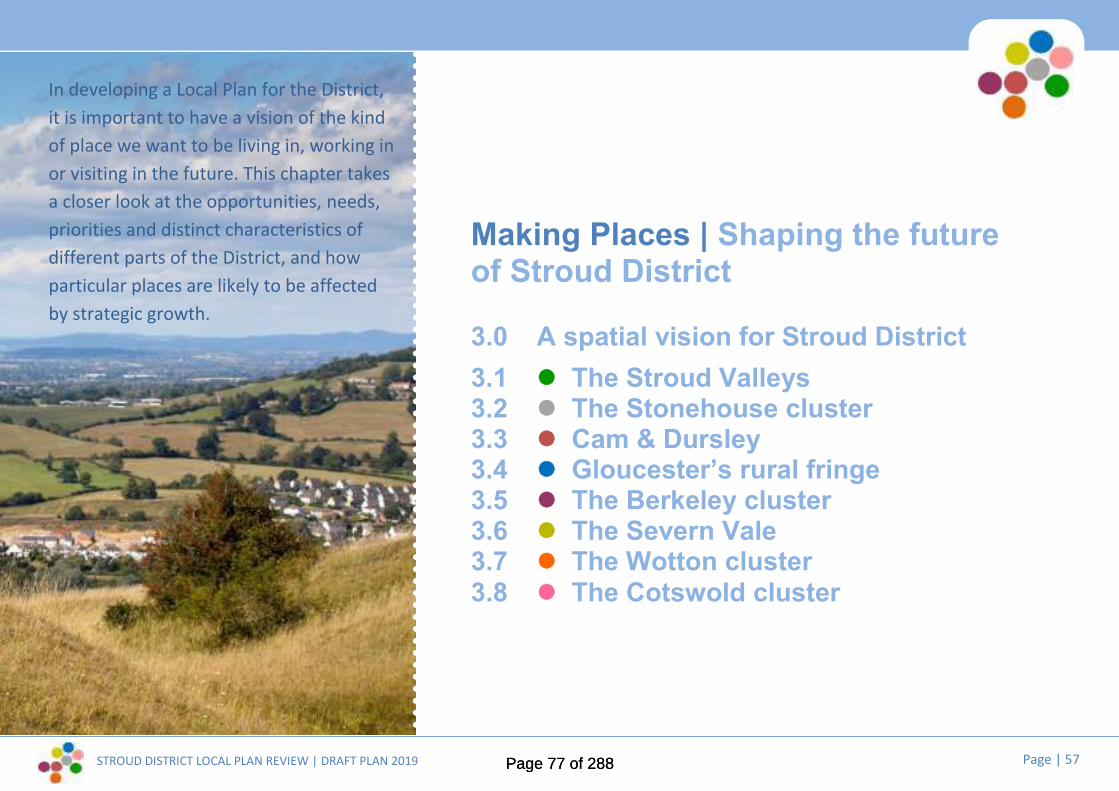
STROUD DISTRICT LOCAL PLAN REVIEW | DRAFT PLAN 2019 Page | 57
In developing a Local Plan for the District,it is important to have a vision of the kindof place we want to be living in, working inor visiting in the future. This chapter takesa closer look at the opportunities, needs,priorities and distinct characteristics ofdifferent parts of the District, and howparticular places are likely to be affectedby strategic growth.
Making Places | Shaping the futureof Stroud District
3.0 A spatial vision for Stroud District3.1 The Stroud Valleys3.2 The Stonehouse cluster3.3 Cam & Dursley3.4 Gloucester’s rural fringe3.5 The Berkeley cluster3.6 The Severn Vale3.7 The Wotton cluster3.8 The Cotswold cluster
Page 77 of 288Page 77 of 288

STROUD DISTRICT LOCAL PLAN REVIEW | DRAFT PLAN 2019 Page | 58
3.0 Making Places | a spatial vision forStroud District
3.1 The Draft Plan is founded on an over-archingvision for the District as a whole, which is acornerstone of the development strategy, andis set out in Chapter 2.
3.2 Derived from this, Chapter 3| Making Placessets out a spatial vision which consists of aseries of eight place-making ‘mini visions’ fordistinct parts of the District. Using facts andfigures gathered about all the District’sparishes, together with outcomes from publicconsultation, the spatial vision aims to focusthe over-arching goals of the main vision andthe strategic objectives in a way thatresponds more specifically to local priorities,issues and needs.
3.3 Whilst some places in the District have a needfor development or are suited to strategiclevels of growth, others are not. The spatialvision identifies areas that are likely to seesignificant changes; and areas that will not. Itpictures what the various levels of change orgrowth could mean for the District’s diverse
communities, settlements and landscapes. Itsets out the envisaged and desired effectsthat the development strategy should haveon particular parts of the district, includinginformation about the proposed strategicgrowth areas and local sites, the kind ofdevelopment that could happen at each placeand how this is intended to help achieve theoverall vision for the District’s future.
3.4 The Plan’s spatial vision for the District (and theeight ‘mini visions’ that feed into it) isillustrated in the Spatial Vision Diagram (fig.x)(over the page). Over the following pages, eight‘mini visions’ for eight parish cluster areas areset out in detail.
3.5 Core Policy CP4 (Chapter 2 | DevelopmentStrategy) emphasises that the Local Plan visionsunderpin the Draft Plan’s developmentstrategy.
“Parish clusters”3.6 The “parish clusters” that appear throughout
this Plan originated with the drafting of the2015 Local Plan. By grouping parishes thatshare some geographic and functionalsimilarities, we have been able to build up apicture of the particular needs andopportunities that most concern different partsof the District.
Our towns and villages3.7 Preparation of the Draft Plan’s development
strategy and the revised settlement hierarchyhas involved studying the main towns andvillages in the District, to identify their currentroles and functions and understand futureneeds. The following pages summarise some ofthe key findings from this work, to establish thecase for growth at each defined settlement.
3.8 Core Policy CP3 (Chapter 2 | DevelopmentStrategy) explains the implications of thesettlement hierarchy.
Page 78 of 288Page 78 of 288

STROUD DISTRICT LOCAL PLAN REVIEW | DRAFT PLAN 2019 Page | 59
Locations for strategic housingand mixed-use growth
Employment areas andlocations for employment-related growth
Existing areas of strategicgrowth, due to be completedduring the plan periodi) Hunts Grove, Hardwickeii) Brockworthiii) Littlecombe, Dursley
Local service centres: a focalpoint for retail, leisure, culturaland community facilities,commerce and employment
Locations for new localcentres
Strategic town centreconservation andregeneration at the District’sprincipal towns: Stroud andDursley
Canal corridor conservationand regeneration
Canal conservation andrestoration
Conserving and enhancingthe Cotswolds AONB
Conserving wildlife andnatural estuarine habitats
SETTLEMENT HIERARCHY:
Accessible local servicecentre (first tier)
Local service centre(second tier)
Accessible settlementwith limited facilities(third tier)
[NOTE: this image shows the spatial vision diagramfrom the current 2015 Local Plan. The consultation
Draft Plan will include an updated diagram (and mapkey), showing the Draft Plan’s proposed siteallocations and settlement hierarchy, etc.]
Vision diagram
Fig. X: ...Spatial vision for the StroudDistrict up to 2040
Berkeley cluster“...Growing two newvillages and boostingvitality by making themost of our naturalresources, leisure andtourism”
Berkeley, Ham & Stone,Alkington, Hamfallow, Hinton,Slimbridge
Cotswold cluster“...Protecting andenhancing all the thingsthat will make theCotswolds a thriving andinclusive place to live, aswell as a great place tovisit”
Painswick, Bisley-with-Lypiatt,Miserden, Cranham,Pitchcombe
Stroud Valleys“...Regeneration, creativityand cultural blossoming inthe green valleys”
Stroud, Whiteshill & Ruscombe,Randwick, Cainscross,Rodborough, Brimscombe &Thrupp, Chalford, Woodchester,Minchinhampton, Horsley,Nailsworth
Cam & Dursley“...Growth and prosperity:revitalising the towns ofDursley and Cam to makean accessible, attractivefocus for ruralcommunities in thesouth”
Dursley, Cam, Coaley,Stinchcombe, Uley,Nympsfield, Owlpen
Gloucester fringe“...Growing a sustainablecommunity at HuntsGrove and preservingGloucester’s ruralhinterland”
Hardwicke, Haresfield,Harescombe, Brookthorpe-with-Whaddon, Upton StLeonards
Stonehouse cluster“...Economic growth andwell-connected, thrivingcommunities”
Stonehouse, Standish,Eastington, Frocester,Leonard Stanley, KingsStanley
Wotton Cluster“...Improving access to jobs,services and facilities in thesouth of the District, toboost local sustainabilityand community vitality”
Wotton-Under-Edge, NorthNibley, Kingswood, Alderley,Hillesley & Tresham
Severn Vale“...Maintaining adistinctive rural way of lifeand strengthening theresilience of the area’scommunities, builtheritage and naturalenvironment”
Arlingham, Fretherne-with-Saul, Frampton on Severn,Whitminster, MoretonValence, Longney, Elmore
p50
p62
p68
p79
p84
p87
p75
p91
[NOTE: map key to beupdated to reflect Draft
Plan.]
[NOTE: map key to beupdated to reflect Draft
Plan.]
Page 79 of 288Page 79 of 288

STROUD DISTRICT LOCAL PLAN REVIEW | DRAFT PLAN 2019 Page | 60
The development strategy and proposed siteallocations | what this means for where you live
3.9 The settlement summaries set out in this chapter identify the location, scale andextent of any proposed site allocations that would affect individual settlements.Some site allocations are ‘strategic’ in scale and nature; some are intended tomeet smaller scale local need, with a focus on enhancing or delivering newservices and facilities to support settlements’ role and function. Moreinformation on what the development strategy means for where you live is setout in Chapter 2.
3.10 At this stage, the Draft Plan identifies site outlines and includes some draft policywording for each proposed site allocation. The policies are not accompanied byfull supporting text. This will be developed and refined for the next iteration ofthe Local Plan (the Pre-submission Plan, anticipated Autumn 2020), takingaccount of evidence and relevant views expressed through this publicconsultation.
3.11 The diagram on the left summarises the process through which all potential siteshave been filtered, alongside the emergence of the preferred developmentstrategy that is now set out in this Draft Local Plan.
Where can I see the evidence behind the site assessments and development strategy?You can find links to our Strategic Assessment of Land Availability (SALA) and the technical studies that supported it, plus the
Settlement Role and Function Study and the Sustainability Appraisal, on our Local Plan Review web page:www.stroud.gov.uk/localplanreview
Page 80 of 288Page 80 of 288

STROUD DISTRICT LOCAL PLAN REVIEW | DRAFT PLAN 2019 Page | 61
Making Places | Shaping the future of The Stroud ValleysDeveloping a vision for the future...
Where are we now?...
Around 40% of the District’s population is concentrated within theparishes of the Stroud valleys. Stroud is the District’s principal town andit has a reputation for its artistic and ‘green’-thinking community. This isthe most populous part of the District, yet it retains a distinctive ruralcharacter. The majority of this area falls within the Cotswolds AONB,with the exception of the valley bottoms, which is where industry wastraditionally focussed and where today much of the transportinfrastructure is squeezed in. Although Stroud is the District’s principaltown, it is highly constrained by its landscape setting.
The core urban area relates to the parishes of Stroud, Cainscross (themost densely populated parish in the District) and Rodborough, with thesettlements of Brimscombe and Thrupp, North and South Woodchesterand Nailsworth having strong functional links to that core.
Key issues and top priorities for the future...
Public consultation and our evidence base have told us that these are keylocal issues and top priorities:
Achieving a better public transport system
Supporting an ageing population
Ensuring adequate provision of smaller affordable housing for youngfamilies and those wishing to downsize
Encouraging carbon neutral housing and promoting renewable energytechnologies in all new development
Maintaining and improving the vitality of Stroud town centre, includingmanaging the night time economy
Conserving and enhancing the natural beauty of the Cotswolds AONB
The current Local Plan sets out a mini vision, a range of key issues and a seriesof ‘guiding principles’ for future development in this parish cluster area.
The Council consulted community representatives on potential changes to thevisions and key issues at Issues and Options stage (2017) and the draft visionand ‘top priorities’ set out here take account of this, as well as feedback to theEmerging Strategy consultation last year.
These will be subject to further refinement and rationalisation before the nextiteration of the Local Plan (the Pre-submission Plan, anticipated Autumn 2020),to take full account of evidence and the final development strategy.
Page 81 of 288Page 81 of 288

STROUD DISTRICT LOCAL PLAN REVIEW | DRAFT PLAN 2019 Page | 62
Making Places | Shaping the future of The Stroud ValleysDeveloping a vision for the future...
...Where do we want to be in the future?
Draft vision to 2040: “Regeneration, creativity and cultural blossoming in the green valleys...”
The Stroud valleys will continue to be an important employment focus for the District, as well as seeingsome of its residential communities grow.
Stroud town will go from strength to strength as the beating heart of a flourishing artistic and culturalscene, although its sensitive location in the landscape will prevent further outward growth other thanalong the valley bottoms. It will act as both focal point and gateway for surrounding communities andvisitors, with improving public transport links to the wider rural area.
As the principal commercial centre for the District, the town centre will capitalise on its attractive builtheritage, distinctive landscape setting and unique selling points (such as the acclaimed farmers’ market)to enhance its retail, arts and leisure offer and tourist appeal.
With its high quality and niche retail and leisure, Nailsworth town will play a supporting role: providing forits own growing resident community, but also drawing from a wider local catchment and attractingvisitors from outside the District.
Alongside protecting the special qualities of the wildlife-rich grasslands, ancient woodlands andcommons, Minchinhampton and the smaller villages within the Cotswolds AONB will flourish as localcommunities, set within a valued and protected landscape. Minchinhampton will grow to reflect its roleas a local service centre, whilst smaller villages may see small scale development in response to identifiedlocal needs, boosting their ability to remain sustainable and thriving communities.
The regeneration of the industrial valley bottoms and the restoration of the Cotswold Canals will providea new lease of life for the valleys’ rich architectural heritage: a home for thriving businesses, creativeindustries and green technologies, as well as for people. This will be an environment that improveswalking and cycling links through the area, boosts tourism, conserves, enhances and connects habitatsalong its valued river corridors and provides an exciting and tranquil amenity for the District’s residents.
Key to maps
Existing settlement development limit(settlement boundary)
Proposed site allocations
Committed Development (including siteallocations in the current Local Plan andsites already with planning permission)
Heritage constraints (includingconservation areas, listed buildings,scheduled monuments...)
Natural environment constraints(including key wildlife sites, ancientwoodland, SSSI, RAMSAR...)
Flood Zones 2 and 3
The Cotswolds AONB
Page 82 of 288Page 82 of 288

STROUD DISTRICT LOCAL PLAN REVIEW | DRAFT PLAN 2019 Page | 63
The Stroud Valleys | Our towns and villages
Planning constraints and designationsPhysical constraints include the steeptopography on the partly wooded westernvalley sides.
The Amberley Conservation Area covers thewhole of the village. There are a number oflisted buildings within the village and on theboundaries. Minchinhampton Common on theeastern boundary is designated as a ScheduledAncient Monument.
Minchinhampton Common is also a Site ofSpecial Scientific Interest (SSSI) which includesland to the east and west of the village. Thereare Tree Preservation Orders (TPO) on thewestern edge of the village.
The Cotswolds AONB designation covers all ofthe village and surrounding land.
Landscape sensitivity
The landscape parcels around the settlementare all considered to be of high sensitivity toboth housing and employment uses and donot offer any opportunity for housing oremployment allocation in terms of landscapeand visual factors.
Settlement role and function
Settlement role and function
Amongst Tier 3 settlements, Amberley hasone of the smallest populations (althoughthe ‘Amberley’ community encompassesareas outside the Settlement DevelopmentLimit as well).
It currently has no retail role (the shop andpost office have closed quite recently), butthe village offers a basic level of localcommunity services and facilities (primaryschool and pre-school provision, pubs,village hall and playground). However,access to key services and facilitieselsewhere is good.
Amberley has no significant employmentrole: its principal role is as a ‘dormitory’settlement.
Development Strategy
Amberley is a Tier 3b settlement and has aSettlement Development Limit (SDL),[outlined in black on the map].
Limited infill and re-development ispermitted inside the SDL and (exceptionally)adjacent to the SDL (subject to policycriteria), with a view to sustaining orenhancing Amberley’s role, function andaccessibility as a settlement with localfacilities.
There are no site allocations at Amberley.
...Amberley[for key to map see page xx]
© Crown copyright and database rights 2019 Ordnance Survey 100019682
Amber ley
Page 83 of 288Page 83 of 288

STROUD DISTRICT LOCAL PLAN REVIEW | DRAFT PLAN 2019 Page | 64
The Stroud Valleys | Our towns and villages
Planning constraints and designationsPhysical constraints include the floodplain thatruns along the River Frome valley; the steeptopography on the valley sides and brownfieldsite conditions.The Industrial Heritage Conservation Area runsthrough the settlement. There are a number oflisted buildings principally related to formermills located along the river.The River Frome Key Wildlife Site lies along the
river and canal corridor. There are a number ofunimproved grassland Key Wildlife Siteslocated on the northern slopes.The Cotswolds AONB surrounds the settlementon three sides. There is a protected open spaceto the west.
Landscape sensitivityLandscape sensitivity indicates that there areonly limited opportunities for housing growthbeyond the settlement development limit;and there is no identified preferred directionfor employment growth.
Settlement role and functionThe historically distinct villages of Brimscombeand Thrupp comprise a large and complexsettlement, parts of which extend intoMinchinhampton and Chalford parishes.Brimscombe has a basic local retail role, with asmall range of neighbourhood shops. Thesettlement has a good level of local community
Settlement role and function (contd...)services and facilities (primary schools andpre-school provision, part time post office,pub, place of worship, village hall/communitycentre, sports pitches and playground).Access to key services and facilities here andelsewhere is good from Brimscombe and verygood from Thrupp.
The settlement has an importantemployment role, forming part of a valuableemployment hub, strung along the valleybottom between Stroud and Chalford.
Development StrategyBrimscombe & Thrupp is a Tier 3a settlementand has a Settlement Development Limit(SDL), [outlined in black on the map].
In addition to the allocated sites [outlined inred on the map and shown in more detailover the page], limited infill and re-development is permitted inside the SDLand (exceptionally) adjacent to the SDL(subject to policy criteria), with a view tosustaining or enhancing Brimscombe &Thrupp’s role and function as an accessiblesettlement with local facilities.
PS01 Brimscombe Mill (This is an existingsite allocation in the current Local Plan)PS02 Brimscombe Port (This is an existingsite allocation in the current Local Plan)
...Brimscombe & Thrupp[for key to map see page xx]
© Crown copyright and database rights 2019 Ordnance Survey 100019682
PS01
PS02
STROUD
Thrupp
Br imscombe
Page 84 of 288Page 84 of 288

STROUD DISTRICT LOCAL PLAN REVIEW | DRAFT PLAN 2019 Page | 65
The Stroud Valleys | Our towns and villages...Brimscombe & Thrupp
Draft site allocationsPS01 Brimscombe Mill:Land at Brimscombe Mill, as identified on thepolicies map, is allocated for a developmentcomprising 40 dwellings and employment usesand associated community and open spaceuses, together with enabling infrastructure.Detailed policy criteria will be developed wherenecessary to highlight specific mitigationmeasures and infrastructure requirements. Adevelopment brief incorporating an indicativemasterplan, to be approved by the DistrictCouncil, will detail the way in which the landuses and infrastructure will be developed in anintegrated and co-ordinated manner.
PS02 Brimscombe Port:Land at Brimscombe Port, as identified on thepolicies map, is allocated for a developmentcomprising 150 dwellings, canal related tourismdevelopment and employment uses andassociated community and open space uses,together with enabling infrastructure. Detailedpolicy criteria will be developed wherenecessary to highlight specific mitigationmeasures and infrastructure requirements. Adevelopment brief incorporating an indicativemasterplan, to be approved by the DistrictCouncil, will detail the way in which the landuses and infrastructure will be developed in anintegrated and co-ordinated manner.
Page 85 of 288Page 85 of 288
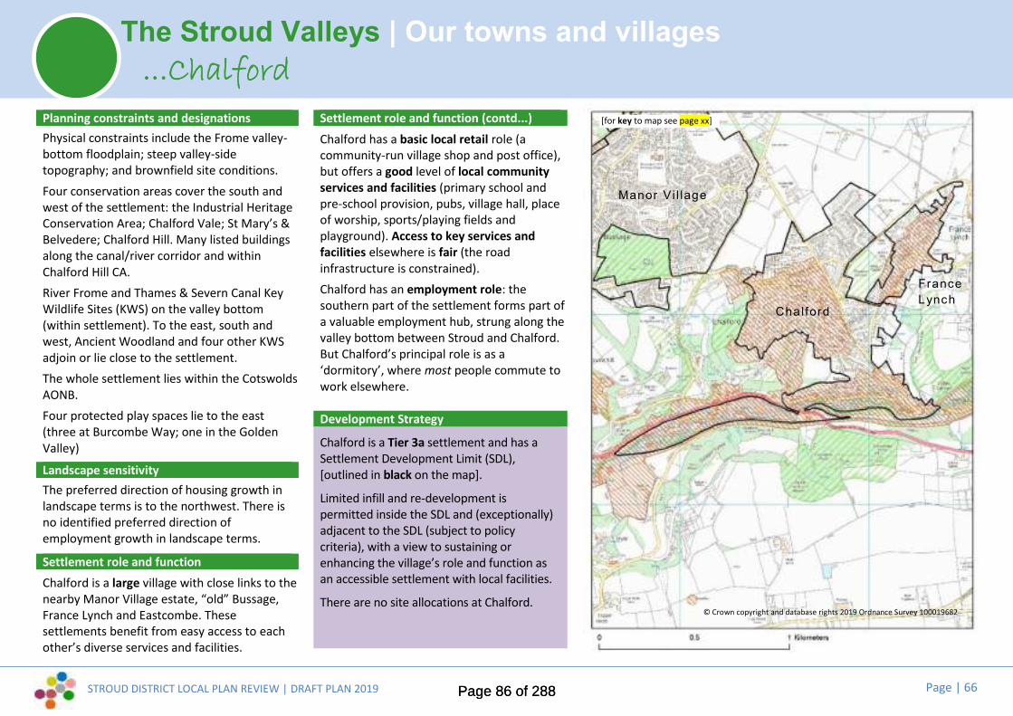
STROUD DISTRICT LOCAL PLAN REVIEW | DRAFT PLAN 2019 Page | 66
The Stroud Valleys | Our towns and villages
Planning constraints and designationsPhysical constraints include the Frome valley-bottom floodplain; steep valley-sidetopography; and brownfield site conditions.Four conservation areas cover the south andwest of the settlement: the Industrial HeritageConservation Area; Chalford Vale; St Mary’s &Belvedere; Chalford Hill. Many listed buildingsalong the canal/river corridor and withinChalford Hill CA.River Frome and Thames & Severn Canal KeyWildlife Sites (KWS) on the valley bottom(within settlement). To the east, south andwest, Ancient Woodland and four other KWSadjoin or lie close to the settlement.The whole settlement lies within the CotswoldsAONB.Four protected play spaces lie to the east(three at Burcombe Way; one in the GoldenValley)
Landscape sensitivityThe preferred direction of housing growth inlandscape terms is to the northwest. There isno identified preferred direction ofemployment growth in landscape terms.
Settlement role and functionChalford is a large village with close links to thenearby Manor Village estate, “old” Bussage,France Lynch and Eastcombe. Thesesettlements benefit from easy access to eachother’s diverse services and facilities.
Settlement role and function (contd...)Chalford has a basic local retail role (acommunity-run village shop and post office),but offers a good level of local communityservices and facilities (primary school andpre-school provision, pubs, village hall, placeof worship, sports/playing fields andplayground). Access to key services andfacilities elsewhere is fair (the roadinfrastructure is constrained).Chalford has an employment role: thesouthern part of the settlement forms part ofa valuable employment hub, strung along thevalley bottom between Stroud and Chalford.But Chalford’s principal role is as a‘dormitory’, where most people commute towork elsewhere.
Development Strategy
Chalford is a Tier 3a settlement and has aSettlement Development Limit (SDL),[outlined in black on the map].
Limited infill and re-development ispermitted inside the SDL and (exceptionally)adjacent to the SDL (subject to policycriteria), with a view to sustaining orenhancing the village’s role and function asan accessible settlement with local facilities.
There are no site allocations at Chalford.
...Chalford[for key to map see page xx]
© Crown copyright and database rights 2019 Ordnance Survey 100019682
Chalford
Manor Vi l lage
FranceLynch
Page 86 of 288Page 86 of 288

STROUD DISTRICT LOCAL PLAN REVIEW | DRAFT PLAN 2019 Page | 67
The Stroud Valleys | Our towns and villages
Planning constraints and designationsThe principal physical constraint is thefloodplain to the east of the settlement.
There are a number of listed buildingsincluding the church, Horsley Court and anumber of dwellings.
The Sandgrove Cottages and Hartley BridgeWood Key Wildlife Site wraps around the southeast corner.
The settlement is within the Cotswolds AONB.
There is a protected open space to thesouthwest.
Landscape sensitivityLandscape sensitivity indicates that there isonly limited opportunity for housing growth,along the B4056.
There is no identified preferred direction ofemployment growth in landscape terms.
Settlement role and functionAmongst Tier 3 settlements, Horsley has oneof the smallest populations (although the‘Horsley’ community encompasses somesmall satellite hamlets outside theSettlement Development Limit as well).It has a basic local retail role (a community-run shop), and the village offers a basic levelof local community services and facilities(primary school and pre-school provision,pub, village hall, sports field/pitch andplayground). Access to key services andfacilities elsewhere is fair.Horsley has no significant employment role:its principal role is as a ‘dormitory’settlement.
Development Strategy
Horsley is a Tier 3b settlement and has aSettlement Development Limit (SDL),[outlined in black on the map].
Limited infill and re-development ispermitted inside the SDL and (exceptionally)adjacent to the SDL (subject to policycriteria), with a view to sustaining orenhancing Horsley’s role, function andaccessibility as a settlement with localfacilities.
There are no site allocations at Horsley.
...Horsley[for key to map see page xx]
© Crown copyright and database rights 2019 Ordnance Survey 100019682
Proposed SDLchanges – seeAPPENDIX A
Proposed SDLchanges – seeAPPENDIX A
Page 87 of 288Page 87 of 288

STROUD DISTRICT LOCAL PLAN REVIEW | DRAFT PLAN 2019 Page | 68
The Stroud Valleys | Our towns and villages
Planning constraints and designationsPhysical constraints include the steep valley-sidetopography to the northwest.The Brownshill & Bussage Conservation Areaabuts the western side of the settlement andEastcombe Conservation Area abuts the north.Chalford Hill Conservation Area lies very nearbyto the southeast.Frith Wood, (designated as Ancient Woodlandand a Key Wildlife Site) is a significant intrusioninto the southern part of the settlement.The settlement is within the Cotswolds AONB.There is protected outdoor play space at bothschools within the settlement and further siteslie north east at Middle Hill and southwest atThe Frith.Landscape sensitivityThe preferred direction of housing growth inlandscape terms is to the northeast andsecondarily to the southwest, close to thesettlement edge. There is no identifiedpreferred direction of employment growth inlandscape terms.
Settlement role and function
The “Manor Village” estate at Bussage is alarge settlement, mostly developed in the1980s and 1990s. It and has close links withsmaller surrounding villages in Chalfordparish, which benefit from easy access toeach other’s diverse services and facilities.
Settlement role and function (contd...)It has a basic local retail role (a conveniencestore). It offers a good level of localcommunity services and facilities (GP andpharmacy, primary school, villagehall/community centre, sports/playing fieldsand playground) and has a very limited rolein providing ‘strategic’ services andfacilities to a wider catchment (at ThomasKeble Secondary School). Access to keyservices and facilities here and elsewhere isgood (although the road infrastructure isconstrained).The settlement has no significantemployment role. Its principal role is as a‘dormitory’ settlement for its large workingpopulation.
Development Strategy“Manor Village” is defined as a Tier 3asettlement and has a SettlementDevelopment Limit (SDL), [outlined in blackon the map].
Limited infill and re-development ispermitted inside the SDL and (exceptionally)adjacent to the SDL (subject to policycriteria), with a view to sustaining orenhancing the village’s role and function asan accessible settlement with local facilities.
There are no site allocations at ManorVillage.
...”Manor Village” (Bussage)[for key to map see page xx]
© Crown copyright and database rights 2019 Ordnance Survey 100019682
Chalford
Manor Vi l lage
Eastcombe
Bussage
Page 88 of 288Page 88 of 288
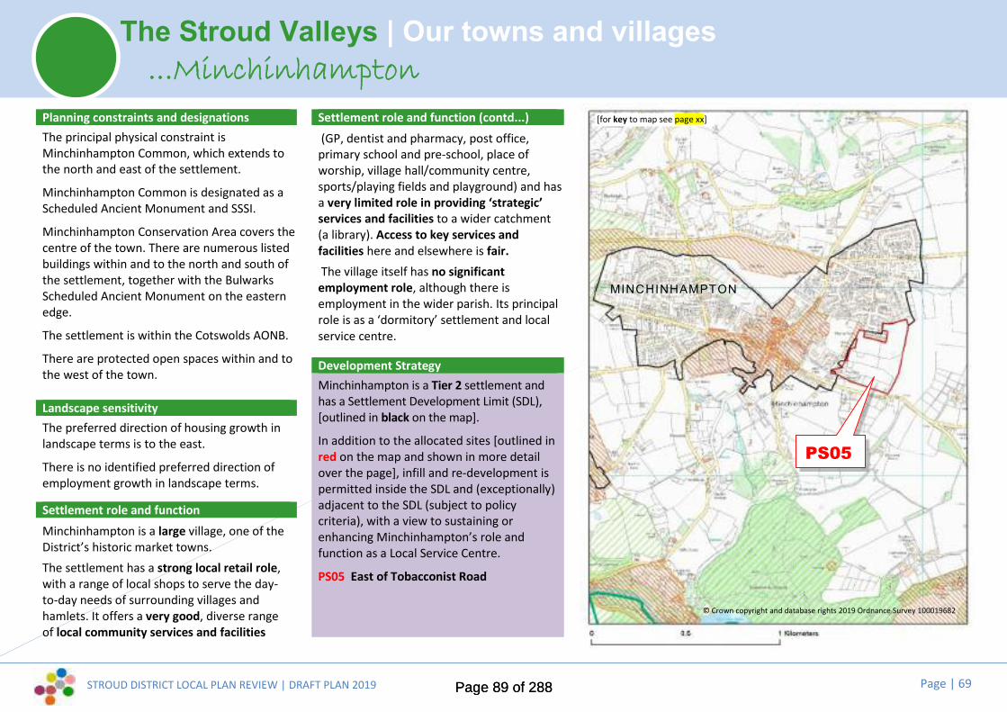
STROUD DISTRICT LOCAL PLAN REVIEW | DRAFT PLAN 2019 Page | 69
The Stroud Valleys | Our towns and villages
Planning constraints and designationsThe principal physical constraint isMinchinhampton Common, which extends tothe north and east of the settlement.
Minchinhampton Common is designated as aScheduled Ancient Monument and SSSI.
Minchinhampton Conservation Area covers thecentre of the town. There are numerous listedbuildings within and to the north and south ofthe settlement, together with the BulwarksScheduled Ancient Monument on the easternedge.
The settlement is within the Cotswolds AONB.
There are protected open spaces within and tothe west of the town.
Landscape sensitivityThe preferred direction of housing growth inlandscape terms is to the east.
There is no identified preferred direction ofemployment growth in landscape terms.
Settlement role and functionMinchinhampton is a large village, one of theDistrict’s historic market towns.The settlement has a strong local retail role,with a range of local shops to serve the day-to-day needs of surrounding villages andhamlets. It offers a very good, diverse rangeof local community services and facilities
Settlement role and function (contd...)(GP, dentist and pharmacy, post office,
primary school and pre-school, place ofworship, village hall/community centre,sports/playing fields and playground) and hasa very limited role in providing ‘strategic’services and facilities to a wider catchment(a library). Access to key services andfacilities here and elsewhere is fair.The village itself has no significant
employment role, although there isemployment in the wider parish. Its principalrole is as a ‘dormitory’ settlement and localservice centre.
Development StrategyMinchinhampton is a Tier 2 settlement andhas a Settlement Development Limit (SDL),[outlined in black on the map].
In addition to the allocated sites [outlined inred on the map and shown in more detailover the page], infill and re-development ispermitted inside the SDL and (exceptionally)adjacent to the SDL (subject to policycriteria), with a view to sustaining orenhancing Minchinhampton’s role andfunction as a Local Service Centre.
PS05 East of Tobacconist Road
...Minchinhampton[for key to map see page xx]
PS05
© Crown copyright and database rights 2019 Ordnance Survey 100019682
MINCHINHAMPTON
Page 89 of 288Page 89 of 288

STROUD DISTRICT LOCAL PLAN REVIEW | DRAFT PLAN 2019 Page | 70
The Stroud Valleys | Our towns and villages
description of use/numbers]
...MinchinhamptonDraft site allocationsPS05 East of Tobacconist Road:Land East of Tobacconist Road, as identified onthe policies map, is allocated for a developmentcomprising up to 80 dwellings, communitybuilding and associated open space uses andstrategic landscaping. Detailed policy criteriawill be developed where necessary to highlightspecific mitigation measures and infrastructurerequirements. A development briefincorporating an indicative masterplan, to beapproved by the District Council, will detail theway in which the land uses and infrastructurewill be developed in an integrated and co-ordinated manner.
Page 90 of 288Page 90 of 288

STROUD DISTRICT LOCAL PLAN REVIEW | DRAFT PLAN 2019 Page | 71
The Stroud Valleys | Our towns and villages
Planning constraints and designationsThe principal physical constraint is thefloodplain to the east and south of thesettlement along the River Frome Valley
The Industrial Heritage Conservation Areacovers the eastern edge of the settlementcontaining listed buildings.
The settlement is surrounded by the CotswoldAONB.
There are protected open spaces scatteredaround the settlement.
Landscape sensitivityThe preferred direction of housing growth inlandscape terms is to the west.
Small areas within the valley bottom offer theonly opportunities for employment growth.
Settlement role and functionNailsworth is a very large settlement, one ofthe District’s historic market towns.Nailsworth has a strong ‘strategic’ retail roleas one of the District’s 5 town centres, servinga wide catchment. Its niche retail and leisureoffer draws visitors from further afield. It offersa very good level of local community servicesand facilities (GP, dentist and pharmacy, postoffice, primary school and pre-school, place ofworship, pubs, town hall/community centre,
Settlement role and function (contd...)sports/playing fields and playground) andhas a limited role in providing ‘strategic’services and facilities to a wider catchment(a bank and a library). Access to key servicesand facilities here and elsewhere is good.The town has an important employmentrole and also functions as a ‘dormitory’settlement and local service centre, with asignificant leisure and tourism role too.
Development strategyNailsworth is a Tier 2 settlement and has aSettlement Development Limit (SDL),[outlined in black on the map].
In addition to the allocated sites [outlined inred on the map and shown in more detailover the page], infill and re-development ispermitted inside the SDL and (exceptionally)adjacent to the SDL (subject to policycriteria), with a view to sustaining orenhancing the town’s role and function as astrategic Local Service Centre.
PS06 The New Lawn, NailsworthPS07 North of Nympsfield Road
...Nailsworth[for key to map see page xx]
© Crown copyright and database rights 2019 Ordnance Survey 100019682
PS06
PS07
Amber ley
Page 91 of 288Page 91 of 288
STROUD DISTRICT LOCAL PLAN REVIEW | DRAFT PLAN 2019 Page | 72
The Stroud Valleys | Our towns and villages...Nailsworth
Draft site allocationsPS06 The New Lawn, Nailsworth:Land at New Lawn, as identified on the policiesmap, is allocated for a development comprising80 dwellings and associated community andopen space uses, together with enablinginfrastructure, subject to the satisfactoryrelocation of Forest Green football club.Detailed policy criteria will be developed wherenecessary to highlight specific mitigationmeasures and infrastructure requirements. Adevelopment brief incorporating an indicativemasterplan, to be approved by the DistrictCouncil, will detail the way in which the landuses and infrastructure will be developed in anintegrated and co-ordinated manner.
PS07 North of Nympsfield Road:Land North of Nympsfield Road, as identifiedon the policies map, is allocated for adevelopment comprising up to 25 dwellingsand associated community and open spaceuses and strategic landscaping. Detailed policycriteria will be developed where necessary tohighlight specific mitigation measures andinfrastructure requirements. A developmentbrief incorporating an indicative masterplan, tobe approved by the District Council, will detailthe way in which the land uses andinfrastructure will be developed in anintegrated and co-ordinated manner.
Page 92 of 288Page 92 of 288

STROUD DISTRICT LOCAL PLAN REVIEW | DRAFT PLAN 2019 Page | 73
The Stroud Valleys | Our towns and villages
Planning constraints and designationsThe principal physical constraint is thefloodplain to the east of the settlement alongthe River Frome valley.The Industrial Heritage Conservation Areacovers the eastern edge of the settlement andSouth Woodchester Conservation Area lies tothe south. There are numerous listed buildingsin and around the settlement; and WoodchesterRoman Villa, a Scheduled Ancient Monument,adjoins it to the north.The Nailsworth Brook Key Wildlife Site (KWS)lies to the east of the settlement and RabbitWarren Wood KWS beyond to the west.The north west and the eastern edge of thesettlement are within the Cotswold AONB.There is a protected open space to the south.
Landscape sensitivityLandscape sensitivity indicates that the onlypotential for housing growth is to thenorthwest, for a few well spaced propertieswith indented edge, west of Lawns Park.
The only potential for employment growthmay be to the north, where very smallcommercial premises may be acceptableadjoining the existing buildings.
Settlement role and functionNorth Woodchester is a small village, withclose functional links to neighbouring SouthWoodchester (Tier 4a).
Settlement role and function (contd...)It has a basic local retail role (a village shop),and the village offers a basic level of localcommunity services and facilities (primaryschool and pre-school provision, post office,place of worship, pub, village hall and sportsfield/pitch). Access to key services andfacilities elsewhere is very good.Woodchester has an employment role,forming part of a valuable employment hubstrung along the valley bottom betweenStroud and Nailsworth. AlthoughWoodchester is a net importer of workers,the village’s principal role is as a ‘dormitory’.Development strategyNorth Woodchester is a Tier 3a settlementand has a Settlement Development Limit(SDL), [outlined in black on the map].
Limited infill and re-development ispermitted inside the SDL and (exceptionally)adjacent to the SDL (subject to policycriteria), with a view to sustaining orenhancing the village’s role and function asan accessible settlement with local facilities.
Committed development at Rooksmoor Mill(an existing planning permission for 54dwellings plus employment uses) will providefor the future needs of the settlement.
There are no site allocations here, due toenvironmental constraints around thesettlement.
...North Woodchester
Alreadycommitteddevelopment
[for key to map see page xx]
© Crown copyright and database rights 2019 Ordnance Survey 100019682
STROUD
Page 93 of 288Page 93 of 288

STROUD DISTRICT LOCAL PLAN REVIEW | DRAFT PLAN 2019 Page | 74
The Stroud Valleys | Our towns and villages
Planning constraints and designationsPhysical constraints include the River Fromefloodplain; the steep valley topography andbrownfield site conditions.
There are multiple conservation areas: EbleyMills; Industrial Heritage; Lodgemore &Fromehall; Stroud Station; Top of Town andTown Centre. Many listed buildings within andnear to the town centre and along river/canalcorridor.
Rodborough Common SAC / SSSI to the south.Key Wildlife Sites (KWS): River Frome KWSalong the river corridor; Bisley Road Cemetery,The Folly, The Horns Bank and Wood and SladeWood KWSs to the east. Rodborough FieldsKWS to the south of the centre. NailsworthBrook KWS to the south.
The Cotswolds AONB surrounds the town.There are protected open spaces within thetown.
The town is a First Tier settlement and hassettlement development limits.
Landscape sensitivityLandscape sensitivity indicates that there arelimited options for housing growth, but modestinterventions may be possible within parcels tothe west; north east and south east. Smallscale interventions are possible within thecanal corridor. If employment growth isnecessary, there are only very small scaleoptions within the canal corridor.
Settlement role and functionStroud is the District’s principal town and ourlargest concentrated population (25,000+).“Stroud” encompasses parts of the parishesof Rodborough and Cainscross, as well asStroud parish, which includes the town centreand surrounding residential areas.It has a key strategic retail role as ourprincipal town centre. In addition to theDistrict’s most extensive range of ‘strategic’services and facilities (including hospital, railstation, banks, cinema, leisure centre, library,secondary schools and further educationfacilities), Stroud offers a very good range oflocal community services and facilities for itsneighbourhoods and communities and hasvery good access to key services and facilitieswithin the town and elsewhere.Stroud is the District’s largest employment‘hub’: more than 11,700 jobs are based in thetown. Combined with adjacent Brimscombe &Thrupp, this area clearly represents theDistrict’s most significant employment base.The town also functions as a major‘dormitory’ settlement and strategic servicecentre, with a significant leisure role too.
Development strategyStroud is a Tier 1 settlement and has a Settlement Development Limit(SDL), [outlined in black on the map].
Site allocations [outlined in red on the map and shown in moredetail over the following pages] will meet local needs and willcontribute towards meeting some of the District’s strategic growthand development needs:
PS10 Railway land / car parks, Cheapside: up to 75 dwellings andtown centre uses.
PS11 Merrywalks Arches, Merrywalks: up to 25 dwellings and towncentre uses.
PS12 Police station / Magistrates court, Parliament Street: up to45 dwellings and town centre uses.
PS13 Central river / canal corridor: around 120 dwellings, canalrelated tourism and employment uses.
In addition to the allocated sites, infill and re-development ispermitted inside the SDL and (exceptionally) adjacent to the SDL(subject to policy criteria), with a view to sustaining or enhancingStroud’s role and function as the District’s principal town and mostimportant strategic service centre.
There are no proposed site allocations for very large scaledevelopment to meet the District’s strategic housing oremployment needs, due to environmental constraints aroundStroud.
...Stroud
Page 94 of 288Page 94 of 288

STROUD DISTRICT LOCAL PLAN REVIEW | DRAFT PLAN 2019 Page | 75
The Stroud Valleys | Our towns and villages...Stroud
[for key to map see page xx]
PS11
PS13
PS11
PS10
PS12
© Crown copyright and database rights 2019 Ordnance Survey 100019682
Town centre sites...
Sels ley
Br imscombe& Thrupp
W hiteshi l l & Ruscombe
STROUD
Proposed SDLchanges – seeAPPENDIX A
PS10
Proposed SDLchanges – seeAPPENDIX A
PS12
Page 95 of 288Page 95 of 288

STROUD DISTRICT LOCAL PLAN REVIEW | DRAFT PLAN 2019 Page | 76
The Stroud Valleys | Our towns and villages...Stroud
Draft site allocationsTown Centre sites:The following sites, as identified on the policiesmap, are allocated for the followingdevelopment:PS10 Railway land / car parks, Cheapside: up to75 dwellings and town centre uses.
PS11 Merrywalks Arches, Merrywalks: up to 25dwellings and town centre uses.
PS12 Police station / Magistrates court,Parliament Street: up to 45 dwellings and towncentre uses.
Detailed policy criteria will be developed wherenecessary to highlight specific mitigationmeasures and infrastructure requirements.Development briefs incorporating indicativemasterplans, to be approved by the DistrictCouncil, will detail the way in which the landuses and infrastructure will be developed in anintegrated and co-ordinated manner.
Page 96 of 288Page 96 of 288

STROUD DISTRICT LOCAL PLAN REVIEW | DRAFT PLAN 2019 Page | 77
The Stroud Valleys | Our towns and villages...Stroud
Draft site allocationsPS13 Central river / canal corridor:Land within the central river/corridor, asidentified on the policies map, is allocated forpartial redevelopment and re-use toaccommodate around 120 dwellings, canalrelated tourism, employment and communityand open space uses. Detailed policy criteriawill be developed where necessary to highlightspecific mitigation measures and infrastructurerequirements. A development briefincorporating an indicative masterplan, to beapproved by the District Council, will detail theway in which the land uses and infrastructurewill be developed in an integrated and co-ordinated manner.
Page 97 of 288Page 97 of 288

STROUD DISTRICT LOCAL PLAN REVIEW | DRAFT PLAN 2019 Page | 78
The Stroud Valleys | Our towns and villages
Planning constraints and designationsPhysical constraints include the steeptopography on the valley sides and woodedareas to the north and west.
There are listed buildings within the villagesand on the southern edge of Whiteshill.
There is ancient woodland to the north west ofRuscombe. There are three Key Wildlife Sites:Ruscombe Woods to the north west; TheThroat Meadows and Quarry to the north andRuscombe Meadows between the villages.There are TPOs on the southern and westernedge of Whiteshill
The Cotswolds AONB designation covers all ofthe villages and surrounding land.
There is a protected open space to the west ofWhiteshill.
Landscape sensitivityThe landscape parcels around the settlementare all considered to be of high sensitivity toboth housing and employment uses and donot offer any opportunity for housing oremployment allocation in terms of landscapeand visual factors.
Settlement role and functionThe medium-sized settlement of Whiteshill& Ruscombe is comprised of two historicallydistinct villages.The settlement has a basic local retail role(a community-run shop), and offers a basiclevel of local community services andfacilities (primary school and pre-schoolprovision, place of worship, villagehall/community centre, pub, sportsfield/pitch and playground). Access to keyservices and facilities elsewhere is good.Whiteshill & Ruscombe has no significantemployment role: its principal role is as a‘dormitory’ settlement.
Development strategy
Whiteshill & Ruscombe is a Tier 3bsettlement and has a SettlementDevelopment Limit (SDL), [outlined in blackon the map].
Limited infill and re-development ispermitted inside the SDL and (exceptionally)adjacent to the SDL (subject to policycriteria), with a view to sustaining orenhancing the village’s role, function andaccessibility as a settlement with localfacilities.
There are no site allocations at Whiteshill &Ruscombe.
...Whiteshill & Ruscombe
© Crown copyright and database rights 2019 Ordnance Survey 100019682
[for key to map see page xx]
W hiteshi l l & Ruscombe
STROUD
Page 98 of 288Page 98 of 288

STROUD DISTRICT LOCAL PLAN REVIEW | DRAFT PLAN 2019 Page | 79
The Stroud Valleys | Our towns and villages...Bussage, Eastcombe, S.Woodchester, Box, France Lynch, Randwick
Tier 4a settlements in the Stroud Valleys Tier 4b settlements in the Stroud Valleys
“Old” Bussage Eastcombe South Woodchester
Box France Lynch Randwick
Settlement role and function Settlement role and functionThese small and very small settlements provide onlybasic/minimal local services and facilities themselves.However, access to key services and facilities elsewhere isgood: these are relatively accessible settlements, whichbenefit from their proximity and/or connectivity to highertier settlements and, in the case of South Woodchester, itsproximity to a key public transport route (A46). However,the road infrastructure in and around these settlements isvery constrained. South Woodchester is the only Tier 4settlement with any employment role. These villages allfunction as ‘dormitory’ settlements to some extent.The Cotswolds AONB designation covers these villages andsurrounding land, and they each face significantenvironmental constraints.
These small and very small settlements provide onlybasic/minimal local services and facilities for theircommunities (although Randwick is stronger in thisrespect than other Tier 4b settlements), and none hasany retail facilities. These settlements are highly car-reliant and poorly connected, generally lackingreasonable foot, cycle or bus access to key services andfacilities elsewhere. These villages lack anyemployment role and all function as ‘dormitory’settlements.The Cotswolds AONB designation covers these villagesand surrounding land, and they each face significantenvironmental constraints.
Development strategy Development strategy
Bussage, Eastcombe and South Woodchester are Tier 4asettlements and have Settlement Development Limits (SDL).
Very limited infill and re-development to meet specific localneeds may be permitted inside the SDL and (exceptionally)adjacent to the SDL (subject to policy criteria), with a viewto sustaining or enhancing their role, function andaccessibility as accessible settlements with basic facilities,and boosting community vitality and social sustainability.
There are no site allocations at these settlements.
Box, France Lynch and Randwick are Tier 4b settlementsand have Settlement Development Limits (SDL).
Very limited infill and re-development to meet specificlocal needs may be permitted inside the SDL and(exceptionally) adjacent to the SDL (subject to policycriteria), with a view to sustaining or enhancing their roleand function as settlements with basic facilities, andboosting community vitality and social sustainability.
There are no site allocations at these settlements.
Page 99 of 288Page 99 of 288

STROUD DISTRICT LOCAL PLAN REVIEW | DRAFT PLAN 2019 Page | 80
Making Places | Shaping the future of The Stonehouse clusterDeveloping a vision for the future...
Where are we now?...
The town of Stonehouse lies two miles east of Junction 13 (M5), with arail station on the main Gloucester-London line (the main line to Bristolalso runs to the west of the town, but the station is no longeroperational). Although Stonehouse has a close relationship with nearbyStroud, it very much functions as a town in its own right, the secondmost populous town in the District, with a good range of services andshops at its centre. On its western edge lies a major industrial andbusiness area, which provides jobs for over 4,000 people and is home toa number of national companies.
By contrast, Standish and Frocester are amongst the most sparselypopulated parishes in the District, with a strong rural character.Eastington, Leonard Stanley and Kings Stanley are amongst the District’slarger villages, each having good access to everyday services andfacilities, village essentials such as pub and primary school, and a strongsense of community. The Cotswold escarpment provides a dramaticlandscape backdrop and the eastern edge of this cluster area isdesignated part of the Cotswolds AONB.
Key issues and top priorities for the future...
Public consultation and our evidence base have told us that these are keylocal issues and top priorities:
Reducing A419 road congestion and travel to work out-commuting
Designing safe cycle routes and achieving better public transport, including bydelivering a new rail station on the Bristol-Birmingham main line and improvingpedestrian and cycle connectivity to Stonehouse High Street
Maintaining and improving the vitality of Stonehouse town centre
Providing for local job opportunities, supporting home working, co-working,small businesses and training/apprenticeships
Ensuring provision of adequate smaller affordable housing and opportunitiesfor downsizing for local people
Increasing health and community facilities at our towns and villages
Conserving and enhancing the Cotswolds AONB
Ensuring development enhances local green spaces and improves access tocountryside throughout the Stonehouse cluster
Prioritising green spaces along the canal for tourism, recreation, wildlife andcommunity usesThe current Local Plan sets out a mini vision, a range of key issues and a series
of ‘guiding principles’ for future development in this parish cluster area.
The Council consulted community representatives on potential changes to thevisions and key issues at Issues and Options stage (2017) and the draft visionand ‘top priorities’ set out here take account of this, as well as feedback to theEmerging Strategy consultation last year.
These will be subject to further refinement and rationalisation before the nextiteration of the Local Plan (the Pre-submission Plan, anticipated Autumn 2020),to take full account of evidence and the final development strategy.
Page 100 of 288Page 100 of 288

STROUD DISTRICT LOCAL PLAN REVIEW | DRAFT PLAN 2019 Page | 81
Making Places | Shaping the future of The Stonehouse clusterDeveloping a vision for the future...
...Where do we want to be in the future?
Draft vision to 2040: “Economic growth and well-connected, thriving communities...”
Stonehouse is one of the District’s employment hotspots and, with its good rail and road links, it is wellplaced for future growth to meet the District’s strategic needs.
Development to the west of Stonehouse at Great Oldbury will expand the existing Oldends/Stroudwateremployment area, with attendant transport and infrastructure improvements – including improved linksto the town centre and opportunities for all to make use of pleasant and safe ‘green links’ on foot orcycle. This will be a sustainable workplace destination for the District, as well as a vibrant newcommunity, served by its own local centre.
The growth of a new employment area close to the M5 Junction 13 will reinforce the town’s role as oneof the District’s most important employment hubs.
The area will feel the environmental enhancement of both the river corridor and the canal restoration,with boosted tourist appeal contributing to the local economy. Links will be improved into thecountryside (including to the Cotswold Way) and between the town centre and the canal, providing avaluable amenity for residents of Stonehouse and surrounding communities, as well as helping to drawincreased visitor footfall to the town centre.
This area will continue to benefit from strong, well-balanced residential communities, both rural andurban. Communities will have the chance to help shape their neighbourhoods, maintaining their distinctidentities and protecting and improving those aspects of the area that make it a pleasant and viable placeto live. The villages of Eastington and The Stanleys in particular will thrive, with services and facilities for youngand old alike.
Key to maps
Existing settlement development limit(settlement boundary)
Proposed site allocations
Committed Development (including siteallocations in the current Local Plan andsites already with planning permission)
Heritage constraints (includingconservation areas, listed buildings,scheduled monuments...)
Natural environment constraints(including key wildlife sites, ancientwoodland, SSSI, RAMSAR...)
Flood Zones 2 and 3
The Cotswolds AONB
Page 101 of 288Page 101 of 288

STROUD DISTRICT LOCAL PLAN REVIEW | DRAFT PLAN 2019 Page | 82
The Stonehouse cluster | Our towns and villages
Planning constraints and designationsThe principal physical constraint is thefloodplain, which runs to the north east of thevillage, along the River Frome valley.
The Industrial Heritage Conservation Areaabuts the eastern part of the village. There area number of listed buildings at Millend, to theeast of the village, and along the Bath Road, tothe south and west of the village.
The River Frome Key Wildlife Site lies to thenorth of the village.
There are protected open spaces within and tothe west of the village.
Landscape sensitivityThe preferred direction of housing growth inlandscape terms is to the south east of thesettlement. There may be some opportunitiesto the northwest.
The preferred direction of employmentgrowth in landscape terms is to thenorthwest.
Settlement role and functionEastington is a medium/large sized village,with the old hamlet of Alkerton at its core.This is the focus of the SettlementDevelopment Limit, but the ‘Eastington’community extends across several otherdistinct hamlets.
Settlement role and function (contd...)It has a basic local retail role (a conveniencestore), and the village offers a basic range oflocal community services and facilities(primary school and pre-school provision,post office, place of worship, pub, villagehall/community centre, sports field/pitchand playground). Access to key services andfacilities elsewhere is fair.Eastington has an employment role, with aKey Employment Site north of the village.Although it is a modest net importer ofworkers, its principal role is as a ‘dormitory’settlement.
Development strategy
Eastington is a Tier 3a settlement and has aSettlement Development Limit (SDL),[outlined in black on the map].
Limited infill and re-development ispermitted inside the SDL and (exceptionally)adjacent to the SDL (subject to policycriteria), with a view to sustaining orenhancing the village’s role and function asan accessible settlement with local facilities.
There are no site allocations at Eastington.
...Eastington (Alkerton)stington (Alkerton [for key to map see page xx]
© Crown copyright and database rights 2019 Ordnance Survey 100019682
East ington(Alkerton)
Proposed SDLchanges – seeAPPENDIX A
Proposed SDLchanges – seeAPPENDIX A
Page 102 of 288Page 102 of 288

STROUD DISTRICT LOCAL PLAN REVIEW | DRAFT PLAN 2019 Page | 83
The Stonehouse cluster | Our towns and villages
Planning constraints and designationsThe principal physical constraint is thefloodplain to the north of the village along theRiver Frome valley.
The Industrial Heritage Conservation Areaabuts the northern part of the village. Thereare a number of listed buildings within thevillage and on the northern and easternboundaries.
The River Frome Key Wildlife Site abuts thevillage to the north.
The Cotswolds AONB lies immediately to theeast and south of the village.
There are protected open spaces within thesettlement.
Landscape sensitivityThe preferred direction of housing growth inlandscape terms is to the north of thesettlement. There may be some smallopportunities to the south and east.
The preferred direction of employment growthin landscape terms is to the north.
Settlement role and functionKings Stanley is a medium/large sized villagewith close geographic and functional links toLeonard Stanley.It has a strong local retail role with a smallrange of shops to serve the day-to-day needs
Settlement role and function (contd...)of the community and a small localcatchment. The village has a good level oflocal community services and facilities(primary school and pre-school provision,post office, place of worship, pub, villagehall/community centre, sports field/pitchand playground). Access to key services andfacilities elsewhere is fair.Kings Stanley has no significant employmentrole: its principal role is as a local servicecentre and ‘dormitory’ settlement.
Development strategyKings Stanley is a Tier 3a settlement and hasa Settlement Development Limit (SDL),[outlined in black on the map].
Limited infill and re-development ispermitted inside the SDL and (exceptionally)adjacent to the SDL (subject to policycriteria), with a view to sustaining orenhancing the village’s role and function asan accessible settlement with local facilities.
Committed development at Stanley Mills (anexisting planning permission for 146 dwellingsplus employment uses) will provide for thefuture needs of the settlement.
There are no site allocations at Kings Stanley,due to environmental constraints around thesettlement.
...Kings Stanley[for key to map see page xx]
© Crown copyright and database rights 2019 Ordnance Survey 100019682
Alreadycommitteddevelopment
Kings Stanley
Leonard Stanley
Proposed SDLchanges – seeAPPENDIX A
Page 103 of 288Page 103 of 288

STROUD DISTRICT LOCAL PLAN REVIEW | DRAFT PLAN 2019 Page | 84
The Stonehouse cluster | Our towns and villages
Planning constraints and designationsThere are no significant physical constraints.
There are a number of listed buildings withinand to the south west of the village.
The River Frome Key Wildlife Site lies beyondthe village to the north.
The Cotswolds AONB lies beyond the south ofthe village.
There are protected open spaces within thesettlement.
Landscape sensitivityThe preferred direction of housing growth inlandscape terms is to the north and northwestof the settlement.
There is no identified preferred direction ofemployment growth in landscape terms.
Settlement role and functionLeonard Stanley is a medium/large sizedvillage with close geographic and functionallinks to Kings Stanley.
It has no retail role and relies on Kings Stanleyto service day-to-day needs. But the villageoffers a basic level of local community servicesand facilities (primary school and pre-schoolprovision, place of worship, pub, village hall /community centre, sports field / pitch andplayground.
Settlement role and function (contd...)Access to key services and facilitieselsewhere is fair.Leonard Stanley has no significantemployment role: its principal role is as a‘dormitory’ settlement.
Development strategy
Leonard Stanley is a Tier 3a settlement andhas a Settlement Development Limit (SDL),[outlined in black on the map].
In addition to the allocated sites [outlined inred on the map and shown in more detailover the page], limited infill and re-development is permitted inside the SDL and(exceptionally) adjacent to the SDL (subject topolicy criteria), with a view to sustaining orenhancing the village’s role and function asan accessible settlement with local facilities.
PS16 South of Leonard Stanley PrimarySchool.
PS42 Land off Dozule Close.
...Leonard Stanley[for key to map see page xx]
© Crown copyright and database rights 2019 Ordnance Survey 100019682
KingsStanley
Leonard Stanley
Proposed SDLchanges – seeAPPENDIX A
PS16
PS42
Page 104 of 288Page 104 of 288

STROUD DISTRICT LOCAL PLAN REVIEW | DRAFT PLAN 2019 Page | 85
The Stonehouse cluster | Our towns and villages...Leonard Stanley
Draft site allocationsPS16 South of Leonard Stanley PrimarySchool:Land south of Leonard Stanley Primary School,as identified on the policies map, is allocatedfor a development comprising up to 25dwellings and associated community and openspace uses. Detailed policy criteria will bedeveloped where necessary to highlight specificmitigation measures and infrastructurerequirements. A development briefincorporating an indicative masterplan, to beapproved by the District Council, will detail theway in which the land uses and infrastructurewill be developed in an integrated and co-ordinated manner.
PS42 Land off Dozule Close:Land off Dozule Close, as identified on thepolicies map, is allocated for a developmentcomprising up to 15 dwellings and associatedcommunity and open space uses. Existing openspace on the southwest of the site andadjoining Marsh Lane will be retained andenhanced as public open space. Detailed policycriteria will be developed where necessary tohighlight specific mitigation measures andinfrastructure requirements. A developmentbrief incorporating an indicative masterplan, tobe approved by the District Council, will detailthe way in which the land uses andinfrastructure will be developed in anintegrated and co-ordinated manner.
Page 105 of 288Page 105 of 288

STROUD DISTRICT LOCAL PLAN REVIEW | DRAFT PLAN 2019 Page | 86
The Stonehouse cluster | Our towns and villages
Planning constraints and designationsThe principal physical constraint is thefloodplain to the south of the town along theRiver Frome valley.
The Industrial Heritage Conservation Areaadjoins the southern edge of the town. Thereare a number of listed buildings within thetown and on the rural boundaries.
The River Frome and the Verney Meadows KeyWildlife Sites lie along the southern andeastern edges of the town respectively.
The Cotswolds AONB lies adjacent to theeastern and northern edge of the town.
There are protected open spaces within thetown.
Landscape sensitivityThe preferred direction of housing andemployment growth in landscape terms is tothe west and/or to the north of thesettlement.
Settlement role and functionStonehouse is a very large settlement, oneof the District’s four biggest towns.Stonehouse has a strong ‘strategic’ retailrole as one of the District’s 5 town centres,serving a wide catchment. It offers a verygood level of local community services andfacilities (GP, dentist and pharmacy, postoffice, primary school and pre-school, placesof worship, pubs, town hall/communitycentre, sports/playing fields andplayground) and has a limited role inproviding ‘strategic’ services and facilitiesto a wider catchment (bank, secondaryschool and rail station). Access to keyservices and facilities here and elsewhere isgood.As a net importer of thousands of workersand with several major key employmentsites around it, Stonehouse is the District’ssecond biggest employment ‘hub’. The townhas a very important employment role.
Development strategyStonehouse is a Tier 1 settlement and has a Settlement DevelopmentLimit (SDL), [outlined in black on the map].
Site allocations [outlined in red on the map and shown in moredetail over the following pages] will meet local and strategic growthneeds:
PS17 Magpies site, Oldends Lane.
PS19 Northwest of Stonehouse.
PS20 M5 Junction 13.
In addition to the allocated sites, infill and re-development ispermitted inside the SDL and (exceptionally) adjacent to the SDL(subject to policy criteria), with a view to sustaining or enhancingStonehouse’s role and function as one of the District’s main townsand a strategic service centre.
...Stonehouse
Page 106 of 288Page 106 of 288

STROUD DISTRICT LOCAL PLAN REVIEW | DRAFT PLAN 2019 Page | 87
The Stonehouse cluster | Our towns and villages
[for key to map see page xx]
...StonehouseDraft site allocationsPS17 Magpies site, Oldends Lane:Land at Magpies site, Oldends Lane, asidentified on the policies map, is allocated for adevelopment comprising up to 10 dwellings inorder to secure the enhancement of existingand the provision of new community and openspace uses. The site shall also safeguard land toallow for a future pedestrian bridge across therailway at Oldends Lane. Detailed policy criteriawill be developed where necessary to highlightspecific mitigation measures and infrastructurerequirements. A development briefincorporating an indicative masterplan, to beapproved by the District Council, will detail theway in which the land uses and infrastructurewill be developed in an integrated and co-ordinated manner.
East ington (Alkerton)
STONEHOUSE
Alreadycommitteddevelopment
Proposed SDLchanges – seeAPPENDIX A
SA2Great Oldbury
(Allocated in thecurrent Local Plan)
PS17
PS19aPS20
© Crown copyright and database rights 2019 Ordnance Survey 100019682
Page 107 of 288Page 107 of 288

STROUD DISTRICT LOCAL PLAN REVIEW | DRAFT PLAN 2019 Page | 88
The Stonehouse cluster | Our towns and villages...Stonehouse
Draft site allocationsPS19a Northwest of Stonehouse:Land Northwest of Stonehouse (in StandishParish), as identified on the policies map, isallocated for a strategic mixed usedevelopment, including 5ha employment, 650dwellings, primary school, strategic landscapingand green infrastructure along the northern,western and eastern boundaries and associatedcommunity and open space uses. Detailedpolicy criteria will be developed to highlightspecific mitigation measures and infrastructurerequirements and how development willprioritise walking, cycling and public transportover the use of the private car. A developmentbrief incorporating an indicative masterplan, tobe approved by the District Council, will detailthe way in which the land uses andinfrastructure will be developed in anintegrated and co-ordinated manner.
PS19a
Page 108 of 288Page 108 of 288
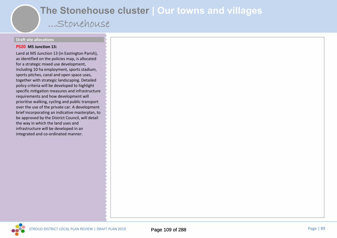
STROUD DISTRICT LOCAL PLAN REVIEW | DRAFT PLAN 2019 Page | 89
The Stonehouse cluster | Our towns and villages...Stonehouse
Draft site allocationsPS20 M5 Junction 13:Land at M5 Junction 13 (in Eastington Parish),as identified on the policies map, is allocatedfor a strategic mixed use development,including 10 ha employment, sports stadium,sports pitches, canal and open space uses,together with strategic landscaping. Detailedpolicy criteria will be developed to highlightspecific mitigation measures and infrastructurerequirements and how development willprioritise walking, cycling and public transportover the use of the private car. A developmentbrief incorporating an indicative masterplan, tobe approved by the District Council, will detailthe way in which the land uses andinfrastructure will be developed in anintegrated and co-ordinated manner.
Page 109 of 288Page 109 of 288
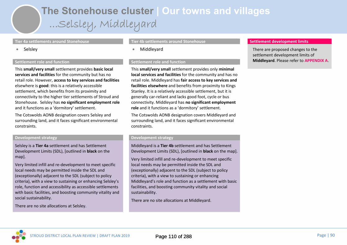
STROUD DISTRICT LOCAL PLAN REVIEW | DRAFT PLAN 2019 Page | 90
The Stonehouse cluster | Our towns and villages...Selsley, Middleyard
Tier 4a settlements around Stonehouse Tier 4b settlements around Stonehouse
Selsley Middleyard
Settlement role and function Settlement role and functionThis small/very small settlement provides basic localservices and facilities for the community but has noretail role. However, access to key services and facilitieselsewhere is good: this is a relatively accessiblesettlement, which benefits from its proximity andconnectivity to the higher tier settlements of Stroud andStonehouse. Selsley has no significant employment roleand it functions as a ‘dormitory’ settlement.The Cotswolds AONB designation covers Selsley andsurrounding land, and it faces significant environmentalconstraints.
This small/very small settlement provides only minimallocal services and facilities for the community and has noretail role. Middleyard has fair access to key services andfacilities elsewhere and benefits from proximity to KingsStanley. It is a relatively accessible settlement, but it isgenerally car-reliant and lacks good foot, cycle or busconnectivity. Middleyard has no significant employmentrole and it functions as a ‘dormitory’ settlement.The Cotswolds AONB designation covers Middleyard andsurrounding land, and it faces significant environmentalconstraints.
Development strategy Development strategy
Selsley is a Tier 4a settlement and has SettlementDevelopment Limits (SDL), [outlined in black on themap].
Very limited infill and re-development to meet specificlocal needs may be permitted inside the SDL and(exceptionally) adjacent to the SDL (subject to policycriteria), with a view to sustaining or enhancing Selsley’srole, function and accessibility as accessible settlementswith basic facilities, and boosting community vitality andsocial sustainability.
There are no site allocations at Selsley.
Middleyard is a Tier 4b settlement and has SettlementDevelopment Limits (SDL), [outlined in black on the map].
Very limited infill and re-development to meet specificlocal needs may be permitted inside the SDL and(exceptionally) adjacent to the SDL (subject to policycriteria), with a view to sustaining or enhancingMiddleyard’s role and function as a settlement with basicfacilities, and boosting community vitality and socialsustainability.
There are no site allocations at Middleyard.
Settlement development limits
There are proposed changes to thesettlement development limits ofMiddleyard. Please refer to APPENDIX A.
Page 110 of 288Page 110 of 288

STROUD DISTRICT LOCAL PLAN REVIEW | DRAFT PLAN 2019 Page | 91
Making Places | Shaping the future of Cam and DursleyDeveloping a vision for the future...
Where are we now?...
Cam and Dursley adjoin each other and together make up the District’ssecond largest population (after the Stroud Valleys). This largeconurbation sits nestled at the foot of the Cotswold hills (the CotswoldsAONB covers the southern half of this parish cluster area) and adjoinsthe Severn Vale. The Cotswold Way runs through the historic markettown centre of Dursley. Cam has a smaller village centre.
Both communities historically were centres for cloth manufacturing.Other industries later boomed in Dursley town, including enginemanufacture, furniture production and pin-making. The area hassuffered from a degree of deprivation that has impacted on the localcommunities, but regeneration and expansion in more recent years isdelivering new employment and improved facilities and services withinthe area. The area benefits from a station on the main line to Bristol andgood accessibility to the south of the District.
Outside of Cam and Dursley, the rural hinterland contains attractivevillages, which look to the main settlement for their key services.
Key issues and top priorities for the future...
Public consultation and our evidence base have told us that these are keylocal issues and top priorities:
Reducing car-borne traffic levels and congestion by delivering public transportimprovements and safe pedestrian and cycle links
Enhancing rail facilities at Cam and Dursley station, linked to the widerpedestrian and cycle network
Encouraging growth of start up businesses, hot desk facilities and homeworking, including through improved IT connectivity and infrastructure
Improving health and community facilities in Cam, providing for children andyoung people
Providing sheltered homes and affordable bungalows for the elderly anddisabled
Developing tourism and accommodation opportunities
Enhancing walking and cycling routes and green links through to Uley and theSevern Vale, including the Wildfowl & Wetlands Trust
Conserving and enhancing the natural beauty of the Cotswolds AONBThe current Local Plan sets out a mini vision, a range of key issues and a seriesof ‘guiding principles’ for future development in this parish cluster area.
The Council consulted community representatives on potential changes to thevisions and key issues at Issues and Options stage (2017) and the draft visionand ‘top priorities’ set out here take account of this, as well as feedback to theEmerging Strategy consultation last year.
These will be subject to further refinement and rationalisation before the nextiteration of the Local Plan (the Pre-submission Plan, anticipated Autumn 2020),to take full account of evidence and the final development strategy.
Page 111 of 288Page 111 of 288
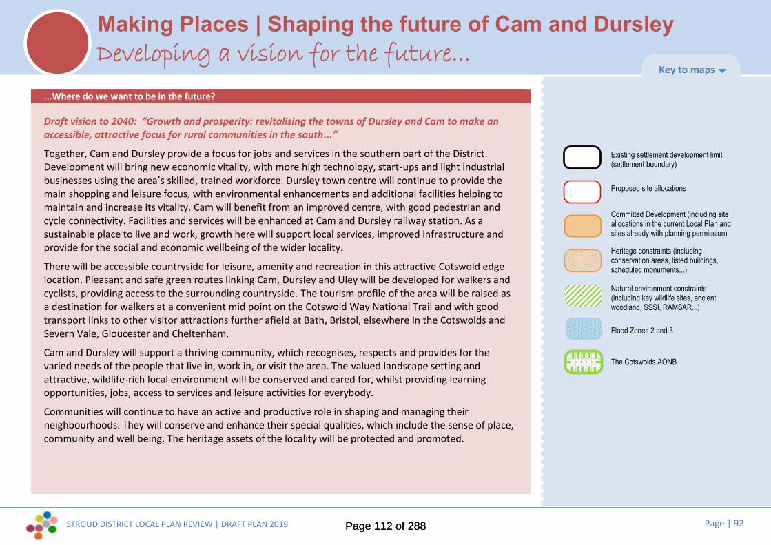
STROUD DISTRICT LOCAL PLAN REVIEW | DRAFT PLAN 2019 Page | 92
Making Places | Shaping the future of Cam and DursleyDeveloping a vision for the future...
...Where do we want to be in the future?
Draft vision to 2040: “Growth and prosperity: revitalising the towns of Dursley and Cam to make anaccessible, attractive focus for rural communities in the south...”
Together, Cam and Dursley provide a focus for jobs and services in the southern part of the District.Development will bring new economic vitality, with more high technology, start-ups and light industrialbusinesses using the area’s skilled, trained workforce. Dursley town centre will continue to provide themain shopping and leisure focus, with environmental enhancements and additional facilities helping tomaintain and increase its vitality. Cam will benefit from an improved centre, with good pedestrian andcycle connectivity. Facilities and services will be enhanced at Cam and Dursley railway station. As asustainable place to live and work, growth here will support local services, improved infrastructure andprovide for the social and economic wellbeing of the wider locality.
There will be accessible countryside for leisure, amenity and recreation in this attractive Cotswold edgelocation. Pleasant and safe green routes linking Cam, Dursley and Uley will be developed for walkers andcyclists, providing access to the surrounding countryside. The tourism profile of the area will be raised asa destination for walkers at a convenient mid point on the Cotswold Way National Trail and with goodtransport links to other visitor attractions further afield at Bath, Bristol, elsewhere in the Cotswolds andSevern Vale, Gloucester and Cheltenham.
Cam and Dursley will support a thriving community, which recognises, respects and provides for thevaried needs of the people that live in, work in, or visit the area. The valued landscape setting andattractive, wildlife-rich local environment will be conserved and cared for, whilst providing learningopportunities, jobs, access to services and leisure activities for everybody.
Communities will continue to have an active and productive role in shaping and managing theirneighbourhoods. They will conserve and enhance their special qualities, which include the sense of place,community and well being. The heritage assets of the locality will be protected and promoted.
Key to maps
Existing settlement development limit(settlement boundary)
Proposed site allocations
Committed Development (including siteallocations in the current Local Plan andsites already with planning permission)
Heritage constraints (includingconservation areas, listed buildings,scheduled monuments...)
Natural environment constraints(including key wildlife sites, ancientwoodland, SSSI, RAMSAR...)
Flood Zones 2 and 3
The Cotswolds AONB
Page 112 of 288Page 112 of 288

STROUD DISTRICT LOCAL PLAN REVIEW | DRAFT PLAN 2019 Page | 93
Cam & Dursley | Our towns and villages
Planning constraints and designationsPhysical constraints include the floodplain thatruns along the River Cam, together with thetopography of the valley sides to the east, andthe Cotswold escarpment to the southeast andsouthwest.
There are a number of listed buildings,primarily within Upper and Lower Cam.
Westfield and Bownace Woods and Cam Peakand Longdown Key Wildlife Sites lie to thesouthwest and southeast of the townrespectively.
The Cotswolds AONB adjoins the southern edgeof the settlement and lies to the southeast.
There are protected open spaces within thesettlement and to the northwest.
Landscape sensitivityThe preferred direction for housing growth inlandscape terms is to the north/north east andeast of the settlement. The preferred directionfor employment growth in landscape terms isto the north/northeast.
Settlement role and functionCam is a very large settlement (second largestpopulation after Stroud). Cam and Dursley areadjacent settlements and their combinedpopulation (14,800+) makes this a reallysignificant conurbation and an importantsecond focus for the District.
Cam has a strong local retail role, with several‘neighbourhood’ shopping areas and a range oflocal shops in the main centre, which serves theday-to-day needs of surrounding villages andhamlets. Unlike our other very largesettlements, Cam has only a very limited role inproviding ‘strategic’ services and facilities to awider catchment (a rail station and asupermarket). But it benefits from proximity toDursley and offers an excellent range of localcommunity services and facilities (GP, dentistand pharmacy, post office, primary schools andpre-school provision, places of worship, pubs,village hall/community centre, sports/playingfields and playgrounds). Cam and Dursley havethe best access to key services and facilities ofanywhere in the District.
Cam has a very significant employment role,but it is nevertheless a net exporter of workers:it acts as a major ‘dormitory’ and a local servicecentre.
Development strategyCam is a Tier 1 settlement and has a Settlement Development Limit(SDL), [outlined in black on the map].
Site allocations [outlined in red on the map and shown in moredetail over the following pages] will meet local and strategicgrowth needs:
PS21 Land adjacent to Tilsdown House.
PS24 West of Draycott.
PS25 East of River Cam.
In addition to the allocated sites, infill and re-development ispermitted inside the SDL and (exceptionally) adjacent to the SDL(subject to policy criteria), with a view to sustaining or enhancingCam’s role and function as one of the District’s main towns and animportant local service centre.
...Cam
Page 113 of 288Page 113 of 288

STROUD DISTRICT LOCAL PLAN REVIEW | DRAFT PLAN 2019 Page | 94
Cam & Dursley | Our towns and villages...Cam
[for key to map see page xx]
© Crown copyright and database rights 2019 Ordnance Survey 100019682
SA3
Northeast Cam(Allocated in the
current Local Plan)
PS21
PS25
PS24
(See Coaleysites p71)
[SDL changes?]
Draft site allocationsPS21 Land adjacent to Tilsdown House:Land adjacent to Tilsdown House, as identifiedon the policies map, is allocated for adevelopment comprising up to 15 dwellingsand associated community and open spaceuses. Detailed policy criteria will be developedwhere necessary to highlight specific mitigationmeasures and infrastructure requirements. Adevelopment brief incorporating an indicativemasterplan, to be approved by the DistrictCouncil, will detail the way in which the landuses and infrastructure will be developed in anintegrated and co-ordinated manner
Alreadycommitteddevelopment
Proposed SDLchanges – seeAPPENDIX A
(See Wisloe pxx)
CAM
DURSLEY
Page 114 of 288Page 114 of 288
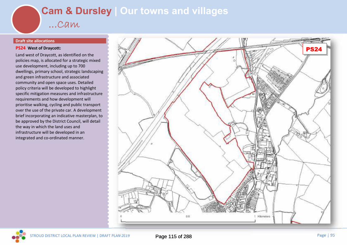
STROUD DISTRICT LOCAL PLAN REVIEW | DRAFT PLAN 2019 Page | 95
Cam & Dursley | Our towns and villages...Cam
Draft site allocationsPS24 West of Draycott:Land west of Draycott, as identified on thepolicies map, is allocated for a strategic mixeduse development, including up to 700dwellings, primary school, strategic landscapingand green infrastructure and associatedcommunity and open space uses. Detailedpolicy criteria will be developed to highlightspecific mitigation measures and infrastructurerequirements and how development willprioritise walking, cycling and public transportover the use of the private car. A developmentbrief incorporating an indicative masterplan, tobe approved by the District Council, will detailthe way in which the land uses andinfrastructure will be developed in anintegrated and co-ordinated manner.
PS24
Page 115 of 288Page 115 of 288

STROUD DISTRICT LOCAL PLAN REVIEW | DRAFT PLAN 2019 Page | 96
Cam & Dursley | Our towns and villages
Draft site allocationsPS25 East of River Cam:Land east of River Cam, as identified on thepolicies map, is allocated for 180 dwellings andassociated community and open space uses tocomplete the current Local Plan North EastCam strategic allocation. Development willcomplete the walking and cycling route fromCam local centre to Box Road. Detailed policycriteria will be developed to highlight specificmitigation measures and infrastructurerequirements and how development willprioritise walking, cycling and public transportover the use of the private car. A developmentbrief incorporating an indicative masterplan, tobe approved by the District Council, will detailthe way in which the land uses andinfrastructure will be developed in anintegrated and co-ordinated manner..
Page 116 of 288Page 116 of 288

STROUD DISTRICT LOCAL PLAN REVIEW | DRAFT PLAN 2019 Page | 97
Cam & Dursley | Our towns and villages
Planning constraints and designationsThere are no significant physical constraints.
There are listed buildings within the north ofthe settlement, clustered around Grade II StBartholomew’s Church. There are listedbuildings at Betworthy Farm and Field Farm,immediately south of the settlement edge.
The recreation ground, north of The Street,and the open space off The Close (in theBetworthy Estate) are both protected outdoorplay spaces.
Landscape sensitivityThe preferred direction of housing growth inlandscape terms is to the south.
There is no identified preferred direction ofemployment growth in landscape terms.
Settlement role and functionCoaley is a small village with a smallpopulation, (although the ‘Coaley’community also encompasses separatelinear hamlets outside the SettlementDevelopment Limit).It has a basic local retail role (a community-run village shop), and a basic level of localcommunity services and facilities (primaryschool and pre-school provision, place ofworship, pub, village hall/community centre,sports field/pitch and playground). Access tokey services and facilities elsewhere is fair.Coaley has no significant employment role:its principal role is as a ‘dormitory’settlement.
Development strategy
Coaley is a Tier 3b settlement and has aSettlement Development Limit (SDL),[outlined in black on the map].
Limited infill and re-development ispermitted inside the SDL and (exceptionally)adjacent to the SDL (subject to policycriteria), with a view to sustaining orenhancing Coaley’s role, function andaccessibility as a settlement with localfacilities.
There are no site allocations at Coaley.
...Coaley[for key to map see page xx]
© Crown copyright and database rights 2019 Ordnance Survey 100019682
Page 117 of 288Page 117 of 288
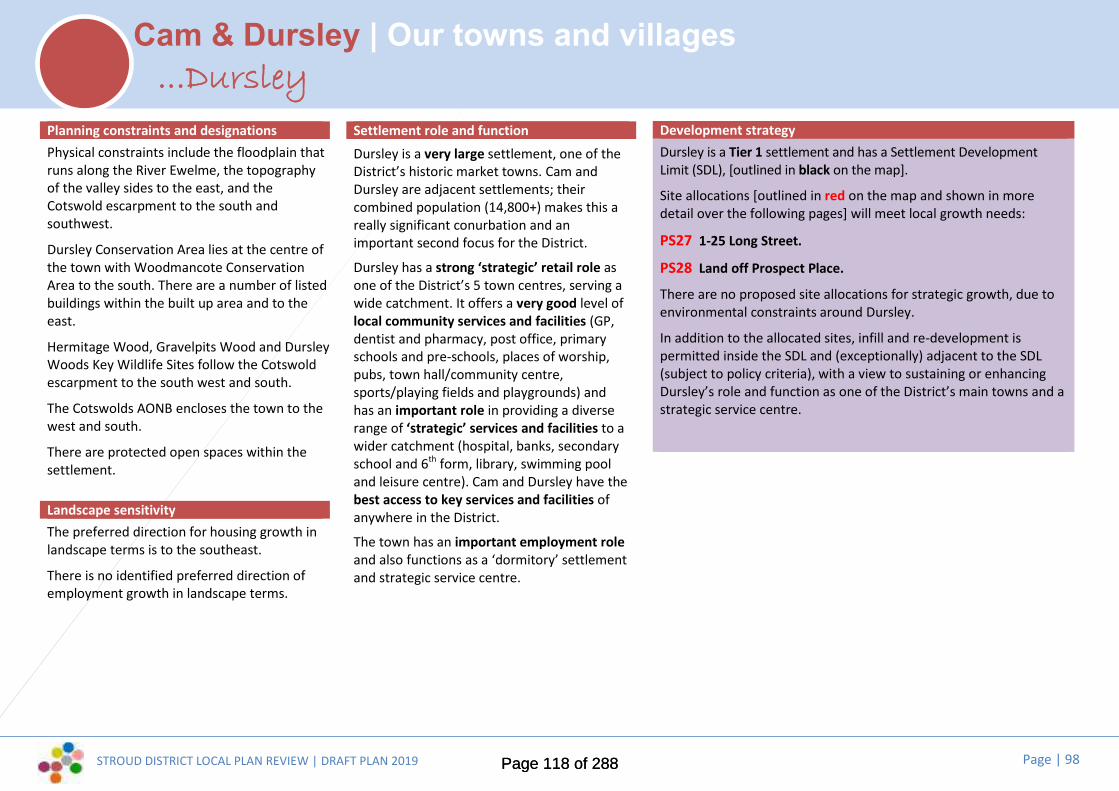
STROUD DISTRICT LOCAL PLAN REVIEW | DRAFT PLAN 2019 Page | 98
Cam & Dursley | Our towns and villages
Planning constraints and designationsPhysical constraints include the floodplain thatruns along the River Ewelme, the topographyof the valley sides to the east, and theCotswold escarpment to the south andsouthwest.
Dursley Conservation Area lies at the centre ofthe town with Woodmancote ConservationArea to the south. There are a number of listedbuildings within the built up area and to theeast.
Hermitage Wood, Gravelpits Wood and DursleyWoods Key Wildlife Sites follow the Cotswoldescarpment to the south west and south.
The Cotswolds AONB encloses the town to thewest and south.
There are protected open spaces within thesettlement.
Landscape sensitivityThe preferred direction for housing growth inlandscape terms is to the southeast.
There is no identified preferred direction ofemployment growth in landscape terms.
Settlement role and functionDursley is a very large settlement, one of theDistrict’s historic market towns. Cam andDursley are adjacent settlements; theircombined population (14,800+) makes this areally significant conurbation and animportant second focus for the District.
Dursley has a strong ‘strategic’ retail role asone of the District’s 5 town centres, serving awide catchment. It offers a very good level oflocal community services and facilities (GP,dentist and pharmacy, post office, primaryschools and pre-schools, places of worship,pubs, town hall/community centre,sports/playing fields and playgrounds) andhas an important role in providing a diverserange of ‘strategic’ services and facilities to awider catchment (hospital, banks, secondaryschool and 6th form, library, swimming pooland leisure centre). Cam and Dursley have thebest access to key services and facilities ofanywhere in the District.
The town has an important employment roleand also functions as a ‘dormitory’ settlementand strategic service centre.
Development strategyDursley is a Tier 1 settlement and has a Settlement DevelopmentLimit (SDL), [outlined in black on the map].
Site allocations [outlined in red on the map and shown in moredetail over the following pages] will meet local growth needs:
PS27 1-25 Long Street.
PS28 Land off Prospect Place.
There are no proposed site allocations for strategic growth, due toenvironmental constraints around Dursley.
In addition to the allocated sites, infill and re-development ispermitted inside the SDL and (exceptionally) adjacent to the SDL(subject to policy criteria), with a view to sustaining or enhancingDursley’s role and function as one of the District’s main towns and astrategic service centre.
...Dursley
Page 118 of 288Page 118 of 288

STROUD DISTRICT LOCAL PLAN REVIEW | DRAFT PLAN 2019 Page | 99
Cam & Dursley | Our towns and villages
[for key to map see page 49]
© Crown copyright and database rights 2019 Ordnance Survey 100019682
...Dursley
Town centre sites...
PS27
PS28
Proposed SDLchanges – seeAPPENDIX A
CAM
PS27
PS28
Page 119 of 288Page 119 of 288

STROUD DISTRICT LOCAL PLAN REVIEW | DRAFT PLAN 2019 Page | 100
Cam & Dursley | Our towns and villages...Dursley
Draft site allocationsPS27 1-25 Long Street:Land rear of 1-25 Long Street, as identified onthe policies map, is allocated for partialredevelopment and re-use for town centreuses. Detailed policy criteria will be developedwhere necessary to highlight specific mitigationmeasures and infrastructure requirements. Adevelopment brief incorporating an indicativemasterplan, to be approved by the DistrictCouncil, will detail the way in which the landuses and infrastructure will be developed in anintegrated and co-ordinated manner.
PS28 Land off Prospect Place:Land off Prospect Place, as identified on thepolicies map, is allocated for a developmentcomprising up to 10 dwellings, associatedcommunity and open space and town centreuses. Detailed policy criteria will be developedwhere necessary to highlight specific mitigationmeasures and infrastructure requirements. Adevelopment brief incorporating an indicativemasterplan, to be approved by the DistrictCouncil, will detail the way in which the landuses and infrastructure will be developed in anintegrated and co-ordinated manner.
Page 120 of 288Page 120 of 288
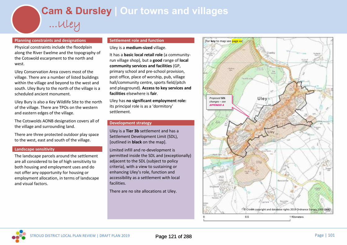
STROUD DISTRICT LOCAL PLAN REVIEW | DRAFT PLAN 2019 Page | 101
Cam & Dursley | Our towns and villages
Planning constraints and designationsPhysical constraints include the floodplainalong the River Ewelme and the topography ofthe Cotswold escarpment to the north andwest.
Uley Conservation Area covers most of thevillage. There are a number of listed buildingswithin the village and beyond to the west andsouth. Uley Bury to the north of the village is ascheduled ancient monument.
Uley Bury is also a Key Wildlife Site to the northof the village. There are TPOs on the westernand eastern edges of the village.
The Cotswolds AONB designation covers all ofthe village and surrounding land.
There are three protected outdoor play spaceto the west, east and south of the village.
Landscape sensitivityThe landscape parcels around the settlementare all considered to be of high sensitivity toboth housing and employment uses and donot offer any opportunity for housing oremployment allocation, in terms of landscapeand visual factors.
Settlement role and functionUley is a medium-sized village.It has a basic local retail role (a community-run village shop), but a good range of localcommunity services and facilities (GP,primary school and pre-school provision,post office, place of worship, pub, villagehall/community centre, sports field/pitchand playground). Access to key services andfacilities elsewhere is fair.Uley has no significant employment role:its principal role is as a ‘dormitory’settlement.
Development strategy
Uley is a Tier 3b settlement and has aSettlement Development Limit (SDL),[outlined in black on the map].
Limited infill and re-development ispermitted inside the SDL and (exceptionally)adjacent to the SDL (subject to policycriteria), with a view to sustaining orenhancing Uley’s role, function andaccessibility as a settlement with localfacilities.
There are no site allocations at Uley.
...Uley[for key to map see page xx]
© Crown copyright and database rights 2019 Ordnance Survey 100019682
Proposed SDLchanges – seeAPPENDIX A
Uley
Page 121 of 288Page 121 of 288
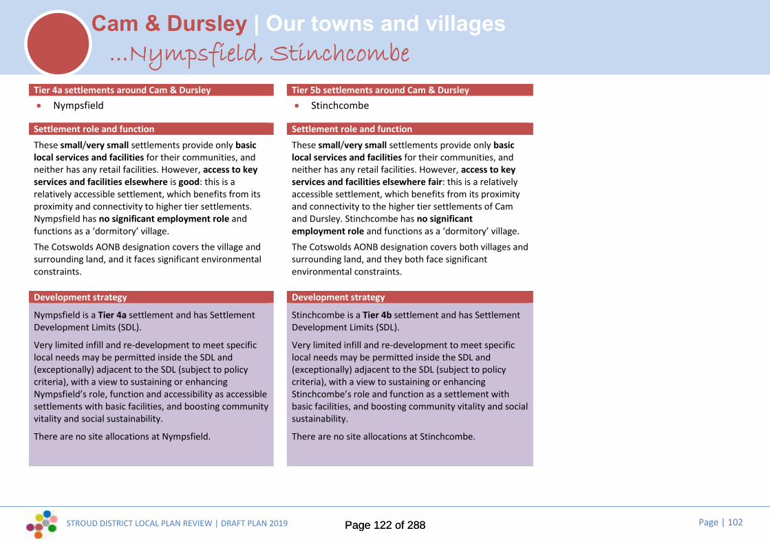
STROUD DISTRICT LOCAL PLAN REVIEW | DRAFT PLAN 2019 Page | 102
Cam & Dursley | Our towns and villages...Nympsfield, Stinchcombe
Tier 4a settlements around Cam & Dursley Tier 5b settlements around Cam & Dursley Nympsfield Stinchcombe
Settlement role and function Settlement role and functionThese small/very small settlements provide only basiclocal services and facilities for their communities, andneither has any retail facilities. However, access to keyservices and facilities elsewhere is good: this is arelatively accessible settlement, which benefits from itsproximity and connectivity to higher tier settlements.Nympsfield has no significant employment role andfunctions as a ‘dormitory’ village.The Cotswolds AONB designation covers the village andsurrounding land, and it faces significant environmentalconstraints.
These small/very small settlements provide only basiclocal services and facilities for their communities, andneither has any retail facilities. However, access to keyservices and facilities elsewhere fair: this is a relativelyaccessible settlement, which benefits from its proximityand connectivity to the higher tier settlements of Camand Dursley. Stinchcombe has no significantemployment role and functions as a ‘dormitory’ village.The Cotswolds AONB designation covers both villages andsurrounding land, and they both face significantenvironmental constraints.
Development strategy Development strategy
Nympsfield is a Tier 4a settlement and has SettlementDevelopment Limits (SDL).
Very limited infill and re-development to meet specificlocal needs may be permitted inside the SDL and(exceptionally) adjacent to the SDL (subject to policycriteria), with a view to sustaining or enhancingNympsfield’s role, function and accessibility as accessiblesettlements with basic facilities, and boosting communityvitality and social sustainability.
There are no site allocations at Nympsfield.
Stinchcombe is a Tier 4b settlement and has SettlementDevelopment Limits (SDL).
Very limited infill and re-development to meet specificlocal needs may be permitted inside the SDL and(exceptionally) adjacent to the SDL (subject to policycriteria), with a view to sustaining or enhancingStinchcombe’s role and function as a settlement withbasic facilities, and boosting community vitality and socialsustainability.
There are no site allocations at Stinchcombe.
Page 122 of 288Page 122 of 288

STROUD DISTRICT LOCAL PLAN REVIEW | DRAFT PLAN 2019 Page | 103
Making Places | Shaping the future of Gloucester’s rural fringeDeveloping a vision for the future...
Where are we now?...
Most people in this area live on the edge of the Gloucester urban area, atHardwicke and in the growing new communities at Hunts Grove andCooper’s Edge. There are also several key employment sites here. Overthe District boundary, Gloucester City is experiencing significantemployment growth, including at Waterwells Business Park. Upton StLeonards is the second largest settlement on the Gloucester fringe, butboth Hardwicke and Upton St Leonards have limited facilities and theylook to Gloucester for most of their strategic needs.
Beyond Hardwicke and Upton St Leonards, the parishes are distinctlyrural in character, populated by scattered hamlets and farmsteads, asidefrom the small villages of Haresfield and Brookthorpe. Almost half of thearea is designated part of the Cotswolds AONB and there are dramaticand far-reaching views to and from the Cotswold escarpment. All theDistrict’s major routes north (road and rail, as well as the Gloucester-Sharpness canal) pass through this area and Junction 12 (M5) lies justsouth of Hunts Grove. The motorway provides a distinct ‘edge’ to theurban expansion of the city.
Key issues and top priorities for the future...
Public consultation and our evidence base have told us that these are thekey local issues and top priorities:
Delivering a new train station at Hunts Grove, with public transport, pedestrianand cycling links
Maintaining and designing safe footpaths, cycle paths and bridleways, includingconnections to employment allocation sites
Ensuring walking routes are clearly defines, attractive, accessible and suitablefor all
Ensuring adequate provision of affordable housing, addressing needs of youngpeople, the elderly and first time buyers.
Supporting agriculture and encouraging farm diversification to sustainbusinesses and support the economy
Enabling small scale housing development to sustain villages whilst retainingtheir diverse identify
Recognising amenity and environmental issues along M5 and A38 corridors
Increasing health, sport and community facilities in nearby centres.
Conserving and enhancing the natural beauty of the Cotswolds AONBThe current Local Plan sets out a mini vision, a range of key issues and a seriesof ‘guiding principles’ for future development in this parish cluster area.
The Council consulted community representatives on potential changes to thevisions and key issues at Issues and Options stage (2017) and the draft visionand ‘top priorities’ set out here take account of this, as well as feedback to theEmerging Strategy consultation last year.
These will be subject to further refinement and rationalisation before the nextiteration of the Local Plan (the Pre-submission Plan, anticipated Autumn 2020),to take full account of evidence and the final development strategy.
Page 123 of 288Page 123 of 288

STROUD DISTRICT LOCAL PLAN REVIEW | DRAFT PLAN 2019 Page | 104
Making Places | Shaping the future of Gloucester’s rural fringeDeveloping a vision for the future...
...Where do we want to be in the future?
Draft vision to 2040: “Growing a sustainable community at Hunts Grove and preserving Gloucester’srural hinterland...”
Parishes on Gloucester’s fringe will retain their distinctiveness and rural character, providing a valuablegreen hinterland to the city and a setting for the Cotswolds AONB. At the urban fringe, with theexception of employment development at Junction 12, the motorway will represent a distinct anddefensible limit to southerly expansion.
Hunts Grove will grow into a sustainable new community with a strong sense of identity, served by itsown “village centre”, providing easy and convenient access to nearby jobs and playing an ever moreimportant role as a ‘gateway’ to Gloucester. High quality design and improvements to cycle andpedestrian links, transport and infrastructure will enhance the environment and quality of life for thoseliving or working close to here, as well as improving the experience of those passing through.
This area will continue to be an important employment focus for the District. Whilst the presence of thewaste incinerator has marked the landscape, Javelin park will also provide a positive stimulus to thedevelopment of complementary innovative business opportunities on surrounding employment sitesand offer combined heat and power opportunities to nearby housing.
While Hunts Grove sees continued housing and employment growth, Hardwicke’s own village characterand sense of community will be preserved as distinct, as will that of the area’s other ancient villages andhamlets. Growth and development will be minimal outside of the identified ‘strategic locations’. Butcommunities elsewhere will have the chance to help shape their neighbourhoods, protecting andimproving those aspects of the area that make it special to them, and identifying needs and opportunitiesthat will help to improve their sustainability.
Key to maps
Existing settlement development limit(settlement boundary)
Proposed site allocations
Other sites (which may have potential tocontribute towards Gloucester’s futurehousing needs)
Committed Development (including siteallocations in the current Local Plan andsites already with planning permission)
Heritage constraints (includingconservation areas, listed buildings,scheduled monuments...)
Natural environment constraints(including key wildlife sites, ancientwoodland, SSSI, RAMSAR...)
Flood Zones 2 and 3
The Cotswolds AONB
G2
Page 124 of 288Page 124 of 288
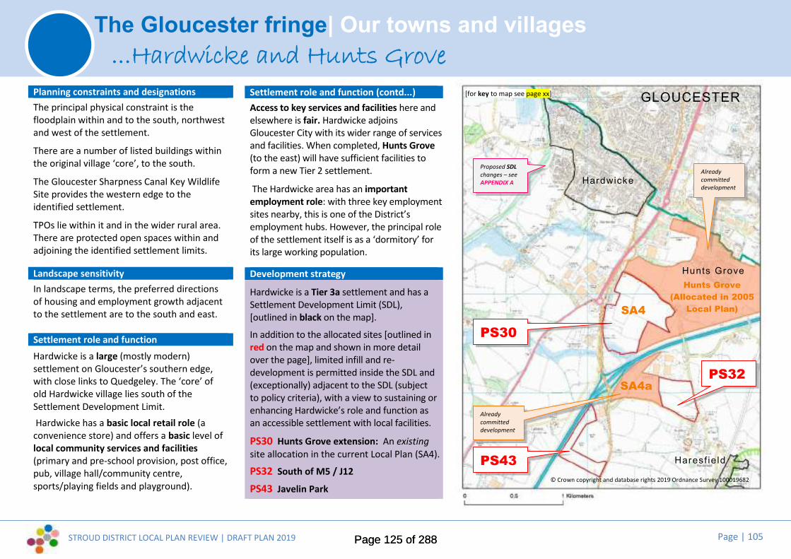
STROUD DISTRICT LOCAL PLAN REVIEW | DRAFT PLAN 2019 Page | 105
The Gloucester fringe| Our towns and villages
Planning constraints and designationsThe principal physical constraint is thefloodplain within and to the south, northwestand west of the settlement.
There are a number of listed buildings withinthe original village ‘core’, to the south.
The Gloucester Sharpness Canal Key WildlifeSite provides the western edge to theidentified settlement.
TPOs lie within it and in the wider rural area.There are protected open spaces within andadjoining the identified settlement limits.
Landscape sensitivityIn landscape terms, the preferred directionsof housing and employment growth adjacentto the settlement are to the south and east.
Settlement role and functionHardwicke is a large (mostly modern)settlement on Gloucester’s southern edge,with close links to Quedgeley. The ‘core’ ofold Hardwicke village lies south of theSettlement Development Limit.Hardwicke has a basic local retail role (a
convenience store) and offers a basic level oflocal community services and facilities(primary and pre-school provision, post office,pub, village hall/community centre,sports/playing fields and playground).
Settlement role and function (contd...)Access to key services and facilities here andelsewhere is fair. Hardwicke adjoinsGloucester City with its wider range of servicesand facilities. When completed, Hunts Grove(to the east) will have sufficient facilities toform a new Tier 2 settlement.
The Hardwicke area has an importantemployment role: with three key employmentsites nearby, this is one of the District’semployment hubs. However, the principal roleof the settlement itself is as a ‘dormitory’ forits large working population.
Development strategy
Hardwicke is a Tier 3a settlement and has aSettlement Development Limit (SDL),[outlined in black on the map].
In addition to the allocated sites [outlined inred on the map and shown in more detailover the page], limited infill and re-development is permitted inside the SDL and(exceptionally) adjacent to the SDL (subjectto policy criteria), with a view to sustaining orenhancing Hardwicke’s role and function asan accessible settlement with local facilities.
PS30 Hunts Grove extension: An existingsite allocation in the current Local Plan (SA4).
PS32 South of M5 / J12
PS43 Javelin Park
...Hardwicke and Hunts Grove
Hunts Grove(Allocated in 2005
Local Plan)
[for key to map see page xx]
PS30
PS32
SA4
SA4a
© Crown copyright and database rights 2019 Ordnance Survey 100019682
PS43
Hardwicke
Alreadycommitteddevelopment
Proposed SDLchanges – seeAPPENDIX A
Alreadycommitteddevelopment
Hunts Grove
Haresf ie ld
GLOUCESTER
Page 125 of 288Page 125 of 288

STROUD DISTRICT LOCAL PLAN REVIEW | DRAFT PLAN 2019 Page | 106
The Gloucester fringe| Our towns and villages...Hardwicke and Hunts Grove
Draft site allocationsPS30 Hunts Grove Extension:Land at Hunts Grove, as identified on thepolicies map, is allocated for 750 dwellings,primary school and associated community andopen space uses and strategic landscaping tocomplete the current Local Plan Hunts Grovestrategic allocation. are set out in the currentLocal Plan Policy SA4, to highlight specificmitigation measures and infrastructurerequirements. Detailed policy criteria will bedeveloped to highlight specific mitigationmeasures and infrastructure requirements. Adevelopment brief incorporating an indicativemasterplan, to be approved by the DistrictCouncil, will detail the way in which the landuses and infrastructure will be developed in anintegrated and co-ordinated manner.
PS30
Page 126 of 288Page 126 of 288
STROUD DISTRICT LOCAL PLAN REVIEW | DRAFT PLAN 2019 Page | 107
The Gloucester fringe| Our towns and villages...Hardwicke and Hunts Grove
Draft site allocationsPS32 South of M5 / J12:Land south of M5/J12, as identified on thepolicies map, is allocated for 5ha employmentand strategic landscaping buffer to the southeast, to complete the current Local PlanQuedgeley East strategic allocation. Detailedpolicy criteria will be developed to highlightspecific mitigation measures and infrastructurerequirements. A development briefincorporating an indicative masterplan, to beapproved by the District Council, will detail theway in which the land uses and infrastructurewill be developed in an integrated and co-ordinated manner
Page 127 of 288Page 127 of 288

STROUD DISTRICT LOCAL PLAN REVIEW | DRAFT PLAN 2019 Page | 108
The Gloucester fringe| Our towns and villages
Planning constraints and designationsThe principal physical constraints are thefloodplain to the south west and north east ofthe settlement and the proximity to the M5 tothe west.
There are a few listed buildings within thevillage centre. A notable cluster exists at Nuthillaround Bowden Hall on the eastern easternedge of the village.
To the east the Cotswold Beechwoods SAC. Asignificant group of TPO’s exist at Nuthill andon southern development limits. There is a SSSIat Hucclecote Meadows to the north.
The Cotswolds AONB adjoins the settlement tothe south, and is adjacent to the east.
There are 3 protected open spaces within thevillage and on the settlement edge.
Landscape sensitivityThe preferred direction for housing growth inlandscape terms is to the southeast. There isalso potential west of Upton Lane in anenclosed field, away from the AONB.
There is no identified preferred direction ofemployment growth in landscape terms.
Settlement role and functionUpton St Leonards is a medium-sizedvillage. Although it lies on Gloucester’speriphery, it is separated from the city bythe M5 motorway.The village has a basic local retail role (avillage shop), but a good range of localcommunity services and facilities (primaryschool and pre-school provision, post office,place of worship, pub, villagehall/community centre, sports field/pitchand playground). Access to key services andfacilities elsewhere is fair.Upton St Leonards has no significantemployment role: its principal role is as a‘dormitory’.
Development strategy
Upton St Leonards is a Tier 3b settlementand has a Settlement Development Limit(SDL), [outlined in black on the map].
Limited infill and re-development ispermitted inside the SDL and (exceptionally)adjacent to the SDL (subject to policycriteria), with a view to sustaining orenhancing the village’s role, function andaccessibility as a settlement with localfacilities.
There are no site allocations at Upton StLoenards.
...Upton St Leonards
© Crown copyright and database rights 2019 Ordnance Survey 100019682
[for key to map see page xx]
Page 128 of 288Page 128 of 288
STROUD DISTRICT LOCAL PLAN REVIEW | DRAFT PLAN 2019 Page | 109
The Gloucester fringe| Our towns and villages...Brookthorpe, Haresfield
Tier 4b settlements on Gloucester’s fringe
Brookthorpe Haresfield
Settlement role and functionThese small/very small settlements provide onlybasic/minimal local services and facilities for theircommunities and neither has any retail role. Access tokey services and facilities elsewhere is poor/very poor,generally lacking reasonable foot, cycle or busconnectivity to strategic facilities nearby (despiteBrookthorpe’s location on a key transport corridor, theA4173). These settlements have no significantemployment role and they both function as ‘dormitory’villages to some extent, tending to look northward toGloucester.The Cotswolds AONB extends to the east, with the
designation affecting parts of both these villages. Theyboth face significant environmental constraints.Development strategy
Brookthorpe and Haresfield are Tier 4b settlements andhave Settlement Development Limits (SDL), [outlined inblack on the map].
Very limited infill and re-development to meet specificlocal needs may be permitted inside the SDL and(exceptionally) adjacent to the SDL (subject to policycriteria), with a view to sustaining or enhancing their roleand function as settlements with basic facilities, andboosting community vitality and social sustainability.
There are no site allocations at Brookthorpe orHaresfield.
Page 129 of 288Page 129 of 288
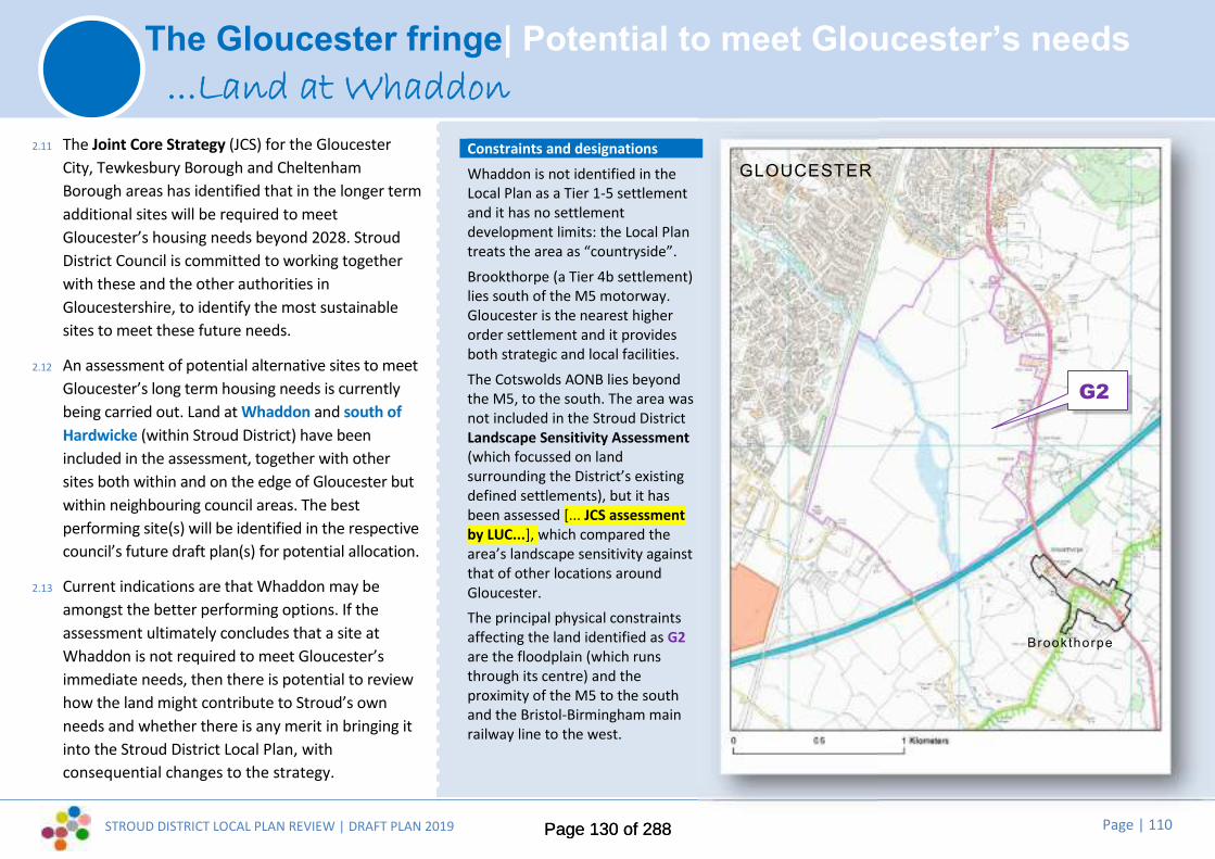
STROUD DISTRICT LOCAL PLAN REVIEW | DRAFT PLAN 2019 Page | 110
The Gloucester fringe| Potential to meet Gloucester’s needs...Land at Whaddon
2.11 The Joint Core Strategy (JCS) for the GloucesterCity, Tewkesbury Borough and CheltenhamBorough areas has identified that in the longer termadditional sites will be required to meetGloucester’s housing needs beyond 2028. StroudDistrict Council is committed to working togetherwith these and the other authorities inGloucestershire, to identify the most sustainablesites to meet these future needs.
2.12 An assessment of potential alternative sites to meetGloucester’s long term housing needs is currentlybeing carried out. Land at Whaddon and south ofHardwicke (within Stroud District) have beenincluded in the assessment, together with othersites both within and on the edge of Gloucester butwithin neighbouring council areas. The bestperforming site(s) will be identified in the respectivecouncil’s future draft plan(s) for potential allocation.
2.13 Current indications are that Whaddon may beamongst the better performing options. If theassessment ultimately concludes that a site atWhaddon is not required to meet Gloucester’simmediate needs, then there is potential to reviewhow the land might contribute to Stroud’s ownneeds and whether there is any merit in bringing itinto the Stroud District Local Plan, withconsequential changes to the strategy.
Constraints and designationsWhaddon is not identified in theLocal Plan as a Tier 1-5 settlementand it has no settlementdevelopment limits: the Local Plantreats the area as “countryside”.Brookthorpe (a Tier 4b settlement)lies south of the M5 motorway.Gloucester is the nearest higherorder settlement and it providesboth strategic and local facilities.The Cotswolds AONB lies beyondthe M5, to the south. The area wasnot included in the Stroud DistrictLandscape Sensitivity Assessment(which focussed on landsurrounding the District’s existingdefined settlements), but it hasbeen assessed [... JCS assessmentby LUC...], which compared thearea’s landscape sensitivity againstthat of other locations aroundGloucester.The principal physical constraintsaffecting the land identified as G2are the floodplain (which runsthrough its centre) and theproximity of the M5 to the southand the Bristol-Birmingham mainrailway line to the west.
G2
Brookthorpe
GLOUCESTER
Page 130 of 288Page 130 of 288

STROUD DISTRICT LOCAL PLAN REVIEW | DRAFT PLAN 2019 Page | 111
The Gloucester fringe| Potential to meet Gloucester’s needs
Other sites(outlined in purple on the maps):This site does not currently form part of the DraftPlan’s development strategy for meeting StroudDistrict’s needs, but it may have potential tocontribute towards meeting Gloucester’s unmethousing needs, subject to being consideredagainst all reasonable alternatives on the edge ofGloucester:
G2 Land at Whaddon:Land at Whaddon, as identified on the policiesmap, is safeguarded to meet the futurehousing needs of Gloucester City should it berequired and provided it is consistent with theapproved strategy of the Joint Core StrategyReview. Subject to this, the site will beallocated for a strategic mixed usedevelopment, including approximately 2500dwellings, local centres including shops,community and employment uses, secondaryand primary schools, bus interchange,safeguarded rail halt, green infrastructure,open space and strategic landscaping. Detailedpolicy criteria will be developed to highlightspecific mitigation measures and infrastructurerequirements and how development willprioritise walking, cycling and public transportover the use of the private car. A developmentbrief incorporating an indicative masterplan, tobe approved by the District Council inconsultation with Gloucester City Council, willdetail the way in which the land uses andinfrastructure will be developed in anintegrated and co-ordinated manner.
...Land at Whaddon
G2
Page 131 of 288Page 131 of 288

STROUD DISTRICT LOCAL PLAN REVIEW | DRAFT PLAN 2019 Page | 112
Making Places | Shaping the future of the Berkeley clusterDeveloping a vision for the future...
Where are we now?...
This cluster of parishes lies in the Severn Vale at the south-western cornerof Stroud District, close to the boundary between Gloucestershire andSouth Gloucestershire. Berkeley is a historic market town, which todayacts as a local service centre for a rural hinterland. Many residents ofthese parishes commute out of the District for work, leisure and anythingother than convenience shopping (Bristol and Thornbury are within easyreach). The closure of Berkeley Nuclear Power Station had an impact onlocal employment opportunities, but the development of theGloucestershire Science and Technology Park is providing newopportunities for growth. Sharpness Docks is a thriving and busy port buthas scope for new development focussing on the leisure and tourismpotential of the Gloucester-Sharpness canal and its Severn Estuarylocation.
The area is blessed with some beautiful landscape and valuable estuarinehabitats, which are nationally and internationally protected. Theseparishes are also home to some of the District’s major tourist attractions:notably, Berkeley Castle, The Jenner Museum, Cattle Country AdventurePark and the world-renowned Wildfowl and Wetlands Trust at Slimbridge.
Key issues and top priorities for the future...
Public consultation and our evidence base have told us that these are thekey local issues and top priorities:
Designing safe walking and cycle routes from Newport to Berkeley
Designing safe walking and cycle routes from Newport to Berkeley extended toSharpness and the Gloucestershire Science and Technology Park
Providing a well signposted, direct walking and cycle route from Wisloe to Camand Dursley station and to the Wildfowl and Wetlands Trust at Slimbridge
Completing the Berkeley Link Road to the A38
Improving transport links with towns and villages in South Gloucestershire andto Bristol and beyond
Ensuring adequate provision of affordable housing and housing opportunities foryounger people
Providing for local job opportunities; supporting small scale and start upbusinesses
Improving IT connectivity and infrastructure
Maintaining and improving the vitality of Berkeley town centre
Protecting the natural landscape and wildlife habitats of the river estuary and itsrural setting including the Severnway
Promoting tourist opportunities in Berkeley town centre and the river estuaryfor tourism and increasing tourist accommodation opportunities.
The current Local Plan sets out a mini vision, a range of key issues and a series of‘guiding principles’ for future development in this parish cluster area.
The Council consulted community representatives on potential changes to thevisions and key issues at Issues and Options stage (2017) and the draft vision and‘top priorities’ set out here take account of this, as well as feedback to theEmerging Strategy consultation last year.
These will be subject to further refinement and rationalisation before the nextiteration of the Local Plan (the Pre-submission Plan, anticipated Autumn 2020),to take full account of evidence and the final development strategy.
Page 132 of 288Page 132 of 288

STROUD DISTRICT LOCAL PLAN REVIEW | DRAFT PLAN 2019 Page | 113
Making Places | Shaping the future of the Berkeley clusterDeveloping a vision for the future...
...Where do we want to be in the future?
Draft vision to 2040: “Growing two new villages and boosting local vitality by making the most of ournatural resources, leisure and tourism...”
New communities at Sharpness and at Wisloe Green will help to meet the housing and employment needs of theDistrict, whilst delivering a step change in services and facilities available to the local area. Following Garden Cityprinciples, the mix of uses, design quality and an accessible layout within a green setting will deliver a trulysustainable pattern of living for new and existing local residents. Public transport will be boosted by the newsettlement at Wisloe providing sustainable transport links along the A38 corridor connecting Stone, Newport,Slimbridge and Cambridge to Bristol and Gloucester. Established communities will have the chance to helpshape their neighbourhoods, maintaining their distinct identities and protecting and improving those aspectsof the area that make it a pleasant place to live.
Berkeley town will continue in its historic role as a service centre for rural communities around it, although it isrecognised that it cannot compete with larger towns within or outside the District for many goods or services.Instead, its local role will be bolstered through small scale growth to meet locally identified needs, benefittingfrom improved transport links to elsewhere, delivered by the new community at Sharpness. The town’s vitality willalso benefit from increased visitor numbers and passing trade, drawn to the area for work or leisure and tourism.The new settlement at Sharpness, together with improvements to the working environment and leisure amenitiesat the Docks and the development of Gloucestershire Science and Technology Park at the former Nuclear PowerStation site, will provide a local boost. These will act together with visitor attractions (including Berkeley Castle, DrJenner’s Museum, Slimbridge Wildfowl and Wetlands Trust, restored heritage railway and several safe andattractive walking and cycling routes) to raise the profile of this part of the District. The townscape and publicrealm of Berkeley will be conserved and enhanced, to improve the marketability of the area.
Villages and hamlets may see small scale development in response to identified local needs, boosting their abilityto remain sustainable and thriving communities. Where possible, safe walking and cycling routes will link placestogether. Across the area, small scale local businesses are encouraged, supported by farm diversification andincluding low-impact tourism related activities.
Conservation and management of the area’s distinctive built heritage, precious estuarine landscape and habitatswill remain high priorities, as will resilience to climate change and associated flood risk.
Key to maps
Existing settlement development limit(settlement boundary)
Proposed site allocations
Committed Development (including siteallocations in the current Local Plan andsites already with planning permission)
Heritage constraints (includingconservation areas, listed buildings,scheduled monuments...)
Natural environment constraints(including key wildlife sites, ancientwoodland, SSSI, RAMSAR...)
Flood Zones 2 and 3
The Cotswolds AONB
Page 133 of 288Page 133 of 288

STROUD DISTRICT LOCAL PLAN REVIEW | DRAFT PLAN 2019 Page | 114
The Berkeley cluster| Our towns and villages
Planning constraints and designationsThe principal physical constraint is thefloodplain to the south west and east of thesettlement.
The Conservation Area covers the town centreand south eastern part of the town. There area number of listed buildings within the towncentre and on the south eastern edge of thetown, including landmark Berkeley Castle.
The Berkeley Heath Key Wildlife Site liesbeyond the village to the north east.
There are protected open spaces within thesettlement.
Landscape sensitivityThe preferred direction of housing growth inlandscape terms is to the north west and westof the settlement.
Landscape sensitivity suggests that there maybe a very limited opportunity for small scaleemployment growth to the north of the town,south of the Station Road employment area.
Settlement role and functionBerkeley is a large settlement, although it issmaller than the District’s other historicmarket towns.Berkeley has a strong local retail role, with arange of local shops to serve the day-to-dayneeds of surrounding villages and hamlets. Itoffers a very good, diverse range of local
Settlement role and functioncommunity services and facilities (GP andpharmacy, post office, primary school, placeof worship, town hall/community centre,pub, sports/playing fields and playground).Berkeley also has a role in providing some‘strategic’ services and facilities to a widercatchment (mobile bank, library, swimmingpool), plus further education at nearbyBerkeley Green UTC. Access to key servicesand facilities here and elsewhere is good.The town itself has a small employment role,although nearby Berkeley Green is likely togrow as a significant employment hub.Berkeley’s principal role is as a ‘dormitory’settlement and local service centre.
Development strategyBerkeley is a Tier 2 settlement and has aSettlement Development Limit (SDL),[outlined in black on the map].
In addition to the allocated sites [outlined inred on the map and shown in more detailover the page], infill and re-development ispermitted inside the SDL and (exceptionally)adjacent to the SDL (subject to policycriteria), with a view to sustaining orenhancing the town’s role and function as astrategic Local Service Centre.
PS33 Northwest of Berkeley
...Berkeley
© Crown copyright and database rights 2019 Ordnance Survey 100019682
[for key to map see page xx]
(See SharpnessGarden Village p81)
PS33
Proposed SDLchanges – seeAPPENDIX A
Berkeley
Page 134 of 288Page 134 of 288

STROUD DISTRICT LOCAL PLAN REVIEW | DRAFT PLAN 2019 Page | 115
The Berkeley cluster| Our towns and villages...Berkeley
Draft site allocationsPS33 Northwest of Berkeley:Land northwest of Berkeley, as identified onthe policies map, is allocated for 120 dwellingsand associated community and open spaceuses and strategic landscaping along thenorthern and eastern boundaries. Detailedpolicy criteria will be developed to highlightspecific mitigation measures and infrastructurerequirements. A development briefincorporating an indicative masterplan, to beapproved by the District Council, will detail theway in which the land uses and infrastructurewill be developed in an integrated and co-ordinated manner.
Page 135 of 288Page 135 of 288

STROUD DISTRICT LOCAL PLAN REVIEW | DRAFT PLAN 2019 Page | 116
The Berkeley cluster| Our towns and villages
Planning constraints and designationsThe principal physical constraint is the tidalfloodplain to the west and southwest of thesettlement.The Conservation Area covers the SharpnessOld Dock and Sharpness canal to the north.There are a few listed buildings within theDocks and within the surrounding rural area.The Severn Estuary to the west is aSAC/SPA/RAMSAR site. The Sharpness DocksKey Wildlife Site lies between Sharpness Docksand Newtown.There are protected open spaces within thesettlement.
Landscape sensitivityThe preferred direction of housing growth inlandscape terms is to the southeast and east ofthe settlement. There is no identified preferreddirection of employment growth in landscapeterms.
Settlement role and functionNewtown is a medium/large sized village,attached to the docks area of Sharpness.Newtown & Sharpness has a basic local retailrole (village shop), but the settlement offers agood level of local community services andfacilities (primary school and pre-schoolprovision, post office, place of worship, pub,village hall/community centre, sports field/pitchand playground. Access to key services and
Settlement role and function (contd...)facilities elsewhere is good.Sharpness principally has an employmentrole (although its residential and leisurefunctions are likely to grow), whileNewtown’s principal role is as a ‘dormitory’settlement.
Development strategyNewtown & Sharpness is a Tier 3a settlementand has a Settlement Development Limit(SDL), [outlined in black on the map].
In addition to the allocated sites [outlined inred on the map and shown in more detailover the page], limited infill and re-development is permitted inside the SDLand (exceptionally) adjacent to the SDL(subject to policy criteria), with a view tosustaining or enhancing Newtown &Sharpness’s role and function as anaccessible settlement with local facilities.
PS34 Sharpness Docks: This is an existingsite allocation in the current Local Plan (SA5).
PS35 Land at Focus School, Wanswell
The proposed strategic site allocation PS36 isnot envisaged as an extension to the existingsettlement of Newtown & Sharpness, but as adistinct new settlement in its own right. Furtherdetails of the proposed Sharpness “GardenVillage” are set out from page xxx.
...Newtown & Sharpness
PS34
PS36
PS35
PS36aPhase 2
© Crown copyright and database rights 2019 Ordnance Survey 100019682
SA5
SA5a
Newtown
Sharpness
BERKELEY
Alreadycommitteddevelopment
Proposed SDLchanges – seeAPPENDIX A
(See SharpnessGarden Village pxx)
Page 136 of 288Page 136 of 288

STROUD DISTRICT LOCAL PLAN REVIEW | DRAFT PLAN 2019 Page | 117
The Berkeley cluster| Our towns and villages...Newtown & Sharpness
Draft site allocationsPS34 Sharpness Docks:Land at Sharpness Docks, as identified on the policiesmap, is allocated for a mixed use development,comprising dock uses and dock related industrial anddistribution uses, including 7 ha expansion land, to thesouth and a mix of tourism, leisure and recreationaldevelopment including up to 300 dwellings to the north,as set out in the current Local Plan Sharpness Docksstrategic allocation. Detailed policy criteria are set out inthe current Local Plan Policy SA5, to highlight specificmitigation measures and infrastructure requirements. Adevelopment brief incorporating an indicativemasterplan, to be approved by the District Council, willdetail the way in which the land uses and infrastructurewill be developed in an integrated and co-ordinatedmanner.
PS34 Land at Focus School, Wanswell:Land at Focus School, Wanswell, as identified on thepolicies map, is allocated for partial redevelopmentcomprising up to 70 dwellings and community use andopen space, including the retention and enhancement ofexisting open space. Development should be consideredwithin the context of the proposed allocation PS36 toensure that retained open space is integrated into thenew community. Detailed policy criteria will bedeveloped where necessary to highlight specificmitigation measures and infrastructure requirements. Adevelopment brief incorporating an indicativemasterplan, to be approved by the District Council, willdetail the way in which the land uses and infrastructurewill be developed in an integrated and co-ordinatedmanner.
Page 137 of 288Page 137 of 288
STROUD DISTRICT LOCAL PLAN REVIEW | DRAFT PLAN 2019 Page | 118
The Berkeley cluster| Creating a new settlement... Garden Villages
2.14 The Draft Plan envisages that housing andemployment growth will be centred at two newsettlements at Sharpness and Wisloe, withinthe Severn Vale (A38/M5 corridor), where thereis potential to create new sustainablecommunities along garden village principles.
2.15 National policy identifies that a new settlementshould create a sustainable community, withsufficient access to services and employmentopportunities within the development itself, orin larger towns to which there is good access.
2.16 At both Sharpness and Wisloe, developmentwill be an exemplar for achieving carbonneutral development by 2030 and will takeplace in accordance with “Garden CityPrinciples”.
2.17 These are defined as:
A Garden City is a holistically planned newsettlement which enhances the naturalenvironment and offers high-quality affordablehousing and locally accessible work in beautiful,healthy and sociable communities. The Garden CityPrinciples are an indivisible and interlockingframework for their delivery, and include:
Draft site allocations(outlined in red on the map):
PS36 New settlement at Sharpness:Up to 2,400 dwellings by year 2040, 10 haemployment, local centre, community uses(including new secondary school) and openspace.
PS37 New settlement at Wisloe:Up to 1,500 dwellings, 5 ha employment, localcentre, community uses and open space.
[Map]
Land value capture for the benefit of thecommunity.
Strong vision, leadership and communityengagement.
Community ownership of land and long-termstewardship of assets.
Mixed-tenure homes and housing types that aregenuinely affordable.
A wide range of local jobs in the Garden Citywithin easy commuting distance of homes.
Beautifully and imaginatively designed homeswith gardens, combining the best of town andcountry to create healthy communities, andincluding opportunities to grow food.
Development that enhances the naturalenvironment, providing a comprehensive greeninfrastructure network and net biodiversity gains,and that uses zero-carbon and energy-positivetechnology to ensure climate resilience.
Strong cultural, recreational and shoppingfacilities in walkable, vibrant, sociableneighbourhoods.
Integrated and accessible transport systems, withwalking, cycling and public transport designed tobe the most attractive forms of local transport.
“Garden City Principles” as defined by the Town andCountry Planning Association
Page 138 of 288Page 138 of 288

STROUD DISTRICT LOCAL PLAN REVIEW | DRAFT PLAN 2019 Page | 119
The Berkeley cluster| Creating a new settlement
Draft site allocationsPS36 New settlement at Sharpness:Land south and east of Newtown andSharpness, as identified on the policies map, isallocated for a new garden communitycomprising 10ha employment, 2,400 dwellingsby 2040 (5,000 by 2050), local centre includingshops and community uses, primary schoolsand secondary school , associated communityand open space uses and strategic greeninfrastructure and landscaping. Thedevelopment will prioritise walking, cycling andpublic transport over the use of the private carand will include high quality pedestrian andcycle routes through the development, a newrail station enabling rail services to Cam andGloucester and rapid bus services to thenearest main settlements. Detailed policycriteria will be developed to highlight specificmitigation measures and infrastructurerequirements.
A range of tools including a communityengagement and stewardship strategy, designcodes and a spatial masterplan andimplementation plan, to be approved by theDistrict Council, will detail the way in which thenew community, land uses and infrastructurewill be developed in an integrated and co-ordinated manner. Development will be anexemplar for achieving carbon neutraldevelopment by 2030 and will take place inaccordance with Garden City Principles.
... Sharpness Garden Village
PS36
PS36aPhase 2
Newtown
Sharpness
BERKELEY
© Crown copyright and database rights 2019 Ordnance Survey 100019682
Page 139 of 288Page 139 of 288

STROUD DISTRICT LOCAL PLAN REVIEW | DRAFT PLAN 2019 Page | 120
The Berkeley cluster| Creating a new settlement...Wisloe Garden Village
Draft site allocationsPS37 New settlement at Wisloe:Land at Wisloe, as identified on the policiesmap, is allocated for a new garden communitycomprising 5ha employment, up to 1500dwellings, local centre including shops andcommunity uses, primary school(s) andassociated community and open space usesand strategic green infrastructure andlandscaping. The development will prioritisewalking, cycling and public transport over theuse of the private car and will include highquality pedestrian and cycle routes through thedevelopment, walking and cycling connectionsto Cam & Dursley rail station and rapid busservices to the nearest main settlements.Detailed policy criteria will be developed tohighlight specific mitigation measures andinfrastructure requirements.
A range of tools including a communityengagement and stewardship strategy, designcodes and a spatial masterplan andimplementation plan, to be approved by theDistrict Council, will detail the way in which thenew community, land uses and infrastructurewill be developed in an integrated and co-ordinated manner. Development will be anexemplar for achieving carbon neutraldevelopment by 2030 and will take place inaccordance with Garden City Principles.
PS37Cambridge
Slimbridge
CAM
© Crown copyright and database rights 2019 Ordnance Survey 100019682
Page 140 of 288Page 140 of 288

STROUD DISTRICT LOCAL PLAN REVIEW | DRAFT PLAN 2019 Page | 121
The Berkeley cluster| Our towns and villages
Planning constraints and designationsThe principal physical constraints are thefloodplain on the north eastern edge of thearea adjacent to Cambridge and the proximityto the M5 to the east.The Slimbridge football club ground (ThornhillPark) is a protected open space.The area around Wisloe Road currentlyconsists of an employment area, footballground, stables and scattered housing.The area is not identified in the Local Plan as asettlement and it has no settlementdevelopment limits.Landscape sensitivityThe area is beyond the immediate vicinity ofCam and Slimbridge and was therefore notincluded in the Stroud District LandscapeSensitivity Assessment (which focussed onland surrounding the District’s existingsettlements).
Settlement role and functionThe area is not currently defined as asettlement and has not been assessed for itscurrent role and function. The Draft Plananticipates that Wisloe “Garden Village” willfunction as a new Accessible Settlement withLocal Facilities once complete (Tier 3a), withaccess to services and employmentopportunities within the development itself, aswell as in higher tier settlements to whichthere is good access.
© Crown copyright and database rights 2019 Ordnance Survey 100019682
(See Camsites pxx)
...Wisloe Garden Village
CambridgeSlimbridge
CAM
Alreadycommitteddevelopment
PS37
[for key to map see page xx]
Page 141 of 288Page 141 of 288

STROUD DISTRICT LOCAL PLAN REVIEW | DRAFT PLAN 2019 Page | 122
The Berkeley cluster| Our towns and villages
Planning constraints and designationsThe principal physical constraint is the Severnfloodplain, which lies to the north of the villageand wraps around to the east and west (atapproximately 0.4km – 1km distance).
The Severn Estuary (Ramsar, SPA, SAC) liesapproximately 1.5km north of the settlement.
There are several listed buildings within thevillage, most clustered around the Church.There is also a Scheduled moated site withinthe settlement, on its eastern edge.
There is protected outdoor play spaceadjoining the southwest settlement edge.
Landscape sensitivityThe preferred direction of housing growth inlandscape terms is to the southwest.
Landscape sensitivity indicates that there maybe only some very limited opportunity foremployment growth to the south, closest tothe A38.
Settlement role and functionSlimbridge is a medium-sized village.It has a no retail role, but the village offers abasic level of local community services andfacilities (primary school and pre-schoolprovision, post office, place of worship,village hall, sports field/pitch andplayground). Access to key services andfacilities elsewhere is poor.Slimbridge has no significant employmentrole: its principal role is as a ‘dormitory’.
Development strategy
Slimbridge is a Tier 3b settlement and has aSettlement Development Limit (SDL),[outlined in black on the map].
Limited infill and re-development ispermitted inside the SDL and (exceptionally)adjacent to the SDL (subject to policycriteria), with a view to sustaining orenhancing the village’s role, function andaccessibility as a settlement with localfacilities.
There are no site allocations at Slimbridge.
© Crown copyright and database rights 2019 Ordnance Survey 100019682
[for key to map see page xx]
...Slimbridge
Cambridge
Slimbridge
Page 142 of 288Page 142 of 288

STROUD DISTRICT LOCAL PLAN REVIEW | DRAFT PLAN 2019 Page | 123
The Berkeley cluster| Our towns and villages...Cambridge, Newport, Stone
Tier 4a settlements in The Berkeley cluster Tier 4b settlements in The Berkeley cluster
Cambridge Newport
Stone
Settlement role and function Settlement role and functionThese small/very small settlements lack any retail roleand provide only minimal local services and facilitiesthemselves. However, access to key services andfacilities elsewhere is good: these are relativelyaccessible settlements, which benefit from theirproximity and/or connectivity to higher tier settlements.Their location on a key transport corridor (A38) offerspotential to develop better public transport links tostrategic facilities nearby. These villages have nosignificant employment role and both function as‘dormitory’ settlements, to some extent.These villages are relatively unconstrained by
environment or topography, although both are affectedby river floodplain.
This small/very small settlement provides basic localservices and facilities for its community but has no retailfacilities. The village has fair access to key services andfacilities elsewhere, but generally lacks reasonable foot,cycle or bus connectivity to strategic facilities nearby,despite its location on a key transport corridor (A38). Thevillage has no significant employment role and itfunctions as a ‘dormitory’ settlement, tending to looksouthward to Bristol / M5 J14.Stone is relatively unconstrained by environment ortopography, although there is river floodplain to thenortheast and the west.
Development strategy Development strategy
Cambridge and Newport are Tier 4a settlements andhave Settlement Development Limits (SDL), [outlined inblack on the map].
Very limited infill and re-development to meet specificlocal needs may be permitted inside the SDL and(exceptionally) adjacent to the SDL (subject to policycriteria), with a view to sustaining or enhancing theirrole, function and accessibility as accessible settlementswith basic facilities, and boosting community vitality andsocial sustainability.
There are no site allocations at Cambridge or Newport.
Stone is a Tier 4b settlement and has SettlementDevelopment Limits (SDL), [outlined in black on the map].
Very limited infill and re-development to meet specificlocal needs may be permitted inside the SDL and(exceptionally) adjacent to the SDL (subject to policycriteria), with a view to sustaining or enhancing Stone’srole and function as a settlement with basic facilities, andboosting community vitality and social sustainability.
There are no site allocations at Cambridge or Newport.
Settlement development limits
There are proposed changes to thesettlement development limits ofCambridge. Please refer to APPENDIX A
Page 143 of 288Page 143 of 288
STROUD DISTRICT LOCAL PLAN REVIEW | DRAFT PLAN 2019 Page | 124
Making Places | Shaping the future of the Severn ValeDeveloping a vision for the future...
Where are we now?...
With much of this area falling within the functional floodplain of theSevern, it has a generally low lying open and flat landscape. The land istraversed by key north/south through-routes (M5, A38 and theGloucester-Sharpness canal), but many communities lie a long way offany main road. The farming community is strong and holdings range frommedium-scale dairy, arable and beef farms to family run smallholdings.The natural environment is high quality with sympathetically managedagricultural land, orchards, woodland and watercourses; the SevernEstuary and its margins offer an internationally important wildlife andhabitat resource. Frampton-on-Severn has an exceptional built heritage,with a high number of listed buildings set around a very distinctive, longvillage green.
The hamlets and villages are few and relatively isolated, reflected in therelatively low population densities of these parishes, compared to manyother parts of the District. The communities are active and have a strongsense of local identity with more than half living there more than 10years. The area is becoming well known for day tourism for walkers,cyclists and horse-riders. There are no major employment areas withinthis cluster.
Key issues and top priorities for the future...
Public consultation and our evidence base have told us that these are thekey local issues and top priorities:
Designing a new cycle way between Arlingham Passage and Newnham on Severn
Ensuring adequate provision of affordable housing and opportunities fordownsizing for local people
Ensuring infrastructure is implemented in a timely manner to supportdevelopment
Supporting farm diversification schemes
Ensuring adequate flood defences for the River Severn.
The current Local Plan sets out a mini vision, a range of key issues and a seriesof ‘guiding principles’ for future development in this parish cluster area.
The Council consulted community representatives on potential changes to thevisions and key issues at Issues and Options stage (2017) and the draft visionand ‘top priorities’ set out here take account of this, as well as feedback to theEmerging Strategy consultation last year.
These will be subject to further refinement and rationalisation before the nextiteration of the Local Plan (the Pre-submission Plan, anticipated Autumn 2020),to take full account of evidence and the final development strategy.
Page 144 of 288Page 144 of 288

STROUD DISTRICT LOCAL PLAN REVIEW | DRAFT PLAN 2019 Page | 125
Making Places | Shaping the future of the Severn ValeDeveloping a vision for the future...
...Where do we want to be in the future?
Draft vision to 2040: “Maintaining a distinctive rural way of life and strengthening the resilience of thearea’s communities, built heritage and natural environment...”
This area has a special character – its unique social and environmental distinctiveness relies partly on itsrelative isolation and its estuarine location. The relationship to the River Severn is a key aspect in localland use and management decisions. Whilst maintaining and improving public transport, accessibility andservices will remain key aims for these communities, this part of the District will experience no ‘strategic’growth or development during the plan period.
But villages and hamlets may see small scale development in response to identified local needs, boostingtheir ability to remain sustainable and thriving communities. Frampton on Severn and Whitminster willcontinue to be a focus for local service provision; while across the area, small scale local businesses areencouraged, supported by farm diversification and including low-impact tourism related activities.
Communities will also feel the environmental and economic benefits of the restored Stroudwater canal.Saul Junction will become an important visitor ‘gateway’ to the Cotswold Canals and the wider StroudDistrict – part of a growing and ever improving network of walking and cycling routes.
Conservation and management of the area’s distinctive built heritage, precious estuarine landscape andhabitats will remain high priorities, as will resilience to climate change and associated flood risk.
Key to maps
Existing settlement development limit(settlement boundary)
Proposed site allocations
Committed Development (including siteallocations in the current Local Plan andsites already with planning permission)
Heritage constraints (includingconservation areas, listed buildings,scheduled monuments...)
Natural environment constraints(including key wildlife sites, ancientwoodland, SSSI, RAMSAR...)
Flood Zones 2 and 3
The Cotswolds AONB
Page 145 of 288Page 145 of 288

STROUD DISTRICT LOCAL PLAN REVIEW | DRAFT PLAN 2019 Page | 126
The Severn Vale| Our towns and villages
Planning constraints and designationsThe principal physical constraints are the tidalfloodplain to the west of the settlement andthe floodplain to the north and east of thevillage along the River Frome.
The Frampton Conservation Area covers thecentre of the village. The Industrial HeritageConservation Area lies to the north and east ofthe settlement. There are numerous listedbuildings within both conservation areas.
The Gloucester and Sharpness Canal KeyWildlife Site follows the canal to the west ofthe settlement and links to the River FromeKey Wildlife Site to the north and east of thevillage.
There are protected open spaces within and tothe north west of the village.
Landscape sensitivityThe preferred direction of housing growth inlandscape terms is to the northeast. There maybe some small opportunities to the southeast.
The preferred direction of employment growthin landscape terms is to the northeast.
Settlement role and function (contd...)Frampton is a medium sized village.It has a basic local retail role (a villageshop), but the village offers a good, diverserange of local community services andfacilities (GP, primary school and pre-schoolprovision, post office, place of worship,pubs, village hall and sports field/pitch,playground). Access to key services andfacilities elsewhere is very poor.Frampton has an employment role, with aKey Employment Site in the village.Although it is a modest net importer ofworkers, its principal role is as a ‘dormitory’settlement.
Development strategyFrampton-on-Severn is a Tier 3a settlementand has a Settlement Development Limit(SDL), [outlined in black on the map].
In addition to the allocated sites [outlined inred on the map and shown in more detailover the page], limited infill and re-development is permitted inside the SDLand (exceptionally) adjacent to the SDL(subject to policy criteria), with a view tosustaining or enhancing the village’s roleand function as an accessible settlementwith local facilities.
PS44 Northwest of Whitminster Lane.
...Frampton on Severn[for key to map see page xx]
© Crown copyright and database rights 2019 Ordnance Survey 100019682
PS44Frampton-on-Severn
Saul
Page 146 of 288Page 146 of 288
STROUD DISTRICT LOCAL PLAN REVIEW | DRAFT PLAN 2019 Page | 127
The Severn Vale| Our towns and villages
Draft site allocationsPS44 Northwest of Whitminster Lane:Land northwest of Whitminster Lane, asidentified on the policies map, is allocated for adevelopment comprising 30 dwellings andassociated community and open space uses.Detailed policy criteria will be developed wherenecessary to highlight specific mitigationmeasures and infrastructure requirements. Adevelopment brief incorporating an indicativemasterplan, to be approved by the DistrictCouncil, will detail the way in which the landuses and infrastructure will be developed in anintegrated and co-ordinated manner.
...Frampton on Severn
Page 147 of 288Page 147 of 288
STROUD DISTRICT LOCAL PLAN REVIEW | DRAFT PLAN 2019 Page | 128
The Severn Vale| Our towns and villages
Planning constraints and designationsThere are no significant physical constraints.
There are a number of listed buildings withinand to the north and southeast of the village.
The River Frome Key Wildlife Site abuts thevillage to the south west.
There are protected open spaces within and onthe western edge of the settlement.
Landscape sensitivityThe preferred directions of housing growth inlandscape terms are to the northeast andnorthwest.
There is no identified preferred direction ofemployment growth in landscape terms.
Settlement role and functionWhitminster is a medium-sized village.It has a strong local retail role with a range oflocal shops to serve the day-to-day needs ofthe community and surrounding area. Inaddition, some niche retail providers drawconsumers here from a much wider catchment.
Settlement role and function (contd...)Whitminster has a basic level of localcommunity services and facilities (primaryschool, post office, pub, villagehall/community centre, sports field/pitchand playground). Access to key services andfacilities elsewhere is poor.Whitminster has a small but importantemployment role and is a net importer ofworkers. Its principal role is as a local servicecentre and ‘dormitory’ settlement though.
Development strategyWhitminster is a Tier 3a settlement and has aSettlement Development Limit (SDL),[outlined in black on the map].
In addition to the allocated sites [outlined inred on the map and shown in more detailover the page], limited infill and re-development is permitted inside the SDLand (exceptionally) adjacent to the SDL(subject to policy criteria), with a view tosustaining or enhancing the village’s roleand function as an accessible settlementwith local facilities.
PS45 Land west of Upton’s Gardens.
PS46 Land west of School Lane.
...Whitminster[for key to map see page xx]
© Crown copyright and database rights 2019 Ordnance Survey 100019682
PS46
PS45
Proposed SDLchanges – seeAPPENDIX A
Page 148 of 288Page 148 of 288

STROUD DISTRICT LOCAL PLAN REVIEW | DRAFT PLAN 2019 Page | 129
The Severn Vale| Our towns and villages
Draft site allocationsPS45 Land west of Upton’s Gardens:Land south of Whitminster Playing Field, asidentified on the policies map, is allocated for adevelopment comprising 10 dwellings andassociated community and open space usesand strategic landscaping. Detailed policycriteria will be developed where necessary tohighlight specific mitigation measures andinfrastructure requirements. A developmentbrief incorporating an indicative masterplan, tobe approved by the District Council, will detailthe way in which the land uses andinfrastructure will be developed in anintegrated and co-ordinated manner.
PS46 Land west of School Lane:Land north of Whitminster Playing Field, asidentified on the policies map, is allocated for adevelopment comprising 30 dwellings andassociated community and open space uses andstrategic landscaping. Detailed policy criteria willbe developed where necessary to highlightspecific mitigation measures and infrastructurerequirements. A development briefincorporating an indicative masterplan, to beapproved by the District Council, will detail theway in which the land uses and infrastructurewill be developed in an integrated and co-ordinated manner.
...Whitminster
Page 149 of 288Page 149 of 288

STROUD DISTRICT LOCAL PLAN REVIEW | DRAFT PLAN 2019 Page | 130
The Severn Vale| Our towns and villages...Arlingham, Longney, Saul
Tier 4b settlements in The Severn Vale
Arlingham Longney Saul
Settlement role and functionThese small and very small settlements providebasic/minimal local services and facilities for theircommunities and only Arlingham has any retail facility.These are remote, highly car-reliant and poorlyconnected settlements, with very poor access to keyservices and facilities elsewhere, including on foot, cycleor by bus. These villages have no significant employmentrole and they function as ‘dormitory’ settlements, tosome extent, with a Gloucester / M5 focus.These settlements are constrained by the Severn’s tidalfloodplain and, south of Saul, the Severn Estuary isprotected by multiple environmental designations(SAC/SPA/RAMSAR).Development strategy
Arlingham, Longney and Saul are Tier 4b settlements andhave Settlement Development Limits (SDL), [outlined inblack on the map].
Very limited infill and re-development to meet specificlocal needs may be permitted inside the SDL and(exceptionally) adjacent to the SDL (subject to policycriteria), with a view to sustaining or enhancing their roleand function as settlements with basic facilities, andboosting community vitality and social sustainability.
There are no site allocations at these settlements.
Page 150 of 288Page 150 of 288

STROUD DISTRICT LOCAL PLAN REVIEW | DRAFT PLAN 2019 Page | 131
Making Places | Shaping the future of The Wotton clusterDeveloping a vision for the future...
Where are we now?...
This is a largely rural area on the western escarpment of the Cotswolds,overlooking the Severn Vale. Wotton-under-Edge sits on a ledge belowthe Cotswold Escarpment and is crossed by the Cotswold Way nationaltrail and Monarchs Way long distance path. The centre of the town (oneof the District’s former market towns, which grew as a wool and cloth-trading centre) is a Conservation Area and sits within the CotswoldsAONB.
Surrounding villages and hamlets look towards Wotton-under-Edge as alocal service centre. Renishaw Ltd is a major employer, based justoutside the village of Kingswood. Most working people commute tosurrounding towns and cities (it is relatively close to Thornbury, Yate andBristol), but the town itself is still commercially active. There are a goodrange of shops and services in the town including a local cinema andswimming pool.
Key issues and top priorities for the future...
Public consultation and our evidence base have told us that these are keylocal issues and top priorities:
Designing safe green walking and cycle routes and achieving a better publictransport system
Ensuring adequate provision of affordable housing and opportunities fordownsizing for local people
Preventing the loss of employment sites to housing, providing for low skilledjob opportunities
Maintaining and improving the vitality of Wotton High Street Reducing traffic congestion and improving traffic flow through Wotton under
Edge Promoting tourism and accommodation opportunities Conserving and enhancing the natural beauty of the Cotswolds Area of
Outstanding Natural Beauty. Addressing Kingswood School capacity issues
The current Local Plan sets out a mini vision, a range of key issues and a seriesof ‘guiding principles’ for future development in this parish cluster area.
The Council consulted community representatives on potential changes to thevisions and key issues at Issues and Options stage (2017) and the draft visionand ‘top priorities’ set out here take account of this, as well as feedback to theEmerging Strategy consultation last year.
These will be subject to further refinement and rationalisation before the nextiteration of the Local Plan (the Pre-submission Plan, anticipated Autumn 2020),to take full account of evidence and the final development strategy.
Page 151 of 288Page 151 of 288

STROUD DISTRICT LOCAL PLAN REVIEW | DRAFT PLAN 2019 Page | 132
Making Places | Shaping the future of The Wotton clusterDeveloping a vision for the future...
...Where do we want to be in the future?
Draft vision to 2040: “Improving access to jobs, services and facilities in the south of the District, toboost local sustainability and community vitality...”
Lying at the southernmost tip of the District, the parishes around Wotton-Under-Edge naturally looksouthwards to Bristol and South Gloucestershire for many of their needs. A key aim for the plan periodwill be to improve opportunities for people to access jobs, services and facilities without having to travellong distances, but to improve public transport access to those services that cannot be met locally. Thesouth of the District will benefit from the growth of employment at Cam, as well as the on-goingrevitalisation of Dursley and its town centre.
Wotton-Under-Edge itself will continue to capitalise on its character as an historic town set within a greenand pleasant environment, benefitting from its proximity to the Cotswold Way. With commercial activityand local employment, Wotton meets the everyday needs of its surrounding rural communities, althoughits sensitive location in the landscape will prevent further outward growth. High Street vitality will bemaintained, with a varied and well-used range of shops and services in its pretty town centre. This will besupported by strong community input into events, festivals and cultural and leisure facilities, such as thePicture House.
Kingswood is a thriving village within an attractive landscape setting which benefits from its proximity toWotton-Under Edge and access to local employment boosted by pleasant and safe green walking andcycling links connecting Kingswood, Wotton under Edge and Charfield and other key local destinations.Smaller villages and hamlets may see small scale development in response to identified local needs,boosting their ability to remain sustainable and thriving communities.
Across the area, small scale local businesses are encouraged, supported by farm diversification andincluding low-impact tourism related activities.
Key to maps
Existing settlement development limit(settlement boundary)
Proposed site allocations
Committed Development (including siteallocations in the current Local Plan andsites already with planning permission)
Heritage constraints (includingconservation areas, listed buildings,scheduled monuments...)
Natural environment constraints(including key wildlife sites, ancientwoodland, SSSI, RAMSAR...)
Flood Zones 2 and 3
The Cotswolds AONB
Page 152 of 288Page 152 of 288

STROUD DISTRICT LOCAL PLAN REVIEW | DRAFT PLAN 2019 Page | 133
The Wotton cluster| Our towns and villages
Planning constraints and designationsThe principal physical constraint is thefloodplain to the north of the village along theOzleworth Brook.
The Kingswood Conservation Area covers thecentre of the village. There are a number oflisted buildings within and to the north of thevillage.
Ozleworth Brook is identified as a Key WildlifeSite.
There are protected open spaces within and onthe western edge of the settlement.
Landscape sensitivityThe preferred directions of housing growth inlandscape terms are to the southwest and tothe southeast.
There is no identified preferred direction ofemployment growth in landscape terms.
Settlement role and functionKingswood is a medium sized village.It has a basic local retail role (a village shop),but the village offers a good level of localcommunity services and facilities (primaryschool and pre-school provision, post office,place of worship, pub, village hall and sports
Settlement role and function (contd...)field/pitch). Access to key services andfacilities elsewhere is very good.Kingswood has an employment role: as welltwo Key Employment Sites within thevillage, nearby Renishaw acts as a notableemployment ‘hub’ and the village is a netimporter of workers. Its principal role is as a‘dormitory’ settlement though.
Development strategyKingswood is a Tier 3a settlement and has aSettlement Development Limit (SDL),[outlined in black on the map].
In addition to the allocated sites [outlined inred on the map and shown in more detailover the page], limited infill and re-development is permitted inside the SDLand (exceptionally) adjacent to the SDL(subject to policy criteria), with a view tosustaining or enhancing the village’s roleand function as an accessible settlementwith local facilities.
PS38 South of Wickwar Road
PS47 Land west of Renishaw New Mills.
...Kingswood
PS38
PS47
Kingswood
WOTTON-UNDER-EDGE[for key to map see page xx]
© Crown copyright and database rights 2019 Ordnance Survey 100019682
Page 153 of 288Page 153 of 288

STROUD DISTRICT LOCAL PLAN REVIEW | DRAFT PLAN 2019 Page | 134
The Wotton cluster| Our towns and villages
[for key to map see page 49]© Crown copyright and database rights 2018 Ordnance Survey 100019682
...KingswoodDraft site allocationsPS38 South of Wickwar Road:Subject to the satisfactory resolution of existingschool capacity issues at Kingswood, land southof Wickwar Road, as identified on the policiesmap, is allocated for a development comprising50 dwellings and associated community andopen space uses and strategic landscaping.Detailed policy criteria will be developed wherenecessary to highlight specific mitigationmeasures and infrastructure requirements. Adevelopment brief incorporating an indicativemasterplan, to be approved by the DistrictCouncil, will detail the way in which the landuses and infrastructure will be developed in anintegrated and co-ordinated manner.
PS47 Land west of Renishaw New MIlls:Land west of Renishaw New Mills, as identifiedon the policies map, is allocated as anextension to the key employment site EK17 fora development comprising 9ha employmentand strategic landscaping. Detailed policycriteria will be developed where necessary tohighlight specific mitigation measures andinfrastructure requirements. A developmentbrief incorporating an indicative masterplan, tobe approved by the District Council, will detailthe way in which the land uses andinfrastructure will be developed in anintegrated and co-ordinated manner.
Page 154 of 288Page 154 of 288

STROUD DISTRICT LOCAL PLAN REVIEW | DRAFT PLAN 2019 Page | 135
The Wotton cluster| Our towns and villages
Planning constraints and designationsThe principal physical constraint is the steeptopography to the north (either side of NewRoad) and to the southeast (foot slopes ofNibley Knoll).
There are several listed buildings, mostlygrouped along The Street and at the foot ofBarrs Lane. Outside the settlement, the GradeII* listed Tyndale Monument on Nibley Knoll isa local landmark.
Nibley Knoll, to the immediate southeast of thevillage, has multiple designations: Site ofSpecial Scientific Interest (SSSI) status, anextensive tree belt (TPOs) and two Key WildlifeSites, linking to Ancient Woodland.
The village is entirely within and surrounded bythe Cotswolds AONB.
Landscape sensitivityThe preferred direction of housing growth inlandscape terms is to the northeast, north ofInnocks Estate.
There is no identified preferred direction ofemployment growth in landscape terms.
Settlement role and functionAmongst Tier 3 settlements, North Nibleyhas one of the smallest populations.It has a basic local retail role (a village
shop), but the village offers a good level oflocal community services and facilities(primary school and pre-school provision,post office, place of worship, pub, villagehall, sports field/pitch and playground).Access to key services and facilitieselsewhere is good.North Nibley has no significant employmentrole: its principal role is as a ‘dormitory’.
Development strategy
North Nibley is a Tier 3b settlement and hasa Settlement Development Limit (SDL),[outlined in black on the map].
Limited infill and re-development ispermitted inside the SDL and (exceptionally)adjacent to the SDL (subject to policycriteria), with a view to sustaining orenhancing the village’s role, function andaccessibility as a settlement with localfacilities.
There are no site allocations at North Nibley.
...North Nibley[for key to map see page xx]
© Crown copyright and database rights 2019 Ordnance Survey 100019682
Page 155 of 288Page 155 of 288

STROUD DISTRICT LOCAL PLAN REVIEW | DRAFT PLAN 2019 Page | 136
The Wotton cluster| Our towns and villages
Planning constraints and designationsThe principal physical constraint is thefloodplain through the centre of the settlement.
There are many listed buildings in the towncentre.
There are three Key Wildlife Sites within closeproximity to the settlement: Hentley Wood tothe east; Conygre Wood & Westridge Wood(south) to the north. There is a swathe of land tothe north covered by Coombe SSSI & WottonSSSI.
The settlement is within the Cotswolds AONB.
Landscape sensitivityThe only land parcels with slightly lesssensitivity in landscape terms are to the northeast, north west and south (inner central).
There is no identified preferred direction ofemployment growth in landscape terms.
Settlement role and functionWotton is a very large settlement, one of theDistrict’s historic market towns.Wotton has a strong ‘strategic’ retail role asone of the District’s 5 town centres, serving awide catchment. It offers a very good level oflocal community services and facilities (GP,dentist and pharmacy, primary school andpre-school provision, post office, place ofworship, pub, town hall sports / playing fields
Settlement role and functionand playground) and has an important rolein providing a diverse range of ‘strategic’services and facilities to a wider catchment(bank, secondary school and 6th form,library, cinema, swimming pool and leisurecentre). Access to key services and facilitieshere and elsewhere is very good.The town has a significant employment role,but it principally functions as a ‘dormitory’settlement and local service centre.
Development strategyWotton-Under-Edge is a Tier 2 settlementand has a Settlement Development Limit(SDL), [outlined in black on the map].
Infill and re-development is permitted insidethe SDL and (exceptionally) adjacent to theSDL (subject to policy criteria), with a viewto sustaining or enhancing the town’s roleand function as a strategic Local ServiceCentre.
There are no proposed site allocations forhousing or employment growth, due toenvironmental constraints around Wotton-Under-Edge.
...Wotton-under-Edge[for key to map see page xx]
Kingswood
WOTTON-UNDER-EDGE
© Crown copyright and database rights 2019 Ordnance Survey 100019682
Page 156 of 288Page 156 of 288

STROUD DISTRICT LOCAL PLAN REVIEW | DRAFT PLAN 2019 Page | 137
The Wotton cluster| Our towns and villages...Hillesley
Tier 4b settlements in The Wotton cluster
Hillesley
Settlement role and functionThis small/very small settlement provides only basiclocal services and facilities for its community and has noretail facilities. Hillesley is highly car-reliant and poorlyconnected, with poor access to key services and facilitieselsewhere, including on foot, cycle or by bus. The villagehas no significant employment role and it functions as a‘dormitory’ settlement, tending to look southward toBristol.The Cotswolds AONB designation covers the village andsurrounding land and it faces significant environmentalconstraints.
Development strategy
Hillesley is a Tier 4b settlement and has SettlementDevelopment Limits (SDL), [outlined in black on the map].
Very limited infill and re-development to meet specificlocal needs may be permitted inside the SDL and(exceptionally) adjacent to the SDL (subject to policycriteria), with a view to sustaining or enhancing Hillesley’srole and function as a settlement with basic facilities, andboosting community vitality and social sustainability.
There are no site allocations at Hillesley.
Settlement development limits
There are proposed changes to thesettlement development limits ofHillesley. Please refer to APPENDIX A.
Page 157 of 288Page 157 of 288

STROUD DISTRICT LOCAL PLAN REVIEW | DRAFT PLAN 2019 Page | 138
Making Places | Shaping the future of The Cotswold clusterDeveloping a vision for the future...
Where are we now?...
This cluster of parishes falls entirely within the Cotswolds Area ofOutstanding Natural Beauty (AONB) and is predominantly rural. Thelargest settlement here is Painswick, which lies at the heart of these ruralparishes.
The Cotswolds are world-renowned for their landscape and the prettylimestone villages that populate it. The area includes a number of populartourist attractions including the Rococco Gardens, Painswick; the village ofSlad and the Laurie Lee Wildlife Way; and the Garden at Miserden.
But, as with elsewhere in the District, rural life is changing with fewerpeople now working in the villages and residents commuting longdistances to work. There has certainly been a decline in village services inmodern times. Housing affordability is an issue – average house priceshere are amongst the highest in the District. Owner-occupation levels arehigh compared to elsewhere in the District, while levels of social housingare very low. A very high proportion of residents are retirement aged.
The loss of traditional skills is perhaps the most significant issue for thefuture management of the landscape. The wooded landscape knowncollectively as the Cotswold Beechwoods around Cranham andSheepscombe is recognised as being particularly vulnerable torecreational pressures.
Key issues and top priorities for the future...
Public consultation and our evidence base have told us that these are keylocal issues and top priorities:
Creating resilient, rural, life-time communities, to enable people to live affordablyand work in the area
Maintaining and improving the vitality of Painswick town centre
Ensuring adequate parking provision within the historic tourist town of Painswick
Improving community transport schemes for use by an increasingly elderlypopulation
Conserving and enhancing the countryside and biodiversity.
Conserving the Cotswolds Area of Outstanding Natural Beauty.
Protection of the historic environment, specifically including archaeology and keyopen spaces within historic settlements
Improvements to IT connectivity and infrastructure to support home working
Ensuring adequate provision of smaller properties to allow for starter homes andopportunities for downsizing for local people
The current Local Plan sets out a mini vision, a range of key issues and a seriesof ‘guiding principles’ for future development in this parish cluster area.
The Council consulted community representatives on potential changes to thevisions and key issues at Issues and Options stage (2017) and the draft visionand ‘top priorities’ set out here take account of this, as well as feedback to theEmerging Strategy consultation last year.
These will be subject to further refinement and rationalisation before the nextiteration of the Local Plan (the Pre-submission Plan, anticipated Autumn 2020),to take full account of evidence and the final development strategy.
Page 158 of 288Page 158 of 288

STROUD DISTRICT LOCAL PLAN REVIEW | DRAFT PLAN 2019 Page | 139
Making Places | Shaping the future of The Cotswold clusterDeveloping a vision for the future...
...Where do we want to be in the future?
Draft vision to 2040: “Protecting and enhancing all the things that will make the Cotswolds a thrivingand inclusive place to live, as well as a great place to visit...”
A key goal for the future of this area will be to ease the tension between its role as a major touristattraction and ‘protected landscape’ and its ability to function as a place where people can live and work.Rural businesses have a valued and supported role in providing local employment opportunities.
The popularity of the area with tourists presents real opportunities and will continue to play a major partin Stroud District’s economy: the Cotswold ‘brand’ is an important draw for inward investment to theDistrict. As such, the preservation and enhancement of the area’s landscape, character and built heritagewill be paramount.
Given the relative affluence of this area, high-end and high quality tourism and leisure products (includingaccommodation, attractions, events, eating and drinking places) are likely to find customers amongst theresident community as well as visitors. But inclusiveness, rather than exclusiveness, will be a goal –improving access for all to the countryside and facilities on offer.
At the heart of the area lies Painswick, “the Queen of the Cotswolds”, which will continue to play animportant role as a service provider for surrounding communities, as well as drawing in visitors. Somegrowth will reflect its role within the area, and will help to meet housing needs, maintain and improve thevitality of the town centre and support local services.
Although none of the smaller villages in this part of the District will see ‘strategic’ levels of growth, somemay see small scale development, responding to locally-identified needs with a goal of boosting theirability to remain sustainable and thriving communities.
Key to maps
Existing settlement development limit(settlement boundary)
Proposed site allocations
Committed Development (including siteallocations in the current Local Plan andsites already with planning permission)
Heritage constraints (includingconservation areas, listed buildings,scheduled monuments...)
Natural environment constraints(including key wildlife sites, ancientwoodland, SSSI, RAMSAR...)
Flood Zones 2 and 3
The Cotswolds AONB
Page 159 of 288Page 159 of 288

STROUD DISTRICT LOCAL PLAN REVIEW | DRAFT PLAN 2019 Page | 140
The Cotswold cluster| Our towns and villages
Planning constraints and designationsThe Bisley Conservation Area covers thesouthern half of the village and extends furtherto the south, into countryside. There arenumerous listed buildings, concentrated withincentral and southern parts of the settlement.
The extensive designated Historic Park andGarden of Lypiatt Park lies 500m west of thesettlement.
Bisley is entirely within the Cotswolds AONB.
There is protected outdoor play spaceadjoining the east side of the settlement (offVan De Breen Street).
Landscape sensitivityThe preferred direction of housing growth inlandscape terms is to the northeast.
Landscape sensitivity indicates that there maybe only a very limited opportunity for smallscale employment use to the north of thevillage (south of existing commercialpremises).
Settlement role and functionBisley is a medium-sized village with acompact form.It has a basic local retail role (a villageshop), but the village offers a good range oflocal community services and facilities(primary school and pre-school provision,post office, place of worship, pubs, villagehall, sports field/pitch and playground).However, access to key services andfacilities elsewhere is poor.Bisley has no significant employment role:its principal role is as a ‘dormitory’settlement.
Development strategy
Bisley is a Tier 3b settlement and has aSettlement Development Limit (SDL),[outlined in black on the map].
Limited infill and re-development ispermitted inside the SDL and (exceptionally)adjacent to the SDL (subject to policycriteria), with a view to sustaining orenhancing the village’s role, function andaccessibility as a settlement with localfacilities.
There are no site allocations at Bisley.
...Bisley[for key to map see page xx]
© Crown copyright and database rights 2019 Ordnance Survey 100019682
Page 160 of 288Page 160 of 288

STROUD DISTRICT LOCAL PLAN REVIEW | DRAFT PLAN 2019 Page | 141
The Cotswold cluster| Our towns and villages
Planning constraints and designationsThe steeply sloping topography to theimmediate north/east of the village is theprincipal physical constraint.
The Miserden Conservation Area covers almostthe entire village and seamlessly adjoins thegarden grounds and parkland of MiserdenHouse to the north and east, which is aregistered historic park and garden. The villagecontains a high density of listed buildings.Misarden Park motte and bailey castle SAM liessome 500m to the north east; a long barrowSAM lies 360m to the west.
The village and surrounding countryside isentirely within the Cotswolds AONB.
Landscape sensitivityThe village is not currently a definedsettlement and was therefore not included inthe Stroud District Landscape SensitivityAssessment (which focused on landsurrounding the District’s existing settlements).
There is no identified preferred direction ofhousing or employment growth in landscapeterms.
Proposed new settlementThe Draft Plan proposes to designateMiserden as a new Tier 3b settlement withinthe settlement hierarchy and to definesettlement development limits.
Settlement role and functionMiserden is the smallest of all Tier 3settlements, but has a level of functionalitycomparable with others in this tier.The settlement has a basic local retail role,(a village shop) and offers a good range oflocal community services and facilities(post office, primary school and pre-school,place of worship, pub, village hall, sportspitch/playing field).However, access to keyservices and facilities elsewhere is verypoor.Miserden has no significant employmentrole: its principal role is as a ‘dormitory’settlement.
Development strategy
Miserden is a Tier 3b settlement and has aSettlement Development Limit (SDL),[outlined in black on the map].
Limited infill and re-development ispermitted inside the SDL and (exceptionally)adjacent to the SDL (subject to policycriteria), with a view to sustaining orenhancing the village’s role, function andaccessibility as a settlement with localfacilities.
There are no site allocations at Miserden.
[for key to map see page xx]
...Miserden
© Crown copyright and database rights 2019 Ordnance Survey 100019682
Proposed SDLchanges – seeAPPENDIX A
Miserden
Page 161 of 288Page 161 of 288

STROUD DISTRICT LOCAL PLAN REVIEW | DRAFT PLAN 2019 Page | 142
The Cotswold cluster| Our towns and villages
Planning constraints and designationsPhysical constraints include the steeptopography on the valley sides to the southand west and woods to the south.
There are a number of listed buildings withinthe village.
Strawberry Banks Site of Special ScientificInterest (SSSI) lies beyond the western edge ofthe village. The Oakridge Recreation GroundKey Wildlife Site (KWS) is on the eastern edgeof the village. The Valley, Moley and GreatMoley KWS is beyond the village to the south.
The Cotswolds AONB designation covers all ofthe village and surrounding land.
There is protected outdoor play spaceadjoining the east side of the village.
Landscape sensitivityThe preferred direction of housing growth inlandscape terms is to the north of TheCrescent.
The landscape parcels around the settlementare all considered to be of high sensitivity toemployment uses and do not offer anyopportunity for employment allocation interms of landscape and visual factors.
Settlement role and functionAmongst Tier 3 settlements, Oakridge Lynchhas one of the smallest populations and acompact area.It has a basic local retail role (a village shop)and offers a basic level of local communityservices and facilities (primary school, postoffice, place of worship, pub, village hall,sports field/pitch and playground). Access tokey services and facilities elsewhere is poor.Oakridge Lynch has no significantemployment role: its principal role is as a‘dormitory’ settlement.
Development strategy
Oakridge Lynch is a Tier 3b settlement andhas a Settlement Development Limit (SDL),[outlined in black on the map].
Limited infill and re-development ispermitted inside the SDL and (exceptionally)adjacent to the SDL (subject to policycriteria), with a view to sustaining orenhancing the village’s role, function andaccessibility as a settlement with localfacilities.
There are no site allocations at OakridgeLynch.
...Oakridge Lynch[for key to map see page xx]
© Crown copyright and database rights 2019 Ordnance Survey 100019682
Page 162 of 288Page 162 of 288
STROUD DISTRICT LOCAL PLAN REVIEW | DRAFT PLAN 2019 Page | 143
The Cotswold cluster| Our towns and villages
Planning constraints and designationsThe Painswick Stream floodplain is a physicalconstraint to the south and south east of thesettlement.The Painswick Conservation Area covers most ofthe town. Gyde House Conservation Area lies tothe north and the Rococo Garden at PainswickHouse, to the north west, is a registered historicpark and garden. The town contains a significantnumber of listed buildings.Bulls Cross/Frith Wood Site of Special ScientificInterest (SSSI) lies beyond the village to the east.The Cotswolds Beechwoods SSSI/SAC liesbeyond to the north. The town contains anumber of TPOs.The Cotswolds AONB designation covers all ofthe town and surroundings.There are protected open spaces with thesettlement.
Landscape sensitivityLandscape sensitivity indicates that there isonly limited potential within or on the northedge of the town for housing growth.
There is no identified preferred direction ofemployment growth in landscape terms.
Settlement role and functionPainswick is a large village, one of theDistrict’s historic market towns.The settlement has an important butvulnerable local retail role, with a small
Settlement role and function (contd...)range of local shops to serve the day-to-day
needs of surrounding villages and hamlets.It offers a very good, diverse range of localcommunity services and facilities (GP andpharmacy, part-time post office, primaryschool and pre-school, place of worship,pubs, village hall/community centre,sports/playing fields and playground) andhas a very limited role in providing‘strategic’ services and facilities to a widercatchment (a library). Access to key servicesand facilities here and elsewhere is good.Painswick has only a small employment role:its principal role is as a ‘dormitory’ settlementand local service centre, with an additionaltourism and leisure draw.
Development strategyPainswick is a Tier 2 settlement and has aSettlement Development Limit (SDL),[outlined in black on the map].
In addition to the allocated sites [outlined inred on the map and shown in more detailover the page], infill and re-development ispermitted inside the SDL and (exceptionally)adjacent to the SDL (subject to policycriteria), with a view to sustaining orenhancing Painswick’s role and function as aLocal Service Centre.
PS41 Washwell Fields.
...Painswick
PS41
[for key to map see page xx]
PAINSWICK
Page 163 of 288Page 163 of 288

STROUD DISTRICT LOCAL PLAN REVIEW | DRAFT PLAN 2019 Page | 144
The Cotswold cluster| Our towns and villages...Painswick
Draft site allocationsPS41 Washwell Fields:Land at Washwell Fields, as identified on thepolicies map, is allocated for a developmentcomprising up to 20 dwellings and associatedcommunity and open space uses and strategiclandscaping. Detailed policy criteria will bedeveloped where necessary to highlight specificmitigation measures and infrastructurerequirements. A development briefincorporating an indicative masterplan, to beapproved by the District Council, will detail theway in which the land uses and infrastructurewill be developed in an integrated and co-ordinated manner.
Page 164 of 288Page 164 of 288

STROUD DISTRICT LOCAL PLAN REVIEW | DRAFT PLAN 2019 Page | 145
The Cotswold cluster| Our towns and villages... Cranham, Sheepscombe
Tier 4b settlements in The Cotswold cluster
Cranham Sheepscombe
Settlement role and functionThese are small/very small settlements and neither hasany retail facilities. While Cranham provides only basiclocal services and facilities for its community,Sheepscombe is relatively strong in this respect,compared to other Tier 4b settlements. However, thesesettlements are both remote, highly car-reliant and verypoorly connected, with very poor foot, cycle or busaccess to key services and facilities elsewhere. Neithervillage has a significant employment role; they both havea ‘dormitory’ function to some extent.The Cotswolds AONB designation covers these villagesand surrounding land, and they both face significantenvironmental constraints.
Development strategy
Cranham and Sheepscombe are Tier 4b settlements andhave Settlement Development Limits (SDL), [outlined inblack on the map].
Very limited infill and re-development to meet specificlocal needs may be permitted inside the SDL and(exceptionally) adjacent to the SDL (subject to policycriteria), with a view to sustaining or enhancing their roleand function as a settlement with basic facilities, andboosting community vitality and social sustainability.
There are no site allocations at Cranham orSheepscombe.
Page 165 of 288Page 165 of 288

STROUD DISTRICT LOCAL PLAN REVIEW | DRAFT PLAN 2019 Page | 146
4.
Page 166 of 288Page 166 of 288
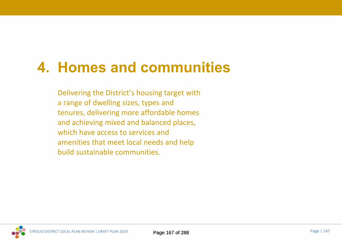
STROUD DISTRICT LOCAL PLAN REVIEW | DRAFT PLAN 2019 Page | 147
4. Homes and communitiesDelivering the District’s housing target witha range of dwelling sizes, types andtenures, delivering more affordable homesand achieving mixed and balanced places,which have access to services andamenities that meet local needs and helpbuild sustainable communities.
Page 167 of 288Page 167 of 288

STROUD DISTRICT LOCAL PLAN REVIEW | DRAFT PLAN 2019 Page | 148
Core Policies4.1 These policies sit at the heart of the Plan. They are the principal means of
delivering the Plan’s strategic objective of nurturing accessible, healthyand inclusive communities across the District (SO1, SO1a), as well asmeeting the District’s housing needs in the most sustainable way.
4.2 The Draft Plan includes some new polices and changes are proposed tosome of the policies in the current Local Plan. The following pages set outthe draft wording, and identify where and why any changes are proposed.Supporting and explanatory text will be developed to accompany the finalpolicies in the Pre-submission Local Plan (anticipated Autumn 2020) andwill be subject to public consultation at that point.
* NEW * Core Policy DCP24.3 This new policy addresses the aims of proposed new strategic objective
SO1a, which seeks to develop healthy, inclusive and safe communities:
* NEW * Core Policy DCP2Supporting Older People
Initiatives and developments will be supported which:
1. Enable older people to live independently in their own home;2. Increase the range of available housing options with care and support
services in accessible locations;3. Promote active lifestyles;4. Increase older people’s engagement in community life, including
through “hubs”.
Achieving healthy and inclusive communitiesSummary of proposed changes to Core Policy CP7:
4.4 There are no proposed changes to this policy:
Core Policy CP7Lifetime communities
To ensure that new housing development contributes to the provision ofsustainable and inclusive communities (including the provision of communityfacilities) in the District, developers will need to clearly demonstrate howmajor housing development will contribute to meeting identified long termneeds in those communities the development relates to. Proposals will needto demonstrate how the following needs have been taken into account:
1. An ageing population, particularly in terms of design, accessibility,health and wellbeing service co-ordination
2. Children, young people and families
3. People with special needs, including those with a physical, sensory orlearning disability, dementia, or problems accessing services and
4. The specific identified needs of minority groups in the District.
Proposals will need to demonstrate how the factors below have informedthe development proposal:
A. Lifetime accommodation
B. Contribution to meeting the needs of those with an existing longstanding family, educational or employment connection to the area.
Page 168 of 288Page 168 of 288
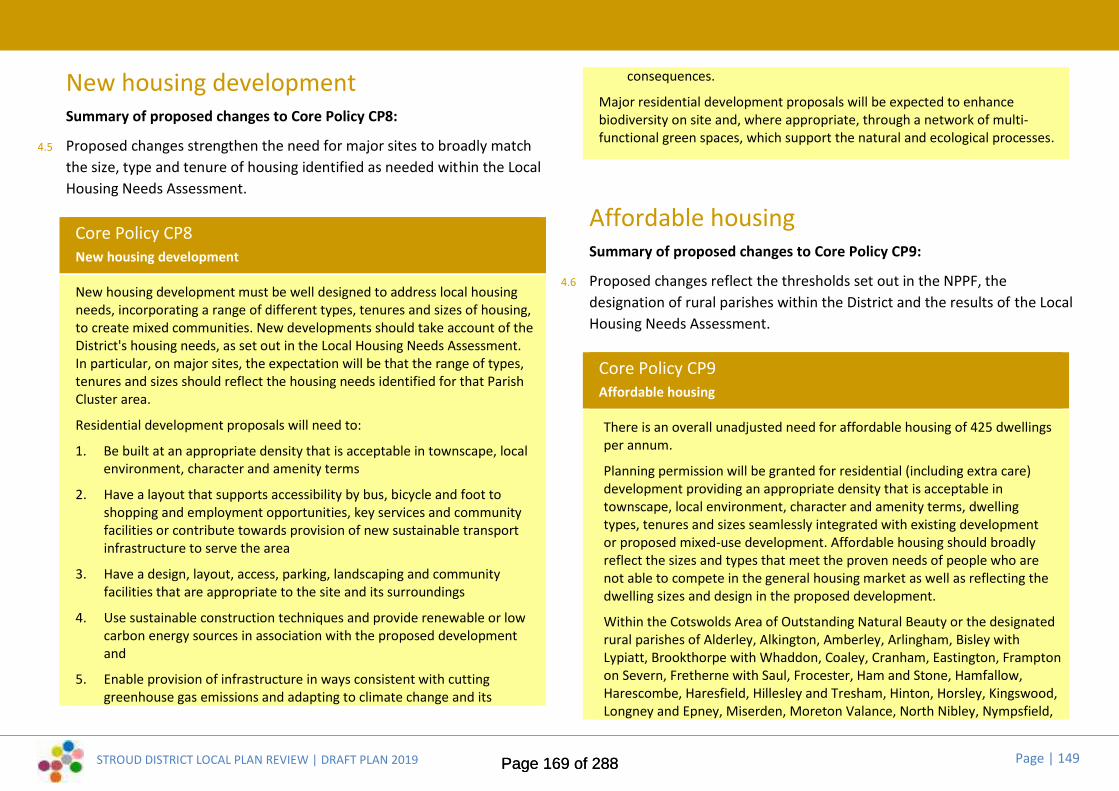
STROUD DISTRICT LOCAL PLAN REVIEW | DRAFT PLAN 2019 Page | 149
New housing developmentSummary of proposed changes to Core Policy CP8:
4.5 Proposed changes strengthen the need for major sites to broadly matchthe size, type and tenure of housing identified as needed within the LocalHousing Needs Assessment.
Core Policy CP8New housing development
New housing development must be well designed to address local housingneeds, incorporating a range of different types, tenures and sizes of housing,to create mixed communities. New developments should take account of theDistrict's housing needs, as set out in the Local Housing Needs Assessment.In particular, on major sites, the expectation will be that the range of types,tenures and sizes should reflect the housing needs identified for that ParishCluster area.
Residential development proposals will need to:
1. Be built at an appropriate density that is acceptable in townscape, localenvironment, character and amenity terms
2. Have a layout that supports accessibility by bus, bicycle and foot toshopping and employment opportunities, key services and communityfacilities or contribute towards provision of new sustainable transportinfrastructure to serve the area
3. Have a design, layout, access, parking, landscaping and communityfacilities that are appropriate to the site and its surroundings
4. Use sustainable construction techniques and provide renewable or lowcarbon energy sources in association with the proposed developmentand
5. Enable provision of infrastructure in ways consistent with cuttinggreenhouse gas emissions and adapting to climate change and its
consequences.
Major residential development proposals will be expected to enhancebiodiversity on site and, where appropriate, through a network of multi-functional green spaces, which support the natural and ecological processes.
Affordable housingSummary of proposed changes to Core Policy CP9:
4.6 Proposed changes reflect the thresholds set out in the NPPF, thedesignation of rural parishes within the District and the results of the LocalHousing Needs Assessment.
Core Policy CP9Affordable housing
There is an overall unadjusted need for affordable housing of 425 dwellingsper annum.
Planning permission will be granted for residential (including extra care)development providing an appropriate density that is acceptable intownscape, local environment, character and amenity terms, dwellingtypes, tenures and sizes seamlessly integrated with existing developmentor proposed mixed-use development. Affordable housing should broadlyreflect the sizes and types that meet the proven needs of people who arenot able to compete in the general housing market as well as reflecting thedwelling sizes and design in the proposed development.
Within the Cotswolds Area of Outstanding Natural Beauty or the designatedrural parishes of Alderley, Alkington, Amberley, Arlingham, Bisley withLypiatt, Brookthorpe with Whaddon, Coaley, Cranham, Eastington, Framptonon Severn, Fretherne with Saul, Frocester, Ham and Stone, Hamfallow,Harescombe, Haresfield, Hillesley and Tresham, Hinton, Horsley, Kingswood,Longney and Epney, Miserden, Moreton Valance, North Nibley, Nympsfield,
Page 169 of 288Page 169 of 288
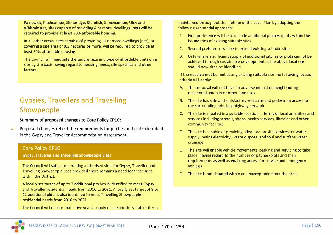
STROUD DISTRICT LOCAL PLAN REVIEW | DRAFT PLAN 2019 Page | 150
Painswick, Pitchcombe, Slimbridge, Standish, Stinchcombe, Uley andWhitminster, sites capable of providing 4 or more dwellings (net) will berequired to provide at least 30% affordable housing.
In all other areas, sites capable of providing 10 or more dwellings (net), orcovering a site area of 0.5 hectares or more, will be required to provide atleast 30% affordable housing
The Council will negotiate the tenure, size and type of affordable units on asite by site basis having regard to housing needs, site specifics and otherfactors.
Gypsies, Travellers and TravellingShowpeopleSummary of proposed changes to Core Policy CP10:
4.7 Proposed changes reflect the requirements for pitches and plots identifiedin the Gypsy and Traveller Accommodation Assessment.
Core Policy CP10Gypsy, Traveller and Travelling Showpeople Sites
The Council will safeguard existing authorised sites for Gypsy, Traveller andTravelling Showpeople uses provided there remains a need for these useswithin the District.
A locally set target of up to 7 additional pitches is identified to meet Gypsyand Traveller residential needs from 2016 to 2031. A locally set target of 8 to12 additional plots is also identified to meet Travelling Showpeopleresidential needs from 2016 to 2031.
The Council will ensure that a five years’ supply of specific deliverable sites is
maintained throughout the lifetime of the Local Plan by adopting thefollowing sequential approach:
1. First preference will be to include additional pitches /plots within theboundaries of existing suitable sites
2. Second preference will be to extend existing suitable sites
3. Only where a sufficient supply of additional pitches or plots cannot beachieved through sustainable development at the above locationsshould new sites be identified.
If the need cannot be met at any existing suitable site the following locationcriteria will apply:
A. The proposal will not have an adverse impact on neighbouringresidential amenity or other land uses
B. The site has safe and satisfactory vehicular and pedestrian access tothe surrounding principal highway network
C. The site is situated in a suitable location in terms of local amenities andservices including schools, shops, health services, libraries and othercommunity facilities
D. The site is capable of providing adequate on-site services for watersupply, mains electricity, waste disposal and foul and surface waterdrainage
E. The site will enable vehicle movements, parking and servicing to takeplace, having regard to the number of pitches/plots and theirrequirements as well as enabling access for service and emergencyvehicles
F. The site is not situated within an unacceptable flood risk area.
Page 170 of 288Page 170 of 288

STROUD DISTRICT LOCAL PLAN REVIEW | DRAFT PLAN 2019 Page | 151
Delivery Policies4.8 These policies add detail to the interpretation and application of the
Plan’s development strategy and core policies. The Draft Plan includessome new polices and changes are proposed to some of the policies inthe current Local Plan. The following pages set out the draft wording, andidentify where and why any changes are proposed. Supporting andexplanatory text will be developed to accompany the final policies in thePre-submission Local Plan (anticipated Autumn 2020) and will be subjectto public consultation at that point.
Residential development at definedsettlements and on strategic developmentsites:DHC1 * New policy *
4.9 This new policy is part of a restructuring of the current Local Plan housingpolicies but does not contain any material changes to housing policy:
*NEW* Delivery Policy DHC1Meeting housing need within defined settlements
At all settlements with defined settlement development limits, permissionwill be granted for residential development or redevelopment within thosedefined settlement development limits, subject to the satisfaction of detailedcriteria defined for meeting housing need at settlements.
DHC2 * New policy *4.10 This new policy introduces a more flexible housing policy approach for
smaller rural communities. This reflects the new strategy, the result of localconsultation and the need to counter demographic trends in ruralsettlements:
*NEW* Delivery Policy DHC2Sustainable rural communities
In order to maintain the social sustainability of smaller rural settlements,small housing schemes of up to 9 dwellings will be supported outsidesettlement development limits at designated Tier 4 settlements, providing allof the following criteria are met:
1. the proposed housing will consist of types, tenures and sizes that seek toaddress existing demographic imbalances in the local population and/orspecific housing needs identified in a parish housing needs survey
2. the site adjoins settlement development limits or would fill in anotherwise built up frontage close to settlement development limits in amanner that would be in accordance with the settlement pattern, thelocal environment, character and landscape setting of the settlement
3. the proposal is included within a Neighbourhood Development Plan or issupported by the relevant parish council
4. the proposal would not lead to a cumulative increase of more than 10%of the settlement housing stock at 2020
5. the proposal satisfies the detailed criteria defined for meeting housingneed at settlements.
For schemes of 4 or more dwellings, where 30% affordable housing isrequired, the affordable dwellings will be made available for those in needwith a strong local connection. Appropriate legal agreements will be enteredinto to ensure that such dwellings will remain available as affordable housingfor local need, with the necessary management of the scheme in place.
Page 171 of 288Page 171 of 288

STROUD DISTRICT LOCAL PLAN REVIEW | DRAFT PLAN 2019 Page | 152
Summary of proposed changes to Delivery Policy HC2:
4.11 There are no proposed changes to this policy:
Delivery Policy HC2Providing new homes above shops in our town centres
Proposals to use the upper floors above shops and offices in identified townand local centres for residential use (three units or more) will be permittedwhere this does not threaten the continued ground floor commercial use orthe vitality of the town centre.
Summary of proposed changes to Delivery Policy HC3:
4.12 Proposed changes broaden the policy support for self build and custombuild dwellings and strengthen the policy requirement for good design:
Delivery Policy HC3Self-build and custom build housing provision
The Council supports the provision of self build and custom build dwellingswithin settlement development limits and single plot affordable self build andcustom build dwellings adjacent to settlement development limits. Inaddition, at strategic sites allocated within this Local Plan and in addition tothe affordable housing component, a minimum of 2% of the dwellings shallbe provided as plots suitable for self- or custom-build in order to meetGovernment aspirations to increase self build developments, subject toappropriate demand being identified. In determining the nature and scale ofany provision, the Council will have regard to site-specific circumstances andlocal demand.
All schemes will:
1. be individually designed and bespoke to that household, employinginnovative approaches throughout that cater for changing lifetime
needs
2. provide appropriate linkages to infrastructure and day to day facilities
3. Include a design framework, submitted with the full or reserved mattersplanning application for the wider site, to inform detailed design of theindividual units, where more than one self build unit is proposed
4. satisfy the detailed criteria defined for meeting housing need atsettlements.
Summary of proposed changes to Delivery Policy HC4:
4.13 Proposed changes reflect the NPPF support for entry level homes, selfbuild and custom build homes and some market housing on ruralexception sites in certain circumstances. Other changes update referencesto Homes England and set size requirements for affordable self build andcustom build dwellings to meet needs:
Delivery Policy HC4Local housing need (exception sites)
Planning permission may be granted for affordable housing, including entrylevel homes, and single plot self-build or custom build affordable dwellingson sites well related to existing settlements. Such sites should be locatedclose to, or adjoining, an accessible settlement with local facilities (‘ThirdTier’) or above in terms of the Plan settlement hierarchy, unless specificlocal need and environmental considerations indicate that provision shouldbe met at fourth or fifth tier settlements. The Council shall meet localaffordable housing need, where:
1. the Council is satisfied that there is a clearly evidenced local need,which cannot be readily met elsewhere in the locality, for the numberand type of housing proposed
Page 172 of 288Page 172 of 288

STROUD DISTRICT LOCAL PLAN REVIEW | DRAFT PLAN 2019 Page | 153
2. the site is accessible to a range of local services, such as shops, primaryschools, healthcare and public transport
3. appropriate legal agreements are entered into to ensure that suchdwellings will remain available as affordable housing for local need, withthe necessary management of the scheme in place
4. the proposal satisfies the detailed criteria defined for meeting housingneed at settlements
5. the design quality and gross internal floor area of affordable dwellingsshall comply with the latest recommended standards used by HomesEngland where applicable. Single plot self-build or custom-buildaffordable dwellings shall be limited to a maximum GIA of 100m2.
The Council will consider the inclusion of some market housing on these siteswhere this is required to make the scheme viable. A high level of proof willbe required to ensure that the level of market housing is de minimus,including consideration of whether Government grant availability couldreduce or negate the necessity for market housing.
DHC3 * New policy *4.14 This new policy addresses the issue of live-work development, which is
only referred to in supporting text in the current Local Plan:
*NEW* Delivery Policy DHC3Live-work development
Live-work development will be supported subject to the following criteriabeing met:
1. the site is located within or adjoining settlement development limits andwould not result in the loss of part of a key employment site or anotherexisting employment site which is suitable for continued business use
2. the work element is not ancillary to the dwelling and is physically distinctfrom the residential accommodation with a separate access.
3. the residential floorspace of the live-work unit shall be occupied only bya person solely or mainly employed, or last employed in the businessoccupying the business floorspace of that unit, or by a widow or widowerof such a person, or any resident dependants.
4. servicing arrangements should be appropriate to the scale of the useproposed and located so as to minimise impacts on residentialaccommodation.
5. the residential element should meet the normal standards for housingdevelopment
6. the residential element satisfies the detailed criteria defined for meetinghousing need at settlements.
The business floorspace of the live-work unit shall be finished ready foroccupation before the residential floorspace is occupied and the residentialuse shall not precede commencement of the business use.
Detailed criteria for new housingdevelopments:Summary of proposed changes to Delivery Policy HC1:
4.15 Proposed changes are part of a restructuring of the current Local Planhousing policies to ensure that all housing within and on the edge ofsettlements meet detailed criteria which are currently only defined fordevelopments within settlement limits (current Policy HC1). Consequently,criteria relating to development on the edge of settlements have beenexpanded:
Page 173 of 288Page 173 of 288

STROUD DISTRICT LOCAL PLAN REVIEW | DRAFT PLAN 2019 Page | 154
Delivery Policy HC1Detailed criteria for new housing developments
Housing development within settlement development limits, and otherlimited housing development specifically allowed for by other policies in thePlan at locations outside of settlement development limits, will be permittedproviding all the following criteria are met:
1. the proposed housing is of a scale, density, layout and design that iscompatible with the character, appearance and amenity of the part ofthe settlement in which it would be located and the density proposed isat as high a level as is acceptable, in terms of townscape, street sceneand amenity
2. where appropriate schemes should include a variety of dwelling typesand sizes, which meet identified local needs
3. on edge of settlement sites, the proposal would not appear as an intrusioninto the countryside, would be sympathetic in scale and location to theform and character of the settlement, would not lead to coalescence withother hamlets or settlements and would retain a sense of transitionbetween the open countryside and the existing settlement’s core
4. it would not cause the loss of, or damage to, any open space which isimportant to the character of the settlement
5. it would not result in the loss of locally valued habitat which supportswildlife
6. any natural or built features on the site that are worthy of retention areincorporated into the scheme
7. an appropriate area of private amenity space is provided for theoccupiers of each dwelling house. Where other types of residentialaccommodation are proposed, an appropriate level of amenity space toserve the scheme as a whole is provided
8. it is not subject to any other over-riding environmental or other materialplanning constraint
9. it will have a layout, safe access and parking appropriate to the site andits surroundings.
Community-led housing schemes:DHC4 * New policy *
4.16 This new policy supports the development of community-led housingschemes:
*NEW* Delivery Policy DHC4Community-led housing
The Council supports the development of housing schemes that are initiatedby local communities. These may include schemes involving affordablehousing, co-housing, community self-build or housing for people with specificneeds such as older people or those with disabilities. They may also include,as part of the proposal, community buildings, recreational areas, space forgrowing food or for supporting wildlife.
The Council will support innovative design, particularly where thesecontribute to the Council’s ambition to deliver carbon neutral development.
While there are a number of types of community group or organisation thatmay be appropriate to promote development proposals, the Council willexpect that the proposal has been initiated by a legitimate local communitygroup which is able to demonstrate that it has a democratic structure, is notfor profit, is controlled by the local community and has appropriate policesand procedures in place. However, given that development projects can becomplex and time consuming to deliver, community groups may wish toconsider partnering with organisations such as housing associations,landowners and agents.
Community-led organisations would also be suitable as a means of deliveringaffordable housing on rural exception sites.
Page 174 of 288Page 174 of 288

STROUD DISTRICT LOCAL PLAN REVIEW | DRAFT PLAN 2019 Page | 155
Other forms of residential development:Summary of proposed changes to Delivery Policy HC5:
4.17 Proposed changes tighten requirements to minimise potential landscapeor amenity issues that can result from replacement dwellings being re-sited elsewhere within plots. However, changes also provide flexibilityover size of replacement dwellings, when exceptional sustainableconstruction standards are proposed:
Delivery Policy HC5Replacement dwellings
The replacement of dwelling houses outside defined settlementdevelopment limits will only be permitted where all the following criteria aremet:
1. the residential use has not been abandoned
2. the building is a designated or non-designated heritage asset
3. the scale, form and footprint of the replacement dwelling is smallerthan, or of a similar size to the existing dwelling (including anyextensions), the replacement dwelling is located on or overlaps thefootprint of the existing dwelling, is within the existing residentialcurtilage and the design does not detract from the character orappearance of its surroundings
4. a minor enlargement of the replacement may be permitted, but only toallow the dwelling to achieve a basic living standard or to deliverexceptional sustainable construction standards and where the designdoes not detract from the character and appearance of the area
5. the existing dwelling is not a caravan or mobile home.
Summary of proposed changes to Delivery Policy HC6:
4.18 There are no proposed changes to this policy:
Delivery Policy HC6Residential sub-division of dwellings
In considering proposals for the sub-division of existing dwellings into twoor more self-contained residential units the Council will have regard to:
1. the provision of adequate vehicular access, car parking, amenity spaceand facilities for refuse storage
2. the adequacy of the internal accommodation relative to the intensity ofoccupation envisaged and the impact upon any neighbouringresidential or other units, including privacy, loss of daylight andoverbearing effect
3. the likely impact on the character and appearance of the immediateneighbourhood of the design, scale, form and footprint of anyproposed extension or alteration
4. no significant new extension should be made to any dwelling locatedoutside defined settlement development limits: minor extension maybe permitted only where essential in order for the new units to achievebasic living standards
5. the sustainability of the new development based around the sitelocation and its relationship to the Plan’s settlement hierarchy,including accessibility to shops, services and facilities
6. the need to minimise built form through the conversion of any existingoutbuildings.
Page 175 of 288Page 175 of 288

STROUD DISTRICT LOCAL PLAN REVIEW | DRAFT PLAN 2019 Page | 156
Summary of proposed changes to Delivery Policy HC7:
4.19 Proposed changes tighten requirements to ensure new dwellings are notcreated in unsustainable locations:
Delivery Policy HC7Annexes for dependents or carers
Permission will be granted for the creation of an annexe where there is aclear justification for a dependant or full-time carer. The following criteriamust be satisfied:
1. the annexe is linked to the main dwelling by an internal door or doors
2. the annexe is readily convertible into an extension to the main dwellingwhen no longer required for family health circumstances.
Permission may be granted to convert an existing outbuilding within thecurtilage of a dwellinghouse to a self-contained annexe where it is notpossible to attach the outbuilding to the main house. Any such permissionwill require a condition to ensure that a new dwelling is not created in anunsustainable location. Any outbuilding to be converted must be closelyrelated to the main dwelling and have shared access arrangements, parkingand amenity (garden) space.
Extending your homeSummary of proposed changes to Delivery Policy HC8:
4.20 Minor change to extend the scope of policy to include other alterationsrequiring planning permission:
Delivery Policy HC8Extensions to dwellings
Permission will be granted for the extension or alteration of residentialproperties, and for erection of outbuildings incidental to the enjoyment ofthe dwelling, provided all the following criteria are met:
1. the plot size of the existing property is large enough to accommodatethe extension or outbuilding without resulting in a cramped oroverdeveloped site
2. the height, scale, form and design of the extension or outbuilding is inkeeping with the scale and character of the original dwelling (taking intoaccount any cumulative additions), and the site’s wider setting andlocation
3. following construction of the extension, or outbuilding, sufficient space isavailable for the parking of cars, in line with the Council’s ParkingStandards, in a way that does not detract from the character andappearance of the area
4. the proposed construction meets sustainability requirements for newbuild dwellings and any opportunity to enhance the energy efficiency ofthe existing dwelling or unit is taken.
Page 176 of 288Page 176 of 288

STROUD DISTRICT LOCAL PLAN REVIEW | DRAFT PLAN 2019 Page | 157
Planning for healthy communities:DHC5 * New policy *
4.21 Proposed new policy to reflect the NPPF and accompanying guidance onhealth and wellbeing:
*NEW* Delivery Policy DHC5Wellbeing and healthy communities
Stroud District Council will seek to improve the health and wellbeing of localcommunities by supporting proposals that include design measures toencourage healthier lifestyles and sustainable neighbourhoods, proportionateto the scale of a development proposal. Any potential demonstrable adverseimpact of proposals on the health and wellbeing of existing or newcommunities will need to be mitigated in an appropriate manner.
Proposals on strategic allocation sites should include a robust Health ImpactAssessment (HIA) identifying how the design, detailed land uses and layoutwill contribute to encouraging healthier lifestyles and will mitigate anyidentified adverse impacts.
Major development proposals should demonstrate that they have had regardto the following:
1. Provide access to healthy, fresh and locally produced food
2. Provide layouts that support the mental and physical well being ofresidents and encourage healthy, safe and active lifestyles (including forthose with disabilities)
3. Provide convenient sustainable access to local health care facilities.
Proposals for the multi-use and co-location of health facilities with otherservices and facilities will be supported.
DHC6 * New policy *4.22 This new Homes & Communities policy adapts existing Environment policy
ES13 (Protection of existing open spaces) in the current Local Plan. Theproposed changes seek to strengthen the existing policy, broaden it toinclude built and indoor sports facilities, and address recommendationsarising from the Stroud District Open Space and Green InfrastructureStudy:
*NEW* Delivery Policy DHC6Protection of existing open spaces and built and indoor sports facilities
Development proposals shall not involve the whole or partial loss of openspace within settlements, or of outdoor recreation facilities, playing fields orallotments within or relating to settlements, or of built and indoor sportsfacilities unless:
1. a robust assessment of open space and sports provision, using thequantity and access standards for open space and indoor / built sportsfacilities set out in this Local Plan, has identified a surplus in thecatchment area to meet both current and future needs, and fullconsideration has been given to all functions that open space and indoor/ built sports facilities can perform, having regard to the existingdeficiencies within the local area;
2. any replacement facility (or enhancement of the remainder of theexisting site) provides a net benefit to the community in terms of thequantity, quality, availability and/or accessibility of open space or sportand recreational opportunities.
There should be no harm to spaces or built facilities which:
A. contribute to the distinctive form, character and setting of a settlement
B. create focal points within the built up area
C. provide the setting for important buildings or scheduled ancientmonuments, or are themselves of historic or cultural value
Page 177 of 288Page 177 of 288

STROUD DISTRICT LOCAL PLAN REVIEW | DRAFT PLAN 2019 Page | 158
D. form part of an area of value for wildlife, sport or recreation, includingareas forming part of a ‘green corridor’.
Local communities through Neighbourhood Development Plans shalldesignate Local Green Spaces which are of importance to them and are ofparticular local significance.
DHC7 * New policy *4.23 This new Homes & Communities policy replaces existing Environment
policies ES14 (Provision of semi-natural and natural green space within newresidential development) and ES15 (Provision of outdoor play space) in thecurrent Local Plan and addresses recommendations arising from theStroud District Open Space and Green Infrastructure Study:
*NEW* Delivery Policy DHC7Provision of new open space and built and indoor sports facilities
New residential development shall be accompanied with additional accessiblerecreational and natural green space, and built and indoor sports facilities,proportionate to the scale of development. This will be provided inaccordance with the following quantity and access standards:
Topic / typology(open space)
Quantity standard Access standard
Allotments 0.35 ha/1000 population 720m (15 minutes walktime) for parishes withover 1000 people
Community Orchards 0.15 ha/1000 populationfor new provision only
720m (15 minutes walktime)
Amenity Green Space 0.40 ha/1000 population(sites > 0.15ha)
600m (12-13 minuteswalk time)
Parks and Recreation 1.20 ha/1000 population 600m (12-13 minutes
Grounds walk time).For parishes with lessthan 1000 people thiscould be met by anamenity green space.
Childrens Play Space 0.06 ha/1000 population 480m (10 minutes walktime) for parishes withover 500 people)
Youth Play Space 0.06 ha/1000 population 720m (15 minutes walktime) for parishes withover 1000 people
Natural Green Space(ANGSt)
1.0ha/1000 populationfor new provision
960m (20 minutes’ walktime)
Playing Pitches andOutdoor SportsFacilities (PPS)
0.7ha/1000 population
Total open space fornew provision
3.22ha/1000
Topic / typology(built facilities)
Quantity standard Access standard
Indoor swimmingpools
9.75 sq.mwaterspace/1000persons
Sports halls 0.27 courts/1000persons
Health & FitnessSuites
6.3 health & fitnessstations/ 1000 persons
Small community hall 1:1,800 people (or 0.55halls/ 1000 persons)
Provision should be made on-site and link well with any existing greeninfrastructure features in the local area and with the wider green
Page 178 of 288Page 178 of 288
STROUD DISTRICT LOCAL PLAN REVIEW | DRAFT PLAN 2019 Page | 159
infrastructure network. For strategic allocations, where the achievement ofthese standards is unrealistic or inappropriate within the boundaries of thedevelopment site, a financial contribution will be sought in lieu of on-siteprovision. Where new provision is made, appropriate measures will be soughtto ensure the future satisfactory maintenance and management of the openspace or facility.
Where application of the standards would deliver a significant surplus in thelocal area, requirements could be varied, in agreement with the developer, toprovide another form of open space to help address a deficiency in theexisting provision.
Page 179 of 288Page 179 of 288

STROUD DISTRICT LOCAL PLAN REVIEW | DRAFT PLAN 2019 Page | 160
5.
Page 180 of 288Page 180 of 288
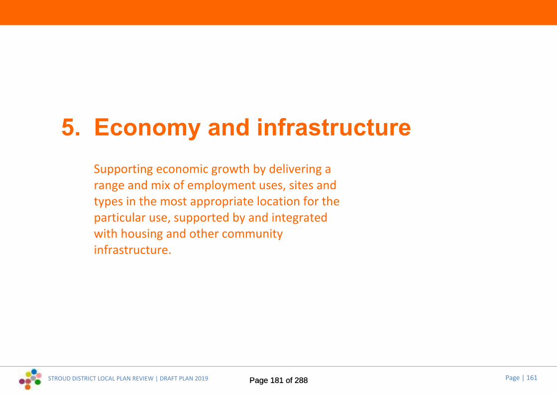
STROUD DISTRICT LOCAL PLAN REVIEW | DRAFT PLAN 2019 Page | 161
5. Economy and infrastructureSupporting economic growth by delivering arange and mix of employment uses, sites andtypes in the most appropriate location for theparticular use, supported by and integratedwith housing and other communityinfrastructure.
Page 181 of 288Page 181 of 288

STROUD DISTRICT LOCAL PLAN REVIEW | DRAFT PLAN 2019 Page | 162
Core Policies5.1 These policies sit at the heart of the Plan. They are the principal means of
delivering the Plan’s strategic objectives in relation to economic growth,jobs and infrastructure throughout the District (SO2, SO3, SO4).
5.2 The Draft Plan includes some new polices and changes are proposed tosome of the policies in the current Local Plan. The following pages set outthe draft wording, and identify where and why any changes are proposed.Supporting and explanatory text will be developed to accompany the finalpolicies in the Pre-submission Local Plan (anticipated Autumn 2020) andwill be subject to public consultation at that point.
Economic growth and strategic employmentneedsSummary of proposed changes to Core Policy CP11:
5.3 Proposed changes reflect the need for decision takers to consider thespecific locational requirements of different sectors and that ruralbusiness needs cannot always be met in locations currently well served bypublic transport.
Core Policy CP11New employment development
New employment development will be provided through a range of sitesand premises across the District. Strategic employment sites will beallocated, mixed use developments encouraged and the expansion ofexisting businesses and rural diversification supported. Employment sites
will be provided in order to increase the range and choice of sites availableand to address the self-containment of settlements in terms of homes / jobsbalance. Small work places, live-work units and facilities for co-working willbe supported as part of new housing developments.
Existing employment sites will be safeguarded unless new proposals are putforward that intensify the employment use of part of the site, supported byenabling development as set out in other policies in the Local Plan. Sitesallocated for mixed use redevelopment should aim to provide for at leastthe same or an increase in the level of job opportunities as existed when theemployment space was previously used, subject to viability and site specificcircumstances.
Permission will be granted for industrial or business development, or for theexpansion or intensification of existing industrial or business uses,recognising the specific locational requirements of different sectors,provided that the proposals would:
1. Be of a type and scale of activity that does not harm the character,appearance or environment of the site or its surroundings or to theamenity of occupiers of nearby properties
2. Be readily accessible by public transport, wherever possible, and bybicycle and foot, or contribute towards provision of new sustainabletransport infrastructure to serve the area, in order to make thedevelopment accessible by those modes
3. Have a layout, access, parking, landscaping and facilities that areappropriate to the site and its surroundings
4. Use sustainable construction techniques and provide for renewable orlow carbon energy sources in association with the proposeddevelopment
5. Enable provision of infrastructure in ways consistent with cutting carbondioxide emissions and adapting to changes in climate (including SuDSand green infrastructure)
6. Demonstrate how the principles of industrial symbiosis have been takeninto account.
Page 182 of 288Page 182 of 288

STROUD DISTRICT LOCAL PLAN REVIEW | DRAFT PLAN 2019 Page | 163
Retail and town centresSummary of proposed changes to Core Policy CP12:
5.4 Proposed changes reflect the need for new settlements and large urbanextensions to provide local centres to sit within the retail hierarchy andrecognise the role residential development can play in ensuring the vitalityof centres:
Core Policy CP12Town centres and retailing
Town centre uses will be located according to the Retail Hierarchy as set outbelow, in order to promote choice, competition and innovation:
Principal Town Centre Stroud
Other Town Centres Dursley, Stonehouse, Nailsworth, Wotton-Under-Edge
District Centres Berkeley, Cam, Painswick
Local Centres Cainscross (Stroud), Great Oldbury(anticipated), Hunts Grove (anticipated),Kings Stanley, Sharpness Garden Village(anticipated), Whaddon (anticipated),Whitminster
Neighbourhood Shopping Kingshill (Dursley), Woodfields (Cam),Brimscombe, Manor Village
A. Stroud town centre will remain the principal town centre in the District.Proposals for major town centre uses will be directed sequentially tothe Primary Shopping Area but then to the wider town centre. AfterStroud, priority will be given to improving retail facilities in Dursley,
Stonehouse, Nailsworth and Wotton-under-Edge.
B. The vitality and viability of all the District’s centres will be maintainedand enhanced, as will their existing range of uses, including localmarkets. This will involve widening the range of uses (including housing,where appropriate) and encouraging convenient and accessibleshopping, service and employment facilities to meet the day-to-dayneeds of residents.
C. On large new settlement and urban extension sites, which are notwithin easy walking distance of existing shops and services, new localcentres will be established or existing retail functions adapted to servethe needs of the residents. Such centres should be of a scaleappropriate to the site, should not undermine the role or function ofother centres within the retail hierarchy and should not becomedestinations in their own right.
D. Retail and other uses (including leisure, entertainment, cultural andtourist uses as well as other mixed-uses) that would support the vitalityand viability of the centres in the hierarchy below Stroud town centrewill be directed sequentially to within designated town centre or localcentre boundaries, then to edge-of-centre locations and, only if suitablesites are not available, to out-of-centre locations, provided they:
1. are of a scale and nature that is appropriate to the size andfunction of the centre and
2. would not lead to unsustainable trip generation from outside theircatchments.
E. Outside these centres, the following types of retail provision will besupported:
1. bulky-goods non-food retail development so long as any increase infloorspace will not have an unacceptable impact on town centresand the proposal is in accordance with the sequential test as setout in national policy
2. specialist uses (including car showrooms) and trade centredevelopments not within key employment sites, where it will not
Page 183 of 288Page 183 of 288

STROUD DISTRICT LOCAL PLAN REVIEW | DRAFT PLAN 2019 Page | 164
have an unacceptable impact on a town centre
3. small-scale ancillary retail uses within employment sites (includingshowrooms)
4. changes of use to retail and other local services within existingneighbourhood centres and
5. small shops within residential areas to serve the local area.
Travel and transportSummary of proposed changes to Core Policy CP13:
5.5 Proposed changes emphasise the importance of prioritising sustainabletransport options and implementing the Sustainable Transport Strategy.
Core Policy CP13New employment development
Proposals for major schemes, as defined by the Town and Country Planning(Development Management procedure) (England) Order 2010, will besupported where they:
1. Provide for a variety of forms of transport as alternatives to the car toallow more sustainable choices
2. Improve the existing infrastructure network, including road, rail and bus,facilities for pedestrians and cyclists, including provision for those withreduced mobility, and other users
3. Mitigate any significant adverse affects upon the transport network thatarise from the development proposed.
In all development cases, schemes shall:
i) be located where there are, or will be, at the time of development,
choices in the mode of transport available and which minimise thedistance people need to travel
ii) provide appropriate vehicular parking, having regard to car ownershipand the Council’s adopted standards
iii) not be detrimental to and, where possible, enhance road safety and
iv) not cause or contribute to significant highway problems or lead totraffic related environmental problems.
Development proposals will be expected to consider all possible sustainabletransport options before the capacity of the road network is increased.
Development proposals shall be consistent with and contribute to theimplementation of the agreed transport strategy, set out in theGloucestershire Local Transport Plan and the Stroud Sustainability TransportStrategy. Any transport assessment needs will be consistent with therequirements set out in the Gloucestershire Local Transport Plan.
Page 184 of 288Page 184 of 288

STROUD DISTRICT LOCAL PLAN REVIEW | DRAFT PLAN 2019 Page | 165
Delivery Policies5.6 These policies add detail to the interpretation and application of the Plan’s
development strategy and core policies.
5.7 The Draft Plan includes some new polices and changes are proposed tosome of the policies in the current Local Plan. The following pages set outthe draft wording, and identify where and why any changes are proposed.Supporting and explanatory text will be developed to accompany the finalpolicies in the Pre-submission Local Plan (anticipated Autumn 2020) andwill be subject to public consultation at that point.
Protection and development of employmentsitesSummary of proposed changes to Delivery Policy EI1:
5.8 Proposed changes recognise that key employment areas may require theprovision of ancillary uses to support the primary uses. Further changesmay be required following the completion of an Employment Land Studyin 2020:
Delivery Policy EI1Key employment sites
The key employment sites listed below will be retained for B Class Uses.Redevelopment for alternative uses or changes of use from employment usewill not be permitted on these sites, except for the provision of ancillaryuses specifically designed to support the primary use (for example, cateringor additional parking areas).
Site Parish Location
EK1 Berkeley Rigestate, Station RoadEK3 Brimscombe & Thrupp Griffin Mills Industrial EstateEK4 Brimscombe & Thrupp Hope Mills Industrial EstateEK5 Brimscombe & Thrupp Phoenix Industrial EstateEK6 Cam Draycott / Middle Mill Industrial EstateEK7 Cam Cam Mills, EverlandsEK8 Chalford Chalford Industrial EstateEK9 Dursley Littlecombe Business ParkEK10 Eastington Meadow Mill Industrial EstateEK11 Frampton on Severn Frampton Industrial EstateEK12 Hardwicke Quedgeley WestEK13 Hardwicke Hunts Grove/Quadrant Distribution CentreEK14 Haresfield Javelin ParkEK15 Haresfield Quedgeley Trading Estate EastEK16 Hinton Severn Distribution ParkEK17 Kingswood Renishaw New MillsEK18 Kingswood Renishaw Charfield WorksEK19 Kingswood Abbey Mill Industrial AreaEK20 Kingswood Orchestra WorksEK21 Minchinhampton Aston DownEK22 Nailsworth Inchbrook Industrial EstateEK23 Nailsworth Nailsworth Mill Industrial EstateEK24 Nailsworth Spring Mill Industrial EstateEK25 Rodborough Bath Road Industrial EstateEK26 Stonehouse Stroudwater Industrial EstateEK27 Stonehouse Stonehouse ParkEK28 Stonehouse Bonds Mill Industrial EstateEK29 Stonehouse Upper Mills Industrial EstateEK30 Stonehouse Ryeford Industrial AreaEK31 Stroud Fromeside Industrial EstateEK32 Stroud Salmon Springs Industrial EstateEK33 Stroud New Mills/Libby Drive
Page 185 of 288Page 185 of 288

STROUD DISTRICT LOCAL PLAN REVIEW | DRAFT PLAN 2019 Page | 166
EK34 Woodchester South Woodchester Industrial AreaEK35 Woodchester Frogmarsh Mill Industrial AreaEK36 Wotton under Edge Tabernacle RoadEK37 Wotton under Edge Renishaw Old Town
Summary of proposed changes to Delivery Policy EI2:
5.9 Proposed changes recognise that housing can form part of an acceptablemix for such sites and that some existing employment sites listed in thecurrent Local Plan have now been regenerated, are allocated or havepermission for alternative uses. Further changes may be requiredfollowing the completion of an Employment Land Study in 2020:
Delivery Policy EI2Regenerating existing employment sites
Regeneration of existing employment land listed below will be permitted formixed-use development, including employment-generating uses andhousing, provided that there are demonstrable environmental and/orconservation benefits. Site rationalisation should provide at least the sameemployment opportunities for the local community as existed when theemployment space was previously used, subject to viability and site specificcircumstances.
Site Parish Location
ER4 Minchinhampton Dockyard WorksER5 Cainscross Dudbridge Industrial EstateER7 Rodborough Daniels Industrial EstateER8 Stroud Stafford Mills Industrial EstateER9 Stroud Lodgemore & Fromehall Mills
Summary of proposed changes to Delivery Policy EI2a:
5.10 There are no proposed changes to this policy.
Delivery Policy EI2aFormer Berkeley Power Station
The site will be retained for B1-B8 employment uses and for employmentrelated training and education purposes and for operations and usesassociated with the decommissioning of the nuclear power station.Redevelopment for unrelated alternative uses will not be permitted.
Summary of proposed changes to Delivery Policy EI4:
5.11 Proposed changes clarify that the policy also applies to the extension ofsite boundaries, as well as the extension of buildings within existing siteboundaries and to reflect the need for future employment requirementsto take into account the conversion of offices to residential allowed forunder Government changes to permitted development rules.
Delivery Policy EI4Development at existing employment sites in the countryside
At existing employment sites in the countryside, the extension of existingbuildings, site boundaries and the provision of new buildings, includinginfilling between existing buildings, will be acceptable provided that:
1. The proposal facilitates the retention or growth of local employmentopportunity
2. The proposal would not cause an unacceptable visual impact on thelocal character in terms of its siting, scale, materials or site coverage
3. There are no suitable alternative buildings or sites that can be used
Page 186 of 288Page 186 of 288
STROUD DISTRICT LOCAL PLAN REVIEW | DRAFT PLAN 2019 Page | 167
adjacent to the site or locality
4. The proposal can avoid harm to local amenities and adjoining land uses,particularly where residential uses have been permitted on part of thesite
5. The proposal would not generate significant traffic movement andvolume that would lead to unacceptable environmental impacts ordetriment to road safety.
Proposals will be expected to include measures to secure environmentalimprovements such as landscaping, enhancing biodiversity andincorporating SuDS.
Summary of proposed changes to Delivery Policy EI5:
5.12 Proposed changes seek to clarify and strengthen existing policy provisionand to better reflect the NPPF and accompanying guidance:
Delivery Policy EI5Farm and forestry enterprise diversification
Development which forms part of a farm or forestry diversification schemewill be permitted where the proposal can demonstrate the viability offarming or forestry through helping to support, rather than replace orprejudice, farming or forestry activities on the rest of the site and promotesthe use of farming or forestry practices that have a positive impact onenvironment.
In all cases, a diversification plan will be submitted, which demonstratesthat:
1. The proposed development will stimulate new economic activity with ause compatible with its location, which maintains the relativesustainability of a rural area
2. Diversification activities remain subsidiary to the agricultural or forestry
operation, in terms of physical siting, scale and form
3. Diversification activities avoid adverse environmental impact in terms ofbiodiversity interests; landscape character qualities; air, soil and waterqualities; and/or level of activity within a rural location
4. The development re-uses or replaces existing buildings where possible.Where this is not possible, the development should be related physicallyand functionally to existing buildings and should retain the agriculturalcharacter. Any outdoor storage is provided as a minor ancillary elementof the diversification proposal
5. The proposed development will not generate traffic of a type or amountinappropriate for the rural roads affected by the proposal, or requireimprovements or alterations to these roads which could be detrimentalto their character.
Shopping, leisure, tourism and communityfacilitiesSummary of proposed changes to Delivery Policy EI6:
5.13 Proposed changes clarify that the policy is intended to protect currentcommunity uses located outside defined retail and town centreboundaries (where other policies apply) and that the current communityuse (rather than a different use) is what is required to be protected:
Delivery Policy EI6Protecting individual and village shops, public houses and other communityuses
Where planning permission is required, development which involves the lossof individual shops, public houses, village halls and other community facilitieslocated outside defined retail and town centre boundaries will be supported
Page 187 of 288Page 187 of 288

STROUD DISTRICT LOCAL PLAN REVIEW | DRAFT PLAN 2019 Page | 168
where all the criteria below are satisfied:
1. there is no prospect of the current use continuing (which is evidenced)
2. there are adequate similar use facilities either within that settlement oradjoining countryside which cater for the needs of the local populationand is accessible by walking or cycling – a distance of 800m
3. the current or previous use is no longer viable, demonstrated by auditedfinancial and marketing evidence over an agreed reasonable period.
Summary of proposed changes to Delivery Policy EI7:
5.14 There are no proposed changes to this policy.
Delivery Policy EI7Non-retail uses in primary frontages
Within Primary Shopping Frontages, the change of use from retail (A1) atground floor level to other uses within Class A will be acceptable where nonA1 retail units do not exceed 30% of total frontage length 50m either sidefrom the application site edges. There may be more than one frontage to beconsidered on some buildings. Uses outside Class A will not be permitted.
Summary of proposed changes to Delivery Policy EI8:
5.15 Proposed changes reflect the findings of studies that recognise that officeand residential uses can also help support the vitality and viability of towncentres outside of core shopping areas:
Delivery Policy EI8Non-retail uses in secondary frontages
Within Secondary Shopping Frontages, the change of use from retail (A1) atground floor level to other uses within use classes A2 to A5, amusementcentres/arcades, laundrettes, community use, healthcare, leisure andrecreational uses, office and residential uses, will be acceptable in principle,subject to:
1. the overall shopping character is not undermined;2. the proposed use contributes positively to the town centre as the focus
of commercial or community life of the town; and3. there is no detrimental effect on the visual or other special character and
amenities of the surrounding area.
Summary of proposed changes to Delivery Policy EI9:
5.16 There are no proposed changes to this policy:
Delivery Policy EI9Floorspace thresholds for Retail Impact Assessments
In order to ensure that full consideration is given to the scale ofdevelopment and whether this would have any significant adverse impacts,proposals involving additional retail floorspace and variations in the types ofgoods to be sold from existing floorspace, that is in excess of the followingthresholds, should be accompanied by a Retail Impact Assessment:
Retail hierarchysettlementclassification
Defined settlements in the District Retail floorspacethreshold (gross)
Principal TownCentre
Stroud 1000 sq m
Page 188 of 288Page 188 of 288
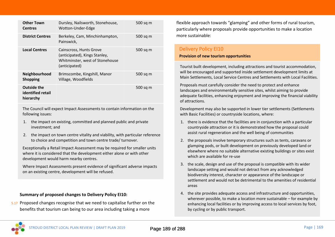
STROUD DISTRICT LOCAL PLAN REVIEW | DRAFT PLAN 2019 Page | 169
Other TownCentres
Dursley, Nailsworth, Stonehouse,Wotton-Under-Edge
500 sq m
District Centres Berkeley, Cam, Minchinhampton,Painswick,
500 sq m
Local Centres Cainscross, Hunts Grove(anticipated), Kings Stanley,Whitminster, west of Stonehouse(anticipated)
500 sq m
NeighbourhoodShopping
Brimscombe, Kingshill, ManorVillage, Woodfields
500 sq m
Outside theidentified retailhierarchy
500 sq m
The Council will expect Impact Assessments to contain information on thefollowing issues:
1. the impact on existing, committed and planned public and privateinvestment; and
2. the impact on town centre vitality and viability, with particular referenceto choice and competition and town centre trade/ turnover.
Exceptionally a Retail Impact Assessment may be required for smaller unitswhere it is considered that the development either alone or with otherdevelopment would harm nearby centres.
Where Impact Assessments present evidence of significant adverse impactson an existing centre, development will be refused.
Summary of proposed changes to Delivery Policy EI10:
5.17 Proposed changes recognise that we need to capitalise further on thebenefits that tourism can being to our area including taking a more
flexible approach towards “glamping” and other forms of rural tourism,particularly where proposals provide opportunities to make a locationmore sustainable:
Delivery Policy EI10Provision of new tourism opportunities
Tourist built development, including attractions and tourist accommodation,will be encouraged and supported inside settlement development limits atMain Settlements, Local Service Centres and Settlements with Local Facilities.
Proposals must carefully consider the need to protect and enhancelandscapes and environmentally sensitive sites, whilst aiming to provideadequate facilities, enhancing enjoyment and improving the financial viabilityof attractions.
Development may also be supported in lower tier settlements (Settlementswith Basic Facilities) or countryside locations, where:
1. there is evidence that the facilities are in conjunction with a particularcountryside attraction or it is demonstrated how the proposal couldassist rural regeneration and the well being of communities
2. the proposals involve temporary structures such as tents, caravans orglamping pods, or built development on previously developed land orelsewhere where no suitable alternative existing buildings or sites existwhich are available for re-use
3. the scale, design and use of the proposal is compatible with its widerlandscape setting and would not detract from any acknowledgedbiodiversity interest, character or appearance of the landscape orsettlement and would not be detrimental to the amenities of residentialareas
4. the site provides adequate access and infrastructure and opportunities,wherever possible, to make a location more sustainable – for example byenhancing local facilities or by improving access to local services by foot,by cycling or by public transport.
Page 189 of 288Page 189 of 288
STROUD DISTRICT LOCAL PLAN REVIEW | DRAFT PLAN 2019 Page | 170
Summary of proposed changes to Delivery Policy EI11:
5.18 Aside from a change of title, there are no proposed changes to this policy:
Delivery Policy EI11Providing sport, leisure, recreation and cultural facilities
Planning applications for new sports, cultural, leisure and recreationalfacilities, or improvements and extensions to existing facilities, will bepermitted provided:
1. the proposals are connected to and associated with existing facilities,they are located at a site that relates well to the settlement hierarchy inthe District or they are intended to meet specific rural needs thatcannot be appropriately met at settlements within the settlementhierarchy
2. the development would not harm the character, appearance andamenities of the area
3. the development can be made readily accessible to adequate bus,cycling and walking links, for the benefit of non-car users
4. cycle/vehicle access and on-site cycle/vehicle parking would beprovided to the adopted standards
5. adequate access to and between the facilities would be provided forpeople with disabilities
6. any biodiversity interest is enhanced by taking opportunities to create anetwork of multi-functional green spaces, which support the locality’snatural and ecological processes
5. it is not subject to any other overriding environmental or other materialplanning constraints.
Travel and transportSummary of proposed changes to Delivery Policy EI12:
5.19 Proposed changes are designed to underpin the objectives of theSustainable Transport Strategy to achieve modal shift away from theprivate car and to give priority to sustainable transport improvementsabove additional road infrastructure:
Delivery Policy EI12Promoting transport choice and accessibility
Sustainability through design
All developments should be planned in line with the Sustainable TransportHierarchy. In the first instance, opportunities to reduce the need to travelshould be maximised, including through the provision of ancillary facilities on-site and through measures which enable people to work from home, such ashigh speed broadband. Development should be located in areas which arealready well served by public transport and have access to a range of localfacilities within walking and cycling distance. Masterplans should be designedto prioritise active travel modes, including emerging mobility options such ase-bikes and e-scooters, over private car usage. Residential streets should bedesigned to a 20mph speed limit to enhance pedestrian and cycle safety.
Bus permeability and associated facilities should be incorporated intodevelopment proposals, where appropriate, and pedestrian facilities shouldbe provided to ensure people can access bus services, either on or off-site.Shared mobility opportunities should be explored and accommodatedthrough design, with the aim of reducing car ownership whilst maintainingpersonal mobility.
Delivering Transport Infrastructure
Where appropriate, new developments will be required to connect into thesurrounding infrastructure and contribute towards new or improvedwalking, cycling and rail facilities within the District and the provision of an
Page 190 of 288Page 190 of 288

STROUD DISTRICT LOCAL PLAN REVIEW | DRAFT PLAN 2019 Page | 171
integrated public transport network across the District. Walking, cyclingand public transport facilities will be required to be put in place as early aspossible in development proposals to ensure that opportunities forsustainable travel are available to support early occupiers in establishingsustainable travel patterns Developers must take account of the proposalsincluded within Stroud Infrastructure Delivery Plan, the StroudSustainability Transport Strategy and the Gloucestershire Local TransportPlan. In appropriate circumstances, new development will be required tocontribute towards these schemes. Contributions, where reasonable andviable, will be sought towards these strategic transport infrastructureschemes from strategic allocations throughout the plan period. Proposalswhich are likely to prejudice the future development of strategic transportinfrastructure will not be permitted.
Enhancing Accessibility
All development proposals should have full regard to the transport impacton the strategic and/or local transport networks. Major developmentproposals, or those that are likely to have a significant impact on the localtransport network, will be required to submit a Transport Assessment aswell as a Travel Plan, to demonstrate that they have fully considered safeand suitable access by all modes of transport.
The Transport Assessment will be required to establish the transport impactof the development proposals in the absence of mitigation. Where a severeimpact is identified, mitigation will be required. Mitigation should beproposed in line with the sustainable transport hierarchy, with measures toreduce car trips through demand management viewed favourably. Measureswhich increase traffic capacity should not be seen as the default mitigationmechanism and will be accepted only where residual traffic impact remainssevere after sustainable transport mitigation measures have been accountedfor.
The Travel Plan shall set out targets and measures for addressing traveldemand through a package of measures. This will include maximisingaccessibility by sustainable transport modes, minimising traffic generationand mitigating the effects of additional traffic through a package of multi-modal measures which minimise the distance people have to travel. Travel
Plans will be expected to include the offer of Personalised Travel Planning toall residents or users of proposed development. Any planning permission willrequire full implementation of the Travel Plan.
Parking Standards
Vehicular parking standards and principles for new development should beprovided in accordance with adopted standards, as set out in Appendix 2 ofthis Local Plan. This includes a requirement for the developer to justify theirown car parking provision with evidence accompanying any planningapplication. Evidence will need to demonstrate that the level would not havea detrimental impact on the local road network.
DEI1 * New Policy *5.20 New policy, designed to underpin the objectives of the Sustainable
Transport Strategy to achieve modal shift away from the private car and togive priority to sustainable transport improvements above additional roadinfrastructure:
Delivery Policy DEI1District-wide mode-specific strategies
Stroud District Council will work with key partners including GloucestershireCounty Council and Highways England to develop District-wide strategies toenhance sustainable travel opportunities for all. This will integrate withpatterns of growth coming forward in the District, as well as establishingconditions for existing movement patterns to be accommodated in assustainable a way possible. Strategies will include:
District-Wide Walking and Cycling Strategy: To identify and accommodateboth local and strategic movement patterns and opportunities, and prioritiseinvestment in improvement schemes to create a connected network. ThisStrategy should take account of technology such as e-bikes, providingopportunities for longer distance cycling to become available for a wider
Page 191 of 288Page 191 of 288
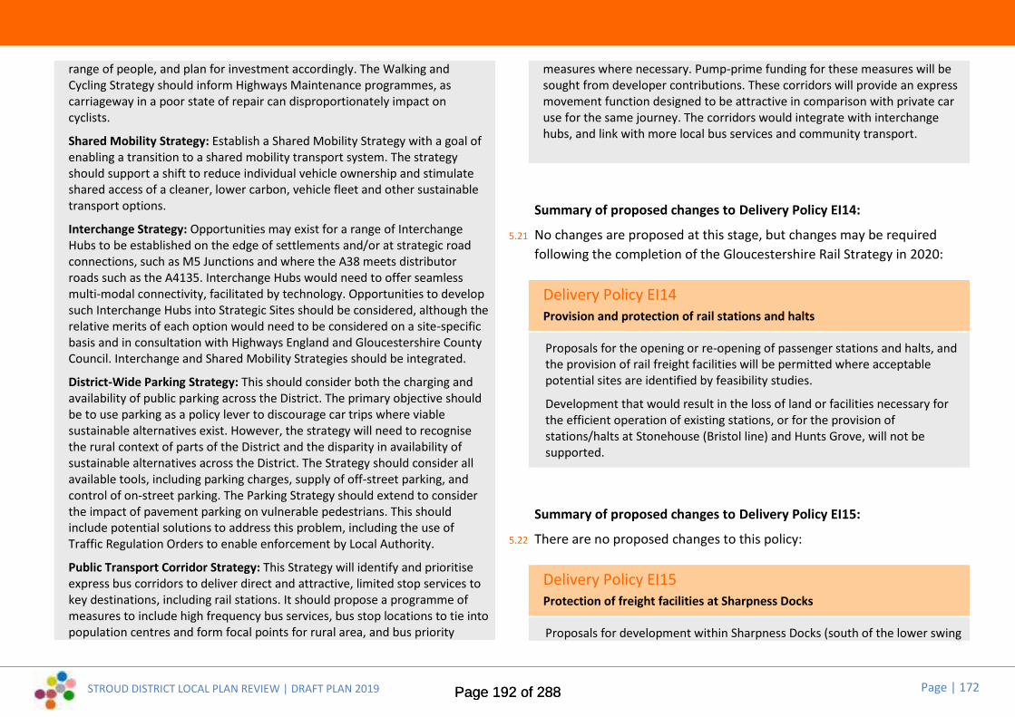
STROUD DISTRICT LOCAL PLAN REVIEW | DRAFT PLAN 2019 Page | 172
range of people, and plan for investment accordingly. The Walking andCycling Strategy should inform Highways Maintenance programmes, ascarriageway in a poor state of repair can disproportionately impact oncyclists.
Shared Mobility Strategy: Establish a Shared Mobility Strategy with a goal ofenabling a transition to a shared mobility transport system. The strategyshould support a shift to reduce individual vehicle ownership and stimulateshared access of a cleaner, lower carbon, vehicle fleet and other sustainabletransport options.
Interchange Strategy: Opportunities may exist for a range of InterchangeHubs to be established on the edge of settlements and/or at strategic roadconnections, such as M5 Junctions and where the A38 meets distributorroads such as the A4135. Interchange Hubs would need to offer seamlessmulti-modal connectivity, facilitated by technology. Opportunities to developsuch Interchange Hubs into Strategic Sites should be considered, although therelative merits of each option would need to be considered on a site-specificbasis and in consultation with Highways England and Gloucestershire CountyCouncil. Interchange and Shared Mobility Strategies should be integrated.
District-Wide Parking Strategy: This should consider both the charging andavailability of public parking across the District. The primary objective shouldbe to use parking as a policy lever to discourage car trips where viablesustainable alternatives exist. However, the strategy will need to recognisethe rural context of parts of the District and the disparity in availability ofsustainable alternatives across the District. The Strategy should consider allavailable tools, including parking charges, supply of off-street parking, andcontrol of on-street parking. The Parking Strategy should extend to considerthe impact of pavement parking on vulnerable pedestrians. This shouldinclude potential solutions to address this problem, including the use ofTraffic Regulation Orders to enable enforcement by Local Authority.
Public Transport Corridor Strategy: This Strategy will identify and prioritiseexpress bus corridors to deliver direct and attractive, limited stop services tokey destinations, including rail stations. It should propose a programme ofmeasures to include high frequency bus services, bus stop locations to tie intopopulation centres and form focal points for rural area, and bus priority
measures where necessary. Pump-prime funding for these measures will besought from developer contributions. These corridors will provide an expressmovement function designed to be attractive in comparison with private caruse for the same journey. The corridors would integrate with interchangehubs, and link with more local bus services and community transport.
Summary of proposed changes to Delivery Policy EI14:
5.21 No changes are proposed at this stage, but changes may be requiredfollowing the completion of the Gloucestershire Rail Strategy in 2020:
Delivery Policy EI14Provision and protection of rail stations and halts
Proposals for the opening or re-opening of passenger stations and halts, andthe provision of rail freight facilities will be permitted where acceptablepotential sites are identified by feasibility studies.
Development that would result in the loss of land or facilities necessary forthe efficient operation of existing stations, or for the provision ofstations/halts at Stonehouse (Bristol line) and Hunts Grove, will not besupported.
Summary of proposed changes to Delivery Policy EI15:
5.22 There are no proposed changes to this policy:
Delivery Policy EI15Protection of freight facilities at Sharpness Docks
Proposals for development within Sharpness Docks (south of the lower swing
Page 192 of 288Page 192 of 288
STROUD DISTRICT LOCAL PLAN REVIEW | DRAFT PLAN 2019 Page | 173
bridge) which would support the viability of the docks for handling freightand shipping repairs will be supported, where the proposal would not have ademonstrable detrimental impact on the environment or amenity.
Summary of proposed changes to Delivery Policy EI16:
5.23 There are no proposed changes to this policy:
Delivery Policy EI16Provision of public transport facilities
Development proposals should cater for the needs of bus and taxi operators,where appropriate. Layouts should encourage operational efficiency,maximise likely bus passenger traffic and include ancillary facilities such asshelters and seating for users.
Page 193 of 288Page 193 of 288

STROUD DISTRICT LOCAL PLAN REVIEW | DRAFT PLAN 2019 Page | 174
6.
Page 194 of 288Page 194 of 288

STROUD DISTRICT LOCAL PLAN REVIEW | DRAFT PLAN 2019 Page | 175
6. Our environment and surroundingsMoving the District towards becoming CarbonNeutral by 2030, adapting to the effects ofclimate change and providing resilience forthe future, whilst ensuring that developmentprotects, conserves or enhances our localenvironment.
Page 195 of 288Page 195 of 288

STROUD DISTRICT LOCAL PLAN REVIEW | DRAFT PLAN 2019 Page | 176
Core Policies6.1 These policies sit at the heart of the Plan. They are the principal means of
delivering the two strategic objectives about our environment andsurroundings (SO5 and SO6).
6.2 The Draft Plan includes some new polices and changes are proposed tosome of the policies in the current Local Plan. The following pages set outthe draft wording, and identify where and why any changes are proposed.Supporting and explanatory text will be developed to accompany the finalpolicies in the Pre-submission Local Plan (anticipated Autumn 2020) andwill be subject to public consultation at that point.
A ‘checklist’ for quality design anddevelopmentSummary of proposed changes to Core Policy CP14:
6.3 Proposed changes reflect national policy on biodiversity net gain and therecommendations arising from the Council’s Open Space and GreenInfrastructure Study:
Core Policy CP14High quality sustainable development
High quality development, which protects, conserves and enhances the builtand natural environment, will be supported. Development will be supportedwhere it achieves the following:
1. Sustainable construction techniques, including facilities for the recyclingof water and waste, measures to minimise energy use and maximiserenewable energy production
2. No unacceptable levels of air, noise, water, light or soil pollution orexposure to unacceptable risk from existing or potential sources ofpollution. Improvements to soil and water quality will be sought throughthe remediation of land contamination, the provision of SuDS and theinclusion of measures to help waterbodies to meet good ecologicalstatus
3. Adequate water supply, foul drainage and sewage capacity to serve thedevelopment and satisfactory provision of other utilities, transport andcommunity infrastructure
4. No increased risk of flooding on or off the site, and inclusion of measuresto reduce the causes and impacts of flooding as a consequence of thatdevelopment
5. An appropriate design and appearance, which is respectful of the
Page 196 of 288Page 196 of 288
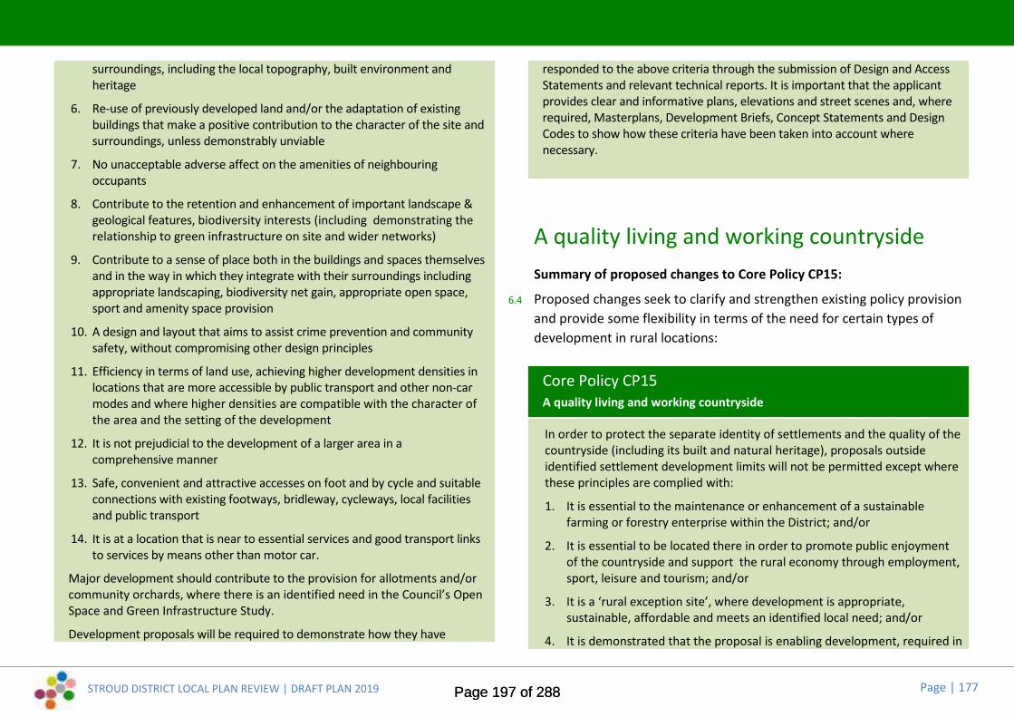
STROUD DISTRICT LOCAL PLAN REVIEW | DRAFT PLAN 2019 Page | 177
surroundings, including the local topography, built environment andheritage
6. Re-use of previously developed land and/or the adaptation of existingbuildings that make a positive contribution to the character of the site andsurroundings, unless demonstrably unviable
7. No unacceptable adverse affect on the amenities of neighbouringoccupants
8. Contribute to the retention and enhancement of important landscape &geological features, biodiversity interests (including demonstrating therelationship to green infrastructure on site and wider networks)
9. Contribute to a sense of place both in the buildings and spaces themselvesand in the way in which they integrate with their surroundings includingappropriate landscaping, biodiversity net gain, appropriate open space,sport and amenity space provision
10. A design and layout that aims to assist crime prevention and communitysafety, without compromising other design principles
11. Efficiency in terms of land use, achieving higher development densities inlocations that are more accessible by public transport and other non-carmodes and where higher densities are compatible with the character ofthe area and the setting of the development
12. It is not prejudicial to the development of a larger area in acomprehensive manner
13. Safe, convenient and attractive accesses on foot and by cycle and suitableconnections with existing footways, bridleway, cycleways, local facilitiesand public transport
14. It is at a location that is near to essential services and good transport linksto services by means other than motor car.
Major development should contribute to the provision for allotments and/orcommunity orchards, where there is an identified need in the Council’s OpenSpace and Green Infrastructure Study.
Development proposals will be required to demonstrate how they have
responded to the above criteria through the submission of Design and AccessStatements and relevant technical reports. It is important that the applicantprovides clear and informative plans, elevations and street scenes and, whererequired, Masterplans, Development Briefs, Concept Statements and DesignCodes to show how these criteria have been taken into account wherenecessary.
A quality living and working countrysideSummary of proposed changes to Core Policy CP15:
6.4 Proposed changes seek to clarify and strengthen existing policy provisionand provide some flexibility in terms of the need for certain types ofdevelopment in rural locations:
Core Policy CP15A quality living and working countryside
In order to protect the separate identity of settlements and the quality of thecountryside (including its built and natural heritage), proposals outsideidentified settlement development limits will not be permitted except wherethese principles are complied with:
1. It is essential to the maintenance or enhancement of a sustainablefarming or forestry enterprise within the District; and/or
2. It is essential to be located there in order to promote public enjoymentof the countryside and support the rural economy through employment,sport, leisure and tourism; and/or
3. It is a ‘rural exception site’, where development is appropriate,sustainable, affordable and meets an identified local need; and/or
4. It is demonstrated that the proposal is enabling development, required in
Page 197 of 288Page 197 of 288

STROUD DISTRICT LOCAL PLAN REVIEW | DRAFT PLAN 2019 Page | 178
order to maintain a heritage asset of acknowledged importance; and/or
5. It is a replacement dwelling or subdivision; and/or
6. It is a house extension; and/or
7. It will involve essential community facilities; and/or
8. It will involve the re-use of an existing rural building; and/or
9. It is a scheme of up to 9 dwellings at a designated Tier 4a or 4bsettlement, supported by the local community.
Where development accords with any of the principles listed above, it willonly be permitted in the countryside if:
i) it does not have an adverse impact on heritage assets and their setting;and
ii) it does not have an adverse impact on natural assets and/or landscapecharacter; and
iii) it does not lead to excessive encroachment or expansion of developmentaway from the original buildings;
iv) in the case of dwellings for a farming or forestry enterprise, it isaccompanied by an appraisal to justify the development in terms of afunctional text, a financial test and that there are no other dwellings orbuildings within reasonable proximity that could be used; or
v) in the case of proposals to re-use an existing rural building or buildings,these are appropriately located and capable and worthy of conversionwithout significant alteration. Any such conversion will involve a buildingthat positively contributes to an established local character and sense ofplace. In the case of replacement buildings they must bring aboutenvironmental improvement; or
vi) in the case of extensions to buildings, it does not result in aninappropriate increase in the scale, form or footprint of the originalbuilding; or
vii) in the case of replacement dwellings the proposal must bring aboutenvironmental improvements and not result in an inappropriate increase
in the bulk, scale, form or footprint of the original building; or
viii) in the case of new buildings for essential community facilities, theycannot be accommodated within the identified settlement developmentlimits or through the re-use or replacement of an existing building.
Page 198 of 288Page 198 of 288
STROUD DISTRICT LOCAL PLAN REVIEW | DRAFT PLAN 2019 Page | 179
Delivery Policies6.5 These policies add detail to the interpretation and application of the Plan’s
development strategy and core policies.
6.6 The Draft Plan includes some new polices and changes are proposed tosome of the policies in the current Local Plan. The following pages set outthe draft wording, and identify where and why any changes are proposed.Supporting and explanatory text will be developed to accompany the finalpolicies in the Pre-submission Local Plan (anticipated Autumn 2020) andwill be subject to public consultation at that point.
A sustainable future: living, working andgrowing within our environmental limitsSummary of proposed changes to Delivery Policy ES1:
6.7 Proposed changes reflect the need to make significant progress tomeeting the Council’s Carbon Neutral 2030 commitments and respond torecommendations from technical studies.
Delivery Policy ES1Sustainable construction and design
Sustainable design and construction will be integral to new development inStroud District. Development proposals should meet the followingrequirements:
1. Achieve net-zero carbon – all new development should achieve a net-zero carbon standard by means of:
an overall minimum 35% reduction in emissions over Part L 2013Building Regulations achieved onsite;
a minimum of 10% and 15% reduction in emissions over Part L 2013Building Regulations achieved respectively in homes and in non-domestic developments through fabric energy efficiencyimprovements;
residual emissions offset through payments to a Stroud DistrictCouncil carbon offset fund;
Major development proposals should calculate and minimise carbonemissions from any other part of the development, including plant orequipment, that are not covered by Building Regulations, i.e.unregulated emissions.
These standards are required unless it can be clearly demonstrated thatthey are not viable for the development in question
2. Reduce the potential for overheating – All new development shouldinclude a recognised overheating risk assessment (Home Quality Mark(HQM) or equivalent)
3. Minimise waste and maximise the recycling of any waste generatedduring construction and in operation – All new development shouldprovide internal recycling bins (HQM or equivalent)
4. Conserve water resources and minimise vulnerability to flooding
5. Be efficient in the use of materials, including the type, life cycle andsource of materials to be used - All new development should usesustainably sourced materials during construction (HQM or equivalent)
6. Be flexible and adaptable, allowing future modification of use or layout,facilitating future refurbishment and retrofitting
7. Provide cycle parking – All new developments should provide coveredand secure cycle parking facilities (HQM or equivalent) in accordancewith Local Plan standards
8. Enable electric vehicle charging – New developments with off roadparking should provide electric vehicle points (HQM or equivalent) in
Page 199 of 288Page 199 of 288

STROUD DISTRICT LOCAL PLAN REVIEW | DRAFT PLAN 2019 Page | 180
accordance with Local Plan standards
9. Applications for all development will need to be accompanied by acompleted Stroud District Sustainable Construction Checklist.
All development will be built in accordance with the approved plans and theSustainable Construction Checklist.
Summary of proposed changes to Delivery Policy ES2:
6.8 Proposed changes reflect the need to make significant progress tomeeting the Council’s Carbon Neutral 2030 commitments and respond torecommendations from technical studies:
Delivery Policy ES2Renewable or low carbon energy generation
The Council will support proposals that maximise the generation of energyfrom renewable or low carbon sources, provided that the installation wouldnot have significant adverse impact (either alone or cumulatively) andincludes an impact statement that demonstrates the following factors:
1. The impact of the scheme, together with any cumulative impact(including associated transmission lines, buildings and access roads), onlandscape character, visual amenity, water quality and flood risk,historic features and biodiversity
2. Evidence that the scheme has been designed and sited to minimise anyadverse impact on the surrounding area for its effective operation
3. Any adverse impact on users and residents of the local area, includingshadow flicker, air quality and noise
4. The direct benefits to the area and local community
5. Avoid the use of best and most versatile agricultural land, unlessjustified by clear and compelling evidence.
Where appropriate, provision should be made for the removal of thefacilities and reinstatement of the site should it cease to be operational.
Within the Cotswold Area of Outstanding Natural Beauty (AONB), or inlocations where proposals would affect the setting of the AONB, applicantsfor the development of renewable energy schemes and associatedinfrastructure will need to demonstrate that the public or national interestoutweighs the protection afforded to the AONB.
Wind turbine proposals in the vicinity of the designated sites of internationalimportance for nature conservation at the Severn Estuary, will need to besubject to an appropriate level of assessment in respect of potential impactson biodiversity (including bird or bat species).
In all cases development will need to demonstrate how any significantadverse impacts on acknowledged biodiversity interests (and the habitatsthat support them) will be adequately mitigated.
The Council will encourage the provision of small-scale renewable energydevelopments utilising technology such as hydro installations, solar panels,biomass and woodfuel heating, small-scale wind turbines and photovoltaiccells.
Community renewable energy schemes will be particularly welcomed wherethey comply with this policy.
Summary of proposed changes to Delivery Policy ES3:
6.9 Proposed changes seek to strengthen existing policy and to more closelyreflect NPPF and accompanying guidance:
Delivery Policy ES3Maintaining quality of life within our environmental limits
Development proposals (as appropriate to their nature and scale) willdemonstrate that environmental risks have been evaluated and thatappropriate measures have been taken to minimise the risks of adverse
Page 200 of 288Page 200 of 288

STROUD DISTRICT LOCAL PLAN REVIEW | DRAFT PLAN 2019 Page | 181
impact to air, land and water quality.
Permission will not be granted to any development which would be likely tolead to, or result in an unacceptable level of:
1. noise, general disturbance, smell, fumes, loss of daylight or sunlight, lossof privacy or an overbearing effect
2. environmental pollution to water, land or air and an unacceptable risk tothe quality and quantity of a water body or water bodies
3. noise and vibration in sensitive locations
4. increased risk of flooding on or off the site, and no inclusion of measuresto reduce the causes and impacts of flooding
5. detrimental impact on highway safety
6. adverse impact on or from contaminated land, where there is a risk tohuman health or the environment
7. antisocial behaviour and / or environmental crime.
Summary of proposed changes to Delivery Policy ES4:
6.10 Proposed changes seek to strengthen existing policy and to more closelyreflect NPPF and accompanying guidance:
Delivery Policy ES4Water resources, quality and flood risk
The Strategic Flood Risk Assessments (SFRA 1 and 2) will be used to informthe location of future development within the District, including to takeaccount of climate change.
In considering proposals for development the District Council will weigh upall of the relevant policy issues when giving full consideration to thesequential test and implementing the "Exception Test" where necessary.
Applications will be supported by Flood Risk Assessments (FRA) whereappropriate that demonstrate the development will be safe, not increaseflood risk elsewhere, and maximise opportunities to reduce flood risk(including Natural Flood Management).
All new developments shall incorporate appropriate Sustainable DrainageMeasures (SuDs) in accordance with National Standards for SustainableDrainage Systems. This should be informed by specific catchment andground characteristics, and will require the early consideration of a widerange of issues relating to the management, long term adoption andmaintenance of SuDs.
For all developments in areas with known surface water flooding issues,appropriate mitigation and construction methods will be required including,where appropriate, contributions towards upstream rural SuDS projects.
Applications and proposals which relate specifically to reducing the risk offlooding (e.g. defence / alleviation work, retro-fitting of existingdevelopment, off site detention / retention basins for catchment wideinterventions) will be sought.
New development in areas with known ground and surface water floodingissues will seek to provide betterment in flood storage and to removeobstructions to flood flow routes where appropriate.
Development will:
1. Conserve and enhance the ecological flood storage value of the waterenvironment, including watercourse corridors and catchments
2. Open up any culverted watercourse where safe and practicable tocreate an asset of community value
3. Improve water efficiency through incorporating appropriate waterconservation techniques including rainwater harvesting and grey waterrecycling
4. Discharge surface run-off, not collected for use, to one or more of thefollowing, listed in order of priority:
a. discharge into the ground (infiltration); or, where not reasonablypracticable
Page 201 of 288Page 201 of 288

STROUD DISTRICT LOCAL PLAN REVIEW | DRAFT PLAN 2019 Page | 182
b. discharge into a surface water body; or, where not reasonablypracticable
c. discharge to a surface water sewer, highway drain, or otherdrainage system; or, where not reasonably practicable
d. discharge to a combined sewer
5. Connect to the main foul sewer network where possible
6. Consider the cumulative impact of adjacent development(s) in devisingan appropriate drainage strategy.
Summary of proposed changes to Delivery Policy ES5:
6.11 Proposed changes seek to strengthen existing policy and to more closelyreflect NPPF and accompanying guidance:
Delivery Policy ES5Air quality
Development proposals which by virtue of their scale, nature or location arelikely to exacerbate existing areas of poorer or marginal air quality, will needto demonstrate (potentially by provision of a formal air quality assessment)that effective measures can be taken to mitigate emission levels in order toprotect public health and well being, environmental quality and amenity.Mitigation measures should demonstrate how they will make a positivecontribution to the aims of any locally agreed air quality and/or transportstrategies for Stroud District and may include:
1. landscaping, bunding or separation to increase distance from highwaysand junctions
2. possible traffic management or highway improvements to be agreedwith the local authority
3. abatement technology and incorporating site layout / separation and
other conditions in site planning
4. traffic routing, site management, site layout and phasing
5. managing and expanding capacity in the natural environment tomitigate poor air quality.
DES1 * New Policy *6.12 Proposed new policy provides criteria for the conversion of agricultural
buildings where planning permission is necessary, and reflects theprovisions of NPPF and accompanying guidance:
Delivery Policy DES1Conversion of redundant agricultural or forestry buildings
The conversion of redundant agricultural or forestry buildings outside ofdefined settlement development limits to an alternative use will be permittedwhere:
1. The location is sufficiently well related to existing infrastructure,amenities and services;
2. The existing vehicular access is suitable in landscape terms for the useproposed;
3. The original building is worthy of conversion with regard to its currentcharacter, scale and condition, without the need for substantialreconstruction, significant extensions or ancillary buildings;
4. Conversion will not result in the need for another agricultural or forestrybuilding on the holding as a replacement;
5. If the building proposed for conversion is not a traditional one, there areno redundant traditional buildings within the holding capable of beingre-used in the first instance;
6. There is no adverse impact on the character of the building and its
Page 202 of 288Page 202 of 288

STROUD DISTRICT LOCAL PLAN REVIEW | DRAFT PLAN 2019 Page | 183
setting, in particular its agricultural/forestry character, and
7. The building is converted to the most appropriate viable use according tothe following hierarchy:
i. Firstly, housing for essential agricultural or forestry workers, orsuccession housing for former agricultural or forestry workers
ii. Farm/forestry diversification for employment useiii. Affordable housingiv. Farm/forestry diversification for visitor accommodation or
facilitiesv. Open market housing
The hierarchy i-iv must be carefully considered with robust evidence(including marketing over a reasonable period) before open market housingcan be supported. Applications must demonstrate that all reasonable effortshave been made to secure alternative viable uses.
Protecting our built and natural heritageSummary of proposed changes to Delivery Policy ES6:
6.13 Proposed changes seek to strengthen existing policy and to more closelyreflect NPPF and accompanying guidance regarding biodiversity net gainrequirements and the hierarchy of sites mitigation. The proposed changesalso reflect the recommendations of the Stroud District Open Space andGreen Infrastructure Study:
Delivery Policy ES6Providing for biodiversity and geodiversity
Development proposals shall provide a net gain in biodiversity throughenhancement and creation of ecological networks within and connecting with
those beyond the district by:
1. Incorporating and enhancing existing and creating new biodiversityfeatures within their design; and
2. Maximising opportunities to enhance and create links betweenecological networks and habitats of principal importance. Links shouldbe created both on-site and, where possible, with nearby features; and
3. Biodiversity within a development needs to be managed, monitored andmaintained; and
4. Development proposals within, or in close proximity to, an ecologicalnetwork corridor should enhance the functionality and connectivity ofthe corridor. Development that would impact on the strategic ecologicalnetwork causing fragmentation or otherwise prejudice its effectivenesswill not be permitted.
Development proposals shall also demonstrate that the mitigation hierarchyhas been followed sequentially in accordance with the principles of:
i. avoidii. reduce, moderate, minimise
iii. rescue e.g. translocationiv. repair, reinstate, restore, compensate or offset.
Where development is considered necessary, adequate mitigation measuresor, exceptionally, compensatory measures, will be required, with the aim ofproviding an overall improvement in local biodiversity and/or geodiversity.
Where development proposals are likely either alone or in combination withother plans and projects, to cause harm to the nature conservation orgeological interest of Internationally important sites, they will not bepermitted unless:
a. There is no suitable alternative to the development; andb. There are imperative reasons of overriding public interest; andc. Appropriate compensatory provision can be secured to ensure that the
overall coherence of the site(s) is protected and enhanced.
Other important habitats and sites of geological and geomorphological
Page 203 of 288Page 203 of 288
STROUD DISTRICT LOCAL PLAN REVIEW | DRAFT PLAN 2019 Page | 184
interest will be protected, managed and enhanced. Up to date,comprehensive ecological surveys undertaken in accordance with industryguidelines and standards will be required to support and inform developmentproposals that would affect sites for nature conservation, protected species,or species or habitats of importance.
Development that will adversely affect the following designations shall not beconsidered sustainable development and will not be permitted:
National SSSIs and NNRs International or Nationally protected species, or species and habitats of
principal importance. It will be important to consider the futureconservation status of the relevant species in their natural range.
Development should not adversely affect:
Local Wildlife Sites, Local Nature Reserves, Local Geological or Geomorphological Sites, Local ecological or Green Infrastructure networks
The assessment of adverse impacts will apply to potentially damagingdevelopment proposals that may affect a designated area and will includethe consideration of adverse cumulative effects with other existing orproposed development.
Summary of proposed changes to Delivery Policy ES7:
6.14 Proposed changes seek to strengthen existing policy and to more closelyreflect NPPF and accompanying guidance:
Delivery Policy ES7Landscape character
Within the Cotswolds Area of Outstanding Natural Beauty (AONB), or onland that may affect its setting, priority will be given to the conservation and
enhancement of the natural and scenic beauty of the landscape whilsttaking account of the biodiversity interest and the historic and culturalheritage. Major development will not be permitted unless it is demonstratedto be in the national interest and that there is a lack of alternativesustainable development sites.
In all locations development proposals should conserve or enhance thespecial features and diversity of the different landscape character typesfound within the District. Priority will be given to the protection of thequality and diversity of the landscape character. Development will only bepermitted if all the following criteria are met:
1. The location, materials, scale and use are sympathetic and complementthe landscape character; and
2. Natural features including trees, hedgerows and water features thatcontribute to the landscape character and setting of the developmentshould be both retained and managed appropriately in the future.
Opportunities for appropriate landscaping will be sought alongside all newdevelopment, such that landscape type key characteristics are strengthened.
The Stroud District Landscape Assessment will be used when determiningapplications for development within rural areas.
Summary of proposed changes to Delivery Policy ES8:
6.15 Proposed changes seek to strengthen existing policy and to more closelyreflect NPPF and accompanying guidance:
Delivery Policy ES8Trees, hedgerows and woodlands
Development should seek where appropriate to enhance and expand theDistrict’s tree, hedgerow and woodland resource.
Development that would result in the unacceptable loss of, or damage to, or
Page 204 of 288Page 204 of 288

STROUD DISTRICT LOCAL PLAN REVIEW | DRAFT PLAN 2019 Page | 185
threaten the continued well-being of locally valued and/or protected trees,hedgerows, community orchards, veteran trees or woodland will not bepermitted.
Where the loss of trees and/or hedgerows is considered acceptable,adequate replacement provision will be required that utilise species that arein sympathy with the character of the existing tree or hedge species in thelocality and the site.
Tree surgery work requiring consent must be undertaken in accordance witharboricultutal best practice.
Development proposals shall provide soft landscaping details, including tree,hedge and wood planting where appropriate. Landscaping schemes shouldtake account of local landscape character, ecological interests (includinggreen infrastructure networks) and should include the planting ofindigenous species where appropriate.
The Council will seek long-term maintenance and management plans toaccompany the soft landscaping proposals where appropriate.
Summary of proposed changes to Delivery Policy ES9:
6.16 There are no proposed changes to this policy:
Delivery Policy ES9Equestrian development
The keeping of horses for leisure and recreational purposes or as part ofcommercially based equestrian activity shall be considered acceptablewhere development that, through its environmental impact, eitherenhances or does not diminish environmental quality of those rural areas inwhich it is to take place. The level of activity generated by a proposal will betaken into account.
Such development shall be integrally connected with wider landmanagement and be development requiring a countryside location. In
particular, a longer term landholding management and maintenance planwill be expected to accompany any equestrian development proposal.
Any proposal for the conversion or change of use of existing equestrianestablishments to a non-equestrian use will be discouraged, unless there is astrong case setting out why an exception should be made.
Summary of proposed changes to Delivery Policy ES10:
6.17 Proposed changes seek to strengthen and clarify existing policy in relationto locally distinctive landmark features:
Delivery Policy ES10Valuing our historic environment and assets
Stroud District’s historic environment will be preserved, protected orenhanced, in accordance with the principles set out below:
1. Any proposals involving a historic asset shall require a description of theheritage asset significance including any contribution made by itssetting, and an assessment of the potential impact of the proposal onthat significance, using appropriate expertise. This can be a desk basedassessment and a field evaluation prior to determination wherenecessary and should include the Gloucestershire Historic EnvironmentRecord.
2. Proposals and initiatives will be supported which conserve and, whereappropriate, enhance the heritage significance and setting of theDistricts heritage assets, especially those elements which contribute tothe distinct identity of the District. These include:
A. the 68 sites of national archaeological importance (which aredesignated as Ancient Monuments), any undesignated archaeologyof national significance, and the many buildings that are Listed ashaving special architectural or historic interest
B. the stone, bronze, iron age and roman settlements and remains; the
Page 205 of 288Page 205 of 288
STROUD DISTRICT LOCAL PLAN REVIEW | DRAFT PLAN 2019 Page | 186
medieval settlements including Berkeley Castle; historic houses;historic parks, gardens and villages
C. the townscapes of the larger towns such as Stroud where theindustrial heritage influenced its historic grain, including its streetlayouts and plot sizes
D. the District’s historic market towns and villages, many withdesignated conservation areas, such as Berkeley, Wotton UnderEdge, Minchinhampton, Painswick and Dursley.
3. Proposals will be supported which protect and, where appropriate,enhance the heritage significance and setting of locally identifiedheritage assets, such as buildings of local architectural or historicinterest, locally important archaeological sites and parks and gardens oflocal interest.
4. Proposals will be supported which protect and, where appropriate,enhance key views and vistas, especially of locally distinctive landmarkfeatures such as the spires and towers of historic churches and millchimneys.
5. Any harm or loss would require clear and convincing justification to therelevant decision-maker as to why the heritage interest should beoverridden.
A full programme of work shall be submitted with the application, togetherwith proposals to mitigate any adverse impact of the proposeddevelopment, and where appropriate, be implemented through measuressecured by planning condition(s) or through a legal agreement.
Summary of proposed changes to Delivery Policy ES11:
6.18 Minor proposed changes seek to strengthen and clarify the existing policy:
Delivery Policy ES11Maintaining, restoring and regenerating the District’s canals
The Council will continue to support and deliver the restoration of and othernecessary functional improvements to the District’s canals. It will seek toimprove access to and along the canals to encourage use for transport and forleisure / recreational purposes.
Development on the route of, or adjacent to, the Stroudwater Navigation, theThames and Severn Canal or the Gloucester & Sharpness Canal must notprevent the improvement, reconstruction, restoration, widening orcontinued operational use of the canals or towpaths.
All developments adjacent to the canals must respect their character, setting,biodiversity and historic value as well as have regard to improving andenhancing views along and from the canals. Environmental improvements toany canal's appearance will include enhancement of its historic andbiodiversity value.
In assessing any proposals for development along or in the vicinity of any ofthe Districts three canals, the Council will have regard to any relevantadopted design guidance.
Reasonably related financial contributions may be sought via CommunityInfrastructure Levy or, where appropriate, via legal agreements forcontributions towards the improvement or restoration of the related canaland towpaths.
Page 206 of 288Page 206 of 288

STROUD DISTRICT LOCAL PLAN REVIEW | DRAFT PLAN 2019 Page | 187
Quality of design: places and spacesSummary of proposed changes to Delivery Policy ES12:
6.19 Minor proposed changes to clarify the policy:
Delivery Policy ES12Better design of places
The District Council will require the layout and design of new development tocreate well designed, socially integrated, high quality successful places,where people enjoy living and working, with legible and well planned routes,blocks and spaces, integrated residential, commercial and communityactivity, safe attractive public spaces and pedestrian/cycle routes withouttraffic conflict, secure private areas, better designed buildings andlandscaped spaces.
New development should be designed to offer flexibility for future needs anduses taking into account demographic and other changes. The Council willexpect the improvement of existing buildings to meet changing needs and tosustain the District’s housing and commercial building stock.
All new development must be based on thorough site appraisal includingreference to any adopted Design Statements, Design Codes, NeighbourhoodDevelopment Plans, Secured by Design standards and be sensitive to itscontext as well as contributing to sustainable living.
‘Design Quality’, reflecting a thorough understanding of the site context,must be demonstrated as part of any proposal. The Council will require thesubmission of a Design and Access Statement which clearly demonstratesthe design and suitability of the proposal in its local context wherenecessary.
DES2 * New Policy *6.20 Proposed new policy reflects changes in the NPPF and accompanying
guidance and addresses recommendations arising from the Stroud DistrictOpen Space and Green Infrastructure Study:
Delivery Policy DES2Green Infrastructure
All development proposals should, where possible, and appropriate to theirnature and scale:
1. protect existing green infrastructure and the functions this performs;
2. increase the functionality of existing and planned green infrastructureespecially where this helps to mitigate the causes of and addresses theimpacts of climate change;
3. improve the quality of existing green infrastructure, including localnetworks and corridors, specifically to increase its attractiveness as arecreation opportunity and its value as a habitat for biodiversity;
4. protect and improve access to and connectivity between existing andplanned green infrastructure to develop a continuous right of way andgreenway network and integrated ecological system/network;
5. secure new green infrastructure in order to cater for anticipatedincreases in demand arising from development particularly in areaswhere there are existing deficiencies assessed against standardscontained within this Plan; and
6. provide long-term management arrangements for new and enhancedgreen infrastructure within development sites.
Where a loss of, or negative impact on green infrastructure functionality orecological system/network is unavoidable, development proposals shoulddemonstrate what mitigation measures are proposed and/or replacementgreen infrastructure will be provided. Any replacement or mitigation measureshould seek to secure a net gain in biodiversity and be deployed as closely as
Page 207 of 288Page 207 of 288
STROUD DISTRICT LOCAL PLAN REVIEW | DRAFT PLAN 2019 Page | 188
possible to the affected green infrastructure asset.
Development that is demonstrably harmful to an identified strategic greeninfrastructure asset, or adversely affects the functioning and/orimplementation of approved strategic green infrastructure projects, will notbe permitted.
Summary of proposed changes to Delivery Policy ES16:
6.21 Minor proposed changes to clarify the purpose of the policy:
Delivery Policy ES16Public art contributions
Proportionate contributions will be required towards the provision of publiclyaccessible art and design works from development proposals comprisingmajor residential schemes or major commercial, retail, leisure andinstitutional development involving 1,000m2 gross floorspace or 1ha of landor more which are publicly accessible. Public art should help create a sense ofplace for that development.
Smaller schemes will be encouraged to include Public Art as a means ofenhancing the development's quality and appearance. The level ofcontribution will be negotiated on an individual basis dependent upon thenature of the development proposal, taking into account the impact of thisrequirement on the economic viability of the development proposal.
Page 208 of 288Page 208 of 288

STROUD DISTRICT LOCAL PLAN REVIEW | DRAFT PLAN 2019 Page | 189
7.
STROUD DISTRICT LOCAL PLAN REVIEW | DRAFT PLAN 2019 Page | 189
7.
STROUD DISTRICT LOCAL PLAN REVIEW | DRAFT PLAN 2019 Page | 189
7.
Page 209 of 288Page 209 of 288

STROUD DISTRICT LOCAL PLAN REVIEW | DRAFT PLAN 2019 Page | 190
7. Delivery and monitoring
Page 210 of 288Page 210 of 288

STROUD DISTRICT LOCAL PLAN REVIEW | DRAFT PLAN 2019 Page | 191
7.0 Delivery and monitoringImplementation
7.1 This Local Plan identifies an over-arching vision, which expressesaspirations for the future of our District. However, if we are to achieve thisvision it is important that the policies and proposals contained within thePlan can be delivered and mechanisms are put in place to ensure that theyare.
Delivery mechanisms7.2 The policies and proposals contained within this Plan are only the start of
the story. Many of the proposals contained within this Plan will needdeveloping through more detailed delivery documents and policies mayneed further clarification through supplementary documents. The mostsignificant delivery documents include:
Development briefs, masterplans and design codes for strategic sitesand other major development
Supplementary Planning Documents (SPD) for significant policies, suchas affordable housing, etc.
7.3 In order to ensure the timely delivery of sites and infrastructure we willconsider using our compulsory purchase powers to acquire land needed toprogress development.
Working with partners7.4 Delivering the development strategy will require a wide range of private,
public and voluntary bodies working together. At a strategic level, theCouncil will work with the County Council, with neighbouring districtauthorities and other bodies to identify and meet strategic needs and toco-ordinate the delivery of infrastructure across administrativeboundaries.
7.5 The Council recognises and supports the development of NeighbourhoodDevelopment Plans by parish councils. Indeed, the development strategyspecifically states that such plans have a role in bringing forwarddevelopment to meet local needs, particularly at the smaller settlementswhere strategic levels of growth are inappropriate.
Delivery of growth7.6 The Table x (following page) sets out when the strategic housing
allocations set out in the Local Plan are anticipated to be delivered. Whilstexisting commitments (planning permissions) will contribute significantlyto meeting the housing needs during the first five years of the plan, it willbe important to plan for the strategic sites in the short term as larger sitestake time to masterplan and come on stream, especially where significantinfrastructure is required.
Page 211 of 288Page 211 of 288
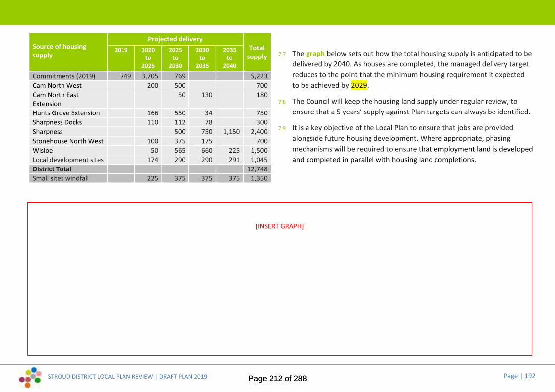
STROUD DISTRICT LOCAL PLAN REVIEW | DRAFT PLAN 2019 Page | 192
Source of housingsupply
Projected deliveryTotal
supply2019 2020
to2025
2025to
2030
2030to
2035
2035to
2040Commitments (2019) 749 3,705 769 5,223Cam North West 200 500 700Cam North EastExtension
50 130 180
Hunts Grove Extension 166 550 34 750Sharpness Docks 110 112 78 300Sharpness 500 750 1,150 2,400Stonehouse North West 100 375 175 700Wisloe 50 565 660 225 1,500Local development sites 174 290 290 291 1,045District Total 12,748Small sites windfall 225 375 375 375 1,350
7.7 The graph below sets out how the total housing supply is anticipated to bedelivered by 2040. As houses are completed, the managed delivery targetreduces to the point that the minimum housing requirement it expectedto be achieved by 2029.
7.8 The Council will keep the housing land supply under regular review, toensure that a 5 years’ supply against Plan targets can always be identified.
7.9 It is a key objective of the Local Plan to ensure that jobs are providedalongside future housing development. Where appropriate, phasingmechanisms will be required to ensure that employment land is developedand completed in parallel with housing land completions.
[INSERT GRAPH]
Page 212 of 288Page 212 of 288

STROUD DISTRICT LOCAL PLAN REVIEW | DRAFT PLAN 2019 Page | 193
Monitoring framework7.10 The implementation of policies and proposals in the Local Plan should be
monitored on a continuous basis, to assess how they are working in termsof delivering the strategy and objectives that are set out in the Plan.
7.11 Continuous monitoring enables an assessment of the effectiveness of theLocal Plan development strategy and development management policies.It helps to address questions like:
Are policies achieving their objectives and in particular are theydelivering sustainable development?
Have policies had unintended consequences that were not originallyanticipated?
Are the assumptions and objectives underpinning the policies stillrelevant and applicable?
Are the targets being achieved?
7.12 A monitoring framework will be prepared to assess the performance ofthe Local Plan over its course up to 2040. It will provide the keymechanism for ensuring that Council’s vision and the spatial objectivesand policies stemming from it are successfully delivered. The monitoringframework will set out a series of key indicators, which can be used tomeasure the Local Plan's performance. There will be related targets inorder to assess whether policies are working effectively or whether theyneed to be reviewed or replaced. Where it becomes evident that policiesare not performing as initially envisaged or intended, any subsequentmonitoring analysis will suggest the actions that need to be taken toaddress the issues.
7.13 The Council will continue to publish regular monitoring reports to identifyprogress with the Local Plan. At the current time, the Council producesannual reports covering:
housing land availability
housing land supply
employment land availability
Page 213 of 288Page 213 of 288

STROUD DISTRICT LOCAL PLAN REVIEW | DRAFT PLAN 2019 Page | 194
[1] [2]
[3]
*[image credits see page 111]
Page 214 of 288Page 214 of 288

STROUD DISTRICT LOCAL PLAN REVIEW | DRAFT PLAN 2019 Page | 195
8. Appendices
Page 215 of 288Page 215 of 288

STROUD DISTRICT LOCAL PLAN REVIEW | DRAFT PLAN 2019 Page | 196
Appendix A
Page 216 of 288Page 216 of 288

STROUD DISTRICT LOCAL PLAN REVIEW | DRAFT PLAN 2019 Page | 197
Appendix ANote: Potential changes are shown in red. Existing settlement development limits are in black. You can see the existing settlement development limits for allthe District’s settlements by using our online mapping tool at www.stroud.gov.uk/localplan.
Berkeley: ref. SDL-BER01 at Lynch Road
SDL-BER01 © Crown copyright and database rights 2018 Ordnance Survey 100019682
Cam: ref. SDL-CAM01 at Strawberry Field / Elstub Lane
© Crown copyright and database rights 2018 Ordnance Survey 100019682
Note: Cam and Dursleycurrently share a single
settlement development limit
SDL-CAM01
Page 217 of 288Page 217 of 288

STROUD DISTRICT LOCAL PLAN REVIEW | DRAFT PLAN 2019 Page | 198
Appendix A
Cambridge: ref. SDL-CBR01 at Narles Road / Barton Field Cambridge: ref. SDL-CBR02 at Ryalls Court
Dursley: ref. SDL-DUR01 at Shearing Close, Littlecombe
Note: Potential changes are shown in red. Existing settlement development limits are in black. You can see the existing settlement development limits for allthe District’s settlements by using our online mapping tool at www.stroud.gov.uk/localplan.
© Crown copyright and database rights 2018 Ordnance Survey 100019682 © Crown copyright and database rights 2018 Ordnance Survey 100019682SDL-CBR02
SDL-CBR01
Note: Cam and Dursleycurrently share a single
settlement development limit
SDL-DUR01
Page 218 of 288Page 218 of 288

STROUD DISTRICT LOCAL PLAN REVIEW | DRAFT PLAN 2019 Page | 199
Appendix ANote: Potential changes are shown in red. Existing settlement development limits are in black. You can see the existing settlement development limits for allthe District’s settlements by using our online mapping tool at www.stroud.gov.uk/localplan.
Eastington: ref. SDL-EAS01 at Swallowcroft Eastington: ref. SDL-EAS02 at Alkerton Farm, rear of Bath Road
Hardwicke: ref. SDL-HAR01 at Sellars Road
SDL-EAS02
SDL-EAS01
SDL-HAR01© Crown copyright and database rights 2018Ordnance Survey 100019682
© Crown copyright and database rights 2018 Ordnance Survey 100019682
Page 219 of 288Page 219 of 288

STROUD DISTRICT LOCAL PLAN REVIEW | DRAFT PLAN 2019 Page | 200
Appendix ANote: Potential changes are shown in red. Existing settlement development limits are in black. You can see the existing settlement development limits for allthe District’s settlements by using our online mapping tool at www.stroud.gov.uk/localplan.
Hillesley: ref. SDL-HIL01 at no.s 1-3 Alderley Road
SDL-HIL01
Horsley: ref. SDL-HOR01 at Sealey Wood Lane / Nupend Farm; ref. SDL-HOR02 at TheChooks / Willow Barn; ref. SDL-HOR03 north of The Street; ref. SDL-HOR04 at The Priory
© Crown copyright and database rights 2018 Ordnance Survey 100019682 © Crown copyright and database rights 2018 OrdnanceSurvey 100019682
SDL-HOR04
SDL-HOR01
SDL-HOR02
SDL-HOR06
SDL-HOR03
SDL-HOR05
Page 220 of 288Page 220 of 288

STROUD DISTRICT LOCAL PLAN REVIEW | DRAFT PLAN 2019 Page | 201
Appendix ANote: Potential changes are shown in red. Existing settlement development limits are in black. You can see the existing settlement development limits for allthe District’s settlements by using our online mapping tool at www.stroud.gov.uk/localplan.
Kings Stanley: ref. SDL-KST01 at Dyehouse Field / off Woodside LaneLeonard Stanley: ref. SDL-LEO01 at Lyndon Morgan Way / Marsh Lane
Middleyard: ref. SDL-MID01 at Coldwell Close
© Crown copyright and database rights 2018 Ordnance Survey 100019682
SDL-KST01
SDL-LEO01
SDL-MID01
Page 221 of 288Page 221 of 288

STROUD DISTRICT LOCAL PLAN REVIEW | DRAFT PLAN 2019 Page | 202
Appendix A
SDL-MIS01a
Note: Potential changes are shown in red. Existing settlement development limits are in black. You can see the existing settlement development limits for allthe District’s settlements by using our online mapping tool at www.stroud.gov.uk/localplan.
Miserden: ref. SDL-MIS01a: An entirely new settlement development limit. The extent of the proposed SDL has been amended in the light of last year’s public consultation.
© Crown copyright and database rights 2018 Ordnance Survey 100019682
Page 222 of 288Page 222 of 288

STROUD DISTRICT LOCAL PLAN REVIEW | DRAFT PLAN 2019 Page | 203
Appendix A
Newtown: ref. SDL-NEW01 at Cromwell Close / south of Gloucester Road
Note: Potential changes are shown in red. Existing settlement development limits are in black. You can see the existing settlement development limits for allthe District’s settlements by using our online mapping tool at www.stroud.gov.uk/localplan.
SDL-NEW01
© Crown copyright and database rights 2018 Ordnance Survey 100019682
Stonehouse: ref. SDL-STO01 at Brunel Way / Oldends Lane
SDL-STO01© Crown copyright and database rights 2018 Ordnance Survey 100019682
Page 223 of 288Page 223 of 288

STROUD DISTRICT LOCAL PLAN REVIEW | DRAFT PLAN 2019 Page | 204
Appendix A
Uley: ref. SDL-ULY01 at Goldingham Close
Note: Potential changes are shown in red. Existing settlement development limits are in black. You can see the existing settlement development limits for allthe District’s settlements by using our online mapping tool at www.stroud.gov.uk/localplan.
Stroud: ref. SDL-STR01 at Margaret Hills Place / Bisley Old Road Stroud: ref. SDL-STR02 at Bowbridge Wharf
SDL-STR01© Crown copyright and database rights 2018 Ordnance Survey 100019682
SDL-STR02
Whiteshill &Ruscombe
Selsley
North Woodchester
Thrupp
Randwick
SDL-ULY01© Crown copyright and database rights 2018 Ordnance Survey 100019682
Page 224 of 288Page 224 of 288
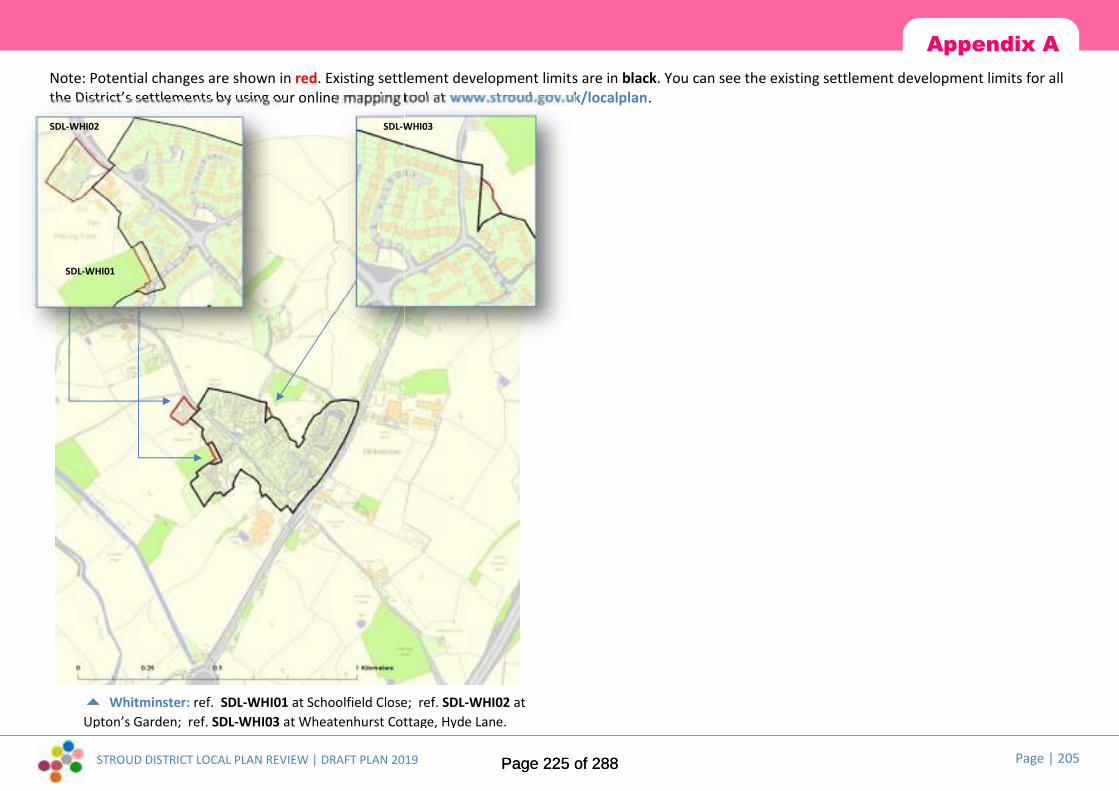
STROUD DISTRICT LOCAL PLAN REVIEW | DRAFT PLAN 2019 Page | 205
Appendix ANote: Potential changes are shown in red. Existing settlement development limits are in black. You can see the existing settlement development limits for allthe District’s settlements by using our online mapping tool at www.stroud.gov.uk/localplan.
Whitminster: ref. SDL-WHI01 at Schoolfield Close; ref. SDL-WHI02 atUpton’s Garden; ref. SDL-WHI03 at Wheatenhurst Cottage, Hyde Lane.
SDL-WHI01
SDL-WHI02 SDL-WHI03
Page 225 of 288Page 225 of 288

STROUD DISTRICT LOCAL PLAN REVIEW | DRAFT PLAN 2019 Page | 206
Appendix B
Areas of search for renewable energy locations...
Page 226 of 288Page 226 of 288

STROUD DISTRICT LOCAL PLAN REVIEW | DRAFT PLAN 2019 Page | 207
Appendix C
Parking standards for vehicles and cyclesVehicle parking:1. General vehicle parking standards for Planning Use Classes are not specified by
the Local Plan. The number of parking spaces will be a matter for negotiationand assessed according to individual circumstances. The proposed provision willneed to be demonstrated to be suitable based on the following
i. The accessibility of the development.
ii. The type, mix and use of the development.
iii. The availability of and opportunities for public transport.
iv. Local car ownership levels.
v. The need to ensure an adequate provision of spaces for charging plug-inand other ultra-low emission vehicles.
2. Opportunities to improve the sustainable accessibility of the site, and forshared mobility solutions to reduce local car ownership, will be prioritisedahead of provision of parking above Policy levels as measures to accommodatetravel demand for new development. Provision of excessive parking levels atnew development will not be supported due to the risk of encouragingunnecessary car travel where viable sustainable alternatives exist.
3. All car parking spaces (except disabled) shall be a minimum of 2.4m x 4.8m,with a minimum aisle width of 6m.
4. When required, lorry parking spaces will range between 13.5m x 6.3m to 17.5mx 7.4m depending on the types of vehicles anticipated.
5. Parking levels for mixed use development will be assessed as a sum of theparking requirements of the individual elements of the scheme based on thestandards, with consideration of the potential for linked trips, i.e. one tripaccessing two or more parts of the development, to reduce the overall parking
demand. This also applies to ancillary uses such as an office use within anindustrial development, or a bar open to non-residents within a hotel.
6. Parking Management Plans will be required for mixed use developments todemonstrate how the parking resource will be managed across the whole siteto ensure that excess levels of parking are not available to an individual landuse which could provide an incentive for private car use over sustainable travel.An appropriate balance will be sought between unallocated and allocatedparking, with the aim of minimising the level of parking required for thedevelopment overall.
7. The requirement to provide appropriate levels of parking apply to newdevelopments or extensions and to changes of use. When considering anextension to an existing use the opportunity to reduce parking levels will beconsidered.
8. For residential development the allocated parking spaces shall be providedwithin easy walking distance of the dwellings they intend to serve.
Disabled parking bays:a) Disabled parking bays (dpb) should be provided in relation to publicly accessed
parking at a ratio of 1 dpb per 10 conventional parking bays.
b) Disabled parking bays should be large enough to facilitate access by wheelchairusers, i.e. 3.6m x 4.8m, especially in public car parks. Only where space islimited will a smaller space (minimum 3.0m x 4.8m) or two adjoining spaces (of2.4m x 4.8m each with a shared space between of 1.2m) be acceptable. Astandard of 2.4m x 4.8m can be provided where the long side is left open foraccess.
c) The disabled car parking bays should be located close to an entrance to thebuilding, with the route from the space to the building capable of use by a
Page 227 of 288Page 227 of 288

STROUD DISTRICT LOCAL PLAN REVIEW | DRAFT PLAN 2019 Page | 208
Appendix Cdisabled person. This may require the provision of ramps (maximum gradient1:20) and convenient handrails.
d) For pedestrian areas, bays should be within 50m of the destination.
e) Each bay should have a zone for transfer from car to wheelchair.
f) Each transfer zone should either serve two bays or be positioned in the cornerof a parking area to avoid abuse by other drivers.
g) Bays and transfer zones should be clearly marked and should display the BritishStandard “Disabled” symbol, both on the road surface and on a discreet, butclearly visible, signpost or wall.
h) The bay should be level, without camber or flanking upstand kerbs.
i) No bay, or access to it, should be so restricted in height as to make itinaccessible for cars carrying wheelchairs on roof racks.
Ultra Low Emissions Vehicles (ULEV):The Office of Low Emissions Vehicles started a consultation in July 2019 on policiesfor electric charging points for residential and non-residential properties. At thetime of writing, these policies are not adopted by the Government. Stroud DistrictCouncil seeks to maximise opportunities to secure ULEV infrastructure throughplanning policy to assist meeting carbon neutrality objectives. ULEV policy will bewhichever is the greater requirement of adopted government policy, or:
Every new residential building with an associated car parking space will have acharge point. This also applies to buildings undergoing a material change of useto create a dwelling.
Every residential building undergoing major renovation with more than 10 carparking spaces to have cable routes for electric vehicle chargepoints in everycar parking space.
Every new non-residential building including buildings undergoing majorrenovation with more than 10 car parking spaces to have one chargepoint andcable routes for an electric vehicle chargepoint for one in five spaces.
Every existing non-residential building with more than 20 car parking spacesshould have at least one chargepoint from 2025
To be classified as a chargepoint for the purpose of policy compliance, eachchargepoint must be a minimum 7kW and be at least Mode 3 or equivalent. It isrecognised that innovations are coming to market that use different types ofchargers and charging speeds, such as wireless and ultra-rapid charging, althoughthese are unlikely to be used in residential settings. Policy specifically allows forequivalence with Mode 3 chargepoints to allow for future innovation to not beexcluded where it provides an equal or better facility.
Cycle parking:A minimum of 2 cycle parking spaces must be provided at any new non-residentialdevelopment, however small. Transport Assessments will need to demonstrate thatlevels of cycle parking are appropriate to the development being proposed.
In addition to the required level of parking provision (which should be under coverand secure), strategically significant developments (i.e. those included in Table A)should also provide showers and lockers for cyclists.
The Council may also seek shower and/or locker facilities in other developmentsthat generate large numbers of employees.
In town centres developers have the option of paying commuted sums in lieu of therequired provision, for public cycle parking to be provided by the District Council,although there must be a demonstrable solution to the required level of spacesbeing provided prior to grant of planning permission.
The location of cycle stands shall be as close as possible to the destination served, insecure positions or open positions where surveillance by staff or the general publicis a deterrent to theft. At any site where 10 or more spaces are provided, the standsshould be located under cover, be lit and appropriately signed. The detailed designand lighting of such facilities must have regard to the locality and to the proposeddevelopment. In residential development garages and rear garden space (for shedsetc.,) will be acceptable as cycle storage provision. In flats developments securecommunal space should be provided. Where, due to specific circumstances, e.g.small development, access restrictions etc., the amount of car parking is reduced orwaived, no reduction shall be made in the number of cycle spaces to be provided.
Page 228 of 288Page 228 of 288

STROUD DISTRICT LOCAL PLAN REVIEW | DRAFT PLAN 2019 Page | 209
Appendix C
Table A:Minimum cycle and motorcycle parking standards
Land Use Car parking
A1 Food retail 1/60 sq m
A1 Non-food retail 1/120 sq m
A2 Professional services 1/166 sq m
A3 Public House/Restaurant 1/26 sq m
B1 (a) and (b) Office and R&D 1/166 sq m
B1 (c) /B2 Industrial 1/330 sq m
B8 Warehousing/distribution 1/330 sq m
C1 Hotel 0.15/employee
C1 Hostel 0.15/employee
C2 Hospital 0.15/employee
C2 Nursing Home 0.15/employee
C2 Boarding School 0.15/employee + 0.15/student
C3 Dwelling houses/flats 1/dwelling
C3 Sheltered Housing 0.15/employee
D1 Doctor’s/Vet’s Surgery/Health Centre 0.15/employee
D1 School/Crèche/Day Centre 0.15/employee + 0.15/student
D1 Higher/Further Education 0.15/employee + 0.15/student
D1 Art Gallery, museum, library 1/300 sq m public area + 0.15/employee
D1 Public Hall/Place of Worship 1/20 seats or 1/26 sq m
D2 Cinema, Concert Hall, Night Club 1/20 seats or 1/26 sq m
D2 Leisure/Sports Centre/Fitness Club 1/66 sq m
Definitions (Table A): Floorspace figures (in sq m) refer to Gross Floor Area. Employees refers to the total of full-time equivalent employees, e.g. a person
employed half-time would count as 0.5.
Page 229 of 288Page 229 of 288

STROUD DISTRICT LOCAL PLAN REVIEW | DRAFT PLAN 2019 Page | 210
Image credits and information
Page 230 of 288Page 230 of 288

[blank page]
Page 231 of 288Page 231 of 288
Development ServicesStroud District CouncilEbley MillStroudGloucestershireGL5 4UB
The Planning Strategy Team01453 [email protected]
visit www.stroud.gov.uk/localplanreview
Development ServicesStroud District CouncilEbley MillStroudGloucestershireGL5 4UB
The Planning Strategy Team01453 [email protected]
visit www.stroud.gov.uk/localplanreview
Development ServicesStroud District CouncilEbley MillStroudGloucestershireGL5 4UB
The Planning Strategy Team01453 [email protected]
visit www.stroud.gov.uk/localplanreview
Page 232 of 288Page 232 of 288

Stroud DistrictLocal Plan ReviewEmerging Strategy Consultation Report Part Two
November 2019
Stroud District Local Plan Review
Consultation Report
Page 233 of 288Page 233 of 288
dayj
Typewritten text
Appendix B

Development Services
Stroud District Council
Ebley Mill
Stroud
Gloucestershire
GL5 4UB
The Planning Strategy Team
01453 754143
visit www.stroud.gov.uk/localplanreview
Contents
Page 234 of 288Page 234 of 288

STROUD DISTRICT LOCAL PLAN REVIEW | CONSULTATION REPORT PART TWO Page | 2
1. Introduction 3
2. What you told us
Key issues 3
Local economy and jobs 4
Our town centres 7
A local need for housing 9
Local green spaces and community facilities 10
A vision for the future 12
Strategic objectives 13
The Emerging Growth Strategy 17
Settlement hierarchy 20
Settlement boundaries 23
Mini visions and priorities 27
3. Potential sites and alternatives The Stroud Valleys
Brimscombe & Thrupp 31
Minchinhampton 32
Nailsworth 33
North Woodchester 35
Stroud 35
The Stonehouse cluster
Kings Stanley 37
Leonard Stanley 38
Stonehouse 38
Cam & Dursley Cluster
Cam 40
Dursley 43
Gloucester’s rural fringe
Hardwicke 45
Whaddon 47
The Berkeley cluster
Berkeley 48
Newtown & Sharppness 48
Wisloe 50
The Wotton cluster
Kingswood 51
Wotton-under-Edge 52
The Cotswold cluster
Painswick 53
Page 235 of 288Page 235 of 288
Page | 3
1. Introduction In November 2018 Stroud District Council consulted on its Emerging Strategy as part of the Local
Plan Review and a report containing quantitative headline results was published in May 2019 and
is available to view on the Council’s website at www.stroud.gov.uk/localplanreview
This report provides more detailed summaries of public comments submitted in response to the
consultation and a Council response to each section that summarises how comments have been
taken into account in the Draft Plan.
2. What you told us....
Key Issues
Qu. 1.0a Have we identified the top 5 issues for you?
Comments received regarding the top 5 key issues focused on the lack of reference to the
following:
• Reducing our collective carbon footprint, adaptation for the consequences of climate change
impact and the need to work towards the Council’s aim to be carbon neutral by 2030.
• Stroud’s historic environment, cultural heritage and associated distinctiveness.
• Conserving the landscape or firm protection of open spaces and footpaths.
• Developing a tree strategy.
• Delivering the full housing requirement.
• Prioritising the reuse of brownfield sites.
• Improving the walking and cycle network.
• Managing parking issues.
• Providing suitable housing for older people.
• Meeting the needs of young people through sport, recreation and schooling.
• Building good quality homes and communities, health, food independence and education
and training, conversion of underused buildings.
• Protecting the best of the remaining environment with a need to do more than ‘mitigate’
and ‘avoid’.
• The lack of emphasis on existing inadequate infrastructure and putting infrastructure in place
before development.
• A clear indication of how the Green Infrastructure Strategy will be given a statutory footing
to ensure delivery.
• A much greater focus on prioritising making the whole of the housing market affordable to
people on typical incomes.
STROUD DISTRICT LOCAL PLAN REVIEW | CONSULTATION REPORT PART TWO
Page 236 of 288Page 236 of 288
Page | 4
• The local economy and job provision, with a need for meaningful economic growth in the
District to allow growth and expansion of established local businesses as well as encouraging
new business.
Qu. 1.0b Do you agree with the ways we intend to tackle these issues?
Suggested ways to tackle the key issues focused on the need to increase consultation with the
following:
• Local communities.
• Providers of affordable housing to emphasise the Council’s proactive approach to maximising
the supply of affordable housing in Stroud District.
• Relevant conservation and wildlife groups to ensure ecological impact studies are both
independent and thorough.
Council’s response
Many of the points raised during consultation are now reflected in the key issues, the vision and
objectives, and/or the development strategy for the Plan. The need to work with local
communities, affordable housing providers and key stakeholders, including wildlife groups is
recognised and will be important to ensure effective delivery of identified policies and proposals.
The importance of reducing our carbon footprint has been reinforced by the Council’s
declaration of climate emergency and its commitment to delivering Carbon Neutral 2030. This is
now reflected as the key issue for the Plan.
Local Economy and jobs
Qu. 2.1a Do you agree with the ways in which the Emerging Strategy intends to support the
local economy and the creation of jobs?
The consultation report published in May 2019 presents the key findings from this question. The
report can be viewed in full at www.stroud.gov.uk/localplanreview
Qu.2.1b Do you support an alternative approach? or have we missed anything?
The following areas were identified as those the Plan should address when focusing on the local
economy and the creation of jobs:
• The need for a sustainable local economy resilient to the impact of climate change.
• The need to end preoccupation with economic growth and instead be flexible to enable
growth to be scaled down if development pressures are reduced
• The need for the Plan to have a clear economic growth strategy before allocations are
identified.
• All new business developments should have to meet strict energy efficiency targets and
provide some of their own renewable power.
STROUD DISTRICT LOCAL PLAN REVIEW | CONSULTATION REPORT PART TWO
Page 237 of 288Page 237 of 288

STROUD DISTRICT LOCAL PLAN REVIEW | CONSULTATION REPORT PART TWO
Page | 5
The following areas were thought to need addressing in the Plan:
• Home working is the fastest growing area of employment.
• Strategy for addressing ageing working population.
• When land is no longer viable for employment-related development.
Concern was raised over the following points:
• People may not want to live and work in the same place – new communities will become
dormitories and lead to an increase in commuting
• Warehousing and depots offer limited employment per square foot as much of distribution
is automated.
• Farm diversification and tourism development are being permitted without stringent
planning controls to mitigate potential impact on the local environment.
• Stroud does not currently benefit from a modern business park
• There is a significant risk to low skilled jobs in the economy from automation.
• The current land supply is controlled by too few developers.
In suggesting alternative approaches to strategic employment provision the following were
raised:
• Ensure that people are able to live and work in close proximity. Co-locating housing and
employment significantly assists in creating economically viable higher quality bus services
which are needed to ensure developments are socially and economically inclusive
• Employment opportunities need to be developed early or in tandem with housing and
infrastructure to reduce the need to travel
• Policies should actively encourage home working
• Housing and employment sites should be located close to major transport links such as A38
and M5 but need to maximize use of public transport links.
• Stroud is a rural district and development should be limited and dispersed between smaller
towns and villages with sufficient farmland retained for future food production
• Large allocations are taking time to come forward. The strategy may need to support the
delivery of smaller sites
• Redevelopment of employment land should be looked at pragmatically and triggers should
be included within policies
• Redevelopment should be firmly controlled and evidence should be clear to justify loss.
Mixed uses are preferable to total loss
• Improved access to rail network is critical to economic success. Support reopening Charfield
station and Stonehouse rail station.
• Planning policy should provide in some circumstances for change of use which supports
employment – e.g. education and training centres, day nurseries, gyms and sporting facilities
• Support businesses at all stages of their development: Consider the provision of incubator
units to cultivate new businesses and small units within housing developments as well as
larger premises.
Page 238 of 288Page 238 of 288

STROUD DISTRICT LOCAL PLAN REVIEW | CONSULTATION REPORT PART TWO
Page | 6
• Encourage temporary office space/cafes in new village developments so that home workers
can meet each other and co-workers/clients close to home.
• Locate co-working throughout the District not just town centres, being mindful that most of
the existing "hubs" involve cars and car parking issues.
• Providing opportunities to encourage co-operatives to be formed.
• Develop proactive engagement with targeted industries/growth markets/expanding
businesses that have a good fit with the District to bring new businesses to the area.
• Review local business rates for small businesses to foster small-scale, creative, local
economic activity
• Higher speed broadband provision for employment premises is key to jobs. Developers
should be required to provide the network.
It was suggested that the Plan should have more focus on the following sectors:
• High tech businesses - a high tech cluster for emerging companies should be developed in
conjunction with local colleges and schools.
• Jobs that conserve and enhance the Cotswolds AONB and ecological networks, including
through promoting traditional rural skills and local produce,
• Green technologies including green energy production, low carbon domestic and industrial
building technologies, home-grown food and supporting sustainable farms or community
food-growing projects and eco-tourism
• Sport employment sector that has a high direct economic value to Stroud District and there
are indirect benefits from the related health economy.
• Although there has been a dramatic reduction in freight on our commercial waterways, the
Gloucester & Sharpness Canal can still be used to carry freight and links into the River
Severn navigation at Gloucester.
• The economic value of the historic environment should not be underappreciated
• Stroud’s natural environment as an asset that provides a competitive advantage to attract
businesses and talent to the area
The following locations were suggested as having potential for economic growth:
• Strengthen public transport links to unused industrial land in Gloucester instead of building
in areas of historic or natural beauty.
• Further land near to the M5 J12 and J13.
• Non A38/M5 growth corridor locations i.e. Stroud, Cam & Dursley, Berkeley and south
Gloucester areas.
• More emphasis should be placed on the economic needs of the Cam community and how
employment is to be delivered.
• Focus new tourism development on the canal corridors to appreciate the environment for
living and wildlife benefits. Prioritise the linkage of the Stroudwater navigation to the
Sharpness Canal to enable tourist access by water
Page 239 of 288Page 239 of 288
STROUD DISTRICT LOCAL PLAN REVIEW | CONSULTATION REPORT PART TWO Page | 7
• Existing tourist "hot spots" – e.g. Slimbridge and Berkeley should be supported by strategic
public transport developments.
Concerns were raised with focusing economic growth in the following locations:
• Concentrated growth i.e. at Stonehouse, causes congestion and pollution. Air quality should
be measured.
• The focus on the A38/M5 growth corridor may be limiting.
Council’s response
The Council, together with other local authorities in Gloucestershire, has recently commissioned
an Economic Assessment of the Gloucestershire economy and will shortly be commissioning
work on employment land supply. The detailed comments arising from public consultation will
be considered as part of this work. The Local Plan now proposes a significant increase in
employment land at a variety of locations to reflect the needs of our local communities and the
market.
Our town centres Qu. 2.2a Do you agree with the ways in which the Emerging Strategy intends to support the
District’s town centres?
The consultation report published in May 2019 presents the key findings from this question. The
report can be viewed in full at www.stroud.gov.uk/localplanreview
Qu. 2.2b Do you support an alternative approach? or have we missed anything?
Comments received regarding Dursley Town Centre focused on:
• The need to manage traffic flows and reduce traffic congestion through the town. A
suggestion to achieve this included the widening of Silver Street.
• The potential to regenerate the area to make the town centre more attractive to businesses
and visitors with particular focus on filling redundant shops and regenerating the area
around Church Street/Water Street/Long Street.
• Marketing Dursley as a tourist and Cotswold way location as a strategy to help increase the
number of visitors to the area.
Comments received regarding Nailsworth Town Centre focused on:
• Maintaining the free parking which is considered to be integral to the town centre’s success.
• Designing a clear and effectively enforced policy on design in the town centre with a focus on
signage, shop fronts, piecemeal alteration to existing buildings
• Implementing a long term plan for better and consistent street furniture, paving and
surfacing to bring about gradual improvement.
Comments received regarding Stonehouse Town Centre focused on:
• The need to address parking at the railway station.
• The provision of long stay parking in the town centre.
Page 240 of 288Page 240 of 288

Page | 8
• Consideration of the connection between Stonehouse and Gloucester-Bristol line.
• Reducing business rates for businesses within town centres to encourage chains to come in.
Comments received regarding Stroud Town Centre focused on:
• Implementing stricter planning controls on shop fronts and upgrading signs and street
furniture.
• Better provision of green infrastructure, with particular focus on the market square
• Improving parking within the town centre
• Using better signage to improve the link between the town centre and the Museum in the
Park and art facilities
• Improving accessibility to the town centre for cyclists and walkers. Current proposals for the
redevelopment of Merrywalks was seen as one of the solutions to the current barrier
• Improving cycling links to the wider Stroud Valleys network, with particular focus on routes
towards Horsley.
Comments received regarding Wotton-under-Edge Town Centre focused on:
• The need for more off street parking provision within the town centre and examination of
providing well lit walking routes to parking on the edge of the town.
General comments received regarding the District’s town centres focused on:
• A need to recognise that the demands for high street shopping is declining and the need to
manage this by changing use of retail outlets at the edge of town and concentrating retail
use in the centre which will then reduce the number of empty shops.
• Changing the focus of town centres away from retail use only, to include social and
recreational spaces. Greater emphasis on provision of small residential units in town centres
to meet demands for affordable housing and to help revitalise town centres.
• The need to give greater consideration to smaller town centres i.e. Berkeley,
Minchinhampton and Painswick
• Aligning the approach to town centres with the Council’s carbon reduction targets,
contributing to their achievement, and addressing necessary adaptation to the effects of
climate change.
• Referencing the importance of street trees and amenity trees within a town centre setting
as a way of offsetting carbon and improving the quality of public spaces.
• The need to consider the viability of town centres also needs to be taken into account when
deciding on the location of new development
• Supporting smaller local businesses by reducing rates and encouraging more people to come
into town centres by reducing parking charges or offering free parking after 3pm
• Consideration for the provision of charging infrastructure for electric vehicles.
• Providing better access to town centres through better bus services for rural communities
• Detailing how new businesses will be encouraged to move into high streets
STROUD DISTRICT LOCAL PLAN REVIEW | CONSULTATION REPORT PART TWO
Page 241 of 288Page 241 of 288
STROUD DISTRICT LOCAL PLAN REVIEW | CONSULTATION REPORT PART TWO
Page | 9
Council’s response
The Local Plan recognises recent retail trends and puts in place a more flexible policy approach
to support complimentary uses within the town centre, whilst continuing to protect the primary
retail frontages for shopping. The comments relating to individual town centres are particularly
welcome as it will be important for each town centre to build upon its unique attributes to
ensure it continues to retain vitality and viability moving forward. Those non-land use planning
comments will be taken into account by the Council as a whole. Various changes have been
made to the Draft Local Plan to reflect comments made.
A local need for housing
Qu. 2.3a Do you agree with the ways in which the Emerging Strategy intends to meet local
housing need?
The consultation report published in May 2019 presents the key findings from this question. The
report can be viewed in full at www.stroud.gov.uk/localplanreview
Qu. 2.3b Do you support an alternative approach? Or have we missed something?
Comments received focused on a number of areas:
Carbon footprint
• The Emerging Strategy’s approach to housing needs should be reviewed and revised in the
light of the Council’s 2030 pledge. It must be aligned with the Council’s carbon reduction
targets, contribute to their achievement, and address necessary adaptation to the effects of
climate change.
Housing numbers and deliverability
• The new housing delivery rate is a major step up on past planned levels and past delivery
rates.
• There is no definition given as to what is 'local need' and how the 40% increase in housing
need has been calculated.
• There should be a thorough review of the 7,100 dwellings already stated as committed to
ensure they are deliverable.
• The housing growth figure of 638 dwellings per annum may increase as new household and
affordability data is published. It should be above the minimum requirement to provide a
degree of boost as sought by Government. An uplift may also be required to support the
District’s economic growth assumptions.
Affordable housing
• The consultation is not specific enough on the proportion of social housing. It distinguishes
criteria between different areas, but not the proportions.
Page 242 of 288Page 242 of 288

Page | 10
• Any emerging policy for affordable homes should be subject to vigorous viability
assessment.
• Although there has been some council-sponsored building in the District there is no mention
of how the District can play a part in the supply of affordable housing.
• The standard method doesn’t provide for specific affordable housing requirements or the
specific emerging needs of the elderly.
• Enforce a minimum 30% affordable housing / 50% of the new houses need to be solidly built
affordable homes. The current policy doesn’t work and needs a statement committing to its
enforcement.
• There should be stronger policy to ensure all housing sites which are not self-build or
community projects are forced to provide affordable homes at a minimum specified rate.
House types
• There are too many houses planned for large families when statistically families are breaking
down and housing for single persons/starter homes are needed.
• The Plan should ensure that a suitable mix of development types are available across a wide
choice of locations.
• The Plan should be flexible and should not seek to be prescriptive with regard to specific
housing mix through individual policies for each allocated site.
• There is a need for houses to support multigenerational living
• Life time homes should be incorporated into the housing strategy
• Consideration should be given to a single site exception policy for individual self build
housing on same basis as HC4.
Council’s response
The Council has now received the results of the Local Housing Needs Assessment, which provides
further detail on how the Government’s standard method for calculating the housing
requirement has been applied to Stroud District. The results of the assessment will support the
provision of affordable housing, homes for older people and details the house types needed. The
Draft Plan provides a more robust policy framework for ensuring new housing reflects needs
whilst also providing for self build and custom build housing, homes for first time buyers and
renters, homes for older people and some flexibility for new market homes in smaller rural
communities, subject to local support. The newly approved Council’s Housing Strategy sets out
how the Council will deliver and facilitate new housing to meet the needs identified.
Local green spaces and community facilities
Qu. 2.4a Do you agree with the ways in which the Emerging Strategy intends to protect
existing or deliver new local green spaces and community facilities?
The consultation report published in May 2019 presents the key findings from this question. The
report can be viewed in full at www.stroud.gov.uk/localplanreview
STROUD DISTRICT LOCAL PLAN REVIEW | CONSULTATION REPORT PART TWO
Page 243 of 288Page 243 of 288

Page | 11
Qu. 2.4b Do you support an alternative approach or have we missed anything?
Responses raised a number of areas within local green spaces and community facilities that were
felt to be missing from the Emerging Strategy. These include:
• The effect of increasing sea level due to climate change does not seem to have been
quantified in assessing the risk to low lying areas of the District.
• Allotments, community orchards and green spaces as they are beneficial to wildlife.
• Provision for cemetery space
• There is no mention of the Cotswold Way, Cotswolds AONB, Gloucester to Sharpness Canal,
Rodborough Common, Rodborough Fields and Selsley Common
• The strategy does not contain enough guarantees and absolutes about how the Council will
protect/enhance local green spaces and community facilities.
The following were suggested as alternatives approaches to protect existing or deliver new local
green spaces and community facilities:
• The approach must align with the Council’s carbon reduction targets, contribute to their
achievement, and address necessary adaptation to the effects of climate change
• Green Infrastructure networks should be designed into new developments from the outset
to provide routes for wildlife and people. Routes for wildlife need to allow travel at ground
and tree top level and via waterways. Fences between gardens should be designed in such a
way that they allow the passage of small animals such as hedgehogs between gardens.
• Biodiversity should be integrated into every aspect, not as a standalone issue.
• Additional health and wellbeing benefits could be achieved by requiring active design
principles and Building with Nature principles to be applied, to support behaviour change to
more active lifestyles amongst those unlikely to use formal sports facilities.
• The long term plan should recognise the known benefits of being in or around water and
consider blue spaces in addition to green spaces.
• The Plan should recognise that informal green open spaces also have great value to
communities and should be protected.
• The impact of new development on currently designated nature areas, AONB's, SSSI's,
RAMSAR, SAC, SPA, or other green spaces must be carefully monitored and managed.
• The protection and enhancement of the Cotswolds Area of Outstanding Natural Beauty and
the importance of the Cotswold Way National Trail to the Stroud District, should be
referenced on page 21
• Independent ecological surveys, undertaken by developers should be validated objectively
by other organisations
• The walking and cycle routes from Cam to Slimbridge and onto Frampton and the towpath
between Frampton and Cambridge need improving to encourage people to use alternatives
to the car.
STROUD DISTRICT LOCAL PLAN REVIEW | CONSULTATION REPORT PART TWO
Page 244 of 288Page 244 of 288
STROUD DISTRICT LOCAL PLAN REVIEW | CONSULTATION REPORT PART TWO
Page | 12
The following standards were suggested:
• A set of standards for local open space, sport and recreation and community facility
provision, to guide future development.
• Defined rules and a strategy to encourage the positive management of green spaces.
• Reference to minimum standards set down by the Building with Nature benchmark
developed by Gloucestershire Wildlife Trust should be inserted into Core Policy CP8
The following were suggested as ways to deliver local green spaces and community facilities:
• Ensure Community Infrastructure Levy and section 106 funding actually deliver community
benefits.
• The Council should work collaboratively with the local NHS/voluntary sector to provide more
social type activities for the older community and vulnerable adults.
Council’s response
The Draft Plan now takes full account of the results of the Open Space, Green Infrastructure,
Sport and Recreation Study, which recommends new provision standards in the District for green
infrastructure, playing pitches and recreation space. Standards for new housing development
now include the requirement to address the need for allotments and community orchards.
Policies in the Draft Plan also support the provision of the cycling and walking network and the
completion of the Stroudwater Canal which will also provide opportunities for extending the
green infrastructure network.
A vision for the future
Qu. 3.1a Do you agree with the vision for 2040 as drafted?
The consultation report published in May 2019 presents the key findings from this question. The
report can be viewed in full at www.stroud.gov.uk/localplanreview
Qu. 3.1b Do you support an alternative approach or have we missed anything?
The Council received a number of responses that focused on the style and content of the
District’s vision. The Vision was thought to be:
• Too vague and in need of more detail
• Simple and uninspiring
• More of a statement of what is important now, rather than a vision to see us through the
next 20 years.
• An excellent place from which to start but does not create a sense of ambition or direction of
travel.
• Lacking explanation of what 'nurture our high quality landscapes’ actually mean
• Lacking clarity of what the plan will result in for Stroud at the end of the period.
Page 245 of 288Page 245 of 288
STROUD DISTRICT LOCAL PLAN REVIEW | CONSULTATION REPORT PART TWO
Page | 13
• Missing the words ’will' and 'improve' and missing reference to the elderly, high tech
industries, Cotswold National Trail, Gloucester to Sharpness Canal, the use of brownfield
sites and future transport modes.
There was concern over whether the vision was achievable and that it lacked detail on what is
going to be done to achieve it, the challenges and the threats to its success. The issue of how to
measure its success was also raised.
The Council received suggestions of alternative approaches and that the Vision should:
• Adopt the timeframe of 2050 to keep in line with other Local Authorities in Gloucestershire
• Be much more ambitious in light of recently agreed zero-carbon targets and declaration of
climate emergency.
• Lead the way and be a trail-blazer of genuine sustainable policy,
• Embed the Green Infrastructure pledge as well as informing the objectives of the strategy.
• Recognise, and make aspirations to accommodate, new homes and jobs in the right places.
• Make more direct reference to the future strengthening of smaller settlements and
surrounding villages, particularly those which provide key services and employment.
• Reflect different needs of towns and villages which are not always the same.
• Be fully in tune with and reflect other parish councils’ Neighbourhood Plans.
• Mention of protecting our landscape and heritage as assets for the future
• Encourage tourism and the marketing of the District as an interesting destination
• Include reference to planning for the delivery of necessary strategic road infrastructure
Council’s response
The Council has amended the Vision for 2040 having taken into account all comments received
from the Emerging Strategy consultation. In particular, the Vision now reflects CarbonNeutral
2030, travelling in sustainable ways, reflecting on employment growth sectors, supporting older
people and providing opportunities for young people and the needs of villages and rural
communities.
Strategic objectives
Qu. 3.2a Do you agree with the Strategic Objectives as drafted?
The consultation report published in May 2019 presents the key findings from this question. The
report can be viewed in full at www.stroud.gov.uk/localplanreview
Qu. 3.2b Do you support an alternative approach or have we missed anything?
Comments received described the objectives as merely statements, that will become objectives
when they can be realistically delivered against an indentified main issue that the plan is seeking
to address. They were also thought to be:
• Aspirational
Page 246 of 288Page 246 of 288

STROUD DISTRICT LOCAL PLAN REVIEW | CONSULTATION REPORT PART TWO
Page | 14
• Of no great depth
• Very vague and open to misinterpretation.
It was felt that the objectives were misnamed and more akin to strategic aims, as they are
general and contain no measurable element that can be monitored. They should be focused,
specific, containing measurable elements and often time bounded.
It was felt that a number of areas have been missed through the development of the strategic
objectives or have been given low priority. Some wording was thought to require further
clarification:
• Education seems to have been missed
• An objective to encourage water efficiency
• Heritage should get a higher profile
• The way in which strategic objectives are derived from and link to other elements of the
strategy should be made much clearer
• There is no mention how the Council propose to carry them forward including the cost of
maintaining them
Suggested revisions to the strategic objectives included:
• Carbon neutral 2030 commitment should become the main objective in the Emerging
Strategy.
• They should better relate to specific settlements/geographical areas within the local
authority area, which follows through from the Vision.
• Reduce the number of objectives by combining objectives 1 and 1 a and objectives 2 and 3.
• They need to recognise the requirement to meet the housing targets set out in the
Government’s Standardised Housing Number Methodology
• An additional strategic objective included under the heading of ‘Homes and Communities’ to
meet both market and affordable housing need in order to demonstrate Stroud District’s
commitment to providing a sufficient supply of homes to meet the objectively assessed
housing need.
Additional comments received suggested changes to wording and alternative approaches to the
strategic objectives:
Strategic Objective SO1: Accessible communities
• It should include recognition of the specific needs of an ageing population.
• Garden village concept contradicts this objective
• The housing element of Strategic Objective S01 should be more aspirational.
• ‘Decent housing’ gives the impression of mediocrity rather than higher standards of urban
design, masterplanning, architecture and living space which the local planning authority
should be seeking.
• There should be an additional bullet point: Supporting villages providing vital services and
employment in rural areas
• It does not go far enough in relation to the Top Key Issues and Key Issue 1
Page 247 of 288Page 247 of 288

Page | 15
Strategic Objective SO1a: Healthy, inclusive and safe communities
• Needs to include recognition of the specific needs of an ageing population.
• It should refer to Active Design Guidance regarding creating new communities.
• It should be revised to take account of what the role and function of the Plan is in housing
terms and should be better aligned to mirror Economic Objective SO2, which identifies that
there is a need to provide a very strong diverse and vibrant local economy.
• It does not go far enough in relation to the Top Key Issues and Key Issue 1
Strategic Objective SO2: Local economy and jobs
• No mention of high-tech industry or green businesses.
• It should complement Strategic Objective 4 Transport and travel
• There is no mention of what type of jobs should be focused on
• Employment follows infrastructure, not settlement expansion.
• It should be expanded to include an emphasis to positively support local businesses already
providing employment in the District.
• There should be reference to the primary and function of the Strategic Road Network and
ensuring this is maintained/not prejudiced by planned growth.
Strategic Objective SO3: Town centres and rural hinterlands
• Improving the vitality and viability of town centres should tackle the challenges currently
posed by on-line retail offerings
• It should be extended to also refer to key villages providing vital services in rural areas.
• Rural hinterlands should also benefit from investment in facilities of an appropriate scale in
order to avoid the need to visit town centres for basic facilities.
Strategic Objective SO4: Transport and travel
• There should be more emphasis on sustainable travel and much less on increasing the
capacity of road network; particular focus on public transport in rural areas and raising
profile of safe cycle ways
• It fails to complement SO2: Local jobs and economy as the employment strategy is focused
on the main M5/A38 routes inaccessible by train
• It should include leading the country in the support for electric vehicles.
• Should seek to reduce CO2 by siting new development close to existing transport hubs and
providing additional housing close to employment opportunities where alternatives to car
use are available and realistic
• Should include the protection of soils (BMV farmland) as a finite resource and as a way to
keep carbon locked up.
• Inclusion of a reference within the ‘Economy and Transport’ Strategic Objectives to the
primary and strategic function of the SRN and ensuring that this is maintained/not
prejudiced by planned growth.
STROUD DISTRICT LOCAL PLAN REVIEW | CONSULTATION REPORT PART TWO
Page 248 of 288Page 248 of 288
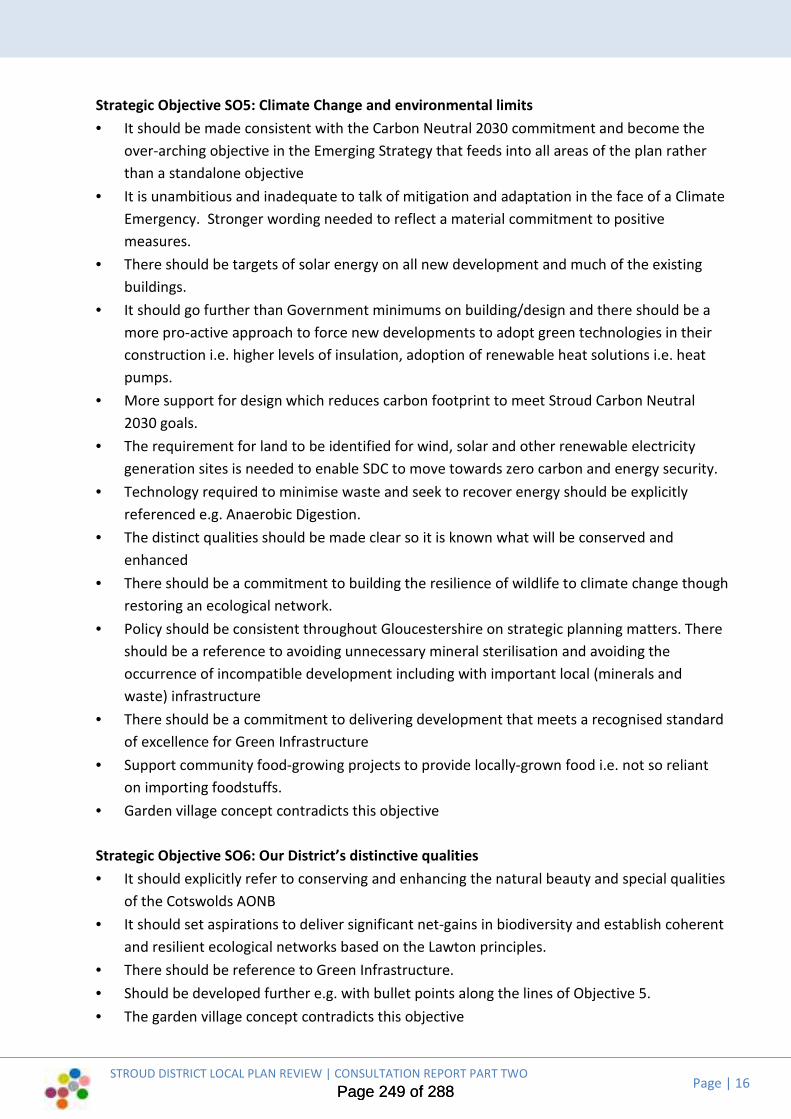
STROUD DISTRICT LOCAL PLAN REVIEW | CONSULTATION REPORT PART TWO
Page | 16
Strategic Objective SO5: Climate Change and environmental limits
• It should be made consistent with the Carbon Neutral 2030 commitment and become the
over-arching objective in the Emerging Strategy that feeds into all areas of the plan rather
than a standalone objective
• It is unambitious and inadequate to talk of mitigation and adaptation in the face of a Climate
Emergency. Stronger wording needed to reflect a material commitment to positive
measures.
• There should be targets of solar energy on all new development and much of the existing
buildings.
• It should go further than Government minimums on building/design and there should be a
more pro-active approach to force new developments to adopt green technologies in their
construction i.e. higher levels of insulation, adoption of renewable heat solutions i.e. heat
pumps.
• More support for design which reduces carbon footprint to meet Stroud Carbon Neutral
2030 goals.
• The requirement for land to be identified for wind, solar and other renewable electricity
generation sites is needed to enable SDC to move towards zero carbon and energy security.
• Technology required to minimise waste and seek to recover energy should be explicitly
referenced e.g. Anaerobic Digestion.
• The distinct qualities should be made clear so it is known what will be conserved and
enhanced
• There should be a commitment to building the resilience of wildlife to climate change though
restoring an ecological network.
• Policy should be consistent throughout Gloucestershire on strategic planning matters. There
should be a reference to avoiding unnecessary mineral sterilisation and avoiding the
occurrence of incompatible development including with important local (minerals and
waste) infrastructure
• There should be a commitment to delivering development that meets a recognised standard
of excellence for Green Infrastructure
• Support community food-growing projects to provide locally-grown food i.e. not so reliant
on importing foodstuffs.
• Garden village concept contradicts this objective
Strategic Objective SO6: Our District’s distinctive qualities
• It should explicitly refer to conserving and enhancing the natural beauty and special qualities
of the Cotswolds AONB
• It should set aspirations to deliver significant net-gains in biodiversity and establish coherent
and resilient ecological networks based on the Lawton principles.
• There should be reference to Green Infrastructure.
• Should be developed further e.g. with bullet points along the lines of Objective 5.
• The garden village concept contradicts this objective
Page 249 of 288Page 249 of 288
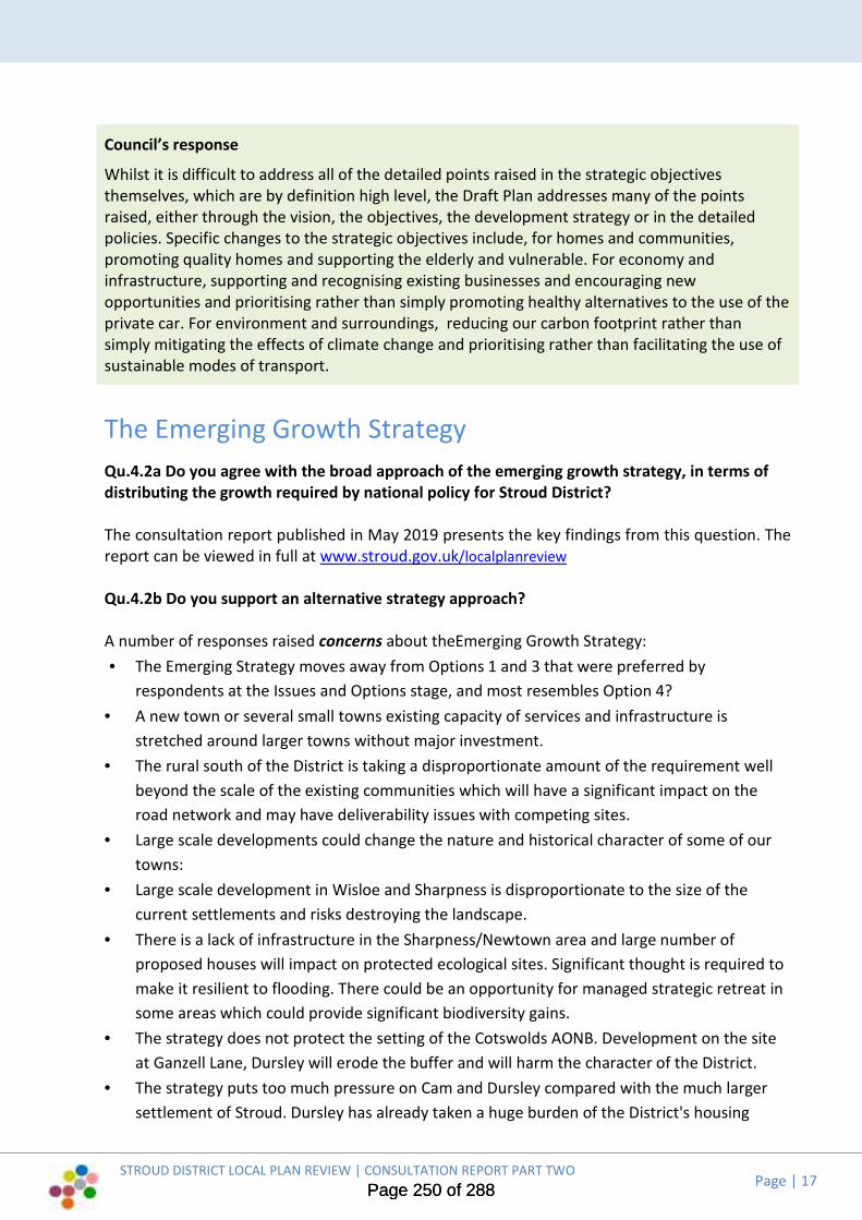
Page | 17
Council’s response
Whilst it is difficult to address all of the detailed points raised in the strategic objectives
themselves, which are by definition high level, the Draft Plan addresses many of the points
raised, either through the vision, the objectives, the development strategy or in the detailed
policies. Specific changes to the strategic objectives include, for homes and communities,
promoting quality homes and supporting the elderly and vulnerable. For economy and
infrastructure, supporting and recognising existing businesses and encouraging new
opportunities and prioritising rather than simply promoting healthy alternatives to the use of the
private car. For environment and surroundings, reducing our carbon footprint rather than
simply mitigating the effects of climate change and prioritising rather than facilitating the use of
sustainable modes of transport.
The Emerging Growth Strategy
Qu.4.2a Do you agree with the broad approach of the emerging growth strategy, in terms of
distributing the growth required by national policy for Stroud District?
The consultation report published in May 2019 presents the key findings from this question. The
report can be viewed in full at www.stroud.gov.uk/localplanreview
Qu.4.2b Do you support an alternative strategy approach?
A number of responses raised concerns about theEmerging Growth Strategy:
• The Emerging Strategy moves away from Options 1 and 3 that were preferred by
respondents at the Issues and Options stage, and most resembles Option 4?
• A new town or several small towns existing capacity of services and infrastructure is
stretched around larger towns without major investment.
• The rural south of the District is taking a disproportionate amount of the requirement well
beyond the scale of the existing communities which will have a significant impact on the
road network and may have deliverability issues with competing sites.
• Large scale developments could change the nature and historical character of some of our
towns:
• Large scale development in Wisloe and Sharpness is disproportionate to the size of the
current settlements and risks destroying the landscape.
• There is a lack of infrastructure in the Sharpness/Newtown area and large number of
proposed houses will impact on protected ecological sites. Significant thought is required to
make it resilient to flooding. There could be an opportunity for managed strategic retreat in
some areas which could provide significant biodiversity gains.
• The strategy does not protect the setting of the Cotswolds AONB. Development on the site
at Ganzell Lane, Dursley will erode the buffer and will harm the character of the District.
• The strategy puts too much pressure on Cam and Dursley compared with the much larger
settlement of Stroud. Dursley has already taken a huge burden of the District's housing
STROUD DISTRICT LOCAL PLAN REVIEW | CONSULTATION REPORT PART TWO
Page 250 of 288Page 250 of 288

STROUD DISTRICT LOCAL PLAN REVIEW | CONSULTATION REPORT PART TWO
Page | 18
numbers and there are insufficient services available in Cam and Dursley for this extra
population.
Suggestions for alternative approaches included:
• The strategy should be revised in line with the 2030 commitment to be carbon neutral
• The strategy should be more flexible taking into account available and deliverable sites.
Different settlements have differing potential to accommodate proportionate growth. Some
of the larger villages could accommodate useful and positive growth without redefining the
overall strategy.
• Prioritise brownfield/derelict land and infill and relax some planning rules to allow
incremental, organic growth.
• Options 1 and 2 appear to present the most sustainable options. Consideration should be
given to a combination of those sites to provide the bulk of housing development together
with a small measure of dispersal (Option 3) to support local needs in the lower tier
settlements.
• A more viable option is to concentrate development at already substantial settlements
• Development should be a combination of dispersed development and sensible, balanced
development at key sites next to existing employment, services and public transport
• Tier 2 settlements are capable of providing additional development than currently
proposed.
• Development should be within the M5/A38 corridor, consistent with the Strategic Economic
Plan.
• Consider village expansions along the existing A38 around the villages of Stone, Newport,
Slimbridge and Cambridge. Creating a well connected corridor using the existing road
infrastructure connecting the residents to employment sites.
• Propose development in the Severn Vale area. Substantial villages like Frampton on Severn,
which has good services including a school and employment, and proximity to higher order
centres, have the ability to accommodate moderate levels of growth.
• Building near the M5 / A38 gives access to major roads and also the train station at Cam.
• The AONB should not be considered for development, or should have as little as possible.
• The urban expansion of fringe development is encouraged by national policy and there are
further opportunities on the edge of Gloucester, with proximity to the motorway network
and good access to public transport. It would provide an opportunity for employment in the
Gloucester/Cheltenham corridor
• The plan should support smaller developments more widely spread across the District, to
retain young people and create opportunities for older people to remain and will have less
impact on the environment. It should be done on an equitable basis and in-scale with the
existing communities. Adding proportionately to the existing population on a pro-rata basis
will support local employment activities which are not based in the main towns.
• Housing growth should not include the small villages in Tier 3b that are located in the AONB
and have few facilities or transport links.
Page 251 of 288Page 251 of 288

STROUD DISTRICT LOCAL PLAN REVIEW | CONSULTATION REPORT PART TWO
Page | 19
Qu.4.2c Have we identified the right towns and villages for growth or do other settlements
have growth potential?
The consultation report published in May 2019 presents the key findings from this question. The
report can be viewed in full at www.stroud.gov.uk/localplanreview
Qu.4.2d Do you support our approach to addressing Gloucester’s housing needs?
The consultation report published in May 2019 presents the key findings from this question. The
report can be viewed in full at www.stroud.gov.uk/localplanreview
Qu.4.2e Do you support an alternative approach to addressing Gloucester’s housing needs?
A number of responses questioned the need for Stroud to assist in meeting Gloucester’s unmet
need. Concerns included:
• Letting Gloucester deal with their own needs.
• Stroud should not be included when Tewkesbury and Cheltenham are already helping
Gloucester meet its 5 Year Housing Land Supply
• Gloucester should not use Stroud as an additional pool of land when Stroud its own
requirement. Stroud needs its land to cater for its own expansion.
• Stroud seems to be going beyond its minimum regulated responsibilities to offer its open
spaces to Gloucester.
• Hardwicke and Whaddon sites should not have been identified before the requirement has
been confirmed
Suggestions for alternative approaches included:
• The Government re-allocating the need to more suitable places If Gloucester can’t meet its
own needs
• Other neighbouring authorities should also help i.e. Malvern Hills, Forest of Dean, Cotswold
and Wychavon
• There should be a whole county approach to strategic planning.
• Land at Hardwicke and Whaddon should be used to meet our unmet housing need in Stroud
District
• Gloucester should firstly utilise the safeguarded land and then examine SALA sites within
their own area.
• Gloucester should find the solution by building more densely and upwards rather than
sprawling outwards over neighbouring areas.
• Redevelop central Gloucester shopping areas, building more houses in and around the city
where there is currently shops and employment.
• Gloucester could expand north towards Highnam.
• Utilise derelict and brownfield land, old empty buildings and empty houses.
Page 252 of 288Page 252 of 288
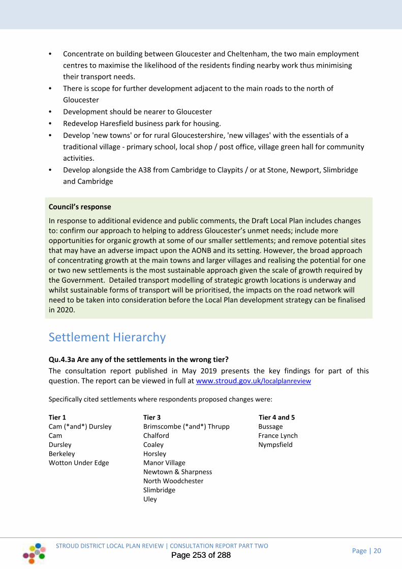
Page | 20
• Concentrate on building between Gloucester and Cheltenham, the two main employment
centres to maximise the likelihood of the residents finding nearby work thus minimising
their transport needs.
• There is scope for further development adjacent to the main roads to the north of
Gloucester
• Development should be nearer to Gloucester
• Redevelop Haresfield business park for housing.
• Develop 'new towns' or for rural Gloucestershire, 'new villages' with the essentials of a
traditional village - primary school, local shop / post office, village green hall for community
activities.
• Develop alongside the A38 from Cambridge to Claypits / or at Stone, Newport, Slimbridge
and Cambridge
Council’s response
In response to additional evidence and public comments, the Draft Local Plan includes changes
to: confirm our approach to helping to address Gloucester’s unmet needs; include more
opportunities for organic growth at some of our smaller settlements; and remove potential sites
that may have an adverse impact upon the AONB and its setting. However, the broad approach
of concentrating growth at the main towns and larger villages and realising the potential for one
or two new settlements is the most sustainable approach given the scale of growth required by
the Government. Detailed transport modelling of strategic growth locations is underway and
whilst sustainable forms of transport will be prioritised, the impacts on the road network will
need to be taken into consideration before the Local Plan development strategy can be finalised
in 2020.
Settlement Hierarchy
Qu.4.3a Are any of the settlements in the wrong tier?
The consultation report published in May 2019 presents the key findings for part of this
question. The report can be viewed in full at www.stroud.gov.uk/localplanreview
Specifically cited settlements where respondents proposed changes were:
Tier 1 Tier 3 Tier 4 and 5
Cam (*and*) Dursley Brimscombe (*and*) Thrupp Bussage
Cam Chalford France Lynch
Dursley Coaley Nympsfield
Berkeley Horsley
Wotton Under Edge Manor Village
Newtown & Sharpness
North Woodchester
Slimbridge
Uley
STROUD DISTRICT LOCAL PLAN REVIEW | CONSULTATION REPORT PART TWO
Page 253 of 288Page 253 of 288

STROUD DISTRICT LOCAL PLAN REVIEW | CONSULTATION REPORT PART TWO
Page | 21
Qu.4.3b Do you support the proposed approach to managing development at small Tier 4 and
5 settlements by including them within the hierarchy and defining Settlement Development
Limits?
The consultation report published in May 2019 presents the key findings from this question. The
report can be viewed in full at www.stroud.gov.uk/localplanreview
or do you support an alternative approach of simply treating them as ‘open countryside’?
Six responses supported treating them as ‘open countryside’; and suggested alternative
approaches for managing development in tiers 4 and 5 included:
• Provide greater flexibility by considering each proposal on a case by case basis, which would
enable some sustainable development of the lower tier
• Treat all applications on their own merits not just where they are located.
• Each settlement in tiers 4 and 5 should be consulted on whether they could accommodate
new housing for their local needs and if there is land available.
• Any development must be in line with a neighbourhood plan or with the support of the
community via consultation
• Each settlement should be treated autonomously to maintain rich diverse and distinct
identity.
Q.4.3c Do you support the idea that the Local Plan should seek to manage the cumulative
impacts of growth on individual settlements?
The consultation report published in May 2019 presents the key findings from this question. The
report can be viewed in full at www.stroud.gov.uk/localplanreview
How should we develop a policy framework to achieve this?
Suggested for a Policy Framework to manage the cumulative impact on growth of individual
settlements included:
• New development should be proportionate to the size of existing settlements
• Cap 10% growth of the lower tiers over each 5 year period.
• Build new houses in proportion to the existing settlements
• Develop ratios which relate new housing to existing housing and the thresholds for school
and GP provision
• Strict definition of sites that are suitable for development – and those that are not; very
clear settlement boundaries; and strict policies to limit infill development, especially in large
gardens and open spaces within the settlement.
• The policy framework should encourage settlements to participate in the evaluation of their
own settlement to provide a baseline against which future development will be considered.
Criteria can then be derived to evaluate the level of impact growth has on a settlement.
Page 254 of 288Page 254 of 288
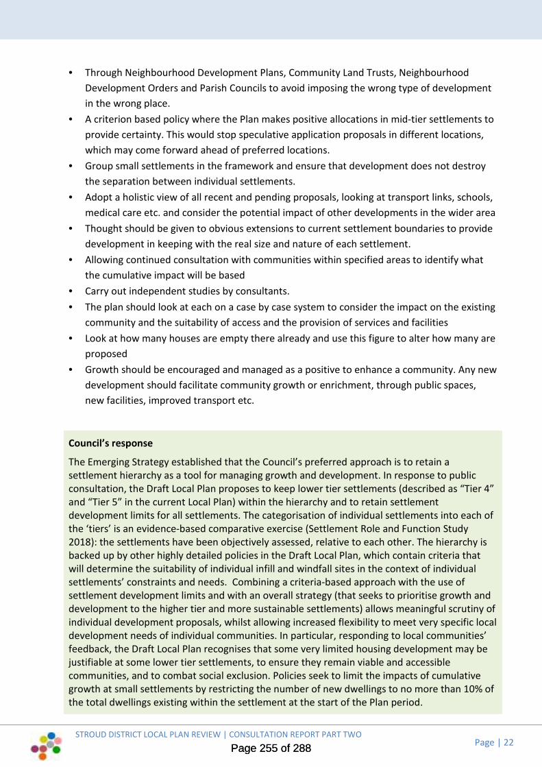
STROUD DISTRICT LOCAL PLAN REVIEW | CONSULTATION REPORT PART TWO
Page | 22
• Through Neighbourhood Development Plans, Community Land Trusts, Neighbourhood
Development Orders and Parish Councils to avoid imposing the wrong type of development
in the wrong place.
• A criterion based policy where the Plan makes positive allocations in mid-tier settlements to
provide certainty. This would stop speculative application proposals in different locations,
which may come forward ahead of preferred locations.
• Group small settlements in the framework and ensure that development does not destroy
the separation between individual settlements.
• Adopt a holistic view of all recent and pending proposals, looking at transport links, schools,
medical care etc. and consider the potential impact of other developments in the wider area
• Thought should be given to obvious extensions to current settlement boundaries to provide
development in keeping with the real size and nature of each settlement.
• Allowing continued consultation with communities within specified areas to identify what
the cumulative impact will be based
• Carry out independent studies by consultants.
• The plan should look at each on a case by case system to consider the impact on the existing
community and the suitability of access and the provision of services and facilities
• Look at how many houses are empty there already and use this figure to alter how many are
proposed
• Growth should be encouraged and managed as a positive to enhance a community. Any new
development should facilitate community growth or enrichment, through public spaces,
new facilities, improved transport etc.
Council’s response
The Emerging Strategy established that the Council’s preferred approach is to retain a
settlement hierarchy as a tool for managing growth and development. In response to public
consultation, the Draft Local Plan proposes to keep lower tier settlements (described as “Tier 4”
and “Tier 5” in the current Local Plan) within the hierarchy and to retain settlement
development limits for all settlements. The categorisation of individual settlements into each of
the ‘tiers’ is an evidence-based comparative exercise (Settlement Role and Function Study
2018): the settlements have been objectively assessed, relative to each other. The hierarchy is
backed up by other highly detailed policies in the Draft Local Plan, which contain criteria that
will determine the suitability of individual infill and windfall sites in the context of individual
settlements’ constraints and needs. Combining a criteria-based approach with the use of
settlement development limits and with an overall strategy (that seeks to prioritise growth and
development to the higher tier and more sustainable settlements) allows meaningful scrutiny of
individual development proposals, whilst allowing increased flexibility to meet very specific local
development needs of individual communities. In particular, responding to local communities’
feedback, the Draft Local Plan recognises that some very limited housing development may be
justifiable at some lower tier settlements, to ensure they remain viable and accessible
communities, and to combat social exclusion. Policies seek to limit the impacts of cumulative
growth at small settlements by restricting the number of new dwellings to no more than 10% of
the total dwellings existing within the settlement at the start of the Plan period.
Page 255 of 288Page 255 of 288

STROUD DISTRICT LOCAL PLAN REVIEW | CONSULTATION REPORT PART TWO
Page | 23
Settlement boundaries
Qu.4.4a Do you support the emerging strategy’s approach towards maintaining settlement
development limits?
The consultation report published in May 2019 presents the key findings from this question. The
report can be viewed in full at www.stroud.gov.uk/localplanreview Comments were received
through the Emerging Strategy consultation process that detailed support and concerns towards
maintaining settlement development limits. These included:
Support
• Settlement boundaries are essential to contain development
• Should be maintained in order to preserve the remaining ecological, environmental and
landscape of those settlements which have reached or exceeded their natural growth space
• Any currently in place limits for development should remain in place, subject to constant
review, and proportionality principles being applied
• Settlement boundaries are critical to providing opportunities for community led housing
through the development of Rural Exception Sites
Oppose
• The policy is too restrictive and broad. Some sites outside are inherently more suitable to
sites inside
• Proposed settlement development limits are too large
• Greater flexibility is required in order for settlements to be able to advance in a sustainable
way.
• A case-by-case basis, while taking longer to implement, would ultimately be more beneficial
in the long run
• There should be some flexibility In larger tier settlements
Qu.4.4b Do you support an alternative approach?
Suggestions for alternative approaches included:
• Only allow select exemptions to local people to fulfil a local need
• Settlement development limits can be arbitrary and unduly restrictive. They should be seen
as guidelines only.
• Brownfield sites outside settlement development limits could be dealt with on a case-by-
case basis but development should remain within settlement boundaries if possible
• Settlement boundaries should be used as a guide only or, alternatively, be drawn more
loosely to embrace land for future growth
• Allow extensions to settlement boundaries which are in keeping with the existing size and
nature of the settlements
• A landscape based approach should be considered in sustainable settlements
Page 256 of 288Page 256 of 288

STROUD DISTRICT LOCAL PLAN REVIEW | CONSULTATION REPORT PART TWO
Page | 24
• There should be support for development outside the settlement development limits of tiers
1-3, if the design is outstanding and fulfils enhanced environmental and design criteria.
• There should be adequate consultation with the relevant communities.
Q.4.4c Do you support the proposals to allow some limited development beyond Settlement
Development Limits?
The consultation report published in May 2019 presents the key findings from this question. The
report can be viewed in full at www.stroud.gov.uk/localplanreview Comments were received
through the Emerging Strategy consultation process that detailed support and concerns towards
allowing limited development beyond settlement development limits. These included:
Support
• A key criteria should assess the appropriateness of development in terms of scale and
availability of services
• Only where there is no direct or indirect impact on designated biodiversity sites or
nationally/internationally threatened wildlife, and where the development delivers a net
gain for biodiversity and the ecological network
• This seems the most sympathetic to the needs of the communities
• Only if strictly controlled and for local people who are self-building
• Support for a more flexible approach in tires 1-3 with stricter controls for tier 4-5
• Developments should be at least 50 percent affordable
• It should be limited to small developments associated with existing development
• Only allow exemptions for high-quality self-built eco-homes, or small scale affordable eco-
homes, if put forward by Neighbourhood Development Plans at all Tiers.
Oppose
• All development should be kept within the boundary limits by using all brownfield sites
• It will set a precedent
• Once countryside is removed it is gone forever.
• The wording 'limited development' is too weak and needs to be carefully defined.
General comment
• Once settlement development limits are extended development will start creeping
• Development should only be considered where it is needed and supported by a
Neighbourhood Development Plan or Village Design Statement.
Qu.4.4 d or do you have an alternative approach?
Suggestions for alternative approaches included:
• A well connected village corridor along the A38 in the villages of Stone, Newport, Slimbridge
and Cambridge.
Page 257 of 288Page 257 of 288

STROUD DISTRICT LOCAL PLAN REVIEW | CONSULTATION REPORT PART TWO
Page | 25
• Only allow development outside settlement boundaries if locally supported in tier 4 and tier
5 settlements
• Development should only be considered where needed and supported by a Neighbourhood
Development Plan or Village Design Statement
• Sites outside the settlement boundary should only be considered with local Parish and Town
Council support and should be made to go above and beyond the normal design,
environmental and energy standards
• A much more organic approach to infill and small scale developments based on demand to
move to an area or for existing communities to grow and house future generations
Qu.4.4e Do you support the specific changes to existing Settlement Development Limits that
are set out in Appendix A?
The consultation report published in May 2019 presents the key findings from part of this
question. The report can be viewed in full at www.stroud.gov.uk/localplanreview Comments
were received through the Emerging Strategy consultation process that raised concern with the
following changes proposed:
SDL-DUR01 at Shearing Close, Littlecombe
• Express concern about the visual impact of the Littlecombe development on the area.
SDL-HOR01 Sealey Wood Lane
• The development is out of scale with the existing settlement and should not expand further.
SDL-LEO01 Lyndon Morgan Way
• The settlement boundary should only include the Saxon Gate development and not the
whole of Mankley Field
• The undeveloped area of Mankley Field should remain outside Leonard Stanley Settlement
Development Limits.
SDL-MIS01 Miserden
• The proposed settlement development limit includes largish areas of green fields.
• The area identified seems disproportionate to the size of the settlement.
• It has been drawn too tightly around the southern edge of the settlement and should
include the Estate nursery (horticultural), gardens, and garden cafe, biomass boiler house,
and associated grounds.
SDL-STN01 Vale Orchard
• The area identified is reserved as a green space, SUDs pond and wildlife mitigation area as
part of an adjoining development and should not be included within the settlement
development limit.
SDL-STO01 Brunel Way/ Oldends Lane
• The area identified seems disproportionate to the size of the settlement.
Page 258 of 288Page 258 of 288

STROUD DISTRICT LOCAL PLAN REVIEW | CONSULTATION REPORT PART TWO
Page | 26
Qu.4.4f Do you support any other changes to Settlement Development Limits, not listed in
Appendix A?
The following additional changes to settlement development limits were suggested (changes
listed alphabetically by settlement):
• All settlement development limits should be reviewed to allow for proportional growth.
• There should be a wider review of Berkeley Settlement Development Limit to reflect extant
planning permissions and the implications of proposed allocations.
• Include Mugswell Nursery, Hayhedge Lane within Bisley Settlement Development Limit
• Amend Cam Settlement Development Limit at Woodend Lane, Cam.
• Include a modest area for future growth north of the doctors’ surgery on Whitminster Lane
within Frampton on Severn Settlement Development Limit.
• Include Emerging Strategy Paper site G1 South of Hardwicke within Hardwicke Settlement
Development Limit.
• Include SALA site HAR005 Land East of Waterwells Business Park within settlement
development limits.
• Consider a settlement development limit at Harescombe.
• Include the domestic garden of Manor Farm Horsley within Horsley Settlement
Development Limit.
• Include the full residential curtilage of Barley Cottage, Boscombe Lane, Horsley within
Horsley Settlement Development Limit.
• Include the small enclave in Tetbury Street based upon the Woefuldane yard and adjacent
house, next to the recently completed development by Partridge Homes, within
Minchinhampton Settlement Development Limit.
• Include Miserden nursery, gardens, cafe and associated grounds within an alternative
settlement development limit boundary at Miserden.
• Include SALA site NAI007 Land adjacent to Lower Newmarket Road within Nailsworth
Settlement Development Limit.
• Include Emerging Strategy Paper site PS08 North of Avening Road, Spring Mill Industrial
Estate, the King George V Playing Fields and SALA site NAI0003 Land at Avening Road within
Nailsworth Settlement Development Limit.
• Include SALA site PAI007 Land at Stamages within Painswick Settlement Development Limit.
• Include Emerging Strategy Paper site PS17 Magpies site and car park, Oldends Lane within
Stonehouse Settlement Development Limit.
• Include SALA site STO012 Land north of The Glen, Woodcock Lane within Stonehouse
Settlement Development Limit.
• Include planning permission site S.18/0982/FUL west of railway line at Oldends Lane within
Stonehouse Settlement Development Limit.
• Include West of Stonehouse Local Plan allocation within Stonehouse Settlement
Development Limit.
Page 259 of 288Page 259 of 288

Page | 27
• Include SALA site STR056 Land west of Devereaux Crescent within Stroud Settlement
Development Limit.
• Include the existing commercial and residential uses on the south side of the A419 within
Thrupp Settlement Development Limit.
Council’s response
The Draft Plan as a whole does seek to provide more opportunities and flexibility for
development proposals that do not conflict with or prejudice the Plan Strategy and broad
sustainability and environmental protection considerations. The Council has undertaken a review
of individual settlement development limits and the recommendations form part of the Draft
Plan proposed changes.
The Draft Plan will enable opportunities for strategic planned growth at our larger towns as well
as some organic growth at our smaller settlements. This revised approach responds to
consultation responses for more flexibility but recognises that settlement development limits are
a well established planning tool with broad support and environmental and sustainability
benefits.
The Draft Plan seeks to address some of the specific concerns expressed in the last consultation
regarding flexibility and development opportunity. Settlement development limits will continue
to be weighed with other policies and material considerations on a case by case basis. The
Council will also recognise identified and agreed local community social, economic and/or
environmental needs and priorities. In all cases, such development opportunities will be
controlled and will need to be compliant with the broad Draft Plan Strategy approach and the
policies that accompany it.
Mini visions and priorities
Qu.5.0a Do you support the proposed mini-visions for your area(s)?
The consultation report published in May 2019 presents the key findings from this question. The
report can be viewed in full at www.stroud.gov.uk/localplanreview
Qu.5.0b Would you like to propose alternative wording for any of the mini-visions?
Suggestions for inclusion in the mini-vision for the future of the Stroud Valleys:
• Highlighting the Cotswolds AONB as a place where the distinctive beauty of the landscape
and built heritage is conserved, enhanced and enjoyed by both visitors and all those who
live and work there.
• Highlighting the special qualities of the wildlife-rich unimproved limestone grasslands and
ancient woodlands as an integral part of the character of the Stroud Valleys.
• Highlighting the creative potential of craftspeople in Stroud to design and build ecologically
sensitive housing
STROUD DISTRICT LOCAL PLAN REVIEW | CONSULTATION REPORT PART TWO
Page 260 of 288Page 260 of 288
STROUD DISTRICT LOCAL PLAN REVIEW | CONSULTATION REPORT PART TWO
Page | 28
Suggestions for inclusion in the mini-vision for the future of the Stonehouse Cluster:
• Highlighting the Cotswolds AONB as a place where the distinctive beauty of the landscape
and built heritage is conserved, enhanced and enjoyed by both visitors and all those who
live and work there.
• Highlighting the potential of the Cotswold Way through Kings Stanley and close to
Stonehouse.
• Supporting the contribution of established local businesses across the wider cluster area.
• Maintaining the distinct identity and strong sense of community of villages and hamlets at
Eastington.
Suggestions for inclusion in the mini-vision for the future of the Cam and Dursley Cluster
• Highlighting the Cotswolds AONB as a place where the distinctive beauty of the landscape
and built heritage is conserved, enhanced and enjoyed by both visitors and all those who
live and work there.
• Highlighting the valued landscape setting and wildlife rich environment of Dursley
surrounded by the Cotswolds AONB and ancient beech woodlands.
• Acknowledging Cam and Dursley as distinct settlements.
• Raising the tourism profile of the cluster and as a destination for walkers.
Suggestions for inclusion in the mini-vision for the future of the Berkeley Cluster
• Protection for the rural lifestyle, culture and ecology of the countryside and Severn Estuary
around the historic town of Berkeley
• Maintaining the natural beauty of the countryside to develop tourist and visitor potential.
• Maintaining the distinct identity and strong sense of community of villages and hamlets
surrounding Sharpness at Newtown, Halmore, Wanswell, Brookend, Pitbrook and Abwell,
and at Slimbridge; Gossington, Moorend and Breadstone.
• Highlighting the potential of the A38 as a sustainable public transport corridor connecting
Stone, Newport, Slimbridge and Cambridge.
Suggestions for inclusion in the mini-vision for the future of the Wotton Cluster
• Highlighting the Cotswolds AONB as a place where the distinctive beauty of the landscape
and built heritage is conserved, enhanced and enjoyed by both visitors and all those who
live and work there.
• Boosting housing supply and delivering new homes, including affordable homes, in response
to local need.
• Amend range of shops and services to remove reference to agricultural market and include
heritage centre, arts centre and Wotton Community Sports Foundation facilities at KLB
Suggestions for inclusion in the mini-vision for the future of the Cotswold cluster
• Highlighting the role of rural businesses in providing local employment opportunities.
Page 261 of 288Page 261 of 288

Page | 29
Qu.5.0c Do you support the identified key issues and priorities for action for your area(s)?
The consultation report published in May 2019 presents the key findings from this question. The
report can be viewed in full at www.stroud.gov.uk/localplanreview
Qu.5.0d Are there other important issues and priorities you would like to highlight
A number of other important issues and priorities for the eight clusters were raised through the
consultation responses. They included:
Stroud Valleys:
• Conserving and enhancing the natural beauty of the Cotswolds AONB
• Encouraging solar panels and electric vehicle charging points in new development
• Requiring passivehaus standard for all new houses
• Protection for the Commons as areas of special scientific interest.
• Improving the vitality of town centres
• Improved public open space provision and accessibility
• Include housing as an objective
Stonehouse Cluster:
• Conserving and enhancing the natural beauty of the Cotswolds AONB and its setting
• Improving pedestrian and cycling connections to Stonehouse High Street
Cam and Dursley:
• Conserving and enhancing the natural beauty of the Cotswolds AONB
• Increasing health and community facilities in Cam
• Easing traffic congestion in Dursley and making the pavements safer.
• Protecting the historic character of Cam and Dursley
• Maximising active travel links to sustainable transport infrastructure serving Cam and
Dursley station. Include a safe cycle route from Cam & Dursley to the canal and Wildfowl
and Wetlands Trust, linking to the station.
• Providing for children and young people
• Include housing as an objective
Gloucester Fringe:
• Conserving and enhancing the natural beauty of the Cotswolds AONB
• Delivering a new train station and sustainable transport hub at Hunts Grove with public
transport, pedestrian and cycle links.
• Addressing traffic congestion A38 Cole Avenue to St Barnabas corridor
• Connecting employment allocation sites to footway and cycle infrastructure
• Ensuring walking routes are clearly defined, attractive and suitable for all users.
STROUD DISTRICT LOCAL PLAN REVIEW | CONSULTATION REPORT PART TWO
Page 262 of 288Page 262 of 288

Page | 30
• Identify Javelin Park EfW as a stimulus for complementary innovative business and
combined heat and power opportunities
Berkeley Cluster:
• Protecting the natural landscape and wildlife habitats
• Protecting the foreshore Severnway from Sharpness to Berkeley Pill
• Completing the Berkeley Link Road to the A38
• Safe walking and cycling routes to the Wildfowl and Wetlands Trust at Slimbridge linked to
Cam and Dursley station
• Safe walking and cycling routes from Newport to Berkeley extended to Sharpness and the
Gloucestershire Science and Technology Park
• Provision of a well signposted, direct walking/ cycle link from Wisloe to Cam and Dursley
station linked to a wider network of clearly defined, attractive pedestrian and cycling routes.
• Identifying Sharpness and Newtown as a potential exemplar eco-town
• Restoration of the heritage railway
Wotton Cluster:
• Conserving and enhancing the natural beauty of the Cotswolds AONB
• Provision of additional off-street car parking and coach parking
• Reducing traffic congestion in Wotton under Edge and improving traffic flow through town
• Improving public transport linked to a re-opened Charfield station
• Delivering a safe, traffic-free Greenway to connect Wotton under Edge, Kingswood and
Charfield including links to Renishaw New Mills, KLB School and Wotton Community Sports
Foundation facilities
• Promoting Wotton under Edge as a tourist destination
Cotswold Cluster
• Conserving and enhancing the natural beauty of the Cotswolds AONB
• Improvements to IT connectivity and infrastructure to support home working
• Protection of the historic environment, specifically including archaeology and key open
spaces within historic settlements
• Ensuring adequate provision of smaller properties to allow for starter homes and
opportunities for downsizing for local people
Wildlife protection and enhancement was identified as relevant to all of the Parish clusters.
Council’s response
The breadth and depth of comments on the local mini-visions and priorities is particularly
welcomed and will be reflected in the final Local Plan in 2020, when the Cluster sections will be
expanded. At this stage, the Draft Plan now reflects in the mini-visions communities’
prioritisation of the Cotswolds AONB and includes additional key local features and
characteristics identified as contributing to the distinctiveness of parish cluster areas. The
STROUD DISTRICT LOCAL PLAN REVIEW | CONSULTATION REPORT PART TWO
Page 263 of 288Page 263 of 288

STROUD DISTRICT LOCAL PLAN REVIEW | CONSULTATION REPORT PART TWO
Page | 31
identified key issues and priorities reflect the top key concern for the protection of finite natural
landscape, environmental and historic resources and the need to embrace green technologies
and provide sustainable transport infrastructure and choices alongside specific community
housing and employment priorities.
3. Potential sites and alternatives
The Emerging Strategy document identified potential sites for development and the Council
asked people whether the highlighted sites were the most sustainable for growth or whether
other alternatives were suitable. This section looks at the physical constraints, potential impacts
and opportunities identified in consultation responses for each of the potential sites. A Council
response is also given for each site.
The Stroud Valleys - Brimscombe & Thrupp
PS01 Brimscombe Mill
Physical constraints (flood risk, topography, contamination, access)
• Increased pressure on local infrastructure from increase in local population
Potential impacts (heritage, landscape, transport)
• Impact on wildlife using the canal corridor, particularly bats
Opportunities
• Brownfield site redevelopment
• Canal redevelopment and access
Council’s response
The site, allocated in the adopted Local Plan, provides opportunities to regenerate brownfield
land, facilitate the restoration of the canal and deliver housing in a relatively sustainable
location. However, it is recognised that any redevelopment will need to reflect environmental
constraints including any impact on wildlife using the canal corridor. Detailed policy wording will
be developed taking into account local views for the final Local Plan in 2020.
PS02 Brimscombe Port
Physical constraints (flood risk, topography, contamination, access)
• Increased pressure on local infrastructure from increase in local population
Potential impacts (heritage, landscape, transport)
• Impact on wildlife using the canal corridor, particularly bats
Page 264 of 288Page 264 of 288
STROUD DISTRICT LOCAL PLAN REVIEW | CONSULTATION REPORT PART TWO
Page | 32
Opportunities
• Brownfield site redevelopment
• Canal redevelopment and access
Council’s response
The site, allocated in the adopted Local Plan, provides opportunities to regenerate brownfield
land, facilitate the restoration of the canal and deliver housing in a relatively sustainable
location. However, it is recognised that any redevelopment will need to reflect environmental
constraints including any impact on wildlife using the canal corridor. Detailed policy wording will
be developed taking into account local views for the final Local Plan in 2020.
PS03 Land at Hope Mill
Physical constraints (flood risk, topography, contamination, access)
• Increased pressure on local infrastructure from increase in local population
Potential impacts (heritage, landscape, transport)
• Impact on wildlife using the canal corridor, particularly bats
Opportunities
• Brownfield site redevelopment
• Canal redevelopment and access
Council’s response
Whilst the initial site assessment work identified this site as having development potential, the
site is not being actively promoted and has significant contaminated land challenges.
Consequently, at this stage, it cannot be demonstrated that the site is deliverable and, pending
further information, the site has therefore been removed from the list of allocated sites.
The Stroud Valleys - Minchinhampton
PS04 South of Cirencester Road
Physical constraints (flood risk, topography, contamination, access)
• Access route through the commons is unsuitable for additional traffic
Potential impacts (heritage, landscape, transport)
• Amenity use impact on nearby designated sites such as Rodborough Common
• Impact on Cotswolds AONB and its setting
• Increased traffic generation and impact on the commons
• Loss of greenfield site
Opportunities
• Opportunity for enhanced bus timetabling to connect Minchinhampton to Stroud and
Cirencester
Page 265 of 288Page 265 of 288

Page | 33
Council’s response
Comments received and further assessment work has identified landscape and visual concerns
regarding self build and custom build development at this location within the AONB directly
adjacent to, and highly visible from, a well used road and entrance to Minchinhampton. At this
stage, pending further review, it is considered that there are better locations within the
settlement to accommodate development and better ways of addressing identified local needs.
PS05 East of Tobacconist Road
Physical constraints (flood risk, topography, contamination, access)
• Access route through the commons is unsuitable for additional traffic
• Access route between 2 residential properties could reveal ownership/access issues
Potential impacts (heritage, landscape, transport)
• Amenity use impact on nearby designated sites such as Rodborough Common
• Impact on Cotswolds AONB and its setting
• Increased traffic generation and impact on the commons
• Loss of greenfield site
• Adjacent to an Ancient Monument
Opportunities
• Opportunity for enhanced bus timetabling to connect Minchinhampton to Stroud and
Cirencester
Council’s response
The site is considered one of the best opportunities at Minchinhampton to meet identified local
needs whilst minimising landscape impact. The scale of potential development has been reduced
to reflect concerns regarding major development within the AONB. The need for strategic
landscaping, to address proximity to an ancient monument and to minimise traffic impact is
recognised and detailed policy wording will be developed taking into account local views for the
final Local Plan in 2020.
The Stroud Valleys - Nailsworth
PS06 New Lawn, Nailsworth
Physical constraints (flood risk, topography, contamination, access)
• No comments received
Potential impacts (heritage, landscape, transport)
• Loss of community facility and open space
• Increased traffic
STROUD DISTRICT LOCAL PLAN REVIEW | CONSULTATION REPORT PART TWO
Page 266 of 288Page 266 of 288

STROUD DISTRICT LOCAL PLAN REVIEW | CONSULTATION REPORT PART TWO
Page | 34
Opportunities
• Improvements to local infrastructure and links from Forest Green to Nailsworth
• Delivery of improved green infrastructure
Council’s response
Subject to the satisfactory relocation of Forest Green football club, the site is considered suitable
for redevelopment to meet the needs of Nailsworth. The need for community and open space is
recognised and referred to in the Draft Local Plan and detailed policy wording will be developed
taking into account local views for the final Local Plan in 2020.
PS07 North of Nympsfield Road/Nortwood Junction
Physical constraints (flood risk, topography, contamination, access)
• No comments received
Potential impacts (heritage, landscape, transport)
• Cumulative impact of this and development of New Lawn site
• Setting of Cotswolds AONB
Opportunities
• Combined with PS06 to deliver coordinated enhancement of Forest Green
• Provision of green infrastructure and public open space
Council’s response
Together with the adjoining New Lawn site, the site offers the potential to meet identified local
needs whilst minimising landscape impact. Additional landscape assessment work has identified
ways of mitigating any adverse landscape impacts and detailed policy wording will be developed
taking into account local views for the final Local Plan in 2020.
PS08 North of Avening Road
Physical constraints (flood risk, topography, contamination, access)
• No comments received
Potential impacts (heritage, landscape, transport)
• No comments received
Opportunities
• Remain as an employment site/garden centre
Council’s response
The site was originally promoted as having potential for redevelopment for employment uses.
However, the site has now been bought and subject to new investment and continues to operate
as a Garden Centre. This is considered to be an effective use of this site and there is no evidence
Page 267 of 288Page 267 of 288
Page | 35
of deliverability for wider employment uses. On this basis, the site has been removed as a
potential site for redevelopment for employment uses.
The Stroud Valleys – North Woodchester
PS09 Rooksmoor Mill
Physical constraints (flood risk, topography, contamination, access)
• No comments received
Potential impacts (heritage, landscape, transport)
• Impact upon Nailsworth Brook Local Wildlife Site
Opportunities
• Improve an untidy brownfield site
Council’s response
The site has received planning permission and is now under construction for housing and
employment uses. The site will support the role of North Woodchester within the development
strategy for the Plan period.
The Stroud Valleys - Stroud
PS10 Railway land/ car parks, Cheapside
Physical constraints (flood risk, topography, contamination, access)
• No comments received
Potential impacts (heritage, landscape, transport)
• Loss of town centre parking
• Impact on neighbouring heritage assets (station, goods shed, Hill paul)
Opportunities
• Brownfield development
• Canalside improvements
• Cycling and walking improvements linking to the station
Council’s response
The opportunities for making beneficial use of brownfield land and for improving linkages
between the canal corridor and the town centre are recognised. However, it will be important to
ensure that any development does not undermine the current use of the site for town centre
uses. Further work is required to ensure that the site is deliverable. Detailed policy wording will
be developed taking into account local views for the final Local Plan in 2020.
STROUD DISTRICT LOCAL PLAN REVIEW | CONSULTATION REPORT PART TWO
Page 268 of 288Page 268 of 288
STROUD DISTRICT LOCAL PLAN REVIEW | CONSULTATION REPORT PART TWO
Page | 36
PS11 Merrywalks Arches, Merrywalks
Physical constraints (flood risk, topography, contamination, access)
• Within Flood Zone 3
Potential impacts (heritage, landscape, transport)
• No comments received
Opportunities
• Brownfield development
Council’s response
The opportunities for making beneficial use of brownfield land for housing and environmental
improvement are recognised. Any flood risk issues will need to be taken into account and further
work is required to ensure that the site is deliverable. Detailed policy wording will be developed
taking into account local views for the final Local Plan in 2020.
PS12 Police Station/Magistrates Court, Parliament Street
Physical constraints (flood risk, topography, contamination, access)
• No comments received
Potential impacts (heritage, landscape, transport)
• Loss of town centre parking
Opportunities
• Brownfield development
Council’s response
Proposals for redevelopment of this brownfield site for housing and open space uses are under
active consideration. However, impacts upon the town centre, both in terms of uses and in
terms of heritage sensitivities, will need to be taken into account. Detailed policy wording will be
developed taking into account local views for the final Local Plan in 2020.
PS13 Central river/ canal corridor
Physical constraints (flood risk, topography, contamination, access)
• Located in Flood Zone 3
Potential impacts (heritage, landscape, transport)
• Impact on Key Wildlife Site and green meadow areas
• Impact on conservation area
• Loss of outdoor play space
Page 269 of 288Page 269 of 288

STROUD DISTRICT LOCAL PLAN REVIEW | CONSULTATION REPORT PART TWO
Page | 37
Opportunities
• Opportunity for enhancement of the canal
• Brownfield development
• Good town centre access and close to strategic transport infrastructure
• Opportunities for sustainable transport, cycling and walking
Council’s response
It is recognised that there are multiple constraints relating to the river and canal corridor within
Stroud. However, there are also significant opportunities in terms of making more active and
efficient use of land, regenerating historic assets and delivering housing and open spaces in a
sustainable location. There is active support among some landowners for regeneration but
further work is required on land assembly and constraints to ensure that opportunities are
deliverable. Detailed policy wording will be developed taking into account local views for the
final Local Plan in 2020.
The Stonehouse Cluster – Kings Stanley
PS14 Stanley Mills
Physical constraints (flood risk, topography, contamination, access)
• No comments received
Potential impacts (heritage, landscape, transport)
• No comments received
Opportunities
• No comments received
Council’s response
The site has received planning permission and is now under construction for housing and
employment uses. Challenges remain and further work is required to ensure that the site can be
delivered in full. Subject to this, the site will support the role of Kings Stanley within the
development strategy for the Plan period.
PS15 North of Kings Stanley Primary School
Physical constraints (flood risk, topography, contamination, access)
• No comments received
Potential impacts (heritage, landscape, transport)
• Local wildlife sites and River Frome catchment
• Increased pressure on school capacity
• Additional traffic on unsafe roads for walkers, cyclists and horse riders
• Increased traffic in proximity to primary school
Page 270 of 288Page 270 of 288

Page | 38
• Physical impact on the feel of the primary school
Opportunities
• Existing sustainable transport links to Stonehouse and Stroud
Council’s response
Whilst initial assessment identified this site as having potential for a small residential
development, it is recognised that the site has poor access and could result in conflict with the
adjacent primary school. Unless these matters can be resolved, it is considered that the role of
Kings Stanley within the development strategy is better addressed through the committed
scheme at Stanley Mills, subject to its delivery being confirmed.
The Stonehouse Cluster – Leonard Stanley
PS16 South of Leonard Stanley Primary School
Physical constraints (flood risk, topography, contamination, access)
• No comments received
Potential impacts (heritage, landscape, transport)
• Increased pressure on oversubscribed school
• Increased traffic on surrounding road network
• Loss of potential land for school expansion
Opportunities
• Sustainable location served by local services and facilities
Council’s response
Further assessment work has identified that a small part of the site may be required in the future
to ensure that the primary school can be expanded, if required. Subject to the satisfactory
resolution of this issue with the County Council, the remaining part of the site is considered
suitable for a slightly reduced housing scheme. Detailed policy wording will be developed taking
into account local views for the final Local Plan in 2020.
The Stonehouse Cluster – Stonehouse
PS17 Magpies site, Oldends Lane
Physical constraints (flood risk, topography, contamination, access)
• No comments received
Potential impacts (heritage, landscape, transport)
• No comments received
STROUD DISTRICT LOCAL PLAN REVIEW | CONSULTATION REPORT PART TWO
Page 271 of 288Page 271 of 288

Page | 39
Opportunities
• Brownfield development
Council’s response
The Open Space, Green Infrastructure, Sport and Recreation Study has recommended that
improvements to the Oldends Lane community and open space facilities should be progressed
and this small development offers the opportunity to deliver these improvements. Wording has
been added to ensure that any layout does not prejudice the future delivery of a pedestrian and
cycle bridge across the railway. Detailed policy wording will be developed taking into account
local views for the final Local Plan in 2020.
PS18 Land to rear of Regent Street
Physical constraints (flood risk, topography, contamination, access)
• Access and parking on Regent Street
Potential impacts (heritage, landscape, transport)
• No comments received
Opportunities
• No comments received
Council’s response
The owners of this site have confirmed that the site is not available for development and, on this
basis, the site has been removed as a potential allocation.
PS19 North/northwest Stonehouse
Physical constraints (flood risk, topography, contamination, access)
• The site is distant from the towns facilities
• It is not large enough to deliver infrastructure
Potential impacts (heritage, landscape, transport)
• Site will negatively impact on Hardwicke and surrounding country areas
• Increase in traffic on rural road B4008
• Harm to setting of the Cotswolds AONB
• Views from Stonehouse
Opportunities
• Sustainable transport links to Stonehouse. Stagholt Lane could become a pedestrian and
cycle track
STROUD DISTRICT LOCAL PLAN REVIEW | CONSULTATION REPORT PART TWO
Page 272 of 288Page 272 of 288
Page | 40
Council’s response
Concerns regarding the impact of PS19b on the setting of the AONB are acknowledged and, on
this basis, the site has been removed from the Draft Local Plan. Further landscape assessment
work has confirmed that any visual impact of PS19a west of the railway could be softened and
integrated by appropriate planting particularly along the northern and north-eastern boundary.
The site offers the opportunity to develop a planned urban extension, linking through to Great
Oldbury and the planned local centre there and the provision of an additional primary school.
The site will be subject to transport modelling and detailed policy wording will be developed
taking into account local views for the final Local Plan in 2020.
PS20 M5 Junction 13
Physical constraints (flood risk, topography, contamination, access)
• Partly in Flood Zone 3
Potential impacts (heritage, landscape, transport)
• Traffic impacts
• Encourage commuting
• Harm to conservation area
• Harm to landscape and biodiversity
• Disjointed from existing built up areas
• Loss of existing green space
Opportunities
• Vicinity to motorway provides good transport links
Council’s response
The southern part of the site is partly within the floodplain and the Industrial Heritage
Conservation Area and any development needs to fully recognise and respond to these
constraints. However, there remains potential for a stadium, employment provision and
community and open space uses across the wider site and for a new cut for the canal to facilitate
reconnection with the wider canal network at Saul. The site will be subject to transport
modelling and detailed policy wording will be developed taking into account local views for the
final Local Plan in 2020.
Cam & Dursley – Cam
PS21 Land adjacent to Tilsdown House
Physical constraints (flood risk, topography, contamination, access)
• Concern around access on to Tilsdown
Potential impacts (heritage, landscape, transport)
• Adverse impact on heritage setting of Grade II Tilsdown House
• Loss of green space
STROUD DISTRICT LOCAL PLAN REVIEW | CONSULTATION REPORT PART TWO
Page 273 of 288Page 273 of 288
Page | 41
Opportunities
• Provision of outdoor play space
• Links to Cam and Dursley Station
• Access to Dursley - Uley Greenway
Council’s response
The primary constraints relating to this site are heritage impact on Tilsdown House and
identifying a suitable and safe access to the site. The Draft Plan identifies the lower northern
portion of the site as suitable for residential development, to protect the setting of the listed
Tilsdown House. Detailed policy wording will be developed taking into account local views for
the final Local Plan in 2020.
PS22 Coaley Junction
Physical constraints (flood risk, topography, contamination, access)
• No comments received
Potential impacts (heritage, landscape, transport)
• Area already overdeveloped
• Loss of Greenfield affecting the rural approach to Cam
• Loss of an area with potential for train station improvements
Opportunities
• Near to transport links
• Away from AONB
Council’s response
The site has now received planning permission and has been removed as a potential allocation
from the Draft Local Plan.
PS23 Rear of 4-60 Draycott
Physical constraints (flood risk, topography, contamination, access)
• Medium sewerage risk (EA)
Potential impacts (heritage, landscape, transport)
• No comments received
Opportunities
• Retain existing businesses and accommodate small and growing businesses
• Infrastructure improvements
STROUD DISTRICT LOCAL PLAN REVIEW | CONSULTATION REPORT PART TWO
Page 274 of 288Page 274 of 288

STROUD DISTRICT LOCAL PLAN REVIEW | CONSULTATION REPORT PART TWO
Page | 42
Council’s response
PS24 West of Draycott
Physical constraints (flood risk, topography, contamination, access)
• Sewerage and surface water constraints
Potential impacts (heritage, landscape, transport)
• Impacts on Cams rural identity and risk of merging with Wisloe
• Strain upon network and services
• Loss of Greenfield site
Opportunities
• Good proximity to M5, A38 and Cam and Dursley Station
• Much needed outdoor play space provision
Council’s response
The site has the potential to meet housing needs within a land parcel with less landscape
sensitivity than other areas around Cam and provide good links to Cam centre and the railway
station. The provision of a primary school and open space on-site adjacent to Jubilee Fields
together with improved access to these facilities will benefit the local network and local services.
Strategic landscaping along northern and western boundaries and a layout which keeps
development below the skyline will be important to minimise local visual and amenity impacts
and retain a sense of local identify. The site will be subject to transport modelling and detailed
policy wording will be developed taking into account local views for the final Local Plan in 2020.
PS25 East of River Cam
Physical constraints (flood risk, topography, contamination, access)
• In the River Cam flood plain
• Access required from neighbouring allocated site
Potential impacts (heritage, landscape, transport)
• Landscape impact of development along River Cam
Opportunities
• Close to transport links
• Open space provision along the river
• Potential cycle route for Dursley to Uley Greenway
The site is partly in active use, is in multiple ownership and is not being actively promoted.
Consequently, the site is not considered deliverable and has been removed as a potential
employment allocation in the Draft Local Plan.
Page 275 of 288Page 275 of 288
STROUD DISTRICT LOCAL PLAN REVIEW | CONSULTATION REPORT PART TWO
Page | 43
Council’s response
The site has the potential to facilitate better access between Cam local centre and the allocated
site North East Cam and complete the cycle link along the disused railway line. The constraints
relating to landscape and local flood risk are acknowledged and reduce the potential from the
area in the vicinity of the site. A modest “rounding off” of the existing allocation, linking to Cam
local centre is considered appropriate. Detailed policy wording will be developed taking into
account local views for the final Local Plan in 2020.
Cam & Dursley – Dursley
PS26 Land off Acacia Drive / Oak Drive, Kingshill
Physical constraints (flood risk, topography, contamination, access)
• No comments received
Potential impacts (heritage, landscape, transport)
• No comments received
Opportunities
• No comments received
Council’s response
The site may have some potential for a limited development, but this is likely to be below the
threshold for an allocated site. Any development will contribute to the supply from windfall
development, for which an allowance is made in the Draft Local Plan.
PS27 1-25 Long Street
Physical constraints (flood risk, topography, contamination, access)
• No comments received
Potential impacts (heritage, landscape, transport)
• No comments received
Opportunities
• No comments received
Council’s response
The site has potential to provide further town centre facilities and environmental improvements
subject to the resolution of local servicing and parking provision and ensuring any development
is in keeping with the Conservation Area.
Page 276 of 288Page 276 of 288

Page | 44
PS28 The Old Dairy / Land off Prospect Place
Physical constraints (flood risk, topography, contamination, access)
• Narrow access via May Lane
Potential impacts (heritage, landscape, transport)
• No comments received
Opportunities
• No comments received
Council’s response
The site is being actively considered for partial redevelopment to provide for some housing,
open space and town centre uses. The narrow access via May Lane is acknowledged and any
scheme will need to take into account this constraint as well as the local character of this area
adjoining the Conservation Area and listed buildings.
PS29 North of Ganzell Lane
Physical constraints (flood risk, topography, contamination, access)
• No comments received
Potential impacts (heritage, landscape, transport)
• Increased traffic in an area already subject to congestion
• Impact on the setting of the Cotswolds AONB
• Loss of useable agricultural land
• Loss of open fields for amenity use (walking)
Opportunities
• Public open space/play space provision
Council’s response
Further landscape assessment has identified that it may be possible to carefully site new
development to avoid significant impacts upon the setting of the AONB. However, concerns
remain that development may be apparent from some locations within the AONB and on
balance it is not considered that the provision of 80 new homes would be of sufficient positive
benefit to outweigh the potential harm from development close to the edge of the AONB,
particularly as other locations at Cam away from the AONB are available to meet the needs of
the local area and the District
STROUD DISTRICT LOCAL PLAN REVIEW | CONSULTATION REPORT PART TWO
Page 277 of 288Page 277 of 288

STROUD DISTRICT LOCAL PLAN REVIEW | CONSULTATION REPORT PART TWO
Page | 45
The Gloucester Fringe – Hardwicke PS30 Hunts Grove extension
Physical constraints (flood risk, topography, contamination, access)
• No comments received
Potential impacts (heritage, landscape, transport)
• Increased pressure on road network capacity
• Increased pressure on infrastructure and services e.g. school, sewers
• Increased usage of canal towpath
Opportunities
• Good access for employment
• Improved transport links to Gloucester
• Improved flood risk management
• Walking and cycling links
Council’s response
The site is allocated in the adopted Local Plan and provides the opportunity to complete the
Hunts Grove development. Additional highway infrastructure including development of the main
access from the A38 is due to commence shortly, which will provide additional highway capacity
to the site. The development will also provide an additional primary school and open space.
Detailed policy wording will be developed taking into account local views for the final Local Plan
in 2020.
PS31 Quedgeley East
Physical constraints (flood risk, topography, contamination, access)
• No comments received
Potential impacts (heritage, landscape, transport)
• Increased pressure on M5 motorway junction 12
• Loss of greenfield site
Opportunities
• No comments received
Council’s response
The site has now received planning permission and has been removed as a potential allocation
from the Draft Local Plan.
Page 278 of 288Page 278 of 288

STROUD DISTRICT LOCAL PLAN REVIEW | CONSULTATION REPORT PART TWO
Page | 46
PS32 South of M5 / J12
Physical constraints (flood risk, topography, contamination, access)
• No comments received
Potential impacts (heritage, landscape, transport)
• Increased congestion on local road network
Opportunities
• Sustainable location for strategic development
Council’s response
The site has potential as an extension to employment provision at Quedgeley East, subject to
strategic landscaping to the south east to protect the setting of Haresfield. Transport modelling
is currently investigating capacity issues on the road network and any mitigation measures will
feature in the final Local Plan. Detailed policy wording will be developed taking into account local
views for the final Local Plan in 2020.
G1 South of Hardwicke
Physical constraints (flood risk, topography, contamination, access)
• No comments received
Potential impacts (heritage, landscape, transport)
• Insufficient infrastructure to support the development
• Impact on remaining rural character of area
• Impact on heritage character and setting of Hardwicke
• Increased traffic congestion in the area
• Contrary to Hardwicke NDP
Opportunities
• Sustainable location near to Gloucester
• Additional retail, open space and educational uses
• Improved transport infrastructure linking to Gloucester and Stroud
Council’s response
Recent assessment work has highlighted the functional relationship of land within this location
to Gloucester. A previous JCS Inspector commented on the site having potential to meet
Gloucester’s future needs. Compared with other locations on the Gloucester fringe, the site
retains cultural heritage sensitivities associated with the historic settlement of Hardwicke and
listed buildings within the area which may limit development potential. However, the site
performs better in terms of landscape sensitivity compared to some other sites on the fringe. On
balance, at this stage, land at Whaddon is preferable as a strategic location to contribute to
meeting Gloucester’s future needs due to the size of the site, the potential to accommodate a
new secondary school and the lack of any functional links to tiered settlements within Stroud.
Page 279 of 288Page 279 of 288

STROUD DISTRICT LOCAL PLAN REVIEW | CONSULTATION REPORT PART TWO
Page | 47
Further strategic development at Hardwicke would not be in conformity with the Local Plan
development strategy to meet Stroud’s needs as it is located at some distance from tier 1
settlements and would not constitute a new settlement. Whilst some development at tier 3a
settlements is appropriate, the scale of development envisaged here would not be in keeping
with Hardwicke’s role within the settlement hierarchy. Further consideration will, however, be
given to the justification to meet Gloucester’s needs at this location in consultation with
Gloucester City and other neighbouring authorities.
The Gloucester Fringe – Whaddon
G2 Land at Whaddon
Physical constraints (flood risk, topography, contamination, access)
• Within a floodplain
Potential impacts (heritage, landscape, transport)
• Coalescence with Gloucester leading to loss of identity
• Too many houses with little room for outdoor space and green infrastructure
• Increased pressure on local infrastructure and already congested road network
• Impact upon existing village/rural character
• Visual impact on views from Robinswood Hill and country park
• Increased pressure on M5 Junction 12
• Loss of green fields/ agricultural land
• Impact on Cotswolds AONB setting
Opportunities
• Sustainable location served by Gloucester
• Improved transport infrastructure linking to Gloucester and Stroud
• Improved flood risk benefits as part of development
Council’s response
Recent assessment work has highlighted the functional relationship of land within this location
to Gloucester. A previous JCS Inspector commented on the site having potential to meet
Gloucester’s future needs. Compared with other locations on the Gloucester fringe, the site
performs relatively well, although the landscape is identified as having a medium-high sensitivity
to housing. On balance, at this stage, land at Whaddon is preferable as a strategic location to
contribute to meeting Gloucester’s future needs due to the size of the site, the potential to
accommodate a new secondary school and the lack of any functional links to tiered settlements
within Stroud. The site will be subject to transport modelling and detailed policy wording will be
developed taking into account local views for the final Local Plan in 2020.
Page 280 of 288Page 280 of 288

STROUD DISTRICT LOCAL PLAN REVIEW | CONSULTATION REPORT PART TWO
Page | 48
The Berkeley Cluster – Berkeley
PS33 Northwest of Berkeley
Physical constraints (flood risk, topography, contamination, access)
• Within floodplain
Potential impacts (heritage, landscape, transport)
• Impact of congestion on already poor road network
• Berkeley has already seen extensive development without investment in infrastructure
• Coalescence with proposed Sharpness development
• Loss of identity of Berkeley due to large scale housing development
• Lack of existing facilities
• Increased pressure on oversubscribed education facilities
• Loss of useable farmland
• Lack of local employment opportunities leading to increased car commuting
Opportunities
• New health facilities
• Proportionate extension to town aiding prosperity
Council’s response
As a tier 2 settlement, Berkeley is an appropriate location for further development and the site
performs well compared against alternatives. Detailed masterplanning can address the
floodplain issue which is restricted to a part of the site identified as open space. Coalescence
with Sharpness development will be avoided. Education issues will be investigated further.
Subject to satisfactory resolution, detailed policy wording will be developed taking into account
local views for the final Local Plan in 2020.
The Berkeley Cluster – Newtown & Sharpness PS34 Sharpness Docks
Physical constraints (flood risk, topography, contamination, access)
• Access from Oldminster Road which already suffers from congestion
Potential impacts (heritage, landscape, transport)
• Industrial working dock not ideal for neighbouring residential development
• Impact on heritage
• Impact on local wildlife including along the canal and river.
• Lack of local employment
Opportunities
• Regeneration of the docks and surrounding landscape
• Brown field areas and not in or near an AONB.
Page 281 of 288Page 281 of 288
STROUD DISTRICT LOCAL PLAN REVIEW | CONSULTATION REPORT PART TWO
Page | 49
• Easy access for commuters.
• Great opportunity to regenerate the area.
• There are good roads in the Sharpness and Berkeley area
• The site would benefit from proportionate development, landscaping and regeneration.
• Would help positively open up opportunities for tourism within the area
Council’s response
The site is allocated in the adopted Local Plan and a planning application is currently being
considered. If this is approved before the final Local Plan is approved, the site will be removed as
an allocation and will contribute to the housing supply as an existing commitment.
PS35 Land at Focus School, Wanswell
Physical constraints (flood risk, topography, contamination, access)
• Concerns about narrow roads and on street parking
Potential impacts (heritage, landscape, transport)
• Lose opportunity for secondary school/playing field/ community uses
• Isolated location
Opportunities
• Brownfield development
• New education and health facilities
Council’s response
The current education providers on site have stated their intentions to vacate the site. The
buildings are in need of substantial repair or redevelopment. Redevelopment for housing would
provide the opportunity to retain and enhance existing playing fields and open space as part of
the overall strategy for future community provision at a Sharpness new settlement.
Redevelopment for housing offers the potential to improve parking provision in the local area.
Detailed policy wording will be developed taking into account local views for the final Local Plan
in 2020.
PS36 South and east of Newtown and Sharpness
Physical constraints (flood risk, topography, contamination, access)
• Only 1 road into and out of the area
Potential impacts (heritage, landscape, transport)
• Lack of existing services to serve large development (schools, health service etc)
• Transport infrastructure is not suitable
• Lack of local employment leading to extra car journeys
• Loss of existing “village feel”
• Loss of open countryside and greenfield land
• Ecological impact on Severn Estuary SAC and SSSI sites
Page 282 of 288Page 282 of 288
STROUD DISTRICT LOCAL PLAN REVIEW | CONSULTATION REPORT PART TWO
Page | 50
• Loss of agricultural land
• Coalescence of existing villages
• Disproportionate amount of development for the area and out of scale
Opportunities
• Some brownfield development and regeneration
• Provision of needed local facilities
• Potential for new rail and cycle links
• Opportunity for an exemplar development with new facilities and infrastructure
Council’s response
Development of a new settlement at Sharpness provides the opportunity to address many of the
issues identified in terms of lack of local facilities which piecemeal development could not
provide. The new development will provide local centre facilities including retail and community
provision as well as secondary and primary schools, new railway station, green infrastructure,
nature reserve, etc which will be of benefit to existing local communities as well as those located
within the new development. Loss of the existing village feel can be addressed through effective
masterplanning to safeguard the character of existing villages and hamlets whilst providing new
cycling and walking links to new facilities. Work is ongoing to ensure development can be
accommodated without impacting negatively on the Severn Estuary and biodiversity assets.
Providing good transport links will be critical to the success of the proposals and transport
modelling is underway to ensure the strategic and local road network will be upgraded to
provide for the new settlement. The site will be subject to transport modelling and detailed
policy wording will be developed taking into account local views for the final Local Plan in 2020.
The Berkeley Cluster –Wisloe
PS37 Land at Wisloe
Physical constraints (flood risk, topography, contamination, access)
• The land is in a floodplain with high water table
Potential impacts (heritage, landscape, transport)
• Coalescence of existing villages
• Extra pressure on services and infrastructure of Cam and Dursley
• Pressure on surrounding road system
• Loss of agricultural land
• Vicinity to motorway would be unpleasant for residents
• Impact on the Severn Estuary SAC and the Wildlife Trust
• Impact on views from AONB
• Scale is too large for the area
• Lack of local employment leading to increased car journeys
• Too close to motorway creating an unpleasant place to live
Opportunities
• Good access and traffic links, Close to Cam and Dursley station
Page 283 of 288Page 283 of 288
STROUD DISTRICT LOCAL PLAN REVIEW | CONSULTATION REPORT PART TWO Page | 51
• Education, health and leisure provision for wider community
• New cycling and walking routes
Council’s response
Wisloe is well located adjacent to the A38 and near to Cam & Dursley rail station to provide a
relatively sustainable location for growth with wider facilities and services at nearby Cam and
Dursley. Development of a new settlement at Wisloe provides the opportunity to transform the
level of local facilities which piecemeal development could not provide. The new development
will provide local centre facilities including retail and community provision as well as primary
school(s), green infrastructure, etc. which will be of benefit to nearby existing local communities
as well as those located within the new development. A number of technical studies have been
undertaken to explore potential constraints which have identified that: the fields do not contain
best and most versatile agricultural land; archaeological resources are unlikely to preclude
development; the site is at low risk of flooding but the drainage strategy will seek to improve
flood risk for downstream communities. Noise modelling and further ecological work is required
which is likely to affect the design and payout of the site but would not prevent development.
Coalescence of villages can be avoided through generous green infrastructure and strategic
landscaping which is characteristic of a garden community. There are opportunities to provide
new and better links for cyclists and pedestrians to the local network, to improve access to Cam
& Dursley rail station and to facilities at Cam. The site will be subject to transport modelling and
detailed policy wording will be developed taking into account local views for the final Local Plan
in 2020.
Wotton Cluster – Kingswood
PS38 South of Wickwar Road
Physical constraints
• No comments received
Potential impacts
• Capacity of Kingswood Primary School
• Lack of local facilities and services to support development
• Impact on character of village
Opportunities
• Close to large employer (Renishaw)
• New walking and cycling links
• Play space provision
Council’s response
The site provides the opportunity to allow for further modest growth at Kingswood whilst
respecting the landscape sensitivity of the area to housing. The site is particularly well screened.
The biggest constraint relates to the lack of capacity at the local school to accommodate further
children within the village. A number of options are being considered and the site is considered
Page 284 of 288

STROUD DISTRICT LOCAL PLAN REVIEW | CONSULTATION REPORT PART TWO Page | 52
suitable subject to satisfactory resolution of this issue. Detailed policy wording will be developed
taking into account local views for the final Local Plan in 2020.
PS39 South of Walk Mill Lane
Physical constraints
• No comments received
Potential impacts
• Capacity of Kingswood Primary School
• Lack of local facilities and services to support development
• Impact on character of village
Opportunities
• Close to large employer (Renishaw)
• New walking and cycling links
• Play space provision
Council’s response
The site is located within a land parcel which has less landscape sensitivity to further housing
than other sites to the north and west of the village. However, the site is open to the south-east
and is being promoted for a level of development in excess of a level considered appropriate for
the village given the position of the settlement within the hierarchy and in particular the lack of
capacity at the local school to accommodate further children within the village.
The Wotton Cluster – Wotton-under-Edge
PS40 Katherine Lady Berkeley School
Physical constraints
• No comments received
Potential impacts
• Loss of open field
• Residential development would be isolated
Opportunities
• Convenient location for KLB school
Council’s response
The site has been considered as a potential extension to Katherine Lady Berkeley School but to
date there has been no confirmation from the landowner that the site could be released for such
uses. Therefore, at this stage, there is no evidence that the site is deliverable and has been
deleted as a potential allocation for school and community and open space uses.
Page 285 of 288
STROUD DISTRICT LOCAL PLAN REVIEW | CONSULTATION REPORT PART TWO
Page | 53
The Cotswold Cluster – Painswick
PS41 Washwell Fields
Physical constraints (flood risk, topography, contamination, access)
• Narrow lane access
Potential impacts (heritage, landscape, transport)
• Loss of open space impacting character
• Heritage setting impact
• Site currently used by local wildlife
• Loss of grazing land
• Visual impact on surrounding countryside
Opportunities
• Infill plot
• Sustainable location with local transport links and walking distance to local facilities
• Potential provision of affordable homes
Council’s response
Further landscape assessment work has confirmed that the site is appropriate for development
subject to retaining a minimum 50 metre gap between the development and the Washwell Farm
complex and subject to other mitigation measures including tree and hedge planting along the
northern boundary. Initial heritage assessment identified that development would be unlikely to
affect the setting of Washwell House to the extent that it would harm its character significantly
and has little relationship with the Gyde House conservation area. The provision of a satisfactory
access remains a matter to be resolved. Detailed policy wording will be developed taking into
account local views for the final Local Plan in 2020.
Alternative sites
As part of the 2018 Emerging Strategy consultation the Council asked whether people would like
to promote alternative sites for consideration. The table below lists suggested sites that have
previously been assessed through the SALA process. A list of suggested new sites, not previously
assessed, can be viewed on the SALA page of the Council’s website.
Settlement Suggested alternatives
The Stroud Valleys
Amberley No alternative sites suggested
Brimscombe & Thrupp BRI007, BRI009
Chalford CHA001
Horsley No alternative sites suggested
Manor Village MAN001
Minchinhampton MIN007
Nailsworth NAI003, NAI004, NAI007, NAI010
Page 286 of 288Page 286 of 288

STROUD DISTRICT LOCAL PLAN REVIEW | CONSULTATION REPORT PART TWO
Page | 54
North Woodchester STR043
Stroud STR021, STR023, STR024, STR031, STR035, STR041, STR043,
STR047, STR049
Whiteshill & Ruscombe No alternative sites suggested
The Stonehouse Cluster
Eastington (Alkerton) EAs001, EAS002, EAS003, EAS004, EAS005, EAS008, EAS011,
EAS013, EAS014, EAS015
Kings Stanley KST002
Leonard Stanley LEO001, LEO004, LEO005
Stonehouse STO06, STO015, STO017
Cam & Dursley
Cam CAM003, CAM010, CAM011, CAM015, CAM016, CAM023,
CAM024
Coaley COA001
Dursley DUR009
Uley No alternative sites suggested
The Gloucester Fringe
Hardwicke HAR005, HAR006, HAR007, HAR008, HAR009, HAR012, HAR013,
G1 (to meet Stroud’s needs)
Upton St Leonards UPT002, UPT003, UPT004, UPT006, UPT007, UPT012
The Berkeley Cluster
Berkeley BER005, BER008, BER011, BER012, BER013
Newtown & Sharpness No alternative sites suggested
Slimbridge No alternative sites suggested
Wisloe CAM0015, CAM016
Severn Cluster
Frampton on Severn FRA002
Whitminster WHI001, WHI005, WHI007, WHI008
The Wotton Cluster
Kingswood KIN001, KIN007, KIN008
North Nibley NIB001
Wotton-under-Edge WUE001
The Cotswold Cluster
Bisley No alternative sites suggested
Oakridge Lynch No alternative sites suggested
Painswick PAI007, PAI008, PAI012
Council’s response
The principle of development at the above settlements has been assessed as part of the
generation and selection of strategy options. In addition, all sites have been subject to initial
assessment through the Council’s Strategic Assessment of Land Availability (SALA) process. The
results of this work have informed the preferred development strategy and the list of sites for
allocation. Sites that are not considered suitable or available for allocation are set out in the
SALA reports and the Sustainability Appraisal of alternative sites with reasons for not taking
these sites forward.
Page 287 of 288Page 287 of 288
STROUD DISTRICT LOCAL PLAN REVIEW |
Development Services
Stroud District Council
Ebley Mill
Stroud
Gloucestershire
GL5 4UB
The Planning Strategy Team
01453 754143
visit www.stroud.gov.uk/localplanreview
CAL PLAN REVIEW | CONSULTATION REPORT PART TWO
visit www.stroud.gov.uk/localplanreview
Page | 55
visit www.stroud.gov.uk/localplanreview
Page 288 of 288Page 288 of 288
Related Documents