Enhancing Virtual City with Collective Memory to Support Urban Design Learning By SUSHARDJANTI FELASARI A thesis submitted to the University of Sheffield for the degree of Doctor of Philosophy The University of Sheffield School of Architecture October 2013

Welcome message from author
This document is posted to help you gain knowledge. Please leave a comment to let me know what you think about it! Share it to your friends and learn new things together.
Transcript
Enhancing Virtual City with Collective Memory
to Support Urban Design Learning
By
SUSHARDJANTI FELASARI
A thesis submitted to the University of Sheffield for the degree of Doctor of Philosophy
The University of Sheffield School of Architecture
October 2013

ii
… in memory of my beloved father…
iii
Acknowledgements
This thesis would not have been possible without the guidance and the help of several individuals who in one way or another contributed and extended their invaluable assistance in the preparation and completion of this study. First and foremost, my utmost gratitude to Dr. Chengzhi Peng, my supervisor at the School of Architecture, University of Sheffield whose sincerity and encouragement has been my inspiration as I hurdle all the obstacles in the completion of this research work. I would like to thank to Prof. Doina Petrescu and Dr. Stephen Walker for their constructive and valuable feedback during the upgrade process. It is an honour for me that General of Higher Education, Ministry of Education and Culture of Indonesia had granted me the scholarship to pursue my career in academic by taking this PhD. I would like to thank to Atma Jaya Yogyakarta University and Slamet Rijadi Foundation for giving me the opportunity and supporting me when I need. Especially to the Late Rector, Prof. Dibyo Prabowo and the Former Rector Dr. A. Koesmargono who gave me permission and supported in the early year of my study. I owe a lot to Dr. Lucia Adra Rudwiarti for her invaluable support when I did the experiment and her continuously encouragement to finish my study. To Ir. B. Sumardiyanto for giving me permission to conduct the pilot study in his class. To Bapak Tazbir, the Head of Tourism Department of Yogyakarta who gave permission to retrieve data from the site. It was very helpful in preparing the 3D models. I would like to thank to Ardi Prasetya, Tamara Happy Diana Soelaiman and Marlens Pratama for their hard work in helping me prepare for the 3D models of the Virtual Malioboro, and to Heribertus Sew, for his continuously helps in collecting information I needed despite the distance. All students of the Urban Design module in the Spring semester 2011 at the Department of Architecture, Engineering Faculty, Atma Jaya Yogyakarta University who participating in the study: Roswita Rensa Susanto, Septi Kurniawati, Andreas Dwi CB, Meilani, Mario Martinus R, Aditya Putra P, Avelino Rainhard, Dennis Lesmana P, Nova Juanda, Robby Agung Santoso, Yohanes Hadi Utama, Hendra, Deri Maisandy Edyus, Denny Agung Setiawan, Mutia Aprilia Christy, Agustina S Palupi, Gregorius Prihambodo, Yulius Harida Putra, Andreas Agung Pradicto, Cahyadi Sulistyo Abadi, Michael Indra Saputra, Zamiar Julianto, Oky Adi Saputra, Yosef Wikan, Michael Edo, Maria Retnaningrum, Rifky Yusuf, Putu Iwan, Devi Andriani, Pascalia Emy, and Deny Yudistira. I would like to thank them for their willingness, help and feedback. Without them this study could not be possibly done. Also a group of students of the Urban Design module in the Winter semester 2012: Wahyu Stevani, Jati Prakosa Priyo Utomo, Yoas Tri Purboyo, Albertus Adhipuspa Pranata, and Doni Darsono for their kindness to let me use their design project for the study.
iv
I am grateful to Pilmosiri Prajongsan (Anne) and her family for their warm friendliness. I really enjoyed when we had dinner and had plenty of chat with Hongseok Yang, Mike Barclay and Sahar Sahiri. I miss that moment guys. Hope that we could still meet someday, somewhere in another opportunity. Best wishes for your future. I would like to thank to Sinta Dewi and Djoko Budiyanto, my colleagues for their entertaining jokes and chats when I felt doubt for what I was doing and that always reminds me to remember the place I should belong. Don’t worry Frau Sint and Pak Djoko, I still have the ‘GPS’ and shouldn’t be lost. Last but not the least, to all my family and my relatives, especially my mother and my late father. Thank you ‘Ibu’ and ‘Bapak’ for always being there when I need someone to talk to and thank you for your prayer. I can feel it in every step of my life. I also dedicate this piece of work for two special persons in my life, Nono and Gabriela. Thanks for being my strength by showing me that being different doesn’t mean less. It just makes you both unique and special. And the one above all of us, the omnipresent God, for answering my prayers for giving me the strength to plod on despite my constitution wanting to give up and throw in the towel, thank you so much Dear Lord. Sushardjanti Felasari
v
Abstract
This research investigates the pedagogical effects of collective memory enhanced virtual city
models as an e-‐learning environment for urban design in an Indonesian university context. In
this study, collective memory refers to expressions people made when remembering
buildings, spaces and places of the past and present city living. A city’s collective memory is
either elicited from or produced directly by the city’s residents or visitors. The thesis
presents the outcomes of designing an experimental collective memory enhanced virtual city
(CREATI) platform and applying it to the urban design course at the Department of
Architecture, Atma Jaya Yogyakarta University, Indonesia. The Jalan Malioboro area in
Yogyakarta was chosen as the case study site for constructing 3D virtual city models and
gathering records of collective memory associated with the street and city. Student
participants were invited to use CREATI while undertaking the urban design course. The
usability and effects of CREATI on the students’ learning outcomes are analysed according to
the learning experiences reported by the students as well as the urban design proposals they
produced for the course. The study finds that students appear more knowledgeable about
the urban contextual issues because of accessing and sharing the resources hosted on
CREATI. Students also reported that they felt better supported in developing more context-‐
sensitive design proposals by working with the collective memory enhanced virtual city
models.
vi
Publication Note
Some of the work in this thesis has been published prior to thesis submission:
1. Felasari S and Peng C (2010). ‘Enhancing a Virtual City with Collective Memory, A Pilot Study of Jalan Malioboro in Yogyakarta’, in Schmitt G et.al. (eds), Future Cities -‐ Proceedings of the 28th eCAADe Conference -‐ 1st Edition / ISBN 978-‐0-‐9541183-‐9-‐6, Die Deutsche Nationalbibliothek, ETH Zurich, Switzerland, 15-‐18 September 2010, pp. 825-‐831.
2. Felasari S and Peng C (2012). ‘The Role of a City’s Collective Memory in Supporting Cooperative Urban Design Learning’, in Yuhua Luo (ed.) – Proceedings of the 9th International Conference on Cooperative Design, Visualization and Engineering (CDVE), Osaka, Japan, September 2012, LNCS/7467 Springer-‐Verlag Berlin Heidelberg, pp.143-‐150.
3. Felasari S and Peng C (2012). ‘Supporting Urban Design Learning with Collective Memory Enhanced Virtual City: The Virtual Jalan Malioboro Experiment’ in Achten H et.al. (eds.), Digital Physicality -‐ Proceedings of the 30th eCAADe Conference -‐ Volume 1 / ISBN 978-‐9-‐4912070-‐2-‐0, Czech Technical University in Prague, Faculty of Architecture, Czech Republic, 12-‐14 September 2012, pp. 195-‐202.
4. Felasari S and Peng C (2012). ‘Connecting Digital Representations: A City’s Urban Spaces and its Collective Memory’, The Digital Humanities Congress, The University of Sheffield, Sheffield, UK, 6-‐8 September 2012.
vii
Table of Contents
Acknowledgements............................................................................................................ iii Abstract .................................................................................................................................. v Publication Note ..................................................................................................................vi Table of Contents................................................................................................................vii Chapter 1. INTRODUCTION.............................................................................................1 1.1. Research Background ................................................................................................... 1 1.1.1. Virtual City as An E-‐Learning Tool ...................................................................................1 1.1.2. The Role of Collective Memory in Architecture and Cities ....................................3 1.1.3. The Scope of The Research ..................................................................................................3
1.2. Research Questions........................................................................................................ 4 1.3. Aim and Objectives......................................................................................................... 4 1.4. Research Methodology.................................................................................................. 5 1.5. Thesis Outline .................................................................................................................. 6 Summary........................................................................................................................................ 8
Chapter 2. CONCEPTS OF COLLECTIVE MEMORY.....................................................9 2.1. General Concepts of Collective Memory.................................................................. 9 2.2. Individual Memory and Collective Memory.........................................................11 2.3. Collective Memory and Process of Remembering .............................................12 2.4. Memory and Mode of Transmission .......................................................................13 2.5. Mediated Memory as a Conceptual Tool ...............................................................14 2.6. Performances of Memory Through Digital Media .............................................15 2.7. Digital Media and Mode of Transmission of Memory.......................................16 2.8. Digital Media and the Process of Remembering ................................................17 2.8.1. Remembrance Through Digital Diaries....................................................................... 17 2.8.2. Remembrance Through Digital Music Recordings................................................. 18 2.8.3. Remembrance Through Digital Pictures .................................................................... 18
2.9. Collective Memory in Architecture and Cities.....................................................19 Summary......................................................................................................................................20
Chapter 3. WEB-BASED TOOLS FOR ENHANCING E-LEARNING IN URBAN DESIGN................................................................................................................................ 22 3.1. Understanding of E-Learning....................................................................................22 3.2. Web-Based Tools for Architecture and Urban Design Learning...................25 3.2.1. Social and Collaborative Networking........................................................................... 26 3.2.2. Multimedia Archives ........................................................................................................... 27 3.2.3. Synchronous Technologies............................................................................................... 28 3.2.4. Virtual Worlds ........................................................................................................................ 29 3.2.5. Mobile Learning..................................................................................................................... 30
3.3. Visualization of 3D Virtual City and The Production........................................32
viii
3.4. Interaction and Collaboration in Web-Based Learning Environments ......35 3.4.1. Interaction in Web-‐Based Learning Environments ............................................... 35 3.4.2. Collaboration in Web-‐Based Learning Environments .......................................... 36
3.5. Measuring the Effectiveness of Virtual City as a Web-Based Learning Resource ......................................................................................................................................37 Summary......................................................................................................................................39
Chapter 4. CONCEPTUAL FRAMEWORK OF COLLECTIVE MEMORY ENHANCED VIRTUAL CITY (CREATI) FOR SUPPORTING URBAN DESIGN LEARNING .......................................................................................................................... 40 4.1. Related Projects ............................................................................................................40 4.1.1. Case 1: The Sheffield Urban Contextual Databank (SUCoD) .............................. 40 4.1.2. Case 2: WeCAMP Project University of Sheffield .................................................... 42 4.1.3. Case 3: Wikis at VITAL (Virtual Interactive Learning At Liverpool) .............. 44 4.1.4. Case 4: The People’s Archive Project, Library of Birmingham.......................... 45
4.2. Collective Memory Enhanced Virtual City (CREATI) for Urban Design Learning.......................................................................................................................................46
Chapter 5. RESEARCH METHODOLOGY.................................................................... 50 5.1. Designing The Interface: Integrating Course Content and 3D World..........50 5.2. Modelling the Study Site .............................................................................................54 5.3. Connecting Instances of Collective Memory ........................................................56 5.4. Pilot Application of CREATI in a Design Education Setting.............................58 5.5. Methods of Data Collection........................................................................................59 5.6. Methods of Data Analysis ...........................................................................................64
Chapter 6. THE INITIAL ‘CREATI’: A PILOT STUDY .............................................. 66 6.1. Pilot Study Site...............................................................................................................66 6.1.1. History of the City of Yogyakarta and Malioboro Street ...................................... 67 6.1.2. Collective Memories of the City of Yogyakarta and Malioboro Street ........... 71
6.2. CREATI Version 0.0.......................................................................................................73 6.2.1. Initial Preparation ................................................................................................................ 73 6.2.2. 3D Virtual Modelling ........................................................................................................... 74 6.2.3. Connecting 3D Models with Samples of Collective Memory.............................. 75 6.2.4. CREATI Site as a Single Point of Entry ......................................................................... 76
6.3. Conducting the Pilot Study ........................................................................................77 6.4. Evaluating CREATI as a Virtual Learning Environment in Urban Design ..78 6.4.1. Students’ Background......................................................................................................... 78 6.4.2. Collaboration among Students........................................................................................ 81 6.4.3. Feedback................................................................................................................................... 82 6.4.4. Quality of the 3D Models ................................................................................................... 83 6.4.5. Collective Memory and the 3D Models........................................................................ 84 6.4.6. Collective Memory and Urban Analysis ...................................................................... 86
6.5. Refinement and Development of CREATI .............................................................88 6.5.1. Refinement of the CREATI Site Structure and Interface ...................................... 89 6.5.2. Development of the Presentation/Format and Content of Collective Memory...................................................................................................................................................... 90 6.5.3. Provision of a Collective Memory Bank ...................................................................... 90
Chapter 7. THE ‘CREATI’ EXPERIMENT: APPLICATION OF ‘CREATI’ IN A REAL DESIGN EDUCATION SETTING..................................................................................... 92 7.1. CREATI Version 1.0.......................................................................................................92 7.2. The Urban Design Module at Atma Jaya Yogyakarta University................ 103 7.2.1. The Students and Tutors .................................................................................................103 7.2.2. The Curriculum....................................................................................................................104 7.2.3. The Learning Objectives ..................................................................................................105
ix
7.3. Applying CREATI 1.0 to the AJYU Urban Design Module in Spring Semester 2011 106 7.3.1. The Urban Sites....................................................................................................................106 7.3.2. The Design Tasks ................................................................................................................109 7.3.3. Background of Participant Students...........................................................................111
7.4. The Data Collection ................................................................................................... 113 7.4.1. Individual Student Assignment ....................................................................................113 7.4.2. Students’ Group Project ...................................................................................................116 7.4.3. Interviews ..............................................................................................................................118 7.4.4. Students’ Final Achievement .........................................................................................119 7.4.5. Observation on the Use of CREATI Version 1.0 .....................................................120
Summary................................................................................................................................... 123 Chapter 8. FINDINGS AND DISCUSSION..................................................................124 8.1. Frequency Words, Theme of Memorable Past and Current Contextual Issues ......................................................................................................................................... 126 8.2. Content of Collective Memory and the Quality of Urban Space .................. 130 8.3. Content of Collective Memory and Design References.................................. 133 8.4. Collective Memory and Students’ Achievement .............................................. 136 8.5. Analysis of the CREATI website............................................................................. 137 8.6. Comparison between CREATI and Non-CREATI Student Groups............... 139 8.6.1. Context Awareness.............................................................................................................141 8.6.2. Architectural Design Observation ...............................................................................143 8.6.3. Historical Roles and Contemporary Issues..............................................................145 8.6.4. Participation and Collaboration ...................................................................................145
Summary................................................................................................................................... 147 Chapter 9. CONCLUSION AND FUTURE RESEARCH.............................................148 9.1. Conclusion .................................................................................................................... 148 9.2. Some Recommendations for Future Research................................................. 149 9.2.1. The Structure of the Collective Memory Repository ...........................................150 9.2.2. The Graphical Interfaces for Design References ...................................................150 9.2.3. The Application of CREATI for Other Design Modules .......................................151 9.2.4. CREATI for Mobile Pervasive Learning .....................................................................152
BIBLIOGRAPHY & REFERENCES ...............................................................................153
APPENDICES....................................................................................................................165
x
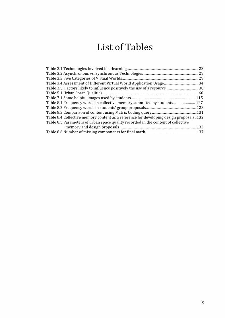
List of Tables
Table 3.1 Technologies involved in e-‐learning ................................................................................... 23 Table 3.2 Asynchronous vs. Synchronous Technologies ................................................................ 28 Table 3.3 Five Categories of Virtual Worlds......................................................................................... 29 Table 3.4 Assessment of Different Virtual World Application Usage........................................ 34 Table 3.5. Factors likely to influence positively the use of a resource ..................................... 38 Table 5.1 Urban Space Qualities………………………………………………………………….................. 60 Table 7.1 Some helpful images used by students…………………………………………………….. 115 Table 8.1 Frequency words in collective memory submitted by students………………… 127 Table 8.2 Frequency words in students’ group proposals...........................................................128 Table 8.3 Comparison of content using Matrix Coding query ....................................................131 Table 8.4 Collective memory content as a reference for developing design proposals ..132 Table 8.5 Parameters of urban space quality recorded in the content of collective
memory and design proposals ..........................................................................................132 Table 8.6 Number of missing components for final mark............................................................137
xi
List of Figures
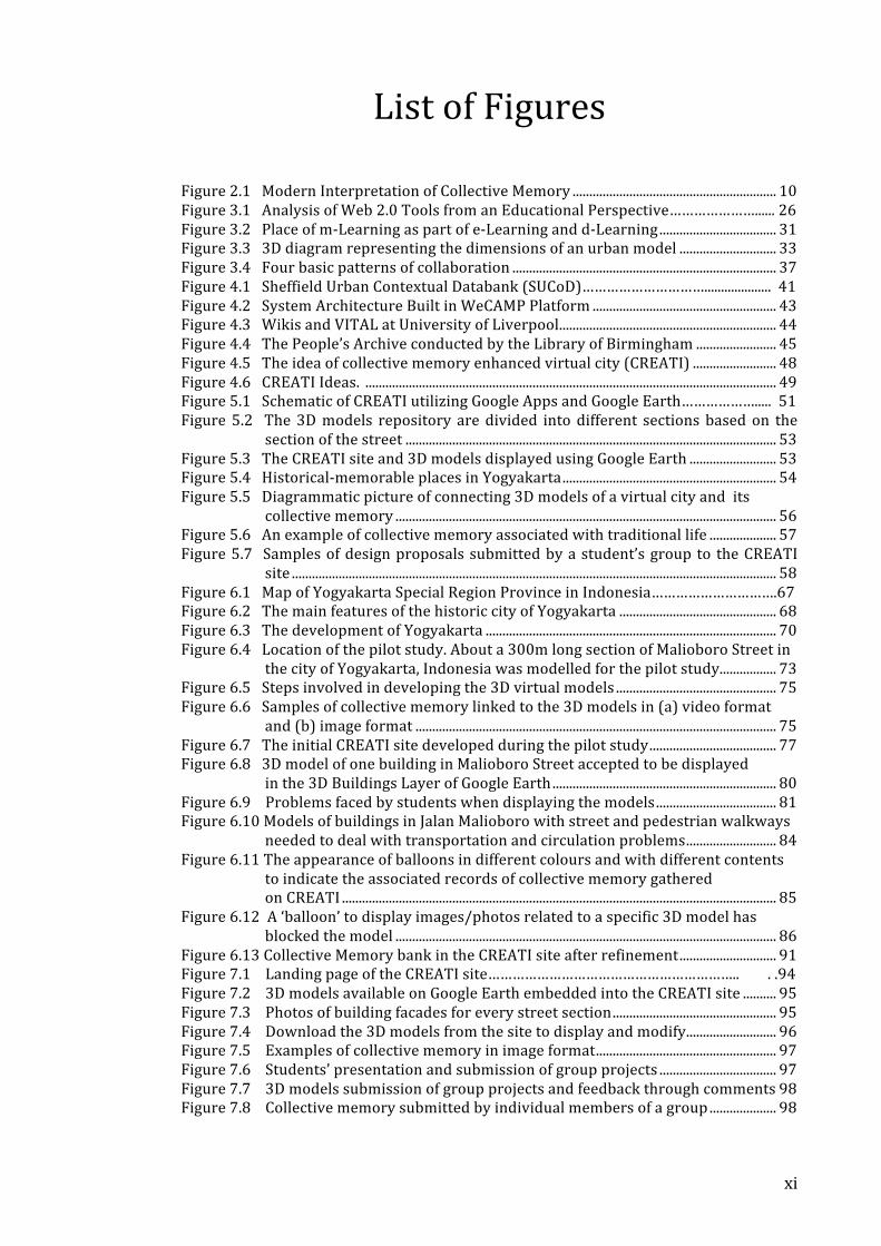
Figure 2.1 Modern Interpretation of Collective Memory ............................................................. 10 Figure 3.1 Analysis of Web 2.0 Tools from an Educational Perspective…………………...... 26 Figure 3.2 Place of m-‐Learning as part of e-‐Learning and d-‐Learning................................... 31 Figure 3.3 3D diagram representing the dimensions of an urban model ............................. 33 Figure 3.4 Four basic patterns of collaboration ............................................................................... 37 Figure 4.1 Sheffield Urban Contextual Databank (SUCoD)………………………….................... 41 Figure 4.2 System Architecture Built in WeCAMP Platform ....................................................... 43 Figure 4.3 Wikis and VITAL at University of Liverpool................................................................. 44 Figure 4.4 The People’s Archive conducted by the Library of Birmingham ........................ 45 Figure 4.5 The idea of collective memory enhanced virtual city (CREATI) ......................... 48 Figure 4.6 CREATI Ideas. ........................................................................................................................... 49 Figure 5.1 Schematic of CREATI utilizing Google Apps and Google Earth………………..... 51 Figure 5.2 The 3D models repository are divided into different sections based on the
section of the street ............................................................................................................... 53 Figure 5.3 The CREATI site and 3D models displayed using Google Earth .......................... 53 Figure 5.4 Historical-‐memorable places in Yogyakarta................................................................ 54 Figure 5.5 Diagrammatic picture of connecting 3D models of a virtual city and its
collective memory .................................................................................................................. 56 Figure 5.6 An example of collective memory associated with traditional life .................... 57 Figure 5.7 Samples of design proposals submitted by a student’s group to the CREATI
site ................................................................................................................................................. 58 Figure 6.1 Map of Yogyakarta Special Region Province in Indonesia………………………….67 Figure 6.2 The main features of the historic city of Yogyakarta ............................................... 68 Figure 6.3 The development of Yogyakarta ....................................................................................... 70 Figure 6.4 Location of the pilot study. About a 300m long section of Malioboro Street in
the city of Yogyakarta, Indonesia was modelled for the pilot study................. 73 Figure 6.5 Steps involved in developing the 3D virtual models ................................................ 75 Figure 6.6 Samples of collective memory linked to the 3D models in (a) video format
and (b) image format ............................................................................................................ 75 Figure 6.7 The initial CREATI site developed during the pilot study...................................... 77 Figure 6.8 3D model of one building in Malioboro Street accepted to be displayed
in the 3D Buildings Layer of Google Earth................................................................... 80 Figure 6.9 Problems faced by students when displaying the models.................................... 81 Figure 6.10 Models of buildings in Jalan Malioboro with street and pedestrian walkways
needed to deal with transportation and circulation problems........................... 84 Figure 6.11 The appearance of balloons in different colours and with different contents
to indicate the associated records of collective memory gathered on CREATI .................................................................................................................................. 85
Figure 6.12 A ‘balloon’ to display images/photos related to a specific 3D model has blocked the model .................................................................................................................. 86
Figure 6.13 Collective Memory bank in the CREATI site after refinement............................. 91 Figure 7.1 Landing page of the CREATI site…………………………………………………….. . .94 Figure 7.2 3D models available on Google Earth embedded into the CREATI site .......... 95 Figure 7.3 Photos of building facades for every street section................................................. 95 Figure 7.4 Download the 3D models from the site to display and modify........................... 96 Figure 7.5 Examples of collective memory in image format...................................................... 97 Figure 7.6 Students’ presentation and submission of group projects ................................... 97 Figure 7.7 3D models submission of group projects and feedback through comments 98 Figure 7.8 Collective memory submitted by individual members of a group .................... 98
xii
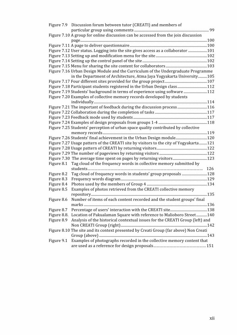
Figure 7.9 Discussion forum between tutor (CREATI) and members of particular group using comments ................................................................................... 99
Figure 7.10 A group for online discussion can be accessed from the join discussion page.............................................................................................................................................100
Figure 7.11 A page to deliver questionnaire......................................................................................100 Figure 7.12 User status. Logging into the site gives access as a collaborator .....................101 Figure 7.13 Setting up and modification menu for the site .........................................................102 Figure 7.14 Setting up the control panel of the site ........................................................................102 Figure 7.15 Menu for sharing the site content for collaborators ..............................................103 Figure 7.16 Urban Design Module and the Curriculum of the Undergraduate Programme
in the Department of Architecture, Atma Jaya Yogyakarta University..........105 Figure 7.17 Four different sites provided for the group project...............................................107 Figure 7.18 Participant students registered in the Urban Design class .................................112 Figure 7.19 Students’ background in terms of experience using software ..........................112 Figure 7.20 Examples of collective memory records developed by students
individually..............................................................................................................................114 Figure 7.21 The important of feedback during the discussion process .................................116 Figure 7.22 Collaboration during the completion of tasks ..........................................................117 Figure 7.23 Feedback mode used by students ..................................................................................117 Figure 7.24 Examples of design proposals from groups 1-‐4 ......................................................118 Figure 7.25 Students’ perception of urban space quality contributed by collective
memory records ....................................................................................................................119 Figure 7.26 Students’ final achievement in the Urban Design module...................................120 Figure 7.27 Usage pattern of the CREATI site by visitors to the city of Yogyakarta.........121 Figure 7.28 Usage pattern of CREATI by returning visitors........................................................122 Figure 7.29 The number of pageviews by returning visitors .....................................................122 Figure 7.30 The average time spent on pages by returning visitors ......................................123 Figure 8.1 Tag cloud of the frequency words in collective memory submitted by
students…………………………………………………………………………………………… 126 Figure 8.2 Tag cloud of frequency words in students’ group proposals ............................128 Figure 8.3 Frequency words diagram................................................................................................129 Figure 8.4 Photos used by the members of Group 4 ...................................................................134 Figure 8.5 Examples of photos retrieved from the CREATI collective memory
repository.................................................................................................................................135 Figure 8.6 Number of items of each content recorded and the student groups’ final
marks .........................................................................................................................................136 Figure 8.7 Percentage of users’ interaction with the CREATI site.........................................138 Figure 8.8. Location of Pakualaman Square with reference to Malioboro Street ............140 Figure 8.9 Analysis of the historical contextual issues for the CREATI Group (left) and
Non CREATI Group (right)................................................................................................142 Figure 8.10 The site and its context presented by Creati Group (far above) Non Creati
Group (above) ........................................................................................................................143 Figure 9.1 Examples of photographs recorded in the collective memory content that
are used as a reference for design proposals………………………………………… 151

Chapter 1. INTRODUCTION
1.1. Research Background
1.1.1. Virtual City as An E-‐Learning Tool
The wider use of virtual environments to support a range of human activities and
interactions has increased in the last few years. Some scholars believe that virtual
environments can enrich learning. However the application of virtual environments for
learning and education is still significantly low.1 In terms of learning technology, virtual
environments might provide students better learning experiences as they can learn more
actively, interactively and through engaged experiences. In addition, they can also
communicate using different senses.2
In architecture and urban design, the use of virtual environments like virtual cities as
a tool for learning is still developing, such as in the visualization and representation of
historical urban environment. Initially virtual cities were designed to represent real cities
digitally through mirroring their physical form and a host of serious tasks that defined what
cities are about and how they might function better.3
Meanwhile it seems that there is no widely accepted standard approach to the
construction of 3D cities, as each method applied to city modelling requires different inputs
(modelling and data collection) and results in different outputs (representation and
1 Doug A. Bowman and others, ‘The Educational Value of an Information-‐Rich Virtual Environment’, Presence: Teleoperators and Virtual Environments, 8 (1999), 317–331; Sara deFreitas, Serious Virtual Worlds -‐ A Scoping Study (UK: JISC, 2008).
2 deFreitas. 3 Andrew Hudson-‐Smith, Digital Urban, The Visual City, CASA Working Papers Series (London: University College London, 2007) <http://www.casa.ucl.ac.uk/publications/workingPaperDetail.asp?ID=124>.
2
application).4 The goal of virtual environment (VE) research is not to produce more realistic
environments, faster 3-‐D graphics, better sensory cues or low latency. Rather all of these are
only the means by which to achieve the actual end: useful applications that will benefit
people.5 Education should be another key application area for VEs.
The use of virtual learning environments to support collaborative learning in urban
design at university level seems to have potential with the development of computer
technology and the Internet. There are suites of software available online which provide
flexibility and customization options to support learning and teaching in architecture design.
However, the questions whether the software should be considered a Content
Management System (CMS) or Virtual Learning Environment (VLE) remains to be answered.
Kolb argues that learning is the process whereby knowledge is created through the
transformation of experience.6 Therefore, the significance of the use of VLE is its impact on
learning and the goal is not to replace human input but to support personal development
and exploration.7 In a design education context, Vecchia and co-‐workers have shown the
potential of VLE in supporting design processes and discussions in a more explicit manner.8
Information-‐rich virtual environments offer students not only the chance to use
experience as a learning tool but also the opportunity to relate information that would
normally be received in a lecture setting to an actual experience and three-‐dimensional
space.9 Experience can take a student only part of the way to learning and understanding a
subject, and it is necessary to have background knowledge, peripheral information,
reflection and experience before the subject can be comprehended by the student.
Collective memory embedded in virtual cities could be proposed as an information-‐rich
virtual environment to support learning in the context of architecture and urban design.
The development of new Web 2.0 tools presents a major challenge to all educational
and training organizations. Many of these new tools can be integrated with a more
structured context and provide significant educational benefits for students as it empowers
4 M.L Chiu and C Peng, ‘Insights of 3D Digital Cities: The Past, Present, and Futures’, in CAAD Talks 4: Insights of Digital Cities, Mao-‐Lin Chiu (editor) (Archidata, Co.,Ltd, 2005), pp. 13–35.
5 Doug A. Bowman and others. 6 David A. Kolb, Experiential Learning: Experience as the Source of Learning and Development, 1st edn (Financial Times/ Prentice Hall, 1983).
7 Bob Martens and Henry Achten, ‘Do You Moodle?’, 2008 <http://cumincad.scix.net/cgi-‐bin/works /Show?_id=ecaade2008_016&sort=DEFAULT&search=do%20you%20moodle&hits=866> [accessed 21 January 2011].
8 Luisa Dalla Vecchia, Adriane da Silva and Alice Pereira, ‘Teaching/learning Architectural Design Based on a Virtual Learning Environment’, International Journal of Architectural Computing, 7 (2009), 255–266 <doi:10.1260/147807709788921976>.
9 Doug A. Bowman, Larry F. Hodges and Jay Bolter, ‘The Virtual Venue: User-‐Computer Interaction in Information-‐Rich Virtual Environments’, Presence: Teleoperators and Virtual Environments, 7 (1998), 478–493 <doi:10.1162/105474698565866>.
3
them to create and manage their own digital learning materials.10 However, it is important to
make sure that they are used in educationally meaningful ways.
1.1.2. The Role of Collective Memory in Architecture and Cities
Architecture and urban design are subjects, which require students to have comprehensive
knowledge of the aspects of the built environment including buildings and urban context. In
order to understand the urban context, students not only need to learn to use maps and
archives but also to investigate the social and architectural history of either buildings or a
site.11 Buildings in a city significantly carry the common memory of its inhabitants. Therefore
balancing between the memory of past forms and current needs is very important in order
to create a uniqueness of relationship to site and place and to give identity and meaning to
its users.12
The need for understanding memory of past forms brings about the importance of
collective memory related to architecture and cities. Scholars have studied memory for
decades in many disciplines. This has brought the increasing elusiveness of memory as
meanings, concepts and phenomena of memory can be diverse.13 Metaphors and analogies
are used in order to understand phenomena in a more or less appropriate way. And there is
no way to prove a metaphor wrong or right.14
The collective memory discourse has been explored for years including within the
subject of architecture. The role of collective memory in architecture and cities has been
discussed by scholars.15 In relation to the use of computers for learning architectural and
urban historical context, there is also a question of investigating ways of recording historical
information electronically, which is available long-‐term for any site in a flexible form.16
1.1.3. The Scope of The Research
This research is conducted on the subject of virtual city as an e-‐learning tool and collective
memory in architecture and cities. Virtual city is a 3D graphic model built through mirroring a
10 Web 2.0-‐Based E-‐Learning, ed. by Mark J.W. Lee and Catherine McLoughlin (IGI Global, 2010) <http://www.igi-‐global.com/chapter/understanding-‐web-‐its-‐implications-‐learning/45015> [accessed 5 December 2012].
11 P Blundell Jones, A Williams and J Lintonbon, ‘The Sheffield Urban Study Project’, Architectural Research Quarterly, 3 (1999), 235–244.
12 Aldo Rossi, The Architecture of the City (The MIT Press, 1984); Blundell Jones, Williams and Lintonbon. 13 Jens Brockmeier, ‘After the Archive: Remapping Memory’, Culture & Psychology, 16 (2010), 5 –35 <doi:10.1177/1354067X09353212>.
14 Everyday Memory, ed. by Svein Magnussen and Tore Helstrup, 1st edn (Psychology Press, 2007). 15 K. Lynch, The Image of the City (MIT Press, 1960); Rossi; M. C. Boyer, The City of Collective Memory: Its Historical Imagery and Architectural Entertainments, New edition (MIT Press, 1996).
16 Blundell Jones, Williams and Lintonbon.
4
city’s real physical form, which can be accessed online through a web browser. In this study
collective memory refers to all kinds of records of the history and story of buildings and
places in the city. The study will concentrate on enhancing virtual city with collective
memory to support architectural and urban design learning.
Virtual city models have been used widely to study the historical urban
environments such as the Heusden Study17 and the Sheffield Urban Contextual Databank
(SUCoD) project.18 The present study considers how students can be further supported in
using virtual city models for architecture and urban design learning. It addresses the key
questions of how a city’s collective memory can be represented digitally and linked to the
city’s 3D virtual models. It also investigates how collective memory-‐enhanced virtual city can
help learners to achieve the goals of a particular course as a way of evaluating the
enhancement.
Therefore this study will develop and test a digital modelling methodology for
enhancing virtual city with collective memory to support architecture and urban design
learning. This study is conducted on the premises that by providing a city’s 3D virtual models
linked to its collective memory, students may become more knowledgeable of the urban
contextual issues. It is expected that students will be better supported to develop more
context-‐sensitive design proposals by working with such virtual models.
1.2. Research Questions
• How can a city’s collective memory be represented digitally and linked to the city’s
virtual model?
• Does a virtual city embedded with collective memory help students at
undergraduate level to achieve the goals of an Urban Design course? In what ways?
• Can a collective memory enhanced virtual city facilitate collaborative learning? How
can the effectiveness of this e-‐learning approach be measured?
1.3. Aim and Objectives
The study aims to develop and test a digital modelling methodology for enhancing virtual city
with collective memory to support urban design learning.
17 P Alkhoven, ‘Computer Visualisation as a Tool in Architectural Historical Research: Representation and Research of the Historical Urban Environment’, in Architectural and Urban Simulation Techniques in Research and Education, 1997.
18 C. Peng and others, ‘Exploring Urban History and Space Online: Design of the Virtual Sheffield Application’, Design Studies, 23 (2002), 437–453.
5
In order to effectively achieve the primary aim, the study has the following
objectives:
• To demonstrate the usefulness of collective memory in urban design learning
• To construct a pilot 3D virtual environment, which students can access to develop
experiential learning in urban design to complement their experiences in real spaces
• To create examples and case studies of enhancing 3D virtual city with digital
representation of collective memories
• To evaluate the effectiveness of the digital content created in supporting teaching
and learning
1.4. Research Methodology
The methodology of this study can be outlined briefly as:
1. Modelling a particular city and embedding collective memory into the city’s 3D
virtual models.
A small-‐scale representation of a 3D virtual city was modelled. The study used the
City of Yogyakarta, Indonesia as a research site. Malioboro Street was modelled as it
is a historical street and is found to be the most memorable place in the City of
Yogyakarta. For the initial pilot study, a 300-‐metre long section of Malioboro Street
was modelled. Architectural and urban historical context information was embedded
into 3D virtual models of Malioboro Street. The embedded digital collective memory
consisted of text, images and videos. Samples of collective memory of Malioboro
Street were collected and embedded into the 3D street models. In organizing the
digital collective memory content of the 3D models, some digital resources found
from many different websites were used and interlinked to narrate the story of
buildings and places in the city. For the next stage, the remaining Malioboro Street
of about a 900-‐metre long section would be added.
2. Conducting a pilot study and an experiment
A pilot study was conducted and used an Urban Design module at the department of
architecture at university level as a source for collecting data. A number of students
taking the Urban Design course were invited to participate in using CREATI as a tool
for supporting the course tasks. In the pilot study, a Google Site was developed as a
single point of entry through which students can have direct access to both CREATI
and the Urban Design course. Through the site student participants can download
3D virtual models embedded with collective memory and use them for conducting
6
analysis and proposing new designs as required by the course’s task. The problems
and comments collected from the pilot study were analyzed to inform how the
digital modelling methodology might be revised and refined. The second phase of
the study was conducted in the following semester with a newer version of CREATI
and a larger group of student participants. Some improvements were added to
CREATI such as broadening the content of related collective memory and digital
information, and introducing more interactive features such as enabling students to
upload their own design proposals and to post additional information related to the
buildings or places.
3. Data collection and analysis
In the pilot study, this study used questionnaires for collecting data. The
questionnaires were designed to elicit students’ reflections on a number of issues
such as enabling collaboration, analyzing the urban context, visualizing design
proposals in the 3D city context and obtaining feedback. The questionnaires could
also be accessed through the Google Site. The next experiment collected and
combined multiple data resources to address the research questions of how
collective memory enhanced virtual city can support architecture and urban design
learning: (1) interviews (2) content analysis of students’ work (3) web-‐based
observation. From the rich array of data obtained this way, it was hoped that the
research questions could be explained in more detail.
1.5. Thesis Outline
In the study, the author divides the thesis into nine chapters, which reflect the work done
from the start of the research.
Chapter One: Introduction. This chapter describes the background of the study, the
scope of problems, research questions, aims and objectives, research methodology and
thesis outline.
Chapter Two: Concepts of Collective Memory. In this chapter the concept of
collective memory is discussed based on the general concepts of collective memory to
collective memory in architecture and cities. Then it is followed by a discussion of mediated
memory including digital representation of collective memory. This chapter is important to
understand collective memory discourses and how they relate to the subject of architecture
in particular urban design and supporting the application of e-‐learning.
7
Chapter Three: Web-‐Based Tools for Enhancing E-‐Learning in Urban Design. This
chapter starts to discuss the understanding of e-‐learning and web-‐based tools for
architecture and urban design learning. Following that it discusses the visualization of 3D
virtual cities and its challenges. This chapter will also discuss how to measures the
effectiveness of virtual city as an e-‐learning resource. This chapter is important as a
theoretical basis to understand the virtual city used for e-‐learning in the study.
Chapter Four: Conceptual Framework of Collective Memory Enhanced Virtual City
(CREATI) for Supporting Urban Design Learning. This chapter presents some related projects
as references for the study followed by a discussion of the conceptual framework of
collective memory enhanced virtual city (CREATI).
Chapter Five: Research Methodology. This chapter discusses the methodology used
in this study. The discussion starts from how to design the interface, how to model the study
site, how to connect instances of collective memory, how to conduct pilot applications of
CREATI in a design education setting, methods of collecting data and methods of data
analysis.
Chapter Six: The Initial CREATI: A Pilot Study. In this chapter, the pilot application of
CREATI is explained including a description of the pilot study site, history and collective
memory related to the study site, preparation for the pilot study and the evaluation of
CREATI as a virtual learning environment in urban design. This chapter also discusses
refinements and development of CREATI Version 0.0 for the next stage.
Chapter Seven: The CREATI Experiment: Application of CREATI in A Real Design
Education Setting. This chapter describes the application of CREATI in a real design education
setting at university level. It will explain about the improvements have been carried out in
CREATI Version 1.0 followed by information about the Urban Design module at the study
site. The chapter also explains the process of conducting the experiment and presenting the
data collected during the experiment.
Chapter Eight: Findings and Discussion. This chapter discusses the analysis of data
collected from the experiment using several combined methods. In answering the research
question, the chapter analyzes the content of collective memory and students’ design
proposal to show how CREATI can help students at undergraduate level to achieve goals of
an Urban Design course. Students’ achievement, website analysis and comparison of the
students’ design project will be analyzed to reveal the effectiveness of CREATI in supporting
e-‐learning in urban design.
8
Chapter Nine: Conclusions and Further Research. The chapter presents the
conclusion from the previous chapters and the limitation of the study as well as
recommendations and suggestions for further research.
Summary
The use of virtual cities to support learning, particularly in architecture and urban design
education, is still developing. Although there is no widely accepted standard approach to the
construction of 3D cities and virtual cities, in terms of education it has to be noted that the
application of 3D virtual city models has to be directed and emphasized with regard to the
creation of knowledge through which learners can transform their experiences.
The study incorporates virtual cities as e-‐learning tools and collective memory in
architecture and cities. Collective memory enhanced virtual city (CREATI) as an information-‐
rich virtual learning environment is proposed for the study, which aims to support learning in
the context of architecture and urban design.
Through combining multiple data resources (such as questionnaires, interviews and
students’ work) and integrating several methods to analyze the data (such as content-‐based
analysis, and comparison of the outcome and usage observation of the CREATI site), the
effectiveness of CREATI to support learners in a meaningful way will be developed and tested
in a real educational setting. CREATI will also be analyzed as to how it can support personal
development and exploration.
The next question is what is collective memory and how is this concept brought into
architecture and urban design?
Chapter 2. CONCEPTS OF COLLECTIVE MEMORY
“We all have our time machines. Some take us back, they're called memories” (Jeremy Irons – British actor)
2.1. General Concepts of Collective Memory
The concepts of collective memory were first introduced in the 1920s by Maurice Halbwachs,
the French philosopher and sociologist, who focused on collective memory in relation to
time, space, and history. Halbwachs defined collective memory not as a socially constructed
idea about the past, but rather a socially shared notion, a way that a group conceptualized
the past while in the present.1 He believed that all memory is socially constructed through
spatial imagery. In his concept, monuments and other topographical features are central to
the formation of a collective memory.
Since then, there have been many theories from a variety of authors from different
disciplines about the conjunction between space and memory including the significant
contributions from the French philosopher, Pierre Nora, to the role of spaces and places of
shared memory. Nora called the re-‐collective remembrance occurring in the nineteenth
century as a ‘modern memory’. He said that ‘modern memory’ depends totally on the
appearance and presentation of the trace, the recording, and the image.2 It can be
interpreted that in material context, our memory tries to find meanings and the material
sites are valued and experienced as entities that visualize our memories in the present.3
1 Halbwachs, On Collective Memory (Chicago University Press, 1992). 2 Pierre Nora, Realms of Memory: Rethinking the French Past (Columbia University Press, 1996). 3 U Sumnu, ‘The 1912 Galata Bridge as A Site of Collective Memory’ (unpublished A Thesis Submitted for Masters Degree, Turkey: Bilkent University, 2002) <www.thesis.bilkent.edu.tr/0002124.pdf>.
10
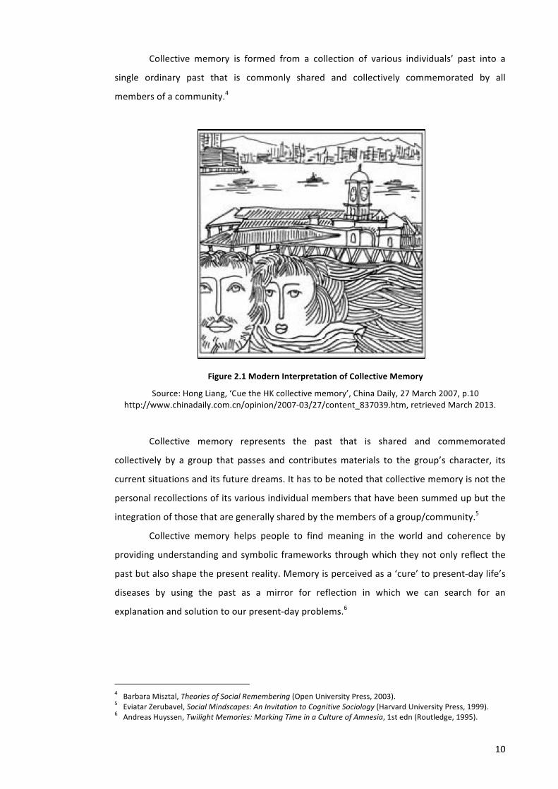
Collective memory is formed from a collection of various individuals’ past into a
single ordinary past that is commonly shared and collectively commemorated by all
members of a community.4
Figure 2.1 Modern Interpretation of Collective Memory
Source: Hong Liang, ‘Cue the HK collective memory’, China Daily, 27 March 2007, p.10 http://www.chinadaily.com.cn/opinion/2007-‐03/27/content_837039.htm, retrieved March 2013.
Collective memory represents the past that is shared and commemorated
collectively by a group that passes and contributes materials to the group’s character, its
current situations and its future dreams. It has to be noted that collective memory is not the
personal recollections of its various individual members that have been summed up but the
integration of those that are generally shared by the members of a group/community.5
Collective memory helps people to find meaning in the world and coherence by
providing understanding and symbolic frameworks through which they not only reflect the
past but also shape the present reality. Memory is perceived as a ‘cure’ to present-‐day life’s
diseases by using the past as a mirror for reflection in which we can search for an
explanation and solution to our present-‐day problems.6
4 Barbara Misztal, Theories of Social Remembering (Open University Press, 2003). 5 Eviatar Zerubavel, Social Mindscapes: An Invitation to Cognitive Sociology (Harvard University Press, 1999). 6 Andreas Huyssen, Twilight Memories: Marking Time in a Culture of Amnesia, 1st edn (Routledge, 1995).

11
2.2. Individual Memory and Collective Memory
According to Halbwachs, collective memory depends on social frames because social groups
decide what and how things are memorable and remembered, and the memories of
individuals are also supported and defined by them.7 He insisted that no memory is possible
outside shared social frames and that the shifting or crumbling of these frames induces
changes in personal memory and even forgetting. The life and duration of a collective
memory depends on the existence of a group’s social power that bears it. The social standing
of the group provides an important indicator of its memory’s durability, visibility and power,
while the diversity and variable intensity of individual remembrance is explained by the
existence of a multiplicity of collective influences. However, Connerton argued that
Halbwachs was unable to explain the fact of the social persistence of images of the past.8
The discourse about the term ‘collective memory’ was explained further by Aleida
Assman.9 In opposition to the statement that collective memory is a determination not a
remembering, she explains another dimension of memory, i.e. its externalization, which
means that once verbalized, the individual’s memory is fused within an inter-‐subjective
symbolic system of language and is no longer a purely exclusive and unalienable property. An
individual’s memory can be exchanged, shared, confirmed, validated, adjusted, contested
and accepted by encoding it. As a result it can be maintained and accessed by those who live
in a different spatial and temporal reach. She then proposes different types of memory, i.e.
individual memory, social memory, political memory and cultural memory to map various
areas of memory research.
In individual memory, she explains that human memory is not designed for accurate
representations of past experiences but is notoriously distorting and cannot be trusted in
any way. Personal memory is the dynamic medium of processing subjective experience and
building up a social identity. Individual memories can be transferred from the private to
unofficial frame of the family to that of society at large using media. Materialized individual
memories that have been part of archival memory are reclaimed as part of public social
memory.
Meanwhile social memory refers to the past as experienced and communicated (or
repressed) within a given society. It is continuously changing as it disappears with the death
of individuals. The memory of a society is by no means homogenous but is instead divided
7 Halbwachs. 8 Paul Connerton, How Societies Remember (Cambridge University Press, 1989). 9 Performing the Past: Memory, History, and Identity in Modern Europe, ed. by Karin Tilmans, Frank van Vree and Jay Winter (Amsterdam University Press, 2010).

12
into generational memories, the importance of which is being (re) discovered by social
psychologists.
Political and cultural memories are mediated and need to be re-‐embodied. They are
designed for trans-‐generational communication, which not only involves libraries, museums,
and monuments, but also provides various modes of education and repeated occasions for
participation. It is not an easy thing to move from individual memory or social memory to
political memory. Political memory is distinguished from other memories. It tends towards
homogeneous unity and self-‐contained closure. It is not fragmentary and diverse but
emplotted in a narrative that is emotionally charged and conveys a clear and invigorating
message. Political memory is reclaimed as a social public memory and a particular political
memory is reclaimed as a national political memory.
2.3. Collective Memory and Process of Remembering
According to Halbwach, collective memory cannot be separated from the process of
remembering.10 It is individuals who remember, but society determines what is worth
remembering. Society as a whole cannot ‘remember’. It is individuals who compose and
bring personal memories into public representations of the past in order to encourage
particular public appreciation and awareness of the past.11
In the dynamics of the memory approach, memory is a process of negotiation and
should be seen as an active process of sense making through time.12 Therefore collective
memory is not only changeable but also depends on time as it alters with every identity and
every new present. It means that present-‐day identities and contexts will determine the
reconstruction of the past. Experimental psychologists have been keen to understand the
phenomena of remembering and forgetting, viewing it as a system capable of selecting,
organizing, storing, and retrieving information.13 It is continuously maintained through a
persistent production of representational forms.
Nevertheless among researchers of collective memory, there has been discussion
about whether the process of shaping social recollections springs from construction or
selection. According to Halbwachs the process of creating collective memories is a total one.
He argues that the need to reconstruct the past and the social group’s ability to utilize it are
even greater than the actual origins of the past events. On the contrary, Barry Schwartz
10 Halbwachs. 11 Connerton. 12 Misztal. 13 Misztal.
13
argued that selection is the most important activity in the process of creating collective
memories rather than construction.14 Social memories alter through the process of
emphasizing certain events over others. Social groups create their own pictures of the world
by choosing factual elements that suit their larger master-‐narratives and disregard or
diminish the importance of others. By continuously shaping and reshaping versions of the
past, social groups define their identity and produce boundaries that disconnect them from
other groups that share different memories of the past, or perhaps, different interpretations
of the same occurrences. So every collective memory needs a group’s support to define its
limit in space and time. Both time and space play a crucial role in anchoring group
recollections and hence in ensuring their preservation.
2.4. Memory and Mode of Transmission
There are many studies about various frameworks that allow memory to be shared and
transmitted such as musical notation, layout of churches, ceremonial spaces and town plans.
Other structures like text, images, sites and experiences can also be used to generate,
maintain, and reproduce collective memory.15
Conventional images of memory portray it as a kind of storage and retrieval. But
memory is more a crucible of meaning than a vessel of truth.16 Many contemporary social
memory scholars have highlighted both the role of memory as a medium of identity and the
role of various technological media in the transmission of memory.
Collective memory covers not only the past that is shared together but also the past
that is embodied in various cultural practices, especially in memorial symbols. In the last
decades the increasing of digitization and information technology have brought about a
movement and creation of second-‐hand memories. Through new images and so forth,
particular narratives and images are duplicated, reframed, questioned and contested.
According to Connerton, the ways we do, be and utilize our body can transfer the
past.17 The depiction of the unspoken articulation of memory can perform and give
materiality to the discourse on collective memory. We preserve versions of the past by
representing it to ourselves in words or through storing and retrieving information as well as
14 Barry Schwartz, ‘The Social Context of Commemoration: A Study in Collective Memory’, Social Forces, 61 (1982), 374–402 <doi:10.2307/2578232>.
15 Misztal. 16 The Collective Memory Reader, ed. by Jeffrey K. Olick, Vered Vinitzky-‐Seroussi and Daniel Levy (Oxford University Press, USA, 2011).
17 Connerton.
14
by memorizing culturally specific postures, gestures, and practices in commemorative
ceremonies.
Connerton also distinguished social practices into two, i.e. incorporated memory and
inscribed memory.18 Incorporated memory relates to the use of bodily activity or actions
which sustain particular activity/information while inscribed memory is related to how we do
something to capture and save information like using modern devices for keeping and
extracting information, print, indexes, photographs, sound tapes, computers, etc.
Cultural memory consists of what Aleida Assman calls a ‘canon’ and an ‘archive’.19
The active memory of the canon (such as repeated performances, the school curricula,
museums, etc) perpetuates what a society has consciously selected and maintains as salient
and vital for a common orientation and a shared remembering. The archival memory is what
in the long run has been neglected, forgotten, excluded or discarded but is still deemed
worthy and important to be preserved in material form. It is accessible only to specialists and
circulates specific/rare knowledge. The archival memory has not passed the filters of social
selection nor is it transformed into a living memory supported by public awareness and
validation by cultural institutions and the public media. The interaction between the active
and the archival dimension, makes cultural memory have an inbuilt potential for ongoing
changes, innovations, transformations, and reconfigurations.
Another mode of memory transmission was explained by M. Christine Boyer, which
she explains as exploring the mnemonic dimensions that are contained in urban contexts.
2.5. Mediated Memory as a Conceptual Tool
Performances of memory can be and are enacted across a range of activities, places, rituals
and media. Mediated memories are things that mediate not only remembrances of things
past but mediate relationships between individuals and groups of any kind and they are
created by media technologies.20
People have a vested interest in mediated memory objects such as pictures, video,
recorded music, diaries, etc. because they come to serve as material triggers of personal
memories. When trying to remember something, the mind, triggered by a material object or
image, searches through the stacks from which stored and unchanged information can be
18 Connerton. 19 Olick, Vinitzky-‐Seroussi and Levy. 20 Jose van Dijck, Mediated Memories in the Digital Age (Stanford University Press, 2007).
15
retrieved and reread. Media memory concerns the study of collective pasts using media as
narration, tools and subject in a systematic way.21
As pointed out by Neiger the social ritual of remembering is performed either in the
public arena or in the private domain physically or virtually and the shared recollections are
incorporated, distributed, and accommodated by media.22 Moreover, media are the key
instruments that control and maintain the consensus on commemorative things.23 On the
contrary, the amplitude of media outlets and memory versions can lead the memory and
commemoration of events into a ‘post-‐memory’ phase, when powerful memories are
transmitted and adapted by publics due to their traumatic nature although they have not
experienced the events.24
2.6. Performances of Memory Through Digital Media
The establishment of the Internet has changed many types of communication in the public
sphere. Web-‐based memorializing practices is one among many other computed media
through which people try to commemorate private lives and individual expression while at
the same time they fulfil a communal function.25
Such collections are embedded in websites like images, text, songs, etc. through
which the people who are involved in and experience such events are enabled to tell their
story. It contributes to the formation of collective memory as they were archived. They pose
as different accounts of the past and can produce a new form of social actions and reactions
after they are merged and affirmed by other versions of the past.26 This new idea forms our
current knowledge of how the occurrences, pictures, and any other collections are
experienced and understood. Through the digital representation of collective memory, which
is experienced through web-‐based memorializing sites, people participate in sharing the past
and commonality with other people they have never met like family ties over nations,
regions or cities.
What should be considered important in the online memorials are reproduction and
preservation of the content as it provides a potential opportunity to be copied, produced
21 On Media Memory: Collective Memory in a New Media Age, ed. by Dr Motti Neiger, Dr Oren Meyers and Dr Eyal Zandberg (Palgrave Macmillan, 2011).
22 Neiger, Meyers and Zandberg. 23 Schwartz. 24 Marianne Hirsch, ‘Surviving Images: Holocaust Photographs and the Work of Postmemory’, The Yale Journal of Criticism, 14 (2001), 5–37 <doi:10.1353/yale.2001.0008>.
25 Kirsten Foot and Barbara Warnick, ‘Web-‐based Memorializing After September 11: Toward a Conceptual Framework’, Journal of Computer-‐Mediated Communication, 11 (1) (2005) <http://jcmc.indiana.edu/vol11/issue1/foot.html>.
26 Foot and Warnick.
16
and distributed quickly as well as reproduction through duplication.27 Another consideration
is whether or not the meaning(s) of memorializing change for those who engage in it through
web memorializing.28 The web provides dialogue and interactions through which texts are
part of the ‘storage’ and ‘functional’ memory that are remembered and linked to other texts,
which generate the appearance of meaning.29
2.7. Digital Media and Mode of Transmission of Memory
According to Dijck, there have been many systems developed to mediate the process of
remembering. AT&T labs in Cambridge, England developed a digital photo management
system called Shoebox.30 With its browsing and searching facilities, it can be used to store
and retrieve digital photographs, utilize spoken and written annotations as well as retrieve
content-‐based images. The outcome reveals that it is more effective to retrieve
automatically large collections of digital pictures based on users’ audio or textual tagging
than image-‐based indexing. However, the lack of time and order as shaping factors in the
memory process show that the system is largely driven by technical considerations. The
process of remembering in the system is infused with time and order – determinant factors
in the continuous shaping and contextualizing of past experiences.
Another system is called The Living Memory. It concerns how a digital support
system may help ‘enhance the memory archiving experience of today’s families’. It
encompasses a central storage display combined with a portable recording device connected
through an innovative interface design.
Lifestreams is a system in which documents are streamed in order by time. It
functions like a diary of an individual’s electronic life. It records comprehensively one’s
activities, registering every communicative and expressive daily activity mediated by the
computer. Lifestreams thus foregrounds ubiquitous availability and connectivity but
disregards the dynamic nature of both documents and memory.
MyLifeBits extends the idea of the computer as a model for the brain to the more
advanced level. The system broadens its capacities from storage and retrieval capacities to
its presentation capacities. It will record everyday events in text, images and audio, and store
27 A. Hess, ‘In Digital Remembrance: Vernacular Memory and the Rhetorical Construction of Web Memorials’, Media, Culture and Society, 29 (2007), 812–830.
28 Foot and Warnick. 29 Christian Pentzold, ‘Fixing the Floating Gap: The Online Encyclopaedia Wikipedia as A Global Memory Place’, 2:255 (2009) <http://mss.sagepub.com/content/2/2/255> [accessed 22 September 2010].
30 Dijck.
17
them orderly in a computer. It departs from the notion of stories or memory narratives as
key ingredients of the remembering process.
However all the systems above fail to acknowledge a far more important function of
digital media in the act of human memory. If we consider media technology to be tools for
selecting, framing, and encapsulating autobiographical memories – rather than mechanical
devices for recording and storing documents or files – they play a constitutive role in the
continuous (re) construction of our selves.31
2.8. Digital Media and the Process of Remembering
2.8.1. Remembrance Through Digital Diaries
Traditional paper diaries involve an act of remembrance and communication, always
intended for private use, although potentially to be read by others later on. Digital
diaries/life logs change the technology of writing in paper diaries as well as change the ways
of creating self-‐reflexive records -‐ memory. ‘Reading through other people’s assorted
memories – organized by themes or years – activated one to trust his/her personal
memories to the screen, thus contributing to the overall project and in turn stimulating
others to revise or re-‐enact their memories in narrated form.’32 It enhances people’s
inclination to (re) construct the self in the light of experiences posted by others.
However, as the digital diary can be edited at a later stage, it potentially diminishes
the concept of a diary as a material, authentic artefact, inscribed in time and on paper as it
can hide or erase the symbol of personality.33 The Internet does best in creating a forum for
dialogue collectively both written and spoken. The digital diary, with its multimedia modality,
becomes an instrument for people to create their personal entries as well as to exchange
cultural content such as clippings, files and songs.34 The digital diary accommodates social
processes involving exchange and participation that enable citizenship to be passed on. It
also functions to synchronize and test one’s subjective experiences against those of others.
Through blogging, one experiences and constructs his/herself in a real-‐life mediated by tools
for reflection and communication. In the life of bloggers, the medium is not the message but
31 Dijck. 32 Robert Payne, ‘Digital Memories, Analogues of Affect’, :: SCAN | journal of media arts culture ::, 2004 <http://scan.net.au/scan/journal/display.php?journal_id=42> [accessed 30 December 2012].
33 Mark B. N. Hansen, Embodying Technesis: Technology Beyond Writing (University of Michigan Press, 2000). 34 Dijck.
18
the medium is the experience that carries memory.35 The changing pace of the meaning of
memory is the same as that of the experience.
2.8.2. Remembrance Through Digital Music Recordings
Recorded popular music is a vital component of people’s personal memory and constitutive
element to construct collective identity and cultural heritage. One can create a sense of
attachment and relate a person’s sense of self to a larger community and generation by
engaging in shared listening, exchanging (recorded) songs and talking about music.36 Songs
or albums are decoded as a mark of their time as they radiate from a cultural-‐historical time
frame and emerge from a socio-‐technological context.37
Music is an aid to remembering something. One can mark and invoke specific
events, emotions or general moods by listening to records.38 However recorded music not
only triggers memories but in reverse constructs a cognitive framework by transposing
collectively constructed meanings onto individual memory. Musical memories can transfer
personal and collective heritage intergeneration by sharing music and sharing stories.39
2.8.3. Remembrance Through Digital Pictures
The role and function of digital photography have changed significantly in contemporary
times. Analogue photography was a medium by which people remembered their personal
history. It was regarded as an aid for recalling and confirming a life as it was. The use of
digital cameras has raised several queries related to photography as a tool for remembrance,
as photos can be manipulated and edited to create memoir and shape identity.40 Moreover
questions related to how we gauge new features when editing our pictures and making our
memories picture perfect also arise. Photography is an extension of mental processes and its
materiality and performativity are significantly important. Photographs are used not only for
preserving life’s moments for later recall but moreover for live communication. This
transformation will have an impact on the everyday use of personal photography.
Memories are made as much as they are recalled from photographs. Although a
photograph reveals a fixed image of the past, our remembrance never remains the same.
35 Dijck. 36 Dijck. 37 Timothy D. Taylor, Strange Sounds: Music, Technology and Culture (Routledge, 2001); David Morton, Off the Record: The Technology and Culture of Sound Recording in America (Rutgers University Press, 1999).
38 Norman M Weinberger, ‘Threads of Music in the Tapestry of Memory’, MuSICA Research Notes: V IV, I 1, Spring 1997, 1997 <http://www.musica.uci.edu/mrn/V4I1S97.html#threads> [accessed 30 December 2012].
39 Dijck. 40 Dijck.
19
Instead, to fix memory, we use pictures to continuously evaluate our past lives and reflect on
what has been as well as what is and what will be.
From the above description, there seems to be countless examples of digital format
mediating memory and the process of remembering. However it is still questioned how
many processes of digitization, multimediatization and googlization impact the construction
of memory.41
2.9. Collective Memory in Architecture and Cities
The roles of collective memory in architecture and cities were explained by Aldo Rossi, an
Italian architect and designer (1931 – 1997). He mentioned that the city is the locus of the
collective memory of its people and like memory it is associated with objects and places. The
city’s predominant image is depicted from the relationship between the locus and the
citizenry, which will be part of its memory, flowing through history and giving shape to it.42
Collective memory participates in the actual transformation of space in that it is always
conditioned by whatever material realities oppose it. Therefore collective memory becomes
the guidance of the entire complex urban structure. Collective memory helps one to grasp
the significance of the urban structure, and its individuality i.e. an event and its architecture.
In short it can be said that collective memory can form a city and give identity and meaning
to its citizens.
The study of collective memory in cities was also discussed by Kevin Lynch. Lynch did
not mention collective memory explicitly, rather he related it to a public image of any given
city, which is an overlap of many individual images.43 There might be a series of public
images, each held by some significant number of citizens. Such group images are necessary if
an individual is to operate successfully within his environment and to cooperate with his
fellows.44
Concern about collective memory in urban contexts has been discussed further by
M. Christine Boyer, an architectural historian and urban critic, in her book called ‘The City of
Collective Memory’.45 Her critics are premised by her concerns over the crisis of the city in
the late twentieth century in which ‘memory’ and ‘remembrance’ seemed to be ignored and
resulted in fragmented city images. Therefore recalling, re-‐examining and re-‐contextualizing
41 Dijck. 42 Aldo Rossi, The Architecture of the City (The MIT Press, 1984). 43 K. Lynch, The Image of the City (MIT Press, 1960). 44 Lynch. 45 M. C. Boyer, The City of Collective Memory: Its Historical Imagery and Architectural Entertainments, New edition (MIT Press, 1996).

20
memory images from the past are urgent until they awaken within us a new path to the
future.46 In that book, she describes the collective memory as the way urban publics
compose their images of their city as a work of art, panorama and spectacle. Boyer
describes that architecture in the city is not only a spectacle shaped by the representational
order of planners and architects but involves the public as well. Through their scenic and
theatrical memory of the city, the public travel back in time through images that recall bits
and pieces of an earlier city then project it forward into recomposed and unified staging.47
Inside the images that users capture and experience, laid hidden and invisible things that
connect the images to the past. Sometimes it can be stories, events or experiences that
happened surrounding the architecture of the city.
In the city of spectacle, she describes that the computer-‐simulated visual
environment has transformed the material world – the bits and pieces of the city – into an
ephemeral form. Worldwide electronic media have changed the connection between
collective memory, history and the urban spaces and the process of remembering the past is
enacted as a set of reconstructed images.48
Summary
The wide-‐ranging definition of collective memory from various disciplines makes the
meanings, concepts and phenomena of memory elusive and diverse. Sometimes, mediated
objects are used as narration, tools and subject to trigger either personal or communal
memories. The development of digital media has changed how collective memory is
interpreted and enacted as well as how the process of remembering is performed.
Performances of memory can be and are enacted across a range of activities, places, rituals
and media.
The increasing of digitization and information technology has brought about a
movement and creation of second-‐hand memories. The development of computer-‐simulated
visual environments has injected the discourse of collective memory into Architecture and
cities have expanded and been augmented from physical worlds to wider virtual
environments. Collective memory, which generally can be defined as socially shared notions
about the past from various individuals integrated into a single one constructed through
spatial imagery can also be enacted from images presented in a virtual space. Images
presented in media such as a virtual space act as a presentation of past traces, and its
46 Boyer. 47 Boyer, p. 32. 48 Boyer.

21
availability over the Internet makes it possible to be accessed by those who live in different
spatial and temporal reaches.

Chapter 3. WEB-‐BASED TOOLS FOR ENHANCING E-‐LEARNING IN URBAN DESIGN
This chapter intends to provide the theoretical basis of web-‐based tools for enhancing e-‐
learning in the areas of urban design. The discussion begins by describing what e-‐learning is
and how it is understood in the subject of architecture and urban design. Then there follows
a discussion of web-‐based tools that can be used to support e-‐learning. In this chapter,
virtual world and 3D models will be discussed in more detail as 3D virtual city models are one
focus of the study. Then this chapter will also discuss interaction and collaboration in a
virtual learning environment, followed by how to measure the effectiveness of 3D virtual city
models as learning resources.
With the discussion in this chapter, how to analyze and measure the effectiveness of
3D virtual city models as web-‐based learning resources in the context of the whole thesis is
expected to be understood thoroughly.
3.1. Understanding of E-‐Learning
E-‐learning is an umbrella term for online learning. It includes any learning activities
conducted using electronic applications and processes.1 Littlejohn and Higginson described
e-‐learning as any use of Information and Communication Technologies (ICT) to ease, assist
and enhance learning.2 It is described as instruction brought individually through the
1 Eva Kaplan-‐Leiserson, ‘ASTD Learning Circuits -‐ eLearning Glossary’, E-‐Learning Glossary, 2000 <http://www.lupi.ch/Schools/astd/astd2.htm#bio> [accessed 14 November 2012].
2 Littlejohn A and Higginson C, ‘A Guide of Teachers.’ (In Centre, L.G. (ed). LTSN Generic Centre E-‐Learning series, The Higher Education Academy, 2005).
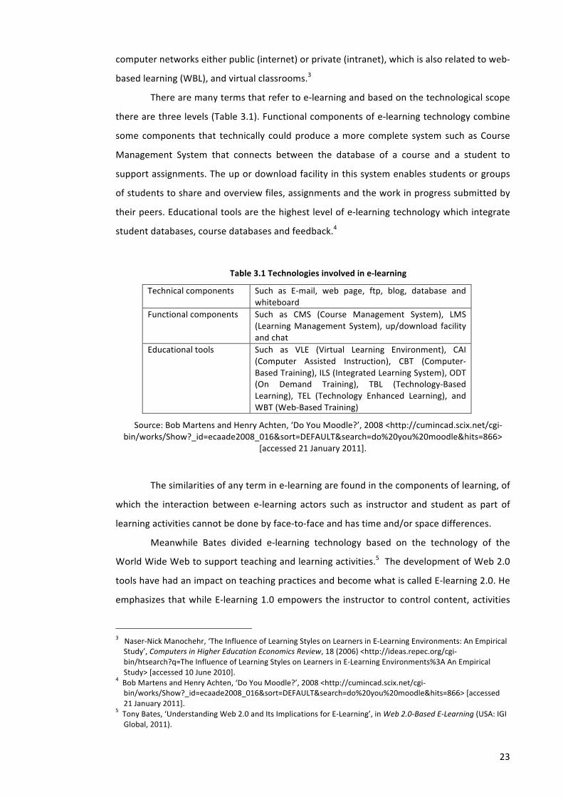
23
computer networks either public (internet) or private (intranet), which is also related to web-‐
based learning (WBL), and virtual classrooms.3
There are many terms that refer to e-‐learning and based on the technological scope
there are three levels (Table 3.1). Functional components of e-‐learning technology combine
some components that technically could produce a more complete system such as Course
Management System that connects between the database of a course and a student to
support assignments. The up or download facility in this system enables students or groups
of students to share and overview files, assignments and the work in progress submitted by
their peers. Educational tools are the highest level of e-‐learning technology which integrate
student databases, course databases and feedback.4
Table 3.1 Technologies involved in e-‐learning
Technical components Such as E-‐mail, web page, ftp, blog, database and whiteboard
Functional components Such as CMS (Course Management System), LMS (Learning Management System), up/download facility and chat
Educational tools Such as VLE (Virtual Learning Environment), CAI (Computer Assisted Instruction), CBT (Computer-‐Based Training), ILS (Integrated Learning System), ODT (On Demand Training), TBL (Technology-‐Based Learning), TEL (Technology Enhanced Learning), and WBT (Web-‐Based Training)
Source: Bob Martens and Henry Achten, ‘Do You Moodle?’, 2008 <http://cumincad.scix.net/cgi-‐bin/works/Show?_id=ecaade2008_016&sort=DEFAULT&search=do%20you%20moodle&hits=866>
[accessed 21 January 2011].
The similarities of any term in e-‐learning are found in the components of learning, of
which the interaction between e-‐learning actors such as instructor and student as part of
learning activities cannot be done by face-‐to-‐face and has time and/or space differences.
Meanwhile Bates divided e-‐learning technology based on the technology of the
World Wide Web to support teaching and learning activities.5 The development of Web 2.0
tools have had an impact on teaching practices and become what is called E-‐learning 2.0. He
emphasizes that while E-‐learning 1.0 empowers the instructor to control content, activities
3 Naser-‐Nick Manochehr, ‘The Influence of Learning Styles on Learners in E-‐Learning Environments: An Empirical Study’, Computers in Higher Education Economics Review, 18 (2006) <http://ideas.repec.org/cgi-‐bin/htsearch?q=The Influence of Learning Styles on Learners in E-‐Learning Environments%3A An Empirical Study> [accessed 10 June 2010].
4 Bob Martens and Henry Achten, ‘Do You Moodle?’, 2008 <http://cumincad.scix.net/cgi-‐bin/works/Show?_id=ecaade2008_016&sort=DEFAULT&search=do%20you%20moodle&hits=866> [accessed 21 January 2011].
5 Tony Bates, ‘Understanding Web 2.0 and Its Implications for E-‐Learning’, in Web 2.0-‐Based E-‐Learning (USA: IGI Global, 2011).
24
and organization of the asynchronous online discussion forums, E-‐learning 2.0 exploits more
of the learner’s capacity to access, create, and publish materials. According to Bates, there
are many samples of Web 2.0 appliances for supporting e-‐learning like blogs, wikis (e.g.
Wikipedia), social networking tools (e.g. Facebook), multimedia archives (e.g. Flickr and
YouTube), synchronous communication tools (e.g. Skype), 3-‐D virtual worlds (e.g. Second
Life), multiplayer games, mobile learning, and open content (e.g. MIT OpenCourseWare).6
In architecture and urban design education, e-‐learning technology might include the
application of virtual environments for learning such as the utilization of 3D virtual worlds
and CAD system to encourage students to collaborate, reflect, and to explore design in a
particular way. The use of a Virtual Learning Environment in architecture and urban design
typically consists of:7
• The use of professional communication tools such as video conferencing, audio
conferencing, mobile phones, email and faxes; 8
• Virtual Studios which combine the use of discussion boards, chat rooms, shared
white boards, document sharing and weblogs to help groups of students in disparate
locations to collaborate on line, either synchronously or asynchronously;9 10 11 12 13
• Shared repositories and databases; 14 15
6 Bates, ‘Understanding Web 2.0 and Its Implications for E-‐Learning’. 7 Nawara Mizban and Andrew Roberts, ‘A Review of Experiences of the Implementation of E-‐learning in Architectural Design Education [Working Paper No. 13]’, The Centre for Education in the Built Environment (CEBE), 2008 <http://www.heacademy.ac.uk/cebe/publications/alldisplay?type=resources&newid=workingpapers/no_13_a_review_of_experiences&site=cebe> [accessed 24 September 2012].
8 Jack Dunne, ‘Remote Studio Design Collaboration : an International Approach’, CEBE funded Case Study, 2001 <http://www.cebe.heacademy.ac.uk/learning/casestudies/record.php?process=full_view&identifier=cebe.ltsn.ac.uk:668230124993&edition=&avability=yes> [accessed 19 November 2012].
9 S Simoff and M Maher, ‘Analysing Participation in Collaborative Design Environments’, Design Studies, 21 (2000), 119–144 <doi:10.1016/S0142-‐694X(99)00043-‐5>.
10 Thomas Kvan, ‘Teaching Architecture, Learning Architecture. Technology in Support of Design Learning’, CAADRIA 2000 [Proceedings of the Fifth Conference on Computer Aided Architectural Design Research in Asia / ISBN 981-‐04-‐2491-‐4] Singapore 18-‐19 May 2000, pp. 181-‐190, 2000 <http://cumincad.scix.net/cgi-‐bin/works/Show?_id=4d8d&sort=DEFAULT&search=Kvan&hits=90> [accessed 19 November 2012]
11 N.Y.W. Chen and others, ‘Place, Time, and the Virtual Design Studio’, Reconnecting [ACADIA Conference Proceedings / ISBN 1-‐880250-‐03-‐9] Washington University (Saint Louis / USA) 1994, pp. 115-‐132, 1994 <http://cumincad.scix.net/cgi-‐bin/works/Show?_id=6651&sort=DEFAULT&search=Wojtowicz&hits=24> [accessed 19 November 2012]
12 J. Wojtowicz and others, ‘Asynchronous Architecture’, Education and Practice: The Critical Interface [ACADIA Conference Proceedings / ISBN 1-‐880250-‐02-‐0] Texas (Texas / USA) 1993, pp. 107-‐117, 1993 <http://cumincad.scix.net/cgi-‐bin/works/Show?_id=ea5a&sort=DEFAULT&search=Wojtowicz&hits=24> [accessed 19 November 2012]
13 D. Donath and others, ‘Virtual Design Studio 1998 -‐ A Place2Wait’, Architectural Computing from Turing to 2000 [eCAADe Conference Proceedings / ISBN 0-‐9523687-‐5-‐7] Liverpool (UK) 15-‐17 September 1999, pp. 453-‐458, 1999 <http://cumincad.scix.net/cgi-‐bin/works/Show?_id=5477&sort=DEFAULT&search=Regenbrecht&hits=6> [accessed 19 November 2012]
14 Hilary Grierson, ‘The Internet as a Tool for Communication in Design Projects’, CEBE funded Case Study, 2004 <http://cebe.cf.ac.uk/learning/casestudies/record.php?process=full_view&identifier=cebe.ltsn.ac.uk:59&edition=&avability=yes> [accessed 19 November 2012].
15 B. Kolarevic and others, ‘Virtual Design Studio -‐ Multiplying Time: 3x8 H = 24 H’, II Seminario Iberoamericano de Grafico Digital [SIGRADI Conference Proceedings / ISBN 978-‐97190-‐0-‐X] Mar del Plata (Argentina) 9-‐11
25
• Specific software by which students can analyze the environmental or structural
performances of their designs and specific elements. Later students can do
reflection upon them; 16
• Software specially written, that helps students to understand a particular concept
such as the principles of structural design;
• Immersive or non-‐immersive virtual reality and three-‐dimensional Computer Aided
Design (CAD) to help students to explore their design ideas three-‐dimensionally;17 18 19
• E-‐Portfolios, Wikis, Weblogs and Personal web pages to display and share students’
design project work.20
3.2. Web-‐Based Tools for Architecture and Urban Design Learning
According to Jung, Web-‐Based Instruction (WBI) can be summarized as an online media-‐rich
environment that enables users to have asynchronous or synchronous interaction with
others.21 In WBI, the interaction between users is conducted in a collaborative and
distributed environment22 to enable remote multimedia database access for supporting
active resource-‐based learning23 and self-‐paced individual learning in a flexible way.24 In
september 1998, pp. 106-‐115, 1998 <http://cumincad.scix.net/cgi-‐bin/works/Show?_id=12&sort=DEFAULT&search=Hirschberg&hits=27> [accessed 19 November 2012]
16 A Roberts and A Marsh, ‘ECOTECT: Environmental Prediction in Architectural Education’, Architectural Information Management [19th eCAADe Conference Proceedings / ISBN 0-‐9523687-‐8-‐1] Helsinki (Finland) 29-‐31 August 2001, pp. 342-‐347, 2001 <http://cumincad.scix.net/cgi-‐bin/works/Show?_id=09cd&sort=DEFAULT&search=Marsh&hits=5> [accessed 19 November 2012].
17 Donath and others. 18 L. N. Kalisperis and others, ‘Virtual Reality/Space Visualization in Design Education: The VR-‐Desktop Initiative’, Connecting the Real and the Virtual -‐ design e-‐ducation [20th eCAADe Conference Proceedings / ISBN 0-‐9541183-‐0-‐8] Warsaw (Poland) 18-‐20 September 2002, pp. 64-‐71, 2002 <http://cumincad.scix.net/cgi-‐bin/works/Show?_id=d5ac&sort=DEFAULT&search=Kalisperis&hits=18> [accessed 19 November 2012]
19 Marc Aurel Schnabel and Thomas Kvan, ‘Interaction in Virtual Building Space, Distributing Knowledge in Building’, CIB W78 Conference 2002, Proceedings, Vol. 2, pp91-‐98, Aarhus School of Architecture, Denmark, 12 –14 June, 2002 <http://cumincad.scix.net/cgi-‐bin/works/Show?_id=6348&sort=DEFAULT&search=Schnabel&hits=44> [accessed 19 November 2012]
20 Grierson. 21 Insung Jung and others, ‘Effects of Different Types of Interaction on Learning Achievement, Satisfaction and Participation in Web-‐based Instruction’, Innovations in Education and Teaching International, 39 (2002), 153–162.
22 Chris Dede, ‘The Transformation of Distance Education to Distributed Learning’, Instructional Technology Research Online, 1995 <http://www2.gsu.edu/~wwwitr/docs/distlearn/index.html> [accessed 28 November 2012]; Linda Harasim and others, Learning Networks: A Field Guide to Teaching and Learning On-‐Line (Cambridge, MA: MIT Press, 1995).
23 Starr Roxanne Hiltz, The Virtual Classroom: Learning Without Limits Via Computer Networks (Norwood, NJ: Ablex Publishing Corporation, 1994).
24 Som Naidu, ‘Collaborative Reflective Practice: An Instructional Design Architecture for the Internet’, Distance Education, 18 (1997), 257–283 <doi:10.1080/0158791970180206>.
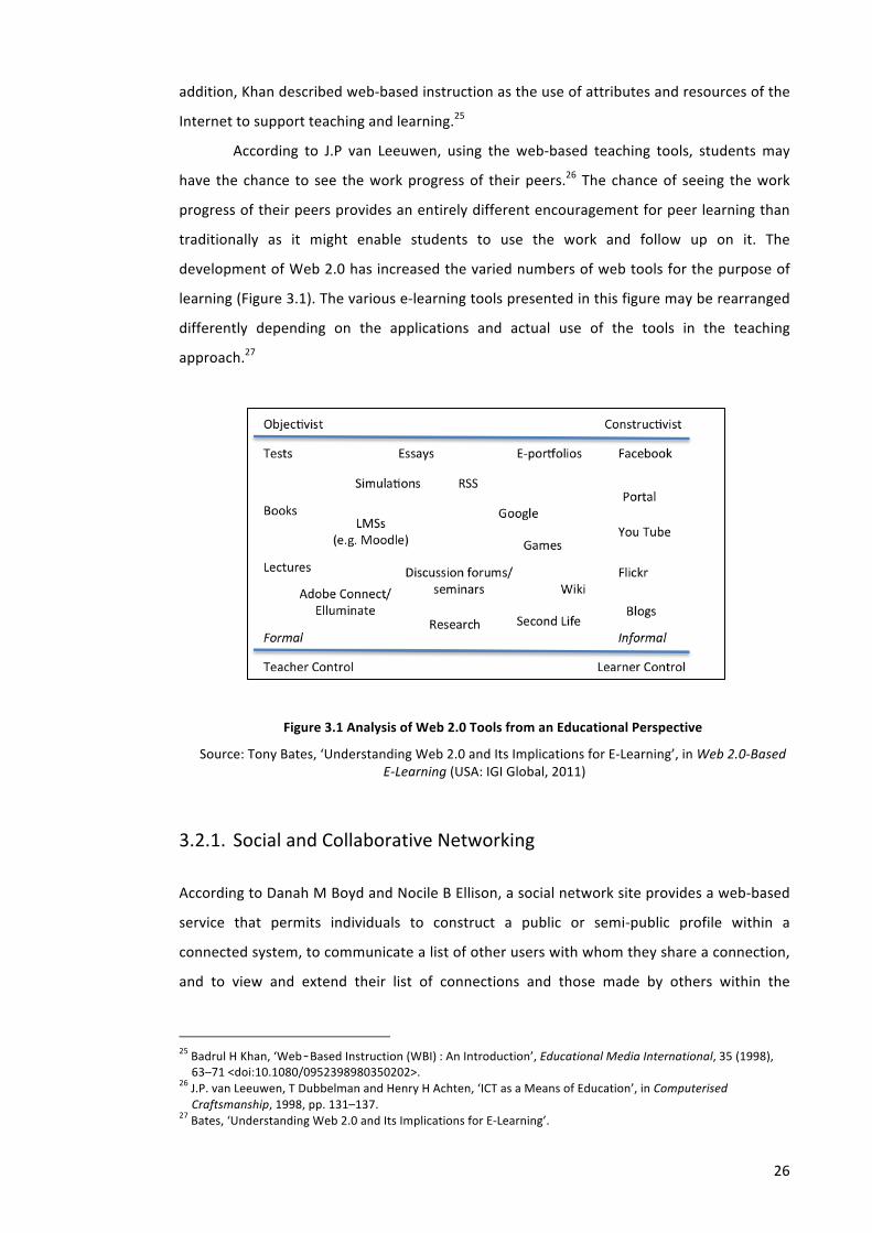
26
addition, Khan described web-‐based instruction as the use of attributes and resources of the
Internet to support teaching and learning.25
According to J.P van Leeuwen, using the web-‐based teaching tools, students may
have the chance to see the work progress of their peers.26 The chance of seeing the work
progress of their peers provides an entirely different encouragement for peer learning than
traditionally as it might enable students to use the work and follow up on it. The
development of Web 2.0 has increased the varied numbers of web tools for the purpose of
learning (Figure 3.1). The various e-‐learning tools presented in this figure may be rearranged
differently depending on the applications and actual use of the tools in the teaching
approach.27
Figure 3.1 Analysis of Web 2.0 Tools from an Educational Perspective
Source: Tony Bates, ‘Understanding Web 2.0 and Its Implications for E-‐Learning’, in Web 2.0-‐Based E-‐Learning (USA: IGI Global, 2011)
3.2.1. Social and Collaborative Networking
According to Danah M Boyd and Nocile B Ellison, a social network site provides a web-‐based
service that permits individuals to construct a public or semi-‐public profile within a
connected system, to communicate a list of other users with whom they share a connection,
and to view and extend their list of connections and those made by others within the
25 Badrul H Khan, ‘Web‐Based Instruction (WBI) : An Introduction’, Educational Media International, 35 (1998), 63–71 <doi:10.1080/0952398980350202>.
26 J.P. van Leeuwen, T Dubbelman and Henry H Achten, ‘ICT as a Means of Education’, in Computerised Craftsmanship, 1998, pp. 131–137.
27 Bates, ‘Understanding Web 2.0 and Its Implications for E-‐Learning’.
27
system.28 Social and collaborative networking tools refer to any web technology that helps
users to interact and share information to achieve any common goal. In this social and
collaborative environment, every individual contributes their ideas through a brainstorming
process, and discussion and involvement in the development of concepts.
Social and collaborative networking tools have usage advantages in teaching and
learning. They offer significant advantages such as positive impacts on student engagement,
motivation, personal interaction and the affective aspects of the learning environment.29
Blogs, Wikis, and social networking sites such as Facebook have been used to
support e-‐learning including the subject of architecture and urban design. Tutors may add
their own blog to online courses and use it as a medium for discussion with their students.
Using blogs, wikis, and social software, students can also test, question, and construct their
own personalized knowledge. In the University of Liverpool for example, wikis have been
used in architectural design modules to support the ‘traditional’ approach of one-‐to-‐one
tutorials30 (see Chapter 4, Section 4.1.3).
3.2.2. Multimedia Archives
Multimedia archives such as YouTube and Flickr enable learners to create their own digital e-‐
portfolios of work that combine text, graphics, audio and video in a relatively simple way.
Flickr is an online photo management and sharing application that enable users to upload,
edit, organize and share photos and videos, while YouTube allows people to discover, watch
and share video across the Internet through Web sites, mobile devices, blogs and email.31
The potential impact of multimedia archives such as YouTube on teaching and
learning has improved in the last few years. In his recent paper, Snelson mentioned that at
least 188 peer reviewed journal articles and conference papers mentioned ‘YouTube’ in the
title.32
28 Danah M Boyd and Nicole B Ellison, ‘Social Network Sites: Definition, History, and Scholarship’, Journal of Computer-‐Mediated Communication, 13 (2007) <http://jcmc.indiana.edu/vol13/issue1/boyd.ellison.html>.
29 Ellen S Hoffman, ‘Evaluating Social Networking Tools for Distance Learning’, in The New Internet: Collaborative Learning, Social Networking, Technology Tools and Best Practices, 2009, 92–100 <http://etec.hawaii.edu/proceedings/2009/>.
30 Michael W Knight and Andre G.P Brown, ‘Increasing Design Reflection and Improving Feedback Using Wikis’, FUTURE CITIES [28th eCAADe Conference Proceedings / ISBN 978-‐0-‐9541183-‐9-‐6] ETH Zurich (Switzerland) 15-‐18 September 2010, pp.51-‐55, 2010 <http://cumincad.scix.net/cgi-‐bin/works/Show?_id=ecaade2010_135&sort=DEFAULT&search=Knight&hits=48> [accessed 20 November 2012].
31 Theresa Brosche and Michelle Feavel, Successful Online Learning: Managing the Online Learning Environment Efficiently and Effectively (Jones & Bartlett Learning, 2010).
32 Chareen Snelson, ‘YouTube Across the Disciplines: A Review of the Literature’, JOLT -‐ Journal of Online Learning and Teaching, 2011 <http://jolt.merlot.org/vol7no1/snelson_0311.htm> [accessed 7 May 2013].
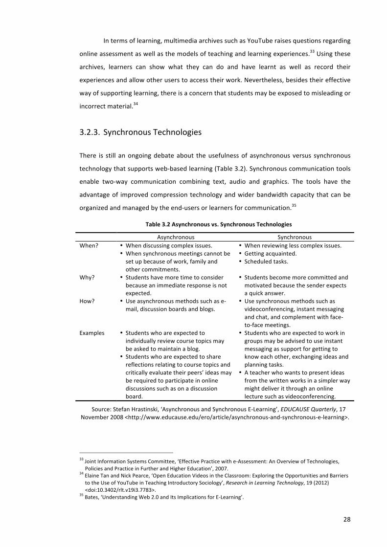
28
In terms of learning, multimedia archives such as YouTube raises questions regarding
online assessment as well as the models of teaching and learning experiences.33 Using these
archives, learners can show what they can do and have learnt as well as record their
experiences and allow other users to access their work. Nevertheless, besides their effective
way of supporting learning, there is a concern that students may be exposed to misleading or
incorrect material.34
3.2.3. Synchronous Technologies
There is still an ongoing debate about the usefulness of asynchronous versus synchronous
technology that supports web-‐based learning (Table 3.2). Synchronous communication tools
enable two-‐way communication combining text, audio and graphics. The tools have the
advantage of improved compression technology and wider bandwidth capacity that can be
organized and managed by the end-‐users or learners for communication.35
Table 3.2 Asynchronous vs. Synchronous Technologies
Asynchronous Synchronous When? • When discussing complex issues.
• When synchronous meetings cannot be set up because of work, family and other commitments.
• When reviewing less complex issues. • Getting acquainted. • Scheduled tasks.
Why? • Students have more time to consider because an immediate response is not expected.
• Students become more committed and motivated because the sender expects a quick answer.
How? • Use asynchronous methods such as e-‐mail, discussion boards and blogs.
• Use synchronous methods such as videoconferencing, instant messaging and chat, and complement with face-‐to-‐face meetings.
Examples • Students who are expected to individually review course topics may be asked to maintain a blog.
• Students who are expected to share reflections relating to course topics and critically evaluate their peers’ ideas may be required to participate in online discussions such as on a discussion board.
• Students who are expected to work in groups may be advised to use instant messaging as support for getting to know each other, exchanging ideas and planning tasks.
• A teacher who wants to present ideas from the written works in a simpler way might deliver it through an online lecture such as videoconferencing.
Source: Stefan Hrastinski, ‘Asynchronous and Synchronous E-‐Learning’, EDUCAUSE Quarterly, 17 November 2008 <http://www.educause.edu/ero/article/asynchronous-‐and-‐synchronous-‐e-‐learning>.
33 Joint Information Systems Committee, ‘Effective Practice with e-‐Assessment: An Overview of Technologies, Policies and Practice in Further and Higher Education’, 2007.
34 Elaine Tan and Nick Pearce, ‘Open Education Videos in the Classroom: Exploring the Opportunities and Barriers to the Use of YouTube in Teaching Introductory Sociology’, Research in Learning Technology, 19 (2012) <doi:10.3402/rlt.v19i3.7783>.
35 Bates, ‘Understanding Web 2.0 and Its Implications for E-‐Learning’.
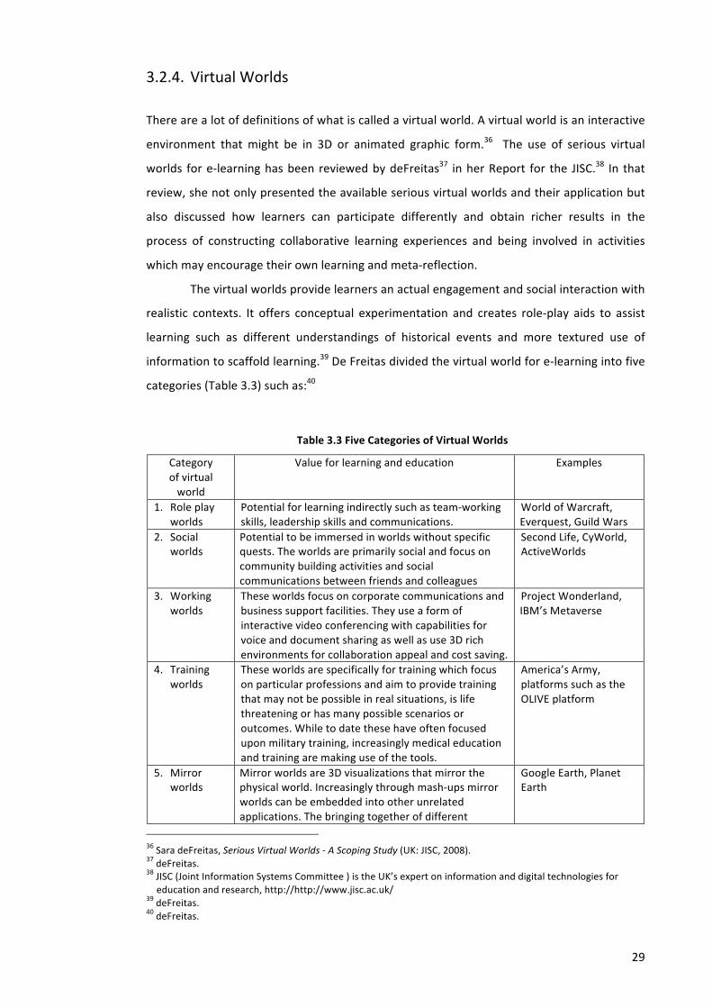
29
3.2.4. Virtual Worlds
There are a lot of definitions of what is called a virtual world. A virtual world is an interactive
environment that might be in 3D or animated graphic form.36 The use of serious virtual
worlds for e-‐learning has been reviewed by deFreitas37 in her Report for the JISC.38 In that
review, she not only presented the available serious virtual worlds and their application but
also discussed how learners can participate differently and obtain richer results in the
process of constructing collaborative learning experiences and being involved in activities
which may encourage their own learning and meta-‐reflection.
The virtual worlds provide learners an actual engagement and social interaction with
realistic contexts. It offers conceptual experimentation and creates role-‐play aids to assist
learning such as different understandings of historical events and more textured use of
information to scaffold learning.39 De Freitas divided the virtual world for e-‐learning into five
categories (Table 3.3) such as:40
Table 3.3 Five Categories of Virtual Worlds
Category of virtual world
Value for learning and education Examples
1. Role play worlds
Potential for learning indirectly such as team-‐working skills, leadership skills and communications.
World of Warcraft, Everquest, Guild Wars
2. Social worlds
Potential to be immersed in worlds without specific quests. The worlds are primarily social and focus on community building activities and social communications between friends and colleagues
Second Life, CyWorld, ActiveWorlds
3. Working worlds
These worlds focus on corporate communications and business support facilities. They use a form of interactive video conferencing with capabilities for voice and document sharing as well as use 3D rich environments for collaboration appeal and cost saving.
Project Wonderland, IBM’s Metaverse
4. Training worlds
These worlds are specifically for training which focus on particular professions and aim to provide training that may not be possible in real situations, is life threatening or has many possible scenarios or outcomes. While to date these have often focused upon military training, increasingly medical education and training are making use of the tools.
America’s Army, platforms such as the OLIVE platform
5. Mirror worlds
Mirror worlds are 3D visualizations that mirror the physical world. Increasingly through mash-‐ups mirror worlds can be embedded into other unrelated applications. The bringing together of different
Google Earth, Planet Earth
36 Sara deFreitas, Serious Virtual Worlds -‐ A Scoping Study (UK: JISC, 2008). 37 deFreitas. 38 JISC (Joint Information Systems Committee ) is the UK’s expert on information and digital technologies for education and research, http://http://www.jisc.ac.uk/
39 deFreitas. 40 deFreitas.

30
Category of virtual world
Value for learning and education Examples
applications is facilitated by interoperability – and this presents interesting options for education and training especially where a blend of real and virtual spaces may be beneficial, e.g. field trips, multimedia production.
Source: Sara deFreitas, Serious Virtual Worlds -‐ A Scoping Study (UK: JISC, 2008)
In the subject of architecture and urban design, the term ‘virtual world’ is generally
used to represent a built environment or a city. ‘Virtual city’ refers to a computer-‐based 3D
graphical representation of a city, which can be accessed over an intranet or the Internet.41
The characteristics of 3D digital (virtual) cities are influenced by the goals of their creation,
the approach and technologies applied to the uses and users.42 Research and development
groups from all over the world have developed virtual cities for different uses such as the city
directory developed by University of Strathclyde (Glasgow Director), historical reconstruction
(such as Virtual Historic Museum of the City of Bologna), urban simulator (such as Virtual City
of Bath developed by CASA-‐University of Bath and Virtual Los Angeles), social or community
networking (such as Digital City Amsterdam), and many more.
3.2.5. Mobile Learning
Mobile technologies are becoming increasingly ubiquitous and pervasive and they have
caused a complete disparity in the way society works, learns and has fun. In terms of
learning, it is generally believed that learners should be able to take part in educational
activities anytime anywhere.43 Therefore there needs to be a transformation in the way
educational materials should be designed, improved and be accessible to anyone who wants
to learn.44
The success factors for the mobile learning initiatives are generated by the
affordability and user-‐friendliness of mobile devices, creative and innovative uses of mobile
devices for learning, the eagerness of the education sector to adopt mobile learning
strategies, and advocacy and social mobilization (ASM) schemes that have resulted in
community ownership of the projects. 41 C. Peng and others, ‘On an Alternative Framework for Building Virtual Cities: Supporting Urban Contextual Modelling on Demand’, Environment and Planning B: Planning and Design, 29 (2002), 87–103.
42 M.L Chiu and C Peng, ‘Insights of 3D Digital Cities: The Past, Present, and Futures’, in CAAD Talks 4: Insights of Digital Cities, Mao-‐Lin Chiu (editor) (Archidata, Co.,Ltd, 2005), pp. 13–35.
43 Mobile Learning: A Handbook for Educators and Trainers, New edition (Routledge, 2005). 44 Adelina Moura and Ana Amelia Carvalho, ‘Mobile Learning: Two Experiments on Teaching and Learning with Mobile Phones’, in Advanced Learning, ed. by Raquel Hijon-‐Neira (InTech, 2009) <http://www.intechopen.com/books/advanced-‐learning/mobile-‐learning-‐two-‐experimednts-‐on-‐teaching-‐and-‐learning-‐with-‐mobile-‐phones> [accessed 5 February 2013].
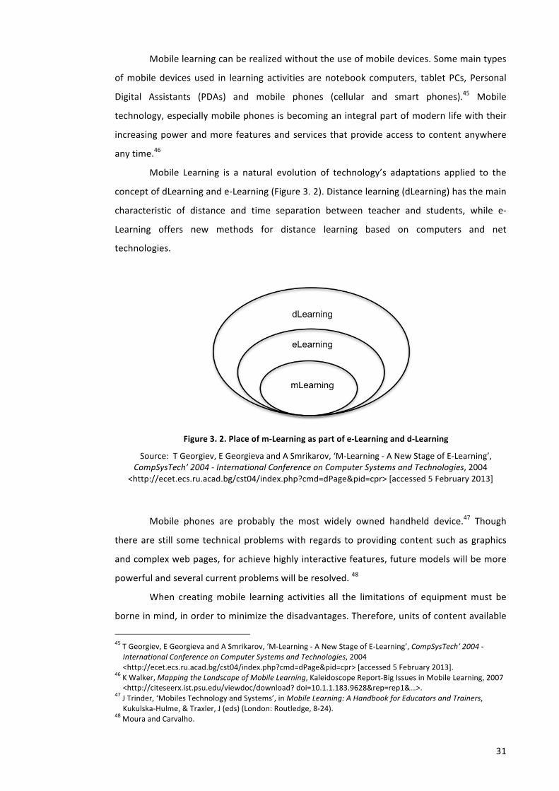
31
Mobile learning can be realized without the use of mobile devices. Some main types
of mobile devices used in learning activities are notebook computers, tablet PCs, Personal
Digital Assistants (PDAs) and mobile phones (cellular and smart phones).45 Mobile
technology, especially mobile phones is becoming an integral part of modern life with their
increasing power and more features and services that provide access to content anywhere
any time.46
Mobile Learning is a natural evolution of technology’s adaptations applied to the
concept of dLearning and e-‐Learning (Figure 3. 2). Distance learning (dLearning) has the main
characteristic of distance and time separation between teacher and students, while e-‐
Learning offers new methods for distance learning based on computers and net
technologies.
Figure 3. 2. Place of m-‐Learning as part of e-‐Learning and d-‐Learning
Source: T Georgiev, E Georgieva and A Smrikarov, ‘M-‐Learning -‐ A New Stage of E-‐Learning’, CompSysTech’ 2004 -‐ International Conference on Computer Systems and Technologies, 2004
<http://ecet.ecs.ru.acad.bg/cst04/index.php?cmd=dPage&pid=cpr> [accessed 5 February 2013]
Mobile phones are probably the most widely owned handheld device.47 Though
there are still some technical problems with regards to providing content such as graphics
and complex web pages, for achieve highly interactive features, future models will be more
powerful and several current problems will be resolved. 48
When creating mobile learning activities all the limitations of equipment must be
borne in mind, in order to minimize the disadvantages. Therefore, units of content available
45 T Georgiev, E Georgieva and A Smrikarov, ‘M-‐Learning -‐ A New Stage of E-‐Learning’, CompSysTech’ 2004 -‐ International Conference on Computer Systems and Technologies, 2004 <http://ecet.ecs.ru.acad.bg/cst04/index.php?cmd=dPage&pid=cpr> [accessed 5 February 2013].
46 K Walker, Mapping the Landscape of Mobile Learning, Kaleidoscope Report-‐Big Issues in Mobile Learning, 2007 <http://citeseerx.ist.psu.edu/viewdoc/download? doi=10.1.1.183.9628&rep=rep1&…>.
47 J Trinder, ‘Mobiles Technology and Systems’, in Mobile Learning: A Handbook for Educators and Trainers, Kukulska-‐Hulme, & Traxler, J (eds) (London: Routledge, 8-‐24).
48 Moura and Carvalho.
32
only to learning just in time, practice and reviews of content, recordings, communication and
access to information in the local set, sending reminders and relevant information for
students are good options (Thornton & Houser, 2002).
The use of a mobile approach for enhancing learning in Urban Design was conducted
at Oxford Brookes University during the 2011-‐2012 academic year. In the project, the
portability and versatility of mobile technology was used to complement traditional teaching
resources to create a series of mobile lectures.49
3.3. Visualization of 3D Virtual City and The Production
Quality e-‐learning aims to merge the variety and unity into an active and intellectually
stimulating ‘learning environment’. E-‐learning requires and provides more appropriate ways
to deal with, make sense of and reproduce this information. The most important facets of e-‐
learning are its interactive and constructive nature.50 In order to support interactive and
constructive e-‐learning, the visualization of existing real world spaces should create
experiences and procedures by which and within, communities can use and share the
outputs. Building interactive virtual cities, which support E-‐learning is very challenging
because it involves large complexes of spatial data to describe the city in question. In an
information-‐rich virtual environment, symbolic and perceptual information is merged into
one environment.51
When developing virtual cities, there are two central ideas that should be
considered, i.e. mirror worlds and virtual worlds.52 Mirror worlds are a digital representation
of the real world/real city geographically linked to planet Earth. Virtual worlds are both real
and fictional media, which are created without importing any iconic representation of a real
world.
The emergence of this pervasive virtual city has been supported by the development
of Web 2.0. Web 2.0 has been distinguished for its interactive information sharing, creativity,
interoperability, user-‐centred design, and collaboration.53 The current generation of virtual
city models is important because it is not simply the digital geometry of traditional models
but large-‐scale databases which can be viewed in 3D. It represents a way of merging abstract 49 Laura Novo de Azevedo, ‘The Power of Experience: Implementing and Evaluating the Use of a Mobile Approach for Enhancing Students’ Learning in Urban Design’, 8 (2011), 32–49 (18).
50 D. Randy Garrison, E-‐Learning in the 21st Century: A Framework for Research and Practice, 1st edn (Routledge, 2002).
51 Jay Bolter and others, ‘Integrating Perceptual and Symbolic Information in VR’, IEEE Comput. Graph. Appl., 15 (1995), 8–11 <doi:10.1109/38.391481>.
52 Andrew Hudson-‐Smith, Digital Urban, The Visual City, CASA Working Papers Series (London: University College London, 2007) <http://www.casa.ucl.ac.uk/publications/workingPaperDetail.asp?ID=124>.
53 http://en.wikipedia.org/wiki/Web_2.0, accessed on October 2009
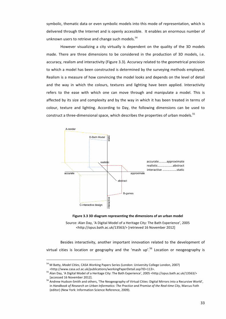
33
symbolic, thematic data or even symbolic models into this mode of representation, which is
delivered through the Internet and is openly accessible. It enables an enormous number of
unknown users to retrieve and change such models.54
However visualizing a city virtually is dependent on the quality of the 3D models
made. There are three dimensions to be considered in the production of 3D models, i.e.
accuracy, realism and interactivity (Figure 3.3). Accuracy related to the geometrical precision
to which a model has been constructed is determined by the surveying methods employed.
Realism is a measure of how convincing the model looks and depends on the level of detail
and the way in which the colours, textures and lighting have been applied. Interactivity
refers to the ease with which one can move through and manipulate a model. This is
affected by its size and complexity and by the way in which it has been treated in terms of
colour, texture and lighting. According to Day, the following dimensions can be used to
construct a three-‐dimensional space, which describes the properties of urban models.55
Figure 3.3 3D diagram representing the dimensions of an urban model
Source: Alan Day, ‘A Digital Model of a Heritage City: The Bath Experience’, 2005 <http://opus.bath.ac.uk/13563/> [retrieved 16 November 2012]
Besides interactivity, another important innovation related to the development of
virtual cities is location or geography and the ‘mash up’.56 Location or neogeography is
54 M Batty, Model Cities, CASA Working Papers Series (London: University College London, 2007) <http://www.casa.ucl.ac.uk/publications/workingPaperDetail.asp?ID=113>.
55 Alan Day, ‘A Digital Model of a Heritage City: The Bath Experience’, 2005 <http://opus.bath.ac.uk/13563/> [accessed 16 November 2012].
56 Andrew Hudson-‐Smith and others, ‘The Neogeography of Virtual Cities: Digital Mirrors into a Recursive World’, in Handbook of Research on Urban Informatics: The Practice and Promise of the Real-‐time City, Marcus Foth (editor) (New York: Information Science Reference, 2009).
accurate….……approximate realistic…………..…..abstract interactive ………………static
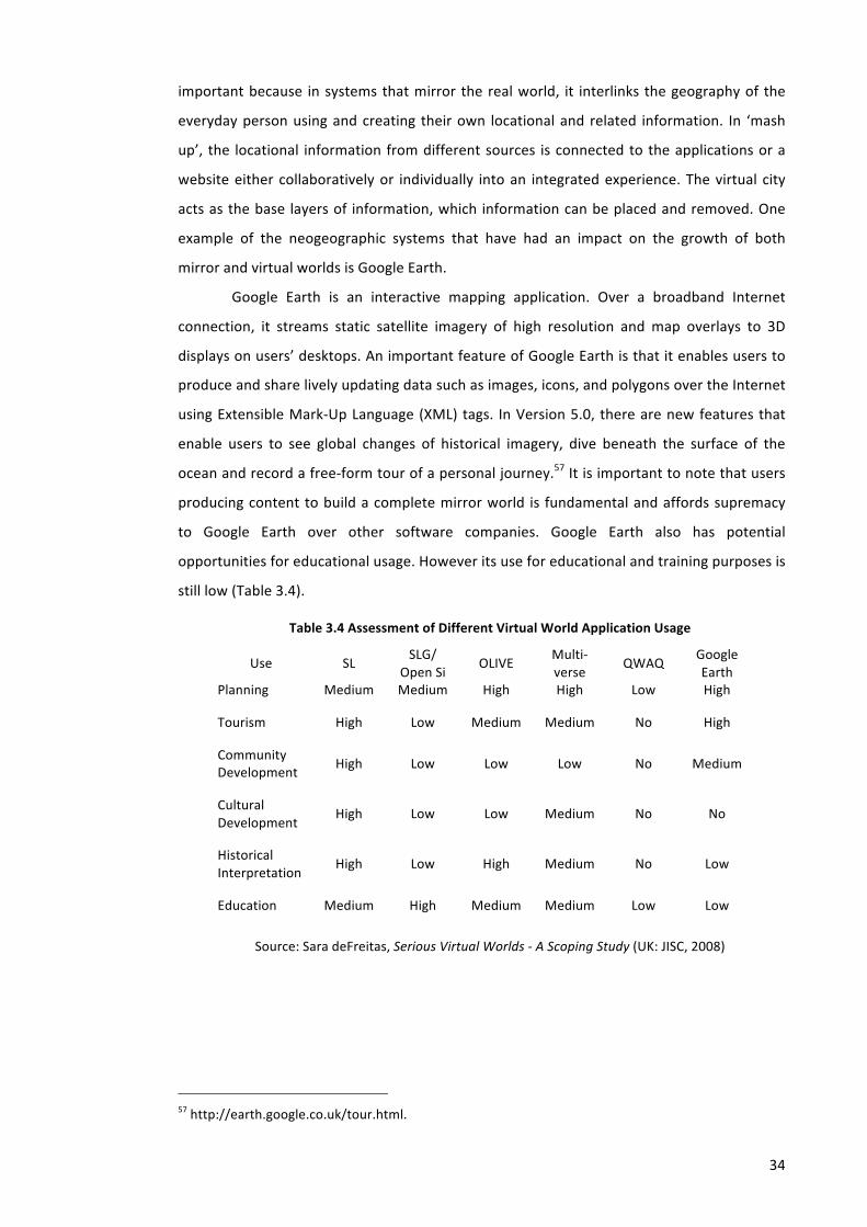
34
important because in systems that mirror the real world, it interlinks the geography of the
everyday person using and creating their own locational and related information. In ‘mash
up’, the locational information from different sources is connected to the applications or a
website either collaboratively or individually into an integrated experience. The virtual city
acts as the base layers of information, which information can be placed and removed. One
example of the neogeographic systems that have had an impact on the growth of both
mirror and virtual worlds is Google Earth.
Google Earth is an interactive mapping application. Over a broadband Internet
connection, it streams static satellite imagery of high resolution and map overlays to 3D
displays on users’ desktops. An important feature of Google Earth is that it enables users to
produce and share lively updating data such as images, icons, and polygons over the Internet
using Extensible Mark-‐Up Language (XML) tags. In Version 5.0, there are new features that
enable users to see global changes of historical imagery, dive beneath the surface of the
ocean and record a free-‐form tour of a personal journey.57 It is important to note that users
producing content to build a complete mirror world is fundamental and affords supremacy
to Google Earth over other software companies. Google Earth also has potential
opportunities for educational usage. However its use for educational and training purposes is
still low (Table 3.4).
Table 3.4 Assessment of Different Virtual World Application Usage
Use SL SLG/
Open Si OLIVE
Multi-‐verse
QWAQ Google Earth
Planning Medium Medium High High Low High
Tourism High Low Medium Medium No High
Community Development
High Low Low Low No Medium
Cultural Development
High Low Low Medium No No
Historical Interpretation
High Low High Medium No Low
Education Medium High Medium Medium Low Low
Source: Sara deFreitas, Serious Virtual Worlds -‐ A Scoping Study (UK: JISC, 2008)
57 http://earth.google.co.uk/tour.html.
35
3.4. Interaction and Collaboration in Web-‐Based Learning
Environments
Web-‐based learning environments have many unique advantages in comparison with the
physical classroom such as providing an equal opportunity for every student to take part,
share information, express their thoughts and build their knowledge with the rest of the
group. It also allows students to communicate and cooperate with their peers freely
regardless of time and place. In addition, the learning process is often automatically
recorded and can be easily monitored and tracked.
Nevertheless, designing and using a web-‐based environment to support teaching
and learning has many challenges as well. The environment must be easy to be accessed,
meet different students’ needs, and be a safe and comfortable space in which students are
willing to contribute and support one another.
3.4.1. Interaction in Web-‐Based Learning Environments
Interaction is one of the most critical elements of learning experiences in web-‐based learning
environments. Scholars have categorized interaction in web-‐based learning based on:
• Time of interaction: Synchronous-‐asynchronous interaction.58
• Context for interaction: Personal-‐social interaction.59
• Interaction in computer mediated communication: individual interaction, one-‐to-‐one
interaction, one-‐to-‐many interaction and many-‐to-‐many interaction.60
• Medium of interaction: learner-‐content, learner-‐teacher, learner to learner
interaction61 and learner to interface interaction.62
• Types of interaction: academic community (learners-‐instructors), intellectual
community (peer-‐to-‐peer interaction) and interpersonal community (through
personal encouragement and assistance).63
58 Tony Bates, Technology, Open Learning, and Distance Learning (London: Routledge, 1995). 59 Bates, Technology, Open Learning, and Distance Learning. 60 Morten Flate Paulsen, ‘The Online Report on Pedagogical Techniques for Computer-‐Mediated Communication’, 1995 <http://repository.maestra.net/valutazione/MaterialeSarti/articoli/Online%20Report%20on%20Pedagogical%20Techniques%20for%20CMC.htm> [accessed 4 February 2013].
61 MG Moore, ‘Three Types of Interaction’, in In Harry, K, John, M and Keegan, D (eds),Distance Education: New Perspectives (London: Routledge, 1993).
62 D C Hillman, D J Willis and C N Gunawardena, ‘Learner-‐Interface Interaction in Distance Education. An Extension of Contemporary Models, and Strategies for Practitioners’, American Journal of Distance Education, 8 (1994), 30–42.
63 L Moller, ‘Designing Communities of Learners for Asynchronous Distance Education’, Educational Technology Research and Development, 46 (1998), 115.
36
According to Jung et al., web-‐based learning environments consist of three kinds of
asynchronous interaction, i.e. academic interaction, collaborative interaction and social
interaction.64 Online interaction is also influenced by factors such as design of online class,
size of class and feedback, and prior experience with web-‐based learning.65
3.4.2. Collaboration in Web-‐Based Learning Environments
The benefits of web-‐based learning for architecture students are that it encourages students
to collaborate with their peers, develop team working skills and enhance their
communication skills, and enables creative design work among participants.66 This
collaboration can help students to engage more in group work and help them to share ideas
and receive feedback, which is very important for students in the process of learning.
Collaboration can be described as an activity where individuals through
communication and cooperation with each other share their understanding and mutually
engage in shared goals or problem solving.67 According to Dillenbourg, learning mechanisms
can be triggered through particular forms of interaction that occur among people involved in
‘collaborative learning’.68 He argued that learning collaboratively is not a single mechanism
but neither is it a method. He describes in a collaborative situation that there is a social
contract under which certain types of interaction may occur between the learners or
between the teacher and learners. Collaborative activities can be described as joint problem
solving and learning can be seen as a result of problem solving. Collaborative learning takes
several forms such as instructions, certain institutional constraints or a physical situation.
Any collaborative drawing or design activity can be differentiated into four types, i.e.
collocated synchronous, collocated asynchronous, remote synchronous and remote
asynchronous (Figure 3.4).69 In collocated synchronous, collaboration is done at the same
geographical location and all participants interact directly face to face while in collocated
asynchronous, communication between groups’ members is done indirectly although they
are located in the same place. Remote synchronous enables all participants to have direct
communication among them in the design process although they are separated in different
64 Jung and others. 65 C Vrasidas and M S McIsaac, ‘Factors Influencing Interaction in an Online Course’, American Journal of Distance Education, 13 (1999), 22–36.
66 Mizban and Roberts. 67 K Kreijns, P Kirschner and W Jochems, ‘Identifying the Pitfalls for Social Interaction in Computer-‐supported Collaborative Learning Environments: a Review of the Research’, Computer in Human Behavio., Vol. 19 (2003), 335–353.
68 P Dillenbourg, ‘Introduction: What Do You Mean by “Collaborative Learning”?’, in In P.Dillenbourg (Ed.) Collaborative Learning, Cognitive, and Computational Approaches, Advances in Learning and Instruction Series (Amsterdam: Pergamon, 1999), pp. 1–19.
69 Chengzhi Peng, Design through Digital Interaction (Intellect L & D E F a E, 2002).
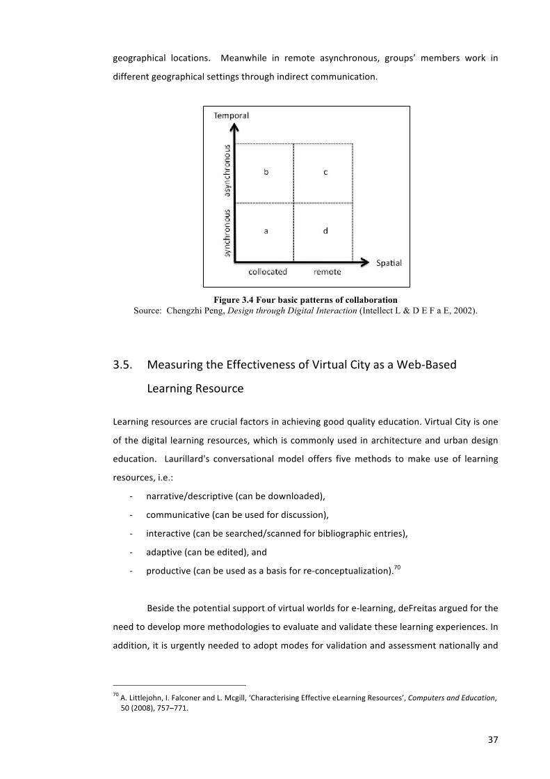
37
geographical locations. Meanwhile in remote asynchronous, groups’ members work in
different geographical settings through indirect communication.
Figure 3.4 Four basic patterns of collaboration Source: Chengzhi Peng, Design through Digital Interaction (Intellect L & D E F a E, 2002).
3.5. Measuring the Effectiveness of Virtual City as a Web-‐Based
Learning Resource
Learning resources are crucial factors in achieving good quality education. Virtual City is one
of the digital learning resources, which is commonly used in architecture and urban design
education. Laurillard's conversational model offers five methods to make use of learning
resources, i.e.:
-‐ narrative/descriptive (can be downloaded),
-‐ communicative (can be used for discussion),
-‐ interactive (can be searched/scanned for bibliographic entries),
-‐ adaptive (can be edited), and
-‐ productive (can be used as a basis for re-‐conceptualization).70
Beside the potential support of virtual worlds for e-‐learning, deFreitas argued for the
need to develop more methodologies to evaluate and validate these learning experiences. In
addition, it is urgently needed to adopt modes for validation and assessment nationally and
70 A. Littlejohn, I. Falconer and L. Mcgill, ‘Characterising Effective eLearning Resources’, Computers and Education, 50 (2008), 757–771.
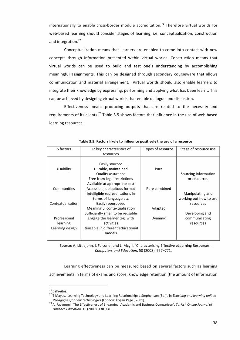
38
internationally to enable cross-‐border module accreditation.71 Therefore virtual worlds for
web-‐based learning should consider stages of learning, i.e. conceptualization, construction
and integration.72
Conceptualization means that learners are enabled to come into contact with new
concepts through information presented within virtual worlds. Construction means that
virtual worlds can be used to build and test one's understanding by accomplishing
meaningful assignments. This can be designed through secondary courseware that allows
communication and material arrangement. Virtual worlds should also enable learners to
integrate their knowledge by expressing, performing and applying what has been learnt. This
can be achieved by designing virtual worlds that enable dialogue and discussion.
Effectiveness means producing outputs that are related to the necessity and
requirements of its clients.73 Table 3.5 shows factors that influence in the use of web based
learning resources.
Table 3.5. Factors likely to influence positively the use of a resource
5 factors 12 key characteristics of resources
Types of resource Stage of resource use
Usability
Communities
Contextualisation
Professional learning
Learning design
Easily sourced
Durable, maintained Quality assurance
Free from legal restrictions Available at appropriate cost Accessible, ubiquitous format Intelligible representations in
terms of language etc Easily repurposed
Meaningful contextualisation Sufficiently small to be reusable Engage the learner (eg. with
activities Reusable in different educational
models
Pure
Pure combined
Adapted
Dynamic
Sourcing information or resources
Manipulating and working out how to use
resources
Developing and communicating
resources
Source: A. Littlejohn, I. Falconer and L. Mcgill, ‘Characterising Effective eLearning Resources’, Computers and Education, 50 (2008), 757–771.
Learning effectiveness can be measured based on several factors such as learning
achievements in terms of exams and score, knowledge retention (the amount of information
71 deFreitas. 72 T Mayes, ‘Learning Technology and Learning Relationships J.Stephenson (Ed.)’, in Teaching and learning online: Pedagogies for new technologies (London: Kogan Page., 2001).
73 A. Fayyoumi, ‘The Effectiveness of E-‐learning: Academic and Business Comparison’, Turkish Online Journal of Distance Education, 10 (2009), 130–140.
39
continuously retained after a period of time), time-‐on-‐task (learner’s time spent using the e-‐
learning system), learner’s satisfaction, and self-‐efficacy (one’s judgment of his/her ability to
accomplish a task).74 Effectiveness is also influenced by factors such as technology, learner
(maturity, motivation, previous experience, computer anxiety), teacher/instructor (teaching
style, availability), course content (conceptual, procedural, factual knowledge) and student
characteristics.
Summary
Web-‐based learning seems a promising way to support e-‐learning in architecture and urban
design through combining content management systems and virtual worlds. It facilitates
students not only to manage data in 2D but also 3D. The benefit of combining various data
could be possibly supported by the use of web 2.0 tools which support interaction and
collaboration between learners.
Visualizing 3D virtual city models in virtual worlds is very complex as it involves large
amounts of spatial data to represent the city in question. And the technology to model,
display, and host the 3D models have improved continuously from single desktop computers
and web-‐based technology to mobile technology.
The visualization of a city should create experiences and procedures for learners in
order to support interactive and constructive e-‐learning. CREATI as an information-‐rich
virtual learning environment proposed in this study facilitates learners to gather contextual
information related to buildings and places while experiencing urban spaces virtually in the
virtual world. The effectiveness of 3D virtual city models enhanced with collective memory
as e-‐learning resources in architecture and urban design will be examined. It is important to
note that learning stages (conceptualization, construction and integration) should be
considered when designing virtual worlds as web-‐based learning.
74 Littlejohn, Falconer and Mcgill.
Chapter 4. CONCEPTUAL FRAMEWORK OF COLLECTIVE MEMORY ENHANCED VIRTUAL CITY (CREATI) FOR SUPPORTING URBAN DESIGN LEARNING
Without a collective memory, we are nothing, and can achieve nothing. It defines our identity and we use it continuously for education, work and leisure.
(European Commission View)
In this chapter several projects will be described in order to give an introduction that can
paint a picture of how the conceptual framework of Collective memory enhanced virtual city
(CREATI) for urban design learning is devised. The Sheffield Urban Contextual Databank
(SUCoD) at the School of Architecture, the University of Sheffield and The People’s Archive
Project at Birmingham Library have suggested ideas about making historical contextual
information accessible online to support collaboration by users. Meanwhile WeCAMP at the
School of Architecture, the University of Sheffield and Wikis at Vital Project, the University of
Liverpool have proposed ideas related to the design of virtual learning environments in the
subject of architecture and urban design.
4.1. Related Projects
4.1.1. Case 1: The Sheffield Urban Contextual Databank (SUCoD)
In 2001 the University of Sheffield developed a system called the Sheffield Urban Contextual
Databank (SUCoD) (Figure 4.1). It was designed as a research prototype for building virtual
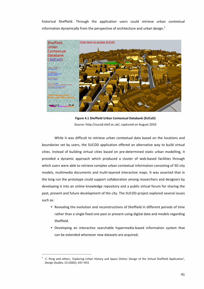
41
historical Sheffield. Through the application users could retrieve urban contextual
information dynamically from the perspective of architecture and urban design.1
Figure 4.1 Sheffield Urban Contextual Databank (SUCoD)
Source: http://sucod.shef.ac.uk/, captured on August 2010
While it was difficult to retrieve urban contextual data based on the locations and
boundaries set by users, the SUCOD application offered an alternative way to build virtual
cities. Instead of building virtual cities based on pre-‐determined static urban modelling, it
provided a dynamic approach which produced a cluster of web-‐based facilities through
which users were able to retrieve complex urban contextual information consisting of 3D city
models, multimedia documents and multi-‐layered interactive maps. It was asserted that in
the long run the prototype could support collaboration among researchers and designers by
developing it into an online knowledge repository and a public virtual forum for sharing the
past, present and future development of the city. The SUCOD project explored several issues
such as:
• Revealing the evolution and reconstructions of Sheffield in different periods of time
rather than a single fixed one past or present using digital data and models regarding
Sheffield.
• Developing an interactive searchable hypermedia-‐based information system that
can be extended whenever new datasets are acquired;
1 C. Peng and others, ‘Exploring Urban History and Space Online: Design of the Virtual Sheffield Application’, Design Studies, 23 (2002), 437–453.
42
• Facilitating collaborative design and research relating to the city context of Sheffield
by creating online digital resources through urban contextual research and
modelling.
According to system developers and data modellers’ point of view, the SUCoD had
supremacy in terms of system functionality and its richer graphical user interface. Moreover
a larger contextual data scope could be added into the system without rendering obsolete
any previous efforts no longer in use. However the need for information on the current state
of Sheffield had been highlighted several times such as supplementing the SUCoD system
with up-‐to-‐date contextual information.
4.1.2. Case 2: WeCAMP Project University of Sheffield
Another example of virtual cities for e-‐learning application is the WeCAMP project. WeCAMP
was a JISC (Joint Information System Committee) institutional innovation research project
undertaken from 2008-‐2010 at the School of Architecture, the University of Sheffield. The
main aim of the project was to create a Web-‐Based 3D Interactive Visualisation Modelling
Platform to Effect Participative and Collaborative Planning and Design of Future Learning
Spaces.2 The platform enabled users to view and interact with the buildings and spaces of a
university campus. Users could freely choose to view the whole of the campus at once or just
an individual floor or even a space within a specific building.
The platform delivered by the WeCAMP project is called uCampus -‐ a visualization of
the University of Sheffield campus. The system architecture of uCampus was built with
reference to its predecessor, i.e. Sheffield Urban Contextual Databank (SUCoD) formerly built
in 2001 to deliver complex urban contextual information sets of history of Sheffield. The
SUCoD system was intended initially as a web-‐based urban databank acquired from studies
of the history of Sheffield (Figure 4.2).3 It was a Dynamic Virtual City system capable of
providing multi-‐dimensional urban contextual datasets on demand according to user-‐
specified contextual criteria such as spatial and/or temporal locations and boundaries and it
could become a platform for experimenting with urban design in an educational setting.4
2 (http://www.wecamp.group.shef.ac.uk/ 3 Chengzhi Peng and others, ‘Dynamic Retrieval in An Urban Contextual Databank System Using CGI Communications, Development of the SUCoD Prototype’ (presented at the CAAD Futures, Eindhoven, Netherland: Kluwer Academic Publishers, 2001).
4 WeCAMP Project Plan, http://www.jisc.ac.uk, retrieved April 2009

43
Figure 4.2 System Architecture Built in WeCAMP Platform
Source: WeCAMP Project Plan, http://www.jisc.ac.uk, retrieved April 2009
UCampus aimed to act as a tool to aid the collaborative and coordinated design of
learning spaces [both informal and formal], by a range of university stakeholders.5 Although
uCampus focused on the University of Sheffield, it was the intention that the system and
platform created could be adapted and utilized by other institutions. UCampus offered both
the interior and exterior of buildings and information on how individual spaces were used,
allowing different perspectives to be gained and explored in 3D. The uCampus 3D building
models were accurate to within 5 mm, which meant that they could be used for a variety of
purposes. Users could upload models in real time and decide whether their designs should
be private or in the public domain.
The project was effective in achieving its intended aim of developing a 3D
visualization and modelling application to help stakeholders in institutional building and
space developments better understand and visualize existing and new spaces6. In terms of
creating a version of the application specific to visualizing space at the University of Sheffield
campus, the data added far exceeded the project team’s expectations at the outset of the
project, and included several layers of data relating to the physical arrangement of space,
but also other dimensions relevant to space such as types of learning and teaching space.
5 Puja Basu and others, uCampus a Web-‐based 3D Interactive Visualisation Modelling Platform to Effect Participative and Collaborative Planning and Design of Future Learning Spaces. uCampus -‐ a weCAMP Core Project Output. FINAL REPORT (University of Sheffield, 2010) <http://www.wecamp.group.shef.ac.uk/>.
6 Diane Hart and James Pinder, weCAMP External Evaluation Report (University of Sheffield, 2010) <http://www.wecamp.group.shef.ac.uk/>.
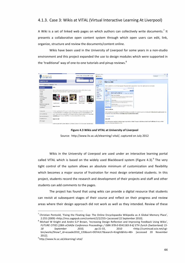
44
4.1.3. Case 3: Wikis at VITAL (Virtual Interactive Learning At Liverpool)
A Wiki is a set of linked web pages on which authors can collectively write documents.7 It
presents a collaborative open content system through which open users can edit, link,
organize, structure and review the documents/content online.
Wikis have been used in the University of Liverpool for some years in a non-‐studio
environment and this project expanded the use to design modules which were supported in
the ‘traditional’ way of one-‐to-‐one tutorials and pinup reviews.8
Figure 4.3 Wikis and VITAL at University of Liverpool
Source: http://www.liv.ac.uk/elearning/-‐vital/, captured on July 2012
Wikis in the University of Liverpool are used under an interactive learning portal
called VITAL which is based on the widely used Blackboard system (Figure 4.3).9 The very
tight control of the system allows an absolute minimum of customization and flexibility
which becomes a major source of frustration for most design orientated students. In this
project, students record the research and development of their projects and staff and other
students can add comments to the pages.
The project has found that using wikis can provide a digital resource that students
can revisit at subsequent stages of their course and reflect on their progress and review
areas where their design approach did not work as well as they intended. Review of these
7 Christian Pentzold, ‘Fixing the Floating Gap: The Online Encyclopaedia Wikipedia as A Global Memory Place’, 2:255 (2009) <http://mss.sagepub.com/content/2/2/255> [accessed 22 September 2010].
8 Michael W Knight and Andre G.P Brown, ‘Increasing Design Reflection and Improving Feedback Using Wikis’, FUTURE CITIES [28th eCAADe Conference Proceedings / ISBN 978-‐0-‐9541183-‐9-‐6] ETH Zurich (Switzerland) 15-‐18 September 2010, pp.51-‐55, 2010 <http://cumincad.scix.net/cgi-‐bin/works/Show?_id=ecaade2010_135&sort=DEFAULT&search=Knight&hits=48> [accessed 20 November 2012].
9 http://www.liv.ac.uk/elearning/-‐vital/
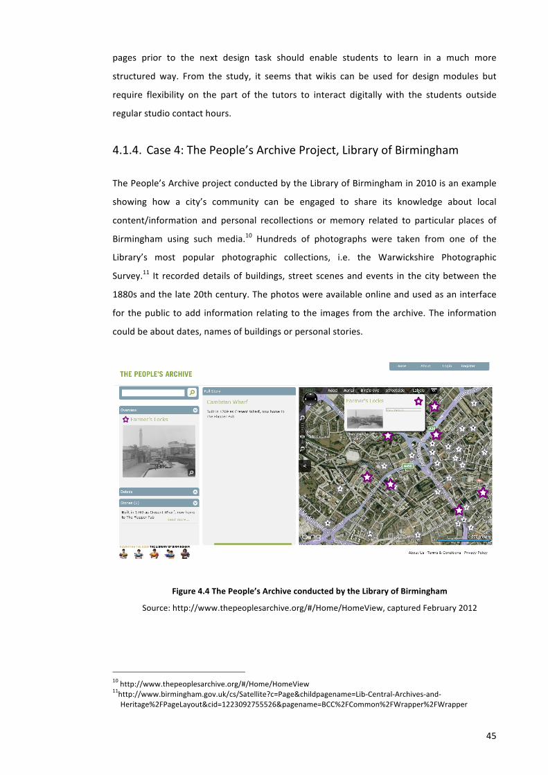
45
pages prior to the next design task should enable students to learn in a much more
structured way. From the study, it seems that wikis can be used for design modules but
require flexibility on the part of the tutors to interact digitally with the students outside
regular studio contact hours.
4.1.4. Case 4: The People’s Archive Project, Library of Birmingham
The People’s Archive project conducted by the Library of Birmingham in 2010 is an example
showing how a city’s community can be engaged to share its knowledge about local
content/information and personal recollections or memory related to particular places of
Birmingham using such media.10 Hundreds of photographs were taken from one of the
Library’s most popular photographic collections, i.e. the Warwickshire Photographic
Survey.11 It recorded details of buildings, street scenes and events in the city between the
1880s and the late 20th century. The photos were available online and used as an interface
for the public to add information relating to the images from the archive. The information
could be about dates, names of buildings or personal stories.
Figure 4.4 The People’s Archive conducted by the Library of Birmingham
Source: http://www.thepeoplesarchive.org/#/Home/HomeView, captured February 2012
10 http://www.thepeoplesarchive.org/#/Home/HomeView 11http://www.birmingham.gov.uk/cs/Satellite?c=Page&childpagename=Lib-‐Central-‐Archives-‐and-‐Heritage%2FPageLayout&cid=1223092755526&pagename=BCC%2FCommon%2FWrapper%2FWrapper
46
The project was intended to explore how citizens might add new layers of
information to the city’s collective memory, using a digital place for recording and sharing
knowledge. According to Kuhn, a repository of memories such as a photograph album acts as
reminders of persons, places or events in the past and can function as substitutes for
remembering and be used by their compilers/owners as prompts for performances of
memory in private, interactive, collective and sometimes even public contexts.12
For the pilot project, about 500 images of the city centre were provided and
displayed to the visitors at Birmingham’s ArtFest. The images were used to encourage
memories and personal knowledge of people and places. Using the images, it was expected
that the members of public could recognize a face in a photo or confirm a date displayed on
the photos to help provide missing details and solve mysteries.
The People’s Archive aimed to enrich the library’s existing collections. Using Bing
Maps and Silverlight (Figure 4.4), the project was built by adding new layers of information
and providing a digital place for recording and sharing knowledge. If the pilot was successful,
The People’s Archive was to be developed further, providing an important digital resource
offered by the new library, accessible to all, and for everyone, from local people curious
about their city’s past to serious researchers and students.13
The People’s Archive was a collaboration project that involved Birmingham City
Council, Service Birmingham and Birmingham-‐based digital companies, In Cahoots and
Clusta. It was expected that it would grow continually into an online journey telling the story
of the area’s history, inviting input from the public, and heralding the Library of
Birmingham’s philosophy of providing a world-‐class learning and leisure experience in a fully
interactive environment.
4.2. Collective Memory Enhanced Virtual City (CREATI) for Urban
Design Learning
As mentioned in Chapter 1, this study aimed to develop and test a digital modelling
methodology for enhancing virtual city with collective memory to support urban design
learning. In view of the collective memory concepts explained in Chapter 2, some
understanding of the collective memory concepts that are relevant to this study can be
summarized as follows:
12 Annette Kuhn, ‘Memory Texts and Memory Work: Performances of Memory in and with Visual Media’, Memory Studies, 2010 <doi:10.1177/1750698010370034>.
13 http://www.ubelly.com/2010/10/shaping-‐the-‐past-‐with-‐the-‐peoples-‐archive/
47
• Collective memory is not the summation of memory from personal recollections of
its various individual members but the entirety of those that are commonly shared
by all of them and collectively commemorated.14
• Digital collective memory is created and sustained through the continuous
production of information such as text, graphics, images, film and audio, multimedia
computers and Internet by selecting, organizing, storing and retrieving documents
wherein particular events are emphasized.15
• Web-‐based archives can contribute to the formation of collective memory by
providing dialogue and interactions through which meaning emerges.16
• As the past is frequently used as a mirror via which explanation and remedy to our
present-‐day problems are searched, the content of collective memory can be seen
as solutions to problems in daily life.17
This study approaches the concepts of collective memory as expressions that people
make when remembering buildings, spaces and places of the past and present city living. It
contains all kinds of digital records of the history and story of buildings and places of a city
that are either elicited from or produced directly by the city’s residents or visitors. The idea is
that initial instances of people’s memory associated with a particular segment of a city can
be gathered into a repository (i.e. a collective memory bank) as ‘seeds’ to grow further
contextual and historical information contributed by others (Figure 4.5).
In representing the collective memory of buildings or places digitally, 3D virtual
models are interlinked to these digital memory instances in text, graphics, images, film and
audio, multimedia and other historical resources found from many different websites to
become what is called a collective memory enhanced virtual city (CREATI).18 3D models of a
virtual city become an interface through which the process of remembering can be
mediated. Through the CREATI website, registered users may add and share a digital
memory record of the history and story of buildings and places of a city using 3D virtual
models as an interface. By selecting, organizing, storing and retrieving the records’ content
14 Barbara Misztal, Theories of Social Remembering (Open University Press, 2003); Eviatar Zerubavel, Social Mindscapes: An Invitation to Cognitive Sociology (Harvard University Press, 1999).
15 Jens Brockmeier, ‘After the Archive: Remapping Memory’, Culture & Psychology, 16 (2010), 5 –35 <doi:10.1177/1354067X09353212>; Misztal; Barry Schwartz, ‘The Social Context of Commemoration: A Study in Collective Memory’, Social Forces, 61 (1982), 374–402 <doi:10.2307/2578232>.
16 Pentzold. 17 Andreas Huyssen, Twilight Memories: Marking Time in a Culture of Amnesia, 1st edn (Routledge, 1995). 18 S Felasari and Chengzhi Peng, ‘Enhancing A Virtual City with Collective Memory: A Pilot Study of Jalan Malioboro in Yogyakarta’, in Future cities: proceedings of the 28th Conference on Education in Computer Aided Architectural Design in Europe, September 15-‐18, 2010, Zurich, Switzerland, ETH Zurich (vdf Hochschulverlag AG, 2010).

48
through the CREATI website as well as having dialogue and interactions, a collective memory
can be formed.
Figure 4.5 The idea of collective memory enhanced virtual city (CREATI)
In relation to supporting learning, learners can use the 3D models of virtual city
embedded with collective memory to obtain historical information related to buildings and
places and use it as resources that might explain present-‐day urban design issues.
Using web-‐based tools as a virtual learning environment, the CREATI website has
become a single point of entry through which learners may access urban design course
information as well as the content-‐rich 3D models of a virtual city. The 3D virtual city
embedded with collective memory can be displayed in a 3D virtual world and enable users to
obtain historical information from people’s memory while they are experiencing the virtual
space i.e. by walking through or flying around (Figure 4.6).
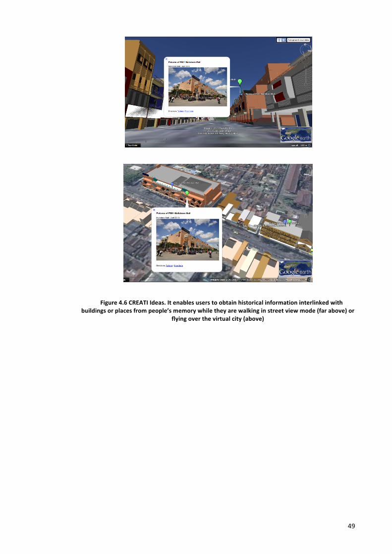
49
Figure 4.6 CREATI Ideas. It enables users to obtain historical information interlinked with buildings or places from people’s memory while they are walking in street view mode (far above) or
flying over the virtual city (above)
Chapter 5. RESEARCH METHODOLOGY
This chapter explains the methodology of this research. It starts by introducing how to
design the interface for the study, followed by modelling the study site, connecting instances
of collective memory to 3D models, and conducting a pilot study and an experiment in an
education setting. The study combined research strategies and utilized questionnaires,
interviews, observation of website usage and content analysis of students’ assignments as
data sources.
Based on practical reasons, this study will use the city of Yogyakarta and Urban
Design module as a study case. It supports research that is normally necessary to answer
how and why questions1 and the questions are being asked about a contemporary set of
events over which the investigator has little or no control.2 According to Linda Groat and
David Wang, a case study can focus on a single case and rely on multiple sources of evidence,
with data needing to converge in a triangulating fashion.3
5.1. Designing The Interface: Integrating Course Content and 3D World
In this study, Google Apps and Google Earth were used as experimental tools to implement a
pilot Collective Memory Enhanced Virtual City (CREATI) modelling platform to support
cooperative urban design learning. Google Apps is a suite of Google applications that has
been quite widely used by educational institutions to support their learning systems. It is a
service from Google providing independently customizable versions of several Google
products under a custom domain name. It features several Web applications with similar
functionality to traditional office suites, including Gmail, Google Groups, Google Calendar,
1 Jennifer Rowley, ‘Using Case Studies in Research’, Management Research News, 25 (2002), 16–27 <doi:10.1108/01409170210782990>.
2 Robert K. Yin, Case Study Research: Design and Methods (SAGE Publications, 2003). 3 Linda Groat and David Wang, Architectural Research Methods (Wiley, 2001).
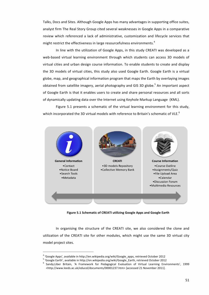
51
Talks, Docs and Sites. Although Google Apps has many advantages in supporting office suites,
analyst firm The Real Story Group cited several weaknesses in Google Apps in a comparative
review which referenced a lack of administrative, customization and lifecycle services that
might restrict the effectiveness in large resourcefulness environments.4
In line with the utilization of Google Apps, in this study CREATI was developed as a
web-‐based virtual learning environment through which students can access 3D models of
virtual cities and urban design course information. To enable students to create and display
the 3D models of virtual cities, this study also used Google Earth. Google Earth is a virtual
globe, map, and geographical information program that maps the Earth by overlaying images
obtained from satellite imagery, aerial photography and GIS 3D globe.5 An important aspect
of Google Earth is that it enables users to create and share personal resources and all sorts
of dynamically updating data over the Internet using Keyhole Markup Language (KML).
Figure 5.1 presents a schematic of the virtual learning environment for this study,
which incorporated the 3D virtual models with reference to Britain’s schematic of VLE.6
Figure 5.1 Schematic of CREATI utilizing Google Apps and Google Earth
In organising the structure of the CREATI site, we also considered the clone and
utilization of the CREATI site for other modules, which might use the same 3D virtual city
model project sites.
4 ‘Google Apps’, available in http://en.wikipedia.org/wiki/Google_apps, retrieved October 2012 5 ‘Google Earth’, available in http://en.wikipedia.org/wiki/Google_Earth, retrieved October 2012 6 Sandy;Liber Britain, ‘A Framework for Pedagogical Evaluation of Virtual Learning Environments’, 1999 <http://www.leeds.ac.uk/educol/documents/00001237.htm> [accessed 21 November 2011].
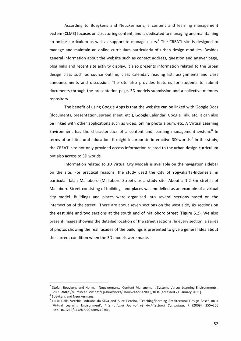
52
According to Boeykens and Neuckermans, a content and learning management
system (CLMS) focuses on structuring content, and is dedicated to managing and maintaining
an online curriculum as well as support to manage users.7 The CREATI site is designed to
manage and maintain an online curriculum particularly of urban design modules. Besides
general information about the website such as contact address, question and answer page,
blog links and recent site activity display, it also presents information related to the urban
design class such as course outline, class calendar, reading list, assignments and class
announcements and discussion. The site also provides features for students to submit
documents through the presentation page, 3D models submission and a collective memory
repository.
The benefit of using Google Apps is that the website can be linked with Google Docs
(documents, presentation, spread sheet, etc.), Google Calendar, Google Talk, etc. It can also
be linked with other applications such as video, online photo album, etc. A Virtual Learning
Environment has the characteristics of a content and learning management system.8 In
terms of architectural education, it might incorporate interactive 3D worlds.9 In the study,
the CREATI site not only provided access information related to the urban design curriculum
but also access to 3D worlds.
Information related to 3D Virtual City Models is available on the navigation sidebar
on the site. For practical reasons, the study used the City of Yogyakarta-‐Indonesia, in
particular Jalan Malioboro (Malioboro Street), as a study site. About a 1.2 km stretch of
Malioboro Street consisting of buildings and places was modelled as an example of a virtual
city model. Buildings and places were organised into several sections based on the
intersection of the street. There are about seven sections on the west side, six sections on
the east side and two sections at the south end of Malioboro Street (Figure 5.2). We also
present images showing the detailed location of the street sections. In every section, a series
of photos showing the real facades of the buildings is presented to give a general idea about
the current condition when the 3D models were made.
7 Stefan Boeykens and Herman Neuckermans, ‘Content Management Systems Versus Learning Environments’, 2009 <http://cumincad.scix.net/cgi-‐bin/works/Show?caadria2009_103> [accessed 21 January 2011].
8 Boeykens and Neuckermans. 9 Luisa Dalla Vecchia, Adriane da Silva and Alice Pereira, ‘Teaching/learning Architectural Design Based on a Virtual Learning Environment’, International Journal of Architectural Computing, 7 (2009), 255–266 <doi:10.1260/147807709788921976>.
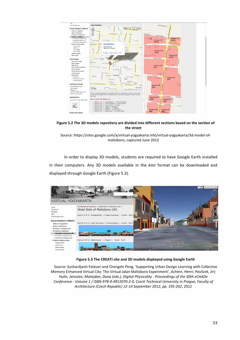
53
Figure 5.2 The 3D models repository are divided into different sections based on the section of the street
Source: https://sites.google.com/a/virtual-‐yogyakarta.info/virtual-‐yogyakarta/3d-‐model-‐of-‐malioboro, captured June 2012
In order to display 3D models, students are required to have Google Earth installed
in their computers. Any 3D models available in the kmz format can be downloaded and
displayed through Google Earth (Figure 5.3).
Figure 5.3 The CREATI site and 3D models displayed using Google Earth
Source: Sushardjanti Felasari and Chengzhi Peng, ‘Supporting Urban Design Learning with Collective Memory Enhanced Virtual City: The Virtual Jalan Malioboro Experiment’, Achten, Henri; Pavlicek, Jiri;
Hulin, Jaroslav; Matejdan, Dana (eds.), Digital Physicality -‐ Proceedings of the 30th eCAADe Conference -‐ Volume 1 / ISBN 978-‐9-‐4912070-‐2-‐0, Czech Technical University in Prague, Faculty of
Architecture (Czech Republic) 12-‐14 September 2012, pp. 195-‐202, 2012
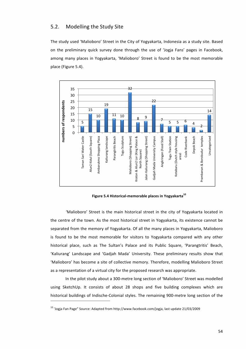
54
5.2. Modelling the Study Site
The study used ‘Malioboro’ Street in the City of Yogyakarta, Indonesia as a study site. Based
on the preliminary quick survey done through the use of ‘Jogja Fans’ pages in Facebook,
among many places in Yogyakarta, ‘Malioboro’ Street is found to be the most memorable
place (Figure 5.4).
Figure 5.4 Historical-‐memorable places in Yogyakarta10
‘Malioboro’ Street is the main historical street in the city of Yogyakarta located in
the centre of the town. As the most historical street in Yogyakarta, its existence cannot be
separated from the memory of Yogyakarta. Of all the many places in Yogyakarta, Malioboro
is found to be the most memorable for visitors to Yogyakarta compared with any other
historical place, such as The Sultan’s Palace and its Public Square, ‘Parangtritis’ Beach,
‘Kaliurang’ Landscape and ‘Gadjah Mada’ University. These preliminary results show that
‘Malioboro’ has become a site of collective memory. Therefore, modelling Malioboro Street
as a representation of a virtual city for the proposed research was appropriate.
In the pilot study about a 300-‐metre long section of ‘Malioboro’ Street was modelled
using SketchUp. It consists of about 28 shops and five building complexes which are
historical buildings of Indische-‐Colonial styles. The remaining 900-‐metre long section of the
10 ‘Jogja Fan Page” Source: Adapted from http://www.facebook.com/jogja, last update 21/03/2009
5
15
10
19
11 10
32
8 9
22
7 5 5 6
4 2
14
0
5
10
15
20
25
30
35
Taman Sari W
ater Castle
Alun2
Kidul (Sou
th Squ
are)
Ambarukm
o Shop
ping Plaza
Kaliurang land
scape
Parangtrios Be
ach
Tugu Sculpture
Maliobo
ro (Sho
pping Street)
Kraton
& Alun2
Lor (K
ing Palace &
North Squ
are)
Jalan Kaliurang (Sho
pping Street)
Gadjah Mada University
Cam
pus
Angkringan (Foo
d Stall)
Tugu Train Staoo
n
Kotabaru (D
utch style hou
sing
area)
Code
Riverbank
Dep
ok Beach
Pram
banan & Borob
udur tem
ples
Uncategorised
numbe
rs of respo
nden
ts
55
street consists of almost 200 shops and offices which were completed afterwards for the
next stage of the experiment.
Although in some ways there are many conveniences of using Google Earth and Apps
as a research tool, the author had to take into account the limitations of the research tools
used which effect the level of detail of the 3D models. Although Google Apps itself allows
attached files to be uploaded to the system of up to 20 MB in size, Google Earth limits the
size of 3D models to only 10 MB.
In modelling the buildings and places, each building or place was represented as a
single file so as not to burden the system. By modelling the building in a single file, it makes
the editing process easier.
Level of Detail (LoD) of the buildings is limited by the requirement set by Google as
no more than 10 MB file size can be displayed using the Google Earth application. All models
submitted for inclusion to Google Earth must adhere to a set of standards to ensure a high-‐
quality experience for all users. The majority of the criteria ensure that the Photorealistic 3D
Buildings layer in Google Earth is accurate and represents the real world we live in. The
remaining criteria ensure that 3D models do not hinder Google Earth’s performance. In order
to be included in Google Earth’s 3D buildings layer, Google applies acceptance criteria for 3D
models such as requiring models to:11
• Represent real and permanent structures
• Be better than all other alternatives
• Be textured with photographs
• Be correctly aligned with the imagery in Google Earth
• Not include more than one discrete structure
• Not float above or be sunken under the ground
• Not include an excess of constructed terrain
• Not include bundled entourage
• Be the correct height and scale
• Not exhibit Z-‐fighting
• Not contain advertising or spam
• Be complete
• Not be too complex
Unless accepted by the system, the 3D models are only displayable in local Google
Earth.
11 http://support.google.com/sketchup/bin/answer.py?hl=en&answer=1267260
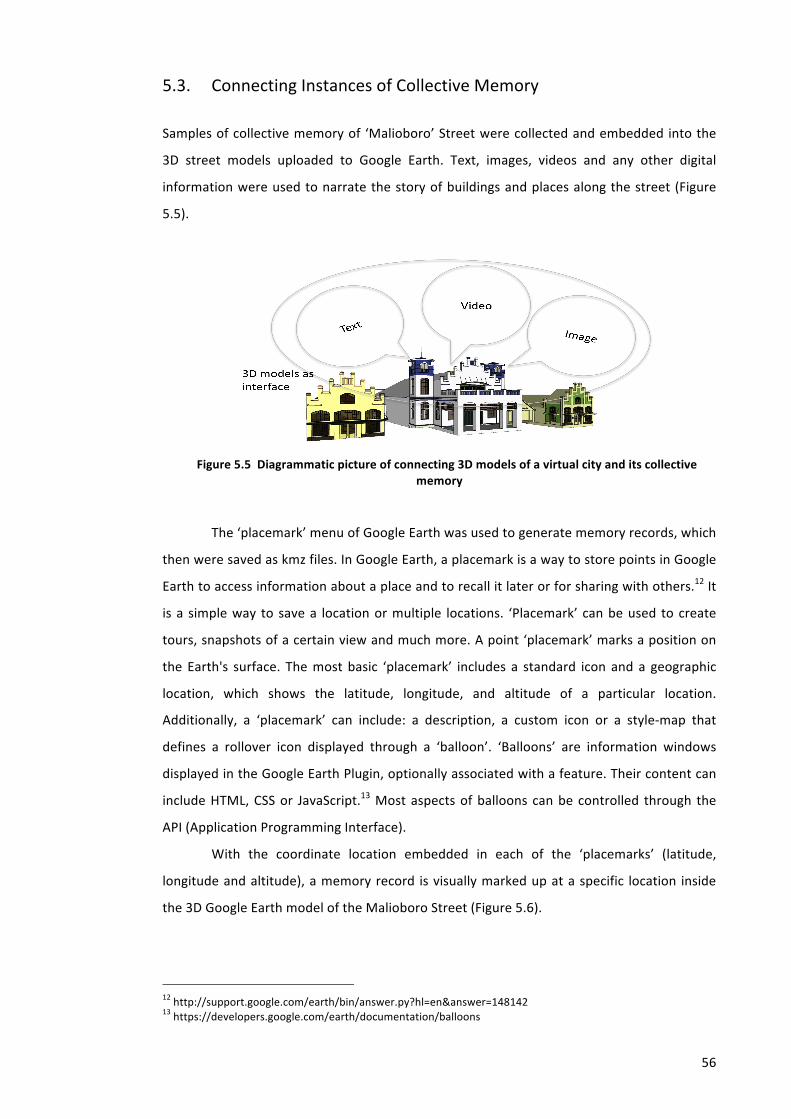
56
5.3. Connecting Instances of Collective Memory
Samples of collective memory of ‘Malioboro’ Street were collected and embedded into the
3D street models uploaded to Google Earth. Text, images, videos and any other digital
information were used to narrate the story of buildings and places along the street (Figure
5.5).
Figure 5.5 Diagrammatic picture of connecting 3D models of a virtual city and its collective memory
The ‘placemark’ menu of Google Earth was used to generate memory records, which
then were saved as kmz files. In Google Earth, a placemark is a way to store points in Google
Earth to access information about a place and to recall it later or for sharing with others.12 It
is a simple way to save a location or multiple locations. ‘Placemark’ can be used to create
tours, snapshots of a certain view and much more. A point ‘placemark’ marks a position on
the Earth's surface. The most basic ‘placemark’ includes a standard icon and a geographic
location, which shows the latitude, longitude, and altitude of a particular location.
Additionally, a ‘placemark’ can include: a description, a custom icon or a style-‐map that
defines a rollover icon displayed through a ‘balloon’. ‘Balloons’ are information windows
displayed in the Google Earth Plugin, optionally associated with a feature. Their content can
include HTML, CSS or JavaScript.13 Most aspects of balloons can be controlled through the
API (Application Programming Interface).
With the coordinate location embedded in each of the ‘placemarks’ (latitude,
longitude and altitude), a memory record is visually marked up at a specific location inside
the 3D Google Earth model of the Malioboro Street (Figure 5.6).
12 http://support.google.com/earth/bin/answer.py?hl=en&answer=148142 13 https://developers.google.com/earth/documentation/balloons
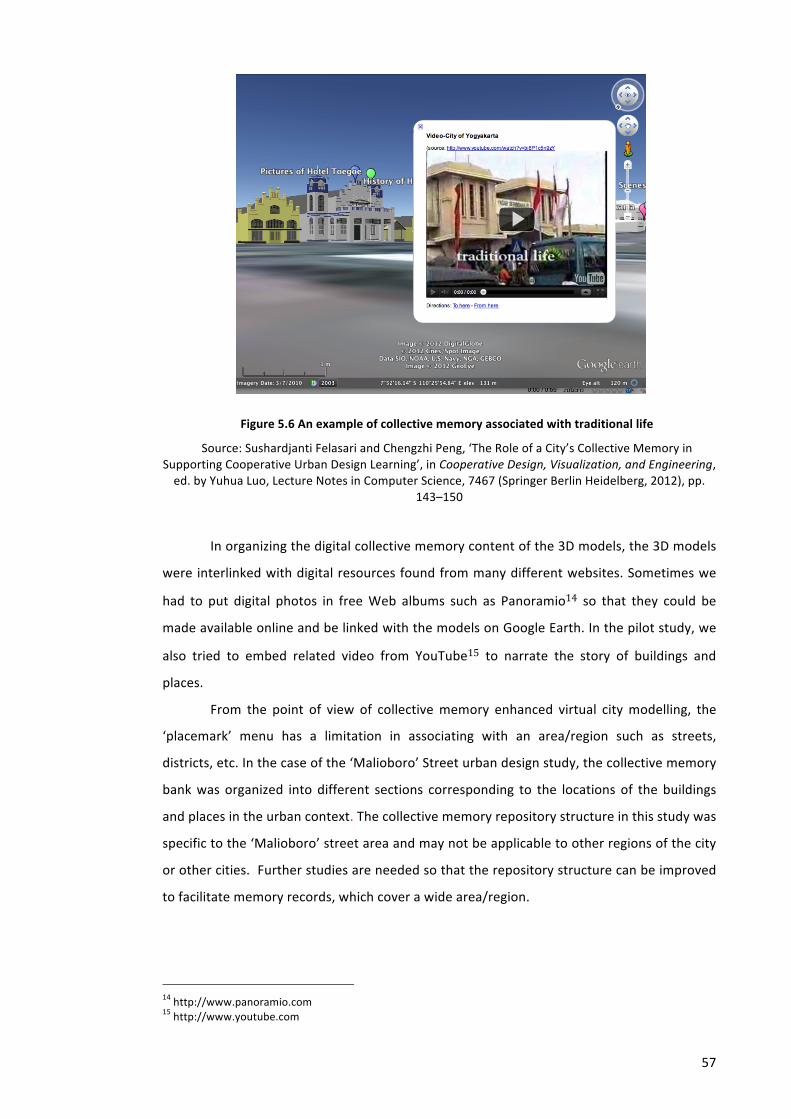
57
Figure 5.6 An example of collective memory associated with traditional life
Source: Sushardjanti Felasari and Chengzhi Peng, ‘The Role of a City’s Collective Memory in Supporting Cooperative Urban Design Learning’, in Cooperative Design, Visualization, and Engineering, ed. by Yuhua Luo, Lecture Notes in Computer Science, 7467 (Springer Berlin Heidelberg, 2012), pp.
143–150
In organizing the digital collective memory content of the 3D models, the 3D models
were interlinked with digital resources found from many different websites. Sometimes we
had to put digital photos in free Web albums such as Panoramio14 so that they could be
made available online and be linked with the models on Google Earth. In the pilot study, we
also tried to embed related video from YouTube15 to narrate the story of buildings and
places.
From the point of view of collective memory enhanced virtual city modelling, the
‘placemark’ menu has a limitation in associating with an area/region such as streets,
districts, etc. In the case of the ‘Malioboro’ Street urban design study, the collective memory
bank was organized into different sections corresponding to the locations of the buildings
and places in the urban context. The collective memory repository structure in this study was
specific to the ‘Malioboro’ street area and may not be applicable to other regions of the city
or other cities. Further studies are needed so that the repository structure can be improved
to facilitate memory records, which cover a wide area/region.
14 http://www.panoramio.com 15 http://www.youtube.com
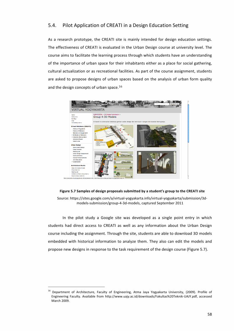
58
5.4. Pilot Application of CREATI in a Design Education Setting
As a research prototype, the CREATI site is mainly intended for design education settings.
The effectiveness of CREATI is evaluated in the Urban Design course at university level. The
course aims to facilitate the learning process through which students have an understanding
of the importance of urban space for their inhabitants either as a place for social gathering,
cultural actualization or as recreational facilities. As part of the course assignment, students
are asked to propose designs of urban spaces based on the analysis of urban form quality
and the design concepts of urban space.16
Figure 5.7 Samples of design proposals submitted by a student’s group to the CREATI site
Source: https://sites.google.com/a/virtual-‐yogyakarta.info/virtual-‐yogyakarta/submission/3d-‐models-‐submission/group-‐4-‐3d-‐models, captured September 2011
In the pilot study a Google site was developed as a single point entry in which
students had direct access to CREATI as well as any information about the Urban Design
course including the assignment. Through the site, students are able to download 3D models
embedded with historical information to analyze them. They also can edit the models and
propose new designs in response to the task requirement of the design course (Figure 5.7).
16 Department of Architecture, Faculty of Engineering, Atma Jaya Yogyakarta University, (2009). Profile of Engineering Faculty. Available from http://www.uajy.ac.id/downloads/Fakultas%20Teknik-‐UAJY.pdf, accessed March 2009.
59
5.5. Methods of Data Collection
In order to answer the research questions, this study used questionnaires, interviews,
observation of website usage and students’ assignment as data sources. The questionnaires
were available in printed version as well as being accessible online through the CREATI site.
They were designed to elicit students’ reflections on a number of issues such as enabling
collaboration, analyzing the urban context, visualizing design proposals in the 3D city context
and receiving feedback. The results from the questionnaires and interviews as well as
content of students’ assignments such as individual memory records and group project
proposals were used for analysis. Before conducting the pilot study, the questionnaires
devised for the research were submitted for research ethical review and received
unconditional approval by the University Ethics Reviewers (Appendix M).
The questionnaires for this study were divided into several parts/sections (Appendix
A). The questions in part A intended to reveal the experiences and background knowledge of
the participants when using different kinds of software, which might influence how they use
and interact with CREATI. This is useful to develop the design of CREATI for learning
purposes.
In part B, the questions were designed to investigate the level of collaboration which
the students experienced with their peers during the use of CREATI. Collaboration among
users can be divided into four types, i.e. working at the same time and place (collocated
synchronous), working at the same time but in a different place (remote synchronous),
working at different times but in the same place (collocated asynchronous), and working at
different times and places (remote asynchronous).
The questions in part C were related to how feedback can be sent and which
participants can give feedback. This is important, as the level of access to CREATI for
participants determines how the feedback can be sent or uploaded to the site. In relation to
this matter, CREATI provides two accesses for participants, i.e. as collaborators and as
viewers. As a collaborator, a user can upload and download materials from the site, while as
a viewer, one can only download the material from the site. The different role between
collaborators and admin is only that admin can determine to whom accesses is given while
collaborators cannot.
Part D consisted of questions about 3D visualization intended to investigate users’
opinions concerning the quality of 3D models in CREATI with regard to supporting their tasks
before being interlinked with collective memory records. The section included questions
about accuracy of building dimensions, accuracy of site dimensions, quality of building
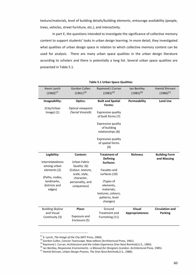
60
texture/materials, level of building details/building elements, entourage availability (people,
trees, vehicles, street furniture, etc.), and interactivity.
In part E, the questions intended to investigate the significance of collective memory
content to support students’ tasks in urban design learning. In more detail, they investigated
what qualities of urban design space in relation to which collective memory content can be
used for analysis. There are many urban space qualities in the urban design literature
according to scholars and there is potentially a long list. Several urban space qualities are
presented in Table 5.1.
Table 5.1 Urban Space Qualities
Kevin Lynch
(1960)17
Gordon Cullen
(1961)18
Raymond J Curran
(1983)19
Ian Bentley
(1985)20
Hamid Shirvani
(1986)21
Imageability:
(City/Urban Image) (1)
Optics:
Optical viewpoint /Serial Vision(4)
Built and Spatial Forms:
Expressive quality of built forms (7)
Expressive quality of building
relationships (8)
Expressive quality of spatial forms
(9)
Permeability
Land Use
Legibility:
Interrelatedness among urban elements (2)
(Paths, nodes, landmarks, districts and
edges)
Content:
Urban Fabric Quality: (6)
(Colour, texture, scale, style, character,
personality, and uniqueness)
Treatment of Defining Surfaces:
Facades and surfaces (10)
(Types of elements, materials,
textures, colours, patterns, level
changes)
Richness
Building Form and Massing
Building Skyline and Visual
Continuity (3)
Place:
Exposure and Enclosure (5)
Ground Treatment and Furnishing (11)
Visual Appropriateness
Circulation and Parking
17 K. Lynch, The Image of the City (MIT Press, 1960). 18 Gordon Cullen, Concise Townscape, New edition (Architectural Press, 1961). 19 Raymond J. Curran, Architecture and the Urban Experience (Van Nost.Reinhold,U.S., 1983). 20 Ian Bentley, Responsive Environments : a Manual for Designers (London: Architectural Press, 1985). 21 Hamid Shirvani, Urban Design Process, The (Van Nost.Reinhold,U.S., 1986).
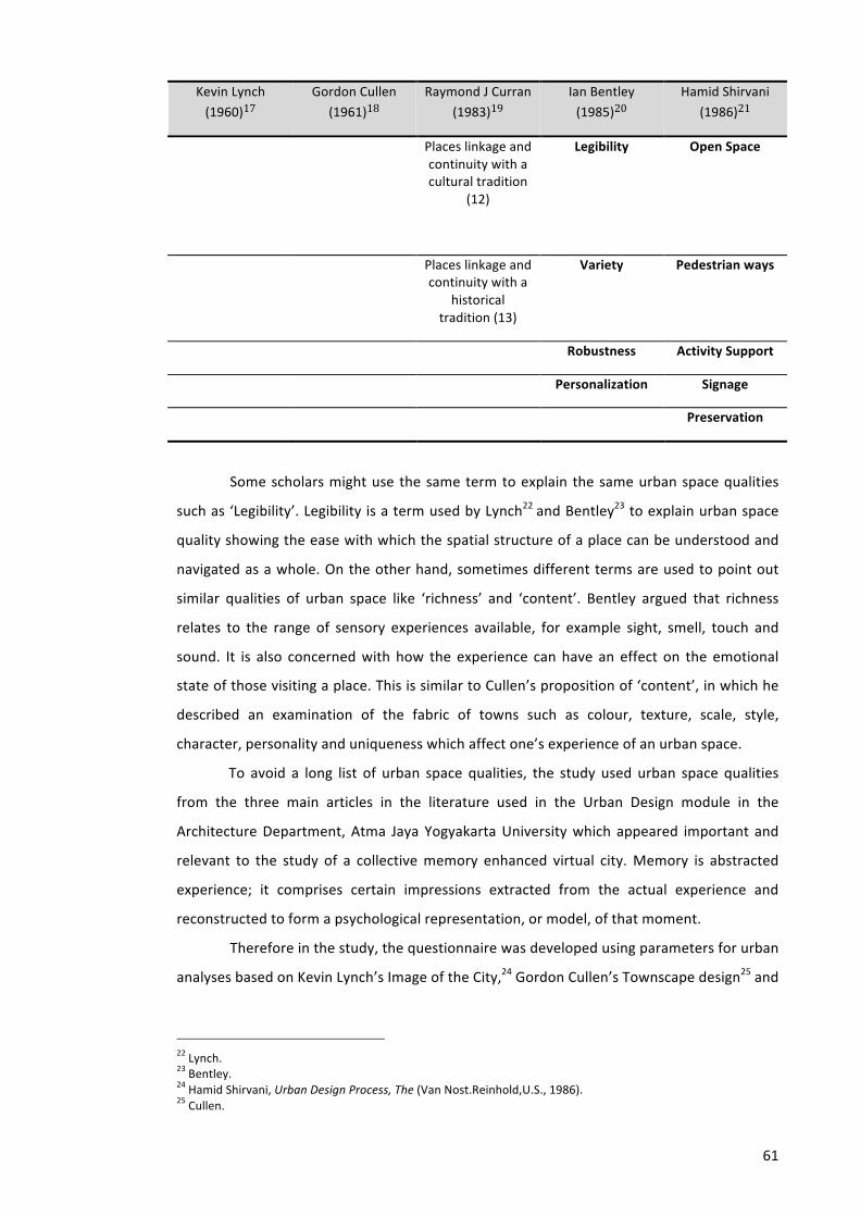
61
Kevin Lynch
(1960)17
Gordon Cullen
(1961)18
Raymond J Curran
(1983)19
Ian Bentley
(1985)20
Hamid Shirvani
(1986)21
Places linkage and continuity with a cultural tradition
(12)
Legibility
Open Space
Places linkage and continuity with a
historical tradition (13)
Variety Pedestrian ways
Robustness Activity Support
Personalization Signage
Preservation
Some scholars might use the same term to explain the same urban space qualities
such as ‘Legibility’. Legibility is a term used by Lynch22 and Bentley23 to explain urban space
quality showing the ease with which the spatial structure of a place can be understood and
navigated as a whole. On the other hand, sometimes different terms are used to point out
similar qualities of urban space like ‘richness’ and ‘content’. Bentley argued that richness
relates to the range of sensory experiences available, for example sight, smell, touch and
sound. It is also concerned with how the experience can have an effect on the emotional
state of those visiting a place. This is similar to Cullen’s proposition of ‘content’, in which he
described an examination of the fabric of towns such as colour, texture, scale, style,
character, personality and uniqueness which affect one’s experience of an urban space.
To avoid a long list of urban space qualities, the study used urban space qualities
from the three main articles in the literature used in the Urban Design module in the
Architecture Department, Atma Jaya Yogyakarta University which appeared important and
relevant to the study of a collective memory enhanced virtual city. Memory is abstracted
experience; it comprises certain impressions extracted from the actual experience and
reconstructed to form a psychological representation, or model, of that moment.
Therefore in the study, the questionnaire was developed using parameters for urban
analyses based on Kevin Lynch’s Image of the City,24 Gordon Cullen’s Townscape design25 and
22 Lynch. 23 Bentley. 24 Hamid Shirvani, Urban Design Process, The (Van Nost.Reinhold,U.S., 1986). 25 Cullen.
62
Raymond J Curran’s Urban Experience26 as the book discusses more people’s experience in
the urban space and how it might affect their impression and memory. There are urban
space qualities which students have to evaluate through the use of CREATI, i.e.:
a. Imageability -‐ city/urban images (1)
Imageability is the quality of a place that makes it distinct, recognizable and
memorable. City/urban image is an impression or ‘mental picture’ of urban
environment that a person can perceive while experiencing it. It is experienced
in relation to its surroundings, the sequences of events leading up to it and the
memory of past experiences. Every citizen has had long associations with some
part of their city and such image is soaked in memories and meanings. A place
has high imageability when specific physical elements and their arrangement
capture attention, evoke feelings, and create a lasting impression.
b. Interrelatedness among urban elements (2)
To provide a satisfying form of environmental image at the city scale, urban
elements (paths, nodes, landmarks, districts and edges) should be patterned
together to reinforce, resonate, and enhance each other’s power; otherwise
they will conflict and destroy themselves.
c. Buildings skyline and visual continuity (3)
d. Optical viewpoint (serial vision) (4)
Optical viewpoint/serial vision is the scenery of towns revealed in a series of
memory jerks or revelations to the pedestrians when they walk through the
town at a uniform speed. Vision is not only useful but evokes our memories and
experiences, those responsive emotions inside us, which have the power to
disturb the mind when aroused. This is important as the manipulation of
elements in a town can impact emotions.
e. Exposure and enclosure (5)
Exposure and enclosure are related to the use of buildings to create a sense of
defined space. Sense of enclosure shows the quality of an experience in which a
pedestrian feels sheltered within a semi-‐private realm. Buildings, trees,
26 Curran.
63
landscaping and street widths are all factors creating a sense of enclosure.
Exposure and enclosure are about distance and angle.
f. Urban Fabric Quality (Colour, Texture, Scale and Proportion, and Architectural
Style) (6-‐9)
A city is a story which consists of many layers of a historical period. Using urban
fabric such as colour, texture, scale and proportion, and architectural style, one
can see evidence of differing periods in a city’s layers.
g. Expressive quality of built form (form and content relationship in individual
buildings) (10)
Individual buildings are expressive of their interior functions and also act as
symbols of particular ideas and values. The content of form in a city’s public
domain is associated primarily with use and use ideas.
h. Expressive quality of building relationship (11)
This is related to the way buildings in space are disposed and related to each
other. The relationship of buildings is also expressive of functional ideas. With
regard to building relationships, there are two basic patterns that are relevant in
the experience of a city, i.e. linear patterns and cluster patterns.
i. Expressive quality of spatial form (12)
Like built form, spatial forms of public spaces also convey essential information.
j. Facades and surfaces (13)
The organization of facades can have an important impact on the scale and
character of public spaces as well as the use of openings. Contributing to the
scale and character of urban spaces, windows, and doors can be highly
expressive of the uses contained within buildings. They provide both visual and
functional linkage between the exterior public domain and the interior private
domain.
k. Ground treatment and furnishing (14)
This is related to the way the ground surface is treated in terms of materials,
textures, patterns, etc., and the various elements that we put into our public
64
spaces such as monuments, trees, bollards, and seating. The use of these factors
can be highly expressive and supportive in our perception and use of the public
domain.
l. Places linkage and continuity with a cultural tradition (15)
This is the quality of places for establishing a sense of linkage and continuity with
a cultural tradition.
m. Places linkage and continuity with a historical tradition (16)
This is the quality of places for establishing a sense of linkage and continuity with
a historical tradition.
Data were also collected from the students’ assignments both the individual task
and group project. In the individual task, students were asked to write about a memory
related to buildings or places located in a particular site while in the group task, students as a
group were asked to submit a design proposal for a particular site.
The study also collected data from the observation of the CREATI site. As every
student has an account to access the site, their activity and how they access and use the site
can be observed. Interviews were used to verify the results.
5.6. Methods of Data Analysis
The three research questions described in Chapter 1 determined how data collected in the
experiment would be analyzed.
In answering the first research question about digital representations of collective
memory, the study explained the process of connecting a virtual city and its collective
memory, how and in what form the participating students write about their memories and
share them through the CREATI site, what problems they face and how to overcome the
problems.
To answer the second and third research questions related to the use of collective
memory to facilitate urban design learning, the study combined several methods to analyze
data collected from many sources such as students’ assignments (individual and group),
questionnaires, usage pattern of the CREATI website, students’ final achievement in terms of
final grade and interviews.
65
The content of collective memory records from students’ individual tasks was
analyzed to investigate whether or not they were correlated to the development of group
design proposals. In doing so, qualitative software, i.e. NVivo, was used in this study to help
analyze the content of students’ assignments. Using the software, the content of collective
memory either as descriptions, pictures, videos or any other formats were classified into
nodes representing urban space qualities. It was expected that the content of students’
assignments could reveal the role of collective memory in supporting urban design learning.
The results were also verified with the students’ final grades to identify the effectiveness.
Data from the CREATI site was analyzed with the help of the Google Analytic
application. Using Google Analytic, the usage pattern of the site was revealed. Interviews
were used to verify the results. In addition to the analysis, the study also presented a
comparison of students’ group projects between one particular group which used CREATI in
the urban design module and one which did not. It was expected that the comparison would
reveal the additional value of collective memory enhanced virtual city models in supporting
urban design learning.

Chapter 6. THE INITIAL ‘CREATI’: A PILOT STUDY
This chapter explains a pilot study of the initial CREATI. In the early part of this chapter, the
author will describe the study site including its history and current conditions so that the
reader can draw a mental picture of the site before it is represented as a virtual city
modelled for CREATI. Subsequently, this chapter will explain the process of developing
CREATI Version 0.0 starting with the initial preparation, 3D virtual modelling, interlinking the
3D models with instances of collective memory and providing access to CREATI. Most
importantly, this chapter will describe how the pilot study of CREATI was conducted and
evaluated as a virtual learning environment. Based on the evaluation, refinements and
developments of the next version of CREATI will be proposed for the next stage of the
experiment.
6.1. Pilot Study Site
It has been pointed out that city streets have an important role in constructing urban images
as well as presenting the beauty and attractiveness of the city.1 In order to address the
research questions and for practical reasons, the study will use Malioboro Street in the City
of Yogyakarta, Indonesia as the main study site to be virtually modelled. Malioboro Street
was found to be the most memorable place in Yogyakarta compared with other historical
places in that city. Therefore, this study proposes to model Malioboro Street as a
representation of a virtual city.
1 J. Jacobs, The Death and Life of Great American Cities, Vintage Books ed (Vintage Books, 1993);

67
As in many places in the world, globalization and modern lifestyles have entered,
influenced and changed the lives of the people of Yogyakarta city. Malioboro Street is the
main street in Yogyakarta and a major attraction for domestic and foreign visitors. In an
increasingly pressured society, the city and its citizens have managed to maintain its unique
Javanese tradition and culture. The rapid changes to Malioboro Street have become a cause
of concern to many researchers, educators and policy decision makers as well as the
inhabitants of Yogyakarta itself. Many efforts have been made to improve the condition of
the street, but in some ways the changes are perhaps not in keeping with what people need.
There has been a loss of some quality that connects the present inhabitants with the past,
rather than solutions to functional problems. The new places created by recent changes have
less meaning than their predecessors.
6.1.1. History of the City of Yogyakarta and Malioboro Street
The city of Yogyakarta is situated on Java Island, about 500 km southeast of Jakarta, the
capital city of Indonesia (Figure 6.1). As the capital of Yogyakarta Special Region Province, the
city of Yogyakarta has an area of about 32.5 km2 with a total population in 2010 of around
388,627 and population density of about 11,957.75/km2.2
Figure 6.1. Map of Yogyakarta Special Region Province in Indonesia
The city of Yogyakarta has a long and rich history, as documented in Indonesian
literature. It was founded in 1755, when the Sultanate of Mataram, which had been in
existence since the 8th century, was divided by the Dutch East India Company (VOC) under
the Treaty of Giyanti into two parts, i.e. Sultanate of Ngayogyakarta Hadiningrat with
2 Central Bureau of Statistics, 2010, ‘2010 Population Census, BPS – Statistics of D.I. Yogyakarta Province’, available in http://yogyakarta.bps.go.id/kependudukan.html
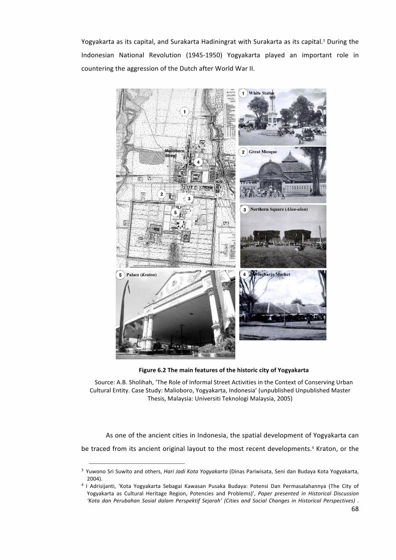
68
Yogyakarta as its capital, and Surakarta Hadiningrat with Surakarta as its capital.3 During the
Indonesian National Revolution (1945-‐1950) Yogyakarta played an important role in
countering the aggression of the Dutch after World War II.
Figure 6.2 The main features of the historic city of Yogyakarta
Source: A.B. Sholihah, ‘The Role of Informal Street Activities in the Context of Conserving Urban Cultural Entity. Case Study: Malioboro, Yogyakarta, Indonesia’ (unpublished Unpublished Master
Thesis, Malaysia: Universiti Teknologi Malaysia, 2005)
As one of the ancient cities in Indonesia, the spatial development of Yogyakarta can
be traced from its ancient original layout to the most recent developments.4 Kraton, or the
3 Yuwono Sri Suwito and others, Hari Jadi Kota Yogyakarta (Dinas Pariwisata, Seni dan Budaya Kota Yogyakarta, 2004).
4 I Adrisijanti, ‘Kota Yogyakarta Sebagai Kawasan Pusaka Budaya: Potensi Dan Permasalahannya (The City of Yogyakarta as Cultural Heritage Region, Potencies and Problems)’, Paper presented in Historical Discussion ‘Kota dan Perubahan Sosial dalam Perspektif Sejarah’ (Cities and Social Changes in Historical Perspectives) .
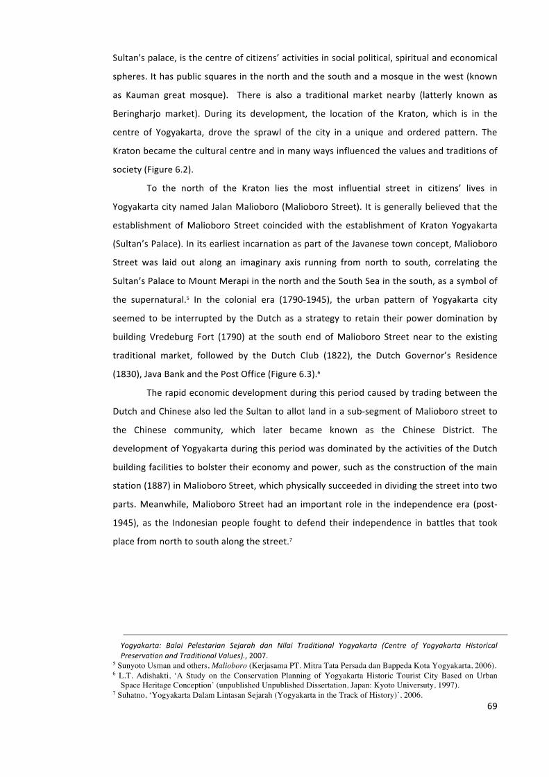
69
Sultan's palace, is the centre of citizens’ activities in social political, spiritual and economical
spheres. It has public squares in the north and the south and a mosque in the west (known
as Kauman great mosque). There is also a traditional market nearby (latterly known as
Beringharjo market). During its development, the location of the Kraton, which is in the
centre of Yogyakarta, drove the sprawl of the city in a unique and ordered pattern. The
Kraton became the cultural centre and in many ways influenced the values and traditions of
society (Figure 6.2).
To the north of the Kraton lies the most influential street in citizens’ lives in
Yogyakarta city named Jalan Malioboro (Malioboro Street). It is generally believed that the
establishment of Malioboro Street coincided with the establishment of Kraton Yogyakarta
(Sultan’s Palace). In its earliest incarnation as part of the Javanese town concept, Malioboro
Street was laid out along an imaginary axis running from north to south, correlating the
Sultan’s Palace to Mount Merapi in the north and the South Sea in the south, as a symbol of
the supernatural.5 In the colonial era (1790-‐1945), the urban pattern of Yogyakarta city
seemed to be interrupted by the Dutch as a strategy to retain their power domination by
building Vredeburg Fort (1790) at the south end of Malioboro Street near to the existing
traditional market, followed by the Dutch Club (1822), the Dutch Governor’s Residence
(1830), Java Bank and the Post Office (Figure 6.3).6
The rapid economic development during this period caused by trading between the
Dutch and Chinese also led the Sultan to allot land in a sub-‐segment of Malioboro street to
the Chinese community, which later became known as the Chinese District. The
development of Yogyakarta during this period was dominated by the activities of the Dutch
building facilities to bolster their economy and power, such as the construction of the main
station (1887) in Malioboro Street, which physically succeeded in dividing the street into two
parts. Meanwhile, Malioboro Street had an important role in the independence era (post-‐
1945), as the Indonesian people fought to defend their independence in battles that took
place from north to south along the street.7
Yogyakarta: Balai Pelestarian Sejarah dan Nilai Traditional Yogyakarta (Centre of Yogyakarta Historical Preservation and Traditional Values)., 2007.
5 Sunyoto Usman and others, Malioboro (Kerjasama PT. Mitra Tata Persada dan Bappeda Kota Yogyakarta, 2006). 6 L.T. Adishakti, ‘A Study on the Conservation Planning of Yogyakarta Historic Tourist City Based on Urban
Space Heritage Conception’ (unpublished Unpublished Dissertation, Japan: Kyoto Universuty, 1997). 7 Suhatno, ‘Yogyakarta Dalam Lintasan Sejarah (Yogyakarta in the Track of History)’, 2006.
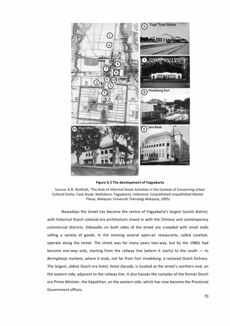
70
Figure 6.3 The development of Yogyakarta
Source: A.B. Sholihah, ‘The Role of Informal Street Activities in the Context of Conserving Urban Cultural Entity. Case Study: Malioboro, Yogyakarta, Indonesia’ (unpublished Unpublished Master
Thesis, Malaysia: Universiti Teknologi Malaysia, 2005)
Nowadays the street has become the centre of Yogyakarta's largest tourist district,
with historical Dutch colonial-‐era architecture mixed in with the Chinese and contemporary
commercial districts. Sidewalks on both sides of the street are crowded with small stalls
selling a variety of goods. In the evening several open-‐air restaurants, called Lesehan,
operate along the street. The street was for many years two-‐way, but by the 1980s had
become one-‐way only, starting from the railway line (where it starts) to the south ― to
Beringharjo markets, where it ends, not far from Fort Vredeburg, a restored Dutch fortress.
The largest, oldest Dutch era hotel, Hotel Garuda, is located at the street's northern end, on
the eastern side, adjacent to the railway line. It also houses the complex of the former Dutch
era Prime Minister, the Kepatihan, on the eastern side, which has now become the Provincial
Government offices.
71
6.1.2. Collective Memories of the City of Yogyakarta and Malioboro
Street
For Indonesian people, in general, Yogyakarta is well known as a city full of memory and
symbols, i.e. a city of Indonesian history, a city of culture and a city of education.8 Those
memories are strong links to the history of the city of Yogyakarta of the past and the city's
role in the subsequent years under the government of the Republic of Indonesia.
As a city with a great history, Yogyakarta had an important role during the
revolutionary era (1945-‐1950) when Indonesia declared independence in 1945, following the
defeat of the occupying Japanese forces in World War II. Due to military aggression I (1947)
and II (1949) by the Dutch, Yogyakarta served as the capital of Indonesia for a time as it was
considered necessary to remove the governmental centre from Jakarta, the former capital.
Yogyakarta has also become well known as a centre of education, as in 1949 the first
Indonesian National State University called the Gadjah Mada University, was built there.9
Since that time, many scholars have converged on Yogyakarta from all regions of Indonesia
to study at this university. Subsequently, Yogyakarta has become a ‘melting pot’ of many
different cultures and ethnic backgrounds due to the arrival of many diverse young people to
study in the city. Yogyakarta has produced many great artists who have flourished in the
fields of painting, literature, theatre, sculptural art, music, etc. in Indonesia. More traditional
arts, especially Javanese art forms such as traditional dance and puppetry, have also
developed since that time.
The historical events in the past, which occurred in Yogyakarta have explained the
significance of the city of Yogyakarta, not only to its citizens or to people who experienced
living in the city for a long time, but also to visitors who may only visit for a short time.
People remember things or events through text, song, web-‐based memorializing practices
and other mnemonic devices, and there are also some that are specifically intended to
remind people of Yogyakarta. Below is an example of such popular mnemonic device, i.e. a
song called ‘Yogyakarta’, created by a famous Indonesian band named KLA Project. The
song’s lyrics not only describe why the city is worth remembering, but also mention implicitly
the unique characteristics of a famous place in Yogyakarta including Malioboro Street.
8 D. Suryo, ‘Penduduk Dan Perkembangan Kota Yogyakarta 1900-‐1990 (Development of Yogyakarta City and Its Population Between 1900-‐1990)’, 2004.
9 Sholeh UG Saleh, Menjadi Jogja: Menghayati Jatidiri dan Transformasi Yogyakarta (Panitia HUT ke-‐250 Kota Yogyakarta, 2006).
72
YOGYAKARTA – by KLA Project10
(verse 1) Coming home to your town, I am caught by the stir of my longing,
Still the same as before, Every corner is a friendly greeting,
Fully satiated with meaning
(verse 2) Lost in the sensation of nostalgia, Of the moments when we were spending time,
And enjoying Jogja’s ambience together
(verse 3) At the intersection my steps stand still, Bustling portable food stands
Peddling various delectable cuisines, People sit cross-‐legged
(verse 4) And street musicians begin to play, In rhythm with my sorrow at losing you,
Alone in my moans, Engulfed by your city’s roar
(verse 5) Although now you’re no longer here,
And will never come back, Please allow me to always return,
If the heart embarks on loneliness with no comfort.
The texts in verse 3 and the 1st line of verse 4 implicitly describe Malioboro Street. It
describes a unique character of food stalls in the street during night-‐time called Lesehan.
Lesehan is a culture in terms of goods trade in food while sitting on a mat/the floor.11 Food or
goods traded are displayed on a mat/the floor so that visitors can see and select it with ease.
Although now, people can find Lesehan in different cities in Indonesia such as Bali, Bandung
and Jakarta, most people associate Lesehan with Malioboro Street in the city of Yogyakarta.
Malioboro Street, as the most historical street in Yogyakarta, cannot be separated
from the memory of Yogyakarta.12 Of all the many places in Yogyakarta, Malioboro is found
to be the most memorable for visitors to Yogyakarta. Its central location and proximity to
historical buildings as well as its commercial shopping arcades and the attractive ambience
created by its street performance arts and cultural activities might be factors that explain
why it is very popular and memorable for Indonesian people.
10 ‘Yogyakarta’, a video clip available from http://www.youtube.com/watch?v=BBPs3Tkg0JA, retrieved 2009 11 ‘Lesehan’ , http://id.wikipedia.org/wiki/Lesehan, retrieved November 2012 12 Arwan Tuti Artha, Yogyakarta tempo doeloe sepanjang catatan pariwisata (Bigraf Pub., 2000).
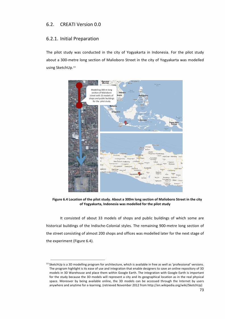
73
6.2. CREATI Version 0.0
6.2.1. Initial Preparation
The pilot study was conducted in the city of Yogyakarta in Indonesia. For the pilot study
about a 300-‐metre long section of Malioboro Street in the city of Yogyakarta was modelled
using SketchUp.13
Figure 6.4 Location of the pilot study. About a 300m long section of Malioboro Street in the city of Yogyakarta, Indonesia was modelled for the pilot study
It consisted of about 33 models of shops and public buildings of which some are
historical buildings of the Indische-‐Colonial styles. The remaining 900-‐metre long section of
the street consisting of almost 200 shops and offices was modelled later for the next stage of
the experiment (Figure 6.4).
13 SketchUp is a 3D modelling program for architecture, which is available in free as well as ‘professional’ versions. The program highlight is its ease of use and integration that enable designers to save an online repository of 3D models in 3D Warehouse and place them within Google Earth. The integration with Google Earth is important for the study because the 3D models will represent a city and its geographical location as in the real physical space. Moreover by being available online, the 3D models can be accessed through the Internet by users anywhere and anytime for e-‐learning. (retrieved November 2012 from http://en.wikipedia.org/wiki/SketchUp}
74
6.2.2. 3D Virtual Modelling
In the early stage of the study, the 3D virtual models were intended to be accessible online
on Google Earth’s 3D Buildings Layer. Therefore the limitation and requirements set by
Google were the major consideration. About 28 3D models of Malioboro Street were
submitted at that time to be reviewed by the Google Team in order to appear in Google
Earth’s 3D layer. It took a very long time to wait to find out whether they would be accepted
for inclusion in the 3D layer (i.e., to become a georeferenced model in Google Earth’s
terminology14) or only be available in the 3D Warehouse (called a non-‐georeferenced model).
The georeferenced models would appear in Google Earth’s 3D layer and be accessible online
through the Internet, while non-‐georeferenced models do not appear online on the Google
Earth layer unless they are downloaded by users to their own computers.
According to the Google Earth (GE) team’s reviews, most problems with the 3D
models of Malioboro Street submitted were caused by incomplete texture (19 of the 28
models submitted) and misalignment (9 of 28). Only about five 3D models were displayed on
Google Earth’s 3D layer after 5 weeks’ reviewing time. In order to tackle the problems and in
light of the time limit applicable to the research, it was important to consider the criteria set
by GE (see Chapter 5, Section 5.2) or to set new criteria suited to the objectives of the
research, e.g. models that really present the most current condition of the city (as realistic as
possible), degree of accuracy, consistency, etc., as well as to consider other ways of
providing the 3D models of Malioboro Street online rather than rely too much on GE’s
approval.
14 According to Google Earth’s term, a georeferenced model is a building or other real-‐life object, which has been accurately located and displayed online in Google Earth and published to the 3D Warehouse. Non-‐georeferenced models are simply 3D models, which have not been included online in Google Earth. Examples range from interesting things to be included in your model's environment, like trees and people, to abstract art (retrieved from sketchup.google.com/intl/en_uk/3dwh/, 2009)
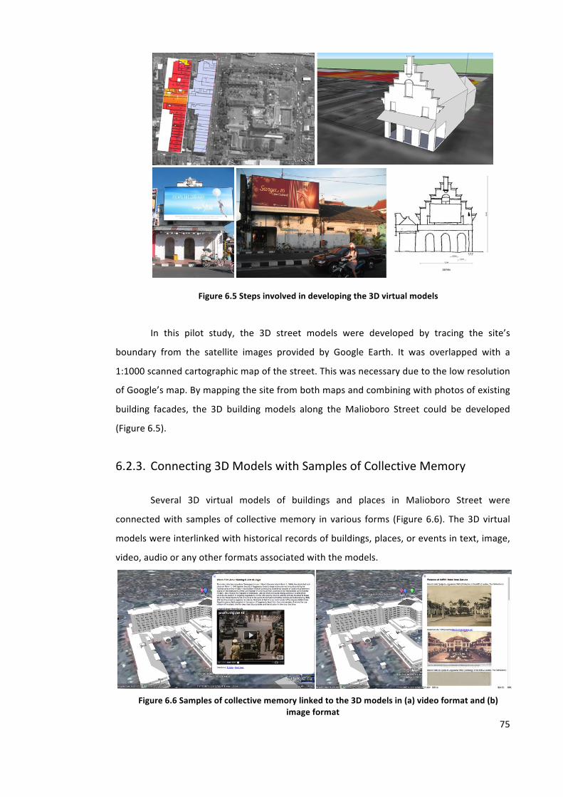
75
Figure 6.5 Steps involved in developing the 3D virtual models
In this pilot study, the 3D street models were developed by tracing the site’s
boundary from the satellite images provided by Google Earth. It was overlapped with a
1:1000 scanned cartographic map of the street. This was necessary due to the low resolution
of Google’s map. By mapping the site from both maps and combining with photos of existing
building facades, the 3D building models along the Malioboro Street could be developed
(Figure 6.5).
6.2.3. Connecting 3D Models with Samples of Collective Memory
Several 3D virtual models of buildings and places in Malioboro Street were
connected with samples of collective memory in various forms (Figure 6.6). The 3D virtual
models were interlinked with historical records of buildings, places, or events in text, image,
video, audio or any other formats associated with the models.
Figure 6.6 Samples of collective memory linked to the 3D models in (a) video format and (b)
image format
76
To investigate how samples of collective memory may be linked to the 3D virtual
models, we used the ‘placemark’ menu available in Google Earth and saved them as kmz
files. Google Earth’s ‘placemark’ is an icon used to show geographical positions on Earth, i.e.
latitude, longitude and altitude (see Chapter 5, Section 5.3). It can use a ‘balloon’ – an
information window displayed in the Google Earth Plugin -‐ to present any information
related to a feature. Their platform can include HTML, CSS or JavaScript.15
We used different coloured balloons as placemarks to differentiate the content of
collective memory records and their formats. With the coordinates embedded in the
placemarks (latitude and longitude), the information in the records points directly to the
locations of buildings and places in the models to which the information is related. Using
Google Earth’s placemark as a cross-‐referencing mechanism, the 3D models and digital
resources found from many different websites can be interlinked. Sometimes digital photos
have to be put into free Web albums such as Panoramio16 so that they can be made available
online and can then be linked with the models on Google Earth. In the pilot study, the 3D
models were also interlinked with video from YouTube to narrate the story of buildings and
places.17
6.2.4. CREATI Site as a Single Point of Entry
Having managed to embed 3D virtual city models with samples of collective memory, the
next step was to consider how this virtual city enhanced with the collective memory (CREATI)
could be accessed online by users. Using the 3D models as an interface can add the content
of collective memory online. However, in the previous sub-‐chapter, the length of time taken
by Google Earth’s reviewer team to accept or reject the submitted 3D models was discussed.
Initially the 3D models created in this study could only be presented on the Google Earth
platform locally, and could not be accessed online. With this in mind, it was necessary to
provide a website to host CREATI accessible online by users. Moreover as CREATI is intended
to support learning, the availability of information related to particular modules is important
too. As a result, a website (‘CREATI site’) was provided for this study to be a single point of
entry through which learners could access the collective memory enhanced virtual city as
well as courses and learning information.
15 https://developers.google.com/earth/documentation/balloons 16 http://www.panoramio.com 17 http://www.youtube.com
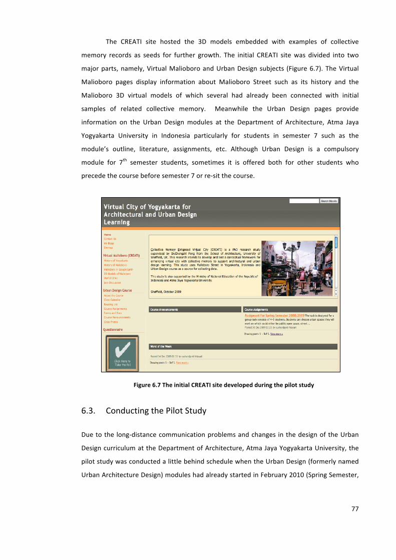
77
The CREATI site hosted the 3D models embedded with examples of collective
memory records as seeds for further growth. The initial CREATI site was divided into two
major parts, namely, Virtual Malioboro and Urban Design subjects (Figure 6.7). The Virtual
Malioboro pages display information about Malioboro Street such as its history and the
Malioboro 3D virtual models of which several had already been connected with initial
samples of related collective memory. Meanwhile the Urban Design pages provide
information on the Urban Design modules at the Department of Architecture, Atma Jaya
Yogyakarta University in Indonesia particularly for students in semester 7 such as the
module’s outline, literature, assignments, etc. Although Urban Design is a compulsory
module for 7th semester students, sometimes it is offered both for other students who
precede the course before semester 7 or re-‐sit the course.
Figure 6.7 The initial CREATI site developed during the pilot study
6.3. Conducting the Pilot Study
Due to the long-‐distance communication problems and changes in the design of the Urban
Design curriculum at the Department of Architecture, Atma Jaya Yogyakarta University, the
pilot study was conducted a little behind schedule when the Urban Design (formerly named
Urban Architecture Design) modules had already started in February 2010 (Spring Semester,
78
2009/2010 academic year). As a result, when the pilot study was introduced to the students,
they had already formed their task groups and chosen an urban site for the task.
In the modules, students were given a group project in which they were required to
propose a new design development for a particular site from a set of several options along
Malioboro Street and other urban areas. One of the choices was the site for which 3D virtual
models of a section of Malioboro Street had been made available by the author on CREATI.
Ten students were willing to participate in the pilot study but only five returned the
questionnaire and gave feedback. They were then given a technical explanation in the use of
CREATI. After that they were asked to try using CREATI for about 2 weeks. Having had some
experience of using CREATI, the participating students were asked to complete a
questionnaire to provide some feedback (Appendix A). The questionnaire can be accessed
online through the CREATI site. Due to the very limited number of participants, the students
were also asked for their willingness to be interviewed to further clarify their feedback
replies.
6.4. Evaluating CREATI as a Virtual Learning Environment in Urban
Design
The effectiveness of CREATI as a pilot Virtual Learning Environment in urban design could be
best evaluated through a questionnaire exercise participated in by the students undertaking
the Urban Design course. The questionnaire was designed to elicit students’ reflections on a
number of issues such as enabling collaboration, analyzing the urban context, visualizing
design proposals in the 3D virtual city context, and obtaining feedback from fellow students
and the design tutor. The outcome of evaluating the pilot study of CREATI is presented in the
following six questions raised with the participating students.
6.4.1. Students’ Background
Question #1: Have you had experience using SketchUp, Google Earth and Google 3D
Warehouse?
This question was intended to reveal the background knowledge of the participants
regarding the use of different kinds of software, which might influence how they use and
interact with CREATI. Prior experience of computer-‐mediated communications as well as the
structure of the online course, class size and feedback all influence interaction in an online
79
course.18 Noticing this at the earliest stage of the study was useful for informing the design of
CREATI for e-‐learning purposes.
SketchUp is a 3D modelling program, optimized for a broad range of applications
including architectural design and is available in free as well as 'professional' versions. Its
‘Push/Pull’ technology enables users to draw two-‐dimensional planar faces similar to pencil
and paper in a three-‐dimensional design and modelling environment, which then can be
pushed and pulled by editing tools within the environment to easily and intuitively model
three-‐dimensional volumes and geometries.
The three-‐dimensional models produced using SketchUp can be uploaded,
downloaded and shared in an accompanying website for SketchUp called Trimble 3D
Warehouse19 (formerly Google 3D Warehouse). The site enables modellers to create
collections of models, and the system uses algorithms to determine similar models.
Individual models can be viewed in 3D from within a browser. The 3D Warehouse has
become a virtual ‘dictionary’ of 3D vocabulary.20
After being subjected to internal reviews for accuracy, user-‐developed 3D models
are loaded onto the Google Earth platform to be viewable publicly. Users can select the
option when uploading their models to verify if it is ‘Google Earth Ready’, which will verify if
the building is a real, current and correctly located model of the building. If a ‘Google Earth
Ready’ model is submitted, within a few weeks, the model will go through a review by
several Google employees who check the models’ qualifications under certain acceptance
criteria. If the model submission passes, it is added to Google Earth’s 3D Layer and will soon
be visible on the sidebar labelled ‘3D Buildings’ (Figure 6.8).
18 C Vrasidas and M S McIsaac, ‘Factors Influencing Interaction in an Online Course’, American Journal of Distance Education, 13 (1999), 22–36.
19 Kulsoom Middleton, ‘Google to Sell SketchUp to Trimble | 3D World’, 3Dworldmag, 2012 <http://www.3dworldmag.com/2012/04/29/google-‐to-‐sell-‐sketchup-‐to-‐trimble/> [accessed 19 December 2012].
20 http://en.wikipedia.org/wiki/3D_Warehouse, retrieved October 2012
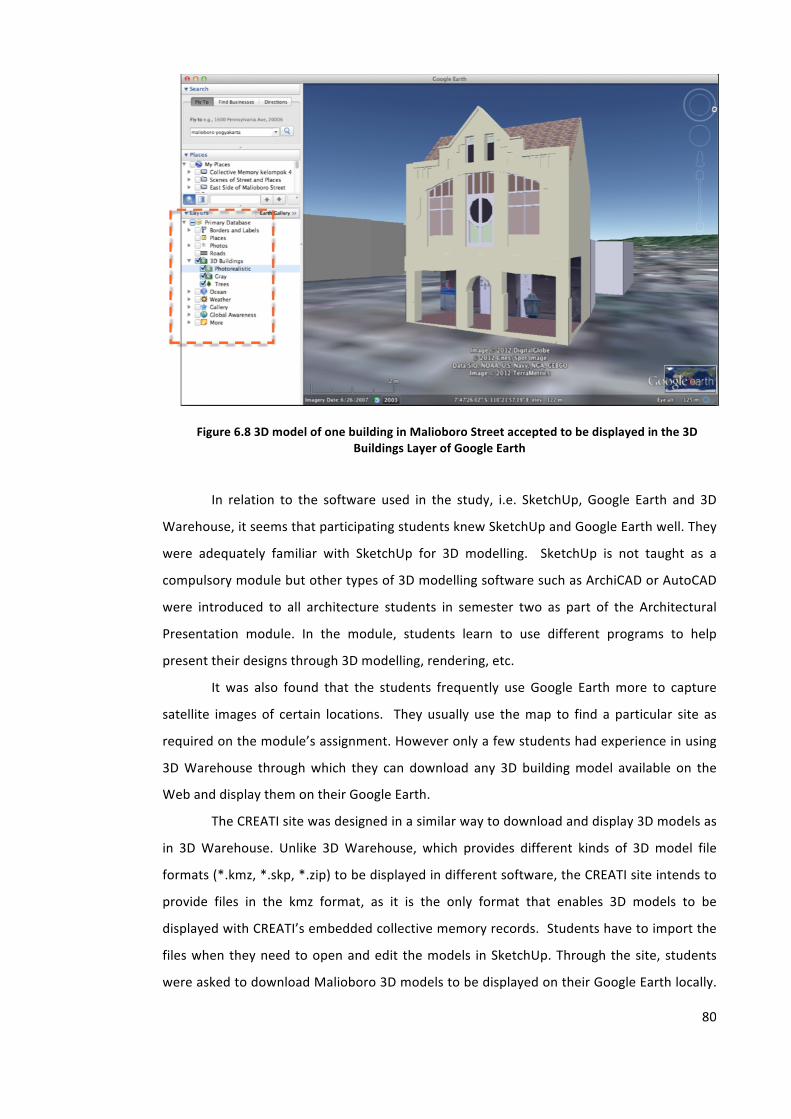
80
Figure 6.8 3D model of one building in Malioboro Street accepted to be displayed in the 3D Buildings Layer of Google Earth
In relation to the software used in the study, i.e. SketchUp, Google Earth and 3D
Warehouse, it seems that participating students knew SketchUp and Google Earth well. They
were adequately familiar with SketchUp for 3D modelling. SketchUp is not taught as a
compulsory module but other types of 3D modelling software such as ArchiCAD or AutoCAD
were introduced to all architecture students in semester two as part of the Architectural
Presentation module. In the module, students learn to use different programs to help
present their designs through 3D modelling, rendering, etc.
It was also found that the students frequently use Google Earth more to capture
satellite images of certain locations. They usually use the map to find a particular site as
required on the module’s assignment. However only a few students had experience in using
3D Warehouse through which they can download any 3D building model available on the
Web and display them on their Google Earth.
The CREATI site was designed in a similar way to download and display 3D models as
in 3D Warehouse. Unlike 3D Warehouse, which provides different kinds of 3D model file
formats (*.kmz, *.skp, *.zip) to be displayed in different software, the CREATI site intends to
provide files in the kmz format, as it is the only format that enables 3D models to be
displayed with CREATI’s embedded collective memory records. Students have to import the
files when they need to open and edit the models in SketchUp. Through the site, students
were asked to download Malioboro 3D models to be displayed on their Google Earth locally.
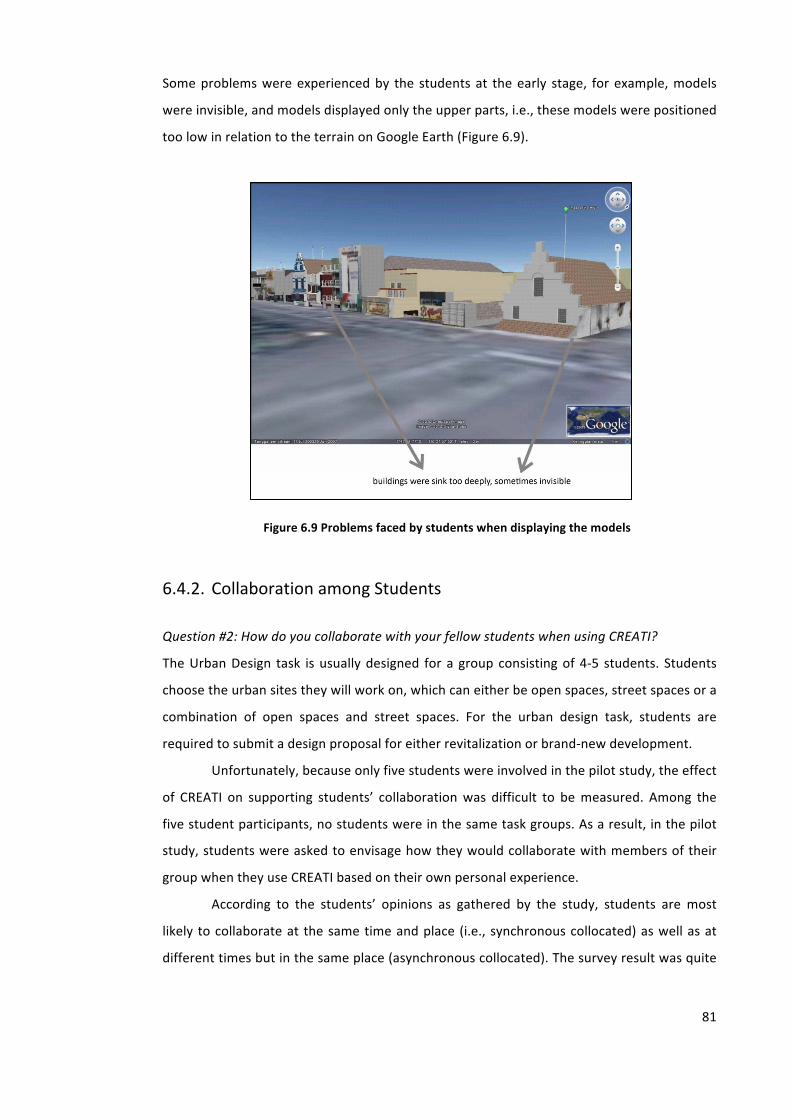
81
Some problems were experienced by the students at the early stage, for example, models
were invisible, and models displayed only the upper parts, i.e., these models were positioned
too low in relation to the terrain on Google Earth (Figure 6.9).
Figure 6.9 Problems faced by students when displaying the models
6.4.2. Collaboration among Students
Question #2: How do you collaborate with your fellow students when using CREATI?
The Urban Design task is usually designed for a group consisting of 4-‐5 students. Students
choose the urban sites they will work on, which can either be open spaces, street spaces or a
combination of open spaces and street spaces. For the urban design task, students are
required to submit a design proposal for either revitalization or brand-‐new development.
Unfortunately, because only five students were involved in the pilot study, the effect
of CREATI on supporting students’ collaboration was difficult to be measured. Among the
five student participants, no students were in the same task groups. As a result, in the pilot
study, students were asked to envisage how they would collaborate with members of their
group when they use CREATI based on their own personal experience.
According to the students’ opinions as gathered by the study, students are most
likely to collaborate at the same time and place (i.e., synchronous collocated) as well as at
different times but in the same place (asynchronous collocated). The survey result was quite
82
surprising. As a Web-‐based online facility, CREATI should be able to support collaboration
among users in a more flexible way, which should not depend on specific times or places.
There were two ways of sharing the models embedded with memory records among
the participants. Which one used depends on whether the participants are invited (by the
author as the developer of CREATI) as collaborators or as viewers. As collaborators, students
can download the models. After editing the models or embedding the models with further
memory records, they can upload the updated models back into CREATI. On the site,
collaborators can remove the files into different folders or delete unused files. It is important
to note that some rules about modifying the files should be given to the student participants
to avoid unnecessary problems. On the other hand, as viewers, students are only able to
download the 3D models but they cannot upload updated ones.
6.4.3. Feedback
Question #3: How important is the feedback given by other people?
There are three different user roles in Google Site, i.e. administrator, collaborator and
viewer. The roles determine how users can access the CREATI site. All participating students
in the study were invited as collaborators. Students can give feedback to the other
participants by leaving comments or asking questions. However, it also depends on the
status of the participants whether they are invited as a collaborator or viewer. As a
collaborator, students can use the ‘Comments’ button to post messages on someone’s work.
While giving feedback, they can attach files when needed. As a viewer, participants are only
able to use the ‘Asking questions’ button through which they can contact the tutor to ask
questions or give feedback on someone’s work. As viewers, they cannot upload files.
In the pilot study, the students argued that they needed feedback not only from the
course tutor, group members or other course participants but also from ‘open users’. An
open user refers to any person who is not taking the course. As the CREATI site is made
public on the Web, anyone can view the site. Therefore, there is an urgent need to improve
the site by giving more access to open users to give feedback to students. A kind of group
discussion with open users might be useful so that they can also post messages as well as
read the archives or download the attached files.
Google site is part of the Google Apps productivity suite to create structured wikis
and web pages. The goal of Google Site is for anyone to be able to create a team-‐oriented
83
site where multiple people can collaborate and share files.21 In Google Site, the site
developer can set a discussion forum with open users by embedding a gadget such as Google
Groups into the Google site and providing this group to be viewed by anyone. He/she can
regulate how the open users post a reply to a topic and whether they have to join as a group
member or not.
6.4.4. Quality of the 3D Models
Question #4: How important is the quality of 3D models in CREATI?
Urban context is something that architecture students have to be aware of in the process of
creating a new building design. Relationships with surrounding areas have to be considered
when creating a new design, which should exhibit meaningful dialogue with other existing
buildings. When students work with a digital environment, the availability of contextual 3D
models of existing buildings is very important to help students see the proposed building in
relation to its environmental surroundings. Therefore, when developing their design
proposals, students can access CREATI and download the existing 3D models embedded with
collective memory records. Student users are able to edit the contextual models in SketchUp
in the process of producing new designs according to the task requirement of the design
course.
It was found that the availability of the 3D models complement the data which the
students obtained from the field survey, which is sometimes difficult to be collected.
Generally, they had to search for data from various places such as the City Council, Town and
Planning Bureau, Internet, etc. Therefore, the students argued that in order to support the
assignment, accuracy of site dimensions was the most important thing for them compared to
other factors such as building dimension accuracy, interactivity, textures, level of detail and
entourage availability. Accuracy of site dimensions is important because the existing
buildings in Malioboro Street were very densely built. This means that building site
dimensions can only be measured from one or two sides and are impossible to measure from
the back. Meanwhile, finding accurate and up-‐to-‐date cartographic maps like the ones
provided by the Ordnance Survey in the UK is very difficult. They might exist for certain
purposes but are not made available publicly.
From the pilot study, there was an emergent need not only to model building sites
but also sites of open spaces and pedestrian walkways as well as the streets. Students
21 Nations, Daniel (2008), ‘Google Sites Profile -‐ What is Google Sites?’ available at http://webtrends.about.com/od/profil2/p/Google-‐Sites-‐b.htm, retrieved December 2012.
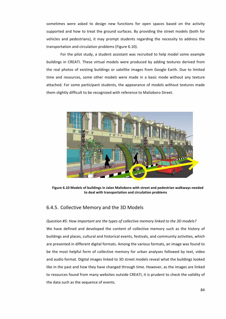
84
sometimes were asked to design new functions for open spaces based on the activity
supported and how to treat the ground surfaces. By providing the street models (both for
vehicles and pedestrians), it may prompt students regarding the necessity to address the
transportation and circulation problems (Figure 6.10).
For the pilot study, a student assistant was recruited to help model some example
buildings in CREATI. These virtual models were produced by adding textures derived from
the real photos of existing buildings or satellite images from Google Earth. Due to limited
time and resources, some other models were made in a basic mode without any texture
attached. For some participant students, the appearance of models without textures made
them slightly difficult to be recognized with reference to Malioboro Street.
Figure 6.10 Models of buildings in Jalan Malioboro with street and pedestrian walkways needed to deal with transportation and circulation problems
6.4.5. Collective Memory and the 3D Models
Question #5: How important are the types of collective memory linked to the 3D models?
We have defined and developed the content of collective memory such as the history of
buildings and places, cultural and historical events, festivals, and community activities, which
are presented in different digital formats. Among the various formats, an image was found to
be the most helpful form of collective memory for urban analyses followed by text, video
and audio format. Digital images linked to 3D street models reveal what the buildings looked
like in the past and how they have changed through time. However, as the images are linked
to resources found from many websites outside CREATI, it is prudent to check the validity of
the data such as the sequence of events.
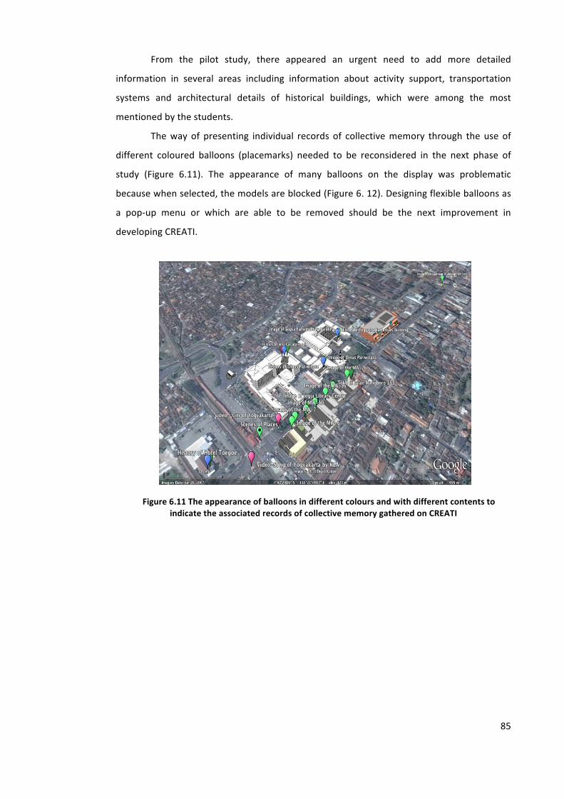
85
From the pilot study, there appeared an urgent need to add more detailed
information in several areas including information about activity support, transportation
systems and architectural details of historical buildings, which were among the most
mentioned by the students.
The way of presenting individual records of collective memory through the use of
different coloured balloons (placemarks) needed to be reconsidered in the next phase of
study (Figure 6.11). The appearance of many balloons on the display was problematic
because when selected, the models are blocked (Figure 6. 12). Designing flexible balloons as
a pop-‐up menu or which are able to be removed should be the next improvement in
developing CREATI.
Figure 6.11 The appearance of balloons in different colours and with different contents to indicate the associated records of collective memory gathered on CREATI
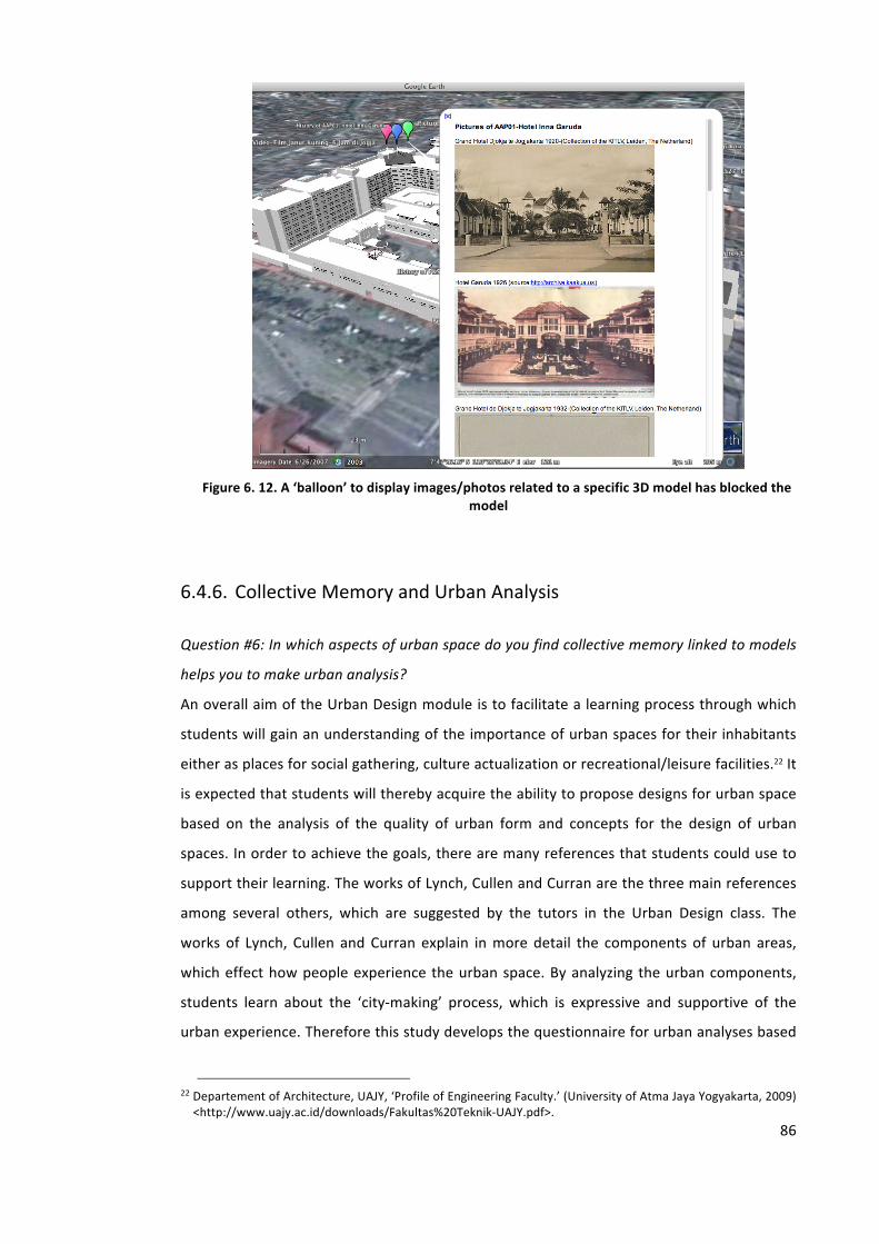
86
Figure 6. 12. A ‘balloon’ to display images/photos related to a specific 3D model has blocked the
model
6.4.6. Collective Memory and Urban Analysis
Question #6: In which aspects of urban space do you find collective memory linked to models
helps you to make urban analysis?
An overall aim of the Urban Design module is to facilitate a learning process through which
students will gain an understanding of the importance of urban spaces for their inhabitants
either as places for social gathering, culture actualization or recreational/leisure facilities.22 It
is expected that students will thereby acquire the ability to propose designs for urban space
based on the analysis of the quality of urban form and concepts for the design of urban
spaces. In order to achieve the goals, there are many references that students could use to
support their learning. The works of Lynch, Cullen and Curran are the three main references
among several others, which are suggested by the tutors in the Urban Design class. The
works of Lynch, Cullen and Curran explain in more detail the components of urban areas,
which effect how people experience the urban space. By analyzing the urban components,
students learn about the ‘city-‐making’ process, which is expressive and supportive of the
urban experience. Therefore this study develops the questionnaire for urban analyses based
22 Departement of Architecture, UAJY, ‘Profile of Engineering Faculty.’ (University of Atma Jaya Yogyakarta, 2009) <http://www.uajy.ac.id/downloads/Fakultas%20Teknik-‐UAJY.pdf>.
87
on Gordon Cullen’s Townscape design23, Raymond J Curran’s Urban Experience24, and Kevin
Lynch’s Image of The City.25There are about 16 items of urban quality, which students have
to evaluate through the use of CREATI (see Chapter 5, Section 5.5).
According to the students, CREATI helps them most to examine the urban fabric
quality. The collective memory records embedded in the 3D virtual models display evidence
of different periods of architectural styles especially the scale, proportion and
facades/surfaces which show the image of a city. However, it has to be noted that the 3D
models in CREATI were built without including very many details such as building textures as
they were intended to be shown as online models so that the file sizes of the 3D models
could be kept small.
Historical texts and video format help students to explore the historical background
of the buildings as well as events happening around buildings and urban places. Some videos
were taken from a piece of film or a song that sometimes indirectly explained the place.
Below is an example of texts of a song taken from a video that narrate the story of the city of
Yogyakarta.
A Video Clip -‐Jogja Never Ending Love.26
(verse 1) In the sand, I can see my footprints left behind, Parangtritis waves calling in rhyme,
For the longest time, life was just a struggle in the past, Now it’s time to free my soul at last.
(verse 2) Between waves chasing, each other to the shore,
The sound of gamelan enticing even more, This calm I've been waiting for.
(verse 3) Letting myself fly, I see all these people passing by,
Bicycles are everywhere I go, Smiles so beautiful, friendly faces greeting me so nice,
My hearts found its home in paradise.
(verse 4) Watch that lady dancing gracefully, She brings to life the legend of Tamansari,
How softly and sweetly, tradition’s calling me.
Refrain: O please let me stay, time don't pass away, I treasure your beauty day to day,
Here peace I can find, leave troubles behind, Just this city in my mind.
23 Gordon Cullen, Concise Townscape, New edition (Architectural Press, 1961). 24 Raymond J. Curran, Architecture and the Urban Experience (Van Nost.Reinhold,U.S., 1983). 25 K. Lynch, The Image of the City (MIT Press, 1960). 26 ‘Jogja Never Ending Love’, a video clip available in http://www.youtube.com/watch?v=x-‐UsRs7Tvco, accessed November 2010
88
A place that's so real, and yet makes me feel,
like being in heaven up above, pure white like a dove, A passion deep in my heart, a never ending love,
Jogjakarta.
(verse 5) Deep within my heart, we'll never be apart, Javanese romance enchanting like a dance,
Oh… so innocently tradition’s calling me.
The song lyrics and the pictures from the video describe the atmosphere of the city
of Yogyakarta that still has strong traditions. For example verse 3 mentions the use of
traditional vehicles such as bicycles and ‘becaks’ (tricycle rickshaw)27 that are still quite
comparable to motorized vehicles in the modern life of Yogya’s people. This can provide
information on the traffic conditions in the city of Yogyakarta and affect how the urban
facilities in terms of vehicles and pedestrians pathways should be designed.
The historical event driven by the Sultan’s Karaton as the centre of tradition could
explain how the urban spaces and places were used by people in the past and how they
could be facilitated and designed in the contemporary era. Several places are mentioned in
the song as well as presented in the video such as Parangtritis (regarded as a sacred beach by
the Karaton), Tamansari (Water Castle), Tugu (White Statue), Alun-‐alun Lor (North Public
Square), etc.
6.5. Refinement and Development of CREATI
The results of the pilot study revealed that in general the participating student users
considered CREATI useful in supporting their architectural and urban design learning in these
areas:
• Collective memory interlinked with the 3D models could help learners to
analyze the given tasks by allowing immediate access to more historical
information related to the urban setting.
• Students feel that they are better supported to develop their design
proposals by having collective memory linked to the virtual city models
accessed.
27 A ‘becak’ or tricycle rickshaw is a small-‐scale local means of transport, pulled by a person on foot. They are often used on a for-‐hire basis. Available in http://en.wikipedia.org/wiki/Cycle_rickshaw, accessed in December 2012.
89
The pilot study did not attempt to measure the impact of the use of CREATI on the students’
final assessment in the course. However, suggestions were proposed by students such as to
provide 3D models with information related to a site or places including building regulations
(Floor Area Ratio, Building Coverage Ratio, etc.) and historical maps/site plans over several
periods of time as it is important to know these things when proposing a new design.
Nevertheless the pilot study also identified several areas where the current version
of CREATI (CREATI Version 0.0) needs to be refined and further developed. Based on the
analysis of CREATI as developed and used through the pilot study, there were three areas of
refinement and development regarding the use of CREATI in the next step.
6.5.1. Refinement of the CREATI Site Structure and Interface
The Virtual Malioboro Street as a specific implementation of CREATI also needs further
refinement and evaluation by introducing more interactive features such as enabling
students to upload their own design proposals and to post additional historical information
related to the buildings or places. Therefore it was necessary to invite the students to be
collaborators of the site. Inviting the students as collaborators also enabled them to discuss
designs and hold dialogues within the CREATI site.
The quality of the 3D models needs to be improved. The remaining 900 metres of
Malioboro Street will be modelled in the next development. Historical buildings could be
modelled in more detail although the limitation of GE as a research tool is still to be
considered.
According to the participating students, the 3D virtual models could be
complemented with street terrain so that students are able not only to download buildings
but also open places and pedestrian walkways. In terms of recognizability, the quality of the
3D models could be developed by attaching the texture from Google Earth satellite images
to the roofs of building models to differentiate them more easily from surrounding buildings.
Some students found that the 3D models sank too deeply, so they couldn’t see the
shopping arcades (pedestrian walkways). After discussion with students, the problem might
have been caused by the terrain layer being turned off or compatibility issues relating to the
software used in the study. It is important to model the terrain to show the street level,
pedestrians and open spaces as well as enable them to download models of the street, open
space, pedestrians, etc. because sometimes students are asked to design spaces based on
activity. In the case of Malioboro street, multiple activities might take place in the open
spaces or pedestrian walkways at different times during the day and night. For example, in
90
the morning a particular walkway is used mainly for pedestrians. During the day the space
has to be shared between pedestrians and street stalls, in the evening it is used for
community gatherings and other street stalls, and at night for ‘Lesehan’. If students want to
propose a design, they should consider the differentiation between such activities.
Students also expected that the street could be modelled in detail complete with
street furniture such as bus stop area for traditional vehicles (horse carriage, ‘becak’, etc.).
6.5.2. Development of the Presentation/Format and Content of
Collective Memory
The collective memory will be developed both in terms of format and content. The scope of
CREATI’s collective memory information bank can be broadened by adding other types of
records such as architectural details of historical buildings and traditional transport systems.
It can be extended using different formats of collective memory like audio or any other
format.
More work is required to improve the presentation of the collective memory
embedded into the 3D models through different Placemarks in Google Earth. The Placemarks
could also be designed to display representatively the content of collective memory. Some
students suggested combining the text and images in one information window (balloon) to
make the content of collective memory easier to read. Alternatively the information window
(balloon) could be formatted to be more flexible (can be removed, pop-‐up balloons-‐
appear/disappear, etc.).
6.5.3. Provision of a Collective Memory Bank
As collective memory is the central issue for enhancing the representation of urban spaces
used in the study, it was considered necessary to develop formally a collective memory bank
as a distinctive information organizing device.
In developing the collective memory bank on CREATI, the pilot study suggests a
possible way of structuring the repository into different directories or folders based on (1)
the location of buildings and places along Malioboro Street, and (2) the formats of collective
memory records (Figure 6.13).
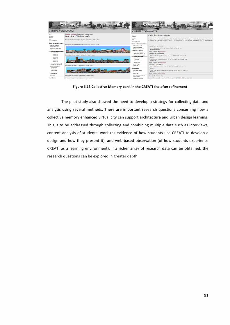
91
Figure 6.13 Collective Memory bank in the CREATI site after refinement
The pilot study also showed the need to develop a strategy for collecting data and
analysis using several methods. There are important research questions concerning how a
collective memory enhanced virtual city can support architecture and urban design learning.
This is to be addressed through collecting and combining multiple data such as interviews,
content analysis of students’ work (as evidence of how students use CREATI to develop a
design and how they present it), and web-‐based observation (of how students experience
CREATI as a learning environment). If a richer array of research data can be obtained, the
research questions can be explored in greater depth.
Chapter 7. THE ‘CREATI’ EXPERIMENT: APPLICATION OF ‘CREATI’ IN A REAL DESIGN EDUCATION SETTING
This chapter discusses the experiment through which the application of ‘CREATI’ was tested
in a real design education setting. At first it explains the changes of CREATI Version 0.0
following the pilot study and what improvements have been carried out in CREATI Version
1.0.
The urban design module as the source for collecting data in the Architecture
Department, Atma Jaya Yogyakarta University will also be discussed by describing the
students and the tutor of the module as well as presenting the curriculum of the
Architecture Department in order to comprehend the position of the Urban Design module
on their curriculum map. Learning objectives and how the module is delivered will be
explained to provide a thorough understanding of this course and how CREATI can support
the learning process.
In this chapter, the application of CREATI in a real design education setting will be
explained by introducing the different urban sites used for the assignment and what tasks
were required of the students. Data collection will be presented based on the tasks.
7.1. CREATI Version 1.01
As explained in Chapter 6, the refinement and development of CREATI Version 0.0 consisted
of three areas, i.e.:
1 https://sites.google.com/a/virtual-‐yogyakarta.info/virtual-‐yogyakarta/home
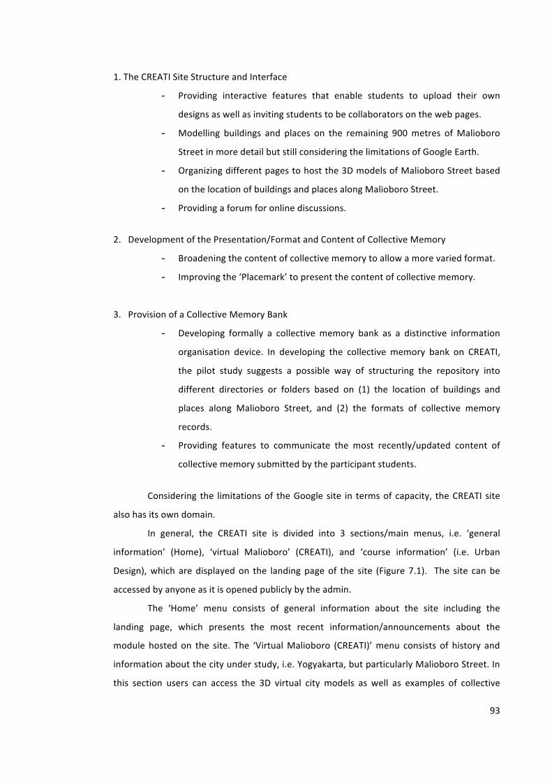
93
1. The CREATI Site Structure and Interface
- Providing interactive features that enable students to upload their own
designs as well as inviting students to be collaborators on the web pages.
- Modelling buildings and places on the remaining 900 metres of Malioboro
Street in more detail but still considering the limitations of Google Earth.
- Organizing different pages to host the 3D models of Malioboro Street based
on the location of buildings and places along Malioboro Street.
- Providing a forum for online discussions.
2. Development of the Presentation/Format and Content of Collective Memory
- Broadening the content of collective memory to allow a more varied format.
- Improving the ‘Placemark’ to present the content of collective memory.
3. Provision of a Collective Memory Bank
- Developing formally a collective memory bank as a distinctive information
organisation device. In developing the collective memory bank on CREATI,
the pilot study suggests a possible way of structuring the repository into
different directories or folders based on (1) the location of buildings and
places along Malioboro Street, and (2) the formats of collective memory
records.
- Providing features to communicate the most recently/updated content of
collective memory submitted by the participant students.
Considering the limitations of the Google site in terms of capacity, the CREATI site
also has its own domain.
In general, the CREATI site is divided into 3 sections/main menus, i.e. ‘general
information’ (Home), ‘virtual Malioboro’ (CREATI), and ‘course information’ (i.e. Urban
Design), which are displayed on the landing page of the site (Figure 7.1). The site can be
accessed by anyone as it is opened publicly by the admin.
The ‘Home’ menu consists of general information about the site including the
landing page, which presents the most recent information/announcements about the
module hosted on the site. The ‘Virtual Malioboro (CREATI)’ menu consists of history and
information about the city under study, i.e. Yogyakarta, but particularly Malioboro Street. In
this section users can access the 3D virtual city models as well as examples of collective
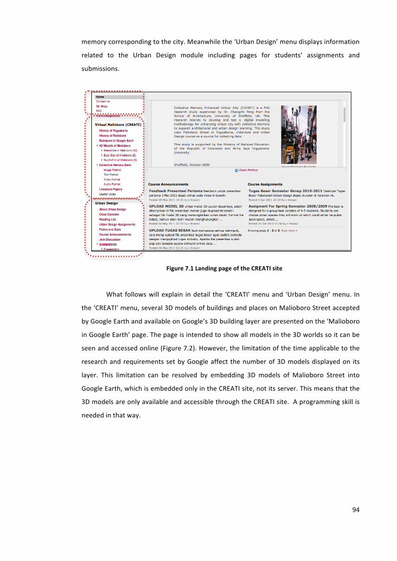
94
memory corresponding to the city. Meanwhile the ‘Urban Design’ menu displays information
related to the Urban Design module including pages for students’ assignments and
submissions.
Figure 7.1 Landing page of the CREATI site
What follows will explain in detail the ‘CREATI’ menu and ‘Urban Design’ menu. In
the ‘CREATI’ menu, several 3D models of buildings and places on Malioboro Street accepted
by Google Earth and available on Google’s 3D building layer are presented on the ‘Malioboro
in Google Earth’ page. The page is intended to show all models in the 3D worlds so it can be
seen and accessed online (Figure 7.2). However, the limitation of the time applicable to the
research and requirements set by Google affect the number of 3D models displayed on its
layer. This limitation can be resolved by embedding 3D models of Malioboro Street into
Google Earth, which is embedded only in the CREATI site, not its server. This means that the
3D models are only available and accessible through the CREATI site. A programming skill is
needed in that way.
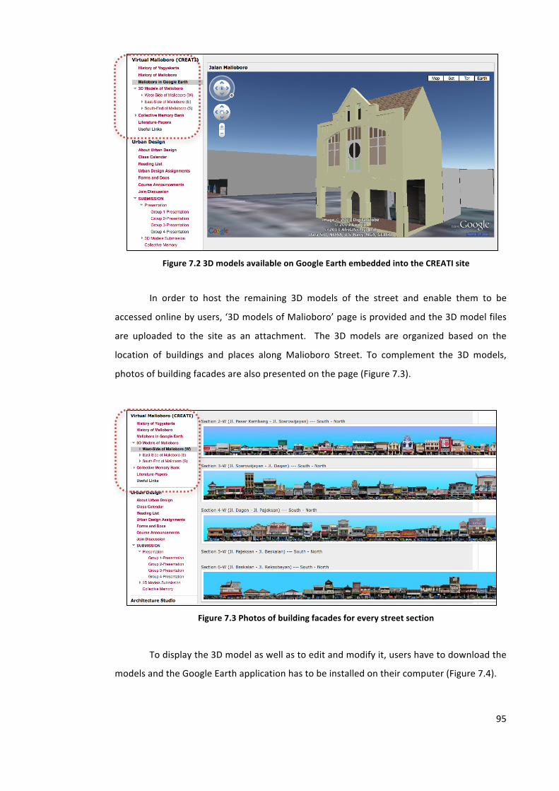
95
Figure 7.2 3D models available on Google Earth embedded into the CREATI site
In order to host the remaining 3D models of the street and enable them to be
accessed online by users, ‘3D models of Malioboro’ page is provided and the 3D model files
are uploaded to the site as an attachment. The 3D models are organized based on the
location of buildings and places along Malioboro Street. To complement the 3D models,
photos of building facades are also presented on the page (Figure 7.3).
Figure 7.3 Photos of building facades for every street section
To display the 3D model as well as to edit and modify it, users have to download the
models and the Google Earth application has to be installed on their computer (Figure 7.4).
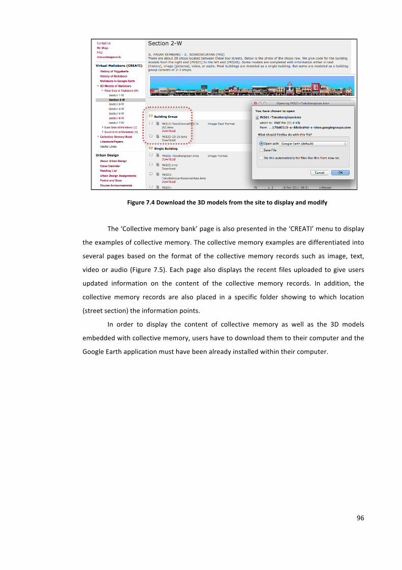
96
Figure 7.4 Download the 3D models from the site to display and modify
The ‘Collective memory bank’ page is also presented in the ‘CREATI’ menu to display
the examples of collective memory. The collective memory examples are differentiated into
several pages based on the format of the collective memory records such as image, text,
video or audio (Figure 7.5). Each page also displays the recent files uploaded to give users
updated information on the content of the collective memory records. In addition, the
collective memory records are also placed in a specific folder showing to which location
(street section) the information points.
In order to display the content of collective memory as well as the 3D models
embedded with collective memory, users have to download them to their computer and the
Google Earth application must have been already installed within their computer.
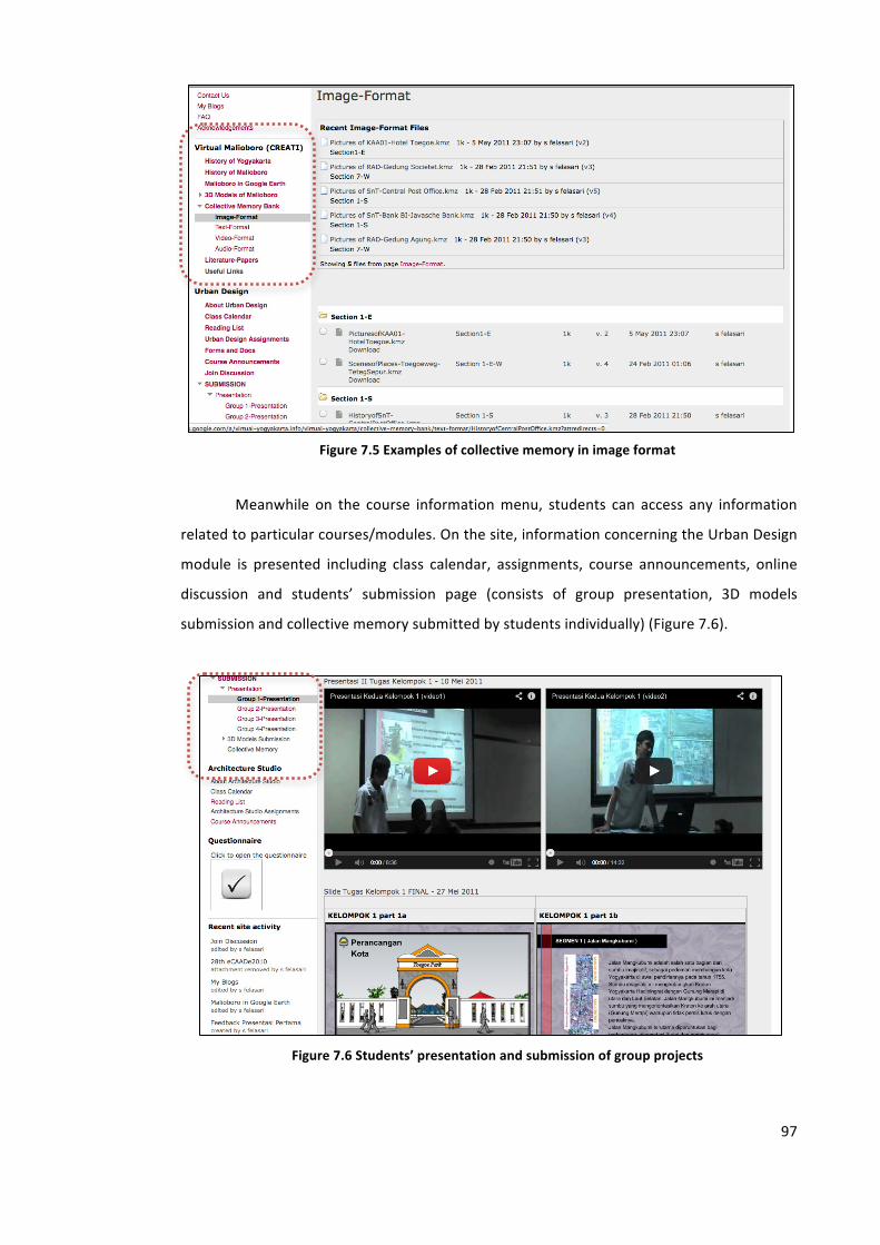
97
Figure 7.5 Examples of collective memory in image format
Meanwhile on the course information menu, students can access any information
related to particular courses/modules. On the site, information concerning the Urban Design
module is presented including class calendar, assignments, course announcements, online
discussion and students’ submission page (consists of group presentation, 3D models
submission and collective memory submitted by students individually) (Figure 7.6).
Figure 7.6 Students’ presentation and submission of group projects
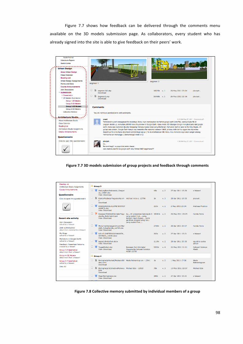
98
Figure 7.7 shows how feedback can be delivered through the comments menu
available on the 3D models submission page. As collaborators, every student who has
already signed into the site is able to give feedback on their peers’ work.
Figure 7.7 3D models submission of group projects and feedback through comments
Figure 7.8 Collective memory submitted by individual members of a group

99
Figure 7.8 shows the collective memory page on which students are individually
asked to submit memory records related to buildings or places located on the site that they
are working with. The collective memory records submitted by students are organized into
four group folders, which are the same as the tasks group. The folder provided is able to host
any files uploaded; however students are suggested to upload *.kmz files.
The ‘collective memory’ page for students’ submissions provides a comments menu
for giving feedback between students’ peers in the same group and the tutor (Figure 7.9).
A group for online discussion is also provided and can be accessed through ‘Join
Discussion’ page (Figure 7.10). The group is also accessible for open users as long as they
apply to join the group and are granted permission by the admin/tutor as a member of the
group.
Figure 7.9 Discussion forum between tutor (CREATI) and members of a particular group using comments
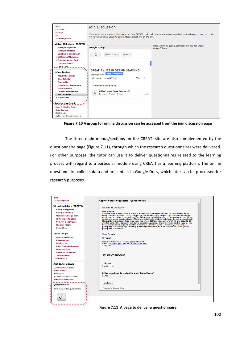
100
Figure 7.10 A group for online discussion can be accessed from the join discussion page
The three main menus/sections on the CREATI site are also complemented by the
questionnaire page (Figure 7.11), through which the research questionnaires were delivered.
For other purposes, the tutor can use it to deliver questionnaires related to the learning
process with regard to a particular module using CREATI as a learning platform. The online
questionnaire collects data and presents it in Google Docs, which later can be processed for
research purposes.
Figure 7.11 A page to deliver a questionnaire
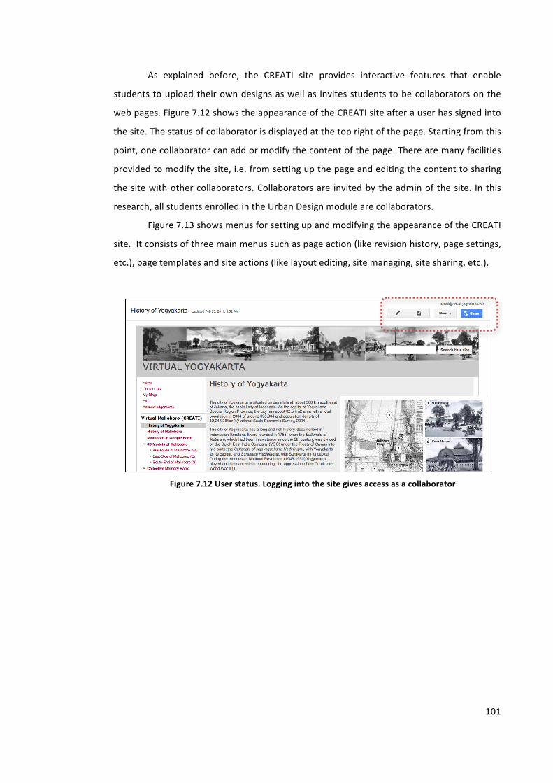
101
As explained before, the CREATI site provides interactive features that enable
students to upload their own designs as well as invites students to be collaborators on the
web pages. Figure 7.12 shows the appearance of the CREATI site after a user has signed into
the site. The status of collaborator is displayed at the top right of the page. Starting from this
point, one collaborator can add or modify the content of the page. There are many facilities
provided to modify the site, i.e. from setting up the page and editing the content to sharing
the site with other collaborators. Collaborators are invited by the admin of the site. In this
research, all students enrolled in the Urban Design module are collaborators.
Figure 7.13 shows menus for setting up and modifying the appearance of the CREATI
site. It consists of three main menus such as page action (like revision history, page settings,
etc.), page templates and site actions (like layout editing, site managing, site sharing, etc.).
Figure 7.12 User status. Logging into the site gives access as a collaborator
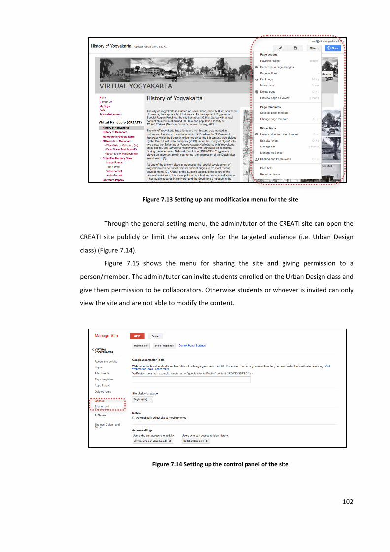
102
Figure 7.13 Setting up and modification menu for the site
Through the general setting menu, the admin/tutor of the CREATI site can open the
CREATI site publicly or limit the access only for the targeted audience (i.e. Urban Design
class) (Figure 7.14).
Figure 7.15 shows the menu for sharing the site and giving permission to a
person/member. The admin/tutor can invite students enrolled on the Urban Design class and
give them permission to be collaborators. Otherwise students or whoever is invited can only
view the site and are not able to modify the content.
Figure 7.14 Setting up the control panel of the site
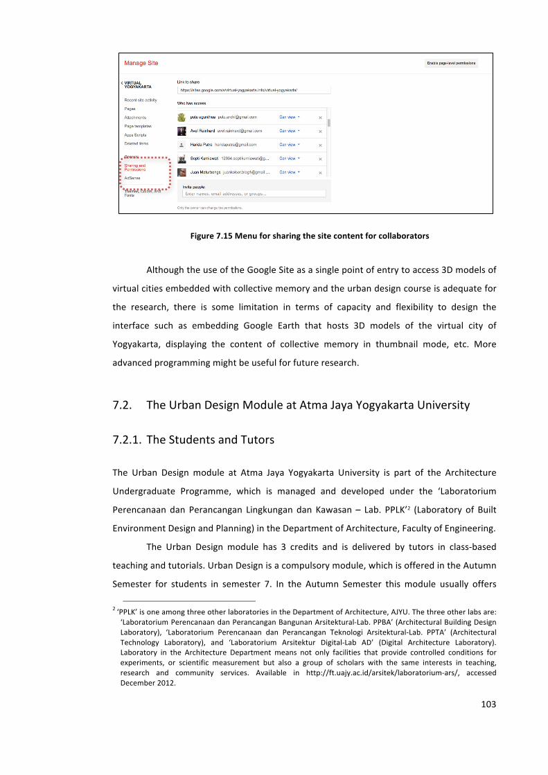
103
Figure 7.15 Menu for sharing the site content for collaborators
Although the use of the Google Site as a single point of entry to access 3D models of
virtual cities embedded with collective memory and the urban design course is adequate for
the research, there is some limitation in terms of capacity and flexibility to design the
interface such as embedding Google Earth that hosts 3D models of the virtual city of
Yogyakarta, displaying the content of collective memory in thumbnail mode, etc. More
advanced programming might be useful for future research.
7.2. The Urban Design Module at Atma Jaya Yogyakarta University
7.2.1. The Students and Tutors
The Urban Design module at Atma Jaya Yogyakarta University is part of the Architecture
Undergraduate Programme, which is managed and developed under the ‘Laboratorium
Perencanaan dan Perancangan Lingkungan dan Kawasan – Lab. PPLK’2 (Laboratory of Built
Environment Design and Planning) in the Department of Architecture, Faculty of Engineering.
The Urban Design module has 3 credits and is delivered by tutors in class-‐based
teaching and tutorials. Urban Design is a compulsory module, which is offered in the Autumn
Semester for students in semester 7. In the Autumn Semester this module usually offers
2 ‘PPLK’ is one among three other laboratories in the Department of Architecture, AJYU. The three other labs are: ‘Laboratorium Perencanaan dan Perancangan Bangunan Arsitektural-‐Lab. PPBA’ (Architectural Building Design Laboratory), ‘Laboratorium Perencanaan dan Perancangan Teknologi Arsitektural-‐Lab. PPTA’ (Architectural Technology Laboratory), and ‘Laboratorium Arsitektur Digital-‐Lab AD’ (Digital Architecture Laboratory). Laboratory in the Architecture Department means not only facilities that provide controlled conditions for experiments, or scientific measurement but also a group of scholars with the same interests in teaching, research and community services. Available in http://ft.uajy.ac.id/arsitek/laboratorium-‐ars/, accessed December 2012.
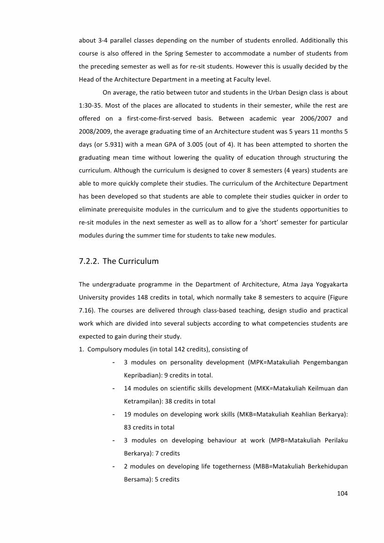
104
about 3-‐4 parallel classes depending on the number of students enrolled. Additionally this
course is also offered in the Spring Semester to accommodate a number of students from
the preceding semester as well as for re-‐sit students. However this is usually decided by the
Head of the Architecture Department in a meeting at Faculty level.
On average, the ratio between tutor and students in the Urban Design class is about
1:30-‐35. Most of the places are allocated to students in their semester, while the rest are
offered on a first-‐come-‐first-‐served basis. Between academic year 2006/2007 and
2008/2009, the average graduating time of an Architecture student was 5 years 11 months 5
days (or 5.931) with a mean GPA of 3.005 (out of 4). It has been attempted to shorten the
graduating mean time without lowering the quality of education through structuring the
curriculum. Although the curriculum is designed to cover 8 semesters (4 years) students are
able to more quickly complete their studies. The curriculum of the Architecture Department
has been developed so that students are able to complete their studies quicker in order to
eliminate prerequisite modules in the curriculum and to give the students opportunities to
re-‐sit modules in the next semester as well as to allow for a ‘short’ semester for particular
modules during the summer time for students to take new modules.
7.2.2. The Curriculum
The undergraduate programme in the Department of Architecture, Atma Jaya Yogyakarta
University provides 148 credits in total, which normally take 8 semesters to acquire (Figure
7.16). The courses are delivered through class-‐based teaching, design studio and practical
work which are divided into several subjects according to what competencies students are
expected to gain during their study.
1. Compulsory modules (in total 142 credits), consisting of
- 3 modules on personality development (MPK=Matakuliah Pengembangan
Kepribadian): 9 credits in total.
- 14 modules on scientific skills development (MKK=Matakuliah Keilmuan dan
Ketrampilan): 38 credits in total
- 19 modules on developing work skills (MKB=Matakuliah Keahlian Berkarya):
83 credits in total
- 3 modules on developing behaviour at work (MPB=Matakuliah Perilaku
Berkarya): 7 credits
- 2 modules on developing life togetherness (MBB=Matakuliah Berkehidupan
Bersama): 5 credits

105
2. Optional modules (as many as 6 credits that students can choose from the 40 credits
offered).
Modules offer as many as 40 credits, or 20 subjects. Students may choose a
minimum of 6 credits or equal to 3 modules to take.
However, it also allows the possibility of students taking more than three
optional modules if they need to. Consequently when students graduate, only
the three highest-‐value optional modules will be included in their academic
transcript. However, as compensation and a reward, they will also receive a
letter describing the qualification they received and optional modules they have
taken over the initial 3.
Figure 7.16 Urban Design Module and the Curriculum of the Undergraduate Programme in the
Department of Architecture, Atma Jaya Yogyakarta University
Source: Kurikulum Arsitektur, Fakultas Teknik, Universitas Atma Jaya Yogyakarta’, available at http://ft.uajy.ac.id/arsitek/kurikulum-‐ars/, accessed December 2012
7.2.3. The Learning Objectives
The study will also use an Urban Design module from the Department of Architecture, Atma
Jaya Yogyakarta University as a source for collecting data. The module was designed for
106
undergraduate students in their 4th year (semester 7) who have already gained a
considerable amount of knowledge related to urban experience through previous education
and training in other modules such as History and Theory of Urban (semester 5) and Human
and Settlement Project Design (semester 6). The Urban Design module is classified as a
module for developing work skill competency.
An overall aim of the Urban Design module is to facilitate a learning process through
which students will gain an understanding of the importance of urban spaces for their
inhabitants either as places for social gathering, culture actualization or recreational/leisure
facilities. It is expected that students will thereby acquire the ability to propose designs for
urban space based on the analysis of the quality of urban form and concepts for the design
of urban space.3
7.3. Applying CREATI 1.0 to the AJYU Urban Design Module in Spring
Semester 2011
7.3.1. The Urban Sites
The study used Malioboro Street in the city of Yogyakarta, Indonesia as a study site.
Malioboro Street is the main street in the centre of Yogyakarta city, which has a long history
as well as a complex development. Complexity issues arising in Malioboro like the ever-‐
increasing congestion caused by the dense traffic and excessive number of street vendors,
environmental degradation, problems threatening historic buildings, preservation and
conservation, open space issues, and so forth, have demanded a thorough solution in various
aspects. Therefore Malioboro is always exciting as the object of study or site assessment
either for higher education institutions, research institutions, or government institutions.
About 30 students participated in the experiment, and they were divided into 4
groups, which would work at four different sites located on Malioboro Street, which is a
historical street in the centre of Yogyakarta city in Indonesia about 1.2 kilometres long.
Students were allowed to form their own group and choose with whom they would work,
but the sites/locations for the group’s task were distributed randomly. At the end, each
group was required to submit their design of urban space in digital format both by uploading
files to the website provided and handing a copy of the files on a CD to the tutor as a backup
file.
3 Departement of Architecture, UAJY, ‘Profile of Engineering Faculty.’ (University of Atma Jaya Yogyakarta, 2009) <http://www.uajy.ac.id/downloads/Fakultas%20Teknik-‐UAJY.pdf>.
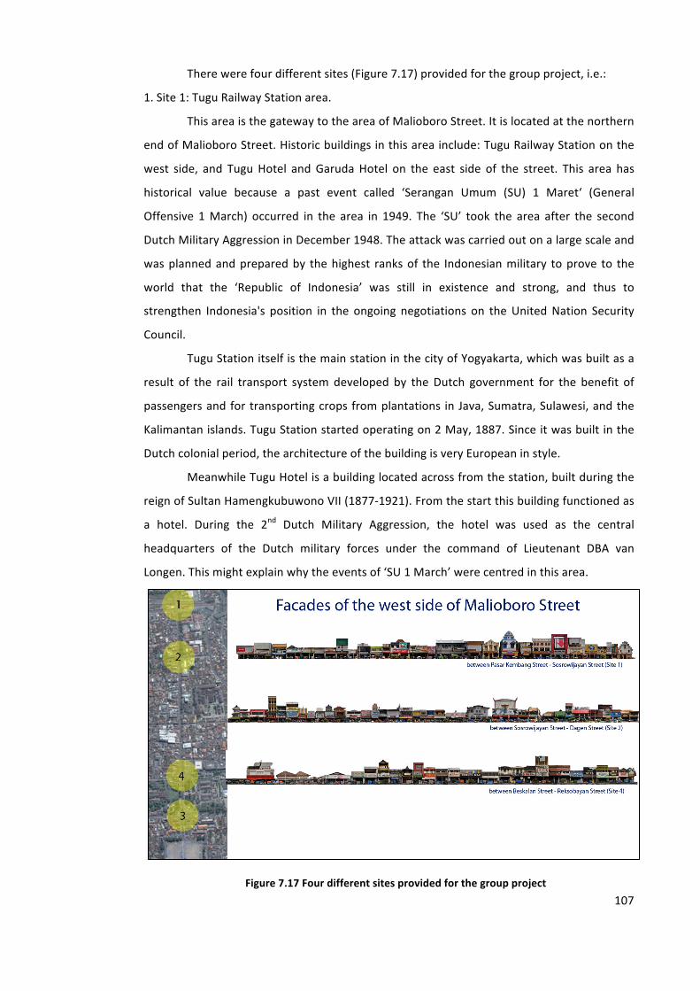
107
There were four different sites (Figure 7.17) provided for the group project, i.e.:
1. Site 1: Tugu Railway Station area.
This area is the gateway to the area of Malioboro Street. It is located at the northern
end of Malioboro Street. Historic buildings in this area include: Tugu Railway Station on the
west side, and Tugu Hotel and Garuda Hotel on the east side of the street. This area has
historical value because a past event called ‘Serangan Umum (SU) 1 Maret‘ (General
Offensive 1 March) occurred in the area in 1949. The ‘SU’ took the area after the second
Dutch Military Aggression in December 1948. The attack was carried out on a large scale and
was planned and prepared by the highest ranks of the Indonesian military to prove to the
world that the ‘Republic of Indonesia’ was still in existence and strong, and thus to
strengthen Indonesia's position in the ongoing negotiations on the United Nation Security
Council.
Tugu Station itself is the main station in the city of Yogyakarta, which was built as a
result of the rail transport system developed by the Dutch government for the benefit of
passengers and for transporting crops from plantations in Java, Sumatra, Sulawesi, and the
Kalimantan islands. Tugu Station started operating on 2 May, 1887. Since it was built in the
Dutch colonial period, the architecture of the building is very European in style.
Meanwhile Tugu Hotel is a building located across from the station, built during the
reign of Sultan Hamengkubuwono VII (1877-‐1921). From the start this building functioned as
a hotel. During the 2nd Dutch Military Aggression, the hotel was used as the central
headquarters of the Dutch military forces under the command of Lieutenant DBA van
Longen. This might explain why the events of ‘SU 1 March’ were centred in this area.
Figure 7.17 Four different sites provided for the group project
108
In 1908, the Colonial Government occupying the city of Yogyakarta wanted to build a
hotel in this strategic location in the centre of Yogyakarta, on Malioboro Street. They built a
cottage hotel, which in 1911 became the biggest and most luxurious hotel in Yogyakarta
named Grand Hotel De Djokdja meaning "London hotels".4 It only accommodated Dutch
military guests. In 1946, when Yogyakarta became the capital of Indonesia due to the
political and national security situation, the hotel changed its name to ‘Hotel Merdeka’
temporarily and became the office complex for the Indonesian governmental cabinet at that
time.
2. Site 2: Perwakilan Street area
The Parliamentary Building was built in 1950 in this area, five years after Indonesia
proclaimed its Independence Day or two years after the Second Dutch Military Aggression in
December 1948.5 There is a modern mall located in the area, namely Malioboro Mall, the
first mall established in the city of Yogyakarta since 1993 and now which can be said to be a
new modern landmark in Malioboro street. Prior to the construction of the mall, this area
was a unique area, with rows of small shops, and a rooftop restaurant, which was built as an
overflow for Malioboro street. Since the construction of the mall, the south part of the street
has been transformed into a parking area and the street itself has become an alternative way
out of Malioboro street at peak times when traffic jams cannot be avoided.
3. Site 3: ‘Zero Kilometre – 0 Km’ area
‘Zero Kilometre’ area is a term referring to the intersection street in front of the
central post office in Yogyakarta. The ‘0 Km’ area is located at the imaginary axis between
Mount Merapi, the Sultan Palace and the South Sea, and is located in the government,
commerce and tourism centre. So the ‘0 Km’ area is a strategic location for the development
of a Community Activity Centre and Travellers, in particular the activities of culture and
tourism. As a public space, the area is always crowded with people either hanging out or
performing arts. Various cultural arts activities and demonstrations often take place in this
open space such as the Yogyakarta Arts Festival (‘Festival Kesenian Yogyakarta’ – FKY) and
hobby community. Near the ‘0 Km’ neighbourhood stands historical buildings that are not
only witnesses to the history of the city of Yogyakarta, but also play an important part in the
4 Arwan Tuti Artha, Yogyakarta tempo doeloe sepanjang catatan pariwisata (Bigraf Pub., 2000). 5 Rumah Tembi Budaya, ‘Djogdja Tempo Doeloe: Gedung DPRD Malioboro Tahun 1950’, available at http://www.tembi.net/id/news/yogyakarta-‐tempo-‐doeloe/gedung-‐dprd-‐malioboro-‐tahun-‐1950-‐3235.html
109
history of the Republic of Indonesia such as Vredeburg Fort, Gedung Agung Presidential
House, Senisono Arts Centre, BNI Government Bank, Central Post Office, Sonobudoyo
Museum and Monument of the ‘SO 1 March’.
4. Site 4: Beringharjo Central Market area
Beringharjo market has been part of Malioboro and the centre of economic activity
for hundreds of years. Its existence has philosophical meaning because Beringharjo was built
as one of the pillars of 'Catur Tunggal' – a philosophical concept of the founding of
Yogyakarta city (consisting of South and North Square, the Sultan Palace and the Market –
Beringharjo).6 It symbolizes economic functions. The location of Beringharjo market originally
was a forest of banyan trees. Shortly after the founding of ‘Kraton Ngayogyakarta’ Sultan
Palace, i.e. in 1758, the area was used as a place for economic transactions by residents of
Yogyakarta and the surrounding areas. Hundreds of years later, in 1925, the transaction
place acquired a permanent building. Sultan Hamengkubuwono IX gave it the name
Beringharjo meaning that the banyan tree (from the word ‘Bering’) was expected to provide
welfare (from the word ‘Harjo’). Now, tourists define this place as a pleasant shopping area.
7.3.2. The Design Tasks
The Urban Design assignment is usually designed as a group task. Students may choose the
scope of urban space whether it be public open spaces (public open space and surrounding
areas), street spaces (the space and layout of the surrounding buildings) or a combination of
the two.
For the task, students were asked to submit either a re-‐designed and revitalized
proposal or hand in a new development. In the guideline (Appendix B), students were
advised to consider:
- Urban space’s roles both due its forms and functions.
- Design quality principles in a friendly and responsive environment such as
one having permeability, variety, legibility, robustness, richness, visual
appropriateness, and personalisation (depends on the priority).
- Appropriateness of townscape design concepts such as the application of
serial vision (fit the theme or spatial experiences offered, urban forms and
6 L.T. Adishakti, ‘A Study on the Conservation Planning of Yogyakarta Historic Tourist City Based on Urban Space Heritage Conception’ (unpublished Unpublished Dissertation, Japan: Kyoto Universuty, 1997).
110
buildings skyline, façades, scale and proportion in urban spaces, and visual
continuity).
- Building codes and regulations.
- Context and possible innovative design creativity.
Under the course’s task, students can add new elements to propose urban space
arrangements for example by adding open spaces, connected streets, public arts or other
physical elements as long as they can be used to assert the concepts. They can also consider
supporting elements such as (1) lighting (natural and artificial) -‐ for visual richness because of
viewing time differences, (2) viewing distance (in relation to the hierarchy of scale and
viewing distance), (3) viewing time (related to the complexity of details), and (4) kinetic art
(sequence of arts which can be enjoyed by movement).
Proposed design concepts should be based on the analysis of findings, which should
be based on theories for analysing urban spaces such as:
- Theory of townscape design.7
- Theory about understanding urban space through spatial experiences.8
- Theory of city image and interrelatedness among urban image elements.9
- Theory of a responsive environment.10
- Theory of urban spatial design.11
- Theory of urban space.12
- Other theories, which might be useful for supporting the design proposal
As part of the urban design assignment, students were given an urban design project
consisting of both a group task and individual task. For the task group, which comprised 6-‐8
people, students were asked to submit a design proposal at one specific site in a particular
location. The proposal should be carefully designed based on the existing conditions without
losing the historical context.
In consultation with the tutor, every student of the Urban Design class was also
asked individually to add memory records related to a ‘locus’ in any format. It was expected
that the memory records would assist the city 'to narrate' its story. The memory record could
7 Gordon Cullen, Concise Townscape, New edition (Architectural Press, 1961). 8 Raymond J. Curran, Architecture and the Urban Experience (Van Nost.Reinhold,U.S., 1983). 9 K. Lynch, The Image of the City (MIT Press, 1960). 10 Ian Bentley, Responsive Environments : a Manual for Designers (London: Architectural Press, 1985). 11 Roger Trancik, Finding Lost Space: Theories of Urban Design (John Wiley & Sons, 1986). 12 Rob Krier, Urban Space (Rizzoli Intl Pubns, 1979); J. C. Moughtin, Urban Design: Street and Square, 3rd edn (Architectural Press, 2003).
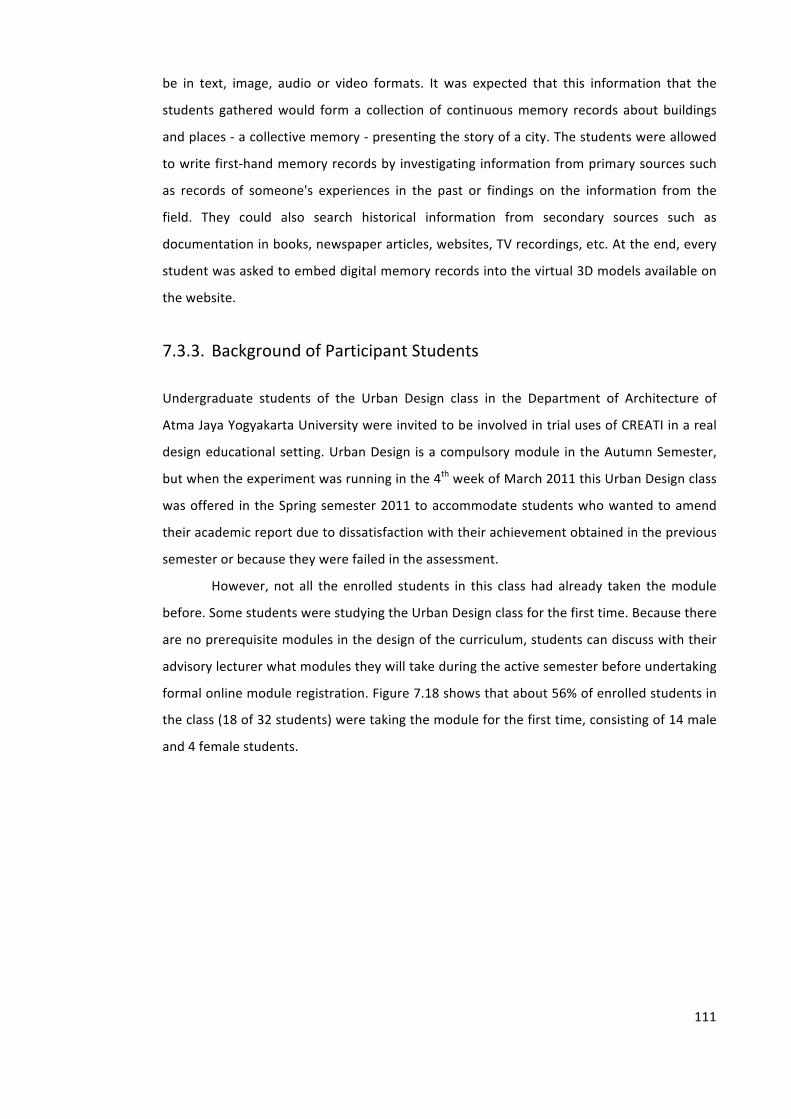
111
be in text, image, audio or video formats. It was expected that this information that the
students gathered would form a collection of continuous memory records about buildings
and places -‐ a collective memory -‐ presenting the story of a city. The students were allowed
to write first-‐hand memory records by investigating information from primary sources such
as records of someone's experiences in the past or findings on the information from the
field. They could also search historical information from secondary sources such as
documentation in books, newspaper articles, websites, TV recordings, etc. At the end, every
student was asked to embed digital memory records into the virtual 3D models available on
the website.
7.3.3. Background of Participant Students
Undergraduate students of the Urban Design class in the Department of Architecture of
Atma Jaya Yogyakarta University were invited to be involved in trial uses of CREATI in a real
design educational setting. Urban Design is a compulsory module in the Autumn Semester,
but when the experiment was running in the 4th week of March 2011 this Urban Design class
was offered in the Spring semester 2011 to accommodate students who wanted to amend
their academic report due to dissatisfaction with their achievement obtained in the previous
semester or because they were failed in the assessment.
However, not all the enrolled students in this class had already taken the module
before. Some students were studying the Urban Design class for the first time. Because there
are no prerequisite modules in the design of the curriculum, students can discuss with their
advisory lecturer what modules they will take during the active semester before undertaking
formal online module registration. Figure 7.18 shows that about 56% of enrolled students in
the class (18 of 32 students) were taking the module for the first time, consisting of 14 male
and 4 female students.
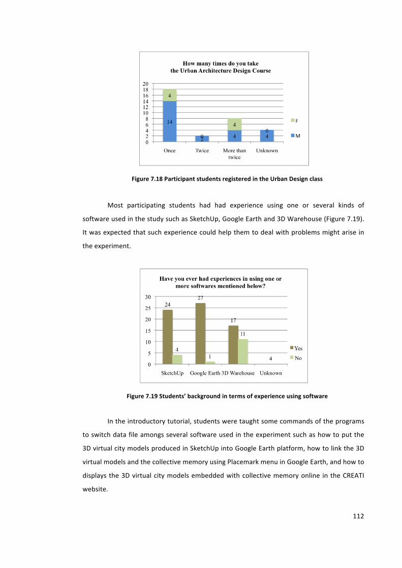
112
Figure 7.18 Participant students registered in the Urban Design class
Most participating students had had experience using one or several kinds of
software used in the study such as SketchUp, Google Earth and 3D Warehouse (Figure 7.19).
It was expected that such experience could help them to deal with problems might arise in
the experiment.
Figure 7.19 Students’ background in terms of experience using software
In the introductory tutorial, students were taught some commands of the programs
to switch data file amongs several software used in the experiment such as how to put the
3D virtual city models produced in SketchUp into Google Earth platform, how to link the 3D
virtual models and the collective memory using Placemark menu in Google Earth, and how to
displays the 3D virtual city models embedded with collective memory online in the CREATI
website.
113
7.4. The Data Collection
When the assignment was announced a week before the midterm exam, the course tutor
informed the students about what subjects should be covered, how the assignment could be
done and how the CREATI website could help them to perform the task. A more specific
explanation related to collective memory as part of this research was also introduced to the
students, and how the collective memory embedded in virtual city models might assist them.
Students were also introduced to the website and were given an introductory technical
tutorial to give them confidence in using the website functions later and to avoid navigation
problems as this may diminish learners’ willingness to perform online knowledge sharing.13
At the end of the explanation, all students were also required to have a Google
account as a condition to access the CREATI site. On campus, students are facilitated to have
access to Internet connections and all computers have Google Earth installed (to display 3D
models as 3D models can be downloaded or new ones uploaded) as well as 3D modelling
programs like Sketch Up (for editing models). The study used several sources for data
collection such as individual student assignments, group project assignments submitted via
the CREATI site, interviews and observations on the use of the CREATI website.
7.4.1. Individual Student Assignment
When organizing the use of CREATI to support the urban design class, it was important to
schedule access to the website in several steps. At the beginning, students were given access
to the website as a viewer. With viewer status, it was expected that students would become
familiar with the site and could navigate through it easily without the ability to edit the
content. They were assisted to acquire information related to the urban design course such
as module descriptions, class calendar, reading list, assignments and class announcement as
well as to download the 3D models available on the site.
Three weeks after the introductory tutorial, students were required to submit their
individual task via the CREATI website. They were asked to update content from the
examples of the collective memory bank on the site. In this stage, by having a Google
account, all students enrolled in the class were given access to the website as a collaborator
to enable them not only to view and download files but also upload their files as well as edit
13 Luisa Dalla Vecchia, Adriane da Silva and Alice Pereira, ‘Teaching/Learning Architectural Design Based on a Virtual Learning Environment’, 2008 <http://cumincad.scix.net/cgi-‐bin/works/Show?_id=ecaade2008_073&sort=DEFAULT&search=Vecchia&hits=3> [accessed 22 January, 2011]; Irene Y. L. Chen, Nian-‐Shing Chen and Kinshuk, ‘Examining the Factors Influencing Participants’ Knowledge Sharing Behavior in Virtual Learning Communities’, Educational Technology & Society, 12 (2009), 134–148.
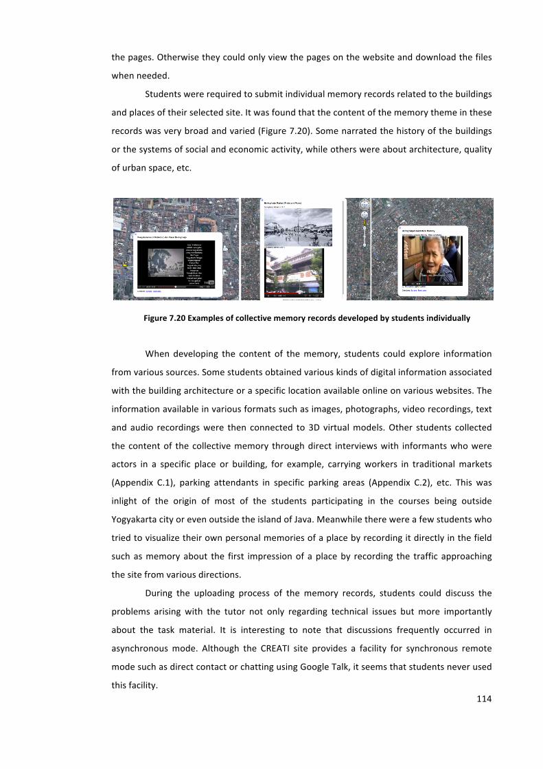
114
the pages. Otherwise they could only view the pages on the website and download the files
when needed.
Students were required to submit individual memory records related to the buildings
and places of their selected site. It was found that the content of the memory theme in these
records was very broad and varied (Figure 7.20). Some narrated the history of the buildings
or the systems of social and economic activity, while others were about architecture, quality
of urban space, etc.
Figure 7.20 Examples of collective memory records developed by students individually
When developing the content of the memory, students could explore information
from various sources. Some students obtained various kinds of digital information associated
with the building architecture or a specific location available online on various websites. The
information available in various formats such as images, photographs, video recordings, text
and audio recordings were then connected to 3D virtual models. Other students collected
the content of the collective memory through direct interviews with informants who were
actors in a specific place or building, for example, carrying workers in traditional markets
(Appendix C.1), parking attendants in specific parking areas (Appendix C.2), etc. This was
inlight of the origin of most of the students participating in the courses being outside
Yogyakarta city or even outside the island of Java. Meanwhile there were a few students who
tried to visualize their own personal memories of a place by recording it directly in the field
such as memory about the first impression of a place by recording the traffic approaching
the site from various directions.
During the uploading process of the memory records, students could discuss the
problems arising with the tutor not only regarding technical issues but more importantly
about the task material. It is interesting to note that discussions frequently occurred in
asynchronous mode. Although the CREATI site provides a facility for synchronous remote
mode such as direct contact or chatting using Google Talk, it seems that students never used
this facility.
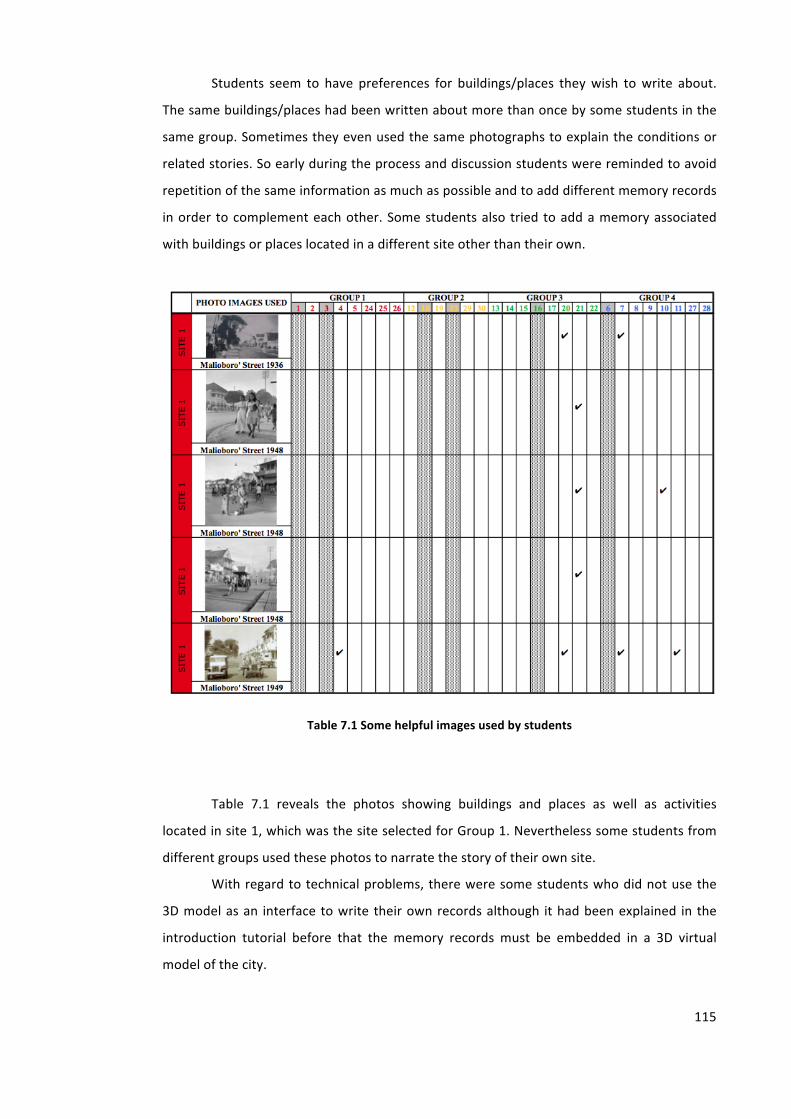
115
Students seem to have preferences for buildings/places they wish to write about.
The same buildings/places had been written about more than once by some students in the
same group. Sometimes they even used the same photographs to explain the conditions or
related stories. So early during the process and discussion students were reminded to avoid
repetition of the same information as much as possible and to add different memory records
in order to complement each other. Some students also tried to add a memory associated
with buildings or places located in a different site other than their own.
Table 7.1 Some helpful images used by students
Table 7.1 reveals the photos showing buildings and places as well as activities
located in site 1, which was the site selected for Group 1. Nevertheless some students from
different groups used these photos to narrate the story of their own site.
With regard to technical problems, there were some students who did not use the
3D model as an interface to write their own records although it had been explained in the
introduction tutorial before that the memory records must be embedded in a 3D virtual
model of the city.
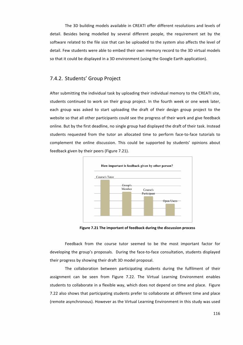
116
The 3D building models available in CREATI offer different resolutions and levels of
detail. Besides being modelled by several different people, the requirement set by the
software related to the file size that can be uploaded to the system also affects the level of
detail. Few students were able to embed their own memory record to the 3D virtual models
so that it could be displayed in a 3D environment (using the Google Earth application).
7.4.2. Students’ Group Project
After submitting the individual task by uploading their individual memory to the CREATI site,
students continued to work on their group project. In the fourth week or one week later,
each group was asked to start uploading the draft of their design group project to the
website so that all other participants could see the progress of their work and give feedback
online. But by the first deadline, no single group had displayed the draft of their task. Instead
students requested from the tutor an allocated time to perform face-‐to-‐face tutorials to
complement the online discussion. This could be supported by students’ opinions about
feedback given by their peers (Figure 7.21).
Figure 7.21 The important of feedback during the discussion process
Feedback from the course tutor seemed to be the most important factor for
developing the group’s proposals. During the face-‐to-‐face consultation, students displayed
their progress by showing their draft 3D model proposal.
The collaboration between participating students during the fulfilment of their
assignment can be seen from Figure 7.22. The Virtual Learning Environment enables
students to collaborate in a flexible way, which does not depend on time and place. Figure
7.22 also shows that participating students prefer to collaborate at different time and place
(remote asynchronous). However as the Virtual Learning Environment in this study was used
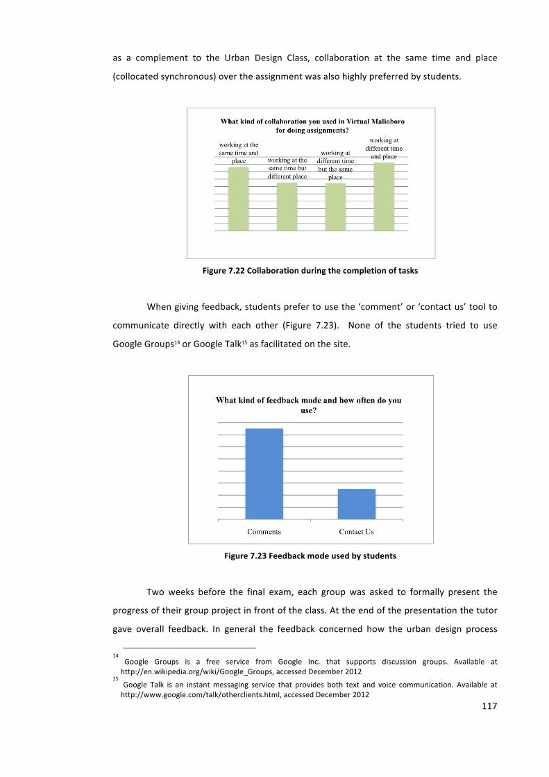
117
as a complement to the Urban Design Class, collaboration at the same time and place
(collocated synchronous) over the assignment was also highly preferred by students.
Figure 7.22 Collaboration during the completion of tasks
When giving feedback, students prefer to use the ‘comment’ or ‘contact us’ tool to
communicate directly with each other (Figure 7.23). None of the students tried to use
Google Groups14 or Google Talk15 as facilitated on the site.
Figure 7.23 Feedback mode used by students
Two weeks before the final exam, each group was asked to formally present the
progress of their group project in front of the class. At the end of the presentation the tutor
gave overall feedback. In general the feedback concerned how the urban design process
14 Google Groups is a free service from Google Inc. that supports discussion groups. Available at http://en.wikipedia.org/wiki/Google_Groups, accessed December 2012
15 Google Talk is an instant messaging service that provides both text and voice communication. Available at http://www.google.com/talk/otherclients.html, accessed December 2012
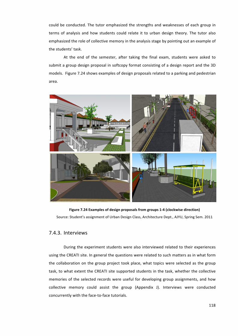
118
could be conducted. The tutor emphasized the strengths and weaknesses of each group in
terms of analysis and how students could relate it to urban design theory. The tutor also
emphasized the role of collective memory in the analysis stage by pointing out an example of
the students’ task.
At the end of the semester, after taking the final exam, students were asked to
submit a group design proposal in softcopy format consisting of a design report and the 3D
models. Figure 7.24 shows examples of design proposals related to a parking and pedestrian
area.
Figure 7.24 Examples of design proposals from groups 1-‐4 (clockwise direction)
Source: Student’s assignment of Urban Design Class, Architecture Dept., AJYU, Spring Sem. 2011
7.4.3. Interviews
During the experiment students were also interviewed related to their experiences
using the CREATI site. In general the questions were related to such matters as in what form
the collaboration on the group project took place, what topics were selected as the group
task, to what extent the CREATI site supported students in the task, whether the collective
memories of the selected records were useful for developing group assignments, and how
collective memory could assist the group (Appendix J). Interviews were conducted
concurrently with the face-‐to-‐face tutorials.
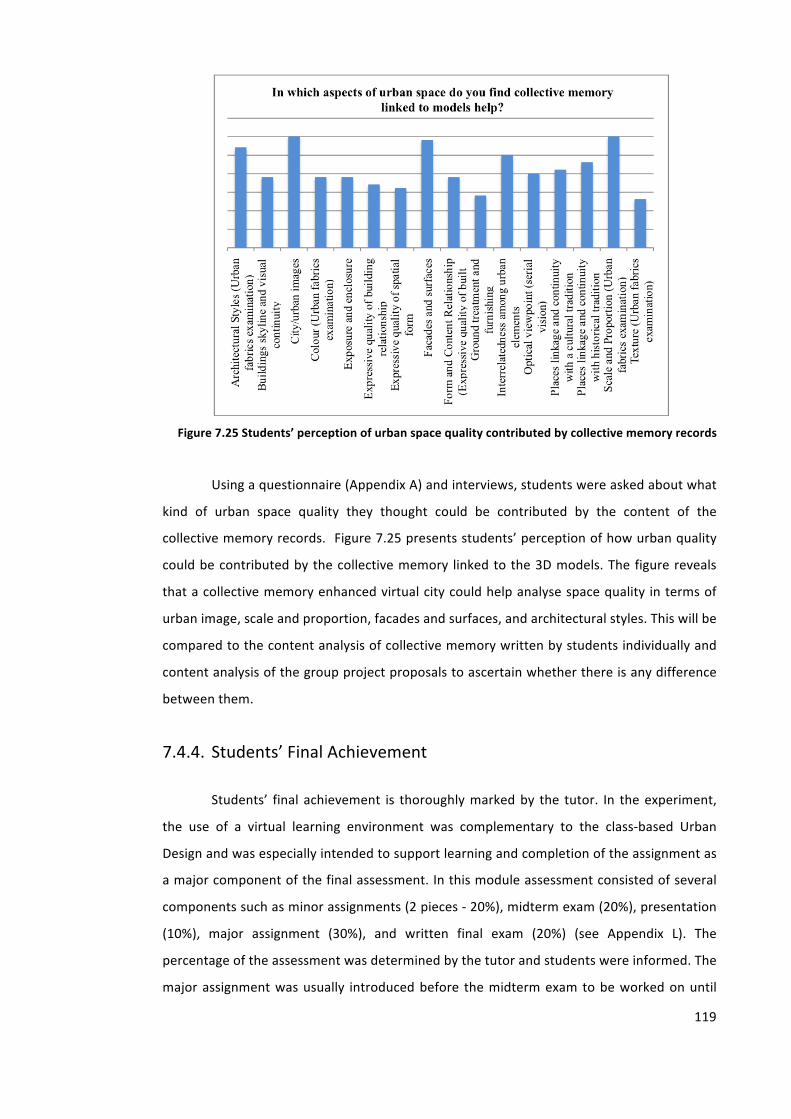
119
Figure 7.25 Students’ perception of urban space quality contributed by collective memory records
Using a questionnaire (Appendix A) and interviews, students were asked about what
kind of urban space quality they thought could be contributed by the content of the
collective memory records. Figure 7.25 presents students’ perception of how urban quality
could be contributed by the collective memory linked to the 3D models. The figure reveals
that a collective memory enhanced virtual city could help analyse space quality in terms of
urban image, scale and proportion, facades and surfaces, and architectural styles. This will be
compared to the content analysis of collective memory written by students individually and
content analysis of the group project proposals to ascertain whether there is any difference
between them.
7.4.4. Students’ Final Achievement
Students’ final achievement is thoroughly marked by the tutor. In the experiment,
the use of a virtual learning environment was complementary to the class-‐based Urban
Design and was especially intended to support learning and completion of the assignment as
a major component of the final assessment. In this module assessment consisted of several
components such as minor assignments (2 pieces -‐ 20%), midterm exam (20%), presentation
(10%), major assignment (30%), and written final exam (20%) (see Appendix L). The
percentage of the assessment was determined by the tutor and students were informed. The
major assignment was usually introduced before the midterm exam to be worked on until
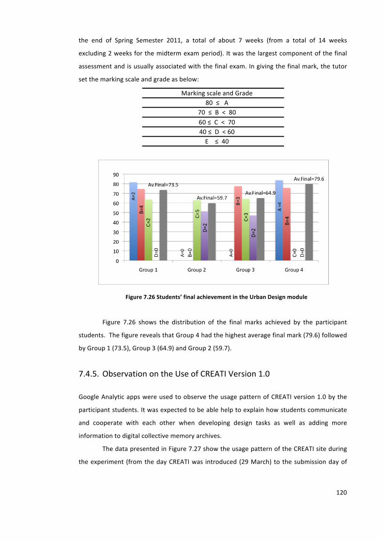
120
the end of Spring Semester 2011, a total of about 7 weeks (from a total of 14 weeks
excluding 2 weeks for the midterm exam period). It was the largest component of the final
assessment and is usually associated with the final exam. In giving the final mark, the tutor
set the marking scale and grade as below:
Marking scale and Grade 80 ≤ A
70 ≤ B < 80 60 ≤ C < 70 40 ≤ D < 60 E ≤ 40
Figure 7.26 Students’ final achievement in the Urban Design module
Figure 7.26 shows the distribution of the final marks achieved by the participant
students. The figure reveals that Group 4 had the highest average final mark (79.6) followed
by Group 1 (73.5), Group 3 (64.9) and Group 2 (59.7).
7.4.5. Observation on the Use of CREATI Version 1.0
Google Analytic apps were used to observe the usage pattern of CREATI version 1.0 by the
participant students. It was expected to be able help to explain how students communicate
and cooperate with each other when developing design tasks as well as adding more
information to digital collective memory archives.
The data presented in Figure 7.27 show the usage pattern of the CREATI site during
the experiment (from the day CREATI was introduced (29 March) to the submission day of
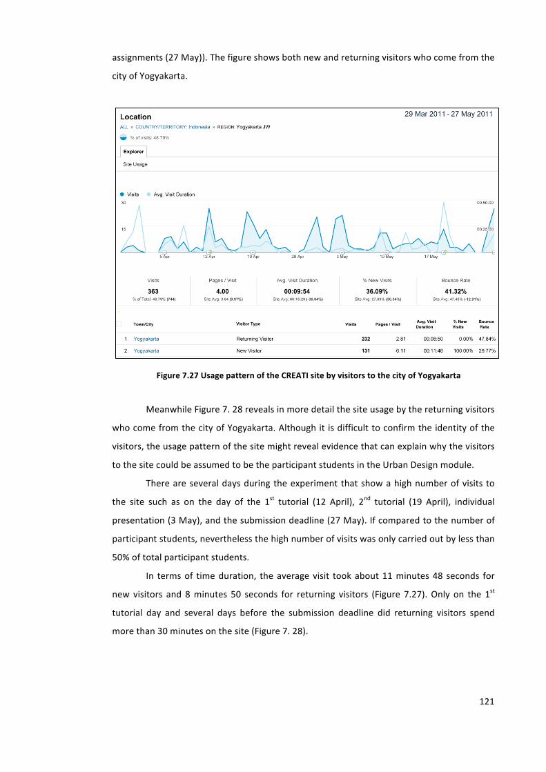
121
assignments (27 May)). The figure shows both new and returning visitors who come from the
city of Yogyakarta.
Figure 7.27 Usage pattern of the CREATI site by visitors to the city of Yogyakarta
Meanwhile Figure 7. 28 reveals in more detail the site usage by the returning visitors
who come from the city of Yogyakarta. Although it is difficult to confirm the identity of the
visitors, the usage pattern of the site might reveal evidence that can explain why the visitors
to the site could be assumed to be the participant students in the Urban Design module.
There are several days during the experiment that show a high number of visits to
the site such as on the day of the 1st tutorial (12 April), 2nd tutorial (19 April), individual
presentation (3 May), and the submission deadline (27 May). If compared to the number of
participant students, nevertheless the high number of visits was only carried out by less than
50% of total participant students.
In terms of time duration, the average visit took about 11 minutes 48 seconds for
new visitors and 8 minutes 50 seconds for returning visitors (Figure 7.27). Only on the 1st
tutorial day and several days before the submission deadline did returning visitors spend
more than 30 minutes on the site (Figure 7. 28).
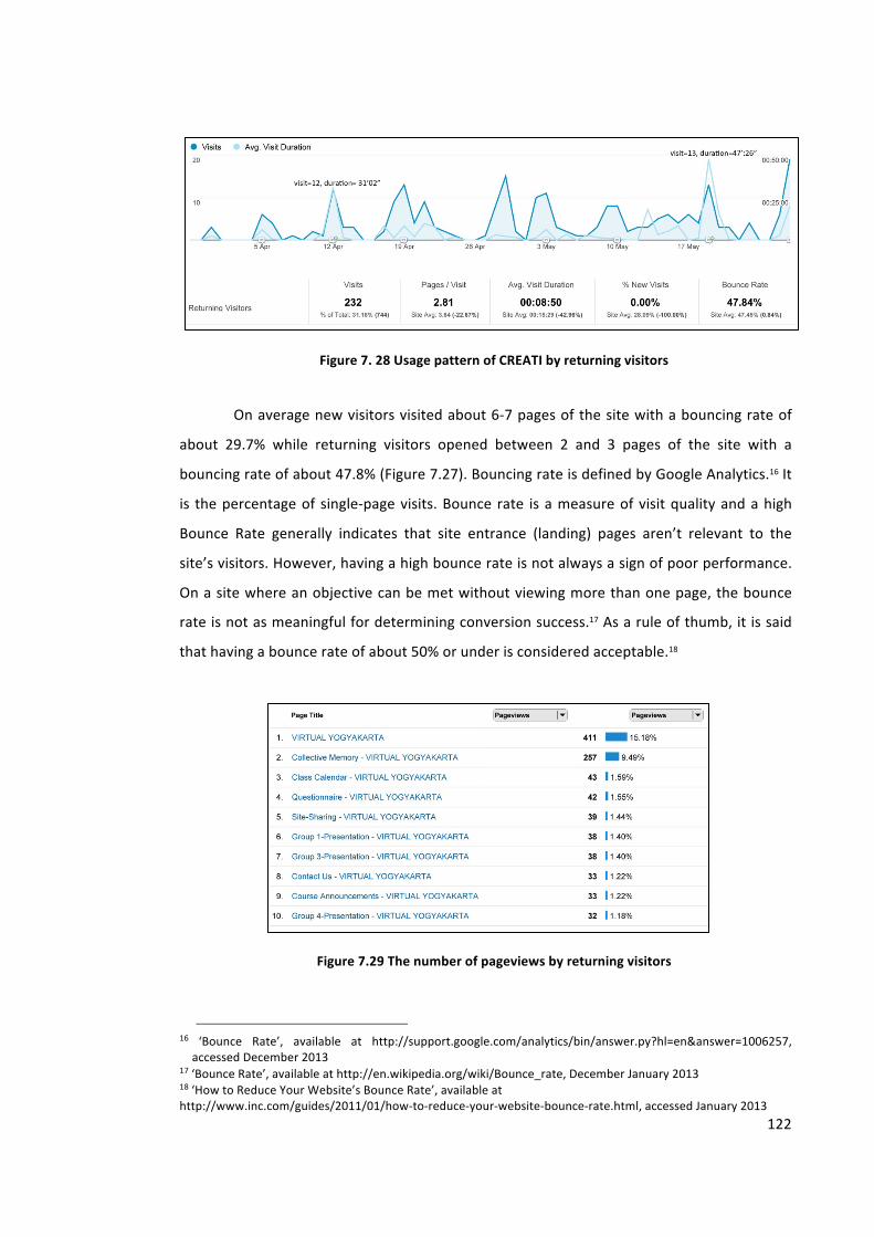
122
Figure 7. 28 Usage pattern of CREATI by returning visitors
On average new visitors visited about 6-‐7 pages of the site with a bouncing rate of
about 29.7% while returning visitors opened between 2 and 3 pages of the site with a
bouncing rate of about 47.8% (Figure 7.27). Bouncing rate is defined by Google Analytics.16 It
is the percentage of single-‐page visits. Bounce rate is a measure of visit quality and a high
Bounce Rate generally indicates that site entrance (landing) pages aren’t relevant to the
site’s visitors. However, having a high bounce rate is not always a sign of poor performance.
On a site where an objective can be met without viewing more than one page, the bounce
rate is not as meaningful for determining conversion success.17 As a rule of thumb, it is said
that having a bounce rate of about 50% or under is considered acceptable.18
Figure 7.29 The number of pageviews by returning visitors
16 ‘Bounce Rate’, available at http://support.google.com/analytics/bin/answer.py?hl=en&answer=1006257, accessed December 2013
17 ‘Bounce Rate’, available at http://en.wikipedia.org/wiki/Bounce_rate, December January 2013 18 ‘How to Reduce Your Website’s Bounce Rate’, available at http://www.inc.com/guides/2011/01/how-‐to-‐reduce-‐your-‐website-‐bounce-‐rate.html, accessed January 2013
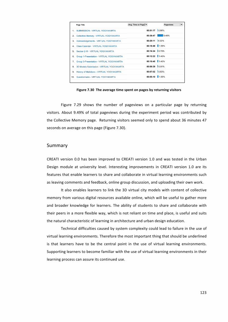
123
Figure 7.30 The average time spent on pages by returning visitors
Figure 7.29 shows the number of pageviews on a particular page by returning
visitors. About 9.49% of total pageviews during the experiment period was contributed by
the Collective Memory page. Returning visitors seemed only to spend about 36 minutes 47
seconds on average on this page (Figure 7.30).
Summary
CREATI version 0.0 has been improved to CREATI version 1.0 and was tested in the Urban
Design module at university level. Interesting improvements in CREATI version 1.0 are its
features that enable learners to share and collaborate in virtual learning environments such
as leaving comments and feedback, online group discussion, and uploading their own work.
It also enables learners to link the 3D virtual city models with content of collective
memory from various digital resources available online, which will be useful to gather more
and broader knowledge for learners. The ability of students to share and collaborate with
their peers in a more flexible way, which is not reliant on time and place, is useful and suits
the natural characteristic of learning in architecture and urban design education.
Technical difficulties caused by system complexity could lead to failure in the use of
virtual learning environments. Therefore the most important thing that should be underlined
is that learners have to be the central point in the use of virtual learning environments.
Supporting learners to become familiar with the use of virtual learning environments in their
learning process can assure its continued use.
Chapter 8. FINDINGS AND DISCUSSION
This chapter discusses the data collected in the experiment as presented in Chapter 7. The
data were analysed with several combined methods to answer the research questions.
The first research question on how a city’s collective memory can be represented
digitally and linked to the city’s virtual model has been discussed in the previous chapters
(see Chapter 5, Section 5.3, Chapter 6, Section 6.2.3 and Chapter 7, Section 7.4.1).
The second research question related to how and in what ways a virtual city
embedded with digital records of collective memory could help students at undergraduate
level to achieve the learning objectives of Urban Design, using the course at the Atma Jaya
Yogyakarta University as an example. Students are expected to have better understanding
about the importance of urban spaces for their inhabitants. Therefore understanding
historical and contextual issues is needed in order for them to develop urban design
proposals based on the analysis of the quality of urban spaces. In answering the question,
this chapter will analyse the content of collective memory and student groups’ proposals
collected from the experiment to see whether there is any correlation between them. In
analysing the content, several parameters of urban space quality were used (see Chapter 5,
Section 5.6). It is expected that if correlations between the content of collective memory and
groups’ urban design proposals are found, then it can be argued that the students’
understanding of the historical and contextual issues is connected with their developing of
the urban design proposals.
The content of collective memory and student groups’ proposals were analysed
using the qualitative software tool NVivo. The NVivo1 program used in the study can read
files in text, image and video formats. To understand the content of collective memory and
1 http://www.qsrinternational.com/products_nvivo.aspx
125
related questions in this research, there are several queries that can be performed in NVivo
such as:
1. Word Frequency query. It enables one to find the most frequently
occurring words in material. This can be a useful way of identifying
themes or concepts.
2. Text Search query. It enables one to search for words or phrases in the
research data. It can be used to search for words in documents and
code each occurrence at a specific node. The relevance rating indicates
the frequency of appearance of the keywords in the items.
3. Simple and Advanced Coding queries. A coding query enables one to
find content based on specific nodes or codes.
4. Compound Coding query. It combines a text search and coding query,
enabling one to search for specific text in or near coded content.
5. Matrix Coding query. It enables comparison of pairs of items and
displays the results in a table or matrix.
6. Coding Comparison query. It enables comparison of coding done by
two users or two groups of users.
The third research question related to whether or not collective memory enhanced
virtual city models can facilitate collaborative learning and how the effectiveness of this e-‐
learning approach can be measured. In answering this question, this chapter discusses the
usage pattern of the CREATI site and interviews of the students who had used the 3D virtual
models embedded with collective memory hosted on CREATI. By observing the usage
pattern, I explain how students collaborate with each other.
The students’ final course assessment results are also deemed a measure of the
effectiveness of CREATI in supporting urban design learning. The analysis focused on
comparing the content of collective memory and students’ proposals with their final grades.
In addition to the analysis, this chapter also presents a comparison of students’ group
projects between one particular group which used CREATI in the urban design module and
another which did not. It was expected that the comparison would reveal the additional
value of collective memory enhanced virtual city models in supporting urban design learning.
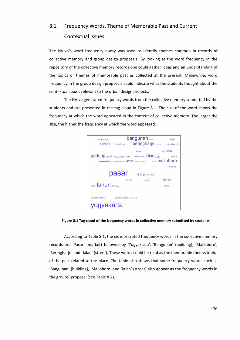
126
8.1. Frequency Words, Theme of Memorable Past and Current
Contextual Issues
The NVivo’s word frequency query was used to identify themes common in records of
collective memory and group design proposals. By looking at the word frequency in the
repository of the collective memory records one could gather ideas and an understanding of
the topics or themes of memorable past as collected at the present. Meanwhile, word
frequency in the group design proposals could indicate what the students thought about the
contextual issues relevant to the urban design projects.
The NVivo generated frequency words from the collective memory submitted by the
students and are presented in the tag cloud in Figure 8.1. The size of the word shows the
frequency at which the word appeared in the content of collective memory. The larger the
size, the higher the frequency at which the word appeared.
Figure 8.1 Tag cloud of the frequency words in collective memory submitted by students
According to Table 8.1, the six most rated frequency words in the collective memory
records are ‘Pasar’ (market) followed by ‘Yogyakarta’, ‘Bangunan’ (building), ‘Malioboro’,
‘Beringharjo’ and ‘Jalan’ (street). These words could be read as the memorable theme/topics
of the past related to the place. The table also shows that some frequency words such as
‘Bangunan’ (building}, ‘Malioboro’ and ‘Jalan’ (street) also appear as the frequency words in
the groups’ proposal (see Table 8.2).

127
Table 8.1 Frequency words in collective memory submitted by students
Figure 8.2 shows the frequency words that appeared in the students’ group
proposals while Table 8.2 reveals in more detail the frequency words which appeared either
in all of the four student groups, in three groups, two groups or in one group only. For
example, words such as ‘building’, ‘street’, ‘Malioboro’, ‘parking areas’, ‘pedestrian’ and
‘design’ (word number 1-‐6) show the words that repeatedly appeared in all of the groups’
proposals (group 1 to 4). Meanwhile words like ‘vehicles’ and ‘district’ (number 7 and 8)
appeared frequently in three of the four groups, whether group 1, 2 and 3 or group 1, 3 and
4.
Even so, the words ‘south’, ‘hotel’, ‘city’, ‘path’, ‘sidewalk’, ‘shops’ and ‘space’
(number 9-‐17) are words that were mentioned in two of the four groups such as groups 1
and 2, groups 1 and 3, groups 1 and 4, groups 2 and 3, and groups 3 and 4. The words
‘colour’, ‘existing’ and ‘height’ (number 18-‐20) appeared only in one particular group.
Students wrote their design proposal in Indonesian; however some students wrote
particular urban design terms in their proposal in English. So when the content of design
proposals were analysed using the NVivo program, some words which refer to the same
meaning appeared multiple times, with different frequencies such as pedestrian and ‘pejalan
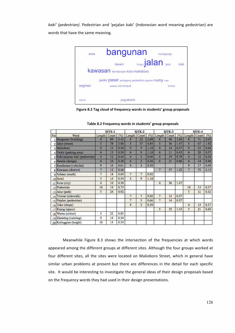
128
kaki’ (pedestrian). Pedestrian and ‘pejalan kaki’ (Indonesian word meaning pedestrian) are
words that have the same meaning.
Figure 8.2 Tag cloud of frequency words in students’ group proposals
Table 8.2 Frequency words in students’ group proposals
Meanwhile Figure 8.3 shows the intersection of the frequencies at which words
appeared among the different groups at different sites. Although the four groups worked at
four different sites, all the sites were located on Malioboro Street, which in general have
similar urban problems at present but there are differences in the detail for each specific
site. It would be interesting to investigate the general ideas of their design proposals based
on the frequency words they had used in their design presentations.
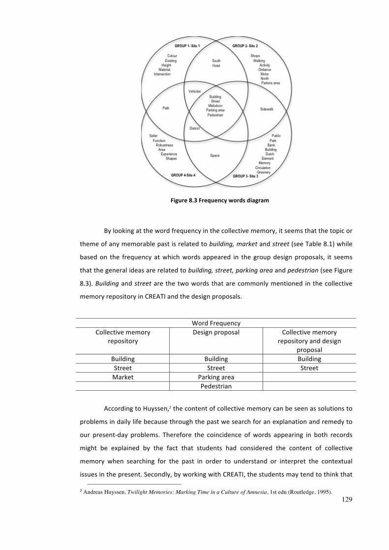
129
Figure 8.3 Frequency words diagram
By looking at the word frequency in the collective memory, it seems that the topic or
theme of any memorable past is related to building, market and street (see Table 8.1) while
based on the frequency at which words appeared in the group design proposals, it seems
that the general ideas are related to building, street, parking area and pedestrian (see Figure
8.3). Building and street are the two words that are commonly mentioned in the collective
memory repository in CREATI and the design proposals.
Word Frequency Collective memory
repository Design proposal Collective memory
repository and design proposal
Building Building Building Street Street Street Market Parking area
Pedestrian
According to Huyssen,2 the content of collective memory can be seen as solutions to
problems in daily life because through the past we search for an explanation and remedy to
our present-‐day problems. Therefore the coincidence of words appearing in both records
might be explained by the fact that students had considered the content of collective
memory when searching for the past in order to understand or interpret the contextual
issues in the present. Secondly, by working with CREATI, the students may tend to think that
2 Andreas Huyssen, Twilight Memories: Marking Time in a Culture of Amnesia, 1st edn (Routledge, 1995).
130
understanding the contextual issues enables them to develop design proposals in response
to the existing problems. However the mere frequency of words cannot explain in what
urban space quality the collective memory may have contributed to the students’ present-‐
day design solutions, and this will be explained in the next section.
8.2. Content of Collective Memory and the Quality of Urban Space
To investigate the potential correlation between students’ accessing and using collective
memory records and the qualities of urban spaces achieved in the students’ design
proposals, this study used NVivo’s matrix-‐coding query. The query compares the content of
collective memory and the content of the students’ design proposals. In this query, each
item of content is coded into particular keywords called a node to represent ideas. They
were coded into 16 parameters indicating urban space quality, previously discussed (see
Chapter 5, Section 5.6).
The query tried to compare the nodes in memory records with the contributions
from each group member. With the matrix code query, a particular theme contributed by
each student could be presented.
Table 8.3 presents an example of the matrix code query applied to Group 4’s design
proposal where its content of collective memory and design proposal were coded into 16
items/parameters indicating the quality of urban space. Any descriptions in the items of
content that matched the parameters were highlighted and coded. The table shows that the
content of collective memory accessed by the group’s members in the repository also
appeared in their group design proposals. This might indicate that content of collective
memory affected the development of the groups’ design proposals.
The sample in Table 8.3 shows that Group 4 considered ‘texture’, ‘colour’, ‘places
linkage and continuity with cultural traditional’, and ‘expressive quality of building
relationships’ written in the content of collective memory (numbers 1, 3, 6, 13) as references
for developing their group design proposals. The table also shows that some qualities of
urban spaces mentioned in the memory records are still yet unfilled such as 'ground
treatment and furnishing', ‘expressive quality of spatial form’, ‘exposure and enclosure’, as
well as ‘building skyline and visual continuity’ as no members of Group 4 (a-‐g) contributed to
the content (numbers 9, 12, 14, 16).
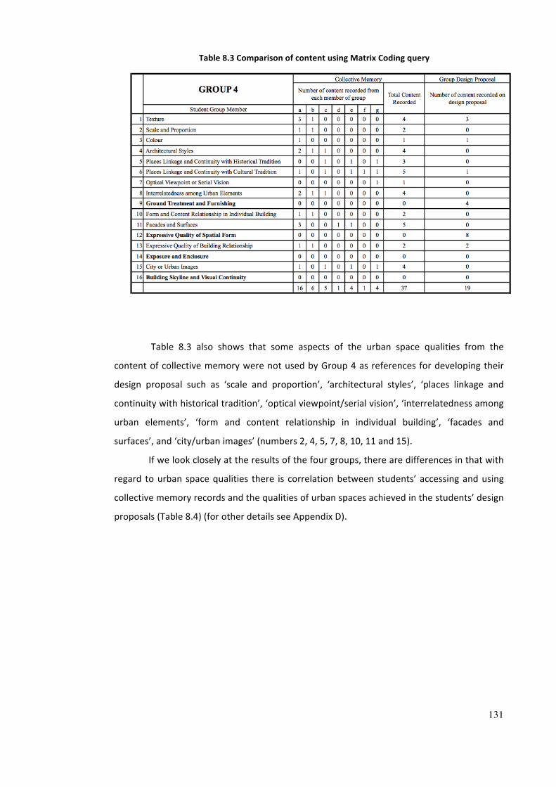
131
Table 8.3 Comparison of content using Matrix Coding query
Table 8.3 also shows that some aspects of the urban space qualities from the
content of collective memory were not used by Group 4 as references for developing their
design proposal such as ‘scale and proportion’, ‘architectural styles’, ‘places linkage and
continuity with historical tradition’, ‘optical viewpoint/serial vision’, ‘interrelatedness among
urban elements’, ‘form and content relationship in individual building’, ‘facades and
surfaces’, and ‘city/urban images’ (numbers 2, 4, 5, 7, 8, 10, 11 and 15).
If we look closely at the results of the four groups, there are differences in that with
regard to urban space qualities there is correlation between students’ accessing and using
collective memory records and the qualities of urban spaces achieved in the students’ design
proposals (Table 8.4) (for other details see Appendix D).
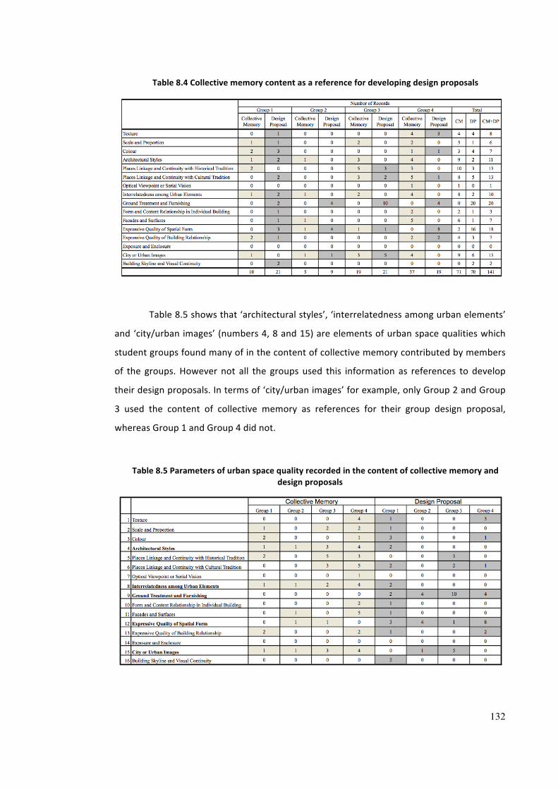
132
Table 8.4 Collective memory content as a reference for developing design proposals
Table 8.5 shows that ‘architectural styles’, ‘interrelatedness among urban elements’
and ‘city/urban images’ (numbers 4, 8 and 15) are elements of urban space qualities which
student groups found many of in the content of collective memory contributed by members
of the groups. However not all the groups used this information as references to develop
their design proposals. In terms of ‘city/urban images’ for example, only Group 2 and Group
3 used the content of collective memory as references for their group design proposal,
whereas Group 1 and Group 4 did not.
Table 8.5 Parameters of urban space quality recorded in the content of collective memory and design proposals
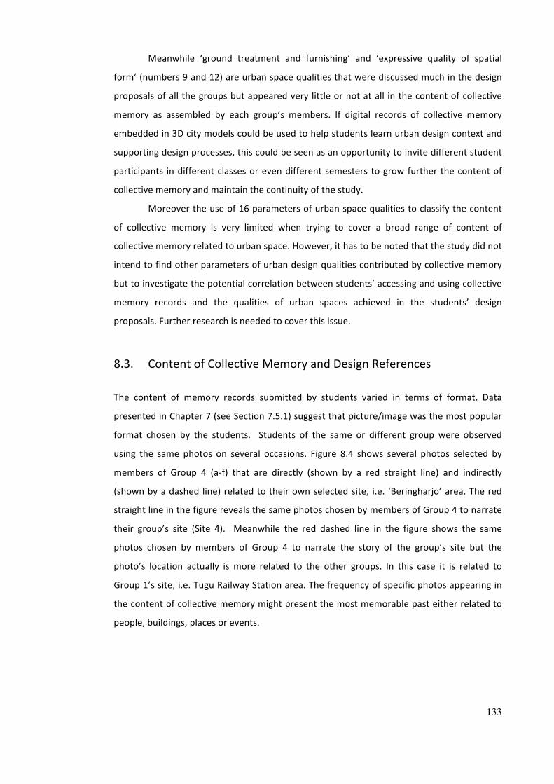
133
Meanwhile ‘ground treatment and furnishing’ and ‘expressive quality of spatial
form’ (numbers 9 and 12) are urban space qualities that were discussed much in the design
proposals of all the groups but appeared very little or not at all in the content of collective
memory as assembled by each group’s members. If digital records of collective memory
embedded in 3D city models could be used to help students learn urban design context and
supporting design processes, this could be seen as an opportunity to invite different student
participants in different classes or even different semesters to grow further the content of
collective memory and maintain the continuity of the study.
Moreover the use of 16 parameters of urban space qualities to classify the content
of collective memory is very limited when trying to cover a broad range of content of
collective memory related to urban space. However, it has to be noted that the study did not
intend to find other parameters of urban design qualities contributed by collective memory
but to investigate the potential correlation between students’ accessing and using collective
memory records and the qualities of urban spaces achieved in the students’ design
proposals. Further research is needed to cover this issue.
8.3. Content of Collective Memory and Design References
The content of memory records submitted by students varied in terms of format. Data
presented in Chapter 7 (see Section 7.5.1) suggest that picture/image was the most popular
format chosen by the students. Students of the same or different group were observed
using the same photos on several occasions. Figure 8.4 shows several photos selected by
members of Group 4 (a-‐f) that are directly (shown by a red straight line) and indirectly
(shown by a dashed line) related to their own selected site, i.e. ‘Beringharjo’ area. The red
straight line in the figure reveals the same photos chosen by members of Group 4 to narrate
their group’s site (Site 4). Meanwhile the red dashed line in the figure shows the same
photos chosen by members of Group 4 to narrate the story of the group’s site but the
photo’s location actually is more related to the other groups. In this case it is related to
Group 1’s site, i.e. Tugu Railway Station area. The frequency of specific photos appearing in
the content of collective memory might present the most memorable past either related to
people, buildings, places or events.
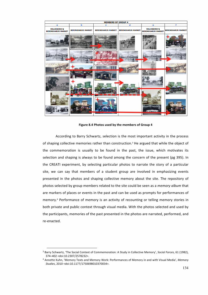
134
Figure 8.4 Photos used by the members of Group 4
According to Barry Schwartz, selection is the most important activity in the process
of shaping collective memories rather than construction.3 He argued that while the object of
the commemoration is usually to be found in the past, the issue, which motivates its
selection and shaping is always to be found among the concern of the present (pg 395). In
the CREATI experiment, by selecting particular photos to narrate the story of a particular
site, we can say that members of a student group are involved in emphasizing events
presented in the photos and shaping collective memory about the site. The repository of
photos selected by group members related to the site could be seen as a memory album that
are markers of places or events in the past and can be used as prompts for performances of
memory.4 Performance of memory is an activity of recounting or telling memory stories in
both private and public context through visual media. With the photos selected and used by
the participants, memories of the past presented in the photos are narrated, performed, and
re-‐enacted.
3 Barry Schwartz, ‘The Social Context of Commemoration: A Study in Collective Memory’, Social Forces, 61 (1982), 374–402 <doi:10.2307/2578232>.
4 Annette Kuhn, ‘Memory Texts and Memory Work: Performances of Memory in and with Visual Media’, Memory Studies, 2010 <doi:10.1177/1750698010370034>.
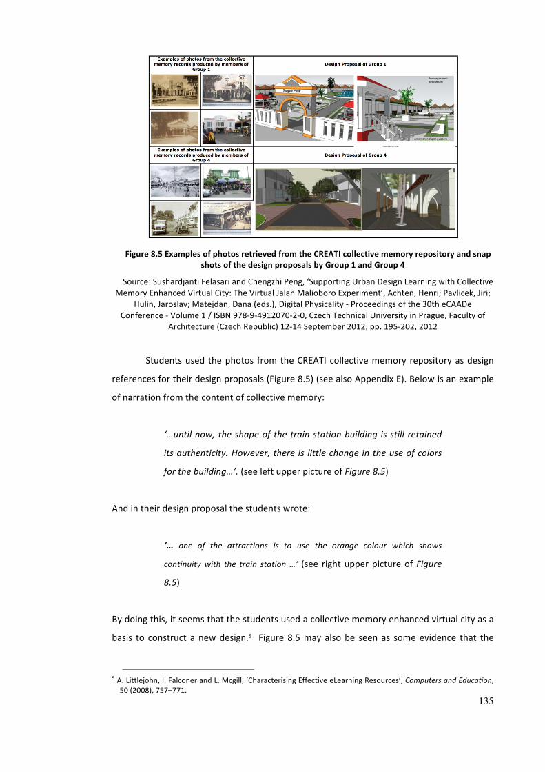
135
Figure 8.5 Examples of photos retrieved from the CREATI collective memory repository and snap
shots of the design proposals by Group 1 and Group 4
Source: Sushardjanti Felasari and Chengzhi Peng, ‘Supporting Urban Design Learning with Collective Memory Enhanced Virtual City: The Virtual Jalan Malioboro Experiment’, Achten, Henri; Pavlicek, Jiri;
Hulin, Jaroslav; Matejdan, Dana (eds.), Digital Physicality -‐ Proceedings of the 30th eCAADe Conference -‐ Volume 1 / ISBN 978-‐9-‐4912070-‐2-‐0, Czech Technical University in Prague, Faculty of
Architecture (Czech Republic) 12-‐14 September 2012, pp. 195-‐202, 2012
Students used the photos from the CREATI collective memory repository as design
references for their design proposals (Figure 8.5) (see also Appendix E). Below is an example
of narration from the content of collective memory:
‘…until now, the shape of the train station building is still retained
its authenticity. However, there is little change in the use of colors
for the building…’. (see left upper picture of Figure 8.5)
And in their design proposal the students wrote:
‘… one of the attractions is to use the orange colour which shows
continuity with the train station …’ (see right upper picture of Figure
8.5)
By doing this, it seems that the students used a collective memory enhanced virtual city as a
basis to construct a new design.5 Figure 8.5 may also be seen as some evidence that the
5 A. Littlejohn, I. Falconer and L. Mcgill, ‘Characterising Effective eLearning Resources’, Computers and Education, 50 (2008), 757–771.
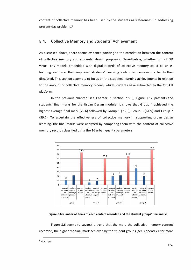
136
content of collective memory has been used by the students as ‘references’ in addressing
present-‐day problems.6
8.4. Collective Memory and Students’ Achievement
As discussed above, there seems evidence pointing to the correlation between the content
of collective memory and students’ design proposals. Nevertheless, whether or not 3D
virtual city models embedded with digital records of collective memory could be an e-‐
learning resource that improves students’ learning outcomes remains to be further
discussed. This section attempts to focus on the students’ learning achievements in relation
to the amount of collective memory records which students have submitted to the CREATI
platform.
In the previous chapter (see Chapter 7, section 7.5.5), Figure 7.12 presents the
students’ final marks for the Urban Design module. It shows that Group 4 achieved the
highest average final mark (79.6) followed by Group 1 (73.5), Group 3 (64.9) and Group 2
(59.7). To ascertain the effectiveness of collective memory in supporting urban design
learning, the final marks were analyzed by comparing them with the content of collective
memory records classified using the 16 urban quality parameters.
Figure 8.6 Number of items of each content recorded and the student groups’ final marks
Figure 8.6 seems to suggest a trend that the more the collective memory content
recorded, the higher the final mark achieved by the student groups (see Appendix F for more
6 Huyssen.
137
details). The highest final mark was achieved by Group 4, which had the highest number of
collective memory records submitted, while Group 2, which had the least number of
collective memories, achieved the lowest final mark. However, Group 3 displayed a slightly
different pattern. This group had more collective memory records than Group 1, but its final
mark was lower.
To explain the divergent results of the final marks, it is important to look into the
assessment system adopted currently at the Department of Architecture. As mentioned in
the previous chapter, the final assessment consisted of several components of assessment
such as minor assignments (2 pieces-‐20%), midterm exam (20%), presentation (10%), major
assignment (30%) and written final exam (20%). Table 8.6 shows the number of students
who missed some components for their final mark. The table presents there being more
students in Group 3 (5 students) than in Group 1 (2 students) who missed components for
final assessment. The missing components that affected each student’s final mark were
different. This might explain why Group 3 obtained a different result.
Table 8.6 Number of missing components for final mark
Number of Missing Components for Final Mark Student Group Fulfil all
components 1 component 2 components 3 components
Group 1 6 students 2 students 0 0
Group 3 3 students 2 students 2 students 1 student
8.5. Analysis of the CREATI website
This analysis of the CREATI site will focus on the usage of the CREATI site. As
mentioned in the previous chapter, returning visitors can be assumed to be the participant
students undertaking the Urban Design module. Figure 8.7 shows the percentage of the
visitors’/participant students’ interaction with the CREATI pages. The participant students
interacted more often with the ‘collective memory’ submission page (11%) than any other
page. Even the ‘collective memory bank’ page, which was intended to provide some initial
samples of the collective memory, had only 1.9% of interaction.
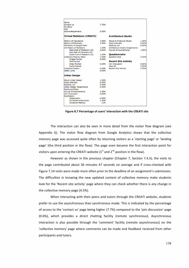
138
Figure 8.7 Percentage of users’ interaction with the CREATI site
The interaction can also be seen in more detail from the visitor flow diagram (see
Appendix G). The visitor flow diagram from Google Analytics shows that the collective
memory page was accessed quite often by returning visitors as a 'starting page' or 'landing
page' (the third position in the flow). The page even became the first interaction point for
visitors upon entering the CREATI website (1st and 2nd position in the flow).
However as shown in the previous chapter (Chapter 7, Section 7.4.5), the visits to
the page contributed about 36 minutes 47 seconds on average and if cross-‐checked with
Figure 7.14 visits were made more often prior to the deadline of an assignment’s submission.
The difficulties in knowing the new updated content of collective memory make students
look for the ‘Recent site activity’ page where they can check whether there is any change in
the collective memory page (4.5%).
When interacting with their peers and tutors through the CREATI website, students
prefer to use the asynchronous than synchronous mode. This is indicated by the percentage
of access to the 'contact us' page being higher (7.7%) compared to the 'join discussion' page
(0.6%), which provides a direct chatting facility (remote synchronous). Asynchronous
interaction is also possible through the 'comment' facility (remote asynchronous) on the
'collective memory' page where comments can be made and feedback received from other
participants and tutors.
139
From the usage of the CREATI site, it seems that students are reluctant to use the 3D
models page and collective memory bank as a starting point.
‘…the process of accessing the 3D models and their collective
memory is a bit long and indirectly…’
‘…although the structure and navigation system on the CREATI site
are quite clear, the interface is not informative. Graphical interfaces
will be better. It will be good if we will be able to see the content
before downloading it. We can select some content we need instead
of downloading all the content…’
‘…collective memory embedded in 3D models cannot be seen
directly on the page …’
However, students took advantage of the CREATI site to review the work progress of other
students.
‘…it helps us to review the work progress of other students…’,
(participant 1)
‘…it facilitates online discussion via gmail or chatting’,
(participant 4)
The availability of other students’ work progress in the website enables students to
learn more flexibly time wise and suited to their needs than from presentations of progress
in the class as usually it is conducted in a limited time.
8.6. Comparison between CREATI and Non-‐CREATI Student Groups
As explained in Chapter 7, the Urban Design module conducted in different academic
semesters uses different urban sites for its assignments. In this section, a comparison of the
analysis process between two groups will be examined, i.e. one group which used CREATI
(i.e., Group 4 labelled C-‐Group -‐ see Appendix H) and another group (labelled Non CREATI,
NC-‐Group -‐ see Appendix I), which didn’t use the CREATI platform when undertaking the
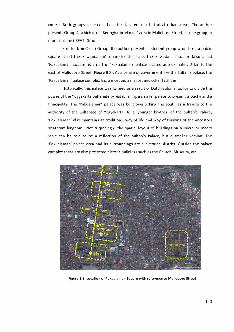
140
course. Both groups selected urban sites located in a historical urban area. The author
presents Group 4, which used ‘Beringharjo Market’ area in Malioboro Street, as one group to
represent the CREATI Group.
For the Non Creati Group, the author presents a student group who chose a public
square called The ‘Sewandanan’ square for their site. The ‘Sewadanan’ square (also called
‘Pakualaman’ square) is a part of ‘Pakualaman’ palace located approximately 2 km to the
east of Malioboro Street (Figure 8.8). As a centre of government like the Sultan’s palace, the
‘Pakualaman’ palace complex has a mosque, a market and other facilities.
Historically, this palace was formed as a result of Dutch colonial policy to divide the
power of the Yogyakarta Sultanate by establishing a smaller palace to present a Duchy and a
Principality. The ‘Pakualaman’ palace was built overlooking the south as a tribute to the
authority of the Sultanate of Yogyakarta. As a 'younger brother' of the Sultan’s Palace,
‘Pakualaman’ also maintains its traditions, way of life and way of thinking of the ancestors
‘Mataram kingdom’. Not surprisingly, the spatial layout of buildings on a micro or macro
scale can be said to be a reflection of the Sultan’s Palace, but a smaller version. The
‘Pakualaman’ palace area and its surroundings are a historical district. Outside the palace
complex there are also protected historic buildings such as the Church, Museum, etc.
Figure 8.8. Location of Pakualaman Square with reference to Malioboro Street
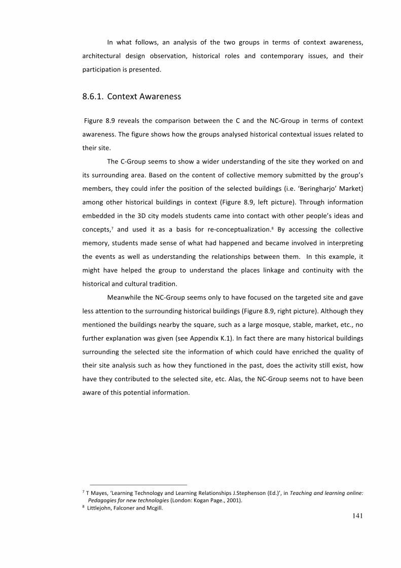
141
In what follows, an analysis of the two groups in terms of context awareness,
architectural design observation, historical roles and contemporary issues, and their
participation is presented.
8.6.1. Context Awareness
Figure 8.9 reveals the comparison between the C and the NC-‐Group in terms of context
awareness. The figure shows how the groups analysed historical contextual issues related to
their site.
The C-‐Group seems to show a wider understanding of the site they worked on and
its surrounding area. Based on the content of collective memory submitted by the group’s
members, they could infer the position of the selected buildings (i.e. ‘Beringharjo’ Market)
among other historical buildings in context (Figure 8.9, left picture). Through information
embedded in the 3D city models students came into contact with other people’s ideas and
concepts,7 and used it as a basis for re-‐conceptualization.8 By accessing the collective
memory, students made sense of what had happened and became involved in interpreting
the events as well as understanding the relationships between them. In this example, it
might have helped the group to understand the places linkage and continuity with the
historical and cultural tradition.
Meanwhile the NC-‐Group seems only to have focused on the targeted site and gave
less attention to the surrounding historical buildings (Figure 8.9, right picture). Although they
mentioned the buildings nearby the square, such as a large mosque, stable, market, etc., no
further explanation was given (see Appendix K.1). In fact there are many historical buildings
surrounding the selected site the information of which could have enriched the quality of
their site analysis such as how they functioned in the past, does the activity still exist, how
have they contributed to the selected site, etc. Alas, the NC-‐Group seems not to have been
aware of this potential information.
7 T Mayes, ‘Learning Technology and Learning Relationships J.Stephenson (Ed.)’, in Teaching and learning online: Pedagogies for new technologies (London: Kogan Page., 2001).
8 Littlejohn, Falconer and Mcgill.
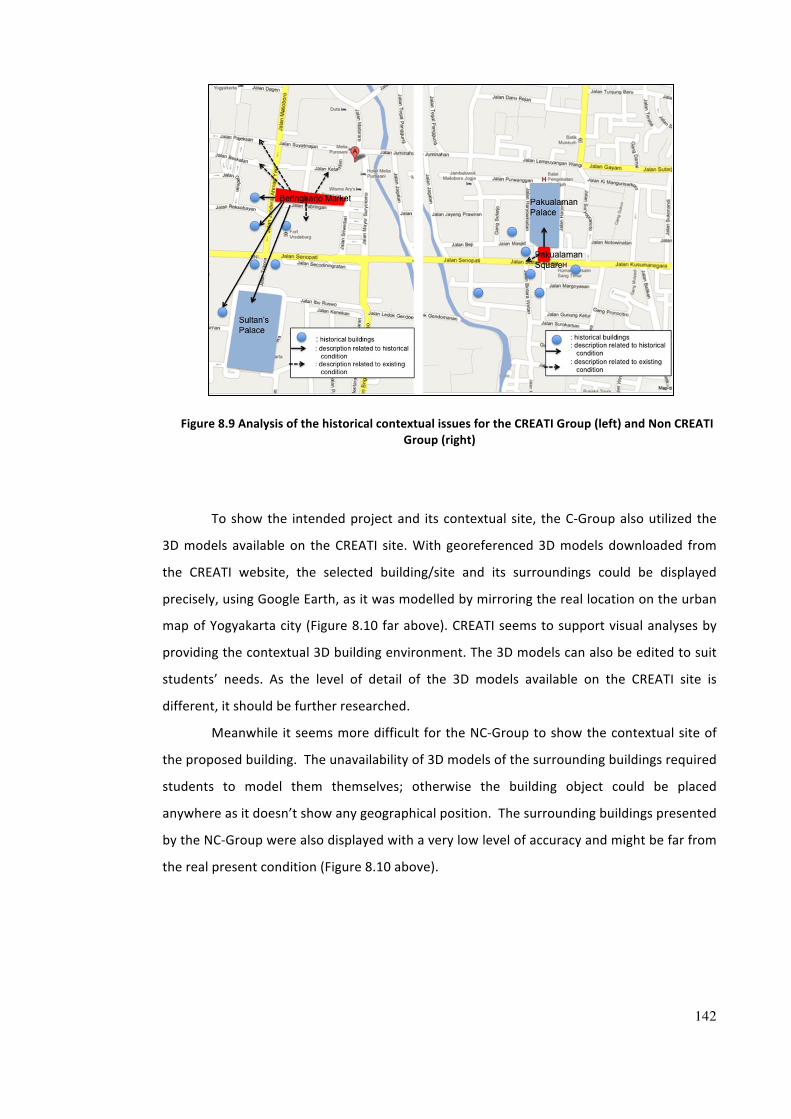
142
Figure 8.9 Analysis of the historical contextual issues for the CREATI Group (left) and Non CREATI Group (right)
To show the intended project and its contextual site, the C-‐Group also utilized the
3D models available on the CREATI site. With georeferenced 3D models downloaded from
the CREATI website, the selected building/site and its surroundings could be displayed
precisely, using Google Earth, as it was modelled by mirroring the real location on the urban
map of Yogyakarta city (Figure 8.10 far above). CREATI seems to support visual analyses by
providing the contextual 3D building environment. The 3D models can also be edited to suit
students’ needs. As the level of detail of the 3D models available on the CREATI site is
different, it should be further researched.
Meanwhile it seems more difficult for the NC-‐Group to show the contextual site of
the proposed building. The unavailability of 3D models of the surrounding buildings required
students to model them themselves; otherwise the building object could be placed
anywhere as it doesn’t show any geographical position. The surrounding buildings presented
by the NC-‐Group were also displayed with a very low level of accuracy and might be far from
the real present condition (Figure 8.10 above).
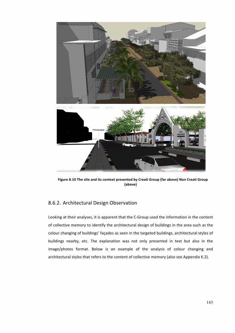
143
Figure 8.10 The site and its context presented by Creati Group (far above) Non Creati Group (above)
8.6.2. Architectural Design Observation
Looking at their analyses, it is apparent that the C-‐Group used the information in the content
of collective memory to identify the architectural design of buildings in the area such as the
colour changing of buildings’ façades as seen in the targeted buildings, architectural styles of
buildings nearby, etc. The explanation was not only presented in text but also in the
image/photos format. Below is an example of the analysis of colour changing and
architectural styles that refers to the content of collective memory (also see Appendix K.2).
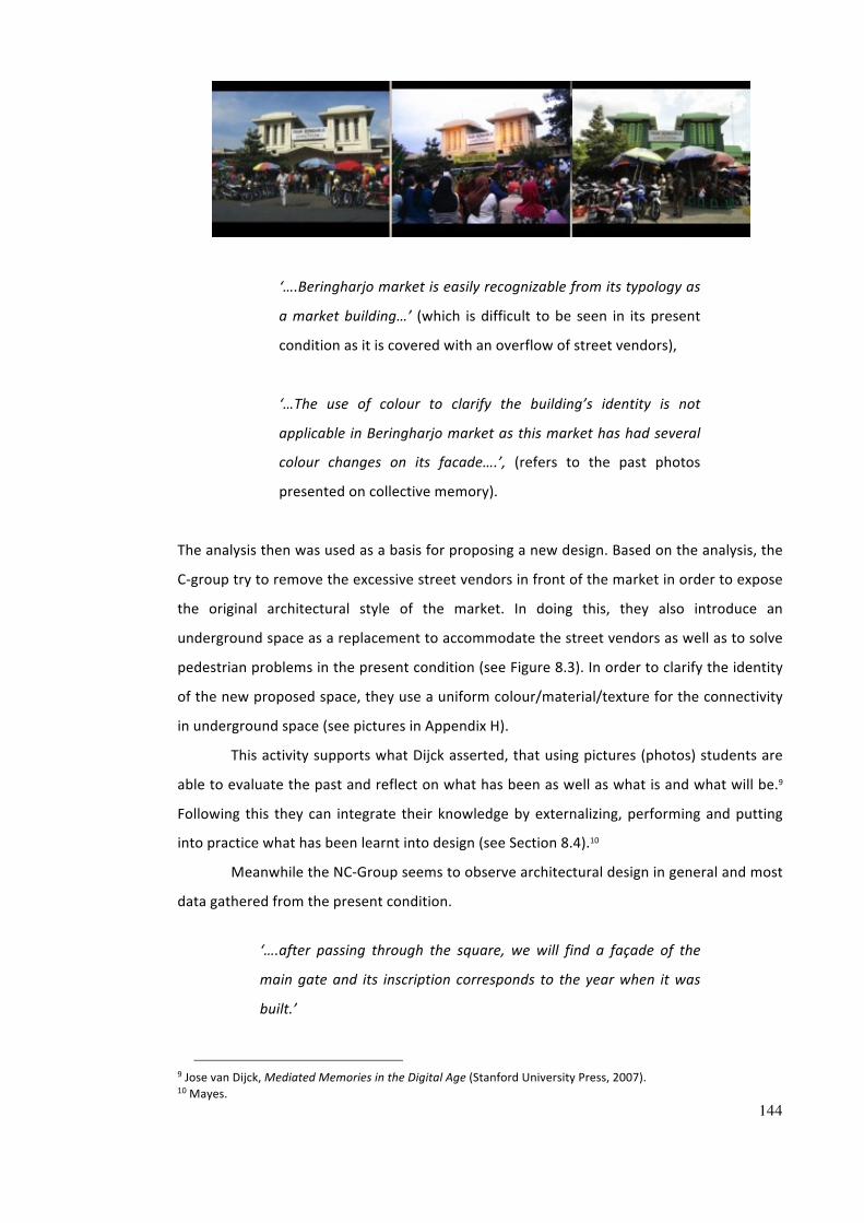
144
‘….Beringharjo market is easily recognizable from its typology as
a market building…’ (which is difficult to be seen in its present
condition as it is covered with an overflow of street vendors),
‘…The use of colour to clarify the building’s identity is not
applicable in Beringharjo market as this market has had several
colour changes on its facade….’, (refers to the past photos
presented on collective memory).
The analysis then was used as a basis for proposing a new design. Based on the analysis, the
C-‐group try to remove the excessive street vendors in front of the market in order to expose
the original architectural style of the market. In doing this, they also introduce an
underground space as a replacement to accommodate the street vendors as well as to solve
pedestrian problems in the present condition (see Figure 8.3). In order to clarify the identity
of the new proposed space, they use a uniform colour/material/texture for the connectivity
in underground space (see pictures in Appendix H).
This activity supports what Dijck asserted, that using pictures (photos) students are
able to evaluate the past and reflect on what has been as well as what is and what will be.9
Following this they can integrate their knowledge by externalizing, performing and putting
into practice what has been learnt into design (see Section 8.4).10
Meanwhile the NC-‐Group seems to observe architectural design in general and most
data gathered from the present condition.
‘….after passing through the square, we will find a façade of the
main gate and its inscription corresponds to the year when it was
built.’
9 Jose van Dijck, Mediated Memories in the Digital Age (Stanford University Press, 2007). 10 Mayes.
145
Although they mentioned the façades of the buildings no further explanations were
given regarding the colours, shapes or architectural styles (see Appendix K.2).
8.6.3. Historical Roles and Contemporary Issues
Using the content of collective memory, the C-‐Group tried to trace the historical contextual
information to discuss the issues of the present conditions (Appendix K.3).
‘…the façade of Beringharjo market currently is the same as it was
in 1925, but...the building’s facade is obstructed due to the
overflowing of street vendors in front of the market..’
‘.. the parking area in Beringharjo market is a new function that did
not exist in the past…’
By having the information from the content of collective memory, the C-‐Group became more
knowledgeable and critical on some issues of the present urban conditions and compared
them with those in the past. Again the activity seems to support the discourse of collective
memory as a ‘remedy’ for present condition.11
On the contrary, the NC-‐Group was more focussed on the existing conditions.
Although they presented some detailed analyses similar to those of the C-‐Group, the lack of
understanding of the past seems to have hindered the design solutions responding to the
problems and caused less connection to the uniqueness of the site.
8.6.4. Participation and Collaboration
Participation and collaboration among group members in a particular group project
sometimes are not easy to be measured as part of the students’ assessment and the tutor
may need several methods to assess it.
Compared with the NC-‐Group, by inviting students in the C-‐Group to submit memory
records related to buildings or places as part of the design process, the participation of the
individual members could be monitored. Participation of group members could be evaluated
from her/his contribution to the content of collective memory. Through the CREATI site,
students could learn and discuss others’ progress. However the results from the CREATI site
11 Huyssen.
146
does not reveal pictures of the real collaboration as CREATI is mainly used as a complement
to class-‐based teaching, particularly with regard to supporting the main assignment of the
urban design module (see Chapter 7.4.2). Moreover student members of the C-‐Group prefer
to use asynchronous interaction/tools such as comments and email, but never synchronous
tools like chatting facilities available on the CREATI site.
The result from the interviews revealed that student groups collaborated more in a
collocated synchronous way rather than use other collaboration methods supported by
CREATI. In doing the assignment usually they started by working at the same time and place
to discuss and distribute the tasks among members of their group. After agreeing to
distribute the tasks, each member worked individually and usually during this period they
collaborated in a remote asynchronous way supported by the CREATI website (Appendix J.1).
Some students argue that although it was easier to communicate, combine and
correct the tasks in face-‐to-‐face discussion, this collocated synchronous way demanded a lot
of time from the students and needed to be arranged in advance as every person usually had
different schedules and activities.
‘…The assignment was performed in a particular place to ease the
communication between members of the group…’
‘…The group task was discussed at the same place and time… The
discussion time was limited…’
Some students argue that they prefer to use remote asynchronous way as it was
more effective, more flexible and independent, and quicker.
On the contrary, the participation of groups’ members and collaboration in the NC-‐
Group might have been slightly more difficult to monitor. Discussion was more often
conducted outside the class, and the tutor could only see the progress during their task
presentation in class. The tutor could not check individual participation in the group.
The students’ opinions on the usefulness of collective memory content in supporting
the analysis stage were mentioned in the interview such as (see Appendix J.3 and J.4):
‘…collective memory can help in the design process by giving
background knowledge on the historical development of both
buildings’ form and activity…’ (participant 2)
147
‘…collective memory will help to maintain architectural style or
street furniture…’ (participant 10)
‘….we learnt from the content of collective memory about the site
structure and building facades, and compared it with the existing
condition in the present…’ (participant 13)
‘…it helps us to understand the condition by comparing the past and
the present conditions and then find problems/issues and propose
new designs to make it better…’ (participant 17)
‘…it is very helpful in the process of considering design ideas…’
(participants 14 and 17)
Students think that the collective memory available on the CREATI site is still not
enough and availability is limited. Therefore more data are needed.
Summary
Several combined methods were used to analyze and discuss the data collected from an
experiment in a real educational setting at university level. The findings show the additional
value of embedding virtual city with collective memory. By experiencing urban spaces
virtually through the presentation of 3D city models in a virtual world, the content of
collective memory linked with 3D virtual city models supports learners to have better
knowledge of historical and contextual issues of urban spaces. It helps learners to evaluate
the past and the present, which latter will be useful to understand and support their
decisions for future design in urban design learning and practice.
Collective memory enhanced virtual cities hosted on the CREATI site can facilitate
collaborative learning between learners. Learners can become more active and engaged in
the learning process through a series of activities such as accessing, sharing the resources,
giving feedback and discussing the content both with their peers and tutor. However, the
continuous gathering of collective memory for further growth (such as content and format of
collective memory) is always challenging as well as the use of virtual learning environments
in architecture and urban design. Therefore the extensibility of CREATI is important for its
sustainability.
Chapter 9. CONCLUSION AND FUTURE RESEARCH
9.1. Conclusion
According to this study, enhancing virtual cities with digital records of a city’s collective
memory seems promising in supporting the urban design learning for students at
undergraduate level. The CREATI experiment shows that it supports various levels of learning
such as conceptualization, construction and integration in the process of achieving the
learning objectives and outcomes.1
CREATI supports conceptualization in the learning process. Through the content of
collective memory embedded in the 3D models as well as through the information presented
in the CREATI website, students come into contact with other people’s ideas or concepts. A
collective memory enhanced virtual city facilitates students to be aware of the contextual
issues and to engage more with the urban sites, and it further invites students to develop the
contextual content online. The rich content of the digital collective memory contributed by
others and presented in a virtual learning environment can help students to understand the
important features of urban spaces as emphasized in the course’s learning objectives.
Collective memory embedded in the 3D models can help students at the analysis
stage (see Chapter 8, Section 8.6). Through the content of collective memory, students can
construct/build and test their knowledge of urban contextual issues by performing
meaningful tasks such as accessing and sharing the resources hosted on the CREATI site. By
reading the content and comparing it with present conditions, the students participating in
the CREATI experiment tried to search for an explanation from the content of collective
1 T Mayes, ‘Learning Technology and Learning Relationships J.Stephenson (Ed.)’, in Teaching and learning online: Pedagogies for new technologies (London: Kogan Page., 2001).
149
memory, which might be related and could explain the present condition. The students tried
to make sense of what has happened by interpreting the events and understanding the
relationships between them. A collective memory enhanced virtual city provides a broader
and richer historical information base in various formats such text, image, video, audio, etc.
Students become more knowledgeable of historical contextual issues, which is useful to
produce richer analyses.
CREATI enables learners to integrate their knowledge by externalizing, performing
and putting into practice what has been learnt (see Chapter 8, Section 8.3). The CREATI
website supports collaborative and participative learning which enable dialogue and
discussion synchronously and asynchronously. Students engage more in the process of
learning as they are asked to add to the content as part of the task. A collective memory
enhanced virtual city helps students to improve the quality of analysis, which at some point
contributes to their achievement (see Chapter 8, Section 8.4). The engagement with the
urban contextual information requires students to be more active although in the
experiment the use of the virtual learning environment was perceived as being
supplementary to class-‐based teaching, which seems to split students’ attention and might
have positioned the CREATI website as only a temporary platform during the experiment.
In addition to the effectiveness of a collective memory enhanced virtual city to
support urban design learning, the continuation of the growth of collective memory can be
extended to future semesters for new student participants. The extensibility is important for
the sustainability of a collective memory enhanced virtual city as a virtual learning
environment in urban design. The continuous gathering of narrative information about
buildings and places presented by the 3D virtual city models of various formats such as text,
graphic, image, film and audio, and other formats can generate, maintain, and reproduce
collective memory.2 In the process of gathering narrative information, evidently, there is a
process of selecting, organizing, storing and retrieving information wherein particular events
are emphasized.
9.2. Some Recommendations for Future Research
The current study shows that a collective memory enhanced virtual city has the potential to
support architecture and urban design education. However, limited by the time and
2 Jens Brockmeier, ‘After the Archive: Remapping Memory’, Culture & Psychology, 16 (2010), 5 –35 <doi:10.1177/1354067X09353212>; Barbara Misztal, Theories of Social Remembering (Open University Press, 2003); Barry Schwartz, ‘The Social Context of Commemoration: A Study in Collective Memory’, Social Forces, 61 (1982), 374–402 <doi:10.2307/2578232>.
150
resources available, several areas could not be investigated thoroughly but are identified for
further research.
9.2.1. The Structure of the Collective Memory Repository
The current structure of the collective memory repository bank as set up in CREATI needs to
be developed further to cover a wider and more complex area or region. In this study the
organization of the collective memory bank was only applicable to the case study site (i.e.
Malioboro Street) as it was structured based on the formats of the records and locations of
buildings and places represented in the 3D virtual models. It becomes problematic when
placing the content of collective memory points/references to buildings/places outside the
study site as well as placing content which refers to a wider complex area, for example a
neighbourhood or a district.
This study suggests that setting up a collective memory repository based on a
building typology or a building occupancy category together with a ‘text/image tagging’
system could serve as an appropriate information organization device. It can help the
participants to search for more specific content and to avoid overlapping data.
In this study, the original example of a collective memory bank was designed
separately from the collective memory submitted by participants. Although students can
check the up-‐to-‐date status of collective memory submission on the ‘recent site activity’
page, they still need to open the memory records individually in a different application
program to know what content has been written and what has not. This user interface is not
effective and is time-‐consuming. As a result, some collective memory records submitted by
students were duplicates of content already assembled on the sample page. More research
is needed to explore how a ‘comment system’ may be developed and interlinked with 3D
models such that memory records can be directly posted and visible to other users.
9.2.2. The Graphical Interfaces for Design References
Instead of text format, during the experiment, some students expressed a preference for
seeing a list of 3D model files in images such as thumbnails. Thumbnails are versions of
pictures reduced in size. By presenting a list of 3D models files in images such as thumbnails
students will be helped to grasp what kinds of places or building models they will download
before displaying the 3D models on other software. Similarly, in terms of the collective
memory, presenting images/photographs of represented objects as thumbnails will enable
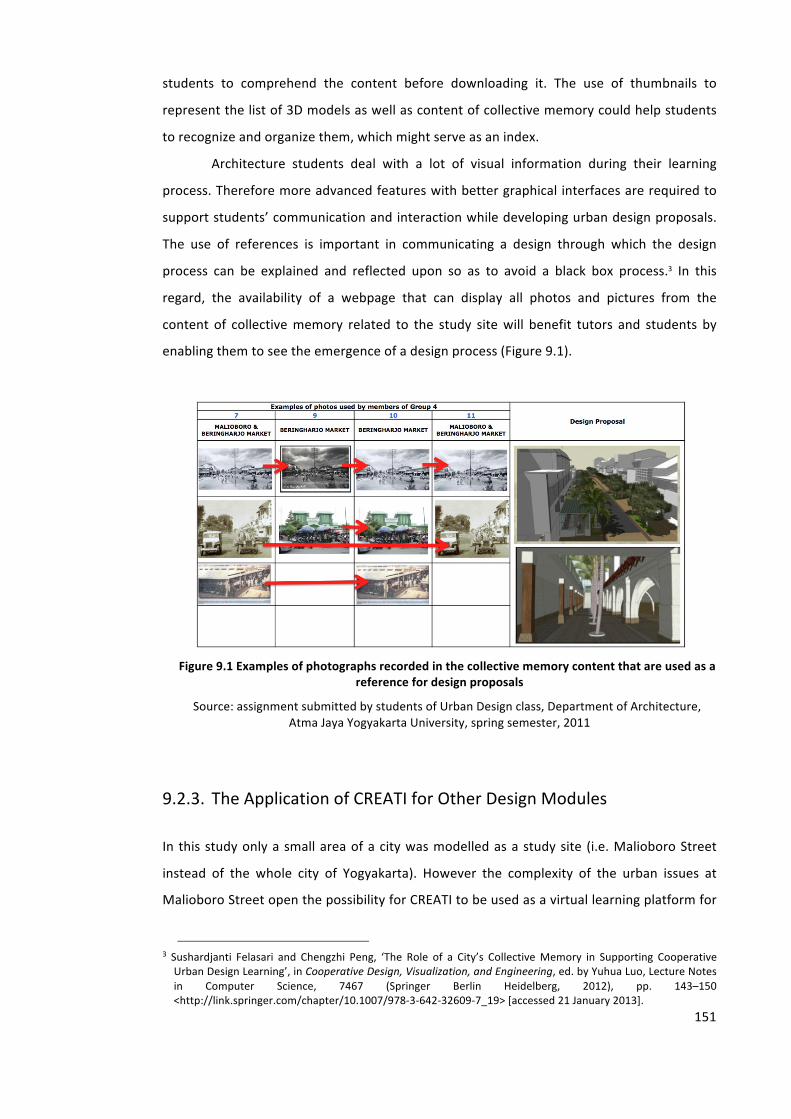
151
students to comprehend the content before downloading it. The use of thumbnails to
represent the list of 3D models as well as content of collective memory could help students
to recognize and organize them, which might serve as an index.
Architecture students deal with a lot of visual information during their learning
process. Therefore more advanced features with better graphical interfaces are required to
support students’ communication and interaction while developing urban design proposals.
The use of references is important in communicating a design through which the design
process can be explained and reflected upon so as to avoid a black box process.3 In this
regard, the availability of a webpage that can display all photos and pictures from the
content of collective memory related to the study site will benefit tutors and students by
enabling them to see the emergence of a design process (Figure 9.1).
Figure 9.1 Examples of photographs recorded in the collective memory content that are used as a
reference for design proposals
Source: assignment submitted by students of Urban Design class, Department of Architecture, Atma Jaya Yogyakarta University, spring semester, 2011
9.2.3. The Application of CREATI for Other Design Modules
In this study only a small area of a city was modelled as a study site (i.e. Malioboro Street
instead of the whole city of Yogyakarta). However the complexity of the urban issues at
Malioboro Street open the possibility for CREATI to be used as a virtual learning platform for
3 Sushardjanti Felasari and Chengzhi Peng, ‘The Role of a City’s Collective Memory in Supporting Cooperative Urban Design Learning’, in Cooperative Design, Visualization, and Engineering, ed. by Yuhua Luo, Lecture Notes in Computer Science, 7467 (Springer Berlin Heidelberg, 2012), pp. 143–150 <http://link.springer.com/chapter/10.1007/978-‐3-‐642-‐32609-‐7_19> [accessed 21 January 2013].
152
other design modules such as architecture studio from a simple task level (semester 1) to a
more advanced level (semester 7).
The availability of the 3D models of buildings or places as a single file in CREATI
enables tutors to choose and determine the complexity of the design task for students’
learning, i.e. either a single building, multi building or building complex.
Although to not a great extent, much content of the collective memory is related to
the interior space of historical buildings in the past. There is a potential too to develop the
level of detail of the 3D models that cover interior space. However the limitation of the
current platform in displaying interior views might have to be considered in presenting
interior models.
9.2.4. CREATI for Mobile Pervasive Learning
Desktop computers are no longer the only way to access multimedia content. Now access
has been extended to mobile technologies such as laptops, tablets and mobile phones.
Mobile learning through mobile devices has developed widely in the last few years. In
relation to this, the pervasiveness of mobile computing (apps on the go) has offered the
possibility to support site visits and field survey architectural students as field collectors of a
city's collective memory. In the experiment, there were students who revealed the story of
buildings and places by recording the real condition from the field.
Nonetheless as the 3D models are the interface to which collective memory will be
connected, more research will be needed to connect the collective memory from field
collectors to the 3D models.
The development of augmented reality (AR) technology which combines views of a
physical real-‐world environment and computer-‐generated sensory input such as sound,
video, graphics, etc. could help learners to gather richer information of collective memory.
Experiencing architecture and urban space can be enhanced by the application of
augmented reality. Augmented reality can aid the visualization of buildings and spaces that
no longer exist in real urban spaces. Computer-‐generated images of buildings or spaces can
be superimposed onto a real life local view. Augmented reality also supports the information
of the real world to become interactive and manipulable.
BIBLIOGRAPHY & REFERENCES
Adishakti, L.T., ‘A Study on the Conservation Planning of Yogyakarta Historic Tourist City Based on Urban Space Heritage Conception’ (Unpublished Dissertation, Japan: Kyoto University, 1997)
Adrisijanti, I, ‘Kota Yogyakarta Sebagai Kawasan Pusaka Budaya: Potensi Dan Permasalahannya (The City of Yogyakarta as Cultural Heritage Region, Potencies and Problems)’, Paper presented in Historical Discussion ‘Kota dan Perubahan Sosial dalam Perspektif Sejarah’ (Cities and Social Changes in Historical Perspectives) . Yogyakarta: Balai Pelestarian Sejarah dan Nilai Traditional Yogyakarta (Centre of Yogyakarta Historical Preservation and Traditional Values)., 2007
Alkhoven, P, ‘Computer Visualisation as a Tool in Architectural Historical Research: Representation and Research of the Historical Urban Environment’, in Architectural and Urban Simulation Techniques in Research and Education, 1997
Artha, Arwan Tuti, Yogyakarta Tempo Doeloe Sepanjang Catatan Pariwisata (Bigraf Pub., 2000)
Basu, Puja, Leo Care, Howard Evans, Panagiotis Patlakas, Chengzhi Peng, Adrian Powell, and others, uCampus a Web-‐based 3D Interactive Visualisation Modelling Platform to Effect Participative and Collaborative Planning and Design of Future Learning Spaces. uCampus -‐ a weCAMP Core Project Output. FINAL REPORT (University of Sheffield, 2010) <http://www.wecamp.group.shef.ac.uk/>
Bates, Tony, Technology, Open Learning, and Distance Learning (London: Routledge, 1995)
Bates, Tony, ‘Understanding Web 2.0 and Its Implications for E-‐Learning’, in Web 2.0-Based E-Learning (USA: IGI Global, 2011)
Batty, M, Model Cities, CASA Working Papers Series (London: University College London, 2007) <http://www.casa.ucl.ac.uk/publications/workingPaperDetail.asp?ID=113>
Bentley, Ian, Responsive Environments : a Manual for Designers (London: Architectural Press, 1985)
Blundell Jones, P, A Williams, and J Lintonbon, ‘The Sheffield Urban Study Project’, Architectural Research Quarterly, 3 (1999), 235–244
Boeykens, Stefan, and Herman Neuckermans, ‘Content Management Systems Versus Learning Environments’, 2009 <http://cumincad.scix.net/cgi-‐bin/works/ Show?caadria2009_103> [accessed 21 January 2011]
Bolter, Jay, Larry F. Hodges, Thomas Meyer, and Alison Nichols, ‘Integrating Perceptual and Symbolic Information in VR’, IEEE Comput. Graph. Appl., 15 (1995), 8–11 <doi:10.1109/38.391481>
154
Bowman, D.A., L.F. Hodges, D. Allison, and J. Wineman, ‘The Educational Value of an Information-‐rich Virtual Environment’, Presence: Teleoperators and Virtual Environments, 8 (1999), 317–331
Bowman, Doug A., Larry F. Hodges, and Jay Bolter, ‘The Virtual Venue: User-‐Computer Interaction in Information-‐Rich Virtual Environments’, Presence: Teleoperators and Virtual Environments, 7 (1998), 478–493 <doi:10.1162/ 105474698565866>
Boyd, Danah M, and Nicole B Ellison, ‘Social Network Sites: Definition, History, and Scholarship’, Journal of Computer-‐Mediated Communication, 13 (2007) <http://jcmc.indiana.edu/vol13/issue1/boyd.ellison.html>
Boyer, M. C., The City of Collective Memory: Its Historical Imagery and Architectural Entertainments, New edition (MIT Press, 1996)
Britain, Sandy;Liber, ‘A Framework for Pedagogical Evaluation of Virtual Learning Environments’, 1999 <http://www.leeds.ac.uk/educol/documents/00001237. htm> [accessed 21 November 2011]
Brockmeier, Jens, ‘After the Archive: Remapping Memory’, Culture & Psychology, 16 (2010), 5 –35 <doi:10.1177/1354067X09353212>
Brosche, Theresa and Michelle Feavel, Successful Online Learning: Managing the Online Learning Environment Efficiently and Effectively (Jones & Bartlett Learning, 2010)
Chen, Irene Y. L., Nian-‐Shing Chen, and Kinshuk, ‘Examining the Factors Influencing Participants’ Knowledge Sharing Behavior in Virtual Learning Communities’, Educational Technology & Society, 12 (2009), 134–148
Chen, N.Y.W., T Kvan, J Wojtowicz, D.V. Bakergem, T Casaus, J Davidson, and others, ‘Place, Time, and the Virtual Design Studio’, Reconnecting [ACADIA Conference Proceedings / ISBN 1-880250-03-9] Washington University (Saint Louis / USA) 1994, pp. 115-132, 1994 <http://cumincad.scix.net/cgibin/works/Show?_id= 6651&sort=DEFAULT&search=Wojtowicz&hits=24> [accessed 19 November 2012]
Chiu, M.L, and C Peng, ‘Insights of 3D Digital Cities: The Past, Present, and Futures’, in CAAD Talks 4: Insights of Digital Cities, Mao-‐Lin Chiu (editor) (Archidata, Co.,Ltd, 2005), pp. 13–35
Connerton, Paul, How Societies Remember (Cambridge University Press, 1989)
Cullen, Gordon, Concise Townscape, New edition (Architectural Press, 1961)
Curran, Raymond J., Architecture and the Urban Experience (Van Nost.Reinhold,U.S., 1983)
Dave, Bharat, and J Danahy, ‘Virtual Study Abroad and Exchange Studio’, Digital Design Studios: Do Computers Make a Difference? [ACADIA Conference Proceedings / ISBN 1-‐880250-‐07-‐1] Québec City (Canada) October 22-‐25, 1998, pp. 100-‐115, 1998 <http://cumincad.scix.net/cgibin/works/Show?_id=c88d&sort=DEFAULT &search=Danahy&hits=11> [accessed 19 November 2012]
155
Day, Alan, ‘A Digital Model of a Heritage City: The Bath Experience’, 2005 <http://opus.bath.ac.uk/13563/> [accessed 16 November 2012]
De Azevedo, Laura Novo, ‘The Power of Experience: Implementing and Evaluating the Use of a Mobile Approach for Enhancing Students’ Learning in Urban Design’, 8 (2011), 32–49 (18)
Dede, Chris, ‘The Transformation of Distance Education to Distributed Learning’, Instructional Technology Research Online, 1995 <http://www2.gsu.edu/ ~wwwitr/docs/distlearn/index.html> [accessed 28 November 2012]
De Freitas, Sara, Serious Virtual Worlds -‐ A Scoping Study (UK: JISC, 2008)
Departement of Architecture, UAJY, ‘Profile of Engineering Faculty.’ (University of Atma Jaya Yogyakarta, 2009) <http://www.uajy.ac.id/downloads/Fakultas%20 Teknik-‐UAJY.pdf>
Dijck, Jose van, Mediated Memories in the Digital Age (Stanford University Press, 2007)
Dillenbourg, P, ‘Introduction: What Do You Mean by “Collaborative Learning”?’, in In P.Dillenbourg (Ed.) Collaborative Learning, Cognitive, and Computational Approaches, Advances in Learning and Instruction Series (Amsterdam: Pergamon, 1999), pp. 1–19
Donath, D., E Kruijff, H Regenbrecht, U Hirscherg, B Johnson, B Kolarevic, and others, ‘Virtual Design Studio 1998 -‐ A Place2Wait’, Architectural Computing from Turing to 2000 [eCAADe Conference Proceedings / ISBN 0-‐9523687-‐5-‐7] Liverpool (UK) 15-‐17 September 1999, pp. 453-‐458, 1999 <http://cumincad.scix.net/cgibin/works/Show?_id=5477&sort=DEFAULT&search=Regenbrecht&hits=6> [accessed 19 November 2012]
Dunne, Jack, ‘Remote Studio Design Collaboration : an International Approach’, CEBE funded Case Study, 2001 <http://www.cebe.heacademy.ac.uk/learning/ casestudies/record.php?process=full_view&identifier=cebe.ltsn.ac.uk:668230124993&edition=&avability=yes> [accessed 19 November 2012]
Fayyoumi, A., ‘The Effectiveness of E-‐learning: Academic and Business Comparison’, Turkish Online Journal of Distance Education, 10 (2009), 130–140
Felasari, S, and Chengzhi Peng, ‘Enhancing A Virtual City with Collective Memory: A Pilot Study of Jalan Malioboro in Yogyakarta’, in Future cities: proceedings of the 28th Conference on Education in Computer Aided Architectural Design in Europe, September 15-18, 2010, Zurich, Switzerland, ETH Zurich (vdf Hochschulverlag AG, 2010)
Felasari, Sushardjanti, and Chengzhi Peng, ‘The Role of a City’s Collective Memory in Supporting Cooperative Urban Design Learning’, in Cooperative Design, Visualization, and Engineering, ed. by Yuhua Luo, Lecture Notes in Computer Science, 7467 (Springer Berlin Heidelberg, 2012), pp. 143–150 <http://link.springer.com/chapter/10.1007/978-‐3-‐642-‐32609-‐7_19> [accessed 21 January 2013]
Felasari, Sushardjanti, and Chengzhi Peng, ‘Supporting Urban Design Learning with Collective Memory Enhanced Virtual City: The Virtual Jalan Malioboro Experiment’, Achten, Henri; Pavlicek, Jiri; Hulin, Jaroslav; Matejdan, Dana (eds.),
156
Digital Physicality - Proceedings of the 30th eCAADe Conference - Volume 1 / ISBN 978-9-4912070-2-0, Czech Technical University in Prague, Faculty of Architecture (Czech Republic) 12-14 September 2012, pp. 195-202, 2012 <http://cumincad.scix.net/cgi-‐bin/works/BrowseTree&search=series:acadia+ year:2011/Show?ecaade2012_207> [accessed 21 January 2013]
Foot, Kirsten, and Barbara Warnick, ‘Web-‐based Memorializing After September 11: Toward a Conceptual Framework’, Journal of Computer-Mediated Communication,11(1)(2005) <http://jcmc.indiana.edu/vol11/issue1/foot.html >
Garrison, D. Randy, E-‐Learning in the 21st Century: A Framework for Research and Practice, 1st edn (Routledge, 2002)
Georgiev, T, E Georgieva, and A Smrikarov, ‘M-‐Learning -‐ A New Stage of E-‐Learning’, CompSysTech’ 2004 -‐ International Conference on Computer Systems and Technologies, 2004 <http://ecet.ecs.ru.acad.bg/cst04/index.php?cmd= dPage&pid=cpr> [accessed 5 February 2013]
Grierson, Hilary, ‘The Internet as a Tool for Communication in Design Projects’, CEBE funded Case Study, 2004 <http://cebe.cf.ac.uk/learning/casestudies/record. php?process=full_view&identifier=cebe.ltsn.ac.uk:59&edition=&avability=yes> [accessed 19 November 2012]
Groat, Linda, and David Wang, Architectural Research Methods (Wiley, 2001)
Halbwachs, On Collective Memory (Chicago University Press, 1992)
Hansen, Mark B. N., Embodying Technesis: Technology Beyond Writing (University of Michigan Press, 2000)
Harasim, Linda, Starr Roxanne Hiltz, Lucio Teles, and Murray Turoff, Learning Networks: A Field Guide to Teaching and Learning On-‐Line (Cambridge, MA: MIT Press, 1995)
Hart, Diane, and James Pinder, weCAMP External Evaluation Report (University of Sheffield, 2010) <http://www.wecamp.group.shef.ac.uk/>
Hess, A., ‘In Digital Remembrance: Vernacular Memory and the Rhetorical Construction of Web Memorials’, Media, Culture and Society, 29 (2007), 812–830
Hillman, D C, D J Willis, and C N Gunawardena, ‘Learner-‐Interface Interaction in Distance Education. An Extension of Contemporary Models, and Strategies for Practitioners’, American Journal of Distance Education, 8 (1994), 30–42
Hiltz, Starr Roxanne, The Virtual Classroom: Learning Without Limits Via Computer Networks (Norwood, NJ: Ablex Publishing Corporation, 1994)
Hirsch, Marianne, ‘Surviving Images: Holocaust Photographs and the Work of Postmemory’, The Yale Journal of Criticism, 14 (2001), 5–37 <doi:10.1353/yale.2001.0008>
Hoffman, Ellen S, ‘Evaluating Social Networking Tools for Distance Learning’, in The New Internet: Collaborative Learning, Social Networking, Technology Tools and Best Practices, 2009, 92–100 <http://etec.hawaii.edu/proceedings/2009/>
157
Hrastinski, Stefan, ‘Asynchronous and Synchronous E-‐Learning’, EDUCAUSE Quarterly, 2008 <http://www.educause.edu/ero/article/asynchronous-‐and-‐synchronous-‐e-‐learning>
Hudson-‐Smith, Andrew, Digital Urban, The Visual City, CASA Working Papers Series (London: University College London, 2007) <http://www.casa.ucl.ac.uk/ publications/workingPaperDetail.asp?ID=124>
Hudson-‐Smith, Andrew, Richard Milton, Joel Dearden, and Michael Batty, ‘The Neogeography of Virtual Cities: Digital Mirrors into a Recursive World’, in Handbook of Research on Urban Informatics: The Practice and Promise of the Real-‐time City, Marcus Foth (editor) (New York: Information Science Reference, 2009)
Huyssen, Andreas, Twilight Memories: Marking Time in a Culture of Amnesia, 1st edn (Routledge, 1995)
Jacobs, J., The Death and Life of Great American Cities, Vintage Books ed (Vintage Books, 1993)
Joint Information Systems Committee, ‘Effective Practice with e-‐Assessment: An Overview of Technologies, Policies and Practice in Further and Higher Education’, 2007
Jung, Insung, Seonghee Choi, Cheolil Lim, and Junghoon Leem, ‘Effects of Different Types of Interaction on Learning Achievement, Satisfaction and Participation in Web-‐based Instruction’, Innovations in Education and Teaching International, 39 (2002), 153–162
Kalisperis, L. N., G Otto, K Muramoto, J Gundrum, R Masters, and B Orland, ‘Virtual Reality/Space Visualization in Design Education: The VR-‐Desktop Initiative’, Connecting the Real and the Virtual -‐ design e-‐ducation [20th eCAADe Conference Proceedings / ISBN 0-‐9541183-‐0-‐8] Warsaw (Poland) 18-‐20 September 2002, pp. 64-‐71, 2002 <http://cumincad.scix.net/cgi-‐bin/works/Show?_id=d5ac&sort=DEFAULT& search=Kalisperis&hits=18> [accessed 19 November 2012]
Kaplan-‐Leiserson, Eva, ‘ASTD Learning Circuits -‐ eLearning Glossary’, E-‐Learning Glossary, 2000 <http://www.lupi.ch/Schools/astd/astd2.htm#bio> [accessed 14 November 2012]
Khan, Badrul H, ‘Web-‐Based Instruction (WBI) : An Introduction’, Educational Media International, 35 (1998), 63–71 <doi:10.1080/0952398980350202>
Knight, Michael W, and Andre G.P Brown, ‘Increasing Design Reflection and Improving Feedback Using Wikis’, FUTURE CITIES [28th eCAADe Conference Proceedings / ISBN 978-‐0-‐9541183-‐9-‐6] ETH Zurich (Switzerland) 15-‐18 September 2010, pp.51-‐55, 2010 <http://cumincad.scix.net/cgi-‐bin/works/Show?_id=ecaade2010_135&sort= DEFAULT&search=Knight&hits=48> [accessed 20 November 2012]
Kolarevic, B., G Schmitt, U Hirschberg, D Kurmann, and B Johnson, ‘Virtual Design Studio -‐ Multiplying Time: 3x8 H = 24 H’, II Seminario Iberoamericano de Grafico Digital [SIGRADI Conference Proceedings / ISBN 978-‐97190-‐0-‐X] Mar del Plata (Argentina) 9-‐11 september 1998, pp. 106-‐115, 1998 <http://cumincad.scix.net/cgi-‐bin/works/Show?_id=12&sort=DEFAULT&search=Hirschberg&hits=27> [accessed 19 November 2012]
158
Kolb, David A., Experiential Learning: Experience as the Source of Learning and Development, 1st edn (Financial Times/ Prentice Hall, 1983)
Kreijns, K, P Kirschner, and W Jochems, ‘Identifying the Pitfalls for Social Interaction in Computer-‐supported Collaborative Learning Environments: a Review of the Research’, Computer in Human Behavio., Vol. 19 (2003), 335–353
Krier, Rob, Urban Space (Rizzoli Intl Pubns, 1979)
Kuhn, Annette, ‘Memory Texts and Memory Work: Performances of Memory in and with Visual Media’, Memory Studies, 2010 <doi:10.1177/1750698010370034>
Kukulska-‐Hulme, Agnes, and John Traxler, eds., Mobile Learning: A Handbook for Educators and Trainers, New edition (Routledge, 2005)
Kvan, Thomas, ‘Teaching Architecture, Learning Architecture. Technology in Support of Design Learning’, CAADRIA 2000 [Proceedings of the Fifth Conference on Computer Aided Architectural Design Research in Asia / ISBN 981-‐04-‐2491-‐4] Singapore 18-‐19 May 2000, pp. 181-‐190, 2000 <http://cumincad.scix.net/cgi-‐bin/works/Show?_id=4d8d&sort=DEFAULT&search=Kvan&hits=90> [accessed 19 November 2012]
Lee, Mark J.W., and Catherine McLoughlin, eds., Web 2.0-Based E-Learning (IGI Global, 2010)<http://www.igi-‐global.com/chapter/understanding-‐web-‐itsimplications-‐ learning/45015> [accessed 5 December 2012]
Liang, Hong, 'Cue the HK collective memory'. China Daily, 27 MArch 2007, p.10, ,<http://www.chinadaily.com.cn/opinion/2007-‐03/27/content_837039.htm>, [retrieved March 2013]
Littlejohn A, and Higginson C, ‘A Guide of Teachers.’ (In Centre, L.G. (ed). LTSN Generic Centre E-‐Learning series, The Higher Education Academy, 2005)
Littlejohn, A., I. Falconer, and L. Mcgill, ‘Characterising Effective eLearning Resources’, Computers and Education, 50 (2008), 757–771
Lynch, K., The Image of the City (MIT Press, 1960)
Magnussen, Svein, and Tore Helstrup, eds., Everyday Memory, 1st edn (Psychology Press, 2007)
Manochehr, Naser-‐Nick, ‘The Influence of Learning Styles on Learners in E-‐Learning Environments: An Empirical Study’, Computers in Higher Education Economics Review, 18 (2006) <http://ideas.repec.org/cgi-‐bin/htsearch?q=The Influence of Learning Styles on Learners in E-‐Learning Environments%3A An Empirical Study> [accessed 10 June 2010]
Martens, Bob, and Henry Achten, ‘Do You Moodle?’, 2008 <http://cumincad.scix.net/cgi-‐bin/works/Show?_id=ecaade2008_016&sort=DEFAULT&search=do%20you%20moodle&hits=866> [accessed 21 January 2011]
Mayes, T, ‘Learning Technology and Learning Relationships J.Stephenson (Ed.)’, in Teaching and learning online: Pedagogies for new technologies (London: Kogan Page., 2001)
159
Middleton, Kulsoom, ‘Google to Sell SketchUp to Trimble | 3D World’, 3Dworldmag, 2012 <http://www.3dworldmag.com/2012/04/29/google-‐to-‐sell-‐sketchup-‐to-‐trimble/> [accessed 19 December 2012]
Misztal, Barbara, Theories of Social Remembering (Open University Press, 2003)
Mizban, Nawara and Andrew Roberts, ‘A Review of Experiences of the Implementation of E-‐learning in Architectural Design Education [Working Paper No. 13]’, The Centre for Education in the Built Environment (CEBE), 2008 <http://www.heacademy.ac.uk/cebe/publications/alldisplay?type=resources&newid=workingpapers/no_13_a_review_of_experiences&site=cebe> [accessed 24 September 2012]
Moller, L, ‘Designing Communities of Learners for Asynchronous Distance Education’, Educational Technology Research and Development, 46 (1998), 115
Moore, MG, ‘Three Types of Interaction’, in In Harry, K, John, M and Keegan, D (eds),Distance Education: New Perspectives (London: Routledge, 1993)
Morton, David, Off the Record: The Technology and Culture of Sound Recording in America (Rutgers University Press, 1999)
Moughtin, J. C., Urban Design: Street and Square, 3rd edn (Architectural Press, 2003)
Moura, Adelina, and Ana Amelia Carvalho, ‘Mobile Learning: Two Experiments on Teaching and Learning with Mobile Phones’, in Advanced Learning, ed. by Raquel Hijon-‐Neira (InTech, 2009) <http://www.intechopen.com/books/advanced-‐learning/mobile-‐learning-‐two-‐experiments-‐on-‐teaching-‐and-‐learning-‐with-‐mobile-‐phones> [accessed 5 February 2013]
Naidu, Som, ‘Collaborative Reflective Practice: An Instructional Design Architecture for the Internet’, Distance Education, 18 (1997), 257–283 <doi:10.1080/0158791970180206>
Neiger, Dr Motti, Dr Oren Meyers, and Dr Eyal Zandberg, eds., On Media Memory: Collective Memory in a New Media Age (Palgrave Macmillan, 2011)
Nora, Pierre, Realms of Memory: Rethinking the French Past (Columbia University Press, 1996)
Olick, Jeffrey K., Vered Vinitzky-‐Seroussi, and Daniel Levy, eds., The Collective Memory Reader (Oxford University Press, USA, 2011)
Paulsen, Morten Flate, ‘The Online Report on Pedagogical Techniques for Computer-‐Mediated Communication’, 1995 <http://repository.maestra.net/ valutazione/MaterialeSarti/articoli/Online%20Report%20on%20Pedagogical%20Techniques%20for%20CMC.htm> [accessed 4 February 2013]
Payne, Robert, ‘Digital Memories, Analogues of Affect’, :: SCAN | journal of media arts culture ::, 2004 <http://scan.net.au/scan/journal/display.php?journal_id=42> [accessed 30 December 2012]
160
Peng, Chengzhi, D.C. Chang, P.B. Jones, and B. Lawson, ‘Dynamic Retrieval in An Urban Contextual Databank System Using CGI Communications, Development of the SUCoD Prototype’ (presented at the CAAD Futures, Eindhoven, Netherland: Kluwer Academic Publishers, 2001)
Peng, Chengzhi, Design through Digital Interaction (Intellect L & D E F a E, 2002)
Peng, C., D.C. Chang, P.B. Jones, and B. Lawson, ‘On an Alternative Framework for Building Virtual Cities: Supporting Urban Contextual Modelling on Demand’, Environment and Planning B: Planning and Design, 29 (2002), 87–103
Peng, C., D.C. Chang, P. Blundell Jones, and B. Lawson, ‘Exploring Urban History and Space Online: Design of the Virtual Sheffield Application’, Design Studies, 23 (2002), 437–453
Pentzold, Christian, ‘Fixing the Floating Gap: The Online Encyclopaedia Wikipedia as A Global Memory Place’, 2:255 (2009) <http://mss.sagepub.com/content/2/ 2/255> [accessed 22 September 2010]
Roberts, A, and A Marsh, ‘ECOTECT: Environmental Prediction in Architectural Education’, Architectural Information Management [19th eCAADe Conference Proceedings / ISBN 0-‐9523687-‐8-‐1] Helsinki (Finland) 29-‐31 August 2001, pp. 342-‐347, 2001 <http://cumincad.scix.net/cgi-‐bin/works/Show?_id=09cd&sort=DEFAULT&search=Marsh&hits=5> [accessed 19 November 2012]
Rossi, Aldo, The Architecture of the City (The MIT Press, 1984)
Rowley, Jennifer, ‘Using Case Studies in Research’, Management Research News, 25 (2002), 16–27 <doi:10.1108/01409170210782990>
Saleh, Sholeh UG, Menjadi Jogja: Menghayati Jatidiri dan Transformasi Yogyakarta (Panitia HUT ke-‐250 Kota Yogyakarta, 2006)
Schnabel, Marc Aurel, and Thomas Kvan, ‘Interaction in Virtual Building Space, Distributing Knowledge in Building’, CIB W78 Conference 2002, Proceedings, Vol. 2, pp91-‐98, Aarhus School of Architecture, Denmark, 12 –14 June, 2002 <http://cumincad.scix.net/cgi-‐bin/works/Show?_id=6348&sort=DEFAULT&search=Schnabel&hits=44> [accessed 19 November 2012]
Schwartz, Barry, ‘The Social Context of Commemoration: A Study in Collective Memory’, Social Forces, 61 (1982), 374–402 <doi:10.2307/2578232>
Shirvani, Hamid, Urban Design Process, The (Van Nost.Reinhold,U.S., 1986)
Sholihah, A.B., ‘The Role of Informal Street Activities in the Context of Conserving Urban Cultural Entity. Case Study: Malioboro, Yogyakarta, Indonesia’ (unpublished Unpublished Master Thesis, Malaysia: Universiti Teknologi Malaysia, 2005)
Simoff, S, and M Maher, ‘Analysing Participation in Collaborative Design Environments’, Design Studies, 21 (2000), 119–144 <doi:10.1016/S0142-‐694X(99)00043-‐5>
161
Snelson, Chareen, ‘YouTube Across the Disciplines: A Review of the Literature’, JOLT - Journal of Online Learning and Teaching, 2011 <http://jolt.merlot.org/vol7no1/snelson_0311.htm> [accessed 7 May 2013].
Suhatno, ‘Yogyakarta Dalam Lintasan Sejarah (Yogyakarta in the Track of History)’, 2006
Suryo, D., ‘Penduduk Dan Perkembangan Kota Yogyakarta 1900-‐1990 (Development of Yogyakarta City and Its Population Between 1900-‐1990)’, 2004
Sumnu, U, ‘The 1912 Galata Bridge as A Site of Collective Memory’ (unpublished A Thesis Submitted for Masters Degree, Turkey: Bilkent University, 2002) <www.thesis.bilkent.edu.tr/0002124.pdf>
Suwito, Yuwono Sri, Rahayu Murbani Ratih, Pratiwi Yuliani, and Widiyastuti, Hari Jadi Kota Yogyakarta (Dinas Pariwisata, Seni dan Budaya Kota Yogyakarta, 2004)
Tan, Elaine and Nick Pearce, ‘Open Education Videos in the Classroom: Exploring the Opportunities and Barriers to the Use of YouTube in Teaching Introductory Sociology’, Research in Learning Technology, 19 (2012)
Taylor, Timothy D., Strange Sounds: Music, Technology and Culture (Routledge, 2001)
Tilmans, Karin, Frank van Vree, and Jay Winter, eds., Performing the Past: Memory, History, and Identity in Modern Europe (Amsterdam University Press, 2010)
Trancik, Roger, Finding Lost Space: Theories of Urban Design (John Wiley & Sons, 1986)
Trinder, J, ‘Mobiles Technology and Systems’, in Mobile Learning: A Handbook for Educators and Trainers, Kukulska-‐Hulme, & Traxler, J (eds) (London: Routledge, 8-‐24)
Usman, Sunyoto, Didik Kristiadi, Widodo D Pramono, Rita Lismiati, Syafarudin Alwi, Agung Rudianto, and others, Malioboro (Kerjasama PT. Mitra Tata Persada dan Bappeda Kota Yogyakarta, 2006)
Van Leeuwen, J.P., T Dubbelman, and Henry H Achten, ‘ICT as a Means of Education’, in Computerised Craftsmanship, 1998, pp. 131–137
Vrasidas, C, and M S McIsaac, ‘Factors Influencing Interaction in an Online Course’, American Journal of Distance Education, 13 (1999), 22–36
Vecchia, Luisa Dalla, Adriane da Silva, and Alice Pereira, ‘Teaching/learning Architectural Design Based on a Virtual Learning Environment’, International Journal of Architectural Computing, 7 (2009), 255–266 <doi:10.1260/147807709788921976>
162
Other References retrieved from website.
CHAPTER 3:
[38] ‘JISC’, accessed at http://www.jisc.ac.uk/ on October 2010
[53] ‘Web 2.0’, accessed at http://en.wikipedia.org/wiki/Web_2.0 on October 2009
[57] ‘Google Earth’, accessed at http://earth.google.co.uk/tour.html on November 2010
CHAPTER 4:
[2] ‘WeCAMP’, accessed at http://www.wecamp.group.shef.ac.uk/ on April 2010
[4] ‘WeCAMP Project Plan’, available at http://www.jisc.ac.uk, retrieved on April 2009
[9] ‘Vital at University of Liverpool’, accessed at http://www.liv.ac.uk/elearning/-‐vital/ on July 2012
[10] ’The People’s Archive’, accessed at http://www.thepeoplesarchive.org/#/Home/Home View, on March 2011
[11] ‘Birmingham City Council, The Warwickshire Photographic Survey’, accessed at http:// www.birmingham.gov.uk/cs/Satellite?c=Page&childpagename=Lib-‐Central-‐Archives-‐and Heritage%2FPageLayout&cid=1223092755526&pagename=BCC%2FCommon% 2FWrapper%2FWrapper, on June 2011
[13] ‘Shaping The Past: The People’s Archive’, accessed at http://www.ubelly.com/2010/ 10/shaping-‐the-‐past-‐with-‐the-‐peoples-‐archive/, on September 2012
CHAPTER 5:
[4] ‘Google Apps’, accessed at http://en.wikipedia.org/wiki/Google_apps on October 2012
[5] ‘Google Earth’, accessed at http://en.wikipedia.org/wiki/Google_Earth on October on 2012
[10] ‘Jogja Fan Page’, available at http://www.facebook.com/jogja retrieved on 21 March 2009
[11]‘Google Sketch Up’, accessed at http://support.google.com/sketchup/bin/answer.py? hl=en &answer=1267260 on July 2012
[14] ‘Panoramio’, accessed at http://www.panoramio.com on August 2009
[15] ‘You Tube’, accessed at http://www.youtube.com on August 2009
[16] ‘Department of Architecture, Faculty of Engineering, Atma Jaya Yogyakarta University, (2009). Profile of Engineering Faculty’, available at http://www.uajy.ac.id/ downloads/Fakultas%20Teknik-‐UAJY.pdf, accessed on March 2009.
163
CHAPTER 6:
[2] Central Bureau of Statistics, 2010, ‘2010 Population Census, BPS–Statistics of D.I. Yogyakarta Province’, available at http:// yogyakarta.bps.go.id/kependudukan.html, retrieved on December 2012.
[10] ‘Yogyakarta’, a video clip available at http://www.youtube.com/watch?v= BBPs3Tkg0JA, retrieved on February 2011
[11] ‘Lesehan’, available at http://id.wikipedia.org/wiki/Lesehan, retrieved on November 2012.
[13] ‘SketchUp’, accessed at http://en.wikipedia.org/wiki/SketchUp SketchUp, on November 2012.
[14] ‘Google 3D Warehouse – 3D Model Types’, accessed at http://sketchup.google.com/intl /en_uk/3dwh/, on 2009.
[15] ‘Google Earth API – Balloons’, accessed at https://developers.google.com/earth/ documentation/balloons, on December 2012.
[16] ‘Panoramio’, accessed at http://www.panoramio.com on September 2012
[17] ‘You Tube’, accessed at http://www.youtube.com on October 2012
[20] ‘3D Warehouse’, retrieved at http://en.wikipedia.org/wiki/3D_Warehouse, on October 2012.
[21] Nations, Daniel (2008), ‘Google Sites Profile -‐ What is Google Sites?’ retrieved at http://webtrends.about.com/od/profil2/p/Google-‐Sites-‐b.htm, on December 2012.
[26] ‘Jogja Never Ending Love’, a video clip retrieved at http://www.youtube. com/watch?v=x-‐UsRs7Tvco, on November 2010.
[27] ‘Becak’ (tricycle rickshaw), available at http://en.wikipedia.org/wiki/Cycle_ rickshaw, accessed on December 2012.
CHAPTER 7:
[1] ‘CREATI’, https://sites.google.com/a/virtual-‐-‐yogyakarta.info/virtual-‐-‐yogyakarta/home
[2]‘Laboratorium Arsitektur, Fakultas Teknik, Universitas Atma Jaya Yogyakarta’, http://ft.uajy.ac.id/arsitek/laboratorium-‐ars/, accessed on December 2012.
[5] Rumah Tembi Budaya, ‘Djogdja Tempo Doeloe: Gedung DPRD Malioboro Tahun 1950’, available at http://www.tembi.net/id/news/yogyakarta-‐tempo-‐doeloe/gedung-‐dprd-‐malioboro-‐tahun-‐1950-‐3235.html
[14] ‘Google Groups’, available at http://en.wikipedia.org/wiki/Google_Groups, accessed on December 2012
164
[15] ‘Google Talk‘, available at http://www.google.com/talk/otherclients.html, accessed on December 2012
[16] ‘Bounce Rate’, available at http://support.google.com/analytics/bin/answer.py? hl=en &answer=1006257, accessed on December 2013
[17] ‘Bounce Rate’, available at http://en.wikipedia.org/wiki/Bounce_rate, accessed on January 2013
[18] ‘How to Reduce Your Website’s Bounce Rate’, available at http://www.inc.com/guides /2011/01/how-‐to-‐reduce-‐your-‐website-‐bounce-‐rate.html, accessed on January 2013
CHAPTER 8:
[1] ‘NVivo 10’, accessed at http://www.qsrinternational.com/products_nvivo.aspx on December 2012.
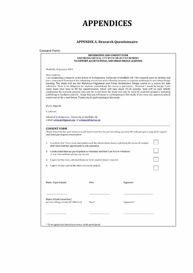
APPENDICES
APPENDIX A. Research Questionnaire Consent Form
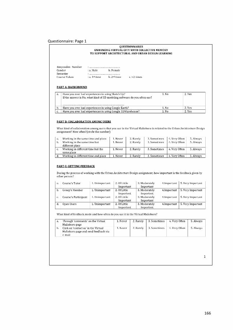
166
Questionnaire: Page 1
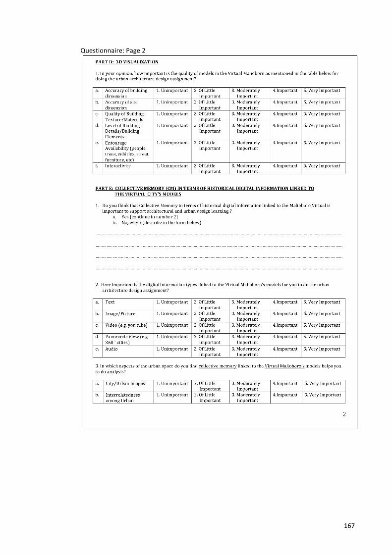
167
Questionnaire: Page 2
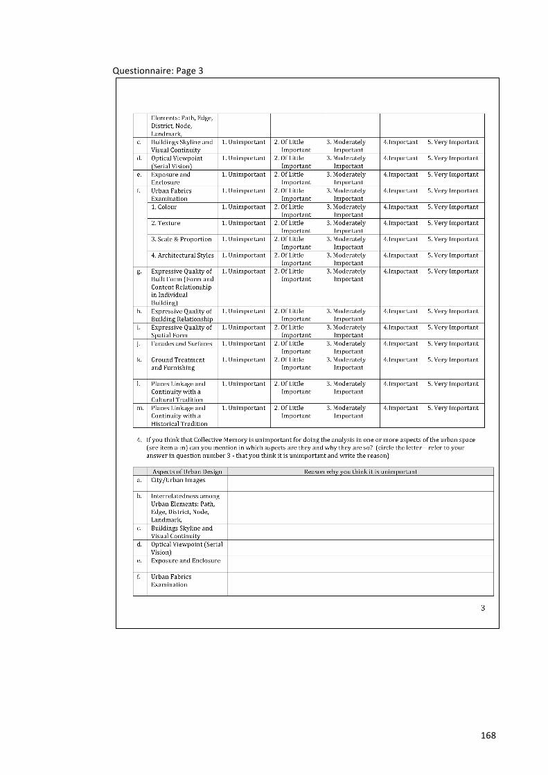
168
Questionnaire: Page 3
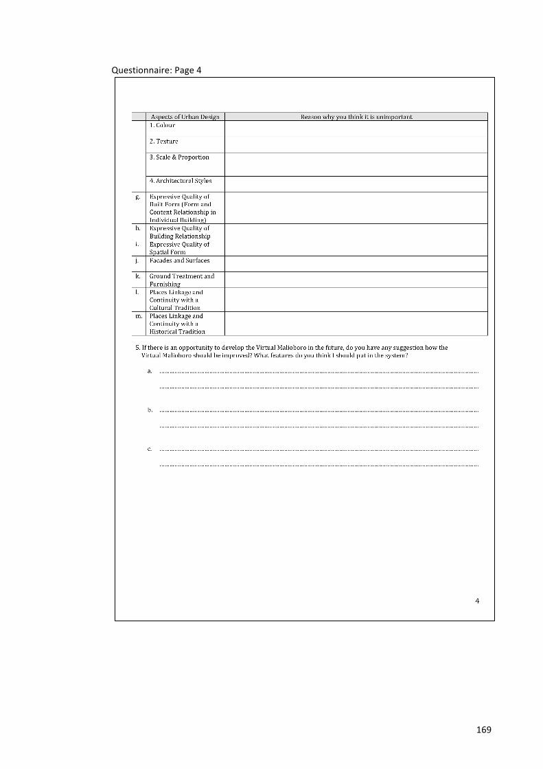
169
Questionnaire: Page 4
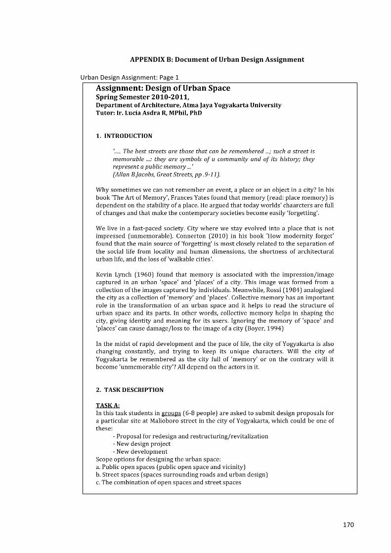
170
APPENDIX B: Document of Urban Design Assignment Urban Design Assignment: Page 1
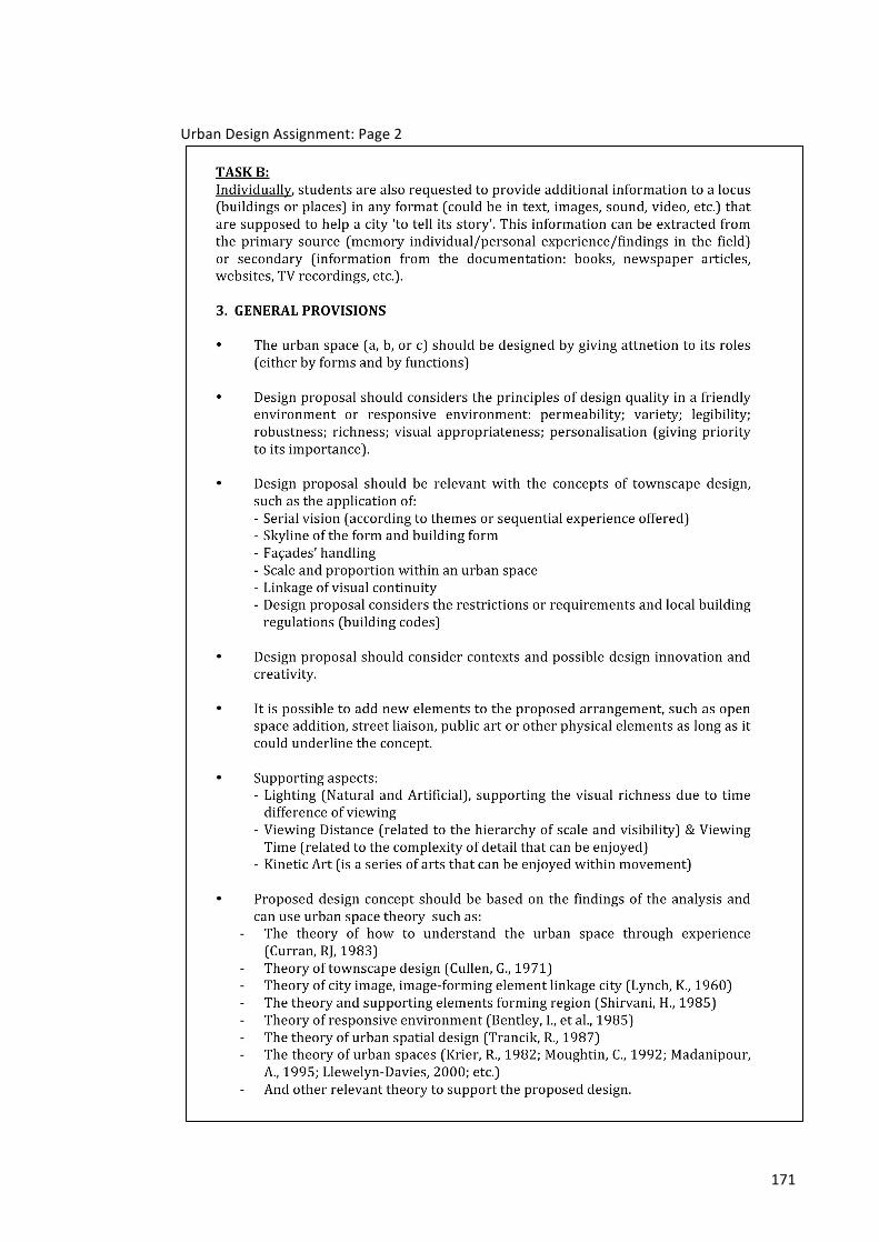
171
Urban Design Assignment: Page 2
172
Urban Design Assignment: Page 3
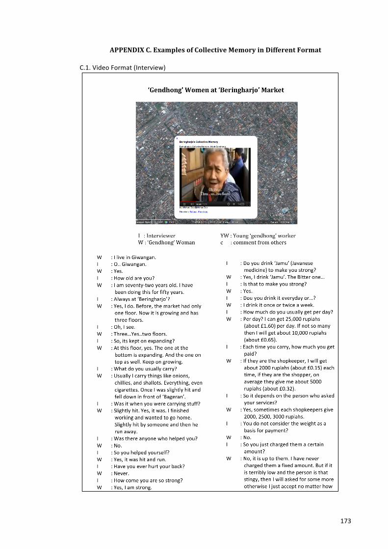
173
APPENDIX C. Examples of Collective Memory in Different Format
C.1. Video Format (Interview)
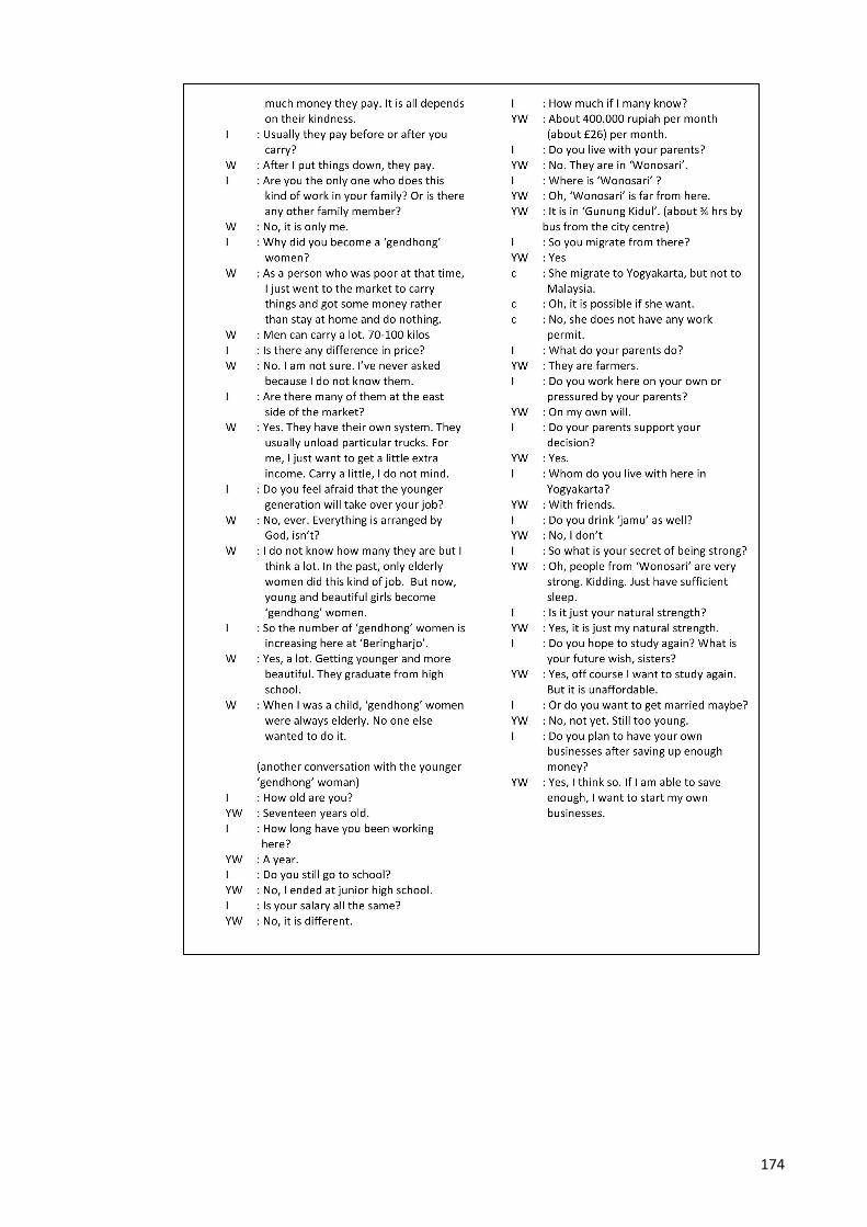
174
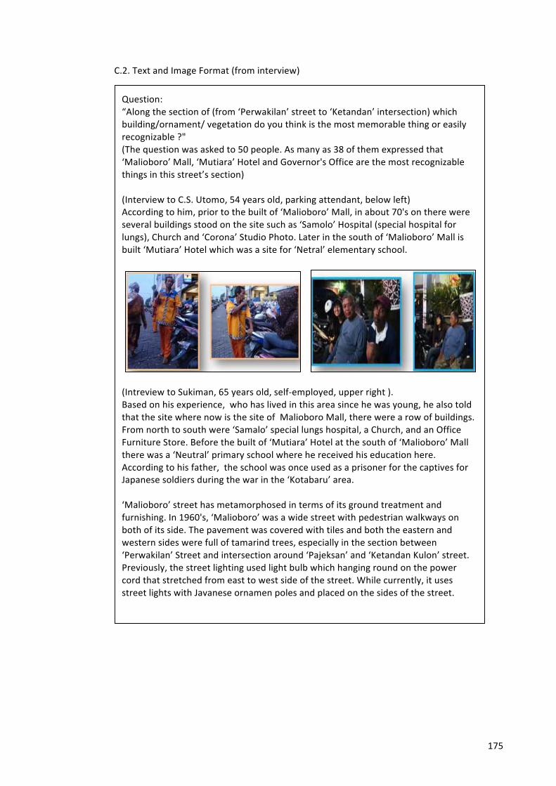
175
C.2. Text and Image Format (from interview)
Question: “Along the section of (from ‘Perwakilan’ street to ‘Ketandan’ intersection) which building/ornament/ vegetation do you think is the most memorable thing or easily recognizable ?" (The question was asked to 50 people. As many as 38 of them expressed that ‘Malioboro’ Mall, ‘Mutiara’ Hotel and Governor's Office are the most recognizable things in this street’s section) (Interview to C.S. Utomo, 54 years old, parking attendant, below left) According to him, prior to the built of ‘Malioboro’ Mall, in about 70's on there were several buildings stood on the site such as ‘Samolo’ Hospital (special hospital for lungs), Church and ‘Corona’ Studio Photo. Later in the south of ‘Malioboro’ Mall is built ‘Mutiara’ Hotel which was a site for ‘Netral’ elementary school.
(Intreview to Sukiman, 65 years old, self-‐employed, upper right ). Based on his experience, who has lived in this area since he was young, he also told that the site where now is the site of Malioboro Mall, there were a row of buildings. From north to south were ‘Samalo’ special lungs hospital, a Church, and an Office Furniture Store. Before the built of ‘Mutiara’ Hotel at the south of ‘Malioboro’ Mall there was a ‘Neutral’ primary school where he received his education here. According to his father, the school was once used as a prisoner for the captives for Japanese soldiers during the war in the ‘Kotabaru’ area. ‘Malioboro’ street has metamorphosed in terms of its ground treatment and furnishing. In 1960's, ‘Malioboro’ was a wide street with pedestrian walkways on both of its side. The pavement was covered with tiles and both the eastern and western sides were full of tamarind trees, especially in the section between ‘Perwakilan’ Street and intersection around ‘Pajeksan’ and ‘Ketandan Kulon’ street. Previously, the street lighting used light bulb which hanging round on the power cord that stretched from east to west side of the street. While currently, it uses street lights with Javanese ornamen poles and placed on the sides of the street.
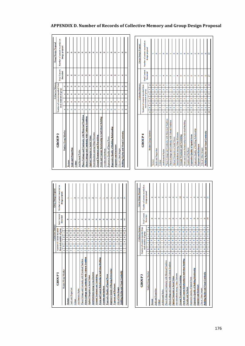
176
APPENDIX D. Number of Records of Collective Memory and Group Design Proposal
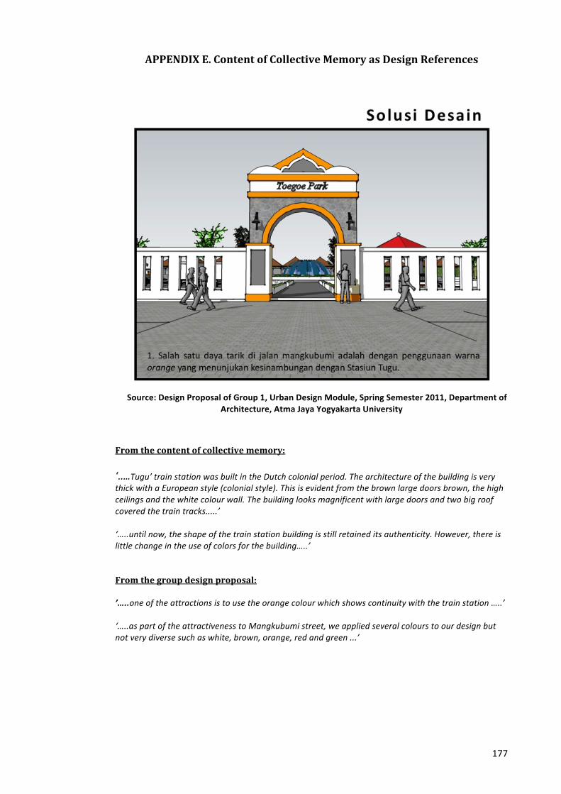
177
APPENDIX E. Content of Collective Memory as Design References
Source: Design Proposal of Group 1, Urban Design Module, Spring Semester 2011, Department of
Architecture, Atma Jaya Yogyakarta University
From the content of collective memory: ‘…..Tugu’ train station was built in the Dutch colonial period. The architecture of the building is very thick with a European style (colonial style). This is evident from the brown large doors brown, the high ceilings and the white colour wall. The building looks magnificent with large doors and two big roof covered the train tracks.....’ ‘…..until now, the shape of the train station building is still retained its authenticity. However, there is little change in the use of colors for the building…..’ From the group design proposal: ’…..one of the attractions is to use the orange colour which shows continuity with the train station …..’
‘…..as part of the attractiveness to Mangkubumi street, we applied several colours to our design but not very diverse such as white, brown, orange, red and green ...’
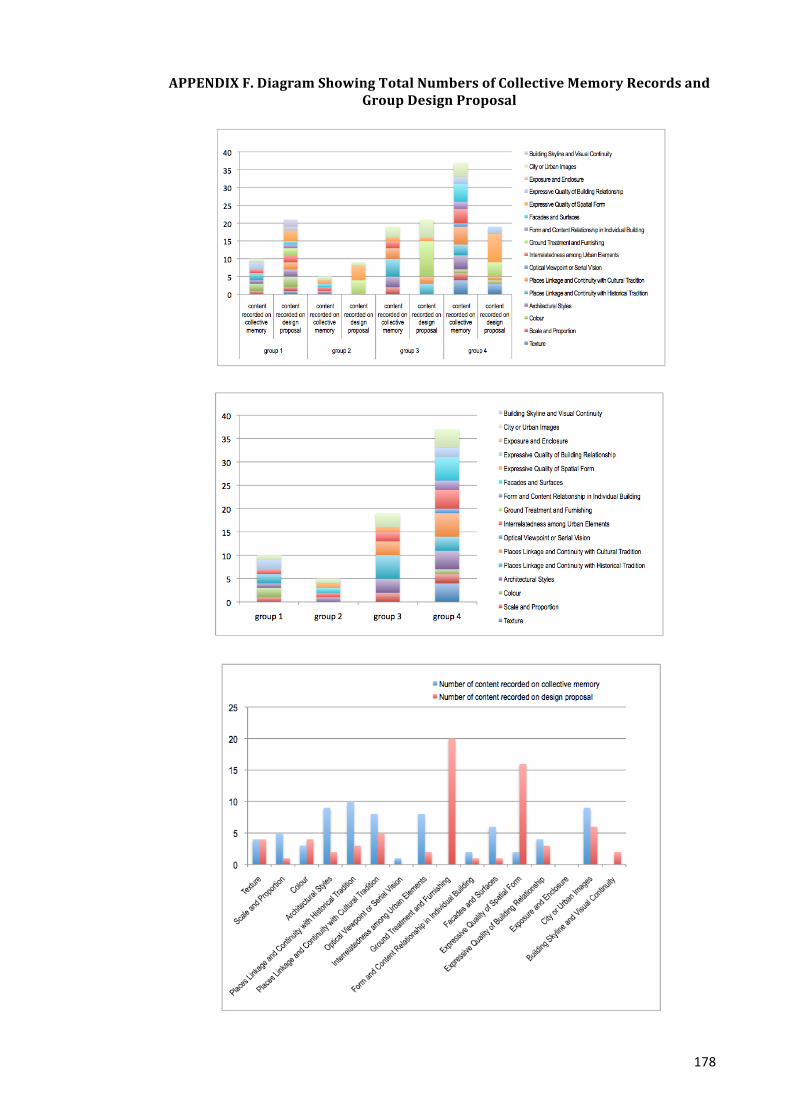
178
APPENDIX F. Diagram Showing Total Numbers of Collective Memory Records and Group Design Proposal
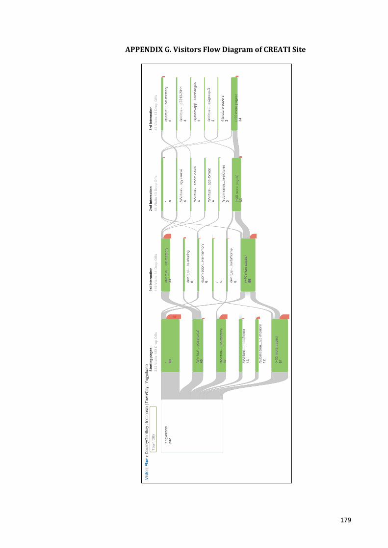
179
APPENDIX G. Visitors Flow Diagram of CREATI Site
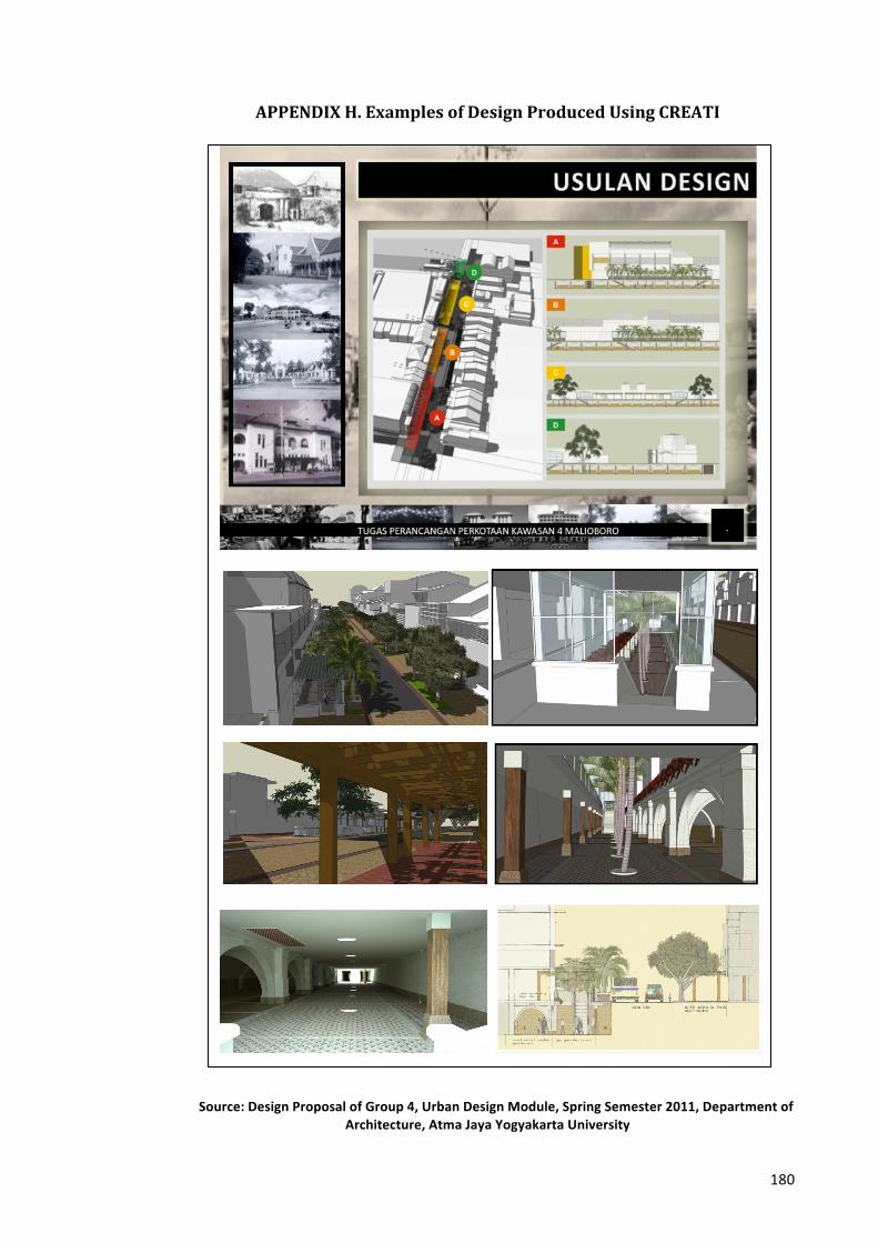
180
APPENDIX H. Examples of Design Produced Using CREATI
Source: Design Proposal of Group 4, Urban Design Module, Spring Semester 2011, Department of Architecture, Atma Jaya Yogyakarta University
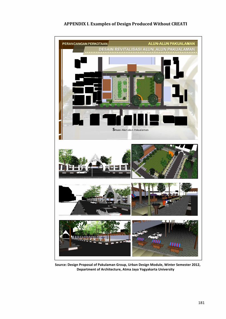
181
APPENDIX I. Examples of Design Produced Without CREATI
Source: Design Proposal of Pakulaman Group, Urban Design Module, Winter Semester 2012, Department of Architecture, Atma Jaya Yogyakarta University
182
APPENDIX J. Transcript of Interviews J.1. About Collaboration Participant A. How did you collaborate in doing the group task?
1 For individual tasks, I choose to take photos documentation independently. In fact for the group task, I worked with friends in my group who relatively used the same media (such as video, photos, etc.). For the group task, everyone has to do the analysis, which was divided based on the element of friendly environment (Kevin Lynch). Each analysis done by individual will be considered later for making design proposal of 'streetscapes'. I, myself, got the parts to make analysis related to permeability.
2 For individual task, I worked individually rather than doing it with friends, because it is more effective. Each member in my group, choose different format of collective memory. There are videos, articles, photos, and so on. For group assignments, we did it individually after discussing it together.
3 First, we looked for the materials and work individually, and then we gathered into groups to perform group tasks.
4 For the assignment, each student looks for their own material, which was divided at the beginning of the group meetings. Everyone did his own task at different times and places. Then we will gather together to combine and discuss the tasks that have been done on their own.
5 For individual assignments, I work alone at home. For the group task, we divided the task based on the subject of urban design module, then after that will be combined.
6 There are task sharing to be done individually on their time and place independently. Then we will gather to discuss the assignment.
7 I like to do the work in groups first in order to discuss and to compare the important thing, then after that work on their own task.
8 We collaborate by dividing the tasks for each individual member, and then everyone looks for the material. After all have done their own parts separately, and the parts then will be combined into one group assignment.
9 Collaboration in doing the group assignment has been done in several steps. First, we conducted site survey by visiting the location together while filming location. In addition we held a discussion on the place to discuss and get feedback of the groups/individual task. The second stage was group work. Group work includes creating a site analysis and a new design. For the analysis, it was divided into several parts for each individual so that the task can be done quickly. For the new design, we discuss it before determining what and how the final design will be made.
10 The assignment was performed in a particular place to ease the communication between members of the group. Then the work was divided into small pieces based on the condition of the targeted the site.
11 In completing this task, the group worked together to gather data from existing surveys and work was divided into multiple segments. The parts then will be distributed to smaller groups so that they can be gathered for more complex data and hopefully can be more focus on the segments.
12 The group task was discussed at the same place and time. To facilitate processing the tasks, the group was divided into 2 groups with different smaller task.
13 Collaboration is done by gathering together in a particular place. Materials that have been collected by each member before will be discussed. The discussion time was limited, but still need for further completion of data for each segment. In the next few days, all task had been divided should be recollected via email to editing process.
14 In this task every member of the group gets a small part of the task. The task has been shared for members then be combined and reprocessed. Any ideas appears will be accommodated for later discussion and agreement. In doing that, we worked together at the same place and time.
15 We help each other in doing the group task. In this task, we divided the tasks that should be collected later into a integrated assignment. Usually we gathered at a particular place.
16 Collaboration begins with a survey together and then divided the tasks based on pre-‐defined segments. If everyone had completed their part then we will combine and correct it.
17 Each member of our group work complementary skill. Its experts create a 3D image design and working drawings so appropriate expertise and agreement of the deliberations of the group.
18 A good cooperation is needed to add information related to the group task so that it can be planned well. The task is very complex and requires a lot of data sources.
183
J.2. About Themes of Design Solution Participant B. What themes/design solutions are selected for the group task?
1 I documented ‘Indra’ cinema, because cinema had exploded in an era of 70-‐80. In that period, the number of theatres reached 20s and this was profitable for businesses and society. Today, when a giant company monopolizes movies, the old small cinema scattered in many corners of the city is dying slowly. The community’s habit to spend their time to go to the cinema has fade away. For group assignments, we take a topic about rearrangement and streetscape revitalization and open space because existing conditions is appropriate and uncomfortable anymore.
2 For the group task, we wanted to create a design that is based on the analysis. For example, to make the parking lot to solve parking problems.
3 For individual tasks, I chose to make a video about ‘Beringharjo’ market because the market has experienced twists, up and down along the way of life of Yogyakarta city and has experienced many changes. For the group task, we chose to restructure/rearrange ‘Beringharjo’ market area, because the circulation in these areas is very crowded.
4 For the group task, we will perform arrangements of revitalization, restructuring signage, and parking that should be taken from the collective memory.
5 For individual tasks, I chose to discuss about women labourers doing carrying job (gendhong women) in ‘Beringharjo’ market. Because the carry trade is something that is very typical in ‘Beringharjo’ market, especially the workers are elderly women. For the group task, we focus on ‘Beringharjo’ market area. ‘Beringharjo’ market is one point in Malioboro, which became a major tourist destination. We propose a design on the market because through this market, people could see the image of the city of Yogyakarta.
6 For group tasks: Resetting/rearrange ‘Beringharjo’ market the market is very crowded and congested. Structuring done through zoning, parking layout, etc.
7 Propose a park (green space) around ‘Beringharjo’ market 8 Task group on restructuring/arrangement of ‘Beringharjo’ market area such as a parking re-‐
layout, street stall arrangement and circulation (including pedestrians) in the region. 9 For the group task: to provide additional lines to vehicles that go to the train station. We intend
to design addition pathways to minimize traffic jams, so the circulation of vehicles can be effective. Besides we also consider providing a new facility design in segment 1 of ‘Mangkubumi’ street. However it is still being discussed in the group.
10 For the group task, we plan to rearrange the circulation at the partial path by changing a space for rickshaws into a circulation area for vehicles.
11 We plan is to set/remodel driveways to ‘Tugu’ train station to reduce traffic jams occur frequently to the entrance of the station. The lines are frequently closed when the train passed, causing the vehicle queue. We intend to add lines into the station. Collective memory is very important to help design that is contextual to the places.
12 The addition of vehicle tracks into the station pillar (main door). Because usually there are traffic jam in Mangkubumi lane road, especially when there is a train passing. With this proposal, it is expected to reduce congestion in the area.
13 Our design proposal intends to minimize traffic jam by utilizing and functioning the dead space area and re-‐arrange the circulation path for the current vehicle. 'Street furniture' will be placed in accordance with the existing context.
14 For the group task, we wanted to try to add the path lane to get to the station. The addition of the proposed pathway is due to long queues on the road goes to the station. In addition there is also discussion about the use of a vacant land located across the train station.
15 Group 1 will plan to add a lane for vehicles that go into the station. There is also a vacant land at the north of Hotel Tugu and we plan to propose it as a park but members of the group are still discussing it.
16 Our group will plan to re-‐layout the line in front of the train to avoid queues of vehicles at the entrance. We also try to utilize the vacant site for a garden and parking area. Collective memory will be used to bring the past atmosphere back.
17 Collective memory helps to bring back the past atmosphere to the city of Yogyakarta. In the past, traffic is not so congested and the air temperature is quite comfortable compared to those in the present time. A lot of trees in the 0km area are disappeared so it is important to bring it back to make the temperature more comfortable.
18 For the main task, we are planning to design a garden in front of the post office, especially in the area of the monument of Yogyakarta March 11 in order to make people more aware to the history of the monument. It is very relevant to the collective memory of that place. Our design intends to attract people to come and enjoy the monument through the surrounding gardens.
184
J.3. About CREATI site Participant C. To what extent the CREATI site available can support you in doing the Urban Design
assignment? 1 It helps to show the existing conditions (the 3D models), to add an insight into the district
through the collective memory content, and to review the work on progress of other students. 2 In the website, the 3D models embedded with collective memory is helpful, particularly in
designing the future condition. 3 The site helps in finding collective memory apart from the direct informants who may have
lived from the time of the independence day to present day. It helps to know more about Malioboro area.
4 Websites can help in proposing a new design. The site provides building models located in Malioboro (including models of ‘Beringharjo’ area), be it 2D or 3D. Collective memory uploaded by members of group can be united to help creating a design proposal. The site also facilitated such an online consultation via gmail or chatting.
5 The website is quite helpful in modelling (using sketch up) and also assist in gathering information. It supports students to upload their design, which is available to be viewed publicly.
6 The website is quite helpful to propose new design because there are a lot of information (text, images, etc.) as well as 3D models, making it useful for designing with sketch up
7 The existence of the website is very helpful to find the data in the form of pictures and information to accomplish this task.
8 The website is quite helpful especially in preparing the design 9 The website is very helpful to provide additional information and to complete the task. 10 This website really helped me, especially when I need to know the existing condition as well as
information about the location to be designed which can be obtain from the content of collective memory (some content is difficult to find).
11 Besides data from field surveys and interviews, we really need a website that provides a variety of data that can be used for design consideration. Historical data is very helpful to create a contextual design.
12 Websites can help to understand the reference and give an overview of the tasks. 13 This website has been quite helpful to find data related to location. For example: provide
references and an overview of the tasks. 14 The website is helpful in terms of providing additional information and photos, especially
photos of the past that are hard to find. Information and photos become a historical documents and very helpful to complete the task.
15 Websites help to consider what design will be made, because it explains the history and 3D images of the location.
16 This website makes data we need is more easier to be found and accessible. But it is better to introduce more tutorial by practising together between tutor and students how to use of the website.
17 The website is very helpful especially information about the photos of the past, and the past conditions. It helps us to understand the condition by comparing the past and present condition of Jogja, and then to find the problems/issues and to propose new design to make it better.
18 In fulfilling the task, we need not only from the interview and a discussion with people. Historical data is needed. The website is very helpful to add information about history and to know the history of the place, what was it look like, what was its function, etc.
185
J.4. About Collective Memory Participant D. Do you think the memory you add is useful for your group task? In what ways this kind of
memory content helps? 1 The memory I chose is less useful for the design project. The identification/ analysis through the
use of photo documentation and using models of buildings. 2 Samples of the collective memory can help in the design process in particular by giving
background knowledge on the historical development of both building forms and activity. We utilize the information from the collective memory related to the physical construction or activities. ‘Beringharjo’ market is part of Malioboro area. By designing the Malioboro area will benefit to ‘Beringharjo’ market.
3 Samples of collective memory in Yogyakarta Virtual website is considerably helpful, but still not enough and had to find a resource directly. I utilize the website for the project and open it occasionally and use the information needed. Almost all objects in Malioboro are interesting, in this particular ‘Beringharjo’ market that have been experienced a lot of changes both the building and its surrounding environment.
4 I wrote memories about the form and layout of ‘Beringharjo’ market as well as the activity inside the market. The memory content helps little in considering the design proposal related to open space, streetscape, and so on.
5 Samples of collective memory available on the website is help me in fulfilling the individual tasks. But it is available for a limited number, so that more data/information is still needed. For the group project, the website is quite useful to get information. ‘Beringharjo’ market is a unique and interesting places to discuss, and its surrounding is also interesting. The market has experienced many changes throughout the history.
6 I interlinked memories about history and background of ‘Beringharjo’ market. By knowing the history and background of the ‘Beringharjo’ market can restore the image of the market as it was. ‘Beringharjo’ market is one important element in the centre of Malioboro Yogyakarta and one of tourist destination.
7 Samples of collective memory more or less help in completing the tasks and information needed. In our group we took some information and pictures of the samples of collective memory. Malioboro is a landmark of the city of Yogyakarta and it is very interesting to study Malioboro.
8 I interlink the story of Beringharjo especially related to building, and activities in the market. Beringharjo area is a historical district in Malioboro that has an interesting history and development.
9 Collective memory is helpful, because it gives a good overview either in text or photographs about the history of Yogyakarta and the situation which is important for considering a design. ‘Mangkubumi’ street had been chosen as the object task because Jogja in the past is very different with present Jogja. In the past, there were just a few buildings located in the street, but now the street is full of shops and offices.
10 Collective memory will help to maintain architectural style or street furniture. I am interested in the function of pharmacy building that has been turned into Indomart – minimarket, a very big change. In the previous years there were some renovation to the pharmacy building but still with the same function. Also because it is a heritage building in Yogyakarta
11 Some samples of collective memory were used for design consideration in order to be contextual with its surrounding area. It is important to keep the history of the place – not lost and forgotten but become stronger with a new design. We chose to accomplish the entrance of ‘Tugu’ train station as it influences the first impression of the visitors upon entering the ‘Tugu’ station. Its entrance has changed for many times from just writing to a sculpture i.e. locomotives. These changes affect the atmosphere and should be eye catching for the new proposed design.
12 Collective memory is useful as a basis for making as a design. I chose ‘Tugu’ train station particularly related to parking issues.
13 Collective memory is very important in determining the design. We learnt from the content of collective memory about the site structure, building facades and compare it with the existing condition in the present. So that there is still a connection between the current situation and the past. The reason for choosing 'Hotel Inna Garuda' as my individual task is because the building has a lot historical value from the colonial era to the present. It is characterized by several changes in the shape and changes of the hotel’s name. Automatically historical value will affect the circumstances around this building such as parking arrangement, existing buildings in that area, etc.
186
14 Collective memory can be helpful to consider design ideas. For individual tasks I chose to write memories related to ‘Tugu’ Hotel, as it is a heritage building. The building continuously changes in its function and is currently planned to be used as a museum for the late president ‘Suharto’.
15 Collective memory can be useful for our group task. It helps to consider design ideas. I chose to write memories related to the ‘Tugu’ Hotel, seeking information that is different from the previous function.
16 Collective memory helps to design a better urban space like in the past, so that the beauty of the city can be enjoyed and not chaotic like the current condition. I chose to write memories about the train station, because the building still maintained its authenticity. There is a spacious atmosphere and the potential for more enhanced to become an icon of Yogyakarta city.
17 Collective memory is very helpful in the process of considering design ideas. I chose to discus ‘0 Km’ area because there are still many debates about the exact location of the ‘0 Km’ point. Some groups say ‘0 Km’ area is the post office, another group says the ‘0 Km’ point is the presidential house.
18 Collective memory helps to know the history of the place. Examples of historical data to support design are needed, because new design should not forget about the history of the place and consider the contextual issues. I chose BNI intersection (0 Km Area) because it has many stories, especially related to the story of ‘11 March’ Monument. It is said that the intersection is the start point of the history of Yogyakarta city. And the monument at the intersection is a real sign that has to be known by many people.

187
APPENDIX K. The Analysis of CREATI and Non CREATI Group
K.1. Context Awareness between CREATI and Non CREATI Group
CREATI Group: Beringharjo Traditional Market Analysis using Collective Memory
Context Awareness
Have wider understanding about the site and surrounding area. Understanding places linkage and continuity with historical and cultural tradition ‘…..Beringharjo market is a part of the old pattern of the Sultanate of Yogyakarta i.e Kraton (centre of government), square (public spaces), a mosque (place of worship) and a market (centre of economic transactions)…’ Identify the position of the selected building among any other historical buildings in context ‘..on the north and the south side of Reksobayan street (in front of the market) there are Dutch colonial buildings, i.e ‘Margomulyo’ Church and a Presidential house…the Church function as a place of worship..in front of the church there is a town clock known as 'Ngejaman' which serves as a reminder time for the community in the past time…’
Context Awareness
Non CREATI Group: Pakualaman Square Analysis
Focus only on the site. No further explanation about nearby historical buildings ‘…The south-‐facing orientation of Pakualaman Palace is in purpose to honor of the Sultan’s Palace…’ ‘…Pakualaman palace equipped with a square, large mosques, markets, stables, and administrative offices...’ (no description about the buildings mentioned)
Historical buildings nearby
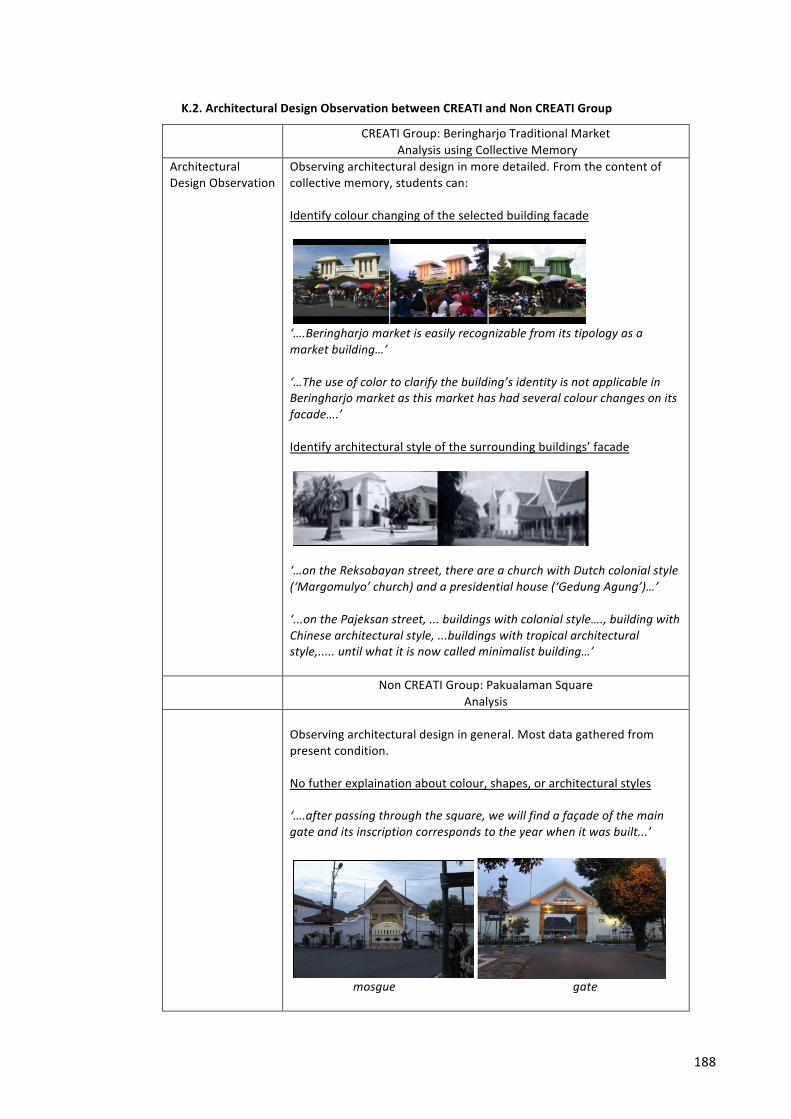
188
K.2. Architectural Design Observation between CREATI and Non CREATI Group
CREATI Group: Beringharjo Traditional Market Analysis using Collective Memory
Architectural Design Observation
Observing architectural design in more detailed. From the content of collective memory, students can: Identify colour changing of the selected building facade
‘….Beringharjo market is easily recognizable from its tipology as a market building…’ ‘…The use of color to clarify the building’s identity is not applicable in Beringharjo market as this market has had several colour changes on its facade….’ Identify architectural style of the surrounding buildings’ facade
‘…on the Reksobayan street, there are a church with Dutch colonial style (‘Margomulyo’ church) and a presidential house (‘Gedung Agung’)…’ ‘...on the Pajeksan street, ... buildings with colonial style…., building with Chinese architectural style, ...buildings with tropical architectural style,..... until what it is now called minimalist building…’
Non CREATI Group: Pakualaman Square Analysis
Observing architectural design in general. Most data gathered from present condition. No futher explaination about colour, shapes, or architectural styles ‘….after passing through the square, we will find a façade of the main gate and its inscription corresponds to the year when it was built...’
mosgue gate
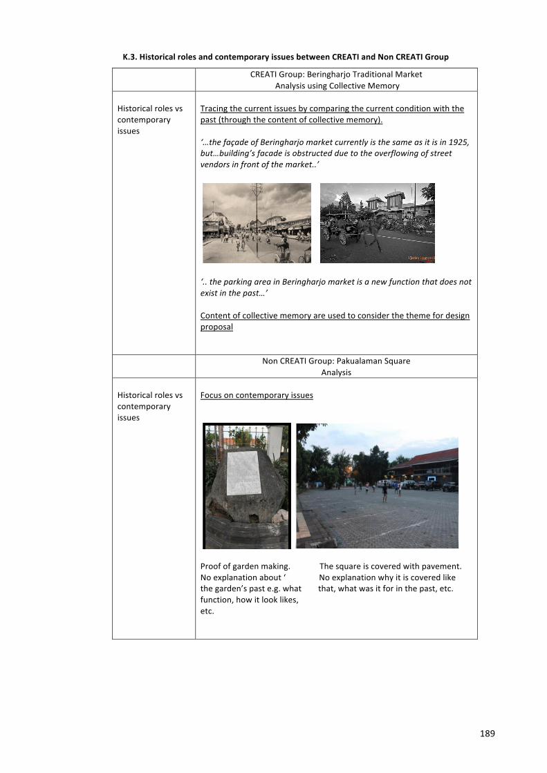
189
K.3. Historical roles and contemporary issues between CREATI and Non CREATI Group
CREATI Group: Beringharjo Traditional Market Analysis using Collective Memory
Historical roles vs contemporary issues
Tracing the current issues by comparing the current condition with the past (through the content of collective memory). ‘…the façade of Beringharjo market currently is the same as it is in 1925, but…building’s facade is obstructed due to the overflowing of street vendors in front of the market..’
‘.. the parking area in Beringharjo market is a new function that does not exist in the past…’ Content of collective memory are used to consider the theme for design proposal
Non CREATI Group: Pakualaman Square Analysis
Historical roles vs contemporary issues
Focus on contemporary issues
Proof of garden making. The square is covered with pavement. No explanation about ‘ No explanation why it is covered like the garden’s past e.g. what that, what was it for in the past, etc. function, how it look likes, etc.
190
APPENDIX L. Final Exam

191
APPENDIX M. Ethics Approval
Related Documents