ENGLISH FIELD SYSTEMS B) HOWARD LEVI GRAY, Ph D. HARVARD UNIVERSITY PRESS:

Welcome message from author
This document is posted to help you gain knowledge. Please leave a comment to let me know what you think about it! Share it to your friends and learn new things together.
Transcript

ENGLISH FIELD SYSTEMS
B)
HOWARD LEVI GRAY, Ph D.
HARVARD UNIVERSITY PRESS:


PREFACE
FOR introductions which have given me access to many of the documents cited in this volume I am indebted to the Rev. A. H. Johnson of All Souls, Oxford, and to Mr. Hubert Hall of the Public Record Office. The custodians of various collections of records have been most courteous, notably those in charge of the British Museum, the Bodleian library, the Public Record Office, the archives of the Dean and Chapter of Christ Church, Canter- bury, and the estate documents a t Holkham Hall. Messrs. J. M. Davenport and J. R. Symonds put a t my disposal the enclosure awards of Oxfordshire and Herefordshire respectively. In making revisions and in correcting proof I have relied upon the skill and care of Miss A. F. Rowe of Cambridge. Professors C. H. Haskins and E. F. Gay of Harvard read the unfinished text and offered valuable suggestions; in particular I am under heavy obligation to Professor Gay, whose unfailing encouragement and generous assistance have made possible the publication of these chapters.
CAMBRIDGE, MASSA~USETTS, August, 1915.


CONTENTS PAGE
INTRODUCTION . . . . . . . . . . . . . . . . . . . . . . 3
CHAPTER I
. . . . . . . . . . . . . THE TWO- AND THREE-FIELD SYSTEM I7
CHAPTER I1
THE EARLIER HISTORY OF THE TWO- AND THREE-FIELD SYSTEM . 50
CHAPTER I11
EARLY IRREGULAR FIELDS WITHIN THE MIDLAND AREA . . . . . 83
1 CHAPTER IV
CHAPTER V
THE CEIJIC SYSTEM . . . . . . . . . . . . . . . . . . . . . 157
CHAPTER V1
. . . . . . THE INFLUENCE OF THE CELTIC SYSTEM IN ENGLAND 206
CHAPTER V11
THE KENTISH SYSTEM . . . . . . . . . . . . . . . . . . . 272
CHAPTER V111
THE EAST ANGLIAN SYS~EM . . . . . . . . . . . . . . . . . 305
CHAPTER IX . . . . . . . . . . . . . . . . . %E LOWER T m m s BASIN. 355
CHAPTER X
RESULTS AND CONJECTURES . . . . . . . . . . . . . . . . . . 403
v11

viii CONTENTS
APPENDIX I
APPENDIX I1
APPENDIX I11
APPENDIX IV
. . . . . . . . . PARLIAMENTARY ENCLOSURES IN OXFORDSHIRE 536
APPENDIX V
APPENDIX V1

MAPS
I. Map of England and Wales, showing Important Places re- ferred to and the Boundaries of the Two- and Three-Field
. . . . . . . . . . . . . . . . . System. Frofztispiece
11. Sketch of the Tithe Map of the Township of Chalgrove, Ox- fordshire. 1841 . . . . . . . . . . . . . . . . . . . .
111. Sketch of the Enclosure Map of the Township of Croxton, Lincolnshire. 1810 . . . . . . . . . . . . . . . . . .
IV. Sketch of the Enclosure Map of the Township of Stow, Lin- colnshire. 1804 . . . . . . . . . . . . . . . . . . . .
V. Sketch of a Map of Padbury, Buckinghamshire. 1591 . . . . . . . . . . . . . . . . . VI. Enclosure Map of Oxfordshire
V I ~ . Sketch of the Enclosure Map of the Township of Kingham, . . . . . . . . . . . . . . . . . . . Oxfordshire. 1850
VIII. Sketch of the Enclosure Map of the Risbury Division of Stoke Prior, Herefordshire. 185 5 . . . . . . . . . . . . . . .
IX. Sketch of the Enclosure Map of the Township of Holmer, . . . . . . . . . . . . . . . . . . Herefordshire. 1855
X. Sketch of the Enclosure Map of the Parish of Marden, Here- . . . . . . . . . . . . . . . . . . . . fordshire. 1819
XI. Sketch of a Townland in Donegal, Ireland, showing the Hold- ings of three Tenants. 1845 . . . . . . . . . . . . . .
XII. Plan of an Estate of All Souls College, Oxford, lying in the . . . Townships of Newington and Upchurch, Kent. 1593
XIII. Plan of an Estate in the Township of Buxton, Norfolk. 1714 .
XIV. Plan of an Estate in the Township of Shropham, Norfolk. . . . . . . . . . . . . . . . . . . . . . . . . . I714
XV. Sketch of a Map of the Township of West Lexham, Norfolk. . . . . . . . . . . . . . . . . . . . . . . . . . 1575
XVI. Plan of the Open Fields of Weasenham, Norfolk, showing the . . . . . . . Location of George Elmdon's Holding. 1600
XVII. Sketch of a Map of the Township of Holkham, Norfolk, show- . . . . . . . . . . . . . . ing the Fold Courses. 1590
PAGE

ABBREVIATIONS
C. Inq. p. Mort.. . . . . . . . . . . . .Chancery Inquisitions post Mortem (reign, file, number).
C. P. Recov. Ro.. . . . . . . . . . . . .Common Pleas Recovery Roll. D. of Lanc., M. B.. . . . . . . . . . .Duchy of Lancaster, Miscellaneous Book, Exch. Aug. Of., M. B.. . . . . . . Exchequer, Augmentation Office, Miscel-
laneous Book. K. B. Plea Ro.. . . . . . . . . . . . . .King's Bench Plea Roll. Land Rev., M. B.. . . . . . . . . . Land Revenue, Miscellaneous Book. Ped. Fin.. . . . . . . . . . . . . . . . . . . Pedes Finium (case, file, number). Rents. and Survs., Portf.. . . . . . Rentals and Surveys, Portfolio.

ENGLISH FIELD SYSTEMS
INTRODUCTION
THE term ' l field system " signifies the manner in which the inhabitants of a township subdivided and tilled their arable, meadow, and pasture land. Although a study of field systems may seem to be primarily of antiquarian interest, the following chapters have been written as a contribution to our knowledge of the settlement of England and to the history of English agri- culture. Since these subjects are wide in scope, no attempt has been made to treat either of them fully; yet i t may not be impossible to show that a comprehension of the structure and cultivation of township fields is germane to both.
The settlement of England, as every one knows, is a topic relative to which the sources of information are very scanty. To what extent Celtic and Roman influences persisted after the Germanic invasions of the fifth century is inadequately revealed in existing written records.' To supplement narrative accounts scholars have had recourse to such indirect sources of information as linguistics, mythology, archaeology, and to later social, govern- mental, and legal institutions. Since not the least significant among social customs, especially with primitive peoples, is the method adopted in tilling the soil, an understanding of the differ- ences in agricultural practice early manifested in various parts of England may prove of assistance in distinguishing between the groups that retained or occupied and held the several sections of the country.
Perhaps a still more important and more comprehensive sub- ject is the history of English agriculture. Until the nineteenth
l The question as to what Germanic groups occupied the several parts of Eng- land in the course of the fifth and sixth centuries is ably discussed by H. M. Chad- wick, The Origin of the Englzsh Nation, Cambridge, 1907.

4 ENGLISH FIELD SYSTEMS
century agriculture remained the chief source of the national wealth of England, and no account of the fortunes of her people that neglects the topic is adequate. No improvements in the arts before the introduction of the factory system affected so large a proportion of the population as did improvements in tillage; and if disastrous changes occurred the men who suffered were the bone and sinew of the nation. What the following chapters have to tell relates to only a single phase of agricultural progress; but, since that phase is the manner in which more and more of the soil was brought under improved cultivation, it has an immediate bearing upon national wealth and individual well-being.
The agriculture and settlement of primitive peoples have been studied with less diligence by English than by German scholars - perhaps a natural outcome of the perception in Germany that an intimate relation existed between the early history of the Germans and the agrarian side of their life. No passages in the writings of classical historians are discussed more frequently than the brief descriptions of these matters found in Caesar and Tacitus. Inherent tendencies toward democracy or toward aristocracy, it is thought, are there to be discerned. Attention, too, has been focused upon the agriculture of the Germans as practiced somewhat later, when they invaded the Roman empire! and in their laws gave testimony to their methods of tilling the soil.
Since all such documentary references to early agrarian custom are brief, it has been usual to interpret them in the light of later usages, descriptions of which have an added value in constituting, as they do, records of the age to which they belong. To two of her scholars is Germany particularly indebted for interpretations and descriptions of this kind. During the second quarter of the nineteenth century Georg Hanssen, stimulated perhaps by the pioneer activity of the Danish Oluffsen, set forth in a series of papers the various field systems or types of agriculture existent a t one time or another in Germanic territories.' In continuation of Hanssen's studies, August Meitzen published in 1895 a more
l Agrarhislwische Abhndlungen, 2 vols., Leipzig, 1880-84.

INTRODUCTION 5
comprehensive work.' Relying largely upon the plans of town- . ship fields as they appeared a t the time of their enclosure in the nineteenth century, he interpreted and compared the earlier agrarian arrangements of Roman, Germanic, Celtic, and Slavic peoples. Not merely to field systems, however, did he have recourse, but in the types of village settlement and in the forms of dwelling-house adopted by the peoples in question he found additional evidence for determining the movements of the popu- lation of Europe in the early Middle Ages. The task was a vast one and its achievement noteworthy; but the generalizations suffer somewhat from the circumstances that much of the evi- dence is late in date and that such of i t as comes from certain countries, notably France, England, and Italy, is inconsiderable.
For information regarding English field arrangements Meitzen relied mainly upon the lucid account given in Seebohm's English Village C~rnmunity .~ In this cleverly written book the author reproduces a plan of the township of Hitchin, Hertfordshire, made a t the time of the enclosure of the open common fields about 1816. I t is the type of evidence which Meitzen himself was to use extensively and which, despite its recent date, is always of value. Beginning with a description of the features portrayed in the Hitchin plan, features which constitute the so- called three-field system, Seebohm with the assistance of three or four terriers carries the reader back to Anglo-Saxon days, arguing that the open fields of English villages a t that time differed in no essential particular from the Hitchin fields of 1816. Behind these descriptions runs the thread of an hypothesis which inter- ested the author more than did the presentation of facts; for it is the thesis of the book that the practically unchanging open-field system of an English township had from Roman days served as the protective shell of a community settled in serfdom upon it.3
' Siedelung und Agramesen der Westgermanen und Oslgermanen, der Kelten, Romer, Finnen und Slawen, 3 vols. and atlas, Berlin, 1895. An account of the antecedent literature of the subject is given in vol. i, pp. 19-28.
Frederic Seebohm, The English Village Community examined in its Relations to the Manorial and Tribal Systems and to the Common or Open Field System of Husbandry, London, 1883. ' Ibid., 409.

6 ENGLISH FIELD SYSTEMS
In contrast the author sketches the Celtic field system, referring particularly to the aspect of a nineteenth-century Irish township and to the testimony of early Welsh laws. As an account of early agricultural arrangements Seebohm's treatment is defi- cient in scope, his meagre evidence by no means warranting the inference that the three-field system was prevalent throughout England from the earliest times.
So far as the structure of English village fields is concerned, Seebohm was not the first to make inquiries. Nasse, in a brief monograph, had already examined with some care the Anglo- Saxon evidence to ascertain whether i t showed the arable unen- closed and parcelled out among the tenants in intermixed strips.* Having satisfied himself that it did, he turned to thirteenth- century documents to inquire whether a two-field or a three-field system was then prevalent. Rogers, as he noted, had surmised that arable lands were a t this time usually left one-half fallow each year, and Fleta in the reign of Edward I had implied that the two systems were CO-existent. Since Nasse's own investiga; tions revealed to him various instances of three-field husbandry ih contrast with only one description of two fields, he concluded that in the thirteenth century the former was " decidedly the prevailing system." This view of Nasse's is what Seebohm, in so far as he wrote of field systems, has made popular. Rogers's 1 conjecture is repeated by Vinogradoff, who, after pointing to nine or ten two-field townships and noting that Walter of Henley as well as Fleta was familiar with both systems, surmises that the two-field rotation may have been " very extensively spread in England in the thirteenth century." '
The evidence adduced regarding English field systems thus proves to be somewhat slight - rather too slight to warrant
l Cf. below, p. 191. 2 Erwin Nasse, On the Agricultural Community of the Middle Ages, and Inclosures
of the Sizlemth Century in England (translated by H . A. Ouvry, London, 1872), pp. 19-26. Cf. below, p. 51 sq.
3 Ibid., 52-58. Most of Nasse's citations refer only to a three-course rota- tion of crops, which does not necessarily imply a three-field system. Cf. below, PP 44-45.
Paul Vinogradoff, Villainage in England (Oxford, 18~2) , pp. 22y230.

INTRODUCTION 7
Vinogradoff's summary dismissal of the subject.' It reduces, in . brief, to a familiarity with the three-field system as practiced in nineteenth-century Hitchin, projected back by the testimony of two thirteenth-century writers and by some twenty references to two- or three-field villages dating mainly from the same century. Yet since Vinogradoff wrote no one has dissented from his pronouncement or taken a further interest in the subject.
One of the problems upon which, as has been intimated, the study of field systems promises to throw light is the development of English agriculture. With this development, so far as i t resulted from the innovations of the eighteenth century which had to do with the rotation of crops and the introduction of convertible husbandry, we are not ~nfamiliar .~ I t chances. however, that these improvements were contemporary with the transformation of England from an agricultural into a manu- facturins country, and that for this reason the benefits conferred by the experiments of Thomas Coke and others reached a far smaller proportion of the population than would have been affected had the change occurred earlier. In days when the annual return from tillage and sheep-raising determined the prosperity of the people to a greater degree than when these pursuits were supplemented by the work of the factories, farming assumed more importance. I t is with the improvements of the earlier period that the following chapters are more immediately concerned.
In English agriculture interest has always fluctuated between corn-growing and pasture-farming. During the Middle Ages a
l "The chief features of the field-system which was in operation in England during the middle ages have been sufficiently cleared up by modem scholars, especially by Nasse, Thorold Rogers, and Seebohm. . . . Everybody knows that the arable of an English village was commonly cultivated under a three years' rotation of crops; a two-field system is also found very often; there are some instances of more complex arrangements, but they are very rare, and appear late - not earlier than the fourteenth century " (ibid., 224). The complex arrangement at Littleton, Gloucestershire, that Vinogradoff proceeds to discuss refers to demesne lands, which possibly did not lie in open field.
A good sketch of it is given by W. H. R. Curtler, A Short History of English Agriculture (Oxford, IW), pp. I I 1-228.

8 ENGLISH FIELD SYSTEMS
combination of the two was usually effected through the annual communal tillage of a part of the improved arable, and the pasturing of sheep and cattle upon the waste and upon that por- tion of the arable which during the year in question lay fallow. Of enclosed land held in severalty and available either for tillage or -
for pasturage there was little. Such as existed was in general to be found among the demesne lands of the lord or in the home closes of the tenants. Whenever, none the less, our records appraise enclosed land they give i t a higher valuation than they assign to the open-field arable, an indication that from an early period separable land available for both pasture and tillage was recog- nized as more remunerative than common arable field.'
A corollary of this estimate is that agricultural progress was bound to take one of two directions. I t was necessary either that the unenclosed arable of a township should be brought under better tillage while continuing to lie open, or that i t should be enclosed and given over to convertible hu~bandry .~ From an agricultural point of view the latter procedure was, of course, the wiser and has ultimately been adopted. Rut there stood in th'e way of such a transformation serious technical and social diffi- culties. The enclosure of the old fields implied, as we shall see, a consolidation of the scattered parcels of each holding and a cessation of communal tillage. For a long time the latter step was actually impossible of accomplishment. Mediaeval plough- ing demanded a team of eight oxen or horses yoked to a heavy
l At Haversham, Bucks, for example, the demesne comprised " c acre terre arabilis iacentes in separali que valent per annum xxx S. iiii d. . . . et centum acre terre que iacent in communi et valent per annum si sunt seminate xvi S. viii d.; et si non sunt seminate nlhil valent quia pastura communis est " (C. Inq. p. Mort., Edw. 111, F. 45 (20), g Edw. 111).
The term " convertible husbandry " is used in the following chapters to desig- nate the continuous annual tillage of improved lands under a succession of grain and grass crops. The equivalent German term is " neuere Feldgraswirtschaft " (Hanssen, .4grarhistorische Abhandlungen, i . 216 sq.). Although, when once in grass, la2d thus tilled was usually left so for more than one year, this feature should not be insisted upon in a definition, as is done by W. Roscher (System der Volks- wirlhschafl. 2. Bd , Nalionalokonomik des Ackerbaz~es und der verzandlen Urproduc- tionen, 12th edition, Stuttgart, 1888, p. 89). Some of Hanssen's illustrations show no series of grass years (cf pp. 227, 231). Convertible husbandry was sometimes practiced upon open-field lands (cf. below, p. 129, 158).

INTRODUCTION 9
plough,' whereas even a team of four beasts, which was still used in places until the end of the eighteenth c e n t ~ r y , ~ was beyond the reach of any except the more prosperous tenants. Communal ploughing thus became inevitable, and it was only natural that strips should be ploughed successively for each contributor to the plough team. In this way an antiquated technique of tillage long prevented the consolidation of the scattered strips of the holdings. Added to this difficulty was the social one. Communal husbandry had in its favor the authority of long tradition, a potent force with a timorous and conservative peasantry. In the event of readjustment - the peasant asked himself - - would not the strong profit, the poor suffer ? Hence there grew up a popular prejudice against the enclosure and improvement of the common fields.
I t should not, however, be assumed, as is often done, that agricultural improvement could take place only through en- closure. Certain open-field systems were superior to others, and a substitution of the better for the poorer meant definite progress. While a two-field arrangement, for example, permitted the annual tillage of only one-half of the arable, a three-field one utilized two-thirds of it and a four-field one three-fourths. Moreover, a transition from one to the other of these systems, or to an irregular arrangement of fields, involved no abandon- ment of intermixed holdings or of cooperative ploughing; and, inasmuch as no tenant had anything to lose by such a change but each was likely to gain by it, friction did not arise. Of the substitution of one system for the other little record is left in complaints before royal courts, in petitions for parliamentary redress, or in the jeremiads of social reformers. Evidence re- garding i t has to be sought in the records of manorial courts, and especially in terriers and surveys that picture the subdivisions of the arable fields. It was the slow pacific change which most
l P. Vinogradoff, English Society in the Eleventh Century (Oxford, 1go8), P. 154.
1 " Four horses are generally put to a plow, even if the work IS a second or third tilth; and on land that has lain a few years the strength is often increased to six horses " (W. Pearce, General View of the Agriculture of the County of Berkshire, London, 1794, p. 24).

I 0 ENGLISH FIELD SYSTEMS
easily escapes the chronicles but which is no less significant in the annals of progress than are dramatic trznsformations. Since this phase of the subject has been little studied by modern stu- dents, considerable attention will be devoted to it in the following chapters.
The other form of agricultural advance, the enclosure of the township's open arable fields and unimproved common, has attracted much notice even from the end of the fifteenth century. Because it then excited popular discontent and appeared to be conducive to depopulation, i t straightway fell under the censure of the Tudor government, which, like the other rising mercantilis- tic powers, was extremely sensitive on the latter point. Parlia- mentary enactment was followed by royal inquisition, both concerned primarily with depopulation. Complaint, legislation, investigation, litigation, and revolt continued throughout the sixteenth century and into the seventeenth. Opposition then became somewhat less vocal and less violent, although the process none the less went on. Precisely how much was accomplished during these two centuries in the way of enclosure and conversion of common lands i t is difficult to determine. The area seems not to have been great in the sixteenth century, but to have been considerable in a few localities during the seventeenth.' What is clear is the persistence throughout midland England, in the middle of the eighteenth century, of great areas of common arable field. During the one hundred and twenty-five years that followed, however, most of this was enclosed by act of parliament, and a t the end of the nineteenth century an open- field township in England had become a curiosity.
To this long-continued and much-distrusted process consider- able attention has been given by modern students. Scrutton formulate6 the problem, especially with reference to the enclosure of unimproved common^.^ Gay has described critically the contemporary l i tera t~re .~ He has further examined the findings of the inquisitions of Tudor and Jacobean times, so far as they
Cf. below, pp. 11, n. I, 101, 107, 149--152, 207, 307-312. T. E. Scrutton, Commons and Common Fields, or the History and Policy of the
Laws relating to Commons and Enclosures in England, Cambridge, 1887. S E. F . Gay, Zur Geschichle der Einhegungen in England, Berlin, 1902.

INTRODUCTION I 1
are preserved, and on the basis of these has estimated the extent to which enclosure proceeded during the century in question.' Relative to the period after 1607 no such comprehensive and scholarly investigation has been undertaken. Miss Leonard's paper on seventeenth-century enclosures is useful for its evidence about Durham; but, since what happened in that county was not representative of the usual course of events, i t can form no basis for a generali~ation.~ Other testimony concerning seventeenth-century enclosures, as i t occurs in the records of the privy council, has been collected by Gonner; and the paper which embodies his results has been expanded into a stout volume by the restatement of much that had already been said on the subject.4 Touching the enclosures of the eighteenth and nine- teenth centuries no better account than Slater's has appeared; but this is hardly satisfactory, for i t is based, not upon the most detailed and accurate documents available, but upon more sum- mary ones.= Nevertheless, it serves to give a general idea of the extent and location of such arable fields as were enclosed by act of parliament.
In view of the inadequate treatment of the enclosure movement after the days of James I, an attempt will be made in one of the following chapters to outline a more satisfactory method of study- ing it.6 The later enclosure history of two English counties will
l " Inclosures in England in the Sixteenth Century," Quarterly Jozrrlral of Economics, 1903, xvii. 576-597; "The Inquisitions of Depopulation in 1517 and the Domesday of Inclosures," Royal Hist. Soc., Trans., new series, rgoo, xiv. 231-303; " The Midland Revolt and the Inquisitions of Depopulation of 1607," ibid., 1904, xviii. 195-244. He concludes, l' The specific inclosure movement . . . reveals itself as one of comparatively small beginnings, gradually gaining force through the sixteenth century and continuing with probably little check through- out the seventeenth century, until it was absorbed in the wider inclosure activity of the eighteenth century " (" Inclosures in England," p. 590).
S E. M. Leonard, " The Inclosure of Common Fields in the Seventeenth Cen- tury," Royal Hist. Soc.. Trans., new series, 19oj, xix. 101-146.
a Cf. below, pp. 107, 110, 138. ' E. C. K. Gonner, " The Progress of lnclosure during the Seventeenth Cen-
tury," English Historical Review, 1908, xxiii. 477-501; expanded into Commo~t Land and Inclosure, London, 1912.
Gilkr t Slater, The English Peasantry and the Enclosure of Common Fields London, 1907. Cf. below, p. 11 I , n. 2.
a Chapter IV, below.

I 2 ENGLISH FIELD SYSTEMS
be examined in some detail, not only for the purpose of ascertain- ing the extent to which open arable fields persisted within their borders, but also in the hope of discovering what systems of tillage were practiced at the time of enclosing. In so far as it is possible to determine whether these were improvements upon old methods, and whether any relationship existed between them and the tendency toward enclosure, new light will have been thrown upon the history of English farming.
The study of field systems, while it should prove conducive to a knowledge of the phases of agricultural development, is, as has been indicated, related to another aspect of English history. Since the structure and tillage of township fields have roots far in the past, the subject is one that reflects the usages and characteristics of primitive society. For this reason i t furnishes acceptable information about the groups of settlers whose fusion in early Anglo-Saxon days resulted in the formation of the English people. Written records of that period being few, investigations and inferences like those which Meitzen made for the continent are pertinent for England. To such the later chapters of this volume are in a measure devoted.
Within the sphere of agrarian studies it is possible to direct attention to types of settlement and to units of land measure as well as to field systems. To the first of these topics no such study has been given in England as Meitzen and Schliiter have bestowed upon Germany.' Maitland's remarks and Vinogradoff's examination of Essex and Derbyshire are the only approaches to the subject, and the latter is concerned with the size rather than the structure of village ~ett lement.~ Units of land measurement, however, have to some extent been considered in two important recent works, whose authors have hazarded certain inferences as to Celtic and Roman influences3 Relative to the subject of
' Otto Schlilter, Siedlungskunde des Thdes der Unstrut von der sachlenburger Pforte bis sur Mundung, Halle, 1896. ' F. W. Maitland, Domesday Book and Beyond, three Essays i n the Early
History of England (Cambridge, 1897), pp. 15-16; Vinogradoff, English Society in the Eleventh Century, pp. 269-273.
F. Seebohm, Customary Acres and their Historical Impqr!ance, London, 1914; G. J. Turner, A Calendar of the Feet of Fines relating to the County of Huntingdon

INTRODUCTION 13
field systems, since no studies have followed those of Nasse and ~eebohm, described above, i t has for the most part been assumed that either the two-field or the three-field system, or the two side by side, prevailed from the earliest times.' Not the least of the aims of the following discussion, therefore, will be an en- deavor to show that the field systems of England were by no means uniform, - that no fewer than three distinct types arose, presumably corresponding to as many different influences exerted by the peoples who early occupied the country. No examination whatever of primitive units of measurement will here be at- tempted, and types of settlement will receive consideration only in so far as they influenced the size of township fields. The structure of villages, a subject which may yet contribute to the writing of early English history, is worthy of an independent monograph.
If we ask what data are available for a description of the types of Engjish field systems, we find that these vary from century to century. The meagre references in the charters of the Anglo- Saxon period barely indicate the existence of open arable fields, without telling the form which they assumed. Only from the end of the twelfth century is the evidence, still brief, a t all definite on this point. At that time charters and feet of fines begin, though rarely,2 to describe in detail the lands which they transfer by mentioning areas of parcels and locations in fields (campi) and furlongs (culturae). After the middle of the thirteenth century the fines cease to be specific, thenceforth reciting simply the acres of arable (terra), meadow, and pasture with which they are concerned; the charters continue to give detailed descriptions until the middle of the fourteenth century, when they too for the most part become formal and jejune.
(Cambridge Antiq. Soc., Octavo Publications, no. xxxvii, Cambridge, 1913), Intro- duction. Cf. below, p. 409
From this view Meitzen (Sieddung und Agrarwesm, ii. 122) vaguely dissents, on the ground that the type of settlement in Kent and elsewhere was Celtic. Gay (" Indosures in England," pp. 593-594) suggests that Tiering forms of agricultural practice characterized England from an early period, and Gonner (Common Land and Inclowe, p. 125) mentions the possibility.
Perhaps once in a hundred times.

I 4 ENGLISH FIELD SYSTEMS 1 Of far less value than the charters are the manorial extents.
Drawn up in considerable numbers in the late thirteenth and early fourteenth centuries, and for the most part embedded in inqui- sitions post mortem, these documents do not locate the acres of the tenants' holdings in the fields. Occasionally the demesne arable is so described as to show that it lay in a two-field or a three-field township, or was consolidated; but more often it is said to lie " in " several culturae, a phrase which leaves us un- certain whether the culturae were open-field furlongs composed of strips or were block-like subdivisions of a consolidated demesne. At times the extents refer to the manner of tilling the demesne; but the implication of such evidence for the history of field sys- tems is uncertain and the interpretation of i t difficult.'
More serviceable than the extents are the terriers, which ap- pear in increasing numbers from the fifteenth century to the end of the seventeenth. These detailed descriptions of one or more holdings in a township continue the tradition of the most valua- ble of the fines and charters in tending, like them, to describe freeholds and copyholds rather than demesne. Especially in the seventeenth century are they useful in telling us whether a town- ship was open or enclosed and, if open, what sort of field system it employed.
The obvious defect 3f all the above-mentioned documents lied in the fragmentary nature of the information which they contain: nowhere do they furnish a complete and specific description of the fields of an entire township. Complete descriptions are to be had, i t seems, in only three classes of documents. Two of these are late - the enclosure awards of the eighteenth and nineteenth centuries and the tithe maps posterior to 1836. The awards themselves, though dealing with entire townships, often omit much through their indifference to old enclosures, and frequently they contain no more than casual references to the condition of that open field the disappearance of which they record. They are intent upon becoming authorities for the future rather than sources of information about the past. With the tithe maps and accompanying schedules, which also deal with entire townships,
l Cf. below, pp. 43-46, 321.

INTRODUCTION I 5
it is different. These picture exactly the condition of township fields a t the time when the rating was made; but, unfortunately
1
for the subject in hand, that time is usually so late that the old field system of the township had already been much trans- formed. The maps are likely to show considerable arable en- closed and novel field systems in use. Had the tithe maps been made in the middle of the eighteenth century, they would have been a boon to the student; dating as they do from the middle of the nineteenth, they are of only occasional assistance.
A third class of documents, most valuable of all for the pur- poses of this study, are the manorial surveys (supervisus) and field-books1 of Tudor and early Stuart days2 Their complete- ness and detail, so far as field conditions are concerned, render them a desirable starting-point for any excursus into earlier or later agrarian history. To interpret the more fragmentary material of an earlier time they can be used with particular advantage.
A word should be added regarding township maps other than tithe maps. The earliest of them date from the late sixteenth century and for graphic illustration surpass the surveys. When, however, a township comprised two or more manors, as was usu- ally the case in the southeast, the map often worked out detailed areas for only one manor, merely sketching in the remainder of the township. Such maps are properly akin to terriers rather than to surveys. The rarer ones of the true survey type, giving areas of all strips and plats, were probably made to accompany field-books, as was the excellent one drafted for Sir Edward Coke in 1601.3
l Often calling themselves terriers, or draggae. Documents of this sort were first described by W. J. Corbett (" Elizabethan
Village Surveys," Royal Hist. Soc., Trans., new series, 1897, xi. 67-87), most of those cited relating to Norfolk. Recently there has been printed for the Roxburghe Club an excellent series of Wiltshire surveys, entitled Survey of the Lands of William, First Earl of Pembroke, ed. C. R. Straton, 2 vols., Oxford, 1909. These and others like them have been successfully utilized for writing the social history of the sixteenth century by R. H. Tawney, The Agrarian Problem in the Sixteenth Century, London, 191 2 .
a The Weasenham field-book of 4 2 Elizabeth, with two maps, preserved in the Holkham MSS.

In the following chapters the plan has been to seek first the characteristics of the field system of a region in those descrip- tions which, though relatively late, are most nearly complete. Such are the enclosure awards and maps of the eighteenth and nineteenth centuries, and particularly the surveys of Tudor and Stuart times. Earlier evidence is then adduced to discover whether the thirteenth-century situation was a prototype of that of the eighteenth century, or whether there had been change. Before the thirteenth century we shall be on conjectural ground, but some guesses may be hazarded.
This method of trying to ascertain early conditions largely through the use of late evidence is not without danger, and from its ill effects neither Seebohm's nor Meitzen's works are free. Yet there seems to be no other way of approaching clearly the subject in hand, while it is often only by the aid of late survivzls that the earlier phenomena can be interpreted at all. The method is therefore adopted with full consciousness of its shortcomings, particularly of the restriction which demands that the projection of any situation into the past be accompanied with provisos. In particular we must not forget that the testimony which survives is only a small fraction of what once existed and what would alone insure certainty. As we approach earlier times our account of the situation must tend to become less of an exposition and more of an argument. We can no longer say, " The evidence tells us thus and so 'l; we are forced to plead, " Since this was true a t a later time and the scanty earlier testimony is in accord with it, may not the known facts be projected into the unknown and unrecorded past ? " Constructive argument and fragmentary testimony thus to a large extent become the basis for a description of early agrarian conditions; but the validity of argument and conclusion may at any moment be tested by the reader who has the known facts before him.

CHAPTER I
TWO-FIELD townships left one-half of their arable fallow each year, three-field townships one-third of it. Apart from this the method of tillage employed by both groups was essentially the same and may for the present be called the two- and three-field system. The characteristics of this system have in a general way long been known. No one, however, has ascertained in precisely what way it differed from other field systems, a t what time we first get sight of i t in England, in what parts of the island it was then to be found, what irregularities i t began in course of time to manifest, and what was the history of its last years. This chapter and the three following ones are designed to throw light on these questions.
I t is well first of all to determine the fundamental characteris- tics of the system. Seebohm's description of Hitchin, based upon the tithe map of 1816 and giving perhaps our most concrete picture of a township under a three-field system, is after all not quite complete or accurate. That there were six fields makes little difference, since we know from a court roll that the six were grouped by twos for a three-course rotation of crops. That in one of these fields 48 owners together held 289 parcels of land, each having from one to 38 parcels, is completely deduced from the schedule of the tithe map. Nothing, however, is advanced to show that these 48 owners held corresponding areas in other fields. The map in which the author represents the " normal virgate or yard-land " is, so far as we can see, imaginary.' The insertion of a fourteenth-century description of a virgate a t Winslow, furthermore, is ingeniously contrived to lead the reader to think that its details applied as well to a Hitchin virgate in 1816; but it will be noticed that the Winslow terrier does not divide its parcels between two or three or six fields. Seebohm
English ViUage Community, p. 27, map 4. The virgate, as will be explained, was the full-sized holding of a villein or customary tenant.
17

I 8 ENGLISH FIELD SYSTEMS
has, in short, grafted the parcels of a virgate of the time of Edward 111, the relation of which to " fields " remains uncertain, upon a nineteenth-century tithe map, which has the equivalent of three fields, but fields in which we do not know the distribution of the strips of the several owners.' Everything a t Hitchin may, of course, have been as one is led to infer. The holdings may have consisted of scattered parcels equally divided among three pairs of fields; the existence of six fields, indeed, makes this probable, or at least makes it probable that such had once been the case. Yet proof of these facts should not be omitted in the description and definition of a typical three-field township. There are in- stances of townships which had three fields but in which a three- field system did not prevaiL2
To repair the shortcomings of the Hitchin illustration, and to amplify the description of a type of open field which was un- doubtedly once widespread in England, i t may be permissible to summarize conditions in certain typical two-field and three-field townships chosen from different counties. In order to make the foundation sure, complete accounts of townships are desirable; and these must, for the most part, be sought for in surveys of the late sixteenth and early seventeenth centuries or in later records.
Since pictorial illustration, as Seebohm knew, is more readily comprehensible than written documents, his happy example may be followed and a tithe map first reproduced. That of a town- ship in eastern Oxfordshire answers the purpose. The village of Chalgrove lies precisely within the area where in 1808 Arthur Young noted the continuance of a three-course h~sbandry .~ The I
tithe apportionment of the township was fixed in 1841, just before its enclosure in 1845; and the map, which is here sketched,' in- dicates all parcels, the areas and tenants being specified in a schedule.
An insert to the Hitchin map does, to be sure, show the scattered strips of William Lucas, Esq.. but without areas. 3 Cf. p. 314, below.
View of tk Agriculture of Oxfwdshire (London, 1809), p. 127. Cf. p. 124, below. ' Owing to the reduction in scale, the number of strips in each furlong is not so
great as in the original, which measures some six feet by seven. The large irreg- ular blocks of the old enclosures are also not shown; but no other important details are omitted. The map is deposited with the Baard of Agriculture in St. James Square.

THE TWO- AND THREE-FIELD SYSTEM
The area of Chalgrove in 1841 was 2358 acres. Two-thirds of this area was arable, nearly one-fifth meadow and pasture.' Much of the latter lay enclosed in three farms, whichwere situated to the north between the open fields and the common of 140 acres. Probably the farms had a t some time been improved from the waste, with perhaps some encroachment upon the common arable fields. When the map was made, however, these fields seem to have been nearly intact. They consisted of ahout two thousand long narrow " lands " or selions, each containing usually from one- fourth of an acre to one acre.* Several parallel lands constituted a furlong or shot, and there were about one hundred furlongs in the township. These differed in shape and size, both features depending largely upon the contour of the land. In consequence the strips varied in length; but a desire to limit their length seems manifest in the frequent appearance side by side of two furlongs the strips of which ran in the same direction. In general the length of a " land " did not exceed that of the English standard acre (forty rods or poles), and there was an undoubted tendency on the part of the acre parcels to conform roughly to the shape of the standard acre. Their breadth thus became one-tenth of their length, that of half-acre parcels one-twentieth, and that of quarter-acres one-fortieth. In other field documents short strips and subdivided strips are often called butts, while triangular or irregular parcels a t the end of a furlong are called gores. The map shows the lands of two adjacent furlongs frequently a t right angles to one another. In such cases that strip of one furlong upon which the strips of the other abutted served as a turning- ground for the plough when the abutting strips were ploughed, and was called a headland. The lands numbered 755 and 175 I on the accompanying plan are designated in the schedule as head- lands, their situation being that just described.
A stream formed part of the northern boundary of the town- ship, and another traversed i t near the village. Some of th;
l The schedule appended to the map subtracts the glebe and gives areas in acres as follows: arable land, 1620; meadow and pasture land, 431; wood land, 8; com- mon land (i. e., the common pasture, or waste), 140; homesteads, 48; glebe, 69; roads and wastes, 42.
Cf. the following temer, p. 22, below.


THE TWO- AND THREE-FIELD SYSTEM 2 1
water from the latter was diverted to flow along the village street, rejoining the main brook near the church. Beside both streams were the short strips of meadow which were never ploughed and were elsewhere often called dales. Between the homesteads and the stream were the home closes (" homestalls," " garths," " backsides.")
Thus far the above description might well apply to many an open-field township which was by no means cultivated in accord- ance with the principles of the two- and three-field system. The characteristic feature of the latter was the further grouping of the furlongs into two, three, four, or six large fields. At Chalgrove there were two groups of fields. The fields of the smaller group to the south of the village are designated in the tithe schedule Langdon, Middle Langdon, and Lower Langdon. With these went certain furlongs toward the northwest, and within them lay much freehold. Indeed, it is not certain that so late as 1841 they were tilled in a strictly three-field manner. To the northeast of the village lay those fields among which the copyholds, the glebe, and certain freeholds were divided. They were without doubt the old three fields of the township, and in 1841 were known as Solinger field, Houndswell field, and Sand field. They ad- joined one another and were similar in extent. At the western end of Houndswell field lay two small ' l fields " named Bower End and Upper End, both pretty clearly appendant to Hounds- well field but probably deriving independent names from their proximity to parts of the village called Bower End and Upper End.
How the customary holdings were related to the fields is shown by the following description, transcribed from the schedule.' Since this copyhold of John Jones was similar to the glebe and to several other copyholds, i t may be taken as typical of early con- ditions. Although the schedule does not use the term virgate or yard-land, often applied in other documents to customary hold- ings, the size of this copyhold is about that of the normal virgate, and not improbably represented such a holding: -
1 Tithe schedule, p. 12.

22 ENGLISH FIELD SYSTEMS
OF SAINT MARY MAGDALENE COLLEGE, OXPO No on the Map BOWER END FIELD
435 One Land In Acre Hedge Furlong UPPER END FIELD
548 One Land In Harpes End Furlong
553 One Land In Harpes End Furlong SAND FIELD
574 One Yard In Lank Furlong
605 One acre In Lank Furlong 612 One Land In Lank Furlong
615 One Land In Setts Furlong 688 One Acre In L~t t le Pry Furlong
690 One acre In L~ttle Pry Furlong
739 One Land In Short Furlong
752 Two acres In Short Furlong
755 One Headacre Land Shootlng on Ch~swell Common
765 One Land In Great Pry Furlong
786 One acre In Great Pry Furlong
843 Two Lands In Pry L~t t le Furlong
907 One Acre In Bowspr~t Furlong HOUNDSWELL FIELD
1001 One acre ln Hayes End Furlong
1 9 2 One Land In Houndswell Furlong 1226 One acre In Short Furlong
I 235 One acre In Short Furlong 1254 One Land In Short Furlong I 265 One Land In Llttle Bushes or Rushy Furrows Furlong 1275 One Land In d ~ t t o 1287 One Land In dltto I 294 One Land In dltto 1364 One Land ln d ~ t t o
SOLINGER FIELD
1429 One Land In Long Lands
1446 One Land In Down Furlong 1486 Two Lands shootlng on Oxford Way ISIT One Land In Wh~te Lands 1529 TWO Lands In d ~ t t o 1543 One Land In Eas~ngton Hedge Furlong 156s Ont Land In Eas~ngton Hedge Furlong 1627 One Land In Woodlands 1633 One Land in Woodlands 1661 One Land In Rood Furlong 1665 One Land In Lower Woodlands
I 693 One Land an Upper Woodlands I 705 Two Lands In Marsh Furlong I 733 One Land In Long Snapper Furlong I 75 X Headland and Fellow In Long Snapper Furlong
Arable o o 24

THE TWO- AND THREE-FIELD SYSTEM 23
1t will be noticed that the parcels were distributed with con- sideraMe equality among the three fields. Solinger field received 7; acres in I 5 parcels, Sand field 9 acres in 13 parcels, Hounds- well field (with Bower End and Upper End fields) 52 acres in 13 parcels. Were the terrier of an earlier date, the irregularity in apportionment would, as will appear elsewhere, probably have been less. The areas assigned to the parcels show approxima- tions to acre, half-acre, and quarter-acre strips; and the locations (numbers on the map correspond with numbers in the schedule) illustrate the scattering of the strips throughout the fields and furlongs. Late though the Chalgrove map and terrier be, they enable us to form a correct and vivid idea of the fundamental characteristics of the three-field system and prepare us to inter- pret earlier evidence not made graphic by contemporary maps.
As pointed out in the Introduction, the most conlprehensive and satisfactory descriptions of English townships are the surveys of the sixteenth and early seventeenth centuries. At their best these note nearly everything that one could wish to know about the manors or townships to which they refer. The metes and bounds, the area of the demesne with its location and the terms upon which it was leased, the number of the freeholders and copy- holders, the holdings of each, the rents, fines, and heriots paid, the parcels df land enclosed and in open field, the nature of these, whether arable, meadow, or pasture, the names of the common fields and meadows, - all this, in the most extended of the sur- veys, a sworn jury of the villagers was called upon to report. The monasteries seem to have originated the custom of making such surveys, for some of the earliest are found in their cartularies of the fourteenth and fifteenth centuries; but the administrators of crown property proved apt pupils, and the most elaborate reports are those relative to crown estates or to manors temporarily in royal hands. During the sixteenth century the latter, of course, included many monastic properties.
So long are the best surveys that i t is impracticable to make extended transcripts from them. The information touching field systems is, furthermore, so interwoven with other detail that it is not readily comprehensible unless rearranged and adapted.

24 ENGLISH FIELD SYSTEMS
For these reasons it seems desirable to print in extenso ex- tracts from two surveys, typical respectively of two-field and three-field townships, and to follow these with pertinent field matter abstracted from other surveys. Such is the content of Appendix I.
If there was a difference in the antiquity of two-field and three- field townships, no one will doubt that the former were the earlier. Apart from any question of age, however, the simpler system calls logically for prior treatment. In an excellent series of surveys of the Glastonbury manors in Wiltshire we find pictured the condi- tion of several two-field townships as they were in 9 Henry VIII.' The descriptions are particularly minute, the location and area of open-field parcels being always stated. The survey of South Damerham, one of the longest, has been printed by R. C. Hoare in his History of Modern Wiltshire; but so inaccessible is this bulky work that i t will not be amiss to transcribe a part of the survey of Kington, another of the Wiltshire manom3
After the introduction, the rubric for metes and bounds, and the description of the demesne, this survey makes note of one of the important features of an old English township. It is the common. That of Kington, called Langley Heath, embraced 310 acres, and over it lord and tenants had common of pasture for all cattle throughout the year. In this there was nothing pea- liar to a two- or a three-field village. Quite apart from the char- acter of its early fields, nearly every township had such a common and the tenants had rights therein. It would have been more pertinent had we been told about pasturage rights over the com- mon fields; but on that point this survey, like many others, is silent.
The free tenants a t Kington were four and most of their hold- ings were small. Only one held a virgate and paid so much as five shillings rent. One of them was Malmesbury Abbey and an- other the Prioress of Kington, each answerable for a messuage or two. Similarly John Saunders held in fee a tenement, rendering therefor two geese yearly. The insignificance of the freeholds
1 Harl. MS. 3961. a Cf. Appendix I, below. (6 vols., London, rSz1-qq), Appendix 11, pp. 40-64.

THE TWO- AND THREE-FIELD SYSTEM 25
and the personal distinction of certain of the freeholders are char- acteristic~ that will recur.
The customary tenants, or copyholders, on the contrary, were numerous and their holdings were considerable. Six were pos-
'sessed each of two virgates or half-hides," seventeen of one virgate, twelve of one-half virgate, and there were two cottagers, each with three or four acres. Besides the two cotlands, six typical holdings have been transcribed,' all showing similar characteristics. To each copyholder was assigned a messuage, a yard, a garden, and sometimes an orchard, together with a few closes held in severalty. At Kington the enclosures were larger than in most townships, comprising in general from five to ten acres. After an account of these, we reach in each case the bulk of the holding. This was arable, and for the virgatarius (the tenant of a virgate) contained about twenty acres. The dimidii hidarii (tenants of two virgates) had some forty acres each, the dimidii virgatarii about ten. The arable of each holding, except the last half-virgate, lay in two fields, usually called the North field and the West field, such being the situation of the two rela- tive to the ill age.^ Between the two fields the arable of the vir- gates was pretty equally divided (e. g., 10 acres vs. 93 acres) ; in some of the larger holdings, however, the lion's share went to the North field (263 acres vs. 2 0 acres, 24 acres vs. 194 acres).3 The parcels ranged in size from one-fourth acre (perticata) to two acres, most of them being either half-acres or quarter-acres. A virgate comprised from forty to sixty such parcels. Often more than one parcel of a holding lay in the same furlong. The re- currence of furlong names in the various holdings shows inter- mixed ownership. There is in the survey nothing about the shape of the parcels, but i t is safe to assume that where several acre and half-acre parcels lay in the same furlong they were long and narrow.
' In Appendix I. The first two or three of each size have been selected. ' In the first holding East field replaces North field; but, as certain of the
furlong names are those of North-field furlongs, the East and North fields can- not have been distinct.
a The last half-virgater held, along with his half-virgate, some twenty acres of demesne, which lay mainly in the East field.

26 ENGLISH FIELD SYSTEMS
Since no plan of Kington is available, the appearance of a two-field township may be illustrated by the enclosure map of Croxton, Lincolnshire.' As the accompanying cut shows, this rectangular township was in 1810 divided by the highway into an East field and a West field, while to the north lay the sheep-walk.
i
Sketch of the Enclosure Map of the f Township of Croxton, Lincolnshire. 1810.
Sheep Walk
?. Yarborough S Camp
Adjacent to the village on the southeast were a few closes, appar- ently taken from the moor. The two arable fields remained nearly intact and were similar in size. If in imagination we fill them with furlongs and strips, the plan will represent not inade- quately the situation described in the Kington survey.
Between two- and three-field townships, as has been said, there was no essential difference in principle. The one divided its
C. P. Recov. Ro., 52 Geo. 111, Trin.

THE TWO- AND THREE-FIELD SYSTEM 2 7
arable between two large fields, the other among three. The former tilled one-half of the arable each year, the latter two- thirds, the parts which remained fallow being respectively one- half and one-third. In consequence of having an additional field, the three-field township subdivided each copyhold into three ap- proximately equal parts. This feature is emphasized in another survey, abstracts from which follow the Kington descriptions in ~ppend ix I .
Handborough in central Oxfordshire is a large township which from the thirteenth century has formed a part of the manor of Woodstock.l In 1606 it was surveyed as royal property, and the resultant supemisus is an excellent illustration of the work of the royal commissioners. The freeholders, who were of the curious sort said to hold " libere per copiam," were much more numerous than the freeholders a t Kington. About fifty are named. The two who held most land were persons of quality, viz., George Cole, Gent., with three messuages and 114 acres, and the heirs of M. Culpepper, Kt., with two messuages and 164 acres. In both instances most of the acres did not lie in the open fields, and an- other freehold of ten acres was partly woodland. Sometimes the freeholder was without a messuage, and he might also, as inspec- tion shows, be a copyholder (in the strict sense of the term) who, in addition to a substantial copyhold, held a small parcel of land freely. Such was Roger Brooke, the first on the list. For the most part, however, the " liberi tenentes per copiam " were per- sons who held merely a messuage and a small close or parcel of land attached. The entire fifty had not a dozen acres in the open fields, and in no instance was there a distribution of acres among fields. At Handborough, as at Kington, the holdings of free tenants are of little value for the study of field systems.
With the customary holdings the case is strikingly different. Almost every one of these supplies information about the open fields. There were forty customary tenements held by thirty-six Persons, all tenements except three having messuages. Apart from a half-dozen instances the virgate equivalent of the acreage
A. Ballard, " Woodstock Manor in the Thirteenth Century," Vierleljahrschrift ffir Sozial-und Wirlschaflsgeschichle, 1908, vi. 424.

28 ENGLISH FIELD SYSTEMS
is given. Each of three tenants held one and one-half virgates, ten others a virgate apiece, the remainder for the most part half a virgate apiece. The normal virgate comprised three or four acres in the common meadow, from five to ten acres of enclosed land, and between seven and ten acres in each of three common arable fields. Often the arable acres of the holdings were almost exactly divided among the three fields (IO,IO, 8; 4, 5,43; 3,33,33). At times, however, there were discrepancies which might give to one field as many as five or six acres more than to another (15, 9, 9; 6+, I 13,7; ), 3, I?). The number of parcels into which the arable was divided is not stated, as i t usually is not in the surveys of Jacobean days. On the other hand, we are told more about the common meadows than a t Kington, and learn that each holding had half-acre or quarter-acre parcels in them. There is further an obvious intention to give information about the pasturage rights of the customary tenants. Nearly always occurs the ab- breviation " communia pasture ut supra." But we refer back in vain; for either a folio is gone, or, as is more likely, the folios as they stand a t present have been incorrectly rearranged. Toward the end of the survey descriptions of three holdings specify com- mon of pasture " in omnibus Campis, etc.," " in omnibus Com- muniis, etc.," and "in Einsham heath and Kinges Heath." l The first statement, to the effect that there was common of pasturi in all fields (campus is the usual term for arable field), undoubt- edly represents the existent rights.
The somewhat full extracts from the surveys of Kington and Handborough will perhaps serve to make clear the nature of our most detailed evidence about English field system^.^ For specific and decisive pronouncements Tudor and Jacobean sur- veys will continually have to be relied upon, and in the light of what they reveal the earlier testimony from many regions of
Cf. Appendix I, below, pp. 434-436. In one respect the Handborough situation was somewhat unusual. The
demesne was farmed, not to two or three or a half-dozen lessees in large parcels, but to some thirty-six persons, nearly all customary tenants. These leaseholds usually comprised less than ten acres each, and frequently lay outside the three common fields in areas called the Great Hide and the Little Hide. The title was '' per copiam," and the tenure seems very like copyhold of inheritance.

THE TWO- AND THREE-FIELD SYSTEM 2 9
England will have to be intzrpreted. At this point it is there- fore pertinent to inquire what counties can furnish two-and three- field surveys like those above examined; for an answer to this question will indicate roughly the extent of the system a t the end of the sixteznth century.
I t is clear that not every holding in a township need be in- stanced to prove that the arable lay in two or three large open fields. I t is equally clear that freeholds, by reason of their small- ness, their irregularity, and the social status of their proprietors, were unrepresentative. Descriptions of copyholds, on the other hand, nearly always reflect a two- or three-field system by the approximately equal distribution of their arable between two or three fields; hence ten or a dozen such descriptions from a town- ship will suffice to inform us of the field arrangements existing there. Adaptations of this sort have been made from several surveys and arranged in Appendix I to show the extension of the system illustrated by the surveys of Kington and Hand- borough.'
Tudor and Jacobean surveys of two-field manors most often come from the upland region which begins with the northern Cotswolds and extends to the Channel. Traversing it in this manner, we start with a long Jacobean survey of Upper and Nether Brailes, a township of southeastern Warwickshire. The holdings are estimated in virgates of from eight to twenty acres, all cf them divided with precision between North field and South field. There were practically no eqclosures save the acre or two attached to each messuage, but there was considerable meadow, some five acres being appurtenant to the virgate. The tenants had stinted common of pasture in as many as nine pastures.
On the easterx slopes of the Cotswolds, just over from Brailes, were many two-field Oxfordshire townships, well illustrated by Shipton-under-Wychwood, a survey of which was made in 6 Edward VI. The customary holdings here usually formed con- siderable farms of more than one virgate each, the virgate itself containing as many as forty acres. To each farm were attached a ' The sources from which they are drawn are noted in each case, and the town-
ships to which they refer are located on the map which faces the title-page.

3 0 ENGLISH FIELD SYSTEMS
small close and a few acres of meadow. In half of the customary holdings the division of arable acres between the East and West fields was equal; in the other half there was some inequality, usually in favor of the East field.
Two monastic manors of the Gloucestershire Cotswolds, Charl- ton Abbots and Weston Birt, were surveyed with many others in the time of Edward VI. In both the virgates were large, con- taining in one township 48 acres of arable and in the other about 40 acres. The division of acres between the North field and the East field of Charlton was even, between the North field and the South field of Weston Birt nearly even. In neither township did the copyholds have other closes than those near the village. With each virgate a t Charlton went nine acres in the common meadow, with a virgate at Weston Birt seldom so much as an acre.
The extension of the Cotswold area into Somerset brings us, a little south from Bath, to South Stoke, which in 6 James I was surveyed as one cf the queen's manors. Here the enclosures were larger, containing from ten to twenty acres in each holding. Occa- sionally they had encroached upon the common arable fields, as had those of Lawrence Smythe and Thomas Hudd. Such a t least seems to be the inference, since except in these instances the arable was assigned in nearly equal parts to the East and West fields. The meadow, too, had been enclosed. Thus, although the township was obviously one of two fields, there had already begun an attack upon the integrity of the system which we shall see farther advanced in most townships of Somerset.
In the large Dorsetshire township of Gillingham the same change was under way in 6 James I. I t had here gone so far that inequality in the division of the arable of a holding between the two fields was frequent. In some holdings meadow and pasture even predominated over the arable; but the general apportion- ment of the latter to the two fields, South and North,' leaves no doubt that a two-field system is described.
Such are typical surveys from six of the counties in which the two-field system was most often apparent. Berkshire, perhaps more extensively characterized by two-field townships than any
A third unimportant field occasionally appears.

THE TWO- AND THREE-FIELD SYSTEM 3 I
of them, should be added to the list. The Glastonbury manor of . Ashbury was in Berkshire, and of this we have a survey similar in date and character to that of Kington, described above.' The upland parts of these seven counties form a compact area in the southwest, characterized by high, bleak down-land not favorable to a developed type of agriculture. Hence in this region the two- field system lingered, little changed, a t least until the seventeenth century. We shall see that i t was, as might be expected, the prevalent type there a t an early date.
There were two outlying areas in which at the end of the six- teenth century it was possible to find two-field townships as un- changed as in the Cotswold counties. One such township was Wellow, in the Isle of Wight. Here, in a Jacobean survey, the customary holdings divided their arable with great consistency and considerable equality between an East field and a West field.2 Such surveys from the Isle of Wight are, however, so infrequent that a two-field system can hardly be said to have retained much hold upon the island in the days of James I.
I t was different with the other outlying area, the so-called wolds of Lincolnshire, where two-field townships were as strongly in- trenched as in the Cotswolds or the Wiltshire downs. The Jaco- bean surveys of Humberston and Alvingham have been chosen for illustration. Both townships had an East field and a West field, and both divided the tenants' arable with marked precision between the two. There was considerable common meadow a t Humberston, at Alvingham rather more enclosed pasture. In all respects the townships were of the strictly two-field type.
To show how often the three-field system is apparent in Tudor and Jacobean surveys a longer list of counties than the one just given is required. Among the counties where i t rivalled the two-field system were some in which the Cotswold highlands gave place here and there to more fertile areas. Such was Oxfordshire, which has already furnished us the survey of Handborough. Such was Warwickshire throughout most of the valley of the Avon. Such too were the three counties of the south-
Harl. MS. 3961, ff. 117-133. The fields were East and West. Cf. Appendix I, below, p. 440.

32 ENGLISH FIELD SYSTEMS
west from each of which an example of the two-field system has been drawn, Wiitshire, Somerset, and Dorset. I t will be in- stractive to parallel the two-field surveys already examined with those picturing three-field arrangements in these last three counties.'
In southeastern Somerset, where the %ills give way to the great plain, lies the large manor of Martcck, surveyed in 1-2 Philip and MarJr. Four townships were included, Martock, Hurst, Cote, and Bower Henton, and each of the four had its independent group of three fields. Ten of the twenty-nine copyholds a t Bower Henton ale summarized in Appendix I. Each comprised a mes- suage, a small close, and an amount of enclosed pasture about equal in area to the arable lying in any one of tne three fields. Frequently the survey notes that the enclosure of the ~ a s t u r e was recent. Each copyholder had also from four to six acres of commcn meadow. The remainder of his holding was arable, divided with little variation among the South, East, and West fields. The recurrence of this characteristic, reproduced as it is in the other townships of the manor, iixes the three-field system upon southeastern Somerset. But the manor was somewhat of a n outpost, and we shall not find much similar evidence west of Martock.
Over the county border in Dorset, however, the survey can bp matched by a similar one descriptive of Hinton St. Mary in the reign of Elizabeth. Here the enclosures were even more exten- sive than a t Bower Nenion, acd nearly equalled the area of the open field. So~lle tenants had enclosures only; but most oi ;hem contincled to have at least half of their acres in the conmon arable fields, distributed, though not very evenly, between North field, So-~th field, and West field.
Not dissimilpr is the long Jacobean survey o: the Wiltshire manor of Ashton Keynes. In it the holdings are estimated in virgates, a circumstance which assures us that they had a long tradition behind them. About one-third of the total copyhold land was enclosed and was largely pasture. Some closes had re- sulted from erlcroachments upon the arable fields, the holdings of
Copyholds from all the surveys about to be cited are tabulated in Appendix I.

T H S TWO- AND THREE-FIELD SYSTEh- 3 3
Joanna Archard 2,nd Joanna Syninge having thus decreased con- siderably their acreage in the East field. Elsewhere, although the distribution of the acres of a holding between East field, North field, and Westham was not so pr~cise as in many townships, discrepancies are not great erough to call in question the existence of a three-field husbandry.
If we make an excursion from the southwestern counties toward the east and north, we shzll enter the less disputed domain of the three-field system. Hampshire and Sussex contribute two excel- lent terrier-surveys of Battle Abbey manors made in the early years of Henry VI. Like the Glastonbury ser:es, they describe each open-field parcel, and the number of these has been indi- cated in parentheses in the brief summaries given in Appendix I. The small manor of Ansty lay in northeastern Hampshire, and its fields bore the conventional names of South, Middle, and East. The holdings were not estimated by virgates, but nearly every one, except those held a t the will of the lord, had its mes- suage or toft. A few were small, but even these contained an acre or more in each field. I t is in two or three of the larger holdings that some unequal distribution appears, an inequ~lity which, so far as we can see, was not compensated for by the possession of en- closed arable. Such occazional deviations from the general prac- tice should not be taken as evidence that a township did not fell within the three-field group. They remind us, rather, that de- scriptions of several holdings are often needed to give assurance in these matters.
The Sussex survey describes the manor of Alciston as i t was subdivided into " borga," a term apparently implying distinct townships. Two of the borga were Blatchington and Alfriston, alike in their field arrangements, of which the descriptions of a half-dozen copyholds and two demesne leaseholds a t Alfriston are illustrative. In these we are introduced to a new terminology. Instead of virgates we meet with " wistae," instead of fields with 6 l leynes." Both terms were peculiar to Sussex and occur often in the Battle cartulary. Each wista contained about eighteen acres, and the assignment of its acre and half-acre strips to the three leynes, North, Middle, and South, was on the principle of

3 4 ENGLISH FIELD SYSTEMS
exact division. Since Alfriston and Blatchington are a t the east- ern end of the Sussex coastal plain, the three-field system reached a t least thus far. Just as the manor of Martock in Somerset, however, was a western outpost, so these townships of the manor of Alciston will prove to be points beyond which it is difficult to discover the existence of the three-field system in southeastern England.
' Turning northward, we may add to the description of Hand- borough briefer accounts of two manors which, like it, lay in the southern midlands. At the end of the sixteenth century there were drawn up for All Souls College, Oxford, maps of its estates in various counties. These are now bound together in volumes known as the Typus Collegii.' Among them is a map of Salford, Bedfordshire, accompanied by a schedule which gives names of tenants and areas of the parcels shown on the map. Apart from the glebe and three other small freeholds, the township is assigned to the " tenants of the college grounds." Chief of these was Martha Langford, who had 160 acres of arable and 112 acres of pasture, all enclosed. This was clearly the old demesne. The other tenants represented the old copyholders. In general each had a few acres of enclosed pasture, a few of " pasture and lea ground " not farther described, and a few of " meadow in the fields." But the most of each holding lay in the three open arahe fields in many parcel^.^ Brooke, Middle, and Wood were the names of the fields, two of them persisting to the time of the en- closure of the township in 1805. At that date Middle field had been subdivided into Lower and Upper fields, although the total open-field area remained almost unchanged. In 1595 the sub- division of the holdings among the three fields was more con- sistently unequal than in any other survey yet examined. In the larger holdings fewer acres were assigned to Middle field than to Brook or to Wood field, apparently because the demesne arable lay largely in this field. Five or six of its furlongs were entirely
I am indebted to the warden, Sir Wiiam Anson, and to the Rev. A. H. Johnson for the privilege of examining them.
T h e number of parcels in each holding is noted in the abstract given in the Appendix. A part of the Salford map is reproduced by Tawney, Agrarian Problem, p. 163.

THE TWO- AND THREE-FIELD SYSTEM 3 5
demesne, whereas Brook field had only one demesne furlong and Wood field not any. Such concentration of the arable demesne in furlongs, and these furlongs in one field, is unusual; but even this can hardly have affected seriously the three-field character of the township.
A very detailed survey of the township of Welford, North- amptonshire, made in 1602, is preserved in an eighteenth-century copy in the Bodleian. The township comprised two manors, that of William Saunders and that of the " late dissolved monastery of Sulby," then the queen's. The first manor consisted of the demesne and the holdings of several " tenants a t will "; the second was in the hands of " ancient freeholders," " new free- holders," and " the Queen's patentees," the last probably repre- senting the copyholders under the monastery. In Appendix I several holdings of three kinds have been summarized in order to show how various tenures fitted into the same field framework. The tenements were rated in virgates. There were no closes except the homestalls, each tenant's holding lying in the open fields, where were also his strips of meadow or " lay ground." Among the three fields, named Memplow, Middle, and Abbey, the acres of the virgates were, except in a few instances, divided with- out prejudice. In most respects this survey is a model one, since it gives the names of all furlongs, with the area and location of each open-field strip.
Selected holdings from four northern surveys will complete our three-field itinerary. A Jacobean account of Lutterworth, Lei- cestershire, illustrates a feature characteristic of many midland and northern field-books, the distribution of several parcels of meadow or " leys " among the arable fields. Here the tenants' strips of meadow, instead of being segregated near a stream, were disposed here and there throughout the arable area. Just as a t Welford, certain furlongs which began with arable strips ended with strips of " ley "; and the meadow in each field amounted to as much as one-third of the arable there. In other respects the survey is of the normal three-field type.
Rolleston, a township of eastern Staffordshire, presents the novelty of six fields instezd of three. In the Elizabethan survey

36 ENGLISH FIELD SYSTEMS
the first holding groups these by twas, an arrangement that will be found to apply pretty well to most of the other holdings, thus reducing the township to one of practically three fields. In several instances the division of acres was not so exact as that to which we have been accustomed (e. g., 43, 6, 7 ; 33, 63, 3) ; yet, if all the holdings be considered, it will be seen ihat in only about one- fourth of them was there such inequality of division as to make the existence of a three-field system questionable. The remaining three-fourths reassure us on this point, though Rolleston, too, was something of an outpost, for there were not many three-field townships beyond it to the northwest.
Typical of the fields of southern Yorkshire is the Jacobean de- scription of Elloughton. Here the holdings were rated in ox- gaqgs, a single one of which comprised, along with some two acres of meadow, two or three acres in each of the three fields (South- east, Middle, and Milne). The township contained many hold- ings of about this size and character, although the oxgangs some- times accumulated in the hands of one tenant to the number of four or more.
In southern Durham, Jacobean surveys record several three- field townships, of which Ingleton was one. In none was there a rating by bovates, and in all the tenants held by letters patent rather than by copy. Each holding had its two or three acres of common meadow and a few additional acres of enclosed meadow. Some of the latter may have been abstracted from the common fields; for when enclosed meadow appears in a holding there is also some inequality in the distribution of arable acres among the fields. Although more remains to be said about this tendency in Durham, the Ingleton acres as they lay in 5 James I had not yet departed far from a three-field arrangement.
From all of the counties which have thus far furnished illustra- tive surveys of the two- and three-field systems i t would be easy LO increase the amount of similarly indubitable evidence. There remains, however, one region for which the three-field testimony is relatively slight and for that reason deserving of careful con- sideration. It comprises the counties of Herefordshire and Shrop- shire, the greater part of the old Welsh border. As we shall see

THE TWO- AND THREE-FIELD SYSTEM 37 l later, considerable irregularity is visible ir_ the field system of these counties a t the end of the sixteenth century.' Hence i t is pertinent to inquire how clearly a three-field system may be dis- cerned within their limits in Jacobean days. Several surveys need be cited,2 a course the more necessary since there were few holdings in any township; for i t is characteristic of these counties that the townships wxe only of hamlet size, and that many of them were grouped within one manor.3
Perhaps the most unimpeachable testimony to the existence of a three-field system in Herefordshire a t the end of the sixteenth century is discernible in a survey of the manor of Stoke Prior. Situated in the northern part of the county, this manor comprised in the days of the survey several hamlets. At Stoke itself all copy- holds and freeholds were apportioned to three fields, Blakardyn, Elford's, and Church, although the acres of the last 5eld some- times have to be supplied from outlying areas pretty clearly con- nected with it. At Rlsbury a more exact division of acres than that existing between Muston field, Mere field, and Inn field could not be desired. At Hennor we hear of only one tenant, a freeholder, whose arable acres none the less lay in three fields. Another Herefordshire manor whose members seem to have employed the three-field system was Stockton. In the haml-t of Stockton the number of fields was considerable, but between two of them, Rowley's field and Rade field, each tenant had about two-thirds of his acres pretty evenly divided. All the remaining fields may well be grouped as a third large field, playing this part relative to the other two. One holding, that of William Bach, had precisely twenty acres in each of these three areas. The three tenants in the hamlet of Hamcashe likewise divided their acres among three fields. At Kimbolton, another hamlet of the manor, five fields recur; but, as a t Stockton, two of them are each as important as a combination of the other :hree.
From Shropshire we have only one brief survey which illus- trates the three-field system. I t describes four copyholds in the fields of Mawley and Prysley, hamlets of the manor of Cleo- bury. While there was much enclosed pasture here, the arable of
* Cf. below, pp. 93 sq. Cf. Appendix I. Cf. below, pp. 95, 141.

3 g ENGLISH FIELD SYSTEMS 1 the holdings, two of which are said to have been virgates, lay equally divided among three fields. Other Shropshire evidence, not less convincing, is of a different nature. I t appears inciden- tally in a specification of boundaries that forms part of an elaborate survey of Morffe forest made in the early seventeenth century l Morffe forest, which contained 3600 acres and was divided into two manors known as Worfield Holme and Claverley Holme, lay near the Severn, between that river and the Stafford- shire boundary Common rights within the forest resided in the townships that bordered it In assessing these rights the sur- vey states the areas within each township that had valid claims, noting which fields were arable In several cases these fields were three in number, and their comparatively large size and rela- tively equal areas make i t highly probable that they were in ,
each instance the three common fields of the hamlet in question. The list is as follows: -
Hamlet
Bromley Swancote Hoccum Lopp Barnsley Roughton Wyken Dall~cott Hopstone
Areas In Acres of the Flelds " common to " each Hamlet
104, 74, 106 34, 30, 34 2 j, 27, 41, with I j other acres in two parcels 31 (Windsor field), 5, 28, 33 119 (Anesdale field), 134, 103
49, 59, 49 58, 32, 38 20, 30, 58 (Ley field) 34 (Snedwell), 50 (Middle field), 53 (Poole field) 69, 48, 77
A smaller number of the abutting townships possessed arable fields less regular than those noted above. They belong to a class, numerous in this region, which will be discussed later.2 If we disregard this class, the foregoing list of fields seems confirma- tory of the surveys, and taken in conjunction with them gives
l Land Rev , M B 203, ff 305-327 S Cf pp 93 sq , below The hamlets bordering upon Morffe forest which had
Irregular fields were as follows - Hamlet Areas of the Flelds ~n Acres
Burcott 44 (M111 field), 24 (Woodcroft field), 23 (common to Burcott) 70 (belonging to Burcott), 35 (belongmg to Burcott)
Mose 21 (Bass field), 103 (wlth 67 acres more) Sltchhouse 56, 44, 46. 13, 16 (" lately lnclosed out of Clarely common field") Sutton 48 (Home field), 102 Ludstone 4.3, 6. 48

THE TWO- AND THREE-FIELD SYSTEM 3 9
assurance that the three-field system extended up to the Welsh border.
After this marshalling of typical Tudor and Jacobean surveys from several counties, i t should be possible to single out the char- acteristic features of the two- and three-field system; for only by the aid of such data, as has been said above, can the earlier and more fragmentary evidence be interpreted. Tbe history of English open fields reaches far back of the sixteenth century, and testimony in regard to this earlier time is a t hand in the docu- ments described in the Introduction. A method of interpreting them remains to be sought. In drawing up our list of charac- teristic features we may treat two- and three-field arrangements as a single system that will in due course have to be contrasted with other systems. What, then, is the minimum of information which an early charter, fine, terrier, or extent must supply in order to give assurance that the township to which i t refers was cultivated after the manner of Kington or Handborough ?
First of all, testimony to the existence of two or three large open fields (campi) is essential. If the open-field area was so small that the total amount of it in the tenants' occupation was less than their enclosures, no need existed for the cultivation of the arable in the manner dictated by two- or three-field hus- bandry. In such cases reliance could be put upon the tillage of the enclosures, and irregularities in the distribution of arable acres among the open fields could thus be corrected. In circumstances like these i t is possible that the two- and three-field system may once have been existent but its integrity have been in time im- paired. The tenants had perhaps seen fit to change part of their arable to pasture; and the holdings of certain tenants who thus converted a part of their open arable field have been noted a t South Stoke, Ashton Keynes, and Ingleton. Such conversion is always a sign of the decay of the original system. The preceding illustrations have shown that the normal enclosed area in two- or three-field townships seldom exceeded one-third of the arable, and usually was much less. Suspicion will therefore attach to any terrier in which the ratio tends to be reversed and closes incline to predominate over the open-field arable in any holding.

40 ENGLISH FIELD SYSTEMS
Closely bound up with this first characteristic of the two- and three-field system is the further one that the arable acres of a hold- ing were divided with approximate equality between the two o: three fields. This is unquestionably the fundamental trait of the system under consideration. I t depends, of course, upon the fact that a fixed ratio had to be maintained year zfter year between tilled land and fallovir. Under the two-field system the ratio was one to one, under the three-field system two to one. Any de- parture from ar, equal division of the acres of a holding between fields involved shortage for the t e ~ a n t during the year in which his largest group of acres lay fallow. increased abundance the ensuing year could scarcely repair the loss to a peasantry wkich probably lived close to the margin of subsistence. The difficulty would be greater in a two-field than in a three-field township, since a shortage of acres would there be more frequently and more acutely felt. The approximately equal distribution of the acres of a holding between two or three fields must therefore be em- ployed as a crucial test. A single terrier which evinces it consti- tutes strong testimony to the existence of the system. If, on the other hand, not one but nearly all of the tenant-holdings fzil to observe it, the township can scarcely be looked upon as lying in two or three fields. An arrangement of six fields by twos, like that a t Rolleston, was only an unimportant modification of the three-field system.
The phrase " tenant-holdings," which has just been used, needs restricting. As the Kington and Handborough surveys show, and as many other surveys would enphasize if they were to be analyzed in full, freeholds are likely to throw little light upon field systems. At least, this is true with regard to town- shipsin which they did not constitute the majority of the holdings. In certain manors, especially in the eastern counties, freeholds assumed such an agrarian importance that they can be relied upon. Elsewhere they were generally srncill, not largely com- posed of open-field arable, liable to be without messuage, and frequently in the possession of an absentee proprietor, who was often a corporation or a person of importance. For these reasons they have beell seldom cited in the preceding abstracts. Nor can

THE TWO- AND THREE-FIELD SYSTEM $I
they henceforth be depended upon in either the earlier or the later evidence to disprove the existence of two or three fields. In other words, the fact that a half-dozen freeholds, or even all the free- holds of a township, were not amenable to two- or three-field condi- tions does not prove that this system was there in disfavor. On the other hand, a single freehold which did divide its arable acres equally between two or three fields is a satisfactory bit of evidence in favoi of the existence of the system. Such were the ancient freeholds a t Welford, and such was the glebe a t Salford. Free- holds, in short, have affirmative, not negative, value. The desir- able tenures for our purpose are copyholds, or the leaseholds into which they were sometimes transformzd, as they probably were a t Welford and Ingleton. Henceforth, therefore, copyholds, denever available, will be cited in proof or disproof of the exist- ence of the two- or three-fieid system. Freeholds will be relied upon only in default of other evidence or when their significance is clear.
The superior value of copyholds depends in part upon one of their characteristics which leads in turn to a fourth useful test in the interpretation of field systems. Copyholds were usually rated in virgates or bovates, each of which was responsible for a fixed quotum of rents and services. Probably to avoid inconven- ience in the collection of rents and the exaction of services, the virgates and bovates, except again in some eastern counties, re- mained little changed for centuries. Division appears to have been unusual after the thirteenth century, and consolidation is first apparent in the sixteenth-century surveys. The virgate, therefore, represented a holding of long standing, originally de- signed to support a peasant family which cauld muster two oxen for the plough. In Somerset such traditional holdings were some- times called, instead of virgates, " de antiquo austro." l Al- though the virgates differed in size from township to township, within any particular one they were approximately equal in area, as the foregoing surveys have often shown. For an investigation of the early history of the two- and three-field system no frag- mentary evidence is so valuable as the terrier of a virgate. I t is
Survey of Kingsbury Episcopi, Land Rev., M. B. 202 ff., 199-253.

42 ENGLISH FIELD SYSTEMS
the best assurance that there were other similar holdings in the township, and that the acres of all were arranged in the fields much as were the acres about which we are informed. There were, to be sure, unrepresentative virgates.' Yet when one con- siders how many virgate and bovate descriptions were cast in the same pattern, and that pattern perfectly indicative of the field system of the township, the significance of the copyhold virgate terrier is appreciated. While a single terrier may thus go far to establish the existence of the two- and three-field system, more than the terrier of one virgate is needed to disprove its existence. The virgate in question may have been exceptional. Only by the testimony of several irregular virgates from the same region, and preferably from the same township, can i t be made clear that the two- and three-field system was non-existent there. Upon this principle several of the following chapters have been written.
In the earlier evidence, however, i t seldom happens that we get descriptions of virgates, bovates, or the halves of either. Nor are reasonably large holdings of any sort, whether copyhold, leasehold, or freehold, always described. The acres of early terriers and charters were frequently few in number; and we must ask what confidence is to be put in those grants of land which not only omit an estimate by virgates or bovates, but in addition convey not more than three ar four acres ? The answer brings us to a fifth characteristic of the two- and three-field sys- tem which a t this point is more or less decisive. We perceive, in short, that much depends upon the names of the fields. I t will have been noted that the names of the fields in Tudor and Jacobean surveys were simple, being usually taken from those points of the compass toward which the fields lay with respect to the village - north, east, south, or west. Often in a two-field manor they were named from opposite points, although a t King- ton the fields were North and West. The fields again might get their names from the topography of the place, and become Upper
l For example, the half-virgate of Richard Weller at Handborough, Oxons., that of Robert Sell at Shipton-under-Wychwood, Oxons., that of Joanna Syninge at Ashton Keynes, Wilts, and that of Theron Symes at Welford, Northants. Cf. Appendix I.

THE TWO- AND THREE-FIELD SYSTEM 4 3
and Lower; in a three-field township the third field might be- come Middle field. Other topographical features sometimes gave the hint. At Salford, for example, Wood field was near the wood and Brook field along the stream. Names like these are what may be called the obvious and usual field names. Accord- ingly, if in an early charter we discover two acres in three or four parcels lying in the West field of a township and two other acres similarly subdivided in the East field, the probability is that the grant points to a two-field tpwnship. In these cases i t is always desirable to find a series of such grants (frequently met with in monastic cartularies), and the evidence is more or less convinc- ing as the region is otherwise known to be or not to be one of two fields. Testimony of this sort has been noted in Appendix 11, and may be accepted for what i t is worth. If the field names appear fanciful, the grant either has been omitted, or has been included only because it is in keeping with what is otherwise known about the region.
Thus far attention has been given only to testimony drawn from descriptions of freeholds or of copyholds (sometimes chang- ing into leaseholds). The third constituent of the manor, the demesne, has not been noticed. I t is, in fact, less important than copyholds in helping us determine field systems, since i t so often lay without the open fields. Even if i t was largely within them it might be irregularly apportioned, as at Salford. If we can be sure, however, that it lay with the tenants' holdings in the open common fields, the even distribution of its arable between two or three fields is as significant a fact as the like distribution of copyholds. Only occasionally do the extents make this point clear. Often they tell us in what field divisions the demesne lay, but frequently these appear to have been numerous. In such cases either the demesne acres were consolidated and the field names refer to large plats, perhaps closes; or, if the acres were not con- solidated, we have no clue to the relation existing between the numerous areas named and the field system employed. Such non-committal descriptions have to be disregarded. Sometimes in the extents, however, the demesne arable is said to lie equally divided between only two or three fields, and these bear the usual

44 ENGLISH FIELD SYSTEMS
field names. In such cases we may conclude that the field system is correctly indicated.
Many extents are to be found in a group of documents which for this reason are of significance in the study of field systems. These documents are the inquisitions post mortem, preserved in large numbers among the public records. During a period of about a'century (c. 1270--1370) we find inserted in many such enumerations of the property of deceased fief-holders or free- holders extents of their manors. Nearly always the extents are brief, dismissing the demesne acres with an estimate of their an- nual value; but occasionally a note of explanation is added, and this is the item which relates to field systems. I t states that one- half or two-thirds of the demesne may be sowr, each year, and that when so sown the acres are worth a certain amount. The re- maining one-half or one-third, the extent continues, is worth nothing since it lies fallow and - the phrase is sometimes added - " since it lies in common." l Thus we are introduced to what might a t first sight seem an equivalent of the two- or three-field system, namely. the two- or three-course rotation of crops. Much, however, depends upon keeping the two subjects distinct.
Let it be a t once admitted that the existence of a system of two or three fields in any township implies that a two- or three-course method of tillage was there followed. If one-half or one-third of the common arable open-field area lay fallow each y:ar, the parts successively tilled were undoubtedly sown with nearly the same crops year after year. Any series of bailiffs' accounts will make this clear.2 The reverse of the generalization, however, is not
l For example, at Corby, Northants, there was a messuage with 180 acres of arable, " unde vi U possunt seminari per annum quarum quelibet acra valet . . . iii d. . . . et residuum iacet ad Warectam et tunc nihil valet quia in communi " (C. Inq. p. Mort., Edw. 111, F. qq ( 6 ) ) . Cf. the phraseology in Appendix 11.
At Gadingay in Cambridgeshire, for instance, the demesne lay in three open fields (Merton College map of 1601). A series of bailiffs' accounts from the end of the thirteenth century records the sowing of gains during four years, as follows (Merton Col. Recs., nos. 5355-58):-
Year Frumentumktl S~ligo Dragetumktl Pisa ktl Avena 21-22 Edw. I [illegible] 10 qr. 7 h. zo qr. 5 bu. z qr. 4 4r. 22-23 " 14 gr. 41bu 10 7 20 31 2 4 I ~ U . 23-14 " 12 4 t 11 4 18 6 I 7bu. :, 24-25 " 16 I D 2 25 2 2 2
More spring corn than winter corn was required to sow an acre.

THE TWO- AND THREE-FIELD SYSTEM 4 5
equally true. A two- or three-course rotation of crops did not necessarily imply a two- or three-field system. If we have evi- dence pointing to the former as characteristic of the tillage of demesne lands, or even of the tillage of the entire township, i t does not follow that demesne or tenants' holdings had their acres equally divided between two or three large fields. All might have been enclosed and yet a two- or three-course rotation of crops have been found acceptable; for this rotation was adaptable to various field systems. Only in connection with two or three large open fields, intermixed acres, and the annual use of one of the fields as common fallow pasture did i t become a constituent part of the two- and three-field system.
With this in mind we may undertake the interpretation of those phrases of the extents which relate to the tillage of the demesne. If the value of two-thirds of the demesne is estimated but the remaining third is said to be worth nothing because fallow, this is insufficient to assure us that the agricultural system was one of two or three fields. Such a statement was applicable to en- closed demesne where the pasturage of the fallow was not deemed to be of value.' Again, i t is not sufficient to be told, as we often are, that the demesne lands lay in common "while unsown "; for this remark may have referred to the period after harvest, when under various systems these lands would have been thrown open. We must know that the period of common pasturage extended throughout the year.2 Finally, it must be made clear what fraction of the demesne lay fallow and common. Unless it were one-half or one-third, there is no necessary approach to a two- or three-field system.
l To be sure, unsown demesne did sometimes have a definite value as pasture. In several Essex extents, for example, the arable acres were worth 4 d. " quando seminantur, et quando non seminantur valet inde pastura . . . pretium awe ii d." (C. Inq. p. Mort., Edw. 111, F. 67 (IO), Latchingdon, 17 Edw. 111). But it is not quite certain that these unsown acres were fallowed. Their value was rather high for fallow stubble, and some sort of grass may have been grown after the corn years. In general, enclosed fallow was probably worth little and so escaped valuation.
The description of fifty aues of arable at Wrentham, Suffolk, for instance, states that they were worth 2 d. the acre " quum seminantur, et quum non seminantur nihil valent quia iacent in communi" (C. Inq. p. Mort., Edw. 111, F. 60 (6), 13 Edw.

46 ENGLISH FIELD SYSTEMS
Even when all the specifications just insisted upon are met, and we are told that one-half or one-third of the demesne lay fallow and common throughout the entire year and for this reason was of no value to the lord, there remains an element of doubt. Did the fraction in question lie in one of two or three large fields ? There is no guarantee that such was the case. Even if, as rarely happens, it be said to lie " in communi campo," the distribution may have been irregular throughout the commonable area. We have seen it so at Salford, Bedfordshire, in the sixteenth century, and yet the preceding specifications could probably have been met in a description of the demesne there. For our present purpose, which is the determination of those two- and three-field charac- teristics that will enable us to interpret the early evidence, i t is sufficient to accept the following working hypothesis: If the arable of the demesne be described in an inquisition-extent as lying one-half or one-third fallow each year, with the fallow acres of no value because commonable, this may be taken as evidence that a two- or three-field system was employed in the township, provided that other testimony shows the system to have been characteristic of the region in question; but if other testimony be against the existence of the two- or three-field system in the county or district in which the township lies, the evidence of the extent will have to be weighed against this other testimony and an independent conclusion reached. Such balancing of evidence must be undertaken in examining the field systems of certain counties of the southeast. In those counties in which there can be no doubt about the general prevalence of the two- and three- field system, the phrases of the extents may be quoted without further discussion. They have been extracted from the inquisi- tions post mortem for a period of ten years (7-16 Edward 111), certain others have been added, and in Appendix I1 all have been placed last in the collection of early evidence relative to each
111). In contrast with this vague phrase the account of six hundred acres at Lidgate in the same county is entirely specific. Two hundred of them " iacent quolibet tertio anno ad warectam et in communi per totum annum et tunc nihil valent "; the remaining four hundred " iace[n]t in communi a tempore asporta- tionis bladomm usque festum Annunciationis beate Marie [i. e., from September till March] " (ibid., F. 41 (19), 9 Edw. 111).

THE TWO- AND THREE-FIELD SYSTEM 47
county.' By this device their somewhat questionable testimony need not be confused with other authority.
A final characteristic of the two- and three-field system is im- plicit in these statements made by the extents relative to the demesne. This feature is the existence of common rights of pasturage throughout the year over the field which lay fallow, and, when the other field or fields were not under crops, over them as well. The meadows, too, we know, were thrown open after- the hay was removed. Only slight traces of these usages appear in the sixteenth-century surveys. At times after each copyhold entry we are told what were the tenant's rights of pas- ture12 but more often the rights over the arable fields and meadows were assumed to be inherent in the system and were not men- tioned. Pasturage rights in the fell, the marsh, or the moor re- ceived more attention, especially if such waste land had to be stinted; earlier legal documents, too, especially cases before the courts and agreements between neighboring lords, tell something about these rights of pasture. All this, however, is of no immedi- ate interest in discriminating between field systems. Practically all townships a t an early time had their waste, in which tenants had common of pasture. One influence only the waste had upon the tillage of the arable fields, and this arose from the relative size of the two areas. If in any township the waste was extensive in comparison with the open-field arable, utilization of the latter for pasturage might be a matter of little moment, the former sufficing for the cattle and sheep. In consequence, deviation from a strict two- or three-field system in the cultivation of the arable and in the rotation of crops became relatively easy. This aspect of things will claim attention in the counties of the northwest, where for the most part the waste did predominate over the arable. I t may also have had much to do with the irregularities, which we shall discover in the arable fields of townships situated within forest areas.3
Though seldom specifically noticed in the manorial documents, the right of pasturage over the arable fallow was so bound up with
The phraseology of each extent is noted in the transcripts. Cf. Appendix 11. Cf. pp. 84-88, below.

48 ENGLISH FIELD SYSTEMS
the nature of the two- and three-field system that it would not be altogether incorrect to call it the determining idea of that system. Why divide the arable into two or three (possibly four or six) large unbroken fields ? Convenience would, of course, be served. I t was simpler to have the strips which were to be tilled in a par- ticular year gathered within one-half or two-thirds of the arable area than to have them scattered throughout its entire extent. Yet dissemination of strips was by no means abhorrent to the mediaeval peasant mind. What was really gained by keeping the arable furlongs in a compact area was convenience of another sort. I t was the possibility of letting the cattle range without hindrance over a large part of the township. Had any furlongs within a large fallow area been subjected to cultivation while the rest of the area was utilized for fallow pasture, it would have been necessary to fence the cultivated portions. Such an incon- venience was obviated by large and simple boundaries, and the easy utilization of the fallow for pasture was what lay behind a system of two or three comprehensive fields. In East Anglia different pasturage provisions deflected the field boundaries, and with them the field system, from the normal type.
Important as is the relation between common rights of pasture and the two- and three-field system, the records a t our disposal seldom enable us to argue from the former to the latter. Since references to common rights of pasture are infrequent even in elaborate sixteenth-century surveys, the less can they be expected in the briefer early documents. I t is rather in the direction of disproof that certain items will be of avail. In the East Anglian evidence there are references to pasturage arrangements of a sort not realizable under a two- or three-field system. In consequence of this (and of other circumstances) it will be possible to maintain .that the system was not there employed. On the other hand, whenever in the case of two- or three-field townships no informa- tion regarding pasturage rights is to be had and no contradictory indications appear, it may fairly be assumed that the sheep and cattle were each year pastured over a large compact arable field.
If this characteristic of the two- and three-field system is seldom, perceptible in the early documents, such is not the case with the

THE TWO- AND THREE-FIELD SYSTEM 49
other features which have been noted above. However brief the terrier or grant, i t will indicate whether arable open field tended to preponderate over enclosures; i t will show how evenly the arable was divided between two or three fields; very likely i t will be the description of a copyhold; i t may by good chance refer to a vir- gate, a bovate, or a fraction thereof. If our source of information be an extent rather than a terrier, i t may, if i t relates to a two- or three-field township, either apportion the demesne acres between two or three fields, or i t may state that every second or third year one-half or one-third of the demesne was fallow and had no value because i t lay in common. Such are the criteria to be ap- plied in sifting the evidence now to be ons side red.

CHAPTER I1
RELYING upon the characteristics of the two- and three-field system deduced from the comprehensive evidence of the six- teenth-century surveys, we may now turn to the more fragrnen- tary and, for the most part, earlier testimony touching the system in question. I t has been collected and arranged by counties in Appendix 11. Much of it is in the nature of terriers of single holdings found in rentals or deeds of conveyance, but only such evidence as satisfies the criteria indicated in the last chapter has been admitted. In particular, reasonably equal dis- tribution of arable acres between two or three fields has been insisted upon. Descriptions of freeholds and leaseholds have been utilized when they give unmistakable information about field systems and when copyholds have not been available. Items relative to small holdings have not been excluded if the acres in question lay equally divided between fields which bore the usual names. Lastly, the statements of the extents concerning fallow and commonable demesne have been appended whenever they appear pertinent. This collection of early evidence ought, i t would seem, to enable us to answer certain questions regarding the two- and three-field system. At what time did it first appear in England ? Throughout what territory did i t prevail ? Were two-field or three-field townships the earlier ? Were the former sometimes transformed into the latter ? And what were the respective areas appropriated by each group ? Answers to these questions can be secured from Appendix 11, although they may not always be so precise as might be desired.
Most unsatisfactory is the testimony regarding the first ques- tion ;- that which asks about origins. The difficulty, as is usual with such queries, arises from .paucity of evidence. From the end of the twelfth century, when the feet of fines begin and when
50

EARLY HISTORY OF TWO AND THREE FIELDS 5 I
grants of land first become specific and descriptive, we have acceptable information; but between the Conquest and the reign of Richard I the charters disdain field detail. So, too, for the most part do those of the Anglo-Saxon period. Since i t is very desirable, however, to have some conception about field arrangements a t this time, fragmentary evidence may well be attended to.
The testimony of the charters and laws of Anglo-Saxon England relative to open arable fields has been noticed by Nasse and Seebohm.' These writers point out that certain suggestive phrases and a few definite statements establish the existence of common arable fields in England long before the Conquest; but neither writer adduces any evidence which shows that the system employed was a two- or three-field one.2
Since the charters are more remunerative ir, information than the laws, we may turn first to them. Such pertinent matter as they contain is usually found in the boundaries of the land which they convey. These boundaries, which follow the Latin body of the charter, are nearly always in Anglo-Saxon. Often they are later than the charter itself, but by how much i t is seldom possible to determine. Except for a few brief early ones, they date from the ninth, tenth, and eleventh centuries. Since for the most part they bound large parcels of land - the five, ten, or twenty hides conveyed - they often coincide with the bound- aries of a township. Usually, too, they refer to striking features of the landscape - roads, hills, ditches, streams, groves, trees, barrows, and the like; and in so far as this is the case they give no information relevant to our subject.
Certain grants, however, were less extensive than a township, and i t might be expected that the boundaries of these would
l Nasse, Agricultural Community, pp. 18-26; Seebohm, English Village Com- munily, pp. 105-11 7.
Nasse (op. cit., p. 25) was inclined to see a three-field arrangement in King Eadwig's grant of twenty hides to Abingdon monastery (Kemble, Codex Diplomati- cus, I 216). The specification runs, " Dis sindon '6a landgemaero Baesse burlandes to Abbendune, '6aet is gadertang on preo genamod, '6aet is Hengestes ig and Seofo- canwyrt5 and Wihtharn." Unfortunately for Nasse's interpretation, it turns out that Hinksey and Witham are two townships just west of Oxford.

5 2 ENGLISH FIELD SYSTEMS
immediately reveal the existence of an open-field system. One hide subtracted from a five-hide township should, under a two- or three-field system, comprise many scattered parcels in the arable fields; l and the bounding of such a hide should involve a reference to the existence of these scattered acres. Such refer- ences, as i t happens, are seldom found. Wherefore Nasse and Seebohm have argued that in these cases there grew up the con- vention of giving the boundaries of the entire township, just as if the latter were conveyed in tot^.^ The convention, they ex- plain, would have arisen because the intermixture of acres made diacult any exact definition of boundary. Reversing the argu- ment, they conclude that, if part of a township is described with the boundary phrases employed elsewhere relative to the entire township, this circumstance proves that intermixed acres existed. In all they cite six instances to establish such a usage. Thereupon they infer that the general employment in Anglo-Saxon charters of concise boundaries for relatively small transfers of land is evidence of the wide extension of open-field arable at an early date.
Before this conclusion can be admitted, the six instances from which they argue that a grant of part of a township and another of the complete township employ the same boundaries deserve re- examination. One instance relates to Kingston, Berk~hir4.~ Two charters of almost the same date describe respectively thir- teen mansae and seven cassati, the boundaries being alike. We are not, however, left to arrive at the existence of intermixed arable acres by inference; for in both charters we find the pre- amble, " Dis sind '6a landgemaero [boundaries] to Cyngestune aecer onder aecere." The last phrase, "aecer onder aecere," is so unusual that there might be doubt about its meaning were it not for the explanation vouchsafed in another charter. Three cassati at Hendred, Berkshire, transferred in 962, are left without boundaries; but where the metae are usually inserted we are told, " Dises landgemaera syn gemaene sua '6aet li'6 aefre aecer under
l Unless, as often happened at a later period, it was consolidated demesne. NWe, op. cit., pp. 24, 25; Seebohrn, op. cit., p. 1x1.
Wod. Dip., 1276, 1 2 7 7 (c. 977).

EARLY HISTORY OF TWO AND THREE FIELDS 5 3
aecer," " The boundaries are common in such way that the arable acres are intermixed." ' This clarifies the phraseology of the Kingston charters. The preamble to them wishes to tell us that the acres were intermixed. I t is equivalent to explaining why the scribe gave the boundaries of an entire township rather than attempt the impossible task of locating scattered acres. We may therefore agree with Nasse and Seebohm in their immediate inference that open arable fields are referred to in the Kingston charters, but we are not obliged to adopt their generalization. I t appears rather that, if the boundaries of a township are used to describe a part of the township, this device is explained by a statement about intermixed acres.2 When such explana- tion is wanting, inferences as to intermixed acres may be un- warranted.
Another citation of Nasse's and one of Seebohm's are not more happy. The latter is concerned with two charters which relate to Stanton, Somerset, and employ very similar boundaries. One conveys two and one-half hides, the other seven and one-half.3 But the former distinctly states, " Dis synt '6a landgemaera to Stantune [the entire township]," and after the recital continues, " Donne is binnan 8am tyn hydun Aelfsiges [the grantee's] pridde healfe hide." The justification for the use of the boundaries of the township in connection with a part of it is specific: the two and one-half hides lay within the ten hides. Nasse's Waltham instance is of the same sort; for the fourteen hides which King Eadmund booked are expressly said to lie " binnan aam pritigum hidum landgemaero l ' - within the thirty hides whose boundaries are given. At Waltham, as a t Stanton, the use of the boundaries of an entire township when a part of the township was to be con- veyed appeared so unusual as to need explanation.
Two other groups of charters to which we are referred are not convincing. In 903, as Seebohm points out, King Edward gave to his "princeps" Ordlaf twenty cassati at Stanton, Wiltshire; in
l Cod. Dip., I 240. Nasse cites the explanatory phrase of the Kingston charters, but Seebohm re-
fers to it only in a note upon another point (op, cit., p. 112, n. 3). ' Cod. Dip., 502 (an. 963), 516 (an. 965). Ibid., 1134 (an. 940).

ENGLISH FIELD SYSTEMS
957 King Edwig conveyed to Bishop Osulf twenty mansae at the same place.' There is a slight if not a very exact correspond- ence between the descriptions of the boundaries of the two grants. Assume, as Seebohm did, that the boundaries are the same. Why should each twenty mansae (or cassati) be looked upon as part of a larger township ? Why should they not refer to the same area -perhaps to a township of twenty hides ? That the grantees in each charter were different need cause no difficulty. Between 903 and 957 the twenty mansae may well have reverted to the crown. The first grant was of the sort which did revert; it had just done so in 903. The boundaries to which Nasse refers a t Wolverley, Worcestershire, were probably alike for the same r e a ~ o n . ~ In one charter the king gave two mansae to one of his ministri, in the other two mansae to the cathedral church a t Wor- cester. Both grants, to be sure, occurred within the same year. I t is not improbable, however, that there was a speedy reversion and regrant, while the identity of the mansae conveyed is insured by the circumstance that the first grantee (Pulfferd) gave his name to the land.
A last instance is cited by Nasse. In the middle of the tenth century eighteen mansae and twenty-two mansae were conveyed at Welford, Berkshire, with substantially the same boundaries3 No phrase explains why this is so, nor do the eighteen seem (to have been a part of the twenty-two. Nasse apparently thought them constituents of a forty-hide manor, bounded similarly be- cause arable acres were intermixed. The first part of this assump tion seems justifiable. I n Domesday Book, Welford is set down as a manor " formerly " rated a t fifty hides.' What Nasse forgot is that a manor of this size was usually composite, containing within its bounds more than one township. A comparison of the Domesday map with the modern one reveals Welford as such a manor.5 This being the case, the eighteen and the twenty-
' Cod. W., 33s (an. 9031,467 (an. 957). Ibid, 291, 292 (an. 866). a Ibid., 427 (an. 949), 1198 (an. 956). " T. R. E. se defendit pro 1 hidis et modo pro xxxvii (i. 586)."
5 Cf. Victorin H i t h y of Berkshire, i. 323. Several hamlets near Welford do not appear on the Domesday map, e. g., Easton, Wickham, Warmstall, Clapton, Shef- ford.

EARLY HISTORY OF TWO AND THREE FIELDS 5 5
two hides can scarcely be referred to a single township of forty hides. Since, however, the agrarian unit within which arable acres were intermixed was the township rather than the com- posite manor, these charters tell us nothing about a usage such as Nasse argues for. To be convincing, he should have pointed to a small number of hides (less than ten) bounded with the boundaries of the township within which they are supposed to have lain.
Inasmuch as neither he nor Seebohm cites instances of this sort which are not self-explanatory, it does not seem safe, in cases where we cannot compare the boundaries of fractional and entire townships, to infer that the boundaries of small grants were frequently those of townships. Without this inference it is not possible to argue that the general character of Anglo- Saxon charter boundaries goes to prove the early prevalence of intermixed arable acres in England.
Another aspect of the boundaries, however, better endures examination. This Seebohm pointed outll and this Vinogradoff has empha~ized.~ They remark that in some enumerations are found words and phrases drawn from the open-field vocabulary, phrases which must naturally have occurred wherever the bound- ary of a township ran for a space along an open arable field. The appearance of these expressions in the description of wtae, they argue, goes to prove the existence of arable common fields.
Prominent among phrases of this kind is foriertke or heafod- aecer.3 I t was the term applied to the long headland upon which the strips of a furlong abutted, and would scarcely have been used in a region not characterized by intermixed strips. Garae- cer, or gore acre, the small irregular triangle in the corners of furlongs, also appears.' This term was less essentially bound up with an open-field system than was "headland," being applicable to any parcel of land thus shaped; still, it was one of the phrases of the open-field vocabulary, and its use as a landmark may be significant. Relative to hlinc, so often found and so strongly
' Op. cit., p. 107. English Society in the E k m d h Century, p. 278.
a For early ins-ces, see Cod. Dip., 437, 1080. ' e. g., ibid., 1080.

s6 ENGLISH FIELD SYSTEMS
insisted upon by Seebohm and Vinogradoff, there seems to be no reason for supposing that in the boundaries it meant anything more than hillside. Such has been and is its usual connotation. Seebohm explains that terraces of hillside arable strips were in the nineteenth century called " lynches "; l but the term seems seldom to have had this significance in sixteenth-century surveys or in earlier field document^.^ Its application to the terraces is probably late, and due to an extension of the original meaning. Among the phrases of the boundaries, therefore, that which most clearly refers to open fields is hajodaecer, and the first appearance of this is in the tenth century.
Apart from occasional open-field words which by chance crept into the boundaries, the charters contain a few specific references to the open-field system. Nasse first cited four of them, all in tenth-century grants to Abingdon monastery, and still among our best bits of e~idence.~ Seebohm added one referen~e,~ Vino- gradoff three,5 and Maitland four, two of them credible and two d ~ u b t f u l . ~ Ten of these citations, together with nine others, may now be given as embodying the most convincing evidence which the charters of the Anglo-Saxon period proffer regarding open-field conditions : -
l Op. cit., p. 5 . The Hertfordshire instance cited below on (p. 377, n. 2) is unusual. I Op. cit., pp. 22, 24. In the following list the four are nos. 1169, 1234, 1240,
1278, in Kemble's Codex. * Op. cit., p. 112, n. (Cod. fip., 1213). English Society, pp. 259, 277, 279 (Cod. Dip., 793, 503; Cartl. Sax., 1130).
"omesday Book, pp. 365-366. The credible ones are here given: Cod. Dip., 339, jS6. The doubtful ones are from Kent and have not the characteristics of two- or three-field grants: ibid., 241 (an. 8\39), 259 (an. 845). Of the latter the first refers to " xxiiii iugeras . . . in duabus locis in Dorovernia civitatis intua [intra] muros civitatis X iugera cum viculis praedictis et in aquilone praedictae civitatis xiiii iugera histis terminibus circumiacentibus. . . . " The boundaries which follow indicate that the fourteen acres formed a single parcel, while the ten acres seem to have been within the walls. The other Kentish charter conveys " xviiii . . . iugera hoc est vi iugera ubi nominatur et Uuihtbaldes hlawe et in australe parte puplice strate altera vi et in australe occidentale que puplice strate ubi appellatur Uueoweraget in confinioque Deoringlondes vii iugero. . . . " The equal division of acres here does indeed suggest a threefold plan, but the awkward location of the three subdivisions with reference to highways rather than fields shows that the arrangement was accidental. Kent, as we shall see, was one of the English counties in which the three-field system did not come to prevail.

EARLY HISTORY OF TWO AND THREE FIELDS 57
Date Reference County. V~llage, and Description
904 339 Worcs., Beferburnan (Barbourn). " Eac hio sella'6 him be befer burnan pa ludadingwic] ec paer to sextig aecera earalondes be su'6an beferburnan ] oer sextig be nor'6an. . . . "
953 1169 Berks, Cusanhricge (Currage in Chieveley). Grant of v cassati. After the boundaries occurs, " And on '6an gemanan lande gebyra'6 Barto fif and sixti aeccera."
958 1213 Berks, Draitune (Drayton). Grantof X mansae. " Dis sind '6a landgemaera to Draitune, aecer under aecer."
961 1234 Berks, Ae'6eredingetune (Addington in Hungerford). Grant of ix munsae. " Das nigon hida licggea'6 on gemang o'6ran gedallande feldlaes gemane and maeda gemane and yr'6land gemaene."
962 1240 Berks, Henneriae (Hendred). Grant of iii cassati. " Dises landgemaera syn gemaene sua 6aet li'6 aefre aecer under aecer."
963 503 Wilts, Afene (Avon). Grant of iii cassati, " singulis iugeribus mixtim in communi rure huc illucque dis- persis."
not earlier Cartl. Wilts, Pinterburnan (Winterbourn). Grant of X munsae. than 964 Sax., 1145 "Pis syndon para fif hida land gemaera Into pinter-
burnan be pestan tune syndries landes. . . . Ponne syndon pa fif hida be Eastan tune gemaenes lan- des on gemaen;e mearce spa spa hit paer to be limped."
966 531 Gloucs., Clifforda (Clifford Chambers). Three-life lease of ii munsae: " o'6er healf hid gedaellandes and hal f hid on '6aere ege."
9 74 586 Gloucs., Cudinclea (Cuddingley). Grant of i mansa. After the boundaries occurs, " and xxx aecra on '6aem twaem feldan dallandes wi'6utan."
c. 977 1276 Berks, Cyngestun (Kingston). Grant of xiii mansae. " Dis sind '6a landgemaero to Cyngestune aecer onder aecere." Boundaries, " on '6a heafodaeceras."
982 1278 Berks[?], Ceorlatun. Grant of v cassali. ' l Rus namque praetaxatum manifestis undique terminis minus divi- ditur, quia iugera altrinsecus copulata adiacent."
985 648 Hants, Harewillan (Harewell). Grant of xvii cassati, " segetibus mixtis."
987 658 Hants, Fearnlaeh (Farleigh). Grant of iii mansae a t Westwood and iii perticae a t Farleigh. After the boundaries of Westwood is, " Donnae licgea'6 '6a preo gyrda on o'6aere haealfae fromae aet Faearnlaeagae on gaemaenum landae."
1 The references. with the exception of two to Birch's Carldorium Soxomicum, arc to the num- ben in Kernbless Cnkr Dipbrolicus. In volume iii of the Carlularium there is a table showing the Compondi i numbers in the two works.

ENGLISH FIELD SYSTEMS
Date Reference County. Vdlage. and Dncrrptlon
990 674 Worcs , Upp6rop (Upthorp). Three-life lease of il hida to two brothers "and se ealdra haebbe '6a preo aeceras, and se iungra '6one feorBan, ge innor, ge utter "
c. 972-992 Cart1 Northants, Oxanege (Oxney) Possessions of Peter- Sax , 1130 borough abbey " yi'6 utan pan ige slxti sticca landes
pet 1s ameten to xxx aecerum 1 ,
995 692 Gloucs , Dumbeltun (Dumbleton) Grant of "duas man- sas et d~mid~am praed~ctum rus, quod in com- muni terra sltum est "
IOOZ 1295 Gloucs , Dumoltun (Dumbleton) Grant of xxi~ii man- sue, " X et v11 In occ~dentali parte fluminls Eslngburnan
ac duas in oriental1 eiusdem torrentis clmate, sorte communes populan aet Eastune, necnon et v [in] locis silvaticis 9 ,
849 262, App Worcs , Coftun (Cofton) Boundary, " up be 6am gernae- [actually X nan lande " or xi cent ]
1050 793 Oxons, Sandforda (Sandford) Grant of ilii mansae " DIS sind '6a landgemaera to Sandforda on 6am gem- annan lande "
What is most immediately to be deduced from these nineteen citations is the fact that, while none of them are earlier than the tenth century, there did exist a t that time so-called common land. Frequently the passages imply nothing more. The sixty-five acres at Currage were " on '6an gemanan lande," l as were the three roods a t Farleigh and the four mansae a t Sandford. A boundary a t Cofton ran " up be 6am gemaenan lande." The Hendred charter, as we have seen, amplifies the term (' gemaene " enough to explain that its lands lay " aecer under aecer," a phrase which, along with the mention of (' haefod aecer " in the boundaries, must lead us to agree with Nasse and Seebohm in see- ing at Kingston intermixed arable acres. " Aecer under aecer is also used to describe the situation a t Dr~yton.
l Nasse, arguing for early convertible husbandry as applied to the waste, sees in this " a certain portion of the common pasturage . taken up and applied tem- porarily to amble purposes " (op cit , p 23) Since there is no other reference in Anglo-Saxon documents to convertible husbandry of this kind (Nasse's other citahon implies, as many charters do, merely proportionate rights in the waste), it seems better t o ihterpret the Currage phrase as descriptive of five hides of demesne to which sixty-five acres in the common arable fields were appurtenant

EARLY HISTORY OF TWO AND THREE FIELDS 59
The Addington account of nine hides is valuable in that it further amplifies our conception of " gemaene land.'' These hides lay " on gemang o6ran gedallande," and their " yl3land " was
gemaene." Nothing could more fittingly describe holdings in open field than to say that they lay in the midst of other divided land, with the arable (as well as the pastures and meadows) in common. Gedalland, or divided land, was, then, the technical Anglo-Saxon phrase for intermixed arable acres. Its use may imply that the division of the arable had passed beyond a stage of yearly allotment to one of permanent possession. I t may, on the other hand, imply nothing about permanence of possession, but may refer only to the minute subdivision to which the arable had been subjected. Whichever the case, i t is a more specific term than " gemaene land," a phrase applicable to common pas- tures and common meadows as well as to arable.
The implications of gedalland once clear, a brief reference to i t in the Clifford charter is self-explanatory. Here one-half of two mansae was on an island, and the other half was " gedael- land." But the term seldom occurs in the charters, being of more importance in a well-known passage of the laws. The par- cels of the " divided " land were, as Vinogradoff conjectures, probably known as " sticca," sixty of which a t Oxney were equivalent to thirty acres.'
The term contrasted with gedalland as indicative of ownership in severalty was " syndrig land." In the Winterbourne charter such were the five hides to the west of the village, and pains are taken to contrast them with the five hides of " gemaene land " to the east. The former must have been what would a t a later day have been called demesne, relative to which common rights were non-existent.
Latin equivalents of the Anglo-Saxon phrases are easy to inter- pret. At Dumbleton two and a half mansae were " in communi terra," and in another charter two mnnsae were " sorte communes Populari," common and in common lot. The phrase " aecer under aecer " got itself translated as " segetibus mixtis " a t Hare- well. At " Ceorlatun " the circumlocution was longer, " iugera
l Cf. the above list, and his English Society, p. 279.

60 ENGLISH FIELD SYSTEMS
altrinsecus copulata adiacent." Clearest was the description a t Avon, " acres scattered here and there intermixedly in the common arable field."
At Upthrop we can see the acres getting intermixed. Two brothers so divided two hides there that in all places the elder had three acres, the younger the fourth. The division would scarcely have been described in this way had it looked to the creation of two compact holdings. Instead of this, we may assume that each plot of the two hides was divided and two holdings of scattered parcels created.
Only two of the passages suggest what kind of field system was in use, and these Maitland has already quoted. At Cuddingley in Gloucestershire there were thirty acres of "[geldalland " in the two fields, a pretty clear reference to a two-field system. Some- what more questionable is the other passage. Appended to the grant of a parcel of land within the city of Worcester were sixty acres of arable to the south of " Beferburnan " and sixty to the north. If Beferburnan (Barbourn) was then a hamlet, as it is today, the description would be not unlike many later ones which indicate the presence of two fields by the statement that a certain number of acres lay on one side of a village and the same number on the other side.' In the charter of 904, however, the name Barbourn may have designated merely a stream. tf so, there is no particular significance in the passage, since land divided by a brook may have been consolidated.
I t chances that this Barbourn charter is earlier by fifty years than any other of the list. Indeed, most of our citations date from the second half of the tenth century. If, then, the Bar- bourn reference be excluded, our first reliable charter testimony touching open fields in England dates from these decades. That we have nothing earlier is perhaps due to the comparative rarity of genuine charters before 950, and to the very brief references to boundaries which the genuine ones contain.
One other feature of the passages quoted is of interest. All refer to townships located within seven counties, and these are counties of the southern midlands. Berkshire, Hampshire, Wilt-
Cf. Appendix 11.

shire, Gloucestershire, Worcestershire, Oxfordshire, and North- amptonshire form a compact area, a part of the larger territory within which we shall soon see the two- and three-field system domiciled. The testimony of the charters is, therefore, in accord with that of more detailed but later evidence. Briefly stated, it is this: in seven counties of the southern midlands some twenty charters of the tenth and eleventh centuries testify to the existence of open common arable fields, and one or two of them probably reflect to a two-field system.
Turning to the Anglo-Saxon laws, we find a single passage of first-rate importance relative to open fields, but we find little besides. The passage in question, which has been quoted by Nasse and Seebohm,' runs as follows: -
" Gif ceorlas gaerstun haebben gemaenne o6'6e oper gedklland to tynanne, 7 haebben sume getyned hiora dael, sume naebben, 7 etten hiora gemaenan aeceras o'6'6e gaers, gCn pa ponne pe aaet geat agan, 7 gebete pam oarum, pe hiora dCel getynedne haebben, pone aewerdlan pe '6aer gedon sie."
What gives this regulation a unique importance is its date. Ine's laws belong to the end of the seventh century, to the years between 688 and 694.3 At this time there existed, as the extract shows, common meadow and " other gedalland " which i t was the duty of the tenants to hedge. If one of them failed to do his share of the hedging, and cattle destroyed the growing grass or grain, he was responsible to his CO-tenants. Such a conception of gedalland corresponds with what we have learned of it in the tenth century. The term was then applied to common inter- mixed arable acres. The gedalland of Ine's law was not pasture, since pasture would not have been divided. I t was " other
Nasse, op. cit., p. 19; Seebohm, op. cit., p. 1x0. F. Liebermann, Die Gesebe der Angelsachsen (3 vols., Halle, 1898-1912), i. 106.
" If ceorls have common meadow or other gedalland to hedge and some have hedged their share and some have not, [and if stray cattle] eat their common acres or grass, let those who are answerable for the opening go and give compensation to those who have hedged their share for the injury which may have been done."
Liebermann, <' Ueber die Gesetze Ines von Wessex," in Milanges d'Hisloire 0 f ~ t s d M . Charles BCmont . . . (Paris, Ig13), p. 32. Liebermann recognizes in the above passage " ein Dorf mit Gemeinwiese und Gemenglage der Aecker " (ibid, 26).

62 ENGLISH FIELD SYSTEMS
than " meadow. I t must have been arable. The arable acres must further have been intermixed, else the cattle, once through the hedge, could not have ranged over all of them. Common intermixed arable acres in England are therefore discernible at the end of the seventh century. The law assures us of their existence two centuries before the charters give testimony.
In another respect the law agrees with the charters. Both lo- cate the early arable open field in the western and southern mid- lands. The counties to which the charters refer were (with the possible exception of Northamptonshire) of West Saxon origin.' That the laws of Ine were applicable to the same territory a t the end of the ninth century is shown by Alfred's recension of them. Wessex and the southern edge of Mercia were thus the regions within which we see arable open field pretty clearly a t the end of the seventh century and quite unmistakably in the tenth.
Apart from their implications regarding the existence of com- mon arable fields, our earliest sources tell us little. No reference to a three-field township is vouchsafed, and only twice (in the tenth century) is there probable reference to a two-field township. But meagre as is the contribution of Anglo-Saxon documents to our knowledge of field systems, that of the first Norman century is not more ample, and we may pass a t once to the times of Richard and John.
Only with the definite evidence of the late twelfth and of the thirteenth century do we first come upon townships whose arable fields were clearly two or three. Since both sorts were then reasonably numerous, it is at length possible to ascertain the area throughout which the two- and three-field system prevailed in mediaeval England. Later testimony fills in doubtful stretches of the boundary, until by the sixteenth century the circuit can be pretty well determined. From the available data which have been collected in Appendix I1 its reconstructi~n may now be attempted.*
In the north the county of Northumberland must for the time be excluded. The three fields which some documents seem to
l Chadwick, Origin of the English Nation, pp. 3 , 5 , map facing p. XI. The result is shown on the map facing the title-page

disclose there manifest certain questionable features, and will best be discussed in a later chapter which treats of the field system of the Border.' I n Durham we are on secure ground, although the evidence is relatively late. The survey of Ingleton, which hasalready been quoted to illustrate the three-field system: is one of a series, several members of which are similar to it. All the townships thus described lie in the southern part of the county in the flat region which stretches from Durham to the Tees. The episcopal city thus becomes the northern outpost of the three- field system.
In Yorkshire, the East Riding and much of the North Riding furnish evidence of the existence of two- or three-field townships. The West Riding is more chary in this respect, for in the moun- tainous western part the system cannot be discerned.
Keeping to the east, the boundary of two- and three-field tillage follows the coast until, on reaching Boston, it turns inland to exclude the fen country. Parts of the counties of Lincoln, North- ampton, Huntingdon, and Cambridge (the Isle of Ely) now fall outside of it, though by far the larger part of each county re- mains within it. From southeastern Cambridgeshire the line turns sharply to the southwest, follows the hills which separate Hertfordshire from Bedfordshire, passes on along the ridges of the Chilterns through southern Buckinghamshire and Oxford- shire, crosses Berkshire east of Reading, keeps near the eastern boundary of Hampshire, until, on reaching the South Downs, it follows them eastward into Sussex as they stretch on to lose themselves in the Channel a t Beachy Head. All tbe south- eastern counties from Norfolk to Surrey, together with a large part of Sussex, are thus excluded.
The western boundary of the two- and three-field area begins in western Dorsetshire, passes north across Somerset including two-thirds of that county, crosses by the forest of Dean into Herefordshire, embraces most of this county and its neighbor Shropshire, passes northeast through Staffordshire and Derby- shire into Yorkshire, where it cuts off the western edge of the county as it continues to Durham. Three areas are excluded
I Cf. below, pp. 210 sq. Cf. p. 36, above.

64 ENGLISH FIELD SYSTEMS
on the west and north: Cornwall, Devon, and western Somerset; Wales with Monmouthshire; and the counties of the northwest, Cheshire, Lancashire, western Yorkshire, Westmorland, Cum- berland, and possibly Northumberland. Within the boundaries thus drawn lay at least half the soil of England, and the coun- ties comprised are for the most part known as the northern and southern midlands. For brevity, therefore, and because it is not altogether inappropriate, the term midland system will often be employed henceforth in referring to two- and three-field arrangements.
There is one stretch of the boundary just indicated which is not borne out by the citations of Appendix 11. This is the link which embraces the counties of Hereford and Shropshire. The early evidence in support of the existence of a three-field system in these counties is relatively so meagre that it seems best to set it forth separately and in detail. I t will be remembered that testimony has already been adduced from Jacobean surveys to show the presence of three-field townships in the two counties. Especially at Stockton and its hamlets in northern Herefordshire have three fields been discerned, and the Shropshire hamlets bordering upon Claverley Holme and Warfield Holme appear also to have had rather consistently three arable fields. But little further sixteenth-century evidence is available, and, as b e shall see, there were many irregularities in Herefordshire fields at that time.' Still later, too, only three or four of all the Herefordshire enclosure awards bespeak three fields2 For these reasons early evidence is the more to be desired. The system, if existent, soon began to decline and can have been intact only in its youthful days. What, then, say the early charters and extents?
The Herefordshire evidence is more slight than that from the neighboring county. We have no difficulty in discovering that a three-course rotation of crops was later in favor on demesne lands, but the demesne in question probably did not lie in open field.s An extent of Luston, a manor of Leominster priory, how-
Cf pp 93 sq., below. P Cf pp. 142-143, below. S The surveyors of the lands of the home manor of the abbey of Dore explain.
" And wher also some parte of the arable lands of the sayd demeain . . . is not

ever, states that in I Edward I11 150 of the demesne acres lay in Tuffenhull field, 140 in Breshull field, and 125 in Wondersback field, a description which seems indicative of a three-field town- ship.'
A similar situation may be perceived in a charter of 1273
which transfers the " quartam partem unius virgate terre de Luda que iacet inter agros de Mortuna." This quarter-virgate of Lyde, which lay within the fields of the neighboring hamlet of Morton, had its acres equally divided among three fields: -
" viii acre sunt in cultura que dicitur parve spire ager [the following re-grant adding] quarum v sunt ultra Waribroc, tres vero citra in cultura que dicitur Preostecroft
et-vii acre sunt in cultura que dicitur West field et vii acre sunt in cultura que dicitur Sudfeld quarum iii sunt
sub Dodenhulle et iii apud pontem de Ludebroc. " lyck good as the more parte therof is and for that the same arable lands, by all marks as the[y] severally lye, every thyrd year lye fallow, we in consyderatyn therof have valued all the same arable lands togethers in grose a1 on' hole com- munibus annis. . . . There be in severall fylds of the sayd demeains of arable lands ccccxx acres valued cornmunibus annis a t iiii li " (Rents. and Suns., Ro. 225, 32 Hen. VIII).
l John Price, A n Historical and Topographical Account of Leominster and i f s Vicinity (Ludlow, 17g5), pp. 151 sq. In the priory's other townships two- or three- field arrangements are not suggested. At Hope the demesne consisted of 150 acres in Hhenhope and 120 in Brounesfield, improbable names for township fields. At Stockton, in the parish of Kirnbolton, the fields were three (or five), but the division of acres among them was unequal. In Whitebroc field were 125 acres, in the field of Conemers and in Alvedon 192, in the field of Redweye and in Stalling 208. Ivington seems a t first glance to have had three fields, since the demesne arable comprised 14 acres in West field, 132 in the " field against the Par," and 146 acres in Merrell. I t chinces, however, that the fields of Ivington are again met with in a fifteenth-century Leominster cartulary, where transfers of six acres and four acres give specific locations (Cott. MS., Domit. A 111, ff. 231, s31b). Of the six acres, two lay " in campo qui vocatur le merele," two " iuxta parcum de Ivynton," and two " in c a m p de Brereley qui dicitur Westefeld " in two parcels. Of the four, two were " in a m p 0 qui vocatur le Wortheyn " and two " in c a m p qui vocatur le Stockyng." The fields of the first grant are those in which, according to the earlier document, the demesne was situated. Hence it is disconcerting to learn that West field is a field of Brierley, an adjacent hamlet. When further we find two new fields appearing in the second grant, the three-field character of Ivington, suggested a t first, becomc. problematical. ' W. W. Capes, Charters and Records of Herefmd Cathedrd (Hereford, 1908)~
P. 23.

66 ENGLISH FIELD SYSTEMS
Although this description gains in value because the division of a fractional virgate is in question, it must be admitted that two instances would constitute slight proof of the early existence of a three-field system in the county, did they stand alone.
From near-by Shropshire, however, more satisfactory early data are available. There can, of course, be no doubt about the existence of common fields in this county. Later descriptions of monastic properties drawn up in 31 Henry VIII continually locate the arable acres " in communibus campis." l Occasionally they give more specific information and mention three fields. At Norton in the parish of Wroxeter there were held at the will of the lord two messuages, two crofts, and " in quolibet campo com- muni trium camporum ibidem . . . ten dayeserth." Just over the county border in the parish of Gnosall, Staffordshire, Lilles- hall monastery had a messuage, a croft, and arable land " in tribus campis communibus ibidem." A copyhold of the monas- tery of Much Wenlock comprised " xx acras terre arabilis iacentes in campo ibidem vocato West-
wodfeld xviii acras ibidem in Alden hill feld versus Estp' xxii acras in campo vocato overfeld. " In general, however, these monastic properties are described
with brevity, and we turn to earlier documents. In 5 Edward I11 a three-course rotation of crops was employed upon the demesne lands a t Ernewood and Hughley, one-third of the acres being sown with wheat.5 But this proves little. More instructive is the fact that in the fourteenth century the demesne lands of the manors of three of the largest abbeys in the county, Shrews- bury, Lilleshall, and Much Wenlock, were so tilled that one-third of the arable each year lay both fallow and in cornm~n.~ Although such tillage is not conclusive proof that the demesne was distrib- uted among three open common arable fields, it does, we have
Land Rev., M. B. 184, ff.4, 5, 7, 9, 12, 184f, 19of, 210, 228b, 234, 236, etc. ' Ibid., 1. 18. 8 Ibid., f . 15b.
Ibid., f . 134b. ' Exch. Anc. Extents, no. 68. " Tertia pars iacet quolibet anno ad warectam et in communi" (Add. MS.
6165, ff. 37,43, 51).

seen, make this probable.' With regard to the demesne arable of another manor little doubt about the apportionment remains. At Faintree, in 2 Edward I, the jurors say that " in uno campo sunt xxxiiii acre terre arabilis et in alio campo xxx acre et in tertio camp0 xxvi." Thus in one way or another we get glimpses of considerable tripartite division of the demesne in fourteenth- century Shrop~hire.~
Always more relevant to the study of field systems than the items about the demesne is information about tenants' holdings. Fortunately there are four or five descriptions of early Shropshire virgates or parts thereof. One is contained in an account O F the land at Poynton from which Shrewsbury abbey in 13 Henry IV claimed tithe^.^ Most of it was demesne, which lay in furlongs or " bruches " pretty equally divided between Tunstall field, Middle field, and Mulle field. But there is this further speci- fication : -
" Item de uno mesuagio et medietate unius virgate terre quam Willielmus Bird tenet omnes decimas in le Mullefeild
Item de medietate ~ n i u s virgate terre quam idem Willielmus tenet, viz. de Marlebrook furlonge . . . tertiam garbam
Item de tota terra dicte medietatis virgate terre quam idem Willielmus tenet iacenti in le Middlefeild omnes decimas . . .
l Cf. p. 46, above. ' C. Inq. p. Mort., Edw. I, F. 4 (14). a I t could not always be found in the sixteenth century, however. An extent
of the demesne of the home manor of the monastery of Wenlock, made when the property was taken over by the crown, runs as follows (Land Rev., M. B. 184, f. 61): -
" [159 acres in eleven closes.] The nombre of acres lyeing in the comyn fyld First the West Fyld callyd eadege fyld of arable gronde count' 105 acres valewyd
at 4 d. the acre Item the South fyld count' 95 acres valewyd a t 4 d. the acre Item a leysowe by the myle pole sown with wheat cont' 10 acres [at 6 d. the
acre1 Item the further Standhyll lyeing in the comyn feld northward count' 16 acres
[at I d.] Item the shorte Walmore dyked and quycksett about cont' 7 acres [at 10 d.] Item the pole Dame dyked and quycksett about cont' xii acres [at rod.] Item the cawscroft byndyng upon the myll cont' iii acres [at 1 2 d.]. " ' Add. MS. 30311, f . 241.

6 8 ENGLISH FIELD SYSTEMS
Item de medietate unius virgate terre quam idem Willielmus tenet in Tonstallfield et de quodam furlongo in Horsecroft
E t de una landa terre vocata Longelane in Horsecroft tertiam garbam. . . . "
This description is not entirely lucid. I t seems, however, to refer to a single half-virgate, since " dicte medietatis " joins the lands in Middle field with those in Mulle field. If so, the half-virgate lay in the same three fields as the demesne lands from which tithes were due, with apparently something in addition in Marle- brook furlong. Such duplication of three fields in the two descriptions goes far to stamp the township as one in which a three-field system prevailed.
The Shropshire feet of fines occasionally transfer virgates or parts of them. At Darliston the third part of a virgate and four acres were described as " vi acras versus Hethe, vi acras versus Pres, vi acras versus Sanford, et vi acras de essarto sub North- wude." ' This enumeration wears the aspect of four fields rather than three. Yet it is noteworthy that the three names used to indicate directions are those of townships near by, and this makes i t probable that the first three groups of acres may have been situated one in each of three open arable fields. Inasmuch as the fourth group of six acres formed part of an assart, it perhaps represents an early addition to the three original fields. Less irregular was the fourth part of a virgate a t Romsley. I t com- prised " in campo qui vocatur Sandstiele vi acras et in campo qui vocatur Eastfeld viii acras . . . et in campo qui vocatur Coldray viii acras et mesuagium quod fuit Roberti Clerenbald." This is the normal virgate terrier of a three-field township, with nothing unusual except perhaps the names of the fields. In neither of these western counties, however, were the field names so direct and simple as in the midlands. They were particularly awkward a t The Last. Here a half-virgate disposed its acres so that there were " undecim in campo versus gravam de Lastes, septem in campo versus crucem de Lastes, et novem in campo versus Chetone." Such a relatively equal division of acres
a Ped. Fin., 193-2-10, I John. a Ibid., 193-3-79, 21 Hen. 111. 8 Ibid., 193-2-38, I John.

EARLY HISTORY OF TWO AND THREE FIELDS 69
seems to domicile the three-field system in the northeastern part of the county. If so, this is an outpost toward Cheshire beyond which the system did not much advance. From the southeast of the county we have another important terrier, describing the sixteen acres which were part of a half-virgate a t Presthope as " vii acras terre in Arildewelle, v acras terre in Chesterfordfeld, iv acras terre in Hinesmere." ' The names are scarcely simple, but the division of virgate acres is after the three-field pattern. Finally, the virgate which accompanied a messuage and curti- lage in a grant a t Shawbury near Shrewsbury comprised
" Sexdecim acras terre campestris in quolibet campo, viz., in campo versus Foret super Crokes forlonge vii acras terre et inter terram de Cherletone et Cressewalbroke ix acras
cum particulis ad capita seilonum E t in campo versus Hadenhale vi acras similiter iacentes in
Stodefolde et quatuor acras terre extendentes inter altam viam et le
Middelheth et iii acras super le Middelheth et duas acras terre super Sicheforlonge
E t in campo versus parvam Withiford iiii acras terre . . . et unam acram terre iuxta Ingriythemedewe et iii acras terre super Molkebur' cum una forera ad capud dictarum acrarum et tres acras terre abuttantes super viam prope gardinum domini
et tres acras terre abuttantes usque ad portam . . . cum forera ad capud dictarum terrarum. . . . "
There could be no more straightforward declaration of a three- field system than this terrier. Only in what has already mani- fested itself as a Shropshire peculiarity, the predilection for nam- ing fields with reference to adjoining townships, is there any variation from the norm. These illustrations must suffice. They are the best available in proof of an early extension of the midland system toward the Welsh border.
l Ped. Fin., 193-3-16, 6 Hen. 111. Add. MS. 33354, f. 81. Earlier than 1254.

70 ENGLISH FIELD SYSTEMS
With this assurance that the boundary of the two- and three- field system bent westward to include Herefordshire and Shrop- shire, we may a t length return to the entire area comprised within that boundary and attempt to make a discrimination. How much of this extensive territory was, during the Middie Ages, claimed by two-field and how much by three-field husbandry ? Hitherto these methods of tillage have been treated as one. A glance a t Appendix 11, in which an effort has been made to col- lect early rather than late instances of the occurrence of both, will show that the list of two-field townships is not short. I t is, indeed, probably longer than the three-field list, but the number of citations imports little when the finding of them is so hazard- ous. What signifies is the area over which each method of tillage was extended. As it happens, neither system always dominated large and compact stretches of territory; nearly every county within the boundary above drawn had both two- and three-field townships. Nevertheless, there were preponderances. The southwestern counties were very largely devoted to two-field tillage. Most of eastern Somerset, all the Cotswold area which stretches through Warwickshire, Oxfordshire, and Gloucester- shire, all the down lands of Berkshire, Wiltshire, and Dorset, were in the thirteenth century in two fields. Even Hampshire, Buckinghamshire, and Bedfordshire may have been at least half given over to this simpler agriculture, while such was certainly the case with Northamptonshire. Lincolnshire, apart from the fen country, was a two-field county.
A slightly smaller area was characterized by the three-field system at an early time. One finds it prevalent in northeastern Hampshire, in Cambridgeshire, in Huntingdonshire, and especi- ally in the valleys of the Trent and the Yorkshire Ouse. Here i t prospered, till its domain came to be the eastern midlands, the north, and the west. In northern Northamptonshire, in Leicester- shire, Nottinghamshire, Yorkshire, and Durham, in Staffordshire, Herefordshire, and Shropshire, i t was easily supreme. Broadly speaking, the line of Watling Street forms an approximate bound- ary between the two large areas characterized respectively by the preponderance of two and three fields. Yet we must hasten to

make restrictions. The considerable expanse of Lincolnshire in the north remained alien to the three-field system; similarly, in the west, Herefordshire, Shropshire, and Staffordshire showed no two-field affiliations. The subtractions from both areas nearly balance each other and leave the midlands divided into two not unequal parts.
A patent conclusion to be drawn from this localization of two- and three-field methods of tillage is that they were not expres- sions of racial or tribal predilection. Any attempt to discern in them usages peculiar to Saxons, Angles, or Danes meets a t once with grave difficulties. The three-field system preponderated to the northeast of Watling Street. Yet if one should surmise that this is attributable to tribal habits of Angles or Danes, he would a t once be reminded that many Lincolnshire townships (with names ending in by) had two fields as clear-cut as any situated on the Wessex downs. If, on the other hand, i t be suggested that two-field usages were native to the Saxons, the early three- field townships of Hampshire and the three-field character of the Sussex coastal plain are sufficient refutation. In reality, what determined the adoption of the one or the other form of tillage was agricultural convenience, and this in turn depended largely upon the locality and the nature of the soil.
For i t must be remembered that between these two modes of husbandry the difference was not one of principle but one of pro- portion. Under two-field arrangements there was left fallow each year one-half of the arable, under three-field arrangements one- third. The cultivated portion, whether one-half or two-thirds, was sown in the same manner; it was divided between winter and spring grains. Walter of Henley, writing in the thirteenth century, makes this clear: " If your lands are divided in three, one part for winter seed, the other part for spring seed, and the third part fallow, then is a ploughland nine score acres. And if your lands are divided in two, as in many places, the one half sown with winter seed and spring seed, the other half fallow, then shall a ploughland be eight score acres."' The distinction between
Wdtcr of Henley's Husbandry, together with an Anonymous Hwbondry, etc. (ed. E. Lamond, 1890)~ p. 7.

72 ENGLISH FIELD SYSTEMS
two-field and three-field modes of tillage reduces, in short, to the utilization of an additional one-sixth of the arable each year. The resort to fallowing, the equitable apportionment of strips to fields, the pasturage arrangements - all the essential features of the system - remained unchanged. A divergence so slight is scarcely one which would evince tribal or racial peculiarities. I t would indicate, rather, differing agricultural opportunities as interpreted by men whose fundamental ideas about agriculture were the same. This consideration leads to the inquiry whether the simpler two-field tillage gave place, as civilization advanced, to the somewhat more elaborate three-field one.
As there was little difference in size between the areas within which two-field and three-field husbandry prevailed in the thir- teenth century, so the extant evidence does not clearly indicate priority of one over the other in point of time. Of the situa- tion before the feet of fines begin a t the end of the twelfth cen- tury we know little. Although one or two Anglo-Saxon charters seem to refer to two fields, they constitute no ground for a general- ization. Certain inferences, however, are possible in this con- nection. If we admit that a two-field arrangement was simpler than a three-field one, and discover that a t a later time town- ships sometimes exchanged the former for the latter, we shall not be unready to believe that the three fields which were existent by 1200 may themselves have been the outcome of a similar trans- formation. Were this the case, the original system of the English midlands should be looked upon as one of two common arable fields. For this reason the occurrence of the transformation a t a later time becomes a point of importance.
Two- and three-field arrangements did not, as we have just seen, correspond with tribal usages, but simply with agricultural opportunity. Hence a change from one to the other was a matter of opportunism. As demands upon the soil increased, and as it was observed that the three-field system brought under tillage one-sixth more of the arable each year than did the two- field system, the question must have arisen whether i t would pay to change a township's arable fields from two to three. I t might, of course, have been argued that in the long run a two-field

EARLY HISTORY OF TWO AND THREE FIELDS 73
arrangement was as remunerative as a three-field one Though more of the soil was left fallow each year, did not the arable repay its cultivators better for the more frequent periods of rest ? Were not the crops grown on land fallowed every other year better than those produced by land fallowed only once in three years ? Such reasoning may at times have got empirical support from the marked prosperity of certain two-field townships. But the gen- eral practice told against it. The regions which adhered to two- field husbandry were, on the whole, the bleak, chalky, unfertile uplands; those, on the contrary, which were possessed of better soil and better location came to be characterized by three fields. This can only mean that, wherever natural advantages permitted, men chose the three-field system by preference. The retention of two fields was usually a tacit recognition that nature had favored the township little.
To change from two-field to three-field husbandry was there- fore tantamount to making greater demands upon the arable - to taking a step forward in agricultural progress. Some desire for improvement was, of course, bound to come in time; but in a great number of two-field townships it delayed long, becoming operative only in the seventeenth and eighteenth centuries. Sur- veys, maps, and enclosure awards instruct us as to the character of these late changes, and their teaching is summarized, so far as certain typical regions are concerned, in the two following chap- ters. In these are described certain townships, particularly in Gloucestershire and Oxfordshire, which during the sixteenth, seventeenth, and eighteenth centuries abandoned the two-field system. What they adopted was not a three-field arrangement, but one of four fields or quarters, the outcome of a subdivision of the old fields.' Before the sixteenth century, however, there is no example, within the midland area, of just this method of improvement. If changes took place, the recasting seems to have resulted in three fields. Evidence of such procedure is, therefore, what must be sought, but unfortunately it is the very kind of evidence which, in the nature of the case, must needs be scanty. To chance upon an early and a later reference to the same town-
' Cf. pp. 88, 125 sq.

74 ENGLISH FIELD SYSTEMS
ship, one implying the existence of two fields and the other oE three, is a rare piece of fortune when single references to field systems are so few. Under these circumstances the following instances seem worthy of consideration.
That township fields were sometimes recast in a manner which involved much surveying and labor is evident from the case of two Northumberland manors. In the middle of the sixteenth century both considered proposals to re-allot parcels in the open fields with a view to the greater convenience of the tenants. One rejected the suggestion because of the difficulties involved; the other undertook the change and we have record of the new arrangement.' The instance is relatively late and the system evolved was probably not one of three fields; yet the readiness to undertake a- readjustment more di£Iicult than a simple sub- division of two existing fields is noteworthy.
A memorandum of the late fourteenth century from Corsham, Wiltshire, while i t does not portray the transformation of two open fields into three, is yet instructive in showing the advent of three-course tillage in a two-field town~hip.~ It relates to the sowing of 103 acres of demesne arable, of which 47 were in a close and worth 6 d. the acre, while 56 were in two open fields and worth 2 d. the acre. The open-field acres are described as follows: -
" Sunt etiam in le Southefeld de dominicis xv acre terre semi- nate cum frumento hoc anno in diversis particulis
Item ibidem xi acre terre deputate pro ordo seminature hoc anno unde seminantur ii acre
Item in le Northefeld xxx acre terre et dimidia que iacent ad warectandum hoc anno in diversis particulis."
This is simple two-field tillage. With the close the case is different: -
" Est ibidem in dominicis in quodam clauso separabili xiii acre seminate cum frumento hoc anno
item ibidem in eodem clauso X acre seminate cum drageto
l History of Northumberland (10 vols., Newcastle, etc., 18g3-1grq), ii. 418, 368. Cf. below, pp. 207-209.
Rents. and Survs., Portf. 16/55.

EARL7 HISTORY OF TWO AND THREE FIELDS 75
et ibidem X acre que iacent pro warecto hoc anno item in eodem clauso in Netherforlong' xiiii acre unde una
medietas seminata cum drageto e t alia medietas iacet in warecto."
Here the 14 acres in Netherfurlong were tilled as were the common fields, but the greater part of the close had adopted a three-
Sketch of the Enclosure Map of the T o a n s l ~ ~ p of Stow, Lincolnshire. 1809.
Normanby
0
Pasture
Con
E
Pasture
sturton
course rotation. One can see that such an example might some day inspire the tenants to make a similar disposition of the open fields.
That a t some time a change from two to three fields had taken place in certain townships is suggested by the enclosure maps of the eighteenth century. Now and then three Eelds are of such a character that two of them seem to have been derived from a single older one. The accompanying plan of Stow, Lincolnshire, is illustrative.' If one compares i t with the plan of two-field Croxton; one cannot help suspecting that Stow too had once only two fields. Opposite to West field there had been an East
l C. P. Recov. Ro., 49 Geo. 111, Hil. Cf. above, p. 26.

76 ENGLISH FIELD SYSTEMS
field, now replaced by Normanby field and Skelton field. We may even conjecture how the shifting of areas had been achieved. West field had been reduced in extent by the enclosure of a part of it and by the setting off of a part for Normanby field; the former East field had in turn been so enlarged by additions from the common that each of the new divisions became approximately equal in area to the shrunken West field.
Much the same transformation can be traced in a plan of Pad- bury, Buckinghamshire, made in 1591. Here the old fields still retained their original names, East and West; but to the north of East field, between it and the woodland, had appeared a new common arable area called Hedge field. There is no reason to think that the old fields had been reduced in size. Improve- ment of the waste rather than subtraction from them seems to have been the creative factor in the change, for the names of the new furlongs, which are recorded, often suggest portions of a common.l
Although these illustrations do not take us out of the realm of conjecture, several others serve to do so by making i t entirely clear that townships once having two fields came to have three. Sometimes the interval between the dates of the documents which picture the two stages of agricultural development is a long one. At Twyford, Leicestershire, a grant to the abbey of Burton Lazars, copied into a fifteenth-century cartulary, relates to two selions in the West field and one rood in the East field. The en- cIosure award of 1796, however, describes the fields of Twyford as three, Nether, Spinney, and Similarly the enclosure award for Piddington, Oxfordshire, dated 1758, has reference to three fields, the Wheat field, the Bean field, and the Fallow field; but a charter of 6-7 Henry I conveys to St. Mary of Missenden inter alia the tithes from two acres of demesne meadow there, viz., from two acres in Westmead when the West field was sown and from two in Langdale when the East field was sown.4 At
l Cf. on the accompanying map the furlongs called Pitthill, Swatthill, Shermore, Cockmore hill, and Foxholes.
Cf below, Appendix 11, pp. 471,473. a The award is at the Shire Hall, Oxford.
Appendix 11, p. 488.

Skekh of s Map of Padbury, Bn (All Souls (Iollege, Typua Colk@I I, i )
Common Meadow

78 ENGLISH FIELD SYSTEMS
Piddington, as a t Twyford, two township fields had a t some time between the thirteenth and eighteenth centuries been replaced by three.
Elsewhere it is possible to discover that the transformation took place before the sixteenth century. At Litlington, Cam- bridgeshire, in I I Edward 111, only one-half of the demesne lands were sown annually, the remainder being of no value since they lay in common. By the time of Henry VIII, however, the demesne arable, so far as it lay in the common fields, comprised 41 acres in Westwoode field, 31 in Grenedon field, and 35 in Hyn- don field.' In three Northamptonshire townships the period of change is likewise restricted to the interval between the thirteenth and sixteenth centuries. At Holdenby a thirteenth-century charter enumerates 36 acres of demesne arable in small parcels, assigning them in equal measure to the East field and the West field. In 32 Henry V111 another account of the demesne there refers it to West field, Wood field, and Cargatt field.2 At Dray- ton a charter of the time of Henry I11 divides 4+ acres equally between North field and South field, allotting to each five parcels. A survey of 13 Elizabeth, on the other hand, subdivides all hold- ings with proximate equality among West field, North field, and East field, the respective areas of which were 529, 573, and 414 acres3 At Evenley, finally, several thirteenth-century charters convey arable in equal amounts in East field and West field; but a terrier of Henry V111 enumerates in many parcels 47 acres, of which 17 lay in West field, 13 in South field, and 17 in East fieid.'
While these four groups of documents pretty clearly assign the change from two-field to three-field arrangements to an undefined period between the thirteenth and sixteenth centuries, other charters and terriers reveal i t accomplished or in process of accomplishment before the fifteenth century. At Long Lawford, Warwickshire, the open fields of the early thirteenth century were two; but a charter copied into a late fourteenth-century cartulary pictures them as three, and divides the numerous parcels of 49
l Appendix 11, PP. 457,459. Ibid., pp. 477,482. a Ibid., pp. 479,482. ' Ibid., pp. 478,482.

EARLY HISTORY OF TWO AND THREE FIELDS 79
acres among the three with rough equality.' By I Henry IV a new third field seems to be making its appearance in an interest- ing terrier of the lands which the prior of Bicester had in the open fields of his home manor, Market End. According to the enclosure map of 1758 these fields numbered three.* In the terrier in question they were also three, but, so far as the prior's lands were concerned, of unequal importance. His acres in the North field numbered 153, in the East field 113, and " in alio campo vocato Langefordfeld " 6 0 . ~ To all appearances an old South field was separating into two parts, with as yet no equi- table adjustment of areas. If no positive record survives to assure us that the Bicester fields were once two, no such deficiency attaches to the evidence from Kislingbury, Northamptonshire. Here the fields were East and West, according to what is probably a thirteenth-century charter copied into a fourteenth-century cartulary; but a terrier of 14 Edward I11 refers to ten acres, of which I; lay in the West field, 3; in the East field, and 4: in the South field.4 As a t Bicester, the small apportionment of acres to one of the three fields hints a t a recent origin. The same situation is perceptible a t Houghton Regis, Bedfordshire. A Dunstable cartulary written in a hand af the time of Edward I records the transfer of a half-virgate, eight of whose acres were in an unnamed field and eight in North field. In the same cartu- lary is entered another grant which refers its acres to North field, West field, and South field.5 Since the last area receives only one half-acre parcel in contrast with the greater amounts assigned to the other fields (13, 2+ acres), here too a new field seems to be making its appearance.
The tendency of two-field townships to change into three-field ones during the late thirteenth or the early fourteenth century is
l Appendix 11, p. 500. They were called Home, Middle, and Further. The award is at the Shire Hall,
Oxford. ' White Kennett, Parochial Anliquities dtempkd in the History of Ambrosden.
Burcesta, and otha adjacent parts in the Counties of Oxford and Bucks (new ed., 2 vols., Oxford, ISIS), ii. 185-199. It is not certain that Kennett has trans- cribed from his original all the furlongs in the East field. His transcript break off abruptly and does not record the total here, as it does elsewhere.
* Cf. below, Appendix 11, pp. 479, 483. Ibid., pp. 450, 451.

80 ENGLISH FIELD SYSTEMS
perhaps most unmistakably seen in two other groups of charters. At Stewkley, Buckinghamshire, in 7 Richard I, 80 acres of arable demesne in many furlongs lay in campo de Suhelt, and 80 more in campo del Est. In a charter copied into an early fourteenth- century cartulary, however, 184 acres of arable a t the same place are described as consisting of 6 in the northern part of the field, 6 in the eastern part, and 6 in the southern part.' The precision of the first division is paralleled by that of the second, and is explicable only by assuming a change from two-field to three-field arrangements. At Culworth, Northamptonshire, i t seems pos- sible to fur still more definitely the date of a similar change. A long charter of 24 Edward I enumerates 62 acres in many parcels divided between North field and South field. Another grant of 7 Edward I11 is brief, but none the less apportions to North field one acre, to South field three roods, and to West field one rood2 I t was apparehtly during the reign of Edward I1 that West field first made its appearance.
Finally, we have express statements that three fields were sub- stituted for two. The first relates to South Stoke, Oxfordshire, where in 1366, as an extent notes, two of the three fields were sown annually and the third lay fal10w.~ Somewhat more than a century before this, however, the fields had numbered but two. A plea roll of 25 Henry I11 records, in a jurors' report relative tola complaint about pasture rights, that " predictus Abbas [John of Eynsham, predecessor of Abbot Nicholas, the defendant] parti- tus fuit terras suas in tres partes, que antea partite fuerunt in duas partes. " * The only doubt attaching to this account is the possibility that the lands referred to may have been demesne. Free from any such uncertainty is the record of what happened at Piddletown, Dorset. The township was once in two fields, as we learn from a charter copied into a cartulary of Christchurch p r i ~ r y . ~ In 20 Edward I, however, as the same cartulary narrates, the priory's lands were formally re-divided into three parts.6 The nature of the field names, the statement that
Appendix 11, pp. 455,456. Ibid., pp. 477,482. S Ibid., p. 490. ' Assize Ro. 696, m. 14a; cited in Vubia Hisby of Oxfordshire, ii. 171.
Appendix 11, p. 462. 8 Cott. MS., Tib. D VI, f . 200. " Divisio terre domini Prioris et conventus

EARLY HISTORY OF TWO AND THREE FIELDS 81
the " campus " is divided, the size of the fields, and the fact that '
not only the bailiffs but also the " other men of the prior and convent " took part in the re-division, make it highly probable that the arable fields of the entire township were recast.
The cumulative effect of all this evidence is to establish the fact $hat transferences from two- to three-field arrangements in midland townships did take place. Instances have been cited from an area extending from Leicestershire to Dorset and from War- wickshire to Cambridgeshire. The period, too, during which the changes seem most often to have occurred has been determined. I t comprises the thirteenth century and the early fourteenth. Of the instances which can be approximately dated, that referring to South Stoke and belonging to the first half of the thirteenth century is the earliest, while the others fall between I 250 and 1350. It is precisely during this most prosperous century of the Middle Ages that one would expect agricultural progress. In midland England, it is quite probable new demands were then made upon the soil leading to numerous changes like those de- scribed above.
We thus approach a final question. Since a transformation from two to three fields is discernible in the records that have survived, may not a similar change once have taken place in all townships which, when we know them, lay in three fields ? The hypothesis is entirely credible. I t is especially so since there were in the thirteenth century no large unbroken three-field areas which would point to an ancient history for that system. Three- field tillage did, of course, come to preponderate in the northern and eastern midlands; but very few counties of that region were
Christi ecclesie de Twynham facta in manerio de Pudelton' per Johannem le Mar- chaunt et philipum de la Berne tunc ballivos dicti manerii et alios dictorum prioris et conventus fideles anno regni regis Edwardi filii Regis Henrici vicesimo et limita- tur campus in tres partes, videlicet.
Primus limes extendit se in regia via de Pudelton usque Cochestubbe et deinde . . . [boundaries] et continentur in parte illa ccxlviii acre de quibus acre iiii" non sunt digne coli quia steriles et prave sunt.
Et est campus orientalis cum toto c a m p australi sibi adiuncto medius campus cuius limes incipit apud . . . sselberghe et tendit se . . . [boundaries] et con- tinentur in medio campo in universo clxxvii acre terre et sunt digne coli.
Tertius campus est campus occidentalis. In c a m p occidentali continentur cc et v acre de quibus acre xxx non sLnt digne coli "

82 ENGLISH FIELD SYSTEMS
without some two-field townships, and much of the three-field evidence is of a date later than the thirteenth century. Hence it is not improbable that the predominantly three-field counties became such during the thirteenth and fourteenth centuries. If so, the system was a derived one, and midland England a t the time of the Conquest was a region dominated by two fields.
The questions with which this chapter opened have a t iength received such answers as accessible data admit of. There is dis- cernible in Anglo-Saxon England an open-field system, which first at the end of tbe twelfth century reveals itself as one of two or three fields; the territory throughout which this system prevailed was the extensive region known as the northern and southern midlands; the CO-existence of two-field and three-field townships within this area as early as 1200 is apparent, but the preponderance of one group or the other in certain parts of it before the sixteenth century is no less obvious; finally, i t is cer- tain that to some extent transition from two-field to three-field arrangements occurred during the thirteenth and early fourteenth centuries, and it is not improbable that the three-field system may have been altogether a derived one, arising from an im- provement in agricultural method. As the sixteenth century saw both forms of tillage employed, and as further changes had by that time set in, we are naturally led to inquire into the la*r history of what may henceforth be called the midland system.

CHAPTER I11
IT is well known from contemporary descriptions that the large midland area, just described as characterized by the two- and three-field system, showed other forms of open field in the eight- eenth century.' These were the result of efforts made to recon- cile the system with the advancing agriculture of that day. Although we shall have to examine these late innovations, i t would be rash to assume that they were the first of their kind until. we have inquired whether, as early as 1600, irregularities were apparent in the fields of townships within the midland area.
Such irregularities Tudor and Jacobean surveys show existent before 1610. Since regions favorably situated for agricultural development must have tended to foster them, their appearance in river valleys, frequently fertile and abounding in meadows, would not be surprising. They may be looked for in the neigh- borhood of the Tees, the Trent, and the Humber; a t favored spots along the course of the upper Thames; beside the Severn and its tributaries, the Warwickshire Avon and the Wiltshire Avon; and in the well-watered plains of central Herefordshire or eastern Somerset. In Appendix I11 have been arranged extracts from surveys illustrative of these early irregularities, many of them from one or other of the regions above mentioned.* The field arrangements, however, of the lower Thames, a river basin without the midland area, require separate treatment.3
A circumstance other than situation in a favored valley may conceivably have given rise to irregularity of field system. Sev- eral tracts of land within the midland area were in early days given over to the royal forests. In course of time settlements en- croached upon these, and the new or a t least the expanding townships assarted forest land. Was this added arable now
' Cf. below, pp. I z g sq. The townships referred to are located on the map which faces the title-page.
a See Chapter IX, below. 83

84 ENGLISH H E L D SYSTEMS
cultivated as were the existent two and three fields? To answer this question an examination of sixteenth-century descriptions is essential; and, since such an examination may perhaps best be undertaken before the more numerous documents from the river valleys receive attention, extracts from surveys of forest townships have been summarized first in Appendix 111.'
In Oxfordshire, just on the other side of Woodstock Park from Handborough and Bladon, both excellent examples of three-field arrangements, lie three other townships whose field irregularities a t the end of the sixteenth century were noteworthy. All five were members of Woodstock manor. Of the three, Stonesfield was least enclosed, and here were to be found three fields apart from " Gannett's Sarte," which contained only freehold. While Church field and Callowe contributed a few acres to most copy- holds, the comprehensive arable area was Home field. This, although of little importance to the freeholders, usually comprised three-fourths or more of the acres of the customary tenants. Such an arrangement was, of course, very unlike the normal one and suggests that the first arable to be improved was occupied as a single field. To this, it would seem, two small additions had in time been made for copyholders and one for freeholders. Yet the preeminence of Home field had never been challenged.
Almost as free from enclosure as Stonesfield was Wootton, where the arable lay in North field and West field, both a t times called " ends." In only one instance was the virgate holding of a customary tenant divided between them, and this was because two copyholds happened to be in one man's hands. A free tenant, too, had seven acres in West field, one and one-half acres in North field. Each remaining holding was confined to one or the other of the two fields. Wootton was thus, like Stones- field, so far as the customary tenements were concerned, a township of a single field.
The third member of this group, Long Coombe, had its copy- holds considerably enclosed by q James I. Though the acres of a large group of " liberi tenentes per copiam " lay more often
1 All the surveys cited in this chapter are there in part tabulated, the order of their citation being observed.

EARLY IRREGULAR FIELDS IN THE MIDLANDS 85
in the open fields, only one of these fields was of importance. Of West field, in which nearly all tenants, whatever their tenure, had some interest, the total area, including 28 acres of demesne, was 126 acres. In contrast, Over field contained only 283 acres, &arecl by a dozen tenants; Land field 344 acres, held by six tenants; East End, apart from 17 acres of demesne, 42 acres in the hands of four tenants. The other open-field divisions were insignificant and of no interest to the copyholders.
Why there should, at the end of the sixteenth century, have been three townships with markedly irregular fields so near to neighbors with regular fields is not obvious. Situation in a river valley, though true enough, will scarcely explain it, for Handborough and Bladon were even nearer the stream. A more plausible interpretation is suggested by the proximity of the three to Woodstock forest, without the bounds of which the two other townships distinctly lay. If the arable areas of the three were carved from the forest at a relatively late date, the regularity characteristic of older fields may not have been adopted. Pretty clearly Gannett's Sarte a t Stonesfield was a recent addition, allotted, as i t happens, only to freeholders. Where an assart can take its place independently among the divisions of the arable,' i t is possible that a t an earlier time other divisions came into existence in the same manner.
Further evidence pointing to the same explanation is to be had from a mid-sixteenta-centary survey of Ramsden, a township on the southern edge of Wychwood forest, not far from the Woodstock group. Of the nine free tenants here we learn nothing save that they held closes. Besides a cottage, there were five customary holdings, each containing a little enclosed land but for the most part lying in open field, above all in Olde field. Each had about one-half as many acres in Gode field as in Olde field, while there were scattering additional parcels in Shutlake, in Swynepit field, and in two assarts, Herwell Serte and Lucerte. If Olde field is balanced against all the other divisions, three of the holdings can be framed into a two-field system; since, however, the other two cannot be, i t is better to class Ramsden with
An assart is a recently improved portion of the waste.

86 ENGLISH FIELD SYSTEMS
the Woodstock group. These four Oxfordshire townships thus seem to confirm the conjecture that location in an old forest area may be a reason for the appearance of irregular field arrangements within the midland territory. Among the fields i t is natural that one, an Old field or a Home field, should have been larger and more important then the others.
Another forest region, somewhat nearer the outskirts of the two- and three-field area, was Arden in northwestern Warwick- shire. From it we have several Tudor and Jacobean surveys, among the best, since its copyholds are numerous and are estima- ted in virgates, being that of Hampton-in-Arden. Here, in addi- tion to three inconsequent areas that furnish an occasional acre, four fields frequently recur, or even five, if In field, which is nearly always joined with Mill field, be counted. The township thus bore a superficial resemblance to those of four fields, such as could a t this time be found on the lower Avon.' Yet the virgate hold- ings do not well stand the test of quadripartite division. Often they had acres in the four fields, and occasionally a not very un- equal number (3, 3,4, 24; 4 4 , 4, 3; 6, 6, 8, 54); but more often one of the fields was slighted (6,3,4, 2; 4,4, 5, 2; 4,3, 3, o), and in some cases two fields were altogether omitted (0, o, 33, 53; o, o, 4, 7). Since all the irregularly divided holdings were vir- gates or fractional virgates, and since there were no enclosures recently taken from the fields to account for the irregularities, i t is difficult to look upon Hampton as a strictly four-field township.
Near Hampton was the manor of Knoll, comprising various hamlets. At Knoll itself the copyholds consisted very largely of enclosed meadow and pasture. So they did also in the ham- lets of Langdon and Widney, the fields of which are not separated in the survey. The freeholds of these hamlets, however, usually contained, along with preponderant enclosures, a few acres of open arable field. For the most part such acres were in Berye field and Seed furlong, but occasionally in Whatcroft and Hen field. The field parcels were often large (4, 5, 11 acres), and no principle of distribution among the curiously-named fields is perceptible.
l Cf. below, p. 88.

EARLY IRREGULAR FIELDS IN THE MIDLANDS 87
~t Henley-in-Arden the Jacobean holdings were all small. Some of the largest had a few arable acres in Back field, usually less than ten, but with this the tale of unenclosed arable in this township, brief a t best, is practically comp1ete.I Leaving, therefore, the forest of Arden we may follow the field irregular- ities that appear to have characterized it into the wooded region which is adjacent on the north.
Much of the county of Stafford was probably in early days an unimproved forested area. In the southeast, indeed, we have found at Rolleston a normal six-field manor situated in the valley of the Trent, but outside the Trent valley fields in the county were likely to be irregular. Though Wootton-under-Weaver was not more than twenty miles north from Rolleston, its fields were five, and the method of tilling them is none too clearly discernible in the survey of I Edward VI. One field was too small to stand independently, but the attachment of i t to any one of the other four does ndt result very satisfactorily. Yet a four-field arrange- ment is more credible than one of two or three fields, if indeed we are to predicate any regularity whatever in the grouping. The enclosures, which were few, explain nothing.
At Rocester, a little farther north, the irregularity is obvious and no conciliatory grouping is possible. Areas, to be sure, are usually given in " lands," but these cannot have differed greatly in size. At best the open fields were small, containing less than seventy-five acres in all, and the tenants a t will who shared in them had their " lands," i t would seem, much as chance deter- mined.
At Over Arley in the southwestern part of the county, on the borders of Wyre forest, most holdings appear enclosed in the survey of 44 Elizabeth. Only seven tenants shared in the open fields, the area of which was less than fifty acres, and parcels in these fields were located in an even more incidental manner than a t Rocester.2 In general, therefore, outside of the Trent valley
Land Rev., M. B. 228, ff. 40-64. The survey is so simple that it has not been summarized.
Ibid., M. B. 185, ff. 149-156. Two tenants had parcels in Stony field, two in Great field, and five in Godfriesharne.

88 ENGLISH FIELD SYSTEMS
Staffordshire seems to have been a county tending to show forest irregularities in its open fields rather than the orderliness of the two- and three-field system.
Sufficient illustra?ion has perhaps been given to indicate what deviations from the normal field system were in the sixteenth century to be met with in midland districts recently reclaimed frcm the forest. I t is time to turn to the irregularities which might arise in the fields of the most favorably situated of the old townships, those of the river vall-ys. Since no part of England within the borders of the two- and three-field area is more endowed with natural advantages than the valleys of the southwest, the basin of the lower Severn and Avon constitutes a suitable region with which to begin our study. To assist us, sixteenth-century surveys of many monastic properties in Gloucestershire are available.'
Simplest of the irregularities there visible is the iour-field arrangement which several townships had adopted. Since the lower Avon and the slopes of the Cotswolds were in the thirteenth century the home of two-field hu~bandry,~ it is not unlikely that each of the old fields had been ~ubdivided.~ Implying, as four fields undoubtedly did in the sixteenth century, a four-course rotation of crops, this method of tillage brought into annual cultivation three-fourths instead of one-half or two-thirds of & arable of the township.
The surveys of Welford and Marston Sicca, villages lying not far from the Avon, are illustrative, cnd have in part been sum- marized in the Appendix. The division of the holdings among four fields was remarkably exact, perhaps an indication that the arrangement was recent. One of the fields of each township was called West field, but the names of the other fields have a ring far from ancient - Sholebreade, Stabroke, Middle Barrow, Natte furlong, Nylls-and-hadland. The copyhoids of hdmington and Stanton, townships ngt far away, were divided in the same precise way among four fields, some of which bore more usual
Pgrticularly in Exch. K. R., M. B. 39, k.np. Edw. VI. Cf. pp. 29- 30, and Appendix 11. For later evidence of this procedure, see below, pp. 125-127, where the plan of
a four-field township is also sketched.

EARLY IRREGULAR FIELDS IN THE MIDLANDS 89
names.' Longney, too, had four important fields, but only the number of " sellions " in each is given.2 Since the areas of these are uncertain and the number of them in each field was by no means the same for different holdings, the four-field character of the township cannot be estab'dshed.
Most field arrangements of low-lying Gloucestershire townships were in the sixteenth century not so simple as those just described. No neat four-field grouping is generally apparenc. Less than five miles from Marston Sicca was situated Clapton, a member of the manor of Ham. The copyholds of the survey were rated in vir- gates, but nearly always the fields in which the acres of the virgate lay were surprisingly numerous. Usually as many as six, they might increase to twelve. Fields which appeared in one holding dropped out in another. To Lake field and Lypiatt's field most acres were usually assigned, but either of them was liable to be slighted. There were severa! common " crofts," Redecroft, Baucroft, Litlecroft, Prestcroft, each shared by several tenants. The township proffers a good illustration of the multi- plicity of small fields, how grouped and cultivated we do not know.
Six miles out of Gloucester is Frocester, a township of the plain. About one-half of the area of the customary holdings was en- closed meadow and pasture in I Edward VI.3; the other half lay in eight small fields. South field and West field received most of the tenants' arable acres, but with no systematic divi- sion between them. Neither by joining the smaller fields with them nor by combining the latter apart can one simulate a two- or three-field system. For purposes of cultivation i t apparently mattered little in what field or fields a tenant's arable acres lay.
Near Gloucester, too, was Oxlynch, a tithing of Standish, situ- ated on the slopes of the Cotswolds. In the account or' its fields nine are named, though four of them seldom. Of the others, Grete
Exch. K. R., M. B. 39, ff. 149, I jj. The fields of Adrnington (Warks.) were Humber, IIarberill, Midell furlong, and Nett; of Stanton (Gloucs.), Myddle, South, Honiburne, and North.
Ibid., f . 1g0. They were named Boinpole, Little, Acra, and Suffilde. a 369 acres out of 707. The demesne comprised 607 acres, of which 136 were
in open field.

90 ENGLISH FIELD SYSTEMS
Combe, Lytelcombe, Stony field, North field, and Dawhill field, a t least three usually appear in each of the holdings, which were rated in fractional virgates. Several times, too, the same three recur together, and the distribution of acres among them is not very unequal. I t is, therefore, possible that Oxlynch was a three-field township with two groups of three fields. If so, i t was somewhat unusual in a neighborhood given over to two-field and irregular-field arrangements. About one-third of each holding was enclosed.
In the southern part of the county on the edge of the Cots- wolds, neighbor on the east to townships once clearly in two fields,' lies Horton. A survey of I Edward V1 shows the tenants in possession of 980 acres, of which 302, nearly one-third, were enclosed. There is some uncertainty about the number and names of the open fields. Mershe field and Yarlinge field are clear enough, but there is an " Infeld et alius campus vocatus Ynfeld." Careless spelling may be responsible for the separa- tion of " EndEeld " from the latter. Whatever the identifications, there is no trace of a three-field arrangement in the virgate holdings, and a two-field one is problematical. Three virgates divide their open field between Yarlinge field and Mershe field, disregarding other fields. If In field be joined with Mershe field and the " great felde " with Yarlinge field, other virgatks can be subdivided according to a two-field system; but still others cannot, one lying entirely in Mershe field. If Horton had ever been or still in the sixteenth century was a two-field township, it could a t least then be convicted of deviations from the norm.
Three or four miles southwest of Horton and distinctly in the flat plain of the Severn is Yate, surveyed a t the same time. The proportions of open field and enclosed land were here exactly reversed, two-thirds of the tenants' acres being enclosed, one- third lying in open field. In consequence there was much greater irregularity in distribution aniong fields than a t Horton. Apart from scattering areas, three fields stood out, West field, North field, and Up field, the last necessarily an east or a south field. Although these names suggest an early three-field arrangement,
E. g., Hawkesbury and Badminton. Cf. Appendix 11, pp. 464,465.

EARLY IRREGULAR FIELDS IN THE MIDLANDS 9 I
no holding in the sixteenth century was divided among the three with any semblance of equality, and for this reason we must look upon the township as one alien to the midland system.
Adjacent to Yate on the south is Frampton Cotterell. Here the process, well under way at Yate, was early completed, for in the survey of I Edward V1 no open-field arable whatever is perceptible.1 There had been a " Westfeld," to which is assigned a solitary seven-acre parcel together with a two-acre close. Quite possibly a common meadow was still existent, for twice there is mention of such, and some 50 acres of meadow in various hold- ings are not said to have been enclosed. The remainder of the township's lands, nearly 575 acres, are minutely described as closes. Only about go acres were closes of arable, the rest being pasture. Thus completely had the twenty-three substantial copyholders of the township, each possessed of a messuage and upwards of 15 acres of land12 gone over to pasture farming. And this had happened, without any evidence of high-handed procedure, in a well-peopled township ten miles distant from Bristol.
To explain what system of tillage was employed on the open irregular fields of the valley townships of Gloucestershire is not easy. William Marshall, who wrote two centuries later but who knew Gloucestershire well, inakes suggestive comment. He first notes with scorn the intermixture of the parcels of the several owners. Although this was a feature likely to be seen wherever a common-field system prevailed, Marshal1 apparently thought the Gloucestershire arrangement more arbitrary than that existing elsewhere. In the fields, he says, the property is not intermixed " with a view to general conveniency or an equitable distribu- tion of the lands to the several messuages of the townships they lie in, as in other places they appear to have been; but here the Property of two men, perhaps neighbours in the same hamlet, will be mixed land-for-land alternately; though the soil and the distance from the messuages be nearly the same." Later he gives valuable information about the tillage of the fields. " In the
Rents. and Survs., Portf. 2/46, ff. 139 sq. Except three, who had 44, 8, and 9 acres respectively.

92 ENGLISH FIELD SYSTEMS
neighbourhood of Glocester are some extensive common fields . . . cropped, year after year, during a century, or perhaps cen- turies; without one intervening whole year's fallow. Hence they are called ' Every Year's Land.' On these lands no regular succession of crops is observed; except that ' a brown and a white crop' - pulse and corn - are cultivated in alternacy. The in- closed arable lands are under a similar course of management."'
Tillage of this kind, characterized by absence of fallowing and by a varying succession of crops, would go far, if it were practiced two centuries before Marshall's time, to explain irregularities in field systems. Nor is such early practice improbable. Mar- shall conjectures that the usage was ancient; and the proximity of townships which the tenants themselves had seen fit to enclose, such as Frampton Cotterell, argues that there was abroad a spirit of innovation and a desire so to cultivate fertile land as to get from it the most ample return.
Pertinent evidence regarding irregularities in Gloucestershire tillage as early as the thirteenth century has been pointed out by Vinograd~ff.~ I t relates to a custom known as making an " inhoc " (inhoc facere). This consisted in enclosing for a year's cultivation a part of the arable fallow which would in the normal course of tillage have lain uncultivated. The anonymous author of a treatise on husbandry written before the end of the ~ i C teenth century knew the custom well? It was the exaction of an added crop from the soil, a demand which could not at that time be made too often. In the instance which Vinogradoff cites, it was thought possible to enclose (inhocare) every second year 40 acres out of 174 which were tilled under a three-course rotation.' In other words, from the 58 acres which would normally each year have lain fallow, 20 were put under contribution for an extra
1 William Marshall, The Rural Economy of Glocestershire, including its Dairy vols., Gloucester, 1784, i. 17, 65-66.
ViUainuge in England, pp. 226227. a '' E si liad inhom il deit ver quele coture il [the provost of the manor] prent le inhom & de quel ble il seme chescune coture. . . . " (Walter of Henley's
Husbandry, together wilh an Anonymous Husbandry, etc., ed. E. Lamond, 18g0, p. 66).
Historia d Cartularium Monasterii S. Pelri Clowestriae (ed. W . H. Hart, Rolls Series, 3 vols., 1863-67), iii. 35.

EARLY IRREGULAR FIELDS IN THE MIDLANDS 93
harvest. If all the I 74 acres were treated alike, each one, instead of being fallowed every third year, was fallowed twice during a period of nine years. Although this instance refers to demesne lands which seem not to have lain in the common arable fields, the other case cited by Vinogradoff makes note of the tenants' interest in the lands which are to be subject to " inhoc," an intimation that these were open arable field.'
A usage of this sort would not, of course, immediately affect the integrity of a field system. The old bipartite or tripartite division might still be kept and a survey give no indication of the new custom. But in time the innovation was bound to tell upon field divisions; for these would gradually be shifted so as to reflect the superior tillage, until by the sixteenth century the fields may have become as abnormal as we have just seen them. If these conjectures are correct, the irregularities of the surveys represent an intermediate step between the already improving agriculture of the thirteenth century and the " every-year " lands which Marshall knew.
To the west of Gloucestershire the valleys of the Wye and Lug constitute the largest and most certile part of Herefordshire. Relative to this county testimony from the sixteenth century and from an earlier period has already been advanced to show that the three-field system was once existent there.2 I t must now be pointed out that alongside three-field townships there appeared in due course others which differed from them. Several Jacobean surveys from Herefordshire manifest characteristics in- dicative of a departure from normal arrangements. Most striking of these irregularities are the large number of small fields and the break-up of the old tenements.
One of the townships of the manor of Stockton, a manor which has already testified to the existence of the three-field system in the county, betrays in the sixte~nth century a tendency toward multiplicity of fields. This is Middleton, about one-fourth of whose area was then enclosed meadow or pasture. The arable, ' Registrum Malmesburiense (ed. J. S. Brewer, Rolls Series, 2 vols., 1879-So), ii.
186. The " campi " in question were those of Brokenborough, a township on the upper Avon in Wiltshire, but very near Gloucestershire.
Cf. pp. 37,6446, above.

94 ENGLISH FIELD SYSTEMS
which canstituted the remaining three-fourths, lay in many com- mon fields, and only by following the names of these does the true complexity of the situation become apparent. In the dozen holdings transcribed in Appendix I11 about forty field names appear, some of them only once. We might suspect them of be- ing applicable to closes held in severalty, were it not that nearly every one is said to refer to a communis campus. Since a tenant's holding was likely to lie in from three to nine of these areas, any attempt to group them according to the three-field system is naturally a hopeless task. The open fields of Middleton had by the end of the sixteenth century got into such a condition that their enclosure cannot have been difficult.'
The same multiplicity of fields characterized certain townships of the manor of Ivington, from two of which, Hope-under- Dinmore and Brierley, holdings are likewise summarized. In both, enclosures constituted from one-fifth to one-third of each holding. At Hope three fields, Over, Down, and Priesthey, fre- quently recur in the survey but if a holding had acres in all of them it had most in Over field. Though four other fields occa- sionally appear, they cannot be grouped with the three so as to redress inequalities among the latter. At Brierley there were seven noteworthy fields, among which Gorve field and " le Much Howe " received the largest apportionment of acres. While a few holdings admit of a three-field interpretation, the rest are not amenable to it.
Equally perplexing are the fields of Stoke Edith, which in 40 Elizabeth were described as largely open. The specifications of the survey are not always lucid, parcels being sometimes desig- nated " ridges "; but the holdings transcribed, which can be little questioned, serve to show the open-field areas small, numer- ous, and indifTerent to a three-field grouping.
In certain of the Stoke Edith holdings that are not trans- cribed there is trace of another tendency characteristic of Here- fardshire fields. This is the break-up of old tenements and the dispersion of their parcels among several new tenants. What is meant will become clear by the consideration of a Jacobean
l There is no record of their enclosure by act of parliament.

EARLY IRREGULAR FIELDS IN THE MIDLANDS 95
survey of the large manor of Malden,' although this is irritatingly complicated. The freehold entries number 3 5, the copyhold 14 I,
nearly all recording small areas.2 There were about 70 messuages in the hands of some 57 independent householders.3 The manor comprised several townships; each apparently with its own fields, although in some cases there nlay have been no sharp division of common fields among them.5 The following holding is charac- teristic of the survey, and serves to emphasize the feature in which we are for the moment interested - the break-up of traditional tenements : -
" Ricardus Grene tenet per copiam datam anno regni regine Elizabethe xxxiv unum mesuagium, pomerium et clausam adia- ca tem continentem i acram nuper Thome Stead
per copiam . . . Elizabethe ii, i acram in Holbach feild in villata de Venne nuper Hugonis Lane
per copiam . . . Elizabethe xxix, ii acras in Lake feild per copiam . . . Elizabethe xli, ii acras in Fromanton [another
villata] in quodam campo ibidea vocato Holbach feild nuper Thome Wootton
per copiam . . . Elizabethe xxv, dimidiam acram de Socke- land iacentem in Nashill feild
per copiam . . . Elizabethe XI, ii rodas in Ashill feild nuper Johanis Parsons
per copiam . . .Elizabethe xxv, dimidiam acram in Ashill . . . in occupatione Johanis Mathie
per copiam . . . Elizabethe xxxv, unam acram terre custumarie de Soakeland in Odich feild nuper Willelrni Stephens
Land Rev., M. B. 217, E. 194-292. Sometimes the subdivision of the holdings (espec~ally of the larger ones) among
the fields is not given. A few of the tenants were gentlemen. a Seven cottages were held by a slngle person, and six messuages by tenants
each already possessed of a messuage ' " Item that there are within the said 1.ordshippe of Marden viii several1
villages or Towneshipps viz. Marden, Fromanton, Sutton, Freene, Wisteston, Vauld, Veme, Fenne, and Marston and that they and everie of them are to doe suyte to the said Courte of the said Mannor . . ." (Land Rev., M. B. 217, f. 290).
Venne and Fromanton, two of the townships which appear in the following holding, seem to have shared in Holbach field.

96 ENGLISH FIELD SYSTEMS
per copiam . . . Elizabethe iv unam acram terre c u s t w r i e de Sokeland iacentem in Fromanton . . . in c a m p ibidem vocato Nashill nuper Willelmi Cooke
per copiam . . . Philipi ii e t Marie iii, unam acram in Froman- ton in quodam ioco vocato Odyche nuper Jacobi Greene, patris sui." l
During the second half of the sixteenth century Richard Grene is thus seen acquiring ten and one-half acres through no fewer than ten different grants by copy. Starting in the time of Philip 2nd Mary with an acre which had been his father's, he had added par- cel after parcel up to the last years of Elizabeth's reign, soae acquisitions being customary sokeland, others simple copyhold. These parcels had formerly been in the possession of six tenants, many of whose otLer acres had also passed out of their hands2 Obviously such an agglomerate holding as this of Grene's can instruct us little about the original field system of the townships of the manor, but the bare fact that such tenements were in process of formation prove's that the rules of three-field tillage can scarcely have been observed at the end of tfie sixteenth cen- tury. Grene had, to be sure, taken pains to acquire parcels in the three fields which are assigned to Fromanton. Yet there were years when he did not possess them all, and one of these fields (Holbach) was not restricted to Framanton, since Venne also had interests in it. Grene, further, did not hesitate to acquire two acres in Lake field, which the enclosure map shows to have been at some distance and which was probably not one of the fields of Fr~rnanton.~ Shifting arrangements of this sort cannot weli have been the concomitant of a systematic three- field system.
Another Marden illustration emphasizes whet has been said above, and in addition reveals clearly the natural outcome of unstable tenements and a decadent field system. John C&r- wardyn held by four copies lands which had once been John Heere's, Richard Heere's, and (for the most part) Richard
l Land Rev., M. B. 217, f . 2.1.
* As is shown in the descriptions of various holdings. a Cf. the sketch of the enclosure m m of Marden, p. 147, below.

EARLY IRREGULAR FIELDS IN THE MIDLANDS 97
Danye!l's.l Among them was half a messuage accompanying half of a virgate of customary sokeland lying in the township of Verne. The half-virgate comprised, besides garden, orchard, and two-acre curtilage,
" Clausam pasture do novo inclusam extra communem cam- pum vocatum Lawfeild continentem per estimationem i acram dimidiam
Aliam parcellam pasture de novo inclusam in Senacre feild Terram arabilem iacentem in communibus campis de Mawar-
den cuius quantitztem juratores ignorant."
This tenant had, i t appears, enclosed the part of his virgate which lay in two of the open common fields. The procedure is what might have been expected and permitted when the vitality of the old system had been sapped. Although, as i t happens, much of the manor of Marden remained open for two centuries longer,2 Here- fordshire townships in general became enclosed, and the nature of the open fields as displayed in the foregoing illustrations must have been one of the causes contributory to enclosure. Multi- plicity of fields and disintegration of the o:d tenements were transitional phases in the passage from the old system to the new, and the motive prompting the change was probably the same as that effective in Gloucestershire - a desire to cultivate the soil more advantageously than the three-field system permitted.
A region whlch in situation and soil was well adapted to im- prove upon a primitive system of agriculture was eastern Somer- set. In early days a two-field system had there prevailed, and nearly all townships which appear in Appendix I1 utilized i t for the cultivation of their arable in the thirteenth century. From the southeastern part of the county the Tudor survey of Mar- tock, with its members Hurst and Bower Henton, has been cited in a preceding chapter to illustrate symmetrical three-field ar- rangements.3 None the less, Tudor and Jacobean surveys from Somerset which disclose the two or three old fields still intact are exceptional. To show how most records of this date picture
l Land Rev., M. B. 217, f. 224. a Cf. p. 32, above. Cf. D. 140, below.

98 ENGLISH FIELD SYSTEMS
the original system in varicus stages of decay, holdings from several surveys have been transcribed in Appendix 111 and now claim attention.
Adjacent to Martock and situated on the river Parret is Kings- bury, the Jacobean survey of which records that many of the ancient holdings called " de antiquo austro " were largely or entirely enclosed. Such were the three still rated in virgates and " fardells," or quarter-virgates, and such were most of the numer- ous holdings not here transcribed. Others had stiIl a few or even the majority of their acres in open fields. Of these open fields, the three which were largest and most often recurrent were Byneworth, Kylworth, and Hill field, their total areas being 68, 41, and 38 acres respectively. At the same time the customary holdings a t Kingsbury, exclusive of cottages, numbered nearly 70. Obviously the share of any tenant in the arable fields must have been slight, seldom so much as ten acres and usually less than five. Some of the holdings which received most liberal allotments have been transcribed, but even in them there was no distribution of acres among fields that suggests a regular system. The names of certain fields, too, Byneworth, Kylworth, Tunnland, Deanland, were unusual. Kingsbury is thus revealed a t the end of the six- teenth century, not only as a parish largely enclosed, but as one that had about it little trace of the system which once characi terized the countryside. These features i t probably owed to its situation; for i t is a river township, and its rich bottom lands must have been early turned to pasturage and improved tillage.
Not unlike Kingsbury was another low-lying manor, that of East Brent, situated nearer the Bristol Channel. Holdings from two of the tithings, which have been transcribed from the Jaco- bean survey, illustrate the predominance here of enclosed pas- ture. Of the arable most was enclcsed, but some lay in small open fields and appeared in the copyholds sporadically. There were a few acres " super le Downe." Reduced in condition though they were, a West field and an East field still had prece- dence; in them lay most of the open arable acres, though no longer with two-field prxision. The manor was one which

EARLY IRREGULAR MELDS IN THE MIDLANDS 99
had almost forgotten its early days in its adherence to pasture farming. l
Similarly unmindful of their thirteenth-century condition were two townships nearer the Wiltshire border, not far removed from Bath and Wells respectively. These were Norton St. Philip and West Pennard. In the copyholds of the forrner enclosures so much predominated that only a half-dozen still had any parcels left in the two fields, vrhich we discern to have been North and South. Since a considerable area in the North field known as " goddes peece " had not long since been converted to enclosed pasture, Norton St. Philip seems already to have devoted itself to the dairy farning of which i? boasts today.
West Pennard, a manor once belonging to Glastonbury, was more conservative. Although its holdings were generally about half enclosed and devoted to pasturage, there were in each several acres of open arable field. Often these lay in " Easterne Downe " and " Westerne Downe," so disposed as to tempt one to see in these " Downes " two old fields; but such a conclusion might be hasty, inasmuch as remains of a South field existed and a t times some holdings manifested a kind of three-field attitude toward Breach field, Westmore field, and Eastmore field. In view of these contradictions, we can only insist upon the general irregu- larity oi the field arrangements without trying to probe into their past.
Finally, certain townships may be cited to show the two-field system just inclining to decay. On the tongue of high land which borders Sedgemoor in mid-Somerset is situated Curry Mallett, where in 1610 the two old fields, East and West, were still easily recognizable. They had been encumbered, though
Two manors of the Earl of Pembroke, surveyed in 9 Elizabeth, lay in this part of the county. South Brent seems to have been entirely enclosed. At Chedzoy near Bridgewater, however, there was considerable unenclosed land, much of it meadow. Seldom did one-half ol a holding lie in open arable field, while the fraction might fall to one-seventh and was usually one-third or one-fourth. The fields which most often appear are East and North, the former receiving the greater number of acres. At times there is reference to West field and Slapeland field, but no indications of a regular field system are visible. Cf. C. R. Straton, Survey of the Lands of William, First Earl of Pembroke (2 vols., Roxburghe Club, 19091, ii. 471-486, 442-471.

I 0 0 ENGLISH FIELD SYSTEMS
only a little, with such appendages as the Slade, the Breache, and Eyeberie. I t was still possible for a tenant to have eleven acres in one, ten in the other, while a small holding, like that of John Polman might even lie largely in the open fields. Yet nearly all copyholders had withdrawn from these fields much of their arable. Departing, however, from the usual practice, they had not converted this into pasture, of which little is described in the survey. Yet it is probable that the " arable " of the enclosures was not without experience of convertible husbandry, and that the copyholders did at times turn their fields into pasture for a year or two. Pasture for sheep or cattle was the less necessary a t Curry Mallett since tenants haci unstinted common in Sedge- moore.
I t will be remembered that Somerset could still in Jacobean days furnish a typical two-field township. Such was South Stoke, situated near Bath, and already described. Not a dozen miles away, Corston had departed from the norm only a little farther. Its two fields were North field and South field, between which several of the holdings, and these large ones, divided their arable evenly enough. Other tenements, however, manifested no equality of division, having many more acres in North field than in South field. Enclosure of a part of the South field may well have been the cause of this, though we are not informed. At any ratk, there was in each of these holdings enough enclosed land to redress the balance between the fields, if it may be assumed that some o: it had once been a part of them.
One more Somersetshire illustration is pardonable, since it shows the two old fields still existent, though moribund, so late as 1684. The hill township of Bruton in the eastern part of the county was once the seat of a priory. Some ten of the copy- holders still in the seventeenth century had acres in North field or South field, the totals being 253 and 19, with 43 acres not located. The numerous lessees, holding for life or for 99 years, had in addition 53 acres in North field, 13 in South field, with 47 acres elsewhere.' Seldom was there such distribution of acres as
1 There a n two or three notea about parcels recently enclosed.

EARLY IRREGULAR FIELDS IN THE MIDLANDS L 0 I
would indicate a two-field system still effective; and the proba- . bility that i t was so is slight, since five-sixths of the leasehold and two-thirds of the copyhold lay enclosed. Many Somerset townships must a t the end of the seventeenth century have been like Bruton, a f ~ c t which would account for the comparatively small amount of arable within the county affected by act of parliament.'
A Wiltshire township, situated, like most of those above de- scribed, in a district favorable for improved or for pasture farm- ing, shows by the Glastonbury survey of 10 Henry V111 that i t was already availing itself of its natural advantages. Christian Kalford is in the valley of the Wiltshire Avon, where the downs do-not yet close in as they do at Bath. Low-iying lands abound. In consequence about one-half of each virgate (and the virgates were large) consisted of closes, but whether these were pasture we do not learn. Altogether the copyholders had 753 acres of enclosed land, in comparison with 68 acres of common meadow and 941 acres in the open arable fields. For a township in the heart of the two-field area these fields were numerous. There was, to be sure, a North field and a West field, though few of the virgate holdings had acres in both of them and some had acres in neither. Other fields were often favored -Little field, Bene- hul field, Middel field, Wode furlong - and in the most arbitrary manner. A virgater sometimes had more arable acres in one field than he had in all the others, while the dorninsnt field a t times varied from virgate to virgate. North field, which in many holdings was not mentioned, contained nearly all the acres of four distinct virgates. Neither uniformity of distribution nor equality of apportionment among fields is anywhere perceptible in the survey. At the beginning of the sixteenth century Chris- tian Malford was as far removed from the appearance of two-
For the entire county Slater (English Peasantry, p. 298) cites only forty-one acts relative to open arable field. Of these all except six estimate the areas to be en- closed. Nine thousand acres are said to have been arable, eleven thousand more partly arable, partly pasture. Since the county contains 1,043,409 acres, the open-field arable enclosed by act of parliament was only between one and two per cent of the area of the county. In Oxfordshire, as the following chapter will show, it was about thirty-seven per cent of the county's area.

I02 ENGLISH FIELD SYSTEMS
and three-field townships as disregard of their field conventions could render it.'
Before we pass to the north of England, we should not fail to note the decay of a two-field system in the Isle of Wight. The precise division of acres between two fields, characteristic of Wellovv,* was unusual in surveys from that island. At Niton in 6 James I there were still two fields, but they had suffered from the aztivity of the tenant encloser, most holdings being half or more than half enclosed. While the acres had been abstracted sometimes from one field, sometimes from the other, East field had shrunken more; in i t there remained but 53 acres of copy- hold, while West field contained 71 and the enclosures 167;. Of common meadow there was scarcely any.
At " Uggaton " the appearance of open-field names in the sur- vey is so infrequent that i t is doubtful whether such fields really survived. One tenant had 2 3 acres in South field, two had together 2 3 acres in North field, four had 291 acres in West'field. That was all. Since such data are too slight to build inferences upon, the township should be looked upon as practically enclosed by 6 James I.3
Enclosed beyond all doubt were the fields of Thorley, sur- veyed a t the same time.4 All areas are said to be closes, although the character of these as pasture or arable is not specified. Whpt is interesting here and a t " Uggaton " is the goodly array of copy- holders whom no evicting landlord seems to have disturbed. At " Uggaton " there were eighteen with from 5 to 68 acres of land a>iece, a t Thorley fifteen similarly circumstanced. To be sure, these manors were royal ones, upon which evictions could not be- comingly have taken place; yet they make i t clear that the quiet passage from open fields to enclosures could be effected in the
1 The numerous Wiltshire manors of the Earl of Pembroke, surveyed in 9 Eliia- beth, were largely in two or three fields (cf. below, Appendix 11, pp. 501-503). Four, however, Bower Chalk, Chilmark, Hilcott, and Stockton, had adopted a four-field arrangement. Two, Berwick St. John and Bedwyn, had irregular fields, due prob- ably to their situation in remote upland valleys. Cf. Straton, Survey of the Lands of William, First Earl of Pembroke, vol. i.
Cf. above, p. 31. Exch. Aug. Of., M. B. 421. Because the open fieIds were so insignificant, no
holdings have been transcribed in Appendix 111. Ibid.

IsIe of Wight without serious diminution of tenants.' Since the copyholders themselves presumably desired such change, the process may be looked upon as a natural one.
Leaving the irregularities of the south and west, we may now inquire whether similar phenomena were to be found a t the end of the sixteenth century within the northern part of the midland area. Most important of the river valleys here are those of the Trent and Eiumber. Just removed from the banks of the latter river in Yorkshire lies Willerby, where nominally the fields were six, though two were small and another very small. If the two be combined, and the smallest be annexed to any one of the others, we shall have in each holding four nearly equal areas. The combination of the two is further permissible, since i t is To&- dale, not called a field, which is thus annexed to West field. All the other large areas are designated fields - Lowe field, Kirke- gate field, Langland field - while even the diminutive tract is dubbed Ellerylund field. If this grouping be correct, there was here a four-field arrangement like that characteristic of the plain of the lower Avon.
Before proceeding up the valley of the Trent we may turn aside for a moment to another Yorkshire township, that of Breighton on the Derwent. Here the Jacobean survey records five fields of importance - Longland, Borne, South, Car, and Hallmore. Sometimes a tenant had acres in three of them, sometimes in four, sometimes in the five, yet without uniform distribution and in accordance with no system which is apparent by tentative grouping. Some tenants had several acres of enclosed land, but the assumption that these had been taken from the fields does not clear up the subject. Although a four-field arrangement is a little more plausible than any other, so incongruous a t times is the distribution of acres that the kind oi system employed must remain in doubt.
Passing now from the Humber to the Trent, we straightway reach the fertile Isle of Axholme, where lies the township of
One of the first anti-enclosure acts (4 Hen. VII, c. 16) refers to the Isle of Wight as a region suffering from depopulation. Cf. Gay, " Inquisitions of De- Population in 1517," p. 232.

104 ENGLISH FIELD SYSTEMS
Owston, of which a Jacobean survey survives. The holdings were small and are not always rated by bovates. The freehold amounted to 247 acres, of which 102 were enclosed and 36 com- mon meadow; of the 239 acres of copyhold, 43 were enclosed and 17 common meadow. Thus less than two-thirds of the tenants' lands lay in open field, and if a holding were a little short in the acres of one field it had enclosed land as a resource. Glancing now at the distribution of the open-field arable of the tenements, we see pretty clearly that the system was, or not long since had been, one of four fields. The larger customary hold- ings (all af which are shown in the Appendix) were unanimous in dividing their areas among four fields, although the division was not sharp-cut, like that at Marston Sicca or Welford. Despite this laxity and the relatively extensive enclosures, the survey is our best iliustration of four-field arrangements in the north.
Farther up the Trent near Nottingham are Lenton and Rad- ford, both of which formed the home manor of Lenton priory. Their fields are described together in a Jacobean survey, the acres ~f the bovates being frequently distributed among all six of them. Three of the fields were smaller than the others, and some one of then1 was often not represented in a holding. We might conclude that the arrangement inclined to three main fields d t h three supplementary ones; yet, if such were the case, groupings to prove i t are not easily made. The three fields in each of which the small holding of Andrew Webster had one-half acre ar? said to be the fields of Lenton. If the other three were the fields of Radford and the two groups were tilled together, the combination should be Beck field and More field, Red field and Church field, Sand field and Alwell field; but neither this nor any other arrangement always works out happily. In each hold- ing there was considerable common meadow, a fact which may account for discrepancies. Only by assuming that parcels of arable in the fields had been converted into meadow,' can we group the six fields by twos so as to make the former existence of a three-field system credible.
l For contemporary instances of this process, see p. 35, above, and p. 106, below.

EARLY IRREGULAR FIELDS IN THE MlDLANDS I05
Although instances of irregularities like these may be found in the valley of the Trent and its neighborhood, they are less numerous than similar phenomena in the southwest. The north- ern midlands were more like the southeastern in retaining until the end of the sixteenth century an unvarying three-field character. Farther to the north, however, several interesting irregular fields deserve notke. They were sitxated to the south and west of Durham, in the territory which has provisionally been designated as the northern outposi of the three-field system.
I t will be remembered that this designation was hazarded in -
connection with the survey of Ingleton. The symmetrical three- field aspect of that township we n a y see repeated in the descrip- tions of thirteen of its neighbors.1 1.11 are taken from a series of Jacobean surveys relative to the extensive manors of Raby, Barnard Castle, and Brancepeth, the members of which are situated for the most part where the moors slope eastward toward the valleys of the Tees and Wear. Those townships lying in the plain of the Tees were the ones in which the three-field system was most intact. Others that lie more on the uplands inclined to enclosure and pasturage. This is particularly true of the members of Brancepeth12 to the west of Durham, where the neighborhood of the holds may have been responsible for irregu- larities in field arrangements; for it is not improbable that some arable here was a relatively recent improvement from t l~e waste, akin in this respect to that of forest townships. Yet certain mem- bers of the manor cannot be thus classified: Willington, Stockley, Eldon, and East Brandon are near enough to the river Wear to have had a long field history. Conditions at East Brandon, as pictured in the Appendix, illustrate the irreg~larities of these river townships and show what might have been seen in Jacobean days just outside the gates of Durham.
Closes in the township were few, scarcely more than the acre or two attached to the homesteads. Nor was the intermixed arable ill the common fields very great in amount. Several tenznts had
' Cf. Appendix 11, pp. 462-463. Crook and Billy Row, Thornley, Wiington, Stockley, Helme Park, Cornsey,
East Brandon.

I 06 ENGLISH FIELD SYSTEMS
a few acres in Rudenhill, in West field, and in Watergate field, but the arable of others lay entirely elsewhere. William Briggs had eleven acres at Hareham, where he had still more meadow and pasture. Indeed, this brings us to what is perhaps most noteworthy about the survey - the appearance in certain fields of meadow alongside the arable. Lowe field was most trans- formed by such procedure, for seldom did the tenants retain any arable there. Instead they had large parcels of meadow, some- times as many as twenty acres; nor does anything indicate that these parcels were enclosed. They seem, rather, to have remained open and to point to a gradual abandonment of arable tillage.
Such an abandonment is more clearly indicated by another sur- vey of this series, that of Eggleston.' Eggleston lies well up the valley of the Tees. and still in 5 James I maintained its three fields, East, Middle, and West, among which several holdings were divided with a show of equality. Presumably the fields had once been largely arable. When, however, the survey was made change had begun, though not in the direction of enclosure, of which there was still little. Conversion to meadow had pro- ceeded without it: nearly all the parcels of the various tencnts in East field and West freld are said to have been meadow; arable still predominated only in Middle field, and even there it had begun to yield. The survey is instructive in showing how natfu- rally conditions arose which must soon have called for enclosure as a matter of convenience.
Eggleston did not stand alone in its early seventeen th-century transformation. Westwick, situated a little way down the river, had begun to make the change a t the same time. Apart from large parcels of pasture which each holding had on the moor, from one-third to one-half of the fields (High, Middle, and Low) had become meadow. Whorlton, still farther down the Tees, was making a similar transition, though rather more than one- half of each holding in the three fields remained arable. At Bolam the arable and meadow in the fields (East, West, and North) were nearly equal in amount. At Willington, once more,
Cf. Appendix 111. For this and the Durham surveys mentioned below, see Land Rev., M. B. 192. 193.

predominated. Since these townships lie not on the fells, but in the valleys, and since their erstwhile three-field char- acter is clear, we have here an interesting departure from the normal system. I t appears that in several places in Durham the old open arable fields were in a state of decay. The tenants pre- ferred meadow and had converted into meadow many of their open-field strips. Pretty clearly the next step was to be consoli- dation and enclosure. Under these circumstances there coilld be no occasion for complaint about enclosure as preceding and in- ducing conversion. The processes were reversed, and the change thereby became more natural.
The enclosure of many Durham townships seems to have oc- curred not very long after these Jacobean surveys were made. Miss Leonard has described the agreements, enrolled on the register of the court of the bishopric, by which the open fields of upwards of twenty townships were re-a!lotted between 1633 and 1700. The preambles, she says, often assign as reason for the enclosure the fact that the land "is wasted and worn with continual ploweing, and.thereby made bare, barren and very unfruitefull." Doubtless this was a motive with such town- ships as still lay largely in arable, and we have seen them numer- ous in the days of James I ; but in those townships whose open fields had become largely meadow the desire to comglete a process begun must have been operative. If so, we have ante- cedent changes in the field system as one explanation of the disappearance of open arable fields in Durham.
Our somewhat prolonged progress through the two- and three- field area should ere this have served at least one end. I t should have made clear that, even within a territory unmistakably char- acterized by one type of open field, conditions were not uniform at the end of the sixteenth century. A stretch of forest or of weld might cause marked deviation; still more might a river with its bordering meadows. In the heart of the two- and three- field area departures from the norm were not frequent, but in the outlying counties they occurred often enough to threaten the integrity of the system. As a result, certain districts within the
" Inclosure of Common Fields," p. I I 7.

I 08 ENGLISH FIELD SYSTEMS
boundary which the thirteenth century would have drawn round the two- and three-field area seem in the sixteenth century to detach themselves. Such in particular were the counties of the west, - Herefordshire and Shropshire, l parts of Staffordshire, Worcestershire, Warwickshire, Gloucestershire, and Somerset,- the Isle of Wight in the south, and part of the county of Durham in the north. In Tudor days these were regions characterized by innovations in field systems, most of which looked toward the im- provement of agriculture. Either the arable of a township had been subdivided in such a way that more of i t than before could be utilized for tillage, or large portions of it had been converted into remunerative meadow or pasture. The latter process had a t times been accompanied by enclosure, a t times not. Even if it had been, there is often no evidence that the tenants had been dispossessed. To ascertain more fully the relation existing be- tween the decadence of the midland field system and the advance of agriculture, especially the enclosure of the open fields, a closer study of what happened in typical counties is essential.
1 Since we have few satisfactory surveys from Shropshire, none have been sum- marized. That of the manor of Cleobury shows irregular field arrangements (Land Rev., M. B. 185, ff. 86-97,21 Eliz.), and it is highly probable that the county differed little in this respect from Herefordshire on the south and Staffordshire on the east.

CHAPTER IV
IT was pointed out in the Introduction that agricultural progress in England would ultimately demand the disappearance of the open-field system. A form of tillage so inconvenient, so inflex- ible, so negligent of the productivity of the soil, could not long endure after technical improvement in ploughing had made pos- sible its abandonment and after its socizl advantages had come to be disregarded.
This significant change, however, it is clear, was not likely to take place suddenly, but improvements in the old system would slowly lead up to it. The probable substitution of three- field for two-field arrangements throughout a large part of the midlands during the thirteenth and fourteenth centuries was only a first step in this advance. Other and later innovations have been disclosed in the preceding chapter. By the sixteenth century, it appears, some townships had already hedged in a part of their arable fields while leaving the remainder open, a piecemeal method of enclosure which seems to have been a kind of experi- ment undertaken by men who would not yet risk the complete abandonment of open fields. Elsewhere innovation took the form of a multiplicity of fields. To judge from the allotment of tenants' acres among them, these numerous fields could not have been tilled in accordance with two- or three-field arrangements, and in them undoubtedly less arable was left fallow each year than under the normal system. Still other townships remained true to the principles of regularity, but subdivided their two fields into four, of which three were tilled annually. All these changes constitute a step in agricultural progress similar to that which substituted three fields for two. Each in its way sought the ultimate goal, a goal involving consolidation of parcels,

I I 0 ENGLISH FIELD SYSTEMS
enclosure of holdings, abandonment of fallowing, and the em- ployment of convertible husbandry. Together these innovations bring the subject of field systems into immediate touch with the subject of enclosures, a topic, of course, too comprehensive to be treated adequately except in an independent monograph.' I t can be discussed here only in relation to the final transforma- tion of midland open fields and the accompanying improvements in agriculture.
An understanding of the situation can perhaps best be attained by an examination of typical districts. We should, for example, like to know how the midland system fared in a county where it once prevailed and where open fields longest remained. We should, again, like to know what happened in counties where it once prevailed but where open fields early tended to evince irregu- larities and decay. In order to approach the subject in this manner, it will be advantageous to examine somewhat in detail the later open-field history of Oxfordshire, a county in which open fields long persisted. An accurate picture of the progress of events there will make clear what went on in most of the counties characterized by the two- and three-field system. A proper corrective will then be introduced by an examination of the earlier decline of the system in Herefordshire, a western county typical in this respect.
An account of the midland system in Oxfordshire between the sixteenth and nineteenth centuries is without doubt best begun by a description of its condition a t the time when it disappeared. How long and how extensively, one may ask, did i t resist attack, and what innovations had i t meanwhile adopted ? Such ques- tions are in a measure answered by the parliamentary enclosure awards, few of which, i t will be remembered, are earlier than 1755 and few later than 1870. During this century, however, the journals of the commons and the lords are distended with the records of acts authorizing the enclosures which the awards describe.
These acts have been conveniently catalogued by Slater, who has also constructed maps which indicate roughly thc areas
1 Cf. above, pp. 10-11.

LATER HISTORY OF THE MIDLAND SYSTEM I I I
affected.' Since many acts neglect to give even the approximate areas to be enclosed, his presentation could not attain to any considerable accuracy.* This defect can be remedied only by an appeal to the awards, a toilsome undertaking upon which no one has yet ventured. Until it is attempted we shall have to accept Slater's results. For the counties of Oxford and Here- ford, however, it has here seemed best to consult all accessible awards, in order that the disappearance of the midland system within limited areas may be described as accurately as possible. This chapter, therefore, stands to Slater's lists and maps for these two counties as the awards do to the acts. It forms a comple- tion of the sketch.
The awards, ponderous as they are, do not always supply such exact information as is desirable, since their form and content varied considerably during the century which saw their prepara- tion. The early ones are relatively brief and uninforming, telling very little about the open fields which they enclosed save, a t times, the number of virgates and the total areas. Only toward 1800 did i t become usual in Oxfordshire to refer to the ancient field divisions in locating new allotments, and in many instances this was then done cursorily in the text, without notice of the old sub- divisions on the plan. Again, a large allotment was often assigned to several field areas without specification of how much belonged to each. Under these circumstances i t frequently becomes diffi- cult to tell exactly what was the size and what the arrangement of the old fields. Toward the middle of the nineteenth century the plans accompanying the awards, though large and detailed
English Peasantry, Appendix and maps. Two shortcomings are most noticeable. One, in the appendix, is due primarily
to the neglect of the acts to state the areas to be enclosed. The phraseology of the acts, further, is often such that it is impossible to discriminate between arable field and common waste, while the Norfolk acts are deceptive in still another way (cf. p. 305). The second shortcoming appears in the maps, where no attempt is made to distinguish between townships in which there was a large amount of arable field remaining open until parliamentary enclosure and those in which there was little. Townships in which there was any enclosure of arable whatever appear as do those in which there was much. I t is questionable whether discrimination in this matter would not have been more acceptable in the maps than are the dis- tinctions by periods which the author has preferred to indicate.

I I 2 ENGLISH FIELD SYSTEMS
as to the arable strips, often have nothing to say about fields, but require the student to puzzle out the arrangement from the schedule, as has been done in the case of Chalgrove.' These late awards, furthermore, like some earlier ones, do not trouble to add up the allotments, but throw that burden upon the investi- gator. Most annoying of all, however, is the brevity which, in both early and late awards, combines arable and waste without specifying the respective areas of each. For this reason i t is often necessary to estimate the extent of the waste, and a t times there are no data for such an e~ t imate .~ The entire en- closure has then to be set down as arable, an expedient which obviously exaggerates the amount of arable that was enclosed. A final difficulty comes in determining the areas of the old en- closures. Seldom are they stated. Sometimes they can be computed from the plan by a comparison of the space there as- signed to them with that assigned to the open areas. Again, when i t may be assumed that the area of the township has re- mained substantially unchanged and that no other open common land existed save that described in the award (or awards), the old enclosures may be obtained by subtraction. To ascertain them in this way, we need only deduct the combined area of open- field arable and unenclosed waste from the area of the town- ship. Sometimes, lastly, the allotment for tithes is so describd in the award that the part of it made in lieu of tithes due from old enclosures is distinguished from the part made in lieu of tithes due from open fields. Since the former was about one-ninth of the value of the old enclosures,3 the area of these
l Cf. above, p. 21. In the later awards the allotment to the lord of the manor, as such, for his
rights in the waste was about one-fifteenth or one-sixteenth of the waste divided. In the tables of the .4ppendix the area of the uncultivated common has often been computed from this entry.
a I t is so in the award for Blackthorn, Oxons. At Sandford St. Martin it was one- sixth, a t Burford one-fifth. The estimate in question is valid only if no old en- closures had already been exempted from tithes. X divergence between an esti- mate got in this way and the area obtained by subtracting the total enclosure from the total area of the township may arise because some old enclosures had already been exempted becore the award was made. The divergences are noted below in Appendix IV.

LATER HISTORY OF THE MIDLAND SYSTEM I I 3
snclosures may in such cases be computed. When different com- putations as to the areas of old enclosures do not agree, the area got by subtracting open-field arable and waste from the entire township has been here adopted. Despite all the uncer- tainties attendant upon the examination of the awards, a study of them repays the labor, since the information which they yield is far more precise than that to be secured in any other way.
The open fields of Oxfordshire which were enclosed by act of parliament are set down township by township in Appendix IV. The townships are grouped in accordance with the percentage of the area in each which, exclusive of the waste, was thus enclosed. This arrangement amounts to a comparison between the open- fieldarable and meadow on the one hand and the old enclosures on the other. The assignment of a township to a group has depended upon whether the land to be enclosed, apart from the waste, amounted to more than three-fourths of the township's total area, or to iess than three-fourths but to more than one- half of it, or to less than one-half but to more thzn one-fourth of it, or, lastly, to less than one-fourth of it. The history of parliamentary enclosure between 1758 and 1867 l, as thus told by the awards12 may be summarized as follows, reference being had to the number of townships that fall within the respective groups and to the ratio which the areas of the groups bear to the total area of the county (478,112 acres 3).
I n 89 townships more than three-fourths of the area, exclusive of the waste, was enclosed by parliamentary award during the century in question, and these townships represent 29 per cent of the county's area. In 58 townships, which constitute 22.1
per cent of the county's area, between one-half and three-fourths oi the improved area was enclosed. In 28 townships, comprising
The Mixbury act dates from 1729, and the Crowell award was made in 1882; but all other parliamentary enclosures of arable fields in Oxfordshire fall between the years mentioned.
In fifteen instances the information is taken from the petitions for enclosure. With one exception the awards in these cases are neither at Oxford nor at the Public Record Ofiice.
This is the area of the land. The area of land and water is 480,687 acres.

I 14 ENGLISH FIELD SYSTEMS
12.6 per cent of the county, the arable or meadow affected was between one-fourth and one-half of the respective areas. In 16 townships the fraction sank to less than one-fourth, the town- ships themselves amounting to 7.55 per cent of the county. For 28.75 per cent of Oxfordshire there is no record of parliamentary enclosure. The townships that fall within the respective groups are indicated on the accompanying plan. (See next page.)
Stated more synthetically, the total amount of open-field arable which the tables show to have been enclosed by act of parliament was 193,781 acres, or 40.53 per cent of the entire county. These figures somewhat overestimate the actual amount, since, as has been noticed, the character of the awards has a t times made i t impossible to separate arable from waste. Probably the above percentage should be reduced to about 37 per cent. The differ- ence should be added to the percentage which represents the unimproved waste, and which our tables, most defective a t this point, show to have been a t least 5.83 per cent of the county's area (27,852 acres out of 478,112). Our estimate of the unim- proved lands in the county in 1750 thus assigns to them about 9 per cent of its entire surface.
After deducting the open-field arable and the unenclosed com- mons, we are left with ihe old enclosures. According to the estimates of the tables these amounted to 256,469 acres, or 53.61 per cent of the county. As was stated above, from townships which represent 28.75 per cent of the county there is no record of parliamentary action; the remaining old enclosed lands (24.86 per cent of the county's area) fall within townships some parts of which were enclosed by award. These large percentages im- ply, of course, that the enclosure history of the county prior to 1750 is a matter of no small moment. In what way these old enclosures were brought about, what motives lay behind the proc- ess, to what extent they represented simply an improvement in agriculture, what relation they bore to field systems, - these are subjects that now demand consideration.
If we turn to those Oxfordshire townships which enclosed their arable without parliamentary act, we shall be able to get some hints, though not always very accurate information, as to how

r Eiomegba or Market Tome
M m h t b r r - h d m d l h - ~ d ~ l r n d t b ~ ~ rumlrmd+ m -mrw,la*-w . . . . . . . . . . . . . . . . . . Fa " I*- "*h.W I . ,a .I 0, .. 04 ,a # I ,I
m h . . . . . . . . . . . . . * . . . Townships E a c t d wlthont Act of Psrllamenb,
D. MM cu.Emd kha I l l%-dtnG W , b , - t d & m m-
Y h.r4m+kl m a b i p - - Wm ldPe R R I . ~ ! ~ . rmrmblp. -M hh~m I, I ~ ~ ~ m d l p . - M h(bn IML

I 16 ENGLISH FIELD SYSTEMS
this came about.' Formal act and formal enclosure might be altogether obviated if the proprietors of the common fields could agree to keep to their own parcels and renounce the exercise of common rights. This is said to have happened at Ewelm, which has never had an independent enclosure award; but to make such an understanding possible the open-field parcels must have been to a large extent consolidated. Another method is reported by Arthur Young, who tells of an enclosure devised by a single proprietor. " The parish of Clifton," he wrote in 1809, " thirty- nine years ago was allotted by Mr. Hucks, being a private ar- rangement of his own. Each farm was enclosed by an outline fence but was not subdivided." I t was usual, however, to secure for voluntary agreements some formal sanction; and an interest- ing illustration of this practice, joined with an explanation of how the agreement was brought about, comes from the years when enclosures were authorized by parliament. In 1783 a petition was presented to that body asking its sanction for an enclosure which had been accomplished at Hanwell fifteen years before. The method there employed had been the purchase by the lord of the manor, Sir Charles Cope, of all interests in the open fields except the glebe land and the tithes. Enclosure had then pro- ceeded apace.4 Since Hanwell is the site of a castle and a park,
1 I have, for example, found no record of how the parish of Cuxham came Zo be enclosed. A map of 1767, which shows much of it still open, has been published by J. L. G. Mowat, Sixteen Old Maps of Properties i n Oxfordshire, Oxford, 1888.
Leonard, " Inclosure of Common Fields," p. 101, n. 3. The award for Ben- sington is concerned with certain lands in Ewelm.
Agriculture of Ozfordshire, p. 9 1 . See Journal of the House of Commims, petition of 5 February, 1783, "Setting
forth, That about the Year r 768 . . the said Sir Charles Cope being then Lord of the Manor of Hanwell, and seised of the perpetual Advowson . . . to the Rec- tory and Parish Church of Hanwell aforesaid, and likewise being seised for Life, cr in Fee, or some other Estate of Inheritance, of the greatest Part of the Lands of the said Manor, did purchase to him and his Heirs, the Estates and Interests of the several Copyholders, Life, and Leaseholders, and other Proprietors of the Remain- der of the said Open and Common Fields, and other Lands, within the said Parish, in order to the inclosing the same; and the Open and Common Fields, Common- able Lands, Cow Pasture, Heath, and Waste Grounds, within the said Manor and Parish of Hanwell, were thereupon inclosed, and have ever since been held in Severalty."

LATER HISTORY OF THE MIDLAND SYSTEM I I 7
it is natural that most of the township should, as the petition .
states, have been in the possession of the lord of the manor before the purchases of I 768.
Enclosure by agreement did not necessarily involve the buy- ing out of the tenants. Before the days of parliamentary activ- ity the enclosure of open fields in the large parish of Charlbury was made possible by a deed of agreement drawn up in I 715.' I t bears fifty-seven signatures with seals, and sets forth that the interested parties are possessed of " several parcells of freehold, leasehold and coppyhold lands lyeing and being in Certain Com- mon fields of Charlbury aforsaid and commonly called or known by the name of the Homefield lands in which said common fields the owners and occupyers of lands therein upon each others Lands there every other year have right of common." There- upon it is agreed that " each party [is] to enclose his or her own parcel or parcells of land in the said Comon fields at his or her own costs and Charges and to enjoy the same soe Inclosed in Severality ."
This deed may have been enrolled in chancery, as Miss Leonard found was the case during the seventeenth century with several similar ones from various parts of England.2 I t is pretty clear, if we may rely upon the notes written on the glebe terriers, that chancery sanction was given to the enclosure of Middleton Stony a t almost the same time. Of that parish a terrier records in 1679 that the glebe lay in sixty-four parcels in the open fields. I n 1701 a second terrier states that " Part of tne Glebe Lands . . . was taken out of the common Field about 15 years agoe and In- clos'd by a general1 consent of the inhabitants." Finally a terrier of 1716 explains that the glebe is " all inclosed and a Decree in chancery for a Rate Tythe pap'd Anno 1714 - all parties con- senting.'13 Though chancery is said to have authorized only the " Rate Tythe," i t is likely that all matters connected with the enclosure were thus sanctioned. There is no later information about open fields a t Middleton Stony.
This deed is with the clerk of the peace at Oxford. '' Inclosure of Common Fields," pp. 108-1 10.
Bodleian, Oxfordshire Archdeaconry Papers, ff. 36,37.

ENGLISH FIELD SYSTEMS
We have still earlier enclosure agreements from Oxfordshire. In 1667 eight proprietors and three commissioners were parties to a deed by which they divided " all the lands lying in the late open and common fields of Finmere." To the eight were allotted 1273 acres. In 1662 Thomas Horde, t sq. entered into an agreement with the freeholders and copyholders of Aston and Cote, whereby it was declared " lawful a t all times hereafter, as well for the Lord of the Manor . . . as for all or any the tenants and owners of lands in Aston and Cote aforesaid, to inclose all or any their respective arable lands there." The interest of the lord of the manor seems to have been the motive force here, since there is special proviso for his immediate a c t i ~ n . ~ That the tenants did not fully avail themselves of their privilege is indi- cated by the fact that most of the common arable field remained open until enclosed by act of parliament in 1855.
Earliest of the extant Oxfordshire enclosure agreements is one relative to Bletchingdon. In 1622 the lord of the manor, the rector, and the tenants drew up a tripartite indenture declaring that " a general division is now intznded to be had and made of all and singular ye messueges lands and Tenements. . . . And also of all . . . the Arable Lands, Meadows, Pastures, Heath, Furzes, Commons, Wastes and Wast grounds hereafter men- tioned . . . and also of and in all and every the Glebe Lanjis lying dispersed in the fields of Bletchingdon." Thereupon are enumerated and apportioned some 500 acres of open field and 600 acres of " Heath." Rights of common are renounced, and the enclosure history of the township is brought to an end.3
l The deed is with the clerk of the peace, Oxford. I t is printed by J. C. Blom- field, Hislwy of Finmere, Buckingham, 1887.
The deed of agreement continues: " Mr. Horde may, as soon as he pleaseth, inclose jq field acres of arable land lying together in the Holiwell field next to the capital messuage in Cote aforesaid, which said 54 acres is as much arable as usually belongs to two yard-lands in Aston and Cote . . . [and he] may inclose as much of Common called Cote Moor . . . as the proportion of two yards of common shall amount unto. . . . " In other cases he and the tenants are to give in exchange " other lands of as good value as those for which he shall so inclose." J. A. Giles, Hislwy of the Parish and Town of Bompton (2d edition, Bampton, 1848), Supplement, pp. 8-9.
a The iiyenture is at the Shire Hall, Oxford.

LATER HISTORY OF THE MIDLAND SYSTEM I I 9
These illustrations may serve to explain how certain town- ships were getting enclosed during the century which preceded parliamentary activity. No other deeds than those just de- scribed are available, but we are not without clue as to what townships made similar changes. The numerous glebe terriers of the seventeenth century,' usually dated between 1634 and 1689,2 show that certain parishes for which there are no parlia- mentary awards were still open when the terriers were drawn up. Of such there are fourteen instance^.^ Unless awards have been lost, the fourteen townships were enclosed by voluntary agree- ment, in most cases probably during the century which elapsed between the date of the terrier and the beginning of parliamentary enclosure. Since the series of glebe terrikrs is incomplete and gives no information about several townships which are later found enclosed, still other enclosures than these fourteen and the six described above may have been effected in the same way.
Several of these seventeenth-century terriers, however, picture the glebe as already enclosed, a circumstance which brings us to a consideration of those Oxfordshire townships in which enclosure occurred before 1634. We are here in a realm of conjecture, but a few surmises are permissible. In the first place, it will be remembered that certain of the townships which in the parlia- mentary awards had less than one-fourth of their tillable ground in open field lay in the Chiltern region.' In no Chiltern township was there much open-field arable,5 and some of them we shall be prepared to find without indication of any whatever. Such is the case with eight townships on the summits and eastern slopes of the hills.6 These were upland wooded areas, without
l Cf. below, p. 134. 9 That for Waterstock is dated 1% a Ardley, Broughton Poggs, Cornwell, Cuxham (still open in 1767), Elsfield,
Emmington, Glyrn~ton, Hardwick (near Bicester), Kiddington, Newton Purcell, Rousham, Steeple Barton, Waterstock, Wood Eaton. ' Chakenden, Goring, Ipsden, Kotherfield Greys. ' Four other townships that extend from the Chilterns well into the plain -
Shirburn, South Stoke, Watlington, and Whitchurch - had between one-fourth and one-half of their improved grounds in open field. No other Chiltern town- ship than the eight mentioned had any open field.
Bix, Kidmore, Nettlebed, Nuffield, Pishill, Rotherfield Peppard, Swyncombe, stoner.

I 2 0 ENGLISH FIELD SYSTEMS
doubt directly enclosed from the forest. Five other early en- closed townships lay in the plain between the hills and the river,' a situation that probably had something to do with the absence of open fields, although two neighboring townships retained such fields until well into the nineteenth c e n t ~ r y . ~ In general, the Chilterns, apart from certain areas near the Thames, are to be looked upon as a forest region in which enclosure was early and probably coincident with improvement from the forest state.3
The condition of such of these townships as lay between the hills and the Thames suggests another reason for early enclosure, namely, proximity to a river. Already situations of this kind have been instanced to explain Tudor and Jacobean irregularities in field arrangements. May they not also have been responsible for a further step - the conversion to enclosed pasture of lands obviously fitted for such use ? The three large streams of Oxfordshire are the Thames, the Chenvell, and the Thame. If we run through the list of early enclosed townships, we find that no fewer than nineteen of them were meadow townships lying on or near these streams.* Most are of small size, containing from ~ o o to IOW acres apiece, a circumstance also conducive to prompt enclosure. There were, of course, many riverside townships which retained open arable fields; but since they were in general larger than the nineteen in question, speedy conver- sion of all their open fields to pasture would have been more difficult.
We come finally to a group of townships the early enclosure of which is explained by their history. Each has long been notable as the site of a mediaeval monastery, an ancient manor-house,
1 Eye and Dunsden, Henley-on-Thames and Badgemore, Greys, Harpsden, Mapledurham.
* Caversham and Shiplake a Except in three or four instances the hamlets near Wychwood forest, unlike
those of the Chilterns, had open fields and retained a part of them until the time of parliamentary enclosure. Long Coombe, whose field irregularities have already been noticed (p. 84, above), may have been enclosed early, since no enclosure award is forthcoming.
Langford, Radcot, Bampton, Chimney, Shifford, Lew, Yelford, Begbrook, Binsey, Marston, Cutslow, Gosford, Hampton Gay, Newnham Murren, Monge- well, Chippinghurst, Stadhampton, Albury, Tiddington.

LATER HISTORY OF THE MIDLAND SYSTEM I 2 I
or a t least as the residence of a county family. In each, furthermore, there is likely to be an extensive park. Notable residences and parks were, to be sure, frequently found where there was enclosure by act of parliament. In these cases their owners had increased the old enclosed area, but had not succeeded in becoming sole proprietors within the townships in question. What a nobleman or a gentleman of consequence in the sixteenth century, however, considered most desirable as a residence was an entire township. The extensive home manors of the mon- asteries, often provided with well-built dwellings, formed ideal seats for the rising gentry who secured them. As luxurious life in the country became fashionable, each county came to have its large Tudor and Jacobean houses. In Oxfordshire there are thirty-four townships entirely given wer to residential estates of this kind. Five are the sites of monastic houses - Bruern, Chilworth, Clattercote, Minster Lovell, Sandford. Seven boast Elizabethan or Jacobean mansions - Chastleton, Cornbury, Fifield, Neithrop, Water Eaton, Weston-on-Green, Yarnton. Elsewhere the houses are of a somewhat later date, but some, like Blenheim and Nuneham Courtenay, are well known.' Together the thirty-four constitute 8.4 per cent of the area of the county.
Often two of the reasom above given to explain enclosures earlier than 1634 applied to the same parish. Stonor is in the Chilterns and a t the same time is the seat of Lord Camoys, with mansion and park; Cornbury Park, DichIey Park, and Wood- stock Park, all notable residential estates, lie within the ancient area of Wychwood forest. At Sandford-on-the-Thames were a preceptory of the Templars and the priory of Littlemore. Just below is Nuneham Park, and above on the bank of the Cherwell is the Jacobean manor-house of Water Eaton. The coincidence of park and stream is natural, since the taste of the sixteenth and seventeenth centuries dictated that, if possible, a mansion be built not far from a stretch of water.
Besides the sites of the five monasteries and the seven Elizabethan or Jaco- bean mansions, the residential townships were and are Adwell, North Aston, Ascot, Attington, Blenheim, Chislehampton, Crowmarch Gifford, Cuddesdon, Goding- ton, Holton, Holwd, Nuneham Courtenay, Little Rollright, Shelswell, Souldern, Stoner, Thomley, Tusmore, Over Warton, Waterperry, Wheatfield, Wicote.

I 2 2 ENGLISH FIELD SYSTEMS
The four general reasons advanced to explain enclosures in Oxfordshire - parliamentary activity, voluntary agreement, situation within a forest area or beside a river, and the existence of an ancient residential estate -have accounted for nearly all the townships within the county. For fifteen, however, no ex- planation is a t hand. Most of these are small, a circumstance which in itself favored consolidation and enc1osure.l In the case of the half-dozen larger ones special causes may have been a t work or explanatory data may have disappeared.
So far as i t is explicable by two of the foregoing reasons, the achievement of early enclosure was probably a normal develop- ment. A favorable situation beside a river was itself an impetus, and voluntary agreement indicates acquiescent tenants. So far, however, as the desire to form a residential estate was responsible for enclosure, high-handed measures on the part of the lord may not have been absent. In townships where this motive came into play, whether directed toward the absorption of the entire area or affecting only a large part of it12 investigators should seek for the activity of the sixteenth-century evicting landlord - so far, indeed, as this existed.3
If we now return to those townships which in time became the object of parliamentary concern and inquire what agricultural progress they had made before their enclosure, we shall discovgr that, although in some regions it was negligible, in others i t was
Warpsgrove 334 acres and Easington 295 (both in the flat fertile valley of the Thame), Stowood 593 (formerly extra-parochial, near Beckley), Hensington 603 (adjacent to the borough of Woodstock), Widford 549 (adjacent to Burford and now owned by a single proprietor), Ambrosden 600 (the residential part of a parish which once included Blackthorn and Arncot), Prescote 551 (set off from Cropready), and Nether Worton 733. The township of Studley (951 acres) has been transferred from Bucks, andLittle Faringdon (1161 acres) lay in Berks, when its open fields were enclosed in 1788. There remain a half-dozen larger townships for the enclosure of which I have no explanation,-Tetsworth (near Thame) 1178 acres, Grimsbury (a rural township set off from the old parish of Banbury) 1218, Middle Aston 894, and, in the southwestern uplands, Crawley 1123 (carved from the old area of the borough of Witney), and Shilton I 596.
The existence of a considerable residential estate is responsible for the pre- ponderance of enclosures in certain townships which, since they later became the objects of parliamentary award, appear in the last two groups of Appendix IV.
On the subject, see Gay's " Midland Revolt " and other papers (cf. above, p. 11, n. 1).

considerable and had manifested itself as a change of field systems. ~ l though relatively few of the maps that accompany the awards give accurate pictures of the old fields, enough of them do so to illustrate the situation. The plans of the Chiltern townships may, for the time, be disregarded. Since the midland system did not prevail in that region, irregular fields, such as these plans
were to be expected there. We shall return to them later.' In the rest of the county, an area once entirely given over to
the two- and three-field system, a diversity of field arrangement had arisen between the sixteenth century and the nineteenth. Occasionally an award or a plan shows the two simple old fields bearing the old names. The Kencott award of 1767 quotes the act to the effect that there were " by estimation in the two open common fields, the East field and the West field, about 731 acres." All the allotments a t Hook Norton and Southrop in 1774 were in either the Northside field or the Southside field. At Arncott, in 1816, there were 533 acres in the West field and 555 in the East field. The Taynton award and plan of 1822 have, besides the common, only the two large fields, East and West. These four townships lie in the Cotswold uplands, where the two-field system was once almost universal. That only one-half of their arable was cultivated yearly after the middle of the eighteenth century may seem incredible; yet there is nothing in the awards to show that field conditions had changed since the thirteenth century. We have, indeed, found the Charlbury agreement of 1715 declaring that the owners and occupiers of lands in the open fields " upon each others Lands there every other year have right of common." We have, too, the definite statement of Richard Davis, who madeAhe first report on Oxfordshire to the Board of Agriculture in 1794. " Some open fields," he says, " are in the course of one crop and a fallow, others of two, and a few of three crops and a fallow. In divers uninclosed parishes the same rota- tion prevails over the whole of the open fields; but in others the more homeward or bettermost land is oftener cropped, or some- times cropped every year." S
' Cf, below, Chapter IX. ' General Vim of the Agriculture of the County of Oxford (London, 1794), p. 11.

1 24 ENGLISH FIELD SYSTEMS
For the most part, however, the two-field system seems to have disappeared in Oxfordshire before the era of parliamentary en- closure. Arthur Young, who in 1809 made for the Board of Agriculture a second and more elaborate report on agrarian conditions within the county, says nothing about it. Yet he does note the continued employment of the three-field rotation, especially on the rich lands west from Thame,' an observation that is borne out by the enclosure maps. The tithe map of Chal- grove has been reprodu~ed,~ and the same district furnishes several three-field enclosure plans. At Thame itself there were in 1826, besides two very small fields, three large ones called Priest End, West, and Black Ditch, while the same plan shows, in the adjacent hamlet of Morton, fields alike in size named Costall, Horsenden, and Chin Hill. The accuracy of this representation is confirmed by an excellent eighteenth-century map of Morton, the strips of which lie in the same three fields, the last being called Little field.3 A third township affected by the award of 1826 was Sydenham, whose three equal fields were Upper, Forty, and Lower. Near by, with only one intervening parish, are Lewknor and its hamlet Postcombe, each of them in a plan of 1815 showing three fields regularly disposed round the ill age.^ Not five miles away is Stoke Talmage, where in 1811 the same neat arrangement was to be seen.5 Berwick Prior, too, in 1815 r4- tained its three fields.= Most striking perhaps of all this group is the township of Crowell, where the enclosure of the arable is the last recorded in Oxfordshire, being delayed until 1882. Yet even a t that date Crowell had three open fields, which bore the unassuming old names of Upper, Middle, and Lower.
Agriculture of Oxfordshire, p. 127, " On the open field near Thame [the rotation is], ( I) Fallow, (2) Wheat, (3) Beans on a \ ery fine reddish loamy sand and the crops great "; p. 123, "On the excellent deap loams between Stoken- church and Tetsworth, ( I ) Fallow, (2) Wheat, (3) Beans "; p. 13, " Morton field [next Thame] a stiff loam . . . two crops and a fallow "; p. 133, " On the open fields at Baldons the old course, (I) Fallow, (2) Wheat, (3) Barley, oats," etc.
Cf. above, p. 20. Add. MS. 34551. The Lewknor fields were Road, Middle, and Sherburn; those of Postcombe
were Clay, Little, and North. h Three equal fields, Westcut, Middle, and Temple Lake. 4 They were named Marsh, Middle, and Town, and lay compactly to the north-
east of the village.

At the beginning of the nineteenth century there were more three-field townships in the region round about Thame than in all the rest of Oxfordshire. Besides those mentioned, Little Mil- ton, Littlemore, Wheatley, Headington, and Islip had each sub- divided three fields into six. A little to the north were Beckley, Piddington, and Bicester Market End, also showing a t the some- what earlier date when they were enclosed three fields apiece. In short, if with Oxford as a center a quadrant were to be described from Bicester (fifteen miles to the northeast) toward the east and south, it would include several townships which still, in 1800 or even in 1825, were cultivated in the three-field manner. Since this region was noticeably the last in the county to undergo enclosure, the system seems not to have been wanting in tenacity.
Elsewhere in Oxfordshire few traces of the three-field system appear in the parliamentary enclosure awards, except just to the west of Oxford.' What had happened can be read on many pages of Arthur Young's account and verified from the enclosure plans. The change amounted to a substantial improvement 1n agricu!ture. Many of the townships had adopted a four-field systeit~ with a four-course rotation of crops, the latter in yell-ral being (I) fallow, (2) wheat, (3) beans, (4) barley or $ ) i t s ? Young's illustrations are for the most part from the regions north and west of Oxford, although he cites Garsington, situated in the district in which we have seen the three-field rotation hoidlng its own. The order of the four courses varied only at Dedding- ton, where i t was (I) fallow, (2) wheat, (3) barley, (4) peas or beans.
These accounts of four-course tillage are confirmed by the plans and enumerations of the enclosure awards. The region round Oxford is again the one which furnishes most illustrations. At
' There seem to have been three ~mportant fields at Eynsham In 1802, six at Ducklrngton In 1839, and SIX at Curbndge In 1845. These p n s h e s lay close together, ten or fifteen m~les west of Oxford ' D a v ~ s In the quotation gnen above says " a few " townsh~pq but the ex idence
about to be c~ted seems to show that they were numerous Young, Agruullure of Oxfwdsh~re, pp 111-130 So at Bamptop, Hampton
Poyle, Garsington, Tackley, Wood Eaton, Wendlebury, B~cester Kings End, Kid- lington, Kelmscott.

I 26 ENGLISH FIELD SYSTEMS
Hampton Poyle, where Young noted a four-course rotation, the award enumerates five fields - Lower, Bletchingdon, Gretting- don, Collet, Friezeman's Well - but the last one was probably small. At Standlake, though several areas are named in the award of 1853, four fields stand out, North, South, Church, and Rickland. At Culham four fields are specified on the plan - North Middle, South Middle, Ham, and Costard - and they are shown to be relatively equal in size. Frequently the divi- sions were no longer called fields, but had come to be known as l' quarters." At Hailey, in the parish of Witney, one of the four open-field areas was in 1824 called Home field, but the others were Crowley quarter, Middle quarter, and Witney quarter. At Kingham, on the western edge of the county, the plan, drawn in 1850 and sketched in the cut on the next page,' indi- cates six quarters; but the glebe terrier of 1685 shows that only four of these quarters (Ryeworth, Withcumbe, Brookside, Broad- moor) were a t that time important, a fifth not being mentioned and a sixth consisting of " every yeares Land." *
Division by quarters is particularly characteristic of northern Oxfordshire. This region, which lies round Banbury, is possessed of a fertile soil known as " redland " and adapted to improved cultivation. If but one of Young's illustrations of four-course rotation, that of Deddington, comes from here, the reason is that nearly all townships hereabouts had already been enclosed when he wrote, having been among the first in the county to apply to parliament. Their awards, however, make it clear, by references to field divisions, that four quarters were existent a t the time. At Sandford near Tew the old fields, North and South, had seen appear beside them two large " quarters " fully as important, called Down and Beacon. At Wardington in 1762 South field had become South field quarter, and ranked along with Ash, Spelham, and Meerhedge quarters. Near by, the township of Neithrop, a rural division of Banbury, had before 1760 divided its open fields into four quarters - Thoakwell, Lower, Forkham, and Greenhill.8 Seldom was the nomenclature of the old fields
1 The award is at the Shire Hall, Oxford. a Cf. above, p. 92. Frequently the relative areas of the quarters cannot be ascertained, since in

retained, and the names applied to the quarters indicate that the formation of them was recent.
In several instances the awards picture nothing so comprehen- sible as a four-fold division; instead of this, furlongs acquire
Sketoh of the Enclosure Map of the Township of Kingham,
Oxfordshire. W.
Broadmoor
Townhill Quarter
J MAP V11
prominence, and are the principal areas of which cognizance is taken.' At Sibford Ferris in 1790 the allotments lay in the
early awards the plans take no account of antecedent conditions and a single large allotment sometimes extended into more than one quarter. At Cropredy, for instance, the total allotment was 1582 acres. To Sir Wiiam Boothby, Bart., were assigned, in lieu of 338 yard-lands, 961 acres in Howland quarter, Hackthorn quarter, Oxley fields and quarter. Elsewhere a quarter called Heywey frequently appears.
l So, for example, a t Drayton near Banbury, Fritwd, Spelsbury, Stmesfield, Little Tew.

I 28 ENGLISH FIELD SYSTEMS
furlongs named Shroudhill, Stonewall, Seven Acres, White Butt, Middle, Boyer, Townsend, Blackland, Longman's Pool, Gore, Bush, Pitch, Church, etc., as well as in several other areas not called furlongs (e. g., Wagborough, and Long Stone Hill). When large divisions of the arable have become thus obscured, it is natural to find in some townships the number of quarters increasing, since these too may have ceased to retain agrarian significance and may have become largely topographical. At Burford in 1795 they numbered seven, a t Duns Tew in 1794 eight, and at Neat Ellstone in 1843 eleven.' The result of disintegra- tion of this kind was often a bewildering array of field names, in which fields, quarters, furlongs, and nondescript patches were indiscriminately mingled.2 At Kidlington in 1815 the allot- ments lay in nine fields, four furlongs, and a half-dozen miscel- laneous areas. At West Chadlington in 1814 the more important open-field areas were Lower field, Lockland quarter, Crosses Quarry quarter, Gardens quarter, Banks quarter, Blackmore Brakes quarter, Cockcroft Stone quarter, Green Benches quarter, Broadslade quarter, Ashcroft furlong, Cooper's Ash furlong, Standalls Pit furlongs, Quarry furlong, Berry Hill, the Down, Broadslade Mill Hill, Thornwood, Great Lands, and Lone Land Hill. These areas were presumably grouped in some manner for a regular rotation of crops, but the inability to locate allotments more simply shows that large field divisions had become obsolete.'
Under such circumstances the grouping of the many quarters and furlongs could, for the sake of improved tillage, be easily chnnged by decree of the manorial court. How this was done may be illustrated from three court rolls of Great Tew, a town- ship on the edge of the redland d i~ t r i c t .~ The rolls date from the autumns of 1756, 17 39. and 1761, nearly a decade before the
l Hull Bush, Abigals, Sturt, Batlodge, White Hill, Windmore Hedge, Whores; Berry Field, Tuly Tree, Tomwell, Whittington, Ridges, Sands, Red Hill, Lands; Hore Stone, Great Stone, Long Lands, Lady Acre, Heythrop, Leazow Hedge, Folly, Crook of the Hedges, Long Weeding, Sheepwalk, Slate Pits. All are called quarters.
So at Westcot and Middle Barton, Bloxham, Church Enstone, Iffley, Mil- combe, Swinbrook, U'endlebury, Wigginton. ' P. Vinogradoff, "An Illustration of the Continuity of the Openfield System,"
Appendix, Quurlerly Journal of Economics, 1907, xxii, 74-82.

enclosure of the open fields of Great Tew in 1767. The first two are not clear about field divisions or the rotation of crops. The third, dated October, 1761, is specific, enumerating the open fields in eight divisions, as follows: (I) Huckerswell, (2) Between the Hedges, (3) Upper Barnwell, (4) The Lower side of Woodstock way beyond the Brook, ( 5 ) Gally Therns and the old Hill, (6) Park Hill and Great Oxenden, (7) Upper Oxenden, plank pitts, ten Lands . . . Wheat Land, Broad and picked Castors, Hollow- marsh Hill to Alepath, (8) Alepath to the Great Pool and the West field from Alepath and Woodway Ford. The first of these divisions was to be subject to an eight-course rotation beginning the following spring and observing the following succession: (I) turnips, (2) barley with grass seeds, (3) hay, (4) sheepwalk, ( 5 ) oats, (6) fallow, (7) wheat, (8) peas. The second division was to begin the same rotation a year later, the third two years later, and so on throughout the series. Eight presumably equal divi- sions of the open fields were, in short, arranged for an eight-course rotation of crops.
That this arrangement was not new in I 761, but that certain of the areas mentioned were at the earlier dates sown precisely as they would have been had the specified rotation been in force, is suggested by four items in the first two rolls. Thus, in the spring of 1757 Upper Barnwell was destined for spring grain and grass seeds, while Between the Hedges was the clover quarter. Eight years later, as we have seen, the same crops wme assigned to these areas. According to the second roll the Upper Oxenden group was in the spring of 1761 to be sown with barley and grass seeds, while Park Hill and Great Oxenden were in 1760 to be " lay'd down with rye grass and clover " (i. e., mowed for hay). The specifications of the third roll were to the effect that the same situations should prevail in the respective divisions eight years later. An eight-course rotation and the subdivision of the open fields into eight parts thus seem to antedate 1756, the date of the first roll, but by how much we cannot say.
These arrangements amounted to the introduction of a second four-course rotation besides the one described by Arthur Young. The normal four-course succession, it will be perceived, appears

I3O ENGLISH FIELD SYSTEMS
in (5) oats, (6) fallow, (7) wheat, (8) peas. After this came the new rotation, (I) turnips, (2) barley with seeds, (3) grass mowed, (4) grass pastured by sheep. The innovation lay in the direction of turnip and grass cultivation, half of the wheat crop having been replaced by hay, and the sheep being pastured on a sward rather than on fallow ground. Upon the fields the effect of this eight-course arrangement was the formation of small areas, no longer even formally named " quarters." Once, however, Be- tween the Hedges is referred to as the " Clover quarter," and elsewhere we hear of the " Turnip division.'' If the other town- ships of northern Oxfordshire which in the awards have such confusing field divisions owed them to the same cause, an eight- course rotation of crops or something similar must have been well known at the very time when parliamentary enclosure was beginning.
All this, of course, implies marked improvement in open-field agriculture. Although the eight-course rotation may perhaps be looked upon as a special refinement, not widespread, there can be no doubt about the extent and importance of four-field and four-course arrangements. They probably constituted the preva- lent method of open-field cultivation in Oxfordshire in 1750. The enclosure history of the townships in which they prevailed seems, moreover, to warrant a generalization. So long as the three-field system maintained itself intact, landlord and tenants' were inclined to rest content and allow the fields to remain open. For this reason the district southeast of Oxford round about Thame, which clung to its three fields until into the nineteenth century, was the last part of the county to undergo enclosure. Where, however, four-field and eight-field husbandry had come to prevail, as they had in the north and west of the county, enclosure was favored. The tenants, already in advance of the inhabitants of three-field tomships, were prepared to outstrip them still more. As soon as parliamentary facilities were offered, acceptance was general; within two or three decades nearly all of the north and west became enclosed. Great Tew itself yielded in 1767, thereby revealing, i t would seem, a connection between the eight-course rotation upon its much-divided fields and this

LATER HISTORY OF THE MIDLAND SYSTEM I 3 I
early enclosure. Elsewhere in the north the complex fields and the four-course rotation with which we have become familiar suggest a similar explanation of the relatively early dates which &aracterize the enclosure awards of this region.'
Having discovered that by the later eighteenth century many oxfordshire townships of the northwest had discarded the two- field husbandry once practiced there, we are led to inquire what period is responsible for this improvement. Such a query in- volves a consideration of seventeenth-century field arrangements. Of these we have, fortunately, a contemporary account which, if not a model of style, is yet instructive. In Robert Plot's Natural History of Oxfordshire, published in 1677, one chapter treats of the tillage employed on the various soils of the county. Before quoting this, however, it will be helpful to note the characteristics and boundaries of the soils themselves.
Arthur Young's description is best.2 According to him, the fertile " redland " of the northern townships near Banbury is one of the best soils of the midlands. It extends over the wedge- shaped area that protrudes between Warwickshire and North- amptonshire, and constitutes about one-sixth of the entire county. South of it there stretches from the Cotswolds eastward to Buckinghamshire a broad belt of less desirable soil, for the most part a limestone and known as " stonebrach." Its southern boundary runs from Witney to Bicester, and it comprises a third of the county. South of this again is a belt of miscellaneous loams including the valleys of the Thames, the lower Cherwell, and the Thame. This constitutes another third of the county, reaching to the Chilterns on the southeast. The latter, one-sixth of the county, have a chalky soil, not ill adapted to certain crops.
Following these divisions, which he too recognizes, Plot begins his description with an account of the tillage of clay soils, most numerous in the north. I t will be seen that he has primarily in mind a four-course rotation of crops, precisely that described by Young one hundred and thirty years later: -
" And first of Clay, Which if kind for Wheat, as most of it is, bath its first tillage about the beginning of May; or as soon as
1 Cf. Appendix IV. AgticuUure of Oxfordskire, p. 3.

I3O ENGLISH FIELD SYSTEMS
in (5) oats, (6) fallow, (7) wheat, (8) peas. After this came the new rotation, (I) turnips, (2) barley with seeds, (3) grass mowed, (4) grass pastured by sheep. The innovation lay in the direction of turnip and grass cultivation, half of the wheat crop having been replaced by hay, and the sheep being pastured on a sward rather than on fallow ground. Upon the fields the effect of this eight-course arrangement was the formation of small areas, no longer even formally named " quarters." Once, however, Be- tween the Hedges is referred to as the " Clover quarter," and elsewhere we hear of the " Turnip division.'' If the other town- ships of northern Oxfordshire which in the awards have such confusing field divisions owed them to the same cause, an eight- course rotation of crops or something similar must have been well known at the very time when parliamentary enclosure was beginning.
All this, of course, implies marked improvement in open-field agriculture. Although the eight-course rotation may perhaps be looked upon as a special refinement, not widespread, there can be no doubt about the extent and importance of four-field and four-course arrangements. They probably constituted the preva- lent method of open-field cultivation in Oxfordshire in 1750. The enclosure history of the townships in which they prevailed seems, moreover, to warrant a generalization. So long as the three-field system maintained itself intact, landlord and tenants were inclined to rest content and allow the fields to remain open. For this reason the district southeast of Oxford round about Thame, which clung to its three fields until into the nineteenth century, was the last part of the county to undergo enclosure. Where, however, four-field and eight-field husbandry had come to prevail, as they had in the north and west of the county, enclosure was favored. The tenants, already in advance of the inhabitants of three-field townships, were prepared to outstrip them still more. As soon as parliamentary facilities were offered, acceptance was general; within two or three decades nearly all of the north and west became enclosed. Great Tew itself yielded in 1767, thereby revealing, i t would seem, a connection between the eight-course rotation upon its much-divided fields and this

LATER HISTORY OF THE MIDLAND SYSTEM I 3 I
early enclosure. Elsewhere in the north the complex fields and the four-course rotation with which we have become familiar suggest a similar explanation of the relatively early dates which &aracterize the enclosure awards of this region.'
Having discovered that by the later eighteenth century many Oxfordshire townships of the northwest had discarded the two- field husbandry once practiced there, we are led to inquire what
is responsible for this improvement. Such a query in- volves a consideration of seventeenth-century field arrangements. Of these we have, fortunately, a contemporary account which, if not a model of style, is yet instructive. In Robert Plot's Natural History of Oxfordshire, published in 1677, one chapter treats of the tillage employed on the various soils of the county. Before quoting this, however, it will be helpful to note the characteristics and boundaries of the soils themselves.
Arthur Young's description is best.2 According to him, the fertile " redland " of the northern townships near Banbury is one of the best soils of the midlands. I t extends over the wedge- shaped area that protrudes between Warwickshire and North- amptonshire, and constitutes about one-sixth of the entire county. South of it there stretches from the Cotswolds eastward to Buckinghamshire a broad belt of less desirable soil, for the most part a limestone and known as stonebrach." Its southern boundary runs from Witney to Bicester, and it comprises a third of the county. South of this again is a belt of miscellaneous loams including the valleys of the Thames, the lower Cherwell, and the Thame. This constitutes another third of the county, reaching to the Chilterns on the southeast. The latter, one-sixth of the county, have a chalky soil, not ill adapted to certain crops.
Following these divisions, which he too recognizes, Plot begins his description with an account of the tillage of clay soils, most numerous in the north. I t will be seen that he has primarily in mind a four-course rotation of crops, precisely that described by Young one hundred and thirty years later: -
" And first of Clay, Which if kind for Wheat, as most of it is, hath its first tillage about the beginning of May; or as soon as
I Cf. Appendix IV. l Ag7klJIure of O~fOTd~fi6, p. j.

1 3 2 ENGLISH FIELD SYSTEMS
Barly Season is over, and is called the Fallow, which they som- times make by a casting tilth, i. e. beginning a t the out sides of the Lands, and laying the Earths from the ridge a t the top. After this. some short time before the second tilth, which they call stirring. which is usually performed about the latter end of June, or beginning of July, they give this Land its manure; which if Horse-dung or Sheeps-dung, or any other from the Home-stall, or from the Mixen in the Field, is brought and spread on the T,and just before this second ploughing: But if it befolded (which is an excellent manure for this Land, and seldom fails sending a Crop accordingly if the Land be in tillage) they do it either in Winter before the fallow, or in Summer after it is fallowed. . . .
" After it is thus prepared, they sow it with Wheat, which is its proper grain . . . and the next year after (it being accounted advantagious in all tillage to change the grain) with Beans; and then ploughing in the bean-brush a t All-Saints, the next year with Barly . . ; and then the fourth year it lies fallow, when they give it Summer tilth again, and sow it with Winter Corn as before. But at most places where their Land is cast into three Fields, it lies fallow in course every third year, and is sown but two; the first with Wheat, if the Land be good, but if mean with Miscel- lan, and the other with Barly and Pulse promiscuously. And a t some places where it lies out of their hitching, i. e. their Land f& Pulse, they sow it but every second year, and there usually two Crops Wheat, and the third Barly, always being careful to lay it up by ridging against winter; Clay Lands requiring to be kept high, and to lie warm and dry, still allowing for Wheat and Bar- ly three plowings, and somtimes four, but for other grains seldom more than one. . . .
" As for the Chalk-lands of the Chiltern-hills . . . when de- signed for Wheat, which is but seldom, they give i t the same til- lage with Clay, only laying it in four or six furrow'd Lands, and soiling it with the best mould . . . and so for common Barly and winter Vetches, with which it is much more frequently sown, these being found the more suitable grains. But if it be of that poorest sort they call white-land, nothing is so proper as ray- grass mkt with Non-such, or Melilot Trefoil. . . .

LATER HISTORY OF THE MIDLAND SYSTEM I 3 3
' l If Red-land, whereof there are some quantities in the North West of Oxford-shire, it must have its tillage as soon in the
year as possibly may be, before the clay. . . . This never re- quires a double stirring. . . . Nor is the Sheep-fold amiss either Winter or Summer. . . . This Land, like clay, bears wheat, miscellan, barly, and peas, in their order very well, and lies fallow every other year, where it falls out of their hitch- ing. . . .
" In some parts of the County they have another sort of Land they call Stone-brash, consisting of a light lean Earth and a small Rubble-stone, or else of that and sour ground mixt to- gether. . . . These Lands will also bear Wheat and Miscellan indifferently well in a kind year, but not so well as clay, sour- ground, or red-land; but they bear a fine round barly and thin skin'd, especially if they be kept in heart: They lie every other year fallow (as other Lands) except where they fall among the Peas quarter, and there after Peas they are sown with Barly, and lie but once in four years. . . .
" There is a sort of tillage they somtimes use on these Lands in the spring time, which they call streak-fallowing; the manner is, to plough one furrow and leave one, so that the Land is but half of it ploughed, each ploughed furrow lying on that which is not so: when it is stirred it is then clean ploughed, and laid so smooth, that i t will come a t sowing time to be as plain as before. . . .
" Lastly, their sandy and gravelly light ground, has also much the same tillage for wheat and barly, as clay, etc., only they require many times but two ploughings. . . . Its most agree- able grains are, white, red, and mixt Lammas wheats, and miscel- lan, i. e. wheat and rye together, and then after a years fallow, common or rathe-ripe barly: so that it generally lies still every other year, i t being unfit for hitching, i.e. Beans and Peas, though they somtimes sow it with winter Vetches." l
This account makes i t clear that in 1677 a four-course, a three- course, and a two-course rotation of crops were in use in different tomships of Oxfordshire. The relation between the four-course
' Robert Plot, Natural History of Oxfordshire (Oxford, 1677), pp. ~ 3 ~ 2 4 4 .

134 ENGLISH FIELD SYSTEMS
and two-course rotations also becomes apparent: the old two- field townships had subdivided their fields and had begun to sow one-half the former fallow field with pulse, i. e., with peas, beans, or vetches. This procedure came to be known as " hitching " the field. A township which remained in two fields practiced little or no " hitching," and even in four-field townships certain poorer lands sometimes " fell without the hitching," i. e., were not sown in the pulse year. The particular rotation (wheat, beans, barley, fallow), always recounted by Young, is thus ex- plained. I t was the natural outcome of sowing one-half of the fallow field of a two-field township.
Thus prepared by Plot's account, we may turn to such descrip- tions of seventeenth-century fields in Oxfordshire as are available. Happily, there exists for this county, as for many others, a series of glebe terriers, a single parish often furnishing two or three such documents.' The dates range from 1601 to 1685, with occasionally a terrier for the sixteenth century and many from the early eighteenth. Most frequently they are dated about 1634 or 1685. Since some parishes do not appear and many terriers are not easy to interpret, no complete classification for the county can be attempted. Yet even an incomplete series shows in a general way the field usages most in favor in Stuart days2
In fourteen parishes, the glebe is said to have consisted of crofts.$ Six of these lay in the Chiltern region, and several of the others were riverside or residential townships. Many terriers, however, picture the original two or three open fields.
Seventeen townships retained the two-field system, the field names being for the most part such primitive ones as East and
1 The Oxfordshire temers have been gathered into one volume, now in the Bodleian (Oxfordshire Archdeaconry Papers, i). A second volume contains the Berkshire series. Temers for other counties are usually to be found in the archives of the diocese within which the county lay.
In Appendix 11, under " Oxfordshire," the description of the glebe as it lay in two-, three-, or four-field townships is summarized.
Bix, Caversham, Harpsden, Ibston, Rotherfield Greys, Rotherfield Peppard (all in the Chilterns); Begbrook, Bletchingdon, Broughton (near Banbury, the glebe being enclosed c. 1700)~ Goddington, Lillingston Lovell, Minster Lovell, Pirton, Over Worton.

LATER HISTORY OF THE MIDLAND SYSTEM I 3 5
West, North and South. All were in the north and west of the county. In them the abandonment of two-field agriculture seems to have occurred between the period of the terriers and that of the awards, since only Kencott is known to have retained its two fields until 1767. Three were enclosed without act of parliament, we know not how.' For several the parliamentary awards give no field detail, most of them being of early date.2 In three instances, however, we discover from the awards that the old two fields of the terriers had disintegrated before enclosure. At Asthall the plan of 1814 bears the names of many small fields, six a t least; a t Duns Tew in 1794 there were six quarters; a t Tackley the references in 1773 are to furlongs and quarters only. Had the awards which contain no field detail been as specific as these three, they would probably have disclosed a similar situa- tion, and have made it quite clear that the definite abandonment of the primitive agriculture by even the least enterprising of two- field townships occurred between the middle of the seventeenth century and the middle of the eighteenth.
Several glebe terriers, of course, picture the continuance of the three-field system, the point of interest here being the location of the townships. All,are near Oxford, mainly to the east, but partly to the west near the Thames, the region which we have already seen characterized by three fields in the nineteenth cen- tury. I t was not there that agricultural advance was to be expected.
For evidence of such progress we turn to eight of the terriers dated about 1680.~ In them the division of the arable into four quarters, later to become so frequent, is already apparent, and they illustrate the four-field arrangements which Plot, writing in , 1677, had in mind. All are from the northern part of the ~ o u n t y . ~
Certain other terriers for townships of the northwest have not this neat quadripartite division of the glebe, but in them also
Ardley, Broughton Poggs, Glympton. The enclosure of Middleton Stony has been explained from the glebe terriers themselves (see p. I I 7).
P Alkerton ( I 777), Alvescot ( I 797), Steeple Aston (I 767), Brize Norton (I 776), Cottisford (1854)~ West Shutford (1766), Westwell (1778).
V f . Appendix 11, pp. 493-494. ' The case of Kingham has already been cited and illustrated (above, p. 126).

136 ENGLISH FIELD SYSTEMS
acres are apportioned in such manner as to indicate that a two- or three-field arrangement was no longer satisfactory.' Where there are four quarters or fields, the names of these are curious and local, obviously of recent origin. At Somerton in 1634 pre- cise designations had not yet been adopted, it being necessary to call the fields second, third, fourth, and to locate them with reference to highways; * but a t least i t is clear that four-field arrangements were known to Oxfordshir'e early in the seventeenth century.
This fact, taken with the testimony of the preceding chapter, seems to warrant the generalization that a four-field system, mak- ing its appearance in the English midlands during the sixteenth century and the early seventeenth, was employed more and more in the course of the latter century and in the early eight- eenth. This transformation marks the second important stage in the development of open-field husbandry in the midlands. The first occurred when, in the thirteenth and fourteenth centuries, three fields were substituted for two in many regions, among others in eastern Oxfordshire. Elsewhere, as in northwestern Oxfordshire, no change then took place, the primitive two-field system remaining intact. These two-field regions, however, were those which, in this second period of development, ceased to be d~r rnan t .~ No longer did they allow one-half of the arable tu lie fallow each year, but they reduced the fraction to one-fourth. Not content with this, they sometimes went farther, introducing an elaborate rotation of crops and a complicated field system in natural approach to the still more scientific principles em-
1 Steeple Barton 1685, Charlbury 1635 (cf. the enclosure of 1715, above, p. 1r7), Churchill 1722, Cornwell 1614, Heyford ad Pontem 1679, Kidlington 1634, Swer- ford 1614, Wood Eaton 1685.
So early as 1622 there is evidence in the indenture that records the partition of the open fields of Bletchingdon (Cf. above, p. 118) of four small quarters beside a much larger West field.
J Other two-field regions underwent the same transformation as northwestern Oxfordshire. The surveys of Welford, Gloucestershire, and Owston, Lincolnshire, have already been described to illustrate four-field townships. Similarly in four fields at the time of their enclosure were, for example, East Hanney, Berkshire (C. P. Recov. Ro., 49 Geo. 111, Hil.), Massingham, Lincolnshire (ibid., 45 Geo. 111, Mich.), Green's Norton, Northamptonshire (ibid., 47 Geo. 111, Trin.).

LATER HISTORY OF THE MIDLAND SYSTEM 137
bodied in the practice of convertible husbandry upon enclosed .
lands. To the adoption of these principles they speedily came as soon
as parliamentary enclosure offered facilities. For among other things which the Oxfordshire evidence has illustrated is the cir- cumstance that townships which had four or more fields were the most prompt to get enclosure awards passed. By the end of the eighteenth century there was little open field left in the northwestern part of the county. Not so, however, with the region southeast of Oxford. In this stronghold of three fields enclosure was long delayed. Whether throughout midland Eng- land in general the three-field system acted similarly as a pro- tective shell for the preservation of open-field arable cannot be determined without further investigation.'
Our study of Oxfordshire, which may end here, should have served to illustraie various aspects of the decay of the two- and three-field system. As to those townships of the county whose en- closure antedated parliamentary activity, a perception that most of them were situated in forest areas or along streams, or were desirable as residential estates, will perhaps serve to explain con- siderable early enclosing activity. Further, the achievement of this step by voluntary agreement has been instanced in order to indicate the legal methods first employed. I n the case of townships enclosed by act of parliament, the awards have enabled us to discover what fraction of the county still re- mained open arable field up to the time when this finally dis- appeared. The awards, too, assisted by glebe terriers, have disclosed what transformations the two- and three-field system had undergone since the days of its earlier simplicity. Only in one part of the county, it appears, and that the section given over
To judge from the dates of the acts for enclosure, certain of the old two-field counties - Lincolnshire, Gloucestershire, Warwickshire - were prompt to avail themselves of the new facilities, while ancient three-field counties, like Bedford- shire, Cambridgeshire, Huntingdonshire, long remained indifferent. But there are enough apparent exceptions to make one hesitate to generalize. Hampshire, Leicestershire, Nottinghamshire, Yorkshire, all three-field counties, inclined early to parliamentary enclo3ure, while Berkshire, once two-field, showed no haste. Cf. Slater, English Pzasanlry, Appendix.

138 ENGLISH FIELD SYSTEMS
to three-field husbandry, had there been no change since the fourteenth century; and that part, as it happens, was the one least inclined to undertake enclosure. Elsewhere in the old two- field territory a four-field system, or one still more advanced, had arisen as a testimony to the best efforts of open-field husbandry to achieve efficient agricultural method.
For those midland and southern counties in which the two- and three-field system once prevailed there is abundant evidence of its long-continued existence,' and the enclosure history of these counties did not in general differ greatly from that of Oxfordshire. In certain western counties, however, where there were pretty clearly two or three fields a t an early time, similar long life was not granted. In the preceding chapter it was pointed out a t length that marked irregularities in field arrangements had al- ready appeared there in the sixteenth century, and that enclosure was frequently in progress. I t remains to inquire how much open field remained to be enclosed by act of parliament.
The region in question comprised the forest area which ex- tended over the northern parts of Warwickshire, Worcestershire, Staffordshire, and Derbyshire. I t reached westward and south- ward to include the fertile valleys of the Wye and Severn, passing thence into the low-lying stretches of Somerset. Through- out large parts of the eight counties within this region there waqa tendency from the sixteenth century onward to increase the area under pasture. The relatively small extent of the arable left to be affected by parliamentary activity can be roughly gauged from Slater's list of acts and areas2 In the valley of the Severn and in the plain of Somerset several townships procured awards, but the amount of arable enclosed by each award was seldom great. Elsewhere the acts were less numerous. As Slater records them, there were twenty-nine for Herefordshire,3 seven
Slater, English Peasantry, Appendix. a Ibid. They are assigned to Gloucestershire, Herefordshire, Shropshire, and
the counties mentioned above. English Pmanky, Appendix. His Herefordshire list includes at least three
acts that should have been omitted. The Wigmore petition of 1772 distinctly states that it is concerned with 600 acres of " common wood," not with 600 acres of common arable, as Slater has it. The award for Bredwardine (with Donton),

LATER HISTORY OF THE MIDLAND SYSTEM 139
for Shropshire, and for the northwestern parts of Warwickshire, Worcestershire, Staffordshire, and Derbyshire, eleven, six,' five, and five respectively. Since Herefordshire furnishes as many awards as any part of this region, unless it be Somerset, and since it lies well to the west, its open-field history may be relied upon to illustrate conditions and changes within the territory above defined.
The contrast with Oxfordshire, whose field transformations we have been following, is marked. Though Herefordshire is the larger county of the two (537,363 vs. 483,614 acres), and not inferior in the extent of its fertile fields, its parliamentary en- closures of arable were not more than 31 in contrast with Oxford- shire's 158. The awards recording them which are preserved and accessible correspond witfi sixteen of the acts listed by Slater,2 and add five that he does not mention. There are, how- ever, ten petitions and acts which mention common fields but for which the subsequent awards are rnissing.3 In no instance do these petitions or acts give areas, and how much confidence should be put in the mention of common fields in a routine formula, especially when the specification of the common wastes precedes, is ~ncer ta in .~ The Bredwardine petition, for example, mentions
makes it clear that no arable was in question. At Byford the award allotted only a common, although it provided for the exchange of certain strips of arable. On the other hand, the list omits five townships for which we have awards concerned with the allotment of arable, viz., Wellington, Humber and Stoke Prior, Holmer, Pembridge, and Madley.
1 Kiddenninster, Wolverley, Overbury, Ombersley, Alvechurch, Yardley. Most of them are at the Shire Hall, Hereford, and I am indebted to J. R.
Symonds, Esq., clerk of the peace, for permisdon to examine them. Of the thirty- four there preserved, fourteen relate to commons only. The Marden award, most important of all, is kept a t the village of that name, but there is a copy at the Public Record Wee.
Perhaps some of them are, like the Marden award, to be found in the parishes to which thev refer. The townships or parishes with which they are concerned are Bodenham, Shobden, Bishopston and Mansell Lacy, Steepleton, Allesmore, Eardisland, Clehonger, Stretton Grandison, Norton Canon, and Puttenham. ' These petitions usually recite " certain Commons, Wastes, Common Fields
and Commonable and Open Lands " ( J o d of the House of Commons, 31 January, 1811, Eardisland). When arable is prominent the phrase runs, " several Open Fields, Meadows, and Pastures " (petition for the enclosure of Tarrington, ibid., 9 February, I 796).

I 40 ENGLISH FIELD SYSTEMS
Date of Award Township
1779 /winforton [37911 ' I 797 ,Much Marcle c. 6224 1797 'Wellington 611 I 799 Tarrington 378
Leintwardine Burrington, Aston, Elton, Marlows 252
f Yarkill 1803i i I Stoke Edith / jWest Hide ( Weston Beggard
1806 Castle Frome I 2 , Kingslon 1816 Mord~ford
1816 Estnor 54 1817 Aymestry c. 3024 7
Marden, Sutton St. Michael Sutton St. Nicholas, Withington, 2371 Amberley, Preston Wynn
1826 Much Cowarne 536 1829 Lingen 781
1854 Bosbury 81;) Humber I49 / Stoke Prior 1 5 ;
297 i Ullingswick 2901
1862 Pipe and Lyde 1863 Madley 3814
85651
Waste Enclosed
1 This is enclosed land over which certain persons had rights of common. 9 Probably some of thi, area was waste. : Of the open field 53 acres, of the waste 1101 acres, lay in these four townships. 4 Of the open field 398 acres were in Yarkill and 1381 acres in Stoke Edith, hut there is no informa-
tion as to how the remainder wap divided among the townships. A small part of the meadow is in Bishops Frome, Much Cowarne, and Evesbatch.
8 " Recently ~ n c l m l from the open field," and still in strips on the plan 1 Some of this may have b a n common waste. I t was divided among the four townships of Upper
Ley. Nether Ley, Covenhope, and Shirley. Manley field and Manlcy Lowa field. in the parish of Pembridge.

LATER HISTORY OF THE MIDLAND SYSTEM I 4 1
common fields," but the award shows that only certain " hills " and " heaths " were in question. Although some of the ten miss- ing awards were probably not dissimilar, it will be safe to assume that a t least a small amount of arable was allotted by them. The results of an examination of all the available Herefordshire awards that relate to arable are tabulated in the schedule on the preceding page.
The open-field arable and meadow in Herefordshire which the existing awards show to have been enclosed by act of parliament amounted to 10,1049 acres. For the ten missing awards per- haps some 3000 acres more should be added, but a t most not more than 2 3 per cent of the total area of the county was affected. All this is in marked contrast .with the late eighteenth-century situation in Oxfordshire. There the open fields of a dozen town- ships would have equalled in area all the open-field land in Here- forishire.' There 37 per cent instead of 2 3 per cent of the area of the entire county was still unenclosed arable.
The foregoing list also makes i t clear that the open arable fields in any township were not extensive. Those of the Marden award, which seem largest, belonged to several hamlets, and the second large area, that assigned to Yarkhill, was apportioned among at least four townships. In no other place were more than 650 acres re-allotted, while 2 0 0 to 300 acres was a usual amount, which in turn often had to be divided among the constituent townships of a parish. The Aymestrey award of 1817 appor- tions its open field, already small, among four such townships, and compares these areas with the far more extensive old enclosures. In both respects i t is typical of Herefordshire conditions: -
Shirley Upper Ley Nether Ley Covenhope
Open and Com- mon F~elds and 0 Id Waste Lands Enclosures
Acres Acres
13: 252 93 375:
181+ 718: 144 676 -
302: 2022
J Clark, who in 1794 publ~shed a General Vzew of t k Agncdture oftke County of Hereford, says parenthetically (Appendix, p I ) , " since a great part of the county

142 ENGLISH FIELD SYSTEMS
Where nineteenth-century open fields thus constituted so small a fraction of the total improved land of a township we should like to know about their appearance. Such information might assist in determining whether they had originally been limited in extent, or whether they had in course of time decreased in area and, if so, in what manner. The aspect of the fields may, in short, explain why they were so diminutive when enclosed. In this way i t may become clear why Herefordshire had only one- fifteenth as much open field for the parliamentary encloser as had Oxfordshire.
The enclosure plans of Oxfordshire townships usually reveal the open fields as large compact blocks of arable lying near the village and often surrounding it. The plan of Chalgrove, which has been reproduced, is in no way exceptional. Often, as there, ,
two or three enclosed farms lay in remote parts of the township. Sometimes enclosures had severed the open fields into two or three parts, but the parts a t least remained large compact blocks. This state of things is precisely what is seldom to be found in the Herefordshire plans. The three-field townships which were once existent in the county, and which must have had fields that were more or less compact, had clearly survived in not more than four or five places.'
One of these survivals was a t Sutton, where 'loo acres were allotted by the Marden award of 1819. The three fields, bear-, ing the becomingly simple names of Upper, Middle, and Lower, would have graced any Oxfordshire township. They lay just to the east of the village, were nearly equal in size, and, except for a strip of old enclosure between two of them and a patch of the same in the third, formed a compact arable area. This plan is one of the few bits of evidence looking toward the long- continued existence of a three-field system in the county.
still remains in this state," i. e., common field. The vagueness and the incidental character of the remark render it unworthy of much attention, especially since the report in general is unsatisfactory.
l Yet the rotation in 1794 was a three-course one, according to the reporter to the Board of Agriculture: " In all the common fields and in that district called Wheatland the rotation is (I) fallow, (2) wheat, (3) beans 'l (Clark, GMleral Vim, etc., p. 18).

Another apparent survival of three fields, only a little less con- vincing than the one a t Sutton, was to be seen at Ullingswick as late as 1856, when 290 acres distributed in 488 parcels were enclosed. The land lay a t a little distance from the village, sur- rounding it on three sides in three rather large compact areas called Wood field, Broomhill field, and Bebbury field Between each two was a tongue of enclosures, and all three fields show jagged edges where closes had eaten in. Still, on the surface a t least this is a recognizable survival of a three-field township
A parliamentary enclosure which, for Herefordshire, was both large and early occurred a t Wellington in 1797. We learn the names and areas of the common fields in which the 611 acres of arable lay, but no plan tells us of their shape or location. Con- jecture may none the less be based on the schedule, which runs as follows: -
Acres Acres Orrington field 77 North field 87; West field 168 Hope field 1402 Hither Adzor field 573 M111 furrows 5 Farther Adzor field . 26) Moor Croft 7 f Thatchley Lands field 41
The important fields here were West, North, and Hope (simple names) while the other fields, Orrington, Adzor, and Thatchley Lands, could easily have adapted themselves to a tripartite arrangement. Nor does the Tarrington schedule of 1799 forbid a three-field grouping. Its 378 acres of arable lay, except for five small patches, in seven areas. To be sure, only three of the latter, and these not the largest, are called fields; yet, if " Radlow " be accounted a field and two of the so-called fields be combined, a grouping into three equal areas becomes possible.'
Only one other enclosure schedule hints at three ancient fields, ' and that rather vaguely. In the Kingston award of 1812, 197
acres are allotted, of which 116 lay in Brooke field, 64 in Chrise field, and 17 in Kipperley field. The last two areas were adjacent, but were somewhat separated from Brooke field. The three were situated relative to the village much as three fields would have
Radlow 11 j acres, Lower Field 93, Church Hill 36, Long Croft 17, East Field 55, Mickle Field 25, Wlllsill 22, five small parcels 17.

144 ENGLISH FIELD SYSTEMS
been, but Kipperley field was so shrunken that we cannot base any argument upon the Kingston situation. Since the parlia- mentary plans and schedules of only these five townships suggest the survival of three compact, open, arable fields in Hereford- shire, we may now give attention to a marked change which most of such records portray.
I t will be remembered that one of the townships in which three fields were seemingly intact in the sixteenth century was Risbury,
a member of Stoke Prior. Fortunately, the enclosure award of Stoke Prior is accompanied by two carefully-drawn plans that locate the arable area which is to be enclosed, indicating the open-field strips and giving the names of the fields. These plans are far more representative of the condition of Herefordshire common fields a t the end of the eighteenth century than are the accounts of the more compact three-field areas already noticed. One of them relates to fields lying in the parish of Humber, the other to fields in the Risbury division of Stoke Prior. The Hum-

ber fields were connected with the two hamlets of Priddleton and . Puddlestone. Priddleton field, so called, was an isolated patch containing some ten acres in seven parcels; the Puddlestone par- cels were perhaps four times as aumerous and lay largely in Sparrow Hill field, though a Fair Mile field is menti0ned.l
More comprehensive is the plan of the Risbury division. As the preceding sketch shows, the strips there were scattered throughout three rather extensive fields called Mear, Mustine, and Anna, while a t one edge they ran into Philtor field.2 They numbered about one hundred, and their area was about 150 acres. The aspect of the important fields (the three called in the Jaco- bean survey Meer, Mustine, and Inn field3) as they reappear here illustrates what had been happening in the interim of two and a half centuries. From the plan, which looks more like the terrier of a single estate than the representation of township fields, the one thing obvious is that enclosure had been eating into the old commonable areas on all sides. Much enclosing had taken place in the middle of the fields, until of the trio there remained only skeletons to which the old names could be appended. Any three- course tillage must long since have disappeared, and the isolated strips must have become a source of annoyance to their propri- etors, who numbered a dozen or more.
So important was this process of piecemeal enclosure in bring- ing about the decline of Herefordshire open fields that another illustration may be permissible, especially as i t also exemplifies an aspect of the field system of the county which first became clear in our examination of Jacobean surveys - the multiplicity of the fields4 A plan of the common fields of Holmer, sketched in the accompanying cut, pictures them as lying in two groups, one to the northeast, the other to the southwest, of the village.& To the northeastern group were attached nine names, -Hill fieid, Patch Hill field, Munstone field, the Butts, Stoney furlong,
1 The total area of this group of strips was 58 acres. 2 The plan is at the Shire Hall, Hereford.
Cf. above, p. 37. See above, pp. 93-94.
5 The plan is at the Shire Hall, Hereford.

146 ENGLISH FIELD SYSTEMS
Churchway field, Hopyard Piece, Ten Acres, and Pinacres, - while the southwestern group comprised West field, Lower West field, Rotherway field, Moor field, Crow Hill, Bobble Stock, and Sickman's field Quite apart from the odd pieces, such as Bobble Stock, these subdivisions were numerous for an area of 297 acres.
.Eout areas in one group and five in the other are distinctly called fields, the average size of a field being thus not more than 25 or
MAP M
30 acres Enclosure had, to be sure, wasted them, as a t Risbury; but they can never have been very large. Either early fields had been much subdivided, or the system was irregular, as i t so often showed itself in Jacobean surveys.
In many of the Herefordshire awards a multiplicity of fields, like that shown in the Holmer plan, is a striking feature. At Marden, a parish of many hamlets, some 1000 acres were en- closed in 1819. These lay in forty-six fields and patches, several of them being small plocks or crofts. Most of the fields contained from three to forty acres each, though in eight instances the


1 4 ~ ENGLISH FIELD SYSTEMS
acreage rose above 40 and once reached 125 l These fields, but not the strips of which they were composed, are located on a plan which is here sketched, and were, it becomes evident, distributed like islands throughout the entire area of the parish. At an earlier day they probably had some logical grouping relative to the half- dozen hamlets of which the parish was composed, but this is no longer discernible Indeed, i t will be remembered that the Jaco- bean survey showed tenants acquiring acres from the fields of the various hamlets By 1819 enclosure had broken the edges of the fields, separating them more and more from one another and sometimes, as in the case of South field, nearly obliterating them. When one considers that this is the parish which in all Herefordshire retained the largest area of open field a t the time of its enclosure, one readily surmises that multiplicity of fields and piecemeal enclosing were signs of decay from which the staunchest townships in the county had seldom been exempt.
To multiply illustrations of numerous fields is easy The 564 acres enclosed at Much Cowarne lay in some thirteen fields, apart
Acres Acres 1 Little Horn F~eld S H111 Field Crofts 4
South F~eld Croft S Hill Field 35 South F~eld of Upper Brierly H111 I3 Hawthorn H~l l Field 13f Roads Orchard 31 The Twenty Acres 13 Kineton Field 10;
Portland Head I I L~ttle F~eld 7 Butchers Plock 4 N~newells Field 3 Upper Vauld Field 25 Venns Green Pasture 2
Apothecary's Croft 54 Holbach Field 50 Ashgrove Field 88 Nashhill Field 49 Pale Croft 9 Overways Field 1 0 2
Meggs Corner 4 Hare Furlong 4 Venn Field 7 L~ttle Field near Paradise 2 3
Venn Field Croft 7 Odd~tch Field 63 3 Lower Vauld Field I 2 3 Holbach Plock 2
Greathome Pasture 3 Little Wall Field I 6 Chestern Field 3 Great Wall Field 473 Sillacre Field 38 Lower Wall F~eld 391 Bush Field 32 Gott Wall F~eld 33 Llngens Hook I M~ll Croft F~eld 5 Burhng Field 52 School Wall F~eld I I
Lower Bnerly Hill Field 10 Newfoundland F~eld 7 Carry Lane Croft 54 Lake Field 125
Cf. above, pp 95-96

from many smaller areas.' At Madley the field names applied to 381 acres numbered thirty, while a t Much Marcle as many as forty were required to locate 6 2 2 acres. The Yarkhill award,
to be sure, makes allotments in other townships as well as in Yarkhill, avails itself of thirty-eight such names. Instances like these show how typical are the descriptions of Holmer and Marden. They make it clear that throughout the county the open fields of the era of parliamentary enclosure were for the most part small, numerous, more or less isolated, and consider- ably eaten into by piecemeal enclosures.
The relatively small amount of arable enclosed in Herefordshire by act of parliament necessitates one of two explanations regard- ing the earlier history of open common fields there: either they were never extensive, or the majority of them disappeared with- out special act. In choosing betwe'en these alternatives one should remember that parliamentary activity in the county began late. The first extant award relative to open arable field dates from 1797, and none of the ten missing awards were earlier. By that year parliamentary enclosure in Oxfordshire had run half its course. I n view of the fragmentary condition of the Hereford- shire fields when they first appear in the plans and schedules, i t is scarcely credible that no enclosing had been going on through- out the preceding fifty years. Since appeal to parliament seems not to have become the vogue until 1797, the natural explanation is that would-be enclosers were getting on very well without it. The simple method of enclosure by agreement, one may surmise, was known and practiced.
For such a conjecture we have further justification. In 1779 parliamentary sanction was sought for the abolition of common rights over 379 acres of enclosed lands a t Winfor t~n.~ The ownership of these closes resided in the lord of the manor, but thirteen other persons were seized of the rights in question. The meadows were " commonable a t midsummer yearly," certain pas- tures a t Lammas day, and several arable fields " when rid or
Great field, Wheatland field, Elms field, Quarry field, Walnut Tree field, Claypit field, Twenty Acres, Birley field, Batch field, Henacre, Stream field, Psalters field, Perry field.
The award is at the Shire Hall, Hereford.

1 so ENGLISH FIELD SYSTEMS
cleared of their respective crops of grain and hay." Since these rights were estimated by the award as equivalent to one-fourth of the yearly value of the 379 acres, the claimants were allotted about one-fourth of this area. Obviously we are here dealing with common arable and meadow lands which had been enclosed a t some time before 1779 without the extinction of common rights. Agreement there doubtless had been between the lord and the tenants, but no separation of interests.
One other parliamentary act relative to a Herefordshire town- ship, said to be the earliest of its kind,' provides for the enclosure of lands a t Marden in 1608.~ The reason assigned to justify its passage is that there may be " better provision of meadow and pasture, for necessary maintenance of husbandry and tillage "- the same reason which many sixteenth-century surveys from Herefordshire, Gloucestershire, and Somerset might have ad- vanced to explain the considerable departures from normal open- field tillage which they manifest. This act recognizes and legalizes what was apparently a usual procedure in this region.
These two parliamentary sanctions given to enclosure by pri- vate agreement in Herefordshire, standing as they do a century apart, are significant, since they suggest that the process of which many traces car1 be seen in the later plans had been of long dura- tion. The process was one of piecemeal enclosure by privade agreement, and it remains to inquire whether much open-field arable disappeared before it. On this point some light is thrown by the condition, in the time of Henry VIII, of certain hamlets formerly in the possession of Wigmore monastery. For each of them there is a brief survey telling the number of tenants and the areas of their holdings. Nearly always the holdings were largely in open field, the situation, briefly stated, being as follows: 7
l Leonard, " Inclosure of Common Fields." p. 108. Miss Leonard states that the act enabled the commoners to enclose a third of their lands.
" An Act for the better Provision of Meadow and Pasture, for necessary Main- tenance of Husbandry and Tillage, in the Manors, Lordships, and Parishes of Mar- den, alias Mawarden, Bodenham, Wellington, Sutton St. Michaell, Sutton St. Nicholas, Murton upon Lugg, and the Parish of Pipe, and every of them, in the county of Hereford " (Journal of the Howe of Lords, 12 May, 5 Jas. I).
Land Rev., M. B. 183, ff. 2-24. The account of the demesnes, which were seldom large, is not transcribed.

LATER HISTORY OF THE MIDLAND SYSTEM 15 1
Enclosed Arable A c r a ln the Common Common Township Messuagn Acres F~elds Meadow
Marlow . 4 71 60, 60, 60, 27
Whitton . 6 84 60,46, 21~40, 60,38 30) acres Ratlinghope 8 13) 30, 10, 22,14, 24, 22,10, 36 45 " dayesmatb "
143 Letton . { 141 30,53. 59, 21, 25, 30
9 16 18~24, 74, 18, 40,12,6,35,16
6f 26,40, 30 Yatton . 3 4 " dayesmath l' Lye 4 383 60,30 30, 23
In all these townships the open-field arable was far more exten- sive than the enclosures, but, considerable as it was in Tudor days, relatively little of i t remained to be enclosed by act of parliament. Only three of the townships appear in the awards.' Of these, Marlow and Whitton are in the parish of Leintwardine, the award for which was drawn up in 1803. In it reference is made to Mar- low, where a large common of 392 acres is allotted, but only five acres of common field (in Little Marlow field). To the township of Leintwardine itself is assigned common field amounting to 197 acres. Since the hamlet of Whitton is not more than a mile distant frorn the village of Leintwardine, a part of the area en- closed probably came from the fields of Whitton; yet such part can have been no very large fraction of the 265 acres which were open arable field there in Tudor days. The third township of the list which appears in the awards is Lye, where in 1817 an area of 274 acres was enclosed. How much of this was arable is not made clear in the award, nor can i t be determined what ratio the four monastic holdings, specified above, bore to the entire township; but, even if i t be assumed that they remained un- enclosed, the total open-field arable and meadow affected by act of parliament in the seven townships of the foregoing list did not exceed 300 acres. Since in Tudor days they had contained upwards of 1 2 0 0 acres, the area enclosed without parliamentary intervention was about 75 per cent of the total.
This fraction may not, of course, be applicable to the county as a whole. On the other hand, there is no reason for assuming
' Ratlinghope is in Shropshire, but there is no record of its enclosure in the acts or in the enclosure awards at Shrewsbury.

1.52 ENGLISH FIELD SYSTEMS
that the hilly, forested, northwestern corner in which were situ- ated the townships above noted had relatively more open field in Tudor times than had the amiable plains round Hereford. Since the Leintwardine and Lye awards are in their areas entirely representative of parliamentary enclosures in Herefordshire, the fraction which seems to reflect conditions in the northwest may not after all be inapplicable to the entire county. At least i t becomes probable that a very considerable amount of arable open field, once existent, disappeared without leaving record of itself in parliamentary act or award; and one can scarcely avoid the inference that private agreement and piecemeal enclosure were operative in this process.
At what period between the days of Henry V111 and those of George I11 the decay of the old fieIds was most rapid is not easily ascertainable. I t cannot have been before the beginning of the seventeenth century, since the Jacobean surveys show no marked encroachments upon the arable. Surveys later than these are not to be had, though glebe terriers might throw light upon the sub- ject, as they have upon similar matters in Oxfordshire.' Until information from them or from some other source is forthcoming, the decades during which the old field system fell most rapidly into decrepitude must remain in doubt.
Why piecemeal enclosure was so much more prevalent in ~ e r k - fordshire than in Oxfordshire can only be conjectured. In general during the sixteenth century the western counties appear to have been much more inclined to pasture farming than were the mid- lands. To judge from the respective values assigned to arable, meadow, and pasture in the contemporary surveys, this preference implies progress. An acre of pasture was usually worth a t least half as much again as an acre of arable, and an acre of meadow was easily worth twice as much.2 Conversion of the arable, therefore, meant an increase in values and income. The fact that
l I have not been able to examine the glebe terriers for Herefordshire, and do not know to what extent they are available.
"ccording to a survey of I Edward VI, the open-field arable at Horton, Gloucestershire, was worth from 6 d. to I 2 d . the acre, the enclosed pasture from I S. 6 d. to 3 S., and the meadow from 3 S. to 5 S. (Rents. and SUNS., Portf. 2/46, ff. 92-104).

LATER HISTORY OF THE MIDLAND SYSTEM 1 5 3
this advantage, patent in all the surveys, was realized only in the west suggests that conversion may for some reason have been easier there than in the midlands.
~ h u s we are brought back to the conditions described in the preceding chapter. There were disclosed, especially in the forest areas and the river valleys of western England, deviations from the two- and three-field system. Most noticeable of these were such irregularities in field arrangements as made it uncertain whether either a two-course or a three-course rotation of crops was still practiced. If neither was in force, there can have been little reason for maintaining the integrity of the arable fields - unless, indeed, a four-course system was adopted, as happened on the lower Avon. I n general in the river valleys, including those of Herefordshire, and near the moors of Somerset, irregular fields, themselves often indicative of progress, must easily have yielded to enclosure. At Frampton Cotterell in Gloucestershire they had done so completely before the days of James I.
One other feature of Herefordshire fields must have been favor- able to innovations. This was their relatively small size. As has been noticed, a Herefordshire parish usually consisted of several hamlets,' each with its group of fields in which seldom so many as ten tenants had holdings of any size. Frequently the tenants numbered less than a half-dozen. Obviously the situa- tion in a township of this nature was very different from that existing in a township of Oxfordshire, where there were nearly always more than ten tenants and sometimes as many as thirty. From so large a group consent for enclosure could be got only with difliculty, whereas by the half-dozen Herefordshire tenants i t might readily be conceded. If this conjecture be justifiable, the form of settlement which prevailed in the western counties had its influence upon the open-field history of the region.
The parish of Marden is a good illustration. Reference to the modern map shows six constituent hamlets or townships, - Marden, Wisteston, Vern, Venn, Vauld, and Fromanton. The name of the last hamlet is supplied from the Jaco- bean survey, a document which tells us that the manw of Marden comprised also the township of Sutton with its hamlet Freen (cf. above, p 95, n. 4).

154 ENGLISH FIELD SYSTEMS
At this point i t will be necessary to conclude our study of the two- and three-field system. This method of tillage has been followed from Anglo-Saxon days to the latter part of the nine- teenth century. The area throughout which it prevailed has been defined as the northern and southern midlands - the terri- tory from Durham to the Channel and from the Welsh marches to the fens. In its primitive Anglo-Saxon form the system seems to have been one of two fields. As soon, to be sure, 'as we get full evidence from the beginning of the thirteenth century, three- field townships are apparent. The discovery, however, that two- field arrangements sometimes gave place to three-field ones has encouraged the belief that such transformation was perhaps responsible for the existence of the three-field system. The period to be credited with this first step in agricultural advance is the thirteenth century and the early fourteenth. From that time on, all the more fertile townships of the midlands, especially of the northern and western portions, were in three fields.
So they remained, it seems, for about two centuries. When the curtain next rises upon midland fields as they appear in the surveys of the sixteenth and early seventeenth centuries, another transformation has begun. Although most townships still re- main in two or three fields, more complex arrangement~ appear here and there, especially in forest areas and in river valleye. Sometimes strips of meadow have substituted themselves for strips of arable in the otherwise normal fields. Sometimes the division of tenants' acres among fields is incomprehensible, even though the fields are few. Sometimes the fields have become numerous and admit of no grouping which adjusts them to the traditional system. Sometimes much piecemeal enclosure has taken place and the open-field arable is visibly in a state of decay. Very often, finally, a new regular system, one of four fields, has replaced the two-field arrangement, and so has brought into annual tillage an additional quarter of the town- ship's arable.
These changes, it is obvious, were evidences a t once of the decay of the old system and of an advance in agricultural technique, To study them at closer range we have given attention to the

LATER HISTORY OF THE MIDLAND SYSTEM 15 5 enclosure history of Oxfordshire and Herefordshire. The latter county has shown itself particularly notable for the extent to which piecemeal enclosure went quietly on within its borders, a procedure which seems to have been facilitated by its numerous and small fields. In Oxfordshire it was different. More than one-half of the county, to be sure, became enclosed before 1750, but the causes of this seem to have been the fertility and residential desirability of certain townships. In other townships a greater or less amount of open arable field survived, the total constituting more than one-third of the county's area. This sur- viving open-field arable had in part undergone certain changes, particularly the substitution of four fields for two; and the extent of such transformation in Oxfordshire, indeed, suggests that it constituted the most important step in systematic agricult- ural advance made by the midland system since the fourteenth century. In conjunction with certain refinements upon itself, it was the last endeavor of open-field husbandry to till the soil in the most remunerative manner possible. In this attempt it failed, being unable to equal the advantages offered by enclosure and convertible husbandry.
Thereupon set in an epoch of parliamentary enclosure which, continuing from the middle of the eighteenth century for rather more than a hundred years, left England a country substantially devoid of open arable fields. The progress of .this late enclosure in Oxfordshire and Herefordshire has been followed in order to make clear what material is available for an extended study of the subject, and to emphasize the distinction between those coun- ties in which the two- and three-field system was firmly en- trenched and those in which it yielded easily to formal or informal enclosure. The first group comprised the counties of the eastern, central, and southern midlands; the second included counties or Parts of counties lying to the north and west in a belt of territory which stretched from Durham to Somerset. In the latter group piecemeal enclosure went on more rapidly thanit did in the former, a circumstance that constitutes the most striking differentiation within the entire two- and three-field area. Next to i t in sug- gestiveness is perhaps the readiness manifested by four-field and

156 ENGLISH FIELD SYSTEMS
eight-field townships to avail themselves of the opportunity to enclose their open fields by act of parliament. Behind all the differences, however, which in course of time manifested them- selves within the two- and three-field area was the unity of origin and character that marked off the midlands from the other parts of England which are now to be considered.

CHAPTER V
BEFORE examining the field arrangements of the north and the west of England, we shall do well to glance across the border to see what method of cultivatiod was employed by peoples of Celtic descent. Phenomena otherwise perplexing may thereby become intelligible.
Of the three Celtic divisions of the British Isles, Scotland fur- nishes perhaps the most specific information as to how the soil was tilled in the eighteenth century. Among the Scottish re- porters to the Board of Agriculture in I 794 were two or three men whose habits of thought led them to go beyond the formal answer to the queries propounded and write scholarly accounts of the situation, past and present. If to their descriptions be added the briefer notes of the other reporters, the composite picture leaves little that is vague about the later history of the Celtic system in Scotland. In particular it makes clear the nature of runrig, the relation of which to the three-field system of England has never been well set forth.'
A striking feature of Scottish agriculture before 1794, and one upon which the reports are practically unanimous, is that most of the arable, as well as the meadow and pasture, lay unenclosed. Near gentlemen's seats only were enclosures to be seen. While the reporters wrote, the process of enclosing was making headway, especially in the southeast; and often matters had got to a point where a ring fence had been built about the farm, although no
Slater has a chapter on the subject, and quotes at length Alexander Carrni- chael's description of the Hebrides (English Peasantry, ch. xv). He has not util'lzed the best information contained in the reports to the Board of Agriculture, nor is his contrast of runrig with English common fields adequate (cf. below, pp. 171-1 72). Seebohrn had apparently not read the reports.

I s g ENGLISH FIELD SYSTEMS
subdivisions had been made. A half-century earlier nearly all of Scotland, they say, lay open.'
As a lucid description of the tillage of an open-field Scottish farm, James Anderson's account, written with reference to Aber- deenshire, cannot be excelled: -
" Throughout the whole district," he writes, " the general practice that has prevailed for time immemorial is to divide the arable lands of each farm into two parts a t least, Infield and Outfield. The in-field, as the name implies, is that por- tion of ground which is nearest to the farmstead; and usually consists of about one-fifth part of the whole arable ground in the fa;m. This is kept in perpetual tillage; and the invariable system of management was, and still is, with few exceptions, to have it di.rided into three equal parts to be cropped thus: First,
l Cf. the following reports, each entitled General View of the Agriculture of the County [in question]: -
Aberdeen, p 40, " But if by commons be understood uninclosed fields [i. e., not heath or waste] then the greatest part of the county might be accounted such "; p. 59, " The old corn lands near Aberdeen . [are] for the most part open and uninclosed "
Southefn Perth, p. 60: "Three-fifths a t least of the whole arable land is open . and on some farms no fence is made except a ring fence around the whole."
Argyll and West Inverness, p. 26: " There is but little of it [the country] inclosed. and that which is only by feal dykes; . the tenants, from want of sufficient inclosures, cannot protect turnip and sown grass and thereby have been discour- aged . . . to raise these articles."
Annandale (CO. Dumfries), app. iv, p. xxiii: " There was scarce an inclosed field thirty years ago in Annandale, unless on the mains or manour place of a gentleman, and they were not a t all frequent. There was no such thing a t a much later period as a divided or inclosed farm, with any sort of fence, occupied by a farmer."
Dumbartan, p. 19: " Till about thirty or forty years ago, none of the country was inclosed, except a few fields adjoining to gentlemen's seats . ibut] inclosing has been daily going on. One-third of the county, however, is yet open, or but roundly inclosed; that is, the farms are inclosed, but not subdivided."
Berwick, p. 45: "Almost the whole or two-thirds, a t least, of the lands of the lower district, are now inclosed, and a considerable part of the arable lands of the higher district."
Orkney Isles, p. 252: " The land is almost wholly in open fields." Midlothian, p. 34: "Even so late as thirty years ago, there was hardly a farm
inclosed in the whole county." General View of the Agriculture of the County of Aberdeen (Edinburgh, 17gq),
PP. 54 sq.

THE CELTIC SYSTEM I59 1
Bear [barley], with all the dung made by the beasts housed on the farm laid upon it. Second and third, oats: then bear again; and so on in the same unvarying rotation. [For bear, the earth was turned over upon the stubble in the winter, a process called (( ribbing." At the end of April, after harrowing, the dung was spread, the soil lightly ploughed, and the crop sown.] For oats the ground is ploughed as soon after the grain is cut down as possible; often some parts of the ridges are ploughed the day the corn is cut down. . . . I t is impossible to form an idea of the foulness of the crop. . . . I t is by no means uncommon to see one-half the ridge (usually that side which lies to the east or north) cut up for green food that year it is in bear, no grain being to be seen among it. . . .
" That part of the farm called out-field is divided into two unequal portions. The smallest, usually about one-third part, is called folds, provincially jalds; the other larger portion is de- nominated jaughs. The fold ground usually consists of ten divi- sions, one of which each year is brought into tillage from grass. With this intent it is surrounded with a wall of sod the last year it is to remain in grass, which forms a temporary inclosure that is employed as a penn for confining the cattle during the night time and for two or three hours each day at noon. I t thus gets a tolerably full dunging, after which it is plowed up for oats during the winter. In the same manner it is plowed successively for oats for four or five years, or as long as i t will carry any crop worth reaping. It is then abandoned for five or six years, during which time it gets by degrees a sward of poor grass, when it is again subjected to the same rotation.
" The faughs never receive manure of any sort; and they are cropped in exactly the same manner as the folds, with this differ- ence, that instead of being folded upon, they are broke up from grass by what they call a rib-plowing about midsummer; one Part of the sward being turned by the plow upon the surface of an equal portion that is not raised, so as to be covered by the furrow. This operation on grass land is called faughing, from whence the division of the farm takes its name. I t is allowed to lie in this state until autumn, when it is plowed all over . . .

I 60 ENGLISH FIELD SYSTEMS
and is sown with oats in the spring. I t produces a poor crop and three or four succeeding crops still poorer and poorer; till a t last they are forced to abandon it by the plough after it will scarcely return the seed. It is deplorable to think that . . . such a barbarous system . . . should have been, from local circumstances, continued for several centuries."
From every part of Scotland come similar accounts of the division between infield and outfield. The variations in detail are slight, having reference largely to the rotation of crops and to the proportions existing between the various sorts of land. No other report makes a distinction between folds and faughs, the entire outfield being usually described as Anderson describes the folds. In East Lothian the outfield was divided into five, six, or seven brakes (instead of ten folds and ten faughs), the number depending upon the quality of the soil.' In Ayrshire " no dung was ever spread upon any part of it. The starved cattle kept on the farm were suffered to poach the fields.from the end of Harvest till the ensuing seedtime." Contrasted with the out- field was the infield, which in Dumbarton comprised about one- fourth of the farm.3 Sometimes the rotation of crops upon the infield extended over four years instead of three. In Ayrshire a year of ley intervened between the crop of barley and the two crops of oats4 In the Carse of Gowrie and in East Lothian one-fourth of the infield " was dunged for pease [and] . . . the second crop was wheat, the third barley, the fourth oats." In southern Perthshire, along with the usual rotation, a crop of peas or beans might be introduced between the oats and the barley, or barley and oats might alternate in two-course rotation.6 The reporter for Annandale explains what part of a farm the system brought under annual cultivation. The quantity of infield land, he says, " was proportioned to the number of cattle wintered and housed on the farm. An acre of land might be dunged for each five or six cattle. . . . A farm that could fold five acres of Outfield land [from which three crops of oats were then taken], and
East Lothian, p. 48. Dumbarton, p. 44.
Ayr, P. 9. Ayr, P. 9. Sotdhern Perth, p.22. The introduction of the peas or beans was deemed an
improvement.

T H E CELTIC SYSTEM I 6 I
could manure as many of Infield [from which one crop of barley and two crops of oats were then taken], had in all [each year] twenty-five acres of oats and five acres of bear."
In the Highlands the poorer soil introduced slight modifica- tions. William Marshall's description is in substance as follow^.^ The valleys were separated from the hills by a stone fence called the " head dyke," or by an imaginary line or partition answering to it and running along the brae or slope. Within the head dyke lay the more productive or greener surface, the black heathy brows of the hills being left out ?S " muir." The muir was an addition to the farm peculiar to the Highlands, since the portion within the head dyke comprised what was elsewhere called infield and outfield. The description of these divisions runs much as usual. Some patches, however, which were " too wet, too woody, or too stoney to be plowed, are," Marshal1 notes, " termed meadow and are kept perpetually under the scythe and sickle for a scanty supply of hay, being every year shorn to the quick and seldom, if ever, manured." Other patches constituted per- manent pasture. " The faces of the braes, the roots of the hills, the woody or rough stoney wastes of the bottom; with a small plot near the house, termed ' door land ' (for baiting horses upon at meal times, teddering a cow, etc.) are kept as pasture for cattle in summer and sheep in winter, the sheep and generally the horses being kept during summer above the head dyke upon the muir lands." In estimating the average amount of each kind of land on a farm on the sides of Loch Tay, Marshall brings to light the principal difference between the Highland farms and the more level ones, whether of the north or of the south. The farms of Loch Tay, he states, " contain on a par about twenty acres of infield, fifteen acres of outfield [both tilled as elsewhere], ten acres of meadow, thirty-five acres of green pasture, with about ten acres of woody waste - in all, about ninety acres within the head dyke, and about two hundred and fifty acres of muir or hill lands." The infield and outfield which were more or less avail- able for tillage thus constituted only a small fraction of the total
Annundale (CO. Dumfries), app. iv, p. xxii. Central Higklandr of ScoIland, pp. 29 sq.

I 62 ENGLISH FIilLD SYSTEMS
area of the farm, instead of all of it, as elsewhere. Apart from the extensive but not very valuable stretches of permanent muir, pasture, and meadow, a Highland farm was like any other in Scotland.
Up to this point in the description Scottish agriculture shows slight resemblance to the two- and three-field system of the Eng- lish midlands. The arable fields were, to be sure, open, and the best of them, the infield, was subject to a three-course rotation; but the three courses involved continuous cropping and knew nothing of the fallow year. With the outfield, the larger part of a Scottish farm, there was nothing in a midland township to correspond, and its alternation of five years of tillage with five years of recovery was far removed from midland methods. We come now, however, to a characteristic of Scottish agriculture which seems to ally it with the common fields of England. This feature is runrig, or rundale, the subdivision of a holding into strips or ridges intermixed with those of other holdings.
The existence of ridges has already come to light in Anderson's account, where he refers to the unproductiveness of the northern halves of the ridges of infield during the year in barley. Ridges may, of course, comport with almost any field system in which there is no cross-ploughing. They are a device for drainage, and were commended by the reporters when they were straight, not too high, and so arranged as to drain the furrows properly. I n , Scotland, as i t happened, they had got out of hand, and, accord- ing to the reporter for East Lothian, the following shape of the ridge was universal: " Anciently almost every ridge in this coun- try was from 18 to 2 2 feet broad ana sometimes more; they had curves a t each end, somewhat in the form of the letter S; and these ridges were always twice, and upon strong lands generally three times, gathered from the level of the ground." l This re- port is confirmed and explained by another from Midlothian: " I t was formerly the universal practice to form the land into high and broad ridges, commonly from 36 to 48 feet wide and elevated a t least three feet higher in the middle than in the fur- rows; but this mode, which perhaps was consistent enough with
East Lothian, p. 51 .

THE CELTIC SYSTEM 163
the heavy, cumberous six-horse ploughs then employed, is now disused since the introduction of the two-horse plough, which has of late been general in this county." l
The long ridges were called ri&s or dales, the short ones butts. The riggs contained from one-fourth to one-half of an acre each, the butts less. As in the midland system, headlands were to be found, and the acres were gathered into " shots." All these fea- tures were apparent in 1599. as the following enumeration of six acres, part of a husbandland a t Eymouth, Berwickshire, shows: -
" One acre containing three rigs lying in that shot called the Schuilbraidis, sometimes occupied by Patrick Huldie, malt- man
other three acres, sometime occupied by John Johnstone, mer- chant,of which one is in Over Bairfute, called the Heidland acre, half an acre containing three butts adjacent in the Over Welsteil, half an acre containing two rigs and a rig- end in the Blackcroft, and the other acIe containing two daills in the Hilawbank
another acre containing two daills and a rig lying on the west side of the said Hilawbank, sometime occupied by Robert Gotthra . . .
and the other acre, containing three rigs of land, lying in Nather Bairfute."
The transition from ridges to runrig is made for us in Sir John Sinclair's disdainful ac'count of Caithness. " In order to prevent any of the soil being carried to the adjoining ridge," he writes, " each individual makes his own ridge as high as possible, and renders the furrow quite bare, so that it produces no crop, while the accumulated soil in the middle of the ridge is never stirred deeper than the plough." Here a t length is intermixed owner- ship or occupation; and Sir John leaves the matter in no doubt. " The greater part of the arable land in this County," he con- tinues, " is occupied by small farmers, who possess i t in run-rig or in rig and rennal, as it is here termed, similar to the common fields of England, a system peculiarly hostile to improvement.
l Midlothian, p. 55. Hist. MSS. Commission, MSS. of Col. D. M . Home (~goz), p. 2 1 4 .

164 ENGLISH FIELD SYSTEMS
Were there twenty tenants and as many fields, each tenant would think himself unjustly treated, unless he had a proportionate share in each." l Of the Orkneys, too, he writes, " Much land that formerly lay in the state known in Scotland under the name of run-rig land has been divided, but much still remains in the -
same situation . . . a source of constant dispute." At the other end of Scotland, in Berwickshire, runrig was at least a memory. The reporter notes that " the common fields, runrig, and rundale lands in the county were all divided previous to any attempt to improve them by inclosing." S
Certain passing remarks of other reporters indicate more exactly the nature of the intermixed property, and at the same time point to its prevalence throughout Scotland. Most illuminating of all is the report from southern Perthshire by James Robertson, D.D. " The husbandry of the particular district under consideration," says he, " was in a most wretched condition, even so late as fifty years ago. The land was always occupied in run-rigg by the different tenants on the same farm and sometimes by coter- minous heritors. The houses were in clusters for the mutual protection of the inhabitants, and the farms were universally divided into out-field and in-field except in the neighborhood of the larger towns." The intermixed strips of the several tenants, we now perceive, were those of a single farm, and thd method of tillage called runrig had the farm as its unit. Robertd son's further comment makes the matter clearer. Discussing production and population, he uses this illustration: " No man will venture to say, that a farm of fifty acres in the hands of four tenants, who have each a horse in the plough, and their ground mixed in run-rig, will produce the quantity of subsistence, which the same farm can do in the hands of one man, who has both money and industry to cultivate the ground. With respect to
l Northern Counties and Islands, p. 207.
Ibid., 227.
S Bmuick, p. 50. Southern Perth ( 1 7 g 4 ) , p. 22. In the second edition (General View of the Agri-
culture in the Coutdy of Perth, 1799)~ the author adds that there were clusten of farms "even to the number in some cases of six or eight ploughs of land in one hamlet."

THE CELTIC SYSTEM 165
population, where is the difference, whether the other three far- mers live on the farm or in an adjoining village ? " ' Elsewhere, writing of runrig as an obstacle to improvement, he continues: " But in our times nothing can be more absurd, than to see two or three, or perhaps four men, yoking their horses together in one plough and having their ridges alternately in the same field, with a bank of unploughed land between them by way of boundary. These diminutive possessions were carried to such a length, that in some parts of Scotland, beyond this county, the term a horse's foot of land is not wholly laid aside? The land is' like a piece of striped cloth with banks full of weeds and ridges of corn in con- stant succession from one end of a field to the other. Under such management, all these people must have concurred in one opinion with regard to the time and manner of ploughing every field, the kind of grain to be sown, and the season and weather fit for sowing, and whether they and their horses were to be em- ployed or idle. Even so late as thirty or forty years ago, this practice prevailed, not only over the greater part of the county of Perth, but with very few exceptions over all Scotland. Since that period i t has been gradually going into desuetude . . . and must soon disappear, except where the landlord is as much of a Goth as his tenants."
In verification of the important fact that runrig applied to the arable strips of the tenants of a single farm, who were seldom more than six in number, we have the explicit statement of two other reporters. Fullarton writes ot Ayr: " The arable farms were generally small, because the tenants had not stock for larger occupations. A plough-gate of land, or as much as could employ four horses, allowing half of i t to be ploughed, was a common sized farm. I t was often runridge or mixed property; and two or three farmers usually lived in the same place, and had their different distributions of the farm in various proportions, from 10 to 40,613, or IOO acres." Again, from Annandale, in the west, comes the comment: " I t may have been from the same ideas of
Southern Perth, (1794)~ p. 65. According to the author's note, this was " the sixteenth part of a plough-gate." ' Ibid. (r7gg), 392. ' Ayr, P. 9.

I 66 ENGLISH FIELD SYSTEMS
common danger, and to call attention to the general safety, that so much of the corn lands lay in run-rigg or in run-dale property; and that almost every farm was run-dale in the corn-lands, and common in the pastures among four, six, eight or sometimes more tenants." Lastly, the reporter from Dumbarton notes, " In some places the old system . . . is yet retained, [and] a mixed farm of little more than a hundred acres is subdivided, stuck- runways, among five or six tenants."
Sometimes, however, the tenants of a farm might come to number distinctly more than six or eight. Not, to be sure, the normal contributors to the plough, as the rhetorical phrase of Sir John Sinclair might suggest; but the increase was due rather to the addition of crofters, or cottagers, so well described by Mar- shall in his account of the agriculture of the Highlands. " This extraordinary class of cultivators appear to have been quartered upon the tenantry after the farms were split down into their smallest siie; the crofters being a species of sub-tenants on the farms to which they are respectively attached. Besides one or two ' cows holdings ' and the pasturage of three or four sheep, they have a few acres of infield land (but no outfield or muir), which the tenant is obliged to cultivate; and they in return per- form to him certain services, as the work of harvest and the cast- ing of peats, the tenant fetching home the crofter's share. And still below these rank the Cotters, answering nearly to the cot- tagers of the southern provinces; except that, in the Highlands, they are attached, like the crofters, to the tenants or joint-tenants, on whose farm they reside; receiving assistance and returning for it services." Robertson tells of similar holdings of cottagers in southern Perthshire : " Without taking notice of small possessions, which are called pendicles, because they are small portions of the land allotted by the farmer to cottagers, labourers and servants, which in some places is still the practice; the extent of what may be called farns, where one or more ploughs are yoked, is from 30 to 400 acres." Elsewhere he says, " Many
l Annandale (CO. Dumfries), app. iv, p. xxii. Dumbarton, p. 15. ' Central Highlands, p. 32.
3 e e above, p. 164. Southern Perth, p. 57 .

T H E CELTIC SYSTEM 167
instances might be pointed out where all the tenants of several . ploughs and a number of cottagers are hcddled together in one hamlet." l
The phrases " tenants of several ploughs " and " where one or more ploughs are yoked l' introduce a new complication. Thus far we have been told of the farm of one plough, whose tenants, besides crofters, were usually three or four, but might be six or eight. Their settlement, which was clearly the typical Scottish farm, was correspondingly small. If, however, the ploughs of a settlement sometimes increased, so too must the population have increased, the tenants to a plough remaining constant. For this larger aggregate of lands and tenants a special term was some- times reserved. I t was called, par excellence, a township. Al- though Marshal1 speaks without differentiation of " the nominal farms or petty townships," Robertson makes the distinction. In outlining the obstacles to improvement he begins with " town- ships," and under this rubric proceeds: " A number of plough- gates [' farms ' in the first edition] in one village or several ten- ants about one plough, having their land mixed with one another is a great bar to the improvement of any cbuntry. [Although they have disappeared where cultivation has made progress] in some districts they still remain and the blame is to be attributed to the landlord. Wherever a stranger sees four br six or eight ploughs of land, possessed perhaps by double that number of tenants and perhaps a cottage or two annexed to each plough, all huddled together in one village, he instantly judges that the pro- prietor is destitute of understanding. . . . However necessary these hamlets were for the mutual aid of the inhabitants in rude ages and unsettled times . . . in the happy days in which we live such clusters of houses are no longer necessary." Immediately after this the author notes as the second obstacle to improvement the existence of runrig. " This," he says, " is a species of the former evil upon a smaller scale," and he continues with the description, already quoted, of the two or three or four men who yoke their horses in one plough team.4
l Southern Perth, p. 117. a Perth (1799)~ P. 392. ' Central Highlands, p. 32. See above, p. 165.

I 68 ENGLISH FIELD SYSTEMS
There were, then, settlements larger than the farm of one plough, settlements consisting of six or eight ploughs and of twenty or thirty tenants and cottagers. Strictly speaking, these were the townships, although the term was doubtless applied to the farm. Indeed, there can have been no sharp line of demarca- tion between farm and township. I t may have been simple enough to call a settlement of one plougbgate a farm and one of six plough-gates a township; yet which term was to be applied to a group of tenants who maintained three or four ploughs ? Sharp distinctions must have faded away, till the terms farm and township tended to become confused.
One thing, however, seems clear enough: Scottish units of settlement inclined to be small. Usually theiy comprised not more than a half-dozen tenants tilling together less than 100 acres of land. Such in all strictness was the farm. If the number of ploughs multiplied and the tenants, apart from crofters, in- creased to a dozen, the arable might expand to 300 or 400 acres. In general, however, we shall not be wrong in calling the group of tenants' houses a hamlet and the unit of settlement a hamlet- farm.
All this is in contrast with the method of settlement usual in the English midlands. There the township often contained a thousand acreif or more and the tenants numbered from twenty t? one hundred.' The ratio of one ro four may not very inaccu- rately represent the relation between Scottish and English units of settlement in point of size. In other words, the fields of the smaller Scottish hamlet-farms were perhaps only about one- fourth as large as the fields of the smaller English townships, and the same was true of the fields of larger townships in both countries. I t happened, of course, that the largest Scottish township-fields were as considerable as the smallest ones of the English mid- lands. Furthermore, the ratio did not hold good for all parts of England where the midland system prevailed. In Herefordshire, for example, the townships frequently had no greater area than those of Scotland, and yet a three-field system was employed there. None the less, the contrast is for the most part valid and
Cf. the areas of the townships of Oxfordshire given in Appendix IV.

THE CELTIC SYSTEM 169
is of importance. Hamlets and small fields were peculiar to '
Scotland, villages and large fields to the English midlands. A single feature remains to be added to th i picture of a
Scottish hamlet-farm, one which appears in certain changes made by James Robertson in the second edition of his report on Perthshire. After repeating that fifty years ago all farms were occupied in runrig, and after pointing to the inconvenience of the intermixed ridges, he continues: " And to add to the evil, one farmer possessed this year what his neighbor did possess the former. Not only farms but in some instances estates were divided in this manner, especially where a property fell into the hands of CO-heirs. The first deviation from run-rig was by dividing the farm into Kavels or Kenches, by which every field of the same quality was split down into as many lots as there were tenants in the farm . . . [and] the possessors cast Iots (or Kavels in the Scottish dialect) for their particular share. (Kench signifies a larger portion of land than a ridge.) This was a real improve- ment so far as i t went; every farmer had his own lot in each field, . . . reaping the benefit of his industry, which by the run-rig husbandry he could not enjoy, owing to the exchange of ridges every year. Kavels still exist in the Stormont, and in some other parts of the county in a certain degree, and almost universally in village lands. In the latter they are unavoidable; in the former they are regularly exploded, as the old leases fall." In his description of Inverness-shire Robertson amplifies this statement about the annual exchanging of ridges. " In some parts of the Highlands," he writes, " I have seen the land first- ploughed without leaving any boundaries except the furrow be- twixt the ridges; then the field was divided by putting small branches of trees into the ground to mark off every man's portion before the field was sown. No man knew his own land till the seed was to be cast into the ground and i t became impossible for him to have the same portion of land any two successive years." 2
We are a t length in a position to summarize the principal characteristics of the Scottish agricultural system as i t appeared
1 Perth (1799), p- 61. Invermss, p. 335.

I 70 ENGLISH FIELD SYSTEMS
in the eighteenth century, and as it had probably existed for some time. The unit of the system was the farm, an area apparently comprising from thirty to four hundred acres, but usually less than one hundred, and requiring for its cultivation a plough of four horses, or at times more than one plough. The tenants were in general from two to four, although the number might increase to six or eight, apart from cottagers attached to the farm. Ten- ants and cottagers lived together in a cluster of houses, and their horses were joined to form the plough or ploughs. The acres of the farm were divided into infield and outfield, the former tilled year after year with the assistance of manure, the latter ploughed, part by part, for some five years and then allowed to revert to grass for at least as long a period. The arable was divided into strips, long, narrow, and sometimes serpentine. The strips of a tenant were not contiguous, but were separated one from another by the strips of other tenants, an arrangement known as runrig. Sometimes the allotment of strips did not take place until the ground was ready for the seed, and in such cases a tenant was not likely to receive the same strips in successive years.
Nearly everything except the intermixture of the strips cf the several tenants was different from the English two- and three- field system with which we have become familiar. The size of the farm as compared with that of the English township, the number of tenants, the infield and the outfield, the method of tillage, the annual re-allotment of strips - all differed. Slater, in getting at the distinctive feature of runrig in contrast with the English open common field, concluded that it resided in the last of these characteristics - in the annual re-allotment of strips. The persistence of such a custom, furthermore, seems to him to have facilitated enclosure, since the tenants, when they finally dissolved their plough-partnership, must have tended to allot their lands with regard to convenience, and must have assigned to each of their number, not several scattered strips, but one parcel or at least few parcels. No resort to act of parliament or to the creation of a commission would thus be necessary to effect enc1osure.l
l English Peasantry, pp. 174-1 75.

THB CELTIC SYSTEM 1 7 1
There may be some truth in this conjecture as to the conse- quences of the long persistence of the annual redistribution of strips. Robertson's account of the first steps taken in getting rid of runrig shows that such fluidity made easier the beginnings of a more convenient arrangement.' Yet in many places the custom of annual re-allotment cannot have persisted so long as coijperative ploughing and the old intermixture. The other re- porters do not speak of it, and Robertson elsewhere is careful to limit his statement by saying that " these ridges were in some cases frequently exchanged." What generally gave the first impetus toward consolidation was not the practice of annually re-allotting strips, but the falling-in of the leases and the action of thz landlord. Disregarding, however, the effect of annual re- distribution upon the beginnings of consolidation, we can scarcely look upon the usage as the most distinctive feature of Scottish runrig. Had the practice been in vogue under English two- and three-field husbandry as we have come to know it, the la2ter would still have been very different from the agriculture of Scotland. More characteristic of the latter were the size of the farm or township, its occupation by CO-tenants or CO-heirs, the manner in which it was tilled, and the distribution of the tenants' acres throughout the arable fields.
Before considering these features, however, as manifestations of a Celtic type of field system, we shall do well to examine such information touching them as comes from Wales and Ireland. Some of it is earlier and some of it more specific than the Scottish evidence.
When reports from Wales were made to the Board of Agri- culture in 1794, no open-field arable lying in common was to be found in certain countiesa Much waste land in the principality4
' Cf. above, p. 169. Inuerness, p. 334. Brecknock, p. 37: " There are no common fields in this district." Carmarthen,
p. 21 : " I do r~ot know of any considerable extent of open common field land in the county." Denbigh, p. I I : " There are no common arable lands in this county." ' Brecknock, p. 39: " One half of the district, containing on the whole 512,000
acres, is waste lands." Cardigan, p. 29: " The greater part of the low lands is pretty well inclosed; but hilly and exposed situations are mostly open." Carmar- then, p. 20: "About two-thirds of the county is inclosed." Glamorgan, p. 4 2 : " The waste land in this county is considerable; computed to amaunt to upwards

172 ENGLISH FIELD SYSTEMS
remained unimproved, sometimes not because of its poor quality but because of the inertness of the occupiers. The arable and pasture were usually described as enclosed.'
Against this background of enclosures and unimproved wastes there were to be discerned, however, certain patches of common arable field. The reporter from Flintshire wrote: " There are no common fields, or fields in run-rig in this county, as I am in- formed, except between Flint and St. Asaph and it is intended to divide and inclose them. The difference in rent between open and inclosed fields is estimated at one-third. . . . From the appearance of the fences in this county, inclosing has been very general many years ago." g Thus in northeastern Wales the remnants, at least, of common fields lingered, their value was estimated relative to that of enclosed land, and the writer thought it probable that existent closes were made within living memory. On the western coast another instance was noted by the reporters from Cardiganshire: " The only tract like a com- mon field is an extent of very productive barley-land, reaching on the coast from Aberairon to Llanrhysted. This quarter is much intermixed and chiefly in small holdings." The tract in question is some ten miles in length. Farther along the coast at the southwestern extremity of Wales, is St. David's. Here again the reporter for Pembrokeshire noted and explained thh existence of common fields: " In the neighborhood of St. David's
of ~zo,coo acres; upon which common without stint is exercised by the occupiers in the vicinity of such waste land." Carnaruon, p. IS: " A great part of Carnawon- shire is still unenclosed." Denbigh, p. I I : " There are . . . several commons of very considerable extent." Flint, p. 2: "Although some small portions of the waste lands have lately been divided and inclosed, yet there are many thousand acres still left in their original state, which are capable of being converted into arable and pasture lands. And although all the waste Iands or commons in North Wales are denominated mountains, yet many of them are as level as a bowling green; and in this county they are, in general, not more hilly than the arable lands nor is the soil inferior in quality, were it well cultivated."
l Merwneth, p. 8: "The lands in this county are mostly enclosed, the sheep walks excepted." Monlgomeryshire, p. 9: " The cultivated parts of this county are mostly inclosed, and the fences are in general old, consisting of an intermixture of hawthorn, hazel, crab, etc., as in Flintshire."
"eorge Kay, Flintshire, p. 4. S T. Lloyd and the Rev. Mr. Turner, Cardigan, p. 29.

THE CELTIC SYSTEM 173
considerable tracts of open field land are still remaining, which is chiefly owing to the possessions of the church being inter- mixed with private property; and the want of a general law to enable the bishop and clergy to divide, exchange and enclose their lands." The situation and the explanation of i t are re- iterated, finally, by the reporter from Glamorgan. " The land in tillage, or appropriated to grazing," he wrote, " is generally inclosed; open or common fields are rarely met with in South Wales. I t is a mode of occupation practiced there in some few instances where ecclesiastical and private property are blended."
Such is the sum of the Welsh evidence contained in the reports of 1794 relative to common arable fields. Three occurrences of such fields are noted, one in the extreme northeast, the others in the south and west on or near the coast. For the phenomenon in south Wales we are told that ecclesiastical properties were answer- able; but there is nothing to indicate that such was the case in Flintshire, while on the coastal stretch of Cardiganshire the inter- mixed properties were chiefly small holdings, apparently not ecclesiastical. If, as seems probable, these ecclesiastical prop- erties were glebe lands, their scattered parcels suggest that a t some earlier time all holdings may have been similarly constituted and that the glebe parcels were the last to be exchanged. About the nature of the open fields we learn little. The Cardigan stretch was (' very productive barley-land," while the district between Flint and St. Asaph was more hilly but not ill adapted to agri- culture. In contrast with this small amount of common field, the central and northwestern parts of Wales are said to have been entirely enclosed, so far as improved lands were ~oncerned.~ To discover whether the eighteenth-century patches were due to exceptional causes operative only on the borders of the princi- pality, or whether they were survivals of what had once been a
l C. Hassal, Pembroke, p. 20.
P J. Fox, Glamorgan, p. 41. ' Of Carnarvonshire, in the northwest, the reporter writes (p. IS), " A great
part is still unindosed" ; but he does not state whether the unenclosed lands were arable or waste. Probably he refers to waste lands, since he continues: " The old fences appear to have been finished in a very imperfect manner. They consist chiefly of dry stone walls and earthen banks."

I74 ENGLISH FIELD SYSTEMS
universal phenomenon, we turn to the surveys of Tudor and Jacobean times.
As it happens, these surveys refer for the most part to the very regions which have just been noted as retaining open fields in the eighteenth century. They are concerned with large lordships in Pembrokeshire in the southwest and Denbighshire in the north- east. From other counties of Wales evidence is scanty, save for one acceptable survey from Anglesey. The testimony from the first two regions, which, to judge from the liberal sprinkling of English place-names, were less purely Welsh, may be examined first.
The intermixture of the parcels of the holdings in Pembroke- shire, described in the eighteenth-century report, is confirmed by a note prefixed to the survey of the royal lordship of Haverford- west, made in 21 James I. " Also whereas the Landes of theise Tenements doe lie devided amonge the Tennants in small par- cells lyeng intermixedlie wherebie the Tennants cannot make full profitt of theire tenements and thereby they are the lesse valu- able in the lettinge; I t were verie convenient in our opinions for his highnes proffitt and for the benefitt of the Tennants that by viewe of a Jurie in everie Mannor or by some direction from your Lordship the land were viewed and by exchange made entire as neere as maie be, or sorted in such partes as the tennantes maie enclose and therebie make theire beste proffitt. And wee holde i t conveynient that for all exchaunges to be made of anie peeces of land betwixte the Tennantes for conveyniencie, that the same be made in writinge and presented a t the next Courte to the Stewarde to be Recorded, and that Notwithstandinge the ex- chaunge the auncient landshares and meares betwixt the peeces be preserved." In determining the value of a ploughland the surveyors state further that they have had " regarde to the goodnes of ech mans holdings and whither i t laye togethers or dispersed." No doubt can exist, then, about the intermixture of parcels here; and, since there is talk about ancient land-
Land Rev., M. B. 206, f. 39. The lordship included the manors of " Camros, St. Issmells, Rock, Pull, and Staynton."
Land Rev., M. B. 238, f. 37.

THE CELTIC SYSTEM
shares and meres and enclosing, it is evidence that the parcels must have been in open field or a t least intermixed in large enclosures.
The procedure which is recommended above by the surveyors was in 1593 well under way a t Carew or New Shipping, some ten miles distant. In the list of demesne lands, for the most part closes, we hear of the following: -
" One acre lying in the closure which lyeth on the north side of the my11 pond; it lyeth among other lands; it was taken from the tenement that nowe John hillen holdeth and added to the demains of New Shippinge; this land is errable or pasture ground. . . . Item iiii acres lyinge in the foresaid close, whereof iii acres lyeth togeather in one peece and one acre a t the end thereof, all arrable or pasture ground . . . ; i t [the iiii acres] was sometyme belonging to the tenement that now John mertyn holdeth. . . .
" Parcells of grounde taken from tenements in newton and added to the demesne of New Shipping: fower acres arable or pasture; five of like ground; three acres of like errable . . . ; two acres of like errable . . . ; two acres of like errable . . . ; two acres of like errable. . . . Memorandum, all these . . . par- cells of grounde are newly enclosed in one closure which close lieth on the north side of the said mesuage of newe shippinge. . . .
" Lands taken From newton annexed to New shippyng: Item three acres situate in the fielde or crofte on the north side of Carewe bridge sometimes belonginge to a tenement in Newton in the occupation of Henry Saunders consisting of errable or pas- ture grounde . . . ; Item two acres in the saide feelde or croft taken from the tenement wherein John woodes now dwelleth beinge errable or pasture grounde . . . ; two acres in the saide croft sometimes belonging to a tenement wherein Richard Bowen now dwelleth of like errable or pasture grounde."
Near by, at Sagestown, certain lands of the queen were thus described by the surveyors: -
" John Benion occupieth the tenemente and xvii acres parcell of the saide xxv acres; and as to viii acres, the residue, iiii of them

176 ENGLISH FIELD SYSTEMS
lie togeathers in an open fielde on the easte side of the said town- shippe of Sageston havinge the highway that leadeth from Carewe to temby on the south side; two other acres lie togeathers in the same fielde neare a place called the haies, these vi acres are pulled from the forsaide tenemente and are anexed to a tenemente in the occupation of one griffith Froine; one acre and a half lyinge togeathers in the said fielde nowe holden by John Gibbe and John Thomas; One acre the residue lyeth in a fielde on the weste side of Sagiston neare the church way taken from the said tenement and anexed to the demaine lands of the castle. . . . Memorandum. insteade of the vi acres annexed to Froines tenemente . . . there is vi other acres taken from the saide froines tenement and added to the demaines of the castle they lie in the fielde on the west side of Sagiston neare the church way beinge errable or pasture. . . . 9 9 1
Of these parcels in New Shipping and Sagestown it will be noticed that the second group, once open, had been enclosed upon consolidation, that the last group apparently still lay in open field, while the first and third groups had lain intermixed in fields already enclosed. These two groups show that inter- mixture of tenants' parcels in Wales does not necessarily imply that the parceis in question were in open field. Strips of more than one tenant sometimes lay within the same close. I t will be noticed further that the intermixed parcels above described as newly enclosed were arable or pasture. The situation is one which could as well have arisen from the subdivision of a close of arable or pasture among several heirs as from the enclosure of an open field.
If in any particular Pembrokeshire survey which has come down to us we try to discover the number and extent of the open fields or of the closes containing intermixed parcels, we shall find only a few of them. In the survey of St. Florence, made in 1609, much land is described as pasture or enclosed arable, while only the following field names recur more than twice, with parcels of the size indicated held in each place by different tenants: -
l Land Rev., M. B. 260, f . 222.
Land Rev., M. B. 206, B. 227-243. The areas are in acres

THE CELTIC SYSTEM
Bloody acre, I, I , 2+, I
in Blackhill fields or a t Blackhill, 43, 8, 3, I+, 7, g$ a t Burrows, I , I , 4 a t Ladyland, and a t Langstone '' in Ladyland field," 4, I, 3,
2 1 11 11 13 7 2 , 4 , 4 , 4
a t Middlehill, S (in open field), 4$, I, 53 in Cherrieland, +, 3 at Honnyland, 4, 4 in the East field of Flemyngton, 9, 6.
Flemington is the township to the west, and apparently had its East field. Since the other localities have not perpetuated them- selves on the ordnance map, they were probably fields rather than hamlets. The total area a t St. Florence throughout which the parcels of the tenants were intermixed appears therefore to have been about seventy-five acres.
A few miles to the north lay the lordship of Narberth, of which we have a survey made in 7 James I.' The lordship comprised, besides Narberth, the townships of Templeton and Robeston. At Templeton there was no open common arable, all holdings con- sisting of " arable land enclosed " and " mountain ground." The Narberth holdings were less uniform. For the most part they were, so far as described, either closes or " arable and pasture a t Middle hill." Three tenants a t least had '( arable not enclosed," in amounts of from six to fourteen acres, but no further descrip- tion of these unenclosed acres is vouchsafed.
Robeston was the township which, of the three, seemed most inclined to interrrkx the parcels of the tenants. Of this we are assured by no definite statement, but the assignment of small par- cels to the same field division can scarcely be interpreted in any other way. Particularly noteworthy is the case of four tenants, each of whom had exactly the same series of small parcels in nine localities. Four times is repeated the following fist of fractional acres: 2 in hill park close, 2 in woodways close, g (or S) in Hookes- meade, 4 in Blind will, 3 at Utter hoke, + above the haies, + at Narbert waie, + at Langstone, + a t Lynacre. What had taken place was a division, among the four tenants, of plots of land
1 Land Rev., M. B. 206, E. 118-186.

I 78 ENGLISH FIELD SYSTEMS 1 containing respectively 3, 3, 2,3, I 4, 4, I, I, I, acres, and a ming- ling of small parcels had been the result. Such intermixture does not imply the existence of open field, since before subdivision the areas may have been closes, and in two instances are said to have been. Indeed, "parkes" and closes a t Robeston were numerous, a sign that the township was largely enclosed. Some further intermixture of the same sort there may have been, especially in the following localities, where acre- or fractional acre-parcels were in the occupation of different tenants (except in case of those connected by +) : -
Castlecroft, I , 14 (arable), 14 (2 parcels), 4, f, I , 13 (2 parcels of arable), 3
at Two Acres and Little Two Acres, I , I , I , I , I , 2 (3 parcels), 1 I
41 2 1
Stubby land, +, +, 4 in or a t Woostland, 3 (arable), g, 3, 3, t, 3 (arable) Shortlands, 2, 2 , 3 upon the Hill (arable), I + f, +, 2 4 + I;, I, 13 (2 parcels),
I + $, 4, 2 4 + I t in the Vran (arable), 3 (3 parcels), I (2 parcels), 3, 13, 3 (3
parcels), I (2 parcels). At best, the total area of the tenants' parcels which were inter- mixed a t Robeston was probably not more than eighty acres. This amount differs little from that just estimated for St. Flor-' ence. Since these two Pembrokeshire townships, of all those described in the Jacobean surveys, inclined most to intermixed holdings, we may conclude that a t the end of the sixteenth century the county had its arable largely enclosed. Some inter- mixed land was to be found; but a t times i t lay within closes, and in certain instances i t pretty clearly arose from the sub- division of parcels among a group of tenants. It seems never to have predominated in a township, and probably seldom exceeded one hundred acres.
From the Pembrokeshire surveys we may turn to those of Den- bighshire in the northeast, especially to some that come from a region in which the place-names are even less Welsh than those of Pembrokeshire. This is a part of the valley of the Dee, ten

TEE CELTIC SYSTEM 179
miles above Chester and adjacent to the English county. Wrex- ham is the largest town of the district, and its open field, as pictured in John Norden's survey of 1620,' has been briefly de- scribed by A. N. Palmer,2 who follows the history of the butts and quillets to the present day. Norden's survey, like several others antedating it, refers to the lordship of Bromfield and Yale, a lordship so extensive as to be subdivided into seventeen manors containing 62 townships or hamlets. Excellent and detailed as is this description, i t is not more so than one of some seventy years earlier preserved a t the Public Record Office.3
For the most part both surveys are concerned with townships and hamlets entirely enclosed. Such, for example, in Norden's survey are Brymbo, Esclusham, Bersham, Moreton Anglicorum, all of which are described in full, with specification of closes.' There are, however, three or four townships which in both sur- veys show certain traces of open field. These traces are very slight a t Holt, being confined to three fields, each divided between two freeholders, and to a fourth in which six freeholders have parcels of arable or p a ~ t u r e . ~ They are most numerous at Wrex- ham, a t Pickhill and Siswick, and a t Issacoed, a division in which the principal hamlets were Sutton and Dutton. The earlier survey is henceforth quoted.
At Wrexham we find, what is very rare elsewhere, the term " common field." John Hower had, besides a messuage, garden, and pasture close of an acre, " ii acras terre arabilis iacentes in communi campo dicte ville." David Middleton, along with four tenements and e i g k e n acres of pasture in seven closes, had an- other tenement, a close of pasture, and " xii seliones terre iacentes in communibus campis villarum vaure Wryxham et Waghame continentes [with the close] viii acras terre arabilis et pasture."
The survey is printed from Harleian MS. 3696, in Archaeologia Cambrensis, Supplement of Original Documents (1877), vol. i, pp. cxi sq.
The Town, Fields, and Folk of Wrezham in the T i m of J a m s the First, Wrex- ham, etc., [1884].
a Land Rev., M. B. 249, the entire zro folios. The survey as a whole is not dated, but the most recent leases and copyholds are c. 39 Henry VIII.
Archaeologia Cambrensis, Sup~lerncnt, etc., vol. i, pp. ccii sq. Land Rev., M. B. 249, ff. 8--22.
' Ibid., f . 68.

I 80 ENGLISH FIELD SYSTEMS
Usually the " communi " is omitted and '' in campo " occurs alone.' Nine other tenants resembled the two mentioned in having a few acres or selions in the fields of Wrexham Vaur.2 Since closes are sometimes included in the areas given, the total amount of open-field arable a t Wrexham cannot be exactly deter- mined. I t comprised about one hundred selions, varying in size from 2z to + of an acre, and i t can hardly have exceeded sixty acres. The amount is not large for the middle of the six- teenth century, nor can it, of course, have increased by Norden's time.
In the survey of Pickhill and Siswick the term " butts " for the most part replaces " seliones," and each butt contained from a quarter-acre to a half-acre.3 Of the two holdings which incline most to open arable field, one has about one-fourth of its area so described, the other about one-half.4 Elsewhere in the survey
1 For example, " William ap Maddoc et Robert ap David ap Gruff ap Robe~ t " held three messuages, three closes containing eleven acres, and ' l xiv seliones terre iacentes in campo ville predicte [Wrexham Vaur] continentes iii acras terre " (Land Rev.,M.B. 249,f. 7 2 b ) .
Their holdings comprised the selions of the preceding note, together with the following eight entries: -
" ii acras terre in diversis selionibus . . . et unam sellionem ii Eruas terre continentes dimidiam acram et unam rodam vii seliones terre . . . continentes per estimationem vi acras terre arabilis viii seliones terre . . . continentes iv acras terre quinque clausas et xii seliones . . . continentes . . . vii acras terre . . .
et vii seliones [no area] cum octo clausis et diversis sellionibus . . . continentibus per estimationem
xx acras terre v seuiones [no area] xii selliones continentes per estimationem vi acras terre " (ibid., E. 65-74). Ibid., ff. 124-130. The two are as follows: -
" Jenkyn ap Jenn ap David nativus ut dicit tenet ibidem unam ceparalem clausam pasture vocatam Ibryn Istrowe alias Stonyclose continentem per estimationem iii acras pasture
et unam clausam prati continentem ii acras et dimidiam ibidem ac unam aliam parcellam terre arabilis vocatam Estymarowe continentem
per estimationem iiii acras pasture E t v butts iacentes in Kay Jenkyng continentes i acram terre et iii butts in dole Seswyke continentes i acram et iiii butts iacentes in dole Seswyke et vi butts iacentes ibidem continentes ii acras et dimidiam terre arabilis

THE CELTIC SYSTEM 181
closes very largely predominate As a t Wrexham, the total open-field arable did not amount to more than sixty acres, and was probably less
Et 11 peclas terre ceparal~s contlnentes dlm~dlam acram terre lacentem luxta brynstonoc
[et] 11 ceparales clausas contlnentes per est~mat~onem 111 acras terre ~ b ~ d e m et I acram et dlmld~am In quadam clausa vocata Kay parva " " Maddoc ap Robert~ ap llywelyn tenet In pychell unum tenementum et
v111 clausas terre In ceparal~ contlnentes XII acras pasture et arabll~s et I et dlmid~am acrarn pratl vocatam gnerlozh ekeyveney et unam peclam pratl contlnentem d ~ m ~ d ~ a m acram pratl lacentem In prato
vocato gwerne estymavall' et xv lez butts ~acentes In doleb~klll [ dolbykelfeld ' IS crossed out] et XI allas contlnentes per estlmatlonem 111 acras terre et 11 peclas terre arrabll~s lacentes In campo vocato y~tymarowe cont~nentes
1 acram terre et In le maysegwyn I peclam contlnentem I acram et d ~ m ~ d ~ a m
E t In campo vocato Oldymawre I peclam pasture contlnentem I acrarn E t In campo vocato rrythe 111 butts contlnentes tertlam partem I acre E t In campo vo~a to maysmawre 1111 lez butts ~ b ~ d e m contlnentes I acram et
dlmlci~am E t In campo vocato Skythery unam peclam contlnentem d~m~diam acram
terre arabll~s E t In campo vocato Ekeyveney unam peclam contlnentem dlmld~am acram
terre a rab~ l~s E t In clauso vocato Ekeyvya unam parvam peclam terre" Land R e v , M B 249, ff 128,128b)
The following are the only other lndlcatlons of open field arable Except where bracketed together, the parcels are In d~fferent holdlngs -
" v11 butts In dollgough ( xlv butts m c a m p de Keyn~stneth contlnentes 111 acras I IV butts contlnerPtes I acrarn
l xxlv le butts ~acentes In dole gowgh et urencregog contlnentes 111 acras terre I acrarn In massewell
I sex parcellas cont~nentes xv butts terre In campls de Pychyll unam sell~onem terre vocatam heyle
111 acras terre a r a b ~ l ~ s lacentes In le butts XII butts conhnentes v1 acras terre
xvlil butts contlnentes 111 acras terre VI butts iacentes ln bryngcregoch contlnentes dlrmd~am acrarn terre et I rodam 1% butts In le bullowgh ald corii contlnentes per est~matlonem 11 acras terre 111 butts In dole gowgh
xlx parcellas et butts terre arab111s cont~nentes per estlmatlonem 111
acras terre v11 lez butts contlnentes 11 acras terre" ( ~ b ~ d , ff 124-130)

182 ENGLISH FIELD SYSTEMS
Longest of all these surveys which reveal open field is that of the division of the lordship which is called Issacoed and which contained nine hamlets l The descriptions are often non-committal, but the total, once more, did not exceed fifty acres
1 Land Rev, M B 249, ff 147-164 2 The following 11st seems to embrace all the open field parcels, those of the same
holdlng belng bracketed together - 1111 butts In Glllowlstayth contlnentes dlmidlam acrarn 111 acras In le grodyer ac 1111 lez butts lacentes In alio Grodyer
I acram In dolhlythj v butts In quadarn clausa vocata dollevellen 11 pecle terre lacentes In Cajstabell contlnentes I acrarn 11 butts In cargrose contlnentes I rodam terre
XI butts in le grodyer contlnentes 1 acrarn et d ~ m ~ d ~ a m 11 butts In a110 grod] er 11 butts in berthyer contlnentes dlm~diarn rodam
\ \ I I I butts In Errowe contlnentes 1 acram terre
l v11 butts In le mersshegwyn XI butts In dyttonbrayne contlnentes per estlmationem 11 acras terre IX acras terre arabllls ~acentes ~ b ~ d e m [In D~tton] In dlversis parcell~s dlmldlam lez butts ~acentem [ ~ n ] panthulog continentem 1 acram 11 lez butts contlnentes dlmld~arn acrarn terre In Sutton tn dlversls parvls pecils terre lacentes in dole Sutton clrca 111 acras terre [ I acram ln le grodyer qulnque d~versas parcellas terre lacentes In commun~bus campls [of Sutton]
contlnentes per estlmatlonem 111 acras terre
1 111 butts vocatas tyre y Kauboth contlnentes dlm~dlam acram terre 11 parcellas terre In dole Sutton contlnentef I acrarn terre I acram et 1 rodam per estlmatlonem In Kayrkewle
1 v11 butts [ln] 111 parcellls In le goldra contlnentes 11 acras 1 acram et dlrmdlam pratl iacentem lb~dem I rodam prati iacentem In doll vha I v butts In doll utha et I rodam et I butt m doll utha I parcellam In dolllssa contlnentem d~m~dlam acram terre
I \ I butts et unarn parvam clausarn ~ontlnentern 1 acram et dimidlam terre
11 butts In Kaystabell contlnentes 1 rodam terre I butt ~acentern In Kaystabell~ssa conhnentem 1 rodam
v11 butts In Kayglase contlnentes 11 acras terre 1111 butts in drowestole ussa 1111 butts In grodyer dytton v11 butts lacentes lnfra G~llough ~sstathelogg
11 clausas pasture et certls terns [SIC] in cornmuni c a m p de Sutton conti- nentes X acras terre lacentes in Sutton
1 acrarn terre [in] duobus parcell~e m communibus campis ~bldern [Horseley].

THE CELTIC SYSTEM 183
To the survivals of common fields in the lordship of Bromfield should be added slight traces found in the survey of the adjacent manor of Ruthin.' Although this is much concerned with mes- suages and with small holdings which are nearly always enclosed, common fields are mentioned two or three times2 In a holding at Llammirock there was appurtenant to a house and garden
terra arabilis in communibus campis vocatis tir y cech," the tenant paying a total rent of 6 d. In Ruthin itself there was held by lease a messuage, three closes containing eleven acres, and
li terra arabilis in communi campo vocato Pantmigan continens per estimationem xii acras
terra arabilis in predict0 campo continens per estimatio- nem ii acras."
In a survey so long as this one such common fields are almost lost.
Thus far only surveys from the English parts of Wales have been examined. Nearly all hamlets in which intermixed parcels have been found bear English names, and even in these the amount of common arable was surprisingly small. One might surmise that in purely Welsh surroundings no common fields whatever were known. So far as our evidence goes, however, the situation seems not to have differed from that already de- scribed. A certain amount of intermixed ownership is visible in places where i t can scarcely be attributed to English influence.
Best of the Jacobean surveys of Welsh regions are those from Anglesey. Frequently these descriptions speak only of non- committal " parcels," but occasionally we discover that the parcels which constituted a holding lay scattered. Such was the case with certain of the lands of John Lewys, armiger, a t Cliviock, which are described as follows: -
(l .- 11 parcelle terre arabilis sparsim iacentes in quodam campo
vocato Dry11 y Castell . . . continentes ii acras v rodas ii parcelle terre arabilis sparsim iacentes in quodam campo
vocato Glodissa . . . continentes i i i acras . . . una parcella terre arabilis iacens in quodam campo vocato do1
Gledog continens iii acras et dimidiam
Land Rev., M. B. 239, if. 125-181. a Ibid., ff. 167, 175.

1 84 ENGLISH FIELD SYSTEMS
terra arabilis iacens in campo vocato Bryn y gwyddal continens iiii acras."
In the rather long account of the lands held by lessees in the manors Hendre, Rosfaire, and Mardreff, in the Anglesey commot of Menai,2 one may find holdings which comprised, for example: -
" Domum mansionalem . . . cum parvo crofto . . . et Sex parvas clausas continentes per estimationem ix acras Sex alias parcellas terre arabilis iacentes in gallt Beder conti-
nentes per estimationem i acram Tres alias parcellas terre arabilis iacentes in carreg y gwydd
continentes per estimationem i acram i rodam Unam aliam parcellam terre arabilis ibidem iacentem iuxta
viam ad Carnarvon continentem i rodam."
The holdings in general inclined, much as did this one, to have parcels in three or four localities, called kesu mawr, kesu bychafz gallt bedr, and carreg y gwydd. I t is not clear whether the first two were hamlets or fields; but carreg y gwydd is once called a 6 6 campus," and five times acres are said to lie " sparsim " in gallt bedr.5 These two areas were thus presumably characterized by intermixed ownership, eight tenants having parcels in carreg y gwydd and seventeen in gallt bedr.= Some intermixture of parcels in Anglesey thus seems demonstrable, although we learn nothing about the shape of the parcels, their relation one to another, or the method by which they were tilled. The character of the open field is far from clear, and the descriptions of the free-
l Land Rev., M. B. 205, f . 135. a Ibid., f. 30. 2 Ibid., ff. 25-30. ' Ibid., f . 28.
e. g., " Sex parcelle terre arabilis iacentes sparsim in gallt beder continentes ii acras."
6 The areas in acres were as follows: - carreg y gwydd, 3 (" acras terre arabilis iacentes sparsim "), I, 2, 8 (7 par-
cels of arable, 2, +, rf (4 parcels of arable), 2:
gallt bedr, 3 (I parcel), 3 (6 parcels of arable), 2 (3 parcels of arable " spar- sim "), 2 ( 5 parcels of arable), I (6 parcels of arable " sparsim "), I ( 2
parcels of arable), f + I (7 parcels of arable) + r (meadow), I (2 par- cels " sparsim "), I (6 parcels of arable), 2 (6 parcels of arable " spar- sim "), $, ), 4 (8 parcels of arable), I (6 parcels of arable), 2 (4 parcels of arable), 2 (6 parcels of arable " sparsim "), 3 ( 5 parcels of arable " sparsim ").

THE CELTIC SYSTEM I 8 5
holds of these manors add little to our knowledge. Since in '
them closes are sometimes designated as such, we may perhaps be justified in inferring that parcels not so designated were unen- closed and non-adjacent.' Considered in its entirety, accord- ingly, the evidence from Anglesey points to the existence there in Jacobean days of holdings which consisted to some extent at least of scattered parcels of arable lying in open fields.
In other parts of Wales than those already considered traces of open field are slight. The twenty-six tenants of the manor of Eglowis Kymin in Carmarthen had in 7 James I only " parks " or close^.^ In a survey of Gower and Kilvey, Glamorganshire, made in 1665, there were many " closes " and " parcels," but little to indicate open field. Of doubtful significance are the " three other parcells, called fields, leying intermixt with the lands of the said George Lucas," containing three acres.3 In the six large volumes of Cartae et alia Muniments quae ad Dominium de Glamorgancia pertinent, edited by G. L. Clark, we find many descriptions of closes, but only two or three revealing open fields. In the fief of Landbither four acres are specified, of which
1 A certain freehold, for example, consisted of a house, a garden, and " quatuor parcellas terre arabilis vocatis Cay pen y kevn insimul continentes . . . v acras 1 perticatas
unam parcellam terre et pasture, unam peciam vocatam cay bach, et alter- am . . . iacentes super quandam clausam vocatam Cay y weyrglodd continentes . . . ii rodas xiv perticatas
unam parcellam terre arabilis vocatam y rerw dew continentem . . . i acram unam aliam parcellam terre arabilis iacentem in quadam Clausa vocata Cay
r llo continentem . . . i acram et aliam parcellam terre arabilis vocatam y dalarhir continentem . . . xxx
perticatas et aliam parcellam terre arabilis iacentem in loco vocato cay y felin continen-
tem . . . i rodam xxxv perticatas et dausam terre arabiiis et pasture saxosam continentem . . . v acras et parcellam terre arabilis et prati vocatam bryn llin continentem in
toto . . . ii acras unam aliam parcellam terre arabilis iacentem in quadam clausa vocata
Penrhyn fadog continentem . . . ii rodas X perticatas " (Land Rev., M. B. 205, f. 16).
' Land Rev., M. B. 258, ff. 1-17. ' Archaeologia Cambrensis, Supplement of Original Documents, i. 270.

I 86 ENGLISH FIELD SYSTEMS
" duae acrae iacent in cultura qui vocatur Kayraryan . . . et una acra iacet in cultura qui vocatur Kayrpistel et una acra iacet in cultura qui vocatur Hendref."
This may be open field or it may not be. Somewhat more sug- gestive of it are the 43 acres of arable which were conveyed along with one-third of a messuage in Landoghe; l but abundant testi- mony of this sort is by no means forthcoming.
Our examination of Jacobean surveys from Wales has brought to light only a relatively slight extent of open arable field in which the parcels of the tenants were intermixed. In each of the two townships of Pembrokeshire for which areas can be estimated i t did not exceed one hundred acres, and it was not greater in the Denbighshire townships. In purely Welsh regions little more than the existence of common arable fields in Jacobean days can be determined.
A reason for the insignificance of such fields, together with testimony to their earlier prevalence, is to be found in Owen's description of Pembrokeshire, written in 1603. Explaining why winter corn is so little grown in that county, the author remarks: " One other cause was the use of gavelkinde used amonge most of these welshmen to parte all the Fathers patrymonie amonge all his sonnes, so that in proces of tyme the whole countrie was brought into smale peeces of ground and intermingled upp and downe one with another, so as in every five or sixe acres you shall have ten or twelve owners; this made the Countrie to remayne Champion, and without enclosures or hedging, and wynter Corne if it weare sowen amonge them should be grased all the winter and eaten by sheepe and other cattell, which could not be kept from the same: . . . this in my opinion was one cheefe cause
" Dimidia acra iacet in loco qui vocatur Votlond inter terram . . . et terram . . . et caput ejus occidens extenditur usque ad teodum de Denaspowys
due acre et dimidia iacent apud Langeton inter terram . . . et terram . . . dimidia acra iacet inter terram . et terram . . . dimidia acra iacet scilicet in Votlond inter terram . . . et terram . . . dimidia acra iacet in loco appellato Morewithe Stlad . . . una roda iacet in parte boreali prati quondam Alexandri" Cartae, etc.
(Cardiff, 1910)~ iii. 722.

THE CELTIC SYSTEM 187
they restrayned sowing of wynter corne but as nowe sythence the use of gavelkiwde is abolished for these threescore yeares past [by statute of 34 and 35 Henry V111 c. 26, secs. 36,641 in many partes the grounde is brought together by purchase & exchanges and headging & enclosures much encreased, and now they fall to the tillinge of this wynter corne in greater aboundance then before."
From this it is clear that parcels of holdings in the Welsh parts of Pembrokeshire had once been intermixed and unenclosed but that the abolition of transmission by gavelkind had encouraged consolidation and enclosure. The reference to gavelkind sug- gests that it was a determining principle in the Welsh field system, and a t once calls to mind the part played by co-tenants in Scottish agrarian arrangements. Before following out these suggestions, however, we shall profit by attending for a little to Irish condi- tions; and we shall naturally inquire first whether Irish units of settlement were, like those of Scotland and wale^,^ of the hamlet typ? surrounded by small arable fields.
In Ireland the units of settlement are and long have been the townlands, but in seventeenth-century surveys they assume various names and are variously grouped into larger units. Since many of these units were more or less artificial, subserving pur- poses of rating or assessment, like English hides or virgates, i t is always necessary to keep apart the actual from the artificial units. The size and shape of an actual Irish townland of the nineteenth century is illustrated by any section of the six-inch ordnance sur- vey map; and the areas of the eight towns which Seebohm has reproduced from county Monaghan, and which range in size from 35 to 165 acres with an average of about go acres, are entirely typical.3
Seebohm has gone farther, and identified these eight townlands by means of their names with eight tates of a survey of 1607. The tate was primarily a unit of rating, whereas the Latin term for townland was villata. Sometimes, as in the instance cited
George Owen, The Description of Penbrokshire, (ed. H . Owen, Cymmrodorion Record Series, 3 pts., London, 1892-1906), i. 61.
The places referred to in the survey of the lordship of Bromfield and Yale were usually hamlets, the arable fields of which were inextensive.
a EngIglish Village Community, p. 224.

I 88 ENGLISH FIELD SYSTEMS
by Seebohm, villata and tate corresponded in extent; elsewhere they did not, more than one villata being sometimes included in a tate.2 Again, in county Tyrone, where the townland was equiva- lent to the " balliboe " and contained about sixty acres, it was itself a unit of rating.3 In county Fermanagh, however, it once more differed from the artificial units. Usually each of the seven baronies into which this county had been artificially divided con- tained seven and one-half ballybetages. Each ballybetage in turn contained four quarters, each quarter four tates, each tate 30 acres, " contrey measure." In consequence the barony com- prised 30 artificial quarters, or 120 t a t e ~ . ~ Elsewhere we learn that the first of the baronies, Knockenyng, was six miles in length by three in breadth, (' wherein are 24 townes." The townlands in county Fermanagh therefore corresponded with none of the artificial units, although they were not far removed in size from the quarters. In this barony of Knockenyng their average area was 150 acres. In Donegal the villata was equivalent to the quarter, and, since 72 quarters are said to have contained about 1000 acres: the townland here too comprised on the average about 125 acres.
1 Inquisitionurn in Officio Rotulorum CanceUariae Hiberniae Repertwium (Rec. Com., 2 vols., 1826-29), ii, CO. Monaghan, no. 2 (1609): " Tres vil' sive precincte terre vocate ballibetaghes . . . que . . . continent quasdam minores parcellas, villatas sive particulas terre vocate tates, viz. Ballileggichory continet I tate vocatam Ballileggichory, i tate vocatam Mullaghbracke " [etc.; sixteen tates are named].
Ibid., no. 4 (1619): " Jacobus O'Donelly nuper abbas nuper monasteri sanc- torum Petri et Pauli de Ardmagh ac conventus . . . seisati fuerunt . . . de separalibus villis, villatis sive hamlettis et terris vocatis Mullaghegny, Reagh, Aghnelyny, Edenaguin et Broaghduff, cum suis pertinentibus continentibus i tate . . . ac de villis, villatis sive hamlettis ac tems vocatis Knocknecarny et Umy, cum suis pertinentibus continentibus i tate."
a Ibid., Tyrone, no. 5 (1628): "King James did grant unto James Claphame . . . all the lands in the severall townes, etc. following, i. e., Cloghogall being I
t o m e or balliboe of land, Creighdde being I towne-land," etc. These townlands consisted of three swsiaghs each. The uniformity of the subdivision and of the sixty-acre area (ibid., 1661, no. 19) are what suggest that the bwne is here a unit of rating rather than one of settlement.
Ibid., pp. xxxiii-xl. "id., p. xviii. 6 Ibid., Donegal, no. 9 (1620).

THE CELTIC SYSTEM 189
In a survey of 3 2 Henry V111 we are told the areas of the town- lands, and learn in addition how many peasant households each contained. Two descriptions run as follows: -
Villata de Balnestragh. William Dyxson tenet scitum man- erii vocati Balnestragh super quod edificantur duo castra . . . terra dominica continet lx acras terre arabilis et i acram prati iacentes in villata de Balnestragh. . . .
" E t [dicunt] quod sunt infra eandem villatam vii messuagia cxv acre iii rode terre arabilis X acre communis pasture ac ii acre more in occupatione Donaldi O'Daylye, Donaldi Holloghan et aliorum. . . . E t sunt iii cottagia. . . .
" Et [dicunt] quod sunt in Villata de Ballerayne vi messuagia cxxxiii acre terre arabilis xx acre communis pasture et xx acre more quas Mauricius O'Nayry, clericus, Ricardus O'Morrye et alii tenentes ibidem occupant. . . . E t sunt X cotagia. . . . 7, I
From these instances we may conclude that Irish units of settlement were in size much like Scottish townships. Their areas, averaging from one hundred to two hundred acres, were perhaps a little greater and their tenants may have been a little more numerous. From the point of view of the English midlands, however, both forms of settlement coalesced into what may be called the Celtic type. Instead of the large village we find the hamlet; instead of extensive arable fields, the restricted areas of the farm, the townland, or the petty township. Wherever in England hamlets and small townships appear as the prevailing type of settlement, Celtic influence is to be suspected. Within the three-field area we have already seen such, notably in the border counties, Herefordshire and Shropshire. If, however, Celtic influence determined the form of settlement and the size of the townships there, i t did not prevent the superposition of a three-field system upon the arable. Since such a system was not Celtic, a further effort should be made to determine what was its Celtic correspondent.
We have seen that a salient feature of the an~ient lgriculture of Scotland and Wales was the intermixture of the parcels of the tenants. Known in Scotland as runrig or rundale, this feature
Rents. and Survs., Ro. 934.

190 ENGLISH FIELD SYSTEMS
was there to be seen a t the end of the eighteenth century in farms or townships which had not been improved Although in Wales it was far less usual in the eighteenth century, or even a t the end of the sixteentl-, traces of i t have been discerned a t both periods An item from the early seventeenth-century survey of Robeston in southwestern Wales has disclosed how rundale might arise, nine parcels of land there having been divided among four tenants, with resultant intermixture, and a contemporary
account of Pembrokeshire relates that such subdivision and inter- mixture were still more prevalent a t an earlier time, attributing the phenomenon to the custom of transmitting land by gavelkimd From Scotland we learn that Scottish runrig was characteristic of farms held by CO-tenants and of lands held by CO-heirs The reporters imply that i t was an ancient custom, and excuse it as a ~oncomitant in earlier days of the grouping of peasants in villages for purposes of defence Since historical explanations were with them only remarks by the way, a further examination of the occasions which gave rise to runrig and of the antiquity of the phenomenon is desirable.

THE CELTIC SYSTEM I 9 I
Perhaps the most pertinent testimony on thesa points comes neither from Scotland nor from Wales, but from their more purely Celtic neighbor, Ireland This evidence, too, is of a more recent date than that hitherto cited I t is embodied in the report of the so-called Devon Commission, made to parliament in the middle of the rineteenth century l From this report came (apparently a t second hand) the plan which Seebohm used to illustrate the ;ntennixed stiips of the tenants of an Irish townland The plan itself, which is herewith once more reproduced, is instructive, but the accompanying explanation, which Seebohm omits, is still more so It runs as follows -
" Fig i shows the condition to which subdivision of holdings has brought a neglected townland in Donegal, containing 205 statute acres The whole was occupied in one farm two genera- tions ago, it then became divided into two farms, and those two have been since subdivided into twenty-nine holdings, scattered into 422 different lots The average arable quantity of each hold- ing is four acres, held in fourteen hfferent parts of the townland, the average quanhty of pasture per farm is three acres, held in lots in common. The largest portion of arable held by any one man is under eight acres, the smallest quantity of arable in any one farm is about two roods The pasture being held in common cannot be improved They had been ia the habit of sub- dividing their lands, not into two, when a division was contem- plated, but into as many times two as there were qualities of land in the gross quantity to be divided. They would not hear of an equivalent of two bad acres being set against one good one, in order to maintain union and compactness Every quality must be cut in two, whatever its size, or whatever its position Each must have his half perches, although they be ever so distant from his half acres And this tendency is attributable to the conviction of these poor ignorant people, that each morsel of their neglected land is a t present in the most productive state to which it can be brought." 3
' Evrdeuce [on] the State of the h w and Praclzce tn respect to the Occupa t t m of Land zn Ireland, 4 vols (Parl Papers, 1845, vols. xix-xxii) ' Englzsh Vzllage Communzty, p 228
Parl Papers, 1845, x~x, app , p 59

192 ENGLISH FIELD SYSTEMS
The most surprising thing in this account is perhaps not the excessive subdivis'm which resulted in 205 acres being cut up into 422 lots held intermixedly by twenty-nine tenants; it is rather that a cempact farm had been thus transformed within two generations - a fact which Seebohm neglected to note. The cause of the subdivision and the manner in which i t had been made are indicated in the quotation. CO-tenancy had been re- sponsible. This custom demanded that the heirs of a tenant receive equal parcels of each quality of his land, no matter how widely distributed the plots of the same quality may have been. The tangle of strips and plats shown on the map was the result.
Such an account corresponds with what has already been noted relative to a Scottish farm or townland. There, too, CO-heirs were often the tenants who held their lands in runrig. In both CO-intries other tenants, not heirs of the original holder, must at times, through purchase or otherwise, have substituted them- selves for some of the CO-heirs. But the principle is plain and the rapidity with which results could be achieved is startling. With such a tradition a t work, both countries must necessarily a t one time or another have had many a townland as much subdivided as were the open fields of the English midlands. Testimony to the prevalence of runrig in Scotland before the middle of the eighteenth century has been given. Something more should be added regarding Ireland.
When the Devon Commission made its report in 1845 runrig had pretty nearly disappeared in certain parts of the island. The following quotations are respectively from Antrim, Down, and Londonderry, three counties of Ulster: -
" Are there many farms near you held in rundale, or in com- mon ? " " Very few. . There are none on the Ballycastle estate. . I do not know more than a dozen cases in my range. I consider it a very objectionable system."
" Are there any persons holding in common or in joint ten- ancy ? " " Very few. I do not know any a t present. I had a property some time ago under me which was in rundale." " In what state were the tenants ? " " Very bad indeed; but I divided it all."

THE CELTIC SYSTEM 1 9 3
There are no farms held in rundale for some years past; I remember when it was the practice. [Yet] farms are a good deal subdivided among the members of a family which is a bad sys- tem." '
In Roscommon there was more of rundale, and again we are told of the custom which produced it: -
" Are there many farms held in common or in joint tenancy ? " Yes, a good many." " What is the condition of the people
occupying them ? " " Principally very poor persons. There are none others in my neighborhood. . . . [The system] is decreasing . . . it is very much the habit of the lower orders to divide their holdings, and give to their sons and sons-in-law a portion of their holdings, which leaves the holding little enough to support them and pay their rent. . . . '7 2
The best account of the getting rid of rundale was given by Marcus Keane, Esq., who was land agent for about 60,000 acres in or near county Clare. This large area was owned by twelve proprietors (principally by three), but was occupied by a great number of tenants. Few holdings were larger than fifteen acres. Since Keane had occasion to divide "many thousand acres," there must have been relatively more of rundale in county Clare than in the northeast of the island. His description of the situation and of his own activity is as follows: -
" The farms were hitherto (and are up to this day, where the changes have not been made) held by tenants in several different divisions scattered over the district, some . . . being as far as a mile distant from other divisions. In some cases one man held so many as ten, twelve, or fourteen different divisions, and it has been my business to go through the estates and divide them out again, giving each tenant his holding in one lot of a convenient size and extending to the high road. . . . [At first there was opposiCon] but of late the people themselves wish to have the changes made. . . . There was one case of a large farm of rooo acres held among zoo tenants nearly, and they gave me much opposition. It was two years before I completely satisfied them all and satisfied myself. . . . And among the tenants upon
Parl. Papers, 1845, xix, nos. 130, 99, x31. Ibid., xx, no. 430.

194 ENGLISH FIELD SYSTEMS
many thousand acres, whose farms I have so divided, I do not know more than two or three wh:, complain." l
Proceeding, Keane corrected the testirnonyof the Rev. Timothy Kelly, who had stated that on one farm nineteen or twenty houses had been levelled. Again we perceive the extreme sub- division of a small township and the process by which it had come about. " The fact is, that only eleven families were turned out, and fewer thzn eleven houses were levelled. . . . only one [tenant] had so much as 6vc acres; the remaining ten had [together] less than twenty acres. . . . The person who had five acres was never known as a tenant, but was the younger son of a tenant who had divided his land without permission . . . most of them were persons who had divided their holdings, or had been brought in by such persons without permission . . . the whole farm contaics 185 acres of arable land besides bog, and there are left on i t twenty-six tenants, making an average of less than eight acres to each; only one tenant of these has more than twelve acres of arable, ~ n d that man has not thirteen acres." *
These descriptions of Irish farms in the nineteenth century confirm the Scottish reports of a half-century earlier and assist in explaining them. In Ireland, as in Scotland, the farm or town- land was occupied by several tenants. The arable was in rundale, the parcels of a tenant being considerably scattered and inter- mixed with those of other tenants. What is new in the Irish account is the description of the rapidity with which the sub- division could be achieved. In the Donegal rownland two generations had been sufficient to transform an undivided area of 205 acres h t o 422 separate lots held intennixedly by twenty- nine tenants. In the last quotation a townland of 185 acres was deprived of eleven tenants because they had, not long before, become tenants through unwarranted division. The witness from Roscommon commented on the frequency with which the " lower orders " divided their holdings among their sons . and sons-in-law.
The Irish evidence thus supplements the Welsh and Scottish by accounting for the appearance of rundale. Rundale was pri-
Parl. Papers, 1845, xri, no. (14-16). a Ibid., xxi, m. 1063 (4).

THE CELTIC SYSTEM 195
rnarily due to the custom of transmitting land to CO-heirs and giving to each a share in parcels of every quality. In a brief time this practice might transform a compact farm or townland into a congeries of ill-compacted holdings, and, once transformed, a farm had little chance of regaining its earlier semblance except by the falling-in of the leases or by the action of the landlord.
Since in Scotland at the end of the eighteenth century runrig was considered ancient, i t becomes pertinent to inquire whether transmission of holdings to CO-heirs was a custom found in Celtic countries in earlier times. The Jacobean description of Pem- brokeshire notes that its effects were a t that time beginning to disappear. Hence we turn with expectation to a Welsh survey of the Tudor period which gives suggestive information. The two following descriptions of holdings, which are typical, illustrate how a transmission to several CO-heirs, presumably resultant in runi-ig, had recently taken place a t Eskirmaen.' To judge from the rents, which elsewhere in the survey are 2 d. the acre, the first holding must have contained about 35 acres, the second about 150: -
" John ap griffith henry howell ap henry david ap meredydd griffith lloyd Morgan ap meredydd ap griffith lloyd Isabell merch griffith ap meredydd ap griffith lloyd Maude merch griffith ap meredydd ap griffith lloyd Gwenllian merch griffith ap meredydd ap griffith lloyd
" Johames dny ap gwilym Gwalter Redd ap meredydd ap gwilym Gwalter Johannes ap Jemi ap gwilym Gwalter howell ap Jenii ap gwilym Gwalter Griffith ap Morgan ap gwalter Gwalter ap Morgan ap gwalter Johann2s ap Owen ap morgan David ap Owen ap morgan Gwalter ap Henry morgan
tenent certas terras et tenementa ibi- dem que nuper f ue- runt henrici ap griffith lloyd.
tenent certas ten?rS et tenementa que nuper fuerunt Gwalter ap Jenii llril."
This Tudor survey with its holdings in the occupation of several heirs finds a prototype in another and earlier Welsh survey - a rate-book of 8 Edward 111, known as the Denbigh extent.
Rents. a ~ d SUNS., D. of Lanc., Portf. 12/4 (15-19 Hen. VII), ff. 27b, 28b.

1 96 ENGLISH FIELD SYSTEMS
Although this has regard primarily to the assessment of rents, the number of persons bearing the same family name who have become responsible for the return from a particular lectum,
Garelle, or Wele (the terms are used interchangeably) testifies to the widespread transmission of land to CO-heirs. The structure of the rillata l of Wigfair in the commot of Ysdulas will make this clear.2 The villata in question consisted of eight lecta, the first of which was divided into three smaller lecta or gavellae, while the first of these in turn comprised three gavellae or weles, each having several tenants. If we attend to only the first of the sub- divisions in each instance, the account runs as follows: -
" Villata de Wyckewere cum Hamellis de Boydroghyn et Kyl- may1 consistebat temporibus Principum ante Conquestum in octo lectis unde vi lecta fuerunt in omnibus locis predictis. . . . E t de hiis vi lectis
[I] unum lectum fuit penitus in tenura liberorum quod vocatur Wele Lauwargh' ap Kendelyk.
[II] Secundum lectum consistit videlicet due partes in tenura liberorum et tertia pars in tenura Nativorum quod lectum vocatur Wele Morythe.
[111] Tercium lectum consistit videlicet due partes in tenura liberorum et tertia pars in tenura Nativo- rum quod quidem lectum vocatur Wele Peidyth ,
Mogh'. [m-v11 Cetera tria lecta de predictis vi lectis fuerunt in-
tegre in tenura Nativorum, unde primum lectum vocatur Wele Breynt' secundum lectum vocatur Wele Meyon et tercium vocatur Wele Bothloyn.
[M-vm] E t duo ultima lecta . . . fuerunt tantumodo in villa de Boydroghyn et consistunt penitus in tenura Nativorum, unde primum lectum vocatur Wele Anergh Guyrdyon et secundum lectum vocatur Wele Thlowthon. . . .
1 The villaiu of fourteenth-century Wales was a far larger unit than the Irisb viUata or townland of the seventeenth century, referred to above (pp. 187-IQ).
Survey of the Honour of Denbigh, 1334 (ed. P. Vinogradoff and F. Morgan, London, rgrq), pp. 210-212.

THE CELTIC SYSTEM I 9 7
[I] De primo lecto [Wele Lauwargh' ap Kendelyk] . . . fuerunt tria lecta seu tres gavelle videlicet [a] Wele Risshard ap Lauwargh' [b] Wele Moridyk ap Law' et [c] Wele Kandalo ap Lauwargh'. . . .
[a] De Wele Risshard ap Lauwargh' fiunt tres ga- velle videlicet [I] gavella Madok ap Risshard [ 2 ] gavella Kendalo ap Risshard et [3] gavella Ken' ap Risshard.
[i] Gronou ap Madok Vaghan, Eynon Routh' frater eius, Heilyn ap Eynon ap Risshard, Heilyn ap Gron' ap Ey- non, Bleth' et Ithel fratres eius et Heilyn ap Eynon Gogh' tenent ga- vellam Madok ap Risshard integre, redd. de Tung' inter se per annum . . . [S d. + 12 d. + 6 d. + 79 d. + 6 d.]. E t faciunt cetera servicia cum aliis liberis istius commoti in communi, de quibus patebit in fine istius commoti inter communes consuetudines &C."
[ii] Seven men, of whom three are brothers of two others, hold Gavella Kendalo ap Risshard " integre."
[iii] Thirteen men, of whom seven are brothers of five others and one is a guar- dian of one other, hold three-fourths of Gaveila Ken' ap Risshard, and one- fourth is escheat to the lord.
The first of the lecta was in the hands of the descendants of a certain Lauwarghe, from whom it derived its name. To his three sons, Risshard, Moridyk, and Kandalo, i t had passed as three lecta or gavellae. The three sons of Risshard, named Madock, Kendalo, and Ken', had in turn received their father's share as three gavellae, and their cousins had inherited similarly. Thus

198 ENGLISH FIELD SYSTEMS
far there had been subdivision of the original lectum. Thence- forth these units allotted to the grandsons of Lauwarghe did not undergo formal subdivision. Yet each was by no means trans- mitted to a single heir; one of them might come to be held by as many as thirteen co-tenants. For the most part, each group of co-tenants, to judge froni the names of its members, was de- scended from one of the grandsons of Lauwarghe, but for the future its bond of union was its joint responsibility for the rents and services due from the gavella which it now held " integre." In this manner did co-tenancy arise.
Thus by somewhat devious ways the custom of transmitting a holding to co-heirs has been followed from Scotland and Ireland in the eighteenth century to Wales in the fourteenth. I t is, as Seebohrn has shown,' a usage apparent in early Celtic law, and from primitive times' can scarcely have failed to influence the field system of a hamlet. The subdivision that went on in the Donegal township during two nineteenth-century generations had without doubt often occurred a t an earlier time in Ireland, in Scot- land, and in Wales. Probably the early usage was to make the allotments for a year only; such a custom, as we have seen, was still observed in Scotland as late as the eighteenth century. In Wales, however, permanent allotments may have taken place before the sixteenth century, since Owen, describing ~ernbrokk- shire, declared that the extreme subdivision of the lands of the Welsh in that county was due to the custom of transmission by gavelkind, a custom itself made illegal by a statute of Henry vIII.2
Whatever may have been the time when the subdivision among co-tenants came to be made for periods longer than a year, there is little doubt about the manner in which i t took place. Each heir, the Irish account declares, demanded a portion of all quali- ties of land within the townland. As a result, small scattered parcels became the constituents of each allotment or holding. Certain of these parcels were of course arable, and so far as this was the case it was more or less necessary that the tenants should share in the ploughing; seldom can one of the co-heirs have had
I English Village Community, pp. 193-194. Cf. above, p. 187.

THE CELTIC SYSTEM 199
enough horses or oxen for a plough team. Cooperative ploughing must, in short, have been a custom complementary to the sub- division of holdings among heirs. Further, in so far as the parcels were arable and ploughed with a common plough they would tend to be, not block-shaped, but long and narrow, for such was the shape of the unit ploughed by the heavy plough. Pasture subdivided among heirs might fall into parcels of any shape; arable would in its nature separate into strips like those described by the Scottish reporters to tLe Board of Agriculture.
The appearance of runrig can thus be explained as due to the custom of subdividing arable land of different qualities among CO-heirs. This custom and its effects constitute the second of the distinctions which differentiate the field system of Celtic coun- tries from that of midland England. The first difference we have found in the markedly smaller size of Celtic townships. I t has now become clear that the intermixed holdings of central England had one history, those of Scotland, Ireland, and Wales another. In the English midlands, virgates consisting of scattered strips had been fully formed when they were first described in the thirteenth century; after that they underwent little change through sub- division, the integrity of the virgate almost never admitting of fission into more than four parts. Ln Celtic countries, on the other hand, subdivision of a townland or a township sometimes first arose as late as the eighteenth century, and no limits were set to the lengths to which it might go. The distinction is fundamental for the comprehension of runrig, and explains the greater flexi- bility of its open-field arrangements.
In a general way, however, the furlongs of open arable field cultivated in accordance with Celtic runrig presented an aspect not very different from that of an English midland township. We must therefore hasten to note two other distinctions between midland and Celtic arrangements, those, namely, which resided in the m~thods of tillage employed and in the grouping of the Parcels of the tenants' holdings.
Relative to Welsh tillage the Denbigh survey of 1334 twice mentions a three-course rotation of crops; but in both instances the reference is to demesne lands and the usage was apparently of

2 0 0 ENGLISH FIELD SYSTEMS
recent introduction since these lands had been " converted " to it.' Elsewhere in the survey there seems to be a t au t under- standing that old Welsh methods of tillage prevailed. What these had come to be in Pembrokeshire in 1603 Owen tells us: " The part of the sheere inhabited by the welshmen as before is saied, followinge their forefathers husbandrie regard more the tillage of oates then of the former graines. . . . [After folding cattle upon parcels of land from March to November] this lande they plowe in November and December, & in March they sowe oates in yt and have comonlie a goodlie Cropp, then they followe these landes with oates seaven eight or ten yeares together till the lande growe so weake&baren that i t will not yeald the seede: and then let they that lande lie for eight or ten yeares in pasture for their Cattell." Such tillage is like that of the Scottish outfield, and since there is no mention of continuously tilled infields we may conclude that i t represents primitive Celtic usage.
This tillage of Scottish or Welsh outfields was, of course, far removed from English midland methods. To take crops of oats for a succession of years from land which had been prepared by a preliminary dressing of manure, and then to turn the exhausted fields over to fallow pasture for another succession of years, was unknown in the valley of the Trent. More like midland practices was the tillage of the Scottish infield. On this there was often a three-course rotation of crops; but the tillage di£fered in that the three crops were all spring grains, the cultivation was continuous, and the absence of fallowing was compensated for by annual manuring. Such advanced practices must have been innovations in Scotland, probably not much antedating the seventeenth ~ e n t u r y . ~ In English counties which may in early times have had a Celtic field system this particular development probably
l " Et sunt in dominico de terra arabili conversa in tress eisonas . . ." (Survey of the Honour of Denbigh, pp. 4, 230.)
Description of Penbrokshire, i. 61-62. An account of " two husbandlands " at Lymouth in Berwickshire, dated 1651,
gives detail for the infield and the outfield separately; two other descriptions of fractional husbandlands at the same place, earlier by a half-century, make no dis- tinction between injield and outfield lands. Cf. Hist. MSS. Commission, MSS. of Col. D. M. HOW (1902), pp. 220, 212, 214.

THE CELTIC SYSTEM 20 I
seldom took p1ace.l From the limitations of outfield tillage another escape, it seems, was devised and some approach to midland methods was made.2 But this happened so early and the traces of outfield cultivation in England are so slight that the contrast between Celtic and midland tillage, sharp as i t was in reality, is not very helpful in estimating Celtic influences in England.
On this account it is desirable to determine for the Celtic system the attribute which we have so often found pertinent in midland England - the grouping of the parcels of a tenant's holding within the arable area. In the fragmentary Welsh fields of the sixteenth century such grouping would tell us little. Where only a few tenants had each a parcel or a t best a few parcels in the common arable field, the location of the parcel or parcels imports little, since the tenant's reliance was upon his closes. If the grouping of parcels is to be important, the parcels must constitute the major part of the holding.
So they did in Scotland and wi~hout doubt in Ireland. In the latter country, whenever townlands were subdivided each tenant desired a share of each quality of land. The location of the parcels of a holding was thus dependent upon the number and location of the different qualities of land to be divided. There can scarcely have beer* thought of dividing the townland into two or three equal compact fields. Indeed, it would have been impos- sible to do this unless nature had given to the township only two or three qualities of land in compact areas, and there would have been no occasion for doing i t unless a tixed two- or three-course rotation of crops was to be established. The map of the Donegal townland, which has been reproduced above, shows no such divi- sion. The strips there assigned to three tenants were not scattered throughout the arable; in fact, in about one-half of it no one of the three tenants had any strip whatever. The field system evolved by Irish CO-heirs and CO-tenants in the eighteenth and nineteenth centuries was clearly not that of the English midlands.
In Scotland the succession of crops itself prevented the sub- division of the outfield into three equal parts. Only about
But cf. below, p. 232. a Cf. below, pp. 221, 225-226, 271.

202 ENGLISH FIELD SYSTEMS
one-tenth of it was brought from grass into tillage each year, the remaining tenths being similarly treated in succeeding years. It is possible, however, that the infield may have met with tripartite division, since a three-course rotation of crops was usual there. Yet no advantage could have been gained by the marking out of three compact areas. All crops were spring grains and no fur- longs lay fallow; rights of summer pasturage, the main pretext for the tripartite division of English midland fields, were non-exist- ent. Nothing would have been sacrificed if the furlongs which in any year were devoted to barley had not been contiguous. Nor do the documents divide Scottish infields by hard and inflexible boundaries into three equal compact areas; the parcels of a hold- ing are not, for example, assigned to East field, North field, and South field. Absence of division by fields thus becomes a con- comitant of runrig and one of its distinguishing marks. It will prove important when the question of Celtic influence in England arises. Terriers from counties where such influence is suspected should, if the suspicion be correct, show no grouping of their parcels by fields.
Before the subject of Celtic field arrangements is dismissed, it should be pointed out that the subdivision of arable in the manner of runrig was not, a t any one time or place, an essential charac- teristic of the system. If the explanation of the origin of run$g above given be correct, such subdivision was rather an accident. Farms, townships, townlands, which are found divided in the eighteenth century may well have been undivided a few genera- tions earlier. Landlords may a t times, on the expiration of leases, have taken certain townships in hand and reconsolidated holdings; in the recompacted areas subdivision may once more have been permitted ana the cycle again have run its course. Regarding Celtic countries, then, no sweeping statement can be made as to the precise aspect of the townships a t any particular time. Some of them may have been entirely in the hands of one or two tenants, with no runrig manifest; others may have been much subdivided.
The latter sort would in turn have assumed different aspects in so far as arable or pasture predominated. If the township were

THE CELTIC SYSTEM 203
devoted to pasturage, closes, more or less irregular in shape, would appear. I n the Donegal townland the pasture was " held in lots in common." The map shows that the plots of pasture in the occupation of a tenant were about as much severed one from another as were the strips. Yet there was less reason for their being so and remaining so, since pasture is not so diverse in its qualities as arable and there was no question of common ploughing. One can, therefore, imagine CO-heirs subdividing a pasturage township on broader lines than they would have thought applicable to one largely arable. For these reasons i t is not improbable that such a township sometimes broke apart into closes which may have been to some extent consolidated.
Probably this is what happenea a t times in Wales. There in the sixteenth century township after township consisted of closesll those of a holding being frequently contiguous. The principality seems a t that time to have been much more of a stranger to run- rig than was Ireland or Scotland, a circumstance best explained by the Tudor prohibition of transmission by gavelkind and by the hypothesis of an early predominance of pasture. In Scot- land, as we know, runrig prevailed in the first half of the eighteenth century, and the situation in Ireland was without doubt similar. The reason must have been that arable was, or had been, rela- tively more extensive in these countries than in Wales. If this supposition be correct, the different aspects assumed by the fields of Celtic countries are only natural developments of a flexible field system.
We are left, accordingly, with four distinctive characteristics of the Celtic field system. In the first place, the open arable fields were small, a necessary corollary of the small size of the town- ships; in the second place, they frequently consisted of the intermixed strips of several tenants, but this intermixture was variable, originating with and depending upon the extent to which subdivision among CO-heirs or CO-tenants had proceeded; in the third place, the rotation of crops, so far as we know it, was not winter corn, spring corn, fallow, but something quite different, viz., a succession of spring crops followed by several fallow years,
' Afckacologia Canrbrcnsis, Supplement of Original Documenls, vol. i parsirn.

ENGLISH FIELD SYSTEMS
or an unbroken succession of three crops of spring corn upon land manured once every three years; finally, the tenants' parcels were not divided between two or three large arable fields, and there is no evidence that fields of this sort ever existed.
The influence of such a system in England is not altogether easy to trace in the documents at hand. One of its four charac- teristics will be of little assistance. The continued subdivision of holdings, farms, or townlands among CO-heirs or CO-tenants, per- haps the most striking feature of runrig, is only occasionally perceptible in western England. In general it seems to have given way before the more rigid requirements of the English manorial system, which preferred that the rent of a holding should be paid by relatively few tenants. Nor have we many instances to show that the English counties which bordered Scot- land or Wales favored a rotation of crops different from that which prevailed in the English midlands. In this matter, too, non-Celtic influences were early dominant.
The smaller size of Celtic townships is a feature which is re- flected in several English counties. Useful as i t is, however, in tracing Celtic influence, i t yields in utility to the last of the four characteristics, the arrangement of tenants' parcels in the arable fields. Where Celtic influence was felt, the parcels, we shall find, were closes, or irregular plats, or arable strips in mnrig, Closes or plats may be expected to predominate in regions situ- ated near Wales and seemingly devoted early to pasturage; arable and the attendant runrig may be expected on the Scottish border. In no instance will there be a division of the arable into two or three large fields with a distribution of the parcels of hold- ings between them. Evidence on this point, so far as the terriers are concerned, will be largely negative. Only rarely will a terrier so clearly locate the strips of a bovate or a virgate as to render it probable that these strips were closely grouped within one part of the arable area of a township and hence not amenable to distribution throughout fields.' Elsewhere we shall have to be content with such negative testimony as results from the omission, in all available descriptions, of those field divisions
Cf. below, pp. 208-210, 235-237, 245.

THE CELTIC SYSTEM 205
which midland terriers more or less frequently contain. Hence i t will never be possible to say regarding an English county, " Here is clearly the field system of Scotland or Wales or Ireland." We shall rather have to conclude: " Its fields lack the positive attributes of English midland fields, just as the fields of Celtic lands do. In their negative characteristics they are Celtic." In so far as this conclusion is convincing, Celtic influence in England will have been established. This prefaced, we may begin our examination of the field systems of such counties of northern and western England as did not fall within the bound- aries of the two- and three-field system. Since Scotland intro- duced us to the Celtic system, the counties of the Scottish border may occupy us first.

CHAPTER V1
Northumberland
THE history of Xorthumberland open fields was nearly completed before the period of parliamentary enclosure. The reporters to the Board of Agriculture in 1794 declared that the parts of this county " capable of cultivation " were " in general well enclosed by live hedges," the only exceptions being " a small part of the vales of Breamish, Till, and Glen," where enclosure was then in progress. They noted further that lands which were or might be cultivated by the plough constituted two-thirds of the county, an area equal to nearly twice that of Oxfordshire.' Of acts of parliament earlier than 1760 Slater found two relative to North- umberland, enclosing respectively 1300 and 1250 acres of arable; of acts later than that date he discovered but six.2 Two of the latter do not distinguish between arable and common, in three others the amount of arable to be enclosed is estimated a t 380 acres altogether, while a t Corbridge only did the open arable field amount to as much as 945 acress Parliamentary encloshre of common fields in Northumberland after 1760 is practically negligible.
The earlier acts, those of 1740 and 1757, point to the comple- tion of an enclosure movement which had been in progress for a century and a half. Some information regarding this process may be obtained from the monumental History of Northumber- land, since the contributors, in their accounts of the various par- ishes, refer a t times to the enclosing of the open fields. North
J. Bailey and G. Culley, General View of the Agriculture of the County of North- umberland (London, 1794)~ p. 50: " Lands which are or may be cultivated, 817,200 acres; mountainous districts improper for tillage, 450,000 acres."
English Peasantry, p. 294. The two earlier acts relate to Gunnerton (1740) and West Matfen (I 757).
a A History of Northumberland (in progress by the Northumberland County History Committee, vols. i-X, Newcastle, etc., 1893-1914)~ X. 143.
106

CELTIC SYSTEM IN ENGLAND 207
Middleton and Broomley, it appears, remained open until the beginning of the nineteenth century, undergoing enclosure in 180 j and 1817 respectively l To judge from what happened in several other townships, however, the movement was most pronounced during the seventeenth century and the early eighteenth. Not only were the open arable fields of Seaton Delaval already en- closed in 1610, but articles of agreement looking to the enclosure of Cowpen were drawn in 1619, and the process was under way at Dilston in 1632.~ The tenants at Earsdon signed their articles in 1649, the same year in which the re-allotment a t Pres- ton was ~ompleted.~ At Backworth the open fields disappeared in 1664.~ The Ovington and Rennington enclosures, however, were delayed until the next century, the former being the work of commissioners appointed in 1708, the latter being asked for in 1707 but not carried out till 1720 and 1762.~ At Newton-by- the-Sea and Embleton the open fields disappeared a little later still, in 172 j and 1730 re~pectively.~ From such items, insuffi- cient as they are, i t seems not improbable that the greater part of the common arable fields of the county had been enclosed by the end of the first quarter of the eighteenth century. If so, Northumberland in its enclosure history resembles Durham, but differs markedly from the midlands.?
Even in the sixteenth century the transformation of Northum- berland fields had begun. At Lesbury, on December 6, 1597, the tenants resolved at the manor court that they would, " be- tween this and the 1st of March next, procure a survey of the South field in Lesbury, and that every tenant [should] have his land laid in several, and the same to dyke in convenient time after the said survey." Clarkson, who made a survey of the township of Tuggal in 1567, intimates that i t was largely if not wholly
l Archaeologia Aeliana, new series, 1894, xvi. 138; History of Northumberland, vi. 143.
History of Norlhumberland, ix. 201, 325; X. 276. a Ibid., viii 244, n. 3; i x 4. ' Ibid., ix. 40.
Archaeologia Ae'iana, new series, xvi. 129; History of Northumberland, ii. 159. History of Northumberland, ii. 45, 98. Cf. above, p. 107, and Chapter IV. History of Northumberland, ii. 424.

208 ENGLISH FIELD SYSTEMS
enclosed. After explaining that it had been " divided a t the greate suite of the Bradfords, who, havinge the moste parte of the t o m e in ther hands, wolde not agree with the other tennants in ther ancyent orders but with thretnings overpolled and trobled the said tennants in th' occupacion of ther grounde," he proceeds to consider measures " that his lordship may have also the said t o m e planted in the anncyent orders with the same number of tenant cottigers, smithe and cotterells, to have ther groundes severallie enclosed by themselves, wherfor they dyd lye in com- mon, as well to the great strengthe of the t o m e as cornodetie to them all." Thus cautiously were proposals for enclosure ad- vanced in the days of Elizabeth.
Perhaps the best conception of the earlier condition of North- umberland open fields and of the changes in progress at the end of the sixteenth century can be got from documents relative to Long Houghton. In this township, which lay on the coast and was the property of the duke of Northumberland, a survey was undertaken in 1567 to rectify mistakes made in the rearrange- ment of a few years earlier. The introduction to the survey explains what had been the state of affairs before the rearrange- ment. " The arable lande . . . [of Houghton Magna] lyeth for the moste parte nighe [the] sea syde, and is donged with the sea wracke . . . and, because of the greatnes of the said towne, the towne is now dividit in two partes, for that they were xxvii tenants besyde cotteagers, havynge alwayes and in every place every one tenant one rige by [him]sellfe, and so consequentlye, from ryge to ryge, that every tenant had one rige, then the first did begyn to have his a ryge for his lot agayne, and so by rygge and ryge i t was in every place devidit amonge them to the great chardge and laboure of everye one of the said tenants: althoughe the same partition did geve to every tenant like quantite of all sortes of lande, yet i t was so paynefe~le to them and ther cattell that for the moste parte the said tennants did never manure ther
l Farther on he notes that "at the late partic[i]on . . . the churche landes nowe in the tennure of Rolland Foster were layed altogether," and that certain crofts contained " xii rigges before the particion of the towne " (Hislory of Nwthumber- land, i. 351, 353).

CELTIC SYSTEM IN ENGLAND 209
grounde threwgly; wherby they did fall in great povertie; and also ther several1 grounde, called their oxen pasture . . . was in breaffe tyme over eatyng and maide baire of fedyng."
Such is the picture of an open-field township in which the dis- tribution of parcels throughout a large area had become intoler- able. To relieve the situation an unusual remedy had been devised. A short time before the survey of 1567 the arable area had been divided into a northern and a southern part, and the parcels of each husbandland (as a holding was called) had been confined to one or the other of these two divisions. To accomplish such an alignment parcels had been exchanged but not to any extent consolidated, as a later survey of 1614 makes clear. One of the fully described furlongs of this last survey, called " Bastie lands," is transcribed by the historian of the parish. In i t each of thirteen husbandlands on the south side then had parcels, which usually contained about half an acre a p i e ~ e . ~
Similar divisions of townships into two parts seem to have been not infrequent in N~rthumberland.~ A survey of Acklington made in 1702 shows that one had there been accomplished, divid- ing the 179 farms into 89 on the north side and 9 on the south side.4 At Lesbury, which adjoins Long Houghton, a division was proposed when the latter township was divided, and the matter was put into the hands of the surveyor who has already been quoted. In this case, however, he pronounced against the division, chiefly on the ground that an equally good water supply could not be had for both parts. His account begins as follows: " I t wer not good that this towne wer devyded into thre [farther
l History of Northumberland, ii. 368. Ibid., 378. The survey of 1567 was undertaken to adjust minor details. In
the earlier division the tenants of the north side had got the poorer lands, and the boundary between the common pasture of the farms on the one side and the arable lands of the farms on the other was unsatisfactory.
At Rock before 1599, according to a map of that date, there had been a re- arrangement of farms as follows (ibid., 128): -
" Belonglnge to 5 F a m e on the North Barne in arable, meadow, and pasture, 214 acres ' 7 K ' southside = * a 301
'5 a ' moore 200
' 7 moore 280 S "
' Ibid., v. 372.

2 1 0 ENGLISH FIELD SYSTEMS
on he says " two "1 several1 townes, althoughe yt ys a greate towne, many tenants and cotteagers, every tenant having his lande lyeinge rigge by rigge and not in flatts nor yet in parcells of grounde by yt selfe, so that therby the labor of the tenants and their cattell ys muche more, to the greate dystruction of the said tenants." In verification of this description, a survey of 1614 tells of a furlong (South Brig haugh) in the West field which contained 4 acres, 3 rods, 26 perches, in eighteen strips held by fourteen tenants.'
If we inquire what field system held together the widely- scattered parcels of Long Houghton before the rearrangement in the middle of the sixteenth century, the answer must be sought in a map of 1619, which is closely associated with the survey of 1614. Although the township had by this time been divided into a northern and a southern half, the boundary between the halves crosses what was clearly an older division into fields. These fields were three and they were unequal in size. Old and new arrangements by fields and by halves distributed the unen- closed arable as follows: -
South field, 99 acres on the Nort'h side, 276 acres on the South side
West field, 181 acres on the North side, none on the South side
East field, 242 acres on the North side, 302 acres on the South side.2
Although there is here the suggestion of an early three-field arrangement, the inequality in area between the fields is a ques- tionable circumstance. Especially great is the discrepancy be- tween the 181 acres of the West field and the 544 acres of the East field. Furthermore, if the midland division was known and after the rearrangement did not lose favor (there is no indication that the strips were consolidated or the method of tillage changed at the time), it seems strange that within fifty years three new fields had not taken form on the north side and three on the south. Of such, however, there is no trace in the map of 1619, which
1 History of Nwthumbnland, ii. 418,425. Ibid., map facing p. 368.

CELTIC SYSTEM IN ENGLAND 211
clings rather to an antiquated division. We are thus led to con- . that no three-field system prevailed a t Long Houghton in
1619, and that the three " fields " of them ap were never really such, but only convenient topographical names for different parts of the township's arable.
To get further information regarding the possible existence of a three-field system in Northumberland, we turn to other sur- veys made in the days of Elizabeth or James I. Many of them, accompanied by maps, exist in the archives of the earl of North- umberland, but the authors of the comty history have seldom transcribed the information which might be at once decisive. They have not, except in one instance, given the distribution of the acres of the tenants' holdings throughout the fields, an omis- sion which greatly increases the difficulties of the investigator a t this point.'
A notable feature about several of the maps and schedules which describe the townships belonging to the duke is their in- sistence upon a division of the arable into three or four fields. Round the village of Acklington, a map, probably made in 1616, shows three fields, North, South, and East, but it gives no areas2 The plan of Clarewood and Halton Shields, dating from 1677, pictures two groups of three fields but is equally reticent about their areas3 On the Tuggal map of about 1620, what remained of the fields amounted to 71 acres in South field, 64 acres in Whittridg field, and 118 acres in Hedglaw field.4 At Rock, too, according to the map of 1599, there were " remaines " of three fields - Earsley field containing 84 acres, Rockley field 70, Arksley field 131.~ The survey of Bilton, completed in 1614, assigns to three fields, also shown on a map of 1624, areas which give to South field I 76 acres, to East field 138, and to North field
l Unfortunately, I have been unable to examine the documents at Alnwick Castle.
History of Northumberland, v. 376. a Ibid., X. 389. Sidarly, there is record of three fields, North, Middle, and
Low, at Ovingtm, but no information about their respective areas or the appor- tionment of the tenants' holdings (Archueologia Aelianu, new series, 1894, xvi. 129).
* History of Northumberland, i. 342. TO Whittridg field should probably be added 26 acres in Townsend flat and I 7 acres in Glebeland.
Ibid., ii. 128.

2 1 2 ENGLISH FIELD SYSTEMS
216.1 At Rennington, where the fields seem to have suffered no diminution from their original size, there were, in 1618, 89 acres in South field, 248 in West field, 146 in North field, 6 in Orchard, and 29 in Barelaw field.2 I t will be noticed that a t Bilton and Rennington, those townships in which the fields were most intact, the areas of the three fields were distinctly unequal.
Other townships divided their arable into four parts. At Shilbottle the fourth part, which was smaller than the others, apparently had no close connection with them. It was known as " The Fower Farmes called the Head of Shilbotie " and con- tained 200 acres; but its four tenants had together only 56 acres of pasture lying in the other three fields. The latter were known as North, Middle, and South, their areas being 347, 268, and 350 acres re~pectively.~ Were it not for the " Fower Farmes," this division would wear somewhat the aspect of a three-field town- ship.
Elsewhere the four fields bore conventional names, but their acres were unequal. The Lesbury fields, which, as we have seen, were in 1567 proposed for division, numbered four in 1614. Of these the West field, not shown on a map of ten years later, con- tained I I O acres, while the other three, Northeast field, East field, and South field, were much larger, comprising respectively 395, 246, and 287 acres4 No combination here would evolve into anything like a three-field arrangement except the union of West field with East field, and even this, apart from the situation of the two, does not obviate considerable discrepancy. Slightly more symmetrical were the fields of South Charlton in 1620. Three of them included meadow, and the subdivision gave to North field 142 acres of arable and 11 of meadow, to East field 1224 acres of arable, to Middle field 583 acres of arable and 38 of meadow, to West field 147 acres of arable and 84 of m e a d ~ w . ~ By combining the arable of East field and Middle field we should get a total only greater by about thirty acres than the area of each of the other fields, a not impossible three-field arrangement. At Lucker the four fields were less amenable to a three-field
l History of Northumberland, 451-452,456. 2 Ibid , 156-157. "bid, v. 416, 427, 429 n. ' I b ~ d , ii. 416 sq Ibid., 307.

CELTIC SYSTEM IN ENGLAND 2I 3 grouping, nor could they well have maintained themselves as four fields. Their names, too, were unusual. To Quarrel1 field were assigned 72 acres, to West field 97, to Bank quarter 158, and to Gawkland quarter 57.' Here, as in the maps and ter- riers of several other townships, the same phenomena appear. Despite what superficially seems to be a simple three- or four- field arrangement, the inequality in the apportionment of the arable among the fields raises the question whether the subdivi- sion has mote than topographical significance.
There is, of course, a simple criterion in such cases, one to which resort has often been had. I t is the distribution of the acres of a holding among the township fields. Only the inade- quacy of the transcripts in the otherwise elaborate county his- tory makes necessary inferences from other data Yet a few terriers of the desirable kind are discoverable. The best refers to Rennington, a township in which, as has been noted, the Wesr field contained 248 acres, the North field 146, and the South field 89. Since the terrier is a part of the survey which states these areas, one would expect some correspondence be- tween them and the apportionment of the acres of the holding in question. Yet scarcely any appears, the terrier assigning to the three fields 21, 2, and 10 acres re~pectively.~ West field and South field thus receive more than their due, while North field is markedly slighted. The terrier of a holding a t Elford, made in
l History of Northumberland, i 234. P Ib~d , ii 157. The specifications of " Trestram Phiipson's fame " run as
follows - Acres Roods Perches
House and garth I 2 38f South field arrahle 10 o 2 7 4
Orchard o I 8 t West field 2 1 0 5 1 North field 8 3 11f Barlawe fedd 2 o 0;
In the West fedd meadowe 2 I I I ~
In Twenty acres 1 3 30t In Cowde clox 2 3 3 2 In Gowlands Croke poole I I 168 I n the Meadow Dayles 1 3 2of In the Orchard Laynlnge o i 161 Elght gaytes m the Oxe pastures 19 i 28
- - Some of acres 74 3 8)

214 ENGLISH FIELD SYSTEMS
162 I, has similar characteristics. There the arable lay largely in three " quarters," North, East, and West, doubtless the prin- cipal divisions of the township fields, yet to North quarter were assi'gned 8 acres, slightly more than were given to the other quarters together, these receiving respectively 36 and 33 acres.' From Corbridge come particulars of the distribution of the demesne acres among four fields. In West field were 26 acres, in East field 112, in North field 84, and in Little field 25.2 Since in the detailed list of " riggs " there is no separation of Little field from North field, it is possible that the two were tilled as a unit. If so, this composite field becomes as important as East field, but the insignificance of West field is only the more emphasized Finally, the terrier descriptive of a holding at Great Felton in 1585 is concerned with only an East field and a West field. None the less, it fails to divide its acres evenly between the two, assigning to one 15 acres and to the other 5.3 In general, we are thus led to conclude that the acres of a North- umberland holding, whether apportioned to two, three, or four fields, were not disposed as they would have been in a normal township of the midland area.
In some Northumberland terriers of Tudor and Jacobean days there is discernible a tendency to group fields along with other
l Hzslory of Northumberland, i 287. Thrs hold~ng of John Chaundler is thus described -
Acres Roods Perches " The house and scrte o o 30
SIX butts of arable land lyrng among other lands m a croft there s I 10
Fowertene several parcells 01 arable land whrch Ire on the North Qurrtcr aontam~ng 8 0 35
Thrrteen parcells of arabk land lyrng on the East Quarter 3 3 30 Other parcels in West Quarter 3 1 o A small parcel lying m East Mcade 0 0 35 Another small parcel o o a0 3 beaste gates m the Ox Pastures
- - W
Total 18 o 1 "
"bid, X 124-r30 IbiC , v11 252. Bes~des the tenement and a croft contaming a half-acre, the
holdlng comprised - " a closes ur the east field of Felton together of I? acres X I selrons m the same field super moores pett ' of a acres At Chamky gappe I acre In the west field parcels called ' Botons peace,' ' Ie Iawe' et ' Ie hedlandes,' together of S acres I close of pasture . caned ' le brbcdox ' of 8 acres "

CELTIC SYSTEM IN ENGLAND 215
divisions of the arable area. Whether this be the fault of the maker of the survey or whether i t points to the minor importance of fields is difficult to say. A Brotherwick terrier from the sur- vey of 1585 suggests the latter explanation.' Most of the selions (excluding those recently held by Thomas Pinne) lay in North field or in South field or adjacent to the " Lang-rigges " If all those in the list which fall between North field and South field be looked upon as lying in North field, the total much over- balances the number left for South field. If, on the other hand, the two fields stand independently toward the other areas, no three-field grouping is apparent, even if " Lang-rigges " be exalted into a field.
A tendency to neglect division by fields in enumerating the par- cels of a holding appears in one of the NorthumberIand surveys which has been printed in full The survey is concerned with the open fields of two townships, Tynemouth and Preston, but it is incomplete. Only such fields as are about to be re-allotted receive attention. I t is possible that all the unenclosed arable at Tynemouth was redistributed, but of this there is no certainty. If it was, only two fields, North and South, existed there and they were somewhat unequal in area.3 The Preston fields are confessedly not described in full Only " so much as was now presented to be divided " appears in the total, which comprised
H z s h y of Nwlhumberland, v 258 - 16 schons of arable land rn tbe North field 14 soutb of the " Lang-ngges " 4 ul " Whyte-lees " 3 " super le Lang-ngges " 2 " by the HaU-well " xo m the South field
S '' iuxta le snake hole " 12 " m the Crokes, formerly held by Thomas Plnne "
"The Terraire or Accompt of Measure of certain Lands ly~ng within the Territories of the Mannor of T~nemouth and Preston, 1649," Arckueologzu Aelzana, new series, 1887, xii I 73 sq.
a " Of the Particon of Tlnemouth - Acres Roods Perches
The Quantrty of the South Fedd of Tynemouth 188 I 9
The Brocks contains 30 1 20
In the North Felld on the upper slde of Monkseaton way 51 X 32
In the North fedd more East from that and more Northerly 106 I 30 "

216 ENGLISH FIELD SYSTEMS
183+ acres in North field, 1374 in South field, and 1614 in Miller Leazes This area was re-allotted to five copyhold " farmes," each containing 53 acres, but the former relation of these farms to the fields is not indicated Such relationship is stated only for certain old freeholds, which are, however, not very satisfac- torily described In then1 something is usually allotted to West iield and to Miller Leazes, but there is considerable obscurity about North field, it will be noticed that, of the many rood par- cels that were " next the Rake," only one is located in that field. For the most part the strips are assigned to such areas as Dikan Dubb or the Long Dike, and it is impossible to group them by fields. If terriers like these be typical of the Northumberland surveys which were made in such considerable numbers prepara- tory to the re-allotment of holdings in the early seventeenth cen- tury, the surveys either contain little useful information about fields or show the acres of the holdings irregularly distributed.
It may be urged, however, that we are here dealing with rela- tively late field arrangements, that in Northumberland the old system, whatever it was, had by this time begun to decay. The very ease with which a re-allotment of parcels was brought about, as at Long Houghton before 1567, testifies, one may say, to the laxity of the old ties. Laxity there pretty clearly was, and it
1 For three of them the detalls run as follows, the areas being in roods: - Locat~on m
Preston Field
In the West Felld In Shedletch Att Moor DlLe At Long D~ke Att Dltan Dubb Next the Rake
Att Morton Way In the watery Reens In the Burnetts In the d e r Lea= In the Garland meadow In the Hundh~U h the New Clore
Robert Spearman's Freehold
I
2, 2 npgs
I, I, I, I, I
3 1 ~ 3 - 1, 1. 2
I.l,I a butts I
I
I and a meadow Spott 4
Robert Ottway's Freehold
I, I and a butt, 4.4, and 2 hank 1, 3 2, I and a bank I, I, I, I. I, I, I short headland 6 3 1
3, I, 1, 1. 2. 4. I
r headland 3, r headland 3
Ceo e Mtllbum's Treehold
3 butts 6 r, I and a bank
4 6 (m the North
field), a, I, I, I lee ngg
a
3

CELTIC SYSTEM IN ENGLAND 217
only remains to inquire whether earlier evidence hints a t the strict observance of more inflexible rules and divisions.
Numerous terriers of Northumberland holdings earlier than the sixteenth century are to be found in the feet of fines and in the monastic cartularies, especially in the record of a survey of the lands of Hexham abbey. All these documents agree in -
showing the prevalence of intermixed strips,' which were often no more than one-fourth of an acre in size. They agree further in seldom referring to fields, and are almost unanimous in never dividing the strips of a holding between two, three, or four fields. The parcels in question are assigned to divisions which in a midland area would have been called furlongs, shots, or quarentines, but in Northumberland were usually designated rigs, dales, flats, laws, and occasionally even fields. A terrier of 1479, which describes a husbandland containing 27 acres of arable attached to a tenement a t Chollerton, illustrates most of these peculiarities.2 It is
1 At " Mulefen " the 12 acres which accompanied a messuage lay in 11 parcels; at " Copum " two tofts were transferred along with 15 acres in 8 parcels, at " Berewik et B~tewurth " 10 acres were divided into 6 parcels (Ped Em , 1812-3-22, 11 Hen. 111, 18-4-61, 19 Hen. 111; 1812-5-107, 30 Hen 111). Two deeds trans- ferring 7 and 12 acres at " Thrasterston " enumerate 7 and 16 parcels respectively (Chartdary of Brankburn Przory, Surtees Soc , 1893, pp 43,451 At Thockrington, about 1280, 2 0 acres of arable lay in 33 small parcels (Histwy of Northumber- land, iv 401).
James Raine, The Priory of Hexham (Surtees Soc , 2 vols , 1864-65), ii 30. The description runs as follows: -
" E t ldem [Hugo Colstanel tenet xxvu acras terrae a rabhs pertlnentes tenement0 praedlcto, quarum n acrae et drmldla acra ex parte austrab rtvulae de Erlane . .
E t super le Kdnflate ex parte occldentall dlmldla acra Horslawspule drmldla acra S~bothalghbank~s Nlthre dlrnldm acra Overxhotlaubankes dlmld~a acra " le Blaklaw ex parte orlentall ejusdem d~mldla acra
E t ex parte occ~dentall elusdem 1 acra U U orlentall le Lons ane 1 roda Y Y orlentall Bronslauemedoue I roda
E t super Bronslawflate ex parte occldental~ dlmldla acra E t ex parte borlah Bronslawmedoue buttando super eodem m rodae E t super le Canonhtte I acra et dlmldra " '' k z buttes lu\ta le dyk dlmrdia acra . s " lez hevedlandes de Brouneslawflatte l rods
E t ad capud del Maynflatt dlmld~a acra E t ex parte austral1 le Crosse I roda E t super Holmersbank dlmld~a acra F t m Harlawhop buttando super lc Messeway d ~ m ~ d l a acra E t ex parte occldentall luxta le Harlaw dlmldra acra

2 I 8 ENGLISH FIELD SYSTEMS
closely followed by a similar terrier describing a holding of 28 acres, the parcels of which are located with the same explicitness in the same field divisions Apparently the husbandlands of a Northumberland township in the fifteenth century shared in all furlongs after the manner described at Long Houghton a century later,2 and this without reference to any three-field arrangement.
In contrast with the rather impressive bulk of negative evi- dence in the early terriers pointing to the non-existence of the midland system in Northumberland, a few items seemingly sug- gestive of it deserve notice. In a terrier of a half-carucate a t Whalton the 529 acres "in campo ejusdem villae" are described in such order that, if the first two items be added together, four thirteen-acre groups result. I t is noteworthy, however, that the name of only one field appears, that the half-carucate consisted of five relatively large blocks of land rather than of scattered strips, and above all that four of these blocks lay to the west of the village, two of them being carefully located in the West field.3
E t super le Meslway super eandem I roda E t ex parte orlentall le lonynghed 1 roda E t super Aldchestre ex pdrte austral1 111 rodae E t ex parte occldentall super le Stoblthorn r roda E t super hlorelaw ex parte orlentall ejusdem dlmldla acra E t ex parte bor~ah de Dueldrlgge dlmldla acra " " or~en:alr le Smythehopsrde dlm~dla acra
E t m medlo Craustrlge dlmldla acra E t ex parte orlentall de Westraustrlge I acra E t super Estraustrlae ex parte occ~dentall I roda E t ex parte orlentall Fartlrmerethorne l acra
austral1 terrae praedrctae 1 roda E t Inter Faltermcre et lez Merlpottes I acra E t ex parte borlalr lez Merlpottes I roda E t In medlo Waynrlg m rodae E t ex parte orlentalr le Brereryg 1 roda
orlentall lez Hudesrodes r acra E t Inter lez Kornhllles 1 roda E t m rnedlo le Mllnrlg dlmldla acra E t super Fulrlg 111 rodae E t In Swynburne feld ex parte bonall le crosse I acra "
l Raine, Prtwy of Hexham, i~ 32. Cf. above, p. 208.
a Raine, Priory of Hexham, ii 39. The descriptionruns as follows - " Tenent etlam m campo ejusdem vlllae dlmldlam carucatam terrae, VIZ, ln acras terns
et dlmld~arn, quarum Super Lindalawe ex parte occidentall ejusdem vlllae lacent 1111 acrae E t super le Flores ex parte occldentalr prope d~ctas acras IX acrae E t ln le Westfeld Inter Walwyk et Leverchdd xlrl acrae vocatae le Burndatt Ex parte austral1 molendlnl lbldem xtll acrac Et super le Farnelaw ex parte onentalr vlllae ejusdem xrlr acrae "

CELTIC SYSTEM IN ENGLAND 219 l These circumstances scarcely accord with midland arrangements. NO more do the names and the allotment of acres in another thirteenth-century terrier, dated 30 Henry 111.' Of the twelve acres which, according to this, accompanied a toft and were subtracted from four bovates at Billingworth, 4f are referred to East field; but the assignment of 2+ to a field called Hypelawe and of 5 ; to a field called Horchestres-and-Bereacres destroys the symmetry of any three-field arrangement, quite apart from the fact that the names are unusual.
Three early charters hint at two-field usages but without giv- ing definite assurance. At Whittonstall six acres were in the thirteenth century described as " duas in tofto et crofto . . ., et ;n campo apud orientem iuxta spinam dimidiam acrarn, et iuxta viam . . . dimidiam acram, et in campo versus occidentem iii acras." A division which thus gives to the East field one acre and to the West field three acres is corrected in a Cramling- ton grant of the twelfth century, according to which thirty acres were so situated that there were " xv in una parte villae et xv in alia "; still, these vague localities are not fields. An early grant which does locate its dales in two fields transfers 14% acres a t Leighton, describing them as follows: -
" In campo occidentali totas illas duas mike1 dales et totas illas duas fair dales, quas Syuuardus et Robertus filii Stephani tenuerunt, curn toto prato in transverso marisci
et totam Thirndale Roberti cum prato et totam Halledale Syuuardi cum prato
et in campo orientali totas illas duas Horthawedales quas praedicti homines tenuerunt
et ii dales totas in Prestesflat quas Thomas de Clenil tenuit. . . . 7' 4
l " Quatuor acras et unam rodam que iacent in campo qui vocatur Estfeld . . . duas acras et dirnidiam que iacent in campo qui vocatur Hypelawe . . . quinque acras et unam rodam que iacent in campo qui vocatur Horchestres et Bereacres " (Ped. Fin., 180-5-113).
History of Northumberland, vi. 182, n. 3. a Ibid., ii. 226 n. ' U. T . Fowler], Chartularium Abbalhiae de Novo M o n a s t ~ i o (Surtees Soc.,
18781, p. 85.

220 ENGLISH FIELD SYSTEMS
Two fields are here, but the chronic irregularity of division is also present, especially so far as the lands of Syuuardus and Robert are concerned. Thus the early two-field evidence for the county is hardly more satisfactory than the three-field evidence has proved.
From all the Northumberland testimony relative to fields only one item points clearly to three-field husbandry. This occurs in an account, written in or about the year 1596, of the expulsion by Robert Delavale, Esq., of the tenants of Hartley and Seaton Delaval, two townships near Newcastle-upon-Tyne.' In both, i t is stated, each dispossessed tenant had been able to till " 60 acres of arable land, 2 0 in every feild." Such even division of holdings among three fields is something hitherto not met with in the Northumberland evidence, and seems a t first sight to con- stitute straightforward and convincing testimony that a three- field system existed in the county. Before this conclusion is admitted, however, the seemingly decisive passage should be more closely examined to see whether i t admits of any other interpretation.
In the first place, the assignment to these townships of hus- bandlands precisely similar in size and divided in precisely the same manner suggests that the writer, whose subject was in no way related to field systems, was mentioning the tenants' hold- ings only incidentally and in a very general manner. Even in the most typical of midland townships the acres of the copyholds were not divided with this precision among the fields. If we ask for more specific evidence about the subdivision of a copy- hold at Hartley or a t Seaton Delaval, we find that the editor of the county history has been obliged to make inferences in the one terrier of which he gives an account. At Hartley, William Taylor had, it appears, 105 acres which lay in three groups of shots or furlongs. One group was assigned to the South field and one to the North field, but either the third group was not assigned to any field or the attribution is missing through injury to the man~script .~ Although the editor conjectures that a West field was in question, he gives no reason for his belief, nor
History of Northumberland, ix. 124, 2 0 1 . Ibid., 122.

CELTIC SYSTEM IN ENGLAND 22 I
does he make note, as he so easily might have done, of the areas of the parcels which fell within each group. Even a t Hartley, therefore, we are left with something of the uncertainty which has thus far attended Northumberland maps, terriers, and surveys.
A better reason than this ambiguity, however, for thinking that the Hartley and Seaton Delaval statements do not unques- tionably imply the existence of a three-field system is the possi- bility that the author, speaking as i t were parenthetically, may have been referring to a three-course rotation of crops. This method of tillage, as is expliined below, might appear where the open-field furlongs were not grouped into three compact fields.' From occasional items there is reason to think that in Northum- berland a three-course rotation was employed, a t least upon de- mesne lands. Nine large consolidated parcels at Hextold were in 1232 SO tilled that 514 acres were sown with wheat and rye, 78 with oats, and 50 were " de terra wareccanda." Although the division here into three parts was not precise, it was approxi- mate. Regarding other demesne lands no uncertainty exists, and i t is furthermore obvious that they might lie in common. At Hepscott, for instance, an inquisition describes 88 acres of demesne " de quibus tertia pars iacet in warecto et pastura eiusdem warecti nihil valet per annum quia iacet in communi." Though we have no corresponding information regarding the rotation of crops which was usual upon tenants' land, it may well have been a t times a three-course one. If so, the Hartley and Seaton Delaval statements perhaps refer to such a situation, and the term "field" is used carelessly in place of the more exact " seisona."
If this seem an over-refinement of explanation, and if i t be urged that a three-course rotation upon tenants' lands was not far removed from a three-field ~ y s t e m , ~ the extent of the negative evidence from Northumberland must once more be insisted upon. Similar avoidance of three-field indications is not characteristic
l Cf. below, pp. 321-325. f Raine, Priory of Hexham, ii. 96. a C. Inq. p. Mort., Edw. 111, F. 2 (17). ' The difference was, however, pronounced. Cf. below, pp. 321-325.

ENGLISH FIELD S Y S T E M S
of the testimony from a midland county. Even if it be admitted that a three-field system at times appeared in Northumberland, it seems equally clear that an alien influence early made itself felt and differentiated the county from its southern neighbors. A ready conjecture would designate such an influence as Celtic, and evidence supporting the surmise is not wanting.
One aspect of this evidence is the character of the terms used in describing Northumberland open-field strips and field divisions. At Long Houghton the parcels lay " rigge by rigge," l and some terriers enumerate " riggs " withoutgiving areas.* The descrip- tion, further, of a husbandland a t Chollerton, which has been already quoted, shows how frequently the names of the furlongs ended in " rig." This nomenclature was, of course, the sub- structure of Scottish runrig.
More decisive, however, than terminology is the appearance in Northumberland of the Scottish method of tillage. A descrip- tion of this in 1599 refers to what was perhaps at that time the persistence of an antiquated usage, but it is particularly instruc- tive as indicating the character of primitive husbandry in the county. I t occurs in an account of the queen's demesne lands a t Cowpen, but relates as well to the lands of freeholders and lessees : -
" At the layenge forth of any decayed or wasted corne feilde, and takinge in any new feildes of the common wastes in liewe thereof, everie tenaunte was and is to have so much lande in everie new fielde as everie of them layde forth in everie wasted or decayed corne feilde, or accordinge to the rents of everie tenaunte's tenement in such place and places as did befall everie of them by their lott; and so hath everie of the quene's tenauntes within the towne of Cowpon aforesaide, as well leassors, ten- naunts a t will, as freeholders, contynewed the occupacion of all their arable lands by partinge by lott as aforesaide; and that after the layenge oute of everie wasted corne feilde within the
1 Cf. above, p. 208.
For example, the terrier of the demesne lands at Corbridge (Hislwy of Norlh- umberland, X. 124).
a Cf. above, p. 217.

CELTIC SYSTEM IN ENGLAND 223 l feldes and territories of Cowpon aforesaide, everie so wasted and layde oute corne felde nowe is and ever was reputed and used as the quene's common wastes there are, until the same lately layde oute corne feildes or any of them be by general1 consente of
taken in, parted, and converted to arable lande or rnedowe again; . . . [many tenants] afhme they alwayes so had used and enjoyed the same parted landes tyme out of mynde of man." l
This description might well apply to the Scottish outfield, described at length in the preceding chapter. In Northumber- land, as in eighteenth-century Scotland, large parcels of land were temporarily reclaimed from the waste, reduced to tillage for a series of years, and then allowed to revert to waste again until they had in a measure recovered their fertility. In a newly-improved area each tenant had a share similar to that which he had had in the (' decayed come feilde " simultaneously " layde forth " or abandoned. Just how this procedure went on is illustrated by the following provision of a Corbridge court roll of 1594: " Item i t is agreed at this courte for the devideinge of the land in Dawpathe, that betwen this and the next fawghe i t shalbe equallie parted by the consience of xii men." Apparently the re-allotment of a furlong about to be brought once more under cultivation was entrusted to a com- mittee of villagers. Such a method of tillage accounts for the dispersion of a tenant's strips and explains the persistence of such dispersion.
Of immediate interest, however, is the probable relation of this practice to a three-field arrangement. Unless the arable area of a Northumberland township is to be thought of as en- tirely surrounded by a tract of waste, the permanent division of the arable into three equal compact parts is difficult to imagine in connection with the type of cultivation just described. As- sume, for instance, a three-field arrangement of the arable, with the waste lying in one part of the township - an arrangement usual in the midlands. Assume further that a furlong was to be 4 L decayed,'' or allowed to drop out of cultivation. If this furlong
l History of Northumbwlad, ix. 324, Ibid., X. 270.

224 ENGLISH FIELD SYSTEMS
were adjacent to the waste, i t might be replaced by another contiguous to the field in such way that the integrity of the latter would in a measure be maintained. But if the furlong lay in a field remote from the waste, how could i t be replaced without destroying the compactness of the field in question ? Furthermore, the abandonment of furlongs within the arable area would under any circumstances make impossible the per- sistence of compact arable fields. Any field would always con- tain " decayed " areas, and the term " field " could at best be applied only to one-third of the entire area of the township, composed in turn of certain furlongs under cultivation and of others abandoned for a series of years. Since such a field would be very different in appearance and in mode of tillage from a midland field - would, in short, be a " seisona " - there is no reason why the term "field " should have been used in North- umberland with its midland significance. Its non-appearance in the documents, or its use in them merely to indicate topograph- ically a part of the township or to designate one of the furlongs, a t once becomes explicable. The infrequent use of the term in early charters, furthermore, is a guarantee that the field arrangements of the midlands did not extend to Northumber- land.
That a system of Celtic type long persisted in the county id apparent from certain evidence offered before chancery in a suit relative to lands in North Middleton as they were prior to their enclosure in 1805 The fourteen ancient farms, which comprised about I IOO acres of arable, meadow, and pasture, were thus described: " These farms are not divided or set out, the whole township lying in common and undivided. . . . The general rule of cultivating and managing the lands within the township has been for the proprietors or the tenants to meet together and determine how much and what particular parts of the lands shall be in tillage, how much and what parts in meadow, and how much and what parts in pasture, and they then divide and set out the tillage and meadow lands amongst themselves in proportion to the number of farms or parts of farms which they are respectively entitled to within the township, and

CELTIC SYSTEM IN ENGLAND 225
the pasture lands are stinted in the proportion of 2 0 stints to each farm." l Although by the nineteenth century the bound- aries between arable, meadow, and pasture may have become more flexible than they were a t an earlier time, there can be little doubt that the method of allotment here described was a survival of the principle that all land newly taken under cultivation should be equitably apportioned among the husbandlands.
~f it be impossible to look upon Northumberland tillage as identical with that of the midlands, there is, on the other hand, no difficulty in seeing how it could transform itself into the latter with ease. Were the cultivation of the arable in any township to become more intensive, the period of years during which a furlong could be allowed to revert to waste would have to be decreased. The ratio might become two years of productivity to one of fallow; with such a rotation once adopted, only the laying together of the fallow furlongs would be wanting to make the system one of three compact fields. If i t may be assumed that this step was a t times taken before or during the sixteenth cen- tury, some of the questionable indications of a three-field system which have been cited in this chapter are perhaps entirely authen- tic. At least there is opportunity, if any one thinks the evidence sufficient, for attributing to Harley and Seaton Delaval the practice of three-field agri~ulture.~
Viewed in all its relations, Northumberland thus becomes a transitional county, having m a t i o n s on the one hand with Scotland, on the other with the midlands. Despite the nominal division of the arable of its townships into fields, a division some- times apparent in maps and terriers, the absence of an equal apportionment of the acres of the holdings among these fields has led us to doubt the midland character of the latter. Apart
Archueologiu deliana, new series, 1894, xvi. 138. Seebohm, in his iatest book, remarks that the CO-aration of the waste described
in the Welsh laws of the tenth century " is an embryo form of the more advanced open field system of the settled agricultural village community. It is only necessary," he cohtinues, " to extend the c o n crop over a wider area and to subject the strips to a permanent rotation of crops, and the result would be holdings with scattered and intermixed strips and the wine fidture over the stubble " (Customary Acres and their Hislwical Importance, London, 1914, p. 6 ) .
a Cf. above, pp. 220-221.

226 ENGLISH FIELD SYSTEMS
from this negative testimony to the absence of a two-, three-, or four-field system within the county, the nomenclature employed relative to fields and the method of fallowing strongly suggest a Scottish connection. Entirely Scottish was the temporary im- provement of tracts of waste land, followed in turn by the aban- donment of them to their original state.
Scarcely have Celtic characteristics been discerned, however, before Northumberland fields are seen to have been cultivated in a manner which was not precisely that employed in Scotland at the end of the eighteenth century. I t is not clear, first of all, that there was a permanent infield, and still less is it clear that there was continuous tillage of any part of the arable which would make possible such an infield. All cultivable land seems to have been treated in the same manner - tilled, probably, under the rotation of two crops and a fallow. At times a new furlong was improved-from the waste, subjected to the usual cultivation for a series of years, and then allowed to revert to waste as another furlong was substituted for it. In Scotland, give-and-take of this sort was limited to the outfield; in Northumberland, i t seems to have been applicable to all lands which a t any time were brought under the plough.
Another way in which a township of Northumberland differed markedly from one of Scotland was in its size. The surveyor of Long Houghton remarked upon " the greatnes of the said towne "; l subsidy lists frequently point to the existence of a not inconsiderable number of tenants; sixteenth- and seventeenth- century plans usually show a single large settlement within a large township area; and, finally, the modern map reveals Northumberland as a county of villages rather than one of ham- lets. In Scotland, on the other hand, the townships, as we have seen, were usually small and the settlements in general had not a half-dozen houses. Northumberland, so far as concerns the area of its townships, was allied with the English midlands rather than with its northern neighbor.
Cf. above, p. 208. See, for example, H i s h y of Northumbmland, ii. 236, 365, 414, 472. For example, ibid., 368, 4x3, 452.

CELTIC SYSTEM I N ENGLAND 227
Such are some of the reasons for looking upon the county as a region which in regard to its settlement and field system was transitional between the Celtic and midland areas. Originally
except for the size of its townships, it inclined to be Celtic, but as cultivation of the soil became more intensive the three-field system practiced toward the south may have been in a measure adopted. Scarcely, however, had this taken place when the process of enclosure began, and with more rapidity than in the midlands the history of open fields in Northumberland came to an end.
Cumberland
IN the period of parliamentary enclosure few open arable fields, i t seems, remained in Cumberland. Slater cites only five acts which mention them, and of these but two specify the acreage.' The reporters to the Board of Agriculture in I 794 subdivided the county into 350,000 acres of lakes and mountains, 150,ooo of improvable common, and 470,000 of old enclosures, making no rubric for open arable field^.^ These last had, however, been existent a half-century earlier. Eden, writing in I 794-96, de- clared that in each of six parishes tracts of cultivated common field ranging in area from IOO to 3000 acres had been enclosed within the preceding fifty years.3 In the case of four parishes he added brief descriptions. At Croglin, he wrote, " a great part of the arable land still remains in narrow crooked dales, or ranes "; a t Cumrew " the grass ridges in the fields are from 20
to 40 feet wide, and some of them 1000 feet in length" ; the greater part of Castle Carrock " remains in dales, or doles . . . which are slips of cultivated land belonging to different pro- prietors, separated from each other by ridges of grass land " ; the cultivated land of Warwick " formerly, although divided, lay in long slips, or narrow dales, separated from each other by ranes, or narrow ridges of land, which are left unplowed."
Twenty acres at Torpenton and 240 at Greystock (English Peasatdry, p. 256) . J. Bailey and G. Culley, General View of the Agriculture of the County of Cum-
bedand (London, 1794), p. 9. "ir F. M. Eden, The State of the Poor ( 3 vols., London, 1797), ii. 45-93. The
parishes were Ainstable, 400 acres; Castle Carrock, 100; Croglin, 100; Gilcrux, 400; Warwick, c. 1100; Wetheral, 3000. 4 Ibid., 65, 67,68, 92.

228 ENGLISH FIELD SYSTEMS
Glebe terriers drawn up a century earlier (about 1704) illus- trate at length these descriptions.' Sometimes the parcels of the glebe were not numerous and comprised but few acres. At Addingham there were 7$ acres in five parcels, at Hayton 63 acres in four parcels, at Castle Carrock 7: acres in seven parcels. Elsewhere parcels were more numerous and the total areas greater. At Hutton-in-the-Forest twelve parcels contained 184 acres; at Melmerby (besides 1 2 acres enclosed) twenty-two par- cels contained 14 acres; a t Skelton thirty-one parcels contained 32 acres. Typical of these terriers, and instructive as to the size of the strips, the subdivision of them into riggs, and the names of the open-field areas in which they lay intermixed, is the description of the glebe a t 0 r t0n .~ Apart from parcels of moss and rights of pasture over the moors, the parson had sixty- three riggs and one butt of arable, with various small pieces of meadow at the ends of these and certain raines or strips of turf
1 See Cumb. and Westm. Antiq. and Archaeol. Soc., Trans., new series, 1910, X. 124 sq.
a Ibid., 1893, xii. 137 (also new series, 1910, X. 124). The specifications run as follows: -
" In the West field in the Croft 11 Riggs with a Head Rigg, 3 acres [This parcel and eafh followin(: one is hounded ]
In Low Croft or East Roods 4 Rigs with a Raine between them and a piece of Meadow at the North End, I acre
In the West Roods 4 Riggs, one acre . . . with a rigg of John Robinson's between then At the Croft Head two large Riggs . . . I acre At the Parson's Thorn two long Riggs, one acre . . . In Crwland two Riggs, I acre . . . with a piece of Meadow at the South end . . . In the Shaws three Riggs, one acre with a piece of Meadow at the low end . . . In the Organ Butts two smaU Rigs, half an acre . . . In Inglands two Riggs, one acre with a small piece of Meadow at the low end . . . In Sheep Coats two Riggs, one acre with a broad Ram between them and a piece of
Meadow at the low end . . . In Crabtreedale two Riggs, one acre with a piece of Meadow at the low end of them . . . In Grayston Butts two Riggs, half an acre . . . More in Grayston Butts two Rig-, half an acre . . . In the Shaws more two Riggs, half an acre . . . Glebe in Orton R i g Field. In ye West end four Rigs, half an acre . . . At the Parson's Lees eight Riggs . . .. two acres with a Daywak of Meadow at the
North end Glebe in Woodhouses Field In Bredick two Riggs, half an acre . . . Underbricks, a butt . . . Upon the Bank or Priest hush three Riggs with a pime of Meadow at the North end . . . In the East Field four Riggs, three roods with a piece of Meadow at the North a d . . . In Great Orton Mosr a large parcel of Moss In the Flatt Moss another great parcel of Moss Common of Pasture for aU the Parson's cattle with four Dayswork of Turf upon all
the Moors of Orton within the Parish."

CELTIC SYSTEM I N ENGLAND 229 1 between them. The riggs lay in twenty divisions of the field and contained about 19 acres, from two to four riggs constituting an acre. Four fields are mentioned, but they take their places along with such curiously-named areas as " the Shaws" and " Underbricks." No grouping of strips by fields is perceptible.
Descriptions like these a t once establish the former existence of open-field intermixed strips in Cumberland. The period a t which they were consolidated and enclosed cannot be here in- vestigated. Slater accepts Wordsworth's conjecture that a movement in this direction was not " general until long after the pacification of the Borders by the union of the two crowns." l
What is without doubt is that in 1665 the estimated areas of certain townships, apart from common pasture, could be de- scribed as " Inclosed Ground - meadow, pasture, and arable." In this list are assigned to " the Lawnde or close of Heskett " 2500 such enclosed acres, to the hamlets of Serbergham and Scotby 750 and 700, to Gamblesby 1870.~ Early in the reign of James I the twenty-five tenants a t Plumpton Park had enclosed their holdings, save that five had an interest in Le Haythorne- fields." a By the middle of the seventeenth century enclosed townships were therefore easy to find.
Leaving aside the date of enclosure, we may refer a t once to Tudor and Jacobean surveys in order to determine, if possible, what was the nature of Cumberland open fields. Sometimes, i t appears, all holdings were in meadow, as in the mountain town- ship of Matterdale;' again, as a t Cokermouth, we learn that there were arable acres " in communibus campis," but we learn no more."lsewhere, however, certain features that seem to have been characteristic of the field system of the county are discernible, and of these the first is the grouping of rather small fields round correspondingly small hamlets.
In determining the areas of townships we are likely to be mis- led if, retaining the midland point of view, we give attention
English Peasantry, p. 258. Land Rev., M. B. 258, ff. 64-65. Hesket was one of Eden's open townships,
but there is a High Hesket and a Low Hesket. a LandRev., M. B. 213, ff. 1-10.
Land Rev., M. B. 212, f. 270. Exch. K. R., M. B. 37, ff. 4-8.

230 ENGLISH FIELD SYSTEMS
merely to the area assigned to a Cumberland manor. In the midlands, manor and township tended to coincide, the latter being relatively large and comprising a single settlement also relatively large. A different situation has come to light in Herefordshire. There a manor comprised several townships, each containing a small settlement, more properly a hamlet than a village. Cumberland units were like those of Herefordshire: the manor was composite, the townships were small, the settle- ments were hamlets.
No survey shows these features better than one of Holme Cultram, made in 2 James I.' At that time this old monastic manor was divided into four quarters, called Abbey, St. Cuth- bert's, Loweholme, and Eastwaver. The tenants of each of the four are mentioned in alphabetical order, and their hoidings are located, with statement of areas. The names used in locating holdings turn out upon examination to be those, not of fields, but of several contiguous hamlets which lie to the west of the village of Holme Cultram. A summary for the Abbey quarter is as follows : -
Name of Hamlet Number of Tenants
Swinestie . . . . . . . . . . . . . . . . . . . 10
Sowter field . . . . . . . . . . . . . . . . . 1 S Aldeth . . . . . . . . . . . . . . . . . . . . 9 High Loese ................. I3 Abbie Cowper ............... 13
............... Sanden House S3
............... Browne Riggs 6
Total Area in Acres
116 I 84 96) 1294 203 I 684
Thequarter, whichitself wasonly the fourth part of the manor, thus broke in turn into seven townships, the largest comprising only 220 acres. Since the holdings are described as " arable, meadow, and pasture," a part of each township must be set aside as non- arable. We thus have an agrarian situation in which the units of settlement comprised not-more than fifteen tenants and the arable area contained usually less than 150 acres.
Not dissimilar were the hamlets and fields of the manor of Hayton. A map and schedule of 1710 describe the " infields " as comprising 1478 acres, the common or waste 3178 acres.
1 Land Rev., M. B. 212, E. 307-389.

CELTIC SYSTEM IN ENGLAND 23 * Within the infields, according to the map, were six hamlets - Hayton, Fenton, Edmond Castle, How, Faugh, Headsnook. Hayton and Fenton gave their names to quarters which con- tained respectively 440 and 528 acres, the one being occupied by forty-five " toftsmen," the other by forty-three. A quarter probably embraced the lands of more than one hamlet; for, even if it is not clear that Edmond Castle was included in Hayton quarter, there can a t least be no doubt that How fell within Fenton quarter. The improved land of either How or Fenton must therefore have comprised about 200 or 300 acres, an area somewhat larger than that of the Holme Cultram hamlet-fields.'
The size of other Cumberland townships may be discovered in a survey of 1608 which relates to the " Castle Soake and De- maines of Carlisle." Enough of the place-names can be identi- fied on the modern map to make i t clear that locations are by hamlets. The " Standwicks freehold," to which are assigned fourteen free tenants and 153 acres, was no other than the township of Stanwix, a hamlet just across the river from the Castle. The fields of Currock, Blackwell, Upperby, and " St. Nicholas Hill " are grouped together. In them sixteen free tenants had 192 acres and nine customary tenants 99 acres, about one-fourth of the total area being meadow and pasture. Other hamlets were Almery Holme with twenty-one tenants in possession of 51 acres, and Wery Holme with thirty-one tenants possessed of 130 acres. The fields of no hamlet in the survey contained so many as 300 acres, and usually a far smaller number. This illustration, together with the two preceding ones, may suffice to determine our conception of Cumberland settlement. We must think of the county as peopled by groups of from five to thirty tenants dwelling in hamlets round which the arable fields were seldom 300 acres in extent, and often not above 50 or 100 acres.
From this first characteristic of Cumberland fields we pass to a second - the distinction occasionally noted between infield
Cumb. and Westm. Antig. and Archaeol. SW., Trans., new series, 1907, vii. 42 SQ.
Land Rev., M. B. 212, E. 129--1.58.

ENGLISH FIELD SYSTEMS
and outfield. In the Hayton map of 1710 already referred to the arable is designated " infields " in contrast with the encir- cling waste. More striking is the name given to one of the hamlets of the manor. On the edge of the infield next the common was a tiny settlement called Faugh, and elsewhere on the map of Cumberland the same place-name is to be found.' I t is, of course, the term which in Scotland was applied to that part of the outfield brought under occasional cultivation. The situation of Faugh on the Hayton map a t a point where infield and outfield meet suggests a settlement due to the permanent improvement of the waste. In other Cumberland documents we learn further that a holding might consist of specific amounts of both infield and outfield. In a survey of Fingland made in 36 Elizabeth each of the eight tenants had " 16 acre terre arabilis in Infield et 10 acre terre arabiss in Outfield." That the out- field was arable and was allotted in specified amounts implies an improvement of the waste before the end of the sixteenth cen- tury. This confirms our conjecture as to how the hamlet of Faugh may have arisen, and suggests that the situation which was characteristic of eighteenth-century Scotland was a transi- tional one in sixteenth-century Cumberland.
Further light is thrown upon the appropriation of the outfield by two surveys of .Soulby, a hamlet of the manor of Dacre.3 In 9 Elizabeth Soulby was occupied by ten tenants, each of whom had a messuage with from five to seven acres of arable and meadow adjacent thereto. Besides this, there was assigned to each one acre of meadow " apud Bradhoomyre," two acres of arable "apud le Tofts," two of pasture "in Sourelands," and two of pasture " apud Fluscoo." In another survey of some forty years later the pasture in Sourelands and Fluscoo had become arable or arable-and-meadow, while a fifth area, called Woodend and Crakowe, had appeared.' In this last area each tenant had 23 acres of pasture or of pasture-and-arable. The two surveys sug- gest that there were appurtenant to the tenements a t Soulby four
l For example, a hamlet of Ainstable is called Faugh Heads. P LandRev., M. B. 2x2, ff. 81 sq. a Land Rev., M. B. 213, ff. 26--296. Ibid., E. 47-48.

CELTIC SYSTEM IN ENGLAND 23 3
or five large parcels of the outfield or waste, each of which had been divided with precision among them and thenceforth appeared in the surveys, sometimes as pasture, sometimes as arable. Such a description, of course, applies rather well to certain furlongs of a Northumberland township, but even more accurately to the Scottish " folds " or " faughs," those divisions of the outfield which were brought under crops for a number of years and then allowed to revert to pasture for a corresponding period of time. I t should be added that both Soulby and Fingland were small townships, each containing less than two hundred acres and each having not more than ten tenants.
A field situation not unlike that perceptible in these townships is described in a somewhat confused Elizabethan survey of Lazonby.' Besides noting the acre or two adjacent to each tenement, it recounts a large number of field names -more than fifty. Since half of them are mentioned in connection with only one tenement apiece and are applied to but small areas, they must have referred to parcels of land in the possession of single tenants. Fifteen other field names recur two or three times, and in these areas, which seldom contained so many as five acres, two or three tenants shared. In the following field divi- sions a greater number of tenants had parcels: -
Field Name Number of Tenants
............... Outelayerclose 27 . . . . . . . . . . . . . . . . . . . Le Holme I 3
Le Holmebushes ............. 16 ............ Redmore (arable) I9
Halling (meadow) ............ 13 Le Linge .................... 9 Keld head (meadow). . . . . . . . . . 8 Kelderdales (meadow) ........ 4 Galloberg . . . . . . . . . . . . . . . . . . 5
Total Area in Acres
87 15 + 10 (enclosed)
2
17f 133 15) 86 54 9 )
In these larger areas the shares of the tenants inclined to be more or less equal. Holdings in Le Holmebushes were usually of an acre, in Outelayerclose 23 or 5 acres, in Halling and in Red- more 3 of an acre, in Gallowberg 13 acres, and in Le Linge 2 acres. The equality of partition and the character of the names
l Land Rev., M. B. 212, ff. 1-7.

=34 ENGLISH FIELD SYSTEMS
suggest that here too there had been improvement of the waste in which many tenants had shared. " Ling " is a term applied to a common; l Le Holmebushes bespeaks a brewery; Outelayer- close is reminiscent of outfield. I t is not improbable that a t Lazonby there was practiced the temporary appropriation of cultivable land, perhaps followed by its reversion to waste - a procedure suggested a t Soulby and Fingland and well known to Northumberland and Scotland.
Although this characteristic seems discernible in Cumberland tillage, the location of the acres of a holding one to another has not yet become apparent. At Soulby the half-dozen acres of each tenant's infield appear to have been consolidated, since they are described as having been " adjacent " to the tenements2 At Lazonby the undivided areas may have been similarly situ- ated, but we cannot tell. A survey of Ainstable made in 19 Elizabeth assists a little in elucidating this important point.a To each of the three constituent hamlets of " Southeranraw," Ruckroft, and Castledyke i t assigns some half-dozen tenants, with holdings of about ten acres apiece in the respective hamlet- fields; but regarding the position of these acres we learn nothing. The remaining tenants seem to belong to the hamlet of Ain- stable proper. Although sometimes the holdings here are not located, a t other times they are said to have lain largely in South field or Kirk field. When this is the case, each was, except in one instance, entirely within one or the other of these fields4 Some- times, too, the acres of a tenant of one of the other hamlets lay wholly or partly in South field. Now, South field and Kirk field were pretty clearly not hamlet-fields attached to different hamlets, but were the two fields of a single township. Nor can the acres which fell within them be looked upon as enclosed,
l Cf. below, p. 326. Once the account adds that they lay to the south (ex awtro), once that they
were enclosed, twice that they were called Lyngarth. "and Rev., M. B. 212, E. 7-12.
In South field were three tenements of 5 , 44, and 4 acres respectively; in Kirk field there were six containing in all 24 acres; one tenement had I# acres in South field and 2 in Kirk field; another had 5 acres in Kirk field and 2 in Low field; one tenement of 10 acres lay in Low field. The acres of six tenements are not located.

CELTIC SYSTEM IN ENGLAND 23 5
since the survey takes pains to distinguish its enclosures,l and a t times states that a tenant's acres were s~a t t e red .~ The con- clusion, then, must be that, if a Cumberland hamlet had two open fields, the acres of the holdings were not divided between them but lay distributed throughout one of them. This implies further that the dispersion of parcels was not very great, since i t was possible to gather all those of a holding within an area described as one field.
A similar situation is pictured in part of a description of the manor of Bromfield entitled " The Survey of lands in Alenbye now in the tenure of Jenet Shaw widoe and Michell fawcon." The first rigg which each tenant held is said to have lain in the East field, and the four following riggs were presumably in the same place. Thereafter one butt, two riggs, and two " Ing- dailes " are definitely said to have been in this field, and the location of only three butts is left uncertain. Without much doubt the parcels of the two tenants lay almost entirely within the so-called East field of Alenby.
A like tendency toward segregation rather than wide distri- bution of the parcels of a holding appears in certain glebe terriers. At Hutton in the Forest the twelve strips of which the glebe
l For example, " John G~bson tenet unurn tenementum et unam dausam eidem ibidem adlacentem . . continentem il acras terre, prati, et pasture, et unam peciam terre in South field "
Appurtenant to one holdlng was a messuage, an acre close, and eight acres of arable, meadow, and pasture lying " divers~m m campo ibldem vocato South- field."
Add. Char. 17163, I Eliz. The specifications run as follows: - " Ayther of them one Rlgg m the estefeyld called Ingdales
Ayther of them a Rgge called totteryge Ayther of them another Rlgge called lange smele R ~ g e Ayther of them one R~gge upon bonve Ayther of them A wawcaye Rlge Ayther of them one but m the same feyld called udge on butt
'And Ayther of theym one R g e In the sald feld called grlge Also Ayther of theym h a ~ t h one Rtge of medo ly~ng In the este field In one plays called
the mlre Doyle ronteynlng by estlmatlon two parts of one acar Item two Ingda~les lylng m the newe Inge In the same contenlng by estlmatron one half
' Acar belonging Evenlye hetwyn the sald tenants Item Ayther of the sayd tenants h a ~ t h one but called the crosse but, et Ayther of theym
halth one wheat but lylng on the ueste syde of Alenbye mlll Item Ayther of them halth one Dryebut of the weste syde Item Ayther of them halth one cowegate In the grlE Ing als leckryge Also there IS comen of pasture and turf graysce for there Rate of the comen of Alenbye."

236 ENGLISH FIELD SYSTEMS
was composed (a total of 18t acres) were described in 1704 as " all . . . butting on the pasture," l a situation which precludes their distribution throughout the entire arable area. In another terrier inserted at the end of the register of Wetheral is a list of the parcels of land which in 1455 belonged to the prior a t Warwick, a village near Carlisle.* A glance a t the description will show that many parcels either lay in or abutted upon " Les Halfakyrs," and that Les Halfakyrs in turn abutted upon the
1 Cumb. and Westm. Antiq. and Archaeol. Soc., Trans., new series, 1910, X. 126.
2 J. E. Prescott, Fegister of the P r i s y of Wetherhal (London, 1897), p. 374. The specifications run as follows: -
" Terrae de Morehouse jacentes in diversis locis infra Dominium de Warthewyk pertinentes Priori de Wedyrhale . . .
Imprimis predicti juratores praesentant et dicunt quod sunt infra dictum Dominium i acra vocata le Toftlandakyr cuius unus finis abuttat super Bromlands et alius finis
versus Lynstock Item dimldia acra terrae cuius unus finis abuttat super les Bromlands et alius finis
versus Lynstock Item iii rodae de les Bromland buttantes super terram quae vocatur le Bromylcroft Item i roda et dimidia terrae bu t tan ts super altam viam et super les Bromlands Item le Tendlatheakyr buttans super altam viam et super communam de Wartbewyk ltem i roda te rne jacens super Roclyfbank et buttans super le Skewgh Item i acra terrae jacens super Roclyfbank et buttans super le Skewgh Item i ~ i acra terrae jacentes super Roclyfbank et super dictum Skewgh Item i acra parceUa de les Halfakyrs abuttans super Henry-holme et super les Halhkyrs Item dimidii acra terrae parcella de les Halfakyrs abuttans super Henry-holme et
super les Halfakyrs Item i acra terrae parcella de les Halfakyrs abuttans super Warthewyk-wath et super
les Halfakyrs Item le Shouptretlat continens ii acras parcella de les Halfakyrs abuttantes super Rot-
difyate et super les Halfakyrs Item ii acrae parcella de les Halfakyrs abuttantes super altam viam et super aquam de
Eden Item dimidia acra parcella de Ies Halfakyrs abuttans super altam viam et super
aquam de Eden Item dimidia acra parcella de les Halfakyrs abuttans super altam viam et super Mydle-
holmewath Item i acra terrae vocata le Goteakyr jacens in longitudine per aquam de Eden Item i roda terrae vocata Strawfordrode abuttans super aquam de Eden versus castellum
de Lynstok et super les Bothomrodes Item ii acrae terrae vocatae Grastantlatt jacentes super les Shortbutts v m u s aquam de
Eden Item le Stocktlatt continens v acras terrae abuttantes super le Sokettlatt et super altam
viam Item le Pittflatt continens ii acras terrae abuttantes super altam viam et super k
Goteakyr Item dimidia acra terrae abuttans super altam viam et super le Syke vocatum Whet-
land syke Item ii acme jacentes super le Butbrome et super les Halfakyrs et super altam viam Item ii acrae terrae abuttantes super terram de Aglunby et super terram vocatam
Fub-lands Item i acra et dimidii terrae vocatae Fulla lands abuttantes super altam viam et
super les Halfakyrs et super Fulladub ltem i acra terrae vocata Stanhryglands."

CELTIC SYSTEM IN ENGLAND 23 7
alta via and the aqua de Eden. Every parcel in the list except the last one and the three in Roclyfbank is thus described fully enough to be brought either into immediate contact with the alta via or the aqua de Eden, or into contact with some parcel which touches upon one of them. The chain becomes continuous, except for four parcels about which we are insufficiently informed and which at best contain only one-sixth of the total area. Un- less the entire open arable field of Warwick abutted upon the alta via and the aqua de Eden, we may safely conclude that the prior's acres lay segregated in one part of it.
Early and late terriers thus concur in segregating to some extent the parcels of a holding. Perhaps not too much should be made of this feature, since we are not well informed of the precise extent of the fields to which the foregoing terriers relate. Yet one aspect of the subject seems clear, - the grouping of strips which prevailed a t Ainstable, Alenby, Hutton, and War- wick was not consistent with a two- or three-field system. Whether the parcels of arable were markedly segregated or not, their distribution throughout two or three large fields is not a t all perceptible.
One should formulate no conclusion, however, without giving attention to earlier testimony. Little of this is to be found in the feet of fines, but a few instructive thirteenth-century terriers are embedded in the cartularies of Holme Cultram, Wetheral, and St. Bees.' Noteworthy is the unanimity with which these terriers locate their parcels by furlongs, without any attempt a t grouping them by fields. At Wetheral, for example, the 4 acres that accompanied a house and croft consisted of nine such parcels, and another grant of 12 acres refers the parcels to eight locali- ties2 Sometimes the specifications are full enough to show that the localities were not after all remote from one another. This was the case with 10 acres and 3 perches which St. Bees acquired a t Rotington.3 All parcels except the first lay adja-
l The cartulary of Lanercost priory I have not been able to examine. Prescott, Registn of Wetherhd, pp. 136, 141. Harl. MS. 434, f. 169 (a late thirteenth-century cartulary). The specifica-
tions run as follows: - " Due acre et d i i id i i iacent in meysigwra inter momm et campum quod vocatur Kenclflat
Item una acra que vocatur garebrad iacet iuxta terram que vocatur Kirkeland . . .

23 g ENGLISH FIELD SYSTEMS
cent to " Kirkeland " or to " Wynnefoth," which were in turn connected by the fourth parcel. If we knew that the terrier referred to a tenant's holding, we should have clear evidence bearing on the segregation of parcels. That we do not points to our need of terriers that describe bovates, the unit in which lands were rated in Cumberland.
Happily such terriers are available from five townships. At Melmorby, in the eastern mountains, the bovates were undivided plats. One is described as " illam bovatam quae iacet propin- quior terrae Adae filii Henrici versus orientem "; l two others are " illas quae iacent inter terram Beatae Mariae Karleoli et Littilgilsic." * Near the western coast at Blencogo much the -
same plat-like character must have pertained to " duas bovatas terre . . . iacentes propinquiores porte ex occidentali parte ville." Since, however, the two had been given as a dower (in liberum maritagium) and were not accompanied by mes- suages, they may have been demesne lands. At the mountain hamlet of Caber two bovates are somewhat similarly described, about 1240, as comprising one parcel of land probably rather large, three professedly small, and a parcel of marsh.4 From Warwick, whence we have already had the terrier of the Wetheral lands in 1455, comes the description of a bovate which was given to the priory soon after 1175. I t consisted of " quinque acras
Item dimidia acra iacet in fridaylandes et extendit se . . . a bercaria usque ad . . . ' Kirkeland . . .
Item una acra et septemdecim perticate iacent iuxta Bercariam . . . inter terrarn que vocatur Wynnefoth et . . . Kirkeland
Item una crofta . . . que continet in se unam acram et sex perticatas iuxta . . . Kirkeland
Item tres acre et tres Rode et dimidia iacent inter Bernardhou et Brezhou et extendunt se in longitudine de Wynnefoth usque ad seberth "
Prescott, Register of Wetherhal, p. 289. 2 Ibid., 291.
Harl. MS. 391 1, f . 57b (an early fourteenth-century copy). ' " Totam terram a superiori parte Mussae ad Neubussehill sicut le silkette
descendit a predicta Mussa usque ad viam ad Sudatende et sicut dicta via tendit usque . . . [etc., bounded at length], et in Bacstanegyle et in Bochum duas acras et dimidiam, et quandarn partinunculam terrae quae vocatur le Gare . . . et ab angulo fossati de Communa duas acras terrae in latitudine versus Mussam . . . et totam meditatam Marisci Scalremanoch versus meridiem " (Prescott, Regiskr of Wetherhal, p. 283).

CELTIC SYSTEM I N ENGLAND 23 9
in Westcroft, et duas acras in Graistanflat, et unam acram iuxta holm cum prato ad predictam terram pertinente." These four early bovate terriers show no marked distribution of par- cels. One describes the acres as lying in five places (including the marsh), another assigns them to three, while two terriers imply that the bovates were consolidated.
Different is the fifth terrier, superior to the others in that the bovate which it describes was appurtenant to a messuage. The land lay at Tallantire, and was granted to St. Bees late in the thirteenth century. It consisted of twelve parcels, but there is little indication how these were situated relative to one a n ~ t h e r . ~ Only two lay in the same area, Biggehove, the others being in different furlongs. In the absence of descriptive locations we cannot tell how widely these furlongs may have been separated; but a t least they formed a group distinct, with one exception, from the group in which nine other acres in Tal- lantire lay. The latter are described in a grant which appears to have been contemporary with the other one, since to some extent the names of the witnesses are the same; like the first, its acres were attached to a toft and probably constituted a holding. If such were the case, we have two tenements in the same township, each comprising several parcels, but parcels which in only one instance lay in the same furlong (Bighou).3 While this does not
l Prescott, Reg~ster of Wetherhal, p 121.
The description (Harl MS 434, f. 161) runs as follows - " Unam bovatam terre ad menswam Rode vlgintl pedes contlnentls cum tofto et
crofto lntegro et toto prato ad dlam bovatam terre pertlnentlbus vldellcet, m crofto duas acras et dlmldlam rodam et quatuordeclm pertlcatas apud blggehoue versus occldentem unam acram et unam rodam et quatuor pertlcatas rbldem versus orlentem duas rodas et dlmldtam apud thuahouel unam acram sub Wartheholis unam acram et unam rodam et vlglntlnovem perticatas apud routhelands unam rodam et tresdecim pertlcatas lnfra vlas de Warthehol' et Karllol duas acras et unam rodam et d~mtdlam et qulnque
pertlcatas apud heyberhe unam acram et vlglntl tres pertlcatas apud leuedlbuthes drmrdlam acram et quatuor pertlcatas ad Sandng tres rodas et dlmkdlam rodam et octo pertlcatas
, ad hddldath unam acram et unam rodam et dlmldiam rodam et quatuordeclm pertlcatas m cultura a molendlno versus aqu~lonem In qulnta et sexta sellone v e ~ u s orlentem duas rodas et dhmldlam et sexdecim pertlcatas '
Ibid., f. 161b. The descnption runs as folIows - " In croft0 elusdem domus tres rodas et octodec~m pertlcatas
In hagamran cum prato rbl lacente qulnque rodas et unam perttcatam

240 ENGLISH FIELD SYSTEMS
prove that the parcels of each group were segregated, it suggests that such may have been the case.
Other early terriers of the cartularies relate to groups of acres or fractional acres which are not designated as bovates or tenants' holdings. They incline, like the Tallantire terriers, to locate parcels in several furlongs which are not brought into relation with one another and are never grouped by fields. Hence they furnish little information, except to make clear that more or less scattered strips were the constituents of early Cumber- land fields and to emphasize the absence of a two- or three-field grouping.
At this point our evidence comes to an end. The nature of cumberland open field has been ascertained only in its broader aspects; yet these are perhaps sufficient to determine certain , affiliations. I t has been pointed out that the field arrangements of Northumberland in the sixteenth century and a t an earlier time manifested Scottish characteristics, though various descrip- tions concur with the map in disclosing other characteristics not Scottish. In particular did the size of the townships differ from what was usual across the border. Nor is i t clear that the arable of a Northumberland township was ever divided sharply into infield and outfield, each tilled in the Scottish manner. On the contrary, a larger stretch of cultivable land was probably kept under more continuous tillage than in Scotland. The field sys- tem of the county seems, in short, to have had midland as well as Scottish aspects. Cumberland, on the other hand, appears to have inclined more to Celtic usages.
In the first place, there nowhere occur in Cumberland sur- veys and terriers suggestions of a two- or three- or iour-field grouping such as are often found, though not well substantiated, in Northumberland documents. If, by chance, mention is made in a Cumberland terrier of an East field, there is small likelihood of finding further reference to a West field or a Middle
Ad Braidron unam acram et t r s rod- et decem perticatas In thorfinesakyr unam acram et t r s rodas et octodecim perticatas Ad biihou tre.4 rodas una perticata minus Ad blaakept unam rodam et trig~nta duas perticatas Super Banks unam acram et triginta perticatas Ad viam que ducit ad capellam Sancte Trinitatis trcs rodu atodecim perticatas "

CELTIC SYSTEM IN ENGLAND 241
field. I t is not merely that the absence of an equal division of the acres of a holding among such fields leads to a distrust of the agrarian significance of the latter, as in Northumberland, but i t seems clear that symmetrical fields seldom or never existed. Nor is the infrequent appearance of fields due to paucity of documents; for Cumberland surveys and terriers are not less numerous than those usually available from a midland county. Instead of adopting the midland arrangement, the acres of a holding seem even to have manifested a tendency to concen- trate within one part of the arable area of a township. If we have insufficient evidence to prove that this was usual, its occasional occurreqce is none the less contributory to a disbeliei in the extension of the midland system to the county.
Apart from the intractability in Cumberland and probably in Northumberland, of the acres of a holding relative to a systematic field arrangement, we have from both counties positive proof of Scottish affiliations. Briefly stated, i t is that, in both, portions of the waste were after the Scottish manner temporarily tilled and then allowed to revert to pasture. For Northumberland the evidence of this practice consists of certain descriptive state- ments, for Cumberland of inferences drawn from sixteenth- century surveys. But whether the Scottish division between compact outfield and infield was maintained in Northumberland there is reason to doubt. I n Cumberland, on the contrary, i t was perhaps more persistent, if one may judge from the phrases of the Fingland terrier.' Such a persistence, were we assured of it, would constitute a second point of difference between Cumberland and Scottish agrarian arrangements on the one hand and those of the midlands and Northumberland on the other.
We are better informed, however, regarding a third dissimi- larity-that, namely, which inheres in the size of the townships. As has been pointed out, Northumberland townships were large, those of Cumberland small, as were also those of Scotland. Often the total area of these small townships was not more than one-fourth of what was usual in the midlands or in Northumber-
Cf. above, p. 232.

242 ENGLISH FIELD SYSTEMS
land. Whether, then, the size of township fields or the method of their tillage be considered, Cumberland appears more Celtic than any other county of England thus far examined. To the south, however, lies a stretch of territory in which the Celtic population long withstood the Anglo-Saxons, and in which, therefore, phenomena not unlike some of those already described in this chapter may be apparent.
Lancashire
SINCE Lancashire was once joined with Cumberland in the old Celtic kingdom of Strathclyde, we shall expect to h d in the two counties similar agrarian conditions. There should be discernible in Lancashire, as in Cumberland, few surviving open common fields in the eighteenth century, but a t an earlier time a certain number of small ones in which the parcels of the tenants had no systematic midland arrangement.
Slater found in Lancashire no common fields enclosed by act of parliament, although there are numerous acts affecting com- monable waste.' The report submitted by John Holt to the Board of Agriculture in 1794 estimated that nearly one-half of the area of the county was waste - 508,000 acres out of 1,129,600. " There are," he says, " but few open or common fields a t this time remaining; the inconvenience attending which, while they were in that state, has caused great exertions to accomplish a division, in order that every individual might cultivate his own lands according to his own method; and that the lots of a few acres, in many places divided into small portions, and again separated a t different distances, might be brought together into one point. . . . The inclosures or fields are in general very small, so much so as to cause great loss of ground from their number and the space occupied by hedges, banks and ditches. " 2
All this bespeaks piecemeal enclosure of common fields, perhaps long continued.
English Peasantry, p. 2 j j.
2 General View of the Agriculture of the County of Lancashire (London, 1794), PP. 49, 52.

CELTIC SYSTEM IN ENGLAND 243
A concrete illustration of the early prevalence of enclosures is a t hand in a detailed survey of the large manor of Rochdale, made in 1626.~ This estate, situated in the southeastern part of the county, included some twenty-four hamlets and had an area of 41,828 acres. Somewhat more than one-fourth of the manor remained in open common waste a t the time of the sur- vey, but the remainder lay almost entirely in closes. At times there were parcels of pasture which, being newly divided, were not yet enclo~ed.~ Intermixed arable strips were nowhere to be found. Thus, to a large tract of land on the edge of the moors - a tract which may never, to be sure, have had much open- field arable - the eighteenth-century description was applicable a hundred and fifty years earlier.
There is, however, no difficulty in iinding traces of open common arable in the seventeenth century. The rental of the houses and lands of Edward Moore at Liverpool, drawn up in 1667-68 and unconsciously offering a striking comment on the later development of that port, frequently attaches to the houses " several lands [e.g., ten] in the field." Elsewhere i t is the " town field," but we get no further detail.3
An instructive document illustrative of early seventeenth- century conditions in Lancashire is an account, drawn up in 1616, of the "Appropriate Parsonages or Rectories of Black- bourne and Whaley . . . possessions and Heriditaments belonging to the Archbishopricke of Canterburie." Since there belonged " unto the said Rectory the Moietie of the Lordship of Black- bourne," the townships included in the enumeration extended over an area of a t least 200 square miles in the northeastern part of the ~ o u n t y . ~ With one exception the land described in
l Henry Fishwick, Survey of the Manor of Rochduk (Chetham Soc., 1913), pp. xiii, xv.
3 Ibid., 240, Whitworth hamlet: " A parcel of pasture . . . lying open amongst the rest of the Copyholders in the Trough containing statute [measure], 10 acres, 3 roods." Areas held by other copyholders " in the Trough " are given.
8 Thomas Heywood, The Moore Rental (Chetham Soc., 1847)~ pp. 19, 23, et )assim.
Exch. K. R., M. B. 40, ff. 24-46. 6 The townships were Samelsbury, Overdale, Walton, Downham, Church, Has-
lingden, Burnley, Colne, Clitheroe, besides Blackburn and Whalley.

244 ENGLISH FIELD SYSTEMS
each township lay in closes, often many in number. The excep- tion was the township of Altham in the parish of Whalley, where the glebe lands comprised a long list of open-field selions A note
1 Exch K R , M B 40, ff 40 sq The description runs as follows - " Now followeth ye parsonage Gleahe of haley lylng wlthln ye towneshlpof Alvetham allas
Altham VEZ
Item m a felld of the Eyes toward Slmonston certalne lands called Calved Eyes with a parcell betwene the dlvlsions of the waters
Item In the same Eyes towards Alvetham alias Altham certalne lands called little Eyes neere the Milldam and so descending Into Calder
Item at a place called the Bronckhouses a Mesuage whlch sometimes Adam of Aspden held
Item there nere the greene gate fower aellons buttlng upon the way Item m the same felld m a certaine place called the farthings fower sellons Item In the same ferld a sellon llke to a headland nere the house whlch sometlme John of
Boncke held Item nere the sald mesuage SIX sellons buttlng upon the sald messuage Item m the same felld two selions Item 1n the Mltthom two0 sellons nere the syke wlth meadou in both the ends Item in the west parte of Nether East felld a Sellon wlth a geron towards the west Item m the same felld slx sellons lacentes dlvlsim Item m the Over east field xi sellons lacentes dlvtsim Item In the felld of Hoghton 1n the Blackcroft xvrli sellons lacentes dlvrslm amongst
percells of the oxegangs Item m the same feild slx Butts lacentes dtvlsim Item In the same fedd of Hoghton at the Rlshy flatt thrrteene sellons lacentes drvlslm Item m the same field ten sellons lacentes slmul whlch 1s called the Barnen Item m a certaine fedd called the HanEatt contaynlng m length xxxvli sellons and on
the other slde IX sellons wrth a way lylng to the sard fedd toward the wood Item In the same field of Hoghton the Walllands conteynlng xr sellons and In another
place In the sane felld xxi sellons Item In the fedd above the Hall a mesuage whlch 1s called Hannehousteed and four
sellons extendxng themselves from the sald mesuage to the Barne of the Mannols of Altham
Item a certalne place called Hannecroft ur the same felld conteynlng SIX Butts Item on the west parte of the Mannour a certalne Messuage whlch Roger de Ornesden
dmetlme held w ~ t h all Sellons ahuttrng upon the sald Mesuage and two sellons whose ends are extended neere the said Messuage
Item m the felld of Mllnecroft two Selrons lacentes drvlslm Item m the fedd of Lordshall slx Sellons lacentes dlvlstm Item In the felld of Tonnested twenty-one Sellon.. tacentes divlsun Item there at the Hartstalgreve and Flnne ten Selions lacentes divlsim Item m the Nethertonnsted XI sellons iacentes divlslm Item m the West Eyes xvll sellons wrth three Butts and a geron Item beyond the water towards Reved five selrons lacentes &vlsim Item a certarne Mesuage on the east part of the Mesuage wrth the pnests house Item m the Bnchholme a certaln Croft Item a cmtaine place neere the Manner gate for a Tyth harne Item m the greate meadow under the Lords hlll m the East part of the sald meadow m breadth lxlll feete lylng together whose longitude IS extended from the Lords hdl to the Hay of the Kerre
Item in the mrddle of the same felld from a part of the old Cawsey rxvrl feet m latltude and from the other part of the sald Cawsey ~ 1 1 1 feet tn latttude extendrng ltself m longrtude as before
Item further in the same fedd toward the west two Sellons Item In the same meadow toward the Meneeage the moytle of all that parcell called
the Menecagc dvrdmg ~t equally wtth the Lord alternls n c ~ b u s

CELTIC SYSTEM IN ENGLAND 245
at the end of the list records that certain of the field names were ancient and that enclosure had recently been in progress l
As to the field system which underlay this elaborate descrip- tion only tentative conclusions can be drawn. Since four mes- suages appear, it is possible that three or four holdings were thrown together If the selions described between the first and second messuages belonged to one holding they lay very largely in " the field of Hoghton " Here were 59 selions and 6 butts, whereas to none of the other five fields in this group were assigned more than 11 selions, Hanflatt being probably a close This im- plies considerable segregation After passing the second mes- suage new fields appear, none of them containing very many selions, save Tonnested and Nethertonnsted with 21 and I I ,
and West Eyes with 17 If, on the other hand, the messuage succession has no significance and parcels in the same field belonging to different messuages are throun together, we can only say about the field system that it seems to have been entirely irregular
While Altham yields only this terrier, Warton situated to the west on the coast boasts a complete survey of 7 James I En- closed land is here carefully distinguished from common field, the latter being said to lie " in communibus campis," or " in Warton field," or " in le Townefield " Although an occasional parcel of common meadow is singled out for specific location, this almost never happens to the arable, except to eight parcels " in le Bonetowne " and four " super le towne " The field system cannot therefore be ascertained, and i t only remains to
Item In the furthest part of the said meadow whlch goeth towards the Milne croft In the East part two sebons lying neere the Lords h111 w ~ t h a certaine round parcell of the same meadow nere the hedge of the same Selions
Item ~n the west parte of the end of the s a ~ d meadow a gereon and beneath that two Selions
Item at the Hanalstall greve ten Sel~ons Item all the meadow of Altham In Symonston Eighes w ~ t h all the errable there
" Item the sald Jurors do further find present and say that the names of the feilds aforement~oned were the auncient names of the said fellds, but t~me hath worne out those names and glven them new names onely some of the aunclent names remalne at thls day, VIZ the Hoghtons, the Kerre, the M~tthom Whlch Hogh- tons were of late yeares dlvlded into d~vers closes, and so the anclent longitude and latltude of them doth not In any one feild continue at thls day "
Land Rev, M B 220, ff 27-58

2q6 ENGLISH FIELD SYSTEMS
determine the area of the open field relative to the area enclosed. The five freeholders, who controlled 29 cottages and gardens had, it appears, 15 enclosed acres, while, the land attached to the forty-four customary messuages amounted to about 270 enclosed acres (mainly small parcels of pasture) and about 287 acres of common field, of which a t least 107 acres were common meadow. Of open-field arable there were, therefore, not more than 180 acres, or about one-fourth of the cultivated land of the township. No rights of pasturage over the arable are mentioned, most tenants having " cattle gates " in Lyndeth Marsh or in le Inges, and sometimes common pasture for sheep on Warton Crag and Warton Marsh.
For two Lancashire townships there are fifteenth-century terriers testifying to the existence of open arable fields.' One recites a grant to Penwortham priory of lands a t Farrington, a hamlet southeast of Preston. By i t were transferred, along with a messuage, 7) and 11 acres of arable. Of the 73 acres, 5 were in a field which bore the naine of the adjacent hamlet of Clayton (in quodam campo vocato Claghtonfelde), and the rest in three parcels lay respectively in Brockforlong, Stainfeld- more, and " ex parte boreali le Heghgate." The 11 acres lay, we k n ~ w not how divided, " in Longestainfeld, Brokeforlong, Shortstainfeld, et le Orchards, et Catcroft medowe." Ta judge from this grant, the subdivisions of Farrington field were few in number, scarcely more than a half-dozen. A like sim- plicity of field division is apparent in the other terrier, despite its greater length. This specifies the parcels which were sub- tracted from three bovates and three acres of arable, and from
1 I t would seem at first sight as if there were useful inionnation in a long fifteenth- century survey of the lands of Sir Peter Legh at Warrington near the mouth of the Mersey, published by the Chetham Society in 1849 (William Beamont, Warrington in 1465). Apart from the messuages, gardens, and certain acres "in c a m p vocato Hollay," much of the land described lay " in magno campo vocato Arpeley," or in some part of it, as Le Wroe or Wetakyrs. A glance a t the Warrington of today, however, shows that the reference isndoubtedly to the large tract of meadow land almost encircled by the Mersey and still called Arpsley meadows. We can learn little about field systems from intermixed acres of common meadow.
W. A. Hulton, Documents relating to the Priory of Penwortham (Chetham Soc., 18.53)~ p. 67 (22 Hen. VII).

CELTIC SYSTEM IN ENGLAND 247
ten acres of meadow, a t Bolron near Lancaster l Except for the 12 acres in the last three parcels, the arable lay in four parts of the field At Bolronbroke and Bolrondale were 13 acres in four parcels, in or under the Withins af acres in four parcels, " Super Bambrest " 43 acres in four parcels, and in the Oldefalde 12 acres apparently together Locations like these a t Farring- ton and Bolron do not adapt themselves to a three-field arrange- ment. They suggest rather small hamlet fields subdivided into a few areas somewhat like midland furlongs Throughout these furlongs the parcels of a tenant were scattered irregularly
These characteristics are reproduced and emphasized in several thirteenth-century terriers referring chiefly to townships situated on the coastal plain between Preston and Lancaster. For the most part they record grants to Cockersand abbey, grants that seldom convey so much as ten acres of open-field arable, therein differing from the charters of a midland cartulary, which nearly always include some long specifications In the brief Cocker- sand transfers i t is possible, none the less, to discover in a measure the relative positions of the parcels conveyed. Typical in all respects is the charter relative to a messuage, garden, and $2 acres of arable a t Sowerby Not only were the acres granted
l Wdllam Farrer, Chrtulary of Cockersand Abbey (Chetham Soc , 3 vols m 7 pts , 1898-IW), 111 pt 1 819-820 The speclficatlons run as follows -
" Robertus recuperavlt selslnam suam de medxetate unrus acrae terrae lacente ex utraque parte de Bolronbroke ac de una roda terrae m Bolrondale lacente mter terram et de una alla roda terrae m Bolrondale per se necnon de med~etate unlus acrae terrae cum uno tofto cum suls pertmentlbus m Bol-
rondak ac de trlbus rodls terrae lacentlbus subtus le Wlthlns m Aldlancastre ed de una aha m eadem per X
ac de trlbus rodrs terrae in eadem per W et de allls trlbus rodls terrae m eadem per X
E t etlam de qulnque rodls terrae m le Oldefalde cum srrpos~s clausuns et de una acra terrae super Bambnst luxta le Lone m Scotforde cum quodam prato
scllrcet. Morehous continente duas acras et d~mldlam E t s~millter de duabus acns et medletate unlus lacrael terrae lacent~bus super Bambrest
per ac de trlbus rodls terrae super Bambrest per X
ac de una roda terrae et pratl super Bambrest Ac etlam de trlbus rods terrae m le Rlddyng m Scotford ac de tnbus rodls terrae ruxta le Standandstone et de una roda terrae super le Clyf "
Ibid , I pt 11 24.4 (c. I 230-1 268) The arable comprised - " Tres perltllcatas m onentah parte de Stlrap super aquam de Broc
et unam &mrdutm acram m occrdcntalr parte de Stuap luxta vadum de Qut&&ch

248 ENGLISH FIELD SYSTEMS
few in number, but, as the locations show, they were not widely separated; all the parcels except the last were connected in one way or another with Stirap, Quitakedich, and the " aqua de Broc," which three in turn were near one another. The segregation which has been noted in Cumberland reappears. I t can also be traced to some extent at Preston in the eight parcels
- -
which were transferred along with a burgage tenement and the third part of a toft.' Apart from the meadow, an assart, and a half-acre near the garden, the arable lay largely in Siclingmor and Platfordale, with something in Aldefeld and at Sewallesike; but how these areas were related we do not discover. Traces of segregation are discernible, once more, in one of the longest charters of the cartulary. From it we learn that the ten acres which the abbey acquired a t Newton comprised many parcels, some of them described as se l ion~.~ Since acres and more than half of the selions lay in Otemaste and Wodebinde furlongs, these two divisions of the open field contained more than three-fourths of the ten acres conveyed. In fact, one of them alone comprised about five acres, a predominance which would not be met with in a normal midland terrier.
Perhaps these descriptions may suffice to show that the open fields of Lancashire had characteristics similar to those of
et unam acram et dlmldlam In alla dlvlsa . sequendo Qu~takedtch ad s e ~ r o n d de Stlrap
et duas acras terrae m alra dlvlsa sequendo usque aquam de Bra: et unam dlmldlam acram m alta drvlsa super terram de Leye "
l Farrer, Chartdary of Cockersand Abbey, iii. pt. i. 217 (c. 1230-125s). The parcels are described as follows -
" Totam terram In assarto meo et quatuor p a r t s terrae super Srchngmor [three parcels, each between the lands of
other men] et unam dlmldram acram super Aldefeld . et tres per[tl]catas terrae m Platfordale et unam d~mldlam acram rn Platfordale et dlmrdlam acram luxta orreum meum e t totam terram meam ex utraque parte de SewalleslLe et totum pratum meum Inter pratum Adae albr et commune Kururn." .
2 Ibid., 175 (1262-1268). Except when otherwise specified, the foUowiq areas are in acres -
" Super Otemaste furlong," f, f, I. I, f , t, f , f. 3 sellons ' super Wodeblnde furlong," I , I , 4 hall-sellons " m supenorr parte vrae quae duclt ad Slngdton," 5 half-relions " m lnfenorr parte vlac de Smngllton," z " Tungas " " super le holderthe," I butt, z haff-selions, ) selion " super Karfurlong,.' 2 l' Tungas "

CELTIC SYSTEM IN ENGLAND 249
cumberland. By the eighteenth century they had, like the fields to the north, become largely enclosed, though certain glebe terriers of the seventeenth century indicate that the intermixture of parcels persisted in a few localities and on a considerable scale. In these and in earlier terriers of the fifteenth and thirteenth cen- turies the nature of the open fields becomes apparent Nowhere were the parcels grouped systematically in the midland manner. On the contrary, they are described as lying irregularly, in areas variously named and sometimes called furlongs, while not in- frequently they were segregated Regarding the method em- ployed in tilling the open fields no information is a t hand Since such characteristics as we know about, however, are manifesta- tions of Celtic runrig, it seems permissible to join Lancashire with Cumberland, and assign both counties to the region within which English agriculture was affected by Celtic custom
Cheshire
OF the counties on the Welsh border, Cheshire is most closely joined with that part of Wales to which considerable attention has been given. Since Chester is only some ten miles down the valley of the Dee from Wrexham, we shall expect to find round about this county town common fields not unlike those of eastern Denbighshire
Late documents, however, do not tell much of common arable fields in Cheshire. The reporter to the Board of Agriculture in 1794 estimated that they probably did not amount to 1000 acres in a county of 676,000 acres, nine-tenths of which was improved land l Descriptions of all the tenants' holdings a t Davenham and Great Budworth in 1650 assure us that nothing but closes were to be found A great survey of Macclesfield manor and forest made in 9 James I gives minute details for some sixteen townships, but throughout the entire survey there is scarcely
Thomas Wedge, General Vzew of the A~rzcdture of the County of Cheshrre, London, I 794
Parl~amentary Surveys, Cheshire, No I I
a Land Rev, M B 200, f 239 (the survey compnses fol~os 147-3 57 ) A typical holding is described as follows -
Jasper Worth esquire claymeth to hold to hlm and h s heyres by cople of court roll Item One other tenement In the tenure ol John Latham, VIZ

250 ENGLISH FIELD SYSTEMS
a suggestion of open common field, except perhaps in the mention of a few unusual " parcells " of arable a t Bollington.1 Apart from these, the entire manor lay in small closes, containing for the most part from one to two acres and consisting largely of arable.
None the less, there is seventeenth-century evidence that open common fields existed in Cheshire. In 1649 the messuages and lands of the dean and chapter a t Chester were surveyed. After an enumeration of several closes " situate without Northgate," the account describes a series of " parcells," mainly arable and usually of from one to two acres in extent. Though most of these are not said to be in open field, a few at the beginning of the list are so described: " In Chester Town Feild, One parcell of Ground, called Long hedge Acre . . . is in Estimacion 2
acres. . . . One parcel1 of ground more in Chester Town Field, near Dee Bank, called Grange Acre . . . [is] in Estimacion I acre, 2 roods. . . . One parcel1 of Arrable ground in the Lower Town Feild . . . commonly caled Burtons Acre . . . containeth by Estimacion 2 acres " At least we are assured of the continued existence a t Chester, in the middle of the seven- teenth century, of a " town field " the constituents of which were small parcels of arable
Not much more informing is an account of the " rectory lands 1' a t Bowdon, dated 1654. This glebe was then leased to eight under-tenants, each with a messuage, though two were cot-
One dwelllng howse and the outhowses thereunto belongmge One dose ArrIable] called the Layefield by estlmat~on One close called the Meadow place by estlmatlon One other Arrlable] called the Hugb close by estlmatlon One other called the good crofte by estlmatlon One other called the Goosre Meadowe by estimation One other Arrlablel called the Symentley Knowle by estlrnat~on One other Arrlablel called Symentley by estlmat~on One other called the l~tle Meadow by estrmatlon One other Arr[ablel called the Calfe crofts by estlmatson One other Arrlablel called the Bancks by estlmatlon
3 acres 2 a
I acre I ' I ' 3 acres I acre t '
3 acra 3 . "
1 One holding, for instance (Land Rev, M B 2 0 0 , f. 321)~ includes: - "One parcell of Arrable m the towne field I+ rood,
one other parcell of Amble m the Neather or towne 6eld 49 by S yards one other parcell of Arrablc called the Butt m Page Croft . so 4 ' "
Henry Fishwick, Lancashire and Cheshire Chwck Surveys (Lanc. and Chesk. Rec. Soc., 1879), pp. 2 2 6 2 2 7 .

CELTIC SYSTEM IN ENGLAXD 25 I
tagers. The six held for the most part a series of closes, but four had also " lands " or strips lying intermixed in places called Eyebrookes, Church field, and Hall field.' These strips formed less than one-third of each leasehold, the ratios in acres being 21 to 75$, 63 to 85t, 12 to 383, 10 to 33& The Eyebrookes was a close, and may have been a close of glebe shared by the four tenants. Since Hall field and Church field were situated " upon the Downes," they suggest areas recently improved and sub- divided. Such constituents do not go to the making of normal open arable fields.
Less vague is a survey of 1650 relative to the manor of Hand- bridge, just outside C h e ~ t e r . ~ Twenty-two of the tenants had each a messuage, a garden (never larger than half an acre), and common of pasture in Saltney Marsh. In addition, each had from one to six " lounds in the Towne feild." Always there were from one to three " lounds " in " Longefeild in the Towne- feild," and eleven tenants had also a strip or two apiece " a t the lower ende of the Bottom in the Town feild." There were besides two parcels " within the Gullett in the Townfeild," four a t " Lowhill in the Townefields," and two a t Crossflatts. At times the " lound " is said to have contained one acre, and on this basis the total area of all of them would have been about sixty acres. At length we have discovered a town field, small, to be sure, but one which had its subdivisions and one in which many tenants had intermixed parcels.
In sixteenth-century terriers similar open fields are discernible in the same neighborhood. At Chester, in 2 Edward VI, the college of St. John the Baptist had several tenants, the holdings
l Fishwick, Lancashire and Cheshzre Church Surveys, pp 176-184 The items are as follows -
" Nyne lands m the Close called the Eye brookes, Conteynelng by estlmaclon 8 acres Seaven Lands In the Churchfe~ld and elght lands In the Hall hill, conteynelng by estlrnaclon 13 acres
Two lands and one head land m a Close Called the Eyebrookes by estlmaclon 2 acres, 2 roods Three lands m the Church-felld and one land m the Hall feild, both upon the Downes by estlmaclon 4 acres
Seaven lands In the Eyebrookes, by estimaclon 6 acres One land m the long acres, by estirnaclon r acre Two lands two headlands in the Chunhfedd, and three lands m the Hall felld or hall h111 by estrmacron 5 acres
Seaven lands m the Eye brookes by estlmanon 5 acres, 2 roods Fower lands In the Church felld, wlth a small Cottage. by estlmacion 4 acres 2 roods "
' Parliamentary Surveys, Cheshire, No. 13 A.

2 5 2 ENGLISH FIELD SYSTEMS
of some twenty of whom included selions in different fields near the city.' These selions, which are also called riggs or lands (terre), are never rated in acres; they even a t times serve as units of measure for the butts. No tenant had more than eleven and one-half of them, the usual holding being five. Since the selion probably contained not more than an acre, the average share in the common field did not exceed five acres arAd the total extent of common arable cannot have been great. Of the three fields named, one is simply the field of Chester; Spyttel field and Banke field might seem to be subdivisions of this, were it not that in certain instances each is made coordinate with it. Usually the selions of a holding lay in a single field. Only four times are they assigned to two fields, and only once to three, the division of acres in the last case being unequal (2, 2+, 4). There is, therefore, no reason for concluding that a three-field system was known to the common field or fields of Chester in the middle of the sixteenth century.
A terrier, contemporary with this from Chester and declaring itself a " bylle of the lands of Sir phylyppe Egertons," describes a holding in Tilston, a parish only about three miles across the Dee from the Denbighshire open fields of Issacoed and Pickhill. Most of the butts are assigned to the town field of Horton, itself one of the hamlets of the parish of Tilston; but whether
Rents and SUNS, Portf 6/24, ff 6-9 The list is as follows, separation by semicolons indicating different holdings -
" In communl campo Cestrle or m c a m p unum pratum, ur sellones, IU selrones, Cestrre 1 IV sellones, v111 sellones, IU sellones
l VI terre arablles m onental~ parte, v sellones,
In Spyttelfelde XI sellones et dlmldla, VI terre arablles m or~entalr parte, v sellones
r IV selrones, qulnque butts contlnentes U sel- In lez Bankefelde lones et drm~dlam, IV sellones, qumque
butts conttnentes n sellones et l r n l d ~ a m 11 sellones et 1111 selrones, 111 sellones et 11
In Spyttelfelde et sellones, 11 sellones et 1111 selrones et 11
In Chesterfelde sellones terre et dlmldra cum uno hadlonde In Bankefeld
In Bankefelde et v sellones et 11 sehones, I sell0 et dlm~dla In Chesterfelde 1 et 111 sellones
' Rents. and Survs , Portf. 1/4, No 9. The specifications run as follows: - " In the fylde of humfre hansom there be thow buttys .
In the same fylde be thow [elsewhere1 Anothv hutte . . a hadlant lyeng m horton towne fylde . In the same fylde four

CELTIC SYSTEM IN ENGLAND 253
there was any grouping of butts within this field we do not learn.
Sixteenth-century arrangements a t Tilston and a t Chester thus seem to have been like those of the Denbighshire hamlets round Wrexham.' Selions in the possession of any tenant were few-seldom more than a half-dozen-and were located without any indication of grouping by fields. Often the entire open arable area was undifferentiated, being merely assigned to a hamlet. Such a " town field " must have been small and situated near the hamlet or village. Though one cannot in Cheshire, as in Denbighshire, compare total areas of townships with the areas of their open fields, the sixteenth- and seventeenth-century surveys of the former county, so far as they are extant, show fully as much enclosure as do those of the latter. In the char- acter and extent of its open field the Dee valley was a t that time a unit.
Thirteenth-century testimony regarding unenclosed fields in this part of Cheshire is not wanting I t is to be found largely in the cartulary of St. Werburgh, written soon after 1300,~ and it accords with the sixteenth-century evidence. To sharpen our conception of a somewhat puzzling field system, it may be well to summarize and illustrate the features that appear in the charters.
The grants were usually made in selions, lands," or butts, the areas of which were not estimated in acres: a procedure
In the same f)Ide the clere p)ett In the same fylde Another butt In the same fylde other thow Another m the same Iylde A butt lyelng In a fylde called the newe close a hadland another butt another butt lye~ng in a fvlile called unerbroke other thow butt' lyeng In I fylde called the longe fylde ln the same fylde a hadlsnd a roughst
Cf. abo\e, pp. 179-182 8 Harl MS 2062 a Cf. Add Chars 50008, 50040, jo304, c~ted below In one Instance. however,
a lay transact~on of 1322 refers to ten acres In Aston [~uxta &Iondrum], a h ~ c h lay .' In le quytenacres, le oldefeld, Ruycedyche, Aldecrofte et In le \Vallefeld ' (Add. Char 49805) Once also lbbot Slmon of St Urerburgh exchanged two messuages, two crofts, two lands, and two butts In " le hedfeld " for " 111 acras et i rodam lacentes Inter landas suas et unum assartum contlnens v acras et unam rodam " (Harl MS 2062, f 226) .

254 ENGLISH FIELD SYSTEMS
that emphasizes the importance of the selion as an agrarian unit. Strips described in this way were often located by furlongs, as in a midland terrier. A specification of ten of them a t Claverton in the time of Edward I illustrates both characteristics.' Some selions lay in furlongs, others in fields, while still others, after a fashions prevalent in northwestern England, lay in areas named " Ulvesdale " and the " croft of Claverton."
Another feature of thirteenth-century Cheshire charters, more striking than either of those just mentioned, becomes apparent in a description of lands transferred a t Newton-near-Chester. Twenty-me and one-half selions " in campis eiusdem villae " are characterized as follows: -
" Tres seliones que vocantur le Cleylondes tres seliones que vocantur le styweylondes duas seliones que vocantur le Schouelebradlondes unam selionem que vocatur le longhevedlond dimidiam selionem que vocatur le Cleyhalflond unam selionem que vocatur le Brocstanlond unam selionem que vocatur le Ioustynghevedlond unam selionem que vocatur le Cleyhevedlond unam dimidiam lmdam Iacentem iuxta eandem Cleyheved-
lond duas seliones que vocantur le Putlondes duas seliones que vocantur le Bradelakelondes et tres dimidias seliones in Fregrene unam selionem que vocatur le styweylond unam selionem que vocatur Edmundislond unam selionem que vocatur le Schoterdichehevedlond
1 Add. Char. 50008. The specification runs as follows - " D K J ~ sehones terrt laccntes In camps de Claverton, VIZ
duas dlmldras seyllons In Ulvesdale et unam seyltonem lacentem super le stonlhulle et unam seyllonem lacentem super le Lowe et unam xyllonem extra le Lowe Iacentem m Brerkfurlon.g et unam seyllonem Iacentem m crofto de Claverton et duas seyllones Iacentes m le Cm-e et duas dlm~dlas sellones Iacentes m le Wythlnes et duas dlmld~as sellones Iacentes supra le Leefeld ruxta campum de Eklatolr et unam dlmldlam seylonem Iacentem In Longefurlong et unam drmrdlam seyloaem Iacentem luxta Swartmgcsfeld."

CELTIC SYSTEM IN ENGLAND 25 5
et totam illam terram que vocatur le Bruches . . . inter terram . . . et terram.'
The noteworthy peculiarity here is the naming of the selions. In the case of the four headlands the use of individual appellations is, of course, not unusual. Specifications, however, do not stop with them, since the entire list is similarly distinguished. One can see why three adjacent selions, perhaps a small furlong, should be denominated Cleylondes, but it is different with the selion called Brocstanlond and the half-selion called Cleyhalflond. Since most selions of the charter were named, the usage must have prevailed throughout the common field of Newton. If so, this cannot have been very great in extent. No midland township designated separately each of its two or three thousand selions, finding it task enough to name the furlongs. The nomenclature at Newton thus points to an open arable field of restricted area, one in which individual selions might assume importance.
Still another characteristic of thirteenth-century Cheshire charters is the brevity of their descriptions of open field. The terriers cited above are exceptional in length, few others enumer- ating as many as six selions.* To be sure, the selions were often not accompanied by rnessuages, and hence may not have been complete holdings. At times, however, the house is mentioned, as when St. Werburgh acquired a t Chester half a burgage tene- ment to which were attached a selion and two butts,3 or when at Coddington a messuage was accompanied by five " half-lands " and a half-acre of meadow.' Small grants to monasteries are,
' Add Char. 50040, temp. Edw. I. A typical grant to St. Werburgh is as follows (Harl. MS. 2062, f. 17): -
" vi sel~ones m Elton, sciket, unam sellonem et d~mid~am m campo q u ~ dlc~tur Brom unam sellonem m campo q u ~ dic~tur Botbum unam selionem que extend~tur usque ad magnam viam et unam selronem que vocatur Naylont et unam selionem que vocatur crongeflont et &mldrsm sellonem que lacet versus metam de yuis "
a I& Dimidiam burgagiam extra portam acquilonarem Cestrie et unam selionem,
scilicet tertiam, a fossa iuxta viam que tendit versus dokeresbroc et ii bottas [kttas in the margin] iacentes inter terram suam et . . . " (ibid., f . 16b).
4 (6 Mesuagium cum una dimidia Landa iacenti inter terram . . . et terram ., et unam alteram dimidiam Landam iuxta Le Ladeway, et unam dimidiam

256 ENGLISH FIELD SYSTEMS
of course, numerous in midland cartularies. Yet longer enumera- tions are nearly always to be found in them, and the absence of such in the cartulary of St. Werburgh tends once more to show that large holdings in the fields were unusual.
Not only is i t possible_ to infer from thirteenth-century charters that Cheshire open fields were small, but these documents give no indication that the selions were ever grouped by fields. The nearest approach to such a suggestion is the location of three acres " in campo de Aston quarum una iacet super longum gale- won e t alia super le middilfeld et tertia in campo versus trente." ' The first of these field names, however, together with the small area transferred, does not argue strongly for a three-field arranpe- ment. Such fields as occasionally appear in other terriers are likely to be coijrdinate with furlongs or with areas variously named. Nowhere did two or three larger fields like those of the midlands gather within their bounds the selions which were con- veyed. Chiefly for this reason, as in the case of the counties already discussed in this chapter, we are justified in concluding that the midland system had no hold upon the borderland of the river Dee.
I t is possible, further, to discern in the charters of St. Werburgh that even in the thirteenth century the abbots were busy exchang- ing and consolidating parcels. Sometimes lands newly given to them lay near those which they already held. At Manley, for example, the two and one-half selions given by Robert Fitz Roger lay " in asponesfurlong, quarum una iacet iuxta sellionem que vocatur Aleyneshevedlond et alia iuxta sellionem quam henricus frater eius dedit dicto abbati aule propinquiorem et dimidia sellio [est] propinquior terre dicti abbatis in eodem campo."
Elsewhere the abbots made exchanges. At Leese, Abbot Simon (1265-1289) gave in exchange for " iii acras et i rodam iacentes inter vi landas suas et unum assartum " two messuages
Landam proximam Le Ladeway, et duasdimidias Landas extendentes usque . . . Westmere cum una dimidia acra prati " (Add. Char. 50290).
Harl. MS. 2062, f . 66. Ibid., f . 21 (1265-1289).

CELTIC SYSTEM I N ENGLAND 257
and two crofts " cum ii landis et ii buttis in le hedfeld." l At ~romborough, Abbot Radulphus (I 141-6. I 157) exchanged on different occasions " unam sellionem et unam Buttam . . . in ~anesfeld . . . pro una sellione iacenti in campo qui vocatur le Churchcroft; duas dimidias selliones que vocantur suchacre- sendes . . . pro una sellione et dimidia iacentibus in le chirche- croft . . . ; unam dimidiam sellionem in manislawefeld . . . pro una sellione et dimidia iacenti in le chirchecroft." Sometimes it is evident that the exchanges looked toward consolidation for both parties. The same abbot exchanged with " Henricus filius heyle," a t Weston, " pro iii selionibus in tachemedwe . . . sub crofto dicti Henrici . . . iii seliones in cliues . . . iuxta cultu- ram abbatis et unam foreram super morshul et dimidiam rodam super pastmeslande in territorio de Aston. . . . "
Exchanges like these indicate a field system which was not rigid but which easily inclined to consolidation and enclosure. At Lawton a holding given to the abbey in the thirteenth cen- tury was already a compact area, comprising a messuage and garden " cum iiii buttis ex una parte dicti gardini et aliis iiii ex altera iacentibus." There is no reason why the open-field strips of a tenement, inconsiderable a t best, should not have under- gone a process of consolidation; they were inclined toward it both by their small number and by the absence of any grouping of the selions by fields. Since consolidation was so brief a process and was opposed by no inflexible field arrangements, one need not be surprised that i t was initiated before the end of the Middle Ages.
Chester thus allies itself more closely with Wales than with the territory to the east. I t appears as a county largely en- closed in the sixteenth century and almost entirely so in the eighteenth. Vestiges of open common field in Tudor surveys, however, suggest that a t an earlier time most hamlets probably had a certain amount of it, and the thirteenth-century testimony, particularly that from the region near Chester, supports such a belief. This evidence reveals holdings that seldom comprised
l Harl. MS. 2062, f. zzb. Ibid., f. 8. a Ibid., f. lob. ' Ibid., f. 24.

2 5 8 ENGLISH FIELD SYSTEMS
so many as a dozen intermixed selions, and township fields in which the strips were so few that at times each of them could attain the dignity of a special designation. Nowhere was there a grouping of strips by fields as in the midlands, and nowhere is found mention of rights of pasture over a fallow field. The arrangement was like that which in Scotland, Wales, and Ire- land was called runrig. Since in Cheshire there is no trace of continued or recurrent division of holdings among heirs, some early allotment of the common lands before the time of written records must have been final. In the twelfth and thirteenth century exchanges were being made and the first steps toward consolidation were already taking place. To the flexibility of Celtic open-field arrangements, therefore, is probably to be attributed the early enclosure of the arable in the county, so far as enclosure did not take place directly from the forest state. Such an explanation is further substantiated by the small size of most closes, as seen, for example, in the survey of Macclesfield manor.' To some extent, then, the seventeenth- century appearance of the fields of the county is traceable to the early existence of runrig.
Llevon and Cmnwall
THERE are several Devonshire surveys dating from the late sixteenth or the early seventeenth century, but too frequently they omit exact information about the condition of the fields. A survey of Topsham, for instance, though usually explaining that the " parcelle " were closes and sometimes adding that they were arable, in about one-fourth of the instances leaves them unde~cribed.~ Since these undescribed parcels were relatively large, we may infer that the usual designation " clausa "
l Cf. above, p. 250.
Rents. and Survs., Ro. 169 (1611). A typical holding is that of Helena Havile, widow, who had a house and stable with garden containing 2 acres; doses of arable called Butt parke and Sandell, twining S acres and one acre; other closes called Whittwell, Greenland, and Longland, each containing 2 acres; a parcel called the half-acre; a parcel of marsh containing 8 acres called Idons; and pasture in the marsh for twenty sheep.

CELTIC SYSTEM IN ENGLAND 259
was carelessly omitted.' One feels on safer ground in surveys like that of Sherford, in which all parcels are carefully labelled orchards, closes, or " parkes." The application of the term " park " to a close of arable is characteristic of Devonshire, and its constant employment in the survey of Vielstone and Kingdon indicates the enclosed character of these town~hips.~ Porlock, too, a Somersetshire township on the edge of Exmoor, resembled its Devonshire neighbors in being entirely enclo~ed.~
Despite the testimony of most sixteenth-century documents to the enclosure of Devonshire fields, there is an occasional hint that unenclosed arable might still be found. Of the manors of the marchioness of Dorset, which were surveyed in 15 Henry VIII, most lay in Somerset, but some were in Cornwall 2nd D e v ~ n . ~ Although none of the surveys of the Devon manors are very explicit about the condition of the arable, it appears from the description of Brixham that many of the tenants held each one " furlong," comprising twenty acres of pasture and ten of arable, and that appurtenant to each furlong was (6 communia in communibus campis " for sixty sheep, two cows, and one horse.7 The " communes campi " here pretty clearly bespeak open arable field, for the phrase was almost never applied to the common waste, and where it occurs elsewhere in this group of surveys i t refers to certain townships in Somerset which lay in open-field neighborhoods. Inasmuch as no similar remark about common fields is vouchsafed regarding the other five Devon and Cornish townships, these by implication were en- closed. Each of them contained more pasture than arable, but
l To be sure, some six parcels were in Rushmore, but they were too large (7, 4, 5, 2, 5, and 3 acres respectively) to suggest open-field strips. The first three were arable, another was a close of pasture, while two are not described.
Add. MS. 21605, ff. 36-43 (1606). The same volume contains (ff. 18-24) another survey of Sherford written in a hand earlier by a generation; but this one neglects to say whether its " farthings " were open or enclosed.
Exch. Aug. Of., M. B. 358, ff. 64-74, 6 Jas. I. The designations, for example, are North park, Lea park, Temsty park, Wall park.
Exch. Aug. Of., M. B. 385, ff. 97-106, 17 Hen. VIII. Ibid., ff. 112-208. Most important were Brixham, Woodford, and Shewte in
Devon, and Trewerdreth, Trelawne, and Wadfast in Cornwall. I. e. ' l ferling," for the meaning of which cf. below, pp. 264-266. Exch. Aug. Of., M. B. 385, f. 200 sq.

ENGLISH FIELD SYSTEMS
arable and pasture differed little in annual value. Both were rated a t from 12 d. to 16 d. the acre, whereas the arable of an open-field midland township was seldom worth more than 6 d. the acre.
A survey of the extensive Cornish and Devon estates of Lord Dynham was made in 1566,' describing in considerable detail more than twenty manors, among others the great manor of Hart- land on the northwestern coast. Holdi~igs here are located in large areas or by hamlets, and the parcels of which they were composed are described as closes. Such was the case with the typical holding printed by Mr. Chope, that of Agnes Dayman, situated a t the hamlet of " Cheristawe." At Cheristawe were five similar tenements with areas of 2 I, I 13, 2 I , 143, and 25 acres, a total of 123 acres for the hamlet.2 No township of the manor - had in i t more holdings than this, and usually there were fewer. So far as can be seen, the manor of Hartland consisted of hamlets the fields of which were small and enclosed.
A few phrases used in other of the Dynham surveys, however, demand attention. At Ilsington, William Prowse held " with- out copy one holding with a garden and one ferling of land, containing by estimation 30 acres, but he does not know where they are because they lie among the lands of the lords and of George Fourde, esq. [lord of the other half of the manor]."
1 The MS. was in 1902 in the possession oi C. D. Heathcote, of Porlock, and has been described by R. P. Chope in two papers published in the Transactions of the Devonshire Association for the Advancement of Science, etc., vols. xxxiv (1~02) and xliii (1911). In the second paper, on " The Lord Dynham's Lands," Mr. Chope sketches summarily the surveys of most of the Devonshire estates; but in the first one, entitled " The Early History of the Manor of Hartland," he trans- cribes all details and illustrates locations by a valuable map.
9 Ibid., xxxiv. 438: " Agnes Dayman, widow, . . . holds by copy dated . . . I3 Henry V111 . . . a half-ierling and one clawe of land, with their appurtenances, in Cheristawe, . . . to which belong
I house , I barn, I garden, and I orchard contaming I rood 2 closes called the Crosse parkes contarnlng 4 acres I close called Swetenham contalnlng 2 acres I close called the H111 parke containxng 6 acres I close bewest the towne contalnlng 9 acres I close called ye Brodeww parke conta~n~ng j acres I close called the Hlgher parke contammg 1 acres I close called ye Lower parke contalnlng j acres and in the meadow $ acre."
Ibid., xliii. 278.

CELTIC SYSTEM 1-V ENGLAND 26 I
In the account of another holding of this manor occur similar statements about intermixed parcels. The customary tenement of Agnes Orchard included " divers parcels of land called lez Shotes, lying in the common about the bounds called lez londscores with the lands of William Dyggen, customary tenant of this manor. containing in all 30 acres of land in the common of Idetordowne [Haytor Down]." Perhaps the translation should run, " divers parcels . . . lying in common " (if the orig- inal is i n communia). However that be, the significant item, apart from the assertion that certain lands were intermixed, is implicit in the phrase " lez londscores." In the same manor Hugh Dyggen also held " divers parcels of land lying together about the Londscore next Idetordowne, containing in all 60 acres."
Explanation of the meaning of the phrase " lez londscores " is to be had from an item relative to the Dynham manor of Wood- huish in Brixham. Here, the survey notes, " the landes . . . for the most parte lyeth by londes score in twoe commen feldes." The holdings were rated in ferlings, to each of which were assigned some 27 acres of " arable land lying a t large in the fields and lez Rreches." Altogether there were 652 acres.3 These state- ments point clearly to open common fields in which parcels lay intermixed, or l' by londescore." The use of the latter phrase a t Ilsington, therefore, accords with the declaration that Agnes Orchard's lands lay intermixed with those of William Dyggen. Upon two of the twenty-five manors or estates of Lord Dyn- ham which were situated in Devon and Cornwall we are thus assured of the existence of common fields.' At Woodhuish in Brixham they were extensive, and Brixham, i t wi!l be remem- bered, was that one of the Devonshire manors of the marchioness of Dorset in which common fields have already been discerned. Brixham and Woodhuish are adjacent townships lying on the southern coast a t the mouth of the river Dart.
l Devon. Assoc., etc., Trans., xliii. 279-280.
Ibid. a Ibid., 281.
There were also " common meadows," as at Wilmington (ibid., 274). Nearly all the Dynham manors comprised wastes upon which the tenants had rights of common.

262 ENGLISH FIELD SYSTEMS
At Ilsington the intermixed lands lay on the edge of a common waste called Haytor Down. Equally unusual in situation, though in a different way, is the " Great Field " a t Braunton. This Slater has described,' but a fuller account is a~ai lable .~ Braunton is a village in northwestern Devon, near Barnstaple, lying a little inland from the estuary of the river Taw. Bordering the river and the sea are marsh lands known as Braunton Burrows. Between the marshes and the village lies the " Great Field." " Its surface," runs the local account, " is a dead flat rising but little above the level of the marshes, and the soil is doubtless by origin a natural reclamation from the bed of the estuary. he whole field is under arable cultivation in small unenclosed plots." The Braunton rate book of 1889 states that its area was then 354+ acres, occupied by 56 proprietors and lying in 491 strips. The strips, each containing from one-half an acre to two acres, were gathered into sixteen shots,3 and those of each proprietor were non-contiguous. All holdings were " unqualified freehold, subject to no seigniorial rights or claims." The lord of the manor had in 1875 owned a considerable portion of the Great Field in seventy-three plots containing each about an acre, but he afterward sold them. Slater says that there are no common rights over the field.
The peculiarities manifested in this description give a pos- sible clue to the origin of the Great Field. Its position on the map and its low-lying character suggest that i t is land a t some time reclaimed from the marshes; the two other manors in Braunton not adjacent to the marshes have no open field. Fur- ther, the tenure by which the field is held points in the same direction: only newly-reclaimed lands would be likely to be free- hold, subject to no seigniorial rights. Probably in lieu of such rights the lord of the manor had received some fraction of the parcels. The extensive scattering of the strips may have been due to the gradual reclamation of the area, each furlong having been subdivided by lord and freeholders as it was improved.
l English Peasantry, p. 250. Devon. Assoc., etc., Tram., xxi. 201 (1889). Lime tree, Harditch, Renpit, Long Hedge Lands, Broadpath, Lane end, Cutta-
burrow, Higher Thorn, etc.

CELTIC SYSTEM IN ENGLAND 263
Fertile alluvial land would need little fallowing, and continuous cropping would leave no opportunity for the exercise of the right of pasturage during a fallow year. If these conjectures be correct, Braunton Great Field was of relatively recent origin. Perhaps the " londscores " near the common a t Ilsington were also recently improved lands, in this instance taken from the waste.
In Cornwall, as in Devon, the Jacobean surveys tell of en- closed townships, occasionally hinting at the existence of common arable fields. A long account of the manor of Launceston, which describes leaseholds in many hamlets, always refers to the parcels of the tenements as closes, sometimes adding that they were meaclow or pasture.' In a companion survey, however, a signif- icant statement is made relative to Leigh Durrant. "Some parte of this Mannor," the surveyor explains, " lieth in Common fields which is hardly founde in any Mannor of his highness eels in Corriewall; " but no description of these common fields is vouch- safed. We come upon others in a survey of C a r n a n t ~ n , ~ where, in 4 James I, 70 of the 960 acres accounted for still lay in some seven " common fields," of which a t least three were closes. Down close contained 12 acres, held by four persons; Furze close, 82 acres in the hands of three tenants; and New close, 5 acres with a single occupant. The remaining " common fields " were West, North, South, and Churchway, each having - an area of from 5 to 20 acres4 Five times the acres in common field or common close are said to be " in stichmeale," a phrase pointing to the intermixture of tenants' parcels. If we inquire into the origin of this situation, the names of the common closes -
a t once suggest appropriation from the waste. Other items in the survey indicate that a " Downe " had recently been allotted and improved. Twelve times there is reference to acres of common pasture " in le Downs " or " in communi campo vocato
1 Land Rev., M. B. 207, ff. 149-213, 5 Jas. I. 2 Ibid., f. 42b. ' Exch. Aug. Of., M. B. 388, ff. 135-171.
In West field six tenants had 19i acres; in North field seven had 15f acres, in Churchway four had 3f acres; in South field two had 5f acres. A few acres lay simply 'l in communi carnpo."

264 ENGLISH FIELD SYSTEMS
le Downes l'; and occasionally this " communis pastura " changes into " terra arabilis et pastura," from which it is only a step to the " Downe close " with its holdings always arable.
This description, joined with that of Braunton Great Field and that of the landscores at Ilsington, seems ground for believ- ing, not only that the common fields of Devon and Cornwall in the sixteenth century were few, but that some of them were not of ancient origin. About the antiquity of certain of the fields a t Carnanton, and of the still larger ones a t Brixham and Wood- huish, we know little. Nor have we information about the distribution of parcels in these Devon and Cornish fields, save that given by the nineteenth-century appearance of Braunton Great Field. This had by no means a two- or three-field aspect, the tenants' parcels being apparently distributed throughout i t with the same irregularity as prevailed in the counties of the northwest.
Turning to the earlier Devon and Cornish evidence, we find two local units much in evidence, the " ferling " and the Cornish 6 L acre." In general utility the ferling corresponded with the midland virgate, replacing i t as the fourth part of a larger unit. The larger unit itself was sometimes called a virgate; in one of the fines, from a total of six virgates a t Dene there were sub- tracted two ferlings and two and one-half acres,' while near Exeter we hear of the transfer of a half-virgate and a ferling.l In Cornwall, according to an early fine which carefully states that the sum of half an acre and two ferlings equalled an acre, the ferling was the fourth part of a Cornish acre.a I ts area of course varied as did that of the unit of which i t was the fourth part. At Brixham, as we have seen, i t contained 30 acres; and a t the end of the sixteenth century this was its size a t Wood- brooke, a t Allerton, and a t Sher f~rd .~ In a Devon fine of 22
Henry I11 three ferlings equalled 43 acres.6 In Cornwall, in 1337,
l Ped Fin., 409-164 (12 John). Cott. MSS., Vitel. D IX, f . 168b (a fourteenth-century cartulary).
8 Ped. Fin., 31-2-20. 4 Cf. above, p. 259. q e n t s . and S w s . , Portf. 6/61; Add. MS. 21605, E. 19, 24. 6 Ped. Fin., 40-12-226.

CELTIC SYSTEM IN ENGLAND 2 6 ~
the ferling was said to contain from 4 to 5 acres, the Cornish acre being only four times as great;' but in a rental of 6 James I the Cornish acre was larger, three-fourths of it con- taining 70 English acres2 Thus, a t different times and in different places the ferling varied in extent between 4 and 30 English acres.
Whatever may have been its size, the important question as regards field systems is whether it was a compact area or was composed of scattered strips. The best evidence on this point is from certain descriptions contained in a fifteenth-century cartulary of Torre abbey. At one time we discover that a half-ferling of unknown size is completely bounded as one block; again a ferling is said to lie " propinquior ad orientem terre pre- dictum canonicorurn l ' ; elsewhere a half-ferling lies " in hoc- rigge," and another half-ferling " in parte orientali de Chinrigge iuxta aquam "; finally we hear of a half-ferling " unde una clawa [close] vocatur Dodemmannesland et alia clawa vocatur Wluesland." In an early fine twelve ferlings of the manor of Coombe are so described as to imply that they were blocks in different parts of the village floor, and that with them were trans- ferred the resident villein households. In Coleford there was a ferling and a half, a t Tocumbe a ferling and a half, a t Fostefelde two ferlings, a t Haldestane four, a t Fishull one, a t Blakewille one, a t la Grutte one.8 In Limerick, in 2 2 Henry 111, two ferlings were " in Lange furlang " and " in Sholdedune." 7 Nowhere
l Sir John Maclean, The Parochial and Family History of the Deanery of Trigg M i n o ~ (3 vols., London, 1873-79), iii. 45 sq.
Rents. and Sums., Portf. 2/33. Exch. K. R., M. B. 19, f. 2 5 6 . " Illud dimidium ferlingum terre . . . que se
extendit a fossato . . . usque magnum iter . . . quod ducit versus Teyngnewike . . . et iacet iuxta terram ecclesie de Hanok et se extendit usque regale iter quod ducit versus hywis et iacet iuxta terram W. de Ferndon . . . et iterum iuxta pratum sub Asselonde . . . et iterum iuxta cornerium curtillagii ubi facte sunt divise."
Ibid., f . 57b. Ibid., f . 33b. Joseph Hunter, Fines she Pedes Finium (Record Com., 2 vols., 183 5-44), ii.
46 (10 Rich. I). Coombe and Coleford are two adjacent Devonshire hamlets, but the other names are not applied to hamlets in this neighborhood.
Ped. Fin., 40-12-239,

266 ENGLISH FIELD SYSTEMS
in the early fines and charters is there anything to indicate that the ferling was composed of acre or half-acre or quarter-acre strips.'
Devon and Cornwall thus assume in the thirteenth- as well as in the sixteenth-century documents the appearance of counties the arable lands of which were very largely enclosed. The feet of fines and the charters from this corner of England are in marked contrast with those from the midlands and even with those from the northwest. From all other English counties (except perhaps from Kent and Essex) a considerable number of fines and charters disclose on examination at least a few which record each its list of small non-adjacent parcels of arable land. The exceptional character of the Devon and Cornish documents would lead us to believe that even runrig was un- known in these two counties, were it not for the testimony of the sixteenth-century survey^.^ How uncertain is this testimony relative to the extent and antiquity of open arable fields we have seen, but about the existence of intermixed strips it is clear. It suggests that Devon and Cornwall more closely resembled Cheshire and Wales than any other region thus far examined. In the valley of the Dee were townships which had common open arable fields, small in extent, like those of the southwest. So far as the latter were really ancient, a characteristic possibly attributable to those of Brixham, it is perhaps allowable to call them Celtic in their affinities and to assume that enclosure occurred early, as it did in most parts of Wales. With these inferences, the most probable that we can draw in view of the perplexing evidence, Devon and Cornwall take their place along with the other counties of western or northern England which in their field arrangements were subject to Celtic influence.
l A parcel of land in a suburb of Exeter was once designated " unum sullonem " (Cott. MS., Vitel. D IX, f . r38), but it may not have been part of a ferling or have lain in open field.
It will also be noticed that in the phrases quoted in the preceding paragraph the term " rigge " was used %designate a furlong.

CELTIC SYSTEM IN ENGLAND 267
Conclusion
A SUMMARY of the results of the preceding examination of field arrangements in the counties of the Celtic border is now possible. I t will be remembered that Scottish, Irish, and Welsh fields, differing as they might in some respects, yet had in common that which makes it possible to speak of a Celtic field system. Although this system was, without doubt, originally one of open fields, the absence of enclosure did not constitute its distinctive characteristic. Non-Celtic fields were often open, and Celtic fields, even after enclosure, sometimes bore traces of their origin. More noteworthy than the absence of enclosure was the size of the Celtic township or townland, the continued subdivision of it among co-heirs or co-tenants, the distribution throughout it of the parcels of the tenants' holdings, and the method by which it was tilled. In the counties considered in this chapter certain of these characteristics appear more clearly than others.
The small township with its hamlet settlement we have seen, behind various disguises, revealed in Cumberland documents. Since other enumerations manifest a tendency to be similarly obscure, i t is difficult to determine from them alone the region characterized by this form of occupation. In the long seventeenth- century survey of the Lancashire manor of Rochdale, for instance, the hamlets themselves were so complex as to contain within their somewhat spacious boundaries several nuclei of settlement.'
l Henry Fishwick, Survey of the Manor of Rochdale (Chetham Soc., 19x3). One division of the manor, known as Spotland, contained six hamlets and " Spotlande towne," the areas being specified as follows (pp 163 sq ) -
The units of settlement named on the modern map as lying within the above areas number some fifty.
Hamlet
Fallnge Chadwlck Spotland (towne) U. olstenholme Healey Whltworth Rossendale
Acres
o o
I9 33 I7 3 o
Acres of Common Waste
o I14 671 823 240 515
o
Tenants
I3 12
29 12 I I
6 I
Acres
255 495
1.266
796 430
2,588 1.382
($!,":,","E 0
I7 4 0 40 9
47 6
Acres
p------
o IZI
312 558 108
716 160
kzi o o I
I
I
5 o

268 ENGLISH FIELD SYSTEMS
In view of the deceptive brevity of written documents, i t is best, unless in each instance it be possible to investigate the stated areas, to take the less specific evidence which is furnished by the modern map From an examination of this we shall have no hesitation in pronouncing that the counties examined in the foregoing chapter, except Northumberland, were characterized by the hamlet type of settlement Indeed, we shall have to include other counties aJ well, a circumstance that leads to a further distinction
Although the hamlet was tqpical of Celtic settlement, its appearance was not necessarilj accompanied by a Celtic field sqstem Two counties of the Welsh border, Herefordshire and Shropshire ha\ e already illustrated the dik ergence On the map they are dotted with tiny groups of houses, which, though often bearing English names, are typical hamlets, while an analysis of the parish of Marden has shown us sek era1 of these grouped into a larger unit. Yet the tillage of Herefordshire and Shrop- shire hamlet fields mas similar to that of the midlands, and, though irregularities soon arose in these fields and the decay of the midland system occurred earlier than i t did farther east the situation in the two counties assures us that hamlet settlements with inconsiderable fields did not necessarily imply Celtic runrig
A second characteristic of the Celtic field system was its readi- ness to subdivide holdings, farms, or townlands among CO-heirs or CO-tenants in such a way that each received a share in every quality of the soil and held his arable strips under a form of intermixed occupancy known as runrig or rundale In Scotland and Ireland such subdivision continued throughout the eighteenth century, in Wales the CO-tenancy of the fourteenth century was abandoned in the sixteenth In northern and western England little evidence is as yet available to demonstrate the prevaience there of the transmission of land to CO-heirs, scholars have merely noted that the custom of certain sokes or manors in Shropshire, Herefordshire, and Monmouthshire a t a relatively late time pre- scribed transmission by gavelkind.' Until further investigation
T Robinson, The Common Lou of Kent, or the Customs of Gavelktnd (5th ed , by C I I lton and H J H Mackay, London, 1897)~ p 33

CELTIC SYSTEM IN ENGLAND 269
has determined the localities in which such a usage prevailed and . the degree to which Celtic influence is responsible therefor,l no generalizations are possible. From what evidence we have it would seem that in most districts of the north and west the sub- division of socage and villein holdings, if it ever prevailed, early gave place to impartible succession, the custom which from the thirteenth century a t least was usual in the midlands.
Of greater assistance in estimating Celtic influence upon the field system of English counties is a third trait of Celtic agricul- ture. This is the irregular disposition of the scattered parcels of the tenants7 holdings throughout the cultivated area of a town- ship; for, if it be assumed that an early subdivision of the land among co-heirs became permanent in the Anglicized border counties, such disposition would be for us the only reminder of the earlier field-history of the region. If i t chanced that the dispersed parcels were in certain places reconsolidated (or if in some townships a division had never taken place), we should expect to find there enclosed areas. When, consequently, Devon, Cornwall, and Cheshire appear as counties largely enclosed in the sixteenth century, this phenomenon is explicable as a normal manifestation of the Celtic system. If some traces of arable common fields still remained within their bounds, these too are normal phenomena. Although in the southwest some such fields may have been due to improvement of marsh or down-land, other tracts are not easily so explained. At Brixham in Devon, as well as a t several places in Cheshire, there seem to have been ancient arable fields that had long been characterized by inter- mixed holdings. Cheshire terriers of the thirteenth century give details which enable us to see that these fields were not of the midland type. In structure they were, on the contrary, like
Two vague passages in the laws of Cnut which may imply that partible suc- cession was the Anglo-Saxon usage of the eleventh century are as follows: " [If a man die intestate] Ac beo be his dihte seo aeht gescyft swy6e rihte wife 7 cildum 7 nehmagum, aelcum be paere mae'be, pe him to gebyrige. . . . And se man, pe on pam fyrdunge aetforan his hlaforde fealle, . . . fon pa erfenuman to lande 7 to aehtan 7 scyftan hit swy'de rihte" (Cnut I1 70, 78 [1027-1034], Liebermann, Gesetze, i. 356, 364). Chapter 34 of the Leis Willelm (1-1135) is of similar purport: " Si home mort senz devise, si departent les enfans l'eritb entre sei per uwel " (ibid. i, 514). Cf. Maitland, Domesday Book and Beyond, p. 145.

270 ENGLISH FIELD SYSTEMS
those of Lancashire and Cumberland, regions in which open fields survived longer and are more fully described.
If we turn to these two northern counties, in neither do we find such a grouping of scattered parcels as the two- or three-field system imposed. In them the strips of the holdings lay, to be sure, dispersed throughout the arable area, but the arrangement can properly be called nothing more than runrig, since nowhere is there any grouping by fields, whether two or four, three or six. In Cumberland i t is even possible that the strips of a holding were a t times segregated within one part of the township's arable. Whatever may have been the usual juxtaposition of a tenant's arable strips in all these western counties (and about this there is still considerable doubt), the absence of the midland alignment is a characteristic common to the field arrangements of Cumberland and Lancashire, to those of Cornwall, Devon, and Cheshire, and to those of Scotland, Ireland, and Wales. Further emphasis is put upon this characteristic by the absence in terriers and surveys of any intimation that the villagers desired to have a continuous stretch of their intermixed arable lying fallow at one time, as was the practice under the midland system. Al- though one hears much about rights of pasture over common, moor, and fell, such rights are never specified relative to a fallow field. Thus pasturage arrangements in the counties under con. sideration do not point to midland usages any more than do the relative positions assumed by the strips of the customary holdings.
If in both these respects the counties of the northwest and the southwest show Celtic rather than midland fields, of a final characteristic of Scottish agriculture - namely, the temporary tillage of parcels of the waste or outfield during a series of years, followed by an abandonment of the same parcels for a corresponding period of time - they furnish little evidence. To find unmistakable traces of such a custom in England i t is necessary to turn to Northumberland, where its existence is established by two or three brief descriptions. Without much doubt the same practice prevailed in Cumberland, since sixteenth- century surveys record there the subdivision among tenants of areas newly improved from the waste. I t seems likely, further-

CELTIC SYSTEM IN ENGLAND 271
more, that the custom fell into disuse much earlier in the English counties than in Scotland. We should, perhaps, think of the two regions as practicing the same system at first but develop- ing it differently. A Scottish township continued to treat its outfield in the primitive manner, but also set aside a small infield, which by the use of manure was kept under continuous tillage; a township of the English border counties set aside no infield, but tilled in a uniform manner all land which a t any time came under the plough. In England, however, a developing agriculture, since i t did not create an infield, began, we may suppose, to demand that the periods of productivity of the improved furlongs be prolonged a t the expense of the periods of fallow. In due course as much as two-thirds of the available arable may have been brought under yearly cultivation. If this were achieved, i t would become easy to shift the location of the fallow furlongs so as to bring them together into a compact fallow field. Thereby the township would practically adopt the three- field system, a transformation which may a t times have taken place in Northumberland. If this was the case, the county is to be looked upon as transitional in its field arrangements, marking the passage from the Celtic to the midland system.
Whatever may be the value of this hypothesis, i t seems pretty clear that the Celtic system made its influence felt in one way or another throughout all the counties discussed in this chapter, and in all probability throughout Monmouth, Westmorland, and western Yorkshire as well. Generally speak- ing, then, the counties of the northwest and southwest, none of them far removed from Celtic lands, constitute that part of England which came within the sphere of influence of the Celtic field .system.

CHAPTER V11
IT will be convenient to begin our examination of the field arrange- ments of the southeast of England with a study of Kent. Doubt has been expressed whether this county was ever in open field. Meitzen, with an eye upon its scattered farmhouses, which con- trast with the nucleated villages of open-field districts, suggested a field system of Celtic origin, similar to that which, he thought, prevailed between the Rhine and the Weser and was largely one of enc1osures.l Slater found no parliamentary acts for the en- closure of arable in Kent, and in 1794 Boys was able to report to the Board of Agriculture, " There are no common fields in this county, and but few common pastures in this part of i t [the east]."
As early as the sixteenth century, indeed, Kent is referred to as one of the counties " wheare most Inclosures be," * a statement that may be verified by several manorial surveys from the end of that century and the beginning of the next. A " measure- ment " of three manors in the parishes of Cranbrook, Goudhurst, and Hawkhurst describes large demesnes and " fermes " appar- ently all enclo~ed.~ Similarly enclosed were the manors of Nether Bilsington (near Romney Marsh and consisting largely of marsh and woodland), Neates Court (in pasture), and Sond- r i~she .~ Throughout a hundred pages of sixteenth-century sur-
Siedelung und Agranuesen, ii. 122, 54. English Peasantry, p. 230. a J. Boys, General View of the Agriculture of the County of Kent (London,.17~4),
p. 44. Eighteenth-century reierences to open-field parcels are rare, although they do occur. In 1770, for example, a Mr. Holmes at Henhurst owed tithes from 6) acres of fallow, which was " part of [a] common field " (Archaeologia Canliana, xxvii. I 24). ' John Hales, A Discourse of the Common Weal of this Realm of England
(1549, ed. E. Lamond, Cambri- 1893), p. 49. Rawl. MS., B 341, ff. 31 sq. (1587).
"dd. MS. 37019 (1567); Rents. and Survs., Portf. 9/43, 6 Jas. I; Land Rev., M. B. 258, ff. 154-164, I Mary.
1 7 2

THE KENTISH SYSTEM 273
veys relating to Kentish manors or townships and collected in one volume, the tale, except for an occasional item, is one of enclo- sures.' A long survey of Northbourn likewise speaks almost entirely of c10ses.~ A11 this, however, does not necessarily imply that sixteenth-century closes in Kent formed compact estates, as one might a t first infer.
All Souls College, as owner of several Kentish estates, had maps of them made in the years 1589-1593. On the maps of the prop- erties which lay in and about Romney Marsh, the parcels, both large and small, appear as plats rather then open-field strips and for the most part were c~nsolidated.~ With two manors which were situated near the mouth of the Medway in the northern part of the county the case was different. The manor of Horsham, in the villages of Upchurch, Alteram, and Ham, lay to some extent intermixed with other properties, and this characteristic is pro- nounced in the plan of a manor a t Ne~ing ton ,~ reproduced in the accompanying sketch.
Such lack of contiguity between the parcels of a holding as is shown in these instances suggests an earlier system not charac- terized by consolidation. That sixteenth-century closes were sometimes of recent origin is clear from an account of the manor of Westcourt or Sibertswold, which, it is said, consisted of demesnes and services. " The demesnes lye contiguously to another and they are all now in Enclosures "; the services were due from some 420 acres in sixteen closes, l' for the most part laiely made." Although, according to a long survey, the manor of Eltham consisted largely of closes, there are ref- erences to an East field in which seven tenants still held parcels containing from 3 acre to 2 acres each!
l Land Rev., M. B. 196, 6 Jas. I. The exceptional items tell us, for example, that at Faversham were 8 acres of arable " in communi campo vocato le Abbey wrongs," and at Shoreham 13 acres of arable " in communi camp vocato Sborham hill" (ff. 116, 117b).
a Stowe MS. 858, 6 Jas. I. There is, however, mention of one acre and ten poles " in communi camp vocato Ashley field " (f. 39).
All Souls Typus Collegii, iii, maps 8-14. Ibid., maps I (Horsham), 4 (Newington). Exch. K. R., M. B. 40, f. 7 (1616). Exch. K. R., M. B. 44, ff. 4ob-sob (1605).
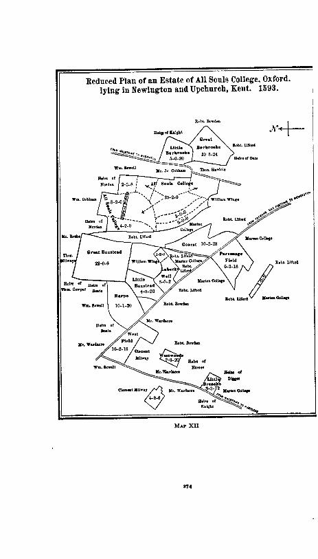
1
Reduced Plan of an Estate of All Souls College, Oxford, lying in Newington and Upchurch, Kent. 1693. I
Rob% Bc"dsm
Robk Lllord
MAP XI1

THE KENTISH SYSTEM 275
Full and convincing testimony to the existence of open-field arable in Kent appears in certain early seventeenth-century surveys relating to St. Margaret a t Cliffe, Guston, Deal, and Sutton, all situated in the southeastern part of the county. A terrier of the glebe of St. Margaret at Cliffe, dated 1645, de- scribes it as lying in 31 furlongs, in each of which were from two to five small parcels, each parcel lying between the lands of other proprietors.' In Limvine furlong, for example, were four separate strips of glebe containing respectively I acre and 22 perches, 3 roods and 10 perches, I rood and 3 perches, 13 acres and 15 perches. An earlier account of 1616 explains that the same glebe " lyeth in severall Shotts or furlongs of land . . . lying intermixed with the lands of the Tenants of the mannor of Reach." Elsewhere we learn that the " manor of Reach doth consist of demesnes and services and lyeth in the parish of St. Margaretts a t Clille neere Dover. . . . The demesnes are of three sorts - Inclosed Lands, Outlands or Dome Lands, and Commons. . . . These open fields and dome do incompasse the inclosed lands and mansion house. . . . " Clearly the so-called " outlands " con- sisted of intermixed arable strips lying in open field.
In 1616 the demesne lands of the manor of Guston near Dover were of " two sortes, Inclosed or lying in parcells in open fielde. The inclosed lands some ly contiguously one to another and the rest lye severed amongst other mens lands." The contiguous en- closed demesne comprised 96 acres; the severed but enclosed, 162 acres; the unenclosed, 38 acres in 18 parcels. Of the tenants' holdings 54 acres were enclosed (whether in contiguous parcels is not stated) and 63 acres lay in 72 parcels in open field, the open ,
fields bearing such names as the Chequer End, the Butts, Church field, and " Le Shott sive Furlong iuxta Banke." ' In contrast with this estate, another reputed " manor called Frith in the same parish was " onely in Demesne . . . and the whole de- mesne lands lye all together in an oblique lyne and no man hath any lands intermixed with the lands of the same manour."
1 Rents. and Survs., Portf. 9/55. Exch. K. R., M. B. 40, f . 47. Ibid., f . 6 (1616). Ibid, ff. z sq. Ibid., f . 14.

276 E,VGLISH FIELD SYSTEMS
Full detail for all tenants' holdings is given in the survey of the manor of Dale, or Court Ashe, in the parish of Deal.' These lay almost entirely in open field. The first tenant had 564 acres in 23 parcels lying in 16 fields: the second 18 acres in 20 parcels in 13 fields, the fourth 259 acres in 18 parcels in 14 fields, and so on. Typical among the field names were Scotten Tyght, Le Chequer, Long Tyght, Woo furlong, West furlong super le Downe, Keetwheet, Goldfrid, and Upland.
In the neighboring township of Sutton, the archbishop of Canterbury's land consisted both of parcels in enclosed fields lying among other men's lands and of parcels in open fields. The open fields were named Pising field, Barley Downe, Chequer end, the Butts, the North end, and the East hill. In them rent-paying tenants also had parcek3
These four parishes, St. Margaret, Guston, Deal, and Sutton, a 1 lie in the high down-lands of southeastern Kent, downs which today are still largely open. The surveys are relatively late, dating from the early seventeenth century. An apparently reasonable inference, then, would be that we are here dealing with stretches of common land somewhat recentlyimprovedand distrib- uted with an attempt s t equity among the several tenants. Yet why subdivide so minutely and separate so persistently ? The glebe in Limvine furlong a t St. Margaret might as well ha+e been one four-acre parcel as four smaller ones, and an eighteenth- century division of a common would have made it such. The actual situation in the survey bespeaks the type of mind which subdivided the fields of the midlands, and suggests that the ar- rangement in Kent was not altogether recent when the surveys were made.
This inference is not without the support of earlier documents. In 4 Richard 11, Thomas Menesse of Dale (in the parish of Deal) granted land as follows: -
In Dale: " una roda terre iacet in campo vocato longetheghe tres rode iacent in loco vocato Dodeham
One parcel contained 18 acres, one 51; the others were small. a Exch. K. R., M. B. 40, ff. 1-2 (1616).

THE KEaVTZSH SYSTEM 277
una roda et dimidia atte Berwhe una roda et dimidia iacent in campo vocato Dode-
ham." In Sholdon: " una roda et dimidia iacent in loco vocato Kete-
wode tres rode et dimidia iacent particulariter in campo
vocato Scholdonesfeld una acra et una roda iacent in duabus parcellis
apud lyden et predicta pastura pro quatuor vaccis iacet in
marisco vocato Collosschepemerch. . . ." l
Since the field names a t Dale also occur in the survey of I4 James I as Long Tyght, Dodham, and Beere Tyght, the conditions of the seventeenth century seem to be carried back to the fourteenth.
I t is desirable, however, to secure testimony from parts of Kent which do not consist mainly of downs. In a hand of Henry VIII is written a survey of Sutton a t Hone, one of the archbishop's manors in the northwestern part of the county, some twenty miles east of London and five miles from the Thames2 The demesne, which comprised 642 acres, was enclosed, but of the 4 2 4 acres held by the freehold tenants a t least 9 3 lay intermixed in 49 par- cels in a half-dozen fields. These fields bore the names Church Down, Southfeld, Northfeld, Battesdene, Bradfeld, Jordanes Croft. Each of the last three was shared by only two tenants, but elsewhere the subdivision was more complex. Southfeld was divided among five tenants holding respectively in acres 2+ in 3 parcels, 63 in 2 parcels, qt in 3 parcels, 14 in 2 parcels, 29) in 12 parcels (the 12 once having been attached to as many as four tenements); Northfeld had four tenants, holding I, a, 2, I$ acres (the last in 3 parcels); Church Down fell to three tenants, whose acres numbered 23, 43 in 2 parcels, and 10) in 9 parcels.
This distribution of a tenant's parcels throughout fields appears quite as noticeably in an early sixteenth-century terrier of the lands of the heirs of William Hexstall, Kt., a t Hoo St. Mary's, a
1 Rawl. MS., B 335 (Reg. Hosp. St. Barth. Dovone). Treas. of Receipt, M. B. 172.

ENGLISH FIELD SYSTEMS
township between the mouth of the Thames and that of the Medway. The 36 acres in question comprised 14 acres adjacent to the messuage, 3 acres of meadow in a neighboring township, and 2 4 small parcels in 18 places which look much like open field.'
Such descriptions from two northern townships suggest that there was a t times in this part of the county considerable sub- division of certain holdings into small scattered parcels, and this aspect of the situation recurs in terriers and surveys of the four- teenth and fifteenth centuries. At Lewisham, near Greenwich, there is twice recorded the transfer of parcels that lay in the same field.2 At St. Mary's Cray and Orpington, also near Greenwich, a conveyance of 40 acres, dated 26 Edward 111, enumerates I I $ acres lying in crofts, I I$ acres '( in diversis parti- culis in campo vocato Burfeld," and the remaining acres in ten other places, several of which are called campi.3 Two instructive charters relative to lands in or near Thanet are recorded in a
1 The distr~but~on was as follows (Rents and Survs , Portf 114) - Acres Roods (Vlrgae) Day's-works ( - & Roods)
In Leyfeld I 9 Cuffeld I5 Tnnrte 1 4
Fadlshawe 1 I 5 Halles I 8 Sporadls 3 Perfeld t 3 Ryfeld I in 3 parcela Barnefeld 3 Newlond I 5 le Skeme I 8 Padpole I I m 2 parcels Menhefeld 8 t Clerkyncroft I 8 t Fedelers 3 5t Greydon 61 Skaalmeston 14 I 6$ ~n 3 parcels
Iuxta Waterlokestret 3
2 In the first Instance there are five acres, of which " una pars lacet m campo vocato Chatefeld In uno loco et a l ~ a pars In eodem campo In a110 loco et tertla pars lacet In carnpo qui cocatur hethefeld 'l
The second grant relates to " una d~midia acra terre in campo qui vocatur Estclune . ate myddelha cum tota terra quam habet In eodem campo Ate gore " (Cott. M S , Otho B;
XIV, ff 79, 81) hlSS of the Dean and Chapter of Christchurch, Canterbury, Lib. B, f 18

THE KENTISH SYSTEM 279
fourteenth-century cartulary of St. Augustine's abbey. In the parish of St. Peter's 19) acres lay in 9 parcels, each located be- tween the lands of persons other than the owner (e. g., " due acre iacent inter terram . . . et terram . . . "). At Chislett 4 acres in 3 parcels were similarly bounded, and other 4 in 4 parcels were assigned to different fields.' Finally, an extended terrier of lands just outside of Canterbury, inserted in a fourteenth- century hand in another register of St. Augustine's, describes six- teen furlongs which constituted the " Tenura de Estber' infra libertatem." In each furlong are parcels, usually of acre to 4 acres, held by various tenants of the archbishop of Canterbury, the prior of Dover, and the abbot of St. Augustine's. There can be little doubt here about the existence of intermixed parcels, or, considering the grouping by furlongs, about the existence of open fields.
This fourteenth-century evidence finds its prototype in thir- teenth-century feet of fines. One of these, dated 21 Henry 111, so describes four acres and four roods in Iwade, near the mouth of the Medway, as to give the impression that they were
1 Cott. MS, Claud. D X, ff. ~oqb, 134b, 162b The last enumeration is as follows. -
" Due acre et una perticata iacent in camp qui vocatur Herste et tres perticate iacent in camp q u ~ dicitur Meredale et tres perticate iacent in loco qui dicitur Calespotle et una perticata iacet in campo de teghe "
Cott MS, Faust. A I, ff orb-106. The following is the allotment of the acres of the first six furlongs (A. A. = abbot of St. Augustine's, P D. = prior of Dover, A C = archbishop of Canterbury). -
In forlan- In forlan- In for~ando In forlando In forlando go be- do by- qul d~c~tur qul dicltur bynorthe In south northe Sharp Uxeaste- Lyt~ldene
8eswey Pesweye nesse crouche Drove
Thornas Rotyng 4 A A John de Gustone 3 r f A A z t P D
z ) A A 3 A A Rlchard Polderne 4 P D
8past P D I P D ztpast P D John de Ber z P D z P D z t P D
I ~ A C 3 4 P D Qukeman de Ber I + A C Slmon Danyel I + A C I A C
Stephen Swanton
I ~ A A
4 past A C I P D I A C
I + I P D P past A C t f 3 P D
t + l P D + A A

2 80 ENGLISH FIELD SYSTEMS
scattered parcels.' More instructive, however, is a fine of 2 0
Henry 111 from Barfreston, in eastern Kent, by which one-half of a carucate, excepting such land as was held in dower by two women. was tran~ferred.~ Several characteristics of this fine are
1 " . unam acram et dimidiam in Sweynesam iuxta terrarn predicti Rogeri unam acram in Longeham iuxta terram Ricardi de Cheteneye unam acram in Clakslond iuxta terram predicti Wyberti dimidiam acram inter domum dicti Kogeri et domum predicti Roberti tres perticatas inter terram predicti Wyberti et Rogeri (Ped. Fin., case 96,
no. 335). 2 Transfer of a messuage and a half+carucate, which comprised
" unam acrarn et tre5 pertic-atas terre que iacent sub dicto mesuagio versus auslrum
et unam acrarn et unam perticatam que iacent inter terram 9saac de Sanwyc et terram Johannis Pent
et quatuor acras et unam perticatam terre et dimidiam versus austrum in campo qui vocatur Bestedune
et unam acram et quatuordecim sulcos qui iacent in medio campo qui vo- catur Bynorthewde
et quattuor acras terre in medio pasture que vocatur northdune et unam acrarn et unam perticatam et quinque pedes terre in medio pasture
que iacet versus Borialem partem de Haggedale et quinque perticatas et sex sulcos terre in campo sub Haggedale versus
austrum et duas acras et unam perticatam et septem pedes terre in pastura versus
occidentem et quattuor acras et quinque sulcos terre versus austrum in campo qui vo-
catur Bisuthewode et tres acras et unam perticatam terre versus austrum in pastura de Litle-
dune et tres acras et unam perticatam et dimidiam et duos sulcos terre in campo
qui vocatur Bromueld quarum una medietas iacet sub pastura de Lit- ledun et altera medietas in medio campo de Bromfelde
et unam acrarn terre que iacet in medio pasture sub bosco de Berefrestone versus occidentem
et tres acras et unam perticatam et dimidiam et quattuor sulcos terre versus aquilonem in campo qui vocatur Langetighe
et unam acrarn et unam perticatam et quattuor sulcos terre in campo qui iacet versus partem orientalem de Langetigh
et unam acram et dimidiam perticatam terre versus a u s t m in campo qui vocatur Steuerlonde
et unam acram et sex suIkos terre versus austrum in Suthfeld et duas perticatas et dimidiam et quattuor sulcos terre versus orientem de
via que vocatur Drove et unam acrarn et tres perticatas e t tres sulcos terre in medio camp0 qui
iacet iuxta c u r b versus austrum

THE KENTISH SYSTEM 28 I
noteworthy. The parcels were not large, ranging from one to four acres and averaging about two acres. Their areas are ac- curately estimated even to " sulci " (furrows). They lay for the most part " in campo," " in medio campi," " in medio culture " (once), '' in medio pasture." l The sulci occur in connection with campi, an intimation that the latter were arable; and, when in one instance it was necessary to estimate a small piece of pasture, this was done in " pedes." The campi can hardly have been con- terminous with the parcels, else why " in medio campi " ? To remove doubt, the fine shows that the 34 acres " in campo qui vocatur Bromueld " were in two parcels, one of them being " in medio campo de Bromfelde." The parcels of arable, then, lay within larger fields, and, although these are not expressly said to have been unenclosed, they probably were so. The terrier establishes the existence in northern Kent, in the thirteenth century, of holdings constituted in part of small non-adjacent parcels of arable.
The descriptive detail of the fine just quoted emphasizes what has already appeared in other terriers and surveys as a Kentish characteristic - the location of the parcels of a holding in a bewildering number of field divisions bearing local names and giv-
et quattuor acras et unam perticatam terre in medio campi qui vocatur Osmundesteghe
et unam acram et dimidiim perticatam et quinque sulcos terre versus aqui- lonem in campo qui vocatur Reteghe
et unam acram et tres perticatas terre in medio pasture de Potynberegh et duas acras terre que iacent versus Potynberegh cum situ unius mo-
lendini et unam perticatam et dimidiam et tres suicos terre in rnedio culture qui
vocatur Shortestiche et dimidiam acram et six sulcos terre versus occidentem hortfurlong et dimidiam acram et decem sulcos terre versus orientem in valle sub Knolle et unam perticatam terre in crofta extra portum versus campum qui iacet
sub Chimyno qui vocatur Drove et tres acras bosci de Berfreston qui iacet versus aquilonem et quintam bestiam cum bestiis predictarum [two women holding in dotem]
in pastura de forestal ante magnam portam curie de Berefreston" (Ped. Fin., case 96, no. 276).
The parcels '' in medio pasture " are puzzling. I t may be that old arable campi were a t the time used as pastures, or it may be that pastures had been allotted among the tenants and that the latter could utilize their parcels by means

282 ENGLISH FIELD SYSTEMS
ing little clue to the husbandry employed. Except that the par- cels were usually small and lay to some extent intermixed with those of other tenants, Kentish arrangements were in contrast with those of the midlands. There was no grouping of parcels into two or three, four or six, fields, with the total areas approximately equal. Nor can it be readily discovered from the surveys thus far noticed whether the parcels of a holding lay to any extent grouped in one part of the unenclosed arable area or whether they were scattered conscientiously throughout it.
Most valuable for determining this point is a survey of Gilling- ham, made in 26 Henry V1 and preserved a t the British Museum in an incomplete nineteenth-century copy.' Gillingham, on the lower Medway near Rochester, has today assumed an industrial character and has lost its early fields. The old survey, however, arranges the tenants' holdings in iuga, and for each of these gives boundaries and area. Since this is almost the only survey which describes iuga by bounding them, a transcription of the first thirteen boundaries is pertinent: -
'( Iugum Foghell incipit ad communem viam ducentem inter Renham et Gyllyngham versus South
ad terram de Renham et ad salsum Mariscum de Gyllyng- ham versus North
et ad terram domine Alicie Passhele versus West et continet illud Iugum xxiii acras.
Iugum Cherlman incipit ad terram heredum Adamari Digges vocatam Wynelyng versus West
ad Regiam stratam ducentem inter Gyllingham et Ren- ham versus South
ad mariscum vocatum Thomas Innyng versus North et ad communem viam ducentem de Berwescrosse ad Twi-
delswelle versus East et continet illud Iugum xxiiii acras iii rodas iii day.
Iugum Fissher incipil ad campum vocatum Bradefeld versus South
of wattles or other temporary enclosures. The phrase " in medio campo " may possibly be a variant of " in medio campi."
1 Add. MS. 33902.

T H E K E N T I S H S Y S T E M 283
ad communem stratam vocatam Twidolestrete ducentem ad Twidoleswell versus West
ad mariscum salsum versus North et ad metas inter Renham et Gyllingham et terram heredum
Thome Gillingham . . . in Iugo Foghell versus East. . . . Duo Iuga Coole incipiunt ad Iugum Fisher ex parte boriali de
Bradfeld versus North ad metas de Renham versus East ad Regiam Stratam vocatam Twidolestrete versus West et ad venellam vocatam Cokkeslane . . . versus South. . . .
Fraunceis ferthyng incipit in venella vocata Cokkeslane versus North
ad croftum Ricardi Mauncer et ad metas de Renham ver- sus East
ad Twydolestreete versus West et ad Iugum Hood versus South. . . .
Iugum Hood incipit ad Fraunceys ferthyng versus North ad Iugum Edweker versus South ad metas de Renham versus East et ad Twidolestrete versus West. . . .
Iugum Edweker incipit ad terram de Renham versus East ad Twidolstrete versus West ad iugum Hood versus North et ad iugum vocatum Raynold versus South. . . .
Iugum Raynold incipit ad metas inter Renham et Gillingham versus East
ad Twydolestrete versus West ad iugum Edweker versus North et ad iugum Gilnoth versus South. . . .
Iugum Gilnoth incipit ad metas de Renham versus East ad regiam viam ducentem inter Roffam et Cantuariam
versus South ad Twydolestrete versus West et ad jugum Raynold versus North. . . .
Iugum Gate incipit ad Twidolestrete versus East ad communem Stratam ducentem inter Eastcourt et Ber-
wescrosse versus North

284 ENGLISH FIELD SYSTEMS
ad communem viam ducentem ad ecclesiam de Gillingham et ad venellam vocatam Snorehelle lane versus South
et ad mesuagium de East court et Scottyssoole versus West. Iugum Petri incipit ad communem Stratam vocatam Ioq~ces-
strete versus West ad Twydolestrete versus East ad communem viam ducentem inter Twydolestrete et
Ioocesstrete versus North et ad iugum Simstan et ad iugum Alreed versus South. . . .
Iugum Simstan incipit ad Ioocestrete versus West ad iugum Alreed versus Est ad iugum Petri versus North et extendit ad Watescroft in Iugo Alreed versus South. . . .
Iugum Alreed incipit ad iugum Petri versus North ad Twiddolestrete versus Est ad Iugum Stimston versus West ad . . . [blank] . . versus South. . . . ,)
The iuga here described were clearly rectangular areas. From "iugum Fissher " to " iugum Gilnoth" they formed a series running from north to south, bounded on the east by the parish of Ren- ham and on the west by Twidolestrete. The next four consti- tuted a similar series lying to the west of Twidolestrete. The iugum here and elsewhere in the survey usually contained aboud 24 acres, although this number might drop to 5 or rise to 132. Sometimes a double iugum occurred, as in the case of " duo iuga Coole," and the fourth part of a iugum might appear as a " ferthing." As to the tenants, the distribution and areas of the parcels of their holdings relative to the first fourteen iuga may be tabulated as shown on the following page.
Few as are these fourteen iuga in proportion to the entire number, the preceding tabulation shows in a measure their rela- tion to the holdings of the tenants. The lands of any person or estate tended to lie in neighboring iuga, whether in few or in many. The estate of the heirs of John Beausitz appears in each of the above fourteen, continues through the following eight, dis- appears for a long time, but reappears toward the end of the survey in some half-dozen field divisions, two of these being iuga.

THE KENTISH SYSTEM 28 5
The heirs of Thomas Gillingham fare in much the same way. Richard Bamme, who is not introduced until we reach the tenth iugum, continues to have an interest in upwards of twenty-five iuga and other areas, his total estate being large. John Digon,
Duo Iuga Fraunceis Name of I w m ........... Foghell Cherlman Fissher Coole Ferthyng Hood Edwcker
............ AreaofIugum' 2 3 0 0 1 4 3 3 1 4 1 1 5 8 3 0 6 0 1 a 4 0 0 2 4 0 5 Heredes Thome de Gillyng- 8311 ' 5 2 0 . . . . . . . . . . . a a o
a m ............... i i l j I 3 o 4 3 0 1 8 o 6
Heredes Johannis Beausitz 9 3 3 a 3 I 14 o I 48 3 7 5 o a aa I 5 19 3 J 2 0 01
John Grenested . . . . . . . . . . . . . . . . . . . . . o I o ... . . . . . . Alicia Hunte . . . . . . . . . . . . . . . . . . . . . . I : 1 I o o I a J I 3 o
. . . . . . . . . . . . Richard Mauncer . . . . . . . 7 3 3 ' . . . . . . . . . . . . Named Iugum.. .......... Rayold Gilnoth Gate Petri Simstan Alrecd Pilgrym h e n 01 I u ~ u ~ ............ l7 0 0 a6 2 9 24 2 21 24 0 118 24 0 3f1 41 3 3' 29 2 3:
HmdesThomedeGiyngharn .... 16 o o I o p f 6 0 5 a o o 13 I 2'
I 2 7 f 1 3 1 f HercdesJohannisBeausitz n o 7 1 0 a 1 { :$} 2 6 ) 3 1 1
1 1 3 3 1 3 6 John Gnnated . . . . . . . . . . . . . . . . . . . . . . . . . . . . . 3 0 0 5 3 0 I .... Aticia Hunte a 0 0 . . . . . . . . . . . . . . . . . . . . . . . . . . . . . . . . ,,l I ....
.... ........ Richard Mauncer a 3 3
Domina Alicia Passhele .. 3 o o .... John Lacy . . . . . . . . . . . . . . . . . . . . . . Richard camme . . . . . . . . . . . . . . . . . Johanna J ave . . . . . . . . . . . . . . . . . . H m d a Johannia h a . . . . . . . . . . John C o h , Sen. . . . . . . . . . . . . . . .
John York ......................
&rrda Johannis Nmte . . .............. W. Mine
&U Ademari D i i . . ............ ohn Harvey h i l b m Zoday .......... .............. ohn Ram k e d a Jobanoia C d e w
' All areas are in acres, roods, and day's works, a day's work being equivalent to one-fourth of a rood.
Includes a messuage. The areas assigned to the last five iuga difler slightly from the sums of the
areas of the parcels in each. A garden.

286 ENGLISH FIELD SYSTEMS
a t first inconspicuous, comes to have in three neighboring iuga 24 acres in 24 parcels and a croft of 5 acres. Most of the numer- ous tenants, however, were like John Colman or John York: they had small parcels in two or three or four neighboring iuga, but none elsewhere. I t is just possible, of course, that such par- cels were contiguous and formed a compact holding artificially divided among arbitrarily drawn iuga. This, however, is unlikely, and in any case the larger holdings have to be thought of as com- posed of parcels to some extent non-contiguous. The survey thus establishes the fact, hitherto obscure, that the parcels of a Kentish holding were not scattered throughout the expanse of the village arable, as under the midland system, but were to some extent segregated in one locality. They did not, however, en- tirely cohere. The field system of Gillingham may, then, be de- scribed as one of non-contiguous, yet of not widely scattered, parcels.
Over i t all rested the network of the iuga, for the rectangular appearance of which this survey is our best source. Whether blocks of such a shape, regularly disposed and of uniform size, served or ever had served an agricultural end, is not explained in this abbreviated document. Other Kentish surveys, hgwever, amplify our knowledge, and an extract from one of the best of them is printed in Appendix V. The description of units, tenants) parcels, and rents shows the same completeness which must have characterized the Gillingham original. Beginning and end are wanting, but the hand is of the early fifteenth century. The townships referred to are Newchurch, Bilsington, and Romney Marsh. Iuga are not mentioned, the units here being " dolae " and " tenementa." The accounts of three dolae (" dola Gode- wini," "dola Storni," " dola de Kyngessnothe ") and of three half-dolae (" dimidia dola Mawgeri," " alia dimidia dola Maw- geri," " dimidia dola de Westbrege ") have been transcribed.
Several characteristics already discerned a t Gillingham re- appear. The dolae are described as abutting upon or lying on both sides of certain highways, a circumstance which implies that they were compact areas; indeed, a statement is sometimes added to the effect that their acres lay " coniunctim." Their size was

THE KENTISH SYSTEM 287
uniform, varying only between 40 and 46 acres. Several tenants shared in each, except in " dola de Kyngessnothe," the whole of which was held by the heirs of Jacob de Kyngessnothe. A ten- ant sometimes had parcels in successive dolae or half-dolae. Adam Osbarn had five parcels in one dola, four in another; the heirs of Richard Pundherst had three acres in one, three and one-half in another, and nine in a third - four parcels in all. So far-as the incomplete survey pennits us to judge, the parcels of a tenant did not lie in many widely separated dolae, but in a few adjacent ones.
Additional information may be got from the extracts printed in Appendix V. The parcels within each dola are named and their areas given. Names usually differed, except that a few parcels are said to have lain "in Holland "; the areas, too, of the parcels were not such as to suggest open-field strips. Both circumstances point to the absence of unenclosed arable, an inference which is the more probable since the region in ques- tion is in or near Romney Marsh. The system of iuga or dolae was therefore consistent with one of plats, whether arable, marsh, or pasture, and hence with one of enclosures. Yet if the parcels were plats or enclosures, they were none the less, in the New- church survey, often non-adjacent. So, indeed, the Newington plan, which has already been reproduced, shows the plats there to have been. Conditions of the late sixteenth century thus find a parallel some two hundred years earlier.
Other peculiarities of the Kentish system we can best discover by noting in connection with the Newchurch extracts the impli- cations of another survey, perhaps the most satisfactory that we have.' I t was made in the early fifteenth century for Thomas Ludlow, abbot of Battle, and refers to the large manor of Wye, situated in the center of the county. Except for its omission of the boundaries and locations of the iuga, it is superior to the Gillingham transcript, and it is more nearly complete and more complex than the Newchurch record.
The description, as usual, proceeds by iuga. At Wye these units varied considerably in area, comprising from 37 to 187
EX&. Aug. Of., M. B. 56, ff. 108-188.

288 ENGLISH FIELD SYSTEMS
acres, the fluctuations being due to the inclusion of greater or smaller quantities of pasture or down-land. The average size of a iugum was from 60 to 70 acres, in contrast with the 24-acre iugum of Gillingham and the 40-acre dola of Newchurch. A description of two of the smaller iuga will be of assistance in drawing general conclusions : -
" Dimidium Iugum de foghelchilde Heredes Johanis Dod tenent in campo vocato Wolvenfeld
ii acras i rodam dimidiam Agnes Broman tenet in eodem i acrarn iii rodas et in
Strongelonde i acrarn dimidiam Thomas Elyndenne tenet de iure uxoris sue in Wolvenfelde
ii acras dimidiam Heredes Johanis Selke de Broke tenent in Strongelonde v
iii acras iii rodas. In crofto vocato Jannescroft de Wy i acrarn terre
Heredes Stephani Tur tenent in Strongelond unam acrarn dimidiam. In Doucerede iii acras et in longecrofte i acrarn dimidiam
Stephanus Dod tenet in Wolvenfeld dimidiam acrarn dimi- diam rodam
Heredes Johanis Selke iunioris tenent in Strongelond ii acras i rodam. In longorcrofte i acrarn et in mesuagio eorum apud Silkenstrete in capite orientali dicti mesuagii iii rodas
Johanes Petycourt tenet apud Gerardesteghile i acrarn terre
Andrus Martyn tenet in mesuagio suo et in Strongelond i acrarn iii rodas
Heredes Simonis German tanner tenent in Clerkescroft i acrarn iii rodas
Thomas Alayn tenet in Selkenbroke iiii acras dimidiam Thomas Kempe tenet in Melcompesmede iii rodas prati
que fuerunt Agnetis Danyel Summa xxxiii acre i roda dirnidia [Rent and services one-half as great as for the following
iugumj."

T H E KENTISH SYSTEM 289
" Iugum de Clyt et Forwerde Hamo German tenet in East walewaye ii acras que fuerunt
Thome Scot Item i acrarn ibidem que fuit Johanis Laghame Item in eodem iii acras que fuerunt Thome de Chityn-
den de Willielmo Barrok Item in eodem i acrarn dirnidiam que fuerunt Simonis
de Tongge Item in eodem iii rodas terre que fuerunt predicti Si-
monis Item in eodem ii acras que fuerunt Johanis Hortone
vocati Cukkow Item in eodem i acrarn terre . . . que fuit Johanis
Westbeche Item in eodem i acrarn terre . . . que fuit Thome
German bocher Item in eodem v acras i rodam terre iacentes in longi-
tudine ad predictam acrarn terre predicti Johanis Westbeche
Item in eodem i acram dimidiam que fuerunt Steph- ani Tur
Summa xix a a e Heredes' Willielmi Mellere tenent in East waleweye sub le
lynche i acram dimidiam Heredes Stephani Tur tenent in Gretefeld i acram dimi-
diam Johanes Peticourt tenet in Eastbrettegh ii acras. Et in
foldenge i acram i rodam Heredes Roberti Man tenent in Eastbrettegh iiii acras Thomas Baldewyne tenet in Westgretefeld ii acras dimi-
diam Heredes Johanis Selke tenent in Eastbretteghe i acrarn
dimidiam. In Gretefelde ii acras. In Westgrettfelde dimidiam acram terre
Gilbertus Baldewyne tenet in Eastbrettegh i acram dimi- &am terre
Summa xxxvii acre i roda

290 ENGLISH FIELD SYSTEMS
Unde de redditu per annum cum viii d. ob. pro tenement0 Gil- berti Forderede ix S. vi d. [at six terms] . . . ad Nativitatem domini i gallum ii gallinas E t [ad] Pascham xx ova. E t tenentes predicti debent pro predicto iugo omnes consuetudines et servicia sicut Johannes de Garde debet de proprio iugo suo de Cokeles- coumbe predicto." l
The concluding phrases, such as are confessedly omitted in the Gillingham copy but occur in connection with each dola at Newchurch, disclose the financial aspect of the iugum. Vary as they might in area, the Wye iuga were alike in the obligations which rested upon them. Rents of assize and services were the same for all. The former were set at 8 S. 93 d. the iugum, with one-half as much for the half-iugum and one-fourth as much for the virgata. The services were not burdensome, comprising little more than the ploughing, sowing, mowing, and reaping of two or three acres yearly by each i u g ~ m . ~ At Newchurch the value of the rent of assize and of the services due from each dola was eighteen shillings. These heavier obligations imposed upon units which were usually smaller than those a t Wye may have been due to a better quality of soil. At any rate, it can no longer be doubted that at the beginning of the fifteenth century the iuga and dolae were primarily financial, not agricultural, units. Whereas several tenants shared in each of them and few tenants werd limited to any one of them, they did have financial unity and .stability. Their midland correspondents were not the furlongs, as the boundaries at Gillingharn might suggest, but rather the virgates or yard-lands upon which, as units, rents and s e ~ c e s were always imposed in the midlands. Dae r as they might in the distribution of their constituent parcels, Kentish iuga and midland virgates were alike to the rent-collector.
l Exch. Aug. Of., M. B. 56, ff. 116, x14b. " Et debet arare ad frumentum i acram et dimidiam acrarn terre domini cum
facto proprio, petere semen ad granariam in manerio domini de Wy, seminare et heraare predictam acram et (imidiam Et debet arare, seminare semine domini ut supra, et herciare i acram et dimidiam acram terre domini ad sementem ordei et petere semen ut supra. Et debet falcare, spa%-, vertere, cumulare, cariare in manerium domini et ad tassum furcare unam aaam prati de pram domini. Et debet meterr, ligare, et coppare in autumpno tmam a c m et dimidii acram de

T H E KENTISH SYSTEM 291
Unfortunately, as was noticed above, the iuga of Wye are not bounded in the survey. To discover whether they were compact areas, as were those a t Gillingham and Newchurch, we have to attend to the field-names used, and even then we can draw conclu- sions only when the names are not too diverse. In the " iugum de Clyt et Forwerde " more than one-half of the parcels and of the area lay in East Walewaye; the remainder was pretty well accounted for by East Brettegh, Gretefeld, and West Gretefeld. Although no statement records that these four areas were contig- uous, i t is probable that they formed a block not unlike a iugum a t Gillingham. Sometimes the place-names within a iugum a t Wye were numerous, certain of them referring to parcels or crofts which fell to individual tenants.' But this circumstance need not conflict with the conception of the iugum as a compact area; i t merely implies that such an area was divided into many parts.
As a t Gillingham and Newchurch, the tenants of each iugum a t Wye were likely to be several in number; the first iugum only was in the hands of a single proprietor. Furthermore, as in the other surveys, a tenant usually had parcels in two or three consecutive iuga; but in its greater concentration of the parcels of a holding Wye resembled Newchurch rather than Gillingham. Typical was the holding of John Baldewyne, whose parcels were situated in three iuga as follows: -
In the half-iugum Mastall, in Weyberghe 2 acres, 13 roods in Tommestowne 3 roods, 8 day's-works in le Berghe 2 acres, 13 roods;
In the one and one-half iuga Chilcheborne, in Chilchebournesfelde 3 acre, 3 day's-work in piriteghe 2 3 acres in Watertoune et in parvo gardino 13 rood;
frumento domini. Et debit xvii averagia et tertiam partem unius averagii per annum. Et debet inde de relevio cum acciderit xl d. Et debet sectam per annum " (ibid., f. I*).
Ten place-names, as we have seen, were connected with the half-iugum of Foghelchilde. Four tenants shared in Wolvenfeld and four in Strangelsnde, but the eight remaining areas, four of which were crofts, fell to individual tenants.

ENGLISH FIELD SYSTEMS
In the half-iugum Amrnyng [specification is only by quality of land],
olim Thome Chiterenden, terra optimi precii, I acre, 3 roods; terra medii precii, I rood
que fuerunt Simmonis de Tonge, terra optimi precii, 34 acres; terra medii precii, I acre; pastura, 259 acres
quondam Gilberti Mogge, terra optimi precii, 3 roods; terra medii precii, $ acre; pastura, 13 acres
que fuerunt Stephani Mogge, terra optimi precii, 3 acre; terra medii precii, 3 acre; pastura, 29 acres
que fuerunt heredum Johanis Mogge et Hamonis Mogge, terra optimi precii, I$ acres; terra medii precii, I acre; pastura, 43 acres.
The " former tenants " here mentioned should be compared with those who appear in the first part of the description of " iugum de Clyt et Forwerde." One-half of this iugum had come into the hands of Hamo German, his ten parcels having formerly been held by nine tenants, only one of whom bore the name of German. Since the names of the former tenants are clearly remembered, the accumulation seems to have come about somewhat recently. From phenomena like this we discover that the situation pictured in the survey was not one of long standing, and perceive that a iugum might come to be transformed from an area shared by many tenants into one held by two or three. Enclosure would readily attend upon consolidation, and by the sixteenth or seventeenth century a county largely enclosed would be a natural result.
If tendencies toward consolidation are discernible in the " iugum de Clyt et Forwerde," none the less were there tenden- cies in the opposite direction. Four of the eight tenants were not individuals but groups, and the group in each case consisted of the heirs of a former tenant. Even if this man's parcel had been not larger than an acre and a half, it passed to his heirs jointly, In the half-iugum Foghelchilde five of the twelve tenants were groups of heirs. Since the situation was not Werent with the other iuga a t Wye, the actual tenants there must have been
Cf. above, p. aBp.

THE KENTISH SYSTEM 293
far more numerous than are the entries of the survey. At Gillingham and Newchurch, too, the heirs of a defunct tenant frequently appear as his successor. In the half-dola of West- brege the only tenants were three such groups. The custom of transmitting a holding to all the heirs of a tenant rather than to one of them is of course the distinguishing feature of the Kentish tenure known as gavelkind. This usage was in marked contrast with that of the midlands, where the virgate or fractional virgate of a customary tenant passed intact to a single heir or to a new tenant. The antiquity of this Kentish custom, so unusual and so frequently perceptible in the fifteenth century surveys, now deserves consideration.
In tracing the earlier history of the iugum much depends upon nomenclature. One of our most valuable documents at this point, since it admits of comparison with the fifteenth-century survey, is a Wye rental of 5 Edward 11, which records the tenants of all iuga and the rents accruing from them.' On examination we discover that the names of the iuga are practically the same as in the survey of 150 years later, and that the surnames of tenants are frequently unchanged. In the half-iugum Coklescumbe the heirs of John Hughelyn are tenants in the earlier rental, Simon Hoghelyn and Johanna Hoghelyn in the later survey. While surnames often thus persist in the same iugum, there is also a tendency for them to shift from one iugum to another. In the rental, " Gilbertus Dod et Simon Dod tenent iugum de East- chilton pro Willelmo de Chiltone "; in the survey, tenants by the name of Dod are found in half-iugum Coklescumbe, in iugum Waleweye, and in half-iugum Foghelchilde.
A peculiar merence between rental and survey lies in the fact that in the former the tenants, whether few or several, hold " for " (pro) one or more persons. The two Dods held " for " W i a m de Chiltone. The one-and-one-half iugum Chelcheborne is held " pro " Hugo Mogge and " Walter de Chelcheborne et socii " by Richard de Coumbe, Richard de Broke, Stephen Re- mud, the heirs of Williarn de Chilcheborne, Gilbert de Chilche- borne, Stephen Baldewyne, William Mogge, Richard Mogge,
' Exch. Aug. Of., M. B. 57, ff. 95-105.

294 ENGLISH FIELD SYSTEMS
Adam Mogge, and Robert " filius Alain Mogge." This is an elab- orate process of sub-letting, both tenants and sub-tenants being many. In the fifteenth-century survey only one group of ten- ants, presumably the old sub-tenant group, is referred to.
The significant feature of the rental, however, is the similarity between the names of the iuga and the names of the tenants (not sub-tenants). The tenant of the iugum East Chilton is William de Chiltone. Similarly, " Hamo pistor tenet iugum de Wyther- stone pro Gilberto de Wytherstone," and " Thomas de Brones- ford tenet iugum quod vocatur Aula de Bronesford." The one-and-one-half iugum Cukelescumbe is held by several sub- tenants for a group composed of Walter de Cukelescumbe, the heirs of Hugo de Cukelescumbe, and the heirs of "Radulfus molendinarius et socii." Thus, so far as names are concerned, the tenants of the iuga stand a t times in intimate relations with the iuga themselves. With the sub-tenants' names, naturally, such is not the case. In the later Wye survey, too, where we are dealing only with actual holders, who correspond to the former sub-tenants, little similarity between surnames and the names of iuga is to be expected; and, indeed, the matter of nomenclature is there of little importance.
The identity between surnames of immediate tenants and names of iuga in the rental of Edward I1 has noteworthy impli- cations. I t might seem that the tenant a t times got his name from the iugum rather than the iugum from the tenant. Hugo de Cukelescumbe, Walter de Chilcheborne, Gilbert de Wither- stone, William de Chiltone, are tenants of the iuga whose names they bear. Yet even in these instances it is probable that the personal name was originally derived from some place-name older than that of a iugum a t Wye. On .the other hand, there can be no doubt that several of the names of the Wye iuga were derived from personal names, and in one instance we can see this happening. Two sub-tenants confer their names upon the iuga which they hold. In the rental Gilbert Dod and Simon Dod held the iugurn of East Chilton for William de Chiltone; in the survey this iugum appears as one of the " duo iuga de Doddes que vocantur Gerold et East Chilton." Other iuga in both rental

THE KENTISH SYSTEM 295
and survey are obviously designated by personal names. Such are " iugum Willelrni de lewte et Stephani de Chiltone," '' dimi- dium iugum Orgari pistoris," " iugum [Stephani] Bard et Neel," " dimidium iugum de Bisshop," " dimidium iugum de Knottes et Someres." In the Newchurch survey the dolae bore the names of Godewin, Mawger, and Storn. Since iuga and dolae therefore sometimes came to bear personal names, we may at once inquire what this implies.
If a person gives his name to a certain area of land or even derives his name from it, that land is presumably his own in some more or less intimate sense. The dola named from Godwin and the iugum named from Stephen Bard must a t one time have been in their occupation or ownership. A clue to the interpreta- tion of the Wye evidence from this point of view is to be had in a still earlier Wye rental, one from the days of Edward I.' Although it is merely an enumeration of payments and of the persons responsible for them, the names of the latter, we discover, are names later borne by the i ~ g a . ~ Most significant is the frequency with which the persons answerable for rents appear as groups of heirs. Where documents of the fourteenth and fifteenth centu- ries speak of " iugum de Clyt et Forwerde," the rental states that the " heredes Cliteres " and the " heredes Forwerd " pay 74 d. Where in the later records we have been wont to hear of the half- iugurn Foghelchilde, we learn from the early rental that the " heredes Foghel " pay 3f d. In short, the rental transports us to a time when most of the iuga were, to be sure, not in the hands of their eponymous tenants, but in the hands of the heirs of such tenants. I t is a period antecedent to the two stages pictured by the later rental and the still later survey. Back of i t is yet an earlier period, the existence of which seems guaranteed by the use of the term '' heirs "; for, if the heirs of a tenant hold a parcel of land, the tenant in question must once have held it either for himself or as representative of his family group.
S. R. Scargill-Bird, Cwtumals of B& Abbey (Camden Soc., 1887), pp. 101- 136.
In a half-dozen instances, iuga, not persons, are named as responsible for the payments.

296 ENGLISH FIELD SYSTEMS
Four stages in the history of the iuga at Wye thus emerge. At a date still undetermined each iugum or half-iugum was attributable to a single tenant, who either gave it his name or, if it already bore a topographical designation, possibly took his name from it. By the end of the thirteenth century it had passed to his heirs, who held it as a group of CO-tenants. In the first half of the next century these heirs were distinguished from another group of tenants who held for (pro) them, but whose members had to only a slight extent the same surnames as the group of heirs. By the fifteenth century one group of tenants alone re- mained, and their names have scarcely any connection with the names once traditional in the iugum. To how small a degree the interests of these last tenants were bound up with the iugurn is shown by their acquisition of parcels in other iuga as well. The history of the iugum was therefore one of continuous subdivision and reapportionment, largely due to the practice of transmitting landed property to groups of heirs, who in turn at times sub- let it.
The effect of such a history upon the appearance of the iugum can be conjectured. Division among CO-heirs probably involved giving to each his share of the several qualities of land within the iugum. In the fifteenth century the half-iugum Ammyng gave no names to its parcels, but grouped them as " terra optimii precii, terra medii precii, et pastura." Since allotments of different quality must frequenily have been non-contiguous, the tenants of a subdivided iugum would find their holdings consist- ing of scattered parcels. But neither in this condition nor as a compact block before subdivision can the iugum have been fitted into the framework of the midland system. Had the arable of the township been divided into two or three large fields, the iugum as a compact area would in a particular year have been either entirely fallow or entirely sown. That fifteenth- or even thirteenth-century Kentkh holdings consisted of scattered parcels does not, therefore, imply midland husbandry. One must re- member, too, that the parcels of the iugum might be meadow or pasture as well as arable, they might be open or enclosed. Only
l Cf. p. 292 , above.

THE KENTISH SYSTEM 297
one approach to the aspect of the midland system do Kentish '
postulates allow. If in the case of the arable CO-heirs or co- tenants a t times devised some system of cooperative ploughing, there may have arisen within a iugum something resembling a midland furlong. But such a furlong did not combine with other similar ones to form two or three large fields.
With the key to Kentish field arrangements above given, the interpretation of early charters becomes simple. The scattering of parcels is explicable; i t was, indeed, normal. The multiplicity of names arises from a reference not only to the field divisions of one iugum, but in all probability to those of two or three iuga. The varying areas of the parcels are appropriate to Kent as they would not be to the midlands, and the small size of most of them was a natural outcome of more or less frequent subdivision. Parcels might or might not assume the appearance of arable strips, according to the tenants' attitude toward cooperative ploughing. Apparently they did practice this on the down-lands of the southeast. In general, then, a fourteenth- or fifteenth- century map would show the parcels of a holding as a network of non-contiguous plats or strips often considerably segregated in one part of the township's area. In its primary methods and results the Kentish system was not unlike the Scottish or the Irish; transmission to CO-heirs or CO-tenants wrought similar effects in each case. The difference lay in the original units. In the Celtic countries it was the entire township which was first subjected to subdivision; in Kent, i t was the smaller iugum or dola.
No conjecture has yet been hazarded as to when the iugum or dola was in the hands of the tenant with whose name i t came to be connected. Since iuga are Domesday units, they must have antedated the Conquest. Yet most of the names which they bear are later. At Gillingham the personal names Fissher, Hood, Pilgrym, have no flavor of antiquity. At Wye, in the earliest rental, many of the list seem to be from Norman England. Such are Gilbertus de Wythereston, Willielmus de Pirye, Roger et Juliana de Rengesdon, Radulphus molendinarius, Richardus Besant, and many others. A few names, however, suggest

298 ENGLISH FIELD SYSTEMS
Saxon or Danish connections, and these are significant. There was a "iugum Wlstani" and a " iugum Orgari"; a t Newchurch the dolae bore the names of Godewin, Mawger, and Storn. Apparently iuga and dolae had once been in the hands of Saxons or Danes but had been largely appropriated by victorious Nor- mans, who thereupon allixed to them Norman names and trans- mitted them by tenure of gavelkind. What we should like to discover is whether, before the Conquest, the units had been thus transmitted and whether therefore there had been several tenants of a iugum or dola. To judge from nomenclature alone, one might assume that there had not, that Wlstan, Orgar, Storn each held an undivided tenement. But we know too little about the transmission of socage holdings in pre-Norman days to maintain that one son inherited to the exclusion of his brothers.' The individual Saxon name attached to each iugum or dola may have been that of the head of a family group and the group may have held the tenement collectively without formally dividing i t - a parcel of folk-land. We must thus be content with consigning the Kentish iugum, as a compact rectangular area of from 25 to 60 acres, into the hands of a single Saxon or of a Saxon family, by whom it was cultivated without thought of any two- or three- field system.
In order that the system may the better be traced outside the borders of the county, a word should be added regarding other Kentish units of land-holding. In the first place, the iugum had its subdivisions, the fourth part having already made its appearance a t Gillingham under the name of " ferthing." At Wye the same fraction was called a virgate, and a " virgatam Throfte, vocatam Throfteyerde, continentem L acras " was bounded as one block. Farther on we learn that i t paid only one-fourth of the usual relief, " sicut de quarta parte unius iugi." At Sceldwike there is mention of a " dimidia virgata terre " from which 5 1 acres are granted away, and a t selling there was an agreement l' de tribus iugis terre et una virgata." At Eltham
l Cf. below, p. 304, n. I. * Exch. Aug. Of., M. B. 56, f . 136.
Archueologiu Canliena, i. 262 (Ped. Fin., 10 Rich. I), iv. 308 (8 John).

THE KENTISH SYSTEM 299
virgates entirely superseded iuga as rent-paying units, the villein tenements amounting to 28s virgates of 7f acres each.'
This connotation of the term virgata, a word often found in descriptions of Kentish land, is, however, unusual. Elsewhere in ~ e n t $ h documents virgata meant a rood, or the fourth part of an acre. Three virgatae, for instance, equalled " una dimidia acra . . . et una virgata," and seven virgatae equalled " una acra et tres virgatae." Such is nearly always the significance of the term in charters and survey^.^
In some places the larger (' sulung " persisted as the rent- paying unit, without any reference to iuga. So late as 30 Henry V1 the arrangement in Thanet was that 50 tenants held Mer- gate " swyllung " of 210 acres, while 13, 10, 20, and 15 tenants held respectively the other sulungs of Savlyng, Westgate, Syan- kesdon, and Her tesdo~ne.~ All sulungs contained 210 acres except the last, which comprised only 146. At Estrey details are given about the four " sullinga " and the services due from each in a roll written in a hand of the thirteenth century and said to be " de novo compositus sed ab antiquo rotulo abstractus." Of these sulungs, each containing about 200 acres, the first is described as follows: " In sullunga de Ruberghe sunt ccv acre unde Willielmus de Ruberghe tenet xlv acras et Willielmus Iuvenis et socii sui Ix acras et Ricardus cyece et socii sui lx acras et Stephanus filius Normanni et socii sui xl acras." From this i t seems likely that the sulung consisted of contiguous blocks of land, and it is clear that one man was often put a t the head of his " socii " as responsible for some 60 acres. Other Christ- church manors a t the end of the thirteenth century were assessed by sulungs. In the manor of Ickham we find four of them.' Again, "apud Monkton sunt xvii swolung de Gavilykind," each
Archaeologia Canliana, iv. 311 (Inq. p. Mort., 47 Hen. 111). Rawl. MS., B 335, f. 54,9 Edw. 11.
a Cott. MS., Claud. D X, f . 123 .
E. g., Ped. Fin., case 95, no. 133, 11 Hen. 111: " De dimidia acra terre et una virgata et dimidia."
MSS. of the Dean and Chapter of Chnstchurch, Canterbury, Reg. St. Augus- tine's E xix. f. 18~b.
Ibid., Roil E, 184a. ' Ibid., Lib. J, f. lob.

ENGLISH FIELD SYSTEMS
rendering yearly 2 0 S. " de mala " and 13 d. the acre " de gablo." At Adisham there was a tendency to use the term generally - to speak, for example, of 36 acres " de Swylenglonde " in Pedding (a field name) held by six tenank2 Certain manors of St. Augustine's were in the thirteenth century divided into sulungs. At Chislet, "'Hec sunt consuetudines . . . scil. de quinque su- linges et dimidia "; and a Littlebourn rental begins, " Apud Sircham habetur dimidia sullung de c acris et debet de qualibet acra I d. de gablo."
Alongside these definite units, the sulung, the dola, the iugum, and the quarter-iugum called virgata or ferthing, there is one less definite, the " tenementum." I t appears in the Wye survey. Following the list of iuga are many tenementa, each containing from 60 to 70 acres, each paying a considerable rent (e. g., 15 S .
9 d. from 70; acres) and doing ploughing, reaping, and mowing services much as did the iuga. Iuga and virgatae sometimes appear among them, and like the iuga they comprised parcels held by different men. It seems natural to infer that this second part of the rental describes lands improved or assessed more re- cently than were the old iuga, and a t a time when there was a tendency to abandon the ancient term for a new one. This conjecture is strengthened by a fourteenth-century custumal of Eastry; which is detailed enough in its field names to admit of comparison with the earlier one of the thirteenth century. I n the later roll the term sulung, the basis of assessment in the first, does not appear, and the same lands are grouped under new and smaller units called tenementa, for each of which there are many tenants. In Eastry the sulung seems to have broken directly into tenementa without reference to iuga; in Wye the tenements took their places beside the iuga.
One other unit, more distinctively Kentish, should be noticed. This is the "day's work," often abbreviated to "day" or "dai." In the survey of Wye neady all parcels are given in acres, roods,
MSS. of the Dean and Chapter of Christchurch, Canterbury, Reg. St. Augus- tine's E xix. f. xb.
9 Ibid., f . 21b. T o t t . MS., Faust. A I, ff. 56, 120. 4 MSS. of the Dean and Chapter of Christchurch, Canterbury, Roll E, 188.
Cf. above, p. 299.

THE KENTISH SYSTEM 3 0 1
and days. The days seldom exceed ten, and a comparison of items leads to the conclusion that ten day's-works constituted one rood. The smallest Kentish unit of superficial land measure was thus not the pole or perch, but the equivalent of four poles.
Of the five units above described three were certainly not widespread in England, at least under these names. The sulung, the iugum, and the day's-work are not often mentioned outside of Kent, and hence may without great inaccuracy be called Kentish. The appearance of any of these names elsewhere will suggest the Kentish system.' The terms tenement and virgate are of course common, but the connotation which they had in Kent is, for the virgate a t least, distinctive.
In default of accessible documents, the methods of tillage em- ployed by manorial tenants in the open fields of mediaeval Kent are not easy to ascertain. There is, however, no reason to think that the demesne may not a t times have lain inter- mixed with the tenants' land,2 as it often did in the midlands. If such were the case, the record which we have concerning the tillage of demesne lands may to some extent be representative of methods of tillage in general. In any event, it will disclose the fact that in fourteenth-century Kent certain arable lands were tilled more continuously and with better results than were similar lands in most other parts of England.
Evidence regarding the tillage of the demesne can be drawn, as heretofore, from the extents contained in the inquisitions post mortem, especially in those of the late thirteenth and early four- teenth centuries3 These documents make i t clear that in the midlands the average annual value of an acre of arable which was left fallow every second or third year was from 4 d. to 6 d., with an occasional drop to 3 d. and a rise to 8 d. In Kent the percentage of the arable left fallow and the annual value of an acre did not a t times greatly differ from this. At Hothfield, in 12 Edward 111, 80 acres from a total of 200 were untilled, and 6 d. is stated to have been the average annual value of an acre.' Elsewhere, while
This is less true of day's work (cf. p. 228, n. 2).
Cf. above, p. 27 j. a Cf. above, p. 46. ' C. Inq. p. Mort., Edw. 111, F. 56 (I), 17 July, 12 Edw. 111, Hothield: " Sunt
ibidem cc acre terre arabilis que valent per annum c S. praetium acre vi d. De

302 ENGLISH FIELD S Y S T E M S
the area sown was about two-thirds of the total, the part left fallow had a distinct value as pasture, presumably because i t was enclosed. At Throwley, for example, the I I O acres that were sown from a total of 160 were each valued a t 6 d., but the re- mainder bore pasturage worth 2 d. the acre.' Similarly, a t Brabourn the demesne arable when sown was worth 6 d., but when unsown the pasturage of each acre was worth 3 d. from Easter to All Saints2
Most interesting and most significant, however, are the some- what numerous Kentish manors on which in the middle of the fourteenth century all the acres of the demesne were sown yearly, - " possunt seminari quolibet anno." They were so sown on nearly all the manors of Giles de Badlesmere in 12 Ed- ward 111. Under these conditions the value of an acre often became 12 d.3 Occasionally i t did not rise above 6 d. or 8 d., but this was in the down-country of the east.* Such annual tillage of the entire demesne, with the resultant high valuation per acre, is a circumstance very unusual for the fourteenth century. I t was seldom to be met with outside of Kent, but was there a normal concomitant of the flexible field system which the surveys of the county have shown us. In a region in which i t was generally known that much land could be sown yearly, and in which there
quibus seminabantur hoc anno cxs acre ante mortem dicti Egidii et residuum iacet ad warectam."
' C. Inq. p. Mort., F. 65 (IT), 21 May, 15 Edw. 111, Throwley: " Sunt ibidem clx acre terre arabilis que valent per annum quando seminantur iiii li. pretium acre vi d. et quando non seminantur pastura cuiuslibet acre valet ii d. De quibus seminabantur ante mortem predicti Willielmi de semine yemali et quadragesimali cx acre."
Ibid., F. 45 (24), II Edw. 111, Brabourn: " Sunt ibidem cccxlii acre terre arabilis in dominico que valent . . quunl seminantur pretium acre vi d. E t quum non seminantur pastura cuiuslibet acre valet a festo Pasche usque festum Omnium Sanctorum iii d. Et a predict0 festo Omnium Sanctorum usque festum Pasche pastura earundem nihil valet quia nihil vendi potest."
Ibid., F. 56 (I), 3 July, 1 2 Fdw. 111, Badlesmere: " Sunt ibidem ccc acre terre arrabilis que valent per annum KV li. pretium acre xii d. et possunt quolibet anno seminari et seminabantur hoc anno ante mortem predicti Egidii." So too, with difference of areas, was it a t Chatham, Kingston, Tong, Sibton, Wilderton. At Erith there were 243 acres of " terra arabilis in marisco" worth 3 S. the acre, and 68 other acres of arable worth 20 d. the acre.
E. g., a t Chilham 8 d., a t Ringwold 6 d., a t Whitstable 6 d. (ibid.).

T H E KENTISH SYSTEM 3 0 3
was no system of two or three open fields, agriculture appears to have advanced more rapidly than elsewhere in England.
We are at length in a position to summarize the characteristics of the Kentish field system. In part they are negative. The arable fields of a township were not divided into two or three large areas in each of which all virgate or bovate holders had strips and one of which was usually left fallow. On the contrary, all the improved land of the township was marked off into more or less rectangular areas called iuga, dolae, or tenementa, all serving as units for the assessment of rents and services. If an actual fifteenth-century holding be considered, it appears that the constituent parcels did not lie consolidated within any iugum. Instead, they were likely to be scattered throughout several iuga, but through those which lay mainly in one section of the township. This situation seems not to have been the original one, but to have arisen from the subdivision of a once compact holding among CO-heirs or CO-lessees. The acquisition by many of these new tenants of parcels in other iuga gave rise to the dis- creteness which the fifteenth century knew. The parcels at that time were arable, meadow, or pasture; and so far as they were arable and were ploughed by a large cooperative plough they may well have been strips like those of the midlands. On the downs in the southeastern part of the county such have been discerned. The rotation of crops was variable, sometimes resembling that of the midlands, but frequently tending toward an unbroken succession. The absence of a three-course rotation, and espe- cially of a large compact fallow field, made easily possible the reconsolidation of scattered parcels as soon as the tide turned in that direction. I t apparently did so turn from the fifteenth century, and hence Kent early became characterized by the con- solidation and enclosure of its farms.' Toward this enclosure the flexible field system contributed in no negligible degree.
How ancient was the custom of subdividing holdings among heirs is not altogether clear. I t was observed a t Wye in the time
1 The persistence of a heavy four-horse plough did not prevent enclosure, since Boys in his report to the Board of Agriculture notes both phenomena (General View of the Agriculture of the County of Kent, pp 21, 41, 44, 70).

3 O 4 ENGLISH FIELD SYSTEMS
of Edward I, when the heirs appear in most cases as descendants of Normans. Yet a few iuga there derived their names from Anglo-Saxons or Danes - an indication that in some sense the iuga were before the Conquest connected with individuals. Whether the Anglo-Saxon tenant held for himself or for his family group must be left undetermined. If the latter relation- ship was the existent one, the custom of gavelkind is carried back to pre-Conquest days.' However this be, the Kentish system, in the subdivision and reconsolidation of its holdings, was not unlike the Celtic. I t was in the size and shape of their respective units that the two systems differed. The iugum of the one was rectangular and relatively small, the townland of the other irreg- ular in shape and larger. An explanation of these facts and of the origin of the Kentish system will be hazarded in a concluding summary and synthesis.
' Maitland remarks that there is no reason for assigning the body of Kentish custom characterized by tenure of gavelkind to a period earlier than the Conquest. Elsewhere he notes that the Kentish villani of Domesday Book seem not particu- larly distinguished from those of other counties among whom a system of impartible successions may a t that time have prevailed. (Pollock and Maitland, History of English Law, zd ed., Cambridge, 1898, i. 187; ii. 272, 263).

CHAPTER VII I
EIGHTEENTH-CENTURY survivals of open field in East Anglia offer suggestions about the character of the field system that once prevailed there, and this information is considerably amplified by sixteenth-century surveys. With the key thus secured earlier and less detailed data can be interpreted.
Enclosure awards from Norfolk drawn up after 1750 show little surviving open arable field, and those from Suffolk almost none. The plan and appendix prepared by Slater to illustrate parlia- mentary enclosures in the northern county convey a wrong im- pression.' Relying as he did upon the acts which authorized the awards, he failed to perceive a peculiarity of Norfolk procedure. For it came to be customary in the county, even when there was but little open arable field within a township, to ask for a nominal re-allotment of the entire township in order to obviate any per- sisting common rights and to establish authoritative titles to ownership. This procedure comes to light through a comparison of certain enclosure awards with nearly contemporary maps and surveys of the same townships made by W. J. Dugmore in 1778.~ Relative to Weasenham All Saints, Weasenham St. Peter, and Wellingham, the enclosure award of 1809 declares that " all lands and grounds in the said several parishes . . . do con- tain by measure 4406 acres," and this amount is forthwith allotted. One might conclude that all or much of the area in question was open field, were i t not that the earlier Dugmore map reveals a t Weasenham only 421 acres of open arable field (in 337 parcels) and a t Wellingham only about 50 acres. The Sparham and Bil-
l English Peasantry, pp. 197, 215, 290. He remarks that after 1793 the acts fail to make mention of areas.
The Dugrnore maps, which were drawn for Thomas W. Coke, Esq., are among the Hokham MSS., and the awards referred to are either in the same collection or at the Shire Hall in Norwich.
305

306 ENGLISH FIELD SYSTEMS
lingford enclosure award of 1809 allots almost all of the 3533 acres which constitute the two townships, but the Dugmore map shows that not more than one-sixth of this area was in open field.' Although the entire parish of Longham containing 1286 acres was the subject of the enclosure award of 1814, the map of 1778 shows i t already enclosed except for some twenty-one strips of open field which contained less than 50 acres. Finally, the Warham award of 1813, which announces that the entire parish of 2303 acres is to be divided and allotted, should be interpreted in connection with a map of 1712, in which one-half of the parish is seen to be already en~losed.~ Because of this aspect of parlia- mentary enclosure in Norfolk, any inference as to the amount of arable open field existent there after 1750, so far as it is based upon parliamentary petitions and acts, is untrustworthy.
Nor, indeed, is it possible to get from the awards themselves very accurate information on this subject. The plans, which alone are useful, are so intent upon the new allotments as only occasionally to indicate by fine lines what the old arrangements were. In a general way, however, the existing enclosures left unchanged in an award can usually be distinguished by their irregular, more or less quadrilateral shape. To judge from them, it appears that a t times hardly any open-field strips remained, the award evidently having been made in order to abolish certain rights of common which might still be claimed over enclosed land.$ The phraseology of other awards makes i t difficult, if not im- possible, to determine how much of the area actually affected by them was waste and how much was arable.' Under these cir-
1 About 125 acres in Sparham and from 400 to 500 acres in Billingford. 2 The Warham map of I 71 2 is a t Holkham Hall. Qmong such awards are those relating to Great Walsingham, Little Walsing-
ham, and Houghton (1812)~ Mileham and Beeston (1814), Gresham and Sustead (1828), all a t the Shire Hall, Norwich. A similar award relative to Winforton, Herefordshire, has been need above, p. 140.
The preamble of the Wmtton award of 1813 declares that it is concerned with 394 acres of " open and common fields, fens, commons and waste lands." Each allotment, however, refers more accurately to " commons, fens, and waste lands," while the plan shows that the area in question was unimproved land on the out- skirts of an enclosed township. The Wymondham award of 1810 notes that the " lands and grounds directed to be divided, allotted, and inclosed contain 2285

THE EAST ANGLZAN SYSTEM 3 O 7
cumstances an examination of all the available awards and plans, such as has been made for Oxfordshire and Herefordshire and such as here too would be the only safe basis for a generalization, promises an unsatisfactory return for a great expenditure of labor. If undertaken, it would, we may safely surmise, show few townships with so much as one-third of their improved area still in open field, and in most townships the fraction would be less than one-tenth.l William Marshall's description, written in 1787, supports this view. I t runs as follows: "Some remnants of common fields still remain; but in general they are not larger than well-sized inclosures. Upon the whole. East Norfolk a t large may be said to be a very old-inclosed country. . . . [The] few common fields [left] . . . are in general very small; ten, twenty or thirty acres; cut into patches and shreds of two or three acres, down to half an acre, or, perhaps, a rood each. . . . Towards the north coast some prettyextensive common-fields remain open; and some few in the southern Hundreds."
If it be true that Norfolk arable fields were very largely en- closed without the aid of parliamentary act, the period at which the process took place most rapidly becomes a matter of interest. The subject cannot here be adequately discussed, but the testi- mony of one or two groups of documents may be noted. Sixteenth- and early seventeenth-century surveys, of which there are several from this county, concur in representing the
acres." A schedule denominates 1931 acres as " Total com. Allots." and 351 acres as " Total Field Allots." Only from the excellent map do we discover that the 1934 acres were the old enclosures, and that the 351 acres were parcels on the outskirts of the township looking very much like waste land. Both these awards are at the Shire Hall, Norwich.
The common field a t Fellbrigg before its enclosure in 1771 was, according to the reporter to the Board of Agriculture, unusually extensive. He remarks that the township had remained time out of mind in the following state: 400 acres inclosed, 400 common field, 100 woodland, 400 common heath (Nathaniel Kent, General triez-*, of the Agriculture of the County of Sorfolk, London, 1794, p. 23). Relatively large was the expanse of open arable field a t Ormesby, where in 1845 it amounted to 700 aeres, in contrast with 1464 acres of old enclosures and 521 acres of roads and commons. At LiTeasenham and Wellingham about 500 acres were in 1809 un- enclosed in townships comprising an area of 4406 acres.
The Rural Economy of iVorfolk, comprising the Management of Landed Estates and the Presefzt Practkce of Husbandry in that Counly (London, 1787)~ i. 4, 8.

308 ENGLISH FIELD SYSTEMS
open fields as still mainly intact.' Considerable enclosing there- fore took place a t some time between 1600 and 1750. How much of i t occurred before 1714 may be in part discerned from a summary of the plans of nineteen estates lying in a somewhat larger number of townships in the central and eastern part of the county and belonging to St. Helen's, the Boys', and other hospitals in Norwi~h .~
I t will be seen that about eighty per cent of the total area of these estates was enclosed when the plans were made; but whether most closes had arisen through encroachments upon the open fields may be doubted, since in nine estates all or a part of them bordered upon the respective common wastes. In those estates, however, in which enclosures from the waste play a smaller part, the open and enclosed areas nearly balance each other. In the Trowse and Bixley property of 58 acres the area of the scattered enclosed plats was 34 acres, that of the open-field strips 24 acres; in the Buxton estate there were 20 acres enclosed, 18 open; a t Shropham, the open-field strips seem to have contained about the same number of acres as the scattered closes, neglecting enclosures from the common; at Snitterton unenclosed strips predominated. In general, then, it is possible that not more than one-half of the open arable fields in the region round Norwich had been enclosed before 1714.
The method followed in bringing about enclosure before this date was the piecemeal one described by Nathaniel Kent a t the end of the eighteenth century and still employed a t that time.3
Certain of these surveys are referred to below (p. 313 sq.) in the discussion of field arrangements. Corbett, describing the open fields of six Norfolk villages, infers that in four instances enclosure had affected not more than one-half of the arable and in the two others much less than this (" Elizabethan Village Surveys," P. 87).
Cf. p. 309. These plans, which are among the Norwich records kept in the castle, were made known to me through the kindness of J. S. Tingey, Esq.
" There is still a conderable deal of common field land in Norfolk, though a much less proportion than in many other counties; for notwithstanding common rights for great cattle exist in all of them and even sheep walk privileges in many, yet the natural industry of the people is such, that wherever a person can get four or five acres together, he plants a white thorn hedge round it, and sets an oak a t every rod distance, which is consented to by a kind of general courtesy from one neighbor to another " (General V+w of the Agriculture of Norfolk, p. 2 2 ) . William

T H E EAST ANGLZAN SYSTEM 309
Enclosed Open Field
TOW.... ...,.-+-p in Acres Parcels ln Acres Parcels
..
7 . .
. .
. .
. .
. .
. .
20
2
I
4 2
3
2 0
8
23
Heathell. . . . . . . . . . . . . . .
Trowse . . . . . . . . . . . . . . . Morley . . . . . . . Swanton
. . . . . . . . . . . . . . . . . . . . . . . I . . . Forncett . . . . . . . . . . . . . .
...................... Cr ingleford . . . . . . . . . . . .
Alborow ..............
Trowse andBixley.. . . . .
Hellington ............
CalthropeandWoolverton
Sprowston . . . . . . . . . . . . .....................
Shipham . . . . . . . . . . . . . .
A compact area near t6e 1 . . common.
Non-contiguous parcels. 8 1
Buxton, Haveringham,
Great Melton ..........
Sallows and Wroxham . .
. . . . . . . . . . . . . . . . . . Shropham
176
19 73
83
85
139
34
164
94
13 97
70
A compact though clop-
gated area. compact a....
A compact area near the common.
A compact area. .................... One
another of three. An elongated area twice
broken by tongues of land.
Six non-contiguous par- cels.
A compact area adjoining the common.
Four non-adjacent par- cels.
Two non-adjacent closes. A compact area adjoining
the common. Threenon-adjacentblocks
2 2
8 13
14
1 2
4 5 7
2 0
10
24
19
2
18
. .
. .
. .
. .
. .
. .
24
3
3
8 14
5
S n i t t e r t o n . . . . . . . . . . . . . 1 8 6 F o u r c 1 o . e s i n t h e
S t r a t o n . . . . . . . . . . . . . ~ ~ . t h e . e l d a n d . v e
71
I 19
. . . . 18
9
26
. ...
1 adjoining the common.
11
. .
com- mon and two home l closes.
Two detached closes in home
doses. Threenon-adjacentcloses
of I r acres in the field, the remainder in two large blocks bordering the common.
A compact area bordering the fen and marshes.
Manynoncontiguouspar- cels, and Sg acres of common.

3 10 ENGLISH FIELD SYSTEMS
Plans of the Norwich hospital estates often show single strips enclosed as long rectangular " pightles." At Shropham there were seventeen such, most of them non-adjacent and with a total area of 38 acres; one containing seven acres is labelled "for- merly several pightles." At Great Melton there was in Bow field an enclosed piece of one acre and another strip of one and one- half acres " partly inclosed "; at Shipham two separate acre strips were partly enclosed. In these plans, too, is discernible another characteristic of Norfolk fields which was conducive to piecemeal enclosure. At Shropham a half-acre strip is labelled " a piece in Clark's Close," and near by two other strips together containing one acre are " pieces in another close." In these cases the enclosure of a furlong had preceded consolidation of owner- ship. It is not, however, by any means certain that such con- ditions arose only after the sixteenth century; for early charters sometimes refer to non-contiguous strips in the same croft, as, for instance, " tres pecie divise in Lyckemillecroft." Whether the phenomenon be early or late, it undoubtedly contributed to informal enclosure.
If we turn from the enclosure of Norfolk open fields to con- sider the aspect of such of them as did persist into the early years of the eighteenth century, we find the plans of the estates of the Norwich hospitals still instructive. Although, as we have seen, about one-third of these estates were enclosed and another third had in each case only three or four detached strips of land, the remaining third retained considerable open field. It is the situation of these open-field strips that for the moment is of interest. An estate of 38 acres in Buxton, pictured in the accompanying plan, extended into two adjacent parishes. Near the farmhouse were five closes containing together 12 acres, while a t a distance was a detached close of 6 acres. The remaining 20
Marshall notes the inconvenience arising from such procedure. " But another species of intermixture, mu& more disagreeable to the occupier, is here singularly prevalent. It is very common for an indosure, lying, perhaps, in the center of an, otherwise entire farm, to be cut in two by a slip of glebe or other land lying in it; and still more common for small inclosures to be similarly situated " (Rurd Ecommy of Norfolk, i. 8).
1 P. R. 0. Ancient Charter A 3138, temp. Edw. I.

THE EAST ANGLZAN SYSTEM 3 1 1
acres lay in twenty-one strips, all non-contiguous, except that three abutted upon others. The parcels, however, were not widely scattered. All lay in the same part of the township not far from the farmstead, and some were obviously either in-the same furlong or in adjacent furlongs. Another estate of 255
acres in Shropham lay on the edge of the common, from which go acres of " Breck Lands " had been appropriated.' Eighteen other enclosures, which together contained about IOO acres, were for the most part detached from one another, and several had evidently been strips of open field. The remaining 65 acres still lay in open field divided into forty-two strips, some of which were in the same furlong (here called " field "). Although the parcels
l Cf. plate, p. 312.
L
r- Reduced Plan of an Estate belongmg to the Girls' Hospital,
Norwich, and situated in the Townsh~pof Buxton, Haveringham, and Straton, Norfolk. Total area, 38 acres. 1714.
t Cloac

AIX nPJ

THE EAST ANGLZAN SYSTEM 3 I 3
of this estate, both open and enclosed, were numerous and dis- parate, they did not lie scattered throughout the township, but were near the farmhouse. As a t Buxton, the farm was one of non-contiguous parcels lying in the same section of the village area. The four other hospital estates which retained most open field show similar characteristics.'
These field arrangements can in 1714 scarcely have been recent. If they were, they would have to be explained as repre- senting a transitional stage between widely-scattered strips on the one hand and enclosures on the other. Apart from the cum- bersomeness of a procedure that would eventually necessitate another exchange, the uniformity of the evidence tells against an original wide dissemination of strips. Although in some cases tentative exchanges may have occurred, such a process can hardly have gone on systematically and to the same degree in all the properties before us. Not one of the six is an estate with parcels scattered throughout the village area. If, on the other hand, i t be true that the arrangements of 1714 are an inheritance from a considerably earlier period, we have a contrast to the midland system, the essence of which lay in a wider and more nearly uniform distribution of parcels.
For the sixteenth century, admirable data regarding field arrangements are furnished by surveys and maps such as were made to describe many of the earl of Leicester's estates2 In these documents there is usually no subdivision by " fields " in the technical midland sense,3 but the enumeration proceeds by furlongs, frequently called stadia or quarenlinae. Sometimes, happily, these furlongs are so grouped that we can tell in what part of the village area certain of them lay. They are referred to precincts," divisions formed usually by the highways that traverse the town~hip.~ East Carleton and Hethilde were each
These estates were at Snitterton, Great Melton, Trowse and Bixley, Sallows and Wroxham.
These are among the well-arranged records at Hokham Hall, for access to which I am indebted to the Rt. Hon. the Earl of Leicester, K. G.
a Corbett, in his study of certain Norfolk surveys (" Elizabethan Village Sur- veys," p. 70, remarks upon the unimportance of the fields.
Miss Davenport found mention of only precincts in the Forncett records (Economic Devdopmenl of a Norfolk Manor, Cambridge, 1906, p. I) .

3 14 ENGLISH FIELD SYSTEMS
thus subdivided into five precincts; Burnham Sutton had three, one being considerably smaller than the others; Weasenham was cut by the Massingham road into a North and a South pre- cinct, the two being approximately equal in e ~ t e n t . ~ When
fields " do occur in the surveys they are as inconsequent as the precincts, being determined by the topography of the parish, the relative position of its highways, or the points of the compass. In the same region there thus arose two, three, four, or five fields. Castle Acre had three, West, Middle, and East, divided by highways and of approximately the same size; not far away, Warham had five unequal fields
Among such haphazard fields or precincts we should hardly expect to find an equal distribution of the parcels of the various holdings From the accompanying tabulation of a few of those at Castle Acre, which has most the semblance of a three-field parish, it can be seen how indifferent to the " fields " was the distribution of acres.= In the first holding nearly three-fourths of the acres lay in West field, in contrast with one-twelfth of them in Middle field; in the second holding three-fourths, again, lay in West field, with the remainder in Middle field and none whatever in East field. Tne third holding redresses the balance by assign- ing to East field nearly 70 per cent of its acres and to West field less than 10 per cent. Still other holdings lay largely in Middle field, like that of Domina Bell, 80 per cent of whose land was there. Such arrangements are, of course, inconsistent with the midland adaptation of fields to a three-course rotation of crops.
At West Lexham the departure from the midland system took another form. As a map of 1575 shows,' there was no division
l Stowe MS 870 (field-book of 13 Eliz ) l Rawl. MS , B 390 (field-book of 38 Eliz )
Holkham Records, field-book of 42 E l i , and map of the same date (cf. below, p. 327).
Holkham Maps, No. 18. The fields lay to the north of the village, whence two highways extend to the north add northwest. Middle field lay between these high- ways, the other fields to the west and east respectively.
6 Holkham Deeds 182, jo Eliz. @ Holkham Deeds 5 7 (field-book of 25 Eliz.).
It is among the Holkham Records and is sketched in the accompanying cut.

1 Aod mill.
West Field Middk P i East F i
... . . . . . . ... R-Jent ............... 3 22 I) 3 3 28: 4 $ . 10 . . . . . . . . . - - - . . . . . . . . WO&.. ............. 3 14: f ... 4; 8 1 2 9f . . . . . . . . . . . . . . .
. . . . . . . . . . . . John W~ngfeild ............ 5 ... 13 754 1st 20 I$ 95: ... I 10 263: I)
JohnCaye ................ 4 . . . . . . 24 14 f ... 38f I: . . . . . . 5 . . . . . . . . . 1: I
. . . . . . . . . . . . . . . JohnMower ............... I' 1st 6 84 19 . . . . . . . . . / 2: . . . . . . . . .
John Warde .............. I I: ... I; . . . 24 2 . . . . . . 15 ... I 1:. 5; - . . . . . . . . ...
Lackford ......... I . . . . . . If . . . . . . . . . 48t . . . . A . . . . 5: . . . . . . . . . . . . . . .
DomhaBdl .............. 2 . . . . . . 41 ... 2f 2f 17: . . - . . - . . . 1402 . . . . . . . . . I ...
JoanAkock ..,........... I 3 ... 4 ... f 4 . . . . . . f ... If ... 1: . . . . . . . . .
Ricb.rd Ellven ............ I . . . . . . . . . 168 . . . . . . . . . . . . . . . . . . . . . . . . 5 . . . . . . . . .

3 I(5 ENGLISH FIELD SYSTEMS
by fields or precincts, but the two largest holdings lay in strips in the northern two-thirds of the township, while the small hold- ings were for the most part thrown together in intermixed strips south and southeast of the village. Neither in the township as a whole nor in this southern part of it is there trace of tripartite division.
Of all sixteenth-century Norfolk records those of Weasenham give the most satisfactory idea of the management of the open field in the northwestern part of the county. Particularly useful are (I) a large map of 1600, in two parts, giving the names of many of the open-field furlongs, with an accompanying field- book recording the areas and locations of the constituent parcels of the tenants' holdings; and (2) the note-book of a Weasenham farmer, George Elmdon, describing the sowing of his lands in 1583, 1584, 1588, and 1589. From this group of documents we can discover how the tenants' holdings were distributed among the precincts and how the parcels of Elmdon's holding were grouped for tillage. The map is here outlined, selected holdings from the field-book are summarized, and the information from the note-book is both tabulated and interpreted topographically.
The map is slightly incomplete in that it does not give the whole of one sheep pasture.' A later plan shows this pasture or " fold-course," which is in the northwestern part of the township! to have been a t least twice as large as the other fold-course, which is represented. Apart from these two fold-courses, some small commons, and a few enclosures, all lands were open arable field. This open field, constituting about two-thirds of the township's area, was cut into two nearly equal parts by the Massingham road, which divided the Northern from the Southern precinct. In the Southern lay the hamlet and parish of Weasenham St. Mary with its church; in the Northern, the hamlet and parish of Weasenham St. Peter, the church here being just south of the road. If we turn to the field-book to discover the relation of the tenants' holdings to the precincts, we find that the larger holdings were nearly always unequally divided between precincts and that the smaller ones frequently lay wholly within one
l The outline of the map is on p. 322.

Demesne Closes
CL. - Clementa
MAP XV

3 1 8 ENGLISH FIELD SYSTEMS
precinct.' This arrangement precludes the possibility that Weasenham was at the end of the sixteenth century cultivated as a two-field township.
One of these late sixteenth-century holdings about which we are well informed is that of George Elmdon, who, as noted above, in four separate years (1583, 1584, 1588, 1589) made careful record of how each parcel of his arable was sown. The account, which is unique and valuable, shows that much of the holding was leasehold and varied somewhat in amount from year to year. When in 1588 Elmdon drew up a list of the lands in his possession, he had 71 acres of enclosed arable and meadow, I 2 acres of open meadow, and 199 acres of open arable field. The notes that describe the sowing of crops account for from 120 to 160 acres yearly, but in the record of any one year a part of the open-field arable usually fails to appear, because laid down for the time in grass. An idea of the character of these notes will be got frorn the following transcript, relative to the year 1584: -
" Wynter corne stubble to sowe barlye on pro anno 1585 In dritelakesmere xi* super Overgate versus boream xii. iiir di. Dowespitt IU'
Roysdlke als Rushdlke di. et 19 yt John Burges had wheat on iia di Rougham deale r di. Ildemere furlonge et howlond iii* et di. Netherdotslands i~i i pec' i i i di. rod. Saleyard i* di. Lawell furlonge ii. il Nether blacklonds ir di Nether calgrave iilr Abb[uttlng] super marketstie versus austrum i. Item in the Southfetld liir pease ex occidente de horswonge,
yt was barlie the last yere iiir [Total, .pi acres ]
1 Holkham Records, field-book of 42 Eliz. T m ~ t
Manor of Northall Manor of Easthall Edward Coke Esq Anthonlc Brovner, Esq John Burgess Hlllar~e Forby John Bsrton John Blll~ngs Thos Llnge Thos Wnght
The following cases are typical. - Southern Northern
hfes- P,mct P-ct I 183+ I I I ~
I 105 117f 6 103i 327 I 1309 1st I 16i zf a 3 29 I 304 17t 1 S I t I 34 I 1s

THE EAST ANGLZAN SYSTEM
" Ollands broken upp befoer Xrmas 1584 to sowe barlie on pro ,
an. 1585 by gods grace In Langmere furlonge linge togeather ex latere australi vr, vr,
. . . . . . . . . . . . . . . . . . . . . . . . . . . . . . . is, i*, ia di. old olland Itm a gork three rods prope le wyndmill in bastard Sommer-
ley at Baylies request for ease in drivinge cattle . . . . . . . In Burnhowe deale of olland very latelie layd . . . . . . . . . . . . In stadio abb[utting] super northall milhill versus occidentem
. . . . . . . . . . . . . . . . . . . In newdikemere of olland latelie layd In newbie p r o p Mr. Yelvertons .......................
. . . . . . . . . . . . . . . . . . . . . . . . . . . . . . . . Itm my haye close.. . . . . . . . . . . . . . . . . . . . . . . . . . . . . . . . . . . . . Itm Cookes close
[Total, 133 acres.] Summa 1P Inde pease viiia di. rod, Otes iiir, Barlye xlvia ir di.
iiir iiir in i. ia di. ia di. is ir
6 L A breif of all my somerlies pro anno 1585 In Westgate feild voc[atum] the Southfeild, viz., ulvescroft,
horsewong, brokback, Brenwonge, et Newbie .......... xxa di. InMildeleet Longlond ............................... in iiir In the newe broken feild . . . . . . . . . . . . . . . . . . . . . . . . . . . . . . xia ir di. In Raisdele . . . . . . . . . . . . . . . . . . . . . . . . . . . . . . . . . . . . . . . . . ia di. In Blackland feild .................................... xiiiia ir di.
[Total, 48 acres.] l
Wynter Cornes god prosper i t sowen a t Mich[aelmas] 1584 . . . . . . . . . . . . . . . . . . . . . . . . . . . . . Barkers croft in una pecia
Hallonge furlong in xiv peciis . . . . . . . . . . . . . . . . . . . . . . . . . . Langmere " U iiii U . . . . . . . . . . . . . . . . . . . . . . . . . . Endike U iii " . . . . . . . . . . . . . . . . . . . . . . . . . .
............................ Howland i pecia. Abutt[ing] super millhill bothom versus occidentem in iii
peciis . . . . . . . . . . . . . . . . . . . . . . . . . . . . . . . . . . . . . . . . . . . . . Burnhowedele in i pecia . . . . . . . . . . . . . . . . . . . . . . . . . . . . . . In stadio ad finem borialem de Shortlond furlong in i pecia In stadio ad finem orientalem ex latere australi de Auppitt
furlong in i pecia . . . . . . . . . . . . . . . . . . . . . . . . . . . . . . . . . . . Micklecrofte in una pecia. . . . . . . . . . . . . . . . . . . . . . . . . . . . . . Powlesfeild in iiii peciis . . . . . . . . . . . . . . . . . . . . . . . . . . . . . . .
va i P iiir via iiir vis di. ia it
iia iiir
ia di. iiir di.
ir di. i- iia ir di.
(6 Wynter corne god blesse et prosper it sowen As[cension] 1584 Wheat in pawles feilde nere Auppitfurlong and belowe the
wyndmill . . . . . . . . . . . . . . . . . . . . . . . . . . . . . . . . . . . . . . . . . viiia iiir di. and above the wyndmill ex parte australi de Massingham
wey sowen before this vth of october, 1584 ............ i i iiir di.
In the margin are written in Arabic numerals other areas, the sum of which is 531 acres.

3 m ENGLISH FIELD SYSTEbfS
" Messylen sowen a t rnichelmes 1584 The upper end of in di. in Burnhowe bothome ir di. in howlond furlong di. acra ex austro de le wyndmill
................... the v small lands in Hallonge furlong iis ir Summa messilen i p iir di.
[Total winter corn and " messylen," 614 acres.] " l
This account, it will be seen, begins with an itemization of 409 acres, which in the autumn of 1584 were winter-corn stubble. Since alone they did not suffice for the barley crop of the next year, some 14 acres of " ollands " were broken up before Christ- mas to be added to them. These ollands were parcels which for a longer or shorter period (" old olland," or " olland very latelie layd ") had been in grass, the term being applied to land enclosed, but particularly to strips in open field. Most of the 14 acres were of the latter character, and nearly one-half of them lay in Langmere furlong near the wheat stubble. ' Similar strips of open-field arable under grass have been met with in Leicester- shire and in Durham in the early seventeenth century12 where in a measure their presence betokened the decay of the open field. Here in Norfolk they were a reserve upon which the tenant could draw at any time to increase his allotment for a particular crop. In 1588 Elmdon was tenant of some 27 acref in Ildemere furlong and Westlongland furlong, but he ploughed only 14 of them; the rest were probably in ollands. To judge from the divergence between his total open-field arable in that year and the portion which he ploughed, his ollands must have amounted to about one-fifth of his open field (38 acres out of 199).
What further appears from the enumeration is that practically the same areas of open field were set apart for winter corn, for spring corn, and for " somerlie " or fallow; and this is true not only for the year 1584 but for 1583 and 1588, as the following summary shows : -
" 1583. Acre
Sowen wynter come at Michaelmas . . . . . . . . . . . . . . . . . . . . 414 Wheat Stubble at Michaelmas . . . . . . . . . . . . . . . . . . 4Ii Pease and Barlie Stubble at Michaelmas . . . . . . . . . . . . . . . . . [38 +l Holkham Deeds, 2d series, 231. ' Cf. above, pp. 35,106.

THE EAST ANGLIAN SYSTEM 321
1.584. Wynter comes sowen at Michaelmasand a t Ascension Messylen sowen at Mlchaelmas
) 61; 44
Wynter come stubble to sowe barlye on Cllands broken upp befoer X m a s to sowe barlie on [13t] Somerlre pro anno 1585
[40i1 1 545 l481
1588. Wynter Come growing in Maye 556 Barlle, otes, pease, and fetches god bless them sowen in Maye 54; [Somerlie not gven]
1589 U ~ Y 15)- Wynter come nowe growinge Barlle, pease, otes, sowen '89 Somerlle pro anno 89 et pro slllgne go 48 "
The only divergence from symmetry here occurred in the year 1589, when the area under spring corn was increased a t the expense of the winter-corn crop. So relatively exact was the division of the other years as strongly to suggest a three-course husbandry, and the suggestion becomes a certainty if the par- cels sown together a t any time be followed from year to year. Although the group which, for example, was under winter corn in 1584 was not precisely the same group that was under spring corn in 1585 and again in 1588, i t was nearly the same. Perhaps one- third or one-fourth of the parcels changed during the period; but enough remained constant to establish the important fact that a three-course husbandry was to a large extent employed on tenants' land in Norfolk open fields a t the end of the sixteenth century.
If i t were true that a three-course husbandry implied a three- field system, we should at this point declare Norfolk fields akin to those of the midlands. Since, however, the one does not neces- sarily involve the other,' and since certain features about the Weasenham descriptions are unusual, i t is desirable to locate, if possible, the three groups of parcels into which Elmdon's open- field arable was roughly but pretty continuously divided. This we may do approximately by comparing the names and descrip- tions of his parcels with the excellent map of 1600. The result is shown on the accompanying plan.2
l Cf above, p 45. Although most of the furlongs of the origlnal map are named, certaln of them
are not, a fact which renders the exact location of a few of the parcels problematic.

3 z2 ENGLISH FIELD SYSTEMS
I t will be noticed that at least two-thirds of Elmdon's parcels lay in the Southern precinct - that is, to the south of Massing- ham way - and that within this precinct they tended to con- centrate near " Overgate " and " Milstye." None were east of
of George Elmdon.
Shepea f ishre of Ktpton sndNorthall
The Bhepa &mm
of Eute EsU
MAP XVI
the church, and apparently there were none near Goosegate, which ran to the south, A few of the Milstye group extended into the Northern precinct, on the other side of Massingham way. Elsewhere in this precinct, which was larger than the Southern, Elmdon had only two small groups of parcels, one toward the west, the other toward the northeast. In another way we thus arrive at the conclusion which has already been reached from a
The names of the highways and field paths are of assistance, however, and the rough grouping of the sketch is naeombly accurate.

THE EAST ANGLIAN SYSTEM 323
consideration of the totals of the field-books of Weasenham and Castle Acre, the conclusion namely that in Norfolk a tenant's arable acres were likely to be concentrated within a particular precinct or field of the township.
Holdings so constituted can be reconciled with the existence of a two- or three-field system only on the assumption that a township had groups of two or three fields and that the parcels concentrated lay in one of these groups. Of Elmdon's three groups of parcels that were assigned successively to winter corn, spring corn, and fallow, two, those near Overgate and Milstye, were each distinctly segregated; and the two may conceivably be thought of as having lain in two compact fields. These fields would, however, have constituted only about one-fourth of the total unenclosed arable, an excessive concentration implying that there were five or six other similar fields. Apart from the attribution of so large a number of fields to Weasenham in the sixteenth century, a difficulty arises regarding Elmdon's third group of parcels. This, instead of being compact, broke into three sub-groups, one lying in the southwest of the township near the Overgate group, the others in the Northern precinct widely removed one from the other. What we actually have, then, is a concentration of two groups of parcels and part of the third within a relatively circumscribed portion of the township's arable. Such locations preclude a six-field arrangement, and one of eight fields does not comport with three-course husbandry. Despite the three-course rotation of crops a t Weasenham, there- fore, the distribution of Elmdon's parcels conflicts with the assumption that the township was one of three or of six fields.
Other features of Elmdon's notes emphasize this conclusion. The writer never says, as he so easily might have done had the system been simple, " Sown with winter corn, all parcels in X field." On the contrary, he nearly always assigns his .strips to furlongs, with only an occasional mention of fields. The area round Westgate is a t times, to be sure, vaguely referred to as Westgate field or South field, but in i t lay parcels devoted to a e r e n t crops. I n it, too, lay a t least two-thirds of Elmdon's holding. Since for these reasons it cannot be thought of as

3 24 ENGLISH FIELD SYSTEMS
functioning like a midland field, the designation without doubt had merely a topographical connotation. Again, we hear of Kipton field, so named from its proximity to the site of the manor of Kipton. Here lay 123 acres of Elmdon's land; but inasmuch as these same acres are elsewhere referred to as in the " newe-broken field " and were situated not far from the " Shepes pasture of Kipton and Northall," the l' field " in ques- tion may have been a newly-improved tract of arable.
As was just noted, parcels within the same field were a t times not under the same crops as neighboring parcels. Although, in 1583, 13 acres of Blackland field lay in wheat stubble, 4$ acres of the same field were a t the same time in pease stubble. One of the parcels in the extract quoted had been under barley for one season and was to be so during the next year.' In the fur- long called Newbie there were in 1589 some parcels fallow and some sown with winter corn. All this implies considerable flexi- bilityin the utilization of the open field. The existence of ollands, or strips of grass in the midst of winter and spring corn, testifies further to the same characteristic and helped make it possible.
This flexibility appears most strikingly in the sowing of Elm- don's open field in 1589. In this year, i t will be remembered, the acres hitherto equally divided between winter corn, spring corn, and fallow were unequally apportioned. In preceding years, to each crop and to the " somerlie " had been allotted about 40 acres (1583) or about 55 (1584, 1588). In 1589, the total acreage accounted for was 145 acres. As usual, one-third of this, 48 acres, was somerlie; of the remainder only 32 acres were devoted to wheat, while upon 65 acres spring grains were sown. Such expansion and contraction of the acreage assigned to a particular crop would have been possible under a three-field system only if all tenants had agreed to shift for the year the boundaries of the three fields. In Elmdon's note-book there is no hint that his dispositions rest upon communal arrangements of this sort.
As a result of the implications of Elmdon's notes, we are led to conclude that a three-course rotation of crops in the open
l Cf. above, p. 318.

THE EAST ANGLIAN SYSTEM 325 l fields of Norfolk was not necessarily indicative of a three-field system. On the contrary, i t proved feasible to till parcels con- centrated in one part of the open field in such a manner as to allot one-third of them to winter corn, one-third to spring corn, and to leave one-third fallow. Under these circumstances each third naturally consisted, as far as possible, of neighboring parcels. I t may seem, however, that the introduction in the same year of two crops and a fallow within a limited portion of the township's arable was a retrogression from the principles of the midland system; that the obvious convenience of the large and simple divisions of that arrangement was sacrificed, inasmuch as a compact fallow field for the pasturage of sheep and cattle thus became impossible in East Anglia. Such questionings are pertinent and bring us to a new aspect of the subject, namely, the provision made for the pasture of cattle and sheep in East Anglian fields.
Certain items regarding Weasenham may serve as introduc- tion. The map of 1600, and still better that of 1726-28, show two large " sheep's courses " distinct from the open fields, one appertaining to the manors of Kipton and Northall, the other to the manor of Easthall.' Relative to the open strips them- selves the schedule accompanying the later map gives informa- tion. Apart from 717 acres of " break " (the former sheep's course of Northall and Kipton), the largest of Sir Thomas Coke's farms comprised arable land described as follows: -
" Subject to its own flock and including whole year grounds, 265 acres,
Subject to the flock of Easthall, 56 acres, and to Lord Townshends [flock] in Little Raynham and
Martin Raynham, 42 acres." From this i t appears that the sheep within a township fell into flocks, each manor having its own flock. Any particular parcel of open-field arable was " subject " to a certain flock, perhaps not to that of the proprietor of the land in question. Pasturage arrangements were not devised with a view to the township as a whole, as in a midland village, where rights of pasturage over
l Cf. above, p. 322.

3 26 ENGLISH FIELD SYSTEMS
the commons and fallow field inhered in the community and were jointly exercised by all its land-holding members. In Nor- folk pasturage rights over certain pastures and certain portions of the fallow field (together called " fold-courses ") appertained only to particular proprietors, other land-holders being excluded. Since this was the practice, it would have served no end had George Elmdon's acres been distributed among three fields. When one-third of them lay fallow, they would not have been open to all the sheep of the township, but would have been reserved for a particular flock. All arable which in any year lay fallow in the township did not form one common pasture, but had to be subdivided in accordance with the claims of the several flocks.
If it be thought that the Weasenham evidence in this matter is insufficient, there is fuller information relative to Holkham, near by. A map of this township, dated 1590, discloses its pasturage arrangements,' which are further explained by the report of a special royal commission sent iil 1584 to ascertain the queen's rights in the " common wastes." The map shows a large South field equal in size to both of the other fields, which were known as Church and Stathe. The marshes to the north next the sea constitute one common, the Lyng on the southeast another. Across fields and commons are traced the boundaries of four iold- courses, each comprising about one-fourth of the township's arable and common waste,"ut the boundaries nowhere correspond with those of the fields. Three of these fold-courses represent the three manors of the township. The fourth " is fed with the sheepe of one Edmund Newgate and others the Inhabitunts and house holders there. But whether Newgate's be taken as a folde corse or no we [the jurors] knowe not." 4 This arrangement
1 Holkham Maps, No. I, sketched in the accompanying cut. 2 Duchy of Lodcaster, Special Commission, No. 350. The commission and a
part of the return have been printed by Hubert Hall, A Form& Book of English Ofi iu l Hisfmical Documents (2 pts., Cambridge, I*), ii. 17.
8 They are known as North course, Caldowe course, Wheatley's course (also called Grigg's), and Newgate's course. The first indudes one-half of the marshes, all of Church field, and a part of South field; the second, a large part of South field and one-half of the Lyng; the third, the remainder of the Lyng, with parts of South field and Stathe field; the fourth, a part of Stathe field and one-half of the marshes.
4 Duchy of Lancaster, Special Commission, No. 350. The jury continues: " No

Caldowe Fol
MAP XVII

3 28 ENGLISH FIELD SYSTEMS
can only imply that each of the four flocks of sheep always had a t its disposal about one-fourth of the unimproved land of the township, and after harvest time could also be pastured over such of the arable as lay within the bounds of its fold-course. If we should try to picture the arable of any course as comprised within one of the three fields, we should a t once see that such an arrangement would not have permitted the flock of the course in question to fare the same in winter-wheat years as in fallow ones. At times all of the course would have been under crops, at times all of it fallow. If stubble fodder was always to be available for each of several flocks of a township, a system different from the typical three-field one must have been evolved. Within each fold-course some parcels of land must have been under winter crops, others under spring crops, and others fallow.
The actual situation is disclosed in an indenture of 26 Eliza- beth that conveyed the Holkham manor called Nealds, alias Lucas.' This manor, we are told, consisted of 25 acres which formed the site of the manor-house, 234 acres in South field, 67 in Church field, and 88 in Stathe field. Appurtenant to these lands were certain common rights of pasture, viz.: -
(a) " Item a Liberty of Fould course and Fouldage and shacke with shepe in the southe fielde of Holkham [but, as the map shows, by no means over the entire South field].
(b) l' Item a common of pasture . . . for horse, neate, and sheepe a t all tymes in the year in fourteen score acres lyinge in the southe parte of Holkham Common Lynge. [This area and the preceding comprised " Caldowe fold course " on the map.]
( c ) " Item another common of pasture . . . in all tymes of the year for horse, neate, and swyne in all the commons of Holk- ham aforesayde.
(d) " Item another common of pasture . . . for horse, neate, and swyne [but not for sheep] uppon all the feilds, grounds, and marshes within Holkham aforesaid lyinge freshe and unsowne
man ought to kepe or mainteyne any folde corse within the marshe. But of late there is one Edmund Newgate taketh upon [him] to kepe five hundred shepe there whereas before tyme his Grandfather and others Kepte not above two hundred yet there upon theire privat marshe."
1 Holkham Records, uncatalogued.

THE EAST ANGLZAN SYSTEM 3 29 yearly from the feaste of St. Mychael the archeAngel1 or the ende of harveste until the annunciation of our Ladye or until1 suche tyme before the sayde feaste . . . as the said feilds and grounds be sowen agayne."
From this i t is clear that all the village cattle ranged over the entire common waste throughout the year and over the unsown fields from October to February. From February to October they had no access to the fallow arable, which was reserved for the various flocks of sheep. Each flock of sheep, furthermore, never passed beyond the bounds of its fold-course; within this course it was presumably folded from day to day over the fallow acres. Since in all probability wattles were used, no inconven- ience arose if sown and fallow acres lay side by side. Hence came the flexible, particularist, more modem system that was employed in the days of George Elmdon. It was an arrange- ment far better for the soil than was that of the midlands, since by i t each parcel of arable was assured of fertilization during the fallow season. Some of the thriftless convenience of the mid- land system may have been sacrificed, but superior agricultural method and profitable sheep-raising were compensations.
Touching the subjects discussed above - the distribution of the parcels of a holding throughout the arable area of the town- ship and the rotation of crops practiced upon them - we should like testimony from an earlier time than the end of the sixteenth century, and we happily find it in various items that carry back a little the regime of insignificant fields and three-course hus- bandry. Most numerous are data relating to Holkham. This township, i t will be remembered, revealed on the map of 1591 a large South field and two smaller fields to the north next the sea, called Church or West field and Stathe or North field. That the distribution of a tenant's acres among these three fields had for a long time been unequal, becomes apparent from an exarnina- tion of several earlier terriers. In 26 Elizabeth the manor of " Nealds " allotted its arable to the three in the proportion of 233, 66, and 87 acres re~pectively,~ while in 3 Edward V1 the apportionment of the lands of Edward Newgate was 13, 7, and
1 Holkham Records, uncatalogued.

3 3 0 ENGLISH FIELD SYSTEMS
55 acres.' In a terrier of " Pomffrett " lands drawn up in 30 Henry V111 the subdivision was 16, 2!j, and 6 acres.2 In 2
Henry V11 Sir Thomas Briggs's manor of Hillhall was so situated that 132 acres lay in North field, 45 in Church field, and 390 in South field.3 The same manor was smaller in 17 Edward IV, and of its parcels 128 acres were in North field, with 68 in Stathe field, 33 in Church field, and 105 in South field.4 The nearest approach to an equal division of acres in the fifteenth-century Holkham terriers is the assignment of 19 acres of Galfridus Por- ter's holding to South field and 17 to North field;6 but in a con- temporary conveyance of 39 Henry V1 the 50 acres which John Newgate transferred to his son Thomas lay almost entirely in the northeastern part of the village arable area.6 The distribution of the acres of fifteenth- and sixteenth-century holdings among the fields of Holkham thus seems to have been chronically irregular.
For discovering what rotation of crops was favored in fifteenth- century Norfolk a Holkham charter of 2 0 September, 16 Richard 11, is of value.' In an exchange of lands, John and Isabell Lyng " invenerunt terras seisonatas ut inferius patet, Vidz. :
i acra in crofta de terra frista semel arata non compostata, iiii acre dimidia in campo australi semel arate de terra firista
non compostate [fallow, probably to be sown with wheat' the next year]
iiii acre dimidia in eodem camp que fuerunt cum ordeo anno elapso [seminatel semel arate non compostate barley stubble, probably to lie fallow for a year]
iiii acre in eodem compostate anno elapso non arate [probably sown with wheat in the year past and to be sown with barley in the coming season]."
Here not only were the 1 2 acres all in the same field, but they were apparently under a three-course rotation and were maxiured
l Holkham Records, uncatalogued. Ibid. a Holkham Field-book, 75. Ibid.
Holkham Records, uncatalogued. Holkham Deeds, zd series, 29. Ibid., 77.

THE EAST ANGLZAN SYSTEM 3 3 1
at least once every three years. The sixteenth-century system is carried back to the end of the fourteenth, and assurance is given regarding the method of fertilization about which later surveys are silent.'
Other East Anglian townships furnish early evidence not un- like that from Holkham. In the time of Henry V111 a manor at Scratby is described as comprising, besides 9 acres enclosed, 29 acres in twelve parcels in South field and 16 acres in nine par- cels in North field? A Great Massingham terrier of the late fifteenth century enumerates the parcels of three holdings in four unnamed field^.^ The respective areas in acres were 83, 89, 39, 73; 9, 69, 34, 69; 24, 24, 13, 13: an irregularity in appor- tionment not to be remed:ed in any instance by a combination of the last two areas. In 8 Henry V a manor a t Ormesby was held by several tenants whose parcels lay principally in North, South, and Little fields, but so unevenly distributed as often to be almost entirely within one field.' At Rockland in 23 Henry V1 the manor of Kyrkhall Moynes had its small parcels princi- pally in South and West fields, although there was something in North and East fields6 Obviously, the distribution of the acres of fifteenth-century holdings among fields was as capricious as in the sixteenth century.
Relative to the matter of tillage, a lease of the manor of Bed- dingfield, Suffolk, dated 19 Richard 11, instructs us as to how certain lands there were sown. Eleven acres were in wheat, of which two were " compostate," two were fallow, six sown with barley, eight with peas, thirteen with 0ats.O Whether these acres were open or enclosed we do not learn, but the small num- ber left fallow points to a husbandry almost as far advanced for
The few other Holkham transfers of the fourteenth century which take the trouble to mention fields are regardless of exact division. Such is the case with 3 acres which in 4 Edward I11 were in two pieces in South field, and with 6 acres of which in 2 Edward I1 at least 4t were in South field (Holkham Deeds, 2d series, 379 24). ' Rents. and Survs., Portf. 12/59. ' Ibid., 22/54, ' Ibid., 22/46. 6 Add. MS. 33228.
Add. Char. A 3338: " Terra seminata cum frumento xi acre unde ii acre compostate; item tern warecta ii acre; item cum ordeo vi acre; item cum pisa viii acre; item cum avena xiii acre."

3 3 2 ENGLISH FIELD SYSTEMS
the fourteenth century as was the contemporary Kentish tillage which cultivated all arable acres yearly.'
The foregoing testimony of surveys and terriers tends in general to show that Norfolk " fields " had from the beginning of the fifteenth century no agricultural significance, and that, although a three-course rotation usually prevailed, i t was not dependent upon a three-field system. I t may be objected, however, that an earlier system was then in decay, one in which names of fields had more than topographical connotation. Without doubt an old system was in decay in the fifteenth century, but scarcely in the sense intimated. What this earlier situation was must now be explained.
With regard to tillage, the custom in East Anglian fields before the sixteenth century was not unlike that practiced by George Elmdon in the days of the Armada. Information on this subject is to be had from extents of Norfolk demesne lands contained in inquisitions post mortem of the first half of the fourteenth cen- t ~ r y . ~ Sometimes these contain statements which, with change of areas, are like the following from East Bradenham: " Sunt c acre terre arabilis per minus centum de quibus possunt seminari per annum lx et seminate fuerunt ante mortem predicti Rogeri [inquisition dated 16 June, 11 Edward 1111 et valent per annum xx solidos, pretium acre iiii d. E t totum residuum nihil valet per annum quia iacet ad warectam et in communi." The signifi- cant information here is that one-third of the demesne land was fallow throughout every third year, and then was of no value, since i t lay in common. Occasionally the phrase is " in communi campo," leaving no doubt that the demesne was open common field.4 The townships about which this could be said lay in eastern as well as in western Norfolk, a fact that fixes the cus- tom upon the entire ~ o u n t y . ~ Although similar remarks about
Cf. above, p. 302. Cf. above, p. 46. a C. Inq. p. Mort., Edw. 111, F. 51 (11). ' " Sunt cxx acre terre arabilis . . . de quibus i i iP acre terre seminabantur
hoc anno . . . et residuum iacet ad warectam et in communi c a m p " (ibid., 51 (10), Newton).
Ibid., 46 (3) Gayton, 45 (18) Rainham and Islington, all three in the west of the county; 51 (10) Caistor and Hellesdon, in the center and east.

THE EAST ANGLZAN SYSTEM 3 3 3
suffolk townships are less numerous,' they occur often enough to show that? three-course raation-upon o~en-field demesne could a t this time be found throughout East Anglia.2
Testimony like this, if from midland counties, has been cited as quasi evidence for the existence of a three-field system there.8 Without doubt the presumption is that arable land which was fallow and common every third year lay in three (or six) common fields. Where other evidence, therefore, points to the prevalence of the three-field system, as it does in the mid- lands, a statement like that quoted above may be looked upon as credible testimony that a particular township had three compact open fields. With East Anglia, however, the case is different. There we have seen in the sixteenth century a three-course rotation of crops upon open fields divorced from a three-field system, and a similar situation in the fourteenth century is not improbable. The implication of the phrases in the extents will therefore depend upon other contemporary evidence touch- ing the location of holdings in the open fields. To interpret such evidence we shall have to determine the nature of East Anglian units of villein tenure. Inasmuch as no reference to a virgate, the unit prevalent in the midlands and the north, has thus far been found here, it may be that the omission points to peculiarities of field arrangements, just as the character of the Kentish iugum lay a t the base of a unique field system. If so, the nature of the early unit of villein tenure in East Anglia assumes increased importance and demands attention.
During the sixteenth century and even a t a much later period certain parcels of an East Anglian holding were often said to
C. Inq. p. Mort., Edw. 111, F. 41 (I), Thurston; 41 (~g), Monewden, Badmon- disfield, and Lidgate, the last two on the Cambridgeshire border. ' But it was not universal. At Kettleburgh, in Suffolk, the soil was of poor
quality (dcbilis), " et quolibet anno medietas iacet frisca et iacet in communi per totum annum " (ibid., 51 (2)). More noteworthy was the case of a tenement of sixty acres a t Wymondham: " Sunt ibidem lx acre terre arabilis . . . unde seminabantur hoc anno semine yernali ante mortem predicte Alicie [inquisition, 2 June, 15 Edw. 1111 xx acre et semine quadragesimali xxx acre. . . . E t X acre terre predicte iacent in communi per totum annum quum non serninantur " (ibid., 65 (13)). Thus it was sometimes customary to fallow only one-sixth of the arable. Wf. above, p. 46.

334 ENGLISH FIELD SYSTEMS
belong to one or another " tenementum "-to Smith's tenement, for example, or to Bunting's. In the fifteenth century all the parcels of a holding could at times be assigned to the tenementa of which they had once formed portions. A tabulation of the acres of two holdings described in a survey of Bawdsey, Suffolk, dated 16 Henry VI, will make this clear, and will show incidentally the insignificant part played by field divisions a t that time.'
Names of the In le 1, Tenements to which^ 1 1 theParcelsbelonged closed "::l?- Estfeld In Dal
I n * I Thomas Mekilborgh / ~ l e x . Frebner . .
Mlscel. and
Unspec.
John Godwyn .....
Surveys of East Anglian manors dating from the late fourteenth or from the fifteenth century are likely to be cast in a mould much like that of Bawdsey. They point, it is clear, to a still earlier time in which the tenementa were the principal agrarian units of the township, instead of merely serving, as they did in the fifteenth century, for the apportionment of rents and services.
In surveys a d rentals of the early fourteenth or, better still, of the thirteenth century, the tenementa assume their earlier prominence. Surveys were not then drawn up, as at Bawdsey, under the names of the contemporary tenants who had parcels in different tenementa, but they were arranged according to the tenementa themselves, in each of which the parcels were assigned
l Add. MS. 23948. With toft. With cottage.
Ston . . . . . . . . . . Chouks . . . . . . . Fenkell ........ Filles . . . . . . . . Chapman . . . . . Gellys . . . . . . . . Hailles . . . . . . . . Frebner ...... Ipris ........
l?] Godewyn . . . . . Crour' . . . . . . . Crunnok . . . . . Hobard . . . . . .

THE EAST ANGLIAN SYSTEM 3 3 5
to the tenants of the hour. Nearly always a tenementum was held by several men, who usually had parcels in other tenementa as well. In rentals of the time, too, brief and parsimonious of names as they are, one often finds reference to such items as the tenemen- turn of John Smith "et parcenarii sui" or "et participes sui."
One of the most instructive of these earlier surveys is that of Martham, Norfolk, giving as i t does a detailed account of field arrangements.' Situated near the east coast, this manor of Nor- wich priory was surveyed in 1291, the fourth year of Prior Henry of Lakenham. The villein holdings are described with reference to the tenants who formerly held them, and are then assigned with minute specification to the contemporary tenants. A typical description of one such holding is as follows: -
" Thomas Knight tenuit quondam xii acras terre de villenagio que vocatur i eriung2 et reddit inde . . . [services and rents follow]. Sciendum est quod xii acre de villenagio vocantur unum Eriung. E t quilibet tenens unum Eriung faciet in omnibus sicud predictum est de tenement0 Thome Knight. E t habentur in Martham xxii Eriung et iii acre de villenagio et omnes isti herciabunt totam terram Ville exceptis terris quesitis ad siligi- nem, avenam, et falihes.
De quibus xii acris terre nunc sunt xii tenentes, viz., Martha Knight tenet iii acras et dimidiam de quibus
dimidia acra iacet in campo de Martham qui vocatur Estfeld . . .
Item dimidia acra iacet in eodem campo . . . U i roda et dimidia iacent in campo qui vocatur Mone-
chyn . . . dimidia acra iacet in Damiottoftes . . .
U acra U Fendrovetoftes . . . U " Roda U Morgrave . . . U i Roda et dimidia iacent in Tofto suo cum mesuagio . . .
dimidia Roda iacet in Monechyn . . . " xxx perticate iacent in eodem c a m p . . . " dimidia Roda iacet in Westfeld . . . (' xxx perticate iacent in Monechyn . . . Stowe MS. 936, ff. 37-115. An eriung is the Anglo-Saxon term for a ploughing or plough-lnd.

3 36 ENGLISH FIELD SYSTEMS
Johanes Knyght tenet i acrarn dimidiam et i Rodam terre iacentes in campo de Martham de quibus
dimidia acra iacet in Westfeld . . . Item dimidia Roda iacet in Fendrove . . .
" i Roda et dimidia iacent in Estfeld . . . L< i LL L6 U "
U eodem campo . . . 41 i " iacet in Estfeld . . .
Andreas Knyght tenet i acrarn et dimidiam et i Rodam terre iacentes in campo de Martham. De quibus
dimidia acra iacet in Estfeld . . . Item i Roda iacet in Fendrovetoftes . . .
U i L' et dimidia iacent in Tofto suo cum mesuagio . . . U ~ U U U " " Monechyn . . . a i (c iacet in Westfeld . . .
Willielmus Anneys tenet i acrarn de qua dimidia acra iacet in Estfeld . . . Item dimidia acra iacet in Estfeld . . .
Beatrix Knight tenet i acrarn terre de qua dirnidia acra iacet in Estfeld . . . Item dimidia acra iacet in eodem campo . . .
Robertus Aleyn tenet i rodam iacentem in campo de Mar- tham qui vocatur Estfeld . . .
Robertus Wuc tenet dimidiam acrarn In Estfeld . . . Hugo Balle ( L
LL U LL . . . Robertus filius Roberti mercatoris tenet i acrarn terre de qua
dimidia acra iacet in Westfeld . . . Item dimidia Roda iacet in eodem campo . . . Item i Roda et dimidia iacent in Fendrovetoftes . . .
Willielmus Folpe tenet i Rodam et dimidiam iacentes in Estfeld . . .
Willielmus G o d h h tenet i Rodam et dirnidiam iacentes in Estfeld . . .
E t omnes isti tenentes reddunt servicia pro pleno Eriung sicut fecit Thomas Knight in tempore suo." l
Relative to a holder of " mulelond " the record runs,* " William Hereman tenuit quondam vi acras terre que vocantur Mulelond
l Stowe MS. 936, f. 39b. Ibid., f . 70b.

THE EAST ANGLIAN SYSTEM 3 3 7 pro xvi d. de Redditu [obligations follow] . . . De quibus nunc sunt ix tenentes," whose holdings are detailed as before. There seems to have been no unit of mulelond, since the holdings of the " former tenants" contained a variable number of acres. Similarly, the socage land is referred to " former tenants " in varying amounts, and these holdings too had been parcelled out among contemporary tenants.
In the case of the villein eriung of Thomas Knight i t is easy to see that the existing situation had come about through a sub- division of the twelve-acre holding among heirs.' Four tenants still bore the name of Knight and had the largest shares in the eriung, together retaining seven and three-fourths acres of it. They may have been three or four generations removed from the ancestor who gave his name to the holding. If so, Thomas Knight lived in the late twelfth or early thirteenth century.
After this introduction to a thirteenth-century Norfolk survey, we may proceed in our inquiry regarding field systems. If the foregoing references to the East and West fields of Martham suggest that a two-field system prevailed there a t the end of the thirteenth century, its existence should be revealed in the distribution between these fields of the acres of the old units. Since a t Martham the villein eriungs were the holdings most invariable in size, being always in theory twelve acres, they should be looked upon as the standard units and most likely to be evenly divided between fields. The condition of a few typical holdings, villein and other, is pictured in the following table: -
(U ~~~~~~ Tenure ' l IP!E Thomas Knlght Thomas Knlght Humfridus de Sco Humfridus de Sco Sywan filrus Galfnd~ Syware fillus Galfnd~ Stepbanus By1 Nubolas Haral
v~llern 11
socage 3 socage 10 vdle~n 4 vrllem 18
socage 0
nlleln 3 mulelond 3
l That socage and villein holdings in East Anglia were ever subject to partible transmission seems to have escaped the notice of legal historians.

3 3 8 ENGLISH FIELD SYSTEMS
From the table i t is clear that the holding of no " former tenant " was divided equally between the two fields, and this is true whether land of all tenures be considered or, as is more to the point, whether attention be confined to villein land. Even in the midlands free land was not always very evenly apportioned among fields. That the Norfolk villein eriung, however, the unit which corresponded with the evenly-divided midland virgate, should show an indifference to equal division between " fields," and an inclination to lie largely in one of them, is significant. I t implies that the East and West fields had no agrarian impor- tance a t the time when the eriung took form.
To know just how the parcels of an eriung lay in relation to one another would be information well worth having. Unfor- tunately, they are described in the Martham survey as they had come to appear in the hands of the numerous tenants of 1291. How many there were and how related when the " former tenants " held them we are left to puzzle out from the incom- plete boundaries that are giv6n. The description of one of the half-eriungs which lay entirely in the West field is substantially as follows: -
Wm Godhey tenuit quondam vi acras de vilenage pro dimidio Eriung. De quibus sunt nunc xi tenentes, viz. : l
Robert Koc, messuage and two tofts; 13 roods next dber tus Harald on the north; 14, Simon Koc N; 2, Walter de Scoutone W; 2, Thomas Mome W.
Robert de Hyl 14, Alan de Syk W. Richard Mercator I , John clericus E ; I, Thos.
Mogge W; 4, Robert Koc S. Simon Koc 3, Roger Mercator S. Osbertus Harald 2 , Robert Koc S; 25 poles, Rob't
Koc S. Beatrix Harald 25 poles, Osbertus Harald S. Simon Cok I , Robert Koc S. Walter de Scoutone 24, Robert de Hill E.
l The neighbor on one side of each parcel is specified, as, for example, " iuxta Osbertus Harald ex parte aquilonari," but the parcel is not completely bounded. The abbreviated locations which follow should all be read in this way, the areas being in roods unless otherwise specified.

THE EAST ANGLZAN SYSTEM
Alan de Syk 14, Robert de Hill E. Alexander de Sco 2 , Robert Koc E. Robert filius Willielmi
Webbester 10 poles, Robert Koc S. From this description it is pretty clear that many of these parcels lay not only in the same field but also side by side. Such were the parcels of Robert Koc and Osbertus Harald, of Robert Koc and Simon Cok, of Robert de Hyl and Alan de Syk. One begins to suspect that the six acres of William Godhey's half- eriung were after all not necessarily much separated one from another. Since the Martham descriptions are somewhat incon- clusive in this respect, we turn to another survey that furnishes what is perhaps our best evidence relative to the appearance of the original East Anglian villein tenementum.
This survey, which is incomplete a t beginning and end, relates to Wymondham, a township southwest from Norwich, and is written in a hand of the time of Henry VII.' Although many descriptions are not detailed and others break off with the state- ment that the residue of the tenementum is in the hands of the lord, certain of them are, none the less, instructive. The tene- menta were by no means so subdivided in the fifteenth century as were those a t Martham in the thirteenth. If this should lead one to suspect that no great period of time had elapsed since they were in the hands of their original tenant, the suspicion would be dispelled by the discovery that not one of the existing tenants of a tenementum bore its name as his surname, after the manner of the Knights who continued to share in Thomas Knight's eriung at Martham. The tenementum here, as there, probably goes back a t least to the thirteenth century. More ancient than that it can scarcely have been, if we may judge from such names as Toly, Crisping, Caly, and Davys.
The novel feature about these Wymondham tenementa is that they can in some instances be shown to have been nearly com- pact areas : -
" Tenementum Toly iuxta Grishaugh continet i mesuagium, xi acras, iv Rodas terre . . . Unde
1 Land. Rev., M. B. 206, E. 188-215.

3 40 ENGLISH FIELD SYSTEMS
Thomas Knyght alias Kette tenet dictum mesuagium, ix acras, iii Rodas terre . . . iacentes iuxta Grishaugh
Ricardus Deynes tenet ii acras pasture inclausas . . . abut- tantes . . . super Grishaugh versus austrum." . . . '
Here the entire tenement bordered upon " Grishaugh " and can- not have been in more than two parcels a t most.
'' Tenementum Havercroft continet xiiii acras terre et bosci cum mesuagio vacante, Unde
Thomas Caly tenet totum tenementum iacens in partrike- fe ld . . .
Edwardus Groote tenet inde ii acras terre in Cobaldisfeld." Six-sevenths of this tenement lay in " partrikefeld," a feature in which i t resembled one of its neighbors.
" Tenementum Ricardi Aleyn continet i mesuagium edifica- tum et xxxii acras et dimidiam terre, Unde
Galfridus Symond tenet dictum mesuagium ac xxvi acras et dimidiam terre, pasture, et subbosci in parkrykefeld . . .
Johanis Caly tenet v acras terre . . . in eodem campo . . . Thomas Cooke alias Blexter tenet unum inclusum infra
mesuagium suum vocatum Benecroft . . . et continet i acram iii Rodas Item tenet unamRodam dicti tenementi iuxtaBenecroft."
Practically all of this tenement lay in " partrikefeld." Finally Ja small holding is briefly dismissed as follows: -
" Tenementum Pering continens iiii acras terre in una pecia restat in manu domini." *
These four illustrations, which are particularly comprehensible since subdivision is slight and locations are traceable, make it certain that the early tenementum was a t times a nearly com- pact area. Three of the above tenementa were relatively large, and two of t k s e lay almost entirely in a single " field." Some non-adjacent parcels there may, of course, have been in this field, as descriptions of other tenementa imply was a t times the case. The twenty-four acres of " Tenementum Cobalds," for example, all of which except two acres were held by Thomas Neker, lay " in
1 Land Rev., M. B. 206, f. 208. 8 Ibid., f. 210.
Ibid., f . 209. * Ibid.

THE EriST ANGLIAN SYSTEM 3 4 I
diversis peciis in Cabaldisfeld, partrikfeld, et Domiham hallfeld." In general, however, the details of this survey reinforce the im- pression got from the half-eriung of William Godhey a t Martham. So far as we can ascertain the appearance of the original tene- mentum in Norfolk, it seems to have been either a compact area or a group of not widely separated parcels.
After examining above the appearance of a sixteenth-century Norfolk holding, we proceeded to inquire into the pasturage arrangements of that date and found them based upon so-called fold-courses.' A division of each township was set off as the fold-course for a certain flock, and over the part of this which lay fallow in any year the flock was folded from February to October. Since the thirteenth-century tenementa were quite as regardless of a three-field disposition of their parcels as were the sixteenth-century holdings, we shall expect to find in early docu- ments pasturage arrangements not unlike those which later prevailed.
Useful information touching this point is given in a series of extents and custumals drawn up in 1278 and referring to the manors of the bishop of Ely, several of which were in Norfolk and Suffolk. T h r e ~ items in particular relate to methods of tillage. First of all, it appears that the tenant of a full villein holding was bound to carry manure for the lord and spread i t upon the fields. Sometimes he carried for a half-day, some- times he drew five or six cartloads, and once, it is estimated, the labor occupied all the tenants for a week.2 Evidently stabling of stock and manuring of fields were to some degree practiced.
Such a device, however, was not the chief reliance for main- taining the fertility of the soil. As in the sixteenth century, this
l Cf. above, p. 325 sq. " Item iste cariabit fimum domini per dimidiam diem semel in anno. . . . Et
quotiens opus fuerit sparget fimum a mane usque ad horam nonam . . . " (Cott. MS., Claud. C XI, f . 221, Derham, Norfolk). " Et debent cariare quindecim mun- cellos composti in quoscunque camps dominus voluerit pro uno opere. Unde duo moncelli vel tres facient unam carectatam " (ibid., f. 259, Glemsford, Suffolk). " Et iste et omnes pares sui cariabunt totum compstum domini per unam septi- mam ad festum Sancti Michaelis. . . . Et quod cariaverint debent spargere " (ibid., f. 243b, Bridgham, Norfolk).

34= ENGLISa FIELD SYSTEMS
end was achieved by the folding of sheep and cattle upon arable fallow, a usage likewise revealed by the custumals. On many manors the tenant of villein land had to make wattles and carry them about. Often he furnished five with ten supports and moved them at least once a year.' Such procedure, i t may be said, refers merely to the demesne acres upon which the sheep of tenant and lord were folded together. In certain instances i t is indeed specifically declared that the tenants' sheep shall lie " in falda domini " throughout the year and the cattle from Pentecost to Michae1mas.l Had this always been the case, an enclosed demesne might account for the requisitions, and we need assume no unusual field system. I t is the third item of the extents that forces us to believe that the system was unique.
This item specifies the payment of " faldagium." " E t dabit de faldagio ad Gulam Augusti per annum pro quolibet bove unum denariunl. Pro qualibet vacca sterili unum denarium. Pro qualibet vacca cum vitulo duos denarios. E t pro qualibet iu- venca duorum annorum vel pro quolibet Bovecto eiusdem etatis unum obulum. E t pro quinque ovibus unum denarium. E t ideo nec oves sue nec averia sua iacere debent in falda domini." The payment of foldage according to this scale exempted the tenant's sheep and cattle from being folded with those of his lord over the demesne acres. Upon several manors, especial& in Suffolk, the tenant had no obligation either to fold sheep or to pay if he did not, the custom being that " oves sue non iacebunt in falda domini." In the Ramsey cartulary the same privilege is recorded in slightly different phrase. That the villein " habet suam faldam," or a t least had it during a part of
l '' Et dabit decem palos et quinque cleyas falde sine cibo. . . . Et portabit quinque cleyas falde domini et totidem palos semel in anno de uno c a m p in alium sine cibo . . ." (Cott. MS., Claud. C XI, f. q 3 b , Bridgham).
2 l' Oves sue iacebunt in falda domini per totum annum preter oves matrices tempore agnilis. . . . Et omnia alia averia sua iacebunt in falda domini a pentecoste usque ad festum Sancti Martini preter vaccas. . . . Et boves similiter iacebunt in falda domini inter pentecostem et festum omnium sanctorum si non dederit cupam pro eis ut supradictum est " (ibid.).
S Ibid., f. 221b, Derham. Ibid., f. 259b, Glemsford; f. 265, " Herthirst "; f. 272, Rattlesden; f . 279b,
Hitcham; f. 288b, Barking; f. 296b, Wetheringsett; f. 303, Brandon.

THE EAST ANGLZAN SYSTEM
the year, was a custom there in the twelfth as well as in the thirteenth century.'
How, we may now ask, could a tenant's privilege of having his own fold be realized ? Under a system of enclosures there would have been no difficulty, but in the twelfth and thirteenth centuries Zast Anglian fields were largely open. Assume nos that the arable of a township was divided into two or three (four or six) compact divisions cultivated like those of the midlands. There i t was the practice for sheep and cattle to roam over the entire field which lay fallow, the lord's acres (if in open field) and the tenants' acres sharing alike. If under such a system tenant or lord were to have had " sua falda," he would have been obliged to hedge about his parcels with wattles, thereby sacrific- ing the prime advantage secured by the compact fallow field - the freedom from attending much to the wanderirg sheep and cattle. Since one aim of the midland system was to attain this convenience, we do not hear about the use of wattles in midland cpen fields or about any tenant having " sua falda."
Apply again the privilege of " sua falda " to such a field sys- tem as was practiced in Norfolk in the sixteenth century. There the flock of each manor had in the township a definite area, apart from unploughed pasture and waste, over which it had rights. Beyond ?his area i t did not pass, and within i t some parcels were fallow and some were sown each year. To protect the growing corn wattles must have been necessary. Since the lord's flock had to be kept from the cultivated acres and folded upon the parcels of fallow until harvest time, the complexity would in no wise have been increased if the tenant were to employ the same pro- cedure relative to his acres. He, too, like his lord, might well have had some of his parcels under crops, and others fallow with his sheep folded upon them. The villein's privilege of having 6 sua falda," recorded in the Ely cartulary, thus accords en-
tirely with the Norfolk method of pasturing sheep, but not a t all with that of the midlands. That i t is noted in the twelfth- and thirteenth-century documents argues for the early existence
l Carticlarium Monasterii de Rameseia (ed W . H. Hart, Rolls Series, 3 vols , 1884-g3), I 423, ili. 261, 262, 264.

344 ENGLISH FIELD SYSTEMS
of the East Anglian system, and the case is strengthened by the divergence manifested in the customs of the manors of Ramsey abbey. No one of the long list of the midland possessions
' of that abbey possessed the privilege of independent foldage. Yet, as we have seen,' the two Norfolk manors had it, and the selection of them for such a favor suggests that they were in a condition to take advantage of it as the others were not.
Pasturage arrangements adopted in East Anglia thus concur with the disposition of the parcels of a tenementum relative to the fields, in pointing to a unique field system. Such descrip- tions of this system as have so far been utilized are, except for certain items in regard to foldage, not earlier than the late thir- teenth century. I t remains to inquire whether it is possible to discover a t what time the tenementa took form.
If we were to judge from names alone, we should not assign them to a period earlier than the thirteenth century. I t is easy to see that the land which, in the Martham survey of 1291,
Thomas Knight is said to have held (quondam tenuit) would soon be known as Knight's tenementum, that the socage land would become Knight's free tenementum, and the eriung Knight's vil- lein or bond tenementum. Thomas Knight, himself, as we have seen, must have lived either in the early thirteenth century or a t the end of the twelfth. The names which attached themselves' to the tenementa a t Wymondham and a t Baudsey often included surnames, as in the case of " tenementum Ricardi Aleyn, or " tenementum Alexandri Frebnere." Since villeins seldom bore surnames before the thirteenth century, the nomenclature of the surveys would seem to assign the tenementum to a period not much earlier than this.
Even if the names of the tenementa did not much antedate 1200, there is reason for thinking that the unit itself was older, though not always, to be sure, under the name " tenemen- tum." This term became usual only in the fourteenth century, and Thomas Knight's holding, though referred to as a tenemen- tum, properly bore the infrequent Anglo-Saxon designation
l Cf. above, p. 342.

THE EAST ANGLIAN SYSTEM 3 45
eriung.l In the thirteenth century the units of villein tenure often assumed other names. " Plena terra " was much in favor. The excellent series of Ely extents already quoted frequently employs this phrase and attaches to it, as to a unit, the enumera- tion of villein services. Its area was uniform within the same manor. At Walpole i t contained 30 acres; a t Walton, 24; a t Feltwell, 20; a t Northwold, 48; a t Terrington, 24.2 Sometimes no name a t all was given to the full villein holding. The Ely manor of Emneth leaves unnamed its unit of 23 acres; and the Ramsey cartulary finds no term to apply to holdings " in lan- cectagio." '
At this point i t will be of assistance to note the way in which Norfolk manors are treated by this cartulary in its two series of extents, one from the middle of the twelfth century, the other from the middle of the thirteenth.5 Ramsey had only two con- siderable manors in Norfolk - Brancaster and Ringstead - whereas in the midlands she had many. In the latter the villein holdings were always denominated virgates, and the enumeration of virgates is usually lengthy. At Ringstead, however, as we learn, ' l Non sunt ibi hydae, vel virgatae terrae. Aestimantur, tamen, quod ibi sint quinque hydae terrae praeter dominicum." At Brancaster, " Ibidem sunt decem hydae. Nescitur, quot vir- gatae faciunt hydam, nec quot acrae faciunt virgatam." Far- ther on we are told that three of the Brancaster hides were villein land. The extents which thus deny the existence of virgates
l The word occurs in an important passage in the Ramsey cartdary. Cf. below, p. 348. ' Cott. MS., Claud. C XI, ff. 192, 199, 254, 1586, 182. ' Ibid., f. 206.
' In this cartdary such is the usual designation for villein land. " Gilbertus Potekyn . . . recognovit viginti quatuor acras terrae, quas tenet de domino Abbate, esse lancectagium Abbatis, et quod debent omnes consuetudines serviles, salvo corpore suo " (court roll of 1239, Cartulary of Ramsey Abbey, i. 424).
In the first series we find that " Eadwinus de Depedale tenuit in diebus Regis Henrici, et nunc tenet . . . " (ibid., iii. 261); many extents of the second series are dated 125-1252. Unlike the tenants in the second series, those in the earlier one usually have no surnames, and their names have a more archaic Saxon 3. Danish character than was usual a century later.
Ibid., i. 405, 413.

3 46 ENGLISH FIELD SYSTEMS
and are somewhat vague about hides date from about 1240 to I 250.'
Fron the absence of the term virgate, however, i t does not follow that units of villein holding were non-existent. On the contrary, the uniformity in size which characterized holdings " in lansectagio " both at Brancastzr and a t Ringstead points con- clusively to a recognition of such units. At Brancaster the three villein hides in the thirteenth-century extent were constituted as follows: 38 holdings of 12 acres each, 17 of 24 acres, two of 60 acres, two of 30 acres, and four of 15 acres. In the extent of a century earlier we find 39 holdings of 12 acres each, one of 32 acres, three of 16 acres, and two of 18 acres. Obviously a t both periods the unit was 12 or 24 acres. At Ringstead the holdings were less symmetrical. In the thirteenth century there were 13 holdings of 10 acres, two of 14, and single holdings of 28, 22,
12, 8, and 7 acres. In the twelfth century there were ten eight- acre holdings, with one of I 2 and one of I I acres. The unit seems to have shifted from eight to ten acres and the total villein land to have increased conside;ably. Mr. Hudson notes the existence of similar unnamed un i~s of villein land in two extents which he publishes. In the manor of Banham in 1281, out of 32 customary tenants who together held 244 acres of arable, seven had 7 acres each and five others had multiples of 7; in the manor of Bradcar in Shropham six customary tenants in 1298. had 8 acres each and the seventh had 6 acres.2
If Norfolk units of villein tenure, even though unnamed, seem to have existed in the twelfth and thirteenth centuries, it may appear fanciful to insist upon the absence of the term virgate in descriptions of them. They might well enough, it will be said, have been called virgates or haif-virgates. By midland extent- makers, indeed, the terms were sometimes applied to the Nor-
Neither extent is dated, but none in the series bears a date later than 1252. That of Ringstead is followed by a court roll of I 240, which seems to be later than the extent, for in it Stephanus Clericus recognizes that he holds his land "in lan- seagio," a dependence which has not been admitted in the extent (Carldary of Ramscy Abbey, i. 41 I).
William Hudson, " Three Manorial Extents of the Thirteenth Century," Nor- folk and Norwich Archaeol. Soc., Norfolk Archeology, xiv. 11, 8.

T H E EAST ANGLIAN SYSTEM 3 47
folk unit as they were not by the resident Norfolk population. Accustomed as men of the midlands were to calling the full vil- lein holding a virgate, they not unnaturally persisted in the usage when they came to speak of East Anglia. There are several instances in the Ely cartulary.' Usually it is made clear that the term is merely a substitute for the " plena terra," which turns into a virgate under our eyes. At Derham, as a t several - other places, the customary tenants who hold plenae terrae (" de operariis plenas terras tenentibus ") are forthwith called virgate- holders2
That this use of " virgate " was, however, imported rather than native seems conclusive from the usage of two large groups of early documents, records which, drawn up within the county, furnish most of our information regarding early units of land- holding. These are the feet of fines and the Domesday returns. In the fines of midland counties the virgate constantly recurs. In Norfolk and Suffolk, however, an examination of several hundred of the earliest fines reveals the term only in connection with one village, Walsoken, which, situated on the Cambridge- shire border in the fen country, was organized by virgates, like its midland neighbors.3 The Domesday usage is the same: in connection with no East Anglian manor except Walsoken is the term virgate used to designate a villein h01ding.~
The Ramsey cartulary also once uses the term virgate in connection with the two Norfolk manors, but this happens in a brief summary of all the manors of the abbey in which the attribution of hides and virgates brooks no interruption. Since this summary is contemporary with the detailed thirteenth-century extents which explicitly declare that virgates are unknown in Brancaster and Ringstead, it is obvious that the virgates crept in through hasty cataloguing. " At Brancaster 40 acres make a virgate, 4 virgates make a hide; a t Ringstead 30 acres make a virgate, 4 virgates make a hide " (Cartulary of Ramsey Abbey, iii. 213).
Cott. MS., Claud. C XI, ff. 221 (Derham), 2336 (Shipham), 209 (Pelham), 248 (Bridgham). ' " De dimidia virgata terre et de tertia parte dimidie virgate terre " (Pedes
Finium, Case 154, no. I&, 4 John). ' As printed by the Pipe Roll Society, two other fines mention virgates: one
from Riston is concerned " de duabus virgatis terrae et dimidia et tribus bovatis terrae (Fed of Firus, xvii. 22); the other, from Upton, relates to a dispute between Stephanus de Ludington and Robert le Wile " de i virgata terrae " (ibid., 35). These fines are in all probability wrongly assigned by the Public Record Office cataloguer to Norfolk. They date from the first year of Richard's reign, when

3 48 ENGLISH FIELD SYSTEMS
This peculiarity of nomenclature, this avoidance of the name appropriate to the midland unit, is thus a t once early and per- sistent. I t points to some fundamental difference between the East Anglian and the midland servile holding, a difference that can hardly have lain in the nature of the services exacted from the respective tenants; for, although East Anglian obliga- tions seem in general to have been lighter than those of the mid- lands, they were similar in kind. May not divergent field systems have been reflected in the usage ? Just as the Kentish unit avoided the midland name because the iugum was essentially unlike the virgate, may not the East Anglian eriung, plena terra, or tenementum have done so for the same reason ?
Besides emphasizing the early distinction between midland and East Anglian field systems, the above excursus into nomen- clature has disclosed something about the earliest appearance of the East Anglian unit. A villein holding, the area of which was uniform in a given township, is revealed in the Ely extents of the thirteenth century, where, too, it is nearly always named. I t is discernible, though unnamed, in the Ramsey extents of the twelfth century. In the same century, however, the unit some- times assumed the name by which it was later designated a t Martham; for in an extent of Stephen's time there is record of a holding of three " ariunges," our earliest specific reference to an East Anglian unit of villein tenure.' For Domesday is non-, committal. Frequently as it speaks of iuga or virgates in other counties, in the description of Norfolk and Suffolk (except a t Walsoken) it carefully avoids reference to any units except hides and acres. Since the acres of the survey are never parcelled out to the villeins on a manor, we cannot tell whether there existed in 1o86 the unnamed units which had taken form a t Ringstead and Brancaster some seventy-five years later.
the name of the county is often missing from the fine, as is the case in both these instances. There is another Riston in Yorkshire (a land of bovates) and there are several other Uptons. The Upton in question was probably not far from Luddington, with which Stephen was connected. Of the three Luddingtons in England not one is in or near Norfolk. On the other hand, Luddington in Lincoln- shire is only some twenty miles distant from an Upton in the same county.
Carlulary of Ramsey Abbey, iii. 285.

THE EAST ANGLIAN SYSTEM
At this point our evidence fails, leaving us in the twelfth cen- tury with an East Anglian unit of villein tenure which did not exactly resemble either the midland virgate or the Kentish iugum. 1t was not, like the former, a group of small arable strips divided evenly between two or three fields; nor is it certain that it was
like the latter, a compact area. At Wymondham a few tenements were more or less compact, and a t Martham several of the strips of an eriung seem to have been not far distant from one another. Yet, as shown by the thirteenth-century survey of the latter township, the large number of strips in the eriung and the probable disparateness of some of thim make us hesitate to believe that as a rule the eriung assumed the form of an un- divided parcel of land. Probably it was sometimes compact, sometimes a group of not widely-scattered parcels. At times it resembled the Kentish iugum; a t other times it was such a hold- ing as a Kentish tenant would have had after the subdivision of iuga had begun, many of his parcels still lying in the ancestral iugum, while others, which had been acquired, were dispersed throughout neighboring iuga.
In what way can such an aspect of the East Anglian eriung or tenementum be explained ? Was this unit affiliated more with the virgate of the midland system or with the iugum of the Kentish system ? Before answering this question, we must give attention to the intimate connection which existed between the location of the parcels of the tenementum and the pasturage arrangements prevalent in East Anglia. The early custumals, we have noticed, usually record whether a tenant had or had not his own fold (sua jalda), whether he might or might not pasture his sheep upon his own fallow acres. I t may be that the atten- tion which they give to this matter points to a greater develop- ment of sheep-raising in East Anglia than elsewhere in England; it is more likely, however, that i t signifies a superiority in agri- culture. Arable fallow was naturally better fertilized when sheep were folded regularly upon it than when the township herd and flock wandered aimlessly over it every second or third year, as they did in the midlands.

3 so ENGLISH FIELD SYSTEMS
But to comprehend East Anglian pasturage arrangements one has to consider another factor than agricultural method, namely, the manor. Throughout the midlands, as Maitland pointed out, manor and township tended tc coincide.' Even if there chanced to be two or more manors in a township, they all adapted themselves to the two- or three-field system precisely as did a single comprehensive manor: demesne horses, cattle, and sheep roamed over the waste and over the fallow field along with the beasts of the tenants. In East Anglia, however, the existence of several manors within a f ownship was the rule rather than the exception, a rule, indeed, which tended to be almost univer~al.~ Furthermore, as we have seen, the manors of a township insisted upon individuality in pasturage arrangements. Except during the autumn and winter seasons, the flock of sheep which each maintained was not allowed tc range over the un- sown lands with the flocks belonging to the other manors of the township; i t was restricted to its own fold-course, where i t en- joyed exclusive privileges. Such particularism, antagonistic as it was to action by the whole township, proved irreconcilable with the practice of the two- and three-field system of tillage?
I t thus appears that pasturage arrangements in East Anglia, so far as they had to do with fold-courses, were bound up with the CO-existence of two or more manors within a township If we may assume that fold-courses were as ancient as the manors to which they appertained, it becomes possible to form conjec- tures about the time of their origin. The petty manors of East Anglia are everywhere apparent in Domesday Book.' In that record, too, Norfolk and Suffolk boast of many " commended " (i. e. slightly attached) freemen, to whom may naturally be
Domesday Book and Beyond, pp. 22, I 29. Ibid., p. 23. Miss Davenport notes that in 1086 in the hundred of Depwade,
Norfolk, every township with possibly one exception was held of more than one lord (Norfolk Manor, p. 7).
Whether this particularism in pasturage had any connection with the deter- mination of what constituted a manor in East Anglia cannot be here discussed, but in view of the vexed state of this latter question the consideration of such a possibility is not unworthy of attention.
Of the 659 Domesday manors of Suffolk, 294 are rated at I t s s than one carucate and only 70 at five or more carucates. Cf. Victoria History of Suffolk, i. 369.

THE EAST ANGLZAN SYSTEM 351
referred the other feature peculiar to East Anglian pasturage arrangements - the privilege, namely, of independent foldage. From the character of the Domesday record, therefore, i t seems possible to infer that the fold-courses of petty manors and the particularist foldage of certain tenants may have been existent prior to 1086.
-We may now return to the question of the origin and affiliation of the eriung or tenementum. The foregoing digression relative to the pasturage arrangements of East Anglia has served to sug- gest a connection between the agrarian system there developed and the small manors and numerous freemen of pre-Domesday times. May there not also have been a connection between these same manors and the East Anglian unit of villein tenure ? The hypothesis deserves consideration, despite the difficulties which i t a t once encounters. For two views are current regard- ing the general relationship to the manor of the Anglo-Saxon unit of villein tenure. In the opinion of some writers this unit antedated the manor and represented the original holding of one of the households of a free village community; when the manor was imposed upon this community, the holdings suffered change of status, not change of form.' The contrary opinion is that the persistent uniformity in the size of these holdings within a town- ship points to a landlord's a ~ t i v i t y . ~ Without discussing this question in its wider bearings, or accepting the latter opinion in the form in which i t was stated by Seebohm, we may here note that a fusion of the two views offers a tenable hypothesis relative to the origin of the East Anglian tenementum.
This unit, as has been explained, often in the thirteenth cen- tury assumed the appearance which a Kentish holding took on a t some time after the disintegration of the iuga had set in. Assume, now, that there were once in East Anglia units like the Kentish iuga. Assume that they were divided among heirs and that some of the new tenants acquired parcels in other iuga, as they did in Kent. Assume, finally, that while the new holdings were in this condition a manorial system was imposed upon them.
l Maitland, Domesday Book and Beyond, pp. 337-338. Seebohm, English ViUage Community, pp. 176-178, 419. .

I t would be natural for the new lords to desire uniformity of size in the units from which rents and services would henceforth be due. What more natural, then, than that they should discard the antiquated and perhaps forgotten iuga and assess their tensnts on the basis of actual holdings ? To equalize the areas of these holdings so as to make them full units or half-units it would only be necessary to shift a few parcels here and there. Some holdings may have been found compact and may have been left so. The outcome of such a readjustment would be tenementa and eriungs like those met with in the thirteenth century. Conjectural as this hypothesis is, i t explains more simply than any other the aspect and characteristics of the East Anglian unit of villein tenure. If i t be accepted, the tenemen- tum becomes a derivative of the Kentish iugum, the result of an arrest in its disintegration and the making permanent for a time of the stage of decline then reached.
There remains the question whether any unusual event in East Anglian history may have contributed to the break-up of an ancient iugum and perhaps have had something to do with the formation of the manorial system which, in accordance with thk foregoing hypothesis, created the new units and the new pasturage arrangements. For answer there must be further resort to conjecture. Domesday Book, as has been noted, shoks us that the petty manors and numerous freeholds of East Anglia were in existence earlier than 1086. That these features are in no wise to be attributed to the Norman Conquest is apparent from the assumption of the survey that the conditions which i t describes go back, in general a t least, to the time of the Confessor. Before tbfs date the most pronounced social revolution which Anglo-Saxon East Anglia experienced was the Danish invasion. That the Danes came in sufficient numbers to make permanent settlements is proved by the place-names of the region. To the Danes also is probably to be attributed the larger free element in the population which in 1086 still persisted here, as elsewhere in the Danelaw.
In a well-settled area, such as East Anglia undoubtedly was before the coming of the Danes, the intrusion of a considerable

T H E EAST ANGLIAN SYSTEM 3 5 3
number of new settlers, who were also conquerors, must have wrought agrarian changes. Foremost among the problems which would naturally arise was that of providing the new-corners with land. One readily surmises that the humbler among the in- vaders became small freeholders, and that the more powerful came into control of many acres along with the tenants already settled thereupon. From the latter appropriation arose the petty manor. Upon the new lords-Danes, or perhaps at times Anglo- Saxons who had profited by disturbed conditions - fell the task of rating the holdings of their new tenants with an eye to uniformity of size within each manor. To them, in short, was due the creation of East Anglian tenementa and eriungs.
One naturally asks why incoming Danes brought into existence in East Anglia a unit different in aspect from the virgate and bovate found elsewhere within the Danelaw. The reply is that the midland system of Lincolnshire and Northamptonshire was much the same system as prevailed in Scandinavian countries.' Danes and Anglo-Saxons agreed in their method of tilling township fields. Hence when the Danes settled in northeastern England there was no need of a readjustment, either on the part of freemen or on the part of conquerors who may have developed into manorial lords. No difference, there- fore, would in the future be perceptible between the field system of the northern Danelaw and that of Wessex. In East Anglia, however, the Danes probably found a field system divergent, then as later, from that of the midlands. To this they adapted themselves, being without doubt the minority of the population. I t was, like their own, a system of open fields, and at the time of their arrival had become one of scattered parcels. In tem- perament and customs they were not hostile to the process of subdivision and dispersion, and they may even have contributed to the disintegration which after the re-rating once more set in throughout East Anglia. But how far the responsibility for this later movement rests with them is uncertain and does not parti- cularly affect the hypothesis sketched above. According to that hypothesis, to state it once more in taking leave of the subject,
1 Meitzen, Siedelung und Agrarulesen, i . 2 2 .

3 54 ENGLISH FIELD SYSTEMS
the East Anglian field system was in origin similar to the Kentish, but was so modified before the Norman Conquest through the settlement of the Danes and the formation of the manorial system that by the thirteenth century it had developed pasturage arrangements and a unit of villein tenure peculiar to itself.

CHAPTER IX
THE four counties which lie between East Anglia, Kent, and the circuit of the midland system, together forming what may be called the basin of the lower Thames east of the Chilterns, are Surrey, Middlesex, Hertfordshire, and Essex. To the north this basin is drained by the small rivers Colne, Lea, Roding, and by the coastal streams of Essex; to the south by the Wey and the Mole. For the most part it is sharply bounded by high hills. The Surrey downs stretch from Croyden southwest to Aldershot, while high-lying heath and the forest of Windsor extend north- ward to the Thames. On the northwest and north the Chiltern hills and foothills continue the boundary to the corner of Essex, whence it is no longer upland but the river Stour flowing down to the sea. Although the basin of the lower Thames is not strictly conterminous with the four counties mentioned, it is nearly so. The exclusion of a strip of Surrey on the south and of the edge of Hertfordshire on the north is compensated for by the inclusion of southern Buckinghamshire and a patch of Bedfordshire. The region is practically that which must have been occupied by the East Saxons and Middle Saxons in the sixth century.
In its field systems this area differed somewhat from the Kent- ish, East Anglian, and midland districts, but borrowed character- istics from each. The unit of villein tenure was in general not the iugum or the tenementurn (although there are interesting exceptions), but the virgate. This midland feature, however, was such in name rather than in reality. The virgates here did not consist, as they did in the midlands, of parcels equally distributed between two or three fields; instead their parcels lay irregularly throughout several furlongs, shots, fields, or crofts. In this ir- regularity they approximated to fifteenth-century Kentish hold- ings and East Anglian tenementa. Although the region was more
355

3 s6 ENGLISH FIELD SYSTEMS
or less homogeneous in these respects, it will be best to present the evidence county by county and then attempt to make certain generalizations.
Surrey
ARABLE open field in Surrey persisted until the period of parlia- mentary enclosure, the reporters to the Board of Agriculture in 1794 estimating the total a t some 12,000 acres. The largest amount in a single township was the 800 acres a t Epsom, while the townships which had more than 350 acres apiece numbered only about a dozen.' Although the open-field arable thus con- stituted no large fraction of a township, parliamentary awards often refer as well to considerable stretches of waste.2 At Ewell, for instance, Slater, following the act of 1801, reports that 1200
acres were enclo~ed.~ The award and map, enrolled in 1803, show the enclosing of down on the south and of common on the north (Chessington common) amounting to some 350 acres, but the arable allotted was not more than 600 acres.4 The map fails, as enclosure maps so often do, to indicate the old field names or arrangements. Even were these given, we should be disinclined to accept them as representative of an early field system, since the arable constituted so small a fraction of the township's area.
The reporters to the Board make statements which seem to ally Surrey tillage with that of the midlands. In a general way
1 W. James and J. Malcolm, General V i m of the Agricdture of the County of Surrey (London, 17g4), pp. 45-50 The reporters' list is as follows: from Carshalton to Sutton and Cheam, 3000 acres; Ewell, 600-700; Epsom, 800; Ashted, 700; Fet- &am, 150; Bookham, 450; East and West Clandon, 300; Meme and Horsehil, $10; Egham, jo6; Hythefields, 250; Thorp, 350; Mortlake, Putney, Wandsworth, and Battersea, 1340; Runnymead, 160; Yard Mead and Long Mead, 100; Wey- bridge and Walton meadows, 350; Send Common Broad Meadow, 365; Scotches Common Broad Meadow in Send parish, 50; Send Little Mead, 70.
8 The award and map for Croydon are among the few that have been printed: J: C. Anderson, Plan aqd Award of th+ Commissioners appointed to Enclose the Commons of Croydon, Croydon, 1889.
a English Peasantry, p. 301. The map reveals the northern half of the township entirely enclosed, while its
open field lay compactly in the *them half, stretching toward the dows , Where arable and downs met on the east, another enclosed area of some 2- to 300 acres was marked off as North Loo Farm. The award is in the Public Record O5ce.

THE W W E R THAMES BASIN
they remark upon the similarity between the open fields of the county and those of other counties, describe the three-course ro- tation, and even mention the tripartite division.' The conclu- sion of their account, however, shows that they were not a t the moment describing what they saw. Mankind has a t length, they say, become " more thoughtful and more enlightened," and has " changed somewhat of the mode " of cultivation. The descrip- tion is intended to be historical and general, the reporters assum- ing that the three-field system, which in their day they still saw farther up the Thames, had once prevailed in Surrey. This natural assumption we should likewise make were the earlier evidence in accord with it. Since, however, the testimony of surveys and terriers conflicts with the conjectural but seemingly straightforward account of the reporters, it will have to be given in some detail.
Somewhat voluminous is the careful transcription of numerous Surrey terriers drawn up in 1-2 Edward V1 and probably re- lating to monastic lands2 Regarding many townships we learn of little more than the existence of common fields, the specification being that so many acres lay " in communi campo " or " in com- munibus campis." S In the longer terriers no holding is evenly divided between two or three comprehensive fields, as would surely have happened several times in the description of an equal
l "According to the common field husbandry of this county [which is similar to that of other counties] . . . very little or no variation could take place; and therefore wheat, barley, and oats have been the uniform routine, and their chief aim has been to get the wheat crop round, be the ground rich or poor, shallow or deep. The custom of each manor in the arable lands for the most part was to lay them in three common fields; and in so doing they were enabled to pursue a course of wheat, barley or oats, and the third remained in fallow.. . . But as mankind became more thoughtful and more enlightened, finding the bad effects of this sort of husbandry, and being ~recluded the advantage of winter crops; seeing also the absurdity of fallowing, they wisely made an agreement among themselves (wherever they could possibly effect it) and changed somewhat of the mode by the introduc- tion of the artificial grasses " (General View, etc., p. 38).
Land Rev., M. B. 190; Treas. of Receipt, M. B. 168, 169. a Of this nature are terriers relating to West Cheam, West Molesey, East Mole-
sey, Esher, Waddington (in Coulsdon), Malden, Witley, Claygate, Pirbright, Lam- beth, Ashstead, Eashing, Shalford (Land Rev., M. B. 190, f f . 107, 38b, 48, 4ob and 117, 68b, 170, IS&, 136b, 138, 156, 189, zqb, 226).

3 58 ENGLISH FIELD SYSTEMS
number of midland holdings. Parcels are, to be sure, sometimes located in fields, but this is done in the most incidental manner. Several typical terriers in which " fields " are distinguished from furlongs make clear this characteristic.'
l At Kingston a leasehold is descrtbed as a toft and three roods, " cum vi acris terre arabtlts, viz ,
111 acre lacent m quodam campo vocato le Combefeld m d~versls parcell~s et I alla acra lacet m quodam c a m p vocato le l~tlefeld In brokefurlong et r a l ~ a acra lacet m &em c a m p apud le Cbapelstyle et sexta acra lacet m eodem campo m trlbus partlhus " (Land Rev , M B 190, f 163)
At Sutton there was a freehold " tenementum cum xiii acris terre arabilis eidem tenement0 perttnentibus iacenttbus in communt campo in diversts locis, viz.,
1111 acre lnvmul lacent subtus le halle et 111 acre terre mslmul lacent In le Russhemede . et 111 acre [et] d ~ m ~ d l a lnslmul lacent m austral~ campo de Sutton apud Suttonsplott et 11 acre k t l d ~ m l d ~ a lacent apud le Fowlnlowe " (~brd . f 62b)
At Ewell the 61 acres whtch are appurtenant to a tenement and garden " iacent in diversis particults in campo vocato Southefeld, unde
due acre lacent ex parte occ~dental~ vle ducentls de Ewell versus Bansted et alla acra lacet ex parte orlentall vre ducentls de EweU versus Retgate luxta Cbllla-
busshe aha acra lacet m Estmarkefurlong tnter terram et terram alla acra lacet m Southelong Inter terram et terram . dlm~dla acra lacet apud Balardesp~t sexta acra lacet mter vlam reglam ducentem de EweU versus Reygate et allam
vlam ducentem versus Walton " ( ~ b ~ d , f 91)
At Walton-upon-Thames a leasehold of 2 Edward V1 consisted of 1st acres of pasture and woodland and 343 acres of arable. Two-thirds of the arable lay in closes, but of acres were " m diversis parcellis in lakefield." A freehold in the same township consisted of a tenement at Payneshill, 7 acres in crofts, 5 ) acres of meadow, and " m communi campo vocato Lakefeld
1111 acre et dlm~dla apud Hokebusshe alre 1111 acre I alla acra luxta le Lake 111 acre et d~mrdla apud Guldford corner . 11 a l ~ e acre ~brdem 111 rode abuttantes super Stonyhlll " ( ~ b ~ d , f 73b)
At Worplesdon a freehold comprised a messuage with 18 acres adjoining, and " Ir acras t e r n ~ b ~ d e m lacentes rn communl campo vocato le Greate Worthe
ac d~mldnm acram terre m dlcto communl c a m p . ac uuam acram et dlm~dlam m communl c a m p ~ b ~ d e m vocato Ie L~tleworth " ( ~ b ~ d ,
f 1 7 d ) Another freehold in Worplesdon had " xi acras terre arabilis divisim iacentes in iibun communibus campis ibidem vocatis le Greateworth et le litleworth." In the first lay 14 acres in five parcels, in the second one half-acre parcel.
At Weybridge three fields recur in two copyholds. In the first we hear of a messuage with 5 3 " acras terre arabilis divisim iacentes in cornmunibus campis, unde
1111 acre u a n t m Wodhawfeid et I acra dlrm&a l a a n t m le Townefelde ac etlam 1111 acre t e r n lacent m Plrcrofte nu acre terre et pasture in Tonnegaston .c 11 acre et dlm~dla p n t l " ( ~ b ~ d , f 3 1 )

THE LOWER THAMES BASIN 3 59
Only from Kingston have we a terrier which gives such a de- scription of acres as would imply a two- or three-field system; and even here nothing but chance and the smallness of the holding are responsible, since other Kingston terriers mention other fields. At Sutton a South field, it appears, figured beside three equally important nondescripts. At Walton all the acres lay in a single field, Lake field, and a t Ewe11 all were similarly in South field. Worplesdon had, besides its Great Worth, where were most of the acres, its " Litleworth ", contributing to each holding a par- cel or two. Even if, by accepting the doubtful Pyrcroft, we posit three fields in the Weybridge terriers, we find the acres appor- tioned with no symmetry, Townefeld having fewest in one holding and most in the other. At West Clandon, where again there were three fields, East field received 44 acres in contrast with 3 acres assigned to Tonge field, 13 acres to West field, and 14 acres to miscellaneous areas.
I t may be objected that, since all the holdings just mentioned were leasehold and freehold, or, if copyhold, were not estimated in virgates, irregularity in field arrangements might naturally be expected to appear. The objection would be valid were it pos- sible to discover in Surrey any instances of symmetrical arrange- ment against which, as against a background, the foregoing
Here only the first two parcels seem to lie in the common field, but the other copy- hold suggests that Pircroft is to some extent common. Appurtenant to a tenement called Hudnetts one finds a small close and
" ii acras tenc arabilii iacentn in Wodhawfcld iii acras et dimidiim t e r n arabilii iacentcs in campo vocato Pyrcroft iiii acras te rn arabilii divisii iacentes in Towncfeld " (ibid., f. 35b).
At West Clandon a freehold tenement has appurtenant three gardens, a croft, and " xi acre terre arabilis quarum
iii acre iacent in quodam campo vocato Tongefcld dimidia acra in Northehill dimidia acra in Southchill una roda tcrre in Westfeld una mda in Basettehawe apud Hordunstile due acre et d i i id i i in Estfeld super culturam vocatam Northefore dimidii acra in codem c a m p vocato Estfeld super culturam vocatam longmwe dimidii acra in eodem c a m p super culturam vocatam Shuldmere dimidia acra in codem s u p r culturam vocatam Shelfegate dimidii acra in codem c a m p super culturam vocatam Pyrrewe dimidia acra in Wntfeld super culturam vocatam Litledcan dimidia acra in codem campo vocato Wntfeld super culturam vocatam thnyerdon dii idia acra in codem c a m p super culturam vocatam Westlongland " (ibid.. f. 146).

360 ENGLISH FIELD SYSTEMS
terriers stand out as exceptions Not only do such instances fail to occur in this senes of surveys, but four detailed descrip- tions of virgates confirm the evidence just given
Dating from the fifteenth and sixteenth centuries, these de- scriptions are as satisfactory illustrations of the appearance of Surrey holdings as can be desired Each virgate was appurte-
1 At Epsom the vlrgate whlch was held w ~ t h the tenement called " Synotes " by copy of I Henry V111 comprised, along w ~ t h two parcels wh~ch may have been added -
1 croftam terre vocatam marters et 1111 acras terre In Chotley unam acram terre apud W hlteweshlll 11 acras terre apud Wersdeynsknoll et nl acras terre apud Hadbrought et 1111 acras terre In communl campo unam acram lacentem apud Churchefurlong et I acram et d lm~d~am lacentes In Gorybroke et 1 acram [et] dlm~dlam lacentes In lllddlefurlong et dlmldlam acram apud Wer~sdenknoll nuper Johanls Hellowes et U acras terre lacentes In Mysden pertlnentes ad nuper offic~um Coquknarr " (Land Rev ,
M B 190 f 61)
At Battersey In I Edward V1 a tenement had appurtenant " d lm~d~am virgatam terre et pratl, unde
una acra terre lacet apud Tyethbournehawe due acre contlgue lacent m Longqtrete et a l ~ a acra terre lacet In Croche una acra lacet In Stonyland drm~dla acra terre lacet m le Grotton 11 acre terre lacent separatlm In medmeney una roda pratl lacet m Skdond~tch ( ~ b l d , f 16)
In 31 Henry V1 the abbot of Chertsey granted to Willlam Frydey a t Chobham " unum mesuaglum, unum curtllag~urn cum d ~ m ~ d ~ a v~rgata terre vocata Eyrey . . In vlllenaglo unde
due acre terre lacent In campo vocato Burlfeld Inter terram et terram et due acre lacent In c a m p vocato Beanlonde Inter terram et terram et 111i acre lacent In campo vocato Gretestene et due acre lacent In campo vocato lytllstene [two acre parcels] et una pecla terre contlnens 11 acras racet apud Estonlanende luxta campum vocatum
Gretestene E t unum pratum et unum pratum [no areas] (Exch K R M B 2s f 2646)
In 33 Henry V1 the abbot of the same monastery conveyed a t Chertsey "unum cotaglum et unum curtilaglum cum d l m ~ d ~ a v~rgata terre cum s u ~ s pert~nent~bus vocata proutfotes unde
pred~ctnm cotagrum cum curtllaglo lacet ~bldem In vlco vocato Eststrete et tres acre parlter lacent In campo vocato Estfelde m cultura vocata Syllyn et dlmld~a acra terre lacet lbldem luxta Coppedeheg et due acre terre parlter lacent In campo vocato Myllershe et una acra Lacet In c a m p vocato yonder Estworthe et dlmldla acra terre lacet m campo vocato heder Estwortbe et una acra pratl racet In prato v d a t o Estmcde et una alla acra pratl lacet lbrdem ' (]bid, f izrb)

THE LOWER THAMES BASIN 361
*ant to a messuage, and hence maintained a household; two were situated in river townships, two In the center of the county, all were in open field, and in all the parcels were largely arable Yet in none was there any grouping of the strips by fields At Ep- som a " common field " appears once, but without further speci- fication and on a par with hills and furlongs At Battersey no fields or even furlongs are mentioned, whlle the field names are curious At Chobham we get trace of four " fields," Burifeld, Beanlonde, Gretestene, and Lytilstene, but one of them, Grete- stene, with an adjacent parcel contained half of the holding At Chertsey the arable was divlded among three fields, Estfeld, Myllershe, and Estworth, but in the proportion 34, 2, and I+ No one of the terriers therefore pictures a three-field system
In two grants made by the abbot of Chertsey a t East Clandon in 11 Henry IV we are able not only to follow the description of a virgate but to compare wrth i t the account of a fourth-virgate, or " ferlingata " The vlrgate was large, containing 134 acres
l Exch K R M B 2 5 , f 284 The respectwe descr~pt~ons are as follows - " Unum mesuag~um et unam vlrgatam terre vocatam Crouchers contlnentem Trtgtnta
quatuor acras et d~mld~am terre que U ~lllam atte Crouche quondam tenult m v~llenagro m Estclendone m dlvers~s loc~s unde
mesuaglum et curtllaglum lacent per vlam Reglam ducentem usque Shure versus Rlpplee una cmfta et quatuor acre et dlmldm terre vocate Clausland lacent due crofte vocate pur~croftes contlnentes tres acras terre lacent due crofte vocate northecroftes contmentes sex acras terre wen t una roda terre vocata Shamelondesbutte lacet iuxta mesuagum predlctt tenement1 una acra terre lacet m Penstede dlm~dla acra terre mcet m Penstede predrcta una alla d~mdla acra terre lacet m eadem Peostede due acre terre vocate Swythecroftes lacent mter halvyncroft a h dlmidla acra terre lacet m Le Haluyngcroft predrcto tres rode terre lacent m halewyngcroft pred~cto alla dunrdla acra te rn lacet m le Overshorebmde una acra te rn w e t m le Overshorebmde una &m~& acra terre lacet m le Ovenhorebmde Inter terram communem vocatam le
Doune una alla &m~dra acra tene lacet m Le Nethereshorebmde a h dunldla acra te rn lacet In quodam forkngo vaa to horeslowe a h dun~dm acra te rn w e t apud Lytelhegge una acra terre vocata Cowshoteaue lacet t n s rode tern lacent apud Longedenesende una acra term w e t apud Coppedthorn h r h acra terre w e t sub le Coppedthorn una roda terre vocata le houstedell lacet mter t e m m vocatam Stonycroft una alla roda te rn lacet m Scoldmere una alra roda te rn vocata Rokeyerdmele .

362 ENGLISH FIELD SYSTEMS
in crofts and 21 acres of common land lying in thirty-one parcels. A few of the parcels were in the same field areas - three in Pen- stede, three in Overshorebrude, two in Halvyngcroft - but most were disparate and without inclination to group themselves by fields. The ferling, which was about one-fourth as large as the virgate, appears relatively less enclosed. Noteworthy about its parcels was their location in field divisions that are not once named in the description of the virgate. The symmetry and uniformity which might be expected under three-field arrange- ments were thus entirely wanting.
Longest of the Chertsey terriers, four of which have just been quoted, are those relative to Egham, which lies on the Thames just east of Windsor Park. In them two virgates and three half-virgates granted by the abbot in 2 Richard I11 are described in full.' The length and breadth of the strips are often given, e. g., " i pecia terre in Northcrofte . . . longitudine xxvi perti- cas, latitudine in utraque parte iii perticas, continens dimidiam acram, dimidiam rodam, viii perticas." More comprehensible than a transcript of the holdings is a tabulation showing the parcels arranged by fields and permitting a comparison of the virgates. Each holding includes a messuage, a curtilage,
dimidii acra terre iacet apud Thistelford . . . una parva butta terre vocata Pilchebutt' iacet . . . dimidia acra t e r n iacet supra Bradvor . . . una acra terre iacet in le Stonycroft . . . dimidia acra t e r n iacet super bradvor . . . tres rode terre iacent super Wowefor . . . dimidia acra terre iacet super le Westhulne . . . una acra terre iacet super le Westhulne . . . una parva pecia term continent' [sic] unam acram et dimidiim vocatam le S tur ta iacet . . . dimidia acra t e r n iacet super le Northfor . . . tres rode terre iacent apud Godhume. . . . "
" Unum toftum et unam ferlingatam terre . . . in villenngio . . . continentem septem acras term et unam rodam unde
predictum Toftum continet unam acram dimidiam terre . . + una alii acra terre iacet in Rogersdene . . . una alia acra term iacet in Ie Shorebmde . . . - una alia acra terre iacet super le Westahulnc . . . una alia acra terre iacet apud le Merk . . . una roda terre iacet apud le Merk predictum . . . dimidi acra term iacet super le Inlond . . . alii dimidia acra terrc iacet super le Middelfor . . . una alia acra terre iacct super longworthe."
Exch. K. R., M. B. 25, f . 238b.

THE LOWER THAMES BASIN 363
and a group of strips the areas of which in acres are as fol- lows: -
Dimidia Dimidia Virgata Gilberti Virgae Dimidia Virgata Virgata Virgata
Field et Johanis Matildla WiUiemi at Well Agnetis Johannis Divisiom Morcok de Bakeham de Inglefeld at WcU at Well
i9 8 %,l b i
I I pecia terre arabilis
I, f, 2) (en-
Southcroft . . 3 , f , 1 , 1 , 1 ~ - d ) ] . . . . I f .... 14 J
Northcroft . . f , 8 .... Burgcroft . . . .... .... 13 .... I )
H i r s h e . . . . I peck .... 42 48 42
[)a;;: Sidene-l I
.. .. z "prc- 0. presture"
( I , 2 (terra et 1 bruerium)
hdm{1i9 '$9 3 , 14, ) 43 (terra et 3, 1,64, ) gravetta " { bruerium) } I" [' h tura)
I# (terra et bruerium) )
I pratum, more " 3 more } .... .... I f , f
Every holding, it thus appears, comprised several enclosures, but the largest part of each still consisted of parcels intermixed with those of other men. Although the township lies near the Thames and the name Ermersh may suggest marsh land, most of the unenclosed parcels seem to have been arable. Those of the several holdings were very unevenly distributed among the field divisions. The half-virgates had large parcels in Hillarshe, but not so the virgates; one holding had eight parcels in Southcroft, another had five in Northcroft, the others not more than a parcel

364 ENGLISH FIELD SYSTEMS
or two apiece in these areas; Burgcroft appears but twice; the first holding had ten parcels in Ermersh, the others only two each. The location of many parcels in " crofts " suggests a subdivision of old enclosures rather than normal open field. Considered together, therefore, the Egham terriers not only fail to evince any trace of a three-field system, but even seem to be prohibitive of such an arrangement.
Since complete surveys are always more convincing than ter- riers, any comprehensive evidence of this sort available from Surrey is important. Somewhat late, to be sure, is the descrip- tion of Banstead, which in 1680 pictures little of the township un- enclosed.' Five of the tenants were then possessed of a few acres vaguely assigned to " the common field," the area of which proves to have been only about 24 acres. The fields may to some ex- tent have been reduced in size, since we find mention of " Upper, Middle, and Lower Common field Closes "; but it is not clear that they had ever been large.
Another survey, earlier by three-quarters of a century, re- cords all the holdings at Byfleet and B i ~ l e y . ~ Byfleet, a town- ship adjacent to the river Wey, was then entirely enclosed. At Bisley there is note of a few small common fields, the combined area of which was about IOO acres and nearly all of which fell within a dozen copy hold^.^ Most acres were in Neltrow and Widcroft, a few being in Burcroft. Since in nearly all of the copyholds the enclosed area exceeded in amount that which was open, from an agricultural point of view it mattered little that
H. C. M. Lambert, History of Banstead in Surrey (Oxford, I~IZ), pp. 194-216. P Land Rev., M. B. 203, E. 80-133. a Their areas in acres may be tabulated as follows - Customary
Tenants Enclosed Neltrow h-orthlll U'ldcroft Robt Cobbett, m 4 7 I
Edm Bonsey Martha Lusher, z m r I! 3 2t JoSymons ,m 2x4 2 z Robt Cobbett 7 1 3 2) Wm Farnham, m 10: Q acres In these three Jo Hone, m X I + 2 z Henry Lee, m 16t 3 5 Henry Lee, m 2 S Joseph Hone, m 8 4 z 3 Henry Rutter, m 14t
southash Burcroft Unspecl- Common
fied Meadow z t
D 24

THE LOWER THAMES BASIN 365
there was no symmetrical distribution of acres among the field divisions. The common fields of Bisley were a t this time prob- ably similar to those of many Surrey townships when the formal enclosure of these took place in the eighteenth or nineteenth century. Nor had the Bisley fields changed much during the two centuries preceding the survey, if we may judge from the mention of three of them in an indenture of 6 Henry IV.' At Bisley, as a t Egham and East Clandon, irregular field arrange- ments thus antedated the sixteenth century.
Not all sixteenth-century common fields in Surrey were so meagre as those of Banstead or Bisley. A field-book written in a hand of about 1600 describes furlong by furlong all the parcels of open field in "Keyo and West Sheen alias Richmond," the total being some 650 acres. By tabulating and summarizing the information there given, we get what is perhaps our best view of relatively extensive open fields in the county a t the period in question. All holdings larger than five acres are noted in a schedule in Appendix VI.
The smaller holdings, which averaged about 13 acres and con- sisted of from one to three parcels, numbered nearly thirty. Each of them lay in one division of the township's arable, a characteris- tic not indicative of a midland field system. Nor for the larger holdings was there a general arrangement by fields, the furlongs instead having a substantial importance. After being told about Kew field and Kew heath, we come upon the " lower field," in which there were a t least two shots, and possibly more. There- after we are guided upward and southward only by furlongs, since " East field " was no more than a shot. To discover any simple field system governing the distribution of acres is difficult. Kew field was of interest to only three tenants, one of whom had nothing in the Richmond furlongs, and a second but little. If we disregard Kew field and try to arrange the remaining furlongs in
Exch. K. R., M. B. 25, f. 264. Of the five acres of arable from which tithes were owed by a certain John Willere,
" una acra mcet In Campo vocato Northull et una acra et dlmld~a parlter lacent In C a m p vocato Wydecroft et una acra Lacet m Campo vocato Eltrowe et una acra et d~midia parlter lacent in Campo vocato [Vesteworth "

3 66 ENGLISH FIELD SYSTEMS
three groups, the following combination is probably the most feasible: -
"The shott butting The Lower- upon t h e r k Upper Dunstable field furlongs west " and hurch to Maybush shot
(three) furlong inclusive
Sir Henry Portman ............ o 3f a* Will. Portman, Esq. ............ (1611 24 28f John Burd, iure uxoris .......... l711 7. 2 t Stephen Pierce, Gent. . . . . . . . . . . 9 f 193 413 Vincan Jones, Gent. ............ - Payne, Gent, iure uxoris ..... Robt. Clarke, Esq. .............
. . . . . . . . . . . . Geo. Charley, Gent. Mary Crome, vidua ............ Lady Wright . . . . . . . . . . . . . . . . . . Barth. Smith, iu.e uxoris . . . . . . . Lott Peerce . . . . . . . . . . . . . . . . . . The Church land . . . . . . .'. . . . . . . Thos. Smith . . . . . . . . . . . . . . . . . . .
In the case of three tenants, Jones, Payne, and Clarke, this group- ing would make a three-field system not altogether impossible, but elsewhere the misfit is complete. Any other arrangement of furlongs, whether by three or four fields, is equally futile. The irregularity of the Richmond field system at the end of the six- teenth century seems pretty clearly demonstrated.
From a survey of 1522, earlier by three-quarters of a century( than that of Bisley or than the Richmond field-book, we have the items which relate to the manor of Merstham.' Although the hold- ings here were tending to accumulate in the hands of a few men, they are still differentiated in the survey. Usually at least half of each lay in open field. When, however, we begin to examine the location of the constituent acres we a t once encounter difficulties. For there were no comprehensive fields. The parcels of the larger holdings lay in as many as twenty field areas, often called furlongs, the amounts assigned to each being usually from one-half acre to three acres; and no grouping of these furlongs to form any kind
1 The extracts were copied in 1710 from a " Rentall of the Lordshipps of Mers- tham and Charlewood," and have been printed in Surrey Archaedogud Collections, 1907, xx. 94-114.
1 The following holding, though not of the longest, is typical: -

TEE LQWER THAMES BASIN 367
of system can be other than highly conjectural and inconclusive. I t is evident that a t Merstham no emphasis was put upon the midland combination of furlongs into three large fields; the fur- longs possessed rather an independence and flexibility which admitted of any arrangement desired.
If we turn now to our earliest sources of information regarding Surrey fields, the fines and charters of the thirteenth century, we shall get plenty of evidence that open fields were usual, but none pointing to the existence of a regular field system. Various fines dating from 10 Richard I to 19 Henry I11 locate the small parcels of the transferred lands in such wa;r as to leave no doubt that open-field strips were in question.'
In some terriers, furthermore, the location of strips is instruc- tive. At Walworth a lease of 17 Edward I1 enumerates twenty parcels containing 203 acres of arable which lay in Ellenebussh, Lolipette, Longewygheth, Fowes, and So~thcrof t .~ In four in- stances, indeed, it is possible to discover in a measure how the par- cels which constituted a virgate were disposed. At Mitcham a half virgate and six acres are defined as " illam medietatem que ubique iacet in campis de Inlond, Bery, Battesworth, Burforlang, Spirihey, Westbroc, versus umbram . . ." At Carshalton ten acres taken from a virgate comprised two acres in Hodicumlje and
" William Holman b r a tenement, garden, and croft on the backside called Barkleyes containiig by estimation 2 acres and a halfe .
for half an acre in North Dane in the common Feild . . . And for one yard in Swynk Furlong . . . And halfe an acre in North Worth . . . And for one yard in Towneman Meade . . . And 3 yards in Tottbury Bush shott . . . And for 2 acres in a w e in Crwked Land . . . And for one acre in Heyforlong . . . And halfe an acre there . . . And for halfe an acre there in Ashtdd . . . And for another halfe acre there . . . And halfe an acre in Tottbury H i Furlong . . . And for balfe an acre in Tottbury Bush Shott . . . and for halfe an acre in Little Boeefeild Shott . . . and for one acre in the upper shott in Quarnpittden . . . And for one acre in Great Oate Croft . . . " (ibid., 106).
l Suck open-field strips are attributable to Camberwell, " Bechom," " Maudon," Kingston, and Thorp: Ped. Fin., 225-1-44 (10 Rich. I); 22.5-2-2 (I John); 225- 3-44 (14 John); 225-4-13 (3 Hen. 111); 225-4-21 (3 Hen. 111).
MSS. of the Dean and Chapter of Christchurch, Canterbury, Lib. B, f. 35b. Ped. Fin., 225-9-30, 19 Henry 111.

368 ENGLISH FIELD SYSTEMS
three in Hegecroft, while the others were situated a t Stikelehelde, Twiseledeweie, Westhehe, Cwernherst, and Netherathe.' At Polestede, in a transfer of two virgates, one was described as " aliam virgatam . . . eiusdem Phillippi, scilicet,
duas acras terre et dimidiam que iacent versus austrum sub- tus viam que est inter Polestede et losne
et duas acras in Westden et in Coster.. . una v acras dimidiam in bromhell versus boreal' unam acram et iii acras in Estden et in Melherse tertiam partem unius acre et i acram prati et tertiam partem
prati subtus polested et capitale mesuagium . . ." Such curious and varied descriptions of the parcels of a virgate
indicate that in the thirteenth as well as in the seventeenth cen- tury the open fields of Surrey between the downs and the Thames were not divided into two or three or four large fields among which the acres of a holding were equally distributed. The mid- land system was not in vogue, and the reminiscent history of the reporters to the Board of Agriculture is not sustained by contemporary evidence. The fields were numerous, were curi- ously named, sometimes being called furlongs, and the distri- bution of the acres of a holding among them was irregular. What the affiliations of this unsymmetrical system were can best be discussed after a study of neighboring counties has been made.
Before we leave Surrey it should be noted that on the Kentish border a virgate in the early documents does not resemble one which lay in the plain to the north and west of the downs. In the high rolling country between Croydon and Reigate a virgate often seems to have been a more or less compact parcel of land, with no scattering of the acres. At Banstead the 2 4 acres which were granted from a virgate lay " in Snithescroft." At Sander- stead the fourth part of a virgate was " unum campum terre . . . et quinque acre in hadfeld quas Ricardus filius Swein essarta- vit." At Gatton the half of two virgates may perhaps have been slightly more disparate, comprising as it did
l Ped. Fin., 225-3-4, 5 John. Ibid., 225-1-41, 10 Rich. I. a Ibid., 225-2-8, I John. ' Ibid., 225-2-15, I John.

THE LOWER THAMES BASIN
" septem acras terre in Neweland et duas acras terre et dimidiam ad Horscroft et duas acras terre et dimidiam ad Kinerod et dimidiam acram ad Wudappeltre et medietatem curtilagii . . . in eadem villa quod vocatur
Chapmanhag."
The existence of compact virgates in this region need not im- ply that there were no common fields. A Coulsdon rental of 11 Henry V11 specifies several crofts, " cum aliis terris in com- munibus canlpis de Wentworth, Churchden, prestyslond." Other documents furnish a clue to the nature of these fields, and any one who has seen the bald chalk downs of the neighborhood can surmise what was their character. In a lease of 9 Henry V1 there is mention of " viginti acre terre pariter iacentes in campo vocato Wenteworthe "; and in a Coulsdon charter of 18 Ed- ward I1 488 acres of arable are described as lying " in communi campo in loco qui vocatur Toldene iuxta ferthyngdoune." The common fields were, i t seems, nothing less than the slopes of the downs, in which parcels were likely to be large; and the very fre- quency with which the fields were named " dene " points to the same conclusion. Fields of such a character in eastern Surrey help to explain the tendency of virgates in that region to lie in a few parcels, or even in a single parcel. The virgates did, indeed, begin to take on somewhat the aspect of Kentish iuga, with which, as we shall see, they were probably allied.
Hertfordshire
WHAT has to the modern student become the typical three-field township of England, is, with no inconsiderable irony, located in a county not characterized by the three-field system. Had See- bohrn gone ten miles to the south or to the east he would have found no field arrangements like those of Hitchin. For i t hap- pens that the long northwestern boundary of the county falls within the midland area and just beyond the hills that bound
1 Ped. Fin., 225-5-25, 8 John. ' Exch.K.R. ,M.B. 25,f.330.
Ibid., f . 347. Ibid., f. 336.

ENGLISH FIELD SYSTEMS
the valley of the lower Thames. In consequence there was in Hertfordshire a fringe of townships, of which Hitchin was one, as typically three-field or six-field as anything to the north.
In this region i t was that the reporter to the Board of Agricul- ture in 1794 noted the persistence of open fields. " The land [of the county] " he says, " is generally inclosed, though there are many small common fields . . . which are cultivated nearly in the same way as inclosed lands; the larger common fields lie toward Cambridgeshire." Almost all of Ashwell he found un- enclosed.' This township, along with Hinxworth and one or two other places, is a projection of Hertfordshire between Bedfordshire and Cambridgeshire, belonging topographically with the latter counties and like Hitchin falling within the midland area.2 Adja- cent to Ashwell is Kelshall, a plan of which, made a t the end of the eighteenth century, apparently for purposes of enclosure, shows six large open fields stretching northward from the village to the heath, which lay on the Cambridgeshire b ~ r d e r . ~ Not far away, on the northern slope of the hills, lay the manor of Lan- nock in the parish of Weston. Here, too, an early seventeenth- century description of the demesne divides i t among three fields in the midland manner.4
D. Walker, Generol V h of the Agriculture of the County of Hertfwdshte (London, 17941, PP. 48, 52.
2 A Hinxworth teriier in an early seventeenth-century hand, describing the lands " which Bray holds to Calldecott farme," enumerates them as follows (Add. MS. 33575, ff . 46-48): -
In the U'mdrn~ll Fleld or Clay field 3f acres m 6 parcels In Waller field 11 22
In Bennill field I " " ~ In Saltmore field 12f = I Q a
In Bhckland held 26f 52 a
This enumeration does not indicate clearly the character of the field system. The township may orig~nally have had two fields, one of which is here represented by Blackland field; or the terrier may be incomplete, slnce it beglns very abruptly; or, once more the farm which Bray held may have had enclosed lands which per- mitted the irregular distribution of parcels throughout the fields.
Add. MS. 37055. The fields were Baldock Way, Crouch Hill, Stump Cross, Sibbern Hill, East Little, and Beacon.
After specifying the scitus manerzi of 17 acres and a woodland of 35 acres, the account continues relative to the arable " Que quidem terra arabilis dividitur in tr~bus Seysonibus [the culture being designated]. . . . In illo c a m p quod iacet iuxta

THE LOWER THAMES BASIN 3 7 * Another projection of Hertfordshire, comprising the townships
of Long Marston, Puttenham, Wilston, and Tring, runs into the midland area between Bedfordshire and Buckinghamshire. The open fields of all these townships except Puttenham were en- closed by an award of 1799.' According to the enclosure map, Long Marston had three fields (Langdale, Mill, and Lolymead) ; Wilston had three, somewhat subdivided, to be sure, but still clearly discernible (Near East and Far East, Bennell, Lince Hill with Blackmoor and Moor Hill); and Tring had seven, appar- ently grouped as Dunsley and Parkhill, Hazely and Gamnill, Hawkwell and Hitchin and Gold.
Turning now from the three-field edge of Hertfordshire to the body of the county, what field system do we find? Evidently one which is irregular in much the same way as that of Surrey. In so far as the holdings of a township lay in open field, the fields were many and there was no symmetry in the distribution of parcels among them. Indeed, a t a fairly early date certain townships contained no open field whatever. In 2 8 Charles I1 a survey was made of the manor of Hemel Hempstead with its members, Flanden, Eastbrook, Boxhamstead and Bovingdon, a large area in the Chiltern region of the west.* All the parcels are expressly stated to have been closes, and there is no trace of open field. In an earlier survey of 1607 relating to Berkhamstead and its neighbor Northchurch most of the parcels appear as closes, though a half-dozen common fields are mentioned. Of these the two most often named probably lay in Northchurch, an indication that even a t this early date Berkhamstead was al- most, if not quite, en~losed.~
If we pass northeastward along the southern slope of the Hert- fordshire hills, we come successively to Little Ayott, Kings Walden, Weston, Clothall, and Ardeley. The appearance of
viam que ducit de Sheneffeld versus Wylie et abuttat super boscum de Langenoke . . . [are] ccxxi acre iii Rode et vi acre de novo adquisite. In Seysona de Gravele- feld . . . ciiiiXx et v acre et Roda et X perticatas. In Seysona de Duxwellefeld . . . c& acre preter iii perticatas " (Add. MS. 33 575, ff. 57-58).
K. B. Plea Ro., 45 Geo. 111, Mich. Land Rev., M. B. 216, ff. 39-70. Ibid., M. B. 365, ff. 1-25.

3 72 ENGLISH FIELD SYSTEMS
each of these townships is described in sixteenth- or early seven- teenth-century documents, all of them implying the existence of open fields but never the existence of a two- or three-field sys- tem. At times the amount of open fie!d was very slight. In 1636 " a coppie of the Survey of Little Ayott " (probably relat- ing to demesne) took account of 83 acres of woodland, 64 acres of park land, and twenty-three closes containing together 329 acres, while in Church field there were but 19 acres in twelve parcels and in Nellwyn field but 24 acres in nineteen parcels. Only one- ninth of the tillable lands here still lay open.'
From Kings Walden the field detail contained in three ter- riers is far more explicit. The latest, dated 1654, rehearses the " particulers of the landes liing in the Common Feildes belonging to the Berry and Parsonage F a m e taken out of former notes with some additions "; another of 1568 relates to all the "copyehold londes of John Camfyld holden of the manor of Kings Waldon "; the third is a valuation, in an Elizabethan hand, of the possessions of Sir William Burgh, knight.4 The Burgh estate comprised a manor house, 266 acres of enclosed land, 80 acres of woodland, and " clxx Acres of Arable lande lieing in sondrie peeces in divers fieldes of Kinges Walden, Powles Walden, and Polletts." These open-field acres (except the ten in Powles Walden and Polletts), together with the parcels of the two other terriers, are shown in the table on the next page. No uniformity is perceptible in these terriers, except in the two larger holdings, which show a preponderance of acres in Mill field. Since in both holdings the acres in question comprised more than one-third of the total but less than one-half, Mill field can hardly have been one of three fields. Especially would its slight representation in Camfyld's holding tell against such an hypothesis, while the location of one-third of this copyhold in Howcroft once more precludes any simple three-field arrange- ment.
On the top of the Hertfordshire hills is situated the parish of Weston, the northern slope of which, constituting Lannock -
l Add. MS. 33575, f . 23. Ibid., f. 241. Ibid., f . 141. 4 Ibid., f . 4.

THE LOWER THAMES BASIN 373 Acres of Slr W~lllam
~ o c a h o n of Common field Berry and Parsonage John Camfyld s Burgh S Estate. Parcels Farm Copyhold 170 Acres
In Hadden field Hadden deU shott
" Mylle field Royden field
" Legates field Hanger field
" Fogman field " Fogman downe " Floxmoore field " Wind m111 field " Wooden " Breadcroft " Landmead downe " How croft
Astyge " Woodden valye U Woodden hyll " Sandy shote
21 acres in 2 parcels
66 acres in 17 parcels 30 " II ' 94 " " I 0 " 2 t U ' 3 "
4 f,$,f 20b acres 4, 3, t t 73 $ 7 4, 3, t, I 30t "
22 " 5 U
8 " 63 " I acre
3, f,9! 1, 1
2
f t t 1, t, 4, 1 Two crofts of 3 and 2 acres
manor, we have seen disposed in three fields Weston itself, however, appears to have departed from this arrangement. A mid-seventeenth-century terrier of two tenements of " Mr. Faire- clough his land in Weston " names eleven closes of 74 acres a t the beginning of the list, seven more of 140 acres at the end, with the following items between- -
Frontley Feild A hedge Row In the upper shott a pelce next weevers mead peace tree pightell another close more there Woodgate shott
Ye corner [S parcels]
Acres Roods Perches
Lince Feild Most part of whitehill furlong 13 0 1 1
in the second furlonge a peice more there 5 2 73-15
another great peice more there 4 4 0 0
[7 other pieces] 7 2 0
Fitks grove shott, the upper shott, neitherdown shott and walkerne shott [= 1024 acres] with 4 other pieces
) 1 1 5-3-30

3 74 ENGLISH FIELD SYSTEMS
Despite the bracketing, this arrangement scarcely bespeaks three fields. Even if " ye corner " be added to Frontley Feild, the sum of the acres is not half so great as the area of the last group, Two other items from Weston seem decisive. In a rental of 11
Charles I1 there is mention inter alia of
" Dimidium unius virgate terre vocate Bondsland in a feild called Lince Feild [and]
Unum aliud dimidium virgate knowne by the name of Da- viesland iacentis in several1 parcells liing in Lince Feilde aforesaid." l
Since half-virgates in three-field townships do not usually lie entirely in one field, we must conclude that the township of Weston marks the transition from the midland area, as repre- sented by Lannock manor, to the region of irregular fields.
Adjacent to Weston are Clothall and Ardeley, the latter lying farther down on the southern slope. A terrier of the manors of Kingswodebury and Mundens, situated in these two parishes, is dated 5 Edward VI." The demesne, which lay very largely in Clothall, consisted of 452 acres of " londs, medowez, Fedyngs, wods, and pasture," together with
" erable iondes in Sheldon felde in the parishe of Clothall. . . . . . . . . . . . . 28 acres in 8 parcel)
erable acres of lond in the Westfield of Clothall" . . . . . . . . . . . . . . . . . . 383 acres in 13 parcels.
The manors comprised also " londs in the occupation of Thomas hawez," which with the exception of some 2 0 acres lay in the par- ish of Ardeley. The Ardeley acres were located indifferently in fields or furlongs, the terms being apparently interchangeable.8 At Clothall and Ardeley, as in the other townships along the south-
l Add. MS. 33575, f. 315. Add. MS. 33582, ff. 4-9.
a Netherwykdane furlong, f , f , f , f , f acres; Snaylesdel, 3; Lodley felde, t , 3, f , I, I, 34, f , one pightell; Bmkefeld (or furlong), f , 2, one little pightell; D d e - lond, 3, 3; Scalfurlong, f, f ; Depewellshott, f , i, i; Holmshot furlong, 3, f , f , 3, t ; Newellfeld, t ; Hoggyswelfurlong, t , f , t ; Asthill (furlong or field), I, f , f, f , t (meadow); Banbery feld, 13, f , xf; Kybwellfeld, I , f , 1; Rybrade, r (a headland); Scotexlen furlong, I; Colecrofte, [?l.

THE LOWER T H A M m BASIN 3 75
ern slope of the Hertfordshire hills, there is thus in the terriers no trace of a three-field grouping.
Leaving the hilly townships of the north and passing to the more level region of the southeast, we come upon the large manor of Ware, about which much information is given in a sixteenth- century book of manorial jottings. If from this collection of court rolls, rentals, and incomplete surveys we select three terriers of typical copyholds,' we shall find that the three had a common interest in Wykfeld only. The first had two acres there, the last four; but the other parcels of their open field lay disparate. Most suggestive of the terriers is the second, in which all the acres except two were in Breckelfeld, a proximity reminiscent of the East Anglian system.
1 Robertus Forde . . . tenet sibi et heredibus suis . . . per copiam datam . . . AMO regni Regis Henrici VIIIvz xxxvito
unum cmftum er re vocatum Gallocroft contlnens qumque acnu unam actam tern lacentem m Warefeld mter le born et salmoll~~roft et duas acras terre m Abelyigstok et duas acras tern lacentes m Wykfeld subtus wokcchen hedge et unam acram tern lacentem apud wanngehowgate et unam acram tern mclusam apud le gravel pytts."
" Christofe~s wright tenet per copiam curie datam xiiitio die Junii anno secundo Regis Edwardi vitl
unum tcnemcntum vocatum H11k lscens et cxlstens m Baldockstrete . . . unam acram terre m Brekelfeld luxta le Claypitt unam &m avam terre m eodem campo iuxta Dunsell crosse duas a- tern m codem campo nuper Thome Purse . . tm acras terre m codem campo abuttantes super Le Purtre et d w a c m tern m campo save dausura luxta wyken lane "
The third terrier details the surrender, in ao Henry VIII, into the hands of the lady of the manor, of
" unum tenementurn cum gardmo adlacent~ apud wermgo lull, decem et octo acras tern arabltrs partmlanter m mvernw h t s urantes, unde
qumque Acre lacent m duobus pec~cs m West fuld et quatuor acre terre ln wykfeld subtus parcum domme et duo crofta mmul tacent et mclusa tenement0 pndlcto Annexata contmcatL
nwem acras tern ~nsmul cum tnbus acns prati in parco de ware p&to ac trcs acras terre m pippeswell field lnter temm . . et tenam . . . et unam acram pratl m parke mcade quondam Johanrs Ostwyke . . . unum pratum contmens trcs acras terre vocatum Sondlese . . Ac unam mlam tern contlnentem qumque acras uccentem apud Goodyaefeld
lnter R~panam et terram domlne . . . et qumque acras terre vocatas Lokeholme . m n t e s mter Rlpanam et Rlponam. . . N&non deoem acras tern subtus parcum donme m Dymmhott ac e b m tres a c m tern acentts m wykfelld vocatas Ladymere " (Add. MS. 17976,
5 arb, W. 47).

3 76 ENGLISH FIELD SYSTEMS
Still farther in the direction of London is Cheshunt, a parish of the Lea valley adjacent to Waltham abbey. Relative to two manors lying mainly in this parish but extending beyond it up and down the river, we have surveys of 19 James I.' In the manor of Periers and Beaumond, reaching into Wormley and Tunford on the north, the larger holdings were leaseholds, and for the most part consisted of parcels of pasture and meadow +.th a few acres in the common meadows. In the other manors of Theobalds, Crosbrook, and Collins, lying towards Waltham, there was still much open field. Here, too, the larger holdings were held by lease, the copyholders having only messuages with at best bits of land attached. The most important leaseholds are summarized in Appendix V1 in a schedule which accounts for all the Cheshunt open field. No fewer than 250 arable acres of the manor were common and unenclosed, while the irregularity of field arrangements is perceptible at a glance. As at Edmonton, which was just down the valley of the Lea in Middlesex, a tenant usually had parcels in two or three fields; but the two or three were seldom the same. No one of them had the prominence which " le Hyde " had at Edmonton, though Holbrooke was favored. Such surveys well illustrate the field situation which was Iikely to be found just to the north of London at the end of the sixteenth century.
If we turn from sixteenth- and seventeenth-century evidence ,
to that of the thirteenth and fourteenth centuries, we shall find the same line of demarcation in the county. One of the town- ships north of the hills in the Bedfordshire plain is Hexton, where an early charter of Walter de la Ponde bestowed 23 acres of land upon St. Albans abbey. After describing eight parcels which contained 12 acres, the charter gathers under the rubric " E t in alio campo " the remaining twelve or thirteen parcel^.^ At the time, therefore, Hexton was in two fields, as were several townships in this part of Bedfordshire.' Another Hertfordshire
Land Rev., M. B. 216, ff. 16-38. Cf. below, p. 381, and Appendix VI. Cott. MS., Otho D 111, f. 152b. At the end of the charter the manuscript is
injured. Cf. below, Appendix 11.

THE LOWER THAMES BASIN 3 77
village situated in the midland plain appears to have had three fields. In 1297 the demesne lands a t Norton were so grouped for a three-course husbandry that the totals by " seasons " amounted to 64, 68, and 66 acres, and the assignment of this demesne to such areas as Westfeld, Neitherwestfeld, and Stoke- feld renders it likely that open field is referred to.
At Kensworth, however, which lies on the crest of the hills, the existence of a similar situation a t an early time is less credible. A lease from there, dated 1152, provides, to be sure, that on its expiration the lessee " reddit eis [canonicis Sancti Pauli] totum bladum lxx acrarum de hiemali blado seminatorum et similiter totum bladum lxx acrarum de vernali blado seminatorum et quatuor xx acras warectetas." There is, however, nothing to show that these acres, which were probably deme~ne ,~ lay in three common fields. Indeed, certain later evidence tells against the existence of such fields a t Kensworth; for terriers of several freeholds and copyholds of the time of Henry VII, one of which describes a half-virgate, show no three-field grouping of parcels.'
l "Ad seysinam unam pertinent in campo qui vocatur Neitherwestfeld xxiv acre terre arabilis et m bokefeld continentur xl acre
ad secundam seysinam pertment In stokefeld xxxv~i acre, in Cellenelond xv acre, m Sondishot xiv acre, in Lepescroft 11 acre
ad tertiam seyslnam pertment in Westfeld XXIII acre, xxxiv acre, i acra, et viu acre " (MSS. of the Dean and Chapter of St Paul's, Lib. I, f 150)
' Ibid , Lib. L, W. D 4, f 35. Qt so early a date only demesne acres would be leased. ' Of the six larger copyholds three are summarized in the following table (from
MSS. ef St. Paul's, Press A, Box 62). The fourth description shows that the freeholds were not dissunilar to the copyholds -
" Thomas Albnght senlor tenet unum mesuagium et xu acras unam rodam terre ac libertatem bosci pertinentem ad dimidlam v~rgatam terre,
m acras, scd~cet, lacentes eldem mesuaglo luxta Basse Croft m acras abuttantes m dctum Wodgrove m acras lacentes super Stokkyng hdle
I acrarn lacentem apud longemere m rodas lacentes super le lynches super Stokynghlll
I acram extendentem ad Croucheway dun~dlam acram m eadem cultura abuttantem super eandem vlam
"John Ellam tenet unum toftum et xx111 acras terre arabilis, [scilicet], X acre lacentu Inter terram Thomarn Albnght et terram
v11 acras super BLakeMl n acras ~uxta le Kenswonh down

3 78 ENGLISH FIELD SYSTEMS
Of three Hertfordshire townships to the north of the summit of the hills, one thus lay in two fields in the thirteenth century, another probably in three, while the Kensworth evidence stops short with showing us a three-course rotation upon demesne lands.
South of the crest of the hills the early evidence changes, two fractional virgates being so described as to imply that parcelling out of virgates among fields was not there usual. A b e of 9 John relative to Wheathamstead transfers " illam quartam par- tem unius virgate terre cum pertinentibus que iacet versus aus- tmm et occidentem a via que tendit de molendino de B[atford] usque ad mesuagium ipsius Rogeri." If it be urged that this quarter-virgate may have been demesne, the same objection will not apply to the description of a half-virgate at Tewjn. The account is contained in a charter, copied into an early fifteenth- century cartulary of St. Albans, by which " Adam filius Walteri, parsone de Aete, [conveys to] Sanson de tebreg pro homagio et servicio suo dimidiam virgatam terre in thebreg, illam, videlicet, dimidiam virgatam terre que iacet inter terram predicti San- sonis et terram Roberti de thebreg' sub parco de Aiete versus le su . . . Reddendo inde annuatim . . . duos soli do^."^ Hom- age, service, and rent imply customary land, and the whole de- scription, like the one preceding, suggests that the plots of land in question were undivided.
I t should by no means be assumed that all Hertfordshire vir- gates or fractions thereof were at an early time compact areas.
" Thomas Mrith tenet X acras terre arabiiis divisim iacentes in campis de Kenesworth, [scilicet],
IV acras apud Ie Greneway ducens a Kencsworth versus k Down I acram apud Gatepath I acram et drm~d~am super Stokyngh~ll super terras WSielm~ Flyndey I acram super easdem terns
dmldmm acram lacentem ~uxta ternm domlni la Zouchc U acras luxta terram Johann~s Move11
&m~d~am acram m Cmuchedene et est fonra et extendd super Crouchenay
" Ceorge Ingleton tenet Pibere] xi et dimidiam acras terre divisim iacentes, undc v acre sm~llter lucent luxta Le Spltleway
IV acre latent super Aldnht u acre suntilter lacent ibldem
dunldia acra iacet m le Galowfurlong " 1 Ped. Fin., 84-7-18. Cott. MS., Jul. D 111, f. 64.

THE LOWER THAMES BASIN 3 79
On the contrary, one may see how exceptional were the two just described by referring to several early terriers from the Essex border, all of which testify to the existence of intermixed parcels in open field. One of these, from Alswick, describing a half- virgate given in the thirteenth century to the priory of Dunmow, enumerates the acres as follows: -
" iv acras iacentes in scalchedelle et dimidiam acram et dimidiam Rodam que iacent [iuxta] terram Stephani
decani in alio campo adversus gravam decani et duas acras et dimidiam Rodam que iacent in eodem c a m p in duas partes et acram et dimidiam et unam Rodam per se usque ad viam et ii acras dimidiam rodam minus [sic] inter Alwardeshei et Siwinesho iii rodas sub domo yvonis clerici iuxta terram sparche et unam acram in puse crofth et ii acras quae iacent in c a m p adversus pucheleshei inter terras brici et
sparche et iii Rodas que appellantur Hevodacher et ii acras terre quae iacent circa dellam." l
Unmistakable characteristics of open fields are here visible: 173 acres were divided into ten parts, many of them small; two par- cels were in the same field, another lay per se, and another formed a head acre.
The parcels of this terrier had, however, been subjected to no two- or three-field arrangement. Although evidence of such a plan might escape us in a single charter, it would scarcely fail to appear in the numerous terriers that are available. Such records the feet of fines, the cartulary of Waltham abbey, and that of St. John Baptist a t colchester supply in no grudging mea~ure .~
l Harl. MS. 662, f. 67b. Typical illustrations from each of these sources follow: -
At Barkway, in the northeastern hills, Abbot Adam of St. John Baptist's, Col- chester, conceded to Robert le Moine, about I 200 ,
" mesagrum cum una acra terre et dlmldram [sic] luxta fontem qul uocatur Bedewelle et allud mesaglum cum dlmldla acra et tres acras cum prato elusdem latltud~nls extra forum de Berquela et unam acram et dlmtdlam penes Bmneslawe et duas acras et dlmrdram luxta Sulneslauue et septem acras In Hocfeld et unam acram et dlmldlam m campo de Ried et unam acram iuxta Tleuwtrate et octo acras que adjacent ad Tleuesstrate et unam acram et dlmldlam super Malmhelle et tres acras que extendunt super Holeuue~e et qumque acras m campo de Ried . " (Caddari*))~ S 4 Johaai:
Ba~tirteCol~~cstrra, ed. S. A. Moore, Roxburgbe Club, a vdr., 1.897, ii. 630).

3 m ENGLISH FIELD SYSTEMS
Unfortunately, however, virgates are seldom described so fully as they are in the instance just quoted, although the statement that a messuage accompanies the parcels often shows that tenants' holdings are in question. The characteristics of open field - small parcels in several localities and sometimes two parcels in the same furlong - are usually apparent in these terriers. Prac- tically all of them, however, fail to group parcels according to two or three fields. The only item suggesting such a grouping is from Stanstead, where in the thirteenth century thirty arable acres were divided among three fields as follows: -
" In c a m p qui vocatur Alfladesfelde quindecem acras et in c a m p qui vocatur Kyngesfelde decem acras et in c a m p qui vocatur Bokkeberwefeld quinque acras." 1
Even these acres, i t should be noted, were unaccompanied by a messuage and were unequally divided among the fields. Since this is only one of a long series of Stanstead grants, and since all the others apportion their acres unequally among fields, there is
At Munden a fine of 15 John enumerates six acres as follows: - " i acram in Netherlee iux-a essartum
et ad chevicias illius acre unam rodam et dimidiam et Infra essartum duas acras et i rodam et in Hertwellevhote dimidiam acram et in c a m p qui vocatur Pucheleslce unam acram et dimidiam . . . et in eodem campo unam acram et dimidiim et in Buttes unam rodam et dimidiam et in Bradecroft duas acras et dimidiam et ad chevicii de ~ewanesfel$ unam rodam et in eodem c a m p de SewantlsfI& tres rodas cum forera et unam acram bosci " (Ped. Fin., 84-7-29).
A grant at Stanstead, typical of many that occur in the Waltham cartulary, runs as follows: -
" Concessi viginti acras terre mee arabii in viUa de Stanstede, scilicet. duas acras terre et d i i d i i m m m mesuagio que sunt ex opposito molendini de Stanstede et tres acras et dimidiim super Kettshell et unam et dimidiam ulterius in codem c a m p et ex oppxito de Kctteshell u putt altera duas acras et unnm rodam . . . et quinque rodas te rn et d i i d i i m ultra le Ncnestrate . . . et duas acras et unam rodam ad quercum . . . et duas acras ulterius in codem campo et unam croftam cum scpibus et fossatis continentem quatuor acras iurtp meslugium
Jordani Partryke . . . et unum mesu&um cum cmfta quod vocatur hosgodeshDmst.ll quod continct trer rodas...
et trcs acrns prati mei et dimidiam " (Harl. MS. 4809, l. 146).
l Harl. MS. 4809, f. 1476.

T H E LOWER THAMES BASIN 381
no reason for interpreting the passage as evidence of the existence of a three-field system.
Hertfordshire testimony of the thirteenth century thus concurs G t h that of the sixteenth. Although from the first the county probably had numerous enclosures and considerable woodland, there was doubtless in the more open regions an abundance of open field. This field was, however, irregular in character, the parcels of arable, so far as can be seen, not being grouped by furlongs into two or three large areas. On the contrary, the fields were, as in Surrey, numerous, often curiously named, and pre- sumably small. The origin and affiliation of such a field system can best be discussed in connection with similar questions regard- ing the other counties of the lower Thames valley.
Middlesex and the Chilterns
THE western half of Middlesex retained much open field until the period of parliamentary enclosure. Slater's list of acts includes the names of nearly all the townships of this part of the county, and considerable of the area tabulated must have been arable. From the eastern half, however, only two townships figure in his enumeration, Enfield and Edmonton. To the latter the enclosure act assigns 1231 acres, but a Jacobean survey makes it clear that not more than 500 of them can have been arable common field.' The 3540 acres mentioned in the Enfield act undoubtedly comprised a certain amount of arable, since the reporter to the Board of Agriculture in 1793 bewails the existence of " a large tract of common field land watered by the New River, a t present condemned to lie fallow every third year."
The Jacobean survey of Edmonton just mentioned illustrates well the irregular field system of eastern Middlesex. The village lies halfway between London and Waltham abbey in the valley of the Lea, not far from the point where the three counties of Hertfordshire, Middlesex, and Essex meet. Most of the numer- ous tenants held a few acres of customary land, although the
l Land Rev., M. B. 2 2 0 , ff. IIC-185. T. Baird, General View of the Agricullure of the County of Middlesex (London,
I793), P. 36.

382 ENGLISH FIELD SYSTEMS
messuages were often freeholds leased by them.' Fully half the township lay in closes, usually pasture land, and many ten- ants had parcels in the common marsh. Over and above the pasture and marsh there was considerable unenclosed arable di- vided into many fields, in most of which three or four tenants had parcels. These fields, numbering about a dozen, seldom con- tained more than twenty acres apiece. Typical of them were Langhedge, Okefeld, Hegfeeld, Dedfeeld, all of which appear in the holdings reproduced in Appendix VI. Only one open-field area, that called " le Hyde," was large and shared in by many tenants. I t was quite normal for a tenant to have, along with his enclosed pasture, arable acres in le Hyde and in perhaps one other area, an irregular arrangement which was of course in- compatible with a two- or three-field system.
This being the situation in eastern Middlesex, it only remains to inquire whether conditions were similar in the rest of the county. In the west the nearest approach to a three-field arrangement appears at Feltham. This township, situated in the plain of the Thames, on the highway from Staines to Hampton, is described in a survey of 2 James I.2 At that time the fields were three, with names reminiscent of the midlands (Further field, Middle field, Home field), and the copyholds were divided with more or less equality among them. I t may well be that this was a town- ship cultivated in the midland manner.3
Elsewhere the evidence tells against the creeping of midland habits down the Thames. Cold Kennington, the village that gave its name to the manor which embraced Feltham, had not three fields but two, and in the holdings that are specifically de- scribed (four of the six are not) the division of acres between these
l A dozen of the copyholds have been summarized in Appendix VI. Summaries of the most important copyholds are given in Appendix VI.
S Slater's intimation that three fields were enclosed by the Cowley and Hilling- don enclosure act (English Peasantry, p. 287) should not mislead us. The peti- tion for this act asks that " certain Common Fields called Cowley Field, Church Adcroft, and Sudcrofts " be divided between the two parishes as well as apportioned anew to the tenants and enclosed. These fields were, therefore, not those of a three-field township, but fields that chanced to be common to two townships. Nor are their names the usual ones for three important fields. Cf. ~ o z u t i o f the House of Commons, 2 1 Jan., 35 Geo. 111.

THE LOWER THAMES BASIN 383
fields was irregular.' An Elizabethan terrier of Harleston farm, which was the property of All Souls College and had its open-field lands in Willesdon, after enumerating the closes, proceeds with the open-field parcels, which it locates in seven fields or shots and in two meadow^.^
From the thirteenth century, also, the specifications of Middle- sex virgates fail to suggest two or three fields. At East Green- ford a fine of 4 John describes a half-virgate as comprising 9 acres in Lukemere and 3 in the field " toward Bramte," while East field and West field receive only 13 acres each.3 At Laleham the fourth of a virgate is assigned in a thirteenth-century transfer to seven localities, four of which were furlong^.^ To be sure, the Laleham enclosure map of 1803 dubs the small open field above the village North field and the large one below it South field; 6
1 The survey is combined with that of Feltham, just referred to (Land Rev., M. B. 220, ff. 97-98). WiUiam Newmann had a messuage, a dose of one acre, and 2 3 acres of arable in Court field, 1st in West field, Anthony Taylor had a messuage, a close of four acres, and 2 1 acres in Court field, 13 in West field.
2 All Souls MSS., Terrier 32 (1593). The distribution of open-field acres is as follows: -
Hungerhlll, f , f , t , f, t, t , t . f, t9 +, t, t, f . t. t s t, b. 1 f l= 8 t ~ r e s l Knowles shoot, 1, f , f , f [= 13 acres] Bkcklands, t ,f ,1, t , t I = 2 t acres1 Fortune fedd, 4, 4, f , I . 4, 2, I + I= 6 a c m l The great marshe mead, t , f , t , t , t , t, 2, 1, t, t, t, t. t. t, f , a. I+ I = Q# acres1 The llttle marshe mead, I , I , 3, $, f [= 6 acres] Brontfelld, f , 1, f , 1, f, 1, t, 1, 1, 1, t, f , f , t , t , It, t, t, f. 3, 4. f , f, 1, t, t , t, t
[= 1st a c m l Meesdonn field, I , 4 l = I f acresl Llttle mansrofts, f , #, # [= I acre]
There is also a map showing the closes and open-field strips of the farm (Typus CoUegii, ii, maps 18-22). ' " v1 acras tern m Lukemere versus occldentem
et m eodem campo tres acras versus onentem et m c a m p qul se extendlt versus bramte l?] duas acras versus astrum et m eodem c a m p versus eccleslam 1111 partlcas terre pro I acra versus aqullonem et m Estfeld I acram et dlmldlam versus Horsendune et m Westfeld I acram et dlmldlam vepus eundem Horsendune " (Ped. Fm , 1 4 6 ~ 4 ) .
' Ped. Fin., 146-3-22. The distribution is as follows- " In Langfurland t m pertrcatas terre ex parte Occldentall
et m M~ddclfurlang drmtdnrn acram ex parte onental~ et m Brocfurlang d~mldlam acram ex parte Occldentall et m Retherford dlmldlam acram ex parte orlentah et m B m h e unam pertratam ex parte onental~ et m Shelpe dunldlam acram pratl ex parte Occrdentall et m Bottefurlang unam pertlcotam pratl ex parte Ow~dent.Li "
C. P. Rec. Ro., 43 Geo. 111, Trin.

3 84 ENGLISH FIELD SYSTEMS
but these names must have been merely topographical, since, apart from the divergence in the size of the fields, a township in this fertile region could hardly a t any time have been tilled under a two-course rotation. Indeed, we know that in the near-by township of Sutton, held by the canons of St. Paul's, the three- course rotation usual on the demesnes of their manors was early emp1oyed.l It is probable that the Sutton demesne was unen- c lo~ed ,~ although the names of the divisions in which i t lay, as well as the area assigned to each, preclude the midland system of two or three large fields3 Thus the earlier Middlesex evidence is in conflict with that of the Jacobean survey of Feltham, the three seventeenth-century fields of which township must have been exceptional.
If it be true that the midland field system did appear in the Middlesex plain, there is no doubt that the manifestations of i t there were isolated from the midland area by the interposition of a different system, one which followed the Chilterns to the Thames and crossed it east of Reading. For the evidence from this Chiltern region regarding irregular fields is full and con- vincing. If we follow the river up from Windsor into the mid- land plain, we shall in so doing have an opportunity to observe Buckinghamshire and Oxfordshire townships on the one hand and those of Berkshire on the other.
The Buckinghamshire reporters to the Board of Agriculture stated that the occupiers of the common fields of Horton (500 acres), Wraysbury (zoo acres), Dachet (750 acres), Upton (I 500 acres), Eton (300 acres), and Dorney (600 acres), all townships lying near Eton, " have exploded entirely the old usage of two crops and a fallow and have a crop every year." May not this deviation in I 794 from the three-course rotation which prevailed
1 A lease of 1283 specifies that 44 acres were'sown with corn and 18 with rye or mixtilion, 60 with oats and 12 with barley, whiie 64 lay fallow (MSS. of the Dean and Chapter of St. Paul's, Lib. I, f. 24).
A measurement of 1299 attributes its acres to various quarentenes (ibid., f. 33b). There were in all go acres in Suthfeld, 47 in Breche, 9 in Hamstal, 36 in Est-
feld, 9 in Northfeld, 66 in Westfeld, 22 in Eldefeld (ibid., f. 33). ' W James and J. Malcolm, General Vznv of the Agricullure of the County of
Buckinghm (London, 1794)~ p. 27.

THE LOWER THAMES BASIN 385
elsewhere in the county have been facilitated by the existence of fields already irregular ? The reporters do not tell us when the change took place, but i t may have been long before they wrote.
Most instructive in showing the character of Buckinghamshire open fields in this region is a survey of Farnham Royal made in 6 James I. Although by far the greater part of the manor was enclosed, some 250 acres of unenclosed field are described.' While there were four recurring common fields, the system was by no means a four-field one, nor was i t even reminiscent of two fields. The acres were unequally apportioned, Hawthorne field receiving most of them and any field being liable to neglect. If in the eighteenth century the fields of all the townships round Eton were like those of Farnham two centuries before, transition from a three-course husbandry was invited by the location of the ten- ants' acres.
Ascending the Thames past Henley, we come into the small plain about Reading, where the valley widens just east of the main ridge of the Chilterns. Regarding sixteenth-century fields here we are instructed by two useful surveys of townships within five miles of Reading - those relating to Sonning, Berkshire, and Caversham, Oxfordshire.
Since the Sonning survey is arranged according to three tithings, the tenants and fields of which differ, we have in it, so far as tillage is concerned, the record of three independent township^.^ The tithing of Okingham was practically enclo~ed.~ A yard-land there usually consisted of some twenty enclosed acres, for the most part arable. At times there were from two to four acres in an open field, but such fields are too insignificant to merit at- tention. More open was the tithing of Wynnershe, several of the copyholds of which have been summarized in Appendix VI. Occasionally yard-lands were here enclosed (e. g., those of Agnes Astell and Robert Phillipps), but most of them had con- siderable arable and some meadow in the fields. This arable,
l The holdings which contain most of it are transcribed in Appendix VI. The tenants of the several tithings have rightsof pasture in the same commons.
a Land Rev., M. B. 202, ff. 74-82.

ENGLISH FIELD SYSTEMS
apart from a few outlying acres, was disposed within a group of three fields (Demys, Whetershe, Benhams) or, if not in these, within another group of four (Stony, Goswell, Old Orchard, Rudges). Whichever group, however, a yard-land favored, among the fields themselves there was no equal apportionment of acres. If a three-field system employing six fields had ever been in force, here it had fallen into decay, a supposition which the presence of numerous enclosures renders not incredible. The third tithing, the one called by the parish name of Sonning, was not unlike Wynnershe.] Although a t times a holding there was enclosed (e. g. the half yard-land of John Gregory), most of the cultivated land lay in open field. Of the four fields which most often recur, to the one called Bulmershe there was seldom assigned more than an acre, whereas Charfielde frequently received a greater number of acres than did all the remaining fields together. A three-field system can hardly have been constructed on such foundations.
Across the river from Sonning is Caversham, which the survey of 5 Edward V1 pictures as already largely enclosed. The vir- gate holdings in this township show that frequently not more than between one-fifth and one-tenth of a tenant's land lay in the open fields1 Yet the fields were numerous, a dozen of them being mentioned and a half-dozen often recurring. Usually a holding had its acres in only three or four of them, and then with no regularity. Small fields which, like these, played so slight a part in the economy of a township could easily depart from any systematic cultivation without inconvenience to their tenants, and apparently those a t Caversham had done so. If a three-field or a six-field arrangement ev& existed there, i t had disappeared before the middle of the sixteenth century.
Passing farther up the Thames, we reach the outposts of the region of irregular fields. These lay in Oxfordshire, either on the northwestern slopes of the Chilterns or in the bottom lands below. Watlington and Ewelm represent the former, Warbor- ough and Bensington the latter. Typical holdings from Jacobean surveys of each of these four townships, which are situated near
Illustrative holdings are given in Appendix VI.

THE LOWER THAMES BASIN 387
one another, are summarized in Appendix VI. In all four open field largely predominated. The number of fields, however, varied from township to township, and the acres held by indi- vidual tenants were nowhere evenly divided among the fields. Ewelm perhaps approached most closely to the midland arrange- ment. Three open fields, Grove, Middle, and Church, frequently recur, and in three or four instances the tripartite division of the open-field acres of a holding was nearlyachieved. In many cases, however, one or more of these fields are disregarded, while as many as a dozen others are mentioned. At both Watlington and Bensington there were about a dozen fields, in from one to seven of which the acres of a tenant might lie. No group of three fields stood prominently forth in either township, nor can a six- field arrangement be discovered. The fourth of the townships, Warborough, did to be sure, have six fields; but here too, if we try to combine any three with any other three, we shall get such improbable apportionments of tenants' acres as 4, 13, 83. Since there are several such inequalities for each equitable division, we are forced to consider the open fields intractable like those of the other townships. I t may be added that nineteenth-century enclosure plans and awards concerned with these four places evince no regularity in field arrangements. To judge, then, from all the instances noticed above, it seems probable that the irregu- lar fields of Surrey and Middlesex extended into the Chiltern region of the three counties to the west, and came to an end only when they reached the plain of southeastern Oxfordshire.
Essex
THE early field system of few English counties is so difficult to describe as that of Essex. At the time when records of it were first made, much of the county was already enclosed. The earliest evidence thus assumes peculiar importance, but since it is of a fragmentary nature i t forbids any but tentative conclusions.
Like Kent, Essex was referred to in the sixteenth century as one of those counties " wheare most Inclosures be." A descriptive
l John Hales, A Discourse of the Common Weal of this Re& of England (1549, ed. E. Lamond, Cambridge, i893), p. 49.

3 m ENGLISH FIELD SYSTEMS
rental of St. Paul's manor of Heybridge in 1675, and a plan of New College's manor of Homechurch Hall in 1662, show closes only,' and so do various accounts of late sixteenth-century conditions. A two-hundred-page survey of Westham, a short one of the manor of Lawford Hall, an excellent one of East- wood Bury, a plan of four " tenements " in Woodham Ferrers, describe enclosure^.^ From the times of Henry V111 and Ed- ward IV we hear principally of crofts in a detailed rental of Rivenhall, in the fragment of a survey of Sandon, in extracts from the court rolls of Crepinghall, in a description of tenants' hold- ings a t Newhall in Boreham, and in a full account of the manor of Wikes.3 Finally, fourteenth- and fifteenth-century terriers of the lands of various chantries a t Colchester seem to be concerned mainly if not altogether with enclosures.'
Such evidence might raise the question, as i t did in Kent, whether common arable fields ever existed, and the topography of the county might suggest that Essex was isolated from its western neighbors by stretches of forest through which open-field usages never found their way. It is true in a measure that the western boundary of the county was reinforced by tracts of for- est. Toward Hertfordshire lay Hatfield Chase, toward Middle- sex the wider reach of Epping. These forests, however, seem not to have acted as barriers to colonization.or communicativn. To judge from the frequency with which Domesday hamlets were scattered throughout them, their settlement was not long de- layed; 6 and the numerous possessions of Waltham abbey within the bounds of Epping a t an early period indicate that communica- tion with the home manor to the west cannot have been difficult. There is thus no topographical reason why western Essex should
l MSS. of the Dean and Chapter of St. Paul's, Press A, Box 62; Rawl. MS. B 311.
Exch. Aug. Of., M. B. 425, ff. I-113,3 Jas. I; Add. MS. 34649, I Jas.; Rawl. MS. B 308, 8 Eliz.; Harl. MS. 6697, ff. 2-24, P I Eliz.
Rents. and Survs., Portf. 2/44, 7/47; ibid., Ro. 196, 3 Edw. IV; Treas. of Receipt, M. B. 163, f . 47.
Philip Morant, History and Antiquities of the County of Essex (2 vols., Chelms- ford, 1816), i. 150-158.
See the Domesday map in Victoria History of Essex, i. 426427; also W. R. Fisher, The Forest of Essex, London, 1887.

THE LOWER THAMES BASIN 389
have been isolated from Hertfordshire and Middlesex in its field systems. Nor does i t seem to have been. The dividing line in field usages, passed through the county rather than along the border, and set apart the northwest as a region indistinguishable from Hertfordshire in the aspect of its open fields. In the central and southeastern part of the county, however, different arrange- ments and possibly Kentish affinities are perceptible.
The northwest is a continuation of the Hertfordshire highlands, that here form part of the boundary of the midland plain. In Essex the river Cam, flowing northward, issues from the hills, which are noticeably lower than in Hertfordshire. From both the valley and the hill region we have several terriers that agree in demonstrating the prevalence of open fields in this part of the county. In every way these fields were similar to those of Hert- fordshire, and especially noteworthy is the fact that the numer- ous parcels of a holding were never grouped as if lying in two or three large arable areas.
In some terriers the parcels were seldom larger than an acre and were widely dispersed throughout the fields. At Wenden, for example, the six acres which in 8 John formed part of a virgate were located in twelve places.' At other times several parcels fell within one of the open-field divisions, the names of which were of the most varied sort, often being reminiscent of hill and woodland. Fifteen acres a t Arkesden which were given to the monks a t Walden early in the fourteenth century are illustrative of conditions in the district. The twenty parcels were located as follows, the areas being in acres: -
" in camp qui vocatur Newey, I , t " in camp qui vocatur Mapeldeneswell, I+, f " in camp qui vocatur Apostolgrove, 2, i, 4 " in campo qui vocatur Witedune, 3 " in campo qui vocatur Blakedune, 3, 3 , 4, f, #, # " in camp qui vocatur Stockyng, I " in camp qui vocatur Burgatesshot, I
" in camp qui vocatur Sevenacres, 3 " in campo qui vocatur Langeland, f , f " in campo qui vocatur Wyndemelnessot, t." 2
F& of Fines fw Essex (ed. R. E. G. Kirk, Essex Archaeol. Soc., 1899, etc.), i. 37 (no. 197). Harl. MS. 3697, f . 1436.

3 9O ENGLISH FIELD SYSTEMS
Elsewhere the parcels were larger, and might seem to have been closes were i t not that the field names and the assignment of more than one parcel to the same field division reassure us. A list of such parcels in the following terrier is illustrative of some sixty pages of similar matter in the Walden cartulary, and es- tablishes the existence of open fields a t Saffron Walden, in the upper valley of the Cam: -
" due acre in Benepistel sex acre et una roda quarum unum caput extendit super manlond . . . due acre super Sortegravehill . . . due acre super Sortegravehill que vocantur le Gorey . . . una acra et tres rode in eodem campo tres acre et una roda super Putemannesdole tres acre et una roda et quarta pars unius rode in Goredlond septem acre et tres rode in Middelsot dimidia acra ex opposito Eustachii de Broc una acra . . . in eodem campo."
The Dunmow cartulary takes us a little farther toward the center of the county and fixes the probable limit of open field. There can, for instance, be no doubt about its existence a t Hen- ham, where ten acres were disposed in seven parcels among various field di~isions.~ At Henham, too, we hear of " totam dalam terre . . . que iacet apud le' 'helz de Rokey inter terram Radulfi Rafur et terram Galfridi Dolling. E t dalam illam in eodem campo inter terram Arnulfi et Rogeri le hog." These daIes recall the open fields of northern England, and in the guise of " doles " recur elsewhere in this region. Just to the west of Henham a fine of 40 Henry III locates sixteen acres a t Manewden in nine parcels6 Other instances of scattered parcels hereabouts are available, but perhaps enough have been-adduced to show
1 Harl. MS. 3697, f . 89b. S Harl. MS. 662, f. ggb. The acres were distributed as follows: -
3 t in Bennvelehe 4 in Hofeld 8 in viclande 3 in Coperdenefeld I + in Cockesdenefeld I in crofto m m '
Ibid., f. 58b. Land in Alsewic, Herts, is specified as seven doles, each separately described
(ibid., f. 1 6 ) . At Middleton one of the parcels in a holding was in the fourteenth century described as one " dole terre continens i acram que vocatur Sheppelond in Sturfeld (Rents. and Survs., Portf. 25/17).
Kirk, Essex Fines, i. 216 (no. I 286).

THE LOWER THAMES BASIN 3 9 I
that there can be no hesitation in assigning this corner of the county to the province of open field. Its open fields, however, were not of the midland type, but resembled those of Hertford- . -
&ire. So far as can be seen, parcels were not arranged with a view to a two- or three-course husbandry accompanied by pas- turage of the fallow. The terminations dene, dune (done), and lee suggest, further, furlongs in a woodland area; and it is possible that a township's arable arose from the continued assarting of the waste, with an adaptation, but no adoption, of midland arrangements.
Throughout all of the county except the northwestern corner traces of open-field husbandry are slight. Seldom, even in the early fines or charters, do we meet with the series of small parcels which betray the presence of intermixed arable strips. Since these fines are both numerous and specific and do not fail to ascribe small parcels to the northwest,' their failure to record similar phenomena in the remainder of the county becomes a telEng negative argument against the existence of open arable fields there.
Later Essex surveys and terriers have the objectionable habit of merely reciting the parcels of the tenants' holdings without grouping or describing them in any way. The sixteenth-century documents referred to a t the beginning of this chapter are useful in that they go so far as to indicate which parcels were closes. What we should like to know, however, is the character and ap- pearance of the primitive villein holding. Inspection of the h e s and extents reveals the fact that the Essex unit was often the virgate or ya rd land .Vt appears as such on three of St. Paul's manors in 1222; and on many Waltham manors tenants held virgates.' There were a t Bocking in the thirteenth century 222
virgates, 10 " forlands," and 7 half-forlands, each forland doing
l Cf., in addition to instances already cited, 6 acres in 13 parcels at Heydon, and 54 acres in 4 ~arcels at Birchanger (Kirk, Essex Fines, i. 41 ,61,9 John, no. 228, and 6 Hen. 111, no. 91).
Ibid., 9 sq. passim. "eauchamp, Wickham, Tidwoldington: W. H. Hale, Domesday of St. P a d ' s ,
Camden Soc., 1858, pp. 27,33, 52. ' E.g., Woodford, Nettleswell (13th century): Cott. MS.,Tiber. CIX,ff. 205b-210.

3 92 ENGLISH FIELD SYSTEMS
one-fourth as many days' week-work as a virgate.' Virgates are also found a t Berneston in 13 Henry V1 and a t Felsted Bury in 41 Edward III.2 Sometimes, however, the villein unit took less committal names. At Hadley there were 224 "terre," and 6 " moneday londs," the services from each being given in detail.3 Lalling, described in the same series, had 124 " terre " from which villein services were due.' Elsewhere no name whatever is given to the unit; in the thirteenth-century enumeration of services due a t Borley, for example, we find merely " de singulis xx acris terre."
Although information to the effect that the virgate or a corres- ponding unit was the standard villein holding can be deduced from the extents and from D ~ m e s d a y , ~ it is impossible to discover from them or from other documents hitherto cited what was the aspect of the virgate. For that reason the later descriptions contained in a Jacobean survey are of importance. The survey in question describes the large manor of Barking in southwestern Essex, not far from London. Although for the most part it neg- lects to group the acres of its holdings in any way, there are happy exceptions, of which the three following descriptions are typical: -
" Idem Johanis [Trewlove] similiter tenet unam virgatam terre custmumarie et heriottalis vocatam Coryes . . . iacentem ea parte orientali de le Fyve Elmes in Daggenham cum vi denariis redditus annuatim percipiendis de una crofta terre vocata Whites continente per estimationem iii acras que nuper fuit par- cella predicte virgate terre; de qua quidem virgata terre quatuor clausa continent per estimationem xii acras terre arabilis insimul iacentia inter terram . . . et tres alia clausa residuum predicte virgate . . . continent per estimationem vii acras terre arabilis
l MSS. of the Dean and Chapter of Christchurch, Canterbury, Lib. B, f f . 115b, 132b.
Rents. and Sums., D. of Lanc. Portf. 2/5; ibid., Ro. 188. Add. MS. 6160, f . 68 (early 14th century).
' Ibid., f. 69. MSS. of the Dean and Chapter of Christchurch, Canterbury, Lib. B, f. 143.
B e. g., at Horndon, Liston, Creping Hall, East Donyland, etc.: Vicloriu History of Essex, i. 560-566.

THE LOWER THAMES BASIN 393
et iiii acras bosci et insimul iacent super terram Jacobi Har- vey. . . .
(( Thomas Humfrey tenet sibi et heredibus suis per copiam . . . unam virgatam terre custumarie et heriottalis vocatam long- yerd . . . continentem per estimationem vii acras terre arabilis et septem acras bosci abuttantes super Blackhethe versus bo-
et venellam ducentem a le kings highway versus . . . et terram nuper Thome Pruey . . . versus Austrum et terram Josephi Haynes armigeri versus boriam. . . .
'( Johannes Pragle tenet per copiam . . . unam virgatam terre . . . vocatam Beesdown ab antiquo Roughlands continentem per estimationem Novemdecim Acras terre arabilis iacentem in pa- rochia de Dagenham abuttantem super terram liberam predicti Johanis versus occidentem et terram nuper Thome Cowper vo- catam Sawgors versus boriam et terram Roberti Scott generosi e t terram pertinentem le Almeshouse de Romford versus occi- dentem." l
Two of the above virgates consisted of arable and woodland, the third of arable only. While the first of the three comprised two groups of closes probably separate, the others were compact areas, and, though nothing is said about their being enclosed, such was without doubt their condition. The nature of the virgate of southwestern Essex a t the end of the sixteenth century thus becomes apparent. I t was sometimes, a t least, a compact area usually divided into closes of arable and woodland.
The testimony of earlier documents confirms that of the Bark- ing survey. A glebe terrier a t Kelvedon declared in 1356 that the vicar should (' have 62 acres of arable land whereof 52 acres lie together near the aforesaid mansion in one field called the Churchfield with the hedge adjoining, and nine acres in a field called Lyndeland as enclosed with hedges and ditches." Most important of the early documents, however, are the feet of fines. After I 235, to be sure, they rarely mention virgates, but the fol- lowing descriptions are informing. At Dunmow, which was near the open-field part of the county, the fourth of a virgate was
Land Rev., M. B. 214, ff. 285, 312, 318. Essex Archaeol. Soc., Trans., new series, 1911, xi. 7.

394 ENGLISH FIELD SYSTEMS
specified in 3 Henry I11 as one-half of a messuage, with the field called Wudelehe, and with a moiety of Smithescroft." l At Laver, in 5 John, the half of a virgate consisted of " all the land which lies between Bredenewell and the wood towards the west, and 3 acres of land which lie between the road (cheminum) of the same town and the wood towards the north." Lastly, a t Havering in the southwest 50 acres were in 15 John taken from one and one-half virgates and located in such a way as to be- speak complete enclosure.3
Thirteenth- as well as sixteenth-century accounts of Essex vir- gates thus describe them as being largely consolidated; nowhere, except in the northwestern part of the county were they com- posed of small scattered parcels. Mention of them in the fines and charters becomes so infrequent after the first quarter of the thirteenth century as to render generalization somewhat unsafe, but the evidence a t hand points unanimously and unmistakably to the largely consolidated virgate as characteristic of much of the county. The case is strengthened by the descriptions of numer- ous holdings which were not virgates. These, too, were composed, not of small scattered strips, but of larger areas which may have been little separated. Certainly the impression carried away from a perusal of the Essex fines is very different from that given by the fines of most other English counties. One feels that they resemble rather closely the equally unusual fines of Kent. If, whether in terrier or survey, we trust to the appearance of the virgate holdings or even to the aspect of holdings of any sort, we shall be inclined to ally the greater part of Essex with its southern neighbor in respect to its field arrangements.
1 Kirk, Essez Fines, i. 52 (no. 29). Ibid., i. 32 (no. 146).
"bid., i. 46 (no. 257). The locations were as follows: - 2 acres in the croft called Hamstall 18 acres in the croft called Nortfeld 5 acres in the croft called Laiacrc
11 acrs in the croft called Ph~stelcroft 5 acres m the croft called Bngfeld 9 acres in the croft called Ls Dune.

THE LOWER THAMES BASIN 395
Conclusion
BEFORE summarizing the results of this chapter we may profit- ably give a little attention to another group of early sources which has elsewhere been of some value in determining the char- acter of early field systems. This is the series of extents con- tained in the inquisitions post mortem. By explaining whether the acres of demesne lands lay one-half or one-third fallow and in common, these extents have heretofore supplemented the evi- dence got by locating in the fields the parcels of the holdings.' Fourteenth-century records of this kind from the midland coun- ties have frequently assured us that the demesne was thus fallow and common; others from East Anglia, while they have revealed the same three-course rotation as prevailed on common lands in the sixteenth century, have not forced us to conclude that a three- field system was existent a t the earlier period any more than a t the later one, when, as we know, i t did not prevail. Kentish ex- tents, on the other hand, have in our examination of them not admitted the possibility that demesne lands in Kent ever lay one- third fallow and in common. If, as occasionally happens, one- third of them are said to have lain fallow, the value put upon the pasturage of these shows that during the fallow season they were not open to common use.2 Furthermore, we have found Kentish demesne sown yearly and valued as high as 1 2 d . the acre, an undoubted indication of superior agriculture.
I t is time now to inquire whether any information, relative either to improved tillage of the demesne or to the distribution of demesne acres between two or three common fields, is available from the extents of the counties of the lower Thames valley. Al- though, like the other documents from this region, these extents are annoyingly noncommittal, those of the decade 7-16 Edward 111, which have hitherto been referred to, give testimony of a general character. In the first place, it is noteworthy that the
Cf. above, p. 46, pp. 301-302. ' " Sunt ibidem ciiiU acre terre arabilis que valent per annum quando seminan-
tur iiii li. pretium acre vid. et quando non seminantur pastura cuiuslibet acre valet ii d. De quibus seminabantur ante mortem predicti Willielmi de semine yemali et quadrigesimali vnx acre " (C. Inq. p. Mort., Edw. 111, F. 65 ( I I ) , Throwley).

3 96 ENGLISH FIELD SYSTEMS
highly-valued demesne acres of Kent nowhere appear. Valua- tions of the arable do not differ particularly from those of the midlands or of East Anglia, but range, like them, from qd. to 8d. the acre. In the second place, statements, usual in the midland or East Anglian extents, to the effect that one-half or one-third of the demesne acres were without value because each year they lay fallow and in common, seldom occur in similar documents from the counties of the lower Thames. Surrey furnishes no such declarations in the extents of the decade referred to; Middlesex contributes the curious information that one-third of certain de- mesne acres were intermixed fallow and yet retained a consider- able value; l the Hertfordshire instances, of which there are four, relate to townships near the northern border of the ~ o u n t y ; ~ and in the numerous Essex extents only once does the phrase charac- teristic of the midlands occur.3 Not that there are in the extents of the decade in question no other traces of common usages or of the three-course rotation of crops. On the contrary, demesne acres are sometimes said to lie in common from the end of harvest till J a n ~ a r y , ~ and a three-course rotation was a t times practiced
1 C. Inq. p. Mort., Edw. 111, F. 66 (p), Parva Greenford: " Sunt ibidem vin acre terre pretium cuiuslibet acre de iiiin iiii d. et residue xxxx acre iacent frisce inter friscas aliorum hominum que valent per annum quelibet acra ii d."
Ibid., F. 42 (18), Offley: " Et residuum predicte terre, viz., cc acre iacent in communi et valent per annum quum seminantur xxxxis. viiid. . . . et quum non seminantur nihil valent per annum quia per totum annum iacent in communi."
Ibid., F. 52 (7), Berkhamstead: " Sunt ibidem ccc acre terre arabilis quarum duo partes seminabantur ante mortem predicte Johannis et tertia pars iacet ad warectam et in communi . . . et quando non seminatur nihil valet quia iacet in communi."
Ibid., F. 64 ( 2 0 ) , Reed: " Sunt ibidem c acre terre arabilii que valent per annum xxxs. iiiid. . . . E t inde seminantur ante mortem predicti Thorne iiinx acre et residuum iacet in communi."
Ibid., F. 64 (20), Widdiall: " Sunt ibidem ccc acre terre quarum cc valent per annum lxvis. viiid. . . . E t inde seminabantur hoc anno semine yemali et quad- ragesimali cxxxx acre. Et residuum iacet ad warectam et in communi."
Ibid., F. 61 (IO), Tolleshunt: " Sunt ibidem cciiiiPv acre terre arabilis de quibus due partes possunt seminari per annum et tunc valet acra per annum quando seminatur iiiid. . . . et totum residuum nihil valet quia iacet ad warectam et in communi per totum annum." ' Ibid., F. 38 (I), Moulsey, Surrey: " Sunt lx acre terre arabilis que valent
per annum xxs. . . . et non plus quia iacent in communi a festo sancti Petri ad vinculos usque ad festum Purificationis beate Marie."

THE LOWER THAMES BASIN 3 97
upon enclosed demesne.' Of evidence, however, which proves the practice of three-course husbandry upon demesne acres lying in common fields there is only the brief amount just cited. Apart from the testimony of four townships in no1 them Hertfordshire and of one in Essex, we have from a considerable body of extents no suggestion that a three-field system prevailed in the counties of the lower Thames.
As to these exceptions, theHertfordshire townships, lying as they do on the borderland of the midland area, may well have adopted midland husbandry without coming to be in any way abnormal phenomena. The Essex instance, however, is more difficult of explanation. Tolleshunt is situated, not in northwestern Essex on the edge of the midlands, where three fields might be expected, but in the eastern part of the county near the coast. The state- ment, then, that one-third of the demesne lay fallow and com- mon there seems to import into the region the usages that lay behind similar statements in Norfolk and Suffolk extents. In those counties, as we have seen, a three-course rotation of crops on common fields did not, either in the sixteenth century or in the fourteenth, necessarily imply a three-field system. The same may have been true of Tolleshunt, and the field arrangements there may have been like those with which we have become fami- liar a t Weasenham in N ~ r f o l k . ~
Forms of tillage other than a three-course rotation of crops were also known in fourteenth-century Essex. At Chingford, in 1 2 Edward 111, 240 acres from a total demesne of 260 acres were sown; a t Newport and a t " Lachlegh " during the same decade
C. Inq. p. Mort. Edw. 111, F. 66 (27), Bennington, Herts: " Sunt ibidem ccc acre terre arabiiis quarum due partes seminari possunt per annurn. Et valent si seminantur LT S. viiii d. pretium acre iiii d. Et quando non seminantur pastura eorum duarum partium valet per annum xvi S. viii d. pretiurn acre i d. et non plus quia terra illa est valde petrosa et inde male herbata. Et dicunt quod due partes serninabantur ante mortem dicti Petrum. Sed tertia pars, viz., c acre de predicta terra iacent ad warectam que valet per annum viii s. iiii d. pretium acre i d."
Cf. above, pp. 316-325. C. Inq. p. Mort., Edw. 111, F. 56 (I): '' Sunt ibidem c& acre terre arabilis. . . . De quibus seminabantur ante mortem predicti Egidii de seisona hyemali cl
acre et de seisona quadragesimali iiii" X &re."

398 ENGLISH FIELD SYSTEMS
160 acres out of 220.' These ratios recall that which we have seen maintained a t Beddingfield in Suffolk a half-century later,2 and suggest that the tillage of the Tolleshunt demesne may not have been the usual Essex practice. Such a belief is fostered by the isolation of the instance. Of the forty Essex extents con- tained in the inquisitions of the decade 7-16 Edward 111, only a t Tolleshunt is the demesne described as lying a t the same time one- third fallow and in common. In view of these circumstances, i t is scarcely necessary to abandon the conclusion reached from a study of Essex fines, charters, and surveys - the conclusion that the field system of Essex was not that of the midlands, but resembled either the East Anglian system or the Kentish.
Having ascertained that the extents from the four counties of the lower Thames basin during a decade of the fourteenth century are almost entirely indifferent to the three-field system, we may proceed to summarize the more positive results of this chapter. The counties in question have been discussed together, not so much because of their topographical unity as because their field systems had certain characteristics which differentiated them from their neighbors on all sides. Unlike Kent and East Anglia, they des- ignated the unit of villein tenure a virgate; unlike the midlands, they did not distribute the parcels of a virgate between two or three large arable fields.
Along with the characteristics which they had in common, how- ever, went certain divergences that distinguished one county from another. In Hertfordshire and Middlesex there was no exception to the use of the term virgate, and the occurrence of that unit was usual a t a late date. With regard to Essex neither of these generalizations is valid. Other units were there sometimes sub- stituted for the virgate, notably the terra " and an unnamed area of uniform size, both already met with in East Anglia. The
1 C. Inq. p. Mort., Edw. 111, F. 66 (33), Newport: " Sunt ibidem ccxx acre terre arabilis . . . unde seminabantur ante mortem predicte Matgarete clx acre de semine yemali et quadragesimali."
Ibid., F. 56 (I), " Lachlegh ": " Sunt ibidem ccxxii acre terre arabiiis. . . . De quibus seminabantur ante mortem predicti Egidii de seisona hyemali iiii-v acre et de seisona quadragesimali lxxvi acre."
Cf. above, p. 331.

THE LOWER THAMES BASIN 3 99
integrity of the virgate, moreover, was not long maintained in Essex, where the use of the term so late as the sixteenth century was unusual.
In Surrey virgates bore the midland name and continued in- tact; but the county furnishes one deviation from the customary nomenclature which is significant in determining the affiliation of ;he field system of a t least a part of the region. This divergent nomenclature occurs in an extent of Ewell, undated, but at least as early as the thirteenth century.' In this extent the tenants' holdings are never rated in virgates but always in iuga. The first tenant held " unum iugerum [iugum] terre continens xiii acras terre," twelve others had one iugum each, one had one and one-half iuga, three had three iuga each, and fourteen had half- iuga. Although no field detail relative to the iuga is given, we are able to supply a certain amount from a field-book of 8 Henry IV.2 In the latter document as we pass from furlong to furlong, each composed largely of acre and half-acre parcels in the hands of many tenants, we often meet with such items as " dirnidia acra quam tenet Thomas Wagmore de tenement0 Wowards." Now, one of the tenants of a half-iugum in the extent was Rogerus Woward; and by looking closely we shall find that many of the parcels of the field-book were still attributed to tenementa which bore the names of the tenants of the extent. In the interim be- tween the drawing up of the two documents the iuga had come to be called tenementa and the constituent parcels of each iugum had fallen into the hands of divers new tenants. The latter change is precisely that which thirteenth-century tenementa in Norfolk underwent, and the Ewell field-book in its attribution of parcels to tenementa is like a fifteenth-century Norfolk field- b o o k . 9 0 ~ much the parcels of the Ewell tenementa were dispersed throughout the open arable area cannot be precisely ascertained, for the field-book often neglects to attribute strips to their respective tenementa. Considerable scattering there
l Regisln or Menrwid of Ewell, Surrey (ed. Cecil Deedes, London, 1913), pp. 135-162. The texts printed are from a sixteenth-century transcript. ' Ibid., pp. 1-135. ' Ibid., p. 35. ' Cf. above, p. 334.

4OO ENGLISH FIELD SYSTEMS
certainly was, since parcels belonging to the same tenement are often widely separated in the field-book's enumeration. The date at which the tenementa were in the hands of the tenants whose names they came to bear is determined by the extent. Since this document is cast in the usual thirteenth-century form, and since in 8 Henry IV a parcel of a tenement was still occasionally ir. the hands of a descendant of the original holder,' the extent undoubt- edly belongs to the thirteenth century. What we see, then, a t Ewell are thirteenth-century tenementa, very much like those of Norfolk, bearing the names of contemporary Kentish units. As in Kent, too, the subdivisions of the rood a t Ewell were known as " day works." Thus, the Ewell field arrangements, repro- duced probably in many Surrey townships, become a connecting link between the East Anglian and Kentish systems.
Essex as well as Surrey shows East Anglian and Kentish anal- ogies. Its " terra " and unnamed unit of villein tenure were East Anglian; its " day's work," a unit of measure often used was Kentish, and there were of course Kentish counterparts for the consolidated or nearly consolidated virgates of Essex. Ex- cept for the northwestern part of the county, deviation from the original Kentish system was less than in East Anglia or in Surrey. Especially are the compact holdings of Essex noteworthy. Al- though we have no evidence that these were rectangular blocks, as were the Gillingham iuga, nevertheless the descriptions of virgates a t Barking are not unlike those of iuga a t Newchurch and especially a t Wye. Only the name differed; whereas at Wye the virgate was the fourth part of the iugum, in Essex i t was, for purposes of estimate, the fourth part of the hide. Units so essentially alike in aspect seem to assure us that the system prevalent in Kent extended to the north of the Thames.
I t is doubtful whether the northwestern corner of Essex should be included in the above generalization. Much more open field was to be found there than in the iest of the county, and the terriers of holdings are very much like those of Hertfordshire in
l " I acra quam tenet Petrus Saleman de tenement0 suo." One of the iuga of the extent was held by Johannes Saleman. Register of E d , pp. 34, 141.
Ibid., p. 159.

THE W W E R THAMES BASIN 401
the number, location, and naming of their parcels. Indeed, it would seem that the entire hilly district extending from Essex to the Thames ought to be considered as one whole. I t embraces, besides northwestern Essex, Hertfordshire and the Chiltern re- gion of southern Buckinghamshire and southern Oxfordshire. In its early days this region must have been, even more than a t present, a wooded area. Denes, dells, groves, hills, and lees, which so often recur in the terminations of the names of open- field divisions in this region, suggest the original condition of the arable field. Hills and forests, as it happens, have been features not without influence upon field systems. In a territory where woodland was relatively extensive, where it was somewhat difficult to transform waste into arable, tenants can have had no concern about a compact fallow field to supplement the pasture. If, further, an additional arable furlong were a t any time to be improved from the waste, one non-adjacent to the existing arable may now and then have been selected. The most feasible spot for improvement may often have been a valley or a slope which, after being brought under cultivation, would still be surrounded by woodland. These considerations should be kept in mind when surmises about the origin of the field system of this Chiltern region are made. Under the circumstances, it would seem haz- ardous to posit either midland or Kentish affiliations. I t is improbable that simple two- or three-field arrangements, with vir- gates divided between the fields, were ever existent there; yet there may have been such in the earliest days, and the later ir- regularities may have arisen from the addition of assarted areas. On the other hand, there is no reason to assume a Kentish origin for the system. The villein units were named differently from the Kentish, they were not compact areas, they were never rated in " day's works," they were not subdivided among co- tenants. The Chiltern area should, therefore, be looked upon as a boundary region so influenced in its field system by its topog- raphy that its original affiliations cannot readily be discovered.
Middlesex remains. In the east its open fields seem to have been like those of Hertfordshire; in the west it is just possible that some of the townships of the Thames plain were in three

402 ENGLISH FIELD SYSTEMS
fields. The character of a Jacobean survey of Feltham is the principal reason for admitting the latter possibility; other evi- dence tells for irregular fields, like the adjacent ones of Surrey. What is clear is that the plain on both sides of the Thames west of London constituted a region where the midland system and the Kentish system came into contact. In Middlesex, the former seems to have prevailed, in Surrey the latter. The outcome was a hybrid system difficult to follow in its origins; and, indeed, this dif3iculty pertains to the field arrangements which characterized the entire lower valley of the Thames. Scarcely any part of England is so dependent upon conjecture for the writing of its early field history. For this reason it is to be hoped that new documents may in time dissipate some of the uncertainties which this chapter leaves unsettled.

CHAPTER X
IN an introductory chapter it was suggested that a study of field systems might throw light upon the history of English agricul- ture; it was intimated, too, that a discrimination between regions characterized by Merent field arrangements might be of im- portance for the history of English settlement. The time has come to inquire whether these predictions have been fulfilled.
The preceding chapters have, it is hoped, established certain general conclusions. The current view that the two- and three- field system was prevalent throughout England has been rejected, and it has been shown that this system was restricted to a large irregular area lying chiefly in the midlands. This central area reached northward as far as Durham and southward to the Chan- nel; it extended from Cambridgeshire on the east to the Welsh border on the west.' In the counties farther toward the south- east, the southwest, and the northwest different field systems have been discovered. Whatever the dissimilarity between these, they have shown agreement in not dividing the unenclosed arable of their village fields into two or three parts to each of which one-half or one-third of every tenant's parcels were assigned.
A marking-off of central England as the precinct of the two- and three-field system is significant for the history of agriculture. The development of this art has depended primarily upon the extent to which and the manner in which the soil has been utilized for the multiplication of agricultural products. At one end of the line of development stands the unenclosed open waste, parts of it transiently improved for purposes of tillage, as in the Scottish outfields; * at the other end stands the modem enclosed farm, its acres cultivated in accordance with the principles of con- vertible husbandry. Between these termini lie two well-marked
1 Cf. map facing the title-page. Cf. above, pp. 158 sq. 403

4O4 ENGLISH FIELD SYSTEMS
phases of progress. The first is the reduction of the waste to regular and considerable, but still open-field, tillage; the second is the enclosure of the now well-established arable fields and re- maining commons, accompanied by some increase in improved pasture and by the substitution for the old fixed succession of crops and fallow of a varied rotation of grains and grasses. The first phase comprehends the development of open-field systems, the second the history of enclosure. With both these subjects the prededing chapters have been concerned, but with the latter somewhat incidentally.
What, now, does our investigation show to have been the rela- tion between the subdivision of England according to field sys- tems and the lines of agricultural development just indicated ? Precisely this, that enclosure was earliest achieved outside the precincts of the midland system. The map which Slater has roughly constructed from the list of eighteenth- and nineteenth- century enclosure acts shows that the midland area was the one where open fields lingered longest.' Gay had already shown that the small enclosures of the sixteenth century took place particu- larly within this region, and had correctly inferred that the open fields then encroached upon lay largely within those counties in which such fields were especially to be found.2 In most counties lying without the midland area, unenclosed arable fields, so far js existent, disappeared for the most part before the era of parlia- mentary enclosure. Only Surrey, Middlesex, Hertfordshire, and a part of Norfolk then retained any appreciable stretches of them. In Northumberland, Durham, and Cumberland they had vanished rapidly after the sixteenth century. Earlier still they had ceased to be characteristic of Devon and Cornwall, Cheshire and Lancashire, Suffolk, Kent and E ~ s e x . ~
One reason for this early disappearance of unenclosed arable lies in the nature of the field systems prevalent in these counties. Since both Celtic and Kentish systems were in part determined
English Peasantry, p. 73. incl closures in England," Quarterly Journal of Economics, xvii. 576, 593-594.
In a footnote contemporary authorities are cited. a Cf. above, chapters VI, VII, IX.

RESULTS AND CONJECTURES
by the custom of subdividing land among heirs, some intermix- ture of the parcels of tenants' holdings naturally appeared wher- ever either system was practiced. But the Celtic system did not necessarily imply an extensive development of runrig, especially if the region were a pastoral one; and the Kentish system did not render immobile the intermixture of tenants' strips. I t was possible under both systems for holdings to retain a certain degree of compactness, a fact which naturally facilitated enclosure. At any rate, no close connection between a three-course ro ta t io~of crops and three large fields ever arose. Often, too, there were in the counties in question tracts of woodland or waste, moor or down, so large that i t was possible to set little store upon the use of the fallow arable for pasture, a feature which the midland sys- tem always emphasized. If i t did seem desirable thus to utilize the fallow arable, as happened in Norfolk, wattles were employed. Freed in one way or another from the pasturage needs of the mid- lands, and disposed with none of the symmetrical arrangement there prevalent, the open-field arable acres of the non-midland counties readily yielded to enclosure a t an early time. Such is the first and not the least noteworthy effect which field systems have had upon the agricultural development of England.
The midland system, on the contrary, exerted upon this devel- opment an influence which was to some extent inhibitive. I t delayed enclosure. The correspondence between its precinct on the one hand and the regions of the persistent open field of the parliamentary awards on the other, shows in a general way that it was peculiarly favorable to the preservation of unenclosed arable, that i t served, indeed, as a protective shell. In order to view this relationship more closely we have given somewhat care- ful attention to the later enclosure history of Oxfordshire. In consequence i t has become apparent that those townships which longest remained open were the ones which clung most tenaciously to the old system. If this was the case in the eighteenth century, when incentives to abandon the traditional tillage were strong- est, the protection afforded by the system was probably even more effective during earlier centuries, when there was less thought of change. The persistent open field of the midlands,

406 ENGLISH FIELD SYSTEMS
therefore, coincides with the precincts of the two- and three-field system, because in a general way field system and unenclosed arable here stood to each other in the relation of cause to effect.
Although the midland field system was inherently adverse to enclosure, i t should not be inferred that within the large area characterized by it no progress took place between Anglo-Saxon days, when a two-field system was probably in use, and the early nineteenth century, when enclosure was for the most part ac- complished. For it is one of the cardinal theses of this book that, owing to changing field arrangements within the midlands, agricul- ture did develop there during the centuries in question. The first important movement of this sort was a transition from two-field to three-field tillage, a change which, according to our evidence, seems to have been brought about in many parts of the eastern and northern midlands during the thirteenth and fourteenth centuries. The second change was later, occurring apparently between the middle of the sixteenth century and the middle of the eighteenth. In some places i t took the form of a subdivision of two fields into four, three of which were tilled annually; else- where i t appeared as the transformation of regular fields into irregular ones, a process probably attended by improved tillage and certainly often accompanied by considerable piecemeal enclosure.
Evidence regarding the second change is the more abundant, and considerable of i t has been cited.' Several Tudor and Jaco- bean surveys have established the fact that departures from the two- and three-field system were known in certain parts of Eng- land as early as the sixteenth century, especially in the counties of the western midlands from Durham to Somerset, and above all in the valley of the Severn. Typical of the disappearance of open fields in this region is the enclosure history of Herefordshire, which has been examined in som3 detail.
The open arable fields of this county had before the days of par- liamentary enclosure so shrunken that they constituted not more than two and one-half per cent of its total area. The abandonment of communal tillage, and hence the achievement of enduring agri-
Cf. above, chapten III, N.

RESULTS AND CONJECTURES
cultural progress, had been brought to pass, if not so promptly as in many non-midland counties, a t least earlier than in the east- ern midlands. For this progress the county seems to have been indebted to certain irregularities in its field arrangements, some of which were already apparent in Jacobean times. These irreg- ularities were in turn due to divers causes. The situation of townships within fertile river valleys, which throughout midland England often proved itself an influence conducive to the appear- ance of irregular fields, was characteristic of a large part of Here- fordshire. Another general influence, the location of townships within a forested area settled and improved relatively late, was not without effect in the county. Along with these wide-reaching causes of irregularities in field systems, irregularities which in turn were conducive to enclosure, went a special circumstance, probably operative in other counties of the western midlands as well as in Herefordshire. This was the small size .of township fields. In a region characterized by hamlet settlements, as some of these western counties were, the improved arable was not great in amount and the tenants were not numerous. Departures from a regular system were easier to make than where fields were large and tenants many; and our evidence goes to show that they were frequently made. The outcome of this and of the other infiuences mentioned was often a multiplicity of small fields. Jacobean surveys and enclosure awards have served to illustrate these fields and have shown how they facilitated piecemeal enclosure. For piecemeal enclosure was the form of agricultural develop- ment naturaIly adopted by districts circumstanced like Here- fordshire.
The course of events differed in Oxfordshire, a county which, because of its situation in the more eastern midlands, serves to exemplify the agricultural progress of that region. The first and dominant fact disclosed by our inquiries is that large tracts of open arable common field persisted in the county until the second half of the eighteenth century. Some thirty-seven per cent of its area then remained in this state and had to be enclosed by act of par- liament. One should not infer from this that a certain amount of open arable field had failed to escape enclosure between the Middle

408 ENGLISH FIELD SYSTEMS
Ages and the period in question. Large parts of some townships and all of others had succumbed to it. Conducive thereto were certain of the causes operative in Herefordshire - situation in a river valley or in a forest area; contributory, too, was the cherished passion for country estates manifested by the new gentry of the sixteenth and seventeenth centuries. The salient feature of agricultural development in Oxfordshire before 1760, however, and presumably the one characteristic of many counties of the eastern midlands, was not the enclosure of open fields but the improvement of them as they lay unenclosed. The redland district of northern Oxfordshire is typical. Once characterized by two-field townships, it began from the end of the sixteenth century to subdivide the two fields into four and to get thereby an annual return from three-fourths of the acres rather than from one-half of them. 'In the eighteenth century still more of the arable was annually tilled and the rotation of crops became as complex as upon enclosed lands.
Improvement in the tillage of unenclosed-fields was not con- fined to Oxfordshire. We have testimony to the early appear- ance of four fields in southwestern and northeastern England, in the valleys of the Severn and Trent. Irregular fields, too, of which we have found many throughout the midlands as early as the sixteenth century, probably reflected other forms of improved cultivation, the nature of which is not always discernible from. the surveys. In so far as these irregularities did not correspond with a changing tillage of arable, they imply that the arable strips were transformed to meadow, a phase of development pe- culiarly suited to river valleys. As it happens, we have given most attention to such transformation in Durham open fields during the seventeenth century; but hints from other regions indicate that it was far from unknown throughout the northern midlands.
In whatever way, therefore, open arable fields underwent change before the middle of the eighteenth century, whether they submitted to a process of piecemeal enclosure with some conver- sion to meadow and pasture, or whether on the other hand they attained to a higher standard of tillage, remaining arable the

RESULTS AND CONJECTURES 409
while, the fact cannot be escaped that field systems, either as cause or as manifestation, were associated with agricultural de- velopment. For this reason the preceding chapters have a bear- ing upon the history of English farming.
If the influence of divergent field systems upon the progress of the enclosure of open arable fields is reasonably clear, there is more doubt about the interpretation of this diversity in relation to the history of the early settlement of England. The tradi- tional account of the Anglo-Saxon occupation, as gleaned from Bede and the Anglo-Saxon Chronicle, has by modern scholars been brought into connection with other evidence. Most opposed to it and most suggestive is Seebohm's theory of a Roman origin of the manor, its fields, and its class distinctions.' Meitzen and Maitland have pointed to the contrast between nucleated and scattered settlements, with an intimation that the latter were of Celtic origh2 Chadwick has done much to abolish the distinction between Angles and Saxons, concluding that only Kent, the Isle of Wight, and the southern coast of Hampshire were occupied by a distinct branch of the invader^.^ Turner, finally, has sketched a theory which discerns Roman elements in the five-hide manor, and possibly in the rod of southern England.'
All students of Anglo-Saxon England agree upon the dominance which the new-corners of the fifth century exercised upon insti- tutions. Legal, military, and political organization became Ger- manic. The spoken language retained few Celtic words, while villages and towns assumed names which in their terminations a t least are Teutonic. If any Roman or Celtic influence survived, i t was in matters connected with the lowest stratum of society, the stratum engaged primarily in the cultivation of the soil. By enslaving a considerable mass of the British population, itself already Romanized, the conquerors could, it is clear, have created
English Village Community, pp. 409 sq. Meitzen, Sioddung und Agranuwen, ii. 118 sq., and Anlage 660; Maitland,
Domesday Book and Beyond, p. 15. H . M . Chadvick, Origin of the English Nation, p. 88. ' G . J . Turner, Calendar of the Feet of Pines relating to the County of Huntingdon,
PP. h, cix.

410 ENGLISH FIELD SYSTEMS
a rural estate not unlike the later mediaeval manor. In taking over the cultivators of the soil they might also have adopted the methods of tillage already practiced by the sitting tenants. As a result, the ancient tenant-holding and its relation to the town- ship's arable would have persisted after the Germanic conquest. On the assumption, therefore, that the Romano-Celtic population was to some extent assimilated rather than exterminated, we should expect to find in Anglo-Saxon England a sub-stratum of servile dependents whose holdings had Roman or possibly Celtic characteristics. What should appear in the extant evidence as testimony to the existence of a conquered and depressed group are Roman or Celtic agrarian usages and early traces of serf- dom. This was Seebohm's thesis, and to a limited extent i t is Turner's.
The subject discussed in the preceding pages is one that touches the history of settlement a t just this point. The nature of field systems depends primarily upon the relation of the unit of villein tenure to the arable fields. For this reason it is pertinent to inquire in what measure the systems that have been described are Anglo-Saxon, Celtic, or Roman. So far as this point can be ascertained, additional matter will be a t hand for solving a troublesome probiem of English social history.
One limitation of our evidence touching field systems which seriously impairs its applicability to the problem above described is its relatively late character. Little of i t antedates the thir- teenth century, a period itself seven hundred years removed from the Germanic invasion. Although Domesday Book and certain twelfth-century documents refer to the unit of villein tenure, they disclose scarcely more than the names i t bore, giv- ing no descriptions that relate it to the arable fields in which i t lay. More informing are the Anglo-Saxon charters, which in a few instances testify to the existence of intermixed parcels and by phrases in the boundaries hint a t open-field usages. Even the assurance, however, that some form of open field existed in midland England in the tenth century is not very valuable for our purpose, partly because the information is still four centuries later than the coming of the Germans, but stiil more because,

RESULTS AND CONJECTURES 411
in view of the fact that open-field arable of one sort or another could be found throughout England in the thirteenth century, the existence of i t a t an earlier time is almost a postulate. What we should like to know are the varieties of open field with which the Anglo-Saxons were familiar, and of these the charters tell us nothing. I t is necessary, then, to assume that distinctions which obtained in the thirteenth century are assignable to the period that saw the accomplishment of Saxon settlement, or a t least to the period that followed the Danish invasions. If this assumption be not admitted, variations in field systems have nothing to tell about the settlement of England.
If it be granted, however, that field arrangements as we find them in the thirteenth century represent more ancient usages, the preceding chapters have implications. I t has appeared that a large midland area was characterized by a two- and three-field system. That this system was not Celtic an examination of Scottish, Irish, and Welsh evidence has made clear. In Celtic countries we do not tind the arable of a farm, township, or town- land divided into two or three equal compact areas and tilled under a rotation of two crops and a fallow. This was, on the other hand, or it came to be, a custom prevalent in Germany, es- pecially east and south of the Weser.' Since this is the region from which the invaders who settled midland England appear to have come,' i t is probable that the two- and three-field arrange- ments of the midlands represent Germanic usage.3 If this be true, the thorough Germanization of central England suggested by various practices is confirmed by the testimony of field sys- tems. No Romano-Briton population remained there in numbers large enough to preserve either a Celtic or a Roman method of tilling the soil.
The westernmost territory which thus yielded to the invasion of Teutonic custom is interesting, since i t did so rather grudg- it&. It comprised the counties of Herefordshire and Shrop- shire, a fertile region early occupied by the Magonsaetan. Here,
' Meitzen, Sieddung und Agranuesn, i. 33-36, 67, 169, and Atlas, Uebenichts- karte; Hanssen, Agrarhistwische Abhandlungen, i. r 71. ' Chadwick, %gin of the English Nation, pp. 88, 91, 116; map, p. 1x2. ' Cf. Meitzen, as above, ii. 110.
412 ENGLISH FIELD SYSTEMS
as in the midlands, the invaders impressed upon their new con- quest an open-field system which, according to our earliest evidence, was one of three fields. In another respect, however, they seem to have adopted the habits of their predecessors: their settlements were small and of the hamlet type. Perhaps they assimilated a part of the Briton population itself along with the Celtic type of settlement. Place-names here evince more of a commingling of Celtic and Anglo-Saxon elements than is usual in the midlands - a further indication that there was in these two counties a more equitable balance of Celtic and Germanic forces in matters of settlement and agriculture than appears elsewhere in England, unless i t be in Northumberland.
Other counties of the west and north diverged more sharply from the midland model. Often townships and settlements in them were small, as in Celtic countries. In Cornwall, Devon, Che- shire, and southern Lancashire open arable fields seem never to have been numerous or, in any township, extensive. The same cannot be said of Northumberland, Cumberland, and northern Lancashire, where such fields were relatively frequent in the thirteenth century and comprised the largest part of the tilled land of each township. But whether large or small, numerous or infrequent, the open arable fields of all these counties were not of the midland type. In no instance (with perhaps a reserva- tion relative to Northumberland) were they divided into two or. three equal parts to which the strips of each holding were equi- tably assigned. In appearance they were more like Scottish or Irish open fields, in which the strips were said to lie in runrig. The underlying principle of runrig was the assignment to each tenant of a share in every kind of soil within a township, when- ever an occasion for distribution arose. Since the several qual- ities of land were likely to lie in various parts of the cultivated area, a scattering of parcels was to some extent the result. Re- course to runrig, therefore, brought about either temporarily or permanently a dispersion of the parcels of a holding. Yet there was no guarantee that these would be as symmetrically located throughout the arable area as they were in two- and three-field townships. There might even occur a segregation of parcels, a

RESULTS AND CONJECTURES
feature which certain Cumberland terriers seem to reveal. In general, however, the parcels in the larger township fields which lay in runrig, especially those in Northumberland, doubtless remained widely dispersed.
Why, then, i t may be asked, was the custom of allotting strips in runrig incompatible with a three-field system ? The answer is that i t was not necessarily incompatible, since runrig might under certain conditions develop into the system in question. To understand what these conditions were we must turn to an- other aspect of Celtic field arrangements still visible in eight- eenth-cent~ry Scotland. This was the practice, appropriate to primitive agriculture, of improving successively different parts of the waste and allowing each part in turn to revert to fallow for a series of years. Traces of such a custom are also perceptible in documents from Cumberland, but are more apparent in others from Northumberland, a fact that has led us to formulate the hypothesis that the English border counties originally had the same field system as Scotland but developed i t differently.
In both regions, we may surmise, field arrangements were based upon runrig, a device that assigned to all tenants within the township strips in any tract of waste brought under transient tillage. As agriculture advanced, however, the two regions ex- panded this system in different ways. Scottish husbandry turned to an intensive tillage of the arable which lay nearest the home- stead, the so-called " infield," and by the aid of manure took from it an annual crop, the remaining " outfield " being treated in the old manner. In the English border counties, on the other hand, no permanent differentiation was made between infield and out- field; but, as the demand for a greater return from the soil grew, the period of fallow which had been allowed to the transiently improved parcels of waste was shortened. Eventually, we may suppose, it was reduced to an interval of one year in three, as i t appears in fourteenth-century Northumberland extents. When this stage was reached, transition to a three-field system was feasible, involving only such regrouping of the parcels of the holdings as would render compact the area left fallow each year. Since the advantage of a fallow field of this sort lay in its utility

414 ENGLISH FIELD SYSTEMS
for purposes of pasturage, the transition in question may have occurred in those places in which i t was desirable to utilize all available pasture. Where, on the other hand, the moor and fell of the township furnished ample grazing ground, i t may never have come about at all. Certain features of the Northumber- land evidence, especially the marking-off of fields on sixteenth- century maps, suggest that some townships of this county may have adopted the three-field system; but the unequal division of the parcels of the tenants' holdings among the fields leaves the matter in doubt. Other Northumberland townships probably never created three equal compact fields. Nothing whatever in the evidence from Cumberland and northern Lancashire leads us to think that the three-field system ever developed there.
Cheshire, southern Lancashire, western Somerset, Devon, and Cornwall were regions in which there was either a far slighter extension of runrig in early days or a more rapid consolidation of scattered parcels than in Northumberland, Cumberland, and northern Lancashire. In explaining how runrig arose we have had occasion to point out that a farm, township, or townland might show no trace of it if the custom of joint succession had not been effective, or if the landlord had intervened to prevent subdivision, or if he had a t any time exercised his authority by reconsolidating the subdivided arable; i t might appear in only a modified form if the lands to be divided were meadow or pasture rather than arable and the need of marking out strips for coijper- ative ploughing did not arise. One or another of these factors seems to have been a t work in the counties now under considera- tion. Traces of runrig have been found in each of them, but the intermixed strips show evident tendencies toward early disap- pearance. In Cornwall and Devon, furthermore, the lands so divided were a t times apparently improved waste or marsh. The conclusion suggested is that the counties in question were sub- jected to Celtic influence in the matter of field systems, but in a different way from those to the north: the original farms, ap- parently like many in pastoral Wales, sometimes escaped sub- division, or a t least escaped i t to such a degree that reconsolida- tion was easy and was achieved a t an early date.

RESULTS AND CONJECTURES
Southeastern England with its divergent field systems was widely separated from the counties in which Celtic influence was manifested. Since the great midland area stretched between, there would seem to be littie n priori probability that irregularities in southeastern fields were of Celtic origin. I t is of course possible to argue that all English field systems arose 3n the basis of runrig, as did the Celtic. On this hypothesis the two- and three-field arrangements of the midlands would be such adaptations of run- rig as have been suggested above relative to Northumberland,' and the systems of the south and east would be other manifesta- tions of it. Such a theory, however, ignores the fact that the midland system was that of the Germans in their home land and was thus more than any other essentially Teutonic. Or are we to assume that the Germans, both in Germany and in England, had a genius for developing runrig into a more regular system ? At all events, the hypothesis would encounter a further difficulty in the fact that the peculiarities of the fields of southeastern England were not all Celtic in type. Settlements and fields here were not small, as they were on the western border, and certain of the earliest units which are met with in the southeast had no corre- spondents a t all in the west.
The Kentish system is a t once most divergent and most com- prehensible. The best-defined feature of i t is the iugum, the unit of villein tenure, which, compact and rectangular in shape, had its exact counterpart nowhere else in England. If we ask whether the continent offered analogies,we are a t once reminded of Roman measurements of land. The application of these, as Meitzen has shown,2 resulted in a superficial unit of the sort actually found in fourteenth-century Kent. This similarity is of the highest importance; for, despite the centuries that have to be bridged, we are led to the inference that the Kentish field system was of Roman origin. While the Anglo-Saxons who occupied the midlands and the south established there the ele- ments of a two- and three-field system, the Germans who occupied Kent seem to have adopted Roman arrangements and to have
l Cf. above, p. 225.
Sicddung und Agratwescn, i. 276-321, and Anlage 29.

416 ENGLISH FIELD SYSTEMS
maintained a closer agrarian tie with Roman Britain than per- sisted elsewhere in the island.
The field arrangements of the other southeastern counties are more difficult to interpret, and in attempting to discover their origin we advance farther into the realm of conjecture. To ex- plain the formation of East Anglian eriungs and tenementa an hypothesis has been sketched which in brief is as follows. The peculiar pasturage arrangements of Norfolk and Suffolk, arising from the possession by individuals and small manors of the privi- lege of independent foldage, is suggestive of a connection between the formation of these manors and the development of the field system of the region. Inasmuch as the manors antedate Domes- day Rook, the foldage privileges may be looked upon as corre- spondingly early. A more decisive feature in the East Anglian system, however, is the aspect assumed by its unit of villein tenure when we first get descriptions of it in the thirteenth century. Its compactness in some instances and the segregation of its parceIs in others reveal its similarity to the Kentish iugum; but it was usually less like the intact Kentish unit than like a Kentish holding after the iuga had for some generations been sub- divided and a tenant had come to hold parcels in several neigh- boring iuga. This feature of the East Anglian tenementum is perhaps best explained by the supposition that a pre-Nonnai organization of petty manors in East Anglia arrested for a mo.. ment the disintegration of ancient iuga which were once charac- teristic of the region, and established as new units the holdings that we find. Such a reorganization of the agrarian situation we have tentatively attributed to the Danish invasion, since to that intrusion was due the greatest social upheaval of Anglo- Saxon days. In this way the East Anglian and Kentish field systems, originally similar, may have come to be unlike each other. Should these inferences be correct, the area within which Roman influence persisted after the invasions of the fifth century is en- larged to include, along with Kent, two other counties of the southeast.
Essex, situated as i t is between Kent and East Anglia, could with difficulty have escaped falling within the same sphere of

RESULTS AND CONJECTURES 41 7
agrarian influence. Nor, as a matter of fact, was its field system of such a character as to tell against a belief that it did so. To be sure, the villein units in Essex were virgates, as they were not to the north or the south; but the virgates in a large part of the county tended to be compact areas which may well have been related to the Kentish iuga. Similarities of nomenclature, too, especially the employment of the term " day's work," emphasize the connection with Kent.
Like peculiarities tempt us to extend the Kentish system to Surrey. " Iuga " and " day's works " were once known at Ewell, and what we learn about the later field arrangements of the county is not prohibitive of an early prevalence of the Kentish system within its borders. Divisiop of holdings among three arable fields seems never to have prevailed there; nor can the aspect of a villein holding have differed greatly from that of one in East Anglia, or from the appearance of one in Kent after the disintegration of the iuga had set in. In view of these circum- stances, the most credible hypothesis relative to Surrey is the assumption that, like East Anglia and Essex, it was originally within the Roman sphere of agrarian influence; that, like these three counties, i t diverged somewhat more from the norm than did Kent; and finally that, like East Anglia, it reorganized the disintegrating iugum, adopting for the new unit the name of the midland virgate, a name likewise favored in Essex.
Whether the same hypothesis should be applied to the region which constitutes Middlesex, Hertfordshire, and the Chilterns is uncertain. This is an area which, with the exception of its north- ern fringe and possibly the flat plain west from London, seems not to have known the three-field system. On the other hand, its field nomenclature and the absence of consolidation which the parcels of its holdings reveal apparently leave it without the sphere of Kentish or Roman infiuence. A factor that enters into the situation is the hilly character of the district, which was doubtless once heavily forested. Probably much of it was set- tled later than the plains round about, and a large part of the arable was undoubtedly improved from the forest state. Whether the tiny settlements which thus extended their tillage organized

418 EjJGLISH FIELD SYSTEMS
their first fields after midland or after Kentish models is a question that must be left undetermined. Since the region forms a border- land between these two spheres of influence, some settlers may have come from the midlands and others from the southeast. The only thing that is clear is the development of arable fields through the assarting of the waste in such manner that the ten- ants' holdings came to comprise a certain amount of unenclosed land lying in scattered parcels.
The foregoing explanation of the field systems of southeastern England, hypothetical as i t is in part, does a t least leave us with a generalization which, if true, is important. I t implies that throughout five counties of the southeast the influence of Roman Britain in agrarian affairs persisted after the Germanic conquest of the fifth century. Either the conquerors showed extraordi- nary flexibility in adopting a field system with wEch they must have been unfamiliar, or they spared a part of the native popu- lation who, as serfs, continued to employ their own agricultural methods. Since the latter supposition is the more credible, we are led to posit a greater survival of the Romano-Celtic popula- tion in southeastern Britain than in the midlands.
Anglo-Saxon England is thus, so far as field systems are indic- ative of settlement, divisible into three parts. The large central area, stretching from Durham to the Channel and from Cam- bridgeshire to Wales, was the region throughout which Germanic usage prevailed, presumably because of the thoroughgoing nature of the fifth-century subjugation; the southeast was characterized by the persistence of Roman influence, a circumstance which implies that the conquest was less destructive there than to the north and west; the counties of the southwest, the northwest, and the north retained Celtic agrarian usages in one form or another, a retention that is readily comprehensible in view of the diff~culty with which, as we know, these districts were slowly overpowered by the invaders. This subdi-{ision of Anglo- Saxon England, together with the evidence upon which i t is based, constitutzs the contribution which the study of field sys- tems is able to make to the history of pre-Norman conquest and settlement.

APPENDICES

APPENDIX I
A. EXTRACTS FROM A SURVEY OF KINGTON, WILTSHIRE
Harl. MS. 3961, ff. 40-62. 9 Henry V111
TERRARIUM Omnium Terrarum et tenementorum unacum finibus, Redditibus, et heriectis eiusdem manerii, Factum ibidem mense Marcii Anno Regni Regis Henrici Octavi Nono Et Anno Domini Ricardi Beere Abbatis vicesimo Quinto coram Fratre Thoma Sutton, Cellerario forinseco, per Sacramentum et fidelitatem Ricardi Snelle, prepositi ibidem, Johannis Tanner, Willelmi Neck, Thome Mylle, Thome Coke, Walteri Tourney, Henrici Belle de Langley, Johannis Kyngton, Ricardi Broune, Willelmi Torney, Walteri Amyett, et Thome Amyett de Kyng- tone, ceterorumque tenencium Domini ibidem ad Idem Terrarium
, vocatorum et distincte examinatorum preter specialem perambula- tionem et mensuracionem factam ibidem atque probatam.
Est ibidem quedam Communa vocata Langleyhethe continens cccx acras ubi dominus et tenentes custumarii communicare possunt cum omnimodis averiis omni tempore anni. Et ulterius Thomas Montague - heres - Baroni et Johannes Gangelle et eorum tenentes in Lang- ley communicare possunt in eadem.
Sunt ibidem Nundine in festo Sancti Michaelis Archiangeli unde Tolnetum extenditur communibus annis xvi S.
Ricardus Snell, h a r i u s Domini, tenet Curiam Dominicalem, viz., Aulam, Cameram, Coquinam, grangiam, boveriam, Domum Columba- rium, et Croftam in boriali parte Curie, continentes insimul ix acras dirnidiam.
Item tenet xx acras prati in Pekyngelmed A festo Purificationis Beate Mane usque amocionem feni.
411

422 APPENDIX I
Item tenet pasturam De Ruydon continentem xxxi Acras i pertica- tam per redditum xiii S. iiii d. solvendo annuatim Prioresse rectricique de Kyngtone in pecuniis pro xi averiis euntibus in predicta pastura per firmarium domini ibidem viii S. vi d. ultra xiii S. iiii d. predictos.
Item tenet pasturam et subboscum de Ynwode continentes xx acras per redditum iii S. iiii d.
Item tenet cxxvi acras iii perticatas terre arabilis in duobus Campis unde in Campo orien'ali
in La hamme xiii acras dimidiam In la Deene iiii acras in iibu8 particulis In Farndelle ix acras dimidiam in iiiior particulis In Sourelond unam acram dimidiam In Middelfurlong xx acras In Manshulle iiii acras dimidiam In Smethyescroft X acras
Et in Campo occidentali in Brechefurlong iiii acras iii perticatas In Brodefurlong xv acras dimidiam In Wellemore X acras dimidiam In Lordeshulle xiii acras Item ibidem ii acras prati In Overlordeshulle xi acras et in Colroft vi acras dirnidiam inclusas
[Total, 563 acres] Redditus lxvii S. viii d.
Bosc~
Est ibidem quidam boscus vocatus Haywode continens cccc acras bosci et subbosci unde vendi possunt quolibet anno xxv acre subbosci. si copis bene preservetur et superintendatur pretium acre xiii S. iiii d, et sic quilibet copis repescet in xvi annis.
L ~ E R I TENENTES LBIDEM
Johannes Saunders tenet unum tenementum apud Haywode in feodo quondam Thome Bolehide per redditum annuatim ii aucarum precium viii d.
Thomas filius et heres Cristoferi Troponelle tenet unam virgatam terre in feodo quondam Edwardi Basyng et nuper Thome Troponelle

APPENDIX I 42 3
per redditum annuatim vs. ixd. ob. q., unde ad festum Natalis Domini xx d., Pasche xx d., Johannis Baptiste ix d. ob. q., et Sancti Michaelis Archiangeli xx d., et heres eius solvet relevium post mortem, etc. viz., duplicem redditum unius anni.
Abbas et conventus de Malmesbury tenet unum mesuagium in feodo in villa de Malmesbury quondam Willelmi de aula per redditum X d.
Priorissa De Kyngtone tenet unum mesuagium aut duo in Langleygh unde sectam facit (ut fertur) ad dies legales tentas ibidem bis per annum.
Isabella Russelle vidua tenet dimidiam hidam terre in Kyngton unde messuagium cum Curtillagio continet unam acram et in duobus Clausis annexatis vii acras.
Item tenet xlvi acras dimidiam terre arabilis in iibu8 Campis unde in Campo orientali
in Wydenalle quinque acras dimidiam in iiiior particulis In occidentali parte de Barefurlong dimidiam acrarn In Sowarlondes ii acras In farendelle iiii acras dimidiam In Hendley iiii acras in iiibu8 particulis In Smalemede dimidiam acrarn apud Ellenstubbe i acrarn In Strottefurlong iiii acras in iibu8 particulis apud la naysshe iii acras in iiibu"articulis apud Culnerwall unam acrarn apud Byddelyate dimidiam acrarn
[Total, 263 acres in 19 parcels] E t in Campo occidentali
in Bradfurlong iiii acras in iibu8 particulis In orchadlondes ii acras apud Grovelondeshegge unam acram dimidiam apud la heele ii acras dimidiam In evydeen unam acrarn dimidiam Item ibidem iiii acras in iibu8 particulis Super Cowngroveshulle ii acras in iibua particulis In Wynewodes ii acras dimidiam in iibu8 particulis
[Total, 2 0 acres in 12 parcels] Et cum obierit dabit domino heriectum. Finis xx s. Redditus xi S.

424 APPENDIX I
Willelmus Necke De langley tenet dimidiam hidam terre unde mes- suagium cum Curtillagio, gardiio, et pomerario continet dirnidiam acrarn, et unum Clausum annexatum continet iiii acras iii perticatas prati.
Item xiiii acras dimidiam terre prati et pasture in separali unde in australi parte tenementi sui iii acras dimidiam perticatam, In Northe- close iii acras iii perticatas, In Langcroft iii acras, In Oldelond ii acras iii perticatas, In Hetheloce ii acras.
Item tenet xliii acras i perticatam terre arabile in iibu<ampis unde in Campo boriali
In Beerefurlong unam acrarn in iibua particulis Juxta Blakebuysshe dimidiam acrarn In Clandfeld In overfurlong ii acras in iiibu"articuliS In Nitherfurlong unam acrarn dimidiam in iiibua particulis apud Thornewell dimidiam acrarn In Holdeen dimidiam acrarn In Farendoune iiiior acras in iibu8 particulis Super Mycheldale ii acras in iiiior particulis In Netylmede dimidiam acrarn In Burymede unam acrarn in iibu"articulis In Whytelond unam acrarn in iibU8 particulis In Hendley unam acrarn dimidiam in iiibua particulis Supe: Whetehullehed dimidiam acrarn In Crownefurlong dimidiam acrarn apud Childaker unam acrarn in iibu"articulis In Millefurlong ii acras in iiiiol particulis In Langdowne dimidiam acrarn In Shorldowne ii acras in v particulis In Walfurlong i acrarn In Hendley dimidiam acrarn
[Total, 24 acres in 41 parcels] E t in Campo occidentali
apud Galleaker dimidiam acrarn In orientali parte de haywode unam acrarn dimidiam in iiibw
particulis In Thyckefurlong unam acrarn in iibu"articulis apud Barnardes Shave unam perticatam In Strottefurlong dimidiam acrarn apud lordeshulle unam acrarn in iibuB particulis apud Northstock i perticatam

APPENDIX I
apud Jacobescrosse unam acrarn In la Slade unam acrarn in iibu8 particulis apud Wecheanger dimidiam acrarn apud Shortcrosse dimidiam acrarn In Staperlond dimidiam acrarn In la More unam acrarn in iibU"articulis Juxta Somerleas unam acrarn Ia Wydefurlong dimidiam acrarn In Barrefurlong dimidiam acrarn In Worthy dimidiam acrarn apud Blakelond dimidiam acrarn In Hangyn Cliffe unam acrarn in iibu"articulis apud Merlynpytte dimidiam acram Super Fursehulle i perticatam Super Whetehull unam acrarn dimidiam in iiibua particulis In Odgarston i acrarn in iibus particulis In Pesefurlong dimidiam acrarn In la hamme i acrarn in iibua particulis In Overhamme unam acrarn in iibUa particulis
[Total, 194 acres in 37 parcels] E t cum obierit dabit domino heriectum. Finis cxiii S. iiii d. Red-
ditus xvii s. ix d. ob. [Four other dimidii hidarii have similar holdings.]
VIRGATARII Walterus Tourney De Langley virgatarfus tenet unum Mesuagium
cum curtillagio continenti i perticatam et in iii clausis annexatis X
acras iii perticatas. Item tenet unum Toftum cum iii clausis vocatis Jeffryes continenti-
bus insimil quinque acras dimidiam. Item tenet xix acras dimidiam terre arabilis in iibu8 Campis unde
in c a m p boriali in Barrefurlong unam acram in iibun particulis In Clanfeld unam acrarn dimidiam in iiibus particulis Super Mycheldale unam acram in iibus particulis Super Hendlye i acrarn in iibus particulis In Whytelond dimidiam acrarn In Boriali parte de Burymede unam acrarn in iibus particulis In australi parte eiusdem unam acrarn in iibus particulis apud Chyldaere unam acrarn in iibus particulis

4z6 APPENDIX I
In Myllof dimidiam acrarn apud Whetehulhed dimidiam acrarn In Wallefurlong dimidiam acrarn In Shortdun dimidiam acrarn
[Total, 10 acres in 20 par+ Et in Campo occidentali
apud Galleacre unam acrarn in iibus particulis In orientali parte de Haywode dimidiam acrarn In Lordeshulle dimidiam acrarn In Thyckefurlong dimidiam acrarn In Strettfurlong dimidiam acrarn In Morefurlong unam acrarn in iibU8 particulis In Stapefurlong dimidiam acrarn apud Shortcrosse dimidiam acrarn In Pessefurlong dimidiam acrarn In la Worthy dimidiam acrarn In Odgarstone dimidiam acrarn In Wheiehulle unam acrarn in iibu particulis In la hamme unam acrarn dimidiam in iiibus particulis In Wecheanger dimidiam acrarn
[Total, 193 acres in 19 parcels] Et cum obierit dabit domino heriectum. Finis xls. Redditus
xiiii S. viii d. ob.
Willelmus Taylour De Langley virgatarius tenet unum mesuagium et Toftum alterius virgate terre unde Curtillagium continet insimil i perticatam et in uno Clauso annexato quinque acras i perticatam.
Item tenet vii acras terre prati et pasture in separali unde in Northe- cloce unam acrarn iii perticatas, In Oldlondes quinque acras i perti- catam.
Item tenet xxx acras iii perticatas terre arabilis in iibuTampis unde in Campo boriali
in Barrefurlong unam acrarn in iibuqarticulis In Clanfeld dimidiam acrarn in iiibu"articulis In Thornewelfurlong iii perticatas in iibu'particulis In Mycheldale unam acrarn dimidiam in iiibum particulis In Netylmede dirnidiam acrarn In Burymede unam acrarn in iibu"articulis In Child acre unam acrarn i perticatam in iiibum particulis In Okeworthe dimidiam acrarn

APPENDIX I 427
In Myllefurlong iii perticatas In Troefurlong dimidiam acrarn apud Whetehulleshed unam acrarn dimidiam in iiibu. particulis In Wallefurlong dimidiam acrarn In Langdoune iii perticatas in iibua particulis In Shortdoune dimidiam acrarn Item ibidem unam acrarn i perticatam et in Guardeene i acrarn
[Total, 133 acres in 28 parcels] Et in Campo occidentali
apud Galleacre unam acrarn in iibu"articulis Subtus Haywode unam acrarn dimidiam in iiibua particulis apud Barnardshave unam perticatam In Strettfurlong dimidiam acrarn In Thyckefurlong unam acrarn in iibUa particulis apud Langcrosse dimidiam acrarn Super Lordeshulle unam acrarn in iibU8 particulis apud Jacobbescrosse i acrarn in iibu"articulis
. In Stapulfurlong dimidiam acrarn In Somerleas ii acras in iiiior particulis In Hangyngcliffe unam acrarn in iibu"articu$ In Merlynpytt unam acrarn in iibus particulis In Whetehull unam acrarn dimidiam in iiibus particulis In Odgarston dimidiam acrarn in iibua particulis In Wecheanger unam acrarn iii perticatas in iiiior particulis In Worthe i perticatam In Pessefurlong i perticatam In la hamme unam acrarn dimidiam in iiibu"articulis apud Northstocke unam perticatam
[Total, 163 acres in 38 parcels] E t cum obierit dabit domino ii heriecta. Finis xx S. Redditus xx S.
[Fifteen other virgatarii have similar holdings.]
Henricus Belle tenet dimidiam virgatam terre in Langley unde mesuagium cum Curtillagio continet i perticatam et in iibua Clausis annexatis vii acras.
Item tenet xi acras dimidiam terre arrabilis in iibua Campis unde in Campo boreali
in Berfurlong dimidiam acrarn

428 APPENDIX I
apud Blakebusshe dimidiam acrarn In Thornewell dimidiam acrarn In Mucheldale dimidiam acrarn In Mrhitelond unam acrarn in iibua particulis In henlee i perticatam In Burymedefurlong i perticatam In Whetehulhed dimidiam acrarn In Millefurlong i perticatam In la Downe unam acrarn i perticatam in iiibu8 particulis In Overclanfeld dimidiam acrarn
[Total, 6 acres in 14 parcels] E t in Campo occidentali
in Lordeshulle iii perticatas Subtus Haywode dimidiam acrarn In Thickefurlong dimidiam acrarn In Stretfurlong i perticatam In Churchewaiefurlong dimidiam acram In la More unam acrarn in iibus particulis In la Hamme i perticatam In Overhamme dimidiam acrarn In Whetehull dimidiam acrarn In Berfurlong i perticatam In Hangcliff dirnidiam acrarn
[Total, 54 acres in 12 parcels] E t cum obierit dabit domino heriectum. Finis xxs. ~ e d d i t u s l
vi S. ii d. ob.
Robertus Coke De Langley dimidius virgatarius tenet unam mesua- gium cum Curtillagio continentem dimidiam acrarn et unum Clausum annexatum continens iiiior acras dimidiam.
Item tenet unum Clausum pasture apud Northcloce continens ii acras separales.
Item tenet xii acras terre arabilis in iibus Campis unde in Campo boriali
apud Barrefurlong unam acrarn in iibua particulis In Clanfelde unam acrarn in iibua particulis Super Mucheldale dimidiam acrarn In Henlee dimidiam acrarn in iibua particulis In Burymede iii perticatas in iibu"articulis In Millefurlong dimidiam acrarn

APPENDIX I
h Wallefurlong dimidiam acrarn h Croefurlong dimidiam acrarn In Langdoune i perticatam Subtus Langdoune i perticatam In Shortdoune dimidiam acram
[Total, 6i acres in 15 parcels] Et in C a m p occidentali
apud Galleacre dimidiam acrarn Super Lordeshulle i perticatam Subtus Haywode iii perticatas in iibun particulis apud Fordesyate dimidiam acrarn In Thyckefurlong dimidiam acrarn In Strottefurlong i perticatam In la More dimidiam acrarn In la hamme iii perticatas Super Whetehulle dirnidiam acrarn In Odgarstone unam perticatam In pessefurlong dimidiam acrarn
' In Beerfurlong i perticatam In Furcyhulle i perticatam
[Total, 5% acres in 14 parcels] Et cum obierit dabit domino heriectum. Finis xx S. Redditus vi S.
ii d. ob. [Ten other dimidii virgatarii have similar holdings.]
Robertus Hagges tenet unum Cotagium cum Curtillagio in Kyng- ton continenti dimidiam acrarn.
Item tenet Toftum i placee terre in orientali parte Cotagii continen- tis unam perticatam.
Item tenet iii acras terre arabiiis in iimu" Campis unde in Campo orientali Super Manneshulle unam acrarn dimidiam Et in Campo occidentali in Ruydone unam acrarn dimidiam.
Finis iii S. iiii d. Redditus ii S. vi d.
Johannes Purymane, Paynter, tenet mum Cotagium cum Curtillagio in Langley continenti dimidiam acrarn et i hammam prati vocatam Mullehamme continentem i perticatam dimidiam cum ii Meerys annexatis in boriali C a m p continentibus iii perticatas. Item tenet iii acras dimidiam terre arrabilis in eodem C a m p in v particulis in furlongo vocato Clanfeld.

43O APPENDIX I
Item tenet annuatim ii plaustra in bosco domini apud Haywode in emendatione tenure predicte. . . . Finis -. Redditus v S.
B. EXTRACTS FROM A SURVEY OF HANDBOROUGH, OXFORDSHIRE
Land Revenue, Misc. Bk. 224, ff. 96-145. 4 James I
Cornitatus Oxoniae. Manerium de Hanberough. Supemisus Manerii predicti factus die Julii Anno regni domini
nostri Jacobi Dei gratia Anglie Scotie Francie et Hibernie Regis fidei defensoris, etc., viz., Anglie Francie et Hibernie Quarto et Scotie xxxix, per Henricum Lee prenobilis garterii militem, Franciscum Stonerd, militem, Johanem Herche, Arm., et Johanem Herch, Jun., gen., vir- tute Comissionis dicti domini Regis extra Scacarrium suum eis et aliis directe, super sacrurn Tenentium ibidem, viz., Richardi slutter, Jun., Johanis Wellr, Johanis Ford, Richardi Deane, Henrici Home, Thome Lymborough, Richardi Rowland, Galfridi Hischrnan, Johanis Salter, Stephani Rugs, Rogeri Brooks, Willielmi Wrighte, Richardi Fletcher, Qui dicunt super sacrum suum quod
LIBERI TENENTES l
Rogerus Brooke Tenet libere per copiam datam quinto die De- cembris Anno Regine Elizabethe xlmo certas terras iacentes iuxta sil- vam vocatam Pindsley Coppice, viz.,
Terram arabilem vocatam le Sarte iacentem iuxta Pinsley Coppice per estimationem iiii acras
Boscum in Pinsley Coppice vocatum a hedge acre per estimationem i a a a m
Habendas prefato Rogero et heredibus suis nuper procreaturis se- cundum consuetudinem Manerii predicti. Redditus per annum v d. ob., relievum X d.
Henricus Salter Tenet libere per copiam datam xxiiiito die Marcii Anno Regine Elizabethe xfiiiitO unam parcellam prati vocatam Ferretts meade, unam parcellam pasture vocatam Fulwell, et unam parcellam terre vocatam le Sartes nuper Willielmi Salter, patris sui, viz.,
parcellam prati in prato vocato Ferretts Meade per estimationem iii acras ii rodas
In the manuscript this rubric is in the margin.

APPENDIX I 43 I
parcellam pasture vocatam Fulwell iuxta Pindsley Coppice per es- timationem iii rodas
parcellam terre arabilis vocatam le Sartes in Myllfeld per estima- tionem i acram ii rodas
Habendas sibi et heredibus suis nuper procreaturis secundum con- suetudinem Manerii. Redditus per annum xii d. q., relievum xii d. q.
Jacobus Woldridge Tenet libere per Copiam datam xxO die Julii Anno Regine Elizabethe xliiio unum mesuagium sive Tenementum et unam clausuram eidem adiacentem in Handboroughe cum pertinen- tibus ex sursumredditu Galfridi London, viz.,
Domum mansionalem iiii spaciorum, horreum iii spaciorum, unum stabulum cum aliis le outhouse iii spaciorum, coq;inam ii spacio- rum, gardinum, pomarium, et Curtilagium, cum parva Clausa adiacenti, per estimationem i acram ii rodas
Habendas sibi et heredibus suis secundum consuetudinem manerii. Redditus per annum xvi d., relievum ii S. viii d.
Thomas Martyn Tenet libere per Copiam datam xiiii die Martii h n o Regis Regine Elizabethe xxxixo unum Cotagium et unam peciam terre vocatam a garden plott cum pertinentibus vocatas Smartes ac dirnidiam acram terre arrabilis iacentem in Mylfeild ex sursumredditu Ricardi Richardson, viz.,
Domum mansionalem v spaciorum, horreum, et stabulum, et gardi- num, per estimationem i rodam
Terram arrabilem in Myllfeilde per estimationem ii rodas Habendas sibi et heredibus imperpetuum secundum consuetudinem
Manerii. Redditus per Annum iii d. Rdievum vi d.
Georgius Cole, gen., Tenet per Copiam datam - die -Anno - unum Cotagium vocatum Pynes, viz.,
Domum mansionalem iiii spaciorum, gardinum, pomarium, et Curtilagium, per estimationem iii rodas
Clausam pasture vocatam Irenmongers per estimationem ii acras Duo Cotagia vocata Clarkes v spaciorum, gardinum, pomarium, et
Curtilagium, per estimationem ii rodas Clausam pasture adiacentem ii rodas Alium Cotagium ii spaciorum, gardinum, et Curtilagium, per estima-
tionem ii rodas Clausam terre arabilis vocatam Ridinges per estimationem vii acras Habendas sibi et heredibus secundum consuetudinem Manerii.
Redditus per annum xxiii d. ob. q. Relievum duplex redditus.

43 2 APPENDIX I
Heredes Martini Culpeper, Militis, Clamant tenere libere per Co- piam non ostensam certas terras in Hanborough, viz.,
Domum mansionalem viii spaciorum, gardinum, cum clausa adia- centi, per estimationem ii acras
Terram arrabilem in le Hide vocatam Hutchins Hilles per estima- tionem viii acras
Clausam arrabilem vocatam Old Close per estimationem vi acras Domum mansionalem vocatam Trumplettes ii spaciorum, gardinum,
per estimationem i rodam Habendas sibi et heredibus suis secundum consuetudinem Manerii.
Redditus per Annum ii S. v d. ob. Relievum duplex redditus. [There are several other similar freeholds.]
CU~TUMARII
Heredes Martini Culpeper, Militis, Tenent per copiam - datam - die - Anno regis - unum mesuagium et unam virgatam terre cum pertinentibus in Hanborowe, viz.,
Domum mansionalem ii spaciorum, unum horreum ii spaciorum, gardinum, et Curtilagium, cum clausa adiacenti, per estima- tionem iiii acras
Clausam terre arabilis vocatam Keenes per estimationem vi acras Terram arabilem in Southfeild per estimationem X acras Terram arabilem in Mylfeild per estimationem X acras Terram arabilem in Myddlefeild per estimationem viii acras Pratum in Southmeade per estimationem i acram Pratum in Nyemeade per estimationem i acram Pratum in Cowmore per estimationem i acram Pratum in Fenlake per estimationem iirodas Communism pasture ut supra Habendas sibi et heredibus secundum consuetudinem Manerii.
Redditus per Annum v S. Finis duplex redditus. Harrietum -. Annualis valor dimittendus -.
Ricardus Weller Tenet per Copiam ut dicitur sed non ostensam unum mesuagium et dimidiam virgatam terre cum pertinentibus, viz.,
Domum mansionalem iii spacionun, mum horreum iii spaciorum, Coquinam ii spaciorum, gardinum, pomarium, et Curtilagium, per estimationem ii rodas
Terram arabilem in le Myddle feild per atimationem i acrarn i rodam

APPENDIX I
Terram arrabilem in le South feild per estimationem iii acras ii rodas
Terram arabilem in le Myllfield per estimationem i rodam Pratum in Cotland Meade per estimationem ii rodas Pratum in Cheny Weare Meade per estimationem ii rodas Communiam pasture ut supra Habendas sibi et heredibus secundum consuetudinem Manerii.
Redditus per Annum iiii S. vi d. Finis duplex redditus. Harrietum -. Annualis valor dimittendus -.
Galfridus Hitchman Tenet per Copiam datam xvii die Novembris Anno Regni Regine Elizabethe xxiio unum messuagium et dimidiam unius virgate Terre cum pertinentibus nuper Elizabethe Hitchman, viz.,
Domum mansionalem vi spaciorum, horreum iiii spaciorum, i stabulum i spacii, pomarium, gardinum, et le backside, per estima- tionem i rodam
Clausam pasture domui adiacentem per estimationem i acram Terram arrabilem in Myddle Feild per estimationem
v acras dirnidiam Terram arrabilem in South Feild per estimationem V acras Terram arrabilem in Myll Feild per estimationem v acras Pratum vocatum Stone Acre per estimationem i acram Pratum in Cowmore per estimationem i acram Communiam pasture pro xxx ovibus Habendas sibi et heredibus suis secundum Consuetudinem man-
erii per Redditum per annurn ii s. vi d. Finis v s. Herrietum una vacca. Servicium, etc. Annualis valor dimittendus -.
Johannes Weller Tenet per Copiam datam xiiO die Septembris Anno Regni Regis nunc Jacobi Anglie Francie et Hibernie Regis iiio et Scotie xxxie unum mesuagium sive Tenementurn et duas Clausuras et dimidiam virgatam terre cum pertinentibus ex sursumredditu Mar- tini Varney, viz.,
Domum mansionalem ii spacionun, mum horreum ii spaciorum, gardinum, et Curtilagium, per estimationem i rodam
Clausam pasture vocatam Peakes per estimationem i acram ii rodas
Clausam terre arrabilis vocatam Peakes per estimationem i acram ii rodas

APPENDIX I
Terram arrabilem in le Myddlefeild per estimationem iii acras ii rodas
Terram arrabilem in le Myllefeild per estimationem iii acras Terram arrabilem in le Southfeild per estimationem
iii acras iii rodas Pratum in Southmead per estimationem ii rodas Pratum in Nyemead per estimationem ii rodas Pratum in Cowmore per estimationem ii rodas Pratum in Fenlake per estimationem i swathe Communiam pasture ut supra Habendas sibi et heredibus secundum consuetudinem Manerii. Red-
ditus per Annum ii s. vi d. Finis duplex redditus. Harrietum opti- mum averium. Annualis valor dimittendus iiii li.
Johannes Bates, Clericus, Tenet per Copiam datam xxiiiito die Marcii Anno Regni Regine Elizabethe xxxix" unum mesuagium sive Tenemen- tum et dimidiam virgatam terre cum omnibus pertinentibus ex sursum- redditu Ricardi Sampson ilii et heredis Roberti Sampson, viz.,
Domum mansionalem iii spaciorum, unum horreum ii spaciorum, mum stabulum i spacii, gardinum, pomarium, et Curtilagium, per estimationem ii rodas
Clausam pasture domui adiacentem ii acras Terram arrabilem in Myddlefeild per estimationem
iii acras ii rodas Terram arrabilem in Southfeild per estimationem
iii acras ii rodas Terram arrabilem in Myllfeild per estimationem iii acras Pratum in Southmeade per estimationem ii rodas Pratum in Nyemeade per estimationem ii rodas Pratum in Cowmore per estimationem ii rodas Pratum in Fenlake per estimationem i rodam Communiam pasture pro omnibus Averiis in omnibus Communiis,
etc. Habendas prefato JohAnni Bates et heredibus suis imperpetuum
secundum consuetudinem Manerii. Redditus per Annum ii S. vid. Finis duplex redditus. Herrietum optimum averium. Annualis valor dimittendus iiii li.
Ricardus Stutter, junior, Tenet per Copiam datam xvito die Martii Anno Regni Regine Elizabethe xliiiO unum Tenementum et unam vir-

APPENDIX I
gatam terre cum omnibus pratis, pascuis, et pasturis eidem pertinenti- bus cum pertinentibus et alium Tenementum cum dimidia virgata terre cum pratis, pascuis, et pasturis eidem pertinentibus, viz.,
Domum mansionalem xii spaciorum, unum horreum iii spaciomm, mum stabulum iii spaciorum, unum le Shepehouse iii spaciorum, gardiium, ii pomaria, et Curtilagium, per estimationem i acrarn
Clausam pasture vocatam le Corne Close cum alia clausa adiacenti vocata Heathfield per estimationem X acras
Terram arabilem in le Southfeild per estimationem X acras Terram arabilem in le Myddlefeild per estimationem X acras Terram arabilem in le Myllfeild per estimationem X acras Pratum in Southmeade et Nyemeade per estimationem iii acras Pratum in Cowmore per estimationem i acram ii rodas Pratum in Fenlake per estimationem iii rodas Alium domum mansionalem iii spaciorum cum gardino et pomario
in occupatione Johannis Holloway per estimationem ii rodas Communism pasture pro omnibus averiis in Einsham heath et
- Kinges Heath Habendas prefato Ricardo et heredibus suis imperpetuum secundum
consuetudinem Manerii. Redditus per Annum vii S. vi d. Harrietum optimum averium. Finis duplex redditus. Annualis valor diiitten- dus X li.
Rogerus Brooke Tenet per Copiam datam quinto die Decembris Anno Regni Regine Elizabethe xlmo unum Mesuagium, unum horreum, unum pomarium, unum clausum, unum gardinum, cum omnibus edifi- ciis eidem mesuagio pertinentibus, et unam virgatam terre in Handbor- oughe ex sursumredditu Wilelmi Watson et Isabelle uoris exius, viz.,
Domum rnansionalem vi spaciorum, ii horrea vi spaciorum, coqui- nam iii spaciorum, stabulum i spadi, unum shepehouse iiii spacio- rum, gardinum, pomarium, et Curtilagium, cum parva Clausa adiacenti, per estimationem iii acras
Duas clausas pasture vocatas Heath Closes per estimationem iiii acras
Terram arrabilem in Southfeilde per estimationem xi acras i rodam Terram bmeriam ibidem per estimationem ii rodas Terram arrabilem in Myllfeild per estimationem vi acras i rodam Terram leazuram in Myllfeild per estimationem i acram Terram arrabilem in Myddlefield per estimationem vi acras Pratum in Southmeade per estimationem i acram

436 APPENDIX I
Pratum in Nyemeade per estimationem i acram Pratum in Cowmore per estimationem i acram Pratum in Fenlake per estimationem ii rodas Communism pasture in omnibus Campis, etc. Habendas prefato Rogero Brooke et heredibus suis imperpetuum
secundum consuetudinem Manerii. Redditus per annum v S. Finis X S. Harrietum optimum averium. Annualis valor dimittendus vi li.
[Several other customary tenants hold similar virgates or half- virgates.]
TERRA DOMINICALIS PER COPIAM
Rogerus Legg Tenet per copiam datam - die - Anno Regis - unam acrarn et unam rodam terre arabilis et unum rodam prati que sunt terre dominicales et vulgariter appellantur Buryland, viz.,
Terram arabilem in Myddlefeild per estimationem dimidiam acrarn Terram arabilem in Southfeild per estimationem i rodam Pratum in bysouth et meadhey per estimationem dimidiam acrarn Terram de Leyland in le Bushyehide per estimationem i rodam Terram de ley iuxta domum predictum per estimationem i rodam Habendas sibi et heredibus secundum consuetudinem Manerii.
Redditus per annum ii S. iii d. Finis duplex redditus. Annualis valor dimittendus -.
Heredes Stephani Culpeper Tenent per copiam datam die - anno Regis - quatuor acras terre arrabilis et unam acrarn prati que sunt terre dominicales et vulgariter appellantur Buryland, viz.,
Terram arabilem in Southfeild per estimationem i acram Terram arabilem in le hide per estimationem i acram Pratum in Bysouth per estimationem i acram Pratum in Meadhay per estimationem i acram Terram leazuram in bushiehide per estimationem i acram Habendas sibi et heredibus secundum consuetudifiem Manerii.
Redditus per Annum ix S. Que quidem premisse similiter clamantur per heredes Martini Culpeper.
Ricardus Lous Tenet per Copiam datam xiii" die Marcii Anno Regni Regine Elizabethe xxiii" octodecim acres terre arrabilis et tres acras prati que sunt terre dominicales et vulgariter appellantur Bury- land, viz.,
Terram arrabilem in le hide per estimationem xiii acras Terram arrabilem in le Myddlefeild per estimationem i acram

APPENDIX I 43 7
Terram arrabilem in le Southfeild per estimationem iiii acras Pratum in Meadhay per estimationem iii acras Pratum in Bysouth per estimationem iii acras Habendas sibi et heredibus secundum consuetudinem Manerii.
Redditus per annum xxvii S. Finis duplex redditus. Annualis valor dimittendus xl S.
[There are several other lessees of demesne lands. At the end of the survey are the signatures of the jurors.]
C. SUMMARIES OF TUDOR AND JACOBEAN SURVEYS WHICH ILLUSTRATE NORMAL TWO- AND
THREE-FIELD TOWNSHIPS
Amas arc in acres unless otherwise specified. Messuages are indicated by m . virgates by virg, cottages by cott , tenements by tent , and gardens by gard.
Arable in the Open Common
Fields
Enclosed - Cuatumuii (Upper Bnilcs) Unspec. Pasture field field
Thos. Baldwyn,'m., 2 virg, 13 . . 12 12
Margar. Napton, m., I virg. t . . 5 4 Marion Warde, m., 2 virg.. I 14 14 Roger Marshall, m., I virg.. I . . 4 4 Dorothea Nicolls, m., 2 virg. I 2 10 g
Cus tuma~ (Nether Braila)
Common Meadow
North South field field
"Leiset "&et Up r Nether had"" hades" & Md.
1) 1) t 1
t I t t 14 1 1% 14
I I t t f
3 14 3 1)
" Lotted ground " in "Le Gallow heath" hill
Thos. Bishopp, m., 2 virg.. . I . . 11 g 3 2 2 2
Ed. Walker, m., I virg. . . . I 1 6 7 4 4 1 1 Serack Ockley, m., I virg. . I . . 8 7 3 2 I I
Wm. Gardner, a, 2 virg.. . I 1 1 2 1 2 4 4 2 2
Ric. Rymell, m., I virg.. . . . 11 . . 7 6 3) 2) I r There are many similar ho1db.g~.
1 Baldwyn has " communia pasture in quibuadam parturb tcentibua in upper brailes varth . [nine past- named] pro viii averiia, v m k , iiiiu ovibra" Other tearuts fare d.

APPENDIX I
Idand Rev, M B
Custumaru
Thos Bradshaw, m , 2 vtrg Elrz Gybbons, m , 3 vrrg Thos Altofte, m , [?] vlrg John Whytinge, m , 2 vlrg John Harris, m , 2 virg M~chael Hucks, m , 3 nocate Thos Hucks, m , I$ vrrg Henry Parrotte, m , 2 vlrg R ~ c h Canburye, m , I htrg Rob't Sell als Ta] lor, m , f vlrg
189,ff 96-~co 6 Edw V1 Arable m the Open
Common Flelds Enclosed East field West field
Common Meadow
44 I I
74 3 3 4 14
6 6 2
41
There are four other copyholds
CHARLTON ABBOTS, GLOUCESTERSHIRE ( ~ n the Cotswolds)
Exch K R , M B 39, ff 166-170 [Edw VI] Arabk m t h e 0 n
Common F l e l x cmmon Copyholders Pastura Separal~r West field East field Meadow
Jac -, m , cott , I vrrg 2 ferrundells l 24 24 9 Edm Copprng, m , I vlrg I ferrundell 24 24 9 Rog Drewe, m , I vlrg 1 acre 24 24 9 Kater~na Drewe, m, I vlrg I ferrundell 24 24 9 Wm Dlche, m , I vlrg 1 acre 24 24 9 Afanana Bedell, m , I vlrg ) acre, r ferrundell 3 3
Thls 1s a complete l ~ s t of the copyholders They all have st~nted pasture e g . " pro c bldent~bd, xn an~malibus. 11 q u r s '
WESTON BIRT, GLOUCESTERSHIRE ( ~ n the Cotswolds)
Rents & Sums, Portf 2/46, f 150 I Edw V1 Arable m the Open
Common F~elds Copy holden Enclosed North field Campu. Allrtralu
Hen Parker m I 2 I 2 I
Thos Drewe, m , I vtrg I 21 2 I
Jo Redford, m , I vrrg I 283 29 3 Thos Ctrtlt m I trg I 20 I7 Jo Tyler 3 m z \ ~ r g 2 40 39 - ( l ( rl, m 4 8 7 K m Holboroughe, 4 m , 2 vlrg 12 3 0 20
A complete bst
Cornmm Meadow
3 3
I 1 he femndeUs arc located, e g . ' ad partem australem ecclesle." and obnously constttute the ~llage closes

APPENDIX I
L.ndRev., M B. 225, ff. 150-159. 6 Jas. I Enclosed
Copyholdem Arab Md
Wm Hedges, m . 23 I
Wm. Mercer, m . t 3 Alice Willis, m. 3: John Dagger, m I+ 1
Joane Browne, m I 3 Laurence Smythe, m. # 4 John Aa burd, m. t l+
Editha Reade, m, I yearde of land . 3 33
Thos Iludd, m, 3 yearde of land . 7 3
Past
4: st 5 2
Arabk m t h e 0 n Common F ~ ~ I E
Unspec East field West field
14 14 53 25 29
I 6 16
43 6 6 wood 20 20
9f 3 61 14 16
Land Rev, M B 214, ff 1-47. 6 Jas. I
Arable m the Own Common F~elds
North or Enclosed South Woodhouse Madgrston Common
Custumanl Arab Md l Past field field held Meadow
Geo Jukes, 2 m. . . z! I 3 Wm. Bowles, m. . . 5f . . Ric. Cooke, 2 m. 2 perches I . . Wm. Sheppard, m. . t 71 5 Joan Mountier, m. . I 3 7)
The copyboldem have " common m the fomt "
. . . . 22
. . I and 4 gates I I$ and 8 gates . . 4t
Some of the meadow was probably open The usual phrase a, e g . "one madowe called hroadc made 4 acm"

APPENDIX I
Exch . Aug . Of., M . B . 359. ff . 26-36 . 6 Jas . I
Custumarii Anble in the Open Common Fields
Enclosed East field West field
Elenora Herring. m ...................... Agnes Hellier. m . . . . . . . . . . . . . . . . . . . . . . . . . Robt . Gopard. m . . . . . . . . . . . . . . . . . . . . . . . . John Bull. m . . . . . . . . . . . . . . . . . . . . . . . . . . Thos . Gillett. cott ....................... Jo . Goodall. m . . . . . . . . . . . . . . . . . . . . . . . . . . David Dore. m ..........................
. ........................... Thos Dore. m Jo . Squib. m . . . . . . . . . . . . . . . . . . . . . . . . . . . .
. . . . . . . . . . . . . . . . . . . . . . . . . . . . Ric Bigger. m . . . . . . . . . . . . . . . . . . . . . . . . . . Thos Urrye. m
Ric . Fricket. m .......................... Jo . Goodale. m . . . . . . . . . . . . . . . . . . . . . . . . . . Jo . Cooke. m ............................ Ed . Lancham. m .......................... Robt . Powell. m ......................... Thos . Bartlett. m ........................
A complete list of copyhddm . They all have stinted common for sheep in the common of weuow .
Land Rev., M.-B. 256. ff . 272-285 . 5 Jas . I Arable in the Open Common Fields
Common Liberi Tmentcs : Enclosed East fidd West fidd Meadow
Vincent Sheffeld. m ............. Wm . Nutsey. m ................ Mich . Spencer. m ............... Rich . Allenson. m ............... Thos . Hawnby. m ..............
............. Wm . Wentworth, m ............ . Saml Waterhouse, m
......... . Wm Webster, m., 3 cott .............. Elii . Dickinson, m
. . . . . . . . . . . . . . . . . . . . Wm Wraye Some of the tenants have stinted common of pasture in "le South mushe."
1 "h oommunibus ampis." 1 There a n no wpyholdur

LandRev., M. B. 265, ff. 1-13. 1608
Arable in the Opcn Common Fields Endosed .
L-1 Md. and Past. East field West field
... Wm. Hennage, Esq., m., cott.. 30 35 35 Ric. Horsard, m.. .............. 4) 30 30
........... Jo. Yarburghe, cott. 11 5 5 Ric. Mackerell, m.. ............. 3 16 16
.......... Abm. Blainchard, m.. 4 20 20
Wm. Horford, m.. .............. I 2 26 30 .......... Wm. Horford, 2 cott.. I) 3 3
Common Meadow
2 . . 15 . . 6 8
Land Rev., M. B. 203, ff. 306-315. 1-2 Philip and Mary
Arable in the Open Common Fields
E n ~ ~ *campus Campuq Campus ' Common Custumuii Arab. Past. Australia Onentalw Occidentalis Meadow
Hugo Geale, m.. .......... 3 74' 6 6 6 34 John Prest, m.. ........... 2) 13 I Z 12) 10) 5) John Gawller, m. ......... f 19)' 12 1 2 I I 6f Margareta Borow, m.. ..... 34 11 84 7 7f 3iF Alicia Adams, m.. ......... 2 6' I I ~ 9 7t 4! Johes. Gele, m. ........... f 9 = 6 53 53 4 t Alicia Punfolde, m.. ....... t 164' 14 9 8 43 Wiielmus Genes, m.. ...... 4 7) 6 ) 8 7 4 Hugo Poole, m.. .......... I) 8 9 81 8 4 Jo.Symond,m ............ I 16f7 5 ) 5) 52 48
There are nineteen similar holdings. Tenants have unstinted wmmon of pasture in Whetmore.
1 There are no copyholders. af " de now incluse." 4) " de novo induac." " M e haye in 80 .cm" 6 3 " in k atbld." 7 xa "in le sou^." " De no70 induse."

APPENDIX I
Arable m the Open Common Flelds
Enclosed Copyholdem Past Md or Past field
Geo Yonge, m 4 16 15 RIC and Wm Shorte, 2 m ,
I cott 38 144 W~dow Stacye, cott 2
Thos Lambert, cott 4: hlargaret Webb, 2 m 6 73 II
Al~ce and Rich Cowpe, cott 4 I
South West Common field field Meadow
74 103 54
Isabell Gancer, cott I I
Elene More, m 3 I I 4f 5 2 2
Robt Stacye, m 74 33 5 4) I
Wm Castleman and Jo Gardyner, m II 7 10 6 6 7
Ric and Thos Castleman, m 164 5 II 8 21
There are fifteen other copyholds Each copyholder has " communem m the fylds for h ~ s cattell
and shepe '
E X C ~ Aug Of, M B 422, ff 48-79 I Jas I
Arable m the Open Common F~elds
Enclosed East North West Common Custumanl Arab Past field field ham Meadow
Ant Ferres, m , I vlrg I; 18 12 II 16 Johanna Archard, m , I v~rg I 12 3 10 9 8 Jo Cove, m , I v ~ r g 4 17 8 8 7 7 M Chapperlyn, m , I vlrg 41 5 15 II 8 24
Wm Clflord, m , I vlrg 3 6 8 14 8 1.33 Jo Rowley, m , f vlrg 3 5 3 RIC Sawyer, m , ) vlrg i 24 6 32 44 3 Joanna Sylmge, m , 4 vlrg I 6 6 10 I
Geo Androwes, m , 3 vlrg 2 92 6) 7 13 Benetta George, m , f vlrg I 2 74 3f 4t 1
Ellena Hardinge, m , 4 virg 3 7 6 7 10 13 Jo Hard~nge, m , 3 v ~ r g 2 6 7 7 10 2
There a n several other copyholders and several fmholders The copyholders have unst~ntcd common of pasture m the common fields the common meadows, and the forest of Braydon

APPENDIX I 443
Exch. Aug. Of., M. B. 56, ff. 67-76. 10 Hen. V1
Arable in the Open Common Fields In
Tenants Netherstrete g u t h field ~ i d i e l field East fie];
Edwatte Rithe, 10 acres past- . . . . . . . . . . . . . . . . . . ure (4) '.
. . . . . . . . . . . . . . . Jo. Ansty, m.. Thos. Cochman, m.. . . . . . . . . . .
. . Robt. Kyng, 2 m,, toft, croft. Phil. Gredare, m.. . . . . . . . . . . . . Steph. Dyere, m.. . . . . . . . . . . . . Jo. Tortyngton, toft. ......... Wm. Sawyer, m., croft. . . . . . . . Wm. Asselot, toft.. . . . . . . . . . . . Wm. Wolane . . . . . . . . . . . . . . . .
. . . . . . . . . . . . Jo. Godard, toft.. Jo. Clerk, m., toft., garden.. . . . Jo. Ken, 3 m., 4 gardens, toft,
croft, together containing 7f acres . . . . . . . . . . . . . . . .
ALFRISTON, SUSSEX
Exch. Aug. Of., M. B. 56, ff. 257b-266. n Hen. V1
Arable in the Open Common Fields . Copyholders North leyne Middil leync South leyne
John Syger, cott., 3 wista.. ........ 32 (6) 1 at (6) 2 (4) Rich. Man, tent., 4 wista.. ........ 2 (3) 3 (4) 2) (4) John Bydon, tent., I wista.. ....... 6: (g) 5 (6) 6) (7) Simon Benet, tent., I wista.. . . . . . . 54 (7) 5f (7) 5f (8) Thos. Smyth, tent., f wista.. ...... 2f (5) 2 1 (5) 3 (5)
..... Philip Younge, tent., I wista.. 62 (8) 5) (6) 63 (10)
Common Meadow
t t
I
Demesne at farm
Rich. Man, ) wista ,.............. 3! (7) 2! (6) 2f (4) . . Rich. Chukke, 3 wista. . . . . . . . . . . . 3t (7) a! (6) 22 (7) . . This is a complete list of the wistae, but there were several cottagers.
1 The figum in parenthavs indicate the number of parcels.

444 APPENDIX I APPENDIX I 445 SALPORD, BEDFORDSHIRE. SOUIS TYPUS C~llegii, Map of 1595
" Meadow " Pasture Tenants of the Arable in the Open Common Fields in the,, and L ~ ~ , ,
College Grounds Enclosed Brook field Middle field Wood field Fields Gmund Henry House.. ..... 17t 21 (31) l 15) (28) 244 (33) 4) 6%
. . . . Widow Crowley. 5 113 (17) 9 (11) 11 (19) 5f 12f
Mr. Francklinge.. . . . rof 19) (27) g) (18) 18% (22) 4) 16 Widow Perse . . . . . . . 4 30: (47) 22t (31) 332 (39) gf 243 Ric. Odell. . . . . . . . . . S 104 (24) 8) (18) I I ~ (18) 41 13 Robt. Cowper.. ..... 24 114 (23) 63- (13) 12) (22) 4) 124
Robt. Woodwarde. . . 11: 10: (14) gf (13) g (11) 4) 4 ... . . . . . . . . . . . . . . . . . . . . . . . . . . . . . . . . The Miller. 3i
Robt. Freeman.. . . . . . . . I (2) . . . . . . . . . . . . . . . . . . . . Jo. Crouche. . . . . . . . . . . f (I) 12 (3) . . . . . . . . . . ... Wm. Briar. . . . . . . . . 2: I$ (4) zf (3) I (2) 2 43 Martha Langford . . . 272i2 . . . . . . . . . . . . . . . . . . . . . 24 ...
Freeholders The Vicar. . . . . . . . . . 43 6: (17) 5f (12) 73 (12) sf It Thos. Pedder . . . . . . . q I) (3) I) (3) 2 (3) 34' ...
... Edw. Butterfield . . . . f . 41 (10) f ( I ) 2 (5) I '
Widow Letter . . . . . . . . . 2 (4) I:( 4) f (2) ... ... A complete list.
WELFORD, NORTHAMITONSHIRE (two manors)
Bodl., Cough MS., Northants. 2. 1602 (XVIII cen. copy) Arable in the Open Common Fields
Manor of Wm. Jaunders Enclosed Hemplow field Middle field Abbey field Wm. Saunders, Gent., demesne. .. 4 large doses 77f 83) 79)
" Tenants at Will " Mary Symes, m., 24 virg. ....... 13: 11% 16 Randall Wilkinson, m., 2 virg.. .. t I of 133 13 Ric. Willis, m., I) virg.. . . . . . . . . I 9 9f 9 Thos. Brett, m., ~f virg.. ....... t 14 I ot 104
Robt. Eyle, m., I virg.. ......... 5 S 2 6
Manor of the Queen, formerly of Sulby Monastery "The Queen's Patentees"
Roger Brewster, m., 3 4 virg.. . . . . f 161 24f 242 Katherine Watts, m., I virg.. .... 4 4i 5 5 t Francis Vanse, m., 11 virg. . . . . . . # 8 at 6f Ed. Horton, m., I virg.. . . . . . . . . 4 8) 73 81
"Ancient Freeholdus " Wm. Sturgis, m., I virg.. . . . . . . . . . . S t S f 4; Robt. Moore, 2 m., 14 virg.. ..... B 8 t 9 8 f Jo. COX, m., I virg.. . . . . . . . . . . . . B 42 4) 7 f Theron Symes, m., f virg.. . . . . . . . . 13 3f 41 Thos. Noble, m., t virg.. . . . . . . . . . . 2 I 3 There are other tenants of each class. The strips of meadow in the fields have been omitted in
all cares. l The figurea in parentheses indicate the number of parcels. 2 Of this, 1604 acre are arable and lie mainly in Middk field, puhap uncnelaed. " Meadow and pasture in the field."
g 1 am d.. -%. d. .d
c j 2z 2 2 2 * W ? m ki 3 . (n In . . k . * .+ . * -M* - lm i"&* . * . . k . :i g !/ $2 .I 2 > . . . . . . . . . . . . . . Vi I * . . . . . . . . . . . . . . M 5 .!S . . . . . . . . . . . . . .
rh 4. . . . . . . . . . . . . . . & e 4 - N . + - m m . . . . . . . . . . . . . . e . . . . . . . . . . . . . . 2 P g a l - - - . . . . . . . . . . . . . . 2 . . . . . . . . . . . . . . S d l m . . . . . . . . . . . . . . a
2 - l4 V1 : : : : : : : : : : : : : : ?i
. . . . . . . . . . . . . . g . . . . . . . . . . . . . . - . . . . . . . . . . . . . . c . . . . . . . . . . . . . . l : : : : : : : : : : : : : : ; . M . . . . . . . . . . . . . . . . . . . . . . . . . , g . . . . . 9 : 3 5 . . ;+j . . w w : . : : : g : % : . * A
l . - . . J z % - a M : & g . . : : & : 2 M $ - E > M . a : - - . . . : E $ ; : g
E E a a t j : ' " , "i-igi,,GGE $ 2 a 2
j u z v v a ~ - E 3;;;;;9;653g&$ w3°*.1c3 3 3 m m 0 . . . z .i 6 3 $Ji 3 3 2 2 E s 4 a a l 4 b P z x F 4 b 3 < z H

APPENDIX I APPENDIX I 447
ELLOUGHTON, YORKSHIRE
Land Rev., M. B. 229, ff. 74-86. 6 Jas. I
Arable in the Open Common Fields
Southeast Middle Common Copyholders Enclosed field field Milne field Meadow 1
Franc. Scarfe, m., 3 cott. . . . . 10 8 10 8
Wm. Carhill, m., cott. . . . . 15 12 I5 12
Jo. Simpson, m.. . . . . . . . . . 6 10 8 10 8 Jane Bacon, m.. . . . . . . . . . I 7) 6 74 6
. . W . . . . . .
c l . . . m Peter Bower, m.. . . . . . . . . . . . 10 8 10 8 Hamond Kelde, m., 4 ox-
gangs. . . . . . . . . . . . . . . . . 10 8 10 G Thos. Simpson, m,, 2 oxgs.. . . 5 4 5 4 Rich. Bentlye, 4 cott., 2 oxgs. . . 5 4 5 4 Robt. Carlille, ~f oxgs. . . . . . 3 t 3 3 t 3 Wm. Kirke, cott., oxg. . . . . 1 t I I! I
Francis Thorley, I oxg. . . . . . 23 2 24 2
W . . . . . . . .
W g m zn, There are many other holdings, all smaller than I# oxgangs. Each oxgang has common " for I
draught. z kine, and I yonge beast."
Land Rev., M. B. 192, ff. 16b-18. 5 Jas. I
Arable in the Open Common Fields
Tenants Enclosed North or East South Common " ex Litteris Patentibus " Arab. Md. Rigg field field field Meadow
Robt. Shawe, tent.. ....... I! 5 7 II 8 3 Geo. Marley, tent. . . . . . . . . 2 4 6 42 2
Barth. Home, tent.. . . . . . . . i 1; 34 6 51) It
Pet. Marley, tent.. . . . . . . . . 3 23 11 7? 7: 2;
Geo. Marley, tent.. . . . . . . . . I . . 6 53 S+ 2:
Milo Waide, tent.. . . . . . . . . t 3 6 6 5 I
Pet. Dixon, tent.. . . . . . . . . . t 3 ) 6 54 3 2;
Jo. Waide, tent.. . . . . . . . . . . 2 34 6 5f 3 2:
Wm. Simpson, f tent.. ..... i 2 . 24 5 5 I
~ o b t . Paverell, f tent. ..... 3 2 24 5 5 I
Edw. Middleton, tent. ..... 34 . . 4f 53 44 I#
* m $ * . + , W
$4
B d . . . . . 9 : : : : :
A complete list of patentees. There arc freeholders, but no copyholders. The patentees have stinted pasture in " le town pasture " (also once called "Le tome feilds ") and in "L Faughs."
1 These acres arc "on the salt marsh."

Land Rev., M. B. 21 7, ff. 296-348. 6 Jas. I ix
Arable in the Open Common Fields
Enclmd Rowleys Church Meare Mmre Bache Rade Grawntons Kymeltons Polliats Common Custumorii 1 Arab. Md. Past. field field field field field field field field Croft Meadow
Ric. Carpenter, m.. ..... 4 Ric. Wanddeton, m. . . . . gard. Walter Colman, m. . . . . . 2 Jo. Hale, m.. . . . . . . . . . . gard. Wm. Powle, m.. . . . . . . . gard. Walt. Bilwyn, m.. ...... 4 Humf. Bilwyn, 2 m. .... 2
Wm. Yeomans, m.. ..... gard. Wm. Bach, 2 m.. ....... I
Job. Musgrove, m.' ..... I
. . . . I 0 3 I 6 8 8
I 2 and Moore . . 3 3 '6 . . 2
. . 2 0
5 . .
HAMNASHE, PART OF THE MANOR OF STOCKMN (f. 321) Arahk in the Open Common Fields -
Enclosed Hamnash Hamnash Wales et Campus adiacens Curtumarii 1 Arab. Md. Past. field Over field Litel field Hallibrooke field
Jo.Comwall,m .......................... 2 2 g) 12 10 8 . . Jo. Bideawhide, m. ...................... .gad. 3 4 10 . . 10 10
......................... Joh. Goodier, m. 3 1 9 ) '0 I3 12 . . I This List includa all the customary tenants except Anne Hardwick, who has a messuage. 8f acres of meadow and pasture, and 3s acres of arable assigned with-
out divisign to six fields. 1 This holding is separated from the others. For it alone there is declared to have been " cornmunia pastura in wmmunibus campis predictis pro omnibus suis
ovibus et ovenis (f. 3301." 1 The list of customary tenants is compkte.
KIMBOLTON, PART OF THE MANOR OF STOCKTON (ff. 318-321)
Arable in the Open Common Fields
Custumarii 1
Endoscd 7 A - Church Midle Criniden Raide Hardwick Hopmonway
Arab. Md. Past. field field field field field field
Wm. Jeflries, m.. . . . . . . . . . . . . . . . . . . . . . . . . gard. a 15) 5 4 6 20 14 . . Jo. Waucklen, m. ......................... gard. 5 g) 10 7 3 20 . . 20 Hugo Waucken, m. . . . . . . . . . . . . . . . . . . . . . . . gard. 11) 12) 2 10 10 2 0 . . 26 Jo. Moms, m. . . . . . . . . . . . . . . . . . . . . . . . . . . gard. 7 IS I 8 I3 6 40 . . 40 Thos. Goodeyere, gent. . . . . . . . . . . . . . . . . . . . . . . I . . . . 2 4 . . 3
b
MAU'LEY AND PRYSLEY, PART OF THE MANOR OF CLEOBURY, SHROPSHIRE
Land Rev., M. B. 185, f. 88. [ZI Eliz.] Arabk in the Open Common Fields k
Custumarii Enclosed - -. Cra. Longecrosse Ncather
Arab. Md. Past. held pit field field
Wm. Fennor, m., I virg. . . . . . . . . . . . . . . . . . . . 44 2 16) 7 8 4 Edw.aWyer,qrn.,avirg . . . . . . . . . . . . . . . . . . 6 11) 534 10 IZ 10
Johanna Wyer, m. . . . . . . . . . . . . . . . . . . . . . . . 5 2 17 4 S 2
Eliz. a Wyer, m.. . . . . . . . . . . . . . . . . . . . . . . . . . 15 8 64) 8 10 12
Joh. a Wyer, cott . . . . . . . . . . . . . . . . . . . . . . . . . I 48 (past. and arab.) The list is complete, save fw one close of pasture held by a gentleman at a rent of z S.
1 The list of customary tenants is complete.

450 APPENDIX II
APPENDIX I1
EVIDENCE, LARGELY EARLY, BEARING UPON THE EXTENT OF THE TWO- AND THREE-FIELD SYSTEM
Chalgrave Grant of 7f acres in 6 parcels in uno campo and 6) acres in 5 parcels in a& campo.
Grant of 3 acres in 4 parcels in campo del West and 3 acres in 4 parcels in campo del Est.'
Dean Grant of a messuage, a croft, and 4 acres of arable, of which
" due acre iacent in Wdefeld et due in carnpis versus Scelton."'
Flitwick Grant of " unam acram in campo de Flittewic cuius dimidia acra iacet in Rugweifurlong in c a m p del Est et altera iacet in campo de West."
Flitwick Survey. Each tenant's arable is divided almost equally between East field and West field.'
Hinwick Grant of " duas perticatas terre, viz., unam perticatam terre in c a m p orientali super
Watterlonde et unam perticatam terre in campo occidentali super
Raveneswelle." Grant of a manse, a croft of 2 acres, and a half-virgate
of demesne comprising 8 acres in 3 places in one field ( in eodem campo) and 8 acres in 2 places in campo del Nord.'
Grant of I I ~ acres from one-third of ~f virgates, scil., " in Northfelde tres acras versus aquilonem et in Suthfelde quinque acras versus austnun et ih crofta que fuit Matillis La Dele tres acras et
dimidiam." 7
Houghton Regis
Southill
Grant of rf acres in 2 parcels in campo occidenkrli and 2 a a e in 2 parcels in campo mientali.
Grant of 4 acres in 3 parcels and in d i o campo 6 acres in 5 parcels.6
Toddington (" cum Plea inter d i a " de xv acris in uno c a m p Hare est una villa: " et de xv acris in alio campo." Feudal Aids, i. 21) Detailed temer of Dunstable lands in Hare:
in campo de North 88 acres in I 2 3 parcels in campo de Suth 881 acres similarly subdivided.1°
1 Harl. MS. 1885, if. 37. 49. [Early XIV cen.1 Harl. MS. 1885, f. 35. [Early XI11 m . 1 1 Ped. Fin.. 1-9-13. 3 Hen. 111. Pd. Fin., 14-10. 15 John.
&l. MS. 1885, f. gab. m111 W.] 8 Harl. MS. 1885, f . 53. [XI11 cen.1 4 Exch. Aug. Of.. M. B. 358, f . 40 sq. 6 Jas. I. Ped. Fin.. I--30. Q Rich. I.
pal. ~ i . , 1-14-39. b. m. Had. MS. 1885, ff. 9-10. bate XI11 cen.1

APPENDIX I1 45 1
Tmundip Description
Wadelawe " [Od& ?] Grant of 5 acres in 2 parcels in campo occaentali and 5 acres in 2 parcels in campo orientali.1
Wrestlingworth Grant of I acre i n camp0 qui iacet vwsus Sz'tton and 3 acre in camp0 qui iacet versus Tadelawe.2
Eyworth
Stagsden
Sundon
Warden
Wrestlingworth
Campton
Houghton Regis
Salford
Extent of the demesne arable, of which [lmedietas pot- est seminari per annum . . . et alia medietas nihil valet quia iacet ad warectam in communi."a
Extent of the acres of demesne arabl? " iacentes in communi, quarum medietas que potest seminari per annum valet . . . et alia medietas nihil valet quia iacet in communi."
Extent of the demesne zrable, of which "medietas q~o l i - bet anho potest seminari.. . [Est] quedam pas- tura que quolibet altero anno est separalis in le Westfeld . . ."
The acres of demesne arable " iacent in communi. . . ; medietas dicte terre seminanda valet per annum . . . et alia medietas nihil valet quia iacet in com- muni c a m p warectato.. . .'
Extent of the demesne arable. " Medietas dicti terre potest seminari per annum . . . et alia medietas iacet warecta quolibet anno et nihil valet tunc quia iacet in cornmuni."
Incomplete survey. The arable of a leasehold com- prises 30 acres in High field, 30 in Chickson field, and 30 in Benhill field.s
Grant inler alia, and not consecutively, of f acre and 3 acre in campo del Suth 13 acres in 4 parcels in campo del North 23 acres in 3 parcels in campo del West.=
Temers of the lands of the " Colledg of Norrell " $how- ing them always divided among the same three fields, e. g.,
in Padworth field 33 acres in 3 parcels in Bamworth field 4 acres in 8 parcels in Ladywood field 4 t acres in 5 parcels.1°
Map of 1595 and several temers. A temer of lands in the occupation of Thos. Whyler describes
1 Harl. MS. 1885, f . 63b. [Early XI11 c:n.] 6 Ibid.. F. 41 (12). 9 Edw. 111.
a Ped. Fin., 1-1-11. p Rich. I. 7 Ibid., F. 65 (7). 15 Edw. 111. 8 C. Ina. D. Mort.. Edw. 111. F. 37 (22). 8 Exch. Aug. Of., M. B. 396. ff . 34-53.
8 E&.-III. 4 Ibid., F. 38 (14). 8 Edw. 111. 1 Ibid.. F. 56 (1). xa Edw. III.
3 Jas. I. Harl MS. 1885, f . 546 [Early XUI cen.1
10 Rents. & SW.. portf. 13/61. 30 Elk. and

APPENDIX I1 45 2
Towisship
Salford (continued)
Souldrop
Tilsworth
W ilden
Cardington
Sudbury
Sutton
Woo tton
Ashbury
I ~t acres in I I parcels in the Brooke field 145 acres in 11 parcels in the Myddell field rqt acres in 16 parcels in the Wood (also New, or
Upper) field.' Grant of 3 acres from a virgate "in campis de Suthrop,
scil., in Northfeld, i acram in Lusemere et in Westfeld unam acram in Sortebrache et in Suthfeld i acram in Rawedeheg." 2
The enclosure award allots 911) acres, which lie in Lower field, Middle field, and Upper field.s
Grant from I) hides, - " in Suthfeld decem acras et in Westfeld novem acras et in Estfeld septem acras."
Extent of the acres of demesne arable " iacentes in communi unde due partes possunt seminari per annum."
Extent of the acres of arable demesne " iacentes in com- muni unde due partes possunt seminari per an- num."
Extent of the acres of arable demesne "iacentes in com- muni unde due partes possunt seminari per annum. . . . Et tertia pars iacet ad warectam."
Extent of the acres of demesne arable " que iacent in communi unde due partes possunt seminari per annum."
Survey. Tenants' holdings always lie equally divided between East field and West field.9
Bassildon Injured survey of one-third of the manor. There are the same number of furlongs in East field and West field.1°
Bockhampton Grant of a virgate " que sic iacet dispersa per acras in campo," viz.,
Chievely
in campo aquilonuri 18; acres in 14 parcels in campo auslrali 19 acres in 8 parcels."
Grant of two half-acres in campo occidentdi and two half-acres i n campo wientdi.lz
1 All Souls MSS , Terriers 3a, jc, and Typus 7 Ibid.. F. 44 (6). 9 Edw. 111. Collcgii, i , map 23. [Late Eliz.] Ibid.. F. 39 (16). 8 Edw. 111.
2 Ped. Fin., 1-4-10 4 John. * Harl. MS. 3961, B. 117-33. 10 Hen. VIII. 8 C. P. Recov. Ro., 8 Geo. 111, Th. 1768. 'O Rents. & Surva., Portf. 5/16. 7 Hen. IV. ' Pd. Fin.. 1-7-19, 9 John. " Carll. St. Fridewidc (d. S. R. W i a m ) , ii. 8 C. Inq. p. Mort., Edw. 111, F. 51 ( 5 ) . 11 315. [Early XI11 cen.]
Edw 111. " Pd. Fin., 7-13-3. 13 Hen. 111. Ibid.. F. 38 (16). 8 Edw. 111.

APPENDIX I I 45 3
Farnborough
Knighton
Milton
Grant of a tenement, " . . . scil., vi acras terre arrabilis in uno campo . . . et vi in alio cum insula prati ad eandem pertinente." 1
Grant of " sex acras terre et i acram prati . . . scil., tres acras in campo australi et tres acras in camDo boriali." '
Enclosure award, affecting (apart from 45 acres of down land) 426) acres in the North field and 478 acres in the South field.3
Grant of one-half hide of demesne, viz., i n campo wienlali 28 acres in 3 places i n campo quoque occidentali 3 2 acres in 4 places and 6 acres of me ado^.^
The enclosure map shows two large open fields called North field and South field, lying to the north and south of the village. The award encloses 129 acres in the former, 327 in the latter.6
Brook, West An extent in which 76 acres c l i demesne arable lie in East field and West field and " Ovenham " field (Ownham is an adjacent hamlet), and " iacent in communi tempore aperto omnibus tenentibus domini."
Cookharn
Shaw
Extent of the demesne arable. of which " medietas po- test seminari per annum . . . et si non seminatur nihil valet, quia iacet in communi. . . .
Extent. " Sunt in dominico due carucate terre . . . quarum medietas seminari potest per annum . . . et alia medietas . . iacet ad warectam et in c a m p communi unde pastura est communis."
Upton Extent of the demesne arable, of which " medietas semi- nari potest per annum. . . . De terra iacente ad warectam nihil inde percipi potest quia in c a m p communi et pastura cornrnunis."
'wittenham, West Extent of the demesne arable, of which " medietas per annum seminari potest. . . . E t alia medietas iacet ad warectam in communi camp. Ita quad nulla inde pastura vendi potest." 'O
1 CarN. St. Fridcnuidc (d. Wigram), ii. 365. 8 Rents. & SUNS., Ro. 46. 14 E d w 111. [IZ~S-48.1 7 C. Inq. p. Mort., quoted in Bibl. Topog.
Ped. Fin.. 7-1-8. I John. Brit, iv. 138. 15 Edw. 111. 8 C. P. Rec. Ro., 18 h. 111, Hil. 1777. 8 C. Inq. p. Mort.. Edw. 111, F. 67 (4). 16 6 CarU. Sl. Frideswide (d. Wigram), ii. 302. E d w 111.
k. IISO-60.1 * Ibid , F 5 2 ( 7 ) . L X Edw 111. * C . P . R c c o v . R o . , 5 o h . I I I , T r i n . 1810. I 0 I b i d . , F . s 1 ( 3 ) r r E d w I I I .

APPENDIX 11
Great Coxwell
" Hullefeld "
Btanford in the Vale
Bradwell
Claydon
Claydon. Steeple
Drayton Parslow
A short and partly illegible terrier. In North field are 4 entries with a total of 20: acres; in West field are 5 entries, in East field 2 entries, the totals being illegible.'
A terrier of what is probably the demesne, showing in the first field (unnamed) 10 j acres in 13 places i n campo bureali I 2 I acres in I 8 places i n campo oriental; 172 acres in 23 places besides 53 acres consolidated and 22 acres in crofts.*
A terrier, locating in North field jQ acres in 8 places in West field 6; acres in 3 places in East field 3$ acres in 2 place^.^
A terrier of two yard-lands, which comprise a mes- suage, an orchard, two closes, "half a hide of meade in the Lott meade," common of pasture, and
in Nye or West field 102 acres in 21 parcels in North field I 12 acres in 24 parcels in East field 9) acres in 22 parcek4
Grant of " dimidiam virgatam terre . . . scil., xiii acras et unam rodam in uno campo et xi acras in alio campo."
Grant of g) acres of arable and meadow, scil.. i n campo wienteli 6 acres in 7 parcels et in alio campo, scil., i n occidentali 34 acres in 5
parcel^.^ Temer of " two yardlands of glebe lands contayning
in number Three score and one ridges or lands arable wherof
Thirtie and one are lying and being in the Mill field [II acres, 9 lands, and 3 ' mowing Hades '1
and other Thirtie in the Wood field [14 acres, 2 lands, and I ' mowing hade in Puddle '1 ".7
Agreement that there shall be pasture for a certain number of cattle " quando campus de Draiton qui est versus austrum iacebit ad warectas," and that a certain " cultura " shall not be plowed and sown '' nisi quando homines de Draiton arabunt et
1 Rents. & Survs., Portf. I/I. 14 [Edw. 111 1 Cott. MS., Tib. E V, f. 21&. fTranscript in Cott. MS.. Nero A XII, f. 132. [Early XV XIV cen. art1 1
cen l 8 Rents. & Survs., Ro. 75. 9 Hen. VI. 8 Rents. & Survs , Portf. I/I. I4 [Edw. 111.1 7 Ibid., Portf. 2 2 / 9 9 , 1639. 4 Add. MS. 36903, f. 11. 27 Elk.

APPENDIX ZZ 45 5
" Helpestrop "
Shalstone
Stewkley
Stoke
Drayton, Parslow (continued) seminabunt predictum campum de Draiton scil. quolibet secundo amo." '
Hadenham Grant of 8 acres, " quarum quatuor iacent in campo versus occidentem scil. due
in Cotland et due in hutland et alie quatuor in campo versus onentem scil. due
in Cotland et due in butland." Grant of 4 acres of arable, viz., in campo versus North 4 ) buttes and I acre in campo versus Sulh 2 acres in 4 parcel^.^
Grant of a half-virgate, viz., 44 acres in the East field 43 acres in the West field.'
Grant of 160 acres of demesne arable, of which 80 are in campo de Suhelt in 11 " culture," and 80 are in campo del Est in 13 " culture."
Exchange of 4 acres of meadow for " 6 acras terre in camp de Nord iuxta croftam . . . et 6 acras terre in c a m p de Sud " in 3 parcel^.^
Aston Clinton
Adstock
Extent of the demesne, of which " medietas seminari potest per annurn. . . Et si [acre] non serninantur nichil valent eo quod pastura inde est communis omnibus tenentibus predicti manerii." '
The enclosure award and map show three large open fields, Breach, Newell, and Ha~kell.~
Bierton Survey in which the open-field acres of the customary holdings are equally divided among Hoods $Id, Middle field, a ~ d Fenne field.g
Borstal1 Confirmation of a grant of the tithes " de tribus campis de Borstall. . . vocatis Frithfeld, Cowhousefeld et Amegrovefeld."
Claydon St. Botolph Temer describing arable, viz., in the Wode field 10) acres in 15 parcels in the East field 83 acres in 11 parcels in the North field 74 acres in 15 parcels."
Hulcot Terrier of lands held by a lessee of All Souls College, viz., 30 parcels in Esseldon field containing 10 acres, 4
butts, 8 leys
1 P d . Fi., 14-13-4. 6 Ha. III. C. Inq. p. Mort., Edw. 111. F. 64 (10). Pd. Fm., 14-14. 7 Kich. I. 15 Edw 111.
8 Had. MS. 1885, £. 5.3. [Copy of c. 1300.1 C. P. Rsov. Ro., 39 h. 111. Trin. 1797. R. Ussha, OM Evndrcd and Sirlylwo DC& Land Rev.. M. B. aw, ff. 101-120. 6 Jas. I
(privately printed), p. 7. [c. 1a~o.1 * White Kennett. Parochial Amlipuilics, ii. 381. I Pipe Roll. Soc, 1894, Pd., xvii, no. 138. [a8 H a . V1 I
7 Rich. I. 11 Rents. & Sum., Portf. 5/20. Ha. VIII.1 ' Ped. Fi., 14-3-14 10 Rich. L

456 T m k i p
Hulcot (conlinucd)
Ilmere
Maids Norton
Olney
Padbury
Stewkley
APPENDIX II
17 parcels in North field containing 6 t acres, 2 londs, I ley
18 parcels in Moore field containing 6 acres, I butt, 11 1eys.l
Extent of the demesne arable which was probably in open field, viz.,
in prima seisona 35; acres in 6 places in secunda seisom 63 acres in 9 places in lertia seisona 473 acres in 3 p l a ~ e s . ~
Terrier of the farm of the College, viz., in Hollowaye field 69 lands, 63 butts, 7$ acres, 3
leys, in 59 parcels in the Meade field 51 lands, 41 butts, 23f acres, 13
leys, in 71 parcels in the Chattell field 60 lands, 55 butts, rzh, acres, 1 2
leys, in 67 parcels. The contemporary map shows the same three fields
and a small one called Rodwell field.3 Areas affected by the enclosure award lay in six large
fields, called Limekiln, Hyde, West, Middle, Wood- lands, and Beneath the Town.'
A map showing three large fields, East, West, and Xedge.&
Grant of 18if acres of arable, scil., "sex acr[as] ex north' parte campi de terra coci . . . et sex acras ex est parte campi iuxta le bonde mon
land. . . et sex acras ex suthparti campi super Lanedistubbing' et dimidiam acram ad mansum." "
Terrier of the copyhold of Thomas Broke, the parcels being nearly always half-acres, viz.,
in South field in 17 furlongs, 25 acres of arable, 84 acres of " layes "
in Rowsam field in 6 furlongs, 24 acres of arable, 2
acres of " layes " in North field in 23 furlongs, 29 acres of arable, I 2$
acres of " layes " in East field in 18 furlongs, 24 acres of arable, 2 acres
of " layes " meadow ground in 15 furlongs [no areas given].'
Extent of the demesne arable which lies " in communi unde due partes possunt seminari . . . et tertia pars nichil valet quia iacebit ad warectam." "
1 All Souls MSS., Terrier 2. ISIS. 1 AU Souls Typus Collegii, i , map I. 1591. 2 Rents. & Sun's.. Ro. 79. 11 Edw. 111. 8 Harl. MS. 3640. f. 52. IXIV cen. cartl.]
All Souls MSS., Terrier 9, and Typus CoUegii. ' Rents. & S u m . , Portf. 5/76. [Hen. VIII.] i, map 2. I 5 9 1 0 C. Inq. p. Mort., Edw. 111, F. 47 (8). 10
4 C. P. Recov. Ro.. 8 Geo. 111, Trin. 1768. Edw. 111.

APPENDIX ZZ
T m k i p
Aylesbury
Buckland
Caldecot
Soulbury
Wolverton
Abington
Boxworth
Tadlow
Boxworth
Litlington
Extent of the acres of demesne arable " iacentes in communi unde due partes possunt seminari per annum.. . . "
Extent of the acres of demesne arable " iacentes in communi unde due partes possunt seminari per annum.. . . "
Extent of 60 acres of demesne arable, " de quibus semi- nabantur hoc anno . . . tam semine hiemali quam quadragesimali xl acre et residuum iacet ad warectam et in communi."
Extent of the acres of demesne arable, "unde due partes possunt seminari per annum . . . et residuum nic- hi1 valet quia iacet in communi."
Extent. " Sunt in dominico cc acre terre arabilis que valent per annum lxvi S. viii d. et non plus quia tertia pars dicte terre est warecta et iacet in com- muni et est nullius valoris. . . . "
Grant (defaced) of about 4 acres, viz., in campo . . . 8 rods in 8 parcels in campo oriental; 9 rods in 7 parcel^.^
Transfer of 10 acres " in campis de Bokesworth," viz., in campo boriali 30 selions in campo australi I 2 selions?
Grant (defaced) of 2 2 acres, viz., in campo oriental; about I I acres in I I parcels in campo occidenlali about 11 acres in 13 parcels.'
Extent. " Sunt in dominico clx acre terre arabilis de quibus possunt seminari per annum iiiixx. . . . E t alie iiiiXX acre nichil valent quia iacent in com- muni campo." D
Extent. " Sunt in dominico cliii acre terre arabilis de quibus possunt seminari per annum lxxvi acre et dimidia. E t alie lxxvi acre et dimidia que non seminantur nichil valent per annum quia iacent in communi." l0
' C. Inq. p. Mort., Edw. 111, F. 55 (18). 1 2 a Ped. Fin., 23-4-47. 4 John. Edw. 111. Harl. MS. 3697 [XV ccn. copy.]
Ibid.. F. 37 (22). I81 Edw. 111. a Pcd. Fin., 23-23, 3 Hen. 111. Ibid., F. 61 (14). 14 Edw. 111. 1 C.Inq.p.Mort. , Edw. 111, F.5: (11). r r
4 Ibid., F. 37 (22). (81 Edw. 111. Edw. 111. ' Ibid., F. 64 (23). 15 M W . 111. '0 Ibid.

458 APPENDIX I1
" Beche " Chesterton
TOWUYP Description
Barnwell Terrier of several holdings, all of which divide their arable acres among North field, Stony field, and White field. Sometimes the division is nearly equal (7, 7, 10; 9, 9, 9), sometimes less so (g+, 7t, 421.'
Grant of " ix acras terre, iii in quolibet campo." Indenture regarding 7 acres, '' quarum
Chippenham
Cottenham
Cottenham
Downham
Foxton
Gamlingay
Harlton
tres dimidie acre iacent in camp versus Middleton. . . et tres acre in Middelfeld . . . et in tertio campo in foxholl' dimidia aaa. . . . " "
Grant of a croft and I j acres of arable, viz., in " Norcampo " 5 acres in 4 parcels in " Soutcampo " 3: acres in 3 parcels in West field 63 acres in 6 parcels.'
Grant of 10) acres, scil., " in c a m p qui vocatur Altebur. . . et in campo qui vocatur Foxholefeld iii acre et in camp qui vocatur Lawefeld. . . . "
Grant of three rods, one in each of the above named fields.'
Extent. The deme?ne arable comprises " in camp qui vocatur aggrave octoviginti acre in camp qui vocatur Westfeld septemviginti et de-
cem acre in campo qui vocatur Estfeld sexviginti et quat-
uordecim acre et dimidia." Terrier of the lands of St. Michael's College, Cambridge:
in the North field 17; acres in 24 parcels in " Chawdwel " field I I ~ acres in 16 parcels in a field called Down 18 acres in 34 par~els.~
Map and accompanying schedule showing that demesne and tenants' holdings were divided pretty evenly among three fields. The demesne arable of the manor of "Avenelles " comprised I 181 acres in the East field, 106 awes in the Middle field, 12 acres in the Sandes field, and 88 acres in the South field.g
Terrier of the lands of St. Michael's College, Cambridge: in the North field I 13 acres in 22 parcels in the West field II# acres in 27 parcels in the " hy " field 9 acres in 18 parcels.1°
I Rents. & Survs.. Portf. 5/78. [Rich. 11.1 Ped. Fin.. 23-5-17. 4 John. 2 Cott. MS., Titus A I, f. 51b. [Copy in cartl. 6 Ibid., 23-12-39 12 Hen. 111.
/cm$. Edw. I.] 7 Cott. MS., Claud. C XI, f . 34. 1278. I Merton Col. MSS.. Charter 1546. 42 Hen. 111. B Rents. & Survs., Ro. 7. KVI cen.1 4 Harl. MS. 3697, f. 155. [Copy in cartl. of 9 Merton Col. MSS., map and schedule. 1601.
138i.l 10 Rents. & Survs , Ro. 7. [XVI cen.1

APPENDIX I I 459
Township
Haslingfield
Hinxton
Litlington
Littleport
Shudy Camps
Terrier of the lands of St. Michael's College, Cambridge: in the field called " Dawland " 8; acres in 25 parcels in the field called " Rowlay " 11: acres in 25 parcels in the field called " Downefelde " g t acres in 19 par-
cels.' Terrier of the lands of St. Michael's College, Cambridge:
in the West field 8% acres in " ly Medylfeld " g: acres in " ly Chyrchfeld " 8; acres.'
Survey. The demesne arable comprises 41 acres in Westwoode field, 31 in Grenedon field, and 35 in Hyndon field, together with 125 acres not in the fields.=
Extent. The demesne arable comprises " in c a m p qui vocatur Westfeld quinque viginti acre
et quinque rode terre in Suthfeld quinque viginti acre in Estfdd quater viginti acre et tres rode." '
Extent. The demesne arable comprises " in c a m p qui vocatur Northay ducente et quad-
raginta acre in c a m p qci vocatur Middelfeld ducente et quater-
viginti acre in campo qui vocatur Sephey ducente et quater-
viginti et novem acre in c a m p qui vocatur Snota viginti quinque acre."
Grant of half a woodland and " tres acras terre arabilis quarum
tres rode et dimidia iacent in Cherchefeld . . .
Swaffham Prior
et in alio c a m p una acra . . . et in tertio campo una acra et dimidia roda."
Terrier of two holdings with acres allotted to " Dyche- felde," " Middelfeld," and " Begdalfyld," as fol- lows:
3& in 12 parcels, z# in 7 parcels, 13 in 7 parcels I ) in 5 parcels, 14 in 3 parcels, 12 in 3 parcels?
Thriplow Extent. The demesne arable comprises " in c a m p qui vocatur Kirkefeld quinque viginti
et octo acre et una roda in Hethfeld septem viginti et tresdecim acre in Westfeld quinque viginti et undecim acre."
Wilburton Extent. The demesne arable comprises " in c a m p vocato Estfeld quater viginti et sexdecim
a a e l Rents. & Survs.. Ro. 7. [XVI cen.1 6 Ibid., f. 53. 1278.
2 Ibid. * Ped. Fin, 23-9-22. 3 Hen. 111. Rents. 8 Survs., Portf. 6/18. Hen. VIII. ' Rents. 81 Sum., Portf. 12/43. 1566.
4 Cott. bfS., Ckud. C XI, f. 38b. 1278. Cott. MS., Cbud. C XI, f. 132. 1278.

APPENDIX 11
Tmrnrhip Dcscriplion
LVilburton (continited) in campo vocato Suthfeld sexaginta et duodecim acre in c a m p vocato Nortfeld centum et octo acre." l
Willingham Extent. The arable demesne comprises " in c a m p qui vocatur Westfeld quater viginti et due
acre in campo qui vocatur Middelfeld quater viginti et un-
Wiliingham
Fen Ditton
Gransden
Madingley
Whaddon
decim acre in campo qui vocatur Belasis quinque viginti et sex
acre." Terriers of small holdings which have parcels in Cad-
win field, Belsaies field, and West field. The terrier of a half-yardland in an eighteenth-century hand allots acres equally to these three field^.^
Extent of the demesne'arable, " de quibus tertia pars iacet quolibet anno ad warectam. E t de residuo quelibet acra valet per annum vi d. quum semi- nantur et auum non seminantur tunc nihil valent quia tunc iacent in communi per totum annum." '
Extent of the demesne arable, " unde due partes earun- dem seminantur per annum . . . et tertia pars ear- undem nichil valet quia iacet in communi ad warec- tarn."
Extent of the demesne arable, "quarum due partes pos- sunt seminari quolibet anno et . . . tertia pars nic- hi1 valet quia iacet quolibet anno ad warectam et in ~ommuni .~
Extent. " Sunt ibidem iiiiXX acre terre arabilis et inde seminabantur hoc anno lx acre terre et residuum iacet in communi."
Grant inter d i a of " duas culturas . . . in c a m p qui vocatur Northfeld
et unam culturam in campo qui vocatur Suthfeld . . . et duas acras et dimidiam in Estfeld. . . . "
Specification of the common of pasture which the abbot ,
and convent of Derley may have " quum campi de Osmudestone et de lutchurch iacent
in warecto versus Derewente . . . in anno subsequente . . quum campi de Osmunde-
stone et de Lutchurch iacent in warecto versus Normanton et Codintone
1 Cott. MS., Cbud C XI, f . 49. 1278. 6 Ibid.. F. 46 (33). 10 Edw. 111. * Ibid.. I. 111. 1178. Ibid.. F. 64 (PO). IS Edw. 111.
Add. MS. 14049. IXV fen.] 8 Cott. MS., Titus C XII, I. 120. Late 4 Add. MS. 6165.1. I&. 3oEdw. 111. XI11 cen. copy.] 6 C. Inq. p Mort. Edw. 111. F. 43 (10). 9 Edw. 111.

APPENDIX I 1 461
Osmaston (continzud) et in tertio anno . . . quum campus de Lutchurch iacet in warecto versus Derb'."
Shirebroke Transfer of a toft and a bovate " prout iacet in tribus stadiis camprum . . . cuius bovate
unum stadium abuttat super parcum de pleseley in c a m p australi
et alterum stadium abuttat super akkyr hedge in uno fine et villam predictam in camp qui vocatur Tonnefeld
et tertium stadium iacet in c a m p occidentali . . . et ista bovata extendit se ab austro in boriam ubique
exceptis duobus buttisqui iacent in campo boriali." a
Aangton
Blandford
Crichel
Eastington
Gufsage
llsington
Nyland
Piddle
Extent (defaced). The demesne arable comprises in campo harienlali 66 acres and in campo occidentali (82 acre^].^
Grant of " vii acre terre in uno camp et vii in alio campo," and of " quatuor acre terre in uno campo et iiii in alio."
Grant of 8 acres, scil., 4 acres in one field in 4 parcels and 4 acres in the other field in 3 parcels. "
Terrier of the lands of Christchurch Priory, Hants. In the North field are 105: acres in II " culture " in the South field, 108 acres in 21 " culture."
Grant of a virgate from the demesne, scil., " decem acras in uno c a m p et decem acras in alio camp et unam acram prati . . . et unam acram ad facien*
dum curtillagium." Grant of a messuage and " tres acre in uno c a m p et
duas acras in alio, in c a m p orientali . . . [S parcels] in campo occidentali . . . [ 2 parcels]."
Survey showing six holdings, the acres of which are almost equally divided between North field and Southfield,i.e., 12vs.1z,gvs.8, rovs. 7,gf vs. 74, 2 2 VS. 20, I4 VS. 14.'
Grant of one-third of three hides, viz., " a third part of the West field towards the south, with the yards and crofts which are in the same field towards the
1 Cott. MS.. Titus C XII,, f.626. [1z47-1js3.] 6 Cott. MS., Tib. D VI, f. 235. 34 Edw. 2 Exch. K. R.. M. B. 13, f. 79. 2 Hen. V. 111. a Rents. & SUNS., Portf. '//g. [Edw. 111.1 Ibid.. l. 1x9. 1XV cen. copy.] 4 Cott. MS., Otho B XIV, f . U. KV cen. copy.] a Ibid., l. 163. [XV cen. copy.] 8 E. A. and G . S. Fry. Dmscl Fincs (1896), p. 10. * Land Rev., M. B. 1 x 4 8.91-91. 6 Jas.1.
4 John.

APPENDIX I1
Township
Piddle (continued)
Piddletown
Tatton
Westhill
Wimborne, Upper
Abbotsbury ' Graston Hilton Portisham Tolpiddle Witherston " Wotton " . Affpiddle Bloxworth I Cerne Hawkchurch Mintern Symondsbury Winfrith ' l Wydesford " ,
Bolam
Gainford
Langton
Description
south of the little garden and a third part of the East field towards the south. . . . " l
Grant of " centum acras colendas, viz., quadraginta in uno c a m p et quadraginta in alio c a m p de dominico mm."
Grant of two and one-half virgates, viz., i n rampo orcidentali 30 acres in 21 parcels in campo wientali 32 acres similarly ~ubdivided.~
Grant of four acres, scil., " duas acras terre in uno c a m p et duas acras in alio campo." '
Grant of a messuage and a half-virgate, scil., " quinque acras in uno c a m p et v in alio. "
Extents of the demesne lands of these manors. Rela- tive to the demesne in each instance occurs the phrase, " due partes . . . pssunt seminari per an- num . . . et tertia pars iacet ad warectam et in communi et ideo nullius valoris."
Extents of the lands of Cerne abbey. Relative to the demesne in each instance occurs the phrase quoted above?
Temer of seven holdings. Each has an almost equal amount of arable and meadow in East field, West field, and North field.8
Tenier of many holdings. Each is predominantly arable and is evenly divided between West field, Middle field, and East field.g
Temer of several holdings. Each is largely arable and is divided evenly between West field, South field, and North fieldJO
I Fry. Dotrd Finer, p. 17. 13 John. "ents. & Sum., Portf. 7/10. 17 Edw. 111. Cott. MS., Tib. D VI, f . 140. [XV cen. copy.] ' Add. MS. 6165, ff. 33-35. 30 Edw. 111. Ibid.. f . 169. [XV cen. copy.] a Land Rev., M. B. 191, f . 31 sq. 5 Jas. I. Ibid., I. 121. KV cen. copy.] Land RN.. M. B. 193. 8. rg-'xp. 5 Jas. I. Ibid., f. 116. [XV cen. wpy.1 10 Ibid.. ff. a r i 4 . 5 Jas. I.

APPENDIX I1 463 Towwhip
Long Newton
Raby
Shotton
Summerhouse
Wackerfield
Wellington
Whitworth
Whorlton
Wick, West
Wolviston
Ablmgton
Alderton
Description
Terrier of many holdings. Each is largely arable and is divided evenly between North field, South field, and West field.'
Terrier of several leaseholds. Each is largely arable and is evenly divided among three fields, two of which are subdivided, viz., West field and Crundle- dyke field, Chapell field, Crabtree field and High field.2
Terrier of seven holdings. Each is largely arable and the acres.are almost exactly divided between West field, East field, and Middle field.3
Temer of a few large holdings. The arable of each is divided between Low field, South field, and North fieid.'
Tenier of several holdings. They are largely arable and their arable is evenly divided between West field, High field, and East fie1d.l
Temer of several holdings. A few retain some open- field arable divided between Hither Crownel field, Far Crownel field, and le Langland~.~
Temer of several holdings. They still have consider- able arable, which is pretty evenly divided between West field, Broome field, and Farnehill fie1d.l
Terrier of several holdings, rather more than one-half of each being equally divided between West field, Bennow field, and Lowe field.$
A long terrier. Arable predominates in each holding, and is often evenly divided between Middle field, Low field, and High field.g
Transfer of 6 acres of arable in the fields, viz., in campo bmiali 5 roods and 2 selions in z places in campo australi 9 selions in 2 places in campo occidmtdi 7 selions in I place.1°
A short survey. In three instances the arable is divided evenly between East field and West field, e.g.* 210 acres vs. 2 0 0 acres."
Transfer of 4 acres of arable in uno campo in S parcels and of 4 in alio in 4 parcels.'"
1 Land Rev.. M. B. 193. f. 29 sq. j Jas I. 8 Land Rev., M.B. 193. f. 86. 5 Jas. I. 1 Land Rev., M. B. 192, f. 5 sq. j Jas. I. * Ibid.. f . 56. j Jas. I. 1 Ibid.. f. zpb. 6 Jas. I. '0 Fw&rium Prioralus Dudmensb (Surtees Soc.. * Ibid.. f. lab. 5 Jas. I. 1871). p. 31. n. 2. 1315. 6 Ibid., K. I@, 19. 5 Jas. I. 11 Kenls. & SW.. Portf. 2/46. I Edw. VI. 0 Ibid., f . gob. S Jas. I. a CorU. Sl. Pcl. G k . (Rolls Series), i. 167. [Mid. 1 Ibid., f . 64. 5 Jas. I. XI11 -.l

464 APPENDIX I1
" Eston " [Cold Ashton] Grant of " servitium . . . de octo acris terre in uno camPO
et de octo acris in alio camp." Aston Sub-edge The abbot has the chapel and " in uno c a m p xv acras
terre et in alio xiiii." ' Badminton Transfer of 14t acres of arable, viz., 8 acres in campo
mienlali and 6t acres in campo occidentali. The numerous parcels are described, and other holdings are similarly divided between the field^.^
Bagendon
Bisley
Transfer of a messuage, a close, and 2 acres of arable " in utroque camp." '
Long survey. Most customary holdings are evenly divided between Battlescombe field and Stank- combe (sometimes Stankham) field.6
Rental. " Una virgata terre iacet in campis, viz.,
Cowley
Dorsington
" in c a m p vocato le Northfeld xxx acre terre ara- bilis
et in c a m p vocato le Southfeld xxx acre terre ara- bilis." 6
Transfer of a messuage and 14 acres of arable, viz., " septem acras terre in c a m p meridionali et alias septem acras in campo occidentali."'
Transfer of a messuage, a croft, and a virgate of land, the latter comprising
13 acres & campo wientali in 15 parcels and 13 acres in campo occiddidi in 13 parcels.8
Duntisborne Abbots Extent. " Robert Abovetun tenet unam virgatam terre continentem quadraginta quatuor acras in utroque camp."
East Leach and Fyfield Transfer of a messuage in East Leach, and of " viii acras in uno c a m p de Fishyde (Fyfield], scii.,
in c a m p versus North [in 16 parcels] et totidem in alio, scil., in c a m p versus Suth [in 17 parcels] ".
Transfer of 13 acres of arable in East Leach, divided almost evenly between South field and North field.lO
Transfer of 6 acres of arable in 6 parcels and in d i o campo of 6 acres in 2 parcels. The same land is again described as " sex acras in uno c a m p et sex acras in alio camp." l1
1 RCK. Mouasl. dc Winchekumba (ed. D. Royce). i. 233. IXIII cen.1
* Eynshm Cad. (ed. H. E Salter), i. 137. [lx&r84.1
* Exch. Aug. Of., M. B. 61, f . S. 11135-49.1 4 Glwc. Inq. p. Mml., British Rscord Soc.,
Index Library, K. 31. z C h . I . Exch. Aug. Of., M. B. 394. P. 78-116. 6 Jas. I.
"ents. & S w s . , Portf. 7/70, f 13. [Hen. VIII.]
1 Exch. Aug. Of., M. B. 61. I. 23. [1249-62.] 8 Harl. MS. 4028. I Edw. 11. * Cartl. S1 Pc;. Clouc. (Rolls Series) iii. 194.
irzaa-67.1 10 Ibid., i. 17t, 274. I I ~ I ~ ~ J , 1263-84.1
Rcg. M w I . de WinckJCyda (ed. Roya), i. 151-54. [c. 1zoo.1

APPENDIX 11 465 T m M p
Hawkesbury
Hitcot Mikleton Norton
Sevenhampton
Sherborne
Shipton
Stratton
Tresham
Whittington
Yanworth
Description
Transfer of a messuage and a croft, " cum duabus acris in uno c a m p et duabus in alio." 1
The abbot has " in utroque c a m p duas acras."' " E t habet vicarius in utroque c a m p unam hidam." S
Extent of the demesne, which comprises " ccvii acre terre arabilis in utroque campo."
Extent of the demesne arable, which comprises 419; acres in campo Haustrali " in diversis culturis " and 390 acres in campo ~r ienta l i .~
A series of charters showing holdings equally divided between North field and South field (cf. especially p. ~ 6 8 ) . ~
Grant of 30 acres from a virgate, scil., in campo qui vocatur Estfeld 15 acres in 12 parcels in alio campo qui vocatur Westfeld 15 acres in 11
parcels? Extent. The demesne arable lies in two fields, viz.,
" in campo orientali et boriali in diversis culturis . . .xlviii acre.. . . Et in eisdem campis 1 acre . . . et in eisdem campis 1 acre. . . . " 8
Grant of 2) acres, viz., in campo australi I) acres in 2 parcels in campo boriali I acre in I parcel.%
Grant of common of pasture " super totam terram . . . [except] in uno campo culturam de Cumbe et in alio campo culturam de Wicham." l0
Transfer of 5 acres in uno campo in 2 parcels and 5 acres in alio campo in 5 parcels.
Transfer of 4 acres in campo del Suth and 4 acres in campo de North."
Extent. " Sunt in dominico cccciiiiP acre terre arabilis quarum curl acre seminate fuerunt ante [20 July]. . . . E t ccxl non possunt extendi quia iacent ad warectam et in communi." l2
Minchin Hampton Extent of the demesne arable, " de quibus due partbs possunt seminari per annum . . . et tertia pars nihil valet quia iacet warecta et in cornmuni." 1s
L Exch. Aug. Of., M. B. 61. f . 7. (1234-49.3 Eynsham Cartl. (ed. Salter), i. 137. [1180-84.1 Ibid.
4 C. Inq. p. Mort.. Edw. 111. F. a (15). I Edw. 111.
8 Rents. 6 Survs., Portf. 16/66. zz Edw. I. I Rcg. Monost. dc Winchclcumba (ed. Royce),
ii. 234-68. WIII-XIV een.1 p d . Fh., 73-12-207. l0 HCU. IIL
8 Rents. 8 Survs , Portf. 16/66. az Edw. I. Exch. Aug. Of., M. B. 61, f.tb. [ I Z ~ ~ Z . ]
10 Ped. Fin.. 73-362. 10 John. 11 Ref. Monast. & Winchdcumbnba (ed. Royce),
ii. 320, 371. IXIII cen.1 C. Inq. p. Mort., Edw. 111. F. 51 (2). 11
Edw. 111. U Ibid , F. 39 (6). 8 Edw. 111.

APPENDIX II
Oxenton
Shipton Moyne
Sudbury
Stoke Orchard
Tewkesbury
Tockington
Descrigrion
Extent of the demesne arable, of which " tertia pars iacet quolibet anno ad warectam et in ~ommuni."~
Extent of the demesne arable, " unde due partes semi- nantur et tertia pars iacet ad warectam et frisca hoc anno."
Extent of the demesne arable which lies "in communi, unde due partes seminabantur ante [26 April] et tertia pars iacet ad warectam et in communi." "
Extent. " Sunt in dominico cccclx acre terre arabilis quarum cccvii acre seminate fuerunt ante [20 July]. . . . E t cliii acre non possunt extendi quia iacent ad warectam et in communi."
Extent. Phraseology as in Sudbury extent. In de- mesne are IOO acres, of which 60 are sown.6
Extent. Phraseology as in Sudbury extent. In de- mesne are 400 acres, of which 270 are sown.6
Extent. " Sunt in dominico cxxii acre terre arabilis. . . . De quibus seminabantur hoc anno ante [IO July] iiiiU acre semine yemali et quadragesimali et residuum iacet ad warectam et in communi." '
Barton Stacy The enclosure award allots 1807 acres lying in two great fields of similar size, named East and West.8
Bullington Grant of 8f acres in 12 parcels in campo awtrali and
Forton
Hinton
Middleton
9 ) acres in 10 parcels in campo bwidi. A virgate comprises
10 acres in campo aquilonuri and I 2 acres in campo a ~ s t r o l i . ~
Exchange of a mill, a meadow, and four acres of arable, of which
" due sunt in c a m p de Northt et due sunt in c a m p de Soudh." l0
Lands of the priory of Twineham comprise a croft of 5 ; acres and 172f acres in 1 4 " culture " in North field and 144; acres in 9 " culture " in South field. "
Grant of " duo curtilagia . . . et octo acre terre unde tres acre iacent in c a m p boriali [in 2 parcels] et quinque acre iacent in campo australi [in 5 par-
cels]." 12
1 C. Inq. p. Mort.. Edw. 111. F. 61 (13). ' Ibid.. F. 51 (8). 11 Edw. 111. 14 Edw 111. 8 Chancery Close Ro. 1757.
2 Ibid., F. 56 ( I ) . 12 Edw. 111. 9 Egerton MS. 2104, E. ggb, 160. K111 cen. 8 Ibid , F 61 (6). 14 Edw. 111. COPY l
Ibid., F. 51 (12). 11 Edw. 111. 10 Ibid , f . 34b. 1334. 8 Ibid. 11 Cott. MS.. Tib. D VI, vol. ii. f . 71. 34 Eh. I. I Ibid. " Egerton MS. 1104. I. 139. XI Edw. 11.

APPENDIX II 467
Week
Wherwell
Newtown, Isle of Wight
Somerford, Isle of Wight
Description
Grant of " duas acras e t dimidiam in utroque campo e t unam virgatam prati
et duas acras quas Martinus tenuit scil. in utroque campo unam
et duas acras quas Sewynas tenuit scil. in utroque c a m p unam."
Grant of 4 acres '' in campo de Wherwell quarum una iacet in c a m p orientali in cultura que vocatur
dodenam e t in c a m p occidentali tres acre [in 3 parcels]."
Extent of demesne arable, viz., " in cultura in quodam campo quod vocatur le Suth-
feld continentur xxxii acre i roda et in cultura que vocatur le Nortfeld continentur
xxx acre et dimidia terre." 3
Lands of the prior of Twynham comprise a croft of 61 acres and in 6 " culture " in West field 30 acres and in 9 " culture " in East field 98) acres.'
A long series of small grants of land in each of these Andover i townships. Three fields appear in each, viz., Charlton a t Andover, East, South, and West fields Enham a t Charlton, North, South, and West fields
a t Enham, North, South, and East fields6 Bradley Grant of 2f acres in campo qui uocalur Westfeld
and 2f acres in campo qui uocatur Narthfeld and 2+ acres in campo qui vocatur Estfeld.'
Drayton in the parish Lands from which tithes are due are enumerated a t of Barton Stacy length. Apart from a few crofts they lie in ' le
Estfeld," " le Sowthfelde," and " Westfeld." ' Faccombe Terrier of the parsonage glebe, which is " accounted one
yard land." Besides crofts of 24 acres, it com- prises
in Middle field 13: acres in 11 parcels in South field 74 acres in 6 parcels in North field 10 acres in 13 parcels.8
Oakley, IChurch] Compotus rolls. In 1338 the campus orientalis and campus australis are sown, in 1398 the West field 9
1 Egerton MS. 2104, 8. 386, z1o6. 33 Hen. 111. 6 Ped. Fin.. 203-8--55. 33 Hen. I11 * Ibid. f. 155. W111 cen. copy l 7 Egerton MS 2104, f. 204. [Edw 111 ] 8 Rents. & Survs , Ro. 579. 28 Edw I. 8 Rents. & Survs., Portf. 1/31. 16 Jas I. 4 Cott MS.,Tib. D VI, vol. ii. f . 71b. 34Edw. I. 8 G. W Kitcbin. Manor oj Manydmn (Hamp 6 Magd. Coll., BracUey Deeds. [Late XI11 shire Rec. Soc., 1895). pp. 151.160. 1338,
cen.] 1398.

468 APPENDIX ZI
Township Descn'~tion
'' Est Acle " [Oakley ?] Grant of 16 acres of arable, " unde sex acre terre iacent in cultura que vocatur Sud-
feld . . . septem acre terre iacent in campo qui vocatur
Nordfeld . . . [in 2 parcels] et tres acre terre iacent in c a m p qui vocatur Est-
feld." l
Wroxhall, Isle of Extent of the demesne arable, which comprises Wight in campo australi 44 acres
in campo mialuli 82; acres in campo boriali 81 % acre^.^
Hinton
Lasham
Nutley
Tystede
Extent. " Sunt in dominico ccxxx acre terre arabilis de quibus clx acre possunt seminari per annum . . . et lxx . . . non possunt extendi quia iacent ad
'.warectam et in communi per totum annum." a
Extent. " Sunt ibidem iiiiPx acre terre arabilis de quibus lx acre . . . possunt seminari per annum . . . et xxx acre non possunt extendi quia iacent ad warectam et in communi per totum annum." '
~ x t e n t . " Sunt in dominico cciiii acre tern arabilis de quibus cxxxvi acre possunt serninari per an- num. . . . Et lxvii acre . . . non possunt extendi quia iacent ad warectam et in communi per totum annum."
Extent. " Sunt ibidem ciiiiniiii acre de quibus cxxiii acre possunt seminari per annum. . . . Et Ixi acre . . . non possunt extendi quia iacent ad warec- tarn et in communi per totum a n n ~ m . " ~
AspertonandStretton Extent. The three carucates of demesne arable are Grandison worth only a certain amount, " qwa tertia pars
iacet quolibet anno ad warectam et in c o m m u ~ . " ~ Bickerton Extent. A carucate of demesne arable is worth only
~ o s . , l' quia tertia pars iacet ad warectam et in communi."
Casde Richard Extent of two carucates of demesne arable. " Et tertia pars eamndem iacet quolibet anno ad warectam et in communi." g
1 Ped. Fin.. 203-8-9. 31 Hen. 111. 8 Ibid. . 2 Rents & SUNS., Ro. 579. 18 Edw. I. 7 C. Inq. p. Mort., Edw. In. F. 43 (4). Q Edw.
C. Inq. p. Mort.. Edw. 111, F. 37 ($0). 8 Edw. 111. 111. a Ibid.; F. 44 (5). 9 Edw. 111.
Ibid.. F. 46 (14). 10 Edw. HI. 3 Ibid., F. 62 (7). 14 Edw. 111. Ibid.. F. 41 (10). 8 Edw. 111.

APPENDIX I 1
Description T m s h i p
Eyton
Gransden
Extent. Two carucates of demesne arable are worth only a certain amount, "quia tertia pars iacet quolibet anno ad warectam et in communi." l
Grant of three acres, of which 14 lie i n campo qui vocatzdr Estfeld and I ) lie in campo qui vocatur We~tfe ld .~
Herningford Extent of a messuage, garden, 10 acres of meadow, and
Toseland
Yelling
Coppingford
Folksworth
Hammerton
Keyston
ICO acres of arable "in communi, de quibus possunt seminari per annum lx acre. . . . "
Extent of a messuage, 8 acres of meadow, 4 of pasture, 6 of woodland. and zoo of arable " in communi, de quibus possunt seminari per annum c acre. . . . "
Extent of a messuage and I 2 0 acres of arable " in com- muni, de quibus possunt seminari Ix per annum." 6
Transfer of a messuage and 6: acres, of which "due acre et una roda iacent in campo versus
Bokeswrth due acre et una roda iacent in campo versus Hamer-
ton et due acre et una roda iacent in campo versus
Aylbriktesl'." A survey arranged by fields and furlongs. There are
three rather large fields and one small one, viz., Wtst field with 12 furlongs, Bulmere field with 7 furlongs, Middle field with 18 furlongs, and the " fylde to Styltonwarde " with 4 small furlongs?
Transfer of 8 acres (part of a virgate), of which " tres acre iacent in campo versus Copmanneford tres acre iacent in campo versus Salenegrove et due acre iacent in c a m p versus Wynewyk."
Survey. The arable of the holdings is divided among three fields, e.g.,
" terra arabilis et leylonde in Mill field per estima- tionem xvii acre
term arabilis et leylonde in Gotteredge field per estimationem xv acre
terra arabilis et leylonde in Morton field per estima- tionem xviii acre."
1 C. Inq. p. Mort.. Edw. 111, F. 43 (4). 9 Edw. Ibid. 111. 6 fed. Fin., 92-9-175. 32 Hen. 111.
* Pd. Fin., g ~ p 1 6 3 . 32 Hen. 111. ' Add MS. 29611. 4 Edw. VI. I C. 1nq.p. Mort..Edw. 11, F. 82 (Q). 17 Edw. 11. Ped. Fin., 92-10-188. 32 Hen. 111.
Ibid. Land Rev., M. B. ~ 1 6 . 8 . 71-104. 3 Jas. I.

APPENDIX ZI 470 T o m s k i p
Overton
Weston
St. Neots
Dcscriplion
Transfer of 12 acres which are part of a virgate, viz., in various furlongs 4 acres in 4 parcels in Middel field 4 acres in 5 parcels in campo auslrali 4 acres in 5 parcels.'
Transfer of 20 acres, of which " septem iacent ifi campo qui vocatur Estfeld septem iacent in campo qui vocatur Westfeld quatuor iacent in campo qui vocatur Brokfeld et due iacent in campo qui vocatur BadeIisford."
Extent. The prior " tenet in dominico suo ibidem viiexx acre terre arabilis quarum . . . iiCxl acre . . . iacent ad warectam et in communi et nihil valent per annum."
Cotes Daval Grant ot 10 acres of demesne arable i n uno campo and 10 acres i n alio campo.'
Croxton General description of the arable of the township with reference to campus orientalis and campus occi- d e n t a l i ~ . ~
Gilmorton The enclosure award allots 784 acres in Usser field, 548 in Mill field, and 63 2 in Ridgway field.6
Newton Harcourt Grant of " quinque acras de dominico, scil., duas acras terre et dimidiam ex una parte predicte
ville et duas acra, terre et dimidiam ex altera parte
Owston
Segrave
Slawton and Othorp
in illa parte, scilicet, versus occidentem [I:, f , f acres] ex altera parte versus orientem [I$, I acres]." '
Transfer of the half of a virgate, scil., " in campis ex parte aquilonali ville versus solem et ex parte australi remotius a sole."
Transfer of " una acra ex una parte campi et alia acra ex altera parte."
Terrier showing, in many parcels, i n campo occidentali 48$ acres i n campo wientali 38; acres i n campo de Oulhorp' 144 acres.1°
1 Ped. F in , 92-2-26. 10 John. 7 Cott. MS., Nero C XII, I. 92. [XIV cen. 2 Ibib., 91-1-181. 32 Hen. 111. COPY .l a Add. MS. 6164, f . 420. 44 Edw. 111. a Ped. Fin.. 121-1-78. 6 Hen. 111. 4 Cott. MS.. Vitel. A I, f. 106. E V cen. copy.] 9 Nichols, Lciccrlcrskirc, ii, App., p. 111, from 6 John Nichols, Lciccslcrrkirc, ii, App., p. 81. Segrave Cartl.. Harl. MS. 4748. [raor-41.)
Memd. 1258. 10 Cott. MS., Claud. C V. Late XIV cen.] I C. P. Recov. Ro.. 19 Geo. III, Mich. 1778.

APPENDIX 11
Towuskip
Sysonby
Sysonby
Thurnby
Twyford
Arnesby
Transfer of " tres virgatas terre, scil., . . . xxv acras in uno campo et in altero totidem."
Transfer of a half-carucate, scil., " xx [acras] in uno campo et xx in alio campo et X acras ubi est situs loci domorum suarum." 2
Transfer of 45 acres of arable, viz., i n uno cantpo 19 acres in 15 parcels i n alio campo 26 acres in 13 parceh3
Grant of " unam partem tofti mei et . . . duas seliones in campo occidentali et unam rodam in campo orientali."
Terrier of two yard-lands, viz., in the Brooke field I I acres of arable, 7 acres of layes,
meadow, pastures, and feeding in the East field 1 2 acres of arable, 73 acres of layes,
meadow, pastures, and feeding in the North field I I acres of arable, 8 acres of layes,
meadow, pastures, and feeding.& Barsby and S. Croxton Areas allotted by the enclosure award lie in three large
fields called Nether, Middle, and Upper.= Beeby Transfer of " medietatem unius bovate, scil.,
unam acram et tres rodas in campis versus australem partem
et tres dimidias acras in Halwefeld' . . . et unam acram et tres rodas in Linkefeld. . . ."
Areas allotted by the enclosure award lie in East, West, and South fields8
Transfer of 20 acres of arable, of which 64 are fallow.s " Registrum omnium terrarum arabilium . . . prioris de
lewes," viz., in the West field about 10: acres in 11 parcels in the Nether field about 23 acres in 24 parcels in the Manmylne field about 28i acres in 2 0 parcels in the Over field about 29 acres in 28 parcels.1°
Bowden, Great
Burton Lazars Burton Lazars
1 Nichols, Leicestershire, ii. App., p. 137, from 6 Rents & Survs., Portf. i, memb. 4. IChas. Cartl. Gerendon Abbey, Lansd. MS. 415, f. I l b. K111 cen. copy.] 8 C P Recov. Ro . 39 Geo. 111, Trin. 1798.
2 Ibid., App., p. 138, from Lansd. MS. 415, f . 7 Ped. Fin., 121-6-126 10 John. 12. [XIII cen. copy.] 8 C. P . Recov. Ro.. 17 Geo. 111, Trin. 1777.
a Cott. MS., Calig. A XII, f. 143. [XIII cen. 9 Anc. Deeds. A 1437. [Early XIV cen.1
COPY. 1 :Q Add. MS. 8930. B. 41-46. 149.3. a Cott. MS., Nero C XII, f . 856. [Copy oi 1404.1

APPENDIX ZI
Tm~nrhip
Clawson
Etton
Kirkby Bellars
Melton Mowbray
Norton
Rotherby
Stonesby
Survey showing the arable of the tenants' holdings " in tribus campis ibidem vocatis le peazefeld, the wheatfeld, and the fallow feld." l
Grant of a part of the sixth of a hide, scil., " iiii acras et dimidiam inter Etton et Elinton in
Estfeld et iiii acras et unam rodam in Sudhfeld et ii acras et dimidiam in Aldefeld et v acras et dimidiam in Westfeld et ii acras prati in Lenstang."
Terrier of two virgates, viz., in Sowthefyld 16 acres in 25 parcels in Northfyld 15) acres in 19 parcels, one of which
contains 3 2 selions in Westfyld and Estfyld 14t acres in 29 par~e l s .~
Grant of a toft and 8% acres of arable, viz., i n campo occidentali 2% acres in 7 parcels in medio campo 44 acres in II parcels in campo orientali 2+ acres in 7 parcels.'
Terrier of three large holdings evenly divided between " FalIowfyld [or] Sowthefeld, Peysefyld [or] West- fyld, Whetefyld [or] Northefyld."
View of the lands of the abbot of Owston, viz., in campo boriali 694 acres in 187 selions lying in 14
furlongs in campo occidentali 70+ acres in 268 selions lying in 23 furlongs
in campo austral; 51: acres in 246 selions lying in 35 furlong^.^
" Territor' Prioris domus Cartusiensis Londonie," whose lands comprised
in campo orientali I 73 acres in 43 parcels in campo boriali 1693 acres in 63 parcels in campo occidentali 2691 acres in 67 parcels?
Terrier of the demesne landsof the priory of Chalcombe, which comprised
in East field 68) awes in Middle field 62 acres in " le heyfeld " 68 acress
The enclosure award and plan show three large fields, Mill field, Waltham Gate field, and Gasthorp Gate fieid.9
I Land Rev., M. B. 220, 1. 6616 . t Jas. I. 6 Add. MS. 8930, f . 12 sq. 24 Hen. VII. Ped. Fin., 121-3-57. 2 John. Rents. & Survs., Ro. 386. 1360.
8 Add. MS. 8930, 8. 8-11. 24 Hen. VII. 7 Ibid. Ro. 388. 13 Hen. VII. 4 Cott. MS.. Nem C XII, f. 59b [Copy of 8 Exch. Aug. Of.. M. B. 378, f . 17b. [Edw. 111.1
1484.1 a C. P. Recov. Ro.. 21 Geo. 111, Easter. 1781.

APPENDIX II 473 TmunrSfi
Stoughton " Memorandum quod sunt in dominico ccxiii acre per maius centum . . . viz.,
in campo boreali versus Thurnby v- acre viz., iiiin infra fossam et xx extra fossam
in c a m p orientali vocato Longwong 160 acres includ- ing a close of 16 acres]
in campo australi [93 acres]." l
Terrier of " . . . Addygtons Land lately dyssessed," which comprised
in Santles field 27 acres of arable in 43 parcels and 18 acres of meadow in 2 j parcels
in Nonhylls field 2 2 acres of arable in 40 parcels and I I ) acres of meadow in 2 0 parcels
in Gostyll field 29 acres of arable in 44 parcels and 19 acres of meadow in 33 parcel^.^
Twyford The allotments of the enclosure award lie in Nether, Spinney, and Mill fields?
Walton and Kimcote Terrier of the lands of Gabriell Pulteney, Esq., which comprised j+ yard-lands " in very greate measure," viz.
in the North field 38 acres of arable and 6 acres of meadow
in the Middle field 364 acres of arable and 5f acres of meadow
in the South field 3 52 acres of arable and 8 acres of meadow.'
Aylesby The township contained 29 bovates, "ita quodquelibet bovata contineat in se sexdecim acras terre, scil., octo acras ex una parte ville et totidem ex altera."
Bametby upon the The enclosure award divides some 2000 acres almost Wolds equally between the North field and the South
field.6 Barton [upon Humber] Grant of a half-bovate, containing
in campo occidentali S acres in 2 parcels in campo wientali 5 acres in 4 parcels.'
Benniworth Terrier of " quindecies xxti acras terre arabilis ex una parte ipsius ville et quatuordecies xxti et xv acras et unam perticatam et quinque fal[las] terre arabi- lis ex altera parte ville." There is no field rubric
1 Nichols, Leiceskrshire. i, App.. p. 96, from ' Rents. & SUNS., Ro. gog. 34 Eliz. Rent. Monast. S. Mane de Pratis Leyces- 6 Carll. Prior. dc Cyseburnc (Surtees Soc., trie. (7 Hen. IV.] 1891)~ ii. 315. [IZIS-21.1
Rents. & Survs.? Portf. ~ o / z z . [Eliz.] 8 C. P. Recov. Ro., 8 Geo. 111. Trin. 1766. * C. P. Recov. Ro., 39 Geo. 111, Trin. 1796. ' Cott. MS., Vesp. E XX, f . 155.

474 APPENDIX I1
Township
Benniworth (conlinued)
Branston
Burwell
Claxby
Claxby
Coates
Cockerington, South
Croxton
Grimblethorp
Grimsby, Great
Haburgh
Lgbourne
Limber, Great
Norton
Description
a t the beginning of the enumeration, but halfway through occurs " in orientali campo."
Grant of 3: acres in 2 parcels in campo orientali and 2 ) acres in 2 parcels in campo o~cidental i .~
" Robt. Taler holdeth in both the feildes of Burwell . . ." [amount torn].3
Survey of the manor. Tenants' holdings are divided between North field (not always named) and south
Grant of one-half of a bovate, viz., 4 acres on the south of the vill and 4 on the north.6
Grant of " quinque acras terre ex una parte ville . . . et quinque ex altera."
Grant of " unam bovatam terre de dominico meo in campo de Chottes, scil., X acras terre ex una parte ville et X ex altera."O
Schedule of attainted lands. " . . . Oonclosse . . . and also he holdyth
iii acres of arrable lande lieng in ye Estfeld and oon acre in ye Westfeld."
The enclosure award and plan show two large and ap- proximately equal fields, East and West.8
Grant of " decem acras terre arabilis . . . scil., v in orientali campo [in 3 parcels] et v in occidentali campo [in 6 parcels]."
Survey. " E t decem acre seminate, id est, decem acre ex una parte ville et decem ex altera parte faciunt unam bovatam. . . . " 10
The enclosure award allots 2500 acres in North field, South field, and the Marsh."
Survey of the manor. Often one-third of a holding is enclosed pasture, but the remainder is divided be- tween East field and West field.lX
Assignment of dower. The arable transferred comprises in campo olientali 5 acres in 9 parcels in campo occidentali 5 acres in 8 parcels.13
Grant of 8 acres, of which 4 lie ad wmbram and 4 ad solem."
1 Cott. MS., Vesp. E XVIII, 1. 27. [XIII cen. COPY .l
Ibid., f. 60D. 1x111 cen. copy.] Rents. & SUNS., Portf. 10/57. f . 46. 6 Jas. I.
' Exch. K. R. , M. B. 43, 8. 1-36. 39 Eliz W. 0. Massingberd and W. Boyd, Final Con-
cords (London. 1896). i. 27. 4 John. Harl. MS. 3640, f . 98. [Late XIV cen. copy.] Rents. & Survs., Portf. 10/38. 38 Hen. VIII.
a C. P. Recov. Ro.. 52 Geo. 111, Trin. 18q. Cott. MS., Vesp. E XVIII, f . 96. 1x111
cen. copy.] l0 Rents. & Survs., Ro. 406. 7 Hen. VII. fl C. P. Recov. Ro., I Geo. IV. Trin. 1820. 1' Rents. & SUNS., Portf. 10/57. 6 Jas. I. a C. Inq. p. Mort., Edw. 111. F. 37 (12). 7 Edw.
111. 1' Massingberd and Boyd, Final Concords, i.
284. 18 Hen. 111.

APPENDIX I1
Description Township
Stainton
Stubton
Thurlby
Ulceby
Winceby
Baston
Grimsby, [Great] Cabourne Swallow Tetney Thorganby
1 Weelsby Harrington
Leadenham
Leasingham
Grant of three selions, of which one lies in aquiloltali campo and two lie in azdslrali campo.'
From a bovate are granted 4 acres of land in the North field and 3q acres in the-South field.2
The demesne arable lies in campo qzci dicittlr Westfeld in 6 " culture " and in campo qui dicitzdr Estfeld in 7 " pecie."
Grant of a half-bovate, scil., " v acras ex una parte ville et v acras ex alia parte."
Two bovates lie in Est campo in 6 parcels and in West campo in 6 parcel^.^
Grant of a hall-bovate which lies '. .
In boriali parte ville . . . in tribus locis et in meridionali parte in quatuor locis."
Extent. " De predictis iiiwx acris terre arabilis xxx acre pgsunt seminari per annum. . . . E t residuum iacebit ad warectam et tunc nichil valet quia in communi."
Extents. At Grimsby " sunt . . . de terris dominicis iiiiniiii acre terre arabilis de quibus xlii acre pos- sunt seminari quolibet anno et alie xlii acre iacent quolibet anno ad warectam et in communi." The demesne lands of the other manors of the abbot of Grimsby are similarly de~cribed.~
Extent. " Sunt in dominico iiiiw acre terre arabilis . . . et xl acre possunt seminari per annum . . . et re- siduum iacet ad warectam et tunc nichil valet quia in communi." 8
Extent. " Sunt in dominico xii bovate terre unde vi bovate possunt seminari per annum. . . . E t re- sidue vi bovate terre iacebunt ad warectam et tunc nichil valent quia in communi." g
Extent. " Sunt in dominico clx acre terre arabilis de quibus possunt seminari per annum iiiiu . . . et totum residuum nichil valet quia iacet warectum et in communi." l0
1 Cott. MS.. Vesp. E XVIII. [XIII cen. copy.] 6 C. Inq. p. Mort., Edw. 111, F. 38 (28). 1 Massingberd and Boyd, Final Concords. i. 8 Edw. 111.
244. 15 Hen. 111. Add. MS. 6165. E. 6345. 5 Hen. IV. ' Cott. MS., New C VII, f . 149. [I Hen. IV.] 8 C. Inq. p. Mort.. Edw. 111. F. 39 (3). 8 Edw. ' Cott. MS.. Vesp.. E XVIII, E. IS. I:. (1280- 111.
1318, and b t e XI11 cen. copy.] Ibid , F. 40 (8). 8 Edw. 111. ' Cott. MS.. Vesp. E X X , L 116. K I V cen. IQ Ibid. F. 51 (5). 11 Edw. 111.
WPY .l

476 Townsbig
Morton
Ringstone
Searby
APPENDIX 11
Description
Extent. " Sunt in dominico clx acre terre arabilis unde medietas potest seminari per annum . . . et residu- um nihil valet per annumquia incommuni campo."l
Extent. Phraseology and areas are like those of the extent of Leasingham2
Extent. " Sunt in dominico cx acre terre quorum Iv acre quolibet anno seminabiles . . . et Iv iacent ad warectam et in comrnuni et ideo nullius valoris." a
Burton iuxta Lincoln
Doddington
Gedney and Gouxhill
Kexby
Stowe
Upton
Extent. " QueIebet bovata continet xii acras terre unde possunt seminari quolibet anno . . . viii acre . . . et residuum . . . quod iacet ad warectam nichil valet pro eo quod iacet in communi."
Extent. " Sunt in dominico viUviii acre terre arabilis de quibus due partes possunt seminari per annum et residuum nichil valet quia iacet ad warectam et in communi."
Extent. " Sunt in dominico vin acre terre arabilis quarum iiiiU possunt seminari per annum . . . et residuum iacet ad warectam et in communi." 6
Extent. " Sunt in dominico viU acre terre arabilis quarum iiii" possunt seminari per annum et valet acra quum seminatur xii d. . . . et quum non semi- natur iacet warecta et in communi." 7
Extent of the demesne, which comprises " in campo australi xliii acre terre arabilis et dimidia in campo occidentali xxxii acre terre arabilis in campo boriali xxxvii acre et tres rode terre ara-
bilis." Extent of the demesne, which comprises
2 0 parcels lying in campo qui dicitur Midilfeld 26 parcels lying in campo boriali 21 parcels lying in campo o~cidentd i .~
The enclosure award makes allotments in three large fields, Skelton, Normanby, and West.lo
Extent of the demesne, which comprises " in campo orientali xxiiii acre et dimidia in c a m p boriali xvi acre in campo occidentali xxi acre." 11
1 C. Inq. p. Mort., Edw. 111, F. 37 (22). 8 Edw. 8 Ibid., F. 51 (5). 11 Edw. 111. 111. Ibid., F. 54 (10). 12 Edw. 111.
Ibid., F. 51 (5). 11 Edw. 111. a Rents. & SUNS., Ro. 4 9 . 18 Edw. I. a Ibid., F. 59 (8). 13 Edw. 111. 8 Cott. MS., Nero C VII, f . 210. [I Hen. 1V.I
Ibid., F. 68 (14). 17 Edw. 111. 10 C. P. Recov. Ro., 49 GM. 111. Hi. I M . 5 Ibid., F. 54 (11). 12 Edw. 1x1. 11 Rents. & Sums., Ro. 469. 118 Edw. I.]

APPENDIX I1
Adstone Grant of 17: acres of arable, viz., 7; acres in campo occidentali in 19 parcels and g$ acres in campo horientali in 26 parcels.'
Althorp Grant of a messuage and 4 acres of arable, viz., due i n una parte campi in 3 parcels et due i n alia parte campi in 3 parcels.2
Astcote Transfer of " quatuor viginti acras terre in campis de Pattishall Pateshulle, Acheskote et Edeweneskote, viz., " Edeweneskote " quadraginta acre de warecta
et quadraginta acre terre seminate." Bodington Grant of 4 acres of arable, viz.,
2 in the eastern field and 2 in the western field.'
Brackley Grant of 8 acres in the fields, viz.,
Brackley
in the South field 4 acres in 7 parcels in the North field 4 acres in 7 parcel^.^
Grant of 2 0 acres in the fields, viz., in the North field 10 acres in half-acre parcels in the South field 6; acres in half-acre parcels in the Badond 2 acres and in a croft I acre.
Canons Ashby " Tarrer of Thomas Gaywood's londs yn the Estfelld & the Westfelld," viz.,
in the East field 2 acres and 90 "yards" in g parcels
in the West field 20 acres and 42 "yards" in 8
Chalcombe
Culworth
Drayton
parcels? A long terrier of the lands of Chalcombe Priory. The
arable is divided into two series of parcels, one comprising 76% acres, the other 776. Owing to an injury to the manuscript, the names of the two fields are missing in connection with the arable, but are given in connection with the meadow as East and West.
Grant of 62 acres, viz., a croft of 4 acres, and in campo boriali 2 8 acres in 72 parcels i n campo australi 30 acres similarly subdivided.9
Grant of 44 acres in the fields, viz., i n campo de Norht 2 t acres in 5 parcels et in campo de Su' zt acres in 5 parcels."
1 Anc. Deeds, B 239. [Early XIV cen.1 6 Ibid., 63. [c. 1160.1 Cott. MS..Tib. E V. I. 496 [XIV cen. copy.] ' Rents. & SUNS., Portf. 13/20. [Hen. VIII.] Harl. Char. 57 F 14. 5 Edw. I. 8 Exch. Aug. Of., M. B. 378. [Mid. XIV cen.1
4 Magd. Cd.. Brackley Deeds. C 97. [rrpo- 9 Add. Char. 44285. 24 Edw. I. 1200.1 " Cott. MS.. Claud. D XII. I. 40. K111 cen.
Ibid., 4. [c. 1260.l COPY. 1

APPENDIX 11
Tmonskifi
Evenley
Evenley
Farthinghoe
Fawsley
Flower
Gayton
Grant of 2 acres in the fields, viz., in the Eastern field 13 acres and in the Western field 3 acre.
There are several similar charters.' Transfer of 10 acres, viz.,
5 acres of arable in the East field and 5 acres of arable in the West fie1d.l
Grant of all the land which Hallough held, viz., a mes- suage, croft, and
6 acres in one field and 6 in another?
Grant of " due acre terre de eorum dominico . . . scil., in campo aquilonari unam acram in c a m p australi unam acram." '
Grant from the demesne of " decem acre terre in campo orientali et decem acre terre in campo occidentali et quinque in campo orientali et quinque acre in campo occidentali."
Grant of 16: acres of arable, viz., in campo occidenlali 7: acres in 1 2 parcels (the char-
ter is injured and the remaining 8) acres do not
Haddon, West
Harleston
appear) " cum duabus rodis prati quarum una iacet in campo
occidentali et altera in campo orientali." Terrier of " totam terram subscriptam in campis, viz.,
in carnpo australi [several parcels] in campo boriali [several parcels]." '
Grant of 12 acres, viz., 6 acres in campo australi and 6 in campo boriali.
Grant of 73 acres, viz., in campo australi 33 acres in 7 parcels in campo boriali 4 acres in 8 parcel^.^
Harpole Grant of a toft and [field name omitted] 23 acres in 3 parcels and in alio campo a head-acre and 3 half-acres.O
Harrowdon A long but probably incomplete terrier locating parcels in " Estfeld " and in " Westfeld."
1 Magd. Coll.. Brackley Deeds. B 178. [c. 1220- 7 Cott. MS., Claud. D XII. I. 1206. [XVcen. 30 1 COPY.]
' Bodl., Rawl B 408, f. 4rb IXV cen copy, 8 Cott. MS., Nero C XII. ff. 174, 176. [Late ~n English, of an old charter ] XI11 cen. copy.]
Malrd C o l , Bracklry Deeds. B 246. [c. I Z W 1 * Cott. MS., Tib. E V, f . zgb. [XIV cen. ' Lott. MS Claud D XII. f. 104 (1131-6j l COPY.] ' Ped. Fin , 171-7-86 q John 10 Cott. MS., Vnp. E XVII, f. 310. [Late XV 0 Cott MS. Tib E \', ff 130. rroD [XIV ccn.1
cen copy.]

APPENDIX I1
Towski#
Heyford, Nether
Holdenby
Hothorp
Kislingbury
Preston
Radstone
Rushton
Southorp
Staverton
Sulgrave
Grant of 3 acres, scil., in occidentali campo 2 acres in 4 parcels in wientali campo I acre in 2 parcels.'
Grant of 36 acres of arable " de libero meo dominico, scil.,
decem et octo acre in campo orientali et decem et octo acre in campo occidentali."
Grant for a chapel '' de singulis virgatis, unam acram ex una parte ville et aliam ex altera."
Grant of 2 acres, scil., in campo occidentali I acre in 2 parcels in campo wientali I acre in 2 parcels.'
Grant of 95 acres of demesne arable and g) acres of demesne meadow. scil.. , ,
in campo versus quilonem 44 acres of arable and 63 acres of meadow
in campo versus austrdem 51 acres of arable and 23 acres of me ado^.^
Grant of 2 acres, viz., in the South field I acre in 2 parcels in the North field I acre in 2 parcel^.^
Grant of a mill, " cum duabus acris terre, una in uno c a m p et alia in alio."
Transfer of a half-bovate comprising in campo boriali 8 selions in 4 places and in campo australi 6 selions in 4 place^.^
Many charters detailing land in campus borialis and campus austrdis, e.g.,
in campo boriali 5f acres in 7 parcels in campo australi 5 acres in 9 parcels (f. 73).9
Transfer of " unam virgatam . . . domum et cotagium, scil.,
unam acram terre cum dimidia acra terre in uno c a m p
et tantum in alio c a m p et item sex acras terre de inlonde in uno c a m p et
unam acram prati et sex ncras in alio c a m p et unam acram prati." l0
Terrier of the demesne of the prior of Chalcumbe, which comprised
Cott. MS.. Tib. E V, f . 366. [XIV cen. copy.] 8 Magd Col1 , Brackley Deeds. B 148. [c. 1 2 2 ~ -
9 Add. Cbar. 21897. [XIII cen.] 30.1 Add. Char. 12012. [Early XI11 cen.] 7 Cott. MS., Tib E V , f . 84. [XIV cen. copy 1
4 Cott. MS., Tib. E V, f . 306. [XIV cen. 8 Exch. Treas. Recpt . M . B 71, 1. sz 1-9:
COPY.] * Cott. M S . Claud I) XI], ff. 7 3 - 8 2 , ,YV 6 Ped. Fin, 171-3-61; printed, Pipe Roll Soc , cen copies l
Publ., IQW, xxiv. no. 225. 10 Rich. I. 10 Cott. MS.. Vesp. E XVII, f . 163b. [c. I&W.

APPENDIX 11
Townshig
Thrup (continued)
Thurlaston
Weedon
Welton
Welton
Woodford
Pattishall
Stowe
in campo boridi 494 acres in 68 parcels i n campo austiali 42: acres in 61 parcels.'
Transfer of 4 acres of arable, viz., 2 acres in 4 parcels ex una parte campi 2 acres in 4 parcels ex alia parte campi.4
A series of leases assigning to tenants parcels in North field and South field. The longest (no. 40) de- scribes
in North field 82 parcels consisting of 44 lands, 23 butts, 29 " yards," and 20 leys
in South field 85 parcels consisting of 37 lands, 18 butts, 50 '' yards,'' and 26 1eys.J
Grant of 13 acres of arable, viz., i n campo occidentali + acre in I parcel i n campo orientali I acre in 2 parcels?
Transfer of 6 acres of arable, scil., " iii in uno c a m p et iii in alio."
Transfer of 24 acres of arable in the fields, viz., " xii acras in uno c a m p et xii acras in altero camp."
Extent of the demesne arable, " unde medietas potest seminari per annum. . . . Et altera medietas nic- hi1 valet per annum quia iacet ad warectam et tunc est communis." '
Extent. " Item sunt ibidem in dominico ccxl acre
Warden, [Chipping]
terre arabilis de quibus pssunt serninari per an- num cxx et . . . cxx acre terre iacent ad warectam que nihil valent per annurn quia dicta warecta est communis omnibus tenentibus ibidem."
Extent of the demesne arable, "de quibus medietas p test seminari per annum et . . . alia medietas que iacet ad warectam nichil valet per annum quia in communi camp." 9
Weston iuxta Weedon Extent. " Predicta virgata continet gurii acras terre quanun medietas potest seminari per annum.. . . Et alia medietas quolibet anno ad warectam cuius proficuus nichil valet quia iacet in communi camp."
1 Exch. Aug. Of., M. B. 378. f . 29. [Mid. XIV "ott. MS., Vesp. EXVII, f . 128b. WVcen. cen.1 COPY.]
Cott. MS., Calig. A XIII, f. 1x76. Late XIV ' C. Inq. P. Mort.. Edw. 111, F. 47 ( 5 ) . 10 cen. copy.] Edw. 111.
a AU Souls MSS., Terriers 37, 38, 40. 1586-87. "bid.. F. I (12). I Edw. 111. Anc. Deeds, A 3065. 5 Edw. 111. * Ibid.. F. 40 (6). 8 Edw. 111. Cott. MS., Claud. D XII, f . 8zb. (XV cen. Ibid.. F. 68 (22). 17 M W . 111.
COPY .l

APPENDIX II 481
Township Description
Adstone, or Canons Terrier of land belonging to the prior of Ashby, viz., Ashby [field rubric omitted] 6% acres in I 2 parcels
i n campo borientali 64 acres in I 2 parcels i n campo occidentali 8 acres in 15 parcels.'
Barnack and Bainton Retention of xv acres from one carucate, " unde v acre iacent in campo inter Bernake et Pilesgate et alie v acre iacent in campo inter viam de Stanford
et Wel. . . e [Walcot ?l et iiii acre versus occidentalem partem ville de Bernake
Barnack
Blakesley
Bozeat
Braybrook
Braybrook
Braybrook
et i acra versus aquilonem." A series of charters incidentally mentioning " campus
australis," " campus orientalis," " campus occi- dentalis," and " Aldefeld." No holding is of any size and none is divided among these fields?
Terrier of a virgate which comprises i n campo orientali 64 acres in 11 parcels in campo borientali 7; acres in 13 parcels in campo occidenlali 64 acres in 15 parcels.'
Temer of All Souls lands in the tenure of Wm. Bettell, showing, along with 2: acres of meadow,
in the Wood field 2 0 lands in 14 parcels in the Diche field 19 lands in 17 parcels in Sandwell field I acre and 24 lands in I 7 parcel^.^
Grant of " triginta acras terre de domenico . . . scil., undecim acras in c a m p versus Oxendun' [Oxendon
Magnal undecim acras in campo versus Bugedon' [Bowden] undecim acras in c a m p versus Deresburc [Des-
borough]." Two charters locating small parcels "in campo orientali,
in c a m p occidentali, et in aquilonali parte campi."7 A terrier of the glebe, which comprises
in Loteland field 29 parcels of arable and 12 leys in Hedickes field 29 parcels of arable and 17 leys in Arnsborrow and Black fields 27 parcels of arable
and 4 leys.* Rental of ten virgates of land, each of which is described
in detail. One comprises f acre of meadow and in Schotenwelle field 6 acres in I I parcels in Demmyswelle field 6 acres in 11 parcels in Whaddon field 7f acres in I I parcel^.^
Rents. & Sums., Portf. 13/19. [Hen. VIII.1 W Souls MSS., Terrier 35. 1580. S P d . Fin., 171-2-24; printed. Pipe RoU Soc.. 8 P d . Fin.. 171-12-210. p John.
Publ., 1898, xxiii, no. 1x7. g Rich. I. 7 Cott. MS., Calig. A XII, ff . 105, 106. S Cott. MS., Faust. B 111, 6.586, 63b. 65b, 75b. cen. copy.]
4 Edw. I1 and 2 Edw. 111. Stowe MS. 7 9 5 , l 21g. 1631. ~ e i t s . & Survs., Portf. 13/15. [Hen. VII.] ' Cott. MS., Vesp. E XVII, ff. 18s-19~.
I Hen. VI.

APPENDIX I? 482 Towuship
Clopton
Culworth
Culworth
Desborough
Draughton
Drayton
Evenley
Hardimgstone
Holdenby
Grant of 422 acres " de predicta virgata terre, scil., xvi acre et una roda inter le Frid et exitum de Clape-
tom versus occidentem xiii acre et una roda inter le predictum exitum et
feodum Sancti Gutlaci xiii acre et una roda inter le predictum feodum
Sancti Gutlaci et Swinehaw." l Grant of two acres, viz.,
in campo aztstrali $, f in campo occidentali in campo boriali 4, t, f .2
Terrier of a yard-land, which contains in the South field I 2 " yerdes " and f acre in 13 parcels in the West field 19 " yerdes " and ) acre in the North field 34 "yerdes" and f acrein3oparcels.a
Grant of common of pasture " per totum campum de Deseborug tam in boscis quam in campis tribus."
Grant of a cottage and " sex acre terre arabilis de terris dominicalibus . . . quarum
due acre simul iacent in c a m p australi septem rode simul iacent in campo boriali sex rode simul iacent in campo onentali et quinque
dimidie rode simul iacent super eandem cul- turam."
A survey assigning to West field 529 acres to North field 573 acres and to East field 414 acres.
The copyholds and leaseholds are divided among the same three fields.6
A temer of two yard-lands, which comprise in the West field 17 acres in 15 parcels in the South field 13 acres in 13 parcels in the East field 17 acres in 16 parcels.'
Grant of 3 acres of arable, viz., i n campo austroli I acre in 2 parcels in campo medw I acre in 2 parcels in campo [septen] trionali I acre in 2 parcels!
Transfer of several parcels of arable located in the West field, called Langeland field, in the Wood field, and in Cargatt fie1d.O
Ped. Fi., 171-7-80. 4 John. D. of Lanc.. M. B. 113, ff. 34 sq. 13 Eliz. 1 Add. Char. 44291. 7 Edw. 111. Rents. & Sum., Portf. 13/15 (Hen. VIII a Add. Char. 44354. [Early XVI cen.1 or later.] 4 G t t . MS.. Otho B XIV, f . 169. [Late XIV a Cott. MS., Tib. E V. ff. 1x5, 115b. [XIV
cen. wpy .l cen. copy.1 6 Add. Char. 8181~. 6 E h . V. Add. Char. zxppr. j a Ha. VIII.

APPENDIX II 48 3
Holcot
Isham
Township Description
The numerous parcels of a half-virgate are divided among East field, Middle field, and West field.'
Terrier of a virgate, which comprises in cam30 australi 9 acres in I parcel in magno campo boriali 8; acres in 4 parcels i n campo occidenlali g+ acres in 3 parcels.2
Kislingbury Transfer of 10 acres of arable, viz., i n campo orientali 3: acres in 11 parcels i n campo australi 43 acres in 13 parcels in campo occidentali 12 acres in 4 parcel^.^
Kislingbury Long terrier of the demesne arable, which lies in many parcels in East field, South field, and West field.4
Maidwell Grant of two cottages and 44 acres lying " in campo boreali, in campooccidentali, et in campo australi."5
Market Harborough Transfer of 2 0 acres in the fields of Great Bowden and Great Bowden almost equally divided among South field, East
field, and hTorth field. Other charters divide their acres similarly (pp. 178, 196).'
Moulton A long terrier with apparently even division of parcels among North field, South field, and West field.'
Northampton Terrier of a carucate lying in the fields of North- ampton, and comprising
Oundle
Paulers Pury
Pilsgate
in campo orientali 32 acres in le Middelfeld 172 acres in campo buriali 3 12 acres?
Extent of the demesne arable, which consists of 65; acres in g '' culture " in campo qui vocatur Znham-
feld 943 acres in 9 " pecie " in campo qui vocatur Howefeld 96; acres in 10 "pecie" in campo qui vocatur Holm-
feld? Richard Stuemyn holds a messuage, two cottages, one-
half acre, and " xxx acras terre errabilis et ii acras prati iacentes in communibus campis predictis vocatis parkefeild, Totehilfeild, et Myddelfeild."l@
Terriers of several holdings, with considerable variation in the distribution of acr& among fields. One terrier (f. 145) has about the same number of acres in Nether field, West field, and South field. "
1 Cott. MS., Vep. E XVII, f. 52. 10 Edw. 11. 2 Ibid.. f . 3156. [Mid. X V cen.] a Add. Char. 12078. 14 Edw. 111. '
4 Cott. MS.. Vesp. E XVII, f . 300. [Mid XV cen.]
6 Add. Char. 11269. 6 Hen. VI. 6 J. E . Stocks and W. B. Bragg, Market Har-
brnou~l~ Parish Records (London. 1890). p. 161 134.3.
7 Cott. MS., Vesp. E XVII, ff. 304-309. 9 Hen. VI.
8 Ibid.. f . z ~ p b . [Mid. X V cen.] Cott. MS., Nero C VII, f . 1546. I Hen.
IV. Exch. Aug. Of., M. B. 419, S. 3. 32 Hen.
VIII. 1' Cott. MS., Faust. B 111. 8. 145-152. [Mid.
XIV cen.]

APPENDIX I1
TmwrrLifi
Walcot
Wellingborough
Braybrook
Clapton
Corby
Dallington
Deanshanger
Rushden
Extent of the demesne arable, which consists of 19 acres in 7 places in campo occidentali 15 acres in 4 places in campo awtrdi 53 acres in 10 places in campo orient& (the last in-
cluding 29 acres in Northdyk~oft) .~ A terrier, which locates many rood parcels as follows:
in East field 33 roods and 10 " todel " in Up field 21 roods and I I " todel " in West field 32 roods and 4) " todel." '
Extent of the demesne arable, "quarum due partes pos- sunt serninari per annum . . . et tertia pars . . . que iacet ad warectam nichii valet quia in communi campo." a
Extent of the demesne arable. " Et tertia pars eius- dem terre quolibet anno iacet ad warectam et est nullius valoris quia in communi campo."4
Extent. "Sunt in dorninico ix" acre terre arabis unde cxx possunt seminari per annum . . . et residuum iacet ad warectam et tunc nichil valet quia in com- muni."
Extent of the demesne arable. " Et tertia pars eius dem terre quolibet anno iacet ad warectam et est nullius valoris quia in communi campo." 6
Extent of the demesne arable, " de quibus due partes possunt seminari per annum. . . . Et tertia pars que iacet ad warectam nichil valet per annum quia semper tempre warecta [terra] est communis omnibus tenentibus ibidem."
Extent of the demesne arable, of which " tertia pars. . . quando iacet ad warectam nichii valet quia tunc est communis. "
Extent of the demesne arable, of which two-thirds may be sown yearly. " Et dicunt quod residuum de terra predicta iacens ad warectam nihil valet per annum quia tempore warecta [terra] est communis omnibus tenentibus ibidem."g
Extent of the demesne arable, of which two-thirds may be sown yearly. " Et warecte terre residue nihil valent quia semper tempore warecta baec terra] est communis omnibus tenentibus ibidem." '0
1 Cott. MS., Nero C VII, f. 169. I Hen. IV. 0 Cott. MS., Cleop. C 11, f . 113. 20 Edw. m. Cott. MS., Vesp. E XVII, f. 3096. ro Hen. VI. 7 C. Inq. p. Mort., Edw. 111, F. 47 (8) . 10
C. Inq. p. Mort., Edw. 111, F. 40 (6). 8 Edw. 111. Edw. IIL 8 Ibid., F. 53 (18). 12 Edw. 111.
4 Cott. MS.. Cleop. C 11, f. 123. ao Edw. 111. * Ibid.. F. 6. I Edw. 111. C. Inq. p. Mort.. Edw. In, F. 44 (6). q Ibid.
Edw. 111.

APPENDIX 11 485
Hucknall Torkard
Keyworth
Kirton
Extent of the demesne arable, "quarum due partes pos- sunt serninari per annum . . . et tertia pars . . . iacebit ad warectam et tunc nichil valet per annum quia in communi campo."
Two bovates are withheld from a grant of one and one- fourth carucates, scil., " una bovata terre quam Warinus de Boville tenuit et que iacet in c a m p aquilonari et orientali et una bovata terre quam Walterus Cape1 tenuit et que iacet in c a m p occi- dentali."
Transfer of toft, croft, and 2; acres of arable, viz., I acre in the West field ) acre in the East field 2 acre ad capud wientale ville I acre in the South field in 2 parcels.3
Long terrier of a holding, specifying many selions but in part illegible. The parcels seem to be pretty evenly divided among " Brokfeld, campus de Senygow, and le Wooldefelt." '
Grant of 33 acres, of which " una acra iacet in Nortfeld . . . et altera in Holims et una acra in Suthfeld . . . et dimidia acra in medio camp."
Each of these three fields is mentioned singly in three following charters.6
Grant of two bovates, scil., i n campo occidenlali 5% acres in 11 parcels in campo aquilonari 7 3 acres in 9 parcels in Middelfeld 6 acres in 9 parcels.'
Wakeringham Terriers of the holdings of eleven. tenants, the acres being often divided equally among three fields, West, North, and East.'
Wandesley Extent. " Sunt in dominico xx acre terre . . . de qui- bus tertia pars iacet quolibet anno in warecto et pastura inde nihil valet quia iacet in communi."a
1 C. Inq. p. Mort., Edw. 111, F. 43 (10). p 6 Harl. MS. 1063, f . 1856. P V I I cen. copy of Edw. 111. an early charter.]
* Pd. Fm., 182-5-142. 16 Hen. 111. "d. Fin., 182-4-84. 10 Hen. 111. 8 Exch. K. R.. M. B. 23, f. 66. 14 Hen. IV. 7 Rents. 8 Sum., Portf. 13/87. 1608. 4 Cott. MS., Titus C XII, f. 147. lXIvcen. 8 C. Inq. p. Mort., Edw. 111. 50 (24). 11
WPY.~ Edw. 111.

APPENDIX II
Barford Terrier of a messuage and one virgate of arable in the fields, viz.,
i n campo occdentali 10: acres in 22 parcels i n campo orientali 93 acres and 3 ' l forere " in 24 par-
cels.' Bensington Grant to the Templars of a messuage and
10: acres i n campo aushal i in 13 furlongs and 114 acres i n campo aquilonari in 13 furlongs.2
Bicester [King's End] Extent, with certain holdings described in detail. One half-virgate (e.g., p. 573) contains
in South field 103 acres in 21 parcels in North field I 12 acres in 23 parcels?
Bletchingdon Grant of 32: acres in many parcels, viz., " in one felde " 14 acres and " in anothyr felde " 17: acres4
Burford Terrier of the glebe, which comprises " in le Estfyld " 473 acres in 51 parcels " in le Westfylde " 48 acres in 52 parcels.6
Chadlington Transfer of four holdings, the acres of which are equally divided between East field and West field, viz., 2 VS . I:, 27 V S . 27, 15 vs. 14, 6 vs. ~ 4 . ~
Chadlington Grant of " duas acras in uno campo et duas in alio." 7
Chipping Norton Valor. " Sunt ibidem ii carucate .terre continentes per estimationem clx acre terre arabilis quarum iiiiXX acre iacent quolibet anno ad warectam. . . et
Churchill
Cleveley
Cornwell
iiii* acre quolibet anno seminande ad utramque sementem." S
" Habebit eciam dictus Vicarius v acras terre arabilis in uno campo et v in alio, cum prato ad easdem pro rata pertinente."
Transfer of a messuage, 3 acres enclosed, and in campo orientali I 73 acres in I 7 parcels i n campo occdentali I 2 acres in 16 parcels."
Grant of 4 acres "in Cumbe near Heanhulle in one field and in another field 4 acres towards the way to
Kaigham." l'
1 Exch. Aug. Of., M. B. 378. [Mid. XIV cen.1 Bodl., Wood Donat. 10, f. 99. [Copy of
Edw. I.] Kennett, Parochial Anliquilies, i. 565-578.
19 Edw. 11. 4 Bodl., Rawl. B 408, f . 86. K V cen. transcript
of a deed of Edw. I.] 6 Bodl.,OxfordshireArchdeaconryPapers. 1576.
Eynsham Carfl. (ed. Salter), i. a47 (1~64-68.1
7 Ibid. 107. [c. 1173.1 8 Rents. & Survs., Ro. 33. [Hen. VI.] 9 Cartl. St. Fridrnuide (ed. Wigram), ii. 286.
1340. '0 Reg. Monasf. de Winchelcumba (ed. Royce),
ii. 172. [c. 1~80 .1 1' W. H. Turner and H. 0. Coxe. Calendar of
Charferr and Rolls in the Bodleion Librory (Oxford. 1878). p. 324. [c. 1zzo.1

APPENDIX I1
TLnmK#
Enstone
Faringdon, Little
Fulwell
Hampton Gay
Hanwell
Hensington
Hook Norton
Kirtlington
Lidstone
Middleton
Milcombe
Milton-ynder- Wychwood
Newington " Juel "
Grant of 6 acres in the field, viz., in campo del Suht 3 acres in 6 parcels in campo del Nwht 3 acres in 5 parcels.'
Description of the arable demesne, of which 230; acres are in campo boriali and 156f acres in campo aus t~al i .~
Grant of one acre of arable in campo orientali and one in campo occidentali.'
Grant of " I halfe hyde of londe in Gaihampton con- teynynge
xxv acres of land in on feelde and also many in an othyr feelde."
Transfer of 4 acres, of which " due acre iacent coniunctim in uno campo . . . et alie due acre iacent coniunctim in alio camp." 6
Grant of a messuage and 4 acres of arable, viz., 2 acres in the North field and 2 in the South field.B
Grant of a messuage, + acre of meadow, and 2 acres in the East field in 4 parcels and 2 acres in another field.'
Grant of part of a half-virgate, viz., I acreof meadow and in uno campo 5f acres in 7 parcels and in dw campo 52 acres in 6 parcel^.^
Grant of 4 acres, scil., " in uno campo duas acras et in alio campo duas acras." 9
Grant of 4 acres, of which 2 lie in the East field and 2 in the West field."
Grant of 16 acres of arable in the fields, viz., 7 acres in the South field in 7 parcels I acre in the West field in I parcel 8 acres in the North field in 8 parcels.ll
Grant of 5 acres in uno campo in 5 parcels and 5 acres in alio campo in 5 parcels.12
" John Busseby tenet i acram terre . . . in utroque camp. . . . Hugo Gilbert tenet i messuagiumet unarn acram terre in uno c a m p et duas terre in alio."l3
1 RCE. Mofiosl. & WinckJcvmba (ed. Royce), ii. 175. [c. 1140.1
1 Cott. MS., Nero A XII, f. loob. KV cen. COPY .l
8 Kennett. Parochial Adiquilics, i. 396. [zo Hen. 111.1
4 Bodl., Rawl. B 461. f . pb. IXV cen. copy of a deed of Edw. I.]
6 Add. Char. 22016. 16 Rich. 11. Edward Manhall, Early History o j Woodslock
Manor (Oxford. 1873). p. 461. 1x111 cen.]
7 Turner and Coxe, Calendar oj Charters, etc., P. 329 [C. I Z O ~ ~ I O . ]
8 Carll. St . Fridcswidc (ed. Wigram), ii. 21s. [c. 1210-28.1
8 R q . Monasl. dc Winchclcumba (ed. Royce), ii. 182. [C. 1235.1
10 Bodl., Rawl. B 408, f . 91. [Edw. I.] 1' Ibid., f . 886. [c. 1216-30 1 1' Eynshom Carll. (ed. Salter), p. 117. [ r ~ b o -
80.1 18 Hundred Rolls, ii. 84ga-b. 7 Edw. I.

APPENDIX I1
Description Township
Newington, South
Newnham Murren
Piddington
Grant of one virgate from the demesne, viz., i n campo aquilonali 10 acres in I z parcels i n campo australi 11 acres in 11 parcels.'
One holding comprises " terra arabilis in cornmunibus campis ibidem, viz.,
South field per estimationem Ixv acre North field per estimationem lxxxvi acre."
Grant inter alia of tithes from 2 acres of demesne mead- ow, " scil., quando occidentalis campus seminatur duas primas acras de prato quod dicitur West- mede, quando vero orientalis campus seminatur latitudinem duarum acrarum in prato quod dicitur Langdale."
Rollright Dower of Johanna, wife of Adam le Despencer, com- prises 5 of a messuage, a pond, and
Rousham
Sandford
Shipton
Sibford
i n campo boriali 80 acres of arable and i n campo australi 60 acres of arable.'
Grant of a messuage and 9 acres of demesne in one field and 9 acres in another.&
Grant of one acre in the North field and one acre in the South field."
Grant to the Templars of a croft and 2 acres i n campo versus wientem in 2 parcels and 2 acres i n alio campo in 3 parcels.'
Grant to Templars of 10 acres of demesne arable, viz., j acres i n zlno canzpo and 5 acres i n a1i0.~
Stratton Audley Grant of 40 acres of demesne, scil., i n uno campo 20 acres in j furlongs and i n allero campo 20 acres9
Tew, Great "Adam Prat tenet I cottagium et ii acras terre in utroque campo." l0
Wilcot Terrier of two virgates held by the Templars: in East field 24 acres in 10 places in West field 24 acres in 13 places.ll
1 Harl. MS. 4028. [XVIII cen. copy of an early "bid., 363. 4 Edw. 11. charter.] 7 Bodl., Wood Donat. ro, f. 76. [Edw. I.]
Exch. Aug. Of., M. B. 388, f . 67. 6 Jas. I. 8 Ibid., f. 94. [Edw. 1.1 Kennett. Parochial Anliquilics, i. 103. 6-7 B Kennett, Parochial Anfiquities, i. 188. 129
Hen. I. Hen. 11.1 C. Inq. p. Mort., Edw. I, F. 134(3) 34 10 Hundred Rolls, ii. 8460. 7 Edw. I.
Edw. I. 11 Bodl., Wood Donat. 10, f . 3% [Edw. I.] 6 Turner and Coxe, Calendar of Churlerr, etc.,
p. 362. [c. 1200.1

APPENDIX 11 489
OXFORDSE~E. GLEBE TERRIERS OF THE SEVENTEENTE CENTURY (B&., Oxfordshire Archdeaconry Papers)
Townshi# Descrigtion of the Glebd
Alkerton " Lands and Layes on the South side 21, on the North side 19." l
Alvescot In a field called Barrell 4f acres in 5 parcels in a field called Woo-Lands I acre in 2 parcels.
In the Upper Fields are 1 7 acres of ground, viz.,
Ardley
Astall
Aston, Steeple
Brize Norton
Broughton Poggs
Cottisford
Duns Tew
Fulbrook
Glimpton
Kencott
gf acres in the East field in 18 parcels and 7+ acres in the West field in 14 parcel^.^
Two yard-lands, viz., in West field 2 2 acres in 9 parcels in East field 26 acres, 8 butts, in 10 parcel^.^
. In the East field 34 acres in 3 parcels in the West field 4 acres in 4 parcel^.^
In the lower field I 2 acres in 5 parcels in the upper field 9 acres in 4 parcel^.^
In the grove field 362 acres, j lands, in 34 parcels in Ringborough field 47 acres, 4 lands, in 3 j parcels.'
Two yard-lands, viz., in the East field 31: acres in 31 parcels in the West field 37 acres in 30 parcels, with 2 crofts
containing 4 acres? " The glebe land in Cottesford fielde lies for 4 yard
lands divided into two fields: whereof one field, which lieth Eastward, containeth 39 acres, and the other field, which lieth Westward, containeth 21 acres." S
Two yard-lands described in two (not very legible) columns, containing many parcels and headed "on the North side " and " on the South side."
In the West field 33 acres in 25 parcels in the East field 303 acres in 20 parcels.1°
On the north side of the town in the common fields 27f acres, 7 lands, I butt, in 25 parcels
on the south side of Glimpton in the common fields 14 acres, 3 lands, in 9 parcels
on the upper side of Woodstocke way [also on the south] 16 acres, 9 lands, in 13 parcels.
There are closes, viz., 5 acres of arable, I acre of meadow, 4 acres of pasture, 19 acres of heath."
In the West field 354 acres in 21 parcels, and in the Hitching 74 acres, and in the "new broake ground" I$ acres to be sown with this field
l 1647. 6 1684. 8 Late XVII cen. Printed by J. C. Blodeld, * 1685. -685. Eislory of the Presml Deawry of Bicesln * IBeforc 1679.1 2 1685. (8 pts.. London, 1882-94). iii. 33. 1634. * 1634. '0 1685. 11 1685.

49O APPENDIX ZI
Tmurrshig Dercri)liorr of the Gkbe
Kencott (continued) in the East field 32 acres in 24 parcels, and in the Hitching 9: acres to be sown with this field.'
Middleton Stony In the South fields 32: acres and 14 lands in 31 parcels in the North field 29 acres and 14 lands in 30 parcels2
Shutford, West I n the South field 46 acres in 18 parcels in the North field 46 acres in 27 parcels, with one other
parcel of 2 0 acress Stoke, South In the little North field 34 acres in 5 parcels, in the
great North field 13f acres in 28 parcels in the great South field I I ~ acres in 23 parcels. The total constitutes two yard-lands.'
Tackley In the South field 21 acres in 11 parcels in the North field 2 0 acres in 11 parcels. There are closes of arable containing 6f acre^.^
Westwell In the East field 44 acres in 22 parcels (one of them containing 9 acres)
in the West field 37 acres in 22 parcels.'
Aston and Cote " There are . . . several Leyes of greensward lying in the common fields, two years mowed and the other fed [the fields being HoUiwell field, Windmill field, and Kingsway field.] " '
Stoke, South Extent of the demesne arable in three fields, " unde duo seminantur annuatim, tertius vero iacet warec- tus," viz.,
in campo australi I 26 acres i n campo medio 73$ acres
Stoke Talmage
Tew, Great
Thomley
in campo aquilonari 644 acres? Grant to the Templars of one-half hide of demesne
arable, viz., in campo aquilonari 15 acres in 3 places i n campo australi 15 acres in 5 places in campo occidentali qui vocatur chdfelde 15 acres in
Grant of 7 acres, viz., 12 acres in the North field in 4 parcels I: acres in the West field in 4 parcels 3 acres in the South field in 8 parcels 3 acre in the mede in the East field.lo
Grant of 5 acres, I butt, and f of a meadow. The ara- ble comprises
1 1634. 1634. 1634. 8 Eynshum Carll. (ed. Salter), ii. 118-128. 2 1679. 1685. 6 1601 1366. 7 J. A. Giles, History o f B a ~ 9 t o n , Supplement. ' Bodl , Wood Donat. 10, f . 53. [Edw. 1.1
PP. 3, 7. 1657. 10 Bodl.. Rawl. B 408, f . 165. KV cen. copy.]

APPENDIX II
TmanshiP Description
Thomley (cmtinued) in the furlongs Bremor Gorstilond and Harsaeforlong 2 acres in 3 parcels
in alio campo 2) acres in 4 parcels in d i o campo toward Wormehale ) acre and in Short-
lond I butt.'
Bampton
Finmere
Kidlington
Marston
Extent. " Sunt ibidem tres carucate terre continentes in se cxcvi acras unde due partes possunt quolibet anno seminari . . . et tertia pars nihil valet quia iacet ad warectam et in comrnuni."
Extent. " In dominico sunt cc acre terre arrabilis unde due partes possunt seminari."
Extent. " Sunt duo carucate terre in dorninico que continent cxlvi acre terre quarum due partes omni- modis annis serninari possunt et tertia pars iacet ad warectam et in campo communi ita quod nihil inde percipi potest." '
" Est quedam terra in carnpo de Merston ultra domini- cum que . . . sernper in tertio anno nichil reddit quia iacet warecta."
(Bodl., Oxfordshire Archdeaconry Papers)
Township Description of lhe Glebe
Bladon Two yard-lands, viz., in Church field 6 acres and 10 lands in 16 parcels in the Down field 21 lands in 19 parcels in Burley field 27 lands, 2 acres, 2 butts, in 25
parcels.' Bourton, Black In West Brook field next Alvescott 2f acres in 5 parcels
in the Downe field next Bourton 3) acres in 6 parcels in the Downe field next Norton 51 acres in 8 parcels.'
Britwell Satome I n the West field 18 acres in ro parcels in the Hill field 6 acres in 6 parcels in the East field 6 acres in 6 parcel^.^
Chinnor In West Pond field 4 acres in 3 parcels in Great Winnoll field r acre, I land, in 2 parcels in Chinnor field 2 lands in 2 parcels?
Culham In Ham field 43 acres in 10 parcels in Middle field 6 t acres in 13 parcels in Cositer field 6 acres in I I parcels.1°
Cuxham In the South field I? acres in 13 parcels ( ' I two of these acres are now tilled with the West fieid ")
1 Carll. St. F r i d d e (ed. Wigram). ii. 158. 4 Ibid. F. 51 (3) 11 Edw. 111 [c. IIIC-20.1 6 Hundred Rolls, ii. 7 1 1 b 7 Edw. I.
2 Giles, Hislory o / B a m p h . p. 138 36 Edw. 111. "c. 1685.1 8 1635. * 1685. C Inq. p. Mort.. Edw. 111. F. 56 ( I ) . IZ ' 1634. 8 1635. Edw. 111.

492 APPENDIX ZI
T m k i p Description of thc Gkbc
Cuxham (continued) in the West field 9 acres in 7 parcels in the North field 94 acres in 7 parcels.'
Finmere In South field 22 lands, 3 butts, 3 leys, in 27 parcels in Mill field 25 lands, 4 butts, 6 leys, in 3 j parcels in the field next Fullwell 20 lands, 3 butts, 3 leys, 2
Hardwick
Heath
yards, 2 " foreshorters," in 30 par~els.~ Handborough In the Church field I 2 acres in I 2 parcels
in the Mill field I j acres in 24 parcels in the South field 12 acres in 15 parcels. Also three closes of 7 acres and 10 acres of meadow.'
In the Heeth field 14 lands, 4 " heads," in 3 parcels in the Mill field 20 lands in 7 parcels in Tinkers field 13 lands in 4 parcels.'
[In the first field] 9 lands, I acre, I butt, in 6 parcels in the second field 7 lands, I acre, I butt, I yard, in
Lewknor
Newton Purcell
Waterstock
Wendlebury
Weston, South
10 parcels in the third field 11 lands, 3 acres, I butt, 2 yards, in
I 2 parcels In the field next to Aston 5 acres, 4 lands, 10 yards,
2 butts, in 16 parcels in the field next Shuerborn j acres, 1 2 lands, I yard,
in 14 parcels in the middle field 8 acres, 5 lands, j yards, in 10
parcel^.^ In the field toward Finmere (North field), 5 acres, I
yard, in 6 parcels in the field butting upon broadmeadow (South field)
7 acres, I yard, 2 lands, 2 butts, in 11 parcels in the field adjoining Wioston lordship (West field) 7 acres, 4 yards, 2 lands, in 10 parcels.7
In Conygere field (South field) j) acres in 8 parcels in Gravewaye field (East field) 3) acres in 5 parcels in Ham field (North field) 24 acres in 4 parcels.8
In the fie!d toward Bisseter 17 lands, 3 butts, in 19 parcels
in the field toward Charleton I 2 lands in I 2 parcels in the field toward Weston 15 lands, 3 yards, I ley,
in 13 parcels? In Cope field 8 acres in 10 parcels
in Stonie field 62 acres in 7 parcels, and 2 butts of grass ground
in Moshill field I 7f acres in 15 parcels, and I acre of grass ground.1°
Whitchurch In the Parke field 401 acres in 23 parcels in the West field 3t acres in 3 parcels
1 1634. 8 [Early XVII cm.] [c. 1601.1 7 1634. ' 1679. 1634. * 1601. ' 1704. 8 1601. * 1635.

APPENDIX 11
Tmvnrhip Description o j the Glebe
Whitchurch (continued) in the East field 33) acres in 20 parcels in the Moore End field 16 acres in 13 parcels in Bozden field 10: acres in 14 parcels. These fields were probably grouped as three.'
Wooton In the North field 25 acres in 8 parcels and probably I I: acres of meadow
at Greene Hitch 2 3 acres in 13 parcels in the West field 19 acres in 17 parcels with I l e ~ . ~
(Bodl., Oxfordshire Archdeaconry Papers)
Adderbwy, West In the Flags quarter 3 acres, I land, in 4 parcels in Poinfurlong quarter 4 acres, 3 yards, in 4 parcels
Hanwell
Kingham
Somerton
in Berryll quarter 2 acres in I parcel in Langland quarter 6 acres in 4 parcel^.^
In Debtcombe quarter 7 lands, z butts, z leas, 3 pikes, I yard, in 14 parcels
in the Westfield quarter 6 lands, 2 butts, 5 leas, I headacre, + piece greensward, in 8 parcels
in Lotrum quarter 8 lands, 4 butts, 3 yards, I head- acre, I " hade," in 16 parcels
in Pit-Acre quarter 7 lands, z butts, 3 leas, I " hade," in I I parcels.'
In the field adjoining Nether Heyford and Calcott (Dean field in 1685) 21 ridges
in another field called Stanhill 20 ridges in Lobdane-tree field (Elmn field in 1685) 22 ridges in the field between the ways called Somerton way
and above Oxford way 17 ridges in the lower field 11 ridges6
In the Ryeworth quarter 4 acres, 5 2 ridges (I ridge usually equals f acre), in 9 parcels
in Wythcombe quarter 4 acres, 27 ridges, 24 butts, in 11 parcels
in Broadmore quarter z acres, 59 ridges, 11 butts, in 8 parcels
in Brookside or Adbridge quarter 4 acres, 7 ridges, 10 butts, in 6 parcels
in TownehiU quarter "every yeares land," a acres, 6 ridges, and Rye close, in 4 parcel^.^
In the wheat field lying toward Frittwell moor, 3 acres, 8 lands, 8 butts, in 10 parcels
in the second field butting on the south side Ardley way, 7 acres, 7 lands, 4 butts, in 13 parcels
1 1635. 1722. 5 1679 Pr~nted by Blode ld , Bicesler, vi [pt ~ 1 , 5 ~ - 6 0 . 1601. 1680. 6 1685

494 APPENDIX I1
Townshrp Descriplion of the Glebe
Somerton (continued) in the third field adjoining the way leading to Bister, 7 acres, 16 lands, 3 butts, in 1 2 parcels
in the fourth field lying on the south side Bister way, 5 acres, 10 lands, 4 butts, in 12 parcels.'
Standlake In Standlake Little field 6 acres in 8 parcels in the Richland field 8 acres in 16 parcels in the North field 9: acres in 19 parcels in the South fieId 6 acres in 12 parcel^.^
Tadmarton In Blackland quarter I acre, 9 lands, I lea, in 11 parcels in Fulling mill quarter 3t acres, 7 lands, 4 leas, 3
butts, in 17 parcels in Leabrouch quarter 10 acres, 2 lands, 2 leas, in 14
parcels
" Wigginton
Township
Essendine
Whissendine
in Rattnill quarter 41 acres, 6 lands, I lea, 2 butts, in 14 parcels, and 9 " lottes " of furzes in the heath?
In AIiIcome quarter 2 acres, 4 lands, in 6 parcels in Petsbush quarter 14 lands in 14 parcels in Midnill quarter 5 lands, 3 yards, I butt, in 8 par-
cels, and 13 leys or other parcels of grass ground in South quarter 7 lands, 2 yards in 7 parcels4
Description
Extent. " Suni ibidem cl acre terre arabiiis in dornin- ico unde possunt seminari per annum c acre. . . . E t residuum iacebit ad warectam et tunc nihil valet quia in communi."
Extent of the demesne arable, which comprises in " campus qui dicitur Estfeld [g] pecie " in " Middilfeld [8] pecie " in " campus qui dicitur Westfeld [IS] pecie " in " campus qui dicitur Inglethorpfeld [z] pecie."
Extent of the demesne arable, " de quibus due partes possunt seminari per annum . . . et warrecta inde nihil valet per annum quia tunc est communis omnibus tenentibus."
Baltonsborough Extent of the demesne, of which 131 acres lie in campo occidentali and 88 acres lie in campo ~ i e n t a l i . ~
1 1634. 2 1685. ' 1676. 4 1685. 7 C. Inq. p. Mort., Edw. 111, F. 46 (31). 10 qC. Inq. p. Mart., Edw. 111, F. 37 (22). 8 Edw. 111.
Edw. 111. 8 Rent. el Cud. Monasl. Glasloniae, Somerset 6 Cott. MS., Nero C VII, f . 150. I Hen. IV. Rec. Soc., [Publ.], 1891, v. 195. I1a~a-61.1

APPENDIX 11 495
Bath Esston
" Berewe "
Description
Grant of 7 acres from one-third of a virgate, viz., 34 acres in campo versus orientem and 34 acres in campo versus occidentem.1
Grant of a grove and 162 acres of arable, viz., 84 acres in the East field in 4 parcels 72 acres in the West field in 9 par~e l s .~
Grant. " De illa dimidia virgata terre que remanet. . . iacent
decem acre in Sudfeld et octo acre in Nordfeld."
Bratton St. Maur Grant of a messuage and 604 acres of land in the West field and 59 acres of land in the East field.'
Camel ' l Rumare " Grant of two messuages, two crofts, 24 acres of meadow, and
Cameley
27 acres in 2 0 parcels in the North field and 25 acres in 19 parcels in the South field.5
Confirmation of a grant of a messuage, 2 acres of meadow, and
6 acres of arable in one field and 6 acres in the other field.'
Charlton Musgrove Grant of 3 acres of meadow and 18 acres of arable, viz., 10 acres in 10 parcels in the North field and 8 acres in 7 parcels in the South field.'
Coleford Grant inter alia of two mills " cum omnibus ~ e r t i - nentibus suis, scil.,
" cum sex acris terre iacentibus in campo orientali
Compton
et sex acris terre iacentibus in campo occiden- tali."
Grant of a messuage, a grove, a meadow, and " quinque acras terre in campo qui dicitur Suthfeld
[in 4 parcels] et quinque acras terre in c a m p qui dicitur Estfeld
[in 4 parcels]." Curry Rivell Grant of a rent of 3s. paid for 9 acres of arable, viz.,
in the West field 5 acres and in the East field 4 acres.1°
English Combe Grant of 4 acres of arable, whereof 2 acres are in the East field and 2 acres are in the West field."
1 Ped. Fin.. 1963-23. 3 Hen. 111. Chartl. Bath Priory, Somerset Rec. Soc.. [Publ.].
1893, vii. 81. [1apj-13oo.l a Ped. Fin.. 1 9 6 - 2 4 3 , S John. ' Card. Bruton Priory. Somerset Rec. Soc., [Publ.],
1894. viii. 2 2 . [Before 1~32.1 Carll. Mvihclncy Abbey, ibid., 1899, xiv. 68. [ I Z ~ O . ]
"artl. Bwklond Priory, ibid.. I Q ~ , m. 56. 1101.
Carll. Bruton Priory. ibid., 1894, viii. 44.
[125667.1 8 Ped. Fin., 1964-89. 18 Hen. 111. 9 Ibid., 196-3-71. 10 Hen. 111.
10 CnrN. Mvchclncy Abbey, Somerset Rec. Soc., IPubb.1, xiv. 66. [Early XI11 cen.1
'1 Charll. Balh Priory, ibid.. vii. 165. I S Edw. 111.

APPENDIX ZI
Township
Lovington
Lyncombe
Mells
Somerton
Swell
Wookey Hole
Brompton
Description
Grant with the advowson of the church of one hide of land, viz.,
four score acres in one field and four score in the other.'
Grant of 2 acres in the lower field and 2 acres in the upper field.2
Extent of the demesne, of which 2 IQ acres lay in campo orient& and 209) acres lay i n campo occidentali.'
Grant of 8 acres of arable, viz., in the East field 4 acres in 3 parcels and in the West field 4 acres in I parcel.'
Grant of one-fourth of a virgate, viz., 73 acres in Babforlang and Crouforlang and 7; acres in the other field in 5 parcel^.^
Description of a virgate of land, of which 15 acres are in the South field in 7 parcels and IS acres in the North field in 8 parcels!
Grant of houses, meadow, and 14 acres of arable land in one field and 13 acres in the other?
Extent of the demesne arable, which comprises in campo occidentdi 49 acres sown with wheat in campo boriali 60 acres sown with spring corn in campo orientali 39 acres lying fallow.8
Little Marston Transfer of a half-virgate, which comprises 184 acres, viz.,
in the East field 53 acres in the East [sic] field 7 acres in the South field 6 acres.g
" Huredcote " ), Extents of the manors of Athelney abbey. Relative Il ton to the demesne arable of each, " due partes pos- L P ~ sunt seminari per annum. . . et tertia pars iacet in Sutton ) communi et ad warectam et ideo nullius valoris." '0
Cal. MSS. of Dean and Chapler of Wells (Hist. MSS. Corn , 1907), i. 41. n. d.
' Char#. Balh Priory, Somerset Rec. Soc., IPutl.1, vii. 77. [ x z ~ I ~ I . ]
' R e d . et Cusl. Monusl. Glasloniae, ibid., v. zrp. [IZSZ--61.1
' Carll Muchelncy Abbey, ibid., xiv. 66. [Before 1282.1
W a r l l . Brvlon Priory. ibid., viii. 40. [1zo&z3.]
6 Charll. Balh Priory, ibid.. vii. 7 7 . [Early XIV cen.]
7 Cal. MSS. of Deun and Chapler oj Wells, i. 107. 1294.
8 Rents. & Survs.. Ro. 564. 16 Edw. 111. 9 Carll. Muchdncy Abbey, Somerset Rec. Soc.,
[Publ.]. xiv. 71. 1241. '0 Add. MS. 6065, B. 9, so. 23 Edw. I.

APPENDIX 11
T a v ~ ~ b i p Description
Barton
BonehiU
Bromley, Abbots
Clayton Griffin
Hilderston
Leek
Trysull and Siesdon
Tutbury
An extensive survey arranged by fields and devoting to Wheat field 1 7 folios, to Walkers field 26, to Rowghemedowe field 4, and to Arloo field 24.1
Two terriers describe parcels in three common fields. John Warde, for example, has 2 2 selions in Marle- pit field, 6 in Uppal field, and 5 in Morowe field.2
The enclosure award allots, in addition to 818 acres of waste, 394 acres in Ley field, 40 in HollyweU field, and 17 in Mickledale field. Each of the three fields is surrounded by enclosures?
Extent describing "in campo de Middulhulfeld et le Heygrene quat-
uordecim acras terre regales. . . in campo inter villam Novi Castri et villam de Clay-
ton undecim acras terre. . . in campo de Fullwallefeld et assarto quondam domini
de Clayton quatuordecim acras terre." * Transfer of a messuage and a half-virgate, scil.,
" tres acras et dirnidiam que iacent in campo de Holewei . . .
et tres acras et dimidiam in c a m p de Blakedone . . . et tres acras in campo de Whecolnelfeld. . . ."
Transfer of a messuage and I 2 acres of demesne arable: in campo occidentali 21 selions in 3 parcels in campo aquilonali 18 selions in 3 parcels in campo mientali 15 selions in 3 parce1s.O
The enclosure award and map show three non-adjacent fields, each containing many parcels. The total area re-allotted comprises 523 acres in Whitney field, 28 acres in Newlunt field, and 20) acres in Budbrooke field.'
A survey showing three fields, Castelhay, Mill, and Middle, but they are not large and their tenants are few.8
" Berkeswych " i Extents of the manors of the bishop of Coventry and Brewood Lichfield. Relative to the arable of each, " de Heywood tertia parte nihil potuit levari quia iacebat frisca Draycott, Derbyshire et inculta et in cornmunibus campis ad ~ a r e c t a m . " ~
I D . o f L a n c . , M . B . r r o . I1Eliz.1 6 Cott. MS., Vesp. E XXVI, f. 466. [XIV Land Rev.. M. B. 185, f. 66. 21 Eh. cen. copy.1
1 C. P. Recov. Ro., 39 Geo. 111. Trin. 1799. 7 C. P. Recov. Ro.. 10 Gm. 111. Easter. 4 C h a d . Priory of Trdhanr, W m . Salt Archaml. 1780.
Soc.. CoUs., 1890, xi. 318. 34 Edw. I. 8 D. of Lanc., M. B. IW, ff. 35-426 I ELiz. 5 Ped. Fin., 208-4-47. 11 Hen. 111. Add. MS. 6165, ff. 97-104. 31 Edw. 111.

498 APPENDIX I1
Township Description
Bradley Extent of the demesne arable, of which " tertia pars iacet quolibet anno ad warectam et in communi."
Essington Two and one-half virgates are valued a t only half a mark because the soil is sandy, and " tertia pars eiusdem terre quolibet anno iacet ad warectam et in communi."
Madeley Extent. " Sunt ibidem ciiiiXx acre terre arabilis de quibus cxx seminantur quolibet anno . . . et lx acre nihil valent per annum quia iacent quolibet anno ad warectam et in communi."
Mere End Extent of a carucate of arable, of which " tertia pars iacet quolibet anno ad warectam et in communi." '
Norbury Extent of a carucate of arable, of which " tertia pars iacet quolibet anno ad warectam et in communi."
Swinnerton Extent of three carucates of arable, of which " tertia pars iacet quolibet anno ad warectam et in com- muni."
Amberley
Broadwater
Alciston
Angmering
Atherington
Eartham
Extent of 176 acres of demesne arable, of which 53 are sown with wheat, 24 with barley, 10 with beans, peas, and vetches, 5 with oats. " Et valet acra per annum si debet dimitti ad finnam iiii d. et non plus quia iacent in communi . . . ."
The enclosure plan shows, apart from many old en- closures, two open common fields called North and South.8
Terrier of the manor showing the parcels of the holdings divided between Westleyne, Middleleyne, and Ea~t leyne.~
The enclosure plan shows three compact open arable fields named West, Middle, and East.10
A reproduction of the plan of 1606 shows one-third of the manor still in three open fields named West, Mead, and Mill.ll
The enclosure award and plan show six large open arable fields with areas as follows: North field 80
1 C. Inq. p. Mort., Edw. 111. F. 51 ( 7 ) . 11 ' Add. MS. 6165, f . 1 3 6 . rr Rich. 11. Edw. 111. 8 C. P. Recov. Ro.. 51 Geo. 111, Hi1 1810.
2 Ibid., F. 61 (18). 14 Edw. 111. Exch. Aug. Of., M. B. 56, E. 246-248. 11 J Ibid.. F. 51 (7). I I Edw. 111. Hen. VI. 4 Ibid., F. 54 (p). 12 Edw. 111. '0 C. P. Recov. Ro.. 5 2 Geo. 111, Trin. 1809. 5 Ibid, F. 66 (25). 16 Edw. 111. '1 Sussex Archacol. Colls.. 1901, xliv. 147. 6 Ibid.. F. 54 (8). I Z Edw. 111. 1606.

APPENDIX I1 499 Tmunship Descriglion
Eartham (continued) acres, Middle field 93, Church field 92, Hodge Lee field 82, Mill field 102, Boar's Hill field 46.1
Nutbourne The enclosure plan shows three common fields called Weston, Mill Pond, and Hat C~pp ice .~
Ovingdean Terrier of the lands of the prior of Lewes, who has this
Worthing
Heighton
Rackham
year arable to be sown " in qualibet leyna, viz., in le Nort:ileyne cum frumento . . . xxv acras in le Sowthleyne cum ordeo . . . xxxi acras . . . be Estoune terra frista . . . xxix acras . . . " and in four other places 8 acres.3
A complete and detailed terrier of the township. The open-field arable of each tenant is divided equally among three groups of fields, viz.: Eastope, the Steane, and Langlands (" this Laine"); Moggland fields; Southerdeane and Plumer (" this Laine "1.'
The enclosure plan shows three large open-field areas, East field, Home and Middle fields, and West field.
Extent of 60 acres of demesne arable, "de quibus semi- nabantur hoc anno . . . xl acre et residuum iacet ad warectam et in communi."
Extent of 160 acres of demesne arable, of which 50 are sown with wheat, 2 0 with barley, 16 with oats, 2 0
with peas and vetches. " E t valet acra per annum iiii d. et non plus quia iacent in communi." 7
Chapel Ascote Grant of 6 acres in the field, of which " tres sunt in parte [defaced] . . . campi et tres alie in illa parte campi qui est inter Astanes-
cote et hodenhulle. . . ." Church Over Transfer of demesne arable "in uno campo.. . et in
alio campo, scil., in aquilonali parte [52 acres in 10 parcels] in australi vero campo [44 acres in 8 parcels]."
Compton Transfer of 2 messuages, with 28 acres of arable in camp0 aquilonali and 26 in campo aust~ali.'~
Eatington Transfer of a croft, with a " culturam. . . in uno campo . . . et culturam . . . in alio campo."
1 C. P. Recov. Ro.. 57 Geo. 111, Trio. 1817. 7 Add. MS. 6165, f. rro. 11 Rich. 11. 1 K. B. Plea Ro., 3-4 Geo. IV. Hil. 1818. 8 Cott. MS., Vitel. D XVIII, f . 71 [XIII
Cott. MS., Vesp. F XV. 23 Hen. VI. cen.] Rents. & Sum. , Portf. 3/57. 1640. * Cott. MS., Vitel. A I, I. 1x9 [XIII cen]
5 C. P. Recov. Ro.. 51 Geo. 111, Hil. 1810. 10 Ped. Fin., 242-5-28. 4 John. 8 C. Inq. p. Mort., Edw. 111. F. 56 (I). I? Edw. 111. 11 Harl. MS. 4028. 131-44 Hen. 111.1

A PPENDZX I1
T m s h i f i
Harbury
Hodnel
Kenilworth
Ladbroke
Long Lawford
Radburn
Tysoe
Westcote
Binley
Long Lawford
Transfer of a messuage and a half-virgate, scil., in campo versus W a r m i c h 4 acres in 12 parcels i n campo verslts [La]dbr[oke] 33 acres in 9 parcels.'
Transfer of 4 acres i n uno campo in 8 parcels and 4 acres in alio campo in 8 parcel^.^
Transfer of a toft and gf acres of arable, viz., 5 ; acres in various furlongs in 18 parcels and 4: acres i n alio campo similarly subdivided?
Transfer of 15 acres of demesne arable, viz., 74 i n lane parte campi in 3 parcels 74 i n altera parte campi in 3 parcels.4
Retention from a virgate of 4 acres, scil., " duas in uno campo et duas in alio."
Retention from a virgate of 4 acres, scil., " duas in una parte campi et duas in altera." "
Transfer of 17 acres of arable, scil., 83 in uno campo et 81 i n altero.
Several other charters make a similar division." Transfer of two virgates of demesne, each formerly held
by a tenant who had " unam dimidiam virgatam in uno campo et unam dimidiam virgatam in alio campo."
Transfer of " sex acras in c a m p versus Tysho et sex in campo versus Radeweye." S
Transfer of 9 selions of arable in campo occidentali in 5 places
I 7 selions of arable in campo australi in 3 places and 17 selions of arable in campo aquilonali in 4 place^.^
Grant of 49 acres of arable, viz., i n orienlaii campo 194 acres in 19 parcels i n campo occidentali 15 acres in 15 parcels i n cantpo nteridiano 144 acres in 10 parcels.I0
Weston under Wetherley The enclosure award and plan show six fields approxi- mately equal and named Wind Mill Hill, Heeth, Cross of the Hand, Northalls, Carr, and Pinwell.'l
Willenhall A rental stating that the virgate, the half-virgate, and the quarter-virgate of three tenants lie " in tribus campis." l2
I Cott. MS., Vitel D XVIII. f 816. 1x111 6 Cott. MS., Vitel. A I. f. 12jb. IXVcen. copy.] cen ] 7 Cott MS., Vesp. E XXIV, f . 36. [Edw. I.]
3 Ibid , l 74. [XIII cen 1 8 Ped. Fin, 242-7540. 4 John. 2 Stone MS 937. f . 1066. 1x111 cen l 9 Cott h f S , Vitei. A I, f . 466 IXVcen. copy.]
Cott MS ,Vitel. A I , f . 1 3 5 [XV cen copy 1 10 Cott MS., Calig. A XIII, f 1366. IXIV cen.] "ott M S , Calig. A XIII, E. 135b, 149 11 C P Recov. Ro., zo Geo. 111, Easter. 1780.
1x111 cen 1 12 Lansdowne MS. 400. E. 41,416. 12 Hen. IV.

APPENDIX II
Towushi#
Axford
Badbury Damerham, South Grittleton Kington Nettleton Winterboume Berwick [St. James]
I Marden
Overton, West
Sherston
Stanton [St. Quenton]
Warminster
Winterbourne
Yatesbury
Survey of the township showing the tenants' arable divided between North field and South field.'
Surveys of Glastonbury manors (cf. Appendix I). In each case the holdings of the customary tenants are divided between two fields, named respectively East and West, East and West, North and West, East and West, North and South, East and WesL2
Extent of the demesne arable, which comprises i n campo versus Austrum 99 acres and i n campo Boriali 96 acres.3
Transfer of demesne arable, scil., l' in campo orientali viginti acre et in campo occidentali viginti acre." 4
Survey of the township, showing tenants' arable divided between South field and West field.6
Transfer of a virgate, scil., 21 acres i n uno campo and 21 in alio camp^.^
Survey of the township, showing the tenants' arable divided between North field and South field, though a small East field also appears.?
Confirmation to the church of 6 acres " in utroque campo."
Grant of a half-virgate, the arable of which comprises " septem acras in campo inter Wermenstre et Bis-
sopestre et septem acras in campo inter Upton et Wer-
menstre." Transfer of 80 acres i n una parte ville
and 82 acres in altera parte ~ i l l e . '~ Transfer of 70 acres of arable, except a croft and "ex-
ceptis xv acris terre in uno campo et in alio campo xi acris terre. . . . " 11
1 C. R. Straton, Pcmbrokc L a d s , i. 163-167. 8 Rcg. Malmarburicnsc (Rolls Series), ii. 26. g Elk. [IZO~-22 1
2 Harl. MS. 3961. 10 Hen VIII. 1 Straton. Pembrde Lands, i. 132-136. 9 Eliz. * Inq p. Mart.. quoted by R C. Hoare, Modern a Re#. Sarisberiensc (Rolls Series). i. 342.
WiNshirc, ii 25. 42 Hen. 111. [XIII cen. copy.] Ped. Em., 250-2-7. 3 John. ' Ped Fin.. zj0-4-1. z Hen. 111.
6 Straton, Pcnbrokc Lands, i. 143-145 9 Eliz. is Anc. Deeds. A 244. [XIII cen.] '1 Ped. Fin.. 250-3-16. 7 John.

APPENDIX 11
WILTSHIRE. TWO-FIELD TOWNSHIPS - Cont.
Brokenborough 1 Newnton k Cowfold with Korton ) He~tesbury, East
Heytesbury, Great
Colerne
Hurdcott
Maddington
Sherston
Descraplion
Extents of the estates of Malmesbury abbey. Of the demesne arable in each case " medietas potest quolibet anno serninari . . . et alia medietas nihil valet quia iacet in communi et ad warectam." '
Extent. " Sunt ibidem cccclx acre terre arabilis de quibus possunt serninari per annurn cclx . . . et quum non seminantur nihil valent quia iacent in communi."
Extent. " Sunt in dominico cccc acre terre arabilis . . . et quum non seminantur nihil valent quia iacent in communi de quibus possunt seminari cc acre." a
Extent of loo acres of demesne arable, the phraseology being the same as the preceding.'
Extent. " Sunt in dominico clx acre terre arabilis de quibus possunt seminari per annum iiiixx . . . et quum non seminantur nihil valent quia iacent in communi."
Extent of 1 x 1 acres of arable, "de quibus possunt serni- nari,per annum 1 acre et quum non seminantur nihil valent quia iacent in c~mmuni .~
Extent. " Sunt ibidem in dominico DC acre terre ara- bilis de quibus possunt serninari per annum ccc acre . . . et quando iacent ad warectam nihil valent quia iacent in communi."
Aldbourne The enclosure award and plan show six open arable fields named South, Windmill, ~ o o k s b u r ~ ; West, North, and E a ~ t . ~
Manors of the Earl of Surveys of townships showing the arable of the tenants' Pembroke, for the holdings divided among three fields, as follows: most part near Wilton Alvediston, South, Middle, and Home fields;
" Aven," South, Middle, and North fields; Broad Chalke, East, Middle, and West fields; Burcombe, East, West, and Wood fields; Chilhumpton, North, West, arid South fields; Dichampton, North, Middle, and South fields; Dinton, West, Middle, and East fields; East Overton, North, East, and South fields; Fuggleston, East, West, and North fields; Newlon Toney, Woodburghe, Bush, and
I Add. MS. 6165. E. 57-59. 19 Rich. 11. Ibid., F. 56 (I). 12 Edw. 111. 2 C. Inq. p. Mort.. Edw. 111, F. 56 (I ) . 12 8 Ibid., F. 62 (6). 14 Edw. 111.
Edw. 111. 7 Ibid.. F. 65 (3) . 15 Edw. 111. Ibid.. F, 63 (12). 14 Edw. 111. a C . P. R m v . Ro., 53 Geo. 111, Trin. 1809.
4 Ibid.

APPENDIX II 503 Towuhig
Manors of the Earle of Pembroke (continud)
DucriptMn
Hoome fields; North Ugfwd, North, Middle, and West fields; Qz~idhampton, East, Middle, and West fields; South Newton, South, Middle, and North fields; Slqford, East, Middle, and West fields (plan in ii. 542); Washerne, East, Middle, and West fields; Wylye, East, Middle, and West fields.'
Steeple Ashton and tith- Brief survey, often showing that the townships lay in ings, Hinton, South- three common arable field^.^ dck, Semington, North Ashton, North Bradley
Bremhill and Foxham Charlton l Extents of the manors of Malmesbury abbey. Of the Crudwell demesne arable in each instance " due partes pos- " Kemele " sunt quolibet anno seminari . . . et tertia pars nihil Purton valet quia iacet ad warectam et in communi." a Su tton Castle Combe Extent of " due carucate terre arabilis quarum . . .
tertia pars per annum nihil valet quia iacet ad warectam et in communi." 4
Dumngton Extent of the demesne arable, "quarum due partes pos- sunt seminari per annum . . . et tertia pars quum non seminatur nihil valet quia iacet in com- muni." "
Sharncott Extent of the demesne arable, " de quibus due partes possunt seminari per annum . . . Et tertia pars que non seminatur nihil valet quia iacet in co~~muni.''
Broadway Transfer of a messuage and zf acres of arable in uno campo and 2) in alio campo.'
Hampton Transfer of a messuage and 30 acres in the fields, " quarum xiiii iacent in uno campo et xvi in alio." 8
Hill Grant of 6 acres of arable from half a virgate, scil., in uno campo 3 acres in 5 parcels
Walcot in alio campo 3 acres in 5 parcel^.^
Transfer of a half-virgate in duobus campis, scil., in campo iuxta Ellesbergam 13 acres in 13 parcels in alio campo 13 acres in 10 parcels.1°
1 Straton, Pembroke Lauds, vol. i. 9 Eliz. ' Exch. Aug. Of.. M. B. 61, f. 156. [XIV cen. 9 Land Rev., M. B. 191, E. 145-158. COPY.] 8 Add. MS. 6165, E. 57-59. 19 Rich. 11. Cott. MS., Vesp. B XXIV, f. 5. [XIII cen.1 4 Add. MS. 18206. 46 Edw. 111. Ped. Fin., 258-3-47. 11 Hen. 111. 8 C. Inq. p. Mort.. Edw. 111. F. 40 (10). 8 10 Exch. Aug. Of., M. B. 61, f. 93b. WIV cen.
Edw. 111. COPY.] Ibid.. F. 39 (6). 8 Edw. III.

APPENDIX I1
Township . Huddington
Shurnock
Manors of the bishop of Worcester, viz., North Wick, Wick Episcopi, Kempsey, Ripple, Bre- don, Fladbury, Block- ley, Tredingtoa, Ham- bury, Alvechurch, As- ton Episcopi, Knight- wick.
Ainderby
Castley
Coniston
Kilnsey
Marton
Description
At 'the end of a survey are described three small, non- adjacent arable common fields, viz.. Shatherlong field containing 36 acres, Badney or Windmill field containing 2 0 acres, and Hill field containing 30 acres.'
Transfer of a half-virgate oE arable, scil., " illam medie- tatem que ubique iacet in campis de Suthecot, Hul- feld, et Denefeld versus umbram."
Extents valuing two-thirds of the demesne arable in each instance, but stating that " tertia pars nihil [valet] quia ad warectam et in communi."
Memoranuum of the lands of Malton priory. " Item in Aymunderby
in campo occidentali iii bovate in campo orientali viii bovate." *
" Thabbot of Fontaunce hath in ye felde of Casteley xii acres of land of the which "
3 acres lie in the South field in 4 parcels and 8 acres lie in the North field in 11 parcels6
Transfer of 1st acres, viz., i n campo de Conyngslon versus le North 104 acres in
5 places in campo versus k Suth 5 ) acres in one place.6
Extent of the demesne arable, which comprises in campo orientali 1 0 2 acres and in campo occidentali 1112 acres.'
Transfer of 40 acres of arable, "viginti, scilicet, ex una parte ville et viginti ex alia."
Transfer of " iiii acre ex una parte ville versus boream in Fourtenerode
et quatuor ex illa parte versus meridiem [in 3 par- cels]." s
1 Exch. Aug. Of., Parl. Survs., Worcs. 6. 1650. 6 Add. MS. 18276, f . 366. 1468. f Ped. Fin., 258-5-3. 21 Hen. 111. Q Ibid., f . 39. 1509. 3 Add. MS. 6165, 8. 81-83. 38 Edw. 111. 7 Rents. & Survs.. Portf. 17/4. Edw. 111. 4 Cott. MS., Claud. D XI, f . 279. [XIV cen. 8 Car#. Prior. de Gyscburne (Surtees Soc., 1891).
COPY . l ii. 9. [Early XI11 cen.]

APPENDIX I I
Owthorn
Richmond
Skeckling
Thoralby
Walkington
Ganstead
Hunmanby
Bainton
Baldersby
Transfer of a toft and 20 acres of arable, scil,, " decem ex una parte ville et ex alia parte ville decem.. . ." 1
Extent of the demesne arable, which comprises in campo ex purte boriali dicte ville 61t acres i n campo versus azrstrum 95 acres, ro perches.2
Extent of the demesne arable, which comprises in campo occidentali per 167i acres in campo orientali per 145; acres.a
Extent of the demesne arable, which comprises in campo orientali 67t acres in campo occidentuli 70; acres i n duabus ctdtzlris de forland qzrod dicitur Gildcrosse-
wages rot acres.( Transfer of 40 acres of arable, viz.,
36 in septentrionali parte ville and 4 in a u ~ t r a l i . ~
One holding of two oxgangs comprises 15 acres of arable in the South field and 15 acres of arable in the North field.=
Extent of the demksne arable, " de quibus medietas quolibet anno iacet in warecto et in communi."
Extent of the demesne arable. " Et qualibet bo- vata continet xvi acre terre unde possunt seminari quolibet anno . . . viii acre . . . et residuum quod iacet in warecto nihil valet per annum pro eo quod iacet in communi."
Terriers of five leaseholds which, apart from small en- closures, divide their arable almost equally between West field, Riddinge field, and Lowe field (e.g., 62, 7, 6; acres)?
A survey in which the holdings, apart from the mes- suages and small closes, are described as " arrable in the 3 feilds." l0
" Mensuratio campi de Balderby. Summa ~cxxvi acre." The rubrics in the margin (perhaps of the fifteenth century) are Campzts borialis, Szrth Cam- pus, and West Campzrs; but the South field is not
I Egerton MS. 2823. [XV cen. copy.] 8 Land Rev., M. B. 229, f. 192. 1608. 1 Rents. & Sums., Portf. 17/4. Edw. 111. 1 C. Inq. p. Mort., Edw. 111, F. 40 (7). 8
Ibid. Edw. 111. 4 Ibid. 8 Ibid., F. 44 (I). q Eda. 111. 8 Cott. MS., Claud. D XI, f. 1846. KIV cen. 8 Land Rev., M. B. 229. E. 18-185. 1608.
COPY.] '0 Ibid.. E. 159-162. 1608.

$06 APPENDIX I I
Burstwick
Catterton
Damngton
Deighton, North
Township Dcscrigfion
Baldersby (< ontinfled) great in extent, and in all three fields certain " flats " are sown with rye.'
Barwick [in Elmet] Extent of the demesne arable, which comprises 40 acres i n campo m i e n t d i 48 i n campo occidentali so i n campo bwiali and 4 i n Sco le~ker .~
Extent of the demesne arable, which comprises 130) acres in East field 116; in Middle field and 1571 in West field.3
Temers of three farmholds each divided among three fields. The second comprises
in North field 1st acres in 6 places in the Toftefield 134 acres in g places in Gosbar' field 10 acres in S places4
Grant of 2$ acres from a bovate: $ acre in a croft, and " i acram in cultura de Nortfeld et dimidiam acram in cultura de Sudfeld et dimidiam acram in cultura de Westfeld."
Transfer of 2 acres, scil., I acre in North field and r i n campo occidentali, with a cultura i n campo wientali. At the end of the cartulary is a sixteenth-century temer of the demesne arable, assigning to West field 11; acres, to South field 11; acres, to Ho- berkes 78 acres, to North field 2 acres, and to Oxenclosse 8 acres6
Temer of 3 messuages, 2 crofts, 3 doles of meadow, 6 acres of enclosed arable, and
in the Mylne field 10 acres in 9 parcels in the Clough field 74 acres in 12 parcels in the Kyrke field 7 acres in 9 parce1s.l
Houghton cum Castle- A survey showing the arable acres of the tenants' hold- forth ings pretty evenly divided among Kirk field,
High (or Meare) field, and Park (or West) field, (e.g., 30, 40, 40; 5, 5, 6; 16, 16, 20, et^.).^
Hutton, Sheriff A survey showing the arable acres of the tenants' hold- ings equally divided among Dudhill field, Dyce- gate and Reddinge, and West field (e.g., 12, I 2, I z ) . ~
Kippax Extent of the demesne arable, which comprises 2 3 acres in the South field, 2 2 in the North field, and 2 2 in the West field.1°
1 Cott. MS., Tib. C XII, f. 193. 1196. 1 Cott. MS., Vap . A IV. E. 63. I F . 11285.1 ' Exch. Treas. Recpt., M. B. 176. 15 Edw. 111. Rents. & SUNS., Portf. 22/41, 5 Hen. VI.
Rents. & Survs., Portf. 17/4. Edw. 111. 8 Land Rev.. M. B. 229, ff. 27-38. 1608. ' Cott. MS., Vsp . A IV, f . 188. IXVI cen.] 9 Land Rev., M. B. 193. f. 47b. 5 Jas. I.
Pulcs Pinivm Ebm. reg. J o h n 8 (Surtecs Soc., Exch. Treas. Recpt., M. B. 176. 15 Edw. 1894). p. 136. 1208. 111.

APPENDIX 11 5O7
Townskip
Kirby Grinddyth
Kirkby-Wiske
Lund
Monkhill
Norton
Map showing three large fields, viz., East field con- taining 277 acres, Middle field containing 316 acres, and West field with Garth End field containing 418 acres (265 + IS^).'
-Transfer of 4 selions in campo borientali in 3 parcels 4 selions in campo occidentali in 3 parcels 3 selions in campo australi in 3 parcel^.^
Several leaseholds consist largely of arable, which is said to lie " in ye three fields."
A tenant's holding consists of a messuage, a close of 4 acre, 2 acres of meadow in the town " Ings," and 6 acres of arable in Kirk field, 7 in Middle field, anc: 7 in North field.4
A valuation of the demesne arable, which is rubricated as follows:
in Chapelcroft, East field, and Middle field 98% acres in South field in 8 flats, 98 acres in West field in 17 flats, 924 acres!
Nun Monketon " T O the towne are belongynge thre fieldes . . . the towne fielde . . . the middel fielde . . the west fielde." 6
Pickering " On each side of the brook lay a suite of common fields, three in number; . . . each bovate on one side of the township contained 24 acres, on the other 12 acres." '
Rokeby and Smythorp Exchange of 66 acres of arable, " que iacent in tribus campis de Rokeby et Smythorp," viz.,
in Blacker field and Langland field 22% acres in Eskelflat field and Thornholm field 22: acres in More field and Tresholm field 22: a c r e ~ . ~
Of the 14 bovates which belong to Whitby abbey 6 are consolidated, but 8 lie " in flattes in c a m p dicte ville quanun
prima iacet in Northfeld super Wolfhow que continet xxii acras terre . . .
in c a m p australi a flatt vocata Blaland flatt que continet xvi acras terre et dimidiam . . .
in c a m p occidentali . . . a flatt vocata Okflat . . . que conkinet ii acras terre."
Sneaton Transfer of 21 acres of arable, viz., in West field 9f acres in 6 places
1 Add. MS. 36899 A. 1755. Wil l im Marshall. Rural Economy of Yorkshire Add. MS. 18276. I. 1056. 1266. ( z vols., London, 1788), i. 50, c. 1788. Land Rev.. M. B. 129, E. 163-164. 1608. a Bodl., Rawl. R 449, f . 84. k. rzh.1 Ibid.. f. 44. [1661.1 @ Carff. Abbal. de Whilby (Surtoes Soc.,
6 Rents. & Sum.. Ro. 753. Edw. I. 1878), i. 328. 1446. 6 Add. MS. 4781. [Hen. VIII.]

508 APPENDIX II
Tmwrshig Descripfion
Sneaton (continued) in lhIiddle field 6% acres in 6 places super Heydun ~f acres.'
Studley Terriers of two holdings. The first consists of a mes- suage, a toft, and a croft of 3 acres, with
8 acres in 10 parcels in the South field 2) acres in 4 parcels in Miln field 7; acres in 11 parcels in North field 2; acres in 4 parcels in West field. The second tenement consists of a messuage, a toft,
Tibthorpe
Waghen
Wetwang
Whixley
Wighill
Wombwell
and a croft of 2 acres, with 4+ acres in South field, I B in Miln field, and 3$ in North field.2
A survey in which several tenants have their arable " in the three fields."
Transfer of three bovates, scil., in orientali campo 10 selions in 6 parcels in campo aitstrali 18 selions in 6 parcels in cunzpo aquilonali 9 selions in 6 parcels.'
A survey in which the lessee of the demesne and one other tenant have their arable " in the three fields."
Transfer of 6 acres " quarum quedam pars iacet in Westfeld . . . et quedam pars in Estfeld . . . et tertia pars in Midelfeld. . . ."
A terrier of the arable belonging to the prior of Helaugh Park, which comprised
i n North field 23f acres in West field jof acres in East field 23f acres.'
A terrier of the arable belonging to the prior of Helaugh Park, viz.,
in campo boriuli 41 acres and 2 " pecie " in 9 parcels in campo occidentali 9% acres in 13 parcels in campo australi 43) acres in 71 pa r~e l s .~
Boynton Extent of the demesne arable, of which "quelibet bovata continet xiii acras et de qualibet bovata terre pos- sunt seminari per annum ix acras pro utraque semente equaliter . . . et residuum quod iacet in warecto nihil valet per annum pro eo quod iacet in cornrnuni."
Kirkby hlalzeard Extent. " Sunt ibidem xx acre terre que possunt semi- nari cum semine hiemali . . . sunt xx acre terre que
1 Cott. MS., Claud. D XI, f . 133b. [XIV cen. S Land Rev., M. B. 229. K. 145-146. 1608. COPY l Add. MS. 18276. c. 1255.
2 Add. MS. 18276, f . 216. 21 Hen. VII. 7 Cott. MS., Vesp. A IV, f. IQI~. [XVI cen.1 a Land Rev., M. B. 229, ff. 155-158. 1608. 8 Cott. MS., Vesp. A, f . 184. [Hen. VII.] 4 Cott. MS., Otho C VIII, f . 86. [XV cen. 9 C. Inq. p. Mort.. Edw. 111, F. 2 (7). X
COPY.] Edw. 111.

APPENDIX II 5O9
Kirkby Malzeard (continued) possunt seminari cum semine estivali . . . sunt xx acre terre in warecto quarum herbagium nichil valet per annum quia iacent in comhuni." l
Scamston Extent of the demesne arable, " de quibus tertia pars quolibet anno iacet in warecto et pastura in eodem
Thorgqnby
Thorp Arch
Upleatham
Sherbourn Everingham Walton
warecto nihil valet per annum quia iacet in com- muni cum tenentibus ville." 2
Extent of " una bovata . . . de qua quidem bovata terre tertia pars iacet quolibet anno in warecto et pastura in warecto nichil valet per annum quia iacet in communi." a
Extent of the demesne arable, " de quibus due partes seminabantur . . . et tertia pars earundem quoli- bet anno iacet in warecto et pastura nichil valet quia iacet in communi."
Extent of the demesne arable, " de quibus duo partes possunt quolibet anno seminari curn utroque semine et tertia pars iacet quolibet anno in warecto et pastura inde nichil valet quia iacet in com- muni."
Extent, with phraseology as above." Extent, with phraseology as above? Extent of the demesne arable, " de quibus tertia pars
quolibet anno iacet in warecto et pastura eiusdem nichil valet per annum quia iacet in communi."
1 C. Inq. p. Mort., Edw. 111. F. 5 ( 5 ) . 5 Ibid., F. 63 (I) . 14 Edw. 111. I Edw. 111. Ibid.. F. 65 (8). I j Edw. 111.
9 Ibid.. F. 44 (6). g Edw. 111. 7 Ibid. J Ibid., F. 38 (10). 8 Edw. 111. 8 Ibid., F. 39 (10). 8 Edw. 111.
Ibid., F. 59 (IS). 13 Edw. 111.

A PPENDZX ZZI
APPENDIX I11
SUMMARIES OF TUDOR AND JACOBEAN SURVEYS WHICH ILLUSTRATE IRREGULAR FIELDS WITHIN THE AREA
OF THE TWO- AND THREE-FIELD SYSTEM
Areas are in acres unless otherwise specified. Messuages are indicated by m., virgates by virg., tenements by tent., cottages by cott.
STONESFIELD, OXFORDSHIRE
Land Rev., M. B. 224, ff. 162-180. 4 Jas. I Arable in the Open Common Fields
\
Church Home Gurnetts Custumarii Enclosed field CaUowe field Sarte
John Kerke, m., ) virg.. . . . 2 3 1 2 12 . . . . Wm. Hedges, m., f virg.. I 3 1 $ 9 ) . .
Wm. Hedges, cott., t virg. . 14 23 2 21 . . Rich. Nashe, m., f virg.. . . . 12 I 1 t 1 4 . . Ceo. Owen, gent., m., ) virg. t 3 13 114 . . Wm. Larder, m., 3 virg.. . . . I . . 13 I3 . . Ric. Keeth, cott. . . . . . . . . . . I 1) . . Wm. Hicks, m., 3 virg.. . . . 14 I I: 23 . . Thos. Sayward, m., 3 virg. . 3 41 ~f 1 2 . . Robt. Jeames, m., I: virg.. . r f I: 34 2 2 . .
Liberi Tenentes
Jac. Lardner, m. . . . . . . . . . 3 2 f . . 4 Rich. Dewe, m.. . . . . . . . . 21 4 1 i 9 i 8 Wm. Dutton, m.. . . . . . . . . ) . . t . . 2
Rich. Meede, m.. . . . . . . . . f . . If 2 . . There are severalother copyholdem and freeholden. The customary tenants have stinted common
of pasture for sheep in the common fields and meadows.
Land Rev., M. B. 224, ff. 181-206. q Jas. I Arable in the 0 n
Common ~ie~g North field West field
Custumarii Arab. Past. or end or end
Jo. Gregory, m., 3 virg.. . . . . . . . . 2 3 . . 70 Jo. Gregory, m,, 2 virg.. . . . . . . . . I) . . 40 . .
... Egidius Sowthram, m., a virg.. I I) 50 . . Robt. Parram, m., 2 virg. . . . . . . . I) 2 t . . 70 Chris. Castell, 2 m., I virg.. ..... 2a 3 . . 40 Wm. Home, Jr., m.. . . . . . . . . . . . . f t 30 . . Jo. Symonds, m.. . . . . . . . . . . . . . . t . . . . 20
Common Meadow
There are t h m other copyholds and several frabdds. Tiro curtomuy tenants Lrr laid to hve common of pasture, but no l o d i t y in mentioned.

APPENDIX 111
Land Rev., M. B. 224, ff. 58-94 4 Jas. I
Arable in the Open Common Fields
Enclosed c West Land East ' Common Custumarii Arab. Md. Past. field field end Meadow
Joanna Woodward, m.,) virg. Q . . 13 . . 9 . . 13 Edm. Haukings, m., f virg. . 4 3 . . 5 . . .. 3f Jo. Newman, m,, f virg.. ... f 24 I) . . 8 2;
Sara Payne, m., I virg.. .... ) . . 43 10 4 . . 42 . . Wm. Bolton, m., f virg.. . . . ) 8 4 . . 9 3
.... Rich. Swift, m., 4 virg.. 4 a .. I$ 6 . . 1 + Jo. Hurst, f virg.. . . . . . . . . . . . 2 . . a 4 .. 51 Wm. Seacolle, 4 m., a virg. . of 2 0 . . 2 . . I3 101
Robt. Newman, m., 4 virg.. f . . 2 2 6 . . 1 + Wm. Bowden 2 m., j virg. . ) . . z+ . . . . rz z+
. . . . . . Jo. Maye, m., 3 virg. + .. 3 9 . . . . If
There arc several other holdings, The free tenants have open-field arable in Over field. The cur- tomary tenants have common of pasture " in campis " (f. 81), stinted for sheep.
Land Rev., M. B. 189. 6 Edw. V1
Arable in the Open Common Fields
blde Gode Swine it Shurt- Custumarii Enclosed field field f i e d lake
Jo. Lardener, m.. . . . . . . . . . 23i 24 94 . . . . .... Wm. Cottes, m., 2 virg. 3 23 13 2 3)
Elieas Kyrbey, m., 2 virg. . 3 43 12 8 .. . . . . . . . . . . . . Robt. Camden.. 23 18f .. 8
............ Wm. Lee, m.. 2; 9f 53 I 3 Jo. Lardner, cott.. . . . . . . . . . . . . . . .. 2

Land Rev., M. B. 228, ff. 1-35. 6 Jas. I
Arable in the Open Common Fields ,--- -. Common
Custumarii Enclosed Clay field Little field Mill field Sporley field Rodnell field le Hwth Inidge Meadow
. . . . . . . Wm. Fisher, m., I virg. ...... Thos. Taylor, m., virg.
Robt. Broadnock, m., I virg.. . . . . . . . . Wm. Biddle, m., I virg..
Rich. Feild, m,, ) virg.. ....... Hen. Marshe, gent., m., 14 virg. Hen. Fentam, m., I virg. ...... Wm. Taylor, m., I virg.. ...... Thos. Burge, m., I virg.. ...... Thos. Barlowe, m., ) virg.. .... Thos. Gybbines, m., I nrg. .... Thos. Fentam, m., I) virg. ....
..... Rich. Fwlford, m., 3 virg.. ........ Jos. Smith, m., I virg.. ....... Ric. Smith, m., 3 virg..
4 3 and Infield 5 2
5 and Infield 3 4 5 4 2
4 and Infield 3 4 " " 43 ,$ " " 7 I I 23
2 2
3 2
There are a do- other wpyholds, and a few frrcholds and leaseholds. For each virgate there is " communia pasture pro xv averiis, iiii equis, et XI ovibus in wm- munibus campis, pratis, et vastis manerii predicti."
LANGDON AND WIDNEY, PART OF TBE MANOR OF KNOLL, WARWICKSHIRE
Land Rev., M. B. 228, ff. 65-136. 3 Jas. I
Arable in the Own Common Fields
Enclosed Berye Seede What- Hen Unspecified, Common Liheri Tenentes Arab. Md. Past. field furlong croft field etc. Meadow
. . . . . . . . . . . . . . Robt. Middlemore, armig., m. . 3 24 6 14 Rad. Vyne, armlg., m.. . . . . . . . . . . . . . . . . . . . . 4 . . 6 9 Chas. Waring, armig., m.. . . . . . . . . . . . . . . . . . . . 2 14 158 8 Chas. Wadng, 3 m.. . . . . . . . . . . . . . . . . . . . . . . . . 24 91 27 I
. . . . . . . . . . . . . . . . . . . . . . . . . . . . Chas. Waring,m 5 38 6 Regin. Heald.. . . . . . . . . . . . . . . . . . . . . . . . . . . . . . . . . . . . . Robt. Higgenson, gent., m. . . . . . . . . . . . . . . . . . . 2 7 904 4
. . . . . . . . . . . . . . . . . . . . . . . . . Thos. Holbach, m.. t . . . . 7 Thos. Palmer, m.. . . . . . . . . . . . . . . . . . . . . . . . . . . 2 6 23 4 Jo. Walton. . . . . . . . . . . . . . . . . . . . . . . . . . . . . . . . . . . . . I
. . . . . . . . . . . . . . . . . . . . . . Wm. Huddesford, m.. 34 . . 4 . . Only the freeholds above named include common fields. The others, of which there are several, consist, like the Knoll copyholds, largely of enclo4ed pasture and
meadow.

Rents. & Survs,, Port. 14/83. I Edw. V1
Tenants by Copy
Arable in the Open Common Fields
RogerLees,m .................................... Annys Dole, m.. ................................. Rich. Leithe, m.. ................................. Jas.Orpe,m ..................................... Robt. Highynbothome, m.. ........................ Jo. Bull, m.. ..................................... Thos. Bothome, m.. .............................. Walt. Lees, m.. .................................. Thos. Bull, cott.. ................................ Thos. Tomer, m.. ................................ Isabell Aynesworth, m.. ........................... Jo. Heathe, cott. ................................. Robt. Trotton, cott. .............................. Jo.Orpe,m ......................................
Endoeed ' Dale P a t e South d Common Croft Past. field field field Legh. Meadow
. . 1 2 5 t * I) (in " le heath ")
Thos. Aynesworth, m.. ............................ 2 4) .. . . t I . . 3
The P t of copyholders is complete. There arc five i d i t free b ~ ~ l t s , whosc hnds ue not Wedfied.
ROCESTER, STAPPOPDSEXRE
Land Rev., M. B. 183, ff. 128-131. [Hen. VIII] Arable in the Open Common Fields
Tenants a t Will
Jo. Bakyn, m.. ........................... ............................ Jo.Stathn,m
Hen. Langtonhouse, cott.. ................. Robt. Grafton, m.. ....................... Thos. Annsell, cott.. ...................... Thos. Rige, m.. .......................... Rog. Jonson, cott. ........................ Jo. Boche, cott.. .........................
Endosed
2 crofts I
2
I
2
3 I
I U
3 lands ...... 6 lands
Newton field
6lands 2
8 5 ...... 18 lands ...... 7 lands
2 0 lands 8 2
4 4 10 acres 2 lands
Miscellaneous
Whytefield 6 lands Wygley 4 acres
...... Wygley 2 lands
b Common Meadow 'U
) acre I acre
2 3:
4 acre, 2 doles 2 acres 2 2 acre
I acre, 3 lands %
2 acre ......
Only the above hddiDgs have acres in the fields. There are several small tenements, each comprising a messuage and some acres of common meadow.

Exch. K. R., M.B. 39, ff. 183-186. 6 Edw. V1
Arable in the Open Common Fields
Sholebreade Stabroke Middle West Copyholders Enclosed field field Barrow field field
Geo. Holtam, m,, 14 virg. . . . . . . . . . . . . . . . . . . . . . . . . . I ferendell l 6 6 7 9 Jac. Robins, 2 m., 2 virg.. . . . . . . . . . . . . . . . . . . . . . . . . . I 8 9 8 8 Walt. Brornley, m., I virg.. . . . . . . . . . . . . . . . . . . . . . . . . I U 6 5 6 6 Thos. Warde, m., I virg.. . . . . . . . . . . . . . . . . . . . . . . . . . . . . . . . . . . . 5 6 6 6 Jo. Hamlins, m., 4 virg.. . . . . . . . . . . . . . . . . . . . . . . . . . . I ferendell 3 3 3 44 Thos. Hewes, 2 m., 2 virg. . . . . . . . . . . . . . . . . . . . . . . . I 10 10 10 10
Common Meadow
There are several similar holdings. George Holtam has common of pasture "pro viii animalibus, xlv bidentibus." and the other tenants fare prowrtionally; but 5 no locality is mentioned
Exch. K. R., M. B. 39, ff. 145-147b. Arable in the Open Common Fields
2 Common
hl
Custumarii Endosed Natte furlong West field Lowe field NyUs & Hadland Meadow
............................ Rk. Cowper, m., I) virg.. f 7 7 7 7 3 . . . . . . . . . . . . . . . . . . . . . . . . . . . . Thos. Warne, m., 2 virg.. t 8 8 8 8 4 . . . . . . . . . . . . . . . . . . . . . . . . . . . . Galf. Beke, 2 m., 23 virg.. 13 10 10 10 10 5 . . . . . . . . . . . . . . . . . . . . . . . . . Robt. Martin, 3 m., 3 virg.. 2 1 I3 I3 I3 I3 6
Hen. Cowper, 5 m., 5 virg.. . . . . . . . . . . . . . . . . . . . . . . . . . . . 3 15 15 15 15 10
Alida Tommes, m., 4 virg.. ........................... 13 16 16 16 16 4 There are several similar holdings. Richard Cowper has m m o n of pasture "pro 1s bidentibus, vi animalibus, iii equis," and the other tenants fare proportionally.
1 This is the home close.
CLAPTON, PART OF MANOR OF HAH, GLOUCESTERSHIRE - Exch. K. R., M. B. 39, ff. 58-60. [Eliz.]
Arable in the Open Common Fields
Enclosed ' Ridge Lake Ly iatts Common Copyholders Arab Past. Redecroft Baucroft Litlsroft field field &ld Miscellaneous Meadow
Johanna Baker, m., I virg.. .. 2 15 14 33 2 3
Wm. Nicols, m.. . . . . . . . . . . . 6 8 . . . . 2 2
........... Wm. Mallet, m.. 5 7 2 4 2 . .
. . Thos. Pers, m., I virg. ...... 8 .. a-) 2 . . . . . . . .Rich. Hicks, m., I virg. 3 1 3 3 3 1 t 1 2
Jo. Wyllis, m,, 1 virg.. ...... 3 14 .. . . . . . .
Thos. Wymter, m., I) virg. . . 9 15 3 I 3 1
.. Thos. Hurne, m.. .......... 83 33 5f 3 I
7f Cleves I:, Ricks 3, Goldhill field . . I, Woodwynnehomes f, Long- catmershe I selion
g) Clapham hill I 2
. . Churgaston 14, Irelands hill f , Clappe Ridge 3, Ricks 13 1 $
93 Prestcroft 6, Yelons 3 2
12 Ricks 2, Prest croft 4, Brickhill I, Clappe Ridge 2f 12
I) Longacre I:, Hunger field I,
Ricks 2, Clappe ruge 2 ) 8 Lobthorne 2, Cleves I:, Rowe-
land 3, Hennegaston 4, Homes field 14, Longacre I, Clap ridge 7 +
. . Prestcroft I$, Homes field f , Paddams Down I:, Mersheland I:, Clap Ridge 3, Ante tene- ment 3 3
.. . . . . . Ric. Samger, m., I virg. 2 11 . . 6) . . . . 5 Perham downe 2, Riks I 3; . . . . . . Wm. Pers, m,, I Qirg.. 3 1 2 4 2 I . . 6 6 Homes field 43, Perham downes,
Shurmans field af, Ricks 3, Cleves 3 . .
Katerina Hurne, m.. ........ ~i 5 4 I-) I$ .. 9 9 Hunger field 14, Shurmans field 34, Severne field 24, Churgaston :, le Ricks 5, Clapham 4
There are three other copyholders. No statements regarding pasture a n made 14

Rents. & Survs., Portf. 2/46, ff. qq-66. I Edw. V1
Arabk in the Open Common Fidds Endosed
Custumrrii Anb. a d. Past. Nochdd field Up 6eld West field C h a r m field South fidd Bmadcroft Lang Furlong Lyde field
Wm. Shipman, 2 m., # virg.. .. I
Wm. Symons, m., 2 virg.'. . . . . I)
Jo. Pegler, 2 m., I virg.. . . . . . . 6 Jo. Brotone, m., ) virg.. . . . . . . I
Thos. Chundelor, m., # virg. . . . . Wm. Mayowe, m., I virg.. .. 8 .. Jo. Warner, m., I virg.. .... 9 3 Thos. Whiteworth, m., f virg.l 2 ) Thos. Whiteworth, m., I virg. .. 8)
. . . . . . . . J o Taylour, m., I virg.. Ric. Ellonde, m., # virg.. . . . . . . .
.. Joanna Horewode, m., I virg. 2
Joh. Wyley, m., I virg.. . . . . . . 4) Jo.W;lkins,m.,#virg ...... 4 4 Jo. Benett, m., cott. .........
1 The fourth pnrt of a virgate ia called a " fmnddt."
Ox~mca, A T ~ U N G OP STANDISH, GCODCESTEPSHIBE -Rents. & Survs., Portf. 2/16, ff. 1-40. I Edw. V1
Endosed Custumarii P&w
Eliz. Holder, m., I virg.. ........... 16 Walt. aorde, m., ) virg. ........... 134 Thos. Ricardes, a m., f virg. ....... 2 4 Ric. Gardiner, m., # virg. .......... 10
Ric. Watkins, 2 m., virg. ......... I 2
Eliz. Marshe, m., f virg. .......... 6 John Berde, m., f virg. ............ 8 John Gabbe, m., f virg. ........... 10
Margar. Gibbs, m., f virg.. ......... 10)
Ric. Chewe, m., f virg.. ........... 54
Arable in the Open Common Fidds
Grete Combe Stony fidd Lytelcombe Dawhill field Northe field ~isallonmua* 10 t 4 . . . . Admorley field 171
...... 7
...... 14 . . Roulet field 6
.. { Waywardon I Admorley field 7
. . Admorley field ) ...... 9
8 Riddyng field 9 I0 ......
...... 9
HORTON, GLQUCESTEPSHIRE - Rents. & Survs., Portf. 2/46, ff. 92-104. I Edw. V1
Enclovd Arable in the Open Common Fields
Cusiumurii Md. Past. In field Yarlinge fleld Mershe field Miscellaneous
David Luce, m., I virg.. ............... S 14 . . . . 16 thegreatfield16. Richadeane,m.,)virg ................ 11 8 I7 .. . . alius campus vocatus In field 20
...... Jo. Wichewell, tent., # virg.. . . . . . . . . . . . . . . 4 94 9 f Wm. Hicks and Nich. Smyth, tent., I virg. 6 1 2 8 23 14 in le gaso 2
J. Dalyn, m., + virg.. .................... 3 + .. . . . . End field 10, Castle field II
...... Johanna Whityng, m., I virg.. .......... a# S 24 . . 24
...... Wm.-,m., 1virg ................... 2 2 3 29 . . Thos. IIobbes, m., ) virg.. .............. 6 .. . . . . . . End field 12
...... Jo. Pope, tent., I virg.. ................ 3 2 . . . . 13~14 Jo. Hatheway, m., I virg.. .............. 4 53 .- 15 15 ...... -- , m., I vlrg.. ................. 2 3 . . ...... I3 I3 ...... Edw. -, m., I virg.. ................. 3) jf .. I3 I3
Common Meadow

Rents. & Survs., Portf. 2/46, E. 67-86. I Edw. V1
Arable in the Open Common Fields Enclosed
Custumarii Md. and Past. W s t field North field Up field Miscellaneous
Jo. Belsire, m.. . . . . . . . . . . . . . . . . . . 7 7 . . I) The Breche I Isabella Byrchold, m., I lundmar' . . I3 . . . . 6 Whele 33, Coulmede I , Northmedowe )
. . . . . . . . . . . . . . . . . . . Jo. Hoper, m.. 53 33 . . . . communis vocata Rogehill 10
Thos. Colyns, m.. ................ 10 3 . . 8 Whetlands 11, Coulmede 7, lynehollys 2, Cotestrote I
...... Laur. Voillys, m,, I ferendell 12 . . 4 I Whylie 3, Coulmede 2
Wm. Tremplyn, m.. . . . . . . . . . . . . . . 60 . . 3: . . Knewewey 2
...... . . . . . . . . . . . . . . . . . . . Wm. Nele, m.. 2 (with 9 demesne) 13 9 14 . . . . . . . . . Jo. Coper, m., I ferendell 63 . . . . 3 Lynalds I, Wheley I
Jo. Coper.. . . . . . . . . . . . . . . . . . . . . . . . . I 2 5 1,ynalds af, Dyngleigh 3 . . . . . . . . . . . . . Robt. Browne, cott.. 12 4 6 9 Wheley 2
. . . . . . . . . . . . . . . . Thos. Taylor, m.. 14 . . . . 5 le hayes 3, Wheley 2)
. . . . . Hen. Smythe, m., I ferendell.. 4 8 2 . . Nocke field 2
. . . . . . . . . . . . . . . . . Rich. Shorte, m.. 33 7 14 . . Dunsley I, Wheley 2, Nuppe field 10
. . . Manricius Dymbury, m., 2 ferendells 28 . . . . the Leyghe 6, Winesworthye 2
. . . . . Wm. Dyrnerey, m., I ferendell 10 . . . . . . the Leyghe 12
Common Meadow
Land Rev., M. B. 217, ff. 331-341. 6 Jas. I Endosed
Custumarii Arab. Md. Past.
...... Jo. Yarlech, m.. f 2 113 Wm. Smith, m. . . . . . . f 4 12
Thos. Cocke, m.. ..... 2 3 14
Jo. Carpenter, m.. .... 151 42 9 Robt. Fulwood, gent., m. 3 5 2 0
Robt. Fulwood, gent., m. 2 42 11
Thos. Yappe, m. . . . . . f 3 33 Johanna Goughe, m. . . t 6 6f John Phillipps, m. . . . . 16 9 8) Will Winde, m.. . . . . . . t 3 42
Phi. Winde, m.. ..... I 3 6 Rowland Pitt, m.. . . . . 3 14 5 Jocasa Maunde, m. . . . 2) 32 6)
Arable in the Open Common Fields
Grittiehill field 9, Hascrofte 10, Withers field 11
Grittiehilt field 10, Withers field 12, le Sedge and littlecroft 13 Withers field 6, le Ford field 10, le Ferfords field 8, Hollow furlong 2, Pirry furlong 3, L
le Rylands 2 % Combes field 14, Coggell field 14
%
Norman field 11, Crosse field 5, Weyland 3, Litle field 7, Withie crofte 4 Normans field 2, Weyland field 2, Litle field 4, Withie crofte 3 West field 8, Low crofte 3, Church field 4, Norman field 3 5 Cookle field 18, Combes field 15, Stonall field 6, Lower field 7 h
h lr
The field at the gate 15, Stonewall field, Nun field 7 (not said to be common) Withers field 7, Grityhill field 4, Hayfurlong 31, Grimstie 1, Hessich 3, Plumppitts I,
Millepowle I, Brierland I, le Heath I Withers field 6, Asheley field 7, West field 7 Gate field 10, le West field I), le querrell field 6, le old field 5, le Flemings field 1 2
West field 6, Lowcroft 3, Church field 9, Widdie croft 2, Cros field 2, Litle field and Drane field 4. (The last four are not said to be common.)

HOPE-UNDER-DINMORE, A MEMBER OF IVINGTON, HEREFORDSHIRE -Land Rev., M. B. 217, ff. 49-59. 6 Ias. J U7 - -
Arable in the Open Common Fields E., . Endosed
- Common
N Over Prnthay Downe Bakenhop Browns- AveU Southhow
Custumarii Arab. Md. Past. field 6eld 6eld field londe field field MisceUaneous Meadow
.. Joh. Bedowes, m.. . . . . . . . . . . I
Joh. Sacker;' m.. . . . . . . . . . . . I 2
Jo. Blacke, m.. . . . . . . . . . . . . 4 .. .. . . . . . . . . . . . Wm. Cooke, m,. I
. . . . . . . . Wm. Goodman, m.. I 7 Robt. Davys, m.. . . . . . . . . . . 33 - -
. . . . . . . . . . Rich. Davies, m.. 3 2
. . . . . . . . Christ. Higgins, m.. 8 3 Thos. Hoppeswood, m.. . . . . . 7 34
............. Jo. Higgins, m,. I I
. . . . . . 3 Helde field I 2 13
. . . . . . . Aw field 6 14 Litle field 4 3 Aw field 6 I: L
3 BRIERLEY. A M~MBER OF IVINGTON, HEREFORDSHIRE - Land Rev., M. B. 217, ff. 77-84. 6 Jas. I g
Arable in the Open Common Fields R
Custumarii
7
Enclosed le Much Little- Write Great Grove common 5 Arab. Md. Past. Howe howe field Lowes Pillcrofte Ryelands 6eld Miscellaneous Meadow
Thos. Badnedge, m. . . . . . . . . I 2 i 24 11 I 4 3 3 3 . . Pitt field 9 2
Walter Bedford, m.. ........ I I 8 i 6 1) 24 13 3 4 8 Pittfieldz, Coppgrove 3 2%
Thos. Whetstone: m.. . . . . . . gard. .. 4: 4 I 2 4 I 6 1 1 . . . . . . 2 . . . . . . Marg. Avye, m.. 3 3 73 6andLittlehowe 5 . . 10 andRylands 9 21 ...........
Thos. Badnedge, m. ........ 3 3 9 6 2 8 2 12andRylands 1 2 ...... 7 .......... Thos. Parkes, m.. 4 6 18 10 6 I 7 4 5 16 Buryfieldz, . .
Ketchlowe field 2 . . ...... Thos. Langford, m.. ........ 2 .. 63 8 . . 3 . . . . 6 8 I
Thos. Tompkynq m. ....... I) 22 43 ro . . 5 5 4 6 15 ...... 41
1 Joh. Sader has " communia pastura in communibus campis predictis pro omnibus avariis suis et in vastis vocatis Buskewood et Wynstleyeshill pm Ix ovibus." Thos. Whetstone has " communia pasture in communibus campis predictis."
STOKE EDITH, HEREFORDSHIRE
Add. MS. 27605, ff. 67-95. 40 Elk.
Endosed
Demesne . . . . . . . . . 238 Copy holdem
Wm. Hodgeq m. . . . . .
. . . . . . Jo. Turnor, m..
. . . Jo. Hodges, m.. f
Marg. Garnors, m.. I
Thos. Jeffreys, 2 m. I
Wm. Fryer, 4 m.. . 33
... Edm. higgs, m. 4 Thos. danford, m. . f Roger Danford, m.. 3 Roger Jeffreys, m.. 44 Alice Nurburye, m. 7
Jo. Taylor, 2 m.. . . 4 Roger Careles, m.. . I
Anble in the Open Common Fields A , Opm Field
KnotweU Stokes Pyryan 6eld Manncroft Cowlsmore field Pyrtonshill Prillhiu MbceUaneous Md. Pmt.
7,and I butt
I I
. . I
4 I
. . . . 6, and 9 ridges
6, and 4 ridges I 2, and 4 ridges, 4 butts
. . I
. . I0
3, and 4 ridges
Orgonscroft 2 2 4
Dodnarshill6 2) 4 Dodnarshill f ,
...... f ..
...... 3 .. 2 Oldhill 4, Bick- %
% napland 2 2 44 2 Oldhill 2 3 2 Oldhill 1 . . . . Oldhill I 4 3 Oldhill 2 .- 9 Ashcroft 4, Un- specified 8, and 35 ridges 34 11 Oldhill ) 6 Orgons Croft 6, Dodnors Hill 3 23 64 c,
N W

KINGSBURY, SOMERSET
Land Rev., M. B. 202, ff. 199-253. (3-5 Jas. I]
Encloxd - Arable in the Open Common Field Common Custumarii Arab. Md. Past. Byneworth Kylworth Norton Hill field Miscellaneous Meadow
. . . . . . ..................... Wm. Gibbs, m.. 1) 2 I 2 5: . . . . 1)
...... Robt. Seagar, m.. ................... t .. 2f 6 I I 2 4 Thos. Lye, m.. ...................... 4 .. . . I . . I 2 Tunnland I t b Ric. Phillips, m.. .................... I) .. . . 22 . . . . I Tunnland 1% f
. . . . . . ...................... Jo. Crofts, m.. 251 . . 14 . . . . . . . . 13
Geo. Louche, m.. .................... 2 . . I 14 3 I 2 Deanland I 4 2 . . . . . . .................... .. Jo. Drayton, m.. ) I 3 2 13 4 t 2
Jo. AT^, m.. . . . . . . . . . . . . . . . . . . . . . . . . 3 . . . . 3 1 t . . . . Twynefurlong I I * Hen. Towchin, m.. .................. h.. I 2 I . . . . Bushoppshill I,
+ Pame field I t 2
...... Johanne Rapson, m.. . . . . . . . . . . . . . . . . .. . . . . 2 . . 3 2
.................... Jo. Towchin, m.. 12 . . 71- . . . . . . . . Dedlond I I
...... Thos. Rooke, m., ) virg.. ............. I . . 221 . . . . . . . . . . Jo. Clark, m., 3 ferdells g) I 11 . . . . . . . . Gosen field 8 I . . . . . . . . . . . . . . Jo.Humfrye,m.,3ferdeIls ........... 15) 3 7) . . 4 . . 2 Dedland 5 I
Holdings are frequently described as 5 , 10, or 20 acres " de antiquo austro." Free and customary tenants have common in all or in some of the following pastures: Horsey, Westmore, Chaldworthmead. Leachleaze. Foreleaze, Sheepleaze. Sharpham.
EAST BRENT, SOMERSET
Land Rev., M. B. 225, ff. 53-114. 4 Jas. I
Custumarii, Tithing of Burton
. . . . . . . . . . . . . . . . . . . . Jo. Whippie, m., ) virg.. Jac. Shew, m.. . . . . . . . . . . . . . . . . . . . . . . . . . . . . . . Math. Knowles, m.. . . . . . . . . . . . . . . . . . . . . . . . . . Timotb. Ill, m.. . . . . . . . . . . . . . . . . . . . . . . . . . . . . . Isabella Lacye, m.. . . . . . . . . . . . . . . . . . . . . . . . . . . Rich. Tyll, m.. . . . . . . . . . . . . . . . . . . . . . . . . . . . . . . Edw. Wal, m.. . . . . . . . . . . . . . . . . . . . . . . . . . . . . . .
Custumarii. Tithing of Singhampton
. . . . . . . . . . . . . . . . . . . . . . . . . . . . Wm. Mason, m.. . . . . . . . . . . . . . . . . . . . . . . . . . . . . Thos. Herse, m..
Nich. Isger, m.. . . . . . . . . . . . . . . . . . . . . . . . . . . . . .
JohnDod,m . . . . . . . . . . . . . . . . . . . . . . . . . . . . . . . . Wm. Purnell, m.. . . . . . . . . . . . . . . . . . . . . . . . . . . . Kath. Browning, m.. . . . . . . . . . . . . . . . . . . . . . . . . Jo. Martin, m.. . . . . . . . . . . . . . . . . . . . . . . . . . . . . .
Enclosed Arab. Md. Past.
13 22 29; 1 163 17
23 9 34% 7 . . 2
3 . . 172 1 - . . 16
4 . . 17
Enclosed Arab. d . Past.
1 - . . 182
8 . . . .
Arable in the Open Common Fields 7 7
Super le Sharpham alias Yea Common Downe West field field Miscellaneous Meadow
1; . . . . . . . . . . I
3 I I . . . . . . . . 1; 1 3 - 4 . . . . . . . . . . 1 I - 2 ~icknell field gf 2t
. . 7 . . Bicknell field q .. b . . . . 103 Lympesham field 5 . . b
. . I I+ Lympesham field 3, Horsecroft I 6
Arable in the Open Common Fields 7 -A- - Super le Common
B Downe East field Hardland Miscellaneous Meadow 2
. . 5 . . . . . . . . . .
. . 23 . . West field 4, My1 field 5 5
. . 83 My1 field 3, North Ewe field 3 73
I 1 . . . . . . a 4 . . . . I 2 West field 2 74 . . 13 t North Ewe field 4 5 I I 4 . . . . . . 2%
Copyholders of Rurton have unstinted common ol pasture in Markemoore alias Farlemore; those of Singhampton in Thurlmore. h ta CI1

NORTON ST. PHILIP, SOMERSET - Land Rev., M. B. 202, E. 167-197. 3 Jas. I Arable in the
Enclosed Open Common Fields Enclosed C u s t u m s ~ Arab. Md. Past. South field North field Custumarii Arab. Md. Past
. . . . . . . Alicia Aprise, m., I virg. 83, 6l I I 23 33 5 Edw. Aprise, m.. 5; . . 2f . . . . . Jo. Davison, m.. . . . . . . 2) 14 . . I Thos. Methwine, m.. t . . 4f
. . . . . . . . Edw. Thomas, m.. . . . .16t1 .. 2) . . . . Ric. Tovy, m.. 3, A' 2 I zf . . . . . . John Butcher, m.. . . . . . t . . 4f, I l . . . . Jo. Buddock, m,. 23,3' 2 15
Johanna Butcher, m.. . . I .. 41 2az a 3 . . John Pardies, m.. . . . . . . 2 t It Ric. Tovy, m.. . . . . . . . . 24 7) 8) . . . .
The holdings are usually small, those noted above being among the largest. Many of the parcels of enclosed pasture are " in goddes peece field (f. 192). There is no reference to common of pasture.
Custumarii
Jo. Galler, m.. . . . . . . . . . . . . . . . . Radus. Ball, m..
. . . Robt. Shepheard, m.. . . . . . . Jo. Frye, Sen., m.
Johanna Hole, vidua, m.. Elii. Walter, m.. . . . . . . . Wm. Sheppard, Sen., m..
Arahle in the Open Common Fields
South field North field
3 and North . . 2
. . . .
. . . . L 2
." which was in the North
WEST PENNARD, SOMERSET - Land Rev., M. B. 202, ff. 105-159. 3 Jas. I b
Enclosed Arab. Md.
It 3) I 5 I) . . 84 33 1 42 4; . . I ..
Past. Esterne Downe
10
Uresterne Downe
Arable in the Open Common Fields
Lyttle South Breach field field field 1 - . . . .
2 . . . .
Westmore Eastmore Common $
field field Meadow 2 . . . . 5 . . . . 112
. . . . I 2
8 r,
. . . . 2 =:
. . . . If
. . . . 3)
. . . . 7 .. . . . . Wm. Grymstede, m. 4 13) 4) 33 . . 10 13 . . . . 4f
Edw. Slade, m.. ........ 12 .. 1st .. . . . . 5 9 . . . . 2)
.. .......... Jo. Frye, m.. 4 2 33 S 2 . . . . . . . . . . 2
Thos. Dunkerton, m. ... f I 7 . . . . . . . . 4 S 6 2
Thos. Frye, m.. ........ ) .. 17) .. . . . . . . 5 4 5 2
Edw. Carter, m.. ....... f 5 5 . . 2 . . . . . . I3 4 34 Jo. Dunkerton, m.. . . . . . 3 94 .. . . 5 . . 5 5) 2 2
Freeholders and copyholders usually have unstinted common of pasture over aU or a part of the following commons: Sedgemwre. Comon mwre, Kennard more, Litlemorc, Basborowe wood, CranneU more, Edith more (f. 106).
8 Enclosed. in the South field. * Enclosed, in the North field.
Rents. & Survs., Ro. 566. 1610
Arable in the O ~ e n Common Fields
Custumarii Enclosed Campus Campus
Arab. Md. Past. Occidentalis Orientalis Slade Breache Eyeberie Miscellaneous
Jo. Polman, m.. . . . . . . . . . . . . . . I) . . . . ..... . 32 3 2 . . I Jo. Uttermeare, m.. . . . . . . . . . . . 7) . . . . 8 . . 4 5 . . Woodlees ) Hugo House, m.. . . . . . . . . . . . . . . 7 . . . . 6 . . . . . . 3 1) 2) 5 Thos. Middle, m.. . . . . . . . . . . . . . I I ~ . . . . 5 4 . . . . . . Headmead I Eliz. Meade, m.. . . . . . . . . . . . . . . 13f . . . . . . 10 . . . . 12 . . . . . . Math. Masters, m.. . . . . . . . . . . . 193' 31 . - I 4 . . . . . . . . . . . . Jerome Howse, m.. . . . . . . . . . . . . 15 4 t I 10 1 t . . . . . . . . . . . . Jo.Collier,m . . . . . . . . . . . . . . . . . . I 4 16 11 10 3 . . 3 The eighte part of
the Downe 10
Jo. Baller, m.. . . . . . . . . . . . . . . . . 26t . . . . 6 2 . . . . . . . . . . . . Rich. Collier, m.. . . . . . . . . . . . . . 20). . . 7 I; . . 6 . . . . Campus borialis I John Meade, m.. . . . . . . . . . . . . . . 20 .. I 3 2 . . . . . . . . . . . . Agnes Hawker, m.. . . . . . . . . . . . . 91 . . 23 2 5 2 . . 2; Ruddlonde 2
Philip Tayler, m.. . . . . . . . . . . . . . rof . . . . . . 6 . . . . . . . . . . . .
Common Meadow
8
The tenants have common "sans stint " in Sedgemore.
1 I n d u d i a close of 5 acres " in campo orientali."

m CORSTON, SOMERSET - Land Rev., M. B. 225, ff. 41-50. 6 Jas. I E) Arable in the Open
Enclosed 00
Common Fields Common Copyholders Arab. Md. Past. North field South field Meadow
Thos. Coxe, m. . . . . . . . . . . . . . . . . . . . . . . . . . . . . . . . . . . . . . . . . . . . . . . f . . 74 28 2 7 2 4 Jo. Holbye, m., cott.. . . . . . . . . . . . . . . . . . . . . . . . . . . . . . . . . . . . . . . . . 2 . . 13 26 23 5 Flower Forde, m.. . . . . . . . . . . . . . . . . . . . . . . . . . . . . . . . . . . . . . . . . . . . I . . 9 24 24 4 Thos. Weekes, m,. . . . . . . . . . . . . . . . . . . . . . . . . . . . . . . . . . . . . . . . . . . 2 . . 9 18 I I 2
. . . . . . . . . . . . . . . . . . . . . . . . . . . . . . . . . . . . . . . . . . . Edw.Maynard,m 74 6 9 23 54 . . Ric. Wade,m . . . . . . . . . . . . . . . . . . . . . . . . . . . . . . . . . . . . . . . . . . . . . . . I I 5 7 6 14 Marie Bilbie, m.. . . . . . . . . . . . . . . . . . . . . . . . . . . . . . . . . . . . . . . . . . . . . 2 63 94 2 2 I5 . . Agnes Bushe, m.. . . . . . . . . . . . . . . . . . . . . . . . . . . . . . . . . . . . . . . . . . . . I . . 23 10 6 4 L
. . . . . . . . . . . . . . . . . . . . . . . . . . . . . . . . . . . . . . . . . . . Edw. Curwell, m.. 4 . . 9 12 6 . . 'a . . . . . . . . . . . . . . . . . . . . . . . . . . . . . . . . . . . . . . . . . . . . . Edw. CurweU,m 8 4 8f 114 6 . . 'a
Robt. Baber, gent., 14 yl. . . . . . . . . . . . . . . . . . . . . . . . . . . . . . . . . . . . . I 5 30 37f 8 4 There three are other copyholders. The tenants have "common on the B~rrie." 2 *
'-4
BRUTON, SOMERSET - Bodl., Rawl. B, 416 B. 1684 Enclosed Enclosed
2 - _ .4rable in the 0 en Common
~ d . , pasty, Arable in the Open Common Fields Md. Past. ~ i e l & Copyholders Arah. & Wood. North field South field Miscell. Leaseholders Arab. & wood. ' North field South field Miscell.
H. Albin.. . . . . . . . . . 10 4 4 2 Edw. Moore. . . . IOO 66 33) . . . . . . . . . Hannah Albin, m. . . . . . rof 4 . . Jo. Ludiwell. 6 2 2 ..
. . . . . . . . . . Wm. Dymond, m.. 2 2 2 . . Jas. Albin. 32 5 2 .. . . . . . . . . Florence Dymond. . . . . 4 . . Wm. Millard 5 . . 2 6
Jas. Allyn, m.. . . . . . . 4f 4 . . 2: Alex. Whittacre . 5 . . 2 3 .- Elinor Stevens, m.. 3 I7 I 3 . .
. . Wm. Whitlacre, m. . . 2 . . . . . . . . T. and J. Stevens . . I I . .
CHRISTIAN MAI.FORD, WILTSHIRE
Harl. MS. 3961, ff . 64-84. 10 Hen. V111
Arable in the Open Common Fields
Campus Campus Common Custumarii Enclosed Borialis Occidentalis Little field Benehul field Middel Geld Wodeturlong ~ i s c e l l a n ~ o u s Meadow
Isabelle Boxe, 2 tofts, 2 virg.. . . 40 264 (25) . . . . 14i (I 5) 5 (7) . . . . 13 (8) Brodecroft (10 (2), Estwodehegge 4 8 (18)
. . . . . . Wm. Wastefeld, m., I virgs. . . 45 26 (13) 8 (5) . . . . . . . . 51 ( 6 ) 7 (4) 43 (8) . . . . . . . . . . . . . . Rich. Peers, m., I virg.. . . . . . . 38; 1st (16) 3f (3) . . . . 2 (2) 28 (3) b
. . . . . . . . . . . Jo. Hatherell, m,, I virg. 25 4 (3) . . . . 6; (4) 54 (5) 2 (2) 6 (2) 2 (3) 'a . . . . . . . . . . . . . . . . . . . . Robt. Snell, nl., I virg.. 10 5 (4) 72 (6) 4f (6) I 1:(7) g
. . . . . . Geo. Snell, m., I virg.. . . . . . . . 23+ . . . . 3; (3) 8: (8) S( 5) 2 13 (2) 1 g (4) . . . . . . . . Helena Cocke, m,, f virg.. . . . . 29; . . . . . . . . . . . . . . . . 54 (4) Wodecroft 10 (3)
. . . . . . . . . . Jo. Stokehame, m., I virg.. . . . 31 14; (14) . . . . .... . . . . 4 (3) B 4 (5)
. . . . ...... Wm. Say, m., I virg.. . . . . . . . . 28: 142 (10) .... . . . . . . . . 4 (3) G (5) 2 . . . . Rich. Aldey, m,, I virg. . . . . . . 25 7 (3) 4 (4) 4 (3) 32 (5') 6 (3) firodecroft 5 12 (6)
. . . . . . Nich. Ryche, m., I virg.. . . . . . ;I . . . 42 (4) 26 (3) 5f (6) 5: (6) 46 (5) 13 (5) Robt. Batyn, m,, I virg.. . . . . . 34 . . . . 5$(4) 63(5) 17$(11) . . . . 3 (I) Woodhegge 8 2 t Wm. Rymell, In., I virg.. . . . . . 8) . . . . . . . . 2 (3) g$ (6) . . . . I+ Woodhegge 8 I#
Jo. Gangell, m,, 3 virg.. . . . . . . 22 I I$ (6) 2 (I) .... .... 3: (3) I) Brodecroft 5, Woodcroft 10 I:
Jo. Bosse, m,, 4 virg.. . . . . . . . . 20$ 5f (2) 4 (3) I (2) .... 3f (3) $ Brodecrofts field 5, Woodhegge 3 8
The figures in parentheses indicate the number of parcels. There are many other copyholds divided irregularly among the fields.

N ~ N , ISLE OF WIGET - Exch. Aug. Of., M. B. 421, ff. 32-46. 6 Jas. I
Arable in the Open Common Fields
Enclosed West field East field Copyholders Enclosed - - ............. Jo. Harvey, m.. ................ 7) 9) . . Wm. Trefford, m.. 12
................ Judith Sunddle, m.. . . . . . . . . . . . . 63 6% . . Jo. Karvy, m.. 6) ............... Wm. Peare, gent., m.. .......... 37P 1) 9 Jane Speed, m.. 4 . . . . . . . . . . . . . . . . Rich. Munt, m.. . . . . . . . . . . . . . . . I3 41 5 Wm. Leoper, m.. . . . . . . . . . . . . . ............... Jo. Downer, m.. 5% 1 2 Wm. Spanner, m.. 9 t . . . . . . . . . . . . . . . . . . . . . . . . . . Thos. Orchard, m.. 33 5 34 Danl. Haward, m.. 21;
There are eight other copyholdcn. AU tenants have rights of common (stinted for sheep) in five designated commons.
WILLERBY, YORKSHIBE - Land Rev., M. B. 229, ff. 90-96. 6 Jas. I
Arable in the Open Common Fields
Enclosed Kirkegate Langland Elleylund Leaseholders Past. West field Toffindale Lowe field field field field
........... Wm. Rowley, m., 5 oxgs.. 9 t 93 44 144 ......... Wm. Wikinson, m., 4 qxgs.. 3 93 4 103
Wm. Wright, m., I) oxgs.. .......... I) 2 I 8) ................ Robt. L io r the , m.. 2) t 2 2 4
Gm. Wetheroppe, gent., and Hellen Skipwith, m., 5 oxgs.. ............. 8 93 6 16
Wm. Gullson, m., 6 oxgs.. ........... 2) 6 8 I9 Ralphe Risom, 2 m., 5 oxgs.. ........ 2f 5) 9 15
............... Wm. See, m., 2 cott.. 9 13 i 4 i ............ Phil. Risom, m., 4 oxgs.. I 62 3) 10)
There are no copyholders. Sevual cottagers have holdings of less than two acres each.
Lessees
Robt. Blancharde, m. Raphe Rabie, cott.. . Dion. Srnithe, m.. . . . Anth. Smythe, m. . . Anth. Smythe, m. . . . Hen. Audus, m.. .... R. & J. Bargeman, m. Rich. Smyth, m. . . . . Franc. Beacham, m. . Robt. Smyth, m. . . . . Wm. Binck, m.. . . . . . Wm. Halley, m.. . . . . Alex. Bond, m.. . . . . . Anne Beacham, m. . .
1 Aka in EUey Kirke field 3+ acres, EUey Dmbutt field 5 a m , Ellw Andrewethome field 3f acres each.'
BEEIGHTON, YORKSHIRE
Land Rev., M. B. 229, ff. 225-232. 1609
Enclosed Arab.
Arable in the Open Common Fields
Longland Borne and South Car field Townsend fields field Hallmore field Wilderthorne Miscellaneous
14 8 74 7 14 . . . . . . . . I + I . . . . 1 f . . ...... 6 7 I ...... 14 3 i . . . . 9 I0 . . . . . . '4 2 4 . . . . . . . . . . 9 84 7 . . . . 9 8 . . 7 5 4 Northmore 8 54 54 . . 7 7 and Wilderthorne close
I 6 and Borne 10 and Hallmore 24 . . . . . . . . 8 9 . . 64 6 5 in the Lund 2
6 10 5 14 5 . . in the Lund 6 10 9 . . . . 8 . . . . . . 4 . . 7 5 7 . . . . in the Lund 2
. . . . . . 84 74 I 7 3 . . 6 5 I I4 4 4 ......
- - Arable in the Open O
Common Fields West field East field
8 . . 10) . .
Common Meadow
Pasture in Willerby Carr
6 t 14 gates 5 I 2 aaes
S 23 5 acres . . 5 gates
6 14 gates .... 83
6 t 12 gates 8 I 2 gates 5 10 gates
Common Pasture,, Meadow " Gates
2 t 4 . . . . b 3 P . . 'a 4: I I
3: 2;
2-t-
44 34 2 t 4 3f 3 2% 6 64 4 2 t 7 4 6
There are no copyholders The above list of lesxes is complete except for three cottagers.

LandRev.,M. B. 256, ff. 56-65, 182-192. 5 Jas.1
Custumarii
Arable in the Open Common Fields - . Common Enclosed Wood field Syden field Church field Selibus field Meadow
Greg. Davies, m.. . . . . . . . . . . . . . . . . . . . . . . . . . . . . . . . . . . . . . . . . . . . . . . 12 2 1
Jo. Phillipson, m.. - . . . . . . . . . . . . . . . . . . . . . . . . . . . . . . . . . . . . . . . . . . . . . . 2 5 1
Mane Cooke, m., I bovate - ...................................... 4 3; Jo.Lawghton,zm . . . . . . . . . . . . . . . . . . . . . . . . . . . . . . . . . . . . . . . . . . . . . . I; 5 Wm. Fishe, m.. ................................................ 14 10 Jo.Cooke,m . . . . . . . . . . . . . . . . . . . . . . . . . . . . . . . . . . . . . . . . . . . . . . . . . . . I 14 Ed. Fayerwether, m., 2 bovates.. . . . . . . . . . . . . . . . . . . . . . . . . . . . . . . . . 2 5f Thos .,J ohnson,m ............................................... I 2
Liberi Tenentes
Thos. Slingsbury, 2 m,. ......................................... 5; 2; 2 1 4 2 t 3! Geo. Fisshe, m.. . . . . . . . . . . . . . . . . . . . . . . . . . . . . . . . . . . . . . . . . . . . . . . . I I$ I+ 3 I f 4
. . . . . . . . . . . . . . . . . . . . . . . . . . . . . . . . . . . . . . . . . Robt. Corringham, m.. 8f 1 t 14 4 2 3t
There are several smaU copyholds and enclosed freeholds. No statements are made regardiw common of pasture.
Land Rev., M. B. 211, ff. 106-158. 5 Jas. I
Tenentes per Litteras Patent-
..... Rich. Grason, m., X bovate. .......... Pet. Toole, m., 4 bov..
. . . . . . Valentinus Salt, m., I bov.. . . . . . . Wm. Bosworth, m. 4 bov..
........... Wm. Hill, m., 2 bov..
........... Wm. Hill, m., I bov.. ......... Jo. Meryan, m., 3 bov.. ........ Wm. Gresley, m., I bov..
. . . . . . Phil. Wilkinson, m. 2 bov.. Johanna Mottershead, m., 2 bov.. Jo. Godbehere, m., 4 bov. ....... Wm. Crompton, m., 4 bov.. ..... Hen. Noten, m.. . . . . . . . . . . . . . . . Rich. Daste, m., 3 bov.. . . . . . . . . . And. Webster, m.. ............. Jo. AUen, m., 3 bov.. . . . . . . . . . . .
Enclosed Arab. Md. & Past.
t . . I t I
4 . . 1 + 11 I . .
l a . . t 5 + t 3 . . t I 3 - 4 . .
2 I
4 2 l - 4 . . t . . t I
Arable in the Open Common Fields 7
Beck field More field Red field Church field Sand field Alwell field
2 l 1 i 2 a P I
-
11 7 11 2 9 8 2 t 2 4f . . I 2
10 10 8 . . 8 9 34 2 2 3 2 4 . . 3 1 t 2 . . 2 . .
10 4 8 4 6 8 2) 3+ 32 . . I 4 4 2 4 2 4 . . s t 14 54 1: 1; 2
7 6 8 4 6 . . 9 4 7 3 8 . . 4) 23 4 24 5 61 6 5 6 3 8f . .
1 3 - . . t . . . . 8: 5 5 I f 8 2
Common Meadow
3 t I0
There are many other similar Iioldigs, together with 88 acres ot freehold. The tenants have stinted common of pasture for cattle, hones, and sheep " in campis et communia."

Land Rev., M. B. 192, ff. 4ob-43. 5 Jas. I
Arahle in the Ooen Common Fields Meadow ~n the O ~ e n Common Fields -A . F
-Water- Lowe Ruden West le Lowe Wed Pasture Tenentes per Lltteras Patentes Arab. Md. gate field field hill field Crofts Miscellaneous field field Miscellallpous "Gates"
Jo. Fletcher, m.. . . . . . . . . . . . . . Thos. Burlason, m., I bovate . . . . Chris. Hutchinson, m,. . . . . . . . . . . Anth. Farer, m.. . . . . . . . . . . . . . . Gm. Rippon, m, . . . . . . . . . . . . . . .
Wm. Briggs, m.. . . . . . . . . . . . .
Mich. Brian, m.. . . . . . . . . . . . . . . . . . . Wm. Farrowe, m..
Nich. Cathericke, m.. . . . . . . . . . . . Mart. Pinckney, m. . . . . . . . . . . . . . Gm. Mason, m.. . . . . . . . . . . . . . . . Robt. Arcle, m. . . . . . . . . . . . . . . . Jo. Harrison, m.. . . . . . . . . . . . . . . .
Thos. Hall, m.. . . . . . . . . . . . . . . . .
Langrigge 2
Hareham I I
Farbrome 2
Broome 3
Broomflatts I
in le garends 3
Foot of acre 5 East uppe Bancks 4
Langrigge 10, White field 2
Hareham 2 8 md., 16 past. East field 3 Cathills 3, Little Garban 2;
Broomflatts 2
. . . . . .
. . . . . . le great medowe 18, le new medowe 2f
The tenants have " parcelle pasture," occasionaUy called closes. estimated in " gates." In addition many of them have " communia sanq stinte super commllnem de Brandon."
1 " Parcella arahilis iacens in pastura sua."
Land Rev., M. B. 192, ff. 23627. 5 Jas. I
Enclosed Arable in the Open Common Fields Tenentes " Termino Expirnto " Arab. East field Middle field West field
. . . . . . . . . . . . . . . . . . . . . . . . . . . . . . . . . Wm. Whorton, m.. I
.................................... JD. Harker, m,. 3
.................................... Jo. Gibson, m.. f . . . . . . . . . . . . . . . . . . . . . . . . . . . . . . . . . . . Anth. Bland, m.. 3
..................................... Jo.Hodgson,m f . . . . . . . . . . . . . . . . . . . . . . . . . . . . . . . . . . . . Geo. Bailes, m.. I
. . . . . . . . . . . . . . . . . . . . . . . . . . . . . . . . . . . Jo. Pinkney, m,. 4f ................................ Chris. Harrison, m,. 22
............................... Jo. Hodgson, Sr., m.. f . . 3 1 . . Jo. Newbie, m.. . . . . . . . . . . . . . . . . . . . . . . . . . . . . . . . . . . . . f . . 2 2
Mich. Raine, m.. . . . . . . . . . . . . . . . . . . . . . . . . . . . . . . . . . . . I . . 8 . . ... . . . . . . . . . . . . . . . . . . . . . . . . . . . . . . Thos. Addison, m.. I, ! md. f 33 . .
1 Wm. Howson, m, . .................................. 13 2 t . . .. . . . . . . . . . . . . . . . . . . . . . . . . . . . . . . . Wm. Hodgson, m.. f f . . . .
J Ric. Londsdale, m.. - ................................ t 3 I
Meadow in the Open Common Fields East field Middle field West field
4 1f 73 43 22 2 t I 2 - 6 b 23 . . 5 4t I 43
2 P 3
2 f 53 g 3 '-4
64 . . * 2
. . 3 9
. . I 8 6 f 24
4 . . 6 9 f 43
I 5 1 t . . 3 4 4
There are many similar holdings. The tenants have "communem sans stint."

APPENDIX IV
APPENDIX IV
PARLIAMENTARY ENCLOSURES I N OXFORDSHIRE
1 These areas refer only to the land within the township, not to the water. Estimated by subtracting the area allotted from the total area of the township. ' Estimated by subtracting the area allotted from the total area of the township. An estimate
from the tithe allotment is possible but it gives fewer acres of old enclosures. Estimatbd from the tithe allotment.
"stimated from the plan. "he are4 of the old enclosure is stated in a schedule.
The date and area are derived from the petition to parliament, not from the award. The area in 1808 was 1850 acres
TOWNSHIPS I N WHICH MORE THAN THREE-FOURTHS OF THE AREA, EXCLUSIVE OF THE WASTE, WAS ENCLOSED BETWEEN 1758 AND 1864
Date of Enclosure
Award
I 768
1777 1816
1838] 7859 1855 I 767 I 794 1796
1794 'l7') 1851
1777 1802
1778 1802
1776 1776
) 1804
I 767
I 1 1 1 Open-field 1 Old Township
Area in Total Area Arable and Enclosures ,902 1 *'lotted in Or Waste Meadow Known or
the Award Allotted Estimated
Adderbury (East and ) West), Bodicot, ?
l321 270
and Milton Alkertori Arnrot
[4310]
l6571 1122
Ascot-under Wychwood
Aston and Cote Aston, Steeple Barford, Little Barton, Westcote Barton, Middle Bicester, King's End
Black Bourton
Blackthorn Bloxham Bourton, Great andLittle Brightwell Baldwin Brize Norton
741 1697
[96513
1521 30j6
1492
1226
L9891 l6661
8
[10291 2030
[1772] [ 2 6 d [ I~OO] [rzzj] 124421 [6161
2173
1514 [1860]
689 1392
1966
[2512]~ [8214 h31"
[zrS16
[12612
c2771
[25414 13661' [208] [28613
[82313 [5414
[75214
[34912 [480]
b391I'
1832
2982 1071
724 9'0)
1326
1455
2347
2026
3139 1669 1609
3265 Burcott 670 616 Burford
Upton and Signet
2690
989 681
o r
1329 '03" 4o
1772 2773 1461
1323
Cassington Chesterton Chipping Norton,
Salford, Over Norton )
1464 ?
[IS]
. . . . [ 3 4
40 ?
[1731 [61]
G. roo
2442
2263
2340
63%
1914 [186017
6.400 ?
4805 ( )

APPENDIX ZV 537
Date of Enclosure
Award
1823 Garsington 1846 l Grafton
Towrrship
1776 1854) I773 1853
I 775 1808
1794 1773
1 1808
Headington
Heyford, Lower and Collcolt
Heyford, Upper
Hornton 1 Horsepath Horton cum Studley Idbury, Bowld, & Foscot
,Iffley Islip Kelmscott Kencott Kidlington and Thrup Kingham Littlemore Milcombe Milton, Great
Claydon Cottisford }
Heath Cowley, Temple Cowley, St. Johns Cropredy Deddington Duns Tew EpweU Fencot, Murcott and } Fritwell
Openaeld Old Arable and Enclosures
Meadow Known or Allotted Estimated l !
/ I024 / [r66I6
* The petition to parliament is the only source of information. I t mentions no area, that given above being purely conjectural.
The 58 acres of common were not enclosed by the award. U The 528 acres of common were not enclosed by the award.
This enclosed area is that of the other hamlets of the large parish of Epstone. The com- mon fields of one of them, Radford, were enclosed by agreement in 1773 (cf. John Jordan, Parorhial History of Enslone, London. 1857, P. ago).
The enclosure relates mainly to the open arabk fields of Berrick Prior, Newington having been largely enclosed already.
1' The area in 1801 was 1065 acres.

5 3 8 APPENDZX ZV APPENDIX ZV 539
Date of Enclosure
Award
Oddington
Rollright, Great Sandford St. Martin Shennington Shipton-on-Cherwell Sibford Ferris Sihford Gower and
Birdrup Somerton
1 South Nrwington South Weston Standlake
Brighthampton 'i
Hardwick Stanton Harcourt
i Stolesfield Tadmarton Taynton Tew, Little Warborough Wardington, Cotes,
and Wilcote Wendlehury
i Westwell Wheatley Wiggin ton
Township
1849 1 Milton-uMer-Wychw001 I 729 VnIixbury
1 1 O p z - I d Old Area in Area Arable and Enclosures
L Allotted ln or Waste Meadow Known or the *ward Allotted Allotted , Estimated
I 797 1856
TOWNSHIPS IN WHICH FROM ONE-HALF TO THREE-FOURTIIS OF THE ARE^, EXCLUSIVE OF THE WASTE, WAS ENCLOSED BETWEEN 1758 AND 1864
Mollington North Stoke
Asthall [and AsthaUeigh]
1835 \ Aston Rowant 1858 1 Kingston Blount
Chalford 1840 Baldon, Toot
Baldon, Marsh
l 1808 Barford Magna 1863 Bensington 1863 Berrick Salome 1766 Bladon 1845 Brightwell Salome
Brightwell Prior
Filkins Chadlington, East,West
and Chilmback 1845 Chalgrove 1858 Charlton-on-Otmoor
Chinnor Hempton Winnall
1788 Churchill 1839 Clanfield 1787 coggs 1861 Dorchester and Overy 1861 Drayton near Dorchestt
1839 Ducklington
1761 Fringford I 797 Hampton Poyle
Date of Enclosure
Award
I 773 l Handborough
1 Open-field 1 Old
Township Area in Area Arable and, Enclosures 1902 1 Allotted ln or Waste Meadow Known or
the Award Allotted Estimated
2586
1764 585
735 2165 I O I O
I [1282]
1192
254
514 l5841
I14621 14331 [4801
3'9
[23861
2900
[16891
735 1665 I O I O
1239 93' 857
1029
2387 . . . . ....
I335 1774 / Hook Norton a d
Southrop 1815 Kirtlington 1814 Launton

5 40 APPENDIX ZV APPENDIX ZV 541
Date of I / / / o w n - i i e ~ / OH Enclosure Township Area in Area Common Arable and Enclosures
I Allotted in or Waste M ~ ~ , J ~ ~ K~~~~ or An ard the Award Allotted Estimated
1815) ~ewknor' 1859 Postcornbe 1788 Lyneham 1839 Milton, Little 1759 North Leigh I 758 Piddington I 852 Shipton-under-
Wychwood 1766 l Shutford
1794 ,) 1 South Leigh I774 1803 ) j Spebbury 1 1778 Stanton St. John 1813 Stoke Talmage I 1710 772 I Swalcliffe Dean
1826 / Sydenham 1767 Tew, Great 1834 Wolvercot 1770 Wooton 1805 Wroxton and Balscott
TOWNSRIPS IN WBICH FROM ONE-FOURTH TO ONE-HALF OF THE AREA, EXCLUSIVE OF THE WASTE, WAS ENCLOSED BETWEEN 1758 AND 1882
I I I I I l
3610 1829 1445
1758 Bicester, Market End 2280 1045 1780 Bucknell
Date of Enclosure
Award
1780 Caversfield 1 Stratton Audley } 1 1275)/ [1100171 ? / [110oI 1 [247512
2300
Open-field / Old Area in Area Arable and Enclosures
Township 1 1 1 1 1902 1 in Or Waste Meadow / Known or the Award Allotted 1 Estimated
1848 l Denton 1 543 1 170 / . ... 1 170 1 373"
) 1865 1882 1813 1845
Enstone, Church Enstone, Neat Merton
Neithmp Banbury Newington
Berrick Prior Ramsden Sarsden
Shiplake
Shirburn
Woodcote Swerford Tackley Tharne, Priest End,
North Weston . Watlington
t Whitchurch
Cavenham
Crowell Culham Curbridge
'S6s
996 1963 2856
593 \ 252 1 358 1100
1110
252 . . . . 270 200
593
358 830 g10
[151812
[63815 [863] [174616

542 APPENDIX ZV
Checkendon Drayton near Banbury Ewelm
Goring
Hailey
Haseley, Great
lpsden
Leafield
Noke
Northmoor
North Igewington Broughton
Pyrton 1
Rotherfield Greys Stoke Lynn and Fewcott
Date of Enclosure
Award stimated

APPENDIX V
APPENDIX V
EXTRACTS FROM THE SURVEY OF AN ESTATE LYING IN
NEWCHURCH, BILSINGTON, AND ROMNEY MARSH, KENT
Add. MS. 37018, ff. 42-70.'
DOLA Godewini iacet in villa de Newecherche et in marisco de Romene inter feodum sacristie ecclesie Christi Cantuariensis et Dojam Ma~vgeri et capitat ex parte australi ad regiam stratam que ducit a cruce Johanis Cobbe usque Northene. E t predicta Dola continet xl acras terre iacentes coniunctim. E t debet ad terminum sancti Andree Apostoli vs. de redditu assise [rents and services follow in detail]. Summa xviiis. ob. q.
Adam Osbarne tenet de predicta Dola viii acras terre et quartam partem unius acre, viz.,
dimidiam acrarn terre iacentem iuxta stratam supradictarn et fuit quondam mesuagium Michaelis Galiot
et i acrarn terre vocatam longreche et i acrarn et dimidiam terre vocatas hegeton et ii acras terre vocatas holland et ii acras et tres partes unius acre vocatas Flothame. E t debet
ad terminum sancti Andree xiid. q. de redditu assise. . . . Willielmus atte Mede tenet de predicta Dola iii acras terre et
dimidiam, viz., iii partes unius acre iacentes iuxta mesuagium Michaelis Galyot et i acrarn terre et dimidiam iacentes iuxta hegetownys et i acrarn terre et quartam partem unius acre iacen~es in holland.
Et debet ad terminum sancti Andree vd. q. de redditu assise. . . . Johanes Northene tenet de predicta Dola i acrarn terre et dimidiam
iuxta hegetownys versus australem. E t debet. . . . Ricardus de Northene tenet in predicta Dola iiii acras terre, viz.,
i acrarn et dimidiam terre vocatas Seadfeld et iii partes i acre iacentes iuxta hegetownys et i acrarn et iii partes i acre terre vocatas holland. E t debet. . . .
Johanis Symon de Newcherche tenet depredicta Dola iiii acras terre, viz.,
iii partes unius acre vocatas longereche et i acrarn et dimidiarn vocat: s Seadfeld
l Cf. at w e , p. 287.

544 APPENDIX V
et i acrarn et quarta pars [sic] unius acre terre iacentem in holland et dimidiam acrarn iacentem iuxta. E t debet. . . .
Robertus Londer tenet de predicta Dola quartam partem i acre terre vocatam longereck iuxta feodum Sacristie ecclesie Christi Cantuarien- sis. Etdebet. . . .
Johanes Pundherst tenet de predicta Dola tres partes i acre vocatas longreche. E t debet. . . .
,Heredes hamonis Baron tenent de predicta Dola i acrarn terre et dimidiam iuxta mesuagium Roberti Salmon versus australem. E t debent. . . .
Gilbertus de Morton tenet de predicta dola ii acras terre iacentes in Holland. E t debet. . . .
Heredes Laurentii Holde tenent de predicta dola ii acras terre et tres partes unius acre, viz.,
dimidiam acrarn terre iacentem iuxta Regiam stratam de Northene
et i acrarn et dimidiam in mesuagio Roberti Salmon et tres partes i acre in mesuagio Johanis Salmon vocatas Reye-
town iuxta stratam. E t debent. . . . Ricardus Tomelyn tenet de predicta Dola i acrarn et iii partes i acre
iacentes iuxta mesuagium Roberti Salmon versus occidentem. E t predictus Ricardus defendit heredibus laurentii Holde quartam partem unius acre terre iacentem iuxta stratam. E t debet. . . .
Heredes Henrici de Bonyngton tenent de predicta Dola i acrarn terre et tres partes unius acre vocatas terra[m] GryfFyn et iacet iuxta Sande- lyne ex parte boriali. E t debent. . . .
Johanes Freland tenet de predicta Dola viii acras terre iacentes in Holland. E t debet. . . .
Summa acrarum istius Dole xl acre unde portio cuiuslibet acre per annum vd. ob. de redditu, mala, et serviciis. E t plus in toto, viz., ad Natalem Christi i gallum, ii gallinas, et ob. q. de redditu Regis.
Dimidia Dola Mawgeri iacet in Newcherche et in marisco de Ro- mene et inter Dolam Godewini supradicti et Dolam Storni et capitat ex parte australi ad regiam stratam que ducit a cruce Johanis Cobbe usque Northene et predicta dimidia Dola continet xx acras terre. E t debet. . . . Summa viii S. iid. ob. q.
Heredes Thome Baker tenent de predicta dimidia Dola v acras terre et iii partes unius acre. Et debent. . . .
Adam Osbarn tenet de predictd Dola ix acras et dimidiam acrarn terre, viz.,

A PPENDIX V 545
iii acras terre iuxta Twynenton versus North et iii acras in ii peciis iuxta Twynenton versus South et iii acras et dimidiam acram terre iacentes iuxta terram Radulphi
Claverynge versus South. E t debet. . . Idem Adam pro Claverynge de predicta dimidia Dola tenet i acram
et iii partes unius acre terre iacentes iuxta predictam terram Ade Osbarne versus North. Et debet. . .
Heredes Ricardi Pundherst tenent de predicta dimidia Dola iii acras terre vocatas Twyneneton que fuit quondam mesuagium Hamonis Wodman. E t debent. . . .
Summa acrarum istius dimidie Dole xx acre Unde portio cuiuslibet acre per annum vd. ob. de redditu assise, mala, et serviciis. . . .
Alia dimidia Dola Mawgeri iacet in Newcherche in marisco de Ro- mene inter Dolam Godewyni supradicti et Dolam Storni et capitat ad terram Radulphi Claveryng versus North et ad terram Nicholai de Bonyngton versus South et continet predicta dimidia dola xx acras terre iacentes coniunctim. E t debet. . . . Summa vs. iiid. ob.
Johanis Northene tenet in predicta dimidia Dola de terra Ricardi Elys
vi acras terre et 1 perticas iacentes iuxta terram Adam Osbarne ex parte australi
et iiii acras de terra Ricardi Gryffyn iacentes iuxta predictas vi acras terre ex parte australi
et iii acras terre de terra Ricardi Elys iacentes iuxta predictas iiii acras. E t debet. . . .
Heredes Henrici Bonyngton tenent de predicta dimidia dola i acram terre et iii partes unius acre terre iacentes iuxta Sandelyne
versus North et iiii acras terre vocatas Sandelyne et i acram terre et iii partes unius acre terre vocatas Borefeld que
iacent iuxta predictam Sandelyne versus australem. Et de- bent. . . .
Summa acrarum istius dimidie Dole xx acre unde portio cuiuslibet acre per annum iii d. q.
Dola Storni iacet in Bylsington et in Newcherche et in marisco de , Romene ex parte boriali et australi ad Regiarn stratam que ducit a cruce Johanis Cobbe versus Northene et continet predicta Dola xlii acras terre unde viii acre terre et quarta pars unius acre iacent coniunc-

S 46 APPENDIX V
tim in Bylsyngton et xxxiii acre terre et tres partes unius acre iacent in Newcherche. E t debet predicta dola. . . . Summa xviiis. I d. q. Item in predicta dola sunt iiii vetera mesuagia. . . .
Johanis Pundeherst tenet de predicta Dola in Bylsington iii acras iacentes ex partenorth iuxta pontem malegare. E t in Newcherche xxii acras terre et dimidiam acrarn, viz.,
iii acras terre et quartam partem unius acre iacentes ex parte australi ad Wychysland
et ii acras terre et tres partes unius acre vocatas Wychysland et i acrarn et tres partes unius acre vocatas Wylespot et fuit quon-
dam mesuagium Johanis de Northene et v acras terre et dimidiam acrarn terre iacentes ex parte North
iuxta predictam Wylespot et viii acras terre et quartam pars [sic] unius acre de terra Edwardi
Freland iacentes in Holland. E t debet. . . . Heredes Richardi Pundherst tenent de predicta Dola iii acras
et dimidiam acram terre iacentes in Newcherche ex parte occiden- tali ad Wychysland et fuit quondam mesuagium Roberti de Northene. E t debent. . . .
Gilbertus de Morton tenet de predicta Dola in Bylsyngton in mesua- gio Roberti atte hope i acrarn et dimidiam vocatas Barattispot iacentes iuxta regiam stratam de Northene versus North. E t debet. .
Heredes Ricardi Thomelyn defendunt de predicta Dola Johani Bordon i acram terram et dimidiam iacentes in Bylsyngton iuxta terram prioris de Bylsyngton vocatam mentere versus West. E t debent. . . .
Ricardus Baker pro Petham tenet de predicta Dola in Newcherche i acrarn et tres partes i acre terre vocatas Bradfeld iacentes inter ter- ram vocatam Hegemede et terram Johanis Pundherst. E t debet. . . .
Heredes Thome Baker tenent de predicta Dola in Newecherche v acras terre vocatas Hegemede et fuit quondam mesuagium Hamonis atte Eope iacentes iuxta Stormstrete ex parte Est et predicti heredes defendunt heredibus Roberti Holde ii acras vocatas similiter Hege- mede iacentes in Newcherche iuxta Stormstrete ex parte Est in uno campo continenti ii acras terre et dimidiam et predicti heredes Thome Baker defendunt Henrico atte Neshe i acrarn et quartam partem unius acre iacentes in Bylsington iuxta terram prioris de Bylsyngton voca- tam mentege vel secundum quosdam lonekyns acre. E t debent. . . .
Prior de Bylsyngton tenet de predicta Dola in Bylsyngton unam acrarn terre vocatam mentege vel . . . Lonekynes acre. E t debet. . . .

APPENDIX V 547
Summa acrarum istius dole xlii acre terre unde portio cuiuslibet acre per annum vd. q.
Dimidia Dola de Westbrege iacet in Newcherche et in marisco de Romene ex parte orientali et occi~entali ad Regiam stratam que ducit a Bylsyngton usque Newcherche et continet predicta dimidia Dola xxii acras terre. Xt debet. . . . Item in predicta dola est unum vetus mesuagium . . et debet.' . . .
Johanes Pundeherst tenet de predicta dimidia dola iii acras terre in ducbus campis vocatis Longefeld iacentes iuxta Stormistrete versus occidentem et iii acras terre vocatas Stretefeld iacentes ex parte orien- tali iuxta Regiam Stratam. E t debet. . .
Heredes Ricardi Pundhzrst tenent de predicta dimidia Dola ix acras iacentes ex parte occidentali ad Regiam stratam, viz.,
vi acras terre vocatas morefriztege et iii acras vocatas litle- friztege. E t debent. . . .
Heredes Edwardi Godard tenent de predicta dimidia dola iiii acras iacentes ex parte orie~ltali ad Regiam stratam, viz.,
i acram vocatam Hegespot et fuit quondam mesuagium Johanis atte Bregge
E t ii acras iuxta predictas ii acras et i acram vocatam Hegespot [sic]. E t debent. . . .
Heredes Ricardi Thomelyn tenent de predicta dirilidia Dola iii acras terre iacentes ex parte crientali ad Regiam sti-atam. E t debent. .
Summa acrarum istius dimidii Dole xxii acre unde portio cuiuslibet acre per annurn v d de reciditu assise, mala, et serviciis. . . .
Dola de Kyngessnothe iacet in Bylsyngton et in Newcherch et ixi marisco de Romene ex parte orientali et occidentali strate que ducit a Bylsyngton usque molendinum Ricardi Staple et continet predicta Dola xlvi acras et dimidiam acram terre unde in Bylsyngton sunt xiiii acre terre et tres partes unius acre terre et in Newcherch sunt xxxi acre et tres partes unius acre terre. E t debet. . . .
Heredes Jacobi de Syngessnothe tenent totam predictam Dolam unde in Bylsyngton sunt xiiii acre et tres partes unius acre terre, viz.,
ix acras et dimidiam acram terre vocatas Nessland iacentes ex parte occidentali strate scpradicte iuxta mesuagium Radulphi Wole-
wyke et iiii acras et dimidiam acram terre vocatas Pykottismedeiacentes
ex parte occidentali strate supradicte iuxta terram Johanis Pundherst vocatam Pykottismede.

548 APPENDIX V APPENDIX V I 549
Item predicti heredes tenent tres partes unius acre terre vocatas Alderwynisland iacentes ex parte orientali strate supradicte iuxta Seadfeld et fuit quondam mesuagium Roberti de Kyngessnothe.
Item predicti heredes tenent de predicta dola in Newchurch ex parte orientali strate supradicte xxxi acras terre et tres partes unius acre terre, viz.,
vii acras terre vocatas Redmede iacentes iuxta Alderwynisland et v acras terre vocatas HokydefeId et ii acras et tres partes unius acre terre vocatas longehamme et vi acras et dimidiam acrarn terre vocatas marketfeld et unam acram et quartam partem unius acre terre iacentes in
alia pecia iuxta predictam Marketfeld et ii acras et dimidiam acrarn terre vocatas Petfeld et ii acras et dirnidiam acrarn terre in alia parte iuxta predictam
Petfeld et tres partes unius acre terre vocatas Hegetown et ii acras 6t dimidiam acrarn terre vocatas Bachousefeld et i acrarn terre vocatam homstalle iacentem iuxta stratam pre-
dictam versus orientem. E t debent. . . . Summa acrarum istius Dole xlvi acre. . . .
. . . . S a ' . . . . . . . . : 2 : 2 : 3 4 : 3 : : : : : : : : : 5 : : : . . c+ 4 . . . . ; A : z : : : : : : . . a . . . . . . a . . . : : : $ : 1 : . . . . . . . . . . . . . . . . . B g i i I r i g i ~ ~ E ~ . U 8 a . . . : Z A : 5 : ; ; g ; ; ; ; : S : : : ." V)
: : : :.g :: , a 2 : g i : : : : : :' i : i : , g ; :,A ¶ . . . g : : : : : % : B : . . . . . . . . B : = ' ; S ; 9 4 t M : : . U :I:". - 
e s d b . .&a* : g 3 S " $t;z!$j.g : f ild i~~~~ : , . , " : S g $ 4 p $ 3
2 A ,, SO:'^$ . c n n z g 9 3 2 : I z 3 $ f 8 s 1 $ $ $ ~ . 5 ~ ~ - 9 - S Q Q , ~ ~ ESa R Q'" A a i j s A a . i i I j g r - a s - a A $ i j
W 4 H u s ~ A ~ s d ~ t - Q

Land Rev., M. B. 216, E. 16-31. 19 Jas. I
Enclosed Arab Md. Past
. . .: 13; 1 3 . 5 t .. t
14 . . . . t . .
8t 3 46
Arable in the Open Common Fields Common Meadow Leaseholders
Wm. Clerke, gen. . . . . Thos. Norton, gen., m..
Alberie Holbrooke Brompton Broad field Miscellaneous
8 . . . . . . Grymescroft 84, Church-field . . . . . . . .
End field I M. Jennings, m. . . . . . Roger Holt, m. . . . . . . Roger Cooke, m. . . . . . Grymescrof t 9:
Aldwicke 81, Long fields 13t Brooke field I$, Farlie 5 Windhill field 2, Lovedon 10;
Longlands I 14: Allom field 4 Long fields, 12,' Brooke field 74 Blackdale field 4t , Tennacr feild 8
Nich. Sliter, m. . . . . . .
. . . . . . Purfrey, Armiger . . . . . Edw. Collins, m.
Edw. Collins, m.
Roger Guildeford . . . Executors R. Cowlter, m.
. . . . . . . . John Fitez, m.
. . . . . . . . Rich. Petts, m.
. . . . . . . . A. Tzrlinge, m. . . . . . . Geo. Grymes, m.
. . . . . . . . Rowlands field 2
End field 5, Grymes croft 8
1 In three parcels. In two parcels. a In seven parcels. 4 In five parcels. In six parcels.
EDMONTON, MIDDLESEX
Land Rev., M. B. 220, ff. 110-185. 2 Jas. I
Enclosed Copyholders Arable Pasture
Robt. Estry, m.. . . . . . . . 3 I 8 . . . . . . . . Wm. Smith, m. I 5
.... Jacob. Lockyer, m. at 71 Maria Owen, m. . . . . . . . 44 6)
. . . Thos. Stebrauk, 2 m. 4 3
Arable in the Open Common Fields 7
Langhedge le Hyde Oke field Heg field Miscellaneous
. . . 6 (2 parcels) 13 (5 parcels) 6; . .
.... . . 5 . . . .
. . . . 5) 2) I ) . . . . I ) . . . . Church feeld 3
. . . . . 3 . . . . Scots feeld I
. . 64 . . 5 Parti feeld I ) 1 Pickstones 14 1
. . 3 . . . . Dedfeeld 3
. . 5 . . . . Rushells gf
. . 8 . . . . Hollis feeld 3 .... . . . . . . 34 . . . . . . . . . . . .
Dead feld 14 . . 3 . . I Brome feld 3
Peckshook I
. . . . . . . . . . . . Thos. Gray 14+
. . . . . . Jo. Proctor, 2 m. 3 . .
. . . . . . Robt. Hellam, m. ) 5 Jo. Wright, m. . . . . . . . . 3 7 Heredes Hawes, m. . . . . ~t 7)
. . . . . . Rich. Stockden, m. 34
. . . . . . . . . Thos. Walkeden . .

FELTHAM, MIDDLESEX - Land Rev., M. B. 220, ff. 78-108. 2 Jas. I Arable in Open Common Fields (rt
7 Cn
Copyholders Enclosed ' ~ u r t h e r field Middle field Home field Meadow
. . . . . . . . . . . . . . . . . . . . . . . . . . . . . . . . Rich. Welbeloved, m. 4 I + a t . . -
Rich.Reade,m. . . . . . . . . . . . . . . . . . . . . . . . . . . . . . . . . . . . . . zf,z+(wood) 48 9: I o+ . . . . . . . . . . . . . . . . . . . . . . . . . . . . . . . . Christopher Tubbes, m. 13, 1: (pasture) 43 4 11; . .
.. . . . . . . . . . . . . . . . . . . . . . . . . . . . . . . . . . . . Thos. Towe, m. 3 I . . I . . . . . . . . Baptista Welbeloved . . . . . . . . . . . . . . . . . . . . . . . . . . . . . . . . . 2 13 311 . .
. . . . . . . . . . . . . . . . . . . . . . . . . . . . . . . . . . . Wm. Robberts, m. 4 32 30 28 . . Rad.Lawrens,m. . . . . . . . . . . . . . . . . . . . . . . . . . . . . . . . . . . . 8 30 30 30 53 Jo. Glysson, m. . . . . . . . . . . . . . . . . . . . . . . . . . . . . . . . . . . . . . . I 2 13 2 2
I ...... Rich. Pullen ........................................ { i } .. I b
FARNHAM ROYAL, BUCKINGHAMSHIRE - Land Rev., M. B. 200 , ff. 57-100. 6 Jas. I
Arable in the Open Common Fields
4 -
Enclosed Hawthorne Bidwell Deare ath Common
5 Custumarii Arable Pasture West field field field fiefi Miscellaneous Meadow 2
. . . . . . . . . . . . . Isabella Wright, m. gard. 1 11 63 . . 11 1 3 -
. . . . . . . . Wm. Rolphe, m. ........ 1 3 I 23 3 . . . . Robt. Walter, m. ....... 3 11 . . 3 2 2 le Pease ), Upper Studs + 2 3
. . . . . . . . Jo. Peryman, m. 3 . . . . . . . . . . Litle feild and le Downe 26; 3 Christofer Redding, m. .. 304 10 . . . . . . . . Litle Reding 33 1 Jo. Fisher, m. . . . . . . . . . . 26 24 . . gt 7: and Derepath Unspecified I . .
........ Edrn. Goodrich, m. . . . . . 34i 7 In these four common fields 46 . .
........ Jo. Randall, m. ......... $ . . 3 . . 3 . . . .
........ Jo. Peryman ........... 22 ("or pasture") .. . . 41 t . . 251' . . Tenants have communia pasture pro omnibus averiis in communibus campis et le Heath ibidem."
1 The specification of the arable of this holding in Hawthorne field and Derepath field is as follows: le yards. XI$; Welcrofts, 34; Les Downes, 23; Tres les pitles, 3; in le veare ducente a Sipenham versus Farnham, 7; peck terre nuper inclusa ex boriali parte vie predicte, 20; Little feild, 64; clausa terre ibidem, 54.
SONNING, TITHING OF WYNNERSHE, BERKSHIRE
Land Rev., M. B. 202, ff. 66-73. [Elii.]
Arable in the Open Common Fields >
Enclosed Gos- Olde Char Dem Whet- Ben- Stonye well Orchard Rudges -
Customary Tenants Common Arab. Past. Unspec. field f i e l r ershe hams field field field Miscellaneous Meadow
Johane Mykm, m,, I yl. ...... X I 5 3 .. 5f I I . . . . . . Westreadies I 3f
Wm. Headache, m., + yl. ..... 7 .. . . . 2 2 I . . . . . . . . ...... 2 t
Thos. Cmckford, m,, I yl. .... 4 .. . . . . . . . . 6 14 f . . Cressfell7,2 wood, 2 md. t Hamlet Shefforde, m,, 2 yl. . . . . . . . 10 t .. . . . . 11 5 2 z t ...... 5 Agnes AsteU, m,, I yl. ........ 19 i f wood .. . . . . . . . . . . . . . . ...... ... Ralphe BaUe, m.. I yl. ....... 94 {::2 Marke Wheteleye, m,,
t YI , etc. {,: 2 t w o d
Robt. Shefforde. Jr., 2 yl. . . . . . . . 6
Robt. Phiiipps. gent..m., z yL . 16 . . Robt. PhBipps, gent.. m.. I yl. . 18 I wood
Clia Bosworth, m . I yl. ..... X I and wood
Wm. Maynard, m,, f yl. ..... p+ .. Robt. CoUyns, m,, I yl. ...... 3 ..
8 (the Mu-) . . 74 5 5 of I0 2 4 . . . . . . . . . . . . . . . . . . 2 I I . . . . . . . . 9 5 4 . . . . . .
. . 6 a 3 I f
...... 4f
Weste Hayles Rydinge 3, Hedgemore I 3 Hedgemore 3 Stonyham 3 Goldrydinge ;, Malamyn 3
1 Greenhills 3, Vernelle I the Brech + Hasill fi+d 2, Rydings 2 Brooksp~ddle I
...... Weste Redings f
( Redinge ?+,West Redinge I j 17f Inward Haies a
Buchers 3 2 f
There is no reference to common of pasture over the fields. In the commons of the manor, of which a list is given (1. 102b), and of which the largest, Bullmenhe- hethe, contained roo acres, the tenants had rights of pasture.

Land Rev., M. B. 202, if. 52-66. [Eliz.]
Arable in the Open Common Fields 7
Enclosed Char Upp Downe Bullmershe Common Arab. Past. Unspec. field field field field Miscellaneous Meadow
Custumarii Great Puckewe115
Robt. Adams, m., I yl. . . . . . . . . . . 5f 5 131. 10 . . . . Brarnleye 6 1 John Gregory, f yl. 11 3 . . . . . . . . . . . . . . . . . ............ ..
I . . . . . . . . . . . . . . Great Puckewell I
Eliz. Langford, m,, I yl. 5 If
. . . . . Andrew Crockford, m., f yl. . . . . . . . . . Thos. Flecher, m., I yl.
Will. Walles, m., + yl. . . . . . . . . . . Ralph Blake, m., f yl. . . . . . . . . . .
. . . . Thos. Thorne, gent., m., I yl.
.... Thos. Thorne, gent., m., f yl. John Loveioy, m., I yl. . . . . . . . . . .
. . . . . . . . Thos. Loveioye, m., I yl. ....... Ambrose Barker, m., f yl.
..... Agnes Hutchins, 2 m., 24 yl.
Woodley field I 3 Wengell3, Ridges I z
I . . . . . . . . I . . . . . . . .
Burwayfielde~o I 3 . . . . . . . .
. . . . . . . . 44 Parkworth f 34
........ t 2 ........
5 f . . 4 and UP field
The only statement about common of pasture is that Elizabeth Langford has common for " eight beasts and a Bullock in Bunvaye menhe and for one cowe in Son- ninge m a d e (f 606).
Land Rev., M. B. 189,ff. 48-65. 5 Edw. V1
, Barman
Hermedene field
Arable in the Open Common Fields
West field
L ~ Y field
2
Ashecroft field
Le Grove Breche field
. . . .
Custumarii Enclosed
John Ireland, m., 4 virg. . . . 44 Eliz. Lowgey, m., 2 virg. . . . 51 Rich. Lee, Jr., m., 4 virg. . . . 63 Rich. Insalathe, m., I virg. . 15
.. Henry Sawyer, m., I virg. 25 Alicia Jenens, m., 2 virg. . . . 21)
Cicilia Atwell, m., 2 virg. . . . 13) Petrus Atwell, m., 3 virg. . . . 32 Johanna Thorn, m., 2 virg. . 13 Jo. Flowrey, m., I virg. . . . . 6f Agnes Wapull, m., 2 virg. . . . 503 Thos. Alee, m., I virg. . . . . . 14
Vernon- Mis- hill cellaneous
Common Meadow
b

EWELY, OXFORDSHIILE
Exch. Aug. Of., M. B. 388, ff. 1-75. 6 Jas. I
Arable in the Open Common Fields -- - Enclosnl Grove Middle Church Mundeys
Arab. Past. field field field 1 field Miscellaneous Custumarii
........ .. Johes Clarke, m. f . . . . . . . . . . Rich. Eyre, m.. I 3
. . . . . . . . .. Thos. Wylles, m. i ......... Wm.Poxen,m. 4 15 . . . . . . . . . . . . . Thos. Willis, m..
.. . . Thos. Banks, gent. cott.. . . . . . . . . . . . Grif. Powell, m.. z i
. . . . . . . . . . Jac. Poxen, m. i .. . . . . . . . . . Thos. South, m.
........ Wm. Warner, m. 5) 13 . . . . . . . . . . . Jac. Nebb, m. ~i
. . . . . . Edw. Buckland, m.. 3
. . . . . . . . East feild 20, Berrick feild 20, High feild 20
East feild 14, Gravel1 feild 3 Cley 73, Port feild t84, Bensington feild 11
. . . . . . . . Hie feild 15 (" pecia terre ")
2 . . . . . . . . High feld 10, East feld 14, Koakpet I), { Little feld ) S6 South feld 54, West feld 84, the Warden 2 2 West feld 7 i , the Warden I Greathome feld 6, Littlehome feld I, High- { feld I
........ ....... .. Walter Palmer, m. i 5 5 4 . .
........ ......... John Atkins, m.. 1 3 2' 4 . .
........ Johanna Renell, m. . . . . . . . . 1 84 8 12 . .
........ Prudence Spire, m. I 14 8 ) I I ....... . . .. John Hall, m.. ........... 3 f . . .. . . the Warden I, Crofts
Copyholders have stinted common of pasture " in cornmunibus campis & Ewdme " (B. 17 sq.).
1 " Ji.s Wamn feld!' 9 4 acres by one copy, 10 by another.
WATLINGTON, OXFORDSHIRE
Land Rev., M. B. 202, ff. 1-23. 6 Jas. I
Arable in the Open Common Fields
F U per t lhy Edgin downe Middle- East Cowberrycs Brightwell Hill -. Custumarii Arab. Past. feld %eld hill held field field field
Miscellaneous Wm. Hambleden, m. . . . . . . 4 4 2 8 I . . . . . . . . . . Pegseare j Simon Bartlet,m.,z cott . ,~ virg.1: I; 20 I I ~ 4; 10 94 12
I0 . . . . . . b .. John Forde, toft. . . . . . . . . . gard. 14 j+ . . . . . . . . . . . . Lower feld j 2 Eliz. Quartermayne, m. . . . I % 104 2 2 21 I3 44 . . 134 44 . . . . . . Rad. Mercer, m. . . . . . . . . . . I 2 12 12 (theclayes) 144 35: . . . . 24 Cuddendon 3
. . Julian Greendowne, m. . . . . I 4 . . . . 3 4 14 3 14 . . . . 5 . . Q . . . . . . . . Robt. Erestare, m. l 9 6 (the Claye) 34 1.5 3 . . 8; . . . . bf
Wm. Johnson, m. . . . . . . . . . I .. . . I . . 3 7 . . 2 7 Paribane feld 63 2 John Adene, m. . . . . . . . . . . + 24 . . I3 . . , . . . I3 . . . . Peggsyeere 18 Roger Bartlett, m., 2 4 virg., 2,s next the 23 (Cley le
.... and 4 acres . . . . . . . . . . . . mill . . field) . . . . I I . . 11)
John Bowler, m. . . . . . . . . . . I I 7 16 . . . . . . 6 . . . . Cranes feild 2
There are no other customary holdings of importance. Customary tenants have common of pasture in Minigrove and in the common fields.
1 By another copy.

BENSINGTON, OXFORDSHIRE
Land Rev., M. B. 224, ff. 15-29. 4 Jas. I.
Arable in the O w n Common Fields
Enclosed Liberi tenentes Arab. Past.
Thos. Fnrtescue. Arm., m. . . . . . . . . 5 1 .. Roht. Amolde, m. . . . . . . . . . . . . . . . I* .. Geo. Penneye, m,, 3 cott. . . . . . . . . 11 I
Geo. Penneye, nuper M. Weathers . . . . . Thos. Bennett, m., cott. . . . . . . . . . . 2 1 .. Johannes P a w l i e . cott. . . . . . . . . . f . . Thos. Freeman; m,, 2 cott. . . . . . . . . f I +
le Claye le Claye iuxta
iuxta London le fowle Ewelm way Sloowe
5 % 32 I
porte- hill
1 f
in le Hale
t 16
I
2
Roake Easte feitdes Stonye More- feildes or hill lande lande
. . . . 7 I
. . ................ Rk. Waterer. m. 4 . . I 12 . . 14 t 4% . . Nieh. Smyth, m. . . . . . . . . . . . . . . . . I .. I r t 3 . . st . . .. I
ad usum Ecclesie de Bensington, m. z t . . I + 31 I + I Z + 7 5 I t 41 31
J o b LydaU, m,, I virg. . . . . . . . . . . t .. . . .. I .. IS ..
Helinora et Maria Buckland, m. . . . t t .. . . . . . . .. 41 81 41
Thos. Merryweather. m. . . . . . . . . . . I .. .. 6 .. . . .. 14 .. Rector e t Scolares CoUegii Exon. in
Oxon.,m . . . . . . . . . . . . . . . . . . . . . . z f .. 4f 121 ~t 63 11 .I+ 3 13f .. No statement is made regarding common of pasture. Several tenants have an acre or two of pasture in Horselease.
Land Rev., M. B. 224, ff. 29-33, 153-159. 4 Jas. I
.4rahle in the Open Common Fields
Enclosed Custumarii Arab. Past.
Wm. Bartlett, m. . . . . . . + a . . . . . . . . . . John Cope, m. f
Ric. Wallis, m,, 2 cott. . I; 11 Edw. Frenche, cott. . . . . t . . John Bamon, 3 m. . . . . . 2 4 I
Jac. Porter, m., cott. . . . I+ . . .. . . . . . . . Wm. Arnett, m. I
. . . . . . . . Ric. Butler, m. 5 f . . . . . . . . m 13
John Janes. CO:~ . . . . . a ..
. . . . . . . . . . . . John Webbe
le oulde Chickshill Hen Linches Costoll Claye field field field
g and feild 4 . . 45 If
1 1: -
23 4 I 8 . . 5 . . 6 I$
9 I) . . . . 4 I
Common Miscellaneous Meadow
apud Roake Eline I I t
in Roak Crofts I 1 in Bensington Crofts I 1 ' in le Crofts 5 % st b
. . . . . . . .. ru in le Crofts I +
. . . . . .
I Seavenokes I , Beggars bushe 4, Walton 5 Heycroft I , Pilbrushe 14 1 . M111 land ende f I ! sc West feild I
d I t CI(
I Churche Feilde 2, West feild +. Ewelm Home feild f prope Reevewaye 2, prope
1 2
Bkckelandes I?, prope Ewell- hed I . Berricke weste feild 2
l le Crofts 2 , Home Feilde 34
High feild 6
I Crofte lande 4, Churche
I 1 . fe~lde 2 1
1
Meade Shillingford field fields
. . 18 7 . . sf I 1 - . .
8;' . . 2f1 . . 3 t 1 7. 9) . . 102 . . . . 201 19 . .
Common Meadow
24 I
2t 3 -
Liberi tenentes
. . . . . . . John Webbe, 3 cott. 73 . . 2 3 4 . . 3 . . I
. . . . . . . . Ric. Harrison, m. I; . . I; . . 2 . . 63 2 44 . . . . . . . . . . . John Arnett, m.. . . 7 I I+ . . I 3 . . 3
.. . . . . . . . 1 John Smyth, m.. 2 . . 7 34 . . 6 1 I + -
1 Ric. Bisleye, m. . . . . . . . f .. 3; I . . I I) . . I - . . 1 In Meade field and Town hill. There is no reference in the description of the holdings to common of pasture. In a list of the commons of Warborough (1. 160) it is stated that the '' firmarius "
of Shillingford ought to have common " pro Rotherbests et ovibus in campis et communiis de Warboroughe cum tenentibus domini Regis ibidem [Warborough was a royal manor], viz., in le Costoll feilde, in Chickeshill feilde, in le olde Claye, super le Townhill, in Henne feilde, in Lioches et Shillingford Filds." vl
m \D

I N D E X

I N D E X
Acre, the standard, 19. Agriculture, relation of field systems to,
3,4, 7-12> 403-409. Alciston, Suss., 33, 34. Alfriston, Suss., 33, 443. All Souls College, Oxford, maps of, 34,
77, 274. Altham, Lancs., 244, 245. Alvingham, Lincs., 31, 441. Anglesey, common arable fields in,
183-185. Anglo-Saxon charters, 51-61, 410; laws,
61, 62. Anglo Saxons, 71, 298,304,409-411,418. Ansty, Hants., 33, 443. Arden, forest of, 86, 87. Ashbury, Berks., 31. Ashton Keynes, Wilts., 32, 39, 42, 442. Assart, 85. Aston and Cote, Oxons., 118. Austro, de antipz~o, 41, 98. Avon, valley of the, 31, 88. Axholme, Isle of, 103, 532.
Bailas' accounts, 44. Barfreston, Kent, 280, 281. Barking, Essex, 392, 393. Bawdsey, Suff., 334. Bedfordshire, 34, 35, 70, 79, 444. Bensington, Oxons., 387, 558. Berkshire, 30, 31, 60, 61, 63, 70, 553,
554. Bicester, Oxons., 79. Biddletown, Dorset, 80. Bisley, Surr., 364, 365. Blatchington, Suss., 33. Bletchingdon, Oxons., 118.
B o w , 33. Boundaries, in Anglo-Saxon charters, 5 I-
56. Bovates, 41, 42.
Bower Henton, Somers., 32, 441. Brailes, Upper and Nether, Warks., 29,
437. Brancaster, Norf., 345, 346. Brandon, East, Durham, 105, 534. Braunton Great Field, Devon, 262, 263. Breighton, Yorks., 103, 531. Brent, East, Somers., 98, 52 5. Brixham, Devon, 259, 261. Bruton, Somers., loo, 528. Buckinghamshire, 63, 70, 76, 77, 80,
552. Butts, 19, 163. Buxton, Norf., 311, 312.
Cambridgeshire, 63, 70, 78. Campi (fields), 13, 21, 28,39. See Fields. Camarton, Corn., 263. Castle Acre, Norf., 314, 315. Caversham, Oxons., 386,555. Celtic system, 157-205; influence of, in
I England, 266-271, 404, 405, 412-414, 418.
Chalgrove, Oxons., 18-23, 124. Charlbury, Oxons., 117. Charlton Abbots, Gloucs., 30, 438. Charters, Anglo-Saxon, 51-61, 410. Cheshire, 64, 404, 412, 414; field system
of, 249-258. Cheshunt, Herts., 376, 550. Chester, Chesh., 25-252. Chiltern hills, enclosures in, 119, 120;
field system of, 384-387, 401, 417. Christian Malford, Wilts., 101, 529. Clapton, Gloucs., 89, 517. Clifton, Oxons., 116. Common, or waste, 10, 24, 26, 47, 405,
412-414. Consolidation of open-field parcels, I 7 5, 1 176, 256, 257. Convertible husbandry, 7, 8, 58 n., IW.

INDEX s64 INDEX
Co~vholds, 21-23, 25, 27, 28, 41, et (Eas t Anglia, 48, 416; field system of, . - passim.
Corby, Northants, 44. Cornwall, 63, 4?4,412,414;
of, 263-266. Corsham, Wilts., 74. Corston, Somers., IW, 528. Cotswolds, the, 29-31, 70,
438.
field system
88-90, 123
Cowpen, Northumb., 222, 223. Crofters, 166-168. Crofts, held in common, 89. Crops, succession of, 44, 45; in Oxford-
shire, 124, 125, 129; in Scotland, 158- 160; in Wales, ~ w ; in Northumber- land, 208, 222-225; in Kent, 302; in Norfolk, 318-322, 330, 332, 333; in Suffolk, 331; in Surrey, Hertfordshire, Middlesex, Essex, 396-398.
Crown estates, 23. Croxton, Lincs., 26. Culitrrae, 13, 14. See Furlongs. Culworth, Northants, 80, 477, 482. Cumberland, 64, 404, 412-414; field
system of, 227-242. Curry Mallett, Somers., 99, 527. Customary holdings. See Copyholds.
Dales, 21, 163. Damerham, South, Wilts., 24. Danes, 71, 298, 304, 352354,416- Darliston, Salop, 68. Day's work, 3m, 301. Deal, Kent, 276. Demesne, 8, 24, 28 n., 34, 35, 315, 444
tillage of, 43-46. Denbiahshire, I 78-183.
305-354. Edmonton, Mdx., 381, 382, 551. Eggleston, Durham, 106, 535. Egham, Surr., 362-364. Elloughton, Yorks., 36,446. Elmdon, George, note-book of, 316-324. Enclosure, by agreement, 116-118,
149-152; piecemeal, 145-148, 310- 312, 407.
Enclosure awards, 14, 15; for Oxford- shire, 11 1-114; for Herefordshire, 1 3 p 141, 149, 150; for Norfolk, 305-307.
Enclosure maps, 14, 1 1 2 , and see fuble of contents.
Enclosures, 8-12, 32, go, 91, 98, 101,
102, 107, 404-408; in Oxfordshire, 110-132; in Herefordshire, 139-141; in Wales, 172, 173; in Northumber- land, 206, 207; in Cumberland, 227- 229; in Lancashire. 242, 243; in Cheshire, 249; in Kent, 272, 273; in Norfolk, 305-312; in Surrey, 356; in Hertfordshire, 370; in Middlesex, 381; in Essex, 387, 388.
Epping forest, 388. Eriung, 335-338,348,351. 2
Eskirmaen, Wales, 195. Essex, 12,404,416,417; field system of,
387-3949 400. Evenley, Northants, 78, 478, 482. Every-year lands, 92. Ewell, Surr., 399, 400. Ewelm, Oxons., 116,387,556. Extents, 14, 43-47.
Falda, 342-344.
Derbyshire, 12, 63, 139. Devonshire, 63, 404, 412, 414; field
system of, 258-266. Disintegration of holdings, 94-97. Dola, 286, 287.
irregular fields in, 105-107, 408. / fields.
Faldagic~m, 342. Farnham Royal, ~ucks . , 385, 552. Faughs, 159, 232. Feet of fines, 13, 62, 68. Feltham, Mdx., 382, 552.
Donegal, Ireland, townland in, 191. Dorset, 30, 32, 63, 70, 80, 439, 442. Draggu, 15 n. Drayton, Sorthants, 78, 477, 482. Durham, 36, 63, 70, 404, 446, 534, 535;
Ferthing, 298. Fields, names of, 42,43,69; multiplicity
of, 89, 93-97, 101, 146149, 282, 407. See Campi, Two-field system, Three- field system, Four-field system, Six
Fingland, Cumb., 232- Finmere, Oxons., 118. Fold-courses, 316, 325-329, 341-344,
350.
523; irregular fields in, 93-97; en- closures in, 139-141; decay of mid- land system in, 139-153,407,411,447- 449
Folds (falds), 159. Forest areas, 83-88, 1x9, 120, 138, 407,
417. Four-field system, 88, 103, 104, 125, 126,
135-137, 406. Frampton Cotterell, Gloucs., 91. Freeholds, 21, 24, 27, 35, 40, 41. Frocester, Gloucs., 89, 518. Furlongs, 13, 19, 127, 128, 313.
Gamlingay, Cambs., 44. Gavelkind, in Wales, 186, 187, 195-199;
in Ireland, 191-194; in Kent, 295, 296; in Norfolk, 335-337.
Gavelle (wele), 196-198. Gedalland, 59, 60, 6 I. Gillingham, Dorset, 30, 439. Gilligham, Kent, 282-286. Glastonbury manors, 24, 31, 92. Glebe terriers, 119, 134-136. Gloucestershire, 30, 61, 70, 438, 516-
520; irregular fields in, 88-93. Gores, 19, ;S. Great Tew, Oxons., 128-130. Guston, Kent, 275.
Hamlets, 268, 407, 412; in Hereford- shire, 95, 153; in Scotland, 167, 168; in Wales, I 79; in Ireland, 187-189; in Cumberland, 230, 231; in Devon, 260; in Lancashire, 267.
Hampden-in-Arden, Warks., 86, 512. Hampshire, 33, 61, 63, 70, 443. Handborough, Oxons., 27, 28, 40, 430-
437. Hanwell, Oxons., I 16. Hartley, Northumb., 220, 221.
Haverfordwest, Pembrokes., 174. Hayton, Cumb., 232. Headland, 19, 55. Heufodaact, or headland, 55, 56. Henley-in-Arden, Warks., 87. Hennor, Herefs., 3 7. Herefordshire, 36,37,63-66, 70, 71,521-
Hertfordshire, 404, .$SO; field system of, 369-381, 401,4=7.
Highlands. Scottish, field system of, 161. Hinton St. Mary, Dorset, 32, u2. Hitchin, Herts., 5 , 17, 18, 369. Hitching, 132, 133, 134. Holdenby, Northants, 78, 479, 482. Holkham, Norf., 326-330. Holme Cultram, Cumh., 230. Holmer, Herefs., 146. Hoo St. Mary's, Kent, 277, 278. Horton, Gbucs., go, 519. Houghton Regis, Bedfs., 79, 450, 451. Humberston, Lincs., 31, 440. Huntingdonshire, 63, 70.
Ilsington, Devon, 260-262. Ine's laws, 61, 62. Infield, 158-161. Ingleton, Durham, 36, 39, 41, 63, 446. Inhoc, 92, 93. Inquisitions post mortem, 44, 46. Ireland, field system of, 187-194. Irregularities in midland area, 83-107,
407. Issacoed, Denbighs., 182. Iugum, 282-298, 304, 351, 352, 399. Ivington, Herefs., 94, 522.
Kavels (kenches), 169. Kent, 404,415,543-548; field system of,
272-304. Kimbolton, Herefs., 37. Kingham, Oxons., 126. Kingsbury, Somers., 98, 524. Kington, Wilts., 24-26, 40, 42, 421-430. Kislingbury, Northants, 79, 479, 483. Knoll, Warks., 86, 513.
Lancashire, 64, 404, 412, 414; field system of, 242-249.
Landescore, 261. Lands, or strips, 19. h t , The, Salop, 68.

INDEX
Lazonby, Cumb., 233. Leaseholds, 28, 36, 41. Lectum, 196-198. Leicestershire, 35, 70, 76, 445. Lenton and ~ a a o r d , Notts., 104, 533. Lesbury, Northumb., 207, 209, 212 .
Lexham, West, Norf., 314, 317. Leynes, or fields, 33. Leys, or lays, 34, 35. See Meadows. Lincolnshire, 26, 31, 63, 70, 71, 75, 103,
440, 441, 532. Litlington, Cambs., 78, 457, 459. Long Coombe, Oxons., 84, 511. Long Houghton, Northumb., 208-21 I ,
226. Long Lawford, Warks., 78, 500.
Names of fields, 42, 43, 69. Nasse, Erwin, on Anglo-Saxon fields, 6,
51-61 passim. Newchurch, Kent, 286, 287, 543-548. Newington, Kent, 273, 274. New Shipping, Pembrokes., 175, 176. Niton, Isle of Wight, 1 0 2 , 530. Norfolk, field system of, 305-354. Normans, 297. Northamptonshire, 35,61,62,63, 70, 78,
79,80, 444. Northumberland, 64, 74, 404, 412-415;
field system of, 206-227. Norton St. Philip, Somers., 99, 526. Nottinghamshire, 70, 533; irregular
fields in, 104. Lutterworth, Leics., 35, 445. Lynches, 56. Lyng, 328.
Meadow strips in arable fields, 35, 106, 408.
Meadows, common, 21, 28, 47. Mercia, early open fields in, 62. Merstham, Surr., 366, 367. Middlesex, 404, 551, 552; field system
of, 381-384, 402,417. Middleton, Herefs., 93, 521. Middleton, North, Northumb., 224,
225. Middleton Stony, Oxons., I 17. Midland system. See Two-field system,
Three-field system, Six fields. Monmouthshire, 64, 271. Morffe forest, 38. Multiplicity of fields, 89, 93-97, 101,
Oats, cultivation of, in Scotland, 159; in Wales, 2m.
Ollands, 319, 320.
Manors, in East Anglia, 350-352. Maps, enclosure, 14, 112, and see table
of contents; tithe, 14, 15, 18-23. Marden, Herefs., 95-97, 142, 146-148,
150, 153 n. Marhall, Willmm, on Gloucester&ire,
91, 92; on the Scottish Highlands, 161; on Norfolk, 307.
Marston Sicca, Gloucs., 88, 516. Martham, Norf., 335-339. Mawley, Salop, 37, 38,449.
Padbury, Bucks., 76. Pasture, common of, 28, 47, 48. Pembrokeshire, 172-178; gavelkind in,
186, 187. Pendicles, 166. Pennard, West, Somers., g0, 526. Perticata, 25. Pickhill and Siswick, Denbighs., I&, 181. Piddington, Oxons., 76, 488.
- . - Ouse, valley of the, 63, 70. Outfield, 153-161y 2227 223j 232'
Over Arley, Staffs., 87. Owston, Lincs., 104, 532. Oxfordshire, 18-23, 27, 28, 29,31,61,63,
7'7 76, 799 go? '49 4S89 51°7 5427 555-559; jmegular in, 84-86; decline of midland system in, ~og- 137, 407, 408; enclosures in, 110-132.
Oxgangs, 36. Oxlynch, Gloucs., 89, 519.
Plena term, 345, 392. Ploughing, mediaeval, 8, 9. Poynton, Salop, 67, 68. Precincts, 313, 314, 322. Presthope, Salop, 69. Preston, Northumb., 215, 216.
Quarters, I 26-130.

INDEX 567
Raines, 228. Ramsden, Oxons., 85, 511. Redland district, 128, 131, 133. Residential townships, I 21. Richmond, Surr., 365, 366, 549. Riggs, 163, 222, 227-229, 235. Ringstead, Norf., 345, 346. Risbury, Herefs., 37, 144, 145, 447. River valleys, 88-107, 120, 138. Robeston, Pembrokes., 177, 178. Rocester, Staffs., 87, 515. Rolleston, Staffs., 35, 36, 40, 445. Roman influence on field systems, 5, 12, 415, 418.
Romsley, Salop, 68. Runrig (rundale), 268, 405, 412-414; in
Scotland, 162-167; in Ireland, 191- 195; origin of, 19-199; in Wales, 203.
St. Florence, Pembrokes., 176, 177. St. Margaret a t ClilTe, Kent, 275. Salford, Bedfs., 34, 41, 43, 46, 444. Scotland, field system of, 157-1 71, 201, 202.
Seebohm, Frederic, description of Hitchin, Herts., 5, 6, 17; on Anglo- Saxon fields, 51-61 passim.
Segregation of strips, 234-237, 245. Selions, 19, 89; individually named,
254, 255. Settlement, relation of field systems to, 3, 12, 13, 409-418; types of, see Hamlets.
Severn, valley of the, irregular fields in, 38,88-93,406, 408.
Shawbury, Salop, 69. Shipton-under-Wychwood, Oxons., 29, 42, 438.
Shots, 19. See Furlongs. Shropham, Norfolk, 31 I, 31 2. Shropshire, 37, 38, 63, 64, 66-69, 70, 71, 138, 411,449; irregular fields in, 108.
Six fields, 17, 21, 35, 40. Somerlie, 319, 324. Somerset, 30, 32, 63, 70, 138, 139, 439, 441, 524-528; irregular fields in, 97- 101.
Sonning, Berks., 385,386, 553, 554. Soulby, Cumb., 232. Staffordshire, 35, 63, 70, 71, 139, 445, 514, 515; irregular fields in, 87.
Stewkley, Bucks., 80, 455, 456. Sticca, 59. Stockton, Herefs., 37, 448. Stoke, South, Oxons., 80, 490. Stoke, South, Somers., 30, 39, 439. Stoke Edith, Herefs., 94, 523. Stoke Prior, Herefs., 37, 447. Stonebrach, 131, 133. Stonesfield, Oxons., 84, 510. Stow, Lincs., 75. Suffolk. See East Anglia. Sulung, 299, 300. Surrey, 549; field system of, 355-369, 399, 400, 404,417.
Surveys, 15, 23-25, 27-36, 83-107, et passim.
Sussex, 33, 63, 443. Sutton, Kent, 276. Sutton a t Hone, Kent, 277. Sydrig land, 59.
Tallantire, Cumb., 239, 240. Tees, valley of the, 105. Tenematurn, 300, 334-341,344,351. Terriers, 14, 41, 42, 49, et passim; glebe, 119, 134-136.
Thame, Oxons., 124. Thames, meadow-townships on the, 120;
field system of the lower, 355-402. Thorley, Isle of Wight, 102. Three-field system, characteristics of, 17-28, 39-48; townships typical of, 27, z8,32-36; extent of, 34,39,62-71; development of, from two-field system, 72-82, 406; deviations from, 83-107; decline of, I 24, 125, 135-138, 142-152.
Tithe maps, 14, 15, 18-23. Trent, valley of the, 70,87,103-105,408. Two-field system, characteristics of, 17- 26, 39-48; townships typical of, 24- 26, 29-31; early history of, 5042; ex- tent of, 62-70; transformation of, into three-field system, 72-82; deviations from, 83-107; decline of, 123-137,406.

INDEX
Twyford, Leics., 76, 471, 473. Typus Collegii of ,\U Souls College,
Oxford, 34, 77, 274.
Virgates, 17? 21, 25, 27, 28, 41, 42; in Kent, 298, 299; in Norfolk, 345347; in Essex, 391-394.
Wales, 64; field system of, 171-187, 200.
Walter of Henley, on thirteenth-century tillage, 7 I.
Warborough, Oxons., 387, 559. Warton, Lancs., 245, 246. Warwick, Cumb., 236, 237. Warwickshire, 29, 31, 70, 78, 138, 437,
512, 513; irregular fields in, 86, 87. Watling Street, 70. Watlington, Oxons., 387, 557. Wattles, 329, 342, 343, 405. Weasenham, Norf., 316-326. Welford, Gloucs., 88, 516.
l Westmorland 64, 271. Weston Birt, Gloucs., 30, 438. Wight, Isle of, 31, 440, 530; irregdar
fields in, 102.
Willerby, Yorks., 103, 530. Wiltshire, 24, 25, 32, 33, 60, 70, 74,442,
529; irregular fields in, 101.
Wista, 33. Woodstock forest, 84, 85. Wootton, Oxons., 84, 510. Wootton-under-Weaver, Staffs., 87, 514. Worcestershire, 61, 139. Wrentham, S&., 45. Wrexharn, Denbighs., 179, 180. Wychwood forest, 85. Wye, Kent, 287-296. Wye, valley of the, irregular fields in, 93-
97. Wymondham, Norf., 339-341. Wyre forest, 87.
Yard-lands, 21. See Virgates. Welford, Northants, 35, 41, 42, 444. Wellow, Isle of Wight, 31, 440.
Yate, Gloucs., go, 520. Yorkshire, 36, 63, 64, 70, 271, 446, 530,
Wessex, early open fields in, 62. 531; irregular fields in, rog.
Related Documents


