University of Calgary PRISM: University of Calgary's Digital Repository University of Calgary Press University of Calgary Press Open Access Books 2021-10 Energy in the Americas: Critical Reflections on Energy and History University of Calgary Press Kiddle, A. (Ed.). (2021). Energy in the Americas: Critical Reflections on Energy and History. University of Calgary Press. http://hdl.handle.net/1880/113901 book https://creativecommons.org/licenses/by-nc-nd/4.0 © 2021 Amelia M. Kiddle Downloaded from PRISM: https://prism.ucalgary.ca

Welcome message from author
This document is posted to help you gain knowledge. Please leave a comment to let me know what you think about it! Share it to your friends and learn new things together.
Transcript

University of Calgary
PRISM: University of Calgary's Digital Repository
University of Calgary Press University of Calgary Press Open Access Books
2021-10
Energy in the Americas: Critical Reflections on
Energy and History
University of Calgary Press
Kiddle, A. (Ed.). (2021). Energy in the Americas: Critical Reflections on Energy and History.
University of Calgary Press.
http://hdl.handle.net/1880/113901
book
https://creativecommons.org/licenses/by-nc-nd/4.0
© 2021 Amelia M. Kiddle
Downloaded from PRISM: https://prism.ucalgary.ca
ENERGY IN THE AMERICAS: CRITICAL REFLECTIONS ON ENERGY AND HISTORYEdited by Amelia M. Kiddle
ISBN 978-1-55238-940-9
THIS BOOK IS AN OPEN ACCESS E-BOOK. It is an electronic version of a book that can be purchased in physical form through any bookseller or on-line retailer, or from our distributors. Please support this open access publication by requesting that your university purchase a print copy of this book, or by purchasing a copy yourself. If you have any questions, please contact us at [email protected]
Cover Art: The artwork on the cover of this book is not open access and falls under traditional copyright provisions; it cannot be reproduced in any way without written permission of the artists and their agents. The cover can be displayed as a complete cover image for the purposes of publicizing this work, but the artwork cannot be extracted from the context of the cover of this specific work without breaching the artist’s copyright.
COPYRIGHT NOTICE: This open-access work is published under a Creative Commons licence. This means that you are free to copy, distribute, display or perform the work as long as you clearly attribute the work to its authors and publisher, that you do not use this work for any commercial gain in any form, and that you in no way alter, transform, or build on the work outside of its use in normal academic scholarship without our express permission. If you want to reuse or distribute the work, you must inform its new audience of the licence terms of this work. For more information, see details of the Creative Commons licence at: http://creativecommons.org/licenses/by-nc-nd/4.0/
UNDER THE CREATIVE COMMONS LICENCE YOU MAY:
• read and store this document free of charge;
• distribute it for personal use free of charge;
• print sections of the work for personal use;
• read or perform parts of the work in a context where no financial transactions take place.
UNDER THE CREATIVE COMMONS LICENCE YOU MAY NOT:
• gain financially from the work in any way;• sell the work or seek monies in relation to the distribution of the work;
• use the work in any commercial activity of any kind;• profit a third party indirectly via use or distribution of the work;
• distribute in or through a commercial body (with the exception of academic usage within educational institutions such as schools and universities);
• reproduce, distribute, or store the cover image outside of its function as a cover of this work;
• alter or build on the work outside of normal academic scholarship.
Acknowledgement: We acknowledge the wording around open access used by Australian publisher, re.press, and thank them for giving us permission to adapt their wording to our policy http://www.re-press.org

179
7
Seismic Innovations: The Digital Revolution in the Search for Oil and Gas
Tyler Priest
During the 1920s, the lion’s share of global oil production came from lands that rimmed the Gulf of Mexico and Caribbean Sea, with Texas, Mexico, and Venezuela dominating the world oil market. Nearly one hundred years later, the Gulf-Caribbean continues to yield prodigious amounts of oil and attract huge investments. Although not as dominant as before, this region nevertheless has demonstrated remarkable endurance as an oil province. What explains its staying power?
Obviously, the size of the petroleum resource is a determining factor. But someone still has to extract that petroleum in a cost-effective way and locate new reserves to offset depletion. In recent decades, as chapters by Joseph Pratt and Linda Hall in this volume reveal, resource nationalism in Mexico and Venezuela largely prevented those countries from achieving this. As a result, both have suffered steady production declines. The US portion of the Gulf of Mexico, by contrast, has experienced wave after wave of new discoveries and development, expanding from the shallow “tidelands” out beyond the edge of the continental shelf into 10,000-foot water depths in the middle of the Gulf. The underlying key to this expan-sion was the application of digital technology to geophysical exploration.
Energy in the Americas180
This chapter shifts the focus in this volume away from the role of the state in shaping energy development and outcomes, to the role of business and technological innovation in discovering the largest reserves of con-ventional petroleum in the recent history of the Americas. Government actions and policies assisted the growth of the US Gulf of Mexico off-shore industry through a transparent property rights regime, generous fiscal terms and access, minimal safety and environmental regulation, and import protection.1 But the driving force in this story was the digital transformation of seismic technology, which increased the accuracy and lowered the costs of finding oil. Long before digitization altered everyday lives through personal computing and the Internet, it reshaped the geo-science of oil exploration. The digital revolution happened earlier in the oil industry than in other established industries, and earlier in geophysical exploration than in any other part of the oil industry.2 What we now call “Big Data,” a term coined in the 1990s to describe the challenge of storing and processing massive amounts of digital information, was something that the oil industry first encountered in the 1960s in trying to harvest digital acoustic data from beneath the surface of the earth.3
Petroleum seismology was born on the US Gulf Coast, and subsequent digital advances were all developed in the waters of the US Gulf of Mexico. The commercialization of digital seismic technology could have emerged elsewhere in the world, but the particular geology and marine environ-ment of the Gulf were uniquely conducive to it. The marginal costs of ap-plying novel ideas and expensive new technologies were lower offshore than on land. The gradual slope of the shelf and relatively calm waters allowed for incremental approaches to solving problems. The deep-seated salt domes and sedimentary layers underlaying the coast and continental shelf of the Gulf of Mexico hold vast amounts of petroleum, but they are geologically complex, with massive overlaying salt sheets, highly faulted and steeply dipping beds, and numerous but thin sandstones in which hydrocarbons are difficult to pinpoint. Oil extraction here depended on continuous advances in technology.
As the Gulf yielded riches in the form of hundreds of oil and gas fields of varying size and productivity in gradually deeper waters, explor-ation technology continued to be refined and improved at a steady pace. Companies operating there became accustomed to seeking technological
1817 | Seismic Innovations: The Digital Revolution
solutions to exploration challenges.4 The entrepreneurs who commercial-ized leading edge technologies, however, were usually not the oil operators themselves; early on, those operators moved away from developing their own seismic instruments and running their own seismic crews. Instead, they purchased these services from geophysical contractors who invested in research to gain their own competitive edge and who interfaced most closely with cutting-edge work coming out of the universities and profes-sional organizations.
Geophysical contractors became a bellwether service industry, the first hired in booms and the first fired in busts. In helping to reduce fi-nancial risk for oil firms, geophysical contractors ended up assuming an inordinate amount of that risk themselves. While oil firms jealously nur-tured in-house expertise to interpret, reprocess, and correlate ever-larger streams of seismic data, the acquisition and primary processing technol-ogies developed by contractors spread throughout the global oil indus-try. After leading the charge into the deep waters of the Gulf, advanced digital seismic techniques found successful application elsewhere. In the Americas, this can be seen most spectacularly in the deep waters off Brazil and most recently off Guyana and on the Mexican side of the Gulf of Mexico, which has further extended the life of the Gulf-Caribbean as a major oil-producing region.
The Gulf Coast Origins of Petroleum Seismology In the 1920s, oil explorers began applying new methods and instruments to search for oil-bearing structures deep in the ground. Most import-antly, companies adopted seismology, the practice of measuring acoustic wave velocities through elastic layers in the earth’s crust in order to better understand earthquakes. During the First World War, the German mil-itary had tested the technology for locating enemy artillery. Afterward, oil companies began deploying a unique new instrument, the refraction seismograph, in a similar way, but with the objective of determining sub-surface features that might lead them to oil.5
Refraction worked particularly well in locating Gulf Coast salt domes. Salt is impermeable and thus good at trapping oil deposits. In a refraction survey, a charge of dynamite set off near the surface created a sound wave

Energy in the Americas182
that travelled through the earth and was picked up by a series of distant seismometers, or “geophones.” These waves travelled through soft forma-tions, such as sand and shale, in underground arcs at a known velocity. A hard or more compact formation, such as a salt dome, would trans-mit the waves at a much faster rate, in effect refracting them like a prism. Refracted waves would arrive at the geophone relatively fast, often indicat-ing the presence of salt, and possibly oil.
The most ambitious and successful effort to commercialize seismic ex-ploration came from the Tulsa-based Geophysical Research Corporation (GRC), an Amerada Petroleum affiliate established in 1925 by one of the geophysical industry’s founding fathers, Everette DeGolyer.6 Expanding rapidly and spreading its crews far and wide, Amerada’s GRC established itself as the leading seismic contractor in the United States, especially on the Gulf Coast. In the late 1920s, GRC set two important historical precedents for the business of geophysical contracting. The first was the inauguration of marine operations across the swamps, lakes, and open bayous of southern Louisiana. The second was the commercialization of the reflection seismograph.
Reflection seismology offered more seductive possibilities than refrac-tion.7 It measured the time it took for a wave to travel from the sound source at the surface to an underground layer and back again to the sur-face. An acoustic wave would be reflected or bounced back toward the surface, much like an echo, from any place where there was a change in the elastic properties of the medium through which the wave travelled. Using a series of recordings and knowledge of wave velocities through various formations, the reflection method made it possible to plot the contour and depth of reflecting layers.8
In the 1930s and ’40s, reflection seismic surveying transformed the business of petroleum exploration in nearly every oil region in the United States. In 1930, Everette DeGolyer and two associates responsible for the development of the reflection seismograph, John Karcher and Eugene McDermott, left Amerada and GRC to form a new venture, Geophysical Service Inc. (GSI). Still other GRC employees left to start new geophysical companies. During the 1930s, more than thirty US seismic contracting firms appeared, many of which could trace their lineage to GRC or GSI. In

1837 | Seismic Innovations: The Digital Revolution
1933, Henry Salvatori left GSI to form the Western Geophysical Company, which would become GSI’s chief competitor.9
Reflection seismology’s greatest economic impact was on the Texas-Louisiana Gulf Coast. Several technical refinements, especially sonograph recording, ultimately gave the reflection seismic method much broader range along the coastal plain and into the Gulf of Mexico.10 New capabil-ities for detailed geophysical prospecting accelerated the pace of wildcat leasing and land acquisition all along the Gulf Coast. Seismic surveying did not stop during the Second World War, but military and industrial mobilization diverted scientific minds away from investigating improve-ments in seismic technology to other priorities. After the war, companies made a big push both to expand surveying offshore in the Gulf of Mexico and to upgrade seismic capabilities.
In the late 1940s and early 1950s, the move from onshore leasing conducted by private and public landowners to offshore leasing by com-petitive auctions held by state and federal governments placed an even greater premium on geologic and geophysical capabilities, as incentives for speculative leasing were fewer, and costs higher, offshore. Oil firms and service companies had made rapid strides in learning how to drill and log wells. Still, drilling and producing hydrocarbons from deeper water offshore would entail steeply rising development costs, which mandated greater accuracy and economic efficiency in exploration.
Seismic surveying on the water nevertheless promised advantages over surveying on land. For one, companies did not have to contend with individual property holders or imposing topography, giving recording surveys potentially much greater speed and scope. In the early post-war years, operations in the Gulf of Mexico were conducted on modi-fied shrimp boats or war surplus vessels. Establishing accurate shot and geophone positions and handling heavy, bulky geophones and cables designed for land operations, all from small vessels bobbing in offshore swells, proved difficult. By the early 1950s, radio-positioning systems such as “RAYDIST” (for radio and distance), based on advances made during the Second World War, had enabled accurate surveying, but it also added to the costs of deploying a small fleet of boats.11
The economies of surveying improved greatly with the construction of larger, purpose-built ships that combined all shooting, recording, and

Energy in the Americas184
surveying operations in a continuous operation. The breakthrough that made this possible was the oil-filled seismic “streamer,” a cable towed be-hind a boat with electrical wires and “hydrophones” that recorded and relayed seismic data to the vessel. With neutral buoyancy in water, the “Pavey” streamer, named after one of the men who patented it, could be adjusted to any depth. Because of its pressure-sensitive characteristics, the streamers were unaffected by cable motion and could be “yo-yoed” from a storage reel off the end of the boat. This meant that shots could be record-ed one after the other from a moving boat, rather than having to stop the boat for each one.12
The next logical step was building bigger boats that could perform all the surveying functions continuously through rough waters. The
Figure 7.1 Offshore Reflection Seismic Survey Diagram
Source: Image courtesy of Kris Energy
1857 | Seismic Innovations: The Digital Revolution
single-ship operation that became the industry standard by the late 1950s could record seismic profiles every one-half to two minutes continuously and cover up to 65 miles per day. This compared to 50 miles covered per month on dry land. The cost of a water crew in 1955 far exceeded that for a land crew ($60,000–$100,000/month versus $15,000–$25,000/month), but the higher rate of data acquisition by the new marine exploration techniques yielded a much lower cost per profile obtained, as little as one-third of the land cost by the 1960s. An offshore seismic survey simply of-fered much greater economies of scale in seismic data acquisition than onshore.13
Oil firms both ran their own seismic crews and contracted out for seis-mic services. The contractors’ stock-in-trade was their instruments and the quality of their records. Nearly every company built and used its own instruments. Oil firms hired contractors by the month on “time-and-ma-terials” contracts. Each seismic crew had a person designated as “the com-puter,” someone who managed the seismic sections recorded on photo-graphic paper, which were metre-long strips covered in reflection squig-gles. The computer washed and hung the strips to dry, converted time data to depth, made all sorts of corrections for various factors, and then plotted this information profile on a two-dimensional, subsurface cross-section. The cross-section would be handed over to the seismologists, who would draw the geologic inferences on a contour map. All this was extremely tedious and time-consuming, not to mention vulnerable to human error. The successful contractors were those who could provide quality data at the lowest cost per month. But the time-based contract meant there was no incentive to exploit fully the increased productivity (i.e., reduced cost per mile or per profile) made possible by the single-ship operation. Company crews operated on a similar basis.14
From 1952 to 1958, geophysical contractors found themselves caught between rising costs and declining revenues.15 They responded in four possible ways: (1) they went out of business or sold to a competitor; (2) they continued cutting costs to the point of sacrificing quality, which often resulted in the first option; (3) they tried to change the contracting model; or (4) they looked to new technological advances to give them a leg up on competitors. Of the two strongest companies that emerged from this
Energy in the Americas186
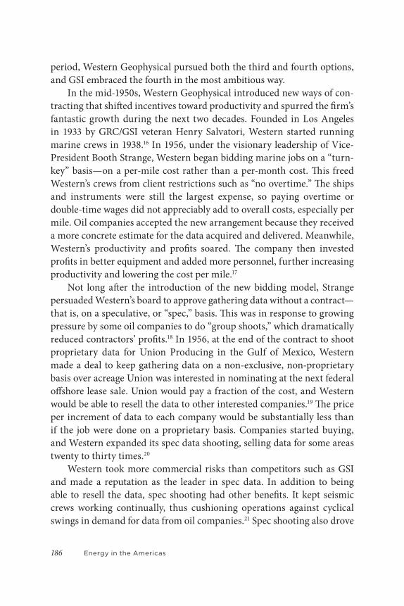
period, Western Geophysical pursued both the third and fourth options, and GSI embraced the fourth in the most ambitious way.
In the mid-1950s, Western Geophysical introduced new ways of con-tracting that shifted incentives toward productivity and spurred the firm’s fantastic growth during the next two decades. Founded in Los Angeles in 1933 by GRC/GSI veteran Henry Salvatori, Western started running marine crews in 1938.16 In 1956, under the visionary leadership of Vice-President Booth Strange, Western began bidding marine jobs on a “turn-key” basis—on a per-mile cost rather than a per-month cost. This freed Western’s crews from client restrictions such as “no overtime.” The ships and instruments were still the largest expense, so paying overtime or double-time wages did not appreciably add to overall costs, especially per mile. Oil companies accepted the new arrangement because they received a more concrete estimate for the data acquired and delivered. Meanwhile, Western’s productivity and profits soared. The company then invested profits in better equipment and added more personnel, further increasing productivity and lowering the cost per mile.17
Not long after the introduction of the new bidding model, Strange persuaded Western’s board to approve gathering data without a contract—that is, on a speculative, or “spec,” basis. This was in response to growing pressure by some oil companies to do “group shoots,” which dramatically reduced contractors’ profits.18 In 1956, at the end of the contract to shoot proprietary data for Union Producing in the Gulf of Mexico, Western made a deal to keep gathering data on a non-exclusive, non-proprietary basis over acreage Union was interested in nominating at the next federal offshore lease sale. Union would pay a fraction of the cost, and Western would be able to resell the data to other interested companies.19 The price per increment of data to each company would be substantially less than if the job were done on a proprietary basis. Companies started buying, and Western expanded its spec data shooting, selling data for some areas twenty to thirty times.20
Western took more commercial risks than competitors such as GSI and made a reputation as the leader in spec data. In addition to being able to resell the data, spec shooting had other benefits. It kept seismic crews working continually, thus cushioning operations against cyclical swings in demand for data from oil companies.21 Spec shooting also drove
1877 | Seismic Innovations: The Digital Revolution
Western to invest more in research and development, because spec data competed not only in price, but also in quality. In 1960, when Salvatori sold the company to Litton Industries, Western gained access to deeper pockets for making these kinds of investments. Booth Strange took over as president, and in 1965 he relocated the company from Los Angeles to Houston, where Western could be closer to the centre of the oil business and focus its operations and research in the booming Gulf of Mexico.22
The mid- to late 1950s proved to be the most fertile period of invention perhaps in the entire history of seismic imaging. Inventions came from varied sources, but they combined to lay the ground for the revolution-ary move from analogue to digital technology. First, the introduction of continuous velocity well logs (sonic logs)—in which the velocity of sound measurements within a well bore was matched to rock density—allowed for greater precision in locating the origin of seismic reflections. Even more important, starting in 1955, was the replacement of paper records by magnetic tape in seismic recording. Magnetic tape could record signals in analogue over a wide range of frequencies and play them back using different “filters” to adjust for time delays caused by surface effects and path geometry.23
Cross-sections prepared from analogue magnetic-tape playback changed the way seismic data were processed as well as collected. Most importantly, magnetic-tape playback provided a means for economic-ally applying the “common-depth-point” (CDP) or “horizontal stack-ing” method of acquisition and processing. Patented and developed by Harry Mayne of Petty Geophysical, CDP stacking involved taking tapes of individually corrected seismic traces from different sound source and recording stations, each equally offset from the same reflection point or mid-point, and then combining or “compositing” these traces. Stacking enhanced the desired or “primary” reflections and filtered out unwanted “multiple” reflections or “noise.” The CDP method dramatically improved the accuracy of seismic surveying and the delivery of quality data.24 After presenting and marketing the CDP technique at the 1960 international meeting of the Society for Exploration Geophysicists (SEG), Mayne and Petty licensed it to the most technologically advanced oil firms in the industry. Still the main signal-to-noise enhancing technique today, CDP stacking was a watershed that divided previous seismic exploration from

Energy in the Americas188
all subsequent innovations and paved the way for the conversion to digital technology.25
Magnetic recording and CDP shooting led to additional refinements and improvements in seismic acquisition, which, again, found their most productive use offshore in the Gulf of Mexico. Magnetic recording made it possible to employ other sound sources to replace the thousands of tons of dynamite exploded every year in the Gulf. Dynamite was cost-ly, time-consuming, and dangerous to deploy; it also killed or disturbed aquatic life, leading to conflicts with shrimpers, fishermen, and oyster-men.26 Beginning in the late 1950s, many companies experimented with new types of sound sources, such as mechanical/hydraulic vibrating mech-anisms and gas exploder devices. By the mid-1960s, air guns, pioneered by a young engineer at Lamont Geological Observatory, Stephen Chelminski, proved to be safest, simplest, and most reliable. They eventually became the source of choice.27
The Digital RevolutionMagnetic recording, with its capacity for storing seismic information in reproducible form, generated interest in what one geoscientist referred to in the 1950s as “mechanized automatic means of data processing,” or simply “computing.” Conventional methods of seismic data processing involved tedious human computational labour. In the mid- to late 1950s, analogue seismic-data-processing computers made their appearance, which relieved the human computer of some of the busy work in process-ing and plotting cross-sections. Efforts to digitize analogue magnetic re-cordings soon followed, largely to assist in filtering unwanted noise. The logical extension of this technology was the direct digital recording and processing of seismic data.28
The shift from analogue to digital, however, was not immediate or seamless. The transition required companies and contractors to replace outmoded equipment with expensive new computers and adopt entire-ly new ways of doing things, which oil companies often resisted.29 But thanks to research breakthroughs and savvy methods of marketing digital technology by GSI, the digital revolution finally transformed the indus-try during the early 1960s, expanding oil companies’ understanding of

1897 | Seismic Innovations: The Digital Revolution
the subsurface and increasing their accuracy in finding oil and gas. This lowered the considerable risks of exploration in the Gulf of Mexico, where digital seismic technology was commercially introduced.
Investigations into digital seismic surveying began with the Geophysical Analysis Group (GAG), organized in 1952 at the Massachusetts Institute of Technology (MIT). In 1951, a twenty-year-old graduate student in mathematics at MIT, Enders Robinson, applied a time-series analysis to the task of enhancing the quality of seismograph records, something never tried before, and came up with a method of “deconvolution,” which was a way of filtering desired seismic signals from other noise signals that corrupted them. The basic problem was that acoustical wavelets were re-flected with varying amplitudes from hundreds of subsurface reflecting horizons. Hence, a single seismic trace recorded at the surface consisted of a continuous series of overlapping reflections that were difficult to dis-tinguish from one another. This was an especially troublesome problem in offshore seismic prospecting. Seismic signals tended to reverberate in the water layer between the seabed and water surface, producing a “ringing” noise so strong it often masked the desired reflections from the subsur-face. Robinson’s study proved that numerical filtering could separate data and noise just like electronic filtering, but in a much more precise and high-powered fashion. What deconvolution did, in essence, was provide better resolution for imaging seismic signals.
Based on this revolutionary discovery, the Office of the President at MIT sponsored GAG, and the following year a consortium of twenty oil and geophysical companies took over funding the group. Between 1952 and 1957, the GAG group attracted some of MIT’s brightest graduate students, most of whom subsequently specialized in geophysics. At first, the group mainly used analogue recordings to perform deconvolution. However, having access one hour per week to MIT’s first digital computer with stored program architecture, the “Whirlwind,” and, later, Raytheon’s British Ferranti Mark 1 computer, they found that all analogue meth-ods could be done by digital seismic processing and with much greater accuracy.30
The conversion to digital was years away, not least because oil com-panies were still skeptical about the technology’s commercial applica-tions, even after publication of Enders Robinson’s path-breaking thesis,
Energy in the Americas190
“Predictive Decomposition of Time Series with Application to Seismic Exploration,” reproduced as GAG Report No. 7 in July 1954.31 In spite of the oil industry’s reticence, GSI forged ahead to commercialize digital seismic technology. During the Second World War, GSI had diversified into elec-tronics, becoming a major contractor to the US military as a maker of sub-marine detection devices, airborne magnetometers, and radar. This led to the creation in 1951 of a new company called Texas Instruments (TI), with GSI reorganized as TI’s geophysical subsidiary.32 That same year, GSI’s president, Cecil Green, a towering figure in the geophysics profession who had an eye for spotting talent, worked with Robert R. Shrock of MIT to or-ganize a summer “co-operative program” designed to give selected college students an orientation in applied geophysics working with crews in the field.33 The combination of GSI’s pipeline to MIT and TI’s aggressive ap-proach to electronics innovation propelled GSI into the digital vanguard.
Dr. Kenneth Burg, GSI’s technical vice-president, grasped the poten-tial of the emerging computer revolution and initiated research into digit-al seismic processing at TI’s Central Research Laboratory in Dallas.34 To support this effort, Burg hired a large crop of geophysics PhDs from MIT, including former members of GAG. Headed by Mark Smith, GSI launched a special research effort in 1954 to adapt the newly recognized statistical communication theory developed by Robinson to reflection seismology. Milo Backus, one of the MIT PhDs, devised a unique deconvolution solu-tion to the water reverberation problem using something called a “mul-tiple analyzer and eliminator,” a crude sort of “digital filter implemented in analog form,” as Backus described it, to reduce multiple reflections.35 According to Mark Smith, “this approach was very successful and helped to give GSI a competitive edge in many important offshore areas.”36
Between 1956 and 1958, GSI’s digital seismic investigations broke important new ground. After testing digital processing methods on a hybrid analogue-digital computer called the seisMAC, TI’s research de-partment—renamed the Data Systems and Earth Sciences Department—designed and built an analogue-to-digital converter and TI’s first digital computer. Programmed for seismic processing, the data analysis and re-duction computer used two thousand vacuum tubes and measured six by three by twenty-four feet. As Mark Smith noted, “it began to look to GSI as though the equipment end of the geophysical business was starting to
1917 | Seismic Innovations: The Digital Revolution
wag the dog, and that the misconception was developing that a major step in hardware alone would substantially change the effectiveness of seismic exploration.”37
Smith, in turn, instituted a comprehensive R&D program that ad-dressed all aspects of the reflection seismic problem. He focused on locat-ing stratigraphic traps, which were a key objective in the sedimentary basin of the Gulf of Mexico. Stratigraphic traps are features that accumulate oil due to changes in rock character rather than because of structural aspects such as faulting or folding of the rock. Up to that point, reflection seismol-ogy was only useful for finding structural traps. GSI-TI’s “Stratigraphic Trap Program” aimed to introduce digital recording in the field (instead of recording in analogue and converting to digital) and integrate it with continually improving digital processing software and techniques, so that the recorded seismogram would provide a closer approximation of the particular geology and stratigraphy.38
Dovetailing with this effort was the rapid development of another breakthrough technology in the 1950s, the semiconducting transistor, which replaced vacuum tubes, first as a sound amplifier in many kinds of electronic devices, and then as electronic switches in digital computers. Both applications had a pivotal impact on seismic surveying. Transistors fabricated from germanium and eventually silicon were smaller, lighter, and increasingly more powerful than vacuum tubes. Developed and li-censed by Bell Laboratories, early transistors were relatively costly and thus found commercial application initially in small, portable, and low-er-power-consuming devices, such as hearing aids, radios, and, by 1958, seismic receivers. Transistorized geophysical equipment significantly lightened the load for field crews.39
By the late 1950s, thinner, faster, and more reliable transistors en-hanced digital computing. In 1954, TI introduced the first commercial silicon transistor and in 1957 became a major supplier of transistors for IBM computers. Then, in 1958, TI pioneered a major advance with the in-tegrated circuit made of a single semiconductor material.40 By 1960, most new computer designs were fully transistorized with integrated circuits. At TI’s seismic branch in Houston, J. Fred Bucy, who would later become president of TI, led the development of the first digital field recording

Energy in the Americas192
system, the DFS-9000, which was integrated with an all-transistorized computer called the TIAC (Texas Instruments Automatic Computer).41
In launching this “total seismic system,” as GSI called it, the company faced an uphill climb, first to produce it within TI, and then, as with other seismic innovations, to market it to a dubious oil industry. Even though digital recording promised to eliminate the time and costs of converting analogue data, the front-end costs of the system were much higher, and oil companies and contractors alike preferred tried and true methods of recording in analogue. A digital recording set cost more than $100,000; converting to digital meant completely replacing equipment.42
To market the new system and obtain the initial financial support to manufacture the equipment and develop field experience, GSI agreed to give two of the oil companies most interested in the technology, Mobil and Texaco, a two-year contract (1961–3) for exclusive use of GSI digital crews and equipment. If the technology proved itself, Mobil and Texaco would have a jump on competitors. However, seismic software and signal processing were not part of the exclusive agreement, which allowed GSI to make marketing presentations in all the petroleum centres around the United States showing the latest processing developments, thus “whetting the industry’s appetite” for the full digital service.43
And whet it, it did. After the exclusive period, during which GSI made dramatic improvements to all aspects of the integrated system, company after company signed up for digital crews. GSI had convincingly demon-strated that the greater dynamic range and processing flexibility of digital recording and processing allowed for a much fuller exploitation of CDP shooting and the tremendous seismic signal-to-noise enhancements it provided. In 1964, GSI experienced a 58 per cent growth in revenue, driv-en largely by the new digital business.44
Although some of GSI’s digital crews worked on land (mainly for Texaco), the “real bread and butter was in digital marine work,” especial-ly in the Gulf of Mexico.45 GSI’s marine business grew fairly quickly to twenty-six crews operating with a fleet of more than fifty seismic vessels.46 In 1964, GSI opened its first regional TIAC data centre in New Orleans to handle growing business in the Gulf of Mexico.
There were several reasons for the intensive application of digital seis-mology offshore. First, offshore exploration was already growing at the
1937 | Seismic Innovations: The Digital Revolution
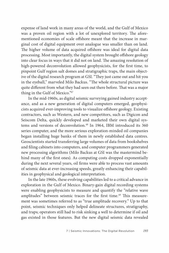
expense of land work in many areas of the world, and the Gulf of Mexico was a proven oil region with a lot of unexplored territory. The afore-mentioned economies of scale offshore meant that the increase in mar-ginal cost of digital equipment over analogue was smaller than on land. The higher volume of data acquired offshore was ideal for digital data processing. Most importantly, the digital system brought offshore geology into clear focus in ways that it did not on land. The amazing resolution of high-powered deconvolution allowed geophysicists, for the first time, to pinpoint Gulf region salt domes and stratigraphic traps, the main object-ive of the digital research program at GSI. “They just came out and hit you in the eyeball,” marveled Milo Backus. “The whole structural picture was quite different from what they had seen out there before. That was a major thing in the Gulf of Mexico.”47
In the mid-1960s, as digital seismic surveying gained industry accept-ance, and as a new generation of digital computers emerged, geophysi-cists acquired ever-improving tools to visualize offshore geology. Existing contractors, such as Western, and new competitors, such as Digicon and Seiscom Delta, quickly developed and marketed their own digital sys-tems and versions of deconvolution.48 In 1964, IBM introduced its 360 series computer, and the more serious exploration-minded oil companies began installing huge banks of them in newly established data centres. Geoscientists started transferring large volumes of data from bookshelves and filing cabinets into computers, and computer programmers generated new processing algorithms (Milo Backus at GSI was the mastermind be-hind many of the first ones). As computing costs dropped exponentially during the next several years, oil firms were able to process vast amounts of seismic data at ever-increasing speeds, greatly enhancing their capabil-ities in geophysical and geological interpretation.
In the late 1960s, these evolving capabilities led to a critical advance in exploration in the Gulf of Mexico. Binary-gain digital recording systems were enabling geophysicists to measure and quantify the “relative wave amplitudes” between seismic traces for the first time.49 This measure-ment was sometimes referred to as “true amplitude recovery.” Up to that point, seismic techniques only helped delineate structures, stratigraphy, and traps; operators still had to risk sinking a well to determine if oil and gas existed in those features. But the new digital seismic data revealed
Energy in the Americas194
striking “amplitude anomalies” that suggested the tantalizing prospect of “directly detecting” hydrocarbons that might be associated with them. Shell Oil and Mobil Oil were the first companies to identify and quantify such anomalies and factor them into their bids for offshore leases. Mobil referred to them as “hydrocarbon indicators.” Shell called them “bright spots,” because they seemed to light up on the seismic record.50 “Direct hydrocarbon indicators” (DHI) has since become the industry’s standard technical term.
Once the bright spot interpretation, or DHI, method was refined and disseminated in the early 1970s, it had a giant impact on the business of exploration in the Gulf. Being able literally to “see” hydrocarbons on the seismic section before ever drilling a well eliminated the questions of whether hydrocarbons existed in a certain location or what the drilling
Figure 7.2 Shell Oil Bright Spot Seismic, Posey Prospect, Eugene Island 330 Field
Source: Image courtesy of Mike Forrest

1957 | Seismic Innovations: The Digital Revolution
targets were. The remaining questions were whether the target was big enough or if the hydrocarbons would come out the ground fast enough. Reducing the “dry hole factor” changed the way companies allocated risk and capital in their general strategic approach to offshore oil. If a bright spot scan reduced the odds of drilling a dry hole on a prospect from three out of five to two out of five, managers could afford to bid more for at-tractive leases or use the money saved by avoiding dry holes to invest in drilling and production technologies for deeper water. The advances in seismic amplitude analysis were one of the most important products of the digital revolution for the exploration business, moving the industry into 1,000-plus-feet water depths in the 1980s and ’90s.
One caveat about bright spots—the technique worked only for certain kinds of geology. The clastic sedimentary rocks found in deltaic regions like the Gulf Coast—and, as oil explorers would later learn, along the Atlantic Ocean margins of Brazil and West Africa—were well-suited to this kind of interpretation. Hard-rock areas elsewhere were not. Bright spot interpretation and the digital seismic revolution helped oil compan-ies overcome the water depth and cost limits that had stalled offshore development in the Gulf. In the late 1970s, the Brazilian state-owned oil firm, Petrobras, which Gail Triner writes about in this volume, also used bright spot amplitude analysis to help identify prospects in the offshore Campos Basin that ultimately contained more than twelve billion barrels of oil. By 1995, Petrobras was producing a million barrels a day from the Campos Basin, establishing Brazil, for the first time, as a major oil-produ-cing nation.51
Three DimensionsThe move from two-dimensional (2D) to three-dimensional (3D) seis-mic technology was decisive confirmation of the revolutionary potential of digital technology in the oil business. The concept of 3D seismology had existed since the earliest days of geophysics. Geoscientists have al-ways sought to visualize the subsurface in three dimensions, not two. All seismic surveys, when they produce a subsurface contour map, are con-ceived of in three dimensions. By the early 1970s, the arsenal of digital

Energy in the Americas196
data recording and processing techniques had taken exploration to an unprecedented level of sophistication, but imaging was still 2D.
Exxon claims to have shot the first 3D seismic survey over the Friendswood field south of Houston in 1967. Esso Production Research presented the results at an SEG meeting in 1970.52 It was a presentation that displayed a model based on data gathered from well logs and 2D seismic surveys, and it used a special fibre optic viewer to simulate depth in three dimensions. Although Exxon later received the Distinguished Achievement Award from the SEG for “inventing” and developing 3D methods, this was not actually 3D technology as it came to be properly understood and practised. As GSI’s Robert Graebner put it, “3D involves gathering data in a spatial sense so that you can put together that data from wherever it reflected with another piece that came from that same spot.”53 This means doing 3D “migration.” Migration is the geometric reposition-ing of the return signal to show the exact subsurface location where the seismic wave reflects, as opposed to where it is picked up by the geophone. To position events accurately in three dimensions was a massive computa-tional challenge. It required building a mathematical and physical model governed by the so-called wave equation, which is a hyperbolical partial differential equation that describes the propagation of waves.54 This is not what Exxon (Esso at the time) was doing in the Friendswood field in 1967.
The density of spatial seismic coverage required to produce a 3D im-age magnified the computational challenge of migration. A detailed 2D seismic survey might collect data in a grid spaced at one-kilometre inter-vals, whereas a 3D survey would require a much tighter grid, by at least an order of magnitude, to get any kind of accurate detail. By the early 1970s, computing power and digital seismic acquisition and processing techniques had developed to a point where this was finally possible. But, as with every major step forward with geophysical technology, the constraint on commercializing this concept was cost. And again, it was GSI that pi-oneered the technology and successfully marketed it to industry.
In early 1972, an important brainstorming session took place at GSI headquarters in Dallas. The principals were research scientist William Schneider, Milo Backus, then director of research, and Robert Graebner and M. E. “Shorty” Trostle, both executives. To fund an experimental sur-vey to test the idea, the GSI executives enlisted the support of six large

1977 | Seismic Innovations: The Digital Revolution
oil companies—Chevron, Amoco, Texaco, Mobil, Phillips, and Atlantic Richfield. They selected the Bell Lake field in southeastern New Mexico and West Texas, which was “a structural play with nine producers and several dry holes.” Bell Lake had sufficient well data so that 3D data could be correlated with subsurface geology.55 The results of the 3D survey were stunning. They not only confirmed the field’s nine producers and three dry holes but also indicated several new drilling prospects in this mature area. As the Midland Reporter-Telegram later reported:
When the petroleum history books are written, Milo Back-us, M. E. “Shorty” Trostle, and Bob Graebner (of GSI) [Schneider should also have been mentioned] may stand in significance alongside Howard Hughes and his rotary bit, the Schlumberger brothers and their logging machine, and Earl Halliburton and his idea for pumping cement behind the casing of oil wells. Because when the final tally is made, the impact of 3D on the oil industry will be in the billions.56
It took considerable time for the tally to mount. Many oil companies could not justify the cost of the 3D survey. Even a modest sampling of the data acquired in a 3D survey generated a huge number of paper sections to examine and interpret. Computers were limited in power to handle more advanced and accurate algorithms. The commercial viability of 3D seis-mology for exploration—that is, looking for new, wildcat fields—was still in the future. The expense of a 3D survey was prohibitive in an area with a relatively high probability of drilling a dry hole. GSI’s Bob Graebner, how-ever, made an increasingly convincing case that the bottom-line results of a 3D survey could be worth the cost for developing producing fields and defining already discovered reservoirs.57
Again, as with the introduction of digital recording and processing, the most value could be added offshore, where the marginal cost of doing a 3D survey was smaller than on land. The Gulf of Mexico, the most ma-ture offshore producing region in the world, was where oil companies and contractors cut their teeth on 3D and devised ways to bring down costs. Better instruments, wider arrays of hydrophone streamers, larger vessels, faster navigation, and on-board processing all reduced costs and improved

Energy in the Americas198
data acquisition. Most importantly, advances in computing power spurred the market for 3D surveys. The emergence of interactive computer work-stations permitted geophysicists to see results in computer screen images with three dimensions and reduced the time to interpret a 3D survey from months to weeks.
Before workstations, images produced from a 3D survey were basic-ally “a sandwich of 2D cross sections linked by horizontal slices.”58 Workstations finally rendered seismic images in 3D shapes that corres-ponded to the subsurface features, and with increasing speed. By the early 1980s, all the major seismic contractors and several major oil companies had developed their own systems. New companies formed to focus en-tirely on the seismic workstations business, led by Landmark Graphics, GeoQuest, and others associated with Schlumberger and Halliburton.59 Eventually, these contractors developed special rooms called “visualiza-tion centres” that displayed seismic images in three dimensions. Using stereoscopic glasses, viewers could immerse themselves in 3D seismic images constructed from projections on the walls, ceiling, and floor, and actually walk through a moving perspective of the subsurface.60
Figure 7.3 GSI’s 3D Seismic PioneersBill Schneider, Milo Backus, Bob Graebner, and Jack Pizant, co-authors of the 1966 SEG Award–winning paper “A New Marine Processing System.”
Source: Photo courtesy of Degolyer Library, Southern Methodist University.

1997 | Seismic Innovations: The Digital Revolution
In the 1990s, the market for 3D surveys exploded, first in the Gulf of Mexico and then in other marine areas such as the North Sea. In 1989, only 5 per cent of the wells drilled in the Gulf relied on 3D; in 1996, nearly 80 per cent did. Companies acquired the majority of that data between 1990 and 1993.61 Data acquisition was made easier beginning in the early 1990s by the deployment of the US Navy’s global positioning system (GPS) in place of conventional radio positioning systems. By the late 1990s, oil firms increasingly used 3D data not only for field development, but for exploration as well. As majors such as Shell began to divest from older producing properties in the shallow waters of the Gulf ’s continental shelf in favour of new “deepwater” prospects (in water greater than 1,500 feet), smaller firms purchased the older properties and redeveloped them with significant reserve additions using 3D data. Graebner conservatively esti-mates that 3D quadrupled the oil and gas reserves in the Gulf of Mexico.62
As the majors moved into deepwater, where a single well could cost $50 million or more, it made perfect sense to have 3D coverage before drilling. However expensive a 3D survey was, that was little more than a rounding error when applied to the overall cost of exploring and produ-cing in deepwater. More significantly, 3D gave oil firms nearly pinpoint accuracy in discovering oil and gas. Wildcatting success rates without 3D were typically no higher than 30 or 40 per cent (three or four out of every ten wells struck pay). By most accounts, 3D boosted wildcat drilling suc-cess to 60 or 70 per cent. The savings from drilling three or four fewer $50 million dry holes out of every ten added up very quickly. Investment bank Salomon Smith Barney estimated that 3D technology accounted for 46 per cent of falling exploration and production costs between 1995 and 1997, far more than any other oil field technology.63
Figure 7.4 3D Seismic Image with Salt Domes in Deep Blue
Source: Photo courtesy of Paradigm.

Energy in the Americas200
Ongoing InnovationsIronically, just as the forty-year effort to exploit the digital potential of seismic exploration was bearing fruit in what Business Week called “a Golden Age of technology,” the geophysical contractor business took a dive.64 The demand for seismic crews had been relatively weak since the oil bust in the mid-1980s. The sharp oil price drop and wave of oil com-pany mergers beginning in 1998 further slashed demand. Compounding the problem, contractors found themselves swimming in an excess supply of data—what one analyst described as “data indigestion.” The diffusion and commodification of 3D seismic technology generated intense compe-tition. Speculative shooting, pioneered by Western Geophysical, and so-called multi-client surveys, had become the dominant mode of acquiring and selling data, and both became less profitable.
In a multi-client deal, a group of oil customers would fund a seismic shoot in advance, but the real profits were earned over time from resell-ing the data (after usually a six-month exclusive period). This kind of deal emerged in the Gulf of Mexico during the leasing boom that started in 1995. However, if the data turned out to be of little value, or if demand fell due to slashed exploration budgets, then the seismic contractors operating with less than 100 per cent funding were on the hook. To win business, contractors would agree to lower their “pre-funding” requirements to 35 or 40 per cent, taking on greater risk and essentially subsidizing seismic exploration for the oil companies.65
The result was a massive contraction and consolidation in the geo-physical contractor business that lasted for a good part of the 1990s. Forty years of innovation could not protect GSI, which was sold to Halliburton in 1988. Six years later, Halliburton sold the remnants of its GSI assets to Western Geophysical, which itself underwent a series of reorganizations and mergers before resurfacing in 2000 as Western Geco, a business unit of Schlumberger. Over the long run, the oil companies, many of whom were initially skeptical about leading-edge innovations in seismic tech-nology, enjoyed most of the benefits from the subsurface vision digitally engineered by firms such as GSI and Western.
While geophysical contractors were the first to be fired in the down-turn, they were also the first to be hired in an upturn. During the oil boom
2017 | Seismic Innovations: The Digital Revolution
that lasted from 2002 to 2014, the marine seismic business recovered and thrived once again. This expansion pushed exploration into new geologic-al frontiers, most spectacularly beneath massive layers of salt in deep-water. The subsalt play began first in the Gulf of Mexico in the late 1990s, and then spread elsewhere, especially offshore of Brazil, spurring succes-sive rounds of innovation in digital seismic acquisition, processing, and interpretation.
Although developed in the 1970s, 3D technology was still in its in-fancy by the late 1990s, and it matured in many directions. More complex 3D migration algorithms, such as 3D “prestack” time and depth migration and “reverse-time migration,” provided ever-greater precision necessary for imaging through wave-distorting bodies of salt. To overcome the data constraints that still inhibited subsalt exploration, contractors introduced “multi-azimuth” (MAZ), “wide-azimuth” (WAZ), and “full-azimuth” (FAZ) seismic surveys, acquiring data from several vessels at a time that recorded data in multiple azimuths (the angle of linear horizontal dir-ection), rather than merely along one narrow azimuth from one vessel. Steadily increasing computing power allowed geophysicists to extract more and different kinds of information from richer sets of data obtained through MAZ, WAZ, and FAZ seismic surveys.66
These capabilities combined to propel further advances in data ac-quisition and processing. Along with the development of high-sensitiv-ity ocean-bottom hydrophones, or “nodes,” these advances helped to improve on a kind of seismic amplitude analysis called “amplitude vs. offset,” or AVO, which is a way of measuring the variation of seismic re-flection amplitudes with a change in distance between the shotpoint and receiver. The advances enabled geophysicists to estimate the velocity of not only “p-waves,” but also “s-waves,” known variously as secondary, shear, or transverse waves. P-waves travel longitudinally by compression in the same direction as sound; they have the highest velocity and move through both solid rock and fluid. S-waves travel perpendicularly to the direction of sound; they are slower and can only move through solid rock, thus requiring ocean-bottom receivers to be recorded. S-waves can detect important reservoir properties or subtle changes in lithology that p-waves cannot. Improvements in AVO analysis had a major impact on modelling reservoirs found with DHI or bright spots in young, poorly consolidated
Energy in the Americas202
rocks, such as those in the Gulf of Mexico. In relatively a short time, s-waves enabled oil and gas firms to find hundreds of millions of barrels of oil and tens of billions of cubic feet of gas that could not have been found with p-waves alone.67
On top of advanced AVO modelling, technology moved along many different fronts. These include broadband data recording, simultan-eous sound sources, wireless systems, higher channel counts, fibre optic streamers, and robotic ocean-bottom nodes. As computing power began to catch up with advances in seismic acquisition, the industry progressed toward “full wave-form inversion” (FWI), in which primary and shear waves, reflections and refractions, all contribute to the creation of a more fine-grained subsurface image from much better estimates of seismic vel-ocity. FWI could obtain quantitative information from seismic data about rock properties, such as porosity, lithology, and fluid saturation, on a de-tailed scale.68 Oil explorers closed in on acquiring the power to visualize, literally, the intricacies of subsurface geology before ever drilling a well.
Once again, the Gulf of Mexico was the proving ground for this latest trend in seismic innovation. Explorers used their expanded capabilities to uncover a whole new oil frontier in the subsalt strata, foldbelts, and Lower Tertiary formations of the “ultra-deepwater” (7,000- to 12,000-foot depths) Gulf of Mexico. By 2015, the US Department of the Interior count-ed 171 deepwater and ultra-deepwater fields discovered in the Gulf since the 1980s, containing an original 13 billion barrels of oil equivalent, with billions more classified as “contingent,” awaiting a development commit-ment from operators.69
Beginning in the late 1990s, advanced digital seismic techniques ani-mated other deepwater basins, enabling geophysicists to collect accurate images through the salt and decipher frontier geology. Many major dis-coveries followed, which helped allay fears about the adequacy of oil sup-plies for years to come. By 2006, the industry had discovered 60 billion barrels of oil in deepwater worldwide, production from which is still com-ing on line.70 From 2007 to 2012, half of the 170 billion barrels of global conventional oil and gas discovered by the industry was in deepwater.71
West Africa accounted for a lot of this action, but seismic innova-tions have also reshaped oil prospects in the Americas. Most spectacu-larly, as Triner in this volume recounts, Brazil’s Petrobras announced in

2037 | Seismic Innovations: The Digital Revolution
late 2007 that it had discovered 7.5 billion barrels of oil in the “pre-salt” sediments of the Santos offshore basin. The company has since estimated pre-salt reserves across three basins to be 13 billion barrels. In May 2015, ExxonMobil used bright spot amplitudes to make a significant discovery in the Stabroek Block offshore Guyana (population: 770,000).72 The com-pany followed that up with a string of additional discoveries in even deep-er water, based on advanced 3D imaging, that totalled more than 8 billion barrels of oil equivalent by 2020. Geophysical surveying and drilling have also indicated “huge hydrocarbon potential” in the offshore basins of Brazil’s equatorial margin.73 Finally, the expansion of leasing and drilling ever closer to the US-Mexico maritime boundary has played no small part in compelling Mexico in 2013 to end the seventy-five-year-old oil monop-oly that barred foreign participation in the nation’s oil sector (see Hall in this volume). In January 2018, Mexico sold exploration rights to nineteen deepwater blocks for $500 million. The ongoing digital revolution in seis-mic technology has illuminated new pockets of hydrocarbon resources across the Americas.
ConclusionBeginning in the 1950s, technological advances in petroleum seismology transformed oil exploration into a high-tech business and turned the Gulf of Mexico into one of the most active oil-hunting areas in the world. The development of marine geophysical operations and a new model of con-tracting in the 1950s opened up new offshore vistas. The early introduc-tion of magnetic tape recording and common-depth-point shooting in the late 1950s, closely followed by digital processing and recording in the early 1960s, led to continual improvements in seismic processing and interpret-ation, from the deconvolution of signals caused by reverberations in water in the late 1950s, to the direct detection of hydrocarbons in the late 1960s, to three-dimensional seismology in the late 1970s, to the emergence of full wave-form inversion in the twenty-first century.
The fifty-year project of digital innovation has had its greatest impact on the water, where the marginal costs of applying novel ideas and ex-pensive new technologies were lower offshore than on land. The proving ground for digital seismic technology was the US Gulf of Mexico. But

Energy in the Americas204
geophysical techniques pioneered in the Gulf have also helped to open other deepwater basins around the world to petroleum extraction. In the Americas, from the Santos Basin off Brazil to the Mexican side of the Gulf, digital seismic innovations have led explorers to find billions upon bil-lions of barrels of petroleum, much of which has yet to be coaxed from the ocean. This newly discovered offshore petroleum abundance, combined with the spectacular growth of oil and gas production from shale basins in the United States through hydraulic fracturing, which also benefitted from advanced digital seismic technologies, silenced alarms about an im-pending “peak” in global oil supply that had been so common in the early 2000s.74
Ironically, just as the progress in seismic innovations reduced a great deal of the uncertainty in finding oil, other uncertainties arose to cloud the future of offshore exploration. The unreliability of future demand in a world desperately trying to shift away from fossil fuels to mitigate run-away global warming is obviously a big problem. Related to this is the ongoing price volatility of oil in a world without a mechanism to balance supply and demand. This volatility wreaks havoc on the investment de-cisions companies make in developing resources in high-cost environ-ments like deepwater.75 The first industry affected in a price downturn, like the one that lasted from 2014 to 2018, remained geophysical contract-ors. Among other casualties in this shakeout, the long-established French company CCG filed for bankruptcy, and Schlumberger sold off the seismic acquisition business of WesternGeco, whose ancestors, GSI and Western Geophysical, pioneered the digital revolution.76 The supply and demand for digital data has turned out to behave a lot like oil, subject to endemic cycles of boom and bust.
N OT E S
1 Tyler Priest, “Extraction Not Creation: The History of Offshore Petroleum in the Gulf of Mexico,” Enterprise & Society 8, no. 2 (June 2007): 227–67.
2 Enders A. Robinson, “Geophysical Exploration: Past and Future,” Leading Edge 25, no. 1 (January 2006): 98.
3 Steve Lohr, “The Origins of ‘Big Data’: An Etymological Detective Story,” New York Times, 1 February 2013.
2057 | Seismic Innovations: The Digital Revolution
4 Exploration geophysicists have documented the technological milestones in their field, but they do not emphasize the Gulf Coast origins of commercial geophysics or the business contours of its evolution. See, for example, George Elliott Sweet, The History of Geophysical Prospecting (Los Angeles: Science Press, 1966); J. E. Brantly, History of Oil Well Drilling (Houston: Gulf Publishing, 1971); Rajni K. Verma, Offshore Seismic Exploration: Data Acquisition, Processing, Interpretation (Houston: Gulf Publishing, 1986); L. C. Lawyer, Charles C. Bates, and Robert B. Rice, Geophysics in the Affairs of Mankind: A Personalized History of Exploration Geophysics (Tulsa: Society of Exploration Geophysicists, 2001); and Mark Mau and Henry Edmundson, Groundbreakers: The Story of Oilfield Technology and the People Who Made it Happen (Peterborough, UK: Fast-Print Publishing, 2015).
5 Sweet, The History of Geophysical Prospecting; Lawyer, Bates, and Rice, Geophysics in the Affairs of Mankind, 1–12.
6 Edgar Wesley Owen, Trek of the Oil Finders: A History of Exploration for Petroleum (Tulsa: American Association of Petroleum Geologists, 1975), 505–10; Lawyer, Bates, and Rice, Geophysics in the Affairs of Mankind, 15–17.
7 J. A. Klotz, “Geophysical Exploration Methods,” Journal of Petroleum Technology 4, no. 6 (June 1952): 20–1.
8 R. J. Graebner, G. Steel, and C. B. Wason, “Evolution of Seismic Technology into the 1980s, Pt. 1,” Australian Petroleum Exploration Association (APEA) Journal 20 (1980): 110–20; “Seismic Technology: Evolution of a Vital Tool for Reservoir Engineers,” Journal of Petroleum Technology 51, no. 2 (February 1999): 22–8; and Robert J. Graebner, “Meeting the Challenge of Cost-Effective Exploration,” address to the Dallas Geophysical Society, 15 May 1987, Texas Instruments Records, DeGolyer Library, Southern Methodist University, Dallas (documents from this collection hereafter cited as TI Records).
9 Sweet, History of Geophysical Prospecting, 122–5. Also see “Fifty Years of Trailblazing in the Oil Patch, GSI (1930–1980),” The Grapevine 36, no. 2 (1980): 4–17. The Grapevine was GSI’s internal magazine. A full set can be found in the TI Records, 87–60.
10 D. C. Barton, “Petroleum Potentialities of Gulf Coast Petroleum Province of Texas and Louisiana,” Bulletin of the American Association of Petroleum Geologists 14, no. 11 (1930): 1380j; Owen, Trek of the Oil Finders, 511–14, 794–7; and Lawyer, Bates, and Rice, Geophysics in the Affairs of Mankind, 21–4.
11 “A Method of Surveying by Use of Radio Waves,” Oil and Gas Journal, 7 July 1949, 69–71, 90–1; “Offshore Seismograph Work . . . with a Single Boat,” Oil and Gas Journal, 13 April 1950, 82–3, 112–13.
12 Jack M. Proffitt, “A History of Innovation in Marine Seismic Data Acquisition,” Geophysics: The Leading Edge of Exploration 10, no. 3 (March 1991): 27.
13 Curtis A. Johnson and John W. Wilson, “Marine Exploration Comes of Age,” World Oil, March 1954, 76–7; John W. Wilson, “Single Ship Takes the Place of a Fleet,” World Oil, June 1954, 163.
14 Society of Exploration Geophysicists (SEG) Wiki, s.v. “Booth Strange,” last modified 18 October 2016, 11:08, https://wiki.seg.org/wiki/Booth_Strange; Sam Evans, former
Energy in the Americas206
GSI seismologist, interview with the author, 9 April 2002, Houston. This and other oral histories cited in this chapter were collected as part of a six-volume study for the Minerals Management Service of the US Department of the Interior, History of the Offshore Oil and Gas Industry in Southern Louisiana (OCS Study MMS 2008-042, New Orleans, September 2008), which can be accessed online at the Bureau of Ocean Energy Management’s Environmental Studies Program Information System, https://www.boem.gov/espis. Oral history audio and transcripts can be found at University of Houston Libraries, Oral Histories—Houston History Project, 1996–, Series 7: Energy Development, http://archon.lib.uh.edu/?p=collections/findingaid&id=231&q=&rootcontentid=129960#id129960.
15 “Geophysical Activity Drops Again in ’54,” Oil and Gas Journal, 4 April 1955, 138–47; “Seismic Work Hits a Slump,” Oil and Gas Journal, 17 March 1958, 176–8; “Firms See Higher Fees as Solution,” Oil and Gas Journal, 14 July 1958, 72–3.
16 Delores Proubasta, “Henry Salvatori,” Geophysics: The Leading Edge of Exploration 2, no. 8 (1983): 14–22; and “Henry Salvatori, G.O.P Advisor and Oil Company Founder, 96,” New York Times, 13 July 1997.
17 SEG Wiki, “Booth B. Strange.”
18 Neal Cramer, President of Western Geophysical, 1984–91, interview with the author, 20 August 2002, Houston.
19 Evans, interview.
20 Cramer, interview.
21 Lawyer, Bates, and Rice, Geophysics in the Affairs of Mankind, 298.
22 “Western Geophysical, Division of Western Atlass International,” Oil and Gas Online, 21 September 2000, https://www.oilandgasonline.com/doc/western-geophysical-division-of-western-atlas-0001. Also see various issues of Western Profile, the in-house magazine of Western Geophysical, the full set of which is available online at https://seg.org/Publications/Journals/Western-Profile.
23 See Lawyer, Bates, and Rice, Geophysics in the Affairs of Mankind, 83–5; “Seismic Technology: Evolution of a Vital Tool,” 24.
24 For Mayne’s personal account, see W. Harry Mayne, 50 Years of Geophysical Ideas (Tulsa: SEG, 1989).
25 Mayne, 50 Years of Geophysical Ideas, 33–7.
26 Proffitt, “A History of Innovation in Marine Seismic Data Acquisition,” 27–8.
27 Proffitt, “A History of Innovation in Marine Seismic Data Acquisition,” 28–9.
28 “Seismic Technology: Evolution of a Vital Tool.” The difference between analogue and digital media has to do with the way the sound is recorded and stored. Analogue refers to recordings where the original sound is modulated onto another physical medium, such as the iron oxide surface of magnetic tape. The physical quality of the medium is directly related, or analogous, to the physical properties of the original sound. A digital recording involves sampling and converting the physical properties of the

2077 | Seismic Innovations: The Digital Revolution
original sound into binary digits or numbers, which can then be stored, replayed, and manipulated for various purposes on a computing device.
29 Robert Graebner, interview with the author, 13 June 2002, Dallas.
30 The early history of the MIT GAG is told by Enders A. Robinson, “The MIT Geophysical Analysis Group (GAG) from Inception to 1954,” Geophysics 70, no. 4 (July–August 2005): 7JA–30JA. For details on the origins of stored-program architecture, the basis for what most people recognize as the modern computer, see Martin Campbell-Kelly and William Aspray, Computer: A History of the Information Machine (New York: Basic Books, 1996), 87–104.
31 “Digital Revolutionaries: Technical Advances Reverberated Through the Industry,” in AAPG Explorer Special Issue—A Century (Tulsa: AAPG, 2000), 51; Robinson, “The MIT Geophysical Analysis Group,” 23JA; Enders Robinson, oral history interview by Andrew Goldstein, 6 March 1997, New York, available at Engineering and Technology History Wiki, last modified 26 January 2021, 19:06, https://ethw.org/Oral-History:Enders_Robinson.
32 “Fifty Years of Trailblazing in the Oil Patch, GSI (1930–1980),” 10–12; Caleb Pirtle III, Engineering the World: Stories from the First 75 Years of Texas Instruments (Dallas: Southern Methodist University Press, 2005), 1–25.
33 Robert R. Shrock, A Cooperative Plan in Geophysical Education: The GSI Student Cooperative Plan, the First Fifteen Summers, 1951–1965 (Dallas: Geophysical Service, 1966).
34 For more on Burg, see “Kenneth Edwin Burg,” A Profile by Cecil H. Green for Honorary Membership in the SEG, October 1979, Ken Burg folder, Box 4, TI Records.
35 Milo Backus, interview with the author, 12 June 2002, Dallas.
36 Mark Smith, “The Seismic Digital Revolution” (unpublished manuscript provided by Smith to author).
37 Smith, “The Seismic Digital Revolution.”
38 Smith, “The Seismic Digital Revolution.”
39 Michael Riordan and Lillian Hoddeson, Crystal Fire: The Birth of the Information Age (New York: W. W. Norton, 1997).
40 See Pirtle, Engineering the World, 27–84.
41 Ken Burg Lecture, 10 April 1964 Revision, “The Total Seismic Exploration System and the Role of Digital Technology,” Ken Burg Folder, Box 4, TI Records; GSI, Fact Sheet, Digital Seismic Service Technology and GSI’s Systems Approach to Exploration, 9 June 1964, GSI Press Releases, 1964–1966 Folder, Box 1, TI Records.
42 Backus, interview. See also Lawyer, et al., Geophysics in the Affairs of Mankind, 114–115.
43 Smith, “The Seismic Digital Revolution.”
44 Smith, “The Seismic Digital Revolution.”
45 Smith, “The Seismic Digital Revolution.”
Energy in the Americas208
46 For more on the GSI navy, see Pirtle, Engineering the World, 20–5.
47 Backus, interview.
48 Lawyer, Bates, and Rice, Geophysics in the Affairs of Mankind, 279–80.
49 “Binary gain refers to a seismic digital-recording system that switches decibel levels (gain) for each seismic channel in steps of two in response to changes in signal energy. This technique allows data recovery with low distortion.” F. Reynolds and Robert H. Ray, “Binary-Gain Recording and Processing,” AAPG Bulletin 51, no. 5 (May 1967): 814.
50 “Direct detection” was based on the principle that the acoustic impedance of a loosely cemented rock filled with hydrocarbons was different from that of a similar water-filled rock, and with advanced digital methods, this difference often could often be detected as an “amplitude anomaly” or “high-amplitude reflection” on the seismic record. Mobil and Shell first bid on offshore leases using bright spots in the December 1970 federal offshore Louisiana lease sale. Tyler Priest, The Offshore Imperative: Shell Oil’s Search for Petroleum in Postwar America (College Station: Texas A&M University Press, 2007), 124–136; Mike Forrest, interview with the author, 29 June 1999, Houston; Robert Hirsch, interview with the author, 6 November 2003, Navasota.
51 Décio Fabrício Oddone da Costa, Renato Sanches Rodrigues, and Álvaro Felippe Negrão, “The Evolution of Deepwater Drilling in Brazil” (paper presented at the Society of Petroleum Engineers Latin American Petroleum Engineering Conference, Rio de Janeiro, 14–19 October 1990); Tyler Priest, “Petrobras in the History of Offshore Oil,” in New Order and Progress: Development and Democracy in Brazil, ed. Ben Ross Schneider (New York: Oxford University Press, 2016), 56, 64–7.
52 The presentation resulted in the publication by G. G. Walton, “Three-Dimensional Seismic Method,” Geophysics 37, no. 3 (June 1972): 417–30.
53 Graebner, interview.
54 Jon F. Claerbout, a Stanford geophysicist and consultant to Chevron, published two seminal papers, in 1970 and 1971, that pioneered the methodology of using the wave equation to perform seismic imaging: “Coarse Grid Calculations of Waves in Inhomogeneous Media with Application to Delineation of Complicated Seismic Structure,” Geophysics 35, no. 3 (1970): 407–18, and “Toward a Unified Theory of Reflector Mapping,” Geophysics 36, no. 3 (1971): 467–81. Also see J. Bee Bednar, “A Brief History of Seismic Migration,” Geophysics 70, no. 3 (May–June 2005): 3MJ–20MJ.
55 William A. Schneider, “3-D Seismic: A Historical Note,” Leading Edge 17, no. 3 (March 1998): 375.
56 Quoted in Pirtle, Engineering the World, 19.
57 C. G. Dahm and R. J. Graebner, “Field Development with Three-Dimensional Seismic Methods in the Gulf of Thailand—A Case History,” Geophysics 47, no. 2 (February 1982): 149–76.
58 Bob Tippee, “Seismic Progress: Where the Trends Might Lead,” Oil & Gas Journal, 13 December 1999, https://www.ogj.com/articles/print/volume-97/issue-50/petroleum-in-the-21st-century/upstream-in-the-new-century/seismic-progress-where-the-trends-might-lead.html.

2097 | Seismic Innovations: The Digital Revolution
59 Internal memo, Bob Graebner to Bob Tiner, Halliburton research director, “Material for Indonesian Meeting,” 17 September 1991, copy provided to author by Graebner. This memo lays out a summary of the major milestones in the use of seismic methods in the petroleum industry. In 1988, Halliburton purchased GSI from TI and merged it with Geosource into Halliburton Geophysical Services.
60 Tippee, “Seismic Progress.”
61 “U.S. E&P Surge Hinges on Technology, Not Oil Price,” Oil & Gas Journal, 13 January 1997, https://www.ogj.com/articles/print/volume-95/issue-2/in-this-issue/general-interest/us-ep-surge-hinges-on-technology-not-oil-price.html.
62 Graebner, interview.
63 “U.S. E&P Surge Hinges on Technology”; “Looking Ahead in Marine and Land Geophysics—A Conversation with Woody Nestvold and Ian Jack,” Leading Edge 14, no. 10 (October 1995): 1061–7; International Association of Geophysical Contractors, “Industry at a Crossroads: A Message from the Geophysical Industry,” Leading Edge 22, no. 1 (January 2003): 14–17.
64 “The Cat Scans of the Oil Patch,” Business Week, 10 June 1991, 66.
65 Nelson Antosh, “Bad Vibrations: Seismic Firms Have Been Unable to Imitate Oil Industry’s Rebound,” Houston Chronicle, 20 February 2000, 1D, 3D; Nigel Ash, “Consolidation Still Needed,” Petroleum Economist, October 2002, 21–2.
66 David Brown, “Wide Azimuths Combat Salt ‘Blur’: Resolution Undergoing Revolution,” AAPG Explorer 29, no. 3 (March 2008): 16–18.
67 Derman Dondurur, Acquisition and Processing of Marine Seismic Data (Amsterdam: Elsevier, 2018), 567–9; David Monk, “Technological Advances Bringing New Capabilities to Seismic Data Acquisition,” American Oil & Gas Reporter, July 2014, https://www.aogr.com/magazine/editors-choice/technological-advances-bringing-new-capabilities-to-seismic-data-acquisitio.
68 Rocky Roden, “The Promise of Full Waveform Inversion,” E&P Magazine, 3 June 2013, http://www.epmag.com/promise-full-waveform-inversion-694906#p=1.
69 US Department of the Interior, Bureau of Ocean Energy Management, Gulf of Mexico OCS Region, Office of Resource Evaluation, Deepwater Gulf of Mexico December 31, 2014 (OCS Report BOEM 2016-057, New Orleans, August 2016).
70 Peggy Williams, “Deep Water Delivers,” Oil & Gas Investor 26, no. 5 (May 2006): 32.
71 Kerry Nelson et al., “Deepwater Operators Look to New Frontiers,” Offshore 73, no. 5 (May 2013), https://www.offshore-mag.com/articles/print/volume-73/issue-5/international-report/deepwater-operators-look-to-new-frontiers.html.
72 Velda Addison, “ExxonMobil VP Stresses Value of Geophysical Data,” E&P Magazine, 28 September 2017, https://www.epmag.com/exxonmobil-vp-stresses-value-geophysical-data-1660357#p=full.
73 Karyna Rodriguez, Neil Hodgson, and Richie Miller, “Hydrocarbon Prospectivity in Brazil,” GeoExpro 15, no. 3 (2018), https://www.geoexpro.com/articles/2018/08/hydrocarbon-prospectivity-in-brazil.
Energy in the Americas210
74 Tyler Priest, “Hubbert’s Peak: The Great Debate Over the End of Oil,” Historical Studies in the Natural Sciences 44, no. 1 (February 2014): 37–79.
75 Robert McNally, Crude Volatility: The History and Future of Boom-Bust Oil Prices (New York: Columbia University Press, 2017).
76 Bruce Beaubouef, “Seismic Survey Contractors Hoping for Turnaround,” Offshore 78, no. 3 (March 2018), https://www.offshore-mag.com/articles/print/volume-78/issue-3/seismic-survey-market-outlook/seismic-survey-contractors-hoping-for-turnaround.html. CCG eventually emerged from bankruptcy. Schlumberger sold WesternGeco to Shearwater Geosciences, formed in 2016.
Related Documents


![Smart Epub[3.0]](https://static.cupdf.com/doc/110x72/556145aad8b42adb6b8b479a/smart-epub30.jpg)


