Auto-Knight Group 30 Bruce Hardy Electrical Engineering Tyler Thompson Electrical Engineering Eduardo Linares Electrical Engineering Christian Theriot Computer Engineering Sponsor: Dr. Yaser P. Fallah & UCF NSL Department Contributor & Advisor: Behrad Toghi University of Central Florida Dept. of Electrical and Computer Engineering Senior Design 2018

Welcome message from author
This document is posted to help you gain knowledge. Please leave a comment to let me know what you think about it! Share it to your friends and learn new things together.
Transcript

Auto-Knight
Group 30
Bruce HardyElectrical Engineering
Tyler ThompsonElectrical Engineering
Eduardo LinaresElectrical Engineering
Christian TheriotComputer Engineering
Sponsor:Dr. Yaser P. Fallah & UCF NSL Department
Contributor & Advisor:Behrad Toghi
University of Central FloridaDept. of Electrical and Computer EngineeringSenior Design 2018

Project Motivation● 37,000 People die in car accidents within the United States alone
● Road crashes are the leading cause of death in people ages 15-29
● Globally, cost of damages due to Automotive crashes is roughly $518 billion
● The Autonomous vehicle industry is projected to reach a value of $800 billionBy the year 2050
Left:Tesla Self-DrivingVehicle
Right:M.I.T.
Small-ScaleAutonomous
Vehicle

Project Description & Goals
• Create a small scale autonomous vehicle that can be used to gather data for used UCF’s Networked Systems Lab for research
• Using a variety of sensors and computer vision technology to create a car that can be situationally aware and accurately maneuver its environment

RequirementS & SPECIFICATIONS Component Specification
Vehicle Speed >= 24 km/h
Battery Lifetime >= 15 min
Camera Range >= 10 m
2 Control Modes Manual and autonomous function
Emergency Collision Avoidance If main processor/localization crashes, the vehicle should be able to continue moving
and avoiding direct collisions
Control Distance >=10 m

Hardware Diagram

Parts Selection: RC CARSunfire Pro
Iron Track E8XBL
Traxxas Rally Racer
Traxxas Slash Platinum

Parts Selection: RC CARSunfire Pro
Iron Track E8XBL
Traxxas Rally Racer
Traxxas Slash Platinum

RC CAR SPECIFICATION COMPARISONSpecification Sunfire Pro Iron Track E8XBL Traxxas Rally Racer Traxxas Slash Platinum
Scale 1/10
1/8 1/10 1/10
Cost $192
$245 $300 $429
Motor Brushless 3300KV
2075KV Brushless 3500KV Brushless 3500KV
Suspension Aluminum Shocks Independent and Adjustable Adjustable Oil-filled
Aluminum Shocks
Differential Metal Gears
Gear Ratio: 11.3
Hardened Steel Bevel, LSD Hardened Steel Bevel, LSD
Chassis Not Specified
Plastic Nylon Nylon Composite Nylon Composite
Battery 3000mAh
3 Cell Li-Po 7-cell NiMH Optional
Drive 4 Wheel Drive
4 Wheel Drive
4 Wheel Drive 4 Wheel Drive

Parts Selection: CPU
Drawbacks:● Not Sufficient for image processing
Advantages:● Online Community● Affordable
Drawbacks:● Expensive● Little Documentation
Advantages:● Exceptional Image Processing ability
NVIDIA Jetson TX2 Raspberry Pi

NVIDIA CPU COMPARISON Specification NVIDIA Jetson TX2 NVIDIA Jetson TX1
CPU Quad ARM A57 and a HMP Dual Denver
Quad ARM A57
Video Processing Encoding: HEVC 4K x 2K at 60HzDecoding: 4K x 2K at 60Hz with 12-bit Support
Encoding: HEVC 4K x 2K at 30HzDecoding: 4K x 2K at 60Hz with 10-bit Support
Memory 8 GB / 128-Bit / 59.7 GB per sec
4 GB / 64-Bit / 25.6 GB per sec
Display 2x DSI, 2x DP 1.2 / HDMI 2.0 / eDP 1.4
2x DSI, 1x eDP 1.4 / DP 1.2 / HDMI
Camera Serial Interface 6 Cameras in 2 Lanes 2.5 Gbps per Lane
6 Cameras in 2 Lanes 1.5 Gbps per Lane
Data Storage 32 GB
16GB
Serial Communication CAN, UART, SPI, I2C, I2S, GPIOs UART, SPI, I2C, I2S, GPIOs

Parts Selection: MICROCONTROLLER
Controllers Researched:● Arduino● Texas Instruments
Texas Instruments Drawbacks:● 3.3V Operating Voltage● Less extensive resources

ARDUINO MCU COMPARISONSpecification Uno R3 101 Due Mega 2560
RAM
2 KB
24 KB 96 KB 8 KB
Memory 32 KB 196 KB 512 KB 256 KB
Power 1.8-5V
3.3V 3.3V 5V
Serial Communication
UART,SPI,& I2C UART,SPI, & I2C UART,SPI & I2C (4)UART,SPI & I2C
I/O Pins
Digital: 14 Analog: 6 PWM: 6
Digital: 14 Analog: 6 PWM: 4
Digital: 54 Analog: 12 PWM: 12
Digital: 54 Analog: 16 PWM: 15
Size
68.6mm x 53.4mm 68.6mm x 53.4mm
101.52mm x 53.3mm 101.5mm x 53.3mm
Weight
25 g 45 g 36 g 37 g
Cost $22 $30 $37 $40

PARTS SELECTION: STEREO CAMERA
Specification Sense 3D Sensor Stereolabs ZED Camera
Resolution
1344x376 megapixels (max)
640x480 megapixels
Range
20 meters 3.5 meters
Frame Rate
100 fps
30/60 fps
Field of Vision
110 degrees Horizontal and vertical
58 degrees horizontal 45 degrees vertical
Illumination Method
Visible light Visible light and Infared
Power
5 VDC 5 VDC
Hardware Requirements
Windows, Linux, ROS Windows, IOS, Linux, Android Operating Systems
Cost $449 $449
Sense 3D Sensor
Stereolabs ZED Camera

PARTS SELECTION: LIDAR
Specification RPLiDAR A1M8 Scanse Sweep SEN 14117
Resolution
0.019 inches 0.4 inches
Range
6 meters 40 meters
Field of Vision
360 degrees horizontal
360 degrees horizontal
Rotation Frequency
Up to 10 Hz Up to 1075 Hz
Power
4.9-5.5 VDC 5 VDC
Hardware Requirements
Intel core i5 or equivalent Windows, IOS, Linux, Android Operating Systems
Cost $199 $349
RPLiDAR A1M8
Scanse Sweep SEN 14117

: SENSORS AND OTHER ITEMS
• Ultrasonic Sensor • SparkFun Ultrasonic Sensor
Pack
• Inertial Measurement Unit • SparkFun 9DoF Breakout
IMU
• Temperature Sensor • TMP36
• Hall Sensor • Traxxas RPM Telemetry
Sensor
• Auxiliary Battery • MAXOAK 50,000mAH
• Powered USB Hub• Aukey Powered USB hub
• Wireless Router• TP-Link TL-WR940N
• USB Network Adapters• TP-Link N-300 Adapter

PCB Design

PERIPHERAL HEADER PINS
PCB Design

PERIPHERAL HEADER PINS
● 1 Ultrasonic Sensor
● Temperature Sensor and Fan
● LCD Display
● LED Headlights and Taillights
● Motor Control
● Traxxas Battery Monitoring
● Additional Pins for Integration of Other Sensors

PROGRAMMING
PCB Design

PROGRAMMING
● USB to UART for data transmission with Jetson ● Mini USB Connector● Bootloader Header ● Addition Header for backup USB Breakout● Spare TX and TX Pins for dedicated Ultrasonic Alerts

DESIGN
PCB Design


PCB DESIGN
PCB Design

PCB DESIGN
PCB Design


STRUCTURE DESIGN & 3D PRINTED MODELS
● For a mobile unit of high-speeds, it became apparent standard methods of construction had to be intricately designed to fit within the scale of the selected vehicle chassis.
● To keep design and sleek for proper maneuverability, mounts and structures were either laser-cut or 3D printed.
● All sensors, processing boards, and the PCB were integrated into the design and each possessed a personalized mount or designated area.
● AutoCAD software was used to construct all designs to precision.
Current 3D Model

STRUCTURE DESIGN & 3D PRINTED MODELS
LiDAR Mount
ZED Camera Mount
Base Mount
Wi-Fi Antenna Mount
USB Hub Mount
Designed for minimal vibration – fixed to Jetson Board
Designed with tapered insert – fixed to front bumper Designed for support, ventilation, and for ample cable access
Designed to mount antenna – fixed to rear bumper
Designed to support USB hub with ports facing upward – fixed to base mount

STRUCTURE DESIGN & 3D PRINTED MODELS
Final Unit Design with Protective BodyWorking Prototype

ZED STEREO CAMERA – OPEN CV● For autonomous vehicles, the ability to track object is
essential for localization purposes and predictions of path and velocity of surrounding objects in motion.
● OpenCV is an open-source computer vision library, and is the main tool for customized computer vision.
● Python 3.5 programming language was used to interface with the ZED camera module and feed video into the computer vision algorithms
Early Tests:
Object Detection & Isolation Motion Mapping Motion Detection

ZED STEREO CAMERA – OPEN CV
● A chief component in autonomous vehicle localization is sensing the lanes of a road
● OpenCV provides various algorithms to be employed and manipulated for proper lane detection
● Various methods were tested including:
○ Color Gradient Masking
○ “Canny” Edge Detection
○ Extrapolation of “Hough” Lines
○ Perspective Transform
○ Polynomial fitting to lane contour
○ Sliding window approach
Using a combination of these methods, the algorithm is able to detect a left and right lane and calculate the position of the vehicle between the two
Gradient Masking
Perspective Transform
“warp”
Edge Detection
Sliding Window
“Polyfit” Lane
Extract Data
“un-warp”& draw lines
Image In
LANE DETECTION ALGORITHM

ZED STEREO CAMERA – OPEN CV
”GradientMasking”
PerspectiveTransform“Warp”
Edge Detection
Sliding Window
“Polyfit” Lane
Extract Data “un-warp”
& draw lines
Image In
Image in Gradient Masking
Perspective “Warp” Polyfit

GPIO INTERFACING
• 14 addressable, true “GPIO” pins
(out of 28)
• 1 pin: RPM sensor
• 8 pins: 4 Sonar sensors for collision detection
• 5 pins left for an IMU over SPI (Serial Peripheral Interface)

ROS (AND WHY WE CHOSE IT)ROS: Robot Operating System: publisher/subscriber framework
● PROS:○ Includes examples for visualizing
sensor data, position, velocity, camera image, etc.
○ Rapid development and visualization of real-time data
○ Allows nodes to communicate between each other efficiently
● CONS:○ One ROS master must
effectively run in the background – otherwise resulting in system failure
ROS test environment
ROS “Octomapping”
Visualized in RVIZ

LIDAR TESTING
● Currently, LiDAR is still in the testing phase
● LiDAR can detect large obstacles in a given range, which is useful for localization
● For high-speed scenarios, a higher-grade LiDAR should be used for a higher resolution of data Point Cloud generated by RVIZ using ROS
Red Box: Human operating LiDARGreen Boxes: Surrounding Walls

Software Diagram

TELEOP

● Move the vehicle with the keyboard
● Manually pause the vehicle for any reason
● 2 bytes sent to PCB over UART○ 1 for motor speed, 1 for steering angle
● Can be run from a remote computer via ssh
Cons:● Latency of the ssh connection may cause noticeable lag
● TeleOp MUST take priority over all other planning algorithms to allow emergency stopping of the vehicle
TELEOP

CONTROLLER NODE

● Integrates data from all other nodes to decide what speed and angle to set
● Yaw rate is the rate of change of the car’s direction; relies upon steering angle and current speed
● Odometry is the steering angle and current speed
CONTROLLER NODE

SENSORS

● ROS has numerous examples for recording, visualizing, and using sensor data
● This node will integrate all of those into one that gives useful information for mapping and localization
● Each sensor has a different purpose○ Vision is the primary sensor○ LIDAR used primarily to detect large unmoving objects like walls○ Sonar sensors use to detect objects approaching from the sides/back
SENSORS

Line Deviation

● Using OpenCV, a line will be drawn in the center of the image captured by the camera that the vehicle will attempt to follow.
● If the vehicle has issues achieving this, a PID controller will be designed to reduce error. ○ 3 cm maximum deviation from the line ○ Maximum settling time of 5 seconds
LINE DEVIATION
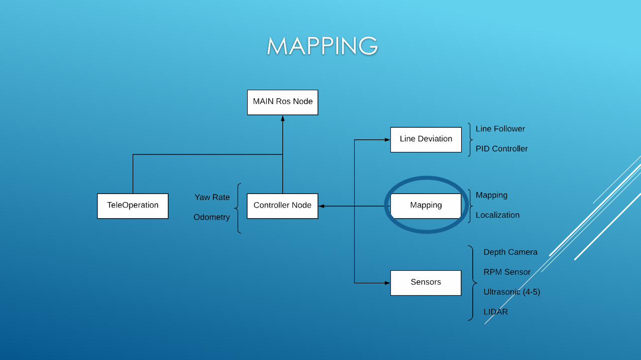
MAPPING

● Saves and updates a map of the vehicle’s environment
● Uses sensor data to create a map and odometry to assign a current location
● Updates the map where old data has been recorded, or adds it if seeing a new area
● Can be saved between sessions; useful for comparing teleop and autonomous runs through the same area(s)
MAPPING

LOCALIZATION
● Particle Filter● “Particles” represent different states of the vehicle
● Pros:● Easy to program/conceptually understand
● Cons:● Can fail if too little “particles” are used● Complexity increases exponentially

● Extended Kalman Filter● Uses updates from odometer data and sensors to localize
● Pros:● Lower complexity● Already implemented in ROS
● Cons:● Bad initial estimates can make the filter fail
LOCALIZATION

CAR TESTING

STEERING ANGLES
● Arduino Servo.write() Command sends pulses with different duty cycles at 50 Hz.● FInd the range of inputs where Servo.write() works
● Attached a ruler to the wheel of the vehicle● Took photos as we incremented duty cycle by .01%● Used Photoshop tools to measure Steering Angles

TACHOMETER
● Measures rotations of the spur gear that turns the wheels○ Using engine rotations you can calculate the distance the car travels. ○ Needed for localization and collision detection
● Attached a magnet to the spur gear and placed a traxxas hall sensor near the gear○ Pull-up Resistor between signal and VCC pins○ When the sensor detects the magnet, the voltage across the sensor drops to millivolts○ We measure the rising and falling edges of the tachometer

Motor Speed Testing ● We have the car run at varying speed for 10 seconds and then have it brake
○ Every 20 measurements from the tachometer it writes the calculated rotations per millisecond and the time between writes to a text file

Collision Avoidance
● If ROS ever fails, all the sensors will go down, but the PCB will keep driving the engine and servos using the last received values
● A sonar sensor on the front of the vehicle will determine if we have an object near the vehicle
● if the vehicle is moving at a certain “servo” value and detects an object near it, the car will begin to brake

Communication
● Sponsor asked us to use an Ad Hoc network at 5-5.9 GHz○ Simulates the protocol for wireless communication between vehicles
● The vehicles will communicate by sending each other text files that contain their locations and orientations.
● Issues○ Jetson Wifi card doesn’t support Ad-Hoc mode○ USB adapters do not consistently have a chipset that is compatible with
Ad-Hoc mode in Linux ○ PCI is the only solution, but is expensive.

PROJECT EXPENSES

Work DistributionTask Bruce Tyler Eduardo Christian
Purchasing and Product Research X X
Mount Design X X
Sensor Testing X X
PCB Design X
Electrical Wiring and Soldering X
OpenCV Computer VIsion X
Lane Detection X
PID Control Design X
ROS System Integration X X
Nvidia Programming Setup X
Ad Hoc Network Setup X

PROGRESS

OBSTACLES
● Linux and OpenCV learning curve
● Unavailability of Nvidia documentation
● Zed Camera software installation on Jetson

Questions?
Related Documents