ELASTIC CLOUD COMPUTING ARCHITECTURE AND SYSTEM FOR HETEROGENEOUS SPATIOTEMPORAL COMPUTING Xuan Shi * Department of Geosciences, University of Arkansas, Fayetteville, AR 72701. U.S.A. Email: [email protected] KEY WORDS: Elastic Architecture, Cloud Computing, Geocomputation, Spatiotemporal ABSTRACT: Spatiotemporal computation implements a variety of different algorithms. When big data are involved, desktop computer or standalone application may not be able to complete the computation task due to limited memory and computing power. Now that a variety of hardware accelerators and computing platforms are available to improve the performance of geocomputation, different algorithms may have different behavior on different computing infrastructure and platforms. Some are perfect for implementation on a cluster of graphics processing units (GPUs), while GPUs may not be useful on certain kind of spatiotemporal computation. This is the same situation in utilizing a cluster of Intel's many-integrated-core (MIC) or Xeon Phi, as well as Hadoop or Spark platforms, to handle big spatiotemporal data. Furthermore, considering the energy efficiency requirement in general computation, Field Programmable Gate Array (FPGA) may be a better solution for better energy efficiency when the performance of computation could be similar or better than GPUs and MICs. It is expected that an elastic cloud computing architecture and system that integrates all of GPUs, MICs, and FPGAs could be developed and deployed to support spatiotemporal computing over heterogeneous data types and computational problems. 1. SPATIOTEMPORAL COMPUTING IN THE ERA OF BIG DATA SCIENCE Data originated from sensors aboard satellites and platforms such as airplane, UAV and mobile systems have generated high spectral, spatial, vertical and temporal resolution data. There is greater potential and challenge to extract more accurate and significant geospatial information with these high resolution data at the level that was not possible before. For example, high spectral resolution (hyperspectral) data characterized by hundreds of relatively narrow (<10 nm) and contiguous bands are useful not only for the general purpose land cover classification, but also for extracting the mineral composition of rocks and identifying crop or tree species (Martin et al. 1998, Xiao et al. 2004, Thenkabail et al. 2004, Clark et al. 2005, Buddenbaum et al. 2006, Boschetti et al. 2007). High spatial resolution (HSR) sensors (Greenberg et al. 2009, Sridharan and Qiu 2013), such as IKONOS, QuickBird, and WorldView-2,3, can provide sub-meter pixel image products, with sufficient detail to allow the delineation of individual geographic objects such as buildings, trees, roads, and grassland (often referred to as feature extraction). Light Detection and Ranging (LiDAR) sendor can offer high vertical resolution of geometry and allows the direct collection of x, y, and z coordinates of ground objects, which makes possible automatic detection of elevated features and construction of 3 dimensional (3D) models of ground surface (Rottensteiner et al. 2005). The temporal resolution are increased not only because of the shortening of revisit frequency, but the simultaneous available of mutiple sensors such as IKNOS, WolderView 1,2,and 3. Traditional statistics based per pixel image processing methods and algorithms have been designed primarily for 2D coarse and moderate spatial resolution multispectral imagery, not appropriate or optimal for the high resolution sensor data. Inevitably, the volume, velocity, and variety of hyperspectral, HSR and 3D data, along with other socioeconomic, demographic, environmental, and social media data, pose great challenge to existing geospatial software when analyzing such big heterogeneous datasets, because the scale of data and computation are well beyond the capacity of PC-based software due to PC’s limited storage, memory, and computing power. For example, DigitalGlobal alone acquires 1 billion km 2 of HSR imagery annually with its 6-satellite constellation, resulting in 63 petabypes data achive in 2013, second only to Facebook among all private companies. New computing infrastructure and system are required in response to such big data challenge. 2. HYBRID COMPUTING ARCHITECTURE AND SYSTEMS Heterogeneous spatial data integration, processing, and analysis have been a challenging task as spatial computation has been playing an essential part in a variety of significant areas of science, engineering and decision-making. Such areas include geospatial-related natural and social sciences, public safety and emergency response, spatial intelligence analytics and military operations, ecological and environmental science and engineering, and public health. Geospatial data represents real- world geographic features or objects in either vector or raster data models. In the vector model, features are captured as discrete geometric objects and represented as points, lines or polygons with non-spatial attributes. In the raster model, features are represented on a grid, or as a multidimensional matrix, including satellite imagery and other remotely sensed data. While many algorithms were developed to process vector, raster or imagery data, handling heterogeneous data is required in a variety of spatiotemporal computing tasks. High-resolution geospatial data has become increasingly available along with an accelerating increase in data volume. Consequently spatial data may be stored as separate tiles for efficient data exchange, integration, processing, analysis and visualization. Distributed or separated data has raised a variety of challenges and complexities in spatial computation for knowledge discovery. Traditional software may only work on one tile of data for computation or analysis. If all tiles are merged or mosaicked into a single piece, its size may become * Corresponding author ISPRS Annals of the Photogrammetry, Remote Sensing and Spatial Information Sciences, Volume IV-4/W2, 2017 2nd International Symposium on Spatiotemporal Computing 2017, 7–9 August, Cambridge, USA This contribution has been peer-reviewed. The double-blind peer-review was conducted on the basis of the full paper. https://doi.org/10.5194/isprs-annals-IV-4-W2-115-2017 | © Authors 2017. CC BY 4.0 License. 115

Welcome message from author
This document is posted to help you gain knowledge. Please leave a comment to let me know what you think about it! Share it to your friends and learn new things together.
Transcript
ELASTIC CLOUD COMPUTING ARCHITECTURE AND SYSTEM FOR
HETEROGENEOUS SPATIOTEMPORAL COMPUTING
Xuan Shi*
Department of Geosciences, University of Arkansas, Fayetteville, AR 72701. U.S.A. Email: [email protected]
KEY WORDS: Elastic Architecture, Cloud Computing, Geocomputation, Spatiotemporal
ABSTRACT:
Spatiotemporal computation implements a variety of different algorithms. When big data are involved, desktop computer or
standalone application may not be able to complete the computation task due to limited memory and computing power. Now that a
variety of hardware accelerators and computing platforms are available to improve the performance of geocomputation, different
algorithms may have different behavior on different computing infrastructure and platforms. Some are perfect for implementation on
a cluster of graphics processing units (GPUs), while GPUs may not be useful on certain kind of spatiotemporal computation. This is
the same situation in utilizing a cluster of Intel's many-integrated-core (MIC) or Xeon Phi, as well as Hadoop or Spark platforms, to
handle big spatiotemporal data. Furthermore, considering the energy efficiency requirement in general computation, Field
Programmable Gate Array (FPGA) may be a better solution for better energy efficiency when the performance of computation could
be similar or better than GPUs and MICs. It is expected that an elastic cloud computing architecture and system that integrates all of
GPUs, MICs, and FPGAs could be developed and deployed to support spatiotemporal computing over heterogeneous data types and
computational problems.
1. SPATIOTEMPORAL COMPUTING IN THE ERA OF
BIG DATA SCIENCE
Data originated from sensors aboard satellites and platforms
such as airplane, UAV and mobile systems have generated high
spectral, spatial, vertical and temporal resolution data. There is
greater potential and challenge to extract more accurate and
significant geospatial information with these high resolution
data at the level that was not possible before. For example, high
spectral resolution (hyperspectral) data characterized by
hundreds of relatively narrow (<10 nm) and contiguous bands
are useful not only for the general purpose land cover
classification, but also for extracting the mineral composition of
rocks and identifying crop or tree species (Martin et al. 1998,
Xiao et al. 2004, Thenkabail et al. 2004, Clark et al. 2005,
Buddenbaum et al. 2006, Boschetti et al. 2007). High spatial
resolution (HSR) sensors (Greenberg et al. 2009, Sridharan and
Qiu 2013), such as IKONOS, QuickBird, and WorldView-2,3,
can provide sub-meter pixel image products, with sufficient
detail to allow the delineation of individual geographic objects
such as buildings, trees, roads, and grassland (often referred to
as feature extraction). Light Detection and Ranging (LiDAR)
sendor can offer high vertical resolution of geometry and allows
the direct collection of x, y, and z coordinates of ground
objects, which makes possible automatic detection of elevated
features and construction of 3 dimensional (3D) models of
ground surface (Rottensteiner et al. 2005). The temporal
resolution are increased not only because of the shortening of
revisit frequency, but the simultaneous available of mutiple
sensors such as IKNOS, WolderView 1,2,and 3. Traditional
statistics based per pixel image processing methods and
algorithms have been designed primarily for 2D coarse and
moderate spatial resolution multispectral imagery, not
appropriate or optimal for the high resolution sensor data.
Inevitably, the volume, velocity, and variety of hyperspectral,
HSR and 3D data, along with other socioeconomic,
demographic, environmental, and social media data, pose great
challenge to existing geospatial software when analyzing such
big heterogeneous datasets, because the scale of data and
computation are well beyond the capacity of PC-based software
due to PC’s limited storage, memory, and computing power.
For example, DigitalGlobal alone acquires 1 billion km2 of HSR
imagery annually with its 6-satellite constellation, resulting in
63 petabypes data achive in 2013, second only to Facebook
among all private companies. New computing infrastructure
and system are required in response to such big data challenge.
2. HYBRID COMPUTING ARCHITECTURE AND
SYSTEMS
Heterogeneous spatial data integration, processing, and analysis
have been a challenging task as spatial computation has been
playing an essential part in a variety of significant areas of
science, engineering and decision-making. Such areas include
geospatial-related natural and social sciences, public safety and
emergency response, spatial intelligence analytics and military
operations, ecological and environmental science and
engineering, and public health. Geospatial data represents real-
world geographic features or objects in either vector or raster
data models. In the vector model, features are captured as
discrete geometric objects and represented as points, lines or
polygons with non-spatial attributes. In the raster model,
features are represented on a grid, or as a multidimensional
matrix, including satellite imagery and other remotely sensed
data. While many algorithms were developed to process vector,
raster or imagery data, handling heterogeneous data is required
in a variety of spatiotemporal computing tasks.
High-resolution geospatial data has become increasingly
available along with an accelerating increase in data volume.
Consequently spatial data may be stored as separate tiles for
efficient data exchange, integration, processing, analysis and
visualization. Distributed or separated data has raised a variety
of challenges and complexities in spatial computation for
knowledge discovery. Traditional software may only work on
one tile of data for computation or analysis. If all tiles are
merged or mosaicked into a single piece, its size may become
∗Corresponding author
ISPRS Annals of the Photogrammetry, Remote Sensing and Spatial Information Sciences, Volume IV-4/W2, 2017 2nd International Symposium on Spatiotemporal Computing 2017, 7–9 August, Cambridge, USA
This contribution has been peer-reviewed. The double-blind peer-review was conducted on the basis of the full paper. https://doi.org/10.5194/isprs-annals-IV-4-W2-115-2017 | © Authors 2017. CC BY 4.0 License.
115

too huge to be processed on a desktop computer. If the whole
data is maintained as separate tiles, however, the analytic result
may not be correct or consistent among multiple separated tiles.
In the problem-solving and decision-making processes, the
performance of geospatial computation is severely limited when
massive datasets are processed. Heterogeneous geospatial data
integration and analytics obviously magnify the complexity and
operational time frame. Many large-scale geospatial problems
may be not processable at all if the computer system does not
have sufficient memory or computational power.
Designing novel algorithms and deploying the solutions in
massively parallel computing environment to achieve the
capability for scalable data processing and analytics over peta-
scale, complex, and heterogeneous spatial data with consistent
quality and high-performance is the central theme of
spatiotemporal computing. Emerging computer architecture and
system that combine multi-core CPUs and accelerator
technologies, like many-core GPUs and Intel MIC coprocessors,
would provide substantial computing power for many time-
consuming spatial-temporal computation and applications. New
multi-core architectures combined with application accelerators
hold the promise to achieve scalability and high performance by
exploiting task and data levels of parallelism that are not
supported by the conventional systems. Such a distributed
computing environment is particularly suitable for large-scale
spatiotemporal computation over distributed or separated spatial
data, while the potential of such advanced Cyberinfrastructure
remains unexplored in this domain. For example, ESRI’s
commercial product ArcGIS has an estimated 615 stand-alone
tools in 18 categories (Gao and Goodchild 2013), plus hundreds
of other interactive tools under the ArcMap interface. Very few
of these more than 1,000 functional modules in ArcGIS are
parallelized into applicable solutions on GPUs or MICs.
In the chapters on “GPGPU in GIS” (Shi and Huang 2016a)
and “MIC in GIS” (Shi and Huang 2016b) included in the
Encyclopaedia of GIS, details about GPU and MIC were
introduced. As representative accelerators, GPUs and MICs
have been utilized to construct hybrid computer architecture
and systems that integrate multicore processors, manycore
coprocessors. For example, Keeneland is a hybrid
supercomputer that has 528 CPUs and 792 GPUs funded by
NSF. The Keeneland Full Scale (KFS) system consists of 264
HP SL250G8 compute nodes, each with 2 eight-core Intel
Sandy Bridge (Xeon E5) processors, 3 NVIDIA M2090 GPU
accelerators. Beacon is a Cray CS300-AC Cluster
Supercomputer that offers access to 48 compute nodes and 6
I/O nodes joined by FDR InfiniBand interconnect. Each
compute node is equipped with 2 Intel Xeon 8-core processors,
4 Intel Xeon Phi (MIC) coprocessors, 256 GB of RAM, and
960 GB of storage. Each Xeon Phi coprocessor contains 60
MIC cores and 8 GB on-board memory. Beacon provides 768
conventional cores and 11,520 accelerator cores that offer over
210 TFLOP/s of combined computational performance, 12 TB
of system memory, 1.5 TB of coprocessor memory, and over 73
TB of storage, in aggregate. Both Keeneland and Beacon were
used to enable many large scale spatiotemporal computation
and simulation (Shi and Xue 2016a, 2016b, Lai et al. 2016,
Guan et al. 2016, Shi et al. 2014a, Shi et al. 2014b).
Besides conventional hybrid computer clusters, Hadoop and
Spark are the new distributed computing architecture and
platforms that can be applied for spatiotemporal computing.
Hadoop is an Apache open source framework written in java
that allows distributed processing of large datasets across
clusters of computers using simple programming models. A
Hadoop frame-worked application works in an environment that
provides distributed storage and computation across clusters of
computers. Hadoop is designed to scale up from single server to
thousands of machines, each offering local computation and
storage. Hadoop MapReduce is a software framework for easily
writing applications which process big amounts of data in-
parallel on large clusters of commodity hardware in a reliable,
fault-tolerant manner. MapReduce refers to the following two
different tasks that Hadoop programs perform: 1) map is the
first task, which takes input data and converts it into a set of
data, where individual elements are broken down into tuples
(key/value pairs). 2) reduce takes the output from a map task as
input and combines those data tuples into a smaller set of
tuples. The reduce task is always performed after the map task.
In comparison to Hadoop that has heavy I/O and file
transactions, Apache Spark is a new distributed computing
platform for general-purpose scientific computation. Spark
extends the popular MapReduce model to efficiently support
more types of computations, including interactive queries and
stream processing. Furthermore, Spark provides ability to run
computations in memory, and the system is more efficient than
MapReduce for complex applications running on disk. Spark is
designed to cover a wide range of workloads applicable on
distributed systems, including batch applications, iterative
algorithms, interactive queries, streaming and graph based
network calculation through its rich built-in libraries, including
Spark SQL, streaming, MLlib and GraphX. By supporting these
workloads in the distributed engine, Spark makes it easy and
inexpensive to combine different processing types, which is
often necessary in production data analysis pipelines. Spark is
also highly accessible, offering simple APIs in Python, Java,
Scala, and SQL. Very few of these more than 1,000 functional
modules in ArcGIS are transformed into MapReduce solutions
applicable on Hadoop or Spark platforms.
At last, an emerging new hybrid architecture integrates FPGAs
as coprocessors along with traditional multicore or manycore
processors. FPGA has the advantage for its energy-efficient
manner, while it can be reconfigured based on different
applications. There are growing interest to deploy FPGAs in
cloud computing and data center systems. For example, in
Microsoft’s Catapult project, FPGAs were integrated into a data
center to accelerate the Bing search engine. By using FPGAs to
implement the document ranking algorithm, the performance
was doubled at only a 30% increase in energy (Putnam et al.
2015). Intel acquired Altera (one major provider of FPGAs) for
16.7 billion dollars as Intel also would like to integrate FPGAs
with Xeon multicore processors to build data and computing
centers (Morgan 2014). FPGAs have the potential to build
energy efficient next generation computing systems, if several
challenging problems can be resolved to enable reconfigurable
computing to become mainstream solutions.
3. HETEROGENEOUS SPATIOTEMPORAL
COMPUTING ON HYBRID COMPUTING SYSTEMS
In recent years, my research team has been working on parallel
and high performance spatiotemporal computation on
supercomputers KraKen (a cluster of CPUs), Keeneland (a
cluster of GPUs), and Beacon (a cluster of MICs) over different
spatiotemporal problems, including ISODATA for unsupervised
image classification, MLC for supervised image classification,
Kriging interpolation, Cellular Automata based urban sprawl
ISPRS Annals of the Photogrammetry, Remote Sensing and Spatial Information Sciences, Volume IV-4/W2, 2017 2nd International Symposium on Spatiotemporal Computing 2017, 7–9 August, Cambridge, USA
This contribution has been peer-reviewed. The double-blind peer-review was conducted on the basis of the full paper. https://doi.org/10.5194/isprs-annals-IV-4-W2-115-2017 | © Authors 2017. CC BY 4.0 License.
116
simulation, agent-based modelling on information diffusion,
affinity propagation (AP), near-repeat calculation, and so on. In
2016, the 2nd place award was given by ACM SIGSPATIAL
International Student Research Competition for the research
entitled Accelerating the Calculation of Minimum Set of
Viewpoints for Maximum Coverage over Digital Elevation
Model Data by Hybrid Computer Architecture and Systems.
This research introduces how to accelerate the calculation of
minimum set of viewpoints for maximum coverage over digital
elevation model data using Intel’s Xeon Phi on supercomputer
Beacon equipped with Intel’s Many-Integrated-Core (MIC)
coprocessors. This data and computation intensive process
consists of a series of geospatial computation tasks, including 1)
the automatic generation of control viewpoints through map
algebra calculation and hydrological modeling approaches; 2)
the creation of the joint viewshed derived from the viewshed of
all viewpoints to establish the maximum viewshed coverage of
the given digital elevation model (DEM) data; and 3) the
identification of a minimum set of viewpoints that cover the
maximum terrain area of the joint viewshed. The parallel
implementation on Beacon achieved more than 100x speedup in
comparison to the sequential implementation. The outcome of
the computation has broad societal impacts since the solutions
can be applied to real-world applications and decision-making
practice, including civil engineering, infrastructure optimization
and management, and military operations.
Throughout the course of such extensive development on
different spatiotemporal themes, it can be concluded that
different kind of hybrid computer architecture and systems may
be more suitable to different kind of problems. GPU has been
utilized in a variety of our prior works (Shi and Xue 2016b,
Guan et al. 2016, Shi et al. 2014, Shi et al. 2014). Particularly
when many spatiotemporal modules would process matrix data,
GPU could be a perfect accelerator to improve the performance.
On the other hand, some spatiotemporal computation and
simulation would contain randomized procedures, which may
devaluate the functionality of GPU. A typical CUDA-capable
GPU is organized into an array of highly threaded streaming
multiprocessors (SMs). Within the SM, computing threads are
grouped into block, which is then managed by a grid structure.
Within a block of threads, the threads are executed in groups of
32 called a warp. In the case of the random procedures, if
different threads in a warp need to do different things, all
threads will compute a logical predicate and several predicated
instructions. This is called warp divergence. When all threads
execute conditional branches differently, the execution cost
could be the sum of both branches. Warp divergence can lead to
a big loss of parallel efficiency. In comparison to such a
problem in the utilization of GPUs, MIC exemplifies its
advantage in dealing with randomized procedures in
spatiotemporal computation. Each MIC has a total of 240
threads on 60 processing cores. The vector processing unit on
the Intel MIC processor is very efficient and can deal with
operations involving many independent operands.
Although hardware accelerators have been widely used in
computer clusters, there are limitations as well. For example,
the extra communication overhead between the coprocessor and
the host can easily offset the performance benefit from the
parallel processing on GPUs. Originally, all the kernels running
on GPUs have to be created by host processors. This limitation
makes it impossible or inconvenient to implement some
algorithms with dynamic behavior. The communication cost
between the host processors and the coprocessors has been a
traditional drawback since the on-board memory on the
accelerators is separate from the host main memory. Therefore,
the source data and the results have to be transferred between
these two pieces of memory. Data transfer between two GPUs
crossing two different nodes has to go through host memory,
introducing unnecessary overhead. NVIDIA Kepler GPU
architecture supports a “dynamic parallelism” feature in which
kernels (i.e., tasks) can generate new kernels while running on
GPU. This feature makes it possible to implement algorithms
with dynamic behavior completely on the GPU. Furthermore,
the “GPUDirect” feature could be explored to carry out data
communication directly when multiple GPUs are used.
In the case of MICs, both the native model and the offload
model only utilize the Xeon Phi coprocessor, while the host
(Xeon) CPU is not efficiently used, or not used, in the
calculation. Hybrid solutions were explored to optimally utilize
both the Xeon CPU and MIC coprocessors (Lai et al. 2016).
For example, to extend the native model, we create MPI ranks
that reside on the host CPU and the MIC coprocessors. If m
MIC (Xeon Phi) coprocessors and n host CPU processors are
used, m × 60 + n MPI processes are created in the parallel
implementation. In the case of offload model, the workload is
first distributed to CPUs through MPI. Then a host CPU will
offload part of the job to a MIC card using OpenMP. On the
host CPU, we also use OpenMP to spawn multiple threads for
parallel processing. Asynchronous offload allows overlap of
data transfer and compute. The host initiates an offload to be
performed asynchronously and can proceed to next statement
after starting this computation. In general, the hybrid-offload
solution could be more flexible and efficient (Lai et al. 2016).
Although FPGAs have been increasingly integrated into cloud
computing systems and data centers, very few geographers and
GIScientists would have worked on FPGAs. In a pilot study, we
implemented a generic Cellular Automata (CA) algorithm using
a cluster of FPGAs. In (Shi et al. 2014a), in comparison to the
use cases of embarrassingly parallelism and geospatial
computing with loose communication and data exchange, CA
was the most complicated use cases due to its intensive data
partition and exchange among distributed computing nodes. In
(Shi et al. 2014a), we applied MPI’s SEND and RECV
commands to enable data communication and exchange to
complete Game of Life (GOL). In the latest pilot study, we re-
designed the solution by transforming the GOL into a pipeline
style that is applicable on a cluster of FPGAs.
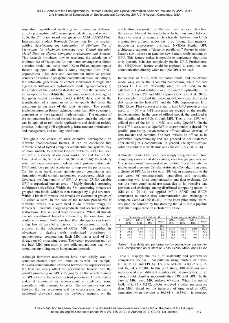
#
Size of the grid: 8,192 x 8,192 Size of the grid: 16,384 x 16,384
MPI +
CPU
MPI +
GPU
MPI +
MIC FPGA
MPI +
CPU
MPI +
GPU
MPI +
MIC FPGA
1 38.9 287.4
2 78.2 24.9 7.3 19.6 312.7 122.2 29.0 143.6
4 39.2 12.8 4.3 9.9 155.6 59.1 14.7 42.3
8 21.8 6.3 3.3 5.5 78.1 29.7 8.5 21.8
16 10.4 4.2 3.8 3.2 39.4 17.2 6.6 11.7
Table 1. Scalability and performance (by second) comparison for GOL computation on clusters of CPUs, GPUs, MICs, and FPGAs
Table 1 displays the result of scalability and performance
comparison for GOL computation using clusters of CPUs,
GPUs, MICs, and FPGAs. The size of GOL is 8,192 x 8,192
and 16,384 x 16,384. In this pilot study, 100 iterations were
implemented over different numbers (#) of processors. In all
cases, FPGA displays superiority than CPU and GPU. In the
case of MIC, each MIC utilized 60 cores. When the size of
GOL is 8,192 x 8,192, FPGA achieved a better performance
than MIC. Based on the trajectory of time used on GOL
simulation when the size is 16,384 x 16,384, it is expected
ISPRS Annals of the Photogrammetry, Remote Sensing and Spatial Information Sciences, Volume IV-4/W2, 2017 2nd International Symposium on Spatiotemporal Computing 2017, 7–9 August, Cambridge, USA
This contribution has been peer-reviewed. The double-blind peer-review was conducted on the basis of the full paper. https://doi.org/10.5194/isprs-annals-IV-4-W2-115-2017 | © Authors 2017. CC BY 4.0 License.
117
when 32 or more FPGAs are used, the performance of FPGA
could be better than that for the same number of MICs. When
energy efficiency is considered, FPGA is superior in all cases.
Considering many spatiotemporal computation are raster based
while such convolutional calculation is commonly applied, this
pilot study on clusters of FPGAs will have broader impact in
the future in the GIScience community.
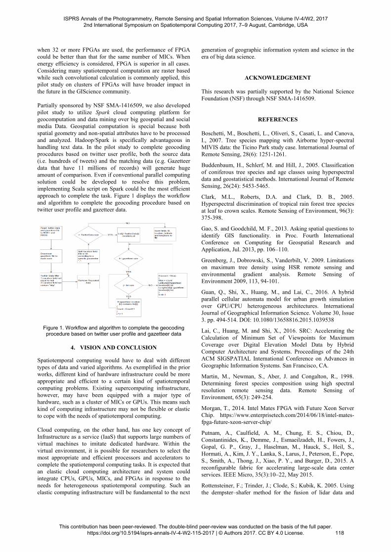
Partially sponsored by NSF SMA-1416509, we also developed
pilot study to utilize Spark cloud computing platform for
geocomputation and data mining over big geospatial and social
media Data. Geospatial computation is special because both
spatial geometry and non-spatial attributes have to be processed
and analyzed. Hadoop/Spark is specifically advantageous in
handling text data. In the pilot study to complete geocoding
procedures based on twitter user profile, both the source data
(i.e. hundreds of tweets) and the matching data (e.g. Gazetteer
data that have 11 millions of records) will generate huge
amount of comparison. Even if conventional parallel computing
solution could be developed to resolve this problem,
implementing Scala script on Spark could be the most efficient
approach to complete the task. Figure 1 displays the workflow
and algorithm to complete the geocoding procedure based on
twitter user profile and gazetteer data.
Figure 1. Workflow and algorithm to complete the geocoding procedure based on twitter user profile and gazetteer data
4. VISION AND CONCLUSION
Spatiotemporal computing would have to deal with different
types of data and varied algorithms. As exemplified in the prior
works, different kind of hardware infrastructure could be more
appropriate and efficient to a certain kind of spatiotemporal
computing problems. Existing supercomputing infrastructure,
however, may have been equipped with a major type of
hardware, such as a cluster of MICs or GPUs. This means such
kind of computing infrastructure may not be flexible or elastic
to cope with the needs of spatiotemporal computing.
Cloud computing, on the other hand, has one key concept of
Infrastructure as a service (IaaS) that supports large numbers of
virtual machines to imitate dedicated hardware. Within the
virtual environment, it is possible for researchers to select the
most appropriate and efficient processors and accelerators to
complete the spatiotemporal computing tasks. It is expected that
an elastic cloud computing architecture and system could
integrate CPUs, GPUs, MICs, and FPGAs in response to the
needs for heterogeneous spatiotemporal computing. Such an
elastic computing infrastructure will be fundamental to the next
generation of geographic information system and science in the
era of big data science.
ACKNOWLEDGEMENT
This research was partially supported by the National Science
Foundation (NSF) through NSF SMA-1416509.
REFERENCES
Boschetti, M., Boschetti, L., Oliveri, S., Casati, L. and Canova,
I., 2007. Tree species mapping with Airborne hyper-spectral
MIVIS data: the Ticino Park study case. International Journal of
Remote Sensing, 28(6): 1251-1261.
Buddenbaum, H., Schlerf, M. and Hill, J., 2005. Classification
of coniferous tree species and age classes using hyperspectral
data and geostatistical methods. International Journal of Remote
Sensing, 26(24): 5453-5465.
Clark, M.L., Roberts, D.A. and Clark, D. B., 2005.
Hyperspectral discrimination of tropical rain forest tree species
at leaf to crown scales. Remote Sensing of Environment, 96(3):
375-398.
Gao, S. and Goodchild, M. F., 2013. Asking spatial questions to
identify GIS functionality. in Proc. Fourth International
Conference on Computing for Geospatial Research and
Application, Jul. 2013, pp. 106–110.
Greenberg, J., Dobrowski, S., Vanderbilt, V. 2009. Limitations
on maximum tree density using HSR remote sensing and
environmental gradient analysis. Remote Sensing of
Environment 2009, 113, 94-101.
Guan, Q., Shi, X., Huang, M., and Lai, C., 2016. A hybrid
parallel cellular automata model for urban growth simulation
over GPU/CPU heterogeneous architectures. International
Journal of Geographical Information Science. Volume 30, Issue
3. pp. 494-514. DOI: 10.1080/13658816.2015.1039538
Lai, C., Huang, M. and Shi, X., 2016. SRC: Accelerating the
Calculation of Minimum Set of Viewpoints for Maximum
Coverage over Digital Elevation Model Data by Hybrid
Computer Architecture and Systems. Proceedings of the 24th
ACM SIGSPATIAL International Conference on Advances in
Geographic Information Systems. San Francisco, CA.
Martin, M., Newman, S., Aber, J. and Congalton, R., 1998.
Determining forest species composition using high spectral
resolution remote sensing data. Remote Sensing of
Environment, 65(3): 249-254.
Morgan, T., 2014. Intel Mates FPGA with Future Xeon Server
Chip. https://www.enterprisetech.com/2014/06/18/intel-mates-
fpga-future-xeon-server-chip/
Putnam, A., Caulfield, A. M., Chung, E. S., Chiou, D.,
Constantinides, K., Demme, J., Esmaeilzadeh, H., Fowers, J.,
Gopal, G. P., Gray, J., Haselman, M., Hauck, S., Heil, S.,
Hormati, A., Kim, J. Y., Lanka, S., Larus, J., Peterson, E., Pope,
S., Smith, A., Thong, J., Xiao, P. Y., and Burger, D., 2015. A
reconfigurable fabric for accelerating large-scale data center
services. IEEE Micro, 35(3):10–22, May 2015.
Rottensteiner, F.; Trinder, J.; Clode, S.; Kubik, K. 2005. Using
the dempster–shafer method for the fusion of lidar data and
ISPRS Annals of the Photogrammetry, Remote Sensing and Spatial Information Sciences, Volume IV-4/W2, 2017 2nd International Symposium on Spatiotemporal Computing 2017, 7–9 August, Cambridge, USA
This contribution has been peer-reviewed. The double-blind peer-review was conducted on the basis of the full paper. https://doi.org/10.5194/isprs-annals-IV-4-W2-115-2017 | © Authors 2017. CC BY 4.0 License.
118
multi-spectral images for building detection. Information
Fusion 2005, 6, 283-300.
Sridharan, H. and Qiu, F., 2013. Developing an Object-based
HSR Image Classifier with a Case Study Using WorldView-2
Data. Photogrammetric Engineering & Remote Sensing, 79(11).
Shi, X. and Huang, M., 2016a. GPGPU in GIS. In Shekhar, S.
et al. (eds) Encyclopedia of GIS. Published by Springer
Shi, X. and Huang, M., 2016b. MIC in GIS. In Shekhar, S. et
al. (eds) Encyclopedia of GIS. Published by Springer.
Shi, X. and Xue, B., 2016a. Deriving a Minimum Set of
Viewpoints for Maximum Coverage over Any Given Digital
Elevation Model Data. International Journal of Digital Earth.
Volume 9, Issue 12. pp. 1153-1167.
Shi, X. and Xue, B., 2016b. Parallelizing maximum likelihood
classification on computer cluster and graphics processing unit
for supervised image classification. International Journal of
Digital Earth.
http://www.tandfonline.com/doi/full/10.1080/17538947.2016.1
251502
Shi, X., Lai, C., Huang, M. and You, H., 2014a.
Geocomputation over the Emerging Heterogeneous Computing
Infrastructure. Transactions in GIS, vol. 18, no. S1, pp. 3-24,
Nov. 2014.
Shi, X., Huang, M., You, H., Lai, C. and Chen, Z., 2014b.
Unsupervised image classification over supercomputers Kraken,
Keeneland and Beacon. GIScience & Remote Sensing, Volume
51, Issue 3. 2014. pp. 321-338
Shi, X. and Ye, F., 2013. Kriging interpolation over
heterogeneous computer architectures and systems. GIScience
& Remote Sensing. Volume 50, Issue 2, 2013. pp.196-211
Thenkabail, P. S., Enclona, E. A., Ashton, M. S., Legg, C. and
De Dieu, M. J., 2004. Hyperion, IKONOS, ALI, and ETM+
sensors in the study of African rainforests. Remote Sensing of
Environment, 90(1): 23-43.
Xiao, Q., Ustin, S. and McPherson, E., 2004. Using AVIRIS
data and multiple-masking techniques to map urban forest tree
species. International Journal of Remote Sensing, 25(24): 5637-
5654.
ISPRS Annals of the Photogrammetry, Remote Sensing and Spatial Information Sciences, Volume IV-4/W2, 2017 2nd International Symposium on Spatiotemporal Computing 2017, 7–9 August, Cambridge, USA
This contribution has been peer-reviewed. The double-blind peer-review was conducted on the basis of the full paper. https://doi.org/10.5194/isprs-annals-IV-4-W2-115-2017 | © Authors 2017. CC BY 4.0 License.
119
Related Documents