
Welcome message from author
This document is posted to help you gain knowledge. Please leave a comment to let me know what you think about it! Share it to your friends and learn new things together.
Transcript

Environmental & Social Impact Assessment (ESIA)
Karachi Hyderabad Motorway (M-9)
NATIONAL HIGHWAY AUTHORITY
Draft Final ReportJune 2012

Draft Final ReportJune 2012
ENVIRONMENTAL MANAGEMENT CONSULTANTS503, Anum Estate, Opp. Duty Free Shop, Main Shahrae Faisal, Karachi.
Phones: 9221-4311466, 4311467, Fax: 9221-4311467.
E-mail: [email protected], [email protected]
Website: www.emc.com.pk
Environmental and Social Impact Assessment
Karachi Hyderabad Motorway (M-9) Project
Bina Puri Pakistan (pvt) Ltd.

EnvIRonMEntAl And SocIAl IMpAct ASSESSMEnt foR KARAchI hYdERAbAd MotoRwAY (M-9) pRojEct
EnvIRonMEntAl MAnAgEMEnt conSUltAntS
ExEcUtIvE SUMMARY
I of vII
SUMMARYBackground of the Project
The existing 136 km Karachi-Hyderabad section of N-5 (popularly known as
Super Highway) connects the port city of Karachi with the North of Pakistan.
This section of the highway is amongst the most densely trafficked in the entire
country, the existing highway is serving heavy traffic volume with large portion
of truck traffic. The route is also the shortest possible distance between the two
cities i.e. Karachi and Hyderabad and feeds into the main North – South Links
i.e. National Highway N-55 (Indus Highway) and the National Highway N-5
(Grand Trunk Road).
In order to accelerate the process of expansion of motorways the Government has
invited the private sector to participate in expansion of Motorway Network, on
the basis of build, operate and transfer (BOT) arrangement. The National
Highway Authority selected M/s Binapuri Pakistan Pvt. Ltd. (BPL) for the
construction of existing 4-lane Karachi-Hyderabad Superhighway as 6-lane,
access controlled and world class Motorway (M-9) along with its allied facilities.
Environmental & Social Impact Assessment of the proposed project Karachi-
Hyderabad M-9 has been conducted by M/s Environmental Management
Consultants in order to comply with the regulatory requirement of
environmental laws of Pakistan. Under the Pakistan Environmental Protection
Agency (Review of IEE and EIA) Regulations 2000; “Federal or provincial
highways or major roads (except maintenance or rebuilding or reconstruction of
existing roads) with total cost of Rupees 50 Million and above” is in Schedule II,
List of projects requiring an Environmental Impact Assessment”
As per the EPA Guidelines, the present Project is classified as “Schedule II” that
requires an EIA study and approval from the concerned authority, prior to the
construction. The approach adopted for conducting Environmental & Social
Impact Assessment of Karachi-Hyderabad M-9 Project is to follow the
requirements of Pakistan Environmental Protection Agency (Review of
IEE/EIA), Regulations 2000.
Proposed Project
The project starts off at Km 13+000 (Project Chainage 0+000) of the NHA
reference under the flyover/interchange provided for the Lyari Expressway on
the Lyari River and ends at Km 149+000 (Project Chainage 136+000) in the
proximity of the clover leaf interchange on the Hyderabad Bypass.
The proposed project involves rehabilitation of the existing 134.35 Km (Length
EXECUTIVE

reduced by 1.65 Km at Hyderabad end, terminating before Hyderabad
Interchange) of 4-lane carriageway both north-bound and south-bound and
construction of an additional new lane on the inner side of the Highway
wherever technically feasible. Both rehabilitation and widening bound
carriageways will be divided by a New Jersey Barrier. Extensions are to be made
to all the existing bridge structures and culverts. Four (4) bridges have an
additional extension on either side accommodating service roads to allow local
traffic to negotiate land locked areas between canals.
Project Objectives
The prime objective of the proposed project is to facilitate movement of people
and goods transport in the project area and between Sindh and other provinces
by providing better access and enhance the efficiency of the existing road
network. The scope of project is but not limited to:
EnvIRonMEntAl And SocIAl IMpAct ASSESSMEnt foR KARAchI hYdERAbAd MotoRwAY (M-9) pRojEct
EnvIRonMEntAl MAnAgEMEnt conSUltAntS
ExEcUtIvE SUMMARY
II of vII
Project Name Environmental & Social Impact Assessment for the proposed M-9 Karachi to Hyderabad.
Project Proponent Binapuri Pakistan Pvt. Ltd. (BPL)
Project Location Existing 136Km Karachi-Hyderabad section of National Highway N-5.
Interchanges Seven (7)
Service Area Two (2)
Facilities at Service Area:
l Restaurants and Food Courts
l Toilets
l CNG/LPG Filling Stations with Tuck Shop
l Diesel/Petrol Filling Stations with Tuck Shop
l Tyre Shop and Mini Workshop
l Trauma Centre
l Mosque
l Parking Area
l Truckers Workshop
l AamSarai and Dhaba (with Trucks/Buses Parking)
l Customer service centers where motorists can inquire about products, services,
road information, weather etc.
l Internal Roads, Sewerage, Water Supply and Electrification
Toll Plazas Two New 16-lane Toll Plazas with Electronic Toll and Traffic Management (ETTM) system
Weigh Stations Seven (7) weigh stations
Motorway Facilities l Electronic Toll Collection
l Emergency Call Service
l Centralized Operation Centre
l Traffic Counting Stations/ Weigh in Motion (WIM) system
l Variable Message Signs
l Emergency Assistance System
Table 2.1-Silent Features of the Project

n Strengthen the existing road infrastructure,
n Construct existing 4- lane Karachi-Hyderabad Superhighway as 6-lane,
access controlled in order to provide world class Motorway (M-9) along with
its associated facilities
n Design and construct bridges, culverts, and underpasses where necessary,
n Provide helpline services, services area and other motorway facilities.
Relevant Legislation & Guidelines
To carry out the present ESIA study, the environmental legislation and
guidelines enforced by the Pakistan Environmental Protection Agency have been
followed.
Project Alternatives
Different alternative of the project were analyzed by considering no Project,
alternative transport modes and improvement of the existing carriageway.
Improvement of existing road with widening on both sides in different lane
alignments, construction of more lanes and construction of bypass was
considered for project alternatives. Rehabilitation of existing carriageway and
construction of new lane was considered feasible due to least impact and more
benefits.
Description of Environment andSocial Conditions of the Area
Baseline conditions were studied for the physical, ecological resources and for
socioeconomic environment. The project is located in three districts of Sindh
Province; Malir, Thatta and Jamshoro.
The climate of most parts of the Project Area is arid characterized by four district
seasons in a year, that is, winter from Mid-November to February, spring during
March and April summer from May to Mid- September and autumn from Mid-
September to Mid-November. June is the hottest month in most parts of the
Hyderabad area, with mean daily maximum temperature recorded as 34.7 °C.
January is the coldest month in the area, with the mean daily minimum
temperature recorded as 20.7 °C. The air temperature prevailing at Karachi city
and its adjoining coastal areas are generally high throughout the year. During
winter the range of variation of temperature is large for Karachi coast especially
in respect of maximum and minimum temperatures. The mean maximum
summer temperature is 33°C, while the mean minimum temperature of Karachi
is 21.0°C.
EnvIRonMEntAl And SocIAl IMpAct ASSESSMEnt foR KARAchI hYdERAbAd MotoRwAY (M-9) pRojEct
EnvIRonMEntAl MAnAgEMEnt conSUltAntS
ExEcUtIvE SUMMARY
III of vII

In order to analyze the existing air quality of the project area, ambient air
monitoring was conducted at four locations in association with Suparco through
their mobile monitoring lab by using USEPA designated monitoring equipment.
The estimated value of the ambient air quality data parameters when compared
with the NEQS were within the limits at all sites except the CO and NO which
are slightly higher than the NEQS limits at site of Hyderabad (Near Toll plaza).
EMC team has measured noise quality of the project area. Noise level at Damba
Goth was found to be 80.6 dB (Max) which is above the NEQs Level.
The geology of the region is divisible in three main regions, the mountain ranges
of Kirthar, Pab containing a chain of minor hills in the west and in east it is
covered by the Thar Desert and part of Indian Platform where the main exposure
is of Karonjhar Mountains, which is famous for Nagar Parkar Granite. The
geology of Sindh is divisible in three main regions, the mountain ranges of
Kirthar, Pab containing a chain of minor hills in the west and in east it is covered
by the Thar Desert and part of Indian Platform where the main exposure is of
KaronjharMountains, which is famous for Nagar Parkar Granite. The soils in the
vicinity are generally coarse textured extensively laden with gravels and pebbles.
The River Indus is the prime surface water resource of Sindh.
According to the seismic zone map of Pakistan the project area lies in Zone 2A
and 2B of Modified Mercalli (M.M) intensity scale i.e. minor to moderate
damage, distinct earthquakes may cause damage to structures with fundamental
period corresponds to intensity IV- VII the M.M Scale.
Most wildlife species were found to be present or reported quite far away from
the project area in relation to the officially notified protected areas which may
comprises ecosystems that includes wildlife reserves and forests, archaeological
sites, monuments, buildings, antiquities or cultural heritage sites. As many as 12
species of mammals, 18 species of birds and 11 species of reptiles were recorded
from the area. None of the threatened species of mammals, birds or reptiles was
recorded from the area.
On both the sides of the road several tree plantations were seen which are mainly
dominated by Eucalyptus citriodora, Azedarahtaindica, Thespeciapopulenaea,
Conocarpuslatifolia, Parkinsoniaaculeata, Neriumindicum, Callistemon sp,
Guacamofficinale, Bougainvillaglabra. There is a big tract of abandoned land on
either side of the project dominated by two invasive species viz Prosopisjuliflora
and Prosopisglandulora.
The nearest Wildlife Protected Area is the Surjan Game Reserve which is about
2.0Km from the existing Karachi-Hyderabad Super Highway. The limits of
Mahal Kohistan Wildlife Sanctuary have been extended. These may be taken into
account.
In order to assess the present socio-economic and socio-cultural conditions of the
community living in the project area, a social survey was conducted. Meetings
EnvIRonMEntAl And SocIAl IMpAct ASSESSMEnt foR KARAchI hYdERAbAd MotoRwAY (M-9) pRojEct
EnvIRonMEntAl MAnAgEMEnt conSUltAntS
ExEcUtIvE SUMMARY
Iv of vII

were held with different Government departments, educational institutions,
NGOs and local communities to discuss the project, its components and its
expected environmental and socio-economic impacts.
Environmental Impact and Mitigations
Potential impacts were identified in relation to planning, design and location for
construction and operation phases of the proposed Karachi-Hyderabad M-9
Project. Mitigation measures have been suggested to reduce all negative impacts
to acceptable levels. These were discussed with specialists responsible for the
engineering aspects, and measures have been included in the designs for the
infrastructure. This means that the number of impacts and their significance have
already been reduced by amending the design. These including Strengthen the
existing road infrastructure without disturbing the business of the people;
n Design of structures as per seismic zone to eliminate risk;
n Design of storm water drainage system in consideration of change in
topography;
n Replantation of trees and Compensatory plantation;
n Avoiding complete closure of road by limiting the construction area to actual
M-9 RoW and allowing the traffic as per the traffic management plan.
n Provide provision of chain link fence and all necessary arrangement on both
sides of defined RoW;
During the construction phase, impacts mainly arise from generation of dust
from soil excavation and refilling; and from the disturbance of residents,
businesses, traffic and important buildings by the construction work. Among
these, public and worker safety due to large scale construction using heavy-duty
construction equipment, traffic disturbance during construction is considered to
be significant.
Important measures suggested include:
n Dust control measures such as water sprinkling and covering the loose
material during transport;
n Proper planning and scheduling of noise generating activities;
n Providing alternative traffic routes/detours and informing public about the
same;
n Providing public information boards at site (project details, traffic
arrangements, executing agency and contractor details; safety and contact
information);
n Following standard and safe construction practices (barricading the site
EnvIRonMEntAl And SocIAl IMpAct ASSESSMEnt foR KARAchI hYdERAbAd MotoRwAY (M-9) pRojEct
EnvIRonMEntAl MAnAgEMEnt conSUltAntS
ExEcUtIvE SUMMARY
v of vII

properly; avoiding accidental traffic entry including pedestrians;
deployment of safety and security staff; providing warning/sign boards;
provision of protection equipment; special precautions during risky works
like arranging the pre-cast elements and equipment safety checks, etc.)
n By considering the above mentioned factors and the road will now be
constructed first on one side and then on the other side from centerline of
the existing road to a 6 lane carriageway. This will have the advantage of
enhanced safety during construction and operational stages, and less
disruption to the passing traffic during construction. It will also minimize
resettlement of structures, trees and other utilities
The construction of the existing road will be in such a way with minimal land
acquired and less disruption to the traffic hence no major impacts are envisaged.
The main beneficiary of the proposed project is to provide a future access to the
Karachi- Hyderabad Motorway that would be achievable in the most
appropriate location.
Mitigation will be assured by a program of environmental monitoring
conducted to ensure that all measures are provided as intended, and to
determine whether the environment is protected as envisaged. This will include
observations on and off site, document checks, and interviews with workers and
beneficiaries, and any requirements for remedial action will be reported to the
EPA.
Stakeholders were involved in developing the ESIA through face-to-face
discussions in meetings at ESIA preparatory stage and a large public hearing
will be held, after which views expressed will be incorporated into the ESIA and
the planning and development of the project.
There are two essential recommendations that need to be followed to ensure that
the environmental impacts of the project are successfully mitigated. The
proponent and NHA shall ensure that:
n All mitigation, compensation and enhancement measures proposed in this
ESIA report are implemented in full, as described in the document;
n The Environmental Management and Monitoring Plan proposed is also
implemented in letter & spirit.
Environmental Management Plan
A comprehensive, Environmental Management Plan (EMP) has been developed
for Karachi-Hyderabad M-9 Project. An Environmental Mitigation Matrix has
also been prepared considering impacts on different components of the physical,
biological and socio-economic environment. In addition, a comprehensive
monitoring plan has been proposed for the project.
EnvIRonMEntAl And SocIAl IMpAct ASSESSMEnt foR KARAchI hYdERAbAd MotoRwAY (M-9) pRojEct
EnvIRonMEntAl MAnAgEMEnt conSUltAntS
ExEcUtIvE SUMMARY
vI of vII

The EMP includes review of regulatory requirements and applicable standards,
EMP institutional arrangements for implementation of EMP, roles and
responsibilities of different agencies & Environmental Monitoring plan.
Conclusion
The proposed project will increase the economic activities around the area,
creating avenues for direct/indirect employment in the post project period. It
will improve the commercial activity in the project area resulting in economic
uplift of the people of the Project area. There would be a wider economic impact
in terms of generating opportunities for other business like transportation,
marketing, repair and maintenance tasks, etc.
Property value especially near interchanges may increase in future. It is planned
by the Government to develop Industrial Zones near each interchange, which
will enhance the commerce and trade activities.
It gives a speedy as well as safe way for traveling and trade (as there are
minimum chances of accidents due to controlled speed). Decreasing the vehicle
operating cost and travel time costs due to better/ improved road facility,
reduced traffic congestion, uninterrupted and smooth traffic flow, and for
shorter route between Karachi and Hyderabad.
Due to better condition of road, the wear and tear of vehicles/engines of
vehicles is very much reduced resulting in the reduction of maintenance
expanses of vehicles. Free flow conditions throughout M-9 will reduce traffic
congestion and in turn reduce both air and noise pollution.
Generally the project will show positive impacts once completed but may cause
some short term negative impacts during its construction stage. These negative
impacts however, can be minimized or avoid if proposed mitigation measures
are duly taken into account.
The overall conclusion is that providing the mitigation, compensation and
enhancement measures are implemented in full, there should be no significant
adverse environmental impacts as a result of location, design, construction or
operation of the project.
EnvIRonMEntAl And SocIAl IMpAct ASSESSMEnt foR KARAchI hYdERAbAd MotoRwAY (M-9) pRojEct
EnvIRonMEntAl MAnAgEMEnt conSUltAntS
ExEcUtIvE SUMMARY
vII of vII

environmental and social impact assessment for Karachi hyderabad motorway (m-9) project
environmental management consultants contents
contents01 Introduction 01 of 07
1.1 General 01 of 07
1.2 Overview of the Project 01 of 07
1.2.1 Project Location 01 of 07
1.2.2 Scope of the Project 02 of 07
1.2.3 Profile of the Proponent 02 of 07
1.3 Environmental and Social Impact Assessment of the Proposed Project 02 of 07
1.3.1 Justification and Categorization of the Project 02 of 07
1.3.2 Objectives and Scope of ESIA 03 of 07
1.3.3 Environmental Standards and Guidelines 04 of 07
1.3.4 ESIA Methodology 04 of 07
1.3.5 Composition of the ESIA Report 06 of 07
1.3.6 ESIA Study Team 07 of 07
02 Description of the Project 01 of 10
2.1 Existing Karachi-Hyderabad Superhighway 01 of 10
2.2 The Proposed Project 02 of 10
2.2.1 Project Location 02 of 10
2.3 Project Component 02 of 10
2.3.1 Rehabilitation and Extension 02 of 10
2.3.2 New Interchanges 04 of 10
2.3.3 Service Road Formations 04 of 10
2.3.4 Service Areas 04 of 10
2.3.5 Toll Plazas 05 of 10
2.3.6 Weigh Stations 05 of 10
2.3.7 Safety Fances or Barriers 05 of 10
2.3.8 Maintenance and Operation Compounds 06 of 10
2.3.9 Ancillary Development 06 of 10
2.3.10 Motorway Facilities 06 of 10
2.4 Detail Design of the Project Component 07 of 10
2.4.1 Design Life 07 of 10
2.4.2 Geometric Design 07 of 10
2.4.3 Pavement Design 07 of 10

2.4.4 Structural Design 08 of 10
2.4.5 Highway Drainage Design 09 of 10
2.4.6 Hydrological Design 09 of 10
2.4.7 Electrical Wiring and Lighting 09 of 10
2.4.8 Road Signs and Markings 10 of 10
03 Legislative Cosiderations, Environmental Regulations and Guidelines 01 of 11
3.1 Introduction 01 of 11
3.2 Institutional Setup 01 of 11
3.3 National Policies and Stretagies 01 of 11
3.3.1 National Conservation Strategy 01 of 11
3.3.2 Biodiversity Action Plan 03 of 11
3.3.3 National Environmental Policy-2005 03 of 11
3.3.4 National Resettlement Policy 03 of 11
3.4 National Legislations 03 of 11
3.4.1 Pakistan Environmental Protection Act 1997 04 of 11
3.4.2 Pakistan Environmental Protection Agency Review of
(IEE/EIA) Regulations 2000 05 of 11
3.4.3 Land Acquisition Act 05 of 11
3.4.4 Antiquities Act 1975 06 of 11
3.4.5 Sindh Cultural Heritage Preservation Act 1994 06 of 11
3.4.6 The Forest Act 1927 07 of 11
3.4.7 Sindh Wildlife Protection Ordinance, 2001 07 of 11
3.5 National Environmental Guidelines 07 of 11
3.5.1 Pakistan Environmental Assessment Procedures 2000 07 of 11
3.5.2 National Environmental Quality Standards (NEQS) 08 of 11
3.6 International Guidelines 09 of 11
3.6.1 World Bank Guidelines on Environment 09 of 11
3.6.2 Obligation under International Treaties and Convention 09 of 11
3.6.3 International Convention on Biodiversity 10 of 11
3.6.4 Convention on Wetlands 10 of 11
3.6.5 IUCN Red List 10 of 11
3.6.5 KYOTO Protocol 10 of 11
04 Screening of Alternatives 01 of 04
4.1 No Project Alternatives 01 of 04
environmental and social impact assessment for Karachi hyderabad motorway (m-9) project
environmental management consultants contents
4.2 Alternate Transport Modes 01 of 04
4.2.1 Alternate Access Road 01 of 04
4.3 Improvement of Existing Carriageway 02 of 04
4.3.1 Rehabilitation of Existing Roads and Addition of Two Lanes 02 of 04
4.3.2 Construction of 8-Lane Highway 04 of 04
4.3.3 Construct a Completely New Carriageway Parallel to the Existing Road 04 of 04
4.3.4 Provision of Bypass 04 of 04
4.3.5 Advantages and Disadvantages 04 of 04
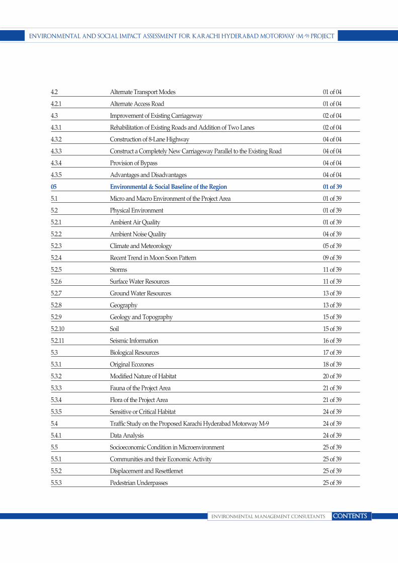
05 Environmental & Social Baseline of the Region 01 of 39
5.1 Micro and Macro Environment of the Project Area 01 of 39
5.2 Physical Environment 01 of 39
5.2.1 Ambient Air Quality 01 of 39
5.2.2 Ambient Noise Quality 04 of 39
5.2.3 Climate and Meteorology 05 of 39
5.2.4 Recent Trend in Moon Soon Pattern 09 of 39
5.2.5 Storms 11 of 39
5.2.6 Surface Water Resources 11 of 39
5.2.7 Ground Water Resources 13 of 39
5.2.8 Geography 13 of 39
5.2.9 Geology and Topography 15 of 39
5.2.10 Soil 15 of 39
5.2.11 Seismic Information 16 of 39
5.3 Biological Resources 17 of 39
5.3.1 Original Ecozones 18 of 39
5.3.2 Modified Nature of Habitat 20 of 39
5.3.3 Fauna of the Project Area 21 of 39
5.3.4 Flora of the Project Area 21 of 39
5.3.5 Sensitive or Critical Habitat 24 of 39
5.4 Traffic Study on the Proposed Karachi Hyderabad Motorway M-9 24 of 39
5.4.1 Data Analysis 24 of 39
5.5 Socioeconomic Condition in Microenvironment 25 of 39
5.5.1 Communities and their Economic Activity 25 of 39
5.5.2 Displacement and Resettlemet 25 of 39
5.5.3 Pedestrian Underpasses 25 of 39
environmental and social impact assessment for Karachi hyderabad motorway (m-9) project
environmental management consultants contents

5.5.4 Indiginous People 25 of 39
5.5.5 Cultural Heritage 27 of 39
5.5.6 Aesthetics and landscape 27 of 39
5.5.7 Human Health and Safety 27 of 39
5.5.8 Reservation of Cultural Heritage 28 of 39
5.6 Socioeconomic Conditions in Macroenvironment 28 of 39
5.6.1 Demography 28 of 39
5.6.2 District Malir (Karachi) 28 of 39
5.6.3 HIstory, Ethnicity/Tribes and Culture 28 of 39
5.6.4 Occupation 30 of 39
5.6.5 Betrothal and Marriages 30 of 39
5.6.6 Important Historical Places 31 of 39
5.6.7 Population Size Growth and Distribution 31 of 39
5.6.8 Household Size 31 of 39
5.6.9 Rular/Urban Distribution 32 of 39
5.6.10 Religion 32 of 39
5.6.11 Mother Tongue 32 of 39
5.6.12 Literacy Ratio 32 of 39
5.6.13 Education Attainment 32 of 39
5.7 District Thatta 32 of 39
5.7.1 Population 32 of 39
5.7.2 Administration Setup 33 of 39
5.7.3 Historical Importance 33 of 39
5.7.4 Demographic Conditions 33 of 39
5.7.5 Gender Balance 33 of 39
5.7.6 Social Infrastructure 33 of 39
5.7.7 NGOs Working in the Area 35 of 39
5.7.8 Economy 35 of 39
5.8 District Jamshoro 36 of 39
5.8.1 Location 37 of 39
5.8.2 Population of District Jamshoro 37 of 39
5.8.3 Infrastructure 38 of 39
5.8.4 Economy 38 of 39
5.8.5 Power Plants 39 of 39
environmental and social impact assessment for Karachi hyderabad motorway (m-9) project
environmental management consultants contents

06 Stakeholder Consultation 01 of 08
6.1 Identification of Stakeholder 01 of 08
6.2 Approach and Methodolgy 01 of 08
6.2.1 Scoping Meeting 01 of 08
6.2.2 Consultation Meeting 02 of 08
07 Environmental and Social Impact Assessment and Proposed Mitigation Measures 01 of 21
7.1 Screening Potential Environmental Impacts 01 of 21
7.2 Identification of Impacts during Design Phase 03 of 21
7.2.1 Topography 03 of 21
7.2.2 Formation in Built-up Area 03 of 21
7.2.3 Location of Labour Camps & Other Material 04 of 21
7.2.4 Change of Land Use 04 of 21
7.2.5 Cross Drainage and Accessory Structures 04 of 21
7.3 Identification of Impacts during Construction Phase 04 of 21
7.3.1 Air Quality 04 of 21
7.3.2 Noise and Vibration 08 of 21
7.3.3 Impacts on Water Resources 10 of 21
7.3.4 Impacts on Land Environment 11 of 21
7.3.5 Biological Environment 13 of 21
7.3.6 Impact on Traffic 14 of 21
7.3.7 Impacts on the Socio-economic of the Area 14 of 21
7.3.8 Public Health and Safety 17 of 21
7.3.9 Natural and Manmade Hazards 17 of 21
7.4 Identification of Impacts during Operation Phase 17 of 21
7.4.1 Air Quality 19 of 21
7.4.2 Noise and Vibration 19 of 21
7.4.3 Impacts on Water Resources 19 of 21
7.4.4 Impacts on Land Environment 19 of 21
7.4.5 Bilogical Environment 20 of 21
7.4.6 Traffic Conditions 20 of 21
7.4.7 Socio-economic 20 of 21
08 Environmental Management and Monitoring Plan 01 of 30
8.1 General 01 of 30
8.2 Objectives 01 of 30
environmental and social impact assessment for Karachi hyderabad motorway (m-9) project
environmental management consultants contents
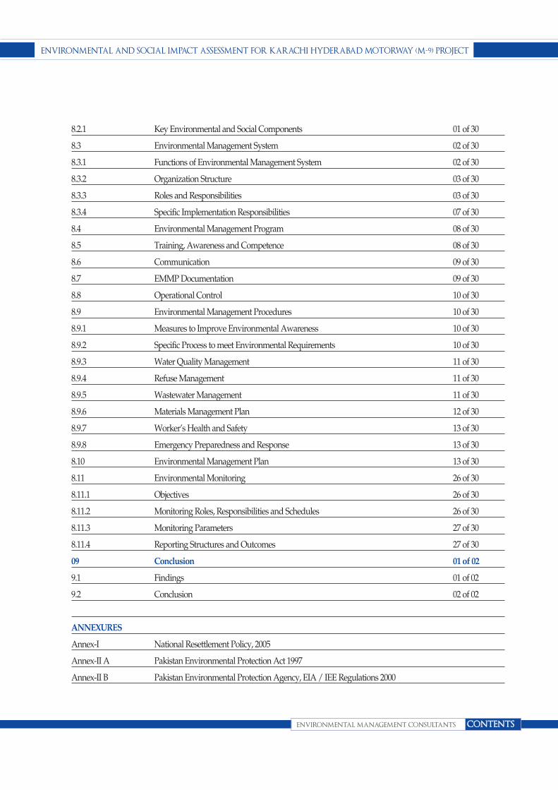
8.2.1 Key Environmental and Social Components 01 of 30
8.3 Environmental Management System 02 of 30
8.3.1 Functions of Environmental Management System 02 of 30
8.3.2 Organization Structure 03 of 30
8.3.3 Roles and Responsibilities 03 of 30
8.3.4 Specific Implementation Responsibilities 07 of 30
8.4 Environmental Management Program 08 of 30
8.5 Training, Awareness and Competence 08 of 30
8.6 Communication 09 of 30
8.7 EMMP Documentation 09 of 30
8.8 Operational Control 10 of 30
8.9 Environmental Management Procedures 10 of 30
8.9.1 Measures to Improve Environmental Awareness 10 of 30
8.9.2 Specific Process to meet Environmental Requirements 10 of 30
8.9.3 Water Quality Management 11 of 30
8.9.4 Refuse Management 11 of 30
8.9.5 Wastewater Management 11 of 30
8.9.6 Materials Management Plan 12 of 30
8.9.7 Worker’s Health and Safety 13 of 30
8.9.8 Emergency Preparedness and Response 13 of 30
8.10 Environmental Management Plan 13 of 30
8.11 Environmental Monitoring 26 of 30
8.11.1 Objectives 26 of 30
8.11.2 Monitoring Roles, Responsibilities and Schedules 26 of 30
8.11.3 Monitoring Parameters 27 of 30
8.11.4 Reporting Structures and Outcomes 27 of 30
09 Conclusion 01 of 02
9.1 Findings 01 of 02
9.2 Conclusion 02 of 02
ANNEXURES
Annex-I National Resettlement Policy, 2005
Annex-II A Pakistan Environmental Protection Act 1997
Annex-II B Pakistan Environmental Protection Agency, EIA / IEE Regulations 2000
environmental and social impact assessment for Karachi hyderabad motorway (m-9) project
environmental management consultants contents

Annex-III National Environmental Qualtiy Standards (NEQS)
Annex-IV IUCN Red List
Annex-V List of Stakeholders
environmental and social impact assessment for Karachi hyderabad motorway (m-9) project
environmental management consultants contents

envIronmental and SocIal Impact aSSeSSment for KarachI hyderabad motorway (m-9) project
envIronmental management conSultantS
SectIon 1
1 of 7
IntroductIon
1.1- GeneralThe Karachi-Hyderabad 136 km section of N-5 Super
Highwaywas constructed as a part of the First Highway
Project with the assistance of World Bank during 1964 – 68
and idealized in 1991 as part of the Fourth IBRD Highway
Project.The project corridor serves as the main spine for
traffic movement between Karachi and Hyderabad as it
provides the shortest route between these two major
urban centers. According to the Traffic study March 2012,
more than 98% of traffic both passenger and goods
vehicles used Karachi- Hyderabad M-9 to travel from
Karachi towards Punjab, Northern areas and lower Sindh
region especially desert areas of Sindh.
In order to accelerate the process of expansion of
motorways the Government has invited the private sector
to participate in expansion of Motorway Network, on the
basis of build, operate and transfer (BOT) arrangement.
The GOP believes that the technical, managerial and
financial resources of the private sector can make a useful
addition to its own efforts in this regard.
The National Highway Authority selected M/s Binapuri
Pakistan Pvt. Ltd. (BPL)for the construction of existing 4-
lane Karachi-Hyderabad Superhighway as 6-lane, access
controlled and world class Motorway (M-9) along with its
allied facilities. The project is to be carried out under
Public-Private Partnership (PPP) arrangement on Build-
Operate-Transfer (BOT) basis.
Understanding the existing environmental and socio-
economic characteristics of the region is a prelude to
evaluate the likely impacts (positive/ negative) that can
occur from the proposed project. For this Binapuri
Pakistan Pvt. Ltd. has appointed M/s Environmental
Management Consultants to conduct Environmental and
Social Impact Assessment of proposed Karachi-
Hyderabad M-9 Projectin compliance with the mandatory
requirements of Section 12 of Pakistan Environmental
Protection Act (PEPA) 1997 and Pakistan Environmental
Protection Agency Review of EIA/IEE Regulations 2000.
1.2- Overview of theProject
1.2.1- Project LocationThe proposed 134.35 Km Karachi- Hyderabad M-9 project
will likely to starts off at Km 13+000 (Project Chainage
0+000) of the NHA positioned under the
flyover/interchange provided for the Lyari Express way
on the Lyari River and ends at 149+000 (Project Chainage
01
Project Name Environmental & Social Impact Assessment for the proposed
M-9 Karachi to Hyderabad.
Project Location Existing 136Km Karachi-Hyderabad section of National Highway N-5.
Project Construction Cost 18,235,000,000 PKR
Project Proponent Binapuri Pakistan Pvt. Ltd. (BPL)
Contact Person Ooi Chin Giap (Azlan)
PD / Acting Head – Pak, No.84 St-3 Sector HH Phase-IV, DHA Lahore.
ESIA Consultants Environmental Management Consultants (EMC)
Syed NadeemArif
Office # 503, Anum Estate Building, Main Shahrae Faisal, Karachi.
Tel: 021-34311466, Fax: 021-34311467,
E-mail: [email protected], [email protected]
Table 1.1- Project Brief

136+000) in the closeness of the clover leaf interchange
which is present on the Hyderabad Bypass.
1.2.2- Scope of the ProjectThe scope of project is but not limited to:
n Strengthen the existing road infrastructure,
n Construct existing 4- lane Karachi-Hyderabad
Superhighway as 6-lane, access controlled in order to
provide world class Motorway (M-9) along with its
associated facilities
n Design and construct bridges, culverts,
andunderpasses where necessary,
n Provide helpline services, services area and other
motorway facilities.
1.2.3- Profile of the ProponentBinapuri Pakistan Pvt. Ltd. (BPL)is a renowned
construction company on the Main Board ofBursa
Malaysia Berhad, with 35 years of work experience in civil
and building constructionboth locally and internationally.
The diverse work has been done by the proponent that
comprises business activities, investment holdings, civil
and building engineering management,
propertydevelopment, highway concessionaire, quarry
operations, manufacturing ofconstruction materials,
polyurethane system house, utilities and
hospitalitymanagement.
The proponent is certified with MS ISO 9001:2000,
OHSAS 18001, MS 1722 Certifications and has won many
award laudable of mention including the Prominent
Player Award2005: Malaysian Construction Industry
Excellence Awards 2005 (MCIEA 2005), theContractor
Award 2007: Grade G7 (MCIEA 2007) and the
International AchievementAward (MCIEA 2008)
awarded by the Construction Industry Development
Board ofMalaysia.BinaPuri commenced to expand
globally in 1995 as well as it has various operations offices
in Thailand,United Arab Emirates, Saudi Arabia,
Pakistan, Indonesia and Brunei Darussalam.
Nowadays BinaPuri is a remarkable construction
company which is listed in the main boardof Bursa
Malaysia managed by a team of professional, devoted,
qualified andexperienced personnel supported by the
resources of the company. The Proponent is conceited to
have completed more than 1,000 kilometers of roads
andhighway, bridges, interchanges, waterworks and
projects related to land reclamation.The projects related to
Building completed comprise commercial buildings,
educational institutions, hotels, hospitals, government
complexes and residential projects.
1.3- Environmental andSocial Impact Assessmentof the Proposed Project
1.3.1- Justification&Categorization of ProjectThe Pakistan Environmental Protection Act 1997
empowers the EPA as the principal authority for
environmental management in Pakistan. It has also
established the requirement of environmental assessment
of any project in place prior to commencement of
work.Section 12 of Pakistan Environmental Protection Act
1997 states that:
“No proponent of a project shall commence construction
or operation unless he has filed with the Government
Agency designated by Federal Environmental Protection
Agency or Provincial Environmental Protection Agencies,
as the case may be, or, where the project is likely to cause
adverse environmental effects an environmental impact
assessment, and has obtained from Government Agency
approval in respect thereof.”
EIA study is carried out in compliance with the
mandatory requirements of Section 12 of Pakistan
Environmental Protection Act (PEPA) 1997. This legal
provision requires an initial environmental examination
(IEE) or an environmental impact assessment (EIA) to be
carried out and the report submitted to the relevant
Agency or Department, which has been delegated the
authority for review and approval of EIA/IEE findings.
envIronmental and SocIal Impact aSSeSSment for KarachI hyderabad motorway (m-9) project
envIronmental management conSultantS
SectIon 1
2 of 7
The Pakistan Environmental Protection Agency (Review
of EIA/IEE) Regulations 2000 defines the categories of
projects requiring an Initial Environmental Examination
(IEE) or Environmental Impact Assessment (EIA) in
Schedules I & II respectively. According to Clause 4 of the
Pakistan Environmental Protection Agency (Review of
IEE and EIA) Regulations, 2000, “a proponent of a project
falling in any category specified in Schedule II shall file an
EIA with the Federal Agency.” Schedule II of the
regulations includes “all projects situated in
environmentally sensitive areas” and “any project likely
to cause an adverse environmental effect.”
Under the Pakistan Environmental Protection Agency
(Review of IEE and EIA)Regulations 2000;
“Federal or provincial highways or major roads (except
maintenance or rebuilding or reconstruction of existing
roads) with total cost of Rupees 50 Millionand above” is
in Schedule II, List of projects requiring an Environmental
Impact Assessment”
As per the EPA Guidelines, the present Project is classified
as “Schedule II” that requires an EIA study and approval
from the concerned authority, prior to the construction.
Accordingly detailed Environmental and Social Impact
Assessment has carried out to address the regulatory
requirements as well as to make it acceptable to:
n BinaPuriPakistan Pvt Ltd who are the proponents
n BOT entrepreneur investing in its establishment and
operation; and
n EPA Sindh against the requirement of Pakistan
Environmental Protection Act 1997.
n The ESIA study has accordingly been designed to
focus on making certain that:
n If there is a negative impact, it should be mitigated as
much as possible through specified design and
construction procedures, and
n Any remaining short term or long term negative
impact is identified clearly and made known to all
those likely to be affected.
1.3.2- Objectives & Scope of ESIAThe objective of ESIA is to foresee the potential
environmental problems that would arise out of the
proposed development activity and address them in the
planning and design stage of the project. The ESIA
process should then allow for the communication of this
information to:
n The project proponent
n The regulatory agency (ies); and,
n All stakeholders and interest groups.
ESIA integrates the environmental concerns in the
development activities right from the time of initiating the
preparation of feasibility report. In doing so, it enables the
integration of environmental concerns and mitigation
measures in project development. ESIA can often prevent
future liabilities or expensive alterations in project design.
The purpose of this EIA study is to evaluate the activities
associated with the construction and operation of
proposed Karachi- Hyderabad Motorway project.
Environmental assessments made here are in conformity
with the requirements of Pakistan Environmental
Protection Act 1997 as well as other national and
international environmental guidelines where national
guidelines are not available.
The scope of this study is to assess the environmental and
social impacts that could occur as a result of construction
and operations of the proposed project. Following are
some of the main objectives of this EIA study:
n To determine and document the state of the
environment of the project area to establish a baseline
in order to assess the impact of implementation of the
proposed project;
n To collect and assess existing environmental and
social profile of entire project area and incorporate it
in report for future use by client;
n To identify all environmental sensitivities including
flora, wildlife and avifauna of the project area, if there
is any;
envIronmental and SocIal Impact aSSeSSment for KarachI hyderabad motorway (m-9) project
envIronmental management conSultantS
SectIon 1
3 of 7

n To identify national heritage sites, archaeological
sites and ecologically important areas in the project
zone of influence;
n To identify and assess all the major and minor
environmental & socio-economic aspects and
impacts due to construction and operation of the
office building project specifically in the project area
and generally on its surrounding in accordance with
national and international environmental legislations
and guidelines.
n To provide assistance to the proponent for planning,
designing and implementing the project in a way that
would eliminate or minimize the negative impact on
the biophysical and socio-economic environment
and maximizing the benefits to all parties in the most
cost effective manner;
n To provide opportunity to the public for
understanding the project and its impact on the
community and their environment in the context of
sustainable development.
n To develop a detailed environmental management
plan (EMP) for the sustainable implementation
mechanism of mitigation measures identified during
the study along with monitoring plan.
1.3.3- EnvironmentalStandards and GuidelinesIssues related to Environment and control all over
Pakistan are governed by Pakistan Environmental
Protection Act (PEPA) 1997.Guidelines and procedures
for preparing EIA reports have been published by Federal
EPA in the form of “ Pakistan Environmental Assessment
Package”.
Before commencement of Projects the requirements of
Govt. of Pakistan that need to be met are as follows:
n Legal requirements in Pakistan for Environmental
Assessment for new projects under the
Environmental Protection Agency Sindh
n Pakistan EPA Guidelines and Procedures (2000) for
Environmental Assessment of new projects and
n Pakistan National Environmental Quality Standards
(NEQS) gaseous including Vehicular exhaust
emissions; noise emissions and liquid effluents.
Scoping to explain all stakeholders of the need of the
project and the likely environmental as well as social
impact has already been held as the necessary first step of
process of EIA .The views and concerns expressed by the
stakeholders have been recorded and they will be duly
responded in the EIA.
1.3.4- ESIA MethodologyEMC adopted the following procedures for making
assessment of impact of different activities during the
construction and operational phases on micro
environment and macro environment of the project
activity areas:
A. Understanding of the Proposed
Operation
This step involved collecting information from on the
propose project activities and understanding the activities
to identify potential impacts from them.
B. Review of Legislation and
Guidelines
National legislation, international agreements,
environmental guidelines, and best industry practices
were reviewed to set environmental standards that
BinaPuriwill be required to follow during different stages
of the project.
C. Secondary Data Collection
All available published and unpublished information
pertaining to the micro and macro environment of the
Project was obtained and reviewed. It included the earlier
environmental studies and environmental baselines
conducted the consultants for development activities in
M-9 Motorway project. All data sources were reviewed to
collect information relevant to physical, biological and
envIronmental and SocIal Impact aSSeSSment for KarachI hyderabad motorway (m-9) project
envIronmental management conSultantS
SectIon 1
4 of 7

socio-economic condition of the macroenvironment and
microenvironment of project site.
D. Scoping Sessions with Relevant
Stakeholders
Meetings were held with all project related stakeholders
to have expert opinion and get a better understanding on
project area, its physical, biological features, as well as
social and economic issues. The stakeholders gave
valuable suggestions and input which were very useful
while carrying out the impact assessment.
E. Field Data Collection
EMC teamvisited the project area in the months of
May2012. During the site visit, primary information on
the physical, biological and socio-economic conditions of
the project area were collected.
F. Impact Identification and
Assessment
Potential impacts which may arise from proposed
activities were identified. These included effects on
physical, biological, socio-economic environment;
archaeology and culture. Impacts were identified in
particular on the biological habitats and assessed on the
basis of field data collected from area, secondary data,
expert opinion, and monitoring results ofprojects in
proposed project area.
G. Recommendations to Mitigate
Impacts
Keeping in view the baseline data collected and impacts
identified mitigation measures have been recommended
to minimize, reduce, eliminate, or compensate for the
envIronmental and SocIal Impact aSSeSSment for KarachI hyderabad motorway (m-9) project
envIronmental management conSultantS
SectIon 1
5 of 7

potential environmental and social impacts on the project
zone of influence. Mitigation measures recommended
here are based on past experience, best industry practices,
legislative requirements and professional judgment.
H. Environmental Management
Plan (EMP)
Environmental management plan (EMP) was developed
for effective implementation of the recommended
mitigation measures. EMP includes controls to minimize
the identified impacts, and monitoring programme to
monitor residual impacts, if any, during the operation.
The EMP has laid down procedures to be followed during
the Karachi-Hyderabad Motorway (M-9) construction,
operation and associated activities and has identified roles
and responsibilities for all concerned personnel during
the operation, including post project monitoring and
reporting.
I. Documentation, Review &
Conclusion
This is the final step in the environmental assessment. The
document is based on reports produced by EMC Team of
experts and compiled by Project Coordinator and office
staff, duly overseen by Team Leader and Project
Manager. The Report was reviewed by Team leader for
screening/assessment of potential environmental impacts
and put forward recommendations of mitigation
measures and the Environmental Monitoring and
Management Plan.
The Report has been prepared according to the Policy and
Procedures for Filing, Review and Approval of
Environmental Assessments 2000 and relevant guidelines
of the PEPA 1997. This report includes the findings of the
assessment of the project impacts, and the mitigation
measures to be adopted during the execution of the
proposed activities.
1.3.5- Composition of ESIAReportThe ESIA report has been structured on the standard
format, prescribed by the Environmental Protection Act
(PEPA) 1997, and Pakistan EPA guidelines and
procedures (2000) for the Environmental Assessment of
New Projects. The Report has been presented in the
following sections:
Chapter 01- Introduction
Provides an introduction and background of the project
and justification of ESIA.
Chapter 02- Description of Project
Describes the project, its objective; its type and category;
location of the facilities and project details while in
operation along with proposed schedule for
implementation.
Chapter 03- Governing legislation
and Statutory Requirements
Provide an overview of Policy and Legislation along with
International Guidelines relevant to operation of Karachi
Hyderabad M-9.
Chapter 04- Screening of
Alternatives
Provides evaluation of different alternatives to arrive at
the best possible option for the project.
Chapter 05- Environmental &
Socio-economic Baseline
This section describes the existing environmental and
Socio-economic baseline situation of the macro and micro
environments of the proposed project area.
Chapter 06- Stakeholder
Consultation
Describes the consultations process performed for the
ESIA of Karachi Hyderabad M-9 project and gives the
concerns of stakeholders during consultation process.
envIronmental and SocIal Impact aSSeSSment for KarachI hyderabad motorway (m-9) project
envIronmental management conSultantS
SectIon 1
6 of 7

Chapter 07- Screening of
anticipated Impacts and Proposed
Mitigations
Describes the potential environmental and social impacts
on different features of the micro and macro environment,
and using the general guidelines presents a screening of
potential environmental impacts at the designing,
construction and operation stages. The screening includes
the residual impact as a result of adoption of mitigation
measures that may be needed for minimizing the impact.
Chapter 08-Environmental
Management and Monitoring Plan
Presents the environmental management that has been
incorporated in the design, construction and operation of
Karachi Hyderabad M-9.
Chapter 9-Conclusion
Summarizes the report and presents its conclusions.
1.3.6- ESIA Study TeamThe study was assigned to Environmental Management
Consultant. EMC organized the following team to carry
out the study:
envIronmental and SocIal Impact aSSeSSment for KarachI hyderabad motorway (m-9) project
envIronmental management conSultantS
SectIon 1
7 of 7
S.No. Name Position
1 Mr. Syed NadeemArif Project Manager
2 Mr. SaquibEjazHussain Dy. Project Manager / EIA Expert
3 Dr. MirzaArshad Ali Beg Team Leader / Principal Expert
4 Dr. Muhammad Mansha Expert on Air
5 Dr. IqbalHashmi Expert on Water Resources
6 Dr. Mansoor Imam Expert on Waste Management
7 Dr. Syed Ali Ghalib/Mr. Razaque Expert on Fauna/Ornithologist
8 Ms. SamitaNadeem Environmental Engineer
9 Dr. ViqarHussain Expert on Geology
10 Dr. Saddar-ud-din Expert on Flora
11 Ms. Tasneem Bhatti Expert on Social Issues
12 Ms. Noor Fatima Environmentalist
13 Ms. Sarah Sidiki Environmentalist
Table 1.2: EIA Study Team

ENvIRONmENTal aND SOCIal ImPaCT aSSESSmENT FOR KaRaCHI HyDERabaD mOTORway (m-9)PROJECT
ENvIRONmENTal maNagEmENT CONSulTaNTS
SECTION 2
1 OF 10
DESCRIPTION OF THE PROJECT
2.1- Existing Karachi-Hyderabad Super Highway
The existing 136 km Karachi-Hyderabad section of N-5
(popularly known as Super Highway) connects the port
city of Karachi with the North of Pakistan. This section of
the highway is amongst the most densely trafficked in the
entire country, the existing highway is serving heavy
traffic volume with large portion of truck traffic. The route
is also the shortest possible distance between the two
cities i.e. Karachi and Hyderabad and feeds into the main
North – South Links i.e. National Highway N-55 (Indus
Highway) and the National Highway N-5 (Grand Trunk
Road).
The Karachi-Hyderabad section was constructed as a part
of the First Highway Project with the assistance of World
Bank during 1964 – 68 and dualized in 1991 as part of the
Fourth IBRD Highway Project. Toll is being collected
from Highway users by the NHA.
02
Figure 2.1: The existing Karachi- Hyderabad Section of National Highway N-5

2.2- The Proposed Project
The National Highway Authority intends to construct
existing 4-lane Karachi-Hyderabad Superhighway as 6-
lane, access controlled, world class Motorway (M-9) along
with its allied facilities. The project is to be carried out
under Public-Private Partnership (PPP) arrangement on
Build-Operate-Transfer (BOT) basis.
2.2.1- Project Location
The project starts off at Km 13+000 (Project Chainage
0+000) of the NHA reference under the
flyover/interchange provided for the Lyari Expressway
on the Lyari River and ends at Km 149+000 (Project
Chainage 136+000) in the proximity of the clover leaf
interchange on the Hyderabad Bypass.
2.3- Project Component
The key engineering features of the Project, for
construction of a world-class motorway, include but not
limited to the following:
2.3.1- Rehabilitation&Extensions
The proposed project involves rehabilitation of the
existing 134.35 Km (Length reduced by 1.65 Km at
Hyderabad end, terminating before Hyderabad
ENvIRONmENTal aND SOCIal ImPaCT aSSESSmENT FOR KaRaCHI HyDERabaD mOTORway (m-9) PROJECT
ENvIRONmENTal maNagEmENT CONSulTaNTS
SECTION 2
2 OF 10
Project Name Environmental & Social Impact Assessment for the proposed M-9 Karachi to Hyderabad.
Project Proponent Binapuri Pakistan Pvt. Ltd. (BPL)
Project Location Existing 136Km Karachi-Hyderabad section of National Highway N-5.
Project Cost 13,235,000,000 PKR
Interchanges Seven (7)
Service Area Two (2)
Facilities at Service Area:
l Restaurants and Food Courts
l Toilets
l CNG/LPG Filling Stations with Tuck Shop
l Diesel/Petrol Filling Stations with Tuck Shop
l Tyre Shop and Mini Workshop
l Trauma Centre
l Mosque
l Parking Area
l Truckers Workshop
l AamSarai and Dhaba (with Trucks/Buses Parking)
l Customer service centers where motorists can inquire about products, services,
road information, weather etc.
l Internal Roads, Sewerage, Water Supply and Electrification
Toll Plazas Two New 16-lane Toll Plazas with Electronic Toll and Traffic Management (ETTM) system
Weigh Stations Seven (7) weigh stations
Motorway Facilities l Electronic Toll Collection
l Emergency Call Service
l Centralized Operation Centre
l Traffic Counting Stations/ Weigh in Motion (WIM) system
l Variable Message Signs
l Emergency Assistance System
Table 2.1-Silent Features of the Project

ENvIRONmENTal aND SOCIal ImPaCT aSSESSmENT FOR KaRaCHI HyDERabaD mOTORway (m-9)PROJECT
ENvIRONmENTal maNagEmENT CONSulTaNTS
SECTION 2
3 OF 10
Figure 2.2: Proposed
Project Location

Interchange) of 4-lane carriageway both north-bound and
south-bound and construction of an additional new lane
on the inner side of the Highway (wherever technically
feasible) with 3.0 m outer shoulder and 1.0 m inner
shoulder. Lane width is to be taken as 3.65 m. Both
rehabilitation and widening bound carriageways will be
divided by a New Jersey Barrier.
Extensions are to be made to all the existing bridge
structures and culverts. Four (4) bridges have an
additional extension on either side accommodating
service roads to allow local traffic to negotiate land locked
areas between canals.
2.3.2- New Interchanges
As shown in figure 2.1 Seven (7) new interchanges are to
be provided to support populations, towns, industrial
zones and other isolated pockets enabling them to
commute on the motorway after fencing of the Right of
Way (“ROW”). Although at some locations, volume of
traffic does not justify an interchange, the isolation of road
side developments and populations warrants
connectivity as there is no other route available for
transport. Interchanges within the closed system to have
entry and exit 2-lane Toll Plazas. The locations for the new
interchanges are as follows:
2.3.3- Service Road Formations
Two kinds of service road formations are to be
incorporated with minimum provisions as follows:
1. Urban (Shoulder – 1.5m (DST), Carriageway – 7.0m
(Asphalt), Shoulder – 1.5m (DST)
n CH 0+000 to CH 15+000 Both Sides of Motorway
2. Semi-Urban, rural (Shoulder – 1.0m (Earthen),
Carriageway -6m (TST),
Shoulder – 1.0m (Earthen)
n CH 15+000 to CH 19+800 Both Sides of Motorway
n CH 22+000 to CH 34+000 Both Sides of Motorway
n CH 36+875 to CH 46+875 Both Sides of Motorway
n CH 51+600 to CH 58+600 Both Sides of Motorway
n CH 61+350 to CH 83+600 Both Sides of Motorway
2.3.4- Service Areas
Minimum two main Service Areas of M-2 (Lahore-
Islamabad Motorway) Service Areastandard, with
minimum following facilities, are to be established as part
of the Project:
a) Restaurants and Food Courts
b) Toilets
c) CNG/LPG Filling Stations with Tuck Shop
d) Diesel/Petrol Filling Stations with Tuck Shop
e) Tyre Shop and Mini Workshop
f) Trauma Centre
g) Mosque
h) Parking Area
ENvIRONmENTal aND SOCIal ImPaCT aSSESSmENT FOR KaRaCHI HyDERabaD mOTORway (m-9)PROJECT
ENvIRONmENTal maNagEmENT CONSulTaNTS
SECTION 2
4 OF 10
Sr.No. Chainage (Km) Name of Interchange
1 Ch 14+985 Malir Road
2 Ch 23+112 Damba Goth
3 Ch 45+596 Lucky Cement
4 Ch 55+760 Nooriabad
5 Ch 66+936 Tooriabad
6 Ch 80+952 ThanoBullah Khan
7 Ch 113+440 Borari Sand
Table 2.2: Location of New Interchanges

i) Truckers Workshop
j) AamSarai and Dhaba (with Trucks/Buses Parking)
k) Customer service centers where motorists can inquire
about products, services, road information, weather etc.
l) Internal Roads, Sewerage, Water Supply and
Electrification
The CH 60+790 (North Bound & South Bound) is a
proposed location for Service Areas. Access and egresses
to each service (and rest) areas will be conformed to
AASHTO Guidelines in terms of Geometric layout and
position in relation to adjacent intersection.
2.3.5- Toll Plazas
Two New 16-lane Toll Plazas with Electronic Toll and
Traffic Management (ETTM) system and other state-of-
the-art facilities are to be provided on the main
carriageway at entry point on the Karachi End and the
Hyderabad End on the following Project Chainages,
respectively. These new Toll Plazas shall replace the
existing Toll Plazas:
n CH 16+000
n CH 131+900
Toll Collection Areas
Toll collection areas shall be designed to ensure that an
adequate number of toll booths are provided at each toll
collection point so as to ensure that the operational
standards with regards to delays to road users are
adhered to.
The toll collection area will be of Rigid Pavement. The
layout of the toll collection area and its approaches shall
be designed in such a manner as to provide safe
conditions for both road users and toll collection staff.
This shall include but not limited to.
n The provision of adequate advance warning signs
and road markings.
n Lighting at times of darkness.
n Protection of staff from vehicle emissions and vehicle
impact and.
n Parking and toilet facilities shall be provided as per
parameters stipulated in Para above.
In the case of closed toll systems, the ticket issuing
procedures shall be such that.
n The opportunity for fraud is reduced to a minimum.
n The information provided on the ticket conforms to
the operation standard and.
n Data can be retrieved regarding the entry and exit
points of all traffic using facility, by time of day and
by vehicle type.
2.3.6- Weigh Stations
Seven (7) weigh stations are to be provided strategically to
cover movement of heavy traffic minimize overloading at
least on the following locations:
n CH 15+500 (North Bound)
n CH 30+750 (South Bound)
n CH 40+850 (South Bound)
n CH 40+850 (North Bound)
n CH 71+850 (South Bound)
n CH 71+850 (North Bound)
n CH 132+900(South Bound)
2.3.7- Safety Fences or Barriers
Chain link fence with all necessary arrangements will be
provided on both sides of defined ROW.The form, layout
and vertical profile of such fences/barriers shall conform
to the requirements of United Kingdom, Department of
Transport Standards TD 19/85 or other similar approved
international standard.
a. All the edge of the carriageway.
n On the embankment 6m or more in height or where
there is a road, railway, water hazard or other feature
at or near the flood of the slope.
ENvIRONmENTal aND SOCIal ImPaCT aSSESSmENT FOR KaRaCHI HyDERabaD mOTORway (m-9)PROJECT
ENvIRONmENTal maNagEmENT CONSulTaNTS
SECTION 2
5 OF 10

n On the outside of curves of less than 850m radius on
embankment between 3m and 6m in height.
n Adjacent to all retaining walls, rock faces cuttings or
earth banks (steeper than 1 in 1 slopes) that there are less
than 4.5m from the edge of the running carriageway.
b. On the central reserve where the width of thecentral reserve is less than 5m and at the
following locations
n Adjacent to obstruction such as bridge piers, sign
posts and trees.
n Where there are lighting columns on the central
reserve and.
n Where the difference in the inner channel levels of the
two carriageways exceeds 1m and the slope across
the central reserve exceeds 1 in 4.
2.3.8- Maintenance andOperation Compounds
The concession company may subject to the approval of
the NHA, provide a maintenance compound with the
concession area. Minimum of two maintenance and
operation compounds will be provided. Access and
egresses to the maintenance compound wall shall
conform to AASHTO Guidelines in terms of Geometric
layout and position in relation to adjacent
intersections.All plant, materials and equipment stored
within the maintenance compound will be directly related
to the general maintenance and operational requirements
of the expressway and approach roads.
2.3.9- Ancillary Development
The Concessionaire will also undertake Ancillary
Development relevant to the Project. Such development
encompasses approach roads, pedestrian/cattle
crossings, lighting, administrative and operation
buildings/centers, controlling systems, vehicle recovery
and environment-friendly development of areas located
in the project jurisdiction and where the Motorway links
with the city or other connecting points.
2.3.10- Motorway Facilities
The Concessionaire will also ensure provision of
following motorway facilities and will maintain them in a
good working condition throughout the Concession
Period.
a. Electronic Toll Collection (ETC) for quick convenient
and cashless transactions.
b. Emergency Call Service for motorists requesting
assistance in case of accidents and other emergencies.
c. Road structure safety features.
n Reflectorized lane markings
n Emergency parking areas
n Rumble strips
n Motorway signage plan
n Installation of urban road lighting and reflectorized
lane marking along the strategic locations as well as
interchanges and toll plazas
d. Centralized Operation Centre:
The smooth traffic flow is to be ensured through
electronic traffic management system, complementing its
operation with CCTV (Close Circuit TV) system for closer
monitoring of traffic situations inside a centralized
operation, maintenance and control centre.
e. Traffic Counting Station/Weight in Motion (WIM)
systems
The station will be designed to capture and record axle
weights and gross vehicle weights as vehicles drive over
a measurement site. Unlike static scales, WIM systems
are capable of measuring at either a reduced or normal
traffic speed, and do not require the vehicle to stop. This
makes the weighing process more efficient, and, in the
case of commercial vehicles, allows for trucks under the
weight limit to potentially bypass static scales or
inspection.
f. Variable Message Signs (VMS)
The VMS provide motorists with useful updates on the
ENvIRONmENTal aND SOCIal ImPaCT aSSESSmENT FOR KaRaCHI HyDERabaD mOTORway (m-9)PROJECT
ENvIRONmENTal maNagEmENT CONSulTaNTS
SECTION 2
6 OF 10

traffic situation and other helpful information along the
highway
g. Emergency Assistance System
Following Emergency assistance system will be provided:
n First aid emergency trucks & Mobile Workshops
n Traffic patrol surveillance system equipped
with cameras, radios and speed monitoring
devices.
2.4- Detailed Design of theProject Components
2.4.1- Design Life
The design life to be adopted for the various elements of
the main carriageway is set out in Table given below. All
elements shall be designed to withstand the effects of
anticipated traffic and other loadings and deterioration
over the specified periods.
The design life specification for the electrical and
electronic systems reflects the requirement that as part of
the maintenance, refurbishment and replacement
program all systems must be upgraded to comply with
the standards then prevailing.
2.4.2- Geometric Design
The geometric design of both carriageway facilities shall
generally be in accordance with the requirements and
recommendations of the American Association of State
Highway and Transportation Officials (AASHTO)
Guideline 2004 or the latest version and other specified
standards employed by NHA.
2.4.3- Pavement Design
The road pavement shall be designed generally in
accordance with the AASHTO Guide 2004, using site
specific data.
a. Riding Quality
The roughness of the pavement, over any one kilometer
length on any lane after construction upon opening to
traffic shall be not more than 2.0m/Km IRI with a
tolerance of plus 10%.
b. Pavement Materials
In general, asphaltic concrete pavements shall be used,
except in cases of unusually high traffic volumes, or where
poor sub-grade conditions exist. In these situations a
Portland Cement Pavement may be proposed if it can be
shown to be more economical over the whole life of the
road. Alternatively ground improvement techniques
involving geotextiles, chemical of mechanical stabilization
ENvIRONmENTal aND SOCIal ImPaCT aSSESSmENT FOR KaRaCHI HyDERabaD mOTORway (m-9)PROJECT
ENvIRONmENTal maNagEmENT CONSulTaNTS
SECTION 2
7 OF 10
Element Design Life
New Buildings, Structures and Drainage 50 Years
Carriageway Pavement 10 Years (minimum)
Communication and Electrical System
(if required)
Cabling 40 Years
Electrical and Electronic Systems 15 Years
Table 2.4 Design Life Periods to be Adopted
Carriageway Section Type of Terrain
Flat Rolling
Two / Three Lane Carriageway 120 Kph 100 Kph
Table 2.5 Design Speed
Carriageway Section Design Speed
Main Carriageway 120 Kph
Slip Roads 60 Kph
Service Roads 60 Kph
a) Dual Carriageway
Expressway 120 Kph
Non Expressway 80 Kph
b) Dual Carriageway 60 Kph
Horizontal and Vertical Curvature

or polymer modified asphalt may be used. All service roads
and ramp facilities incorporate asphalt concrete pavements.
On all Toll Plazas rigid pavement will be used. The extent
of the concrete pavement shall be 75m on either side of the
centerline of the mainline toll plaza. In areas with
constraints, a smaller length of concrete pavement may be
used but it would be subject to the approval of the NHA.
2.4.4- Structural Design
All structures shall be designed in accordance with the latest
AASHTO standard specification for Highway Bridges,
using local environmental factors to determine seismic,
flood water, wind and temperature loads and Government
of West Pakistan Highway Department Code of Practice for
Highway Bridges 1967 (WPCHB) for vehicle loads.
a. Design Strength of Material
Deformed billet steel bars (Grade 60 and Grade 40)
conforming to ASTM. A615 or High yield deformed bars
with minimum yield or characteristics strength of
425/460 N/mm2 to BS 4461.Steel for pre-stressing will be
either sever wire low relaxation strand or seven wire
normal relaxation strand conforming to ASTM A416
Grade 270. All structural steel, plates angles etc shall
conform ASTM A36 steel.
Design Methods
The methods and requirements of latest AASHTO should
be taken into account in all cases. The seismic analysis of
bridges should be based on the method given in
AASHTO 1192.
The design superstructure shall include appropriate
method of analysis for determination of forces in
longitudinal and transverse directions. Empirical
methods should not be used.
For irregular structures such as curved or skewed bridges,
ENvIRONmENTal aND SOCIal ImPaCT aSSESSmENT FOR KaRaCHI HyDERabaD mOTORway (m-9)PROJECT
ENvIRONmENTal maNagEmENT CONSulTaNTS
SECTION 2
8 OF 10
Geometric Design Element Design Standard
Design Speed (Kph) 120
Minimum Stopping Sight Distance (m) 260
Minimum Passing Sight Distance (m)
Maximum rate of super-elevation (%). 6
Horizontal Curvature
i) Absolute minimum radius (m) 790
ii) Desirable minimum radius (m) 900
iii) Radius above which no super-elevation is required (m). 4950
iv) Special Curve parameter (m). 330
Vertical Curvature
i) Maximum Gradient (%) 3
ii) Maximum Gradient (%) 0.3% or steeper if conditions permit special consideration to
be given to drainage.
iii) Rate of Vertical Curvature – ‘K’ Value (m/%) 52
Crest Curves (m)
Stopping sight distance – desirable. 210
Minimum 105
Passing Sight Distance 720
Sag Curves (m)
Desirable Minimum 75
Absolute Minimum 50
Minimum Length of Vertical Curve 70
Table 2.6: Geometric Design Criteria

or where new or unusual types of structural form are
employed a more detailed analysis should be performed
to completely capture the behavior of the structure.
Localized stresses concentrations will be given due
consideration.
2.4.5- Highway DrainageDesign
In general drainage provision on the highway shall be in
accordance with the requirements of AASHTO Highway
Drainage Guidelines 1989 or NHA Standards. All
drainage systems shall be improved to be self-cleansing,
in terms of design velocities and design gradients.
2.4.6- Hydrological Design
In designing river bridge structures, associated river
training works, culverts and storm water drainage
systems the flood return periods shown in Table below
shall be used.
2.4.7- Electrical Wiring andLighting
a. Electrical Wiring
All electrical wiring or connections associated with road
lighting shall conform to the requirements of United
Kingdom, Institution of Electrical Engineers Wiring
ENvIRONmENTal aND SOCIal ImPaCT aSSESSmENT FOR KaRaCHI HyDERabaD mOTORway (m-9)PROJECT
ENvIRONmENTal maNagEmENT CONSulTaNTS
SECTION 2
9 OF 10
a. Traffic Lanes Width Traffic lanes on the main carriageway of expressways, or multi-lane slip roads and on
connecting link roads shall have a width of 3.65m. One single lane road traffic lane width shall be 4.88m
b. Shoulder Width On dual two and dual three lane expressway, a 0.3m paved outer shoulder and 1.0m paved inner shall be
provided. In addition, an unpaved shoulder of 0.5m and 0.7m shall be provided beyond the paved area
on the outer and inner sides of the carriageway respectively.
On dual and single carriageway connecting link roads, a 3.0m shoulder (2m surface sealed and 1m
untreated) shall be provided on the outer side of the carriageway.
c. Median Width On dual three lane expressway, a minimum central media width of 4.0m shall be provided. In case
median is not provided, Standard Jersey Barrier is to be used.
d. Pavement Cross fall and Generally the pavement cross fall gradient should be 2.5%. This may however be varied within the range
Super Elevation of 2% to 3% if required.
On both motorway and dual carriageway connecting link roads, where horizontal curvature is less than
the radius shown Table 2.3-b for a particular design speed, super elevation up to a maximum of 6% shall
be introduced.
e. Lateral Clearance The minimum lateral clearance between any structures, roadside barrier of the other street furniture shall
be 0.6m from the edges of usable shoulder.
f. Vertical Clearance A clear vertical clearance of 5.33m must be provided between the carriageway and the soffit of all
underpasses and over bridges.
Where any roadway passes over Pakistan Railway Track, a clear vertical clearance of 6.4m shall be
provided between the top of the rail level and the soffit level of the roadway bridge.
In cases where an expressway passes over water courses and rivers, the minimum level of the bridges
soffit shall be 1.0m above the local recorded (or anticipated) maximum 100 years flood level for that river
or water
g. Walkway The walkway on each side of Flyover Bridge shall be provided ensuring the following dimensions.
Height of Walkway - 0.25m
Width of Walkway - 1.20m
Height of Railing - 1.05m
Note: No walkways are to be provided on Motorway Bridges.
Table 2.7: Structural Design

Regulations, 15th Edition, or similarly
approved international standards. In addition the
regulations of the Water and Power Development
Authority (WAPDA) and the requirements of the
Pakistan Electricity Act shall also be adhered to.
b. Lighting
Road lighting shall be provided at interchanges only. The
design of road lighting shall conform to the requirements
of British Standards BS 5489 or other similarly approved
international standards. Average luminance level shall be
2 candela per square meter (“cd/m2”).
Unless otherwise approved by NHA, all lighting shall be
by High Pressure Sodium Vapour Lamps conforming to
IEE 662 or other similarly approved international
standards.
2.4.8- Road Signs and Marking
a. Road Signs
All road signs shall be set out to accord with the Standard
Manual for Highway Signs (National Transport Research
Centre, Pakistan) and shall generally conform to the
Manual for Uniform Traffic Control Devices (FHWA), the
UK Traffic Signs Manual or other approved international
standards.
All road signs shall be faced with retro reflective material
and where indicated in the detailed project specification,
shall be illuminated during hours of darkness. The
constructional elements of road signs shall conform to the
requirements of British Standard 873 or similarly
approved national or international standard.
All electrical wiring or connections associated with road
signs shall conform to the requirements of United
Kingdom, Institution of Electrical Engineers Wiring
Regulations, 15th Edition, or similarly approved
international standards. In addition the regulations of the
Water and Power Development Authority (WAPDA) will
also be followed.
b. Road Markings
All road markings shall be formed using Thermoplastic
paint conforming to AASHTO M249-77 or equivalent
international standard and shall be set out to accord with
the Standard Manual for Highway Signs (National
Research Centre, Pakistan) and generally meet the
requirements of the United Kingdom Traffic Signs
Manual or other approved international standard.
ENvIRONmENTal aND SOCIal ImPaCT aSSESSmENT FOR KaRaCHI HyDERabaD mOTORway (m-9)PROJECT
ENvIRONmENTal maNagEmENT CONSulTaNTS
SECTION 2
10 OF 10
Type of Crossing Flood Return Period
River Bridges 100 years
Culverts 50 Years
Storm Water Drainage System 5 Years
Table 2.8 Design of Structures, Flood Return Periods to be adopted

ENVIRONMENTAL AND SOCIAL IMpACT ASSESSMENT fOR KARAChI hyDERAbAD MOTORwAy (M-9)pROjECT
ENVIRONMENTAL MANAGEMENT CONSULTANTS
SECTION 3
1 Of 11
LEGISLATIVE CONSIDERATIONS, ENVIRONMENTALREGULATIONS AND GUIDELINES
3.1 Introduction
This chapter provides synopsis of policies, legislation,
and guidelines that may have relevance to the proposed
Karachi Hyderabad M9 Project. The proponent of this
project will comprehensively follow the relevant
requirements of the policy documents and legislative
framework as well as those recommendations as
described in the national and international guidelines for
the proposed project. Many of those guidelines have
been incorporated in the Environmental Management
Plan (EMP) which has been developed for improved and
consistent implementation of mitigation measures.
3.2 Institutional Set Up
The apex environmental body in the country is the
Pakistan Environmental Protection Council (PEPC),
presided by the Chief Executive of the Country. Other
bodies include the Pakistan Environmental Protection
Agency (Pak-EPA), provincial EPAs (for four provinces,
AJK and Northern Areas), and environmental tribunals.
The EPAs were first established under the 1983
Environmental Protection Ordinance; the PEPA 1997
further strengthened their powers. The EPAs have been
empowered to receive and review the environmental
assessment reports (IEEs and EIAs) of the projects, and
provide their approval (or otherwise).
As the Karachi Hyderabad M-9 Project is located in the
Province of Sindh therefore, the EIA report will be
submitted to Sindh Environmental Protection Agency
for obtaining environmental approval for the project.
3.3 National Policies andStrategies
Pakistan has developed its own legislation, policies and
strategies for the protection of environment which are to
be followed in planning and approving development
projects in different sectors. Those relevant to the
Karachi Hyderabad M-9 Project are discussed here
under.
3.3.1 National ConservationStrategy
The Pakistan National Conservation Strategy (NCS),
which was approved by the Federal Cabinet in March
1992, is the principal policy document for environmental
issues in the country. The NCS signifies the country's
primary approach towards encouraging sustainable
development, conserving natural resources, and
improving efficiency in the use and management of
resources. The NCS has 68 specific programs in 14 core
areas in which policy intervention is considered crucial
for the preservation of Pakistan's natural and physical
environment. The core areas that are relevant to the
proposed project are biodiversity conservation,
restoration of rangelands, pollution prevention and
abatement, and the preservation of cultural heritage.
Pakistan is a signatory to the Convention on Biological
Diversity, and is thereby obligated to develop a national
strategy for the conservation of biodiversity. The
Government of Pakistan constituted a Biodiversity
Working Group, under the auspices of the Ministry of
Environment, to develop a Biodiversity Action Plan for
the country, which was completed after an extensive
consultative exercise. The plan, which has been designed
to complement the NCS and the proposed provincial
conservation strategies, identifies the causes of
biodiversity loss in Pakistan and suggests a series of
proposals for action to conserve biodiversity in the
country. The Pakistan Environmental Protection Council
(PEPC) has approved the action plan and steering
committees at the federal and provincial levels have
been formed to implement it.
Mid-term Review of NCS: Key Findings An overview of
the key environmental issues facing
Pakistan is as follows:
03
n Per capita water availability in Pakistan has been
decreasing at an alarming rate. In 1951, the per
capita availability was 5300 cubic meter which has
now decreased to 1105 cubic meter just touching
water scarcity level of 1000 cubic meter.
n Almost all fresh water resources are severely
polluted due to discharge of untreated industrial
and municipal wastes. Pollution of coastal waters
due to waste discharges and oil spills coupled with
reduced freshwater flows is resulting in declining
fish yields.
n About 55 percent of population has access to a
relatively safe drinking water source. Potable water
quality, assessed against WHO standards, fails to
meet all the specified criteria, confirming evidence
of extremely high pollutant loads.
n Approximately 35 percent of population has access
to adequate sanitation facilities.
n Air pollution is on the rise, especially in urban areas.
Recent surveys conducted by Pakistan
Environmental Protection Agency revealed
presence of very high levels of suspended
particulate matter (about 6 times higher than the
World Health Organization's guidelines). 'Smog'
also seriously affects almost entire Punjab during
December and January every year.
n Noise pollution has become a serious issue in major
urban centers.
n Of about 54,850 tons of solid waste generated daily
in urban areas, less than 60 per cent is collected. No
city in Pakistan has proper waste collection and
disposal system for municipal, hazardous or
healthcare wastes.
n The deforestation rate has been estimated at 0.2 0.5
percent per annum. Forest cover, which was 4.8
percent of total land area in 1992, could hardly be
increased substantially despite all efforts.
n Degradation and encroachment of natural forests,
rangelands, freshwater and marine ecosystems are
resulting in loss of biodiversity. At least four
mammal species, including tiger, swamp deer, lion
and Indian one horned rhinoceros, are known to
have become extinct from Pakistan while at least 10
ecosystems of particular value for the species
richness and uniqueness of their floral and faunal
communities are considered to be critically
threatened.
n Desertification affects over 43 million hectares of
land annually.
n Pakistan is a highly energy in efficient country. It
uses approximately same amount of energy to
generate 1 dollar of GNP as the USA.
The situation just mentioned is the result of a number of
constraining factors including high population growth
rate, prevailing poverty, unplanned urban and
industrial expansion, insufficient emphasis on
environmental protection in the government policies,
lack of public awareness and education and above all the
ailing economy which has caused deficiencies in
institutional capacity and resources for effective
environmental management. The mid term review of
the NCS led the Government of Pakistan (GOP) and
United Nations Development Program (UNDP) to
jointly initiate an umbrella support program called the
National Environmental Action Plan Support Program
(NEAP SP) that was signed in October 2001 and
implemented in 2002. The development objective
supported by NEAP SP is environmental sustainability
and poverty reduction in the context of economic
growth.
The primary objective of NEAP is to initiate actions and
programs for achieving a state of environment that
safeguards public health, promotes sustainable
livelihood, and enhances the quality of life of the people
in Pakistan.
The NEAP identifies four primary areas, (1) Clean air (2)
Clean water (3) Management of solid waste (4)
Ecosystem management. The plan also presents five
additional areas of concern (i) Management of fresh
water resources (ii) Marine pollution (iii) Toxic and
ENVIRONMENTAL AND SOCIAL IMpACT ASSESSMENT fOR KARAChI hyDERAbAD MOTORwAy (M-9)pROjECT
ENVIRONMENTAL MANAGEMENT CONSULTANTS
SECTION 3
2 Of 11

hazardous substances handling and disposal (iv) Energy
conservation and management (v) Compliance with
international treaties and protocol.
Studies conducted by GOP and Donor Agencies in
Pakistan have identified a number of environmental
concerns with regard to energy, water and air pollution,
waste management, irrigated agriculture, and
biodiversity.
These studies suggest an overall degradation in the
quality and impoverishment of renewable natural
resources such as water, forests and other flora as well as
key biological habitats. The GOP, private sector and civil
society have, with few exceptions, not responded
positively to meet the challenges from these concerns.
3.3.2 Biodiversity Action Plan
The key to protection of the biological heritage of
Pakistan lies in the involvement of local people and in
the support provided by competent institutions for
conservation and sustainable use. The Government of
Pakistan has recognized the importance of these
measures in the preparation of the National
Conservation Strategy and in becoming a signatory to,
and ratifying, the Convention on Biological Diversity
(CBD) in 1994. Developing the Biodiversity Action Plan
for Pakistan, 2000 has been the most significant direct
steps towards addressing the biodiversity loss.
This ESIA study has addressed all aspects of
conservation, including wildlife and forest. It has
specifically addressed the biodiversity aspects and
suggested mitigation measures.
3.3.3 National EnvironmentalPolicy, 2005
The National Environment Policy (NEP) aims to protect,
conserve and restore Pakistan’s environment in order to
improve the quality of life of the citizens through
sustainable development. In NEP, the further sectoral
guidelines, Energy Efficiency and Renewable directly
related to building energy code for newly constructed
buildings were introduced.
3.3.4 National ResettlementPolicy
National Resettlement Policy (draft) has been
formulated to not only cover the affected persons (APs)
in existing systems but also to ensure an equitable and
uniform treatment of resettlement issues all over
Pakistan. This policy applies to all development projects
involving adverse social impacts, including land
acquisition, loss of assets, income, business etc. It has
addressed those areas, which are not looked after at
Land Acquisition Act (LAA) and is applicable wherever
the people, families or communities are affected by any
public sector or private development project, even when
there is no displacement. The policy also aims to
compensate for the loss of income to those who suffer
due to loss of communal property including common
assets, productive assets, structures, other fixed assets,
income and employment, loss of community networks
and services, pasture, water rights, public infrastructure
like mosques, shrines, schools, graveyards etc.
The policy is supplemented with Guidelines for
planning and implementation of resettlement, which
form an integral part of Policy. Also, the Government
has tabled an enabling law entitled "Project
Implementation and Resettlement of Affected Persons
Ordinance" (henceforth to be called "Resettlement
Ordinance"), for enactment by the provincial and local
governments, after incorporating the local requirements.
The Ordinance although being a new law, shall not
supercede other laws of Pakistan in regard to the land
acquisition and resettlement issues, and shall be
supplementary to the LAA as well as the other laws. (See
Annexure I for details)
3.4 National Legislations
The Constitution of Pakistan distributes legislative
powers between the federal and provincial governments
through two ‘lists’ attached to the Constitution as
Schedules. The Federal List covers the subjects over
which the federal government has exclusive legislative
power, while the Concurrent List contains subjects
ENVIRONMENTAL AND SOCIAL IMpACT ASSESSMENT fOR KARAChI hyDERAbAD MOTORwAy (M-9)pROjECT
ENVIRONMENTAL MANAGEMENT CONSULTANTS
SECTION 3
3 Of 11
regarding which both the federal and provincial
governments can enact laws.
Provisions for environmental protection and resource
conservation are mentioned in the Constitution of
Pakistan under “Environmental Pollution and Ecology”,
and it is a subject in the Concurrent Legislative List,
meaning that both the Federal and Provincial
Governments may initiate and make legislation for the
purpose. The development of statutory and other
instruments for environmental management has
steadily gained priority in Pakistan since the late 1970s.
The Pakistan Environmental Protection Ordinance, 1983
was the first piece of legislation designed specifically for
the protection of the environment.
The promulgation of this ordinance was followed, in
1984, by the establishment of the Pakistan
Environmental Protection Agency, the primary
government institution dealing with environmental
issues. Significant work on developing environmental
policy was carried out in the late 1980s, which
culminated in the drafting of the Pakistan National
Conservation Strategy. Provincial environmental
protection agencies were also established at about the
same time. The National Environmental Quality
Standards were established in 1993.
3.4.1 Pakistan EnvironmentalProtection Act, 1997
Pakistan Environmental Protection Act was introduced
in December 1997 to provide for protection,
conservation, rehabilitation and improvement of the
environment, for prevention and control of pollution
and for sustainability of all development activities. The
Act is the basic legislative tool that empowers the
government to frame regulations to protect the
environment. It broadly applies to air, water, soil, and
noise pollution. The salient features of the law are:
1. The Act covers the air, water, soil, marine and noise
pollution including pollution caused by vehicles.
2. The Act provides for fixing the National Environment
Quality Standards (NEQS) and their strict enforcement.
For default, the Government has been empowered to
levy a pollution charge.
3. The Government has been empowered to issue
environmental protection orders so as to effectively deal
with and respond to the actual or potential violation of
the law leading to environmental degradation.
4. Under this Act no project including construction
activities or any change in the existing physical
environment can commence unless the fulfillment of
prerequisite to IEE or EIA has been conducted and its
approval obtained from the Responsible Authority, in
the present case from Sindh EPA.
5. The imports of hazardous waste into the country has
been banned and the transport of hazardous substances
and dangerous chemicals or toxic material or explosive
substances etc. has been regulated, through licenses,
under prescribed rules and procedure.
6. To ensure compliance with the NEQS, the law
provides for an appropriate mechanism including the
installation of devices so as to control the pollution
caused by motor vehicles.
7. A fairly high level body called, Pakistan
Environmental Protection Council, headed by the Prime
Minister and comprising the Chief Ministers of the
provinces, relevant Ministers of the Federal and
provincial governments, representative of trade,
commerce and industry and members of the academia,
has been constituted to formulate policy and provide
guidelines for enforcing the law.
8. For the effective implementation of the provisions of
the law, the Pakistan Environmental Protection Agency,
headed by a Director General with other staff has been
constituted. This Agency is responsible for enforcing the
policy and implementing the provisions of the law. On
the same pattern, Provincial Environmental Protection
Agencies have been created in each province.
9. There has been established Provincial Sustainable
Development Fund, regulated and managed by a Board.
10. The Environmental Tribunals with exclusive
jurisdiction to try serious offences have been provided.
ENVIRONMENTAL AND SOCIAL IMpACT ASSESSMENT fOR KARAChI hyDERAbAD MOTORwAy (M-9)pROjECT
ENVIRONMENTAL MANAGEMENT CONSULTANTS
SECTION 3
4 Of 11

The law also provides for the appointment of
Magistrates to try minor offences. Appeal against an
order/judgment of a Magistrate lies before the Court of
Session, whose decision is final. Appeal against the
judgment of Tribunal lies to the High Court. Stringent
punishment through heavy fine and imprisonment has
been prescribed.
11. The Act also empowers the Federal Government to
make rules for the implementation of international
environmental agreements and conventions to which
Pakistan is a party.
The enactment of the Pakistan Environmental Protection
Act (PEPA), 1997 has conferred broad based
enforcement powers to the environmental protection
agencies. The publication of the Pakistan Environmental
Protection Agency Review of IEE and EIA Regulations
(IEE EIA Regulations), 2000 provided the necessary
details on the preparation, submission, and review of
initial environmental examinations (IEE) and
environmental impact assessments (EIA). In addition to
the PEPA, 1997, Pakistan’s statute books contain a
number of other laws that have clauses concerning the
regulation and protection of the environment. The
Provisions of rules and regulations have been enacted;
they include National Environmental Quality Standards
(Self monitoring and Reporting by Industries) Rules,
2000; Environmental Samples Rules, 2001; Provincial
Sustainable Development Fund Board (Procedure)
Rules, 2001; Pollution Charge for Industry (Calculation
and Collection) Rules 2001; National Environmental
Quality Standards (Environmental Laboratories
Certification) Regulations 2000; Pakistan Environmental
Protection Agency (Review of Capital IEE/EIA)
Regulations 2000; Provincial Sustainable Development
Fund (Utilization) Rules 2002; Composition of Offences
and Payment of Administrative Penalty Rules 2002 and
Hazardous Substances Rules, 2002. The Federal
Government has established two Environmental
Tribunals one each in Karachi and Lahore.
The Karachi Tribunal has jurisdiction over the provinces
of Sindh and Baluchistan while the Lahore Tribunal
covers the provinces of the Punjab and the NWFP. The
High Courts have designated senior civil judges as
Environmental Magistrates to take all contraventions
punishable in respect of handling of hazardous
substances and pollution caused by motor vehicles.
3.4.2 Pakistan EnvironmentalProtection Agency Review OfIEE and EIA Regulations 2000
Pakistan Environmental Protection Agency Review of
IEE and EIA Regulations, 2000 promulgated under
PEPA 1997 were enforced in June 2000. These
Regulations define the applicability and procedures for
preparation, submission and review of IEE and EIA.
These Regulations also give legal status to the Pakistan
Environmental Assessment Procedures prepared by the
Federal EPA in 1997.
Accordingly the Environmental Protection Agencies,
including Sindh EPA are bound to conduct a preliminary
scrutiny and reply within 10 days of the submittal of the
IEE/EIA report. These regulations require submission of
a monitoring report to the concerned EPA after
completion of the construction, followed by regular
monitoring reports, in the case of EIAs, during
subsequent operations. EPA is bound to approve or
disapprove the report within a period of four months or
else the EIA would be deemed approved. This regulation
also provides procedures for classification of projects on
the basis of expected severity of the adverse
environmental impact and lists them into three separate
schedules. Projects that may not have significant impacts
on the environment are included in Schedule‑I, and they
therefore require an IEE. Schedule‑II includes Projects
having potentially significant environmental impacts
and such projects require submission of an EIA.
The proposed Karachi Hyderabad M-9 project is
categorized in the Schedule-II under sub-section D of
Transport.
(See Annexure II for details)
3.4.3 Land Acquisition Act
The land acquisition in Pakistan is regulated by the Land
ENVIRONMENTAL AND SOCIAL IMpACT ASSESSMENT fOR KARAChI hyDERAbAD MOTORwAy (M-9)pROjECT
ENVIRONMENTAL MANAGEMENT CONSULTANTS
SECTION 3
5 Of 11

Acquisition Act, 1894 (LAA) with its successive
amendments is the main law regulating land acquisition
for public purpose. The LAA has been variously
interpreted by local governments, and some province
has augmented the LAA by issuing provincial
legislations. The LAA and its Implementation Rules
require that following an impacts assessment/valuation
effort, land and crops are compensated in cash at market
rate to titled landowners and registered land
tenants/users, respectively. The LAA mandates that
land valuation is to be based on the latest three years
average registered land sale rates, though, in several
recent cases the median rate over the past year, or even
the current rates, have been applied. Due to widespread
land under-valuation by the Revenue Department,
current market rates are now frequently used with an
added 15% Compulsory Acquisition Surcharge as
provided in the LAA.
Based on the LAA, only legal owners and tenants
registered with the Land Revenue Department or
possessing formal lease agreements, are eligible for
compensation or livelihood support. The rights of the
non-titled are however addressed under the 1986 Punjab
Jinnah Abadis for Non-proprietors in Rural Areas Act
which recognize to squatters the right to receive
rehabilitation in form of a replacement plot. It is to be
noted that this right has been sometimes extended in
practice to include some form of rehabilitation in cash or
in forms different from land.
It is also noted that the LAA does not automatically
mandate for specific rehabilitation/assistance
provisions benefiting the poor, vulnerable groups, or
severely affected AHs, nor it automatically provides for
rehabilitation of income/livelihood losses or
resettlement.
The proposed project does not involve any land
acquisition therefore no provision of this law would be
applicable.
3.4.4 Antiquity Act 1975
The Antiquities Act of 1975 ensures the protection of
cultural resources in Pakistan. The act is designed to
protect antiquities from destruction, theft, negligence,
unlawful excavation, trade, and export. Antiquities have
been defined in the Act as ancient products of human
activity, historical sites, or sites of anthropological or
cultural interest, national monuments, etc. The law
prohibits new construction in the proximity of a
protected antiquity and empowers the Government of
Pakistan to prohibit excavation in any area that may
contain such articles of archaeological significance.
Under the Act, the project proponents are obligated to:
n Ensure that no activity is undertaken in the
proximity of a protected antiquity.
n If an archaeological discovery is made during the
course of the project, it should be reported to the
Department of Archaeology, Government of
Pakistan.
The Act of 1975 is considered quite effective, provided it
is administered appropriately. For its proper
administration, the federal department of Archaeology
needs adequate staff which has not been provided to it.
Civic agencies authorized to grant permission for new
constructions must keep in view the provisions of the
Act. It has been suggested that the Act must be amended
to make compulsory registration of the antiquities and
the owner of the property be made responsible for
preservation of the antiquity.
This ESIA Study has not found any antiquity artifact in
the area concerned and does not find that the said Act
would apply to siting of the Karachi Hyderabad M-9
under consideration.
3.4.5 Sindh Cultural Heritage(Preservation) Act, 1994
The Sindh Cultural Heritage (Preservation) Act, 1994 is
the provincial law for the protection of cultural heritage.
Its objectives are similar to those of the Antiquity Act,
1975. None of the sites protected under this law has been
identified on the proposed M-9 highway.
ENVIRONMENTAL AND SOCIAL IMpACT ASSESSMENT fOR KARAChI hyDERAbAD MOTORwAy (M-9)pROjECT
ENVIRONMENTAL MANAGEMENT CONSULTANTS
SECTION 3
6 Of 11
3.4.6 Forest Act 1927
This act empowers provincial forest authorities to
declare any area as forest. The proposed project is not in
forest declared area; however, trees will have the prime
importance and their conservation will be considered
when the project is executed.
The Forestry Departments manage official forestry
reserves and have expressed concern about the level of
woodcutting, camel breeding which has taken place in
the area. The Proponent will be required to adopt
conservation practices at the proposed project site at the
preconstruction, construction, operation and
post‑operation stages.
3.4.7 Sindh Wildlife Protection(Second Amendment)Ordinance, 2001
Sindh Wildlife Department is responsible for protection
of wildlife in the Province. The Department's concerns
are limited to areas designated as game reserves,
national parks or wildlife sanctuaries and to protecting
species afforded protection under the law. So long as the
law is not being contravened they have no official
interest in activities carried on outside game reserves,
national parks and wildlife sanctuaries. The Department
nevertheless has the powers to halt illegal activities
outside the protected areas.
Sindh Wildlife Protection Ordinance 1972 was enacted
to protect wildlife resources of the province directly, and
other natural resources indirectly. It classifies wildlife by
degree of protection, i.e., animals that may be hunted on
a permit or special license, and species that are protected
and cannot be hunted under any circumstances. The
Ordinance specifies restrictions on hunting, and trade in
animals, trophies, or meat. The Ordinance also provides
for the creation of three classes of special protected areas:
National Parks (Section 15), Wildlife Sanctuaries (Section
14), and Game Reserves (Section 16).
The 2001‑Amendment to Sindh Wildlife Protection
Ordinance (1972) allows carrying out activities for
exploration of oil and gas in wildlife sanctuaries of
national park areas in the province. The Ordinance
relates to oil and gas exploration activities in Kirthar
National Park, which was declared protected area under
Sindh Wildlife Protection Ordinance 1972.
The Wild Birds and Animals Protection Act, 1992, the
West Pakistan Wildlife Protection Ordinance 1959, the
Wildlife Protection Rules and the Forest Act, 1927
provide for the protection of flora and fauna in the
territory, including vegetation and protected forests.
As the Project area does not have any wildlife protected
area in its vicinity nor does it fall under the flyway zone
of migratory birds, no provision of this law would be
applicable to it.
3.5 NationalEnvironmental Guidelines
Environmental guidelines are developed and provided
by the environmental regulatory bodies to the general
public and project proponents, consultants, planners
and designers who comply with the guidelines in
various procedures of project materialization.
3.5.1 Environmental AssessmentProcedures 2000
The PEPA prepared the Pakistan Environmental
Assessment Procedures in 1997. The guidelines
pertaining to the review process of impact assessments
have been recently given regulatory status in the Review
of IEE and EIA Regulations 2000. The package of
regulations prepared by PEPA with relevance to this
EIA includes:
n Policy and Procedures for Filing, Review and
Approval of Environmental Assessments;
n Guidelines for the Preparation and Review of
Environmental Reports;
n Sectoral Guidelines for Environmental Reports-
Major Roads Project:
n Guidelines for Public Consultation
ENVIRONMENTAL AND SOCIAL IMpACT ASSESSMENT fOR KARAChI hyDERAbAD MOTORwAy (M-9)pROjECT
ENVIRONMENTAL MANAGEMENT CONSULTANTS
SECTION 3
7 Of 11

Policy and procedures for filing, review and approval of
environmental assessments: These guidelines define the
policy context and the administrative procedures that
will govern the environmental assessment process, from
the project pre-feasibility stage, to the approval of the
environmental report. According to the procedures laid
out in the policy guidelines, IEE's or EIA's are to be filed
with the EPA of the province where the project is to be
implemented. The PEPA has, however, been given the
right to review any environmental report at any time
and the power to revoke the decision of the provincial
EPA, if it deems this to be necessary. Projects have been
classified in the policy guidelines by expected degree of
adverse environmental impacts.
Those projects having potential environmental impacts
are listed in Schedule-II. Projects which have
comparatively slightly narrow environmental issues and
can be managed by less extensive analysis are included
in Schedule-I. The proposed Karachi Hyderabad M-9
project is included in the Schedule-II under sub-section
D of Transport.
Guidelines for the preparation and review of
environmental reports: It requires proponents to prepare
terms of reference for the environmental assessment
reports. It requires that all studies should contain
baseline data on the area and must contain an
assessment of the potential environmental impacts and
the recommended mitigation measures.
Sectoral guidelines for environmental reports- Major
Roads Project: The guidelines will assist proponents to
identify the key environmental issues that need
addressed during construction and operation of the
project. It also provides measures and alternatives that
should be considered. Major roads taken into
consideration include motorways, major rural roads and
major urban arterial roads. Ancillary facilities such as all
works within the right of way, restoration of access to
surrounding property, traffic control devices,
administration buildings, tollbooths, truck weighing
facilities, rest and service areas, borrow pits,
maintenance depots and construction compounds are
also included within the scope of the guidelines.
Guidelines for public consultation: These guidelines are
a part of a package of regulations and guidelines. It
provides assistance throughout the environmental
assessment of project by involving the public which can
lead to better and more acceptable decision-making.
Public involvement, undertaken in a positive manner
and supported by a real desire to use the information
gained to improve the proposal, will lead to better
outcomes, and lay the basis for ongoing positive
relationships between the participants.
3.5.2 National EnvironmentalQuality Standard (NEQs)
Pak EPA under the provision of Pakistan Environmental
Protection Ordinance of 1983 issued the National
Environmental Quality Standards (NEQS) for municipal
and liquid industrial effluent, industrial gaseous
emissions and motor vehicles exhaust and noise in 1994.
It required all units coming into production after 1st July
1994 to comply with the standards. That already in
production at the time of S.R.O was required to comply
starting 1st July 1996. The Pak EPA could not implement
the NEQS for many reasons, including lack of
implementation capacity and resistance from industry.
With the legislation of PEPA‑1997 the Pak EPA revised
the NEQS with full consultation of the private sector,
industrialist, trade and business associations, and
NGOs. Revised standards cover discharges limits of
effluents into inland water, sewage treatment plant and
the sea. The NEQS for municipal and liquid industrial
effluent standards cover 32 parameters, while for
industrial gaseous emissions they specify limits for 16
parameters, and the standards for motor vehicles
prescribe maximum permissible limits for smoke,
carbon monoxide and noise.
The NEQS are primarily concentration based. The limits
on industrial effluents are neither industry specific nor
have they any relationship with the quantum of
production. The NEQS prohibit dilution of effluents, and
requires keen monitoring for effective implementation.
NEQS in Pakistan does not have standards/guidelines
for threshold concentrations for sensitive land use soils.
ENVIRONMENTAL AND SOCIAL IMpACT ASSESSMENT fOR KARAChI hyDERAbAD MOTORwAy (M-9)pROjECT
ENVIRONMENTAL MANAGEMENT CONSULTANTS
SECTION 3
8 Of 11
The proponent would be required to comply with the
NEQS with respect to the effluent discharges, air and
noise emissions.
(See Annexure III- for Details)
3.6 InternationalGuidelines
3.6.1 World Bank Guidelines onEnvironment
The principal World Bank publications that contain
environmental guidelines are listed below:
n Environmental Assessment-Operational Policy
4.01.Washington, DC, USA. World Bank 1999.
n Environmental Assessment Sourcebook,
Volume I: Policies, Procedures, and Cross
Sectoral Issues. World Bank Technical. Paper
Number 139, Environment Department, the
World Bank, 1991.
n Environmental Assessment Sourcebook,
Volume III: Guidelines for Environmental
Assessment of Energy and Industry Projects.
World Bank Technical Paper No. 154,
Environment Department, the World Bank,
1991.
n Pollution Prevention and Abatement handbook:
Towards Cleaner Production, Environment
Department, World Bank, United Nations
Industrial Development Organization and the
United Nations Environment Program, 1998.
The first two publications listed here provide
general guidelines for the conduct of an ESIA, and
address the ESIA practitioners themselves as well as
project designers. While the Sourcebook in
particular has been designed for the Bank projects,
and is especially relevant for the impact assessment
of large-scale infrastructure projects, it contains
enormous information which is useful to
environmentalists and project proponents.
3.6.2 Obligation underInternational Treaties andConvention
Pakistan is signatory/member to various international
treaties and conventions on conservation of
environment and protection of wildlife. The country is
obliged to adhere to the commitments specified in these
treaties. The United Nations Conference on
Environment and Development (UNCED), 1992
emphasized on Protection, rational use and
development of resources; preventing further
degradation and reducing the risk of long term
irreversible effects; conservation of biodiversity, and
sustainable use of genetic resources.
World Heritage Convention obligates the states to
ensure identification, protection and transmission of
natural heritage to future generations. A world heritage
site is a site (natural or cultural) recognized by the
international community (World Heritage Convention
founded by the General Conference of UNESCO in 1972)
as possessing universal value, and coming under a
collective responsibility.
Other international conventions and programs to which
Pakistan is a party relate to biodiversity conservation, for
all of which there is a national legislation. Three
conventions dealing with species are:
1. Convention on Conservation of Migratory Species of
Wildlife Animals, adopted in Bonn, Germany in 1979
which Pakistan ratified in 1987;
2. Convention of International Trade in Endangered
Species of Wild Fauna and Flora (CITES), signed in
Washington in 1973 of which Pakistan became a party in
1976;
3. Convention on Biodiversity (CBD), singed in Rio de
Janiero in 1992 which Pakistan ratified in 1994.
4. Convention on Wetlands of International Importance
especially as Waterfowl Habitat, signed in Ramsar in
Iran in 1971, to which Pakistan became a party in 1978;
and Convention Concerning the Protection of the World
Culture and Natural Heritage, signed at United Nations
ENVIRONMENTAL AND SOCIAL IMpACT ASSESSMENT fOR KARAChI hyDERAbAD MOTORwAy (M-9)pROjECT
ENVIRONMENTAL MANAGEMENT CONSULTANTS
SECTION 3
9 Of 11

Educational, Scientific and Cultural Organization
(UNESCO), Paris in 1972.
3.6.3 InternationalConvention on Biodiversity
The International Convention on Biodiversity was
adopted during the Earth Summit of 1992 at Rio de
Janeiro. The Convention requires parties to develop
national plans for the conservation and sustainable use
of biodiversity, and to integrate these plans into national
development programmes and policies. Parties are also
required to identify components of biodiversity that are
important for conservation, and to develop systems to
monitor the use of such components with a view to
promoting their sustainable use.
The mitigation measures and monitoring strategy have
been suggested in environmental management plan for
the conservation and sustainable use of biodiversity.
3.6.4 Convention on Wetlandsof International Importance,(RAMSAR) 1971
Pakistan is a signatory to the RAMSAR Convention. The
principal obligations of contracting parties to the
Convention are:
n To designate wetlands for the List of Wetlands of
International Importance.
n To formulate and implement planning so as to
promote wise use of wetlands.
n To carry out Environmental Assessment before
transformations of wetlands and to make national
wetland inventories.
n To establish nature reserves on wetlands and
provide adequately for their wardening and
through management to increase waterfowl
populations on appropriate wetlands.
n To train personnel competent in wetland research,
management and wardening.
n To promote conservation of wetlands by combining
far‑sighted national policies with coordinated
international action, to consult with other
contracting parties about implementing obligations
arising from the Convention, especially about
shared wetlands and water system.
n To promote wetland conservation concerns with
development aid agencies.
n To encourage research and exchange of data.
So far 18 sites in Pakistan have been declared as
wetlands of International Importance or RAMSAR Sites.
Of these, there are about 45 game sanctuaries and
reserves spread over an area of 0.90 million hectares in
Sindh. None of these wetlands have been included
within or close to the project area. Haleji Lake and
Kinjhar (Kalri) Lake are the two lakes designated as
Wildlife Sanctuary. These freshwater lakes are
internationally important areas for breeding; staging
and wintering water birds. They are however approx. 41
km and 44 km distance from the project area.
3.6.5 IUCN Red List
IUCN has published red list, it includes those species
that are under potential threat of extinction. These
species have been categorized as endangered,
vulnerable in decline, lower risk species and data
deficient species that may be at risk of extinction in the
wild. Red list of mammals found in Pakistan is attached
in the Annexure IV.
No faunal species that fall under the IUCN Red List
category were observed during the surveys at the site for
the ESIA study.
3.6.6 Kyoto Protocol
The Kyoto Protocol to the United Nations (UN)
Framework Convention on Climate Change (the Kyoto
Protocol) addresses the emission of greenhouse gases.
Greenhouse gases are naturally occurring and
man‑made gases that absorb infrared radiation and thus
may enhance atmospheric warming. The Kyoto Protocol
aims to reduce emissions of six greenhouse gases,
ENVIRONMENTAL AND SOCIAL IMpACT ASSESSMENT fOR KARAChI hyDERAbAD MOTORwAy (M-9)pROjECT
ENVIRONMENTAL MANAGEMENT CONSULTANTS
SECTION 3
10 Of 11

including CO2, methane (CH4), and nitrous oxide (N2O)
by 2008‑2012. Article 2 of the Kyoto Protocol calls on the
participating governments to implement policies that
enhance energy efficiency and encourage measures to
limit or reduce emissions of greenhouse gases. The
Kyoto Protocol was opened for signatures on March 16,
1999, at the UN Headquarters in New York. After
signing the agreement, each government must ratify it
before it becomes officially adopted. As of July 24, 2002,
84 parties have signed the agreement, and 22 nations
have ratified the agreement. The Kyoto Protocol will
become effective 90 days after it has been ratified by at
least 55 Parties to the United Nations Framework
Convention. This will represent at least 55 percent of the
total 1990 CO2 emissions from developed countries. The
Pakistan has signed and acceded to the agreement.
ENVIRONMENTAL AND SOCIAL IMpACT ASSESSMENT fOR KARAChI hyDERAbAD MOTORwAy (M-9)pROjECT
ENVIRONMENTAL MANAGEMENT CONSULTANTS
SECTION 3
11 Of 11

ENVIRONmENTAL ANd SOCIAL ImpACT ASSESSmENT FOR KARAChI hydERAbAd mOTORwAy (m-9)pROjECT
ENVIRONmENTAL mANAGEmENT CONSuLTANTS
SECTION 4
1 OF 4
SCREENING OF ALTERNATIVES
This chapter provides evaluation of different
alternatives to arrive at the best possible option for the
Karachi Hyderabad M-9 project. Different alternatives
that were evaluated are brief as follows.
4.1- “No Project”Alternatives
During the 1990s, transport volume by road grew at 5%
per year for passenger and 12% per year for freight in
terms of passenger-kms and tons kms, respectively. The
project corridor serves as the main spine for traffic
movement between Karachi and Hyderabad as it
provides the shortest route between these two major
urban centers. According to the Traffic study March
2012, more than 98% of traffic both passenger and goods
vehicles used Karachi Hyderabad Motorway M9 to
travel from Karachi towards Punjab, Northern areas and
lower Sindh region especially desert areas of Sindh.
It is estimated that in the future years more and more
people will be using the Karachi-Hyderabad Motorway
M-9. Total daily traffic is increasing according to the
survey. Without the proposed project the existing road
from Karachi to Hyderabad will continue to be the main
transportation corridor in the area. Traffic volume on the
existing Karachi Hyderabad (National Highway) is
anticipated to increase with the passage of time as
indicated from the traffic projection survey. Traffic
congestion is expected to increase in the future and road
conditions are expected to deteriorate due to ever
increasing traffic volume.
The No Project Alternative is keeping the existing road
as 4-lane carriageway. The advantages of this option are
lower cost, less import of construction material, less
potential impact during construction stage due to use of
asphalt/bitumen processes and no cutting of trees. The
disadvantages are increased accidents, as the existing
road cannot meet traffic volume, likelihood of
deterioration of road due to heavy traffic and delayed
transportation of trade products to markets in
Hyderabad and Karachi.
Therefore “No Alternative” conditions will result in
further worsening of the present environmental
conditions and increased disturbance to residents of the
area and the road users. Socioeconomic conditions will
also deteriorate due to lack of proper link between Sindh
and other provinces.
4.2- Alternate TransportModes
The alternate transport mode comprises railways, air
travel and other access roads. Air access from Karachi to
Hyderabad is already available and the people of
Karachi and Hyderabad and surrounding areas will use
M-9 for access to the Karachi- Hyderabad Motorway.
There are railway track bound for Karachi- Hyderabad
but this option cannot be considered as an alternate
keeping in view the traffic pattern and connectivity with
surrounding areas as well as keeping in mind the
existing carriageway.
4.2.1- Alternate Access Road
The alternate access road from Karachi to Hyderabad
(shown in the figure 4.1) is approx. 177 Km long. The
rehabilitation or widening of this alternate route will not
improve the future traffic congestion as it takes more
time for the people to travel from Karachi to Hyderabad.
People will prefer the existing Karachi Hyderabad M-9
carriageway to have short distance and fuel efficient
travelling. Further it also involves high revenue for the
rehabilitation or construction of this long access road
and may involve land acquisition at some places.
Other disadvantage of the construction or rehabilitation
of this route is the presence of archaeological sites like
Makli and Chaukandi graveyard and presence of two
wildlife sanctuary Karli Lake and Haleji Lake approx. 0.5
and 4 km respectively from this access road.
04

Since the benefits associated with the proposed project
are saving in travel time, fuels and overall development
of the whole region between Karachi to Hyderabad. The
option of considering an alternate route is ruled out, as it
will involve (a) long distance travelling and high fuel
consumption (b) More environmental degradation as it
involve damage to the archeological sites and wildlife
sanctuary (b) acquisition of land, which will be a lengthy
process. Therefore, widening of existing shortest Karachi
Hyderabad M-9 carriage way is the best
environmentally sound option. Therefore, no alternate
route should be considered for the project.
4.3- Improvement of ExistingCarriageway
In terms of the movement of people and goods, road
transportation facilitates majority of travellers in the
project area further improvement of the road system will
enhance economic development by providing reliable
corridor for the movement of goods and passengers to
and from other provinces. For this and other reasons, the
implementation of the project is the only viable solution
for reducing the traffic congestion and providing safe
and good quality route for movement of the people and
goods. Different options for the proposed route were
examined as discussed below:
4.3.1- Rehabilitation of ExistingRoad and Addition of 2 Lanes
Rehabilitation of the existing road that is 134.35 Km
providing 4-lane carriageway both north-bound and
southbound and additional new lane construction on the
inner side of the Highway with 3.0 m outer shoulder and
1.0 m inner shoulder by widening on both sides. Following
alternatives can be considered for the alignment of
additional lane when going North- bound (from Karachi
to Hyderabad ) on the existing carriage way.
i) Addition of 2 Lanes in the median
of the carriage way.
This option will not be feasible as the median of the
existing carriage way will have provision only for the
addition of one lane having width and shoulders as
define above and it will not accommodate two lanes in
the median.
ii) Addition of Lanes on the right
and left side of the carriage way.
This option involves acquisition of land and resettlement
issues especially on the left side of the carriageway as
most of the settlement and encroachments are present on
this site.
iii) Addition of Lanes in the median
and left side of the carriage way.
As discussed above when going north-bound (Karachi
to Hyderabad) the left side of the carriage way has major
settlements, utilities lines and encroachers so this option
will involve land acquisition and resettlement issues.
iv) Addition of Lane in the median
and right side of the carriage way.
Addition of the lane in the median of the road is feasible
while the addition of the lane in the right side of the
carriageway will affect the business of some petrol
pumps and settlements after fencing of the Right of Way
(RoW). Since NHA will provide compensation to those
affected business in terms of service road formation and
addition of lane on the right side will not involve any
resettlement therefore this side can be utilize for the
addition of lane.
v) Provision of Interchanges
In order to support populations, towns and Industrial
zones seven new interchanges to be provided and other
isolated pockets enabling them to commute on the
motorway after fencing of the Right of Way (RoW), the
isolation of the roadside developments and populations
warrants connectivity as there is no other route available
for transport.
ENVIRONmENTAL ANd SOCIAL ImpACT ASSESSmENT FOR KARAChI hydERAbAd mOTORwAy (m-9)pROjECT
ENVIRONmENTAL mANAGEmENT CONSuLTANTS
SECTION 4
2 OF 4

ENVIRONmENTAL ANd SOCIAL ImpACT ASSESSmENT FOR KARAChI hydERAbAd mOTORwAy (m-9)pROjECT
ENVIRONmENTAL mANAGEmENT CONSuLTANTS
SECTION 4
3 OF 4

4.3.2- Construction of 8 laneHighway
The option is not feasible because the addition of 4 more
lanes will involve ultimate increased in existing Right of
way (Row) which results in the acquisition of more land
for the 8 lane carriage way, shifting of utilities and
resettlement of the nearby communities. The option is
also not feasible in term of cost and time.
4.3.3- Construct a completelynew carriage way Parallel tothe existing road
This option was not selected due to the increased
resettlement of structures, trees and other utilities of the
project area. It also involve high project cost and
unnecessary burden on the national exchequer when
compare to the rehabilitation and construction of
proposed carriage way.
4.3.4- Provision of By Pass
To shorten the travelling time on the highway route or to
specifically reroute traffic away from the existing
cities/towns and commercial areas to provide safety to
the citizens living in the cities/towns for this by passes
are used. Traffic survey shows that traffic on this
important route will increase in the coming years.
Provision of the bypass will also facilitate the residents
who are vulnerable due to passing of high traffic volume
from the city.
4.3.5- Advantages andDisadvantages
Main advantages from the improvement of the existing
carriage way are:
n Follows existing road as much as possible, with
minimal land take;
n Extensions will be made to all the existing bridge
structures and culverts. Four bridges have an
additional extension on either side accommodating
service roads to allow local traffic to negotiate land
locked areas between canals.
n Emergency assistance system with:
n First aid emergency trucks and mobile workshops.
n Traffic patrol surveillance system equipped with
cameras, radios and speed monitoring devices.
n Reduced area of road in cutting and thus a better
earthworks balance
n Less disruption to the travelling public during
construction
n Safer to construct due to separation of work from
live traffic
n Urban shoulder 1.5 (DST) so that the traffic on the
main service road will not be affected.
n The requirement to provide for a future access to the
Karachi-Hyderabad Motorway would be
achievable in the most appropriate location.
Main disadvantages from the proposed project will be
diversion of telecommunications equipment and
relocation of a telephone mast. It will affect the protected
species present on the near lane plantation.
ENVIRONmENTAL ANd SOCIAL ImpACT ASSESSmENT FOR KARAChI hydERAbAd mOTORwAy (m-9)pROjECT
ENVIRONmENTAL mANAGEmENT CONSuLTANTS
SECTION 4
4 OF 4

EnvironmEntal and Social impact aSSESSmEnt for Karachi hydEraBad motorway (m-9) projEct
EnvironmEntal managEmEnt conSultantS
SEction 5
1 of 39
EnvironmEntal and SocialBaSElinE of thE rEgion
This section describes the environmental conditions of
the project area. Information for this section was
collected from a variety of sources, including published
literature, reports of other studies conducted in the area
by the EMC and archives of the experts, consultations
with institutions, Non-Government Organizations
(NGOs) and field surveys conducted for this study by
the team of Environmental Management Consultants
(EMC). The description of the environment of Karachi
Hyderabad Motorway (M-9) project requires baseline
data on the existing resources of its microenvironment
and macro environment, the following in particular:
1) Physical Resources
2) Ecological Resources
3) Social, Economic Development and Cultural
Resources
5.1 Microenvironment andMacroenvironment of theProject AreaThe project starts at 15.60 km from Toll Plaza, Super
Highway on the Lyari River and ends at in the proximity
of the clover leaf interchange on the Hyderabad
Bypass.The first 15 Km at the Western end of the
Highway are being rapidly urbanized by the Karachi
Development Authority (KDA). The next 20 Km is semi-
urban. Then the population thins out into isolated
portion along the rest of the Highway until the end
point.
The project influence area of Karachi Hyderabad
Motorway –M9 is spread over theentire Pakistan and
especially in Sindh Province vise three district Malir
Development Authority, District Thatta and District
Jamshoro.
Habitation is sparse along the length and natural
vegetation is confined to thorn, shrub and cactus. The
drainage divide of the highway is almost at the midpoint
of the route. The rest of the route is drained off by the
Malir River and its tributaries flowing in the south west
and the tributaries of River Indus in the south-east. The
rivers and streams remain dry generally but get flooded
during heavy rains in the respective vast catchments.
The ground elevation varies from 28 meters to 260
meters above mean sea level.
The alignment is scattered with factories, especially the
Nooriabad Industrial Zone towards the middle of the
alignment and a number of fuel pumps and minor truck
restaurants. Karachi golf city, DHA city and Wonder city
Karachi are the new developments along the project
area.
5.2 Physical EnvironmentThe physical environment of Karachi Hyderabad
Motorway (M-9) has been described in this study with
respect to the air shed, watershed, geology, soil
characteristics and seismicity. The air shed describes the
climatic conditions and quality of air in the
microenvironment and macro environment and
characterizes it in terms of level of pollution, viz.
unpolluted, polluted or grossly polluted. The watershed
describes the hydrology and quality of surface and
groundwater as well as water availability. The terrestrial
environment is described by its geology,
geomorphology, soil characteristics in terms of stability,
and seismicity.
5.2.1 Ambient Air QualityIn order to analyze the existing air quality of the project
area, ambient air monitoring was conducted in
association with Suparco through their mobile
monitoring lab by using USEPA designated monitoring
equipment. The results achieved by the monitoring will
be taken as baseline air quality of the area. A well-
organized team of Suparco selected monitoring locations
to collect ambient air quality data for the proposed
‘Environmental and Social Impact Assessment of
05

EnvironmEntal and Social impact aSSESSmEnt for Karachi hydEraBad motorway (m-9) projEct
EnvironmEntal managEmEnt conSultantS
SEction 5
2 of 39
Figure 5.1: M
icroen
vironm
ent a
nd M
acroen
vironm
ent o
f the
project area

Karachi Hyderabad Motorway (M-9)’Project.
SUPARCO Air monitoring lab has been deputed at the
proposed project area to collect ambient air quality data
for 24 Hours for the following air quality parameters at
different locations.
Survey Items:
SO2, NO, NO2, PM10, CO, Temperature, Humidity,
Wind speed, Wind direction.
Survey Locations:
n Nooriabad 1( Near Al-Mustafa CNG Station)
n Nooriabad 2 (Near Palari Hotel)
n Hyderabad (Near Toll plaza)
n Karachi (Near MalirCantt Interchange).
Results:
The estimated value of the ambient air quality data
parameters when compared with the NEQS were within
the limits at all sites except the CO and NO which are
slightly higher than the NEQS limits at site of
Hyderabad (Near Toll plaza).
EnvironmEntal and Social impact aSSESSmEnt for Karachi hydEraBad motorway (m-9) projEct
EnvironmEntal managEmEnt conSultantS
SEction 5
3 of 39
SO2 (ug/m3) NO2 (ug/m3) NO (ug/m3) CO (ug/m3) PM10 (ug/m3)
Average Time 24 hrs 24hrs 24hrs 8hrs 24 hrs
Nooriabad 1 (Near Al-Mustafa CNG Station) 53.2 33.2 32.05 5.09 59.02
Nooriabad 2 (Near Palari Hotel) 60.10 30.11 31.01 5.14 71.12
Hyderabad (Near Toll Plaza) 111.2 54.8 41.6 6.63 91.20
Karachi
(Near MalirCantt Interchange) 80.5 43.3 30.6 5.98 99.02
Pak NEQS 120 80 40 5 150
Table 5.1:Monitoring Data Sheet (Time Weighted Average Value)
Figure 5.2: Ambient Air Quality of the Project Area

5.2.2 Ambient Noise QualityThe noise level data generated from the survey suggest
that the vehicular traffic is the main source of noise
pollution. It is wide spread all along the two lines and
particularly so as traffic intersections and congestion
points. The noise level, however, decreases with
increasing distance from source. It was observed that the
noise level in the vicinity increased only at times when a
noisy vehicle entered the premises. The areas with noise
level above tolerable limits are located on the front of the
roadsides. Such areas where the noisy vehicles e.g. the
rickshaws, motor cycles are in abundance have the limits
of this zone (viz. the one whose level exceeds tolerable
limits) stretched over to more than one lane. The zone of
noise level, which is above the level of distress, has been
observed to lie between the two sides of the road, while
the zone, which is highly hazardous, lays in the middle
of the road particularly the road inlands.
The footpaths along the two lines fall in the distress
zone. The front of the shops and households adjacent to
the footpaths also fall in the distress zone while the
inside of the shop and households unless exposed to
EnvironmEntal and Social impact aSSESSmEnt for Karachi hydEraBad motorway (m-9) projEct
EnvironmEntal managEmEnt conSultantS
SEction 5
4 of 39
Figure 5.3: Noise Quality Measurement of Proposed Project Site
S.No Coordinates Location Time Ave (dB) Min (dB) Max(dB)
1 24.99363N
67.25462E Whole sale fruit market 7:22 am 67.3 57 78.9
2 24.97654N
67.25 462E Damba Goth 7:39 am 69.1 56.1 80.6
3 25.32439N
68.12148E Karachi Hyderabad Motorway 9:44 am 75.4 63.9 88
4 25.39011N
68.24847E Al ZaibVip restaurant 10:00 am 71.9 62.1 79.4
Table 5.2:Noise Quality Measurement

noise emission from the vehicles marginally in the safe
zones since the noise level is about 65 dB (A).Damba
Goth noise level is about 80.6 dB (Max) which is above
the NEQs Level and Karachi Hyderabad Motorway (M-
9) is about 88 dB (Max) which is above the NEQs level.
Following are the National Environmental Quality
Standards (NEQs) Values for Noise Level in different
areas:
5.2.3 Climate & MeteorologyThe climate of most parts of the Project Area is arid
characterized by four district seasons in a year, that is,
winter from Mid-November to February, spring during
March and April summer from May to Mid- September
and autumn from Mid-September to Mid-November.
There exist several meteorological stations in the project
area; data recorded at Hyderabad and Karachi station is
provided in the Table given below &subsequent
sections.
A. Temperatures
June is the hottest month in most parts of the Hyderabad
area, with mean daily maximum temperature recorded
as 34.7 °C. January is the coldest month in the area, with
the mean daily minimum temperature recorded as 20.7
°C.Mean daily maximum and mean daily minimum
temperatures of Hyderabad are presented in Table 5.4
and Table 5.5, rainfall in view of the very small
differences among these temperatures, this data can be
taken as representative for theNooriabadarea. The mean
monthly wind speeds, Mean Monthly wind direction,
Mean Monthly Relative Humidity, Monthly Amount of
Precipitation of Hyderabad District are given below.
The air temperature prevailing at Karachi city and its
adjoining coastal areas are generally high throughout
the year. During winter the range of variation of
temperature is large for Karachi coast especially in
respect of maximum and minimum temperatures.
The mean maximum summer temperature is 33°C,
while the mean minimum temperature of Karachi is
EnvironmEntal and Social impact aSSESSmEnt for Karachi hydEraBad motorway (m-9) projEct
EnvironmEntal managEmEnt conSultantS
SEction 5
5 of 39
S.No Category of Area/Zone Limit in dB(A) Leq
Day time Night time
1 Residential area 65 50
2 Commercial Area 70 60
3 Industrial Area 80 75
4 Silence Zone 55 45
Table 5.3:National Environment Quality Standards (NEQS)
Source: The Gazette of Pakistan, Extra, November 26, 2010.
Table 5.4:Mean Monthly Maximum Temperature oC (Hyderabad)
Year Jan Feb Mar Apr May Jun Jul Aug Sep Oct Nov Dec Annual
2001 25.3 29.0 34.6 38.8 40.3 39.6 35.4 35.5 36.9 38.3 33.2 28.5 34.6
2002 25.7 27.9 35.0 40.3 42.6 40.4 37.0 36.1 36.8 38.3 32.1 27.2 35.0
2003 25.6 28.0 33.6 39.2 41.2 40.0 35.5 35.1 35.8 37.6 30.7 26.0 34.0
2004 24.7 30.1 38.0 41.1 41.7 40.5 37.6 37.6 36.9 33.5 32.4 26.5 35.0
2005 23.1 25.7 33.1 38.1 41.2 40.5 37.7 35.6 37.0 36.4 32.4 25.9 33.9
2006 24.3 31.8 33.0 38.8 41.8 40.5 37.7 33.6 35.5 36.0 31.8 23.9 34.1
2007 24.7 29.1 32.2 39.8 40.8 39.1 37.4 36.2 37.5 36.7 33.9 24.4 34.3
2008 21.7 26.7 36.0 38.4 40.6 38.6 37.2 35.0 36.9 37.2 31.6 24.5 33.7
2009 23.5 29.3 35.0 39.2 42.3 39.5 37.8 35.8 35.5 36.8 31.2 25.8 34.3
2010 25.1 28.4 37.6 40.9 43.0 38.7 37.4 35.6 36.4 37.3 30.6 25.4 34.7
Source: Pakistan Meteorological Department

21.0°C. There are occasion when the coastal belt is in the
wake of heat wave and the maximum temperatures
exceeds 40° C but this happens only a few times in the
year and last for as short duration usually not exceeding
three days at maximum.
The mean monthly maximum and minimum
temperatures recorded at Karachi Airport
Meteorological Station of Pakistan Meteorological
Department are given in Tables 5.6 and 5.7, respectively.
EnvironmEntal and Social impact aSSESSmEnt for Karachi hydEraBad motorway (m-9) projEct
EnvironmEntal managEmEnt conSultantS
SEction 5
6 of 39
Table 5.5:Mean Monthly Minimum Temperature oC (Hyderabad)
Year Jan Feb Mar Apr May Jun Jul Aug Sep Oct Nov Dec Annual
2001 10.1 13.4 18.4 22.2 26.5 27.9 26.6 25.9 24.5 22.8 17.7 13.9 20.8
2002 10.7 12.7 19.4 23.9 26.7 28.0 27.1 25.7 24.1 23.0 18.2 13.8 21.1
2003 11.6 14.9 19.0 23.5 25.6 27.8 27.0 26.7 24.9 21.4 15.6 12.3 20.9
2004 11.4 14.3 19.7 24.1 26.5 28.2 27.2 26.4 24.7 21.5 17.6 14.5 21.3
2005 10.6 13.2 19.0 22.2 25.2 27.6 27.2 26.0 26.0 22.1 17.8 11.1 20.7
2006 10.3 17.2 18.0 22.2 26.0 27.1 27.0 25.2 25.0 23.2 18.0 12.4 21.0
2007 11.5 15.0 17.7 23.1 25.9 28.2 28.5 27.0 26.4 21.8 18.6 12.5 21.4
2008 9.9 10.7 19.4 23.3 26.1 28.2 27.4 26.2 26.1 23.5 18.4 14.7 21.2
2009 12.8 15.8 20.0 23.3 26.6 27.7 27.6 27.6 25.8 22.3 17.2 13.7 21.7
2010 12.1 13.9 21.1 23.7 26.1 27.1 27.8 27.2 25.7 23.5 17.9 10.8 21.4
Source: Pakistan Meteorological Department
Table 5.6:Mean Monthly Maximum Temperature oC (Karachi)
Year Jan Feb Mar Apr May Jun Jul Aug Sep Oct Nov Dec Annual
2001 27.2 29.6 33.1 34.6 35.1 34.9 32.2 32.3 33.1 36.0 33.5 30.4 32.7
2002 27.0 28.2 33.3 35.4 35.6 35.1 32.2 31.6 31.4 36.5 32.7 28.1 32.3
2003 27.6 28.5 32.4 36.6 35.7 34.9 34.1 32.6 32.5 37.0 32.2 28.3 32.7
2004 26.6 29.9 36.2 35.4 36.8 35.6 33.8 32.7 32.8 33.7 33.1 29.4 33.0
2005 24.9 26.3 31.5 35.3 35.4 36.0 33.2 32.2 34.2 35.2 33.1 28.4 32.1
2006 26.0 31.3 31.8 34.0 34.6 35.3 33.8 31.0 34.2 35.0 33.4 26.3 32.2
2007 26.9 29.4 31.4 37.7 36.0 36.4 N/A N/A N/A N/A N/A N/A 33.0
2008 24.4 26.9 34.3 34.4 33.9 35.1 33.5 31.9 34.7 35.5 32.5 27.2 32.0
2009 26.2 29.8 33.0 36.0 36.8 35.7 34.5 33.0 32.8 35.9 33.0 28.6 32.9
2010 27.5 29.2 34 35.7 36.5 34.7 34.6 33.2 34.5 35.9 32.7 28 33.0
2011 26.9 28.5 33.2 35.8 35.3 35.3 34.2 32.8 32.9 N/A N/A N/A N/A
Source: Pakistan Meteorological Department
Table 5.7:Mean Monthly Minimum TemperatureoC (Karachi)
Year Jan Feb Mar Apr May Jun Jul Aug Sep Oct Nov Dec Annual
2001 11.5 14.9 19.6 23.8 28.1 29.0 27.1 26.5 25.9 24.4 18.6 15.8 22.1
2002 12.8 13.8 19.5 23.9 27.0 28.2 29.6 25.6 24.8 22.5 17.7 14.9 21.7
2003 12.7 16.9 19.8 24.2 26.5 28.2 23.6 27.0 25.3 20.9 15.2 12.0 21.0
2004 12.9 14.5 19.1 24.8 27.3 28.8 27.5 26.3 25.3 22.4 18.0 15.4 21.9
2005 12.3 11.3 20.3 23.0 26.4 28.3 27.2 26.6 26.6 22.9 18.9 13.0 21.4
2006 11.7 18.1 19.6 24.5 27.5 28.5 28.3 26.3 26.8 25.7 19.4 14.0 22.5
2007 13.0 17.3 19.7 24.7 27.6 28.6 N/A N/A N/A N/A N/A N/A 21.8
2008 10.1 11.1 19.6 24.0 27.3 29.1 27.9 26.8 26.6 23.8 17.6 14.9 21.6
2009 14.7 16.5 20.8 23.8 27.6 28.7 28.1 27.5 26.5 22.6 17.0 13.9 22.3
2010 12.2 14.7 21.3 25.1 28 28.2 28.3 27.2 25.8 23.9 17.4 11.1 21.9
2011 11 14.5 19.7 23.1 27.1 28.8 27.8 28.6 26.5 N/A N/A N/A N/A
Source: Pakistan Meteorological Department

B. Wind Speed & Direction
The wind is another important feature of coastal region.
It is variable and is faster in summer than in winter. The
highest velocity has been observed during monsoon.
The velocity increases from morning on wards to the
evening. Northerly to North-Easterly winds prevail
during the morning hours, changing to Westerly and
South-Westerly directions for rest of the day. The wind
usually blows from 7.4 to 20.5 Km/h during summer.
The wind blows throughout the year with highest
velocities, during summer it has direction from south-
west to west. During winter, wind blows from north to
northeast and shift southwest to west in the evening
hours. This high velocity wind usually carries sand and
salt, resulting in severe corrosion and erosion. The wind
velocity varies between 3-15 m/s. The wind direction
and speed between the two monsoon seasons viz.
summer and winter are rather unsettled or large
variations are noted both with respect to speed and
direction. The wind speed and wind direction of
Hyderabad is given in Tables 5.8 and 5.9 and wind speed
and wind direction of Karachi is given in Table 5.10 and
5.11.
C. Relative Humidity& Precipitation.
July, August and September are the most humid months
in the area, whereas May and June are the less humid
months. Average monthly relative humidity (RH)
values at Hyderabad area are provided in Table 5.12.The
mean relative humidity in Karachi in summer season is
60 70% while the mean relative humidity during winter
is 25 30%.
EnvironmEntal and Social impact aSSESSmEnt for Karachi hydEraBad motorway (m-9) projEct
EnvironmEntal managEmEnt conSultantS
SEction 5
7 of 39
Table 5.8: Mean Monthly Wind Speed at 1200 UTC (Knots)(Hyderabad)
Year Jan Feb Mar Apr May Jun Jul Aug Sep Oct Nov Dec Annual
2001 6.8 7.0 8.8 15.0 20.8 21.0 14.7 17.0 14.6 10.0 7.1 6.5 12.4
2002 8.5 9.6 10.7 13.5 20.6 21.0 28.1 21.5 20.5 6.6 8.5 8.6 14.8
2003 10.5 11.6 8.1 14.2 18.5 12.8 15.6 15.3 17.2 9.3 9.1 9.5 12.6
2004 11.0 8.7 5.6 15.9 18.5 21.0 23.5 20.7 17.5 10.6 7.1 10.1 14.2
2005 8.7 8.6 11.3 12.1 17.6 22.1 22.1 22.3 16.3 11.4 7.1 8.8 14.0
2006 10.0 10.6 10.8 14.9 24.6 20.8 22.1 13.9 13.6 12.5 6.1 10.9 14.2
2007 9.8 10.1 10.3 15.8 18.7 20.1 20.0 17.9 15.4 9.0 7.5 9.5 13.7
2008 8.1 8.3 10.9 13.9 26.3 21.0 21.3 19.5 15.4 12.6 9.9 10.4 14.8
2009 11.1 7.5 9.4 11.6 19.0 20.1 16.5 18.0 14.6 8.1 7.3 8.0 12.6
2010 7.6 7.1 8.6 12.3 18.9 16.7 13.2 9.8 11.0 9.2 7.3 6.8 10.8
Source: Pakistan Meteorological Department
Table 5.9: Mean Monthly Wind Directionat 1200 UTC (Hyderabad)
Year Jan Feb Mar Apr May Jun Jul Aug Sep Oct Nov Dec
2001 N04W N03W S74W S4W S27W S41W S34W S30W S26W S10E N32E N31E
2002 N13E N15W S82W S45W S31W S22W S32W S34W S23W S63W N34E N04E
2003 N6E N58W N81W S52W S37W S77W S23W S26W S27W N89E N20E N10E
2004 N11W N27E S56E S33W S21W S25W S23W S36W S17W S17W N31E N12E
2005 N11E N72W N59W S36W S23W S9W S25W S17W S11E S37E N18E N06E
2006 N03E N68W S87W S20W S22W S14W S26W S25W S10E S1E N49E N2E
2007 N2E N67W S72W S2W S11W S7W S18W S20W S13W S4E S68E N9E
2008 N85W N14W S45W S17W S41W S20W S26W S34W S34W S13W N30E N20E
2009 N3E N14E S35W S17W S37W S33W S31W S30W S35W S63E W25E 18N
2010 N6E N27W S36W S19W S36W S28W S6W S20W S11E S2E N19E N9E
Source: Pakistan Meteorological Department
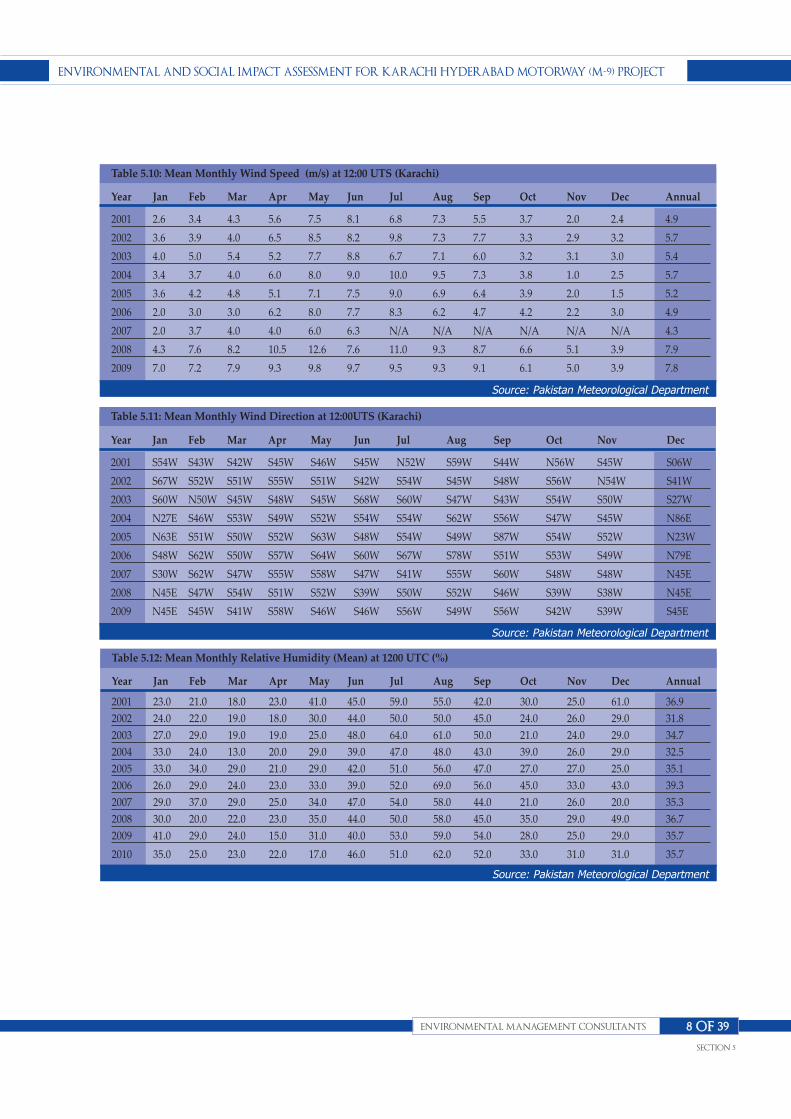
EnvironmEntal and Social impact aSSESSmEnt for Karachi hydEraBad motorway (m-9) projEct
EnvironmEntal managEmEnt conSultantS
SEction 5
8 of 39
Table 5.10: Mean Monthly Wind Speed (m/s) at 12:00 UTS (Karachi)
Year Jan Feb Mar Apr May Jun Jul Aug Sep Oct Nov Dec Annual
2001 2.6 3.4 4.3 5.6 7.5 8.1 6.8 7.3 5.5 3.7 2.0 2.4 4.9
2002 3.6 3.9 4.0 6.5 8.5 8.2 9.8 7.3 7.7 3.3 2.9 3.2 5.7
2003 4.0 5.0 5.4 5.2 7.7 8.8 6.7 7.1 6.0 3.2 3.1 3.0 5.4
2004 3.4 3.7 4.0 6.0 8.0 9.0 10.0 9.5 7.3 3.8 1.0 2.5 5.7
2005 3.6 4.2 4.8 5.1 7.1 7.5 9.0 6.9 6.4 3.9 2.0 1.5 5.2
2006 2.0 3.0 3.0 6.2 8.0 7.7 8.3 6.2 4.7 4.2 2.2 3.0 4.9
2007 2.0 3.7 4.0 4.0 6.0 6.3 N/A N/A N/A N/A N/A N/A 4.3
2008 4.3 7.6 8.2 10.5 12.6 7.6 11.0 9.3 8.7 6.6 5.1 3.9 7.9
2009 7.0 7.2 7.9 9.3 9.8 9.7 9.5 9.3 9.1 6.1 5.0 3.9 7.8
Source: Pakistan Meteorological Department
Table 5.11: Mean Monthly Wind Direction at 12:00UTS (Karachi)
Year Jan Feb Mar Apr May Jun Jul Aug Sep Oct Nov Dec
2001 S54W S43W S42W S45W S46W S45W N52W S59W S44W N56W S45W S06W
2002 S67W S52W S51W S55W S51W S42W S54W S45W S48W S56W N54W S41W
2003 S60W N50W S45W S48W S45W S68W S60W S47W S43W S54W S50W S27W
2004 N27E S46W S53W S49W S52W S54W S54W S62W S56W S47W S45W N86E
2005 N63E S51W S50W S52W S63W S48W S54W S49W S87W S54W S52W N23W
2006 S48W S62W S50W S57W S64W S60W S67W S78W S51W S53W S49W N79E
2007 S30W S62W S47W S55W S58W S47W S41W S55W S60W S48W S48W N45E
2008 N45E S47W S54W S51W S52W S39W S50W S52W S46W S39W S38W N45E
2009 N45E S45W S41W S58W S46W S46W S56W S49W S56W S42W S39W S45E
Source: Pakistan Meteorological Department
Table 5.12: Mean Monthly Relative Humidity (Mean) at 1200 UTC (%)
Year Jan Feb Mar Apr May Jun Jul Aug Sep Oct Nov Dec Annual
2001 23.0 21.0 18.0 23.0 41.0 45.0 59.0 55.0 42.0 30.0 25.0 61.0 36.9
2002 24.0 22.0 19.0 18.0 30.0 44.0 50.0 50.0 45.0 24.0 26.0 29.0 31.8
2003 27.0 29.0 19.0 19.0 25.0 48.0 64.0 61.0 50.0 21.0 24.0 29.0 34.7
2004 33.0 24.0 13.0 20.0 29.0 39.0 47.0 48.0 43.0 39.0 26.0 29.0 32.5
2005 33.0 34.0 29.0 21.0 29.0 42.0 51.0 56.0 47.0 27.0 27.0 25.0 35.1
2006 26.0 29.0 24.0 23.0 33.0 39.0 52.0 69.0 56.0 45.0 33.0 43.0 39.3
2007 29.0 37.0 29.0 25.0 34.0 47.0 54.0 58.0 44.0 21.0 26.0 20.0 35.3
2008 30.0 20.0 22.0 23.0 35.0 44.0 50.0 58.0 45.0 35.0 29.0 49.0 36.7
2009 41.0 29.0 24.0 15.0 31.0 40.0 53.0 59.0 54.0 28.0 25.0 29.0 35.7
2010 35.0 25.0 23.0 22.0 17.0 46.0 51.0 62.0 52.0 33.0 31.0 31.0 35.7
Source: Pakistan Meteorological Department

The annual rainfall in the project area ranges between 9.0
mm and 405 mm. Maximum rainfall (about 60% of the
total annual) occurs during the Monsoon season (July,
August and September), while the period of minimum
rainfall or drier period is October and November. Mean
monthly precipitation data of Hyderabad area is
provided in Table 5.13.
The precipitation in Karachi is extremely low. The
rainfall data shows that 156.8 mm rainfall was recorded
during first six months of 2007.The records for the last
over six years are presented in Table 5.14
The 5-years record for rainfall of PMD at Karachi Airport
(2001‐2005) suggests that July and August are the wettest
months and that the maximum rainfall recorded in
Karachi during last five years is 240.4 mm during the
month of July 2003.
It states, Karachi has been facing drought conditions as
the average range of rainfall seen during five years
(2001‐2005) is 8‐24 mm. On the other hand, during the
year of 2006, heavy monsoon and winter rainfall was
recorded during the months of July/August and
November. An average of rainfall recorded in the month
of December 2006 is around 166.4 mm.Figure 5.6 shows
annual graph of precipitation of Karachi Hyderabad.
5.2.4 Recent Trend in MonsoonPatternThe low cloud covers and increased sunshine results in
EnvironmEntal and Social impact aSSESSmEnt for Karachi hydEraBad motorway (m-9) projEct
EnvironmEntal managEmEnt conSultantS
SEction 5
9 of 39
Table 5.13:Monthly Amount of Precipitation (mm)(Hyderabad)
Year Jan Feb Mar Apr May Jun Jul Aug Sep Oct Nov Dec Annual
22001 0.0 0.0 0.4 18.5 0.0 0.0 104.9 47.5 TR TR 0.0 0.0 171.3
2002 0.0 2.0 0.0 0.0 0.0 4.0 0.0 TR 0.0 0.0 3.0 0.0 9.0
2003 TR 106.0 TR 0.0 0.0 13.0 209.2 77.4 0.0 0.0 0.0 0.0 405.6
2004 2.0 0.0 0.0 6.2 0.0 TR 0.0 16.0 TR 103.3 0.0 2.0 129.5
2005 2.2 2.6 0.0 3.4 15.0 0.0 10.6 15.4 3.2 0.0 0.0 0.0 52.4
2006 0.0 0.0 37.0 21.4 0.0 0.7 80.2 204.5 170.0 0.0 0.0 11.1 524.9
2007 0.0 3.0 33.5 0.0 0.0 34.3 7.5 130.4 0.0 0.0 0.0 33.2 241.9
2008 8.8 TR 1.0 14.5 0.0 0.7 8.0 103.8 0.0 0.0 0.0 19.8 156.6
2009 0.7 0.2 0.4 0.6 0.0 0.3 137.8 62.2 0.0 0.0 0.0 0.0 202.2
2010 0.4 0.4 0.0 0.0 0.0 76.5 29.5 85.9 18.0 0.0 3.4 0.0 214.1
*TR= TraceSource: Pakistan Meteorological Department
Table 5.14: Monthly Amount of Precipitation (mm) at Karachi Air Port
Year Jan Feb Mar Apr May Jun Jul Aug Sep Oct Nov Dec Annual
2001 0.0 0.0 0.0 0.0 0.0 10.6 73.6 16.2 N/A 0.0 0.0 0.0 100.4
2002 0.0 2.4 0.0 0.0 0.0 N/A N/A 52.2 N/A 0.0 0.5 0.4 55.5
2003 6.4 21.8 0.0 0.0 0.0 16.3 270.4 9.8 N/A 0.0 0.2 0.0 324.9
2004 13.7 0.0 0.0 0.0 0.0 N/A 3.0 5.6 N/A 39.3 0.0 4.3 65.9
2005 6.6 12.8 N/A 0.0 0.0 N/A N/A 0.3 54.9 0.0 0.0 17.1 91.7
2006 N/A 0.0 N/A 0.0 0.0 0.0 66.2 148.6 21.9 0.0 3.1 61.3 301.1
2007 0.0 13.2 33.4 0.0 0.0 110.2 N/A N/A N/A N/A N/A N/A 156.8
2008 8.0 Trace 1.1 0.0 0.0 0.0 54.0 37.5 Trace 0.0 0.0 21.0 121.6
2009 3.0 Trace 0.0 Trace 0.0 2.6 159.9 44.0 68.9 0.0 0.0 1.5 279.9
Source: Pakistan Meteorological Department

rise in temperature of landmass in the hinterland.
MoenjoDaro recorded the world record of 55 °C on May
25. Such high temperatures on vast territory has (i)
turned large territory of Pakistan into an extensive heat
zone, and (ii) raised the temperature of the North
Arabian Sea by 1°C to 1.5°C. The heat zone serves as the
main heat engine and the significant rise in temperature
of the Arabian Sea leading to higher salinity can trigger
cyclones in the Arabian Sea on the south of Karachi
besides heavy monsoon rains all over the Indo-Pakistan
region.
Such rise in temperature indicates onset of low-pressure
zone on land and steep salinity gradient on the sea. The
former parameter can attract rain bearing winds in case
they are around, while the latter can nucleate
cyclones/storms. Such attraction of moisture laden
winds did cause severe storms, the latest on June 6, 2010;
June 5, 2007; August 21, 2007; and on August 17, 2006
and brought sudden heavy rains of as much as 50 to 100
mm in two to three hours. Earlier on 150 mm rain fell in
3 hours in 1967 and caused accumulation of 8 ft water in
Shershah. In the 1977 monsoon season the incessant
pouring brought 200 mm rains in five hours.
The cyclonic event that was incident on June 6, 2010
brought 100 mm rainfall in two hours; on August 10 and
11 of 2007 it brought unusually high rainfall of 107mm in
24 hours as compared with the normal of about 60mm
for August. The wettest August ever experienced by the
city of Karachi was in 1979, when over 262mm rainfall
was recorded. The record for maximum rainfall within
24 hours was 166mm of rain on August 7, 1979. The
heavy rainfall was thus not unusual particularly because
it was caused by the system that travelled from across
Rajasthan and lay over Sindh. The monsoon weather
system did not move towards Baluchistan but the
penetration of moist currents from Sindh brought
scattered to heavy rain in southern Baluchistan,
particularly along its coastal regions.
The rainfall system that started on July 30, 2006 was a
repetition of the 50 year cycle since in 1956 the recorded
rainfall was 400 mm. The regular monsoon system was
rendered inoperative by the persistence of the El-Nino
and La-Nina effects. That system seems to have been
broken by the powerful Tsunami – 2004, which was
caused by the 1000 km long and 4 km wide rupture
under the Indonesian Seas that initiated the propagation
EnvironmEntal and Social impact aSSESSmEnt for Karachi hydEraBad motorway (m-9) projEct
EnvironmEntal managEmEnt conSultantS
SEction 5
10 of 39
Figure 5.4: Annual Graph of Precipitation of Karachi-Hyderabad

of sea waves. The powerful Tsunami waves were
traveling at a speed of 700 km/hour and were cause for
the disruption of the ocean current system of the Indian
Ocean that had been operating under the El-Nino
system.
It seems that the disturbance caused by the Tsunami of
December 2004 system was instrumental in bringing
rains though still below average in Sindh. The
disruption of the oceanic current system firmed up in the
year 2006 and there was revival of the past system when
there would be heavy rains after periods of drought.
The monsoon activity does not subside until mid-
September but in 2007 it was more than usual. One of the
indicators of its activity is the up welling that comes
along. Up welling had intensified during the year 2007
because of the increased input of sunshine over the land
area of Pakistan. This has caused serious disturbances in
the current pattern in the Arabian Sea leading to major
cyclonic events during the year 2007.
5.2.5 Storms High heat content of the Arabian Sea that is adjacent to
the extensive heat zone of Pakistan usually upsets the
heat balance and hence the water-balance of the region,
particularly because it is the destination of windstorms.
Tropical cyclones generally develop over Arabian Sea in
low latitude i.e. 5-20 degrees north and dissipate after
they move over land. The maximum frequency of
tropical cyclone formation occurs in April, May and June
and in the October-November period. The month of
June receives least tropical cyclones in the region. About
76% of tropical cyclones in Karachi approach from the
south through the east.
Tropical cyclones that come near the proximity of
Karachi are generally weakened. The one that came near
the coastal area on May 12, 1999 changed its direction
and hit the coastal area of Badin, however Karachi was
safe from this cyclone as it is located in the peripheral
area and only rain showers of moderate intensity were
recorded.
The cyclone in September 2006 proceeded towards
coastal belt of Badin; but it did not hit the area and
changed its direction. Although some cyclones have
passed near the coastal belt of Badin but still it is
classified outside the zone of cyclone activity for the
Arabian Sea.
In late May 2007 the heat zone in Pakistan attracted the
Tropical Cyclone Gonu, and by Tropical Cyclone 03A
from the south of Mumbai, and thereafter by Tropical
Cyclone 04B nicknamed Yemyin, and then a series of
depressions travelling almost directly to the heat zone in
Pakistan.
Soon after the beginning of June 07 the tropical cyclone
Gonu visited the Coastal area of Oman for the first time
in history and set the beginning of destruction over the
coastal area of western Baluchistan. At this time it
seemed that cyclone Yemyin was trekking westward
south of Sindh and Baluchistan while also weakening,
but numerical forecasts were indicating that a huge,
strong system was developing high up in the sky
diagonally on the path i.e. Arabia and Iran and thereby
cutting off the impact and almost restraining the cyclonic
system to proceed further from the Indus Delta and
proceeding towards Karachi. On the night of July 3, 2007
Sindh especially lower Sindh received widespread rains,
but luckily Karachi escaped from a high impact of this
system. Scattered rains in Sindh with isolated heavy falls
in eastern Sindh occurred.
The June 6, 2010 cyclone 03A, nicknamed Phet had
landed on the coast of Oman and had lost its intensity.
Moving in clockwise direction it poured heavy rains on
Gwadar and Pasni. The rain bearing winds moved along
the coastline towards Karachi. It touched Karachi only
tangentially and brought 100 mm rainfall two days
before it landed south of Thatta District.
5.2.6 Surface Water ResourcesThe River Indus is the prime surface water resource of
Sindh. Salient information of this river is provided
below.
Indus River: The Indus River is the main source of
surface water in the project area (and in the country).
EnvironmEntal and Social impact aSSESSmEnt for Karachi hydEraBad motorway (m-9) projEct
EnvironmEntal managEmEnt conSultantS
SEction 5
11 of 39

The Indus rises in Tibet, at an altitude of about 18,000
feet (5,486 m) and has a total catchment area of 654,329
km2. Length of the Indus River in the country is about
2,750 km. Five main rivers that join the Indus from the
eastern side are Jhelum, Chenab, Ravi, Beas and Sutlej.
Besides these, two minor riversSoan and Harrow also
drain into the Indus. On the western side, a number of
small rivers join Indus, the biggest of which is River
Kabul with its main tributaries i.e. Swat, Panjkora and
Kunar. Several small streams such as Kurram, Gomal,
Kohat, Tai and Tank, also join the Indus on the right side.
The Indus River and its tributaries on an average bring
about 154 MAF of water annually. This includes 144.9
MAF from the three western rivers and 9.14 MAF from
the eastern rivers. Most of this, about 104.7 MAF is
diverted for irrigation, 39.4 MAF flows to the sea and
about 9.9 MAF is consumed by the system losses which
include evaporation, seepage and spills during floods.
The flows of the Indus and its tributaries vary widely
from year to year and within the year. As is the case with
the water availability there issignificant variation in
annual flows into sea.
The Indus Delta: Historically, the Indus Delta has
formed in an arid climate under conditions of high river
discharge to the proportion of 4 billion tons of sediment
per year.
In the past, this has contributed to a prograding seaward
of the delta as a result ofinteraction of fluvial and marine
processes and a moderate tide range of
approximately2.6 meters. Pro-gradation has occurred in
spite of extremely high wave energies of the order of
1,400 million ergs/sec. During the past six decades,
however, the construction of dams and barrages and
extensive engineering works upstream has reduced the
sediment load to 100-650 million tons per year (based on
different studies). This decrease in sediment load
together with the extremely high wave energies is
expected to cause rapid reworking and transgression of
the Indus delta. What makes Indus delta unique is the
fact that it experiences the highest wave energy of any
river in the world. During the monsoon season, from
May-September, the delta front receives more wave
energy in a single day than the Mississippi delta receives
in the entire year.
The Indus delta is triangular in shape and occupies a
large part of the province of Sindh, covering about
30,000 km2. It is about 240 km in length along the axis of
the river and220 km at its widest, from Karachi to the
great Rann of Kutch.
Hill Torrents: A distinct feature of the Kirthar Range on
the Indus right bank is the presence of hill torrents,
which drain the western hilly areas towards the Indus
River in the east. Most of these surface drains experience
nominal flow, if any, during the dry weather. However,
during the rainy seasons, sudden, high and gushing
flows occur, causing flash floods in the downstream
areas.The surface water resources in the project are in
clued natural drainage channels, i.e. rivers including
River Sindh (at Karachi – Hyderabad), drains, torrents
and manmade irrigation and drainage systems.
River Water Quality: The water quality of Indus River is
generally considered excellent for irrigation purposes.
The total dissolved solids (TDS) range from 60 mg/l in
the upper reaches to 375 mg/l in the lower reaches of the
Indus, which are reasonable levels for irrigated
agriculture and also as raw water for domestic use. The
disposal of saline drainage from various irrigation
projects has been a major factor in the increased TDS in
the lower reaches of the rivers in the Indus Plain. There
is progressive deterioration downstream and the salinity
is at its maximum at the confluence of the Chenab and
Ravi rivers, where the TDS ranges from 207 to 907 mg/l.
A slight improvement in water quality is noted further
downstream at Panjnad due to dilution from the inflow
from Sutlej River. The quality of the Indus water at
Guddu, however, is within acceptable limits for
agriculture; TDS being in the range of 164-270 mg/l.
In the upper reaches of the Indus River, the Dissolved
Oxygen (DO) content remains above 8.5 mg/l which is
well above the acceptable levels of 4 mg/l. The
Biochemical Oxygen Demand (BOD) downstream of
Attock has been recorded as 2.9 mg/l. At Kotri, it has a
suspended solid (SS) content of 10 to 200 mg/l. Indus
EnvironmEntal and Social impact aSSESSmEnt for Karachi hydEraBad motorway (m-9) projEct
EnvironmEntal managEmEnt conSultantS
SEction 5
12 of 39

River water quality has-been studied at the Dadu-Moro
Bridge and Kotri Barrage, with nitrate levels at 1.1
and7.5 mg/l, phosphate at 0.02 and 0.3 mg/l, BOD at 2.4
and 4.1 mg/l, faecalcoli forms at 50and 400 per ml, and
aluminum at 1.8 and 0.2 mg/l respectively. Due to
industrial waste discharges from Punjab and Sindh, a
high content of heavy metals such as nickel, lead, zinc
and cadmium have also been found in Indus water.
Lakes: There exist several fresh water and brackish lakes
in the Sindh province. The salient among these include
Manchar, Keenjhar and Haleji lakes. In addition there
exist a large number of small lakes and ponds in the
irrigated areas of Sindh, most of which have been
created as a result of extensive irrigation and very
shallow groundwater.
5.2.7 Groundwater ResourcesThe Indus Basin was formed by alluvial deposits carried
by the Indus and its tributaries. It is underlain by an
unconfined aquifer covering about 15 million acres
(60,700 km2) insurface area. In Sindh, about 28% of the
area is underlain by fresh groundwater. This is mostly
used as supplemental irrigation water and pumped
through tube-wells. Some groundwater is saline. Water
from the saline tube-wells is generally put into drains
and, where this is not possible, it is discharged into large
canals for use in irrigation, after diluting with the fresh
canal water.
Before the introduction of widespread irrigation, the
groundwater table in the Indus Basin varied from about
12 m in depth in Sindh and Bahawalpur areas to about
30 m in RechnaDoab (the area between Ravi and Chenab
Rivers). After the introduction of
weircontrolledirrigation, the groundwater table started
rising due to poor irrigation management, lack of
drainage facilities and the resulting additional recharge
from the canals, distributaries, minors, water courses
and irrigation fields. At some locations, the water table
rose to the ground surface or very close to the surface
causing water-logging and soil salinity, reducing
productivity.
In the last 25-30 years, ground water has become a major
supplement to canal supplies, especially in the Upper
Indus Plain, where ground water quality is good. Large
scale tube-well pump age for irrigation started in the
early sixties. There are presently more than 500,000 tube-
wells in the Indus Basin Irrigation System (IBIS).
According to study, the total groundwater potential in
Pakistan is of the order of 55 MAF.
Major part of the groundwater abstraction for irrigation
is within the canal commands or in the flood plains of
the rivers. However, the amount of abstraction varies
throughout the area, reflecting inadequacy/unreliability
of surface water supplies and groundwater quality
distribution.
The quality of groundwater ranges from fresh (salinity
less than 1,000 mg/l TDS) near the major rivers to highly
saline farther away, with salinity more than 3,000 mg/l
TDS. The general distribution of fresh and saline
groundwater in the country is well known and mapped,
as it influences the options for irrigation and drinking
water supplies. Generally, the quality and quantity of
groundwater in the Indus Basin deteriorate from north
to south and from east to west. Table 5.15represents the
ground water quality of Nooriabad.
5.2.8 GeographyThe Province of Sindh is located in the South- Eastern
part of the country (between Lat 23-35 and Lat 28- 30 N).
Its gross geographical area is 140,914 Sq. km which is
18% of the country. The geographical area is 14 million
hectares out of which almost 8.0 million hectare is
cultivable, and the remaining area is not available for
cultivation mostly lying in the northern hills of Khirthar
Range, eastern desert of Thar Desert and AchharoThar
and the riverian area. Sindh’s 60% land area is arid.
Annual average precipitation is 5 inches yearly. The
mighty River Indus flows in the middle of the province.
There are seasonal streams which become active in the
monsoon season, they emanate from the Khirthar hill
range from west of province, which fallout in River
Indus and Arabian Sea. The boundaries of Sindh are
touched by Arabian Sea in South, India in east, Punjab in
EnvironmEntal and Social impact aSSESSmEnt for Karachi hydEraBad motorway (m-9) projEct
EnvironmEntal managEmEnt conSultantS
SEction 5
13 of 39

EnvironmEntal and Social impact aSSESSmEnt for Karachi hydEraBad motorway (m-9) projEct
EnvironmEntal managEmEnt conSultantS
SEction 5
14 of 39
Water Quality Parameter Unit Nooriabad
Min Max Avg.
Alkalinity m.mol/l 1.50 5.80 1.96
Arsenic µg/l 0 200.00 13.80
Bicarbonate mg/l 75.00 290.00 98.00
Calcium mg/l 25.00 88.00 33.93
Carbonate mg/l 0 0 0
Chloride mg/l 5.00 124.00 25.33
Chromium Ppb 0 25.00 9.20
Conductivity µS/cm 260.00 1,150.00 387.00
Fluoride mg/l 0.20 0.42 0.46
Hardness mg/l 100.00 370.00 136.33
Iron mg/l 0.02 3.90 1.33
Magnesium mg/l 8.00 36.00 12.47
Nitrate (N) mg/l 0.50 4.00 2.14
pH - 6.50 7.70 7.15
Phosphate mg/l 0 0.22 0.05
Potassium mg/l 4.00 10.00 5.94
Sodium mg/l 10.00 102.00 26.20
Sulfate mg/l 28.00 138.00 45.07
TDS mg/l 161.00 782.00 244.93
Turbidity NTU 2.00 160.00 40.80
Total Coliform MPN/100 ml 0 16.00 4.20
Table 5.15: Ground Water Quality of Nooriabad
Figure 5.5: Ground Water Quality of Nooriabad
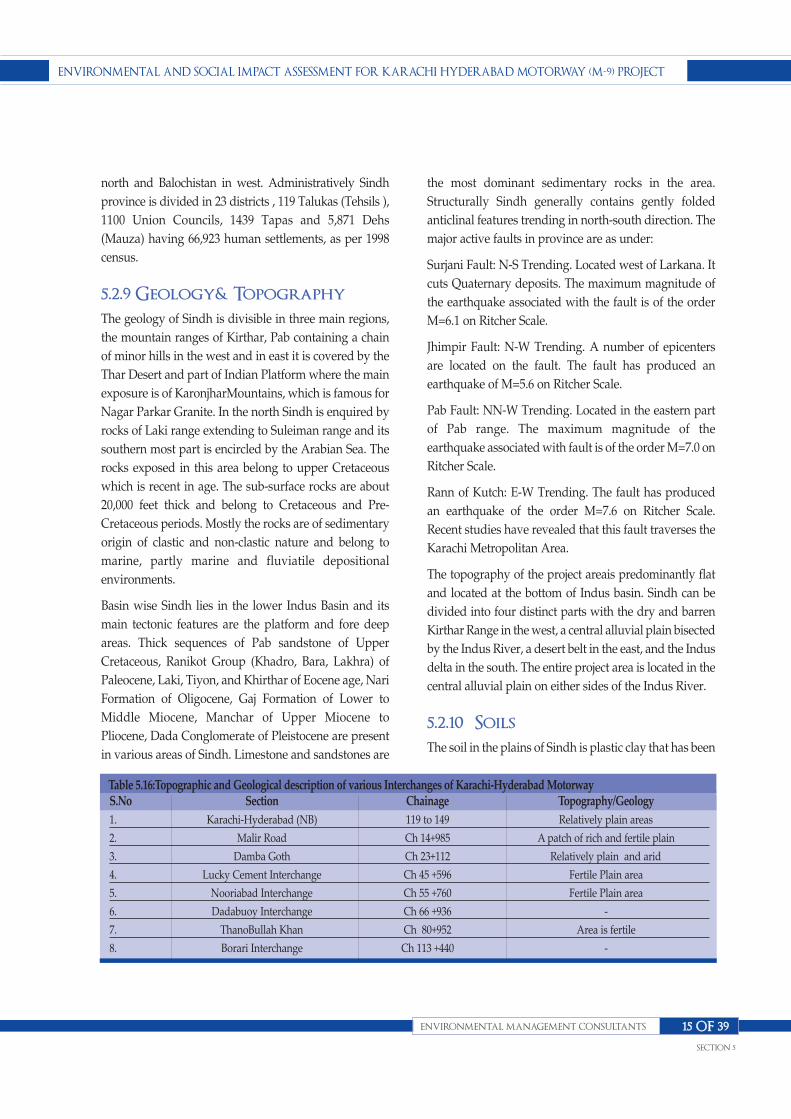
north and Balochistan in west. Administratively Sindh
province is divided in 23 districts , 119 Talukas (Tehsils ),
1100 Union Councils, 1439 Tapas and 5,871 Dehs
(Mauza) having 66,923 human settlements, as per 1998
census.
5.2.9 Geology& TopographyThe geology of Sindh is divisible in three main regions,
the mountain ranges of Kirthar, Pab containing a chain
of minor hills in the west and in east it is covered by the
Thar Desert and part of Indian Platform where the main
exposure is of KaronjharMountains, which is famous for
Nagar Parkar Granite. In the north Sindh is enquired by
rocks of Laki range extending to Suleiman range and its
southern most part is encircled by the Arabian Sea. The
rocks exposed in this area belong to upper Cretaceous
which is recent in age. The sub-surface rocks are about
20,000 feet thick and belong to Cretaceous and Pre-
Cretaceous periods. Mostly the rocks are of sedimentary
origin of clastic and non-clastic nature and belong to
marine, partly marine and fluviatile depositional
environments.
Basin wise Sindh lies in the lower Indus Basin and its
main tectonic features are the platform and fore deep
areas. Thick sequences of Pab sandstone of Upper
Cretaceous, Ranikot Group (Khadro, Bara, Lakhra) of
Paleocene, Laki, Tiyon, and Khirthar of Eocene age, Nari
Formation of Oligocene, Gaj Formation of Lower to
Middle Miocene, Manchar of Upper Miocene to
Pliocene, Dada Conglomerate of Pleistocene are present
in various areas of Sindh. Limestone and sandstones are
the most dominant sedimentary rocks in the area.
Structurally Sindh generally contains gently folded
anticlinal features trending in north-south direction. The
major active faults in province are as under:
Surjani Fault: N-S Trending. Located west of Larkana. It
cuts Quaternary deposits. The maximum magnitude of
the earthquake associated with the fault is of the order
M=6.1 on Ritcher Scale.
Jhimpir Fault: N-W Trending. A number of epicenters
are located on the fault. The fault has produced an
earthquake of M=5.6 on Ritcher Scale.
Pab Fault: NN-W Trending. Located in the eastern part
of Pab range. The maximum magnitude of the
earthquake associated with fault is of the order M=7.0 on
Ritcher Scale.
Rann of Kutch: E-W Trending. The fault has produced
an earthquake of the order M=7.6 on Ritcher Scale.
Recent studies have revealed that this fault traverses the
Karachi Metropolitan Area.
The topography of the project areais predominantly flat
and located at the bottom of Indus basin. Sindh can be
divided into four distinct parts with the dry and barren
Kirthar Range in the west, a central alluvial plain bisected
by the Indus River, a desert belt in the east, and the Indus
delta in the south. The entire project area is located in the
central alluvial plain on either sides of the Indus River.
5.2.10 SoilsThe soil in the plains of Sindh is plastic clay that has been
EnvironmEntal and Social impact aSSESSmEnt for Karachi hydEraBad motorway (m-9) projEct
EnvironmEntal managEmEnt conSultantS
SEction 5
15 of 39
S.No Section Chainage Topography/Geology
1. Karachi-Hyderabad (NB) 119 to 149 Relatively plain areas
2. Malir Road Ch 14+985 A patch of rich and fertile plain
3. Damba Goth Ch 23+112 Relatively plain and arid
4. Lucky Cement Interchange Ch 45 +596 Fertile Plain area
5. Nooriabad Interchange Ch 55 +760 Fertile Plain area
6. Dadabuoy Interchange Ch 66 +936 -
7. ThanoBullah Khan Ch 80+952 Area is fertile
8. Borari Interchange Ch 113 +440 -
Table 5.16:Topographic and Geological description of various Interchanges of Karachi-Hyderabad Motorway
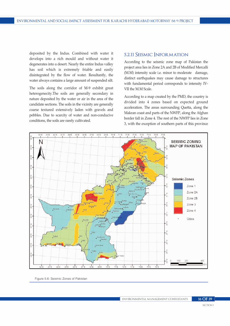
deposited by the Indus. Combined with water it
develops into a rich mould and without water it
degenerates into a desert. Nearly the entire Indus valley
has soil which is extremely friable and easily
disintegrated by the flow of water. Resultantly, the
water always contains a large amount of suspended silt.
The soils along the corridor of M-9 exhibit great
heterogenecity.The soils are generally secondary in
nature deposited by the water or air in the area of the
candidate sections. The soils in the vicinity are generally
coarse textured extensively laden with gravels and
pebbles. Due to scarcity of water and non-conducive
conditions, the soils are rarely cultivated.
5.2.11 Seismic InformationAccording to the seismic zone map of Pakistan the
project area lies in Zone 2A and 2B of Modified Mercalli
(M.M) intensity scale i.e. minor to moderate damage,
distinct earthquakes may cause damage to structures
with fundamental period corresponds to intensity IV-
VII the M.M Scale.
According to a map created by the PMD, the country is
divided into 4 zones based on expected ground
acceleration. The areas surrounding Quetta, along the
Makran coast and parts of the NWFP, along the Afghan
border fall in Zone 4. The rest of the NWFP lies in Zone
3, with the exception of southern parts of this province
EnvironmEntal and Social impact aSSESSmEnt for Karachi hydEraBad motorway (m-9) projEct
EnvironmEntal managEmEnt conSultantS
SEction 5
16 of 39
Figure 5.6: Seismic Zones of Pakistan

which lie in Zone 2. The rest of the parts of Pakistani
coast till Karachi also lie in Zone 3. The remaining parts
of the country other than the coast lie in Zone 1.
Karachi is situated close to the junction of three tectonic
plates (Indo-Pakistan, Arabian and Eurasian Plates). The
significant faults in the vicinity include Rann of Katch
Fault in east and Pub-Null Fault in west. The Rann of
Kutch-Karachi fault, also known as Karachi-Jati-Allah
Bund fault, passes close to the Eastern Industrial Zone of
Port Qasim. It has three other segments namely the
Jhimpir fault, the Pab fault, and the Surjani fault.
The earthquake hazard in the Indus Delta and the
estuaries on the passive continental margin is mainly
from intra-plate active faults particularly Rann of Kutch
Fault and Pab Fault and their strands. The most
spectacular effect of the active fault of Rann of Kutch
which grazes the vicinity of Karachi was due to severe
earthquake of June 1819. It resulted in the 6 m uplift of
16 km wide and 81 km long tract of alluvial land which
blocked on eastern band of the Indus River and therefore
the locals called it Allah Band. The main faults between
Karachi and Rann of Kutch are generally oriented
easterly and slightly concave to the north.
Historically two sever earthquakes in the vicinity of
Karachi have been reported one in the year 1050 at
Bhanbore in which 0.15 million casualties were taken
place and the other in the year 1668 at Pipri near Steel
Mill which was only 60 km away from Karachi, however
the details of which are not available (IqbalMohsin,
2005). The earthquake of Bhoge in the year 2001
(Ahmedabad 300 km east and Karachi 300 km west) has
also been reported however Karachi remained safe.
Historically this region has suffered a number of
earthquakes. A list of earthquakes, since 1977 to date,
which may affect the proposed area and its vicinity, are
given in Table 5.22. The largest earthquake occurred in
1819. It had a magnitude of 8.0 on Richter scale and was
felt over a wide swath of the Indian subcontinent.
Eastern branch of the Indus River was blocked. Long
tract of alluvial land (81 Km long, 6m height, 16 Km
wide) got uplifted as a result of earthquakes. This
earthquake was also associated with surface faulting
and subsequent subsidence in the epicenter area. This
fault produced a scarp called "The Allah Bund". The
effects of recent earthquake on January 26, 2001 have
also been noticed in the deltaic areas.
These earthquakes occurred along an approximately
East West direction trending the thrust fault at a shallow
depth of less than 25 Km.
5.3 Biological ResourcesThe land which is present around the Karachi-
Hyderabad Super Highway is sparsely inhabited and
almost barren with very little vegetation comprising
mostly bushes. Some areas close to Karachi and
Hyderabad have been developed for cultivation under
tube well irrigation where trees of exotic varieties have
also been planted. Near Karachi, pockets of coconut and
EnvironmEntal and Social impact aSSESSmEnt for Karachi hydEraBad motorway (m-9) projEct
EnvironmEntal managEmEnt conSultantS
SEction 5
17 of 39
Date LAT.( °N) LONG(°E) DEPTH(km) MAGNITUDE RITCHER SCALE
26.09.1977 25.4 68.2 33 4.5
25.11.1982 25.6 67.9 33 4.9
17.12.1985 24.9 67.4 33 4.9
24.12.1985 24.8 67.6 33 4.7
10.09.1991 24.4 68.7 33 4.8
19.09.1991 24.3 68.7 33 4.7
23.04.1992 24.3 68.8 33 3.7
24.12.1992 25.2 67.7 33 3.6
05.02.1993 24.6 68.9 4.3 4.3
06.01.2001 23.4 70.32 7.6 7.6
Table 5.17: List of Earthquakes in Indus Deltaic region and surroundings with latitude 23.0-25.0° N and longitude 67.5-71.0° E
Source: Final Technical Report Impacts of Proposed Water Front Development Project on the Hydraulic Regime, 2005.
date palm plantations have also been observed. The
common fauna in the vicinity of the highway section
comprises Jackal, fox and wild hare. This section
provides an overview of the ecozones, wild flora and
fauna, and the habitat conditions prevailing in the
project area.
5.3.1 Original Ecozones
A. Tropical Thorn Forest Ecozone
This habitat was the most extensive ecozone of the Indus
plain, and currently exists onlyin places where the land
has not been converted for habitation or cultivation. This
habitatcomprises low forests of thorny and hard-
wooded tree species, dominated by Acacia spp.The trees
of such forests have short boles and low branching
crowns. These are usually not close-growth trees hence
their canopies touch each other in exceptionally
favorable spots. The usual height of the trees is 20-30 feet
(6-9 m). Other plants that grow mixed withAcacia
include Salvadora, Prosopis, Capparis, and Tamarix.
The shrubs of theecozone included Calotropis,
Zizyphus, Suaed, while herbs of the area
includedChenopodium, Calligonum, Haloxylonand
various species of grasses.
The type of soil i.e. sandy, loamy, water logged or saline,
and the amount of moisture available mainly governs
the vegetation species. Mostly, both the roads are
covered with thick vegetation that fulfills its water
requirements from the seepage water of farmlands,
agricultural fields and canals of irrigation water
network. In the water logged areas between Jamrao
Bridge andMirpurkhas, where Tamarixaphylla is the
dominant species which is followed
byHaloxylonstocksii as the second dominant species of
saline areas.
The project site from Hyderabad bypass (Channel mori)
to Jamrao Bridge isdominated by Prosopisglandulosa
and Salvadoraoleoides along both sides ofthe road with
small patches of Calotropisprocera and Aervajavanica.
At certainplaces, cultivated Nerium oleander and
Carissa opaca are found. Similarly, thickplantation of
Azadirachtaindica, Albizialebbek,Ficusreligiosa,
Ficusbengalensis, Moringaoleifera, Eucalyptus
camaldulensis and Cordiamyxaarefrequently present on
both sides of the existing road.
Although, at some places old tree plantations are limited
to only one side orabsent on both sides. For instance, 20
trees of Albizialebbek (Shrin) and 36trees of
Azadirachtaindica(Neem) are there, on single side of
road, at adistance of about 25 kilometres from
Hyderabad towards Mirpurkhas, nearSabhu Musa next
to Machi hotel. 32 old trees of Ficusreligiosa (Peepal)
arenear Goth Ameed Ali about 46 kilometres from
Hyderabad towards Mirpurkhas,and more than a dozen
of Acacia nilotica (Babur) trees, at a distance of about
27kilometres from Hyderabad. Cultivated orchards are
also important vegetativeareas that have environmental
as well as social concerns due to their commercial value.
The dominant trees in Hyderabad and Mirpurkhas
districts are babul (Populuseuphrafica),
ber(Zizypuhsnumularia) and several verities of Tamarix
like plai(Tamarixgallica) and
j h a o ( T a m a r i x d i o c i a ) , t a l h i ( D a l b e r g i a s i s o o ) ,
kri(Tamarixgallica), karir(Copparisaphylla).
Number of ornamental flowers found in farms, gardens
and elsewhere in thearea are rose (Rosa damascena),
jasmine (Jasminumofficinale), and tuberose (Polianthes
tuberose)etc.The area is mostly covered with weeds like
Tamarixaphylla and Salvadorapersica and exotic species
like Prosopisglandulosa. Cutting/ clearance of
thesespecies has least concern. Old plantations of
Azadirachtaindica(Neem), Albizialebbek(Shrin),
Ficusreligiosa(Peepal),Acacianilotica (Babul),
Cordiamyxa(Lasura) and Ficusbenghalensis (Borh) have
special concerns. As estimated of 111 plant species
belonging to 41 families and 99 genera have been
reported within the project area. The Annexure-4
provides the alphabetical checklist of floral species with
their local names, family name and life form.
Poaceae family was found dominant with 18 vegetation
species followed byAsteraceae having 7 species,
Mimosaceae, Papilionaceae and Cyperaceaeeach
EnvironmEntal and Social impact aSSESSmEnt for Karachi hydEraBad motorway (m-9) projEct
EnvironmEntal managEmEnt conSultantS
SEction 5
18 of 39

having5 while Malvaceae, Moraceae and Solanaceae
each with 4 vegetation speciesfrom the Hyderabad area.
The Table given below shows the number of floral
species withdominant families.
Important commercial crops of the project area are
Saccharumofficinale (Sugarcane), Brassica oleracea
(Cabbage), Capsicum annum (Chilli), Gossypium
sp.(Kapaas), Oryza sativa (Dhaan), Sorghum vulgare
(Jawar) and Hibiscusesculentus (Bhindi). Similarly, fruit
orchards comprising of Chiku, Mangoes ofvarious
varieties including Chounsa, Sindhri, Dosehri, Langrha,
Fajri, Almas,Maldasaroli and Totaparri. Jaman and Ber
trees are also commonly cultivated along boundaries of
fruit orchards.
The major wildlife mammal species of this ecozone was
Long-eared Hedgehog, Desert Hare, Porcupine, Desert
Wolf, Jackal, Bengal Fox, Desert Fox, Honey Badger,
Small Indian Civet, Grey Mongoose, Small Indian
Mongoose, Striped Hyena, Indian Desert Cat, Caracal,
Jungle Cat, Wild Boar, Nilgai, Blackbuck and Chinkara
Gazelle. Annexure I provide a list of the key mammalian
species of Sindh.
Birds of the ecozone included Grey Partridge, Peafowl,
Common Quail, Ring Dove, Red Turtle Dove, Little
Brown Dove, Green Pigeon, Hoopoe, Spotted Owlet,
Barn Owl, Dusky Horned Owl, Indian Nightjar, and
Wryneck, Golden-backed woodpecker, Pied
EnvironmEntal and Social impact aSSESSmEnt for Karachi hydEraBad motorway (m-9) projEct
EnvironmEntal managEmEnt conSultantS
SEction 5
19 of 39
S.No Family Name No of Species
1. Poaceae 18
2. Asteraceae 7
3. Mimosaceae 5
4. Papilionaceae 5
5. Cyperaceae 5
6. Malvaceae 4
7. Moraceae 4
8. Solanaceae 4
Table 5.18:Number of Species belonging to dominant families
S.No Family Name No of Species
1. Herbs 39
2. Shrubs 19
3. Grasses 18
4. Trees 24
5. Climbers 3
6. Sedges 5
7. Creepers 3
Total=111
Table 5.19:Life Form-wise breakdown of species

Woodpecker, Wood Shrike, Great Grey Shrike, Rufous-
backed shrike, Fantail Flycatcher, Common babbler,
Jungle babbler, Houbara Bustard, Great Indian Bustard
and many other species of passerine birds. Annexure
Iprovide a list of the key bird species of Sindh.
Reptiles of the area included Bengal Monitor Lizard,
Garden Lizard, Spiny-tailed Lizard, Cobra, Krait, Vipers
and Rat Snake. Annexure I provide a list of the key
reptilian species of the area.
B. Riverine Tract Habitats
Originally the riverine habitats used to have heavy,
seasonal floods. Since forecasting and prior warning
were not available to the rural people, these habitats
were not occupied for agriculture and habitation.
Natural resource exploitation was also not extensive. As
result, this natural flora along the rivers flourished.
These included: Tamarix, Saccharum,populousand
Acacia. Typhagrowth was common wherever the water
was stagnant orslow moving.
The mammals of such habitat included Hog Deer, Wild
Boar, Fishing Cat, Jungle Cat, Small Indian Civet,
Smooth-coated Otter and Indus Blind Dolphin. The wild
avifauna of the area included around forty species of
Ducks and Geese, Black Partridge, Countless number
and species of waders, Purple Moorhen, Common and
White-breasted Moorhen, Yellow-eyed Babbler, and
several Passerine species. The key reptiles of the
areaincluded Monitor Lizard and several species of
Turtles.
5.3.2 Modified Nature of HabitatMajor parts of the original habitats as described in above
section have been modified into new habitats, primarily
as a result of extensive cultivation and expanding
centers as well as rural settlements. These new habitat
types are briefly discussed below.
A. Agricultural Habitats
Most parts of Sindh are under very intensive irrigated
cultivation. In addition, livestock rearing is also
practiced extensively, and milk animals are common.
The use of the chemical fertilizers and pesticides is very
common. Several species of wildlife have adapted to the
changed habitat. These include: Jackal; Jungle Cat,
Bengal Fox, Small Indian Mongoose, Shrew, Rodent
pests including Porcupine, Fruit Bats and Wild Boar.
The avifauna which survived the modified habitat
include Doves, Black Partridge, Cuckoos, Koel,
Woodpeckers, Parakeets, Bulbuls, Babblers, Black
Drongo, Bee-eaters, Finches and House Sparrow. The
reptilian species of this modified habitat include Krait,
Cobra, Saw-scaled Viper, Rat Snake and Monitor Lizard.
In these modified habitats, the winter bird species from
Himalayas have reduced due tothe extensive use of
pesticides in these areas, since these species feed on the
insects. These birds play an important role in controlling
insects particularly in the forests.
B. Rural and Urban Habitats
These include human habitations within agriculture
areas, as well as the urban centers. Scavengers like
Jackals are attracted to the garbage dumps and human
feces for food. House Sparrows breed in the houses.
Bank Mynas and Cattle Egrets feed on grasshoppers in
the rangelands with cattle and buffalos. Banyan and
Peepal trees still grow in villages. Green Pigeons and
barbets feed in these trees.
Some of the oldest trees still stand in the old British era
colonies. Some rare species of birds such as hornbills,
Green Pigeon and Barbets still live on them. Large
populations of Pigeons breed in urban houses. Kites,
Crows, Mynas, House Sparrows, and Alexandrine
Parakeets breed in the urban areas.
Usually Shisham and Acacia trees are planted alongside
the roads and canals. Mostly Doves breed on such trees.
C. Migratory Birds
There are many migratory bird species, which still visit
or pass through the modifiedecozones. These include
geese and ducks, cranes, many waders, raptors and large
EnvironmEntal and Social impact aSSESSmEnt for Karachi hydEraBad motorway (m-9) projEct
EnvironmEntal managEmEnt conSultantS
SEction 5
20 of 39

variety of passerine birds such as larks, cuckoos, rooks,
ravens, starlings, tits, warblers and finches. Some of
these birds fly in to stay for the winter, while the rest fly
through.
For many species the province serves as a breeding
ground while others procreate in other areas but have
been spotted in this region.
5.3.3 Fauna of the Project Area Survey on Fauna was conducted by EMC team to collect
the data for the Fauna of the project area. The guidelines
for sensitive and critical areas were followed to identify
sensitive and critical areas in the project area. Most
wildlife species were found to be present or reported
quite far away from the project area in relation to the
officially notified protected areas which may comprises
ecosystemsthat includes wildlife reserves and forests,
archaeological sites, monuments, buildings, antiquities
or cultural heritage sites. Due to movement of traffic and
human activities in the area, the area is already quite
disturbed. Mammals and reptiles have already shifted to
far sides of the super highway. Only common birds such
as doves, crows, sparrows, kites, pigeonsetcwhich are
already accustomed to the disturbed environment are
commonly seen along the road side. Due to the
developmental activities in the area hence there will be
minor impacts on the fauna of the area.
Methodologies of both strip census and point count
methods were applied to record the wild animal’s
species that were found in the area. From the local
communities information about the wildlife of the area
was also taken into account.
Along the main highway and along 200m on each sites
of the main traverse line observations were made and at
randomly selected sites in the main habitats sampling of
animal species was done.The species of mammals, birds
and reptiles and their habitats have been identified and
recorded.
As many as 12 species of mammals, 18 species of birds
and 11 species of reptiles were recorded from the area
(Table 1)
The main habitats of these species were also recorded
such as ridges, rocky area, plain/sandy area, riparian
area, agricultural area and wasteland
n Ridges and ravines are either flat places or soil
filled cracks in the rocks. The species recorded from
here were Blue Rock Pigeons and Crested Larks.
n Rocky habitats were the rocky areas and stony plain
areas providing habitats for Desert Hare,
Balochistan Gerbil and House Bunting.
n Plain / Sandy area was the bare area or some with
vegetation cover. This is the favourable habitat of
Red Fox, Grey Mongoose, Desert Cat, Common
Buzzard Ring Dove, Little Brown Dove, Crested
Lark, White Cheeked Bulbul, Purple Sunbird,
Garden Lizard, Fat-Tailed Gecko, Sand Boa, Indian
Cobra and Saw-Scaled Viper.
n Riparian Area is the area on the edges of waterways.
It provides habitat for Desert Hedgehog, Steppe
Eagle, Black crowned Finch Lark, and Indian Spiny
tailed Lizard.
n Croplands and vicinity of villages provide habitat
for Indian Jackal, Indian Porcupine, Palm Squirrel,
House Rat, House Mouse, Green Bee-eater, Indian
Roller, Red-vented Bulbul, House Crow, Common
Kite, Blue Rock Pigeon and Red-wattled Lapwing.
Threatened Species
None of the threatened species of mammals, birds or
reptiles was recorded from the area.
Protected Species
The following species are totally protected under the
Sind Wildlife Protection Act 1972: Desert Cat, Black Kite,
Steppe Eagle, Common Buzzard and Desert Monitor.
5.3.4- Flora of the Project AreaA survey on Flora of Karachi Hyderabad M9 was made
regarding Environmental Impact Assessment effect of
the project on Vegetation of the area.On both the sides of
EnvironmEntal and Social impact aSSESSmEnt for Karachi hydEraBad motorway (m-9) projEct
EnvironmEntal managEmEnt conSultantS
SEction 5
21 of 39

EnvironmEntal and Social impact aSSESSmEnt for Karachi hydEraBad motorway (m-9) projEct
EnvironmEntal managEmEnt conSultantS
SEction 5
22 of 39
Indian Sanda Boa Ribbon snake
Red Wattled lapwing House Crow
Indian Roller Blue Pigeon

EnvironmEntal and Social impact aSSESSmEnt for Karachi hydEraBad motorway (m-9) projEct
EnvironmEntal managEmEnt conSultantS
SEction 5
23 of 39
No. Common Name Scientific Name Status Occurrence Listing
1. Bank Myna Acridotheres ginginianus x x
2. Black crowned Finch Lark Eremopterix nigreceps x x
3. Black Drongo / King Crow Dicrurus macrocercus x x
4. Black Kite Milvus migrans x x II
5. Blue Rock Pigeon Columba livia x x III
6. Collared Dove Streptopelia decaocto x x
7. Common buzzard Buteo buteo x x x II
8. Crested Lark Galerida cristata x x
9. House Crow Corvus splendens x x
10. House Sparrow Passer domesticus x x
11. Indian Myna/Common Myna Acridotheres tristis x x
12. Indian Robin Saxicoloides fulicata x x
13. Indian Roller Coracias benghalensis x x
14. Little Brown Dove Streptopelia senegalensis x x III
15. Little Green Bee-eater Merops orientalis x x
16. Purple Sunbird Nectarinia asiatica x x
17. Red vented Bulbul Acrocephalus agricola x x
18. Red-wattled Lapwing Hoplopterus indicus x x
19. Steppe eagle Aquila nipalensis x x x
20. White-cheeked Bulbul Pycnonotus leucogenys x x
Mig
rato
ry
Resi
dent
Com
mon
Abu
ndan
t
Less
Com
mon
Rare
WPO
/Act
IUC
N R
ed L
ist
CM
S A
ppen
dix
CIT
ES A
ppen
dix
Table 5.20 :A. Details of birds recorded in the project area
No. Common Name Scientific Name Occurance Listing
1 Asiatic Jackal Canis aureus x III
2 Red Fox Vulpes vulpes x III
3 Desert Cat Felis silverstris ornata x x II
4 Five striped-palm Squirrel Funambulus pennantii x
5 House Mouse Mus musculus x
House rat Rattus rattus x
6 Long-eared Steppe/
Afghan Hedgehog Hemiechinus auritus x
7 Small Indian Mongoose Herpestes javanicus x III
8 Indian Grey Mongoose Herpestes edwardsi x III
9 Indian Crested Porcupine Hystrix indica x
10 Indian Hare/
Black-naped Hare Lepus nigricollis x
11 IndianDesert Jird Meriones hurrianae x
Com
mon
Less
Com
mon
Rar
e
WPO
/Act
IUC
N R
ed li
st
CIT
ES A
ppen
dix
B. Details of mammals recorded in the project area

the road several tree plantations were seen which are
mainly dominated by Eucalyptus citriodora,
Azedarahtaindica, Thespeciapopulenaea,
Conocarpuslatifolia, Parkinsoniaaculeata,
Neriumindicum, Callistemon sp, Guacamofficinale,
Bougainvillaglabra. This entire plantation will have to be
removed and their regeneration and replacement would
be done according to the agreed set of rules.
There is a big tract of abandoned land on either side of
the project dominated by two invasive species
vizProsopisjuliflora and Prosopisglandulora. These trees
are invasive with allelopathic nature there removal
would be beneficial for prevailing native natural
vegetation.
On either side of the project there is a huge expanse of
land with natural native Vegetation. The main wild
plants include Acacia nilotica, Prosopisspicigera, Acacia
senegal, Prosopis cineraria, Capparis decidua,
Euphorbia caducifolia, Salvadoraoleoides,
Ziziphusnummularia, Ziziphusmauritiana,
AervaJavanica, Ticomellaundulat (ornamental tree)
Commiphoramukul (Medicinal plant) Rhusmysorensis
(medicine plant), Indigoferaoblongifolia (blue dye ‘neel’
is extracted from this plant), Fegoniacretica, Zigophiran
simples.
5.3.5- Sensitive or CriticalHabitatsThe nearest Wildlife Protected Area is the Surjan Game
Reserve which is about 2.0Km from the existing Karachi-
Hyderabad Super Highway. The limits of
MahalKohistan Wildlife Sanctuary have been extended.
These may be taken into account.
5.4- Traffic Study on theProposed KarachiHyderabad Motorway M-9The traffic counts were carried out by Halcro on March 2012
at three locations on entire length of Motorway, all major
intersections, Link Road connecting Motorway-M9 and
National Highway N-5 and competing route National
Highway-N5 Traffic pattern on adjoining roads is one of the
prerequisites for travel demand assessment as it is required
to study the present traffic pattern and to study the impact
on this traffic condition due to any proposed development.
5.4.1- Data Analysis
EnvironmEntal and Social impact aSSESSmEnt for Karachi hydEraBad motorway (m-9) projEct
EnvironmEntal managEmEnt conSultantS
SEction 5
24 of 39
No. Common Name Scientific Name Occurance Listing
1 Glossy bellied Racer Coluber ventromaculatus x
2 Indian Spiny-tailed Lizard Uromastyx hardwickii x II
3 Indian desert monitor Varanus griseus x x I
4 Indian Fringe-toed Sand lizard Acanthodactylus cantoris cantoris x
5 Saw scaled viper Echis carinatus pyramidum x
6 Garden Lizard Calotes versicolor x
7 Pakistan Ribbon Snake Psammophis leithii x
8 Indian Sand Boa Eryx johnii johnii x II
9 Sindh Sand Gecko Crossobamon orientalis x
10 Indian Cobra Naja naja naja x II
11 Fat tailed Gecko Eublepharis macularius x
Com
mon
Less
Com
mon
Rar
e
WPO
/Act
IUC
N R
ed L
ist
CIT
ES A
ppen
dix
C. Details of reptiles recorded in the project area

The analysis of the classified traffic volume count
observed at the count locations was carried out to arrive
at the
n Average Daily Traffic as per NHA Toll able
Classification ( ADT)
n Hourly Variation and Peak Hour Factor (PHF)
n Directional Distribution
n Traffic Composition
n Intersection Turning Movements
n Review of Previous Studies
n Willingness to Pay Survey
n Origin and Destination Survey
n Travel time and Delay Survey
n Capacity Analysis
5.5- Socio-economicCondition inMicroenvironment
5.5.1- Communities and theirEconomic ActivityCommunities owe much of their vitality to the ease with
which economic and social interactions take place.
Ironically, while roads are central to this continuing
interaction, the introduction of a new road, or the
widening of an existing road, may well cause
disruptions to local interactions which outweigh the
benefits. With poor planning, this can be as true of the
local road improvement as it is of the new highway.
Properly planned, however, both should bring benefits
to surrounding communities; for example through
lower transport costs, better access to markets, goods,
jobs, or services such as health and education.
Admittedly, in the case of some major highways and
freeways, the benefits may accrue mainly to long-
distance travelers and haulage companies and their
customers, while benefits to the local community may be
minimal. Proper planning calls for recognition that
road projects can lead to modifications in the
community environment surrounding the road,
influencing various aspects of lifestyles, travel
patterns, and social as well as economic activities.
Recognizing and planning for the management of these
impacts is an important aspect of the environmental
assessment of roads.
5.5.2- Displacement andResettlementThe land acquired by M-9 is less agricultural land and
but some residential area (village/town) will be
disturbed by the route, during construction phase.
According to NHA, the acquired agricultural land is
purchased from the owners at a rate higher than the
market rate.
5.5.3- Pedestrian UnderpassesM-9 motorway has cut the access to same villagers; some
individuals may have their houses on one side and their
estates on other side. Although for **.* Km length of
project, *** numbers of subways (under-passes) have
been designed (about one subway after one Km), but
location of these subways will have some
impactonlivingand housing trend of the area.
5.5.4- Indigenous PeopleRoads are very crude instruments of economic and
social change. Nowhere is this more evident than in
areas inhabited by indigenous peoples. The cultural,
social, political, and economic integrity that
characterizes indigenous peoples renders their lives
extremely vulnerable to disruptions from outside.
Whether a road is being planned to cross an area
inhabited by indigenous peoples or to open up that same
area, it will have a marked effect on their lives.
EnvironmEntal and Social impact aSSESSmEnt for Karachi hydEraBad motorway (m-9) projEct
EnvironmEntal managEmEnt conSultantS
SEction 5
25 of 39
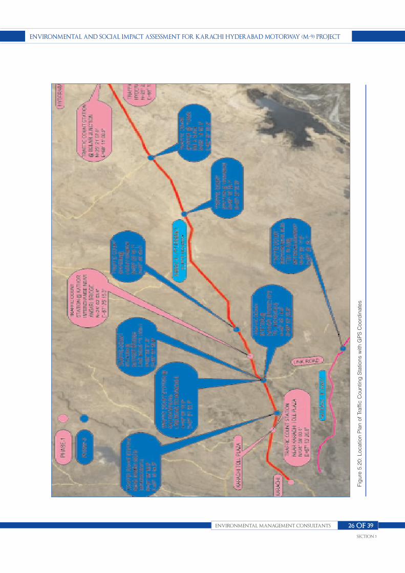
EnvironmEntal and Social impact aSSESSmEnt for Karachi hydEraBad motorway (m-9) projEct
EnvironmEntal managEmEnt conSultantS
SEction 5
26 of 39
Figure 5.20
: Loc
ation Plan of Traffic Cou
nting Statio
ns w
ith G
PS C
oordinates

Road planners have to realize that while a road will
create some opportunities, it will more likely thrust
indigenous people into an artificially accelerated
development stream. As a result of a poorly planned
road project, indigenous people could suffer health and
other social problems. Most of the indigenous people are
farmers, shop-keepers, land- lords and other people
related with agricultural activities.
5.5.5- Cultural HeritageThe term cultural heritage, also termed cultural
property, refers to sites, structures, and remains of
archaeological, historical, religious, cultural, or
aesthetic value. Cultural heritage, often only partially
known and studied, is a particular form of expression
of human values which serves to record past
achievements and discoveries. Its identification and
examination by specialists are helpful in
understanding the significance of a site, according to
its aesthetic, historic, scientific, and social value, in
addition to its amenity value. There are few mosques
and Imam Bargahs along the way as no such major
cultural heritage at M-9.
5.5.6- Aesthetics and LandscapeIt is now becoming more widely accepted that an
understanding of ecology is essential for socio economic
and environmental planning in the larger, regional
landscape. Landscape along the M-9 motorway is very
beautiful with mountainous up down and green
EnvironmEntal and Social impact aSSESSmEnt for Karachi hydEraBad motorway (m-9) projEct
EnvironmEntal managEmEnt conSultantS
SEction 5
27 of 39
MODE Sunday Monday Tuesday Wednesday Thursday Friday Saturday Total
CAR / TAXI/JEEP/Vans (2Axle) 7620 6827 6796 6609 6899 7819 6848 49418
MINIBUS/ COACHES(2 Axle) 956 938 729 708 696 698 867 5592
BUS (2 Axle) 837 834 652 745 725 798 856 5447
TRUCK -RIGID (2/3Axle) 2324 2309 2886 2699 2639 2481 2633 17971
TRUCKS- ARTICULATED (4 /5/ 6Axle) 927 528 1152 1165 1145 1087 1157 7161
TOTAL 12664 11436 12215 11926 12104 12883 12361 85589
SUMMARY of TRAFFICVOLUMECOUNTSURVEY WEEKLYTRAFFICONMOTORWAY M9 (KARACHI-HYDERABAD)KARACHI to HYDERABAD@KARACHITOLLPLAZA
MODE Sunday Monday Tuesday Wednesday Thursday Friday Saturday Total
CAR / TAXI/JEEP/Vans (2Axle) 9284 7933 6863 7031 7066 7823 6454 52454
MINIBUS/ COACHES(2 Axle) 931 938 821 683 690 730 695 5488
BUS (2 Axle) 870 884 743 760 789 803 756 5605
TRUCK -RIGID (2/3Axle) 2215 2319 2565 2407 2224 2272 2510 16512
TRUCKS- ARTICULATED (4 /5/ 6Axle) 759 1289 1030 1059 1207 1294 1250 7888
TOTAL 14059 13363 12022 11940 11976 12922 11665 87947
SUMMARYOF TRAFFICVOLUMECOUNTSURVEY WEEKLYTRAFFICONMOTORWAYM9 (KARACHI-HYDERABAD)HYDERABAD toKARACHI @KARACHITOLL PLAZA
MODE Sunday Monday Tuesday Wednesday Thursday Friday Saturday Total
CAR / TAXI /JEEP/Vans (2Axle) 16904 14760 13659 13640 13965 15642 13302 101872
MINIBUS/ COACHES(2 Axle) 1887 1876 1550 1391 1386 1428 1562 11080
BUS (2 Axle) 1707 1718 1395 1505 1514 1601 1612 11052
TRUCK -RIGID (2/3Axle) 4539 4628 5451 5106 4863 4753 5143 34483
TRUCKS- ARTICULATED (4 /5/ 6Axle) 1686 1817 2182 2224 2352 2381 2407 15049
TOTAL 26723 24799 24237 23866 24080 25805 24026 173536
SUMMARYOF TRAFFICVOLUMECOUNTSURVEY WEEKLYTRAFFICONMOTORWAYM9 (KARACHI-HYDERABAD)HYDERABAD toKARACHI @KARACHITOLL PLAZA

agricultural crops, beautiful trees and unspoiled natural
landscape.
5.5.7- Human Health and SafetyNowhere is impact prevention more important than in
the area of road safety and human health. Poor
planning can lead to loss of life, which can neither
be mitigated nor adequately compensated.
Pedestrians and non-motorized vehicles are the most
vulnerable users of roads, and are at greater risk of being
injured in accidents. In areas where these road users mix
with motorized traffic, special measures must be
adopted to prevent the increased mobility of motorists
from undermining the safety and health of all other road
users. As M-3 is limited access motorway with free flow
conditions. Therefore, possibility of road accidents is
very rare while crossing the road. Moreover, pedestrian
underpasses have also been provided at convenient
intervals (*** km) along the entire length. The threats to
health and safety of the workers and other road users are
air pollution and from the dead bodies of dead animals,
which should be removed efficiently right after the
accident.
5.5.8- Reservations of CulturalHeritageThe M-9corridor does not contain any structures and
artifacts of historical and cultural interest that must be
preserved. However The Antiquities Act 1975,
administered by the provincial government, exists forth
preservation of cultural heritage. Destruction and/or
defacement of antiquities areas offence under the Act.
5.6- Socio-economicConditions inMacroenvironment
5.6.1- Demography The province of Sindh has two gigantic seaports and
both are located in Karachi. The Province of Sindh forms
the lower Indus basin and lies between 23 to 35 Degree
and 28-30, north latitude and 66-42 and 71-1-degree east
longitude. It is about 579 kms in length from north to
south and nearly 442 kms in its extreme breadth (281
kms average). It covers 1, 40,915 square kms and is about
as large as England. Highway, which is generally called
Super Highway, it connects major cities of the province
and it is situated in three district, starting from Karachi it
covers Malir District, in the middle Thatta, district
Jamshoro in the end.
5.6.2- District Malir (Karachi) The district derives its name from its headquarter town
Malir. The word Malir denotes basically a region of
pastoral wealth, a patch of rich and fertile plain or
meadow in Rajasthani, Saraiki and Sindhi.
The district lies between 24˚45' to 25˚ 37' north latitudes
and 67˚ 06' to 67˚ 34' east longitudes and is bounded on
the north by Dadu district, on the south by Thatta
district and Arabian sea, on the east by Dadu and Thatta
districts and on the west by Karachi south, Karachi
Central, Karachi East, Karachi west and Lasbala district
of Balochistan province. The total area of the district is
2268 square kilometers.
5.6.3- History, Ethnicity/Tribesand Culture
A. History
The history of the district can be viewed in association
with Karachi as a whole. Karachi has been variously
called Karakola. Kolachi, Khoraji, Korangi etc. But its
existence in terms of location, condition and name
remains controversial. According to Dr. William Viscent
in his book "The Commerce of Ancients in the Indian
Ocean", it was called Karakola, when Alexander, the
great stayed here. According to James Rennel when
Niarx stayed here it was an island and he was impressed
with it and named after his emperor "SikandariJanat"
Around 1558, Karachi was a conglomerate of about two-
dozen fishing villages called Kalachi or Kalati. The
settlement was projected into prominence when Seth
Bhoju Mal laid the foundation of a small township on the
EnvironmEntal and Social impact aSSESSmEnt for Karachi hydEraBad motorway (m-9) projEct
EnvironmEntal managEmEnt conSultantS
SEction 5
28 of 39

left bank of Lyari river in 1729. This town appears to
have attained little importance under either the native
dynasties or the Mughal administration. Its rise into
notice began with the period of TalpurMirs, in
succession to the Kalhora, who had usurped power on
the break up of the Mughal Empire. They were the first
to recognize the value of the harbor for commerce and in
1792 recovered Karachi from the Khan of Kalat. The
settlement expanded rapidly. It was already of
significance when the British captured Karachi in 1839.
The British annexed Karachi, in 1842, as part of the
Province of Sindh. Then Karachi became an army
headquarters for the British as well as developing into a
principal port for the Indus River region.
After World War-1, manufacturing and service
industries were installed. By 1924, an aerodrome had
been built and Karachi became the main airport of entry
into India. The city became provincial capital of Sindh in
1936.
Malir to an extent is considered to have a part history of
its own. In recent past some archaeological sites were
discovered. The analysis of archaeological studies made
thereof from the tools, utensils, and ornaments etc.
classified it of stone- age and Indus Valley civilizations.
These studies, however, are not of much value as their
chronological order of civilization is undetermined.
Prominence of Malir came into existence in 1856 when
scheme for supplying of water to Karachi was
developed and Captain D. Leezay discovered the source
of water in dry belt of Malir River at Dumlotee.
With the creation of Pakistan in 1947, Karachi not only
became the capital and premier port of new country but
also a center of business and administration. This had
added the value to the burgeoning nation who suffered
an increase in population as a result of mass exodus of
immigrants from India. The Government decided to
settle the refugees in Malir and its surrounding areas.
After then the area gradually developed until November
1993 when the areas comprising now of Malir district
were separated from Karachi East district and the Malir
district was notified.
b. Ethnicity/tribesDifferent tribes are settled in the district, majority of who
are Muslim. Among Sindhis the tribes settled here are
Syed, Jokhia, Khaskheli, Palri, Bareja, Bhabra, Dhars,
SirhindiJamot and Mohannas. These tribes are
landowners keep herds and do fishing.
Among the Baloch, the tribes resides in the district are
Kulmati, Jadgal, Gorgej, Hoot, Vadela, Vashki,
Zarzedagh, Tumpi, Lashari, Laghri, Khosa, Rindh,
Brohi, Harani. Characteristically, these people are hard
working and hospitable. The previously mentioned
tribes are engaged in land, service and business.
Among the Memons are Modaani, Chitrani, Bolani and
Hamlani. The new settlers are from India and have
settled in this district after 1947. After the downfall of
Dhaka, the inhabitants from former East Pakistan
migrated to this district.
Business and Industry allured a large number of persons
from the rest of the country. The majority among them
are the Punjabis and the Pathans. A small proportion of
the Bengalis, the Burmese and the Meghwars are also
settled in this district.
A small minority, which consists of Christians and
Hindus, resides in Malir District.
c. Culture, Custom andTraditions The population of the district is heterogeneous follows a
kaleidoscopic pattern, which has developed a mosaic
culture. Apart from the ceremonies like births and death,
which are followed as ritual and social duties, the
shagging pattern of social economy and behavioral
attitude of the persons, have diminished the values of
the culture and traditions.
It is common nearly to all class of people to visit shrines
of saints, which are many in the district. These visits are
even more pronounced at the time of trouble and
misfortune, which reflects their faith upon them.
Depending on which sect one belongs to determines
whether or not they visit shrines or how much they
EnvironmEntal and Social impact aSSESSmEnt for Karachi hydEraBad motorway (m-9) projEct
EnvironmEntal managEmEnt conSultantS
SEction 5
29 of 39

revere the saints.
The youths are growing up with healthy appetite for
active games. The playing of team games and regular
courses in physical exercise is now part of the
curriculum of the schools. Cricket, hockey and football
are now becoming conspicuous features in urban and
rural areas. In rural areas the indigenous games like
cock-and-dog-fighting are favorite.
d. FoodThe staple food of the people in the district is wheat and
rice. Wheat is taken in the form of unleavened cakes
made savory with vegetables, meat or fish. Rice is boiled
and eaten with same similar accompaniment or made
into pulao or biryani. A class of people prefers rich and
relish food as Shami Kabob, SeekhKabab, Chicken
Tikka, Haleem, and Nihari etc. Those who can afford
them consume fruits as a part of their diet.
Tea is common among all class of people. Among
sweetmeats, Karachi Halwa, SohanHalwa and Habshi
Halwa are the delicacies consumed by the people
preferably on special ceremonies.
e. Dress and Ornaments The most common and generally used dress is Shalwar
and a long shirt. However on festivals and special
occasions this dress is of higher quality and is
accompanied by waistcoat or sherwani and a Jinnah
Cap. The western dress trouser and shirt is also common
among educated persons, students, and working class
people in the office.
The ladies-wear is also shalwar and long shirt but of
bright and fancy color along with a headscarf. Ladies
from eastern and southern India prefer Sari, which
becomes a sophisticated dress. The women on special
ceremonies also wear Gharara and Sari.
Formal ornaments, though indispensable to women, are
either out of fashion or their uses are restricted to special
ceremonies in this district. Thus, Jhoomer, Tika, nose-
ring and necklace are generally worn in marriage
ceremonies. Anklets and toe-rings have gone out of
fashion for the women in Malir. Generally women wear
bangles, finger-ring, a golden chain in their neck and
earring of different sizes, color and design. Special
attention, however, is given to match the color of bangles
in harmony with the color of their dress.
f. DwellingThe new dwelling of the district is generally made of
reinforced cement and concrete (RCC)
The architecture of the old city is marked by decorated
houses with deep wide verandas. These houses are
constructed from stone blocks and are double storied. In
some of the buildings wooden and iron bars are also
used. The fronts of the houses are covered with latticed
screens. In rural areas there is a marked shift in
construction of the houses from mud and shrubs to
(RCC).
5.6.4- Occupation Malir is an industrial and commercial city having multi-
occupations. The main occupation of the people is
business and trade. The other major portion of the
population consists of labor class including skilled and
unskilled labor. The remaining small portion of the
population is having different occupation including
government and private services as well as agriculture.
The women also assist their men in the economic activity
in different fields of business, service, education and
other institutions. Women mostly serve in schools,
colleges and hospitals.
5.6.5- Betrothal and marriagesMarriages in most families are still arranged by parents.
The betrothal ceremony is called Mangni. It is formal
engagement of a boy and girl. The betrothal ceremony is
the declaration of engagement on the part of the two
parties. Usually, the relatives and friends from both
sides assemble at the bride's house and terms and
conditions of marriage are settled. Bride's parents
present the betrothal ring to the bridegroom in the
presence of guests.
EnvironmEntal and Social impact aSSESSmEnt for Karachi hydEraBad motorway (m-9) projEct
EnvironmEntal managEmEnt conSultantS
SEction 5
30 of 39

The custom amongst some families of playing drum and
Shennai at least a week before the marriage is universal.
The bride becomes the center of every body's attention,
when four to five days before the marriage women from
the bridegroom's house go the house and make her sit in
seclusion. The ceremony is called Manja or Manwah.
None is allowed to visit the bride during these days
except the close female relatives of the bride. Two days
before the marriage the Mehndi ceremony is performed
at the bridegroom's house. The women of the
bridegroom's house apply Mehndi on the hands of the
bride. On the marriage day the bridegroom is taken in
procession on a car accompanied by relatives, guests and
friends. The procession terminates at the door of the
bride's house. The Moulvi or Mullah, who recites Nikah,
then solemnizes the marriage. The amount of mehr, the
dower money is fixed and is made known to the
wedding party. Dry dates and sweets are distributed
and the marriage feast is served. The bride generally
leaves her father's house with the bridegroom after
Nikah. The bridegroom gives a feast called Valima at his
residence usually on the following day.
5.6.6- Important HistoricalPlaces Malir, the district headquarters, is situated some twenty
kilometers from the heart of Karachi City. This town is
famous for its vegetable gardens and fruits orchards. A
large number of sweet water wells feed these gardens.
With the increase in industrial growth Malir has
developed into a commercial and industrial center.
A. Pakistan Steel Mills
Pakistan Steel Mills is the country's largest industrial
unit having the production capacity of 1.1 million tones
of steel.
The mill is spread over an area of 18,660 acres including
10,390 acres for the main plant, 8,070 acres for 110-MG
water reservoir.
The mill provides employment to more than 21,000
persons on regular basis whereas about 3,000 daily
wageworkers and retainers are engaged on piece job
basis including capital repair and emergency work.
B. Chowkandi Tombs
Located on the National Highway, about 8 kilometers
from Malir City, Chowkandi tombs are situated. It
comprises of innumerable sand graves with strangely
carved motifs, dating from an early Muslim period in
Sindh.
C. Karachi Airport
Karachi airport is the gateway to the east. It was built in
1924 when aviation was in its infancy. In 1928, it became
the port of entry into India for the Imperial Airways. At
the time of Independence this was the only Airport in
good shape and it met the national and international
requirement at that time. During the last 26 years, it has
fully equipped Flight Information Center, Area Control
Center, Radar Approach Control and Air Traffic Control
Tower providing for the operation of aircraft t in the air,
efficient conduct of flights and maintaining an orderly
crew of air traffic. Karachi Airport also has a big fire
fighting fleet manned by trained personnel with
ambulances and fire jeeps to meet any emergency. The
Pakistan International Airlines (PIA) Head Office and
engineering base is situated at the airport terminal. The
PIA has undertaken a major renovation project at
Karachi Airport to meet its daily expanding
requirements of the supersonic jet era.
The Jinnah Terminal is a multi level facility with two
satellites; each has eight aircraft parking around it and is
connected to the terminal building by a link corridor.
There are 46 airline check-in counters for international
passengers and 30 counters for domestic use. The
building can handle over 8 million passengers annually,
including all domestic and international traffic.
5.6.7- Population size, growthand distributionThe population of Malir district is 981.41 thousands in
1998 as compared to 429.57 thousands in 1981 recording
EnvironmEntal and Social impact aSSESSmEnt for Karachi hydEraBad motorway (m-9) projEct
EnvironmEntal managEmEnt conSultantS
SEction 5
31 of 39

an increase of 128.46 percent over the last 17 years i.e.
during 1981-98.The average annual growth rate of
population during 1981-98 is 4.98 percent. If the
population continues to grow at its present rate i.e. 4.98
percent per annum, it will double in about every 14
years. The area of district is 2268 square kilometers
yielding a population density of 432.7 in 1998.
5.6.8- Household SizeAverage household size of the district is 6.2 in 1998. If we
compare rural/urban areas the household size is 5.6 in
rural and 6.8 in urban areas.
5.6.9- Rural/UrbanDistributionThe rural population of the district is 321.00 thousands
constituting 32.70 percent of the total population in the
district. The average annual growth rate of rural
population during 1981-1998 is 3.80 percent.
The urban population of the district is 660.00 thousands
which constitutes 67.30 percent of its total population.
There are four urban locations in the district of which
District Municipal Corporation, Malir has a population
of 447.00 thousands followed by Gujro Town Committee
with 134.54 thousands.
5.6.10- ReligionThe population of the district is predominantly Muslim
who constitutes 96.57 percent of the total population and
96.51 percent in urban area. Among the minorities
percentage of Christians is 2.08, all remaining minorities,
which are 1.35 percent. Most of the Christians are settled
in urban areas.
5.6.11- Mother Tongue25.08 percent of the total population in the district,
followed by Pushto and Punjabi sharing 20.67 and 17.46
percent speaks Sindhi as mother tongue respectively.
Urdu, Balochi and Saraiki are spoken by only 15.87, 8.51
and 2.36 percent of the population.
5.6.12- Literacy RatioThe literacy ratio of the district is 53.56 percent. The male
literacy ratio is higher at 61.44 percent as compared to
42.87 percent for females. There are sharp differences in
the literacy ratios by sex and areas. The ratio in urban
areas is 55.65 as compared to 49.16 percent in rural areas.
In rural areas male literacy is 58.57 percent as compared
to female literacy ratio, which is at 38.05 percent. In
urban areas it is 62.69 for males in comparison to females
at 45.43.
5.6.13- Educational AttainmentThe percentage of educated persons is 52.92 of the
population aged 10 years and above, including those
below primary. The remaining 47.08 percent either have
attained no educational level or never attended any
educational institution.
A large variation exists in the ratios of educated persons
in rural and urban areas as well as for males and
females. The percentage of males is 60.87 and for females
42.13. It is 48.26 for rural against 55.12 for urban areas.
5.7- District Thatta
5.7.1- PopulationAccording to the 1998 census of Pakistan, it had a
population of 1,113,194 of which 11.21% were urban.
The population of Thatta District was estimated in 2008
at 1.469 million with 778 thousand males and 691
thousand females.
The population of all seven Talukas of Thatta District
according to the 1998 Census was 1.113 million. Based
on an annual growth rate of 2.26 percent the current
EnvironmEntal and Social impact aSSESSmEnt for Karachi hydEraBad motorway (m-9) projEct
EnvironmEntal managEmEnt conSultantS
SEction 5
32 of 39
Religion Population by religion (%age)
Muslim 96.57
Christian 2.08
Hindu (Jati) 1.10
Qadyani (Ahmadi) 0.18
Scheduled Caste 0.03
Others 0.04
Table6.2.2.4: Shows Percentage of Population by Religion

population of the district is estimated to be around 1.301
million.
5.7.2- Administrative SetupDistrict administration in Thatta district was tilled
recently governed by the local government system. The
District is subdivided into 7 tehsils (talukas or sub-
district): Ghora Bari, Jati, Mirpur Bathoro, Mirpur Sakro,
Shah Bunder, Sujawal, Thatta, Kharo Chan, and Keti
Bunder. These talukas include 55 Union
Councils, 7,200 villages and over 190,000
households with an average size of 6.5 persons
per household. The seven talukas are governed
by their respective Taluka Municipal
Administration (TMA), while the 55 UCs of 7
talukas are governed by Union Council
Administration (UCA).
5.7.3- Historical importance A tomb at Makli Hills built in 1559 Thatta is known
to be the burial place of 125,000 (Sawa Lakh) saints;
it also was a place of great learning where eminent
scholars from Khurasan, Qandhar, Heartetc had
assembled. Thatta is also famous of being known as
Door of Islam to subcontinent which symbolizes the
famous entry of Mohammad Bin Qasim to the
region.
5.7.4- DemographicConditions District Thatta is spread over 17,355 square
kilometers with estimated population of 1,113,194
based on 1998 census. The density of population is 64
people/ square km which is the 2nd lowest in
Province of Sindh after District Tharparker.
5.7.5- Gender BalanceMale to Female ratio of population is (48:52) but the
Gender disparity is visible in the social sector and in
all the areas of human development.
5.7.6- Social Infrastructure
A. Water Supply
District Thatta get the water from River Indus which
flows from here till it meets to the great Arabian Sea
in the south The Thatta District is also very poor in
terms of the indicator of piped water, which is
available to only about 14% of the housing units.
About 13% of rural households have hand pumps
inside the housing units, while 16% use outside
ponds for fetching water and 6% of housing units use
dug wells.
B. Potable Water
Lack of potable water is one of the primary issues of
this region. The Union Councils have provided water
supply lines to most villages, but these schemes are
largely non-functional. Groundwater levels are low
and prospecting for water is an expensive
proposition.
C. Sanitary
Only about 1/3rd of the residents in the GDRP have
a separate sanitation facility. The residents of units
EnvironmEntal and Social impact aSSESSmEnt for Karachi hydEraBad motorway (m-9) projEct
EnvironmEntal managEmEnt conSultantS
SEction 5
33 of 39
S. No. Name of Taluka No. of UCs Population 1998 Census Estimated Current Population in 2007
1. Thatta 13 254,056 361,820
2. Sujawal 06 127,299 221,814
3. Shah Bundar 05 100,565 158,201
4. Jati 06 126,550 205,968
5. Mirpur Bathoro 08 150, 598 194,281
6. Mirpur Sakro 10 202,800 296,650
7. Ghora Bari 05 105,562 129,081
Table 6.3.1: Shows Estimated Population in the Talukas of Thatta
Source: 1998 Census Data and projections

without proper latrine facility use adjacent rural
environs. Majority uses the bushes to answer the call
of nature. Only a few households have latrines as
part of their bathing area. In the bushes outdoors the
toilet area is demarcated. Although, women’s
enclosure is separate but it is not properly concealed.
D. Electricity
Electricity is available to about one-third of the
housing units in Thatta District. There is a wide
variation in the availability of electricity in urban
and rural areas. It is estimated that about 79 percent
in urban areas had access to electricity in contrast to
about 21 percent in the entire District. Kerosene oil is
used in over 77 percent of the rural dwellings. More
than 80 percent of the housing units in the district
were using wood as cooking fuel. Only 3 percent of
the housing units had access to Sui Gas in the
district.
E. Road Transport
The Thatta District is linked by road with other
districts. National Highway from Karachi to
Peshawar passes through Thatta for a length of 200
kilometers. All major towns of the district are
connected with metalled roads of 1,585 kilometers
length. The district is also connected by the main
railway line from Karachi to Peshawar. The principal
railway stations are Jangshahi, Dhabeji and Jhimpir.
The district is also equipped with digital and non-
digital telecommunication system besides postage
and telegraph.
F. Condition of houses
More than 78% of the housing units in Thatta District
are one room houses whereas merely 15% or less of
the housing units in the two districts is pucca units.
Two-thirds of the housing units are constructed with
wood and bamboo while more than half the housing
units were constructed at least 10 years ago. There is
considerable overcrowding in houses, which are
poorly constructed and provide inadequate structure
whereas; electricity is available in only 21% of the
rural housing units.
G. Education
Education opportunities in the area are minimal in
Mirpur Sakro taluka as a whole. The disparity seems
more pronounced in rural areas than in urban areas,
and gender-wise.
The educational facility in the area in the GDRP
ecosystem comprising Bhambore, Dhabeji, and
Gharo is adequate to the extent of primary and level
and secondary level. The Dhabeji Pumping Station
residential Colony has a high school. Literacy and
enrolment level for boys in particular, is above
average in the villages visited. Each of the villages in
the area has access to primary or middle school
within a distance of three to four kilometers.
There is one high school each at Ghagar Town,
Bhambore, Dhabeji and Gharo that offers services to
nearby Dehs. Female literacy rate is low, with rare
cases of literate adult females. General educational
level, according to Nazims of Union Councils, is
above average, training in technical skills is
inadequate and the proportion of skilled labour in
the workforce is estimated at less than 10 % of the
total labour force. Thus the local residents are ill-
equipped for jobs in industry and manufacturing.
i) Literacy Rate and Education
Facilities
There are two primary school buildings for boys in
the villages surveyed for this study; both of them are
functional. It is reported that teachers have been
appointed for the functional schools.
Literacy rate for Thatta is amongst the lowest in
Sindh. Total literacy rate stands at 22%. There are
marked urban and rural and male-female
differentials in Thatta as 46% urban and 19% rural.
Male literacy ratio is less than 60% and female
EnvironmEntal and Social impact aSSESSmEnt for Karachi hydEraBad motorway (m-9) projEct
EnvironmEntal managEmEnt conSultantS
SEction 5
34 of 39

literacy is almost 20%. Most persons can speak Urdu,
the National language and most of them can read the
Holy Quran. Things have started to change with the
emergence of new leadership which has started
setting up mosques and madressas in the area of
influence.
H. Health
The health infrastructure in Thatta is scant. In the six
coastal Talukas, three do not have any Rural Health
Centre (RHC) or any veterinary dispensary. The
dispensaries are also in small number 27. Health
facilities are inadequate and sub-standard in quality
in the GDRP ecosystem and people have to travel to
Thatta District Hospital in severe emergencies or
even to Hyderabad and Karachi. There is a Basic
Health Unit (BHU) and a Mother and Child Centre
(MCH) in Ghaggar town, Bhambore, Dhabeji and
Gharo but these centers are understaffed and under
stocked. Serious ailments have to be treated at
Thatta, Quaidabad or Karachi. Many of the diseases
occurring in the area are water borne, and the lack of
sanitation facilities and reliable water supply
schemes has contributed to health problems.
i. Epidemic/Infection Diseases
Fever, Malaria, Tuberculosis, respiratory tract
congestion, asthma, sugar, blood pressure,
diarrhoea, vomiting, Hepatitis B, kidney stone are
the common reported diseases especially amongst
women and children. Snake biting is not as common
as it used to be a few years back.28% cases of snake
bite were reported from Goth Jaffar Jokhio. After the
rainy season, the entire village falls ill with high
grade fever, vomits, flu and cough. Many adults and
children pass away in these times
5.7.7- NGOs Working in theAreaDifferent national and international NGOs are
working in the Thatta district with the help of their
local partners. Their scope of work ranges from
relief operations in coastal areas of the Thatta to
social welfare and livelihood improvements
initiatives. Some are working on CPI (Community
Physical Infrastructure). Some have found their
way in providing micro finance to local
communities through social collateral. Few of
these are also working on awareness and
advocacy.
5.7.8- EconomyDistrict’s economy based on Agriculture and Fishing
is the 2nd largest source of income of the people,
major portion of the population is related to these
means of occupation. Main Crops are Rice,
Sugarcane, wheat, Banana and Tomatoes.
According to the Household Survey Data (Jan 2005),
Out of the total population of Thatta City (i.e. 1.4
million), 25% is economically active of which 85%
work in the fishing and agriculture sector. 88% of the
population lives in rural areas of the Thatta district
Since the villagers net income is limited, such a large
cash outflow for fuel leaves them with little or no
possibility of saving any part of their income.
A. Industries
Despite the industrialization in Thatta, the local
community has not benefitted much and their
contribution to the workforce for these industrial
units has remained as low as 5%.
i. Salt industry
There are numerous sites for salt production in the
Bambhore area. Private contractors have leased these
lands from the government and local people are
working there since the inception of the salt works,
under primitive conditions for seven days a week, at
an average salary of Rs. 250-350 per day.
ii. Poultry farming
A large number of poultry farms were observed
EnvironmEntal and Social impact aSSESSmEnt for Karachi hydEraBad motorway (m-9) projEct
EnvironmEntal managEmEnt conSultantS
SEction 5
35 of 39

during the site visit for socioeconomic survey in the
project area. The climatic condition favors this
profitable business in terms of quality and quantity.
These farms are major suppliers to urban centers.
iii. Handicrafts
Both men and women in the project area supplement
their major income source with handicrafts. Women
particularly use their leisure time, albeit minimal, for
handmade products like rali, comforters called sour,
sagi, agath and embroidery on shirts, bed sheets,
pillows, handkerchiefs and table covers
B. Occupation
According to the Household Survey Data (Jan 2005),
20 percent of the households relying on fishing as an
occupation in the Thatta Districts, Almost 88% of the
population resides in rural area and the population
base indicates a high level of younger population.
C. Employment and Incomes
The economically active population is 25 percent of
the total population and 37 percent of the population
is aged 10 and above. A high unemployment rate of
18 percent was recorded in Thatta District in 1998. Of
the total employed persons, about two-thirds are
engaged in primary occupations namely agriculture,
forestry, fishing and hunting.
The villagers in the area have multiple sources of
income which varies from:
n Government jobs in the Water Board and the
Railway.
n Pension of villagers retired from Water Board
and Railway jobs
n Agriculture income from owner’s cultivable land
n Sale of Livestock as and when need arises
There is unemployment all over the villages amongst
the men who were previously employed. The focus
group revealed that two-thirds of the employable
men are unemployed and only one-third are holding
stable jobs. Qualifications are few, almost non-
existent in the villagers, maximum metric or inter
passed. Most men have skills (agricultural, masonry)
but not education.
D. Indebtedness
Most of the families are indebted in the range of Rs.
20,000 to Rs. 50,000 yearly. They borrow money for
household consumption from banyas or the landlord
on whose land they make a living, and repay the loan
by selling livestock at the time of Eid ul Azha
E. Poverty
According to the Pakistan National Human
Development Report 2003, Thatta stands 64th among
91 Districts (UNDP 2003) and one of its Taluka
Mirpur Sakro was declared the most poverty ridden
Taluka in District Thatta. The 80% of the population
living below the poverty line in the district.
5.8. District JamshoroJamshoro is one of the newly created Districts in
Sindh by devolving the former Dadu District. It was
announced on 13-12-2004 and notified by Board of
Revenue on 14-12-2004. Elected Zila Nazim has taken
oath of his office on 17-10-2005. The Naib Zila Nazim
and Convener of Zila Council Jamshoro have taken
oath in January 2006. The elected Zila Council came
into existence in January 2006.
District Jamshoro consists of four Talukas Kotri, T. B.
Khan, Sehwan and Manjhand. It is situated on the
right bank of River Indus. A series of mountains and
hill tracks spread over a vast area of the District.
5.8.1- LocationJamshoro district was bifurcated in the month of
December 2004 from district Dadu. It was announced
on 13-12-2004 and notified by Board of Revenue on
EnvironmEntal and Social impact aSSESSmEnt for Karachi hydEraBad motorway (m-9) projEct
EnvironmEntal managEmEnt conSultantS
SEction 5
36 of 39

14-12-2004 It consists of four TalukasSehwan,
Manjhand, Kotri and Thano Bola Khan. It is situated
on the right bank of River Indus. The district has
taken its name from its head quarter Jamshoro,
famously known as Educational City.
District Boundaries on the Northern by Dadu
district, on the East the River Indus separates it from
Nawab Shah, Matyari and Hyderabad district, on the
south Thatta district, south west Karachi district and
on the west by Kheerthar Range make its boundary
which separates Sindh and Lasbela district of
Baluchistan.
5.8.2- Population of DistrictJamshoroThe total population of District is 582094 according
to Population Census 1998. The total geographical
area of District is 11,517 Sq. Km. There are 57
EnvironmEntal and Social impact aSSESSmEnt for Karachi hydEraBad motorway (m-9) projEct
EnvironmEntal managEmEnt conSultantS
SEction 5
37 of 39
No Name of District Thatta
1 Area (sq: K.M) 17355
2 Population 1113194
3 Male 589341
4 Female 523853
5 Literacy rate (male/female) 22.1
6 No. of universities NIL
7 No. of schools (primary/secondary) 2498
8 No. of newborn (0-12 months) 43.8
9 Population (01-14) 53.2
10 Population (15-49) 53.2
11 Population (60 and above) 4.8
12 Population Growth Rate 2.26
13 Density per sq k .m 64.1
14 Users percentage -
15 Contraceptive Choice Percentage -
16 No. of FWCs 25
17 No. of MSUs 02
18 No. of RHS-A 02
19 No. of RHS-B 01
20 No. of Hakims/Homeopaths/RMPs H.H 140, RMPs 273
21 Contraceptive prevalence rate 20.3
22 No. of Male Mobilizer 32
23 Total Fertility Rate 5.2
24 No. of Taulka Hospitals 05
25 No. of RHCs 09
26 No. of BHUs 49
27 No. of Prominent NGOs 10
28 No. of Donor Agencies Working for Population Planning 01
29 No. of Male Elected Councilors 847
30 No. of Female Elected Councilors 364
31 Family Size 5.2
32 House Hold Size 5.1
Table: shows the Statistical preview of the District

Revenue Tapas in the District with 175 Revenue
Dehs and 28 Union Councils. Total number of
registered voters is 548342 with male 297869 and
250473 female voters.
5.8.3- Infrastructure
A. Health Sector
The health services are provided to the masses by
Taluka hospitals (4), Rural Health Centers (5), Basic
Health Units (15) Sub Health Centers (2),
Dispensaries (6), MCH Centers (1) Besides a No of
DC Dispensaries & Excremental Dispensaries are
providing service in wide spared area of this district.
B. Education Sector
Up till now, near about 70 -80 % child of Jamshoro,
Kotri and Sehwan (Towns) are goes to school. But in
the rural areas due to shortage of teachers 194 out of
853 schools are closed. Therefore the large
population of this district has been deprived of their
basic right.
The studies shows that the primary schools are in
sufficient numbers whether Secondary, Middle and
Higher Secondary Schools are not in sufficient
numbers and improvement is required for adequate
consumption of students from primary to middle
and onward this step is also necessary to increase the
literacy rate in district.
i. Universities
The District has taken its name from its head quarter
Jamshoro, famously known as the center of higher seat of
learning with three important universities i.e University of
Sindh Jamshoro, Liaquat University of Medical and
Health Sciences and Mehran University of Engineering
and Technology and other educational organizations such
as Sindh Text Book Board, Bureau of Curriculum, Sindhi
Adabi Board, Sindhology and Cadet College Petaro.
C. Famous Barrage
This District has Ghulam Muhammad Barrage,
which is now called Kotri Barrage with its four off-
taking canals. Besides, there are some other canals
including KB (Kotri Baghar) feeder, danister and
Dadu Canal. Also District Jamshoro has a historical
railway bridge on Indus River.
D. Famous Places
There is one natural biggest lake of Asia namely
Manchhar Lake, and other famous places are Rani
Kot, Bado Jabal, Bhit Jabal and Khirthar National
Park. There are also two Multinational
Pharmaceutical industries namely Novats and
Clarent.
E. Railway Network
A railway network is also part of this District
providing people Rail Line links to all provinces of
Pakistan. This District also serves as main base of
two powerhouses. In addition the network of 21 grid
stations is connected with the powerhouses and
supplying electricity to domestic and commercial
users. This District is very rich & lucky to have
shrines i.e Lal Shahbaz Qalandar, Laki Shah Sadar&
Baba Salauddin etc.
5.8.4- Economy
A. The Livelihood in District
Jamshoro
The District Jamshoro is generating large number of
employment opportunities for its locals and
outsiders. Most of the population is employed in
industries from which 60% are outsider’s whether
remaining of the population is employed in
Agriculture, transport, construction, doing their own
business, poultry & cattle forms, fisheries and
working in government & semi government sectors.
B. Minerals& Mines
The District has huge deposits / reserves of minerals
EnvironmEntal and Social impact aSSESSmEnt for Karachi hydEraBad motorway (m-9) projEct
EnvironmEntal managEmEnt conSultantS
SEction 5
38 of 39

including oil, gas, limestone, and marble, Salika
Sand, Gravels, Silt Mines and gypsum, these
minerals are found in Taluka Thano Bula Khan and
Sehwan. The Coal is obtained from
LakhraTalukaManjhand Multinational companies
such as Lasmo, Parco, ENI exploration of which
various are busy exploring these minerals. Crops like
wheat, cotton and chilies, fodder, beans are also
cultivated in various parts of Jamshoro.
C. Industries
The District has credit of having one of the largest
Industrial Estate of Asia, called Nooriabad Industrial
Estate and another industrial area namely Kotri SITE
in Kotri Taluk where more than 400 different
industries are located and playing part in the
development of the country. Besides there are 232
industrial units of them 78 are working and 154 are
closed because of various reasons.
D. Occupation
The majority of population of District is rural and
they are involved in cultivation. Industrial areas and
Power plants are using manpower, while towns are
providing business opportunities to the residents.
The inhabitants of mountainous area keep cattle
while Mallahs o Manchhar Lake earns their living by
fishing. Approximately 20% of district population is
serving in Federal and provincial Government.
5.8.5- Power PlantsJamshoro Power station, Lakhra Power Project and
Kotri Thermal Power Station are main power units in
EnvironmEntal and Social impact aSSESSmEnt for Karachi hydEraBad motorway (m-9) projEct
EnvironmEntal managEmEnt conSultantS
SEction 5
39 of 39
Information District jamshoro
Population Total 580,031
Geographical Area 2,844,802-25 acres
No. of Tapas. 57
No. of Dehs 175
No. of Union Councils 28
Canals 1. KB. Feder 2. Danster Canal 3 Dadu Canal
Industrial Estate 1. Kotri Site 2 Nooriabad
No. of Factories Total = 232 Running = 78 Closed = 154
No. of Education Institutions Universities = 3. Colleges = 4 Higher Schools = 16 High Schools = 20. Technical /
Commercial Institutions = 6. Middle Schools = 19. Primary Schools Boys / Girls = 784.
Health Facilities Total = 19
Railway Stations 13 Railways Station
Treasury 1.
Main roads 1, Super Highway. 2 National Highway. 3 Indus Highway.
Source of Drinking Water Through canals, hand pumps & rain water
Thermal Powers Total = 23
No. of Voters Male = 297,869. Female = 250,473. Total = 548,342
Masjid and Imam Barghas Masjid = 140 Imam Barghah=19 Mandar=4
Darghas Total 21 Darghas & Sherines
Tribes Total = 20
Languages. Sindhi, Urdu, Panjabi, Balochi, Pashto and Saraiki.
Archeological Places Total = 7
Table: shows the Statistical preview of the District
ENVIRONMENTAL AND SOCIAL IMPACT ASSESSMENT FOR KARACHI HYDERABAD MOTORWAY (M9) PROJECT
ENVIRONMENTAL MANAGEMENT CONSULTANTS
SECTION 6
1 OF 8
STAKEHOLDER CONSULTATION
Stakeholder consultation is a tool for initiating andmanaging communications among theprojectproponent, stakeholders, and other affectedpersons/groups. It provides an avenue for thereviewing agencies and the project proponent toimprove their decision-making capabilities, whilefostering an environment of understanding by activelyinvolving organizations, groups, and individualsdirectly affected by, or involved in, the Project.Thepurpose of involving the public in general and projectaffected persons; in the decision making process is tohave a fair interaction with all community groups andensuring them that every attempt would be made toreduce the negative impacts of the project, and thatadequate remedial measures would be taken torecompense the loss of the affected persons, if any.
6.1 Identification ofStakeholders:It is important to identify early in the process that thekey stake holders are in the project. Their needs must berecognized, understood and incorporated at the verybeginning of the project. Consultation will enable theclient body to understand the stakeholders requirementsand ambitions and as well as for the stakeholders todevelop an understanding of the project.
Stakeholders are people, groups, or institutions that may
be affected by, can significantly influence, or areimportant to the achievement of the stated purpose of aproposed intervention.The Primary and secondarystakeholders were identified based on standardfollowing definitions:
n Primary Stakeholders: People, groups orinstitutions affected positively (beneficiaries) ornegatively by the project.
n Secondary Stakeholders: People, groups, orinstitutions that are important intermediaries in theproject delivery process e.g. the institutions,research organizations, government line agencies,or NGOs etc. For the purpose of this project, theprimary stakeholders are the local communitiesliving around red and green line. However, it ispertinent to mention the living population andcommunity settlements problems .PrimaryStakeholders are people, groups or institutionsaffected positively beneficiaries or negatively.
6.2 Approach andMethodology
6.2.1- Scoping MeetingIn accordance with Pakistan Environmental ProtectionAct 1997, Pakistan Environmental Protection Agency(Review of IEE/EIA Regulations 2000 for the
06
Primary Stakeholders Secondary StakeholdersLocal Leaders/CBO National Highway Authority
Hyderabad Development Authority (HDA)Sindh Environmental Protection Agency (SEPA)Wildlife Department, Government of SindhForest Department, Government of SindhInternational Union for Conservation of Nature(IUCN)World Wide Federation (WWF)Shehri‑ CBE (an NGO)
Table 6.1:

Environmental and Social Considerations, a Scopingmeeting for the proposed M-9 project has beenconductedon 26th April, 2012 at Marriot Hotel Karachi.The Scoping meeting as an initial step in ESIA was heldto consult with stakeholders on environmental scope forEIA Study and to secure transparency and Involvementof stakeholders as well as the general public to theplanning process of the Project.
Scoping Meeting was held with the following mainobjectives:
n To inform concerned citizens regarding theKarachi–Hyderabad Motorway Project and plansfor development of proposed Karachi HyderabadMotorway M-9 Project.
n To consult with stakeholders on environmentalscope for EIA Study
n Identify concerns/suggestions and solicit feedbackregarding ESIA Study for the proposed M-9Karachi- Hyderabad Motorway project throughdiscussion and suggestion.
6.2.2- Consultation MeetingA detailed survey of the field was made by the team inwhich detailed meetings was held with majorstakeholders and the number of restaurants/industrialunits/ Mosques/emergency center/markets/shops/residential sides/ Police check posts and pickets/andother Society Development Schemes offices etc. List ofnumber of petrol pumps and other amenities is givenbelow.
A public consultation in form of group discussions wascarried out at different locations of the project areaduring the preparation of the Environmental and Social
ENVIRONMENTAL AND SOCIAL IMPACT ASSESSMENT FOR KARACHI HYDERABAD MOTORWAY (M9) PROJECT
ENVIRONMENTAL MANAGEMENT CONSULTANTS
SECTION 6
2 OF 8

ENVIRONMENTAL AND SOCIAL IMPACT ASSESSMENT FOR KARACHI HYDERABAD MOTORWAY (M9) PROJECT
ENVIRONMENTAL MANAGEMENT CONSULTANTS
SECTION 6
3 OF 8
Person/Community/Organization Concerned Raised
Mr. Shams Memon • Some portion of the existing super highway and proposed highways is going to be a part
Sindh Coastal Development Authority of protected forest which comes under the jurisdiction of Sindh forest department so the
consultants and proponent must seek permission and procedures for acquiring the land lies
under protected forest.
• Some of the sensitive portion regarding wildlife like MahalKohistan Wildlife Sanctuary
and vegetation KirtharNational Park and other protected area might come under the
construction phase of the M‑9 project.
Syed GhulamQadir • There should be a provision in the design of the proposed motorway for slow moving
(IUCN) Pakistan commuters like livestock movement from one village to another.
• During designing and construction of the project natural drainage system should be taken
consideration. Waste runoff should not be disturbed the existing drainage and water flow.
• Since the proposed project will involve lodge construction, it requires huge construction
material so care should be taken on the protected areas.
Mohsin Shekhani • Toll Plaza should be on the first interchange because hindrance would be faced
(ABAD) for the development ahead of toll plaza.
• The Toll Plaza should be developed away from the city at both ends of the Highway.
Dr. Shabbar Ali • Road Safety Audit should be taken into account i.e. potential hazards related to the
(NED) construction and operation phase.
• Instead of New Jersey barrier in the middle of the road, there should be a 6ft wide proper
median because the provision of New Jersey barrier will createat night time glare and other
problems along with that it is implemented in the urban areas especially in the fast track
types of roads.
• There are two locations which should be taken care in the design i.e. transition from 4
lanes to 6 lanes at the entrance and at the end.
Imran Sabir • Study for the designing the proper alternative routes should be conducted in EIA.
Deputy director‑EPA
• Dust emission should be considered in the EIA as there is this problem was experienced in
the Hyderabad‑Mirpurkhas Motorway Carriage.
• Housing schemes and water parks for the irrigation purpose located at both sides of the
road should be addressed in the EIA report.
• If the Hotels and Petrol Pumps present at both sides of the road are illegal then there
should be a resettlement plan or if they are legal then there should be a compensation for them.
• During the Construction and Operation Phase, there should be a Helpline service.
• Heavy Traffic should be designated with a separate lane to overcome the problem of traffic
congestion.
6.2.2‑Concerns of Stakeholders

Impact Assessment (ESIA) with a view to minimizeadverse impact of the project through creatingawareness among the communities on potential benefitsof the project. The meetings with communities were heldduring the months of May,2012. List of stakeholders andtheir contacts are attached as Annexure.
A. Meeting at Dumba Goth (Malir)
A comprehensive meeting was held in Dumba Goth, acommunity representative Mr. Faiz Mohd Palari wasmet with team and share views with us. He shared thatthey lived here since more than 100 years and their four
generations are buried here. It is difficult to shift theirhomes and dislocate from the present area. They fear aloss of business from the diversion of traffic andsome community activities may migrate to the newroute, potentially changing existing land use patternsand possibly undermining the objective of greatercontrol of access on the new route. He added that wehave many communities living here viz Palari, Bikak,Burfat, Khaskheli and Memon.
It was also appreciated by them that new motorwaysystem will make some reforms in the area as roads aresign of new ways of development in the area. It
ENVIRONMENTAL AND SOCIAL IMPACT ASSESSMENT FOR KARACHI HYDERABAD MOTORWAY (M9) PROJECT
ENVIRONMENTAL MANAGEMENT CONSULTANTS
SECTION 6
4 OF 8
S# Name North Zone South Zone1. Fuel/CNG Stations 28 562. Hotel/Restaurant 40 513. Mosques 39 454. Grave Yards/Imam Bargahs 2 35. Shrines 1 16. Shops(tyre/vendors/room) 177 3007. Residential colonies/Societies 1 28. Residential Houses 22 129. Edhi Emergency Service (Room) 2 110. Villages 0 111. Govt. Municipal/UC Offices 1 112. Schools 0 113. Hospitals 2 114. Police Check Posts 0 1615. Police Pickets 16 316. Precast Factories 2 217. Kiosks/Portable Cabins 176 3518. Thatched Sheds/Chapra Temporary Structures 174 12519. Mobile Towers 3 420. Eletric Power Transmission Lines on
PYLON TOWERS (132 KV to 500 KV) 1 4821. Electric Power Transmission Lines on Poles (11KV)
(Between Km‑13 to Km‑97) 210 98022. OFC (Continue Between Km‑13 to Km‑148) 2 223. SSGC (these are No of locations for 18 & 8 inch pipe line) 7 624. OFS (Repeaters)
(PTCL system repeaters are installed in a building) 3 0
Table 6.3:

accelerates their business and minimize time toaccess Hyderabad/Karachi. They also added withaddition of high vigilance and trained motorwaypolice rate of accidents will be minimize, now it isfrequent in context of human and animal both.
It can also cause changes in vehicle flow on thesecondary network, possibly creating nuisances iftraffic should increase at some locations.
The existing land use along the M-9routeisuninhabited substantially except smallruralsettlements located 500 to 800m away from the ROWbut few villages are closer to the projectline.Therearesomeagriculturalactivitiesaroundtheprojectarea.Asgoodqualitygroundwaterisavailableforagriculture.Therefore, majorlanduseof theareaisagriculture.Otherlandusesin thevicinityof theprojectarea are residential settlements and roads. Hotels,petrol pumps,shopping area, river, water channelsetc., are also found along the M-9 route.
ThelandalongtheM-9routeiscultivated near Malirand Jamshoro districts.(About60%landisagricultural).In villages,peopleareengagedincultivation mainlyforthedomesticandcommercialconsumption.Thesurveyalsorevealedthatthecultivatedlandproducesahighyield. Mostly vegetables ofevery kind are grown mainly. Seasonal fruits are alsogrown in this area.Generally mostly people possess300 to 500 acres for the cultivation.
B. Visit of Commercial Center/Restaurants, Truck and BusStands (Thano Bulla Khan)
Mostly team met with different people engaged inthis profession, they were appreciated the projectwith some limitations as their direct entrance wouldbe interrupted and customers will be disturbed so iteffects their business. But some have change opinionand they have positive aspect of of the project, as thedevelopment of motorways accelerate the businessand also promote the quality of the restaurants andres places with modern recreation developmentprojects in future.
No major commercial centre exists along the M-9route. But some local commercial activities andmarket exist at some villages near. One mainVegetable supply market is also located near KarachiToll Plaza which is providing to all Karachi and itssurrounding. People usually go to Karachi orHyderabad for large commercial markets.
Some small shops are also located beside the road,which are located at main stops and rest placeswhere people wait for buses and buy some eatingstuff.
ENVIRONMENTAL AND SOCIAL IMPACT ASSESSMENT FOR KARACHI HYDERABAD MOTORWAY (M9) PROJECT
ENVIRONMENTAL MANAGEMENT CONSULTANTS
SECTION 6
5 OF 8
Meeting with community at Dumba Goth
Restaurant recreation near Highway

C. Visit of Edhi Ambulance andother Services Center
Under this project, it is planned to construct fivehundred Edhi Centers in order to cover a sizeablepopulation on all highways and major link-roads ofPakistan in a properly phased fashion. The existingcenters provide first aid to accident victims and arrangefor their speedy transfer to the nearby hospitals. More-over, these centers are being used for providing medicalfacilities in rural and semi-urban areas.
Also they provide ambulance service at nominalcharges, facility for vaccinating new-born babies andchildren against diseases, and other welfare services.The dispensary and mobile dispensary at each centrecater for medical assistance to approximately twohundred and fifty patients daily.
On completion of the proposed project each Centre willhave three ambulances, a four-bedded emergency unit, apermanent dispensary and a mobile dispensary for fieldoperations. All Centres will be linked with wireless sets.Each centre is estimated to cost Rs. One million giving atotal project cost of Rs. Five hundred million. Work hasstarted on this project and sixty permanent and onehundred and twenty five temporary centres havealready started functioning.
Work is also underway to include the establishment ofadditional Edhi Homes for the destitute, dispensaries,centres for rehabilitation of heroin addicts, ambulance
ENVIRONMENTAL AND SOCIAL IMPACT ASSESSMENT FOR KARACHI HYDERABAD MOTORWAY (M9) PROJECT
ENVIRONMENTAL MANAGEMENT CONSULTANTS
SECTION 6
6 OF 8
Karachi Toll Plaza
Meeting with Edhi Ambulance Survey at Highway
Bus Stop at Thana Bulla Khan
Meeting with Restaurant Manager

centres and rural welfare centres. Acquisition ofadditional ambulance aircraft's is also in hand to providea speedy service between these centres.
D. Meeting with Motorway Police(Jamshoro)
A detailed meeting was held with officers of Motorwaypolice. According to the officers they have high alertduties and it is total different than the general police.Most of the time they are responsible to give first aid toemergencies / accidents. They added that we undertookthe intricate task of raising a professional and modernforce. The challenge was accepted by the leader of thisprovoked team. Their ceaseless energy, unflinchingwillpower, devotion to work and inspiring leadershipwere a source of motivation for his team whicheventually produced incredible results. Their vision andunwavering commitment helped them to achieve theirtarget.
It is established in the year 1997, reforms were broughtin the history of policing in Pakistan and a modern,proficient and efficient police force was raised forenforcement of law and order on the Motorways. Theprofessional policemen believed that it was not possibleto improve the working of practicing Police.
This force was a u-turn and a complete transformation ofpolice culture, therefore the pleasant change in no timeearned the respect and appreciation of the public.
Initially there were no fresh recruitments and all theofficers were taken from the police setups from differentprovincial and were put under intensive training andmotivational programs. All efforts were made to mouldthis force as true public servants. The result of this greatventure astounded everyone. Another surprisingchange observed that the same officers, who wereinvolved in heinous malpractices in the provinces,became noble, honest and efficient. It was thusconcluded that through proper training, guidance, byproviding compatible working conditions and takingcare of some basic human needs this miracle waspossible.
The government in recognition of excellent performanceof Motorway Police, decided to expand its network toNational Highways. The apprehensions were logicalwhen taken in to consideration the complexity of thetraffic, attitude of drivers and behavior of thepedestrians, on the highways of Pakistan. Again the taskwas a difficult one and the hard work, goodwill andpride, was at stake. With success the government furtherdecided to handover all the federalized highways ofPakistan to NH&MP. Later on, some other highwayshave also been taken over and presently 3529 kmhighways and motorways are being policed byNH&MP.
n Travel facilitation Centers along Motorways
n Road Safety drivers training centers
n Raising rescue and recovery wing with modernrecovery vehicle and equipment
n Road safety
n Installation of LED Advisory Boards at Toll Plazas
n Issuance of driving Licenses
n E-enforcement
n Launch of new Road Safety Awareness Program
E. Meeting with Industrialist
Meet with Major (R) Ahmed Masood, Managing
ENVIRONMENTAL AND SOCIAL IMPACT ASSESSMENT FOR KARACHI HYDERABAD MOTORWAY (M9) PROJECT
ENVIRONMENTAL MANAGEMENT CONSULTANTS
SECTION 6
7 OF 8
Meeting with Edhi Rehabilitation Centre

Director of Al Abbas Cement Factory. He shared atstrength of positive and sort out lot of creative things forthe project. He pointed out matter of illegal possessionson way to project which is supported by someinfluentials.
This industrial area along the M-9 route covers morethan 15 KM. Mainly Nooriabad, Lucky Cement andDadabhoy Cement factories are famous lined at the roadside. It is large industrial area and possess major humanresources with all amenities from Karachi, it on distanceof 75 Km from Karachi
ENVIRONMENTAL AND SOCIAL IMPACT ASSESSMENT FOR KARACHI HYDERABAD MOTORWAY (M9) PROJECT
ENVIRONMENTAL MANAGEMENT CONSULTANTS
SECTION 6
8 OF 8
Meeting with Motorway Police
Al Abbas Cement Factory

EnvironmEntal and Social impact aSSESSmEnt for Karachi hydErabad motorway (m-9) projEct
EnvironmEntal managEmEnt conSultantS
SEction 7
1 of 21
EnvironmEntal and Social impact aSSESSmEnt& propoSEd mitigation mEaSurES
This section identifies the potential impacts of the
proposed project during preconstruction, construction,
operation on the physical, biological and socio-economic
environment of the macro environment of Karachi
Hyderabad M-9 Project area on which the 6-lane
motorway has been laid and its immediate surroundings
i.e. the microenvironment. It also narrates the measures
that will mitigate the project adverse environmental
effects.
7.1- Screening of Potential
07
Table 7.1- Impact Identification MatrixS. No. Impacts Negative Impact Positive Impact No Impact
1.0- Project Siting
1.1 Displacement of people √
1.2 Change of land use √
1.3 Loss of trees √
1.4 Shifting of Utilities √
1.5 Impact on archeological property √
2.0- Construction Stage
2.1 Pressure on local infrastructure √
2.2 Contamination of soils √
2.3 Impact on surface and ground water quality √
2.4 Impact on air quality √
2.5 Noise and vibration pollution √
2.6 Impact on flora and fauna √
2.7 Traffic congestion √
2.8 Staking and disposal of construction material √
2.9 Public health and safety √
2.10 Social impact √ √
3.0- Operation Stage
3.1 Air environment √
3.2 Noise environment √
3.3 Traffic Congestion √
4.0- Positive Impacts of the Project
4.1 Savings in travel time and fuel costs √
4.2 Transportation of agricultural products √
4.3 Exploitation of coal mines √
4.4 Employment and business opportunities √
n Short term negative impact
n Long term negative impact
n Short term positive impact
n Long term positive impact
n No impact
EnvironmEntal and Social impact aSSESSmEnt for Karachi hydErabad motorway (m-9) projEct
EnvironmEntal managEmEnt conSultantS
SEction 7
2 of 21
Table-7.2: Screening Checklist for Potential Environmental ImpactsScreening Questions Yes No Remarks
A. Project Siting
Is the Project Area
• Densely Populated? X
• Heavy with Development Activities? X
• Adjacent to or within any Environmentally Sensitive Areas? X
• Cultural Heritage Site X
• Protected Area X Surjan Game Reserve present approx.3-4
km from project site
• Wetland X
• Mangrove X
• Estuarine X
• Special Area for Protecting Biodiversity X
B. Potential Environmental Impacts
Will the Project cause…
• The construction, operation and decommissioning of the project
involve actions which will cause physical changes in the locality
(topography, land use, changes in water bodies etc.) X Topography will change to some extent
• Will the construction and operation of the project use natural resources
such as land, water, materials or energy, especially any resources which
are non-renewable or in short supply. X Not envisaged
• Degradation of land and ecosystems (e.g. loss of wetlands and
wild lands, coastal zones, watersheds and forests)? X Not envisaged
• Dislocation or involuntary resettlement of people X Encroachments on RoW being totally
unauthorized will have to be removed
• Dislocation of indigenous communities and Disadvantaged population X Not envisaged
• Degradation of cultural property, and loss of cultural heritage and
tourism revenues? X Not envisaged
• Water resource problems (e.g. depletion/ degradation of available water
supply, deterioration for surface and not envisaged, better management
& conservation ground water quality, and pollution of receiving waters? X Practices will be followed nevertheless
• Air pollution due to urban emissions? X Minor
• Social conflicts between construction workers from other areas and
local workers? X Not expected
• Road blocking and temporary flooding due to land excavation X Possible but will be mitigated if some such
during rainy season? situation emerges through better
management practices
• Noise and dust from construction activities? X Minor but will be minimized through
better management practices
•Traffic disturbances due to construction material transport and wastes? X Construction material transportation to the
site will be managed through good
management practices

Environmental Impacts The impacts have been predicted for the proposed M-9
project assuming that the pollution due to the existing
activities has already been covered under baseline
environmental monitoring.
Screening of potential environmental impacts due to
siting of the proposed project on the existing 4 lane
carriage way and construction as well operation of the 6
lane carriageway has been carried out by the checklist
method and described in Tables given below.
7.2- Identification ofImpacts during DesignPhase
7.2.1- TopographyThe topography along the project area will change to
some extent because of the construction of project
related structures such as embankments, culverts etc.
Visual Changes to the topography will be of permanent
and minor negative in nature and do not require any
mitigation measures, except that the project design
should consider aesthetic concerns.
7.2.2- Formation in Built-upAreasThe formation width in built up areas may result in
creating to market opportunities, loading and vending
activities for the locals. This impact is temporary and
minor negative in nature.
Mitigation Measures
n In Built-up areas, apply as feasible some flexibility
in order to avoid excessive resettlement;
n Incorporate technical design features that allows
flexible shoulder width in towns; and
n Explore the incorporation of additional parking lots
EnvironmEntal and Social impact aSSESSmEnt for Karachi hydErabad motorway (m-9) projEct
EnvironmEntal managEmEnt conSultantS
SEction 7
3 of 21
Table-7.2: Screening Checklist for Potential Environmental ImpactsScreening Questions Yes No Remarks
• Temporary silt runoff due to construction? X Not envisaged but will be mitigated if some
such situation emerges through better
management practices
• Hazards to public health due to ambient, household and X Not envisaged but will be mitigated if
occupational pollution, thermal inversion, and smog formation? some such situation emerges through
better management practices and
implementation of Environmental
Management and Monitoring Plan
• Water depletion and/or degradation? X Not envisaged, better management
practices and conservation practices will
be followed nevertheless
• Overplaying of ground water, leading to land subsidence, X Conservation practices will be followed
owered ground water table, and salinization? and excessive use will be avoided
• Contamination of surface and ground waters due to improper X Solid and Liquid waste Disposal system
waste disposal? will be in place to prevent possible
contamination of water resources
•Pollution of receiving waters resulting in amenity losses, fisheries X Solid and Liquid waste Disposal system
and marine resource depletion, and health problems? will be in place to prevent possible
contamination of receiving waters.

and bus bays.
Beside approved passage and intersections more
number of underpasses should be developed at Dumba
Goth 17 ½ K.M from Karachi. This town is an old legal
settlement. Beside Dumba goth under pass should also
be constructed at Goth Matko Polari Power Cement
Factory and at Thano Bullah Khan intersection. All the
bridges can also be used as underpasses for people and
their cattle.
7.2.3- Location of LabourCamps & Other MaterialsWhere Government owned land is available for location
of Labour Camps, Material Depots, Equipment and
Machinery Yard, Link Road or other activities related to
these matters, the Contractor will choose particular sites
within the overall campus indicated in consultation with
RE. These activities shall not be allowed outside. This
land, if the Contractor chooses to locate his facilities on a
private land, he will himself be responsible for any
compensation, resettlement or rehabilitation process and
costs and RE or Client/NHA shall not involve in
acquiring or using the land in making any payments for
doing so.
7.2.4- Change of Land UseThe proposed project involves rehabilitation of the
existing 134.35 Km of 4-lane carriageway both north-
bound and south-bound and construction of an
additional new lane on the inner side of the Highway
(wherever technically feasible) with 3.0 m outer
shoulder and 1.0 m inner shoulder. Lane width is to be
taken as 3.65 m. The RoW is the property of Provincial
Highway Department, Government of Sindh and is
earmarked for road construction. So the land use change
will have long term potential positive impacts and will
bring overall development in the project area.
7.2.5- Cross Drainage andAccessory StructuresFlash flows and Seismic activities may damage
structures or cause drainage problems in urban areas.
Mitigation Measures
Adequately design cross-sections of drainage structures
based on hydraulic studies and 100 years rainfall data,
taking regional/local lessons learned into consideration.
Protective measures against scour problems at bridges
and culverts (gabions at abutments, wing walls and
aprons for culverts); as applicable, additional planting
with soil-stabilizing shrubs and grasses. All structures
will be constructed with reasonable safety against
seismic acceleration
7.3- Identification ofImpacts duringConstruction PhaseThe physical impacts that are critical in construction
phase are being considered with an emphasis to take
necessary mitigation measures. Summary of potential
impacts and propose mitigation measures is given in
table 7.4.
7.3.1- Air QualityThe prevalent ambient air quality along the Karachi
Hyderabad M-9 Project proposed carriage way as
observed at selected field survey point is within
allowable limits in accordance to the prescribed NEQS
limits except for the CO and NO which are slightly
higher at Toll Plaza. Any additional emissions expected
to arise during construction phase due to activity of
construction equipment would be insignificant.
Additional dust sources from construction and
rehabilitation of the motorway therefore likely to create
significant additional impacts, especially where the
works are close to the sensitive receivers that are near to
the majority of the proposed carriage way.
Potential impacts on the air quality during the
construction stage will be due to the fugitive dust and
the exhaust gases generated in and around the
construction site. Dust is a major component of air
pollution, generated mainly from the following
construction activities:
EnvironmEntal and Social impact aSSESSmEnt for Karachi hydErabad motorway (m-9) projEct
EnvironmEntal managEmEnt conSultantS
SEction 7
4 of 21

EnvironmEntal and Social impact aSSESSmEnt for Karachi hydErabad motorway (m-9) projEct
EnvironmEntal managEmEnt conSultantS
SEction 7
5 of 21
S. N
oEn
viro
nmen
tal A
ttrib
utes
Asp
ect
Pote
ntia
l of I
mpa
ctM
itiga
tion
Mea
sure
s
1. 2. 3. 4. 5. 6. 7. 8.
Ambie
nt A
ir Qu
ality
Noise
& V
ibrati
on
Wate
r Res
ource
s
Solid
was
te
Land
use
Topo
grap
hy &
Geo
logy
Soils
Ecolo
gy Fl
ora &
Faun
a
Dust
emiss
ions f
rom
site
prep
arati
on,
exca
vatio
n, m
ateria
l han
dlin
g & ot
her
cons
tructi
on ac
tivitie
s at s
ite.
Noise
& V
ibrati
on ge
nera
ted fr
omco
nstru
ction
activ
ities,
oper
ation
ofco
nstru
ction
mac
hine
ry, eq
uipm
ent a
nd th
eirm
ovem
ent
o Su
rface
runo
ff fro
m p
rojec
t site
o
Oil/f
uel &
was
te sp
ills
o Im
prop
er d
ebris
disp
osal
o Di
schar
ge of
sewa
ge fr
om la
bour
cam
p.
Disp
osal
of ex
cava
ted so
il, co
nstru
ction
debr
is an
d oth
er w
aste
inclu
ding
dom
estic
waste
whi
ch ca
n cau
se so
il con
tamin
ation
and
other
healt
h & sa
fety i
ssues
Dem
olitio
n/ex
cava
tion o
n exis
ting
carri
agew
ay re
quire
s reh
abilit
ation
Site d
evelo
pmen
t
Cons
tructi
on an
d ex
cava
tion a
ctivit
y lea
ding
to top
soil r
emov
al &
eros
ion.
Habit
at di
sturb
ance
dur
ing c
onstr
uctio
nac
tivity
.
Majo
r neg
ative
impa
ct w
ithin
site
prem
ises.
No ne
gativ
e im
pact
outsi
de si
te pr
emise
s.Sh
ort t
erm
Majo
r neg
ative
impa
ct ne
ar no
ise
Gene
ratio
n sou
rces w
ithin
site.
No
sign
ifica
nt im
pact
on am
bient
noise
leve
lsou
tside
site.
Sh
ort t
erm
No si
gnifi
cant
nega
tive i
mpa
ct.
Shor
t ter
m
Min
or ne
gativ
e im
pact
Min
or ne
gativ
e im
pact
Tem
pora
ry an
d M
inor
nega
tive i
mpa
ct
Min
or ne
gativ
e im
pacts
Min
or ne
gativ
e im
pacts
Shor
t ter
m
Regu
lar w
ater s
prin
kling
on th
e exp
osed
surfa
ces t
o red
uce d
ust e
miss
ion an
d pr
oper
main
tenan
ce of
all e
quip
men
t at r
egul
arin
terva
ls
The a
dvan
ce co
nstru
ction
tech
niqu
es p
rovid
ead
equa
te m
easu
res t
o con
trol n
oise a
ndvib
ratio
n lim
iting i
ts nu
isanc
e effe
cts
Cons
tructi
on m
ethod
s and
tech
niqu
es an
ddi
spos
al of
use
d wa
ter ne
ed to
be d
esign
edfo
r pro
per d
rain
age a
nd co
ntro
l of d
ischa
rge
Prop
er so
lid w
aste
man
agem
ent p
rogr
amm
eto
be d
esign
ed an
d ex
ecut
ed fo
r the
cons
tructi
on an
d op
erati
on p
hase
s of t
hepr
oject
as in
tegra
ted in
the E
MP.
It is
requ
ired
to ad
opt a
ppro
priat
e tec
hniqu
esw
hile
unde
rtakin
g con
struc
tion a
ctivit
ies to
min
imize
ecolo
gical
distu
rban
ces
Tab
le 7
.3-
Su
mm
ary
of
Imp
act
Iden
tifi
cati
on
- C
on
stru
ctio
n P
has
e
EnvironmEntal and Social impact aSSESSmEnt for Karachi hydErabad motorway (m-9) projEct
EnvironmEntal managEmEnt conSultantS
SEction 7
6 of 21
S. N
oEn
viro
nmen
tal A
ttrib
utes
Asp
ect
Pote
ntia
l of I
mpa
ctM
itiga
tion
Mea
sure
s
8. 9.
Socio
-econ
omy
Traff
ic Pa
ttern
Incre
ased
job o
ppor
tuni
ty fo
r loc
als.
Econ
omy r
elated
to m
ateria
l sup
ply e
tc.ex
pecte
d to
boom
.Th
e inf
rastr
uctu
re of
the p
rojec
t will
incre
ase
the a
esth
etic a
nd la
ndsca
pe p
rofil
e of t
hepr
oject
area
. Co
mm
unica
ble d
iseas
es su
ch as
HIV
may
bein
trodu
ced
due t
o the
imm
igrati
on of
work
ers a
ssocia
ted w
ith p
rojec
t.
Vehi
cle m
ovem
ent a
nd tr
affic
cong
estio
ns on
the r
oad.
Over
all p
ositiv
e im
pact
Majo
r neg
ative
impa
ct
Regu
lar an
d pr
oper
main
tenan
ce of
the
infra
struc
ture
is re
quire
d th
roug
hout
the
proje
ct lif
e.Co
mm
unica
ble d
iseas
es p
reve
ntion
pro
gram
will
be p
repa
red
for c
onstr
uctio
n wor
kers
orre
siden
t nea
r the
cons
tructi
on si
te.
Prep
are t
raffi
c man
agem
ent p
lan on
e mon
thbe
fore
the c
omm
ence
men
t of c
onstr
uctio
nwo
rk
Tab
le 7
.3-
Su
mm
ary
of
Imp
act
Iden
tifi
cati
on
- C
on
stru
ctio
n P
has
e

n Site clearance and use of heavy vehicles and
machinery/equipment etc. at construction site;
n Procurement and transport of construction
materials such as sand, cement, etc. to the
construction site; and
n Other Gaseous emissions during construction result
from operating of construction vehicles, plant and
equipment.
n Increase in air pollution levels without project and
with project during construction period (for mobile
& stationary sources) is predicted from construction
machinery, equipment, which reveals that there
shall not be significant contribution towards
pollution due to the construction activity of the
project if mitigation plan will be implemented and
monitored in proper sense.
n Asphalt heating
The negative impact on air quality during construction
stage is predicted as “short term”.
Mitigation Measures:
i. Fugitive Dust Control
Source wise Fugitive dust control measures are
tabulated below:
The most cost-effective dust suppressant is water. Water
can be sprinkled by the handheld sprays or with the help
of automatic sprinkler systems as the situation would
demand. The incoming loads of dusty materials could be
covered to avoid spreading of dust. Besides; loss of
material in transport, especially if material is transported
off-site, will be minimized.
Construction materials (sand, gravel, and rocks) and
spoil materials will be transported trucks covered with
tarpaulins and all vehicles (e.g., trucks, equipment, and
other vehicles that support construction works) will
comply with the NEQS (as amended) for carbon
emissions and noise.
ii. Vehicular Emissions:
n Periodically check and maintenance of the
construction machinery and haul vehicles.
n Regular change of engine oil and use of new engines
/ machinery / equipments having good efficiency
and fuel burning characteristics.
n Use of catalytic converters and low Sulphur fuels.
n Training of the technicians and the operators of the
construction machinery and drivers of the vehicles.
n Air quality monitoring in the project site during
construction phase.
EnvironmEntal and Social impact aSSESSmEnt for Karachi hydErabad motorway (m-9) projEct
EnvironmEntal managEmEnt conSultantS
SEction 7
7 of 21
Source Control Measures
Earth moving - For any earth moving which are more than 30m from site boundary, conduct watering as
necessary to prevent visible dust emissions.
Disturbed Surface Areas - Apply dust suppression measures frequently to maintain a stabilized surface;
- Areas, which cannot be stabilized, as evidenced by wind driven dust, must have an
application of water at least twice per day.
Inactive Disturbed Surface Areas - Apply dust suppressants in sufficient quantity and frequency to maintain a stabilized surface.
Unpaved Roads - Water all roads used for any vehicular traffic at least twice per day of active operations;
Open Storage Piles - Apply water to at least 80 percent of the surface areas of all open storage piles on a daily basis
when there is evidence of wind driven fugitive dust; OR
- Install an enclosure all along the storage piles.
Track-out Control - Downwash of construction vehicles (especially tyres) prior to departure from site.
Table 7.4- Source wise Fugitive dust control measures

iii. Procedural Changes to
Construction Activities
n Material Production:
The transport of materials such as concrete, asphalt, etc.
to construction sites generate significant amounts of
road dust, especially for sites that are relatively far off
from the material manufacturers. Setting up the
temporary portable concrete plants and/or asphalt
plants at construction sites can eliminate haulage of
these materials.
n Emission from construction machinery:
The emissions from construction machinery would
contain particulates, SOx, NOX, CO. However, the
quantity of these pollutants is expected to be extremely
low due to low fuel requirement and use of cleaner fuel
like diesel.
n Idling Time Reduction:
Construction equipment is generally left idling while the
operators are on break or waiting for the completion of
another task. Emissions from idling equipment tend to
be high, since catalytic converters cool down, thus
reducing the efficiency of hydrocarbon and carbon
monoxide oxidation. Existing idling control
technologies, which automatically shut the engine off
after a preset time can reduce emissions, without
intervention of the operators.
n Improved Maintenance:
Recognizing that significant emission reductions can be
achieved through regular equipment maintenance,
contractors could be asked to provide maintenance
records for their fleet at regular intervals as a part of the
contract awarded to them. A monetary
incentive/disincentive provision could be made to
encourage contractors to comply with the regular
maintenance requirements.
7.3.2- Noise and VibrationNoise and vibration are perceived as one of the most
undesirable consequences of construction activity.
The construction activities will include the excavation
for foundations and grading of the site and the
construction of structures and facilities. Powered
mechanical equipment such as generators, excavators,
bulldozers, piling rigs, stabilizers, drills, stone crushers,
graders, vibratory rollers, concrete-mixing plants, and
screening plants can generate significant noise and
vibration. Whereas various modern machines are
acoustically designed to generate low noise levels there
may not be much acoustically insulated plant available
in Karachi.
The cumulative effects from several machines can be
significant and may cause significant nuisances.
However, these increased noise levels will prevail only
for a short duration during the preconstruction and
construction stage.
The noise and vibration produced by construction
equipment is presented in table 7.5 as reference.
The cumulative impact of the noise caused by
construction equipment will be estimated based on the
following formula;
LAp = 10lg (10LA1/10 + 10LA2/10 + 10LA3/10+ …… +
10LAn/10)
Where: LAp: cumulative noise caused by construction
equipment (dB),
LAi: noise level at forecast point caused by each
construction equipment (dB)
LAi = L AW - 20lgr - 8
LAw: noise caused by construction equipment
r: distance from construction equipment to forecast point
Though the construction method has not been
determined yet, however it is believed that the adopted
method of construction shall produce less noise and
vibration if the suggested mitigation measures are
adopted.
Mitigation Measures:
In order to mitigate the impact of noise from
EnvironmEntal and Social impact aSSESSmEnt for Karachi hydErabad motorway (m-9) projEct
EnvironmEntal managEmEnt conSultantS
SEction 7
8 of 21
construction equipment, the contractors should require
to
n Provide evidence that all plant and equipment to be
used for construction is fitted with the necessary
noise dampening devices to meet any statutory
requirements that may apply from the NEQS;
n Install acoustic insulation or use portable noise
barriers or install a hoarding where practicable to
limit noise to protect sensitive areas such as schools,
hospitals, relics, residential areas, etc.
n Plants and machinery with high intensity of noise
and vibration such as drilling machines, rollers,
excavators, etc. will be allowed to operate during
specified / designated timings in day hours only
(no operation timings from 0:00 to 5:00 am shall be
observed). In case it is necessary to take construction
activities in night time to catch up with the required
EnvironmEntal and Social impact aSSESSmEnt for Karachi hydErabad motorway (m-9) projEct
EnvironmEntal managEmEnt conSultantS
SEction 7
9 of 21
Operation Equipment Noise (dB) Vibration (dB)
Excavation and backfill
Road surface breaker Road surface breaker 105 73
Truck 105 68
Soil stability (Pile driving, retaining wall) Derrick 101 33
Mortar injector 97 50
Pile driving 101 63
Excavation Excavator 101 72
Bulldozer 98 64
Crane 101 40
Truck 105 68
Concrete pumping 104 50
Batching plant 98 50
Bull dozer 98 64
Rammer 106 57
Truck 105 68
Concrete placing Concrete pumping 104 65
Batching plant 98 50
Soil backfill Bulldozer 98 64
Rammer 106 57
Truck 105 68
Roller 98 65
Construction of viaduct
Foundation excavation Boring machine 100 50
Derrick 102 35
Excavator 101 72
Generator 98 68
Truck 105 68
Foundation concreting Concrete pumping 104 50
Mixing plant 95 50
Soil stability( Sheet piling) Sheet piling 98 63
Table 7.5: Noise and Vibration produced by construction equipment
(Source: Construction Ministry of Japan, 1983:Japan Public Works Institute, 1979, Japan Machanism Construction(Association ,1987)

schedule, permissions from local authorities shall be
obtained.
n Plants and machinery with high intensity of noise
and vibration such as drilling machines, rollers,
excavators, etc. will be allowed to operate during
specified / designated timings.
n In urban settlements, construction activities will be
restricted to be carried out between 6 a. m. and 8
p.m. During night time (10 pm to 7 am) the
measured impact noise at the sensitive receiver
(residential or hospital) shall not be more than 3dB
above background noise levels measured at the
nearest sensitive receiver (Leq15minutes) two
weeks prior to the commencement of works.
n Unnecessary use of horn and hooter by the vehicle
operators should be restricted.
n Use of ear muffs and protective gears by the
workers on the construction site would be
mandatory.
n Vibration due to operation of heavy construction
equipment in the sensitive areas may be controlled
by imposing time restrictions.
n In accordance with the Environmental Monitoring
Plan, noise measurements will be carried out at
locations and schedule specified to ensure the
effectiveness of mitigation measures.
7.3.3- Impact on WaterResourcesConstruction activities for the proposed development
can have minor impact on hydrology and ground water
quality of the area. The Malir River, Kathor River, and
River Indus are three surface water bodies through
which the proposed carriage way will cross.
Surface water might get contaminated due to the
disposal of construction waste generated due to the
Project activity, this contamination will not only
endanger the aquatic life but will also result in
threatening the health of natives that use this water for
meeting domestic requirement. In addition to that,
construction waste, if left unattended will result in
forming leachate which will percolate through the soil
strata and will reach underground water table and
hence, will end up contaminating it.
Following are the most susceptible locations for
contamination of surface and water resources during
construction stage
n Waterlogged areas that have water in them during
the period of construction;
n Surface and ground water resources close to
construction material storage yard, concrete mixer
etc
n Workshop and maintenance sites of construction
vehicles; and
n Surface water bodies close to labour camp.
Mitigation Measures:
In order to prevent degradation and maintain the quality
of the water, adequate control measures have been
proposed to check the surface run-off, as well as
uncontrolled flow of water into any nearby water body
like small pond, stream, etc. Following management
measures are suggested to protect the water quality
during this phase.
n The drainage designs for motorway should be
cleared with the local drainage and irrigation
authorities before works commence. Crossing
structures should be prefabricated off site to prevent
impacts to sensitive receptors near the river
crossings (if any).
n Any drainage structures, cross road tunnels,
culverts or pipes crossing the carriage way may
need to be modified or protected and the detailed
designs must make provisions to protect all
infrastructure that may be affected by the
constructions works.
EnvironmEntal and Social impact aSSESSmEnt for Karachi hydErabad motorway (m-9) projEct
EnvironmEntal managEmEnt conSultantS
SEction 7
10 of 21

n The solid waste will be disposed of in designated
landfill sites to sustain the water quality for
domestic requirements;
n Avoid excavation during monsoon season.
n Pit latrines and community toilets with temporary
soak pits and septic tanks should be constructed on
the site during construction phase to prevent the
wastewater from entering into the water bodies.
n To prevent surface and ground water
contamination on account of oil/grease, etc. leak
proof containers should be used for storage and
transportation of oil/grease. The floors of oil/grease
handling area should be kept effectively
impervious. Any wash off from the oil/grease
handling area or workshop should be drained
through impervious drains and effluent should be
treated appropriately before releasing it.
n Construction activities generate disturbed soil,
concrete fines, oils and other wastes. On-site
collection and settling of storm water, prohibition of
equipment wash downs, toxic releases from the
construction site, etc. are some of the essential
measures which prove helpful in minimizing water
pollution.
7.3.4- Impacts on LandEnvironment
A. Land Use & Aesthetics
The proposed project will built on existing road and
comes under NHA limit. Land required for proposed
project is in possession with NHA. There is minor
change in land use pattern of the area.
Aesthetic and visual impacts during the construction
phase are limited to the sections which are passing
through the residential areas however the construction
of motorway will have a positive impact on the urban
aesthetics and architectural beauty that they will bring to
the existing national highway.
B. Solid Waste and Land
Contamination
Solid waste mainly generated is from the construction
debris and the packaging material as well as some from
human activity i.e. workers at construction site. The
mean (average) rates of waste for some specific materials
are timber 13% which is the highest percentage of waste
among all materials with sand 9% while other materials
such as reinforcing steel 5%, cement 5%, and concrete
4%. Tiles and Masonry wastes varies according to their
types.
Among non-construction waste i.e. generated from
human / worker activity are; food waste, paper, plastic,
rubber, metals, glass, textile and other waste materials. It
is estimated that the non-construction waste is not likely
to exceed 0.5kg/worker/day. The entire solid waste
generated at the construction site is recyclable except for
the food waste which is perhaps considered to be a
major issue in regard to contamination from non-
construction waste however is negligible in comparison
to the total solid waste generated during construction
phase.
The component of construction waste likely to cause
contamination of soil and other ecological resources are
oil, paints and allied chemicals which require specific
containment, proper handling and storage.
Mitigation Measures
n A proper solid management programme describing
safe disposal mainly through recycling process
would provide a viable solution against land
contamination impact likely to cause by solid waste
generation during the construction phase.
n Excavated soil shall be checked for any harmful
materials / contents before disposal.
n Contracts for services of waste collection / transport
/ dumping / recycling / treatment and reuse shall
be formulated and assigned to reliable companies.
n Monitoring of all the waste management activities
EnvironmEntal and Social impact aSSESSmEnt for Karachi hydErabad motorway (m-9) projEct
EnvironmEntal managEmEnt conSultantS
SEction 7
11 of 21

should be carried out by IMC.
C. Topography
As a result of construction, topography of the Project
Area will be changed. One of the important activities
during construction will be the cutting and dismantling
of pavements and borrow areas that will have an
environmental impact on the topography of the Project
Area.
The impact is temporary and minor negative in nature.
Mitigation measure for the impact is the proper
landscaping (construction of stone pitching/riprap
across the embankments).
D. Geology & Soil
E. Soil Erosion and Sedimentation
Since the construction involves earth moving activity
and lot of earth is disturbed and exposed therefore the
impact of construction on erosion is significant.
Soil erosion is one of the major causes for the ecological
degradation. Not only has it led to the loss of fertile
medium of plant growth and organic matter but also
disruption of the ecosystem. Microbial activity is
reduced to minimum level. Soil contamination due to
fuels/oils chemicals spillage and leakage and
inappropriate waste disposal further contaminate the
soil. The scarified/ scraped asphalt and concrete
materials, if not disposed off properly, may cause
serious contamination to soil and even water resources.
Sediments dispersion and associated deposition in and
around the project area will be of little concern as much
is carried out through the aerial rather than hydrological
regime.
F. Staking and Disposal of
Construction Material
Staking of construction materials shall be confined to the
project site only and also suitable enclosure will be
provided, hence no impacts on surrounding area are
envisaged. Improper disposal of construction waste is
likely to adversely affect the aesthetic value of the project
area. The severity of such impact will depend upon the
magnitude and type of construction waste and can be
minimized by exercising proper waste disposal
mechanisms.
G. Borrow/Open Pits
Borrow/Open pits and its excavation activities may
result in land disputes, soil erosion, loss of potential
cropland, loss of vegetation, landscape degradation, and
damage to road embankments.
Borrow/Open pits may also become potential sources of
mosquito breeding and may prove hazardous to human
beings, livestock and wildlife. This will also degrade
hygienic condition of the Project Area.
This impact is permanent and moderately adverse in
nature in nature.
Mitigation Measures
n Necessary permits must be obtained for any borrow
pits from the competent authorities;
n No excavations should be allowed within a distance
of 100 meters of the RoW;
n In borrow pits, the depth of the pits should be
regulated so that the sides of the excavation will
have a save and disposal slope.
n Soil erosion along the borrow pit should be
regularly checked to prevent/mitigate impacts on
adjacent lands;
n In case borrow pits are filled with water, measures
have to be taken to prevent the creation of
mosquito-breeding sites; and
n Borrow pits can be used for sanitary landfills, but
during the excavation, top 20 cm soil cover should
be preserved for vegetation after the filling of the
pits. This is the best way to restore the flora of that
area.
EnvironmEntal and Social impact aSSESSmEnt for Karachi hydErabad motorway (m-9) projEct
EnvironmEntal managEmEnt conSultantS
SEction 7
12 of 21

H. Drainage, paths, roads, Linear
Fixtures crossed/ damaged by
Machinery moving to and from the
construction sites
During the construction, if the Contractor s vehicles’
moving to and from the construction site(s) cause any
damage or disruption of services pertaining to drainage
systems, paths, roads linear fixtures e.g., transmission
lines and fences, the Contractor shall get the damage
repaired and services restored within 24 hours of the
damage clause failing which the RE will get an
assessment of the damage and losses and debit that
amount to Contractors account and the next payment
shall be made to Contractor after deducting the debited
amount.
7.3.5- Biological EnvironmentThe following aspects are of typical consideration while
evaluating ecological impacts of Karachi Hyderabad M-
9 Project:
A. Flora
On either side of the project there is a huge expanse of
land with natural native Vegetation. Their removal is
definitely going to disturb the natural biodiversity of the
area. With the commencement of M9 project natural
biodiversity of the area would be destroyed and
disturbed their natural regeneration would require
hundreds of years.
Mitigating Measures:
In order to solve this problem, it is highly recommended
that two nurseries of natural wild plants should be
established with the suggestion of native population and
Botanist consultants. One such nursery is proposed at
Dumba Goth and other should be somewhere near
Nooriabad. It is very important to preserve and protect
the natural native plants for its use for the present
generation as well as for the generations to come
Where trees have to be felled, mitigation will be required
in the form of reinstatement and compensatory planting.
Proposed mitigation measures include the following:
n Incorporate technical design to minimize removal of
roadside plantation;
n Apply flexibility in decision as which side to be
widened;
n Plan for compensatory and compulsory plantation
for each felled tree, 4 plants of similar floral
function/type; and
n Disallow introduction of exotic species or species
with known environmental setbacks (e.g.
Eucalyptus, Prosopic).
After removing the existing trees and top soil (down to
0.5 m) the topsoil shall be retained for elsewhere in the
project. The cut wood shall not be burned on site. Recent
international practice suggests that replacement at a
minimum rate of 3:1 for trees would be appropriate
given possible difficulties with establishing trees and
low survival rate of young trees. This would probably be
affordable. Therefore it is important to recognize that
some significant part of the replacement ratio should
allow for a high mortality rate among the newly planted
trees based on observation, international expectations,
and advice from the Sindh forest department.
B. Fauna
Most wildlife species were found to be present or
reported quite far away from the project area. The area is
already quite disturbed due to movement of traffic and
human activities in the area. Mammals and reptiles have
already shifted to far sides of the Super Highway. Only
common birds such as doves, crows, sparrows, kites,
and pigeons etc. which are already accustomed to the
disturbed environment are commonly seen along the
road side. Hence there will be minor impacts on the
wildlife due to the developmental activities in the area.
Mitigation Plan:
n Planting in the adjacent area can help to support
EnvironmEntal and Social impact aSSESSmEnt for Karachi hydErabad motorway (m-9) projEct
EnvironmEntal managEmEnt conSultantS
SEction 7
13 of 21

local flora and fauna. It may provide additional
habitat and migration routes for local animals while
also guarding against erosion.
n Native species of plants are likely to require little
maintenance and may prove beneficial for
maintaining ecosystem integrity.
n Methods to protect species and their habitats from
accidental damage during construction / operation
may be adopted.
n Training programs for staff for environmentally
sound performances may be taken up.
C. Migratory Birds
The project area does not have wetlands also the sections
passing across rivers and water bodies are not directly
affecting the associated ecosystems particularly the
movement and feeding / breeding grounds of migratory
birds.
7.3.6- Impact on TrafficSince the existing 4 lane carriageway will be converted
into 6 lane carriageway so the traffic congestion during
the construction stage will be only managed by proper
planning. However, suitable temporal segregation of
traffic will be undertaken, in order to ease the load of
traffic in and out of Karachi & Hyderabad especially
during morning and evening time.
A temporary traffic management plan will be developed
and submitted by the contractor at least one month
before commencement of construction. The main
objectives of the plan shall be to maximize the safety of
the workforce and the travelling public. The main
secondary objective will be to keep traffic flowing as
freely as possible.
Mitigation Measures
The Temporary Transport Management Plan will
include consideration of the following:
n Lane availability and minimization of traffic flows
past the works site.
n Establishment of acceptable working hours and
constraints.
n Agreement on the time scale for the works and
establishment of traffic flow/delay requirements.
n Programming issues including the time of year and
available resources.
n Acceptability of diversion routes where necessary.
n Need for road closures and the necessary orders.
n Co-ordination with other planned road and street
works.
n Discussion of the NHA inspection/monitoring role.
n Establishment of incident management system for
duration of the works.
The plan will be reviewed by NHA and approved, if
found appropriate. Resources from contractor, NHA,
and the traffic police will be provided as per the plan
before construction commences.
Traffic signs and warning instructions are displayed at
sites and along the proposed routes being used by the
construction traffic for the information of other road
traffic as well. Period of construction and area / location
of construction site shall be informed to public in general
and specifically to local residents. Any closure of the
roads and deviations / diversions proposed should be
informed to the riders through standard signs and
displays.
7.3.7- Impacts on Socioeconomicof the AreaThe social impacts during the construction stage could
result due to influx of migrant workers. This will ensure
a rise in the consumption of consumer goods in the local
area, which will tend to boost up the local economy. As
local labor will be hired from the vicinity of the project
area and surrounding areas, so no conflict is expected.
As far as possible local labor within the project area will
be hired an all activities related to construction worker
EnvironmEntal and Social impact aSSESSmEnt for Karachi hydErabad motorway (m-9) projEct
EnvironmEntal managEmEnt conSultantS
SEction 7
14 of 21

shall be confined to the project site only, hence no
adverse social impacts are envisaged due to the project.
The expected social impacts related to the road project
are as follows;
A. Land Acquisition and
Resettlement
The economic impacts of expropriation may include the
loss of houses or businesses, or the loss of business
income, either temporary or permanent. These can be
estimated and costed. However, the actual valuation of
these losses often proves to be difficult and protracted
process.
The social and psychological impacts and associated
costs are more complex, and they are often much more
devastating. Neighborhoods can be disrupted and, in
the worst instances, broken up completely by large
construction projects.
Mitigation Measures
Mitigation of land acquisition impacts is achieved
primarily by modifying the route or design of a road to
minimize its effects on nearby properties and land uses.
The design of alternative access to affected properties
and the management of temporary works and traffic
diversion can also reduce the magnitude of impacts on
property and welfare.
Consultation with affected people and other interested
parties can assist planners in mitigating the impacts of
land acquisition and resettlement actions by providing
clear and timely information as well as opportunities for
a complete discussion of options, preferences, and likely
outcomes. Thus, by taking full account of the needs of
those affected the design of implementation
arrangements should be based on more solid
information.
In the event that displacement is necessary, or that
disruptions to livelihoods will occur, a comprehensive
assistance strategy is required. This should go beyond
financial compensation to include social and commercial
rehabilitation or replacement.
B. Pressure on Local Infrastructure
During the construction stage, demand for basic
amenities such as water and power will increase mainly
due to the contractor’s camp which will put pressure on
the existing local infrastructure. Considering the nature
and magnitude of the project, pressure on local
infrastructure will be short term and limited to
construction stage only.
C. Shifting of Utilities:
The infrastructure like optical fiber cables, gas, 11 KVA
Lines & Poles, Pole Mounted Transformers, Electric
Poles 220V, Telephone Poles, Light Poles, Sign Boards
and other infrastructure etc. will be relocated in
consultation with relevant departments. A proper
relocation plan has already been prepared by the
relevant DCOs consultation with design consultants and
responsible authorities of utilities exist in RoW of the
project. There will be temporary disturbance to local
communities during shifting of utilities.
D. Community and their Economic
Activity Impacts
i) Traditional Lines of Travel
The introduction of faster traffic, access controls, and
median barriers generally have cut traditional lines of
travel or communication. The alternative routes for local
movements are a little longer, directly affecting
businesses, pedestrians, and users of non-motorized
transport. The burden of accommodating the changes is
generally greater for the poor.
The normal links between villagers and their grazing
lands (i.e., their economic space) have been cut. On the
scale of the individual grazing lands, the same
phenomenon may disrupt existing routes of livestock
and connections between grazing fields. The ensuing
impact on economic activity could be a disturbance to
increased travel routes and time duration.
EnvironmEntal and Social impact aSSESSmEnt for Karachi hydErabad motorway (m-9) projEct
EnvironmEntal managEmEnt conSultantS
SEction 7
15 of 21
ii) The By-passed Community
Community may fear a loss of business from the
diversion of traffic and some community activities
may “ migrate “ to the new route, potentially changing
existing land use patterns and possibly undermining the
objective of greater control of access on the new route.
It can also cause changes in vehicle flow on the
secondary network, possibly creating nuisances if traffic
should increase at some locations.
iii) The Reduced Convenience of
Traditional Modes of Transport
Traditional modes of transport have been disrupted by
changes accompanied by M-9 project. The barrier effect
of the project has increased travel time and distance for
short local trips, especially effecting access by foot,
bicycle, and other non-motorized transport up to some
extent. But this impact is not major in the project area.
iv) The Gentrification Effect
Gentrification is a term sometimes applied to situations
in which the value of land in a particular area is
increased by infra-structural improvements, leading to
higher rental values, a turnover in occupancy, and a
replacement of lower-income tenants and residents by
those who can afford the higher rents. The gentrification
effect is foreseen on the entrance and exist places (i.e.,
near inter changes etc.).
In fact all the impacts discussed above are not
specifically associated with operation stage. It is always
preferable to identify and discuss these concerns at an
early stage in the road planning process, so that the
magnitude of likely effects can be understood more fully
and designs can be modified accordingly.
Mitigation Measures
i) The splitting of a community can be minimized by
taking account of local movements at the road design
stage and by making provision for improved crossings
or alternative access routes. Almost done during design
phase.
ii) The effects of bypassing local businesses can be
mitigated by providing service areas adjacent to the new
routes and by encouraging local communities to make
use of the new opportunities provided.
iii) Motivation & Mobilization should be started as
people are not convinced to dislocate from the area and
they would be taken in confident to avoid any resistance
in future from community side.
iv) Residential and business areas should be identified
early in project planning and considered as constraints
in the choice of alternative routes, the planning of
temporary traffic diversions, and the location of work
site camps.
E. Archaeological and Heritage Sites
There are no significant sites of archaeological and
heritage value however during the construction phase
there is some exposure to be experienced with cultural
or religious sites which needs attention and should be
carefully handled to minimize the physical impacts. The
socioeconomic and cultural considerations of these sites
are to be given due regards under respective domains.
F. Cultural Heritage
The development of Motorway (M-9) may have the
following impacts on cultural heritage.
i) Damage caused by road construction, related
works such as quarries and borrows sites, and
unregulated access to cultural heritage sites. Such
damage could affect the historic, scientific, social and
amenity values;
ii) Aesthetic impacts on cultural monuments and
archaeological sites; and
EnvironmEntal and Social impact aSSESSmEnt for Karachi hydErabad motorway (m-9) projEct
EnvironmEntal managEmEnt conSultantS
SEction 7
16 of 21

iii) Positive impacts on the amenity value arising from
improved access to sites recognized for their cultural
value; and on the scientific, historic, and social values
arising from the addition of interesting sites previously
unknown or overlooked; and the updating of the region
s heritage.
Mitigation Measures
i) Commonly utilized mitigative measures include
excavation, erosion control, restoration of structural
elements, rerouting of traffic, and site mapping. Other
measures that may be required on occasion are
structural stabilization, soil and rock stabilization,
control of groundwater levels, vegetative stabilization,
control of flora and fauna, and site surveillance.
ii) Dialogue between the road department and the
ministry in charge of cultural heritage needs to be
frequent and continuous to avoid situations which either
damage the cultural site or delay the project
development.
G. Job Opportunity
The local people would get the job opportunities closer
to their places of stay. Expenditure incurred by those
employed at the project will boost local economy. Jobs
would be created for unskilled, semiskilled as well as
skilled labor category, for which local population would
be given preference. Thus, the project is expected to
contribute to the overall development of the area.
Construction activity may lead to influx of construction
labors. Though majority of work force would be
recruited locally, labors with specific skills, may be from
outside. However, such labors would be limited in
number. The camp shall be provided with all basic
amenities like water supply, public toilet etc. Therefore
no significant pressure on local infrastructure is
envisaged
7.3.8- Public Health and SafetyAbout 700-800 personnel will be engaged in the
construction activities that would be subject to direct
exposure to dust causing health related potential
impacts. Besides that heavy machinery will be used for
excavation, land leveling and carpeting during the
construction stage. This potential impact will be
minimized by providing suitable Personal Protective
Equipment (PPE) such as nose mask with suitable filters
and Gloves etc. The contractor store will be fenced.
There will be signage indicating that construction is in
progress will be placed at appropriate intervals on the
road.
Communicable diseases such as HIV may be introduced
due to the immigration of workers associated with
project. Communicable diseases prevention program
will be prepared for construction workers or resident
near the construction site and regular checkup and
diagnostic will be done for all construction staff.
7.3.9- Natural and ManmadeHazards These natural disasters include wind storms, floods,
earthquakes which may be experienced during the
construction phase however the likelihood is quite low
and the effect of the project in case of occurrence of
natural calamity on the health and safety of the workers
and affected population can be minimized by adopting
appropriate and adequate mitigation measures.
Fire accidents and terrorist / sabotage activities are something
which cannot be predicted or foreseen but can be prepared for
it by taking precautionary measures such as training of staff
and acquiring extra safety and security measures.
7.4- Identification ofImpacts during OperationPhaseThe impacts in the operation phase are critically
important as most of the impacts are 'long term' and
need sustained mitigation measures as long the project is
in operation or sometimes may continue beyond the
service life of the project. Impacts for operation phase
and mitigation measures are summarized in Table 7.6.
EnvironmEntal and Social impact aSSESSmEnt for Karachi hydErabad motorway (m-9) projEct
EnvironmEntal managEmEnt conSultantS
SEction 7
17 of 21

EnvironmEntal and Social impact aSSESSmEnt for Karachi hydErabad motorway (m-9) projEct
EnvironmEntal managEmEnt conSultantS
SEction 7
18 of 21
S.N
oC
ompo
nent
sA
ctiv
ities
Pred
icte
d im
pact
sM
itiga
tion
Mea
sure
s
1 2 3 4 5 6 7
Ambie
nt A
ir Qu
ality
Noise
Wate
r qua
lity
Land
cont
amin
ation
Ecolo
gy,
flora
& fa
una
Socio
-econ
omy
Traff
ic pa
ttern
-Par
ticul
ate an
d ga
seou
sem
ission
s fro
m ve
hicle
mov
emen
t
Noise
from
incre
ased
vehi
clem
ovem
ent
-Oil/f
uel a
nd w
aste
spills
.-D
ischa
rge o
f con
tamin
ated
storm
wate
r
- Acc
iden
tal Fu
el an
dm
ateria
l spi
lls
-Lan
d us
e cha
nge
-Incre
ased
job o
ppor
tuni
ty-Im
prov
emen
t of I
nfra
struc
ture
Facil
ities
-Wid
er E
cono
mic
Grow
th
Impr
oved
road
s with
out a
ny ob
struc
tion
Min
or ne
gativ
e im
pact
long t
erm
Shor
t ter
m ne
gativ
e im
pact.
No si
gnifi
cant
adve
rseIm
pact.
No w
astew
ater d
ischa
rge o
utsid
e the
prem
ises t
o the
near
by w
ater s
ource
.
No ne
gativ
e im
pact
No ne
gativ
e im
pact
Over
all p
ositiv
e im
pact.
Socio
-econ
omic
statu
s of t
he re
gion w
ill be
impr
oved
Posit
ive Im
pact
Mon
itorin
g em
ission
s of v
ehicl
e as p
er N
EQS
Cont
rol a
nd G
reen
belt D
evelo
pmen
t
Prov
ision
of ad
equa
te no
ise ba
rrier
s suc
h as
hedg
es an
d in
dige
nous
tree
spec
ies
Prop
er w
aste
man
agem
ent p
lan an
d sp
illre
spon
se p
lan to
be im
plem
ented
- Regu
lar an
d pr
oper
main
tenan
ce of
infra
struc
ture
thro
ugho
ut th
e pro
ject li
fecy
cle.
Tab
le 7
.6:
Su
mm
ary
Mat
rix
of
Pre
dic
ted
Im
pac
ts D
ue
to P
rop
ose
d P
roje
ct (
Op
erat
ion
Ph
ase)

7.4.1- Air QualityImprovement in road condition will help reduce traffic
related emissions in the short term by allowing a
smoother traffic flow. However in the longer, run,
increased traffic levels may lead to higher values of
emissions. The impact is permanent and two-fold. It is
positive in case of improvement of road conditions; and
minor negative, when traffic volume increases.
Mitigation Measures
Following mitigating measures are needed to be
suggested:
n Setting up to system to monitor air quality along the
project area in accordance with acceptable
International Standards;
n Monitoring emissions of vehicle as per NEQS;
n Helping the owners and occupants of the affected
premises to identify and implement special measure
such as hedges and vegetation to reduce air
pollution.
n Greenbelt Development
Increasing vegetation in the form of greenbelt is one of
the preferred methods to mitigate air pollution. Plants
generate oxygen, serve as a sink for pollutants, reduce
the flow of dust and reduce the noise pollution too
alongside the motorway.
7.4.2- Noise and VibrationDue to the increase in traffic volume, noise is expected
to increase. This impact is permanent and minor
negative. Provision of adequate noise barriers such as
hedges and indigenous tree species will reduce the
noise. Further Improvement can be made with the
help of National Highway and motorway Police
(NHMP) by enforcing the lows and getting the
vehicles tested, regularly after a specific time period,
by some reputable vehicle testing laboratory and
obtaining a certificate.
7.4.3- Impacts on WaterResources
A. Wastewater Generation and
Discharge
The operation of the motorway does not directly involve
any discharge of effluents into the surrounding
environment except for the certain locations identified in
the project where physical activities involving excessive
or commercial use of water is involved which may
therefore require proper treatment prior to disposal.
The main sources of wastewater regarding the project
operation include each service areas, maintenance and
operation compounds. The runoff from these areas may
affect the water quality of the surface and ground water,
if the drainage and collection system is not properly
designed and fail to functions.
The water consumption is not estimated yet however thequality of water projected is likely to be contaminatedmostly with oil and grease therefore it is proposed thatwastewater monitoring shall be carried out at specifiedlocations for any possible incident of contamination andnon-compliance to NEQS.
B. Storm Water Management:
Most of the storm water produced along the carriageway will be channeled to the well laid out storm waternetwork and it will recharge in ground water recharge.Surface water may get polluted through storm watercontaining hazardous substances due to drainage orrun-off from roads into water bodies. This impact is anegative permanent impact and minor in magnitude.The mitigation measures will include:
n Water quality monitoring during operation stage
according to the approved schedule.
n If monitored parameters are above the prescribed
limit, suitable control measures should be taken.
7.4.4- Impacts on landEnvironmentDuring the operation phase the routine impacts to soils
EnvironmEntal and Social impact aSSESSmEnt for Karachi hydErabad motorway (m-9) projEct
EnvironmEntal managEmEnt conSultantS
SEction 7
19 of 21

would be limited largely to soil erosion impacts caused
by vehicular traffic. Any excavations required for
maintenance would cause impacts similar to those from
construction phase, but at a lesser spatial and temporal
extent. The accidental spill of product such as accidental
fuel and material spills would likely cause soil
contamination. Except in the case of a large spill, soil
contamination would be localized and limited in extent
and magnitude.
Mitigating Measures:
To minimize the disruption of top soil following
remedial measures should be taken.
n The top soil that will be excavated from the area will
be preserved and reused for the horticulture
purpose.
n Proper solid waste management program is
prepared and executed to ensure and Land waste
containment, collection, transfer and disposal.
n Monitoring is carried out at specific locations for
strict compliance to the developed EMMP in
implementing measures to solid waste
management.
7.4.5- Biological EnvironmentDuring the operation phase there is fewer chance of
habitat disturbance. Hence no major impacts are
envisaged. Following remedial measures should be
taken to reduce the impact.
Mitigation Measures:
Extensive plantation and landscaping is proposed to
mitigate any impacts during this phase. Selection of the
plant species to be done on the basis of their adaptability
to the existing geographical conditions and vegetation
composition. During the development of the green belt
within the project area, emphasis shall be given on
selection of plant species like nitrogen fixing species,
species of ornamental values, species of very fast growth
with good canopy cover etc.
7.4.6- Traffic Conditions
A. Driving Safety & Risk
Overall the condition of the road facilities in the vicinity
of Karachi Hyderabad motorway will be enhanced with
the implementation of proposed project. Routine safety
measures, signage and road markings will be introduced
to reduce driving risk further in accident prone areas
and provide enhancements to driving conditions near
the junctions. The overall visibility at the intersections
will meet the local design standards and will be
acceptable under all the foreseeable conditions.
Improvements to sighting angles and improved junction
warning signage and road markings are included in the
detailed design stages.
Therefore improved 6 lane carriageway will improve
safety condition and will reduce accidents and loss of
lives due to better traffic movements. This impact is
permanent and major positive in nature.
B. Reduction in Travel Time and Fuel
Consumption
Due to increase in speed and undisturbed flow of traffic;
travelling time will be saved to reach at destination
which in turn results in savings fuel costs. Trade will
improve due to better transport opportunities. This
impact is permanent and major positive in nature.
7.4.7- SocioeconomicActivities during the operations would contribute to
local economy by providing job opportunity as well as
project will involve few resettlements of encroachers.
These benefits will definitely increase the socioeconomic
status of the region. Hence the overall impact will bring
the positive change.
A. Community
Development/Commercial Activities
The development of project will also create or improve
the amenities / services like power, road,
EnvironmEntal and Social impact aSSESSmEnt for Karachi hydErabad motorway (m-9) projEct
EnvironmEntal managEmEnt conSultantS
SEction 7
20 of 21

communication, health, education, etc. thereby
improving the life of local populace.
Improved road condition will promote better business
opportunities such as new petrol pumps and hotels; In
addition, such an activity will also increase the land
value that will benefit the local residents. This impact is
permanent and major positive in nature.
B. Wider Economic Growth
The proposed project will increase the economic
activities around the area, creating avenues for
direct/indirect employment in the post project period. It
will improve the commercial activity in the project area
resulting in economic uplift of the people of the Project
area. There would be a wider economic impact in terms
of generating opportunities for other business like
transportation, marketing, repair and maintenance
tasks, etc. It will also increase in value of land along the
carriage way resulting due to gentrification effect
Property value especially near interchanges may
increase in future. It is planned by the Government to
develop Industrial Zones near each interchange, which
will enhance the commerce and trade activities.
It gives a speedy as well as safe way for traveling and
trade (as there are minimum chances of accidents due to
controlled speed). Decreasing the vehicle operating cost
and travel time costs due to better/ improved road
facility, reduced traffic congestion, uninterrupted and
smooth traffic flow, and for shorter route between
Karachi and Hyderabad.
Due to better condition of road, the wear and tear
of vehicles/engines of vehicles is very much reduced
resulting in the reduction of maintenance expanses of
vehicles. Free flow conditions throughout M-9 will
reduce traffic congestion and in turn reduce both air and
noise pollution.
EnvironmEntal and Social impact aSSESSmEnt for Karachi hydErabad motorway (m-9) projEct
EnvironmEntal managEmEnt conSultantS
SEction 7
21 of 21

ENVIRONMENTAL ANd SOcIAL IMPAcT ASSESSMENT fOR KARAchI hydERAbAd MOOTORwAy (M-9) PROjEcT
ENVIRONMENTAL MANAGEMENT cONSuLTANTS
SEcTION 8
1 Of 30
ENVIRONMENTAL MANAGEMENT &MONITORING PLAN
8.1 General
The scope of the present ESIA study includes delineation
of Environmental Management and Monitoring Plan
(EMMP). The aim of an environmental management and
monitoring plan is to provides an approach for
managing and monitoring environment related issues
and describes the institutional framework for
environmental management and resource allocations to
be carried out by the Karachi Metropolitan Corporation
for mitigating the negative impacts during various
project execution and operation phases of
Environmental and Social Impact Assessment Study of
Karachi-Hyderabad Motorway M-9.
EMMP is a dynamic and a live document that is under
constant review having periodic revisions and may be
updated as required. Any amendments in the
procedures, information are notified to the concerned
personnel after the approval from the competent
authority for subsequent implementation.
Before implementation, every road construction project
has to obtain environmental clearance from the
appropriate quarters of the Environmental Protection
Agency (EPA). The letter of environmental Clearance is
a conditional agreement between the project proponent
and the EPA, where in the project proponent declares
that all care would be taken to avoid causing
unnecessary damage to the ambient environment while
implementing the given project and the EPA accepts it
.The environmental management plan is vital so that the
project proponent may provide a concrete and
comprehensive plan and adequate budget for
environmental management. This plan should state the
procedure and the manner in which the proponent of
the project would carry out the management of the
environment in the context of the given project.
8.2 Objectives
The EMMP will serve as a principal execution module of
the project that would help the Binapuri Pakistan Pvt.
Ltd. to address the foreseen adverse environmental and
social impacts of the project and not only mitigate
adverse environmental impacts during the construction
and the operation phase of the project but also ensures
that environmental standards and good in
housekeeping are maintained. Continuous
environmental monitoring is exercised to ensure that
preventive measures are in place and effective to sustain
environmental integrity. Some of the key objectives of
EMMP are to:
n To outline functions and responsibilities of
responsible persons.
n To state and implement standards and guidelines
which are required under environmental
legislations particular in context to the project.
n Facilitates the implementation of the mitigation
measures by providing the technical details of each
project impact, and proposing implementation
schedule of the proposed mitigation measures.
n Define a monitoring mechanism and identify
monitoring parameters to ensure that all proposed
mitigation measures are completely and effectively
implemented.
n Identify training requirements at various levels and
provide a plan for the implementation of training
sessions.
n Identify the resources required to implement the
EMMP and outline corresponding financing
arrangements; and
n Providing a cost estimate for all proposed EMMP
actions.
8.2.1 Key Environmental andSocial Components
The Key environmental and social issues associated with
this project are as follows:
08
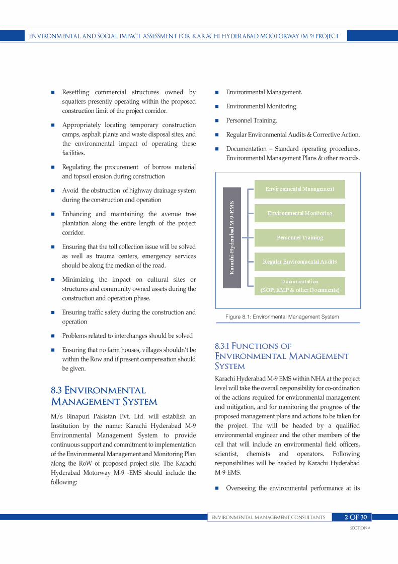
n Resettling commercial structures owned by
squatters presently operating within the proposed
construction limit of the project corridor.
n Appropriately locating temporary construction
camps, asphalt plants and waste disposal sites, and
the environmental impact of operating these
facilities.
n Regulating the procurement of borrow material
and topsoil erosion during construction
n Avoid the obstruction of highway drainage system
during the construction and operation
n Enhancing and maintaining the avenue tree
plantation along the entire length of the project
corridor.
n Ensuring that the toll collection issue will be solved
as well as trauma centers, emergency services
should be along the median of the road.
n Minimizing the impact on cultural sites or
structures and community owned assets during the
construction and operation phase.
n Ensuring traffic safety during the construction and
operation
n Problems related to interchanges should be solved
n Ensuring that no farm houses, villages shouldn’t be
within the Row and if present compensation should
be given.
8.3 EnvironmentalManagement System
M/s Binapuri Pakistan Pvt. Ltd. will establish an
Institution by the name: Karachi Hyderabad M-9
Environmental Management System to provide
continuous support and commitment to implementation
of the Environmental Management and Monitoring Plan
along the RoW of proposed project site. The Karachi
Hyderabad Motorway M-9 -EMS should include the
following:
n Environmental Management.
n Environmental Monitoring.
n Personnel Training.
n Regular Environmental Audits & Corrective Action.
n Documentation – Standard operating procedures,
Environmental Management Plans & other records.
8.3.1 Functions ofEnvironmental ManagementSystem
Karachi Hyderabad M-9 EMS within NHA at the project
level will take the overall responsibility for co-ordination
of the actions required for environmental management
and mitigation, and for monitoring the progress of the
proposed management plans and actions to be taken for
the project. The will be headed by a qualified
environmental engineer and the other members of the
cell that will include an environmental field officers,
scientist, chemists and operators. Following
responsibilities will be headed by Karachi Hyderabad
M-9-EMS.
n Overseeing the environmental performance at its
ENVIRONMENTAL ANd SOcIAL IMPAcT ASSESSMENT fOR KARAchI hydERAbAd MOOTORwAy (M-9) PROjEcT
ENVIRONMENTAL MANAGEMENT cONSuLTANTS
SEcTION 8
2 Of 30
Figure 8.1: Environmental Management System

different Facilities, Installations, Construction sites,
Activity Centre’s and Institutions along the RoW, at
regular interval to demonstrate compliance with
existing National Environmental Quality Standards
and guidelines.
n Oversee the environmental performance in a
manner that their operation as well as maintenance
will neither degrade the environment of the RoW
nor its macro environment and will provide
continuous support and commitment to
implementation of its Environmental Management
and Monitoring Plan.
n Avail facilities at a designated ISO 9000 certified
Quality Control Laboratory (QCL) for all
environmental sampling and will also arrange for
specialist qualified personnel or laboratories to
perform the work within parameters specified by
NEQS, or as advised by EPA Sindh and required by
World Bank Guidelines 1998. It will thus satisfy the
national as well as international requirements.
n Follow for its governance plan, the environmental
management practices adopted by ISO 14,000
certified organizations and also support in their
endeavors to safeguard the environment.
n Establish and maintain procedures to identify the
environmental issues pertaining to its own
activities, and services that it can control and over
which it can be expected to have an influence, in
order to determine those issues which have or can
have significant impacts on the environment. It will
ensure that the characteristics related to significant
impacts are considered in setting its environmental
objectives, and will keep this information up-to-
date.
n Establish and maintain procedures to identify and
have access to legal and other requirements to
which it subscribes, that are applicable to the
environmental quality of its own activities, and
services.
n Establish and maintain documented environmental
objectives and targets, at each relevant function and
level within its organizational set up.
n Consider, while establishing and reviewing its
objectives, the legal and other requirements, its
significant environmental features, technological
options and its financial, operational and business
requirements, in addition to obtaining the views of
stakeholders. The objectives and targets set by EMS
will be consistent with environmental regulations,
including the commitment to prevention and
control of pollution.
n Maintain a database and its own archives to keep
abreast of modern environmental legislation,
emission norms that are now technology-specific,
and have their own limits and standards. National
legislation or guidelines on specific emission limits
have not been set in many cases in Pakistan, World
Bank Guidelines are widely used as the minimum
norm if the host country does not have its own
specific legislation. It will follow the World Bank
Guidelines till such time that Technology-specific
limits, closely corresponding to National as well as
actual conditions are not available. As will be seen
in the later sections, the limits of most important
specific emissions that it will look for are CO, NOx,
SO2 and Particulate Matter for the air, besides
Dissolved Oxygen (DO), NO3, BOD5, COD, and
trace elements for the effluent.
n Comply with all existing environment related laws
and other requirements, including safety
regulations, applicable to different systems and
products.
8.3.2 Organization Structure
The organogram shown below gives an idea of the
organizational set-up of Environmental and Social
Impact Assessment of Karachi-Hyderabad Motorway
(M-9).
8.3.3 Roles and Responsibilities
Roles, responsibilities and authorities will be defined for
different levels of hierarchy, documented and
ENVIRONMENTAL ANd SOcIAL IMPAcT ASSESSMENT fOR KARAchI hydERAbAd MOOTORwAy (M-9) PROjEcT
ENVIRONMENTAL MANAGEMENT cONSuLTANTS
SEcTION 8
3 Of 30

ENVIRONMENTAL ANd SOcIAL IMPAcT ASSESSMENT fOR KARAchI hydERAbAd MOOTORwAy (M-9) PROjEcT
SEcTION 8
4 Of

communicated in order to facilitate effective
implementation and operation of the EMMP.
The following organization involved in the
implementation of the project:
n Bina Puri (Pvt.) Ltd, as the project proponent and
the owner of the EMP;
n Project contractor as the executors of the EMP; and
n Environmental Protection Agency (EPA) Sindh will
act as the overall regulatory body. The specific roles
of the key functionaries are described hereafter.
n The organizational setup of the management plan
as shown above.
The main executing agency of the Project will be
National Highway Authority (NHA).
A. General Manager NHA
General Manager NHA will be the overall in charge of
the project. The GM-NHA will delegate the supervisory
responsibilities of the project to the project director who
will have professional staff supported by a team of
consultants including Environmental Monitoring
Specialist/Consultants.
B. Director (Environment and
Social )
The Director (Environment and Social) will be the
overall in charge for handling the NHA’s obligations
with respect to the EMP. The Director (Environment and
Social) will depute one Deputy Directors (Environment
and Social) for the Project, who will be responsible for
ensuring that the provisions of the EMP are
implemented. In addition, the Deputy Director will also
coordinate with the EPA Sindh, provincial Agriculture,
Forest and Wildlife departments, NGOs/CBOs and
other public/ private sector organizations.
Deputy Director will be assisted by Assistant Directors
(Environment & Social) for the execution of
Environmental Management Plan (EMP) for each
section of the project.
Deputy Director (Social) will be responsible for the social
issues.
Executive District Officer (E.D.O Revenue) will be
assisted by D.D.O (Revenue). Assistant Revenue Officer
will assess the award price for land acquisition to the
affectees.
C. Supervision Consultants
Supervision Consultants appointed by the GM (NHA)
will be headed by a “Project Manager”, who will be an
Engineer. He along with his team will supervise the
Project Contractors to ensure quality of work and
fulfillment of contractual obligations. The Supervision
Consultants (SC) will provide one Independent
Monitoring Consultant (IMC) who will:
n Ensure that all the environmental and social
parameters/provisions comply with the applicable
standards;
n Ensure that day-to-day construction activities are
carried out in an environmentally sound and
sustainable manner;
n Organize periodic environmental training
programmes and workshops for the Contractors’
staff and NHA site staff in consultation with the
NHA;
n Develop “good practices’’ following construction
guidelines to assist the Contractors and NHA staff
in implementing the EMP.
D. The EHS Manager:
n Ensure that the contractor is aware of all
specifications, legal constraints, standards and
procedures pertaining to the project specifically
with regards to environment.
n Ensure that all stipulations within the EMMP are
communicated and adhered to by contractor(s).
n Monitor the implementation of the EMMP
ENVIRONMENTAL ANd SOcIAL IMPAcT ASSESSMENT fOR KARAchI hydERAbAd MOOTORwAy (M-9) PROjEcT
ENVIRONMENTAL MANAGEMENT cONSuLTANTS
SEcTION 8
5 Of 30
throughout the project by means of sit inspections
and meetings. This will be documented as part of
the minutes of the site meeting documents.
n Be fully conversant with the Environmental Impact
Assessment of the project, the conditions of the
approval of EIA (once issued), and all relevant
environmental legislations.
n Conduct audits to ensure compliance to the EMMP.
n Liaise with the top management and delegate the
EHS Officer, EHS Coordinator and relevant
discipline Engineer on matters concerning the
environment.
n Prevent actions that will harm or may cause harm to
the environment, and take steps to prevent
pollution on the site.
n Confirm activities to the demarcated construction
site.
E. The EHS Officer:
n Be fully conversant with the Environmental Impact
Assessment and conditions of its approval.
n Be fully conversant with the Environmental
Management Plan.
n Be fully conversant with all relevant environmental
legislation, policies and procedures, and ensure
compliance with these.
n Undertake regular and comprehensive inspection of
the site and surrounding areas in order to monitor
compliance with the EMMP.
n Take appropriate action if the specifications
contained in the EMMP are not followed.
n Monitor and verify that environmental impacts are
kept to a minimum, as far as possible.
n Review and approve construction methods, with
input from the Site Manager, where necessary.
n Ensure that activities on site comply with all
relevant environmental legislation.
n Order the removal of person(s) and/or equipment
in contravention of the specifications of the EMMP.
n Compile progress reports on regular basis, with
input from the Site Manager, for submission to the
EHS Manager, including a final post construction
audit.
F. The EHS Coordinator
n Be fully conversant with the Environmental Impact
Assessment and conditions of its approval.
n Be fully conversant with the Environmental
Management Plan.
n Be fully conversant with all relevant environmental
legislation, policies and procedures, and ensure
compliance with these.
n Convey the contents of this document to the
contractor site staff and discuss the contents in detail
with the EHS Manager and Contractor.
n Liaise with the Site Manager regarding the
monitoring of the site.
n Report all environmental problems arising on the
construction area to the EHS officer and reports on
such problems will be submitted to the EHS
Manager.
G. Contractors and Service
Providers:
n Environmental management is part of on-site
quality management. Under the environmental
management plan, the contractor
n Shall propose measures to minimize environmental
impacts during construction process, and submit
them to the EHS Coordinator. In case of having
impacts on the environment, the contractor will
inform them to the EHS Coordinator in time to get
instructions and then take next step.
ENVIRONMENTAL ANd SOcIAL IMPAcT ASSESSMENT fOR KARAchI hydERAbAd MOOTORwAy (M-9) PROjEcT
ENVIRONMENTAL MANAGEMENT cONSuLTANTS
SEcTION 8
6 Of 30

n Comply with the environmental management
specifications;
n Submitting an obligatory Methods Statement for
approval by the EHS Officer before any work is
undertaken;
n Adhering to any instructions issued by the
Engineer/Project Manager on the advice of the EHS
Coordinator;
n Submitting a report at each site meeting which will
document all incidents that have occurred during
the period before the site meeting.
n Displaying the list of transgressions issued by the
EHS Officer in the site office.
n Maintaining a public complaints register. Arrange
that all his employees and those of his
subcontractors receive training before the
commencement of construction.
8.3.4 Specific ImplementationResponsibilities
This section describes the implementation and
supervision responsibilities for the different phases of
the project.
(a) Design Phase/ Pre-Construction
Phase
The Director (Environment, Social) NHA and his staff
with the assistance of EIA consultant are responsible for
ensuring that the Project design and specifications
adequately reflect the EMP .He will ensure the Project’s
compliance with environmental regulations and donor
requirements; and ensure stakeholder participation in
the design of the project.
The responsibilities of Director (Environment and
Social) may be briefly described as follows:
n To coordinate with regulatory agencies including
EPAs, EIA consultant, local NGOs, that could assist
the NHA in independent reviews of environmental
and social compliance
n To supervise environmental and social assessment
reports and to provide substantial inputs and
guidance to the EIA consultant
n To get the approval of EIA from the EPA Sindh; and
n To ensure that the design consultant have
incorporated all the mitigation measures proposed
for the design phase in the design and included in
the contract documents.
Specifically, before the start of the Project, the NHA’s
Deputy Director (Social) will ensure that the following
activities are carried out in a transparent manner
according to the acceptable standards:
n Identifying and verifying Project affected persons
(PAPs) on the basis of specified documents;
n Identifying which public facilities and utilities need
to be relocated;
n Carrying out a consultation and dissemination
campaign with regard to compensation procedures,
entitlement packages.
n Preparing individual entitlement files
n Preparing and approving compensation budgets
n Providing shifting assistance to displaced squatters
and to assist squatter owners to salvage their
facilities as per guidelines.
(b) Construction Phase
The NHA will appoint supervision consultants, who
along with the Deputy Director (Environment) will
oversee the working of contractor in accordance with the
EMP.
n The supervision Consultant will liaise with the
project staff to monitor environmental compliance
during the construction
n He will supervise the construction and provide
technical support to help ensure compliance with
the EMP;
n The supervision Consultants will assess the
ENVIRONMENTAL ANd SOcIAL IMPAcT ASSESSMENT fOR KARAchI hydERAbAd MOOTORwAy (M-9) PROjEcT
ENVIRONMENTAL MANAGEMENT cONSuLTANTS
SEcTION 8
7 Of 30

environmental impact of highway construction;
n He will monitor the progress of work and
adherence of the contractor to the EMP;
n He will direct the Contractor to work in such a
manner that all project activities are in compliance
with the EMP and NEQs.
(c) Operation Phase
The Deputy Director (Environment) and his staff will be
responsible for the following:
n Coordinating with the operational staff working
under the Regional General Manager to monitor
environmental compliance during highway
operation;
n Advising on, and monitoring tree plantations along
the highways;
n Reporting on the progress of environmental
compliance to the federal and EPA Sindh;
n Assessing the long-term environmental impacts of
highway operation;
n Sustaining a working partnership among the
NHA,EPA Sindh, Agriculture, Forest and Wildlife
departments of Sindh, NGOs and other related
public private sector organizations
n Reporting to Director (Environment) about progress
of the work.
8.4 EnvironmentalManagement Programme:
Karachi Hyderabad Motorway M-9-EMS will establish
and maintain programmes for achieving the
environmental objectives and targets. These
programmes will include:
n Designation of responsibility for achieving
environmental objectives and targets at each
relevant function and level of NHA as the
organization, and
n The means and timeframe by which they are to be
achieved.
n If and when a project related to new developments
and new or modified system of transportation or
material usage is introduced, that may likely alter
the quality of the environment, the EMMP will be
suitably amended to ensure that the System applies
to such development or modification as the case
may be.
8.5 Training, Awareness andCompetence:
Karachi Hyderabad M-9-EMS will identify its own
training needs. It will ensure that all personnel, whose
work may create a significant impact on the
environment, e.g. those who have to handle safety,
security, and emergencies arising out of spill of
hazardous materials or have to work in hazardous
situations, receive appropriate training.
Karachi Hyderabad M-9-EMS will establish and
maintain procedures to make its employees or members
at each relevant function and level aware of:
n Importance of conformance with the environmental
policy and procedures and with the requirements of
EMMP
n Significant environmental impacts, actual or
potential, of their work activities and the
environmental benefits of improved personal
performance
n Their roles and responsibilities in achieving
conformance with environmental commitment and
procedures and with the requirements of the
EMMP, including emergency preparedness and
response requirements
n Potential consequences of departure from specified
operating procedures
n Comprehension that competence of personnel
performing the tasks that can cause significant
ENVIRONMENTAL ANd SOcIAL IMPAcT ASSESSMENT fOR KARAchI hydERAbAd MOOTORwAy (M-9) PROjEcT
ENVIRONMENTAL MANAGEMENT cONSuLTANTS
SEcTION 8
8 Of 30

environmental impacts, depends on appropriate
education, training and/or experience.
8.6 Communication
With regard to its environmental considerations and
EMMP, Karachi Hyderabad Motorway M-9-EMS will
establish and maintain procedures for:
n Internal communication between its various levels
and functions
n Receiving, documenting and responding to relevant
communication from external interested parties.
n Karachi Hyderabad M-9 EMS will consider
processes for external communication on its
significant environmental aspects and record its
decision.
8.7 EMMP Documentation
Karachi Hyderabad Motorway-EMS will establish and
maintain information, in paper or electronic form to:
n Describe the core elements of EMMP and their
interaction
n Provide direction to related documentation
n Help its facilities in establishment of their own
Information Documentation Centre’s.
A. Document Control
Karachi Hyderabad Motorway-EMS will establish and
maintain procedures for controlling all documents
required to ensure that:
n They can be located
n They are periodically reviewed, revised as
necessary and approved for adequacy by
authorized personnel
n Current versions of relevant documents are
available at all locations where operations essential
to the effective functioning of EMMP are performed
n Obsolete documents are promptly removed from all
points of issue and points of use, or otherwise
assured against unintended use
n Any obsolete document retained for legal and/or
knowledge preservation purposes are suitably
identified.
Karachi Hyderabad M-9-EMS will ensure that its
documentations are legible, dated (with dates of
revision) and readily identifiable, maintained in an
orderly manner and retained for a specified period.
Procedures and responsibilities will be established and
maintained concerning the creation and modification of
the various types of documents. Typical record keeping
requirements are given below:
ENVIRONMENTAL ANd SOcIAL IMPAcT ASSESSMENT fOR KARAchI hydERAbAd MOOTORwAy (M-9) PROjEcT
ENVIRONMENTAL MANAGEMENT cONSuLTANTS
SEcTION 8
9 Of 30
Parameter Particulars
Solid Waste Handling & Disposal • Daily quantity of waste received
• Daily quantity of waste recycled
• Daily quantity sold
Regulatory Licenses (Environmental) • Environmental Permits
Monitoring & Survey • Records of all monitoring carried out as per the finalized
• Monitoring protocol.
Other • Log book of compliance
• Employee environmental, health and safety records
• Equipment inspection & calibration records, where
• applicable
• Vehicle maintenance and inspection records
Record Keeping Requirement

8.8 Operational Control:
Karachi Hyderabad M-9-EMS will identify those
operations and activities on the corridors that are
associated with significant environmental impacts as
well as Health Consequences in line with its
commitments, objectives and targets.
The significant impacts on the environment from
construction activities and operations include emission
of CO, SO2, NOx, particulate matter and noise of
medium to high intensity from the vehicular traffic.
Karachi Hyderabad Motorway M-9-EMS will ensure
that baseline for different environmental parameters,
health, safety and security issues, and MSDS for
chemicals, pharmaceuticals and auxiliaries, relevant to
Karachi Hyderabad Motorway are generated and
recorded, and the database is regularly updated.
Karachi Hyderabad Motorway-EMS will ensure that it is
actively involved in getting
n EIA or IEE carried out for its improvement and
rehabilitation projects,
n Necessary mitigation measures identified in the EIA,
IEE and Environmental Audit by concerned Agency,
n Due approval obtained from Responsible Authority
at the EPA before launching on the project.
Karachi Hyderabad Motorway-EMS will further ensure
Performance monitoring of this project, at its
construction sites and activity centers to verify the
situation in the air shed and watershed of the projects
and to require the Karachi Hyderabad Motorway M-9 or
the concerned Agency to adopt remedial measures to
reduce the residual impact.
8.9 EnvironmentalManagement Procedures
8.9.1 Measures to ImproveEnvironmental Awareness
To improve the awareness of the environment of site
workers and people living around the Project area, the
contractor will take following actions:
n Frequently train the Site staff about the meaning
and the importance of environmental protection.
n Manage and improve conditions at the construction
area to minimize negative impacts.
n Make residents understand the consequences of
environmental degradation.
8.9.2 Specific process to meetenvironmental requirements
To meet legal requirements, the contractor will take the
following steps:
n Comply with the provisions of Pakistan
Environmental Protection Act 1997 and other legal
frameworks.
n Shoulder responsibility for ensuring that no waste
materials and rubbish are left on roads as
consequences of transport during the construction
process.
n Collect and move away all the wastewater
generated during the construction process from the
construction area using the temporary drainage
system designed and arranged at proper locations
so as not to cause environmental pollution.
n Timely clean and move away the waste materials
and debris generated during the land and mud
construction process at the construction area and
surrounding areas to revert the environment to the
original state.
n Specific measures to control air pollution during the
operation of concrete mixing stations include:
n Periodically cleaning and watering the mixing
stations and related areas to control the dust
generation.
n Applying pollution control by the EHS Officer
whenever mixing stations operate.
ENVIRONMENTAL ANd SOcIAL IMPAcT ASSESSMENT fOR KARAchI hydERAbAd MOOTORwAy (M-9) PROjEcT
ENVIRONMENTAL MANAGEMENT cONSuLTANTS
SEcTION 8
10 Of 30

n Enclosing with three-sided walls all sand and
materials stockpiles within the location of mixing
stations with volume of more than 50 m3.
n Dust, exhausted gases-minimizing measures shall
be taken as proposed in the Environmental Impact
Assessment Report. Periodically watering the
construction area shall also be implemented.
n The EHS Officer will monitor activities generating
dust on the construction area, and join hands with
the Independent Monitoring Consultant in
minimizing air pollution.
8.9.3 Water QualityManagement:
The water needs of the Karachi Hyderabad Motorway
will be assessed and will make its own arrangement for
procurement if the same is not available from
conventional sources. Quality and quantity of water
used will be recorded and its treatment, if required will
also be noted. Water and energy balance at the Karachi
Hyderabad Motorway M-9 will be recorded and
maintained in the log book to be submitted to the
Karachi Hyderabad Motorway-EMS.
n The EHS Officer is in charge of frequently
monitoring water sources to prevent them from
being polluted. The contractor and the sub-
contractor will supervise such activities.
n The EHS Officer is to propose schemes on arranging
the construction area to limit water pollution. The
contractor and subcontractors are to ensure that the
schemes will not cause pollution.
8.9.4 Refuse management:
The Project owner instructs the contractor to ensure that
no soil, stone or brick debris scatter on roads during the
construction process. The refuse include wastes falling
down during the transport process.
It is necessary to cover and wrap wastes containing
chemicals when discharging them to prevent dangerous
effects on environment and humans. It is also necessary
to strictly conform to relevant criteria when handling
chemical wastes.
Classifying refuse and strictly following commitments
about the location of dumping sites made with local
authorities affected by the project. The contractor will
allocate areas for specific kinds of wastes at the
construction area. However, wood, steel, iron, plastic
materials and raw materials necessary to the
construction area and not affected by weather will be
placed near the consumption area to prevent storage
overload at the site and material squandering.
8.9.5 Wastewater Management:
Generation of wastewater from various activities
and operations will be collected and conveyed to
the point of discharge. The requirement of
treatment prior to discharge and disposal shall be
determined by the quality of effluent meeting the
NEQS criteria.
The EHS Manager in liaison with the Project Manager
shall be responsible for the preparation of the
wastewater management plan which then shall be
executed by the contractor responsible for complying to
the environmental standards as prescribed and
introduced from time to time according to the
requirements of the project operations.
Wastewater generated during construction phase will be
disposed of in the designated channel after obtaining
permission from the KWSB to do so. The quality of this
wastewater will also be tested against NEQS
requirements.
Karachi Hyderabad Motorway M-9 and NHA will
ensure adequate disposal of storm water from the RoW,
roads, and construction sites. It will be ensured that
storm water does not accumulate on the roads.
The Independent Monitoring Consultant (IMC) shall
ensure that wastewater management plan is prepared
before commencement of Project’s construction works.
IMC will also monitor the implementation of this plan
by contractor.
ENVIRONMENTAL ANd SOcIAL IMPAcT ASSESSMENT fOR KARAchI hydERAbAd MOOTORwAy (M-9) PROjEcT
ENVIRONMENTAL MANAGEMENT cONSuLTANTS
SEcTION 8
11 Of 30

8.9.6 Materials ManagementPlan:
The contractor will comply with conditions stated in the
approval of EIA and the Environmental Protection Law
and other relevant regulations in context to material
procurement, handling, storage, consumption / use,
transportation and disposal.
The materials management plan shall be developed and
formulated by the EHS Manager in consultation with the
Project Manager however contractor and personnel who
shall be in charge / responsible for the execution of the
management plan may also be invited for their technical /
supportive input. The contractor shall remain the key
functionary of the Material Management during the
construction as well as the operation phase of the project.
The Independent Monitoring Consultant (IMC) shall
ensure that materials management plan is prepared before
commencement of Project’s construction works. IMC will
also monitor the implementation of this plan by contractor.
i. Storage and Preservation
The contractor will ensure that all hazardous
materials/wastes are stored and preserved in accordance
with chemical properties of each substance such as
burning, melting and boiling points. To prevent
substances from interacting with one another, each kind of
hazardous material/waste should be isolated in separable
suitable containers.
Specifically, when storing and preserving inflammable
substances and agents prone to explosion, the contractor
should install fire and explosion prevention systems at the
preservation area using thick concrete blocks, mortar or
other fire-proof materials. The contractor is also to supply
and install other fire prevention equipment at preservation
sites.
Training of personnel and assigning of responsibilities to
individuals for managing and control of hazardous
materials and waste shall be included in the
materials/waste management plan of the facility. The
hazardous substance storage and preserving area shall be
protected strictly. Strict control of discharge of liquid
wastes should be maintained which are used as solvents in
the processes of drilling foundations and bridge buttresses
(the location for storing these wastes should be pre-
approved from the local authorities and mentioned in the
plan).
ii. Materials Inventory
The contractor will make an inventory of all the materials
(raw material and waste produced) categorizing them
according to the nature of safety requirements, handling,
storage, transportation and disposal. In case of changes
addition and deletion of materials the inventory will be
updated on a periodic basis.
iii. Handling Procedures
Training is part of the programme provided to the team
designated to materials/waste management. Standard
procedures are to be developed for specific types of
materials and waste for handling and transferring to
receptacles for subsequent disposal. Training for the use of
safety devices and personal protective gears is to be
imparted to the personnel.
iv. Public Hygiene Management:
n Site inspection
The contractor will conduct the site inspection to ensure
that hygienic conditions are maintained in and around the
project area. Cleanliness maintenance according to the
environmental and public health standards would be
carried out in service areas and general public areas will be
maintained accordingly. Solid waste management and
wastewater/sewerage system function along with air and
noise quality monitoring will be undertaken by the
Independent Monitoring Consultant.
n Liquid and Solid Waste disposal
All types of wastes arising should be contained and
disposed of properly without causing a potential threat to
general public and staff.
ENVIRONMENTAL ANd SOcIAL IMPAcT ASSESSMENT fOR KARAchI hydERAbAd MOOTORwAy (M-9) PROjEcT
ENVIRONMENTAL MANAGEMENT cONSuLTANTS
SEcTION 8
12 Of 30

8.9.7 Worker’s Health and Safety:
During the period of construction at site, EHS Officer will
ensure that the contractor bears the responsibility for
worker’s safety, safe working practices and for providing
adequate and appropriate facilities for fire protection,
medical aid, potable water supply and sanitation.
Emphasis would be on health and safety training of the
personnel. Safety instructions, handbooks, charts,
diagrams etc. will be printed in English as well as Urdu.
The workers would be given appropriate training for
handling hazardous materials and goods. World Bank
guidelines relating to worker’s health and safety would be
incorporated into the Karachi Hyderabad Motorway M-9
Health and Safety Procedures.
For eye and face protection it will be mandatory on the
Construction workers and other personnel in emergency
situations to wear safety glasses, for skin protection to
wear protective gloves, and for respiratory protection,
positive pressure air line with full-face mask and escape
bottle or self-contained breathing apparatus will be made
available for emergency use. For general protection,
wearing of overalls, helmets and safety shoes will be made
obligatory, and provision will be made for safety shower
and eyewash.
Restoration of site: It will be contractor’s responsibility to
restore the sites of excavation for the supporting structures
by removing the debris and construction equipment and
materials No attempt will be made to dispose of residual
waste or unused materials on the Corridors.
Health, Safety & Security Commitment of Karachi
Hyderabad Motorway will have the following
components:
n Monitoring implementation of Health and Safety Plan
to prevent and reduce accidents and occupational
diseases among workers of Karachi Hyderabad
Motorway M-9 as well as facilities affiliated with
operations within its jurisdiction.
n Periodic programme for fire, safety and accident
prevention
n Good housekeeping practices
n Regular and periodic course on general safety, health
and hygiene.
n Providing appropriate signage throughout the
corridors
n Providing a site safety handbook.
n Providing on site publicity on safety instructions
through conventional notice boards.
8.9.8 Emergency Preparednessand Response:
The objectives of Karachi Hyderabad M-9-EMS
Contingency Plan, Disaster Management Plan and
Hazardous Materials & Hazardous Waste Management
Plan will be:
n To protect the life and property of people within the
RoW and public places and people in the RoW of
Impact.
n To limit and control the economic and environmental
damage, and
n To fight the results of an incident.
The Contingency Plan would be a management tool to aid
site personnel and relevant third parties to tackle an
emergency situation. Karachi Hyderabad Motorway-EMS
will formulate its Contingency Plan to integrate it as well
as sharing the responsibility to handle all emergencies at
the place of emergency. Karachi Hyderabad-EMS’s
contingency plan will therefore be a component of
emergency response plan of NHA for maintaining an
efficient and safe facility.
Karachi Hyderabad M-9-EMS will review and revise,
where necessary, its emergency preparedness and
response procedures, in particular, after the occurrence of
accidents or emergency situations.
8.10 EnvironmentalManagement Plan
The Environmental Management Plan based on the
mitigation measures is presented in Table 8.1 below.
ENVIRONMENTAL ANd SOcIAL IMPAcT ASSESSMENT fOR KARAchI hydERAbAd MOOTORwAy (M-9) PROjEcT
ENVIRONMENTAL MANAGEMENT cONSuLTANTS
SEcTION 8
13 Of 30
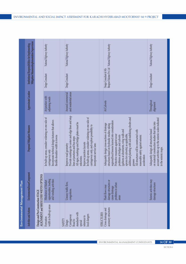
ENVIRONMENTAL ANd SOcIAL IMPAcT ASSESSMENT fOR KARAchI hydERAbAd MOOTORwAy (M-9) PROjEcT
ENVIRONMENTAL MANAGEMENT cONSuLTANTS
SEcTION 8
14 Of 30
Activ
ities
and
Actio
nsEn
viro
nmen
talIss
ue/C
ompo
nent
Prop
osed
Miti
gatio
n M
easu
res
Appr
oxim
ate L
ocati
onIn
stitu
tiona
l Res
pons
ibili
ties f
or Im
plem
entin
g M
itiga
tion
Mea
sure
sImpl
emen
tatio
n Su
perv
ision
Form
atio
nw
idth
in b
uilt-
up a
reas
SAFE
TYD
esig
n Ca
rria
gew
ayRo
ad to
stand
ards
with
spec
ial
refe
renc
e to
loca
l dan
gers
STRU
CTU
RES
Cros
s dra
inag
e an
dac
cess
ory
struc
ture
s
Des
ign
and
Pre-
Con
stru
ctio
n ST
AG
EA
LIG
NM
ENT
and
SHO
ULD
ER W
IDTH
OPT
ION
S
Hin
dran
ce o
f Mar
ket
oppo
rtuni
ties,
load
ing
and
vend
ing
activ
ities
Une
asy
traffi
c flo
w,
cong
estio
ns.
Flas
h flo
ws m
ayda
mag
e str
uctu
res o
rca
use
drai
nage
prob
lem
s in
urba
nar
eas
Seism
ic ac
tiviti
es m
ayda
mag
e str
uctu
res
In b
uilt-
up a
reas
, con
sider
wid
enin
g on
one
side
of
carr
iage
way
onl
y In
corp
orat
e te
chni
cal d
esig
n fe
atur
es th
at a
llow
sfle
xibl
e sh
ould
er w
idth
in to
wns
Impr
ove
road
geo
met
ryPr
ovid
e m
arki
ngs f
or ce
nter
and
edg
e lin
es a
nd st
oplin
es a
t jun
ctio
ns a
nd b
us st
ops
All
signs
, mar
king
s and
brid
ge p
late
s mus
t be
refe
ctor
ies.
Impr
ove
junc
tion
layo
uts
In b
uilt-
up a
reas
, con
sider
wid
enin
g on
one
side
of
carr
iage
way
onl
y, an
d ex
plor
e po
ssib
ility
toin
corp
orat
e se
rvice
lane
.
Ade
quat
ely
desig
n cr
oss-
sect
ions
of d
rain
age
struc
ture
s bas
ed o
n hy
drau
lic st
udie
s, ta
king
regi
onal
/loca
l les
sons
lear
ned
into
cons
ider
atio
nPr
otec
tive
mea
sure
s aga
inst
scou
rpr
oble
ms a
t brid
ges a
nd cu
lver
ts(g
abio
ns a
t abu
tmen
ts, w
ing
wal
ls an
dap
rons
for c
ulve
rts);
as a
pplic
able
,ad
ditio
nal p
lant
ing
with
soil-
stabi
lizin
g sh
rubs
and
gras
ses
All
struc
ture
s will
be
cons
truct
ed w
ithre
ason
able
safe
ty a
gain
st se
ismic
acce
lera
tion
Ade
quat
ely
desig
n al
l stru
ctur
es b
ased
on m
ater
ial/
cons
truct
ion
studi
es th
at ta
ke in
toac
coun
t act
iviti
es u
p to
the
seism
ic sc
ales
indi
cate
din
the
seism
ic m
aps.
At j
unct
ion
with
adjo
inin
g ro
ads
Aro
und
com
mer
cial
and
resid
entia
l are
as
At C
ulve
rts
Thro
ugho
utal
ignm
ent
Desig
n Con
sulta
ntNa
tiona
l High
way A
utho
rity
Desig
n Con
sulta
ntNa
tiona
l High
way A
utho
rity
Desig
n Con
sulta
nt &
M/s
Binap
uri P
akist
an Pv
t. Ltd
Natio
nal H
ighwa
y Aut
horit
y
Desig
n Con
sulta
ntNa
tiona
l High
way A
utho
rity
En
vir
on
men
tal
Man
agem
ent
Pla
n

ENVIRONMENTAL ANd SOcIAL IMPAcT ASSESSMENT fOR KARAchI hydERAbAd MOOTORwAy (M-9) PROjEcT
ENVIRONMENTAL MANAGEMENT cONSuLTANTS
SEcTION 8
15 Of 30
Activ
ities
and
Actio
nsEn
viro
nmen
talIss
ue/C
ompo
nent
Prop
osed
Miti
gatio
n M
easu
res
Appr
oxim
ate L
ocati
onIn
stitu
tiona
l Res
pons
ibili
ties f
or Im
plem
entin
g M
itiga
tion
Mea
sure
sImpl
emen
tatio
n Su
perv
ision
Loss
of
Road
side
vege
tatio
ndu
eto
wid
enin
g
WIL
DLI
FE &
AD
JACE
NT
ECO
LOG
ICA
LSE
NSI
TIV
E A
REA
S
Dist
urba
nce
toEc
olog
ical s
ensit
ive
area
s adj
acen
t or t
hene
ar th
e ro
ad.
MA
INTA
ININ
G A
IRQ
UA
LITY
& N
OIS
ELE
VEL
S
Incr
ease
of t
raffi
c int
ensit
y
Crea
tion
and
burn
ing
ofw
aste
s at o
rne
ar ca
mp
site
RO
AD
SID
E V
EGET
ATIO
N &
PLA
NTA
TIO
N
Loss
of p
lant
s in
an a
rea
with
biod
iver
sity,
and
loss
of f
unct
iona
lbe
nefit
s fro
mro
adsid
e pl
ants
Traf
fic a
ccid
ents
with
wild
life
Incr
ease
of a
iran
d no
ise p
ollu
tion
and
asso
ciate
dhe
alth
risk
s for
road
side
resid
ents
Air
pollu
tion
Ass
ocia
ted
with
burn
ing
garb
age
Inco
rpor
ate
tech
nica
l des
ign
to m
inim
ize
rem
oval
of
road
side
plan
tatio
n.A
pply
flex
ibili
ty in
dec
ision
as w
hich
side
to b
ew
iden
ed, o
r in
redu
cing
loca
lly th
e sh
ould
er w
idth
.Pl
an fo
r com
pens
ator
y pl
antin
g pr
ogra
m, i
.e. p
lant
sof
sim
ilar f
lora
l fun
ctio
n, a
t lea
st 1
m h
igh.
Disc
oura
ge th
e in
trodu
ctio
n of
exo
ticsp
ecie
s or s
pecie
s with
kno
wn
Envi
ronm
enta
l set
back
s.
Inco
rpor
ate
caut
iona
ry si
gnag
e to
raise
atte
ntio
n of
road
use
rs fo
r wild
life
cros
sing
in a
rea
at ri
sk.
inco
rpor
ate t
echn
ical d
esig
n fe
atur
es th
at en
able
cont
inua
l tra
ffic f
lux a
nd av
oid
cong
estio
ns (e
.g.
signb
oard
s, sp
eed
limits
, spe
ed b
umpe
rs, b
ays);
Inclu
de d
esig
n m
easu
res t
o pr
even
t blo
ckag
e of b
ussta
nds a
nd ca
rriag
eway
s by
stree
t ven
dors
, par
ticul
arly
near
vill
ages
. Con
sider
noi
se b
arrie
rs in
sens
itive
area
s
Disa
llow
setti
ng fo
r wor
ker c
amp
, inclu
ding
was
tedu
mp
sites
, in d
istan
ces c
lose
r tha
n 5
km to
any
inha
bite
d ar
eas;
Inco
rpor
ate t
echn
ical d
esig
n fe
atur
esfo
r ref
use c
ollec
tion
cont
aine
rs a
t site
s tha
tw
ould
min
imiz
e bur
ning
impa
cts; D
evise
pla
n fo
r saf
eha
ndlin
g, st
orag
e and
disp
osal
of h
arm
ful m
ater
ials.
All
alon
g th
e Ro
adas
exp
lain
ed in
Tre
eCu
tting
and
Re-
Plan
tatio
n Pl
an
Dist
urba
nce
toec
olog
ical s
ensit
ive
area
s adj
acen
t or t
hene
ar th
e ro
ad.
Thro
ugho
utal
ignm
ent
At c
amp
site
Desig
n Con
sulta
ntNa
tiona
l High
way A
utho
rity
Desig
n Con
sulta
ntNa
tiona
l High
way A
utho
rity
Desig
n Con
sulta
ntNa
tiona
l High
way A
utho
rity
Desig
n Con
sulta
ntNa
tiona
l High
way A
utho
rity
En
vir
on
men
tal
Man
agem
ent
Pla
n

ENVIRONMENTAL ANd SOcIAL IMPAcT ASSESSMENT fOR KARAchI hydERAbAd MOOTORwAy (M-9) PROjEcT
ENVIRONMENTAL MANAGEMENT cONSuLTANTS
SEcTION 8
16 Of 30
Activ
ities
and
Actio
nsEn
viro
nmen
talIss
ue/C
ompo
nent
Prop
osed
Miti
gatio
n M
easu
res
Appr
oxim
ate L
ocati
onIn
stitu
tiona
l Res
pons
ibili
ties f
or Im
plem
entin
g M
itiga
tion
Mea
sure
sImpl
emen
tatio
n Su
perv
ision
Exca
vatio
n of
earth
from
borr
ow a
reas
Acq
uisit
ion
ofco
nglo
mer
ate
and
rock
y su
bbas
em
ater
ial
EXIS
TIN
G P
UBL
ICU
TILI
TIES
Publ
ic U
tiliti
es
CON
STRU
CTIO
NST
AG
ECA
MP
SITE
Site
sele
ctio
n
Site
clea
ring
and
prep
arat
ion,
and
rein
stalla
tion
wor
k af
ter
cont
ract
com
plet
ion
RO
AD
SID
E V
EGET
ATIO
N &
PLA
NTA
TIO
N
Chan
ge o
f soi
lch
arac
teris
tics;
loss
of
tops
oil;
impa
ct o
nag
ricul
ture
Deg
rada
tion
ofex
istin
g riv
er b
eds,
alte
ratio
n of
surfa
ce a
ndgr
ound
wat
erre
gim
e, la
nd-u
seco
nflic
ts
Publ
ic ut
ilitie
s to
beaf
fect
ed m
ay cr
eate
disr
uptio
nof p
ublic
serv
ices a
nd e
cono
mics
Acc
epta
bilit
y to
publ
ic/ow
ner;
inte
rfere
nces
Loss
of v
eget
atio
n an
das
sets
on th
e se
lect
edla
nd, a
nd d
issat
isfac
tion
on re
habi
litat
ion
mea
sure
s afte
rco
mpl
etio
n
Agr
icultu
ral a
reas
will
be
avoi
ded
for b
urro
win
g of
mat
eria
ls, co
nfin
ing
to a
lread
y de
fined
bar
row
pits
.Co
ntra
ctor
nee
ds to
obt
ain
appr
oval
from
PPP
Uni
tfo
r exc
avat
ion
and
for p
lan
of re
habi
litat
ing
the
site
afte
r exc
avat
ion.
Exca
vatio
n in
farm
land
s, Ri
verb
ed a
nd e
mba
nkm
ent
vicin
ity w
ill b
e pr
ohib
ited.
Tim
ely
notif
icatio
ns a
nd co
nsul
tatio
ns w
ithre
spec
tive
agen
cies;
All
publ
ic ut
ilitie
s (e.g
. wat
erpi
pes,
pow
er/ t
elep
hone
and
Sui
-gas
line
s) a
relik
ely
to b
e im
pact
ed b
y th
e ca
rria
gew
ay w
iden
ing
need
be
re-lo
cate
d w
ell a
head
wor
k co
mm
ence
men
t.
Cont
ract
or n
eed
obta
in cl
eara
nce
perm
itfo
r siti
ng w
ork
cam
p an
d w
orks
hop,
All e
fforts
dur
ing
the d
esig
n sta
ge sh
ould
be m
ade t
om
inim
ize th
e rem
oval
of ex
istin
g pl
anta
tion
at ca
mp
site.
Cont
racto
r will
pro
vide
plan
for r
emov
al&
reha
bilit
atio
n of
site
upo
n co
mpl
etio
n Ph
otog
raph
ical
and
bota
nica
l inve
ntor
y of
veg
etat
ion
befo
re cl
earin
g th
esit
e Com
pens
ator
y pl
anta
tion
to b
e sch
edul
ed w
hen
cons
tructi
on w
ork
near
to en
d; fo
r eac
h tre
e rem
oved
new
shall
be p
lante
d
Whe
re a
pplic
able
Whe
re a
pplic
able
In a
ll ar
ea o
f the
thre
e di
strict
s
All
thre
e di
strict
s
Thro
ugh
the
cons
truct
ion
site
Desig
n Con
sultan
tNa
tiona
l High
way A
uthori
ty
Desig
n Con
sultan
tNa
tiona
l High
way A
uthori
ty
Natio
nal H
ighwa
y Auth
ority
Gover
nmen
t of S
indh
M/s B
inapu
ri Pak
istan P
vt. Lt
dNa
tiona
l High
way A
uthori
ty
M/s B
inapu
ri Pak
istan P
vt. Lt
dNa
tiona
l High
way A
uthori
ty
En
vir
on
men
tal
Man
agem
ent
Pla
n

ENVIRONMENTAL ANd SOcIAL IMPAcT ASSESSMENT fOR KARAchI hydERAbAd MOOTORwAy (M-9) PROjEcT
ENVIRONMENTAL MANAGEMENT cONSuLTANTS
SEcTION 8
17 Of 30
Activ
ities
and
Actio
nsEn
viro
nmen
talIss
ue/C
ompo
nent
Prop
osed
Miti
gatio
n M
easu
res
Appr
oxim
ate L
ocati
onIn
stitu
tiona
l Res
pons
ibili
ties f
or Im
plem
entin
g M
itiga
tion
Mea
sure
sImpl
emen
tatio
n Su
perv
ision
Sani
tatio
n &
was
tedi
spos
alfa
ciliti
es a
tca
mp
Wor
k sa
fety
and
hygi
enic
cond
ition
s
RO
AD
SID
E V
EGET
ATIO
N &
PLA
NTA
TIO
N
Hea
lth ri
sks t
o w
ork
forc
e an
d pu
blic
if no
tpr
oper
lym
anag
ed
Wor
k sa
fety
and
hygi
enic
cond
ition
s
The
Cont
ract
or w
ill p
rovi
de a
pro
per w
aste
man
agem
ent p
lan.
The
sew
erag
e sy
stem
for t
he ca
mp
will
be p
rope
rly d
esig
ned
(pit
latri
nes)
and
bui
lt so
that
no w
ater
pol
lutio
n ta
kes p
lace
.
Obl
igat
ory
insu
ranc
e ag
ains
t acc
iden
ts to
wor
kla
bore
rs.
Prov
idin
g ba
sic m
edica
l tra
inin
g to
spec
ified
wor
k sta
ff, a
nd b
asic
med
ical
serv
ice a
nd su
pplie
s to
wor
kers
Layo
ut p
lan
for c
amp
site,
to b
e ap
prov
edin
dica
ting
safe
ty m
easu
res
take
n by
the
cont
ract
or, e
.g. f
ire fi
ghtin
geq
uipm
ent,
safe
stor
age
of h
azar
dous
mat
eria
l, fir
st ai
d, se
curit
y, fe
ncin
g, a
ndco
ntin
genc
y m
easu
res i
n ca
se o
fac
ciden
ts;W
ork
safe
ty m
easu
res a
nd g
ood
wor
kman
ship
pra
ctice
s are
to b
e fo
llow
edby
the
cont
ract
or to
ens
ure
no h
ealth
risks
for l
abor
ers;
Prot
ectio
n de
vice
s (ea
r muf
fs) w
ill b
e pr
ovid
ed to
the
wor
kers
in th
e vi
cinity
of h
igh
noise
gen
erat
ing
mac
hine
s.Pr
ovisi
on o
f ade
quat
e sa
nita
tion,
was
hing
, coo
king
and
dor
mito
ry fa
ciliti
es,
inclu
ding
ligh
t up
to th
e sa
tisfa
ctio
n, a
ppro
ved
byN
HA
Uni
t.Pr
oper
mai
nten
ance
of f
acili
ties f
orw
orke
rs w
ill b
e m
onito
red
by th
e I
regu
lar p
est c
ontro
l mea
sure
s in
dorm
itorie
s
At w
aste
colle
ctio
nan
d la
trine
site
s of
cam
p
Valid
for e
ntire
cons
truct
ion
area
Thro
ugho
utop
erat
ion
of w
ork
cam
p
M/s B
inapu
ri Pak
istan P
vt. Lt
dNa
tiona
l High
way A
uthori
ty
M/s B
inapu
ri Pak
istan P
vt. Lt
dInd
epen
dent
Monit
oring
Consu
ltant
En
vir
on
men
tal
Man
agem
ent
Pla
n

ENVIRONMENTAL ANd SOcIAL IMPAcT ASSESSMENT fOR KARAchI hydERAbAd MOOTORwAy (M-9) PROjEcT
ENVIRONMENTAL MANAGEMENT cONSuLTANTS
SEcTION 8
18 Of 30
Activ
ities
and
Actio
nsEn
viro
nmen
talIss
ue/C
ompo
nent
Prop
osed
Miti
gatio
n M
easu
res
Appr
oxim
ate L
ocati
onIn
stitu
tiona
l Res
pons
ibili
ties f
or Im
plem
entin
g M
itiga
tion
Mea
sure
sImpl
emen
tatio
n Su
perv
ision
Cam
p sit
e se
curit
y
Crea
tion
ofco
nstru
ctio
nw
aste
mat
eria
l
Mov
emen
t of
vehi
cles i
n th
eco
nstru
ctio
nsit
e an
d al
ong
the
haul
age
rout
es
Mov
emen
t,m
aint
enan
cean
d fu
ellin
g of
cons
truct
ion
vehi
cles
RO
AD
SID
E V
EGET
ATIO
N &
PLA
NTA
TIO
N
Secu
rity
haza
rds
and
rela
ted
conf
licts
Conta
mina
tion o
fso
il fro
m co
nstru
ction
waste
s and
quarr
y mate
rials
Soil c
ompa
ction
and a
lterat
ion of
perco
lation
and
vege
tation
patte
rn; D
amag
e to
prop
erties
and u
tilitie
s
Cont
amin
atio
n of
soil
and
grou
ndw
ater
from
fuel
and
lubr
icant
s
Prop
er sto
rage a
nd fe
ncing
/lock
ing of
stor
age r
ooms
conta
ining
haza
rdou
s mate
rial
Emplo
ymen
t of g
uard
for s
torag
e roo
ms.
Prov
ision
of ad
equa
te sec
urity
again
st sab
otage
and p
etrol
theft.
All sp
oils w
ill be
disp
osed
off a
s desi
red an
d the
site w
ill be
resto
redba
ck to
its or
igina
l con
dition
s befo
re ha
nding
over.
Non-b
itumi
nous
wast
es fro
m co
nstru
ction
activ
ities w
ill be
dump
edin
sites
appr
oved
by th
e NHA
in lin
e with
the l
egal
presc
riptio
ns fo
rdu
mpsit
es, an
d cov
ered w
ith a
layer
of the
cons
erved
tops
oil.
Bitum
inous
wast
es wi
ll firs
t be r
ecycle
difit i
s not
possi
ble th
en be
dispo
sed of
f in an
iden
tified
dump
ing sit
e.
Cons
tructi
on ve
hicles
, mac
hinery
and e
quipm
ent w
ill mo
ve, o
rsta
tione
d in t
he de
signa
ted R
OW, to
avoid
unne
cessar
y com
pacti
onof
soil.
Dama
ges w
ill be
insta
ntly r
epair
ed an
d/or c
ompe
nsate
d at
Contr
actor
’s obli
gatio
n Wate
r and
soil q
uality
will
be m
onito
redas
envis
aged
in th
e Env
ironm
ental
Mon
itorin
g Plan
Slope
s of e
mban
kmen
t lead
ing to
wate
r bod
ies w
ill be
mod
ified a
ndscr
eene
d so t
hat c
ontam
inants
do no
t ente
r the
wate
rbo
dyCo
nstru
ction
vehic
les an
d equ
ipmen
t willb
e pro
perly
main
taine
dan
d refu
eled i
nsuc
h way
that
oil/di
esel sp
illage
does
not
conta
mina
te the
soil.
Fuel
storag
e and
refue
ling s
ites w
ill be
kept
away
from
drain
age
chan
nels.
Oil a
nd gr
ease
traps
will
be pr
ovide
d at fu
elling
loca
tions
, to pr
even
tco
ntami
natio
n of w
ater.
Unus
able
debr
is sha
ll be d
umpe
d in n
eares
t land
fill sit
es.W
aste o
il and
oil so
aked
cotto
n/ clo
th sh
all be
sold
off to
autho
rized
vend
ors
Wate
r qua
lity w
ill be
mon
itored
as en
visag
ed in
the E
nviro
nmen
talM
onito
ring P
lan.
At C
onstr
uctio
nca
mp
All
cons
truct
ion
sites
and
ent
irepr
ojec
t are
a
Thro
ugho
ut th
epr
ojec
t site
Thro
ugho
ut th
epr
ojec
t alig
nmen
t.
M/s B
inapu
ri Paki
stan P
vt. Ltd
Indepe
ndent
Mon
itoring
Consu
ltant
M/s B
inapu
ri Paki
stan P
vt. Ltd
Indepe
ndent
Mon
itoring
Consu
ltant
M/s B
inapu
ri Paki
stan P
vt. Ltd
Indepe
ndent
Mon
itoring
Consu
ltant
M/s B
inapu
ri Paki
stan P
vt. Ltd
Indepe
ndent
Mon
itoring
Consu
ltant
En
vir
on
men
tal
Man
agem
ent
Pla
n

ENVIRONMENTAL ANd SOcIAL IMPAcT ASSESSMENT fOR KARAchI hydERAbAd MOOTORwAy (M-9) PROjEcT
ENVIRONMENTAL MANAGEMENT cONSuLTANTS
SEcTION 8
19 Of 30
Activ
ities
and
Actio
nsEn
viro
nmen
talIss
ue/C
ompo
nent
Prop
osed
Miti
gatio
n M
easu
res
Appr
oxim
ate L
ocati
onIn
stitu
tiona
l Res
pons
ibili
ties f
or Im
plem
entin
g M
itiga
tion
Mea
sure
sImpl
emen
tatio
n Su
perv
ision
Emba
nkm
ent
wor
ks: E
xcav
atio
n of
earth
, cut
ting
oper
atio
ns,
emba
nkin
g,cle
arin
g of
vege
tatio
n
Borr
ow p
it la
nd le
ase
agre
emen
t
Borr
ow p
itex
cava
tion
activ
ities
Prov
ision
s for
reha
bilit
atio
nof
bor
row
pit
RO
AD
SID
E V
EGET
ATIO
N &
PLA
NTA
TIO
N
Soil
Eros
ion,
Los
s of
vege
tatio
n an
d ha
bita
t
Land
disp
utes
, Soi
l ero
sion,
loss
of p
oten
tial c
rop
land
,lo
ss o
f veg
etat
iona
ndla
ndsc
aped
egra
datio
n
Soil
Eros
ion,
dam
age
toro
ad e
mba
nkm
ent
and
publ
ic he
alth
risks
Soil
Eros
ion,
der
elict
land
uses
,conf
licts,
visu
al so
res i
n th
ela
ndsc
ape,p
ublic
heal
thris
ks d
ue to
deve
lopm
ent o
fm
osqu
itobr
eedi
ngpi
ts
In are
as wi
th str
ong s
heet
flow,
high
emba
nkme
nts w
ill be
prov
ided
with
chute
s and
drain
s to m
inimi
ze so
il ero
sion.
Stone
pitch
ing an
dret
aining
wall
s will
be m
ade a
t high
emba
nkme
nts in
critic
al are
as (>
40%
grad
ient)
As ap
plica
ble an
d nee
ded,
planta
tion o
f gras
ses an
d shr
ubs w
ill be
carri
ed ou
t for s
lope p
rotec
tion.
Soil e
rosio
n-che
cking
mea
sures
such
as th
e for
matio
n of s
edim
ent
basin
s, slop
e drai
ns, e
tc, w
ill be
carri
ed ou
t.So
il ero
sion a
long t
he ro
ad sh
all be
visu
ally c
heck
ed as
give
n in t
heen
viron
menta
l mon
itorin
g plan
.
The C
ontra
ctor m
ust o
btain
any n
ecessa
ry pe
rmits
for b
orro
w pit
sfro
m the
comp
etent
autho
rities
, inclu
ding N
ation
al Hi
ghwa
yAu
thorit
y.
No ex
cava
tions
are a
llowe
d with
in 10
0 mto
ROW
In bo
rrow
pits t
he de
pth of
the p
it will
be re
gulat
ed so
that
the sid
esof
the ex
cava
tion w
ill ha
ve a
slope
not s
teepe
r tha
n 1: 4
.So
il ero
sion a
long t
he bo
rrow
pit sh
all be
regu
larly
check
ed to
prev
ent /
mitig
ateim
pacts
on ad
jacen
t land
s.In
case
burro
wed p
its fil
l with
wate
r, mea
sures
shall
be ta
ken t
opr
even
t the c
reatio
n of m
osqu
ito-br
eedin
g site
s.
Aban
donin
g bor
row
areas
witho
ut pr
oper
rehab
ilitati
on m
easu
reswi
ll be d
isallo
wed.
The C
ontra
ctor’s
agree
ment
with
the la
ndow
ner m
ust d
eterm
ine th
eop
tions
and a
ppro
priat
e mea
sures
for r
ehab
ilitati
on of
the b
orro
wpit
as ap
prov
ed by
the I
ndep
ende
nt Co
nsult
ant, s
uch a
s resh
aping
the bo
rrow
site i
nto a
desir
ed la
nd-us
e plot
(e.g.
irriga
tion f
ield,
fishp
ond)
, re-pl
antat
ion ai
ming
at do
uble
amou
nt of
trees
remov
edfro
m the
site.
Thro
ugho
utal
ignm
ent
Thro
ugho
ut th
ero
ad
All
borr
ow si
tes i
nen
tire
proj
ect a
rea
All
borr
ow si
tes i
nen
tire
proj
ect a
rea
M/s Bin
apuri P
akistan
Pvt. Lt
dInd
epende
nt Moni
toring
Consult
ant
M/s Bin
apuri P
akistan
Pvt. Lt
dInd
epende
nt Moni
toring
Consult
ant
M/s Bin
apuri P
akistan
Pvt. Lt
dInd
epende
nt Moni
toring
Consult
ant
M/s Bin
apuri P
akistan
Pvt. Lt
dInd
epende
nt Moni
toring
Consult
ant
En
vir
on
men
tal
Man
agem
ent
Pla
n
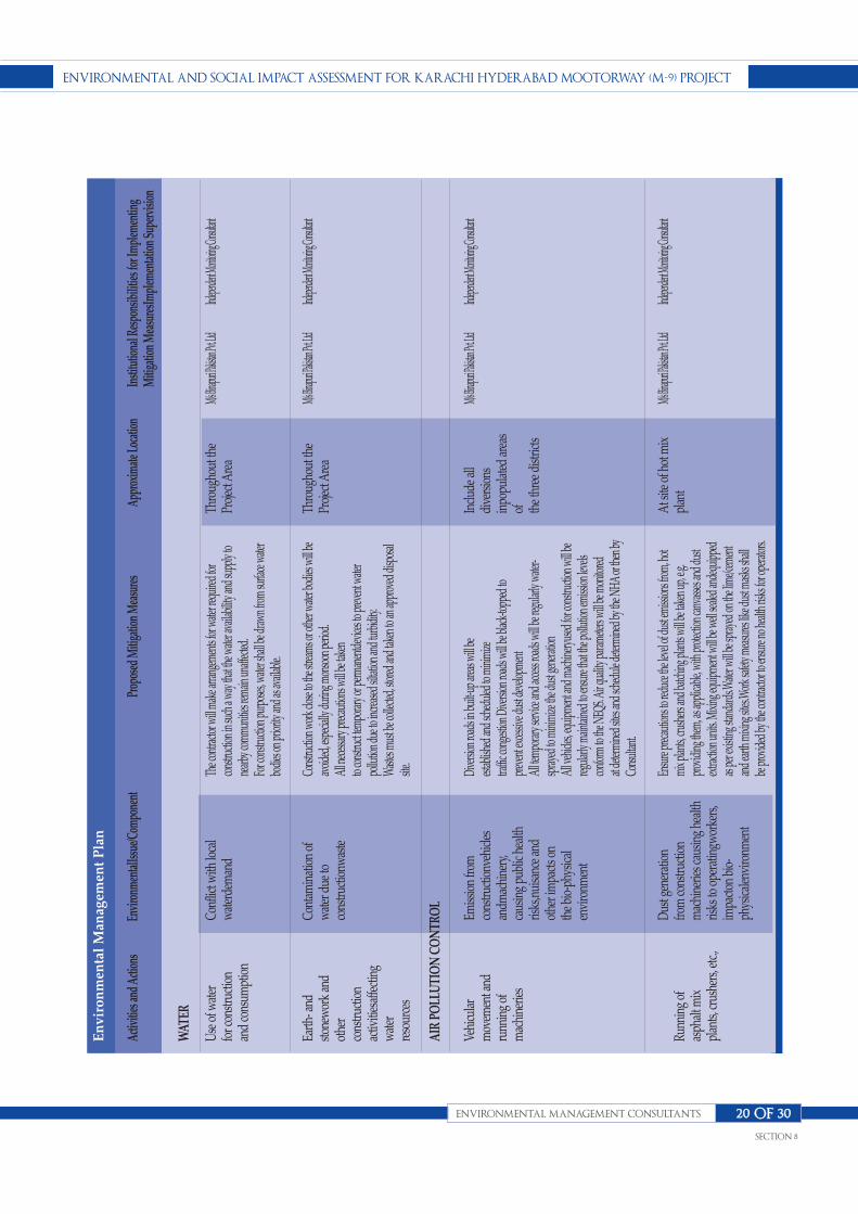
ENVIRONMENTAL ANd SOcIAL IMPAcT ASSESSMENT fOR KARAchI hydERAbAd MOOTORwAy (M-9) PROjEcT
ENVIRONMENTAL MANAGEMENT cONSuLTANTS
SEcTION 8
20 Of 30
Activ
ities
and
Actio
nsEn
viro
nmen
talIss
ue/C
ompo
nent
Prop
osed
Miti
gatio
n M
easu
res
Appr
oxim
ate L
ocati
onIn
stitu
tiona
l Res
pons
ibili
ties f
or Im
plem
entin
g M
itiga
tion
Mea
sure
sImpl
emen
tatio
n Su
perv
ision
Use
of w
ater
for c
onstr
uctio
nan
d co
nsum
ptio
n
Earth
- and
stone
wor
k an
dot
her
cons
truct
ion
activ
ities
affe
ctin
gw
ater
reso
urce
s
Vehi
cula
rm
ovem
ent a
ndru
nnin
g of
mac
hine
ries
Runn
ing
ofas
phal
t mix
plan
ts, cr
ushe
rs, e
tc.,
WAT
ER
AIR
PO
LLU
TIO
N C
ON
TRO
L
Conf
lict w
ith lo
cal
wat
erde
man
d
Cont
amin
atio
n of
wat
er d
ue to
cons
truct
ionw
aste
Emiss
ion
from
cons
truct
ionv
ehicl
esan
dmac
hine
ry,
caus
ing
publ
ic he
alth
risks
,nui
sanc
e an
dot
her i
mpa
cts o
nth
e bi
o-ph
ysica
len
viro
nmen
t
Dus
t gen
erat
ion
from
cons
truct
ion
mac
hine
ries c
ausin
g he
alth
risks
to o
pera
tingw
orke
rs,
impa
cton
bio
-ph
ysica
lenv
ironm
ent
The c
ontra
ctor w
ill ma
ke ar
range
ments
for w
ater r
equir
ed fo
rco
nstru
ction
in su
ch a
way t
hat th
e wate
r ava
ilabil
ity an
d sup
ply to
nearb
y com
munit
ies re
main
unaff
ected
.Fo
r con
struc
tion p
urpo
ses, w
ater s
hall b
e draw
n fro
m su
rface
water
bodie
s on p
riorit
y and
as av
ailab
le.
Cons
tructi
on w
ork c
lose t
o the
strea
ms or
othe
r wate
r bod
ies w
ill be
avoid
ed, e
speci
ally d
uring
mon
soon
perio
d.Al
l nece
ssary
preca
ution
s will
be ta
ken
to co
nstru
ct tem
porar
y or p
erman
entde
vices
to pr
even
t wate
rpo
llutio
n due
to in
crease
d silta
tion a
nd tu
rbidi
ty.W
astes
must
be co
llecte
d, sto
red an
d tak
en to
an ap
prov
ed di
spos
alsit
e.
Dive
rsion
road
s in bu
ilt-up
area
s will
beest
ablis
hed a
nd sc
hedu
led to
mini
mize
traffic
cong
estion
Dive
rsion
road
s will
be bl
ack-t
oppe
d to
prev
ent e
xcess
ive du
st de
velop
ment
All te
mpor
ary se
rvice
and a
ccess
road
s will
be re
gular
ly wa
ter-
spray
ed to
mini
mize
the d
ust g
enera
tion
All v
ehicl
es, eq
uipme
nt an
d mac
hinery
used
for c
onstr
uctio
n will
bereg
ularly
main
taine
d to e
nsur
e tha
t the p
olluti
on em
ission
leve
lsco
nform
to th
e NEQ
S. Ai
r qua
lity pa
ramete
rs wi
ll be m
onito
redat
deter
mine
d site
s and
sche
dule
deter
mine
d by t
he N
HA or
then
byCo
nsult
ant.
Ensu
re pr
ecauti
ons t
o red
uce t
he le
vel o
f dus
t emi
ssion
s fro
m, ho
tmi
x plan
ts, cr
ushe
rs an
d batc
hing p
lants
will b
e tak
en up
, e.g.
prov
iding
them
, as a
pplic
able,
with
prote
ction
canv
asses
and d
ust
extra
ction
units
. Mixi
ng eq
uipme
nt wi
ll be w
ell se
aled a
ndeq
uippe
das
per e
xistin
g stan
dard
s.Wate
r will
be sp
rayed
on th
e lim
e/cem
ent
and e
arth m
ixing
sites.
Wor
k safe
ty me
asures
like d
ust m
asks s
hall
be pr
ovide
d by t
he co
ntrac
tor to
ensu
re no
healt
h risk
s for
opera
tors.
Thro
ugho
ut th
ePr
ojec
t Are
a
Thro
ugho
ut th
ePr
ojec
t Are
a
Inclu
de a
lldi
vers
ions
inpo
pula
ted
area
sof th
e th
ree
distr
icts
At s
ite o
f hot
mix
plan
t
M/s Bin
apuri P
akistan
Pvt. Lt
dInd
epende
nt Moni
toring
Consult
ant
M/s Bin
apuri P
akistan
Pvt. Lt
dInd
epende
nt Moni
toring
Consult
ant
M/s Bin
apuri P
akistan
Pvt. Lt
dInd
epende
nt Moni
toring
Consult
ant
M/s Bin
apuri P
akistan
Pvt. Lt
dInd
epende
nt Moni
toring
Consult
ant
En
vir
on
men
tal
Man
agem
ent
Pla
n

ENVIRONMENTAL ANd SOcIAL IMPAcT ASSESSMENT fOR KARAchI hydERAbAd MOOTORwAy (M-9) PROjEcT
ENVIRONMENTAL MANAGEMENT cONSuLTANTS
SEcTION 8
21 Of 30
Activ
ities
and
Actio
nsEn
viro
nmen
talIss
ue/C
ompo
nent
Prop
osed
Miti
gatio
n M
easu
res
Appr
oxim
ate L
ocati
onIn
stitu
tiona
l Res
pons
ibili
ties f
or Im
plem
entin
g M
itiga
tion
Mea
sure
sImpl
emen
tatio
n Su
perv
ision
Runn
ing
ofco
nstru
ctio
nm
achi
nery
Acc
ess t
o se
nsiti
vear
eas
and
fragi
leec
osys
tem
Vehi
cula
rm
ovem
ent a
tco
nstru
ctio
nsit
es a
nd a
cces
s/se
rvice
road
s
NO
ISE
CO
NTR
OL
FAU
NA
& F
LOR
A
RO
AD
SA
FETY
& C
OM
MU
NIT
Y LI
FE
Noi
se fr
om v
ehicl
es,
asph
altp
lant
s and
equi
pmen
t
Wild
life
poac
hing
,colle
ctio
n of
wild
plan
ts, d
istur
banc
eof
ecos
yste
m.
Acc
iden
t risk
s,pa
rticu
larly
infli
ctin
glo
calco
mm
uniti
esw
ho a
re n
ot fa
mili
arw
ithpr
esen
ce o
fhe
avy
equi
pmen
t
The p
lant a
nd eq
uipme
nt us
ed fo
r con
struc
tion w
ill str
ictly
confo
rmto
noise
stan
dard
s spe
cified
in th
e NEQ
S.Ve
hicles
and e
quipm
ent u
sed w
ill be
fitted
as ap
plica
ble, w
ithsil
encer
s and
prop
erly m
aintai
ned.
In ur
ban s
ettlem
ents,
cons
tructi
on ac
tivitie
s will
be re
strict
ed to
beca
rried
out b
etwee
n 6 a.
m an
d 8 p.
m.In
acco
rdan
ce wi
th the
Envir
onme
ntal
Mon
itorin
g Plan
, nois
e mea
surem
entsw
ill be
carri
ed ou
t at lo
catio
nsan
d sch
edule
speci
fied t
o ens
ure t
he ef
fectiv
eness
of m
itigati
onme
asures
.
The u
se of
fire w
ood f
or co
oking
and e
xecu
tion o
f wor
ks w
ill be
proh
ibited
No o
pen f
ires w
ill be
allow
edRe
storat
ion of
vege
tated
area
s dam
aged
Stric
t instr
uctio
ns fr
om th
eCo
ntrac
tor to
wor
k staf
f (part
icular
ly the
cook
s) wi
thres
pect
to po
achin
g loc
al wi
ldlife
Patro
lling a
nd en
forcem
ent.
Timely
publi
c noti
ficati
on on
plan
ned c
onstr
uctio
n wor
k.Cl
ose c
onsu
ltatio
n with
loca
l com
munit
ies to
iden
tify op
timal
solut
ions f
or di
versi
ons t
o main
tain c
ommu
nityin
tegrit
y & so
cial
links
Seek
ing co
opera
tion w
ith lo
cal e
duca
tion
facilit
ies (s
choo
l teac
hers)
for r
oad s
afety
camp
aigns
Prov
ision
of pr
oper
safety
signa
ge, p
articu
larly
at ur
ban a
reas a
nd at
sensit
ive/ a
ccide
nt-pr
one a
reas.
Settin
g up s
peed
limits
in cl
ose c
onsu
ltatio
n with
the l
ocal
stake
holde
rsEn
sure
prop
er lig
hting
at au
xiliar
y fac
ilities
such
as bu
s stan
ds, ta
xista
nds, p
assen
gers
waitin
g she
ds et
c.If i
denti
fied,
cons
ider g
uard
rails
at ac
ciden
t-pro
ne st
retch
es an
dsen
sitive
loca
tions
(sch
ools)
.
Dur
ing
cons
truct
ion
Nea
r sen
sitiv
e ar
eas
Thro
ugho
ut P
rojec
tRo
ad, p
artic
ular
lyne
ar th
e se
ttlem
ents
and
sens
itive
loca
tions
(sch
ools,
heal
th ce
ntre
s, et
c)
M/s Bin
apuri P
akistan
Pvt. Lt
dInd
epende
nt Moni
toring
Consult
ant
M/s Bin
apuri P
akistan
Pvt. Lt
dInd
epende
nt Moni
toring
Consult
ant
M/s Bin
apuri P
akistan
Pvt. Lt
dInd
epende
nt Moni
toring
Consult
ant
M/s Bin
apuri P
akistan
Pvt. Lt
dInd
epende
nt Moni
toring
Consult
ant
En
vir
on
men
tal
Man
agem
ent
Pla
n

ENVIRONMENTAL ANd SOcIAL IMPAcT ASSESSMENT fOR KARAchI hydERAbAd MOOTORwAy (M-9) PROjEcT
ENVIRONMENTAL MANAGEMENT cONSuLTANTS
SEcTION 8
22 Of 30
Activ
ities
and
Actio
nsEn
viro
nmen
talIss
ue/C
ompo
nent
Prop
osed
Miti
gatio
n M
easu
res
Appr
oxim
ate L
ocati
onIn
stitu
tiona
l Res
pons
ibili
ties f
or Im
plem
entin
g M
itiga
tion
Mea
sure
sImpl
emen
tatio
n Su
perv
ision
Cultu
ral
diffe
renc
esbe
twee
n co
ntra
ctor
and
loca
ls
Conf
licts
arisi
ng d
ue to
the
mix
of l
ocal
&m
igra
tory
job
seek
ers
Enco
unte
ring
arch
aeol
ogica
lsit
es d
urin
gea
rth w
orks
SOC
IAL
BALA
NC
E &
PU
BLIC
REL
ATIO
NS
AR
CH
AEO
LOG
ICA
L SI
TESLoca
l res
iden
tsm
ay re
sist C
ontra
ctor
attit
udes
; Cul
tura
lcla
shes
parti
cula
rlyw
heni
nter
natio
nal
Cont
ract
or is
eng
aged
Socia
l dist
urba
nce
beca
use
of d
issat
isfac
tion
with
em
ploy
ing
outsi
ders
Impa
cts o
f hist
orica
llyim
porta
nt si
tes a
ndda
mag
e to
foss
ils,
artif
acts,
tom
bs,
struc
ture
etc
., as d
efin
edin
Ant
iqui
ty A
ct,
1975
Timely
and f
ull pu
blic c
onsu
ltatio
n and
anno
uncem
ent o
f mob
ilizing
equip
ment
Estab
lishm
ent o
f form
al lin
ks w
ith af
fected
comm
unitie
s,Pla
n for
socia
l grie
vanc
e red
ressm
echan
isms in
cludin
g the
Naz
iman
d com
munit
y lea
ders.
Seek
assis
tance
from
and c
oope
ration
with
local
NGOs
Aim
at ob
liging
the C
ontra
ctor t
o emp
loyan
agree
d rati
o (>7
5%) lo
cal c
ommu
nity
(unsk
illed)
labo
ur fo
r con
struc
tion
work
s;An
agree
d mini
mum
unsk
illed l
abou
rem
ploym
ent r
ate fo
r wom
en, a
t equ
alpa
y like
men
, will
be ne
gotia
ted at
early
stag
e.
In ca
se of
detec
ting a
ny ar
chae
ologic
alart
ifact,
stru
cture,
tomb
etc.,
and t
heCo
ntrac
tor ne
eds im
media
tely h
alt al
lwo
rks a
t the f
ind sit
e and
brief
with
insh
ortes
t time
possi
ble th
e Arch
aeolo
gical
Depa
rtmen
t in Si
ndh.
In the
even
t of s
uch f
inding
, the
Contr
actor
has t
he du
ty to
secur
e the
site a
gains
t any
intru
sion u
ntil
the ar
chae
ologic
al ex
pert
will d
ecide
on fu
rther
actio
n.
Proj
ect A
rea
Proj
ect S
ite
Thro
ugho
ut/ e
ntire
proj
ect a
rea,
inclu
ding
bor
row
sites
M/s Bin
apuri P
akistan
Pvt. Lt
dInd
epende
nt Moni
toring
Consult
ant
M/s Bin
apuri P
akistan
Pvt. Lt
dInd
epende
nt Moni
toring
Consult
ant
M/s Bin
apuri P
akistan
Pvt. Lt
dInd
epende
nt Moni
toring
Consult
ant
M/s Bin
apuri P
akistan
Pvt. Lt
dInd
epende
nt Moni
toring
Consult
ant
En
vir
on
men
tal
Man
agem
ent
Pla
n

ENVIRONMENTAL ANd SOcIAL IMPAcT ASSESSMENT fOR KARAchI hydERAbAd MOOTORwAy (M-9) PROjEcT
ENVIRONMENTAL MANAGEMENT cONSuLTANTS
SEcTION 8
23 Of 30
Activ
ities
and
Actio
nsEn
viro
nmen
talIss
ue/C
ompo
nent
Prop
osed
Miti
gatio
n M
easu
res
Appr
oxim
ate L
ocati
onIn
stitu
tiona
l Res
pons
ibili
ties f
or Im
plem
entin
g M
itiga
tion
Mea
sure
sImpl
emen
tatio
n Su
perv
ision
Vehi
cula
rm
ovem
ent
Vehi
cula
rm
ovem
ent
Vehi
cula
rm
ovem
ent
OPE
RAT
ION
AL
STA
GE
WAT
ER &
SO
ILS
AM
BIEN
T A
IR Q
UA
LITY
NO
ISE
LEV
EL &
VIB
RAT
ION
S
Cont
amin
atio
n fro
m sp
ills
duet
o tra
ffic a
ndac
ciden
ts
Emiss
ion
from
veh
icula
rtra
fficc
ausin
g pu
blic
heal
th ri
sks,
nuisa
nce
ando
ther
impa
cts o
nth
e bi
o-ph
ysica
len
viro
nmen
t
Traffic
-relat
ed no
ise po
llutio
n and
vibrat
ionsfr
om en
gines,
tires
and
use o
f(pres
sure)
horn
s
The s
pills a
t the a
ccide
nt sit
es wi
ll be c
leared
imme
diatel
y and
dispo
sed of
fpr
operl
y
Road
side t
ree pl
antat
ions a
s app
licab
lean
d fea
sible
unde
r hars
h clim
aticco
nditio
ns; p
lants
shou
ld be
select
ed in
acco
rdan
ce to
their a
bility
to ab
sorb
emiss
ions R
egula
r roa
d main
tenan
ce to
ensu
rego
od su
rface
cond
ition S
peed
limits
in ar
eas s
ensit
iveM
onito
ring a
ir qua
lity at
defin
edsch
edule
Reg
ular v
ehicl
e che
ck to
contr
ol/en
sure
comp
lianc
e with
NEQ
S Enfo
rceme
nt an
d pen
alties
again
st tra
fficru
les vi
olator
s
Noi
se m
easu
rem
ents
will
be
carr
ied
out a
t loc
atio
nsan
d sc
hedu
le sp
ecifi
ed b
y th
e N
HA
to e
nsur
e th
eef
fect
iven
ess o
f miti
gatio
n m
easu
res,
e.g. s
peed
lim
itsan
d no
ise co
ntro
l pla
ntat
ions
at s
ensit
ive
spot
s.A
ccor
ding
to m
onito
ring
resu
lts, a
dditi
onal
soun
dba
rrie
rs in
form
of t
rees
and
hed
ges w
ill b
e di
scus
sed
with
the
affe
cted
pub
lic a
nd p
lant
ed if
agr
eed.
Sign
s for
sens
itive
zon
es (h
ealth
cent
ers
/edu
catio
nal i
nstit
utio
ns e
tc.)
will
be
head
ed to
proh
ibit
the
use
of p
ress
ure
horn
s.En
forc
emen
t and
pen
altie
s aga
inst
traffi
c rul
esvi
olat
ors.
Thro
ugho
ut th
ePr
ojec
t Are
a
Urb
an a
reas
and
at
sens
itive
spot
sal
ong
the
road
As a
pplic
able
at
Sens
itive
spot
sal
ong
the
road
M/s Bin
apuri P
akistan
Pvt. Lt
dInd
epende
nt Moni
toring
Consult
ant
M/s Bin
apuri P
akistan
Pvt. Lt
dInd
epende
nt Moni
toring
Consult
ant
M/s Bin
apuri P
akistan
Pvt. Lt
dInd
epende
nt Moni
toring
Consult
ant
M/s Bin
apuri P
akistan
Pvt. Lt
dInd
epende
nt Moni
toring
Consult
ant
En
vir
on
men
tal
Man
agem
ent
Pla
n

ENVIRONMENTAL ANd SOcIAL IMPAcT ASSESSMENT fOR KARAchI hydERAbAd MOOTORwAy (M-9) PROjEcT
ENVIRONMENTAL MANAGEMENT cONSuLTANTS
SEcTION 8
24 Of 30
Activ
ities
and
Actio
nsEn
viro
nmen
talIss
ue/C
ompo
nent
Prop
osed
Miti
gatio
n M
easu
res
Appr
oxim
ate L
ocati
onIn
stitu
tiona
l Res
pons
ibili
ties f
or Im
plem
entin
g M
itiga
tion
Mea
sure
sImpl
emen
tatio
n Su
perv
ision
Vehi
cula
rm
ovem
ent
Road
side
Plan
tatio
n
Vehi
cula
rm
ovem
ent
Vehi
cula
rm
ovem
ent
FAU
NA
& F
LOR
A
RO
AD
SA
FETY
Acc
iden
ts w
ith w
ildlif
e
Mai
nten
ance
of F
lora
Acc
iden
tsinv
olvi
ngha
zard
ous m
ater
ials
Gen
eral
road
safe
ty is
sues
Settin
g up s
peed
limits
.Pr
ovisi
on of
prop
er saf
ety sig
nage
.Se
tting u
p spe
ed lim
itsPr
oper
lighti
ng ar
range
ments
at pe
trol
statio
ns, b
us tr
uck s
tops
Disp
lay of
signb
oard
s aler
ting d
rivers
’att
entio
n on w
ildlife
and e
nviro
nmen
taliss
ues r
elated
to sa
fe dr
iving
and w
ildlife
enco
unter
s.Sp
ecial
educ
ation
signb
oard
s at ti
mes
when
migr
atory
bird
s ten
d to a
ppro
ach
the hi
ghwa
y; inf
orm
schoo
l mast
ers
Mon
itorin
g of s
urviv
al of
trees
at the
rate
of 75
% sh
ould
be do
ne in
the f
irst y
ear
of the
opera
tion s
tage a
nd su
itable
mitig
ation
mea
sures
shou
ld be
take
n to
prote
ct the
tree
sEf
forts
will b
e mad
e for
prop
erma
inten
ance
of pla
nted t
rees, s
hrub
san
d gras
ses to
main
tain g
reene
ry an
daest
hetic
s.
In ca
se of
spilla
ge, th
e rep
ort to
relev
ant d
epart
ments
will
be m
ade.
Effor
ts wi
ll be m
ade t
o clea
n the
spills
of oi
l, tox
ic ch
emica
ls etc.
asea
rly as
possi
ble.
Traffic
man
agem
ent p
lan w
ill be
deve
loped
, esp
eciall
y alon
gco
ngest
edloc
ation
sTra
ffic co
ntrol
measu
res in
cludin
g spe
edlim
its w
ill be
enfor
ced
Thro
ugho
ut th
epr
ojec
t site
Thro
ugho
ut P
rojec
tRo
ad
At a
ny lo
catio
nw
here
acc
iden
toc
curs
Thro
ugho
ut P
rojec
tro
ad
M/s Bin
apuri P
akistan
Pvt. Lt
dInd
epende
nt Moni
toring
Consult
ant
M/s Bin
apuri P
akistan
Pvt. Lt
dInd
epende
nt Moni
toring
Consult
ant
M/s Bin
apuri P
akistan
Pvt. Lt
dInd
epende
nt Moni
toring
Consult
ant
M/s Bin
apuri P
akistan
Pvt. Lt
dInd
epende
nt Moni
toring
Consult
ant
En
vir
on
men
tal
Man
agem
ent
Pla
n
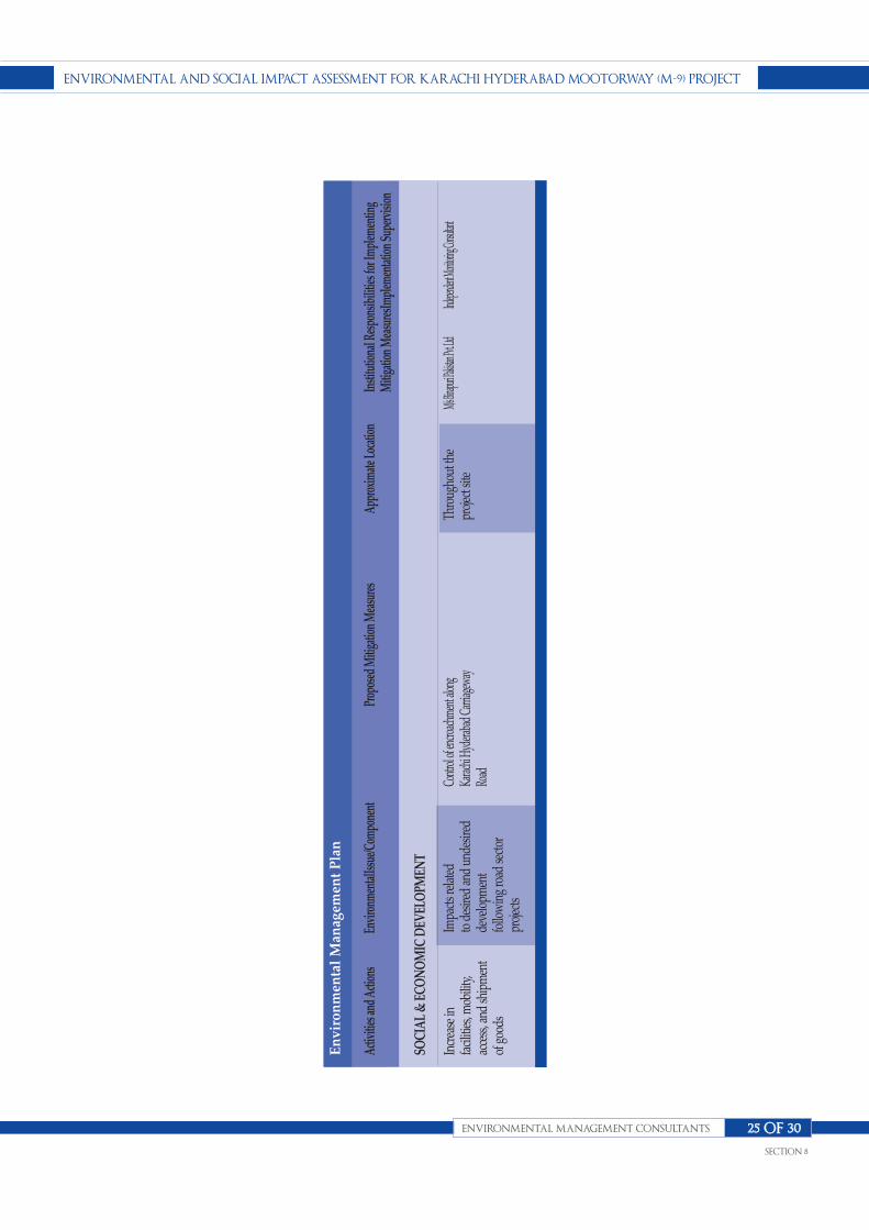
ENVIRONMENTAL ANd SOcIAL IMPAcT ASSESSMENT fOR KARAchI hydERAbAd MOOTORwAy (M-9) PROjEcT
ENVIRONMENTAL MANAGEMENT cONSuLTANTS
SEcTION 8
25 Of 30
Activ
ities
and
Actio
nsEn
viro
nmen
talIss
ue/C
ompo
nent
Prop
osed
Miti
gatio
n M
easu
res
Appr
oxim
ate L
ocati
onIn
stitu
tiona
l Res
pons
ibili
ties f
or Im
plem
entin
g M
itiga
tion
Mea
sure
sImpl
emen
tatio
n Su
perv
ision
Incr
ease
infa
ciliti
es, m
obili
ty,
acce
ss, a
nd sh
ipm
ent
of g
oods
SOC
IAL
& E
CO
NO
MIC
DEV
ELO
PMEN
T
Impa
cts r
elat
edto
des
ired
and
unde
sired
deve
lopm
ent
follo
win
g ro
ad se
ctor
proj
ects
Contr
ol of
encro
achm
ent a
long
Karac
hi Hy
derab
ad C
arriag
eway
Road
Thro
ugho
ut th
epr
ojec
t site
M/s Bin
apuri P
akistan
Pvt. Lt
dInd
epende
nt Moni
toring
Consult
ant
En
vir
on
men
tal
Man
agem
ent
Pla
n

8.11 EnvironmentalMonitoring
This section provides a monitoring plan that identifies
the roles and responsibilities of the Project staff
involved in environmental and social monitoring and
list the parameters that will be used in the monitoring
process.
8.11.1 Objectives
The main objectives of the pre-construction and
construction phase monitoring plans will be able to:
n Monitor the actual impact of the works on
physical, biological and socioeconomic receptors
within the project corridor for indicating the
adequacy of the ESIA.
n Recommend mitigation measures for any
unexpected impact or where the impact level
exceeds that anticipated in the ESIA.
n Ensure compliance with legal and community
obligations including safety on construction sites.
n Restoration of the construction campsites as
described in the EMP
n Ensure the safe disposal of excess construction
materials.
The main objectives of monitoring during the operation
phase will be to:
n Appraise the adequacy of the ESIA with respect to
the Project’s predicted long-term impact on the
corridors physical, biological and socioeconomic
environment.
n Evaluate the effectiveness of the mitigation
measures proposed in the EMP and recommend
improvements, if and when necessary.
n Compile periodic accident data to support
analyses that will help minimize future risks.
n Monitor the survival rate of avenue plantations
8.11.2 Monitoring Roles,Responsibilities and Schedules
(a) Internal Monitoring
The project staff engaged in social and environmental
monitoring is listed below, followed by descriptions of the
monitoring responsibilities specific to each post:
n DD (Environment)
n Supervision Consultants
Overall monitoring plan is shown in Table 8.2.
(b) Deputy Director (Environment)
The Deputy Director (Environment) will have overall
responsibility for Environmental Monitoring and
Evaluation.This includes the following:
n Ensuring the availability of human and materials
resources required for environmental monitoring.
n Generating periodic monitoring reports and
disseminating these among the management and
appropriate staff members.
n Ensuring that the required environmental training is
provided to the staff concerned;
n Contracting out external monitoring to independent
firms and ensuring that periodic environmental
audits are carried out.
The DD (Environment) and his team will also be
responsible for:
n Carrying out visits to the construction sites to review
the environmental performance of the contractors
n The status of the Project’s consultation strategy.
(c) Supervision Consultant
Supervision consultant will involve the Environmental
Expert/Monitoring Consultant and Resident Engineer.
The Resident Engineer will overlook the performance of
contractor to make sure that the contractor is carrying out
ENVIRONMENTAL ANd SOcIAL IMPAcT ASSESSMENT fOR KARAchI hydERAbAd MOOTORwAy (M-9) PROjEcT
ENVIRONMENTAL MANAGEMENT cONSuLTANTS
SEcTION 8
26 Of 30

the work in accordance with EMP.The Independent
Monitoring Consultant (IMC) on the other hand will carry
out the environmental monitoring and report to DD
(Environment) for adequacy of the monitoring program as
specified in EMP.The IMC will also induct a Technical
Training Consultant to educate the contractor’s and
NHA’s staff.
8.11.3 Monitoring Parameters
A. Environmental Monitoring
Parameters
The following environmental parameters will be
monitored at locations identified during the construction
phase (e.g. location of asphalt plants, construction camps,
etc).
n Ambient Air Quality (NOx, SOx, CO and PM10)
n Asphalt Plant emissions (smoke, dust, etc)
n Ambient Noise levels
n Water Quality
B. Social Monitoring Parameters
Social monitoring will be carried out based on the
following indicators:
n Record of any problems due to restricted access to the
highway during construction and whether ramps/
diversions have been provided where required.
n Number of grievances recorded and redressed
n Number of public facilities and utilities to be relocated
n Number of mosques/ shrines/ graves to be relocated
(if any)and corresponding contribution of affected
communities and NHA
n Verification of relocation of mosques/shrines/graves.
8.11.4 Reporting Structure andOutcomes
Progress reporting will be the overall responsibility of the
Project Director who will provide inputs to the
Supervision Consultants for submission to GM
(NHA).The supervision Consultants will be responsible
for submitting a monthly environmental/social report for
the Project to GM (NHA).In addition, the DD
(Environment) will prepare a quarterly report
encompassing environmental concerns, and following
review by the Director (Environment, Social) he will
submit the report to the EPA Sindh.
ENVIRONMENTAL ANd SOcIAL IMPAcT ASSESSMENT fOR KARAchI hydERAbAd MOOTORwAy (M-9) PROjEcT
ENVIRONMENTAL MANAGEMENT cONSuLTANTS
SEcTION 8
27 Of 30

ENVIRONMENTAL ANd SOcIAL IMPAcT ASSESSMENT fOR KARAchI hydERAbAd MOOTORwAy (M-9) PROjEcT
ENVIRONMENTAL MANAGEMENT cONSuLTANTS
SEcTION 8
28 Of 30
Envi
ronm
ental
Com
pone
ntPa
ram
eters
Loca
tions
Freq
uenc
ysta
ndar
dsIm
plem
entat
ion
Supe
rvisi
on
Air
Qua
lity
Wat
er Q
ualit
y
Noi
se le
vels
Solid
was
te fr
omco
ntra
ctor
’s ca
mp
Land
Con
tam
inat
ion
CO, C
O2,
SO2,
NO
x, d
ust
and
micr
oclim
ate
para
met
ers
At al
l sites
whe
re air
quali
tyan
alysis
is ca
rried
out a
nd at
vario
us In
terch
ange
s
Surfa
ce wa
ter bo
dies /
lago
ons /
pond
s, etc.
in pr
oxim
ity to
cons
tructi
on sit
es
Resid
entia
l & Se
nsitiv
e area
s.
At co
ntrac
tors c
amp s
ite
Expo
sed su
rfaces
in an
d aro
und
areas
in pr
oxim
ity to
cons
tructi
onsit
es pa
rticu
larly
at sta
tions
&de
pot. S
ubsu
rface
sampli
ng in
areas
aroun
d pilin
g, ex
cava
tion,
quarr
ying a
nd ba
tching
plan
ts.
Mea
surin
g tw
ice a
mon
th, 6
sam
ples
at
one
loca
tion.
Onc
e fo
rtnig
htly
for
surfa
ce a
ndgr
ound
wat
er. G
rabs
Sam
plin
g to
be
done
onc
e at
eac
hid
entif
ied
loca
tion.
Mea
surin
g 2
times
per m
onth
, 16
hour
s/ d
ay
Onc
e in
a m
onth
Onc
e fo
rtnig
htly
for
surfa
ce a
nd su
b-su
rface
sam
ples
.Sa
mpl
ing
to b
edo
ne g
rab
once
at
each
iden
tifie
dlo
catio
n
WH
O/U
SEPA
guid
elin
es,N
EQS
WH
O/N
EQS
NEQ
s
N/A
NEQ
s
Bina
Puri
(Pvt
) Ltd
/NH
A
Bina
Puri
(Pvt
) Ltd
/NH
A
Bin
Puri
(Pvt
) Ltd
/NH
A
Bina
Puri
(Pvt
) Ltd
/NH
A
Bina
Puri
(Pvt
) Ltd
/NH
A
Inde
pend
ent M
onito
ring
Cons
ulta
nt
Inde
pend
ent M
onito
ring
Cons
ulta
nt
Inde
pend
ent M
onito
ring
Cons
ulta
nt
Inde
pend
ent M
onito
ring
Cons
ulta
nt
Inde
pend
ent M
onito
ring
Cons
ulta
nt
Tab
le 8
.2:
En
vir
on
men
tal
Mo
nit
ori
ng
Pla
n d
uri
ng
Co
nst
ruct
ion
Ph
ase

ENVIRONMENTAL ANd SOcIAL IMPAcT ASSESSMENT fOR KARAchI hydERAbAd MOOTORwAy (M-9) PROjEcT
ENVIRONMENTAL MANAGEMENT cONSuLTANTS
SEcTION 8
29 Of 30
Envi
ronm
ental
Com
pone
ntPa
ram
eters
Loca
tions
Freq
uenc
ysta
ndar
dsIm
plem
entat
ion
Supe
rvisi
on
Hea
lth S
afet
y of
Cont
ract
or S
taff
Flor
a an
d Fa
una
Road
side
pla
ntat
ion
Site
Res
tora
tion
Socio
-eco
nom
ic
• Te
mpo
rary
fenc
ing
of th
eco
nstru
ctio
n sit
e fo
r saf
ety
of w
orke
rs a
nd g
ener
alpu
blic
also
chec
king
unau
thor
ized
acc
ess.
• Pr
otec
tive
gear
and
safe
ty e
quip
men
t for
cons
truct
ion
wor
kers
.•
Basic
trai
ning
of
pers
onne
l in
heal
th a
ndsa
fety
and
resp
ondi
ng to
emer
genc
ies
Visu
al ch
ecks
to a
sses
s the
situa
tion
Visu
al in
spec
tion
of p
lant
spec
ies,
surv
ival
rate
and
statu
s of m
aint
enan
ce
Resto
ring
the
sites
tofin
ished
pro
ject s
ites
with
out u
nnec
essa
ryde
lays
.
• Co
mm
unica
ble
Dise
ases
Prev
entio
n Pr
ogra
m w
illbe
prep
ared
for
cons
truct
ionw
orke
rs o
rre
siden
ts ne
arth
econ
struc
tion
sites
• Cu
ltura
l &A
rcha
eolo
gica
l Site
s
M-9
RoW
M-9
RoW
At sit
es wh
ere pl
antat
ion w
asca
rried
out.
At sit
e with
in rig
ht of
the w
ay
Cons
tructi
on Si
tes
M-9
RoW
Cont
inuo
us
Cont
inuo
us
• O
ne m
onth
afte
rpl
anta
tion
• O
ne y
ear a
fter
plan
tatio
n
Afte
r com
plet
ion
ofea
ch se
ctio
n
Cont
inuo
us
Pote
ntia
lm
onito
ring
met
hod
coul
d be
occu
patio
nal s
afet
ytra
inin
g at
the
ince
ptio
n of
the
cons
truct
ion
or e
ach
time
a ne
w w
orke
rsta
rts to
eng
age
inth
e jo
b an
d pe
riodi
che
alth
chec
ks fo
r all
wor
kers
.
- 75 %
surv
ival
rate
N/A
N/A
Bina
Puri
(Pvt
) Ltd
/NH
A
Bina
Puri
(Pvt
) Ltd
/NH
A
Bina
Puri
(Pvt
) Ltd
/NH
A
Bina
Puri
(Pvt
) Ltd
/NH
A
Bina
Puri
(Pvt
) Ltd
/NH
A
Inde
pend
ent M
onito
ring
Cons
ulta
nt
Inde
pend
ent M
onito
ring
Cons
ulta
nt
Inde
pend
ent M
onito
ring
Cons
ulta
nt
Inde
pend
ent M
onito
ring
Cons
ulta
nt
Inde
pend
ent M
onito
ring
Cons
ulta
nt
Tab
le 8
.2:E
nv
iro
nm
enta
l M
on
ito
rin
g P
lan
du
rin
g C
on
stru
ctio
n P
has
e

ENVIRONMENTAL ANd SOcIAL IMPAcT ASSESSMENT fOR KARAchI hydERAbAd MOOTORwAy (M-9) PROjEcT
ENVIRONMENTAL MANAGEMENT cONSuLTANTS
SEcTION 8
30 Of 30
Envi
ronm
ental
Com
pone
ntPa
ram
eters
Loca
tions
Freq
uenc
ysta
ndar
dsIm
plem
entat
ion
Supe
rvisi
onD
urati
on
Air
Qua
lity
Wat
er Q
ualit
y
Noi
se L
evel
s
SOx,
NO
x, C
O, P
M10
pH, B
OD
, CO
D, T
DS,
TSS
,D
O, c
olifo
rms,
Har
dnes
s,N
itrat
e, E.
coli
La (d
B)
From
the e
dge o
f the p
avem
ent
down
wind
back
grou
ndco
ncen
tratio
n nea
r a re
siden
tial
area a
t a se
nsitiv
e loc
ation
Comm
unity
grou
nd w
ater
sour
ces n
ear R
oW tw
o sele
cted
locati
ons o
n exis
ting /
prop
osed
highw
ay
From
the e
dge o
f pav
emen
t, at
sensit
ive lo
catio
n and
ares
identi
al/co
mmerc
ial ar
ea.
Mea
surin
g th
e fir
st12
mon
ths,
8sa
mpl
es a
t rin
g on
cea
quar
ter d
urin
gon
e lo
catio
n.
Onc
e a
year
insu
mm
er ,
just
befo
rem
onso
on se
ason
for
thre
e ye
ars
Mea
surin
g 1
time
per q
uarte
r dur
ing
the
first
12 m
onth
s.
WH
O/U
SEPA
guid
elin
es, N
EQS
WH
O D
rinki
ngW
ater
Qua
lity
Gui
delin
es
NEQ
s & W
HO
noise
gui
delin
es
Bina
Puri
(Pvt
) Ltd
/NH
A
Bina
Puri
(Pvt
) Ltd
/NH
A
Bina
Puri
(Pvt
) Ltd
/NH
A
Inde
pend
ent M
onito
ring
Cons
ulta
nt
Inde
pend
ent M
onito
ring
Cons
ulta
nt
Inde
pend
ent M
onito
ring
Cons
ulta
nt
24 h
ours
,rea
ding
sta
ken
at 1
5 se
cin
terv
als,
over
15
min
, eve
ry h
our
and
then
ave
rage
d
- 24 h
ours
, rea
ding
sta
ken
at 1
5 se
c, 15
min
, eve
ry h
our
and
then
ave
rage
d
Tab
le 8
.2:E
nv
iro
nm
enta
l M
on
ito
rin
g P
lan
du
rin
g O
per
atio
n P
has
e

environmental and soCial impaCt assessment for KaraChi hyderabad motorway (m-9) projeCt
environmental management Consultants
seCtion 9
1 of 2
ConClusion
9.1 Findings
The environmental and social assessment process
described in this document have evaluated and assessed
the environmental impacts of the proposed Karachi-
Hyderabad M-9 project. Potential impacts were
identified in relation to planning, design and location for
construction and operation phases of the proposed
Karachi-Hyderabad M-9 Project. Mitigation measures
have been suggested to reduce all negative impacts to
acceptable levels. These were discussed with specialists
responsible for the engineering aspects, and measures
have been included in the designs for the infrastructure.
This means that the number of impacts and their
significance have already been reduced by amending the
design. These include:
n Strengthen the existing road infrastructure without
disturbing the business of the people;
n Design of structures as per seismic zone to eliminate
risk;
n Design of storm water drainage system in
consideration of change in topography;
n Replantation of trees and Compensatory plantation;
n Avoiding complete closure of road by limiting the
construction area to actual M-9 RoW and allowing
the traffic as per the traffic management plan.
n Provide provision of chain link fence and all
necessary arrangement on both sides of defined
RoW;
During the construction phase, impacts mainly arise
from generation of dust from soil excavation and
refilling; and from the disturbance of residents,
businesses, traffic and important buildings by the
construction work. Among these, public and worker
safety due to large scale construction using heavy-duty
construction equipment, traffic disturbance during
construction is considered to be significant.
Important measures suggested include:
n Dust control measures such as water sprinkling and
covering the loose material during transport;
n Proper planning and scheduling of noise generating
activities;
n Providing alternative traffic routes/detours and
informing public about the same;
n Providing public information boards at site (project
details, traffic arrangements, executing agency and
contractor details; safety and contact information);
n Following standard and safe construction practices
(barricading the site properly; avoiding accidental
traffic entry including pedestrians; deployment of
safety and security staff; providing warning/sign
boards; provision of protection equipment; special
precautions during risky works like arranging the
pre-cast elements and equipment safety checks, etc.)
n By considering the above mentioned factors and the
road will now be constructed first on one side and
then on the other side from centerline of the existing
road to a 6 lane carriageway. This will have the
advantage of enhanced safety during construction
and operational stages, and less disruption to the
passing traffic during construction. It will also
minimize resettlement of structures, trees and other
utilities
The construction of the existing road will be in such a
way with minimal land acquired and less disruption to
the traffic hence no major impacts are envisaged.
The main beneficiary of the proposed project is to
provide a future access to the Karachi- Hyderabad
Motorway that would be achievable in the most
appropriate location.
Mitigation will be assured by a program of
environmental monitoring conducted to ensure that all
measures are provided as intended, and to determine
09

whether the environment is protected as envisaged. This
will include observations on and off site, document
checks, and interviews with workers and beneficiaries,
and any requirements for remedial action will be
reported to the EPA.
Stakeholders were involved in developing the ESIA
through face-to-face discussions in meetings at ESIA
preparatory stage and a large public hearing will be
held, after which views expressed will be incorporated
into the ESIA and the planning and development of the
project.
There are two essential recommendations that need to be
followed to ensure that the environmental impacts of the
project are successfully mitigated. The proponent and
NHA shall ensure that:
n All mitigation, compensation and enhancement
measures proposed in this ESIA report are
implemented in full, as described in the document;
n The Environmental Management and Monitoring
Plan proposed is also implemented in letter & spirit.
9.2 Conclusion
The environmental impacts of the proposed Karachi -
Hyderabad M-9 Project have been assessed by the
Environmental Impact Assessment reported in this
document, conducted according to the Pakistan
Environmental Protection Act 1997 and the Rules and
Regulations framed there under. Social issue will be
given due priority and will be resolved at
preconstruction stage of project in consultation with
community.
It is concluded that the construction of Karachi-
Hyderabad M-9 Project will have a great relief to traffic
commuting from Karachi to Hyderabad and Northern
Areas of Pakistan. As it will also help in the reduction of
traffic jams faced due to slow moving heavy traffic.
Generally the project will show positive impacts once
completed but may cause some short term negative
impacts during its construction stage. These negative
impacts however, can be minimized or avoid if
proposed mitigation measures are duly taken into
account.
The overall conclusion is that providing the mitigation,
compensation and enhancement measures are
implemented in full, there should be no significant
adverse environmental impacts as a result of location,
design, construction or operation of the project.
environmental and soCial impaCt assessment for KaraChi hyderabad motorway (m-9) projeCt
environmental management Consultants
seCtion 9
2 of 2

ENVIroNmENtAl ANd soCIAl ImpACt AssEssmENt for KArAChI hydErAbAd motorwAy (m-9)projECt
ENVIroNmENtAl mANAgEmENt CoNsultANts
ANNEX I
I of XXV
ANNEX I

ENVIroNmENtAl ANd soCIAl ImpACt AssEssmENt for KArAChI hydErAbAd motorwAy (m-9)projECt
ENVIroNmENtAl mANAgEmENt CoNsultANts
ANNEX I
II of XXV
ANNEX I

ENVIroNmENtAl ANd soCIAl ImpACt AssEssmENt for KArAChI hydErAbAd motorwAy (m-9)projECt
ENVIroNmENtAl mANAgEmENt CoNsultANts
ANNEX I
III of XXV
ANNEX I

ENVIroNmENtAl ANd soCIAl ImpACt AssEssmENt for KArAChI hydErAbAd motorwAy (m-9)projECt
ENVIroNmENtAl mANAgEmENt CoNsultANts
ANNEX I
IV of XXV
ANNEX I

ENVIroNmENtAl ANd soCIAl ImpACt AssEssmENt for KArAChI hydErAbAd motorwAy (m-9)projECt
ENVIroNmENtAl mANAgEmENt CoNsultANts
ANNEX I
V of XXV
ANNEX I
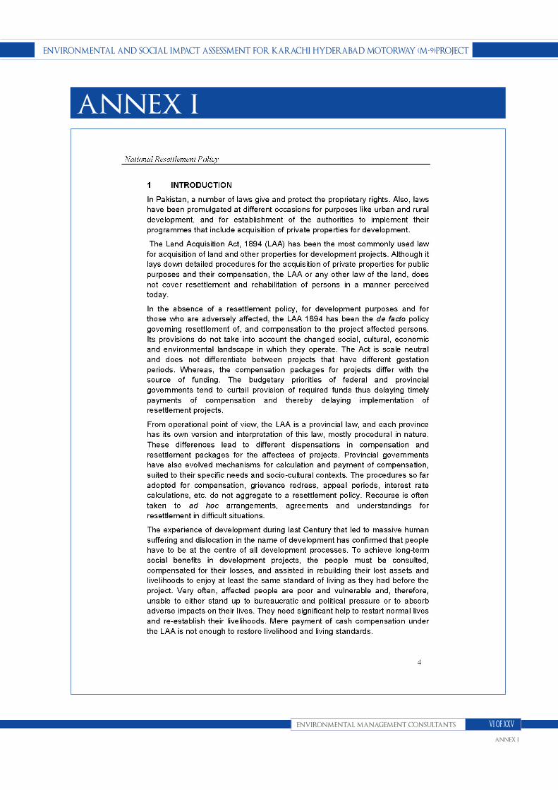
ENVIroNmENtAl ANd soCIAl ImpACt AssEssmENt for KArAChI hydErAbAd motorwAy (m-9)projECt
ENVIroNmENtAl mANAgEmENt CoNsultANts
ANNEX I
VI of XXV
ANNEX I

ENVIroNmENtAl ANd soCIAl ImpACt AssEssmENt for KArAChI hydErAbAd motorwAy (m-9)projECt
ENVIroNmENtAl mANAgEmENt CoNsultANts
ANNEX I
VII of XXV
ANNEX I

ENVIroNmENtAl ANd soCIAl ImpACt AssEssmENt for KArAChI hydErAbAd motorwAy (m-9)projECt
ENVIroNmENtAl mANAgEmENt CoNsultANts
ANNEX I
VIII of XXV
ANNEX I

ENVIroNmENtAl ANd soCIAl ImpACt AssEssmENt for KArAChI hydErAbAd motorwAy (m-9)projECt
ENVIroNmENtAl mANAgEmENt CoNsultANts
ANNEX I
IX of XXV
ANNEX I

ENVIroNmENtAl ANd soCIAl ImpACt AssEssmENt for KArAChI hydErAbAd motorwAy (m-9)projECt
ENVIroNmENtAl mANAgEmENt CoNsultANts
ANNEX I
X of XXV
ANNEX I

ENVIroNmENtAl ANd soCIAl ImpACt AssEssmENt for KArAChI hydErAbAd motorwAy (m-9)projECt
ENVIroNmENtAl mANAgEmENt CoNsultANts
ANNEX I
XI of XXV
ANNEX I

ENVIroNmENtAl ANd soCIAl ImpACt AssEssmENt for KArAChI hydErAbAd motorwAy (m-9)projECt
ENVIroNmENtAl mANAgEmENt CoNsultANts
ANNEX I
XII of XXV
ANNEX I

ENVIroNmENtAl ANd soCIAl ImpACt AssEssmENt for KArAChI hydErAbAd motorwAy (m-9)projECt
ENVIroNmENtAl mANAgEmENt CoNsultANts
ANNEX I
XIII of XXV
ANNEX I

ENVIroNmENtAl ANd soCIAl ImpACt AssEssmENt for KArAChI hydErAbAd motorwAy (m-9)projECt
ENVIroNmENtAl mANAgEmENt CoNsultANts
ANNEX I
XIV of XXV
ANNEX I

ENVIroNmENtAl ANd soCIAl ImpACt AssEssmENt for KArAChI hydErAbAd motorwAy (m-9)projECt
ENVIroNmENtAl mANAgEmENt CoNsultANts
ANNEX I
XV of XXV
ANNEX I

ENVIroNmENtAl ANd soCIAl ImpACt AssEssmENt for KArAChI hydErAbAd motorwAy (m-9)projECt
ENVIroNmENtAl mANAgEmENt CoNsultANts
ANNEX I
XVI of XXV
ANNEX I

ENVIroNmENtAl ANd soCIAl ImpACt AssEssmENt for KArAChI hydErAbAd motorwAy (m-9)projECt
ENVIroNmENtAl mANAgEmENt CoNsultANts
ANNEX I
XVII of XXV
ANNEX I

ENVIroNmENtAl ANd soCIAl ImpACt AssEssmENt for KArAChI hydErAbAd motorwAy (m-9)projECt
ENVIroNmENtAl mANAgEmENt CoNsultANts
ANNEX I
XVIII of XXV
ANNEX I

ENVIroNmENtAl ANd soCIAl ImpACt AssEssmENt for KArAChI hydErAbAd motorwAy (m-9)projECt
ENVIroNmENtAl mANAgEmENt CoNsultANts
ANNEX I
XIX of XXV
ANNEX I

ENVIroNmENtAl ANd soCIAl ImpACt AssEssmENt for KArAChI hydErAbAd motorwAy (m-9)projECt
ENVIroNmENtAl mANAgEmENt CoNsultANts
ANNEX I
XX of XXV
ANNEX I

ENVIroNmENtAl ANd soCIAl ImpACt AssEssmENt for KArAChI hydErAbAd motorwAy (m-9)projECt
ENVIroNmENtAl mANAgEmENt CoNsultANts
ANNEX I
XXI of XXV
ANNEX I

ENVIroNmENtAl ANd soCIAl ImpACt AssEssmENt for KArAChI hydErAbAd motorwAy (m-9)projECt
ENVIroNmENtAl mANAgEmENt CoNsultANts
ANNEX I
XXII of XXV
ANNEX I

ENVIroNmENtAl ANd soCIAl ImpACt AssEssmENt for KArAChI hydErAbAd motorwAy (m-9)projECt
ENVIroNmENtAl mANAgEmENt CoNsultANts
ANNEX I
XXIII of XXV
ANNEX I
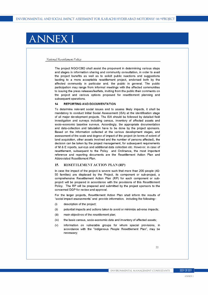
ENVIroNmENtAl ANd soCIAl ImpACt AssEssmENt for KArAChI hydErAbAd motorwAy (m-9)projECt
ENVIroNmENtAl mANAgEmENt CoNsultANts
ANNEX I
XXIV of XXV
ANNEX I

ENVIroNmENtAl ANd soCIAl ImpACt AssEssmENt for KArAChI hydErAbAd motorwAy (m-9)projECt
ENVIroNmENtAl mANAgEmENt CoNsultANts
ANNEX I
XXV of XXV
ANNEX I

ENVIroNmENtAl ANd soCIAl ImpACt AssEssmENt for KArAChI hydErAbAd motorwAy (m-9) projECt
ENVIroNmENtAl mANAgEmENt CoNsultANts
ANNEX II
I of XXV
ANNEX II

ENVIroNmENtAl ANd soCIAl ImpACt AssEssmENt for KArAChI hydErAbAd motorwAy (m-9) projECt
ENVIroNmENtAl mANAgEmENt CoNsultANts
ANNEX II
II of XXV
ANNEX II

ENVIroNmENtAl ANd soCIAl ImpACt AssEssmENt for KArAChI hydErAbAd motorwAy (m-9) projECt
ENVIroNmENtAl mANAgEmENt CoNsultANts
ANNEX II
III of XXV
ANNEX II
ENVIroNmENtAl ANd soCIAl ImpACt AssEssmENt for KArAChI hydErAbAd motorwAy (m-9) projECt
ENVIroNmENtAl mANAgEmENt CoNsultANts
ANNEX II
IV of XXV
ANNEX II

ENVIroNmENtAl ANd soCIAl ImpACt AssEssmENt for KArAChI hydErAbAd motorwAy (m-9) projECt
ENVIroNmENtAl mANAgEmENt CoNsultANts
ANNEX II
V of XXV
ANNEX II

ENVIroNmENtAl ANd soCIAl ImpACt AssEssmENt for KArAChI hydErAbAd motorwAy (m-9) projECt
ENVIroNmENtAl mANAgEmENt CoNsultANts
ANNEX II
VI of XXV
ANNEX II
ENVIroNmENtAl ANd soCIAl ImpACt AssEssmENt for KArAChI hydErAbAd motorwAy (m-9) projECt
ENVIroNmENtAl mANAgEmENt CoNsultANts
ANNEX II
VII of XXV
ANNEX II

ENVIroNmENtAl ANd soCIAl ImpACt AssEssmENt for KArAChI hydErAbAd motorwAy (m-9) projECt
ENVIroNmENtAl mANAgEmENt CoNsultANts
ANNEX II
VIII of XXV
ANNEX II

ENVIroNmENtAl ANd soCIAl ImpACt AssEssmENt for KArAChI hydErAbAd motorwAy (m-9) projECt
ENVIroNmENtAl mANAgEmENt CoNsultANts
ANNEX II
IX of XXV
ANNEX II

ENVIroNmENtAl ANd soCIAl ImpACt AssEssmENt for KArAChI hydErAbAd motorwAy (m-9) projECt
ENVIroNmENtAl mANAgEmENt CoNsultANts
ANNEX II
X of XXV
ANNEX II

ENVIroNmENtAl ANd soCIAl ImpACt AssEssmENt for KArAChI hydErAbAd motorwAy (m-9) projECt
ENVIroNmENtAl mANAgEmENt CoNsultANts
ANNEX II
XI of XXV
ANNEX II

ENVIroNmENtAl ANd soCIAl ImpACt AssEssmENt for KArAChI hydErAbAd motorwAy (m-9) projECt
ENVIroNmENtAl mANAgEmENt CoNsultANts
ANNEX II
XII of XXV
ANNEX II

ENVIroNmENtAl ANd soCIAl ImpACt AssEssmENt for KArAChI hydErAbAd motorwAy (m-9) projECt
ENVIroNmENtAl mANAgEmENt CoNsultANts
ANNEX II
XIII of XXV
ANNEX II

ENVIroNmENtAl ANd soCIAl ImpACt AssEssmENt for KArAChI hydErAbAd motorwAy (m-9) projECt
ENVIroNmENtAl mANAgEmENt CoNsultANts
ANNEX II
XIV of XXV
ANNEX II

ENVIroNmENtAl ANd soCIAl ImpACt AssEssmENt for KArAChI hydErAbAd motorwAy (m-9) projECt
ENVIroNmENtAl mANAgEmENt CoNsultANts
ANNEX II
XV of XXV
ANNEX II

ENVIroNmENtAl ANd soCIAl ImpACt AssEssmENt for KArAChI hydErAbAd motorwAy (m-9) projECt
ENVIroNmENtAl mANAgEmENt CoNsultANts
ANNEX II
XVI of XXV
ANNEX II

ENVIroNmENtAl ANd soCIAl ImpACt AssEssmENt for KArAChI hydErAbAd motorwAy (m-9) projECt
ENVIroNmENtAl mANAgEmENt CoNsultANts
ANNEX II
XVII of XXV
ANNEX II

ENVIroNmENtAl ANd soCIAl ImpACt AssEssmENt for KArAChI hydErAbAd motorwAy (m-9) projECt
ENVIroNmENtAl mANAgEmENt CoNsultANts
ANNEX II
XVIII of XXV
ANNEX II

ENVIroNmENtAl ANd soCIAl ImpACt AssEssmENt for KArAChI hydErAbAd motorwAy (m-9) projECt
ENVIroNmENtAl mANAgEmENt CoNsultANts
ANNEX II
XIX of XXV
ANNEX II

ENVIroNmENtAl ANd soCIAl ImpACt AssEssmENt for KArAChI hydErAbAd motorwAy (m-9) projECt
ENVIroNmENtAl mANAgEmENt CoNsultANts
ANNEX II
XX of XXV
ANNEX II

ENVIroNmENtAl ANd soCIAl ImpACt AssEssmENt for KArAChI hydErAbAd motorwAy (m-9) projECt
ENVIroNmENtAl mANAgEmENt CoNsultANts
ANNEX II
XXI of XXV
ANNEX II

ENVIroNmENtAl ANd soCIAl ImpACt AssEssmENt for KArAChI hydErAbAd motorwAy (m-9) projECt
ENVIroNmENtAl mANAgEmENt CoNsultANts
ANNEX II
XXII of XXV
ANNEX II

ENVIroNmENtAl ANd soCIAl ImpACt AssEssmENt for KArAChI hydErAbAd motorwAy (m-9) projECt
ENVIroNmENtAl mANAgEmENt CoNsultANts
ANNEX II
XXIII of XXV
ANNEX II

ENVIroNmENtAl ANd soCIAl ImpACt AssEssmENt for KArAChI hydErAbAd motorwAy (m-9) projECt
ENVIroNmENtAl mANAgEmENt CoNsultANts
ANNEX II
XXIV of XXV
ANNEX II

ENVIroNmENtAl ANd soCIAl ImpACt AssEssmENt for KArAChI hydErAbAd motorwAy (m-9) projECt
ENVIroNmENtAl mANAgEmENt CoNsultANts
ANNEX II
XXV of XXV
ANNEX II

ENVIroNmENtAl ANd soCIAl ImpACt AssEssmENt for KArAChI hydErAbAd motorwAy (m-9) projECt
ENVIroNmENtAl mANAgEmENt CoNsultANts
ANNEX III
I of XVIII
ANNEX III

ENVIroNmENtAl ANd soCIAl ImpACt AssEssmENt for KArAChI hydErAbAd motorwAy (m-9) projECt
ENVIroNmENtAl mANAgEmENt CoNsultANts
ANNEX III
II of XVIII
ANNEX III
ENVIroNmENtAl ANd soCIAl ImpACt AssEssmENt for KArAChI hydErAbAd motorwAy (m-9) projECt
ENVIroNmENtAl mANAgEmENt CoNsultANts
ANNEX III
III of XVIII
ANNEX III

ENVIroNmENtAl ANd soCIAl ImpACt AssEssmENt for KArAChI hydErAbAd motorwAy (m-9) projECt
ENVIroNmENtAl mANAgEmENt CoNsultANts
ANNEX III
IV of XVIII
ANNEX III

ENVIroNmENtAl ANd soCIAl ImpACt AssEssmENt for KArAChI hydErAbAd motorwAy (m-9) projECt
ENVIroNmENtAl mANAgEmENt CoNsultANts
ANNEX III
V of XVIII
ANNEX III

ENVIroNmENtAl ANd soCIAl ImpACt AssEssmENt for KArAChI hydErAbAd motorwAy (m-9) projECt
ENVIroNmENtAl mANAgEmENt CoNsultANts
ANNEX III
VI of XVIII
ANNEX III

ENVIroNmENtAl ANd soCIAl ImpACt AssEssmENt for KArAChI hydErAbAd motorwAy (m-9) projECt
ENVIroNmENtAl mANAgEmENt CoNsultANts
ANNEX III
VII of XVIII
ANNEX III
ENVIroNmENtAl ANd soCIAl ImpACt AssEssmENt for KArAChI hydErAbAd motorwAy (m-9) projECt
ENVIroNmENtAl mANAgEmENt CoNsultANts
ANNEX III
VIII of XVIII
ANNEX III

ENVIroNmENtAl ANd soCIAl ImpACt AssEssmENt for KArAChI hydErAbAd motorwAy (m-9) projECt
ENVIroNmENtAl mANAgEmENt CoNsultANts
ANNEX III
IX of XVIII
ANNEX III

ENVIroNmENtAl ANd soCIAl ImpACt AssEssmENt for KArAChI hydErAbAd motorwAy (m-9) projECt
ENVIroNmENtAl mANAgEmENt CoNsultANts
ANNEX III
X of XVIII
ANNEX III

ENVIroNmENtAl ANd soCIAl ImpACt AssEssmENt for KArAChI hydErAbAd motorwAy (m-9) projECt
ENVIroNmENtAl mANAgEmENt CoNsultANts
ANNEX III
XI of XVIII
ANNEX III

ENVIroNmENtAl ANd soCIAl ImpACt AssEssmENt for KArAChI hydErAbAd motorwAy (m-9) projECt
ENVIroNmENtAl mANAgEmENt CoNsultANts
ANNEX III
XII of XVIII
ANNEX III
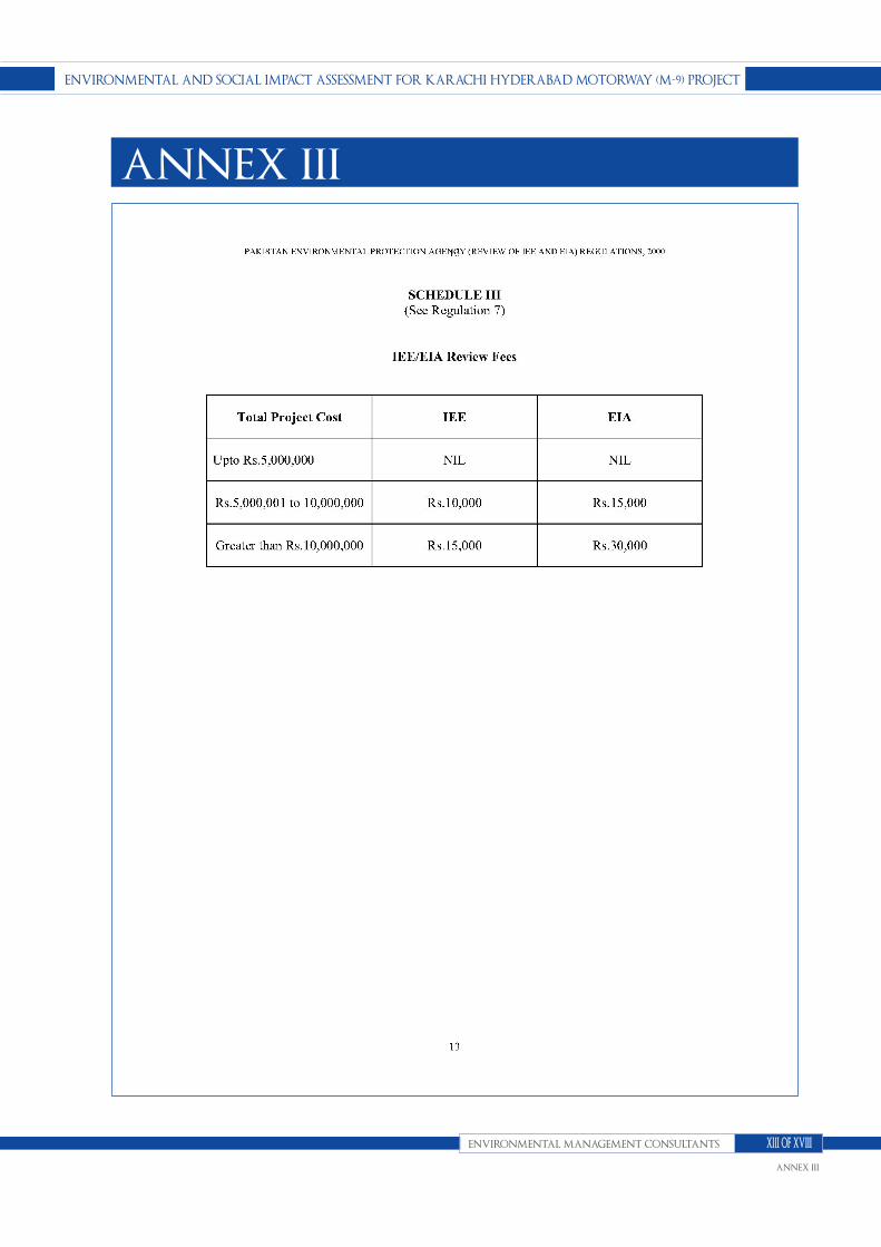
ENVIroNmENtAl ANd soCIAl ImpACt AssEssmENt for KArAChI hydErAbAd motorwAy (m-9) projECt
ENVIroNmENtAl mANAgEmENt CoNsultANts
ANNEX III
XIII of XVIII
ANNEX III

ENVIroNmENtAl ANd soCIAl ImpACt AssEssmENt for KArAChI hydErAbAd motorwAy (m-9) projECt
ENVIroNmENtAl mANAgEmENt CoNsultANts
ANNEX III
XIV of XVIII
ANNEX III

ENVIroNmENtAl ANd soCIAl ImpACt AssEssmENt for KArAChI hydErAbAd motorwAy (m-9) projECt
ENVIroNmENtAl mANAgEmENt CoNsultANts
ANNEX III
XV of XVIII
ANNEX III

ENVIroNmENtAl ANd soCIAl ImpACt AssEssmENt for KArAChI hydErAbAd motorwAy (m-9) projECt
ENVIroNmENtAl mANAgEmENt CoNsultANts
ANNEX III
XVI of XVIII
ANNEX III

ENVIroNmENtAl ANd soCIAl ImpACt AssEssmENt for KArAChI hydErAbAd motorwAy (m-9) projECt
ENVIroNmENtAl mANAgEmENt CoNsultANts
ANNEX III
XVII of XVIII
ANNEX III

ENVIroNmENtAl ANd soCIAl ImpACt AssEssmENt for KArAChI hydErAbAd motorwAy (m-9) projECt
ENVIroNmENtAl mANAgEmENt CoNsultANts
ANNEX III
XVIII of XVIII
ANNEX III

ENVIroNmENtAl ANd soCIAl ImpACt AssEssmENt for KArAChI hydErAbAd motorwAy (m-9) projECt
ENVIroNmENtAl mANAgEmENt CoNsultANts
ANNEX IV
I of VI
ANNEX IV
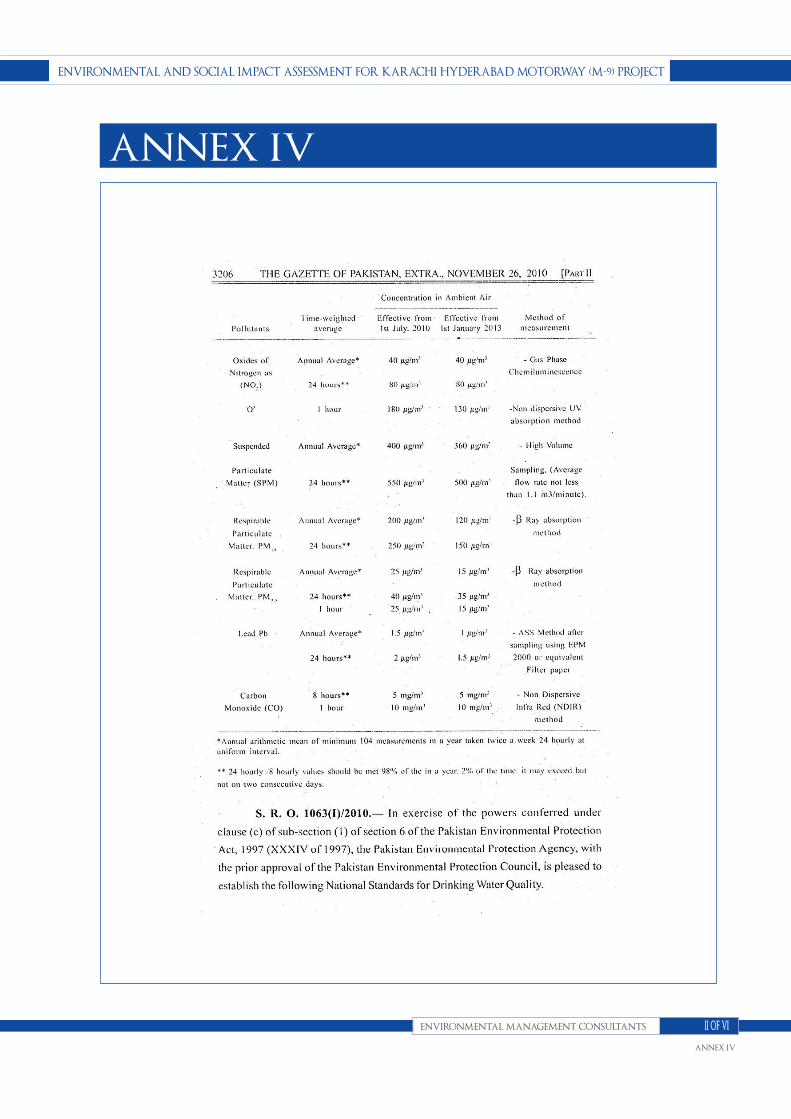
ENVIroNmENtAl ANd soCIAl ImpACt AssEssmENt for KArAChI hydErAbAd motorwAy (m-9) projECt
ENVIroNmENtAl mANAgEmENt CoNsultANts
ANNEX IV
II of VI
ANNEX IV

ENVIroNmENtAl ANd soCIAl ImpACt AssEssmENt for KArAChI hydErAbAd motorwAy (m-9) projECt
ENVIroNmENtAl mANAgEmENt CoNsultANts
ANNEX IV
III of VI
ANNEX IV

ENVIroNmENtAl ANd soCIAl ImpACt AssEssmENt for KArAChI hydErAbAd motorwAy (m-9) projECt
ENVIroNmENtAl mANAgEmENt CoNsultANts
ANNEX IV
IV of VI
ANNEX IV

ENVIroNmENtAl ANd soCIAl ImpACt AssEssmENt for KArAChI hydErAbAd motorwAy (m-9) projECt
ENVIroNmENtAl mANAgEmENt CoNsultANts
ANNEX IV
V of VI
ANNEX IV

ENVIroNmENtAl ANd soCIAl ImpACt AssEssmENt for KArAChI hydErAbAd motorwAy (m-9) projECt
ENVIroNmENtAl mANAgEmENt CoNsultANts
ANNEX IV
VI of VI
ANNEX IV
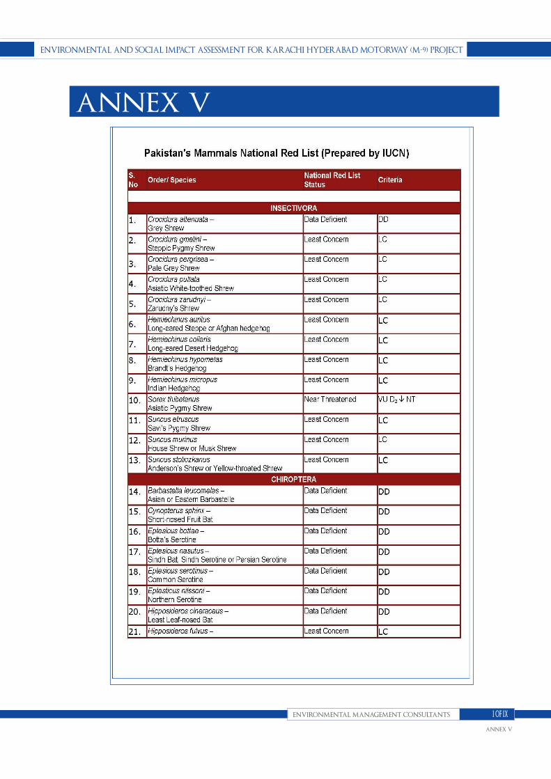
ENVIroNmENtAl ANd soCIAl ImpACt AssEssmENt for KArAChI hydErAbAd motorwAy (m-9) projECt
ENVIroNmENtAl mANAgEmENt CoNsultANts
ANNEX V
I of IX
ANNEX V

ENVIroNmENtAl ANd soCIAl ImpACt AssEssmENt for KArAChI hydErAbAd motorwAy (m-9) projECt
ENVIroNmENtAl mANAgEmENt CoNsultANts
ANNEX V
II of IX
ANNEX V

ENVIroNmENtAl ANd soCIAl ImpACt AssEssmENt for KArAChI hydErAbAd motorwAy (m-9) projECt
ENVIroNmENtAl mANAgEmENt CoNsultANts
ANNEX V
III of IX
ANNEX V

ENVIroNmENtAl ANd soCIAl ImpACt AssEssmENt for KArAChI hydErAbAd motorwAy (m-9) projECt
ENVIroNmENtAl mANAgEmENt CoNsultANts
ANNEX V
IV of IX
ANNEX V

ENVIroNmENtAl ANd soCIAl ImpACt AssEssmENt for KArAChI hydErAbAd motorwAy (m-9) projECt
ENVIroNmENtAl mANAgEmENt CoNsultANts
ANNEX V
V of IX
ANNEX V

ENVIroNmENtAl ANd soCIAl ImpACt AssEssmENt for KArAChI hydErAbAd motorwAy (m-9) projECt
ENVIroNmENtAl mANAgEmENt CoNsultANts
ANNEX V
VI of IX
ANNEX V

ENVIroNmENtAl ANd soCIAl ImpACt AssEssmENt for KArAChI hydErAbAd motorwAy (m-9) projECt
ENVIroNmENtAl mANAgEmENt CoNsultANts
ANNEX V
VII of IX
ANNEX V
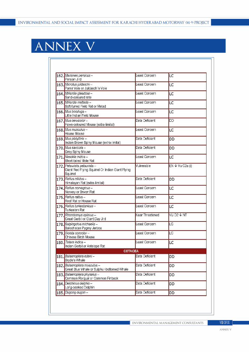
ENVIroNmENtAl ANd soCIAl ImpACt AssEssmENt for KArAChI hydErAbAd motorwAy (m-9) projECt
ENVIroNmENtAl mANAgEmENt CoNsultANts
ANNEX V
VIII of IX
ANNEX V

ENVIroNmENtAl ANd soCIAl ImpACt AssEssmENt for KArAChI hydErAbAd motorwAy (m-9) projECt
ENVIroNmENtAl mANAgEmENt CoNsultANts
ANNEX V
IX of IX
ANNEX V

ENVIroNmENtAl ANd soCIAl ImpACt AssEssmENt for KArAChI hydErAbAd motorwAy (m-9) projECt
ENVIroNmENtAl mANAgEmENt CoNsultANts
ANNEX VI
I of III
ANNEX VI

ENVIroNmENtAl ANd soCIAl ImpACt AssEssmENt for KArAChI hydErAbAd motorwAy (m-9) projECt
ENVIroNmENtAl mANAgEmENt CoNsultANts
ANNEX VI
II of III
ANNEX VI

ENVIroNmENtAl ANd soCIAl ImpACt AssEssmENt for KArAChI hydErAbAd motorwAy (m-9) projECt
ENVIroNmENtAl mANAgEmENt CoNsultANts
ANNEX VI
III of III
ANNEX VI
Related Documents


