Proceedings World Geothermal Congress 2010 Bali, Indonesia, 25-29 April 2010 1 EGS, the Energy for the Next Millennium: Potential Sites in the Philippines Lauro F. Bayrante 1 , Joeffrey A. Caranto 2 and Ramonchito Cedric M. Malate 3 Energy Center, Merritt Road, Ft. Bonifacio, Taguig City, Philippines 1 [email protected], 2 [email protected], and 3 [email protected] Keywords: EGS, Philippine geothermal, renewable energy ABSTRACT The Philippine energy sector’s agenda targets 60% energy self-sufficiency beyond 2010. Included in the agenda is the intensification of renewable energy resources development which is projected to reach 39% of the primary energy supply mix by 2014. Geothermal development will account for about 19.8% of the mix. The limited remaining suitable sites for conventional geothermal development require inclusion of Engineered Geothermal Systems (EGS) in the Philippine energy sector’s agenda. Previous exploration and development drilling of the Energy Development Corporation (EDC) in at least seven high- temperature prospects and projects encountered fluid- and permeability-deficient, conductively-heated but high- grade potential EGS resources. These near-producing field geothermal resources may be considered as the best sites for the country’s initial research and development and future EGS development projects. The Philippines can accelerate EGS development through DOE’s inclusion of EGS in its indigenous renewable energy resource base of the future. Inter-country technical collaborations with countries like USA, Australia, Germany and Japan with advanced experience in this type of resources, private sector upfront investments, and Philippine DOE’s role to shepherd EGS direction in the energy sector are crucial in the systematic documentation, assessment and successful development of low- to high- grade EGS in the country. 1. INTRODUCTION The Philippines draws about 18% of its energy mix from geothermal energy from proven geothermal reserves distributed in seven locations in the archipelago. Geothermal energy also comprises 38% of the renewable energy (RE) mix which included hydro (61.9%), wind (<1%), and solar (<1%). In 2008, generation from geothermal resource reached a total 10,395 GWh. From 1977 to 2008, geothermal generated a modest but significant foreign exchange savings of US $1.144 billion (DOE, 2008). The country’s geothermal installed capacity totals 1972 MWe (DOE, 2008); 60% of which is supplied by the Energy Development Corporation (EDC). Except for the 49 MWe Northern Negros Geothermal Project (NNGPF) capacity additions in 2007, no new large geothermal projects have been developed and conventional geothermal development in the country has slowed down significantly since the early 90’s mainly due to lack of new large discoveries and a combination of land use, environmental, social constraints and less attractive government incentive package. The Renewable Energy Law called the RE Act of 2008 or RA 9153 and its Implementing Rules and Regulation (IRR) were approved by the Philippine government in 2009. The RE Act is a landmark legislation which will spur growth in exploration and development through the entry of foreign capital and the institutionalization of a system of incentives (Peñarroyo, 2010). Here, the potential of the different sites of the country for Engineered Geothermal System (EGS) development was examined. EGS has not been given enough considerations by the government in its Philippine Energy Plan (PEP) and equal attention by the private sector mainly due to lack of appreciation on the importance of EGS. Moreover, a significant information on EGS was drawn from the interdisciplinary panel report of Massachusetts Institute of Technology (MIT, 2006). This paper aims to: 1) provide a perspective review of the potential of EGS sites in the Philippines; 2) update the geothermal potential of the country; 3) identify high- priority sites for EGS; 4) identify action plans that could accelerate EGS technology application and development and; 5) highlight the current barriers for RE resource development and the importance of EGS as the energy of the next millennium. 2. TECTONIC SETTING The Philippines is located within the Circum-Pacific Ring of Fire, which transects the Pacific Plate. It is characterized by active volcanism and seismicity which serves a favorable locus for high temperature (>180 o C) geothermal resources identified in countries like Indonesia, New Zealand, Japan, California, Mexico, Central America and Andes Mountain ranges, among others. (Fig. 1). Figure 1: Tectonic Map of the Philippines (After, Phivolcs, 1985)

Welcome message from author
This document is posted to help you gain knowledge. Please leave a comment to let me know what you think about it! Share it to your friends and learn new things together.
Transcript
Proceedings World Geothermal Congress 2010 Bali, Indonesia, 25-29 April 2010
1
EGS, the Energy for the Next Millennium: Potential Sites in the Philippines
Lauro F. Bayrante1, Joeffrey A. Caranto2 and Ramonchito Cedric M. Malate3
Energy Center, Merritt Road, Ft. Bonifacio, Taguig City, Philippines [email protected], [email protected], and [email protected]
Keywords: EGS, Philippine geothermal, renewable energy
ABSTRACT
The Philippine energy sector’s agenda targets 60% energy self-sufficiency beyond 2010. Included in the agenda is the intensification of renewable energy resources development which is projected to reach 39% of the primary energy supply mix by 2014. Geothermal development will account for about 19.8% of the mix. The limited remaining suitable sites for conventional geothermal development require inclusion of Engineered Geothermal Systems (EGS) in the Philippine energy sector’s agenda.
Previous exploration and development drilling of the Energy Development Corporation (EDC) in at least seven high- temperature prospects and projects encountered fluid- and permeability-deficient, conductively-heated but high-grade potential EGS resources. These near-producing field geothermal resources may be considered as the best sites for the country’s initial research and development and future EGS development projects.
The Philippines can accelerate EGS development through DOE’s inclusion of EGS in its indigenous renewable energy resource base of the future. Inter-country technical collaborations with countries like USA, Australia, Germany and Japan with advanced experience in this type of resources, private sector upfront investments, and Philippine DOE’s role to shepherd EGS direction in the energy sector are crucial in the systematic documentation, assessment and successful development of low- to high-grade EGS in the country.
1. INTRODUCTION
The Philippines draws about 18% of its energy mix from geothermal energy from proven geothermal reserves distributed in seven locations in the archipelago. Geothermal energy also comprises 38% of the renewable energy (RE) mix which included hydro (61.9%), wind (<1%), and solar (<1%). In 2008, generation from geothermal resource reached a total 10,395 GWh. From 1977 to 2008, geothermal generated a modest but significant foreign exchange savings of US $1.144 billion (DOE, 2008).
The country’s geothermal installed capacity totals 1972 MWe (DOE, 2008); 60% of which is supplied by the Energy Development Corporation (EDC). Except for the 49 MWe Northern Negros Geothermal Project (NNGPF) capacity additions in 2007, no new large geothermal projects have been developed and conventional geothermal development in the country has slowed down significantly since the early 90’s mainly due to lack of new large discoveries and a combination of land use, environmental, social constraints and less attractive government incentive package.
The Renewable Energy Law called the RE Act of 2008 or RA 9153 and its Implementing Rules and Regulation (IRR)
were approved by the Philippine government in 2009. The RE Act is a landmark legislation which will spur growth in exploration and development through the entry of foreign capital and the institutionalization of a system of incentives (Peñarroyo, 2010).
Here, the potential of the different sites of the country for Engineered Geothermal System (EGS) development was examined. EGS has not been given enough considerations by the government in its Philippine Energy Plan (PEP) and equal attention by the private sector mainly due to lack of appreciation on the importance of EGS. Moreover, a significant information on EGS was drawn from the interdisciplinary panel report of Massachusetts Institute of Technology (MIT, 2006).
This paper aims to: 1) provide a perspective review of the potential of EGS sites in the Philippines; 2) update the geothermal potential of the country; 3) identify high-priority sites for EGS; 4) identify action plans that could accelerate EGS technology application and development and; 5) highlight the current barriers for RE resource development and the importance of EGS as the energy of the next millennium.
2. TECTONIC SETTING
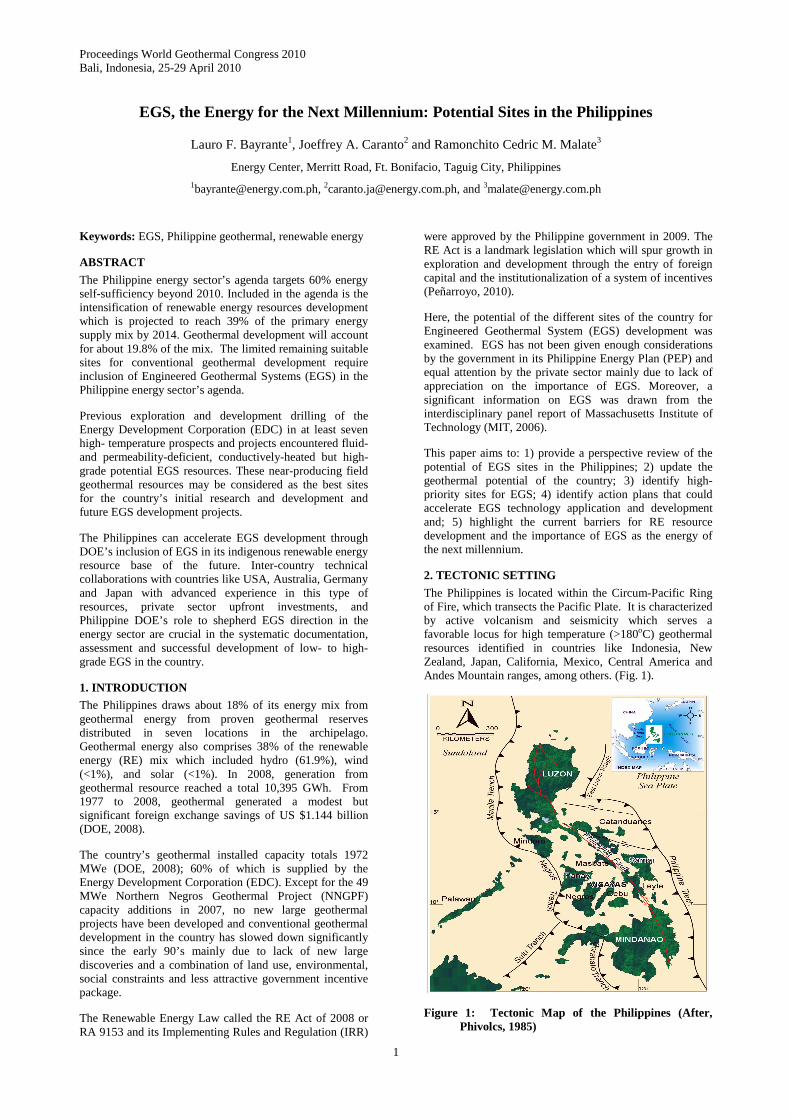
The Philippines is located within the Circum-Pacific Ring of Fire, which transects the Pacific Plate. It is characterized by active volcanism and seismicity which serves a favorable locus for high temperature (>180oC) geothermal resources identified in countries like Indonesia, New Zealand, Japan, California, Mexico, Central America and Andes Mountain ranges, among others. (Fig. 1).
Figure 1: Tectonic Map of the Philippines (After, Phivolcs, 1985)

Bayrante et al.
2
The Philippine archipelago is cut by the Philippine Fault (PF), a major strike-slip fault that extends for 1200km from Luzon to Mindanao. The East Luzon Trough (ELT) and the Philippine Trench (PT) system subduct westwards under the archipelago and have formed series of discontinuous volcanic arcs characterized in general by andesite to dacitic active and inactive volcanic edifices. The Manila-Negros-Sulu-Cotabato trench system defines an eastward subduction of the thinned margin of the Eurasian plate (Aurelio, 1994).
3. PHILIPPINE ENERGY PLAN AND RENEWABLE ENERGY OUTLOOK
The Philippine Energy Plan (PEP) aims to attain a sustainable 60% energy sufficiency beyond 2010. This goal is anchored on the successful implementation of the following: 1) accelerating the exploration, development, and utilization of indigenous energy resources (such as oil, gas, coal and renewable energy resources like geothermal, hydro, wind, solar and biomass); 2) intensifying renewable energy resource development; 3) increasing the use of alternative fuels; and 4) enhancing energy efficiency and conservation. The PEP indicated an overall energy and power demand forecast yearly growth rate of 3.3% and 5.2 %, respectively (DOE, 2008). The primary energy supply will comprise of 58% annual average share of indigenous energy and about 42% annual share of imported energy.
4. GEOTHERMAL SITES AND AVAILABLE ESTIMATE
The geothermal potential of the Philippines has been estimated to range from 4537 MWe to 8000 MWe (Malapitan and Reyes, 2000; Stefansson, 1998). Stefansson (1998) gave a total resource estimate of 50,000 MWe based on the assumption that the identified resource is 6.4 times the identified resource. This includes potential RE resources from magmatic systems (i.e. active volcanoes). The previous estimated values by Malapitan and Reyes (1998) are constrained to a large extent by lack of exploration data particularly in Northern Luzon, parts of Visayas and a significant portion in Mindanao with prevailing security, social, environmental and land-use conflicts. As a result the cited values for the various sites are very tentative and in most cases, require reliable resource assessment based on new surface and subsurface data (Fig. 2).
5. GEOTHERMAL RESOURCES AND RESERVES
It is noted here that the use of the term “resource” and “reserve” needs clarification to address the prevailing uncertainties on its usage in the context of Philippine reports. For example, the geothermal in the Philippines is in general quantified on the basis of proven, probable and possible reserves. The proven reserves were based on extensive drilling data, geoscientific assessment and economically recoverable reserves. The probable reserves were based on integrated surface geoscientific studies (i.e. geology, geochemistry and geophysics) and stored heat estimates while the possible reserves included areas with limited surface data. These were called hypothetical or speculative reserves (Malapitan and Reyes, 2000). This classification however, is inadequate in addressing other parameters such as sustainability, legal, social, government factors and level of confidence, among others.
At present no Philippine geothermal code is available which explicitly defines geothermal resource and reserve. The recent classification of geothermal in the RE Act of 2008 as a mineral resource also requires modification of present usage in the Philippine geothermal context. For this
purpose, we have adopted the definition contained in the geothermal code prepared by the Australian Geothermal Energy Group (2008). The code is based closely on the Australian Institute of Mining and Metallurgy, Joint Ore Reserves Committee (JORC). The code is an important document which provides a “methodology for defining, assessing and quantifying and reporting geothermal resources and reserves which will promote transparency, consistency and confidence”. It also covers a minimum set of requirements for reporting of geothermal resources and reserves.
The proposed code has been recognized to be an important document by the International Geothermal Association (IGA). However, the adoption of the code is dependent on the member organization affiliated with IGA. Figure 3 illustrates the relationship of the terms as used in the paper and defined in detail in Annex 1.
Figure 2: Location map of Philippine geothermal resources including power generating projects, drilled and explored sites
Exploration Results
Geothermal Resources Geothermal ReservesIncreasinggeological Inferred
knowledgeand
confidenceIndicated Probable
Measured Proven
Consideration of energy recovery and conversion, economic, marketing, production, environmental, social, legal, and regualtory factors
the modifying factors
Figure 3: Relationship between geothermal resources and geothermal reserves and consideration for modifying factors for reserves. (After Australian Geothermal Energy Group, 2008)
The figure illustrates the relationship between resource and reserve estimates based on the increasing level of

Bayrante et al.
3
geological data and confidence including the varying degrees of technical and economic evaluation. The most significant difference between resource from geothermal reserve is the application of modifying factors such as production, economic, marketing, legal, environmental, land access, social and governmental factors (Australian Geothermal Energy Group, 2008). Such distinction is apt for both conventional and EGS resources and reserves in the Philippines.
Table 1 shows the geothermal reserves and resources of the Philippines based on the cited geothermal code. The data is a modified version of the Philippine geothermal reserves given by Malapitan and Reyes (2000). The data is based on updated geothermal resource (i.e. inferred, indicated and measured) and reserve (i.e. proven and probable) classification. The inferred resources excluded data from Makiling-Banahaw and Tiwi areas. The table included information from surface exploration, resource assessments, drilling and well testing of the various sites by EDC and DOE.
The inferred resources included the data from Cordillera, Sierra Madre and Palawan in Luzon, Central Leyte and Negros in Visayas islands, and greater Mindanao region. This totals about 705 MWe. The indicated and measured resources, is 530 and 115 MWe, respectively. Overall the estimated geothermal resources reached 1,350 MWe. In comparison, the proven and probable reserves are 1910.5 and 370 MWe, respectively. The estimated total resources and reserves is 3719.5 MWe. The figure is lower by 817.5 MWe compared to the 4537 MWe estimated geothermal reserve by Malapitan and Reyes, 2000.
6. SELECTED SITES FOR EGS
Seven potential sites in the country were reviewed where surface exploration, (i.e. geology, geochemistry, geophysics), resource assessment, shallow and deep drilling have been completed. These are distributed in the three major islands: 1) Luzon (3 sites – Daklan, Natib and Bacon-Manito); 2) Visayas (3 sites – Tongonan, Lagunao in Palinpinon, and Cabalian in Southern Leyte), and 3) Mindanao (1 site -Amacan in N. Davao). Figure 4 shows the location of the sites and Table 3 summarizes the data from these sites. Following is a brief description of the selected sites.
6.1 Daklan Prospect, Benguet
The Daklan prospect located in Benguet, Northern Luzon was the site of extensive surface exploration activities between 1979 and 1981 (BED/MOE and Electro-Consult, 1980; KRTA, 1981). The local basement rocks comprised of >1000 m-thick folded sequence of metavolcanics and metasediments of Paleogene age. Overlying the basement is the Early Miocene volcano-sedimentary formation consisting of marine sediments with volcanic intercalations. This volcano-sedimentary formation is overlain by Middle to Late Miocene andesitic to basaltic lava flows and breccias. Late Miocene quartz diorite batholiths and stocks intruded the earlier emplaced units. Sporadic volcanism during the Plio-Pleistocene period developed andesitic to dacitic cones, plugs, and domes that are distributed over the prospect area. Daklan dome, with elevation of 1500mRSL, is a prominent volcanic feature in the prospect area.
Table 1. Summary of Philippine Geothermal Resources and Reserves (revised after Malapitan and Reyes, 2000).
A. GEOTHERMAL RESOURCES I. INFERRED RESOURCES MWe 1 Cordillera Region 15 2 Acupan - Itogon 10 3 Buguias-Tinoc, Benguet 20 4 Batong Buhay 40 5 West Labo 40 6 Mabini 20 7 Mainit-Sadanga 40 8 Cagua-Baua 40 9 Natib 40 10 Biliran 40 11 Central Leyte 50 12 Mahagnao Leyte 20 13 Bato-Lunas 60 14 Mandalagan 50 15 Mt. Malindang 40 16 Lakewood 20 17 Mainit-Surigao 40 18 Mainit-Amacan 40 19 Greater Palawan 10 20 Camiguin Mis. Oriental 10 21 Balatucan, Misamis 40 22 Montelago, Mindoro 20 Sub Total 705 II. INDICATED RESOURCES MWe 1 Kayabon 40 2 Rangas 40 3 Alto Peak 60 4 Mahagnao 20 5 South Lagunao 60 6 Dauin 40 7 Mindanao 100 8 Biliran 40 9 Cabalian 60 10 Labo 50 11 Cagua 20 Sub Total 530 III. MEASURED RESOURCES MWe Natib 20 Mindanao 3 50 Labo 12 Biliran 10 Cabalian 20 Dauin 3 Sub Total 115 Total 1350 The prospect is bounded by a N-S trending Agno River Fault in the west and the Bokod River-Taduyan Creek Fault in the east. These faults demarcate a 5 to 7 km wide and 15- km long graben in the area. A 13-km wide volcano-tectonic depression occupies the center of the prospect and is interpreted to have been developed during the Plio-Pleistocene volcanic episode. This feature is interpreted to control the extent of the hydrothermal system in Daklan.
In 1980-1981, PNOC-EDC drilled 5 deep exploratory wells in Daklan with average depth of 2412m. Among these wells, well DK1 was drilled to probe the preferred central portion of the prospect, while the four deep wells probed the periphery of Daklan dome. Except for DK1, none of the deep wells were flow tested because of their inherent impermeability. Well DK1 was deepened (renamed DK-1A) from its original total depth of 1526m to 2692m to test permeability at depth.

Bayrante et al.
4
Table 2. Updated Philippine Geothermal Reserves (revised after Malapitan and Reyes, 2000).
B. GEOTHERMAL RESERVES I. Proven Reserves (MWe) MWe 1 Makiling-Banahaw, Bulalo, Laguna 458 2 Tiwi, Albay 287 3 Bacon-Manito, Albay/Sorsogon 200 4 Tongonan, Leyte 705 5 Palinpinon (1 & 2) and Nasulo,
Negros Occ. 212.5
6 No. Negros, Negros Occidental 49 7 Mindanao (1 & 2), Mindanao 158 Sub total 2,069.5 II. Probable Reserves (MWe) MWe 1 Maibarara 40 2 Tiwi 40 3 Rangas 40 4 Manito Lowlands, Kayabon 40 5 Leyte 20 -Upper Mahiao 40 - Mahanagdong 40 7 So. Lagunao 40 Sub total 300 Total 2,369.5
Figure 4: Location map of selected high-priority EGS sites in the Philippines. Three sites are adjacent to currently operating geothermal fields of Bacon-Manito, Tongonan and Palinpinon fields
Table 3. Selected EGS Site Summary
Depth Temp (°C) PERMEABLE ZONES (m) Project Location
Well Name mMD Measured Major Minor
Injectivity Index
(l/s/Mpa)
Transmissivity (dm)
Reservoir Rock
1. Daklan DK-1A 2692 293 No dataNo data No data No data 1.31 0.38 Paleogene metamorphics and volcanics
NA-1D 2751 280 1950 2050 5.60 No Data 2. Natib
NA-2D 2916 270 2447 2686 5.40 No Data
andesite/dacite intruded by micro diorite/diorite dikes
3. Bacon-Manito
PAL17D 2590 280 ND ND 1400 1500 16.60 0.60
andesite, microdio) with silstone, sandstone, claystone and limestone
IR6D 2942 226 ND ND ND ND ND No Data 4. Leyte , Tongonan 1 IR7D 2903 257 2500 2600 1350/2650 1450/2750 19.00 No Data
andesite with minor sedimentary lenses
505D 2658 270 1400 1550 1150 1350 22.00 0.40 5. Leyte-Malitbog 516D 2785 280 2056 2189
1235/1506/ 1690
1325/1598 /1782
11.10 2.60
andesite with microdiorite dikes/intrusives
MG1RD 2552 210 ND ND 1975/2375 2025/2425 9.80 No Data 6. Leyte-Mahanagdong MG-4RD 1399 160 968 1093 1293 1343 ND No Data
sedimentary formation
SL-1D 2710 240 2000 2400 1915 2000 2.80 0.20 Tertiary sediments 7. Southern Leyte SL-3D 3012 170 ND ND 2540 2620 3.30 0.30
Tertiary sediments and intrusives
8. Southern Negros- Lagunao
OK11D 3000 242 2700 2818 1600/2000 1700/2150 9.70 0.20 encountered quartrz diorite/ monzonite
9. North Davao/Amacan
AM-1 2700 265 1400 1800 2200 2700 3.30 No PFO encountered quartz diorite

Bayrante et al.
5
The result of the exploratory drilling thus confirmed high temperature at depth. Downhole temperature surveys indicate the highest temperature of ≈293°C at 2400m in DK1A. Due to poor permeability and scaling potential, development in the prospect was shelved in favor of other more promising areas in the country.
6.2 Natib Prospect, Bataan
The Natib prospect is located within a strato-volcanic complex called Mt. Natib (Fig. 4) consisting of a series of volcanic edifices that erupted andesitic and basaltic lava flows and breccias, largely of calc-alkaline affinity. These volcanic centers are characterized by central caldera/collapse structure with post-caldera volcanic vents along a ring fault system.
Surface geological, geochemical and geophysical surveys were conducted by PNOC-EDC over an area of 450 km2 in 1987. Geological evidences indicate the existence of an active geothermal system within the Mt. Natib caldera. The Natib caldera is a well-defined volcanic feature consisting of an arcuate structure about 7.5-km from north to south and 5.5-km from east to west. Faulting in Mt. Natib is dominantly defined by NW-SE and E-W directions, and less significantly in the NE-SW direction. These are mostly gravity faults with steep dips ranging from 75-90°. In general, the thermal manifestations are closely associated with the NW-SE and E-W trending faults located within the caldera.
The most impressive thermal features are distributed over a 23 km2 area within the Natib caldera suggesting that hydrothermal fluids circulate within a large area of the prospect. Thermal springs consisted of secondary neutral to slightly alkaline SO4-HCO3-Cl and HCO3-Cl types. Silica and alkali cation geothermometers predict source temperatures of 168-189°C. In addition, chloride-enthalpy plot suggests aquifer fluids with a minimum temperature of 210°C and Cl of 4000 mg/kg.
Schlumberger resistivity traversing and vertical electrical sounding surveys detected a conductive body closely related to the alteration and weathering of andesites belonging to the Natib volcanics. The low resistivity anomaly based on iso-resistivity maps were interpreted in the earlier surveys to merely reflect the configuration of the Natib caldera and the distribution of thermal areas
To test the potential of the inferred resource, two deep, directional exploratory wells were then drilled within the Natib caldera from January to July 1989 to probe the subsurface temperatures, permeability, fluid composition and viability of the geothermal resource. Both wells were deviated towards the southwest, targeting NW-SE and E-W trending faults. Well NA-1D was completed down to 2751m, while NA-2D was drilled down to 2916m. Well NA-1D has a maximum measured temperature of ~280°C at 2780m, while NA-2D gave a lower temperature of ~270°C at 2900m. The wellheads are spaced by 1.55 km, while their bottoms are separated by 1.85-km from each other.
6.3 The Bacon-Manito Geothermal
Well Pal-17D was drilled within the Bacon-Manito Geothermal Field (BGPF) in 1991. BGPF is located about 500 km southeast of Manila (Fig. 4). The field is presently producing 110 MWe from its Palayang Bayan sector (BacMan-1) and 20 MWe each from Cawayan and Botong Sectors (BacMan -2).
Pal 17D, was spudded from pad Y and was deviated N85°E toward northern side of Pangas dome. It reached a total depth of 2590m and attained an average drift angle of 32°. The well encountered 1530m-thick Pocdol Volcanic Formation (PVF) and 1030-m section of Gayong Sedimentary Formation. The intrusive units called the Cawayan Intrusive Complex units intruded both formations. Measured temperature at 1900 (2003 survey) was 280°C. The well is currently being used as a monitor well for resource management purposes. The well has an injectivity index of 16.6 li-sec/Mpa and transmissivity of 0.60 dm.
6.4 Leyte Geothermal Production Field
The Leyte Geothermal Production Field (LGPF) is located within Ormoc City and Municipality of Kananga (Fig. 4). LGPF is the Philippines’ biggest geothermal project with a present installed capacity of 705 MWe.
The field is situated within the en-echelon and pull-apart features of the strike-slip Philippine Fault (Aurelio et al., 1994). The PF and its related structures serve as the main source of primary permeability and dominantly control the production zones within LGPF . However, certain portions of the field such as the Malitbog, Mahiao and Mahanagdong are characterized by less-permeable wells. This may be attributed to the anisotropic character in certain section of the fault and the formation within the area. The selected sites with potential for EGS development are briefly described below.
6.4.1 Tongonan Well 1R6D
Well 1R6D was drilled in 1989 within the Lower Mahiao sector of LGPF. It was the first well that was directed toward the West Fault Line, one of the main branches of the Philippine Fault that defines the western side of the Bao pull-apart basin structure. The well reached a total depth of 2942m.
The Bao Volcanics (BV) was intersected throughout the well with minor sedimentary lenses. The well did not encounter circulation losses during drilling. Downhole surveys conducted in 1990 showed a temperature of 226°C at main clear depth of 2942m.
6.4.2 Tongonan Well 1R7D
Well 1R7D was drilled in 1989 from the same pad, as well 1R6D but was directed towards the south within the inferred Mahiao graben. The well reached a total depth of 2903m and a maximum drift angle of 43°. Despite the presence of losses during drilling the well has low injectivity index of 19 li/s-Mpa with high WHP of 6.7 MPag. The well encountered similar formation as well 1R6D. The Bao Volcanics formation was penetrated throughout the drilled intercept with minor intercalation of sedimentary lenses. A 1990 downhole survey recorded a maximum temperature of 257°C at a depth of 2750m.
6.4.3 Malitbog Well 505D
In 1980 well 505D was drilled from Pad 505 of Malitbog sector of LGPF, down to a total depth of 2658m.
The Bao Volcanics was encountered throughout the well, with dikes/intrusives occurring between 1530m down to TD. Based on alteration mineralogy, the well’s predicted temperature was 280°C from 1423m to total depth. Completion test yielded an injectivity index of 22 li/s-Mpa with no major losses encountered during drilling. Downhole temperature/pressure surveys in 1998 showed an increasing temperature profile, with measured bottom hole temperature of 270°C. Five attempts were made to
Bayrante et al.
6
discharge the well but all were unsuccessful. Maximum measured temperature after the discharge attempts were constant at 270°C.
6.4.4 Malitbog Well 516D
Well 516D was drilled from the same pad as 505D in 1982. It was deviated N44°W, and reached a TD of 2796m with a maximum drift angle of 50°.
The well was drilled blind from 2220mMD to TD, but yielded a low injectivity index of only 11 li/s-MPa. The well intersected the Bao Volcanic formation from the surface down to 2200m, while a micro diorite unit was observed down to TD. The well has a blockage at 1700m and recent downhole surveys of the well indicated a temperature of 280°C above the blockage depth.
6.4.5 Mahanagdong Well MG1RD
Well MG-1RD was drilled in 1992 on Pad RE of Mahanagdong sector of LGPF with an azimuth of 295°. It reached a total depth of 2552m and achieved a drift angle of 45°. No drilling losses were encountered; thus the measured injectivity index was low at 9.8 li-s/Mpa.
The well encountered the Mamban Volcanics formation from surface to 618m MD, while the Mahiao Sedimentary Formation persisted below 618 m down to total depth. Recent, neutral-pH alteration assemblages suggest a fluid temperature of 185°C, while a bottom hole temperature of 210°C was measured during the 1996 downhole surveys.
6.4.6 Mahanagdong Well MG4RD
Well MG-4RD is the fourth injection well drilled on Pad RE in Mahanagdong sector in 1994. It reached a total depth of 1399m , with an azimuth of 318.5°. The well was completed with maximum drift angle of 46°. Completion tests result gave injectivity index of 70-76 li/s-MPa at 8MPa wellhead pressure. The well’s stratigraphy is rather different from MG1RD. The Mahanagdong Volcanics occurred from surface to 178m and underlain by the Mamban Formation from 178-743m. The Bao Volcano-Sedimentary Formation (BVSF) at 743-1043m); and Mahiao Sedimentary Formation (MSF) from1043m to TD. Predicted temperature based on alteration mineralogy was 180-200°C, while a 1994 KT-KP survey measured only 160°C its bottom hole.
6.5 Southern Leyte Prospect
The Southern Leyte Geothermal Prospect (SLGP) is located at the southeastern tip of Leyte Island (Fig. 4). Mts. Cabalian and Cantoyocdoc comprised the Quaternary strato-volcanoes in the area.
Initial surface exploration studies were done in Mt. Cabalian area by Bureau of Energy Development (BED) and Electroconsult of Italy (ELC) in 1979. An inventory of thermal springs yielded an estimated reservoir temperature of 221°C based on chemical geothermometry (BED-ELC, 1979).
SL-1D was drilled first exploratory well drilled in 1997 on the eastern flanks of Mt. Cabalian. It encountered a maximum temperature of 240°C at -1870m RSL but with poor permeability. It has a calculated injectivity and transmissivity indexes of 2.8 l/s/.Mpa and 0.20 dm, respectively.
Well SL-3D was drilled in 2007 from Site D and targeted northwest to probe the northern part of a resistivity anomaly delineated by MT survey. Well SL-3D was completed on
21 June 2007 down to a total depth of 3012 m MD. SL-3D encountered poor permeability and low temperatures. Its injectivity index is 3.3 l/s/Mpa and transmissivity of 0.30 dm. Apart from being impermeable, well SL-3D reached the maximum temperature which is projected to be ~170°C at well bottom.
6.6 South Lagunao, Negros Oriental
South Lagunao area is located within the Southern Negros Geothermal Field (SNGPF). The field is located near the southern tip of Negros Island, Central Philippines. It is further sub-divided into two geographical areas called Palinpinon 1 and Palinpinon 2. The former sector has an installed capacity of 112.5 MWe which was commissioned in 1983. On the other hand, Palinpinon 2 is comprised of Balas-balas (20 MWe), Nasuji (20 MWe) and Sogongon (20 MWe). These modular plants were commissioned in December 1993, June 1994 and January 1995, respectively.
The entire Southern Negros Geothermal Field is essentially a liquid-dominated, high-temperature geothermal system. It is situated at the northern flank of a dormant Quaternary andesite volcano called Cuernos de Negros. Based on surface and drill hole data, the field is underlain by a suite of volcanic, sedimentary and intrusive rocks ranging in age from Miocene to Pliocene in age (Aniceto-Villarosa et al., 1988). Younger Pleistocene to Recent formation is mapped outside the drilled area.
Permeability in the field is generally related to numerous steeply dipping faults and majority of the production zones are directly associated with mapped fault structures. Minor permeability have also been recognized from lithologic contact, dike intrusions and through primary porosity within the volcaniclastics.
Well OK-11D, is one the production wells drilled within Nasuji Sector of Palinpinon 2. It was drilled in 1981 as delineation well to probe the southwest region of the sector. It reached a depth of 3000m and is one of the earlier deep wells that drilled into the Nasuji Pluton of SNGPF. The well drilled through the basal member of the Cuernos Volcanics from surface down to 180m. Beneath the basal member of Cuernos Volcanics is the 1879m-thick Southern Negros Formation consisting of silicified and rarely chloritized andesite breccias and tuff. A young holocrystalline quartz diorite/monzonite was penetrated below 2060 down to TD. The contact between SNF and the pluton is characterized by a metamorphic/hornfelsic aureole.
OK-11D has a recorded downhole temperature of 242oC and an injectivity index of 9.7 li/sec/Mpa. A higher temperature of 250 to 280oC is indicated by the hydrothermal alteration assemblage from representative core samples (Seastres, 1981; Reyes, 1981).
6.7 Amacan/North Davao Prospect
The Amacan prospect or North Davao prospect is located in the province of Davao del Norte in southeastern Mindanao. The prospect is characterized by impressive thermal manifestations including fumaroles, solfataras and hot springs that are widely distributed. The prospect is located within the southern trace of the Philippine fault system, which is bounded on both sides by the Hijo and Agusan Faults.
Voluminous data had been gathered in the Amacan geothermal prospect starting 1975 to 1985. The scientific and drilling investigations conducted were: 1) Geoscientific

Bayrante et al.
7
studies consisting of reconnaissance geological studies, heat flow measurements, geochemical and geophysical surveys by National Power Corporation (1975); 2) Drilling of 13 temperature gradient holes (1977); 3) Drilling of three medium-depth (ranging from 919-1067m) exploratory wells (Panibasan-1, Manat-1 and Manat-2) based on dipole-dipole survey (1978); 4)Drilling of more TGH wells (14-21), SRT and VES surveys, and geochemical analyses (1980-1982).
The scientific studies culminated in the drilling of a deep exploratory well at Amacan (AM-1) to a depth of 2700 in 1982. The deep well AM-1 in Amacan sector encountered high measured temperature of 265ºC at 2700m and temperature could be up to 300ºC based on various chemical geothermometers. The well had low permeability and was not able to sustain commercial discharge. It has a calculated injectivity index of 3.3 l/s/Mpa.
7. ASPECTS OF EGS SITES IN THE PHILIPPINES
As described above, the selected potential EGS sites in the Philippines exhibit some differences when compared to the well-studied EGS sites worldwide. Most explored EGS resources are hosted by moderate- to high-temperature crystalline granites (e.g. Fenton Hill, USA; Rosemanowes, United Kingdom, Cooper Basin, Australia and Le Mayet de Montagne, France). The typical reservoir rocks encountered in drilled sites in the Philippines comprised of permeability-deficient Paleogene to Neogene sedimentary sequences intruded by dykes consisting of microdiorite, diorite, or monzonite (e.g Natib, Bacon-Manito, Tongonan and Cabalian). These reservoir rocks are comparable with those encountered in Ogachi and Hijori Sites in Japan and Horstberg in Germany. Two sites however, encountered diorite plutons (e.g Amacan and S. Lagunao).
The second characteristic of the EGS sites their proximity to the trace of the Philippine Fault and its associated conjugate. Completion tests revealed that the wells exhibit two to three distinct, potential productions but permeability-deficient zones as indicated by its very low injectivity index which generally range from 2.8 to 16.6 l/s/Mpa and transmissivity values of 0.20 to 5.8 dm.
The third characteristic of the studied sites is its moderate- to high- temperatures with measured temperature of 170oC (SL-3D) to 293oC (DK-1). Relative to the existing operating geothermal fields, the EGS sites are near-field sites and may be considered as contiguous to the main resource of existing operating fields (e.g. Bacon-Manito, Tongonan and S. Negros).
Finally, the sites are characterized by high temperatures at moderate depths of about 1400m to 3000m. This is relatively shallow compared with other explored and being developed EGS sites in Basel, Switzerland (5000m) and Fenton Hill, USA (4390m). Thus, investment costs of conducting RD and D in these Philippine sites should be lower.
8. CURRENT BARRIERS TO GEOTHERMAL AND OTHER RE RESOURCES DEVELOPMENT
The critical role and contribution of RE resources including geothermal in addressing energy security and environmental issues like climate change, global warming and pollution is recognized worldwide (Fridleifsson, et al., 2008). In the Philippines, such role and contribution had been amplified and given in-depth analysis during the 2008 Philippine Energy summit. Likewise, the summit has identified concrete action plans on power cost management,
conventional energy exploration, renewable energy development, energy efficiency promotion and oil price management (DOE, 2008).
The participants during the summit, including the authors, have identified several barriers to RE resource development: 1) lack of regulatory framework and government policy direction; 2) market and financial and; 3) technology barriers.
In the geothermal front, the lack of foreign investments, lack of attractive financial incentives and need for credit rating of local electric cooperatives are significant barriers that hamper if not, derail exploration and development efforts. In addition, high upfront cost of geothermal resource exploration and development led to stunted geothermal resource development since early 90’s. Other barriers that are equally significant but were given less emphasis are: 1) protracted delays in the issuance of contracts, approvals, permits, certificates, and clearances from relevant government agencies; 2) prevailing land-use conflicts between energy developers and other stakeholders; 3) social acceptance and unfounded concerns regarding geothermal exploration and development and; 4) sporadic and unpredictable peace and order situation coupled with unresolved socio-political and ethnic disputes particularly in greater Mindanao region. This may also explain the observed lack of new large geothermal development in the country for over a decade.
The recent approval of the Renewable Act of 2008 or RA 9153 in January 2009 and the signing of its Implementation Rules and Regulations (IRR) in June 2009 is expected to address some, if not most of the barriers cited earlier. Republic Act No. 9153 is an act promoting the development, utilization and commercialization of renewable energy resources and for other uses. The Law is expected to spur growth in the exploration and development of RE resources, including among others geothermal, wind, solar, biomass and hydro through the entry of foreign capital and the institutionalization of a system of incentives.
DISCUSSIONS
The Philippine government target of 60% energy-sufficiency beyond 2010 would seem unrealistic, bold, and unattainable. For the geothermal scenario for example, although the total identified geothermal resources is conservatively given in this report to about 1,350 MWe with extreme optimistic estimates of about 8,000 MWe, the 699 MWe indicative targets cited in the 2007-2014 Philippine Energy Plan are unsupported. This is borne by the fact that about 45 % or 9 out of the 20 indicated sites still require the conduct of exploration drilling, resource assessment and detailed feasibility studies. These areas include: Batong-Buhay, Buguias, Daklan, Baua, Mandalagan, Lakewood, Amacan, SE and NW Apo. In addition, except for Batong-Buhay, all sites are yet to be offered in the Philippine Energy Contracting Round (PECR) which is often characterized in the past by protracted delays in the issuance of service contracts. Thus, the typical 5-year or even the fast-tracked 2 to 3-year gestation period from exploration to power plant commissioning may be expected to exceed the indicative target commissioning.
An updated inventory of the potential sites for development in Cordillera, Sierra Madre and other areas in Luzon, Visayas and Mindanao islands has been provided. These areas include selected high potential EGS sites near conventional operating geothermal projects of the Energy

Bayrante et al.
8
Development Corporation (EDC). The lack of deep well data from the other identified sites requires new initiatives and attention from DOE and the PNOC Renewable Corporation, a new subsidiary of Philippine National Oil Company (PNOC). EGS and low-enthalpy resources may be considered “emerging” RE resources and technologies in the Philippines. These therefore, deserve earnest consideration and attention from the government and private investors to beef up and realistically achieve the government 60% energy sufficiency target.
Along this framework, the following initiatives should be pursued: 1) establishment of an EGS technology road map for research, pilot-study, commercialization in collaboration with countries with advanced knowledge and experience such as USA, Japan ,Australia, Germany and France; 2) systematic mapping and database development of all EGS sites; 3) identification and provision for EGS R and D project funding; 4) future amendment of RA9153 to include EGS under emerging RE resources and technologies and; 5) initiate immediate R and D among the high-grade potential sites pinpointed in this paper. The Philippine’s leading experience in conventional geothermal development and the strategic location of these sites to the operating fields can open opportunities in EGS development and at the same time complement the resource management of the existing fields. For example, the spent brine from the producing fields may be used to run the EGS sites.
CONCLUSIONS
The potential of EGS resources in the Philippines as an emerging resource and technology option in its RE portfolio is promising. Results of the regional identification demonstrate that several sites offer opportunity for EGS exploration and development.
The current potential of yet to be explored and developed geothermal resources of about 1,350 MWe which include the inferred, indicated, and measured resources may be used as basis by the government in preparing the updated PEP’s. A systematic and sustained exploration and resource assessment program of all sites with inferred resources is necessary to provide higher degree of confidence in preparing the indicative power development program of the country. The resulting information can significantly refine these data and the funding requirement of these geothermal projects.
We have taken the initial steps in identifying several high-grade EGS sites from Luzon to Mindanao. These near- and edge-field EGS-sites in Leyte and Negros, together with the separate exploration sites, are high-priority sites that may be assessed by existing RE service contract holders and by new geothermal industry players in the country. The success in developing some areas would depend to a large extent in hurdling the technical, financial, market and environmental barriers and challenges in the development of RE, resources including geothermal. The passage of the RA 9153 and its IRR in 2009 is an important milestone in the Philippine energy program and this is expected to address and accelerate the exploration, development and commercialization of this type of resource.
EGS potential resources may be considered as a high potential RE resource in the next millennium in the Philippines. Its exploration and subsequent development would depend upon its demonstration as an alternative and reliable RE resource base. Thus, the crafting of a technology road map is a critical action plan that was
agreed upon during the 2008 Philippine Energy summit. This action plan should be earnestly pursued by the government in cooperation with the RE stakeholders.
ACKNOWLEDGEMENT
We thank the management of Energy Development Corporation for allowing the publication of this paper.
REFERENCES
Aniceto-Villarosa, H.G., E.L. Bueza, A.G. Reyes, and M.C. Zaide-Delfin: The Subsurface Geology and Alteration Mineralogy of the Nasuji-Songonan Sector, Southern Negros Geothermal Field,(1988), PNOC-EDC Unpub Rpt.
Australian Geothermal Energy Group. Geothermal Code Committee: Guidelines for the Geothermal Resources and Reserves Reporting Definition and Reporting, (2008), 36p
Aurelio, M.A., P. Huchon, E. Barrier, and R. Gaulan: Displacement rates along the Philippine Fault Estimated from Slip Vectors and Regional Kinematics. J. Geol. Soc., of the Philippines , vol. 49, no. 2, (1994), pp. 63-78.
Bayon, F.E.B.: Daklan Geochemistry Review, PNOC-EDC Unpub. Rpt, (1998), 8p.
Bureau of Energy Development / Ministry of Energy and ELC-Electro Consult, S. P. A.: Philippine-Italian Technical Cooperation on Geothermics, Stage 3. Pre-feasibility study of Daklan-Bokod (Benguet Province) Annex 1 – geological report. Ministry Unpub. Rpt, (1980).
Delfin, F.G. Jr., D.B. Layugan, A.G. Reyes, T.V. Padilla, and J.M.R. Salera: Mindanao Geothermal project. Surface Exploration Deep Drilling and Preliminary Resource Estimate. J. Geol. Soc., of the Philippines, vol. XLVII, No. 3-8 (1992), 107-119.
Del Rosario, R.A., M.S. Pastor and R.T. Malapitan: Controlled Source Magnetotelluric (CSMT) Survey of Malabuyoc Thermal Prospect, Malabuyoc / Alegria, Cebu, Philippines. Proc. World Geothermal Congress, (2005), Antalya, Turkey, 10p.
DOE: Philippines Energy Plan, 2007-2014. Fuelling Philippine Development Through Greater Access to Energy: Republic, Philippine Department of Energy Report, (2008), 144p.
DOE: Philippines Energy Summit Summary Report, (2008), Philippines Department of Energy Report, 168p.
Duquesnoy, Th., E. Barrier, M. Kasser, M. A. Aurelio, R. Gaulon, R.S. Punongbayan, C. Rangin and The French and Philippine Cooperation Team: Detection of Creep Along the Philippine Fault, First Result of Geodetic Measurement on Leyte Island, Central Philippines. Geophys. Res. Letters, vol. 21, no. 11, (1994), 973-978.
Fridleifsson, I. B., R. Bertani, E. Huenges, J. W. Lund, A. Ragnarsson, and L. Ryback: The Possible Role and Contribution of Geothermal to the Mitigation of Climate Change. IPPC Geothermal 11, (February 2008), 36 p.
Malapitan, R.T., and A.N. Reyes: Thermal Areas of the Philippines, Proc. World Geothermal Congress, (2000), Kyushu/ Tohuku, Japan, 1395-1400.

Bayrante et al.
9
MIT: The Future of Geothermal Energy. Input of Enhanced Geothermal System (EGS) in the United States in the 21st century, (2006), Prepared under Idaho National Laboratory Sub Contract No. 6300019 for US DOE.
Pastor, M.S., R.A. del Rosario, R.E. Papasin: Geothermal Potential of the Cordillera Region, Philippines, Proc., World Geothermal Congress (2005). Antalya, Turkey, 1-9.
Peñarroyo, Fernando S. : Renewable Act of 2008: Legal and Fiscal Implications to Philippine Geothermal Exploration and Development, Proc., World Geothermal Congress, (2010)., Bali Indonesia.
Pioquinto, W.C.P., J.A. Caranto, R.D. Leynes and J.B. Rosell: North Davao Geothermal Prospect, Geologic Framework and Fault Set Analysis, (1997), EDC, Unpub. Rpt, 59p.
PHIVOLCS: Distribution of Active and Inactive Volcanoes and the Different Tectonic Features of the Philippines, (1985).
Republic Act No. 951: An Act Promoting the Development, Utilization and Commercialization of Renewable Energy Resources and for Other Purposes, Congress of the Republic of the Philippines, (2008).
Reyes, A.G.: Petrological Analysis of OK-11D, Cores and Cuttings, PNOC-EDC Unpub. Rpt, (1981), 17p.
Stefansson, Valgardur: Estimate of the World Geothermal Potential, 20th Anniversary Workshop, (1998), UNU, Geothermal Training Program, Reykjavik, Iceland, 111-120.
Seastres, J.S. Jr.: Preliminary Downhole Geology of OK11D, PNOC-EDC, Unpub. Rpt. (1981), 12p.

Bayrante et al.
10
ANNEX A. PROPOSED NOMENCLATURE BASED ON THE AUSTRALIAN GEOTHERMAL ENERGY GROUP (2008)
A “Geothermal Play” is used as a general informal descriptor for an accumulation of heat energy within the Earth’s crust. It can apply to heat contained in rock and/or fluid. It has no connotations as to permeability or the recoverability of the energy. It does not necessarily imply the existence of a Geothermal Resource or Reserve.
A ‘Geothermal Resource’ is a Geothermal Play which exists in such a form, quality and quantity that there are reasonable prospects for eventual economic extraction.
An ‘Inferred Geothermal Resource’ is that part of a Geothermal Resource for which thermal energy in place can be estimated only with a low level of confidence.
An ‘Indicated Geothermal Resource’ is that part of a Geothermal Resource which has been demonstrated to exist through direct measurements that indicate temperature and dimensions so that the thermal energy in place can be estimated with a reasonable level of confidence.
A ‘Measured Geothermal Resource’ is that part of a Geothermal Resource for which thermal energy in place can
be estimated with a high level of confidence. It may also optionally be reported as recoverable thermal energy or assumed electricity generation with assumptions and rate of energy recovery stated
A ‘Geothermal Reserve’ is that portion of an Indicated or Measured Geothermal Resource which is deemed to be economically recoverable after the consideration of both the resource parameters and Modifying Factors.
A ‘Probable Geothermal Reserve’ is the economically recoverable part of an Indicated Geothermal Resource. It will differ from Proven Reserves because of greater uncertainty, usually in terms of factors that impact the recoverability of thermal energy such as well deliverability or longevity of the project.
A ‘Proven Geothermal Reserve’ is the economically recoverable part of a Measured Geothermal Resource. It includes a drilled and tested volume of rock within which well deliverability has been demonstrated and commercial production for the assumed lifetime of the project can be forecast with a high degree of confidence.
The term ‘Modifying Factors’ is defined to include energy recovery and conversion, production, economic, marketing, environmental, social, legal, land access, regulatory factors.
Related Documents