FOR AGRICULTURE EGNOS in Precision Agriculture: An affordable solution for a wide range of applications IATRC Symposium Sevilla, 3 June 2013 Carmen Aguilera European GNSS Agency (GSA)

Welcome message from author
This document is posted to help you gain knowledge. Please leave a comment to let me know what you think about it! Share it to your friends and learn new things together.
Transcript

FOR AGRICULTURE
EGNOS in Precision Agriculture:
An affordable solution for a wide range of applications
IATRC Symposium
Sevilla, 3 June 2013
Carmen Aguilera
European GNSS Agency (GSA)
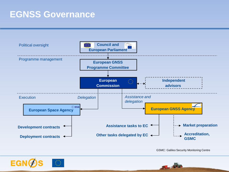
EGNSS Governance
European
Commission
Development contracts
Political oversight
Programme management
Delegation
Council and
European Parliament
European GNSS
Programme Committee
Execution
European
Commission Independent
advisors
European GNSS Agency European Space Agency
Assistance and
delegation
Deployment contracts
Assistance tasks to EC
Other tasks delegated by EC
Market preparation
Accreditation,
GSMC
GSMC: Galileo Security Monitoring Centre

• Satellite Based Augmentation System (SBAS)
• Measures and improved GPS performance
• Sends corrections to users via satellite or
terrestrial links (EDAS)
• Certified for Safety Of Life since March 2011
• Covers most of EU
• Expansion to Africa, Middle East and Eastern
Europe
• Global Navigation Satellite
Systems (GNSS)
• Compatible with most other GNSS
• Inter-operable with GPS
• 2 first satellites launched in October 2011
• 18 satellites in 2014/15
• Will support 5 services
The European Satellite Programme:
EGNOS/EDAS and Galileo
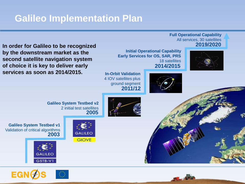
Galileo System Testbed v1
Validation of critical algorithms
Galileo System Testbed v2
2 initial test satellites
In-Orbit Validation
4 IOV satellites plus
ground segment
Initial Operational Capability
Early Services for OS, SAR, PRS
18 satellites
2003
2005
2011/12
2014/2015
Full Operational Capability
All services, 30 satellites
2019/2020 In order for Galileo to be recognized
by the downstream market as the
second satellite navigation system
of choice it is key to deliver early
services as soon as 2014/2015.
Galileo Implementation Plan

The Galileo implementation plan
launches are under way
The launch of the first two Galileo
IOV (In-Orbit Validation) satellites
took place in October 2011 from
Kourou, in French Guiana.
Second pair followed October 2012.
These satellites are part of the
Galileo final constellation.
10 9 8 7 6 5 4 3 2 1 Launch
http://www.youtube.com/watch?v=lbnie1dt-Gs

12 June, 2013 The European GNSS Programmes
6
LEO
Note: Only major centres, facilities and stations in view are shown. Not all of them are (fully) implemented yet.
GCC
GCC
GCC
PRS
PRS
PRS
GSA
The major Galileo centres and facilities are
located throughout Europe
SAR
GSA
IOT
LEO
LEO
Darmstadt
Prague
Oberpfaffenhofen
Fucino
Toulouse
Torrejon
Swanwick
Redu
St Germain-en-Laye
European GNSS Agency
Galileo Control Centre
Galileo In-Orbit Testing Centre
LEOP Centre
Galileo Security Centre (PRS)
Galileo Service Centre (OS/CS/SoL)
GSA
IOT
Brussels

Fucino (IT)
Oberpfaffenhofen (DE)
Credits: ESA
Galileo IOV Control Centres operational

Kiruna Galileo TTC Site Completed (Nov 2007)
Svalbard Galileo ULS/GSS Site Completed (May 2008) Credits: ESA
Galileo IOV ground segment sites completed

• Satellite Based Augmentation System (SBAS)
• Measures and improved GPS performance
• Sends corrections to users via satellite or
terrestrial links (EDAS)
• Certified for Safety Of Life since March 2011
• Covers most of EU
• Expansion to Africa, Middle East and Eastern
Europe
• Global Navigation Satellite
Systems (GNSS)
• Compatible with most other GNSS
• Inter-operable with GPS
• 4 first satellites launched
• 18 satellites in 2014/15
• Will support 5 services
The European Satellite Programme:
EGNOS/EDAS and Galileo

EGNOS, it’s there. Use it!
EGNOS, it’s there. Use it.
EGNOS availability
• EGNOS is the European
Geostationary Navigation Overlay
Service
• EGNOS improves the accuracy of
position measurements by sending
out signals that correct GPS data and
providing information on its reliability
• EGNOS signal is free and already
widely used in agriculture

Ranging and Integrity
Monitoring Stations
(RIMS)
… receive GPS data
and send it to MCC …
2
Mission Control Centres (MCC)
… process GPS data to
determine errors …
3
GPS Constellation 1
3 geostationary EGNOS Satellites
… relay error corrections to users
5
EGNOS position accuracy
GPS position accuracy Navigation Land Earth
Stations (NLES)
… uplink error
corrections to
EGNOS satellites …
4
EGNOS improves GPS

End users
User-
specific
information
Value-
added
service
provider
EDAS on the way – Plug in for free
EDAS is available. This allows any interested party is invited to sign up
Currently the evolution of EDAS is assessed including service and system enhancements
http://www.gsa.europa.eu/go/egnos/edas
EGNOS data (real-
time): • RIMS raw observations
• SBAS messages
The EDAS Service is operational to plug in on
EGNOS data via terrestrial channels (internet)

Why Precision Agriculture?
Agriculture challenges:
– Rise in crops demand:
Population increase
Chemical industry
diversification
Bio-fuel demand
– Limited resources
Limited increase of the
cultivable land
Water shortage
Energy prizes rise
Precision Agriculture has an
answer:
– Provides:
Increase yield production
Better management of
resources
– Reduces:
• Chemical pollution
• Energy consumption
• Time

Application
category Application field
Required
accuracy
level
Arable
High-value crop cultivation (potatoes, vegetables)
Precision operations (sowing and transplanting) c.2cm
Low-value crop cultivation (e.g. cereals)
Low-accuracy operations (fertilising and reaping) c.1m
Dairy Individual livestock positioning and virtual fencing 2-5m
Agro-logistic
Land parcel identification/ geo-traceability
Post harvest pick-up
Supervised tracking of livestock, manure, etc.
c.2.5m
Legislation/
management
Field measurement
Boundary mapping and updating c.2.5m
EGNOS: the most affordable solution for a wide range of applications…
“Precision Agriculture is
about doing the right thing,
in the right place, in the
right way, at the right time” EGNOS
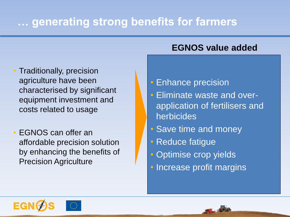
… generating strong benefits for farmers
• Traditionally, precision
agriculture have been
characterised by significant
equipment investment and
costs related to usage
• EGNOS can offer an
affordable precision solution
by enhancing the benefits of
Precision Agriculture
• Enhance precision
• Eliminate waste and over-
application of fertilisers and
herbicides
• Save time and money
• Reduce fatigue
• Optimise crop yields
• Increase profit margins
EGNOS value added

(100.000)
(50.000)
-
50.000
100.000
150.000
200.000
250.000
300.000
350.000
400.000
1 101 201 301 401 501 601
NPV per technology and farm’s hectares:
The case of durum wheat
Example for Durum Wheat
Net present value per
technology and hectare
Hectares
€ EGNOS
DGPS
RTK
EGNOS
17
DGPS
35
RTK
97
NPV>0
(HA) Source: GSA CBA

17
No installation costs neither annual subscription costs
are required
EGNOS is the best GNSS technology to be applied on a 16 HA farm
on average European farms are 16 HA wide
EGNOS is free
EGNOS is widely
available all over Europe
EGNOS is convenient
1 on 10 tractors in Europe are equipped today with
GNSS receivers, most of them are EGNOS enabled
The application of EGNOS involves:
• 2,36% reduction in time, fuel and seed quantity
• 2,49% reduction in fertilize and Plant Production
Products quantities
A practical example

CO-PILOT TS MOJO MINI
EZ-GUIDE 250
Pass to pass accuracy of +/- 15 cm
EGNOS-only corrections
Ideal for fertilising, seeding and spraying
Entry price, affordable for all farmers
Product characteristics
“EGNOS-only” entry products have taken a
pivotal role
They start with EGNOS
They appreciate the benefits
In few years, some of them, migrate to
advanced systems to cover new
functions
EGNOS effect on farmers
EZ-GUIDE 250

R&D fill technical gaps and pave the way to
adoption in High Precision…
Works on system to support in-field and inter-field agricultural
logistics activities
Sets up a user forum to present and defend the needs of
farmers in the development of GNSS applications and services
...and get ready for Galileo

Farming by Satellite Prize
• New competition to be launched 2013
• Open to young farmers/professionals aged <32
• Last edition with 117 registrations from 25 countries around Europe
• Awarded at SIMA, February 2013

And the winners are…
Ranking Application
1st “European Farm Management Information System”
2nd “A satellite aided bale collection system”
3rd “Vitismart: Digital Maps for limited-size vineyards”
6/12/2013 Administrative Board 35

www.egnos-portal.eu
Carmen Aguilera, Market Development Officer
European GNSS Agency (GSA)
Thank you!
Related Documents