Ž . Geomorphology 24 1998 225–243 Effects of topography on surface fault geometry and kinematics: examples from the Alps, Italy and Tien Shan, Kazakstan Alessandro Tibaldi ) Department of Earth Sciences, UniÕersity of Milan, Milan, Italy Received 15 March 1997; revised 22 November 1997; accepted 5 December 1997 Abstract The kinematics and extent of surface faulting are usually determined using observations on morphostructures, such as escarpments, and measurements of the net displacement of geologic deposits and topographic features, such as gullies and ridges. The present paper shows that these measurements can be misleading in rugged terrains if one does not take into account the effect of topography. To illustrate this effect, field data on surface deformations collected along Holocene faults of the Italian Alps and Kazakstan Tien Shan are compared with fault plane geometry and local topography. The reverse Foscagno Fault, Italy, which is also linked to deep-seated gravitational slope deformation, splays upward at a 50-m-high ridge inducing scarps with apparent normal offset. The transpressional Sate Fault, Tien Shan, changes its dip near the surface ` where it intersects ridges at least 50–60 m high. Here, fault inclination changes up to 60–808 with a complete inversion of fault dip, a normal fault appearing at the surface. The transpressional Beskaragai Fault, Tien Shan, manifests an opposite sense of slip at a 80-m-high ridge. A detailed measurement of surface displacement along these Holocene structures shows that the offset apparently increases at ridges and tends to zero at inter-ridge depressions. These data are here explained with a new model which considers the greater mobility of the rock mass of the ridge which has unbuttressed sides. This produces upward or horizontal downhill expulsion of part of the ridge in a direction perpendicular to the fault strike if faulting has vertical motions, while the expulsion direction is parallel to the fault strike when strike–slip motions occur. This expulsion can be accompanied by tilting which produces oversteepening of the downhill slope and landsliding. q 1998 Elsevier Science B.V. All rights reserved. Keywords: surface faulting; topographic stresses; neotectonic; Alps; Tien Shan 1. Introduction Stresses due to topography are shown to be of the same order as typical tectonic stresses in the Earth’s Ž uppermost crust review given in McTigue and Mei, . 1981; Miller and Dunne, 1996 . The ambient stress field related to topographic features can exert a ) Corresponding author. strong control on geomorphological and near-surface deformation processes. In particular, surface coseis- mic rupture processes can be controlled by gravity- induced stresses that exceed tectonic stresses in the vicinity of topographic irregularities. This represents a first-order problem for neotectonic geological and geomorphological field studies. For example, the surface normal faulting and ground fissuring which Ž occurred during the El Asnam seismic event Oc- 0169-555Xr98r$19.00 q 1998 Elsevier Science B.V. All rights reserved. Ž . PII S0169-555X 98 00018-X

Welcome message from author
This document is posted to help you gain knowledge. Please leave a comment to let me know what you think about it! Share it to your friends and learn new things together.
Transcript
Ž .Geomorphology 24 1998 225–243
Effects of topography on surface fault geometry and kinematics:examples from the Alps, Italy and Tien Shan, Kazakstan
Alessandro Tibaldi )
Department of Earth Sciences, UniÕersity of Milan, Milan, Italy
Received 15 March 1997; revised 22 November 1997; accepted 5 December 1997
Abstract
The kinematics and extent of surface faulting are usually determined using observations on morphostructures, such asescarpments, and measurements of the net displacement of geologic deposits and topographic features, such as gullies andridges. The present paper shows that these measurements can be misleading in rugged terrains if one does not take intoaccount the effect of topography. To illustrate this effect, field data on surface deformations collected along Holocene faultsof the Italian Alps and Kazakstan Tien Shan are compared with fault plane geometry and local topography. The reverseFoscagno Fault, Italy, which is also linked to deep-seated gravitational slope deformation, splays upward at a 50-m-highridge inducing scarps with apparent normal offset. The transpressional Sate Fault, Tien Shan, changes its dip near the surface`where it intersects ridges at least 50–60 m high. Here, fault inclination changes up to 60–808 with a complete inversion offault dip, a normal fault appearing at the surface. The transpressional Beskaragai Fault, Tien Shan, manifests an oppositesense of slip at a 80-m-high ridge. A detailed measurement of surface displacement along these Holocene structures showsthat the offset apparently increases at ridges and tends to zero at inter-ridge depressions. These data are here explained with anew model which considers the greater mobility of the rock mass of the ridge which has unbuttressed sides. This producesupward or horizontal downhill expulsion of part of the ridge in a direction perpendicular to the fault strike if faulting hasvertical motions, while the expulsion direction is parallel to the fault strike when strike–slip motions occur. This expulsioncan be accompanied by tilting which produces oversteepening of the downhill slope and landsliding. q 1998 ElsevierScience B.V. All rights reserved.
Keywords: surface faulting; topographic stresses; neotectonic; Alps; Tien Shan
1. Introduction
Stresses due to topography are shown to be of thesame order as typical tectonic stresses in the Earth’s
Župpermost crust review given in McTigue and Mei,.1981; Miller and Dunne, 1996 . The ambient stress
field related to topographic features can exert a
) Corresponding author.
strong control on geomorphological and near-surfacedeformation processes. In particular, surface coseis-mic rupture processes can be controlled by gravity-induced stresses that exceed tectonic stresses in thevicinity of topographic irregularities. This representsa first-order problem for neotectonic geological andgeomorphological field studies. For example, thesurface normal faulting and ground fissuring which
Žoccurred during the El Asnam seismic event Oc-
0169-555Xr98r$19.00 q 1998 Elsevier Science B.V. All rights reserved.Ž .PII S0169-555X 98 00018-X
( )A. TibaldirGeomorphology 24 1998 225–243226
.tober 10, 1980 were firstly interpreted as an earth-quake extensional mechanism, but later correctlyinterpreted as the surface expression of deeper thrust-
Ž .ing Philip and Meghraoui, 1983 . The morphostruc-Žtures associated with the Spitak earthquake Decem-
.ber 7, 1988 also show the association of surfaceŽnormal faulting with deeper thrusting Philip et al.,
.1992 . Both cases occurred in rugged terrains andhighlight the problem of the relationships betweenmorphostructural evidence of surface deformations
Ž .and subsurface faulting. Philip and Meghraoui 1983approached this problem in terms of structural geol-ogy, suggesting that the normal faults of the ElAsnam earthquake originated as tensile structures on
Ž .fold extrados. Philip et al. 1992 however arguedthat topographic conditions could also have locallyinfluenced the geometry of the Spitak faults. Thedevelopment of complex coseismic fault scarps andan increase of fault scarp height at the center ofalluvial fans was credited with the steepening of
Ž .fault dip near the surface Slemmons, 1957 . ThisŽ .link was also suggested by Wallace 1984 for the
downvalley arcuate ‘bulging’ of fault scarps acrossstream mouths. Variations of coseismic fault scarp
Ž .height have also been reported by Crone et al. 1987Ž .for normal faulting, by Knuepfer 1989 for reverse
faulting, and by many authors for strike–slip faultingŽ .review in McCalpin, 1996, p. 278 . A full topo-graphic control on some variations of the geometryof coseismic faulting was briefly suggested by Tibaldi
Ž .et al. 1997a , who cited two main strike–slip re-verse faults in the Kazakstan Tien Shan which be-come normal faults at the surface at a point corre-sponding to ridges.
More than field studies, there exists an extensiveliterature that addresses by mathematical approachesthe effect of topography on the state of stress in thelithosphere or in the crust. Most of these studies havebeen devoted to a regional view of the process ofinteraction of the different types of stress, charac-
Žterised by lateral length scales i.e., the distance.ridge–inter-ridge depression in the order of hun-
Ždreds of kilometers e.g., McNutt, 1980; Ricard et.al., 1984 . Numerical calculations also characterise
the fewer studies which are directed at the localstress field in the neighbourhood of small topo-graphic features, i.e., a lateral scale of tens of kilo-meters or less. Early studies addressed this problem
by representing topographic effects with a distributednormal load on a plane boundary, neglecting the
Ž .shear tractions e.g., Lambeck and Nakiboglu, 1980 .Ž .McTigue and Mei 1981 analysed the stresses near
topography of small slopes by taking into accountalso the shear traction on surface plane boundary,stating that both normal load and shear effects con-tribute to the same degree to departures from thelithostatic stress field. They concluded that topogra-phy gives rise to significant stresses in the near-surface region which can depart from a lithostaticstate and from regional tectonic stresses, even for
Ž .slopes that are quite small. Miller and Dunne 1996included lateral loads that vary with depth, whichbetter approximates Earth’s crust state of stress. Theirmodel indicates that topographic relief can causestresses of sufficient magnitude to break rock, creat-ing fracture sets having a spatial distribution andorientation governed by landform shape and the re-gional state of stress.
Field and numerical evidence of the influence oftopography on the morphostructural surface expres-
Ž .sion of faulting raises some problems: 1 geologi-cal–structural field surveys of pre-Holocene faultsusually investigate the geometry and kinematics of
Žmotion planes at a structural level the level of.exposure which is a function of the erosion process.
For example, some compressional Tertiary faultsexhumed by erosion in the Alps were originallyproduced at a depth of several kilometers, whereastectonic compressional stresses are still active in the
Ž .Alps Philip, 1987; Slejko et al., 1987; Ward, 1994and could produce coseismic surface faulting. Bothexhumed originally deep fault planes and surfacefaults can be studied in the field, but can their
Ž .geometry and kinematics be directly compared? 2In neotectonic studies ground evidence of Quater-nary faulting is commonly integrated with crustalfocal mechanism solutions. Given that faulting at afew kilometers of depth can have different geometryand kinematics with respect to coeval surface fault-
Ž .ing e.g., Ferrari and Tibaldi, 1992 , is such a proce-dure of integration correct? This problem is alsoevidenced by in situ stress measurements whichdemonstrate that stress directions vary with depthand that correlation between stress and strain is not
Ž . Ž .so obvious e.g., Zoback et al., 1987 . 3 Fieldmeasurement of the maximum value of displacement
( )A. TibaldirGeomorphology 24 1998 225–243 227
or the derived slip-rate of a fault is used to relateŽ .fault length to fault slip Cowie and Scholz, 1992
and to earthquake magnitude for seismic hazard stud-Žies Rikitake, 1975; Smith, 1976; Schwartz et al.,
.1984; Ribeiro, 1986; Niemi and Hall, 1992 ; but is itnot possible that local topographic conditions couldincrease surface fault slip thus affecting the derived
Ž . Ž .estimations e.g., earthquake size ? Finally, 4 moststudies on this topic are based on a mathematicalapproach which oversimplifies the issue, neglecting,e.g., the anisotropy of rocks; how does a naturalsystem behave and how consequently does the rockmass deform under the influence of preexisting dis-continuities?
The present paper hopes to clarify these issuesthrough an in-depth comparison between field mor-phological and structural data along Holocene faultsand local topography. The analysis, performed alongfaults of the Italian Alps and Kazakstan Tien Shan,highlights features at a scale of interest for classicalfield-oriented geomorphological and structural stud-ies. Results show that deformation pattern can changeat the surface even with small topographic features,such as topographic ridges some tens of meters highŽ .henceforth termed ridges . Valley-side portions ofridges can be pushed apart during fault motions ifthese ridges are perpendicularly or sub-perpendicu-larly crossed by the fault plane. At ridges, the geom-etry and kinematics of the study faults change at thesurface, where the largest displacement can be seen.Finally, a correlation of these phenomena with land-slides is presented.
2. Methodology
Geomorphological, geological and structural sur-veys at 1:5000–1:10,000 scale were carried out inselected areas of the central Italian Alps and of the
Ž .central Tien Shan in Kazakstan Fig. 1 . Geomorpho-logical analyses concentrated on the recognition ofoffset landforms and deposits of the Last Glacial
Ž .Maximum LGM phase or of the following period.In areas with similar geological and palaeo-environ-mental conditions, the LGM is commonly placed at
Žthe late Pleistocene Seret et al., 1990; Smiraglia,.1992; Ammann et al., 1994 followed by deposition
of materials related to deglaciation. Deglaciation is
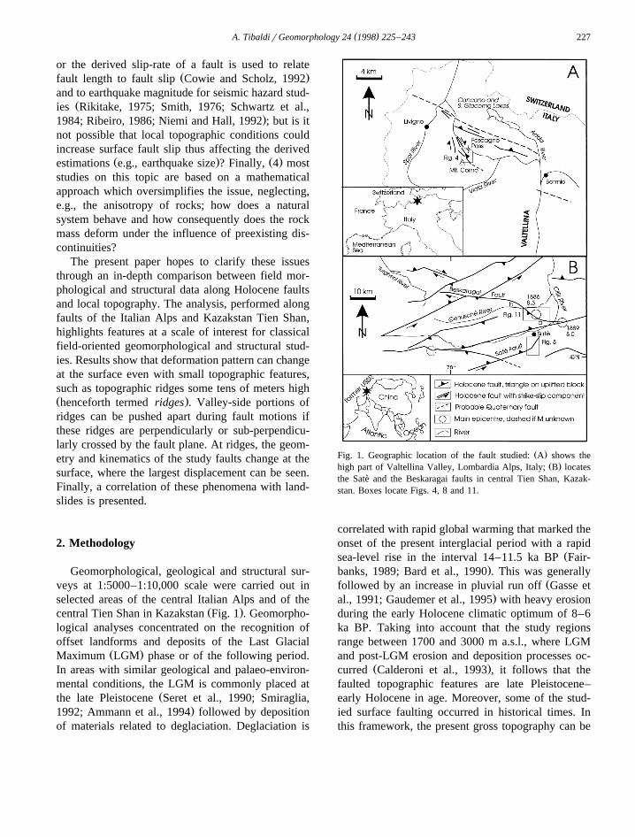
Ž .Fig. 1. Geographic location of the fault studied: A shows theŽ .high part of Valtellina Valley, Lombardia Alps, Italy; B locates
the Sate and the Beskaragai faults in central Tien Shan, Kazak-`stan. Boxes locate Figs. 4, 8 and 11.
correlated with rapid global warming that marked theonset of the present interglacial period with a rapid
Žsea-level rise in the interval 14–11.5 ka BP Fair-.banks, 1989; Bard et al., 1990 . This was generally
Žfollowed by an increase in pluvial run off Gasse et.al., 1991; Gaudemer et al., 1995 with heavy erosion
during the early Holocene climatic optimum of 8–6ka BP. Taking into account that the study regionsrange between 1700 and 3000 m a.s.l., where LGMand post-LGM erosion and deposition processes oc-
Ž .curred Calderoni et al., 1993 , it follows that thefaulted topographic features are late Pleistocene–early Holocene in age. Moreover, some of the stud-ied surface faulting occurred in historical times. Inthis framework, the present gross topography can be
( )A. TibaldirGeomorphology 24 1998 225–243228
assumed to be very similar, or even equal, to thatcoeval with the faulting events.
Geological survey enabled us to recognise andreject post-LGM scarps or other morphological fea-tures due to selective erosion by comparing lithologyon both sides of the escarpments. The geometry ofprimary structures such as scistosity in metamorphicrocks or stratification in sedimentary deposits wasalso studied in order to verify possible control onchanges of fault inclination and strike. The variousfaults studied were also selected on the basis of thepresence of different lithological conditions, in orderto verify if different characteristics such as anisotro-py could enhance the surface change in deforma-tions. A range of rheological conditions was ensured
Ž .by the presence of i metamorphic rocks in the areaŽ .of the Italian Alps, ii intrusive crystalline and
sedimentary rocks in one of the two areas in TienŽ .Shan, and iii volcanic and metamorphic rocks in
the other area of Tien Shan.Structural survey comprises morphostructural and
kinematic analyses. Each fault was followed in thefield to study the possible changes in geometry,kinematics, and displacement. Special attention wasgiven to the measurements of vertical and horizontal
Ž .components of displacement e.g., in Fig. 2 , tomorphological indicators of fault kinematics such as
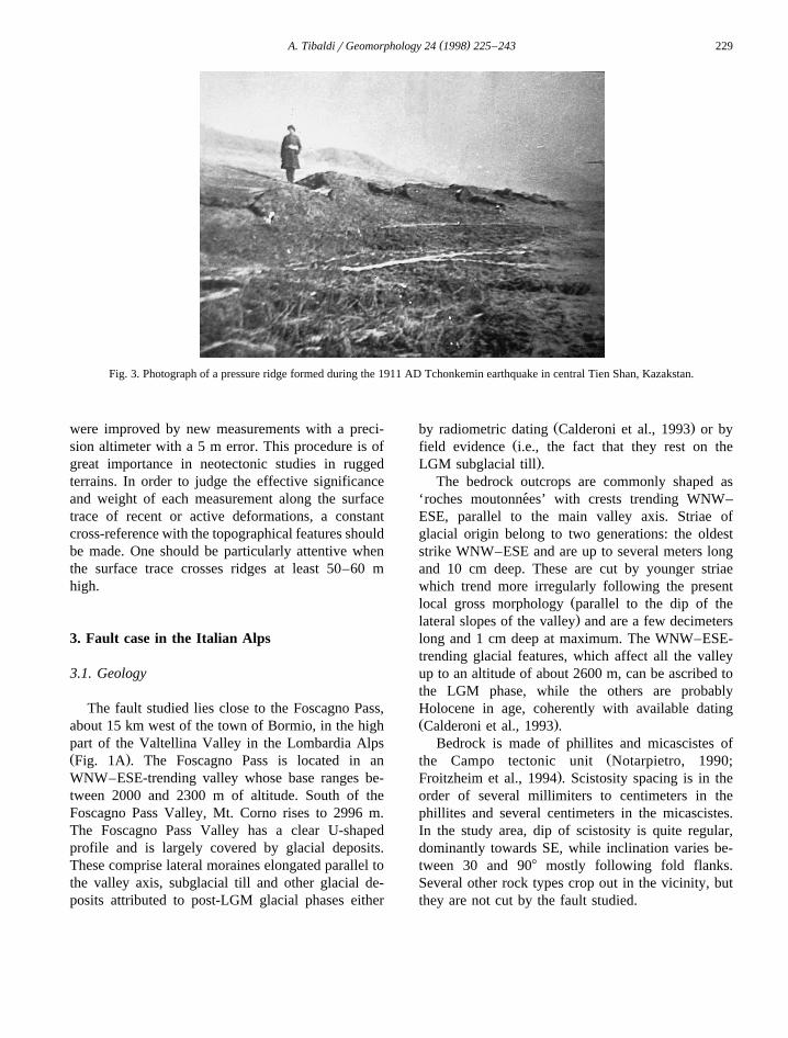
Ž .pressure ridges e.g., in Fig. 3 , and to structuralindicators such as fault tectoglyphs. These character-istics were measured at intervals as regular as possi-
Žble or wherever possible in the case of rare indica-.tors such as pressure ridges in particular at erosional
ridges such as interfluves between gullies and atlower altitude at the site of canyons and gullieswhere a three-dimensional representation of the faultplane could be derived. For a better comprehensionof the regional and local tectonic state of stress, the
Ž .results were integrated with i the available earth-Žquake focal mechanisms Tapponnier and Molnar,
. Ž .1979; Nelson et al., 1987; Lukk et al., 1988 , iimeasurements of active crustal movements by geode-
Ž .tic methods Atrushkevitch et al., 1988; Ward, 1994Ž .and iii geological evidence of active tectonic mo-
Žtions along other conterminous faults Forcella et al.,.1981; Graziotto, 1994; Tibaldi et al., 1997a .
All these data were compared with topographydirectly observed in the field and mapped with theaid of enlarged topographic maps, originally at1:10,000 scale in the Italian Alps and 1:50,000 scalein Kazakstan. Locally, topographic data and mapping
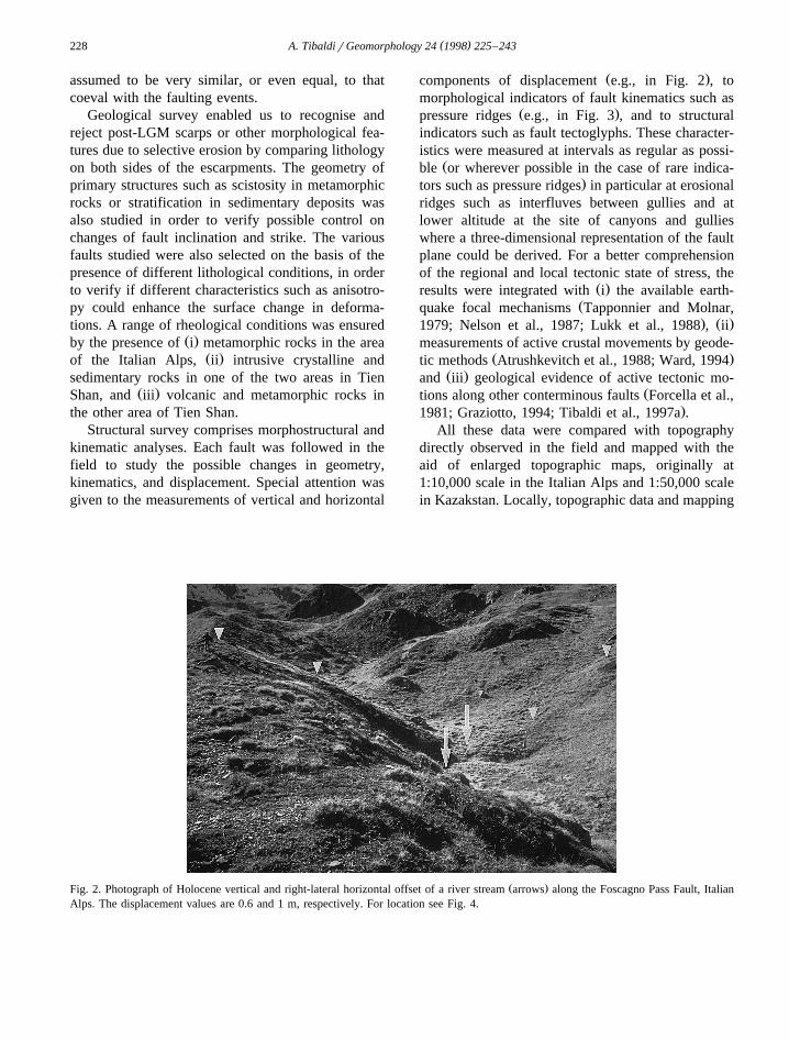
Ž .Fig. 2. Photograph of Holocene vertical and right-lateral horizontal offset of a river stream arrows along the Foscagno Pass Fault, ItalianAlps. The displacement values are 0.6 and 1 m, respectively. For location see Fig. 4.
( )A. TibaldirGeomorphology 24 1998 225–243 229
Fig. 3. Photograph of a pressure ridge formed during the 1911 AD Tchonkemin earthquake in central Tien Shan, Kazakstan.
were improved by new measurements with a preci-sion altimeter with a 5 m error. This procedure is ofgreat importance in neotectonic studies in ruggedterrains. In order to judge the effective significanceand weight of each measurement along the surfacetrace of recent or active deformations, a constantcross-reference with the topographical features shouldbe made. One should be particularly attentive whenthe surface trace crosses ridges at least 50–60 mhigh.
3. Fault case in the Italian Alps
3.1. Geology
The fault studied lies close to the Foscagno Pass,about 15 km west of the town of Bormio, in the highpart of the Valtellina Valley in the Lombardia AlpsŽ .Fig. 1A . The Foscagno Pass is located in anWNW–ESE-trending valley whose base ranges be-tween 2000 and 2300 m of altitude. South of theFoscagno Pass Valley, Mt. Corno rises to 2996 m.The Foscagno Pass Valley has a clear U-shapedprofile and is largely covered by glacial deposits.These comprise lateral moraines elongated parallel tothe valley axis, subglacial till and other glacial de-posits attributed to post-LGM glacial phases either
Ž .by radiometric dating Calderoni et al., 1993 or byŽfield evidence i.e., the fact that they rest on the
.LGM subglacial till .The bedrock outcrops are commonly shaped as
‘roches moutonnees’ with crests trending WNW–´ESE, parallel to the main valley axis. Striae ofglacial origin belong to two generations: the oldeststrike WNW–ESE and are up to several meters longand 10 cm deep. These are cut by younger striaewhich trend more irregularly following the present
Žlocal gross morphology parallel to the dip of the.lateral slopes of the valley and are a few decimeters
long and 1 cm deep at maximum. The WNW–ESE-trending glacial features, which affect all the valleyup to an altitude of about 2600 m, can be ascribed tothe LGM phase, while the others are probablyHolocene in age, coherently with available datingŽ .Calderoni et al., 1993 .
Bedrock is made of phillites and micascistes ofŽthe Campo tectonic unit Notarpietro, 1990;
.Froitzheim et al., 1994 . Scistosity spacing is in theorder of several millimiters to centimeters in thephillites and several centimeters in the micascistes.In the study area, dip of scistosity is quite regular,dominantly towards SE, while inclination varies be-tween 30 and 908 mostly following fold flanks.Several other rock types crop out in the vicinity, butthey are not cut by the fault studied.
( )A. TibaldirGeomorphology 24 1998 225–243230
3.2. Fault characteristics and topography
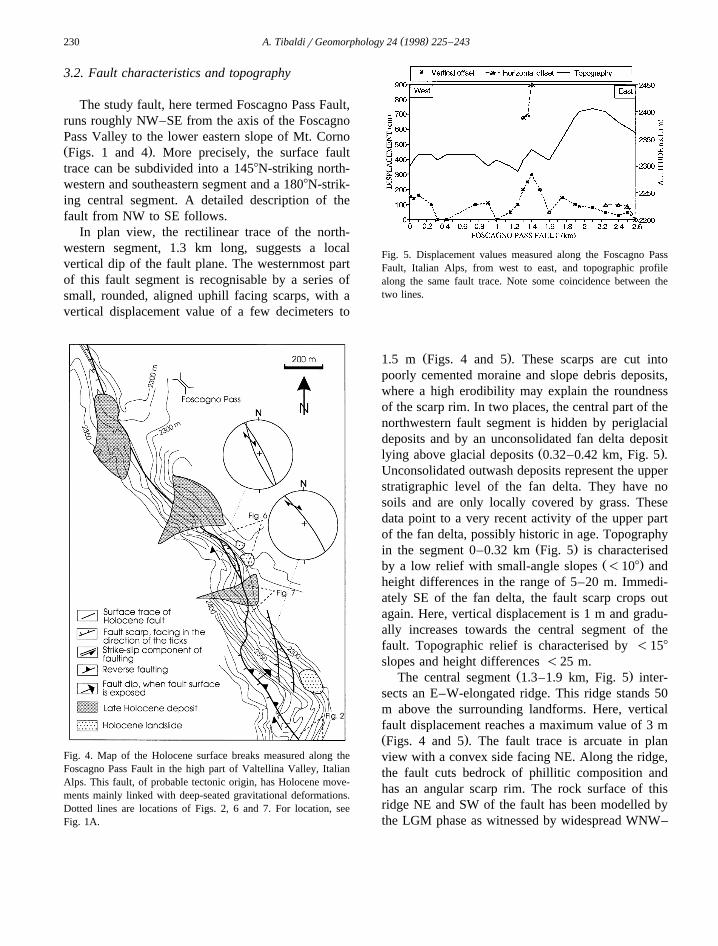
The study fault, here termed Foscagno Pass Fault,runs roughly NW–SE from the axis of the FoscagnoPass Valley to the lower eastern slope of Mt. CornoŽ .Figs. 1 and 4 . More precisely, the surface faulttrace can be subdivided into a 1458N-striking north-western and southeastern segment and a 1808N-strik-ing central segment. A detailed description of thefault from NW to SE follows.
In plan view, the rectilinear trace of the north-western segment, 1.3 km long, suggests a localvertical dip of the fault plane. The westernmost partof this fault segment is recognisable by a series ofsmall, rounded, aligned uphill facing scarps, with avertical displacement value of a few decimeters to
Fig. 4. Map of the Holocene surface breaks measured along theFoscagno Pass Fault in the high part of Valtellina Valley, ItalianAlps. This fault, of probable tectonic origin, has Holocene move-ments mainly linked with deep-seated gravitational deformations.Dotted lines are locations of Figs. 2, 6 and 7. For location, seeFig. 1A.
Fig. 5. Displacement values measured along the Foscagno PassFault, Italian Alps, from west to east, and topographic profilealong the same fault trace. Note some coincidence between thetwo lines.
Ž .1.5 m Figs. 4 and 5 . These scarps are cut intopoorly cemented moraine and slope debris deposits,where a high erodibility may explain the roundnessof the scarp rim. In two places, the central part of thenorthwestern fault segment is hidden by periglacialdeposits and by an unconsolidated fan delta deposit
Ž .lying above glacial deposits 0.32–0.42 km, Fig. 5 .Unconsolidated outwash deposits represent the upperstratigraphic level of the fan delta. They have nosoils and are only locally covered by grass. Thesedata point to a very recent activity of the upper partof the fan delta, possibly historic in age. Topography
Ž .in the segment 0–0.32 km Fig. 5 is characterisedŽ .by a low relief with small-angle slopes -108 and
height differences in the range of 5–20 m. Immedi-ately SE of the fan delta, the fault scarp crops outagain. Here, vertical displacement is 1 m and gradu-ally increases towards the central segment of thefault. Topographic relief is characterised by -158
slopes and height differences -25 m.Ž .The central segment 1.3–1.9 km, Fig. 5 inter-
sects an E–W-elongated ridge. This ridge stands 50m above the surrounding landforms. Here, verticalfault displacement reaches a maximum value of 3 mŽ .Figs. 4 and 5 . The fault trace is arcuate in planview with a convex side facing NE. Along the ridge,the fault cuts bedrock of phillitic composition andhas an angular scarp rim. The rock surface of thisridge NE and SW of the fault has been modelled bythe LGM phase as witnessed by widespread WNW–
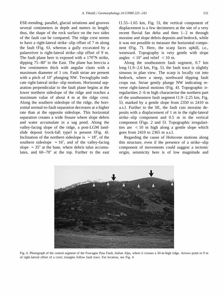
( )A. TibaldirGeomorphology 24 1998 225–243 231
ESE-trending, parallel, glacial striations and groovesseveral centimeters in depth and meters in length;thus, the shape of the rock surface on the two sidesof the fault can be compared. The ridge crest seemsto have a right-lateral strike–slip offset of 7 m along
Ž .the fault Fig. 6 , whereas a gully excavated by apalaeoriver is right-lateral strike–slip offset of 9 m.The fault plane here is exposed with a 1708N strike,dipping 75–808 to the East. The plane has breccia afew centimeters thick with angular clasts with amaximum diameter of 1 cm. Fault striae are presentwith a pitch of 108 plunging NW. Tectoglyphs indi-cate right-lateral strike–slip motions. Horizontal sep-aration perpendicular to the fault plane begins at thelower northern sideslope of the ridge and reaches amaximum value of about 4 m at the ridge crest.Along the southern sideslope of the ridge, the hori-zontal normal-to-fault separation decreases at a higherrate than at the opposite sideslope. This horizontalseparation creates a wide fissure where slope debrisand water accumulate in a sag pond. Along thevalley-facing slope of the ridge, a post-LGM land-
Ž . Ž .slide deposit rock-fall type is present Fig. 4 .Inclination of the northern sideslope is ;188, of thesouthern sideslope ;168, and of the valley-facingslope ;358 at the base, where debris talus accumu-lates, and 60–708 at the top. Further to the east
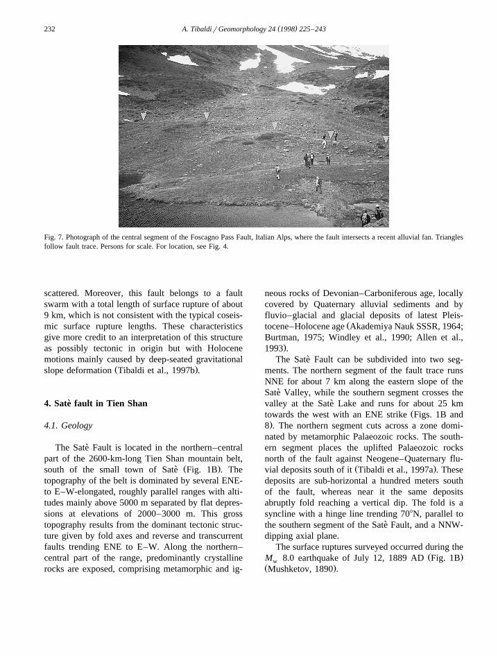
Ž .1.55–1.65 km, Fig. 5 , the vertical component ofdisplacement is a few decimeters at the site of a veryrecent fluvial fan delta and then 1–2 m throughmoraine and slope debris deposits and bedrock, whileit was not possible to measure the horizontal compo-
Ž .nent Fig. 7 . Here, the scarp faces uphill, i.e.,westward. Topography is very gentle with slopeangles -108 and relief -10 m.
Along the southeastern fault segment, 0.7 kmŽ .long 1.9–2.6 km, Fig. 5 , the fault trace is slightly
sinuous in plan view. The scarp is locally cut intobedrock, where a steep, northward dipping faultcrops out. Striae gently plunge NW indicating re-
Ž .verse right-lateral motions Fig. 4 . Topographic ir-regularities 2–6 m high characterise the northern part
Žof the southeastern fault segment 1.9–2.25 km, Fig..5 , marked by a gentle slope from 2350 to 2410 m
a.s.l. Further to the SE, the fault cuts moraine de-posits with a displacement of 1 m in the right-lateralstrike–slip component and 0.5 m in the vertical
Ž .component Figs. 2 and 5 . Topographic irregulari-ties are -10 m high along a gentle slope whichgoes from 2410 to 2365 m a.s.l.
Regarding the cause of Holocene motions alongthis structure, even if the presence of a strike–slipcomponent of movements could suggest a tectonicorigin, seismicity here is of low magnitude and
Fig. 6. Photograph of the central segment of the Foscagno Pass Fault, Italian Alps, where it crosses a 50-m-high ridge. Arrows point to 9 mof right-lateral offset of a crest; triangles follow fault trace. For location, see Fig. 4.
( )A. TibaldirGeomorphology 24 1998 225–243232
Fig. 7. Photograph of the central segment of the Foscagno Pass Fault, Italian Alps, where the fault intersects a recent alluvial fan. Trianglesfollow fault trace. Persons for scale. For location, see Fig. 4.
scattered. Moreover, this fault belongs to a faultswarm with a total length of surface rupture of about9 km, which is not consistent with the typical coseis-mic surface rupture lengths. These characteristicsgive more credit to an interpretation of this structureas possibly tectonic in origin but with Holocenemotions mainly caused by deep-seated gravitational
Ž .slope deformation Tibaldi et al., 1997b .
4. Sate fault in Tien Shan`
4.1. Geology
The Sate Fault is located in the northern–central`part of the 2600-km-long Tien Shan mountain belt,
Ž .south of the small town of Sate Fig. 1B . The`topography of the belt is dominated by several ENE-to E–W-elongated, roughly parallel ranges with alti-tudes mainly above 5000 m separated by flat depres-sions at elevations of 2000–3000 m. This grosstopography results from the dominant tectonic struc-ture given by fold axes and reverse and transcurrentfaults trending ENE to E–W. Along the northern–central part of the range, predominantly crystallinerocks are exposed, comprising metamorphic and ig-
neous rocks of Devonian–Carboniferous age, locallycovered by Quaternary alluvial sediments and byfluvio–glacial and glacial deposits of latest Pleis-
Žtocene–Holocene age Akademiya Nauk SSSR, 1964;Burtman, 1975; Windley et al., 1990; Allen et al.,
.1993 .The Sate Fault can be subdivided into two seg-`
ments. The northern segment of the fault trace runsNNE for about 7 km along the eastern slope of theSate Valley, while the southern segment crosses the`valley at the Sate Lake and runs for about 25 km`
Žtowards the west with an ENE strike Figs. 1B and.8 . The northern segment cuts across a zone domi-
nated by metamorphic Palaeozoic rocks. The south-ern segment places the uplifted Palaeozoic rocksnorth of the fault against Neogene–Quaternary flu-
Ž .vial deposits south of it Tibaldi et al., 1997a . Thesedeposits are sub-horizontal a hundred meters southof the fault, whereas near it the same depositsabruptly fold reaching a vertical dip. The fold is asyncline with a hinge line trending 708N, parallel tothe southern segment of the Sate Fault, and a NNW-`dipping axial plane.
The surface ruptures surveyed occurred during theŽ .M 8.0 earthquake of July 12, 1889 AD Fig. 1Bw
Ž .Mushketov, 1890 .
( )A. TibaldirGeomorphology 24 1998 225–243 233
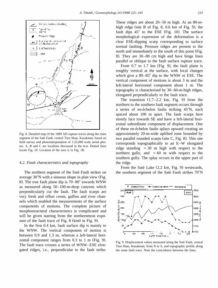
Fig. 8. Detailed map of the 1889 AD rupture traces along the mainsegment of the Sate Fault, central Tien Shan, Kazakstan, based on`field survey and photointerpretation of 1:25,000 scale aerial pho-tos. A, B and C are localities discussed in the text. Dotted lineslocate Fig. 10. Location of the area is in Fig. 1B.
4.2. Fault characteristics and topography
The northern segment of the Sate Fault strikes on`Žaverage 308N with a sinuous shape in plan view Fig.
.8 . The true fault plane dip is 70–808 towards WNWas measured along 50–100-m-deep canyons whichperpendicularly cut the fault. The fault scarps arevery fresh and offset crests, gullies and river chan-nels which enabled the measurements of the surfacecomponents of motions. The complete picture ofmorphostructural characteristics is complicated andwill be given starting from the northernmost expo-
Ž .sure of the fault trace of Fig. 8 km0 in Fig. 9 .In the first 0.4 km, fault surface dip is mainly to
the WNW. The vertical component of motion isbetween 0.9 and 1.3 m, whereas a left-lateral hori-
Ž .zontal component ranges from 0.3 to 1 m Fig. 9 .The fault trace crosses a series of WNW–ESE elon-gated ridges, i.e., perpendicular to the fault strike.
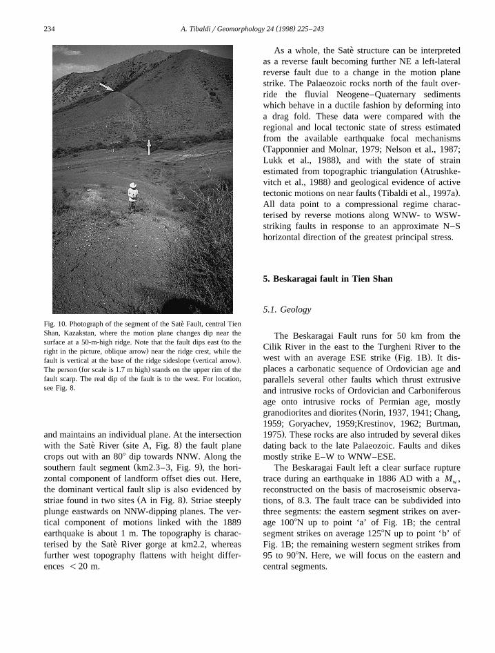
These ridges are about 20–50 m high. At an 80-m-Ž .high ridge site B of Fig. 8, 0.6 km of Fig. 9 , the
Ž .fault dips 458 to the ESE Fig. 10 . The surfacemorphological expression of the deformation is aclear ESE-dipping scarp corresponding to surfacenormal faulting. Pressure ridges are present to the
Žnorth and immediately to the south of this point Fig..8 . They are 30–80 cm high and have hinge lines
parallel or oblique to the fault surface rupture trace.Ž .From 0.7 to 1.7 km Fig. 9 , the fault plane is
roughly vertical at the surface, with local changeswhich give a 80–858 dip to the WNW or ESE. Thevertical component of motions is about 3 m and theleft-lateral horizontal component about 1 m. Thetopography is characterised by 30–60-m-high ridges,elongated perpendicularly to the fault trace.
Ž .The transition 1.7–2.2 km, Fig. 9 from thenorthern to the southern fault segment occurs througha series of en-echelon faults striking 458N, each´spaced about 100 m apart. The fault scarps heremostly face towards SE and have a left-lateral hori-zontal subordinate component of displacement. Oneof these en-echelon faults splays upward creating an´approximately 20-m-wide uplifted zone bounded by
Ž .two parallel rounded scarps site C, Fig. 8 . This sitecorresponds topographically to an E–W elongatedridge standing ;30 m high with respect to thenorthern gully, and ;60 m with respect to thesouthern gully. The splay occurs in the upper part ofthe ridge.
Ž .From the Sate Lake 2.2 km, Fig. 9 westwards,`the southern segment of the Sate Fault strikes 708N`
Fig. 9. Displacement values measured along the Sate Fault, central`Tien Shan, Kazakstan, from N to S, and topographic profile alongthe same fault trace. Note the coincidence between the lines.
( )A. TibaldirGeomorphology 24 1998 225–243234
Fig. 10. Photograph of the segment of the Sate Fault, central Tien`Shan, Kazakstan, where the motion plane changes dip near the
Žsurface at a 50-m-high ridge. Note that the fault dips east to the.right in the picture, oblique arrow near the ridge crest, while the
Ž .fault is vertical at the base of the ridge sideslope vertical arrow .Ž .The person for scale is 1.7 m high stands on the upper rim of the
fault scarp. The real dip of the fault is to the west. For location,see Fig. 8.
and maintains an individual plane. At the intersectionŽ .with the Sate River site A, Fig. 8 the fault plane`
crops out with an 808 dip towards NNW. Along theŽ .southern fault segment km2.3–3, Fig. 9 , the hori-
zontal component of landform offset dies out. Here,the dominant vertical fault slip is also evidenced by
Ž .striae found in two sites A in Fig. 8 . Striae steeplyplunge eastwards on NNW-dipping planes. The ver-tical component of motions linked with the 1889earthquake is about 1 m. The topography is charac-terised by the Sate River gorge at km2.2, whereas`further west topography flattens with height differ-ences -20 m.
As a whole, the Sate structure can be interpreted`as a reverse fault becoming further NE a left-lateralreverse fault due to a change in the motion planestrike. The Palaeozoic rocks north of the fault over-ride the fluvial Neogene–Quaternary sedimentswhich behave in a ductile fashion by deforming intoa drag fold. These data were compared with theregional and local tectonic state of stress estimatedfrom the available earthquake focal mechanismsŽTapponnier and Molnar, 1979; Nelson et al., 1987;
.Lukk et al., 1988 , and with the state of strainŽestimated from topographic triangulation Atrushke-
.vitch et al., 1988 and geological evidence of activeŽ .tectonic motions on near faults Tibaldi et al., 1997a .
All data point to a compressional regime charac-terised by reverse motions along WNW- to WSW-striking faults in response to an approximate N–Shorizontal direction of the greatest principal stress.
5. Beskaragai fault in Tien Shan
5.1. Geology
The Beskaragai Fault runs for 50 km from theCilik River in the east to the Turgheni River to the
Ž .west with an average ESE strike Fig. 1B . It dis-places a carbonatic sequence of Ordovician age andparallels several other faults which thrust extrusiveand intrusive rocks of Ordovician and Carboniferousage onto intrusive rocks of Permian age, mostly
Žgranodiorites and diorites Norin, 1937, 1941; Chang,1959; Goryachev, 1959;Krestinov, 1962; Burtman,
.1975 . These rocks are also intruded by several dikesdating back to the late Palaeozoic. Faults and dikesmostly strike E–W to WNW–ESE.
The Beskaragai Fault left a clear surface rupturetrace during an earthquake in 1886 AD with a M ,w
reconstructed on the basis of macroseismic observa-tions, of 8.3. The fault trace can be subdivided intothree segments: the eastern segment strikes on aver-age 1008N up to point ‘a’ of Fig. 1B; the centralsegment strikes on average 1258N up to point ‘b’ ofFig. 1B; the remaining western segment strikes from95 to 908N. Here, we will focus on the eastern andcentral segments.
( )A. TibaldirGeomorphology 24 1998 225–243 235
5.2. Fault characteristics and topography
As a base observation, where the Beskaragai Faultcrosses deep gullies, it is possible to detect the truefault plane geometry and tectoglyphs. Fault inclina-tion is from vertical to 758, with a real dip towardsthe south. As the block south of the fault is uplifted,the resulting movement of the entire rupture zone isreverse right-lateral as evidenced by fault striae; they
Žplunge towards the east pitch is between 43 and. Ž .508 on 170–1808N-dipping planes Fig. 11 . The
direction of shortening results roughly N–S. Also,here, a general compressional deformation is consis-
Žtent with other geological and geophysical data Lukk.et al., 1988; Graziotto, 1994; Tibaldi et al., 1997a .
A description of the surface characteristics of thefault rupture zone from E to W follows.
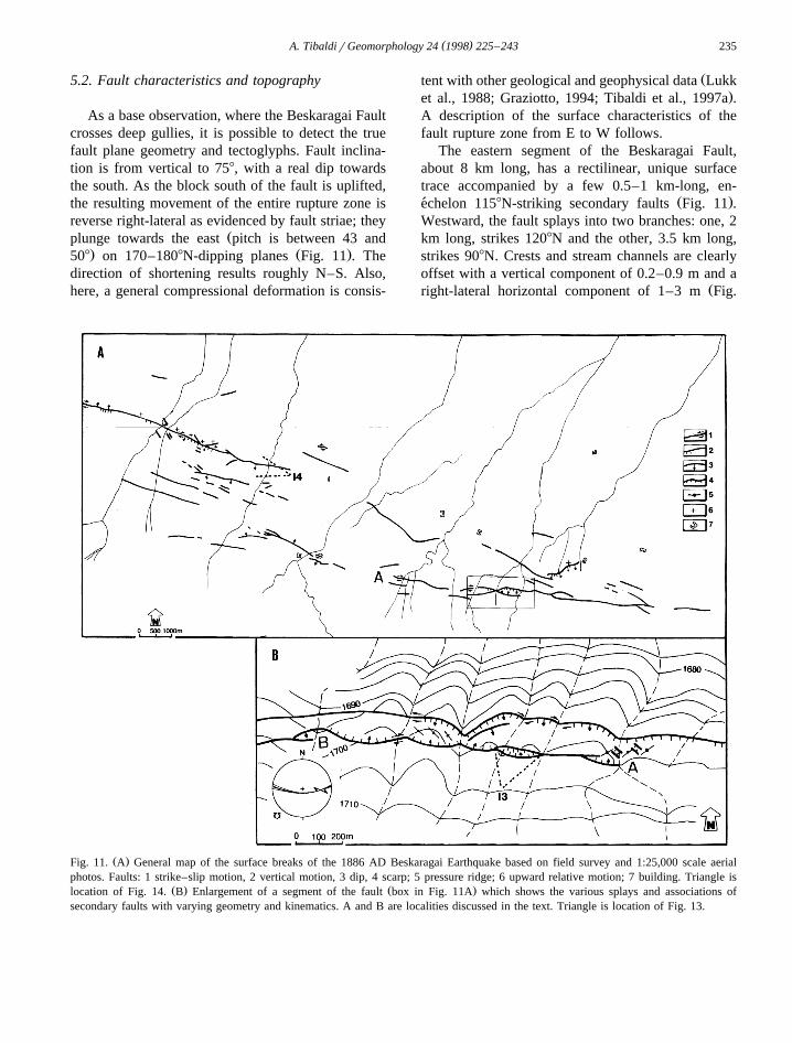
The eastern segment of the Beskaragai Fault,about 8 km long, has a rectilinear, unique surfacetrace accompanied by a few 0.5–1 km-long, en-
Ž .echelon 1158N-striking secondary faults Fig. 11 .´Westward, the fault splays into two branches: one, 2km long, strikes 1208N and the other, 3.5 km long,strikes 908N. Crests and stream channels are clearlyoffset with a vertical component of 0.2–0.9 m and a
Žright-lateral horizontal component of 1–3 m Fig.
Ž .Fig. 11. A General map of the surface breaks of the 1886 AD Beskaragai Earthquake based on field survey and 1:25,000 scale aerialphotos. Faults: 1 strike–slip motion, 2 vertical motion, 3 dip, 4 scarp; 5 pressure ridge; 6 upward relative motion; 7 building. Triangle is
Ž . Ž .location of Fig. 14. B Enlargement of a segment of the fault box in Fig. 11A which shows the various splays and associations ofsecondary faults with varying geometry and kinematics. A and B are localities discussed in the text. Triangle is location of Fig. 13.
( )A. TibaldirGeomorphology 24 1998 225–243236
Fig. 12. Displacement values measured along the BeskaragaiFault, central Tien Shan, Kazakstan, from E to W, and topo-graphic profile along the same fault trace. Note the coincidencebetween the lines.
.12 . The 908N-striking fault branch, enlarged in Fig.11B, shows a complex array with vicariant faults andhorse structures. Along this zone, pressure ridgesaffecting the ground surface trend ENE–WSW in anen-echelon right-stepping arrangement. The pressure´ridges are interconnected by en-echelon left-step-´
Ž . Žping, small 2 m long , pull-apart basins A in Fig..11B . All these structures are consistent with the
right-lateral component of the fault slip.
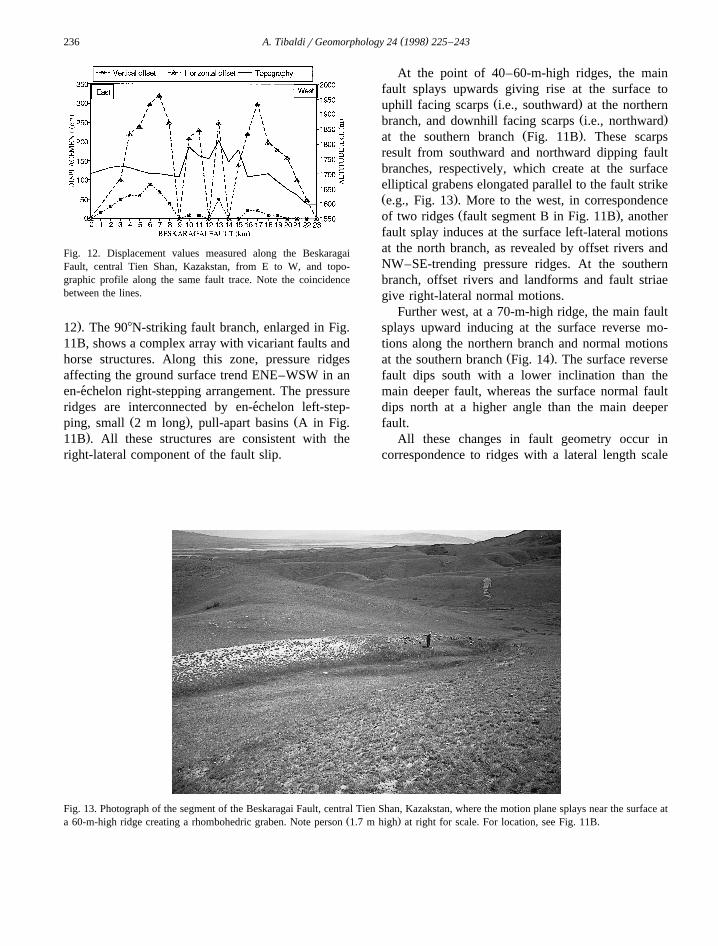
At the point of 40–60-m-high ridges, the mainfault splays upwards giving rise at the surface to
Ž .uphill facing scarps i.e., southward at the northernŽ .branch, and downhill facing scarps i.e., northward
Ž .at the southern branch Fig. 11B . These scarpsresult from southward and northward dipping faultbranches, respectively, which create at the surfaceelliptical grabens elongated parallel to the fault strikeŽ .e.g., Fig. 13 . More to the west, in correspondence
Ž .of two ridges fault segment B in Fig. 11B , anotherfault splay induces at the surface left-lateral motionsat the north branch, as revealed by offset rivers andNW–SE-trending pressure ridges. At the southernbranch, offset rivers and landforms and fault striaegive right-lateral normal motions.
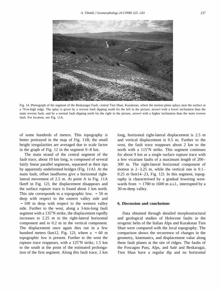
Further west, at a 70-m-high ridge, the main faultsplays upward inducing at the surface reverse mo-tions along the northern branch and normal motions
Ž .at the southern branch Fig. 14 . The surface reversefault dips south with a lower inclination than themain deeper fault, whereas the surface normal faultdips north at a higher angle than the main deeperfault.
All these changes in fault geometry occur incorrespondence to ridges with a lateral length scale
Fig. 13. Photograph of the segment of the Beskaragai Fault, central Tien Shan, Kazakstan, where the motion plane splays near the surface atŽ .a 60-m-high ridge creating a rhombohedric graben. Note person 1.7 m high at right for scale. For location, see Fig. 11B.
( )A. TibaldirGeomorphology 24 1998 225–243 237
Fig. 14. Photograph of the segment of the Beskaragai Fault, central Tien Shan, Kazakstan, where the motion plane splays near the surface atŽ .a 70-m-high ridge. The splay is given by a reverse fault dipping south to the left in the picture, arrow with a lower inclination than the
Ž .main reverse fault, and by a normal fault dipping north to the right in the picture, arrow with a higher inclination than the main reversefault. For location, see Fig. 11A.
of some hundreds of meters. This topography isbetter portrayed in the map of Fig. 11B; the smallheight irregularities are averaged due to scale factorin the graph of Fig. 12 in the segment 0–8 km.
The main strand of the central segment of thefault trace, about 10 km long, is composed of severalfairly linear parallel segments, separated at their tips
Ž .by apparently undeformed bridges Fig. 11A . At themain fault, offset landforms give a horizontal right-lateral movement of 2.5 m. At point A in Fig. 11AŽ .km9 in Fig. 12 , the displacement disappears andthe surface rupture trace is found about 1 km north.This site corresponds to a topographic low, ;50 mdeep with respect to the eastern valley side and;100 m deep with respect to the western valleyside. Further to the west, along a 3-km-long faultsegment with a 1358N strike, the displacement rapidlyincreases to 2.25 m in the right-lateral horizontalcomponent and to 0.2 m in the vertical component.The displacement once again dies out in a few
Ž .hundred meters km12, Fig. 12 , where a ;60 mtopographic low is present. Further to the west therupture trace reappears, with a 1258N strike, 1.5 kmto the south at the point of the estimated prolonga-tion of the first segment. Along this fault trace, 2 km
long, horizontal right-lateral displacement is 2.5 mand vertical displacement is 0.5 m. Further to thewest, the fault trace reappears about 2 km to thenorth with a 1158N strike. This segment continuesfor about 9 km as a single surface rupture trace witha few vicariant faults of a maximum length of 200–300 m. The right-lateral horizontal component ofmotion is 2–3.25 m, while the vertical one is 0.1–
Ž .0.25 m km14–23, Fig. 12 . In this segment, topog-raphy is characterised by a gradual lowering west-wards from ;1780 to 1600 m a.s.l., interrupted by a30-m-deep valley.
6. Discussion and conclusions
Data obtained through detailed morphostructuraland geological studies of Holocene faults in theorogenic belts of the Italian Alps and Kazakstan TienShan were compared with the local topography. Thecomparison shows the recurrence of changes in thegeometry, kinematics, and displacement value alongthese fault planes at the site of ridges. The faults ofthe Foscagno Pass, Alps, and Sate and Beskaragai,`Tien Shan have a regular dip and no horizontal
( )A. TibaldirGeomorphology 24 1998 225–243238
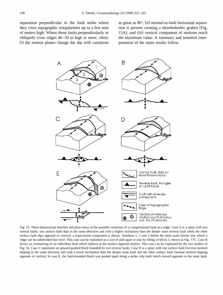
separation perpendicular to the fault strike wherethey cross topographic irregularities up to a few tensof meters high. Where these faults perpendicularly orobliquely cross ridges 40–50 m high or more, often:Ž .i the motion planes change the dip with variations
Ž .as great as 808, ii normal-to-fault horizontal separa-Žtion is present creating a rhombohedric graben Fig.
. Ž .15A , and iii vertical component of motions reachthe maximum value. A summary and tentative inter-pretation of the main results follow.
Fig. 15. Three-dimensional sketches and plan-views of the possible variations of a compressional fault at a ridge. Case A is a splay with twonormal faults: one surface fault dips in the same direction and with a higher inclination than the deeper main reverse fault while the othersurface fault dips opposite or vertical; a transcurrent component is shown. Numbers 1, 2 and 3 define the three main blocks into which a
Ž .ridge can be subdivided see text . This case can be explained as a sort of pull-apart or else by tilting of block 3, shown in Fig. 17C. Case Bshows an overturning of an individual fault which induces at the surface opposite motion. This case can be explained by the two models of
Ž .Fig. 16. Case C represents an upward-pushed block bounded by two reverse faults. Case D is a splay with one surface fault reverse motionŽ .dipping in the same direction and with a lower inclination than the deeper main fault and the other surface fault normal motion dipping
opposite or vertical. In case E, the fault-bounded block was pushed apart along a strike–slip fault which moved opposite to the main fault.
( )A. TibaldirGeomorphology 24 1998 225–243 239
6.1. Topography, fault geometry and kinematics
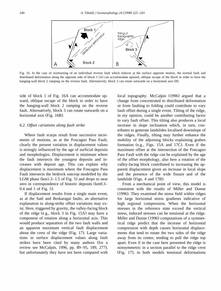
At some intersections between the reverse faultsand ridges, the rotation of the fault plane induces anopposite dip giving rise to normal displacement at
Ž .the surface Fig. 15B . In other cases, a fault splaysupward creating an upward pushed block boundedby two reverse faults with inclination higher than or
Ž .equal to the underlying main fault Fig. 15C . Alter-natively, a fault splays upward inducing a tilted
Žblock bounded by a normal and a reverse fault Fig..15D . In this case, the surface reverse fault has an
inclination lower than the underlying main reversefault, while the surface normal fault dips opposite tothe main reverse fault. At one intersection of theBeskaragai Fault with a ridge, a fault plane parallelto the main transcurrent fault shows contrasting mo-
Ž .tions Fig. 15E .Analysing the main kinematics and geologic set-
ting of the various fault types studied, it results thatanomalies in fault rupture at the surface occurredboth on reverse and strike–slip faults and indepen-dently of the lithology and geometry of the rocksconcerned. Bibliographic data on this matter arescarce but consistent with this finding. For example,coseismic deformations found after the compres-sional 1988 Spitak earthquake, Armenia, showed achange in the reverse fault dip near the surfacewhich induced normal faulting triggered by gravityŽ .Philip et al., 1992 . In Algeria after the 1980 ElAsnam earthquake, some active faults show normalmotions at the surface even if they are the secondary
Žexpression of active thrust faults Philip and.Meghraoui, 1983 , in line with the compressional
ŽPlio-Quaternary state of stress Ferrari and Tibaldi,.1990 . These normal faults have mainly been inter-
Žpreted as tensile structures on fold extrados Philip.and Meghraoui, 1983 . In this case, the surface
extensional structures originate from folding of theramping hanging-wall block or from bifurcation ofthe main fault plane at the near surface. Very similarto the cases described in the present paper are the
Ž .findings of Avouac et al. 1992 in the same ElAsnam rupture zone, where normal surface faultinglocally resulted from the interaction with topography.At the site of a small hill a few tens of meters high,elongated perpendicularly to the average fault strike,the main reverse fault splays into two secondary
faults at the surface, one with reverse motions andone with normal motions. Variations of fault inclina-tion at the surface have been widely reported in theliterature, but they usually consist of fault steepeningŽ .refraction without a complete inversion of fault dip.Refraction in normal faults has been explained by
Ž .Mercier et al. 1983 as caused by a lack of confin-ing pressure near the surface and the existence of atrue tensional stress.
From a mechanical point of view, all the casespresented here have two common factors. Changes in
Ž .the fault characteristics at the surface occur when: ithe fault intersects obliquely or perpendicularly a
Ž .ridge, and ii the ridge is at least 40–50 m high.Lithostatic masses can exert a strong influence on
Žthe state of stress in the upper crust McTigue and.Mei, 1981 to the order of r gH, where rs rock
density, gsacceleration of gravity, and Hsheightof the topographic feature. For r gf2.65=104
Parm, and a typical tectonic stress in the crust of7 8 Ž .10 –10 Pa McGarr and Gay, 1978 , we obtain an
H value of 103–104 m as necessary in order to havethe tectonic stresses normalised by the magnitude ofthe lithostatic stresses. The topographic features stud-ied in the present work have H-102 m; thus, alithostatic perturbation of tectonic stresses does notexplain the observed fault characteristics. I suggestthat these characteristics reveal a near surface changein the dynamic mechanical behaviour of the rockbodies, essentially due to the surface morphology. Atthe near surface, the rock body represented by theridge is unbuttressed along the two sideslopes andalong the valley-facing slope. This rock body is freer
Ž .and can be deformed or, better, moved more easilythan the conterminous rocks. When this rock body is
Ž .separated into three blocks e.g., Fig. 15A , thecentral block is bounded by the splay faults and bythe topographic surface; this gives a complete degreeof mobility. Where vertical motions predominate, thesecondary faults define a wedge which can protrude
Ž . Ž .downward Fig. 15A , upward Fig. 15C or towardsŽ .the valley Fig. 15D . In the case of transcurrent
dominant motions, the wedge can horizontally es-Ž .cape towards one side of the ridge Fig. 15E . All
these models are consistent with rock mechanics andkinematics, apart from the model of Fig. 15B whichrequires some explanations. In this case, the normalfault and distributed deformation along the opposite
( )A. TibaldirGeomorphology 24 1998 225–243240
Fig. 16. In the case of overturning of an individual reverse fault which induces at the surface opposite motion, the normal fault andŽ .distributed deformation along the opposite side of block 1 A can accommodate upward, oblique escape of the block in order to have the
Ž .hanging-wall block 2 ramping on the reverse fault. Alternatively, block 3 can rotate outwards on a horizontal axis B .
side of block 1 of Fig. 16A can accommodate up-ward, oblique escape of the block in order to havethe hanging-wall block 2 ramping on the reversefault. Alternatively, block 3 can rotate outwards on a
Ž .horizontal axis Fig. 16B .
6.2. Offset Õariations along fault strike
Where fault scarps result from successive incre-ments of motions, as at the Foscagno Pass Fault,clearly the present variation in displacement valuesis strongly influenced by the age of surficial depositsand morphologies. Displacement is minimum wherethe fault intersects the youngest deposits and in-creases with deposit age. This can explain whydisplacement is maximum where the Foscagno PassFault intersects the bedrock outcrop modelled by the
Ž .LGM phase km1.3–1.5 of Fig. 5 and drops to nearŽzero in correspondence of historic deposits km0.3–
.0.4 and 1 of Fig. 5 .If displacement results from a single main event,
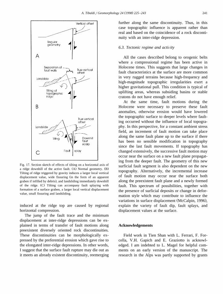
as at the Sate and Beskaragai faults, an alternative`explanation to along-strike offset variations may ex-ist. Here, triggered by gravity, the valley-facing block
Ž .of the ridge e.g., block 3 in Fig. 15A may have acomponent of rotation along a horizontal axis. Thiswould produce separation of the two fault walls andan apparent maximum vertical fault displacement
Ž .about the crest of the ridge Fig. 17 . Large varia-tions in surface displacement values along fault
Žstrikes have been cited by many authors for a.review see McCalpin, 1996, pp. 89–95, 189, 277 ,
but unfortunately they have not been compared with
Ž .local topography. McCalpin 1996 argued that achange from concentrated to distributed deformationor from faulting to folding could contribute to varyfault offset during a single event. Tilting of the ridge,in my opinion, could be another contributing factorto vary fault offset. This tilting also produces a localincrease in slope inclination which, in turn, con-tributes to generate landslides localised downslope ofthe ridges. Finally, tilting may further enhance themobility of the adjoining blocks explaining graben
Ž .formation e.g., Figs. 15A and 17C . Even if themaximum offset at the intersection of the FoscagnoPass Fault with the ridge can be explained by the ageof the offset morphology, also here a rotation of thevalley-facing block contributed to increasing the ap-parent displacement given an increase in local slopeand the presence of the wide fissure and of the
Ž .landslide Figs. 4 and 17B .From a mechanical point of view, this model is
consistent with the results of Miller and DunneŽ .1996 . They examined the stress field within ridgesfor large horizontal stress gradients indicative ofhigh regional compression. When the horizontalstresses in the reference state exceed the verticalstress, induced stresses can be tensional at the ridge.
Ž .Miller and Dunne 1996 computations of a symmet-rical ridge predict that the increase of horizontalcompression with depth causes horizontal displace-ments that tend to rotate the two sides of the ridgeaway from its center, tending to pull the ridge topapart. Even if in the case here presented the ridge isnonsymmetric in a section parallel to the ridge crestŽ .Fig. 17 , in both models tensional deformations
( )A. TibaldirGeomorphology 24 1998 225–243 241
Fig. 17. Section sketch of effects of tilting on a horizontal axis ofŽ . Ž .a ridge downhill of the active fault. A Normal geometry. B
Tilting of ridge triggered by gravity induces a larger local verticalŽdisplacement value, wide fissuring in the form of an apparent
.graben if infilled by debris , and landsliding immediately downhillŽ .of the ridge. C Tilting can accompany fault splaying with
formation of a surface graben, a larger local vertical displacementvalue, small fissuring and landsliding.
induced at the ridge top are caused by regionalhorizontal compression.
The jump of the fault trace and the minimumdisplacement at inter-ridge depressions can be ex-plained in terms of transfer of fault motions alongpreexistent diversely oriented rock discontinuities.These discontinuities can be morphologically ex-pressed by the preferential erosion which gave rise tothe elongated inter-ridge depressions. In other words,I suggest that the surface fault rupture may die out asit meets an already existent discontinuity, reemerging
further along the same discontinuity. Thus, in thiscase topographic influence is apparent rather thanreal and based on the coincidence of a rock disconti-nuity with an inter-ridge depression.
6.3. Tectonic regime and actiÕity
All the cases described belong to orogenic beltswhere a compressional regime has been active inHolocene times. This suggests that large changes infault characteristics at the surface are more commonin very rugged terrains because high-frequency andhigh-magnitude topographic irregularities exert ahigher gravitational pull. This condition is typical ofuplifting areas, whereas subsiding basins or stablecratons do not have enough relief.
At the same time, fault motions during theHolocene were necessary to preserve these faultanomalies, otherwise erosion would have loweredthe topographic surface to deeper levels where fault-ing occurred without the influence of local topogra-phy. In this perspective, for a constant ambient stressfield, an increment of fault motion can take placealong the same fault plane up to the surface if therehas been no sensible modification in topographysince the last fault movements. If topography haschanged extensively, the successive fault motion mayoccur near the surface on a new fault plane propagat-ing from the deeper fault. The geometry of this newsurficial fault segment is also dependent on the newtopography. Alternatively, the incremental increaseof fault motion may occur near the surface bothalong the preexistent fault plane and a newly formedfault. This spectrum of possibilities, together withthe presence of surficial deposits or change in defor-mation style which may contribute to influence the
Ž .variations in surface displacement McCalpin, 1996 ,explain the variety of fault dip, fault splays, anddisplacement values at the surface.
Acknowledgements
Field work in Tien Shan with L. Ferrari, F. For-cella, V.H. Gapich and E. Graziotto is acknowl-edged. I am indebted to L. Magel for helpful com-ments on an early version of the manuscript. Theresearch in the Alps was partly supported by grants
( )A. TibaldirGeomorphology 24 1998 225–243242
from CARIPLO, 40% MURST, EDRA, and Centroper la Geodinamica Alpina e Quaternaria-CNR; theresearch in Tien Shan by SYTCO-Lugano and by aCNR grant for Italian–Soviet researcher exchange.
References
Allen, M.B., Windley, B.F., Chi, Z., 1993. Palaeozoic collisionaltectonics and magmatism of the Chinese Tien Shan, CentralAsia. Tectonophysics 220, 89–115.
Akademiya Nauk SSSR, 1964. Geologic Map of Central Asia andAdjacent Regions. Moscow.
Ammann, B., Lotter, F., Eicher, U., Gaillard, M.J., Wohlfarth, B.,Haeberli, W., Lister, G., Maisch, M., Niessen, F., Schluchter,¨Ch., 1994. The Wurmian Late-glacial in lowland Switzerland.¨J. Quat. Sci. 9, 119–125.
Atrushkevitch, P.A., Kalabaev, N.B., Kartashov, A.P., Lototsky,V.D., Ostropico, P.A., 1988. Research on crustal movementson the Alma Ata Polygon, northern Tien Shan. J. Geodynam-ics 9, 279–292.
Avouac, J.P., Meyer, B., Tapponnier, P., 1992. On the growth ofnormal faults and the existence of flats and ramps along the El
Ž .Asnam active fold and thrust system. Tectonics 11 1 , 1–11.Bard, E., Hamelin, B., Fairbanks, R.G., Zindler, A., 1990. Cali-
bration of the C14 timescale over the past 30,000 years usingmass spectrometric U-Th ages from Barbados corals. Nature345, 405–410.
Burtman, V.S., 1975. Structural geology of the Variscan TienShan. Am. J. Sci. 275A, 157–186.
Calderoni, G., Guglielmin, M., Lozej, A., Tellini, C., 1993.ŽResearch on rock glaciers in the central Italian Alps Valtel-
.lina, Sondrio, Northern Italy . Proceedings of the 6th Interna-tional Conference on Permafrost, Vol. 1, Beijing, China, pp.72–77.
Chang, T’a, 1959. The Geology of China. CCM Information, NewYork, 623 pp.
Cowie, P.A., Scholz, H., 1992. Displacement–length scaling rela-tionship for faults: data synthesis and discussion. J. Struct.
Ž .Geol. 14 10 , 1149–1156.Crone, A.J., Machette, M.N., Bonilla, M.G., Lienkaemper, J.J.,
Pierce, K.L., Scott, W.E., Bucknam, R.C., 1987. Surfacefaulting accompanying the Borah Peak earthquake and seg-mentation of the Lost River fault, Central Idaho. Bull. Seis-mol. Soc. Am. 77, 739–770.
Fairbanks, R.G., 1989. A 17,000-year glacio-esustatic sea levelrecord: influence of glacial melting rates on the YoungerDryas event and deep-ocean circulation. Nature 342, 637–642.
Ferrari, L., Tibaldi, A., 1990. Kinematic evolution of the AlgerianAtlas. Mem. Soc. Geol. It. 45, 489–494.
Ferrari, L., Tibaldi, A., 1992. Recent and active tectonics of theŽ .north-eastern Ecuadorian Andes. J. Geodynamics 15 1r2 ,
39–58.Forcella, F., Gallazzi, D., Montrasio, A., Notarpietro, A., 1981.
Note illustrative relative all’evoluzione neotettonica dei fogli6-Passo dello Spluga, 7-Pizzo Bernina, 8-Bormio, 17-Chia-
venna, 18-Sondrio, 19-Tirano. In: ‘Contributi conclusivi per larealizzazione della Carta Neotettonica d’Italia’; Pubbl. n. 513del Prog. Finalizz. Geodinamica, C.N.R., Roma, pp. 238–288.
Froitzheim, N., Schmid, S.M., Conti, P., 1994. Repeated changefrom crustal shortening to orogen-parallel extension in the
Ž .Austroalpine units of Graubunden. Eclog. Geol. Hel. 87 2 ,559–612.
Gasse, F., Arnold, M., Fontes, J.C., Fort, M., Gilbert, E., Huc, A.,Li, Y., Liu, Q., Melieres, F., van Compo, E., Wang, F., Zheng,Q., 1991. A 13,000 yr climate record in western Tibet. Nature353, 742–745.
Gaudemer, Y., Tapponnier, P., Meyer, B., Peltzer, G., Shunmin,G., Zhitai, C., Huagung, D., Cifuentes, I., 1995. Partitioning ofcrustal slip between linked, active faults in the eastern QilianShan, and evidence for a major seismic gap, the ‘Tianzhu
Ž .gap’, on the western Haiyuan Fault, Gansu China . Geophys.J. Int. 120, 599–645.
Goryachev, A.V., 1959. Mesozoic-Cenozoic structure, history,tectonic development, and seismicity of the regions of the
Ž .Lake Issyk-Kul in Russian . Academy of Sciences PublishingHouse, Moscow.
Graziotto, E., 1994. Osservazioni geologiche e geofisiche sullapaleosismicita e sismicita del Zailisky Alatau, Tien-Shan,` `Kazakhstan. MSc Thesis, Universita di Milano, 162 pp.`
Knuepfer, P.L.K., 1989. Implications of the characteristics ofend-points of historical surface fault ruptures for the nature of
Ž .fault segmentation. In: Schwartz, D.P., Sibson, R.H. Eds. ,Fault Segmentation and Controls of Rupture Initiation andTermination, U.S. Geol. Open File Rep., 89-315, pp. 193–228.
Krestinov, V.N., 1962. History of development of oscillatorymovements of the earth’s crust of the Pamir and neighboring
Ž .parts of Asia in Russian . Academy of Sciences PublishingHouse, Moscow.
Lambeck, K., Nakiboglu, S.M., 1980. Seamount loading stress inthe ocean lithosphere. J. Geophys. Res. 85, 6403–6418.
Lukk, A.A. et al., 1988. Study on the possibility of reconstructionof the state of strain of the earth’s crust on the basis of focal
Ž .mechanisms of earthquakes in Russian . In: Seismic Bulletinof Kazakhstan of 1985, Dushambe, pp. 52–81.`
Ž .McCalpin, J.P. Ed. , 1996. Paleoseismology. Academic Press,San Diego, 588 pp.
McGarr, A., Gay, N.C., 1978. State of stress in the earth’s crust.Ann. Rev. Earth Planet. Sci. 6, 405–436.
McNutt, M., 1980. Implications of regional gravity for state ofstress in the earth’s crust and upper mantle. J. Geophys. Res.85, 6377–6396.
McTigue, D.F., Mei, C.C., 1981. Gravity-induced stresses neartopography of small slope. J. Geophys. Res. 86, 9268–9278.
Mercier, J.-L., Carey-Gailhardis, E., Mouyaris, N., Simeakis, K.,Roundoyannis, T., Anghelidhis, C., 1983. Structural analysisof recent and active faults and regional state of stress in the
Žepicentral area of the 1978 Thessaloniki earthquakes northern.Greece . Tectonics 2, 577–600.
Miller, D.J., Dunne, T., 1996. Topographic perturbations of re-gional stresses and consequent bedrock fracturing. J. Geophys.
Ž .Res. 101 B11 , 25523–25536.Ž .Mushketov, I.V., 1890. Verny earthquake: 28 May 9 June 1887
( )A. TibaldirGeomorphology 24 1998 225–243 243
Ž .in Russian . Commission of the Geology Committee,Leningrad, USSR, 154 pp.
Nelson, M.R., McCaffrey, R., Molnar, P., 1987. Source parame-ters for 11 earthquakes in the Tien Shan, Central Asia, deter-mined by P and Sh waveform inversion. J. Geophys. Res. 92Ž .B12 , 12629–12648.
Niemi, T.M., Hall, N.T., 1992. Late Holocene slip rate andrecurrence of great earthquakes on the San Andreas fault innorthern California. Geology 20, 195–198.
Norin, E., 1937. Geology of the Quruq Tagh: eastern Tien Shan.Reports from the scientific expeditions to the northwesternprovinces of China under the leadership of Dr. Sven Hedin,Part III, Geology 1, Bokforlags, Aktiebolaget Thule, Stock-holm.
Norin, E., 1941. Geologic reconnaissance in the Chinese TienShan. Reports from the scientific expeditions to the northwest-ern provinces of China under the leadership of Dr. SvenHedin, Part III, Geology 6, Bokforlags, Aktiebolaget Thule,Stockholm.
Notarpietro, A., 1990. Geological structure and landslides in theprovince of Sondrio. 6th ICFL, Switzerland–Austria–Italy,Milano.
Philip, H., 1987. Plio-Quaternary evolution of the stress field inMediterranean zones of subduction and collision. Ann. Geo-
Ž .phys. 5B 3 , 301–320.Philip, H., Meghraoui, M., 1983. Structural analysis and interpre-
tation of the surface deformations of the El Asnam earthquakeŽ .of October 10, 1980. Tectonics 2 1 , 17–49.
Philip, H., Rogozhin, E., Cisternas, A., Bousquet, J.C., Borisov,B., Karakhanian, A., 1992. The Armenian earthquake of 1988December 7: faulting and folding, neotectonics and palaeoseis-micity. Geophys. J. Int. 110, 141–158.
Ribeiro, A., 1986. A stochastic model to estimate maximumexpectable magnitude of earthquakes from fault dimension andslip-rate. Terra Cognita 6, 611–615.
Ricard, Y., Fleitout, L., Froidevaux, C., 1984. Geoid heights andŽ .lithosphere stresses for a dynamic earth. Ann. Geophys. 2 3 ,
267–286.Rikitake, T., 1975. Statistics of ultimate strain of the earth’s crust
and probability of earthquake recurrence. Tectonophysics 26,1–21.
Schwartz, D.P., Coppersmith, K.J., Swan III, F.H., 1984. Methodsfor estimating maximum earthquake magnitude. Proc. VIII
World Conf. on Earthquake Engineering, San Francisco, 1, pp.279–285.
Seret, G., Dricot, E., Wansard, G., 1990. Evidence for an earlyglacial maximum in the French Vosges during the last glacialcycle. Nature 346, 453–456.
Slejko, D., Carulli, G.B., Carraro, F., Castaldini, D., Cavallin, A.,Doglioni, C., Iliceto, V., Nicolich, R., Rebez, A., Semenza, E.,Zanferrari, A., Zanolla, C., 1987. Modello Sismotettonicodell’Italia Nord-Orientale. CNR-GNDT Rend. 1, Trieste, 82pp.
Slemmons, D.B., 1957. Geological effects of the Dixie Valley–Fairview Peak, Nevada, earthquakes of December 16, 1954.Bull. Seismol. Soc. Am. 47, 353–375.
Smiraglia, C., 1992. Guida ai ghiacciai e alla glaciologia.Zanichelli, Bologna, 240 pp.
Smith, S.W., 1976. Determination of maximum earthquake magni-tude. Geophys. Res. Lett. 6, 351–354.
Tapponnier, P., Molnar, P., 1979. Active faulting and cenozoictectonics of the Tien Shan, Mongolia, and Baykal regions. J.
Ž .Geophys. Res. 84 B7 , 3425–3459.Tibaldi, A., Graziotto, E., Forcella, F., Gapich, V.H., 1997a.
Morphotectonic indicators of Holocene faulting in central TienShan, Kazakstan, and geodynamic implications. J. Geodynam-
Ž .ics 23 1 , 23–45.Tibaldi, A., Onida, M., Pasquare, G., Forcella, F, 1997b. Trench-`
ing and paleoseismic researches along Holocene deformationŽ .zones in the upper Valtellina region, Central Alps Italy . Proc.
3rd Workshop on Alpine Geological Studies, Oropa-Biella,Quad. Geod. Alpina e Quat., CNR, Milano, 4, pp. 219-220.
Wallace, R.E., 1984. Faulting related to the 1915 earthquake inPleasant Valley, Nevada. U.S. Geol. Surv. Prof. Pap. 1274-A,1–33.
Ward, S.N., 1994. Constraints on the seismotectonics of thecentral Mediterranean from Very Long Baseline Interferome-try. Geophys. J. Int. 117, 441–452.
Windley, B.F., Allen, M.B., Zhang, C., Zhao, Z.Y., Wang, G.R.,1990. Paleozoic accretion and Cenozoic redeformation of theChinese Tien Shan Range, central Asia. Geology 18, 128–131.
Zoback, M.D., Zoback, M.L., Mount, V.S., Suppe, J., Eaton, J.P.,Healy, J.H., Oppenheimer, D., Reasenberg, P., Jones, L.,Raleigh, C.B., Wong, I.G., Scotti, O., Wentworth, C., 1987.New evidence on the state of stress of the San Andreas faultsystem. Science 238, 1105–1111.
Related Documents