Nat. Hazards Earth Syst. Sci., 15, 1051–1059, 2015 www.nat-hazards-earth-syst-sci.net/15/1051/2015/ doi:10.5194/nhess-15-1051-2015 © Author(s) 2015. CC Attribution 3.0 License. Effects of soil settlement and deformed geometry on a historical structure Y. Yardım and E. Mustafaraj Department of Civil Engineering, Epoka University, Tirana, Albania Correspondence to: Y. Yardım ([email protected]) Received: 2 May 2013 – Published in Nat. Hazards Earth Syst. Sci. Discuss.: 31 October 2013 Revised: 17 December 2014 – Accepted: 4 May 2015 – Published: 26 May 2015 Abstract. Protecting the historical character of a valued structure during the assessment and damage repair process is a very challenging task for many engineers. Heritage pro- tection is complicated by a lack of design details and restric- tions on sample extraction needed to obtain accurate material properties and limited studies on the restoration of certain types of historical structures. This study aims to assess the effects of soil settlement on a structure’s stress concentra- tions and the value of laser scanning techniques on structure analysis in obtaining correct data of settlement vs. deforma- tion. Terrestrial laser scanner (TLS) data are used to analyse the 500-year-old historical structure of Naziresha’s Mosque. The obtained TLS data allow an accurate definition of the imperfect geometry patterns lying on every side of the struc- ture. The soil profile and general crack formation together with TLS measurement proves that the structure deformed toward the south façade, where a railway and motorway are also located. Stress concentration and mode period results have a considerable difference, which highlights earthquake vulnerability and failure mechanisms and changes the strat- egy of possible retrofitting. 1 Introduction Finding a way to protect the historical character of a valued structure during the assessment and damage repairs process is a very challenging task for many engineers. Decay of ma- terials, degradation from environmental conditions, seismic activities and geological phenomena, such as internal and ex- ternal erosion and earthquakes, are some of the common ex- ternal problems that affect historical structures and make the protection of cultural heritage a complex process (Riveiro et al., 2011). Modifications, wrong strengthening and restora- tion are man-made interventions to be considered when as- sessing vulnerabilities in historical structures. In addition, the restrictions on extracting samples to obtain accurate material properties and a limited number of studies on these types of structures increase the complexity of assessment (Pesci et al., 2012). However, the accurate measurement of the current geo- metrical shape of a structure provides insights into structural vulnerabilities and degradation, such as the changes in the layout, existing crack propagations and settlements. There- fore, accurate geometrical measurements of historical struc- tures with its imperfections have to be considered to model the present state and the effects of many interventions (Pesci et al., 2012). The traditional methods of making measurements by hand are usually not sufficiently accurate (1), are time-consuming and labor-intensive (2) (Lahoz et al., 2006). The details of geometric data of historical structures including all the exist- ing distress and geometric imperfections have been obtained by remote-sensing techniques (Lerones et al., 2010; Pesci et al., 2011, 2012) such as terrestrial laser scanning (TLS). The terrestrial techniques, applicable to 3-D modeling of infras- tructures, consist of traditional topography, close-range pho- togrammetry and the TLS (Lubowiecka et al., 2009). This technique is able to provide a detailed 3-D model of the observed object, whose accuracy can reach from 5 mm to 100 m (Lahoz et al., 2006). The TSL 3-D model and digi- tal ortho-image can easily be created using a generated 3-D point cloud and recorded digital images. This study aims to demonstrate the use of precise geo- metric data obtained by methods in digital photogrammetry and terrestrial laser scanning on finite element model (FEM) Published by Copernicus Publications on behalf of the European Geosciences Union.

Welcome message from author
This document is posted to help you gain knowledge. Please leave a comment to let me know what you think about it! Share it to your friends and learn new things together.
Transcript

Nat. Hazards Earth Syst. Sci., 15, 1051–1059, 2015
www.nat-hazards-earth-syst-sci.net/15/1051/2015/
doi:10.5194/nhess-15-1051-2015
© Author(s) 2015. CC Attribution 3.0 License.
Effects of soil settlement and deformed geometry
on a historical structure
Y. Yardım and E. Mustafaraj
Department of Civil Engineering, Epoka University, Tirana, Albania
Correspondence to: Y. Yardım ([email protected])
Received: 2 May 2013 – Published in Nat. Hazards Earth Syst. Sci. Discuss.: 31 October 2013
Revised: 17 December 2014 – Accepted: 4 May 2015 – Published: 26 May 2015
Abstract. Protecting the historical character of a valued
structure during the assessment and damage repair process
is a very challenging task for many engineers. Heritage pro-
tection is complicated by a lack of design details and restric-
tions on sample extraction needed to obtain accurate material
properties and limited studies on the restoration of certain
types of historical structures. This study aims to assess the
effects of soil settlement on a structure’s stress concentra-
tions and the value of laser scanning techniques on structure
analysis in obtaining correct data of settlement vs. deforma-
tion. Terrestrial laser scanner (TLS) data are used to analyse
the 500-year-old historical structure of Naziresha’s Mosque.
The obtained TLS data allow an accurate definition of the
imperfect geometry patterns lying on every side of the struc-
ture. The soil profile and general crack formation together
with TLS measurement proves that the structure deformed
toward the south façade, where a railway and motorway are
also located. Stress concentration and mode period results
have a considerable difference, which highlights earthquake
vulnerability and failure mechanisms and changes the strat-
egy of possible retrofitting.
1 Introduction
Finding a way to protect the historical character of a valued
structure during the assessment and damage repairs process
is a very challenging task for many engineers. Decay of ma-
terials, degradation from environmental conditions, seismic
activities and geological phenomena, such as internal and ex-
ternal erosion and earthquakes, are some of the common ex-
ternal problems that affect historical structures and make the
protection of cultural heritage a complex process (Riveiro et
al., 2011). Modifications, wrong strengthening and restora-
tion are man-made interventions to be considered when as-
sessing vulnerabilities in historical structures. In addition, the
restrictions on extracting samples to obtain accurate material
properties and a limited number of studies on these types of
structures increase the complexity of assessment (Pesci et al.,
2012).
However, the accurate measurement of the current geo-
metrical shape of a structure provides insights into structural
vulnerabilities and degradation, such as the changes in the
layout, existing crack propagations and settlements. There-
fore, accurate geometrical measurements of historical struc-
tures with its imperfections have to be considered to model
the present state and the effects of many interventions (Pesci
et al., 2012).
The traditional methods of making measurements by hand
are usually not sufficiently accurate (1), are time-consuming
and labor-intensive (2) (Lahoz et al., 2006). The details of
geometric data of historical structures including all the exist-
ing distress and geometric imperfections have been obtained
by remote-sensing techniques (Lerones et al., 2010; Pesci et
al., 2011, 2012) such as terrestrial laser scanning (TLS). The
terrestrial techniques, applicable to 3-D modeling of infras-
tructures, consist of traditional topography, close-range pho-
togrammetry and the TLS (Lubowiecka et al., 2009). This
technique is able to provide a detailed 3-D model of the
observed object, whose accuracy can reach from 5 mm to
100 m (Lahoz et al., 2006). The TSL 3-D model and digi-
tal ortho-image can easily be created using a generated 3-D
point cloud and recorded digital images.
This study aims to demonstrate the use of precise geo-
metric data obtained by methods in digital photogrammetry
and terrestrial laser scanning on finite element model (FEM)
Published by Copernicus Publications on behalf of the European Geosciences Union.
1052 Y. Yardım and E. Mustafaraj: Effects of soil settlement and deformed geometry on a historical structure
structural analysis of a historical monument under seismic
load. The structure was modeled with two different geomet-
ric data: as-built and assumed perfect geometry, which are
obtained from precise geometric documentation with TLS
and traditional geometric measurements. Then a structural
analysis was carried out with the same material properties
and type of seismic loads to compare the effects of two dif-
ferent geometric data on the structural assessment result. The
effect of imperfect geometry, which is mainly caused by soil
settlement due to different reasons, is obtained in terms of
stress.
2 Background
The usage of the TLS technology to assess historical struc-
tures has increased in the last decade (Yastikli, 2007;
González et al., 2010). Traditional measurement techniques
often produce less reliable models because of the low accu-
racy of equipment, dependence on the technical ability of the
operator and difficulties of architecture details. The accuracy
concern became more important when the obtained geomet-
ric data were used as the base for FEM modeling of historical
masonry structures (Lourenço et al., 2001; González et al.,
2010; Ustundag et al. 2010).
There are many automated detection and visualization
techniques used for geometrical data collection of histori-
cal structures. They can be classified on the basis of the
sensor used: active sensor (i.e., laser scanning and 3-D
range camera) and passive sensor (i.e., photogrammetry
and videogrammetry) (Zhu and Brilakis, 2009; Fathi and
Brilakis, 2011).
Recent studies show that the most suitable techniques for
cultural heritage documentation and also 3-D modeling and
visualization are photogrammetry and terrestrial laser scan-
ning (Yastikli, 2007; Guarnieri et al., 2010; Prokop and Pan-
holzer, 2009; Yerli et al., 2009; Bhatla et al., 2012). It is very
difficult, or in some cases, quite impossible to obtain per-
fectly accurate geometric data with every single detail of a
historical structure. Even though this is possible, many as-
sumptions need to be taken during structural modeling, due
to limitations of the software packages used and for the sake
of simplification. However, this source of error may partially
be avoided with experience and a deep knowledge in me-
chanics of materials and finite element modeling. In most
of the cases, the geometric data documentation and assump-
tions were done by technical people having very little or no
idea about structural modeling. Therefore, the impact of early
assumptions on geometrical data and structural engineering
simplifications during modeling could cause differences in
FEM results. This difference could be more significant for
a historical masonry structure because of the composition
and the diversity of materials used (Lubowiecka et al., 2011;
Pesci et al., 2012; Teza and Pesci, 2013). Such errors in the
assessment may end up with ineffective or wrong strength-
ening efforts. Eventually, the architectural authenticity of the
structure could be disturbed.
The photogrammetry and terrestrial laser scanning tech-
niques have also been used to carry out structural assessment;
the models obtained by these techniques were converted into
computational meshes to be able to generate FEM meshes
(Pesci et al., 2012; Gordon and Lichti, 2005; Tang et al.,
2010). The same techniques were applied on historical ma-
sonry arches by Riveiro et al. (2011) to obtain a precise geo-
metric model for numerical analysis. The failure load in the
numerical model with accurate geometry has proved to be
higher by 12 %.
There is an increasing interest in using these techniques in
several fields: heritage (Teza and Pesci, 2013; Hinzen et al.,
2013; Tapete et al., 2013), medicine, geological survey and
computer vision (Lubowiecka et al., 2011). Applications of
the techniques have been used in construction safety (Prokop
and Panholzer, 2009), load monitoring of structures (Pesci
et al., 2012), disaster management (Mikoš et al., 2005) and
construction progress evaluation (Turkan et al., 2012).
3 The studied site and architectural features
For a small country like Albania, acquiring the geometrical
data of a structure with a laser scanner is not an easy task and
usually expensive. Therefore, a special structure was selected
to realize the benefits of this technology. Naziresha’s Mosque
is the only well-preserved historical structure in Elbasan, Al-
bania (Fig. 1). It was built in the 1590s and is situated on
a fenced plot in the southern suburb of Elbasan, a few hun-
dred meters to the north of the Shkumbini River bank. The
structure has a square 10.70 m× 10.70 m plan and one cubic-
shaped central hall of 8.70 m. The main load bearing system
is comprised of 1 m thick stone walls and the main dome. It
was built according to the late-Classical Ottoman style. Tran-
sition from the cube to the dome is provided by pendentives
covered from outside by triangular shoulders. The dome rises
over pendentives 14 m a.g.l. (above ground level). It is made
of brick masonry 0.35 m thick and is covered with roof tiles
(Fig. 2).
Masonry walls are made of rectangular cloisonné; neatly
cut rectangular blocks formed with two layers of horizon-
tally and two layers of vertically placed bricks. The win-
dows are found on three floors. The ones in the first level are
adorned with rectangular frames and crowned with a pointed
arch with an adorned border. The windows of the other lev-
els have the same characteristics, but are smaller in size and
fewer in number. The minaret was damaged after an earth-
quake in 1920 and the upper section is missing (Mustafaraj,
2012).
The structure sits on alluvial deposits of the first terrace of
the Shkumbini River (Fig. 1). The area is flat with an incli-
nation of 1–2◦ and the deposits consist of silts and clay inter-
calated by sand layers (upper part) and gravels in the lower
Nat. Hazards Earth Syst. Sci., 15, 1051–1059, 2015 www.nat-hazards-earth-syst-sci.net/15/1051/2015/

Y. Yardım and E. Mustafaraj: Effects of soil settlement and deformed geometry on a historical structure 1053
Figure 1. Location of the mosque (a), boreholes B1–B4 (b) and soil profile under the mosque (c).
Figure 2. Main façade (a, b) and the cross section detail of the mosque (c).
part of the lithological profile. Field tests of boreholes, pits
and ditch works were performed around the building. The
boreholes depth varies from 10 to 20 m (see boreholes B1–
B4 in Fig. 1). Several tests were conducted to obtain general
properties of soil under the structure. The laboratory works
include grain size analysis, natural water content, bulk den-
sity, strength parameters, internal friction angle and cohe-
sion based on ASTM. The underground water table is located
18.5–19.0 m below the surface level. In total, five geotechni-
cal layers were seen from the field test (Table 1).
In addition to weak soil and high water level, terrain move-
ments derived from the high seismicity affect the structure.
Albania and the Balkan Peninsula are part of the Alpine-
Mediterranean seismic belt. The released energy from the
earthquakes of this belt is estimated to be about 15 % of
the total amount of the overall energy released from the
earthquakes around the world (Papazachos, 1988). Accord-
ing to the statistical records of the seismic centres in Alba-
nia and the neighboring countries, during 1900–2005, Alba-
nia was hit by 234 earthquakes with a magnitude of greater
than 5 on the Richter scale. The earthquake that hit El-
basan in 1920 withMs= 6.5 caused the complete collapse of
173 houses, 14 deaths, 300 injuries and the partial collapse of
1790 houses. This was the biggest earthquake to hit the city
in the last century. The minaret of the Naziresha’s Mosque
and the surrounding castles’ walls were partially destroyed
in this earthquake (Aliaj et al., 2010).
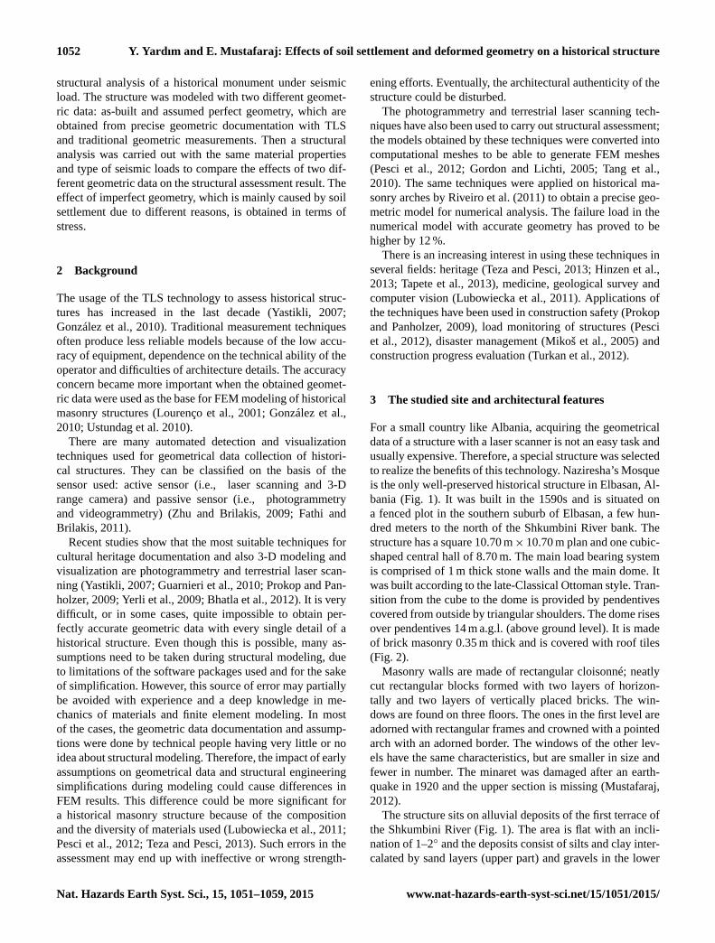
Other influences on the structural conditions created by
human intervention are the roads and the railway next to the
structure. The railway which lies 6 m away from the structure
was built in 1960 to connect the cities of Durrës and Korça. It
is located 1 m a.g.l., and it is used 4 times a day with heavily
loaded trains. In addition, a motorway was put in place just
next to the structure (as shown in Fig. 3). Studies show that
the presence of a railway at such a close distance to an unre-
inforced masonry structure may cause significant damage.
www.nat-hazards-earth-syst-sci.net/15/1051/2015/ Nat. Hazards Earth Syst. Sci., 15, 1051–1059, 2015
1054 Y. Yardım and E. Mustafaraj: Effects of soil settlement and deformed geometry on a historical structure
Table 1. Geological properties of soil under the structure.
Description Composition (%) Depth (m)
gravel sand silt clay
Layer 1 vegetal soil – – – – 0.4–0.6
Layer 2gravel–sand–clay
4.5–14.9 23.7–33.7 21.2–33.8 4.5–14.9 3.0–4.0mixture
Layer 3inorganic silt, clay of
– 21.5–33.5 51–65.2 7.7–16.9 3.5–4.0low–medium plasticity
Layer 4sand-gravel low–
1.1–9.1 21.2–35 51.2–61.4 10.5 2.2–3.5medium plasticity
Layer 5 gravel–sand–silt mixture 6.2–14.8 18.9–29.7 6.5–17.9 2.4–3.8 4.0–5.0
Koçak and Köksal (2010), in their study of Little Hagia
Sophia Mosque, among other reasons, counted the effect of
the railway as one of the big contributors to the settlement of
the structure. The railway, which was operational for 50 years
and lay 5 m away from the mosque, caused bricks to fall from
the nearby wall when trains were passing by. The present set-
tlement was measured towards the railway site of the struc-
ture. The significance of the railway’s effect may increase
with weak soil and a high water level (Koçak and Köksal,
2010).
4 Methodology
Data collection was enabled by a calibrated high-resolution
digital camera (Nikon D90) firmly mounted onto the laser
scanner (Optech ILRIS 3-D Intelligent Laser Ranging and
Imaging System) together with Topcon GPT-3007 Total Sta-
tion, which provided a combination of scan data and image
data. The laser scanner facilitates the measurement proce-
dure. It enables a field view of 360◦ along horizontal and a
60◦ view in vertical plane. In this way, a full panoramic view
could be generated. The generated point cloud provided ac-
curate details of the surface pattern of the structure and map-
ping coordinate system of the volume the structure covered.
The Optech ILRIS 3-D long-range laser scanner has a beam
divergence (in mrad),D(r)= 1.7× 10⁻⁴× r + 0.012, where
r is the acquisition distance in meters.
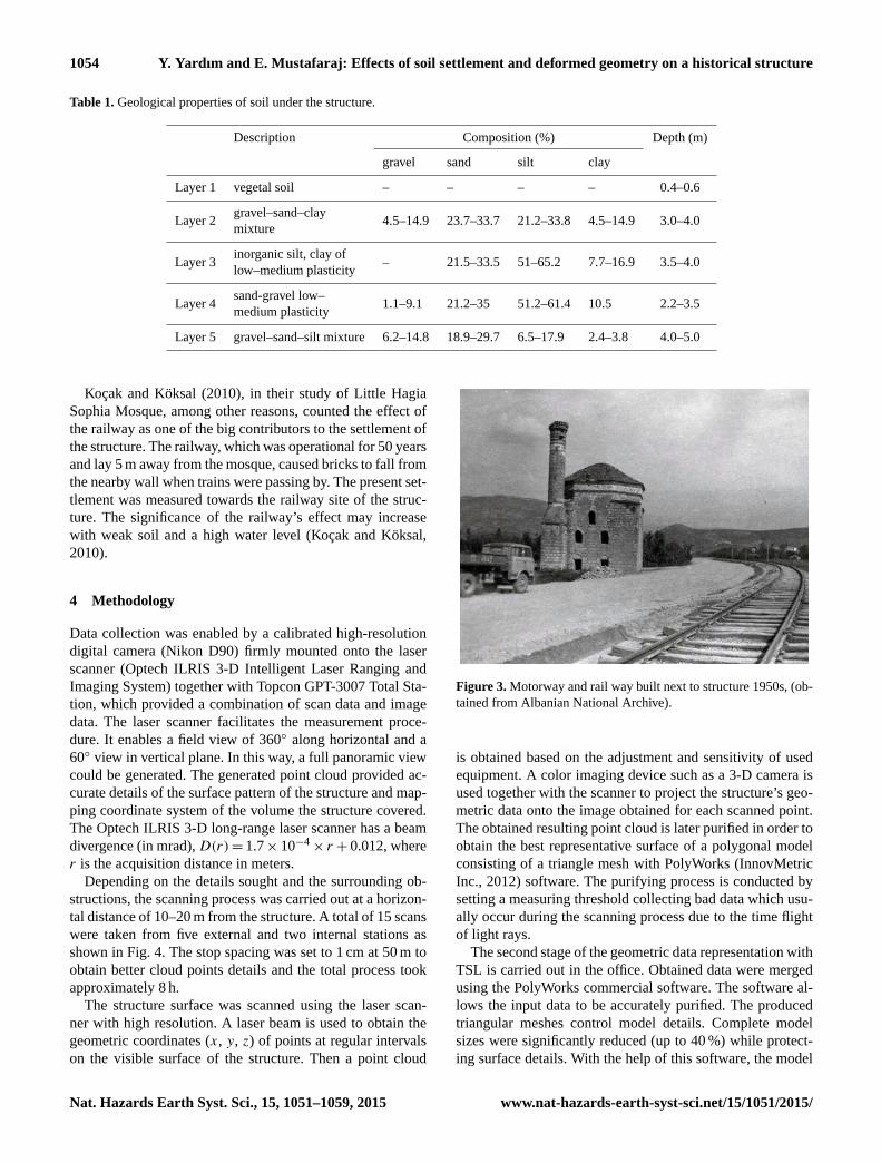
Depending on the details sought and the surrounding ob-
structions, the scanning process was carried out at a horizon-
tal distance of 10–20 m from the structure. A total of 15 scans
were taken from five external and two internal stations as
shown in Fig. 4. The stop spacing was set to 1 cm at 50 m to
obtain better cloud points details and the total process took
approximately 8 h.
The structure surface was scanned using the laser scan-
ner with high resolution. A laser beam is used to obtain the
geometric coordinates (x, y, z) of points at regular intervals
on the visible surface of the structure. Then a point cloud
Figure 3. Motorway and rail way built next to structure 1950s, (ob-
tained from Albanian National Archive).
is obtained based on the adjustment and sensitivity of used
equipment. A color imaging device such as a 3-D camera is
used together with the scanner to project the structure’s geo-
metric data onto the image obtained for each scanned point.
The obtained resulting point cloud is later purified in order to
obtain the best representative surface of a polygonal model
consisting of a triangle mesh with PolyWorks (InnovMetric
Inc., 2012) software. The purifying process is conducted by
setting a measuring threshold collecting bad data which usu-
ally occur during the scanning process due to the time flight
of light rays.
The second stage of the geometric data representation with
TSL is carried out in the office. Obtained data were merged
using the PolyWorks commercial software. The software al-
lows the input data to be accurately purified. The produced
triangular meshes control model details. Complete model
sizes were significantly reduced (up to 40 %) while protect-
ing surface details. With the help of this software, the model
Nat. Hazards Earth Syst. Sci., 15, 1051–1059, 2015 www.nat-hazards-earth-syst-sci.net/15/1051/2015/
Y. Yardım and E. Mustafaraj: Effects of soil settlement and deformed geometry on a historical structure 1055
Figure 4. Laser scanner view of the structure from different scan stations (May 2012): (a) northwest, (b) northeast, (c) north façade, (d) top
view, (e) southeast corner.
can be detailed where needed. Finally, three-dimensional
digital models were obtained.
An FEM modeling was carried out to demonstrate the
behavior of the structure based on the rough shape and a
more accurate shape. The analysis was carried out using
SAP2000 v.15.0 software (CSI, 2011), based on Eurocode 8
(EN1998-1, 2004), with consideration of the local earth-
quake code (KTP-N2, 1989). The elements and material were
chosen to obtain the most realistic simulation of the struc-
ture’s behavior. In order to validate the accuracy of the as-
sumed results, the modal frequencies were compared with
previous studies. The most difficult part in modeling a histor-
ical monument is obtaining the right material characteristics.
Since Naziresha’s mosque is a very old structure, the limi-
tation of knowledge is unavoidable due to the lack of infor-
mation or documentation of types of construction materials,
original architectural plans, maintenance schedule, modifica-
tion and restoration phases during its lifetime, etc. Addition-
ally, obtaining the required number of samples for testing is
not possible as it is a cultural monument of the first category
protected by law. Uncertainty may come from equipment ac-
curacy and measurement errors which may be overcome by
using tools with higher accuracy. In this study, the obstacles
related to acquisition of an accurate geometry of the struc-
ture are overpassed by making use of TLS and photogram-
metry, having a geometrical model as close as reality. The
model generated from TLS showed that there was a variation
in the thickness of the load bearing walls from 0.8 to 1.1 m,
whereas in the architectural plan they are described as 1 m
thick.
In the model, the modulus of elasticity and characteristic
stresses were defined according to previous studies in which
experimental tests were carried out to evaluate the charac-
Table 2. Assumed material properties of the FE model.
Brick Stone
Unit weight, γ (kN m−3) 17 21
Modulus of elasticity, E (MPa) 2100 1740
Void ratio, υ 0.2 0.2
Tensile strength (MPa) 0.564 1.42
Compressive strength (MPa) 1.03 4.06
teristic properties of the materials (Faella et al., 2004). The
material properties used for the model are shown in Table 2.
The masonry walls and the dome were modeled using
macro-modeling (masonry units and mortar layers are con-
sidered a continuum, where masonry is isotropic, homoge-
neous and shows elastic behavior) with shell elements.
A response spectrum analysis was performed to obtain
critical stresses. This analysis is a statistical method used to
determine the likely maximum response of the structure un-
der a specific seismic loading. It is defined as a set of val-
ues (acceleration, velocity or displacement) consisting of the
maximum responses of a single mass oscillator that varies
with natural frequencies and a given damping. In this anal-
ysis, a spectrum of pseudo-spectral acceleration versus pe-
riod is considered. This response indicates a statistical mag-
nitude of the likely maximum response for the considered
earthquake (CSI, 2011).
In order to study the effects of the ground motion excita-
tions on the structure, it is necessary to measure the intensity
of the motion. Hence, a response spectrum analysis was per-
formed based on EN1998-1 with a considering local code
of KTP-89. Peak ground acceleration based on obtained soil
data was chosen as 0.25 g.
www.nat-hazards-earth-syst-sci.net/15/1051/2015/ Nat. Hazards Earth Syst. Sci., 15, 1051–1059, 2015

1056 Y. Yardım and E. Mustafaraj: Effects of soil settlement and deformed geometry on a historical structure
Figure 5. Cracks due to differential settlement (1= 18 cm) in the south façade (May 2012).
5 Results and discussion
Representation of geometric imperfections is not uniform
along the structure; therefore, it is not easy to describe all
effects of such deformations. The recorded deformation has
been progressing for centuries. The morphological features
of the site and soil profile have been playing a key role for
this imperfection in geometry. Seismic activities and constant
vibration because of external impact accelerate and form this
deformation. Final shapes are formed with a combination of
these events with material characteristics. However, the soil
profile and general crack formation together with the TSL
measurement proves that the structure is deformed toward
the south façade of the mosque where the railway and motor-
way are also located.
The main reasons for this complexity rise from a variety of
internal and external influences. Based on the field study, the
measured geometric imperfection of the structure is primar-
ily caused by differential settlement of the foundation due
to the soil profile. The soil layers are very suitable to pro-
duce internal erosion with its different void ratio and particle
size along the vertical. This type of settlement is triggered
by earthquakes, frequent changes in underground water level
caused by the river base change, changes of ground water
level due to surrounding drainage system and constant vibra-
tions created by the adjacent motorway and railway. In ad-
dition to the above-mentioned factors, the maintenance that
had been carried out at different times during the lifespan of
the mosque with different materials whose characteristics do
not match the original materials could be a secondary or an
additional cause of imperfect geometry.
The laser scanner data were transferred to AutoCAD (Au-
todesk Inc., 2012) and Sap2000 (CSI, 2011) software to fig-
ure out a detailed representation of the geometric model. Sev-
eral optimizations and approximations were carried out dur-
ing this transformation between the software programs. The
main aim of this optimization is to avoid several types of
misrepresentations and error such as noise due to dust, vege-
tation and cracks. Based on the detailed scan, the southwest-
ern corner of the structure has settled down to 18 cm (Figs. 5
and 6). This corner is directly facing the motorway and rail-
way that passes next to the structure.
With the help of a laser scanner acquisition, the obtained
geometric imperfection results in an increase in stress con-
centrations under seismic load. This imperfection changes
the possible failure mechanisms and threatens the historical
monument if an earthquake were to occur in the area. With
respect to the corresponding models with more accurate ge-
ometry, the maximum tensile stress that occurs in the struc-
ture is 0.361 MPa under static load, 0.801 MPa under seismic
load and 0.144 s for the first mode. On the other hand, the
actual geometric model gives 0.774 MPa under static load,
1.4 MPa under seismic load and 0.174 s for the first mode.
The existing structural defects associated with the stress re-
sults are shown in Fig. 7; as expected, stress concentrations
were recorded at the corners of openings and wall connection
locations.
The cracks on the existing structure and stress concentra-
tion in the model verify this method. The key findings from
a comparison of stress concentrations due to response spec-
trum analysis are given in Fig. 7. The imperfect geometry
due to settlement directly affects stress concentration values
Nat. Hazards Earth Syst. Sci., 15, 1051–1059, 2015 www.nat-hazards-earth-syst-sci.net/15/1051/2015/

Y. Yardım and E. Mustafaraj: Effects of soil settlement and deformed geometry on a historical structure 1057
Figure 6. Deformation of the structure at the southeastern corner and east of the dome.
Figure 7. Stress difference for accurate and imperfect geometric model under combined dead and earthquake loading (stress values obtained
from SAP2000).
which are the key values to drawing retrofitting strategies
for the historical monument. The comparison between the
modes shows that the imperfect geometry has considerable
influence on modes as well. The periods for every mode are
summarized in Fig. 8. Stress concentration and the mode pe-
riod difference between the rough and accurate models give
good evidence of the extreme importance of the definition of
the correct geometry for this type of structure.
www.nat-hazards-earth-syst-sci.net/15/1051/2015/ Nat. Hazards Earth Syst. Sci., 15, 1051–1059, 2015

1058 Y. Yardım and E. Mustafaraj: Effects of soil settlement and deformed geometry on a historical structure
Figure 8. First five modes for as-built and assumed perfect geometry (SAP2000).
6 Conclusions
There were two main topics of interest in this study: (1) the
impact of the soil settlement on a structure’s stress concentra-
tions and (2) the influence of the laser scanning techniques on
structure modeling by obtaining the correct data of settlement
vs. deformation. The method used to analyse the structure
based on TLS data allows an accurate definition of the im-
perfect geometry patterns on every side of the structure. The
comparison of two models presented significant stress values
along the structure, hence, a different crack pattern. Addi-
tionally, the morphological and geological information seem
to support the TLS-based model showing a deformation re-
sulting from soil settlement. This settlement has been a con-
sequence of cumulative effects of soil profiles and also seis-
mic events which have occurred from the 1600s to today and
man-made vibrations due to vehicular and train traffic. Fi-
nal shapes are formed by combining these events with mate-
rial characteristics. Therefore, TLS-measured imperfections
in geometry are not in a uniform shape to be attributed to one
activity. However, soil profile and general crack formation
together with TSL measurement suggests that the structure
deformed toward the south façade, where a railway and mo-
torway are also located. The stress concentration and mode
period results have a considerable difference which high-
lights the failure mechanism and the mosque’s vulnerability
to earthquakes in the area and suggests the correct strategy
for possible retrofitting. The proposed method to detect ge-
ometric imperfection by TLS and incorporating the obtained
data into a structure model can be taken into account for fu-
ture restoration, retrofitting and acting on localized anoma-
lies such as cracks and settlement.
Acknowledgements. The authors wish to thank AST-Ahmet Soner
Toganas Bureau of Architecture, Ankara, for providing us with
useful architectural data of the mosque and their help with laser
scanning process.
Edited by: B. D. Malamud
Reviewed by: four anonymous referees
References
Aliaj, S., Muço, B., and Sulstarova, E.: Sizmiciteti, sizmotektonika
dhe vleresimi i rrezikut sizmik ne Shqipëri, (Albanian), Academy
of Sciences of Albania, Tirana, Albania, 2010.
Nat. Hazards Earth Syst. Sci., 15, 1051–1059, 2015 www.nat-hazards-earth-syst-sci.net/15/1051/2015/

Y. Yardım and E. Mustafaraj: Effects of soil settlement and deformed geometry on a historical structure 1059
Autodesk Inc.: http://www.autodesk.com/, last access: 28 Novem-
ber 2012.
Bhatla, A., Choe, S. Y., Fierro, O., and Leite, F.: Evaluation of ac-
curacy of as-built 3D modeling from photos taken by handheld
digital cameras, Automat. Construct., 28, 116–127, 2012.
CSI, SAP2000 v-15.0: Integrated finite element analysis and de-
sign of structures basic analysis reference manual, Computers
and Structures Inc, Berkeley, California, USA, 2011.
EN 1998-1: European seismic design code, Design of structures for
earthquake resistance, Part 1: General rules seismic actions and
rules for buildings, 2004.
Faella, C., Martinelli, E., Nigro, E., and Paciello, S.: Tuff masonry
walls strengthened with a new kind of C-FRP sheet: Experi-
mental tests and analysis, Paper No. 923, 13th WCEE, 1–6 Au-
gust 2004, Vancouver, 2004.
Fathi, H. and Brilakis, I.: Automated Sparse 3D Point Cloud Gener-
ation of Infrastructure using its Distinctive Visual Features, Adv.
Eng. Inform., 25, 760–770, 2011.
González, J. A., Rodríguez, B. R., Aguilera, D. G., and Brea, R. T.:
Terrestrial laser scanning intensity data applied to damage detec-
tion for historical buildings, J. Arch. Sci., 37, 3037–3047, 2010.
Gordon, S. J. and Lichti, D. D.: Modeling terrestrial laser scan-
ner data for precise structural deformation measurement, J. Surv.
Eng., 133, 72–80, 2005.
Guarnieri, A., Pirotti, F., and Vettore, A.: Cultural heritage interac-
tive 3-D models on the web: an approach using open source and
free software, J. Cult. Herit., 11, 350–353, 2010.
Hinzen, K. G., Schreiber, S., Fleischer, C., Reamer, S. K., and Isabel
Wiosna, I.: Archeoseismic study of damage in Roman and Me-
dieval structures in the center of Cologne, Germany, J. Seismol.,
17, 399–424, 2013.
InnovMetric Inc: http://www.innovmetric.com/polyworks/
3D-scanners/home.aspx?lang=en, last access: 12 Decem-
ber 2012.
Koçak, A. and Köksal, K.: An example for determining the cause
of damage in historical buildings: Little Hagia Sophia (Church
of St. Sergius and Bacchus) – Istanbul, Turkey, Eng. Fail. Anal.,
17, 926–937, 2010.
KTP-N2: Earthquake Resistant Design Regulations, Academy of
Science of Albania, Tirana, Albania 1989.
Lahoz, J. G., Aguilera, D. G., Finat, J., Martínez, J., Fernández,
J., and José, S. J.: Terrestrial laser scanning metric control:
assessment of metric accuracy for cultural heritage modeling,
10 Proc. ISPRS Commission V Symp. Dresden, Germany, 2006.
Lerones, P. M., Fernández, J. L., Gil, A. M., Bermejo, J. G. G. B.,
and Casanova, E. Z.: A practical approach to making accurate
3-D layouts of interesting cultural heritage sites through digital
models, J. Cult. Herit., 11, 1–9, 2010.
Lourenço, P. B., Mele, E., Gatto, D., and Luca, A. D.: Structural
analysis of basilica churches: a case study, Historical Construc-
tions, Guimarães, Portugal, 729–738, 2001.
Lubowiecka, I., Armesto, J., Arias, P., and Lorenzo, H.: Historic
bridge modelling using laser scanning, ground penetrating radar
and finite element methods in the context of structural dynamics,
J. Eng. Str., 31, 2667–2676, 2009.
Lubowiecka, I., Arias, P., Riveiro, B., and Solla, M.: Multidisci-
plinary approach to the assessment of historic structures based on
the case of a masonry bridge in Galicia (Spain), Comput. Struct.,
89, 1615–1627, 2011.
Mikoš, M., Vidmar, A., and Brilly, M.: Using a laser measure-
ment system for monitoring morphological changes on the Strug
rock fall, Slovenia, Nat. Hazards Earth Syst. Sci., 5, 143–153,
doi:10.5194/nhess-5-143-2005, 2005.
Mustafaraj, E.: A case study on structural assessment of Ottoman
mosques in Albania, MSc Thesis, Epoka University, Tirana, Al-
bania, 2012.
Papazachos, B. C: Active tectonics in Aegean and surrounding area,
Proceedings Summer School on Seismic Hazard in Mediter-
ranean Regions, 21–30 July 1986, Strasbourg, France, 301–331,
1988.
Pesci, A., Casula, G., and Boschi, E.: Laser scanning the Garisenda
and Asinelli towers in Bologna (Italy): detailed deformation pat-
terns of two ancient leaning buildings, J. Cult. Herit., 12, 117–
127, 2011.
Pesci, A., Bonali, E., Galli, C., and Boschi, E.: Laser scanning
and digital imaging for the investigation of an ancient building:
Palazzo d’Accursio study case (Bologna, Italy), J. Cult. Herit.,
13, 215–220, 2012.
Prokop, A. and Panholzer, H.: Assessing the capability of terrestrial
laser scanning for monitoring slow moving landslides, Nat. Haz-
ards Earth Syst. Sci., 9, 1921–1928, doi:10.5194/nhess-9-1921-
2009, 2009.
Riveiro, B., Caamaño, J. C., Arias, P., and Sanz, E.: Photogrammet-
ric 3-D modelling and mechanical analysis of masonry arches: an
approach based on a discontinuous model of voussoirs, Autom.
Constr., 20, 380–388, 2011.
Tang, P., Huber, D., Akinci, B., Lipman, R., and Lytle, A.: Au-
tomatic reconstruction of as-built building information models
from laser-scanned point clouds: a review of related techniques,
Autom. Constr., 19, 829–843, 2010.
Tapete, D., Casagli, N., Luzi, G., Fanti, R., Gigli, G., and Leva, D.:
Integrating radar and laser-based remote sensing techniques for
monitoring structural deformation of archaeological heritage, J.
Arch. Sci., 40, 176–189, doi:10.1016/j.jas.2012.07.024, 2013.
Teza, G. and Pesci, A.: Geometric characterization of a cylinder-
shaped structure from laser scanner data: development of an anal-
ysis tool and its use on a leaning bell tower, J. Cult. Herit., 14,
411–423, 2013.
Turkan, Y., Bosche, F., Haas, C. T., and Haas, R.: Automated
progress tracking using 4-D schedule and 3-D sensing technolo-
gies, Autom. Constr., 22, 414–421, 2012.
Ustundag, C., Sesigur, H., and Cili, F.: Seismic evaluation and
retrofit of the 16th century Mihrimah Sultan Mosque, 14th Euro-
pean Conf. on Earthquake Eng., 30 August–9 September 2010,
Ohrid, F. Y. R. Macedonia, 2010.
Yastikli, N.: Documentation of cultural heritage using digital pho-
togrammetry and laser scanning, J. Cult. Herit., 8, 423–427,
2007.
Yerli, B., Schreiber, S., Veen, J. H. T., and Sintubin, M.: Testing
the hypothesis of earthquake related damage in structures in the
Lycian ancient city of Pinara, SW Turkey, 1st INQUAIGCP-567
Int. Workshop on Earthq. Archaeo. Palaeoseism., 7–13 Septem-
ber 2009, Baleo Claudia, Spain, 173–176, 2009.
Zhu, A. and Brilakis, I.: Comparison of optical sensor-based spa-
tial data collection techniques for civil infrastructure modeling,
J. Comput. Civ. Eng., 23, 170–178, 2009.
www.nat-hazards-earth-syst-sci.net/15/1051/2015/ Nat. Hazards Earth Syst. Sci., 15, 1051–1059, 2015
Related Documents


![NAVAL POSTGRADUATE SCHOOL · Virtual Crack Closure Technique for Two-dimensional Solid Elements. From [2].....6 Figure 3. Deformed Crack Geometry—Without Resin Interface.10 Figure](https://static.cupdf.com/doc/110x72/605ee27cb41d710d4940bcf6/naval-postgraduate-school-virtual-crack-closure-technique-for-two-dimensional-solid.jpg)