EFFECTS OF FLIGHT ALTITUDE ON TREE HEIGHT ESTIMATION USING AIRBORNE LASER SCANNING Xiaowei Yu 1 , Juha Hyyppä 1 , Hannu Hyyppä 2 and Matti Maltamo 3 1 Finnish Geodetic Institute, Geodeetinrinne 2, P.O. Box 15, 02431 Masala, Finland - [email protected], [email protected] 2 Helsinki University of Technology, HUT-02150 Espoo, Finland - [email protected] 3 University of Joensuu, Faculty of forestry, Joensuu, Finland - [email protected] KEY WORDS: Laser scanning; Tree height; Flight altitude; Footprint size; Sampling density. ABSTRACT: High-density airborne laser scanner data has been previously shown to provide great opportunities for individual tree detection and measurement of variables characterizing the detected trees. This paper evaluates the effect of laser flight altitude on the tree height estimation at individual tree level in the boreal forest area mainly consisting of Norway spruce, Scots pine and birch. The test area (0.5 km by 2 km) was flown at three altitudes (400 m, 800 m and 1500 m) with TopoSys Falcon scanner in spring 2003. Field inventory was carried out on 33 sample plots (about 30 m x 30 m) in the test area during summer 2001. Trees with diameter at breast height larger than 5 cm were measured. Position, height and species of the trees were recorded. 13 plots were dominated by spruce (>50 %), 7 plots by pine, 6 plots by deciduous trees and the rest were mixed forests. Laser point clouds in the circle of varying radius around the trees were used to extract information about spatial distribution of tree crown and height without delineation of individual trees first. Evaluations of estimation errors due to flight altitudes, including beam size and pulse density, were performed for different tree species. The results indicate, in general, that tree height estimation accuracy and number of detectable trees decreases with the increase in flight height. Point density has more influence on tree height estimation than footprint size. Birch is less affected than coniferous trees by the change in the flight altitude. 1. INTRODUCTION Airborne laser scanning has been used to acquire data to measure forest characteristics directly or indirectly and at various levels for different types of forest. In particular, tree heights, basal area, volume and forest biomass (Nelson et al., 1988; Nilsson, 1996; Næsset, 1997, 2002; Magnussen and Boudewyn, 1998; Hyyppä and Inkinen, 1999; Means et al., 2000; Schardt et al., 2002; Nilsson and Holmgren, 2003, Popescu et al., 2003), as well as tree species (Brandtberg et al., 2003; Holmgren and Persson, 2004) have been successfully derived from laser scanner data. Using multi- temporal laser data sets, even the growth of the trees can be determined and harvested trees can be automatically detected (Yu et al., 2004a). Within forest inventory the main interest is focused on automatic measurement of tree height for different tree species and automatic delineation of tree crowns, because from crown diameter and tree height other important inventory parameter can be derived (Friedlaender and Koch, 2000). Tree height as a crucial forest inventory attribute in planning and in timber volume calculation is one of the physical parameters of trees that can be directly measured with laser scanning. Among the first laser-based experiments, tree heights were derived from laser canopy profiles (Nelson et al., 1984; Nilsson, 1994). Recently studies have indicated high potential in assessing even heights of single trees using laser scanning (Hyyppä and Inkinen, 1999; Persson et al., 2002; Brandtberg et al., 2003). Accuracy of tree heights measured with laser scanner has been reported to be comparable with the accuracy of field measurements (Hyyppä et al., 2001; Persson et al., 2002; Maltamo et al., 2004). There seems to be a good potential for laser scanning to become an operational technique for forest inventories if the costs of data acquisition can be reduced. One way to reduce these costs is to increase the flight altitude. However, when flight altitude increases, the pulse density decreases and footprint size increases if pulse-repetition frequency kept fixed. Therefore, it is necessary to investigate the effect of flight altitude change on tree height estimation. It has been shown that the tree height is typically underestimated by laser scanning (Nelson et al. 1988; Nilsson, 1994,1996; Næsset, 1997; Gaveau and Hill, 2003; Leckie et al., 2003; Rönnholm et al., 2004). Even though the phenomenon has been known for about 20 years, the reasons for underestimation have not been fully explored. Effect of using different pulse/sampling densities on estimation error has been evaluated by Nilsson (1996) and Holmgren (2003). The tree height estimation from laser data is also affected by the footprint diameter (see Aldred and Bonnor, 1985; Nilsson, 1994; Persson et al., 2002; Næsset, 2004). Gaveau and Hill (2003) found that a small footprint laser pulse hitting the upper surface of a canopy often advances into the canopy before reflecting a signal strong enough to be detected by the scanner as a first return. The depth of laser pulse penetration varies with canopy structural characteristics and laser scanning device configuration. In addition to these, Nelson et al. (1988) and Maltamo et al. (2004) reported that tree height estimation accuracy varied with stand density. Other parameters affecting the estimation have been reported to be scan angle (Holmgren et al., 2003), tree species and crown shape (Nelson, 1997; Maltamo et al. 2004). The objectives of this study were to evaluate the effect of pulse density and footprint size together and separately on the tree height estimation and the influences of tree species on the estimation.

Welcome message from author
This document is posted to help you gain knowledge. Please leave a comment to let me know what you think about it! Share it to your friends and learn new things together.
Transcript

EFFECTS OF FLIGHT ALTITUDE ON TREE HEIGHT ESTIMATION USING AIRBORNE LASER SCANNING
Xiaowei Yu1, Juha Hyyppä1, Hannu Hyyppä2 and Matti Maltamo3
1Finnish Geodetic Institute, Geodeetinrinne 2, P.O. Box 15, 02431 Masala, Finland - [email protected], [email protected]
2Helsinki University of Technology, HUT-02150 Espoo, Finland - [email protected] 3University of Joensuu, Faculty of forestry, Joensuu, Finland - [email protected]
KEY WORDS: Laser scanning; Tree height; Flight altitude; Footprint size; Sampling density. ABSTRACT: High-density airborne laser scanner data has been previously shown to provide great opportunities for individual tree detection and measurement of variables characterizing the detected trees. This paper evaluates the effect of laser flight altitude on the tree height estimation at individual tree level in the boreal forest area mainly consisting of Norway spruce, Scots pine and birch. The test area (0.5 km by 2 km) was flown at three altitudes (400 m, 800 m and 1500 m) with TopoSys Falcon scanner in spring 2003. Field inventory was carried out on 33 sample plots (about 30 m x 30 m) in the test area during summer 2001. Trees with diameter at breast height larger than 5 cm were measured. Position, height and species of the trees were recorded. 13 plots were dominated by spruce (>50 %), 7 plots by pine, 6 plots by deciduous trees and the rest were mixed forests. Laser point clouds in the circle of varying radius around the trees were used to extract information about spatial distribution of tree crown and height without delineation of individual trees first. Evaluations of estimation errors due to flight altitudes, including beam size and pulse density, were performed for different tree species. The results indicate, in general, that tree height estimation accuracy and number of detectable trees decreases with the increase in flight height. Point density has more influence on tree height estimation than footprint size. Birch is less affected than coniferous trees by the change in the flight altitude.
1. INTRODUCTION
Airborne laser scanning has been used to acquire data to measure forest characteristics directly or indirectly and at various levels for different types of forest. In particular, tree heights, basal area, volume and forest biomass (Nelson et al., 1988; Nilsson, 1996; Næsset, 1997, 2002; Magnussen and Boudewyn, 1998; Hyyppä and Inkinen, 1999; Means et al., 2000; Schardt et al., 2002; Nilsson and Holmgren, 2003, Popescu et al., 2003), as well as tree species (Brandtberg et al., 2003; Holmgren and Persson, 2004) have been successfully derived from laser scanner data. Using multi-temporal laser data sets, even the growth of the trees can be determined and harvested trees can be automatically detected (Yu et al., 2004a). Within forest inventory the main interest is focused on automatic measurement of tree height for different tree species and automatic delineation of tree crowns, because from crown diameter and tree height other important inventory parameter can be derived (Friedlaender and Koch, 2000). Tree height as a crucial forest inventory attribute in planning and in timber volume calculation is one of the physical parameters of trees that can be directly measured with laser scanning. Among the first laser-based experiments, tree heights were derived from laser canopy profiles (Nelson et al., 1984; Nilsson, 1994). Recently studies have indicated high potential in assessing even heights of single trees using laser scanning (Hyyppä and Inkinen, 1999; Persson et al., 2002; Brandtberg et al., 2003). Accuracy of tree heights measured with laser scanner has been reported to be comparable with the accuracy of field measurements (Hyyppä et al., 2001; Persson et al., 2002; Maltamo et al., 2004). There seems to be a good potential for laser scanning to become an operational technique for forest inventories if the
costs of data acquisition can be reduced. One way to reduce these costs is to increase the flight altitude. However, when flight altitude increases, the pulse density decreases and footprint size increases if pulse-repetition frequency kept fixed. Therefore, it is necessary to investigate the effect of flight altitude change on tree height estimation. It has been shown that the tree height is typically underestimated by laser scanning (Nelson et al. 1988; Nilsson, 1994,1996; Næsset, 1997; Gaveau and Hill, 2003; Leckie et al., 2003; Rönnholm et al., 2004). Even though the phenomenon has been known for about 20 years, the reasons for underestimation have not been fully explored. Effect of using different pulse/sampling densities on estimation error has been evaluated by Nilsson (1996) and Holmgren (2003). The tree height estimation from laser data is also affected by the footprint diameter (see Aldred and Bonnor, 1985; Nilsson, 1994; Persson et al., 2002; Næsset, 2004). Gaveau and Hill (2003) found that a small footprint laser pulse hitting the upper surface of a canopy often advances into the canopy before reflecting a signal strong enough to be detected by the scanner as a first return. The depth of laser pulse penetration varies with canopy structural characteristics and laser scanning device configuration. In addition to these, Nelson et al. (1988) and Maltamo et al. (2004) reported that tree height estimation accuracy varied with stand density. Other parameters affecting the estimation have been reported to be scan angle (Holmgren et al., 2003), tree species and crown shape (Nelson, 1997; Maltamo et al. 2004). The objectives of this study were to evaluate the effect of pulse density and footprint size together and separately on the tree height estimation and the influences of tree species on the estimation.
Hintz
- 96 -
2. STUDY AREA AND DATA
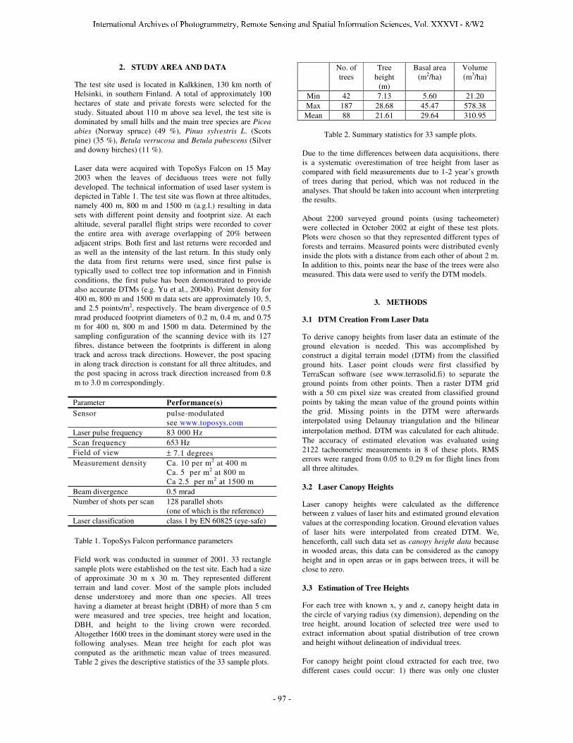
The test site used is located in Kalkkinen, 130 km north of Helsinki, in southern Finland. A total of approximately 100 hectares of state and private forests were selected for the study. Situated about 110 m above sea level, the test site is dominated by small hills and the main tree species are Picea abies (Norway spruce) (49 %), Pinus sylvestris L. (Scots pine) (35 %), Betula verrucosa and Betula pubescens (Silver and downy birches) (11 %). Laser data were acquired with TopoSys Falcon on 15 May 2003 when the leaves of deciduous trees were not fully developed. The technical information of used laser system is depicted in Table 1. The test site was flown at three altitudes, namely 400 m, 800 m and 1500 m (a.g.l.) resulting in data sets with different point density and footprint size. At each altitude, several parallel flight strips were recorded to cover the entire area with average overlapping of 20% between adjacent strips. Both first and last returns were recorded and as well as the intensity of the last return. In this study only the data from first returns were used, since first pulse is typically used to collect tree top information and in Finnish conditions, the first pulse has been demonstrated to provide also accurate DTMs (e.g. Yu et al., 2004b). Point density for 400 m, 800 m and 1500 m data sets are approximately 10, 5, and 2.5 points/m2, respectively. The beam divergence of 0.5 mrad produced footprint diameters of 0.2 m, 0.4 m, and 0.75 m for 400 m, 800 m and 1500 m data. Determined by the sampling configuration of the scanning device with its 127 fibres, distance between the footprints is different in along track and across track directions. However, the post spacing in along track direction is constant for all three altitudes, and the post spacing in across track direction increased from 0.8 m to 3.0 m correspondingly. Parameter Performance(s) Sensor pulse-modulated
see www.toposys.com Laser pulse frequency 83 000 Hz Scan frequency 653 Hz Field of view ± 7.1 degrees Measurement density Ca. 10 per m2 at 400 m
Ca. 5 per m2 at 800 m Ca 2.5 per m2 at 1500 m
Beam divergence 0.5 mrad Number of shots per scan 128 parallel shots
(one of which is the reference) Laser classification class 1 by EN 60825 (eye-safe)
Table 1. TopoSys Falcon performance parameters
Field work was conducted in summer of 2001. 33 rectangle sample plots were established on the test site. Each had a size of approximate 30 m x 30 m. They represented different terrain and land cover. Most of the sample plots included dense understorey and more than one species. All trees having a diameter at breast height (DBH) of more than 5 cm were measured and tree species, tree height and location, DBH, and height to the living crown were recorded. Altogether 1600 trees in the dominant storey were used in the following analyses. Mean tree height for each plot was computed as the arithmetic mean value of trees measured. Table 2 gives the descriptive statistics of the 33 sample plots.
No. of trees
Tree height
(m)
Basal area (m2/ha)
Volume (m3/ha)
Min 42 7.13 5.60 21.20 Max 187 28.68 45.47 578.38 Mean 88 21.61 29.64 310.95
Table 2. Summary statistics for 33 sample plots.
Due to the time differences between data acquisitions, there is a systematic overestimation of tree height from laser as compared with field measurements due to 1-2 year’s growth of trees during that period, which was not reduced in the analyses. That should be taken into account when interpreting the results. About 2200 surveyed ground points (using tacheometer) were collected in October 2002 at eight of these test plots. Plots were chosen so that they represented different types of forests and terrains. Measured points were distributed evenly inside the plots with a distance from each other of about 2 m. In addition to this, points near the base of the trees were also measured. This data were used to verify the DTM models.
3. METHODS
3.1 DTM Creation From Laser Data
To derive canopy heights from laser data an estimate of the ground elevation is needed. This was accomplished by construct a digital terrain model (DTM) from the classified ground hits. Laser point clouds were first classified by TerraScan software (see www.terrasolid.fi) to separate the ground points from other points. Then a raster DTM grid with a 50 cm pixel size was created from classified ground points by taking the mean value of the ground points within the grid. Missing points in the DTM were afterwards interpolated using Delaunay triangulation and the bilinear interpolation method. DTM was calculated for each altitude. The accuracy of estimated elevation was evaluated using 2122 tacheometric measurements in 8 of these plots. RMS errors were ranged from 0.05 to 0.29 m for flight lines from all three altitudes. 3.2 Laser Canopy Heights
Laser canopy heights were calculated as the difference between z values of laser hits and estimated ground elevation values at the corresponding location. Ground elevation values of laser hits were interpolated from created DTM. We, henceforth, call such data set as canopy height data because in wooded areas, this data can be considered as the canopy height and in open areas or in gaps between trees, it will be close to zero. 3.3 Estimation of Tree Heights
For each tree with known x, y and z, canopy height data in the circle of varying radius (xy dimension), depending on the tree height, around location of selected tree were used to extract information about spatial distribution of tree crown and height without delineation of individual trees. For canopy height point cloud extracted for each tree, two different cases could occur: 1) there was only one cluster
Hintz
International Archives of Photogrammetry, Remote Sensing and Spatial Information Sciences, Vol. XXXVI - 8/W2
Hintz
- 97 -
(point cloud referring to a tree), 2) there were more than one cluster. The number of tree clusters was defined using histogram of the point cloud data corresponding to canopy height. For case 1), maximum z value of cluster was chosen as the measure of tree height. For case 2), maximum z value of the selected cluster was chosen as a measure of tree height. The selection was done by comparing the heights of the clusters and the reference tree. After linking the trees with laser measurements, trees that have a distance greater than 2 m or a height difference greater than 5 m between field and laser measurements were considered as an error in finding the trees from laser data and, therefore, removed from further analyses. The number of correctly detected trees is the number of the trees remained. Data was processed stripwise so that the point density will not increase in overlapping area. For trees that were located in overlapping areas, tree height was measured twice each from one of adjacent strips. Although the number of such trees is small, this gives us the opportunity to study the effect of viewing geometry on tree height estimations. However, only one estimate was used in analysing the effect of flight altitude on tree height. 3.4 Data Reduction
To investigate the effect of point density and beam divergence separately, the original laser data was reduced. Since the along track point spacing is independent of flying height, along track density is the same for data from different altitudes as long as the flying speed is constant. Therefore, the reduction was performed only in the direction of across track. E.g. data set with point density similar to 800 m laser data can be obtained from 400 m laser data by removing every second measurements within each scan lines. DTMs derived from original data were used in calculations of canopy height for reduced data.
4. EVALUATION
Evaluations were performed by comparing laser-derived values from three altitudes with field measured values and with each other. Mean and standard deviations (S. D.) of the differences were used to express the systematic (bias) and random errors. Because the tree species were registered in the field inventory, their influence on the tree height estimates from different altitudes could be studied as well.
5. RESULTS
5.1 Effect of the Viewing Geometry on DTM and Tree Height Estimation
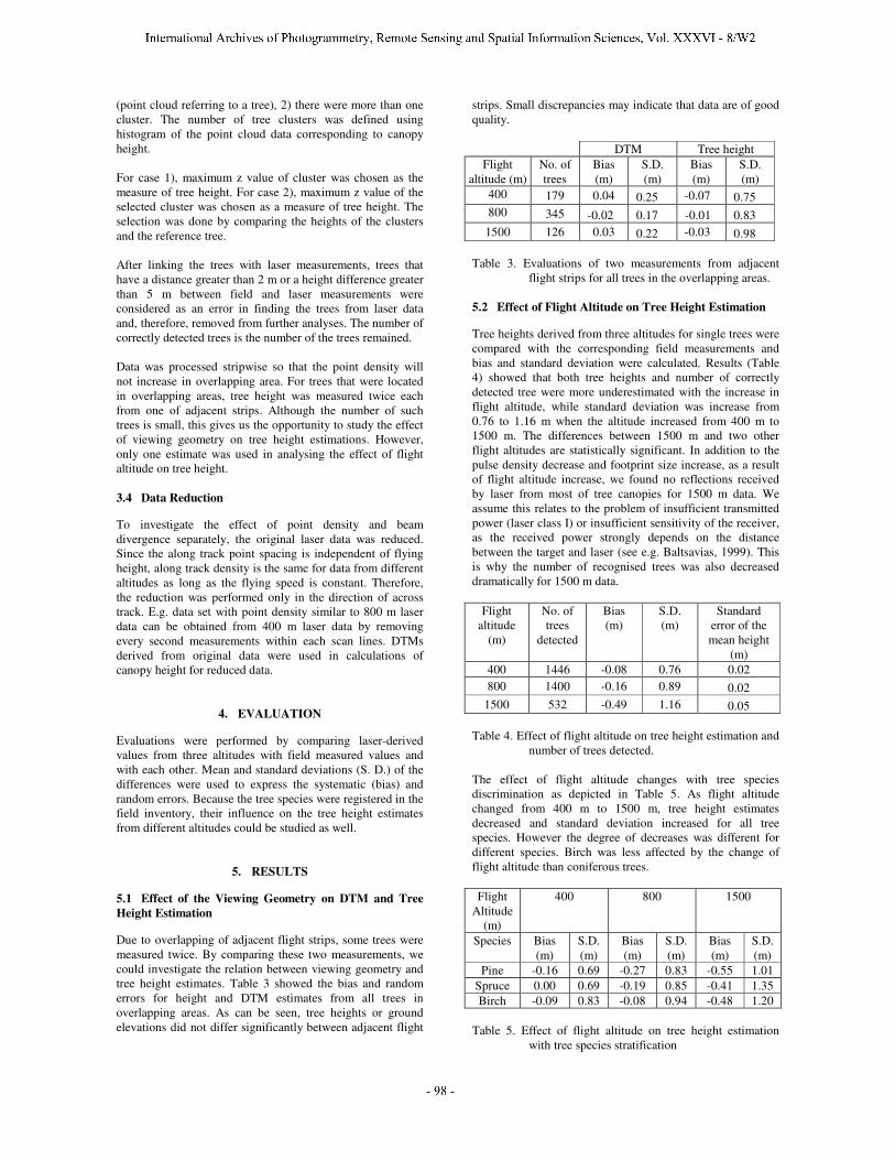
Due to overlapping of adjacent flight strips, some trees were measured twice. By comparing these two measurements, we could investigate the relation between viewing geometry and tree height estimates. Table 3 showed the bias and random errors for height and DTM estimates from all trees in overlapping areas. As can be seen, tree heights or ground elevations did not differ significantly between adjacent flight
strips. Small discrepancies may indicate that data are of good quality.
DTM Tree height Flight
altitude (m) No. of trees
Bias (m)
S.D. (m)
Bias (m)
S.D. (m)
400 179 0.04 0.25 -0.07 0.75 800 345 -0.02 0.17 -0.01 0.83 1500 126 0.03 0.22 -0.03 0.98
Table 3. Evaluations of two measurements from adjacent
flight strips for all trees in the overlapping areas. 5.2 Effect of Flight Altitude on Tree Height Estimation
Tree heights derived from three altitudes for single trees were compared with the corresponding field measurements and bias and standard deviation were calculated. Results (Table 4) showed that both tree heights and number of correctly detected tree were more underestimated with the increase in flight altitude, while standard deviation was increase from 0.76 to 1.16 m when the altitude increased from 400 m to 1500 m. The differences between 1500 m and two other flight altitudes are statistically significant. In addition to the pulse density decrease and footprint size increase, as a result of flight altitude increase, we found no reflections received by laser from most of tree canopies for 1500 m data. We assume this relates to the problem of insufficient transmitted power (laser class I) or insufficient sensitivity of the receiver, as the received power strongly depends on the distance between the target and laser (see e.g. Baltsavias, 1999). This is why the number of recognised trees was also decreased dramatically for 1500 m data.
Flight altitude
(m)
No. of trees
detected
Bias (m)
S.D. (m)
Standard error of the mean height
(m) 400 1446 -0.08 0.76 0.02 800 1400 -0.16 0.89 0.02
1500 532 -0.49 1.16 0.05 Table 4. Effect of flight altitude on tree height estimation and
number of trees detected. The effect of flight altitude changes with tree species discrimination as depicted in Table 5. As flight altitude changed from 400 m to 1500 m, tree height estimates decreased and standard deviation increased for all tree species. However the degree of decreases was different for different species. Birch was less affected by the change of flight altitude than coniferous trees. Flight
Altitude (m)
400 800 1500
Species Bias (m)
S.D. (m)
Bias (m)
S.D. (m)
Bias (m)
S.D. (m)
Pine -0.16 0.69 -0.27 0.83 -0.55 1.01 Spruce 0.00 0.69 -0.19 0.85 -0.41 1.35 Birch -0.09 0.83 -0.08 0.94 -0.48 1.20
Table 5. Effect of flight altitude on tree height estimation
with tree species stratification
Hintz
International Archives of Photogrammetry, Remote Sensing and Spatial Information Sciences, Vol. XXXVI - 8/W2
Hintz
- 98 -
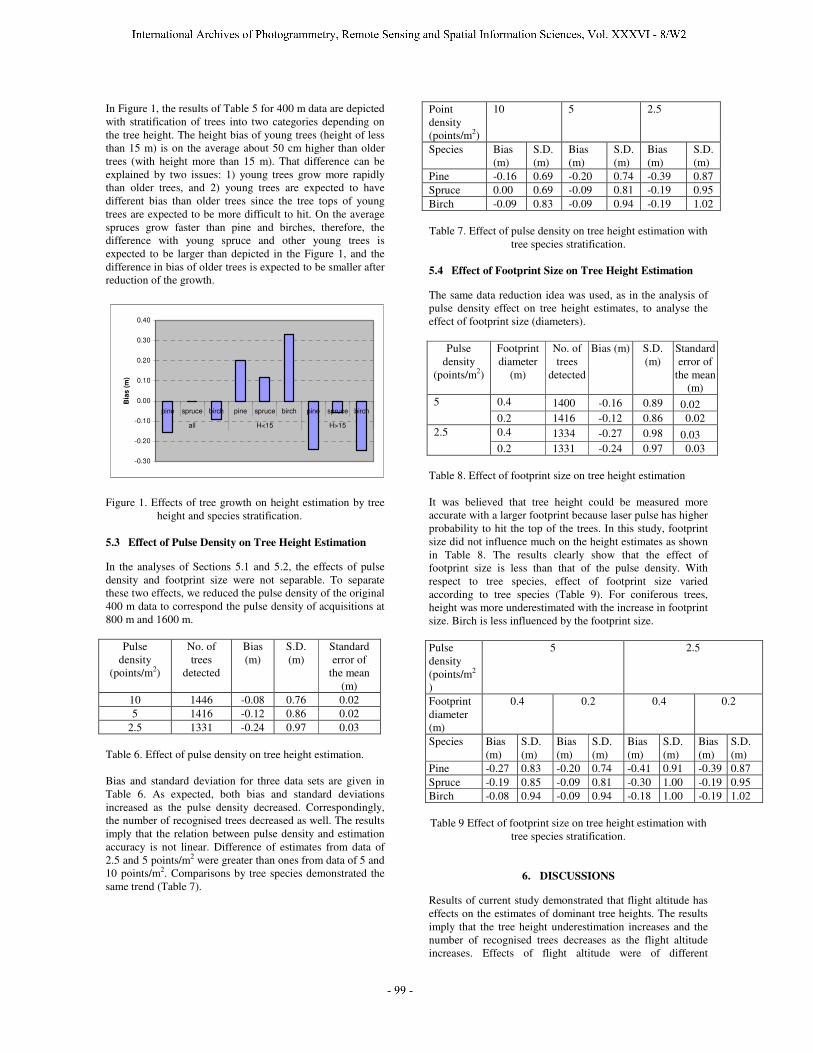
In Figure 1, the results of Table 5 for 400 m data are depicted with stratification of trees into two categories depending on the tree height. The height bias of young trees (height of less than 15 m) is on the average about 50 cm higher than older trees (with height more than 15 m). That difference can be explained by two issues: 1) young trees grow more rapidly than older trees, and 2) young trees are expected to have different bias than older trees since the tree tops of young trees are expected to be more difficult to hit. On the average spruces grow faster than pine and birches, therefore, the difference with young spruce and other young trees is expected to be larger than depicted in the Figure 1, and the difference in bias of older trees is expected to be smaller after reduction of the growth.
-0.30
-0.20
-0.10
0.00
0.10
0.20
0.30
0.40
pine spruce birch pine spruce birch pine spruce birch
all H<15 H>15
Bia
s (m
)
Figure 1. Effects of tree growth on height estimation by tree
height and species stratification. 5.3 Effect of Pulse Density on Tree Height Estimation
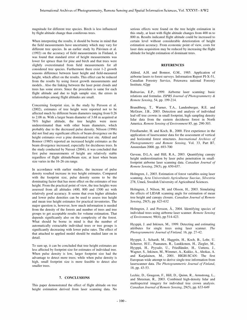
In the analyses of Sections 5.1 and 5.2, the effects of pulse density and footprint size were not separable. To separate these two effects, we reduced the pulse density of the original 400 m data to correspond the pulse density of acquisitions at 800 m and 1600 m.
Pulse density
(points/m2)
No. of trees
detected
Bias (m)
S.D. (m)
Standard error of
the mean (m)
10 1446 -0.08 0.76 0.02 5 1416 -0.12 0.86 0.02
2.5 1331 -0.24 0.97 0.03 Table 6. Effect of pulse density on tree height estimation. Bias and standard deviation for three data sets are given in Table 6. As expected, both bias and standard deviations increased as the pulse density decreased. Correspondingly, the number of recognised trees decreased as well. The results imply that the relation between pulse density and estimation accuracy is not linear. Difference of estimates from data of 2.5 and 5 points/m2 were greater than ones from data of 5 and 10 points/m2. Comparisons by tree species demonstrated the same trend (Table 7).
Point density (points/m2)
10 5 2.5
Species Bias (m)
S.D. (m)
Bias (m)
S.D. (m)
Bias (m)
S.D. (m)
Pine -0.16 0.69 -0.20 0.74 -0.39 0.87 Spruce 0.00 0.69 -0.09 0.81 -0.19 0.95 Birch -0.09 0.83 -0.09 0.94 -0.19 1.02 Table 7. Effect of pulse density on tree height estimation with
tree species stratification. 5.4 Effect of Footprint Size on Tree Height Estimation
The same data reduction idea was used, as in the analysis of pulse density effect on tree height estimates, to analyse the effect of footprint size (diameters).
Pulse density
(points/m2)
Footprint diameter
(m)
No. of trees
detected
Bias (m) S.D. (m)
Standard error of
the mean (m)
0.4 1400 -0.16 0.89 0.02 5 0.2 1416 -0.12 0.86 0.02 0.4 1334 -0.27 0.98 0.03 2.5 0.2 1331 -0.24 0.97 0.03
Table 8. Effect of footprint size on tree height estimation It was believed that tree height could be measured more accurate with a larger footprint because laser pulse has higher probability to hit the top of the trees. In this study, footprint size did not influence much on the height estimates as shown in Table 8. The results clearly show that the effect of footprint size is less than that of the pulse density. With respect to tree species, effect of footprint size varied according to tree species (Table 9). For coniferous trees, height was more underestimated with the increase in footprint size. Birch is less influenced by the footprint size. Pulse density (points/m2
)
5 2.5
Footprint diameter (m)
0.4 0.2 0.4 0.2
Species Bias (m)
S.D. (m)
Bias (m)
S.D. (m)
Bias (m)
S.D. (m)
Bias (m)
S.D. (m)
Pine -0.27 0.83 -0.20 0.74 -0.41 0.91 -0.39 0.87 Spruce -0.19 0.85 -0.09 0.81 -0.30 1.00 -0.19 0.95 Birch -0.08 0.94 -0.09 0.94 -0.18 1.00 -0.19 1.02 Table 9 Effect of footprint size on tree height estimation with
tree species stratification.
6. DISCUSSIONS
Results of current study demonstrated that flight altitude has effects on the estimates of dominant tree heights. The results imply that the tree height underestimation increases and the number of recognised trees decreases as the flight altitude increases. Effects of flight altitude were of different
Hintz
International Archives of Photogrammetry, Remote Sensing and Spatial Information Sciences, Vol. XXXVI - 8/W2
Hintz
- 99 -
magnitude for different tree species. Birch is less influenced by flight altitude change than coniferous trees. When interpreting the results, it should be borne in mind that the field measurements have uncertainty which may vary for different tree species. In an earlier study by Päivinen et al. (1992) on the accuracy of field measurements in Finland, it was found that standard error of height measurements was lower for spruce than for pine and birch and that trees were slightly overestimated from field measurements for all considered tree species. Furthermore there exist 1-2 growth seasons difference between laser height and field-measured height, which affect on the results. This effect can be reduced from the results by using forest growth measurements and models.. Also the linking between the laser point clouds and trees has some errors. Since the procedure is same for each flight altitude and due to high sample size, the errors in relationships among flight altitudes are small. Concerning footprint size, in the study by Persson et al. (2002), estimates of tree height were reported not to be affected much by different beam diameters ranging from 0.26 to 2.08 m. With a larger beam diameter of 3.68 m acquired at 76% higher altitude, the tree heights were more underestimated than with other beam diameters, which probably due to the decreased pulse density. Nilsson (1996) did not find any significant effects of beam divergence on the height estimates over a pine dominated test site. Aldred and Bonnor (1985) reported an increased height estimates as the beam divergence increased, especially for deciduous trees. In the study conducted by Næsset (2004), it was concluded that first pulse measurements of height are relatively stable regardless of flight altitude/beam size, at least when beam size varies in the 16-26 cm range. In accordance with earlier studies, the increase of pulse density resulted increase in tree height estimates. Compared with the footprint size, pulse density seems to be the dominating factor that has more effect on the estimates of tree height. From the practical point of view, the tree heights were assessed from all altitudes (400, 800 and 1500 m) with relatively good accuracy. It seems that even higher altitudes and lower pulse densities can be used to assess tree height and mean tree height estimates for practical inventories. The major question is, however, how much information is needed from the density of the forests and number of trees and tree groups to get acceptable results for volume estimation. That depends significantly also on the complexity of the forest. What should be borne in mind is that the number of automatically extractable individual trees or tree groups is significantly decreasing with lower pulse rates. The effect of that attached to applied model should be studied later on in detail. To sum up, it can be concluded that tree height estimates are less affected by footprint size for estimates of individual tree. When pulse density is low, larger footprint size had the advantage to detect more trees; while when pulse density is high, small footprint size is more feasible to detect also smaller trees.
7. CONCLUSIONS
This paper demonstrated the effect of flight altitude on tree height estimation derived from laser scanning data. No
serious effects were found on the tree height estimation in this study, at least with flight altitude changes from 400 m to 800 m. Results indicated flight altitude could be increased to certain level without considerable deterioration of height estimation accuracy. From economic point of view, costs for laser data acquisition may be reduced by increasing the flight altitude for height estimation of dominant trees.
REFERENCES
Aldred, A.H. and Bonnor, G.M., 1985. Application of airborne lasers to forest surveys. Information Report PI-X-51, Canadian Forestry Service, Petawawa national Forestry Institute, 62pp
Baltsavias, E.P., 1999. Airborne laser scanning: basic relations and formulas. ISPRS Journal of Photogrammetry & Remote Sensing, 54, pp. 199-214.
Brandtberg, T., Warner, T.A., Landenberger, R.E. and McGraw, J.B., 2003. Detection and analysis of individual leaf-off tree crowns in small footprint, high sampling density lidar data from the eastern deciduous forest in North America. Remote Sensing of Environment 85, pp. 290-303.
Friedlaender, H. and Koch, B., 2000. First experience in the application of laserscanner data for the assessment of vertical and horizontal forest structures. International Archives of Photogrammetry and Remote Sensing, Vol. 33, Part B7, Amsterdam 2000. pp. 693-700
Gaveau, D.L.A. and Hill, R.A., 2003. Quantifying canopy height underestimation by laser pulse penetration in small-footprint airborne laser scanning data. Canadian Journal of Remote Sensing, 29(5), pp. 650-657.
Holmgren, J., 2003. Estimation of forest variables using laser scanning. Acta Universitatis Agriculturae Sueciae, Silvestria 278, Umeå, Swedish University of Agricultural Sciences.
Holmgren, J. Nilson, M. and Olsson, H., 2003. Simulating the effects of LIDAR scanning angle for estimation of mean tree height and canopy closure. Canadian Journal of Remote Sensing, 29(5), pp. 623-632
Holmgren, J. and Persson, Å., 2004. Identifying species of individual trees using airborne laser scanner. Remote Sensing of Environment, 90(4), pp 514-423.
Hyyppä, J. and Inkinen, M., 1999. Detecting and estimating attributes for single trees using laser scanner. The Photogrammetric Journal of Finland, 16, pp. 27-42.
Hyyppä, J., Schardt, M., Haggrén, H., Koch, B., Lohr, U. Scherrer, H.U., Paananen, R., Luukkonen, H., Ziegler, M., Hyyppä, H., Pyysalo, U., Friedländer, H., Uuttera, J., Wagner, S., Inkinen, M., Wimmer, A., Kukko, A., Ahokas, A. and Karjalainen, M., 2001. HIGH-SCAN: The first European-wide attempt to derive single-tree information from laserscanner data. The Photogrammetric Journal of Finland, 18, pp. 43-53.
Leckie, D., Gougeon, F., Hill, D., Quinn, R., Armstrong, L., and Shreenan, R., 2003. Combined high-density lidar and multispectral imagery for individual tree crown analysis. Canadian Journal of Remote Sensing, 29(5), pp. 633-649
Hintz
International Archives of Photogrammetry, Remote Sensing and Spatial Information Sciences, Vol. XXXVI - 8/W2
Hintz
- 100 -
Magnussen, S. and Boudewyn, P., 1998. Derivations of stand heights from airborne laser scanner data with canopy-based quantile estimators. Can. J. For. Res. 28, pp. 1016-1031.
Means, J. E., Acker, S.A., Fitt, B.J., Renslow, M., Emerson, L., and Hendrix, C.J., 2000. Predicting forest stand characteristics with airborne scanning lidar. Photogrammetric Engineering and Remote Sensing, 66(11), pp. 1367-1371.
Maltamo, M., Mustonen, K., Hyyppä, J., Pitkänen, J. and Yu, X., 2004. The accuracy of estimating individual tree variables with airborne laser scanning in boreal nature reserve. Canadian Journal of Forest Research (in press).
Nelson, R., Krabill, W. and Maclean, G., 1984. Determining forest canopy characteristics using airborne laser data, Remote Sensing of Environment 15, pp. 201-212.
Nelson, R., Krabill, W. and Tonelli, J., 1988. Estimating forest biomass and volume using airborne laser data, Remote Sensing of Environment 24, pp. 247-267.
Nelson, R., 1997. Modeling forest canopy heights: the effects of canopy shape. Remote Sensing of Environment, 60, pp. 327-334.
Nilsson, M., 1994. Estimation of tree heights and stand volume using airborne lidar system. Report 57, Dept. of Forest Survey, Swedish University of Agric. Sciences, Umeå, 59p.
Nilsson, M., 1996. Estimation of tree heights and stand volume suing an airborne lidar system. Remote Sensing of Environment, 56, pp. 1-7.
Nilsson, M. and Holmgren, J., 2003 prediction of forest variables using lidar measurements with different footprint sizes and measurement densities, Proceedings of the ScandLaser scientific workshop on airborne laser scanning of forests, September 3-4, 2003. Umeå, Sweden.
Næsset, E., 1997. Determination of mean tree height of forest stands using airborne laser scanner data. ISPRS Journal of Photogrammetry & Remote Sensing, 52, pp. 49-56.
Næsset, E., 2002. Predicting forest stand characteristics with airborne scanning laser using a practical two-stage procedure and field data. Remote Sensing of Environment 80, pp. 88-99.
Næsset, E., 2004. Effects of different flying altitudes on biophysical stand properties estimated from canopy height
and density measured with a small-footprint airborne scanning laser. Remote Sensing of Environment 91, pp. 243-255.
Päivinen, R., Nousiainen, M. ja Korhonen, K., 1992. Puutunnusten mittaamisen luotettavuus. English summary: Accuracy of certain tree measurements. Folia Forestalia 787. 18 p.
Persson, Å., Holmgren, J. and Söderman, U., 2002. Detecting and measuring individual trees using an airborne laser scanner. Photogrammetric Engineering and Remote Sensing, 68(9), pp. 925-932.
Popescu, S. C., Wynne, R. H. and Nelson, R. F., 2003. Measuring individual tree crown diameter with lidar and assessing its influence on estimating forest volume and biomass. Can. J. Remote Sensing, 29(5), pp. 564-577.
Rönnholm, P., Hyyppä, J., Hyyppä, H., Haggrén, H., Yu, X., and Kaartinen, H., 2004. Calibration of laser-derived tree height estimates by means of photogrammetric techniques, accepted by Scandinavian Journal of Forest Research.
Schardt, M. Ziegler, M., Wimmer, A., Wack, R. and Hyyppä, J., 2002. Assessment of forest parameters by means of laser scanning, Photogrammetric Computer Vision PCV02. ISPRS Commission III, Symposium 2002, Graz, Austria. In: The International Archives of Photogrammetry, Remote Sensing and Spatial Information Sciences, Vol. XXXIV, Part 3A, pp. 302-309
Yu, X., Hyyppä, J., Kaartinen, H., and Maltamo, M., 2004a. Automatic detection of harvested trees and determination of forest growth using airborne laser scanning. Remote Sensing of Environment 90, pp. 451-462.
Yu, X., Hyyppä, J., and Kaartinen, H., 2004b. Factors affecting laser-derived DTM in forested areas, submitted to Photogrammetric Engineering and Remote Sensing.
ACKNOWLEDGEMENTS
The financial support by the Academy of Finland and Tekes is gratefully acknowledged.
Hintz
International Archives of Photogrammetry, Remote Sensing and Spatial Information Sciences, Vol. XXXVI - 8/W2
Hintz
- 101 -
Related Documents