1 EFFECTS OF CLIMATE CHANGE AND LAND SUBSIDENCE ON WATER MANAGEMENT ZONING IN TIDAL LOWLANDS CASE STUDY TELANG I, SOUTH SUMATRA EFFETS DU CHANGEMENT CLIMATIQUE ET AFFAISSEMENT DU SOL ZONAGE DE GESTION DES EAUX DE MARÉE DANS LES BASSES TERRES ÉTUDE DE CAS TELANG I, AU SUD DE SUMATRA RAHMADI 1 , F.X. SURYADI 2 , ROBIYANTO H. SUSANTO 3 AND BART SCHULTZ 4 1 GIS specialist, Palembang, South Sumatra, Indonesia 2 Senior Lecturer Land and Water Development, UNESCO-IHE, Delft, the Netherlands 3 Head of the Post Graduate Programme on Environmental Science, Sriwijaya University, Palembang, South Sumatra, Indonesia 4 Professor Land and Water Development, UNESCO-IHE, Delft, the Netherlands ABSTRACT Water management zoning in tidal lowlands is an approach to design and implement proper water management. Water management zoning is defined as the determination of zones that have similar water management characteristics, based on their physical characteristic. The impacts of climate change and land subsidence on water management zoning deserve careful analysis, since they may have an important influence on success of agriculture in tidal lowlands. This study is dealing with the effects of climate change - especially sea level rise - and land subsidence on water management zoning in tidal lowlands. Results of this study may be useful to support development of lowlands, particularly in Indonesia, including of measures to be taken to deal with climate change and land subsidence. Data for the study were based on the conditions in the Telang I area, South Sumatra. Hydrodynamic modelling by using DUFLOW in combination with the Model Builder of ARCGIS was used in this research. Land subsidence in Telang I was calculated or modelled in compartments of soil in each layer. Samples were taken from two locations representing category A and B or B/C hydro- topographical conditions of the standard classification of tidal lowland areas in Indonesia (secondary block P8-12S and P6-3N). Results show that land subsidence has a relation with the groundwater fluctuation that varies in the area from 3 - 7 mm/year. In low areas where the groundwater level is near the surface land subsidence is about 3 mm/year, while for higher areas it is about 7 mm/year. Land subsidence during the reclamation period was higher than the present subsidence, about thirty years after reclamation. It can be concluded that the impacts of climate change and land subsidence on water management zoning in future will be significant. Land subsidence has more impact on water management zoning than sea level rise. The impacts can be positive and negative for the development of the tidal lowlands of the study area, as well as of similar areas in Indonesia. Water management zoning in the wet season is primarily dependent on the tidal fluctuation and rainfall, which is also related to the hydro-topographic conditions, tidal irrigation and drainability. Sea level rise and land subsidence make the potential of tidal irrigation larger and significant. The area with tidal depth of 0 - 25 cm or > 25 cm will increase. This change in water management zoning from dryland crops in the present condition to tidal irrigated wetland Contact: Rahmadi, Jl. Bendung Indah I 2230/25 Sekip Palembang. Phone: +62 711 316263 mobile: +62 811 784 614 email: rahmadi@lowlands-info.org

Welcome message from author
This document is posted to help you gain knowledge. Please leave a comment to let me know what you think about it! Share it to your friends and learn new things together.
Transcript

1
EFFECTS OF CLIMATE CHANGE AND LAND SUBSIDENCE ON WATERMANAGEMENT ZONING IN TIDAL LOWLANDS
CASE STUDY TELANG I, SOUTH SUMATRA
EFFETS DU CHANGEMENT CLIMATIQUE ET AFFAISSEMENT DU SOLZONAGE DE GESTION DES EAUX DE MARÉE DANS LES BASSES TERRES
ÉTUDE DE CAS TELANG I, AU SUD DE SUMATRA
RAHMADI1, F.X. SURYADI2, ROBIYANTO H. SUSANTO3 AND BART SCHULTZ4
1GIS specialist, Palembang, South Sumatra, Indonesia2Senior Lecturer Land and Water Development, UNESCO-IHE, Delft, the Netherlands
3Head of the Post Graduate Programme on Environmental Science, Sriwijaya University, Palembang,South Sumatra, Indonesia
4Professor Land and Water Development, UNESCO-IHE, Delft, the Netherlands
ABSTRACT
Water management zoning in tidal lowlands is an approach to design and implement properwater management. Water management zoning is defined as the determination of zones thathave similar water management characteristics, based on their physical characteristic. Theimpacts of climate change and land subsidence on water management zoning deserve carefulanalysis, since they may have an important influence on success of agriculture in tidal lowlands.
This study is dealing with the effects of climate change - especially sea level rise - andland subsidence on water management zoning in tidal lowlands. Results of this study may beuseful to support development of lowlands, particularly in Indonesia, including of measures tobe taken to deal with climate change and land subsidence. Data for the study were based on theconditions in the Telang I area, South Sumatra. Hydrodynamic modelling by using DUFLOW incombination with the Model Builder of ARCGIS was used in this research.
Land subsidence in Telang I was calculated or modelled in compartments of soil in eachlayer. Samples were taken from two locations representing category A and B or B/C hydro-topographical conditions of the standard classification of tidal lowland areas in Indonesia(secondary block P8-12S and P6-3N). Results show that land subsidence has a relation with thegroundwater fluctuation that varies in the area from 3 - 7 mm/year. In low areas where thegroundwater level is near the surface land subsidence is about 3 mm/year, while for higher areasit is about 7 mm/year. Land subsidence during the reclamation period was higher than thepresent subsidence, about thirty years after reclamation.
It can be concluded that the impacts of climate change and land subsidence on watermanagement zoning in future will be significant. Land subsidence has more impact on watermanagement zoning than sea level rise. The impacts can be positive and negative for thedevelopment of the tidal lowlands of the study area, as well as of similar areas in Indonesia.Water management zoning in the wet season is primarily dependent on the tidal fluctuation andrainfall, which is also related to the hydro-topographic conditions, tidal irrigation anddrainability. Sea level rise and land subsidence make the potential of tidal irrigation larger andsignificant. The area with tidal depth of 0 - 25 cm or > 25 cm will increase. This change inwater management zoning from dryland crops in the present condition to tidal irrigated wetland
Contact: Rahmadi, Jl. Bendung Indah I 2230/25 Sekip Palembang. Phone: +62 711 316263 mobile:+62 811 784 614 email: [email protected]

rice and from tree crops to dryland crops due to the reduced potential of drainage by gravity.Preventive efforts to control land subsidence are needed to overcome negative impacts
which may occur in future, while for climate change there needs to be wider concern tominimize or to reduce its rate. Therefore, structural and non structural measures are needed.
KEY WORDS: Sea level rise, land subsidence, water management zoning, hydraulic modelling,GIS modelling
SYNTHÈSE ET CONCLUSIONS
Zonage de la gestion de l'eau dans les basses terres est l'une des stratégies à concevoir et àmettre en œuvre la gestion adéquate de l'eau. Zonage de la gestion de l'eau est définie commeles zones de certaines régions qui ont la gestion des eaux similaires en fonction de leurscaractéristiques physiques. Les impacts du changement climatique et les affaissements de terrainsur le zonage de la gestion de l'eau méritent une analyse attentive, car ils peuvent avoir uneinfluence importante sur la réussite du secteur agricole dans les plaines.
Cette étude est consacrée aux incidences du changement climatique - en particulierl'élévation du niveau de la mer - et les affaissements de terrain sur la gestion de l'eau de zonagedans les basses terres de marée. Les résultats de cette étude peuvent être utiles pour soutenir ledéveloppement des basses terres, en particulier en Indonésie, y compris des mesures à prendrepour faire face au changement climatique et l'affaissement du sol. Les données pour cette étudesont fondées sur les conditions dans la zone I Telang, au sud de Sumatra. Modélisationhydrodynamique à l'aide de DUFLOW en association avec le constructeur de modèlesd’ARCGIS a été utilisée dans cette recherche.
Affaissements de terrain dans Telang I a été calculée ou modelés dans des compartimentsde sol dans chaque couche. Les échantillons ont été prélevés à deux endroits représentant decatégorie A et B ou B / C des conditions hydro-topographiques de la Classification type deszones de plaine de marée en Indonésie (secondaire bloc P8-12S et P6-3N). Les résultatsmontrent que l'affaissement du sol a une relation avec la fluctuation des eaux souterraines quivarie dans la région du 3 - 7 mm / an. Dans les zones basses où la nappe phréatique est prochede la surface de l'affaissement du sol est d'environ 3 mm / an, tandis que pour des zones plusélevées, il est d'environ 7 mm / an. Affaissements de terrain au cours de la période derécupération a été plus élevé que la subsidence actuelle, près de trente ans après la remise en état.
Il peut être conclu que les impacts du changement climatique et les affaissements deterrain sur la gestion de l'eau de zonage à l'avenir seront importants. Affaissements de terrain àplus d'impact sur la gestion des eaux de zonage de l'élévation du niveau de la mer. Les impactspeuvent être positifs et négatifs pour le développement de la plaine de marée de la zone d'étude,ainsi que des zones similaires en Indonésie. Zonage, la gestion de l'eau dans la saison des pluiesest principalement dépendante de la fluctuation de la marée et des précipitations, qui estégalement lié aux conditions hydro-topographiques, l'irrigation des marées et drainabilité.L’élévation du niveau de la mer et l’affaisement du sol font le potentiel de l’irrigation desmarées plus grandes et importantes. La zone de la profondeur à marée de 0 - 25 cm ou> 25 cmva augmenter. Ce changement de gestion de l'eau de zonage à partir de cultures des zones aridesdans l'état actuel de riz des zones humides de marée irriguées et des cultures d'arbres des terresarides cultures en raison de la réduction du potentiel de drainage par gravité.
Les efforts de prévention pour contrôler l'affaissement du sol sont nécessaires poursurmonter les impacts négatifs qui pourraient survenir à l'avenir, tandis que pour le changementclimatique il faut être plus large souci de minimiser ou de réduire son taux. Par conséquent, desmesures structurelles et non structurelles sont nécessaires.
MOTS CLÉS: élévation du niveau de la mer, les affaissements de terrain, zonage, la gestion del'eau, modélisation hydraulique, la modélisation SIG.

3
INTRODUCTION
Lowland, flood prone areas can be found all over the world, along the coasts, in riverfloodplains and as inland depressions. Generally these are by their nature sensitive areas with ahigh ecological value. Due to their physical conditions and environmental value they arebasically unsuitable for development. However, due to the in many cases strategic locationand/or suitability for agricultural production there is often a tremendous pressure to developthese areas for various types of land use (Schultz, 2008).
This study is dealing with the impacts of climate change and land subsidence on watermanagement zoning in tidal lowlands. Water management zoning is defined as thedetermination of zones that have similar water management characteristics, based on theirphysical characteristic. The most important parameters for water management zoning are tidalirrigation (irrigability) and potential for drainage (drainability).
Focus was on three main aspects i.e. sea level rise, land subsidence and changes in watermanagement zoning in tidal lowlands. Results of this study may be used to support developmentof lowlands in general and particularly to support tidal lowland development in Indonesia,including of measures to be taken to deal with climate change and land subsidence.
THE IMPORTANCE OF LOWLANDS IN INDONESIA
Due to regional developments an increasing number of worlds’ population is living and workingin flood prone areas, in particular in lowlands area. There are no indications that this tendencywill change. In the rural areas we may observe improvements in agricultural production and anincrease in the value of crops, farm buildings, water management facilities and infrastructure.Due to urbanisation and industrialisation and the improvement in the standard of living thevalue of property, buildings and infrastructure has significantly increased and will furtherincrease in future. Especially in flood prone and lowland areas in South and East Asia includingIndonesia we may observe a very rapid growth of urban areas. In order to cope with this growthfor new urban areas very often reclamation has taken place of low-lying areas in theneighbourhood of the existing urban area (Schultz, 2008).
Indonesia has large lowland areas with an estimated acreage of about 34 million ha, outof which about 20 million ha is tidal lowland. The other 13.4 million ha concern predominantlynon-tidal lowlands along rivers and inland swamp areas. Tidal lowlands have been reclaimedsince more than 100 years by local people known as Buginese and Banjarnese. The mainmotivation was to find new living space because of the limitation of further expansionpossibilities in the village of origin (Collier, 1980). They have settled along the eastern coast ofSumatra (Riau, Jambi, South Sumatra and Lampung), and along the western and southern coastof Kalimantan (Manuwoto, 1986). The Government schemes in the tidal lowlands were mainlyreclaimed in the 1970s. One of the important original objectives of the government for thisreclamation was transmigration of farmers from the overcrowded isles of Java, Bali and Madurato the isles of Sumatra, Kalimantan and Papua (Ministry of Public Works, 1984).
Almost 4 million ha of the tidal lowlands have been reclaimed, partly by spontaneoussettlers (2.5 million ha) and partly by the Central Government (1.5 million ha). Detaileddistribution of lowlands in Indonesia in each province sponsored by Government is shown inFigure 1. These reclaimed areas generally have a good potential for agricultural development,with a rice crop in the wet season and a second rice crop, or a dry food crop in the dry season.
Problem definition
For tidal lowlands, sea level rise is particularly important, as it will increase flooding andrestrict drainability of low-lying areas. It is predicted that water management in tidal lowland

schemes is affected by sea level rise as an impact of climate change and also will influencehydro-topography, drainage capability (drainability) and salinity intrusion. Land subsidence willalso have significant impacts to soil development as well as hydro-topography and drainagecapability. These impacts will directly affect the land suitability and water management zoning.To overcome this problem, it is needed to predict the effects of climate change and landsubsidence on water management zoning in tidal lowland areas.
Figure 1. Lowlands distribution in Indonesia (re-drawn from Euroconsult, 1993)
OBJECTIVES OF THE RESEARCH
The objectives of this research were (Rahmadi, 2009): to set up a water management zoning model for tidal lowlands by using spatial analyses
with GIS and remote sensing techniques, based on the present situation; to evaluate the possible impacts of climate change and land subsidence on water
management; to recommend approaches for future development of tidal lowlands.
LOWLAND DEVELOPMENT IN INDONESIA AND GOVERNMENT POLICY
The Government of Indonesia wants to maintain food self-sufficiency, among others in rice.Nearly all rice in Indonesia is produced on Java, one of the most densely populated rice growingareas of the world. However, in Java there is continuous loss of fertile agricultural land forresidential and industrial development. It is estimated that the rate of the loss of agriculturalland at Java is about 30,000 ha/year (Soenarno, 1993). They have been identified as newdevelopment areas for the future.
Potential of lowlands in Indonesia
Being located in the coastal zone, the lowlands are often characterised by waterloggedconditions, and shallow to deep peat overlying unconsolidated, and often (potentially) acidicclays. Main natural habitats were originally swamp forest and peat swamp forest, along withmangrove in brackish and marine areas.
Lowland

5
From the Nationwide survey on coastal and near-coastal lowlands, an indicativeassessment on land suitability for low cost agricultural development was conducted on Sumatra,Kalimantan and Papua (Euroconsult, 1984). 24.6 million ha were surveyed, of which 5.6 millionha or 23% were classified as suitable for development. Some of 64% of the remaining lowlandswas classified as unsuitable for agricultural development due largely peat formations and lowdrainability. These areas would have to be kept as conservation areas.
Government policy on lowland development
One of the important original objectives of the government schemes that were mainly reclaimedin the 1970s was transmigration, implying the reclamation of tidal lowland areas, primarily onthe isles of Sumatra, Kalimantan and Papua in order to settle farmers from the overcrowdedisles of Java, Bali and Madura, as well as for security at the border and for balancing thedevelopment (Ministry of Public Works, 1984).
In the recently formulated policy of the Indonesian Government, one of the mainobjectives of tidal lowland development and management is to contribute to the requiredincrease in food production (Suriadikarta et al., 2001; Suprapto, 2002; Schultz, 2006).
Effort to keep the existing lowland (including peat and/or swamp forest) area as naturalconservation areas based on their characteristics is also included in the present governmentpolicies. The umbrella of legal aspects of lowlands development is Law No. 7/2004 on WaterResources, by providing the legal basis for water resources development. Lowland developmentis one of the explicitly mentioned objectives of the law.
CLIMATE CHANGE AND LAND SUBSIDENCE, THEIR POSSIBLE EFFECTS TO TIDALLOWLAND WATER MANAGEMENT
Climate change as formulated by the Intergovernmental Panel on Climate Change (IPCC) refersto a change in the state of the climate that can be identified by changes in the mean and/or thevariability of its properties and that persists for an extended period, typically decades or longer(Intergovernmental Panel on Climate Change (IPCC), 2007). This description differs from thatof the United Nations Framework Convention on Climate Change (UNFCCC), where climatechange refers to a change of climate that is attributed directly or indirectly to human activity thatalters the composition of the global atmosphere (Bernstein et al., 2007).
The rise in global mean sea level is accompanied by considerable decadal variability. Forthe period 1993 to 2003, the rate of sea level rise has been estimated from observations withsatellite altimetry as 3.1 ± 0.7 mm/year, significantly higher than the average rate. The tidegauge records indicate that similar large rates have occurred in previous 10-year periods since1950. It is unknown whether the higher rate in 1993 to 2003 is due to decadal variability or anincrease in the longer-term trend.
Impact of climate change on Indonesia
The global climate is a very complex system and climate change will interact with many otherinfluences. However, in Indonesia, it will make many of the existing climatic problems worse.The following is described based on United Nations Development Programme Indonesia andIndonesian Country Report (United Nations Development Programme (UNDP), 2007). The ElNiño-Southern Oscillation (ENSO) is found as one of dominant global factors causing extremeclimate events in Indonesia and is often related to droughts and La Niña to floods. Moreover,El-Niño is considered as one of the overriding control factors in major forest/land fire and hazeoccurrence and frequency.

Changes in seasons and rainfall
In most of Sumatra, comparing the periods 1961 - 1990 and 1991 - 2003, the onset of the wetseason is now 10 to 20 days later and the onset of the dry season is now 10 to 60 days earlier.
Similar shifts have been seen in most of Java. These patterns seem likely to continue. In thefuture, parts of Indonesia, particularly regions located south of the equator, could have longerdry seasons and shorter but more intense wet seasons with the kind of changes in the rainfall
pattern (Naylor et al., 2007).
Sea level rise
As a result of the expansion of seawater and the melting of glaciers and polar ice caps, globalwarming could result in an average rise in sea level between 0.12 and 0.58 m in a century(Intergovernmental Panel on Climate Change (IPCC), 2007). The rate of increase varies withthe location, i.e. between 0.1 and 6 mm/year, depending also on changes in the ocean currents. Itis also described that at the equator zone sea level rise is not that much as at Antarctic or Arcticzone, or in other words it will not be higher than the global sea level rise. However, oceanconditions such as warmer temperature, salinity, decreased pH are dominant in the equator zone,although in the study area this is still hard to detect due to limited data (Figure 2). Informationfrom the field shows a similar trend, especially salinity intrusion now periodically occurs in thisregion. According to recent observations by the National Oceanic and AtmosphericAdministration (NOAA) satellite, Indonesia has an average sea level rise of 4.9 - 6.6 mm/yearNational Oceanic and Atmospheric Administration - Laboratory for Satellite Altimetry (NOAA-LSA), 2007) (Figure 3). In this study the global sea level rise of 2 mm/year has been used.
Figure 2. Schematic view of observed changes in the ocean state (Bindoff et al., 2007)
Climate change and its general effect to water management in lowlands
The direct impacts of human activities on the coastal zone have been more significant over thepast century than impacts that can be directly attributed to observed climate change (Scavia et
al., 2002; Lotze et al., 2006; Schultz, 2008). The major direct impacts include drainage of

7
coastal wetlands, deforestation and reclamation, and discharge of sewage, fertilisers andcontaminants into coastal waters as presented in Figure 4. Compared to the conditions when
tidal lowlands were reclaimed for agricultural purposes, due to climate change different watermanagement conditions will develop with as a consequence that water management zoning of
the areas will have to be modified.
Figure 3. Average sea level rise per year in Indonesia (National Oceanic and AtmosphericAdministration - Laboratory for Satellite Altimetry (NOAA-LSA), 2007)
Figure 4. Climate change and the coastal system (Nicholls et al., 2007)
Effects of climate change on water management in lowlands in wet and dry season
Especially in tidal lowland areas, sea level rise and rainfall pattern will play an important rolefor future water management, as influence of upstream discharge is reduced by the tidalinfluence due to its location in the near coastal zone. In this research, the effect of sea level risehas been analyzed together with land subsidence.
The hydro topographical condition is defined as the elevation of the fields relative toactual high canal water levels at the nearest drainage or intake point, and is usually expressed inthe number of tidal irrigations that can be applied. It provides a simple categorisation of the tidalirrigation potential and soil and water management conditions at field level.

Hydro-topography is classified as follows (after Euroconsult, 1993; Suryadi, 1996): category A: tidal irrigated areas, in both wet and dry season; category B: tidal irrigated areas, only in the wet season; category C: areas just above (≤ 0.50 m) the average high water level in wet season; category D: water levels independent from tidal influence.
With land subsidence and sea level rise there will be significant change in hydro-topographic categories. This situation is caused by change of inundation depth of tidal irrigation,for example from category C to B, caused by the fact that it can be irrigated during the wetseason, or from category B to A as before it could only be irrigated during the wet season, butwith sea level rise it can be irrigated during the wet and the dry season.
Land subsidence and its impacts
Land subsidence can be defined as the phenomenon of the irreversible reduction in the porespace in the soil, resulting in a drop of the surface level as a result of physical ripening of thetopmost layer, oxidation of organic material and compression of the subsoil (De Glopper, 1973).When reclaiming tidal lowlands, one has to estimate the possible land subsidence, because thiswill affect the design and operation of the water management systems. Land subsidence is notconstant in time and not uniform in space.
Land subsidence is very important in relation to the soil and water management system oflowland areas. Land subsidence will directly influence drainability of the area since the level ofthe land surface becomes lower than in the previous condition. Effects of land subsidence willinfluence all related infrastructure, especially hydraulic structures (as well as embankments)may have to be re-evaluated and adjusted.
Groundwater level fluctuations play an important role in land subsidence in tidal lowlandareas. Drop of the groundwater level to the lower part of the soil especially occurs when there isno or limited rainfall, or during a dry period. The deeper the groundwater level the faster soilripening (clay soil) takes place, which causes land subsidence. Land use will also play animportant role in affecting land subsidence in relation with the groundwater table management.For rice fields it is the aim to maintain the groundwater as shallow as possible depending on thegrowing stages. For dryland crops such as corn or soybean, the groundwater table is kept 0.4 -0.6 m below surface. Shrinkage and subsidence take place since there is soil ripening in thetopmost soil. This situation will significantly increase when rice would be replaced by tree cropswhere the groundwater table is kept more than a metre below surface.
CASE STUDY TELANG I, SOUTH SUMATRA
The Telang I scheme (26,680 ha) is located in the coastal swamp plains north of Palembang inSouth Sumatra Province. Administratively Telang I is located in the Muara Telang Sub Districtin Banyuasin District. It is bordered by the Musi River (East), Selat Jaran and Sebalik rivers(South), Anak Telang and Telang rivers (West and North). It takes 1 to 2 hours by speedboat viathe Musi River to reach primary canals P10 and P3 (also called main canals, used as well fornavigation). The north part of Telang I is still covered by mangrove forest and functioning asprotected swamp forest.
The Telang I scheme is divided into secondary block units of 460 ha gross that consist ofthe farmlands of 128 families (KK). The 4,000 m by 1,150 m units are separated by villageroads and housing areas on one side and greenbelts on the other side. Each family was allocateda plot of 2.25 ha divided in a 0.25 ha home yard, 1.0 ha first farm holding next to the home yardand a 1.0 ha second holding at the far end of the tertiary unit bordering the green belt. The homeyards are located along the secondary canals (SPD) and village roads. Location of Telang I is

9
shown in Figure 5.The climate at Telang I is tropical monsoon, hot and humid throughout the year with
maximum temperatures ranging from 29 - 32 oC, minimum temperatures from 21 - 22 oC andhumidity between 84 - 89%. The wet months (over 200 mm rainfall per month) occur duringNovember - April and the average driest month is August (less than 100 mm rainfall per month).Average annual rainfall is about 2,400 mm. According to the classification of Oldeman theagro-climate is C-1, with 5 to 6 consecutive wet month (rainfall over 200 mm) and 0 - 1 drymonths (rainfall less than 100 mm).
Figure 5. Telang I and tidal lowland reclamation schemes in South Sumatra
Water levels in the Musi and Telang rivers are mainly influenced by daily variations ofthe tides and less by seasonal effects. The tidal pattern of Bangka Strait in front of the coast ofSouth Sumatra Province is of a mixed type. During spring tides the pattern is diurnal and duringneap tides the pattern is semi-diurnal. The extreme wet season high water level (HWL) is 2.50m+MSL at sea and 2.30 m+MSL in Musi River at Telang I. The extreme dry season HWL is2.15 m+MSL at sea and 2.00 m+MSL in Musi River at Telang I. The mean HWL in the wetseason is 1.75 m+MSL and in the dry season 1.60 m+MSL both at the sea and in the Musi Riverat Telang I. The mean low water level (LWL) in the wet season is 0.75 m-MSL at sea and 0.50m-MSL in the Musi River at Telang I. For the dry season the mean LWL is 1.00 m-MSL at seaand 0.80 m-MSL in the Musi River at Telang I. The tidal range at sea is 1.40 m during neap tideand 3.50 m during spring tide.
Soil
Soils in Telang I have tidal swamp characteristics, are still to some extent organic and may

contain at some places potential acid sulphate layers at various depths. Moderately deep peat(over 0.40 m) can still be found in the northern part of Telang I, in primary block P3. Thesuitability of the shallow peat soils resembles that of the tidal swamp clay soils, though withincreased risk of organic acidities (stagnant water) and water shortage (high permeability). Atdepths of less than 0.50 m potential acid sulphate soil layers or pyrite soils are not foundanymore in the area. Pyrite at depths between 0.50 - 0.75 m has largely been oxidized, usuallyin the lower areas. Potential acid sulphate soil layers may still be found at depths below 0.50 m.
Topography
The macro topography is generally flat or gently sloping towards the natural drainage outlets. Atmicro level, the topography is very irregular and disturbed as a result of reclamation activities.Topographical conditions of Telang I are shown in Figure 6.
Figure 6. Topographic condition in Telang I (Citra Lahan Utama, 1994)
Land use
During 1990-1995, 15% of the area was covered with shrubs and remained unutilized. Thismainly concerned land at the fringes and in the lowest, poorly drained areas. Both drainageconstraints and security aspects may have played a role. During undeveloped areas, pigs alwaysdamaged the crops and were perceived as a serious pest. Farmers managed over the years todevelop techniques that better suited with tidal swamp conditions and land utilization was onthe rise. Many farmers also developed lands near the river, in addition to their own land. Landuse of the area is presented in Figure 7 which is based on the survey in 2003.
Hydro-topography
The overall hydro-topography of Telang I can be assessed by analyzing relations between tidalwater levels, the hydraulic infrastructure and field levels. Actual and predicted water levels inthe tidal rivers and open primary canals are relatively well known. Predicted high water levelsare higher than present water levels in the primary canals as there is much storage in the fieldsand canals. Increased flood and water control storage will reduce the actual water levels such

11
that they will approach predicted levels.
Water management system in Telang I
The water management system in Telang I comprises primary, secondary and tertiary canals.The four primary canals have intervals of 4 - 8 km. Tertiary canals were originally constructedat 400 m spacing with an open connection at one side only to a secondary canal (SDU). In theup-grading of the Telang-Saleh scheme (1994 - 1997), tertiary canals were (re-)constructed at200 m spacing and connected at both sides to the secondary canals, to allow a better watercirculation, to optimize the supply and drainage in the low rice area (at the northern part ofprimary canals 5 and 6), and to drain the higher tree crop areas (at the southern part of primarycanal 3). The tertiary canals with 200 m spacing are equipped with tertiary structures at bothends of the canals. During the project Land and Water Management Tidal Lowlands (LWMTL)(2004 - 2006) tertiary canals in the secondary blocks at primary canal 8 in (P8-12S and P8-11S)were also brought at 200 m spacing and equipped with movable fibre glass flap gate as well asat block P6-3N. With these structures water management can be implemented properly.
Figure 7. Land use in Telang I (Data interpreted from Landsat image, 2003)
Development scenarios
Two situations have been studied: present condition. No effect of sea level rise and land subsidence; future scenarios. There will be sea level rise and land subsidence, estimated for the next
25 year and 50 year.
METHODOLOGY
Data collection
Data collected for the analyses in this study were the following: topographic data from the Integrated Irrigation Sector Project (IISP), Telang Saleh project
of 1993 have been used in this study. These topographic data were used as primary data; base map consisting of thematic layers of spatial information together with database
attributes: e.g. rivers, roads, administration boundaries, scheme networks, andinfrastructure layout;
satellite images with remote sensing data obtained for the most recent acquisition, basedon Landsat ETM for the whole area and SPOT5 resolution 2.5 m for selected areas;
time series of rainfall and groundwater table of the study area from 1993 - 1997 (IISP,Telang Saleh project), from 2004 - 2008 (LWMTL and Strengthening Tidal LowlandDevelopment (STLD) projects), and from 1985 - 2007 (Badan Meorologi dan Geofisika(BMG), Kenten station, Palembang);
tidal fluctuation data from 1993 - 1997 (IISP, Telang Saleh project), from 2004 - 2008(LWMTL and STLD projects) and from 2001 - 2008 (Pelabuhan Cabang Palembang);
soil characteristics from various researches in the study area carried out by a student ofthe Soil Department, Faculty of Agriculture, University of Sriwijaya;
sea level rise in Indonesia from NOAA and IPCC (Intergovernmental Panel on ClimateChange (IPCC), 2007).
Model development
Analyses and modelling have been carried out to analyse the present condition and possiblefuture problems. The methodology that has been developed in this research is based on modelsimulations with respect to hydraulics and land subsidence and on a Geographic InformationSystem (GIS).
Hydraulic mathematical modelling
For the open water system DUFLOW has been used to analyze the flow parameters (Q and h) inthe delta system, losses and the drainage index for the entire scheme, salinity intrusion and toderive the boundary conditions for the system level. This computation was calibrated withobserved water levels at some spots along the river, as well as with loss of head due to sea levelrise in the mouth of the river to the delta and system level. Basically, free flow in open canalsystems has been simulated, where control structures like weirs, pumps, culverts and siphonscan be included. The selected numerical scheme allows for a rather large time step in thecomputation and for choosing different lengths of the elementary sections. The basic equations,which are the mathematical translation of the laws of conservation of mass and of momentumare as follows:
0
x
Q
t
B(1)
and
)cos()( 2
2
wa
ARC
QQg
x
Qv
z
HgA
t
Q(2)
Where:t = time (s)x = distance as measured along the canal axis (m)H (x, t) = water level with respect to reference level (m)v (x, t) = mean velocity (averaged over the cross-sectional area) (m/s)Q (x, t) = discharge at location x and at time t (m3/s)R (x, H) = hydraulic radius of cross-section (m)

13
A (x, H) = cross-sectional flow area (m2)B (x, H) = cross-sectional storage area (m2)g = acceleration due to gravity (m/s2)C (x, H) = coefficient of De Chézy (m1/2/s)w (t) = wind velocity (m/s)Ф (t) = wind direction in degrees (degrees)ϕ(x) = direction of canal axis in degrees, measured clockwise from the north (degrees)γ (x) = wind conversion coefficient (-)α = correction factor for non-uniformity of the velocity distribution in the advection
term, defined as:
These basic equations (1) and (2) were discredited in space and time using the four pointimplicit Preismann scheme.
Land subsidence modelling
Land subsidence is not constant in time and space. To calculate land subsidence at a given placeand time, two different soils would have to be considered, i.e. clay and peat soils (Suryadi,1996). In this study land subsidence will focus on clay soil only, with an assumption that peatsoil in this area generally has already disappeared.
Land subsidence has been modelled by using the SWAP model for the simulation of claysoils (Soil, Water, Atmosphere and Plant Model) (Kroes et al, 2008). The effect has beencombined in GIS to develop a drainability map.
Subsidence in vertical direction can be calculated in the following steps: the conversion of moisture content change ∆θ into volume changes of the soil matrix ∆V.
The relation between ∆θ and ∆V follows directly from the shrinkage characteristics(Bronswijk, 1991);
the conversion of volume change of the soil matrix ∆V into crack volume and subsidence.The following equations were used:
sr
V
VVzzz
/1
*
(3)
zzVVcr *2(4)
Where:∆z = change inlayer thickness due to shrinkage and swelling (m)∆Vcr = change in crack volume (m3)V = volume of cube of soil matrix before shrinkage/swelling (m3)∆V = change in volume of soil matrix due to shrinkage/swelling (m3)Z = layer thickness before shrinkage/swelling (m)rs = geometry factor
Model Builder and ARCGIS
The results of the model simulations were used in the ARCGIS programme to interpolate andanalyse spatial distribution by using Model Builder (Rahmadi et al., 2010). ARCGIS consists ofsome application extensions to perform any GIS task, from simple to advanced, includingmapping, data management, geographic analysis, data editing and geoprocesssing

(Environmental System Research Institute, 2001). The ARCGIS Spatial Analyst extension waschosen to model distance, elevation, drainability, hydro-topography, soils, etc. and to generatethe water management zoning. In this study ARCGIS 9.2 has been used to analyse spatial datain order to generate a map of water management zoning. Overlay and spatial analyses of allrelated maps to generate water management zoning have been carried out. Model Builderoperates in conjunction with ArcGIS Spatial Analyst , and is designed to work primarily withgrid data sets. It groups selected ArcGIS Spatial Analyst functions into eleven wizards thatguide you step by step through the procedures necessary to create a final map. As you workthrough the wizards, Model Builder also creates a model diagram, or flow chart, of the sessionthat captures the geographic data, the spatial functions that operate on the data, and the order ofthose functions. Model Builder can be created by using arc-catalogue in ARCGIS 9.2. Theprocedure to use Model Builder can be started by opening Arc-catalogue and to navigate to afolder that you can access. Figure 8 shows the block diagram of the Model Builder to create adrainability and hydrotopography map. To generate water management zoning in Model Builderthe same procedure needs to be implemented. Layers represent sea level rise as well as soilsubsidence to generate predicted hydrotopography and drainability. Existing land use is derivedfrom satellite images and the soil layer is generated by direct digitizing from secondary map. Torun water management zoning at least 4 layers consisting of soil type, land use, predictedhydrotopography and drainability were needed. ARCGIS is a system of parts that can bedeployed on a single desktop or distributed on a heterogeneous computer network ofworkstations and servers.
Figure 8. Model Builder to generate a water management zoning map in relation with sea levelrise and land subsidence
RESULTS AND DISCUSSION
Trend of sea level rise in the study area
Although data collected from PT. Pelabuhan II Cabang Palembang were only recorded from2001 - 2008 they show a sea level rise trend. Data were recorded based on the average level ofLow Water Springtide (LWS), since they were used for navigation purposes. Due to the limitedlength of the time series, the trend can be used just to see the impact of climate change,

15
especially sea level rise in the study area (Figure 9). Nevertheless sea level rise was still usedfrom the comprehensive study from related research.
Data were recorded using AWLR (Automatic Water Level Recorder) at Tanjung Buyutstation in the mouth of Musi River, Kampung Upang (± 40 km from river mouth) and SelatJaran (± 45 km from the river mouth).
Figure 9. Average water level of Low Water Springtide in Musi River (2001-2008)
Land subsidence and its facts
In the study area the groundwater is generally kept around the surface, since in most areaswetland paddy is cultivated. There is a relationship between hydro-topographical conditions andgroundwater table fluctuations, especially for category A and B areas. An example of thegroundwater fluctuation from 2004 - 2008 in the study area (P8-12S) is shown in Figure 10.
Figure 10. Groundwater level fluctuation at P8-12S Telang I (LWMTL and STLD, 2004-2008)
SWAP modelling for land subsidence
The SWAP model for land subsidence considers the macropores of the soil. Three main data areused in this model: crop, drainage and weather. Land subsidence in Telang I was simulated incompartments of soil in each layer. The results of the model shows that land subsidence has arelation with groundwater fluctuation, where it varies from 3 - 7 mm/year. In low areas wherethe groundwater level is near the surface land subsidence is about 3 mm/year, while for higher
Average waterlevel of LWS in Musi River (2001-2008)(Source: PT. Pelabuhan Indonesia II Cabang Palembang, 2008)
y = 5E-05x - 0,0815
y = 4E-05x + 0,6665
y = 4E-05x + 0,6462
0
0,5
1
1,5
2
2,5
3
3,5
Jun-0
0
Okt-
00
Jan-0
1
Apr-
01
Jul-01
Nop-0
1
Feb-0
2
Mei-02
Sep-0
2
Des-0
2
Mar-
03
Jun-0
3
Okt-
03
Jan-0
4
Apr-
04
Agust-
04
Nop-0
4
Feb-0
5
Mei-05
Sep-0
5
Des-0
5
Mar-
06
Jul-06
Okt-
06
Jan-0
7
Apr-
07
Agust-
07
Nop-0
7
Feb-0
8
Jun-0
8
Sep-0
8
Des-0
8
Month
Avera
ge
wate
rle
vel
(m)
Tanjung Buyut Upang Selat Jaran Linear (Tanjung Buyut) Linear (Upang) Linear (Selat Jaran)
gr
0.000
0.200
0.400
0.600
0.800
1.000
1.200
1.400
1.600
1.800
7/2
7/2
004
9/1
5/2
004
11/4
/2004
12/2
4/2
004
2/1
2/2
005
4/3
/2005
5/2
3/2
005
7/1
2/2
005
8/3
1/2
005
10/2
0/2
005
12/9
/2005
1/2
8/2
006
3/1
9/2
006
5/8
/2006
6/2
7/2
006
8/1
6/2
006
10/5
/2006
11/2
4/2
006
1/1
3/2
007
3/4
/2007
4/2
3/2
007
6/1
2/2
007
8/1
/2007
9/2
0/2
007
11/9
/2007
12/2
9/2
007
2/1
7/2
008
time (day)
wate
rle
vel(m
+M
SL
)
0.00
20.00
40.00
60.00
80.00
100.00
120.00
140.00ra
infa
ll(m
m)
Rainfall SPD side SDU side Middle side Average Surface level

areas it is about 7 mm/year. Land subsidence during the beginning of the reclamation period ishigher than after a long period. In the present conditions when the soil has already ripened, theland subsidence trough swelling, compacting or other processes becomes slower.
In Telang I and its surrounding areas such periods occurred in 1977, 1985, 1993 and1994. However, as the soil becomes more compact, the effect of a dry period becomes less.Land subsidence in this study was based on data from a few sampling sites only. Due to thelimitation of data and information it is assumed that land subsidence in the northern location isfrom 3 - 7 mm/year. For realistic analyses, a 30% exceedance of land subsidence for GISanalyses has been assumed.
Water management zoning
In Telang I, there are three main water management zones based on present hydro-topography,drainability, salinity intrusion and soil characteristics. The present land use is used to check andre-delineate water management zones. There are water management zones (WMZ) I, III andVIII, WMZ I for tree crops or dryland crops, rainfed rice dependent on field characteristics andfarmers objectives. Areas located in the higher areas with potential drainage of more than 0.60m. WMZ III concerns tidal irrigated areas, with category A or B for rice and WMZ VIII forrainfed areas or dryland crops, located in areas with a drainage potential of 0.30 – 0.60 m. Thenorthern part of Telang I was planted with coconut due to the peat layer in the past.
Present condition in the wet season
Topographic data were available as point data based on the survey by PT. Citra Lahan Utama(1993). The grid system for point data is 20 x 20 m. Topographic data presented in the DigitalElevation Model (DEM) were the main data used for this study (Figure 11). The tidal irrigationand drainability map consisted of two of layers that use DEM as their reference data.
Figure 11 Present digital elevation models (DEM) of the study area (real data type)

17
Effect of land subsidence and sea level rise in the wet season
Land subsidence and sea level rise significantly influence future hydro-topography, tidal-irrigated and drainage. Present water management was analysed for 2008 and future watermanagement was analysed for 25 years ahead. The 25 years were chosen based on the un-certain condition in the future, especially for land subsidence.
Hydro-topography
In the present situation, hydro-topography in Telang I is dominated by category C with 13,700ha or 53% of the area, and followed by category B with 9,430 ha or 37% and category A with2,680 ha. Because of land subsidence (3 - 7 mm/year) and sea level rise of 2 mm/year, futurehydro-topography will significantly change. Based on the GIS modelling it can be stated that in25 years hydro-topography will become dominated by category A (6,750 ha) or 26%, categoryB (11,500 ha) or 45% and category C (7,570 ha) or only 29% (Rahmadi et al., 2010) (Figure 12).
Figure 12. Comparison between present (left) and future hydro-topographical category (right)in Telang
In the present condition, the largest area in Telang I can be drained sufficiently for ricefield and other cultivation purposes. For rice field, most of the drainage base is about 0.30 m orstill sufficient for paddy. If land subsidence can not be controlled properly the drainage basewill not be sufficient anymore in future. Strengthening of the protection dike will be needed tosupport better water management in future.
Hydro-topography will influence land quality of the area which directly will influence thedelineation of the water management zoning. Water management is derived for each secondaryblock. Based on the ARCGIS analysis the effect of land subsidence and sea level rise on watermanagement zoning is shown in Figure 13. It can be concluded that the effects of climatechange and land subsidence on water management zoning in the future is significant. Thesesignificant effects can have positive and negative impacts on the development in the study areaparticularly and in Indonesia in general. Although land subsidence will be slower in futurebecause of soil compactness and ripeness, it can also be concluded that land subsidence willhave a larger effect on water management zoning than sea level rise.
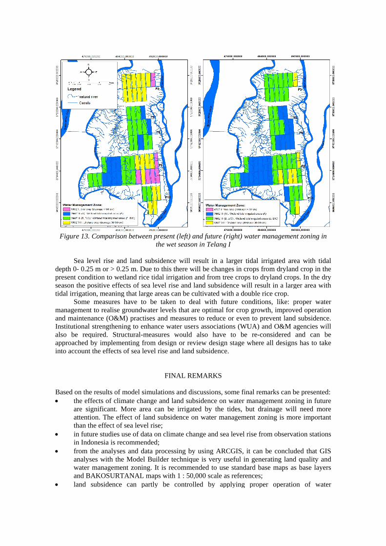
Figure 13. Comparison between present (left) and future (right) water management zoning inthe wet season in Telang I
Sea level rise and land subsidence will result in a larger tidal irrigated area with tidaldepth 0- 0.25 m or > 0.25 m. Due to this there will be changes in crops from dryland crop in thepresent condition to wetland rice tidal irrigation and from tree crops to dryland crops. In the dryseason the positive effects of sea level rise and land subsidence will result in a larger area withtidal irrigation, meaning that large areas can be cultivated with a double rice crop.
Some measures have to be taken to deal with future conditions, like: proper watermanagement to realise groundwater levels that are optimal for crop growth, improved operationand maintenance (O&M) practises and measures to reduce or even to prevent land subsidence.Institutional strengthening to enhance water users associations (WUA) and O&M agencies willalso be required. Structural-measures would also have to be re-considered and can beapproached by implementing from design or review design stage where all designs has to takeinto account the effects of sea level rise and land subsidence.
FINAL REMARKS
Based on the results of model simulations and discussions, some final remarks can be presented: the effects of climate change and land subsidence on water management zoning in future
are significant. More area can be irrigated by the tides, but drainage will need moreattention. The effect of land subsidence on water management zoning is more importantthan the effect of sea level rise;
in future studies use of data on climate change and sea level rise from observation stationsin Indonesia is recommended;
from the analyses and data processing by using ARCGIS, it can be concluded that GISanalyses with the Model Builder technique is very useful in generating land quality andwater management zoning. It is recommended to use standard base maps as base layersand BAKOSURTANAL maps with 1 : 50,000 scale as references;
land subsidence can partly be controlled by applying proper operation of water

19
management systems; establishment of monitoring stations, like in Telang I (also in other tidal areas) that may
represent tidal lowlands development in Indonesia is recommended in order to monitorthe impact of sea level rise and land subsidence in present and in future.
REFERENCES
Bernstein Lenny, Peter Bosch, Osvaldo Canziani, Zhenlin Chen, Renate Christ, Ogunlade Davidson,William Hare, Saleemul Huq, David Karoly, Vladimir Kattsov, Zbigniew Kundzewicz, Jian Liu,Ulrike Lohmann, Martin Manning, Taroh Matsuno, Bettina Menne, Bert Metz, Monirul Mirza,Neville Nicholls, Leonard Nurse, Rajendra Pachauri, Jean Palutikof, Martin Parry, Dahe Qin,Nijavalli Ravindranath, Andy Reisinger, Jiawen Ren, Keywan Riahi, Cynthia Rosenzweig,Matilde Rusticucci, Stephen Schneider, Youba Sokona, Susan Solomon, Peter Stott, RonaldStouffer, Taishi Sugiyama, Rob Swart, Dennis Tirpak, Coleen Vogel, Gary Yohe, 2007. ClimateChange 2007: Synthesis Report - Summary for Policymakers.’ Pp. 23 in Intergovernmental Panelon Climate Change Fourth Assessment Report.
Bindoff, N.L., J. Willebrand, V. Artale, A, Cazenave, J. Gregory, S. Gulev, K. Hanawa, C. Le Quéré, S.Levitus, Y. Nojiri, C.K. Shum, L.D. Talley and A. Unnikrishnan, 2007: Observations: OceanicClimate Change and Sea Level. In: Climate Change 2007: The Physical Science Basis.Contribution of Working Group I to the Fourth Assessment Report of the Intergovernmental Panelon Climate Change [Solomon, S., D. Qin, M. Manning, Z. Chen, M. Marquis, K.B. Averyt, M.Tignor and H.L. Miller (eds.)]. Cambridge University Press, Cambridge, United Kingdom andNew York, NY, USA.
Bronswijk, J.J.B., 1991. Magnitude, Modeling and Significance of Swelling and Shrinkage processs inclay soils. Doctoral Thesis. Wageningen Agricultural University, Wageningen, The Netherlands.(IX) + 455 pp.
Citra Lahan Utama, 1994. Laporan Akhir Survei Topografi Telang I. Direktorat Jenderal Sumberdaya Air.Departemen Pekerjaan Umum, Jakarta, Indonesia.
Collier, W.L., 1980. Fifty years of spontaneous and government sponsored migration in the swampylands of Kalimantan. Prisma, September 1980. Jakarta, Indonesia.
Environmental System Research Institute (ESRI), 2001. Model Builder for ArcView Spatial Analyst 2.Environmental Systems Research Institute.
Euroconsult, 1984. Nationwide study of coastal and near coastal swamp land in Sumatra, Kalimantanand Irian jaya. Directorate General Water Resources Development. Ministry of Public Works.
Euroconsult, 1993. Technical Note. Integrated Irrigation Sector Project. Directorate General WaterResources Development. Ministry of Public Works.
Glopper, R.H.J. de, 1973. Subsidence after drainage of deposits in the former Zuyder Zee and in thebrackish and marine forelands in the Netherlands. Van Zee tot Land no.50, the Netherlands.
Intergovernmental Panel on Climate Change (IPCC), 2007. Climate Change 2007: Synthesis report,Intergovernmental Panel on climate Change Fourth Assessment Report .(Downloaded fromhttp://www.ipcc.ch/pdf/assessment-report/ar4/syr/ar4_syr_introduction.pdf on 10 June 2009)
Kroes J.G., J.C. Van Dam, P. Groenendijk, R.F.A. Hendriks, C.M.J. Jacobs. 2008. SWAP version 3.2.Theory description and user manual. Alterra-report 1649, ISSN 1566-7197. Alterra. WageningenUR.
Lotze, H.K., H.S. Lenihan, B.J. Bourque, R.H. Bradbury, R.G. Cooke, M.C. Kay, S.M. Kidwell, M.X.Kirby, C.H. Peterson and J.B.C. Jackson, 2006. Depletion, degradation and recovery potential ofestuaries and coastal seas. Science, 312, 1806-1809.
Manuwoto, S. 1986. The time perspective of tidal lowland development. In: Proceeding of the LowlandDevelopment in Indonesia Symposium, ILRI, Wageningen, the Netherlands.
Ministry of Public Works, 1984. Executive Report of Nationwide survey of coastal and near coastalswampland in Indonesia. Jakarta, Indonesia.
Naylor, R.L., Battisti, D.S. Vimont, D.J., Falcon, W.P. and Burke, M.B. 2007. Assessing risks of climatevariability and climate change for Indonesian rice agriculture. Proceeding of the NationalAcademic of Science 114:7752-7757
National Oceanic and Atmospheric Administration - Laboratory for Satellite Altimetry (NOAA-LSA),2007. Regional sea level rise time series.

http://ibis.grdl.noaa.gov/SAT/slr/LSA_SLR_timeseries_regional. phpNicholls, R.J., P.P. Wong, V.R. Burkett, J.O. Codignotto, J.E. Hay, R.F. McLean, S. Ragoonaden and
C.D. Woodroffe, 2007. Coastal systems and low-lying areas. Climate Change 2007: Impacts,Adaptation and Vulnerability. Contribution of Working Group II to the Fourth Assessment Reportof the Intergovernmental Panel on Climate Change, M.L. Parry, O.F. Canziani, J.P. Palutikof, P.J.van der Linden and C.E. Hanson, Eds., Cambridge University Press, Cambridge, UK, 315-356.
Rahmadi. 2009. Effects of Climate Change and Land Subsidence on Water Management Zoning in TidalLowlands. Case Study Telang I, South Sumatra. MSc thesis, UNESCO-IHE, Delft, thyeNetherlands and Sriwijaya University, Palembang, Indonesia.
Rahmadi, F.X. Suryadi, H.S. Robiyanto, Bart Schultz, 2010. Effects of Climate Change and LandSubsidence on Hydro-topographical Conditions in Tidal Lowlands Case Study Telang I, SouthSumatra. Paper presented in International Seminar-Workshop on Integrated LowlandDevelopment and Management, Sriwijaya University, Palembang, Indonesia, March 2010.
Scavia, D., J.C. Field, D.F. Boesch, R. Buddemeier, D.R. Cayan, V. Burkett, M. Fogarty, M. Harwell andCo-authors, 2002. Climate change impacts on U.S. coastal and marine ecosystems. Estuaries, 25,149-164.
Schultz, B., 2006. Opportunities and threats for lowland development. Concepts for water management,flood protection and multifunctional land-use. In: Proceedings of the 9th Inter-RegionalConference on Environment-Water. EnviroWater 2006. Concepts for Watermanagement andMultifunctional Land-Uses in Lowlands, Delft, the Netherlands, 17 - 19 May, 2006.
Schultz, B, 2008. Extreme weather conditions, drainage, flood management and land use. In:Proceedings of the 10th International Drainage Workshop, Helsinki, Finland and Tallinn, Estonia,2008, Helsinki University of Technology, Helsinki, Finland.
Soenarno, 1993. Irrigation management transfer in Indonesia. Paper. Directorate General WaterResources Development. Ministry of Public Works.
Suprapto, 2002. Land and water resources development in Indonesia. Website FAO, Rome, ItalySuriadikarta, D.A, Sjamsidi G, Mansur D and A. Abdurachman. 2001. Increasing food crop productivity
through intensive agricultural program in Indonesia. Proceedings Regional Workshop onIntegrated Plant Nutrient System (IPNS) Development and Rural Poverty Alleviation, 18-20September 2001, Bangkok, Thailand.
Suryadi, F.X. 1996. Soil and water management strategies for tidal lowlands in Indonesia. PhD thesis,Delft University of Technology- IHE Delft. Balkema, Rotterdam, The Netherlands.
United Nations Development Programme Indonesia, 2007. The other half of climate change. WhyIndonesia must adapt to protect its poorest people. UNDP Indonesia Country Office, Jakarta.
Related Documents