Research Article Effects of Alpine hydropower dams on particle transport and lacustrine sedimentation Flavio S. Anselmetti 1, * , Raphael Bɒhler 1, 4 , David Finger 2 , StȖphanie Girardclos 1 , Andy Lancini 1, 5 , Christian Rellstab 3, 6 and Mike Sturm 3 1 Geological Institute, ETH Zɒrich, UniversitȨtsstrasse 16, CH-8092 Zɒrich, Switzerland 2 Eawag, Swiss Federal Institute of Aquatic Science and Technology, CH-6047 Kastanienbaum, Switzerland 3 Eawag, Swiss Federal Institute of Aquatic Science and Technology, CH-8600 Dɒbendorf, Switzerland 4 Current address: JȨckli AG, CH-8048 Zɒrich, Switzerland 5 Current address: Schenker Korner & Partner GmbH, CH-6006 Luzern, Switzerland 6 Institute of Integrative Biology, ETH Zɒrich, CH-8092 Zɒrich, Switzerland Received: 24 July 2006; revised manuscript accepted: 23 December 2006 Abstract. The effects of high-alpine hydropower damming on lacustrine sedimentation and transport of solid particles were investigated in the glaciated Grimsel area and in downstream Lake Brienz, pro- viding quantitative denudation rates and sediment yield on a source-sink basis. A total of 271 kt/yr of solid particles entered the Grimsel reservoirs on average in the last 71 years, mostly by turbiditic underACHTUNGTRENNUNGflows that focused sedimentation in depocenters upACHTUNGTRENNUNGstream of obstacles such as bedrock ridges, submerged mor- aines, or dams. This is equivalent to a sediment yield of 2430 t/(km 2 yr) in the catchment (111.5 km 2 ) or a denudation rate of 0.94 mm/yr. A total of 39 kt/yr of the fine fraction (<~4 mm) leave the reservoirs and are transported to downstream Lake Brienz, while 232 kt/ yr of mostly coarse particles are retained, reducing total sediment input of the River Aare into Lake Brienz by two thirds. Modeling the particle budgets in the Aare with and without dams indicates that the fine fraction budgets are only slightly affected by dam- ming, but that the reservoirs cause a shift in seasonal runoff timing resulting in increasing and decreasing particle transport in winter and summer, respectively. Thus, hydrodamming alters mostly deltaic sedimenta- tion in Lake Brienz, where the coarse fraction is deposited, whereas fine grained distal sedimentation and varve formation on lateral slopes are less affected. All varved records of the reservoirs and Lake Brienz that provide sediment rates and grain size records on an annual basis indicate that climate is the main control on these proxies, while, for instance, the onset of pump storage activity in the reservoirs did not impose any significant change in lacustrine sedimen- tation pattern. Key words. Sediment yield; reservoir lakes; lacustrine sedimentation; particle transport; erosion rates. 1. Introduction Sediment yield, particle transport, and deposition in source-sink systems are sensitive to factors such as climatic conditions (e.g. temperature and precipita- tion), bedrock lithologies, topographic relief, and * Corresponding author phone: 0041 44 6326569; fax: 0041 44 6321080; e-mail: [email protected] Published Online First: June 6, 2007 Aquat. Sci. 69 (2007) 179 – 198 1015-1621/07/020179-20 DOI 10.1007/s00027-007-0875-4 # Eawag, Dɒbendorf 2007 Aquatic Sciences

Welcome message from author
This document is posted to help you gain knowledge. Please leave a comment to let me know what you think about it! Share it to your friends and learn new things together.
Transcript
Research Article
Effects of Alpine hydropower dams on particle transport andlacustrine sedimentation
Flavio S. Anselmetti1, *, Raphael B�hler1, 4, David Finger2, St�phanie Girardclos1, Andy Lancini1, 5,Christian Rellstab3, 6 and Mike Sturm3
1 Geological Institute, ETH Z�rich, Universit�tsstrasse 16, CH-8092 Z�rich, Switzerland2 Eawag, Swiss Federal Institute of Aquatic Science and Technology, CH-6047 Kastanienbaum, Switzerland3 Eawag, Swiss Federal Institute of Aquatic Science and Technology, CH-8600 D�bendorf, Switzerland4 Current address: J�ckli AG, CH-8048 Z�rich, Switzerland5 Current address: Schenker Korner & Partner GmbH, CH-6006 Luzern, Switzerland6 Institute of Integrative Biology, ETH Z�rich, CH-8092 Z�rich, Switzerland
Received: 24 July 2006; revised manuscript accepted: 23 December 2006
Abstract. The effects of high-alpine hydropowerdamming on lacustrine sedimentation and transportof solid particles were investigated in the glaciatedGrimsel area and in downstream Lake Brienz, pro-viding quantitative denudation rates and sedimentyield on a source-sink basis. A total of 271 kt/yr of solidparticles entered the Grimsel reservoirs on average inthe last 71 years, mostly by turbiditic under ACHTUNGTRENNUNGflows thatfocused sedimentation in depocenters upACHTUNGTRENNUNGstream ofobstacles such as bedrock ridges, submerged mor-aines, or dams. This is equivalent to a sediment yield of2430 t/(km2yr) in the catchment (111.5 km2) or adenudation rate of 0.94 mm/yr. A total of 39 kt/yr ofthe fine fraction (<~4 mm) leave the reservoirs and aretransported to downstream Lake Brienz, while 232 kt/yr of mostly coarse particles are retained, reducingtotal sediment input of the River Aare into Lake
Brienz by two thirds. Modeling the particle budgets inthe Aare with and without dams indicates that the finefraction budgets are only slightly affected by dam-ming, but that the reservoirs cause a shift in seasonalrunoff timing resulting in increasing and decreasingparticle transport in winter and summer, respectively.Thus, hydrodamming alters mostly deltaic sedimenta-tion in Lake Brienz, where the coarse fraction isdeposited, whereas fine grained distal sedimentationand varve formation on lateral slopes are less affected.All varved records of the reservoirs and Lake Brienzthat provide sediment rates and grain size records onan annual basis indicate that climate is the maincontrol on these proxies, while, for instance, the onsetof pump storage activity in the reservoirs did notimpose any significant change in lacustrine sedimen-tation pattern.
Key words. Sediment yield; reservoir lakes; lacustrine sedimentation; particle transport; erosion rates.
1. Introduction
Sediment yield, particle transport, and deposition insource-sink systems are sensitive to factors such asclimatic conditions (e.g. temperature and precipita-tion), bedrock lithologies, topographic relief, and
* Corresponding author phone: 004144 6326569;fax: 0041446321080; e-mail: [email protected] Online First: June 6, 2007
Aquat. Sci. 69 (2007) 179 – 1981015-1621/07/020179-20DOI 10.1007/s00027-007-0875-4� Eawag, D�bendorf 2007
Aquatic Sciences

tectonic processes (Hinderer, 2001; De Vente andPoesen, 2005; and references therein). These particlefluxes may be altered by anthropogenic impact, suchas by hydropower dam construction that form artifi-cial sediment sinks acting as manmade sediment traps.Operation of such reservoirs is thus affected byreduction of available water volume (Schleiss andOehy, 2002). In turn, sediment studies in thesereservoirs allow relative simple quantification oferosion rates and sediment budgets (McIntyre, 1993;Einsele and Hinderer, 1997; De Cesare et al. , 2001).As a conACHTUNGTRENNUNGsequence of their sediment retaining capa-bilities, they affect the downstream particle transportso that the sediment budgets at lower elevations maybe altered significantly (Vçrçsmarty et al. , 1997, 2003;Teodoru and Wehrli, 2005; Finger et al. , 2006).Furthermore, parameters such as water temperature(Preece and Jones, 2002; Meier et al. , 2003), turbidity(Loizeau and Dominik, 2000; Jaun et al. , 2007),nutrients (Humborg et al. , 2000; Friedl et al. , 2004)and resulting biological communities (Hart et al. ,2002) may be altered by damming.
The study presented here focuses on the effect ofthe Grimsel reservoirs (Grimselsee, Oberaarsee,R�terichsbodensee) on particle transport and deposi-tion in an alpine source-sink system (Lake Brienzcatchment; Fig. 1). The three reservoirs lie at eleva-tions between 1760 and 2300 m asl, embedded in thecrystalline Aar Massif (Fig. 2; Table 1). They werebuilt between 1929 and 1953 and flooded alpinemeadows, two natural lakes, proglacial floodplainsand the tongues of the Oberaar and Unteraar glaciers.The reservoirs drain through the Aare into down-stream Lake Brienz, which lies at an elevation of566 m asl in a deep glacial valley within the HelveticNappes of the frontal Alpine range (Jurassic andCretaceous calcareous formations). Next to the Aare,the Lake Brienz catchment (area 1140 km2, of which19 % is glaciated) is drained by a second large river,the L�tschine (Fig. 1). The effect of the high-alpinereservoirs on downstream Lake Brienz is of particularinterest because during 1999 Lake Brienz experiencedan extremely low fish yield (W�est et al. , 2007), an
event that initiated a multidisciplinary study. Severalaspects of the Grimsel-Brienz source-sink systemwere studied. One possible scenario was that theamount and timing of suspended particles (Finger etal. , 2006) and colloids (Chanudet and Filella, 2007)released to Lake Brienz changed over time with directconsequences on water clarity. All of these parametersmight have furthermore affected the availability ofnutrients (M�ller et al. , 2007a), primary production(Finger et al., 2007), the Daphnia population (Rellstabet al., 2007) and fish ecology (M�ller et al., 2007b).
The goals of this study were to (1) quantify theamount of sediment retained in the reservoirs andsubsequently not flushed into Lake Brienz; (2)calculate the erosion rate in the glaciated catchment;(3) address the change in flow regime of the Aareoccurring as a result of the dam construction, and (4)evaluate related changes in the hydrologic andsedimentologic patterns of Lake Brienz.
For this purpose, recent sedimentation processesfor both the reservoirs and Lake Brienz are described,quantified and interpreted. In Section 2 of this study,we first quantify the sediment budgets, resultingerosion rates and type of retained sediment loads inthe reservoirs. In Section 3, we describe how flowregime and transport of suspended solid particles ofthe Aare changed as a result of damming. In Section 4,we evaluate how the sedimentation pattern in LakeBrienz was altered as a result of these upstreamchanges. Finally in section 5, all observations are putinto the context of evaluating the impact of thehydropower dams on the sedimentologic regime ofLake Brienz and the potential role this may haveplayed in the observed environmental changes in thelate 1990 s.
2. Erosion and sedimentation in the glaciatedGrimsel area
Characteristics of the proglacial reservoirsAll three investigated reservoirs (Table 1) are con-nected by a series of pipelines that are either used for
Table 1. Characteristics of the three reservoirs in the Grimsel area.
Maximum elevation(m asl)
Firstflooding(yr AD)
Maximum water-volume(106 m3)
Maximum length(m)
Maximum width(m)
Maximum depth(m)
Oberaarsee 2303 1953 57 ~2500 ~600 85Grimselsee 1909 1929 95 ~6000 ~500 87R�terichsbodensee 1767 1950 25 ~1000 ~700 56
All three lakes:All KWO reservoirs
177196
Lake Brienz 566 Postglacial 5120 ~14,500 ~2500 260
180 F. S. Anselmetti et al. Hydropower dams and lacustrine sedimentation

power generation or for water exchange. Since 1980,Grimselsee and Oberaarsee were also connected by apump-storage system that is able to pump 80 m3/s tothe higher reservoir for hydro-peaking.
The catchment area of the three reservoirs (Figs. 1,2), ranging in elevation between 1908 and 4273 m aslhas a total size of 111.5 km2, of which 44.8 km2 arecovered by glaciers (B�hler, 2003). The runoff ofOberaar Glacier drained prior to construction of theOberaarsee dam (built in 1953) into Grimselsee.R�terichsbodensee has basically no glaciated catch-ment and is only fed by small creeks that provide littlesediment to the reservoir. The bulk of its sedimentoriginates from Grimselsee that is periodicallydrained so that its reworked sediments becomeredeposited in R�terichsbodensee. The combinedsediments of the three reservoirs, and the fine particlesleaving the system in suspension, thus reflect the totalsediment budget of the catchment since the construc-tion of the main hydropower dams in 1929.
All three reservoirs exhibit strong water levelfluctuations, with generally low stands in late winterwhen they are totally covered with ice for severalmonths, and high stands in summer. The threereservoirs have been emptied several times duringthe last 71 years for maintenance. Grimselsee wasemptied twice, in winter 1976 and 2000, as wasR�terichsbodensee in 1974 and 1990. Oberaarseewas emptied only once in 2004. These drainage eventsled to flow conduits at the lake floor that are
characterized by channels cutting into the sediments.A large amount of sediment is consequently trans-ported into the next lower basin. However, no sedi-ment other than the finest suspension load can escapethe lowest reservoir R�terichsbodensee, which formsthe ultimate closure of the sediment trap.
MethodsSeismic survey methods. In summer 2001 and 2002,high-resolution reflection seismic investigations wereperformed with a 3.5 kHz pinger system mounted onan inflatable catamaran that was pushed by aninflatable boat. A dense grid of seismic lines with aspacing of < 100 m was digitally acquired to obtainquasi-3D images of the sedimentary infill (Figs. 2, 3).Navigation was achieved with a conventional GPSsystem (+/- 5 m accuracy). Processing of the acquireddata consisted of an automatic gain control (windowlength 100 ms), band pass filter (1800/2000 – 6000/6500Hz), water bottom muting and, only for Grimselseeand R�terichsbodensee data, a constant-velocity mi-gration (with Vp = 1430 m/s). The used zero timesreference levels are 2300 m (Oberaarsee), 1910 m(Grimselsee) and 1767 m (R�terichsbodensee).
Sediment volume calculations. The difference betweenthe lowermost reflection and the basin floor indicatesthe total sediment thickness that was interpolated forall three reservoirs (Fig. 4). In the glacial-proximalparts towards the eastern ends of Grimselsee and
Fig. 1. Map of Lake Brienz catchment. Glaciated areas are marked with blue shading. The Eastern Aare catchment is dominated by glacialinfluence.
Aquat. Sci. Vol. 69, 2007 Research Article 181

Oberaarsee, the acoustic signal could not penetratethe basin floor sufficiently due to coarse sand or gravellithologies. In these areas, sediment thickness wasestimated based on a core taken in Grimselsee fromthe exposed basin floor in spring 2002 (B�hler, 2003),which helped to interpolate the delta area with themost proximal seismic sediment thicknesses. Sedi-ment volumes could thus be estimated for the entireGrimselsee and, with a similar procedure, for Ober-aarsee. In R�terichsbodensee, the former valley floorcould be seismically detected only in a few areas. Forthis basin, however, a topographic map from imme-diately prior to dam construction was digitized andprojected onto the seismic sections (Fig. 3C). Depthsobtained through this procedure showed a good matchto the areas where the former valley floor could beseismically recognized and, consequently, allowedbasinwide calculation of sediment thickness. In addi-tion, a second topographic map dating from the year1974, when the reservoir was emptied for the first time,provided an additional chronostratigraphic seismichorizon to subdivide the sedimentary succession.
Sediment coring and analytical techniques. A series ofsediment cores were collected from the ice (Figs. 2, 5).In Grimselsee, two ~1 m long vibracores were re-ACHTUNGTRENNUNGtrieved in 2002 at the locations of the former naturallakes. Cores from the main depocenter in Grimselseeand from Oberaarsee with a maximum core length ofover 2 m were recovered using a percussion-pistoncorer in winter of 2003 and 2006. All cores were split,scanned petrophysically using a multisensor corelogger (bulk density/porosity), photographed anddescribed sedimentologically. Particle-size analysisof bulk sediment was performed on a Malvern MasterSizer 2000 laser diffraction instrument (range 0.02 mmto 2 mm).
Catchment erosion rates. For the calculation of thesediment yield and erosion rate for the 71 years after1929, sediment volumes had to be corrected forporosity, which was determined to average 35 % bycomparing the measured bulk densities to graindensities. Eroded rock volumes then were convertedto particle mass with a bedrock density of 2.6 g/cm3.
Fig. 2. Map of reservoirs. Red lines mark track lines from seismic surveys (for sediment volume calculations). Black dots indicate coringlocations (with core numbers). Location of seismic lines in figure 3 are marked in blue bold lines.
182 F. S. Anselmetti et al. Hydropower dams and lacustrine sedimentation
The annual amount of finest fraction, which escapesthe reservoirs through suspended load, was quantifiedby daily sampling and using the discharge data (Fingeret al. , 2006) and was summed to get the full amount ineroded rock volume (Table 2).
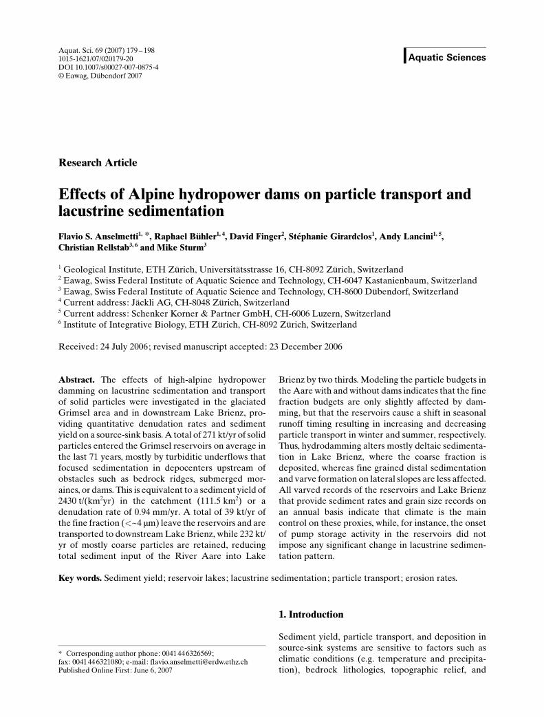
Sediment and depositional processes in GrimselseeSediment distribution. The former valley floor isoverlain by a thick sediment succession, that accumu-lates only in the basin and not on lateral slopes. Alongitudinal section (Fig. 3A) shows a downvalley-thickening wedge of sediment with a maximum thick-ACHTUNGTRENNUNGness of ~11 m directly in front of a 30 m-high basementridge (Fig. 4A). A second depocenter with a maximumthickness of 6 m can be found in the deepest part infront of the northern dam (Fig. 4A). This pattern iscaused by the slowing of proglacial turbidity currentsas an effect of the first obstacle resulting from settlingof the major part of the sediment input (Weirich, 1986;De Cesare et al. , 2001; B�hler et al. , 2005). A smallerportion of the sediment load passes through a formergorge to the deeper area, where in a similar fashion,the dam stops the turbidity currents and creates asecond center of sediment accumulation. The easternarea, where two natural lakes were located, is coveredby ~70 cm of proglacial sediment because this part lies~50 m above the thalweg of the main valley and is by-passed by all coarse glacier-derived sediments. Inaddition, during low water levels in winter and spring,this part of the reservoir is separated from the mainbasin and becomes completely detached from anysediment input.
Lithology. Despite strong coring disturbance, an over2 m long core from the deep central part of theGrimselsee (GR03 –1) shows that sedimentation inthis area is dominated by coarse sediment depositedby turbiditic flows (B�hler 2003; Lancini, 2004). Avibracore from the area of the natural Grimsel lakes(VGR02 – 1; Fig. 5 A,B) that is bypassed by the mainturbidites shows the transition from gyttja sediments
Fig. 3. A 3.5 kHz seismic sections of Grimselsee (A), Oberaarsee(B), and R�terichsbodensee (C). For line location see Figure 2.Yellow dashed line indicates former valley floor in all reservoirs.Green dashed line in C marks measured topography after fulldrainage in 1974. Blue dashed line in C marks an unconformityrelated to a flushing event in Grimselsee. Note the vertical exag-ACHTUNGTRENNUNGgeration.
Table 2. Sediment and erosion budgets of Grimsel area. Infilling times are calculated under the assumption of constant sedimentationrates.
Sediment volumes(103 m3)
Infilling times (yr) Eroded bedrock-volumes(103 m3)
Solid particle mass(kt)
Oberaarsee (49 yr) 934 2990 607 1579Grimselsee (71 yr) 5300 1270 3445 8957R�terichsbodensee (50 yr) 3584 350 2294 5965
All three lakes (71 yr) 9818 6346 16,501retained in reservoirs per year (71 yr) 138 89 232Annual suspension in Aare 15 39Total annual input from catchment 104 271
Aquat. Sci. Vol. 69, 2007 Research Article 183
of the former mountain lakes to grey-colored progla-cial deposits in the reservoir after 1929. The successionconsists of 71 varves with an average thickness of~8 mm. The average mean grain size of these rather�pelagic-type� sediments is 8.2 mm for the light-coloredsummer layers and 4.7 mm for the dark and fine winterlayers (Lancini, 2004). The summer part of the varvescomprise a series of stacked mm- to cm-scale gradedlayers. Such a complex varve formation was alsodocumented in the nearby proglacial lake Steinsee(Blass et al. , 2003). The thickness of the varves inGrimselsee (Fig. 6) can be correlated to strong rainfallevents that exceed a certain threshold value (Lancini,2004). Other than a color change related to anoxidation process of the top layers (red Fe-staining),no overall trend in varve thickness and other lithologicparameters (e.g. grain size) can be determined overthe 71-year sediment record (Fig. 6). In particular, nosignificant change in the sedimentation pattern, varvethickness or grain size appears around the introduc-tion of the pump storage activities in 1980.
Sediment budget. The total interpolated sedimentvolume of Grimselsee was calculated to be 5.3*106 m3
(Table 2), yielding an average annual sedimentationvolume of 74,650 m3. If the infilling rate stays constant,the reservoir will be filled in 1270 years.
Sediment and depositional processes inR�terichsbodenseeSediment distribution. The seismic stratigraphy of theR�terichsbodensee infill can be divided into threedifferent sequences (Fig. 3C). The base of the topsequence can be traced seismically throughout thereservoir, whereas the bases of the lower two sequen-ces are only partly imaged by seismic reflections andare also defined by projected paleomorphologic data(see Methods). The lowermost sequence overlies theformer valley floor and is interpreted to have beendeposited from 1950 – 1974 before the R�terichsbo-densee was emptied for the first time. It has a partlyerosive top with maximum erosion occurring approx-imately along the flow path of the former Aare. Theoverlying middle sequence is more or less equallythick. It is interpreted to correspond to the timebetween 1974 and 1990, after which a second completedrainage occurred. The topmost of the three sequen-ces is seismically well-layered and contrasts to thetransparent underlying sequences (Fig. 3C). The topof this sequence, the modern basin floor reflection, ismarked by recent erosion processes, likely due to thetotal drainage of Grimselsee in 2001, which triggeredintense water circulation in R�terichsbodensee.
The main sediment depocenter of R�terichsbo-densee is located in the southern part of the reservoir
(Fig. 4B). This sediment distribution is mainly con-trolled by the location of the inlet of the suspension-loaded Grimselsee waters into the narrow gorge at thesouthern shore. Due to the slowing of the current uponentering the larger basin, most of the sediment settlesand forms an up to 28 m thick pile (Fig. 4B). Thisresults in a surprisingly high maximum averagesedimentation rate of over 50 cm/yr for the last 50years since dam construction in 1950.
Sediment budget. Since 1950 a total sediment volumeof 3.6*106 m3 has been deposited in R�terichsboden-see, reflecting an average annual sedimentationvolume of ~70,400 m3 (Table 2). These numbers arecomparable to those from the much larger Grimselsee.Assuming a constant sedimentation rate, the R�te-richsbodensee will be infilled in ~350 years. Consid-ering the small catchment and the lack of majortributaries, this high sediment budget is rather surpris-ing and can only be explained by the occurrence ofmajor drainages in Grimselsee causing widespreadredistribution of sediment that was initially depositedin the upstream reservoir.
Sediment and depositional processes in OberaarseeSediment distribution. Based on the seismic data, up to~4.5 m of lacustrine sediment could be recognized inOberaarsee (Figs. 3B, 4C). Maximum sediment thick-ACHTUNGTRENNUNGness is reached in parts of the central basin thatcoincide with the channel of the former river and itstributary, while the adjacent steep slopes lack anydetectable sediments. The main depocenter covers anarea of ~400 by 400 m in the middle of the lake(Fig. 4C) located directly upstream of the now floodedLittle Ice Age terminal moraine (~1890; Ammann1976; Lancini 2004), and forms an obstacle that slowsturbidity currents. A second depocenter, with amaximum sediment thickness of ~2.5 m, is located500 m to the east of the main sediment sink (Fig. 4C)just downstream of the same moraine, where theremaining currents, after passing the moraine throughthe former river channel, can expand again in thebasin and slow down. Furthermore, a small area withhigher sedimentation rates is located in a basin in frontof the dam at the Eastern end of the reservoir. Allthese depocenters confirm the concept of flood-induced turbiditic currents acting as main sedimentdistributors (Weirich, 1986; De Cesare et al. , 2001).Such turbidity currents have also been observed byB�hler et al. (2005) using turbidity measurements inthe outflow pipeline.
Lithology. The over 2 m long core OR03 – 2 from thecenter of the basin (Fig. 2) shows a clear change at adepth of 1.6 m from gravel-rich lithologies at the base
184 F. S. Anselmetti et al. Hydropower dams and lacustrine sedimentation

to relative homogenous muddy-sandy sediments atthe top. This change correlates well with the totalsediment thickness obtained from the seismic data andis interpreted as a transition from pre-dam fluvialsediments to lacustrine sediments. At a more distalsite that is bypassed by the main turbidites, two cores(OR06 – 1 and -2) taken in March 2006 revealed avarved sedimentary section (Fig. 5C) that covers theentire period from 1953 to 2005 with 53 proglacialvarves, similar to those from Grimselsee (e.g. darkwinter layer, light-colored multi-graded summer lay-ers that reflect strong precipitation events). Becausethe recovered varves show coring disturbance(Fig. 5C), an image analysis procedure was appliedover 4 cm of core width to estimate varve thickness(Fig. 6A). No overall trend can be detected over thelast 30 years. Around 1980 and in the mid 1990 s, varve
thickness is minimal. The two highest values arecaused by exceptionally-thick graded event layers.
Sediment budget. Since 1953, when the dam was built,a total sediment volume of ~934,000 m3 has beendeposited, resulting in a sedimentation rate of~22,200 m3/yr (Table 2). If the sedimentation rateremains stable, it will take ~3,000 years to infill thisreservoir.
Total sediment budgets and implications for erosionratesBecause Oberaarsee drains into the Grimselsee, andbecause R�terichsbodensee only has a negligablecatchment with no glacial runoff (Fig. 2), the sum ofall three reservoirs represent the sediment budget ofthe combined catchment for the 71 year period (even
Fig. 4. Sediment isopach maps of Grimselsee (A), Oberaarsee (B) and R�terichsbodensee (C). Blue colors mark different thicknesses foreach reservoir. Sediment thickness in delta proximal areas in Oberaarsee and Grimselsee were extrapolated due to limited seismicpenetration depth (not shown for Grimselsee).
Aquat. Sci. Vol. 69, 2007 Research Article 185
though the Oberaarsee and R�terichsbodensee werebuilt ~20 years after the Grimselsee). The entiresediment volume thus is considered to be the productof 71 years of erosion in the combined total catchmentarea, resulting in an average volume of 138,300 m3/yrthat is equivalent of a retention of 232 kt/yr of sediment(Table 2). In order to calculate catchment erosion rates,the suspended particles leaving the reservoir systemmust be taken into account. Measurements in the Aarein Innertkirchen indicate an annual transport ofsuspended particles of 39 kt (Finger et al., 2006) thatmust be added to the sediment mass in order toestimate the amount of eroded rock material.
The erosion rate can be calculated for two differentscenarios, depending on postulated erosional proc-esses: In a first scenario, bedrock erosion is equallydistributed over the entire catchment resulting in anaverage erosion rate of 0.94 mm/yr. For a secondscenario, erosion is only considered for the glaciatedareas (40 % of catchment) through pure subglacialprocesses, resulting in an erosion rate of 2.33 mm/yr.Both denudation values are much higher than thoseusually assumed for central alpine areas (0.1 to0.65 mm/yr; Hinderer, 2001). The 0.94 mm/year validfor the entire catchment coincides, however, withrecent uplift rates for the Bernese Central Alps, that
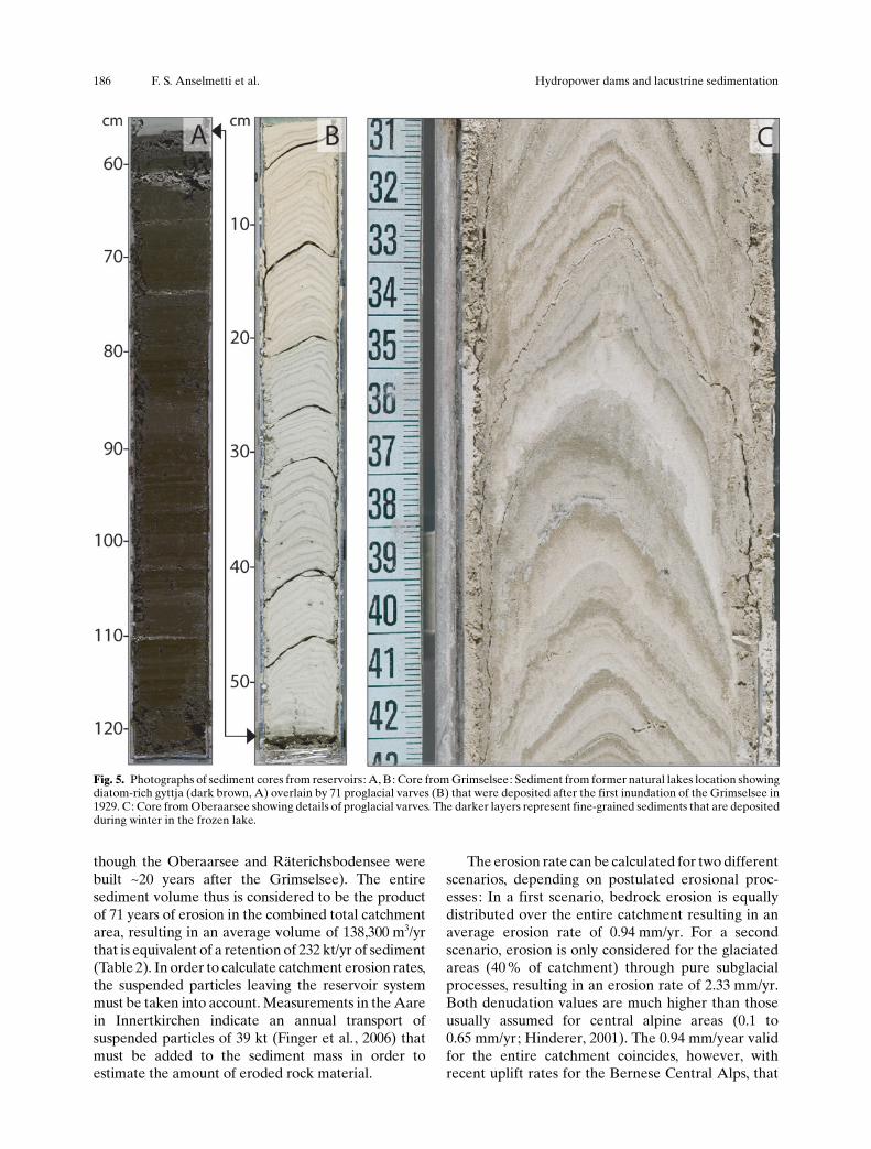
Fig. 5. Photographs of sediment cores from reservoirs: A, B: Core from Grimselsee: Sediment from former natural lakes location showingdiatom-rich gyttja (dark brown, A) overlain by 71 proglacial varves (B) that were deposited after the first inundation of the Grimselsee in1929. C: Core from Oberaarsee showing details of proglacial varves. The darker layers represent fine-grained sediments that are depositedduring winter in the frozen lake.
186 F. S. Anselmetti et al. Hydropower dams and lacustrine sedimentation

have been determined as slightly below 1 mm/yr(Schlatter and Marti, 2002). The numbers can beconverted to a total annual sediment yield per km2,amounting to 2430 and 6050 t/(km2yr), for erosion inthe total or only glaciated areas, respectively. Thesevalues roughly coincide with values obtained in asimilar study for W�rmian glacial erosion in the Juramountains (4400 � 1700 t/(km2yr); Buoncristini andCampy, 2001) but are larger than those given forgeneral alpine and perialpine catchments (~100 to2500 t/(km2yr); Einsele and Hinderer, 1997, 1998;Hinderer, 2001, and references therein) reflecting thehigh degree of glaciation. As a comparison, the totalsediment yield for Lake Brienz equals 324 t/(km2yr)excluding sediments retained in the reservoirs (Fingeret al. , 2006), or to 572 t/(km2yr) if they are included.The 2430 t/(km2yr) for the entire Grimsel area aloneclearly documents the high efficiency of subglacialerosion and mobilization.
3. Runoff and particle transport in tributaries ofLake Brienz
In order to assess the effects of hydropower operationsin the headwaters of the Aare on particle dynamics inLake Brienz, the particle yield of the major tributarymust be compared to the situation before constructionof the dams. The hydrologic regime of the Aare is thecrucial link in determining the amount and timing ofparticle transport from the reservoirs to Lake Brienz.This chapter summarizes how the annual pattern inthe hydrologic regime of the Aare changed as a resultof dam construction and how this is affecting theparticle budget of Lake Brienz.
MethodsDischarge and particle loads. Present particle loadswere estimated for the years 1997 to 2004 (Finger etal. , 2006), whereas particle load for a situation withoutany hydropower dams was reconstructed with numer-ical simulations. The Swiss Federal Office for the
Fig. 6. A: Annual varve thickness of Oberaarsee sediment (core ORA06–1 providing record of 1973–2005) and Grimselsee sediment (atsite of natural lakes, core VGR02–1, 1932–1999). Both coring locations only record the fine fraction and are by-passed by the major glacial-derived turbidites. The two thickest layers in Oberaarsee are produced by single turbidite events. B: A 71-year time series of grain size ofGrimselsee sediment (grey: summer; black: winter).
Aquat. Sci. Vol. 69, 2007 Research Article 187
Environment has monitored discharge Q (in 10 minintervals) and instant suspended particle concentra-tions C (twice a week) in the rivers Aare andL�tschine since 1964 (BWG/LHG). Based on thisdata, Finger et al. (2006) developed the adaptiverating curve (ARC) to estimate suspended particlesloads in each river, consisting of an empirical relationbetween Q and C (Cohn et al., 1989; Crawford, 1991).In order to minimize the inaccuracy of this empiricalrelation, the ARC continuously corrects the relationto the bi-weekly measured particle concentrations.This increases the accuracy of particle load estimates,which are partially influenced by hydropower activ-ities. As test runs indicate, the ARC reproducesannual suspended particle loads with an accuracybetter than 20% in the L�tschine and 30 % in theAare. Nevertheless, long-term averages have uncer-tainties of < 3% (Finger et al. , 2006).
The loads for a hypothetical situation withouthydropower dams were reconstructed with numericalsimulations for the years 1997 to 2004: S�gesser andWeingartner (2006) simulated the discharge of anatural flow regime and Finger et al. (2006) recon-structed the particle dynamics in the Aare withoutparticle retention in the dams.
Grain size. To simulate residence times of suspendedparticles in Lake Brienz, particles in the Aare andL�tschine, in the reservoir outlets, and in the sedi-ments of the reservoirs were divided into coarseparticles (> 4 mm) and fine matter (< 4 mm; Finger etal. , 2006). While particle distribution in the inflowsdescribes present particle input, sediment of thereservoirs represents distributions during pre-damconditions. Sediment samples from the reservoirswere collected with a grab sampler across the Grim-selsee, water samples were collected daily at thereservoir outlets and random samples were collectedin the two rivers. In all samples, the particle sizedistribution was determined using static light scatter-ing measured with a Beckman Coulter LS 230 instru-ment (range 0.04 mm to 2 mm; Zimmermann, 1996).
RunoffThe Aare watershed is about 1.5 times larger(554 km2) than the L�tschine (379 km2). Accordingly,the average discharge of the Aare (34.9 m3/s) is about1.88 times that of the L�tschine (18.6 m3/s). Theeffects of the hydropower operations on the flowregime of the Aare can be evaluated by scaling theL�tschine runoff to that of the Aare and by comparingthe annual patterns throughout the last century,distinguishing four epochs with increasing hydropow-er activity (Fig. 7): 1) Before 1932, without any dams,both rivers Aare and L�tschine revealed a typical peri-
alpine regime with high discharge in summer (due toprecipitation and snow/glacier melting) and low dis-charge during winter (due to temperatures belowfreezing); 2) Between 1933 and 1955, the constructionof hydropower dams in the headwaters of the Aareprovoked a temporal shift of discharge from summerto winter; 3) After construction of the Oberaarseedam in 1953, the increased storage volume led tocontinuously increasing winter discharge rates; 4) In1980, the pump storage operation was introduced,which did not result in a further increase in winterdischarge, as water is transported back and forthbetween Grimselsee and Oberaarsee (Fig. 8).
Besides the evident effects on discharge patterns,the new hydrologic regime also affected the particletransport in the Aare and subsequently in LakeBrienz. Before construction of the dams, about 10 %of the Aare discharge occurred during winter (No-vember to March), whereas today this discharge hasdoubled to 21 %. The subsequent effects on particleloads are discussed in the following section.
Particle loadsBased on the ARC method, the mean annual particleload between 1997 and 2004 in the Aare and L�tschinewas estimated at 128 kt/yr and 174 kt/yr, respectively(Figure 8; Finger et al. , 2006). The L�tschine trans-ports 36 % more material, although its discharge isonly ~53 % of the Aare. This is a direct consequence ofthe particle retention in the reservoirs as documentedby the load coming from the reservoir outlets (39 kt/yr), representing only 15% of the total sediment loadin the headwater above the reservoirs (272 kt/yr). Thehypothetical particle load for a situation withoutreservoirs results from the actual particle loads in theAare (128 kt/yr) and particle retention in the reser-voirs (232 kt/yr), as shown in Section 2, amounting to360 kt/yr. The simulations of the hypothetical situationwithout reservoirs for the years 1997 to 2004 revealthat the water storage in the reservoir leads to atemporal shift of particle loads from summer (April –October) to winter (November – March; Table 3).Today, particles transported in winter are 14 kt, ofwhich at least 7 kt can be directly attributed to thereservoir outlets. About 4 kt are probably resuspend-ed material due to intense hydroelectric production,so that only ~3 kt would be transported under naturalconditions (Table 3).
Based on the sporadic measurements of particlesize distributions in the Aare and L�tschine, about 27mass-% of the suspended load entering Lake Brienz iscomposed of particles < 4 mm in diameter (finefraction; Finger et al. , 2006). For the particle distri-bution in the lake, particle size is of major importance,as only colloids (< 1 mm) and small particles remain
188 F. S. Anselmetti et al. Hydropower dams and lacustrine sedimentation
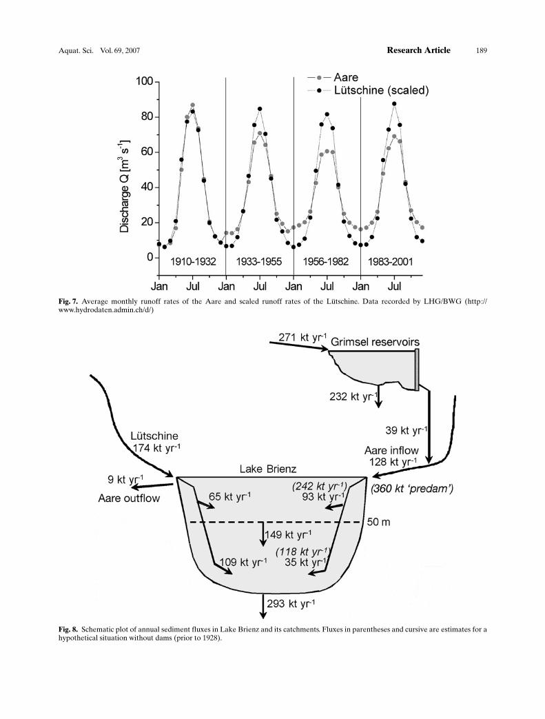
Fig. 7. Average monthly runoff rates of the Aare and scaled runoff rates of the L�tschine. Data recorded by LHG/BWG (http://www.hydrodaten.admin.ch/d/)
Fig. 8. Schematic plot of annual sediment fluxes in Lake Brienz and its catchments. Fluxes in parentheses and cursive are estimates for ahypothetical situation without dams (prior to 1928).
Aquat. Sci. Vol. 69, 2007 Research Article 189
suspended long enough to spread across the lake. Atthe reservoir outlets, significantly higher fractions offine particles were measured (Finger et al. , 2006):~56 % of the load in summer and up to 82 % in winterare composed of particles < 4 mm. These numberscoincide with the size distribution of the sediment inthe reservoirs: only ~3 % of the retained sediment iscomposed of particles < 4 mm. Large particles, whichsettle out fast, are retained in the reservoirs, while thesmall particles remain suspended and are dischargedinto the Aare. Fine particle load was estimated to be~43 kt/yr and ~47 kt/yr for the Aare and L�tschine,respectively. For a hypothetical situation withoutreservoirs, the fine fraction load in the Aare wouldbe only slightly higher (~50 kt/yr).
4. Recent sedimentation in Lake Brienz
Sedimentation in Lake Brienz (Fig. 9A; Table 1) ismainly controlled by the inflowing particles from theAare and L�tschine, which build two large deltas atboth ends of the lake (Sturm, 1976; Adams et al. ,2001). Between 1866 and 1875, the Aare was chan-nelized in the upstream alluvial plain and routed fromits natural mouth to the south, where it presentlyinflows (Fig. 9A). From the time it was rerouted, theAare built a new delta with channels that have cut intoparts of the former delta structure. A surficial sedi-ment study showed that the sediment load of lateraltorrents have, compared to the two large deltas, verylittle influence on total lake sedimentation (Sturm,1976).
Lake Brienz is a holomictic and oligotrophic lake(Nydegger, 1967) with almost exclusively allochtho-nous clastic input. Its sediment distribution is mainlycontrolled by the varying stratification of river inflows(over-, inter- and underflows; Sturm, 1976). LakeBrienz is subdivided into different sedimentationsectors: the proximal delta areas where mainly graveland coarse sand deposit, the slopes where finely-laminated sediment forms clastic varves, and the deepbasin where fine sediment (hemi-pelagic deposit)intercalates with small and large turbidites (non-graded and normally graded sand layers; Sturm andMatter, 1978). Small turbidites (1 mm to 10 cm thick)
enter as underflows from the two large river deltasthat both have distinct mineralogical signatures andcolors due to their geologically contrasting catch-ments (Sturm and Matter, 1978). Particle residencetimes in Lake Brienz are < 20 and < 4.5 days for fine(< 4 mm) and coarse (> 4 mm) particles, respectively(Finger et al. , 2006).
Large turbidites (0.2 to 1.3 m-thick �megaturbi-dites�) are rare sedimentological events. They origi-nate from the Aare delta area and remobilize largeamounts of sediment. As these sediment flows traveldown to the deep basin, they even erode parts of theunderlying hemi-pelagic deposits and incorporatethem in their moving mass (Girardclos et al. , inpress). The last megaturbidite occurred in April 1996,redeposited a total volume of 2.7 * 106 m3 equivalent toa dry mass of 2.6 * 106 t (~9-times the lake�s annualinput) and covered the entire flat lake bottom(Girardclos et al. , in press). It was caused by a non-catastrophic event most likely due to overloadingfrom normal sediment accumulation. The clay-sizedsediment mobilized during this event took 6 months tocompletely settle (Zeh, 1997) and forms a distinctwhite layer, which can be followed throughout theentire deep lake basin (Fig. 9B).
MethodsSediment coring and analytical techniques. Sedimentsamples were collected with a gravity corer (1 –2 mlength) and with a modified Kullenberg coring system(5 – 10 m length) from 1998 –2005. After opening,sediment cores were photographed, described macro-scopically and sampled. Particle-size analysis of bulksediment was performed on a Malvern Master Sizer2000 laser diffraction instrument (range 0.02 mm to2 mm). Core-to-core correlation was achieved bycomparing both visual characteristics and lithologicalproperties.
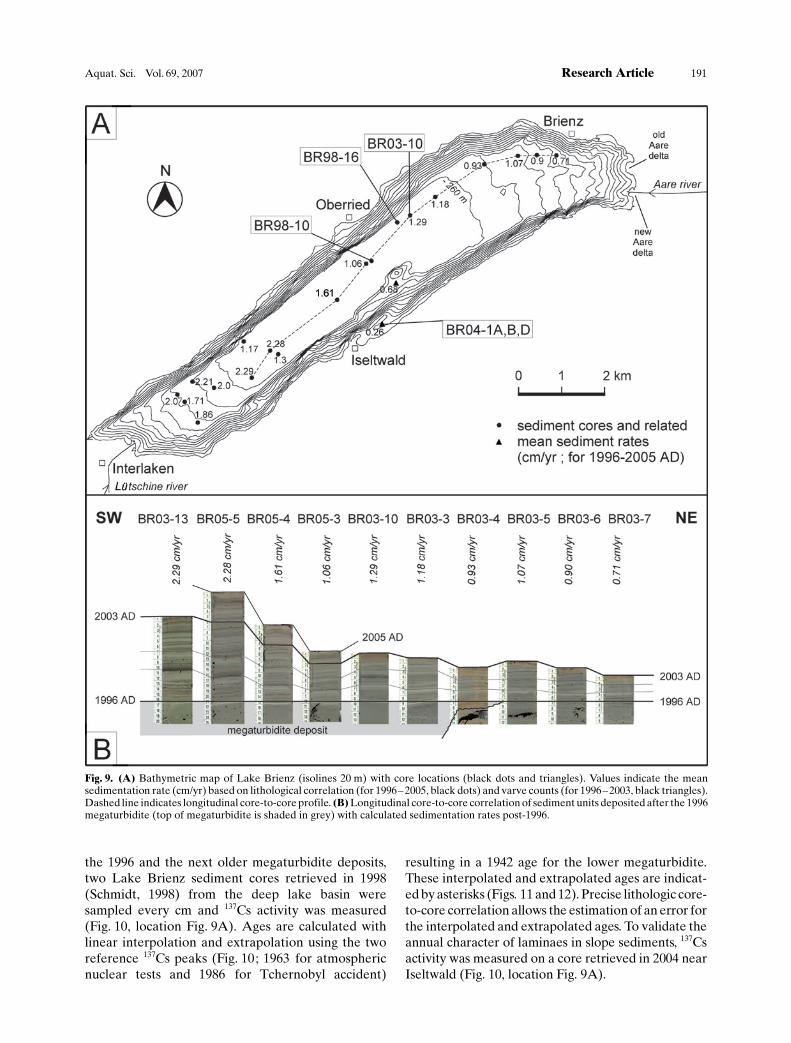
Sedimentation rate and radioisotope dating. In thedeep basin the recent mean sedimentation rates for1996 – 2005 (black dots; Fig. 9A) were estimated withthe white clay top layer of the 1996 megaturbidite usedas a lower reference horizon and the top of the core(sampling year) as an upper reference (Fig. 9B). Forsedimentation rates of core sections situated between
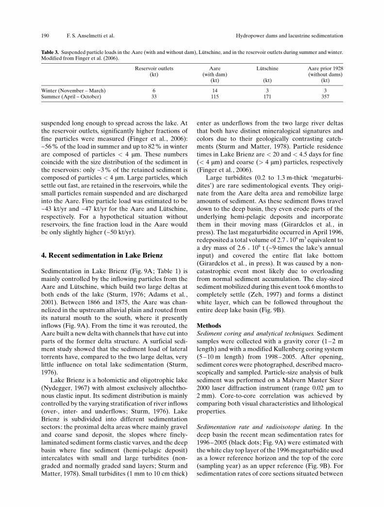
Table 3. Suspended particle loads in the Aare (with and without dam), L�tschine, and in the reservoir outlets during summer and winter.Modified from Finger et al. (2006).
Reservoir outlets(kt)
Aare(with dam)
(kt)
L�tschine
(kt)
Aare prior 1928(without dams)
(kt)
Winter (November – March) 6 14 3 3Summer (April – October) 33 115 171 357
190 F. S. Anselmetti et al. Hydropower dams and lacustrine sedimentation
the 1996 and the next older megaturbidite deposits,two Lake Brienz sediment cores retrieved in 1998(Schmidt, 1998) from the deep lake basin weresampled every cm and 137Cs activity was measured(Fig. 10, location Fig. 9A). Ages are calculated withlinear interpolation and extrapolation using the tworeference 137Cs peaks (Fig. 10; 1963 for atmosphericnuclear tests and 1986 for Tchernobyl accident)
resulting in a 1942 age for the lower megaturbidite.These interpolated and extrapolated ages are indicat-ed by asterisks (Figs. 11 and 12). Precise lithologic core-to-core correlation allows the estimation of an error forthe interpolated and extrapolated ages. To validate theannual character of laminaes in slope sediments, 137Csactivity was measured on a core retrieved in 2004 nearIseltwald (Fig. 10, location Fig. 9A).
Fig. 9. (A) Bathymetric map of Lake Brienz (isolines 20 m) with core locations (black dots and triangles). Values indicate the meansedimentation rate (cm/yr) based on lithological correlation (for 1996–2005, black dots) and varve counts (for 1996–2003, black triangles).Dashed line indicates longitudinal core-to-core profile. (B) Longitudinal core-to-core correlation of sediment units deposited after the 1996megaturbidite (top of megaturbidite is shaded in grey) with calculated sedimentation rates post-1996.
Aquat. Sci. Vol. 69, 2007 Research Article 191
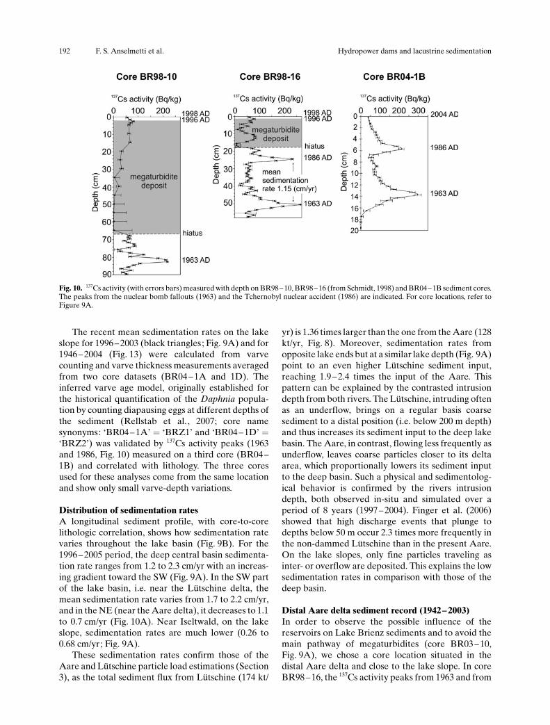
The recent mean sedimentation rates on the lakeslope for 1996– 2003 (black triangles; Fig. 9A) and for1946 – 2004 (Fig. 13) were calculated from varvecounting and varve thickness measurements averagedfrom two core datasets (BR04 – 1A and 1D). Theinferred varve age model, originally established forthe historical quantification of the Daphnia popula-tion by counting diapausing eggs at different depths ofthe sediment (Rellstab et al. , 2007; core namesynonyms: �BR04 – 1A� = �BRZ1� and �BR04 –1D� =�BRZ2�) was validated by 137Cs activity peaks (1963and 1986, Fig. 10) measured on a third core (BR04 –1B) and correlated with lithology. The three coresused for these analyses come from the same locationand show only small varve-depth variations.
Distribution of sedimentation ratesA longitudinal sediment profile, with core-to-corelithologic correlation, shows how sedimentation ratevaries throughout the lake basin (Fig. 9B). For the1996 – 2005 period, the deep central basin sedimenta-tion rate ranges from 1.2 to 2.3 cm/yr with an increas-ing gradient toward the SW (Fig. 9A). In the SW partof the lake basin, i.e. near the L�tschine delta, themean sedimentation rate varies from 1.7 to 2.2 cm/yr,and in the NE (near the Aare delta), it decreases to 1.1to 0.7 cm/yr (Fig. 10A). Near Iseltwald, on the lakeslope, sedimentation rates are much lower (0.26 to0.68 cm/yr; Fig. 9A).
These sedimentation rates confirm those of theAare and L�tschine particle load estimations (Section3), as the total sediment flux from L�tschine (174 kt/
yr) is 1.36 times larger than the one from the Aare (128kt/yr, Fig. 8). Moreover, sedimentation rates fromopposite lake ends but at a similar lake depth (Fig. 9A)point to an even higher L�tschine sediment input,reaching 1.9– 2.4 times the input of the Aare. Thispattern can be explained by the contrasted intrusiondepth from both rivers. The L�tschine, intruding oftenas an underflow, brings on a regular basis coarsesediment to a distal position (i.e. below 200 m depth)and thus increases its sediment input to the deep lakebasin. The Aare, in contrast, flowing less frequently asunderflow, leaves coarse particles closer to its deltaarea, which proportionally lowers its sediment inputto the deep basin. Such a physical and sedimentolog-ical behavior is confirmed by the rivers intrusiondepth, both observed in-situ and simulated over aperiod of 8 years (1997 – 2004). Finger et al. (2006)showed that high discharge events that plunge todepths below 50 m occur 2.3 times more frequently inthe non-dammed L�tschine than in the present Aare.On the lake slopes, only fine particles traveling asinter- or overflow are deposited. This explains the lowsedimentation rates in comparison with those of thedeep basin.
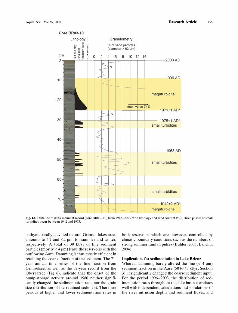
Distal Aare delta sediment record (1942– 2003)In order to observe the possible influence of thereservoirs on Lake Brienz sediments and to avoid themain pathway of megaturbidites (core BR03– 10,Fig. 9A), we chose a core location situated in thedistal Aare delta and close to the lake slope. In coreBR98 – 16, the 137Cs activity peaks from 1963 and from
Fig. 10. 137Cs activity (with errors bars) measured with depth on BR98–10, BR98–16 (from Schmidt, 1998) and BR04–1B sediment cores.The peaks from the nuclear bomb fallouts (1963) and the Tchernobyl nuclear accident (1986) are indicated. For core locations, refer toFigure 9A.
192 F. S. Anselmetti et al. Hydropower dams and lacustrine sedimentation
1986 are recorded at 50.5 and 24.5 cm, respectively,giving a mean sedimentation rate of 1.2 cm/yr for thistime range. In core BR98 – 10, due to sediment erosionby the overlying megaturbidite deposit (Girardclos etal. , in press), only the 1963 137Cs activity peak remains(Fig. 10).
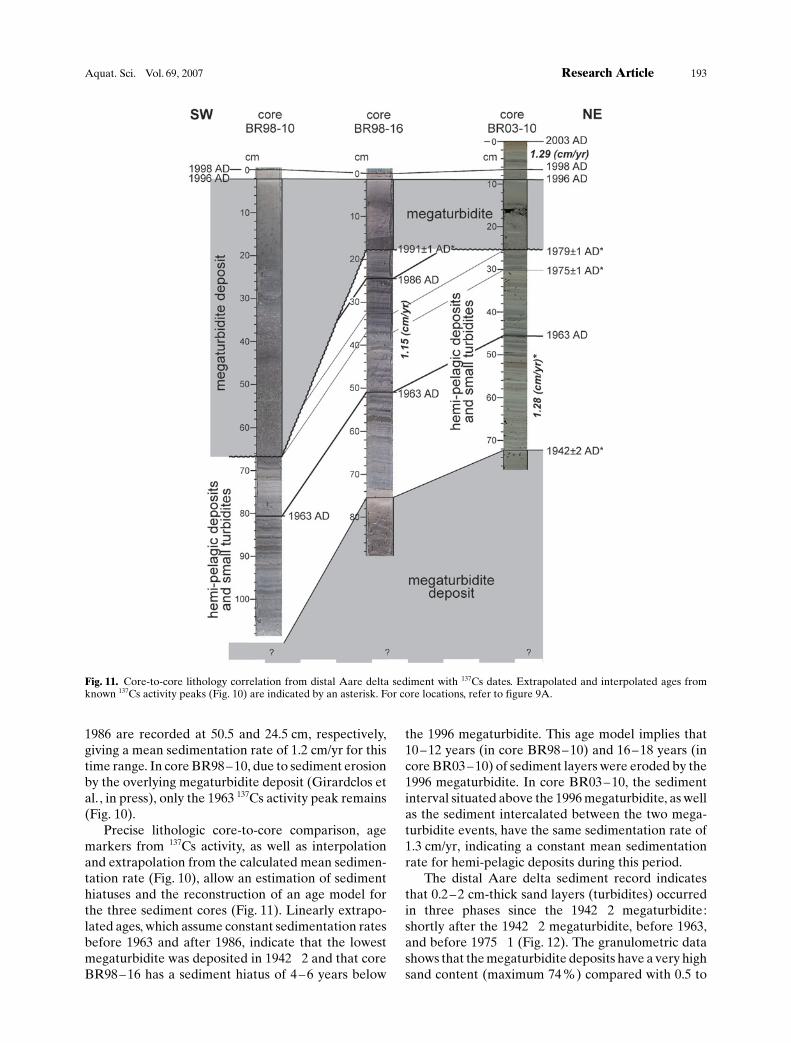
Precise lithologic core-to-core comparison, agemarkers from 137Cs activity, as well as interpolationand extrapolation from the calculated mean sedimen-tation rate (Fig. 10), allow an estimation of sedimenthiatuses and the reconstruction of an age model forthe three sediment cores (Fig. 11). Linearly extrapo-lated ages, which assume constant sedimentation ratesbefore 1963 and after 1986, indicate that the lowestmegaturbidite was deposited in 1942�2 and that coreBR98 – 16 has a sediment hiatus of 4 – 6 years below
the 1996 megaturbidite. This age model implies that10 – 12 years (in core BR98 – 10) and 16– 18 years (incore BR03 – 10) of sediment layers were eroded by the1996 megaturbidite. In core BR03– 10, the sedimentinterval situated above the 1996 megaturbidite, as wellas the sediment intercalated between the two mega-turbidite events, have the same sedimentation rate of1.3 cm/yr, indicating a constant mean sedimentationrate for hemi-pelagic deposits during this period.
The distal Aare delta sediment record indicatesthat 0.2– 2 cm-thick sand layers (turbidites) occurredin three phases since the 1942�2 megaturbidite:shortly after the 1942�2 megaturbidite, before 1963,and before 1975�1 (Fig. 12). The granulometric datashows that the megaturbidite deposits have a very highsand content (maximum 74 %) compared with 0.5 to
Fig. 11. Core-to-core lithology correlation from distal Aare delta sediment with 137Cs dates. Extrapolated and interpolated ages fromknown 137Cs activity peaks (Fig. 10) are indicated by an asterisk. For core locations, refer to figure 9A.
Aquat. Sci. Vol. 69, 2007 Research Article 193
9.7% in the remainder of the core. The sand contentdisplays a constant general trend along the core depthand, as expected, the peaks in sand content correlatewith periods of small turbidite occurrence.
The occurrence of small turbidites in the distalAare delta can be interpreted in different ways: (1)sudden increase in sand supply from the Aare catch-ment (increased erosion, leached subaerial mass-movement, etc.), (2) higher frequency of deep Aareintrusions leading to enhanced sediment transport tothe deep basin, or (3) sand remobilization due tointernal lacustrine mass movement (slide, slump, etc.).Currently, we cannot decipher the exact cause of thesmall turbidites, but for the pre-1963 turbidite period(depth 46 – 58 cm, Fig. 12), the reddish sediment color,which accompanies the increase in sand, points to acontemporary increase in terrestrial matter (i.e. soilremains) in the sediment and, therefore, to a likelyincrease of erosion in the catchment. This lithologycould potentially be linked to the KWO constructionsin the Gadmertal, which occurred between 1958 and1967.
Varved lateral slope sediment record (1946 – 2003)Lateral slope sediments result from fine-grained sedi-ment input deposited as clastic varves (Sturm andMatter, 1978). The mean sedimentation rate for 1946 –2004, averaged from two age-depth profiles(Fig. 13A), shows that lake slope sedimentation variedfrom 0.13 to 0.4 cm/yr with an exceptional peak in1995 (0.72 cm/yr; Fig. 13B). The sedimentation ratetrend is subdivided into three phases: (A) a decreasingtrend from 1946 – 1955, (B) an increasing trend from1955 – 1963/64, and (C) a plateau from 1963/64– 2003.
The sedimentation rates inferred from varvesreflect changes in the lacustrine deposition of fine-grained sediment, and thus variations in the total finesediment input from the Aare and L�tschine throughtime. As presented in Sections 2 and 3, the Grimseldams had a relatively small influence on the retentionof fine-particles, as the fine (< 4 mm in diameter)sediment fraction load in the Aare was only slightlyreduced (Section 3). The 59-year time series of the finesediment from Lake Brienz (Fig. 13A and B), whichrepresents only a �post-dam� sequence, doesn�t allowus to validate the results of Section 3. Similarly to thereservoir record, the Lake Brienz varve record showsthat the onset of the pump-storage activities around1980 did not change significantly the fine-grainedsediment input to Lake Brienz, as the averagesedimentation rate variations from 1946 to 1963/64are much higher than those after 1980. Comparison ofvarve- and climate-derived sedimentation rates withannual mean temperatures (Begert et al. , 2005), aswell as with annual precipitation (Meteo Swiss data
for Interlaken and Meiringen) showed no correlation.Furthermore, none of the known reservoir mainte-nance events (Section 2) seem to have influenced thevarve record (no sedimentation peaks). However, theincrease in varve thickness from 1955 to 1963/64 mightbe related to the increase of fine turbidites in the distalAare delta before 1963. The punctual high sedimen-tation rate (0.72 cm/yr) in 1995, being a unique highvalue, probably reveals a local sedimentological event.
The difficulty in interpreting the varve sedimenta-tion rate is possibly due to the superposition ofdifferent sedimentological �signals�. The main sources(L�tschine and Aare) for fine-grained sediment havecontrasting hydrologic regimes and intrusion behav-iors, and react independently. Variations in lakecurrents occur and, as shown in Lake Geneva (Gir-ardclos et al. , 2003; Ulmann et al., 2003), they mightalso induce shifts in the distribution pattern of finesediment particles and hence cause varying sedimentbudgets in different lake areas over time. Also, thecorrelation with precipitation data from high-altitudestations might be more relevant than with those fromInterlaken and Meiringen. Moreover, a time offsetbetween climate data and sedimentation rates mightexist and be hidden by the annual averaging. A longertime series, reflecting the pre-dam situation, and moredetailed varve analysis (color, etc.) might contributenew insights into control on varve thickness.
5. Summary and conclusions
Implications for retention of erosional particles in thereservoirsThe investigation of the sediment fill of the reservoirsindicates that for the last 71 years, ~232 kt/yr ofsediment were retained on average in the reservoirsand, as a consequence, not fed into the Aare. Thissediment is mostly brought into the reservoirs byturbiditic flows related to increased runoff eventsfrom the glacier, e.g. during strong rainfalls in summer.Sediment distribution in the reservoirs is controlled bymorphobathymetric features (Fig. 4) that determineflow tracks and velocity and thus the local sedimentsettling rate. In addition, flushing activities can causelarge quantities of sediment to be remobilized andredeposited. The quantified annual sediment loadaveraged from 1930 to 2001 results in a denudationrate and sediment yield of 0.94 mm/yr and 2430 t/(km2yr) or 2.33 mm/yr and 6050 t/(km2yr) assumingerosion in the entire catchment of the reservoirs oronly in the glaciated area, respectively.
The bulk of the retained sediment consists mostlyof silt and sand-size particles. The average grain size ofthe thinner hemipelagic-type sediment, as cored in the
194 F. S. Anselmetti et al. Hydropower dams and lacustrine sedimentation
bathymetrically elevated natural Grimsel lakes area,amounts to 4.7 and 8.2 mm, for summer and winter,respectively. A total of 39 kt/yr of fine sedimentparticles (mostly< 4 mm) leave the reservoirs with theoutflowing Aare. Damming is thus mostly efficient inretaining the coarse fraction of the sediment. The 71-year annual time series of the fine fraction fromGrimselsee, as well as the 32-year record from theOberaarsee (Fig. 6), indicate that the onset of thepump-storage activity around 1980 neither signifi-cantly changed the sedimentation rate, nor the grainsize distribution of the retained sediment. There areperiods of higher and lower sedimentation rates in
both reservoirs, which are, however, controlled byclimatic boundary conditions such as the numbers ofstrong summer rainfall pulses (B�hler, 2003; Lancini,2004).
Implications for sedimentation in Lake BrienzWhereas damming barely altered the fine (< 4 mm)sediment fraction in the Aare (50 to 43 kt/yr; Section3), it significantly changed the coarse sediment input.For the period 1996 – 2003, the distribution of sed-imentation rates throughout the lake basin correlateswell with independent calculations and simulations ofthe river intrusion depths and sediment fluxes, and
Fig. 12. Distal Aare delta sediment record (core BR03–10) from 1942–2003, with lithology and sand content (%). Three phases of smallturbidites occur between 1942 and 1975.
Aquat. Sci. Vol. 69, 2007 Research Article 195

confirms the dominance of the present L�tschineinput over the Aare input to the deep lake basin, aswell as the intrusion depth regimes of those rivers. Thehigh sedimentation rate of Lake Brienz and the thickmegaturbidite deposits prevented the coring of distalAare delta sediments older than 1929 (i.e. before thereservoirs were built). As a consequence, the expectedstrong changes in Aare sediment particle-size andquantity could not be analyzed. But the 1942 – 2003sediment record of the distal Aare delta shows ageneral constant trend in sedimentation rate and insand content variation, and the occurrence of threeperiods of frequent small turbidites, one of whichcould be related to KWO constructions in theGadmertal between 1958 and 1967.
In summary, two major phases of hydropoweroperations affected the downstream Lake Brienzsedimentation pattern. First, the closure of the twodams of Grimselsee in 1929 separated the Aare fromthe direct proglacial influence of the two largeOberaar and Unteraar glaciers, and coarse particleswere retained in the reservoirs. Assuming that all thiscoarse sediment would have reached Lake Brienzwithin a few years (e.g. after a series of strong rainfallevents), input of silt and sand-sized particles at theAare delta was significantly lowered. Although the
total amount of fine grained sediment was barelyaffected, the establishment of reservoirs in the head-waters did, however, affect the seasonal distribution ofturbidity, as more water with fine grained suspensionentered after 1929 Lake Brienz during winter and lessin summer. The second major impact occurring in thecontext of the hydropower operations, the pump-storage activities that started around 1980, had nosignificant influence on the distribution, quantities,and grain size of the deposited fine fraction in thereservoirs nor in Lake Brienz, as could be shownthrough analysis of the varved records in Oberaarsee,Grimselsee and Lake Brienz. It is thus highly unlikelythat the low fishing yield in Lake Brienz observed in1999 had its cause in a change in the solid particlebudgets. At that time, changes in the boundaryconditions of hydropower activities and particle trans-port were insignificant, especially when comparedwith the major changes in the 1930 but also with theminimal changes in 1980.
Fig. 13. (A) Lake slope sediment record with clastic annual varves from 1946–2004 AD (core BR04–1D). Varve dating was validated by137Cs activity peaks. (B) Averaged sedimentation rate (cm/yr) of two cores (BR04–1A and BR04–1D) shows three trend phases (reddashed line; see text). The high sedimentation rate (0.72 cm/yr) in 1995 reveals a local sedimentological event. For core locations, refer toFigure 9A.
196 F. S. Anselmetti et al. Hydropower dams and lacustrine sedimentation

Acknowledgments
Financial support was received by Swiss NationalScience Foundation Grant 620 –066113. Part of thestudy was funded by the interdisciplinary researchproject investigating the ecological impacts of anthro-pogenic changes in the watershed on Lake Brienz,which was supported by (1) Regional Government ofCanton Bern, (2) Kraftwerke Oberhasli AG (KWO)(3) Swiss Federal Office of the Environment (FOEN),(4) communities on the shoreline of Lake Brienz and(5) Swiss Federal Institute of Aquatic Science andTechnology (Eawag). KWO logistically and financial-ly also supported the Grimsel reservoirs survey. Wethank, in particular, Theo Maurer, Peter Streit andtheir colleagues on the Grimsel Hospiz. JohannesB�hler contributed data on particle transport pro-ACHTUNGTRENNUNGcesses. Alois Zwyssig, Robert Hofmann and severalETH and Eawag students and staff members helpedduring numerous coring and survey campaigns. ErwinGrieder performed the Cesium analysis. Urs Gerbermade the core photographs. Matthias Papp performedthe sediment analysis and age assignments of the coreOR06 – 1/2 from Oberaarsee. The Hofmann Shipyardin Brienz and the village of Iseltwald with the ShipyardAbegglen logistically supported our campaigns inLake Brienz. Comments of two anonymous reviewersand Johny W�est improved earlier versions of themanuscript. We thank Johny W�est and Markus Zehfor their continuous support and feedback.
References
Adams, E. W., W. Schlager and F. S. Anselmetti, 2001. Morphologyand curvature of delta slopes in Swiss lakes: lessons for theinterpretation of clinoforms in seismic data. Sedimentology,48: 661 – 679.
Ammann, K., 1976. Der Oberaargletscher im 18., 19. und20. Jahrhundert. Zeitschrift f�r Gletscherkunde und Glaziolo-gie, XII: 2, 253 – 291.
Begert, M., T. Schlegel and W. Kirchhofer, 2005. Homogeneoustemperature and precipitation series of Switzerland from 1864to 2000. International Journal of Climatology, 25: 65 – 80.
Blass, A., F. S. Anselmetti and D. Ariztegui, 2003. 60 years ofglaciolacustrine sedimentation in Steinsee (Sustenpass, Swit-zerland) compared with historic events and instrumentalmeteorological data. Eclog. Geol. Helv. 96: Suppl. 1, 59 – 71.
B�hler, R., 2003. Sedimentvolumen in den Grimselseen und darausresultierende Erosionsraten im Einzugsgebiet, Diplomarbeit,ETH Z�rich, 69 pp.
B�hler, J., C. Siegenthaler and A. W�est, 2005. Turbidity currentsin an alpine pumped – storage reservoir. In: Lee and Lam(eds.), Environmental Hydraulics and Sustainable waterManagement, A.A. Balkema, London, 1, pp. 239–244.
Buoncristiani, J.-F. and M. Campy, 2001. Late Pleistocene sedimentyield of the Jura glacier, France. Quaternary Research, 56: 51 –61.
Chanudet V. and M. Filella, 2007. The fate of inorganic colloidalparticles in Lake Brienz. Aquat. Sci. 69: doi 10.1007/s00027-007-0877-2.
Cohn, T. A., L. L. Delong, E. J. Gilroy, R. M. Hirsch, and D. K.Wells, 1989. Estimating constituent loads. Water ResourcesResearch 25: 937 – 942.
Crawford, C. G., 1991. Estimation of suspended-sediment ratingcurves and mean suspended-sediment loads. Journal of Hy-drology 129: 331 – 348.
De Cesare, G., A. Schleiss, and F. Hermann, 2001. Impact ofturbidity currents on reservoir sedimentation. Journal ofHydraulic Engineering 127: 6 – 16.
De Vente, J. and J. Poesen, 2005. Predicting soil erosion andsediment yield at the basin scale: Scale issues and semi-quantitative models. Earth-Science Reviews 71: 95 – 125.
Einsele G. and M. Hinderer, 1997. Terrestrial sediment yield andthe lifetimes of reservoir lakes and larger basins. GeologischeRundschau 86: 288 – 310.
Einsele, G. and M. Hinderer, 1998. Quantifying denudation andsediment-accumulation systems (open and closed lakes): basicconcepts and first results. Paleogeography, Palaeoclimatology,Palaeoecology 140: 7 – 21.
Finger, D., M. Schmid and A. W�est, 2006. Effects of upstreamhydropower operation on riverine particle transport andturbidity in downstream lakes. Water Resources Research 42,W08429, doi: 10.1029/2005WR004751.
Finger, D., P. Bossard, M. Schmid, L. Jaun, B. M�ller, D. Steiner, E.Sch�ffer, M. Zeh and A. W�est. 2007. Effects of alpinehydropower operations on primary production in a down-stream lake. Aquat. Sci. 69: doi 10.1007/s00027-007-0873-6.
Friedl, G., C. Teodoru and B. Wehrli, 2004. Is the Iron Gate Ireservoir on the Danube River a sink for dissolved silica?Biogeochemistry 68: 21 – 32.
Girardclos, S., I. Baster, W. Wildi and A. Pugin, 2003. Bottom-current and wind-pattern changes as indicated by Late-Glacialand Holocene sediments from western Lake Geneva (Switzer-land). Eclog. Geol. Helv. 96: Suppl. 1: 39 – 48.
Girardclos, S., O. T. Schmidt, M. Sturm, D. Ariztegui, A. Pugin andF. S. Anselmetti. The 1996 AD delta collapse and largeturbidity in Lake Brienz. Marine Geology, in press.
Jaun, L., D. Finger, M. Zeh, M. Schurter and A. W�est, 2007.Effects of upstream hydropower operation and oligotrophica-tion on the light regime of a turbid peri-alpine lake. Aquat. Sci.69: doi 10.1007/s00027-007-0876-3.
Hart, D. D., T. E. Johnson, K. L. Bushaw-Newton, R. J. Horwitz, A.T. Bednarek, D. F. Charles, D. A. Kreeger and D. J. Velinsky,2002. Dam removal: Challenges and opportunities for ecolog-ical research and river restoration. Bioscience 52: 669 – 681.
Hinderer M., 2001. Late Quaternary denudation of the Alps, valleyand lake fillings and modern river loads. Geodinamica Acta 14:231 – 263.
Humborg, C., D. J. Conley, L. Rahm, F. Wulff, A. Cociasu and V.Ittekkot, 2000. Silicon retention in river basins: Far-reachingeffects on biogeochemistry and aquatic food webs in coastalmarine environments. Ambio 29: 45 – 50.
Lancini, A., 2004. Proglaziale Sedimentation im Oberaar- undGrimselstausee (Kanton Bern). Diplomarbeit, ETH Z�rich, 92pp.
Loizeau, J. L. and J. Dominik, 2000. Evolution of the upper RhoneRiver discharge and suspended sediment load during the last80 years and some implications for Lake Geneva. AquaticSciences 62: 54 – 67.
McIntyre, S. C., 1993. Reservoir sedimentation rates linked to long-term changes in agricultural land use. Water ResourcesBulletin 29: 487 – 495.
Meier, W., C. Bonjour, A. W�est and P. Reichert, 2003. Modelingthe effect of water diversion on the temperature of mountainstreams. Journal of Environmental Engineering-Asce. 129:755 – 764.
M�ller, B., D. Finger, M. Sturm, V. Prasuhn, T. Haltmeier, P.Bossard, C. Hoyle and A. W�est, 2007a. Present and past bio-available phosphorus budget in the ultra-oligotrophic LakeBrienz. Aquat. Sci. 69: doi 10.1007/s00027-007-0871-8.
M�ller, R., M. Breitenstein, M. M. Bia, C. Rellstab and A.Kirchhofer, 2007b. Bottom-up control of whitefish populations
Aquat. Sci. Vol. 69, 2007 Research Article 197
in ultra-oligotrophic Lake Brienz. Aquat. Sci. 69: doi 10.1007/s00027-007-0874-5.
Nydegger, P., 1967. Untersuchungen �ber Feinststofftransport inFl�ssen und Seen, �ber Entstehung von Tr�bungshorizontenund zuflussbedingten Strçmungen im Brienzersee und einigenVergleichsseen. Beitr�ge zur Geologie der Schweiz. Hydro-logie 16: 1 – 92.
Preece, R. M. and H. A. Jones, 2002. The effect of Keepit Dam onthe temperature regime of the Namoi River, Australia. RiverResearch and Applications 18: 397 – 414.
Rellstab, C., V. Maurer, M. Zeh, H. R. B�rgi and P. Spaak, 2007.Temporary collapse of the Daphnia population in turbid andultra-oligotrophic Lake Brienz. Aquat. Sci. 69: doi 10.1007/s00027-007-0872-7.
S�gesser, M. and R. Weingartner, 2005. Ver�nderung der Hydro-logie der Aare. Modellierung des nat�rlichen Abflusses derAare, Pegel Brienzwiler, von 1921 bis 2004. Bern, InternalReport Institute of Geography – University of Bern, (http://www.eawag.ch/brienzersee), 94 pp.
Schlatter, A. and U. Marti, 2002. Neues Landeshçhennetz derSchweiz LHN95: Vermessung, Photogrammetrie, Kulturtech-nik 1: 13 – 17
Schleiss, A. and C. Oehy, 2002. Verlandung von Stauseen undNachhaltigkeit, Wasser Energie Luft 94: 227 – 234.
Schmidt, O. 1998. Brienzersee Turbiditereignis vom Fr�hjahr 1996.Diploma, ETH Z�rich/EAWAG, Kastanienbaum, 92 pp.(http://www.eawag.ch/brienzersee).
Sturm, M. 1976. Die Oberfl�chensedimente des Brienzersees.Eclog. Geol. Helvetiae 69: 111 – 123.
Sturm, M. and A. Matter, 1978. Turbidites and varves in LakeBrienz (Switzerland): deposition of clastic detritus by density
currents. In: A. Matter and M. Tucker (eds.), Modern andAncient Lake Sediments. Spec. Publs Int. Ass. Sediment. 2,Blackwell Scientific Publications, Oxford, pp. 147 – 168.
Teodoru, C. and B. Wehrli, 2005. Retention of sediments andnutrients in the Iron Gate I Reservoir on the Danube River.Biogeochemistry 76: 539 – 565.
Ulmann, M., Wildi, W. and U. Lemmin, 2003. Sediment distribu-tion on a current-dominated lake delta (Versoix delta, LakeGeneva, Switzerland). Eclog. Geol. Helvetiae 96: Suppl. 1,91 – 98.
Vçrçsmarty, C. J., K. P. Sharma, B. M. Fekete, A. H. Copeland, J.Holden, J. Marble and J. A. Lough, 1997. The storage and agingof continental runoff in large reservoir systems of the world.Ambio 26: 210 – 219.
Vçrçsmarty, C. J., M. Meybeck, B. Fekete, K. Sharma, P. Green andJ. P. M. Syvitski, 2003. Anthropogenic sediment retention:major global impact from registered river impoundments.Global and Planetary Change 39: 169 – 190.
Weirich, F., 1986. The record of density-induced underflows in aglacial lake. Sedimentology 33: 261 – 277.
W�est. A., M. Zeh, and J. D. Ackerman, 2007. Preface: LakeBrienz Project: An interdisciplinary catchment-to-lake study.Aquat. Sci. 69: doi 10.1007/s00027-007-0016-0.
Zeh, M. 1997. Makabrer Leichenfund als Indiz f�r ein Jahrhun-dertereignis / L��v�nement du si�cle � Brienz. GSA Informa-tionsbulletin (Amt f�r Gew�sserschutz und Abfallwirtschaftdes Kantons Bern) / OPED Bulletin d�information (Office dela protection des eaux et de la gestion des d�chets du canton deBerne) 1: 7 – 13.
Zimmermann, I., 1996. Mçglichkeiten und Grenzen von Streu-lichtmessverfahren. Chemie Ingenieur Technik 68: 422 – 425.
To access this journal online:http://www.birkhauser.ch/AS
198 F. S. Anselmetti et al. Hydropower dams and lacustrine sedimentation
Related Documents