Effects of a tectonically-triggered wave of incision on riverine exports and soil mineralogy in the Luquillo Mountains of Puerto Rico Gilles Y. Brocard ⇑ , Jane K. Willenbring, Frederick N. Scatena, Art H. Johnson Department of Earth and Environmental Science, University of Pennsylvania, Hayden Hall, 240 South 33rd Street, Philadelphia, PA 19104, United States article info Article history: Available online xxxx abstract We document the long-term response of a tropical mountain stream to tectonics and show how this response exerts a first-order spatial control on the delivery of weatherable minerals to forest soils in its catchment. These minerals, in turn, affect nutrient availability and biogeochemical cycles. The Luquillo Mountains is a rainforest-covered isolated massif on Puerto Rico Island. Instead of displaying typical concave-up long profiles of most mountain streams, the rivers draining the southern flank of these mountains display a systematic downstream increase in gradient. Using concentrations of in situ-pro- duced cosmogenic 10 Be in quartz from river sediments, we find that the downstream steepening is due to the propagation of an erosion wave along the rivers from the coastal plain upstream, toward the head- waters. Decreased 10 Be concentration along the steepened reaches (knickpoint faces or knickzones) results from faster denudation of the valley sides around the steepened reaches. The upper portions of the steepened reaches (knickpoint lips) cluster in elevation around the altitude of a flat-lying, dissected surface traceable around the Luquillo Mountains. Inspection of similar platforms over other parts of Puerto Rico and in the surrounding seas suggests that the dissected surface is an uplifted shore platform formed in the Early Pliocene (4 My ago). Upstream of the knickpoints, rivers possess alluvial reaches still graded to this uplifted platform. They represent relict profiles of the rivers that once drained an island that was surrounded by the now-uplifted platform. We conclude that the knickpoints initiated when the platform started to rise above the Caribbean Sea. The knickpoints then started propagating upstream, defining the front of a slow-moving wave of erosion. 10 Be-derived catchment-scale denudation rates measured above and below the knickpoints indicate a 30–210% increase in denudation associated to the passage of the knickpoints. Mineralogical analysis of the soils show that soils upstream of the knick- points overlie deeply depleted saprolite and only contain recalcitrant minerals, whereas soils down- stream of the knickpoints experience an input of fresh, weatherable minerals. This influx considerably increases nutrient availability (Porder et al., 2015) in a forest where atmospheric inputs are otherwise the main source of nutrients (McDowell et al., 1990; Zarin and Johnson, 1995; Pett-Ridge, 2009). Ó 2015 Elsevier Ltd. All rights reserved. 1. Introduction Small mountain rivers have been shown to collectively trans- port significant amounts of terrestrial materials to the ocean (Restrepo and Kjerfve, 2000; Rad et al., 2006). Over timescales ranging from a few months to a few decades, fluvial sediment transport can be affected by anthropogenic perturbations of ecosystems such as cultivation and road clearings (MacDonald et al., 1997). Landslides triggered by hurricanes (Zarin and Johnson, 1995) and earthquakes (Dadson et al., 2004) affect sedi- ment delivery over similar timescales. Over centuries and mil- lennia, climate fluctuations modulate the delivery of terrestrial products to the coastal ocean (Goodbred and Kuehl, 2000). Over longer geologic timescales, tectonic uplift and erosion progres- sively reshape the topography of river catchments. In an ideal case of topographic equilibrium (Hack, 1960), erosion everywhere in a catchment should exactly counterbalance mountain uplift. In fast turnover landscapes, such equilibrium is roughly achieved over the timescale necessary to even out the effects of climatic oscilla- tions (Brocard et al., 2003). The response time of rivers to changes in tectonic uplift is however generally not instantaneous, and can span hundreds of thousands to millions of years (Attal et al., 2011). Can such slow river response leave a detectable and signifi- cant imprint, both spatially and temporally in sediment production and biogeochemical cycles in the catchment of small tropical mountainous rivers? To address this question, we investigated the magnitude of a slowly migrating wave or erosion produced http://dx.doi.org/10.1016/j.apgeochem.2015.04.001 0883-2927/Ó 2015 Elsevier Ltd. All rights reserved. ⇑ Corresponding author. E-mail address: [email protected] (G.Y. Brocard). Applied Geochemistry xxx (2015) xxx–xxx Contents lists available at ScienceDirect Applied Geochemistry journal homepage: www.elsevier.com/locate/apgeochem Please cite this article in press as: Brocard, G.Y., et al. Effects of a tectonically-triggered wave of incision on riverine exports and soil mineralogy in the Luquillo Mountains of Puerto Rico. Appl. Geochem. (2015), http://dx.doi.org/10.1016/j.apgeochem.2015.04.001

Welcome message from author
This document is posted to help you gain knowledge. Please leave a comment to let me know what you think about it! Share it to your friends and learn new things together.
Transcript

Applied Geochemistry xxx (2015) xxx–xxx
Contents lists available at ScienceDirect
Applied Geochemistry
journal homepage: www.elsevier .com/ locate/apgeochem
Effects of a tectonically-triggered wave of incision on riverine exportsand soil mineralogy in the Luquillo Mountains of Puerto Rico
http://dx.doi.org/10.1016/j.apgeochem.2015.04.0010883-2927/� 2015 Elsevier Ltd. All rights reserved.
⇑ Corresponding author.E-mail address: [email protected] (G.Y. Brocard).
Please cite this article in press as: Brocard, G.Y., et al. Effects of a tectonically-triggered wave of incision on riverine exports and soil mineralogyLuquillo Mountains of Puerto Rico. Appl. Geochem. (2015), http://dx.doi.org/10.1016/j.apgeochem.2015.04.001
Gilles Y. Brocard ⇑, Jane K. Willenbring, Frederick N. Scatena, Art H. JohnsonDepartment of Earth and Environmental Science, University of Pennsylvania, Hayden Hall, 240 South 33rd Street, Philadelphia, PA 19104, United States
a r t i c l e i n f o a b s t r a c t
Article history:Available online xxxx
We document the long-term response of a tropical mountain stream to tectonics and show how thisresponse exerts a first-order spatial control on the delivery of weatherable minerals to forest soils inits catchment. These minerals, in turn, affect nutrient availability and biogeochemical cycles. TheLuquillo Mountains is a rainforest-covered isolated massif on Puerto Rico Island. Instead of displayingtypical concave-up long profiles of most mountain streams, the rivers draining the southern flank of thesemountains display a systematic downstream increase in gradient. Using concentrations of in situ-pro-duced cosmogenic 10Be in quartz from river sediments, we find that the downstream steepening is dueto the propagation of an erosion wave along the rivers from the coastal plain upstream, toward the head-waters. Decreased 10Be concentration along the steepened reaches (knickpoint faces or knickzones)results from faster denudation of the valley sides around the steepened reaches. The upper portions ofthe steepened reaches (knickpoint lips) cluster in elevation around the altitude of a flat-lying, dissectedsurface traceable around the Luquillo Mountains. Inspection of similar platforms over other parts ofPuerto Rico and in the surrounding seas suggests that the dissected surface is an uplifted shore platformformed in the Early Pliocene (�4 My ago). Upstream of the knickpoints, rivers possess alluvial reachesstill graded to this uplifted platform. They represent relict profiles of the rivers that once drained anisland that was surrounded by the now-uplifted platform. We conclude that the knickpoints initiatedwhen the platform started to rise above the Caribbean Sea. The knickpoints then started propagatingupstream, defining the front of a slow-moving wave of erosion. 10Be-derived catchment-scale denudationrates measured above and below the knickpoints indicate a 30–210% increase in denudation associated tothe passage of the knickpoints. Mineralogical analysis of the soils show that soils upstream of the knick-points overlie deeply depleted saprolite and only contain recalcitrant minerals, whereas soils down-stream of the knickpoints experience an input of fresh, weatherable minerals. This influx considerablyincreases nutrient availability (Porder et al., 2015) in a forest where atmospheric inputs are otherwisethe main source of nutrients (McDowell et al., 1990; Zarin and Johnson, 1995; Pett-Ridge, 2009).
� 2015 Elsevier Ltd. All rights reserved.
1. Introduction
Small mountain rivers have been shown to collectively trans-port significant amounts of terrestrial materials to the ocean(Restrepo and Kjerfve, 2000; Rad et al., 2006). Over timescalesranging from a few months to a few decades, fluvial sedimenttransport can be affected by anthropogenic perturbations ofecosystems such as cultivation and road clearings (MacDonaldet al., 1997). Landslides triggered by hurricanes (Zarin andJohnson, 1995) and earthquakes (Dadson et al., 2004) affect sedi-ment delivery over similar timescales. Over centuries and mil-lennia, climate fluctuations modulate the delivery of terrestrial
products to the coastal ocean (Goodbred and Kuehl, 2000). Overlonger geologic timescales, tectonic uplift and erosion progres-sively reshape the topography of river catchments. In an ideal caseof topographic equilibrium (Hack, 1960), erosion everywhere in acatchment should exactly counterbalance mountain uplift. In fastturnover landscapes, such equilibrium is roughly achieved overthe timescale necessary to even out the effects of climatic oscilla-tions (Brocard et al., 2003). The response time of rivers to changesin tectonic uplift is however generally not instantaneous, and canspan hundreds of thousands to millions of years (Attal et al.,2011). Can such slow river response leave a detectable and signifi-cant imprint, both spatially and temporally in sediment productionand biogeochemical cycles in the catchment of small tropicalmountainous rivers? To address this question, we investigatedthe magnitude of a slowly migrating wave or erosion produced
in the

2 G.Y. Brocard et al. / Applied Geochemistry xxx (2015) xxx–xxx
in response to a tectonic uplift initiated several million years ago inthe catchment of Río Blanco, a mountain stream located in theLuquillo Critical Zone Observatory. We show that this wave or ero-sion leaves a detectable 10Be signal in riverborne sediments andsignificantly increase the delivery of weatherable minerals to thesoils in a mountain where the subsoil is otherwise stronglydepleted in nutrients (Zarin and Johnson, 1995). As a result, thiswave of erosion has a first-order effect on the delivery of nutrientsto the overlying rainforest.
Puerto Rico is an island located above an oblique subductionzone; it has experienced rapid changes in tectonic uplift ratesthroughout its history, faster than the time required by erosionsystems to respond and adjust to these fluctuations. As a result,its landscape has been maintained in a state of permanent disequi-librium. Its topography is a patchwork of domains eroding at vari-ous rates, separated from each other by knickpoints. Knickpointsare over-steepened reaches of river long profiles generated byalong-stream variations in bedrock erodibility, uplift rates, or bed-load grain-size. Transient knickpoints are also formed at the frontof waves of accelerated erosion that propagate an erosional signalupstream. As hypothesized by Penck (1924), following a climatic,tectonic or base level disturbance, such knickpoints transmit atransient denudation signal across drainage basins in an organizedand predictable fashion. In the present study we show how the tec-tonic evolution of Puerto Rico has influenced the topographic evo-lution and impacted the environment in the well-studied ElYunque National forest in the Luquillo Critical Zone Observatory.
We show that an episode of uplift that occurred several millionyears ago has sparked erosion waves that are still propagatingacross the landscape, generating sharp retreating knickpoints inthe topography. These knickpoints provide a fundamental controlon sediment and chemical fluxes. Using in situ-produced 10Be inriver-borne quartz, we evaluate the magnitude of the erosional dif-ference between the relict, slowly eroding uplands and the morerapidly adjusting downstream areas. The upland relict landscapein the Luquillo Mountains has been the site of some of the firststudies of catchment-wide denudation rates using detrital 10Be(Brown et al., 1995; 1998). These 10Be measurements were com-bined with weathering balances to propose some of the firstcalculations of long-term weathering fluxes and rates of soil andsaprolite formation based on cosmogenic denudation rates(White et al., 1998; Riebe et al., 2003; Ferrier et al., 2010). Here,we build upon these previous measurements by generalizing themacross the relict landscape and expanding them below the knick-points. We observe a decrease in the concentration of cosmogenic10Be across the knickpoints, confirming that a tectonic event thatoccurred several millions of years ago still imparts detectable dif-ferences in erosion rates in the modern landscape over the time-scale of 10Be-derived measurements (typically 103–104 years). Byanalyzing the mineral composition of the soils near the knickpointswe find that this increase in erosion rate is accompanied by anincrease in nutrient-bearing primary minerals. We thus show thatknickpoints have a fundamental effect because they separate anupland region where soils are almost completely depleted in pri-mary nutrient-bearing minerals and where previous studies haveshown that nutrients are mostly retrieved from the atmosphereand efficient recycling (e.g. Zarin and Johnson, 1995), from a down-stream region where soils possess a larger stock of nutrient-bear-ing minerals and plant-available nutrients.
2. Tectonic evolution and uplift history of Puerto Rico
The island of Puerto Rico sits on the northeastern corner of theCaribbean Plate (e.g. Dolan et al., 1998; ten Brink, 2005; Mann,2007)(Fig. 1A), and, with the Virgin Islands, belong to a common,
Please cite this article in press as: Brocard, G.Y., et al. Effects of a tectonicallyLuquillo Mountains of Puerto Rico. Appl. Geochem. (2015), http://dx.doi.org/10
almost rigid tectonic block (Mann et al., 1995; ten Brink et al.,2009). This block is a fragment of the ancient Greater Antillesisland-arc, which collided with the Bahamas Bank in the EarlyEocene (e.g. Rojas-Agramonte et al., 2008; Stanek et al., 2009).After collision the arc eroded down to sea level and its residualrelief was drowned into coastal sediments (Monroe, 1980a). ByMiocene time, the Puerto Rico area had become a slowly-subsidingreef platform (van Gestel et al., 1999). By the end of the Miocene,only pure reef carbonates were deposited (Moussa et al., 1987),suggesting that little to no relief was left. Less than 4 My ago, theVirgin islands-Puerto Rico block experienced a sudden tilting inpossibly as few as 14–40 ky (ten Brink, 2005). The northern edgeof the Puerto Rico-Virgin islands reef platform sunk 4.5 km intothe Puerto Rican trench while its southern ledge was upliftedabove sea level and was eroded away, exposing the underlying vol-canic basement (Fig. 1A) (Birch, 1986; Grindlay et al., 2005; tenBrink, 2005; ten Brink et al., 2009).
Little is known about the subsequent landscape evolution ofPuerto Rico. The interior of the island displays vast expanses of flat,high-standing sub-horizontal erosional surfaces at various stagesof dissection (Fig. 2). Semmes (1919) first recognized these andinterpreted them as remnants of a large peneplain exhumed frombeneath the Oligocene–Miocene carbonates. He ascribed lateralchanges in elevation and attitude of the plain remnants to later tec-tonic deformation. Lobeck (1922) disputed the role of tectonicdeformation and instead proposed two distinct, parallel, imbri-cated peneplain levels surrounding the highest peaks (Fig. 2).Briggs (1966) and Monroe (1980b) noticed the progressive dearthof terrestrial inputs to the Miocene reef platforms, which wasattributed to the formation of the peneplains (Monroe, 1980b) orto the decline in the size of the feeding hinterland (van Gestelet al., 1998). Meyerhoff (1927) inferred that both levels arePliocene in age, noticing that the Oligo-Miocene platform is tilted4� to the north and that it is beveled by an erosional surface slant-ing 1� to the north (the Caguana surface, Fig. 1B). These now-uplifted platforms are important benchmarks for understandingthe topographic evolution of Puerto Rico in general, and of theLuquillo Mountains in particular. They demonstrate that theLuquillo Mountains are young and have been uplifted incremen-tally over the past 4 My. The mountains we observe today arenot in a state of dynamic equilibrium; instead, they are a patch-work of relict surfaces and deeply dissected, quickly eroding areas.
3. Methods
3.1. Digital extraction of erosional platforms and knickpoints
We reconstructed the extent and attitude of the erosional plat-forms identified in past works. We first identified the remnants ofthese surfaces over the entire island using the USGS 1-arc-secondNational Elevation Dataset (NED) digital elevation model. Weremoved high frequency topographic details by resampling the ini-tial 30-m DEM with a 210 m-wide circular filter that extracts thehighest points in the topography. The slope map of this resampledtopography (Fig. 2A) was used to delineate the expanses of perchedflat land. In many instances, the remnants matched the levelsdescribed by Lobeck (1922) and Meyerhoff (1927) (Fig. 2B). Theyrepresent either one single surface disrupted by faults (Lobeck,1922) or imbricate surfaces of differing age separated by sinuousescarpments (Meyerhoff, 1927). We modeled the simplest case ofa single surface disrupted by faults to evaluate the maximumamount of deformation necessary to reproduce the observedspread in elevations. A cubic spline interpolation was passed overall the mapped platform remnants and was allowed to break freelyacross major tectonic faults (Fig. 3A). The resulting envelope was
-triggered wave of incision on riverine exports and soil mineralogy in the.1016/j.apgeochem.2015.04.001

Fig. 1. Early Pliocene tilting of the Puerto Rican carbonate platform and the formation of shore platforms. (A) map showing the present extent of the carbonate cover over theisland, with location of the Luquillo Mountains (LM). (B and C) are interpreted seismic section redrawn from van Gestel et al. (1998), showing the tilting of the carbonateplatform and its beveling below a shore platform around the Virgin Islands (C), and below the Caguana surface north of Puerto Rico (B).
G.Y. Brocard et al. / Applied Geochemistry xxx (2015) xxx–xxx 3
used to study how the relict surface projects around the LuquilloMountains (Fig. 3B).
Rivers and ridge profiles of the Luquillo Mountains wereextracted from a one-meter LiDAR DEM (doi: 10.5069/G9BZ63ZR). Due the coverage patchiness, the DEM was resampledat 5 m and void areas where patched with a 10-m DEM generatedby interpolation of 10-m-elevation contour lines (Pike et al., 2010).
3.2. Processing and measurement of in situ cosmogenic 10Be in quartz
Cosmogenic 10Be is produced in quartz grains within theimmediate subsurface of the Earth, over the few uppermost metersof soil that quartz grain traverses during their final exhumationbefore being transported downslope. The residence time of a
Please cite this article in press as: Brocard, G.Y., et al. Effects of a tectonically-Luquillo Mountains of Puerto Rico. Appl. Geochem. (2015), http://dx.doi.org/10
quartz mineral grain in this sub-surface zone of 10Be productiondepends on the rate at which the overlying material is removed.Therefore, the 10Be concentration in river sediment is inverselyrelated to the mean erosion rate in the upstream drainage basin(Lal, 1991). Over time, a steady state may exist where the inputof 10Be produced equals the export of 10Be in sediment leavingthe catchment (Lal, 1991; Brown et al., 1995; Granger et al.,1996). The catchment of Río Icacos in Luquillo Mountains is oneof the first sites where the method was tested (Brown et al.,1995). The Río Blanco quartz diorite is very homogeneous and richin quartz (23 wt.% quartz, Smith et al., 1998), making it ideally sui-ted for such studies. We collected river-borne quartz in sand-and-gravel bars of streams at various locations above and below theriver knickpoints. Samples were taken 50–200 m downstream of
triggered wave of incision on riverine exports and soil mineralogy in the.1016/j.apgeochem.2015.04.001
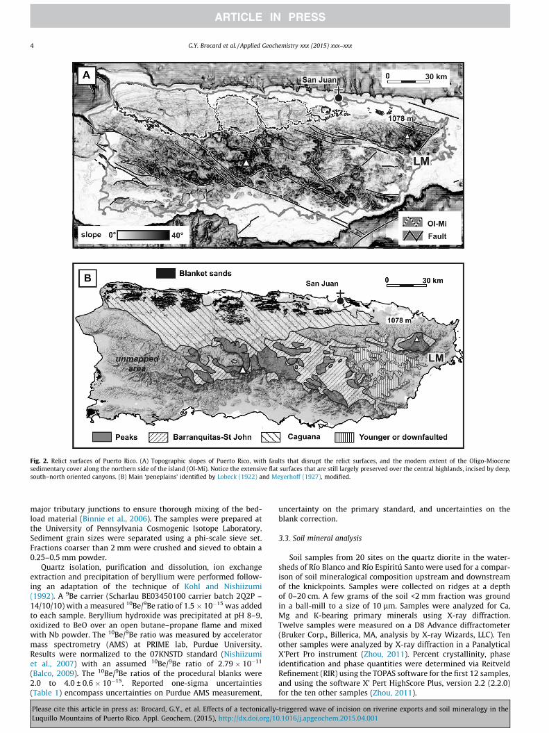
Fig. 2. Relict surfaces of Puerto Rico. (A) Topographic slopes of Puerto Rico, with faults that disrupt the relict surfaces, and the modern extent of the Oligo-Miocenesedimentary cover along the northern side of the island (Ol-Mi). Notice the extensive flat surfaces that are still largely preserved over the central highlands, incised by deep,south–north oriented canyons. (B) Main ‘peneplains’ identified by Lobeck (1922) and Meyerhoff (1927), modified.
4 G.Y. Brocard et al. / Applied Geochemistry xxx (2015) xxx–xxx
major tributary junctions to ensure thorough mixing of the bed-load material (Binnie et al., 2006). The samples were prepared atthe University of Pennsylvania Cosmogenic Isotope Laboratory.Sediment grain sizes were separated using a phi-scale sieve set.Fractions coarser than 2 mm were crushed and sieved to obtain a0.25–0.5 mm powder.
Quartz isolation, purification and dissolution, ion exchangeextraction and precipitation of beryllium were performed follow-ing an adaptation of the technique of Kohl and Nishiizumi(1992). A 9Be carrier (Scharlau BE03450100 carrier batch 2Q2P –14/10/10) with a measured 10Be/9Be ratio of 1.5 � 10�15 was addedto each sample. Beryllium hydroxide was precipitated at pH 8–9,oxidized to BeO over an open butane–propane flame and mixedwith Nb powder. The 10Be/9Be ratio was measured by acceleratormass spectrometry (AMS) at PRIME lab, Purdue University.Results were normalized to the 07KNSTD standard (Nishiizumiet al., 2007) with an assumed 10Be/9Be ratio of 2.79 � 10�11
(Balco, 2009). The 10Be/9Be ratios of the procedural blanks were2.0 to 4.0 ± 0.6 � 10�15. Reported one-sigma uncertainties(Table 1) encompass uncertainties on Purdue AMS measurement,
Please cite this article in press as: Brocard, G.Y., et al. Effects of a tectonicallyLuquillo Mountains of Puerto Rico. Appl. Geochem. (2015), http://dx.doi.org/10
uncertainty on the primary standard, and uncertainties on theblank correction.
3.3. Soil mineral analysis
Soil samples from 20 sites on the quartz diorite in the water-sheds of Río Blanco and Río Espiritú Santo were used for a compar-ison of soil mineralogical composition upstream and downstreamof the knickpoints. Samples were collected on ridges at a depthof 0–20 cm. A few grams of the soil <2 mm fraction was groundin a ball-mill to a size of 10 lm. Samples were analyzed for Ca,Mg and K-bearing primary minerals using X-ray diffraction.Twelve samples were measured on a D8 Advance diffractometer(Bruker Corp., Billerica, MA, analysis by X-ray Wizards, LLC). Tenother samples were analyzed by X-ray diffraction in a PanalyticalX’Pert Pro instrument (Zhou, 2011). Percent crystallinity, phaseidentification and phase quantities were determined via ReitveldRefinement (RIR) using the TOPAS software for the first 12 samples,and using the software X’ Pert HighScore Plus, version 2.2 (2.2.0)for the ten other samples (Zhou, 2011).
-triggered wave of incision on riverine exports and soil mineralogy in the.1016/j.apgeochem.2015.04.001

Fig. 3. Definition of El Yunque Island based on the areal extent of the flat erosional surfaces of Puerto Rico. (A) Surface envelope fit over the remnant of the Barranquitas-Cayaguas surface, with location of cross-section 4B. Contour spacing: 100 m. Mountains protruding over the surface envelope displayed in black (CC: Central Cordillera, LM:Luquillo Mountains). GNFZ: Great Northern Fault zone. (B) Topographic projection across the Luquillo Mountains showing the Barraquitas-Caguana platform reconstructedusing ridge #1, and the protruding ‘El Yunque island’ (ridges #2 and #3). Note spatial correlation between the platform, prominent notches in ridges, and major riverknickpoints over streams flowing on the quartz diorite. Location of ridges and rivers in Fig. 5.
G.Y. Brocard et al. / Applied Geochemistry xxx (2015) xxx–xxx 5
4. Results: Origin of the uplifted platforms around the LuquilloMountains
The relict low-relief platforms that cover much of Puerto Ricobevel both the tilted Mio-Pliocene carbonates and their volcanicbasement (Meyerhoff, 1927 and Fig. 1B). A similar beveling canbe observed today on the marine platform that surrounds theVirgin Islands (van Gestel et al., 1998; Fig. 1C). The Virgin Islandshore platform is essentially an extensive erosional shore platformthat surrounds residual islands, with patchy reefs and detrital sedi-ments blanketing its basal erosional surface. The similarity sug-gests that the upland relict surfaces of Puerto Rico are formershore platforms rather than peneplains. The Virgin Islands plat-form is 40- to 50-km-wide and would have had to expand land-wards by at least a centimeter per year to reach its modernextent since the Early Pliocene tilting of the reef platform. Such arate is compatible with reported rates of long-term sea-cliff retreat(Bradley and Griggs, 1976; Lange and Moon, 2005), rather thanwith the tens of millions of years necessary to form peneplains
Please cite this article in press as: Brocard, G.Y., et al. Effects of a tectonically-Luquillo Mountains of Puerto Rico. Appl. Geochem. (2015), http://dx.doi.org/10
(e.g. Baldwin et al., 2003). The ‘blanket sands’ of Puerto Rico alsosupport this marine origin: these patches of mature quartz-domi-nated sands are commonly found over the relict surfaces(Figs. 1a and 3B). They did not form by concentration of insolubleresidues following the weathering of their substrate as they com-monly rest on non-quartz bearing substrates such as pure carbon-ates (Briggs, 1966; Miotke, 1972; Jones et al., 1982) andserpentinites (Weaver, 1962; Jones et al., 1982). Instead, they musthave been transported all over the platforms by an agent able towidespread dispersion, most likely by the sea.
The platforms may originate in one single level disrupted byfaults (Semmes, 1919), or belong to at least two different imbricatelevels (Lobeck, 1922). The surface envelope that we passed over theplatform remnants is allowed to break freely across major tectonicfaults (Fig. 3A). In places, faults are found to coincide with abruptchanges in the elevation and attitude of the reconstructed envel-ope, such as across the Great Northern Fault Zone along theLuquillo Mountains. At other places, the surface display more dif-fuse and sinuous scarps that could correspond to belts of diffuse
triggered wave of incision on riverine exports and soil mineralogy in the.1016/j.apgeochem.2015.04.001

Table 110Be concentrations and environmental parameters used for the calculation of catchment-wide erosion rates.
Stream Grainsizerangea
Easting Northing Quartzb
feedingarea(AQ)
AQ
Averageelevation
Quartzused
[10Be] Topographicshieldingfactorc
Pld Pspal
d Quartzenrichmentfactore
Integratedsoildensityf
(/) unit (�) (�) (km2) (m) (g) (104 at g�1) (at g�1 yr�1) (at g�1 yr�1) (g cm�3)
ES-UK [�1–3] c �65.8050 18.2967 0.99 763 63.8 5.93 ± 0.29 0.92⁄ 0.23 4.36 1 2.7[4 3] f 55.6 22.51 ± 0.29 0.98 0.23 4.66 1.27 1.6
IC-UK [�1–4] c �65.7853 18.2758 3.19 685 18.5 4.34 ± 0.51 0.92⁄ 0.22 4.11 1 2.7[3 2] f 60.7 17.05 ± 0.55 0.97 0.22 4.35 1.27 1.6[4 3] f 23.9 16.23 ± 0.49 0.97 0.22 4.35 1.27 1.6
SAB-UK [0–3] c �65.8004 18.2742 2.82 713 10.5 6.06 ± 1.00 0.92⁄ 0.22 4.20 1 2.7[4 3] f 11.4 22.1 ± 1.4 0.97 0.22 4.44 1.27 1.6
CUY-UK [�1–3] c �65.8060 18.2662 1.83 700 24.3 1.6 ± 2.8 0.92⁄ 0.22 4.16 1 2.7[3 2] f 41.1 11.52 ± 0.78 0.96 0.22 4.40 1.27 1.6[4 3] f 46.6 33.32 ± 0.94 0.96 0.22 4.40 1.27 1.6
PRI-UK [�1–3] c �65.7741 18.2573 1.06 673 34.1 4.85 ± 0.41 0.92⁄ 0.22 4.07 1 2.7[3 2] f 18.3 15.2 ± 1.0 0.98 0.22 4.36 1.27 1.6
SAB-TDK1 [�3–4] c �65.7958 18.2704 0.37 634 34.3 2.51 ± 0.25 0.92⁄ 0.21 3.96 1 2.7[4 3] f 7.0 9.72 ± 1.25 0.96 0.21 4.15 1.27 1.6
SAB-TDK2 [�3–4] c �65.7993 18.2708 0.21 611 46.5 2.31 ± 0.21 0.92⁄ 0.21 3.89 1 2.7[4 3] f 11.3 7.73 ± 0.77 0.94 0.21 3.98 1.27 1.6
SAB-TDK3 [�1–3] c �65.7964 18.2693 0.11 548 35.5 1.98 ± 0.23 0.92⁄ 0.21 3.72 1 2.7[4 3] f 12.8 9.83 ± 0.83 0.93 0.21 3.76 1.27 1.6
IC-TDK1 [�1–2] c �65.7830 19.2694 0.13 606 48.6 3.28 ± 0.20 0.92⁄ 0.21 3.88 1 2.7[4 3] f 49.9 13. 27 ± 0.38 0.94 0.21 4.02 1.27 1.6
IC-TDK2 [�3–4] c �65.7834 18.2629 0.19 596 18.6 2.11 ± 0.35 0.92⁄ 0.21 3.85 1 2.7[4 3] f 18.7 10.72 ± 0.36 0.96 0.21 4.03 1.27 1.6
IC-TDK3 [�3–4] c �65.7816 18.2596 0.03 600 18.2 2.39 ± 0.27 0.92⁄ 0.21 3.86 1 2.7[4 3] f 60.9 11.80 ± 0.30 0.97 0.21 4.09 1.27 1.6
CUY-TDK [4 3] f �65.7990 18.2615 0.27 598 13.4 10.88 ± 0.52 0.94 0.21 3.99 1.27 1.6
a Grain size phi scale of analyzed sediment: grain diameter D = Do � 2-/ with Do = 1 mm, used to define a coarse (c) and fine (f) fraction.b Quartz feeding area corresponds to the extent of the quartz-diorite.c Topographic shielding factor of the fine fraction is the average shielding in the quartz-feeding area. For the coarse fraction, it is the average shielding of boulder-strewn gullies (*).d Production rates for neutrons (Pspal) and muons (Pl) is calculated using the CRONUS calculator for a polar sea-level 10Be production rate of 5.1 at g�1 y�1 (Balco et al., 2008), topographic shielding.e A vegetation shielding of 7%. The quartz enrichment factor of the coarse fraction is zero and 1.27 (see main text).f Soil density of the coarse fraction is the density of dense quartz diorite, while the soil density for the fine fraction is that of the soil above fully weathered saprolite.
6G
.Y.Brocardet
al./Applied
Geochem
istryxxx
(2015)xxx–
xxx
Pleasecite
thisarticle
inpress
as:Brocard,G
.Y.,
etal.Effects
ofa
tectonically-triggeredw
aveof
incisionon
riverineexports
andsoil
mineralogy
inthe
LuquilloM
ountainsof
PuertoR
ico.Appl.G
eochem.(2015),http://dx.doi.org/10.1016/j.apgeochem
.2015.04.001

Fig. 4. Delimitation of El Yunque Island using platform remnants identified around the Luquillo Mountains. Major river knickpoint lips over the quartz diorite do not matchgeological boundaries; instead, their elevation coincides with that of the platform. IP: Initiation point chosen for the modeling of knickpoint propagation.
G.Y. Brocard et al. / Applied Geochemistry xxx (2015) xxx–xxx 7
tectonic deformation (folds, or arrays of minor faults), or degradedrisers separating imbricate surfaces of differing ages. In theLuquillo area, the situation is simpler. Lobeck (1922) stated that‘the peneplane remnants fringe nicely [the peaks] in the westand form a narrow shelf on the south’. In our reconstruction, theplatform appears as a simple slab that rises toward the ESE withan inclination of 0.7� and projects across the Luquillo Mountainsat an elevation of 500–650 m (Fig. 3B). If the relict surface is ashore platform, then the center of the massif defines an ancient‘El Yunque’ island 10 km in diameter and 500 m high, similar insize and height to the modern Virgin Islands (Fig. 4). Flat topo-graphic shoulders and notches are also found at the elevation ofthe projected platform (Fig. 3B) all around the mountains. Thesesmaller topographic features correspond to the ‘narrow shelf’ ofLobeck (1922).
5. Results: Origin of the knickpoints along the Río Blancodrainage
The rivers that descend the southern flank of the LuquilloMountains drain the Río Blanco quartz diorite stock (Fig. 4).Halfway from their headwaters the rivers display pronouncedsteepened reaches, called knickpoints, or more properly knick-zones, or knickpoint faces, the knickpoint (or knickpoint lip) beingthe upper break in slope from shallow to steep (Fig. 5). Above theknickpoints (KPs), the rivers have concave-up alluvial reaches withlow gradients and limited stream power (Pike et al., 2010). The KPslips are located far upstream from the quartz diorite stock border,on homogenous, almost isotropic bedrock. A survey of joint spac-ing along the knickpoint face indicates the presence of severalfamilies of regularly-spaced joints with a characteristic spacing of1.5–2.5 m. This same spacing determines the size of the corestones
Please cite this article in press as: Brocard, G.Y., et al. Effects of a tectonically-Luquillo Mountains of Puerto Rico. Appl. Geochem. (2015), http://dx.doi.org/10
encountered in the saprolite above the knickpoints (Brantley et al.,2011). There is therefore no significant along-stream change inbedrock erodibility susceptible to explain the formation of these600 m-tall knickzones. On the other hand, the elevation of theknickpoint lips closely cluster around the 600-m altitude of theuplifted shore platform (Fig. 3B). The most straightforward expla-nation therefore is that these KPs represent the front of an incisionwave produced by the uplift that brought the 600 m-platform fromsea-level up to its modern elevation during the past 4 My. The KPsare transient features: they are migrating upstream and separatean upstream landscape which is still graded to the former platformlevel, from a downstream landscape adjusting to the current coastlevel.
The KPs must have initiated at breaks-in-slopes that initiallyformed downstream across the platform. The most likely sites offormation of such breaks are the fault scarps that accommodatedthe uplift of the Luquillo Mountains with respect to the surround-ing land. They would have been situated in the zone of interferencebetween the Great Northern Fault Zone that bounds the mountainsto the southwest (Fig. 3A) and the Fajardo Fault zone that boundsthe mountains to the southeast. Similar knickpoints likely devel-oped over the volcaniclastic rocks as well. However, althoughdetectable in places, knickpoints are less well expressed over thevolcaniclastic rocks (Pike et al., 2010). The mechanical propertiesof the quartz diorite may explain their better expression over thequartz diorite. Quartz diorite is more massive, less fractured thanthe volcaniclastic rocks. Quartz diorite may have slowed downthe propagation of the knickpoints and prevented them fromdegrading by diffusion, rather helping maintaining or even devel-oping extremely steep faces as they migrate upstream.Conversely, over the volcaniclastics, knickpoints may have propa-gated faster and more diffusively toward the headwaters, and arenow either gone or completely degraded.
triggered wave of incision on riverine exports and soil mineralogy in the.1016/j.apgeochem.2015.04.001

Fig. 5. Long profiles of the tributaries of Río Blanco sampled for the measurement of detrital 10Be. CUY: Cubuy, IC: Icacos, PRI: Prieto, SAB: Sabana. DK-x: tributaries ofaforementioned streams (x), sampled downstream of the knickpoint lips. Insert: v graph (Perron and Royden, 2012), with v calculated for a reference drainage area Ao of1 km2 and an intrinsic concavity of 0.5. The v scale is a drainage area-weighted upstream distance. Transient KPs retreating at a celerity solely controlled by drainage area on ahomogeneous substrate plot at the same v distance. The graph highlights how KIC is left beyond other KPs.
8 G.Y. Brocard et al. / Applied Geochemistry xxx (2015) xxx–xxx
6. Results: Erosion rates inferred from 10Be measurements inriver-borne quartz
Previous 10Be-based studies have shown that cosmogenic iso-topes can be used to track increases in river incision rate acrossheadward-retreating knickpoints (e.g. Weissel and Seidl, 1998;Brocard et al., 2003; Jansen et al., 2011), as well as the resultingincrease in catchment-wide denudation rate (e.g. Reinhardt et al.,2007; Willenbring et al., 2013). To quantify the magnitude of thechange in erosion rate induced by the passage of the knickpoints,we measured the concentration of in-situ produced cosmogenic10Be in river-borne quartz. We generalized previous measurementsby Brown et al. (1995) along Río Icacos to the entire relict land-scape by sampling the five largest streams above the knickpoints.Seven tributaries that exclusively drain the dissected landscapedownstream of the knickpoint lips were sampled to document ero-sion rates below the knickpoints (Fig. 6A). Conversion of 10Be con-centration (Table 1) into denudation rates and selection of scalingfactors for 10Be production rates are detailed in Appendix.
By analyzing grain-size fractions at each one-phi incrementfrom�3 to 4 (8–0.063 mm), Brown et al. (1995) showed that abovethe knickpoint of Río Icacos 10Be concentration decreases sys-tematically with increasing grain size. Because landslides areregarded as the largest providers of bedload in the LuquilloMountains (Larsen, 2012; Stallard, 2012), Brown et al. (1995)attributed the grain-size dependency to a change in clast prove-nance whereby the finer fractions stemming from shallow soils(60–80 cm below the surface), the coarser fractions being deliveredby the landslides from deeper, shielded horizons. In this model,landslides have a 10 ky return frequency at any place in the catch-ment. We observed that landslides distribution is not homogenousand that landslides concentrate in coves incised into the 10 s-of-meters-thick saprolite that covers the relict landscape. The IcacosRiver is, above its knickpoint, a shallow-gradient, sandy river(Pike et al., 2010). The coarsest grains released to the stream bythe saprolite are individual quartz crystals that reach a maximumsize of 2 mm. The saprolite also hosts large corestones severalmeters across made of saprock and fresh bedrock (Turner et al.,2003; Brantley et al., 2011; Buss et al., 2013). The corestones are
Please cite this article in press as: Brocard, G.Y., et al. Effects of a tectonicallyLuquillo Mountains of Puerto Rico. Appl. Geochem. (2015), http://dx.doi.org/10
exhumed along the coves, slip downslope and pile up over thestreams. They are too large to be transported and decay in place,shedding rindlet fragments that make up the entirety of the smallflux of quartz-bearing gravel delivered to the stream. The fact thatthe spatial provenance of the sediment changes with grain-sizedependency of the source material has important implications forthe calculation of erosion rates: it introduces a systematic biason the 10Be production rate first because gravels tend to beexhumed at sites topographically more shielded than the sand;second, because the attenuation of cosmic rays is sensitive to theground density, which varies from 2.7 g cm�3 in fresh quartz dior-ite to 1.6 g cm�3 in the Icacos soils. There is no significant reduc-tion of quartz grains by dissolution during the weathering(Schultz and White, 1999). As a result, quartz strongly concentratesin the soil (Ferrier et al., 2010) due to the preferential entrainment,dispersal and dissolution of clay minerals. This effect induces a cor-rection of up to 30% of the 10Be-denudation rates in the soils, but itdoes not apply to the exhumation of gravel exfoliated from thecorestones. A part or the whole of the grain-size dependency couldtherefore be due to these changes in provenance; it will affect theabsolute value of the calculated erosion rates, as well as, moreimportantly, the relative variation of the erosion rates across theknickpoints.
To capture the full range of 10Be concentration expectable, weanalyzed a fine sand (0.63–0.125 mm) and a gravel fraction at eachsite (8 mm, or above when available, Table 1). Along the IcacosRiver we found similar concentrations to those of Brown et al.(1995) (Fig. 6B), confirming that the Icacos River is a well-mixedand damped system. A similar strong grain-size dependency wasfound along all streams. The 10Be concentration is very stable inthe fine fraction across the relict landscape, indicating homogene-ity of erosional processes and rates. The gravel fraction shows morevariability, probably due to the more restricted extent of the sourceareas (corestone zones), and possibly to more episodic delivery. RíoCubuy (CUY) stands as an outlier probably because the measuredwatershed is the only one that includes a fraction of adjustinglandscape (Fig. 6A) that may contaminate the relict landscape bed-load signal. Downstream of the knickpoints, the concentration issystematically lower in both the fine and coarse fractions,
-triggered wave of incision on riverine exports and soil mineralogy in the.1016/j.apgeochem.2015.04.001

Fig. 6. Location of sampling sites for the measurement of 10Be-derived erosion rates across the knickpoint lips. (A) Location of river borne quartz samples and upstreamcontributing areas. Relief: 1 m-precision LiDAR DEM. Simplified contour interval: 25 m. CUY: Cubuy, CUY-BK: Cubuy downstream of knickpoint, ES: Espiritú Santo, IC: Icacos,IC-DK: Icacos downstream of knickpoint, PRI: Prieto, SAB: Sabana, SAB-DK: Sabana downstream of knickpoint. (B) 10Be-derived erosion rate estimates across the knickpoints,using coarse (c) and fine (f) sediment size fractions. Plot shows the effect of various parameter values, as explicated in Table 3. NC: no shielding corrections, soil density of2.1 g cm�3. Additions of topographic shielding (TC), vegetation shielding (VC), spatially variable soil density (SD), spatially variable soil quartz enrichment (QE), and time-dependent production rate (T). Box (B, 1995) represents the spread of erosion rates across the entire range of grain sizes from Brown et al. (1995), plotted forTC + VC + SD + QE + T.
G.Y. Brocard et al. / Applied Geochemistry xxx (2015) xxx–xxx 9
reflecting a net increase in denudation rates and an increase in thespatial heterogeneity of denudation.
We conducted an analysis of the sensitivity of the calculation ofthe increase in erosion rate to the choice of the correction factors(Appendix). We first calculated erosion rates assuming an averagesoil density of 2.1 g cm�3 (model NC, Table A1-1), then exploredthe effect of topographic shielding by ascribing an 8% shieldingtypical of coves to the gravel, and site-specific catchment-derivedshielding values for the sand (model topographic correction, TC).
Please cite this article in press as: Brocard, G.Y., et al. Effects of a tectonically-Luquillo Mountains of Puerto Rico. Appl. Geochem. (2015), http://dx.doi.org/10
We added the effect of shielding by vegetation (7%, model TC–VC), and then explored the effect of variations in ground density,ascribing a soil density of 2.7 g cm�3 to the gravel and 1.6 g cm�3
to the sand (model TC–VC–DV). We finally added the effect of dif-ferential quartz enrichment (model TC–VC–DV–QE), and the effectof temporal variations in production rate using the schemes pro-posed by CRONUS (Table A1-1). These effects of lateral variationsin the physical parameters at steady-state greatly reduce the diver-gence in erosion rate introduced by the choice of the grain size
triggered wave of incision on riverine exports and soil mineralogy in the.1016/j.apgeochem.2015.04.001
10 G.Y. Brocard et al. / Applied Geochemistry xxx (2015) xxx–xxx
(Fig. 6B). Divergences are not completely eliminated however, indi-cating that a non-steady-state 10Be accumulation model still mustbe used to finally reconcile these values (Brown et al., 1995). Abovethe knickpoints, our results yield an average erosion rate of therelict landscape of 53.0 ± 1.6–83.9 ± 6.4 m My�1. Below the knick-points, the average erosion rate is less tightly bracketed between69 ± 3 and 176 ± 8 m My�1.
7. Downstream increase in weatherable minerals across theknickpoints
Upstream of the knickpoint, the relict landscape is underlain bya saprolite tens-of-meters-thick (White et al., 1998; Brantley et al.,2011; Buss et al., 2013). It has been shown that the chemicalweathering of the quartz diorite takes place chiefly at the base ofthe saprolite layer. The parent rock, composed of plagioclases,quartz, amphiboles and biotite, is completely converted over afew meters into a highly porous saprolite essentially composedof kaolinite, quartz and iron oxides, with residual amounts of origi-nal minerals other than quartz. As a result, the topsoil is com-pletely depleted in easily weatherable minerals (White et al.,1998; Brantley et al., 2011; Ferrier et al., 2010; Buss et al., 2013).Thus far, no similar measurements have been made downstreamthe knickpoints, but the local abundance of angular blocks in thesoils suggests that the saprolite is shallower there. The increasein erosion rate accompanying the passage of the knickpoint dimin-ishes the residence time of the easily weatherable minerals (pla-gioclases, amphiboles) into the saprolite. If the residence timebecomes short enough, some of these minerals should survive theirjourney through the saprolite layer and should be present in thetopsoil.
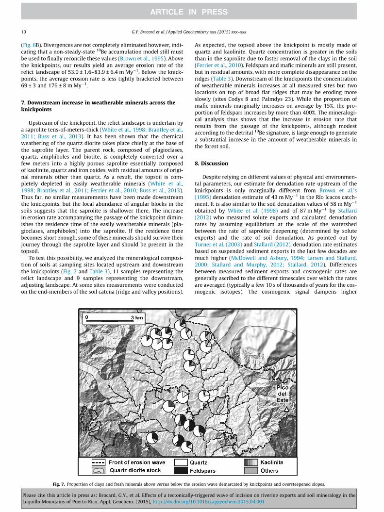
To test this possibility, we analyzed the mineralogical composi-tion of soils at sampling sites located upstream and downstreamthe knickpoints (Fig. 7 and Table 3), 11 samples representing therelict landscape and 9 samples representing the downstream,adjusting landscape. At some sites measurements were conductedon the end-members of the soil catena (ridge and valley positions).
Fig. 7. Proportion of clays and fresh minerals above versus below the e
Please cite this article in press as: Brocard, G.Y., et al. Effects of a tectonicallyLuquillo Mountains of Puerto Rico. Appl. Geochem. (2015), http://dx.doi.org/10
As expected, the topsoil above the knickpoint is mostly made ofquartz and kaolinite. Quartz concentration is greater in the soilsthan in the saprolite due to faster removal of the clays in the soil(Ferrier et al., 2010). Feldspars and mafic minerals are still present,but in residual amounts, with more complete disappearance on theridges (Table 3). Downstream of the knickpoints the concentrationof weatherable minerals increases at all measured sites but twolocations on top of broad flat ridges that may be eroding moreslowly (sites Codys 8 and Palmdys 23). While the proportion ofmafic minerals marginally increases on average by 15%, the pro-portion of feldspars increases by more than 400%. The mineralogi-cal analysis thus shows that the increase in erosion rate thatresults from the passage of the knickpoints, although modestaccording to the detrital 10Be signature, is large enough to generatea substantial increase in the amount of weatherable minerals inthe forest soil.
8. Discussion
Despite relying on different values of physical and environmen-tal parameters, our estimate for denudation rate upstream of theknickpoints is only marginally different from Brown et al.’s(1995) denudation estimate of 43 m My�1 in the Río Icacos catch-ment. It is also similar to the soil denudation values of 58 m My�1
obtained by White et al. (1998) and of 87 m My�1 by Stallard(2012) who measured solute exports and calculated denudationrates by assuming equilibrium at the scale of the watershedbetween the rate of saprolite deepening (determined by soluteexports) and the rate of soil denudation. As pointed out byTurner et al. (2003) and Stallard (2012), denudation rate estimatesbased on suspended sediment exports in the last few decades aremuch higher (McDowell and Asbury, 1994; Larsen and Stallard,2000; Stallard and Murphy, 2012; Stallard, 2012). Differencesbetween measured sediment exports and cosmogenic rates aregenerally ascribed to the different timescales over which the ratesare averaged (typically a few 10 s of thousands of years for the cos-mogenic isotopes). The cosmogenic signal dampens higher
rosion wave demarcated by knickpoints and oversteepened slopes.
-triggered wave of incision on riverine exports and soil mineralogy in the.1016/j.apgeochem.2015.04.001
Table 2Increase in erosion rate across the knickpoints.
Model e – UK, all dataset(m/My)
e – DK, all dataset(m/My)
e increase, alldataset (� upstream)
e increase,IC (� upstream)
e increase,SAB (� upstream)
c f c f c f c f c f
NC 116 ± 7 31 ± 1 247 ± 12 53 ± 2 2.1 ± 0.2 1.7 ± 0.1 1.7 ± 0.3 1.4 ± 0.2 2.6 ± 0.6 2.5 ± 0.6TC 110 ± 7 30 ± 1 235 ± 11 51 ± 2 2.1 ± 0.2 1.7 ± 0.1 1.7 ± 0.3 1.4 ± 0.2 2.7 ± 0.6 2.5 ± 0.6TC, VC 104 ± 6 29 ± 1 225 ± 11 49 ± 2 2.2 ± 0.2 1.7 ± 0.1 1.7 ± 0.3 1.4 ± 0.2 2.7 ± 0.6 2.5 ± 0.6TC, VC, DV 81 ± 5 38 ± 1 175 ± 8 64 ± 2 2.2 ± 0.2 1.7 ± 0.1 1.7 ± 0.3 1.4 ± 0.2 2.7 ± 0.6 2.5 ± 0.6TC, VC, DC,QE 81 ± 5 48 ± 2 175 ± 8 64 ± 2 2.2 ± 0.2 1.3 ± 0.1 1.7 ± 0.3 1.1 ± 0.1 2.7 ± 0.6 2.0 ± 0.5TC, VC, DC, QE, T 84 ± 6 53 ± 2 176 ± 8 70 ± 3 2.1 ± 0.3 1.3 ± 0.1 1.7 ± 0.4 1.1 ± 0.1 2.6 ± 0.7 1.9 ± 0.5
Table 3Summary of the soil mineralogy.
Sample Position Longitude Latitude Quartz Clays Feldspars Gibbsite Goethite Mafics Phosphate% % % % % % %
CODYS 5⁄ R 65.785 18.294 74.4 14.8 1.0 4.1 0.6 2.6 1.2COLDYS 5+ R 65.785 18.294 59.4 27.3 4.0 3.1 2.1 <1 2.1COLDYS 5+ V 65.786 18.294 68.7 8.0 13.7 2.5 1.7 <1 3.2CODYS 6⁄ R 65.795 18.291 82.3 14.5 <1 0.7 0.7 <1 1.0COLDYS 6+ R 65.795 18.291 68.5 17.8 6.8 1.5 1.5 <1 2.2CODYS 6⁄ V 65.796 18.290 81.7 3.7 5.3 1.9 <1 2.5 3.6COLDYS 6+ V 65.796 18.290 77.8 6.7 8.4 2.9 1.4 <1 <1CODYS 7⁄ R 65.785 18.270 70.4 18.0 <1 2.5 1.2 <1 3.0PALMDYS 21⁄ R 65.795 18.292 73.0 16.1 2.1 1.9 0.8 1.7 0.8PALMDYS 21+ R 65.795 18.292 57.4 28.5 3.9 2.4 2.5 <1 4.6PALMDYS 21+ V 65.793 18.292 62.9 18.7 10.1 <1 2.5 <1 4.0PALMDYS 22⁄ R 65.791 18.289 75.9 14.4 4.4 0.8 0.7 1.6 0.7CODYS 8⁄ R 65.794 18.269 81.5 15.0 <1 <1 <1 <1 1.8TABDYS 14⁄ R 65.795 18.266 52.6 10.1 30.0 <1 0.7 <1 3.8TABDYS14+ R 65.795 18.266 34.4 12.1 44.0 0.5 0.7 3.4 2.6TABDYS 14+ V 65.795 18.267 42.0 10.3 40.6 <1 0 1.2 5.0TABDYS 15⁄ R 65.803 18.261 55.5 9.0 28.1 <1 0.6 2.1 3.6TABDYS 16⁄ R 65.793 18.261 64.8 16.0 11.8 <1 1.2 1.1 0.5PALMDYS 23⁄ R 65.794 18.270 73.0 21.9 1.3 <1 2.1 <1 0.2PALMDYS 24⁄ R 65.786 18.2861 31.0 5.5 46.1 0.8 <1 <1 7.0
The clay fraction is dominated by kaolinite, the feldspars fraction by plagioclases; mafics are dominantly hornblende and biotite, and ancillary clinopyroxenes. Positions: R:ridges, V: valleys. Samples were analyzed either on a Pananalytical X’Pert Pro (+) or on a D8 Advance (*) X-ray diffractometer.
G.Y. Brocard et al. / Applied Geochemistry xxx (2015) xxx–xxx 11
frequency fluctuations in erosion rates due to climate oscillations(Schaller and Elhers, 2006) as well as anthropogenic disturbances(e.g. Brown et al., 1998; Hewawasam et al., 2003). The Icacos catch-ment is covered by dense old-growth primary forest subjected tolittle anthropogenic disturbance, so the cause of elevated sus-pended exports remain unclear. The denudation rates obtainedhere and in previous studies (Brown et al., 1995; Riebe et al.,2003) place denudation rates of the relict landscape at the lowerend of the erosion spectrum encountered for catchments withsimilar average slopes of 22–25� (Portenga and Bierman, 2012;Willenbring et al., 2013).
Below the knickpoints rates are higher (69 ± 3–176 ± 8 m My�1)but still lower than some other rates measured at other sites in theLuquillo Mountains. In the Mameyes catchment, Dosseto et al.(2012) found a denudation rate of 334 ± 46 m My�1 using U-seriesisotopes compositions in the volcaniclastic saprolite, assumingequilibrium between saprolite deepening a surface denudation.The concave profile of Río Mameyes suggests that all its catchmentis entirely coupled to the modern base level. Our rates suggest thatthe quartz diorite, where submitted to the new base level, does noterode as fast as the volcaniclastics.
The magnitude of the wave of erosion documented by the detri-tal 10Be varies according to the sediment grain size (Table 2). Thegravel fraction yields a larger downstream increase (�2.1 ± 0.2)than the fine sand (� 1.7 ± 0.1), assuming no correction for theenvironmental parameters (topography, vegetation, soil densityand quartz enrichment). Environmental corrections reduce thespread to 1.3–2.1 ± 0.1.
Please cite this article in press as: Brocard, G.Y., et al. Effects of a tectonically-Luquillo Mountains of Puerto Rico. Appl. Geochem. (2015), http://dx.doi.org/10
Soils upstream of the knickpoints are more thoroughly depletedin fresh minerals, forcing plant communities above the KPs toretrieve their nutrients from the atmosphere (McDowell et al.,1990; Zarin and Johnson, 1995; Pett-Ridge, 2009). Downstreamof the KP lips, incompletely weathered minerals make their waythrough the saprolite up into the soils, potentially providing analternative source of nutrients to the plants. A multi-regressionanalysis of environmental parameters, geochemical and Sr isotopestracing of nutrient sources suggests that these minerals effectivelyrepresent a major source of plant-available nutrients downstreamof the knickpoints (Porder et al., 2015). This implies that the knick-points have a profound effect on the ecology of the LuquilloMountains primary forests. They represent a major boundarybetween an upstream forest that retrieves most of its nutrient fromthe atmosphere from a downstream forest that retrieves a signifi-cant fraction of its nutriments from the bedrock. They illustrate thefirst-order importance of long-term geomorphological processeson the structure of an old-growth tropical forest.
9. Conclusion
Streams draining the southern flank Luquillo Mountains havedeveloped prominent knickzones over a stock of quartz diorite.The lips of these knickzones cluster about the 600 m elevation ofa long-known dissected low-relief surface that surrounds theLuquillo Mountains. We interpret this surface as a former shoreplatform that has been uplifted since the Early Pliocene (5 Myago). These dramatic knickpoints represent the front of an
triggered wave of incision on riverine exports and soil mineralogy in the.1016/j.apgeochem.2015.04.001

12 G.Y. Brocard et al. / Applied Geochemistry xxx (2015) xxx–xxx
upstream-propagating erosion wave that adjusts river profiles tothe resulting 600 m lower coastal base level. They illustrate howa tectonic disturbance that occurred millions of years ago still sig-nificantly impacts the stream morphology to these days.
To quantify the impact of this wave of erosion on soil denuda-tion we have used in situ-produced cosmogenic 10Be in quartztransported by these rivers to compared catchment-wide erosionrates in watersheds located upstream of the front of the erosionrate with erosion rates in catchments completely within the ero-sion wave. The detrital 10Be documents a twofold increase indenudation rate, compatible with the limited amount of prop-agation of the knickpoints over the past millions of years.
Despite this limited increase in erosion, the mineralogy of thesoils located within the area impacted by the erosion wave differsmarkedly from the soils located farther upstream. Soils locatedupstream develop at the expense of a thick saprolite were weath-ering of nutrient-bearing minerals is complete. As a result, soils arealmost devoid of primary minerals, and vegetation there is knownto retrieve its nutrients mostly from atmospheric inputs such assea aerosols and Saharan dust (McDowell et al., 1990; Zarin andJohnson, 1995). Within the erosion wave, we find that soils retainsome of the primary weatherable minerals such as feldspars andmafic minerals. This in turn increases the availability of extractablecations in the soil (Porder et al., 2015), profoundly changing themode of nutrient delivery to the forest between the upstreamand downstream portions of the forest.
Acknowledgements
This work was supported by the National Science FoundationGrant # EAR-0722476 awarded to the Luquillo Critical ZoneObservatory 1. This paper is dedicated to the late Frederick N.Scatena, who loved the Luquillo Mountains, initiated and sup-ported this work with great passion. We thank the anonymousreviewers for their helpful comments.
Appendix A. Supplementary material
Supplementary data associated with this article can be found, inthe online version, at http://dx.doi.org/10.1016/j.apgeochem.2015.04.001.
References
Attal, M., Cowie, P.A., Whittaker, A.C., Hobley, D., 2011. Testing fluvial erosionmodels using the transient response of bedrock rivers to tectonic forcing in theApennines, Italy. J. Geophys. Res. 116, F2.
Balco, G., 2009. 26Al–10Be Exposure Age/Erosion Rate Calculators: update from v. 2.1to v. 2.2. CRONUS Online Calculator, <http://hess.ess.washington.edu>.
Balco, G., Stone, J.O., Lifton, N.A., Dunai, T.J., 2008. A complete and easily accessiblemeans of calculating surface exposure ages or erosion rates from 10Be and 26Almeasurements. Quat. Geochronol. 3, 174–195.
Baldwin, J.A., Whipple, K.X., Tucker, G.E., 2003. Implications of the shear stress riverincision model for the timescale of post-orogenic decay of topography. J.Geophys. Res. Solid Earth 108, B3.
Binnie, S.A., Phillips, W.M., Summerfield, M.A., Fifield, L.K., 2006. Sediment mixingand basin-wide cosmogenic nuclide analysis in rapidly eroding mountainousenvironment. Quat. Geology 1, 4–14.
Birch, F.S., 1986. Isostatic, thermal, and flexural models of the subsidence of thenorth coast of Puerto Rico. Geology 14, 427–429.
Bradley, W.C., Griggs, G.B., 1976. Form, genesis, and deformation of centralCalifornia wave-cut platforms. Geol. Soc. Am. Bull. 87, 433–449.
Brantley, S.L., Buss, H., Lebedeva, M., Fletcher, R.C., Ma, L., 2011. Investigating thecomplex interface where bedrock transforms to regolith. Appl. Geochem. 26,S12–S15.
Briggs, R.P., 1966. The blanket sands of northern Puerto Rico. Trans. Jamaica Geol.Surv. Pub. 95, 60–69.
Brocard, G.Y., van der Beek, P.A., Bourlès, D.L., Siame, L.L., Mugnier, J.-L., 2003. Ratesof fluvial incision and river response time in periodically glaciated catchments:10Be cosmoisotope dating of fluvial terraces in the French Alps. Earth Planet. Sci.Lett. 209, 197–214.
Please cite this article in press as: Brocard, G.Y., et al. Effects of a tectonicallyLuquillo Mountains of Puerto Rico. Appl. Geochem. (2015), http://dx.doi.org/10
Brown, E.T., Stallard, R.F., Larsen, J., Raisbeck, G., Yiou, F., 1995. Denudation ratesdetermined from the accumulation of in situ-produced Be-10 in the LuquilloExperimental Forest, Puerto Rico. Earth Planet. Sci. Lett. 129, 193–202.
Brown, E.T., Stallard, R.F., Larsen, M.C., Bourlès, D.L., Raisbeck, G.M., Yiou, F., 1998.Determination of predevelopment denudation rates of an agriculturalwatershed (Cayaguás River, Puerto Rico) using in-situ-produced 10Be in river-borne quartz. Earth Planet. Sci. Lett. 160, 723–728.
Buss, H.L., Brantley, S.L., Scatena, F.N., Bazilievskaya, E.A., Blum, A., Schulz, M.,Jiménez, R., White, A.F., Rother, G., Cole, D., 2013. Probing the deep critical zonebeneath the Luquillo Experminental Forest, Puerto Rico. Earth Surf. Process.Landforms. http://dx.doi.org/10.1002/esp.3409.
Dadson, S.J., Hovius, N., Chen, H., Dade, W.B., Lin, J.-C., Hsu, M.-L., Lin, C.-W., Horng,M.-J., Chen, T.-C., Milliman, J., Stark, C.P., 2004. Earthquake-triggered increase insediment delivery from an active mountain belt. Geology 32, 733–736.
Dolan, J.F., Mullins, H.T, Wald, D.J., 1998. Active tectonics of the north-centralCaribbean: oblique collision, strain partitioning, and opposing subducted slabs.In: Dolan, J.F., Mann, P., (Eds.), Active Strike-Slip and Collisional Tectonics of theNorthern Caribbean Plate Boundary Zone. Geol. Soc. Am. Spec. Paper 326, pp. 1–62.
Dosseto, A., Buss, H.L., Suresh, P.O., 2012. Rapid regolith formation over volcanicbedrock and implications for landscape evolution. Earth Planet. Sci. Lett. 337–338, 47–55.
Ferrier, K.L., Kirchner, J.W., Riebe, C.S., Finkel, R.C., 2010. Mineral-specific chemicalweathering rates over millennial timescales: measurements at Río Icacos,Puerto Rico. Chem. Geol. 277, 101–114.
Goodbred, S.L., Kuehl, S.A., 2000. Enormous Ganges-Brahmaputra sedimentdischarge during strengthened early Holocene monsoon. Geology 28, 1083–1086.
Granger, D.E., Kirchner, J.W., Finkel, R., 1996. Spatially averaged long-term erosionrates measured from in situ-produced cosmogenic nuclides in alluvial sediment.J. Geol. 104, 249–257.
Grindlay, N.R., Mann, P., Dolan, J.F., van Gestel, J.-P., 2005. Neotectonics andsubsidence of northern Puerto-Rico-Virgin Islands margin in response to theoblique subduction of high-standing ridges. In: Mann, P. (Ed.), Active Tectonicsand Seismic Hazards of Puerto Rico, the Virgin Islands, and Offshore Areas. Geol.Soc. Am. Spec. Paper 385, pp. 31–60.
Hack, J.T., 1960. Interpretation of erosional topography in humid temperate regions.Am. J. Sci. 258, 80–97.
Hewawasam, T., von Blanckenburg, F., Schaller, M., Kubik, P., 2003. Increase ofhuman over natural erosion rates in tropical highlands constrained bycosmogenic nuclides. Geology 31, 597–600.
Jansen, J.D., Gabel, D., Bishop, P., Xu, S., Schnabel, C., Codilean, A.T., 2011. Doesdecreasing paraglacial sediment supply slow knickpoint retreat. Geology 39,543–546.
Jones, R.C., Hudnall, W.H., Sakai, W.S., 1982. Some highly weathered soils of PuertoRico, 2: Mineralogy. Geoderma 27, 75–137.
Kohl, C.P., Nishiizumi, K., 1992. Chemical isolation of quartz for measurement ofin situ-produced cosmogenic nuclides. Geochim. Cosmochim. Ac. 56, 3583–3587.
Lal, D., 1991. Cosmic ray labeling of erosion surfaces; in situ nuclide productionrates and erosion models. Earth Planet. Sci. Lett. 104, 424–439.
Lange, W.P., Moon, V.G., 2005. Estimating long-term cliff recession rates from shoreplatform widths. Eng. Geol. 80, 292–301.
Larsen, M.C., 2012. Landslides and sediment budgets in four watersheds in EasternPuerto Rico. In: Murphy, S.F., Stallard, R.F. (Eds.), Water Quality and LandscapeProcesses of Four Watersheds in Puerto Rico. US Geol. Surv. Prof. Paper 1789, pp.153–178.
Larsen, M.C., Stallard, R.F., 2000. Water, Energy, and Biogeochemical BudgetsLuquillo Mountains, Puerto Rico. U.S. Geol. Surv. Fact Sheet, FS 163-99, 4pp.
Lobeck, A.K., 1922. The Physiography of Porto Rico. Scientific Survey o f Porto Ricoand the Virgin Islands 1, pp. 301–379.
MacDonald, L.H., Anderson, D.M., Dietrich, W.E., 1997. Paradise threatened: landuse and erosion on St John, US Virgin Islands. Environ. Manage. 21, 851–863.
Mann, P., 2007. Overview of tectonic history of northern Central America. In: Mann,P. (Ed), Geologic and Tectonic Development of the Caribbean Plate Boundary inNorthern Central America. Geol. Soc. Am. Spec. Paper 428, pp. 1–20.
Mann, J.F., Taylor, F., Edwards, R.L., Ku, T., 1995. Actively evolving microplateformation by oblique collision and sideways motion along strike-slip faults: anexample from the northeastern margin of the Caribbean Plate. Tectonophysics246, 1–69.
McDowell, W.H., Asbury, C.E., 1994. Export of carbon, nitrogen, and major ions fromthree tropical montane watersheds. Limnol. Oceanogr. 39, 111–125.
McDowell, W.H., Sánchez, C.G., Asbury, C.E., Ramos, C.R., 1990. Influence of sea saltaerosols and long range transport on precipitation chemistry at El Verde, PuertoRico. Atmos. Environ. 24A, 2813–2821.
Meyerhoff, H.A., 1927. Tertiary physiographic development of Porto Rico and theVirgin Islands. Bull. Geol. Soc. Am. 38, 557–576.
Miotke, F.-D., 1972. The subsidence of the surfaces between mogotes in Puerto Ricoeast of Arecibo (translated from German by W.H. Monroe). Caves and Karst 15,1–12.
Monroe, W.H., 1980a. Geology of the middle Tertiary Formations of Puerto Rico. U.S.Geol. Surv. Prof. Paper 953, 93pp.
Monroe, W.H., 1980b. Some Tropical Landforms of Puerto Rico. U.S. Geol. Surv. Prof.Paper 1159, 39pp.
Moussa, M.T., Seiglie, G.A., Meyerhoff, A.A., Taner, I., 1987. The QuebradillasLimestone (Miocene-Pliocene) northern Puerto Rico, and tectonics of thenortheastern Caribbean margin. Geol. Soc. Am. Bull. 99, 427–439.
-triggered wave of incision on riverine exports and soil mineralogy in the.1016/j.apgeochem.2015.04.001

G.Y. Brocard et al. / Applied Geochemistry xxx (2015) xxx–xxx 13
Nishiizumi, K., Imamura, M., Caffee, M., Southon, J., Finkel, R., McAnich, J., 2007.Absolute calibration of 10Be AMS standards. Nucl. Instr. Meth. Phys. Res. B 258,403–413.
Penck, W., 1924. Die geomorphologische Analyse. J. Engelhorns Nachf., 283Perron, J.T., Royden, L., 2012. An integral approach to bedrock river profile analysis.
Earth Surf. Proc. Land. 38, 570–576.Pett-Ridge, J.C., 2009. Contribution of dust to phosphorus cycling in tropical forests
of the Luquillo Mountains, Puerto Rico. Biogeochemistry 94, 63–80.Pike, A.W., Scatena, F.N., Wohl, E.E., 2010. Lithological and fluvial controls on the
geomorphology of tropical montane stream channels in Puerto Rico. Earth Surf.Proc. Land. 35, 1402–1417.
Porder, S., Johnson, A.H., Hao, X., Brocard, G., Goldsmith, S., Pett-Ridge, J., 2015.Linking geomorphology, weathering and cation availability in the LuquilloMountains of Puerto Rico. Ecosystems.
Portenga, E.W., Bierman, P.R., 2012. Understanding Earth’s eroding surface with10Be. GSA Today 21, 4–10.
Rad, S., Louvat, P., Gorge, C., Gaillardet, J., Allègre, C., 2006. River dissolved and solidloads in the Lesser Antilles: new insight into basalt weathering processes. J.Geochem. Explor. 88, 308–312.
Reinhardt, L.J., Bishop, P., Hoey, T.B., Dempster, T.J., Sanderson, D.C.W., 2007.Quantification of the transient response to base-level fall in a small mountaincatchment: Sierra Nevada, southern Spain. J. Geophys. Res. 112, F03S05.
Restrepo, J.D., Kjerfve, B., 2000. Water discharge and sediment load from thewestern slopes of the Colombian Andes with focus on Río San Juan. J. Geol. 108,17–33.
Riebe, C.S., Kirchner, J.W., Finkel, R.C., 2003. Long-term rates of chemical weatheringand physical erosion from cosmogenic nuclides and geochemical mass balance.Geochim. Cosmochim. Ac. 67, 4411–4427.
Rojas-Agramonte, Y., Neubauer, F., Garcia-Delgado, D.E., Handler, R., Friedl, G.,Delgado-Damas, R., 2008. Tectonic evolution of the Sierra Maestra Mountains,SE Cuba, during Tertiary times: from arc-continent collision to transformmotion. J. South Am. Earth Sci. 26, 125–151.
Schaller, M., Elhers, T.A., 2006. Limits to quantifying climate driven changes indenudation rates with cosmogenic radionuclides. Earth Planet. Sci. Lett. 248,153–167.
Schultz, M.S., White, A.F., 1999. Chemical weathering in a tropical watershed,Luquillo Mountains, Puerto Rico, III: Quartz dissolution rates. Geochim.Cosmochim. Ac. 63, 337–350.
Semmes, D.R., 1919. Geology of the San Juan district, scientific survey of Porto Ricoand the Virgin Islands. New York Acad. Sci., 50–51
Smith, A.L., Schellekens, J.H., Muriel-Díaz, A.-L., 1998. Batholiths as markers oftectonic change in the northeastern Caribbean. In: Lidiak, E.G., Larue, D.K. (Eds.),Tectonics and Geochemistry of the Northeastern Caribbean. Geol. Soc. Am. Spec.Pap. 322, pp. 99–122.
Stallard, R.F., 2012. Weathering, landscape equilibrium, and carbon in fourwatersheds in Eastern Puerto Rico. In: Murphy, S.F., Stallard, R.F (Eds.), Water
Please cite this article in press as: Brocard, G.Y., et al. Effects of a tectonically-Luquillo Mountains of Puerto Rico. Appl. Geochem. (2015), http://dx.doi.org/10
Quality and Landscape Processes of Four Watersheds in Eastern Puerto Rico. USGeol. Surv. Prof. Pap. 1789, pp. 208–232.
Stallard, R.F., Murphy, S.F., 2012. Water quality and mass transport in fourwatersheds in eastern Puerto Rico. In: Murphy, S.F., Stallard, R.F (Eds.), Waterquality and landscape processes of four watersheds in eastern Puerto Rico. USGeol. Surv. Prof. Pap. 1789, pp. 113–152.
Stanek, K.P., Maresh, W.V., Pindell, J.L., 2009. The geotectonic story of thenorthwestern branch of the Caribbean arc: implications from structural andgeochronological data of Cuba. In: James, K.H., Lorente, M.A., Pindell, J.L. (Eds.),The Origin and Evolution of the Caribbean Plate. Geol Soc. London Spec. Pub.328, pp. 361–398.
ten Brink, U.S., 2005. Vertical motions of the Puerto Rico Trench and Puerto Rico andtheir cause. J. Geophys. Res. 110, B06404.
ten Brink, U.S., Marshak, S., Granja-Bruña, J.-L., 2009. Bivergent thrust wedgessurrounding oceanic island arcs: insight from observations and sandbox modelsof the northeastern Caribbean plate. Geol. Soc. Am. Bull. 121, 1522–1536.
Turner, B.F., Stallard, R.F., Brantley, S.L., 2003. Investigation of in situ weathering ofquartz diorite bedrock in the Río Icacos basin, Luquillo Experimental Forest,Puerto Rico. Chem. Geol. 202, 313–341.
van Gestel, J.-P., Mann, P., Dolan, J.F., Grindlay, N.R., 1998. Structure and tectonics ofthe upper Cenozoic Puerto Rico-Virgin Islands carbonate platform asdetermined from seismic reflection studies. J. Geophys. Res. 103 (B12),30505–30530.
van Gestel, J.-P., Mann, P., Grindlay, N.R., Dolan, J.F., 1999. Three-phase tectonicevolution of the northern margin of Puerto Rico as inferred from an integrationof seismic reflection, well, and outcrop data. Mar. Geol. 161, 257–286.
Weaver, J.D., 1962. The Nature of the ‘Nipe Clay’ on Las Mesas, Western Puerto Rico.Z. Geomorphol. 6, 218–232.
Weissel, J.K., Seidl, M.A., 1998. Inland propagation of erosional escarpments andriver profile evolution across the southeast Australian passive continentalmargin. In: Tinkler, K., Wohl, E. (Eds.), Rivers Over Rock: Fluvial Processes inBedrock Channels: Am. Geophys. Union, Geophys. Monograph Series 107, pp.189–206.
White, A.F., Blum, A.E., Schulz, M.S., Vivit, D.V., Stonestrom, D.A., Larsen, M.,Murphy, S.F., Eberl, D., 1998. Chemical weathering in a tropical watershed,Luquillo Mountains, Puerto Rico: I. Long-term versus short-term weatheringfluxes. Geochim. Cosmochim. Ac. 62, 209–226.
Willenbring, J.K., Gasparini, N.M., Crosby, B.T., Brocard, G., 2013. What does a meanmeans? The temporal evolution of detrital cosmogenic denudation rates intransient landscapes. Geology 41, 1215–1218.
Zarin, D.J., Johnson, A.H., 1995. Nutrient accumulation during primary succession ina montane tropical forest, Puerto Rico. Soil Sci. Soc. Am. J. 59, 1444–1452.
Zhou, W., 2011. X-ray Diffraction Characterization of Soils in the Luquillo CriticalZone Observatory. Msc Thesis, U. Pennsylvania, 47pp.
triggered wave of incision on riverine exports and soil mineralogy in the.1016/j.apgeochem.2015.04.001
Related Documents