3/20/2015 1 EFFECTS OF CLIMATE CHANGE AND LAND SUBSIDENCE ON WATER MANAGEMENT ZONING IN TIDAL LOWLANDS Case study Telang I, South Sumatra Rahmadi Land and Water Development GIS/RS specialist . OUTLINE Background Lowlands development in Indonesia and Government policy Climate change and land subsidence, their possible effects to tidal lowlands water management Case study Telang I, South Sumatra Methodology Result and Discussion Conclusions and recommendations

Effect of climate change and land subsidence on wmz in tidal lowland
Jul 17, 2015
Welcome message from author
This document is posted to help you gain knowledge. Please leave a comment to let me know what you think about it! Share it to your friends and learn new things together.
Transcript
3/20/2015
1
EFFECTS OF CLIMATE CHANGE AND LAND SUBSIDENCE
ON WATER MANAGEMENT ZONING IN TIDAL LOWLANDS Case study Telang I, South Sumatra
Rahmadi Land and Water Development
GIS/RS specialist
.
OUTLINE
Background
Lowlands development in Indonesia and Government
policy
Climate change and land subsidence, their possible
effects to tidal lowlands water management
Case study Telang I, South Sumatra
Methodology
Result and Discussion
Conclusions and recommendations

3/20/2015
2
BACKGROUND
Lowlands in Indonesia about 34 million ha
About 20 million ha tidal lowland
The other 13.4 million ha non-tidal lowlands along rivers and
inland swamp areas
Tidal lowlands Almost 4 million ha have been reclaimed,
spontaneous settlers (2.5 million ha) and Government (1.5 million ha)
Lambur, Jambi Sei Kakap, West Kalimantan Telang I, South Sumatra SOURCE: WACLIMAD, 2010
PROBLEM DEFINITION
Sea level rise and land subsidenceflooding
and restrict drainage of low-lying areashydro-
topography, drainage capability (drainability)
and salinity intrusion
land quality/suitability and
water management zoning
Water management zoning based on
land capabilities and cropping type
(by considering effects of climate change and
land subsidence)

3/20/2015
3
OBJECTIVES
study water management zoning model for tidal lowlands
set up water management zoning model by using spatial
analyses with GIS techniques based on present situation
evaluate the possible impacts of climate change and land
subsidence in the future
recommend approaches for future development of tidal
lowlands
INDONESIAN GOVERNMENT POLICY ON LOWLANDS
Past policy:
Original objectives →transmigration of farmers from the overcrowded islands; Security border and balancing of development
Present policy:
to contribute to the required increase in food production
Intensifications of existing reclaimed lowlands area to support food self-sufficiency
proper O&M and rehabilitation in the existing schemes
‘no reclamation’ of any new lowlands for food development
3/20/2015
4
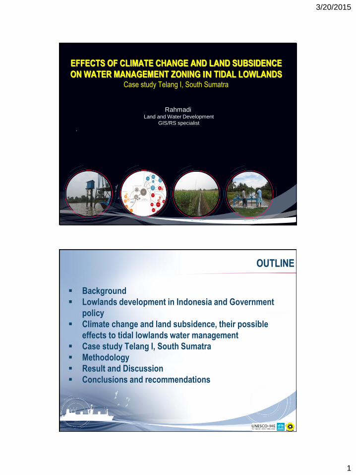
CLIMATE CHANGE AND LAND SUBSIDENCE, THEIR POSSIBLE
EFFECTS TO TIDAL LOWLAND WATER MANAGEMENT
(source: Nicholls et all, 2007)
(source: Bindoff et al, 2007)
SCHEMATIC OF THE OBSERVED CHANGES IN THE OCEAN STATE
3/20/2015
5
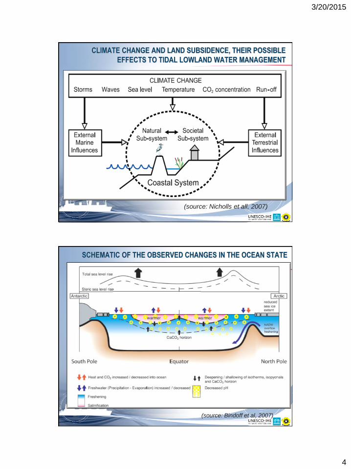
EFFECT ON HYDRO-TOPOGRAPHY
Category A and B Category C and D
Horizontal water level
water level due to
hydraulic losses Ground surface
elevation
Imaginary
ground surface
C and D Extent of category A and B
Original water level
water level due to
hydraulic losses
Original Ground
surface elevation
Imaginary
ground surface
Effect of Sea level rise
Ground surface elevation
due to land subsidence
EFFECT ON DRAINABILITY
∆H present
∆H future Sea level rise
land subsidence
3/20/2015
6
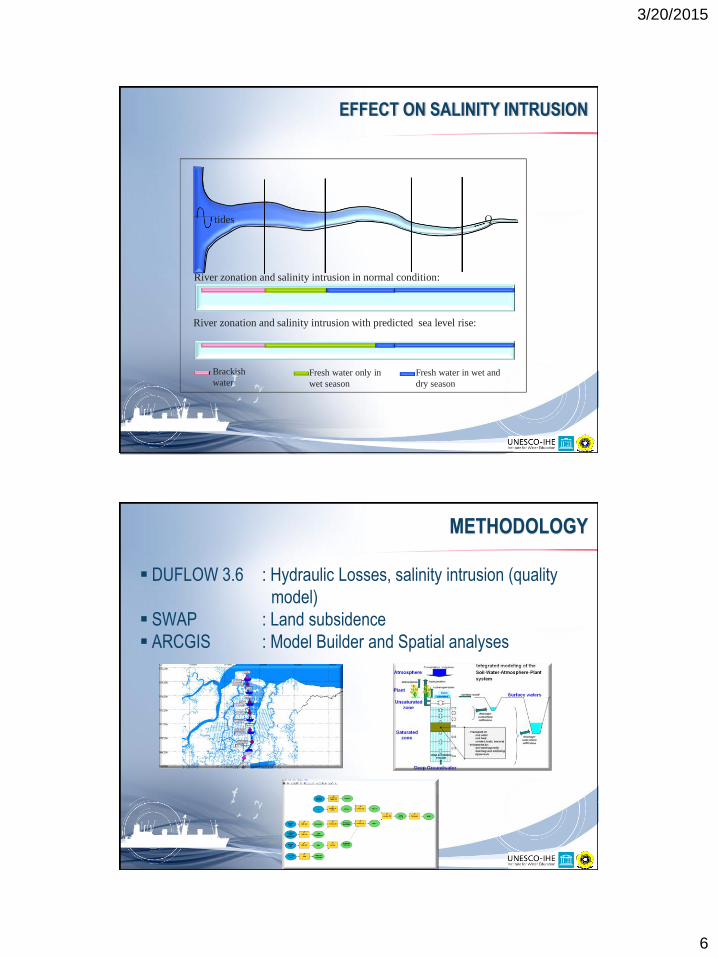
EFFECT ON SALINITY INTRUSION
River zonation and salinity intrusion in normal condition:
River zonation and salinity intrusion with predicted sea level rise:
Brackish
water Fresh water only in
wet season
Fresh water in wet and
dry season
tides Q
METHODOLOGY
DUFLOW 3.6 : Hydraulic Losses, salinity intrusion (quality
model)
SWAP : Land subsidence
ARCGIS : Model Builder and Spatial analyses
3/20/2015
7
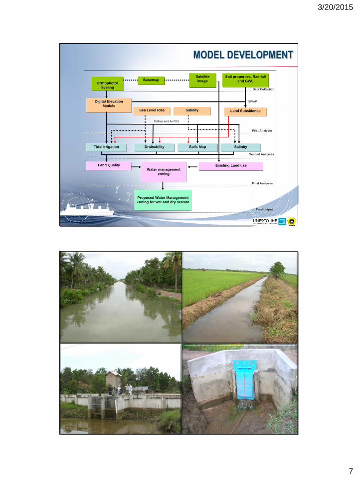
MODEL DEVELOPMENT
Digital Elevation
Models
Satellite
image Basemap
Tidal Irrigation
Orthophoto/
leveling
Land Quality
Proposed Water Management
Zoning for wet and dry season
Drainability Soils Map Salinity
Water management
zoning
Data Collection
First Analyses
Second Analyses
Final Analyses
Final output
Existing Land use
Sea Level Rise Salinity Land Subsidence
SWAP
Duflow and ArcGIS
Soil properties, Rainfall
and GWL
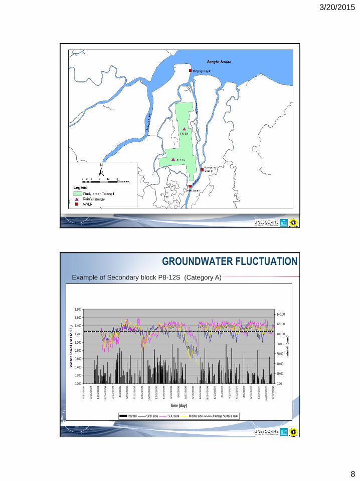
CASE STUDY TELANG I, SOUTH SUMATRA
3/20/2015
8
Average water level of Low Water Springtide in Musi River (2001-2008) : (Source: PT. Pelabuhan Cabang Palembang, 2008)
Average waterlevel of LWS in Musi River (2001-2008)(Source: PT. Pelabuhan Indonesia II Cabang Palembang, 2008)
y = 5E-05x - 0,0815
y = 4E-05x + 0,6665
y = 4E-05x + 0,6462
0
0,5
1
1,5
2
2,5
3
3,5
Jun-0
0
Okt-
00
Jan-0
1
Apr-
01
Jul-01
Nop-0
1
Feb-0
2
Mei-02
Sep-0
2
Des-0
2
Mar-
03
Jun-0
3
Okt-
03
Jan-0
4
Apr-
04
Agust-
04
Nop-0
4
Feb-0
5
Mei-05
Sep-0
5
Des-0
5
Mar-
06
Jul-06
Okt-
06
Jan-0
7
Apr-
07
Agust-
07
Nop-0
7
Feb-0
8
Jun-0
8
Sep-0
8
Des-0
8
Month
Avera
ge w
ate
r le
vel
(m)
Tanjung Buyut Upang Selat Jaran Linear (Tanjung Buyut) Linear (Upang) Linear (Selat Jaran)
RESULT AND DISCUSSION
GROUNDWATER FLUCTUATION
Example of Secondary block P8-12S (Category A)
gr
0.000
0.200
0.400
0.600
0.800
1.000
1.200
1.400
1.600
1.800
7/2
7/2
004
9/1
5/2
004
11/4
/2004
12/2
4/2
004
2/1
2/2
005
4/3
/2005
5/2
3/2
005
7/1
2/2
005
8/3
1/2
005
10/2
0/2
005
12/9
/2005
1/2
8/2
006
3/1
9/2
006
5/8
/2006
6/2
7/2
006
8/1
6/2
006
10/5
/2006
11/2
4/2
006
1/1
3/2
007
3/4
/2007
4/2
3/2
007
6/1
2/2
007
8/1
/2007
9/2
0/2
007
11/9
/2007
12/2
9/2
007
2/1
7/2
008
time (day)
wa
ter le
ve
l (m
+M
SL
)
0.00
20.00
40.00
60.00
80.00
100.00
120.00
140.00
rain
fall
(m
m)
Rainfall SPD side SDU side Middle side Average Surface level

3/20/2015
9
SWAP MODELLING FOR LAND SUBSIDENCE
Average Land subsidence in Telang 1
-0.01
-0.005
0
0.005
0 50 100 150 200 250 300 350
time (day)
su
bsid
en
ce
in
cm
subsidence at P8-12S subsidence at P6-3N
total subsidence = 0.3 - 0.7 cm/year
HYDRO-TOPOGRAPHY
3/20/2015
10
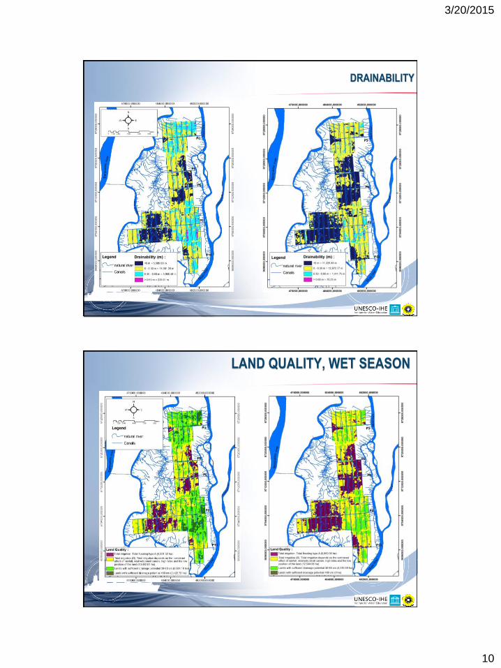
DRAINABILITY
LAND QUALITY, WET SEASON
3/20/2015
11
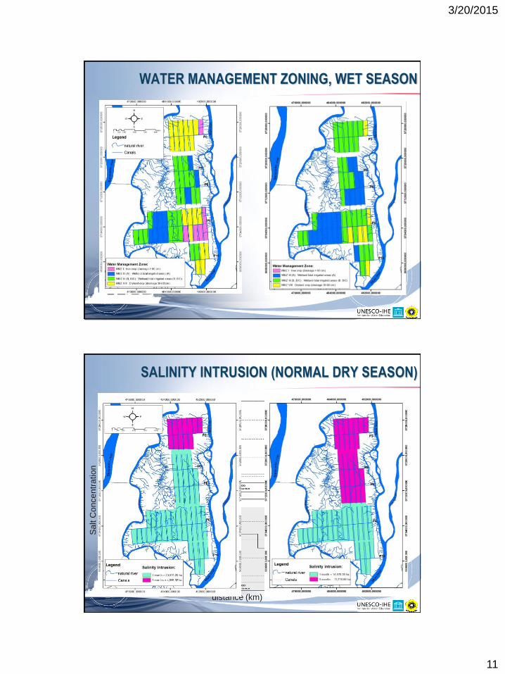
WATER MANAGEMENT ZONING, WET SEASON
Sa
lt C
on
ce
ntr
atio
n
distance (km)
SALINITY INTRUSION (NORMAL DRY SEASON)

3/20/2015
12
WATER MANAGEMENT ZONING (DRY SEASON)
CONCLUSIONS AND RECOMMENDATIONS
Effect of climate change and land subsidence on water
management zoning in the future is significant
MODEL BUILDER technique is very useful tool
Proper operation of water management systems to control
groundwater fluctuation
Further study and groundtruth is needed
To cope with the effect of climate change and land subsidence
on water management zoning in tidal lowlands, some
structural and non structural measures are needed.
Establishment of monitoring station

3/20/2015
13
THANK YOU
Related Documents