Ecology of the European silver fir Abies alba Mill. in vegetation landscapes of south-eastern Poland: GIS and multivariate ordination methods Bożenna CZARNECKA Department of Ecology, Faculty of Biology and Biotechnology Lukasz CHABUDZIŃSKI Geoinformation Laboratory, Faculty of Earth Sciences and Spatial Management Maria Curie-Sklodowska University, Lublin, Poland

Welcome message from author
This document is posted to help you gain knowledge. Please leave a comment to let me know what you think about it! Share it to your friends and learn new things together.
Transcript
Ecology of the European silver fir Abies alba Mill. in vegetation landscapes of south-eastern Poland: GIS
and multivariate ordination methods
Bożenna CZARNECKADepartment of Ecology, Faculty of Biology and Biotechnology
Łukasz CHABUDZIŃSKIGeoinformation Laboratory, Faculty of Earth Sciences and Spatial
Management Maria Curie-Skłodowska University, Lublin, Poland
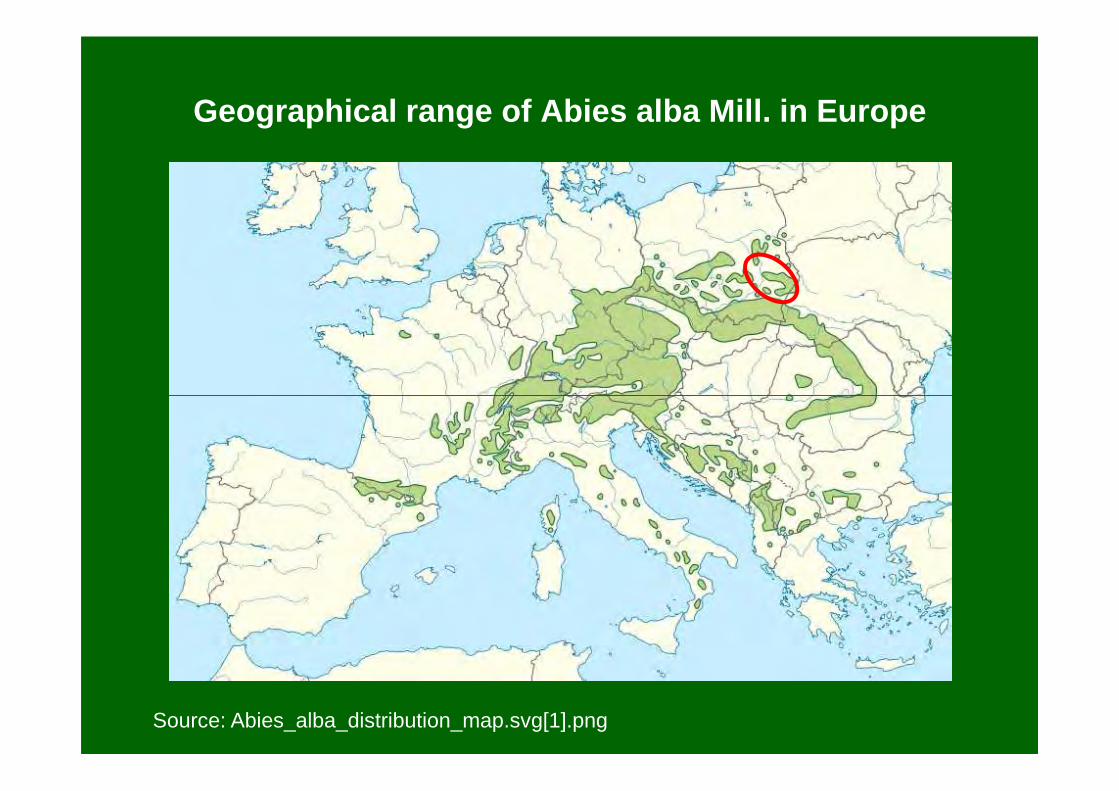
Geographical range of Abies alba Mill. in Europe
Source: Abies_alba_distribution_map.svg[1].png

Distribution of silver fir Abies alba Mill. in PolandSource: Zając A., Zając M. (2001)
Phot. Joanna Czarnecka
� north limit of geographic range;
� on uplands (Małopolska Upland, Świętokrzyskie Mts., Roztocze Highlands) endemic upland mixed fir forest Abietetum polonicum (= the Holy Cross fir forest; code 91P0)
(JC)
Study aims
To answer the questions:• How wide is an ecological amplitude of Abies alba in the
Roztocze Highlands, south-eastern Poland, i.e. at the limits of the species geographic range?
• Does A. alba expand its optimal habitat niche (upland mixed fir forest Abietetum polonicum; acid brown and podzol soils) for an alternative niches contributing to greater diversity in the occupied habitats?
• What kind of terrain characters are responsible for A. albaoccurrence in two landscape types of the region, i.e. Cretaceous hills and gorge sections of river valleys crossing the SW escarpment zone?
• Whether the geographical information system (GIS), particularly digital elevation models (DEM) are useful in the studies of relationships between topographic and ecological attributes ofvarious vegetation landscape?

RNP
Roztocze National Park (RNP)
Sopot river valley
Stokowa Góra Hill
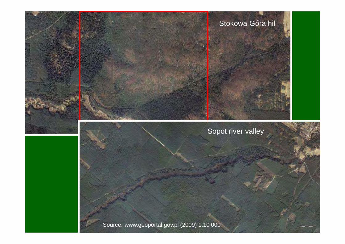
Stokowa Góra hill
Sopot river valley
Source: www.geoportal.gov.pl (2009) 1:10 000

Data and tools• Maps of plant communities at the scale of
1:5000 • Phytosociological relevés, soil pits and
drills
• Abies alba abundance evaluation - RNP hills: forest sections in which at least
one dimension has 200 m - river valleys: 200-m long sections
(separately for the left and right riverbanks)
Stokowa Góra Hill
400 m
Map source: Izdebski et al. (1992), changed
riverbanks)
185 forest and 130 valleys sections =315 area units altogether
Sopot river valley
600 m
Map source: Czarnecka (1998), unpbl.

Data and tools
The simplified, combined scale used for evaluation frequency and abundance of Abies alba in a particular valley and forest section:
1 – sporadic species (single plants or small clumps)2 – rare and non-abundant species (covering <10% of the section area)3 – frequent and abundant species (covering 10-50% of the section
area)area)4 – common and very abundant species (covering >50% of the section
area)
Source of data on A. alba abundance• River valleys: maps of plant communities from the years 1997-2001 (Czarnecka, unpbl. data), floristic charting in 200-m-long sections (separately for the left and right riverbanks), plans of forest management for different forest districts (1998)• Cretaceous hills: maps of plant communities of the RNP (Izdebski et al. 1992), maps of potential vegetation of the RNP (Izdebski et al. 1997), plans of forest management for the RNP (2001)
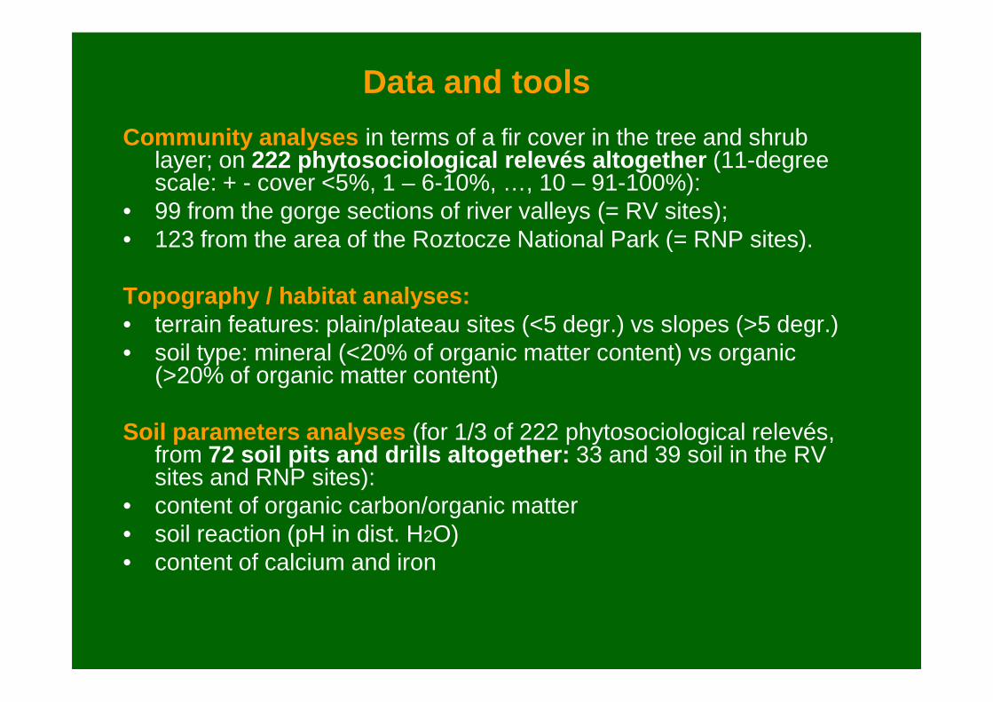
Community analyses in terms of a fir cover in the tree and shrub layer; on 222 phytosociological relevés altogether (11-degree scale: + - cover <5%, 1 – 6-10%, …, 10 – 91-100%):
• 99 from the gorge sections of river valleys (= RV sites);• 123 from the area of the Roztocze National Park (= RNP sites).
Topography / habitat analyses:• terrain features: plain/plateau sites (<5 degr.) vs slopes (>5 degr.)• soil type: mineral (<20% of organic matter content) vs organic
Data and tools
• soil type: mineral (<20% of organic matter content) vs organic (>20% of organic matter content)
Soil parameters analyses (for 1/3 of 222 phytosociological relevés, from 72 soil pits and drills altogether: 33 and 39 soil in the RVsites and RNP sites):
• content of organic carbon/organic matter• soil reaction (pH in dist. H2O)• content of calcium and iron
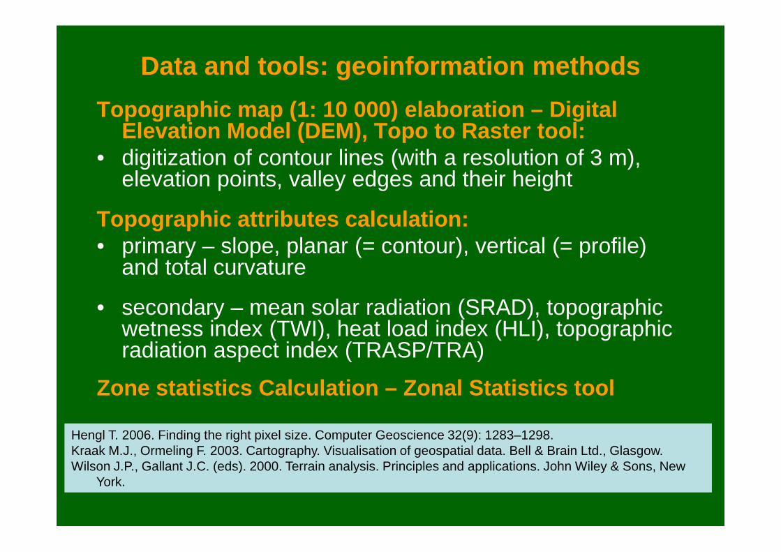
Data and tools: geoinformation methods
Topographic map (1: 10 000) elaboration – Digital Elevation Model (DEM), Topo to Raster tool:
• digitization of contour lines (with a resolution of 3 m), elevation points, valley edges and their height
Topographic attributes calculation:• primary – slope, planar (= contour), vertical (= profile)
and total curvature and total curvature
• secondary – mean solar radiation (SRAD), topographic wetness index (TWI), heat load index (HLI), topographic radiation aspect index (TRASP/TRA)
Zone statistics Calculation – Zonal Statistics tool
Hengl T. 2006. Finding the right pixel size. Computer Geoscience 32(9): 1283–1298. Kraak M.J., Ormeling F. 2003. Cartography. Visualisation of geospatial data. Bell & Brain Ltd., Glasgow.Wilson J.P., Gallant J.C. (eds). 2000. Terrain analysis. Principles and applications. John Wiley & Sons, New
York.
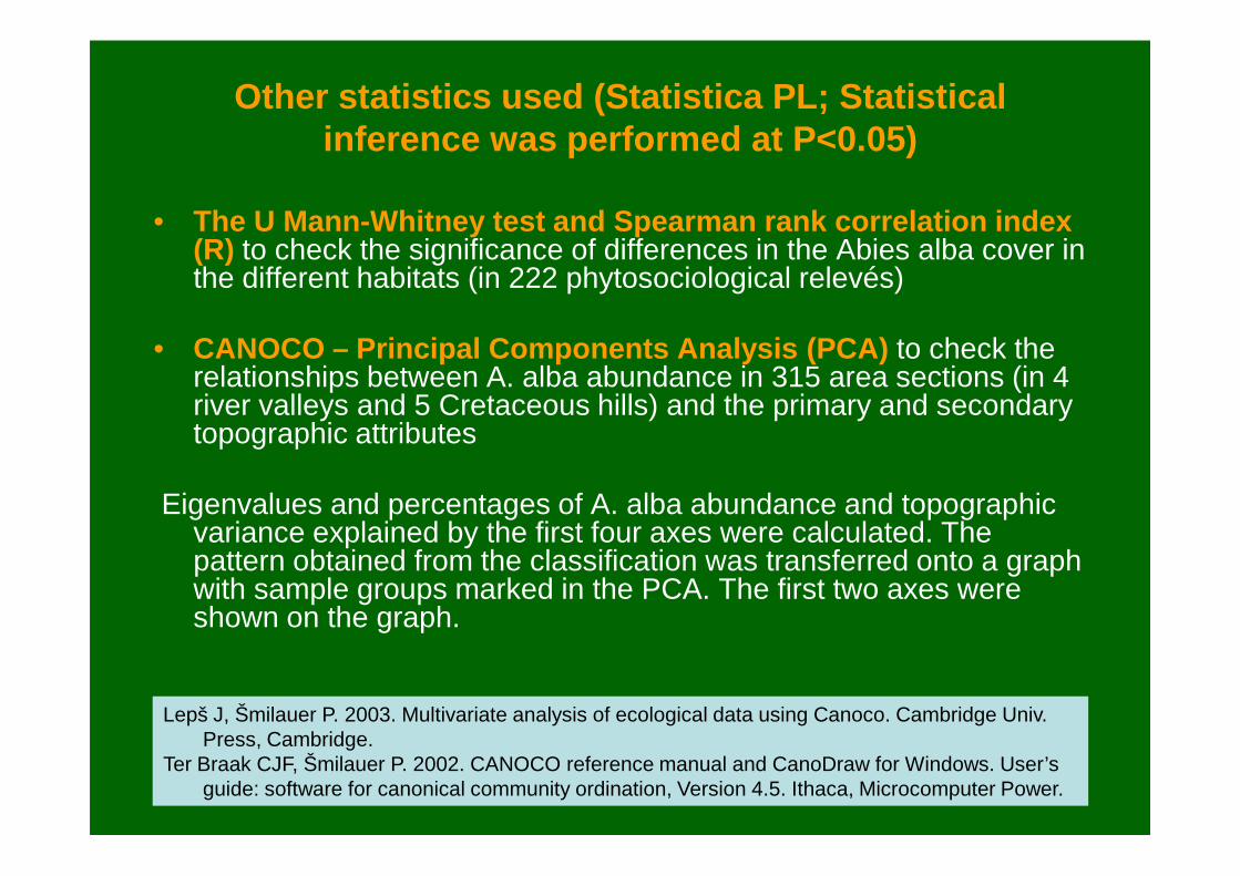
Other statistics used (Statistica PL; Statistical inference was performed at P<0.05)
• The U Mann-Whitney test and Spearman rank correlation index(R) to check the significance of differences in the Abies alba cover in the different habitats (in 222 phytosociological relevés)
• CANOCO – Principal Components Analysis (PCA) to check the relationships between A. alba abundance in 315 area sections (in 4 river valleys and 5 Cretaceous hills) and the primary and secondary topographic attributestopographic attributes
Eigenvalues and percentages of A. alba abundance and topographic variance explained by the first four axes were calculated. The pattern obtained from the classification was transferred onto a graph with sample groups marked in the PCA. The first two axes were shown on the graph.
Lepš J, Šmilauer P. 2003. Multivariate analysis of ecological data using Canoco. Cambridge Univ. Press, Cambridge.
Ter Braak CJF, Šmilauer P. 2002. CANOCO reference manual and CanoDraw for Windows. User’s guide: software for canonical community ordination, Version 4.5. Ithaca, Microcomputer Power.

Community
River valleys
RNP(6,800
ha)Szum
(43.6 ha)Sopot
(80.5 ha)Jeleń
(37.7 ha)
Potok Łosiniecki(24.8 ha)
Upland mixed fir forest 17.4% 46.1% 40.4% - 8.3%
Secondary pine community with A. albaCl. Vaccinio-Piceetea
2.6% 1.5% 6.5% - 7. 1%
Szum river Sopot river Roztocze NP
Tree layer Understorey layer
Topography SlopePlain/
PlateauP R Slope
Plain/Plateau
P R
All data 2.86N=64
1.95N=143
NS 0.13NS
1.03N=64
1.01N=143
NS 0.07NS
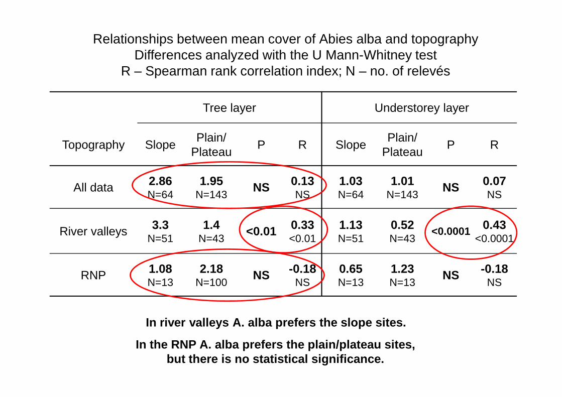
Relationships between mean cover of Abies alba and topography Differences analyzed with the U Mann-Whitney test
R – Spearman rank correlation index; N – no. of relevés
N=64 N=143 NS N=64 N=143 NS
River valleys 3.3N=51
1.4N=43
<0.01 0.33<0.01
1.13N=51
0.52N=43
<0.0001 0.43<0.0001
RNP 1.08N=13
2.18N=100
NS -0.18NS
0.65N=13
1.23N=13
NS -0.18NS
In river valleys A. alba prefers the slope sites.
In the RNP A. alba prefers the plain/plateau sites, but there is no statistical significance.
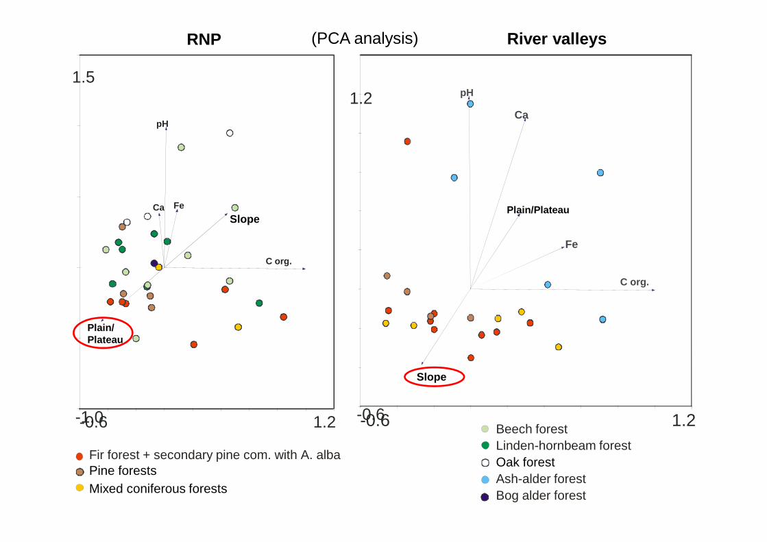
RNP River valleys
1.2
Plain/Plateau
pH
Ca
Fe
1.5
Slope
pH
C org.
Ca Fe
(PCA analysis)
Fir forest + secondary pine com. with A. albaPine forests Mixed coniferous forests
Beech forest Linden-hornbeam forest Oak forestAsh-alder forestBog alder forest
-0.6 1.2-0.6
Slope
C org.
-0.6 1.2-1.0
Plain/Plateau
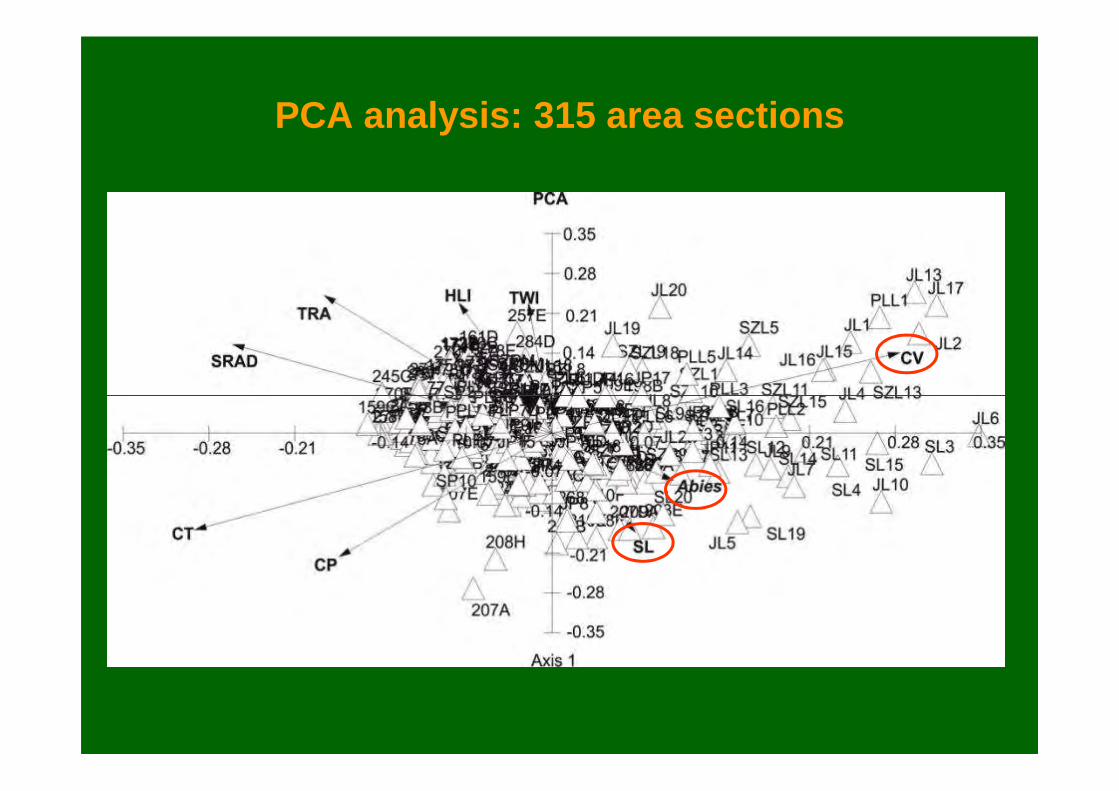
PCA analysis: 315 area sections
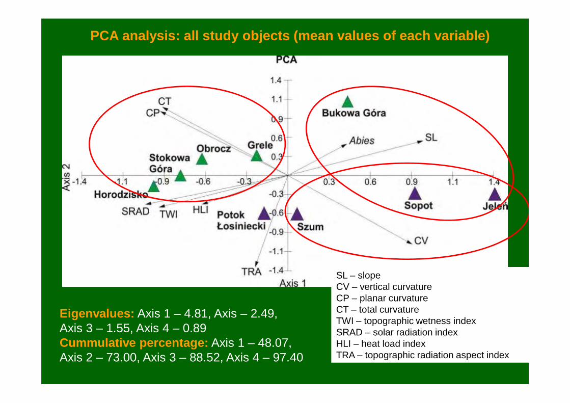
PCA analysis: all study objects (mean values of each variable)
SL – slopeCV – vertical curvatureCP – planar curvatureCT – total curvatureTWI – topographic wetness indexSRAD – solar radiation indexHLI – heat load indexTRA – topographic radiation aspect index
Eigenvalues: Axis 1 – 4.81, Axis – 2.49, Axis 3 – 1.55, Axis 4 – 0.89Cummulative percentage: Axis 1 – 48.07, Axis 2 – 73.00, Axis 3 – 88.52, Axis 4 – 97.40

PCA analysis: river valleys (mean values of each variable)
Eigenvalues: Axis 1 – 7.33, Axis 2 – 1.69, Axis 3 – 0.98, Axis 4 – 0.00 Cummulative percentage: Axis 1 – 73.28, Axis 2 – 90.15, Axis 3 – 100.00, Axis 4 –100.00
SL – slopeCV – vertical curvatureCP – planar curvatureCT – total curvatureTWI – topographic wetness indexSRAD – solar radiation indexHLI – heat load indexTRA – topographic radiation aspect index

PCA analysis: Cretaceous hills (mean values of each variable)
SL – slopeCV – vertical curvatureCP – planar curvatureCT – total curvatureTWI – topographic wetness indexSRAD – solar radiation indexHLI – heat load indexTRA – topographic radiation aspect index
Eigenvalues: Axis 1 – 5.41, Axis – 2.22, Axis 3 – 2.06, Axis 4 – 0.31Cummulative percentage: Axis 1 – 54.01, Axis 2 – 76.26, Axis 3 – 96.88, Axis 4 –100.00

Abies alba in two landscapes of the Roztocze Highlands – final remarks
• In the Roztocze Highlands, especially in the landscape of river valleys, Abies alba occupies habitats that are too leachy for leaf species and even spruce. In the river valleys, it overgrows middle and upper parts of steep slopes, whereas on the Cretaceous hills it most often occurs at foothills and lower parts of hills.
• In the landscape of river valleys, A. alba seems to have much • In the landscape of river valleys, A. alba seems to have much broader ecological amplitude than in the landscape of the Cretaceous hills (RNP), inhabitating semihydrogenic or even hydrogenic soils on the bottoms of valleys overgrowed with ash-alder and bog alder forests.
• While leaf species building beech and linden-hornbeam forests encroach into the habitats of mixed fir forests in the landscape of the Cretaceous hills (RNP), there is no competition for A. alba from deciduous species on the steep slopes of the river valleys.
Abies alba in two landscapes of the Roztocze Highlands – final remarks
• Mean slope (SL) is the most important topographic attribute for Abies alba abundance in both landscape studied: positive for the river valley and negative for the Cretaceous hills.
• The present study confirmed that the TWI on the one hand and indices connected with light intensity, slope aspect and slope configuration (i.e. SRAD, HLI, TRA) on the other hand have an configuration (i.e. SRAD, HLI, TRA) on the other hand have an adverse influence on Abies alba abundance.
• In the light of the present study, the DEM and multivariate canonical analyses seem to be useful in determination of correlations between topographic and ecological attributes of both vegetation landscape types.
Abies alba in two landscapes of the Roztocze Highlands – conclusions
• The present studies are rather of preliminary character. Other important factors should be taken into account in future analysis, e.g. geological formations, precise soil characters (granulometric composition, soil moisture, acidity, humus content, fertility etc.), topoclimate.
• Using the DEM generated from more accurate LIDAR data for the study area (available only in the recent months) instead of the Topo to Raster tools, may bring the results of much greater quality in the future analyses.
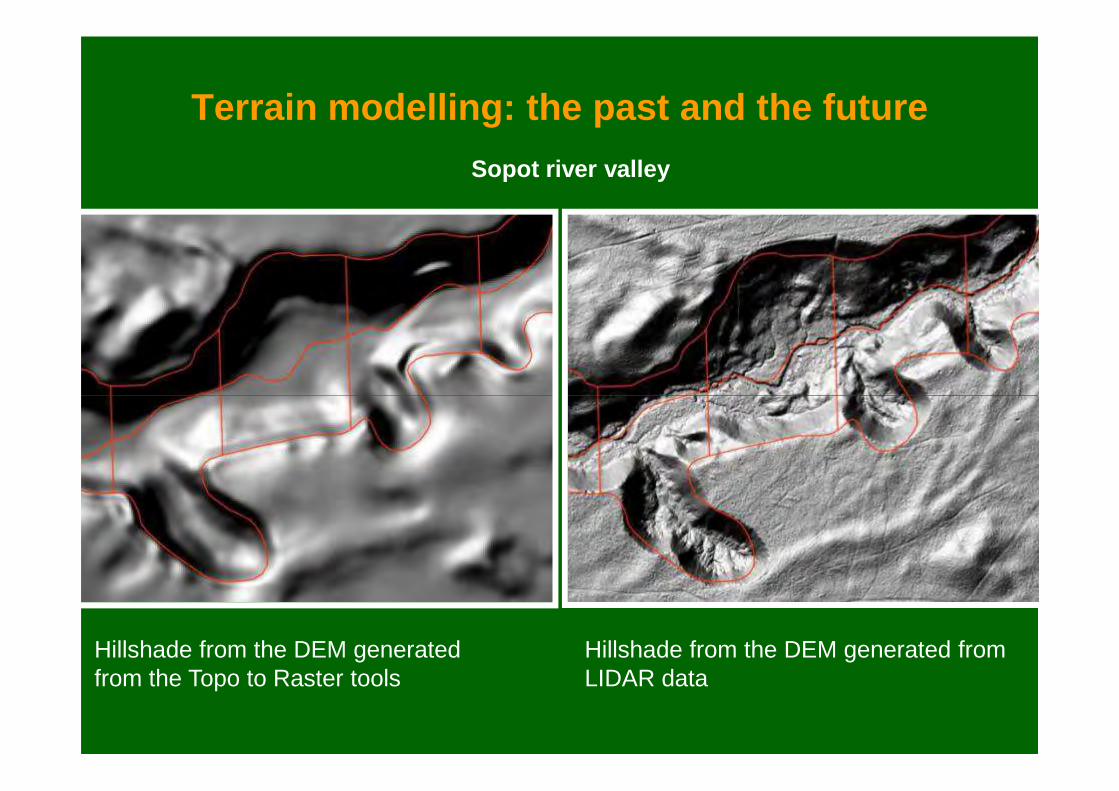
Terrain modelling: the past and the future
Sopot river valley
Hillshade from the DEM generated from the Topo to Raster tools
Hillshade from the DEM generated fromLIDAR data
Related Documents


![Index [assets.cambridge.org]...Index Abdera flexuosa, 170 Abies, 130, 288, 289 Abies alba, 135 Abies sibirica, 283 abiotic environment, 194–201 above-ground environments, 200–205](https://static.cupdf.com/doc/110x72/60dc1344b5babd1c6847e185/index-index-abdera-flexuosa-170-abies-130-288-289-abies-alba-135-abies.jpg)


