Ecological Appraisal Report Proposal: Potential new energy from waste site Site: Land adjacent to Brynsworthy Environmental Centre, Barnstaple, Devon Client: Devon County Council Report: August 2013 Author \ Surveyor: William Dommett MSc Grad CIEEM Checked: Richard Green BSc (Hons) CEnv MCIEEM

Welcome message from author
This document is posted to help you gain knowledge. Please leave a comment to let me know what you think about it! Share it to your friends and learn new things together.
Transcript

Ecological Appraisal Report
Proposal: Potential new energy from waste site
Site: Land adjacent to Brynsworthy Environmental
Centre, Barnstaple, Devon
Client: Devon County Council
Report: August 2013
Author \ Surveyor: William Dommett MSc Grad CIEEM
Checked: Richard Green BSc (Hons) CEnv MCIEEM
Richard Green Ecology Ltd has prepared this report in accordance with the instructions of their client, Devon County Council, for their and their agent’s sole and specific use. Any other persons who use any information contained herein do so at their own risk.
Contents
Executive summary
Ecological receptor checklist
1 Introduction 1
1.1 Introduction 1
1.2 Planning considerations 1
2 Methods 1
2.1 Desk study 1
2.2 Field survey 1
2.3 Evaluation 2
3 Survey findings and evaluation 2
3.1 Desk study 2
3.2 Field survey 3
3.3 Protected species 5
4 Impact assessment, recommendations and mitigation 7
4.1 Designated sites 7
4.2 Habitats 8
4.3 Bats 8
4.4 Nesting birds 9
4.5 Hazel dormouse 10
4.6 Reptiles 10
4.7 Badger 10
4.8 Otter 10
5 References 12
6 Figures 14
7 Annexes 16
A Photographs
B Desk study data

Executive summary
This report makes an ecological appraisal of a proposed new energy from waste (EfW) plant
on land adjacent to Brynsworthy Environmental Centre, Barnstaple, a site of approximately
20.6 ha consisting of a recycling centre, industrial units, hard-standing, amenity, rank, grazed
and marshy grassland, broadleaved woodland, a small stream and scrub surrounded by
grazed grassland and hedgerow boundaries. The site is located at NGR SS 530 305.
An extended phase I habitat survey of the site was undertaken on 31 July 2013 by Richard
Green Ecology Ltd. This report includes the findings of the survey, highlights potential
ecological constraints and opportunities and makes recommendations for ecological
mitigation and enhancement, in accordance with national and local planning policy.
The site is not within any statutory designated sites of nature conservation importance.
Braunton Burrows Special Area of Conservation (SAC)\Site of Special Scientific Interest (SSSI)
and Caen Valley Bats SSSI are within 10km of the site. There are three Unconfirmed Wildlife
Sites (UWS) within the site including Rockabear Covert UWS, an area of broadleaved
woodland and Abattoir (W) and Abattoir (E) UWS, both areas of semi-improved neutral
grassland within the west and east of the site respectively. The Taw/Torridge Estuary SSSI is
within 2km of the site and potentially at risk of pollution through water pathways.
At this stage there are no definitive plans for the site. Protected species that may be affected,
depending on the nature of the development, include bats, including greater horseshoe
foraging over the site; dormice and badgers potentially within woodland and hedgerows; and
reptiles potentially within an area of marshy and rank grassland.
None of the habitats or protected species potentially present are considered to be ‘show
stoppers’ in preventing development providing appropriate survey effort and mitigation is
employed. Brief survey methods and potential mitigation options for protected species and
sites are outlined in this report.
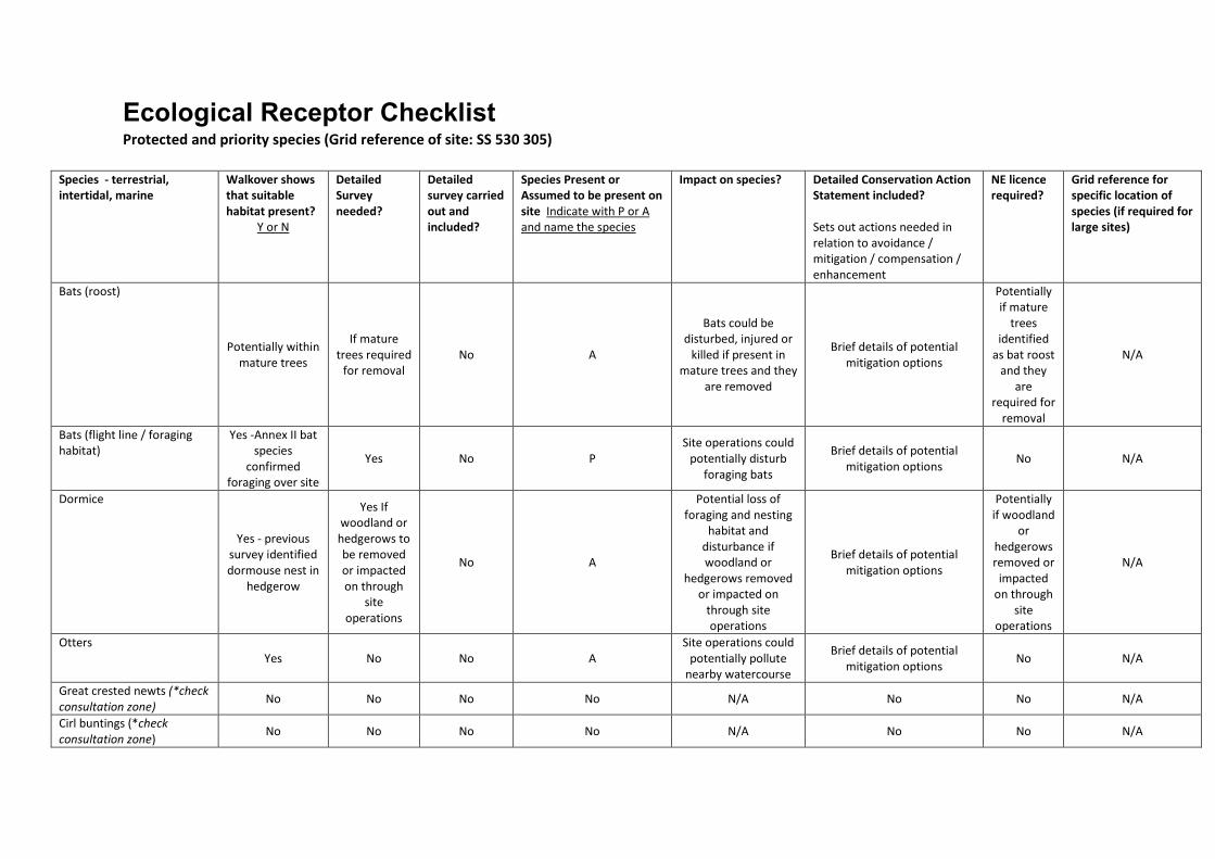
Ecological Receptor Checklist Protected and priority species (Grid reference of site: SS 530 305)
Species - terrestrial,
intertidal, marine
Walkover shows
that suitable
habitat present?
Y or N
Detailed
Survey
needed?
Detailed
survey carried
out and
included?
Species Present or
Assumed to be present on
site Indicate with P or A
and name the species
Impact on species?
Detailed Conservation Action
Statement included?
Sets out actions needed in
relation to avoidance /
mitigation / compensation /
enhancement
NE licence
required?
Grid reference for
specific location of
species (if required for
large sites)
Bats (roost)
Potentially within
mature trees
If mature
trees required
for removal
No A
Bats could be
disturbed, injured or
killed if present in
mature trees and they
are removed
Brief details of potential
mitigation options
Potentially
if mature
trees
identified
as bat roost
and they
are
required for
removal
N/A
Bats (flight line / foraging
habitat)
Yes -Annex II bat
species
confirmed
foraging over site
Yes No P
Site operations could
potentially disturb
foraging bats
Brief details of potential
mitigation options No N/A
Dormice
Yes - previous
survey identified
dormouse nest in
hedgerow
Yes If
woodland or
hedgerows to
be removed
or impacted
on through
site
operations
No A
Potential loss of
foraging and nesting
habitat and
disturbance if
woodland or
hedgerows removed
or impacted on
through site
operations
Brief details of potential
mitigation options
Potentially
if woodland
or
hedgerows
removed or
impacted
on through
site
operations
N/A
Otters
Yes No No A
Site operations could
potentially pollute
nearby watercourse
Brief details of potential
mitigation options No N/A
Great crested newts (*check
consultation zone) No No No No N/A No No N/A
Cirl buntings (*check
consultation zone) No No No No N/A No No N/A

Species - terrestrial,
intertidal, marine
Walkover shows
that suitable
habitat present?
Y or N
Detailed
Survey
needed?
Detailed
survey carried
out and
included?
Species Present or
Assumed to be present on
site Indicate with P or A
and name the species
Impact on species?
Detailed Conservation Action
Statement included?
Sets out actions needed in
relation to avoidance /
mitigation / compensation /
enhancement
NE licence
required?
Grid reference for
specific location of
species (if required for
large sites)
Barn owls Potential
foraging habitat No No A
Potential loss of
foraging habitat
Brief details of potential
mitigation options No N/A
Other Schedule 1 birds No No No No N/A No No N/A
Breeding birds
Yes No No A
Potential loss of
foraging and nesting
habitat and
disturbance if
woodland, scrub or
hedgerows removed
or impacted on
through site
operations
Yes No N/A
Reptiles Yes Yes No A
Potential killing or
injury of reptiles
Brief details of potential
mitigation options No N/A
Native crayfish No No No No N/A No No N/A
Water voles No No No No N/A No No N/A
Badgers
Yes Yes No A
Potential disturbance
if present on site at
time of works
Brief details of potential
mitigation options
Potentially
if present at
time of
works and
require sett
closure
N/A
Species of principal
importance Yes - refer to
section 3
Potentially -
refer to
section 4
No A Potentially Refer to section 4
Potentially
for bats or
dormice
(see above)
N/A
Invasive species
Yes Prior to
construction No
Potential for Japanese
knotweed as survey
involved brief walkover.
N/A No No N/A
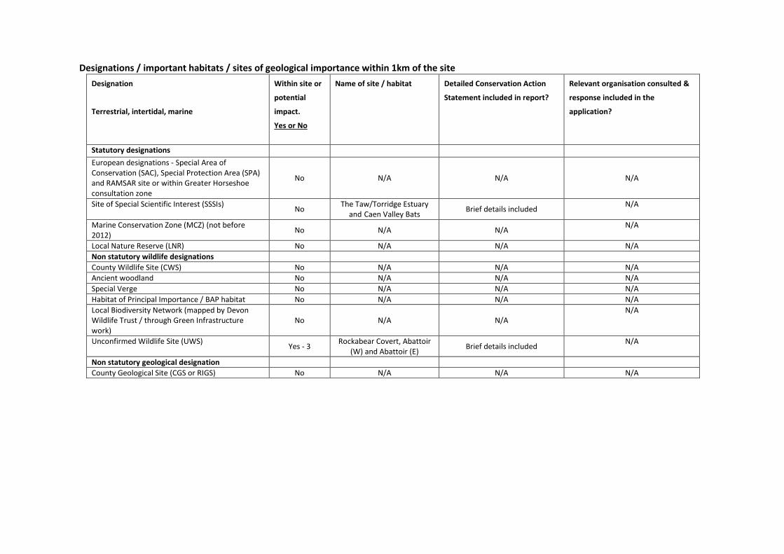
Designations / important habitats / sites of geological importance within 1km of the site
Designation
Terrestrial, intertidal, marine
Within site or
potential
impact.
Yes or No
Name of site / habitat Detailed Conservation Action
Statement included in report?
Relevant organisation consulted &
response included in the
application?
Statutory designations
European designations - Special Area of
Conservation (SAC), Special Protection Area (SPA)
and RAMSAR site or within Greater Horseshoe
consultation zone
No N/A N/A N/A
Site of Special Scientific Interest (SSSIs) No
The Taw/Torridge Estuary
and Caen Valley Bats Brief details included
N/A
Marine Conservation Zone (MCZ) (not before
2012) No N/A N/A
N/A
Local Nature Reserve (LNR) No N/A N/A N/A
Non statutory wildlife designations
County Wildlife Site (CWS) No N/A N/A N/A
Ancient woodland No N/A N/A N/A
Special Verge No N/A N/A N/A
Habitat of Principal Importance / BAP habitat No N/A N/A N/A
Local Biodiversity Network (mapped by Devon
Wildlife Trust / through Green Infrastructure
work)
No N/A N/A
N/A
Unconfirmed Wildlife Site (UWS) Yes - 3
Rockabear Covert, Abattoir
(W) and Abattoir (E) Brief details included
N/A
Non statutory geological designation
County Geological Site (CGS or RIGS) No N/A N/A N/A
1
1 Introduction
1.1 Introduction
This report makes an ecological appraisal of a proposed new energy from waste
(EfW) plant on land adjacent to Brynsworthy Environmental Centre, Barnstaple, a site
of approximately 20.6 ha consisting of a recycling centre, industrial units, hard-
standing, amenity, rank, grazed and marshy grassland, broadleaved woodland, a
small stream and scrub surrounded by pasture fields and hedgerows boundaries. The
site is located at NGR SS 530 305.
An extended phase I habitat survey of the site was undertaken on 31 July 2013 by
Richard Green Ecology Ltd. This report includes the findings of the survey, highlights
potential ecological constraints and opportunities and makes recommendations for
ecological mitigation and enhancement, in accordance with national planning policy.
1.2 Planning considerations
1.2.1 National Planning Policy Framework (NPPF), March 2012
The National Planning Policy Framework outlines the Government’s commitment to
minimise impacts on biodiversity and provide net gains in biodiversity where
possible, contributing to the Government’s commitment to halt the overall decline in
biodiversity, including by establishing coherent ecological networks that are more
resilient to current and future pressures.
2 Methods
2.1 Desk study
Devon Biodiversity Records Centre (DBRC) was commissioned to undertake a search
for designated ecological sites and protected and notable species records as follows:
• Standard terrestrial data search within 1 km of the site;
• 2km bat data search;
• 1km BAP habitat data search;
• 2km statutory sites data search; and
• 10km SAC\SPA\Ramsar and SSSI designated for bats data search.
2.2 Field survey
An extended phase I habitat survey of the site was undertaken, following
recommendations made by the former Institute of Environmental Assessment
(1995). Habitats present are shown in Figure 2. Note was taken of the more
conspicuous fauna, and any evidence of, or potential for the presence of protected
and alien invasive species was recorded.
2
2.2.1 Timing, weather conditions and constraints
The survey was undertaken on 31 July 2013. The weather during the survey was
cloudy with a light breeze. The temperature was approximately 17oC.
It is considered that sufficient vegetation was identified during the survey to provide
an understanding of the site and any potential implications this may have on the
proposal. However, as plants are not always obvious, depending on the time of
survey, and as the survey involved a preliminary walkover, rather than a detailed
‘phase 2’ survey, Richard Green Ecology Ltd accepts no liability for the presence of
any invasive or protected species present that were not recorded during the survey.
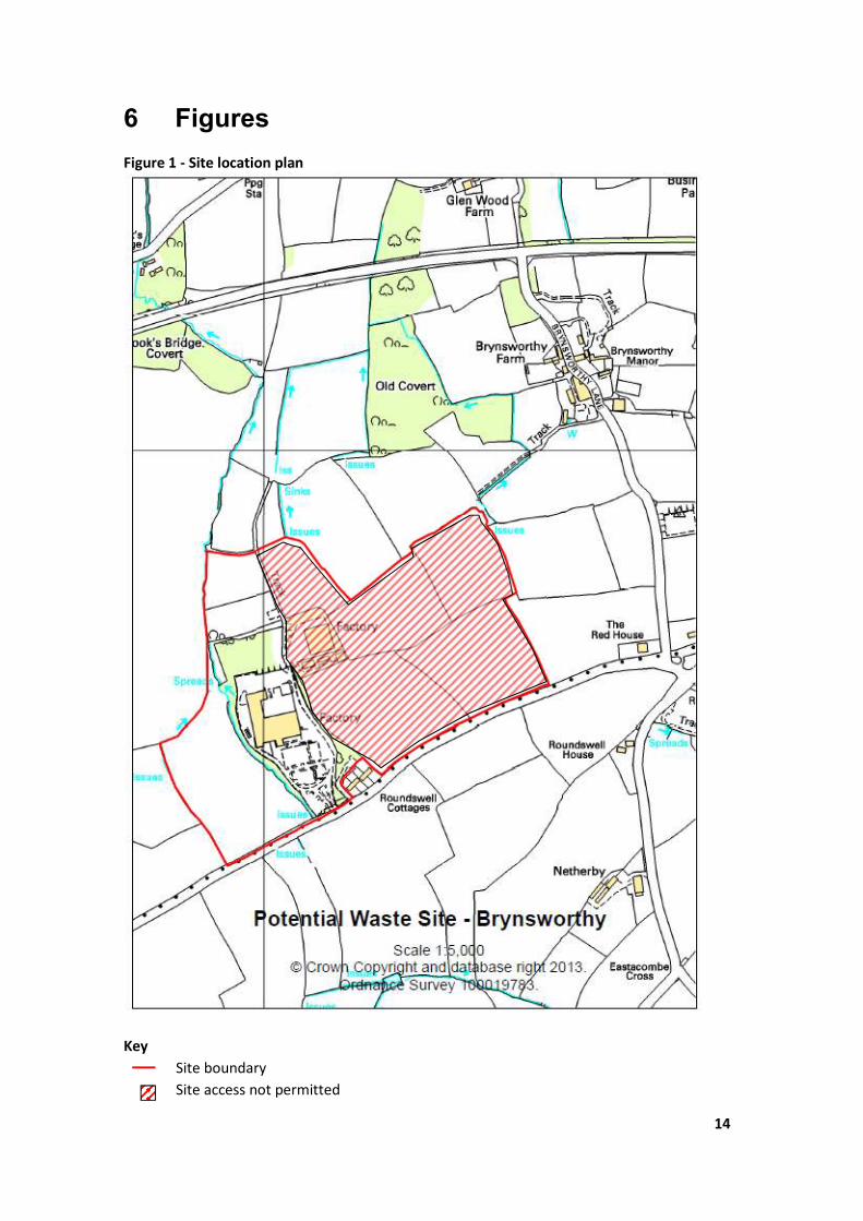
Some areas of the site were not accessible due to land owner permission being
refused (refer to Figure 1).Where possible these areas were inspected remotely from
adjacent areas where rights of way was permitted. However, it must be considered
that a detailed survey of these areas of land could not be undertaken.
2.3 Evaluation
Habitat evaluations are based on guidance from the Chartered Institute of Ecology
and Environmental Management (CIEEM). The level of value of specific ecological
receptors is assigned using a geographic frame of reference, i.e. international value
being most important, then national, regional, county, district, local and lastly, within
the immediate zone of influence of the site only.
Value judgements are based on various characteristics that can be used to identify
ecological resources or features likely to be important in terms of biodiversity. These
include site designations (such as Sites of Special Scientific Interest (SSSI)), or for
undesignated features, the size, conservation status (locally, nationally or
internationally), and the quality of the ecological resource. In terms of the latter,
‘quality’ can refer to habitats (for instance if they are particularly diverse, or a good
example of a specific habitat type), other features (such as wildlife corridors or
mosaics of habitats) or species populations or assemblages.
3 Survey findings and evaluation
3.1 Desk study
3.1.1 Designated sites
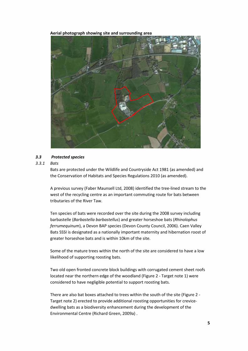
The site is not within any designated sites of nature conservation importance. There
are three Unconfirmed Wildlife Sites (UWS) within the site including Rockabear
Covert, an area of broadleaved woodland within the north of the site and Abattoir
(W) and Abattoir (E), both areas of semi-improved neutral grassland within the west
and east of the site respectively. Abattoir (S) UWS, an area of semi-improved neutral
grassland lies adjacent to the site to the south. There are nine other UWS within 1km
of the site either designated for broadleaved woodland or semi-improved neutral
grassland.

3
There are several small areas of unnamed North Devon Key Network Feature sites
and North Devon Network Sites and a Coastal and Floodplain Grazing Marsh Strategic
Nature Area (SNA) within 1km of the site. Higher Gorse Claypits County Wildlife Site
(CWS), partly designated as semi-natural broadleaved woodland, which also forms
part of Fremington Clay Pits geological Site of Special Scientific Interest (gSSSI), an
important pleistocene site, lies approximately 750m north of the site and the
Taw/Torridge Estuary Site of Special Scientific Interest (SSSI) lies approximately 1.9km
north of the site.
Braunton Burrows Special Area of Conservation (SAC)\ SSSI designated for rare plant
interest lies approximately 7km west of the site and Caen Valley Bats SSSI designated
as a nationally important maternity and hibernation roost of greater horseshoe bats
is located approximately 8.7km northwest of the site. Refer to Annex B for a full list
of sites and locations.
3.1.2 Protected species
There are records of protected/notable species within the 1 km radius search area.
These include records of otter, bat and barn owl to the north and badger to the north
and east. There are no records from the site and the closest records are of badger
approximately 500m east of the site.
There are records of bats and bat roosts within 2km of the site largely to the north
and east including long-eared (Plecotus sp.) and potentially pipistrelle (Pipistrellus
sp.) maternity roosts to the north. Refer to Annex B for a full list of species and
locations.
3.2 Field survey
3.2.1 Habitats
Refer to descriptions below, Figure 2 and photographs in Annex A.
The site consists of a recycling centre, industrial units, hard-standing, amenity, rank
grazed and marshy grassland, broadleaved woodland, a small stream and scrub
surrounded by grazed grassland and hedgerow boundaries.
The centre of the site consists of office buildings, car parking, hard-standing, amenity
grassland and recycling centre, all part of the Brynsworthy Environmental Centre. The
Environmental Centre is surrounded by semi-mature broadleaved woodland (part of
Rockabear Covert UWS - refer to Annex B) and a stream to the west including ash
(Fraxinus excelsior), sycamore (Acer pseudoplatanus), elder (Sambucus nigra), beech
(Fagus sylvatica), hazel (Corylus avellana), willow (Salix sp.), alder (Alnus glutinosa)
and blackthorn (Prunus spinosa) with sparse understory including dog’s mercury
(Mercurialis perennis), ivy (Hedera helix), moss (Bryophyta sp.), bramble (Rubus
fruticosus agg.) and ferns (Pteridophyta sp.).
The woodland extends around the north of the Environmental Centre with a few
mature oak (Quercus robur) and beech trees and a higher percentage of hazel with
4
ground elder (Aegopodium podagraria), hart’s tongue (Asplenium scolopendrium)
and common nettle (Urtica dioica) also noted within the ground flora. Further east
the ground becomes damp with plants including ferns, broad-leaved dock (Rumex
obtusifolius), figwort (Scrophularia sp.) and Yorkshire fog (Holcus lanatus).
A steep sided area of disturbed ground and rank grassland dominated by rushes
including hard (Juncus inflexus), soft (J. effusus) and compact (J. conglomeratus) with
bird’s foot trefoil (Lotus corniculatus), ragwort (Senecio jacobaea), coltsfoot
(Tussilago farfara), common knapweed (Centaurea nigra), common fleabane
(Pulicaria dysenterica), great willow herb (Epilobium hirsutum) and wild angelica
(Angelica sylvestris) is located at the northeast edge of the Environmental Centre.
An area of impenetrable scrub including willow, gorse (Ulex europaeus), buddleia
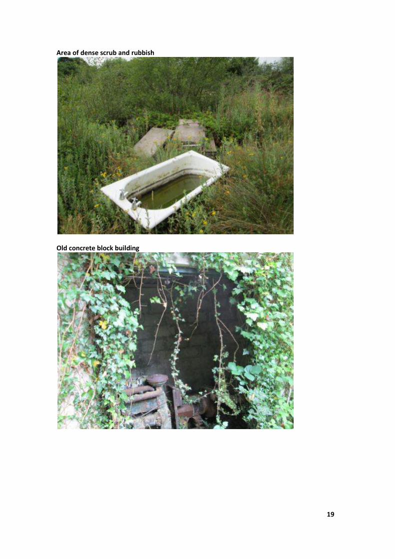
(Buddleia davidii) and evening primrose (Oenothera biennis) with patches of rubbish,
two old concrete block buildings (Figure 2 - Target note 1) and disturbed ground is
located at the northern edge of the woodland. Further north of this area is an area of
marshy grassland dominated by rushes surrounded by a steep bank along the
western boundary of the site with mature trees including oak, ash, beech, hazel and
hawthorn (Crataegus monogyna). The mature trees also extend along the northern
boundary of the site.
A sheep-grazed poor semi-improved grassland field (Abattoir (W) UWS - refer to
Annex B) including crested dog’s tail (Cynosurus cristatus), white clover (Trifolium
repens), selfheal (Prunella vulgaris), hawkbit (Leontodon sp.), sedges (Cyperaceae
sp.), Timothy (Phleum pratense), ribwort plantain (Plantago lanceolata), knapweed
and bird’s foot trefoil with some areas dominated by hard rush lies to the west of the
woodland stream. The field is surrounded by species-rich hedgerows to the west and
south (also forming site boundaries) including blackthorn, hazel, oak, willow, bracken
(Pteridium aquilinum), ash, bramble, field rose (Rosa arvensis) and hawthorn.
The site is bisected by a track with a steep bank covered in willow, gorse, birch
(Betula sp.) and oak scrub in the south of the site. The area of land to the east of the
track was out of bounds for the survey (refer to Figure 1). Towards the centre of the
site is an area of industrial units and hard-standing. The field to the north of the
industrial units had been recently mown with some areas dominated by rushes. A tall
tree-lined hedge, including willow, oak and ash with some dead trees, separates the
industrial units. The fields to the south and east of this area appeared to have been
recently mown and cattle grazed with a recently planted earth bank running along
the southern boundary of the site with recently planted whips of hawthorn, hazel
and willow. Hedgerow boundaries dividing the fields within the east of the site and
eastern boundary appeared to be thick and heavily managed.
Given that part of the site comprises an UWS of broadleaved woodland and grazed
poor semi-improved grassland and part is a recycling centre, industrial estate, hard-
standing and scrub/disturbed ground the site is considered of negligible (industrial
areas) to district (UWS) ecological value.
5
Aerial photograph showing site and surrounding area
3.3 Protected species
3.3.1 Bats
Bats are protected under the Wildlife and Countryside Act 1981 (as amended) and
the Conservation of Habitats and Species Regulations 2010 (as amended).
A previous survey (Faber Maunsell Ltd, 2008) identified the tree-lined stream to the
west of the recycling centre as an important commuting route for bats between
tributaries of the River Taw.
Ten species of bats were recorded over the site during the 2008 survey including
barbastelle (Barbastella barbastellus) and greater horseshoe bats (Rhinolophus
ferrumequinum), a Devon BAP species (Devon County Council, 2006). Caen Valley
Bats SSSI is designated as a nationally important maternity and hibernation roost of
greater horseshoe bats and is within 10km of the site.
Some of the mature trees within the north of the site are considered to have a low
likelihood of supporting roosting bats.
Two old open fronted concrete block buildings with corrugated cement sheet roofs
located near the northern edge of the woodland (Figure 2 - Target note 1) were
considered to have negligible potential to support roosting bats.
There are also bat boxes attached to trees within the south of the site (Figure 2 -
Target note 2) erected to provide additional roosting opportunities for crevice-
dwelling bats as a biodiversity enhancement during the development of the
Environmental Centre (Richard Green, 2009a) .

6
Given the previously identified important commuting route for bats and recorded
presence of Annex II species of bats, the habitats of value (broadleaved woodland,
stream, hedgerows) to bats on the site are considered to be of County importance
for bats (Wray et al, 2010). Industrial units and hard standing are of negligible value
to bats.
3.3.2 Nesting birds
Nesting birds are protected under the Wildlife and Countryside Act 1981 (as
amended).
There is a record of barn owl (Tyto alba), an amber listed bird of conservation
concern and Devon BAP species (Devon County Council, 2009a), approximately 850m
northeast of the site (refer to Annex B). Barn owls may occasionally forage over the
hedgerows and hedgerow margins on the site.
No active nests of other birds were observed during the survey but a previous survey
(Richard Green, 2009b) found blackbird, wren and pheasant nests surrounding the
site, as well as goldfinch and greenfinch (Richard Green pers. comm.). Birds are likely
to nest within the hedgerows, trees and scrub within and surrounding the site.
Given its moderate size and available habitat elsewhere in the area, the site is not
considered of more than site value for nesting birds.
3.3.3 Hazel dormouse
Dormice (Muscardinus avellanarius) are protected under the Wildlife and
Countryside Act 1981 (as amended) and the Conservation of Habitats and Species
Regulations 2010 (as amended).
Hazel dormouse, a Devon BAP (Devon County Council, 2009b) and Section 41 species
of principle importance (S41 species), is known to be present throughout Devon and
a dormouse nest was previously found in a nearby hedgerow (Faber Maunsell Ltd,
2008). The species-rich hedgerows within the site and broadleaved woodland are
connected to the wider hedgerow network and provide favourable habitat for
dormice. It is therefore likely that dormice are present on site.
Given the small area of suitable vegetation on site to support dormice and available
habitat elsewhere in the area, the site is not considered of more than site value for
dormice.
3.3.4 Reptiles
Common reptiles, such as slow worm (Anguis fragilis), common lizard (Lacerta
vivipara) and grass snake (Natrix natrix) are protected under the Wildlife and
Countryside Act 1981 (as amended) against killing and injury and are a UK
Biodiversity Action Plan (BAP) and S41 species.

7
The areas of disturbed ground and rubble, rank and marshy grassland may provide
suitable habitat for common reptiles including slow worm, common lizard and grass
snake. Given the small area of suitable vegetation on site to support reptiles and
isolation from other suitable habitat, the site is not considered of more than site
value for reptiles.
3.3.5 Badger
Badgers are protected under the Protection of Badgers Act 1992.
There are several records of badger surrounding the site to the north and east some
within approximately 500m (refer to Annex B). Approximately four small badger sett
entrances were found within the broadleaved woodland to the north of the
Environmental Centre (Figure 2 - Target note 3). The sett entrances were covered in
old vegetation and there were no obvious spoil heaps or badger paths and it is
considered likely they form part of an outlying sett.
Given the available habitat on site and abundance of badger records within the
locality, the site is considered to be of local value for badgers.
3.3.6 Otter
Otter (Lutra lutra) are protected under the Wildlife and Countryside Act 1981 (as
amended) and the Conservation of Habitats and Species Regulations 2010 (as
amended).
There is a record of otter, a Devon BAP (Devon County Council, 2009c) and S41
species approximately 530m north of the site (refer to Annex B). The stream to
within the west of the site may be used by transient otters.
4 Impact assessment, recommendations and mitigation
4.1 Designated sites
4.1.1 Impacts
The proposed site lies within 10 km of Braunton Burrows SAC\SSSI designated for
rare plant interest (refer to Annex B). Air pollution may have some impact on the
qualifying features of this site although these impacts are outside the scope of this
report. The potential effects of site operations on Braunton Burrows qualifying
features from other pathways (e.g. water) are considered negligible.
The Taw/Torridge Estuary SSSI primarily designated for overwintering and migratory
populations of wading birds lies within 2 km of the site (refer to Annex B). The
estuary could potentially be impacted on through pollution incidents via the stream
to the west of the Environmental Centre which is a tributary of Taw Estuary.
8
However, the site is located next to a recycling centre and small industrial estate
therefore with the appropriate mitigation impacts are considered to be low to
negligible.
4.1.2 Mitigation
During site construction and operation, measures should be put in place to avoid
potential run off of soil, sediment or pollution such as fuel, chemicals, etc. from
flowing into the stream and potentially reaching the estuary.
4.2 Habitats
4.2.1 Impacts
Over the whole site it is estimated that there is approximately 6 ha of habitat of
ecological value, including poor semi-improved grassland, marshy grassland, species-
rich hedgerows, hedgerow margins, broadleaved woodland and a stream.
The broadleaved woodland on site forms part of Rockabear Covert UWS and is part
of an important commuting route for bats (refer to 3.3.1). The poor semi-improved
grassland field within the east of the site and a field within the west of the site (not
surveyed - refer to Figure 1) also form parts of Abattoir (E) & (W) UWS. These areas
of habitat are considered to be of District importance and their potential loss from
the site is considered to result in a negative impact at a District level.
Rank and marshy grassland, species-rich hedgerows and scrub are considered
common and widespread habitats within the area and their potential loss from the
site is considered likely to result in no more than a minor ecological impact at a local
level.
4.2.2 Mitigation
Ecologically valuable features, including poor semi-improved grassland, marshy
grassland, broadleaved woodland, stream, species-rich hedgerows and hedgerow
margins should, where possible, be integrated into the developed site and be
maintained and enhanced (e.g. through appropriate management regimes) to
enhance their ecological value.
4.3 Bats
4.3.1 Impacts
It is considered that there are ecological features of value to bats within the site,
including broadleaved woodland, species-rich hedgerows, mature trees and a tree-
lined steam. The loss of any of these habitat features or site operations could have a
detrimental impact on the local bat population.
The tree-lined stream to the west of the Environmental Centre has previously been
identified as an important commuting route for bats between tributaries of the River
Taw. Ten bat species were also recorded over the site including two Annex II species
(Faber Maunsell Ltd, 2008). The loss or damage of this feature could affect the

9
favourable conservation status of bats in the area if it severs an important route
between roosts and foraging areas or that is used for migration.
4.3.2 Further survey and mitigation
Based on previous survey findings (Faber Maunsell Ltd, 2008) including the presence
greater horseshoe bats over the site and other habitat features of value to bats,
including the species-rich hedgerows and mature trees, it is considered that an
updated bat activity survey should be undertaken to gain an understanding of bat
use on the site.
Following survey guidelines (Hundt, 2012) the site is considered to be of medium
habitat quality and of a large size site. Bat activity survey should therefore include
one transect survey each month (April to September inclusive), to include one dawn
survey transect and two automated bat detectors left on site during each transect
survey (in a different locations each time) for a period of 5 consecutive nights (in
appropriate weather conditions) for subsequent analysis of recorded bat calls.
Any mature trees identified as having potential to support roosting bats that are
required for removal should be preceded by a dusk/dawn survey.
As described in a previous working method statement (Richard Green, 2009a)
measures should be put in place to prevent light spill and disturbance to the tree-
lined stream to the west of the Environmental Centre and to retain where possible
habitat features of value for bats e.g. hedgerow boundaries, trees and shrubs.
4.4 Nesting birds
4.4.1 Impacts
It is likely that birds nest in trees, scrub and hedgerows within and surrounding the
site. It is also possible that barn owl may hunt over the hedgerow margins on the site.
The removal of these habitats would result in a minor loss of local bird-nesting
habitat and potential barn owl foraging habitat.
4.4.2 Mitigation
It is recommended that any tree, scrub or hedgerow removal be undertaken
between October and February (outside of the nesting season) or if this is not
possible, a thorough inspection for any active nests should be undertaken
immediately before tree, scrub or hedgerow removal. Should birds be nesting at that
time, work will have to wait until the young birds have fledged and left the nest.
It is recommended that areas of longer grass around hedgerow margins are left to
grow over the summer months and cut once a year in the autumn to maintain the
habitat and prevent succession to scrub. Long grass provides favourable habitat for
small mammals, the favoured prey of barn owls. If the areas of hedgerow margins
are to be lost from the site then similar areas of long grassland could be provided
elsewhere on or off-site to compensate for the habitat loss.
10
4.5 Hazel dormouse
4.5.1 Impacts
It is possible that dormice are present within the broadleaved woodland, species-rich
hedgerows and scrub within and surrounding the site. The removal of these habitat
features or disturbing site operations could result in the disturbance of dormice or
potential loss of dormouse nesting and foraging habitat.
4.5.2 Further survey and mitigation
Should any of the broadleaved woodland or hedgerows be proposed for removal
(e.g. for access), or site operations require lighting that would spill onto them, then
dormouse nest tube survey should be undertaken to further investigate presence.
Should dormice be confirmed as nesting within the hedgerows then a licence from
Natural England may be required. Potential mitigation could include on or off-site
habitat provision to compensate for habitat loss.
4.6 Reptiles
4.6.1 Impacts
It is possible that slow worm and common lizard are present within the area of rank
grassland and disturbed ground and grass snake may be present within the area of
marshy grassland within the centre of the site. Removal of these habitats could
potentially result in the killing or injury of these reptiles.
4.6.2 Further survey and mitigation
If the areas of marshy grassland or rank grassland within the site are to be removed
then this should be preceded by a reptile survey using artificial refugia (between April
and September). Should reptiles be found in these areas then suitable mitigation
should include isolating these areas using reptile fencing and the translocation of any
reptiles found to a suitable receptor site.
4.7 Badger
4.7.1 Impacts
An outlying badger sett was found within the broadleaved woodland on site and
there are records of badger surrounding the site.
4.7.2 Further survey and mitigation
It is recommended that a badger survey is undertaken immediately before the site is
developed to ensure no new badger setts have been excavated on site or are at risk
of disturbance from site operations. Should a badger sett be found and at risk of
disturbance then suitable mitigation may include the exclusion of badgers (under
licence from Natural England) before sett destruction and creation of artificial setts
elsewhere.
4.8 Otter
4.8.1 Impacts
It is possible that otter pass through the stream on site. Otter could potentially be
affected if pollution during construction or from site operations leak into the stream.

11
4.8.2 Mitigation
Refer to 4.1.2 above.
12
5 References
Devon County Council (2006) Greater horseshoe bat. Devon Biodiversity and
Geodiversity Action Plan.
Devon County Council (2009a) Barn owl. Devon Biodiversity and Geodiversity Action
Plan.
Devon County Council (2009b) Dormouse. Devon Biodiversity and Geodiversity
Action Plan.
Devon County Council (2009c) Otter. Devon Biodiversity and Geodiversity Action
Plan.
Faber Maunsell Ltd (2008) Roundswell Direct Labour Unit - Report on the results of
dormouse, reptiles and bat surveys
Hundt, L. (2012). Bat Surveys – Good Practice Guidelines. 2nd
Edition. Bat
Conservation Trust, London
Institute of Ecology and Environmental Management (2006). Guidelines for Ecological
Impact Assessment within the United Kingdom
Institute of Environmental Assessment (1995) Guidelines for Baseline Ecological
Assessment. E. & F.N. Spon
JNCC (2013) Braunton Burrows
http://jncc.defra.gov.uk/protectedsites/sacselection/sac.asp?EUCode=UK0012570
Nature Conservation Council (1990) Handbook for Phase 1 habitat survey – a
technique for environmental audit. Peterborough: Nature Conservation Council.
Natural England (2013) Braunton Burrows SSSI
http://www.sssi.naturalengland.org.uk/Special/sssi/sssi_details.cfm?sssi_id=1000023
Richard Green (2009a) Proposed DLU site at Roundswell, Barnstaple Devon - Bat and
Dormouse Assessment and Working Method Statement
Richard Green (2009b) Proposed DLU site at Roundswell, Barnstaple Devon -Nesting
Bird and Dormouse Survey Report
Rose, F. (2006) The Wildflower Key: Penguin Books: London

13
Wray et al (2010) Valuing Bats in Ecological Impact Assessment, IEEM InPractice Vol.
70
14
6 Figures
Figure 1 - Site location plan
Key
Site boundary
Site access not permitted
15
Figure 2 - Phase 1 habitat map
Target note Description
1 Two old concrete block buildings (negligible bat potential)
2 Bat boxes attached to trees
3 Outlying badger sett entrance

16
7 Annexes
A Photographs
Environmental Centre building and car parking area
Hard standing and industrial units (out of bounds)
17
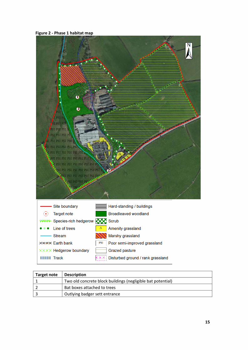
Rank grassland and area of disturbed ground
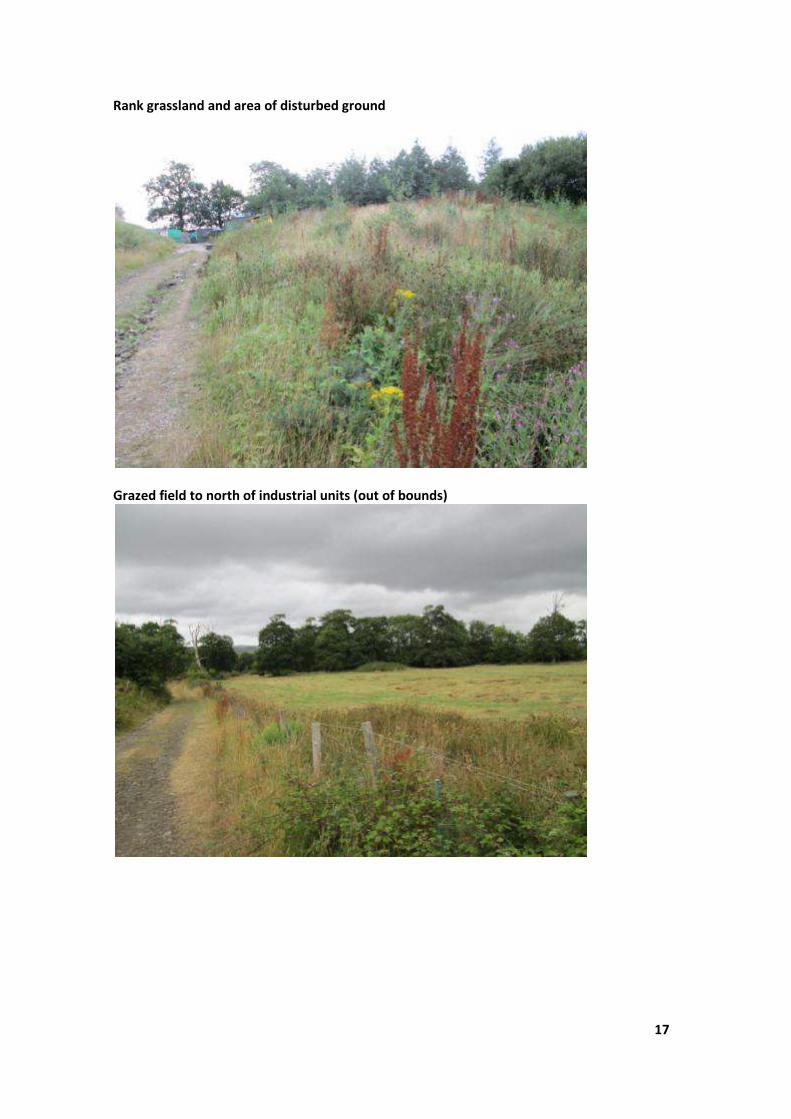
Grazed field to north of industrial units (out of bounds)
18
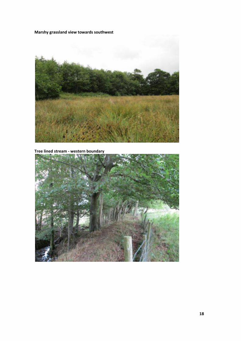
Marshy grassland view towards southwest
Tree lined stream - western boundary
19
Area of dense scrub and rubbish
Old concrete block building
20
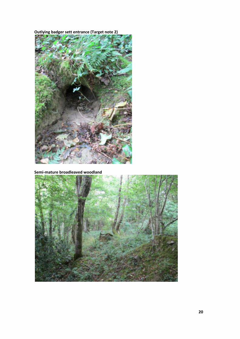
Outlying badger sett entrance (Target note 2)
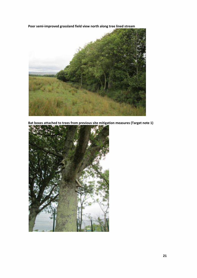
Semi-mature broadleaved woodland
21
Poor semi-improved grassland field view north along tree lined stream
Bat boxes attached to trees from previous site mitigation measures (Target note 1)
22
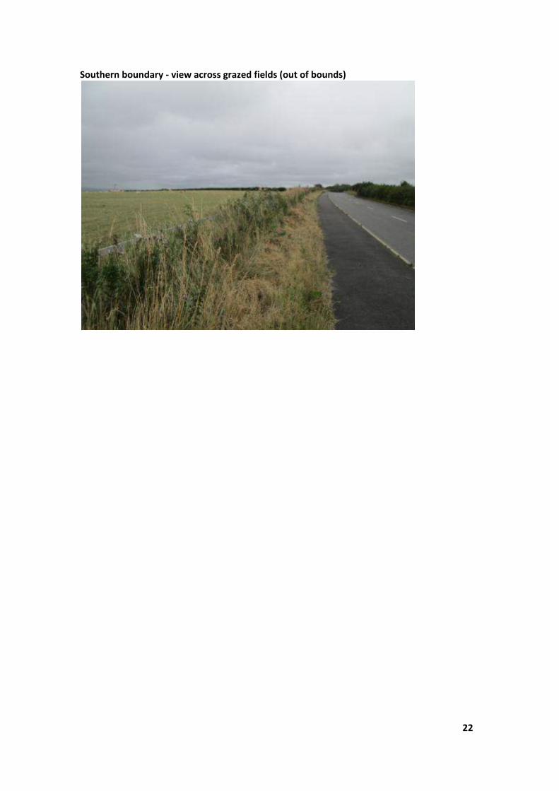
Southern boundary - view across grazed fields (out of bounds)

23
B Desk study data
24
25
26

27

28
29
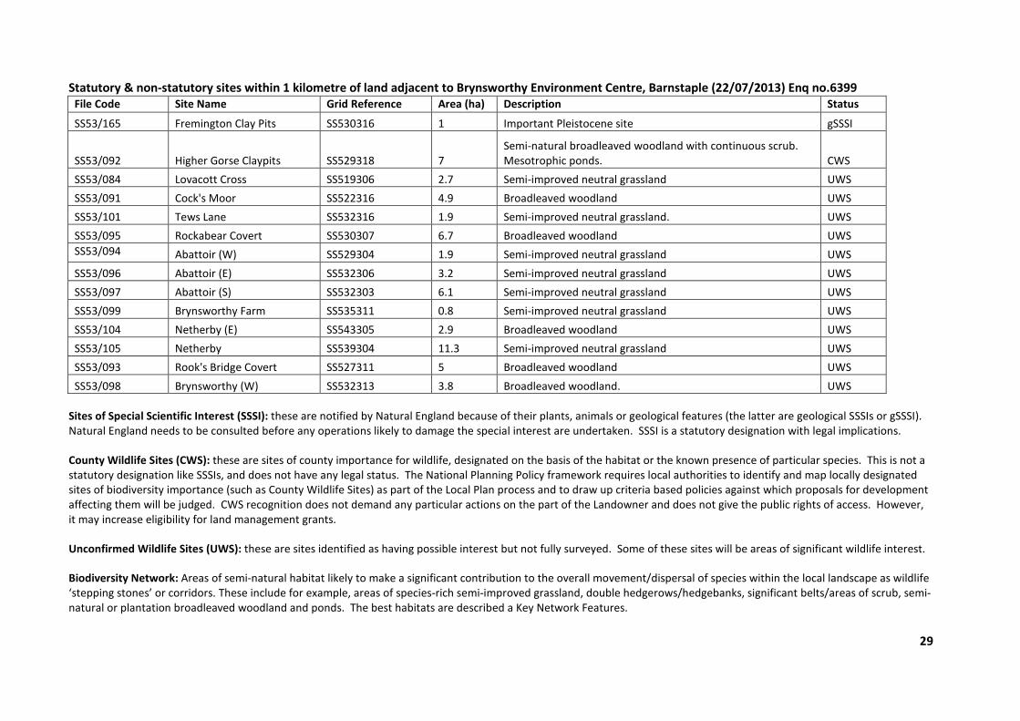
Statutory & non-statutory sites within 1 kilometre of land adjacent to Brynsworthy Environment Centre, Barnstaple (22/07/2013) Enq no.6399
File Code Site Name Grid Reference Area (ha) Description Status
SS53/165 Fremington Clay Pits SS530316 1 Important Pleistocene site gSSSI
SS53/092 Higher Gorse Claypits SS529318 7
Semi-natural broadleaved woodland with continuous scrub.
Mesotrophic ponds. CWS
SS53/084 Lovacott Cross SS519306 2.7 Semi-improved neutral grassland UWS
SS53/091 Cock's Moor SS522316 4.9 Broadleaved woodland UWS
SS53/101 Tews Lane SS532316 1.9 Semi-improved neutral grassland. UWS
SS53/095 Rockabear Covert SS530307 6.7 Broadleaved woodland UWS
SS53/094 Abattoir (W) SS529304 1.9 Semi-improved neutral grassland UWS
SS53/096 Abattoir (E) SS532306 3.2 Semi-improved neutral grassland UWS
SS53/097 Abattoir (S) SS532303 6.1 Semi-improved neutral grassland UWS
SS53/099 Brynsworthy Farm SS535311 0.8 Semi-improved neutral grassland UWS
SS53/104 Netherby (E) SS543305 2.9 Broadleaved woodland UWS
SS53/105 Netherby SS539304 11.3 Semi-improved neutral grassland UWS
SS53/093 Rook's Bridge Covert SS527311 5 Broadleaved woodland UWS
SS53/098 Brynsworthy (W) SS532313 3.8 Broadleaved woodland. UWS
Sites of Special Scientific Interest (SSSI): these are notified by Natural England because of their plants, animals or geological features (the latter are geological SSSIs or gSSSI).
Natural England needs to be consulted before any operations likely to damage the special interest are undertaken. SSSI is a statutory designation with legal implications.
County Wildlife Sites (CWS): these are sites of county importance for wildlife, designated on the basis of the habitat or the known presence of particular species. This is not a
statutory designation like SSSIs, and does not have any legal status. The National Planning Policy framework requires local authorities to identify and map locally designated
sites of biodiversity importance (such as County Wildlife Sites) as part of the Local Plan process and to draw up criteria based policies against which proposals for development
affecting them will be judged. CWS recognition does not demand any particular actions on the part of the Landowner and does not give the public rights of access. However,
it may increase eligibility for land management grants.
Unconfirmed Wildlife Sites (UWS): these are sites identified as having possible interest but not fully surveyed. Some of these sites will be areas of significant wildlife interest.
Biodiversity Network: Areas of semi-natural habitat likely to make a significant contribution to the overall movement/dispersal of species within the local landscape as wildlife
‘stepping stones’ or corridors. These include for example, areas of species-rich semi-improved grassland, double hedgerows/hedgebanks, significant belts/areas of scrub, semi-
natural or plantation broadleaved woodland and ponds. The best habitats are described a Key Network Features.
30
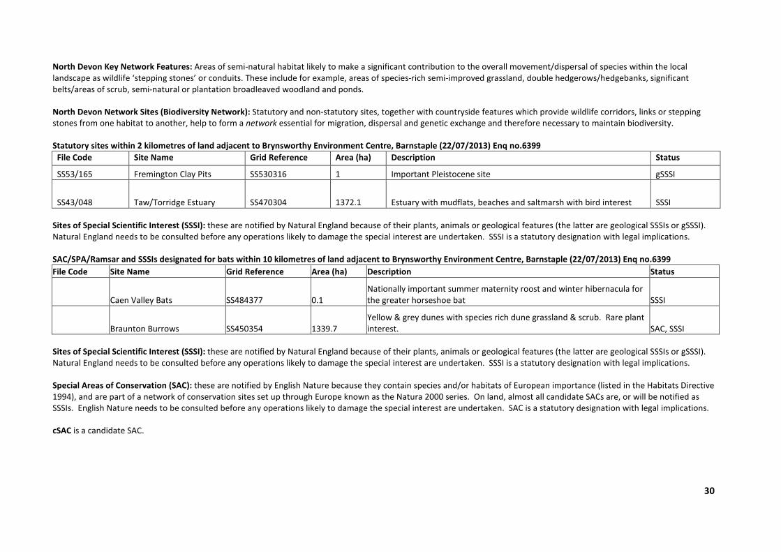
North Devon Key Network Features: Areas of semi-natural habitat likely to make a significant contribution to the overall movement/dispersal of species within the local
landscape as wildlife ‘stepping stones’ or conduits. These include for example, areas of species-rich semi-improved grassland, double hedgerows/hedgebanks, significant
belts/areas of scrub, semi-natural or plantation broadleaved woodland and ponds.
North Devon Network Sites (Biodiversity Network): Statutory and non-statutory sites, together with countryside features which provide wildlife corridors, links or stepping
stones from one habitat to another, help to form a network essential for migration, dispersal and genetic exchange and therefore necessary to maintain biodiversity.
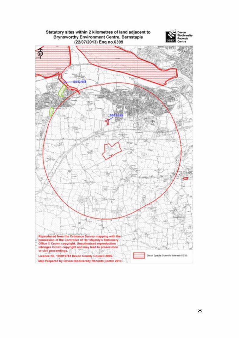
Statutory sites within 2 kilometres of land adjacent to Brynsworthy Environment Centre, Barnstaple (22/07/2013) Enq no.6399
File Code Site Name Grid Reference Area (ha) Description Status
SS53/165 Fremington Clay Pits SS530316 1 Important Pleistocene site gSSSI
SS43/048 Taw/Torridge Estuary SS470304 1372.1 Estuary with mudflats, beaches and saltmarsh with bird interest SSSI
Sites of Special Scientific Interest (SSSI): these are notified by Natural England because of their plants, animals or geological features (the latter are geological SSSIs or gSSSI).
Natural England needs to be consulted before any operations likely to damage the special interest are undertaken. SSSI is a statutory designation with legal implications.
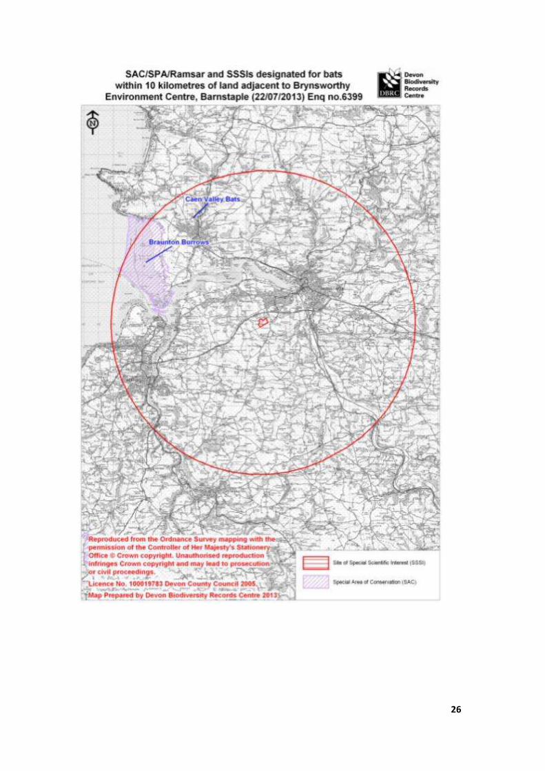
SAC/SPA/Ramsar and SSSIs designated for bats within 10 kilometres of land adjacent to Brynsworthy Environment Centre, Barnstaple (22/07/2013) Enq no.6399
File Code Site Name Grid Reference Area (ha) Description Status
Caen Valley Bats SS484377 0.1
Nationally important summer maternity roost and winter hibernacula for
the greater horseshoe bat SSSI
Braunton Burrows SS450354 1339.7
Yellow & grey dunes with species rich dune grassland & scrub. Rare plant
interest. SAC, SSSI
Sites of Special Scientific Interest (SSSI): these are notified by Natural England because of their plants, animals or geological features (the latter are geological SSSIs or gSSSI).
Natural England needs to be consulted before any operations likely to damage the special interest are undertaken. SSSI is a statutory designation with legal implications.
Special Areas of Conservation (SAC): these are notified by English Nature because they contain species and/or habitats of European importance (listed in the Habitats Directive
1994), and are part of a network of conservation sites set up through Europe known as the Natura 2000 series. On land, almost all candidate SACs are, or will be notified as
SSSIs. English Nature needs to be consulted before any operations likely to damage the special interest are undertaken. SAC is a statutory designation with legal implications.
cSAC is a candidate SAC.

31
Legally protected & notable species records within 1 kilometre of land adjacent to Brynsworthy Environment Centre, Barnstaple (22/07/2013) Enq no.6399
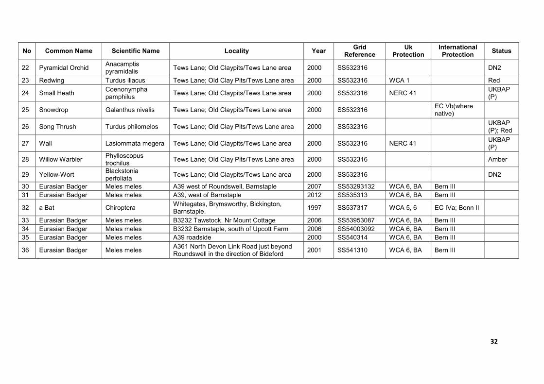
No Common Name Scientific Name Locality Year Grid
Reference Uk
Protection International Protection
Status
1 Grayling Hipparchia semele 1995 SS528318 NERC 41 UKBAP (P)
2 Wall Lasiommata megera 1995 SS528318 NERC 41 UKBAP (P)
3 Eurasian Badger Meles meles A39 south-west of Barnstaple. 2003-2005
SS530313 WCA 6, BA Bern III
4 Eurasian Badger Meles meles A361 2000 SS532313 WCA 6, BA Bern III
5 European Otter Lutra lutra A39 Brynworthy. Small stream flowing into Fremington Pill [Middle Taw]
1999 SS532313 WCA 5; NERC 41
EC IIa, IIIa; Bern II
UKBAP (P); DBAP
6 Barn Owl Tyto alba Tews Lane; Old Clay Pits/Tews Lane area 2000 SS532316 WCA 1, 9 DBAP; Amber
7 Barn Swallow Hirundo rustica Tews Lane; Old Clay Pits/Tews Lane area 2000 SS532316 Amber
8 Common Kestrel Falco tinnunculus Tews Lane; Old Clay Pits/Tews Lane area 2000 SS532316 Amber
9 Common Linnet Carduelis cannabina Tews Lane; Old Clay Pits/Tews Lane area 2000 SS532316 UKBAP (P); Red
10 Common Snipe Gallinago gallinago Tews Lane; Old Clay Pits/Tews Lane area 2000 SS532316 Amber
11 Common Swift Apus apus Tews Lane; Old Clay Pits/Tews Lane area 2000 SS532316 Amber
12 Dunnock Prunella modularis Tews Lane; Old Clay Pits/Tews Lane area 2000 SS532316 Amber
13 Eurasian Curlew Numenius arquata Tews Lane; Old Clay Pits/Tews Lane area 2000 SS532316 NERC 41
UKBAP (P); DBAP; Amber
14 Fieldfare Turdus pilaris Tews Lane; Old Clay Pits/Tews Lane area 2000 SS532316 WCA 1 Red
15 Green Sandpiper Tringa ochropus Tews Lane; Old Clay Pits/Tews Lane area 2000 SS532316 WCA 1 Amber
16 Green Woodpecker Picus viridis Tews Lane; Old Clay Pits/Tews Lane area 2000 SS532316 Amber
17 House Martin Delichon urbica Tews Lane; Old Clay Pits/Tews Lane area 2000 SS532316 Amber
18 Mallard Anas platyrhynchos Tews Lane; Old Clay Pits/Tews Lane area 2000 SS532316 Amber
19 Meadow Pipit Anthus pratensis Tews Lane; Old Clay Pits/Tews Lane area 2000 SS532316 Amber
20 Mistle Thrush Turdus viscivorus Tews Lane; Old Clay Pits/Tews Lane area 2000 SS532316 Amber
21 Primrose Primula vulgaris Tews Lane; Old Claypits/Tews Lane area 2000 SS532316 DBAP
32
No Common Name Scientific Name Locality Year Grid
Reference Uk
Protection International Protection
Status
22 Pyramidal Orchid Anacamptis pyramidalis
Tews Lane; Old Claypits/Tews Lane area 2000 SS532316 DN2
23 Redwing Turdus iliacus Tews Lane; Old Clay Pits/Tews Lane area 2000 SS532316 WCA 1 Red
24 Small Heath Coenonympha pamphilus
Tews Lane; Old Claypits/Tews Lane area 2000 SS532316 NERC 41 UKBAP (P)
25 Snowdrop Galanthus nivalis Tews Lane; Old Claypits/Tews Lane area 2000 SS532316 EC Vb(where native)
26 Song Thrush Turdus philomelos Tews Lane; Old Clay Pits/Tews Lane area 2000 SS532316 UKBAP (P); Red
27 Wall Lasiommata megera Tews Lane; Old Claypits/Tews Lane area 2000 SS532316 NERC 41 UKBAP (P)
28 Willow Warbler Phylloscopus trochilus
Tews Lane; Old Clay Pits/Tews Lane area 2000 SS532316 Amber
29 Yellow-Wort Blackstonia perfoliata
Tews Lane; Old Claypits/Tews Lane area 2000 SS532316 DN2
30 Eurasian Badger Meles meles A39 west of Roundswell, Barnstaple 2007 SS53293132 WCA 6, BA Bern III
31 Eurasian Badger Meles meles A39, west of Barnstaple 2012 SS535313 WCA 6, BA Bern III
32 a Bat Chiroptera Whitegates, Brymsworthy, Bickington, Barnstaple.
1997 SS537317 WCA 5, 6 EC IVa; Bonn II
33 Eurasian Badger Meles meles B3232 Tawstock. Nr Mount Cottage 2006 SS53953087 WCA 6, BA Bern III
34 Eurasian Badger Meles meles B3232 Barnstaple, south of Upcott Farm 2006 SS54003092 WCA 6, BA Bern III
35 Eurasian Badger Meles meles A39 roadside 2000 SS540314 WCA 6, BA Bern III
36 Eurasian Badger Meles meles A361 North Devon Link Road just beyond Roundswell in the direction of Bideford
2001 SS541310 WCA 6, BA Bern III
33
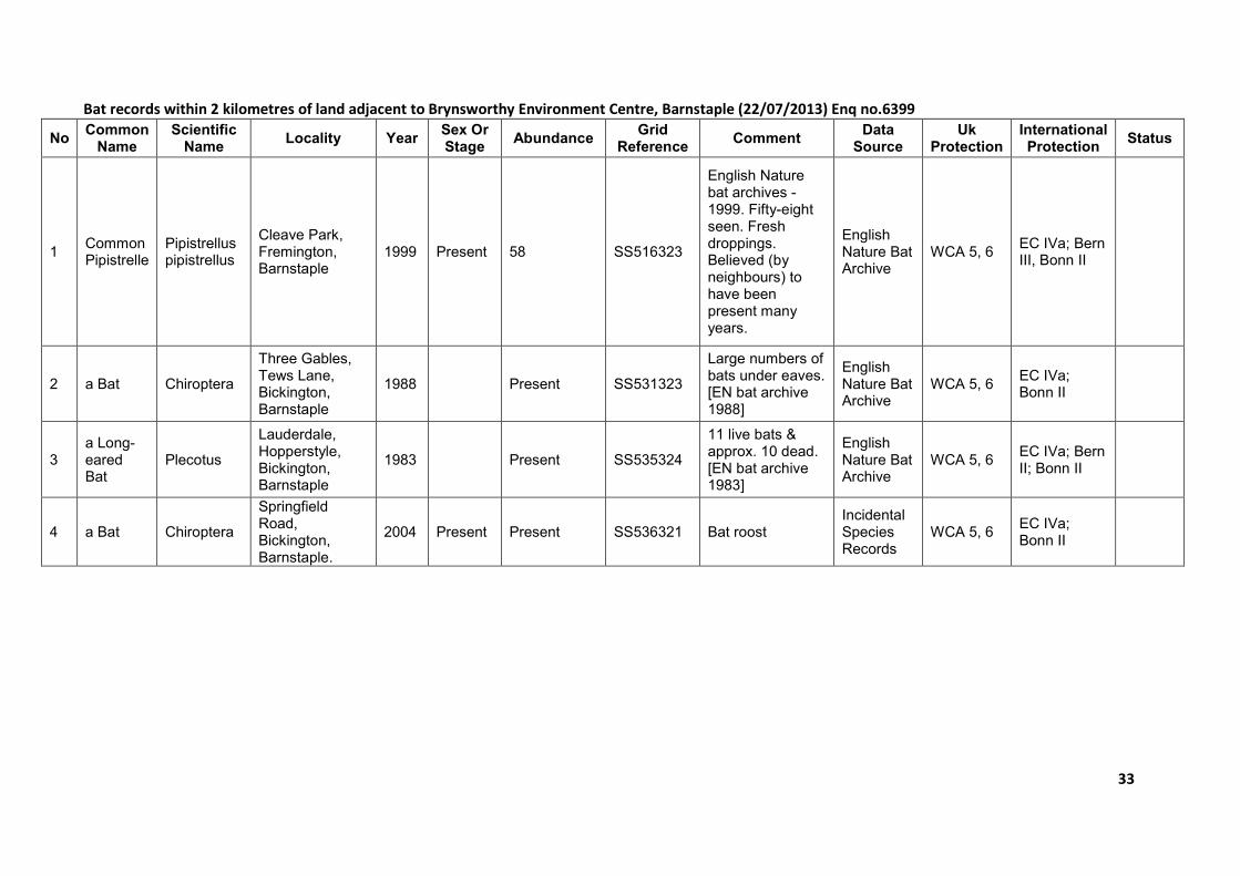
Bat records within 2 kilometres of land adjacent to Brynsworthy Environment Centre, Barnstaple (22/07/2013) Enq no.6399
No Common Name
Scientific Name
Locality Year Sex Or Stage
Abundance Grid
Reference Comment
Data Source
Uk Protection
International Protection
Status
1 Common Pipistrelle
Pipistrellus pipistrellus
Cleave Park, Fremington, Barnstaple
1999 Present 58 SS516323
English Nature bat archives - 1999. Fifty-eight seen. Fresh droppings. Believed (by neighbours) to have been present many years.
English Nature Bat Archive
WCA 5, 6 EC IVa; Bern III, Bonn II
2 a Bat Chiroptera
Three Gables, Tews Lane, Bickington, Barnstaple
1988 Present SS531323
Large numbers of bats under eaves. [EN bat archive 1988]
English Nature Bat Archive
WCA 5, 6 EC IVa; Bonn II
3 a Long-eared Bat
Plecotus
Lauderdale, Hopperstyle, Bickington, Barnstaple
1983 Present SS535324
11 live bats & approx. 10 dead. [EN bat archive 1983]
English Nature Bat Archive
WCA 5, 6 EC IVa; Bern II; Bonn II
4 a Bat Chiroptera
Springfield Road, Bickington, Barnstaple.
2004 Present Present SS536321 Bat roost Incidental Species Records
WCA 5, 6 EC IVa; Bonn II
34
No Common Name
Scientific Name
Locality Year Sex Or Stage
Abundance Grid
Reference Comment
Data Source
Uk Protection
International Protection
Status
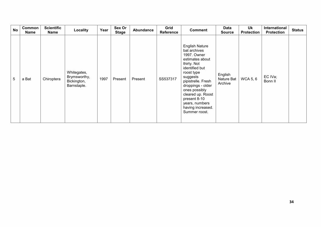
5 a Bat Chiroptera
Whitegates, Brymsworthy, Bickington, Barnstaple.
1997 Present Present SS537317
English Nature bat archives 1997. Owner estimates about thirty. Not identified but roost type suggests pipistrelle. Fresh droppings - older ones possibly cleared up. Roost present 8-10 years, numbers having increased. Summer roost.
English Nature Bat Archive
WCA 5, 6 EC IVa; Bonn II
35
No Common Name
Scientific Name
Locality Year Sex Or Stage
Abundance Grid
Reference Comment
Data Source
Uk Protection
International Protection
Status
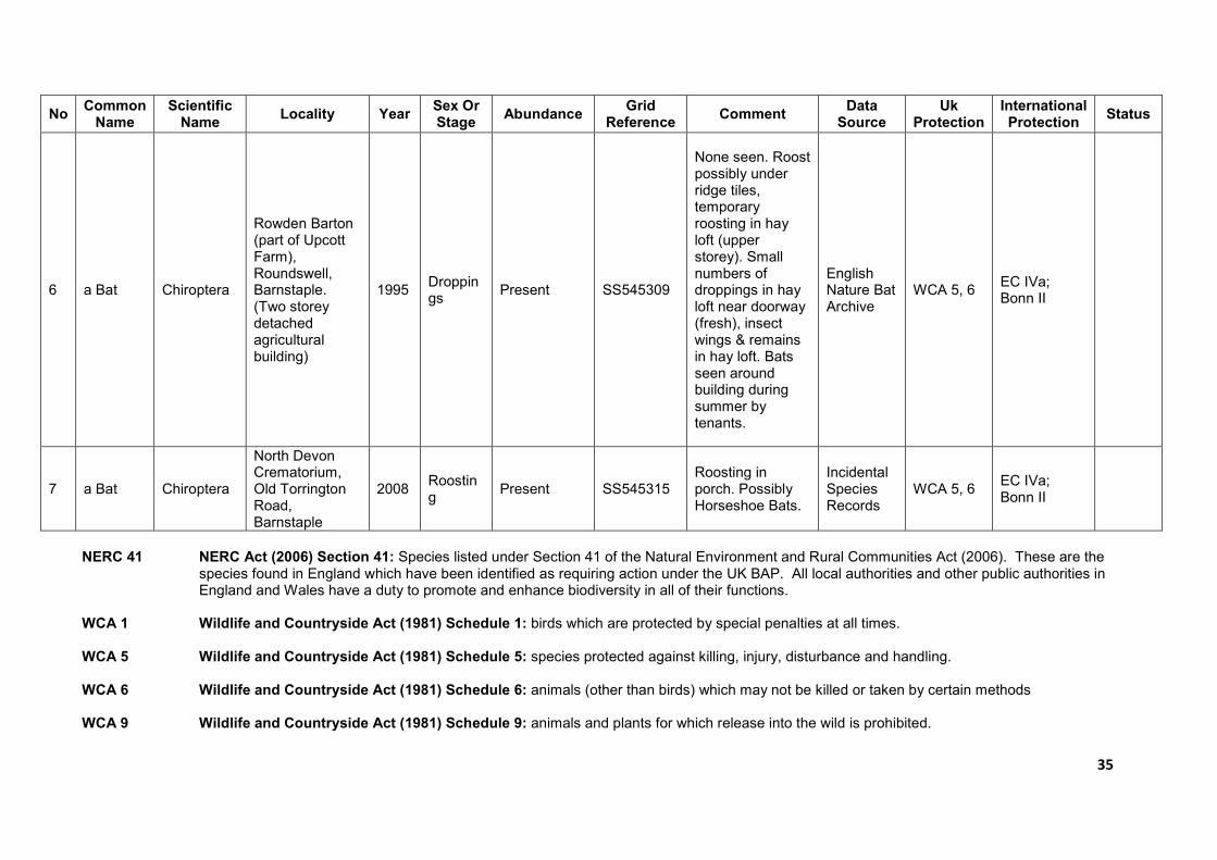
6 a Bat Chiroptera
Rowden Barton (part of Upcott Farm), Roundswell, Barnstaple. (Two storey detached agricultural building)
1995 Droppings
Present SS545309
None seen. Roost possibly under ridge tiles, temporary roosting in hay loft (upper storey). Small numbers of droppings in hay loft near doorway (fresh), insect wings & remains in hay loft. Bats seen around building during summer by tenants.
English Nature Bat Archive
WCA 5, 6 EC IVa; Bonn II
7 a Bat Chiroptera
North Devon Crematorium, Old Torrington Road, Barnstaple
2008 Roosting
Present SS545315 Roosting in porch. Possibly Horseshoe Bats.
Incidental Species Records
WCA 5, 6 EC IVa; Bonn II
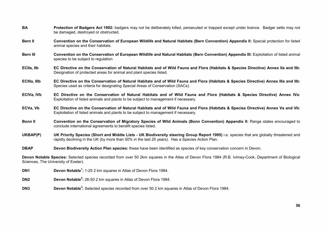
NERC 41 NERC Act (2006) Section 41: Species listed under Section 41 of the Natural Environment and Rural Communities Act (2006). These are the species found in England which have been identified as requiring action under the UK BAP. All local authorities and other public authorities in England and Wales have a duty to promote and enhance biodiversity in all of their functions.
WCA 1 Wildlife and Countryside Act (1981) Schedule 1: birds which are protected by special penalties at all times. WCA 5 Wildlife and Countryside Act (1981) Schedule 5: species protected against killing, injury, disturbance and handling. WCA 6 Wildlife and Countryside Act (1981) Schedule 6: animals (other than birds) which may not be killed or taken by certain methods WCA 9 Wildlife and Countryside Act (1981) Schedule 9: animals and plants for which release into the wild is prohibited.
36
BA Protection of Badgers Act 1992: badgers may not be deliberately killed, persecuted or trapped except under licence. Badger setts may not be damaged, destroyed or obstructed.
Bern II Convention on the Conservation of European Wildlife and Natural Habitats (Bern Convention) Appendix II: Special protection for listed
animal species and their habitats. Bern III Convention on the Conservation of European Wildlife and Natural Habitats (Bern Convention) Appendix III: Exploitation of listed animal
species to be subject to regulation ECIIa, IIb EC Directive on the Conservation of Natural Habitats and of Wild Fauna and Flora (Habitats & Species Directive) Annex IIa and IIb:
Designation of protected areas for animal and plant species listed. ECIIIa, IIIb EC Directive on the Conservation of Natural Habitats and of Wild Fauna and Flora (Habitats & Species Directive) Annex IIIa and IIb:
Species used as criteria for designating Special Areas of Conservation (SACs). ECIVa, IVb EC Directive on the Conservation of Natural Habitats and of Wild Fauna and Flora (Habitats & Species Directive) Annex IVa:
Exploitation of listed animals and plants to be subject to management if necessary. ECVa, Vb EC Directive on the Conservation of Natural Habitats and of Wild Fauna and Flora (Habitats & Species Directive) Annex Va and Vb:
Exploitation of listed animals and plants to be subject to management if necessary. Bonn II Convention on the Conservation of Migratory Species of Wild Animals (Bonn Convention) Appendix II: Range states encouraged to
conclude international agreements to benefit species listed. UKBAP(P) UK Priority Species (Short and Middle Lists - UK Biodiversity steering Group Report 1995) i.e. species that are globally threatened and
rapidly declining in the UK (by more than 50% in the last 25 years). Has a Species Action Plan. DBAP Devon Biodiversity Action Plan species: these have been identified as species of key conservation concern in Devon. Devon Notable Species: Selected species recorded from over 50 2km squares in the Atlas of Devon Flora 1984 (R.B. Ivimey-Cook, Department of Biological Sciences, The University of Exeter). DN1 Devon Notable
1: 1-25 2 km squares in Atlas of Devon Flora 1984.
DN2 Devon Notable
2: 26-50 2 km squares in Atlas of Devon Flora 1984.
DN3 Devon Notable
3: Selected species recorded from over 50 2 km squares in Atlas of Devon Flora 1984.
37
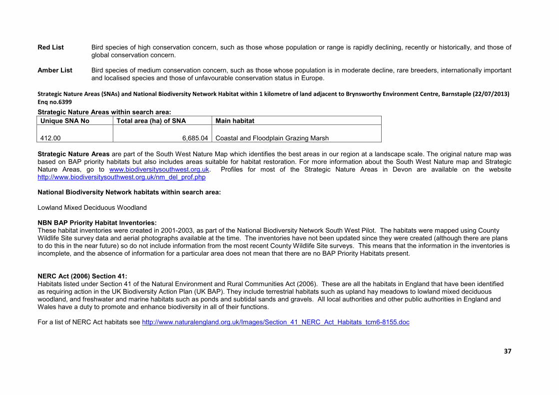
Red List Bird species of high conservation concern, such as those whose population or range is rapidly declining, recently or historically, and those of global conservation concern.
Amber List Bird species of medium conservation concern, such as those whose population is in moderate decline, rare breeders, internationally important
and localised species and those of unfavourable conservation status in Europe.
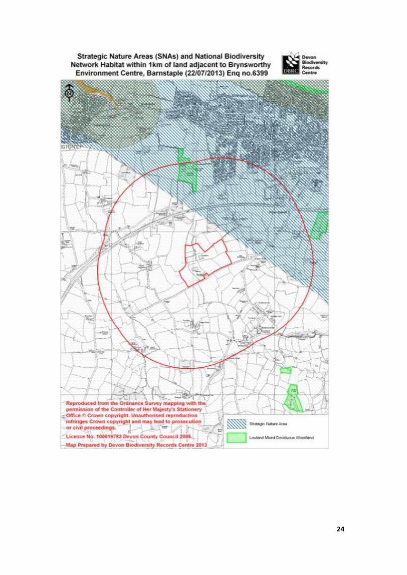
Strategic Nature Areas (SNAs) and National Biodiversity Network Habitat within 1 kilometre of land adjacent to Brynsworthy Environment Centre, Barnstaple (22/07/2013)
Enq no.6399
Strategic Nature Areas within search area:
Unique SNA No Total area (ha) of SNA Main habitat
412.00 6,685.04 Coastal and Floodplain Grazing Marsh
Strategic Nature Areas are part of the South West Nature Map which identifies the best areas in our region at a landscape scale. The original nature map was based on BAP priority habitats but also includes areas suitable for habitat restoration. For more information about the South West Nature map and Strategic Nature Areas, go to www.biodiversitysouthwest.org.uk. Profiles for most of the Strategic Nature Areas in Devon are available on the website http://www.biodiversitysouthwest.org.uk/nm_del_prof.php National Biodiversity Network habitats within search area: Lowland Mixed Deciduous Woodland NBN BAP Priority Habitat Inventories: These habitat inventories were created in 2001-2003, as part of the National Biodiversity Network South West Pilot. The habitats were mapped using County Wildlife Site survey data and aerial photographs available at the time. The inventories have not been updated since they were created (although there are plans to do this in the near future) so do not include information from the most recent County Wildlife Site surveys. This means that the information in the inventories is incomplete, and the absence of information for a particular area does not mean that there are no BAP Priority Habitats present. NERC Act (2006) Section 41: Habitats listed under Section 41 of the Natural Environment and Rural Communities Act (2006). These are all the habitats in England that have been identified as requiring action in the UK Biodiversity Action Plan (UK BAP). They include terrestrial habitats such as upland hay meadows to lowland mixed deciduous woodland, and freshwater and marine habitats such as ponds and subtidal sands and gravels. All local authorities and other public authorities in England and Wales have a duty to promote and enhance biodiversity in all of their functions. For a list of NERC Act habitats see http://www.naturalengland.org.uk/Images/Section_41_NERC_Act_Habitats_tcm6-8155.doc

38
Braunton Burrows SAC qualifying features
Annex I habitats that are a primary reason for selection of this site
2120 Shifting dunes along the shoreline with Ammophila arenaria (`white dunes`)
This large site in south-west England contains a substantial area of mobile dune vegetation,
including representative examples of most of the main variants found in the south-west of the UK.
There are good numbers of characteristic specialist plants typical of this region, such as Portland
spurge Euphorbia portlandica, sea spurge Euphorbia paralias and sea-holly Eryngium maritimum.
Transitions to dune slack and fixed dune are a prominent feature of this site.
2130 Fixed dunes with herbaceous vegetation (`grey dunes`) * Priority feature
Braunton Burrows, in south-west England, is one of the largest dune sites in the UK and is of
particular importance because it is virtually intact and still active. There are very extensive areas of
species-rich calcareous dune grassland with good examples of a variety of important communities.
The short turf areas are extremely rich in herbs and lichens, including a number of nationally rare
species. Flowering herbs such as large thyme Thymus pulegioides, common restharrow Ononis
repens and common bird’s-foot-trefoil Lotus corniculatus are locally dominant.
2170 Dunes with Salix repens ssp. argentea (Salicion arenariae)
Braunton Burrows is one of the largest virtually intact dune sites in the UK and is representative of
dunes with Salix repens ssp. argentea in south-west England. The habitat is scattered across the site
and form part of a complex mosaic of vegetation containing creeping willow, including early and
mature successional stages of dune slack vegetation. There are transitional stages between this
type and more mature scrub vegetation.
2190 Humid dune slacks
Braunton Burrows is one of the largest virtually intact dune sites in the UK, with an exceptionally
large area of Humid dune slack vegetation, representing a significant proportion of the national
resource. The slacks have formed in base-rich sand and are rich in species such as marsh pennywort
Hydrocotyle vulgaris, marsh helleborine Epipactis palustris and round-leaved wintergreen Pyrola
rotundifolia. Vegetation types range from those with almost permanent water to those dominated
by scrub. The site contains representative examples of most of the communities of base-rich humid
slacks in south-west England, namely those characterised by creeping willow Salix repens ssp.
argentea, those with bryophytes or those with Yorkshire-fog Holcus lanatus.
Annex I habitats present as a qualifying feature, but not a primary reason for selection of this site
1140 Mudflats and sandflats not covered by seawater at low tide
Annex II species that are a primary reason for selection of this site
1395 Petalwort Petalophyllum ralfsii
A large population (around 3000 thalli) of petalwort Petalophyllum ralfsii is recorded from Braunton
Burrows, one of two sites selected for this species in south-west England. There are extensive open
dune slack habitats of the types required by this species for survival.

39
Braunton Burrows SSSi citation

40

41
Taw\Torridge Estuary SSSI citation
Related Documents