ECOLOGICAL AND SOCIAL IMPLICATIONS OF HYDROPOWER DEVELOPMENT ON A NEOTROPICAL RIVER SYSTEM, COSTA RICA by ELIZABETH ANDERSON OLIVAS (Under the Direction of Catherine M. Pringle) ABSTRACT The Sarapiquí River system is one of several watersheds in Costa Rica currently undergoing rapid hydropower development. As of 2004, eight hydropower plants are in operation, one project is under construction, and additional hydropower developments are being planned for the Sarapiquí. This dissertation examined hydropower development in Sarapiquí at national, watershed, and local scales. At a national / regional scale, this study showed that partial privatization of electricity generation during the past two decades has driven hydropower development in Sarapiquí and on other Central American river systems. In Costa Rica, ~28 private hydropower plants have been constructed since 1990; six of these are located in the Sarapiquí watershed. At a watershed scale, I examined the cumulative effects of hydropower development on the hydrologic connectivity of the Sarapiquí River system. Hydropower plants have dewatered 30.9 river kilometers in Sarapiquí and roughly 10% of stream length in the watershed is now located upstream from dams. The cumulative effects of hydropower development on the ecological integrity of the watershed may interact with the effects of other human disturbances in the watershed, such as deforestation and increasing fishing pressures. On a local scale, I examined the effects of the Doña Julia Hydroelectric Center on stream fish

Welcome message from author
This document is posted to help you gain knowledge. Please leave a comment to let me know what you think about it! Share it to your friends and learn new things together.
Transcript
ECOLOGICAL AND SOCIAL IMPLICATIONS OF HYDROPOWER DEVELOPMENT ON
A NEOTROPICAL RIVER SYSTEM, COSTA RICA
by
ELIZABETH ANDERSON OLIVAS
(Under the Direction of Catherine M. Pringle)
ABSTRACT
The Sarapiquí River system is one of several watersheds in Costa Rica currently
undergoing rapid hydropower development. As of 2004, eight hydropower plants are in
operation, one project is under construction, and additional hydropower developments are being
planned for the Sarapiquí. This dissertation examined hydropower development in Sarapiquí at
national, watershed, and local scales. At a national / regional scale, this study showed that partial
privatization of electricity generation during the past two decades has driven hydropower
development in Sarapiquí and on other Central American river systems. In Costa Rica, ~28
private hydropower plants have been constructed since 1990; six of these are located in the
Sarapiquí watershed. At a watershed scale, I examined the cumulative effects of hydropower
development on the hydrologic connectivity of the Sarapiquí River system. Hydropower plants
have dewatered 30.9 river kilometers in Sarapiquí and roughly 10% of stream length in the
watershed is now located upstream from dams. The cumulative effects of hydropower
development on the ecological integrity of the watershed may interact with the effects of other
human disturbances in the watershed, such as deforestation and increasing fishing pressures. On
a local scale, I examined the effects of the Doña Julia Hydroelectric Center on stream fish
assemblages of the upper Puerto Viejo River. The presence of a diversion dam influenced fish
assemblage composition near the dam and along a dewatered reach of stream. This dissertation
also examined socio-environmental conflicts associated with hydropower development in
Sarapiquí. Here, I document the multiple uses of the Sarapiquí River and examine the role of
hydropower as a catalyst for river conservation activities in the watershed. The case study
presented in this dissertation may be applicable to other tropical watersheds currently undergoing
hydropower development.
INDEX WORDS: hydropower, dams, Costa Rica, tropical, fish, stream ecology,
cumulative effects assessment, conservation
ECOLOGICAL AND SOCIAL IMPLICATIONS OF HYDROPOWER DEVELOPMENT ON
A NEOTROPICAL RIVER SYSTEM, COSTA RICA
by
ELIZABETH ANDERSON OLIVAS
B.A., The University of Georgia, 1998
A Dissertation Submitted to the Graduate Faculty of the University of Georgia in Partial
Fulfillment for the Requirements of the Degree
DOCTOR OF PHILOSOPHY
ATHENS, GEORGIA
2004

2004
Elizabeth Anderson Olivas
All Rights Reserved
ECOLOGICAL AND SOCIAL IMPLICATIONS OF HYDROPOWER DEVELOPMENT ON
A NEOTROPICAL RIVER SYSTEM, COSTA RICA
by
ELIZABETH ANDERSON OLIVAS
Approved:
Major Professor: Catherine M. Pringle
Committee: Mary C. Freeman Judy L. Meyer
C. Ronald Carroll Benjamin Blount
Electronic Version Approved: Maureen Grasso Dean of the Graduate School The University of Georgia May 2004

iv
DEDICATION
Para la gente de Sarapiquí. Mil gracias por su apoyo y espero que sigan luchando para conservar
la belleza natural del Río Sarapiquí.

v
ACKNOWLEDGEMENTS
This dissertation would not have been possible without the assistance and encouragement
from many people. Above all, I would like to thank my adviser Cathy Pringle, for the many
opportunities she has given me and for her constant support over the past six years. My life has
changed since I met Cathy and I am grateful that she took a chance many years ago and offered
me a position in her lab. Also, I would like to thank Mary Freeman for her patience and advice.
I appreciate her dedication to her students and the long hours she spent helping me with this
project. Thanks also to the other members of my committee, Judy Meyer, Ron Carroll, and Ben
Blount. Their expertise and guidance has been invaluable throughout my graduate career.
Many thanks go to the various organizations that funded the research presented in this
dissertation. Above all, I wish to acknowledge the Fulbright Association for providing me with
the opportunity to spend a year in Costa Rica. I also acknowledge the Organization for Tropical
Studies and to the UGA Women’s Club for additional research support. Funds from a National
Science Foundation grant (DEB-0075339) to C.M. Pringle and F.J. Triska provided indirect
assistance to this project, as did a University-wide Assistantship, a Costa Rica Ecology Program
TA, and a Dissertation Completion Award.
I would like to acknowledge those who live and work in Sarapiquí, Costa Rica for
welcoming me into their community and for helping me to design a unique and applicable
research project. Special thanks go to Orlando Vargas, Rosa Sandoval, and Rocio Lopez who
helped me during the initial phase of this project. Thanks also to the Doña Julia Hydroelectric
Company, especially Rafael Corrales and Antonio Sevilla for collaborating with me on this

vi
study. Also, I thank the workers and researchers at La Selva Biological Station for friendship
and support, especially Ademar Hurtado, Marlene Oconitrillo, Tonio Ezeta, and Antonio
Trabucco. Furthermore, thanks to ‘las lindas,’ Corine Vriesendorp, Cat Cardelus, Alex Reich,
and Patricia Brennan, for laughter, inspiration, and encouragement in the field. This project
would not have been nearly as enjoyable without you.
Special thanks go to all those who helped with fieldwork for this project. Above all, I
acknowledge Minor Hidalgo, who taught me how to be organized and efficient in the field and
dedicated long hours to this project. Thanks also to Enrique Salicetti, William Ureña, Jose
Reñazco, Suzanne Moellendorf, Miriam Ramos, Heather Conwell, Margaret Baltodano, and
Paulo Olivas for their help in the field.
The students, staff, and faculty of the Institute of Ecology, UGA were an invaluable
resource during my graduate career. I thank the Pringle Lab for providing a forum for discussion
and for feedback on research ideas and study results. Thanks to Misha Boyd, Lindsay Stallcup,
Jessica Seares, Rebekah Chapman, Diana Lieberman, Becky Bixby, and Erin Lindquist for their
friendship, advice, and encouragement.
Finally, I would like to thank my friends and family for supporting me over the past few
years. I thank my parents for their constant encouragment and inspiration, and my brothers, Jeff
and Greg, for making me laugh and for reminding me what is important in life. Además, muchas
gracias a mi familia tica, Ana Isabel, Raquel, y Alicia; su apoyo y amor han mejorado mi tiempo
en Costa Rica. Also, I hope that one day I will have the chance to reciprocate the support that
my friends Vivian, Alison, Michelle, and Shelley have given me throughout these five years.
Above all, special thanks to Paulo for his patience, love, and assistance throughout most of my
graduate career.
vii
TABLE OF CONTENTS
Page
ACKNOWLEDGEMENTS……………………………………………………………....…….....v
LIST OF TABLES………………………………………………………………………….…….ix
LIST OF FIGURES……………………………………………………………………………....xi
CHAPTER
1 GENERAL INTRODUCTION…………………………………………………...1
Project history and study scope……………………………………...…….2
2 AN ECOLOGICAL PERSPECTIVE ON ELECTRICITY PRIVATIZATION
AND HYDROPOWER IN CENTRAL AMERICA……..………………………..7
3 PREDICTING CUMULATIVE EFFECTS OF HYDROPOWER
DEVELOPMENT ON THE ECOLOGICAL INTEGRITY OF A TROPICAL
RIVER SYSTEM………………………………………………………………...26
4 IMPACTS OF A WATER DIVERSION DAM ON TROPICAL STREAM FISH
ASSEMBLAGES, COSTA RICA……………………………………………….69
5 HYDROPOWER DEVELOPMENT AS A CATALYST FOR CONSERVATION
OF A COMMON-POOL RESOURCE IN SARAPIQUI, COSTA RICA…..…104
6 GENERAL CONCLUSIONS AND RESEARCH
RECOMMENDATIONS……………………………………………….………143
APPENDIX 1: STRAHLER ORDINATION OF DAMMED SUB-BASINS OF THE
SARAPIQUÍ RIVER WATERSHED…………………………………………………………..149

viii
APPENDIX 2: LAND COVER IN DAMMED SUB-BASINS OF THE SARAPIQUÍ
WATERSHED………………………………………………………………………………...159
ix
LIST OF TABLES
Table 2.1. Summary of recent legislation related to electricity privatization in Central American countries. Source: Economic Commission for Latin America and the Caribbean (1996); Energy Information Administration (2002)………………………………………………………………25 Table 3.1. Selected examples from the scientific literature of attempts to analyze cumulative effects of dams…………………………………………………………………………………...55 Table 3.2. Hydropower plants in operation in the Sarapiqui River watershed………………….56 Table 3.3. River kilometers dewatered as a result of hydropower project operations…………..57 Table 3.4. Kilometers of river and forest cover upstream from dams in the Sarapiqui watershed. % total refers to the percentage of total km of that order of streams in the entire Sarapiqui watershed………………………………………………………………………………………...58 Table 3.5. Projected impacts of Cariblanco Hydropower Project on connectivity in the Sarapiqui River watershed. % total refers to the percentage of total km of that order of streams in the entire Sarapiqui watershed……………………………………………………………………………...59 Table 3.6. Conversion of forest to other land uses in Sarapiqui County between 1976 and 1996. Adapted from Sanchez-Azofeifa et al. 1999……………………………………………………..60 Table 3.7. Legal vs. illegal fishing methods in the Sarapiquí watershed………………………..61 Table 4.1. List of families and species of fish captured in the upper Puerto Viejo River and the Quebradon stream, Costa Rica during 2001-02 as a part of this study…………………………..92 Table 4.2. Species presence/absence along the dewatered reach of the Puerto Viejo River……93
Table 4.3. Summary of selected habitat data from different sites (a) upstream and downstream from the dam (2001) and (b) at different distances downstream from the dam within the de-watered reach (2002)…………………………………………………………………………….94 Table 4.4. Characteristics of life history strategies and classification of Puerto Viejo River fishes by strategy……………………………………………………………………………………….95 Table 5.1. Chronology of population growth, changes in land use, and hydropower development in Sarapiquí, Costa Rica………………………………………………………………………...126 Table 5.2 Hydropower plants in operation in the Sarapiqui River watershed…………………127

x
Table 5.3. Results of formal interviews where 100 residents of Sarapiquí county were asked to rank (1-9) the following uses of river in terms of importance to the community and perceived environmental damage………………………………………………………………………….128
xi
LIST OF FIGURES
Figure 2.1. The seven Central American countries and major rivers that drain the region. The location of the El Cajon Dam (largest in Central America) and of the two largest dams in Costa Rica is highlighted on the map…………………………………………………………………...23 Figure 2.2. Existing and proposed private hydropower projects in Costa Rica. Most projects are located on gradient breaks and dam development has been concentrated on the San Carlos and Sarapiqui watersheds…………………………………………………………………………….24 Figure 3.1. The Sarapiquí river system drains part of the northern Caribbean slope of Costa Rica and encompasses an altitudinal gradient of ~3000 m to near sea level. It is one of 34 major watersheds in the country………………………………………………………………………...62 Figure 3.2. Hydropower development in Sarapiquí is concentrated in the upper watershed where there are abrupt changes in elevation. The location of eight existing hydropower projects is indicated with a red circle on the map. The site for the proposed Cariblanco hydropower project is indicated with a black triangle………………………………………………………………...63 Figure 3.3. Schematic showing the operations of most hydropower projects in Sarapiqui. A dam(s) blocks flow and diverts water into a tunnel or pipeline to a reservoir. Water is run down a gradient to turbines and used to generate electricity and then returned to the river…………...64 Figure 3.4. Strahler ordination of streams upstream from the Suerkata hydropower project on the Sarapiqui River…………………………………………………………………………………..65 Figure 3.5. Strahler ordination of streams upstream from the Suerkata hydropower project on the Sarapiqui River…………………………………………………………………………………..66 Figure 3.6. The total number of stream km dewatered increased with the construction of each additional hydropower plant. However, the number of km dewatered doesn’t correspond uniformly to the number of megawatts of electricity produced………………………………….67 Figure 3.7. The percentage of stream length in the watershed that is upstream from dams increased with the construction of each additional hydropower project…………………………68 Figure 4.1. The upper Puerto Viejo River and the Quebradon stream are used for hydropower production by the Doña Julia hydropower project. The location of the project’s two dams and turbine house are indicated on the map…………………………………………………………..96 Figure 4.2. Diversion dam on the Puerto Viejo River that is part of the Doña Julia hydropower project……………………………………………………………………………………………97
xii
Figure 4.3. Schematic of the Doña Julia Hydroelectric Center…………………………………98
Figure 4.4. Fluctuations in (a) stage height and (b) temperature below the water release from the dam on the Puerto Viejo River…………………………………………………………………..99 Figure 4.5. NMS ordination of 2001 fish data shows three distinct groupings………………..100
Figure 4.6. Estimated fish species richness with increasing downstream distance from the dam……………………………………………………………………………………101 Figure 4.7. Number of individual fish versus downstream distance from the dam on the Puerto Viejo River……………………………………………………………………………………...102 Figure 4.8. Number of fish species in pools vs. downstream distance from the dam along the de-watered reach of the Puerto Viejo River………………………………………………………..103 Figure 5.1. Map of Sarapiquí River watershed……………………………………...…………129
Figure 5.2. Photo of Sarapiqui River near the bridge to the town of Virgen del Socorro……..130
Figure 5.3. Cattle pasture (a) and pineapple plantations (b) are among the principal agricultural land uses in Sarapiquí, Costa Rica………………………………………………………...……131 Figure 5.4. Banana agriculture in Sarapiquí, Costa Rica……………………………...……….132
Figure 5.5. Map of Sarapiquí County, Costa Rica…………………………………………..…133
Figure 5.6. The Sarapiquí River is commonly used for swimming and attracts people from all over northeastern Costa Rica on Sundays and holidays………………………………..………134 Figure 5.7. Boats used for transportation and tourism on the Sarapiquí River downstream from the town of Puerto Viejo……..…………………………………………………………………135 Figure 5.8. A sign posted by ABAS along the banks of the Puerto Viejo River near Horquetas, Sarapiquí that gives information about the river and the Sarapiquí watershed…………...……136 Figure 5.9. Example of diversion dam operations……………………………………………..137
Figure 5.10. One of several signs posted downstream from the Doña Julia Hydroelectric Center on the Puerto Viejo River………………………………………………………………………138 Figure 5.11. Signs around the town of Puerto Viejo de Sarapiquí that urge opposition to the proposed La Virgen Hydropower Project………………………………………………………139

xiii
Figure 5.12. Flyer posted around the town of Puerto Viejo de Sarapiquí in 1999 informing local residents of hydropower development in the watershed and urging them to oppose further dam construction……………………………………………………………………………………..140 Figure 5.13. Flyer posted around Sarapiquí County in 2000 informing local residents of the plebescito, or community voting event………………………………………………………....141 Figure 5.14. Photo of Sarapiquí River downstream from the confluence of the Sucio River…142
1
CHAPTER 1:
GENERAL INTRODUCTION
This dissertation examines some of the ecological and social consequences of
hydropower development in the Sarapiquí River watershed, Costa Rica. Like many other river
systems in Costa Rica, the Sarapiquí has experienced a recent proliferation of dams for
hydropower. Since 1990, eight hydropower dam projects have been built in Sarapiquí and
several additional projects are in planning or construction stages. Dam construction in Sarapiquí
and other parts of Costa Rica is motivated by the country’s expanding human population
(presently at 4 million) and increasing demand for electricity, estimated at 6% annually. Unlike
most developing countries, the vast majority of Costa Ricans (97%) have electricity in their
homes. Hydropower is the primary source of this electricity, accounting for roughly 85% of
electricity produced domestically.
Worldwide, hydropower dams provide approximately one-fifth of electricity. However,
in many tropical developing countries, such as Costa Rica, hydropower satisfies nearly 100% of
electricity needs, and is perceived as an important link to national development (WCD 2000).
While the rate of dam building peaked in the U.S. during the middle of the last century, the
number of dams built per year is on the rise in many tropical, developing countries. In Costa
Rica, more than 30 dams were constructed during the 1990s. The majority of these dams are
small (<15 m high) and privately operated.
Hydropower dams have often been the subject of controversy due to their complex
environmental, social, political, and economic impacts. A substantial amount of
2
information exists on the effects of large dams on temperate rivers (Ward and Stanford 1979;
Goldsmith and Hildyard 1984; Dynesius and Nilsson 1994; Rosenberg et al. 1997; Pringle et al.
2000). Although small dams are a more pervasive feature in the landscape, their effects have not
been as well studied (Gleick 1992; Graf 1999). Moreover, studies of basic stream ecology and
the effects of dams are generally lacking for many tropical regions (Pringle et al. 2000). This
dissertation addresses these two gaps in the scientific literature and provides answers to
questions related to the effects of small dams on a tropical river system.
Project history and study scope
The research presented here actually began in 1998, when conservationists and
community leaders from Sarapiquí County, Costa Rica approached Dr. Catherine Pringle to
express their concerns about the impacts of rapid hydropower development on rivers in the
region. At that time, Dr. Pringle had been working on streams in Sarapiquí for about 15 years
(see www.arches.uga.edu/~cpringle; STREAMS project link) and was locally known for her
efforts to develop river conservation activities in the region (Laidlaw 1996; Vargas 1995;
Pohlman 1998; Pringle 1999). In the fall of 1998, while working with Dr. Pringle, I started
communicating with Orlando Vargas, an employee of La Selva Biological Station, which is
operated by the Organization for Tropical Studies (OTS) in Sarapiquí, Costa Rica. With the help
of Orlando and Rosa Sandoval, also an OTS employee at the time, I began collecting information
about hydropower development in the Sarapiquí watershed. In January 1999, I made my first
visit to Costa Rica to meet with OTS and other conservationists in Sarapiquí. In three days, I
visited many rivers in the watershed and interacted with community groups concerned about

3
further dam construction. I left Costa Rica with plans to return and investigate the ecological
and social impacts of hydropower development in Sarapiquí.
In June and July of 1999, I spent roughly six weeks in Costa Rica meeting with
stakeholders involved with hydropower development in Sarapiquí. Among the stakeholders
were the Costa Rican Institute of Electricity (ICE), the Minister of Environment and Energy
(MINAE), the Public Services Company of Heredia (ESPH), the Municipality of Sarapiquí, the
Association for the Environmental Well-Being of Sarapiquí (ABAS), the Sarapiquí Bureau of
Tourism (CATUSA), and many residents of Sarapiqui County. I also visited the Doña Julia
hydropower project, then under construction on the Puerto Viejo River, as well as the town of La
Virgen, where a hydropower project was being proposed by the ESPH. Based on these initial
informal interviews with stakeholders during my two visits to Costa Rica, I identified four major
questions that needed to be answered regarding hydropower development in the Sarapiquí
watershed. I spent the next four years (2000-2003) of my graduate career addressing these four
questions as reflected by the subsequent chapters of this dissertation.
Question 1: Why is the Sarapiquí watershed a target for rapid hydropower
development? In Chapter 2, I consider the importance of hydropower in Costa Rica and other
Central American countries. I also discuss private companies’ participation in electricity
generation in Central America and outline the ecological consequences of recent electricity
reforms. I then examine the relationship between partial privatization of electricity generation in
Costa Rica and rapid hydropower development in the Sarapiquí and other watersheds.
Question 2: What are the cumulative effects of multiple dams on the ecological
integrity of the Sarapiquí watershed? In Chapter 3, I present an approach to cumulative effects
assessment for the Sarapiquí River system, where little ecological data is available I examine the
4
cumulative effects of hydropower development on the hydrologic connectivity of the Sarapiquí
watershed by quantifying effects of eight dams on the watershed’s stream network and on
downstream hydrology. In addition, I predicted further losses in connectivity that will result
from the construction of a proposed hydropower project on the mainstem Sarapiquí River. This
chapter also considers other human activities that also affect rivers in the watershed and
discusses the possible interactive effects of these activities with hydropower development.
Question 3: What are the ecological effects of a diversion dam on a neotropical
stream? In Chapter 4, I examine the effects of the Doña Julia Hydroelectric Center on fish
assemblages and aquatic habitat in the upper Puerto Viejo River, a tributary of the Sarapiquí
River. The Doña Julia project is one of ~28 small water diversion dams in Costa Rica. To my
knowledge, this study is one of the first in Costa Rica, and perhaps Central America, to
investigate the ecological impacts of a diversion dam during operation.
Question 4: How important is the Sarapiquí River to human communities? In Chapter
5, I consider multiple human uses of rivers in the Sarapiquí watershed—including recreation,
transportation, tourism, water supply, irrigation, fishing, and hydroelectricity. I also discuss the
role of rivers as common pool resources (Hardin 1968; Ostrom 2002) and relate how the
Sarapiquí River is a source of cultural identity for long-term residents of the region.
Furthermore, I examine local responses of human communities to rapid hydropower
development and the subsequent emergence of socio-environmental conflicts in the Sarapiquí
watershed.
The material contained in this dissertation represents a case study of hydropower
development in Sarapiquí, Costa Rica. However, much of the information and the methodology
described here may be applicable to other watersheds in tropical, developing countries. My hope
5
is that the information presented here will be useful to hydropower developers, conservationists,
and local residents in Sarapiquí and other parts of the world facing similar development
situations.
Literature Cited Dynesius, M. and Nilsson, C. 1994. Fragmentation and flow regulation of river systems
in the northern third of the world. Science 266:753-762. Gleick, P.H. 1992. Environmental consequences of hydroelectric development: the role
of facility size and type. Energy 17(8):735-747 Goldsmith, E. and Hildyard, N. 1984. The social and environmental effects of large
dams. Wadbridge Ecological Centre, Camelford. 2 volumes. Graf, W.L. 1999. Dam nation: A geographic census of large American dams and their
hydrologic impacts. Water Resources Research 35:1305-1311. Hardin, G. 1968. The tragedy of the commons. Science 162: 1243-1248. Laidlaw, K.L. 1996. The implementation of a volunteer stream monitoring program in
Costa Rica. Master’s thesis, University of Georgia. Athens, GA. Ostrom, E. (ed). 2002. The Drama of the Commons. National Academy Press,
Washington, DC. 521 p. Pohlman, S.M. 1998. Towards implementation of community-led conservation in
lowland rainforest: the water for life program in Puerto Viejo de Sarapiquí, Costa Rica. Master’s thesis, University of Georgia. Athens, GA.
Pringle, C.M. 1999. Changing academic culture: interdisciplinary science-based graduate
programs to meet environmental challenges in freshwater ecosystems. Aquatic Conservation: Marine and Freshwater Ecosystems 9:615-620.
Pringle, C.M., Freeman, M.C., and Freeman, B.J. 2000. Regional effects of hydrologic
alterations on riverine macrobiota in the new world: tropical-temperate comparisons. BioScience 50(9):807-823.
Rosenberg, D.M., Berkes, F., Bodaly, R.A., Hecky, R.E., Kelly, C.A., and Rudd, J.W.M.
1997. Large-scale impacts of hydroelectric development. Environmental Review 5:27-54.
6
Vargas, R.J. 1995. History of Municipal Water Resources in Puerto Viejo de Sarapiqui, Costa
Rica: A Socio-Political Perspective. Master’s thesis, University of Georgia. Athens, GA. Ward, J.V. and Stanford, J.A. (eds). 1979. The ecology of regulated streams:
Proceedings of the first International Symposium on Regulated Streams held in Erie, PA, April 18-20, 1979. Plenum Press, New York. 398 p.
World Commission on Dams (WCD). 2000. Dams and development: A framework for
decision-making. (www.damsreport.org).
7
CHAPTER 2:
AN ECOLOGICAL PERSPECTIVE ON ELECTRICITY PRIVATIZATION AND
HYDROPOWER IN CENTRAL AMERICA¹
_______________
¹Olivas, E.A., Pringle, C.M. To be submitted to River Research and Applications.
8
Abstract
Hydropower dams are rapidly becoming a pervasive feature in the landscapes of tropical,
developing countries. In Central America, many new dams are the result of recent electricity
sector reforms that privatized electricity generation. The ecological effects of these dams have
not been well-studied, and much of private hydropower development in this region has gone
undocumented by scientists and conservationists. In this chapter, we review hydropower trends
in Central America and examine the ecological impacts of electricity privatization on rivers in
the region. We include a case study from our own research in Costa Rica to illustrate how
private dams are fragmenting the Central American landscape and recommend strategies for
minimizing negative environmental impacts of private hydropower development on river
ecosystems.
Keywords: dams, privatization, conservation, Central America, river ecology, Costa Rica
9
Introduction
Although the rate of dam building in industrialized nations peaked during the middle of
the 20th century, the number of hydropower dams built per year is rapidly multiplying in many
tropical, developing countries (WCD 2000). This accelerated hydropower development is
partially motivated by increasing demands for electricity and what Rogers (1991) calls a ‘crisis
of rising expectations.’ As globalization continues, residents of the developing world are now
demanding more of the commodities (e.g., electricity, computers, televisions, packaged foods)
characteristic of industrialized nations. Demands for electricity in many developing countries
often exceed the global average (Rogers 1991). Hydropower dams, frequently built with capital
and technology from industrialized nations, have emerged as a means of promoting economic
development in regions like Latin America. The ecological integrity of freshwater ecosystems
may be a casualty of increasing hydropower development as dams transform previously intact
tropical rivers into fragmented systems.
Our awareness of the broad-scale impacts of hydropower dams in temperate,
industrialized nations has increased in recent decades (Benke 1990, Pringle et al. 2000, WCD
2000). However, alteration of aquatic systems by dams in tropical, developing countries has not
been well documented. Benke (1990) quantified the extensive modification of streams by dams
in the continental United States and showed that dams have altered more than 98% of an original
5,200,000 kilometers of streams. Comprehensive, broad-scale studies like Benke’s are rare or
non-existent in most tropical, developing countries where most conservation activities have
focused on terrestrial systems. Furthermore, most developing regions lack unified, national river
conservation movements like those within the United States (e.g., American Rivers, Issac Walton
League; see Pringle et al. 1993). Some countries are fortunate to receive attention from
10
international organizations such as International Rivers Network; however, many conservation
issues related to hydropower damming remain undocumented. In regions like Central America
that are currently being targeted by hydropower developers, freshwater resource conservation
deserves more attention than it has traditionally received.
Within the past two decades, all seven countries within Central America (Belize,
Guatemala, Honduras, El Salvador, Nicaragua, Costa Rica, and Panama) have passed legislation
that partially or totally privatizes electricity generation (ECLAC 1996). One result of these new
policies has been an increase in the number of dams, especially on low order, high gradient
streams draining forested areas. Hydropower has emerged as a primary user of water in some
countries and now competes with other human uses like water supply, navigation, and recreation.
The increase in the number of dams and water diversions as a result of electricity privatization
could have substantial consequences for Central American rivers, yet ecological effects recent
hydropower development has gone relatively undocumented by scientists and conservationists.
The purpose of this paper is to: (1) synthesize trends for hydropower development in
Central America; (2) briefly discuss the wave of electricity privatization in Central America and
provide a summary of recent legislation; (3) discuss the regional ecological consequences of
electricity privatization on river ecosystems; and finally (4) focus on Costa Rica as a case study
to illustrate the above points. We conclude with a set of recommendations for minimizing
negative effects of electricity privatization on Central American river basins.
Trends of hydropower development in Central America
Topography and precipitation have created a large hydroelectric potential for Central
America that is considerably out of proportion with the region’s small size. The longitudinal
orientation of mountain chains down the isthmus, coupled with large amounts of annual
11
precipitation (more than 5 m annually in some areas), has resulted in hundreds of short, high-
gradient streams that drain the region in a dendritic pattern. Many dams in the region utilize the
dramatic changes in elevation in mountainous areas, and precipitation-driven discharges, to
generate electricity. Hydropower currently represents the most important source of electricity in
Central America, accounting for more than 50% of power produced regionally. Dependence on
hydropower varies by country; Costa Rica presently leads the region with ~85% of its electricity
generated by hydropower plants (EIA 2002).
The approach to hydropower development in Central America has been somewhat
different than the approach taken in the US and other parts of the world during the last century,
particularly in terms of location and size of dams (Reisner and McDonald 1986; Benke 1990;
Graf 1999). For example, in his analysis of damming trends in the US, Benke (1990) concluded
that development has been heavily focused on large rivers and that only 42 large river segments
longer than 200 km remain unfragmented by dams. Multiple large dams traverse the mainstems
of many US rivers (e.g., Colorado, the Mississippi, and the Columbia-Snake Rivers),
transforming these systems into a series of lakes connected by river reaches with highly altered
flow regimes. Additionally, since the construction of the Hoover Dam, the US has been a
pioneer in the construction of mega-dams (e.g., Glen Canyon Dam, Grand Coulee Dam). In
contrast, the situation in Central America is quite different. First, Central American rivers are
relatively short compared to those that drain the North American landscape—the isthmus’
longest river is the Coco River (750 km), forming the border between Honduras and Nicaragua.
In comparison, the longest river in the US, the Missouri, flows for 4,130 km. Thus, dams on the
mainstems of Central American rivers create smaller river fragments than they would on a river
12
several thousand kilometers long. Second, many large Central American rivers, such as the San
Juan River (190 km) and Patuca River (530 km), currently remain undammed.
The largest dam in Central America, in terms of generation capacity, is El Cajon Dam in
Honduras. Although this dam is high (>200 m tall), it generates only a fraction of the electricity
produced by the mega-dams of the US (Loker 2000). Lack of domestic capital in the public
sector, coupled with relatively unstable political, social, and economic conditions may have
prevented many Central American governments from engaging in large-scale hydropower
development (e.g., multiple dam complexes or construction of very large dams; Reisner and
McDonald 1986). Until the 1990s, government-owned institutions were responsible for
construction and operation of electricity generation centers. Financing of these facilities often
involved large loans from multilateral lending institutions such as the World Bank, the
International Development Bank (IDB), or the International Monetary Fund (IMF) (Vaux and
Goldman 1990). However, since 1990, private companies have started to play a more active role
in hydropower development in Central America.
Recent wave of privatization in Central America
The passage of the Public Utilities Regulatory Policy Act in the US in 1978 spurred a
wave of reform and restructuring in energy sectors worldwide (Dunkerley 1995, Raphals 2001).
In the US, this act permitted private, independent organizations to generate electricity and, along
with the Energy Policy Act passed in 1992, was designed to create a competitive environment
that would regulate supply and demand of electricity. Following the example of deregulation set
by the US, more than 70 developing countries have opened their power sectors in the past two
decades, encouraging private participation through new legislation and economic incentives
13
(Izaguirre 2000, Raphals 2001). Central American countries provide a case in point: since the
late 1980s, all have passed legislation that permits partial or total participation of private interests
in electricity generation (Table 2.1). These energy sector reforms were designed to decrease
pressures on the governments to meet rising electricity demands and to attract foreign capital.
A general result of electricity privatization (also referred to as electricity sector reform)
worldwide has been an increase in the number of electricity generation centers (Raphals 2001).
Although privatization has strongly favored thermoelectric generation in many countries, it has
resulted in an increase in the number of dams in those regions that are rich in freshwater
resources, such as Latin America (ECLAC 1996, WCD 2000, EIA 2002). Privatization in
developing countries manifests itself through two main strategies: (1) partial or total opening of
the power sector to private participation; or (2) allowing private companies to build independent
power projects (IPPs) (Dunkerley 1995). In addition, electricity privatization may also involve
the sale of government-owned plants to private companies.
Ecological consequences of privatization for freshwater systems
These different privatization strategies will likely result in distinct types of development
with unique impacts on environmental systems in Central America. Here, we discuss the
ecological consequences of each of these strategies.
The strategy of partial or total opening of the electricity sector to private interests has
resulted in the construction of more small generation facilities (e.g., diversion dams) that form
part of national electricity networks. In many parts of Central America, electricity privatization
has encouraged the construction of multiple small, (<15 m high; <20 MW installed generation
capacity) private dams on 2nd to 4th order streams in mountainous regions. These dams appear to
14
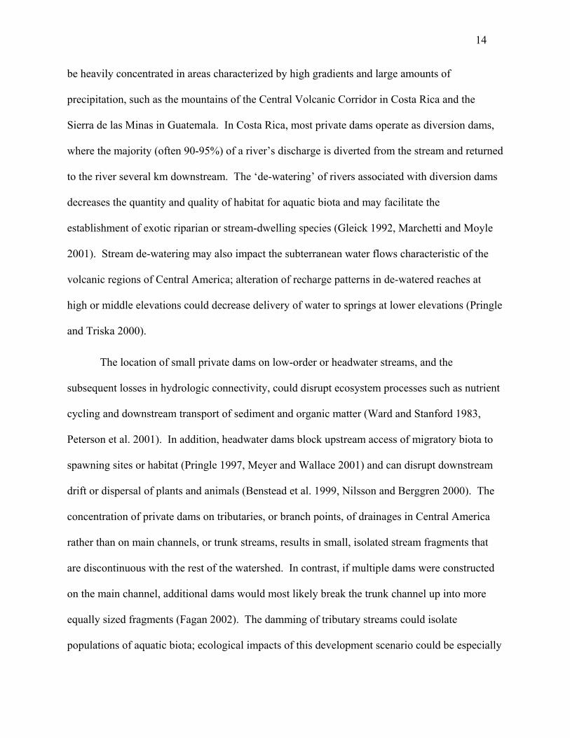
be heavily concentrated in areas characterized by high gradients and large amounts of
precipitation, such as the mountains of the Central Volcanic Corridor in Costa Rica and the
Sierra de las Minas in Guatemala. In Costa Rica, most private dams operate as diversion dams,
where the majority (often 90-95%) of a river’s discharge is diverted from the stream and returned
to the river several km downstream. The ‘de-watering’ of rivers associated with diversion dams
decreases the quantity and quality of habitat for aquatic biota and may facilitate the
establishment of exotic riparian or stream-dwelling species (Gleick 1992, Marchetti and Moyle
2001). Stream de-watering may also impact the subterranean water flows characteristic of the
volcanic regions of Central America; alteration of recharge patterns in de-watered reaches at
high or middle elevations could decrease delivery of water to springs at lower elevations (Pringle
and Triska 2000).
The location of small private dams on low-order or headwater streams, and the
subsequent losses in hydrologic connectivity, could disrupt ecosystem processes such as nutrient
cycling and downstream transport of sediment and organic matter (Ward and Stanford 1983,
Peterson et al. 2001). In addition, headwater dams block upstream access of migratory biota to
spawning sites or habitat (Pringle 1997, Meyer and Wallace 2001) and can disrupt downstream
drift or dispersal of plants and animals (Benstead et al. 1999, Nilsson and Berggren 2000). The
concentration of private dams on tributaries, or branch points, of drainages in Central America
rather than on main channels, or trunk streams, results in small, isolated stream fragments that
are discontinuous with the rest of the watershed. In contrast, if multiple dams were constructed
on the main channel, additional dams would most likely break the trunk channel up into more
equally sized fragments (Fagan 2002). The damming of tributary streams could isolate
populations of aquatic biota; ecological impacts of this development scenario could be especially
15
adverse if a source population (e.g., of fish, aquatic insects, or freshwater shrimp) were located in
one of the fragments, with the dam hindering dispersal of individuals to other parts of the
watershed (Pulliam 1988, Fagan 2002). Furthermore, in both temperate and tropical systems,
there is great uncertainty about the potential cumulative ecological effects of multiple dams on
branch / headwater streams and consequent ecological effects on both local and regional scales.
Because Central American streams are short (often <100 km), losses in hydrologic connectivity
and extensive fragmentation resulting from the operation of multiple small dams may be more
severe than they would be in a region with longer mainland rivers.
The construction of larger Independent Power Projects (IPPs) is a potential option at
lower elevations in Central America and may result in the construction of large dams. An IPP is
generally a large generation project that usually requires substantial investment of private foreign
capital in developing countries. In addition, IPPs could be located in large, relatively
undisturbed areas and involve different stakeholders, including indigenous groups, governments,
conservationists, and foreign dam companies.
Several IPPs have been proposed for Central America. Many of them are large dams;
well-known examples include a series of dams on the Patuca River in central Honduras and the
Boruca Dam in southern Costa Rica. The ecological impacts of large dams have been studied in
both tropical and temperate regions (Rosenberg et al. 1997, Pringle et al. 2000, WCD 2000,
Khagram 2003). Three major potential impacts of large dams in Central America are: (1)
emission of greenhouse gases from reservoirs; (2) impacts on downstream areas; and (3) loss of
biological integrity and extirpation of biota (Rosenberg et al. 1997). For example, the planned
construction of the Boruca Dam on the Rio Grande de Terraba in southern Costa Rica is
proposed for a river with a high sediment load in a region characterized by landslides. The dam
16
will flood hundreds of hectares of forest, most likely resulting in emissions of methane and
carbon dioxide from the decomposing vegetation (Reisner and McDonald 1986). Dams planned
for the Patuca River in the Mosquita region of Honduras also illustrate the severity of potential
impacts: these developments will fragment one of the largest areas of tropical rainforest north of
the Amazon. The Patuca dam series may also endanger several protected reserves (e.g., Rio
Platano Biosphere Reserve, Tawahka Indigenous Reserve) that border proposed dam
construction sites by opening access to previously remote areas (Gutman 1998).
Costa Rica: a case study of links between electricity privatization and river fragmentation
Hundreds of rivers drain the Costa Rican landscape, creating a large hydropower
potential for this small country (51,000 km²). Hydropower currently accounts for ~85% of
domestically-produced electricity for the country’s 4 million inhabitants. The national
electrification system consists of 10 medium to large sized dams (>15 m high) and an increasing
number of smaller dams (<15 m high; <20 MW). Costa Rica’s largest dams are the Arenal Dam
on the Arenal River, the Corobici Dam on the Santa Rosa River and the Angostura Dam
Complex on the Reventazon River, all with installed generating capacities of approximately 170
MW. Smaller dams located on the tributaries of major rivers also contribute to national
electrification, especially during peak hours of domestic electricity demand. Other sources of
electricity for Costa Rica outside of hydropower include thermoelectric, geothermic, and wind
generation.
Before 1990, state-owned utilities, primarily the Costa Rican Institute of Electricity
(ICE), were responsible for electricity generation. Increases in the demand for electricity in the
late 1980s, combined with a lack of capital in the public sector, led Costa Rica to explore other
options to meet energy needs. Electricity sector reforms were introduced in 1990 as a way of
17
decreasing pressures on the ICE by allowing partial participation of private companies in
electricity generation. With the average yearly demand for electricity increasing at a rate of
~6%, Costa Rica must add approximately 80 MW annually to its overall installed capacity in
order to meet these demands (Mario Alvarado, ACOPE, personal communication).
Electricity sector reform in Costa Rica has been more gradual than in some of the other
Central American countries, particularly because of the limits that current legislation places on
private involvement in electricity generation. In Costa Rica, two laws passed in 1990 (Law
7200) and 1995 (Law 7508), permit private individuals or organizations to generate electricity.
The laws require that all private enterprises establish a contract with the ICE prior to
construction of the generation center and maintain the ICE’s authority over regulation,
transmission, and distribution of electricity. Environmental impact assessments must be
completed and approved by the national environmental secretary prior to the granting of
contracts for all generation centers larger than two megawatts. Additionally, the laws limit the
size (measured by installed capacity) of generation facilities to 20 MW. Furthermore, the total
amount of electricity generated by private companies is restricted to 15% of total domestic
electricity production.
Despite these limitations to electricity sector reform, impacts of private involvement in
electricity generation are evident throughout Costa Rica. Hydropower has been a primary
beneficiary of electricity privatization, as evidenced by the construction of 28 small private dams
in Costa Rica since 1990 (Figure 2.2). One half of the country’s 34 major watersheds now either
have operational private hydropower dams or have been targeted for future private hydropower
development. Many private hydropower dams operate as diversion dams and are concentrated
on gradient breaks in regions with very wet climates. For example, certain watersheds, such as
18
the San Carlos River and Sarapiquí River on the northern Caribbean slope, contain multiple
private dams on tributary streams. Many areas in both of these watersheds receive more than
four meters of annual rainfall and are characterized by dramatic changes in elevation over short
distances. Thus far, only limited efforts have been made to investigate the potential cumulative
effects of multiple private diversion dams on these watersheds, and Costa Rican law does not
currently limit the number of private generation facilities that can be constructed on a single
watershed.
Recommended conservation strategies
The transformations of river ecosystems that have resulted from electricity privatization
in Central America illustrate the broad scale impacts of legislation on the environment.
Conservation of the region’s freshwater biodiversity will depend on more careful consideration
of current policies and a more holistic approach to watershed development. In light of current
development trends, we present three recommendations to minimize the potential negative
environmental impacts of electricity privatization on freshwater ecosystems:
(1) Designate certain watersheds as ‘pristine.’ Private hydropower development should be
encouraged in suburban watersheds rather than in watersheds in rural areas. Prohibiting the
construction of dams on the mainstem or tributaries of designated rivers would help to limit the
number of watersheds affected by hydropower development. Attempts to declare rivers as
‘Natural Historic Monuments’ have already been made in watersheds in Costa Rica in response
to accelerated hydropower development (see chapter 5 of this dissertation).
(2) Require cumulative effects assessments when more than one dam is built on a
watershed. Possible additive or interactive effects of multiple dams on individual rivers or
watersheds are often neglected by environmental impact assessments. Impacts of multiple dams
19
on hydrology, fish and shrimp migrations, and municipal water supplies should all be considered
in cumulative impact analyses. Cumulative effects assessments are poor in the US but have not
been completed at all in many parts of Central America currently undergoing hydropower
development.
(3) Develop instream flow methods for Central American streams. Create legislation to
enforce instream flow regulations. A survey by Scatena (2004) that included three Central
American countries indicated a lack of regionally-based methodology for determining instream
flows in river reaches downstream from dams and other withdrawals. More research is needed to
determine the flow needs of aquatic biota to develop adequate instream flow methodologies for
rivers in the region. There is considerable interest in this field (Scatena 2004) and in 2003 the
ICE began organizing a series of workshops in Costa Rica to stimulate public discussion and
identify research needs related to instream flows. These workshops involve a variety of
stakeholders: conservationists, the ICE, private hydropower developers, the government,
scientists, and national and international universities. This is a step in the right direction towards
better management and conservation of freshwater resources amidst rapid hydropower
development.
Acknowledgements
This research was made possible by a Fulbright grant to E. Anderson Olivas and by a
grant from the Organization for Tropical Studies (OTS). Special thanks go to those who
provided information on private hydropower in Costa Rica, especially Mario Alvarado of the
Asociacion de Cogeneradores Privados de Electricidad (ACOPE), the Department of Private
Generation of the Costa Rican Institute of Electricity (ICE), Rafael Corrales, Roger Quesada,
Rocio Lopez, and Orlando Vargas. We are grateful to Mary Freeman for her encouragement in
20
writing the original version of this manuscript and to Javier Mateo for sharing his insights on
policy and environment in Central America. We thank Antonio Trabucco for his help in
preparation of Figs. 1 and 2. Mary Freeman, Javier Mateo, Becky Bixby, Bruce Aylward, Luis
Diego Gomez, and the Pringle lab group provided helpful comments on earlier drafts of this
manuscript.
Literature Cited
Benke AC. 1990. A perspective on America’s vanishing streams. Journal of the North American Benthological Society 9:77-88.
Benstead JP, March JG, Pringle CM, and Scatena FN. 1999. Effects of a low-head dam and
water abstraction on migratory tropical stream biota. Ecological Applications 9:656-668. Dunkerley J. 1995. Financing the energy sector in developing countries. Energy Policy
23:929-939. Economic Commission for Latin America and the Caribbean (ECLAC). 1996. Progress
in the privatization of water-related public services: A country by country review for Mexico, Central America, and the Caribbean. ECLAC: Environment and Development Division.
Energy Information Administration (EIA). 2002. Regional Indicators: Central America. (www.eia.doe.gov/emeu/cabs/centamenv.htm)
Fagan WF. 2002. Connectivity, fragmentation, and extinction risk in dendritic metapopulations. Ecology 83:3243-3249.
Gleick P. 1992. Environmental consequences of hydroelectric development: The role of
facility size and type. Energy 17:735-747. Goodland RJA, Juras A, Pachauri R. 1993. Can hydro-reservoirs in tropical moist
forests be environmentally sustainable? Environmental Conservation 20:122- 130.
Gutman WE. 1998. Cry me a river: The Rio Patuca hydroelectric project—boon or
bane? Honduras This Week. Graf WL. 1999. Dam nation: A geographic census of large American dams and their
hydrologic impacts. Water Resources Research 35:1305-1311.
21
Izaguirre AK. 2000. Private participation in energy. The World Bank Group: Private Sector and Infrastructure Network. Note No. 208.
Khagram S. 2003. Temples or tombs? An analysis of large dams. Environment
45:28-37. Loker WM. 2000. Sowing discord, planting doubts: Rhetoric and reality in an
environment and development project in Honduras. Human Organization 59:300-310.
Marchetti MP and Moyle PB. 2001. Effects of flow regime on fish assemblages in a regulated California stream. Ecological Applications 11:530-539. Meyer JL and Wallace JB. 2001. Lost linkages and lotic ecology: Rediscovering
small streams. Pages 295-317 in Press MC, Huntly N, and Levin S, eds. Ecology: Achievement and Challenge. Oxford, UK: Blackwell Science.
Nilsson C and Berggren K. 2000. Alterations of riparian ecosystems caused by river
regulation. BioScience 50:783-792. Peterson BJ et al. 2001. Stream processes alter the amount and form of nitrogen
exported from small watersheds. Science 292:86-89. Pringle CM. 1997. Exploring how disturbance is transmitted upstream: Going against the flow. Journal of the North American Benthological Society 16:425-438. Pringle CM, Rabeni CF, Benke AC, and Aumen N. 1993. The role of aquatic
science in freshwater conservation; cooperation between the North American Benthological Society and Organization for Conservation and Resource Management. Journal of the North American Benthological Society 12:177-184.
Pringle CM and Triska FJ. 2000. Emergent biological patterns and surface-
subsurface interactions at landscape scales. Pages 167-193 in Jones JB and Mulholland PJ, eds. Streams and Ground Waters. Academic Press.
Pringle CM, Freeman MC, and Freeman BJ. 2000. Regional effects of hydrologic
alterations on riverine macrobiota in the new world: tropical-temperate comparisons. BioScience 50:807-823.
Pulliam HR 1988. Sources, sinks, and population regulation. American Naturalist
132:652-661. Raphals P. 2001. Restructured rivers: Hydropower in the era of competitive markets.
Berkeley, CA: International Rivers Network.
22
Reisner M. and McDonald RH. 1986. The high costs of high dams. Pages 270-307 in Maguire A and Brown JW, eds. Bordering on Trouble. Adler & Adler, MD for World Resources Institute.
Rogers P. 1991. Energy use in the developing world: A crisis of rising expectations.
Environmental Science and Technology 25:580-583.
Rosenberg DM, Berkes F, Bodaly RA, Hecky RE, Kelly CA, and Rudd JWM.
1997. Large-scale impacts of hydroelectric development. Environmental Review 5:27-54.
Scatena FN. 2004. A survey of methods for setting the minimum instream flow standards in the
Caribbean basin. River Research and Applications 20:127-135. Vaux PD and Goldman CR. 1990. Dams and development in the tropics: The role of
applied ecology. Pages 101-122 in Goodland R, ed. Race to Save the Tropics. Washington DC: Island Press.
Ward JV and Stanford JA. 1983. The serial discontinuity concept of lotic
ecosystems. In Fontaine TD and Bartell SM, eds. Dynamics of lotic ecosystems. Ann Arbor Science.
World Commission on Dams (WCD). 2000. Dams and development: A framework for
decision-making. (www.damsreport.org).
23
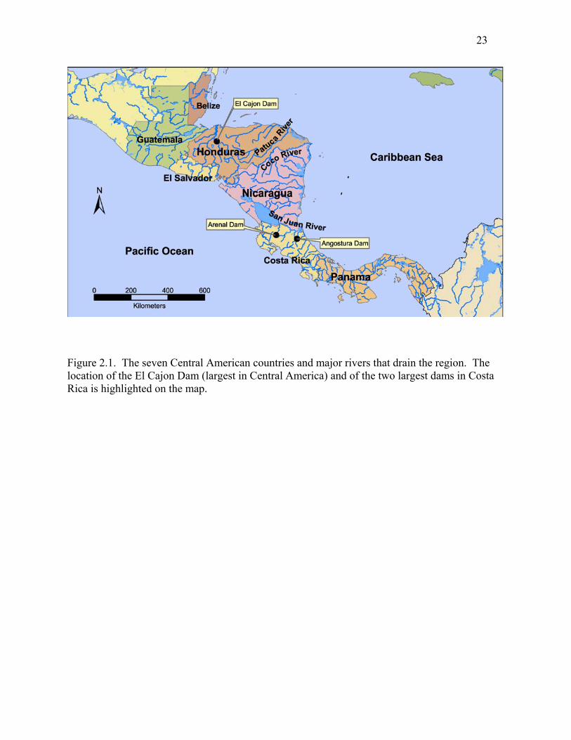
Figure 2.1. The seven Central American countries and major rivers that drain the region. The location of the El Cajon Dam (largest in Central America) and of the two largest dams in Costa Rica is highlighted on the map.
24
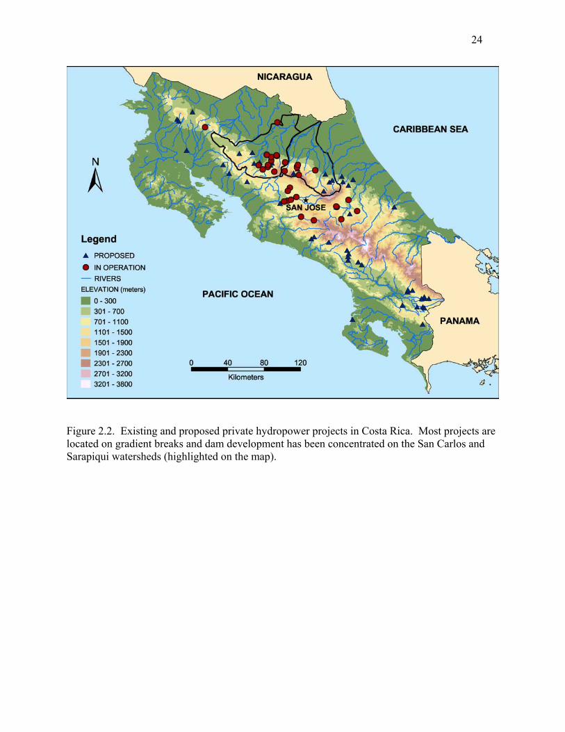
Figure 2.2. Existing and proposed private hydropower projects in Costa Rica. Most projects are located on gradient breaks and dam development has been concentrated on the San Carlos and Sarapiqui watersheds (highlighted on the map).
25
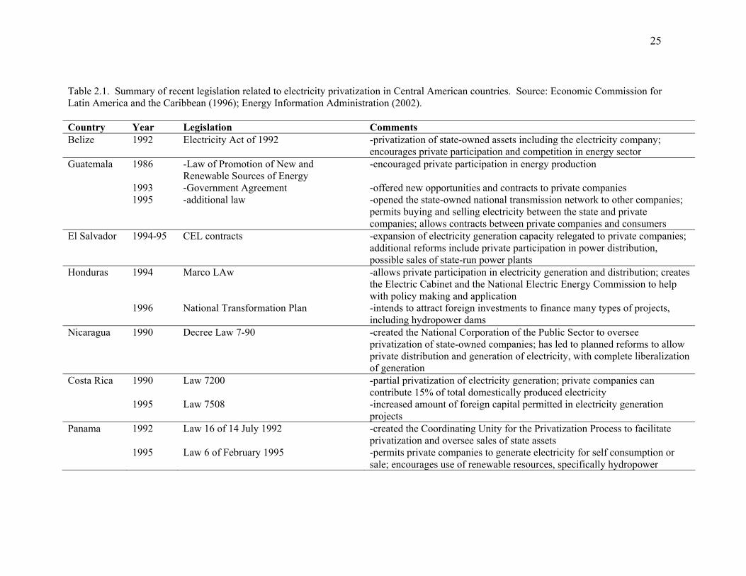
Table 2.1. Summary of recent legislation related to electricity privatization in Central American countries. Source: Economic Commission for Latin America and the Caribbean (1996); Energy Information Administration (2002). Country Year Legislation Comments Belize 1992 Electricity Act of 1992 -privatization of state-owned assets including the electricity company;
encourages private participation and competition in energy sector Guatemala 1986
1993 1995
-Law of Promotion of New and Renewable Sources of Energy -Government Agreement -additional law
-encouraged private participation in energy production -offered new opportunities and contracts to private companies -opened the state-owned national transmission network to other companies; permits buying and selling electricity between the state and private companies; allows contracts between private companies and consumers
El Salvador 1994-95 CEL contracts -expansion of electricity generation capacity relegated to private companies; additional reforms include private participation in power distribution, possible sales of state-run power plants
Honduras 1994 1996
Marco LAw National Transformation Plan
-allows private participation in electricity generation and distribution; creates the Electric Cabinet and the National Electric Energy Commission to help with policy making and application -intends to attract foreign investments to finance many types of projects, including hydropower dams
Nicaragua 1990 Decree Law 7-90 -created the National Corporation of the Public Sector to oversee privatization of state-owned companies; has led to planned reforms to allow private distribution and generation of electricity, with complete liberalization of generation
Costa Rica 1990 1995
Law 7200 Law 7508
-partial privatization of electricity generation; private companies can contribute 15% of total domestically produced electricity -increased amount of foreign capital permitted in electricity generation projects
Panama 1992 1995
Law 16 of 14 July 1992 Law 6 of February 1995
-created the Coordinating Unity for the Privatization Process to facilitate privatization and oversee sales of state assets -permits private companies to generate electricity for self consumption or sale; encourages use of renewable resources, specifically hydropower
26
CHAPTER 3:
PREDICTING CUMULATIVE EFFECTS OF HYDROPOWER DEVELOPMENT ON THE
HYDROLOGIC CONNECTIVITY OF A TROPICAL RIVER SYSTEM¹
_____________
1Olivas, E.A., Freeman, M.C., and Pringle, C.M. To be submitted to Conservation Biology
27
Abstract
In Costa Rica, more than 30 hydropower dam projects have been constructed since the
early 1990s and watersheds with only one or no dams are becoming rare. While studies of the
ecological impacts of individual dams have been limited, there have been no attempts to examine
the collective impacts of multiple hydropower dam projects on Costa Rican rivers. As dam
construction continues in Costa Rica and other parts of the tropics, cumulative effects assessment
will be a necessary tool for conservation and management of freshwater systems. In this study,
we showed how simple cumulative effects assessment can be accomplished using limited data.
We examined the cumulative effects of multiple hydropower dam projects on the hydrologic
connectivity of the Sarapiquí River watershed, Costa Rica. Since 1990, eight hydropower dam
projects have been built in the watershed and an additional project, Cariblanco Dam, is under
construction. Existing projects have dewatered 31 km of streams in the watershed; the planned
Cariblanco Dam will dewater an additional 16 km. Currently, 10 % of total stream km in the
watershed is located upstream from dams and are discontinuous with downstream areas; the
Cariblanco Dam will increase that number to 14% of total stream km. Although limited data
presented a challenge, our results suggested that not all hydropower dam projects are the same
and that the placement of dams in the watershed, rather than the total number of dams, is
important to preserving hydrologic connectivity. Furthermore, the effects of hydropower dam
projects may interact with other human disturbances in the watershed, such as deforestation and
increasing fishing pressures, to affect ecological integrity.
Keywords: cumulative effects, dams, hydropower, tropical, streams, fragmentation
28
Introduction
A major goal of sustainable development worldwide is the integrated management of
freshwater resources (Gleick et al. 2002; Postel and Richter 2003). Toward this end, there exists
a strong need for comprehensive approaches to assess the impacts of human use of freshwater
ecosystems (Bonnell and Storey 2000; Rosenberg et al. 2000; Dube 2003; March et al. 2003).
Humans rely heavily on freshwater for potable water and electricity; freshwater resources also
provide a variety of ecosystem services, among them waste assimilation, flood control, food
sources, and transportation (Postel and Carpenter 1997). Much ecological research has focused
on environmental impacts of individual human activities on freshwater ecosystems, for instance,
the impacts of an individual dam on physical and biological conditions within a river.
Conversely, published studies on the collective impacts of multiple activities on one system, such
as the collective impacts of multiple dams on one river or a watershed, are less common
(Rosenberg et al. 2000). Furthermore, while some form of environmental impact assessment is
used in most countries, these studies are generally initiated by and restricted to a specific project
and conducted over a limited spatial and temporal scale (Burris and Canter 1997; Bonnell and
Storey 2000). Potential cumulative effects of multiple human activities on an ecosystem have
often been ignored (Burris and Canter 1997; Cooper and Sheate 2002).
The concept of cumulative environmental effects is based on the idea that the impacts of
human activities on natural systems are not mutually exclusive of one another. Rather, impacts
can be cumulative, and may cause substantial changes to the environment (Beanlands et al. 1986;
Preston and Bedford 1988; Bonnell and Storey 2000). Cumulative environmental effects may
result from one activity over time or from multiple sources of disturbance over space and time.
Ecosystem disturbances may be related, (e.g., multiple water withdrawals on one river) or
29
unrelated (e.g., a dam, an instream mining operation, and a wastewater treatment plant on a
segment of river). Cumulative effects of these activities can originate through either additive or
interactive processes, or a combination of both. The concept of additive effects refers to a case
where cumulative environmental effects can be defined as the sum of the effects of individual
disturbances. Alternatively, cumulative environmental effects that result from interactive
processes occur when the effect of multiple disturbances is different than the sum of the effects
of those disturbances individually (Bonnell and Storey 2000). The practice of cumulative effect
assessment is an attempt to systematically evaluate these additive or interacting effects of one or
more human influences on an ecosystem (Preston and Bedford 1988; Spaling and Smit 1993;
Dubé 2003).
Dams for hydropower, irrigation, or water supply provide examples illustrating the
different types of cumulative ecological effects. The concept of additive effects may be
explained by studies from the literature describing situations where multiple dams operate on a
river. For example, Williams et al. (2001) documented the additive effects of dams on the
survival of migratory salmon populations in the Columbia-Snake River system, USA: mortality
of smolts increased with the number of dam turbines on the river that smolts had to pass through.
The concept of interactive cumulative effects might be explained by a situation where flow
reduction below a dam increases fishing effectiveness. In this case, flow reductions and fishing
may interact to raise fishing mortality and negatively affect fish populations.
In North America and Europe, watersheds with only one or no dams are rare (Benke
1990; Dynesius and Nilsson 1994). This is also increasingly becoming the case in tropical,
developing countries, where dam construction is occurring at an accelerated rate (March et al
2003; WCD 2000). The scientific literature contains several examples of attempts to evaluate
30
cumulative effects of dams on specific parameters (e.g., emission of greenhouse gases, sediment
retention, water cycles) on global, regional, and local scales (Table 3.1). Nevertheless, most of
these attempts are relatively recent and are far outnumbered by studies on the ecological effects
of individual dams (Rosenberg et al. 2000). Well-known attempts to assess cumulative effects of
multiple dams include the Serial Discontinuity Concept, proposed by Ward and Stanford (1983),
and the Fragmentation Index, presented by Dynesius and Nilsson (1994). However, although
these two studies are frequently cited in the literature, published applications of their methods are
rare. Perhaps the greatest contribution of these studies is that they articulate the need to address
the impacts of river regulation on a broad scale, drawing attention to the magnitude of hydrologic
alterations worldwide.
The present study evaluated cumulative effects of hydropower development on the
hydrologic connectivity of the Sarapiquí River system, Costa Rica. Hydrologic connectivity is
defined here as the flow of energy, matter, and organisms along longitudinal, lateral, vertical,
and temporal pathways in a watershed and is essential to maintaining the ecological integrity of a
watershed (Ward and Stanford 1989; Pringle 2003). We begin with a detailed description of the
study system to document present hydropower development and outline management concerns.
We then quantify the cumulative effects of eight existing dams on the connectivity of the stream
network and on downstream hydrology. We also predict effects of a proposed dam on
connectivity and consider future hydropower development in the watershed. We discuss effects
of hydropower development in light of two other recent changes in the Sarapiquí watershed that
also affect rivers: deforestation and increased fishing pressures. Our goal is to illustrate the
utility of cumulative effects analysis, even in a situation where little data are available for a river
system, as is the case in the Sarapiquí watershed.
31
Study system and management concerns
The Sarapiquí River watershed, Costa Rica, has been targeted for hydropower
development for the past 15 years (Figure 3.1). The Sarapiquí River is one of the major
confluents of the San Juan River and drains part of the northern Caribbean slope of Costa Rica.
Elevational changes greater than 100 m/km characterize the upper watershed, where the 4-8 m of
rainfall received annually is more evenly distributed throughout the year than in other parts of
Costa Rica (Sanford et al. 1994). The combination of high relief and heavy precipitation has
created a large hydropower potential. During the 1990s, eight hydropower projects were built on
the Sarapiquí River and its tributaries (Figure 3.2). The majority of these projects are operated
by private companies, except for two projects on the Toro River that are run by the Costa Rican
Institute of Electricity (ICE), a government-owned institution. Collectively, these hydropower
projects (~143 megawatts (MW) generation capacity) account for a little less than 10% of Costa
Rica’s total installed generation capacity. More dams are currently being planned for the
watershed, including the Cariblanco Dam, proposed by the ICE for the mainstem Sarapiquí
River. If constructed, the Cariblanco Dam will be the largest dam in the watershed with roughly
80 MW installed capacity. Advanced plans for a third project on the Toro River are also
underway at the ICE, as are plans for a 40 MW hydropower project on the General River.
At issue are the impacts of existing and proposed hydropower projects on the ecological
integrity of the Sarapiquí river system. Hydropower developments in the Sarapiquí region affect
the hydrology and the hydrologic connectivity of the watershed (defined above), with cascading
impacts on aquatic biota. In this case, hydrology refers to the natural flow regimes of the
Sarapiquí and its tributaries, with emphasis on the annual cycles of high and low discharge
events (Poff et al. 1997). Alteration of natural flow regimes by dams in Sarapiquí affects the
32
magnitude and timing of river flows and disrupts natural connections between upstream and
downstream reaches (longitudinal connectivity), between channel and floodplain (lateral
connectivity), and between channel and groundwater (vertical connectivity).
Primary conservation concerns in the Sarapiquí watershed are that hydropower
developments may threaten the survival of native aquatic biota and isolate headwater streams.
To date, 44 species of fish have been recorded from the watershed (Bussing 1993; EAO
unpublished data); this is probably a conservative estimate since many of the watershed’s rivers
have never been sampled. Nevertheless, this estimate includes at least two highly mobile fish
species, Joturus pichardi and Agonostomus monticola (Mugilidae) (Cruz 1987; Bussing 1998).
It also includes one fish species that is endemic to Costa Rica, Priapicthys annectens
(Poecilidae), frequently found in headwater streams (Bussing 1998). Boulder and cobble
substrate in the headwaters and mid-reaches of the watershed also provides important habitat for
freshwater shrimp (Atya spp. and Macrobrachium spp.). In other parts of the tropics, research
has shown that dams negatively affect the migratory behavior of these animals (Holmquist et al.
1998; Benstead et al. 1999); this is potentially the case for freshwater shrimp in Sarapiquí as
well.
Hydropower development in Sarapiquí involves a variety of stakeholders. To date, there
has been limited consensus among these groups on management objectives for the watershed.
Private hydropower companies and the ICE recognize the vast hydropower potential of the
Sarapiquí (>300 MW) and want to exploit the watershed’s resources to the fullest extent
possible. Management concerns for hydropower producers include maintaining forest cover in
the upper parts of the watershed to minimize suspended sediments in river reaches above dams.
Unnatural increases in sediment that result from land clearing can damage a project’s machinery
33
and decrease hydropower production. At present, protected areas, including the vast Braulio
Carrillo National Park (~47,000 km²), maintain roughly one-third of the watershed in natural
forest cover. Maintenance of forested areas is also a primary management concern of other
stakeholders in Sarapiquí, especially municipal water users and those involved with the region’s
tourism industry. Potable water for several towns comes from groundwater springs and streams
that drain the interior of the national park (Vargas 1995). Additionally, the national park and
other protected areas are a hotspot for biodiversity, attracting thousands of international tourists
and scientists annually.
Another important management objective of municipal water users, the tourism industry,
and local residents of Sarapiquí is maintaining adequate river flows for human uses and for fish
habitat. Municipal water users express concern that operation of existing and proposed
hydropower projects will negatively affect potable water supplies since they dam and divert
water from reaches of river that may be in areas of groundwater recharge (S. Barrantes,
Aqueduct of Horquetas, personal communication; Pringle and Triska 2000). Local residents
worry that the flow reductions and barriers imposed by the hydropower projects, especially the
planned Cariblanco project, will result in major fish population declines or local extirpation of
migratory fish species like bobo, Joturus pichardi, that are used in recreational and subsistence
fishing. White-water rafting, a major component of the tourism industry in Sarapiquí, depends
heavily on river flows on the mainstem. Rafting companies have expressed concern that
alterations to the hydrology of the Sarapiquí by the planned Cariblanco project will destroy their
business due to periods of decreased flow that make rafting impossible, or due to unnatural flow
fluctuations that make rafting unsafe. Furthermore, local residents and the tourism industry
worry that the increasing hydropower development will detract from the scenic beauty of the
34
Sarapiquí River, by replacing natural wonders like canyons and waterfalls with concrete
impoundments and pipelines.
Hydropower project operations and their environmental impacts
All eight projects in the Sarapiquí watershed operate as water diversion dams, a common
type of hydropower project that takes advantage of discharge and elevation gradients to generate
electricity (Figure 3.3). Despite the fact that diversion dams are found in many areas of Central
America and tropical Asia (Majot 1997), their environmental impacts have not been well studied
in the tropics. At least five of the dams in the Sarapiquí watershed were obligated by law to
complete an environmental impact statement during planning phases. However, comprehensive
studies on the ecology of rivers in Sarapiquí are scarce, and research for environmental impact
assessment reports included little field data collection. Thus, impacts of dams were often
predicted based on limited information; when no data were available, impacts were projected
based on other studies on dams. The same company prepared the environmental impact
statements for three hydropower projects in Sarapiquí. Although each of the three projects is
located on a different river and one at a lower elevation, the three separate reports contain several
identical sections explaining probable environmental impacts of the dams (E. Olivas, personal
observation). The system of environmental impact assessment used for hydropower in Sarapiquí
is confounded by additional serious problems. For instance, the impacts of each hydropower
project were evaluated individually; no efforts have yet been made to predict or assess the
cumulative effects of the eight dams on the watershed. Furthermore, studies on the actual
impacts of dam operations are also scarce.
Our personal observations and work in the area provide insight into some of the
ecological impacts of hydropower projects in the Sarapiquí watershed. These hydropower
35
projects function as water diversion dams, thus their operation results in the ‘de-watering’ of the
reach of river between the diversion site and the water return site. At several of the projects in
Sarapiqui, this ‘de-watered’ reach carries 5-10% of average annual discharge or less and
corresponds to a distance of several river kilometers. Discharge reductions in the de-watered
reach have been shown to affect the quantity and quality of habitat for aquatic biota and affect
the temperature regime of a river (see Chapter 4 of this dissertation). The presence of a concrete
dam at the diversion site disrupts longitudinal riverine connectivity, altering the transport of
matter and organisms. Although they are not particularly high (all but one are <15 m), dams in
the Sarapiquí watershed impede upstream movement of biota and permit downstream movement
over the dam only during high flow events. In addition, these dams most likely isolate upstream
populations of fishes and freshwater shrimps that inhabit low order streams. The ecology of
river reaches downstream from the turbines and water release is also altered by hydropower
project operations: water releases during peak periods of electricity generation can be linked to
abrupt changes in discharge and water temperature (see Chapter 4). These unnatural fluctuations
affect the stability of aquatic habitat for several kilometers downstream and may alter the
composition of biotic assemblages in these reaches by favoring species better adapted to highly
dynamic environments.
When referring to hydropower development in the Sarapiquí and San Carlos watersheds,
a 1997 State of the Nation report on Costa Rica stressed the need for evaluating cumulative
environmental effects of hydropower dams (Estado de la Nación 1998). Several years later,
questions about the cumulative effects of the eight operational hydropower projects in the
watershed remain unanswered. How many projects can the Sarapiquí watershed support while
still maintaining natural ecosystem processes? How do multiple projects affect tropical aquatic
36
biota? Are the impacts of multiple projects on tributary streams greater or less than those of a
large dam on the mainstem Sarapiquí? How do dams alter watershed connectivity? More
information on the ecological consequences of multiple hydropower projects is needed to help
guide decisions made by developers and resource managers about placement and operation of
future projects.
Methods
Cumulative effects of multiple projects on connectivity— During 1999-2002, we visited 7 of the
8 existing hydropower projects in the Sarapiquí watershed. The purpose of these visits was to
meet with managers to discuss operations and collect data about each hydropower project. At
five of these sites, we used a Trimble Navigation Geographic Positioning System (GPS) to
record the location of the water diversion site and the water return site (turbine house; Figure
3.3). For two of the projects, Don Pedro and Volcan, the hydropower company provided GPS
points, because the steep walls of the river channel made data collection difficult with our GPS.
The location of the Rio Segundo project was obtained from the feasibility study on file at the
Department of Private Generation at the ICE.
We used ArcGIS 8.2, a commercial Geographic Information Systems (GIS) program
from the Environmental Systems Research Institute, Inc. (ESRI, Redlands, CA) and 1:50,000
topographic maps of the Sarapiquí region to develop a digital database of rivers for the
watershed. Maps were scanned and geo-referenced and then used as base images to delineate
segments of rivers. We then used ArcView 3.2 (ESRI, Redlands, CA) and the Create Strahler
Stream Order Extension to ordinate all streams in the watershed (Strahler 1952; Lanfear 1990).
Coordinates of the water diversion and water return sites of each of the existing hydropower
37
projects were imported into the ArcInfo rivers coverage.
To quantify the cumulative effects of the eight existing projects on the connectivity of the
stream network, we used ArcInfo to calculate: (1) the length of the dewatered reach of stream
between the water diversion and the water return at each hydropower project; and (2) the total
stream length upstream from each dam (water diversion site). We considered the dewatered
reach to be a break in connectivity because of the significant reductions in discharge (90-95%)
that create different physical conditions than those of upstream and downstream river sections.
We considered rivers upstream from dams to be discontinuous in a downstream direction during
low and normal flow periods and discontinuous in an upstream direction at all times.
We also used ArcInfo and the rivers coverage to predict effects of the proposed
Cariblanco hydropower project on the connectivity of the stream network. The ICE provided
coordinates for the planned location of the water diversion dam and water return for the
Cariblanco hydropower project; we imported these coordinates into the rivers coverage. We then
used ArcInfo to calculate the probable length of the dewatered reach of stream and the total river
length upstream from the four proposed dams in the Cariblanco project.
Cumulative effects of multiple projects on downstream hydrology— Daily discharge records
from a gauge on the Sarapiquí River near the town of Puerto Viejo were provided by the
Department of Hydrology at the ICE for the period 1970-1998. We used these discharge records
and the Indicators of Hydrologic Alteration (IHA) program (Richter et al. 1996) to estimate the
cumulative effects of multiple hydropower projects on the downstream hydrology of the
Sarapiquí River. The IHA program compares daily discharge data collected before and after a
river alteration occurs (i.e., dam construction) by calculating values for 33 hydrologic variables
38
(i.e., magnitude, timing, and duration of low and high flow events; seasonality of flows, etc.) for
the pre- and post-alteration datasets. The IHA then determines whether there are significant
differences between datasets for the calculated values of each variable (Richter et al. 1996;
Richter et al. 1997). In this study, we divided the available discharge data for the Sarapiquí
River into: (1) pre-hydropower development (1970-1990); and (2) post-hydropower development
(1990-1998). Between 1990-1998, four hydropower projects began operation on the Sarapiquí
River and its tributaries upstream from the gauging station. Because the confluence of the Toro
River is downstream from the gauge, the three dams on this subwatershed could not be included
in the analysis. Also, although the Doña Julia project on the Puerto Viejo River is upstream from
the gauge, this project did not begin full operation until 1999.
Results and Discussion
Cumulative effects of multiple dams on connectivity—A total of 30.9 river kilometers in the
Sarapiquí watershed have been dewatered as a result of hydropower dam operations: 5.79 km of
1st and 2nd order streams, and 25.06 km of 3rd order streams (Table 3.3). These 30.9 km now
regularly carry between 5-10 % of average annual discharge, except during storms or high flow
events. The hydropower project with the longest dewatered reach currently is the Volcan Dam
on the Volcan River (Table 3.3).
Extensive stream dewatering has major implications for the hydrologic connectivity, and
thus the ecological integrity of the Sarapiquí river system. Hydropower projects in Sarapiquí are
designed so that gross static height, GSH (i.e., the difference in elevation between the water
diversion site and the turbines), significantly exceeds dam height, DH. While this project design
(GSH>DH) has been considered advantageous from an environmental perspective because it can
39
reduce evaporative water losses and sedimentation behind a dam, past research has shown that
the destruction of aquatic habitat and subsequent loss of species associated with dewatering may
outweigh the environmental benefits of the GSH>DH project design (Gleick 1992). For
example, ecological studies in a dewatered stream below a diversion dam in California, USA,
showed that dewatering facilitates the replacement of native fishes by introduced species
(Marchetti and Moyle 2000; 2001). In the Sarapiquí watershed, a study of fish assemblages in
the Puerto Viejo River near the Doña Julia Hydroelectric Center found that ‘tolerant’ fish species
with opportunistic-type life histories (see Winemiller 1995) dominated assemblages in the ~4 km
dewatered reach of the river (see Chapter 4 of this dissertation). In the future, exotic species
such as tilapia (Oreochromis spp.), now cultivated in small ponds throughout the Sarapiquí
region, may eventually colonize the altered habitats offered by dewatered reaches downstream
from dams. The adaptability of tilapia to a wide range of flow, temperature, and water quality
conditions could make these species stronger competitors for food and space in dewatered
reaches than native fishes.
Past research on the effects of drought on tropical stream biota suggests that extended
low-water periods significantly alter aquatic communities (Covich et al. 2003). A direct result of
prolonged drought conditions is the localized crowding of aquatic biota into severely reduced
habitat; this crowding may have long-term consequences on survivorship through decreased
reproduction or increased predation pressures (Covich et al. 2003). The impacts of stream
dewatering on aquatic biota in Sarapiquí may be comparable to, or harsher than, the impacts of a
prolonged drought, especially during the months with less precipitation (Feb-May). If
maintaining the ecological integrity of the Sarapiquí river system is a management objective of
stakeholders in the watershed, appropriate minimum flows should be required downstream from
40
all dams to lessen the negative effects of dewatering on aquatic biota during drier months. These
flows should be based on the natural flow regimes of rivers in tropical rainforest biomes.
Aside from effects on hydrologic connectivity, dewatering of streams in Sarapiquí could
also have implications for human health. In other parts of the humid tropics, the conversion of
lotic environments to more shallow, slow-flow conditions by dams has been linked to the spread
of diseases (Jobin 1999). Although most documented cases linking dams and disease are
associated with large reservoirs, the vectors of some of these diseases are mosquitoes that can
also breed in stagnant or slow-moving river pools. These habitats characterize many of the 30.9
km of dewatered streams in the Sarapiquí river system; however, current information is
insufficient for documenting potential links between stream dewatering and spread of mosquito-
borne diseases in the region. In general, more scientific research is needed on how vector
populations respond to changes in hydrology associated with dams.
In addition to stream dewatering, another result of hydropower development in Sarapiquí
is the isolation of headwater systems from the stream network. A total of 306.8 river km are
located upstream from dams in Sarapiquí; dams have disrupted the connectivity between these
rivers and the rest of the watershed (Table 3.4). These 306.8 km correspond to 10.8 % of 1st
through 3rd order stream length in the watershed. However, the situation may actually be more
serious because our results underestimate the total length of 1st order streams since many
headwater, ephemeral, and intermittent streams do not show up on topographic maps at a
1:50,000 scale.
Our results indicate that fragmentation of the Sarapiquí river system by dams is non-
random; dams are heavily concentrated on high gradient, 2nd and 3rd order streams above 400 m
elevation. This damming of low-order, tributary streams may alter connectivity and affect
41
ecological integrity differently than a case where multiple dams were built on the lower reaches
of the mainstem Sarapiqui River (Figure 3.5). Concentration of multiple dams on branch streams
divides the network into multiple small, isolated fragments; each additional dam increases the
number of small fragments and the number of discontinuous low-order streams. In contrast,
dams on the mainstem would break the channel into larger, more equally sized fragments (Fagan
2002). Moreover, the ecological role of headwater or low-order streams in a network is often
underestimated, despite the fact that these streams are important sources of sediment, nutrients,
and organic matter for downstream areas (Meyer and Wallace 2001; Gomi et al. 2002). Dams on
low-order streams can trap as much as 95% of sediment and organic matter (Waters 1995),
resulting in sediment-starved, erosive rivers below dams (Ligon et al. 1995). In the Sarapiquí
watershed, observations of the Puerto Viejo River below Doña Julia Dam support this claim:
after only 3 years of operation, we noted a substantial increase in exposed bedrock below the
dam due to sediment trapping (E.Olivas, personal observation). Low-order streams also may
provide critical habitat or spawning grounds for freshwater biota and harbor diverse assemblages
of aquatic invertebrates. Dams hinder upstream access to these areas and disrupt downstream
drift of macroinvertebrates from headwater streams (Pringle 1997; Holmquist et al. 1998;
Benstead et al. 1999).
Specifically, what are the consequences of this hydropower development scenario on the
ecological integrity of the Sarapiquí river system? How important are the downstream linkages
of headwater systems in a tropical catchment? Is the passage of water over dams during storms
sufficient to maintain the export of sediment, nutrients, organic matter, and biota to downstream
areas? How important is longitudinal connectivity in an upstream direction to maintaining biotic
assemblages and ecological processes? As hydropower development continues in Sarapiquí,
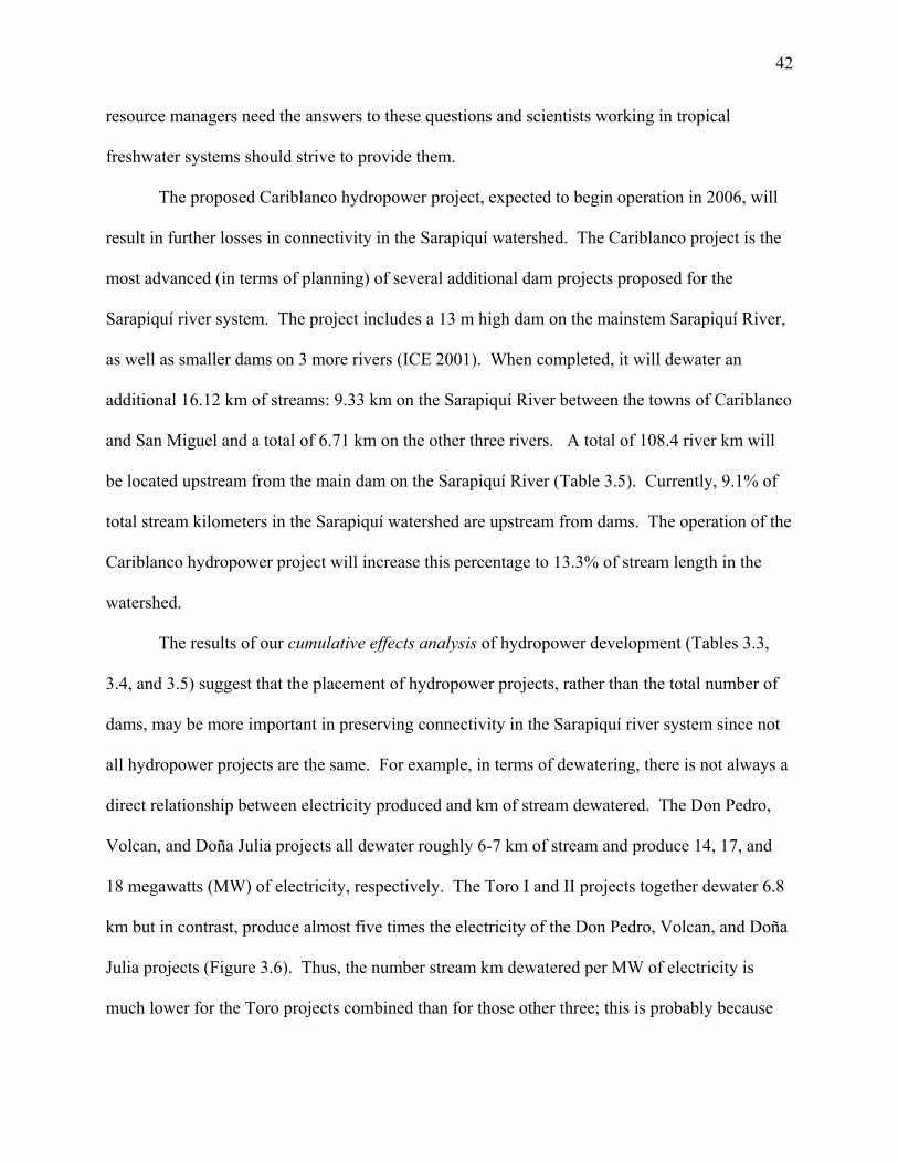
42
resource managers need the answers to these questions and scientists working in tropical
freshwater systems should strive to provide them.
The proposed Cariblanco hydropower project, expected to begin operation in 2006, will
result in further losses in connectivity in the Sarapiquí watershed. The Cariblanco project is the
most advanced (in terms of planning) of several additional dam projects proposed for the
Sarapiquí river system. The project includes a 13 m high dam on the mainstem Sarapiquí River,
as well as smaller dams on 3 more rivers (ICE 2001). When completed, it will dewater an
additional 16.12 km of streams: 9.33 km on the Sarapiquí River between the towns of Cariblanco
and San Miguel and a total of 6.71 km on the other three rivers. A total of 108.4 river km will
be located upstream from the main dam on the Sarapiquí River (Table 3.5). Currently, 9.1% of
total stream kilometers in the Sarapiquí watershed are upstream from dams. The operation of the
Cariblanco hydropower project will increase this percentage to 13.3% of stream length in the
watershed.
The results of our cumulative effects analysis of hydropower development (Tables 3.3,
3.4, and 3.5) suggest that the placement of hydropower projects, rather than the total number of
dams, may be more important in preserving connectivity in the Sarapiquí river system since not
all hydropower projects are the same. For example, in terms of dewatering, there is not always a
direct relationship between electricity produced and km of stream dewatered. The Don Pedro,
Volcan, and Doña Julia projects all dewater roughly 6-7 km of stream and produce 14, 17, and
18 megawatts (MW) of electricity, respectively. The Toro I and II projects together dewater 6.8
km but in contrast, produce almost five times the electricity of the Don Pedro, Volcan, and Doña
Julia projects (Figure 3.6). Thus, the number stream km dewatered per MW of electricity is
much lower for the Toro projects combined than for those other three; this is probably because
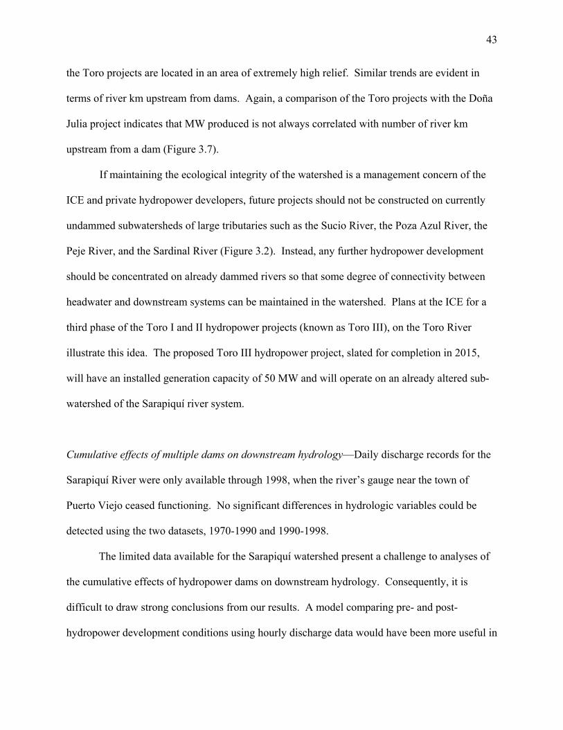
43
the Toro projects are located in an area of extremely high relief. Similar trends are evident in
terms of river km upstream from dams. Again, a comparison of the Toro projects with the Doña
Julia project indicates that MW produced is not always correlated with number of river km
upstream from a dam (Figure 3.7).
If maintaining the ecological integrity of the watershed is a management concern of the
ICE and private hydropower developers, future projects should not be constructed on currently
undammed subwatersheds of large tributaries such as the Sucio River, the Poza Azul River, the
Peje River, and the Sardinal River (Figure 3.2). Instead, any further hydropower development
should be concentrated on already dammed rivers so that some degree of connectivity between
headwater and downstream systems can be maintained in the watershed. Plans at the ICE for a
third phase of the Toro I and II hydropower projects (known as Toro III), on the Toro River
illustrate this idea. The proposed Toro III hydropower project, slated for completion in 2015,
will have an installed generation capacity of 50 MW and will operate on an already altered sub-
watershed of the Sarapiquí river system.
Cumulative effects of multiple dams on downstream hydrology—Daily discharge records for the
Sarapiquí River were only available through 1998, when the river’s gauge near the town of
Puerto Viejo ceased functioning. No significant differences in hydrologic variables could be
detected using the two datasets, 1970-1990 and 1990-1998.
The limited data available for the Sarapiquí watershed present a challenge to analyses of
the cumulative effects of hydropower dams on downstream hydrology. Consequently, it is
difficult to draw strong conclusions from our results. A model comparing pre- and post-
hydropower development conditions using hourly discharge data would have been more useful in
44
our analysis because hydropower projects in Sarapiquí have no long-term (e.g. more than a day)
water storage. Hence, these projects have limited ability to influence seasonal flows through
storage of water during high flow periods for re-release during low flow months. Although peak
releases of water from projects occur twice daily, the time scale of daily discharge data is
probably not sensitive enough to detect these fluctuations. As is typical for many rivers in
tropical, developing countries, hourly discharge data do not exist for the Sarapiquí River. Our
analysis also would have benefited from data in the years following the start of hydropower
development; unfortunately these data were also not available. The lack of data and the
inconclusive results of our analysis articulate the need for re-installing functional gauges on the
Sarapiquí River. In light of present hydropower development trends in the watershed, tributaries
of the Sarapiquí should also be gauged.
In addition to effects of multiple dams on downstream hydrology, fluctuations in water
temperature as a result of hydropower development on the Sarapiquí and other rivers should be
considered in future cumulative effects analyses in the watershed. A study downstream from the
Doña Julia project on the Puerto Viejo River showed that water temperature can drop by as much
as 4 ºC in less than an hour when water is being released from the turbines (see chapter 4 of this
dissertation). These fluctations in water temperature downstream are probably characteristic of
areas downstream from other hydropower projects and may affect aquatic biota adapted to more
stable thermal conditions.
Further considerations
Hydropower development is usually accompanied by other anthropogenic disturbances in
a given watershed. Thus, the cumulative effects of multiple hydropower projects have the
potential to interact with the ecological impacts of other human activities. This is clearly the
45
case for the Sarapiquí river system. Less than 50 years ago, the Sarapiquí region was considered
one of the last frontier areas of Costa Rica, accessible only by boat or mule track (Butterfield
1994). However, road construction and regional expansion of agriculture during the latter half of
the 20th century have now made Sarapiquí one of the most rapidly developing areas of the
country. Resulting changes in land use and increases in human population are impacting the
ecological integrity of the Sarapiquí watershed. Recent conversion of forest to agricultural lands
and increasing fishing pressures in the region merit attention as well, as they have potential to
interact with the effects of hydropower dams on the watershed.
Forest conversion—In the mid 1960s, forests covered roughly 70% of the Sarapiquí region
(Butterfield 1994). Since then, dramatic changes in land uses have occurred, and today forests
cover only about 30% of land area (Table 3.6; Butterfield 1994; Sanchez-Azofeifa and Quesada-
Mateo 1995; Read 1999; Sanchez-Azofeifa et al. 1999). Deforestation until the late 1980s was
largely conversion of forest to pasture, driven by a burgeoning beef cattle industry (Read 1999;
Sanchez-Azofeifa et al.1999). However, since 1990, conversion of forest and abandoned
pastures to banana plantations has been a primary driver of land use change in Sarapiquí (Hunter
1994; Vargas 1995; Sanchez-Azofeifa et al. 1999). Pineapple plantations have also expanded
considerably over the past decade. Ecologically, landscape alteration for banana and pineapple
agriculture is more severe than pasture land uses, due to the excessive erosion of soils and the
intensive use of agricultural chemicals (Sanchez-Azofeifa et al. 1999; 2002).
Previous studies have considered the impacts of upstream deforestation and sediment
accumulation on hydropower generation in Costa Rica (Sanchez-Azofeifa et al. 2002).
However, in Sarapiquí, land cover above dams has either remained unchanged or has been
46
reforested over the past two decades; most deforestation in the watershed is currently occurring
downstream from hydropower developments. It is important to consider the location of these
two types of disturbances in the watershed and how they may interact to affect the ecological
integrity of the Sarapiquí watershed. For example, decreased water quality resulting from
deforestation and intensive agricultural practices could force aquatic biota into more forested
upstream areas. However, water diversions and peak flows associated with hydropower projects
could prevent establishment and survival of aquatic biota in these upstream areas. Forest
restoration activities, especially along lowland streams draining agricultural areas, are essential
for long-term conservation of the ecological integrity of the Sarapiquí watershed.
Fishing pressures—Since the mid-1970s, the population of Sarapiquí County has grown from
around 13,000 to 45,000 inhabitants, largely due to expansion of banana agriculture (Vargas
1995; INEC 2004). Park guards from La Selva Biological Station (located at the confluence of
the Puerto Viejo and Sarapiquí Rivers; Figure 3.2) link these increases in human population with
the growing amount of illegal fishing that goes on in the watershed (E. Paniagua, La Selva park
guard, personal communication). Fishing laws exist for the watershed, permitting a person to
catch up to five individual fishes per day with a hook and line during daylight hours. However,
these laws are poorly enforced. Instead, many fish in the watershed are caught at night with
large nets, spear guns, or by ‘poisoning’ streams with chemicals (Table 3.7). Species most
affected by illegal fishing include the bobo (Joturus pichardi), machaca (Brycon guatemalensis),
moga (Theraps underwoodi), and guapote (Parachromis dovii). Some of these fish, especially
the bobo, sell for more than US$7/kg. At that rate, the earnings from the sale of one large fish
may exceed the wages garnered by an agricultural worker in one day. Illegal fishing also
47
negatively affects freshwater shrimps (Atya spp. and Macrobrachium spp.). A detrimental but
common method of capturing these animals is to pour agricultural chemicals (e.g., Lacnate) into
a stream to flush shrimps out from under rocks.
Increasing human population pressures and widespread illegal fishing may exacerbate the
effects of hydropower projects on the ecological integrity of the Sarapiquí River system. For
example, the concentration of dams on low-order, tributary streams and the resulting changes in
aquatic habitat could force fishes that normally inhabit these areas to move downstream in search
of better habitat. However, dense human populations and increased fishing pressures in
downstream areas may threaten the long-term persistence of populations of target fish species
even more than hydropower development. Likewise, dams may restrict access to upstream
refuge areas for fishes, increasing rates of fishing mortality. Again, it is necessary to consider
the location of disturbances in the watershed: the interaction between the effects of hydropower
development in the headwaters and increased fishing pressures in the mid-reaches and lowlands
may pose a major threat to the ecological integrity of the Sarapiquí watershed.
Conclusions
Although data limitations for the Sarapiquí watershed present a challenge to cumulative
effects assessment of hydropower development, our results illustrate how simple analyses can be
used to predict impacts of human disturbances on the hydrologic connectivity of a river system.
This study revealed that roughly one-tenth of stream length in the Sarapiquí watershed is now
upstream from dams and 1% of stream km have substantially reduced discharge. In addition, the
placement of dams will be a key component of preserving ecological integrity in the face of
future hydropower development; future projects should be concentrated on altered streams when
48
possible. Increased losses of connectivity that will result from the Cariblanco Dam illustrate the
importance of dam placement. The Cariblanco Dam, if constructed as planned, will result in a
50% increase in upstream km and in dewatered km of river. The methodology presented here
may be useful for planning hydropower projects in the future to avoid unnecessary compromises
to ecological integrity in Sarapiquí and other river systems.
Perhaps what is currently happening to the Sarapiquí river system is a good example of
what Odum (1982) called the ‘tyranny of small decisions.’ In Sarapiquí, the cumulative effects
of hydropower projects, forest conversion, and illegal fishing practices are compromising the
ecological integrity of the watershed. To an individual developer, the decision to dam and
dewater one or two streams may seem ‘rational,’ in light of the potential economic and social
benefits of electricity generation. To a rural resident, the decision to cut down a patch of forest
to plant crops or exceed the legal limit for the number of fish removed from the river may seem a
‘rational’ way to temporarily improve her/his economic condition. However, as this study
indicates, losses in hydrologic connectivity and the cumulative effects of human activities on the
watershed provide evidence that an aggregation of these individual, rational decisions can
translate into major environmental changes across the landscape. Future conservation of the
Sarapiquí watershed will depend on a reversal of the current reductionist approach to
environmental impact assessment and management to a more integrated process. It will also
depend on a greater desire of rural populations to protect natural resources.
Acknowledgements
This study was made possible by a Fulbright grant (2001) and an Organization for
Tropical Studies Pilot Research Award to EAO. A National Science Foundation grant (DEB-
0075339) to C.M. Pringle and F. J. Triska, and the Diane C. Davidson Scholarship to EAO from

49
the UGA Women’s Club provided additional financial support. This study would not have been
possible without Antonio Trabucco, Organization for Tropical Studies, who provided invaluable
assistance with GIS work and figure preparation. Mateo Clark, Mauricio Castillo, and Marcia
Snyder also helped with GIS work. We thank the owners and operators of hydropower plants in
Sarapiquí and the Instituto Costarricense de Electricidad for providing access to dam sites,
information about hydropower development, and discharge records for the Sarapiquí River.
EAO also thanks Margaret Baltodano, Andrés Vaughan, Miriam Ramos, and Cat Cardelús for
field assistance and Judy Meyer and David Leigh for initial advice on how to approach this
study.
50
Literature Cited Anctil, F. and Couture, R. 1994. Cumulative impacts of hydroelectric development on
freshwater levels of Hudson Bay. Canadian Journal of Civil Engineering 21(2):297-306. Beanlands, G.E., Erckmann, W.J., Orians, G.H., O’Riordan, J., Policansky, D., Sadar,
M.H., and Sadler, B. (eds). 1986. Cumulative environmental effects: a binational perspective. Canadian Environmental Assessment Research Council / U.S. National Research Council, Ottawa, Ontario, and Washington, D.C., 166 pp.
Benke, A.C. 1990. A perspective on America’s vanishing streams. Journal of the North
American Benthological Society 9:77-88. Benstead J.P., March J.G., Pringle C.M., and Scatena F.N. 1999. Effects of a low- head dam and water abstraction on migratory tropical stream biota. Ecological Applications 9:656-668. Bonnell, S. and Storey, K. 2000. Addressing cumulative effects through strategic
environmental assessment: A case study of small hydro development in Newfoundland, Canada. Journal of Environmental Assessment Policy and Management 2:477-499.
Burris, R.K. and Canter, L.W. 1997. Cumulative impacts are not properly addressed in
environmental assessments. Environmental Impact Assessment Review 17:5-18. Bussing, W.A. 1993. Fish communities and environmental characteristics of a tropical
rain forest river in Costa Rica. Revista de Biologia Tropical 41:791-809.
Bussing, W.A. 1998. Peces de las Aguas Continentales de Costa Rica. Editorial de la Universidad de Costa Rica, San Jose.
Butterfield, R.P. 1994. The regional context: Land colonization and conservation in
Sarapiqui. Pages 299-306 in McDade, L.A., Bawa, K.S., Hespenheide, H.A., and Hartshorn, G.A. La Selva: Ecology and Natural History of a Neotropical Rain Forest. University of Chicago Press, Chicago.
Cooper, L.M. and Sheate, W.R. 2002. Cumulative effects assessment: A review of UK
environmental impact statements. Environmental Impact Assessment Review 22:415-439.
Covich, A.P., Crowl, T.A., and Scatena, F.N. 2003. Effects of extreme low flows on
freshwater shrimps in a perennial stream. Freshwater Biology 48:1199-1206.
51
Cruz, G.A. 1987. Reproductive biology and feeding habitats of cuyamel, Joturus pichardi, and tepemechin, Agonostomus monticola (Pisces:Mugilidae) from Rio Platano, Mosquitia, Honduras. Bulletin of Marine Science 40:63-72.
Dube, M.G. 2003. Cumulative effect assessment in Canada: A regional framework for
aquatic ecosystems. Environmental Impact Assessment Review 23:723-745. Dynesius, M. and Nilsson, C. 1994. Fragmentation and flow regulation of river systems
in the northern third of the world. Science 266:753-762. Estado de la Nación (Costa Rica). 1998. Estado de la Nación en Desarrollo Humano
Sostenible. San Jose, Costa Rica. Informe 4. Fagan, W.F. 2002. Connectivity, fragmentation, and extinction risk in dendritic
metapopulations. Ecology 83(12):3243-3249. Gleick, P.H. 1992. Environmental consequences of hydroelectric development: the role
of facility size and type. Energy 17(8):735-747 Gleick, P.H., Burns, W.C., Chalecki, E.L, Cohen, M., Cushing, K.K., Mann, A., Reyes,
R. Wolff, G.A., and Wong, A.K. 2002. The World’s Water 2002-2003. Island Press, Washington, DC.
Gomi, T., Sidle, R.C., and Richardson, J.S. 2002. Understanding processes and
downstream linkages of headwater systems. BioScience 52(10):905-916. Holmquist, J.G., Scmidt-Gengenbach, J.M., and Yoshioka, B.B. 1998. High dams and
marine-freshwater linkages: effects on native and introduced fauna in the Caribbean. Conservation Biology 12(3):621-630.
Hunter, J.R. 1994. Is Costa Rica truly conservation-minded? Conservation Biology
8:592-595. Instituto Nacional de Estadisticas y Censos (INEC). 2004. Results of the IX National Census
for Costa Rica. www.inec.go.cr. Jobin, W.R. 1999. Dams and Disease: Ecological Design and Health Impacts of Large
Dams, Canals, and Irrigation Systems. Routledge, New York. 584 pp. Knighton, D. 1984. Fluvial Forms and Processes. Edward Arnold, London. Lanfear, K.J. 1990. A fast algorithm for automatically computing Strahler stream
order. Water Resources Bulletin 26(6):977-981. Ligon, F.K., Dietrich, W.E., and Trush, W.J. 1995. Downstream ecological effects of
dams: a geomorphic perspective. BioScience 45(3):183-192.
52
Majot, J. (ed). 1997. Beyond Big Dams: A New Approach to Energy Sector and
Watershed Planning. International Rivers Network publication. March, J.G., Benstead, J.P., Pringle, C.M., and Scatena, F.N. 2003. Damming tropical
island streams: problems, solutions, and alternatives. BioScience 53:1069-1078. Marchetti, M.P. and Moyle, P.B. 2000. Spatial and temporal ecology of native and
introduced fish larvae in lower Putah Creek, California. Environmental Biology of Fishes 58:75-87.
Marchetti, M.P. and Moyle, P.B. 2001. Effects of flow regime on fish assemblages in a
regulated California stream. Ecological Applications 11(2):530-539. Meyer, J.L. and Wallace, J.B. 2001. Lost linkages and lotic ecology: rediscovering
small streams. Pages 295-317 in Press, M.C., Huntly, N.J., Levin, S. (eds.). Ecology: Achievement and Challenge. Blackwell Scientific, Oxford, UK.
Odum, H.T. 1982. Environmental degradation and the tyranny of small decisions.
BioScience 32(9):728-729. Poff, N.L., Allan, J.D., Bain, M.B., Karr, J.R., Prestegaard, K.L., Richter, B.D., Sparks,
R.E., and Stromberg, J.C. 1997. The natural flow regime. BioScience 47:769-784. Postel, S. and Carpenter, S. 1997. Freshwater ecosystem services. In Daily, G.C.,
Reichert, J.S., and Meyers, J.P. (eds). Nature’s Services: Societal Dependence on Natural Systems. Island Press, 412 pp.
Postel, S. and Richter, B.D. 2003. Rivers for Life: Managing Water for People and
Nature. Island Press, 264 pp. Preston, E.M. and Bedford, B.L. 1988. Evaluating cumulative effects on wetland
functions: a conceptual overview and generic framework. Environmental Management 12(5):565-583.
Pringle, C.M. 1997. Exploring how disturbance is transmitted upstream: going against
the flow. Journal of the North American Benthological Society 16:425-438. Pringle, C.M. 2003. What is hydrologic connectivity and why is it ecologically
important? Hydrological processes 17:2685-2689. Pringle C.M. and Triska F.J. 2000. Emergent biological patterns and surface-
subsurface interactions at landscape scales. Pages 167-193 in Jones JB and Mulholland PJ, eds. Streams and Ground Waters. Academic Press.
53
Pringle, C.M., Freeman, M.C., and Freeman, B.J. 2000. Regional effects of hydrologic alterations on riverine macrobiota in the new world: tropical-temperate comparisons. BioScience 50(9):807-823.
Read, J.A. 1999. Land-cover change detection for the tropics using remote sensing and
geographic information systems. Dissertation. Louisiana State University. Richter, B.D, Baumgartner, J.V., Wigington, R., and Braun, D.P. 1996. How much
water does a river need? Freshwater Biology 37:231-249. Richter, B.D, Baumgartner, J.V., Powell, J., and Braun, D.P. 1997. A method for
assessing hydrologic alteration within ecosystems. Conservation Biology 10(4):1163-1174.
Rosenberg, D.M., Berkes, F., Bodaly, R.A., Hecky, R.E., Kelly, C.A., and Rudd, J.W.M.
1997. Large-scale impacts of hydroelectric development. Environmental Review 5:27-54.
Rosenberg, D.M., McCully, P., and Pringle, C.M. 2000. Global-scale environmental
effects of hydrological alterations: introduction. BioScience 50(9):746-751. Sanchez-Azofeifa, G.A. and Quesada-Mateo, C.A. 1995. Deforestation, carbon
dynamics, and sustainable mitigation measures in Costa Rica: the Puerto Viejo de Sarapiqui case study. Interciencia 20:396-400.
Sanchez-Azofeifa, G.A., Harriss, R.C., Storrier, A.L., and de Camino-Beck, T. 2002.
Water resources and regional land cover change in Costa Rica: impacts and economics. International Journal of Water Resources Development 18(3):409-424.
Sanchez-Azofeifa, G.A., Quesada-Mateo, C., Gonzalez-Quesada, P., Dayanandan, S., and
Bawa, K.S. 1999. Protected areas and conservation of biodiversity in the tropics. Conservation Biology 13(2):407-11.
Sanford, R.L., Paaby, P., Luvall, J.C., and Phillips, E. 1994. Climate, Geomorphology,
and Aquatic Systems. Pages 19-33 in McDade, L.A., Bawa, K.S., Hespenheide, H.A., and Hartshorn, G.A. La Selva: Ecology and Natural History of a Neotropical Rain Forest. University of Chicago Press, Chicago.
Spaling, H. and Smit, B. 1993. Cumulative environmental change: Conceptual
frameworks, evaluation approaches, and institutional perspectives. Environmental Management 17(5):587-600.
St. Louis, V.L., Kelly, C.A., Duchemin, E., Rudd, J.W.M., and Rosenberg, D.M. 2000.
Reservoir surfaces as sources of greenhouse gases to the atmosphere: a global estimate. BioScience 50(9):766-775.
54
Strahler, A.N. 1952. Hypsometric (area-altitude) analysis of erosional topography. Bulletin of the Geological Society of America 63:1117-42.
Vargas, R.J. 1995. History of Municipal Water Resources in Puerto Viejo de Sarapiqui,
Costa Rica: A Socio-Political Perspective. Master’s thesis, University of Georgia. Athens, GA.
Vorosmarty, C.J., Sharma, K.P., Fekete, B.M., Copeland, A.H., Holden, J., Marble, J.,
and Lough, J.A. 1997. The storage and aging of continental runoff in large reservoir systems of the world. Ambio 26:210-219.
Vorosmarty, C.J., Meybeck, M., Fekete, B., Sharma, K., Green, P., and Syvitski, J.P.M.
2003. Anthropogenic sediment retention: major global impact from registered river impoundments. Global and Planetary Change 39(1-2):169-190.
Ward, J.V. and Stanford, J.A. 1983. The serial discontinuity concept of lotic ecosystems.
Pages 29-42 in Fontaine, T.D. and Bartell, S.M. (Eds.), Dynamics of Lotic Ecosystems. Ann Arbor Science, Ann Arbor.
Ward, J.V. and Stanford, J.A. 1989. The four-dimensional nature of lotic ecosystems.
Journal of the North American Benthological Society 8:2-8. Waters, T.F. 1995. Sediment in Streams; Sources, Biological Effects, and Control.
American Fisheries Society, Bethesda, MD. 251 pp. Williams, J.G., Smith, S.G., and Miur, W.D. 2001. Survival estimates for downstream
migrant yearling juvenile salmonids through the Snake and Columbia rivers hydropower system, 1966-1980 and 1993-1999. North American Journal of Fisheries Management 21(2):310-317.
Winemiller, K.O. 1995. Aspects structurels et fonctionnels de la biodiversite des
peuplements de poissons. Bulletin Francais du Peche et Pisciculture 339, 23-45. World Commission on Dams (WCD). 2000. Dams and Development: A Framework for
Decision-Making. www.dams.org.
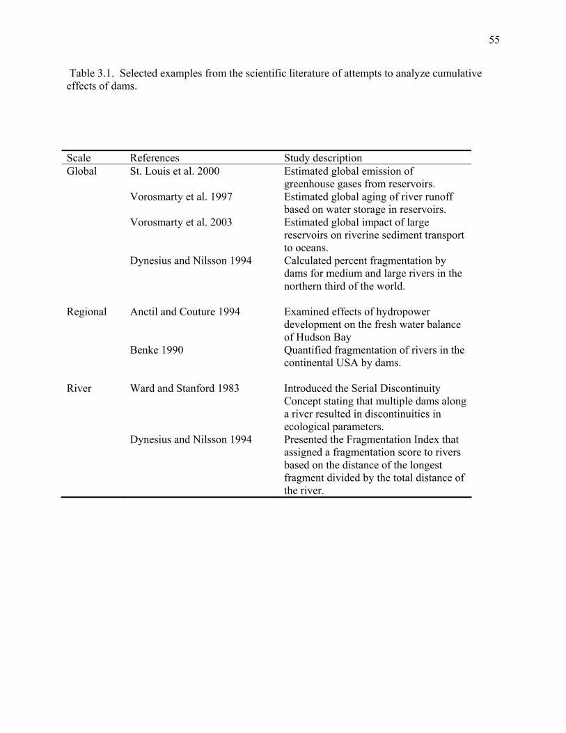
55
Table 3.1. Selected examples from the scientific literature of attempts to analyze cumulative effects of dams.
Scale References Study description Global St. Louis et al. 2000 Estimated global emission of
greenhouse gases from reservoirs. Vorosmarty et al. 1997 Estimated global aging of river runoff
based on water storage in reservoirs. Vorosmarty et al. 2003 Estimated global impact of large
reservoirs on riverine sediment transport to oceans.
Dynesius and Nilsson 1994 Calculated percent fragmentation by dams for medium and large rivers in the northern third of the world.
Regional Anctil and Couture 1994 Examined effects of hydropower
development on the fresh water balance of Hudson Bay
Benke 1990 Quantified fragmentation of rivers in the continental USA by dams.
River Ward and Stanford 1983 Introduced the Serial Discontinuity
Concept stating that multiple dams along a river resulted in discontinuities in ecological parameters.
Dynesius and Nilsson 1994 Presented the Fragmentation Index that assigned a fragmentation score to rivers based on the distance of the longest fragment divided by the total distance of the river.
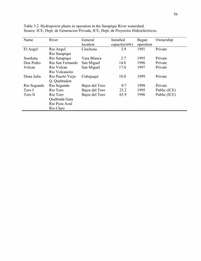
56
Table 3.2. Hydropower plants in operation in the Sarapiqui River watershed. Source: ICE, Dept. de Generacion Privada; ICE, Dept. de Proyectos Hidroeléctricos. Name River General
location Installed capacity(MW)
Began operation
Ownership
El Angel Rio Angel Rio Sarapiqui
Cinchona 3.9 1991 Private
Suerkata Rio Sarapiqui Vara Blanca 2.7 1995 Private Don Pedro Rio San Fernando San Miguel 14.0 1996 Private Volcan Rio Volcan
Rio Volcancito San Miguel 17.0 1997 Private
Dona Julia Rio Puerto Viejo Q. Quebradon
Cubujuqui 18.0 1999 Private
Rio Segundo Rio Segundo Bajos del Toro 0.7 1998 Private Toro I Rio Toro Bajos del Toro 23.2 1995 Public (ICE) Toro II Rio Toro
Quebrada Gata Rio Poza Azul Rio Claro
Bajos del Toro 65.9 1996 Public (ICE)
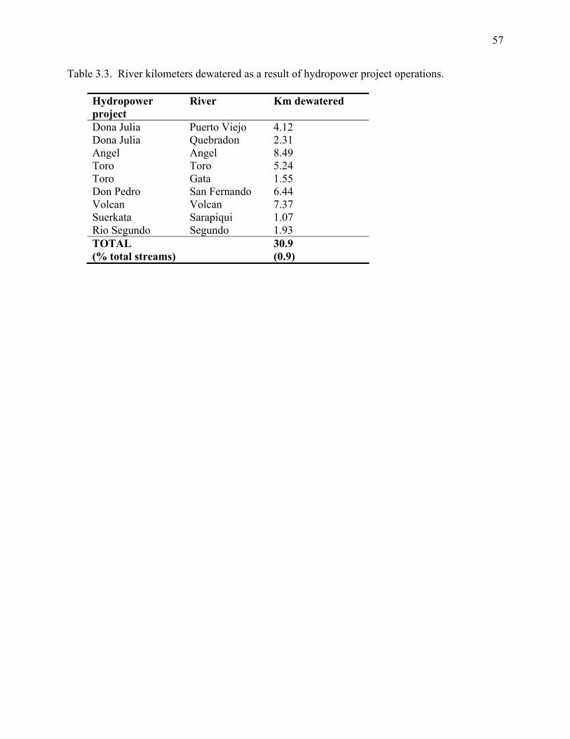
57
Table 3.3. River kilometers dewatered as a result of hydropower project operations.
Hydropower project
River Km dewatered
Dona Julia Puerto Viejo 4.12 Dona Julia Quebradon 2.31 Angel Angel 8.49 Toro Toro 5.24 Toro Gata 1.55 Don Pedro San Fernando 6.44 Volcan Volcan 7.37 Suerkata Sarapiqui 1.07 Rio Segundo Segundo 1.93 TOTAL (% total streams)
30.9 (0.9)
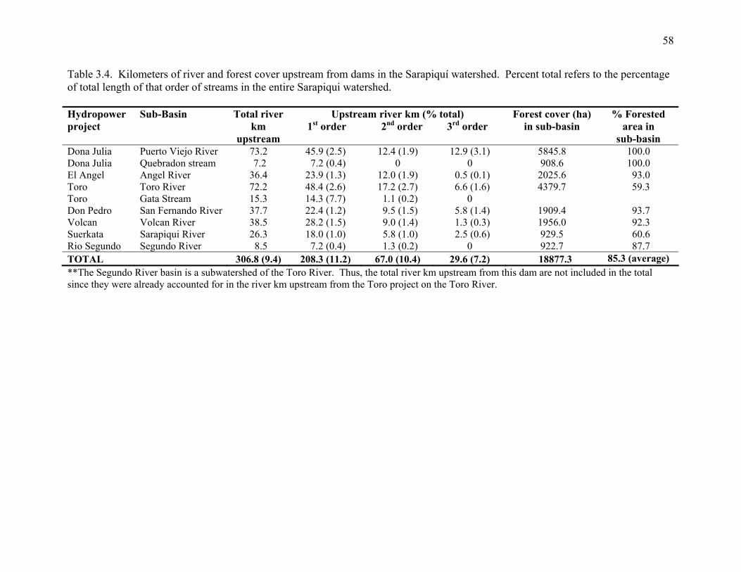
58
Table 3.4. Kilometers of river and forest cover upstream from dams in the Sarapiquí watershed. Percent total refers to the percentage of total length of that order of streams in the entire Sarapiqui watershed. Hydropower project
Sub-Basin Total river km
upstream
Upstream river km (% total) 1st order 2nd order 3rd order
Forest cover (ha) in sub-basin
% Forested area in
sub-basin Dona Julia Puerto Viejo River 73.2 45.9 (2.5) 12.4 (1.9) 12.9 (3.1) 5845.8 100.0 Dona Julia Quebradon stream 7.2 7.2 (0.4) 0 0 908.6 100.0 El Angel Angel River 36.4 23.9 (1.3) 12.0 (1.9) 0.5 (0.1) 2025.6 93.0 Toro Toro River 72.2 48.4 (2.6) 17.2 (2.7) 6.6 (1.6) 4379.7 59.3 Toro Gata Stream 15.3 14.3 (7.7) 1.1 (0.2) 0 Don Pedro San Fernando River 37.7 22.4 (1.2) 9.5 (1.5) 5.8 (1.4) 1909.4 93.7 Volcan Volcan River 38.5 28.2 (1.5) 9.0 (1.4) 1.3 (0.3) 1956.0 92.3 Suerkata Sarapiqui River 26.3 18.0 (1.0) 5.8 (1.0) 2.5 (0.6) 929.5 60.6 Rio Segundo Segundo River 8.5 7.2 (0.4) 1.3 (0.2) 0 922.7 87.7 TOTAL 306.8 (9.4) 208.3 (11.2) 67.0 (10.4) 29.6 (7.2) 18877.3 85.3 (average) **The Segundo River basin is a subwatershed of the Toro River. Thus, the total river km upstream from this dam are not included in the total since they were already accounted for in the river km upstream from the Toro project on the Toro River.
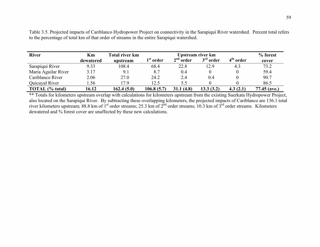
59
Table 3.5. Projected impacts of Cariblanco Hydropower Project on connectivity in the Sarapiquí River watershed. Percent total refers to the percentage of total km of that order of streams in the entire Sarapiqui watershed. River Km
dewatered Total river km
upstream Upstream river km
1st order 2nd order 3rd order 4th order % forest
cover Sarapiqui River 9.33 108.4 68.4 22.8 12.9 4.3 73.2 Maria Aguilar River 3.17 9.1 8.7 0.4 0 0 59.4 Cariblanco River 2.06 27.0 24.2 2.4 0.4 0 90.7 Quicuyal River 1.56 17.9 12.5 5.5 0 0 86.5 TOTAL (% total) 16.12 162.4 (5.0) 106.8 (5.7) 31.1 (4.8) 13.3 (3.2) 4.3 (2.1) 77.45 (ave.) ** Totals for kilometers upstream overlap with calculations for kilometers upstream from the existing Suerkata Hydropower Project, also located on the Sarapiqui River. By subtracting these overlapping kilometers, the projected impacts of Cariblanco are 136.1 total river kilometers upstream; 88.8 km of 1st order streams; 25.3 km of 2nd order streams; 10.3 km of 3rd order streams. Kilometers dewatered and % forest cover are unaffected by these new calculations.

60
Table 3.6. Conversion of forest to other land uses in Sarapiqui County between 1976 and 1996. Adapted from Sanchez-Azofeifa et al. 1999. Parameter 1976 1986 1991 1996 Forested area (km²) 513 381 345 313 % of landscape 55 41 37 34
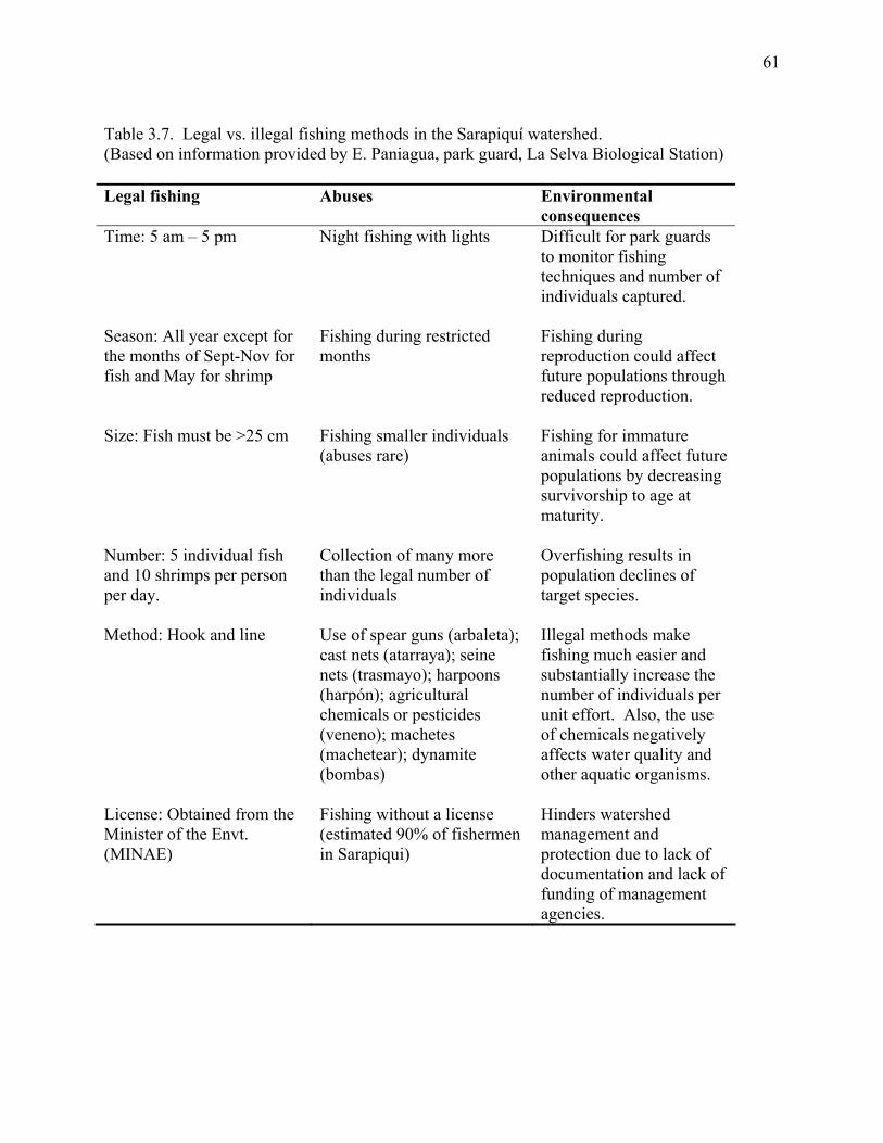
61
Table 3.7. Legal vs. illegal fishing methods in the Sarapiquí watershed. (Based on information provided by E. Paniagua, park guard, La Selva Biological Station) Legal fishing Abuses Environmental
consequences Time: 5 am – 5 pm Night fishing with lights Difficult for park guards
to monitor fishing techniques and number of individuals captured.
Season: All year except for the months of Sept-Nov for fish and May for shrimp
Fishing during restricted months
Fishing during reproduction could affect future populations through reduced reproduction.
Size: Fish must be >25 cm Fishing smaller individuals (abuses rare)
Fishing for immature animals could affect future populations by decreasing survivorship to age at maturity.
Number: 5 individual fish and 10 shrimps per person per day.
Collection of many more than the legal number of individuals
Overfishing results in population declines of target species.
Method: Hook and line Use of spear guns (arbaleta); cast nets (atarraya); seine nets (trasmayo); harpoons (harpón); agricultural chemicals or pesticides (veneno); machetes (machetear); dynamite (bombas)
Illegal methods make fishing much easier and substantially increase the number of individuals per unit effort. Also, the use of chemicals negatively affects water quality and other aquatic organisms.
License: Obtained from the Minister of the Envt. (MINAE)
Fishing without a license (estimated 90% of fishermen in Sarapiqui)
Hinders watershed management and protection due to lack of documentation and lack of funding of management agencies.
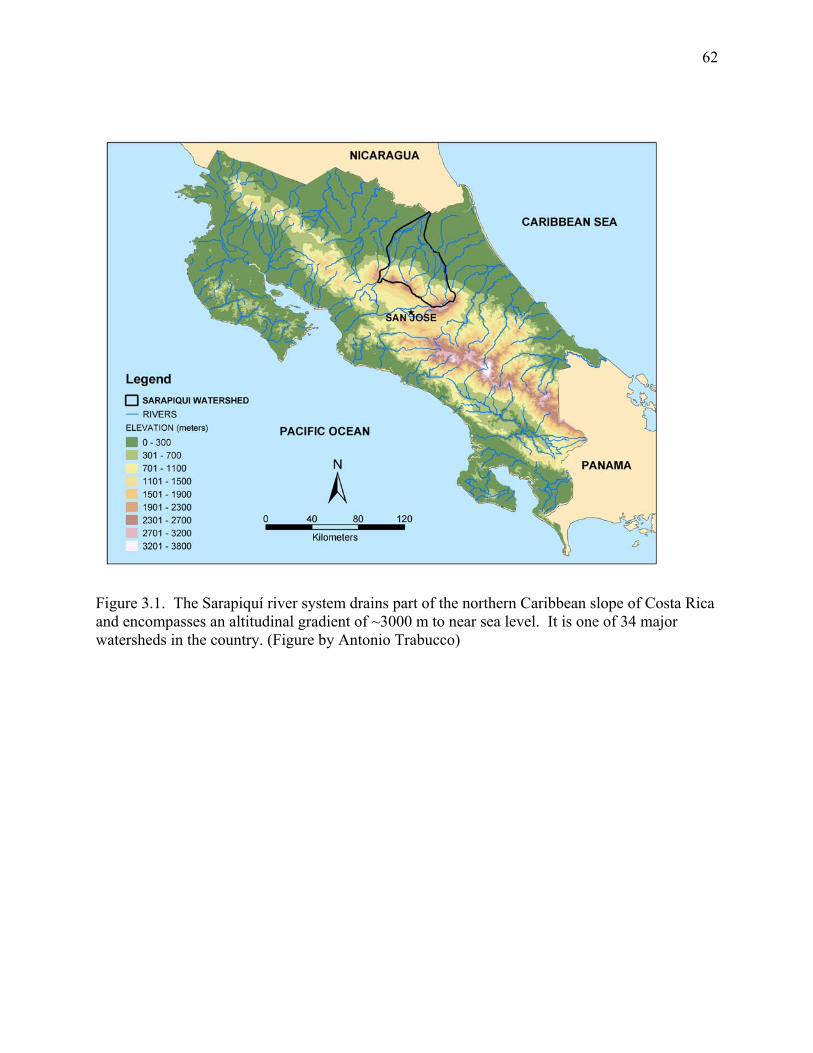
62
Figure 3.1. The Sarapiquí river system drains part of the northern Caribbean slope of Costa Rica and encompasses an altitudinal gradient of ~3000 m to near sea level. It is one of 34 major watersheds in the country. (Figure by Antonio Trabucco)
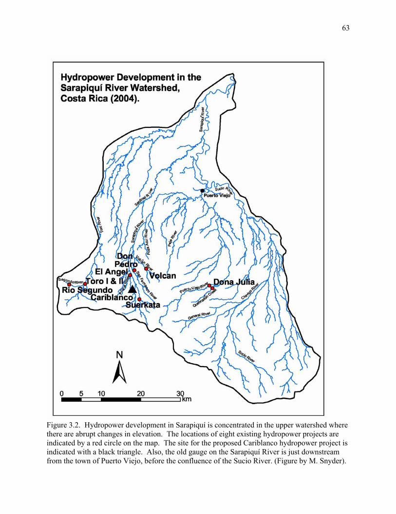
63
Figure 3.2. Hydropower development in Sarapiquí is concentrated in the upper watershed where there are abrupt changes in elevation. The locations of eight existing hydropower projects are indicated by a red circle on the map. The site for the proposed Cariblanco hydropower project is indicated with a black triangle. Also, the old gauge on the Sarapiquí River is just downstream from the town of Puerto Viejo, before the confluence of the Sucio River. (Figure by M. Snyder).
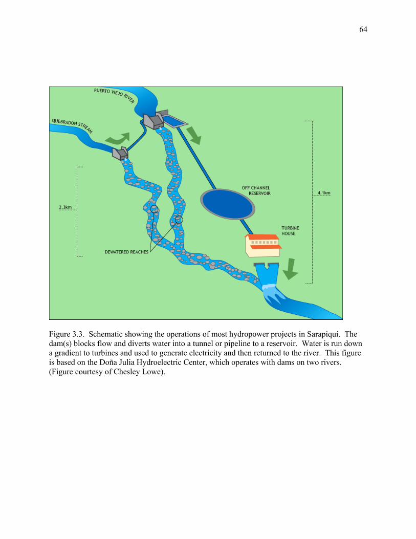
64
Figure 3.3. Schematic showing the operations of most hydropower projects in Sarapiquí. The dam(s) blocks flow and diverts water into a tunnel or pipeline to a reservoir. Water is run down a gradient to turbines and used to generate electricity and then returned to the river. This figure is based on the Doña Julia Hydroelectric Center, which operates with dams on two rivers. (Figure courtesy of Chesley Lowe).
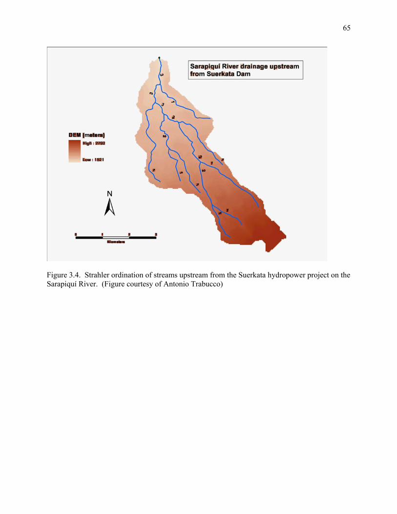
65
Figure 3.4. Strahler ordination of streams upstream from the Suerkata hydropower project on the Sarapiquí River. (Figure courtesy of Antonio Trabucco)
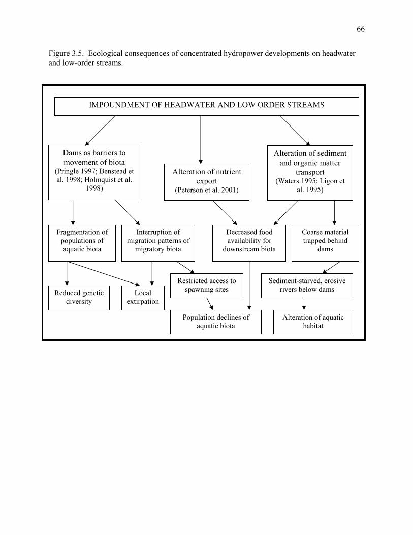
66
Figure 3.5. Ecological consequences of concentrated hydropower developments on headwater and low-order streams. IMPOUNDMENT OF HEADWATER AND LOW ORDER STREAMS
Dams as barriers to movement of biota
(Pringle 1997; Benstead et al. 1998; Holmquist et al.
1998)
Alteration of nutrient export
(Peterson et al. 2001)
Alteration of sediment and organic matter
transport (Waters 1995; Ligon et
al. 1995)
Coarse material trapped behind
dams
Decreased food availability for
downstream biota
Fragmentation of populations of aquatic biota
Interruption of migration patterns of
migratory biota
Local extirpation
Reduced genetic diversity
Restricted access to spawning sites
Sediment-starved, erosive rivers below dams
Population declines of aquatic biota
Alteration of aquatic habitat
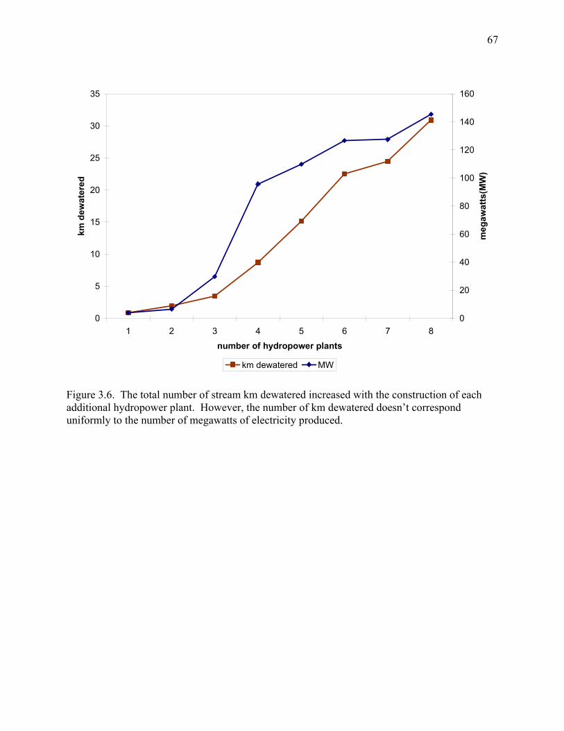
67
0
5
10
15
20
25
30
35
1 2 3 4 5 6 7 8
number of hydropower plants
km d
ewat
ered
0
20
40
60
80
100
120
140
160
meg
awat
ts(M
W)
km dewatered MW
Figure 3.6. The total number of stream km dewatered increased with the construction of each additional hydropower plant. However, the number of km dewatered doesn’t correspond uniformly to the number of megawatts of electricity produced.
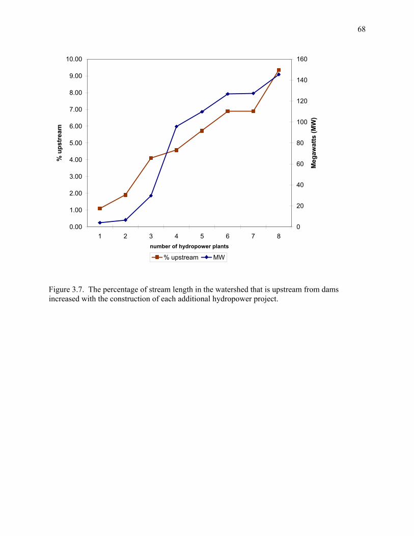
68
0.00
1.00
2.00
3.00
4.00
5.00
6.00
7.00
8.00
9.00
10.00
1 2 3 4 5 6 7 8number of hydropower plants
% u
pstr
eam
0
20
40
60
80
100
120
140
160
Meg
awat
ts (M
W)
% upstream MW
Figure 3.7. The percentage of stream length in the watershed that is upstream from dams increased with the construction of each additional hydropower project.
69
CHAPTER 4:
IMPACTS OF A WATER DIVERSION DAM ON NEOTROPICAL FISH ASSEMBLAGES,
COSTA RICA1
_________ 1Olivas, E.A., Freeman, M.C., and Pringle, C.P. To be submitted to River Research and Applications
70
Abstract
Diversion dams for hydropower are becoming a pervasive feature in the landscapes of
tropical regions. While most countries require some sort of environmental impact assessment
prior to the construction of a dam, follow-up studies of ecological impacts of dam operation are
rare. In this chapter, we present the results of a study of the ecological impacts of a small
hydropower project on the upper Puerto Viejo River, Costa Rica. Specifically, we examined the
impacts of project operations and the presence of two water diversion dams on stream fish
assemblages and aquatic habitat. By investigating changes in fish assemblages with respect to
downstream distance from a diversion dam along a de-watered reach of the Puerto Viejo River.
Our results suggest that there is a measurable effect of dam operations and stream dewatering on
fish assemblages. The fish assemblage at the upstream end of the de-watered reach of a 3rd order
river resembled the assemblage of a 1st order stream. Our data also indicated a general but non-
significant trend towards increasing species richness with downstream distance from the
diversion dam. In addition, fishes with opportunistic life history strategies dominated
assemblages closest to a water diversion dam, whereas cichlids (equilibrium-type life history
strategists) were restricted to the latter half of the 4.4 km de-watered reach of the Puerto Viejo
River. This study was conducted one year after the project’s construction and our dataset serves
as a foundation for monitoring changes in fish assemblages in the upper Puerto Viejo River.
Keywords: small dams, tropical, Costa Rica, streams, fish, hydropower
71
Introduction
The rapid conversion of pristine, free-flowing tropical rivers into regulated systems is
currently one of the most pressing concerns in global freshwater conservation (Allan and Flecker
1993; Fearnside 1995; Dudgeon 2000; Pringle et al. 2000a,b). Expanding human populations
and subsequent increases in demands for water and power have resulted in the construction of
hundreds of dams on tropical rivers over the last two decades (Petts 1990; Vaux and Goldman
1990; WCD 2000). Large dam projects in the tropics have traditionally attracted attention from
the international conservation community, due to their widespread environmental and social
impacts (Goodland et al. 1993; Fearnside 1995; Rosenberg et al. 1995; Rosenberg et al. 1997).
However, much of the dam development currently occurring throughout the tropics involves
small or medium sized projects (Vaux and Goldman 1990; Majot 1997; Benstead et al. 1999;
March et al. 2003). Unfortunately, the ecological impacts of these developments are poorly
understood and are not being adequately documented.
The use of Environmental Impact Assessment (EIA) prior to dam development has
become common in most countries and has aided in identifying projects that are excessively
detrimental to river systems (Bonnell and Storey 2000). Despite its conservation benefits, in
tropical regions, environmental impact assessment is challenged by a general lack of scientific
data on tropical rivers and their biota (Winemiller 1996). While many EIAs provide only a
cursory review of an area based on a few days’ fieldwork, they often represent the first or only
documentation of biotic assemblages in some tropical rivers. As a result, the potential impacts of
dams in the tropics are frequently predicted or derived from studies of large dams on temperate
rivers (Pringle et al. 2000a). Several fundamental differences between tropical and temperate
rivers, such as seasonality, frequency and magnitude of floods, temperature regime, and faunal
72
life histories, imply that this approach is inappropriate and manifest the need for more scientific
research on tropical aquatic systems (Pringle 2000). Furthermore, every pre-dam EIA should be
accompanied by follow-up studies of ecological impacts after dam operation begins to increase
our understanding of how stream ecosystems respond to specific dam-induced changes.
Unfortunately, these follow up studies are seldom completed (Travnichek et al. 1995).
Costa Rica has experienced a proliferation of small dams (<15 m high) on several of its
watersheds during the last 15 years (Anderson 2002). As in much of Latin America, a large
percentage (~85%) of Costa Rica’s electricity is now generated by hydropower, but most of the
country’s hydroelectric potential still remains untapped (Anderson 2002). Studies of the
environmental impacts of dams on Costa Rican rivers may provide insights into the relationship
between future developments and freshwater resources in many tropical areas. By law, virtually
all dam projects in Costa Rica are required to complete an EIA during their planning phase; these
reports must be reviewed and approved by the minister of the environment (MINAE) before dam
construction can begin. However, scientific studies of the actual ecological impacts of dam
operations are rare or non-existent in Costa Rica.
In the mid-1990s, the Doña Julia Hydroelectric Company began construction of a
hydropower project on the Puerto Viejo River, Costa Rica. The project is located in a remote
area of Costa Rica, which was inaccessible by road until it was slated for hydropower
development. Before project construction began, the company completed an EIA that included
rudimentary information on the biotic and abiotic characteristics of the Puerto Viejo River,
collected during April and May 1992 (Flores and Soto 1992). Based on this information and
observations made during visits to the site during the construction and early operation phases, we
predicted two major impacts of the Doña Julia project on the river: (1) the disruption of
73
longitudinal riverine connectivity created by two concrete dams on the Puerto Viejo and a
tributary stream; and (2) the de-watering of several stream kilometers and subsequent alteration
of aquatic habitat. We hypothesized that the project’s operation would affect the composition of
fish assemblages in the Puerto Viejo River both upstream and downstream of the dam.
This study examined effects of the Doña Julia hydropower project’s two small (<10 m
high) dams and associated water diversion on the distribution and abundance of tropical stream
fishes in the upper Puerto Viejo River. To the best of our knowledge, the present study is among
the first in Costa Rica to investigate the ecological impacts of a diversion dam during its
operational phase. We began data collection ~1 yr after the project started full operation. Our
main objectives were to describe aquatic habitat and fish assemblages near the Doña Julia project
on the Puerto Viejo River, Costa Rica, and to investigate potential patterns of fish species
distribution along a de-watered reach of stream below the dam. The specific questions addressed
were:
(1) Is it possible to measure an effect of the hydropower project’s operations on fish
assemblages? If so, is that effect related to aquatic habitat conditions?
(2) Is there a detectable change in fish assemblages and aquatic habitat with increasing
distance from the diversion dam along a de-watered reach of river?
Study site: The Puerto Viejo River and the Doña Julia hydropower project
The Puerto Viejo River, located on the northern Caribbean slope of Costa Rica, drains
part of Braulio Carrillo National Park, one of the largest tracts of protected rain forest in Central
America that spans elevations from near sea level to 2,900 meters above sea level. Natural forest
is the dominant land cover near the headwaters and mid-reaches of the Puerto Viejo drainage;
74
pasture and croplands are the major land uses in the river’s lower watershed. Steep gradients
caused by elevational changes of >100 m/km characterize the upper Puerto Viejo River
watershed, which receives >4 m of precipitation annually. The watershed experiences wet (May
to Dec) and dry (Jan to April) seasons, although precipitation is more evenly distributed
throughout the year than in other parts of Costa Rica (Sanford et al. 1994).
Variable topography and year-round rainy conditions have created a large hydropower
potential for the upper watershed of the Puerto Viejo River. Since 1999, the Doña Julia
Hydroelectric Company has operated an 18-megawatt hydropower project on the river near the
border of the national park (Figs. 4.1 & 4.2). The project draws water from the Puerto Viejo
River and the Quebradon stream; these rivers carry respective mean annual discharges of 8.5
m³/s and 1 m³/s at the dam site, respectively (CLC Ingenieros 1994). The project’s main
function is to provide electricity to Costa Rican residents during peak hours of demand, which
occur between approximately 10:00-12:30 and 17:30-20:00 daily. In 1999, the project produced
enough electricity to satisfy 1.4% of the country’s consumer needs (R. Corrales, personal
communication).
Operation of the project has created a ‘de-watered’ reach of stream on both rivers, where
90-95% of the average annual discharge is removed from the river and piped to an off-channel
reservoir for storage until electricity generation (Figure 4.3). On the Puerto Viejo River and
Quebradon stream, the distance of the ‘de-watered’ reach corresponds to ~4 km and ~1 km,
respectively. During normal flow conditions, a constant compensation discharge, calculated as
approximately 5% of average annual flow, is left in the stream at each diversion site. On the
Puerto Viejo River, tributary inputs (e.g., from Quebradon stream and other smaller 1st order
streams) and groundwater seeps (E. Olivas, personal observation) incrementally increase the
75
compensation discharge such that flow at the downstream end of the dewatered reach is roughly
10% of average annual discharge. During flood events or flows that surpass the capacity of the
diversion canal (~16 m³/s), the ‘de-watered’ reach fills with the excess water that passes over the
dam. Based on long-term discharge records, flows >16 m³/s occur 34 days per year on average
(CLC Ingenieros 1994). Most of these days usually are concentrated during months of heaviest
rainfall, such as November, December, and July.
Operation of the dam has also created variable conditions in the reach downstream from
the turbines where water is returned to the river. Generation periods result in marked increases
in discharge over several kilometers, due to the large amount of water released from the turbines
during a short time period (Figure 4.4a). Discharge increases are accompanied by temperature
decreases (Figure 4.4b).
Fish assemblages of the Puerto Viejo
A total of 44 freshwater fish species have been recorded from the Puerto Viejo River in
the lowlands (Bussing 1993; E. Olivas, unpublished data). Most of these fishes were collected in
1962-63 during a comprehensive study of a 1 km reach near the mouth of the river in the vicinity
of La Selva Biological Station (Bussing 1993). Collections of fishes in the Puerto Viejo River
after the 1960s have been very limited (Burcham 1988; Coleman 1999), and the watershed has
since experienced a dramatic conversion of much forested land to pasture and other agricultural
land uses (Butterfield 1994; Vargas 1995; Reid 1999).
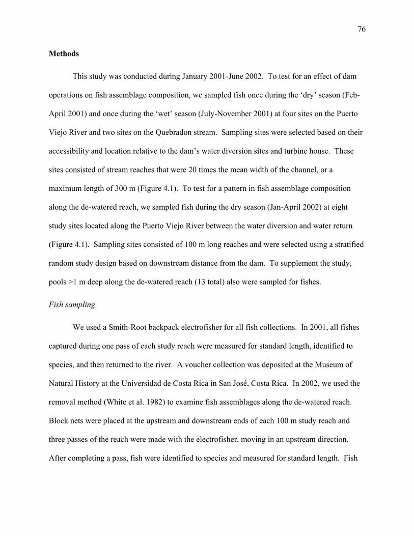
76
Methods
This study was conducted during January 2001-June 2002. To test for an effect of dam
operations on fish assemblage composition, we sampled fish once during the ‘dry’ season (Feb-
April 2001) and once during the ‘wet’ season (July-November 2001) at four sites on the Puerto
Viejo River and two sites on the Quebradon stream. Sampling sites were selected based on their
accessibility and location relative to the dam’s water diversion sites and turbine house. These
sites consisted of stream reaches that were 20 times the mean width of the channel, or a
maximum length of 300 m (Figure 4.1). To test for a pattern in fish assemblage composition
along the de-watered reach, we sampled fish during the dry season (Jan-April 2002) at eight
study sites located along the Puerto Viejo River between the water diversion and water return
(Figure 4.1). Sampling sites consisted of 100 m long reaches and were selected using a stratified
random study design based on downstream distance from the dam. To supplement the study,
pools >1 m deep along the de-watered reach (13 total) also were sampled for fishes.
Fish sampling
We used a Smith-Root backpack electrofisher for all fish collections. In 2001, all fishes
captured during one pass of each study reach were measured for standard length, identified to
species, and then returned to the river. A voucher collection was deposited at the Museum of
Natural History at the Universidad de Costa Rica in San José, Costa Rica. In 2002, we used the
removal method (White et al. 1982) to examine fish assemblages along the de-watered reach.
Block nets were placed at the upstream and downstream ends of each 100 m study reach and
three passes of the reach were made with the electrofisher, moving in an upstream direction.
After completing a pass, fish were identified to species and measured for standard length. Fish
77
were released ~100 m from the block net at the downstream end of the reach to prevent recapture
in subsequent passes.
Visual assessments were conducted in pools >1 m deep and consisted of timed trials
performed by two observers. Using a mask and snorkel, observers took turns slowly swimming
a pre-determined route through the pool during a 10 min period, noting all fish species present in
the pool. These 10 min trials were repeated three times by each observer, for a total sampling
time of 60 min in each pool. In two pools where no fish were seen during the first three trials,
the sampling period was stopped after 30 min. In cases where an observer was uncertain about
species identification, both observers returned to the pool after the 60 min period to note specific
characteristics about the fish and its behavior. Based on this information, fish were identified to
species using Bussing (1998). Pool volume and visibility were estimated after the observation
period to assist with comparisons.
Habitat descriptions
Physical variables related to aquatic habitat were measured at all sites in 2001 and 2002.
These included temperature, water velocity, substrate, wetted channel width, and water depth. In
2001, Onset Stowaway Temperature Dataloggers recorded temperature at two sites on the
Quebradon stream (QQA; QQD), three sites on the Puerto Viejo River (PVA; PVDM; PVCQ),
and at the water release from the turbine house (PVCU) during Feb-April. Geomorphic channel
units were mapped using 50 m measuring tapes to estimate the percentage of pools and rapids at
each site and to measure channel width. Using a stratified random study design, we sampled
water velocity, depth, and dominant substrate at 1 m intervals along 10 bank-to-bank channel
cross-sections (5 in pools and 5 in rapids) at each of the six sites. We also collected two water
78
samples from each of the six study sites that were later analyzed for soluble reactive phosphorus,
nitrate, and ammonium at the UGA Institute of Ecology’s Analytical Laboratory.
In 2002, Onset Stowaway Temperature Dataloggers were placed at three points to record
differences in single maximum and minimum temperatures along the de-watered reach of the
Puerto Viejo River: 100 m downstream from the diversion dam, 2000 m from the dam, and 4200
m from the dam. Water velocity (using a Marsh-McBirney FloMate meter) and depth were
sampled at 1 m intervals along 10 channel cross-sections, spaced equidistantly along each 100 m
study reach. A pebble count (Wolman 1954) was used to identify dominant bed sediment, and
geomorphic channel units were mapped in each of the eight 100 m study reaches after fish and
other habitat sampling was completed.
Data analysis
To test for an effect of dam operations on fish assemblage composition (2001 sample
data), we used non-metric multidimensional scaling (NMS) to ordinate a species abundance by
sample (site and season) matrix of 2001 data. Our analysis was completed using PC-ORD
software (MjM Software Design™, Glendale Beach, OR, U.S.A; McCune and Mefford 1999),
using Sorenson similarity. Abundance data were root-root transformed (e.g., fourth root) prior to
ordination. Species richness for each sample was estimated using the limiting form of the
jackknife estimator described by Burnham and Overton (1979), and calculated using SPECRICH
software provided by the Patuxent Wildlife Research Center (www.pwrc.usgs.gov). This
estimator uses species count data to account for variability in capture probabilities among
different species (see Burnham and Overton 1979). To test for longitudinal patterns in fish
assemblage composition along the de-watered reach (2002 sample data), we estimated species
richness from pooled data from all three passes at each 100 m study reach. This analysis was
79
accomplished using the jacknife richness estimator. Species richness estimates from 100 m
reaches and species count data from visual assessments in pools were tested against downstream
distance from the dam using regression analysis. Regression analysis also was used to test for
patterns in fish abundance (number of individuals) with downstream distance from the dam.
Results
Fishes: Distribution and abundance near hydropower project
A total of 2401 individuals were collected by electrofishing from the Puerto Viejo River
and Quebradon stream, 1519 individuals in 2001, and 882 individuals from the de-watered reach
of the Puerto Viejo in 2002. Captured fishes represented 14 species in 6 families (Table 4.1). In
2001, the most common species captured was Poecilia gillii (Poecilidae), which accounted for
43.5% of all individuals. Rhamdia rogersi (Pimelodidae), which accounted for 23.5% of
individuals, was the second most common species in 2001. Poecilia gillii was also the dominant
species captured in 2002, accounting for 46.0% of all individuals captured along the de-watered
reach. Despite few individuals (only 22 captured in total), the most species-rich family was
Cichlidae, with 5 species. No additional species were recorded during visual assessments.
Ordination of 2001 data indicated that samples (site and season) were divided into three
distinct groups based on fish assemblage composition (Figure 4.5). The largest group included
all four samples from the Quebradon stream (QQAD; QQAW; QQDD; QQDW) and both
samples from the Puerto Viejo River directly below the dam (PVDD; PVDW). Samples taken
from the Puerto Viejo River at the end of the de-watered reach (PVCQD; PVCQW) clustered
with samples taken downstream from the water return (PVCUD; PVCUW) to form the second
80
group. Dry and wet season samples taken above the dam on the Puerto Viejo River (PVAD;
PVAW) formed the third group. Together, axes 1 and 2 represented 91% of the variation in the
original distance matrix. The ordination also indicated that fish assemblage composition was
most affected by site location. Although slight seasonal differences in assemblages may exist,
these differences were small in comparison with site differences. Separation of the groups was
related to the occurrence of cichlids and increased abundance of individuals at the downstream
sites (PVCQ; PVCU), and fewer individuals above the Puerto Viejo dam (PVA).
Estimated species richness varied by location and slightly by season at each location.
Species richness was highest (11 spp.) downstream from the turbines (PVCUD) during the dry
season and lowest (3 spp.) upstream from the dam on the Quebradon stream during the wet
season (QAW). At sites within the dewatered reach of the Puerto Viejo River (PVDM; PVCQ),
species richness was higher during the wet season, whereas at sites upstream from the dams (QA;
PVA), species richness was higher during the dry season.
Fishes: Longitudinal patterns along the de-watered reach
Our data indicated that the removal method (White et al. 1982) was unsuccessful at
estimating fish populations along the dewatered reach of the Puerto Viejo River. As required by
the method, at all study reaches we captured the largest number of individuals during the first
pass with the electrofisher and then substantially fewer individuals during the second pass.
However, during the third pass, we typically captured many more individuals than the second
pass and often as many as during the first pass. This result contradicted the requirement of the
removal method that catches decline with additional passes. Therefore, we were never able to
estimate population size with confidence from our data. In our study system, we believe that
dominant bed sediments, such as boulder and cobble, may have created ample hiding spaces for
81
fishes during the first and second passes, and then fish weakened by the electrofisher were
caught during the third pass.
Analysis of 2002 fish data revealed some longitudinal patterns in species richness along
the dewatered reach of the Puerto Viejo River (Table 4.2). Species count was highest at the
downstream end of the dewatered reach (8 species) and linear regression of species richness
estimates indicated a general but non-significant trend towards increasing fish species richness
with downstream distance from the dam (r²=0.25, p>0.05) (Figure 4.6). However, richness
changed by only two species from the upstream to the downstream end of the dewatered reach.
Overall fish abundance in samples at each study site was not significantly related to downstream
distance from the diversion dam (r²=0.14, p>0.05). Peaks in the number of individuals captured
occurred at 1484 m and 4179 m downstream from the dam; these peaks resulted from the
dominance of Poecilia gillii, which accounted for more than half of the individuals at each of
these two sites (Figure 4.7).
Data from visual assessments along the de-watered reach of the Puerto Viejo River
revealed that fish species counts in pools were significantly related to downstream distance from
the dam (r²=0.73, p<0.01) (Figure 4.8). Cichlid fishes, found only in pools in the latter half of
the de-watered reach (>2500 m downstream from the diversion dam), accounted for this increase
in species count.
Habitat descriptions
Basic habitat characteristics of all sites are shown in Table 4.3. Several trends are evident
in the data. Rapids and riffle habitats tended to compose a larger percentage of the channel at
sites upstream from the dam than at downstream sites within the dewatered reach, where pool or
low velocity habitats dominated. Water velocity in both pools and riffles was 4-10 times greater
82
at sites upstream from the dams than in de-watered reaches. Water depths tended to be greater at
upstream sites as well, with the exception of greater average riffle depth at one site within the
dewatered reach (Table 4.3). However, there were no significant relations between distance
downstream from the dam and average depth or velocity in pools (r²=0.1; r²=0.0004) or riffles
(r²=0.019; r²=0.057), respectively. Boulder (250-4000 mm), followed by cobble (64-250 mm),
was the dominant bed sediment at all sites. Minimum water temperatures tended to be lower at
upstream sites, while maximum water temperatures were higher at downstream sites during Feb-
April 2001 (Table 4.3a). Dewatering appeared to increase water temperature: during Feb-April
2001, single maximum water temperatures recorded from the Puerto Viejo River in the
dewatered reach (PVDM) were ~2 ºC higher than temperatures upstream (PVA; Table 4.3a).
Results were similar for the Quebradon stream; the single maximum temperature of the
dewatered reach was ~1 ºC higher than upstream water temperature. Analysis of water samples
for ammonium, nitrate, and phosphorus indicated that water chemistry of the Puerto Viejo River
and Quebradon stream may be influenced by geochemical inputs from volcanic activity (see
Pringle et al. 1993). Across all sites, average concentrations of nutrients were 7 µg L¯¹ (±3) of
ammonium (NH4-N), 70 µg L¯¹ (±21) of nitrate (NO3-N), and 249 µg L¯¹ (± 94) of phosphorus
(SRP).
Discussion
The Doña Julia Hydropower Project is representative of the ~30 private hydropower
dams built in the past 15 years in Costa Rica (Anderson 2002). While the potential
environmental impacts of such developments are often predicted before their construction, the
actual ecological impacts of dam operations are usually not documented. Our investigation of
83
the ecological impacts of hydropower project operation is one of the only studies of its kind in
Costa Rica.
Fish assemblages of the upper Puerto Viejo River
The present study marks the first comprehensive survey of the fishes of the upper Puerto
Viejo River. An environmental impact statement completed as part of the planning process of
Doña Julia Project claimed that multiple fish species inhabited the river in the area near the dam;
these conclusions, however, were based on the existing literature and interviews with area
residents. No field collections of fishes were reported in the environmental impact statement
(Flores and Soto 1992). During the present study, we collected a total of 14 fish species from the
upper Puerto Viejo River along a ~5 km reach. Of these, one species, Agonostomus monticola, is
highly mobile and suspected to be either amphidromous or catadromous (Cruz 1987; Phillip
1993; Aiken 1998). An additional migratory fish, Joturus pichardi, was reported by local
fishermen to have been abundant in the area in the past and mentioned in the environmental
impact statement; yet this fish was not collected or seen during the present study.
Our results suggest that there is a measurable effect of dam operations on fish assemblage
composition. This effect is most pronounced upstream and directly downstream from the dam
on the Puerto Viejo River (PVA; PVDM). In the absence of the dam, we would expect these two
assemblages to resemble one another, due to their close geographic proximity. However, our
results indicate that the fish assemblage directly downstream from the dam (PVDM) is most
closely related to assemblages of the Quebradon stream (QQA; QQD). The physical barrier
presented by the dam restricts fish movement between the two sites on the Puerto Viejo (PVA;
PVDM) and thus may influence the structure of the upstream assemblage. Whereas fish from
upstream areas are capable of swimming downstream and passing over the dam during high flow
84
conditions, the dam restricts upstream movement. A potential consequence of this restricted
movement is the isolation of fish populations upstream from the dam. This isolation could result
in decreased intraspecific genetic diversity or local extirpation of highly mobile species (Winston
et al. 1991; Pringle 1997). Our data indicate that in the future Agonostomus monticola may face
local extinction upstream of the dam: during the dry season we captured three large adults above
the dam and observed four adults swimming at the base of the dam, yet during the wet season six
months later we neither captured or observed any Agonostomus monticola upstream from the
dam.
Similarity of certain aquatic habitat conditions may be the best explanation for the
separation of the fish assemblages into three groups in the ordination analysis. The resemblance
between the fish assemblage directly downstream from the dam on the Puerto Viejo (PVDM)
and the assemblages of the Quebradon stream (QA; QD) may be explained by the fact that all
three sites are comparable in terms of stream width, temperature range, and substrate.
Additionally, average depth and velocity at the downstream site on the Puerto Viejo (PVDM)
more closely resemble conditions in Quebradon stream than conditions upstream from the dam
(Table 4.3). Lack of pool habitat and rapid water velocities, in addition to isolation caused by
the dam, probably explain why the fish assemblage upstream from the dam on the Puerto Viejo
River (PVA) was unlike any other. Warmer water temperatures, lower elevation, and increased
stream width may be reasons for the similarity between assemblages at the downstream end of
the dewatered reach (PVCQ) and below the water return (PVCU).
Longitudinal patterns to fish distribution along a de-watered reach
Our results indicate that there is a detectable change in fish assemblage composition
downstream from the dam on the Puerto Viejo River. However, is this pattern actually the result
85
of dam operations and if so, to what degree? Alternatively, do observed patterns reflect a natural
longitudinal gradient of species additions, as has been predicted for Central American streams
without large dams (Welcomme 1985)? The paucity of pre-impoundment data on natural fish
distribution and the lack of comparable rivers in the region make it impossible to answer these
questions with complete certainty. In addition, our inability to estimate capture efficiency and
population sizes with removal sampling confounds interpretation of the results of this study.
Nevertheless, some trends evident in our data can provide insights. For example, species count
data from electrofishing and visual assessments in 2002 suggest that fish distribution may reflect
a natural longitudinal pattern. Furthermore, classification of fish by feeding groups (e.g.,
insectivores, piscivores, omnivores, detritivores) and as either habitat generalists or specialists
reveals no real trends in fish distribution along the dewatered reach. But when we classify fishes
by their life history strategies (Winemiller 1995), our results indicate that species with more
‘opportunistic’ strategies dominate assemblages closer to the dam, whereas assemblages further
downstream along the dewatered reach contain a mix of ‘opportunistic’ and ‘equilibrium’ species
(Table 4.4). This distribution of ‘equilibrium’ species may be the result of incremental increases
in discharge along the dewatered reach due to tributary and groundwater inputs, since they were
only present downstream from the confluence of the Puerto Viejo River and the Quebradon
stream. Increased discharge in the downstream half of the dewatered reach may mean three
things for fishes: (1) more habitat during dry periods with little rainfall; (2) reduced disturbance
during high or ‘flashy’ flows; and (3) easier access to refugia near channel edges. Furthermore,
slightly lower minimum water temperatures at the upstream end of the dewatered reach may also
explain why cichlids (equilibrium species) were restricted to downstream areas.
86
Conclusions and Recommendations
Perhaps the greatest value of our dataset is that it can be used as a tool for tracking
changes over time in fish assemblages near the Dona Julia hydropower project. Changes could
result from temporal adjustments to present operating conditions or in response to modifications
in operation designed to minimize environmental impacts. Diversion dams, like the one on the
Puerto Viejo River, hinder upstream movement of mobile / migratory fishes. Our results also
imply that the increased likelihood of desiccation, downstream from a diversion dam before the
confluence of any major tributaries, may be a mechanism limiting the occurrence of equilibrium-
type species like cichlids. The presence of the dam and water diversion may impact long-term
persistence of fish populations in the upper Puerto Viejo River.
If management goals at Doña Julia and other hydropower projects in Costa Rica include
maintaining biotic integrity in dammed streams, alternatives to current operations should be
considered. Providing fish passage at dams below 600 meters above sea level and increasing
flows in diverted streams during dry periods may help facilitate upstream persistence of periodic-
and equilibrium-type fish species. At higher altitudes, fish assemblages are dominated by only a
few small species adapted to colder water temperatures (Bussing 1998). Because the Doña Julia
dam and other private diversion dams in Costa Rica are usually <10 m in height, installation of a
fish ladder or an artificial side channel may be practicable. Increasing flows in diverted streams
could be accomplished in the context of adaptive management (Irwin and Freeman 2002): a trial
period of augmented flows accompanied by fish sampling would show whether or not more
periodic- and equilibrium-type species move upstream when discharge is increased. In absence
of changes to current operations, we expect that fish assemblages in the upper Puerto Viejo
87
River, and other streams used for hydropower, will be increasingly dominated by opportunistic-
type fishes.
In summary, dams like the Doña Julia hydropower project are currently transforming
river ecosystems throughout the tropics. The ecological impacts of these developments on
tropical rivers will depend on the type of facility, degree of hydrologic alteration, local climate,
and life histories of stream biota. More studies of pre-impoundment ecological conditions are
needed to provide insight into the ecological requirements of tropical stream biota and to predict
their response to hydrologic alterations caused by dams. Establishment of monitoring programs
and the use of adaptive management at operational dams can help guide future development in a
way that maximizes the benefits of hydropower while minimizing its negative environmental
consequences. This study and others (see Benstead et al. 1999; Ponton et al. 2000) illustrate the
utility of ecological research in improving the design and management of dams and other water
abstraction projects in the tropics.
Acknowledgements
This research was funded by a Fulbright scholarship (2001) to E. Olivas. Additional
financial and logistical support was provided by the Organization for Tropical Studies. Indirect
support came from a National Science Foundation grant (DEB-0075339) to C.M. Pringle and
F.J. Triska. This study would not have been possible without the collaboration of the Doña Julia
Hydroelectric Company, in particular Rafael Corrales, Antonio Sevilla, and Frank Daniels, who
granted us unlimited access to the project site. We would like to thank the many people who
assisted in the field, especially: Minor Hidalgo, Paulo Olivas, Enrique Salicetti, Jose Reñazco,
William Ureña, Suzanne Moellendorf, and Heather Conwell. We also thank Antonio Trabucco
88
and Chesley Lowe for preparation of figures 1 and 3 and Diana Lieberman for advice on data
analysis. The Pringle Lab group, Judy Meyer, and Ronald Coleman provided insightful
comments on earlier drafts of this manuscript.
Literature Cited
Aiken, K.A. 1998. Reproduction, diet and population structure of the mountain mullet, Agonostomus monticola, in Jamaica, West Indies. Environmental Biology of Fishes 53:347-352.
Allan, J.D. and Flecker, A.S. 1993. Biodiversity conservation in running waters. BioScience 43, 32-43.
Anderson (Olivas), E.P. 2002. Electricity sector reform means more dams for Costa Rica. World Rivers Review 17(4):3.
Benstead, J.P., March, J.G., Pringle, C.M., and Scatena, F.N. 1999. Effects of a low- head dam and water abstraction on migratory tropical stream biota. Ecological Applications 9, 656-668.
Bonnell, S. and Storey, K. 2000. Addressing cumulative effects through strategic environmental assessment: A case study of small hydro development in Newfoundland, Canada.
Burcham 1988. Fish communities and environmental characteristics of two lowland streams in Costa Rica. Revista de Biologia Tropical 36, 273-285.
Burnham, K.P. and Overton, W.S. 1979. Robust estimation of population size when capture probabilities vary among animals. Ecology 60, 927-936.
Bussing, W.A. 1993. Fish communities and environmental characteristics of a tropical rain forest river in Costa Rica. Revista de Biologia Tropical 41, 791-809.
Bussing, W.A. 1998. Peces de las Aguas Continentales de Costa Rica, Editorial de la Universidad de Costa Rica, San Jose.
Butterfield, R.P. 1994. The regional context: Land colonization and conservation in Sarapiqui. Pages 299-306 in McDade, L.A., Bawa, K.S., Hespenheide, H.A., and Hartshorn, G.A. La Selva: Ecology and Natural History of a Neotropical Rain Forest.
89
CLC Ingenieros. 1994. Estudio de Factibilidad del Proyecto Hidroeléctrico Doña Julia. San Jose, Costa Rica.
Coleman, R. 1999. Cichlid fishes of the Puerto Viejo River, Costa Rica. Cichlid News 8, 6-12.
Cruz, G. A. 1987. Reproductive biology and feeding habitat of Cuyamel, Joturus pichardi and Tepemechin, Agonostomus monticola (Pisces: Mugilidae) from Rio Platano, Mosquitia, Honduras. Bulletin of Marine Science 40, 63-72.
Dudgeon, D. 2000. Large-scale hydrological alterations in tropical Asia: prospects for riverine biodiversity. BioScience 50:793-806.
Fearnside, P.M. 1995. Hydroelectric dams in the Brazilian Amazon as sources of “greenhouse” gases. Environmental Conservation 22, 7-19.
Flores, E.M. and Soto, R. 1992. Evaluación biologica del impacto ambiental del Proyecto Hidroeléctrico Doña Julia 18-V. San Jose, Costa Rica.
Goodland, R.J.A., Juras, A., and Pachauri, R. 1993. Can hydro-reservoirs in tropical moist forests be environmentally sustainable? Environmental Conservation 20, 122-130.
Irwin, E.R. and Freeman, M.C. 2002. Proposal for adaptive management to conserve biotic integrity in a regulated segment of the Tallapoosa River, Alabama (U.S.A.). Conservation Biology 16, 1-11.
Majot, J.A. (ed). 1997. Beyond Big Dams: A New Approach to Energy Sector and Watershed Planning. International Rivers Network, Berkeley, CA.
March, J.G., Benstead, J.P., Pringle, C.M., and Scatena, F.N. 2003. Damming tropical island streams: Problems, solutions, and alternatives. BioScience 53, 1069-1078.
McCune, B. and Mefford, M.J. 1999. PC-ORD: Multivariate Analysis of Ecological Data, Version 4. MjM Software Design, Glenden Beach, OR.
Petts, G.E. 1990. Regulation of large rivers: Problems and possibilities for environmentally sound river development in South America. Interciencia 15, 388-395.
Phillip, D.A.T. 1993. Reproduction and feeding of the mountain mullet, Agonostomus monticola, in Trinidad, West Indies. Environmental Biology of Fishes 37:47-55.
Ponton, D., Merigoux, S., and Copp, G.H. 2000. Impact of a dam in the neotropics: what can be learned from young-of-the-year fish assemblages in tributaries of the River Sinnamary (French Guiana, South America). Aquatic Conservation: Marine and Freshwater Ecosystems 10:25-51.
90
Pringle, C.M. 1997. Exploring how disturbance is transmitted upstream: going against the flow. Journal of the North American Benthological Society 16:425-438.
Pringle, C.M. 2000. Riverine conservation in tropical versus temperate regions: Ecological and socioeconomic considerations. Pages 367-379 in Boon, P.J., Davies, B.R., Petts, G.E., eds. Global Perspectives on River Conservation: Science, Policy and Practice. John Wiley & Sons, New York.
Pringle, C.M., Freeman, M.C., and Freeman, B.J. 2000(a). Regional effects of
hydrologic alterations on riverine macrobiota in the new world: tropical-temperate comparisons. BioScience 50, 807-823.
Pringle, C.M., Rowe, G.L., Triska, F.J., Fernandez, J.F., and West, J. 1993. Landscape linkages between geothermal activity, solute composition, and ecological response in streams draining Costa Rica’s Atlantic slope. Limnology and Oceanography 38:753-774.
Pringle, C.M., Scatena, F.S., Paaby-Hansen, P., and Nunez, M. 2000(b). River conservation in Latin America and the Caribbean. Pages 39-73 in Boon, P.J., Davies, B.R., Petts, G.E., eds. Global Perspectives on River Conservation: Science, Policy and Practice. John Wiley & Sons, New York.
Read, J.M. 1999. Land Cover Change Detection for the Tropics Using Remote Sensing and Geographic Information Systems. PhD Dissertation, Louisiana State Univeristy. Baton Rouge, LA.
Rosenberg, D.M., Bodaly, R.A., and Usher, P.J. 1995. Environmental and social impacts of large-scale hydroelectric development: who is listening? Global Environmental Change 5, 127-148.
Rosenberg, D.M., Berkes, F., Bodaly, R.A., Hecky, R.E., Kelly, C.A., and Rudd, J.W.M. 1997. Large-scale impacts of hydroelectric development. Environmental Review 5, 27-54.
Sanford, R.L., Paaby, P., Luvall, J.C., and Phillips, E. 1994. Climate, Geomorphology, and Aquatic Systems. Pages 19-33 in McDade, L.A., Bawa, K.S., Hespenheide, H.A., and Hartshorn, G.A. La Selva: Ecology and Natural History of a Neotropical Rain Forest. University of Chicago Press, Chicago.
Travnichek, V. H., Bain, M. B., and Maceina, M. J. 1995. Recovery of a warmwater fish assemblage after the initiation of a minimum-flow release downstream from a hydroelectric dam. Transactions of the American Fisheries Society 124, 836-844.
Vargas, R.J. 1995. History of Municipal Water Resources in Puerto Viejo de Sarapiquí, Costa Rica: A Socio-Political Perspective. Master’s thesis, University of Georgia. Athens, GA.
91
Vaux, P.D. and Goldman, C.R. 1990. Dams and development in the tropics. Pages 101- 123 in Goodland, R. editor. Race to Save the Tropics. Island Press, Washington, DC.
Welcomme, R.L. 1985. River fisheries. FAO Fisheries Technical Paper 262, 1-330.
White, G.C., Anderson, D.R., Burnham, K.P., and Otis, D.L. 1982. Capture-Recapture and Removal Methods for Sampling Closed Populations. Los Alamos National Laboratory, Los Alamos, NM.
Winemiller, K.O. 1995. Aspects structurels et fonctionnels de la biodiversite des
peuplements de poissons. Bulletin Francais du Peche et Pisciculture 339, 23-45.
Winemiller, K.O. 1996. Dynamic diversity in fish assemblages of tropical rivers. Pages 99-134 in Long-Term Studies of Vertebrate Communities. Academic Press, Inc.
Winston, M.R., Taylor, C.M., and Pigg, J. 1991. Upstream extirpation of four minnow species due to damming of a prairie stream. Transactions of the American Fisheries Society 120, 98-105.
Wolman. 1954. A method of sampling coarse river-bed material. Transactions of the American Geophysical Union 35:951-956.
World Commission on Dams (WCD). 2000. Dams and Development: A Framework for Decision-Making. www.dams.org
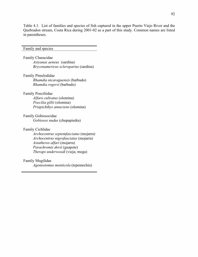
92
Table 4.1. List of families and species of fish captured in the upper Puerto Viejo River and the Quebradon stream, Costa Rica during 2001-02 as a part of this study. Common names are listed in parentheses. Family and species Family Characidae Astyanax aeneus (sardina) Bryconamericus scleroparius (sardina) Family Pimelodidae Rhamdia nicaraguensis (barbudo) Rhamdia rogersi (barbudo) Family Poeciliidae Alfaro cultratus (olomina) Poecilia gillii (olomina) Priapichthys annectens (olomina) Family Gobiosocidae Gobiosox nudus (chupapiedra) Family Cichlidae Archocentrus septemfasciatus (mojarra) Archocentrus nigrofasciatus (mojarra) Astatheros alfari (mojarra) Parachromis dovii (guapote) Theraps underwoodi (vieja; moga) Family Mugilidae Agonostomus monticola (tepemechin)
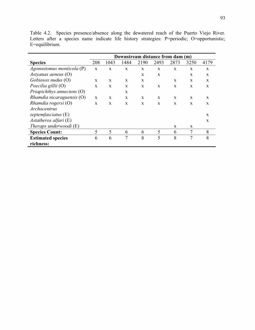
93
Table 4.2. Species presence/absence along the dewatered reach of the Puerto Viejo River. Letters after a species name indicate life history strategies: P=periodic; O=opportunistic; E=equilibrium. Downstream distance from dam (m) Species 208 1043 1484 2190 2493 2873 3250 4179 Agonostomus monticola (P) x x x x x x x x Astyanax aeneus (O) x x x x Gobiosox nudus (O) x x x x x x x Poecilia gillii (O) x x x x x x x x Priapichthys annectens (O) x Rhamdia nicaraguensis (O) x x x x x x x x Rhamdia rogersi (O) x x x x x x x x Archocentrus septemfasciatus (E)
x
Astatheros alfari (E) x Theraps underwoodi (E) x x Species Count: 5 5 6 6 5 6 7 8 Estimated species richness:
6 6 7 8 5 8 7 8
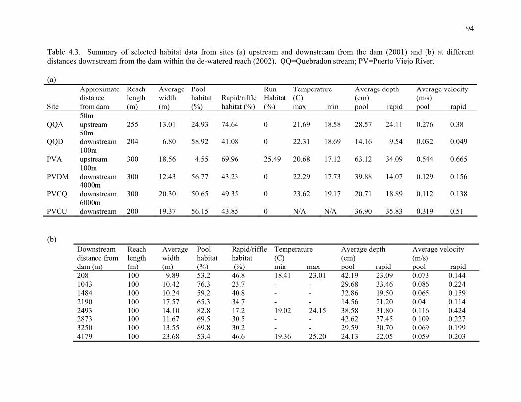
94
Table 4.3. Summary of selected habitat data from sites (a) upstream and downstream from the dam (2001) and (b) at different distances downstream from the dam within the de-watered reach (2002). QQ=Quebradon stream; PV=Puerto Viejo River. (a)
Site
Approximate distance from dam
Reach length (m)
Average width (m)
Pool habitat (%)
Rapid/riffle habitat (%)
Run Habitat (%)
Temperature (C) max min
Average depth (cm) pool rapid
Average velocity (m/s) pool rapid
QQA 50m upstream 255 13.01 24.93 74.64 0
21.69 18.58 28.57 24.11 0.276 0.38
QQD 50m downstream 204 6.80 58.92 41.08 0
22.31 18.69 14.16 9.54 0.032 0.049
PVA 100m upstream 300 18.56 4.55 69.96 25.49
20.68 17.12 63.12 34.09 0.544 0.665
PVDM 100m downstream 300 12.43 56.77 43.23 0
22.29 17.73 39.88 14.07 0.129 0.156
PVCQ 4000m downstream 300 20.30 50.65 49.35 0
23.62 19.17 20.71 18.89 0.112 0.138
PVCU 6000m downstream 200 19.37 56.15 43.85 0
N/A N/A 36.90 35.83 0.319 0.51
(b)
Downstream distance from dam (m)
Reach length (m)
Average width (m)
Pool habitat (%)
Rapid/riffle habitat (%)
Temperature (C) min max
Average depth (cm) pool rapid
Average velocity (m/s) pool rapid
208 100 9.89 53.2 46.8 18.41 23.01 42.19 23.09 0.073 0.144 1043 100 10.42 76.3 23.7 - - 29.68 33.46 0.086 0.224 1484 100 10.24 59.2 40.8 - - 32.86 19.50 0.065 0.159 2190 100 17.57 65.3 34.7 - - 14.56 21.20 0.04 0.114 2493 100 14.10 82.8 17.2 19.02 24.15 38.58 31.80 0.116 0.424 2873 100 11.67 69.5 30.5 - - 42.62 37.45 0.109 0.227 3250 100 13.55 69.8 30.2 - - 29.59 30.70 0.069 0.199 4179 100 23.68 53.4 46.6 19.36 25.20 24.13 22.05 0.059 0.203
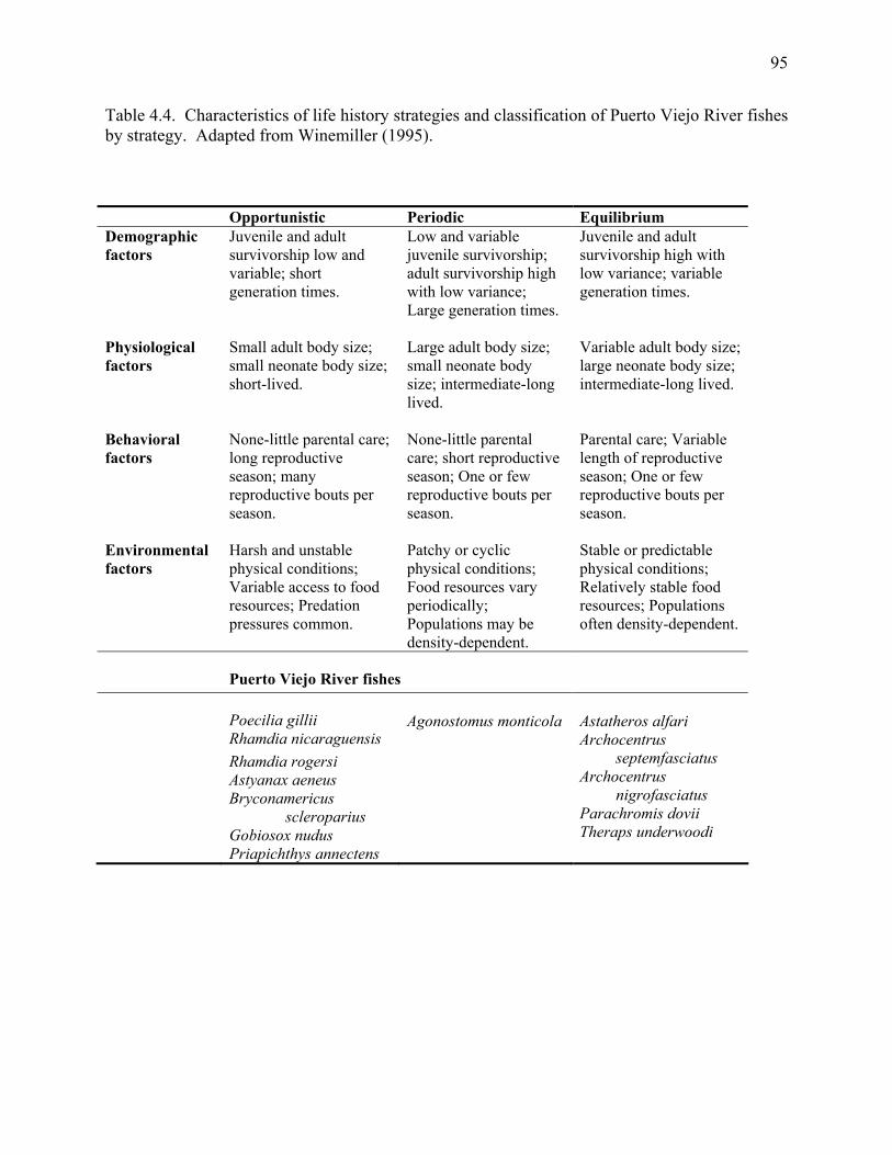
95
Table 4.4. Characteristics of life history strategies and classification of Puerto Viejo River fishes by strategy. Adapted from Winemiller (1995).
Opportunistic Periodic Equilibrium Demographic factors
Juvenile and adult survivorship low and variable; short generation times.
Low and variable juvenile survivorship; adult survivorship high with low variance; Large generation times.
Juvenile and adult survivorship high with low variance; variable generation times.
Physiological factors
Small adult body size; small neonate body size; short-lived.
Large adult body size; small neonate body size; intermediate-long lived.
Variable adult body size; large neonate body size; intermediate-long lived.
Behavioral factors
None-little parental care; long reproductive season; many reproductive bouts per season.
None-little parental care; short reproductive season; One or few reproductive bouts per season.
Parental care; Variable length of reproductive season; One or few reproductive bouts per season.
Environmental factors
Harsh and unstable physical conditions; Variable access to food resources; Predation pressures common.
Patchy or cyclic physical conditions; Food resources vary periodically; Populations may be density-dependent.
Stable or predictable physical conditions; Relatively stable food resources; Populations often density-dependent.
Puerto Viejo River fishes
Poecilia gillii Rhamdia nicaraguensis Rhamdia rogersi Astyanax aeneus Bryconamericus scleroparius Gobiosox nudus Priapichthys annectens
Agonostomus monticola
Astatheros alfari Archocentrus septemfasciatus Archocentrus nigrofasciatus Parachromis dovii Theraps underwoodi
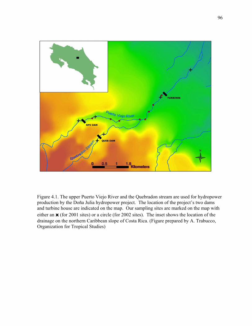
96
Figure 4.1. The upper Puerto Viejo River and the Quebradon stream are used for hydropower production by the Doña Julia hydropower project. The location of the project’s two dams and turbine house are indicated on the map. Our sampling sites are marked on the map with either an x (for 2001 sites) or a circle (for 2002 sites). The inset shows the location of the drainage on the northern Caribbean slope of Costa Rica. (Figure prepared by A. Trabucco, Organization for Tropical Studies)
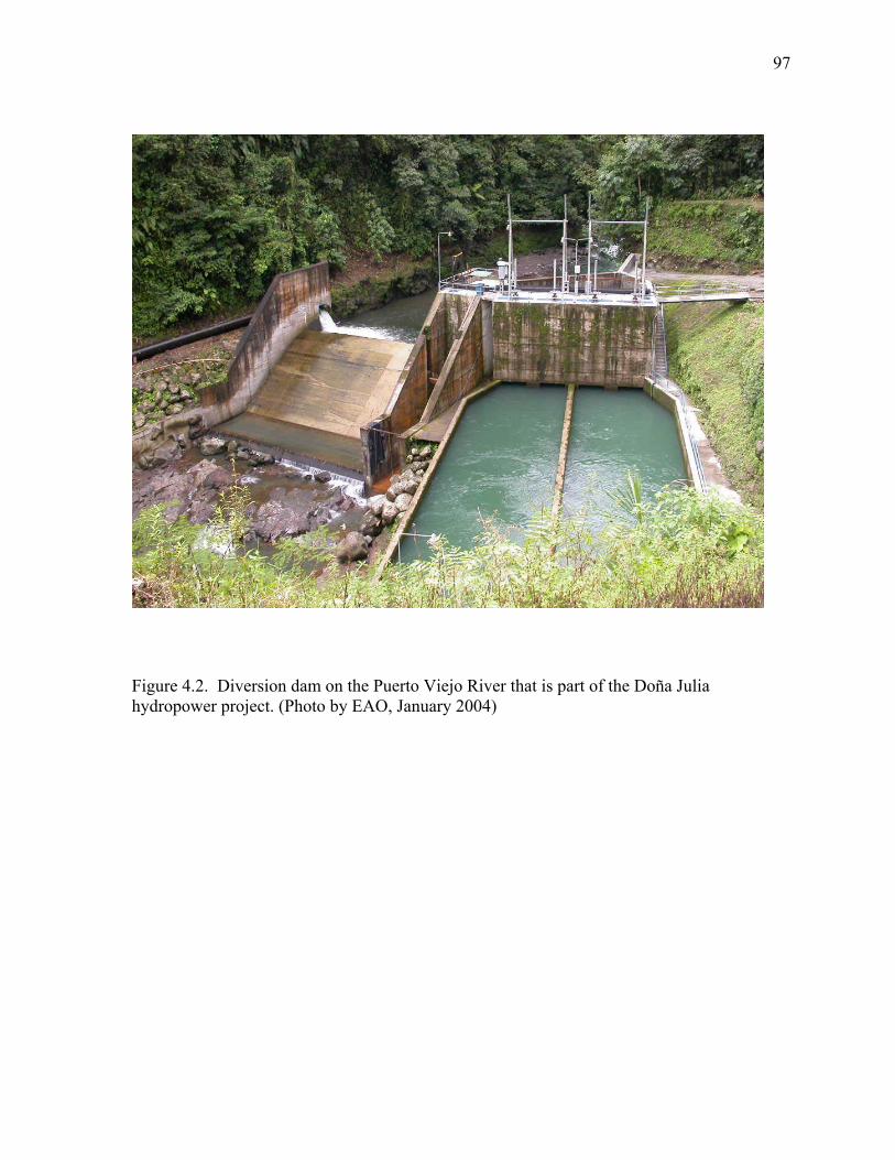
97
Figure 4.2. Diversion dam on the Puerto Viejo River that is part of the Doña Julia hydropower project. (Photo by EAO, January 2004)
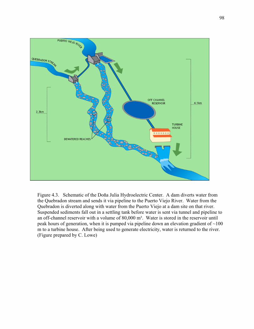
98
Figure 4.3. Schematic of the Doña Julia Hydroelectric Center. A dam diverts water from the Quebradon stream and sends it via pipeline to the Puerto Viejo River. Water from the Quebradon is diverted along with water from the Puerto Viejo at a dam site on that river. Suspended sediments fall out in a settling tank before water is sent via tunnel and pipeline to an off-channel reservoir with a volume of 80,000 m³. Water is stored in the reservoir until peak hours of generation, when it is pumped via pipeline down an elevation gradient of ~100 m to a turbine house. After being used to generate electricity, water is returned to the river. (Figure prepared by C. Lowe)
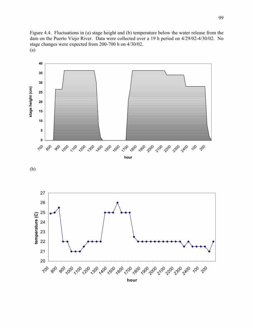
99
Figure 4.4. Fluctuations in (a) stage height and (b) temperature below the water release from the dam on the Puerto Viejo River. Data were collected over a 19 h period on 4/29/02-4/30/02. No stage changes were expected from 200-700 h on 4/30/02. (a)
(b)
0
5
10
15
20
25
30
35
40
700
800
900
1000
1100
1200
1300
1400
1500
1600
1700
1800
1900
2000
2100
2200
2300
2400 10
020
0
hour
stag
e he
ight
(cm
)
20
21
22
23
24
25
26
27
700800900100011001200130014001500160017001800190020002100220023002400 10
0200
hour
tem
pera
ture
(C)
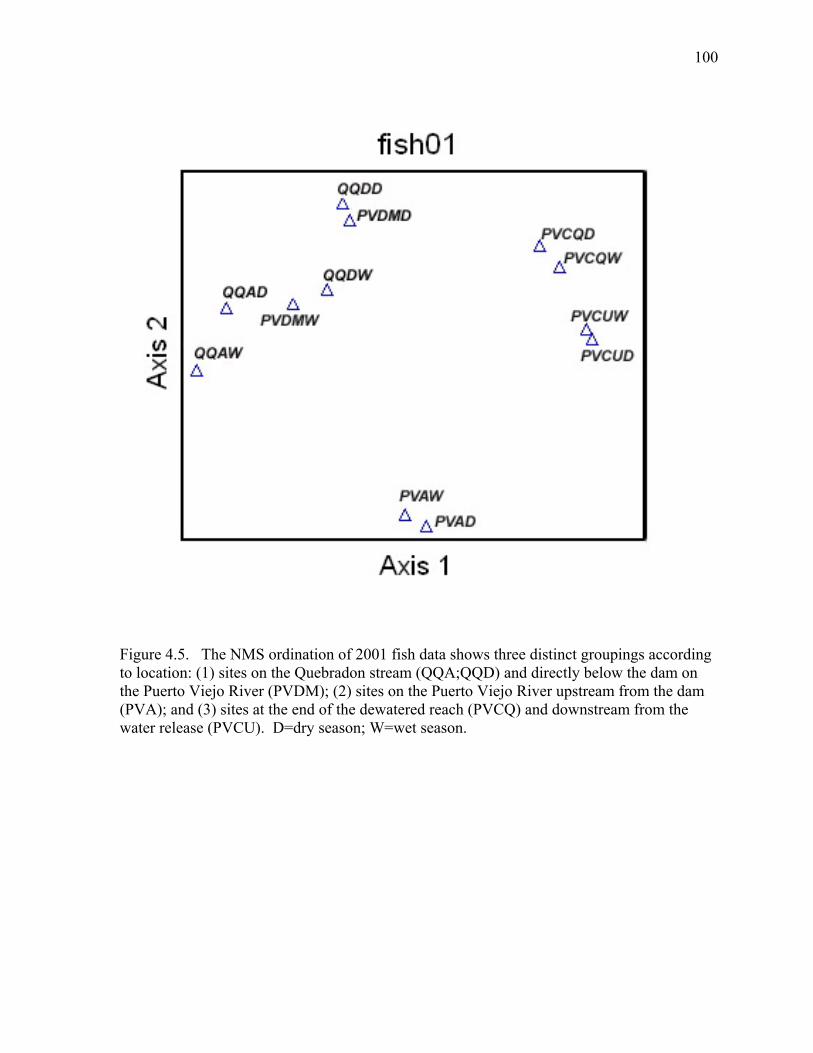
100
Figure 4.5. The NMS ordination of 2001 fish data shows three distinct groupings according to location: (1) sites on the Quebradon stream (QQA;QQD) and directly below the dam on the Puerto Viejo River (PVDM); (2) sites on the Puerto Viejo River upstream from the dam (PVA); and (3) sites at the end of the dewatered reach (PVCQ) and downstream from the water release (PVCU). D=dry season; W=wet season.
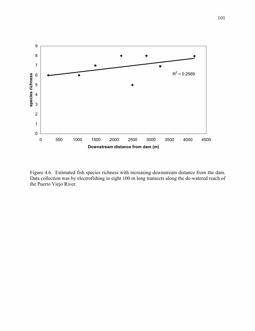
101
Figure 4.6. Estimated fish species richness with increasing downstream distance from the dam. Data collection was by electrofishing in eight 100 m long transects along the de-watered reach of the Puerto Viejo River.
R2 = 0.2569
0
1
2
3
4
5
6
7
8
9
0 500 1000 1500 2000 2500 3000 3500 4000 4500
Downstream distance from dam (m)
spec
ies
richn
ess
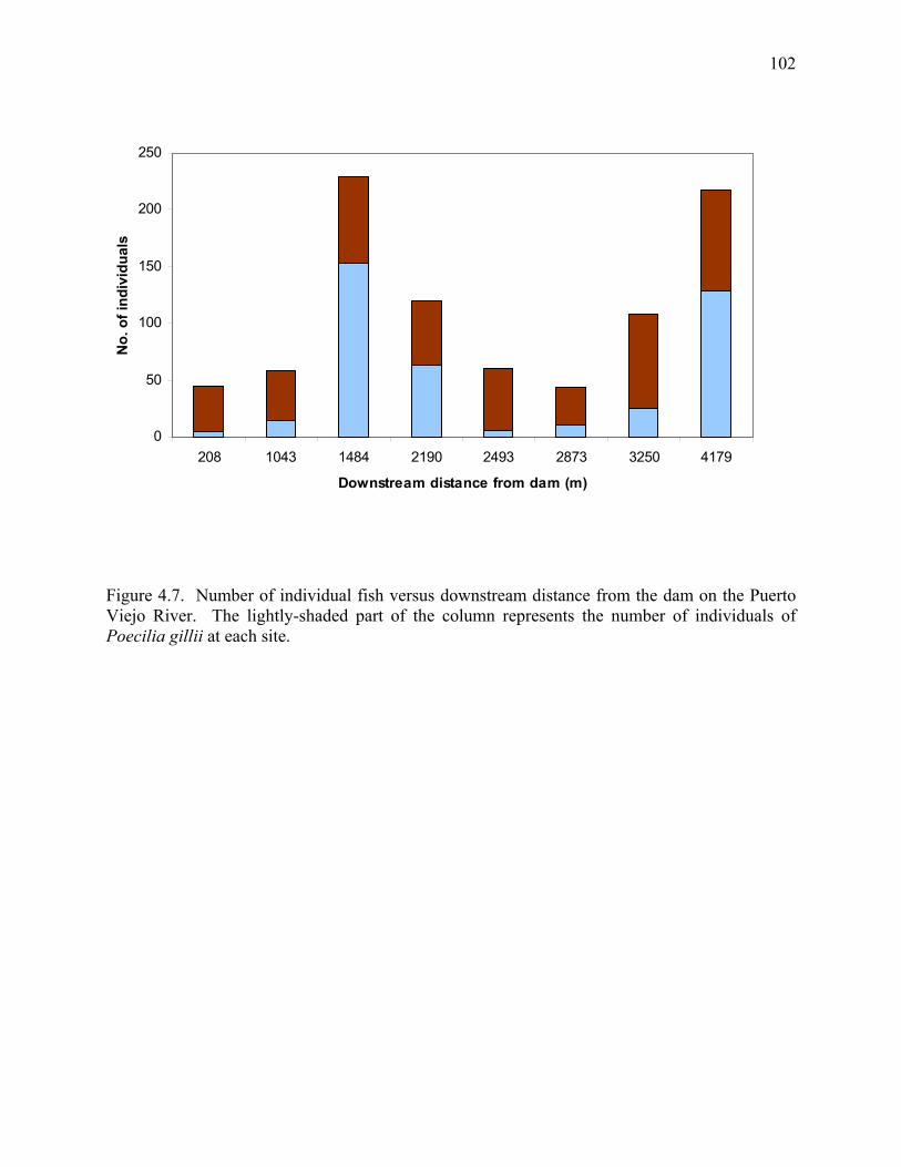
102
Figure 4.7. Number of individual fish versus downstream distance from the dam on the Puerto Viejo River. The lightly-shaded part of the column represents the number of individuals of Poecilia gillii at each site.
0
50
100
150
200
250
208 1043 1484 2190 2493 2873 3250 4179
Downstream distance from dam (m)
No.
of i
ndiv
idua
ls
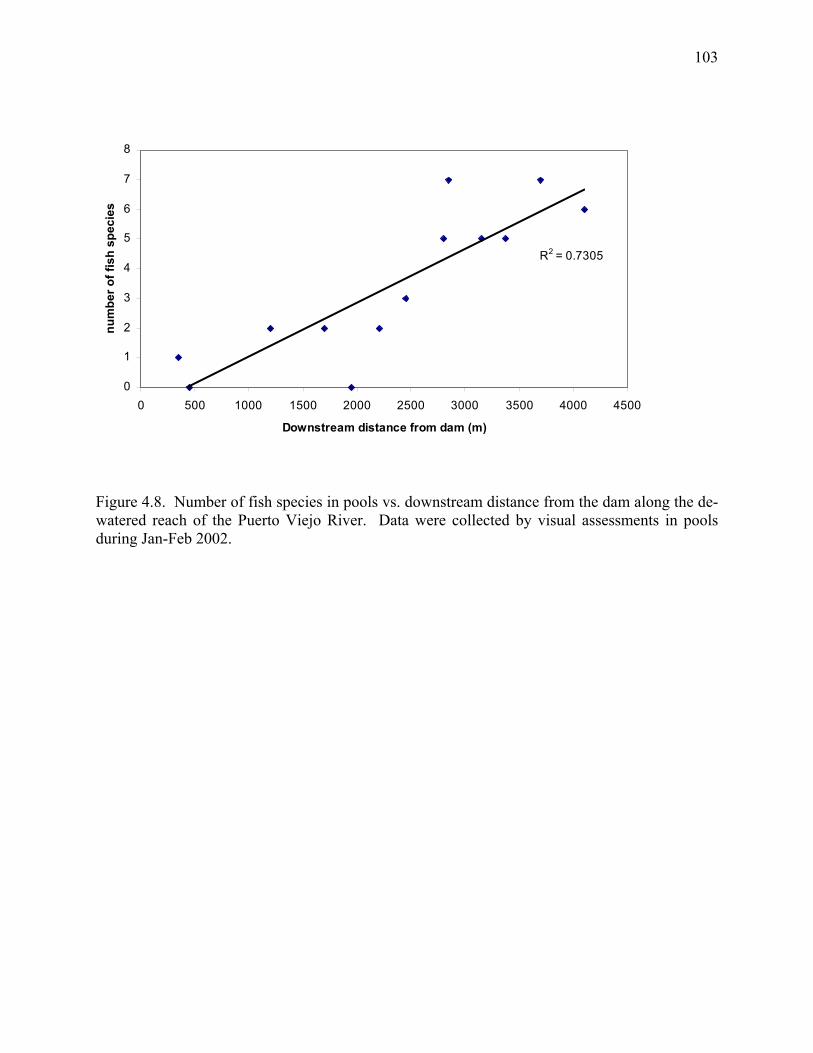
103
Figure 4.8. Number of fish species in pools vs. downstream distance from the dam along the de-watered reach of the Puerto Viejo River. Data were collected by visual assessments in pools during Jan-Feb 2002.
R2 = 0.7305
0
1
2
3
4
5
6
7
8
0 500 1000 1500 2000 2500 3000 3500 4000 4500
Downstream distance from dam (m)
num
ber o
f fis
h sp
ecie
s
104
CHAPTER 5:
HYDROPOWER DEVELOPMENT AS A CATALYST FOR CONSERVATION OF A
COMMON-POOL RESOURCE IN SARAPIQUI, COSTA RICA1
__________ 1Olivas, E.A., Pringle, C.M., and Blount, B. To be submitted to Human Ecology
105
Abstract
The Sarapiquí River, Costa Rica, is a common pool resource used by human populations
that live and work in its watershed. Human uses of the Sarapiquí and other rivers in the
watershed include transportation, tourism (white-water rafting), fishing, potable water, irrigation,
and recreation. In addition, hydropower generation has emerged as a major use of rivers in the
Sarapiquí since the early 1990s. During less than a decade, eight small hydropower dam projects
were constructed on the Sarapiquí River and its tributaries, and additional projects are currently
under construction or in planning stages. This recent hydropower development in the watershed
has been linked to socio-environmental conflicts, and has been perceived by many local residents
as a threat to other human uses of rivers. Hydropower development in Sarapiquí has also been
accompanied by increased awareness of the importance of freshwater resources in the lives of
local residents as well as an increase in river conservation activities. This chapter documents
some of the socio-environmental conflicts associated with hydropower development and
examines the role of hydropower as a catalyst for river conservation activities in the Sarapiquí
watershed.
Keywords: dams, hydropower, socio-environmental conflicts, common pool resources, watershed conservation, rivers, Costa Rica
106
Introduction
Hydropower and other types of dam development have been the source of many social
and environmental conflicts worldwide (WCD 2000; McCully 1996). These conflicts often result
from the complex impacts that dams have on human communities, the natural environment, and
interactions between the two. A large body of research documents the social and environmental
effects of dams (Goldsmith and Hildyard 1984; McCully 1996; Rosenberg et al. 1997; Horning
1999; WCD 2000); examples of these effects include changes to river flow, alteration of
sediment transport, interruption of migration patterns of aquatic biota, reductions of aquatic
biodiversity, flooding of forests, and displacement and resettlement of human communities. The
past few decades have witnessed the emergence of international organizations dedicated to
publicizing and negotiating socio-environmental conflicts associated with dams (e.g.,
International Rivers Network). Until now, most international attention has focused on large
dams, despite the fact that small dams are a more pervasive feature in the global landscape and
are also sources of substantial social and environmental conflict in many countries (Benstead et
al. 1999; Graf 1999).
The accelerated rate of hydropower dam construction in developing countries has
resulted in many dam-related conflicts in Asia, Africa, and Latin America. In Costa Rica, the
number of hydropower dams has tripled since the early 1990s; the majority of these dams are
small (<15 m high), privately owned, and located in rural areas. These increases in small
hydropower development have been linked to a growing number of socio-environmental
conflicts over freshwater resources in Costa Rica. At a national level, there appear to be three
reasons for these conflicts (Aguilar 2001). First, there is a general absence of integrated
planning and protection in watersheds throughout Costa Rica and hydropower is perceived as a
107
major threat to ecological integrity of water resources. Second, the basis for granting freshwater
concessions is susceptible to challenge in Costa Rica. Concessions are often based on the
demand for (and not the availability) of water resources and hydropower projects compete
directly with other users (e.g., tourism, potable water, irrigation, aquatic ecosystems) for
freshwater. Problems with the protocol for environmental impact assessment (EIA) are a third
source of conflicts, specifically the absence of cumulative effects assessments where multiple
hydropower dams are constructed on individual watersheds (Estado de la Nación 1998). The
current EIA process in Costa Rica also has been criticized for a lack of clarity in the definition of
‘environmental’ or ‘instream flows’ and limited participation of human communities in impact
assessments (Aguilar 2001).
In Costa Rica, rivers are public property, and thus, they belong to all residents and can be
considered common pool resources. Here, we define a common pool resource as a valued
resource that is accessible or available to more than person and subject to degradation as a result
of overuse (Hardin 1968; Dietz et al. 2002). Humans use common pool resources as sources of
goods or as sinks for unwanted by-products. In this sense, rivers in Costa Rica act as both
sources of goods (i.e., fish, shrimps, water, transportation, recreation, hydroelectricity) and as
sinks for wastewater and runoff from urban and agricultural lands. Like most water resources,
Costa Rican rivers are susceptible to environmental problems related to the over-harvest of
goods and overuse as a sink and the ‘misuse’ of common pool resources can be a source of
conflicts. These conflicts often stem from two of the defining characteristics of common pool
resources: costly exclusion and subtractability. In terms of rivers, ‘costly exclusion’ refers to the
idea that it is impossible to put a fence around a river to prohibit use of the resource.
108
Subtractability refers to the fact that one person’s use of a common pool resource can reduce the
availability of that resource for others (Dietz et al. 2002).
In Costa Rica, the ‘subtractability’ of rivers has been a major source of socio-
environmental conflicts between hydropower developers and residents of areas where dam
projects are located. The Sarapiquí River watershed in northeastern Costa Rica provides an
interesting case for examining these conflicts. Historically, the Sarapiquí River was a primary
link between the Caribbean coast and the interior of Costa Rica. For decades it played a pivotal
role in the establishment of human communities on the country’s northern Caribbean slope and
in the transportation of goods from abroad (e.g., Europe) to the capital, San Jose. Today, the
Sarapiquí River is nationally known for its scenic beauty, its wealth of biodiversity, and for the
fact that it remains one of a disappearing class of relatively intact rivers in Costa Rica. For
rural residents, the river is a common pool resource that provides water, food, work, and
pleasure. Furthermore, the river continues to influence regional development. Within the last 15
years, eight hydropower dam projects have been constructed on the Sarapiquí River and its
tributaries; planning for additional projects is in advanced stages. Accelerated hydropower
development has led many rural residents to re-evaluate the river’s role in the region and has
created concern about how increased damming may compromise the present state of the river
and current uses of freshwater. In the last decade, a series of river conservation movements has
emerged in Sarapiquí, partly in response to hydropower development. These conservation
efforts have resulted in increased awareness of the importance of freshwater resources in the
lives of rural residents.
The purpose of this chapter is to document the multiple uses of rivers in Sarapiquí, Costa
Rica, and consider these uses of a common pool resource (sensu Hardin 1968) in the context of
109
recent hydropower development. The chapter begins by tracing the development history of the
Sarapiquí region and outlining the role of the Sarapiquí River in the lives of rural residents.
Next, we provide a summary of hydropower development in the Sarapiquí watershed with a brief
description of environmental consequences. We then examine conflicts between hydropower
and downstream human communities. We also document watershed conservation activities in
Sarapiquí and discuss how hydropower development has motivated many of these activities.
The information presented here is based on 20 months of fieldwork from 1999 to 2004.
Methods used to collect information included: (1) formal interviews with river users including
boat operators, rafting companies, NGOs, water resource managers, the Costa Rican Institute of
Electricity (ICE), and dam companies; (2) structured interviews with 100 residents of Sarapiquí
County related to perceived importance of different freshwater uses; (3) observations and field
notes from participant-observation at town meetings and conservation activities; and (4)
hundreds of informal conversations with rural residents over a four year period.
The Sarapiquí River: a river of many uses
The Sarapiquí River drains an extensive area of northern Costa Rica, cutting through a
landscape marked by variable topography and land use (Figure 5.1). The river emerges in the
highlands from Barva Volcano at 2850 m.a.s.l. and flows for ~85 km in a north-south direction.
Dramatic changes in elevation characterize the headwaters of the Sarapiquí, creating a cascading
sequence of rapids and plunge pools in an encanyoned channel (Figure 5.2). Natural forest
dominates the landscape in the upper Sarapiquí watershed, where the steep topography makes
intensive land use activities difficult. As the river descends to middle-elevations (250-1000 m),
tributaries increase the flow and the power of the river. Present land uses in this region include
110
cattle pastures, pineapple agriculture, and tree plantations, interspersed by remnant patches of
natural forest (Figure 5.3). The Sarapiquí widens as it flows into the lowlands and is joined by
two important tributaries: the Puerto Viejo River and the Sucio River. Once in the lowlands, the
river slowly meanders through a mosaic of agricultural lands, banana plantations (Figure 5.4),
and rural human settlements before draining into the San Juan River at the Nicaraguan border.
While the last 50 years have brought major social and environmental changes to the
Sarapiquí region, the river has maintained a central role in the lives of rural residents (Table 5.1).
Until the middle of the last century, the Sarapiquí region was one of the last frontiers of Costa
Rica. Mule trails and the Sarapiquí River, navigable downstream from Puerto Viejo, were the
only connections between the region and the outside world until the 1950s, when the dirt road
between San Jose and Cariblanco was extended to Puerto Viejo (Butterfield 1994). The new
road increased the regional importance of the river and the town of Puerto Viejo: products from
the Caribbean coast and the Nicaraguan border were shipped by way of the Sarapiquí River to
Puerto Viejo and then continued via truck to San Jose. From 1963-1983, the colonization of the
frontier resulted in an increase in the region’s population from 4,856 to 18,909 inhabitants and a
decrease in forested area from 70% to 30% as settlers converted much of the land to pasture
(Table 5.1; Butterfield 1994). The Sarapiquí River also gained importance during this time,
providing a source of potable water, food (fish and freshwater shrimp), transportation, and
recreation for rural residents. Expansion of banana agriculture along the banks of the lower
Sarapiquí River during the late 1980s and early 1990s also affected the river, as banana
companies drew water from wells and built drainage canals to carry precipitation runoff, laden
with agricultural chemicals, to rivers (Vargas 1995). The late 1980s and early 1990s were also a
period of marked population increase in Sarapiquí, primarily due to immigration of banana
111
plantation workers to the region (Table 5.1). These population increases, coupled with
deforestation and agricultural development in the region, put additional pressures on potable
water supplies by decreasing the water quality of the Sarapiquí River near Puerto Viejo. As a
result, many residents turned to springs and small streams inside of Braulio Carrillo National
Park for their water supply (Vargas 1995).
Since the early 1990s, the region has experienced a steady increase in population. Most
forests not in protected areas (e.g., national parks or private reserves) have been converted to
agricultural lands or human settlements. An estimated 45,000 inhabitants now live in Sarapiquí
County (Figure 5.5; INEC 2004); the Sarapiquí River remains a river of many uses for these
residents. Recreation is still at the forefront of current uses of the river: on any Sunday or
holiday people flock to the river to picnic along its banks and swim in its waters (Figure 5.6).
The river is also commonly used for recreational and subsistence fishing, especially in the
lowlands where it supports a diverse assemblage of fishes and other aquatic biota (Bussing
1993). In addition, the Sarapiquí River attracts both national and international tourists as the site
for a growing whitewater rafting industry in the mid-reaches, and a scenic nature cruise business
in the lowlands (Figure 5.7).
The Sarapiquí River is also a source of cultural identity for rural residents of Sarapiquí
County. Perhaps this identity is strongest for long-term inhabitants of the region, especially
those who were born there and grew up dependent on the river as their principal source of water.
Orlando Vargas, 36, a life-long resident of Sarapiquí, describes the basis for this cultural
identity:
“Yo crecí a la par del Río, fue para mi familia el principal recurso acuífero; pesqué, crecí, y aprendí a nadar en este Río.” Translation: I grew up on the banks of the River, for my family it was the principal water resource; I fished, grew up, and learned how to swim in this River.
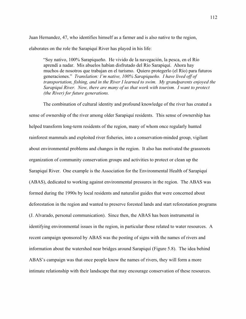
112
Juan Hernandez, 47, who identifies himself as a farmer and is also native to the region,
elaborates on the role the Sarapiquí River has played in his life:
“Soy nativo, 100% Sarapiqueño. He vivido de la navegación, la pesca, en el Río aprendí a nadar. Mis abuelos habían disfrutado del Río Sarapiquí. Ahora hay muchos de nosotros que trabajan en el turismo. Quiero protegerlo (el Río) para futuros generaciones.” Translation: I’m native, 100% Sarapiqueño. I have lived off of transportation, fishing, and in the River I learned to swim. My grandparents enjoyed the Sarapiquí River. Now, there are many of us that work with tourism. I want to protect (the River) for future generations.
The combination of cultural identity and profound knowledge of the river has created a
sense of ownership of the river among older Sarapiquí residents. This sense of ownership has
helped transform long-term residents of the region, many of whom once regularly hunted
rainforest mammals and exploited river fisheries, into a conservation-minded group, vigilant
about environmental problems and changes in the region. It also has motivated the grassroots
organization of community conservation groups and activities to protect or clean up the
Sarapiquí River. One example is the Association for the Environmental Health of Sarapiquí
(ABAS), dedicated to working against environmental pressures in the region. The ABAS was
formed during the 1990s by local residents and naturalist guides that were concerned about
deforestation in the region and wanted to preserve forested lands and start reforestation programs
(J. Alvarado, personal communication). Since then, the ABAS has been instrumental in
identifying environmental issues in the region, in particular those related to water resources. A
recent campaign sponsored by ABAS was the posting of signs with the names of rivers and
information about the watershed near bridges around Sarapiquí (Figure 5.8). The idea behind
ABAS’s campaign was that once people know the names of rivers, they will form a more
intimate relationship with their landscape that may encourage conservation of these resources.
113
Hydropower development in the Sarapiquí River watershed
In the past two decades, hydropower has emerged as a principal user of freshwater in the
Sarapiquí River watershed and throughout Costa Rica (Estado de la Nación 1998). The
discussion here merits a brief examination of the role of hydropower on a national level before
we focus on hydropower development in Sarapiquí. Unlike most developing countries, in Costa
Rica, approximately 97% of residents have electricity in their homes (R. Jimenez, ICE, personal
communication). Hydropower generates roughly 85% of this electricity; thermal, geothermal,
and wind plants account for the rest. Much of Costa Rica’s hydropower potential currently
remains untapped, although plans for meeting increases in the demand for electricity, estimated
at roughly 6% annually, include the construction of more and bigger dams over the next decade.
Since the institution’s creation in the 1940s, the government-owned Costa Rican Institute
of Electricity (ICE) has been charged with developing the country’s energy resources to satisfy
increasing demands. The ICE currently operates ~15 hydropower projects with a combined total
installed generating capacity of approximately 1000 megawatts. Two of these projects are
located on the Toro River, a principal tributary of the Sarapiquí River. During the 1990s,
increasing demands on the ICE led to the passage of two laws (Ley 7200 in 1990 and Ley 7508
in 1995) that opened Costa Rica’s electricity sector to private generators. As a result, private
companies are now permitted to generate 15% of Costa Rica’s electricity and sell it to the ICE at
fixed prices. Hydropower developments in the Sarapiquí watershed and many other areas of
Costa Rica can be directly linked to this partial privatization of electricity generation in the
1990s. Between 1990-2000, ~28 private hydropower plants were constructed on Costa Rican
watersheds; six of these private plants are located on the Sarapiquí River or its tributaries.
114
A total of eight hydropower plants are currently in operation in the Sarapiquí watershed,
and additional projects are being planned (Table 5.1). With a hydropower potential estimated at
around 390 megawatts, of which only 144 have been exploited, the Sarapiquí watershed remains
a principal target for hydropower developers in Costa Rica. Several things make Sarapiquí
appealing from a developer’s perspective. First, the region’s climate is extremely wet (4-8 m
annual rainfall) and less seasonal than in other parts of Costa Rica (Sanford et al. 1994). Thus,
streams in the Sarapiquí watershed carry sufficient discharge almost year-round for hydropower
generation. Second, the steep topography of the upper watershed is characterized by abrupt
changes in elevation. Hydropower projects can take advantage of this high geographic relief as a
way to increase ‘hydraulic head’ or ‘water power’ and generate more electricity from less water.
Moreover, the geographic location and the road network of the Sarapiquí region increase the
watershed’s accessibility to hydropower developers. Sarapiquí is roughly a 1.5-2 hour drive
from San Jose, the Costa Rican capital and business center. Well-maintained, paved roads
connect the region with the capital.
All hydropower projects in the Sarapiquí watershed are located on or near elevational
gradient breaks and operate as water diversion dams (Figure 5.9). A major environmental impact
of these types of projects is the substantial reduction of stream flows between the water diversion
site and the turbines / water return site. These flow reductions are often referred to as stream
‘dewatering.’ In Sarapiquí, hydropower projects divert 90-95% of the flow from rivers with
dams; the operation of eight hydropower projects has resulted in the dewatering of ~31
kilometers of streams throughout the watershed. An additional environmental impact of
hydropower projects in Sarapiquí is the unnatural fluctuations in stream flows that occur
downstream from the turbines / water return sites. Most projects operate on a peaking-power
115
schedule, generating electricity twice daily during hours of high demand. The results are rapid
changes in flow and temperature that may create inhospitable habitat conditions for aquatic biota.
These flow changes also present flash-flood like conditions that are dangerous to downstream
water users like swimmers, rafting tourists, or fishermen. Many hydropower companies have
posted signs to warn downstream human communities of this danger (Figure 5.10).
Conflicts and the commons
In the late 1990s, perceived ‘subtractions’ or reductions in the quantity and quality of
river water after the construction of several hydropower projects alarmed downstream
communities near the towns of La Virgen and Puerto Viejo de Sarapiquí. Specifically, people
started to report changes in channel geomorphology and greater and more frequent fluctuations
in the flow of the Sarapiquí and other rivers. These alterations were viewed as a threat to
economically important activities in the region, especially river-related tourism (e.g., white-water
rafting, tour boats). They also threatened recreational uses of rivers, as fluctuations in flow make
these uses dangerous.
A socio-environmental conflict exploded in 1998, when ABAS and other social
organizations in the region learned of plans to build a hydropower project on the Sarapiquí River
near La Virgen (Merida, S.A. 1998; Aguilar 2001). This project would have substantially
compromised other uses of the river because it would have been located directly upstream from
principal recreational and tourism areas. In response to the development pressures of the La
Virgen and other hydropower projects, a coalition was formed to ‘defend’ the Sarapiquí River
(known as the Colectivo para la Defensa del Río Sarapiquí). This coalition comprised multiple
social and environmental groups from the region. The coalition organized public demonstrations
and posted fliers to inform the community about hydropower development (Figs. 5.11, 5.12, and
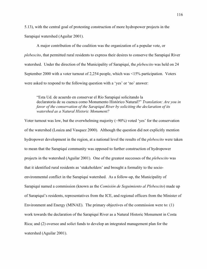
116
5.13), with the central goal of protesting construction of more hydropower projects in the
Sarapiquí watershed (Aguilar 2001).
A major contribution of the coalition was the organization of a popular vote, or
plebescito, that permitted rural residents to express their desires to conserve the Sarapiquí River
watershed. Under the direction of the Municipality of Sarapiquí, the plebescito was held on 24
September 2000 with a voter turnout of 2,254 people, which was <15% participation. Voters
were asked to respond to the following question with a ‘yes’ or ‘no’ answer:
“Esta Ud. de acuerdo en conservar el Río Sarapiquí solicitando la declaratoria de su cuenca como Monumento Histórico Natural?” Translation: Are you in favor of the conservation of the Sarapiquí River by soliciting the declaration of its watershed as a Natural Historic Monument?
Voter turnout was low, but the overwhelming majority (~90%) voted ‘yes’ for the conservation
of the watershed (Loaiza and Vasquez 2000). Although the question did not explicitly mention
hydropower development in the region, at a national level the results of the plebescito were taken
to mean that the Sarapiquí community was opposed to further construction of hydropower
projects in the watershed (Aguilar 2001). One of the greatest successes of the plebescito was
that it identified rural residents as ‘stakeholders’ and brought a formality to the socio-
environmental conflict in the Sarapiquí watershed. As a follow-up, the Municipality of
Sarapiquí named a commission (known as the Comisión de Seguimiento al Plebescito) made up
of Sarapiquí’s residents, representatives from the ICE, and regional officers from the Minister of
Environment and Energy (MINAE). The primary objectives of the commission were to: (1)
work towards the declaration of the Sarapiquí River as a Natural Historic Monument in Costa
Rica; and (2) oversee and solict funds to develop an integrated management plan for the
watershed (Aguilar 2001).
117
To date, the Sarapiquí River has not legally been declared a Natural Historic Monument.
In addition, many of the original organizations dedicated to protesting hydropower development
in Sarapiquí are no longer actively involved in the socio-environmental conflict. In fact, the
ABAS has emerged as the main advocate for conservation of the Sarapiquí watershed and
appears to be one of the only organizations still actively protesting future hydropower
development. ABAS’ most recent campaigns against hydropower in the watershed involve the
Cariblanco Dam, a 80-megawatt, large dam (>15 m tall) proposed by the ICE for the mainstem
Sarapiquí River between the towns of Cariblanco and San Miguel, just outside the southern
limits of Sarapiquí County (Figure 5.1). Construction of this dam is slated for 2004-06 and its
operations likely will result in substantial changes to the hydrology of the Sarapiquí River.
Ideally, ABAS would like to halt the hydropower project altogether. However, since it appears
that the Cariblanco Dam will go ahead as scheduled, a more realistic approach to the conflict
may be to demand more comprehensive surveys of aquatic biota near the project site prior to,
during, and following construction to document the actual impacts of the project on Sarapiquí
River fauna. Furthermore, downstream water users should pressure the ICE to leave sufficient
flows to maintain current human uses of the river.
What is noteworthy about the conflict over the Sarapiquí River is that it has stemmed
almost entirely from hydropower developments, whereas other human activities in the watershed
may have greater social and environmental effects. Poor management of wastewater,
deforestation of riparian areas, over-fishing, and agricultural expansion are all activities with
substantial impacts on the ecological integrity of the watershed. Banana agriculture, for
example, has been linked to fish kills, substantial decreases in water quality, and problems with
sedimentation in the Sarapiquí River. However, there have been few or no organized efforts to
118
protest these activities in Sarapiquí. Why haven’t these activities attracted the same local
response as hydropower development? One reason may be that local residents are often the ones
responsible for deforestation of riparian areas and overfishing. Furthermore, in terms of
agricultural expansion, a substantial percentage of the current population immigrated to the
region to work on the large banana plantations and throughout the past decade, banana
plantations have been the largest employer in the region. Thus, it is likely that local residents
view banana agriculture as a beneficial activity, despite its environmental costs.
Isaias Alvarado, 66, a life-long resident of the region, expresses his thoughts on human
activities in the watershed:
“Yo siento que la comunidad puede sacar materials del Río para la comunidad. Pero algo commercial…no debe ser.” Translation: I feel that the community can take things from the River for the community. But, something commercial…I don’t agree with that.
The Sarapiquí community’s perception of the river as a common pool resource, alluded to
in this comment, signifies that it is the community’s resource to protect or pollute. Since all
hydropower projects in the watershed belong to individuals or companies from other parts of
Costa Rica (and in many cases from other countries), in this sense, hydropower development is
an activity imposed from the outside that may not fall within local residents’ accepted uses of
rivers as common pool resources. If the Sarapiquí community had perceived some benefits to
hydropower development for the community, their opposition to hydropower might not have
materialized into the socio-environmental conflict described here. However, many local
residents believe that hydropower development brings no advantages for rural residents apart
from the temporary jobs created during a project’s construction phase. In addition, electricity
from hydropower projects in Sarapiquí is exported to the national electrification system of Costa
Rica and then distributed to various parts of the country. Joel Alvarado, 40, a naturalist guide
119
and native to the region, when asked if there were any advantages of hydropower development
for Sarapiqueños replied:
“Not for us…in terms of jobs, there are many during the construction phase but after that you only need five people or so to operate a dam. Also, even though we are supplying a lot of electricity, it goes to San Jose (the capital) or somewhere else. We don’t get a cheaper price either.”
Perceived importance of rivers to the Sarapiquí community
As a follow-up to the conflicts, we conducted 100 structured interviews with residents of
Sarapiquí County in 2003-04 to document the perceived importance of different uses of rivers in
Sarapiquí. Interviews were conducted by two investigators in the principal towns of the three
major districts of the county (La Virgen, Horquetas, and Puerto Viejo; Figure 5.5). Eight
interviews were also conducted in the town of San Miguel, just outside of the county line but
within the watershed. One of the investigators was a local resident of Puerto Viejo with training
in survey methods; the other was a foreign resident of Costa Rica who had been working in
Sarapiquí for several years. The number of interviews per region was based on relative
population density and the investigators selected participants haphazardly while walking around
the towns. Participants were given 9 test cards, each representing one of the major uses of rivers
in Sarapiquí: tourism, transportation, fishing, wastewater drainage, recreation, hydropower,
irrigation, potable water, and scientific research. They were then asked to put the cards in order
according to the importance of each use to the Sarapiquí community. After ranking uses of
rivers in terms of importance, participants were asked to rank the cards according to the damage
that they thought each use caused the environment. Those uses perceived as causing more
environmental damage to rivers were ranked first.
120
Tourism was perceived, on average, as the most important use of rivers in Sarapiquí,
since the tourism industry provides many of the jobs in the region (Table 5.2). Community
usage of rivers for transportation, potable water, and recreation followed tourism in perceived
importance. On average, hydropower ranked 7th in importance among freshwater uses.
However, among respondents from the town of San Miguel, hydropower was considered to be
3rd in importance, after tourism and transportation. Of the four towns included in this study, San
Miguel is the closest to existing hydropower developments and is near the site for the new
Cariblanco hydropower project.
Wastewater drainage was perceived as the most environmentally damaging of uses of the
Sarapiquí River, followed by hydropower (Table 5.2). This is noteworthy because all
hydropower developments in the watershed are located several kilometers (10 or more) upstream
from all of the towns except San Miguel. Moreover, the vast majority of the people interviewed
had never visited a hydropower plant. It is likely that hydropower’s high rank on the list of uses
that cause environmental damage stems in part from the socio-environmental conflicts associated
with hydropower development in the watershed in recent years.
River conservation in Sarapiquí
Ironically, hydropower development of the Sarapiquí watershed has been accompanied
by an increase in river conservation activities in the region. The ABAS campaign to post the
names of rivers along their banks provides one concrete example. The realization of the
plebescito, where residents were asked to vote for the conservation of the Sarapiquí River, is
another good example of the growing awareness of the importance of rivers to human
communities in Sarapiquí. Smaller conservation projects (e.g., frequent trash collecting boat
121
trips along the margins of the Sarapiquí River) have also become common over the past few
years. Furthermore, during 2001-2002, several workshops were held in the region to discuss
research and management needs for the Sarapiquí watershed. These workshops involved
representatives from the Costa Rican government (ICE, MINAE, and the Municipality of
Sarapiquí) as well as other national and international organizations (Organization for Tropical
Studies, FUNDECOR, the World Bank, and ABAS). The ultimate goal of these workshops was
to develop a management plan for the Sarapiquí watershed; as of early 2004 this work is still in
progress.
Promoting and implementing integrated watershed management represent two distinct
challenges, as do advocating river conservation and actually making it work. Whose
responsibility is river conservation and management in the Sarapiquí watershed? Is this the job
of the national or municipal government? Or should it be left up to local residents of Sarapiquí
to decide the fate of rivers as common-pool resources in the region where they live? Joel
Alvarado, a naturalist at La Selva Biological Station and lifetime resident of Sarapiquí, believes
that river conservation and management should be a shared responsibility. He challenges the
government with creating and enforcing laws that promote conservation of freshwater resources
like the Sarapiquí River; residents of the region can best help with conservation by respecting
these laws. Many people in Sarapiquí believe that good laws already exist to protect water
quality and aquatic biota. Examples include the Forestry Law, which recommends a minimum
30-meter riparian buffer along waterways, as well as other laws designed to regulate fishing
methods. However, compliance with these laws has long been an issue in Sarapiquí and
throughout Costa Rica. For example, the denuded banks along the lower reaches of the
Sarapiquí River downstream from the confluence with the Sucio River (Figure 5.14) illustrate
122
problems with enforcement of riparian buffers. Disrespect for fishing laws is also an issue in the
watershed. Park guards from La Selva Biological Station estimate that 90% of the fishing that
occurs in the watershed is illegal. Violations of acceptable fishing methods are particularly
rampant, and many people use chemicals and explosives as a way to kill many fishes and
shrimps at once (Edwin Paniagua, personal communication). Compliance with and better
enforcement of existing laws will be the first step towards integrated watershed management and
river conservation in Sarapiquí.
What is the role of hydropower in the management and conservation of the Sarapiquí
watershed? Should hydropower developers be responsible for promoting wise use of freshwater
resources? Should they be a major player in watershed management decisions? Are they
obligated to give something back to downstream human communities in exchange for their use
of a common pool resource? Thus far, conflicts over hydropower development have been a
catalyst for river conservation activities in Sarapiquí, yet the participation of hydropower
developers in these activities has been limited. Perhaps hydropower developers’ greatest
contribution to overall watershed conservation to date has been maintenance of forest cover and
reforestation of river margins upstream from dams. Two hydropower plants in Sarapiquí have
actually established a contract to pay for environmental services provided by rural landowners
that maintain forest cover in the watershed upstream from dams (Jorge Dengo, Energía Global,
personal communication). In the future, hydropower developers can aid in conservation of the
watershed by encouraging and sponsoring similar reforestation and forest protection programs in
downstream areas. In addition, hydropower developers in Sarapiquí should be obligated to
promote and finance scientific research on the impacts of diversion dams on stream ecosystems.

123
Conclusions
The Sarapiquí case study is representative of issues facing many watersheds throughout
Costa Rica—rapid river development, increased competition among freshwater users, and a
growing desire to protect common pool resources. It is likely that socio-environmental conflicts
over rivers in Costa Rica will only become more common as the country invests more in
hydropower to fuel development in the future. Defining the roles of stakeholders and
recognizing rivers as common pool resources will be an important tactic for negotiating these
conflicts, as will a shift towards more integrated watershed management.
Acknowledgements
This study was supported by a Fulbright Scholarship (2001), an Organization for Tropical
Studies Pilot Research Award, and the Diane C. Davidson UGA Women’s Club Scholarship to
EAO. Above all, we thank the people of the Sarapiquí region for sharing their opinions and
information on hydropower development, especially Rocio Lopez, Joel Alvarado, Isaias
Alvarado, Juan Hernandez, William Rojas, Rosa Sandoval, and Orlando Vargas. Special thanks
go to William Ureña for his invaluable assistance with interviews and to Miriam Ramos for
helping collect information in the initial phase of the project. Thanks also to Antonio Trabucco
and Marcia Snyder of the Organization for Tropical Studies for their help with Figs. 1 and 6 and
to Chesley Lowe for Fig. 9.
Literature Cited
Aguilar, A. 2001. El conflicto por el desarrollo hidroelectrico de la cuenca del Río Sarapiquí, Costa Rica. CEDARENA. San Jose, Costa Rica. (http://www.cedarena.org/hidrico/docs/Sarapiqui.doc)
124
Benstead, J.P., March, J.G., Pringle, C.M., and Scatena, F.N. 1999. Effects of a low-
head dam and water abstraction on migratory tropical stream biota. Ecological Applications 9, 656-668.
Bussing, W.A. 1993. Fish communities and environmental characteristics of a tropical
rain forest river in Costa Rica. Revista de Biología Tropical 41:791-809. Butterfield, R.P. 1994. The regional context: Land colonization and conservation in
Sarapiquí. Pages 299-306 in McDade, L.A., Bawa, K.S., Hespenheide, H.A., and Hartshorn, G.A. La Selva: Ecology and Natural History of a Neotropical Rain Forest. University of Chicago Press, Chicago.
Dietz, T., Dolsak, N., Ostrom, E., and Stern, P.C. 2002. The drama of the commons.
Pages 3-36 in: Ostrom, E., Dietz, T., Dolsak, N., Stern, P.C., Stonich, S., and Weber, E.U. (eds). The Drama of the Commons. National Academy Press, Washington, DC. 521 p.
Estado de la Nación (Costa Rica). 1998. Estado de la Nación en Desarrollo Humano
Sostenible. San Jose, Costa Rica. Informe 4. Goldsmith, E. and Hildyard, N. 1984. The social and environmental effects of large
dams. Wadbridge Ecological Centre, Camelford. 2 volumes. Graf, W.L. 1999. Dam nation: A geographic census of large American dams and their
hydrologic impacts. Water Resources Research 35:1305-1311. Hardin, G. 1968. The tragedy of the commons. Science 162: 1243-1248. Horning, J.F. 1999. Social and Environmental Impacts of the James Bay Hydroelectric
Project. McGill-Queen’s Press, Montreal. 169 pp. Instituto Nacional de Estadísticas y Censos (INEC). 2004. Results of the IX National
Census for Costa Rica. http://www.inec.go.cr. Loaiza, V. and Vasquez, C. 2000. Sarapiquí dijo ‘si’ al Río. La Nación, 25 September. Merida, S.A. 1998. Estudio de Impacto Ambiental del Proyecto Hidroeléctrico La
Virgen. Escazu, Costa Rica. McCully, P. 1996. Silenced Rivers: The Ecology and Politics of Large Dams. Island
Press, Washington, D.C. Rosenberg, D.M., Berkes, F., Bodaly, R.A., Hecky, R.E., Kelly, C.A., and Rudd, J.W.M.
1997. Large-scale impacts of hydroelectric development. Environmental Review 5:27-54.
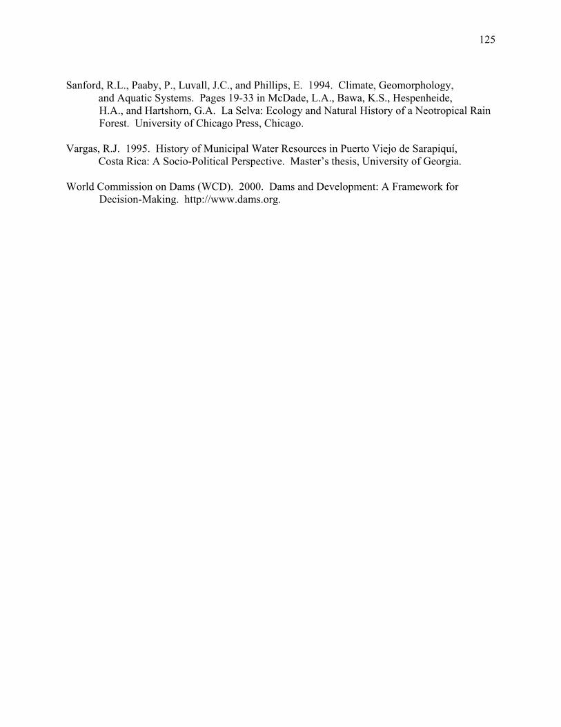
125
Sanford, R.L., Paaby, P., Luvall, J.C., and Phillips, E. 1994. Climate, Geomorphology,
and Aquatic Systems. Pages 19-33 in McDade, L.A., Bawa, K.S., Hespenheide, H.A., and Hartshorn, G.A. La Selva: Ecology and Natural History of a Neotropical Rain Forest. University of Chicago Press, Chicago.
Vargas, R.J. 1995. History of Municipal Water Resources in Puerto Viejo de Sarapiquí,
Costa Rica: A Socio-Political Perspective. Master’s thesis, University of Georgia. World Commission on Dams (WCD). 2000. Dams and Development: A Framework for
Decision-Making. http://www.dams.org.

126
Table 5.1. Chronology of population growth, changes in land use, and hydropower development in Sarapiquí, Costa Rica. Decade Human
population Land-use change
Hydropower development
Conservation activities
1950-1960 < 5000 Forest cover = 70%; Roads extended to Puerto Viejo; Subsistence agriculture
1960-1970 1963: 4,856 inhabitants
Frontier colonization; Forest cleared for cattle pastures
La Selva Biological Station founded by Leslie Holdridge and the Organization for Tropical Studies
1970-1980 Population growth Frontier colonization; Forest cleared for cattle pastures
1980-1990 1983: 18,909 inhabitants and growing
Forest cover = 30% Continued forest clearing; Large banana companies arrive in Sarapiquí
ICE completes a plan for exploiting the hydropower potential of the Sarapiqui watershed
1990-2000 1990s: rapid population growth and immigration of farm workers from Nicaragua and other parts of Costa Rica
Rapid expansion of banana agriculture; expansion of other crops such as heart of palm and ornamental plants
Eight hydropower plants are constructed in the watershed; additional plants are proposed; Conflicts over hydropower emerge in the late 1990s
ABAS is formed by local residents and naturalist guides; Opposition to hydropower development in the late 1990s
2000-present 2004: estimated 45,000 inhabitants of Sarapiquí County
Expansion of pineapple agriculture
Cariblanco hydropower project begins construction; General hydro project plans finalized
Community vote (plebescito) held in 2000; Attempt to declare Sarapiquí River a ‘Natural Historic Monument’; Signs posted with names of rivers, trash pick up along river banks
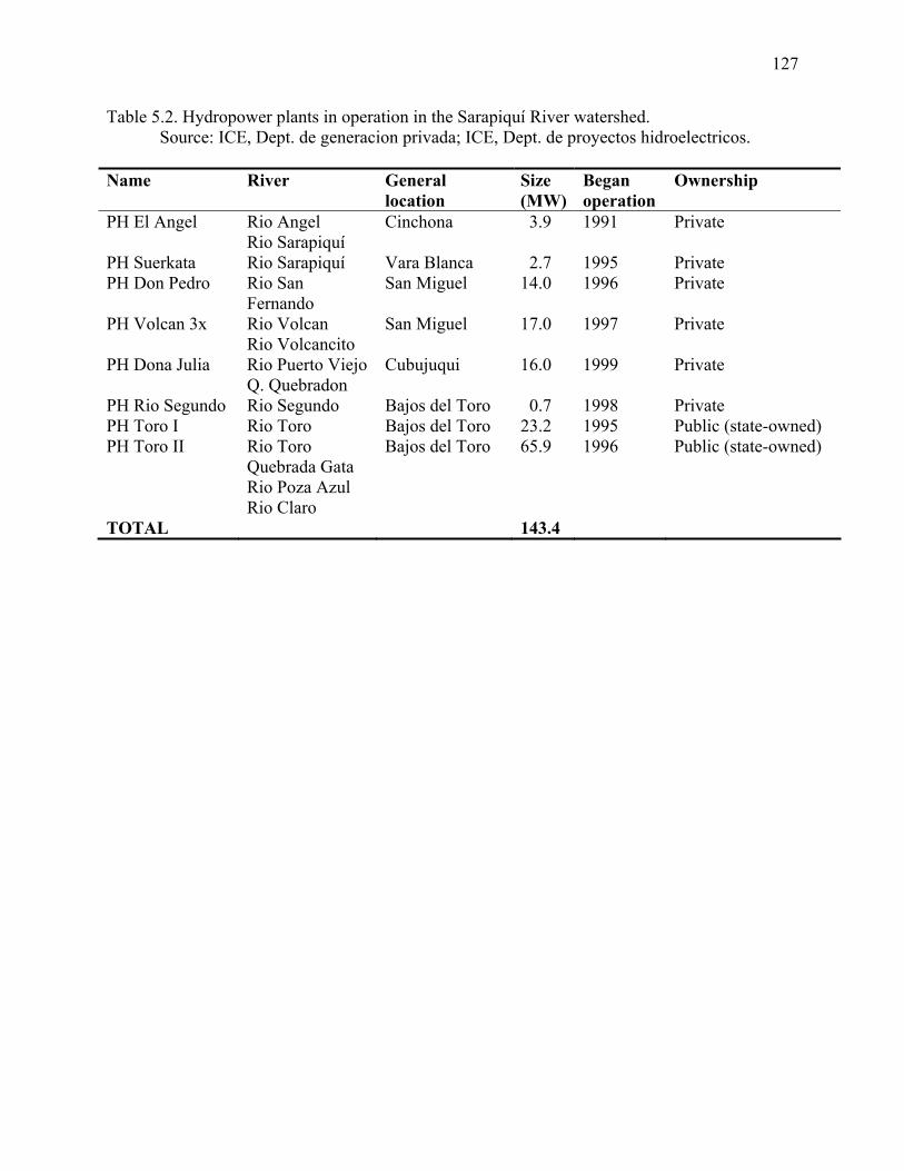
127
Table 5.2. Hydropower plants in operation in the Sarapiquí River watershed. Source: ICE, Dept. de generacion privada; ICE, Dept. de proyectos hidroelectricos.
Name River General
location Size (MW)
Began operation
Ownership
PH El Angel Rio Angel Rio Sarapiquí
Cinchona 3.9 1991 Private
PH Suerkata Rio Sarapiquí Vara Blanca 2.7 1995 Private PH Don Pedro Rio San
Fernando San Miguel 14.0 1996 Private
PH Volcan 3x Rio Volcan Rio Volcancito
San Miguel 17.0 1997 Private
PH Dona Julia Rio Puerto Viejo Q. Quebradon
Cubujuqui 16.0 1999 Private
PH Rio Segundo Rio Segundo Bajos del Toro 0.7 1998 Private PH Toro I Rio Toro Bajos del Toro 23.2 1995 Public (state-owned) PH Toro II Rio Toro
Quebrada Gata Rio Poza Azul Rio Claro
Bajos del Toro 65.9 1996 Public (state-owned)
TOTAL 143.4
128
Table 5.3. Results of formal interviews where 100 residents of Sarapiquí County were asked to rank (1-9) the following uses of river in terms of importance to the community and perceived environmental damage. Lower rank numbers or scores indicate (a) more important uses or (b) uses that are perceived to be more damaging to the environment. Standard deviations of average scores (1-9) are reported in parentheses. Human use of rivers
Rank: Perceived
importance
Average score:Perceived
importance
Rank: Perceived
env’tl damage
Average score:Perceived
env’tl damage Tourism 1 3.03 (2.01) 7 6.04 (1.77) Transportation 2 3.72 (1.85) 3 3.92 (1.54) Potable water 3 3.88 (2.66) 9 7.54 (1.59) Recreation 4 4.10 (2.27) 6 5.30 (2.09) Scientific research 5 5.03 (2.22) 8 7.47 (1.66) Fishing 6 5.29 (2.07) 4 4.56 (2.08) Hydroelectricity 7 5.52 (2.25) 2 3.56 (2.21) Irrigation 8 6.16 (2.11) 5 4.63 (2.32) Wastewater drainage
9 8.25 (1.43) 1 1.69 (1.52)
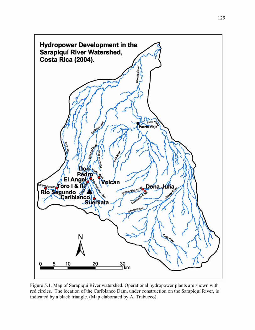
129
Figure 5.1. Map of Sarapiquí River watershed. Operational hydropower plants are shown with red circles. The location of the Cariblanco Dam, under construction on the Sarapiquí River, is indicated by a black triangle. (Map elaborated by A. Trabucco).
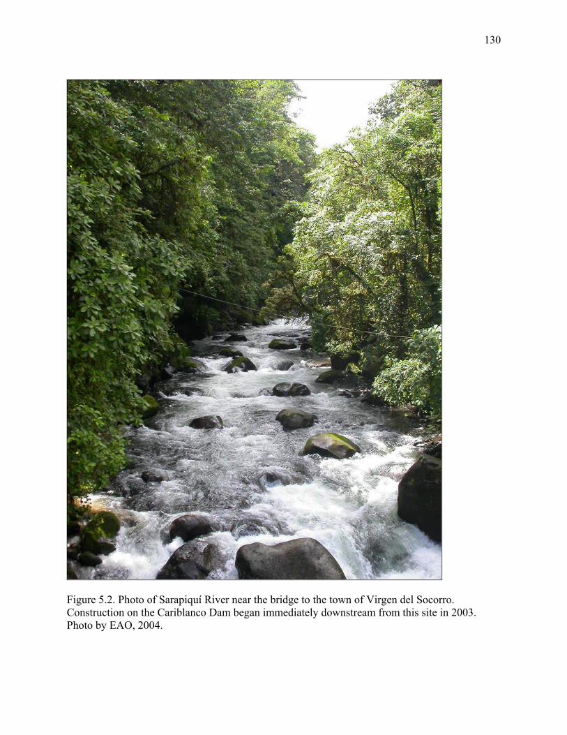
130
Figure 5.2. Photo of Sarapiquí River near the bridge to the town of Virgen del Socorro. Construction on the Cariblanco Dam began immediately downstream from this site in 2003. Photo by EAO, 2004.
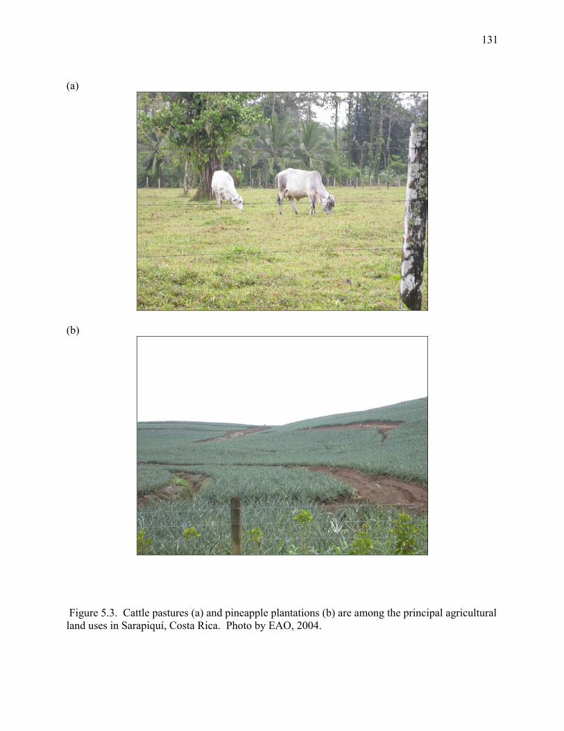
131
(a)
(b)
Figure 5.3. Cattle pastures (a) and pineapple plantations (b) are among the principal agricultural land uses in Sarapiquí, Costa Rica. Photo by EAO, 2004.
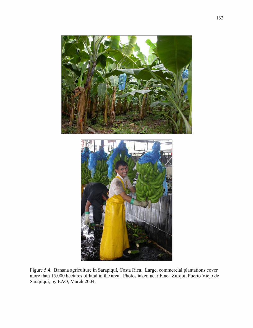
132
Figure 5.4. Banana agriculture in Sarapiquí, Costa Rica. Large, commercial plantations cover more than 15,000 hectares of land in the area. Photos taken near Finca Zurqui, Puerto Viejo de Sarapiquí; by EAO, March 2004.
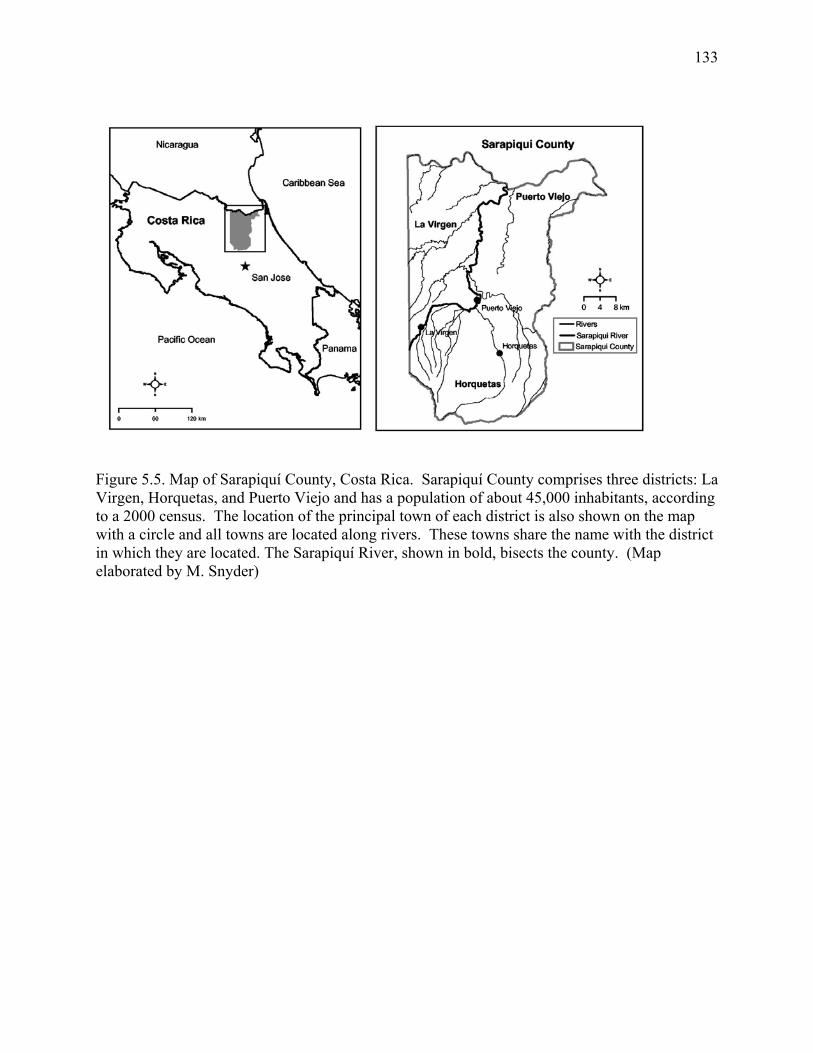
133
Figure 5.5. Map of Sarapiquí County, Costa Rica. Sarapiquí County comprises three districts: La Virgen, Horquetas, and Puerto Viejo and has a population of about 45,000 inhabitants, according to a 2000 census. The location of the principal town of each district is also shown on the map with a circle and all towns are located along rivers. These towns share the name with the district in which they are located. The Sarapiquí River, shown in bold, bisects the county. (Map elaborated by M. Snyder)
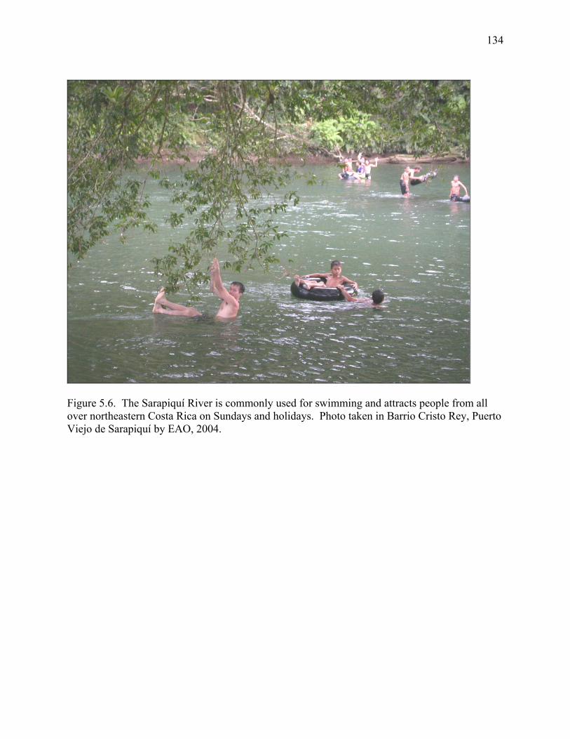
134
Figure 5.6. The Sarapiquí River is commonly used for swimming and attracts people from all over northeastern Costa Rica on Sundays and holidays. Photo taken in Barrio Cristo Rey, Puerto Viejo de Sarapiquí by EAO, 2004.
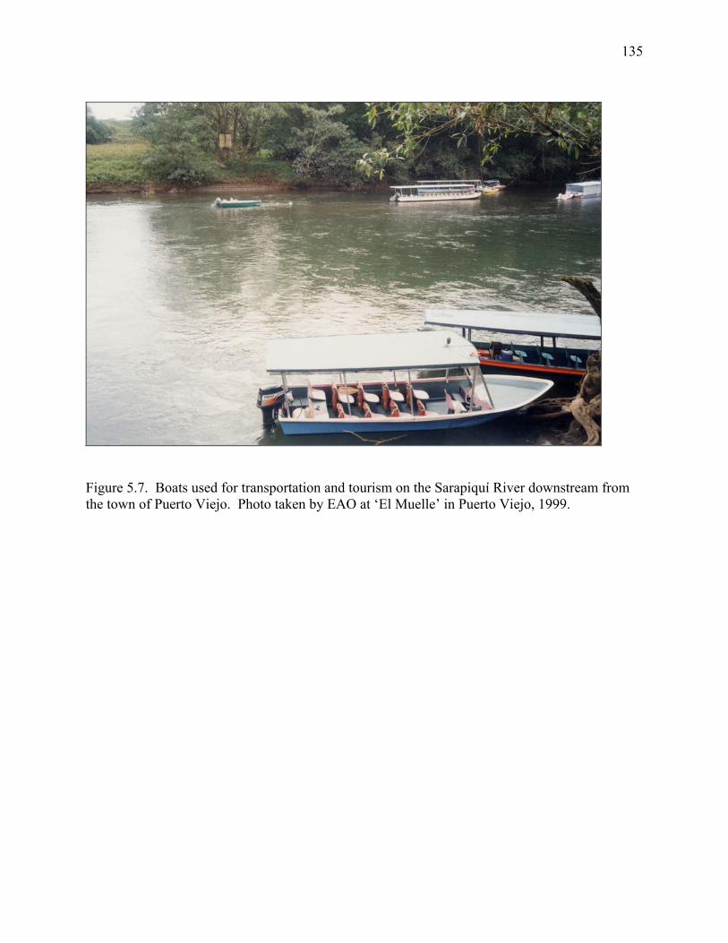
135
Figure 5.7. Boats used for transportation and tourism on the Sarapiquí River downstream from the town of Puerto Viejo. Photo taken by EAO at ‘El Muelle’ in Puerto Viejo, 1999.
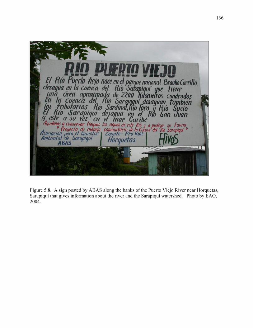
136
Figure 5.8. A sign posted by ABAS along the banks of the Puerto Viejo River near Horquetas, Sarapiquí that gives information about the river and the Sarapiquí watershed. Photo by EAO, 2004.
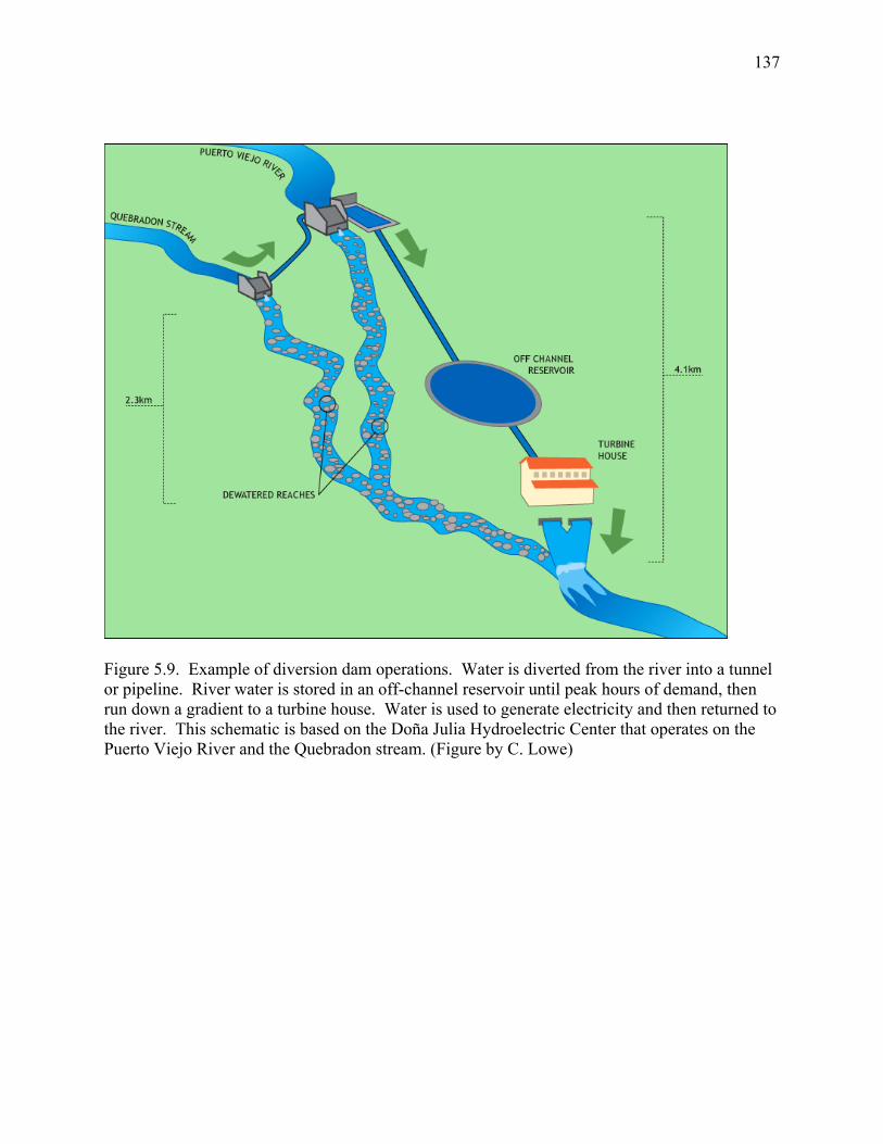
137
Figure 5.9. Example of diversion dam operations. Water is diverted from the river into a tunnel or pipeline. River water is stored in an off-channel reservoir until peak hours of demand, then run down a gradient to a turbine house. Water is used to generate electricity and then returned to the river. This schematic is based on the Doña Julia Hydroelectric Center that operates on the Puerto Viejo River and the Quebradon stream. (Figure by C. Lowe)
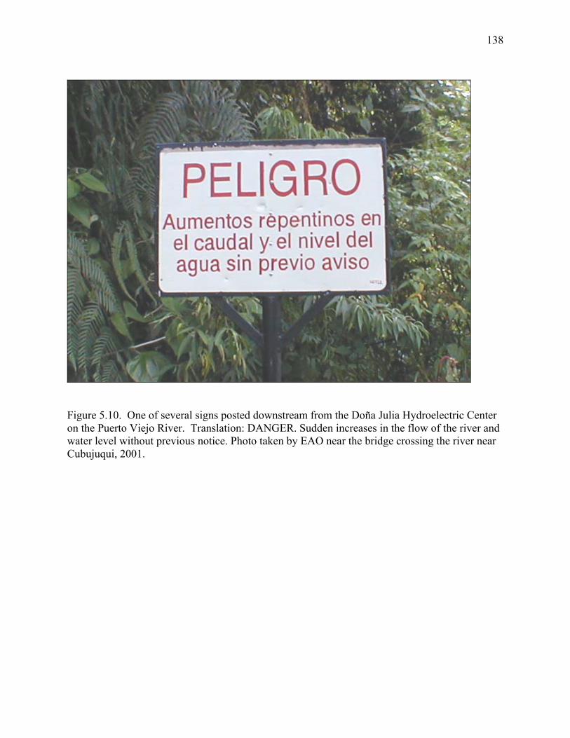
138
Figure 5.10. One of several signs posted downstream from the Doña Julia Hydroelectric Center on the Puerto Viejo River. Translation: DANGER. Sudden increases in the flow of the river and water level without previous notice. Photo taken by EAO near the bridge crossing the river near Cubujuqui, 2001.

139
Figure 5.11. Signs around the town of Puerto Viejo de Sarapiquí that urge opposition to the proposed La Virgen Hydropower Project. ‘No a la Represa’ means ‘say no to the dam’ in English. Photos by EAO, 1999.
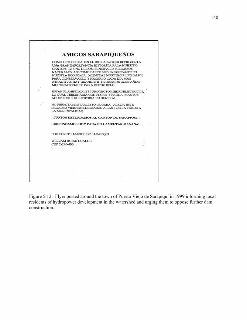
140
Figure 5.12. Flyer posted around the town of Puerto Viejo de Sarapiquí in 1999 informing local residents of hydropower development in the watershed and urging them to oppose further dam construction.
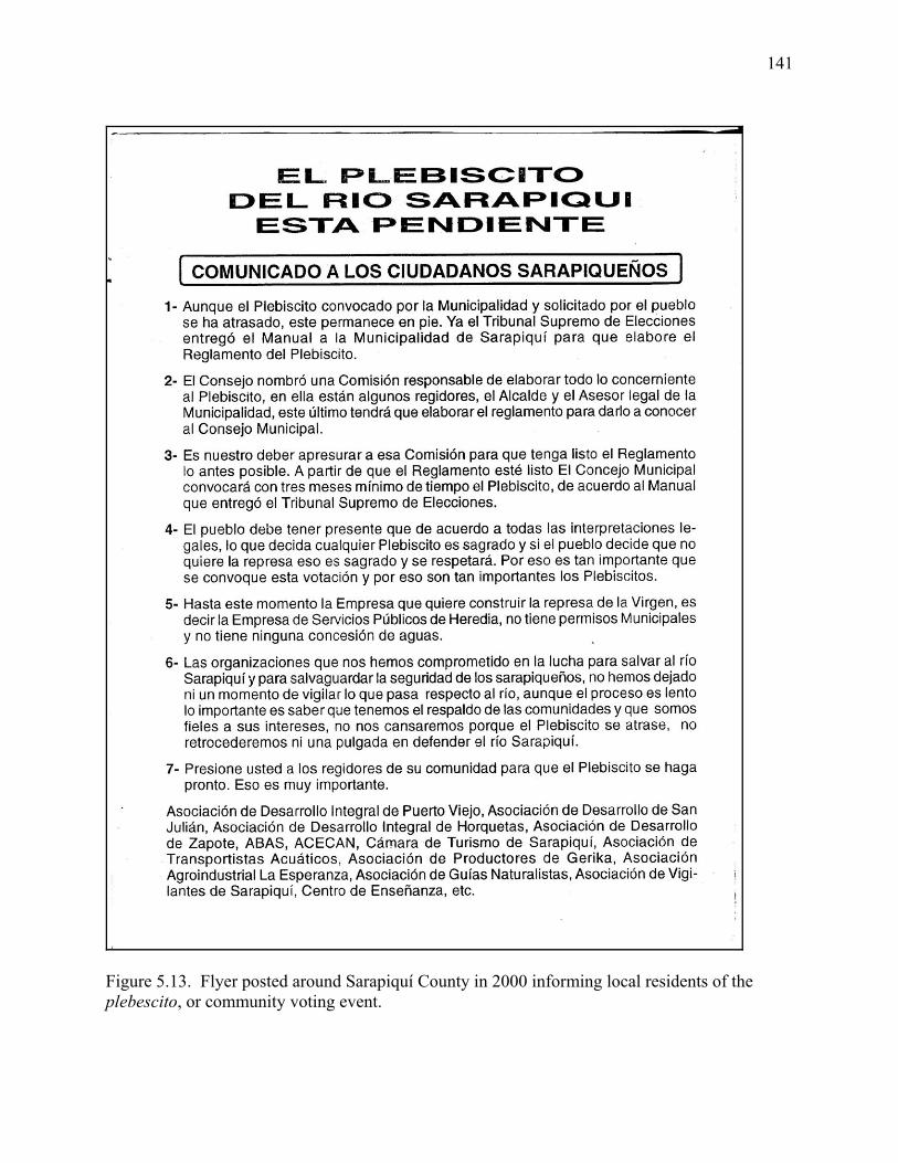
141
Figure 5.13. Flyer posted around Sarapiquí County in 2000 informing local residents of the plebescito, or community voting event.
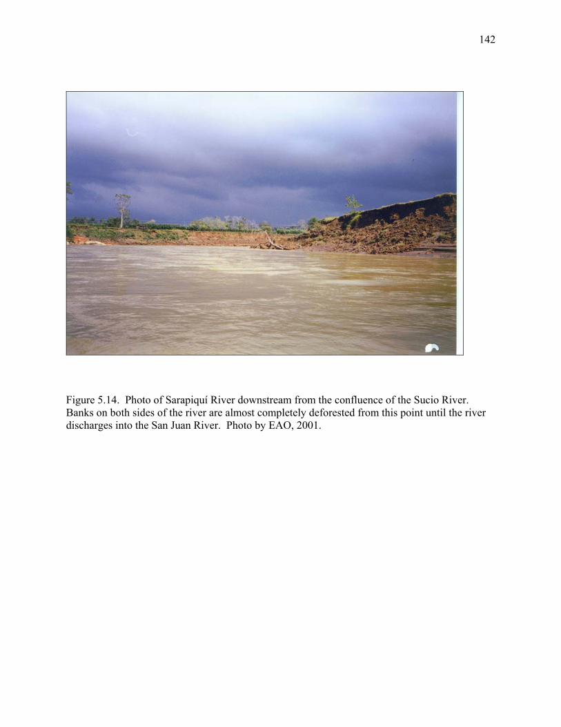
142
Figure 5.14. Photo of Sarapiquí River downstream from the confluence of the Sucio River. Banks on both sides of the river are almost completely deforested from this point until the river discharges into the San Juan River. Photo by EAO, 2001.

143
CHAPTER 6:
GENERAL CONCLUSIONS AND RECOMMENDATIONS FOR FUTURE RESEARCH
144
Summary
The study addresses the consequences of hydropower development at local, watershed,
and national scales. Each of the chapters will be made available to dam owners, the ICE,
conservationists, and academics in Costa Rica.
Hydropower development has dramatically changed the Sarapiquí River system over the
past decade and a half. Its impacts have been both positive and negative. Hydropower projects
in Sarapiquí can now provide ~10% of electricity in a country of 4 million people. However,
hydropower developments have transformed free-flowing rivers in Sarapiquí into altered
systems, both in terms of physical and biological conditions. In addition, the combined impacts
of hydropower and other human activities in Sarapiquí are substantial: 10% of stream length in
the watershed is now upstream from dams and 31 km of streams have been dewatered.
Furthermore, hydropower projects have resulted in increased competition for and conflicts over
freshwater resources. Nevertheless, hydropower development has been a catalyst for river
conservation in the Sarapiquí region: it has provoked local residents to think critically about the
importance of freshwater and has motivated organization of conservation activites in the
watershed.
Results presented here provide only a glimpse of the complex ecological and social
effects of hydropower development in Sarapiquí. An outcome of this study has been the
generation of a new set of ideas that can serve as a base for further research in Sarapiquí and
other tropical river systems. In addition, this study has produced a series of recommendations
for monitoring and management of rivers in Sarapiquí.
145
Recommendations for research and management
National scale
Instream flows—At a national scale, more research is needed to determine appropriate instream
flow methodology for Costa Rican rivers. Presently, guidelines issued by the MINAE (Ministry
of Environment and Energy) recommend that 10% of average annual discharge remain in a river
at all times downstream from a dam. However, these guidelines were based on studies from
North American and European rivers (R. Corrales, Doña Julia Hydroelectric Company, personal
communication) and may or may not be ecologically applicable to tropical systems, which are
characterized by larger and more frequent flooding events and seasonality in precipitation.
Moreover, instream flows are still only ‘recommended’ in Costa Rica; legislation is needed to
mandate their use. The recent organization of workshops (2/04; 3/04) and ongoing research
being conducted by the ICE are steps in the right direction (R. Rojas, ICE, personal
communication).
Managing electricity demand—The demand for electricity in Costa Rica is growing by
approximately 6% annually. The country should explore ways to manage or curb these increases
in demand. Demand-side management programs have been shown to be effective in other parts
of the world and may be useful in Costa Rica as well. Also, campaigns to educate the public on
wise use of electricity (and TV advertisements, with basic recommendations about turning off
lights and appliances when not in use) may help to decrease pressure on electricity resources.
Exploring alternative generation scenarios—A major component of sustainable development of
electricity resources is the exploration of alternative sources of electricity. In Costa Rica, wind
146
and solar energy are promising sources, based on the climate of the northern Pacific slope, which
is characterized by dry, windy weather from roughly December to July. Currently, wind and
solar plants account for <5% of electricity; Costa Rica should try to expand the relative
contributions of these sources in the future. One potential option that the country could explore
is the adoption of a ‘shifting dependence’ system, where the contributions of hydropower and
wind / solar vary throughout the year. For example, during very wet months (June-December),
small hydropower on the Caribbean slope could be used as a primary source of electricity for the
country, since our results suggest that the ecological effects of diversion dams may be lessened
during wetter periods. Dry months (January-May) are characterized by hot sun and windy
weather on the northern Pacific slope, and wind / solar could be used as a primary source of
electricity at this time.
Watershed scale
Cumulative effects assessment—More research is needed on cumulative effects of hydropower
and other human activities on watersheds in Costa Rica. Chapter 3 of this dissertation shows that
cumulative effects assessment is possible even when little data is available. Appropriate
methods for investigating cumulative effects of human activities should be developed for Costa
Rica. These methods should be based on climate, types of human activities, and available data.
In the future, cumulative effects assessment should be an integral part of watershed management
and environmental impact assessment of individual projects.
Comprehensive biotic surveys—Data on species abundance and distribution of fishes and other
aquatic biota do not exist for many rivers in Costa Rica. Where they do exist, data are often
outdated, as they were collected 40-50 years ago when a much larger percentage of Costa Rica
147
was forested. Comprehensive surveys of aquatic biota are needed for rivers in Costa Rica,
especially those targeted for development. Also, more research on the life history of migratory
and sensitive species, especially Joturus pichardi, Agonostomus monticola, native Cichlid fishes,
Atya spp., and Macrobrachium spp., will be useful for conservation and management purposes.
Discharge monitoring—Currently, there are a limited number of rivers in Costa Rica with
discharge monitoring stations. In light of the importance of freshwater resources, more gauges
should be installed to collect long-term data and monitor changes in hydrology as a result of
rapid hydropower development. Long-term hydrologic data will be useful in the development of
instream flow methodologies and in natural history studies of aquatic biota.
Local scale Funded scientific research on dams—Hydropower companies should be required to promote and
fund scientific research related to the ecological and social effects of dams. When private
hydropower companies apply for a generation contract, a research program should be required in
order to obtain the contract. This model has been used with dams in French Guyana on the
Sinnamary River (see Ponton et al. 2000). Examples of research needed on dams in Costa Rica
include studies of biotic response to hydrologic alterations, population ecology studies upstream
from dams that hinder movement of organisms, and geomorphologic studies of channel response
to damming.
Follow up studies of environmental impacts—A substantial problem with environmental impact
assessments in Costa Rica, and worldwide, is the lack of follow up studies. Little to no data are

148
available on the actual impacts of most hydropower projects. Establishment of monitoring
programs at specific time intervals is a necessary part of sound impact assessment studies.

149
APPENDIX 1:
STRAHLER ORDINATION OF DAMMED SUB-BASINS OF THE SARAPIQUÍ RIVER
WATERSHED
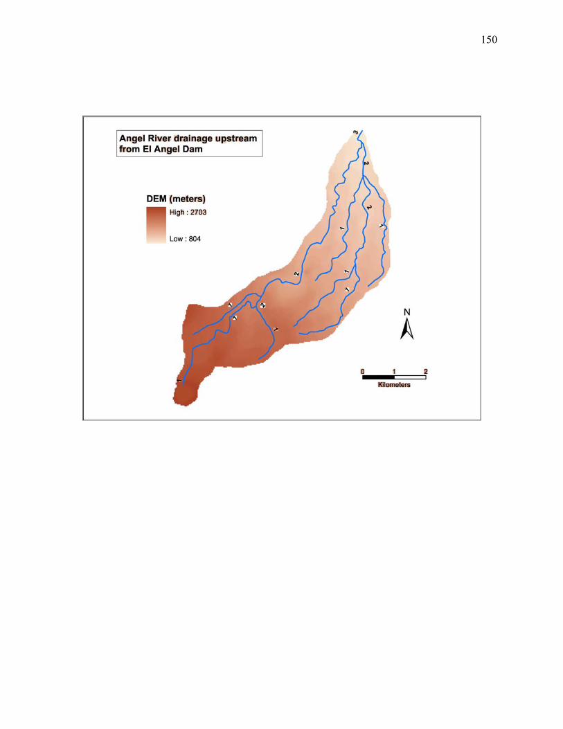
150
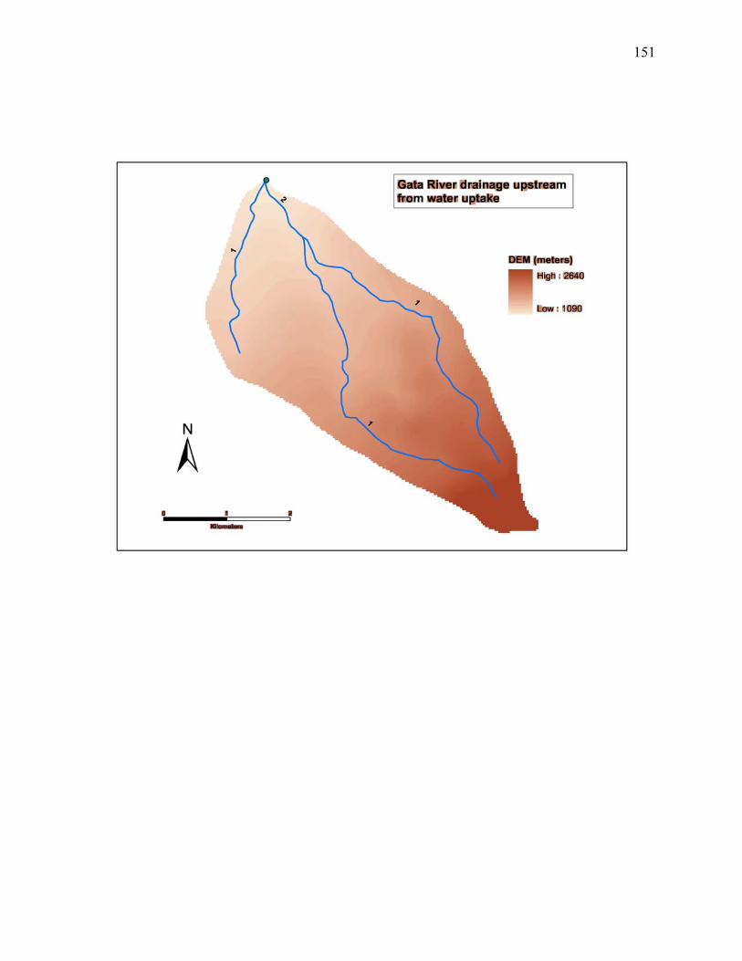
151
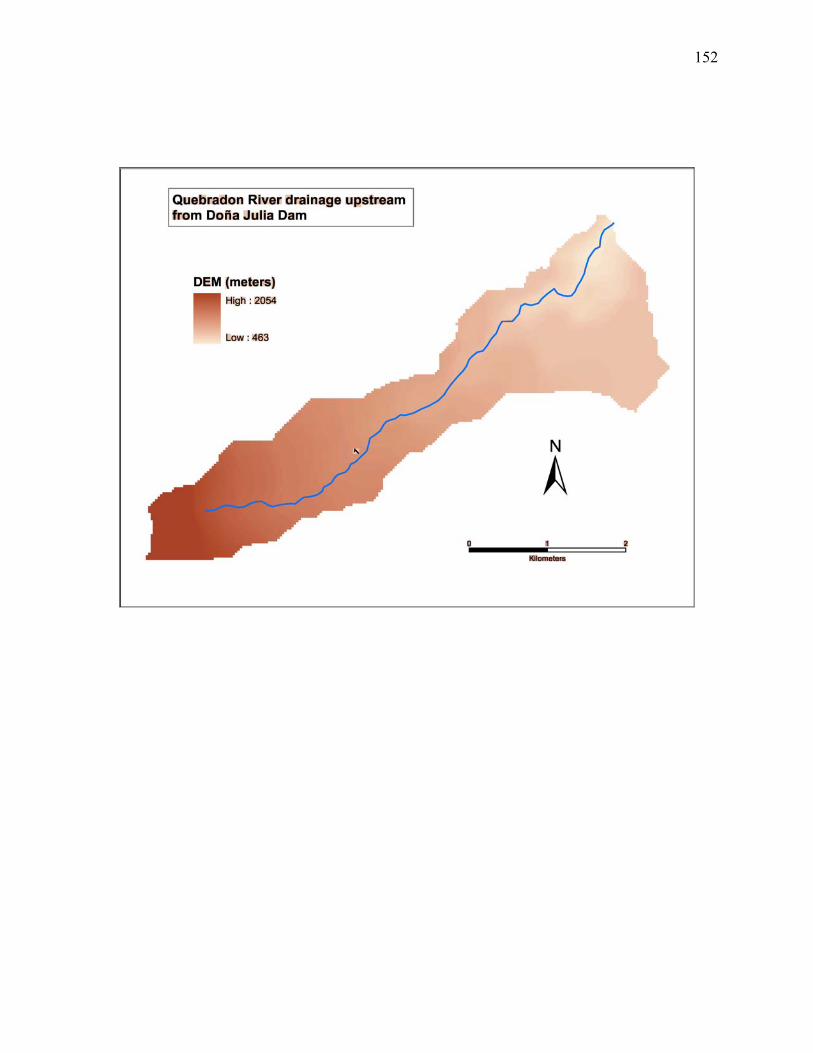
152
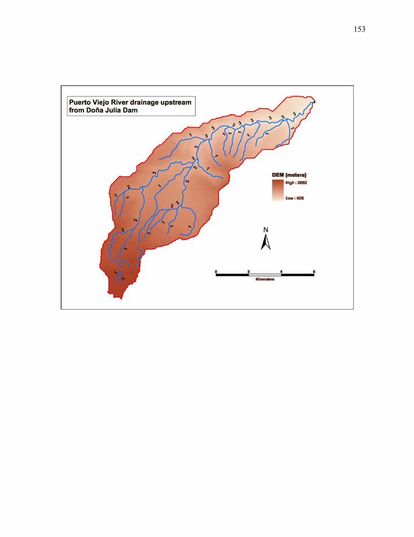
153
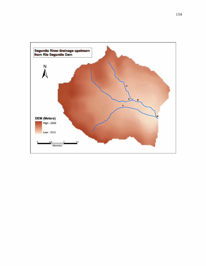
154
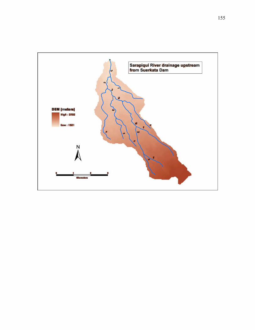
155
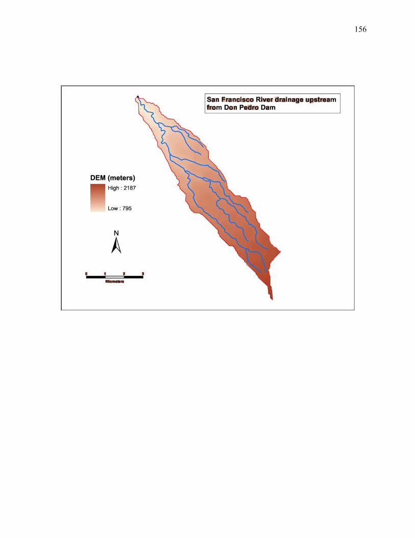
156
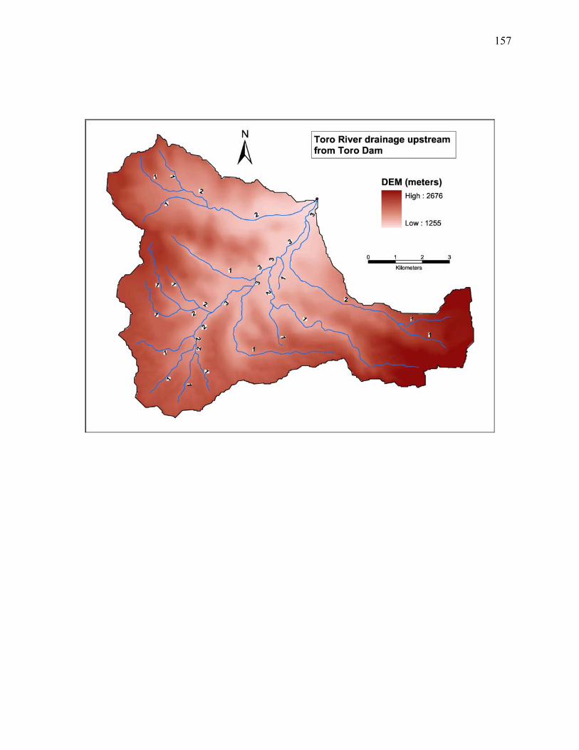
157
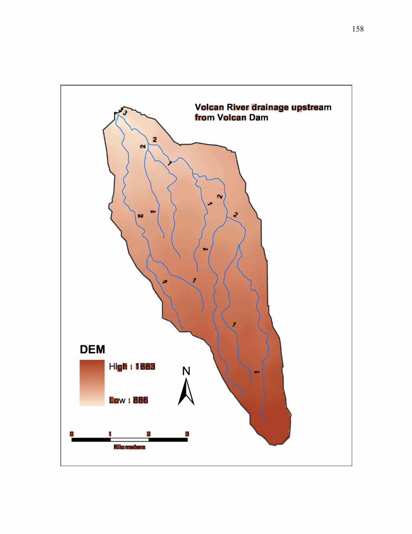
158

159
APPENDIX 2
LAND COVER IN DAMMED SUB-BASINS OF THE SARAPIQUÍ WATERSHED
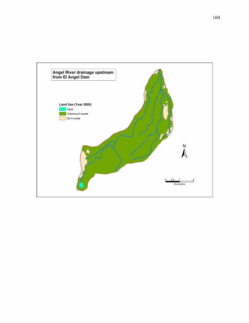
160
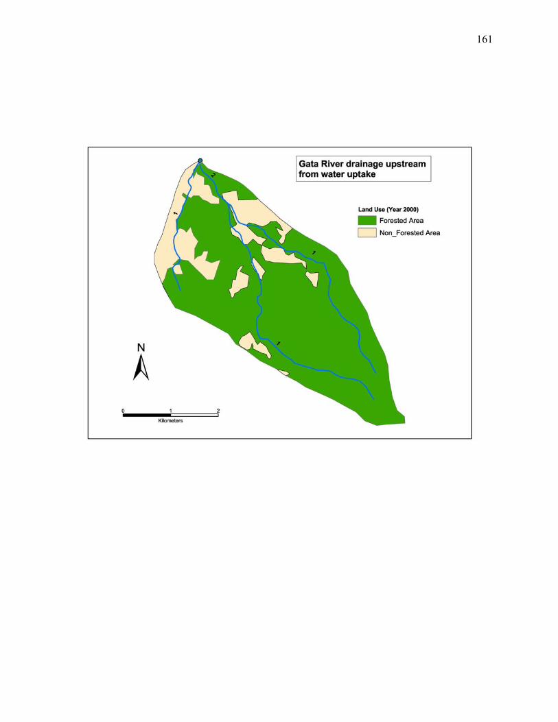
161
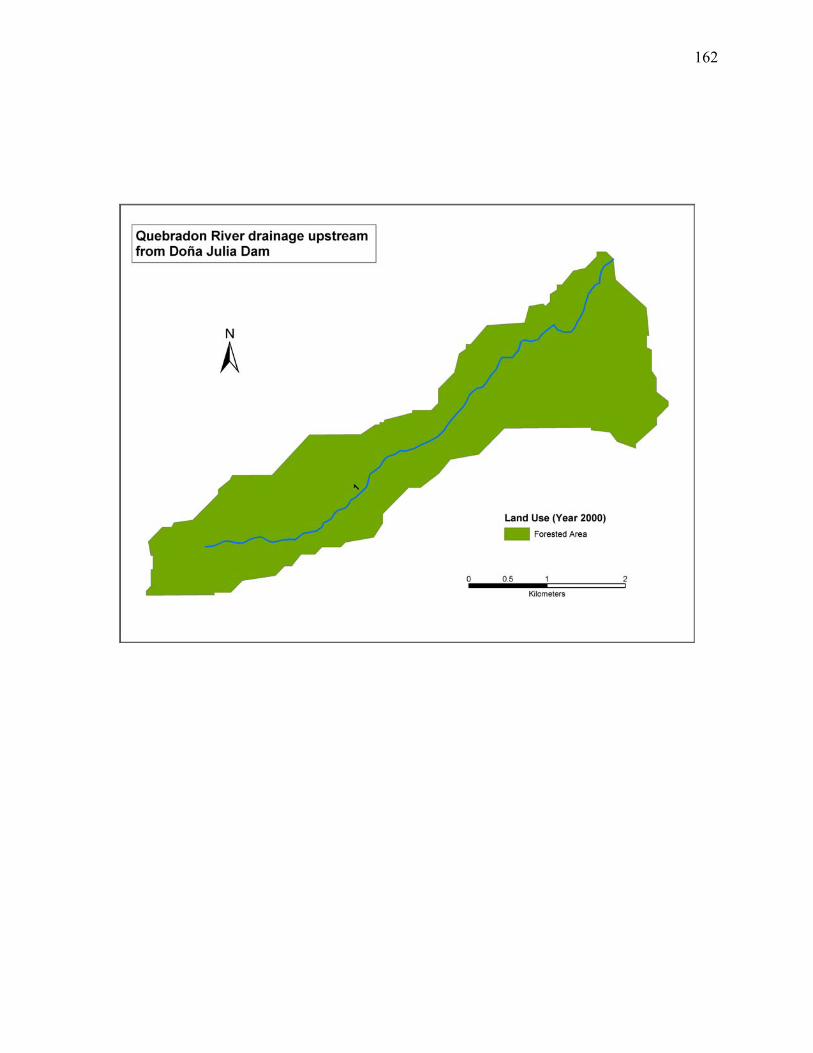
162
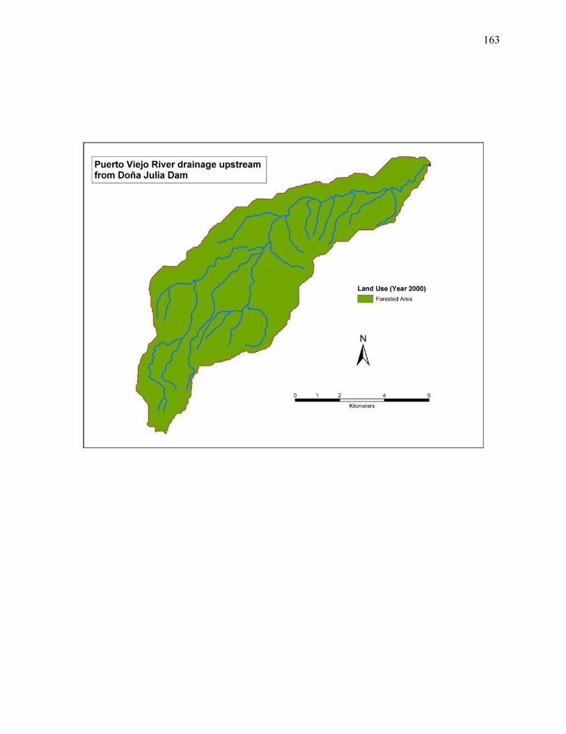
163
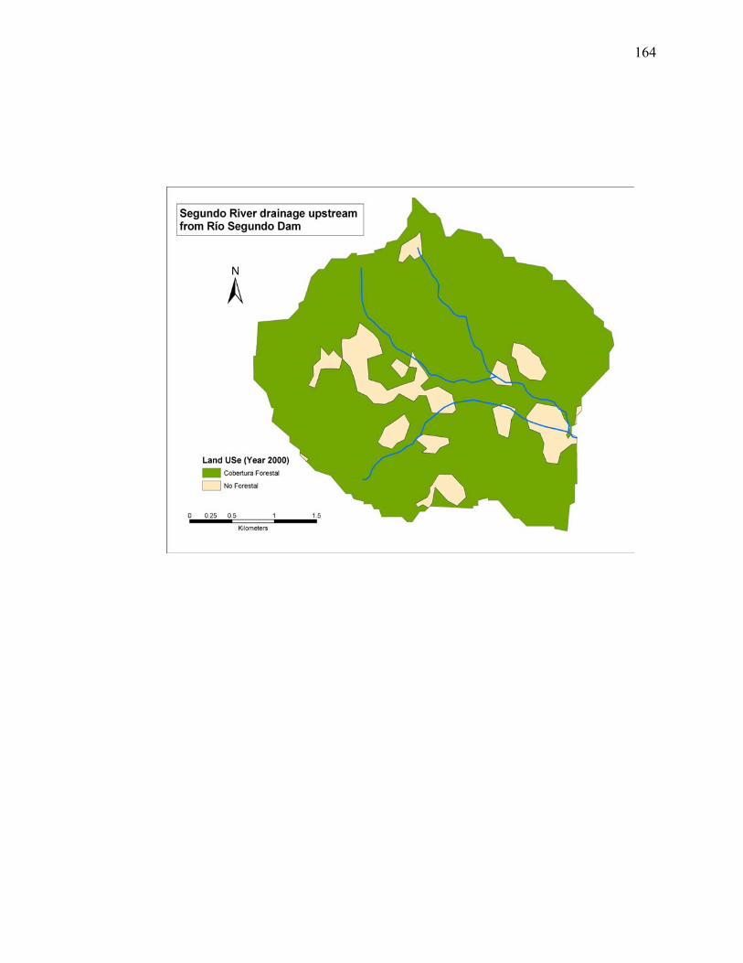
164
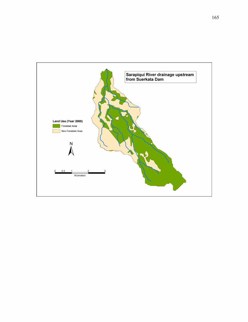
165
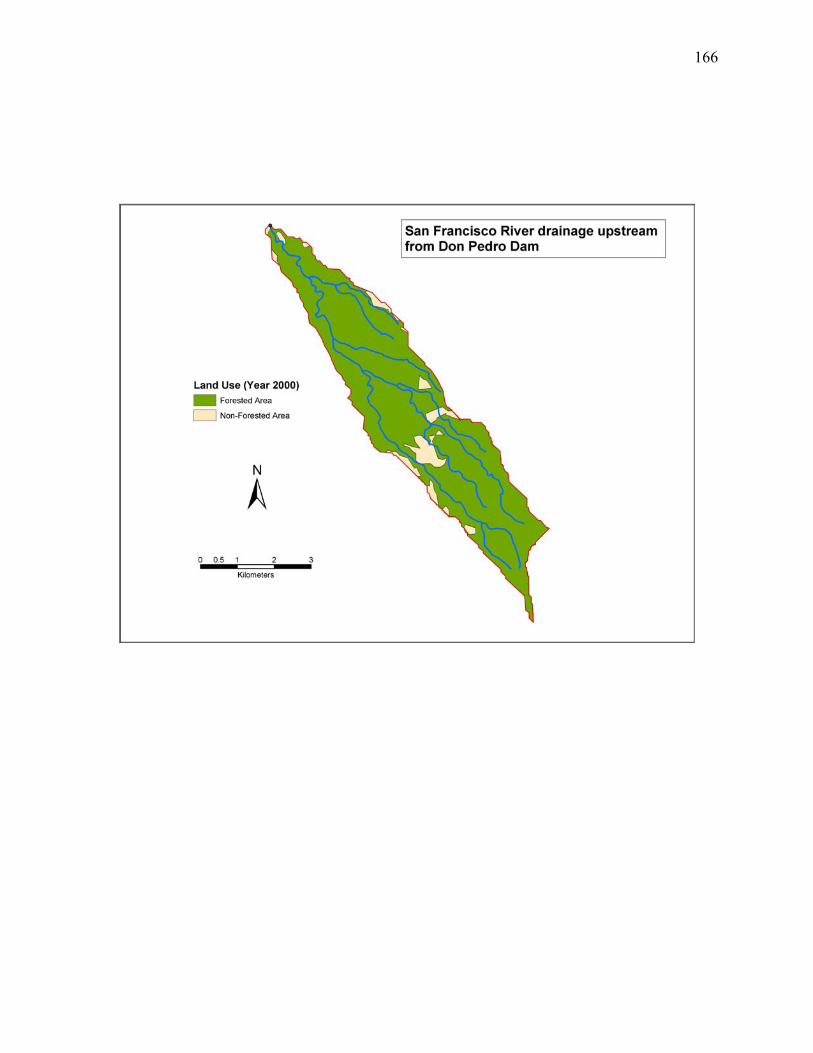
166
167
168
Related Documents