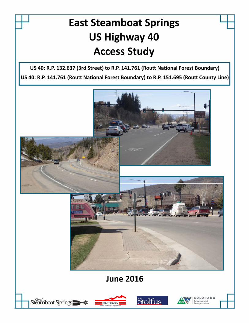
East Steamboat Springs US Highway 40 Access Study US 40: R.P. 132.637 (3rd Street) to R.P. 141.761 (RouƩ NaƟonal Forest Boundary) US 40: R.P. 141.761 (RouƩ NaƟonal Forest Boundary) to R.P. 151.695 (RouƩ County Line) June 2016

Welcome message from author
This document is posted to help you gain knowledge. Please leave a comment to let me know what you think about it! Share it to your friends and learn new things together.
Transcript
East Steamboat Springs
US Highway 40
Access Study
US 40: R.P. 132.637 (3rd Street) to R.P. 141.761 (Rou Na onal Forest Boundary)
US 40: R.P. 141.761 (Rou Na onal Forest Boundary) to R.P. 151.695 (Rou County Line)
June 2016
East Steamboat Springs US Highway 40 Access Study
Stolfus & Associates, Inc.
EAST STEAMBOAT SPRINGS
US HIGHWAY 40 ACCESS STUDY
US 40: R.P. 132.637 (3rd Street) to R.P. 141.761 (Routt National Forest Boundary) US 40: R.P. 141.761 (Routt National Forest Boundary) to R.P. 151.695 (Routt
County Line)
June 2016
Prepared for:
City of Steamboat Springs 137 10th Street PO Box 775088
Steamboat Springs, CO 80487 Ben Beall, PE, City Engineer
Routt County
PO Box 773598 Steamboat Springs, CO 80487
Mike Mordi, PE, Assistant Director Road and Bridge
Colorado Department of Transportation Region 3 – Traffic and Safety
222 South 6th Street, Room 100 Grand Junction, Colorado 81501
Dan Roussin, Permit Unit Manager
In cooperation with:
US Forest Service Medicine Bow/Routt National Forests and Thunder Basin National Grassland
925 Weiss Drive Steamboat Springs, CO 80487
Kent Foster, District Recreation Program Manager
Prepared by:
Stolfus & Associates, Inc. 5690 DTC Boulevard, Suite 560E
Greenwood Village, Colorado 80111 Michelle Hansen, P.E., Project Manager SAI Reference No. 15007/15013/15016

East Steamboat Springs US Highway 40 Access Study
Stolfus & Associates, Inc.
TABLE OF CONTENTS
Executive Summary ....................................................................................................... i
1.0 Introduction ......................................................................................................... 1
1.1 Project Background ........................................................................................... 1
1.2 Project Coordination ......................................................................................... 3
1.3 Public Involvement ............................................................................................ 3
2.0 Access Management – Benefits, Principles & Techniques ............................ 5
2.1 Access Management Benefits ........................................................................... 5
2.2 Guiding Principles ............................................................................................. 6
2.3 Techniques ....................................................................................................... 7
3.0 Existing Conditions .......................................................................................... 10
3.1 Land Use Characteristics ................................................................................ 10
3.2 Roadway Characteristics ................................................................................ 11
3.3 Right-of-Way ................................................................................................... 12
3.4 Access Category ............................................................................................. 13
3.5 Existing Access Inventory ............................................................................... 14
3.6 Crash History .................................................................................................. 16
4.0 Existing Traffic Conditions .............................................................................. 18
4.1 Existing Traffic Volumes ................................................................................. 18
4.2 Existing Traffic Operations .............................................................................. 18
5.0 Future Traffic Conditions ................................................................................. 21
5.1 Traffic Growth ................................................................................................. 21
5.2 Future Traffic without ACP ........................................................................... 21
5.3 Future Traffic with ACP ................................................................................ 23
5.4 Access Control Plan Comparison ............................................................... 24
East Steamboat Springs US Highway 40 Access Study
Stolfus & Associates, Inc.
6.0 Access Plan Development and Evaluation..................................................... 25
6.1 Process ........................................................................................................... 25
6.1.1 Step One – Methodology & Compatibility Index ....................................... 25
6.1.2 Step Two – Development of the Access Plan .......................................... 25
6.1.3 Step Three – Refine the Access Plan ...................................................... 25
6.1.4 Step Four – Evaluation ............................................................................ 25
6.2 Evaluation Results .......................................................................................... 26
7.0 Plan Recommendations ................................................................................... 27
7.1 Access Plan .................................................................................................... 28
7.2 Other Recommended Improvements .............................................................. 53
7.2.1 Alternative Local Routes .......................................................................... 53
7.2.2 Alternate Modes ....................................................................................... 54
7.2.3 Forest Service Parking Considerations .................................................... 55
8.0 Implementation ................................................................................................. 57
9.0 List of Acronyms .............................................................................................. 59
10.0 Glossary ............................................................................................................ 61

East Steamboat Springs US Highway 40 Access Study
Stolfus & Associates, Inc.
LIST OF FIGURES
Figure 1. Vicinity Map ................................................................................................................... 2
Figure 2. Functional Intersection Area .......................................................................................... 6
Figure 3A. US 40 Access Exhibit 1 of 18 .................................................................................... 35
Figure 3B. US 40 Access Exhibit 2 of 18 .................................................................................... 36
Figure 3C. US 40 Access Exhibit 3 of 18 .................................................................................... 37
Figure 3D. US 40 Access Exhibit 4 of 18 .................................................................................... 38
Figure 3E. US 40 Access Exhibit 5 of 18 .................................................................................... 39
Figure 3F. US 40 Access Exhibit 6 of 18 .................................................................................... 40
Figure 3G. US 40 Access Exhibit 7 of 18 .................................................................................... 41
Figure 3H. US 40 Access Exhibit 8 of 18 .................................................................................... 42
Figure 3I. US 40 Access Exhibit 9 of 18 ..................................................................................... 43
Figure 3J. US 40 Access Exhibit 10 of 18 ................................................................................... 44
Figure 3K. US 40 Access Exhibit 11 of 18 .................................................................................. 45
Figure 3L. US 40 Access Exhibit 12 of 18 .................................................................................. 46
Figure 3M. US 40 Access Exhibit 13 of 18 ................................................................................. 47
Figure 3N. US 40 Access Exhibit 14 of 18 .................................................................................. 48
Figure 3O. US 40 Access Exhibit 15 of 18 .................................................................................. 49
Figure 3P. US 40 Access Exhibit 16 of 18 .................................................................................. 50
Figure 3Q. US 40 Access Exhibit 17 of 18 .................................................................................. 51
Figure 3R. US 40 Access Exhibit 18 of 18 .................................................................................. 52
Figure 4. Conceptual Forest Service Parking Layout ................................................................. 56
East Steamboat Springs US Highway 40 Access Study
Stolfus & Associates, Inc.
LIST OF TABLES
Table 1. Eastbound Speed Limits ............................................................................................... 11
Table 2. Westbound Speed Limits .............................................................................................. 11
Table 3. Right-of-way (row) summary ......................................................................................... 13
Table 4. Average Daily Traffic ..................................................................................................... 18
Table 5. LOS Criteria .................................................................................................................. 19
Table 6. March 2015 Levels-of-Service ...................................................................................... 20
Table 7. 2035 Levels-of-Service without ACP ............................................................................ 22
Table 8. 2035 Levels-of-Service with ACP ................................................................................. 23
Table 9. Compatibility Evaluation Summary ............................................................................... 26
East Steamboat Springs US Highway 40 Access Study
Stolfus & Associates, Inc.
TECHNICAL APPENDIX (Bound Separately)
APPENDIX A - PUBLIC OUTREACH
APPENDIX B - EXISTING ACCESS INVENTORY
APPENDIX C - CRASH HISTORY
APPENDIX D - TRAFFIC METHODOLOGY, DATA AND ANALYSIS
APPENDIX E - ACCESS PLAN METHODOLOGY AND EVALUATION PROCESS
APPENDIX F - INTERGOVERNMENTAL AGREEMENT (CITY AND COUNTY)
APPENDIX G - INTERGOVERNMENTAL AGREEMENT (FOREST SERVICE)
East Steamboat Springs US Highway 40 Access Study
Stolfus & Associates, Inc. Page i
EXECUTIVE SUMMARY
Background and Purpose
United States Highway 40 (US 40) is an important regional and local transportation route for the City of Steamboat Springs, Routt County and the State of Colorado. The western leg of US 40 through Colorado begins at the Utah border and extends east to I-70 near the Town of Empire. Although I-70 is the primary route for interstate traffic, US 40 provides an alternate east-west route into Utah. Residents and businesses in Routt County depend heavily on US 40 for local and inter-community travel. The highway serves a large commuter population between Craig, Hayden and Steamboat Springs, as well as large amount of outdoor recreational traffic.
The City of Steamboat Springs, Routt County, and the Colorado Department of Transportation (CDOT) recognize that good mobility and safe access along US 40 are essential to the on-going vitality of the City and the region. The Steamboat Springs Area Community Plan and the Routt County Master Plan specifically recognize the need for access management on US 40 under Policy T-1.5 and Policy 11.3.AA, respectively. The City, County and CDOT previously adopted an Access Control Plan (ACP) on the west side of Steamboat Springs and have successfully implemented portions of the plan with development. Additionally, the Northwest Transportation Planning Region (TPR) has identified US 40 between Craig and Empire as a Regional Priority Corridor in the 2040 Regional Transportation Plan (RTP). Several goals identified for US 40 in the RTP support access management strategies including: preserving and enhancing the existing system, and improving intersections and adding passing lanes. The US Forest Service has also been actively planning for the future within the Routt National Forest along Rabbit Ears Pass on US 40 with the Rabbit Ears Winter Parking Environmental Assessment (EA).
In support of the goals and recommendations from the City’s and County’s previous planning efforts, the goals and strategies from the 2040 RTP, and to address anticipated growth in the area, the City, County and CDOT have partnered to develop an Access Plan for US 40 between 3rd Street (Reference Point (RP) 132.637) and the Routt National Forest Boundary (RP 141.761). In addition, CDOT has engaged the US Forest Service to develop an Access Plan for the remaining segment of US 40 in Routt County between the Routt National Forest Boundary (RP 141.761) and the Routt County Line (RP 151.695) in support of the Forest Service EA.
Project Goals
This study effort coordinates anticipated development and growth in the area with the roadway network. In consultation with the project partners, the following project goals were established:
• Provide effective and efficient travel for traffic on US 40.
• Provide safe, effective, and efficient access to and from US 40 for businesses, residents, and guests for all travel modes.
• Identify and maintain compatibility with existing and proposed off-system connections that provide local circulation to support the transportation system.
• Provide a plan that is adoptable by all entities and can be implemented in phases.
• Support the economic viability of the project area.
• Maintain compatibility with previous local planning efforts.
• Support development of alternative modes.
East Steamboat Springs US Highway 40 Access Study
Stolfus & Associates, Inc. Page ii
Study Area
The study area encompasses approximately 19 miles of US 40 on the east side of Steamboat Springs, Colorado. The westernmost three (3) miles of the study area falls within the City’s jurisdiction; the easternmost ten (10) miles falls within US Forest Service jurisdiction; and the remaining six (6) miles between the city limits and Forest Service boundary fall within the County’s jurisdiction. In general, land use within the city limits is suburban in nature with commercial and residential uses. Land use in the county is typically agricultural, rural residential and recreational with much larger parcel sizes. Several parcels are under conservation easements or Land Preservation Subdivisions (LPS) limiting the potential for development for some time period. Once inside the Forest Service boundaries, all land is National Forest Service land. Within the study area, recreational use in the National Forest is limited to non-motorized use and highway access points are primarily used to provide access to parking areas for recreational uses such as hiking, biking, skiing, camping, etc. Physical characteristics and resources of the area include the Yampa River and minor tributaries, the Union Pacific Railroad (UPRR), the Yampa River Core Trail and other city trail systems, the Steamboat Ski Resort, and Rabbit Ears Pass.
There are currently 135 access points on US 40 within the study area. A majority of access points are full movement. The access points are classified as follows:
10 signalized public road intersections 11 unsignalized public road intersections 12 unsignalized private road intersections 33 business access points 15 residential access points 23 field access points 30 forest access points 1 truck escape ramp
Coordination and Public Involvement
The study is a joint partnership between the City of Steamboat Springs, Routt County, and CDOT Region 3 in cooperation with the US Forest Service. Input from corridor stakeholders, including property owners, tenants, developers, and the general public, was a critical element of the project. Multiple techniques were used to engage stakeholders including: two advertised public open houses; one-on-one meetings/phone calls with interested stakeholders; public presentations with City Council and Board of County Commissioners (BOCC); and project information posted on the City’s and County’s websites. Exhibits presenting access management principles, the study process, and the recommended Access Plan were displayed at open houses and on the City’s and County’s websites. Representatives from the City, County, CDOT, US Forest Service and consultant team were available for questions at public outreach events.
Development of the Plan
In preparation for this study, the existing physical and operational characteristics of US 40 were established. The project team also developed a compatibility index to evaluate how the plan met the objectives identified at the beginning of the project. Next, future physical and operational characteristics were projected for a 20-year planning period based on anticipated development in the area. Using this information, a draft Access Plan was developed and
East Steamboat Springs US Highway 40 Access Study
Stolfus & Associates, Inc. Page iii
evaluated. The Access Plan considered access points in logical groupings, State Highway Access Code guidance, functional intersection area, and alternative local routes. Based on input from the project team, agency representatives, and the public, the draft plan was refined and evaluated using criteria identified in the compatibility index. Overall, the Access Plan rates favorably and is compatible with project goals. Plan adoption by all affected entities is recommended.
Access Plan
Figures 3A-3R found in Section 7 of this report, graphically illustrate the recommended Access Plan. Access Control Plan Tables included in the IGAs contain the specific recommendations for each individual access point and can be found in Technical Appendices F and G. In general, the Access Plan limits full movement access to major intersections. In addition, highway access is reduced to one location per ownership and where feasible, shared between adjacent properties. Where reasonable access can be provided to an alternate route/cross street, access points are relocated to the local street system. On US 40 between 3rd Street and SH 131, access for parcels between major intersections is limited. To maximize local circulation options and serve heavily used left turn movements, minor public road intersections and some private access points are identified long-term as ¾ movement access points. These access points will accommodate left turns from the highway into the minor road or access, but will prohibit left turns entering the highway. Providing the left-turn movement improves operations and/or circulation, but is only used where there is adequate space to develop left turn auxiliary lanes. Traffic control measures, including installation of raised medians, may be used to achieve proposed conditions. On US 40 east of SH 131, limited-access points were not considered due to highway characteristics. Out of direction travel was generally limited to a maximum distance of one mile (½ mile each way) except on Rabbit Ears Pass where out of direction travel was not specifically limited. Limiting out of direction travel was achieved by providing full movement intersections at necessary intervals.
Major intersections that are identified as full movement intersections with a traffic signal or the potential for signalization (or other traffic control measure) in the future are as follows:
City 3rd Street Hilltop Parkway/Trafalgar Dr. Anglers Drive Pine Grove Road Mt Werner Road Ramps Walton Creek Road Dougherty Road
County Access 45/145 at Bald Eagle Lake SH 131/CR 24 Catamount Drive Wild Rose Drive Storm Canyon Trail CR 22 CR 201
In support of the recommended access modifications, development of several alternative local routes within the City and County segments is also recommended. These alternative routes provide additional local connections and internal circulation opportunities that will benefit operations on US 40 by reducing local dependence on the highway, providing alternatives that support restricted turning movements on the highways, and reducing demand at intersections that are already experiencing high demand. The adoption of these additional road connections by the City and County through resolution or incorporation into master planning documents is recommended. In addition, incorporating pedestrian and bicycle crossings at all major intersections and other key locations identified in the Steamboat Springs Open Space and Trails Master Plan is recommended. Accommodating through bicycle traffic on US 40 as intersections are improved is also recommended.
East Steamboat Springs US Highway 40 Access Study
Stolfus & Associates, Inc. Page iv
Implementation
The improvements recommended in the Access Study represent a long-range plan that will be implemented over time as traffic and safety needs arise and as funding becomes available. Construction of the recommended improvements may be completed using public and/or private funding. The following cases, or any combination, will trigger construction:
1. A property redevelops or changes use, resulting in an increase in traffic to and from the site of 20% or more. In this case, limited improvements at the specific access point may be required by CDOT. As part of the City’s and County’s development review process, additional improvements may also be necessary to address traffic-related impacts created by the development. Improvements will be compatible with the Access Plan. (Private Funding).
2. The City, County, and/or US Forest Service obtain funding to complete improvements to a segment of the US 40 corridor or a local route. (Public Funding)
3. State and/or Federal Funds are obtained to complete improvements to a segment of the US 40 corridor. Typically, a project will be identified in the Statewide Transportation Improvement Program (STIP) to obtain funding. (Public Funding)
4. A safety or operational issue develops that can be mitigated through the implementation of access management techniques consistent with the Access Plan. Depending on the extent and type of safety or operational issue, improvements may address a segment of the US 40 corridor or a local route, or may be limited to an isolated location or access point. Public funding from any combination of agencies may be obtained to construct improvements. (Public Funding)

East Steamboat Springs US Highway 40 Access Study
Stolfus & Associates, Inc. Page 1
1.0 INTRODUCTION
1.1 Project Background
The City of Steamboat Springs is built primarily around United States Highway 40 (US 40). US 40 is an important regional and local transportation route for the City of Steamboat Springs, Routt County and the State of Colorado. The western leg of US 40 through Colorado begins at the Utah border and extends east to I-70 near the Town of Empire. Although I-70 is the primary route for interstate traffic, US 40 provides an alternate route into Utah; offering east-west access through Grand, Routt and Moffat Counties. Residents and businesses in Routt County depend heavily on US 40 for local and inter-community travel. A large commuter population exists between Craig, Hayden and Steamboat Springs in support of the Steamboat Ski and Resort Area and other business in Steamboat Springs. In addition, outdoor recreational opportunities are a significant draw to Routt County for residents and guests.
The City of Steamboat Springs, Routt County, and the Colorado Department of Transportation (CDOT) recognize that good mobility and safe access along US 40 are essential to the on-going vitality of the City and the region. The Steamboat Springs Area Community Plan specifically recognizes the need for access management on US 40 under Policy T-1.5: Implement access control improvements as development occurs. Similarly, the County has included a policy in their Master Plan to “avoid excessive intersections on the County road system” (Policy 11.3.AA). The two entities have also partnered to address growth in areas surrounding the City of Steamboat Springs within a defined Urban Growth Boundary (UGB). The City, County and CDOT previously adopted an Access Control Plan (ACP) on the west side of Steamboat Springs and have successfully implemented portions of the plan with development. With the success of the West Steamboat Springs US 40 ACP and potential development pressures on the east side of Steamboat Springs, the City and County are continuing their proactive approach to planning for growth and transportation on the east side of Steamboat Springs.
Additionally, the Northwest Transportation Planning Region (TPR) has identified US 40 between Craig and Empire as a Regional Priority Corridor in the 2040 Regional Transportation Plan (RTP). Several goals identified for US 40 in the RTP support access management strategies including: preserving and enhancing the existing system, and improving intersections and adding passing lanes.
The US Forest Service has also been actively planning for the future within the Routt National Forest along Rabbit Ears Pass on US 40. The Decision Notice for the Rabbit Ears Winter Parking Environmental Assessment (EA) was issued in September, 2014. The EA identifies parking improvements for winter recreation activities along US 40 on Rabbit Ears Pass.
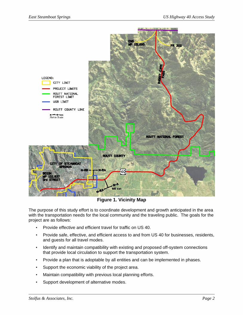
In support of the goals and recommendations from the City’s and County’s previous planning efforts, the goals and strategies from the 2040 RTP, and to address anticipated growth in the area, the City, County and CDOT have partnered to develop an Access Plan for US 40 between 3rd Street (Reference Point (RP)132.637) and the Routt National Forest Boundary (RP 141.761). In addition, CDOT has engaged the US Forest Service to develop an Access Plan for the remaining segment of US 40 within Routt County between the Routt National Forest Boundary (RP 141.761) and the Routt County Line (RP 151.695) in support of the improvements identified in the Forest Service EA. The total limits of the study area span just over nineteen (19) miles of US 40 with approximately ten (10) miles inside US Forest Service boundaries. Limits of the project are defined by reference points based on the CDOT Highway Segment Description for 3rd Street at RP 132.637. The study limits are illustrated on the Vicinity Map in Figure 1.
East Steamboat Springs US Highway 40 Access Study
Stolfus & Associates, Inc. Page 2
Figure 1. Vicinity Map The purpose of this study effort is to coordinate development and growth anticipated in the area with the transportation needs for the local community and the traveling public. The goals for the project are as follows:
• Provide effective and efficient travel for traffic on US 40.
• Provide safe, effective, and efficient access to and from US 40 for businesses, residents, and guests for all travel modes.
• Identify and maintain compatibility with existing and proposed off-system connections that provide local circulation to support the transportation system.
• Provide a plan that is adoptable by all entities and can be implemented in phases.
• Support the economic viability of the project area.
• Maintain compatibility with previous local planning efforts.
• Support development of alternative modes.
East Steamboat Springs US Highway 40 Access Study
Stolfus & Associates, Inc. Page 3
This report summarizes the study process, analyses, findings, and recommendations for access modifications within the US 40 corridor.
1.2 Project Coordination
The project area falls within the boundaries of the City of Steamboat Springs, Routt County, and the US Forest Service. Operations and maintenance of US 40 within the study area are managed by CDOT – Region 3. The study is a joint partnership between the City of Steamboat Springs, Routt County, and CDOT in cooperation with the US Forest Service.
The primary project team for development of the Access Plan consisted of representatives from the following: City Public Works, City Planning and Community Development, County Road and Bridge, US Forest Service Medicine Bow/Routt National Forests and Thunder Basin National Grassland, and CDOT – Region 3, Traffic and Safety Departments. Input from other departments within the City, County, Forest Service and CDOT was collected by project team staff representatives and at staff preview Open Houses held on September 2, 2015 and January 27, 2016. Coordination with local elected officials and project stakeholders, including property owners, tenants and the general public is described in the next section.
1.3 Public Involvement
Input from corridor stakeholders, including property owners, tenants, developers, and the general public, was a critical element of the project. Multiple techniques were used to engage stakeholders including: advertised public open houses; one-on-one meetings/phone calls with interested stakeholders; public presentations with Steamboat Springs City Council, and Routt County Board of County Commissioners (BOCC); press releases and project information posted on the City’s and County’s websites.
Two advertised project-specific public open houses were held to present and discuss the recommended Draft Access Plan for US 40, review access management principles and techniques, and gather public input on the draft plans. The first meeting was held on September 2, 2015 at Library Hall in the Bud Werner Memorial Library and the second meeting was held on January 27, 2016 at the City of Steamboat Springs Community Center. Corridor property owners, local government representatives, and other interested individuals who contacted the project team prior to the Open Houses were invited to the Open House by first class mail and e-mail, when provided. Two hundred eight (208) post cards were mailed for the September, 2015 Open House, and two hundred seventeen (217) post cards and fifty (50) e-mails were sent for the January, 2016 Open House.
To inform the general public of the Open Houses, the following notices were provided:
an invitation was included on the City’s and County’s websites and social media pages,
a legal public notice was posted in two issues of the Steamboat Pilot and Today, the City’s and County’s legal notice paper,
an advertisement was published in two issues of the Steamboat Pilot and Today, and
press releases were issued by CDOT.
East Steamboat Springs US Highway 40 Access Study
Stolfus & Associates, Inc. Page 4
Exhibits presenting access management principles, the study process, and the recommended draft Access Plan were displayed at all Public Open Houses. The same exhibits were also available for review on the City’s and County’s websites. Representatives from the City, County, CDOT, US Forest Service and consultant team were available for questions and discussion at all Open Houses. Approximately twenty-five (25) people attended the September, 2015 Open House and nine (9) people signed-in at the January, 2016 Open House.
Following the September, 2015 Public Open House, the project team held a series of one-on-one meetings with corridor property owners and other interested parties. Face-to-face meetings were held at Steamboat Springs City Hall on October 7, 8, and 28, 2015. Follow-up meetings were also held on December 15, 2015 and January 27, 2016. One-on-one meetings were advertised through a press release and at the September Open House. In addition, over forty (40) people were contacted directly. Twenty-five (25) interested parties participated, including property owners, business owners, developers, public agency representatives, and local advocacy groups. City, County, CDOT, and consultant team representatives participated in these meetings. In addition, the project was discussed with several interested parties via telephone at various times during access plan development.
Public comments were accepted at all public outreach events and via e-mail throughout the project. Open House sign-in sheets and comment sheets, as well as a list of one-on-one meeting participants can be found in Technical Appendix A.
The team updated and engaged the City Council and the BOCC on project progress and development on multiple occasions. All of these meetings were open to the public. Presentations were made at regularly scheduled City Council and BOCC meetings on August 4 and December 15, 2015.
Final presentations to both City Council and BOCC are anticipated for plan adoption at separate regularly scheduled City Council and BOCC meetings on June 7, 2016.
East Steamboat Springs US Highway 40 Access Study
Stolfus & Associates, Inc. Page 5
2.0 ACCESS MANAGEMENT – BENEFITS, PRINCIPLES & TECHNIQUES
As defined by the Access Management Manual, TRB, Second Edition 2014, “Access management is the coordinated planning, regulation, and design of access between roadways and land development. It involves the systematic control of the location, spacing, design, and operation of driveways, median openings, interchanges, and street connections to a roadway.” Access management along Colorado State Highways is generally administered by CDOT on a case by case basis, as prescribed by the State of Colorado State Highway Access Code, latest edition. Per Section 2.12 of the Access Code, CDOT or a local authority may develop an Access Control Plan for a segment of highway that defines access locations, level of access and traffic control for future conditions. Developing an Access Control Plan provides CDOT and the local authorities with the opportunity to develop a single transportation plan that considers multiple access points along a segment of highway as a network rather than as individual access points. Corridor specific issues such as intersection spacing, traffic movements, circulation, land use, topography, alternative access opportunities, and other local planning documents may be considered in developing an Access Control Plan. The Plan does not define capacity improvements, off-network improvements, or funding sources for access improvements, although local governments often consider off-network improvements for their communities in conjunction with an Access Control Plan. The Plan is a long-range planning document that identifies access conditions that will be implemented as highway and land-use characteristics change. Access Control Plans for State Highways are adopted by CDOT and the local authorities.
2.1 Access Management Benefits
Access management provides the means to balance good mobility along the highway with local access needs of businesses and residents. Implementation of access management principles and techniques on State and local transportation networks can provide the following long-term benefits for highway users, communities, and businesses:
Safety Fewer decision points and potential for conflicts for motorists, cyclists, and
pedestrians results in a reduced number of accidents. Safe access to businesses is provided.
Increased ability to accommodate traffic demands Limiting full movement access within a corridor favors through movements and
strategically identifies locations for vehicles to enter and exit the corridor. Reduces congestion, thereby reducing travel times and discouraging thru traffic
from seeking alternative local routes to avoid congestion. Improved operations on the highway also provides increased opportunities to
reduce delay on the local street system. Reduced congestion results in less air pollution.
Preserves property values and the economic viability of abutting development A more efficient roadway system captures a broader market area. A more predictable and consistent development environment is created. Well-defined driveways with suitable spacing make it easier for customers to
enter and exit businesses safely, thereby encouraging customers to patronize corridor businesses.

East Steamboat Springs US Highway 40 Access Study
Stolfus & Associates, Inc. Page 6
Encourages use and development of local streets Alternative local routes allow traffic to access local amenities conveniently
without using the highway, thereby providing both convenient local access and circulation and reduced volumes on the highway.
Enhanced Corridor Appearance Businesses are easily located Well-defined access points with suitable spacing provides more opportunities for
streetscaping/landscaping.
2.2 Guiding Principles
Access management centers around limiting and consolidating access along major roadways and focusing access for development on a supporting local street network and circulation system. The following guiding principles to access management were applied in the development of the Access Plan for US 40:
Limit the number of direct access points to major roadways Locate signals and intersections to favor through movements Minimize the number of locations where vehicles merge, split, or cross Remove turning vehicles from through traffic lanes Provide a supporting local street network and circulation system
In addition, functional intersection area was considered in evaluating the spacing between major intersections. American Association of State Highway and Transportation Officials (AASHTO) A Policy on Geometric Design of Highways and Streets, 2011 and Access Management Manual, TRB, Second Edition 2014 indicate that separation of access points should not be less than the functional area of the intersection. The functional intersection area extends upstream and downstream from the physical intersection as shown in Figure 2 below.
Figure 2. Functional Intersection Area
Source: Federal Highway Administration (FHWA) Access Management in the Vicinity of Intersections Technical Summary
The upstream distance is a combination of the storage length, deceleration and taper length, and the perception-reaction distance required for the speed of the segment. The downstream distance is measured as stopping sight distance, which allows drivers to pass through an intersection before considering potential conflicts at the next intersection. The functional intersection area depends on the speed of the segment and the number of projected turning vehicles.
East Steamboat Springs US Highway 40 Access Study
Stolfus & Associates, Inc. Page 7
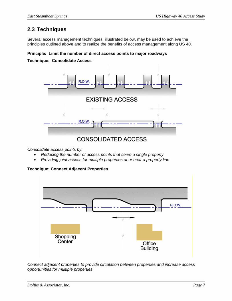
2.3 Techniques
Several access management techniques, illustrated below, may be used to achieve the principles outlined above and to realize the benefits of access management along US 40.
Principle: Limit the number of direct access points to major roadways
Technique: Consolidate Access
Consolidate access points by: Reducing the number of access points that serve a single property Providing joint access for multiple properties at or near a property line
Technique: Connect Adjacent Properties
Connect adjacent properties to provide circulation between properties and increase access opportunities for multiple properties.
East Steamboat Springs US Highway 40 Access Study
Stolfus & Associates, Inc. Page 8
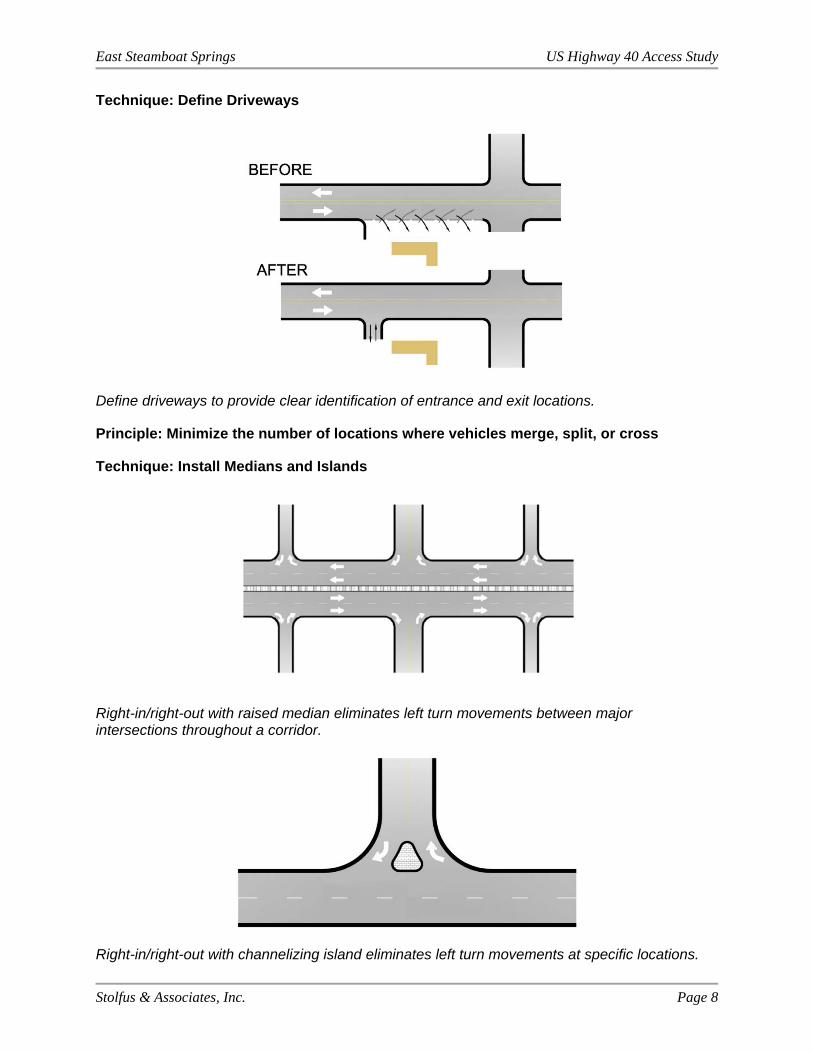
Technique: Define Driveways
Define driveways to provide clear identification of entrance and exit locations.
Principle: Minimize the number of locations where vehicles merge, split, or cross
Technique: Install Medians and Islands
Right-in/right-out with raised median eliminates left turn movements between major intersections throughout a corridor.
Right-in/right-out with channelizing island eliminates left turn movements at specific locations.
East Steamboat Springs US Highway 40 Access Study
Stolfus & Associates, Inc. Page 9
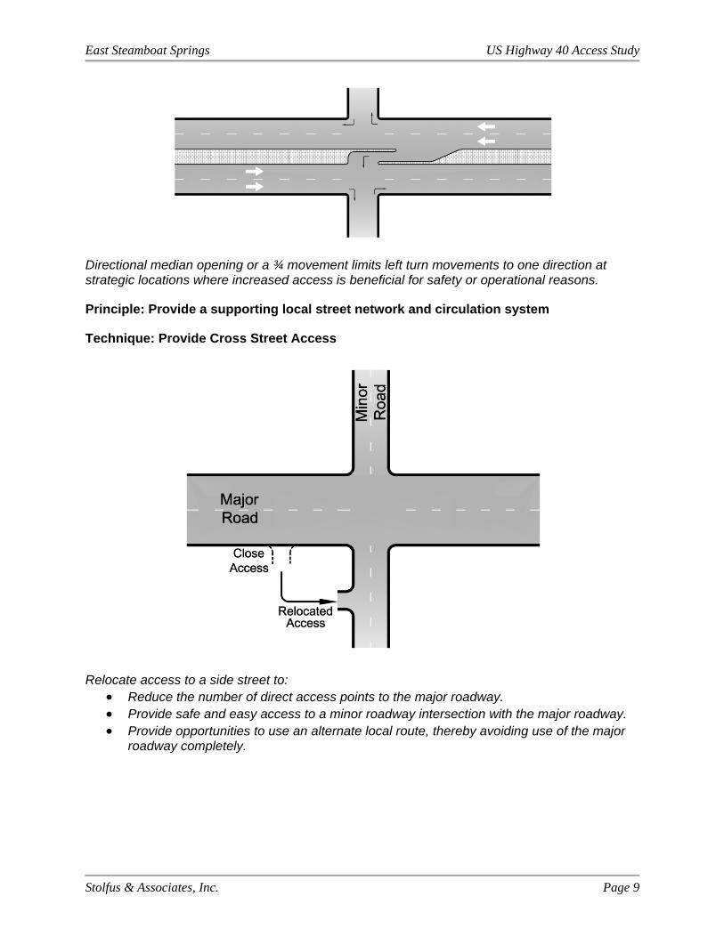
Directional median opening or a ¾ movement limits left turn movements to one direction at strategic locations where increased access is beneficial for safety or operational reasons.
Principle: Provide a supporting local street network and circulation system
Technique: Provide Cross Street Access
Relocate access to a side street to: Reduce the number of direct access points to the major roadway. Provide safe and easy access to a minor roadway intersection with the major roadway. Provide opportunities to use an alternate local route, thereby avoiding use of the major
roadway completely.

East Steamboat Springs US Highway 40 Access Study
Stolfus & Associates, Inc. Page 10
3.0 EXISTING CONDITIONS
3.1 Land Use Characteristics
The study area encompasses approximately 19 miles of US 40 on the east side of Steamboat Springs, Colorado. The westernmost three (3) miles of the study area falls within the City’s jurisdiction; the easternmost ten (10) miles falls within US Forest Service jurisdiction; and the remaining six (6) miles between the city limits and Forest Service boundary fall within the County’s jurisdiction. The UGB covers approximately one-half mile of US 40 west of the city limits. Refer to Figure 1 for the UGB boundaries.
In general, land use within the city limits is suburban in nature with commercial and residential uses. This is consistent with the zoning surrounding US 40. The City has estimated the potential for additional development based on existing zoning. Land use capacity planning documents used to estimate the proportion of future traffic accessing the highway at various public street intersections is located in Technical Appendix D. Land use in the county is typically agricultural, rural residential and recreational with much larger parcel sizes. Land surrounding US 40 in the County segment is zoned Agriculture and Forestry with a small amount of Planned Unit Development at Timbers Village. Several parcels are under conservation easements or Land Preservation Subdivisions (LPS) limiting the potential for development for some time period. Once inside the Forest Service boundaries, all land is National Forest Service land. Within the study area, recreational use in the National Forest is limited to non-motorized use and highway access points are primarily used to provide access to parking areas for recreational uses such as hiking, biking, skiing, camping, etc.
Physical characteristics and resources of the area include multiple waterways, the Union Pacific Railroad (UPRR), the Yampa River Core Trail and other city trail systems, the Steamboat Ski Resort, and Rabbit Ears Pass. The Yampa River parallels US 40 on the west through the City segment of the study limiting potential development on the west in the immediate vicinity of the highway. South/east of SH 131, the river pulls away from US 40. There are also two main tributaries that cross US 40: Fish Creek near Milepost (MP) 133.8 and Walton Creek near MP 135.1. During spring runoff, flooding of the area surrounding US 40 is common, especially south of the Mt. Werner Road interchange. The UPRR also parallels US 40 on the west. It is located within 0.10 – 0.20 miles from US 40 from 3rd Street to the Mt. Werner Road interchange, where the highway begins to pull away from the tracks. Similar to the Yampa River, the proximity of the tracks limits potential development on the west side of US 40. Also paralleling on the west, the heavily used Yampa River Core Trail provides critical bicycle/pedestrian facilities for the area. The trail currently extends to Dougherty Road and is expected to be extended to State Highway (SH) 131 in the future. Several trail spurs off the Core Trail exist and cross US 40 at grade separated crossings. The Steamboat Ski Resort is a key economic driver for the City and region. Located on the east side of US 40, access and circulation for the resort are critical elements not only for traffic operations on US 40, but also for the local street system. Finally, beginning around CR 20/CR 201, US 40 begins to ascend Rabbit Ears Pass. Steep, mountainous terrain exists on either side of the highway east of CR 20/ CR 201 limiting available access opportunities.
East Steamboat Springs US Highway 40 Access Study
Stolfus & Associates, Inc. Page 11
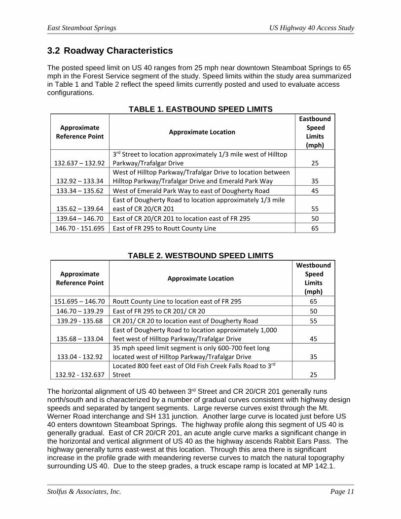
3.2 Roadway Characteristics
The posted speed limit on US 40 ranges from 25 mph near downtown Steamboat Springs to 65 mph in the Forest Service segment of the study. Speed limits within the study area summarized in Table 1 and Table 2 reflect the speed limits currently posted and used to evaluate access configurations.
TABLE 1. EASTBOUND SPEED LIMITS
Approximate Reference Point
Approximate Location
Eastbound Speed Limits (mph)
132.637 – 132.92 3rd Street to location approximately 1/3 mile west of Hilltop Parkway/Trafalgar Drive 25
132.92 – 133.34 West of Hilltop Parkway/Trafalgar Drive to location between Hilltop Parkway/Trafalgar Drive and Emerald Park Way 35
133.34 – 135.62 West of Emerald Park Way to east of Dougherty Road 45
135.62 – 139.64 East of Dougherty Road to location approximately 1/3 mile east of CR 20/CR 201 55
139.64 – 146.70 East of CR 20/CR 201 to location east of FR 295 50
146.70 ‐ 151.695 East of FR 295 to Routt County Line 65
TABLE 2. WESTBOUND SPEED LIMITS
Approximate Reference Point
Approximate Location
Westbound Speed Limits (mph)
151.695 – 146.70 Routt County Line to location east of FR 295 65
146.70 – 139.29 East of FR 295 to CR 201/ CR 20 50
139.29 ‐ 135.68 CR 201/ CR 20 to location east of Dougherty Road 55
135.68 – 133.04 East of Dougherty Road to location approximately 1,000 feet west of Hilltop Parkway/Trafalgar Drive 45
133.04 ‐ 132.92 35 mph speed limit segment is only 600‐700 feet long located west of Hilltop Parkway/Trafalgar Drive 35
132.92 ‐ 132.637 Located 800 feet east of Old Fish Creek Falls Road to 3rd Street 25
The horizontal alignment of US 40 between 3rd Street and CR 20/CR 201 generally runs north/south and is characterized by a number of gradual curves consistent with highway design speeds and separated by tangent segments. Large reverse curves exist through the Mt. Werner Road interchange and SH 131 junction. Another large curve is located just before US 40 enters downtown Steamboat Springs. The highway profile along this segment of US 40 is generally gradual. East of CR 20/CR 201, an acute angle curve marks a significant change in the horizontal and vertical alignment of US 40 as the highway ascends Rabbit Ears Pass. The highway generally turns east-west at this location. Through this area there is significant increase in the profile grade with meandering reverse curves to match the natural topography surrounding US 40. Due to the steep grades, a truck escape ramp is located at MP 142.1.
East Steamboat Springs US Highway 40 Access Study
Stolfus & Associates, Inc. Page 12
The following roadway cross-sections exist on US 40 through the study limits:
MP 132.637 to MP 132.79 (3rd Street to Old Fish Creek Falls Road: - 4-lane urban section with curb and gutter and sidewalk and a two-way left-
turn lane
MP 132.79 to MP 134.85 (Old Fish Creek Falls Road to JD Hays Way): 4-lane section with shoulders and a raised median. Segments of curb and gutter and sidewalk are scattered through this segment on the east side. Left and right turn auxiliary lanes are provided at various intersections and access points. A diamond interchange provides access to Mt. Werner Road with US 40 traveling over Mt. Werner Road.
MP 134.85 to MP 135.22 (JD Hays Way to Weiss Drive/Ingles Lane): - 4-lane section with shoulders and a painted median. Turn lanes are provided
at JD Hays Way, Walton Creek Road, Weiss Drive/Ingles Lane.
MP 135.22 to MP 135.75(Weiss Drive/Ingles Lane to Access #43): - 2-lane rural section with shoulder and two-way left-turn lane. Right-turn auxiliary lanes are provided at various locations. A painted median transition occurs between MP 135.88 and 135.75.
MP 135.75 to MP 151.695 (Access #43 to Routt County Line):
- 2-lane undivided rural section with shoulders. Auxiliary lanes are provided at SH 131, Haymaker Golf Course, Meadow Creek Drive, and Catamount Drive. An eastbound climbing lane begins at County Road (CR) 20/CR 201 and ends approximately 700 feet east of Forest Road (FR 295).
The following access points have configurations that may create operational or safety challenges:
Hilltop Parkway (close proximity of local road access points to US 40) Pine Grove Road (close proximity of local road access points to US 40) Anglers Drive and Pine Grove Road (close proximity of signalized public intersections) Walton Creek Road and Weiss Drive (close proximity of public intersections) SH 131 and CR 24 (offset intersections) CR 20/CR 201 (horizontal and vertical approaches to US 40) Harrison Creek/Smokey Bear Curve access (entering sight distance) Other minor access points on Rabbit Ears Pass (entering sight distance)
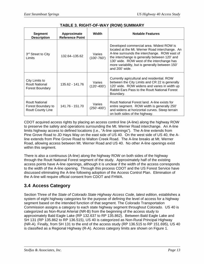
3.3 Right-of-Way
The right-of-way (ROW) width within the study area varies throughout and is generally centered on the US 40 centerline. The ROW width varies between approximately 100’ and over 760’. The widest segment is within city limits between Pine Grove Road and Walton Creek Road to accommodate the Mt. Werner Road interchange. Table 3 summarizes the ROW for the corridor.
East Steamboat Springs US Highway 40 Access Study
Stolfus & Associates, Inc. Page 13
TABLE 3. RIGHT-OF-WAY (ROW) SUMMARY
Segment Description
Approximate Reference Point
Width Notable Features
3rd Street to City Limits
132.64–135.62 Varies
(100’-760’)
Developed commercial area. Widest ROW is located at the Mt. Werner Road interchange. An A-line surrounds the interchange. ROW east of the interchange is generally between 120’ and 130’ wide. ROW west of the interchange has more variability, but is generally between 150’ and 200’ wide.
City Limits to Routt National Forest Boundary
135.62 - 141.76 Varies
(120’-400’)
Currently agricultural and residential. ROW between the City Limits and CR 22 is generally 120’ wide. ROW widens and varies in width up Rabbit Ears Pass to the Routt National Forest Boundary.
Routt National Forest Boundary to Routt County Line
141.76 - 151.70 Varies
(250’-400’)
Routt National Forest land. A-line exists for entire segment. ROW width is generally 250’ and widens at horizontal curves. Steep terrain on both sides of the highway.
CDOT acquired access rights by placing an access control line (A-line) along the highway ROW to preserve the safety and operations surrounding the Mt. Werner Road interchange. An A-line limits highway access to defined locations (i.e., “A-line openings”). The A-line extends from Pine Grove Road to JD Hays Way on the east side of US 40. On the west side of US 40, the A-line extends from Pine Grove Road to Walton Creek Road. The A-line breaks at Mt. Werner Road, allowing access between Mt. Werner Road and US 40. No other A-line openings exist within this segment.
There is also a continuous (A-line) along the highway ROW on both sides of the highway through the Routt National Forest segment of the study. Approximately half of the existing access points have A-line openings, although it is unclear if the width of the access corresponds to the width of the A-line opening. Through this process CDOT and the US Forest Service have discussed eliminating the A-line following adoption of the Access Control Plan. Elimination of the A-line will require official consent from CDOT and FHWA.
3.4 Access Category Section Three of the State of Colorado State Highway Access Code, latest edition, establishes a system of eight highway categories for the purpose of defining the level of access for a highway segment based on the intended function of that segment. The Colorado Transportation Commission assigns a category to each state highway segment throughout Colorado. US 40 is categorized as Non-Rural Arterial (NR-B) from the beginning of the access study to approximately Bald Eagle Lake (RP 132.637 to RP 135.862). Between Bald Eagle Lake and SH 131 (RP 135.862 to RP 136.515), US 40 is categorized as Non-Rural Principal Highway (NR-A). Finally, from SH 131 to the end of the access study (RP 136.515 to RP 151.695), US 40 is classified as a Regional Highway (R-A). Access category limits are shown on Figure 1.
East Steamboat Springs US Highway 40 Access Study
Stolfus & Associates, Inc. Page 14
According to Section 3.11 of the Access Code, the major access control characteristics of a highway segment under Category NR-B are as follows:
Provides service to through traffic movements while allowing more direct access to occur
Capacity for moderate speeds and moderate to high traffic volumes “One access shall be granted to each parcel, if it does not create safety or
operational problems.” Accesses will provide, as a minimum, right turns only. One-half mile spacing for full movement intersections or minimum 30% efficiency
for signal progression Three-quarter movements may be permitted if operations at adjacent full
movement intersections are improved and design standards are met. According to Sections 3.8 and 3.10 of the Access Code, the major access control characteristics of a highway segment under Category R-A and NR-A, respectively, are very similar. These major characteristics are listed below:
Through traffic movements take precedence over direct access needs; Capacity for medium to high speed and medium to high traffic volumes; “One access shall be granted per parcel of land if reasonable access cannot be
obtained from the local street or road system;” One-half mile spacing for full movement intersections or minimum 35% efficiency
for signal progression.
3.5 Existing Access Inventory
There are currently 135 access points on US 40 within the study area. As part of the study access points located on local streets in close proximity to US 40 were also evaluated, including access on Hilltop Parkway, Pine Grove Road, and the future Stone Lane Extension. These access points are listed in the existing access inventory and are displayed on the exhibits, but are solely under local jurisdiction and will not be included in the Access Control Plan adopted through an Intergovernmental Agreement (IGA) between the City, County, and CDOT.
A majority of access points through the US 40 corridor are full movement. There are a handful of right-in/right-out access points between Old Fish Creek Falls Road and Pine Grove Road where raised median exists. Many access points were developed prior to adoption of the State Highway Access Code in 1998 and do not have access permits filed with CDOT. Almost forty (40) access points within the study area are permitted. Almost 25% of the access points provide direct business access and fall mainly within the City limits. In the County, the majority of access points are either residential or field accesses, accounting for 25% to 30% of the access points. Close to 25% of access points provide public/private road access and the remaining 20% to 25% of access points provide access to Routt National Forest.
For the purposes of identifying the location of access points for this plan, all access points are defined by the approximate CDOT reference point along US 40 based on CDOT Highway Segment Description Milepost for 3rd Street, RP 132.637. All access points are located at the approximate centerline of the access (+/- 50 feet). A complete inventory of existing access points is provided in Technical Appendix B.
East Steamboat Springs US Highway 40 Access Study
Stolfus & Associates, Inc. Page 15
The following provides a description of the accesses by type:
Public Road Signalized (PRS) – Full movement, signal-controlled intersection providing direct access to a publicly owned roadway. Within the study area, PRS accesses are city streets including the following:
3rd Street Hilltop Parkway/ Trafalgar Drive Anglers Drive
Pine Grove Road Walton Creek Road (Note: the west
leg of Walton Creek Road is private) Public Road Unsignalized (PRU) – Full movement, stop-controlled intersection providing direct access to a publicly owned roadway. The PRU access points in the study area include:
Old Fish Creek Falls Road Mt. Werner Road Ramps JD Hays Way Fire Station Emergency Access Weiss Drive
SH 131 County Road 24 County Road 22 County Road 20 County Road 201
Private Road Unsignalized (PVRU) – Full movement, stop-controlled intersection providing direct access to one or more private properties. These roadways are maintained privately. There are 12 PVRU access points on US 40 within the study area including:
Highpoint Drive Ingles Lane Dougherty Road Meadow Creek Drive Catamount Drive Wild Rose Drive
Rodeo Drive Storm Canyon Trail Timbers Preserve Drive South Runaway Place Sky Valley Drive Star Ridge Road
Business Access (BA) – Full or partial movement highway access points serving businesses within the study area. These types of access points are typically used multiple times daily by a variety of traffic types. There are a total of 33 BA access points on US 40. A large majority of these access points are within City limits.
Residential Access (R) – Full or partial movement private highway access points used on a regular basis by limited traffic. These types of access points include single-family private driveways. There are 15 R access points in the study area.
Field Access (FA) – Full or partial movement access points that provide direct access from the highway to agricultural land. These types of access points are typically not well-defined and are used infrequently. There are 23 FA points in the study area.
Forest Service (FS) – Full movement access points that provide direct access from the highway to US Forest Service land. These types of access points include Forest Roads and parking area pull-offs. The majority of these access points are not maintained during the winter. There are 30 FS points in the study area.
There is also one truck escape ramp on Rabbit Ears Pass at RP 142.069.
East Steamboat Springs US Highway 40 Access Study
Stolfus & Associates, Inc. Page 16
According to these classifications, the access points are distributed as follows:
10 signalized public road intersections 11 unsignalized public road intersections 12 unsignalized private road intersections 33 business access points 15 residential access points 23 field access points 30 forest access points 1 truck escape ramp
3.6 Crash History
CDOT conducted a Safety Assessment for a portion of US 40 in November 2013. The limits of that assessment extended from MP 130.00 (Bowling Center Drive) to MP 138.91 (Routt County Road 22) and was based on crash data collected from 2008 through 2012. No significant recommendations related to access control were made in the assessment.
More recent crash records with dates between July 2009 and June 2014 were collected for this study. In that time period, 573 crashes were reported on US 40 between MP 132.64 (3rd Street) and MP 151.81 (Routt- Grand County Line). Of those crashes, 258 were at driveways, at intersections, or were intersection-related. Those crashes resulted in injuries 38 times with the remaining 220 resulting in property damage only.
For the purposes of this review, any broadside or left-turn crashes reported at a driveway or intersection were considered to be “access-related” and may have the potential for mitigation with access management techniques. Crashes involving right-turning vehicles are also access-related; however, assuming the access remains open to traffic right-turns will not be restricted as part of the Access Plan.
All other crash types observed along the corridor are unlikely to be affected by the implementation of access control measures. The following US 40 intersections experienced at least five access-related crashes:
3rd St (MP 132.64) Hilltop Ln/Trafalgar Dr (MP 133.28) Anglers Dr (MP 133.81) Pine Grove Rd (MP 133.98) Mt. Werner Rd Interchange (MP 134.41) Walton Creek Rd (MP 135.12)
Each of these intersections currently allow full movement access and all but the interchange location are signalized. At 3rd Street, five access-related crashes were reported. No pattern of crashes was found at the intersection, although two of the broadside crashes reported can be directly attributed to icy or snowy road conditions. At Hilltop Lane, five access-related crashes were reported, however no patterns were identified in the data. At Anglers Drive, sixteen access-related crashes were reported. From eastbound US 40, four approach turn crashes were reported. These movements operate under protected-permitted left turn signal so protected-only phasing may be considered in the future if the frequency of left-turn

East Steamboat Springs US Highway 40 Access Study
Stolfus & Associates, Inc. Page 17
crashes increases. Seven broadside crashes were reported at the intersection, however no patterns were identified in the data. At Pine Grove Road, nineteen access-related crashes were reported. From 2010 through 2012, there were five left turn crashes from US 40. A protective left-turn signal was implemented at Pine Grove Road in 2015 to help mitigate crashes. In six of the ten broadside crashes reported, the at-fault driver was travelling south (westbound) on Pine Grove Road. This number is not high enough to suggest a pattern and no access changes are proposed to address the issue. At the Mount Werner Road interchange, there were four broadside crashes where the westbound driver coming down the ramp was at fault. All of these crashes occurred in icy or snowy conditions, which may have caused the vehicle to slide into the intersection. At Walton Creek Road, six approach turn crashes and two broadside crashes were reported. However, no patterns were identified in the crash records for the intersection. In summary, none of the existing accesses require the implementation of access management to address a specific safety concern. However, implementing access management techniques will reduce the number of conflict points in the study area, thereby decreasing the potential for crashes between road-users. Detailed accident summary reports are included in Technical Appendix C.

East Steamboat Springs US Highway 40 Access Study
Stolfus & Associates, Inc. Page 18
4.0 EXISTING TRAFFIC CONDITIONS
4.1 Existing Traffic Volumes
Daily traffic counts and vehicle classification data were collected at five locations within the study area between Tuesday, March 17, 2015 and Thursday, March 19, 2015. Resulting average daily traffic volumes, which includes traffic in both directions, are summarized in Table 4. An additional count was collected east of Forest Road 302 on the following weekend, March 21-22. Totals shown reflect the daily average over the collection period. Based on the vehicle classification counts, heavy vehicles were separated out as those with three or more axles. The number of bicycles on the highway is also reported from the vehicle classification counts.
TABLE 4. AVERAGE DAILY TRAFFIC
US‐40 Average Vehicles
per Day Heavy Vehicle
Percentage Average Bicycles
per Day
Weekday Counts
West of 3rd Street 23,000 2.7% 240
East of Pine Grove Road 20,400 2.5% 140
East of SH‐131 3,600 6.7% 20
East of Star Ridge Road 2,900 8.3% 40
East of Forest Road 302 2,600 7.7% 140
Weekend Counts
East of Forest Road 302 4,100 1.8% 40
Turning Movement Counts (TMCs) at 34 intersections through the study area were collected over the same period. Additional turning movement counts were collected at five intersections in Routt National Forest near the eastern project limits on the weekend of March 21-22, 2015. Raw traffic count data and peak hour summary figures are included in Technical Appendix D.
4.2 Existing Traffic Operations
Level-Of-Service (LOS) analyses were conducted at all intersections where turning movement counts were collected. Analyses were carried out using the methods described in the Highway Capacity Manual 2010 (HCM 2010) published by the Transportation Research Board of the National Academies. LOS is a measure of the quality of traffic flow and is defined by a letter grade ranging from A (uninterrupted flow) to F (heavily congested conditions). LOS D or better is generally considered acceptable (though not always attainable) for peak period conditions in urban areas.
Table 5 shows HCM 2010 LOS criteria for signalized and unsignalized intersections as well as segments. For signalized all-way stop controlled intersections, LOS is reported for the intersection as a whole. At unsignalized intersections, the LOS for the worst performing movement is reported. Typically, left-turn traffic from the stop-controlled approach will be the worst performing movement. The LOS for a segment is a function of the delay a vehicle will encounter over the length of the segment. Per HCM 2010 methods, segment LOS can only be calculated between signalized intersections, but factors in effects of driveways and unsignalized intersections along the segment.

East Steamboat Springs US Highway 40 Access Study
Stolfus & Associates, Inc. Page 19
TABLE 5. LOS CRITERIA
Level of
Service (LOS)
Average Delay Segment Travel Speed
(% of base free‐flow
speed)
Traffic Characteristics Signalized
Intersection (seconds/vehicle)
Unsignalized Intersection
(seconds/vehicle)
A <= 10 <= 10 > 85% Free Flow / Insignificant Delays
B > 10 – 20 > 10 ‐ 15 > 67% ‐ 85% Stable Flow / Minimal Delays
C > 20 – 35 >15 ‐ 25 > 50% ‐ 67% Stable Flow / Acceptable Delays
D > 35 – 55 >25 ‐ 35 > 40% ‐ 50% Approaching Unstable / Tolerable
Delays
E > 55 – 80 > 35 ‐ 50 > 30% ‐ 40% Unstable Flow / Significant Delays
F > 80 > 50 <= 30% Forced Flow / Excessive Delays
Where an intersection operates at LOS is E or F, a volume-to-capacity ratio (v/c) has been reported for the worst case movement. Where v/c exceeds 1.00, traffic demand during peak periods exceed the capacity for the movement. This condition will cause queues to grow, potentially filling auxiliary lanes and blocking adjacent traffic lanes. HCM 2010 analyses at intersections with v/c greater than 1.00 cannot be relied upon to accurately reflect the operations of the intersection.
At unsignalized intersections, left turn and through movements from the minor street commonly operate at LOS E or F during peak periods. Frequently, side street demand is not high enough to warrant the installation of a traffic signal at the intersection. In this situation, HCM 2010 recommends using v/c to determine if the movement is functional despite an unacceptable LOS. For the purposes of this study, if a minor street movement experiences LOS conditions but has a v/c less than 0.75, no mitigating improvements were considered necessary.
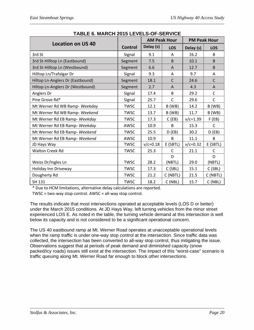
Table 6 on the following page shows the LOS at US 40 intersections and segments within the study limits. Existing intersection geometry and traffic signal timing plans were used for the analyses. The segment between Anglers Drive and Pine Grove Road could not be evaluated using HCM 2010 methods due to unconventional signal phasing in place at Pine Grove Road. However, given the adjacent intersection LOS, the segment LOS is expected to be C.
East Steamboat Springs US Highway 40 Access Study
Stolfus & Associates, Inc. Page 20
TABLE 6. MARCH 2015 LEVELS-OF-SERVICE
Location on US 40 AM Peak Hour PM Peak Hour
Control Delay (s) LOS Delay (s) LOS
3rd St Signal 9.1 A 16.2 B
3rd St‐Hilltop Ln (Eastbound) Segment 7.5 B 10.1 B
3rd St‐Hilltop Ln (Westbound) Segment 6.6 A 12.7 B
Hilltop Ln/Trafalgar Dr Signal 9.3 A 9.7 A
Hiltop Ln‐Anglers Dr (Eastbound) Segment 18.1 C 24.6 C
Hiltop Ln‐Anglers Dr (Westbound) Segment 2.7 A 4.3 A
Anglers Dr Signal 17.4 B 29.2 C
Pine Grove Rd* Signal 25.7 C 29.6 C
Mt Werner Rd WB Ramp‐ Weekday TWSC 12.1 B (WB) 14.2 B (WB)
Mt Werner Rd WB Ramp‐ Weekend TWSC 13.7 B (WB) 11.7 B (WB)
Mt Werner Rd EB Ramp‐ Weekday TWSC 17.3 C (EB) v/c=1.39 F (EB)
Mt Werner Rd EB Ramp‐ Weekday AWSC 10.9 B 15.3 C
Mt Werner Rd EB Ramp‐ Weekend TWSC 25.5 D (EB) 30.2 D (EB)
Mt Werner Rd EB Ramp‐ Weekend AWSC 10.9 B 11.1 B
JD Hays Way TWSC v/c=0.18 E (SBTL) v/c=0.32 E (SBTL)
Walton Creek Rd TWSC 25.3 C 21.1 C
Weiss Dr/Ingles Ln TWSC 28.2 D
(NBTL) 29.0 D
(NBTL)
Holiday Inn Driveway TWSC 17.3 C (SBL) 15.1 C (SBL)
Dougherty Rd TWSC 21.2 C (NBTL) 21.5 C (NBTL)
SH 131 TWSC 18.2 C (NBL) 15.7 C (NBL)
* Due to HCM limitations, alternative delay calculations are reported. TWSC = two‐way stop control. AWSC = all‐way stop control.
The results indicate that most intersections operated at acceptable levels (LOS D or better) under the March 2015 conditions. At JD Hays Way, left turning vehicles from the minor street experienced LOS E. As noted in the table, the turning vehicle demand at this intersection is well below its capacity and is not considered to be a significant operational concern.
The US 40 eastbound ramp at Mt. Werner Road operates at unacceptable operational levels when the ramp traffic is under one-way stop control at the intersection. Since traffic data was collected, the intersection has been converted to all-way stop control, thus mitigating the issue. Observations suggest that at periods of peak demand and diminished capacity (snow packed/icy roads) issues still exist at the intersection. The impact of this “worst-case” scenario is traffic queuing along Mt. Werner Road far enough to block other intersections.
East Steamboat Springs US Highway 40 Access Study
Stolfus & Associates, Inc. Page 21
5.0 FUTURE TRAFFIC CONDITIONS
5.1 Traffic Growth
Traffic growth within the study area was forecasted using a combination of CDOT growth forecasts, land use planning documents provided by the City, and traffic count data. CDOT maintains an Automatic Traffic Recorder (ATR) on US 40 north of Highway 131 at MP 135.28. Average Daily Traffic (ADT) data dates back to 1992 at this station. Annual traffic at the station peaked in 2007 and then declined each year until 2012. Since 2012, traffic has increased through the most recently reported year of 2014. Based upon monthly traffic data, volumes in March (when counts were collected for this study) are considerably less than they are during the summertime. For this reason, a seasonal adjustment factor was applied to the March counts to represent a typical summer day in the month of August. As part of a separate project, TMCs were collected at the US 40/ Pine Grove Road intersection in July 2015. Based upon historical data, July is typically the highest volume month of the year. At the location of the ATR, July traffic was approximately 40% higher than March. However, the TMCs recorded at US 40/Pine Grove Road in July were only 24% more than those collected in March. Given the closer proximity of US 40/Pine Grove Road intersection to other critical study area intersections, the TMCs were used to estimate an appropriate seasonal adjustment factor (1.21). The March traffic counts were therefore increased by a factor of 1.21 to reflect typical August conditions. Tables showing the seasonal adjustment calculations are included in Technical Appendix D.
CDOT Count Station 101844 is located on US 40, just south (up milepost) of Pine Grove Road. The estimated 20-year growth factor at this location is 1.20 (0.9% compounded annually), which when applied to seasonally-adjusted daily traffic volumes collected for this study, equates to 5,500 additional daily trips in 2035. Proportioning these additional daily trips by the March 2015 TMCs, 200-300 additional highway trips in each direction are forecasted during 2035 peak hours at this location.
In order to match growth forecasts described above, land use capacity planning documents (see Technical Appendix D) were used to estimate the proportion of future traffic accessing the highway at various public street intersections. The planning document includes five development areas toward the east end of the City where the potential for new single family residential, multi-family residential, commercial, and industrial land use was estimated.
The directionality of trips originating from each of these areas was estimated using the 2035 additional trip estimates provided for CDOT count stations located outside of the study area. Using these projections, it is estimated that 56% of future traffic from the study area will travel on US 40 west of the study area, 23% to locations east of Star Ridge Road, and 21% to Highway 131. Trip assignment tables and resulting traffic demand figures are included in Technical Appendix D.
5.2 Future Traffic without ACP
The 2035 No-ACP scenario evaluates projected future traffic conditions without changes to existing intersection configurations. Projected operations at US 40 intersections in 2035 are presented in Table 7.

East Steamboat Springs US Highway 40 Access Study
Stolfus & Associates, Inc. Page 22
TABLE 7. 2035 LEVELS-OF-SERVICE WITHOUT ACP
Intersection AM Peak Hour PM Peak Hour
Control Delay(s) LOS Delay(s) LOS
3rd Street Signal 18.9 B 19.1 B
3rd St‐Hilltop Ln (Eastbound) Segment 17.6 B 10.2 B
3rd St‐Hilltop Ln (Westbound) Segment 13.4 B 15.1 B
Hilltop Ln/Trafalgar Dr Signal 14.5 B 14.3 B
Hiltop Ln‐Anglers Dr (Eastbound) Segment 15.2 B 18.1 C
Hiltop Ln‐Anglers Dr (Westbound) Segment 4.0 A 3.2 A
Anglers Dr Signal 19.5 B 52.9 C
Anglers Dr‐Pine Grove Rd (Eastbound) Segment 3.8 C ‐ D
Anglers Dr‐Pine Grove Rd (Westbound) Segment 12.5 D ‐ F
Pine Grove Rd* Signal Max
v/c=1.3 F
Max v/c=2.0
F
Pine Grove Rd Signal
w/modified phasing
26.3 C Max
v/c=1.3 E
Mt Werner Rd WB Ramp TWSC 17.4 C (WB) 39.0 E (WB)
Mt Werner Rd EB Ramp AWSC 16.9 C 44.0 E
JD Hays Way TWSC v/c=.42 F (SB LT) v/c=1.15 F (SB LT)
Walton Creek Rd Signal 20.0 C 38.2 D
Weiss Dr/Ingles Ln TWSC v/c=1.04 F (NB LT) v/c=2.12 F (NB LT)
Holiday Inn Driveway TWSC 27.9 D (SBL) 29.0 D(SBL)
Dougherty Rd TWSC v/c=.22 F (NBL) v/c=.12 F (NBL)
SH 131 TWSC v/c=1.11 F (NBL) v/c=.70 F (NBL)
*Existing Timings‐ Due to HCM limitations, alternative delay calculations are reported TWSC = two‐way stop control. AWSC = all‐way stop control.
The intersection at Pine Grove Road currently operates under twice per cycle left turn phasing also known as “double pump” phasing. In the future, the intersection at Pine Grove Road will not operate acceptably without modifications to the existing traffic signal phasing. It is beyond the scope of an access control plan to extensively evaluate potential mitigation measures, but traffic patterns suggest that dual left turn lanes and a free flow right turn may be appropriate in the future. Even with these improvements, acceptable operations may not be achievable at the intersection without some of the traffic demand selecting alternate routes, most likely to the interchange at Mt. Werner Road. Because operations at the Pine Grove Road intersection are over-capacity, segment operations could not be accurately represented and detailed reports have been excluded from the analysis. Further evaluation of operational deficiencies of the highway segment by CDOT and the City may be worth considering to mitigate deterioration of LOS at the Pine Grove Road intersection.
Stop controlled intersections at Dougherty Road and Mt. Werner Road Westbound Ramp are expected to operate at unacceptable LOS, but will be well below their capacity. Stop controlled intersections at JD Hays Way and Weiss Drive/Ingles Lane are expected to operate at an unacceptable LOS and will be over-capacity. These types of conditions may lead to drivers selecting smaller gaps in traffic, potentially resulting in increased crashes. The close proximity to

East Steamboat Springs US Highway 40 Access Study
Stolfus & Associates, Inc. Page 23
the signalized intersection at Walton Creek Road would not allow either intersection to be signalized under SHAC spacing requirements or considering functional intersection area needs.
At SH 131, unacceptable operations are forecasted under the current stop control. This intersection is anticipated to warrant a traffic signal, which would mitigate the poor LOS. All-way stop control at the Mt. Werner Road Eastbound Exit Ramp is also forecasted to operate at unacceptable levels; alternative control, such as a roundabout, should be considered at the intersection to better accommodate future traffic demands.
5.3 Future Traffic with ACP
The 2035 ACP scenario evaluated projected future traffic conditions with all changes shown in the Access Control Plan included. At full movement intersections with potential for signalization, a traffic signal was modelled if a peak hour warrant was met. Warrant evaluations are included in Technical Appendix D. Projected operations at US 40 intersections in 2035 with full implementation of the Access Control Plan are presented in Table 8.
TABLE 8. 2035 LEVELS-OF-SERVICE WITH ACP
Intersection AM Peak Hour PM Peak Hour
Control Delay
(s) LOS Delay
(s) LOS
3rd St Signal 17.5 B 16.5 B
3rd St‐Hilltop Ln (Eastbound) Segment 22.7 C 13.3 B
3rd St‐Hilltop Ln (Westbound) Segment 10.5 B 10.6 B
Hilltop Ln/Trafalgar Dr Signal 17.2 C 14.5 B
Hiltop Ln‐Anglers Dr (Eastbound) Segment 13.3 B 18.1 C
Hiltop Ln‐Anglers Dr (Westbound) Segment 4.9 B 3.2 A
Anglers Dr Signal 18.8 B 50.3 D
Anglers Dr‐Pine Grove Rd (Eastbound) Segment 3.6 C ‐ D
Anglers Dr‐Pine Grove Rd (Westbound) Segment 10.3 D ‐ F
Pine Grove Rd Signal
w/modified phasing
25.6 C Max
v/c=1.3 NBL
E
Mt Werner Rd WB Ramp TWSC 17.4 C (WB) 39.0 E (WB)
Mt Werner Rd EB Ramp Roundabout 10.1 B 22.2 C
JD Hays Way TWSC 14.1 B (EB LT) 13.6 B (SBR)
Walton Creek Rd Signal 15.7 B 21.7 C
Weiss Dr/Ingles Ln ¾ TWSC 16.2 C 17.6 C
Holiday Inn Driveway TWSC 16.6 C (SBR) 14.0 B (SBR)
Dougherty Rd TWSC v/c=.23 F (NBL) v/c=.16 F (NBL)
SH‐131 Signal 23.4 C 12.4 B
TWSC = two‐way stop control. AWSC = all‐way stop control.
As with the No-ACP scenario, the Pine Grove Road intersection is expected to require mitigation. Unacceptable operations at the intersection do not allow for the adjacent segment to be evaluated. Stop controlled intersections at Dougherty Road and Mt. Werner Road

East Steamboat Springs US Highway 40 Access Study
Stolfus & Associates, Inc. Page 24
Westbound Ramp will continue to operate below desirable operational levels with the ACP, but are not expected to require mitigation. Left turn movements from Weiss Drive/ Ingles Lane will be restricted in the ACP. Most of the redirected left turn traffic is expected to access either Walton Creek Road or Dougherty Road using off-highway connections shown in the ACP. A traffic signal at SH 131 will meet peak hour warrants under forecasted traffic demands and shows improved operations under signalization. A roundabout at the Mt. Werner Road Eastbound Ramp is expected to mitigate the forecasted operational issues under all-way stop control.
5.4 Access Control Plan Comparison
Traffic operations from the No-ACP and ACP scenarios were compared to determine what, if any, improvement can be expected with implementation of the ACP. To evaluate corridor travel time impacts, segment travel delays were summed for both AM and PM peak hours between 3rd Street and Pine Grove Road. In scenarios where the Pine Grove Road intersection operates at unacceptable levels, segment results were excluded from analysis. Analysis of corridor operations east of Pine Grove Road cannot be evaluated using HCM 2010 methods.
The sum of expected delays for both morning and afternoon peak hours along US 40 are expected to be 113 seconds without implementation of any improvements shown in the ACP. With the ACP, delays are expected to sum to 111 seconds. This difference in these results is minimal so operations should be regarded as equivalent for both scenarios.
Operations at each intersection were also evaluated using LOS as the metric. When comparing intersection LOS during both the AM and PM peak periods, operations were better under the No-ACP in two of the 24 scenarios. Under the ACP, LOS was better under eight scenarios. Intersection operations therefore improve at more locations under the ACP.

East Steamboat Springs US Highway 40 Access Study
Stolfus & Associates, Inc. Page 25
6.0 ACCESS PLAN DEVELOPMENT AND EVALUATION
Using the traffic volume forecasts, input from the City, County, US Forest Service and CDOT, input from the public outreach program, and guidance from the State Highway Access Code, an Access Plan was developed for the project. This Plan considers access points in logical groupings, as well as circulation opportunities via existing and potential future local streets.
6.1 Process
The Access Plan was developed using a 4-step process:
6.1.1 Step One – Methodology & Compatibility Index
A traffic methodology and access plan methodology were established at the beginning of the project to define the purpose, approach, and assumptions used to develop the Plan. In addition, a compatibility index was developed to provide a logical means for determining whether the Access Plan meets the established project goals. The index identified a set of evaluation criteria that correspond with each project objective, as listed in Section 1.1. A simple rating system that identifies the plan as favorable, neutral or unfavorable with respect to each criterion was defined. Each of the three ratings under each criterion was then defined to assist in the evaluation. The traffic methodology memo can be found in Technical Appendix D and the access plan methodology memo and compatibility index can be found in Technical Appendix E.
6.1.2 Step Two – Development of the Access Plan
The existing inventory of access points was reviewed with existing parcel and ownership information. This review determined which parcels adjacent to US 40 lacked access to the highway, which parcels had multiple accesses to consider for consolidation, and which parcels had access or potential access to an existing or proposed local road. Access solutions were developed by applying access management principles and techniques discussed in Section 2. Major full movement intersections were located based on traffic projections, City and County planning documents, and anticipated growth patterns. Access for each parcel in between major intersections was either limited (right-in/right-out or ¾ movement) or provided via a local road. In cases where multiple access points served a single ownership, access was reduced to one per ownership. Shared access between parcels was developed, wherever feasible.
6.1.3 Step Three – Refine the Access Plan
A draft access plan was presented to an internal review team consisting of City, County, US Forest Service and CDOT representatives. Based on comments received from the team, the draft plan was refined and presented at the first Public Open House. Public comment was reviewed and the Plan was modified at several points throughout the project, as appropriate. Improvements considered cost prohibitive, with unmanageable physical constraints, with significant traffic operational deficiencies, inconsistent with overall community expectations, or not appearing to provide a reasonable level of access, were revised. In some cases, access conditions were defined to allow phased implementation of long-term solutions.
6.1.4 Step Four – Evaluation
Following the public outreach process, the refined Access Plan was evaluated using the compatibility index described in Step One to determine whether project objectives were met.

East Steamboat Springs US Highway 40 Access Study
Stolfus & Associates, Inc. Page 26
6.2 Evaluation Results
The results of the evaluation by objective are listed in Table 10. Overall, the Access Plan rates favorably and is compatible with project goals. Plan adoption by all affected entities is recommended. Details of the Plan evaluation can be found in Technical Appendix E. A graphical representation of the Access Plan is located in Section 7.
TABLE 9. COMPATIBILITY EVALUATION SUMMARY
Project Goal Evaluation Criteria Rating
Provide effective and efficient travel for traffic on US 40.
Corridor Travel Time Neutral
Functional Intersection Area Neutral
Number of Access Points Favorable
Provide safe, effective, and efficient access to and from US 40 for businesses, residents and guests for all travel modes.
Intersection Sight Distance Favorable
Intersection Level of Service (LOS) Favorable
Conformance with State Highway Access Code Auxiliary Lane Requirements
Favorable
Out of Direction Travel Distance Unfavorable
Intersection Crash Risk Favorable
Identify and maintain compatibility with existing and proposed off-system connections that provide local circulation to support the transportation system.
Local Route Connectivity Favorable
Serviceability of Local Routes to Developments and Properties within the Study Area
Favorable
Provide a plan that is adoptable by all entities and can be implemented in phases.
Public Support Neutral
Phasing Opportunities Neutral
Physical Constraints Neutral
Funding Opportunities Neutral
Support the economic viability of the project area.
Business Market Area Neutral
Maintain compatibility with previous local planning efforts.
Compatibility with Local Planning Favorable
Support development of alternative modes.
Pedestrian/Bicycle Access Favorable
Transit Opportunities Neutral

East Steamboat Springs US Highway 40 Access Study
Stolfus & Associates, Inc. Page 27
7.0 PLAN RECOMMENDATIONS
This section presents details of the recommended Access Plan for the US 40 corridor on the east side of Steamboat Springs. The Plan has been developed with considerable participation from the City of Steamboat Springs, Routt County, US Forest Service, CDOT, and the public. After evaluating both existing and future conditions, the Plan defines how each access will function in the future. In general, the Access Plan limits full movement access to major intersections. Functional intersection area was considered in evaluating the spacing between major intersections. While it is ideal to provide the full functional intersection area between full movement intersections, other site specific considerations were considered in determining intersection spacing. At a minimum, the physical length needed to accommodate storage length, deceleration and taper length is provided between intersections.
In addition, highway access is reduced to one location per ownership and where feasible, is shared between adjacent properties. Where reasonable access can be provided to an alternate route/cross street, access points are relocated to the local street system. On US 40 between 3rd Street and SH 131, access for parcels between major intersections is limited. To maximize local circulation options and serve heavily used left turn movements, minor public road intersections and some private access points are identified long-term as ¾ movement access points. These access points will accommodate left turns from the highway into the minor road or access, but will prohibit left turns entering the highway. Providing the left-turn movement improves operations and/or circulation, but is only used where there is adequate space to develop left turn auxiliary lanes.
On US 40 east of SH 131, limited-access points were not considered due to the highway characteristics. This segment is a two-lane undivided section and there are no plans to expand the section within the study’s planning horizon of 20 years. Access points identified as major intersections have the potential for signalization, although signal warrants are not anticipated to be met within the study’s planning horizon except potentially at SH 131. Major intersections in this segment were identified based on out-of-direction travel project goals, locations of public road intersections, and continuity of private routes. Access points between major intersections are identified as conditional full movement intersections that will remain unsignalized. Proposed access closures for existing field access points and residential access points are marked with an “F” or “R” respectively to indicate that these access points will not be closed unless the land use changes. If the access point remains a “field” access, it will remain. Similarly, if the access point remains an access for one single family home, it will remain. For the segment east of CR 20/201 on Rabbit Ears Pass, signalization was not contemplated and all access points are identified as unsignalized full movement intersections. If signals are warranted at conditional full movement access points within the County segment or if safety or operational issues develop in the future, movements at the access may need to be limited.
For the segments of US 40 in the City and County limits, out of direction travel was generally limited to a maximum distance of one mile (½ mile each way). Out-of-direction travel was limited by providing full movement intersections at necessary intervals. Accommodation for u-turns at major intersections is recommended to provide alternatives for restricted left-turn movements. In addition, proposed alternate routes from this study will provide key alternatives for restricted left-turn movements. For the segment of US 40 on Rabbit Ears Pass within the Forest Service, out of direction travel was not specifically limited. However, generally, out of direction travel does not exceed two miles (1 mile each way) through the Forest Service segment.
East Steamboat Springs US Highway 40 Access Study
Stolfus & Associates, Inc. Page 28
Traffic control measures that may be used to achieve proposed conditions include raised or depressed medians, driveway channelizing islands at limited-access points, directional median openings at 3/4 movement access points, and signage and striping. To avoid turn movement violations and potential enforcement issues, eventual installation of a raised or depressed median or other positive traffic control measure is recommended on US 40 between 3rd Street and SH 131. Based on the existing cross-section with a two-way-left turn lane on US 40, installation of a raised median can likely be achieved with minor widening.
The narratives in this section are intended to serve as a summary of the key features of the Access Plan. The figures are intended to provide a graphical representation of the Access Plan. A detailed explanation of each access in the study area, by reference point, is presented in the Draft Access Control Plan Table, Exhibit A of the Draft Intergovernmental Agreement (IGA). Reference these exhibits for specific access configurations and conditions.
Recognizing that this plan is a long-term planning document and not a detailed engineering design, reference point designations are intended to be approximate. As more detailed information is available, these designations may be modified (generally within 0.05 miles of the specified reference point designation). The Draft IGAs and Draft Access Control Plan Tables are located in Technical Appendices F and G.
7.1 Access Plan
Key features of the Access Plan are summarized by major intersection below and illustrated in Figures 3A-3R following the narratives. Auxiliary lanes shall be provided at access points as prescribed by the State Highway Access Code. In the County segment of the Access Plan, there are a number of parcels that are LPS or have conservation easements. Individual land restrictions were not reviewed as part of this plan and the access recommendations do not change any conditions for development designated by the LPS or conservation easements. Full movement intersections with potential for future signalization or other traffic control have been identified as part of the Access Plan; however, the type of traffic control is not specified. Traffic control will be evaluated on a case-by-case basis as future conditions warrant. Potential traffic control may include stop signs, traffic signals, roundabouts, interchanges, or other traffic control recognized by the MUTCD. Traffic signals may be implemented at intersections if and when warranted per current MUTCD standards and when funding is available.
City Segment – 3rd Street to Dougherty Road 3rd Street to Hilltop Parkway/Trafalgar Drive (Figure 3A) A signalized full movement intersection will remain at 3rd Street and at Hilltop Parkway/Trafalgar Drive. The distance between Old Fish Creek Falls Road and 3rd Street is not adequate for signalization and the potential for development will likely not warrant a signal at that location. However, given the lack of alternative access for this neighborhood, a conditional unsignalized full movement intersection is provided. If safety or operational issues develop at this location, Old Fish Creek Falls Road will be restricted to a ¾ movement intersection. Future improvements on the highway should carefully consider sight distance at this intersection, especially related to median landscaping. Between 3rd Street and Old Fish Creek Falls Road, driveways for Old Town Hot Springs and Rabbit Ears Motel have been identified as conditional ¾ movement intersections. Given the volume of traffic generated at these driveways, allowing these left turns benefits operations by reducing the demand at adjacent major intersections. Based on the 20-year projections from
East Steamboat Springs US Highway 40 Access Study
Stolfus & Associates, Inc. Page 29
this study, there is adequate space to develop left turn lanes, however, if additional left turn lane storage is required at either 3rd Street or Old Fish Creek Falls in the future, these two driveways may be restricted further. Access for other parcels in this segment shall be reduced to one location per ownership, shared where feasible and shall be limited to right-in/right-out or relocated to alternative cross streets. Cross-access for properties with proposed shared access on US 40 is required as properties redevelop. On the local street system, due to the proximity of the access to the US 40 intersection, it is recommended that Access 11a on Hilltop Parkway be restricted to right-in/right-out. It is anticipated that as traffic volumes increase, it will become more difficult to safely achieve left turn movements at Access 11a and left turn queuing may impact safety and operations on Hilltop Parkway and US 40. Access 11a is under local jurisdiction and implementation of access management techniques will be determined by the City. Conditions for implementation of a right-in/right-out at Access 11a include redevelopment, when safety or operational issues develop, or when the City funds a public improvement project. Hilltop Parkway/Trafalgar Drive to Anglers Drive (Figure 3A & 3B) A signalized full movement intersection will remain at Hilltop Parkway/Trafalgar Drive and at Anglers Drive. The City is currently planning a modification to access and circulation on the west side of US 40 to improve access and circulation to Emerald Park. As part of this project Emerald Park Way will be extended across the UPRR to provide direct access to the park. Two access concepts were evaluated for Emerald Park Way: a ¾ movement intersection and offset signalized “t” intersections at Emerald Park Way and Hilltop Parkway with opposing right-in/right-out access. While both concepts provided acceptable LOS, a ¾ movement intersection was selected as the preferred access concept for the following reasons:
¾ movement provides the most access to the west side of US 40 (left turns in at both Trafalgar Drive and Emerald Park Way)
timing of a signal warrant being met at Emerald Park Way is unclear and warrants must be met prior to implementation
less than ideal spacing for signal operations with two signals increased maintenance of infrastructure for two signals.
Highpoint Drive will be limited to right-in/right-out when safety or operational issues develop of when a public project is funded. Alternative left-turn access is available via the local street system. Access for other parcels in this segment shall be reduced to one location per ownership, shared where feasible and shall be limited to right-in/right-out. Cross-access for properties with proposed shared access on US 40 is required as properties redevelop. Anglers Drive to Pine Grove Road (Figure 3B) A signalized full movement intersection will remain at Anglers Drive and at Pine Grove Road. The distance between these two intersections is only about 800’, limiting the amount of storage space that can be provided for the heavy southbound to eastbound left turn movement at Pine Grove Road. CDOT recently increased the storage length for Pine Grove Road by decreasing the storage length for Anglers Drive. This improvement likely maximized the improvements that can be accomplished within the existing cross-section. As described in Section 5.2, dual left turn lanes and a free flow right turn lane may be needed at Pine Grove Road to accommodate increased traffic volumes in the future. It is expected that these improvements will require additional ROW on the highway and on Pine Grove Road. Restricting movements and/or removing signals at one or both intersections was considered during Access Plan development,
East Steamboat Springs US Highway 40 Access Study
Stolfus & Associates, Inc. Page 30
but based on traffic demand, access to businesses, and limited local circulation options, maintaining both intersections as signalized full movement intersections was preferred. Access for other parcels in this segment shall be reduced to one location per ownership, shared where feasible and shall be limited to right-in/right-out or relocated to alternative cross streets. Cross-access for properties with proposed shared access on US 40 is required as properties redevelop. On the local street system, due to the proximity of access points to the US 40 intersection and the volume of traffic traveling through the intersection, it is recommended that Accesses 23, 25, and 26 on Pine Grove Road be restricted when safety or operational issues develop. It is anticipated that as traffic volumes increase, it will become more difficult to safely achieve some left turn movements and left turn queuing may impact safety and operations on Pine Grove Road and US 40. Access 23 is identified as right-in/right-out; Access 25 is identified as a conditional ¾ movement; and Access 26 is identified as a ¾ movement intersection. These access points are under local jurisdiction and implementation of access management techniques will be determined by the City. Conditions for implementation of the proposed configurations include redevelopment, when safety or operational issues develop, or when the City funds a public improvement project. Access 25 is a conditional ¾ movement and may be further restricted to a right-in/right-out if safety or operational issues develop. Pine Grove Road to Mt. Werner Road (Figure 3B & 3C) A signalized full movement intersection will remain at Pine Grove Road. The ramp intersections at the Mt. Werner Road interchange are identified as full movement intersections with potential for signalization, if warranted, or other traffic control recognized by the MUTCD. Roundabouts at the ramp intersections may provide operational and safety benefits, but will require additional investigation to confirm. Access between Pine Grove Road and Mt. Werner Road was evaluated on both sides of US 40. An A-line restricts access on both sides of US 40 through this segment. Breaking the A-line to provide access will require justification and approval from CDOT and FHWA. Significant operational benefits to the system are needed to justify breaking the A-line. Upon evaluation, providing additional access through this segment did not provide measurable operational benefits to the system and/or had negative impacts to the safety and operations of the interchange. A conditional emergency access is identified on the west side in order to provide a secondary emergency access to properties on the west side. The emergency access should be gated. When alternative access to Mt. Werner Road is available, the emergency access will be closed. The developer, in coordination with the City, will be required to make an A-line modification request to CDOT in order to provide an A-line opening at this location. It is recommended that the City initiate the A-line modification request to simplify the procedure. A-line modification requests include the following elements, at a minimum:
A request letter to CDOT from the local agency including supporting documentation for the request.
Preliminary intersection layout and traffic data to support the A-line opening width request. A-line opening widths should accommodate the laneage required to accommodate 20-year projected traffic volumes, including highway auxiliary lanes. The opening width should also include width necessary to accommodate the design vehicle turning movements, pedestrian and bicycle facilities, and any other proposed roadway design elements.
East Steamboat Springs US Highway 40 Access Study
Stolfus & Associates, Inc. Page 31
Legal descriptions include a written description and a sketch for each A-line opening and closure.
CDOT may require additional information to process the request. Coordination with the CDOT ROW and Traffic and Safety Departments is recommended prior to submitting the request. Mt. Werner Road to Walton Creek Road (Figure 3C – 3D) The ramp intersections at the Mt. Werner Road interchange are identified as full movement intersections with potential for signalization, if warranted, or other traffic control recognized by the MUTCD. A signalized full movement intersection will remain at Walton Creek Road. JD Hays Way will be restricted to a ¾ movement intersection when safety or operational issues develop. The emergency access for the fire station is maintained. No other access is provided in this section based on the A-line and the adjacent land uses. Walton Creek Road to Dougherty Road (Figure 3D) A signalized full movement intersection will remain at Walton Creek Road. A four-legged full movement intersection with potential for signalization, if warranted, will be provided at Dougherty Road/Stone Lane Extension. When the Stone Lane Extension is implemented, the intersection with US 40 shall be aligned with Dougherty Road. The distance between Weiss Drive/Ingles Lane and Walton Creek Road is not adequate for signalization. Based on the demand at Weiss Drive/Ingles Lane, a conditional unsignalized full movement intersection is provided. As traffic volumes continue to increase, the ability to make a left-turn from the local streets to US 40 will become increasingly more difficult. If safety or operational issues develop at these intersections, Weiss Drive and Ingles Lane will be restricted to a ¾ movement intersection. Providing alternative local circulation in this area for Weiss Drive and Ingles Lane traffic to access a full movement intersection will provide significant operational benefits when restrictions are required. Refer to Section 7.2.1 for discussion on options for alternative access in this area. Majestic Circle has been identified as a shared conditional ¾ movement intersection. Given the volume of traffic and potential circulation options from Majestic Circle serving multiple properties on the west side, allowing these left turns benefits operations by reducing the demand at adjacent major intersections. Based on the 20-year projections from this study, there is adequate space to develop left turn lanes, however, if additional left turn lane storage is required at the Stone Lane Extension when it is implemented in the future, Majestic Circle may be restricted further.
Access 142 is provided as a conditional right-in/right-out. After reviewing the properties on the east side and the proposed alternative routes desired, maintaining the existing connection between the Fairfield Inn property and Access #37 at the west side of the property appears to unnecessarily limit the development options for the affected property owner(s). Therefore, the project team included Access 142 in the Plan. The right-in/right-out is conditional upon a north-south extension of Ingles Lane to the proposed Stone Lane Extension. In addition, when Access 142 is installed, Access 37a (the existing connection between the Fairfield Inn property and Access #37) will be closed in order to eliminate vehicle conflicts and queuing issues on the Stone Lane Extension and US 40. Access 37a is under local jurisdiction and implementation of access management techniques will be determined by the City.
Access for other parcels in this segment shall be reduced to one location per ownership, shared where feasible and shall be limited to right-in/right-out or relocated to alternative cross streets.
East Steamboat Springs US Highway 40 Access Study
Stolfus & Associates, Inc. Page 32
Cross-access for properties with proposed shared access on US 40 is required as properties redevelop. County Segment – Dougherty Road to Routt National Forest Boundary Dougherty Road to SH 131 (Figure 3D - 3F) A four-legged full movement intersection with potential for signalization, if warranted, will be provided at Dougherty Road/Stone Lane Extension and at SH 131/CR 24. CR 24 will be realigned to provide the fourth leg of the SH 131 intersection when redevelopment occurs or public funding is available. A four-legged full movement intersection with potential for signalization, if warranted, is also provided at Access 45/145 to meet project goals for out of direction travel. This location was selected with input from property owners in the area. A shared conditional unsignalized full movement intersection is also provided at the property line between the properties currently owned by Rule and Heltzel Trust. If safety or operational issues develop at this location, further restrictions may be required. Access for other parcels in this segment shall be reduced to one location per ownership, shared where feasible and shall be limited to right-in/right-out or relocated to alternative cross streets. Cross-access for properties with proposed shared access on US 40 is required as properties redevelop. Ideally, properties on the west side would eventually gain access to Access 45 through cross-access easements. SH 131 to Catamount Drive (Figure 3F – 3G) A four-legged full movement intersection with potential for signalization, if warranted, will be provided at SH 131/CR 24 and Catamount Drive. CR 24 will be realigned to provide the fourth leg of the SH 131 intersection when redevelopment occurs or public funding is available. The Haymaker Golf Course access and Meadow Creek Drive access are identified as conditional unsignalized full movement intersections. If safety or operational issues develop in the future, further access restrictions may be required. Access for other parcels in this segment shall be reduced to one location per ownership, shared where feasible and relocated to alternative routes/cross streets where feasible. Based on these conditions, all other access points in this segment will be closed upon redevelopment. Access points marked with an “F” for field access will not be closed unless the land use changes. If the access point remains a “field” access, it will remain. Cross-access for properties with proposed shared access on both sides of US 40 is required as properties redevelop. Catamount Drive to Wild Rose Drive (Figure 3G – 3H) A four-legged full movement intersection with potential for signalization, if warranted, will be provided at Catamount Drive and Wild Rose Drive. Access for other parcels in this segment shall be reduced to one location per ownership, shared where feasible and relocated to alternative routes/cross streets where feasible. Based on these conditions, all other access points in this segment will be closed upon redevelopment. Access points marked with an “F” for field access or “R” for residential access will not be closed unless the land use changes. If the access point remains a “field” access, it will remain. Similarly, if the access point remains access for one single family home, it will remain. Cross-access for properties with proposed shared access on both sides of US 40 is required as properties redevelop. Wild Rose Drive to Storm Canyon Trail (Figure 3H) A four-legged full movement intersection with potential for signalization, if warranted, will be provided at Wild Rose Drive and Storm Canyon Trail. Access for other parcels in this segment shall be reduced to one location per ownership, shared where feasible and relocated to
East Steamboat Springs US Highway 40 Access Study
Stolfus & Associates, Inc. Page 33
alternative routes/cross streets where feasible. Full movement intersections marked with a “C” for conditional will remain unsignalized and may require restrictions if safety or operational issues develop in the future or may be closed when alternate access is available. Access points marked with an “F” for field access or “R” for residential access will not be closed unless the land use changes. If the access point remains a “field” access, it will remain. Similarly, if the access point remains access for one single family home, it will remain. Cross-access for properties with proposed shared access on both sides of US 40 is required as properties redevelop. Storm Canyon Trail to CR20/CR 201 (Figure 3H – 3I) A four-legged full movement intersection with potential for signalization, if warranted, will be provided at Storm Canyon Trail and CR 22. The County has plans to improve CR 22 between US 40 and SH 131 to current County road standards with the intention of eliminating through traffic between US 40 and SH 131 on CR 20. When improved alternate access is available via CR 22, CR 20 will be closed. CR 201 will remain a full movement “t” intersection and will have the potential for signalization, if warranted. Access for other parcels in this segment shall be reduced to one location per ownership, shared where feasible and relocated to alternative routes/cross streets where feasible. Full movement intersections marked with a “C” for conditional will remain unsignalized and may require restrictions if safety or operational issues develop in the future or may be closed when alternate access is available. Access points marked with an “F” for field access or “R” for residential access will not be closed unless the land use changes. If the access point remains a “field” access, it will remain. Similarly, if the access point remains access for one single family home, it will remain. Cross-access for properties with proposed shared access on both sides of US 40 is required as properties redevelop. CR 20 to Routt National Forest Service Boundary (Figure 3I – 3L) CR 20 will be closed when an improved alternate route is provided at CR 22. CR 201 will remain a full movement “t” intersection and will have the potential for signalization, if warranted. Beginning at CR 20/CR 201 signalization is no longer contemplated and all remaining access points are identified as unsignalized full movement intersections. Access for parcels in this segment shall be reduced to one location per ownership, shared where feasible and relocated to alternative routes/cross streets where feasible. Access points marked with an “F” for field access will not be closed unless the land use changes. If the access point remains a “field” access, it will remain. A conditional one-way access/parking location is identified at Access 95. This access is conditional upon the development of a one-way access/parking configuration with Access 94. Refer to Section 7.2.3 for guidance for developing one-way access/parking layouts. If the one-way access/parking layout is not desired, Access 95 will be closed. An emergency access is provided at Access 99 to provide secondary emergency access to the Timber Village area. If redevelopment occurs in the area or if safety or operational issues develop at this access, a gate will be required for emergency access only. Cross-access for properties with proposed shared access on both sides of US 40 is required as properties redevelop. Forest Service Segment –Routt National Forest Boundary to Routt County Line Routt National Forest Boundary to Harrison Creek/Smokey Bear Curve (Figure 3M - 3N) In this segment, unsignalized full movement intersections are maintained at FR 287 and FR 293. The FR 298.1A access at Harrison Creek/Smokey Bear Curve will be closed based on limited sight distance. An alternative one-way access/ parking location is provided at Access 152/153 to provide access to recreational opportunities in the Harrison Creek/Smokey Bear
East Steamboat Springs US Highway 40 Access Study
Stolfus & Associates, Inc. Page 34
Curve area. Access 152/153 or Access 154/155 may be used to provide vehicular access to the Harrison Creek/Smokey Bear Curve area and will require a trail connection from the parking area(s) to the existing trails. One-way access/ parking locations are also provided at existing loop Forest Roads including: FR 289, FR 290, FR 292, and FR 294. Refer to Section 7.2.3 for guidance for developing one-way access/parking layouts. Vegetation around FR 290 should be actively maintained in order to maximize sight distance for Access. Access 105 is identified as a conditional full movement intersection to accommodate potential trailhead plans from the Steamboat Springs Trails Alliance. This access point is conditional upon trailhead approval from the US Forest Service. Access 106 is also maintained for sign maintenance and Access 108 is maintained as a truck escape ramp. All other access points/parking areas shall be closed within this segment. Harrison Creek/Smokey Bear Curve to FR 296 (Figure 3N – 3P) The FR 298.1A access at Harrison Creek/Smokey Bear Curve will be closed based on limited sight distance. An alternative one-way access/ parking location is provided at Access 154/155 to provide access to recreational opportunities in the Harrison Creek/Smokey Bear Curve area. Refer to Section 7.2.3 for guidance for developing one-way access/parking layouts. Access 154/155 or Access 152/153 may be used to provide vehicular access to the Harrison Creek/Smokey Bear Curve area and will require a trail connection from the parking area(s) to the existing trails. All other Forest Roads in this segment will remain unsignalized full movement intersections. Consistent with the Forest Service EA, the West Summit parking area will be closed on both sides of US 40 when alternate parking is available via FR 296. FR 296 to FR 302 (Routt County Line) (Figure 3P – 3R) All established Forest Road access points through this segment will remain as unsignalized full movement intersections including: FR 296, FR 297, FR 313, FR 300, and FR 302. One-way access/ parking locations are provided at key trailheads including: Bruce’s Trail, Fox Curve, and Walton Creek Trailhead. Refer to Section 7.2.3 for guidance for developing one-way access/parking layouts. Access 134 will be closed.
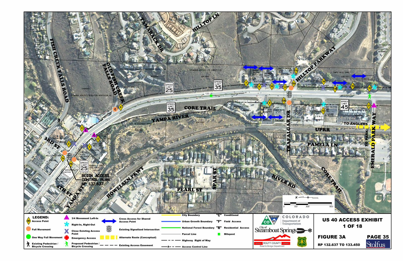
STEAMBOAT HEALTH & RECREATION ASSOCIATION, INC
248900002
134700002
HANLEY, JOHN
250400001
145024003
248900001
POSTAL SERVICE
UNITED STATES
145024004
CITY OF STEAMBOAT SRINGS
936171003
STEAMBOAT RIDGE TOWNHOMES HOMEOWNERS ASSOCITATION
161888001
GOODWIN, AMY
936174002
STEAMBOAT GATEWAY LTD LIABILITY CO.
936174001
LLLP
ESTATES, LTD,
MOBILE HOME
MOUNTAIN
COPPER
936174005
936174006
936174015SQUARE, LLP
STEAMBOAT
LLC ATTN: PEDDIE
500 S. LINCOLN,
936174004
140000002 936174008
G & M, LLC
LLC
MANAGEMENT,
WEST ASSET
COLORADO
151400001
FOX, LLC
MOUNTAIN
HIL
LT
OP P
AR
KW
AY
3RD S
T
101077001
AREA
GENERAL COMMON
OFFICE CONDOS
625 SOUTH LINCOLN
162000001
YAMPA VALLEY BANK
936174016
YAMPA VALLEY BANK
936174017
TEKETA, LLC
936174014
MESA LODGINS, LLC
162000002
260888002
ASSOCIATION
OWNERS
LONGVIEW PARK
WELLS FARGO BANK
145020001
4TH S
T
NNN-NATGRO, LLC
145025001
S.S. STUMBO, LLC
218077001
FIS
H C
RE
EK F
AL
LS R
OA
D
OA
K S
T
5TH S
T
6
13
5
3
1a
2
7
9
8
TR
AF
AL
GA
R D
R
14
17
16
YA
MP
A S
T15
FA
LLS R
OA
D
OL
D FIS
H C
RE
EK
TA
MA
RA
CK D
R
HIL
LTOP
LN
PA
RK VIE
W D
R
HO
WELSE
N P
KW
Y
PEARL ST
SP
AR S
T
RIVER RD
PAMELA LN
133
1b
1011
12a
12b
DEVELOPMENT, LLC
LINCOLN
THIRD AND
MOTEL, INC.
RABBIT EARS
SRINGS
STEAMBOAT
CITY OF
4
CORE TRAIL
YAMPA RIVER
UPRR
TO ANGLERS
TO P
AR
K
139
CO
RE T
RAIL
G & M LLC
151400003
C
ASSOCIA
TIO
N
& RECREATIO
N
STEA
MBOAT HEALTH
145002008
C
SWEDPROPERTY, LLC
LLC
KRE HOLDINGS,
C
MP 132.637
CONTROL PLAN
BEGIN ACCESS
EM
ER
AL
D P
AR
K W
AY
DEVELOPMENT
RIVERWALK YAMPA
145024001
11a
300'0' 600'150'
1 OF 18
FIGURE 3A PAGE 35
RP 132.637 TO 133.450
Full Movement
One Way Full Movement
3/4 Movement Left-In
Right-In, Right-Out
Emergency Access
Existing Signalized Intersection
Alternate Route (Conceptual)
Parcel Line
##
LEGEND:
Access Point
Milepost
US 40 ACCESS EXHIBIT
Point
Close Existing Access
Access Point
Cross Access for Shared
ROUTT COUNTY
Road & Bridge Department
Highway Right of Way
Access Control Line
City Boundary
Urban Growth Boundary
National Forest Boundary
Conditional
Field Access
Residential Access
"C"
"F"
"R"
Bicycle Crossing
Existing Pedestrian /
Bicycle Crossing
Proposed Pedestrian / Existing Access Easement
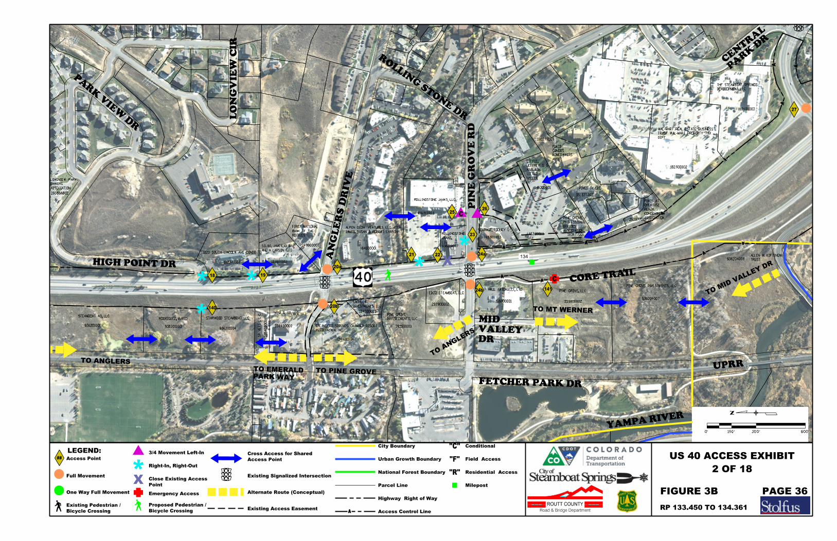
260888002
ASSOCIATION
OWNERS
LONGVIEW PARK
HIGH POINT DR
STEAMBOAT 40, LLC
936201001
RODRIGUEZ, MARIO
936201003
STARWOOD STEAMBOAT LLC
936201004
1120 SOUTH LINCOLN AVE CONDO
192377001 153800001S
P
VE
TS
L.L.C.
2384
00001
KUM & GO, LLC
238400002
ANITA LARSON (JT)
SELBE, JAMES D. & 249900001
ROCKIES
BANK OF THE
FIRST NATIONAL
AN
GL
ER
S D
RIV
E
124400004
124300002
292900001
ASSOCIATION, INC
STEAMBOAT SPRINGS CHAMBER-RESORT
INVESTMENTS LLC
SACHSEN
JAMES, SUSAN & ROBERT LARSON
ALPEN GLOW VENTURES, LLC ATTN:
164900001
EDCO STEAMBOAT, LLC
292900002
ROLLINGSTONE JAAKS, LLC
936212003
936212007
LLC
JAAKS,
ROLLINGSTONE
SCHRAGE, RODNEY L.
146300003
PAUL ANTONUCCI, LTD
198800001
PIN
E G
RO
VE R
D
PINE GROVE, LLC
229600002
BODIE 9, LLC
146300002 193477001
PINE GROVE INVESTMENTS, LLC
936204007
ASSOCIATION
OFFICES
PROFESSIONAL
PINE GROVE 262977004
162300002
936204008
DEPT
TRUST WAL-MART PROPERTY TAX
WAL-MART REAL ESTATE BUSINESS
162400002
DEVELOPMENT, LLC
THF STEAMBOAT SPRINGS
18 19
21
23
COMPANY INC
DILLON REAL ESTATE
PA
RK VIE
W D
R
LO
NG
VIE
W CIR
ROLLIN
G ST
ON
E D
R
PA
RK D
R
CE
NTR
AL
FETCHER PARK DR
134
20a
20b
24a
24b
UPRR
27
CORE TRAIL
C
YAMPA RIVER
140
TO PINE GROVE
TO ANGLERS
2526
22
141
INVESTEMENTS, LLC
PINE GROVE
TO A
NG
LERS
TRUST
ALLEN W. KOFTINOW
146300001
MILLER
LITTLE
KARLA H.
JEFFREY S. &
LITTLE, ASSOC.
HOMEOWNERS
CONDOS
PINES
190277005
PINES IV, LLC
251377007
INC
ASSOCIATION,
CONDOMINIUM
PLAZA
OREHOUSE
PINES AT
DR
VALLEY
MID
TO MT WERNER
C
TO MI
D VALLEY
DR
PARK WAY
TO EMERALD
300'0' 600'150'
2 OF 18
PAGE 36FIGURE 3B
RP 133.450 TO 134.361
Full Movement
One Way Full Movement
3/4 Movement Left-In
Right-In, Right-Out
Emergency Access
Existing Signalized Intersection
Alternate Route (Conceptual)
Parcel Line
##
LEGEND:
Access Point
Milepost
US 40 ACCESS EXHIBIT
Point
Close Existing Access
Access Point
Cross Access for Shared
ROUTT COUNTY
Road & Bridge Department
Highway Right of Way
Access Control Line
City Boundary
Urban Growth Boundary
National Forest Boundary
Conditional
Field Access
Residential Access
"C"
"F"
"R"
Bicycle Crossing
Existing Pedestrian /
Bicycle Crossing
Proposed Pedestrian / Existing Access Easement
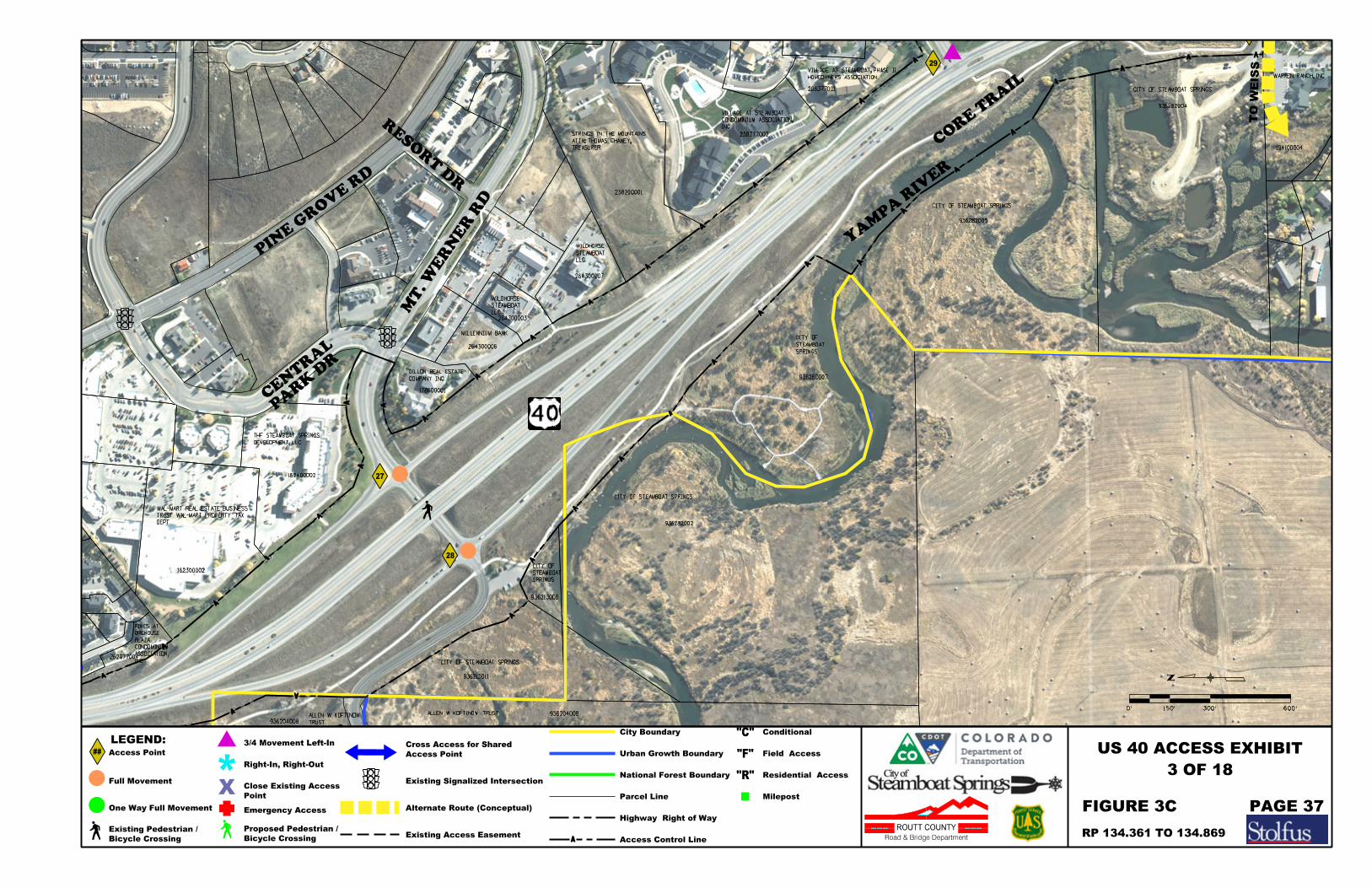
262977004
162300002
936204008
936204008ALLEN W. KOFTINOW TRUST
DEPT
TRUST WAL-MART PROPERTY TAX
WAL-MART REAL ESTATE BUSINESS
CITY OF STEAMBOAT SPRINGS
936213011
162400002
178600001
936213006
936282002
CITY OF STEAMBOAT SPRINGS
SPRINGS
STEAMBOAT
CITY OF
MILLENNIUM BANK
264300006
264300003
LLC
STEAMBOAT
WILDHORSE
LLC
STEAMBOAT
WILDHORSE
264300007
238200001
TREASURER
ATTN: THOMAS CHANEY,
STRINGS IN THE MOUNTAINS
CITY OF STEAMBOAT SPRINGS
936282005
CITY OF STEAMBOAT SPRINGS
936282004
238277002
206377001
HOMEOWNERS ASSOCIATION
VILLAGE AT STEAMBOAT, PHASE II
JD H
AY
S W
AY
WARREN RANCH, INC
194100004
DEVELOPMENT, LLC
THF STEAMBOAT SPRINGS
29
COMPANY INC
DILLON REAL ESTATE
RESO
RT D
R
PIN
E G
RO
VE R
D
MT.
WE
RN
ER R
D
PA
RK D
R
CE
NTR
AL
936280007
SPRINGS
STEAMBOAT
CITY OF
INC
CONDOMINIUM ASSOCIATION,
VILLAGE AT STEAMBOAT
28
27
CO
RE T
RAIL
YA
MP
A RIV
ER
TRUST
ALLEN W. KOFTINOW
TO W
EIS
S
INC
ASSOCIATION,
CONDOMINIUM
PLAZA
OREHOUSE
PINES AT
TO MI
D VALLEY
DR
300'0' 600'150'
3 OF 18
RP 134.361 TO 134.869
FIGURE 3C PAGE 37
Full Movement
One Way Full Movement
3/4 Movement Left-In
Right-In, Right-Out
Emergency Access
Existing Signalized Intersection
Alternate Route (Conceptual)
Parcel Line
##
LEGEND:
Access Point
Milepost
US 40 ACCESS EXHIBIT
Point
Close Existing Access
Access Point
Cross Access for Shared
ROUTT COUNTY
Road & Bridge Department
Highway Right of Way
Access Control Line
City Boundary
Urban Growth Boundary
National Forest Boundary
Conditional
Field Access
Residential Access
"C"
"F"
"R"
Bicycle Crossing
Existing Pedestrian /
Bicycle Crossing
Proposed Pedestrian / Existing Access Easement

CITY OF STEAMBOAT SPRINGS
936282005
CITY OF STEAMBOAT SPRINGS
936282004
206377001
HOMEOWNERS ASSOCIATION
VILLAGE AT STEAMBOAT, PHASE II
JD H
AY
S W
AY
PINE GROVE RD
CITY OF STEAMBOAT SPRINGS
936281006
142600003
CITY OF STEAMBOAT SPRINGS
SPRINGS
STEAMBOAT
CITY OF
936281004
CORP.
SKI & RESORT
STEAMBOAT
936281005
WARREN RANCH, INC
194100004
132800001
CAPITAL
INFINITY STEAMBOAT HOTEL LLC GOFF
194100003
132801001
936284003
SPRINGS
CITY OF STEAMBOAT
DISTRICT
SANITATION
WATER &
MT WERNER
254300001
MANAGER
PETERSON,
DENISE
LLC ATTN:
STATION,
SOUTHSIDE MITCO, LLC
194100001
132800002
LASCO, LLC
132800003
197900005
MARR 106 FAMILY LTD
193800001
WETZLER
INC. ATTN: JAY
SPRINGS HOTEL,
STEAMBOAT
272801002NON-PROFIT
GROUP, A COLORADO
COMMUNITY DEVELOPMENT
RIVER PLACE INTENTIONAL
245499002 936283004
GRAY STONE, LLC
197900006
CIR
CL
EM
AJ
ES
TIC
WEIS
S D
R
INGLES LN
29
32L
AK
E R
D
33
FAMILY, LLLP
MC ELHINNEY, MARK C. & DAWES
34
DO
UG
HE
RT
Y R
D
DO
UG
HE
RT
Y,
L
A
&
KA
RE
N (JT)
936332001
39
CHIN
OO
K L
N
PO
ND CIR
WA
LT
ON
ST
ON
E L
N
WAYASPEN LEAF
MA
RIA
H C
T
DISTRICT
& SANITATION
MT WERNER WATER
936331002
936280007
SPRINGS
STEAMBOAT
CITY OF
135
30
31a
31b
SANITATION DISTRICT
MT WERNER WATER &
221300001
ASSEMBLIES OF GOD
CENTER OF THE
CHRISTIAN
STEAMBOAT SPRINGS
WA
LT
ON C
RE
EK R
D
INC
CONDOMINIUM ASSOCIATION,
VILLAGE AT STEAMBOAT
CO
RE T
RAIL
YA
MP
A RIV
ER
CR
EE
K
WA
LT
ON
37
936283005
(JT)
DOUGHERTY, L A & KAREN
TO W
EIS
S
C
TO WEI
SS
TO INGLES
TO #
37
WALTON POND APARTMENTS, INC.
171400003
INC.
YAMPA RIVER,
203900002
AS
SO
C.
TO
WN
HO
ME
S
OW
NE
RS
MAJE
STIC
VA
LL
EY
27
2888001
AS
SO
C.
TO
WN
HO
ME
S
OW
NE
RS
MAJE
STIC
VA
LL
EY
283188001
AS
SO
C.
TO
WN
HO
ME
S
OW
NE
RS
MAJE
STIC
VA
LL
EY
2909888001
C
DOUGHERTY
TO
CREEKTO WALTON
TO #145
203900001
ASSOCIATION
TOWNHOMES HOMEOWNERS
INDIAN MEADOWS
133088001CITY OF STEAMBOAT SPRINGS
132801001
35 36
38
C
LN
TO S
TO
NE
EX
TE
NSIO
N
TO S
TO
NE L
N
CO
RE T
RAIL
C
INVESTORS, LLC
STEAMBOAT HOTEL
CHD, LLC
KATHY T.
HALLER, SCOTT W. &
142
37a
C
4 OF 18
300'0' 600'150'
RP 134.869 TO 135.601
FIGURE 3D PAGE 38
Full Movement
One Way Full Movement
3/4 Movement Left-In
Right-In, Right-Out
Emergency Access
Existing Signalized Intersection
Alternate Route (Conceptual)
Parcel Line
##
LEGEND:
Access Point
Milepost
US 40 ACCESS EXHIBIT
Point
Close Existing Access
Access Point
Cross Access for Shared
ROUTT COUNTY
Road & Bridge Department
Highway Right of Way
Access Control Line
City Boundary
Urban Growth Boundary
National Forest Boundary
Conditional
Field Access
Residential Access
"C"
"F"
"R"
Bicycle Crossing
Existing Pedestrian /
Bicycle Crossing
Proposed Pedestrian / Existing Access Easement
DISTRICT FACILITIES
WERNER WATER/SAN
WEST OF MT
TO BE LOCATED
ALTERNATE ROUTE
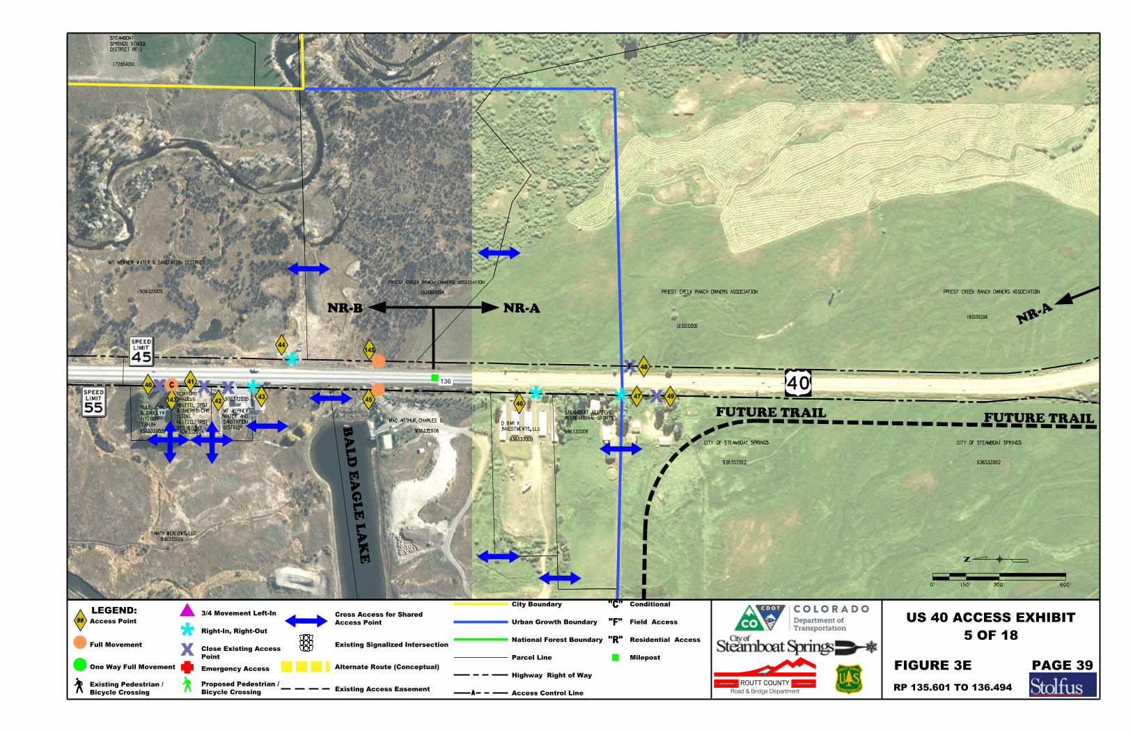
936331002
YAMPA MEADOWS, LLC
936332010
774184
(JT) BOX
& CAROLYN
RULE, JOHN. R.
936332003 936332004
936332005
PRIEST CREEK RANCH OWNERS ASSOCIATION
1931990014
MAC ARTHUR, CHARLES E.
936332006
936332009
936332008
RECREATIONAL SPORTS
STEAMBOAT ADAPTIVE
CITY OF STEAMBOAT SPRINGS
936333002
193100016
CITY OF STEAMBOAT SPRINGS
936333002
MT WERNER WATER & SANITATION DISTRICT
42 46
48
43
193100016
136
44
DISTRICT RE-2
SPRINGS SCHOOL
STEAMBOAT
172604001
BA
LD E
AG
LE L
AK
E
NR-B NR-ANR-
A
F
C
143
INVESTMENTS, LLC
D BAR K DTD 6/13/0
HELTZEL TRST
ISTINE
& SHERRY CHR
HELTZEL TRST
THADEUS
CLIFFORD
PRIEST CREEK RANCH OWNERS ASSOCIATION PRIEST CREEK RANCH OWNERS ASSOCIATION
145
45
4041
47 49
FUTURE TRAIL FUTURE TRAILDISTRICT
SANITATION
WATER AND
MT WERNER
5 OF 18
300'0' 600'150'
RP 135.601 TO 136.494
FIGURE 3E PAGE 39
Full Movement
One Way Full Movement
3/4 Movement Left-In
Right-In, Right-Out
Emergency Access
Existing Signalized Intersection
Alternate Route (Conceptual)
Parcel Line
##
LEGEND:
Access Point
Milepost
US 40 ACCESS EXHIBIT
Point
Close Existing Access
Access Point
Cross Access for Shared
ROUTT COUNTY
Road & Bridge Department
Highway Right of Way
Access Control Line
City Boundary
Urban Growth Boundary
National Forest Boundary
Conditional
Field Access
Residential Access
"C"
"F"
"R"
Bicycle Crossing
Existing Pedestrian /
Bicycle Crossing
Proposed Pedestrian / Existing Access Easement
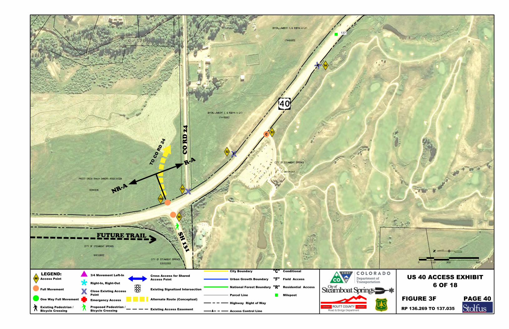
ORTON, LAMBERT C. & ROBYN A. (JT)
174400002
CITY OF STEAMBOAT SPRINGS
174400002
ORTON, LAMBERT C. & ROBYN A. (JT)
CITY OF STEAMBOAT SPRINGS
947041002
936333002
CO R
D 2
4
50
51
SH 1
31
52
53
193100016
CITY OF STEAMBOAT SPRINGS
936333002
137
54
NR-A
R-A
F
F
C
TO C
O R
D 2
4
150
PRIEST CREEK RANCH OWNERS ASSOCIATION
FUTURE TRAIL
6 OF 18
300'0' 600'150'
FIGURE 3F PAGE 40
RP 136.269 TO 137.035
Full Movement
One Way Full Movement
3/4 Movement Left-In
Right-In, Right-Out
Emergency Access
Existing Signalized Intersection
Alternate Route (Conceptual)
Parcel Line
##
LEGEND:
Access Point
Milepost
US 40 ACCESS EXHIBIT
Point
Close Existing Access
Access Point
Cross Access for Shared
ROUTT COUNTY
Road & Bridge Department
Highway Right of Way
Access Control Line
City Boundary
Urban Growth Boundary
National Forest Boundary
Conditional
Field Access
Residential Access
"C"
"F"
"R"
Bicycle Crossing
Existing Pedestrian /
Bicycle Crossing
Proposed Pedestrian / Existing Access Easement
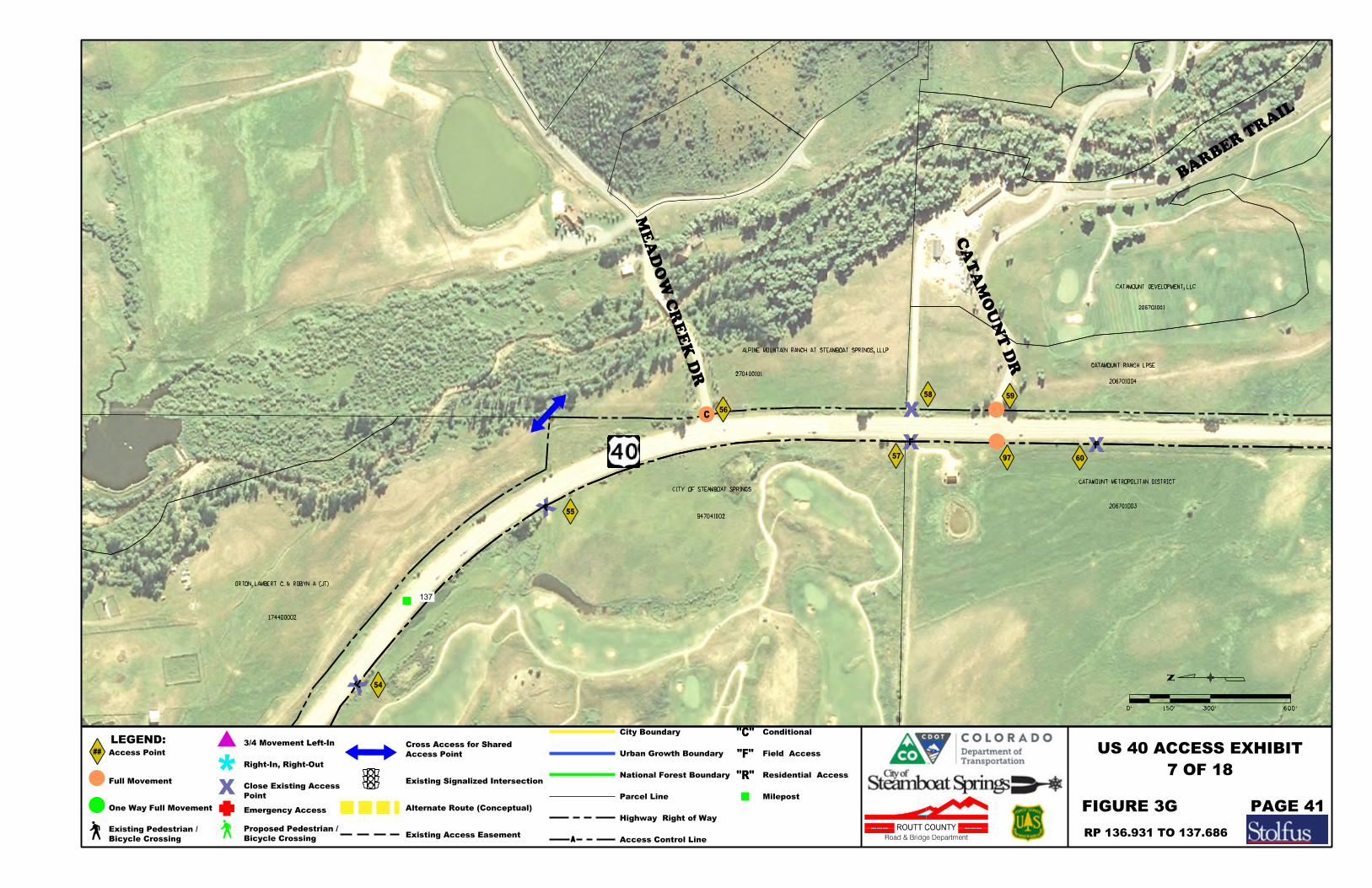
174400002
ORTON, LAMBERT C. & ROBYN A. (JT)
CITY OF STEAMBOAT SPRINGS
947041002
ALPINE MOUNTAIN RANCH AT STEAMBOAT SPRINGS, LLLP
270400101
CATAMOUNT RANCH LPSE
206701004
CATAMOUNT METROPOLITAN DISTRICT
206701003
ME
AD
OW C
RE
EK D
R
CA
TA
MO
UN
T D
R
56
59
55
57
58
BAR
BER T
RAIL
CATAMOUNT DEVELOPMENT, LLC
206701001
137
54
97
F
F
F
C
F
60
7 OF 18
300'0' 600'150'
FIGURE 3G PAGE 41
RP 136.931 TO 137.686
Full Movement
One Way Full Movement
3/4 Movement Left-In
Right-In, Right-Out
Emergency Access
Existing Signalized Intersection
Alternate Route (Conceptual)
Parcel Line
##
LEGEND:
Access Point
Milepost
US 40 ACCESS EXHIBIT
Point
Close Existing Access
Access Point
Cross Access for Shared
ROUTT COUNTY
Road & Bridge Department
Highway Right of Way
Access Control Line
City Boundary
Urban Growth Boundary
National Forest Boundary
Conditional
Field Access
Residential Access
"C"
"F"
"R"
Bicycle Crossing
Existing Pedestrian /
Bicycle Crossing
Proposed Pedestrian / Existing Access Easement
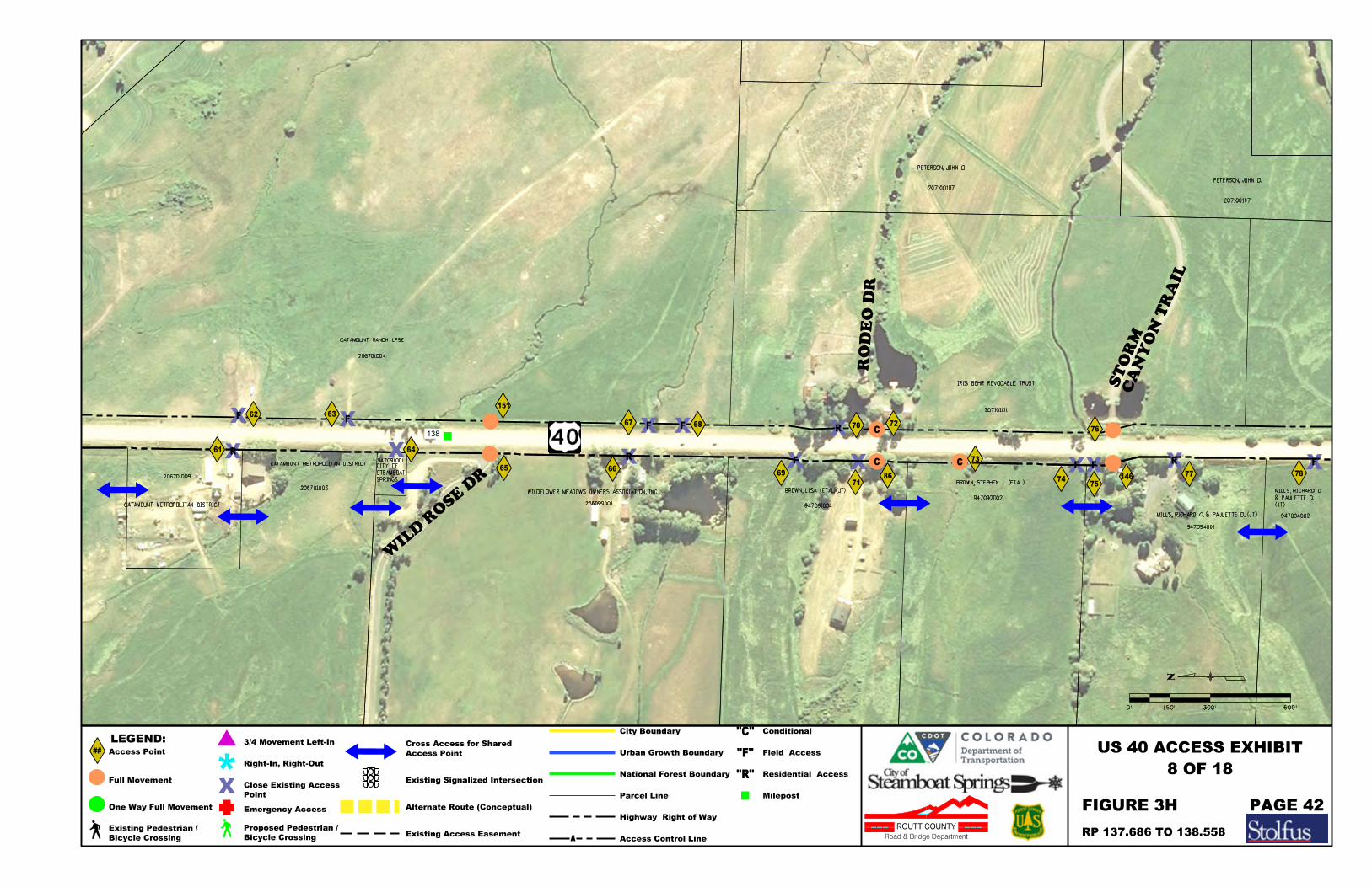
CATAMOUNT METROPOLITAN DISTRICT
CATAMOUNT RANCH LPSE
206701004
206701009
CATAMOUNT METROPOLITAN DISTRICT
206701003
SPRINGS
STEAMBOAT
CITY OF 947091001
WILDFLOWER MEADOWS OWNERS ASSOCIATION, INC
236099001
BROWN, LISA (ETAL)(JT)
947091004
BROWN, STEPHEN L. (ETAL)
947092002
MILLS, RICHARD C. & PAULETTE D. (JT)
947094001
IRIS BEHR REVOCABLE TRUST
207101111
947094002
WIL
D R
OSE D
R65
71
76
62
66
67 72
CA
NY
ON T
RAIL
ST
OR
M
77 7869
RO
DE
O D
R
(JT)
& PAULETTE D.
MILLS, RICHARD C.
207100107
PETERSON, JOHN O.
PETERSON, JOHN O.
207100107
138
63
68 70
73
74
F
F
R
RF
R FF
C
C
86
R
151
F
F
F
61 64
75
C
146
8 OF 18
300'0' 600'150'
FIGURE 3H
RP 137.686 TO 138.558
PAGE 42
Full Movement
One Way Full Movement
3/4 Movement Left-In
Right-In, Right-Out
Emergency Access
Existing Signalized Intersection
Alternate Route (Conceptual)
Parcel Line
##
LEGEND:
Access Point
Milepost
US 40 ACCESS EXHIBIT
Point
Close Existing Access
Access Point
Cross Access for Shared
ROUTT COUNTY
Road & Bridge Department
Highway Right of Way
Access Control Line
City Boundary
Urban Growth Boundary
National Forest Boundary
Conditional
Field Access
Residential Access
"C"
"F"
"R"
Bicycle Crossing
Existing Pedestrian /
Bicycle Crossing
Proposed Pedestrian / Existing Access Easement

STORM MOUNTAIN RANCH ASSOCIATION
207101004
MILLS, RICHARD C. & PAULETTE D. (JT)
MILLS, RICHARD C. & PAULETTE D. (JT)
947094003
947161001
BUCHNER, RODNEY & NANCY (JT)
258000003
O NEAL, SHAWN M. & KRISTI LEE
180400001
TECHARUKPONG, SURIN
180400002
(JT)
SWEERS, SHERYL L.
KYRILL J. &
KRETZSCHMAR,
947153001
947164001
79
8082
84
83
89
90
81
MCKINNIS CREEK RD
CR 201
CR 20947094002
KANE BOSTROM (JT)
CLIFFORD & SUSANNE
BOSTROM, DARYL
MALKOVA, LENKA
166600009
HUNTCO FARMS, INC
947164004
PETERSON, JOHN O.
207100107
139
88
87
85
F F
F
F
CR
CR
22
GAY, WILLIAM
9 OF 18
300'0' 600'150'
PAGE 43FIGURE 3I
RP 138.558 TO 139.443
Full Movement
One Way Full Movement
3/4 Movement Left-In
Right-In, Right-Out
Emergency Access
Existing Signalized Intersection
Alternate Route (Conceptual)
Parcel Line
##
LEGEND:
Access Point
Milepost
US 40 ACCESS EXHIBIT
Point
Close Existing Access
Access Point
Cross Access for Shared
ROUTT COUNTY
Road & Bridge Department
Highway Right of Way
Access Control Line
City Boundary
Urban Growth Boundary
National Forest Boundary
Conditional
Field Access
Residential Access
"C"
"F"
"R"
Bicycle Crossing
Existing Pedestrian /
Bicycle Crossing
Proposed Pedestrian / Existing Access Easement

MALKOVA, LENKA
166600009
HUNTCO FARMS, INC
947164004
KARLA B. SPOONER LIVING TRUST DATED JULY 15, 2003
166600010
BIGELOW, SHARON
947153002
ZAMAR, LLC
947221001
GORMAN, JOHN J., IV & TAMRA I. (JT)
COBB, TERRELL A.
947212004
166600008
& TRUST FBO JOHN J. GORMAN
TEJAS SECURITIES GROUP, INC 401K PLAN
CO
RD
ER, J.
DWIG
HT
94
7222001
YAMPA REALTY HOLDINGS, LLC
947213001
SVENDSEN, LEALLYN & CYNTHIA S. (JT)
166700011
96
91
93
95
94
SK
Y V
AL
LE
Y D
R
PRESERVE DR
TIMBERS
KANE BOSTROM (JT)
CLIFFORD & SUSANNE
BOSTROM, DARYL
947164001
166700012
MALKOVA, LENKA
166600009
140
92
C
10 OF 18
300'0' 600'150'
FIGURE 3J PAGE 44
RP 139.443 TO 140.556
Full Movement
One Way Full Movement
3/4 Movement Left-In
Right-In, Right-Out
Emergency Access
Existing Signalized Intersection
Alternate Route (Conceptual)
Parcel Line
##
LEGEND:
Access Point
Milepost
US 40 ACCESS EXHIBIT
Point
Close Existing Access
Access Point
Cross Access for Shared
ROUTT COUNTY
Road & Bridge Department
Highway Right of Way
Access Control Line
City Boundary
Urban Growth Boundary
National Forest Boundary
Conditional
Field Access
Residential Access
"C"
"F"
"R"
Bicycle Crossing
Existing Pedestrian /
Bicycle Crossing
Proposed Pedestrian / Existing Access Easement
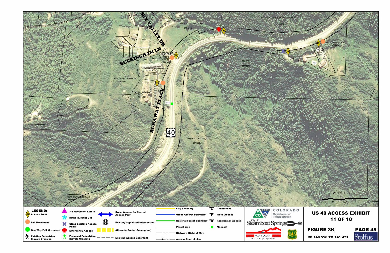
YAMPA REALTY HOLDINGS, LLC
947222002
CRAIG, KYLE T & ELYSE W.
166600004
YAMPA REALTY HOLDINGS, LLC
947213001
166477001
TIMBERS VILLAGE ASSOCIATION
209202003
SK
Y V
ALLE
Y D
R
RU
NA
WA
Y P
LA
CE
ASSOCIATION
TIMBERS CONDOMINIUM
222388001
ASSOCIATION
TIMBERS VILLAS TOWNHOMES
209200020
RYAN, JODITH M.209200015
TIMBERS VILLAGE ASSOCIATION
209202002
FEY, GARY J.
209800001
BAGGENSTOSS, GARY ALAN & BONNIE JEAN (JT)
112400002
947224001
947224002
98
VILLAGE
TIMBERS
99
BUCKINGHAM
LN
141
100
101
98a
JOSFAN, DAVID & ALICIA
ALICIA
DAVID &
JOSFAN,
11 OF 18
300'0' 600'150'
RP 140.556 TO 141.471
FIGURE 3K PAGE 45
Full Movement
One Way Full Movement
3/4 Movement Left-In
Right-In, Right-Out
Emergency Access
Existing Signalized Intersection
Alternate Route (Conceptual)
Parcel Line
##
LEGEND:
Access Point
Milepost
US 40 ACCESS EXHIBIT
Point
Close Existing Access
Access Point
Cross Access for Shared
ROUTT COUNTY
Road & Bridge Department
Highway Right of Way
Access Control Line
City Boundary
Urban Growth Boundary
National Forest Boundary
Conditional
Field Access
Residential Access
"C"
"F"
"R"
Bicycle Crossing
Existing Pedestrian /
Bicycle Crossing
Proposed Pedestrian / Existing Access Easement

SK
Y V
ALLE
Y D
R
214800002
BAGGENSTOSS, GARY ALAN & BONNIE JEAN (JT)
112400002
STAR RI
DGE RD
FEY, GARY J.
209800001128100001
DIANA LYNNE (JT)
PETWAY, KENNETH STEPHEN &
DIANA LYNNE (JT)
PETWAY, KENNETH STEPHEN &
128100001
142
JOAN T. (JT)
GAMBO, MICHAEL S. &
209800007
102
103
104
105
106
ROUTT NATIONAL FOREST
F
C
REGAN II, ROBERT EMMETT
C
12 OF 18
300'0' 600'150'
FIGURE 3L PAGE 46
RP 141.471 TO 142.000
Full Movement
One Way Full Movement
3/4 Movement Left-In
Right-In, Right-Out
Emergency Access
Existing Signalized Intersection
Alternate Route (Conceptual)
Parcel Line
##
LEGEND:
Access Point
Milepost
US 40 ACCESS EXHIBIT
Point
Close Existing Access
Access Point
Cross Access for Shared
ROUTT COUNTY
Road & Bridge Department
Highway Right of Way
Access Control Line
City Boundary
Urban Growth Boundary
National Forest Boundary
Conditional
Field Access
Residential Access
"C"
"F"
"R"
Bicycle Crossing
Existing Pedestrian /
Bicycle Crossing
Proposed Pedestrian / Existing Access Easement
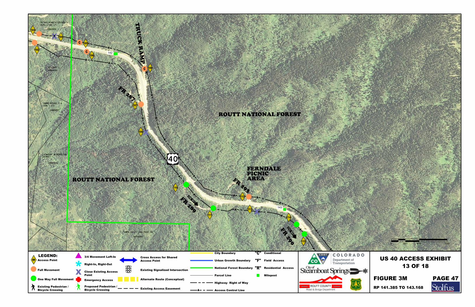
FEY, GARY J.
209800001
128100001
DIANA LYNNE (JT)
PETWAY, KENNETH STEPHEN &
142
143
DISTRICT
CATAMOUNT METROPOLITAN
209801008
947263001
YAMPA VALLEY LAND TRUST, INC
JOAN T. (JT)
GAMBO, MICHAEL S. &
209800007
107
108
109
110
112
114
113
115
106
105
104
103
102
111
FR 289
FR 287
FR 293
AREAPICNIC FERNDALE
FR 2
90
ROUTT NATIONAL FOREST
ROUTT NATIONAL FOREST
TR
UC
K R
AM
P
F
C
C
C
13 OF 18
600'0' 1200'300'
FIGURE 3M PAGE 47
RP 141.385 TO 143.168
Full Movement
One Way Full Movement
3/4 Movement Left-In
Right-In, Right-Out
Emergency Access
Existing Signalized Intersection
Alternate Route (Conceptual)
Parcel Line
##
LEGEND:
Access Point
Milepost
US 40 ACCESS EXHIBIT
Point
Close Existing Access
Access Point
Cross Access for Shared
ROUTT COUNTY
Road & Bridge Department
Highway Right of Way
Access Control Line
City Boundary
Urban Growth Boundary
National Forest Boundary
Conditional
Field Access
Residential Access
"C"
"F"
"R"
Bicycle Crossing
Existing Pedestrian /
Bicycle Crossing
Proposed Pedestrian / Existing Access Easement
600'0' 1200'300'
14 OF 18
FIGURE 3N PAGE 48
RP 143.168 TO 145.426
Full Movement
One Way Full Movement
3/4 Movement Left-In
Right-In, Right-Out
Emergency Access
Existing Signalized Intersection
Alternate Route (Conceptual)
Parcel Line
##
LEGEND:
Access Point
Milepost
US 40 ACCESS EXHIBIT
Point
Close Existing Access
Access Point
Cross Access for Shared
ROUTT COUNTY
Road & Bridge Department
Highway Right of Way
Access Control Line
City Boundary
Urban Growth Boundary
National Forest Boundary
Conditional
Field Access
Residential Access
"C"
"F"
"R"
Bicycle Crossing
Existing Pedestrian /
Bicycle Crossing
Proposed Pedestrian / Existing Access Easement
144
145
116
117
118
120
121
122
FR 294
FR 298.1A
119
FR 292
ROUTT NATIONAL FOREST
ROUTT NATIONAL FOREST
BEAR CURVE
CREEK/SMOKEY
HARRISON
152
153
155
154
FR 295
146
123
124
125
126
SUM
MIT
WEST
ROUTT NATIONAL FOREST
ROUTT NATIONAL FOREST
FR 299.1
15 OF 18
600'0' 1200'300'
FIGURE 3O PAGE 49
RP 145.426 TO 146.772
Full Movement
One Way Full Movement
3/4 Movement Left-In
Right-In, Right-Out
Emergency Access
Existing Signalized Intersection
Alternate Route (Conceptual)
Parcel Line
##
LEGEND:
Access Point
Milepost
US 40 ACCESS EXHIBIT
Point
Close Existing Access
Access Point
Cross Access for Shared
ROUTT COUNTY
Road & Bridge Department
Highway Right of Way
Access Control Line
City Boundary
Urban Growth Boundary
National Forest Boundary
Conditional
Field Access
Residential Access
"C"
"F"
"R"
Bicycle Crossing
Existing Pedestrian /
Bicycle Crossing
Proposed Pedestrian / Existing Access Easement
FR 29
6
147
148
127128
129
FR 2
97
BR
UCE'
S TR
AIL
136
ROUTT NATIONAL FOREST
ROUTT NATIONAL FOREST
CAMPGROUNDMEADOWS
600'0' 1200'300'
16 OF 18
RP 146.722 TO 148.642
FIGURE 3P PAGE 50
Full Movement
One Way Full Movement
3/4 Movement Left-In
Right-In, Right-Out
Emergency Access
Existing Signalized Intersection
Alternate Route (Conceptual)
Parcel Line
##
LEGEND:
Access Point
Milepost
US 40 ACCESS EXHIBIT
Point
Close Existing Access
Access Point
Cross Access for Shared
ROUTT COUNTY
Road & Bridge Department
Highway Right of Way
Access Control Line
City Boundary
Urban Growth Boundary
National Forest Boundary
Conditional
Field Access
Residential Access
"C"
"F"
"R"
Bicycle Crossing
Existing Pedestrian /
Bicycle Crossing
Proposed Pedestrian / Existing Access Easement
FR 31
3
149 150
130
131
132
133
134
FR 300
FOX CURVE137
138
ROUTT NATIONAL FOREST
ROUTT NATIONAL FOREST
CAMPGROUNDCREEK
WALTON
TRAILHEADCREEK
WALTON
600'0' 1200'300'
17 OF 18
FIGURE 3Q PAGE 51
RP 148.642 TO 150.583
Full Movement
One Way Full Movement
3/4 Movement Left-In
Right-In, Right-Out
Emergency Access
Existing Signalized Intersection
Alternate Route (Conceptual)
Parcel Line
##
LEGEND:
Access Point
Milepost
US 40 ACCESS EXHIBIT
Point
Close Existing Access
Access Point
Cross Access for Shared
ROUTT COUNTY
Road & Bridge Department
Highway Right of Way
Access Control Line
City Boundary
Urban Growth Boundary
National Forest Boundary
Conditional
Field Access
Residential Access
"C"
"F"
"R"
Bicycle Crossing
Existing Pedestrian /
Bicycle Crossing
Proposed Pedestrian / Existing Access Easement

FR 302
151
135
ROUTT NATIONAL FOREST
ROUTT NATIONAL FOREST
RO
UT
T N
ATIO
NA
L F
OR
ES
T
GR
AN
D C
OU
NT
Y LIN
E
MP 151.695
END ACCESS CONTROL PLAN
18 OF 18
600'0' 1200'300'
FIGURE 3R PAGE 52
RP 150.583 TO 151.695
Full Movement
One Way Full Movement
3/4 Movement Left-In
Right-In, Right-Out
Emergency Access
Existing Signalized Intersection
Alternate Route (Conceptual)
Parcel Line
##
LEGEND:
Access Point
Milepost
US 40 ACCESS EXHIBIT
Point
Close Existing Access
Access Point
Cross Access for Shared
ROUTT COUNTY
Road & Bridge Department
Highway Right of Way
Access Control Line
City Boundary
Urban Growth Boundary
National Forest Boundary
Conditional
Field Access
Residential Access
"C"
"F"
"R"
Bicycle Crossing
Existing Pedestrian /
Bicycle Crossing
Proposed Pedestrian / Existing Access Easement

East Steamboat Springs US Highway 40 Access Study
Stolfus & Associates, Inc. Page 53
7.2 Other Recommended Improvements
7.2.1 Alternative Local Routes
In support of the recommended access modifications, development of several alternative local routes within the City and County segments is also recommended. These alternative routes provide additional local connections and internal circulation opportunities that will benefit operations on US 40 by reducing local dependence on the highway, providing alternatives that support restricted turning movements on the highways, and reducing demand at intersections that are already experiencing high demand. The proposed local street connections are illustrated in the Access Plan Exhibits in Figures 3A-3I in Section 7.1. Specific alignments are not illustrated in the plan, rather arrows that indicate connections between access points or other local streets are identified. Detailed engineering will be required to establish exact alignments at the time of implementation. It should be noted that some access improvements require development of alternative routes prior to implementation.
The following additional routes have been identified in conjunction with the Access Plan:
1. North-south connection between Emerald Park Way and Pine Grove Road (Figure 3A-3B) This “backage” road will provide local circulation on the west side of US 40, as well as alternatives for limited movement access points. Implementation challenges include crossing Fish Creek between Pine Grove Road and Anglers Drive, the adjacent UPRR tracks, overhead utilities, and existing infrastructure around Anglers Drive.
2. Extension of Mid Valley Drive to Mt. Werner Road (Figure 3B) This road will provide local circulation and eliminate the need for direct access to US 40 for secondary emergency access for properties on the west side of US 40. In combination with route 1, this connection offers a continuous off-highway option on the west side of US 40 between Mt. Werner Road and Trafalgar Drive.
3. Connection between Weiss Drive and the west leg of Walton Creek Road (Figure 3D) This connection is one option for providing alternative left turn access to US 40 for Weiss Drive on the west side of US 40. The City has already obtained right-of-way for the segment between Weiss Drive and Walton Creek. Implementation challenges include crossing Walton Creek and obtaining right-of-way for the west leg of Walton Creek Road.
4. Connection between Weiss Drive and Dougherty Road (Figure 3D) This connection is one option for providing alternative left turn access to US 40 for Weiss Drive. It would also serve other properties with limited movement access on the west side of US 40 between Weiss Drive and Dougherty Road. In order to protect Mt. Werner Water and Sanitation District facilities, the alignment must be located west of the District facilities. Implementation challenges include existing infrastructure, coordination with the Core Trail, and proximity to the Yampa River.
5. Extension of Stone Lane to US 40 on the east side of US 40 (Figure 3D) The Draft Transportation and Mobility Analysis for the Steamboat Springs Area Community Plan Update includes an extension of Stone Lane to US 40 and the City is actively incorporating this connection into long-term planning for the area. The extension should align with Dougherty Road to create a single four-legged intersection
East Steamboat Springs US Highway 40 Access Study
Stolfus & Associates, Inc. Page 54
with US 40 with potential for signalization. Implementation challenges include crossing Walton Creek and associated floodplain impacts.
6. Extension of Ingles Lane to the Stone Lane Extension (Figure 3D) This connection will provide local circulation and alternatives for limited movement access points on the east side of US 40. Ingles Lane is currently a private roadway. Providing public access along this segment will improve access and circulation for the adjacent properties. Implementation challenges include existing infrastructure around Ingles Lane and potential floodplain impacts.
7. Connection between Stone Lane Extension and proposed Access #145 (Figure 3D) This connection will provide local circulation and alternatives for limited movement access points on the east side of US 40. The need for the connection is dependent on redevelopment of properties on the east side of US 40, in particular, the existing Mt. Werner Water and Sanitation District parcel.
8. Realignment of CR 24 across from SH 131 (Figure 3F) CR 24 is currently offset from SH 131 by about 200 feet. Realigning CR 24 to create a single four-legged intersection will eliminate potential vehicle conflicts created by the existing offset configuration. The County has previously approved the realignment and right-of-way has been established. However, no funding is currently available.
9. Improvement of CR 22 between US 40 and SH 131 (Figure 3I) The County has conceptual plans to improve CR 22 between US 40 and SH 131 to current County road standards with the intention of eliminating through traffic between US 40 and SH 131 on CR 20. In comparison to CR 20, CR 22 offers improved sight distance, alignments, grades, and opportunities for developing auxiliary lanes on US 40. Currently no funding is available.
The adoption of these additional road connections by the City and County through resolution or incorporation into master planning documents is recommended. It is anticipated that the majority of these routes would be accomplished in phases when redevelopment occurs.
7.2.2 Alternate Modes
In support of alternate modes, the Plan also considered pedestrian, bicycle and transit access throughout the corridor. Overall, reducing access points reduces potential conflict points for pedestrians, cyclists and buses traveling US 40. Steamboat Springs Transit (SST) provides fixed route transit service throughout the City. Currently, there are two routes that travel on US 40 between downtown Steamboat Springs and Pine Grove Road. There is also a route that travels along US 40 between the Mt. Werner Road interchange and the existing Fairfield Inn located at Access #37. Full movement intersections are consistent with existing SST routes and the Plan is consistent with existing transit stops.
The Access Plan supports the accommodation of pedestrian and bicycle crossings at full movement intersections with potential for signalization throughout the corridor. As intersections are improved and sidewalk is added throughout the corridor, pedestrian crossings should be implemented. In addition, several crossing locations of US 40 are identified by the Steamboat Springs Open Space and Trails Master Plan. Existing and proposed pedestrian and bicycle crossing locations consistent with the master plan are identified on the Access Plan exhibits including the following:
East Steamboat Springs US Highway 40 Access Study
Stolfus & Associates, Inc. Page 55
Emerald Park Way Fish Creek
Mt. Werner Road Interchange Walton Creek
These crossings provide important access to the City’s Core Trail and other local trail systems. Extension of the Core Trail to SH 131 is anticipated in the future. A proposed crossing of SH 131 was also identified for access to areas south of SH 131, including Rabbit Ears Pass. The design of these crossings including location, alignment, and at-grade versus separated configurations are not identified by the Access Plan and will require detailed investigation and support from the City and CDOT prior to implementation. A pedestrian/bicycle crossing east of 3rd Street near the Old Town Hot Springs and Rabbit Ears Motel was discussed during Access Plan development. This area is a high pedestrian use area with several nearby amenities, including existing trails and the hot springs. The Steamboat Springs Open Space and Trails Master Plan identifies a grade-separated crossing at this location. While preferable from a safety and operational standpoint, implementation of a grade separation at this location will likely result in large private property impacts and requires additional investigation to determine the feasibility. An at-grade crossing was also discussed. The City is concerned about the potential for limiting pedestrian movements at 3rd Street in the future to improve highway operations and believes an alternative crossing is necessary prior to restricting any existing pedestrian crossings. CDOT is concerned about introducing a mid-block pedestrian crossing at this location. Additional study of pedestrian movements in this area is recommended prior to modification of pedestrian crossing patterns and locations. Due to the need for additional investigation, a pedestrian crossing is not specifically identified east of 3rd Street in the Access Plan. Any new pedestrian crossings of US 40 will require approval from CDOT.
The Steamboat Springs Open Space and Trails Master Plan also identifies a proposed on-street bicycle route along US 40 between 3rd Street and the city limits. This is generally accommodated with the existing shoulders. However, the shoulder narrows at several major intersections and other minor access points to accommodate auxiliary lanes, thereby reducing space for cyclists and sometimes requiring shared use between cyclists and vehicles. In addition, intersections with right turn auxiliary lanes create potential conflicts between turning vehicles and through cyclists. As intersections are improved throughout the corridor, designs should consider maintaining separated space for cyclists and providing MUTCD compliant striping for through bike lanes adjacent to right turn lanes.
The Access Plan also considered recommendations from the Steamboat Springs Trails Alliance for Rabbit Ears Pass. Accommodation for access to potential trailheads consistent with the Forest Service EA was provided in the Access Plan, conditional upon Forest Service approval.
7.2.3 Forest Service Parking Considerations
The US Forest Service has been actively planning for safe and effective parking for recreational activities within the Routt National Forest through their recent Rabbit Ears Winter Parking EA. In support of those activities, the Access Study has specifically evaluated US 40 access through the Forest Service segment of the study area. One strategy from Section 2.3 that is applicable to this segment and will improve safety for parking throughout the Forest Service segment is to define driveways. Currently wide open pull-offs have the potential for conflicts between vehicles. In addition, separating parking vehicles from through movements will also improve safety. It is recommended that parking areas or loop Forest Roads that provide parking access be located outside the clear zone of US 40, at a minimum. This will minimize conflicts between
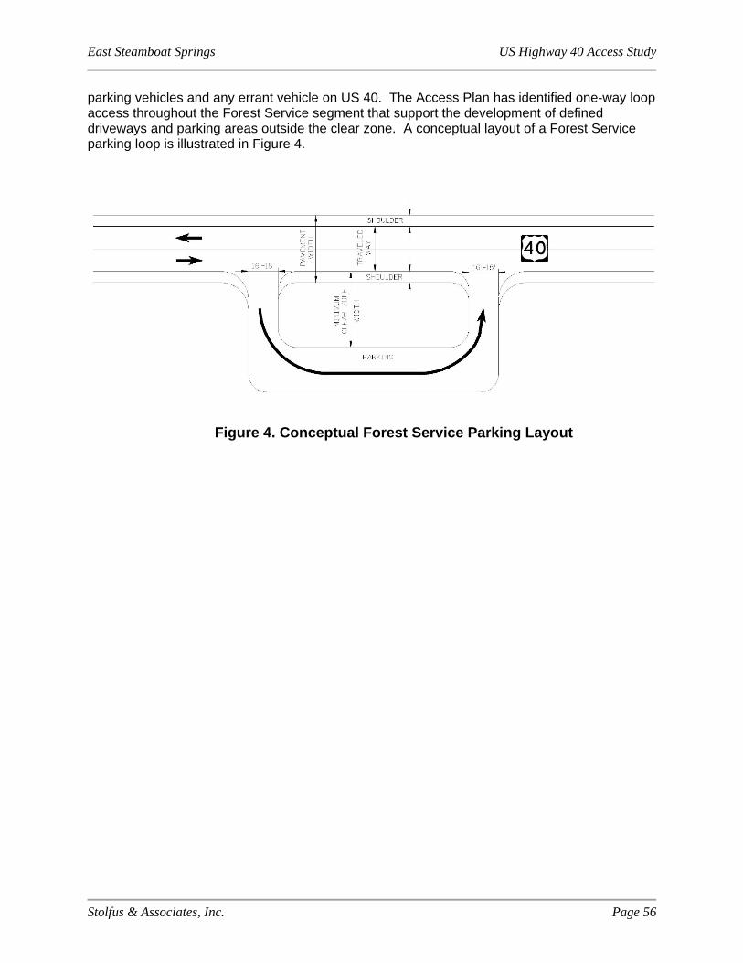
East Steamboat Springs US Highway 40 Access Study
Stolfus & Associates, Inc. Page 56
parking vehicles and any errant vehicle on US 40. The Access Plan has identified one-way loop access throughout the Forest Service segment that support the development of defined driveways and parking areas outside the clear zone. A conceptual layout of a Forest Service parking loop is illustrated in Figure 4.
Figure 4. Conceptual Forest Service Parking Layout

East Steamboat Springs US Highway 40 Access Study
Stolfus & Associates, Inc. Page 57
8.0 IMPLEMENTATION
The improvements recommended in the Access Study represent a long-range plan to implement over time as traffic and safety needs arise and as funding becomes available. Construction of the improvements recommended may be completed using public and/or private funding. The following cases will trigger construction.
1. A property redevelops or changes use, resulting in an increase in traffic to and from the site of 20% or more. In this case, limited improvements at the specific access point may be required by CDOT. As part of the City’s and County’s development review process, additional transportation improvements may also be necessary to address specific traffic-related impacts created by the development. These improvements will be compatible with the Access Plan. In addition, upon redevelopment, the City and County will require property owners to provide legally defined cross-access easements for shared access points, as defined by the Access Plan. If a property does not redevelop, the property owner will not be required to construct access modifications. (Private Funding).
2. The City, County and/or US Forest Service obtain funding to complete improvements to a segment of the US 40 corridor or a local route or parking area. (Public Funding)
3. State and/or Federal Funding are obtained to complete improvements to a segment of the US 40 corridor. Typically, a project will be identified in the Statewide Transportation Improvement Program (STIP) to obtain funding. (Public Funding)
4. A safety or operational issue develops that can be mitigated through the implementation of access management techniques consistent with the Access Plan. Depending on the extent and type of safety or operational issue, improvements may address a segment of the US 40 corridor or a local route, or may be limited to an isolated location or access point. Public funding from any combination of agencies may be obtained to construct improvements. (Public Funding)
5. Any combination of 1, 2, 3, or 4.
Under case 1, a property owner must follow the access permit process as defined by Section 2 of the State of Colorado State Highway Access Code, latest edition. CDOT will remain the issuing authority for US 40. In short, the process requires property owners to submit an application for an access permit. Once the access permit is issued, construction plans for permitted improvements must be developed and submitted to CDOT for review. A Notice to Proceed will be issued following acceptance of the Construction Documents by CDOT, thereby allowing the applicant to proceed with construction. As determined by the CDOT Permit Unit, access permits may allow for construction of interim conditions and define requirements for future conditions that match the Access Control Plan depending upon individual circumstances specific to each permit.
Under case 2, the City, County, and/or US Forest Service may obtain funds either through local government budgeting, application for grant monies, or other potential funding sources. Once funding is available, the City, County, and/or US Forest Service will work through the CDOT planning process to develop a highway improvement project. The project will follow the process and procedures for design, construction, and management detailed in CDOT’s Local Agency Manual. If a City/County/Forest Service project is developed off of the State Highway System, for instance, completion of an alternate local route that does not intersect with US 40, CDOT will

East Steamboat Springs US Highway 40 Access Study
Stolfus & Associates, Inc. Page 58
not be involved in the project. The City, County, and/or US Forest Service will administer the project according to their agency standards and procedures.
Under case 3, a project receiving State and/or Federal funds must be identified in the STIP. In Colorado, six years of transportation projects and their funding sources must be identified in the STIP. The STIP is updated every four years through a continuing, comprehensive and cooperative process involving the CDOT, FHWA, Federal Transit Administration (FTA), Metropolitan Planning Organizations (MPOs), Transportation Planning Regions (TPRs), and City and County Governments. Projects within the study area in Steamboat Springs and Routt County are established in the STIP by request of the Northwest TPR. The STIP was most recently updated and adopted in May, 2015, but may be amended as needed in accordance with the STIP Amendment Guidelines. Currently, the STIP includes surface treatment projects and a Congestion Mitigation and Air Quality (CMAQ) Improvement project on US 40 within the project limits. The Northwest TPR 2040 Regional Transportation Plan (RTP), adopted in February 2015, identifies US 40 through Steamboat Springs (between Craig and Empire) as a Regional Priority Corridor, indicating potential for future projects on US 40 to be added to the STIP; however, State funding is extremely limited at this time and no other future projects have been identified. Similar to case 2, once funding is available, a project will follow CDOT’s relevant process and procedures.
Under case 4, any agency may identify a safety or operational issue along the corridor through a crash pattern, complaints, observation or other manner. A single agency or partnership of agencies may obtain funding to implement access management techniques that are consistent with the Plan and specifically address the issue. Depending on who the lead agency is for the project, the project may be administered through the local agency process, as described in case 2, or through CDOT’s process, as described in case 3.
Detailed engineering drawings of exact roadway alignments and access improvements will be required as project funding is identified. Details related to storm drainage, utilities, landscaping, environmental issues, pedestrian/bicycle facilities, roadway sections, and other topographic features will be considered during this design process. Environmental evaluations appropriate to the size, type, and funding of the project will be completed as part of the design phase.
To provide for continued commitment to the access modifications identified by this study, it is recommended that the City, County and CDOT execute an IGA to adopt this Access Plan as an Access Control Plan for the segment of US 40 between 3rd Street (RP 132.637) and the Routt National Forest Boundary (RP 141.761). In addition, it is recommended that CDOT and the US Forest Service execute a separate IGA to adopt the Access Plan as an Access Control Plan for the segment of US 40 between the Routt National Forest Boundary (RP 141.761) and the Routt County Line (RP 151.695). Each Access Control Plan identifies access locations and levels of access by reference point for US 40, within the project limits. In recognition of the plan’s long-range nature and the potential for conditions to change over time, a critical element of the IGA is the definition of a process for plan modifications. Exhibit B to the IGA defines this process, which basically requires mutual agreement of the IGA parties on modifications to the plan. For the US 40 corridor, the process for administration of the plan shall be as described in the State of Colorado State Highway Access Code, latest edition. The Draft IGA, the Access Control Plan Table that will serve as Exhibit A, and Exhibit B for the City and County segment are presented in Technical Appendix F. The same documents for the US Forest Service segment are presented in Technical Appendix G.

East Steamboat Springs US Highway 40 Access Study
Stolfus & Associates, Inc. Page 59
9.0 LIST OF ACRONYMS
AASHTO = American Association of State Highway and Transportation Officials
ACP = Access Control Plan
ADT = Average Daily Traffic (vehicles/day)
BA = Business Access
BOCC = Routt County Board of County Commissioners
CDOT = Colorado Department of Transportation
CMAQ = Congestion Mitigation and Air Quality
CR = County Road
EA = Environmental Assessment
FA = Field Access
FHWA = Federal Highway Administration
FR = Forest Road
FS = Forest Service Access
FTA = Federal Transit Administration
HCM = Highway Capacity Manual
IGA = Intergovernmental Agreement
LOS = Level of Service
LPS = Land Preservation Subdivision
MP = Milepost
MPO = Metropolitan Planning Organization
mph = Miles Per Hour
MUTCD = Manual on Uniform Traffic Control Devices
NR-A = Non-Rural Principal Highway
NR-B = Non-Rural Arterial
PRS = Public Road Signalized
PRU = Public Road Unsignalized
PVRU = Private Road Unsignalized
R = Residential Access
R-A = Regional Highway
RP = Reference Point
ROW = Right-of-Way
RTP = Regional Transportation Plan
SH = State Highway
East Steamboat Springs US Highway 40 Access Study
Stolfus & Associates, Inc. Page 60
SST = Steamboat Springs Transit
STIP = Statewide Transportation Improvement Program
TMC = Turning Movement Count (at intersection)
TPR = Transportation Planning Region
UPRR = Union Pacific Railroad
East Steamboat Springs US Highway 40 Access Study
Stolfus & Associates, Inc. Page 61
10.0 GLOSSARY
¾ Movement Access - An access that is configured to accommodate partial movements (i.e. left-turn in or out, right-turn in, and right-turn out)
Access – Any driveway or other point of entry and/or exit such as a street, road or highway that connects to the general street system
Access Category – means one of eight categories described in Section Three of the State Highway Access Code, and determines the degree to which access to a state highway is controlled
Access Control Line (A-line) – A line, usually located at the right-of-way boundary, indicating the legal limitation of access along a section of highway
Access Plan, Access Control Plan – A plan which designates access locations and levels of access for the purpose of bringing those portions of roadway included in the planning area into conformance with the highway functional classification to the extent feasible
Access Management – Systematic control of the location, spacing, design, and operation of driveways, median openings, and street connections to a roadway
Access Permit – Means by which access improvements are reviewed, approved and constructed in accordance with the State Highway Access Code
A-line Opening – A break in the A-line delineating the location and width of a potential access point, if permitted by CDOT.
Average Daily Traffic Volume (ADT) – The total 24-hour volume of vehicular traffic at a particular location measured in vehicles per day
Driveway – An access that is not a public street, road, or highway
Full Movement Access – An access without turn restrictions
Functional Intersection Area – Area upstream and downstream of an intersection where intersection operation and conflicts influence driver behavior, vehicle operations, or traffic conditions.
Intergovernmental Agreement (IGA) – A legally-binding agreement between two or more governmental agencies
Issuing Authority – The entity responsible for issuing access permits for a segment of state highway. The board of county commissioners, the governing body of a municipality, or the department of transportation may be the Issuing Authority.
Level-of-Service (LOS) – An indication of the quality of traffic flow as measured by vehicle delays or travel speeds. Level-of-service grades range from LOS A (ideal traffic flow) to LOS F (heavily congested conditions). LOS D is typically considered an acceptable traffic condition during peak demand periods in urbanized locations.
Median – That portion of a highway separating opposing traffic flows
East Steamboat Springs US Highway 40 Access Study
Stolfus & Associates, Inc. Page 62
Right-in, Right-out – An access that is configured to accommodate only right-turns in and right-turns out
Right-of-way (ROW) – The entire width between the boundary lines of every way publicly maintained when any part thereof is open to the use of the public for purposes of vehicular travel
State Highway Access Code – A manual containing the access regulations that apply to state highways within Colorado
Turning Movement Count – A tally of the number of vehicles turning left, right, or traveling through an intersection
Related Documents