Copyright © 2006 John Wiley & Sons, Ltd. Earth Surface Processes and Landforms Earth Surf. Process. Landforms 31, 1692–1706 (2006) Published online in Wiley InterScience (www.interscience.wiley.com) DOI: 10.1002/esp.1432 Bed waves at the basin scale: implications for river management and restoration L. Allan James* Geography Department, University of South Carolina, Columbia, SC 29208, USA Abstract An extensive literature about fluvial sediment waves, slugs or pulses has emerged in the past 20 years. The concept has been useful in many respects, but has been applied to diverse phenomena using a variety of definitions. Moreover, inferred linkages between channel-bed changes and sediment loads are often not justifiable. This paper reviews concepts of large fluvial sediment waves at scales extending to several tens of kilometres. It points out con- straints on the inferences that can be made about sediment loads based on changes in channel-bed elevation at this scale where channel sediment interacts with storage in floodplain and terrace deposits. The type area of G. K. Gilbert’s initial sediment-wave concept is re-examined to show that neither wave translation nor dispersion occurred in the simple manner commonly assumed. Channel aggradation and return to graded conditions provide an alternative theory explaining Gilbert’s observed bed-elevation changes. Recognizing the evidence and implications of the former passage of a large-scale bed wave is essential to the accurate diagnosis of catchment conditions and the adoption of appropriate river restoration goals or methods. Sediment loads, water quality, channel morphologic stability and aquatic ecosystems often reflect changes in sediment storage long after the channel bed has returned to grade. Copyright © 2006 John Wiley & Sons, Ltd. Keywords: sediment waves; channel adjustments; aquatic restoration; fluvial geomorphology; river condition Received 4 December 2004; Revised 3 November 2005; Accepted 20 December 2005 Introduction This paper examines semantic and conceptual issues associated with large-scale fluvial bed waves. It briefly reviews definitions commonly applied to these waves and the validity of using changes in bed elevation to infer sediment loads. Studies of channel-bed elevation changes often make assumptions about sediment loads that may be inappropri- ate, particularly for sedimentation events at the large basin scale. This limitation is elucidated by a re-evaluation of the bed wave generated in the Sierra Nevada of California where Gilbert (1917) described the original sediment-wave concept. This sedimentation episode differed in fundamental ways from smaller-scale waves and from commonly held concepts. After the passage of a bed wave, the production of sediment and pollutants from alluvium left in storage can be persistent and has great bearing on water quality, non-point-source sediment loads, channel morphology and aquatic habitat. These effects and their causes need to be fully recognized as vestiges of a past episodic sedimentation event for appropriate river management and restoration schemes. In many parts of the world, perturbations caused by deforestation, intensive agriculture, mining, fire, road building or urbanization have resulted in episodic sedimentation that caused channel aggradation or floodplain burial. In some cases, such as the Waipaoa River in New Zealand, this is an ongoing process (Gomez et al., 1998). In other cases, such as the Southeastern Piedmont of the USA, accelerated aggradation ceased when erosive land-use was reduced (Trimble, 1974). Such historical perturbations may have disrupted channel quasi-equilibrium conditions and initiated bed waves. Channels formerly bounded by broad, low floodplains may now be narrowly confined by high terraces. Attempts to return a river to pre-disturbance conditions require that historical characteristics and trends be accurately known. This includes a basin-wide comprehension of the spatial relationships between sediment storage components and their connectivity, as well as an understanding of the dynamics of the system on a historical timescale. Recognition of *Correspondence to: L. A. James, Geography Department, University of South Carolina, Columbia, SC 29208, USA. E-mail: [email protected]

Welcome message from author
This document is posted to help you gain knowledge. Please leave a comment to let me know what you think about it! Share it to your friends and learn new things together.
Transcript

1692 L. A. James
Copyright © 2006 John Wiley & Sons, Ltd. Earth Surf. Process. Landforms 31, 1692–1706 (2006)DOI: 10.1002/esp
Earth Surface Processes and LandformsEarth Surf. Process. Landforms 31, 1692–1706 (2006)Published online in Wiley InterScience(www.interscience.wiley.com) DOI: 10.1002/esp.1432
Bed waves at the basin scale: implications for rivermanagement and restorationL. Allan James*Geography Department, University of South Carolina, Columbia, SC 29208, USA
AbstractAn extensive literature about fluvial sediment waves, slugs or pulses has emerged in the past20 years. The concept has been useful in many respects, but has been applied to diversephenomena using a variety of definitions. Moreover, inferred linkages between channel-bedchanges and sediment loads are often not justifiable. This paper reviews concepts of largefluvial sediment waves at scales extending to several tens of kilometres. It points out con-straints on the inferences that can be made about sediment loads based on changes inchannel-bed elevation at this scale where channel sediment interacts with storage in floodplainand terrace deposits. The type area of G. K. Gilbert’s initial sediment-wave concept isre-examined to show that neither wave translation nor dispersion occurred in the simplemanner commonly assumed. Channel aggradation and return to graded conditions providean alternative theory explaining Gilbert’s observed bed-elevation changes. Recognizing theevidence and implications of the former passage of a large-scale bed wave is essential to theaccurate diagnosis of catchment conditions and the adoption of appropriate river restorationgoals or methods. Sediment loads, water quality, channel morphologic stability and aquaticecosystems often reflect changes in sediment storage long after the channel bed has returnedto grade. Copyright © 2006 John Wiley & Sons, Ltd.
Keywords: sediment waves; channel adjustments; aquatic restoration; fluvial geomorphology;river condition
Received 4 December 2004;Revised 3 November 2005;Accepted 20 December 2005
Introduction
This paper examines semantic and conceptual issues associated with large-scale fluvial bed waves. It briefly reviewsdefinitions commonly applied to these waves and the validity of using changes in bed elevation to infer sedimentloads. Studies of channel-bed elevation changes often make assumptions about sediment loads that may be inappropri-ate, particularly for sedimentation events at the large basin scale. This limitation is elucidated by a re-evaluation of thebed wave generated in the Sierra Nevada of California where Gilbert (1917) described the original sediment-waveconcept. This sedimentation episode differed in fundamental ways from smaller-scale waves and from commonly heldconcepts. After the passage of a bed wave, the production of sediment and pollutants from alluvium left in storage canbe persistent and has great bearing on water quality, non-point-source sediment loads, channel morphology andaquatic habitat. These effects and their causes need to be fully recognized as vestiges of a past episodic sedimentationevent for appropriate river management and restoration schemes.
In many parts of the world, perturbations caused by deforestation, intensive agriculture, mining, fire, road building orurbanization have resulted in episodic sedimentation that caused channel aggradation or floodplain burial. In some cases,such as the Waipaoa River in New Zealand, this is an ongoing process (Gomez et al., 1998). In other cases, such as theSoutheastern Piedmont of the USA, accelerated aggradation ceased when erosive land-use was reduced (Trimble,1974). Such historical perturbations may have disrupted channel quasi-equilibrium conditions and initiated bed waves.Channels formerly bounded by broad, low floodplains may now be narrowly confined by high terraces. Attempts toreturn a river to pre-disturbance conditions require that historical characteristics and trends be accurately known. Thisincludes a basin-wide comprehension of the spatial relationships between sediment storage components and theirconnectivity, as well as an understanding of the dynamics of the system on a historical timescale. Recognition of
*Correspondence to: L. A. James,Geography Department,University of South Carolina,Columbia, SC 29208, USA.E-mail: [email protected]
Bed waves at the basin scale 1693
Copyright © 2006 John Wiley & Sons, Ltd. Earth Surf. Process. Landforms 31, 1692–1706 (2006)DOI: 10.1002/esp
sediment buffers and barriers such as local base-level controls is an important first step in understanding fluvialadjustments to anthropogenic sedimentation (Brierly and Fryirs, 1998; Fryirs and Brierly, 2001). Restoration effortsmay be ineffective if high rates of sediment production from historic alluvium are not recognized. If sediment loadsare presently elevated due to former disturbances, they may decrease in the future causing morphological adjustmentsto the channel.
Bed Waves versus Sediment Waves
A first step in understanding the nature of sediment waves is to differentiate between widely varying concepts andprocesses that may be referred to as sediment waves. In addition, a critical evaluation is needed of assumptions oftenmade about the relationship between sediment loads and channel-bed elevations.
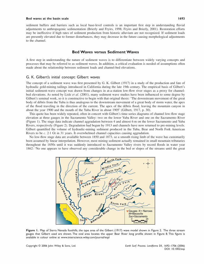
G. K. Gilbert’s initial concept: Gilbert wavesThe concept of a sediment wave was first presented by G. K. Gilbert (1917) in a study of the production and fate ofhydraulic gold-mining tailings introduced in California during the late 19th century. The empirical basis of Gilbert’sinitial sediment-wave concept was drawn from changes in at-a-station low-flow river stages as a proxy for channel-bed elevations. As noted by Lisle et al. (2001), many sediment wave studies have been influenced to some degree byGilbert’s seminal work, so it is constructive to begin with that original thesis: ‘The downstream movement of the greatbody of débris from the Yuba is thus analogous to the downstream movement of a great body of storm water, the apexof the flood traveling in the direction of the current. The apex of the débris flood, leaving the mountain canyon inabout the year 1900 and the mouth of the Yuba River in about 1905’ (Gilbert, 1917, p. 30).
This quote has been widely repeated, often in concert with Gilbert’s time-series diagrams of channel low-flow stageelevation at three gauges in the Sacramento Valley: two on the lower Yuba River and one on the Sacramento River(Figure 1). The stage data indicate channel aggradation between 4 and almost 6 m on the lower Sacramento and YubaRivers, respectively (Figure 2). Degradation had begun by 1913 and channels have now returned to pre-mining levels.Gilbert quantified the volume of hydraulic-mining sediment produced in the Yuba, Bear and North Fork AmericanRivers to be c. 2·1 Gt in 31 years. It overwhelmed channel capacities causing aggradation.
No low-flow stage data are available between 1850 and 1873, so a smooth rising limb of the wave has customarilybeen assumed by linear interpolation. However, most mining sediment actually remained in small mountain tributariesthroughout the 1850s until it was suddenly introduced to Sacramento Valley rivers by record floods in water year1862: ‘No one appears to have observed any considerable change in the bed or slopes of the streams until the great
Figure 1. Map of Sierra Nevada foothills, the type area of the Gilbert (1917) wave model shown in Figure 2. The three streamgauges that Gilbert used are shown. The oval area locates the upper Bear River long profile shown in Figure 8. This figure isavailable in colour online at www.interscience.wiley.com/journal/espl

1694 L. A. James
Copyright © 2006 John Wiley & Sons, Ltd. Earth Surf. Process. Landforms 31, 1692–1706 (2006)DOI: 10.1002/esp
flood of 1862 had receded. Placer mining had been prosecuted by thousands of miners for thirteen years, and thegulches and water courses of the foot-hills had been receiving deposits of gravel and sand all these years . . . In allthese years there had been no great flood. The prolonged and excessive high water of 1862 brought down such massesof material that they could not escape observation’ (Mendell, 1881, p. 6). Hence, the rising limb of the Marysville andSacramento bed waves shown in Gilbert’s diagrams may have commenced with a sudden rise in 1862 (Figure 2).
In spite of missing details in the early record, the low-flow stage data accurately document substantial changes inchannel-bed elevations in response to mining sediment production upstream. Gilbert (1917) predicted that the waveswould pass Marysville and Sacramento by the mid-20th century, and subsequent work has confirmed that low-flowstages at the Sacramento and Marysville gauges returned to pre-mining levels by mid-century (Graves and Eliab,1977). Flow stages at several other stream gauges in the region progressively lowered until the mid-20th century andbecame relatively stable thereafter (James, 1991, 1997; National Research Council, 1995). Large-scale bed wavesresulting from episodic sedimentation events that overwhelm channels will henceforth be referred to as ‘Gilbertwaves’. These waves were not uncommon in recent history and can be identified in association with sedimentationinduced by major landslides, mining, timbering or agricultural clearance.
Modern concepts of sediment waves and bed wavesChannel-bed elevations have been the common basis for most sediment waves, although an alternative usage ofsediment wave should be identified. Changes through time in at-a-station suspended sediment concentrations, betterknown as sediment hydrographs or sedigraphs, are occasionally referred to as sediment waves (Bull, 1997) due tosimilarities with the flood waves that they are often compared with. To avoid confusion with the older and moreprevalent sediment wave concept, however, it is recommended that suspended-sediment hydrographs not be referredto as sediment waves. Sediment hydrographs are not considered further here as they represent an unrelated phenom-enon at a relatively short timescale.
Systematic changes in channel-bed elevations that form an aggradation–degradation cycle have been referred to assediment waves, bed waves, bed-material waves, sediment slugs and sediment pulses. Several comprehensive reviewsof these concepts and relationships between bed elevation and sediment loads have been presented (Meade, 1985;Gomez et al., 1989; Hoey, 1992; Nicholas et al., 1995). Bed waves have been distinguished on the basis of spatialscale, temporal scale, sediment source, sediment storage processes, grain size, and by mode of wave propagation(Table I). In this paper, changes in bed elevation during aggradation–degradation cycles will be referred to as ‘bedwaves’ to emphasize the bed-elevation changes upon which they are defined and to de-emphasize inferred changes insediment loads that are less well established. Gilbert’s (1917) wave model is based on the measurement of bedelevations, so it is best referred to as a bed wave rather than a sediment wave. Bed wave describes what is beingmeasured and need not connote a direct relationship between sediment loads and bed elevations. Some studies(Nicholas et al., 1995) prefer to describe these changes as ‘sediment slugs’ or ‘sediment pulses’ where transport ofmaterial as a coherent wave has not been adequately established. Some studies refer to ‘bed-material waves’ thatimply a direct relationship between bed elevation and bed-material transport rates. Where this relationship is valid,
Figure 2. Time-series plots of low-flow stages at three stream gauges in the lower Sacramento Valley. Data from Gilbert (1917)with exception of step at 1862 which is based on Mendell’s (1881) observation of little sediment delivered prior to 1862 floods(see text). This figure is available in colour online at www.interscience.wiley.com/journal/espl

Bed waves at the basin scale 1695
Copyright © 2006 John Wiley & Sons, Ltd. Earth Surf. Process. Landforms 31, 1692–1706 (2006)DOI: 10.1002/esp
referring to bed waves as passage of a bed-material wave may be appropriate. Bed-material transport is greater thanbed-load transport because it includes fine material that is not sampled by conventional bed-load samplers (Ashmoreand Church, 1998).
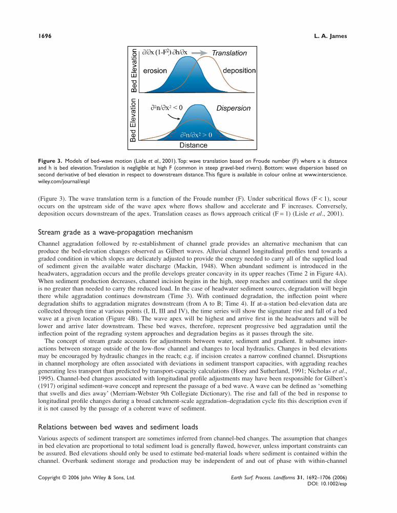
Translation versus dispersionThe mode of bed-wave propagation or morphologic transformation is generally assumed to be by wave translation,dispersion, or a combination of the two (Lisle et al., 2001). Wave translation is the movement of the wave form down-valley without deformation or attenuation, and is often assumed to be the dominant means of wave movement. Bed-load transport in the East Fork River, Wyoming, was thoroughly and quantitatively described as small translatingwaves (Meade et al., 1981; Meade, 1985; Weir, 1983). Wave translation is often inferred from Gilbert’s wave data,although a rise and fall in channel-bed elevations observed at-a-station does not necessarily indicate passage of a waveby translation, as is often assumed. Wave dispersion, the flattening and spreading of a bed wave in situ, can produce asimilar rise and fall of the bed through time (Lisle et al., 2001). The importance of dispersion in gravel-bed streamswas recognized early on by Pickup et al. (1983) who described dispersion as being encouraged by differences inparticle velocities. Several recent studies have concluded that dispersion predominates over translation in gravel-bedrivers (Lisle et al., 2001; Cui et al., 2003). Lancaster et al. (2001) identified deposition zones in mountain streams thatdamp out sediment pulses and preclude translation of bed waves through the reaches.
Experimental work comparing dispersion and translation of bed waves is largely based on observations in flumes orsmall channels, and generally neglects overbank storage and re-release. Under these conditions wave evolution ingravel-bed channels is almost exclusively by dispersion (Lisle et al., 2001). Combinations of dispersion with transla-tion may be common in sand-bed rivers (Cui et al., 2003). A one-dimensional numeric model for bed-wave eleva-tion changes has been presented as a function of three terms: bed-load transport, rate of dispersion, and rate oftranslation (Lisle et al., 2001). The dispersion term is expressed by the rate of change in local bed slope and postulatesdegradation near the apex and aggradation away from the apex where depth is increasing or decreasing most rapidly
Table I. Systems of bed wave classifications
Classification
Scale (two overlapping classification systems based on magnitude)1. By spatial scale of waves
mesoforms (individual bedforms): 10−1–102 mmacroforms or macroslugs (unit or complex bars): 101–103 mmegaforms or megaslugs (bar assemblages): >103 msuperslugs or Gilbert waves (basin-scale with valley-floor adjustments)
2. By temporal scale of wave persistenceannual or seasonal periodicitieslarge flood responses:101–102 yearscatastrophic sedimentation: 102–103 years
Sediment Source and Fate (two overlapping classificationsystems based on source or extent of sediment)1. By sediment source
endogenous waves from within channel (autopulses; endoslugs)exogenous waves from catchment sources (allopulses; exoslugs)
2. By sediment storage processeswithin-channel storage onlyoverbank deposition with longterm floodplain storage
Sediment Character (based on grain-size)wave material coarser than bedwave material similar to bedwave material finer than bed
Wave Propagation ProcessTranslationDispersionMigrating inflection point between aggrading and degrading zones
Reference
Hoey (1992), Nicholas et al. (1995), Wathen and Hoey (1998)
Nicholas et al. (1995)Meade (1985)
Gilbert (1917)
Hoey (1992), Nicholas et al. (1995), Wathen and Hoey (1998)
Nicholas et al. (1995)
This study
Cui et al. (2003)
Lisle et al. (2001), Cui et al. (2003)Lisle et al. (2001), Cui et al. (2003)This study
1696 L. A. James
Copyright © 2006 John Wiley & Sons, Ltd. Earth Surf. Process. Landforms 31, 1692–1706 (2006)DOI: 10.1002/esp
Figure 3. Models of bed-wave motion (Lisle et al., 2001). Top: wave translation based on Froude number (F) where x is distanceand h is bed elevation. Translation is negligible at high F (common in steep gravel-bed rivers). Bottom: wave dispersion based onsecond derivative of bed elevation in respect to downstream distance. This figure is available in colour online at www.interscience.wiley.com/journal/espl
(Figure 3). The wave translation term is a function of the Froude number (F). Under subcritical flows (F < 1), scouroccurs on the upstream side of the wave apex where flows shallow and accelerate and F increases. Conversely,deposition occurs downstream of the apex. Translation ceases as flows approach critical (F = 1) (Lisle et al., 2001).
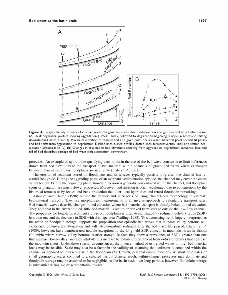
Stream grade as a wave-propagation mechanismChannel aggradation followed by re-establishment of channel grade provides an alternative mechanism that canproduce the bed-elevation changes observed as Gilbert waves. Alluvial channel longitudinal profiles tend towards agraded condition in which slopes are delicately adjusted to provide the energy needed to carry all of the supplied loadof sediment given the available water discharge (Mackin, 1948). When abundant sediment is introduced in theheadwaters, aggradation occurs and the profile develops greater concavity in its upper reaches (Time 2 in Figure 4A).When sediment production decreases, channel incision begins in the high, steep reaches and continues until the slopeis no greater than needed to carry the reduced load. In the case of headwater sediment sources, degradation will beginthere while aggradation continues downstream (Time 3). With continued degradation, the inflection point wheredegradation shifts to aggradation migrates downstream (from A to B; Time 4). If at-a-station bed-elevation data arecollected through time at various points (I, II, III and IV), the time series will show the signature rise and fall of a bedwave at a given location (Figure 4B). The wave apex will be highest and arrive first in the headwaters and will belower and arrive later downstream. These bed waves, therefore, represent progressive bed aggradation until theinflection point of the regrading system approaches and degradation begins as it passes through the site.
The concept of stream grade accounts for adjustments between water, sediment and gradient. It subsumes inter-actions between storage outside of the low-flow channel and changes to local hydraulics. Changes in bed elevationsmay be encouraged by hydraulic changes in the reach; e.g. if incision creates a narrow confined channel. Disruptionsin channel morphology are often associated with deviations in sediment transport capacities, with aggrading reachesgenerating less transport than predicted by transport-capacity calculations (Hoey and Sutherland, 1991; Nicholas et al.,1995). Channel-bed changes associated with longitudinal profile adjustments may have been responsible for Gilbert’s(1917) original sediment-wave concept and represent the passage of a bed wave. A wave can be defined as ‘somethingthat swells and dies away’ (Merriam-Webster 9th Collegiate Dictionary). The rise and fall of the bed in response tolongitudinal profile changes during a broad catchment-scale aggradation–degradation cycle fits this description even ifit is not caused by the passage of a coherent wave of sediment.
Relations between bed waves and sediment loadsVarious aspects of sediment transport are sometimes inferred from channel-bed changes. The assumption that changesin bed elevation are proportional to total sediment load is generally flawed, however, unless important constraints canbe assured. Bed elevations should only be used to estimate bed-material loads where sediment is contained within thechannel. Overbank sediment storage and production may be independent of and out of phase with within-channel
Bed waves at the basin scale 1697
Copyright © 2006 John Wiley & Sons, Ltd. Earth Surf. Process. Landforms 31, 1692–1706 (2006)DOI: 10.1002/esp
processes. An example of appropriate qualifying constraints in the use of the bed-wave concept is to limit inferencesdrawn from bed elevations to the transport of bed material within channels of gravel-bed rivers where exchangesbetween channels and their floodplains are negligible (Lisle et al., 2001).
The erosion of sediment stored on floodplains and in terraces typically persists long after the channel has re-established grade. During the aggrading phase of an overbank sedimentation episode, the channel may cover the entirevalley bottom. During the degrading phase, however, incision is generally concentrated within the channel, and floodplainscour or planation are much slower processes. Moreover, bed incision is often accelerated due to constrictions by thehistorical terraces or by levees and bank protection that alter local hydraulics and retard floodplain reworking.
Ashmore and Church (1998) outline the history and intricacies of using channel-bed morphology to estimatebed-material transport. They use morphologic measurements in an inverse approach to calculating transport rates.Bed-material waves describe changes in bed elevation where bed-material transport is closely linked to bed elevation.They note that in the rivers studied, little bed material is lost to or derived from storage outside the low-flow channel.The propensity for long-term sediment storage on floodplains is often demonstrated by sediment delivery ratios (SDR)less than one and the decrease in SDR with drainage area (Walling, 1983). This decreasing trend, largely interpreted asthe result of floodplain storage, supports the proposition that episodic bed waves that inundate valley bottoms willexperience down-valley attenuation and will later contribute sediment after the bed wave has passed. Church et al.(1989), however, have demonstrated notable exceptions to the long-held SDR concept in mountain rivers in BritishColumbia where narrow valley bottoms restrict storage. In fact, they show a prevalence of SDRs greater than onethat increase down-valley, and they attribute this increase to sediment recruitment from outwash terraces that constrictthe mountain rivers. Under these special circumstances, the inverse method of using bed waves to infer bed-materialloads may be feasible. Scale may also be a factor in the validity of assuming that sediment is contained within thechannel as opposed to interacting with the floodplain (M. Church, personal communication). At short timescales orsmall geographic scales confined to a selected narrow channel reach, within-channel processes may dominate andfloodplain storage may be assumed to be negligible. At the basin scale over long periods, however, floodplain storageis substantial during major sedimentation events.
Figure 4. Large-scale adjustments of channel grade can generate at-a-station bed-elevation changes identical to a Gilbert wave.(A) Ideal longitudinal profiles showing aggradation (Times 1 and 2) followed by degradation beginning in upper reaches and shiftingdownstream (Times 3 and 4). Maximum elevation of channel bed at a given point occurs when inflection point (A and B) passesand bed shifts from aggradation to degradation. Dashed lines, buried profiles; dotted lines, terraces; vertical lines, at-a-station bed-elevation stations (I to IV). (B) Changes in at-a-station bed elevations resulting from aggradation–degradation sequence. Rise andfall of bed describes passage of bed wave with attenuation downstream.
1698 L. A. James
Copyright © 2006 John Wiley & Sons, Ltd. Earth Surf. Process. Landforms 31, 1692–1706 (2006)DOI: 10.1002/esp
Most bed-wave studies have been concerned with sand- or gravel-bedded flumes or streams at the reach or smallerscale. Moreover, most studies have been conducted under controlled conditions with no interactions between sedimenttransport and storage outside of the channel. At small scales under controlled, within-channel conditions, it may bepossible to isolate direct linkages between bed elevation (bed forms) and bed load or bed-material transport rates(Gomez et al., 1989). Where these special conditions are not met, however, such linkages should not be assumed. Theassumption that total sediment loads are proportional to bed-elevation changes is not generally valid for basin-scaleevents that involve substantial amounts of overbank sedimentation. At this scale, the assumption of a direct relation-ship between sediment loads and bed elevations should be rejected unless it can be independently confirmed.
This paper concentrates on basin-scale bed waves that involve a substantial amount of overbank sedimentation.These Gilbert waves persist for long distances downstream, involve a massive amount of mixed sediment, and are notconfined to within the channel. Long-term responses to such an event may be driven by sediment production fromfloodplain and terrace deposits. A few field studies have documented wave dispersion on large scales. For example,Sutherland et al. (2002) documented a landslide-dam failure that generated a bed wave in a gravel-bed river ofnorthern California. They observed topographic changes 1·5 to 4·5 km downstream of the dam site for four years.They tested dispersion versus translation hypotheses based on field observations and concluded that the wave dis-persed with no measurable translation. For episodic sedimentation events extending over several tens of kilometres,however, it is not clear whether or not sediment tends to be transported as a coherent wave and, if so, what is thenature of such a wave? To this end, re-examination of the Gilbert waves is of considerable interest.
A Modern View of Gilbert Waves
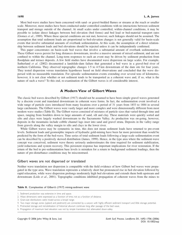
The classic bed waves described by Gilbert (1917) should not be assumed to have been simple gravel waves generatedby a discrete event and translated downstream in coherent wave forms. In fact, the sedimentation event involved awide range of particle sizes introduced from many locations over a period of 31 years from 1853 to 1884 in severallarge catchments. The Gilbert waves were vastly larger and more complex and were dimensionally different from mostmodern wave studies (Table II). The Gilbert waves consisted of mixtures of particle sizes that varied through time andspace, ranging from boulders down to large amounts of sand, silt and clay. These materials were quickly sorted andsilts and clays were largely washed downstream to the Sacramento Valley. As production was on-going, however,deposits in the mountains include cobble channel lags inset into sand and gravel strata. Deposits in the valley rangefrom gravels along the valley margin to silts and clays in the lower river.
While Gilbert waves may be symmetric in time, this does not mean sediment loads have returned to pre-eventlevels. Sediment loads and geomorphic impacts of hydraulic gold-mining have been far more persistent than would bepredicted by the form of the bed-wave. Time series of total sediment loads following a large-scale sedimentation eventcan be described by a positively skewed distribution (James, 1999). Hence, in the type area where the sediment-waveconcept was conceived, sediment wave theory seriously underestimates the time required for sediment stabilization,yield reductions and system recovery. This persistent response has important implications for river restoration. If thereturn of the bed to pre-sedimentation base levels is mistaken for a return to background sediment loadings, then thenature of pre-disturbance conditions may be misconstrued.
Gilbert waves are not dispersed or translatedNeither wave translation nor dispersion is compatible with the field evidence of how Gilbert bed waves were propa-gated in the type area. Wave translation represents a relatively short but pronounced rise in bed elevation followed byrapid relaxation, while wave dispersion prolongs moderately high bed elevations and extends them both upstream anddownstream (Lisle et al., 2001). Topographic conditions inhibited propagation of coherent waves from the mines to
Table II. Complexities of Gilbert’s (1917) mining-sediment wave
1. Sediment production was extensive in time and space.2. Wave dimensions were expressed as a function of time, not as a function of distance.3. Grain-size distributions were mixed across a broad range.4. Two major storage zones (upland and piedmont) are connected by a canyon with highly efficient sediment transport and little storage potential.5. Protracted storage and remobilization of historical alluvium continues long after passage of the bed wave.6. Propagation of maximum bed elevation was not by simple translation, but attenuated down-valley.
Bed waves at the basin scale 1699
Copyright © 2006 John Wiley & Sons, Ltd. Earth Surf. Process. Landforms 31, 1692–1706 (2006)DOI: 10.1002/esp
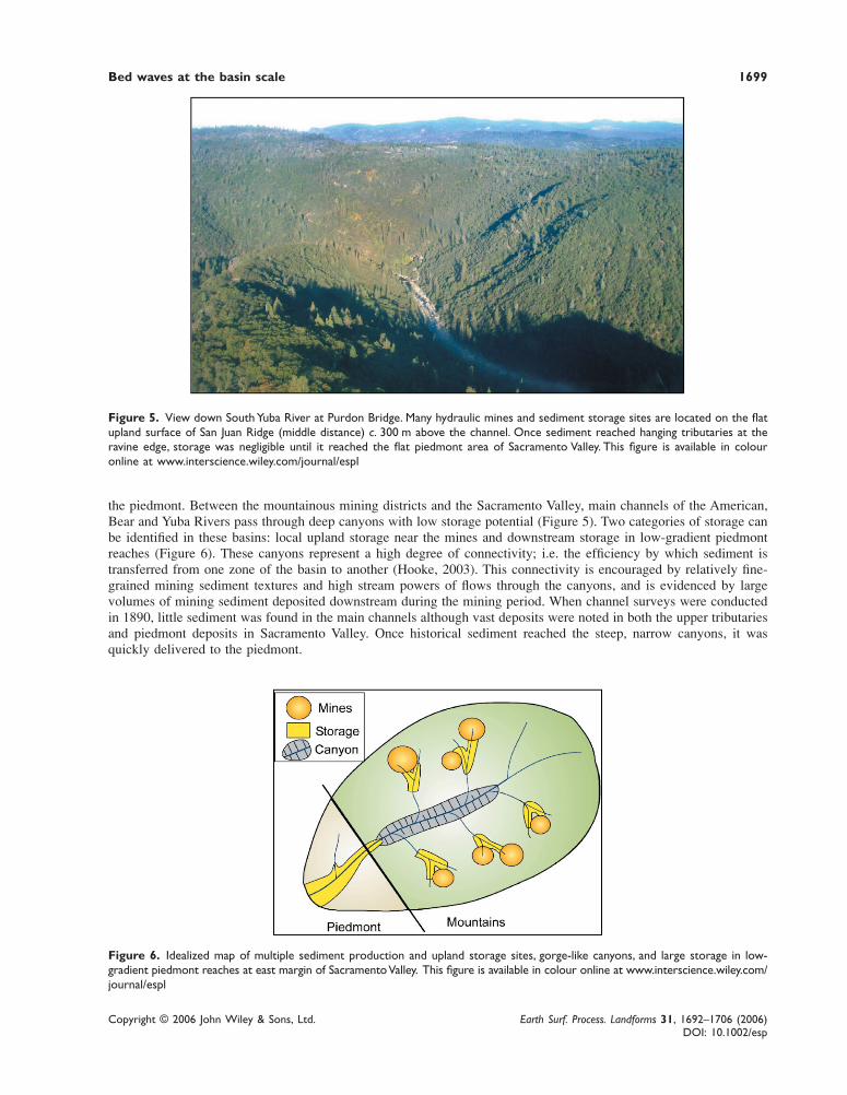
Figure 5. View down South Yuba River at Purdon Bridge. Many hydraulic mines and sediment storage sites are located on the flatupland surface of San Juan Ridge (middle distance) c. 300 m above the channel. Once sediment reached hanging tributaries at theravine edge, storage was negligible until it reached the flat piedmont area of Sacramento Valley. This figure is available in colouronline at www.interscience.wiley.com/journal/espl
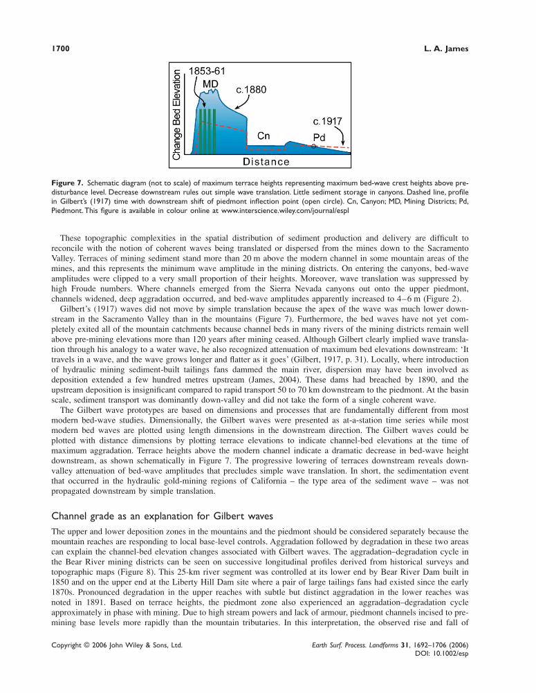
Figure 6. Idealized map of multiple sediment production and upland storage sites, gorge-like canyons, and large storage in low-gradient piedmont reaches at east margin of Sacramento Valley. This figure is available in colour online at www.interscience.wiley.com/journal/espl
the piedmont. Between the mountainous mining districts and the Sacramento Valley, main channels of the American,Bear and Yuba Rivers pass through deep canyons with low storage potential (Figure 5). Two categories of storage canbe identified in these basins: local upland storage near the mines and downstream storage in low-gradient piedmontreaches (Figure 6). These canyons represent a high degree of connectivity; i.e. the efficiency by which sediment istransferred from one zone of the basin to another (Hooke, 2003). This connectivity is encouraged by relatively fine-grained mining sediment textures and high stream powers of flows through the canyons, and is evidenced by largevolumes of mining sediment deposited downstream during the mining period. When channel surveys were conductedin 1890, little sediment was found in the main channels although vast deposits were noted in both the upper tributariesand piedmont deposits in Sacramento Valley. Once historical sediment reached the steep, narrow canyons, it wasquickly delivered to the piedmont.
1700 L. A. James
Copyright © 2006 John Wiley & Sons, Ltd. Earth Surf. Process. Landforms 31, 1692–1706 (2006)DOI: 10.1002/esp
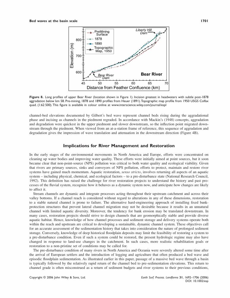
These topographic complexities in the spatial distribution of sediment production and delivery are difficult toreconcile with the notion of coherent waves being translated or dispersed from the mines down to the SacramentoValley. Terraces of mining sediment stand more than 20 m above the modern channel in some mountain areas of themines, and this represents the minimum wave amplitude in the mining districts. On entering the canyons, bed-waveamplitudes were clipped to a very small proportion of their heights. Moreover, wave translation was suppressed byhigh Froude numbers. Where channels emerged from the Sierra Nevada canyons out onto the upper piedmont,channels widened, deep aggradation occurred, and bed-wave amplitudes apparently increased to 4–6 m (Figure 2).
Gilbert’s (1917) waves did not move by simple translation because the apex of the wave was much lower down-stream in the Sacramento Valley than in the mountains (Figure 7). Furthermore, the bed waves have not yet com-pletely exited all of the mountain catchments because channel beds in many rivers of the mining districts remain wellabove pre-mining elevations more than 120 years after mining ceased. Although Gilbert clearly implied wave transla-tion through his analogy to a water wave, he also recognized attenuation of maximum bed elevations downstream: ‘Ittravels in a wave, and the wave grows longer and flatter as it goes’ (Gilbert, 1917, p. 31). Locally, where introductionof hydraulic mining sediment-built tailings fans dammed the main river, dispersion may have been involved asdeposition extended a few hundred metres upstream (James, 2004). These dams had breached by 1890, and theupstream deposition is insignificant compared to rapid transport 50 to 70 km downstream to the piedmont. At the basinscale, sediment transport was dominantly down-valley and did not take the form of a single coherent wave.
The Gilbert wave prototypes are based on dimensions and processes that are fundamentally different from mostmodern bed-wave studies. Dimensionally, the Gilbert waves were presented as at-a-station time series while mostmodern bed waves are plotted using length dimensions in the downstream direction. The Gilbert waves could beplotted with distance dimensions by plotting terrace elevations to indicate channel-bed elevations at the time ofmaximum aggradation. Terrace heights above the modern channel indicate a dramatic decrease in bed-wave heightdownstream, as shown schematically in Figure 7. The progressive lowering of terraces downstream reveals down-valley attenuation of bed-wave amplitudes that precludes simple wave translation. In short, the sedimentation eventthat occurred in the hydraulic gold-mining regions of California – the type area of the sediment wave – was notpropagated downstream by simple translation.
Channel grade as an explanation for Gilbert wavesThe upper and lower deposition zones in the mountains and the piedmont should be considered separately because themountain reaches are responding to local base-level controls. Aggradation followed by degradation in these two areascan explain the channel-bed elevation changes associated with Gilbert waves. The aggradation–degradation cycle inthe Bear River mining districts can be seen on successive longitudinal profiles derived from historical surveys andtopographic maps (Figure 8). This 25-km river segment was controlled at its lower end by Bear River Dam built in1850 and on the upper end at the Liberty Hill Dam site where a pair of large tailings fans had existed since the early1870s. Pronounced degradation in the upper reaches with subtle but distinct aggradation in the lower reaches wasnoted in 1891. Based on terrace heights, the piedmont zone also experienced an aggradation–degradation cycleapproximately in phase with mining. Due to high stream powers and lack of armour, piedmont channels incised to pre-mining base levels more rapidly than the mountain tributaries. In this interpretation, the observed rise and fall of
Figure 7. Schematic diagram (not to scale) of maximum terrace heights representing maximum bed-wave crest heights above pre-disturbance level. Decrease downstream rules out simple wave translation. Little sediment storage in canyons. Dashed line, profilein Gilbert’s (1917) time with downstream shift of piedmont inflection point (open circle). Cn, Canyon; MD, Mining Districts; Pd,Piedmont. This figure is available in colour online at www.interscience.wiley.com/journal/espl
Bed waves at the basin scale 1701
Copyright © 2006 John Wiley & Sons, Ltd. Earth Surf. Process. Landforms 31, 1692–1706 (2006)DOI: 10.1002/esp
channel-bed elevations documented by Gilbert’s bed wave represent channel beds rising during the aggradationalphase and incising as channels in the piedmont regraded. In accordance with Mackin’s (1948) concepts, aggradationand degradation were quickest in the upper piedmont and slower downstream, so the inflection point migrated down-stream through the piedmont. When viewed from an at-a-station frame of reference, this sequence of aggradation anddegradation gives the impression of wave translation and attenuation in the downstream direction (Figure 4B).
Implications for River Management and Restoration
In the early stages of the environmental movements in North America and Europe, efforts were concentrated oncleaning up water bodies and improving water quality. These efforts were initially aimed at point sources, but it soonbecame clear that non-point-source (NPS) pollution was critical to both water quality and ecological viability. Giventhat rivers are primary sources, sinks and conveyors of NPS pollution, efforts to protect, maintain and restore riversystems have gained much momentum. Aquatic restoration, senso stricto, involves returning all aspects of an aquaticsystem – including physical, chemical, and ecological factors – to a pre-disturbance state (National Research Council,1992). This definition has raised the challenge for river restoration projects to understand the history and past pro-cesses of the fluvial system, recognize how it behaves as a dynamic system now, and anticipate how changes are likelyto affect it.
Stream channels are dynamic and integrate processes acting throughout their upstream catchment and across theirvalley bottoms. If a channel reach is considered without regard to alterations in any of these dimensions, restorationto a stable natural channel is prone to failure. The alternative hard-engineering approach of installing fixed bank-protection structures that prevent lateral channel migration may not be desirable because it results in an unnaturalchannel with limited aquatic diversity. Moreover, the tendency for bank erosion may be translated downstream. Inmany cases, restoration projects should strive to design channels that are geomorphically stable and provide diverseaquatic habitat. Hence, knowledge of how channel processes and sediment storage and delivery systems operate bothwithin the reach and upstream are critical to developing a sustainable, dynamic channel system. These objectives callfor an accurate assessment of the sedimentation history that takes into consideration the nature of prolonged sedimentstorage. Conversely, knowledge of deep historical floodplain deposits may limit the feasibility of restoring a system toa pre-disturbance condition. Even if such a system could be restored, the present hydrologic regime may also havechanged in response to land-use changes in the catchment. In such cases, more realistic rehabilitation goals orrestoration to a non-pristine set of conditions may be called for.
The pre-disturbance condition of many rivers in North America and Oceania were severely altered some time afterthe arrival of European settlers and the introduction of logging and agriculture that often produced a bed wave andepisodic floodplain sedimentation. As illustrated earlier in this paper, passage of a massive bed wave through a basinis typically followed by the relatively rapid return of the channel bed to pre-sedimentation elevations. This return tochannel grade is often misconstrued as a return of sediment budgets and river systems to their previous conditions,
Figure 8. Long profiles of upper Bear River (location shown in Figure 1). Incision greatest in headwaters with subtle post-1878aggradation below km 58. Pre-mining, 1878 and 1890 profiles from Heuer (1891). Topographic map profile from 1950 USGS Colfaxquad. (1:62 500). This figure is available in colour online at www.interscience.wiley.com/journal/espl

1702 L. A. James
Copyright © 2006 John Wiley & Sons, Ltd. Earth Surf. Process. Landforms 31, 1692–1706 (2006)DOI: 10.1002/esp
without regard to deep floodplain deposits and the effects that they have on channel morphology, local sedimentproduction, bottomland ecology, frequency of floodplain inundation, and other factors. Specifically, the modern chan-nel may be deeply entrenched in historical terraces with the former floodplain perched high above frequently occur-ring flood stages. Sediment production from the high terrace walls may be orders of magnitude higher, the floodplainwetland may be buried and replaced by a xeric or mesic forest that is disconnected from the river, and aquaticdiversity may be reduced accordingly.
One common strategy in river restoration is to identify a reference reach that is adopted as the target design for therestoration project. The reference channel reach has an appropriate morphology representative of stable conditions(Hughes et al., 1986; Brookes and Shields, 1996). If restoration to a pristine condition is the objective, a relativelypristine reference reach should be sought. Unfortunately, in catchments that experienced large Gilbert waves, norepresentative pristine channel reaches may exist. Moreover, it may not be feasible to restore channels to pristineconditions. In this case, a reference reach may be sought that represents a newly adjusted configuration for the modernwater and sediment regime (Fryirs, 2003). In catchments where bed waves have left deep floodplain deposits, theseconditions should be recognized by experienced fluvial geomorphologists. Such channels may be in a state of long-term flux and if this is not recognized and compensated for, they would make a poor reference reach for stable channeldesigns. Adding to this problem is the common use of purely descriptive channel-classification systems to describe areference reach (Juracek and Fitzpatrick, 2003). Most stream-channel classification systems used in the United Statesdo not adequately account for systematic adjustments to channel morphology through time. Static channel descriptionsdo not facilitate the recognition of on-going adjustments to buried floodplains.
Two examples: implications of bed-waves to restorationIn the type area of the Gilbert wave, the Yuba River catchment has been identified as the primary candidate forrestoration of salmonids in the Central Valley of northern California. Recent studies of the Yuba River have examinedthe feasibility of removing Englebright Dam and its large-capacity reservoir (86 Mm3) to restore salmonid spawninghabitat. Recognition of prolonged reworking of hydraulic mine-tailings is important to dam removal in four ways: (1)downstream delivery of tailings from upland tributary storage; (2) release of 29 Mm3 of tailings stored in EnglebrightReservoir; (3) potential toxicity of mercury associated with mining sediment; and (4) sustainability of fine spawninggravel produced by erosion of mine-tailings. The prolonged reworking of mining sediment in these rivers has provedto be important in the evaluation of scenarios for treatment of Englebright Reservoir (James, 2005). The sustainabilityof spawning gravels has not yet received sufficient attention, however. Field studies and sediment transport modelshave determined the locations and suitability of modern bed materials for spawning habitat. These conditions havebeen assumed to be static without considering the likelihood that the fine gravels are largely supplied from miningsediment deposits in the upper basin. As storage of available fine gravel slowly dwindles, the supply of spawninggravels may prove to be unsustainable. Thus, the rationale for restoration of the upper Yuba River depends upon anunderstanding of the passage of the Gilbert wave and the dynamics of the historical sediment system.
A second example, drawn from the southeastern Piedmont of USA, also illustrates the importance of recognizingthe passage of a bed wave prior to restoration efforts. In response to early 20th century cotton farming, extremegullying and sheet erosion caused stream channels to aggrade. Fairfield County, South Carolina, experienced particu-larly severe erosion and sedimentation (Trimble, 1974). As a consequence, many small catchments were deeplyaggraded as in the Storm Creek basin in Fairfield County (Figure 9). Valley-floor cross-sections cored through thefloodplain of Storm Creek reveal a large volume of historical fill remaining after the channel incised back down tobedrock (Figure 10). The historical age of the thick sandy alluvium is based on weak pedogenesis, lack of bioturbationwithin the unit, uniform thin plane-bedded sedimentary structures throughout the exposure, and an abrupt, wavycontact with a low underlying soil catena ranging from thin brown forest soils (Alfisols) to wetland soils (Histosols).This interpretation is corroborated by a historical carbon-14 date (180 ± 50 carbon-14 years BP; Beta-12729) collectedfrom a tree trunk buried in its upright growth position in a wetland soil at the base of the stratigraphic column. Theserelationships indicate that the floodplain had been broad, low and wet, but began to be buried during historical time,due to forest clearance and severe upland erosion with the sudden introduction of European-derived agriculturaltechnology. In short, a Gilbert bed wave with an amplitude of more than 2 m passed through this reach.
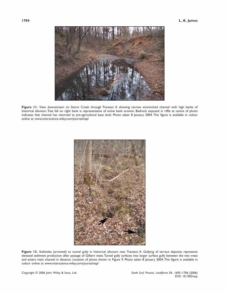
The channel is deeply entrenched into the historical deposits so the terrace tread is now high above the channel andwell drained (Figure 11). The historical alluvium in a representative section (Figure 9) has a mean depth of 2·2 mabove the pre-agricultural soil, a top width of 109 m, and a volume of 62 000 m3 over a reach extending 260 m(Alexander, 1997). Channel erosion has removed only a small proportion of the stored alluvium which continues to beactively reworked (Figure 10). Since this site was first visited in 1995, considerable terrace-scarp erosion has occurredby tree tips, mass failures and gullies, as well as lateral enlargement of the floodplain inset below the level of the old

Bed waves at the basin scale 1703
Copyright © 2006 John Wiley & Sons, Ltd. Earth Surf. Process. Landforms 31, 1692–1706 (2006)DOI: 10.1002/esp
Figure 9. Map of Storm Creek catchment in Fairfield County, South Carolina. The letter A shows location of transect A in Figure10. The arrow shows position of tunnel gully in Figure 12 and direction of that photograph toward main channel. This figure isavailable in colour online at www.interscience.wiley.com/journal/espl
Figure 10. Cores through historical sediment on a small stream in the lower Piedmont of South Carolina. The channel aggradedin response to erosion from cotton farming beginning in the late 19th century. Channel incised to bedrock after the 1920s whencotton farming failed and reforestation began. Vertical exaggeration c. 7×. Adapted from Alexander (1997). This figure is available incolour online at www.interscience.wiley.com/journal/espl
A-horizon. A tunnel gully system is developing in the historical terrace alluvium near the site of Transect A, demon-strating a new source of sediment production since terrace creation (Figure 12).
No evidence supports the passage of a coherent sediment wave through these reaches. Sediment production wasfrom diffuse upland sources over a protracted period, so at the basin scale channel response is best regarded asaggradation due to elevated sediment loads followed by channel incision during the re-establishment of grade. Thesubsequent changes in bed elevation over time constitute a Gilbert wave and are representative of many catchments inthe region. Efforts to restore such channels must be founded on the clear recognition of their on-going geomorphic
1704 L. A. James
Copyright © 2006 John Wiley & Sons, Ltd. Earth Surf. Process. Landforms 31, 1692–1706 (2006)DOI: 10.1002/esp
Figure 11. View downstream on Storm Creek through Transect A showing narrow entrenched channel with high banks ofhistorical alluvium. Tree fall on right bank is representative of active bank erosion. Bedrock exposed in riffle at centre of photoindicates that channel has returned to pre-agricultural base level. Photo taken 8 January 2004. This figure is available in colouronline at www.interscience.wiley.com/journal/espl
Figure 12. Sinkholes (arrowed) to tunnel gully in historical alluvium near Transect A. Gullying of terrace deposits representselevated sediment production after passage of Gilbert wave. Tunnel gully surfaces into larger surface gully between the two treesand enters main channel in distance. Location of photo shown in Figure 9. Photo taken 8 January 2004. This figure is available incolour online at www.interscience.wiley.com/journal/espl

Bed waves at the basin scale 1705
Copyright © 2006 John Wiley & Sons, Ltd. Earth Surf. Process. Landforms 31, 1692–1706 (2006)DOI: 10.1002/esp
adjustments to the passage of a bed wave, episodic sedimentation of the valley floor, and on-going sediment produc-tion by reworking of historical alluvium. These channel reaches are now producing much more sediment and, presum-ably, have much less aquatic diversity than when they were riparian wetlands.
Conclusion
Bed waves are defined on the basis of a rise and fall of the channel bed. They can be differentiated by scale, sedimentsource, grain size, overbank storage potential, and mode of morphologic evolution. Bed waves in gravel-bed rivers arenot usually propagated by simple translation and are not necessarily the result of dispersion. At the large scale, theyrepresent aggradation–degradation cycles. The large-scale bed waves described in this paper are quite different frommost of the bed waves studied in recent years. The classic Gilbert wave is interpreted as the result of channelaggradation in the Sacramento Valley piedmont followed by the re-establishment of channel grade. Massive uplandsedimentation events are often followed by aggradation in upper reaches that steepen longitudinal profiles until localchannel slope is sufficient to carry the new load. When sediment loads are reduced, channel incision begins in thesteepened reaches while aggradation continues downstream. The inflection point between zones of incision andaggradation migrates downstream as channel grade is re-established. Arrival of the inflection point represents themaximum elevation of the channel bed or the apex of the Gilbert bed wave. This sequence generates a rise and fall inchannel beds that appears like the passage of a wave form when viewed at-a-station, but they do not involve transla-tion or dispersion of coherent wave forms. Gilbert waves should be distinguished from smaller-scale bed waves thathave quite different characteristics, processes and explanations. The proliferation of studies of small-scale bed waveshas produced a wealth of knowledge about bed processes and bed-material transport. Benefits of these studies arelikely to be compromised if confusion arises from attempts to reconcile the characteristics of small-scale coherentwave forms with the broad, episodic nature of Gilbert waves.
Recognition of the former passage of a Gilbert wave (large-scale bed wave) is essential to an accurate assessment ofthe condition of river systems. Large volumes of sediment recently stored on floodplains may have altered valley-bottom morphology and may provide large amounts of sediment that was not present prior to the perturbation. Thefrequency of flooding and diversity of aquatic habitats tend to be reduced where passage of a Gilbert wave has lefthigh, erodible terraces along the valley bottom. These considerations should be included in the designation of pristinereaches (if any) and the selection of appropriate reference reaches in river restoration projects.
AcknowledgementsAn early version of this manuscript was read by Gary Brierly and an anonymous reviewer. Brierly provided a large number ofconstructive suggestions that greatly improved the final version. Tom Lisle and Michael Church also read the early version andprovided several valuable suggestions. I am indebted to these individuals for their diligent work and keen insights.
References
Alexander DJ. 1997. Channel morphological adjustment to soil erosion and sedimentation at the Chicken-Strong Creek Confluence, FairfieldCounty, South Carolina. MS thesis, Geography Department, University of South Carolina.
Ashmore PE, Church MA. 1998. Sediment transport and river morphology: a paradigm for study. In Gravel-Bed Rivers in the Environment,Klingeman PC, Beschta RL, Komar PD, Bradley JB (eds). Water Resources Publications: Highlands Ranch, CO; 115–148.
Brierley GJ, Fryirs K. 1998. Tributary–trunk stream relations in a cut-and-fill landscape: a case study from Wolumla catchment, New SouthWales, Australia. Geomorphology 28: 61–73.
Brookes A, Shields FD Jr. 1996. Perspectives on river channel restoration. In River Channel Restoration: Guiding Principles for SustainableProjects. Brookes A, Shields FD Jr (eds). Wiley: Chichester; 1–19.
Bull LJ. 1997. Relative velocities of discharge and sediment and sediment waves for the River Severn, UK. Hydrological Sciences Journal42(5): 649–660.
Church M, Kellerhals R, Day TJ. 1989. Regional clastic sediment yield in British Columbia. Canadian Journal Earth Science 26: 31–45.Cui Y, Parker G, Lisle TE, Gott J, Hansler-Ball ME, Pizzuto JE, Allmendinger NE, Reed JM. 2003. Sediment pulses in mountain rivers:
1. Experiments. Water Resources Research 39(9): 1239. DOI: 10.1029/2002WR001803Fryirs K. 2003. Guiding principles for assessing geomorphic river condition: application of a framework in the Bega catchment, South
Coast, New South Wales, Australia. Catena 53: 17–52. DOI: 10.1016/S0341-8162(02)00199-6Fryirs K, Brierley GJ. 2001. Variability in sediment delivery and storage along river courses in Bega catchment, NSW, Australia: implica-
tions for geomorphic river recovery. Geomorphology 38: 237–265.Gilbert GK. 1917. Hydraulic-mining Debris in the Sierra Nevada. US Geological Survey Professional Paper 105.
1706 L. A. James
Copyright © 2006 John Wiley & Sons, Ltd. Earth Surf. Process. Landforms 31, 1692–1706 (2006)DOI: 10.1002/esp
Gomez B, Naff RL, Hubbell DW. 1989. Temporal variations in bedload transport rates associated with the migration of bedforms. EarthSurface Processes and Landforms 14: 135–156.
Gomez B, Eden DN, Peacock DH, Pinkney EJ. 1998. Floodplain construction by recent, rapid vertical accretion: Waipaoa River,New Zealand. Earth Surface Processes and Landforms, 23: 405–413. DOI: 10.1002/(SICI)1096-9837(199805)23:5<405::AID-ESP854>3.0.CO;2-X
Graves W, Eliab P. 1977. Sediment Study: Alternative Delta Water Facilities; Peripheral Canal Plan. California Department of WaterResources, Central Division.
Heuer WH. 1891. Mining Débris, California. House Executive Document 267; 51st Congress, 2nd Session.Hoey T. 1992. Temporal variations in bedload transport rates and sediment storage in gravel-bed rivers. Progress in Physical Geography
16(3): 319–338.Hoey T, Sutherland AJ. 1991. Channel morphology and bedload pulses in braided rivers: a laboratory study. Earth Surface Processes and
Landforms 16: 447–462.Hooke J. 2003. Coarse sediment connectivity in river channel systems: a conceptual framework and methodology. Geomorphology 56: 79–
94. DOI: 10.1016/S0169-555X(03)00047-3Hughes RM, Larson DP, Omernik JM. 1986. Regional reference sites: a method for assessing stream potentials. Environmental Management
10(5): 629–635.James LA. 1991. Incision and morphological evolution of a channel recovering from hydraulic mining sedimentation. Geological Society of
America Bulletin 103: 723–726.James LA. 1997. Channel incision on the lower American River, California, from stream-flow gage records. Water Resources Research 33:
485–490.James LA. 1999. Time and the persistence of alluvium: River engineering, fluvial geomorphology, and mining sediment in California.
Geomorphology 31: 265–290.James LA. 2004. Tailings fans and valley-spur cutoffs created by hydraulic mining. Earth Surface Processes and Landforms 29: 869–882.
DOI: 10.1002/esp.1075James LA. 2005. Sediment from Hydraulic Mining Detained by Englebright and Small Dams in the Yuba Basin. Geomorphology 71: 202–
226. DOI: 10.1016/j.geomorph.2004.02.016Juracek KE, Fitzpatrick FA. 2003, Limitations and implications of stream classification. Journal of the American Water Resources Associa-
tion 39: 659–670.Lancaster ST, Hayes SK, Grant GE. 2001. Modeling sediment and wood storage and dynamics in small mountainous watersheds. In
Geomorphic Processes and Riverine Habitat, Dorava JM, Montgomery DR, Palcsak B, Fitzpatrick F (eds). Water Science and Applica-tion, Volume 4. American Geophysical Union: Washington, D.C.; 85–102.
Lisle TE, Cui Y, Parker G, Pizzuto JE, Dodd, AM. 2001. The dominance of dispersion in the evolution of bed material waves in gravel-bedrivers. Earth Surface Processes and Landforms 26: 1409–1420. DOI: 10.1002/esp.300
Mackin JH. 1948. Concept of the Graded River, Bulletin of the Geological Society of America 59(5): 463–512.Meade RH. 1985. Wavelike movement of bedload sediment, East Fork River, Wyoming. Environmental Geology and Water Science 7(4):
215–225.Meade RH, Emmett WW, Myrick RM. 1981. Movement and storage of bed material during 1979 in East Fork River, Wyoming, USA. In
Erosion and Sediment Transport in Pacific Rim Steeplands, Davies TRH, Pearce AJ (eds). IAHS: Gentbrugge, Belgium.Mendell GH. 1881. Report upon a Project to Protect the Navigable Waters of California from the Effects of Hydraulic Mining. House
Document 98, 47th Congress, 1st Session: 78–101.National Research Council. 1992. Restoration of Aquatic Ecosystems. National Academy Press: Washington, DC.National Research Council. 1995. Flood Risk Management and the American Basin: An Evaluation. Committee on Flood Control
Alternatives, Water Technology Board. National Academy Press: Washington, DC.Nicholas AP, Ashworth PJ, Kirkby MJ, Macklin MG, Murray T. 1995. Sediment slugs: large-scale fluctuations in fluvial sediment transport
rates and storage volumes. Progress in Physical Geography 19(4): 500–519.Pickup G, Higgins RJ, Grant I. 1983. Modelling sediment transport as a moving wave – the transfer and deposition of mining waste. Journal
of Hydrology 60: 281–301.Sutherland DG, Ball MH, Hilton SJ, Lisle TE. 2002. Evolution of a landslide-induced sediment wave in the Navarro River, California.
Geological Society of America Bulletin 114(8): 1036–1048.Trimble SW. 1974. Man-Induced Erosion on the Southern Piedmont: 1700–1970. Soil Conservation Society of America: Ankeny, Iowa.Walling DE. 1983. The sediment delivery problem. Journal of Hydrology 65: 209–237.Wathen SJ. Hoey TB. 1998. Morphologic controls on the downstream passage of a sediment wave in a gravel-bed stream. Earth Surface
Processes and Landforms 23: 715–730.Weir GJ. 1983. One-dimensional bed wave movement in lowland rivers. Water Resources Research 19(3): 627–631.
Related Documents