Earth Science Topic #2 Review Game Earth Science Topic #2 Review Game 1 7 13 19 25 2 8 14 20 26 3 9 15 21 27 4 10 16 22 28 5 11 17 23 29 6 12 18 24 30

Earth Science Topic #2 Review Game 1111 7777 13 19 25 2222 8888 14 20 26 3333 9999 15 21 27 4444 10 16 22 28 5555 11 17 23 29 6666 12 18 24 30.
Dec 30, 2015
Welcome message from author
This document is posted to help you gain knowledge. Please leave a comment to let me know what you think about it! Share it to your friends and learn new things together.
Transcript
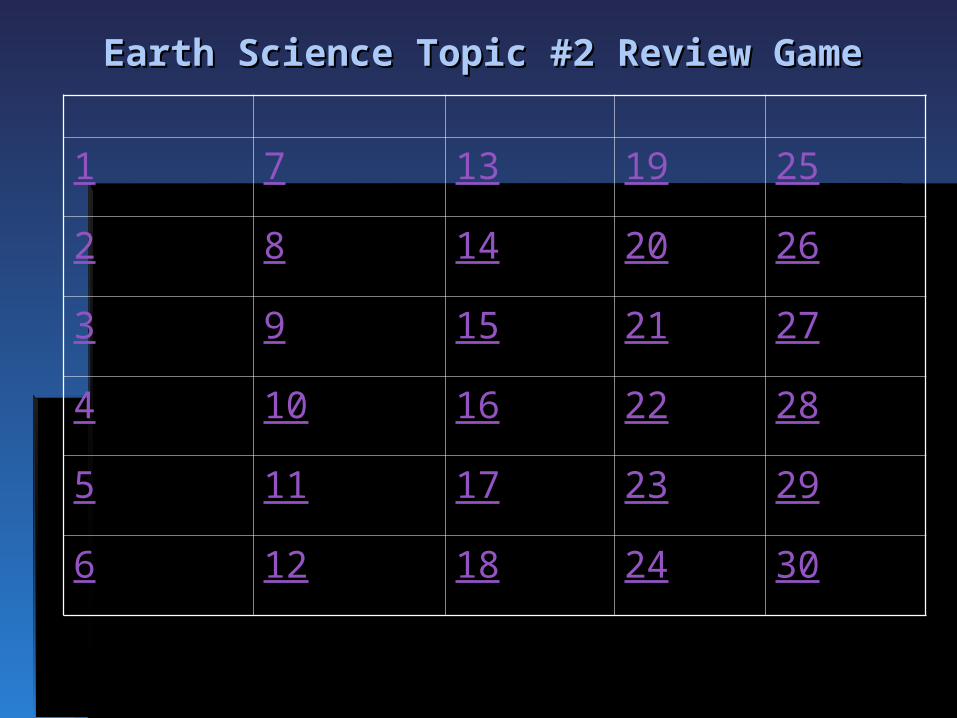
Earth Science Topic #2 Review GameEarth Science Topic #2 Review Game
1 7 13 19 25
2 8 14 20 26
3 9 15 21 27
4 10 16 22 28
5 11 17 23 29
6 12 18 24 30

Base your answer on Point X is a location on the topographic map below. Elevations are measured in meters.
What is a possible elevation, in meters, of point X?a. 55b. 57c. 68d. 70

Which diagram most accurately shows the cross-sectional shape of the Earth?
A
C D
B
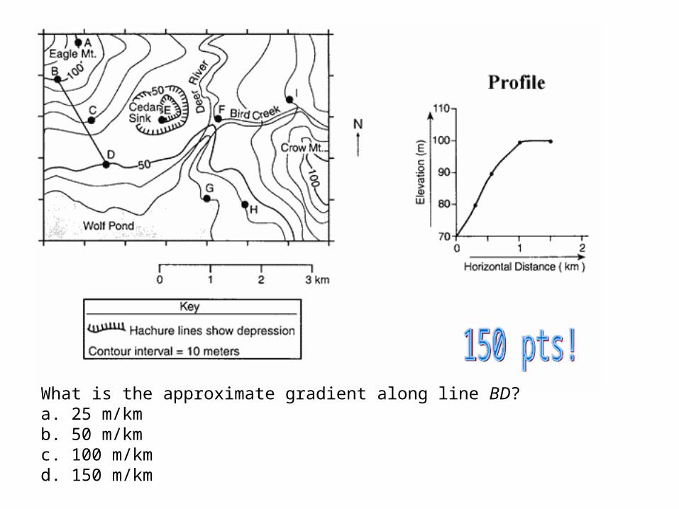
What is the approximate gradient along line BD?a. 25 m/kmb. 50 m/kmc. 100 m/kmd. 150 m/km

Base your answer on the diagram below, which represents the planetary wind and moisture belts in Earth’s Northern Hemisphere.
The tropopause is approximately how far above sea level?
a. 12 mib. 12 kmc. 60 mid. 60 km

Base your answer to the next 2 questions on the topographic map below that represents a location in North America. A grid system of letters and numbers along the edges of the map is provided to assist in finding locations. Elevations are expressed in feet.
What is the approximate elevation at grid location 7-I?a. 140 ft b. 170 ft c. 200 ft d. 230 ft

Base your answer on The diagram below shows a cross section of a cliff climbed by a student.
What is the approximate average gradient of the cliff?
a. 10 m/mb. 30 m/mc. 300 m/md. 700 m/m

Which graph best represents the percentage by volume of the elements making up the Earth's hydrosphere?
C
B
D
A

Base your answer on the contour map of an island below. Points A through G represent locations on the island. Elevations are in meters.
What is the contour interval for this map?a. 10 mb. 15 mc. 20 md. 25 m

Which circle graph best represents the volume of gases in the troposphere?
A
DC
B

At which New York State location would an observer measure the highest altitude of Polaris?
a. New York Cityb. Slide Mountainc. Niagara Fallsd. Plattsburgh

Which graph best represents the effect that heating has on air density in the troposphere?
A DCB

Base your answer on the diagram below which shows a student in New York State observing Polaris.
The student is located nearest to which city in New York State?
a. Plattsburghb. Albanyc. New York Cityd. Kingston

Base your answer on the topographic map below, which represents elevation contours measured in meters. Four straight lines, AB, CD, EF, and GH, have been drawn for reference purposes.
What is the general direction of flow of Mill Creek?a. east to west b. west to eastc. north to south d. south to north

Base your answer on the contour map below. Points A through F represent locations on the map.
If no elevation values were given, which general rule could be used to establish that Cedar River flows into Sunfish Lake?
a. Rivers shown on maps generally flow southward.b. Rivers always flow toward large bodies of water.c. Contour lines bend upstream when crossing a river.d. A large body of water is generally the source of water for a river.

Base your answer on the diagram below represents contour lines on a topographic map with cross-section line AB.
Which diagram best represents the topographic profile along line AB?
A
C D
B

Earth’s troposphere, hydrosphere, and lithosphere contain relatively large amounts of which element?
a. ironb. oxygenc. hydrogend. potassium

The lines on which set of views best represent Earth’s latitude system?
A B
DC

What is the elevation of the highest contour line shown on the map below?
a. 10,000 feetb. 10,688 feetc. 10,700 feetd. 10,788 feet

Base your answer on the topographic map below. Points A, B, C, D, and X represent locations on the map. Elevations are measured in feet.
What is the average gradient of the slope along straight line CD?
a. 100 ft/mib. 250 ft/mic. 500 ft/mid. 1,000 ft/mi
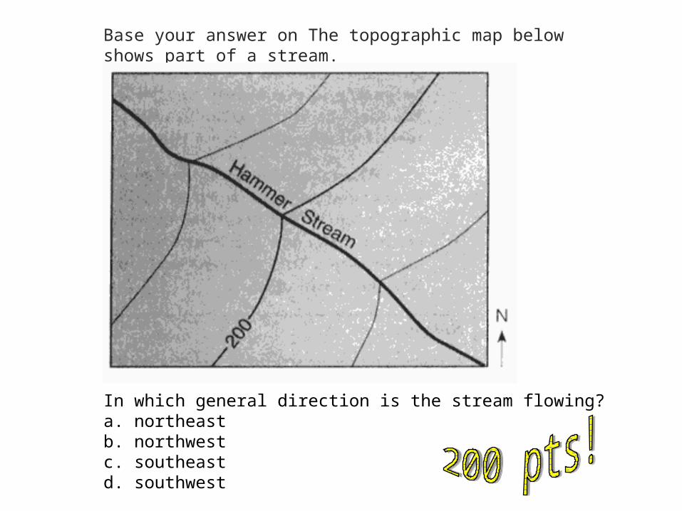
Base your answer on The topographic map below shows part of a stream.
In which general direction is the stream flowing?a. northeastb. northwestc. southeastd. southwest

Base your answer to the topographic map below, which represents elevation contours measured in meters. Four straight lines, AB, CD, EF, and GH, have been drawn for reference purposes.
What is the general direction of flow of Mill Creek?
a. east to westb. west to eastc. north to southd. south to north
The layer of bedrock near the Earth's surface that forms a continuous shell around the Earth is called the
a. troposphereb. stratospherec. lithosphered. hydrosphere

Base your answer on the contour map of an island below. Points A through G represent locations on the island. Elevations are in meters.
Which diagram best represents the topographic profile from location C to location B?
A DB C

What is the approximate latitude and longitude of location A?
a. 160° N, 15° Eb. 160° S, 15° Wc. 15° N, 160° Ed. 15° N, 160° W

The approximate latitude of Utica, New York, is
a. 43°05’ Nb. 43°05’ Sc. 75°15’ Ed. 75°15’W

At which latitude will Polaris be overhead?
a. 0ºb. 23 ½ºN.c. 90º S.d. 90º N.
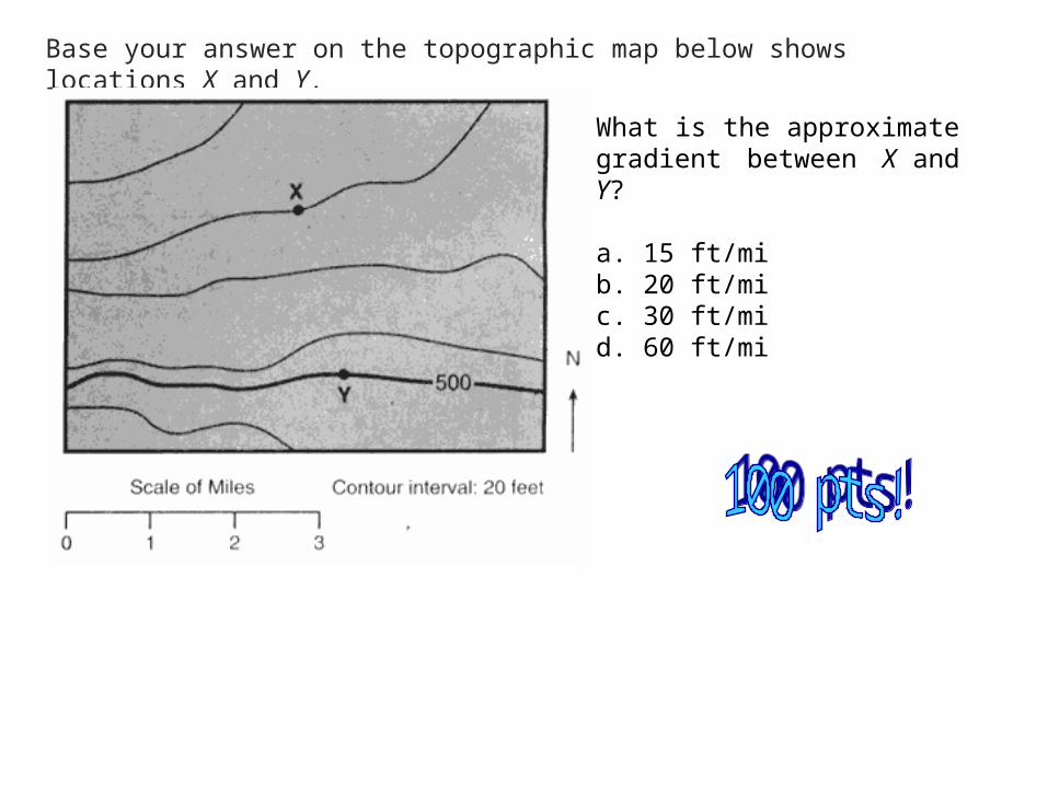
Base your answer on the topographic map below shows locations X and Y.
What is the approximate gradient between X and Y?
a. 15 ft/mib. 20 ft/mic. 30 ft/mid. 60 ft/mi

Base your answer on the contour map shown below. Elevations are shown in feet.
Which side of Amethyst Hill has the steepest slope?a. northb. southc. eastd. west

Base your answer to the next 2 questions on the topographic map below. A, B, C, and D are locations on the map.
Between which two locations does the steepest gradient occur?
a. A and Bb. B and Cc. C and Dd. A and C

The best evidence that the Earth has a spherical shape is provided by
a. photographs of the Earth taken from space satellitesb. the amount of daylight received at the North Pole on June 21c. the changing orbital speed of the Earth in its orbit around the Sund. the cyclic change of seasons
Related Documents


